Cloud Height Mission
22
Cloud Height Mission Klemen Zakšek 1 , Marcello Valdatta 2 K. Oštir 3 , M. Hort 1 , A. Marsetič 3 , N. Bellini 2 , D. Rastelli 2 , A. Locarini 2 , S. Naldi 2 1 University of Hamburg, Germany 2 Npc Spacemind, Italy 3 Center of Excellence SPACE-SI, Slovenia
-
Upload
khangminh22 -
Category
Documents
-
view
6 -
download
0
Transcript of Cloud Height Mission

Cloud Height Mission
Klemen Zakšek1, Marcello Valdatta2
K. Oštir3, M. Hort1, A. Marsetič3, N. Bellini2, D. Rastelli2, A. Locarini2, S. Naldi2
1 University of Hamburg, Germany 2 Npc Spacemind, Italy
3 Center of Excellence SPACE-SI, Slovenia

1989 Redoubt: KLM flight 867
• ATC: Do you have good sight of the ash plume?
• Pilot: It‘s just cloudy. It could be ash. It‘s just a little browner than a normal cloud.
• Pilot: We have to go left now... It‘s smoky in the cockpit at the moment sir.
• ATC: KLM 867 heavy, rodger, left at your discretion.
• Pilot: Climbing to (flight) level 390, we‘re in the black cloud, heading 130.
• Pilot: KLM 867 we have FLAME OUT ALL ENGINES and we are descending now.
• ATC: KLM 867 heavy... Anchorage.
• Pilot: KLM 867 heavy, we are descending now... WE ARE IN A FALL!
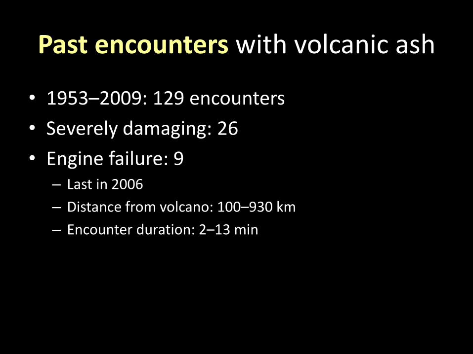
Past encounters with volcanic ash
• 1953–2009: 129 encounters
• Severely damaging: 26
• Engine failure: 9 – Last in 2006
– Distance from volcano: 100–930 km
– Encounter duration: 2–13 min

T = 0 T + 6 h
T + 12 h T + 18 h

1.3 billion EUR in 6 days

H = 7 km
Model of 2010 Eyjafjallajökull eruption
H = 6 km
Heinold et al., 2012


2002 ETNA Eruption; courtesy NASA JPL, MISR Team
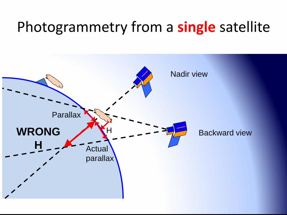
Nadir view
Parallax
H
Photogrammetry from a single satellite
Backward view
Actual
parallax
WRONG
H

Simultaneous observations
Cloud Height Mission
from 2 micro satellites

Mission objectives
Aviation safety and cost reduction!
• 200 m vertical accuracy
• 150 m relative horizontal accuracy
• revisit 1+ per day
• 5+ retrievals in 1 min (on demand)
Observe meteorological and other aerosol clouds!
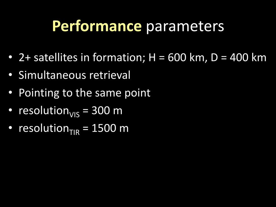
Performance parameters
• 2+ satellites in formation; H = 600 km, D = 400 km
• Simultaneous retrieval
• Pointing to the same point
• resolutionVIS = 300 m
• resolutionTIR = 1500 m
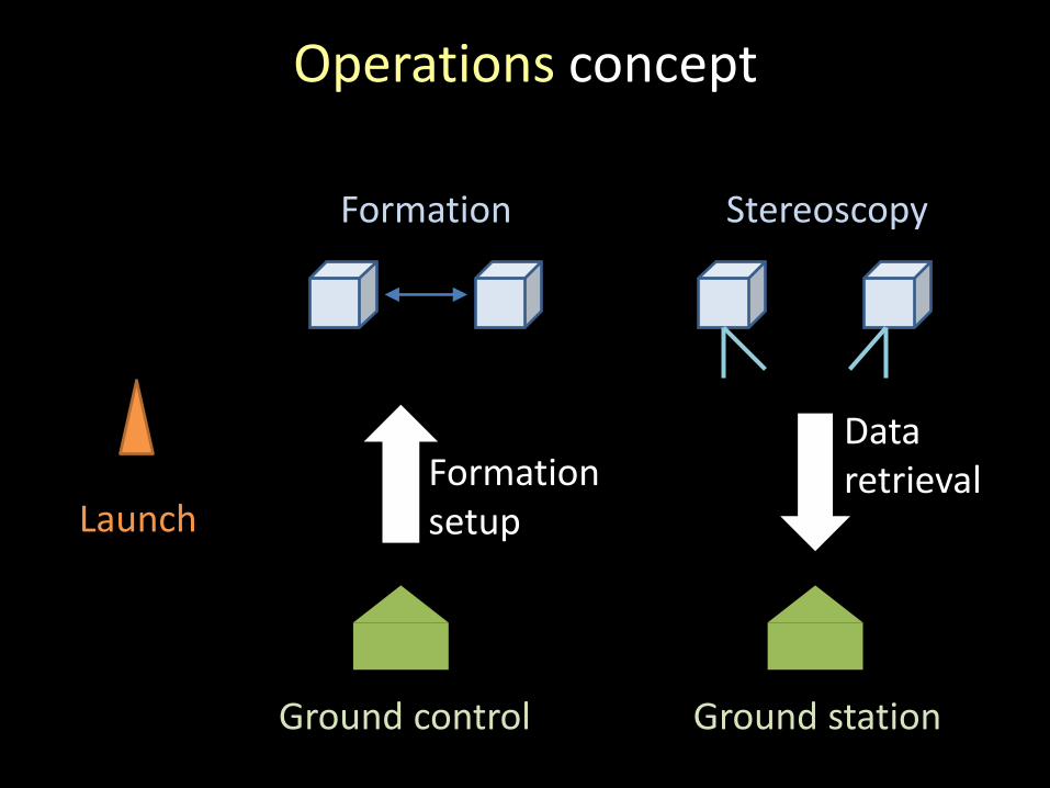
Operations concept
Launch
Formation
Ground control
Formation setup
Ground station
Stereoscopy
Data retrieval
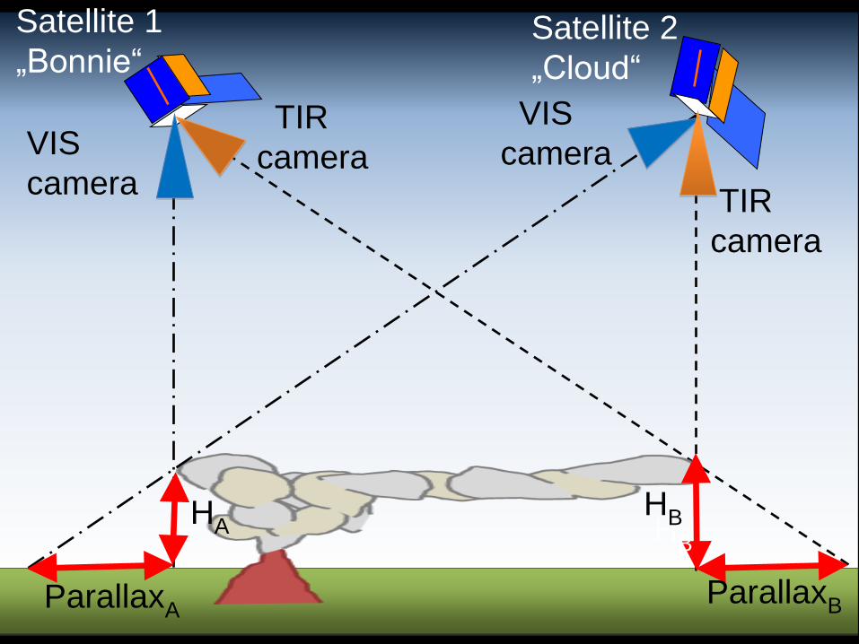
Satellite 1
„Bonnie“ Satellite 2
„Cloud“
ParallaxA
HA
ParallaxB
HB
VIS
camera
TIR
camera
TIR
camera
VIS
camera
HB

Payload • VIS sensor
– Fairchild Imaging CCD486
– 30 mm lense
– resolutionVIS = 300 m
– Swath = 1200 km
• TIR sensor – Teledyne Dalsa / FLIR / Infratec
– resolutionTIR = 1500 m
• GNSS receiver
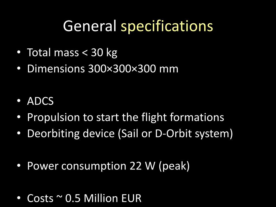
General specifications
• Total mass < 30 kg
• Dimensions 300×300×300 mm
• ADCS
• Propulsion to start the flight formations
• Deorbiting device (Sail or D-Orbit system)
• Power consumption 22 W (peak)
• Costs ~ 0.5 Million EUR
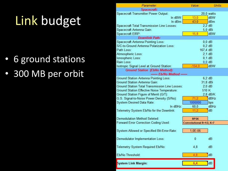
Link budget
• 6 ground stations
• 300 MB per orbit
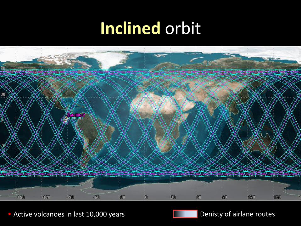
Inclined orbit
Active volcanoes in last 10,000 years Denisty of airlane routes
Kasatochi 2008
Okmok 2008
Chaiten 2008
Sarychev Peak 2009
Eyjafjallajökull 2010
Merapi 2010
Grímsvötn 2011
Puyehue-Cordón 2011
Nabro 2011
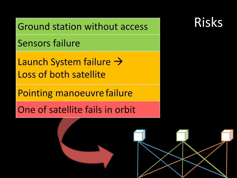
Risks Ground station without access
Sensors failure
Launch System failure Loss of both satellite
Pointing manoeuvre failure
One of satellite fails in orbit
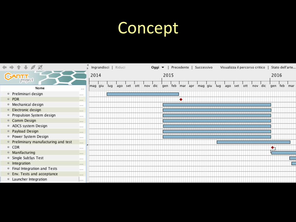
Concept

Zakšek, K., et al.: Monitoring volcanic ash cloud top height through simultaneous retrieval of optical data from polar orbiting and geostationary satellites
Atmos. Chem. Phys., 13, 2589-2606,
doi:10.5194/acp-13-2589-2013