GEOID UNDULATIONS OF SUDAN USING ORTHOMETRIC HEIGHTS COMPARED WITH THE EGM96 ANG EGM2008
11
International Journal of Advanced Research in IT and Engineering ISSN: 2278-6244 Vol. 2 | No. 11 | November 2013 www.garph.co.uk IJARIE | 43 GEOID UNDULATIONS OF SUDAN USING ORTHOMETRIC HEIGHTS COMPARED WITH THE EGM96 ANG EGM2008 Dr. Abdelrahim Elgizouli Mohamed Ahmed* Abstract: Positioning by satellite system determine the normal height above the ellipsoid, then the direct height observed by the Global Positioning System (GPS) is the height of the point on the surface of the earth measured normal to WGS 84 ellipsoid. This height is not the same as the vertical height of the point to the geoid where the surface of the geoid is approximated to the Mean Sea surface. The main objective of this paper is to test the International geoid models (EGM96 and EGM2008 )available by comparison with Orthometric (the local MSL ). The geoid undulations determined by each of the mentioned models were tested to serve as the base for the geometrical model. Keywords: Mean Sea Level, Geoid model, Orthometric height, geometric model, ellipsoid. *Associate Prof., Dep. of Civil Eng., Karary University ,Sudan
Transcript of GEOID UNDULATIONS OF SUDAN USING ORTHOMETRIC HEIGHTS COMPARED WITH THE EGM96 ANG EGM2008
International Journal of Advanced Research in IT and Engineering ISSN: 2278-6244
Vol. 2 | No. 11 | November 2013 www.garph.co.uk IJARIE | 43
GEOID UNDULATIONS OF SUDAN USING ORTHOMETRIC HEIGHTS COMPARED
WITH THE EGM96 ANG EGM2008
Dr. Abdelrahim Elgizouli Mohamed Ahmed*
Abstract: Positioning by satellite system determine the normal height above the ellipsoid, then
the direct height observed by the Global Positioning System (GPS) is the height of the point on
the surface of the earth measured normal to WGS 84 ellipsoid. This height is not the same as
the vertical height of the point to the geoid where the surface of the geoid is approximated to
the Mean Sea surface. The main objective of this paper is to test the International geoid models
(EGM96 and EGM2008 )available by comparison with Orthometric (the local MSL ). The geoid
undulations determined by each of the mentioned models were tested to serve as the base for
the geometrical model.
Keywords: Mean Sea Level, Geoid model, Orthometric height, geometric model, ellipsoid.
*Associate Prof., Dep. of Civil Eng., Karary University ,Sudan
International Journal of Advanced Research in IT and Engineering ISSN: 2278-6244
Vol. 2 | No. 11 | November 2013 www.garph.co.uk IJARIE | 44
1. INTRODUCTION
The Global Positioning System (GPS) provides X, Y, Z Cartesian Coordinates in a geometric
framework called the International Terrestrial Reference Frame (ITRF). The origin (0, 0, 0) 0f
which, is the centre of mass of the earth. These Cartesian coordinates are then transformed
into ellipsoidal latitude, longitude and height. However the error sources in GPS and the
inconsistencies between reference datum of the system and physical reality more or less
disturb its performance as a geodetic measurement technique. Today, numerous scientific
studies are carried on to develop applicable solutions to eliminate or minimize the weakness of
this very practical and precise positioning techniques. Because OPS derived heights refer to its
reference ellipsoid WGS84 the height referenced to geoid are required. To take full advantage
of the technique in geodetic practical applications, GPS derived ellipsoid heights need to be
transformed to orthometric heights via the simple well known equation ( N = h – H), Where N
is the ellipsoid-geoid separation , H is the orthometric height and h is the ellipsoid height).
Ellipsoid height is purely geometric value whereas orthometric height has a physical meaning
and depends upon the gravity field of the earth. Theoretically science the ellipsoid height and
orthometric heights are measured along the normal to ellipsoid and along the direction of
plumb line respectively the relation ship defined in the equation above is only an
approximation and it serve for most of engineering applications. Also it should be pointed out
that these geoid heights determined from global models and gravity data, refer to local vertical
datum, due to the sea-surface topography at the reference tide gauge. The local geoidal height
at a particular point can be measured by subtracting orthometric height, determined from
spirit leveling, from ellipsoidal height determined by GPS observation at the same point. Now
the problem remains how to determine N for the points which are not connected by the
leveling when observed by GPS.
2. GEOID
The geoid is an equipotential surface corresponding with Mean Sea Level (MSL). The geoid
does not exactly correspond to the real ocean surface, because the oceans are subject to tides
and current. As the geoid is an equipotential surface, the gravitational potential at any point on
it will be the same, and the direction of the gravity at any point on it will be perpendicular to
the geoid. If the earth was of uniform density and the earth’s topography did not exist, the
geoid would have the shape of an oblate ellipsoid centered on the earth center of mass.

International Journal of Advanced Research in IT and Engineering ISSN: 2278-6244
Vol. 2 | No. 11 | November 2013 www.garph.co.uk IJARIE | 45
Unfortunately the situation is not simple [5]. The geoid is a fundamental physical reference
surface. Its shape reflects the distribution of mass inside the earth.
2.1 GEOID AND ITS WAYS OF DETERMINATION
The geoid is a dynamic surface, with its radius vector from the center of gravity of the earth
changing cyclically, due to the gravitational attraction of the sun and the moon. This change is
of the order of 1 meter [3]. Several geodesists have investigated means of working without the
geoid [1]; [2]. Using the classical observations to terrestrial targets, this still appears to be an
impossibility, due to the uncertain effects of atmospheric refraction upon vertical angles, and
the fact that these are also affected by deflections of the vertical. One technique that is
independent of the geoid is geometric satellite geodesy. However it is not imaginable that
satellite observations will be made at all geodetic stations, and the classical observations will
be complimented by, rather than replaced by, observations to satellites. Although there is only
one equipotential surface that may be called the geoid, there are several different ways in
which geoidal heights may be computed. This has resulted in several types of geoid, which are
briefly described below.
2.1.1 THE SATELLITE GEOID
The satellite geoid is based upon the analysis of orbit perturbation of artificial earth satellites.
This representation has the characteristics that, although of uniform quantity, it is a some what
smoothed version of the geoid, referred to a geocentric ellipsoid.
2.1.2 THE GRAVIMETRIC GEOID
The calculations of the gravimetric geoid uses the magnitude of the earth gravity, measured at
the terrain, to obtain geoidal heights. It is usually referred to geocentric ellipsoid and due to
lake of gravity data in certain areas of the world is not of consistent quality.
2.1.3 THE SATELLITE-GRAVIMETRIC GEOID
The combined satellite-gravimetric geoid combines the best features of the satellite geoid and
the gravimetric geoid. The detailed variations in geoidal height are described using the gravity
anomalies and the large scale variations by using the satellite data [4].
2.1.4 THE ASTRO-GEODETIC GEOID
The calculation of the astro-geodetic geoid uses the direction of gravity (rather than the
magnitude) to obtain geoidal heights relative to reference ellipsoid to which the direction is
related. This reference ellipsoid is not necessarily geocentric. Due to the nature of the

International Journal of Advanced Research in IT and Engineering ISSN: 2278-6244
Vol. 2 | No. 11 | November 2013 www.garph.co.uk IJARIE | 46
observations it can only be computed for the land masses, and requires a good distribution of
data.
2.1.5 THE ASTRO-GRAVIMETRIC GEOID
The astro-gravimetric geoid combines the best features of the gravimetric geoid and the asro-
geodetic geoid. It is basically an astro-geodetic geoidwith supplementary deflections obtained
via gravity anomalies.
3. THE RELATION BETWEEN THE ELLIPSOID HEIGHT AND THE ORTHOMERTRIC
HEIGHT
It is well known that the geoid has no simple mathematic expression, so it is convenient to
define the relative simple mathematical surface that closely approximate the actual geoied,
thus simplifying the computations. This approximation can be made for a local area or on a
global scale. Because it rotates, the earth assumes the shape of a sphere that is flattened at the
poles and bulging at the equator. This figure is represented well by an ellipsoid of revolution
formed by rotating an ellipse around its minor axis. The ellipsoid is defined by the specification
of two parameters, for example, the length of the semi-major axis a and the flattening f. The
flattening is related to the semi-minor axis b by: f = (a-b)/a the reason for using the ellipsoid is
to obtain a simple surface that approximates the geoid. The relationship between the
ellipsoidal height and the orthometric height is h = H+N where N is the geoid undulation with
respect to the specific ellipsoid. The geoid undulation is positive if the geoid is above the
ellipsoid. A desirable condition for the best fitting ellipsoid is that the magnitude of the geoid
undulation be minimized. Thus minimizing the sum of the squares of the geoid undulations
distributed over the whole earth ensure a balance of positive and negative undulations. The
resulting ellipsoid is called a globally best fitting ellipsoid. In special cases the minimization can
be applied to undulations of a small area, the size of a country or continent. This would yield a
best fitting local ellipsoid.

International Journal of Advanced Research in IT and Engineering ISSN: 2278-6244
Vol. 2 | No. 11 | November 2013 www.garph.co.uk IJARIE | 47
Fig.1: The Earth as geoid
4. EARTH GRAVITATIONAL MODEL (EGM96)
The NGA/NASA Geoid Height File consists of a 15-minute grid of point values in the tide-free
system, using the EGM96 Geopotential Model to degree and order 360. The WGS 84 constants
used to define the geometry and the normal field of the reference ellipsoid in the calculation of
this geoid height file are the following:
i) a=6378137.0 m (semi-major axis of WGS 84 Ellipsoid)
ii) f=1.0/298.2572235630 (flattening of WGS 84 Ellipsoid)
iii) GM=0.3986004418D15 m**3/s**2 (Earth's Gravitational Constant w/ atmosphere)
iv) ω =7292115.D-11 radians/sec (Earth's angular velocity)
The geoid undulation values are calculated by applying a correction term that converts a
pseudo-height anomaly calculated at a point on the ellipsoid to a geoid undulation value. In
addition, a correction term of -0.53 m is added to the prior result to obtain the geoid
undulation with respect to the WGS 84 ellipsoid. The value of -0.53 m is based on the following
estimates of the equatorial radius (a) and flattening (f) of an ideal earth ellipsoid in the tide-
free system: a=6378136.46 m and 1/f=298.25765. The 15-minute geoid height grid is used as
input to a FORTRAN program, INTPT.F, developed for interpolating from the grid, a geoid
undulation at any given WGS 84 latitude and longitude. The program F477.F requires both the
EGM96 spherical harmonic coefficient file and the correction coefficient file to calculate point
geoid undulations at any given WGS 84 latitude and longitude by spherical harmonic synthesis.
5. EARTH GEOID MODEL ( EGM2008 - WGS 84 VERSION )
The official Earth Gravitational Model EGM2008 has been publicly released by the U.S. National
Geospatial-Intelligence Agency (NGA) EGM Development Team. This gravitational model is
Deviation ofthe vertical
Perpendicularto ellipsoid
Ocean
Mean seasurface (geoid)
Perpendicular togeoid (plumb line)
Ellipsoid
Geoid
Geoid undulation

International Journal of Advanced Research in IT and Engineering ISSN: 2278-6244
Vol. 2 | No. 11 | November 2013 www.garph.co.uk IJARIE | 48
complete to spherical harmonic degree and order 2159, and contains additional coefficients
extending to degree 2190 and order 2159. Full access to the model's coefficients and other
descriptive files with additional details about EGM2008 are provided here in. Those wishing to
use EGM2008 to compute geoid undulation values with respect to WGS 84, may do so using
the self-contained suite of coefficient files, FORTRAN software, and pre-computed geoid grids
provided on the web page. For other applications, the previous release of the full 'Geoscience'
package for EGM2008 can be accessed through the link at the bottom of the web page. The
WGS 84 constants used to define the reference ellipsoid, and the associated normal gravity
field, to which the geoid undulations are referenced are:
i) a=6378137.00 m (semi-major axis of WGS 84 ellipsoid)
ii) f=1/298.257223563 (flattening of WGS 84 ellipsoid)
iii GM=3.986004418 x 10¹⁴ m3s-2 (Product of the Earth's mass and the Gravitational
Constant)
1v) ω=7292115 x 10-11 radians/sec (Earth's angular velocity)
All synthesis software, coefficients, and pre-computed geoid grids assume a Tide Free system,
as far as permanent tide is concerned. Note that the harmonic synthesis software provided
applies a constant, zero-degree term of -41 cm to all geoid undulations computed using
EGM2008 with the height_anomaly-to-geoid_undulation correction model. Similarly, all pre-
computed geoid undulations incorporate this constant zero-degree term. This term converts
geoid undulations that are intrinsically referenced to an ideal mean-earth ellipsoid into
undulations that are referenced to WGS 84. The value of -41 cm derives from a mean-earth
ellipsoid for which the estimated parameters in the Tide Free system are: a=6378136.58 m and
1/f=298.257686.
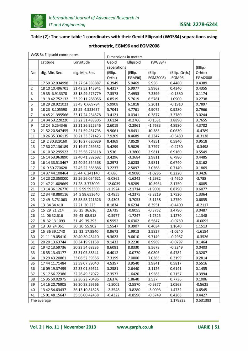
6. RESULTS
The main data of this paper based on coordinates of 41 points observed by GPS Surveying
receivers (using geodetic observation systems) on WGS84 ellipsoid (Table 1). Each point in
table 1 has its own ellipsoid and orthometric height . The geoid separations were obtained by
the Earth Geopotential Model 1996 and 2008 (EGM96 and EGM2008). Table 2 shows ellipsoid
coordinates with the geoid separation computed using orthometric heights and also using
again the EGM96 and EGM2008. Differences between geoid undulations (Orhtometric –
GEM96) and (Orhtometric – GEM2008) have been shown in table 2. Figures 2, 3 and 4 show

International Journal of Advanced Research in IT and Engineering ISSN: 2278-6244
Vol. 2 | No. 11 | November 2013 www.garph.co.uk IJARIE | 49
contours of the Sudan geoid undulations using Orthometric heights, EGM96 and EGM2008
models respectively.
7. CONCLUSIONS AND RECOMMENDATIONS
Table 1, shows 42 points distributed over the area of the country (Sudan), positioned by
geodetic GPS system on WGS84 ellipsoid, so that the WGS84 ellipsoid height and the elevation
(orthometric height) are common to theses points. In table 2 geoid undulations relative to
WGS84 ellipsoid height as a reference were obtained using orthometricheight, EGM96 and
EGM2008 geoid models. Geoid undulations differences {( orthometric height undulations –
EGM96 undulations) and (orthometric height undulations – EGM2008 undulations)} were
shown in table 2. The overall general looking to the differences in table two showed that there
is no significant differences geoid undulations of EGM96 and EGM2008 compared to the
elevation (orthometric height). The average of the differences of EGM96 to orthometric
undulations is equal to 1.179822 meters while EGM 2008 to orthometric undulations is equal
to 0.531383 meters. According to the average values of the two models ( EGM96 and
EGM2008) it is concluded that EGM2008 values are closed to the height of elevation
(orthometric height) so that EGM 2008 is recommended to be used for determination of the
reference height for leveling in the areas which have no reference elevation (orthometric
height) in Sudan.
8. ACKNOWLEGMENT
My special thank to Engineer Elhadi Khaliefa Mustafa and Engineer Mohamed Ahmed Hassan
Damouse for their commendable assistant during preparation of this paper.
REFERENCE
[1] Dufoar, H. M. (1968). The Whole Geodesy without Ellipsoid. Bulletin Geodesique No. 57.
[2] Hotine, M. (1969). Mathematical Geodesy. ESSA Monograph 2, Washington.
[3] Melchior, P. (1966). The Earth Tides. Pergamon press.
[4] Merry, C. L. and P. Vanicek (1973). Horizontal Control and the Geoid in Canada. The
Canadian Surveyor, vol. 27, No. 1.
[5] Torge, W. (1980). Geodesy. W DE G Berlin. New York.
International Journal of Advanced Research in IT and Engineering ISSN: 2278-6244
Vol. 2 | No. 11 | November 2013 www.garph.co.uk IJARIE | 50
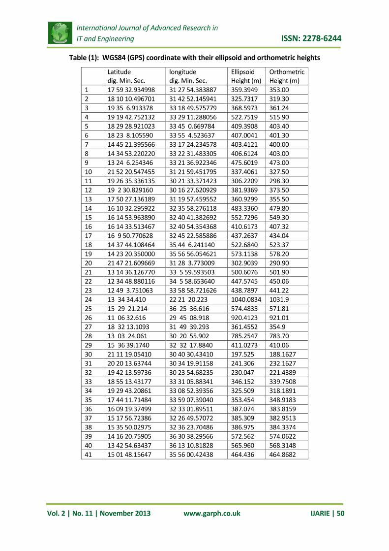
Table (1): WGS84 (GPS) coordinate with their ellipsoid and orthometric heights
Latitude dig. Min. Sec.
longitude dig. Min. Sec.
Ellipsoid Height (m)
Orthometric Height (m)
1 17 59 32.934998 31 27 54.383887 359.3949 353.00 2 18 10 10.496701 31 42 52.145941 325.7317 319.30 3 19 35 6.913378 33 18 49.575779 368.5973 361.24 4 19 19 42.752132 33 29 11.288056 522.7519 515.90 5 18 29 28.921023 33 45 0.669784 409.3908 403.40 6 18 23 8.105590 33 55 4.523637 407.0041 401.30 7 14 45 21.395566 33 17 24.234578 403.4121 400.00 8 14 34 53.220220 33 22 31.483305 406.6124 403.00 9 13 24 6.254346 33 21 36.922346 475.6019 473.00 10 21 52 20.547455 31 21 59.451795 337.4061 327.50 11 19 26 35.336135 30 21 33.371423 306.2209 298.30 12 19 2 30.829160 30 16 27.620929 381.9369 373.50 13 17 50 27.136189 31 19 57.459552 360.9299 355.50 14 16 10 32.295922 32 35 58.276118 483.3360 479.80 15 16 14 53.963890 32 40 41.382692 552.7296 549.30 16 16 14 33.513467 32 40 54.354368 410.6173 407.32 17 16 9 50.770628 32 45 22.585886 437.2637 434.04 18 14 37 44.108464 35 44 6.241140 522.6840 523.37 19 14 23 20.350000 35 56 56.054621 573.1138 578.20 20 21 47 21.609669 31 28 3.773009 302.9039 290.90 21 13 14 36.126770 33 5 59.593503 500.6076 501.90 22 12 34 48.880116 34 5 58.653640 447.5745 450.06 23 12 49 3.751063 33 58 58.721626 438.7897 441.22 24 13 34 34.410 22 21 20.223 1040.0834 1031.9 25 15 29 21.214 36 25 36.616 574.4835 571.81 26 11 06 32.616 29 45 08.918 920.4123 921.01 27 18 32 13.1093 31 49 39.293 361.4552 354.9 28 13 03 24.061 30 20 55.902 785.2547 783.70 29 15 36 39.1740 32 32 17.8840 411.0273 410.06 30 21 11 19.05410 30 40 30.43410 197.525 188.1627 31 20 20 13.63744 30 34 19.91158 241.306 232.1627 32 19 42 13.59736 30 23 54.68235 230.047 221.4389 33 18 55 13.43177 33 31 05.88341 346.152 339.7508 34 19 29 43.20861 33 08 52.39356 325.509 318.1891 35 17 44 11.71484 33 59 07.39040 353.454 348.9183 36 16 09 19.37499 32 33 01.89511 387.074 383.8159 37 15 17 56.72386 32 26 49.57072 385.309 382.9513 38 15 35 50.02975 32 36 23.70486 386.975 384.3374 39 14 16 20.75905 36 30 38.29566 572.562 574.0622 40 13 42 54.63437 36 13 10.81828 565.960 568.3148 41 15 01 48.15647 35 56 00.42438 464.436 464.8682
International Journal of Advanced Research in IT and Engineering ISSN: 2278-6244
Vol. 2 | No. 11 | November 2013 www.garph.co.uk IJARIE | 51
Table (2): The same table 1 coordinates with their Geoid Ellipsoid (WGS84) separations using
orthometric, EGM96 and EGM2008
WGS 84 Ellipsoid coordinates Dimensions in meters Latitude Longitude Geoid Ellipsoid (WGS84)
separations (Ellip.-Orth.) -EGM96
(Ellip.-Orhto)-EGM2008
No.
dig. Min. Sec. dig. Min. Sec. (Ellip.-Orth.)
(Ellip.-EGM96)
(Ellip-EGM2008)
1 17 59 32.934998 31 27 54.383887 6.3949 5.9469 5.956 0.4480 0.4389 2 18 10 10.496701 31 42 52.145941 6.4317 5.9977 5.9962 0.4340 0.4355 3 19 35 6.913378 33 18 49.575779 7.3573 7.4953 7.2399 -0.1380 0.1174 4 19 19 42.752132 33 29 11.288056 6.8519 5.7619 6.5781 1.0900 0.2738 5 18 29 28.921023 33 45 0.669784 5.9908 6.1818 5.2011 -0.1910 0.7897 6 18 23 8.105590 33 55 4.523637 5.7041 4.7761 4.9075 0.9280 0.7966 7 14 45 21.395566 33 17 24.234578 3.4121 0.0341 0.3877 3.3780 3.0244 8 14 34 53.220220 33 22 31.483305 3.6124 -0.2766 -0.1531 3.8890 3.7655 9 13 24 6.254346 33 21 36.922346 2.6019 -2.2961 -1.7683 4.8980 4.3702 10 21 52 20.547455 31 21 59.451795 9.9061 9.8431 10.385 0.0630 -0.4789 11 19 26 35.336135 30 21 33.371423 7.9209 8.4689 8.2347 -0.5480 -0.3138 12 19 2 30.829160 30 16 27.620929 8.4369 7.8529 7.4851 0.5840 0.9518 13 17 50 27.136189 31 19 57.459552 5.4299 5.9029 5.7797 -0.4730 -0.3498 14 16 10 32.295922 32 35 58.276118 3.536 -3.3800 2.9811 6.9160 0.5549 15 16 14 53.963890 32 40 41.382692 3.4296 -3.3684 2.9811 6.7980 0.4485 16 16 14 33.513467 32 40 54.354368 3.2973 2.6233 2.9811 0.6740 0.3162 17 16 9 50.770628 32 45 22.585886 3.2237 2.5097 3.0368 0.7140 0.1869 18 14 37 44.108464 35 44 6.241140 -0.686 -0.9080 -1.0286 0.2220 0.3426 19 14 23 20.350000 35 56 56.054621 -5.0862 -1.6242 -1.2982 -3.4620 -3.788 20 21 47 21.609669 31 28 3.773009 12.0039 9.8289 10.3954 2.1750 1.6085 21 13 14 36.126770 33 5 59.593503 -1.2924 -2.1714 -1.9001 0.8790 0.6077 22 12 34 48.880116 34 5 58.653640 -2.4855 -4.2375 -3.8219 1.7520 1.3364 23 12 49 3.751063 33 58 58.721626 -2.4303 -3.7053 -3.1158 1.2750 0.6855 24 13 34 34.410 22 21 20.223 8.1834 8.6234 8.3951 -0.4400 -0.2117 25 15 29 21.214 36 25 36.616 2.6735 -0.8055 -0.3752 3.4790 3.0487 26 11 06 32.616 29 45 08.918 -0.5977 -1.7247 -1.7325 1.1270 1.1348 27 18 32 13.1093 31 49 39.293 6.5552 6.6302 6.5647 -0.0750 -0.0095 28 13 03 24.061 30 20 55.902 1.5547 0.3907 0.4034 1.1640 1.1513 29 15 36 39.1740 32 32 17.8840 0.9673 1.9913 2.5827 -1.0240 -1.6154 30 21 11 19.05410 30 40 30.43410 9.3623 9.6610 9.7149 -0.2987 -0.3526 31 20 20 13.63744 30 34 19.91158 9.1433 9.2230 8.9969 -0.0797 0.1464 32 19 42 13.59736 30 23 54.68235 8.6081 8.8330 8.5678 -0.2249 0.0403 33 18 55 13.43177 33 31 05.88341 6.4012 -0.0770 6.0805 6.4782 0.3207 34 19 29 43.20861 33 08 52.39356 7.3199 7.0000 7.0385 0.3199 0.2814 35 17 44 11.71484 33 59 07.39040 4.5357 3.9540 3.9841 0.5817 0.5516 36 16 09 19.37499 32 33 01.89511 3.2581 2.6440 3.1126 0.6141 0.1455 37 15 17 56.72386 32 26 49.57072 2.3577 1.6420 1.9583 0.7157 0.3994 38 15 35 50.02975 32 36 23.70486 2.6376 1.8640 2.537 0.7736 0.1006 39 14 16 20.75905 36 30 38.29566 -1.5002 -2.5570 -0.9377 1.0568 -0.5625 40 13 42 54.63437 36 13 10.81828 -2.3548 -3.8280 -3.0093 1.4732 0.6545 41 15 01 48.15647 35 56 00.42438 -0.4322 -0.8590 -0.8749 0.4268 0.4427 The average 1.179822 0.531383

International Journal of Advanced Research in IT and Engineering ISSN: 2278-6244
Vol. 2 | No. 11 | November 2013 www.garph.co.uk IJARIE | 52
Fig (2): Sudan contour lines of geoid ellipsoid seperations using the elevations
(orthometric heights)
Fig 3: Sudan contour lines of geoid ellipsoid separation using EGM96

International Journal of Advanced Research in IT and Engineering ISSN: 2278-6244
Vol. 2 | No. 11 | November 2013 www.garph.co.uk IJARIE | 53
Fig. 4: Sudan contour lines of geoid ellipsoid separation using EGM2008