Geography of Virginia Study Guide
12
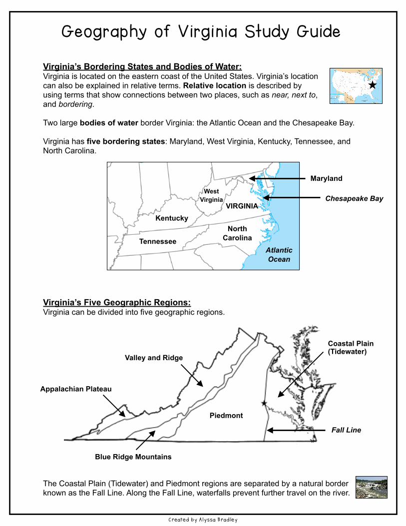
Geography of Virginia Study Guide Virginia’s Bordering States and Bodies of Water: Virginia is located on the eastern coast of the United States. Virginia’s location can also be explained in relative terms. Relative location is described by using terms that show connections between two places, such as near, next to, and bordering. Two large bodies of water border Virginia: the Atlantic Ocean and the Chesapeake Bay. Virginia has five bordering states: Maryland, West Virginia, Kentucky, Tennessee, and North Carolina. Virginia’s Five Geographic Regions: Virginia can be divided into five geographic regions. The Coastal Plain (Tidewater) and Piedmont regions are separated by a natural border known as the Fall Line. Along the Fall Line, waterfalls prevent further travel on the river. Created by Alyssa Bradley Kentucky Tennessee VIRGINIA North Carolina West Virginia Maryland Chesapeake Bay Atlantic Ocean Appalachian Plateau Piedmont Valley and Ridge Blue Ridge Mountains Coastal Plain (Tidewater) Fall Line
-
Upload
khangminh22 -
Category
Documents
-
view
1 -
download
0
Transcript of Geography of Virginia Study Guide
Geography of V i rg in ia Study Gu ide !!Virginia’s Bordering States and Bodies of Water: Virginia is located on the eastern coast of the United States. Virginia’s location can also be explained in relative terms. Relative location is described by using terms that show connections between two places, such as near, next to, and bordering. !Two large bodies of water border Virginia: the Atlantic Ocean and the Chesapeake Bay. !Virginia has five bordering states: Maryland, West Virginia, Kentucky, Tennessee, and North Carolina. !!!!!!!!!!!!!!!Virginia’s Five Geographic Regions: Virginia can be divided into five geographic regions. !!!!!!!!!!!!!!!!!The Coastal Plain (Tidewater) and Piedmont regions are separated by a natural border known as the Fall Line. Along the Fall Line, waterfalls prevent further travel on the river.
Created by Alyssa Bradley
Kentucky
Tennessee
VIRGINIA
North Carolina
West Virginia
Maryland
Chesapeake Bay
Atlantic Ocean
Appalachian Plateau
Piedmont
Valley and Ridge
Blue Ridge Mountains
Coastal Plain (Tidewater)
Fall Line

!Each region in the state has distinctive, or special, characteristics. !!!!!!!!!!!!!!!!!!!!!!!!!!!! Appalachian Valley & Ridge Blue Ridge Piedmont Coastal Plain Plateau Mountains (Tidewater) !!!Virginia’s Water Features: Virginia has many water features that were especially important to the early history of Virginia. For example, the Atlantic Ocean provided transportation links between Virginia and other places, such as Europe, Africa, and the Caribbean. The Chesapeake Bay provided a safe harbor and was a source of food and transportation. !!!!! !
Created by Alyssa Bradley
Region Land Features Location
Coastal Plain (Tidewater)
• flat land • includes the Eastern Shore
• near the Atlantic Ocean and the Chesapeake Bay
• east of the Fall Line
Piedmont • rolling hills • the name means “land at
the foot of mountains”
• west of the Fall Line
Blue Ridge Mountains • old, rounded mountains • part of the Appalachian
mountain system • source of many rivers
• between the Piedmont and Valley & Ridge regions
Valley and Ridge • valleys separated by ridges • includes the Great Valley of
Virginia • part of the Appalachian
mountain system
• west of the Blue Ridge Mountains
Appalachian Plateau • plateau: an area of elevated land that is flat on top
• only a small part of the Appalachian Plateau is located in Virginia
• Southwest Virginia
the Atlantic Ocean the Chesapeake Bay
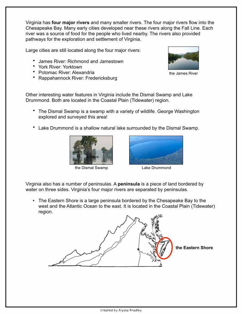
!Virginia has four major rivers and many smaller rivers. The four major rivers flow into the Chesapeake Bay. Many early cities developed near these rivers along the Fall Line. Each river was a source of food for the people who lived nearby. The rivers also provided pathways for the exploration and settlement of Virginia. !Large cities are still located along the four major rivers: !
• James River: Richmond and Jamestown • York River: Yorktown • Potomac River: Alexandria • Rappahannock River: Fredericksburg !!
Other interesting water features in Virginia include the Dismal Swamp and Lake Drummond. Both are located in the Coastal Plain (Tidewater) region. !
• The Dismal Swamp is a swamp with a variety of wildlife. George Washington explored and surveyed this area! !
• Lake Drummond is a shallow natural lake surrounded by the Dismal Swamp. !!!!!! the Dismal Swamp Lake Drummond !!Virginia also has a number of peninsulas. A peninsula is a piece of land bordered by water on three sides. Virginia’s four major rivers are separated by peninsulas. !
• The Eastern Shore is a large peninsula bordered by the Chesapeake Bay to the west and the Atlantic Ocean to the east. It is located in the Coastal Plain (Tidewater) region.
Created by Alyssa Bradley
the Eastern Shore
the James River

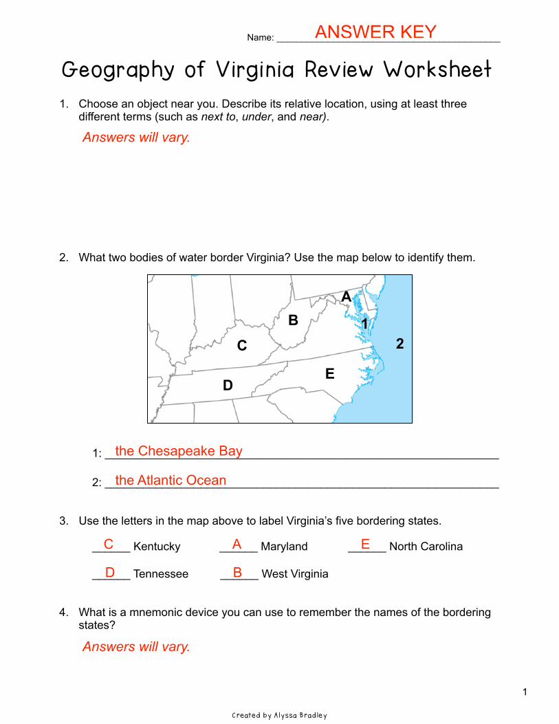
Name: ____________________________________________ !Geography of V i rg in ia Rev iew Worksheet !1. Choose an object near you. Describe its relative location, using at least three
different terms (such as next to, under, and near). !!!!!!!!!!2. What two bodies of water border Virginia? Use the map below to identify them. !!!!!!!!!!!!!! 1: ______________________________________________________________ ! 2: ______________________________________________________________ !!3. Use the letters in the map above to label Virginia’s five bordering states. ! ______ Kentucky ______ Maryland ______ North Carolina ! ______ Tennessee ______ West Virginia !!4. What is a mnemonic device you can use to remember the names of the bordering
states? !!!!Created by Alyssa Bradley
AB
C
DE
21
1
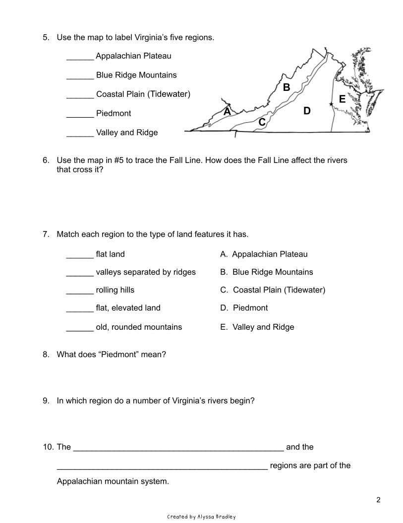
!5. Use the map to label Virginia’s five regions. ! ______ Appalachian Plateau ______ Blue Ridge Mountains ______ Coastal Plain ______ Piedmont ______ Valley and Ridge !!6. Use the map in #5 to trace the Fall Line. How does the Fall Line affect the rivers
that cross it? !!!!!!7. Match each region to the type of land features it has. !!!!!!!!!!!!8. What does “Piedmont” mean? !!!!9. In which region do a number of Virginia’s rivers begin? !!!!10. The ______________________________________________ and the !
______________________________________________ regions are part of the !Appalachian mountain system. !
A
B
CD
E
Created by Alyssa Bradley
______ flat land A. Appalachian Plateau
______ valleys separated by ridges B. Blue Ridge Mountains
______ rolling hills C. Coastal Plain (Tidewater)
______ flat, elevated land D. Piedmont
______ old, rounded mountains E. Valley and Ridge
(Tidewater)
2
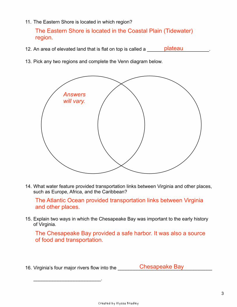
!11. The Eastern Shore is located in which region? !!!!12. An area of elevated land that is flat on top is called a _______________________. !13. Pick any two regions and complete the Venn diagram below. !!!!!!!!!!!!!!!!!!!!!14. What water feature provided transportation links between Virginia and other places,
such as Europe, Africa, and the Caribbean? !!!!15. Explain two ways in which the Chesapeake Bay was important to the early history
of Virginia. !!!!!!!16. Virginia’s four major rivers flow into the ___________________________________ !
_________________________. !!Created by Alyssa Bradley
3
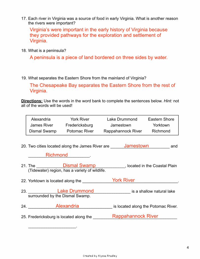
!17. Each river in Virginia was a source of food in early Virginia. What is another reason
the rivers were important? !!!!!18. What is a peninsula? !!!!!19. What separates the Eastern Shore from the mainland of Virginia? !!!!Directions: Use the words in the word bank to complete the sentences below. Hint: not all of the words will be used! !! Alexandria York River Lake Drummond Eastern Shore James River Fredericksburg Jamestown Yorktown Dismal Swamp Potomac River Rappahannock River Richmond !!20. Two cities located along the James River are __________________________ and !
___________________________. !21. The _______________________________________, located in the Coastal Plain
(Tidewater) region, has a variety of wildlife. !22. Yorktown is located along the __________________________________________. !23. _____________________________________________ is a shallow natural lake
surrounded by the Dismal Swamp. !24. _____________________________________ is located along the Potomac River. !25. Fredericksburg is located along the _____________________________________ !
_____________________. !
Created by Alyssa Bradley
4
Name: ____________________________________________ !Geography of V i rg in ia Rev iew Worksheet !1. Choose an object near you. Describe its relative location, using at least three
different terms (such as next to, under, and near). !!!!!!!!!!2. What two bodies of water border Virginia? Use the map below to identify them. !!!!!!!!!!!!!! 1: ______________________________________________________________ ! 2: ______________________________________________________________ !!3. Use the letters in the map above to label Virginia’s five bordering states. ! ______ Kentucky ______ Maryland ______ North Carolina ! ______ Tennessee ______ West Virginia !!4. What is a mnemonic device you can use to remember the names of the bordering
states? !!!!
Answers will vary. !!!!!!!!!!!!!!!!!!!! the Chesapeake Bay ! the Atlantic Ocean !!! C A E ! D B !!!!Answers will vary.
AB
C
DE
21
Created by Alyssa Bradley
ANSWER KEY
1

!5. Use the map to label Virginia’s five regions. ! ______ Appalachian Plateau ______ Blue Ridge Mountains ______ Coastal Plain ______ Piedmont ______ Valley and Ridge !!6. Use the map in #5 to trace the Fall Line. How does the Fall Line affect the rivers
that cross it? !!!!!!7. Match each region to the type of land features it has. !!!!!!!!!!!!8. What does “Piedmont” mean? !!!!9. In which region do a number of Virginia’s rivers begin? !!!!10. The ______________________________________________ and the !
______________________________________________ regions are part of the !Appalachian mountain system. !
A
B
CD
E(Tidewater)
______ flat land A. Appalachian Plateau
______ valleys separated by ridges B. Blue Ridge Mountains
______ rolling hills C. Coastal Plain (Tidewater)
______ flat, elevated land D. Piedmont
______ old, rounded mountains E. Valley and Ridge
Created by Alyssa Bradley
A ! C ! E ! D ! B !!!!Along the Fall Line, waterfalls prevent further travel on the rivers. !!!!! C ! E ! D ! A ! B !!!“Piedmont” means ‘land at the foot of mountains.’ !!!The Blue Ridge Mountains are the source of many rivers.
! Blue Ridge Mountains ! Valley and Ridge
2
!11. The Eastern Shore is located in which region? !!!!12. An area of elevated land that is flat on top is called a _______________________. !13. Pick any two regions and complete the Venn diagram below. !!!!!!!!!!!!!!!!!!!!!14. What water feature provided transportation links between Virginia and other places,
such as Europe, Africa, and the Caribbean? !!!!15. Explain two ways in which the Chesapeake Bay was important to the early history
of Virginia. !!!!!!!16. Virginia’s four major rivers flow into the ___________________________________ !
_________________________. !!Created by Alyssa Bradley
The Eastern Shore is located in the Coastal Plain (Tidewater) region. ! plateau !!!!!! Answers will vary. !!!!!!!!!!!!!!The Atlantic Ocean provided transportation links between Virginia and other places. !!!The Chesapeake Bay provided a safe harbor. It was also a source of food and transportation. !!! Chesapeake Bay
3
!17. Each river in Virginia was a source of food in early Virginia. What is another reason
the rivers were important? !!!!!18. What is a peninsula? !!!!!19. What separates the Eastern Shore from the mainland of Virginia? !!!!Directions: Use the words in the word bank to complete the sentences below. Hint: not all of the words will be used! !! Alexandria York River Lake Drummond Eastern Shore James River Fredericksburg Jamestown Yorktown Dismal Swamp Potomac River Rappahannock River Richmond !!20. Two cities located along the James River are __________________________ and !
___________________________. !21. The _______________________________________, located in the Coastal Plain
(Tidewater) region, has a variety of wildlife. !22. Yorktown is located along the __________________________________________. !23. _____________________________________________ is a shallow natural lake
surrounded by the Dismal Swamp. !24. _____________________________________ is located along the Potomac River. !25. Fredericksburg is located along the _____________________________________ !
_____________________. !!!!Created by Alyssa Bradley
Virginia’s were important in the early history of Virginia because they provided pathways for the exploration and settlement of Virginia. !!A peninsula is a piece of land bordered on three sides by water. !!!!The Chesapeake Bay separates the Eastern Shore from the rest of Virginia. !!!!!!!!! Jamestown ! Richmond ! Dismal Swamp
! York River ! Lake Drummond !! Alexandria ! Rappahannock River
4
Thank you for downloading this Geography of Virginia (VS.2) Study Guide and Review Worksheet! I hope that you find this to be a useful resource. !After you use this product, I’d love to hear your feedback. (When you leave feedback on a purchase, you also receive Teachers Pay Teachers credits, which you can use to purchase other products on the TpT website).
!Terms of Use: !This product is for one teacher’s use only. If a colleague is interested in using any of these pages, please refer him/her to my TpT store. !Please do not alter this product in any way or post/resell any part of this product. !!Images By: !Great Falls by NortyNort, New River Gorge by Gabor Eszes, Valley and Ridge by Bantosh, Piedmont by Pytheas, Jamestown by Robin Baranowski/NPS, Atlantic Ocean by Tiago Fiorenze, Chesapeake Bay by Ole Bendik Kvisberg, Dismal Swamp by Rebecca Wynn/USFWS !!Fonts By: !Munchkins Inc., The Learning Tree !!!!Happy Teaching! !Alyssa Bradley, 2015 www.teacherspayteachers.com/Store/Alyssa-Teaches