Revision Guide- Paper 1 – Physical Geography
88
2017-2018 GCSE Geography Revision Guide- Paper 1 – Physical Geography How to use this revision guide: - Look at the topic outline on the next page, identify the areas you are weakest at and concentrate your revision on them. - Answer the test yourself questions – read the page and answer the questions from memory and then repeat. Create mindmaps/flashcards with answers to the test yourself questions. - Think about your target grade and be realistic – if something is really challenging you perhaps leave it and ask a teacher for help. If your target is 6 an above you should try and learn everything here. - Look out for the 9 mark indicators in the test yourself questions, practising these would be a good idea. They are also underlined on the next page to indicate there could be a 9 mark question in the exam on this.
-
Upload
khangminh22 -
Category
Documents
-
view
4 -
download
0
Transcript of Revision Guide- Paper 1 – Physical Geography

2017-2018 GCSE Geography Revision Guide- Paper 1 –
Physical Geography
How to use this revision guide: - Look at the topic outline on the next page, identify the areas you are weakest at and concentrate your revision on them. - Answer the test yourself questions – read the page and answer the questions
from memory and then repeat. Create mindmaps/flashcards with answers to the test yourself questions.
- Think about your target grade and be realistic – if something is really challenging you perhaps leave it and ask a teacher for help. If your target is 6 an above you should try and learn everything here.
- Look out for the 9 mark indicators in the test yourself questions, practising these would be a good idea. They are also underlined on the next page to indicate there could be a 9 mark question in the exam on this.

Section 1 - Hazards Section 2 – Living World Section 3 – UK Physical Landscapes: rivers and coasts
Tectonics 1.1 - Earthquake/volcano distribution in relation to plate boundaries - Types of plate boundary and landforms that occur there - Earthquake impacts and responses. - Case study- causes, impacts and
responses to New Zealand and Nepal Earthquake
- Monitoring, prediction, protection and prevention minimise impacts.
Ecosystems - Components of an ecosystem - Interdependence in ecosystems
Example Of a UK ecosystem – Epping Forest.
- How and why ecosystems change - How the balance of ecosystems can be
restored – Wolves in Yellowstone.
Rivers – 4 types of erosion and transportation - How long profile and cross sections
change downstream. - Landforms of erosion – waterfall,s v-
shape valleys, interlocking spurs, meanders, ox-bow lakes.
- Landforms of deposition – floodplains, levees, estuaries. Methods of hard and soft engineering.
- Example of UK river management- Boscastle – why needed, how was it done, was it successful?
Weather hazards 1.2 - Global atmospheric circulation model - Tropical storms – distribution, structure and how they are occur, what will happen to them in the future - Tropical storms – impacts and responses - Tropical storm case study – Haiyan – impacts and responses - Monitoring, prediction, protection and prevention minimise impacts.
Tropical rainforests - Characteristics of TRFs - Plant and animal adaptations to TRFs - Biodiversity in TRFs - Causes of deforestation in the Amazon - Value of TRFs for environment and humans - Impacts of deforestation in the Amazon - Strategies to sustainably manage the Amazon
COOAsts – 4 types of erosion and transport - Constructive vs destructive waves - Landforms of erosion – headland and bays, crack>stump, wave cut platfora and cliff. - Landforms of deposition – beaches, bars, spits, sand dunes. - Hard and soft engineering methods - Example of UK Coast – Holderness – why is management needed, how has it been done, is it successful?
Climate change 1.3 - Evidence for climate change oin last 10,00 years - Human and natural causes of climate change - Impacts of climate change on people and the environments - Mitigating climate change - Adapting to climate change
Cold Environments - Characteristics of cold environments - Plant and animal adaptations in cold
environments - Opportunities for development in cold
environments - Challenges for development in cold
environments - How cold environments are under threat - How to manage cold environments for
economic development and environmental protection
READ THROUGH THIS TABLE, ANYUTHING YOU ARE WEAK ON CONCENTRATE YOUR REVISION ON REMEMBER TO PRACTICE YOUR 9 MARK QUESTIONS EXAM = 22ND MAY PM
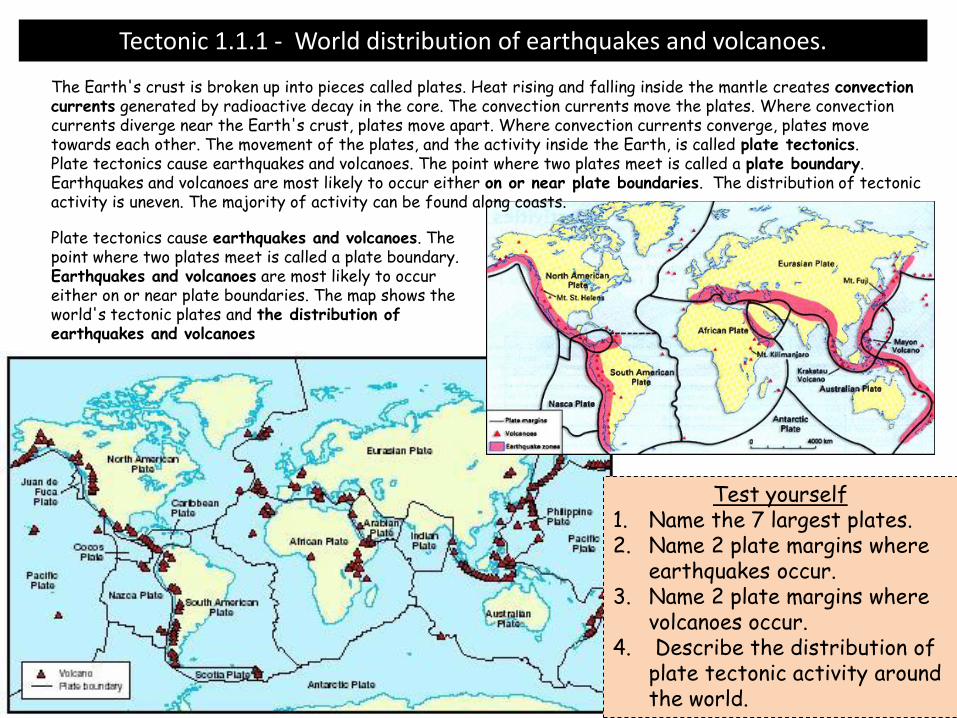
Tectonic 1.1.1 - World distribution of earthquakes and volcanoes.
The Earth's crust is broken up into pieces called plates. Heat rising and falling inside the mantle creates convection currents generated by radioactive decay in the core. The convection currents move the plates. Where convection currents diverge near the Earth's crust, plates move apart. Where convection currents converge, plates move towards each other. The movement of the plates, and the activity inside the Earth, is called plate tectonics. Plate tectonics cause earthquakes and volcanoes. The point where two plates meet is called a plate boundary. Earthquakes and volcanoes are most likely to occur either on or near plate boundaries. The distribution of tectonic activity is uneven. The majority of activity can be found along coasts.
Plate tectonics cause earthquakes and volcanoes. The point where two plates meet is called a plate boundary. Earthquakes and volcanoes are most likely to occur either on or near plate boundaries. The map shows the world's tectonic plates and the distribution of earthquakes and volcanoes
Test yourself 1. Name the 7 largest plates. 2. Name 2 plate margins where
earthquakes occur. 3. Name 2 plate margins where
volcanoes occur. 4. Describe the distribution of
plate tectonic activity around the world.
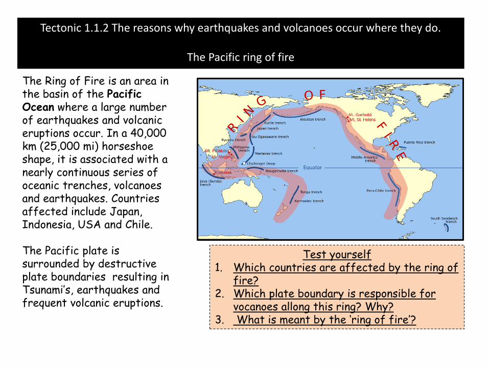
Tectonic 1.1.2 The reasons why earthquakes and volcanoes occur where they do.
The Pacific ring of fire
The Ring of Fire is an area in the basin of the Pacific Ocean where a large number of earthquakes and volcanic eruptions occur. In a 40,000 km (25,000 mi) horseshoe shape, it is associated with a nearly continuous series of oceanic trenches, volcanoes and earthquakes. Countries affected include Japan, Indonesia, USA and Chile. The Pacific plate is surrounded by destructive plate boundaries resulting in Tsunami’s, earthquakes and frequent volcanic eruptions.
Test yourself 1. Which countries are affected by the ring of
fire? 2. Which plate boundary is responsible for
vocanoes allong this ring? Why? 3. What is meant by the ‘ring of fire’?

Tectonic 1.1.3The characteristic features of constructive plate boundaries. At constructive boundary the plates are moving apart. The plates move apart due to convection currents inside the Earth. As the plates move apart (very slowly), magmarises from the mantle. The magma erupts to the surface of the Earth. This is also accompanied by earthquakes. When the magma reaches the surface, it cools and solidifies to form a new crust of igneous rock. This process is repeated many times, over a long period of time. Eventually the new rock builds up to form a volcano. Constructive boundaries tend to be found under the sea, eg the Mid Atlantic Ridge. Here, chains of underwater volcanoes have formed along the plate boundary. One of these volcanoes may become so large that it erupts out of the sea to form a volcanic island, eg Surtsey and the Westman Islands near Iceland. The diagram below to see how magma pushes up between the two plates, causing a chain of volcanoes along the constructive plate boundary. The volcanoes tend to be large and gently sloped due to runny magma.
The Helgafjell volcano on
Westman Island, Iceland
Test yourself 1. Can you give an example of a constructive
pate margin? What plates are separated? 2. Explain the processes the occur and
landforms created at contructive plate boundaries.
3. 7-9 – Explain the type of volcano found here.

Tectonic 1.1.4 The characteristic features of Destructive plate boundaries.
Destructive boundary - the plates are moving towards each other. This usually involves a continental plate and an oceanic plate. The oceanic plate is denser than the continental plate so, as they move together, the oceanic plate is forced underneath the continental plate. The point at which this happens is called the subduction zone. As they move past one another, pressure builds up and earthquakes occur, As the oceanic plate is forced below the continental plate it melts to form magma and the magma collects to form a magma chamber. This magma then rises up through cracks in the continental crust and rises to the surface creating volcanoes – they are often steep and have explosive eruptions. . The diagram below shows how the oceanic plate is pushed underneath the continental plate, causing fold mountains and an ocean trench to form.
Test yourself 1. Describe the movements of
plates at a destructive plate boundary with an example.
2. Explain the processes and landforms that occur at a destructive plate margin.
3. 7-9: explain ocean trenches and fold mountains. Also the type of volcano found here.

Tectonic 1.1.5 The characteristic features of Conservative plate boundaries.
Conservative plate boundaries describe the boundary of two plates passing each other in different directions, or in the same directions but at different speed. An example is the San Andrea fault line which separates the North American and Pacific plate margin. An earthquake is the shaking and vibration of the Earth's crust due to movement of the Earth's plates (plate tectonics). Earthquakes can happen along any type of plate boundary. Earthquakes occur when tension is released from inside the crust. Plates do not always move smoothly alongside each other and sometimes get stuck. When this happens pressure builds up. When this pressure is eventually released, an earthquake tends to occur. The point inside the crust where the pressure is released is called the focus. The point on the Earth's surface above the focus is called the epicentre. Earthquake energy is released in seismic waves. These waves spread out from the focus. The waves are felt most strongly at the epicentre, becoming less strong as they travel further away. The most severe damage caused by an earthquake will happen close to the epicentre.
Test yourself 1. Draw from memory, an annotated
earthquake zone. (Fully labelled). 2. Explain how earthquakes occur at
a conservative plate margin.

Tectonic 1.1.6The measurement of earthquake magnitude (the Mercalli and Richter scales)
.An earthquake's power is measured on the Richter scale using an instrument called a 'seismometer'. The power of an earthquake is measured using a seismometer. A seismometer detects the vibrations caused by an earthquake. It plots these vibrations on a seismograph. The strength, or magnitude, of an earthquake is measured using the Richter scale. The Richter scale is numbered 0-10. Earthquakes measuring just one or two on the scale are very common and can happen everyday in places like San Francisco. These earthquakes are so small that people cannot feel them, they can only be picked up by a seismometer. Earthquakes measuring around 7 or 8 on the Richter scale can be devastating. The earthquake in China's south-western Sichuan province in May 2008 measured 7.8 on the Richter scale.
Test yourself 1. What are the two methods used to measure an earthquake? 2. What is the difference between the Richter scale and the Mercalli scale?
The Mercalli intensity scale is a seismic scale used for measuring the intensity of an earthquake. It measures the effects of an earthquake, and is distinct from the moment magnitude.
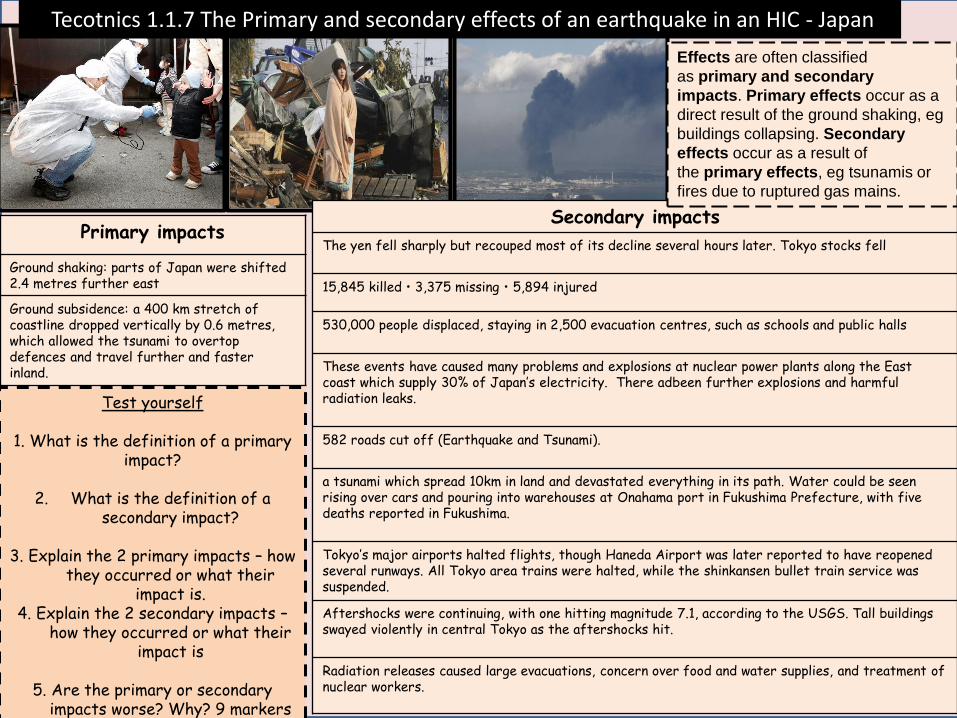
Secondary impacts
The yen fell sharply but recouped most of its decline several hours later. Tokyo stocks fell
15,845 killed • 3,375 missing • 5,894 injured
530,000 people displaced, staying in 2,500 evacuation centres, such as schools and public halls
These events have caused many problems and explosions at nuclear power plants along the East coast which supply 30% of Japan’s electricity. There adbeen further explosions and harmful radiation leaks.
582 roads cut off (Earthquake and Tsunami).
a tsunami which spread 10km in land and devastated everything in its path. Water could be seen rising over cars and pouring into warehouses at Onahama port in Fukushima Prefecture, with five deaths reported in Fukushima.
Tokyo’s major airports halted flights, though Haneda Airport was later reported to have reopened several runways. All Tokyo area trains were halted, while the shinkansen bullet train service was suspended.
Aftershocks were continuing, with one hitting magnitude 7.1, according to the USGS. Tall buildings swayed violently in central Tokyo as the aftershocks hit.
Radiation releases caused large evacuations, concern over food and water supplies, and treatment of nuclear workers.
Primary impacts
Ground shaking: parts of Japan were shifted 2.4 metres further east
Ground subsidence: a 400 km stretch of coastline dropped vertically by 0.6 metres, which allowed the tsunami to overtop defences and travel further and faster inland.
Tecotnics 1.1.7 The Primary and secondary effects of an earthquake in an HIC - Japan
Test yourself
1. What is the definition of a primary impact?
2. What is the definition of a
secondary impact?
3. Explain the 2 primary impacts – how they occurred or what their
impact is. 4. Explain the 2 secondary impacts –
how they occurred or what their impact is
5. Are the primary or secondary
impacts worse? Why? 9 markers
Effects are often classified
as primary and secondary
impacts. Primary effects occur as a
direct result of the ground shaking, eg
buildings collapsing. Secondary
effects occur as a result of
the primary effects, eg tsunamis or
fires due to ruptured gas mains.

Secondary impacts
Schools had to combine to share classrooms and schools due to damage caused.
Businesses put out of action for long periods of time
Christchurch could no longer host rugby world cup – loss of income
80% of the city was without electricity
People needed mental support in the months after the earthquake
Primary impacts
181 killed and 2000 injuered
50% of citiies buildings severely damgeaed
Liquefaction damaged roads and infrastructure
100s of kilometres of sewage pipers were damaged.
Tectonic 1.1.7 The Primary and secondary effects of an earthquake in an HIC – Christchurch NZ
Test yourself
1. What is the definition of a primary impact?
2. What is the definition of a secondary impact?
3. Explain the 2 primary impacts – how they occurred or what their impact is. 4. Explain the 2 secondary impacts – how they occurred or what their impact is
5. Are the primary or secondary impacts worse? Why? 9 markers
Effects are often classified
as primary and secondary
impacts. Primary effects occur as a
direct result of the ground shaking, eg
buildings collapsing. Secondary
effects occur as a result of
the primary effects, eg tsunamis or
fires due to ruptured gas mains.

Secondary impacts
Number of people displaced: 2.8 million
the Langtang valley located in Langtang National Park, 329 people were reported missing after an avalanche hit the village of Ghodatabela and the village of Langtang. The avalanche was estimated to have been two to three kilometres wide.
Concern was expressed that harvests could be reduced or lost this season as people affected by the earthquake would have only a short time to plant crops before the onset of the Monsoon rains.
It was reported that the survivors were preyed upon by human traffickers involved in the supply of girls and women to the brothels of South Asia. These traffickers took advantage of the chaos that resulted from the aftermath of the earthquake.
Primary impacts
Number of hospitals damaged: 26
Number of people affected: 5.6 million
Number of people killed: 8,617
More than 800,000 homes were damaged or destroyed by the earthquake
Tectonic 1.1.7. The Primary and secondary effects of an earthquake in an LIC – Nepal
Test yourself What is the definition of a primary
impact?
2. What is the definition of a secondary impact?
3. Explain the 2 primary impacts –
how they occurred or what their impact is.
4. Explain the 2 secondary impacts – how they occurred or what their
impact is
5. Are the primary or secondary impacts worse? Why? 9 markers
Effects are often classified as primary and secondary impacts. Primary effects occur as a direct result of the ground shaking, eg buildings collapsing. Secondary effects occur as a result of the primary effects, eg tsunamis or fires due to ruptured gas mains.

Nepal response Tectonic 1.1.7 What were the short term and long term responses to these Earthquakes?
Short term responses
For the first 24 hours survivors were left to fend for themselves, moving rubble with bare hands to try to reach relatives and friends.
With only 9 functioning helicopters, the Nepal Army could only reach a few of the badly injured victims standing in remote mountainous villages.
Relief was sent rapidly when the government eventually asked for help. This included a 30-bed mobile hospital from Pakistan. India sent its military to assist with rescue efforts.
Tent cities sprung up in Kathmandu, the capital of Nepal
Responses were criticised as slow - the hardest hit Gorkha-Lamjung epicentre area was visited by helicopter the day after the earthquake and hundreds were feared dead in this area
90 percent of soldiers from the Nepalese army mobilised to worst hit areas, but efforts were hampered by landslides and damaged infrastructure
On May 1st international aid agencies like Médecins Sans Frontières (Doctors Without Borders) and the Red Cross were able to start medically evacuating the critically wounded by helicopter from outlying areas.
Long term responses
The Asian Development Bank (ADB) provided a USD$3 million grant to Nepal for immediate relief efforts; and up to USD$200 million for the first phase of rehabilitation.
Aid was donated by a huge number of countries. The UK gave £73 million, of which £23 million was donated by the government and £50 million was donated by the public. The UK also provided 30 tonnes of humanitarian aid and 8 tonnes of equipment. Finally, the UK offered expert help by sending around 100 search and rescue responders, medical experts, and disaster and rescue experts deployed by the Department for International Development; engineers from the British Army's Brigade of Ghurkhas (ironically, Nepalese soldiers working in the British Army); three Chinook helicopters (returned unused by the Nepali government).
Test yourself
List the short term responses in 4 bullet points
List the Long term responses in 4 bullet points
Can you repeat this from memory?

Christchurch, NZ responses to earthquake
Tectonic 1.1.7 What were the short term and long term responses to these Eaurthquakes?
Short term responses
Provided temprorary housing and ensured all damage were kept water tight
30,000 chemical toilets provided for residnets
Elderly andm ost vuilnerable people immediately evacuated and cared for
City divided in to zones to classify damage and some areas sealed off from the public
Japanesse rescue teams send to help search
Long term responses
Water and sewage restored by August – 5 months after for all
Roads and houses cleared of silt by August, 80% of roads were.reparired,
$898million in building claims paid out
Test yourself
List the short term responses in 4 bullet points
List the Long term responses in 4 bullet points
Can you repeat this from memory?

Potential EQ 9 markers:
TO what extent are primary effects worse than secondary impacts.
Evaluate the response of an earthquake or both
earthquakes you have studied. Which was better?
To what extent are the impacts of EQ worse in LICs compared to HICs.
Tectonic 1.1.7 What were the short term and long term responses to these Eaurthquakes?

Tectonic 1.1.8 The reasons why people continue to live in areas of volcanic activity.
Kilauea Volcano, Hawaii Volcanoes are attractive to tourists, with many visiting active areas such as Iceland, creating a demand for jobs in hotels and as tour guides.
mount Etna, Sicily Volcanoes can provide good environments for farming because some volcanic lava weathers to produce very fertile soils. In Sicily for example, many farmers grow olives, grapes and citrus fruits on the slopes of mount Etna.
People are attracted to live and work in California by the attractive landscape and the pleasant environment. The coast provides beautiful beaches and opportunities for surfing.
Mount Merapi, Indonesia Many people who live here worship ancient spirits and ancestors. They believe that their spirits watch over the peak and will warn them of a n eruption. They believe this will enable live them to live nearby safely, and evacuate at times of danger.
Several hundred men work in the heart of Ljen volcano in East Java, Indonesia. Minerals such as Tin, silver gold, copper and diamonds can be found in areas of volcanic rocks. The money that can be made by mining these precious materials often outweighs the risks of volcanic activity.
Test yourself 1. Name 4 hazardous location where people live. 2. Explain 4 reasons why people live in
hazardous area. (2 economic/1 social/1 environmental).
Indonesia = religiona nd cultuire

Methods of preventing the effects of earthquakes
What methods are there to reduce the
effects of an earthquake?
Planning
Prediction
Monitoring
Think, pair, share- what methods can be used to reduce the effects of an earthquake?
Protection

San Francisco
showing the
Transamerica
Pyramid
The preparedness drills are held every year on Sept. 1, the anniversary of the Great Kanto Earthquake that killed 140,000 people in the Tokyo area in Jpapan..
Test yourself 1. Explain how each method works. 2. Explain the procs and cons of each methods. 3. 9 MARKER – Which method is most successful? Evaluate
the use of each method.
Tectonic 1.1.9 Managing earthquakes: Prediction and monitoring, planning and protection.
Method How Good Bad
Prediction Using technology to guess where and when Eqs will happen
Can be used to give warning and make plans
CANNOT guess to the minute and location - impossible
Monitoring Using past data to try and guess when and where earthquakes will happen.
Can provide time for people to plan
Won’t be overly accurate eg can predict in years
Protection Building so that buildings don’t fall down: - rubber foundation to absorb shock - weighted rollers on top to counteract rolling - pyramid structure to give strong base
Very effective at saving lives – no building collapse
Very expensive and hard to do in LICs
Planning - Plan for the event and have aid and search and resuce teams, as well as supplies ready. - People can have drills so they know what to do
Can be effective at saving lives and helping afterwards Doesn’t cost LICs much money so effective there

Weather Hazards
Living with the physical environment :Weather hazards

Weather Hazards 1.2.1 Global atmospheric circulation model – COME ON!! LOVE IT!!!
Hadley Cell Air rises at the equator because this is where the suns energy is greatest causing evaporation causing rain. Once air has risen here it cannot fall back down to earth because air below is constantly rising so it spreads out in the upper atmosphere. It has lost it’s moisture and falls back down to earth and roughly 30o N/S at the sub-tropical high pressure zone, bringing dry weather. From here it returns to the equator from an easterly direction due to the Coriolis force, this completes the Hadley Cell.
Polar Cell Air sinks at the north and south pole because it is so called, sinking air is called high pressure. Once it hits the surface it travels towards 60o N/S from an easterly direction towards the polar front. Here it meets air travelling from……….
Ferrell Cell ………………..The sub tropical high (air that didn’t go back to the equator). This air has travelled from a westerly direction and is warm (from the equator) and meets the cold air from the poles. They collide at the surface and rise creating low pressure and clouds and rain. This is the polar front (the UK sits here, hence our weather). Once this air has risen it either fans out in the upper atmosphere to the sub tropical high where it falls, completing the Ferrell Cell OR it fans out to the poles where it falls, completing the Hadley Cell.
Test yourself
1. Describe the movement of air in each
cell.
2. Explain the movement of air
in each cell.
YOU MAY FIND IT HELPFUL TO DRAW IT OUT
AND ANNOTATE

Location Tropical storms are located: - between 5 and 20o North and South of the equator (if they were closer to the equator the winds would not be strong enough) - In the Atlantic, Pacific and Indian Oceans. Through the Caribbean, Southern USA, Mexico, South East Asia, India, Australia. North hemisphere = June to December. - South hemisphere = January to March
Ingredient Explanation
Low pressure So that air can rise to create thunderstorms and clouds
Large ocean – at least 70m deep
To provide a huge supply of water to evaporate to create the clouds
Ocean to be warm – 26.5oC
So it is warm enough to evaporate all the water required and the hot temperature gives the storm lots of energy
Earth’s rotation So that winds spin as they move into the centre of the storm
Winds blowing in the same direction
So that the initial storm clouds are not blown apart
Climate change and tropical storms Climate change is expected to affect tropical storms in the following ways: Frequency and distribution – due to warmer oceans the number of very strong tropical storms are expected to increase because the oceans have more energy. Distribution – it is believed that hurricanes could happen further than 20o North and South because oceans at higher latitudes will be warmer and therefore have enough energy to create hurricanes.
Weather Hazards 1.2.2 Tropical storms – locations, requirements and future
Test yourself 1) Describe the location of tropical storms.
2) Explain what they require to form. 3) Explain how they might change due to
climate change.

1) Tropical storms form between approximately 5° and 30° latitude. Because of easterly winds they initially move westward.
2) The air above the warm ocean is heated. Once the ocean water reaches at least 27°C, the warm air rises quickly, causing an area of very low pressure.
3) As the air continues to rise quickly it draws more warm moist air up from above the ocean leading to strong winds.
4) The rapidly rising warm air spirals upwards, cools, condenses and large cumulonimbus clouds form. These clouds form the eye wall of the storm and produce heavy rainfall and extremely strong winds. It is the most dangerous part of the hurricane.
5) In the centre of the storm, cold air sinks forming the eye of the storm - here, conditions are calm and dry.
6) As the storm hits land it causes heavy rain, strong winds and a storm surge which washes up on land.
Weather Hazards 1.2.3Tropical storms – development and causes
Test yourself
1. Describe the steps in the formation of
a tropical storm.
2. Explain the steps in the formation of
a tropical storm.
3. Label the
sections of a tropical storm.

Primary impacts – the immediate impacts which are caused by strong winds, heavy rain and storm surges. -Buildings and bridges destroyed. -- Rivers and coastal areas flood. - People drown, injured, or killed by debris and flood waters. - Infrastructure damaged – roads, railway, ports, airports. - Electricity cables are damaged. - Sewage overflows.
Secondary impacts– the long term impacts which happen in the days or time after due to the primary impacts. -People are left homeless which can cause stress, poverty, diseases, death. - No clean water or sanitation because, diseases spread. - Roads blocked meaning aid cannot get through, business and emergency vehicles can’t function. - Food shortages due to damaged or killed crops and animals.
Immediate responses - action taken before, during or immediately after to lessen the impacts. - Evacuations - Rescue people cut off by flooding -Set up temporary shelters - Provide supplies of food, water, electricity, gas and communitcations. - Recover dead bodies - NGOs and governments send Aid teams and supplies. .
Long term respones – actions that restore areas to the condition before the storm struck and reduce damage in the future. -Fully repair homes , buidligns and infrastructure - Repair and improve flood defences - Improve forecasts for the future - Provide aid for residents to repair and strengthen homes - Encourage economic recovery to for people to return to the area - Build stronger buildings or change planning rules.
The impacts of tropical storms tend to be more severe in LICs because: HICS have more money to create: - Storm proof buildings to resist strong winds eg winds not blowing off. -Evacuation plans and teams to ensure people leave areas and can be rescued afterwards. -The money to invest in monitoring technology to forecast and track storms so people can be warned. - The money to build defences such as sea walls. - The money and organisation to educate people.
Weather Hazards 1.2.4 Tropical storms – impacts and responses
Test yourself: 1. Define primary/secondary impacts and immediate/long term solutions
2. Give 2-3 examples of each and explain how/why they occur OR why they are bad. 3. Explain why the impacts and responses of storms tend to be worse in LICs rather than HICs (9 marker)
4. Explain whether you think primary or secondary impacts are worse (9 marker)

Primary impacts – MOST POWERFUL STORM EVER RECORDED AT LANDFALL -Winds up to 314km an hour - 6,190 people died - 1.1mil tonnes of crop destroyed - 1.1mil houses damaged, over 500,000 destroyed - Boats and fishermen docks destroyed.
Secondary impacts– the long term impacts which happen in the days or time after due to the primary impacts. - 4.1 million made homeless - US$12bn damage - Farmers lost crops – especially cocnut, rice and sugar which are main exports – meaning long term income reduced and there was unemployment. - Three quarters of farmers and fishermen lost their income
Immediate responses - Good President televised a warning, 800,000 people evacuated. Government distributed emergency supplies and equipment. US$1.5bn dollars in foreign aid from 33 countries and organisations. 1million food packs and 250,000 litres of water distributed a week later. - Vaccinations handed out so disease did not spread. Bad Some emergency aid took as much as 5 days to arrive – Tacloban because roads/ports/airports were destroyed. Stadium in Tacloban where people fled to was flooded and they were drowned. A lot of people were not evacuated in coastal areas due to a lack of knowledge, warning or ability. £1m worth of food aid thrown away because it had not been stored properly.
Long term respones – actions that restore areas to the condition before the storm struck and reduce damage in the future. Good - No new buildings to be built within 40m of the shore -New homes to be off a better quality and stronger - $400 cash gifts to people in areas which were worse affected - New storm surge warning - Mangroves replanted (to help lessen the power of the storm) - Local residents involved in the rebuilding of new homes to create jobs Bad -Corruption – areas that did not vote for the president felt they recieved less help - A year later less than 1% of people affected were back in permanent homes and shelter
Weather Hazards 1.2.5 Typhoon Haiyan – Example of a tropical storm – effects and respones
Test yourself: 2. Give 2-3 examples of each box with evidence
3. Explain why the impacts and responses of storms tend to be worse in LICs rather than HICs, with reference to the example. (9 marker)
4. Explain whether you think primary or secondary impacts are worse (9 marker) 5. Explain whether you think the responses were overall GOOD or BAD (9 marker)

Monitoring – allows prediction to be made about where the storm will go and how intense it will be, this can save lives. -Satellites – these can monitor cloud patterns and identify which storms are likely to become hurricanes and when. - Aircraft – purpose built planes can fly through hurricanes which collect air pressure, rainfall and wind speed. They can monitor storms to see if they are becoming more intense.
Monitoring allows for scientists to see how a storm is developing and how strong it will be.
Predicting – using data from modelling to feed computer which “model” where storms will go and how strong they will be. The national hurricane centre in Florida predicts a storms path and intensity for up to seven days. It uses a cone which gets wider from the hurricane. It is accurate 70% of the time. In 2013 Cyclone Phailin was predicted and 1.2 million people evacuated, 21 people died. In 1999 a similar cyclone killed 10, 000 people.
Protection – strengthening/adapting buildings to lessen the impacts of tropical storms. - shutters on windows close to prevent them breaking in wind -secure roofs to walls with strong metal to prevent them flying off - emergency generators#
Houses can also be built with stilts so they are out of flood water’s way. Sea walls and other defences hold back storm surges and limit erosion, but they must be big and strong enough. Salt marshes and wetlands can act as natural barriers which help to absorb the power of tropical storms floods and waves.
Planning – taking steps before a tropical storm to lessen their impacts. -Land use management – not allowing new buildings to be built in areas which are at particular threat from hurricanes. - Emergency services can train for disastster. - Governments can plan evacuation routes. - America National Hurricane Preparedness weak means people can plan what to do in the event of a hurricane: - prepare emergency supply kit - know where shelters are - know evacuation routes - store loose objects
Weather Hazards 1.2.6Typhoon Haiyan – Example of a tropical storm – effects and respones
Test yourself: 1. Define each methods.
2. Give an example of each methods and explain how it works – reducing damage or reducing deaths.
3. Are any of the methods more effective than the others at reducing deaths or damage – (9 marker).
4. How do these vary between HICs and LICs.

Wind – strong winds occur as a result of storms that hit the UK every year. The impacts they can have are: - damage buildings and disrupt transport - Cause large waves to hit and damage the coast - Debris and falling trees can kill people
Rain – every winter prolonged rain brings flooding while in the summer flash flooding occurs. This can cause - damage to homes and business - Deaths through drowning - Homelessness - Transport disruption due to damage - Business close - Millions of £ of damage - - destroy crops and land
Snow and ice – during the winter freezing temperatures hit the UK causing: - People (especially old) to die due to lack of heating - Travel and business chaos as roads and rail are closed - Schools close - Damage to plants and crops
Heatwaves and drought – prolonged periods of hot and dry weather in the summer can lead to the above. Drought can also be caused due to a lack of rainfall in the winter meaning reserovoirs are not topp[ped up. The imapcts can be: - Death due to heat exhaustion (Heatwave) - Breathing difficulties due to more pollution (heatwave) - Disruption to transport due to melting roads and rail (heatwave) - Crop failures - Water shortages (Droughts)
Weather Hazards 1.2.7 Weather hazard in the UK - types
Test yourself: 1. Describe/briefly explain each weather hazard.
2. Split the impacts of the hazards into social, economic and environmental. Be confident in explaining these.

YES! The UK weather is becoming more extreme, most people would say this is as a
result of climate change. However some people would argue that it is natural for our
weather and climate to have extreme periods.
Temperature December 2010 was the coldest December for 100 years, but April 2011, for months later, was the warmest April ev4 er recorded.
Rainfall – we are experiencing more and more rain There has been more rainfall records broken in 2010-2014 than in any decade on record (records started in the 1800s) and this is just 4 years. - 2013 one of the wettest years on record. - December 2015 one of the wettest months ever on
record.
Weather Hazards 1.2.8 UK Weather – Is it becoming more extreme?
Floods are increasing Major floods have occurred in: Cumbria – 2005, 2009 and 2015/16 West Wales – 2012 Somerset Levels - 2012
Test yourself: 1. Describe and give evidence for each box as to how UK weather is getting
more extreme. Ensure you can compare to “records”.
2. Justify an opinion on it, recognise that
some people disagree. (9 marker).

Causes A number of deep depressions (low pressure systems that bring strong winds and lots of rain) hit the UK from the Atlantic Ocean . These may have been caused because southern England was very warm while northern Scotland was very cold, meaning hot and cold air mixed together.
Impacts The storms brought strong winds and flooding to many parts of the UK. Below are some of the impacts: Social - In Scotland the rail network shut down and the planes were cancelled from Glasgow and Edinburgh. Over 100,000 homes lost power. - Flooding in Southern UK in Dorset, Hampshire, Surrey
and Kent. 50,000 people were without power.
Economic The estimated cost of the storms was £1.1bn , this included £446 for homes and business that were flooded. The transport chaos and flight cancellations would have had large effects also as business, trade and deliveries were interrupted. People could not get to work. Environmental – crops destroyed due to flooding and severe coastal erosion in some areas due to storms.
How did management reduce the risks? National COBRA – government emergency committee – met twice to discuss and coordinate response accorss the country. Regional -15,000 people advised to evacutate homes on the east coast. - Emergency shelters set up for those who were evacuated including churches, schools and sport centres. - The army helped Somerset council set up and coordinate
flood defences and rescue efforts. - The Thames Barrier was raised a record number of times
that year to prevent London from flooding.
Weather Hazards 1.2.9 UK Extreme Weather Example – Storms of Winter 2013/14
Test yourself: 1. Describe the causes of the storms.
2. Exlpain, with evidence the environmental, social and economic impacts of the storm.
3. Explain the response. How did they reduce deaths and limit economic damage?

Paper 1 Living with the physical environment
:Climate change

The Quaternary period
The Quaternary is the last 2.6 million years of Earth history. It is marked by the presence of large ice-sheets in the northern hemisphere, which expand when climate is cold (glacials) and retreat when climate warms (interglacials). We are currently in the Holocene interglacial which began about 10,000 years ago. It is important to understand the Quaternary climate system because changes in global climate that have occurred during this period offer important insights into how and why the climate changes.
It is also the time interval during which
humans and their civilisations evolved, which may have been
driven by environmental
changes that we are able to record.

Ice cores are drilled in glaciers and on ice sheets on all of Earth's continents. Most ice cores, however, come from Antarctica and Greenland, where the longest ice cores extend to 3 km—over 2 miles—or more in depth. Ice cores from the cold interior regions of polar ice sheets provide exceptionally well-preserved and detailed climate records. This is because the lack of melt at these locations does not corrupt the record of trapped gases or blur the record of other impurities. The oldest continuous ice core records extend to 130,000 years in Greenland, and 800,000 years in Antarctica.
://www.youtube.com/watch?v=8BgD9xul16g
https://www.youtube.com/watch?v=oHzADl-XID8
To examine the methods used by humans to understand long term climate change.
Ice cores
TEST YOURSELF!!! Can you: 1. Define what Ice cores are? . (2) 2. Write a PEE paragraph explaining how
they measure climate change? (4)

The way ice core dating is typically explained is that ice cores have dark rings and light rings, just like trees rings. In the summer, when it’s warm, the ice melts a little making a clear layer and when it freezes, it creates a clear layer of ice. In the winter, the snow does not melt since it is cold, but instead, snow presses down and you get a compressed layer of snow and it turns into what is called “milky ice” which also has air bubbles trapped in it. So as you look at the core you see clear and milky, clear and milky, etc. Each of these they claim are annual rings (see image and caption above)
To examine the methods used by humans to understand long term climate change.

Tree rings Dendrochronology (or tree-ring
dating) is the scientific method of dating tree rings (also called growth rings) to the exact year they were formed in order to analyze atmospheric conditions during different periods in history.
The rings are wider in
wet and warm years!
Using rings from ancient trees such as the Bristlecone pines which live for 6000 years or more in California give a great deal of information about climate.
To examine the methods used by humans to understand long term climate change.
TEST YOURSELF!!! Can you: 1. Define what tree rings are? (2) 2. Write a PEE paragraph explaining how
they measure climate change? (4)

The Baltic Sea and Black Sea are areas where the sea bed
is tested for Planton fossils as
they are two of the oldest seas on the
planet.
Plankton particle size There is increasing evidence that plankton
particle size is affected by climate change induced warming. In general, larger size species are better adapted to colder environments, while species of smaller sizes are more often found in warmer regions. According to the species shift hypothesis, global warming will likely cause decreasing body-size and an overall increase in the proportion of smaller size species. This evidence dates climate change as far back as 450,000 years.
Therefore we can measure relative warm and cool periods depending on the size and numbers of Plankton found in the Sea bed.
To examine the methods used by humans to understand long term climate change.
TEST YOURSELF!!! Can you: 1. Define what plankton particle size
describes? (2) 2. Write a PEE paragraph explaining how
they measure climate change? (4)

Internal Factors Affecting Climate:
Volcanic activity – Volcanic eruptions release sulphur dioxide and ash into the atmosphere increasing the layer of insulation coming into the earth = increased temperatures Surface reflection – Lighter colours reflect more heat. When there is more snow temperatures drop even more due to reflection. Changes in atmospheric gas – The more carbon dioxide in the atmosphere the greater the temperatures Tectonic activity – The movement of the continents caused by plate tectonic movements affects the ocean circulation, winds and ocean currents. This has a very small effect on the climate over time.
External Factors Affecting Climate: Solar output – The amount of energy that comes from the sun Orbital geometry : - The changing orbit of the earth around the sun - The tilt of the earth’s axis which changes over time. The greater the angle of the tilt, the hotter the summers and the colder the winters are.
Climate Change – 1.3.2.What are the natural causes of climate change? ?
TEST YOURSELF!!! Can you: 1. Describe the overall pattern of how
the climate has changed since the last ice age, giving details of 2 warmer periods and 2 colder periods (4).
2. Explain the following causes of climate change since the last ice age (6):
a) Solar output b) Orbital geometry c) Volcanic activity d) Changes in atmospheric gas e) Surface reflection f) Tectonic activity
This graph shows how the planet’s climate has changed since the end of the last ice age. It is important for you to know that temperature has gone up and down (fluctuated) over the past 10,000 years.
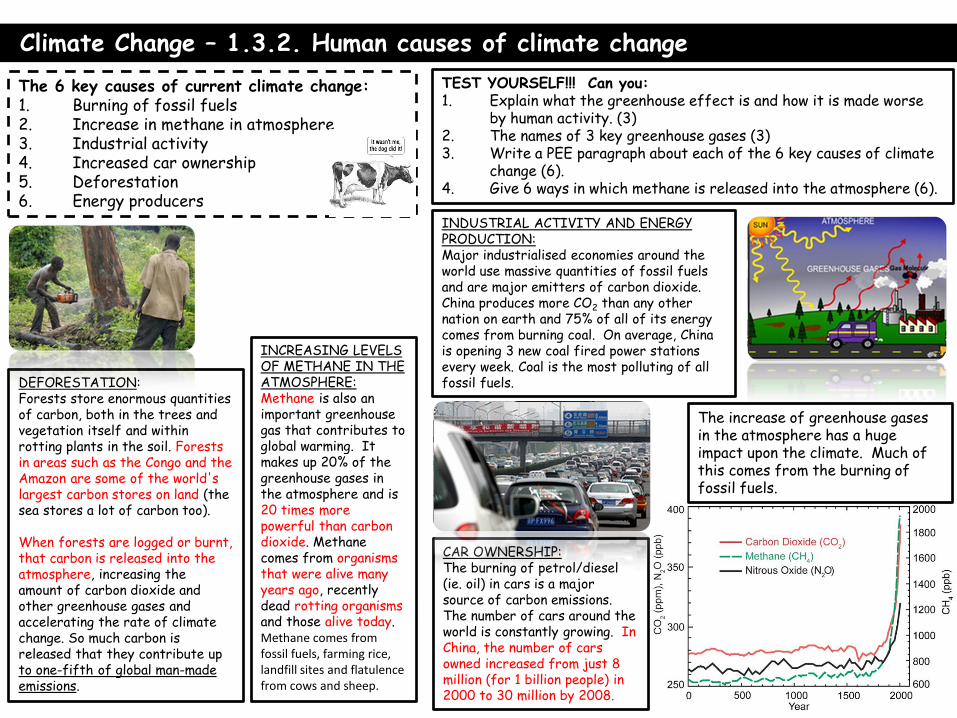
Climate Change – 1.3.2. Human causes of climate change
TEST YOURSELF!!! Can you: 1. Explain what the greenhouse effect is and how it is made worse
by human activity. (3) 2. The names of 3 key greenhouse gases (3) 3. Write a PEE paragraph about each of the 6 key causes of climate
change (6). 4. Give 6 ways in which methane is released into the atmosphere (6).
The 6 key causes of current climate change: 1. Burning of fossil fuels 2. Increase in methane in atmosphere 3. Industrial activity 4. Increased car ownership 5. Deforestation 6. Energy producers
The increase of greenhouse gases in the atmosphere has a huge impact upon the climate. Much of this comes from the burning of fossil fuels.
DEFORESTATION: Forests store enormous quantities of carbon, both in the trees and vegetation itself and within rotting plants in the soil. Forests in areas such as the Congo and the Amazon are some of the world's largest carbon stores on land (the sea stores a lot of carbon too). When forests are logged or burnt, that carbon is released into the atmosphere, increasing the amount of carbon dioxide and other greenhouse gases and accelerating the rate of climate change. So much carbon is released that they contribute up to one-fifth of global man-made emissions.
CAR OWNERSHIP: The burning of petrol/diesel (ie. oil) in cars is a major source of carbon emissions. The number of cars around the world is constantly growing. In China, the number of cars owned increased from just 8 million (for 1 billion people) in 2000 to 30 million by 2008.
INDUSTRIAL ACTIVITY AND ENERGY PRODUCTION: Major industrialised economies around the world use massive quantities of fossil fuels and are major emitters of carbon dioxide. China produces more CO2 than any other nation on earth and 75% of all of its energy comes from burning coal. On average, China is opening 3 new coal fired power stations every week. Coal is the most polluting of all fossil fuels.
INCREASING LEVELS OF METHANE IN THE ATMOSPHERE: Methane is also an important greenhouse gas that contributes to global warming. It makes up 20% of the greenhouse gases in the atmosphere and is 20 times more powerful than carbon dioxide. Methane comes from organisms that were alive many years ago, recently dead rotting organisms and those alive today. Methane comes from fossil fuels, farming rice, landfill sites and flatulence from cows and sheep.

1. The changing pattern of crop yield Villagers in Northern China are suffering from declining crop yields due to poor rainfall (there has been no rain for three years and no harvest). Sand is engulfing the village and people are being forced to move to the cities to survive.
2. Impacts of sea level rise (small islands) Sea levels rise both because of an increased volume of water in the oceans as glaciers and ice at the Poles melt and because of thermal expansion (warmer water is greater in volume). Rising sea level has particular impacts on small islands such as Tuvalu and the Maldives. They risk being flooded and having their landed damaged by saltwater.
4. Retreating glaciers Mountain glaciers are retreating all over the planet. In Patagonia in Argentina, the Neff Glacier has retreated by 3 miles since the 1930s. This leads to a rise in sea levels and has a huge impact on people that rely on the rivers that flow off glaciers for drinking water. This is a particular issue in India, where millions rely on glacier melt from the Himalays for drinking water.
5. Habitat change – impact on species Sea ice melting at the North Pole threatens the habitats of polar bears who are having to swim longer and longer distances in search of food. In Hudson Bay, Canada, the number of polar bears has fallen by a quarter in the past 20 years. Coral bleaching is when increased temperatures kill coral and the animals that survive on it as an ecosystem.
3. Risk of flooding The flooding of the Somerset Levels in January 2014 indicates that the UK is vulnerable to extreme weather, particular wetter winters, as a result of climate change. The UK will need to invest in flood defences.
3. The Negative Effects of Climate Change on people and the environment
TEST YOURSELF!!! Can you: 1.Explain the 5 key
impacts(5) 2.Give a fact to support each one? (5) S[plit intor human and
environemtnal impacts.
Climate Change – 1.3.3. Impacts of climate change on people and evnironemtn

Managing climate change involves both:
Mitigation - reducing causes of climate change through the reduction of green house gas emissions
and the use of sustainable energy technologies.
Adaptation – Accepting that the dangers associated with climate change such as sea level rise are going
to take place and taking steps to reduce the effects, such as attempting to reduce the effects of coastal
flooding.
Climate Change – 1.3.5 Mitigating the effects of climate change.
TEST YOURSELF!!! Can you: 1.From memory – Can you define the key terms above? (2 marks each).
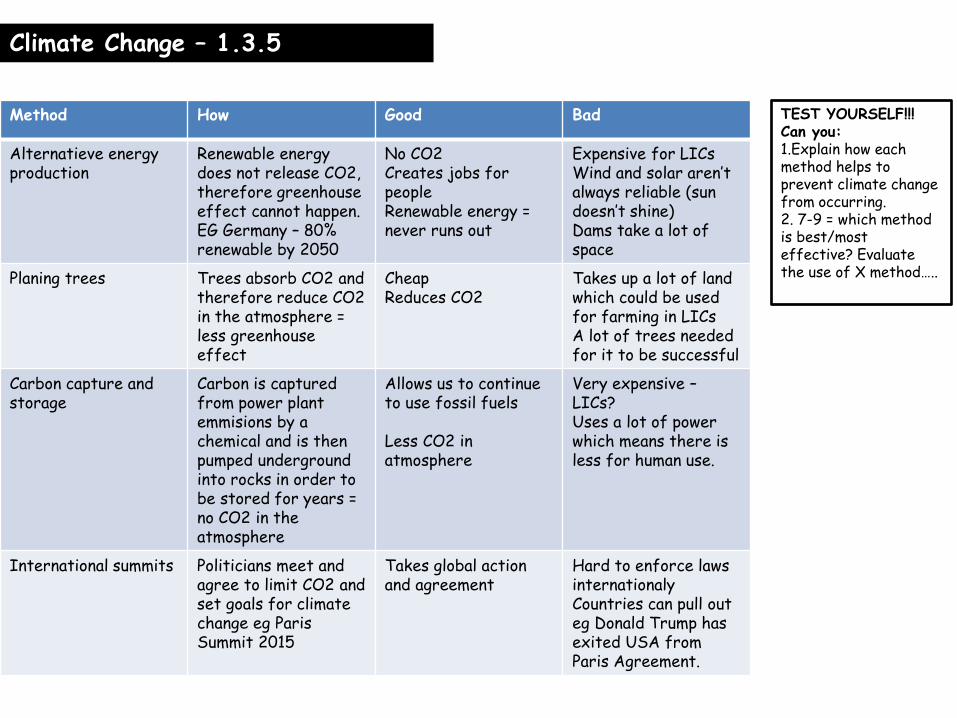
Climate Change – 1.3.5
TEST YOURSELF!!! Can you: 1.Explain how each method helps to prevent climate change from occurring. 2. 7-9 = which method is best/most effective? Evaluate the use of X method…..
Method How Good Bad
Alternatieve energy production
Renewable energy does not release CO2, therefore greenhouse effect cannot happen. EG Germany – 80% renewable by 2050
No CO2 Creates jobs for people Renewable energy = never runs out
Expensive for LICs Wind and solar aren’t always reliable (sun doesn’t shine) Dams take a lot of space
Planing trees Trees absorb CO2 and therefore reduce CO2 in the atmosphere = less greenhouse effect
Cheap Reduces CO2
Takes up a lot of land which could be used for farming in LICs A lot of trees needed for it to be successful
Carbon capture and storage
Carbon is captured from power plant emmisions by a chemical and is then pumped underground into rocks in order to be stored for years = no CO2 in the atmosphere
Allows us to continue to use fossil fuels Less CO2 in atmosphere
Very expensive – LICs? Uses a lot of power which means there is less for human use.
International summits Politicians meet and agree to limit CO2 and set goals for climate change eg Paris Summit 2015
Takes global action and agreement
Hard to enforce laws internationaly Countries can pull out eg Donald Trump has exited USA from Paris Agreement.

Climate Change – 1.3.5
TEST YOURSELF!!! Can you: Explain a method of coastal defence that adapts to rising sea levels? 4 marks) Explain how we in the UK can adapt to increased temperatures in the summer and less rainfall? 4 marks) Explain how Arid coastal countries can cope with drought? (4 marks) 9 MARKER = EVALUTE THESE!
Some countries have been forced to adapt to climate change. Male, the capital of the low-lying Maldives, is constantly under threat from storms. The government has built sea walls around the Island.
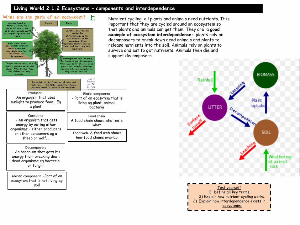
Living World 2.1.2 Ecosystems – components and interdependence
Test yourself 1) Define all key terms.
2) Explain how nutrient cycling works. 2) Explain how interdependence exists in
ecoystems.
Producer - An organism that uses
sunlight to produce food . Eg a plant
Consumer - An organism that gets energy by eating other
organisms – either producers or other consumers eg a
sheep or wolf. .
Decomposers - An organism that gets it’s energy from breaking down dead organisms eg bacteria
or funghi
Biotic component - Part of an ecosytem that is
living eg plant, animal, bacteria
Abiotic component - Part of an ecosytem that is not living eg
soil
Food chain A food chain shows what eats
what
Food web- A food web shows how food chains overlap.
Nutrient cycling: all plants and animals need nutrients. It is important that they are cycled around an ecosystem so that plants and animals can get them. They are a good example of ecosystem interdependence- plants rely on decomposers to break down dead animals and plants to release nutrients into the soil. Animals rely on plants to survive and eat to get nutrients. Animals then die and support decomposers.

Living world – 2.1.2 Ecosystems – causes of change in ecosystems and impacts on food webs
Test yourself 1) Explain the physical reasons change can happen in an
ecosystem. 2) Explain the human reasosn change can happen.
3) Explain how change in a food chain/web impacts other parts of the food chain/web.
Physical - Periods of extreme weather of climate change can disturb the balance of ecosystems. In the years 1976-77, southern England experienced an 18 month drought that killed many trees. A further 15 million English trees were felled by a great storm in 1987. As a result, population numbers declined for many consumer species in the food chain. Secondary forest growth has since taken place, however, and consumer species have migrated back. The recent recovery of English woodland is an example of ecosystem resilience.
Human - ecosystems are sometimes damaged in permanent ways, especially when human forces are involved, for instance by deforestation. The removal of forest exposes the soil beneath to rainfall, and so it can be washed away making it impossible for the ecosystem to recover.
In the long term human induced climate change could threaten the ecosystem balance of many places. Changes in temperature and precipitation patterns for southern England might make it harder for Ecosystems like Epping Forest to survive in their current form.
How does a change in a food chain impact other species?Oak woodlands support many species. Suppose that the population of beetles is reduced by disease, this would directly impact on the numbers of woodpeckers. With fewer beetles, comes fewer meals and their numbers may decline. However, we may see an increase in oak tree growth if fewer beetles were feeding on
them.
The indirect result of a reduction in beetles.
- Owl and hawk numbers may also fall because they feed on woodpeckers.
- Woodpeckers are carnivorous and have multiple food sources, they may just eat more caterpillars (but this would have problems for blue tit numbers).
Woodpeckers
Moth Caterpillar Beetles
Flies Aphids and Capsids
Blue tits
Spiders
Sparrows
Hawks Owls

Living World – 2.1.3 Ecosystems – restoring the balance of ecosystems – wolves in Yellowstone.
Test yourself 1) Describe/explain how the reintroduction
of wolves in Yellowstone caused short term changes to the ecosystem.
2) Describe/explain how the reintroduction of wolves in Yellowstone caused long term
changes to the ecosystem.
Reintroduction of the grey wolf.
There are 16 packs of around 10
animals. Each pack kills one elk
per day.
Competition
from the wolves
results in a
decrease in
coyote
populations.
Reduction in
predation from
coyotes leads to an
increase in voles,
mice and other
rodents.
Elk population falls
from 20,000 to 10,000
in 8 years
Reduction in
grazing pressure
on vegetation.
Aspen and cotton
wood start to
regenerate. Three
is more tree cover.
More kills made
by wolves
provide more
food for
scavengers.
Increases in populations
of grizzly bears, cougars
and ravens, magpies and
eagles.
Increase in
banks side
trees
stabilises
river banks-
there is less
erosion.
More woody
debris in
rivers creates
pools and
provides
trout habitat
Beavers
create
ponds
and
flooded
areas,
which
promote
the
growth of
aspen
Regenerati
on of aspen
attracts
beavers,
which
begin to
recolonise
Yellowston
e
Increase
d tree
cover
provides
habitats
for
songbird
s
Population of
predators of
small rodents,
e.g. red foxes
and birds of
prey, increase

Living World: 2.1.4 Ecosystems – distribution and characteristics of large scale natural ecosystems.
Test yourself 1) For each ecosystem,
describe: - location
- what they look like - climate
2) 7-9 for each ecosystem can
you explain why they are located where they are in
relation to the
3) Explain why latitude is so important in explaining why
ecosystems are located where they are.
4) 7-9: explain one other control of where ecosystems
are located.
Biome Location Description of nature
Description of temperature
Link to Hadley Cell (if applicable)
Tropical rainforests
Found in bands around the world on or near the equator. In Asia (Indonesia), Africa (Congo) and South America (Brazil).
Tall, exotics trees, plants and loads of animals and insects. Most biodiversity on land in the planet.
Hot, humid and lots of rain.
Lies at the equator, so the suns rays are strongest, creating evaporation (low pressure) and therefore lots of rain. The sun and rain mean many plants and trees can grow.
Deserts Found in bands around the world at roughly 30o N and S.
Very little vegetation, landscapes made of just sand or rock.
Very dry (the main thing, technically Antarcitca is a desert) and usually very warm.
Found at 30o N and S, also known as the sub tropical high where dry descends in the Hadley Cell.
Deciduos/temperate forest
Found in higher latitudes around 50oN in Europe, USA and Russia.
What the UK would look like if it was all natural woodland. Large trees such as oak with animals like deer. Loose leaves duriong winter.
Generaly mild – not too cold or hot throughout the year with enough rain to support tree growth.
Found near 60o where low pressure occurs as warm and cold air meet.
Tunda Very northern latitudes around 60oN. Canada and Russia.
No trees only small plants and animals like hares and foxes. It is too cold for trees to grow.
Very cold, especially for 9 months of the year, well below freezing. Temperatures slightly warmer in summer months.
OTHER NOTABLE ECOSYSTEMS: MEDITTERANEANA AND CONFIEROUS WOODLAND (CHRISTMAS TREES)
Latitidue – how far north or south from the equator generally dictates the ecosystem as this controls how warm/cold somewhere is. Altitude/height also has an influence as it gets colder the further with height you get. Oceans also have an impact as it is likely to be drier and cooler near oceans.

Living World: 2.2.1 Tropical rainforests – physical characteristics
Climate Tropical rainforests thrive in warm and wet conditions. The equatorial zone where they are found is characterised by high rainfall (over 2000 mm a year) and high temperatures (averaging about 27°C) throughout the year. The climate graph below is for Manaus, in the Amazon rainforest in Brazil.
The temperature is high and constant throughout the year. This is because the powerful Sun is overhead for most of the time.
The rainfall is high. This is because the global atmospheric circulation causes an area of low pressure to form at the Equator. The rising air creates clouds and triggers heavy rain.
Rainfall varies throughout the year, with a distinct wet season lasting about six months. This is due to a period of intense rainfall when the equatorial low pressure area is directly overhead. (7-9)
Soil Tropical rainforest soils are surprisingly infertile. Most nutrients are found at the surface, where dead leaves decompose in the hot a humid conditions. Many trees and plants have shallow roots to absorb these nutrients. Fungi growing on the roots transfer nutrients straight from the air. Heavy rainfall can quickly dissolve and carry away nutrients. This is called leaching. It leaves behind an infertile red, iron-rich soul called latosol. - Much of the nutrients are locked uo in plants
and animals already
- Much of the nutrients are absorbed straight away.
Biodiversity Tropical rainforests are really biodiverse because they have huge amounts of sun and rain so there are many producers and the different layers allow plants and animals to survive from the forest floor all the way to the tops of trees. However the biodiversity is threatened by human activity such as deforestation.
Vegetation There are huge amounts of plant life in tropical rainforests – they have the most biodiversity of anything anywhere. Trees grow as high as 40m and have leaves all year round. More than 2/3s of the worlds plant life are found here.
Test yourself 1) Describe
tropical rainforest
climate. Use evidence if you
can.
2) Describe rainforest soils and why there are infertile.
3) Describe
rainforest vegeation.
4) Explain why rainforests are so biodiverse.
5) SKILS STRETCH:
identify the highest rainfall
and temperature
and their months from the graph.

Living World 2.2.2 Tropical rainforests – plant and animal adaptations
Plants called epiphytes can live on
branches high in the canopy to
seek sunlight- they obtain
nutrients from water and air
rather than soil
The smooth
bark on trees to
allow water to
flow down easily
so trees can
harvest the
rainwater.
Many leaves have a drip-
tip to allow the heavy rain
to drip off the leaf. So that
the rain doesn’t destroy the
tree and goes to the soil to
be absorbed.
Fast-growing trees
such as kapok out
compete other trees to
reach sunlight- such
trees are called
emergent. This means
they grow taller and
esily reach sunlight.
Many trees have flexible
bases so that they can turn
to face the Sun
Buttresses- massive ridges
help support the base of the
tall trees and help transport
water. May also help
oxygen/ carbon dioxide
exchange by increasing the
surface area
Animal adaptations Monkeys – have large tails and strong claws to allow them to maintain balance high up in the trees. Sloths – move really slowly to conserve energy because their diet doesn’t give them much energy. Jaguars – have eyes that can hunt really well in the dark canopy floor and are especially camoflaged so they can hunt well in the rainforest. Toucans have a large beak in order to stay cool in the hot temperatures – the beak is massive so acts as a large surface area from which to lose heat.
Test yourself 1) Describe and explain at least 2 plants adaptations to living in the
rainforest. 2) Describe and explain at least 2 animal adaptations to living in
rainforests.

Living World: 2.2.3Tropical rainforest deforestation – rates and causes - AMAZON
Rate of deforestation There are 62 countries with a tropical rainforest within their borders. It UN estimates that 50% of the world’s tropical rainforest has been cleared – the scale and accelerating rate of deforestation are extremely worrying. From 2000-2010 the rate of deforestation increased in all three continents where there are tropical rainforests – Asia/Africa and S America. However since 2010 there are signs that the rate of deforestation is slowing, most promisingly in Brazil and Mexico which have had 21 and 37% reductions in deforestation rates. It is believed that the rate of deforestation is slowing because much of the rainforest that is left is now protected and illegal to clear. Indonesia is currently the country with the quickest and most worrying deforestation rates.
Cause of deforestation
Resources or land?
Why does it happen/explanation.
How serious/important is it?
Logging Resources Timber (wood) companies like hardwood such as mahogany and sell them to other countries for furniture - this is selective logging. Small trees are used for fuel, pulp or charcoal and are cleared on larger scales – clear felling.
Very small – 3% in Brazil – although clear felling destroys large areas of land.
Mineral extraction Resources Many minerals that are used are found in the rainforest. In the Amazon in Brazil, gold is the main resources. Today over 50,000 hectares of land are used for gold mining. It is really bad because the whole land is clear felled – trees completely cut away.
Energy development
Resource Building dams for hydro electric power floods large areas of land and destroys the forest.
Small, but could increase
Test yourself 1) Describe rates what’ shappened to rates of rainforest
deforestation, use evidence. 2) 2) Explain why deforestation has slowed down.
3) Describe and explain each cause of rainforest deforestation.

Living World: 2.2.3 Tropical rainforest deforestation – rates and causes
Illegal wildlife trading
Resource This is not a cause of deforessation but hunting for wild animals to sell for zoos, medicine or meaet is a big business and impacts large animals in particular.
Small
Commercial farming: cattle
Land Clearing rainforest to grow grass for cows to eat – it can’t even be used for long because the poor soil means that good grass doesn’t move for long.
Huge – over 80% of deforestation
Comercial farming: crops
Land Crops such as bananas, palm oil, pineapple, sugar cane. The amount of land cleared for this doubled between 1990-2010.
2 nd most important – 10% of deforestation
Road building Land Roads are made to bring equipment to industries mentioned above and move food and supplies around. It also means more of the rainforest is accessible so even more can be deforested
Settlement and population gorwth
Land As more people move to live and work in the above industries more land is required for housing so land even more land is deforested.
Less important.
Test yourself 1) Describe and explain each cause of rainforest deforestation.
9 MARK QUESTION – Evaluate the causes of rainforest deforestation….which cause is most important and why?

Living World: 2.2.4 Tropical rainforest deforestation – impacts of deforestsatoin- AMAZON
Impact of deforestation
Global or
local impact?
Explanation of the impact
Is the impact severe? Why/why
not?
Global warming G Cutting trees down means there are no trees to absorb CO2. If it is burnt this then adds even more CO2 to the atmosphere. Globally rainforests are the most important ecosystem in absorbing and storing carbon.
Very severe (global) Most severe?
Soil erosion and fertility
L When trees are cut down the soil is exposed to rain and there are no longer any roots to bind the soil together. This means the rain washes the soil into the river. This has 2 effects – soil is eroded and plants are therefore less able to grow and recover. Also rivers become full of soil, this means they can carry less water and flood more often causing problems for people.
Locally yes
Economic development L If deforestation occurs and soil erosion happens – this means any plantations are abandoned. Rivers polluted by mining means that fish die and fisheries lose out on money. Reduction in medicines means less people are able to benefit from improved health and medicine industry loses money. If the forest is damaged less tourists will come and locals will lose income.
For the country yes
Test yourself 1) Describe and explain the impacts of rainforest deforestation.
2) 9 MARK QUESTION – Assess the impacts of rainforest destruction – which mimpact is most important and why?

Living World: 2.2.5 Tropical rainforest deforestation – sustainable strategies to manage deforestation - AMAZON
Biodiversity Tropical rainforests contain half of the plants and animals around the world. They are home to thousands of different species. Some plants may become extinct before they have even been discovered. Medicine Around 25% of all medicines come from rainforest plants. More than 2000 tropical forest plants have anti-cancer properties.
Climate change Rainforests absorb and store carbon dioxide, a gas that is partly responsible for climate change.
Climate Known as the lungs of the world, 28 per cent of the world oxygen comes from the rainforests. They prevent the climate from becoming too hot and dry
People Indigenous tribes live in harmony in the world’s rainforests making use of the forest’s resources without causing any long term harm.
Water Rainforests are important sources for clean water- 20 per cent of the world’s fresh water comes from the Amazon basin.
Resources Tropical rainforest trees provide valuable hardwoods as well as nuts, fruit and rubber.
Why is the rainforest important?
Selective logging and replanting
Description and explanagtion of method
This means only cutting trees down when they are fully developed. This allows younger trees to continue to grow and protect the forest floor.
Advantages Money still made for locals from forestry
Disadvantages Takes 30-40 years for one cycle and is hard to police
Test yourself 1) Describe and explain 2 ways the rainforest is important for
people and the environment. 2) Explain how each sustainable
management strategy works. 3) Evaluate each management
strategy – what are the pros and cons of each.
4) 9 MARKER – Evaluate rainforest management
strategies and explain which one you think is most effective
and why.
Remember sustainable management involces
making money and protecting he environment.

Living World: 2.2.5 Tropical rainforest deforestation – sustainable strategies to manage deforestation - AMAZON
Selective logging and replanting
Education and conservation
Description and explanagtion of method
This means only cutting trees down when they are fully developed. This allows younger trees to continue to grow and protect the forest floor.
International charities educate local people about the importance of the rainforest and conservation. They also train people in conservation, pay locals to do so and buy threatened areas of the rainforest to protect them and make nature reserves. Eg WWF, Flora and Fauna International.
Advantages Money still made for locals from forestry
Local people are educated and receive a job and income Rainforest is protected
Disadvantages Takes 30-40 years for one cycle and is hard to police
Hard to do on a large scale and needs money from HICs
Education and conservation
International charities educate local people about the importance of the rainforest and conservation. They also train people in conservation, pay locals to do so and buy threatened areas of the rainforest to protect them and make nature reserves. Eg WWF, Flora and Fauna International.
Local people are educated and receive a job and income Rainforest is protected
Hard to do on a large scale and needs money from HICs
Test yourself 1) Describe and explain 2 ways the
rainforest is important for people and the environment.
2) Explain how each sustainable management
strategy works. 3) Evaluate each
management strategy – what are the pros and cons
of each. 4) 9 MARKER –
Evaluate rainforest management
strategies and explain which one you think is most
effective and why.
Remember sustainable management
involces making money and
protecting he environment.

Living World: 2.3.1 Cold environments – physical characteristics of cold environments and interdependence
Tundra Where? Just south of polar environments in the northern hemisphere. Occupy HUGE areas of land in particular in Russia and Canada. Appearance There are no trees. From October to April it is completely covered in snow and ice. From May – August snow melts and small grass/shrubs are exposed. Climate Below freezing for all winter months, 5-10oC on average during 3 summer months. Generally little rain.
Polar Where? At the north and south pole and are far from the sea. Greenland, Arctic and Antarctica are the main areas. Appearance Completely covered in snow and ice all year round with some rocky outcrops. Climate The average monthly temperature is ALWAYS below freezing. There is very little rain because cold air cannot evaporate and hold water vapour.
Permafrost – both tundra and polar areas are covered in permafrost. This is ground that is currently frozen. However in the tundra, during summer months, the upper layer of the soil melts and this is called the active layer.
Interdependence in cold environments – tundra birds rely on plants – moss – to warm their nests during the summer. Inuit people in cold environments rely on animals for their skin and furs to use as clothing to keep them warm. Inuit people in coastal areas of cold environments have relied in sea species for food eg whales and sharks.
Test yourself 1) For both tundra and polar describe their location, including countries, and what they look like.
2) Describe their climate including figures. 3) Explain what permafrost means.
4) Give examples of how there is interdependence in cold environments.

Living World: 2.3.2 Cold environments – plant and animal adaptations
Animals Polar bears - White fur – means they are camoflagued and can easily hunt for prey. - Thick fur – means they are insulated against the cold weather. - Small ears – means they have less surface area to loose
heat - Large paws – which means they can swim easily
Snowshoe rabbits – have white fur which means they cannot be seen easily. They also have large feet which means they can spread their weight so they can run on snow. Caribou – deer – the two layers of fur to survive the cold. Have large hoofs so they can go over soggy ground and ice.
Plants Mosses and lichens – have shallow roots so that they can access water in the summer and do not go into ice in the winter. Cotton grass and Arcitc willow – these are plants which are close to the ground so that they don’t get destroyed by the strong and cold winds. Arctic poppy – grows very quickly in the short summer by producing flowers very quickly so that they can absorb as much sun as possible.
Biodiveristy is very low because of the cold and dark conditions which means not many plants can grow and therefore large animal life cannot be supported.
Test yourself 1) For plants, describe and explain at least 3 adapations.
2) For animals, explain at least 3 adaptations. 3) Explain why biodiversity is so low in cold environments.

Living World: 2.3.3 Cold environments – Alaska case study – opportunities for development
Mineral extraction Also known as mining, Alaska has lots of gold, silver, zinc and lead. Brings jobs and money to locals Harms the environment - chemicals such as mercury used in mining area highly poisonous. Also people think mines are ugly.
Fishing Alaska has a HUGE coast – over 10,000km, 3000 rivers and 3million lakes – therefore fishing is a big business. 10% of Alaskans are employed in fishing, provides over 78,000 jobs and generates $6bn dollars a year. Inuit communites rely on fishing for food, oil and skin to support their daily lives. Over fishing can harm the environment (however most fishing here is very sustainable)AND some jobs are seasonal – this means they can only be done in the summer because of the ice and people don’t get money all year round. Tourism Alaska is beautiful and vast thefore many people come for walking, sailing and wildlife seeing holidays. Moreover there are many inuit cultural attractions. 6 million visitors come a year which provides jobs for
people Jobs are seasonal only in the summer so people don’t get
money all year round Walking and driving can damage the environment,
especially plant life Many visitors come by airplane = climate change
Energy production 3000 rivers means many dams can be built, there are over 50 hydro electric power plants. - Geothermal energy is also harnessed near the Pacific Ring of Fire. Oil is the main energy industry. Pros and cons of this are: Over 90% of taxes in Alaska come from the oil industry – this means vital services can be provided for the people. It provides 100,00 jobs and provides earnings of $40bn for people. IN some places the oil pipelines pass underground so that they don’t interrupt animal migrations Many workers are not locals and so the money does not
always stay in the local economy. Oil spills occur and damage the environment – Exon Valdez oin in 1989 and a broken pipeline in 2006 spilled a total of 2.2million litres of oil. This kills rare animals, birds and plants and melts the ice.
Some people say that oil pipelines get in the way of migrating deer , although they are often raised off the ground to avoid this.
Test yoursel 1) For each opportunity for development can you:
- Describe and explain what it is - Say why it happens in Alaska
- Give pros and cons using evidence. 2) 9 MARKER – Assess the opportunities for development
in Alaska – which opportunity is the best/makes most money?

Living World: 2.3.4 Cold environments – value of cold environments as wilderness areas and why they need protecting
Value of cold environments 1) There is a planet wide need to protect species of plants and animals and their gene pool so that their diversity is maintained. If there are too few of particular animals then their genes are too similar and the diversity is lost. 2) Scientists need access to rare plants and animals for research. 3) There should always be some places that are left unchanged by humans, this is so that we can study the impact we are having on the natural world. 4) Many people argue these areas have an intrinsic natural beauty and deserve to be protected. 5) Native and indigenous people live in wilderness areas and if they are not protected their values and customs will be lost.
How are cold environments under threat? Toursim – more settlements are built in order to accommodate tourist and they use more resources and produce more waste. - Also tyre tracks and walking routes kill of plant species
that can take as long as 50 years to grow back.
Energy production – oil spills (see 2 pages ago) cause huge problems for local plants and animals as it can kill them and turn the white ice black causing them to melt. Climate change – causes snow and ice to melt which leads to habitat lose for animals such as polar bears – perhaps the biggest threat? Mining causes local area to be destroyd and releases poisons such as mercury into local environments such as rivers. Cold regions are very fragile and any change to their nature can take decades to repair because of how cold they are.
Test yoursel 1) Explain at least 2 reasons why cold environments are
so important. 2) Describe and explain 3 ways in which cold environments
are under threat. 3) 9 MARKER – Assess the threats cold environments
face……which threat is most severe and why? Are humans doing anything to stop it?

Living World: 2.3.5 Cold environments – Strategies used to balance the needs of economic development and conservation in cold environments
Use of technology – internet and computers Mobile phone and internet means people can send emails, texts and calls in areas where post only arrives once a week. This means business can take place more easily. Video conferencing – in remote villages has meant school children have received a good education. Online university courses – means people can take degree courses online, far away from hard to access universities which gives them qualivications. Databases – collect and preserve Inuit knowledge and culture. All of the above examples have limited impacts on the environment.
Global technology companies – Facebook and Google These companies have relocated their data centres to cold environments. The computers in data centres need cold temperatures to stop them from over heating. The cold tundra environment provides the perfect place for this. This is great because: - local people get jobs – 2,000 jobs provided in Lulea, Sweden. - no electricity is required to cool the servers - Flat land means it is easy to build and the data centres
have a low environmental impact
Role of governments National and local governments can make laws and rules which limit certain economic activites. For instance Barack Obama created the Arctic National Wildlife Refuge which is 12million acres in size. In this place no economic activities such as oil exploration can take place. However activities such as tourism can occur.
International agreements This is when countries get together and agree on how particular areas are going to be used. Examples of this in cold environments are: - International Whaling Convention 1986: global ban on whale hunting meant Bowhead Whales in the Arctic have increased. - Arctic council: Russia, Canada, USA, Norway and Denmark aim to deliver sustainable development through protecting the environment and indigenous populations. - The Antarctic Treaty is perhaps one of the most successful in protecting the environment. No countries are allowed to conduct economic activites in the Antarctic, only scientific research is allowed.
Non governmental organisations – charities Many charities will campaign to protect the environment. For instance Greenpeace have interrupted a lot of oil exploration in theArctic and now campaign that all Arctic resources should be off limits. However indigenous population will argue that this limts their rights. Some charities have been set up by Inuit communities to protect them and the local environment.
Test yoursel 1) Describe and explain each strategy outlined.
2) Give an example of each strategy.
3) 9 MARKER – Evaluate the use of X to manage cold environments – what is good and bad about each strategy? What is the best strategy and why?

UK Physical Environments
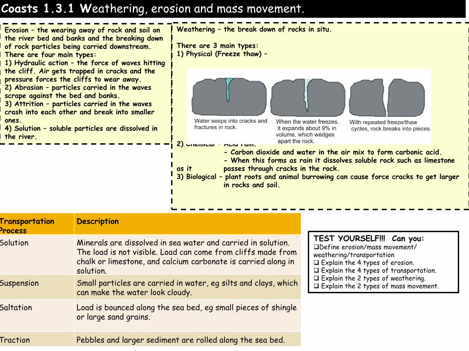
Coasts 1.3.1 Weathering, erosion and mass movement.
TEST YOURSELF!!! Can you: Define erosion/mass movement/ weathering/transportation Explain the 4 types of erosion. Explain the 4 types of transportation. Explain the 2 types of weathering. Explain the 2 types of mass movement.
Erosion – the wearing away of rock and soil on the river bed and banks and the breaking down of rock particles being carried downstream. There are four main types: 1) Hydraulic action – the force of waves hitting the cliff. Air gets trapped in cracks and the pressure forces the cliffs to wear away. 2) Abrasion – particles carried in the waves scrape against the bed and banks. 3) Attrition – particles carried in the waves crash into each other and break into smaller ones. 4) Solution – soluble particles are dissolved in the river.
Weathering – the break down of rocks in situ. There are 3 main types: 1) Physical (Freeze thaw) – 2) Chemical – Acid rain. - Carbon dioxide and water in the air mix to form carbonic acid. - When this forms as rain it dissolves soluble rock such as limestone as it passes through cracks in the rock. 3) Biological – plant roots and animal burrowing can cause force cracks to get larger in rocks and soil.
Transportation Process
Description
Solution Minerals are dissolved in sea water and carried in solution. The load is not visible. Load can come from cliffs made from chalk or limestone, and calcium carbonate is carried along in solution.
Suspension Small particles are carried in water, eg silts and clays, which can make the water look cloudy.
Saltation Load is bounced along the sea bed, eg small pieces of shingle or large sand grains.
Traction Pebbles and larger sediment are rolled along the sea bed.

Coasts 1.3.2 Systems and processes – geomorphological process: mass movement.
Earthflows/mudflows Fast movments of 5-15km a year on steeper slopes which are saturated. Bulging lobes of soil are produced. Mudlflows are generally faster and occur after heavy rainfall.
TEST YOURSELF!!! Can you: 1) Explain how each method of mass movement occurs

Coasts 1.3.3 Types of waves and how geology influences landforms
Rates of erosion vary from place to place depending on many factors. An important factor to consider is the type of wave and the distance a wave has travelled. Fetch describes the length of time and space that a wave has travelled. The larger the fetch the more time wind has had to act on waves, hence the larger the wave. Large oceans with large fetch produce large waves, called destructive waves. These waves have large wave height and short wave length and are characterised by tall breakers that have high downward force and a strong backwash. They have high frequency, between 13 and 15 waves per minute. This downward energy helps erode cliffs. In addition, due to a dominant backwash they erode the beach making for narrow steep beach profiles. Localised storms with high wind speed also form destructive waves as well as steep depth gradients around headlands. Constructive waves have low wave height and long wave length with low frequency, between 6 and 8 waves per minute. Constructive waves are associated with weak backwash and strong swash, which builds up wide flat beaches and so amore associated with coasts of deposition. Size of fetch and type of wave are really important factors influencing rates of erosion
TEST YOURSELF!!! Can you: List 3 characteristics of destructive and constructive waves Compare their differences

Rock Type: This tends to link to how hard/resistant a rock is and how resistant it is to weathering/erosion.
Very hard: Granite Hard: Limestone and chalk (but both vulnerable to chemical weathering as made of calcium carbonate which is an alkali) Soft: Clays, sands and gravels
How geological structure and rock type influence coastal forms
Geological structure: This tends to refer to cracks in the rock. This is important because these cracks expose the rock to hydraulic pressure and freeze thaw weathering.
A crack in a rock which is often called a ‘joint’ or a ‘fault’.
TEST YOURSELF!!! Can you: Explain how rock types influences the rate of erosion Explain why some rocks are weathered more quickly., Explain how joints and faults in rocks can lead to more erosion/weathering.
Coasts 1.3.4 How geological structure and rock type influence coastal forms

Coasts 1.3.5 Coastal landscape development - erosion: cliffs and wave cut platforms.
TEST YOURSELF!!! Can you: Expllain the processes that create wave cut platforms and cliffs BE able to identify and label the sections of wave cut platforms from photographs

Coasts 1.3.5 Coastal landscape development - erosion: cliff profile features = caves > stacks.
Test your self questions: 1) Do a detailed explanation of the formation of cliff features. 2) be confident in identifying them using images.
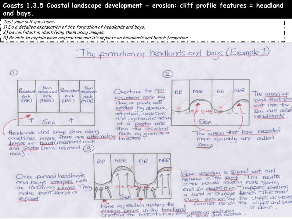
Coasts 1.3.5 Coastal landscape development - erosion: cliff profile features = headland and bays. Test your self questions: 1) Do a detailed explanation of the formation of headlands and bays. 2) be confident in identifying them using images. 3) Be able to explain wave regfraction and it’s impacts on headlands and beach formation.

Coasts 1.3.6 Coastal landscape development - deposition: beaches
Remember, a swash aligned beach brings in waves parallel to the shore and as result, they build up beaches. Swash aligned beaches are more influenced by constructive wave patterns, which are also important for building up large beaches. Swash & backwash movements move material up and down the beach producing the aforementioned beach profile features In contrast, drift aligned coasts bring in waves at an angle to the shoreline and so therefore, the waves tend to transport sediment down the coast, keeping beaches relatively narrow.
Drift aligned beaches that are mainly associated with spits, bars and tombolos
Swash beaches are more associated with large beach profiles, with dunes, a variety of berms and beach drainage features.
Sand beaches tend to be flatter and wider because sand particles are so close together so water cannot infiltrate into them meaning there is more swash and backwash so sediment is always moved, a bit like a rake over a lawn. Pebble beaches tend to be narrower and steeper with because swash infiltrates into the rocks meaning sediment is dumped and there is little backwash. They also have levels called berms.
Test your self questions: 1) Know all these key terms. 2) Explain the difference between drift and swash aligned beaches. 3) Explain why sand beaches tend to be flat and pebble beaches tend to be steep.

Coasts 1.3.6 Coastal landscape development - depostion: spits and tombolos.
Bar A bar is created when there is a gap in the coastland with water in it. This could be a bay or a natural hollow in the coastland. The process of longshore drift occurs and this carries material across the front of the bay. Material is pushed up onto beaches at an 45 degree angle when the swash brings it onto the coastline. The backwash takes it back out towards the sea at a right angle to the coast. Through this process material is constantly moved along the coastline. The deposited material eventually joins up with the other side of the bay and a strip of deposited material blocks off the water in the bay. The area behind the newly formed bar is known as a lagoon. Tombolo A tombolo is formed when a spit connects the mainland coast to an island. A spit is a feature that is formed through deposition of material at coastlines. The process of longshore drift occurs and this moves material along the coastline. Material is pushed up onto beaches at an angle when the swash brings it onto the coastline at a 45 degree angle. The backwash takes it back out towards the sea at a right angle to the coast. Through this process material is constantly moved along the coastline. When the coastline changes direction or there is a river estuary the process of longshore drift continues. This causes material to be deposited in a long thin strip that is not attached to the coast and is known as a spit. If this feature moves in the direction of island and connects it to the mainland then it becomes a tombolo.
Test your self questions: 1) Explain the processes that form spits, bars and tombolos. 2) Be able to identify the lanforms in photos ans sketches.

Coasts 1.3.6 Coastal landscape development - deposition: sand dunes.
Description (what does it look like, plant names)
Small deposits of sand that have joined together. Very little vegetation, except pioneer species such as sea rocket.
2) As the sand becomes more stable larger foredunes will be formed. Plants such as marram grass (Figure 2) start to colonise these dunes. Height: taller. pH: more acidic Humus content: increases.
The darker, richer soils with a higher organic content account for the name grey dunes. Almost completely covered by vegetation, these dunes are more stable and are sometimes called fixed dunes.
A waterlogged area, called a dune slack, will form here with a completely different range of plants and animals, such as orchids and creeping willow. Semi-aquatic animals such as frogs may be found here.
5) After a few hundred years, shrubs and trees will become established on the sand dunes. At this point, the vegetation succession is said to have reached its climatic climax. In the UK typical trees would be oaks or pines.
Explanation (what is happening/how has it formed?)
Sand builds up on the sheltered side of an obstacle such as a rock or drift wood. Very harsh conditions so plants can’t grow easily.
Marram grass is extremely well suited to sand dunes. Its long roots seek fresh water deep below the surface and its tough stems help to bind the sand together. Marram grass is folded to reduce transpiration in windy areas.
Dead plants add nutrients to the soil and the environmental conditions become less extreme. New species of vegetation, such as gorse and brambles start to grow forming a range of habitats for butterflies and insects, birds (e.g. the ringed plover) and small animals (e.g. rabbits and stoats).
Strong winds and trampling by humans can cause hollows or depressions to form in places. These are called ‘blowouts’. Occasionally the base of the hollow may reach the water table.
Test your self questions: 1) Explain the 3 requirements for sand dune formation. (in your folders) 2) Describe what a sand dune looks like at each stage. Can you include height, vegetation cover and types of vegatation. 3) Explain how and why the sand dune develops the way it does in each stage.
Test your self questions: 1) Describe how the appearance and characteristics of sand dunes change as they progress. . 2) Explain the role of plants in trapping sand and adding nutrients at each stage.

Coasts 1.3.7 Coastal mangement: traditional approaches to coastal flood and erosion – hard engineering.
•hard engineering – sea walls; rock armour/rip rap; gabions; revetments; groynes; cliff fixing; offshore reefs; barrages

Coasts 1.3.7 Coastal mangement: traditional approaches to coastal flood and erosion – hard engineering.
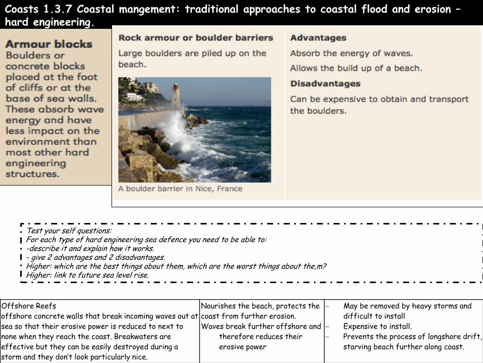
Coasts 1.3.7 Coastal mangement: traditional approaches to coastal flood and erosion – hard engineering.
Offshore Reefs
offshore concrete walls that break incoming waves out at
sea so that their erosive power is reduced to next to
none when they reach the coast. Breakwaters are
effective but they can be easily destroyed during a
storm and they don’t look particularly nice.
Nourishes the beach, protects the
coast from further erosion.
Waves break further offshore and
therefore reduces their
erosive power
May be removed by heavy storms and
difficult to install
Expensive to install.
Prevents the process of longshore drift,
starving beach further along coast.
Test your self questions: For each type of hard engineering sea defence you need to be able to: -describe it and explain how it works. - give 2 advantages and 2 disadvantages. Higher: which are the best things about them, which are the worst things about the,m? Higher: link to future sea level rise.
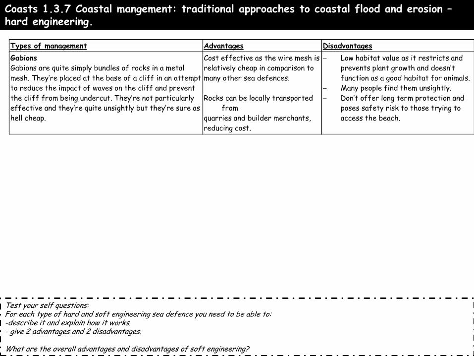
Coasts 1.3.7 Coastal mangement: traditional approaches to coastal flood and erosion – hard engineering.
Types of management Advantages Disadvantages
Gabions
Gabions are quite simply bundles of rocks in a metal
mesh. They’re placed at the base of a cliff in an attempt
to reduce the impact of waves on the cliff and prevent
the cliff from being undercut. They’re not particularly
effective and they’re quite unsightly but they’re sure as
hell cheap.
Cost effective as the wire mesh is
relatively cheap in comparison to
many other sea defences.
Rocks can be locally transported
from
quarries and builder merchants,
reducing cost.
Low habitat value as it restricts and
prevents plant growth and doesn’t
function as a good habitat for animals.
Many people find them unsightly.
Don’t offer long term protection and
poses safety risk to those trying to
access the beach.
Test your self questions: For each type of hard and soft engineering sea defence you need to be able to: -describe it and explain how it works. - give 2 advantages and 2 disadvantages. What are the overall advantages ond disadvantages of soft engineering?

Coasts 1.3.8 Coastal mangement: traditional approaches to coastal flood and erosion – soft engineering.

Coasts 1.3.8 Coastal mangement: traditional approaches to coastal flood and erosion – soft engineering.

Coasts 1.3.8 Coastal mangement: traditional approaches to coastal flood and erosion – soft engineering.
Types of management Advantages Disadvantages
Sand dune regeneration is often used to help protect and rebuild dunes. Sand dunes act as a good barrier against coastal flooding and erosion and they can be exploited as a natural defence against the sea. In order to do so though, the dunes must be left relatively undisturbed so boardwalks are constructed and sections of sand dune systems are marked as out of bounds to the general public in order to reduce the erosion of the dunes by humans.
Cheap to maintain
Erosion and absorption
prevented through
absorption
of wave energy.
Cheap to create
Provides a good natural
habitat
Sand dunes are no longer accessible for
humans
Land use management/zoning
Involves identifying land that is likely to be
flooded/eroded and where possible allowing it to do
so at little economic coast. Eg. Caravan parks that
can be moved parks, farmland in area that will
occasionally be flooded and then return to farmland.
Banning new settlements on some areas of the
caastline.
Cheap
Sustainable
Allows people to make a living of
The land
-Have to educate people
- People have to agree to it.
- Does not prevent erosion/flooding, only
reduces the cost of it.
Test your self questions: For each type of hard and soft engineering sea defence you need to be able to: -describe it and explain how it works. - give 2 advantages and 2 disadvantages. What are the overall advantages ond disadvantages of soft engineering?

Coasts 1.3.9 Coastal management Example – Holderness Coast, East Coast England
TEST YOURSELF!!! Can you: Describe and explain the physical and human reasons it needs protecting. Describve and explain the methods used to protect it. Evalaute – explain the good and bad outcomes of the coastal management. Was it good/bad overall?.
Why is management needed? Land is been eroded quicker than anywhere else in the UK. Physical Reasons Soft rock – the cliffs are made from boulder clay which is VERY easily eroded. Narrow beaches – the beaches are very narrow meaning the waves lose little energy and therefore erode the cliffs powerfully. Large fetch – the North sea generates violent storms with big waves. Human reasons Towns – there are many towns and settlements which could be eroded there would be massive social and economic impacts if these were eroded. Tourism – the area has many campervan parks and is aholiday attraction so this business needs to be protected. Infrastructure - there are important roads which link towns which are under threat. Gas terminal – there is a gas terminal at which provides 25% of the UK’s gas.
How has it been managed? Mappleton Rock armour – 61,000 tonnes of rock placed at base of cliffs to absorb wave power. Rock groyne – stopped LSD, built up beach and reduced wave power. Hornsea Sea wall – absorbs and reflects power of waves Withernsea Sea wall/rock armour/groynes (see above)
o Has the management been successful?
Major towns have been protected saving homes,
businesses and infrastructure from
destruction
Mappleton defences cost £2m alone
Groynes have caused more erosion futher down the coast because they have trapped sand and made the beaches narrower
Spurn Head, a nature reserve spit downstream
is being eroded.
Bays are being created in between towns

River Environments

Rivers – 1.4.1 River processes produce distinctive landforms a Drainage basin terms: watershed, confluence, tributary, source and mouth. D
TEST YOURSELF!!! Can you: Draw and label the drainage basin features from memory.
Define all the drainage basin features.
Watershed – highland which divides two drainage basins . Source – the point where the river begins. Tributary – a small stream that flows into the main river channel. Confluence – the point where two rivers meet. Mouth – the end of the river where it flows into the sea. Main river channel – the landform which the river flows through.
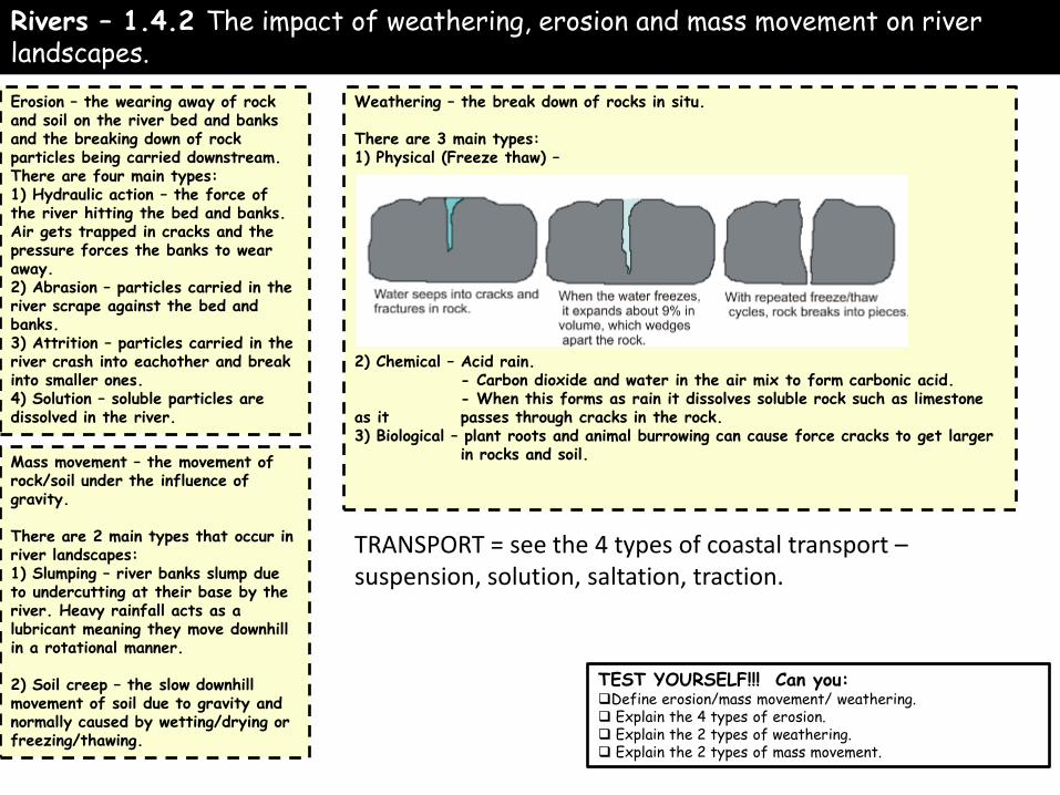
Rivers – 1.4.2 The impact of weathering, erosion and mass movement on river landscapes.
TEST YOURSELF!!! Can you: Define erosion/mass movement/ weathering. Explain the 4 types of erosion. Explain the 2 types of weathering. Explain the 2 types of mass movement.
Erosion – the wearing away of rock and soil on the river bed and banks and the breaking down of rock particles being carried downstream. There are four main types: 1) Hydraulic action – the force of the river hitting the bed and banks. Air gets trapped in cracks and the pressure forces the banks to wear away. 2) Abrasion – particles carried in the river scrape against the bed and banks. 3) Attrition – particles carried in the river crash into eachother and break into smaller ones. 4) Solution – soluble particles are dissolved in the river.
Weathering – the break down of rocks in situ. There are 3 main types: 1) Physical (Freeze thaw) – 2) Chemical – Acid rain. - Carbon dioxide and water in the air mix to form carbonic acid. - When this forms as rain it dissolves soluble rock such as limestone as it passes through cracks in the rock. 3) Biological – plant roots and animal burrowing can cause force cracks to get larger in rocks and soil.
Mass movement – the movement of rock/soil under the influence of gravity. There are 2 main types that occur in river landscapes: 1) Slumping – river banks slump due to undercutting at their base by the river. Heavy rainfall acts as a lubricant meaning they move downhill in a rotational manner. 2) Soil creep – the slow downhill movement of soil due to gravity and normally caused by wetting/drying or freezing/thawing.
TRANSPORT = see the 4 types of coastal transport – suspension, solution, saltation, traction.

Rivers – 1.4.3 Change in river cross and long profiles.
Characteristic
Definition
Change downstream
Explanation
Velocity
Speed of the river
Increase
The river channel becomes smoother downstream therefore there is less friction.
Discharge
Amount of water in the river
Increase
The drainage basin becomes bigger as a river flows downstream and there are more tributaries.
Gradient
The steepness of the land
Decreases
The land becomes flatter as the river flows towards the sea.
Width
Distance between the two river banks.
Increases
Lateral erosion makes the river wider as you move downstream
Depth
Distance between river surface and bed.
Increases
Vertical erosion makes the river deeper as you move downstream.
TEST YOURSELF!!! Can you: Describe/explain how the long profile (gradient and load size) changes down stream Describe and explain how the cross profile – width, depth, CSA, discharge – change downstream Define vertical and lateral erosion

Rivers – 1.4.4 Landforms of erosion – waterfalls and gorges.
They occur where hard rock overlies softer rock. Erosion such as hydraulic action and abrasion erode the softer rock more quickly than the hard rock. This creates a plunge pool beneath. As the soft rock is eroded quicker an overhang is formed. The overhang made of hard rock then collapses under gravity. This collapsed rock helps to erode the soft rock further by abrasion. This process repeats and the waterfall repeats upstream overtime forming a long, narrow, steep sided gorge..
TEST YOURSELF!!! Can you: Explain how waterfalls are formed including processes (eg types of erosion) and landforms (eg. Plunge pool). -including processes and landforms produce a sequence of 3 annotated diagrams to show how waterfalls are formed.

Rivers – 1.4.4 Landforms of erosion/deposition – meanders and oxbow lakes.
Erodes outside banks through abrasion/hydraulic action.
Water flows faster on outside of meander bend because it has further to travel and erodes the river through hydraulic action and abrasion. This creates a river cliff as the outside bend is undercut, which collapses and the meander migrates across the floodplain. Water moves slower on the inside bend and therefore deposition occurs. This forms a slip off slope. Helicoidal flow moves material from one outside bend to a slip off slope at the next meander. Over time the meander migrates across the floodplain as erosion occurs on the outside bend and deposition on the inside.
TEST YOURSELF!!! Can you: Explain how meanders are formed including processes (eg types of erosion) and landforms (eg. Slip off slope). Explain how ox-bow lakes are formed including processes and landforms. - produce a sequence of 3 annotated diagrams to show how meanders and ox-bow lakes are formed.

Rivers – 1.4.5 Landforms of deposition – levees and floodplains. and human causes of flooding.
TEST YOURSELF!!! Can you: Explain how floodplains are formed including processes and landforms. Explain how levees are formed including processes and landforms. produce a sequence of 3 annotated diagrams to show how levees and floodplains are formed.
Remember friction slows the flood waters down!

Rivers – 1.4.6 Physical causes of flooding
TEST YOURSELF!!! Can you: Explain how 4 of the above cause flooding, use key terms such as saturated, absorbed etc
Cause of river flooding
Description/definition (if applicable)
Explanation
Prolonged rainfall Long periods of rainfall saturate the soil so water reaches the river more quickly.
Impermeable rock Rock which water cannot infiltrate/be absorbed into.
Water is not absorbed or stored in rock so moves into the river more quickly.
Steep slopes V-shaped valleys Steep slopes means less water is absorbed into the soil and runs over the land to the river quickly.
Snowmelt Snowmelt in mountainous areas in spring/summer means a lot of water reaches the river very quickly. Also frozen land is impermeable (See above).
Cloudburst/thunderstorm
Heavy, intense rainfall. So much water falls in a short period of time meaning not all of it is absorbed and flows to the river quickly.

Rivers – 1.4.7 The human causes of river flooding.
Cause of river flooding
Description/definition (if applicable)
Explanation
Land use - Deforestation
Removal of trees. Removing vegetation means less water is intercepted or absorbed by trees. Water therefore flows over the land to the river more quickly.
Land use - Urbanisation
Building urban areas. Concrete surfaces are impermeable and so water flows into drainage systems and makes it way to the river more quickly.
Land use - Ploughing up slope
Farming methods Ploughing uplslope as opposed to across the slope creates furrows (Channels) which water can flow through and reach the river more quickly.
TEST YOURSELF!!! Can you: Explain how 4 of the above cause flooding, use key terms such as saturated, absorbed etc remember to say it reaches the river more quickly.

7 Impacts of flooding on humans and the environment using various examples.
TEST YOURSELF!!! Can you: Describe and explain the social, environmental and economic impacts of flooding DON’T worry about evidence. .
Impacts of flooding on humans: - Floods in China in September 2011 killed over 250 people. - Flooding in Mozambique (SE, Africa) in 2007 made 150,000
people homeless - 16 bridges and 25 bridges were included in the damage to
infrastructure during the 2009 Cumbria, UK floods. - Damages to wheat crops in Pakistan 2010 floods was over
US$500 million.
Impacts of flooding on the environment: - 455 landslides were reported in Japan during the 2011 floods. - The unprecedented Pakistan floods of 2010 left 20% of Pakistan’s land underwater. 10 million people were forced to drink unsafe water causing widespread disease.
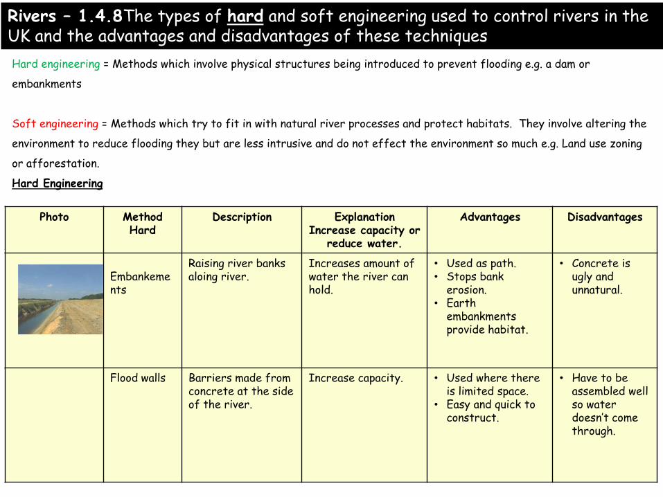
Photo Method Hard
Description Explanation Increase capacity or
reduce water.
Advantages Disadvantages
Embankements
Raising river banks aloing river.
Increases amount of water the river can hold.
• Used as path. • Stops bank
erosion. • Earth
embankments provide habitat.
• Concrete is ugly and unnatural.
Flood walls Barriers made from concrete at the side of the river.
Increase capacity. • Used where there is limited space.
• Easy and quick to construct.
• Have to be assembled well so water doesn’t come through.
Hard engineering = Methods which involve physical structures being introduced to prevent flooding e.g. a dam or
embankments
Soft engineering = Methods which try to fit in with natural river processes and protect habitats. They involve altering the
environment to reduce flooding they but are less intrusive and do not effect the environment so much e.g. Land use zoning
or afforestation.
Hard Engineering
Rivers – 1.4.8The types of hard and soft engineering used to control rivers in the UK and the advantages and disadvantages of these techniques

Photo Method Hard
Description Explanation
Advantages Disadvantages
Channelisation
1) Widening or deepening river channel. 2) Straightening river channel.
1) Increases how much water the river can hold. 2) Increases velocity so water moves further down the river.
• Protects immediate area.
• Long lasting.
• Greater risk of flooding downstream.
• Unnatural – destroys river ecosystem.
• Visually ugly.
Flood relief channels
Adding another channel to the river so flood water avoids settlements.
Increases the amount of water the river can hold.
• Provides safety for people in immediate area.
• Can be used for sport.
• Large amount of land needed.
• Extremely expensive.
Dams Large walls built across rivers which hold back the water.
Control the discharge of the river during flood times.
• Generate hydroelectric power and used for recreation.
• Very effective.
• Expensive Large areas of land flooded behind including settlements and farmland.
• Sediment is trapped in the dam.
TEST YOURSELF!!! Can you: Define hard and soft engineering. List some general positives and negatives of both hard and soft engineering. – explain how 2 methods of hard and soft engineering work and their strengths and weaknesses. explain how 4 methods of both and soft engineering work and their strengths and weaknesses. - explain how all methods of hard and soft engineering work and their strengths and weaknesses.

Photo Method Soft
Description Explanation Increase capacity or reduce
water.
Advantages Disadvantages
Afforestation Soft
Planting trees in the river drainage basin.
Reduce water reaching the river. Planting trees reduces the amount of water reaching the river because they intercept and absorb rainfall. Moreover trees reduce precipitation.
• Low cost • Improves
environment • Less soil
erosion Sustainable
• Dense tree planting can reduce natural look.
• Increases fire risk during dry spells..
Flood plain zoning
Government produce policies to control urban development close to or on the floodplain.
Controls land use around rivers. Less valuable land is placed close to the river (eg. Parks/football pitches) More valuable land ~(homes and businesses) are further away from rivers to reduce costs of flooding should it occur.
• Cheap • Sustainable –
reduces damage • Less surface
run off
• Housing shortages require building on floodplaoins.
• Harder to do in LICs.
Warning system Sirens can give people early warnings (LICs). Env Agency uses TV/radio/interent to keep people informed.
People can prepare their homes/businesses for flooding should it happen and reduce costs.
• Cheap • Effective way
of informing people.
• Valuables can be made safe.
• Not enough time to prepare sometimes.
Washlands River floods naturally in vegetated areas to prevent flooding elsewhere.
Reduces water reaching the river/ allows less valuable land to flood.
• Cost effective • Provides
habitats for birds
• Sediment enriches soil.
• Land cannot be built on.
• Farmland can be wasted.
Rivers – 1.4.9 The types of hard and soft engineering used to control rivers in the UK and the advantages and disadvantages of these techniques

Rivers – 1.4.10 River management Example – River Valency, Boscastle, Cornwall, UK
TEST YOURSELF!!! Can you: Deecribe and explain the human and physical reasons it needs management Describe and explain how it has been protected Evaluate the management – explain the good and bad outcomes – overall is it a success?
Why is management needed? In 2004 the small village was destroyed by a flood which then negatively impacted it’s tourism trade. Physical reasons it floods easily are: 1) Steep V-shaped valleys = water has less time to infiltrate and be absorbed into the soil, therefore it flows to the river over the surface, causing the river to fill up more quickly. 2) Impermeable rock – the surrounding rock is impermeable so water cannot be absorbed into it. Therefore water flows quickly over over the surface, causing the river to fill up more quickly. 3) Location – Boscastle is located in Cornwall which receives large amounts of rainfall and many storms, meaning soul can be easily saturated. Human reasons it flooded are: 1) Buildings – concrete in the village meant water is not absorbed into the soil. 2) Small bridges – acted like dams meaning material (trees and cars) were trapped behind it, building up the water, which then overflowed sending lots of water into the village. The village has many shops so if they were destroyed there would be social impacts. Moreover the village relies on tourism for it’s income. If it were destroyed it would mean people would lose a lot of money.
How has it been managed? River widened – this means the river can hold more water, increasing it’s capacity. River deepened by 0.75m – this means the river can hold more water, increasing it’s capacity. Lands owners encouraged to plant trees – to absorb and intercept rain in the catchment area meaning less water reaches the river. Trees removed from the bank – means trees are not washed into the river and reduce the capacity of the river.
Has the management been successful?
It has not flooded since It cost £5m
Provides 1 in 75 year flood protection
It would not prevent flooding from the same
storm as 2004
Tourists have returned in high numbers
People lost trade while works were occuring
The new bridge does not fit in with the Elizabethan
feel of the village