Geoarchaeological studies in the coastal area of Istron-Kalo Chorio (gulf of Mirabello- Eastern...
16
Z.Geomorph. N.F. 53 Suppl.l 55-70 Berlin . Stuttgart Juni 2009 'I Geoarchaeological studies in the coastal area of Istron-Kalo Chorlo . (gulf of Mirabello- Eastern Crete): landscape evolution and paleoenvironmental reconstruction Katerina Theodorakopoulou, Kosmas Pavlopoulos, Maria Triantaphyllou, Katerina Kouli, Theodora Tsourou,Yiannis Bassiakos, Nikos Zacharias and Barbara Hayden with 7 figures and 4 tables Summary . Within the framework of an ongoing scientific project undertaken in the area of Istron-Kalo Chorio, Gulf of Mirabello, eastern Crete, several geoarchaeological methods wereemployed, to provide information on the paleoenvironmental reconstruction and landscape evolution. The combination of detailed field-survey, geophysical prospection, archaeological excavations, along with geomorphologic observations, analyses and dating on deposited sediments, gave evidence of the paleogeographic evolu- tion of the area and its impact on prehistoric, classical and Roman establishments. The study of sea-land interactions during the last seven millennia in relation to the eustatic sea level oscillations and the regional neotectonic regime provided new data for sea level changes and local tec- tonics. The results of field work and analyses provide insight for landscape evolution, influenced mainly by environmental changes and human presence during the Holocene. Introduction The Istron area is a shore-side valley facing the Aegean Sea in the west-central pan of the Mirabello Gulf, eastern Crete (Fig. 1). There are indications of human installations from the Neolithic to the Roman period, proving the continuous human activity in this area. At a limestone promontory known as Priniatikos Pyrgos in the center of a broad embayment, excavations were conducted by American archaeologists of the University of Pennsylvania Museum in 1912. They found a Bronze Age coastal town, accompanied by high-quality pottery of Early to Late Minoan date. Historical occupation was represented by abundant Roman pottery (HALL 1914, HAYDEN 2004). In 1986, an intensive survey project of the area was undertaken by the University of Pennsyl- vania Museum and Baylor University, directed by BARBARA HAYDEN and JENIFFER MOODY. Fieldwork and laboratory analyses of the survey are complete, although new scientific studies have been initiated for the Istron Geoarchaeological Project, continuing to present. Drilling of boreholes and backhoes along the coastal area, sedimentological, micropaleonto- logical and palynological analyses on sediments, combined with geophysical prospection of the area and radiocarbon dating of plant remains and OSL dating on sediments, were undertaken into the frame of the geoarchaeological survey of Istron area. The aim of this study is the paleogeographic reconstruction of the area the last 10,000 years and the determination of coastal changes, sea-land interactions and other geomorphologic and geologic processes that affected landscape evolution and local civilizations. . DOl: 10.1127/0372-8854/2009/0053S1-0055 0372-8854/09/5301-0055 $ 4.00 \0 200'J Gebriider Borntneger, 0-14129 Berlin - 0 ·70176Stuttgart
Transcript of Geoarchaeological studies in the coastal area of Istron-Kalo Chorio (gulf of Mirabello- Eastern...
Z.Geomorph. N.F. 53 Suppl.l 55-70 Berlin . Stuttgart Juni 2009 ' I
Geoarchaeological studies in the coastal area of Istron-Kalo Chorlo. (gulfof Mirabello- Eastern Crete): landscape evolution and
paleoenvironmental reconstruction
KaterinaTheodorakopoulou, Kosmas Pavlopoulos, MariaTriantaphyllou, Katerina Kouli,
TheodoraTsourou, Yiannis Bassiakos, Nikos Zacharias and Barbara Hayden
with 7 figures and 4 tables
Summary. Within the framework of an ongoing scientific project undertaken in the area of Istron-KaloChorio, Gulf of Mirabello, eastern Crete, several geoarchaeological methods wereemployed, to provideinformation on the paleoenvironmental reconstruction and landscape evolution. The combination ofdetailed field-survey, geophysical prospection, archaeological excavations, along with geomorphologicobservations, analyses and dating on deposited sediments, gave evidence of the paleogeographic evolution of the area and its impact on prehistoric, classicaland Roman establishments.
The study of sea-land interactions during the last seven millennia in relation to the eustatic sea leveloscillations and the regional neotectonic regime provided new data for sea level changes and local tectonics.
The results of field work and analyses provide insight for landscape evolution, influenced mainly byenvironmental changes and human presence during the Holocene.
Introduction
The Istron area is a shore-side valley facing the Aegean Sea in the west-central pan of the Mirabello
Gulf, eastern Crete (Fig. 1). There are indications of human installations from the Neolithic to the
Roman period, proving the continuous human activity in this area. At a limestone promontoryknown as Priniatikos Pyrgos in the center of a broad embayment, excavations were conducted
by American archaeologists of the University of Pennsylvania Museum in 1912. They found a
Bronze Age coastal town, accompanied by high-quality pottery of Early to Late Minoan date.
Historical occupation was represented by abundant Roman pottery (HALL 1914, HAYDEN
2004).In 1986, an intensive survey project of the area was undertaken by the University of Pennsyl
vania Museum and Baylor University, directed by BARBARA HAYDEN and JENIFFER MOODY.
Fieldwork and laboratory analyses of the survey are complete, although new scientific studies
have been initiated for the Istron Geoarchaeological Project, continuing to present.
Drilling of boreholes and backhoes along the coastal area, sedimentological, micropaleonto
logical and palynological analyses on sediments, combined with geophysical prospection of thearea and radiocarbon dating of plant remains and OSL dating on sediments, were undertaken
into the frame of the geoarchaeological survey of Istron area.The aim of this study is the paleogeographic reconstruction of the area the last 10,000 years
and the determination of coastal changes, sea-land interactions and other geomorphologic andgeologic processes that affected landscape evolution and local civilizations. .
DOl: 10.1127/0372-8854/2009/0053S1-0055 0372-8854/09/5301-0055 $4.00\0 200'J Gebriider Borntneger, 0-14129 Berlin - 0 ·70176Stuttgart

56 K. Theodorakopoulou et al.
N.lS'7'4Ul"J: .25"d'~.I1"
Fig. 1.The location map of the study area.
Regionalsetting
According to our field observations and the relevant exist
ing studies, e.g. the geological map, Ag. Nikolaos sheet
(IGME 1981), the bedrocks dominating the area are: crys
talline limestones, marls, sandstones, granodiorites, green
stone conglomerates and limestone breccio-conglomerates.
Also, the so-called Mirabello local granodiorite partici
pates to a certain degree in the geological formations that
from the hills framing the valley to the S-SE. The long
axis of the Istron Valley is SW- NE, generally parallel to
the main local tectonic lines. The Istron River flows in a
similar direction and discharges to the north, ca. 200 m
east of Priniatikos Pyrgos. It feeds the plain with deltaic
deposits originating from the above-mentioned geologi
cal formations. The sediments deposited in the coastal
zone are not only of fluvial but also of littoral origin, the
latter resulting after the Holocene eustatic sea-level rise.
There are six broad geomorphic units and two main
drainage systems in the survey area. The geomorphic units
comprise: a) the riverine system of Istron River, b) river 's
valley with its flooding plain, c) terraces along river's
axis, d) the deltaic alluvial fan , e) the small headland of
Priniatikos Pyrgos and f) limestone cliffs that tower
above the valleys and coast (Fig. 2).
LEGEND OF FIG. 2
-Fault
I I I I Downwards erosionI I I III Retreating coast
•••••~ Longshore current
.& Steep coast >30·
_ Alluvial cones
V-shaped valleysU -Shaped valleys
------ Perrnanentflow- - - Seasonal flow~ Cretaceous limestones
_ Alluvial deposits
I ~.:>J Mlocenic martes-marty limestones
.. Mlocenlc breccio conglomerates
mAlluvial fans
IJ Naches•• Cliff
0. Arcaheolog lcal site
L Underwater archaeological remains
~ Sandy beach
~ Beach with pebbles
.~ Beach with pebbles & sand
~ Planation surface 50-100m
Submarine Beachrocks
Steep coast with sand
Steep coast With-pebbles
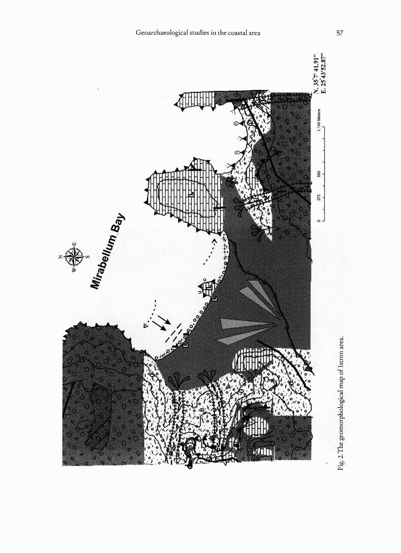
Geoarc haeologica l studies in the coasta l area 57
o
•••••
,,••
.;.~ III
II .

58 K.Theodorakopoulou et al.
The main riverine system of the area is the Istron River, which extends into the Kalo Chorioor Istron Valley from the west. Its main tributary flows into the sea, just east of the small headland of Priniatikos Pyrgos.
MfihodOwgyandrechn~u~
The geomorphological mapping of the coastal area provided data concerning the alluvial fandelta of the Istron River and revealed the geomorphological evolution of the area through thecenturies. The field survey, along with the geomorpholocical mapping of the area, pointed to theselection of appropriate sampling sites.
Subsurface samples were taken by completing five drillings placed in selected sites along thebeach and by opening six backhoe trenches (4-5 m deep), most of them placed near the boreholes(Fig. 3).The five drillings were completed by using independently rotating triple ball bearings, inorder to obtain undisturbed, incompressible cores retaining most of their natural moisture content .Most of the cores were placed in 11 em wide PVC-tubes and thus sealed in "dark conditions ';necessary conditions for OSL dating. Trenches were opened 3.50 m below mean sea level,
Fig. 3. Siteof drillings and trenches.

Geoarchaeological studies in the coastal area 59
whereas the deepest borehole reached -13 m in depth. During the cor ing fieldwork, sedimentary
formation s from two cores, namely C 2 and C 4 seemed promisin g for dating and for ret rieving as
much data as possible co nce rni ng paleoenvironmental features.
Block s of.sed iment were selected fro m the excavated trenches and boreho les for micropa
leontological and pollen analysis. XRF analysis was applied in an att empt to acquire th e chemical
profiling of the cores using raw samples in relation with the dated samples.The main purpose for
thi s analysis was the evaluation of potassium concentration , necessary for dose rate est im ation.
Finally, GIStechniques were used for the recon struct ion of the paleoenvironmental evolution
of the area.
Results
Lithostratigraphy
Five main sedimentological units were identified, A to E, in terms of vertical dep osits stratification
( PAVLOPO Ul.OS ct al. 2007) (F ig. 4):
7-!i
" ..-,I
8 . !
•..jI
~ !
• :ir _ 0
I·3
II
~
--!;
~ .,
-,
. & - j.. .j
.' o
." ,i
." J ?
: .::I ..?
?
?
TRl!¥CIf •
2.240 BP .1 03<00---_.. ...
?
c:Js- c:Jo-y~~c.:::: SoIIE.:i"J e- __
e OSl OllUng
-.} C l 4 O.ling
Fig. 4.Trenches and boreholes logs.The main sedimentological units of Istron's coastal plain.

60 K.Theodorakopoulou et al.
Sedimentary unit A is the youngest and is represented by topsoil with remains of humanactivity. Most of the sequence consisted of dry brown/olive brown clay and sand or silty sandwith small pebbles, indicating a terrestrial environment,whereas some layersof pebbles in core 1revealed fluvial interferences.The strata of pebbles do not appear in other cores or trenches. Considering that the drilling location of core1is near the river flux, it is clear that colluvial overflowsfrom the riverare more marked in core1than in other cores.
Unit B is mainly consisted of gray-dark gray sand or silty sand/clay with some pebbles. Itis characterized by overbank depositsof the river with influenceof brackish and sea storm water.In a very bad state of preservationwere found tracesof planktonic and benthic foraminifera,indicatingthat they had been transported,
The predominance of conglomerate streambed deposits characterized unit C This unit ismainlypresentedin core1and to a lesserextent in core2, related to the possible flowof the river.
This sedimentary unit is followed by a sequence ofgray-darkgraysiltjsilty.sand, composingunit D. Overbank deposits,with some shallowstagnant freshwater predominate in this sequence,revealing low-energy events and quiet conditions.This unit is mainly represented in core 2, indicating that a possible swampwith stagnant freshwater may havebeen in this site.
Finally,unit E is characterized by fluvio-torrential streambed and overbanking deposits.Thisunit is alsopresentedin core 2, indicatinga possible influence or removal of the river'sflowduringthis period.
The borehole C2, located roughly between Priniatikos Pyrgos and the western margin ofthe valley, yielded mostly fine and soft material, mainlycorresponding to mud and well-stratifiedclays and silt.This indicateslow-energy sediments and still depositionalconditions.The progressof the drilling was unhindered in C2 and very few (and thin) layers of pebbles or gravel weremet.
Different conditions prevailed during drilling for C4, a borehole placed near the modemchannel of the Istron River; the drilling progress was slow, thick beds of variouslysized pebblesand gravel were met, and the silt/claylayerswere limited and thin. Obviously this borehole hadbeen placedwas within the course of the paleo-stream.
Dating
The 14C method was used to date charred and plant material from layers of the sedimentarysequence. Sixsampleswere analyzed byAMS technique to BetaAnalytic Inc. (Table 1).
18 samplesfrom cores 2 and 4 were selectedfor OSL dating.OSL measurementswere madeon a Rise n/OSL reader model nDA-15, with blue LEDs, emitting at 470±30 nm (delivering'" 30 mWcm-2) asstimulationsource,at the LaboratoryofArchaeometryin 'Demokritos',Athens.Luminescence measurements were practised with an/OSL set using blue light stimulation onquartz made aliquots with the application of single aliquot regenerative dose (SAR) protocols(MURRAY & WINTLE 2000). Dose rateswere determinedby measuringin situ environmental doseswith the use of a portable NaI scintillator and laboratory PIPS a-countingdetector. Additionaly,XRF analysis was performed for the estimation of potassiumconcentrations,neces~ary factor forOSL dating (dose-rate estimation).

Geoarchaeological studies in the coastal area
Table 1.The results of C14 dating.
61
Sample Data Measured RiC 13C/12C Ratio Conventional Ric 20 cal ageAge (yrBP) Age (13C/12C corr)
ISTROT2C1 470 ± 40 BP -26.6 %0 440± 40 BP Cal AD 1420 toplant material (AMS) 1500 (Cal BP 530
to 450)
ISTROT5C2A 4460± 40 BP -24.1 0/00 4470± 40 BP Cal BC 3350 to
charred material (AMS) 3010 (Cal BP 5300to 4960)
ISTROT5C3 4230 ± 40BP -24.4 %0 4240±40BP Cal BC 2910 tocharred material (AMS) 2860 (Cal BP 4860
to 4810) AND CalBC 2810 to 2750(Cal BP4760 to4700)Cal BC 2720 to2700 (Cal BP 4670to 4650)
ISTROT2C2A 5500 ± 40BP - 26.7 0/00 5470±40 BP Cal BC 4360 toplant material (AMS) 4240 (Cal BP6310
,- to 6190)
ISTROT6C3A 4490 ±40BP - 25.4 %0 4480 ± 40BP Cal BC 3350 tocharred material (AMS) 3020 (Cal BP 5300
to 4970)
ISTROT6C1 2280 ±40BP - 27.2 0/00 2240 ±40BP Cal BC 390 to 190plant material (AMS) (Cal BP 2340 to
2140)
XRF measurements were made with a portable XRF spectrometer developed at the Instituteof Nuclear Physics, N.C.S.R "Demokritos"/Athens. The unit consisted of a Rh-anode side-windowlow power X-ray tube (50 W, 40 k~ 75 urn Be window), and a PIN X-ray detector (XR-100CR,Arnptek Inc.) with a 500 urn nominal crystal thickness, having a FWHM of 165 eVat the Mn-Ka
peak operating at 15kVmode.
InTable 2 the estimated concentration values are presented.
The resulted ages indicate a Holocene landscape evolution clearly for core C2. An eloquentradioactive disequilibrium is noted in the pure terrestrial sediments deposited along the axis ofthe river. (ZACHARIAS et al. 2009) The results of OSL dating are shown in (Table 3).
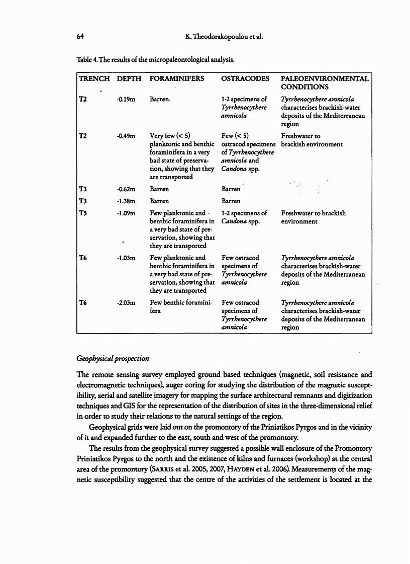
Micropaleontological analyses
Seven samples from trenches 2, 3, 5 and 6 were selected for micropaleontological analyses. All
the samples belonged to the sedimentological unit B,which mainly consists of gray or dark graysand or silty sand/clay with some pebbles and is characterized by overbank deposits of the riverwith influence of brackish and sea storm water. Traces of benthic and planktonic foraminifera '
62
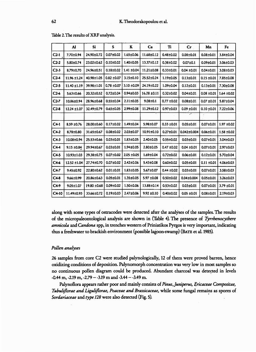
Table 2.The resultsof XRF analysis.
K.Theodorakopoulou et al.
AI Si S K Ca Ti Cr Mn Fe
C2-1 7.70tO.94 24.90tO.72 0.07tO.02 1.65tO.06 11.68tO.12 0.48t0.02 0.08tO.Ol 0.08tO.Ol 3.84t0.04.C2-2 5.80tO.74 23.02tO.62 ·0.10t O.02 1.4O±O.05 13.37tO.12 0.38tO.02 0.07±0.1 O.09tO.Ol 3.06tO.03
C2-3 8.79tO.70 24.96tO.51 0.18tO.02 1.41 to.04 11.21tO.08 0.33tO.Ol 0.04 to.Ol O.04tO.Ol 3.08tO.03
C2-4 11.96 tl.24 4O.98±1.05 0.82tO.07 3.15tO.l0 25.52±O.24 1.19tO.05 0.13tO.Ol 0.15 ±O.Ol 7.85tO.08
C2-5 11.40 t1.19 39.98t1.01 0.78 to.07 3.10 to.09 24.19tO.22 1.O9±O.04 0.12tO.Ol 0.13tO.Ol 7.30tO .08
C2-6 5.63tO.66 20.32tO.52 O.72tO.04 0.94tO.03 16.28to.11 0.32t0.02 O.04tO.Ol 0.08 eo.oi 1.64±O.02
C2·7 10.86tO.94 28.96tO.68 0.55tO.04 2.11tO.05 9.08tO.l 0.77tO.02 0.08tO.Ol 0.07 to.Ol 5.87t0.04
C2-8 12.24t1.07 32.49tO.79 0.65tO.05 2.99tO.08 11.29tO.12 0.97tO.03 O.09tO.Ol 0.10 *0.01 7.22t0.06. -
C4-1 8.59tO.76 28.ootO.6O 0.17tO.02 1.49±O.04 5.98tO.07 0.33 to.Ol 0.05tO.Ol 0.07tO.Ol 1.97 to.02
C4-2 8.78tO.80 31.65tO.67 0.0810.02 2.03±O.07 10.91tO.l0 0.27tO.Ol 0.042tO.004 0.0610.01 1.58 to.02
C4-3 10.08±O.94 25.53tO.66 0.03tO.Ol 1.83tO.05 2.4OtO.05 0.55t0.02 0.03tO.Ol 0.07tO.Ol 3.04tO.03
C4-4 9.15 to.81 29.94tO.67 0.03tO.Ol 1.94±0.05 2.80±O.05 0.47 to.02 0.04 so.or 0.07tO.Ol 2.97t0.03
C4-5 10.93t1.03 29.38tO.75 0.07±0.02 2.05tO.05 1.69±O.04 0.72tO.02 O.06tO.Ol 0.12tO.Ol 5.70t0.04
C4-6 12.52 ±1.04 27.74tO.70 0.0710.02 2.42t0.06 5.43±O.08 0.6Ot0.02 0.05tO.Ol 0.11 to.Ol 4.06tO.03
C4-7 9.45tO.92 22.80tO.62 O.OHO.Ol 1.83tO.05 5.67t0.07 0.+4to.02 0.03tO.Ol 0.07tO.Ol 3.58t0.03
C4-8 9.66tO.99 20.86tO.63 0.05±O.01 1.35±O.05 5.97tO.08 0.50tO.02 O.04tO.OO4 0.05tO.Ol 3.26±O.03
C4-9 9.05tl.07 19.80 to.68 0.09t0.02 1.5OtO.06 13.88tO.14 0.53t0.02 0.03tO.Ol 0.07±0.01 3.79 ±O.Ol
C4-10 11.49tO.93 33.66tO.72 0.19tO.03 2.47t0.06 9.92 to.10 0.4O±O.02 0.05to.Ol 0.08tO.Ol 2.19tO.03
along with some types of ostracodes were detected after the analyses of the samples. The results
of the micropaleontological analysis are shown in (Table 4). The presence of Tyrrhenocythereamnicola and Candona SPPt in trenches western of Priniatikos Pyrgos is very important, indicating
thus a freshwater to brackish environment (possible lagoon-swamp) (BATE et al. 1985).
Pollen analyses
26 samples from core C2 were studied palynologically, 12 of them were proved barren, hence
oxidizing conditions of deposition. Palynomorph concentration was very low in most samples so
no continuous pollen diagram could be produced. Abundant charcoal was detected in levels
-0.44 m, -2.19 m, -2.79- -3.19 m and -3.44 - -3.49 m.
Palynoflora appears rather poor and mainly consists of Pinus,juniperus, Ericaceae Compositae,Tubuliflorae and Liguliflorae, Poaceae and Brassicaceae, while some fungal remains as spores ofSordariaceae and type128 were also detected (Fig. 5). .

Geoarchaeological studies in the coastal area
Table 3.The results of OSL dating.
63
Sample K U Th Equilibrium Sample W Cosmic Dose rate Equivalent Age(wt llb) ijlg g.t) (Ilg g.t) state depth Im) dose rate (Gy/ka) dose (ka)
(Gy!ka) D.(Gy)
C2-t 1.6S±0.06 2.06±0.S4 to.32±2.02 eq, 0.90±0.OS 11±2 O.l9±0.01 2.7S±0.11 2.lS±O.l7 0.78±0.07
C2-2 l.40±O.OS 2.16±0.67 6.92±2.6l eq . 0.30±0.10 14±2 O.l7±0.02 2.23±O.ll 6.80±1.07 J.OS±O.Sl
C2-3 VH±O.04 1.96±0.38 11.24±1.44 eq. - 10±2 O.l6±0.02 2.32±0.08 8.63±1.0S 3.72±0.47O.JO±O.OS
C2-4 3.1S±0.10 3,43±0.36 6.03±1.26 eq. - lS±2 O.l4±O.Ol 3.74±O.ll l6.38±2,46 4.38±0.671.S0±0.OS
C2·5 3.10±0.09 4.l3±0.39 6.08±0.89 60% escape - IS±2 O.l1±O.Ol 3.63±0.12 21.98±2.40 6.0S±0.68226Ra 3.40±0.10
C2 ·6 0.94±0.03 l.16±0.14 S,4S±0.S2 eq. - l6±2 0.09±0.01 1.42±0.06 9,40± 1.2S 6.62±0.93S.lO±O.OS
C2-7 2.1l±0.OS 2.88±0.37 9.66±l.38 eq. - 11±2 0.08±0.02 2.81±O.12 23.83±1.90 8.48±0.777.20±0.OS
C2·8 2.99±0 .08 1.79±0.39 11.24±1.46 eq. - 13±1 0.07±0.01 3.67±0.12 3S.60±2.8S 9.70±0.848.80±0.OS
C4-t 1.49±0.04 1.69±0.44 11.28±1.70 eq. 2.3S±O.OS 14±t 0.20±0.01 2,4S±0.10 2.28±O.16 0.93±0.1S
C4-2 2.03±0 .07 1.44±0.37 10.70±1.42 eq. O.90±O.OS 16±2 O.16±0.02 2.82±0.10 9.84±1.58 3.49±0.58
C4-3 l.83±0.OS 1.83±0.33 16.8t±1.28 eq. - lS±2 0.14±0.02 3.02±0.Ot 13.89±l.SS 4.60±0.50O.OS±O.OS
C4-4 1.94±0.OS 2.28±0.Sl l6.71±1.93 eq. - lS±2 O.l2±0.01 3.l7±0.12 22.73±3.86 7.l7±t.2S1.60±O.OS
C4-5 2.0S±O.OS 3.07±O.S4 tS .84±l.3l 60% escape - IS±2 O.11±O.Ot 3.3S±O.l2 26.72±4.60 7.98±1.40226Ra 2.6±0.OS
C4-6 2.42±0.06 1.620±0.27 t2.01±l.37 SO%excess - l1±t O.10tO.Ol 3.26tO.ll 28.5StS.4S 8.76±1.72226Ra 3,40tO.OS
C4-7 1.83±0.OS 2.52±0.S2 to.3S±1.96 eq. - 14±2 0.09±0.01 2.68±0.12 27.80±2.90 9.59±1.09S.OO±O.OS (2.9S±0.12) (39.20±2.40) (13.29±1.89)
C4-8 l.3S±O.OS 1.99±O.S8 13.37±1.43 60% escape - 13±2 O.08tO.Ol 2,40±0.12 30.70±3 .30 12.79±l.S2226Ra 6.00±O.lO
C4-9 l.SO±O.06 1.39±O.27 1l.32±l.O7 SO%escape - 11±2 O.06±0.Ot 2.34±0.10 3S.00±6 .00 14.9S±2.64226Ra 7.80±O.OS
C4-10 2,48±o.o6 1.87±O.29 9.44±1.09 eq, - 14t2 O.06tO.Ol 2.99±0.11 4S.90±8 .26 IS.3S±2.808.90±0.OS
The pollen content of units A and B point to open xerophytic vegetation with high herb diversity and scarce pine and juniper trees. Interesting is the presence of Olea grains in unit A as a bigdiscussion has risen on whether this - typical Mediterranean - tree occurs in Crete by origin(BOTTEMA & SARPAKI 2003).
The presence of coprophilus fungal spores of Sordiaceae on unit A indicates human activityherding in the area (VAN GEEL 2003), while type 128 in the same unit is indicative of shallow stagnant to slowly moving waters, confirming the data from the micropaleontological analysis forthe existence of a small swamp, western of Priniatikos Pyrgos (THEODORAKOPOULOU et al. 2005).
64 K.Theodorakopoulou et al,
Table 4.The results of the micropaleontological analysis.
TRENCH DEPTH FORAMINIFERS OSTRACODES PALEOENVIRONMENTALCONDmONS
T2 -a.19m Barren. 1·2 specimens of Tyrrbenocytbere amnicolaTyrrhenocytbere characterises brackish-wateramnicola deposits of the Mediterranean
region
T2 -O,49m Very few « 5) Few l 5) Freshwater toplanktonic and benthic ostracod specimens brackish environmentforaminifera in a very of Tyrrbenocytberebad state of preserva- amnicola andtion, showing that they Candona spp.are transponed
T3 -a.62m Barren Barren
T3 -1.38m Barren Barren
Ts -l.09m Few planktonic and . 1-2specimens of Freshwaterto brackishbenthic foraminifera in Candona spp. environmenta very bad state of pre-servation, showing thatthey are transported
T6 -1.03m Few planktonic and Few ostracod Tyrrbenocytbere amnicolabenthic foraminifera in specimens of characterises brackish-watera very bad state of pre- Tyrrbenocytbere deposits of the Mediterraneanservation, showing that amnicola regionthey are transported
T6 -2.03m Few benthic foramini- Few ostracod Tyrrbenocytbere amnicolafera specimens of characterises brackish-water
Tyrrhenocythere deposits of the Mediterraneanamnicola region
Geophysicalprospection
The remote sensing survey employed ground based techniques (magnetic, soil resistance and
electromagnetic techniques), auger coring for studying the distribution of the magnetic suscept
ibility, aerial and satellite imagery for mapping the surface architectural remnants and digitization
techniques and GIS for the representation of the distribution of sites in the three-dimensional relief
in order to study their relations to the natural settings of the region.
Geophysical gridswere laid out on the promontory of the Priniatikos Pyrgos and in the vicinity
of it and expanded further to the east, south and west of the promontory.
The results from the geophysical survey suggested a possible wall enclosure of the Promontory
Priniatikos Pyrgos to the north and the existence of kilns and furnaces (workshop) at the central
area of the promontory (SARRIS et al. 2005, 2007, HAYDEN et al. 2006~ Measurements of the mag
netic susceptibility suggested that the centre of the aCtivities of the settlement is located at the

Geaarchaca lag ical studies in the coastal area 65
Fig. 5. Ditributian of selectedpalynamarfs in coring 2 atIstron.
Ch reoa
f e 128PoaeeaeOlea
eru Erie eeae Sor aria
PinusOm
0.50
1
1.50
2
250
3
350
4
4.50
5
550
6
650
7
7.50
8
850
9
9.50
10
1050
11
11 .50
12
1250
13 " ? /V

66 K.. Theodorakopoulou et aI.
top of the promontory; although the settlement might have been expanded further to the south
with a less intensive occupation. Higher density of architectural relics appears further to the
south and to the east, where the village and soccer field are located.
Taking in account the direction (towards the sea) of a couple of wide high resistance
anomalies (probably correlated to disturbed soil, rubble deposition and other alluvium mate
rial carried away from older branches of the IstronRiver) located towards the SW and SE side
of the promontory, it may be also suggested that the older Istron River branches w:ere directed
to the sea from both sides of the Priniatikos Pyrgos, leaving probably a small path to the main
land from the SW direction. If this hypothesis is true, then the settlement might have been
expanded slightly separate from the workshop area. This phenomenon is not unusual in
Minoan Crete, as it has been also noticed at Gouves (VALLIANOU 1997: 333),where in similar
river delta settings, the centre of ceramic production seemed to beseparated from the main
settlement.
Sea-level changes
The geological-evidence for past sea-levels in the Aegean takes a number of forms, including
the depths of submerged terrestrial or lagoonal vegetation and sediments, inferences drawn from
seismic reflectors in shallow offshore sediments and the age-height relation of marine solution
notches (KRAFT et aL 1980,FOUACHE et al. 2005, KELLETAT 1975). It is noted that the study of sea
level changes in Greece is more complicated, considering that the Eastern Mediterranean is a re- .",
gion of active tectonics and Greece in particular is one of the most rapidly defonning continental
areas on Earth (JACKSON 1994). .
According to LAMBECK'S sea-levelcurve for the island of Crete, sea level had been at -130 m at
18,000 Bp, -56 m at 10,000Bp, -6 m at 6,000 BP and -1.5 mat 2,000 BP (UMBECK 1996,LAMBECK &
PuRCELL 2005). It is obvious that from 6,000BP-2,000 BP, sea rose ca. 4.5 m, therefore, the esti
mated rate of sea-level rise is about 1.12 mm/y.
We plotted I..C datings along with OSL datings from sediments containing benthic foramini
fera and ostarcodes from core C2, in order to estimate sea level changes in Istro and propose a local
sea level curve (Fig.6).& seen in the graphic, there is a correlation with UMBECK'S curve for Greece
and Eastern Mediterranean. The rate of sea level rise in Istro is estimated 0.92 mm/y approxi
mately. So,our estimations for Istro give evidence for tectonic uplift of the area (PAVLOPOULOS
et al. 2007).This observation is very important, as a big discussion has risen on whether Eastern
Crete is undergoing tectonic subsidence or not (KAROTSIERIS et al. 2000).Our results accord with
FLEMMING'S and LAMBECK'S observations for Eastern Crete (LAMBECK 1995,FLEMMING 1978), in
areas near to Malia and MochIos. Even though the archaeological indicators at some sites now lie
below sea-level, the tectonic rates are smaller than the isostatic rates of opposite sign, with the net
result of a rising sea-level relative to the land.

Geoarchaeological studies in the coastal area 67
- ...-I~ i I !"'" - ,
?"rt i , .... !?; , ?
I ! I ! ,,~
,T ~
,•,
!, ,
\?,,
7 ,•
,
! I Model of Lambeck& PurcellI at the broade r area of Istro (2005)• 7 I
10000 8000 6000 4000 2000 o
·1
.;\ r-----,• Larrbeck Islro
-5
·7
Fig. 6. Estimated sea-level curve at Istron coastal area.
Discussion and concluding remarks
The results from the above mentioned analyses and datin gs, give evidence for th e cu ltural develop
ment of the region , the impact of env ironmenta l changes on human activities and the paleogeo
graphic reconstruction of the area the last 10,000years.
The deltaic formations withi n th e Istron valley were found to have evolved primarily during
the H olocene, where human occupation, accord ing to the relevant archae ological research, was
verified in layers that belong to the seco nd and th ird millennia Be.
A diachronic sea-land interaction appears in the last 10,000 years; the land offering fluvial/
deltai c sed iments and the sea risin g due to eustatisrn, simultaneously offering marine sediments
th at include coastal and benthic shells of the respective microfauna.
T he sedimentological analysis of cores and trenches resulted in the identification of 5 main
sed imentological un its. Unit E which is character ized by fluvio-torrential streambed and over
banking deposits, is possible related to the 'Older Fill' (VITA FINZI 1966, 1969). Results from the
chemical data obtained by th ese procedures indic ate a fluvial and possibly marine environment
(from C Z), while the terrestrial/fluvial environmental character is the prevai ling one in the sedi
ments of C4.
Consider ing the results from radiocarbon and OSL datings along with the sed imentological,
pollen, micropaleontological analyses and geophysical prospection, we can assume that before
9,900 years, river's flow mu st be in the western part of Priniatikos Pyrgos, at the site of core Z.
After 9,900 years, a shift of river's ax is from West to East is observed, combined probably with

68 K.Theodorakopoulouet al.
Fig.7.The paleo-coastline and the coastalenvironment 7,000yearsago.
local tectonics or climatic changes. The western area of Priniatikos Pyrgos (C2, T5, T6) had beena possibleswamp-lagoon from 9,900-2,000years ago (Fig.7~ Constrain of swamp's area is observedafter 4,000 years, as terrestrial sediments dominated in the respective sedimentological units.Theexistence of swamp is established by the presence of some ostracods in trench 5 of Candona sppindicating a brackish-fresh water environment along with the occurrence of pollen T.128 in core 2,implying stagnant, shallow, fresh water conditions. At 6,000 years, the results from geophysicalprospection along with the sedimentological analyses and OSL datings, suggested that Istron
. River branches were directed to the sea from both sides of the Priniatikos Pyrgos, leaving probably a small path to the mainland from the SWdirection. Maybe a flooding event of this period,contributed to the contemporaneous river's flow.
Priniatikos Pyrgos was the primary industrial center of the Vrokastro region for millennia(ceramics, iron-working), and exploration of its coastal environment has revealed its topographicalsetting and the probable location of a Minoan settlement that corresponds to the industrial quarteron the headland of Priniatikos Pyrgos.
Low pollen concentration and oxidizing conditions of the deposits was the limiting factorof pollen analysis. An open xerophytic vegetation with high herb diversity and scarce pine andjuniper trees prevailed in the area for the last about 5,000 years. Human presence in the area

Geoarchaeological studies in the coastal area 69
is detected with the help of indicator species as well as high charcoal content of some spectra.Indications of herding (Coprophilus fungi) were found in unit A, while cereal cultivation indica
tions (Cerealia type) were found only in unit D.& for sea revel changes in the area, our sea levelcurve, derived from radiocarbon/OSL datings
from sediments containing benthic foraminifera and ostarcodes from core C2, sea level roseabout 4 m from 6,250-2,240 BP. The rate of sea-level rise for this region per year is estimated atapproximately 0.99 mm/y, correlates with LAMBECK'S sea-level curve for Crete and the EasternMediterranean region and gives evidence for tectonic uplift of the area (PAVLOPoULOSet al.2007).
More analyses, observations, and data are needed to document the complete paleoenvironmental reconstruction of this area and determine the environmental changes that interfered with
human activities.
References
BATE, RH., NEALE, J~, SHEPPARD, LM & SIVETER DJ. (1978): A stereo-Atlas of ostracod shells. The British Micropaleontological Society.
BOTTEMA, S. & SARPAKI, A. (2003): Environmental change in Crete: a 9,OOO-year vegetation historyand the effectof theSantorini eruption. - The Holocene 13(5): 733-749.
FLEMMING, N.C.(1978): Holocene eustatic changesand coastal tectonics in the Northeast Mediterranean:implications for models of crustal consumption. - Philosoph. Trans. Royal Soc. London A 289:405-458
FOUACHE, R, DESRUELLES, S., PAVLOPOULOS, K., DALONGEVILLE, R, COQUINOT, Y., PEULVAST, J.P. &POTDEVIN, JL. (2005): Using beachrocks as sea level indicators in the insular group of Mykonos,Delos and Rhenia (Cyclades,Greece).- z.Geomorph. Suppl.137: 37-43.
HALL, R (1914): Excavationsin Eastern Crete, Vrokastro.- Anthropol. Publ. 3 (3): 79-185.HAYDEN, B.(2004): Reports on theVrokastro area, Eastern Crete.The settlement history of the Vrokastro
area and related studies-University of Pennsylvania. - Museum of Archaeology and Anthropology,Philadelphia.
HAYDEN, B., BASSIAKOS, Y., KALPAXlS, T., SARRIS, A & TSIPOPOULOU, M. (2006): Priniatikos Pyrgos: a .primary harbour settlement and emporium in eastern Crete. - Expedition 48 (3): 33-39.
JACKSON, JoA(1994): Active tectonics of the Aegeanregion. - Ann. Rev. Earth planet. Sci.22: 239-271KAROTSIERIS, z., LOZIOS, S. & DERMITZAKIS, M. (2000): The neotectonic structure of Ierapetra-Ag,
Nikolaos region (Lasithi,Crete).- Ann. Geol. pays Helleniques XXXVIII (C):n-115.KELLETAT, J.D. (1975): Eine eustatische Kurve fiir das jiingere Holozan, konstruiert nach Zeugnissen
fniherer Meeresspiegelscinde im ostlichen Mittelmeergebiet. - N. Jahrb. Geol. Palaont, Monatsh. 6:360-374.
KRAFT, J.e., RApP, J.c.R. & ASCHENBRENNER, S.E. (1980): LateHolocene paIeogeomorphic reconstructionsin the area of the bayof Navarino: SandyPylos.- J. Archaeo. Sci.7:187-210.
LAMBECK, K. (1995): LatePleistocene and Holocene sea-level changein Greece and South-Western Turkey:a separation of eustatic, isostatic and tectonic contributions. - Geophys.J. Int.122: 1022-1044.
LAMBECK, K. (1996): Sea-level change and shore-line evolution in AegeanGreece sinceUp~r Paleolithictime; - Antiquity 70: 588-610.
MURRAY, AS. & WINTLE, AG. (2000): Luminescence dating of quartz using an improved single-aliquotregenerative-doseprotocol. - Radiation Meas.32:57-73.
70 K.Theodorakopoulou et al.
PAVLOPOULOS, K.,'fHEODOllAKOPOULOU, K., BASSIAKOS, Y., HAYDEN, B.,Tsouaou, T.,'IiuANTAPHYLLOU,M, Kouu, K. & VANDAR.AKIS, D. (2007): Paleoenvironmental evolution of Istron (N.E Crete),duringthe last 6,000years: depositional environment, climate and sea levelchanges. - Geodinamica Acta20 (4): 219-229.
SARRIS, A, KOKKINOU, E., KOUR.IATI, K., AEDoNA, E., KARAGIANNI, L, VARGEMEZIS, G., STAMATIS,G., ELVANIDOU, M., KATIFOR.I, E., KASKANIOTI, M., SOETENS, S., KALpAXIS, T., BASSIAKOS, 'Y.,ATHANASSAS, C, HAYDEN; B.& BRENNAN, T. (2005): Geophysical & Geomorphological Studies attheWider Istron Area, E.Crete. - 6th Int. Conf. Archaeoi. Prosp., Nat. Res.Council (CNR), Rome,14-17September.
SARRIS, A, KOURIATI, K., KOKKINOU, E., AEDONA, E., KARAGIANNI, L, VARGEMEZIS, G~, STAMATIS,G., .ELVANIDOU, M., KATIPORI, E., KASKANIOTI, M., SOETENS, S., KALPAXIS, '1:, BASSIAKOS, 'Y.,ATHANAssAS, c., HAYDEN, B. & BRENNAN, T. (2007): A Multi-disciplinaryApproach to IndustrialSites of the Vrokastro Region of Mirabello, Eastern Crete. - Proc, of XXXIII Comp. Appl, andQuant.Meth. in Archaeoi. Conf (March 2005,Tomar, Portugal): The World in YourEyes, edited byA. FIGUEIREDO .& G.VELHO, CAA Ponugal- Assoc.para 0 Desenvol, ApI.Inf. e Novas'Iechnol, emArqueol,Tomar:211-217. ' . ' ~ . .:
'fHEODOllAKOPOULOU, K.,PAVLOPOULOS, K., Tsouaou, T.,1'R.IANTAFYLLOU, M.,Kouu, K., VANDARAKIS,D., BASSIAKOS, Y. & HAYDEN, B. (2005): Coastal changesand human activitiesat Istron-Kalo Chorio(N.E Crete) during the Upper Holocene.- Rev. geomorph.7: 21-31.
VAN GEEL, B., BUUllMAN, J.,BR.INllEMPER, 0., SCHELVIS, ]., APTRoOT, A,VAN REENEN, G. & HAKBIJL, T.(2003): Environmental reconstruction of a Roman period settlement site in Uitgeest (The Netherlands),with a~special referenceto coprophilus fungi.- Journ. Arch. Sci.30:833-873.
VITA FINZI, C. (1966): New Elysianfields. - AJ.A 70:175-178.VITA FINZI, C. (1969): The Mediterranean valleys, Cambridge,1969.ZACHARIAS, N., BASSIAKOS, 'Y., HAYDEN, B., 'fHEODORAKOPOULOU, K.& MICHAEL, C. (2009): Lumines
cencedating of nearshore deltaicdeposits from Eastern Crete, Greece.- Geomorph.: (in press).
Addressesof the authors:KaterinaTheodorakopoulou, Department of Geography,Harokopio University ofAthens, E-Mail:[email protected],Department of Geography, Harokopio University of Athens, 70 EI.Venizelou str,17671, Kalithea,Athens, E-Mail: [email protected],Department of Geology,Universityof Athens, E-Mail: [email protected], Laboratory ofArchaeometry,N.C.s.R Demokritos, Athens, E-Mail:[email protected] Zacharias,Laboratory ofArchaeometry,N.C.s.R Demokritos, Athens, E-Mail:[email protected] Hayden,University of PennsylvaniaMuseum ofArchaeologyand AnthropologyDimitris Vandarakis, Department of Geography,Harokopio UniversityofAthens