General handout COMPANY HISTORY AND PROFILE UNITED KINGDOM NORWAY MIDDLE EAST INDIA MALAYSIA BRUNEI...
38
General handout 1 COMPANY HISTORY AND PROFILE UNITED KINGDOM NORWAY MIDDLE EAST INDIA MALAYSIA BRUNEI SINGAPORE THAILAND AUSTRALIA
-
Upload
independent -
Category
Documents
-
view
1 -
download
0
Transcript of General handout COMPANY HISTORY AND PROFILE UNITED KINGDOM NORWAY MIDDLE EAST INDIA MALAYSIA BRUNEI...

General handout
1
COMPANY HISTORY AND PROFILE
UNITED KINGDOM NORWAY MIDDLE EAST INDIA MALAYSIA BRUNEI SINGAPORE THAILAND AUSTRALIA
General handout
2
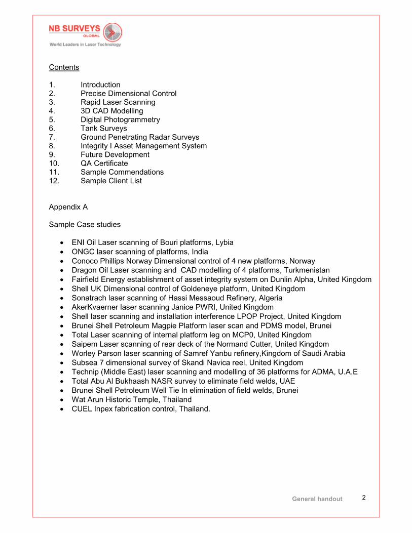
Contents 1. Introduction 2. Precise Dimensional Control 3. Rapid Laser Scanning 4. 3D CAD Modelling 5. Digital Photogrammetry 6. Tank Surveys 7. Ground Penetrating Radar Surveys 8. Integrity I Asset Management System 9. Future Development 10. QA Certificate 11. Sample Commendations 12. Sample Client List
Appendix A Sample Case studies
• ENI Oil Laser scanning of Bouri platforms, Lybia
• ONGC laser scanning of platforms, India
• Conoco Phillips Norway Dimensional control of 4 new platforms, Norway
• Dragon Oil Laser scanning and CAD modelling of 4 platforms, Turkmenistan
• Fairfield Energy establishment of asset integrity system on Dunlin Alpha, United Kingdom
• Shell UK Dimensional control of Goldeneye platform, United Kingdom
• Sonatrach laser scanning of Hassi Messaoud Refinery, Algeria
• AkerKvaerner laser scanning Janice PWRI, United Kingdom
• Shell laser scanning and installation interference LPOP Project, United Kingdom
• Brunei Shell Petroleum Magpie Platform laser scan and PDMS model, Brunei
• Total Laser scanning of internal platform leg on MCP0, United Kingdom
• Saipem Laser scanning of rear deck of the Normand Cutter, United Kingdom
• Worley Parson laser scanning of Samref Yanbu refinery,Kingdom of Saudi Arabia
• Subsea 7 dimensional survey of Skandi Navica reel, United Kingdom
• Technip (Middle East) laser scanning and modelling of 36 platforms for ADMA, U.A.E
• Total Abu Al Bukhaash NASR survey to eliminate field welds, UAE
• Brunei Shell Petroleum Well Tie In elimination of field welds, Brunei
• Wat Arun Historic Temple, Thailand
• CUEL Inpex fabrication control, Thailand.

General handout
3
1. Introduction
NB Surveys was established in Scotland in June 1982 by brothers Douglas and Gordon Niven, and has provided professional surveying services for over 32 years. N.B. Surveys started from very humble beginnings, the Company was established with minimal equity and run from the back room of their parents’ house for several years. Always maintaining strict cost controls (their mother doubling as secretary and book keeper in the early years) the brothers worked long hours, withdrew minimal money from the business and invested whenever they could in technology and system to make the surveying processes simpler and more efficient. From the very outset the Company was focused on the oil and gas business sector providing precise dimensional control services on large construction projects both on and offshore and throughout the 32 year history key strategic opportunities and decisions were made that led to the success and growth of the Company to become a world leader in Precise Dimensional Control, Digital Photogrammetry, Rapid Laser Scanning and 3D CAD modelling. Key Company Milestones 1982 Gordon Niven graduated from Glasgow University and joined with Douglas Niven to form N.B. Surveys Limited in June 1982 for the Provision of dimensional control and surveying services. 1982 to 1987 These five formative years were spent carrying out land surveys, hydrographic surveys, acting as Clients Survey Representatives for Shell UK and significant dimensional control contracts for Occidental on the Piper Alpha and Bravo platforms. The dimensional control work at that time was carrying out using optical survey systems to collect millimetric accurate surveys on reinforcement clamps on all the sub sea jacket members of the Piper Alpha and Bravo platforms. In 1988 after the Piper Alpha disaster NB Surveys were used offshore on the critical bypass survey of the main underwater feed line to the Piper Alpha platform and onshore on the module recovery stages. By the end of 1988 our reputation in Aberdeen for the provision of precise dimensional control survey services was recongnized. 1988 N.B. Surveys were approached by Shell to determine if it would be possible to eliminate the need for field fit welds in pipe work offshore. Shell were experiencing high rework rates and carrying out high risk naked flame welding offshore. N.B. Surveys were engaged in one year trial on the Shell Central fields. The trial was so successful that Shell realised the potential cost and time savings that would be realised using the techniques we had developed would save them millions of pounds annually, reducing shut down time and most importantly, naked flame welding would be mostly eliminated from the offshore environment, reducing the possibility of catastrophic disasters offshore. The success of the work carried out by NB Surveys created an entirely new surveying sector.
General handout
4
1989 N.B. Surveys were the sole supplier of surveying services to eliminate the need for field welding on site, the concept, whilst adopted as standard procedure by Shell UK, was also being adopted by other Oil Companies in the UK North Sea Sector over the next five years. 1994 N.B. Surveys principle vision of always looking for, and investing in, new technologies led the Company to invest in a revolutionary method of photogrammetric measurement for fast plant data capture, allowing precise modelling and photographic overlays within PDMS, PDS, AutoCAD and Microstation environments. The system significantly reduced the data acquisition time and provided 360 degree colour panoramic bubble imaging of assets. NB Surveys were one of only two suppliers of the service worldwide, which was taken up on a very large scale by BP for many of their assets. The system was the first millimeter accurate, rapid data collection method that could reduce the need to travel to sites and the very first 360 degree photographic asset management tool. The early adoption of this new technology further positioned N.B. Surveys as a market leader in innovative surveying techniques and the system was utilized by many major Oil and Gas Operators for their offshore and onshore assets. 1998 By 1998 NB Surveys reputation for excellence in survey was well established in the UK North Sea Sector. Client’s who had experienced the cost saving NB Surveys systems provided began to request if NB Surveys could provide similar services in other worldwide locations. A strategic decision was made in 1988 to support APG/Salamis JV after they had won an EPC contract from Brunei Shell Petroleum. A team of three Surveyors were sent to Brunei to set up a support base and the first steps to service a greater world wide client base began. As was typical NB Surveys transformed the procedures in Brunei Shell Petroleum, slashing well work over times from 10 days to just 1 day. This convinced Brunei Shell Petroleum to use dimensional control services as a standard procedure. 2001 N.B. Surveys for some years prior to 2001 had been involved as consultants to UK Robotics who were developing basic laser scanning systems, helping them understand what requirements laser scanning would need to have to become a commercially viable system. In 2001 N.B. Surveys again led the market by being the first to introduce rapid laser scanning systems commercially, provided a faster and more efficient alternative to the traditional dimensional control services offered by competitors; and the photogrammetric system NB Surveys currently were using. From the very outset NB Surveys identified the best system for the industrial measurement sector, a system that became the “standard” specified by Clients. The utilization of these systems coupled with N.B. Surveys comprehensive knowledge of the Oil and Gas engineering requirements, coupled with N.B. Surveys in-house bespoke software systems, again confirmed N.B. Surveys as a market leader in deployment of innovative surveying techniques. 2002 Through to 2002, N.B. Surveys had primarily focused its services on the lucrative Oil and Gas sector from its base in Aberdeen, establishing its impeccable reputation for a professional and reliable service to a range of blue chip customers such as such as Shell, BP, Occidental, Total, Mobil, ELF Amec, Petrofac, Aker Kvaerner. In 2002 following on
General handout
5
from the success of the service center in Brunei N.B. Surveys were requested to undertake a substantial project in Thailand. A strategic decision was taken to globalise the service and rather than just setting up a service centre as had been undertaken in Brunei a Thai Company was established. In the following years significant contracts were won in countries such as Libya, Algeria, Kazakhstan, Egypt, Sakhalin (Russia), Iraq, Iran, Baku, Saudi Arabia. N.B. Surveys being the first Company to carry out laser scanning or photogrammetric surveys in these regions. 2009 N.B. Surveys took the key strategic aim of becoming a commercial business run by business people rather than a survey company run by surveyors and create an international group of scale, to capitalise on the global market demand for laser scanning and precise dimensional control surveys. The Company identified the key requirement for experienced personnel around the globe, initially with the appointment of a Global CEO and, and subsequently embarked on a global expansion strategy, creating the concept of ‘N.B. Surveys Global’. Development of N.B. Surveys Malaysia Incorporation of N.B. Surveys Australia. Incorporation of N.B. Surveys Kirpalaney in India. 2010 Opening of U.A.E. office in Abu Dhabi to service the Middle East regions. Obtained licenses from ADMA, GASCO, ZADCO, ADCO and ADGAS for the provision of surveying services in U.A.E. region. Incorporation of NB Surveys Petrojaya in Brunei. Development of Integrity i Asset Management System designed to move N.B. Surveys from being a project driven company to an asset management driven company, with the advantages of continual business stream, larger value contracts and development of “life of asset” customer relationships. 2012 N.B. Surveys were the first Company to carry out laser scanning for the Oil and Gas industry in India for ONGC 2013 Incorporation of NB Invis in Norway N.B. Surveys were the first Company to introduce the concept of elimination of field welds to the UAE market with our Client, Total Abu Al Bukhoosh), receiving an innovation award from ADMA and their consideration to develop this as the standard procedure .

General handout
6
N.B. Surveys Global can now service Oil and Gas Clients internationally in Europe, Africa the Middle East, Asia and Australia.
Utilizing only state-of-the-art equipment, highly qualified personnel and a certified QA system we consistently provide world class services to our global clientele.
General handout
7
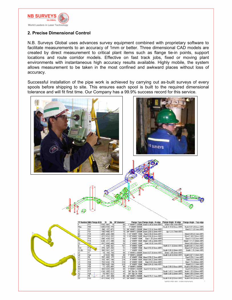
2. Precise Dimensional Control
N.B. Surveys Global uses advances survey equipment combined with proprietary software to facilitate measurements to an accuracy of 1mm or better. Three dimensional CAD models are created by direct measurement to critical plant items such as flange tie-in points, support locations and route corridor models. Effective on fast track jobs, fixed or moving plant environments with instantaneous high accuracy results available. Highly mobile, the system allows measurement to be taken in the most confined and awkward places without loss of accuracy. Successful installation of the pipe work is achieved by carrying out as-built surveys of every spools before shipping to site. This ensures each spool is built to the required dimensional tolerance and will fit first time. Our Company has a 99.9% success record for this service.
General handout
8
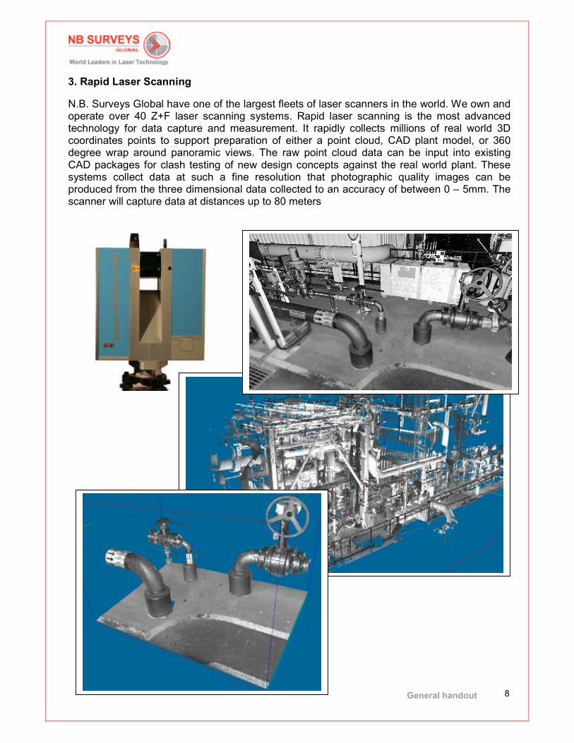
3. Rapid Laser Scanning
N.B. Surveys Global have one of the largest fleets of laser scanners in the world. We own and operate over 40 Z+F laser scanning systems. Rapid laser scanning is the most advanced technology for data capture and measurement. It rapidly collects millions of real world 3D coordinates points to support preparation of either a point cloud, CAD plant model, or 360 degree wrap around panoramic views. The raw point cloud data can be input into existing CAD packages for clash testing of new design concepts against the real world plant. These systems collect data at such a fine resolution that photographic quality images can be produced from the three dimensional data collected to an accuracy of between 0 – 5mm. The scanner will capture data at distances up to 80 meters

General handout
9
Laser scan data captures the accurate as-built condition of the assets and can be inserted directly inside CAD system to provide an invaluable engineering tool for clash testing of new design concepts
Screen shot of new pipe route inside the point cloud data base

General handout
10
Screen shot of new pipe route inside the intensity image.
Screen shot of colourised point cloud database
General handout
11
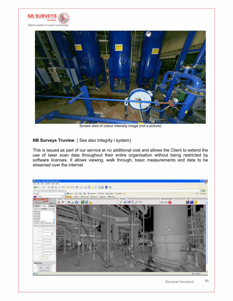
Screen shot of colour intensity image (not a picture)
NB Surveys Truview. ( See also Integrity i system) This is issued as part of our service at no additional cost and allows the Client to extend the use of laser scan data throughout their entire organisation without being restricted by software licenses. It allows viewing, walk through, basic measurements and data to be streamed over the internet.
General handout
12
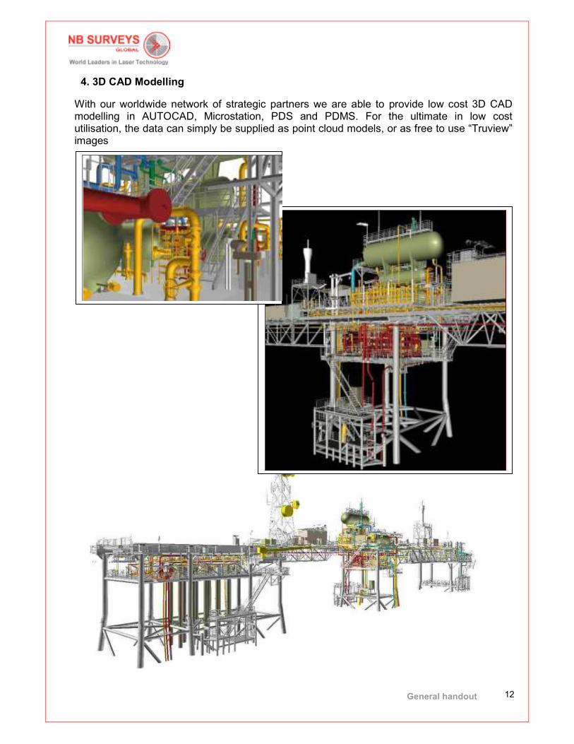
4. 3D CAD Modelling
With our worldwide network of strategic partners we are able to provide low cost 3D CAD modelling in AUTOCAD, Microstation, PDS and PDMS. For the ultimate in low cost utilisation, the data can simply be supplied as point cloud models, or as free to use “Truview” images

General handout
13
5. Digital Photogrammetry Digital photogrammetry (HAZMAP) allows precise measurements to be taken from calibrated digital images. The HAZMAP system generates a complete 360 degree wraparound panoramic view for each camera station allowing the user to measure, rotate, pan and zoom within each station and visually jump between stations. This is a valuable visualisation and measurement tool for design, inspection, induction, safety and any other tasks requiring a visual walkthrough of the facility. Existing 3D CAD model data can be superimposed onto the images for design review, clash checking, HAZOP studies or even Asset Management
General handout
14
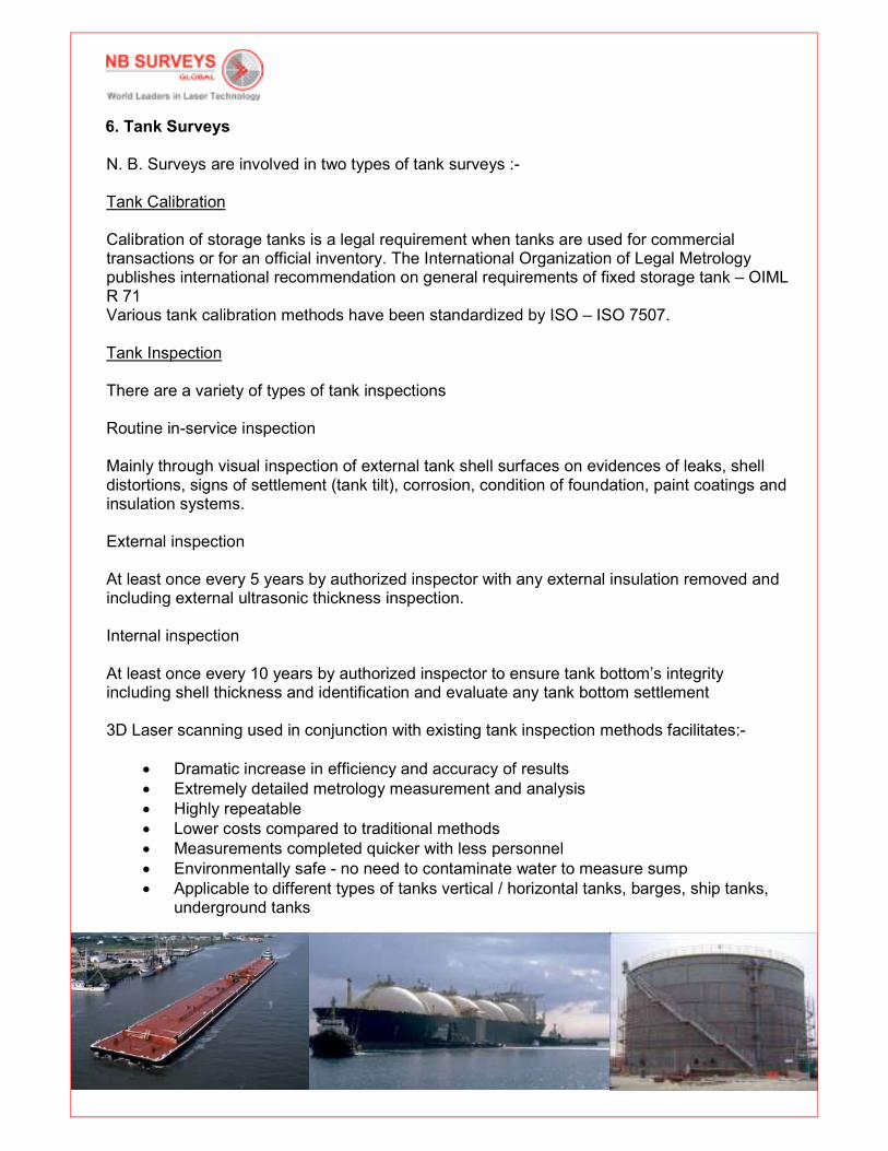
6. Tank Surveys
N. B. Surveys are involved in two types of tank surveys :- Tank Calibration Calibration of storage tanks is a legal requirement when tanks are used for commercial transactions or for an official inventory. The International Organization of Legal Metrology publishes international recommendation on general requirements of fixed storage tank – OIML R 71 Various tank calibration methods have been standardized by ISO – ISO 7507. Tank Inspection There are a variety of types of tank inspections Routine in-service inspection Mainly through visual inspection of external tank shell surfaces on evidences of leaks, shell distortions, signs of settlement (tank tilt), corrosion, condition of foundation, paint coatings and insulation systems. External inspection At least once every 5 years by authorized inspector with any external insulation removed and including external ultrasonic thickness inspection. Internal inspection
At least once every 10 years by authorized inspector to ensure tank bottom’s integrity including shell thickness and identification and evaluate any tank bottom settlement
3D Laser scanning used in conjunction with existing tank inspection methods facilitates:-
• Dramatic increase in efficiency and accuracy of results
• Extremely detailed metrology measurement and analysis
• Highly repeatable
• Lower costs compared to traditional methods
• Measurements completed quicker with less personnel
• Environmentally safe - no need to contaminate water to measure sump
• Applicable to different types of tanks vertical / horizontal tanks, barges, ship tanks, underground tanks
General handout
15
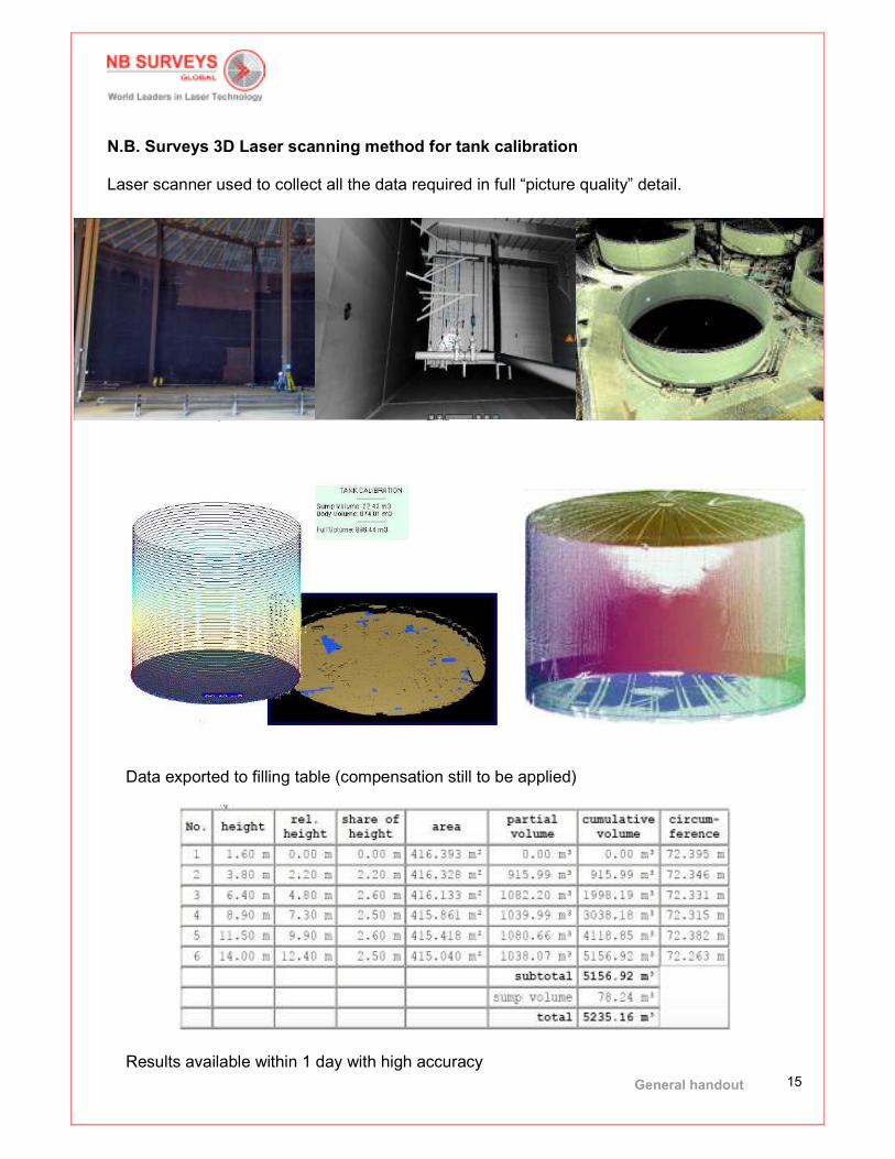
N.B. Surveys 3D Laser scanning method for tank calibration Laser scanner used to collect all the data required in full “picture quality” detail.
Volume computation
Data exported to filling table (compensation still to be applied) Results available within 1 day with high accuracy
General handout
16
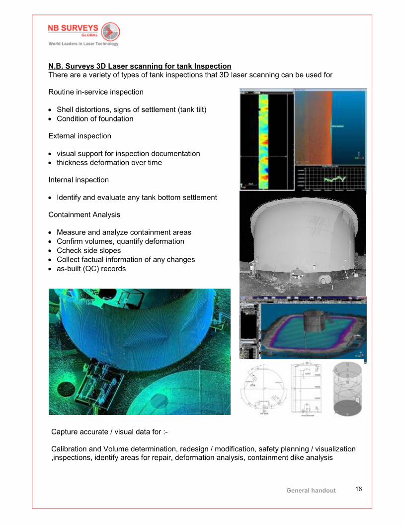
N.B. Surveys 3D Laser scanning for tank Inspection There are a variety of types of tank inspections that 3D laser scanning can be used for Routine in-service inspection
• Shell distortions, signs of settlement (tank tilt)
• Condition of foundation External inspection
• visual support for inspection documentation
• thickness deformation over time Internal inspection
• Identify and evaluate any tank bottom settlement Containment Analysis
• Measure and analyze containment areas
• Confirm volumes, quantify deformation
• Ccheck side slopes
• Collect factual information of any changes
• as-built (QC) records
Capture accurate / visual data for :- Calibration and Volume determination, redesign / modification, safety planning / visualization ,inspections, identify areas for repair, deformation analysis, containment dike analysis

General handout
17
7. Ground Penetrating Radar (GPR) Surveys Increasingly Clients have requested that as-built underground assets be collected at the same time as laser scanning the above ground assets. In order to meet client demand NB Surveys Global has invested in the very latest dual frequency ground penetrating radar systems and can offer complete asset collection.
NB Surveys Global operates the very latest dual frequency multi antenna systems which can cover up to 14000 square meters per day. GPR can locate metallic and non metallic pipes, foundations, reinforcements, sewers cables, and ducts and defines position and depth in a single pass. GPR can locate underground services for inclusion in drawings or 3D CAD and provides cost saving from plant strike avoidance, rework, and eliminate trenching.
General handout
18
8. Integrity I Asset Management System Overview Integrity i is a unique software system that provides safety improvements and cost savings in particular it can be used :-
• for asset integrity management
• to improve HSE compliance
• to control anomaly work parks
• to provide accurate dimensional data for design use
• to reduce the need for site visits
• to reduces personnel exposure
• to provide real time management reports on anomalies
• Provides concise anomaly management reports
• A central location for anomaly and asset data
• Visual anomaly Management Reports
• Minimal return to site visits
• Feed millimeter accurate data in design
• Dimensions without site visits
• Real time anomaly monitoring
• An application that links to into laser scan data
• Planning and visualization at all discipline levels

General handout
19
The ageing infrastructure of oil and gas facilities presents a constant and growing challenge, characterised by deterioration that, in severe operational environments, can be significant. If not managed properly, serious consequences can result for facility integrity, safety, and asset value. In the extreme case, failure could cause total loss of a facility, with little chance of asset survival. Typically, the industry relies on simple spreadsheets to mange and monitor asset integrity and repair issues. These require significant effort to maintain, and their ability to demonstrate that defects are under control in limited. Defects are often diffucult to locate accurately from inspection reports, and are often impossible to review in spatial relationship to each other to give a comprehensive overview of the severity of the integrity problem. Multiple site visits are usually necessary, by different engineering disciplines to gather all the information required to resolve problems, prepare engineering drawings and repair order work packs. THE PROBLEM
• Defects/anomalies occur continuously
• Difficult to manage and understand both the number and location
• Multiple site visits
• Critical HSE issue
THE SOLUTION
• INTEGRITY i
• Location linking at time of
inspection
• Allows proper
management
• Minimal site visits
• Allows visual overview
• Allows visual archiving
• Improves the HSE case
General handout
20
Integrity i is the new data management system designed specifically for the management of asset integrity anomalies. Based on 30 years of industrial experience, the system has been developed using state of the art graphical interfaces, laser scan data, and 3D files working with a database to manage, organise and present digital records of anomalies within industrial plant. This system gives the plant operator a simple to use method of recording, managing and archiving anomalies within their plants. This facilitates and improves planning and targeted campaigns to rectify the anomalies. By reducing exposure to risk, the HSE safety case is improved. It also proves, to legislative authorities, that the operator has proper controls in place to manage anomalies within their plant and provides a central repository of all data and documents related to the individual anomalies. It can be used by all levels within an organisation - from senior management for reviews and strategic planning, engineers for analysis and investigation, designers to extract the construction drawings, to the work squad who will repair the anomaly on-site. It can be used to fully plan work and brief work squads WITHOUT visiting the site, thereby reducing safety risk exposure and cost. Benefits include:
• Improved HSE compliance
• Real time anomaly monitoring
• Full integration with existing asset management systems
• Visual anomaly Management reports
• Reduces the need for site visits
• Reduces personnel exposure
• Provides accurate dimensional data for design use without site visit
• Provides real time management reports on defects and repair issues
• A central location for anomaly and asset data
• Controls defects and repair work pack generation
• An application that links to laser scan data
• Planning and virtual reality immersive visualization at all discipline levels

General handout
21
The process

General handout
22
Site inspectors As anomalies are detected on site, in addition to the normal process of writing up a report, the inspection team locate the anomaly on a plan or laser scan picture within the Integrity I system. In a very simple way this spatially links the anomaly to plant grid, providing an accurate location of the anomaly for ease of identification at later stages of the maintenance process which is located in a very simple way. This will spatially link the anomaly to the plant grid system and give an accurate location of the anomaly for ease of identification at later stages of the maintenance process.
Document controllers The anomalies are linked to all relevant documents stored on the client database, with access to the data through a simple user interface. Any document can be linked to the anomaly.

General handout
23
Isometrics are generated directly from the point cloud model, without the need to return to site Viewers
• Generate reports on individual anomalies.
• History reports allow comparison of new anomalies with historic records to identify
recurring problems.
• Criticality reports identifying anamalies by category of severity for management
reports.
• Work packs for offshore projects can be assembled in one electronic database.
• Anomalies are updated real time between site and managerment locations
• Use to raise awareness of risk in an area prior to work commencing.
General handout
24
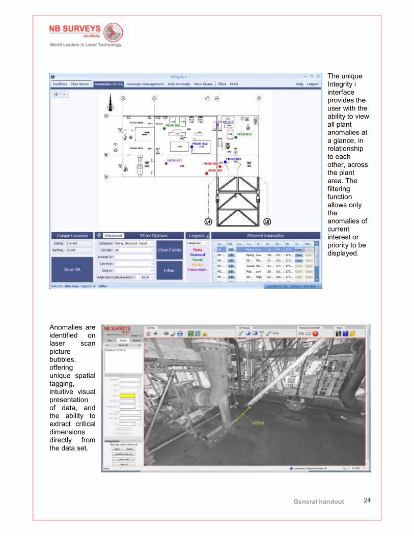
The unique Integrity i interface provides the user with the ability to view all plant anomalies at a glance, in relationship to each other, across the plant area. The filtering function allows only the anomalies of current interest or priority to be displayed.
Anomalies are identified on laser scan picture bubbles, offering unique spatial tagging, intuitive visual presentation of data, and the ability to extract critical dimensions directly from the data set.

General handout
25
9. Future Development From the very outset N.B. Surveys philosophy has been to adopt the very latest technology that makes the survey process more efficient, never becoming complacent or believing that the systems and procedures NB Surveys use today will be the same systems and procedures we will use tomorrow. Technology changes at a rapid pace and it is undeniable that the systems we use today will be improved, and then replaced in line with the ever increasing speed of technology development. N.B. Surveys has to remain open to respond to changing data collection solutions, software processing systems and market expectations. However, through this inevitable process, NB Surveys must never forget our history and the overriding factors that have led to the global success our Company enjoys today :- accuracy, reliability and experience. Clear emphasis will be place on the development of rapid “whole of asset capture” systems coupled with software solutions that reduce on site time, improve operator awareness of the facilities they control and allow geographical asset management to be properly executed. This will become a pressing global requirement as operator try to reduce catastrophic events in their organisations and place even greater emphasis on the control, maintenance and understanding of the assets they operate. This vision will also move the Company from being a project driven organization to a regularised process used in every day operations, thus improving growth forecast and allowing planned development rather than reactionary development. We foresee future improvement in colour scan data systems and the incorporation of thermal imaging collection alongside laser scanning to assist in preventative inspection, further enhancing the value of asset scanning. Future development will include:-
1. Increasing our Global network, particularly the West Coast of Africa, Australia and the Americas.
2. Improving and enhancing Integrity i. 3. Moving towards a becoming a solutions provider rather than a service provider. 4. Expanding our network of key strategic partners. 5. Development and training of new operational staff within NB Surveys training programs
to continue to deliver accuracy, reliability and experience to our worldwide Clients.

General handout
26
10. QA Certificate

General handout
27
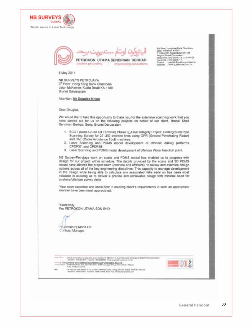
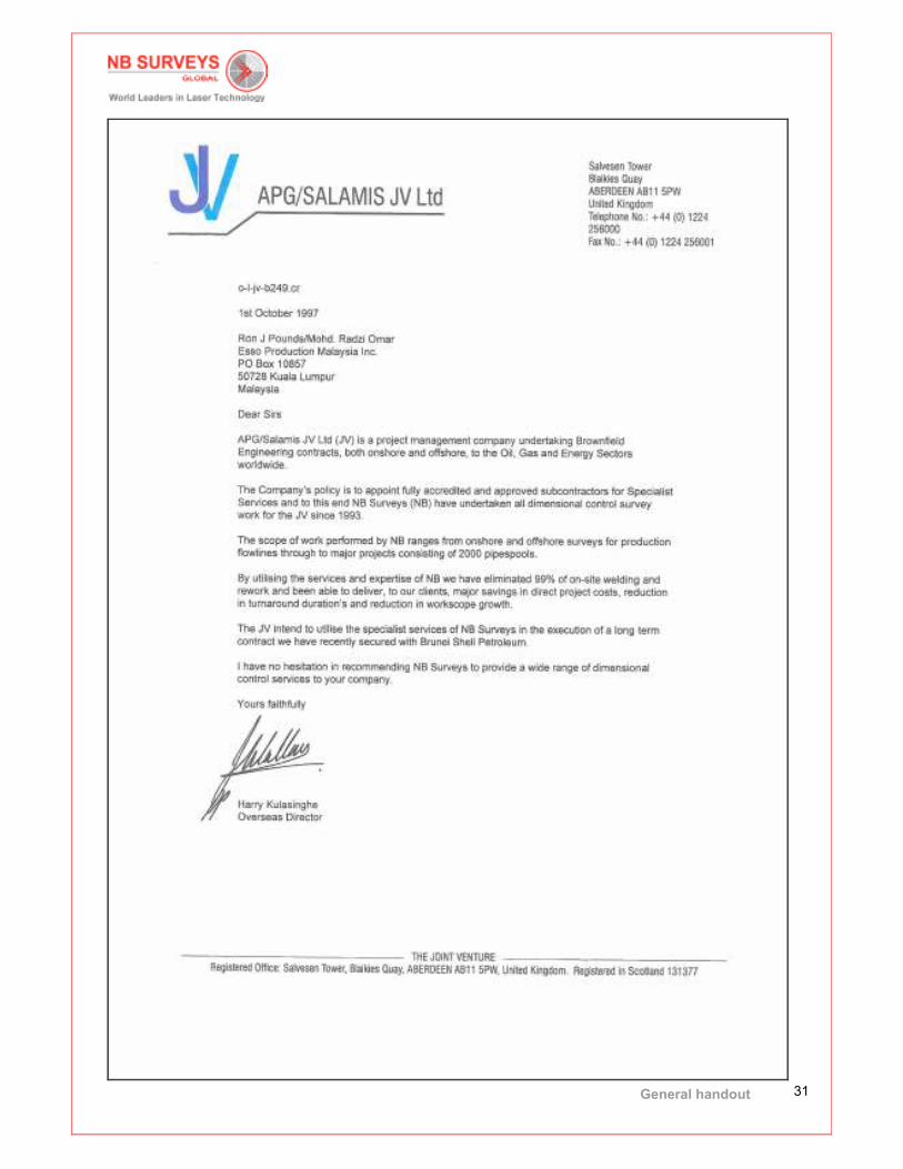
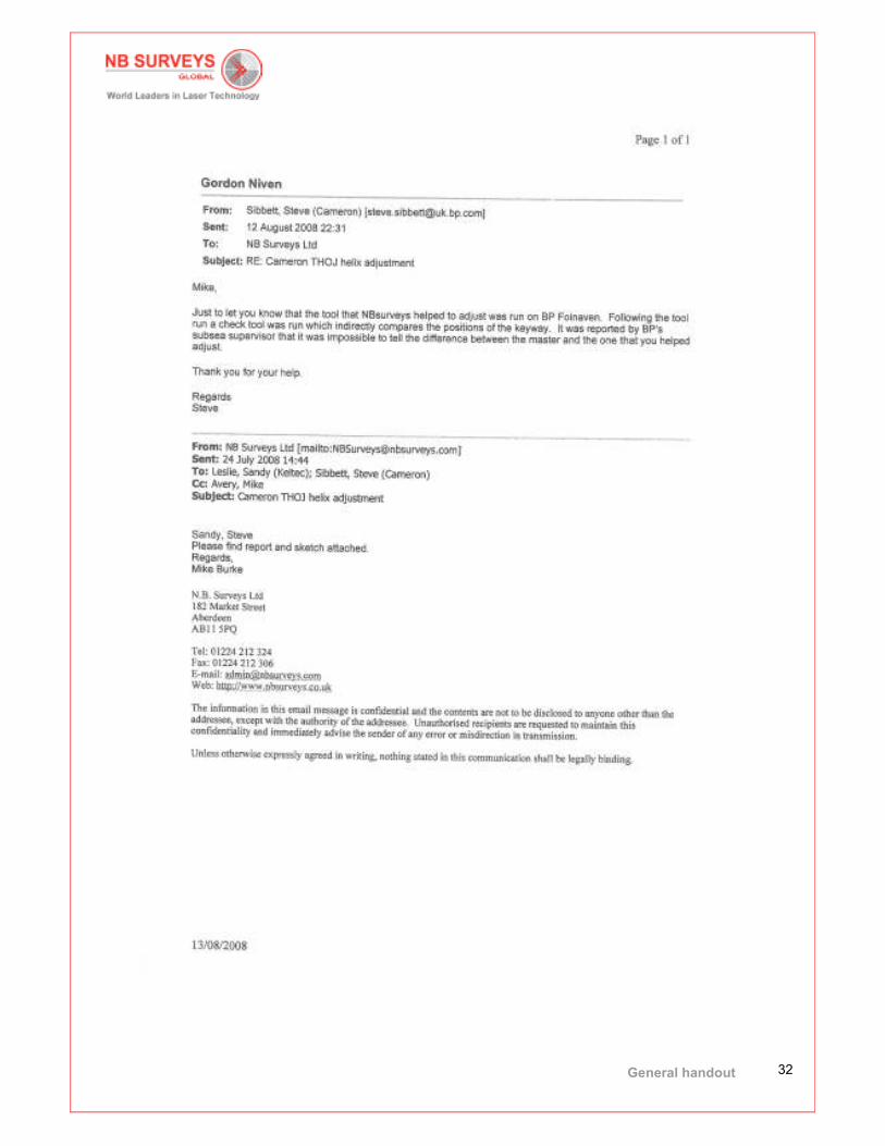
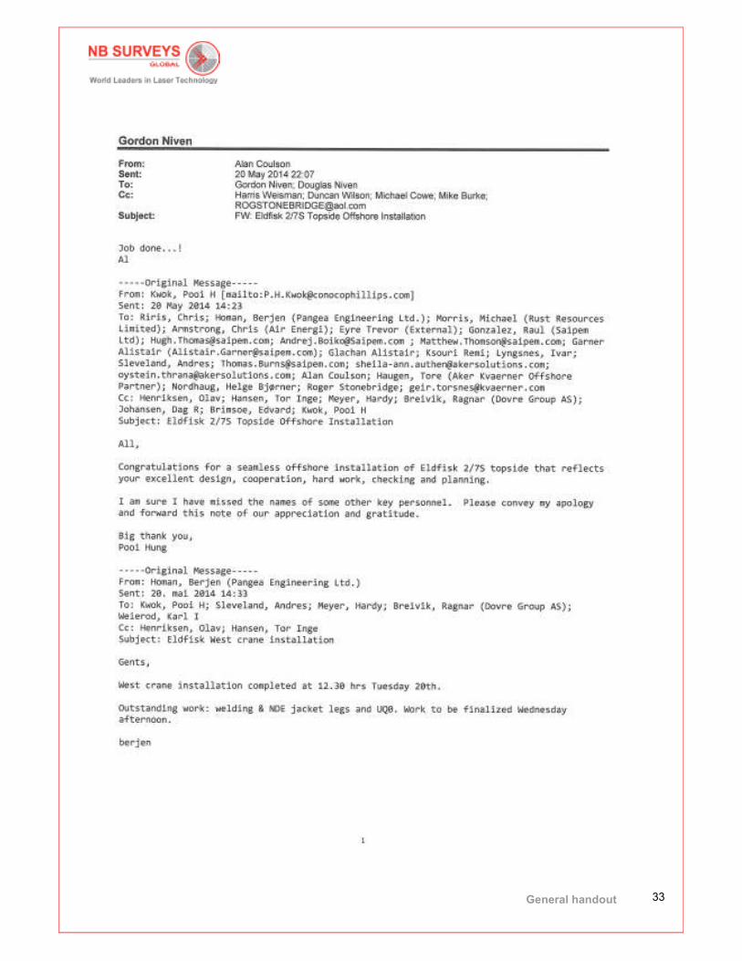
11. Sample Commendations

General handout
28
General handout
29
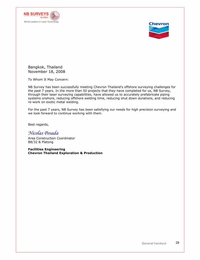
Bangkok, Thailand
November 18, 2008
To Whom It May Concern:
NB Survey has been successfully meeting Chevron Thailand’s offshore surveying challenges for
the past 7 years. In the more than 50 projects that they have completed for us, NB Survey,
through their laser surveying capabilities, have allowed us to accurately prefabricate piping
systems onshore, reducing offshore welding time, reducing shut down durations, and reducing
re-work on exotic metal welding.
For the past 7 years, NB Survey has been satisfying our needs for high precision surveying and
we look forward to continue working with them.
Best regards,
Nicolas Posada Area Construction Coordinator
B8/32 & Platong
Facilities Engineering
Chevron Thailand Exploration & Production
General handout
30
General handout
31
General handout
32
General handout
33
General handout
34
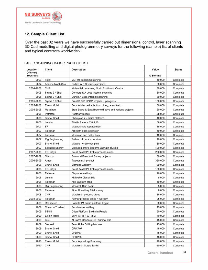
12. Sample Client List
Over the past 32 years we have successfully carried out dimensional control, laser scanning 3D Cad modelling and digital photogrammetry surveys for the following (sample) list of clients and typical contracts worldwide:-
LASER SCANNING MAJOR PROJECT LIST Location Client Description Value Status
Offshore Topsides £ Sterling
2003 Total MCP01 decommissioning 10,000 Complete
2004 Apache North Sea Forties A,B,C various projects. 60,000 Complete
2004-2006 CNR Ninian field scanning North South and Central 30,000 Complete
2005 Sigma 3 / Shell Cormorant A Legs internal scanning 60,000 Complete
2005 Sigma 3 / Shell Dunlin A Legs internal scanning 80,000 Complete
2005-2006 Sigma 3 / Shell Brent B,C,D LPOP projects + penguins 150,000 Complete
2005-2008 Exxon Mobil Beryl A Mini cell at bottom of leg, area 9 etc. 60,000 Complete
2005-2008 Marathon Brae Bravo & East Brae well bays and various projects 50,000 Complete
2006 Petrofac Heather wellbay 25,000 Complete
2006 Brunei Shell Champion 7 - entire platform. 40,000 Complete
2006 Lundin Thistle A mods 7,8,9,10 56,000 Complete
2007 BP Magnus flare replacement 35,000 Complete
2007 Talisman Arbroath deck extension 10,000 Complete
2007 Talisman Montrose sub cellar deck. 10,000 Complete
2007 Rig Engineering Trident 14 deck extension. 10,000 Complete
2007 Brunei Shell Magpie - entire complex 80,000 Complete
2007 Sakhalin Energy Molikpaq entire platform Sakhalin Russia 400,000 Complete
2007-2008 ENI Libya Bourti field DP3 Entire process areas 200,000 Complete
2007-2009 Oilexco Balmoral Brenda & Burley projects 100,000 Complete
2006-2009 Amec Tweedsmuir project 350,000 Complete
2008 Brunei Shell Mampak wellbay 20,000 Complete
2008 ENI Libya Bourti field DP4 Entire process areas 150,000 Complete
2008 Talisman Claymore wellbay 10,000 Complete
2008 Lundin Kittiwake Diesel Skid 5,000 Complete
2008 Talisman Auk laydown area 10,000 Complete
2008 Rig Engineering Monarch Skid beam 5,000 Complete
2008 Talisman Piper B wellbay Trial survey 8,000 Complete
2008 CNR Murchison process areas 35,000 Complete
2008-2009 Talisman Fulmar process areas + wellbay 25,000 Complete
2009 Rashpetco Rosetta P1 entire platform Egypt 60,000 Complete
2009 Chevron Thailand Benchemas wellbay. 15,000 Complete
2009 STSN Orlan Platform Sakhalin Russia 190,000 Complete
2009 Exxon Mobil Beryl A Rig 1 & Rig 2 40,000 Complete
2009 SGS Al Bazra Offshore Oil Terminal Iraq 45,000 Complete
2009 Seawell Tern Alpha Drilling Module 25,000 Complete
2009 Brunei Shell CPWA07 48,000 Complete
2009 Brunei Shell CPDP37 48,000 Complete
2009 Brunei Shell CPDP38 48,000 Complete
2010 Exxon Mobil Beryl Alpha Leg Scanning 40,000 Complete
2010 CNR Murchison Surge Tanks 10,000 Complete
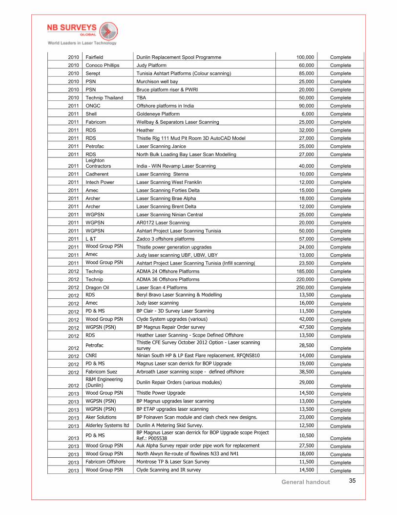
General handout
35
2010 Fairfield Dunlin Replacement Spool Programme 100,000 Complete
2010 Conoco Phillips Judy Platform 60,000 Complete
2010 Serept Tunisia Ashtart Platforms (Colour scanning) 85,000 Complete
2010 PSN Murchison well bay 25,000 Complete
2010 PSN Bruce platform riser & PWRI 20,000 Complete
2010 Technip Thailand TBA 50,000 Complete
2011 ONGC Offshore platforms in India 90,000 Complete
2011 Shell Goldeneye Platform 6,000 Complete
2011 Fabricom Wellbay & Separators Laser Scanning 25,000 Complete
2011 RDS Heather 32,000 Complete
2011 RDS Thistle Rig 111 Mud Pit Room 3D AutoCAD Model 27,000 Complete
2011 Petrofac Laser Scanning Janice 25,000 Complete
2011 RDS North Bulk Loading Bay Laser Scan Modelling 27,000 Complete
2011 Leighton Contractors India - WIN Revamp Laser Scanning 40,000 Complete
2011 Cadherent Laser Scanning Stenna 10,000 Complete
2011 Intech Power Laser Scanning West Franklin 12,000 Complete
2011 Amec Laser Scanning Forties Delta 15,000 Complete
2011 Archer Laser Scanning Brae Alpha 18,000 Complete
2011 Archer Laser Scanning Brent Delta 12,000 Complete
2011 WGPSN Laser Scanning Ninian Central 25,000 Complete
2011 WGPSN AR0172 Laser Scanning 20,000 Complete
2011 WGPSN Ashtart Project Laser Scanning Tunisia 50,000 Complete
2011 L &T Zadco 3 offshore platforms 57,000 Complete
2011 Wood Group PSN Thistle power generation upgrades 24,000 Complete
2011 Amec Judy laser scanning UBF, UBW, UBY 13,000 Complete
2011 Wood Group PSN Ashtart Project Laser Scanning Tunisia (Infill scanning( 23,500 Complete
2012 Technip ADMA 24 Offshore Platforms 185,000 Complete
2012 Technip ADMA 36 Offshore Platforms 220,000 Complete
2012 Dragon Oil Laser Scan 4 Platforms 250,000 Complete
2012 RDS Beryl Bravo Laser Scanning & Modelling 13,500 Complete
2012 Amec Judy laser scanning 16,000 Complete
2012 PD & MS BP Clair - 3D Survey Laser Scanning 11,500 Complete
2012 Wood Group PSN Clyde System upgrades (various) 42,000 Complete
2012 WGPSN (PSN) BP Magnus Repair Order survey 47,500 Complete
2012 RDS Heather Laser Scanning - Scope Defined Offshore 13,500 Complete
2012 Petrofac
Thistle CFE Survey October 2012 Option - Laser scanning survey
28,500 Complete
2012 CNRI Ninian South HP & LP East Flare replacement. RFQNS810 14,000 Complete
2012 PD & MS Magnus Laser scan derrick for BOP Upgrade 19,000 Complete
2012 Fabricom Suez Arbroath Laser scanning scope - defined offshore 38,500 Complete
2012
R&M Engineering (Dunlin)
Dunlin Repair Orders (various modules) 29,000 Complete
2013 Wood Group PSN Thistle Power Upgrade 14,500 Complete
2013 WGPSN (PSN) BP Magnus upgrades laser scanning 13,000 Complete
2013 WGPSN (PSN) BP ETAP upgrades laser scanning 13,500 Complete
2013 Aker Solutions BP Foinaven Scan module and clash check new designs. 23,000 Complete
2013 Alderley Systems ltd Dunlin A Metering Skid Survey. 12,500 Complete
2013 PD & MS
BP Magnus Laser scan derrick for BOP Upgrade scope Project Ref.: P005538
10,500 Complete
2013 Wood Group PSN Auk Alpha Survey repair order pipe work for replacement 27,500 Complete
2013 Wood Group PSN North Alwyn Re-route of flowlines N33 and N41 18,000 Complete
2013 Fabricom Offshore Montrose TP & Laser Scan Survey 11,500 Complete
2013 Wood Group PSN Clyde Scanning and IR survey 14,500 Complete

General handout
36
2013 BP
Paul B Lloyd Junior Scan, photograph and survey the BOP stack.
27,000 Complete
2013 Amec Bluewater Various platforms - Offshore and onshore scanning. 59,000 Complete
2013
R&M Engineering (Dunlin)
Dunlin Scanning and TP survey as per the work scope provided.
28,000 Complete
2013 CNRI Ninan South Production Shutdown MCDR’s 28,500 Complete
2013 Archerwell
Captain Laser scan offshore drilling facility, provide point cloud and 3D CAD model
23,500 Complete
2013 Odfjell Drilling Piper Bravo 3D Laser scan survey of the Piper Bravo Derrick 28,500 Complete
2013 Marathon
Brae Alpha Laser scan areas indicated on the RFQ plans and qualified at the meeting.
10,500 Complete
2013 Archerwell
Brent Bravo Laser scan and survey spools for LP Mud suction strainers
14,500 Complete
2013 Wood Group PSN Tern Alpha Scan Corridor Model and IR Survey TPs 47,000 Complete
2013 WGPSN (PSN)
North Alwyn Laser scanning and TP observations of areas yet to be defined
63,000 Complete
2013 Shell BP Nelson Laser scan the areas indicated and survey TPs. 11,500 Complete
2013 Wood Group PSN Claymore Alpha Scan areas for lifeboats and CVDC 17,500 Complete
2013 Wood Group PSN Clyde Laser scan and TP survey. 14,500 Complete
2013 Wood Group PSN Bruce Scan and survey various repair orders. 21,500 Complete
2013 Amec Judy Laser scan area around chemical injection tank. 10,500 Complete
2013 Taqa Bratani
Cormorant Alpha Laser scan the areas detailed in the scope of work
41,500 Complete
2013 Wood Group PSN
Saltire Scan wellbay, survey TPS for three gas lift line and diesel line replacement.
26,000 Complete
2013 PD & MS
Byford Dolphin Laser scan the cellar and mezz decks as indicated in the MR.
20,000 Complete
2013 Odfjell Drilling Fulmar3D Laser scan survey of drilling facilities 38,500 Complete
2013 Wood Group PSN Montrose Laser scan exhaust support structures 13,000 Complete
2013 Wood Group PSN Clyde Laser scan 3 lifeboats and davits. 22,000 Complete
2013 Nortech Solutions Thislte Survey TPs as directed and laser scan areas. 22,500 Complete
2013 Wood Group PSN
Clyde Laser scan route & TPs Chemical Injection skid & drains CL3852
14,500 Complete
2013 Remontowa Safe Scandanvia Laser scan anchor winch replacement . 30,500 Complete
2013 WGPSN / Taqa Eider Laser scan three lifeboat stations. 14,500 Complete
2013
AOC Engineering Ltd
Janice Laser scanning of the top decks on the Janice Platform 42,500 Complete
2013 Wood Group PSN
Bruce Platform survey for various repair orders using TS and Laser Scanner.
27,000 Complete
2013 Amec North Everest Scan full platform for pipework replacement 46,500 Complete
2013 Odfjell Drilling
Piper Bravo laser scanning service at the area provided in separate SOW.
11,500 Complete
2013 Petrofac
Forties Charlie Corridor laser scanning survey for replacement flowlines.
44,500 Complete
2013 WGPSN Chevron Captain WPP Laser scan the cutting chute 17,500 Complete
2013 Fabricom Offshore Heather Laser scan an area of the wellheads on three levels 24,500 Complete
2013 PD & MS
BP Bruce Laser scan drilling derrick, drill floor and upper mezz
floor 14,500
Ongoing
2013 WGPSN / Taqa North Cormorant Laser scan five lifeboat stations. 56,000 Complete
2013 PD & MS
Clair Laser scan and provide an AutoCAD model of the upgarde areas.
44,000 Ongoing
2013 PD & MS Magnus Laser scan areas of the drilling facillities 60,500 Ongoing
Offshore vessels / FPSO
2004 Stolt Offshore LB200 Stinger 25,000 Complete
2005 Subsea 7 Skandi Navica reel clearance 5,000 Complete
2006 Maersk Janice PWRI project 10,000 Complete
2007 Denholm Big Orange Acid Room 5,000 Complete
2007 Bibby Offshore Bbby Saphire deck & hyperbaric lifeboat. 5,000 Complete

General handout
37
2008 Rig Engineering MV Didon deck extension 10,000 Complete
2008 Petrofac Northern Producer process areas + drains 25,000 Complete
2008 Saipem Normand Cutter 10,000 Complete
2008 Acergy Acergy Discovery Hatches 5,000 Complete
2008 Acergy Acergy Eagle Hatches 5,000 Complete
2009 Acergy Polaris J lay system Angola) 90,000 Complete
2010 Amerada Hess Triton - Various Modules 50,000 Complete
2013 Petrofac Maersk GP3 Laser scan LP flare header 35,000 Complete
2013 Petrofac Maersk GP3 Laser scanning of corridor and tie points. 31,500 Complete
2013 Shell Curlew Laser scanning various modules for upgrade works 39,000 Complete
2013 Petrofac Maersk GP3 Laser scan turret pipework for Repair Order works 34,500 Ongoing
2013 Technip Angola Laser scan the Marine Deck and Engine rooms 69,000 Ongoing
2013 Petrofac Maersk GP3 Laser scanning hydraulic systems 44,000 Ongoing
2013 WGPSN Chevron Captain FPSO Flare header scope to be verified on site - trip 1 33,500 Complete
Offshore Subsea
2007 Shell Starling manifold 5,000 Complete
2008 Petrofac Don manifold 8,000 Complete
2008 Petrofac Don SAL 9,000 Complete
2009 Subsea 7 Bardolino structures 8,000 Complete
Onshore Engineering
2007 Rig Engineering BOP scans 2,000 Complete
2007 Aktiv Nuclear Nuclear power station cells. 45,000 Complete
2007 Scottish water Peterhead pumping station 10,000 Complete
2007 Sonatrach Hassi Messaoud refinery Algeria 85,000 Complete
2008 Exxon Mobil St Fergus Import line modelling 10,000 Complete
2008 BP Sullom Voe 25,000 Complete
2008 Scottish water Ayr road pumping station 5,000 Complete
2008 BP Cruden Bay 5,000 Complete
2008 Yorkshire water Aberdeen WWTP 2,000 Complete
2009 Worley Parsons Arabia Samref Refinery Yanbu 220,000 Complete
2009 KPO Karachaganack refinery re-vamp 1,100,000 Complete
2010 Genisis Oil & Gas West Harbour refinery Egypt 75,000 Complete
2010 Worley Parsons SAMREF refinery Yanbu Saudi Arabia Extended 150,000 Complete
2011 Wood Group
Laser scanning turbine test hall, and associated services externally.
15,550 Complete
2012 BP Super-M2 Jack-up leg survey 22,000 Complete
2013 Talisman Arkwright Riser Investigation Project 17,000 Complete
2013 Genesis Oil & Gas Hannibal Laser scan two scopes and survey TPs. 36,000 Complete
2013 Genesis Oil & Gas Hannibal Laser scan J08634C scope and survey TPs. 25,000 Complete
General handout
38
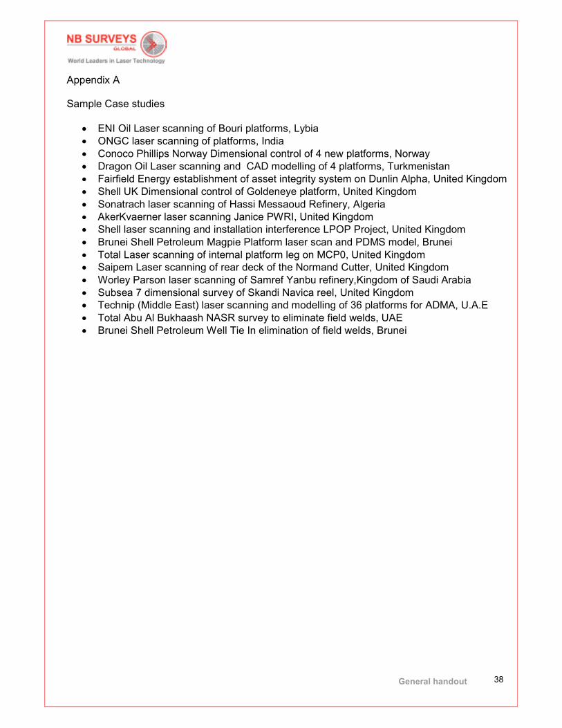
Appendix A Sample Case studies
• ENI Oil Laser scanning of Bouri platforms, Lybia
• ONGC laser scanning of platforms, India
• Conoco Phillips Norway Dimensional control of 4 new platforms, Norway
• Dragon Oil Laser scanning and CAD modelling of 4 platforms, Turkmenistan
• Fairfield Energy establishment of asset integrity system on Dunlin Alpha, United Kingdom
• Shell UK Dimensional control of Goldeneye platform, United Kingdom
• Sonatrach laser scanning of Hassi Messaoud Refinery, Algeria
• AkerKvaerner laser scanning Janice PWRI, United Kingdom
• Shell laser scanning and installation interference LPOP Project, United Kingdom
• Brunei Shell Petroleum Magpie Platform laser scan and PDMS model, Brunei
• Total Laser scanning of internal platform leg on MCP0, United Kingdom
• Saipem Laser scanning of rear deck of the Normand Cutter, United Kingdom
• Worley Parson laser scanning of Samref Yanbu refinery,Kingdom of Saudi Arabia
• Subsea 7 dimensional survey of Skandi Navica reel, United Kingdom
• Technip (Middle East) laser scanning and modelling of 36 platforms for ADMA, U.A.E
• Total Abu Al Bukhaash NASR survey to eliminate field welds, UAE
• Brunei Shell Petroleum Well Tie In elimination of field welds, Brunei