Forest Vegetation of Easternmost Russia (Russian Far East
88
93 Chapter 5 Forest Vegetation of Easternmost Russia (Russian Far East) Pavel V. KRESTOV Institute of Biology and Soil Science, Vladivostok, 690022, Russia, e-mail: [email protected] Abstract: The forest vegetation of the Russian Far East, an area of more than 3 million square kilometers in northeast- ern Asia, has been well studied by Russians but has remained unknown to most vegetation scientists outside Russia. The region is important because it represents natural vegetation processes and their environmental relationships over a huge territory, from polar deserts to cool-temperate forests, from the Pacific coast to the continental interior. These landscapes are among the best preserved forest ecosystems in the world. This chapter includes the first overview in English of eastern Siberian forest vegetation in its basic types, with a focus on phytogeography, ecosystem structure and dynamics, and developmental trends. Special attention is paid to the zonal forest types, including mixed broadleaf-Pinus koraiensis forests, dark-conifer (evergreen) forests of Picea ajanensis, deciduous light-conifer forests of Larix dahurica, broad-leaved deciduous forests of Betula ermanii, and the unique dwarf forests of Pinus pumila and Alnus fruticosa. Key words: Eastern Siberia, Russian Far East, Manchuria, Pinus koraiensis, Picea ajanensis, Betula ermanii, Larix da- hurica, Pinus pumila, Alnus fruticosa, vegetation zone, continentality sector, forest dynamics, Sukachov ap- proach, vegetation classification, Russian-language literature 1. INTRODUCTION 1.1 Russian Far East Easternmost Russia, well known in Russia as the Russian Far East and known elsewhere as eastern Siberia, represents the northeastern edge of the Asian continent, at the northwestern edge of the Pacific Ocean. The whole area covers approximately 3,125,000 km 2 , ranging from 42°15’N to 71°30'N latitude and from 122°E to 169°W longitiude. This includes the area east of the Kolyma River, including its tributaries the Anuy, Omolon and upper Kolyma Rivers (above the Chubukulakh range), the upper In- digirka River (upper half of its tributary the Nera), the east side of the Yudoma River basin and Maya River (Lena River basin) and the Amur River basin from the confluence of the Shilka and Argun’ Rivers (see Fig. 5.1). The territory represents the Far East Federal Terri- tory of the Russian Federation and includes its eight of nine administrative units (krai and oblast’): the Chukotian Autonomous Region, Magadanskaya oblast’ (Magadan Region), Khabarovskiy krai, Amurskaya oblast’, Jewish Autonomous Region, Primorskiy krai, Kam- chatskaya oblast’ and Sakhalinskaya oblast’. The land is bordered on the north by the East- ern-Siberian and Chukotian Seas (Arctic Ocean basin) and on the east by the Bering Sea, Sea of Okhotsk and Sea of Japan (Pacific Ocean ba- sin). The vegetation of this territory changes from polar deserts with scattered or no plants at all
Transcript of Forest Vegetation of Easternmost Russia (Russian Far East
93
Chapter 5
Forest Vegetation of Easternmost Russia (Russian Far East)
Pavel V. KRESTOV Institute of Biology and Soil Science, Vladivostok, 690022, Russia, e-mail: [email protected]
Abstract: The forest vegetation of the Russian Far East, an area of more than 3 million square kilometers in northeast-ern Asia, has been well studied by Russians but has remained unknown to most vegetation scientists outside Russia. The region is important because it represents natural vegetation processes and their environmental relationships over a huge territory, from polar deserts to cool-temperate forests, from the Pacific coast to the continental interior. These landscapes are among the best preserved forest ecosystems in the world. This chapter includes the first overview in English of eastern Siberian forest vegetation in its basic types, with a focus on phytogeography, ecosystem structure and dynamics, and developmental trends. Special attention is paid to the zonal forest types, including mixed broadleaf-Pinus koraiensis forests, dark-conifer (evergreen) forests of Picea ajanensis, deciduous light-conifer forests of Larix dahurica, broad-leaved deciduous forests of Betula ermanii, and the unique dwarf forests of Pinus pumila and Alnus fruticosa.
Key words: Eastern Siberia, Russian Far East, Manchuria, Pinus koraiensis, Picea ajanensis, Betula ermanii, Larix da-hurica, Pinus pumila, Alnus fruticosa, vegetation zone, continentality sector, forest dynamics, Sukachov ap-proach, vegetation classification, Russian-language literature
1. INTRODUCTION
1.1 Russian Far East
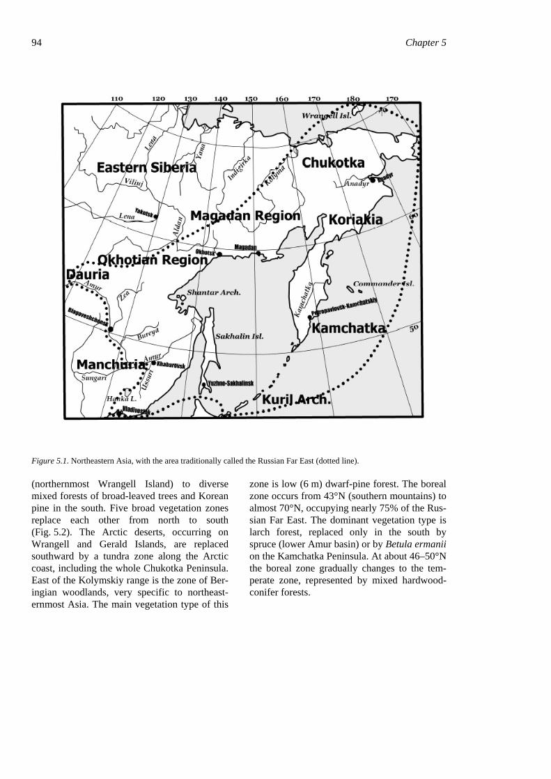
Easternmost Russia, well known in Russia as the Russian Far East and known elsewhere as eastern Siberia, represents the northeastern edge of the Asian continent, at the northwestern edge of the Pacific Ocean. The whole area covers approximately 3,125,000 km2, ranging from 42°15’N to 71°30'N latitude and from 122°E to 169°W longitiude. This includes the area east of the Kolyma River, including its tributaries the Anuy, Omolon and upper Kolyma Rivers (above the Chubukulakh range), the upper In-digirka River (upper half of its tributary the Nera), the east side of the Yudoma River basin
and Maya River (Lena River basin) and the Amur River basin from the confluence of the Shilka and Argun’ Rivers (see Fig. 5.1). The territory represents the Far East Federal Terri-tory of the Russian Federation and includes its eight of nine administrative units (krai and oblast’): the Chukotian Autonomous Region, Magadanskaya oblast’ (Magadan Region), Khabarovskiy krai, Amurskaya oblast’, Jewish Autonomous Region, Primorskiy krai, Kam-chatskaya oblast’ and Sakhalinskaya oblast’. The land is bordered on the north by the East-ern-Siberian and Chukotian Seas (Arctic Ocean basin) and on the east by the Bering Sea, Sea of Okhotsk and Sea of Japan (Pacific Ocean ba-sin).
The vegetation of this territory changes from polar deserts with scattered or no plants at all
94 Chapter 5
Figure 5.1. Northeastern Asia, with the area traditionally called the Russian Far East (dotted line).
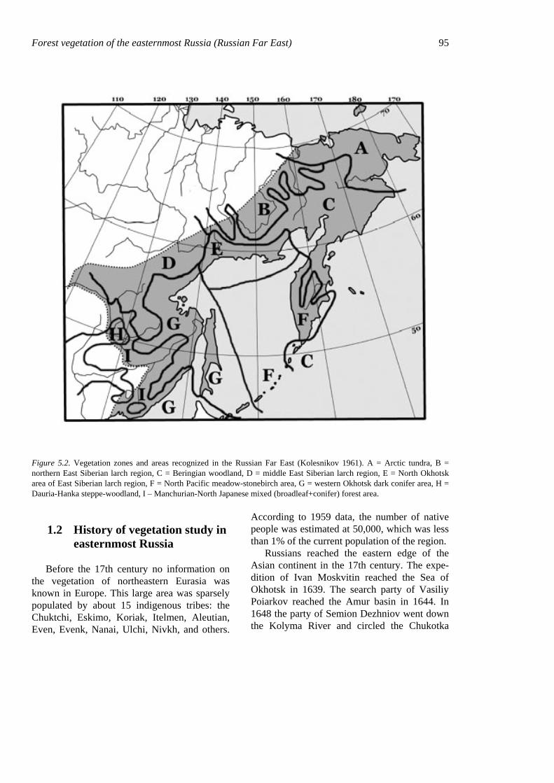
(northernmost Wrangell Island) to diverse mixed forests of broad-leaved trees and Korean pine in the south. Five broad vegetation zones replace each other from north to south (Fig. 5.2). The Arctic deserts, occurring on Wrangell and Gerald Islands, are replaced southward by a tundra zone along the Arctic coast, including the whole Chukotka Peninsula. East of the Kolymskiy range is the zone of Ber-ingian woodlands, very specific to northeast-ernmost Asia. The main vegetation type of this
zone is low (6 m) dwarf-pine forest. The boreal zone occurs from 43°N (southern mountains) to almost 70°N, occupying nearly 75% of the Rus-sian Far East. The dominant vegetation type is larch forest, replaced only in the south by spruce (lower Amur basin) or by Betula ermanii on the Kamchatka Peninsula. At about 46–50°N the boreal zone gradually changes to the tem-perate zone, represented by mixed hardwood-conifer forests.
Forest vegetation of the easternmost Russia (Russian Far East) 95
Figure 5.2. Vegetation zones and areas recognized in the Russian Far East (Kolesnikov 1961). A = Arctic tundra, B = northern East Siberian larch region, C = Beringian woodland, D = middle East Siberian larch region, E = North Okhotsk area of East Siberian larch region, F = North Pacific meadow-stonebirch area, G = western Okhotsk dark conifer area, H = Dauria-Hanka steppe-woodland, I – Manchurian-North Japanese mixed (broadleaf+conifer) forest area.
1.2 History of vegetation study in easternmost Russia
Before the 17th century no information on the vegetation of northeastern Eurasia was known in Europe. This large area was sparsely populated by about 15 indigenous tribes: the Chuktchi, Eskimo, Koriak, Itelmen, Aleutian, Even, Evenk, Nanai, Ulchi, Nivkh, and others.
According to 1959 data, the number of native people was estimated at 50,000, which was less than 1% of the current population of the region.
Russians reached the eastern edge of the Asian continent in the 17th century. The expe-dition of Ivan Moskvitin reached the Sea of Okhotsk in 1639. The search party of Vasiliy Poiarkov reached the Amur basin in 1644. In 1648 the party of Semion Dezhniov went down the Kolyma River and circled the Chukotka
96 Chapter 5 Peninsula. In 1697 the party of Vladimir At-lasov crossed Kamchatka from north to south.
Attempts to study the vegetation of the re-gion followed two basic strategies, descriptive (by expedition) and experimental (stationary). Extensive data on the vegetation cover were obtained from expeditions before the 1960s. All expeditions were organized in Russian capitals, Moscow and St. Petersburg, at that time the main scientific centers. There were no scientific centers nor professional botanists or foresters in the Russian Far East at that time.
Stepan Krasheninnikov was the first profes-sional naturalist, working on Kamchatka in 1737–1741 during the 2nd Kamchatka expedi-tion, sent by Peter the Great for exploring the farthest reaches of the Russian Empire. His book “Description of the Land Kamchatka” written in 1755 (Krasheninnikov 1949) re-mained for a long time the only source of in-formation about the nature and vegetation of Kamchatka. George Steller, working in that expedition as a physician, collected the first herbarium from Kamchatka and adjacent areas.
The first systematic botanical and zoological information was obtained in the mid-19th cen-tury: by A. Middendorf from the coast of the Sea of Okhotsk and Shantar Islands, by Maxi-mowicz from the Ussuri and Amur basin, by Maack in 1855 from the Amur basin, and by Schmidt from Sakhalin, Ussuri and the Amur basin.
At the end of the 19th century the Russian Government, interested in colonizing Far East-ern regions, created a special Ministry for regu-lation of interior immigration, with the intent of settling the Amur basin and huge areas to the north with Russians. This Ministry initiated a series of expeditions to obtain information about lands suitable for colonization. Research was conducted in 1895–1917, mainly in the southern part of the region. One main focus of the research was the vegetation cover. The fun-damental studies of Dokturovskiy in the Upper Amur region, of Korotkiy in the Zeya and Bu-reya River basins, and a series of studies by Komarov on flora and vegetation of southeast-ernmost Russia were conducted during that ex-
pedition. Until the 1950s, most of what we knew about the vegetation and major phyto-geographical subdivisions of the Russian Far East was obtained from those early expeditions.
The establishment of Far Eastern Science began at the end of the 19th century with the foundation in 1899 of the Eastern Institute, which later was transformed into the Far East State University. In the 1930s the network of specialized scientific institutes belonging to the Academy of Science of the Soviet Union was established in the biggest cities of eastern Rus-sia. Several nature reserves were created for preservation of the diversity of natural rarities. All those organizations focused on accumulat-ing knowledge on the nature of the Russian Far East.
At the beginning of the 20th century, pre-liminary vegetation descriptions and forest re-source estimates were obtained from all of east-ern Russia. The data were summarized by the “Vegetation Cover of the USSR” (Lavrenko & Sochava 1956), which was the explanatory book for the first geobotanical map of the USSR (scale 1: 4,000,000). Another book “Out-line of the Vegetation of the [Russian] Far East” (Kolesnikov 1955) remains the only de-scription of the vegetation cover of this terri-tory.
Since the 1960s research on the vegetation has intensified, due to the foundation of several large scientific institutes by the Academy of Sciences. The biggest scientific unit, focused on investigation of the vegetation cover, was the Laboratory of Geobotany, founded by Prof. N.G. Vasiliev in 1964, in the Institute of Biol-ogy and Soil Science in Vladivostok. This labo-ratory, in cooperation with geobotanists from Leningrad (St. Petersburg), prepared a map of the vegetation of the Amur basin, the most ad-vanced work on vegetation cartography in southeastern Russia up to now.
The number of doctoral degrees granted re-flects the increasing research on the vegetation cover: seven during 1935–1945, eight during 1946–1955, and 21 during 1956–1967 (Krylov & Salatova 1969). The vegetation cover was also the subject of study by geographers, forest-
Forest vegetation of the easternmost Russia (Russian Far East) 97 ers, and ecologists. The number of publications on flora and vegetation of the Far East in-creased from 1225 items in 1928 (Komarov 1928) to 7500 in 1969 (Gorovoi 1973).
Since 1950 the whole territory of eastern Russia was photographed from the air and cov-ered by topographic maps at a scale 1: 100,000. The forests were inventoried every 10 years. In the 1970s satellite photographs became avail-able for vegetation monitoring, and topographic maps at a scale 1: 25,000 were published for the whole territory. Nearly all remote points be-came accessible with helicopters.
A specific feature of Soviet science, espe-cially in the Russian Far East, was that most papers were not published in refereed journals but in local sets of papers issued by different scientific organizations. Information on these papers did not go abroad, and they were abso-lutely inaccessible to foreign readers. Papers in European languages were published only occa-sionally.
In the 1990s the situation for science changed dramatically as Russia became open for information exchange. The political crisis in all states of the former Soviet Union caused a very deep crisis in science. Centralized funding for many scientific directions was stopped, in-cluding vegetation science. Because of the cur-rent freedom for information exchange, vegeta-tion science in Russia is now slowly recovering from the crisis.
1.3 Current state of knowledge on forest vegetation of the Russian Far East
Intensive research on the vegetation of east-ernmost Russia in the 20th century enriched our knowledge of the flora and vegetation diversity. Publication of the “Flora of the USSR” (Koma-rov 1934–1964) initiated local floristic research, resulting in the appearance of several regional floristic manuals: “Guidebook to the Vascular Plants of Sakhalin and Kuril Islands” (Vorobiov et al. 1974), with 1528 species; “Guidebook to the vascular plants of Kamchatka” (Kharkevich
& Cherepanov 1981), with 1168 species; “Guidebook to the vascular plants of Vladi-vostok and its suburbs” (Vorobiov 1982); and the “Flora of the Magadan Region” (Khokhria-kov 1985). In 1985–1996 the most complete and reliable information on Far Eastern flora was published in the eight-volume series “Vas-cular plants of the Soviet Far East” (Kharkevich 1985–1996). These books contain information on taxonomy, morphology and distribution of 4350 vascular species, based exclusively on herbarium specimens collected in the territory.
Vegetation analyses appeared in many local descriptive studies focused mainly on important forest, meadow and tundra types. The material was generalized in several geobotanical maps, based on the principles of different cartographic schools (Aliokhin 1930, 1950, Lavrenko 1939, Lavrenko & Sochava 1954, Sochava 1969a, Sochava & Bayborodin 1977, etc.). Schemes for nature regionalization and for phyto-geographical zonation were developed, for all of easternmost Russia, by Kolesnikov (1961, 1963).
In the boreal zone, the principles of vegeta-tion classification developed by Sukachov (Su-kachev & Dylis 1964) were generally used for distinguishing and ordering community types. For classification of mixed forests (broad-leaved + Korean pine), an original approach was elaborated by Ivashkevich (1933) and de-veloped by Kolesnikov (1956a). Not only static criteria (dominants, floristic composition, to-pography) but also dynamic (short-term succes-sional) criteria were used for identifying the main classification units. This approach was called genetic (cf. Man’ko 1967) and was sup-ported by several modern Far Eastern forest ecologists.
Despite the extensive classifications of vegetation of eastern Russia, numerous local classification schemes were also developed. No school was strong enough to coordinate classi-fication work and convince others to use com-mon classification principles. The Braun-Blanquet approach could not be used as an
98 Chapter 5
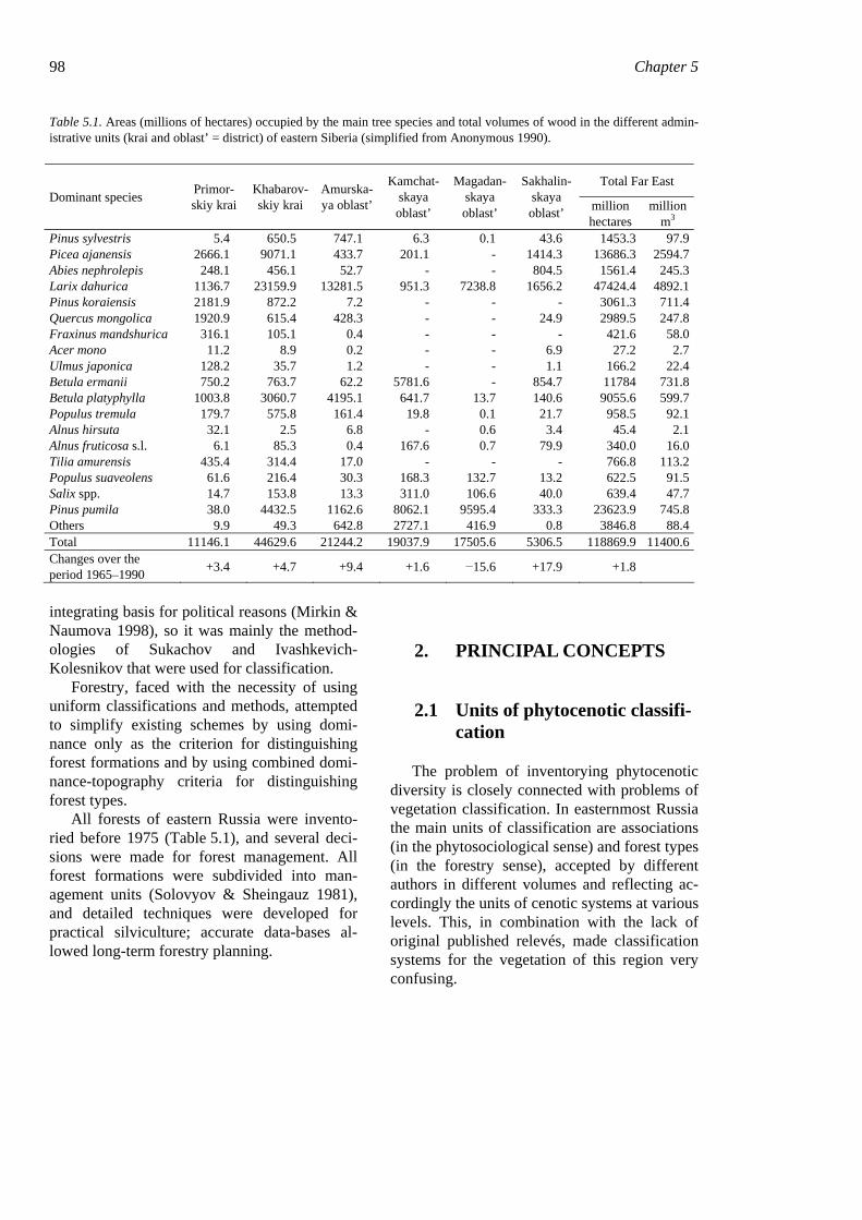
Table 5.1. Areas (millions of hectares) occupied by the main tree species and total volumes of wood in the different admin-istrative units (krai and oblast’ = district) of eastern Siberia (simplified from Anonymous 1990).
Total Far East Dominant species Primor-
skiy krai Khabarov-skiy krai
Amurska-ya oblast’
Kamchat-skaya oblast’
Magadan-skaya oblast’
Sakhalin-skaya oblast’ million
hectares million
m3 Pinus sylvestris 5.4 650.5 747.1 6.3 0.1 43.6 1453.3 97.9 Picea ajanensis 2666.1 9071.1 433.7 201.1 - 1414.3 13686.3 2594.7 Abies nephrolepis 248.1 456.1 52.7 - - 804.5 1561.4 245.3 Larix dahurica 1136.7 23159.9 13281.5 951.3 7238.8 1656.2 47424.4 4892.1 Pinus koraiensis 2181.9 872.2 7.2 - - - 3061.3 711.4 Quercus mongolica 1920.9 615.4 428.3 - - 24.9 2989.5 247.8 Fraxinus mandshurica 316.1 105.1 0.4 - - - 421.6 58.0 Acer mono 11.2 8.9 0.2 - - 6.9 27.2 2.7 Ulmus japonica 128.2 35.7 1.2 - - 1.1 166.2 22.4 Betula ermanii 750.2 763.7 62.2 5781.6 - 854.7 11784 731.8 Betula platyphylla 1003.8 3060.7 4195.1 641.7 13.7 140.6 9055.6 599.7 Populus tremula 179.7 575.8 161.4 19.8 0.1 21.7 958.5 92.1 Alnus hirsuta 32.1 2.5 6.8 - 0.6 3.4 45.4 2.1 Alnus fruticosa s.l. 6.1 85.3 0.4 167.6 0.7 79.9 340.0 16.0 Tilia amurensis 435.4 314.4 17.0 - - - 766.8 113.2 Populus suaveolens 61.6 216.4 30.3 168.3 132.7 13.2 622.5 91.5 Salix spp. 14.7 153.8 13.3 311.0 106.6 40.0 639.4 47.7 Pinus pumila 38.0 4432.5 1162.6 8062.1 9595.4 333.3 23623.9 745.8 Others 9.9 49.3 642.8 2727.1 416.9 0.8 3846.8 88.4 Total 11146.1 44629.6 21244.2 19037.9 17505.6 5306.5 118869.9 11400.6 Changes over the period 1965–1990 +3.4 +4.7 +9.4 +1.6 −15.6 +17.9 +1.8
integrating basis for political reasons (Mirkin & Naumova 1998), so it was mainly the method-ologies of Sukachov and Ivashkevich-Kolesnikov that were used for classification.
Forestry, faced with the necessity of using uniform classifications and methods, attempted to simplify existing schemes by using domi-nance only as the criterion for distinguishing forest formations and by using combined domi-nance-topography criteria for distinguishing forest types.
All forests of eastern Russia were invento-ried before 1975 (Table 5.1), and several deci-sions were made for forest management. All forest formations were subdivided into man-agement units (Solovyov & Sheingauz 1981), and detailed techniques were developed for practical silviculture; accurate data-bases al-lowed long-term forestry planning.
2. PRINCIPAL CONCEPTS
2.1 Units of phytocenotic classifi-cation
The problem of inventorying phytocenotic diversity is closely connected with problems of vegetation classification. In easternmost Russia the main units of classification are associations (in the phytosociological sense) and forest types (in the forestry sense), accepted by different authors in different volumes and reflecting ac-cordingly the units of cenotic systems at various levels. This, in combination with the lack of original published relevés, made classification systems for the vegetation of this region very confusing.
Forest vegetation of the easternmost Russia (Russian Far East) 99
The term ‘association’ was adopted in Rus-sia from Scandinavian classification approaches (Trass & Malmer 1973, Frey 1973) and has a completely different meaning from the associa-tion of the Braun-Blanquet school (Braun-Blanquet 1951). It is more similar to Braun-Blanquet's variant and subvariant, but instead of indicating species abilities, the Russian associa-tion is based on potential to dominate in differ-ent layers or other plant groupings, such as synusiae, layers, growth form spectra, etc. Au-thors realized the advantages of the Braun-Blanquet nomenclature for ordering vegetation units but had no possibility to apply this no-menclature in easternmost Russia, because most vegetation studies were based on original ap-proaches to vegetation classification. All refer-ences to associations and other vegetation units in this chapter will refer only to the Russian system of classification categories.
Despite the agreement of many authors to accept a main classification unit (the associa-tion, or the forest type in the sense of Sukachov 1928), such agreement is not found in the real associations defined by these authors. In the survey of the vegetation of eastern Sikhote-
Alin, Kolesnikov (1938) described 19 associa-tion groups, grouped into five classes; Dylis & Vypper (1953) classified phytocenoses into 18 forest types, related to six subgroups and three groups of types; and Smagin (1965) described 16 types for middle Sikhote-Alin, related to nine series and to four geomorphologic com-plexes. These authors use different criteria for distinguishing associations in complex mixed (broad-leaved + Korean pine) forests of the Far East, though there is a tendency to base classifi-cation units on the dominants of various layers in the communities. Nearly the same situation characterizes the syntaxonomy of the other vegetation types.
Since the criteria used to classify different vegetation types may not be well known, those used herein are summarized in Table 5.2.
The terms ‘phytocenosis’ and ‘association’ are accepted in the sense of Sukachov (1957): “The phytocenose (phytocoenose), or plant community, is taken to mean any plot of vege-tation on a given area, uniform in its composi-tion, synusial structure, and the pattern of inter-actions among plants and between these and the environment”. The term “association
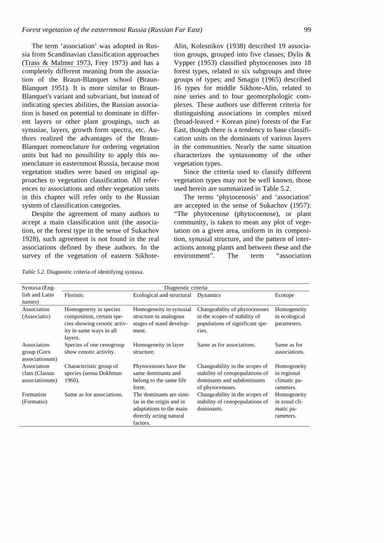
Table 5.2. Diagnostic criteria of identifying syntaxa.
Diagnostic criteria Syntaxa (Eng-lish and Latin names)
Floristic Ecological and structural Dynamics Ecotope
Association (Associatio)
Homogeneity in species composition, certain spe-cies showing cenotic activ-ity in same ways in all layers.
Homogeneity in synusial structure in analogous stages of stand develop-ment.
Changeability of phytocenoses in the scopes of stability of populations of significant spe-cies.
Homogeneity in ecological parameters.
Association group (Grex associationum)
Species of one cenogroup show cenotic activity.
Homogeneity in layer structure.
Same as for associations. Same as for associations.
Association class (Classus associationum)
Characteristic group of species (sensu Dokhman 1960).
Phytocenoses have the same dominants and belong to the same life form.
Changeability in the scopes of stability of cenopopulations of dominants and subdominants of phytocenoses.
Homogeneity in regional climatic pa-rameters.
Formation (Formatio)
Same as for associations. The dominants are simi-lar in the origin and in adaptations to the main directly acting natural factors.
Changeability in the scopes of stability of cenopopulations of dominants.
Homogeneity in zonal cli-matic pa-rameters.
100 Chapter 5 (or forest type) unites communities similar in organization and habitat adaptations, or alter-nately, identical in main species and layer structure on similar habitats.” Thus, the asso-ciation is an abstract unit, a product of the typification of phytocenoses based on struc-tural attributes, unity of dynamic processes, and location in different vegetation gradients (Shennikov 1935).
We consider that associations consist of several developing phytocenoses incorporat-ing all stages of normal ontogenetic develop-ment of all determinant species of the forest community on biologically similar habitats. Thus, to distinguish associations we employ the following criteria: similar sets of canopy dominants; similar cenotic activity by the same species, and as a consequence, similar synusial structure in the lower layers; and similar environmental conditions, as indicated through various groups of indicator species. These criteria are similar to those of Dokhman (1960) and Dolukhanov (1957) (see also Al-exandrova 1973).
The term ‘association group’ (following Shennikov) refers to sets of associations char-acterized by uniform climatic and similar soil and hydrological conditions, by a similar composition in the tree layers, and by cenotic and biomorphological generality of the domi-nants of lower synusiae (Krylov 1984). This concept is closer to the variant or in some cases to the subassociation of the Braun-Blanquet approach. The term ‘association class’ means sets of associations united by generality of dominant species and similarity in features, reflecting adaptations to the re-gional climate (Krylov 1984). As far as the climate determines the differences in vegeta-tion cover at this level, the association class corresponds somewhat to the zonal association of the Braun-Blanquet school.
‘Formation’ unites the associations based on criteria of the ecological similarity of the dominants (Dolukhanov 1957, Krylov 1984).
2.2 Methods of ecological ordination
The site typology of Pogrebnyak (1955), as interpreted by Krylov (1984), was used to dis-play ecological ranges of the main association groups and their distributions on environ-mental gradients. An edaphic grid is con-structed using qualitative axes for soil mois-ture and nutrient regimes. The soil-moisture axis includes six ranks (hygrotopes, sensu Pogrebnyak): 1) xeric (dry), 2) meso-xeric (slightly dry), 3) mesic (fresh), 4) meso-hygric (moist), 5) hygric (very moist), and 6) hydric (wet). The axis for soil nutrient level includes four ranks (trophotopes, sensu Pogrebnyak): A) oligotrophic (very poor), B) oligo-mesotrophic (poor), C) mesotrophic (me-dium), and D) megatrophic (rich). This yields 24 classes for site type (e.g. mesic oligotro-phic, mesic mesotrophic, mesic megatrophic), similar to those of Cajander (1926), Krajina (1969) and Pojar et al. (1987).
The exact position of association groups in the edaphic grid was determined by analyzing the ecological optima of the indicator species composing the phytocenoses, using the eco-logical scales of Ramenskiy (1953), as adapted by Tsatsenkin (1978) and Seledetz (2000) for Far Eastern species.
2.3 Nomenclature
The vegetation syntaxa were named ac-cording to the traditions of the Russian geobotanical school (Sukachev & Dylis 1964, Alexandrova 1973). The naming of associa-tions follows the binary principle, with the name of the dominant as the noun, plus the suffix ‘-etum’, and the name of the subordi-nate (shrub, herb or moss) layer as the adjec-tive, with suffix ‘-osum’. For example, Pine-tum caricosum for a pine forest with Carex understorey. Latin species names may be added to genus names as an adjective in the genitive case, for example Pinetum koraiensis caricosum sordidae. In the case of two equal
Forest vegetation of the easternmost Russia (Russian Far East) 101
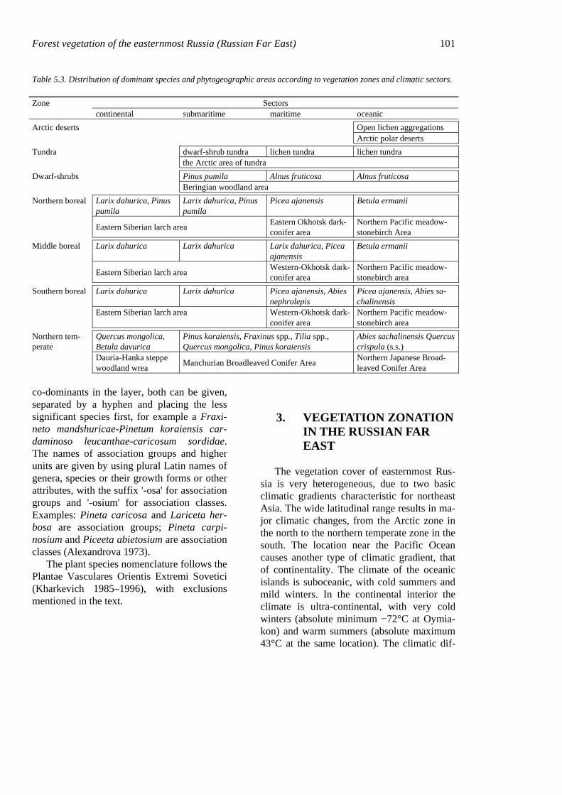
Table 5.3. Distribution of dominant species and phytogeographic areas according to vegetation zones and climatic sectors.
Zone Sectors continental submaritime maritime oceanic Arctic deserts Open lichen aggregations Arctic polar deserts Tundra dwarf-shrub tundra lichen tundra lichen tundra the Arctic area of tundra Dwarf-shrubs Pinus pumila Alnus fruticosa Alnus fruticosa Beringian woodland area Northern boreal Larix dahurica, Pinus
pumila Larix dahurica, Pinus pumila
Picea ajanensis Betula ermanii
Eastern Siberian larch area Eastern Okhotsk dark-conifer area
Northern Pacific meadow-stonebirch Area
Middle boreal Larix dahurica Larix dahurica Larix dahurica, Picea ajanensis
Betula ermanii
Eastern Siberian larch area Western-Okhotsk dark-conifer area
Northern Pacific meadow-stonebirch area
Southern boreal Larix dahurica Larix dahurica Picea ajanensis, Abies nephrolepis
Picea ajanensis, Abies sa-chalinensis
Eastern Siberian larch area Western-Okhotsk dark-conifer area
Northern Pacific meadow-stonebirch area
Northern tem-perate
Quercus mongolica, Betula davurica
Pinus koraiensis, Fraxinus spp., Tilia spp., Quercus mongolica, Pinus koraiensis
Abies sachalinensis Quercus crispula (s.s.)
Dauria-Hanka steppe woodland wrea Manchurian Broadleaved Conifer Area Northern Japanese Broad-
leaved Conifer Area
co-dominants in the layer, both can be given, separated by a hyphen and placing the less significant species first, for example a Fraxi-neto mandshuricae-Pinetum koraiensis car-daminoso leucanthae-caricosum sordidae. The names of association groups and higher units are given by using plural Latin names of genera, species or their growth forms or other attributes, with the suffix '-osa' for association groups and '-osium' for association classes. Examples: Pineta caricosa and Lariceta her-bosa are association groups; Pineta carpi-nosium and Piceeta abietosium are association classes (Alexandrova 1973).
The plant species nomenclature follows the Plantae Vasculares Orientis Extremi Sovetici (Kharkevich 1985–1996), with exclusions mentioned in the text.
3. VEGETATION ZONATION IN THE RUSSIAN FAR EAST
The vegetation cover of easternmost Rus-sia is very heterogeneous, due to two basic climatic gradients characteristic for northeast Asia. The wide latitudinal range results in ma-jor climatic changes, from the Arctic zone in the north to the northern temperate zone in the south. The location near the Pacific Ocean causes another type of climatic gradient, that of continentality. The climate of the oceanic islands is suboceanic, with cold summers and mild winters. In the continental interior the climate is ultra-continental, with very cold winters (absolute minimum −72°C at Oymia-kon) and warm summers (absolute maximum 43°C at the same location). The climatic dif-
102 Chapter 5 ferences cause changes in the vegetation, ex-pressed from north to south as a sequence of phytogeographical zones: (1) polar deserts; (2) tundra; (3) dwarf-pine woodlands; (4) boreal forests; (5) temperate hardwood-conifer for-ests and (6) steppe-woodlands. This sequence of vegetation zones is commonly accepted in the Russian school of phytogeography, with east-west differentiation reflecting the conti-nentality gradient (Komarov 1927, Grishin 1995). The Russian Far East is subdivided commonly into five continentality sectors: (1) suboceanic; (2) maritime; (3) sub-maritime;
(4) continental; and (5) ultra-continental (Ta-ble 5.3). Vegetation in each continentality sec-tor reflects the change from damp, relatively seasonal, even oceanic climates near the coast to dry, seasonally contrasting climates in the interior (Table 5.4).
The sectoral nature of the vegetation zona-tion is reflected by subdividing zones or sub-zones into phytogeographical areas with con-tinentality-dependent features in the vegeta-tion. The main characteristics of these phyto-geographical areas are summarized briefly below.
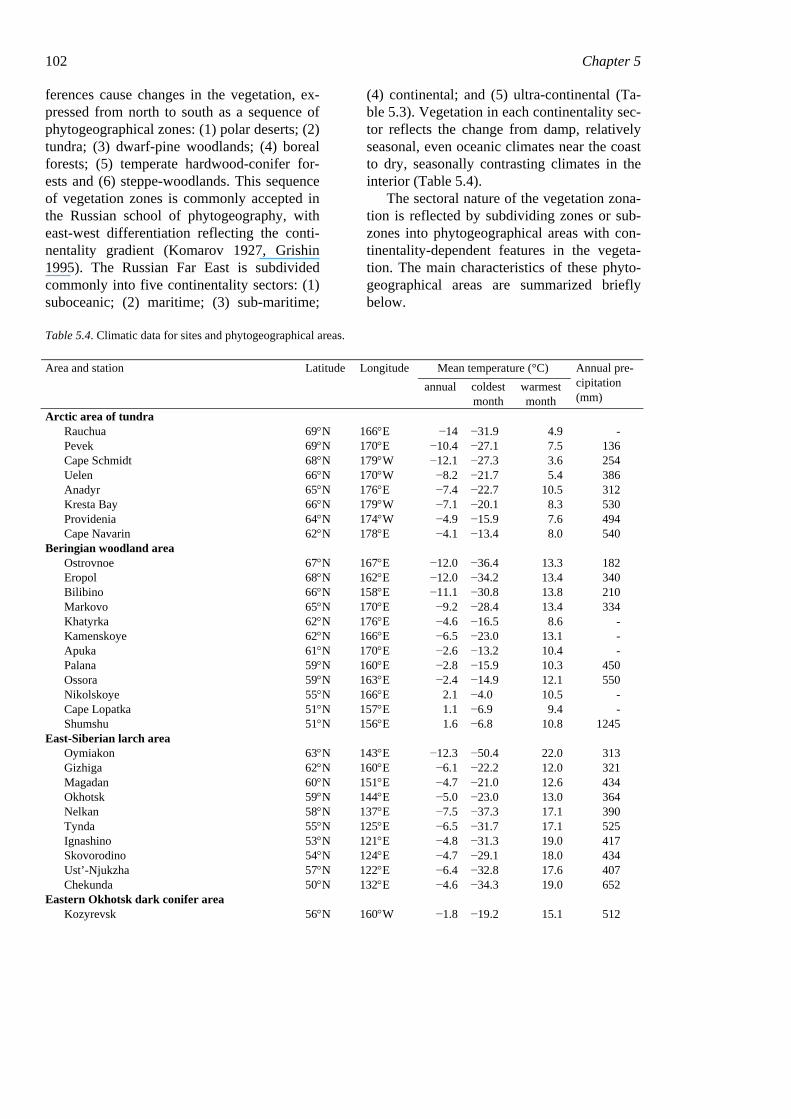
Table 5.4. Climatic data for sites and phytogeographical areas.
Mean temperature (°C) Area and station Latitude Longitude annual coldest
month warmest month
Annual pre-cipitation (mm)
Arctic area of tundra Rauchua 69°N 166°E −14 −31.9 4.9 - Pevek 69°N 170°E −10.4 −27.1 7.5 136 Cape Schmidt 68°N 179°W −12.1 −27.3 3.6 254 Uelen 66°N 170°W −8.2 −21.7 5.4 386 Anadyr 65°N 176°E −7.4 −22.7 10.5 312 Kresta Bay 66°N 179°W −7.1 −20.1 8.3 530 Providenia 64°N 174°W −4.9 −15.9 7.6 494 Cape Navarin 62°N 178°E −4.1 −13.4 8.0 540
Beringian woodland area Ostrovnoe 67°N 167°E −12.0 −36.4 13.3 182 Eropol 68°N 162°E −12.0 −34.2 13.4 340 Bilibino 66°N 158°E −11.1 −30.8 13.8 210 Markovo 65°N 170°E −9.2 −28.4 13.4 334 Khatyrka 62°N 176°E −4.6 −16.5 8.6 - Kamenskoye 62°N 166°E −6.5 −23.0 13.1 - Apuka 61°N 170°E −2.6 −13.2 10.4 - Palana 59°N 160°E −2.8 −15.9 10.3 450 Ossora 59°N 163°E −2.4 −14.9 12.1 550 Nikolskoye 55°N 166°E 2.1 −4.0 10.5 - Cape Lopatka 51°N 157°E 1.1 −6.9 9.4 - Shumshu 51°N 156°E 1.6 −6.8 10.8 1245
East-Siberian larch area Oymiakon 63°N 143°E −12.3 −50.4 22.0 313 Gizhiga 62°N 160°E −6.1 −22.2 12.0 321 Magadan 60°N 151°E −4.7 −21.0 12.6 434 Okhotsk 59°N 144°E −5.0 −23.0 13.0 364 Nelkan 58°N 137°E −7.5 −37.3 17.1 390 Tynda 55°N 125°E −6.5 −31.7 17.1 525 Ignashino 53°N 121°E −4.8 −31.3 19.0 417 Skovorodino 54°N 124°E −4.7 −29.1 18.0 434 Ust’-Njukzha 57°N 122°E −6.4 −32.8 17.6 407 Chekunda 50°N 132°E −4.6 −34.3 19.0 652
Eastern Okhotsk dark conifer area Kozyrevsk 56°N 160°W −1.8 −19.2 15.1 512
Forest vegetation of the easternmost Russia (Russian Far East) 103
Mean temperature (°C) Area and station Latitude Longitude annual coldest
month warmest month
Annual pre-cipitation (mm)
Milkovo 55°N 159°E −2.7 −21.8 15.0 540 Northern Pacific meadow − stone birch area
Sobolevo 55°N 156°E −1.3 −14.8 12.1 789 Storozh Bay 55°N 162°E 0.6 −8.5 11.7 1020 Bolsheretsk 52°N 156°E −0.4 −12.6 11.4 880 Petropavlovsk 53°N 159°E 1.7 −8.6 13.7 1335 Matua 48°N 153°E 1.5 −6.3 10.9 1223 Simushir 47°N 152°E 2.5 −5.8 11.0 1610
Western Okhotsk dark conifer area Ayan 57°N 138°E −3.3 −19.7 13.2 791 Cape Enkan 57°N 139°E −3.4 −20.2 13.3 521 Poliny Osipenko 52°N 136°E −3.3 −29.3 17.8 410 Chumikan 55°N 135°E −3.9 −23.7 14.5 681 Belogorsk 51°N 128°E −2.0 −28.8 20.7 480 Bolon’ 50°N 136°E −1.7 −28.3 19.7 650 Nikolayevsk-na-Amure 53°N 141°E −2.4 −23.9 16.5 513 Okha 54°N 143°E −2.4 −19.9 14.0 546 Nogliki 52°N 143°E −2.0 −20.2 14.4 613 Poronaisk 49°N 143°E 0.0 −17.7 15.8 747
Dauria-Hanka steppe-woodland area Ilyinka 45°N 132°E 3.0 −18.4 20.7 498
Manchurian mixed broadleaf-conifer area Birobidzhan 49°N 133°E −0.1 −24.6 20.3 761 Blagoveshchensk 50°N 127°E 0.0 −24.3 21.4 525 Khabarovsk 49°N 135°E 1.4 −22.3 21.1 569 Sovgavan’ 49°N 140°E −0.4 −19.4 16.5 742 Dalnerechensk 46°N 134°E 1.5 −21.9 20.7 627 Roshchino 46°N 135°E 0.3 −24.4 20.4 789 Terney 46°N 137°E 2.3 −14.0 17.4 813 Kirovskiy 45°N 134°E 1.9 −21.8 21.0 646 Olga 44°N 135°E 3.6 −12.4 18.9 831 Ussuriysk 44°N 132°E 3.2 −19.1 21.2 599 Vladivostok 43°N 132°E 4.8 −13.5 21.0 831 Riazanovka 43°N 131°E 5.2 −11.4 20.5 961
Northern Japanese mixed broadleaf-conifer area Yuzhno-Sakhalinsk 47°N 143°E 2.1 −13.8 17.3 753 Uglegorsk 49°N 142°E 1.6 −14.8 17.0 600 Cape Krilion 46°N 142°E 3.8 −7.6 15.9 960 Kurilsk 45°N 148°E 4.3 −7.2 16.0 1040
3.1 Arctic zone
3.1.1 Arctic deserts
In northeastern Asia only Wrangell and Gerald Islands are in the zone of Arctic De-serts (Kolesnikov 1961, 1963), which are characterized by the lack of a closed vegeta-tion cover. Large areas on the islands are cov-
ered by talus or rock outcrops. Crustose and foliose lichens (species of Gyrophora, Lecidea, and Rhizocarpon) are most abundant on the stony substrates. On the sites with ac-cumulations of fine soil, fruticose lichens (Alectoria, Cetraria and Cladonia) and mosses (mainly Andraea papillosa, Pogo-natum capillare, Rhacomitrium lanuginosum and Tetraplodon mnioides) form the sparse cover. The vascular plants are represented by Douglasia ochotensis, Artemisia glomerata,
104 Chapter 5 Papaver polare, Saussurea tilesii, Saxifraga funstonii, etc. The bryophytes and flowering plants are scattered and not numerous (Gorod-kov 1958a, b).
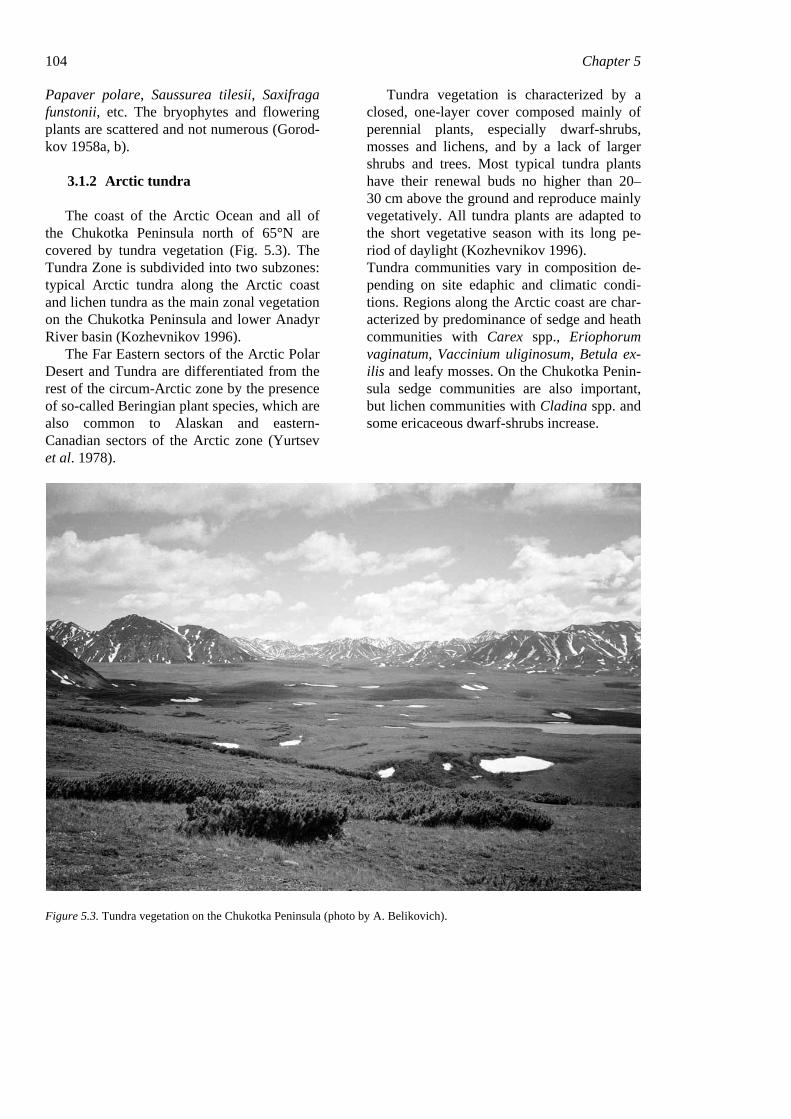
3.1.2 Arctic tundra
The coast of the Arctic Ocean and all of the Chukotka Peninsula north of 65°N are covered by tundra vegetation (Fig. 5.3). The Tundra Zone is subdivided into two subzones: typical Arctic tundra along the Arctic coast and lichen tundra as the main zonal vegetation on the Chukotka Peninsula and lower Anadyr River basin (Kozhevnikov 1996).
The Far Eastern sectors of the Arctic Polar Desert and Tundra are differentiated from the rest of the circum-Arctic zone by the presence of so-called Beringian plant species, which are also common to Alaskan and eastern-Canadian sectors of the Arctic zone (Yurtsev et al. 1978).
Tundra vegetation is characterized by a closed, one-layer cover composed mainly of perennial plants, especially dwarf-shrubs, mosses and lichens, and by a lack of larger shrubs and trees. Most typical tundra plants have their renewal buds no higher than 20–30 cm above the ground and reproduce mainly vegetatively. All tundra plants are adapted to the short vegetative season with its long pe-riod of daylight (Kozhevnikov 1996). Tundra communities vary in composition de-pending on site edaphic and climatic condi-tions. Regions along the Arctic coast are char-acterized by predominance of sedge and heath communities with Carex spp., Eriophorum vaginatum, Vaccinium uliginosum, Betula ex-ilis and leafy mosses. On the Chukotka Penin-sula sedge communities are also important, but lichen communities with Cladina spp. and some ericaceous dwarf-shrubs increase.
Figure 5.3. Tundra vegetation on the Chukotka Peninsula (photo by A. Belikovich).
Forest vegetation of the easternmost Russia (Russian Far East) 105
3.2 Subarctic zone
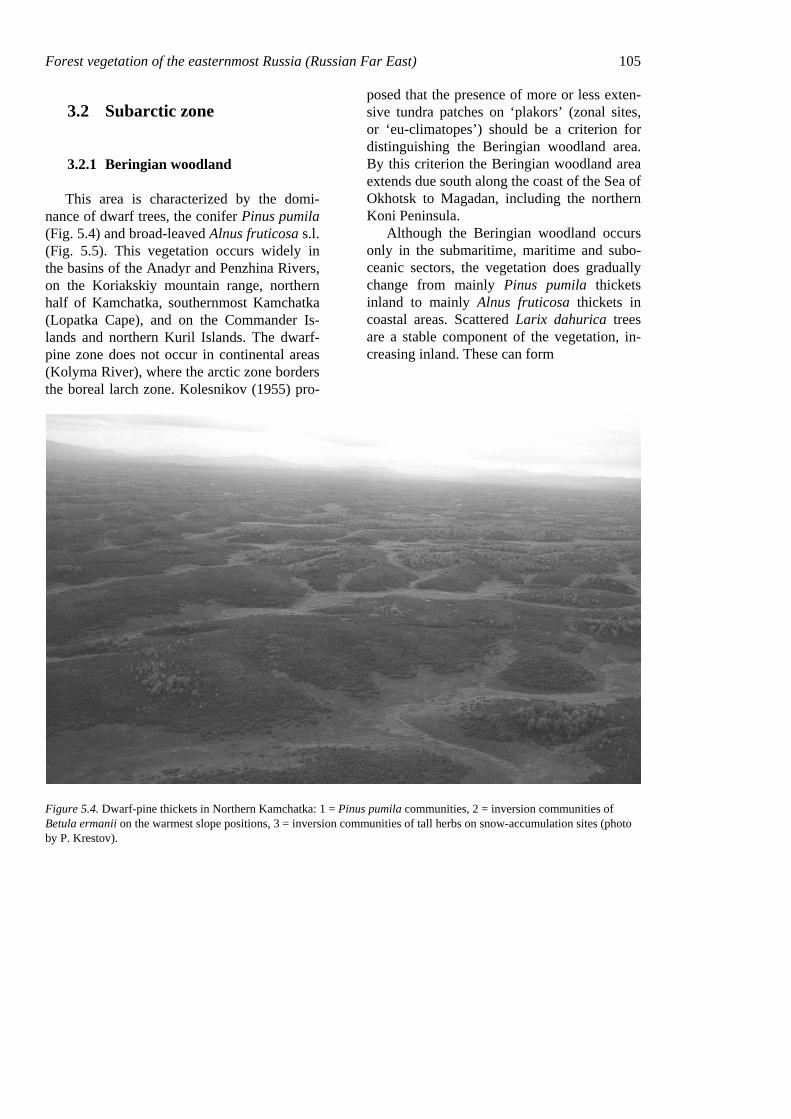
3.2.1 Beringian woodland
This area is characterized by the domi-nance of dwarf trees, the conifer Pinus pumila (Fig. 5.4) and broad-leaved Alnus fruticosa s.l. (Fig. 5.5). This vegetation occurs widely in the basins of the Anadyr and Penzhina Rivers, on the Koriakskiy mountain range, northern half of Kamchatka, southernmost Kamchatka (Lopatka Cape), and on the Commander Is-lands and northern Kuril Islands. The dwarf-pine zone does not occur in continental areas (Kolyma River), where the arctic zone borders the boreal larch zone. Kolesnikov (1955) pro-
posed that the presence of more or less exten-sive tundra patches on ‘plakors’ (zonal sites, or ‘eu-climatopes’) should be a criterion for distinguishing the Beringian woodland area. By this criterion the Beringian woodland area extends due south along the coast of the Sea of Okhotsk to Magadan, including the northern Koni Peninsula.
Although the Beringian woodland occurs only in the submaritime, maritime and subo-ceanic sectors, the vegetation does gradually change from mainly Pinus pumila thickets inland to mainly Alnus fruticosa thickets in coastal areas. Scattered Larix dahurica trees are a stable component of the vegetation, in-creasing inland. These can form
Figure 5.4. Dwarf-pine thickets in Northern Kamchatka: 1 = Pinus pumila communities, 2 = inversion communities of Betula ermanii on the warmest slope positions, 3 = inversion communities of tall herbs on snow-accumulation sites (photo by P. Krestov).
106 Chapter 5
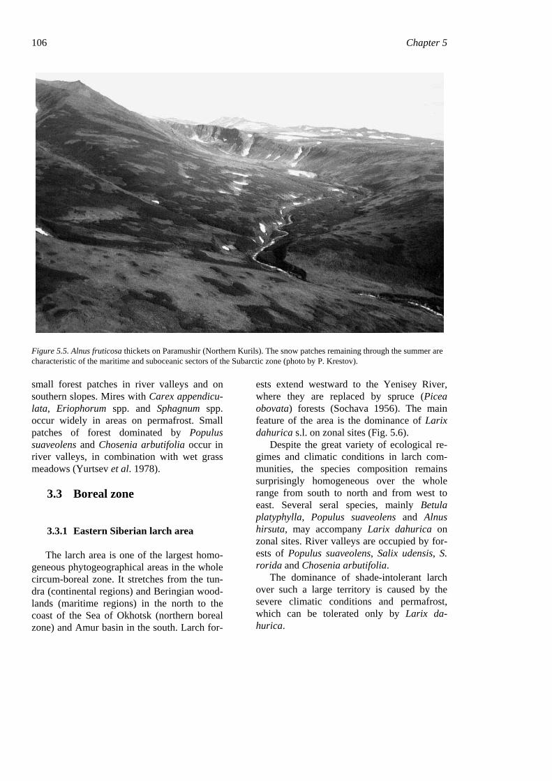
Figure 5.5. Alnus fruticosa thickets on Paramushir (Northern Kurils). The snow patches remaining through the summer are characteristic of the maritime and suboceanic sectors of the Subarctic zone (photo by P. Krestov).
small forest patches in river valleys and on southern slopes. Mires with Carex appendicu-lata, Eriophorum spp. and Sphagnum spp. occur widely in areas on permafrost. Small patches of forest dominated by Populus suaveolens and Chosenia arbutifolia occur in river valleys, in combination with wet grass meadows (Yurtsev et al. 1978).
3.3 Boreal zone
3.3.1 Eastern Siberian larch area
The larch area is one of the largest homo-geneous phytogeographical areas in the whole circum-boreal zone. It stretches from the tun-dra (continental regions) and Beringian wood-lands (maritime regions) in the north to the coast of the Sea of Okhotsk (northern boreal zone) and Amur basin in the south. Larch for-
ests extend westward to the Yenisey River, where they are replaced by spruce (Picea obovata) forests (Sochava 1956). The main feature of the area is the dominance of Larix dahurica s.l. on zonal sites (Fig. 5.6).
Despite the great variety of ecological re-gimes and climatic conditions in larch com-munities, the species composition remains surprisingly homogeneous over the whole range from south to north and from west to east. Several seral species, mainly Betula platyphylla, Populus suaveolens and Alnus hirsuta, may accompany Larix dahurica on zonal sites. River valleys are occupied by for-ests of Populus suaveolens, Salix udensis, S. rorida and Chosenia arbutifolia.
The dominance of shade-intolerant larch over such a large territory is caused by the severe climatic conditions and permafrost, which can be tolerated only by Larix da-hurica.
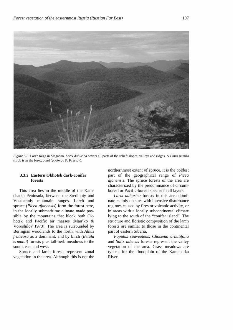
Forest vegetation of the easternmost Russia (Russian Far East) 107
Figure 5.6. Larch taiga in Magadan. Larix dahurica covers all parts of the relief: slopes, valleys and ridges. A Pinus pumila shrub is in the foreground (photo by P. Krestov).
3.3.2 Eastern Okhotsk dark-conifer forests
This area lies in the middle of the Kam-chatka Peninsula, between the Sredinniy and Vostochniy mountain ranges. Larch and spruce (Picea ajanensis) form the forest here, in the locally submaritime climate made pos-sible by the mountains that block both Ok-hotsk and Pacific air masses (Man’ko & Voroshilov 1973). The area is surrounded by Beringian woodlands to the north, with Alnus fruticosa as a dominant, and by birch (Betula ermanii) forests plus tall-herb meadows to the south, east and west.
Spruce and larch forests represent zonal vegetation in the area. Although this is not the
northernmost extent of spruce, it is the coldest part of the geographical range of Picea ajanensis. The spruce forests of the area are characterized by the predominance of circum-boreal or Pacific-boreal species in all layers.
Larix dahurica forests in this area domi-nate mainly on sites with intensive disturbance regimes caused by fires or volcanic activity, or in areas with a locally subcontinental climate lying to the south of the “conifer island”. The structure and floristic composition of the larch forests are similar to those in the continental part of eastern Siberia.
Populus suaveolens, Chosenia arbutifolia and Salix udensis forests represent the valley vegetation of the area. Grass meadows are typical for the floodplain of the Kamchatka River.
108 Chapter 5
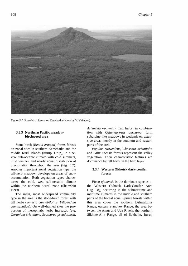
Figure 5.7. Stone birch forests on Kamchatka (photo by V. Yakubov).
3.3.3 Northern Pacific meadow-birchwood area
Stone birch (Betula ermanii) forms forests on zonal sites in southern Kamchatka and the middle Kuril Islands (Iturup, Urup), in a se-vere sub-oceanic climate with cold summers, mild winters, and nearly equal distribution of precipitation throughout the year (Fig. 5.7). Another important zonal vegetation type, the tall-herb meadow, develops on areas of snow accumulation. Both vegetation types charac-terize the cold, wet, sub-oceanic climate within the northern boreal zone (Shamshin 1999).
The main, most widespread community type in the area is the stone-birch forest with tall herbs (Senecio cannabifolius, Filipendula camtschatica). On well-drained sites the pro-portion of mesophytic herbs increases (e.g. Geranium erianthum, Saussurea pseudotilesii,
Artemisia opulenta). Tall herbs, in combina-tion with Calamagrostis purpurea, form subalpine-like meadows in wetlands on exten-sive areas mostly in the southern and eastern parts of the area.
Populus suaveolens, Chosenia arbutifolia and Salix udensis forests represent the valley vegetation. Their characteristic features are dominance by tall herbs in the herb layer.
3.3.4 Western Okhotsk dark-conifer forests
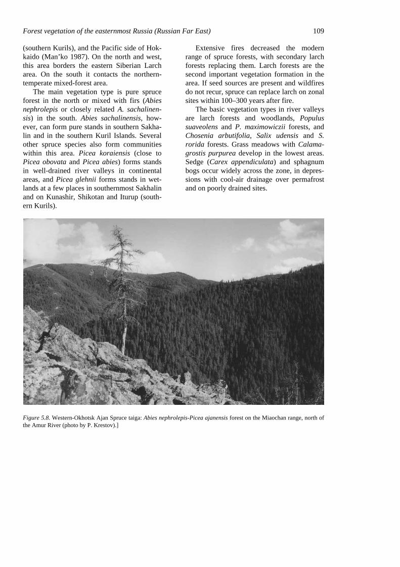
Picea ajanensis is the dominant species in the Western Okhotsk Dark-Conifer Area (Fig. 5.8), occurring in the submaritime and maritime climates in the middle and southern parts of the boreal zone. Spruce forests within this area cover the southern Dzhugdzhur Range, eastern Stanovoy Range, the area be-tween the Amur and Uda Rivers, the northern Sikhote-Alin Range, all of Sakhalin, Iturup
Forest vegetation of the easternmost Russia (Russian Far East) 109 (southern Kurils), and the Pacific side of Hok-kaido (Man’ko 1987). On the north and west, this area borders the eastern Siberian Larch area. On the south it contacts the northern-temperate mixed-forest area.
The main vegetation type is pure spruce forest in the north or mixed with firs (Abies nephrolepis or closely related A. sachalinen-sis) in the south. Abies sachalinensis, how-ever, can form pure stands in southern Sakha-lin and in the southern Kuril Islands. Several other spruce species also form communities within this area. Picea koraiensis (close to Picea obovata and Picea abies) forms stands in well-drained river valleys in continental areas, and Picea glehnii forms stands in wet-lands at a few places in southernmost Sakhalin and on Kunashir, Shikotan and Iturup (south-ern Kurils).
Extensive fires decreased the modern range of spruce forests, with secondary larch forests replacing them. Larch forests are the second important vegetation formation in the area. If seed sources are present and wildfires do not recur, spruce can replace larch on zonal sites within 100–300 years after fire.
The basic vegetation types in river valleys are larch forests and woodlands, Populus suaveolens and P. maximowiczii forests, and Chosenia arbutifolia, Salix udensis and S. rorida forests. Grass meadows with Calama-grostis purpurea develop in the lowest areas. Sedge (Carex appendiculata) and sphagnum bogs occur widely across the zone, in depres-sions with cool-air drainage over permafrost and on poorly drained sites.
Figure 5.8. Western-Okhotsk Ajan Spruce taiga: Abies nephrolepis-Picea ajanensis forest on the Miaochan range, north of the Amur River (photo by P. Krestov).]
110 Chapter 5
3.4 Northern temperate zone
This zone lies in the basin of the Amur River and on the spurs of the Sikhote-Alin, Badzhal, Lesser Hingan and Chyornye Gory mountain ranges (Krestov 1997). The Amur valley permits oceanic air masses to penetrate deeply into the interior, shifting the eastern boundary of the continental climate consid-erably further inland. In addition, the conti-nental cold air masses continue building over the winter, creating a strong contrast between summer and winter. Winter temperatures are extremely low for a maritime region at 40° latitude (−20°C mean for January), and sum-mer temperatures are relatively high (August means to +22°C), with high humidity. The high mean annual temperatures (+2 to +5°C), with the strong seasonal contrast, permit oc-currence of a great variety of vegetation types
on zonal sites. The continentality gradient causes a change in vegetation that ranges from drought-tolerant oak forests in the interior to species-rich mixed broadleaf-conifer forests in coastal areas. Three areas are recognized in this northern temperate zone.
3.4.1 Daurian broad-leaved forests
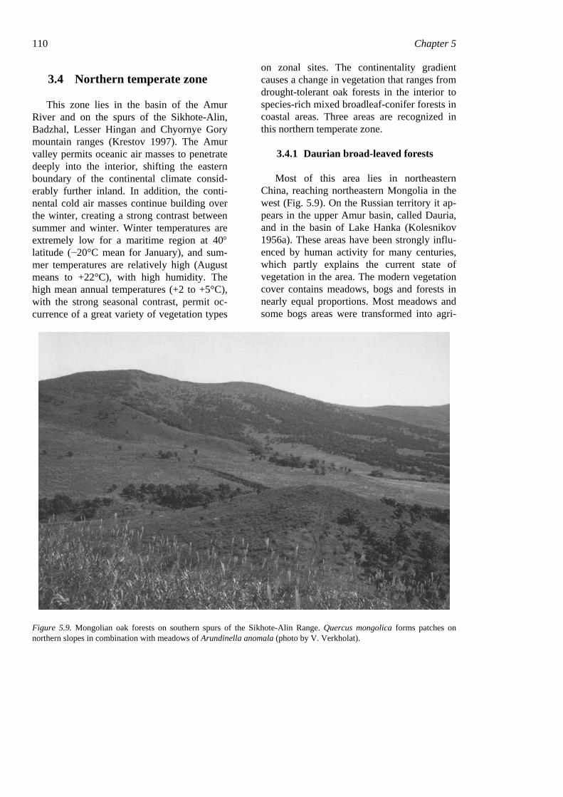
Most of this area lies in northeastern China, reaching northeastern Mongolia in the west (Fig. 5.9). On the Russian territory it ap-pears in the upper Amur basin, called Dauria, and in the basin of Lake Hanka (Kolesnikov 1956a). These areas have been strongly influ-enced by human activity for many centuries, which partly explains the current state of vegetation in the area. The modern vegetation cover contains meadows, bogs and forests in nearly equal proportions. Most meadows and some bogs areas were transformed into agri-
Figure 5.9. Mongolian oak forests on southern spurs of the Sikhote-Alin Range. Quercus mongolica forms patches on northern slopes in combination with meadows of Arundinella anomala (photo by V. Verkholat).
Forest vegetation of the easternmost Russia (Russian Far East) 111 cultural lands. The basic forest type is Mongo-lian oak (Quercus mongolica), forming pure stands or mixed with Betula davurica. All components of the forest communities are drought tolerant and fire resistant. Fire is the most important factor influencing natural se-lection in the oak forests. Meadows in the zone occur on sunny, well-drained slopes (steppe-like meadows) and in lowlands next to boggy vegetation. The characteristic feature of the meadows is the presence of xeric and xero-mesic herbs and grasses (Cleistogenes kitagawae, Stipa baicalensis, Arundinella anomala, different species of Astragalus, Gal-ium, Scabiosa, Allium, and Artemisia, etc.). Mesic and hygric meadows dominated by Miscanthus sacchariflorus and Calamagrostis langsdorffii occur in lowlands.
Pinus densiflora (near Lake Hanka), P. sylvestris (in the upper Amur), Armeniaca sibirica, and Ulmus macrocarpa form small patchy stands on hill slopes and ridges.
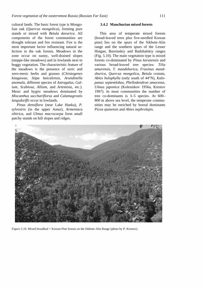
3.4.2 Manchurian mixed forests
This area of temperate mixed forests (broad-leaved trees plus five-needled Korean pine) lies on the spurs of the Sikhote-Alin range and the southern spurs of the Lesser Hingan, Bureinskiy and Badzhalskiy ranges (Fig. 5.10). The main vegetation type is mixed forests co-dominated by Pinus koraiensis and various broad-leaved tree species: Tilia amurensis, T. mandshurica, Fraxinus mand-shurica, Quercus mongolica, Betula costata, Abies holophylla (only south of 44°N), Kalo-panax septemlobus, Phellodendron amurense, Ulmus japonica (Kolesnikov 1956a, Krestov 1997). In most communities the number of tree co-dominants is 3–5 species. At 600–800 m above sea level, the temperate commu-nities may be enriched by boreal dominants Picea ajanensis and Abies nephrolepis.
Figure 5.10. Mixed broadleaf + Korean Pine forests on the Sikhote-Alin Range (photo by P. Krestov).
112 Chapter 5
Other vegetation types in the area include broad-leaved valley forests of Ulmus japonica and Fraxinus mandshurica on old, stable parts of river valleys; Populus maximowiczii and Populus koreana (in fact close species) on younger parts of river valleys; and Chosenia arbutifolia on fresh alluvial deposits. Poorly drained parts of the Ussuri valley are occupied by grass meadows.
Old-growth forests in the area have been drastically reduced in the 20th century as a result of forest exploitation and fires. Secon-dary forests are represented by mixed broad-leaved forests with no conifers, Betula platy-phylla and Populus tremula forests, and Quer-cus mongolica forests with no conifers, de-pending on site ecological conditions and kind of damage.
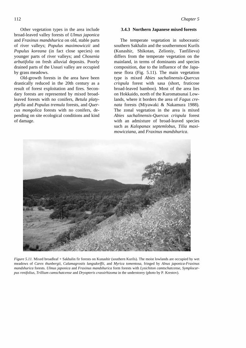
3.4.3 Northern Japanese mixed forests
The temperate vegetation in suboceanic southern Sakhalin and the southernmost Kurils (Kunashir, Shikotan, Zelioniy, Tanfilieva) differs from the temperate vegetation on the mainland, in terms of dominants and species composition, due to the influence of the Japa-nese flora (Fig. 5.11). The main vegetation type is mixed Abies sachalinensis-Quercus crispula forest with sasa (short, fruticose broad-leaved bamboo). Most of the area lies on Hokkaido, north of the Kuromatsunai Low-lands, where it borders the area of Fagus cre-nata forests (Miyawaki & Nakamura 1988). The zonal vegetation in the area is mixed Abies sachalinensis-Quercus crispula forest with an admixture of broad-leaved species such as Kalopanax septemlobus, Tilia maxi-mowicziana, and Fraxinus mandshurica.
Figure 5.11. Mixed broadleaf + Sakhalin fir forests on Kunashir (southern Kurils). The moist lowlands are occupied by wet meadows of Carex thunbergii, Calamagrostis langsdorffii, and Myrica tomentosa, fringed by Alnus japonica-Fraxinus mandshurica forests. Ulmus japonica and Fraxinus mandshurica form forests with Lysichiton camtschatcense, Symplocar-pus renifolius, Trillium camschatcense and Dryopteris crassirhizoma in the understorey (photo by P. Krestov).
Forest vegetation of the easternmost Russia (Russian Far East) 113
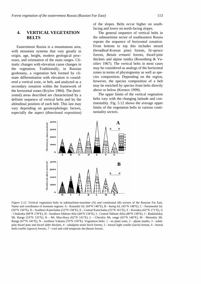
4. VERTICAL VEGETATION BELTS
Easternmost Russia is a mountanous area, with mountain systems that vary greatly in origin, age, height, modern geological proc-esses, and orientation of the main ranges. Cli-matic changes with elevation cause changes in the vegetation. Traditionally, in Russian geobotany, a vegetation belt formed by cli-mate differentiation with elevation is consid-ered a vertical zone, or belt, and analyzed as a secondary zonation within the framework of the horizontal zones (Krylov 1984). The (hori-zontal) areas described are characterized by a definite sequence of vertical belts and by the altitudinal position of each belt. This last may vary depending on geomorphologic factors, especially the aspect (directional exposition)
of the slopes. Belts occur higher on south-facing and lower on north-facing slopes.
The general sequence of vertical belts in the submaritime sector of southeastern Russia repeats the sequence of horizontal zonation. From bottom to top this includes mixed (broadleaf-Korean pine) forests, fir-spruce forests, Betula ermanii forests, dwarf-pine thickets and alpine tundra (Rosenberg & Va-siliev 1967). The vertical belts in most cases may be considered as analogs of the horizontal zones in terms of physiognomy as well as spe-cies composition. Depending on the region, however, the species composition of a belt may be enriched by species from belts directly above or below (Krestov 1999).
The upper limits of the vertical vegetation belts vary with the changing latitude and con-tinentality. Fig. 5.12 shows the average upper limits of the vegetation belts in various conti-nentality sectors.
Figure 5.12. Vertical vegetation belts in submaritime-maritime (A) and continental (B) sectors of the Russian Far East. Name and coordinates of montane regions: A - Kunashir Isl. (44°N 146°E), B - Iturup Isl. (45°N 148°E), C - Paramushir Isl. (50°N 156°E), D - Southern Kamchatka (52°N 158°E), E - Central Kamchatka (55°N 161°E), F - Koriakia (62°N 171°E), G - Chukotka (68°N 178°E), H - Southern Sikhote-Alin (44°N 134°E), I - Central Sikhote-Alin (48°N 138°E), J - Badzhalskiy Mt. Range (53°N 135°E), K - Mt. Mus-Haya (62°N 141°E), L - Cherskiy Mt. range (65°N 146°E), M - Momskiy Mt. Range (67°N 145°E), N - northern Yakutia (70°N 150°E). Vegetation belts: 1 - no plant zone, 2 - alpine tundra, 3 - subal-pine dwarf pine and dwarf alder thickets, 4 - subalpine stone birch forests, 5 - boreal light conifer (larch) forests, 6 - boreal dark-conifer (spruce) forests, 7 - cool and cold temperate deciduous forests.
114 Chapter 5
5. MIXED (BROADLEAF - KOREAN PINE) FORESTS (NORTHERN TEMPERATE ZONE)
The mixed forests (various broad-leaved trees + Korean pine) of southeastern Siberia are a vegetation complex combining some peculiarities of both nemoral and boreal vege-tation (Fig. 5.13). The mixed forest is the zonal vegetation type in the submaritime sec-tor in the northern temperate subzone. These forests occur in the Russian Sikhote-Alin range and in northeastern China (Changbai, Lao-ye and Lesser Hingan mountains). Rela-tively isolated tracts of forest with Korean pine (Pinus koraiensis) are found also in southern Korea (Song 1988, Kim & Man’ko 1994) and on Honshu island of Japan (Miki 1956, Miyawaki & Nakamura 1988), but these stands with Korean pine belong to different vegetation types.
The mixed broadleaf-Korean pine forests form lower and middle vegetation belts from sea level to 800–900 m, extending in the south as high as 1100–1200 m (Chun 1994), coexist-ing and closely interacting with spruce, larch, and oak forests. The rather large north-south range of this forest type and sharp transition from oceanic monsoonal to continental cli-mate have resulted in quite diverse vegetation within the mixed-forest zone. This has been reflected in various schemes of geobotanical districts and on vegetation maps (Kolesnikov 1956b, 1963, Sochava 1969a, b). This region was not glaciated during the Pleistocene or Holocene (Grichuk 1984), although it cur-rently does border the permafrost area to the north. The strong modern climatic gradients, past marine transgressions, and long period of uninterrupted vegetation development have permitted much mixing of northern and south-ern as well as maritime and steppe elements in the regional flora and vegetation.
The occurrence of the mixed forest be-tween clearly distinguishable boreal and tem-
perate zones has posed the question whether the mixed forest is temperate or boreal. In re-cent decades, phytogeographers seem to have favored the idea that it is temperate. In 1958 M. Tatewaki related it to the special “Pan Mixed Forest Zone,” temperate in nature, which also includes climatically and physiog-nomically similar vegetation of central Europe (Carpathian and Tatra mountains) and of east-ern North America (northern Appalachians and around of the Great Lakes), interrupted in continental interiors by steppes or deserts. Hämet-Ahti et al. (1974) treated this vegeta-tion as a northern subzone of the temperate zone; Sochava (1969b) treated it as nemoral and Kolesnikov (1963) as temperate. Russian authors have traditionally placed this forest in a special so-called ‘Far Eastern coniferous-broadleaf forest area’ (Ya. Vasiliev 1947, Kolesnikov 1961, Lavrenko 1950). In 1956 Kolesnikov suggested naming it the East Asian area of mixed coniferous-broadleaf for-ests and related it to the temperate zone. The boundaries of the area coincide generally with those of the Manchurian floristic area distin-guished by Komarov in 1901 and still used by botanists (Komarov 1934–1964, Kharkevich 1985–1996).
5.1 Physiography
5.1.1 Terrain
Much of the range of the mixed broadleaf-Korean pine forest in Russia occurs in the Sikhote-Alin range, extending from southwest to northeast over about 1200 km. The Sikhote-Alin was formed in the late Cretaceous by a combination of folding and volcanic activity (Ivashinnikov 1999). The western slope faces the Ussuri River valley, the eastern slope faces the Sea of Japan. The system is formed by a set of more or less parallel, north-south moun-tain ranges, the altitude of which frequently exceeds the height of the main dividing range in the middle.
Forest vegetation of the easternmost Russia (Russian Far East) 115
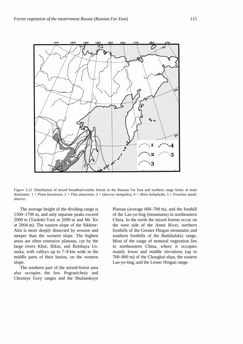
Figure 5.13. Distribution of mixed broadleaf-conifer forests in the Russian Far East and northern range limits of main dominants: 1 = Pinus koraiensis, 2 = Tilia amurensis, 3 = Quercus mongolica, 4 = Abies holophylla, 5 = Fraxinus mand-shurica.
The average height of the dividing range is 1500–1700 m, and only separate peaks exceed 2000 m (Tardoki-Yani at 2090 m and Mt. Ko at 2004 m). The eastern slope of the Sikhote-Alin is more deeply dissected by erosion and steeper than the western slope. The highest areas are often extensive plateaus, cut by the large rivers Khor, Bikin, and Bolshaya Us-surka, with valleys up to 7–8 km wide in the middle parts of their basins, on the western slope.
The southern part of the mixed-forest area also occupies the low Pogranichniy and Chorniye Gory ranges and the Shufanskoye
Plateau (average 600–700 m), and the foothill of the Lao-ye-ling (mountains) in northeastern China. In the north the mixed forests occur on the west side of the Amur River, northern foothills of the Greater Hingan mountains and southern foothills of the Badzhalskiy range. Most of the range of nemoral vegetation lies in northeastern China, where it occupies mainly lower and middle elevations (up to 700–800 m) of the Changbai-shan, the eastern Lao-ye-ling, and the Lesser Hingan range.
116 Chapter 5
5.1.2 Climate
The climate of the mixed-forest area is controlled by the monsoon circulation. In the winter the region is under the effect of cold, dry air masses formed in interior East Asia by the powerful Asian anticyclone. Summer monsoon winds from the southeast bring cool, damp maritime air in early summer and very damp warm air later in the summer. The cold-est month is January, with minimum tempera-tures −22 to −26°C on the western slope of the Sikhote-Alin and −17 to −21°C on the eastern slope, closer to the sea. Average summer tem-perature is 15 to 17.5°C on the coast and 18.5 to 20°С in the continental interior (Anony-mous 1966–1971). The warmest month is July in the interior, August near the coast. Biotem-perature sums (>10°C) in continental regions are 2400–2600° in south and 1600–1800° in the north of this subzone. Biotemperature sums are generally 100–200° lower on the coast facing slopes of the Sikhote-Alin.
5.2 Structure and composition
5.2.1 Structure of phytocenoses
All early explorers of the Russian Far East noted the complexity and unusual richness of the mixed forests (Maximowicz 1859, Koma-rov 1917, Budishchev 1898, etc.). Many ex-plorers experienced with boreal vegetation met with nemoral vegetation for the first time in this part of Russia. They found the diversity of the broad-leaved forests and their structure to be really complex, caused not only by their climatic position but also their non-glaciated history.
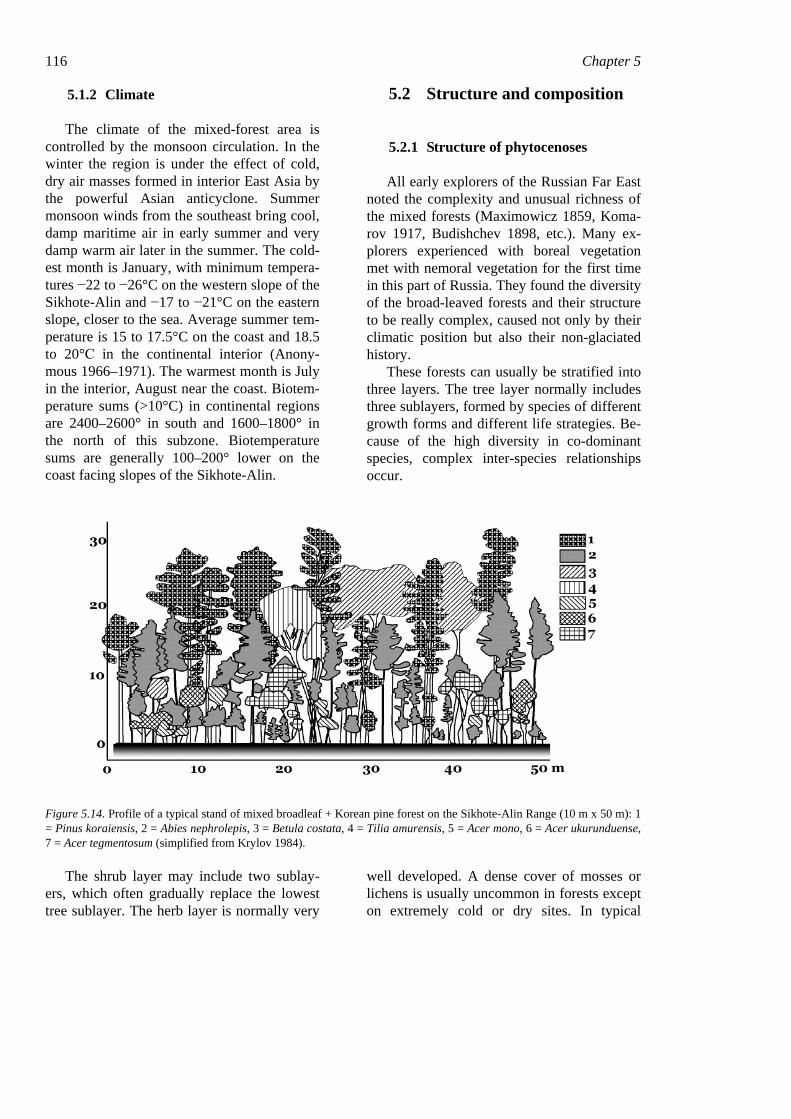
These forests can usually be stratified into three layers. The tree layer normally includes three sublayers, formed by species of different growth forms and different life strategies. Be-cause of the high diversity in co-dominant species, complex inter-species relationships occur.
Figure 5.14. Profile of a typical stand of mixed broadleaf + Korean pine forest on the Sikhote-Alin Range (10 m x 50 m): 1 = Pinus koraiensis, 2 = Abies nephrolepis, 3 = Betula costata, 4 = Tilia amurensis, 5 = Acer mono, 6 = Acer ukurunduense, 7 = Acer tegmentosum (simplified from Krylov 1984).
The shrub layer may include two sublay-ers, which often gradually replace the lowest tree sublayer. The herb layer is normally very
well developed. A dense cover of mosses or lichens is usually uncommon in forests except on extremely cold or dry sites. In typical
Forest vegetation of the easternmost Russia (Russian Far East) 117 broadleaf-Korean pine forests mosses can form small patches in herb-layer gaps and around the base of stems.
Important structural features of this com-munity are 1) that the assimilation organs of different species are located vertically throughout the entire forest profile (Fig. 5.14); and 2) that trees of some species form clumps of different sizes, caused by both gap dynam-ics and competition for light (Krestov & Ishi-kawa 2000).
5.2.1.1 The canopy The dominants in the mixed-forest ecosys-
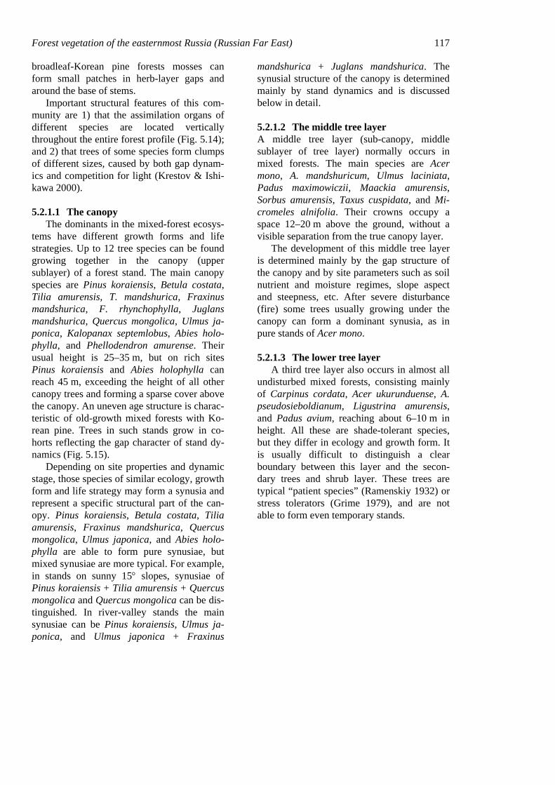
tems have different growth forms and life strategies. Up to 12 tree species can be found growing together in the canopy (upper sublayer) of a forest stand. The main canopy species are Pinus koraiensis, Betula costata, Tilia amurensis, T. mandshurica, Fraxinus mandshurica, F. rhynchophylla, Juglans mandshurica, Quercus mongolica, Ulmus ja-ponica, Kalopanax septemlobus, Abies holo-phylla, and Phellodendron amurense. Their usual height is 25–35 m, but on rich sites Pinus koraiensis and Abies holophylla can reach 45 m, exceeding the height of all other canopy trees and forming a sparse cover above the canopy. An uneven age structure is charac-teristic of old-growth mixed forests with Ko-rean pine. Trees in such stands grow in co-horts reflecting the gap character of stand dy-namics (Fig. 5.15).
Depending on site properties and dynamic stage, those species of similar ecology, growth form and life strategy may form a synusia and represent a specific structural part of the can-opy. Pinus koraiensis, Betula costata, Tilia amurensis, Fraxinus mandshurica, Quercus mongolica, Ulmus japonica, and Abies holo-phylla are able to form pure synusiae, but mixed synusiae are more typical. For example, in stands on sunny 15° slopes, synusiae of Pinus koraiensis + Tilia amurensis + Quercus mongolica and Quercus mongolica can be dis-tinguished. In river-valley stands the main synusiae can be Pinus koraiensis, Ulmus ja-ponica, and Ulmus japonica + Fraxinus
mandshurica + Juglans mandshurica. The synusial structure of the canopy is determined mainly by stand dynamics and is discussed below in detail.
5.2.1.2 The middle tree layer A middle tree layer (sub-canopy, middle sublayer of tree layer) normally occurs in mixed forests. The main species are Acer mono, A. mandshuricum, Ulmus laciniata, Padus maximowiczii, Maackia amurensis, Sorbus amurensis, Taxus cuspidata, and Mi-cromeles alnifolia. Their crowns occupy a space 12–20 m above the ground, without a visible separation from the true canopy layer.
The development of this middle tree layer is determined mainly by the gap structure of the canopy and by site parameters such as soil nutrient and moisture regimes, slope aspect and steepness, etc. After severe disturbance (fire) some trees usually growing under the canopy can form a dominant synusia, as in pure stands of Acer mono.
5.2.1.3 The lower tree layer A third tree layer also occurs in almost all
undisturbed mixed forests, consisting mainly of Carpinus cordata, Acer ukurunduense, A. pseudosieboldianum, Ligustrina amurensis, and Padus avium, reaching about 6–10 m in height. All these are shade-tolerant species, but they differ in ecology and growth form. It is usually difficult to distinguish a clear boundary between this layer and the secon-dary trees and shrub layer. These trees are typical “patient species” (Ramenskiy 1932) or stress tolerators (Grime 1979), and are not able to form even temporary stands.
118 Chapter 5
Figure 5.15. Tree groupings on a permanent plot 100 × 100 m in the southern Sikhote-Alin. The average sizes of groups are: Pinus koraiensis (Pk) - 144 m2, Abies nephrolepis (An) - 576 m2, Tilia amurensis (Ta) - 18 m2, Picea jezoensis (Pa) - 36 m2, Acer mono (Am) and Betula costata (Bc) - no groupings found (after Ishikawa et al. 1999, Krestov & Ishikawa 2000).
5.2.1.4 Secondary trees In addition to the above tree species, there
are some that normally do not occur in stable phytocenoses but appear only after distur-bances. In the mixed-forest area these are Betula platyphylla, Populus tremula, P. kore-ana, Padus maackii and Alnus hirsuta. The first three are light-demanding, while the last two also require mineral soil. These species usually appear in canopy gaps but also form pure stands after large wildfires and clear-cuts,
maintaining a forest environment on distur-bance sites. The positive effect of fire on the germination of various secondary species was described by Komarova (1992).
5.2.1.5 The shrub layer Shrubs are diverse and abundant in the
mixed broadleaf-Korean pine forests. Com-monly the shrub layer is sparse under the can-opy but sometimes very dense in gaps. The shrub layer may merge with other layers due to differences in plant height. If Lonicera chrysantha, Ribes maximoviczianum, and Berberis amurensis do not exceed 1 m, then Corylus mandshurica and Acer barbinerve can reach 6–7 m in height. The shrub layer is valuable for sapling development, especially in the early stages of post-disturbance succes-sion.
5.2.1.6 The herb and dwarf-shrub layer An herb layer is usually very well devel-
oped and characteristic for the mixed forests, but the driest sites on steep slopes and ridges may be free of herbs. Usually different herb species are grouped in synusiae occupying certain ecological niches. The most important factors affecting their development are light, ground fires, presence of stronger competitors, and influence of herbivores (Krylov 1984). Because of low light levels in the forest un-derstorey, almost all herbs are shade-tolerant, and capable of intensive vegetative reproduc-tion. The herbs are quite different in growth form and life strategy; most competitive are the nemoral broad-leaved herbs with leaves oriented horizontally. The average number of species in a phytocenosis may vary between 20 and 100. The total number of herbaceous understorey species in the mixed forests ex-ceeds 600.
5.2.1.7 The moss and lichen cover A moss-lichen layer is not characteristic
for nemoral vegetation, but mosses may in-deed increase toward the northern limit of Ko-rean pine forests. Moss ground synusiae are formed by common boreal species such as
Forest vegetation of the easternmost Russia (Russian Far East) 119 Pleurozium schreberi, Hylocomium splendens, and Ptilium crista-castrensis. Small patches of nemoral mosses can also be found: Rhytidia-delphus triquetrus, Pleuroziopsis ruthenica, Climacium dendroides.
5.2.1.8 Inter-layer plants A special feature of this type of forest is
the presence of woody vines, especially Vitis amurensis, Actinidia arguta, A. kolomikta, A. polygama, Schisandra chinensis, Celastrus flagellaris, Celastrus orbiculata, Pueraria lobata, and Parthenocissus tricuspidata. Some are significant successional species due to their intensive sprouting ability.
5.2.2 Floristic composition of the mixed-forest phytocenoses
Some 645 vascular species have been found in the mixed broadleaf-Korean pine for-ests (Krestov 1997). The term ‘cenoflora’ has been applied here to identify the number and combinations of species in communities of the same type. The distribution of some species within the mixed-forest zone is heterogeneous. Many species, including some major domi-nants, have northern distributional limits near 44°N.
Geographical analysis permitted assigning the vascular species to eight geoelement types (Table 5.5). Most species have a Manchurian type of range. As a whole, the spectrum of cenoflora geoelements is Manchurian, plus Far Eastern, Eurasian and boreal species groups. South-Manchurian species have a rather weak position in forests of the classes Nemoreto-Pineta typicum and piceetosium, characterized by a colder climate (95 species versus 162 in more southern forests); the group of Okhotsk-Manchurian species is more diverse (mean of 43 species versus 36 in southern forests).
Dauro-Manchurian species connect the nemoral-forest cenoflora with the continental vegetation types, such as steppes and dry
meadows. Plants of this group have some xeromorphic traits.
The Far Eastern geoelements (66 and 64 species in the two classes) are basically char-acteristic of azonal vegetation and are consis-tently present in valley broad-leaved forests, Chosenia arbutifolia forests and in valley meadows.
Siberian, Eurasian, and Boreal geoele-ments are generally represented by species cenotically not active in mixed forest (Po-lemonium chinense, Calamagrostis langs-dorffii, Vaccinium vitis-idaea); some (Calamagrostis langsdorffii, Chamerion an-gustifolium, Chelidonium asiaticum), how-ever, considerably strengthen their position in derivative communities.
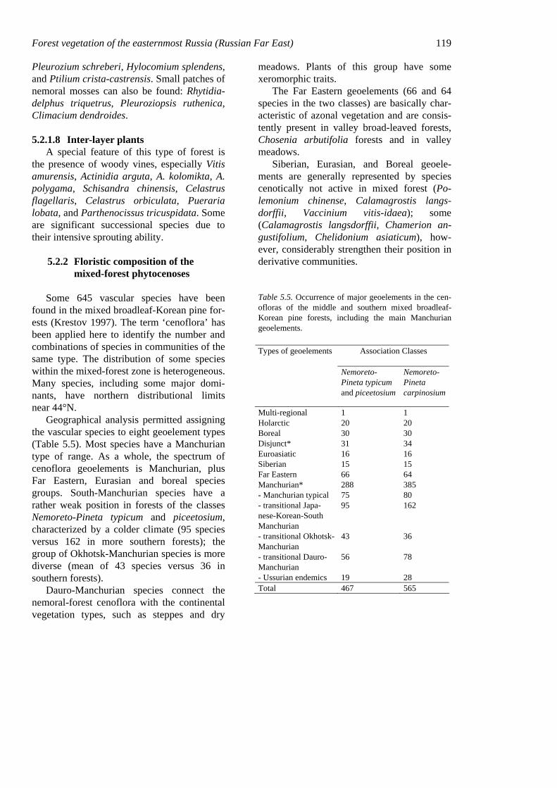
Table 5.5. Occurrence of major geoelements in the cen-ofloras of the middle and southern mixed broadleaf-Korean pine forests, including the main Manchurian geoelements.
Association Classes Types of geoelements
Nemoreto-Pineta typicum and piceetosium
Nemoreto-Pineta carpinosium
Multi-regional 1 1 Holarctic 20 20 Boreal 30 30 Disjunct* 31 34 Euroasiatic 16 16 Siberian 15 15 Far Eastern 66 64 Manchurian* 288 385 - Manchurian typical 75 80 - transitional Japa-nese-Korean-South Manchurian
95 162
- transitional Okhotsk-Manchurian
43 36
- transitional Dauro-Manchurian
56 78
- Ussurian endemics 19 28 Total 467 565
120 Chapter 5
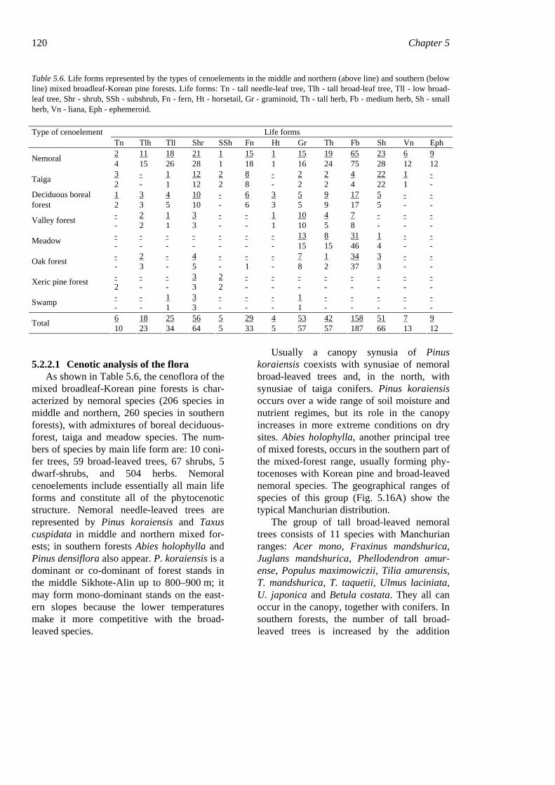
Table 5.6. Life forms represented by the types of cenoelements in the middle and northern (above line) and southern (below line) mixed broadleaf-Korean pine forests. Life forms: Tn - tall needle-leaf tree, Tlh - tall broad-leaf tree, Tll - low broad-leaf tree, Shr - shrub, SSh - subshrub, Fn - fern, Ht - horsetail, Gr - graminoid, Th - tall herb, Fb - medium herb, Sh - small herb, Vn - liana, Eph - ephemeroid.
Type of cenoelement Life forms Tn Tlh Tll Shr SSh Fn Ht Gr Th Fb Sh Vn Eph
2 11 18 21 1 15 1 15 19 65 23 6 9 Nemoral 4 15 26 28 1 18 1 16 24 75 28 12 12 3 - 1 12 2 8 - 2 2 4 22 1 - Taiga 2 - 1 12 2 8 - 2 2 4 22 1 - 1 3 4 10 - 6 3 5 9 17 5 - - Deciduous boreal
forest 2 3 5 10 - 6 3 5 9 17 5 - - - 2 1 3 - - 1 10 4 7 - - - Valley forest - 2 1 3 - - 1 10 5 8 - - - - - - - - - - 13 8 31 1 - - Meadow - - - - - - - 15 15 46 4 - - - 2 - 4 - - - 7 1 34 3 - - Oak forest - 3 - 5 - 1 - 8 2 37 3 - - - - - 3 2 - - - - - - - - Xeric pine forest 2 - - 3 2 - - - - - - - - - - 1 3 - - - 1 - - - - - Swamp - - 1 3 - - - 1 - - - - - 6 18 25 56 5 29 4 53 42 158 51 7 9 Total 10 23 34 64 5 33 5 57 57 187 66 13 12
5.2.2.1 Cenotic analysis of the flora As shown in Table 5.6, the cenoflora of the
mixed broadleaf-Korean pine forests is char-acterized by nemoral species (206 species in middle and northern, 260 species in southern forests), with admixtures of boreal deciduous-forest, taiga and meadow species. The num-bers of species by main life form are: 10 coni-fer trees, 59 broad-leaved trees, 67 shrubs, 5 dwarf-shrubs, and 504 herbs. Nemoral cenoelements include essentially all main life forms and constitute all of the phytocenotic structure. Nemoral needle-leaved trees are represented by Pinus koraiensis and Taxus cuspidata in middle and northern mixed for-ests; in southern forests Abies holophylla and Pinus densiflora also appear. P. koraiensis is a dominant or co-dominant of forest stands in the middle Sikhote-Alin up to 800–900 m; it may form mono-dominant stands on the east-ern slopes because the lower temperatures make it more competitive with the broad-leaved species.
Usually a canopy synusia of Pinus koraiensis coexists with synusiae of nemoral broad-leaved trees and, in the north, with synusiae of taiga conifers. Pinus koraiensis occurs over a wide range of soil moisture and nutrient regimes, but its role in the canopy increases in more extreme conditions on dry sites. Abies holophylla, another principal tree of mixed forests, occurs in the southern part of the mixed-forest range, usually forming phy-tocenoses with Korean pine and broad-leaved nemoral species. The geographical ranges of species of this group (Fig. 5.16A) show the typical Manchurian distribution.
The group of tall broad-leaved nemoral trees consists of 11 species with Manchurian ranges: Acer mono, Fraxinus mandshurica, Juglans mandshurica, Phellodendron amur-ense, Populus maximowiczii, Tilia amurensis, T. mandshurica, T. taquetii, Ulmus laciniata, U. japonica and Betula costata. They all can occur in the canopy, together with conifers. In southern forests, the number of tall broad-leaved trees is increased by the addition
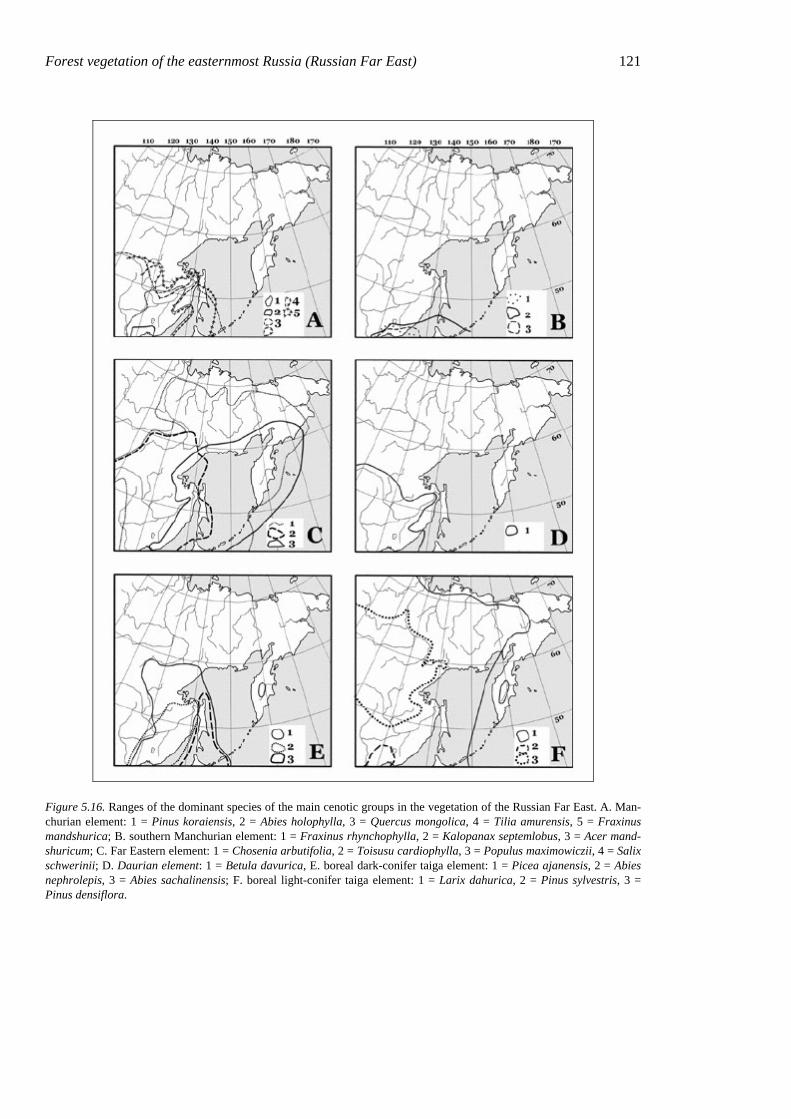
Forest vegetation of the easternmost Russia (Russian Far East) 121
Figure 5.16. Ranges of the dominant species of the main cenotic groups in the vegetation of the Russian Far East. A. Man-churian element: 1 = Pinus koraiensis, 2 = Abies holophylla, 3 = Quercus mongolica, 4 = Tilia amurensis, 5 = Fraxinus mandshurica; B. southern Manchurian element: 1 = Fraxinus rhynchophylla, 2 = Kalopanax septemlobus, 3 = Acer mand-shuricum; C. Far Eastern element: 1 = Chosenia arbutifolia, 2 = Toisusu cardiophylla, 3 = Populus maximowiczii, 4 = Salix schwerinii; D. Daurian element: 1 = Betula davurica, E. boreal dark-conifer taiga element: 1 = Picea ajanensis, 2 = Abies nephrolepis, 3 = Abies sachalinensis; F. boreal light-conifer taiga element: 1 = Larix dahurica, 2 = Pinus sylvestris, 3 = Pinus densiflora.
122 Chapter 5 of southern-Manchurian species such as Frax-inus rhynchophylla and Kalopanax septem-lobus. Their geographical ranges (Fig. 5.16B) are largely similar to those of nemoral coni-fers.
A major component of the mixed forests is the nemoral shrubs, which include 21 species in middle and northern forests and 28 species in southern forests. The most significant are Eleutherococcus senticocus, Lonicera chry-santha, Philadelphus tenuifolius, and Corylus mandshurica.
Nemoral herbs of various life forms prevail in the herb layer of intact mixed forests. The most significant are nemoral tall herbs: Fili-pendula glaberrima, Rabdosia glaucocalyx, R. excisa; nemoral ferns: Cornopteris crenula-toserrulata, Dryopteris crassirhizoma, Co-niogramme intermedia; other nemoral herbs: Carpesium triste, Lilium distichum, Arisaema amurense, Caulophyllum robustum, etc.; nemoral sedges: Carex siderosticta, C. campy-lorhina, C. ussuriensis, C. quadriflora, and many other less significant groups.
The valley-forest cenoelement groups 28 species characteristic of northern and southern valley forests and topographically bound to thick deposits of river alluvium. All these spe-cies have wide north-south ranges (Far East-ern geoelements), or Manchurian ranges but with taxonomically related species in more northern regions (Fig. 5.16C). A classic ex-ample of this cenoelement is Chosenia arbuti-folia (Moskalyuk 1988), which initiates the establishment of broad-leaved floodplain for-ests on pure river alluvium (Kolesnikov 1937). This cenoelement also includes, in addition to Chosenia arbutifolia, some other trees (Tois-usu cardiophylla, Salix schwerinii, S. rorida, Populus maximowiczii, Alnus hirsuta), shrubs (Sorbaria sorbifolia, Spiraea salicifolia, Swida alba), tall herbs (Urtica angustifolia), and graminoids (Carex dispalata, C. sordida, C. drymophila, C. egena).Those species re-lated to Quercus mongolica-Betula davurica and Quercus dentata stands belong to the oak-forest cenoelement. The oak forests in eastern Siberia have mostly arisen after fire degraded
the mixed broadleaf-Korean pine forests (V. Vasiliev 1958, Kurentsova 1973, Dobrynin 2000). Even so, ecological features of xeromesic species (Verkholat & Krylov 1982) and their fire resistance led us to relate these species to the oak-forest cenoelement. These species are the tree Betula davurica, shrubs Lespedeza bicolor and Corylus heterophylla, and herbs Doellingeria scabra, Artemisia keiskeana, Dictamnus dasycarpus, Atracty-lodes ovata, etc. The ranges of these species go far into the continental climates to the west (Fig. 5.16D). Most species of this group show xeromorphic features.
Taiga species usually are common compo-nents of fir-spruce forests and are present also in the mixed broadleaf-Korean pine forests. Their cenotic activity varies from extremely low (sole species) at low altitudes and on sunny slopes to domination of subordinate synusiae in shaded habitats and in the ecotone between the nemoral and boreal zones. The most widespread species of the taiga cenoele-ment are dark-coniferous trees with submari-time boreal ranges (Fig. 5.16E), i.e. Picea ajanensis and Abies nephrolepis; ferns Lepto-rumohra amurensis and Dryopteris expansa; small herbs Maianthemum bifolium, Chama-epericlymenum canadense, etc.; and green mosses Rhytidiadelphus triquetrus, Hyloco-mium splendens, Pleurozium schreberi, etc.
Xeric pine-forest species are represented by five oligotrophic and oligomesotrophic xeric species (e.g. Festuca ovina, Antennaria dioica, Rhododendron mucronulatum) in the southern Far East, cenotically connected with xeric Pinus densiflora communities (Verkho-lat & Krylov 1982). On the middle and north-ern Sikhote-Alin, essentially the whole com-plex of xeric pine-forest species occurs in dry larch forests and Juniperus sibirica thickets. Rhododendron mucronulatum can form synu-siae in dry mixed broadleaf-Korean pine for-ests.
The deciduous-boreal cenoelement unites species characteristic for boreal white-birch (Betula platyphylla, B. pendula) and larch (Larix dahurica) forests, having rather wide
Forest vegetation of the easternmost Russia (Russian Far East) 123 ranges in the boreal zone (Fig. 5.16F). In mixed broadleaf-Korean pine forest, 84 spe-cies belonging to this cenoelement were noted. Of them, 23 have circumboreal ranges, 14 be-long to the boreal zone of Eurasia, 20 to the boreal and oroboreal areas of the Russian Far East, and the others are connected with boreal formations of northeastern China and the Us-suri floristic region.
A special place in this cenoelement is oc-cupied by Larix dahurica, a boreal summer-green needle-leaved tree. The role of larch on the Sikhote-Alin is not significant in undis-turbed vegetation. Virgin larch forests do oc-cur on wide, less-drained river terraces, espe-cially in the Khor, Bikin and Anuy basins. Secondary larch forests are common, how-ever, on the middle and northern Sikhote-Alin and on the east side of the Amur River. Other groups in this cenoelement are the herbs (Saussurea triangulata, Hieracium virosum, Truellum thunbergii, Galium boreale, etc.) and shrubs (Lonicera edulis, Ledum hypoleu-cum and others).
Meadow cenoelements in forests occur as suppressed understorey individuals but are much more abundant in canopy gaps
(Calamagrostis langsdorffii, Trisetum sibiri-cum) and at forest edges (Chamerion angusti-folium, Vicia amoena). Some meadow species are consistently present in nemoral forests (Cimicifuga simplex, Ligularia fischeri, etc.) and on forest edges, where meadow communi-ties directly affect forest regeneration (Lilium pensylvanicum, Lycopus lucidus).
Other cenoelements occur on specific ecotopes (rocks, bogs) or show cenotic activ-ity only during or after strong disturbances (ruderal cenoelements).
5.3 Phytocenotic diversity
Traditionally, the mixed broadleaf-Korean pine forests are subdivided into southern, typi-cal (middle) and northern subtypes. These di-visions correspond geobotanically to the fol-lowing classes of associations: Nemoreto-Pineta carpinosium in the south, Nemoreto-Pineta typicum in the middle and Nemoreto-Pineta piceetosium in the north (Krestov 1997). The major classification units (forma-tio, classus associationum and grex associa-tionum) are presented in Table 5.7.
Table 5.7. Classification of mixed broadleaf + Korean pine forests, with indicator species, ecology, topographical position of association groups. Abbreviations for edatope here and after are for the gradient of soil moisture regime: dry – D, slightly dry – SD, fresh – F, moist – M, very moist – VM, wet – W; for the soil nutrient regime: very poor – VP, poor – P, medium – MN, rich – R. Soil moisture and soil nutrient regimes are showed as intervals following each other.
Grex associationum Indicator plants Edatope Topography, aspect Formatio: Nemoreto-Pineta koraiensis
Classus associationum: Nemoreto-Pineta carpinosium Nemoreto-Pineta caricosa nemoretae
Carex ussuriensis, C. lanceolata, C. reventa, Les-pedeza bicolor, Weigela praecox
SD, P–MN
Upper concave slopes and ridges: S, W, E
Nemoreto-Pineta herbosa nemoretae
Carex campylorhina, C. pallida, Thalictrum fila-mentosum, Arisaema amurense, Osmorhiza aristata, Cacalia protermissa, Asarum sieboldii
SD–F, MN–R
Mid-slopes, all aspects
Nemoreto-Pineta fruticosa nemoretae
Corylus mandshurica, Philadelphus tenuifolius, Deutzia amurensis, Lonicera praeflorens, Acti-nidia arguta
SD–F, R Middle and lower slopes, all aspects
Nemoreto-Pineta grandi-filicosa nemoretae
Cornopteris crenulatoserrulata, Athyrium monomachii, Dryopteris goeringiana, Polystichum tripteron
F–M, MN–R
Lower concave slopes and upper river terraces
Nemoreto-Pineta grandi-filicosa vallisae
Matteuccia struthiopteris, Osmundastrum asiati-cum, O. claytonianum, Symplocarpus renifolius, Urtica laetevirens
F–M, R River terraces
124 Chapter 5 Grex associationum Indicator plants Edatope Topography, aspect
Classus associationum: Nemoreto-Pineta typicum Querceto-Pineta nanocari-cosa taigae
Carex callitrichos, Rhododendron sichotense, Orthilia secunda
SD, P–MN
Steep (>30°) convex slopes, N, E
Nemoreto-Pineta nanocari-cosa nemoretae
Carex nanella, C. reventa, Rhododendron mucro-nulatum, Iris uniflora
SD, MN–R
Steep convex slopes and ridges: S, W,
Nemoreto-Pineta herbosa nemoretae
Waldsteinia ternata, Thalictrum filamentosum, Caulophyllum robustum, Uraspermum aristatum
SD–F, MN–R
Gentle mid-slopes, wide saddles: S, W, E
Nemoreto-Pineta fruticosa nemoretae
Corylus mandshurica, Philadelphus tenuifolius, Lonicera chrysantha, Eleutherococcus senticocus
SD–F, MN–R
Gentle lower concave slopes, all aspects
Nemoreto-Pineta fruticosa vallisae
Sorbaria sorbifolia, Spiraea salicifolia, Swida alba
F–M, R River lower terraces, alluvial deposits
Nemoreto-Pineta grandi-filicosa nemoretae
Cornopteris crenulatoserrulatae, Dryopteris cras-sirhizoma, D. goeringiana, Athyrium sinense, Co-niogramme intermedia
F–M, MN–R
River upper terraces, lower concave slopes, alluvial and deluvial deposits
Nemoreto-Pineta grandi-filicosa vallisae
Matteuccia struthiopteris, Osmundastrum asiati-cum
F–M, R River lower terraces, alluvial deposits
Nemoreto-Pineta grandi-caricosa
Carex sordida, C. drymophylla, C. egena, C. dis-palata
M, MN–R
River terraces poorly drained terraces
Querceto-Pineta festucosa Festuca pseudosulcata, Schizachne callosa D–SD, P Steep slopes with marine exposures
Classus associationum: Nemoreto-Pineta piceetosium Piceeto-Pineta nanocari-cosa taigae
Picea ajanensis, Carex callitrichos, Pyrola minor, Vaccinium vitis-idaea, Linnaea borealis
D–SD, P–MN
Steep upper slopes and ridges, above 700 m
Piceeto-Pineta herbosa nemoretae
Waldsteinia ternata, Thalictrum tuberiferum SD–F, MN–R
Gentle mid-slopes, S aspect
Nemoreto-Piceeto-Pineta fruticosa taigae
Acer ukurunduensis F, MN Steep slopes with narrow valley exposure
Nemoreto-Piceeto-Pineta filicosa taigae
Leptorumohra amurensis, Dryopteris expansa, Diplazium sibiricum
SD–F, MN
Gentle slopes, all aspects above 700 m
Nemoreto-Piceeto-Pineta grandifilicosa nemoretae
Dryopteris crassirhizoma Coniogramme interme-dia, Clintonia udensis
F–M, MN–R
Gentle convex lower slopes
Nemoreto-Piceeto-Pineta herbosa taigae
Aconitum kirinense, Maianthemum bifolium, M. dilatatum, Carex falcata, C. xyphium
SD–F, P–MN
Gentle slopes: S, E aspects above 700 m
Nemoreto-Piceeto-Pineta fruticosa boreale
Ledum hypoleucum, Lonicera edulis, Sphagnum girgensohnii, S. nemerosum
F–M, P–MN
Poorly drained upper river terraces
Classus associationum: Pineta purum Pineta purum herbosa tai-gae
Maianthemum bifolium, M. dilatatum, Clintonia udensis, Linnaea borealis
SD–F, P–MN
Gentle slopes, E-N
Pineta purum filicosa nemoretae
Pseudocystopteris spinulosa, Dryopteris crassirhi-zoma
SD–F, MN
Same, S, W
Pineta purum caricosa taigae
Carex xyphium D–SD, P–MN
Steep slopes, E Sikhote-Alin, S, W
Pineta purum muscosa Rhytidiadelphus triquetrus, Hylocomium splen-dens, Pleurozium schreberi
F, P–MN Steep slopes, E Sikhote-Alin, N
The southern mixed forests occur from
42°40’N in eastern Russia (Vasiliev & Kolesnikov 1962), or from 40°15’N in NE China (Chun 1994), north to 44°N. They oc-cupy gentle slopes at 50–600 m on the south-ern foothills of the Sikhote-Alin, on the Chorniye Gory, and on the Shufan plateau. These forests are very species-rich and have
complex phytocenotic structure (Fig. 5.17). They are usually co-dominated by two nemoral coniferous trees Pinus koraiensis and Abies holophylla, reaching 45 m in height, and by nemoral broad-leaved trees. Carpinus cor-data always forms the lower tree layer on mesic sites. The shrub layer includes nemoral shrubs with southern and typical Manchurian
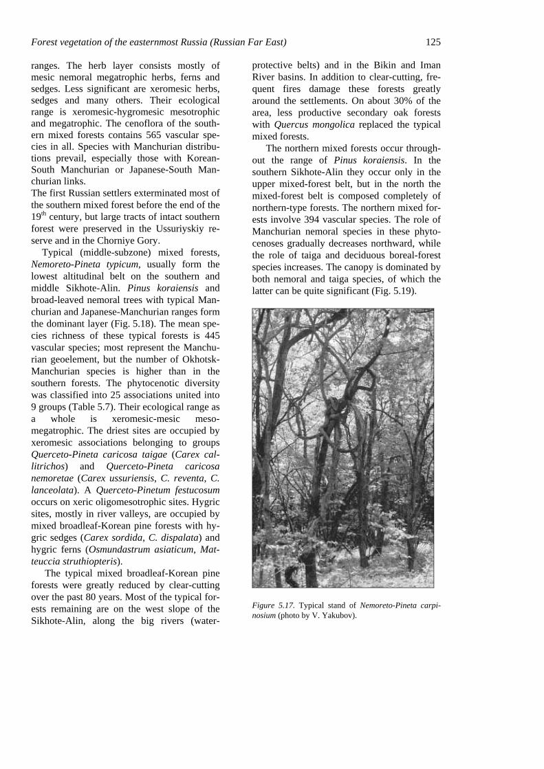
Forest vegetation of the easternmost Russia (Russian Far East) 125 ranges. The herb layer consists mostly of mesic nemoral megatrophic herbs, ferns and sedges. Less significant are xeromesic herbs, sedges and many others. Their ecological range is xeromesic-hygromesic mesotrophic and megatrophic. The cenoflora of the south-ern mixed forests contains 565 vascular spe-cies in all. Species with Manchurian distribu-tions prevail, especially those with Korean-South Manchurian or Japanese-South Man-churian links. The first Russian settlers exterminated most of the southern mixed forest before the end of the 19th century, but large tracts of intact southern forest were preserved in the Ussuriyskiy re-serve and in the Chorniye Gory.
Typical (middle-subzone) mixed forests, Nemoreto-Pineta typicum, usually form the lowest altitudinal belt on the southern and middle Sikhote-Alin. Pinus koraiensis and broad-leaved nemoral trees with typical Man-churian and Japanese-Manchurian ranges form the dominant layer (Fig. 5.18). The mean spe-cies richness of these typical forests is 445 vascular species; most represent the Manchu-rian geoelement, but the number of Okhotsk-Manchurian species is higher than in the southern forests. The phytocenotic diversity was classified into 25 associations united into 9 groups (Table 5.7). Their ecological range as a whole is xeromesic-mesic meso-megatrophic. The driest sites are occupied by xeromesic associations belonging to groups Querceto-Pineta caricosa taigae (Carex cal-litrichos) and Querceto-Pineta caricosa nemoretae (Carex ussuriensis, C. reventa, C. lanceolata). A Querceto-Pinetum festucosum occurs on xeric oligomesotrophic sites. Hygric sites, mostly in river valleys, are occupied by mixed broadleaf-Korean pine forests with hy-gric sedges (Carex sordida, C. dispalata) and hygric ferns (Osmundastrum asiaticum, Mat-teuccia struthiopteris).
The typical mixed broadleaf-Korean pine forests were greatly reduced by clear-cutting over the past 80 years. Most of the typical for-ests remaining are on the west slope of the Sikhote-Alin, along the big rivers (water-
protective belts) and in the Bikin and Iman River basins. In addition to clear-cutting, fre-quent fires damage these forests greatly around the settlements. On about 30% of the area, less productive secondary oak forests with Quercus mongolica replaced the typical mixed forests.
The northern mixed forests occur through-out the range of Pinus koraiensis. In the southern Sikhote-Alin they occur only in the upper mixed-forest belt, but in the north the mixed-forest belt is composed completely of northern-type forests. The northern mixed for-ests involve 394 vascular species. The role of Manchurian nemoral species in these phyto-cenoses gradually decreases northward, while the role of taiga and deciduous boreal-forest species increases. The canopy is dominated by both nemoral and taiga species, of which the latter can be quite significant (Fig. 5.19).
Figure 5.17. Typical stand of Nemoreto-Pineta carpi-nosium (photo by V. Yakubov).
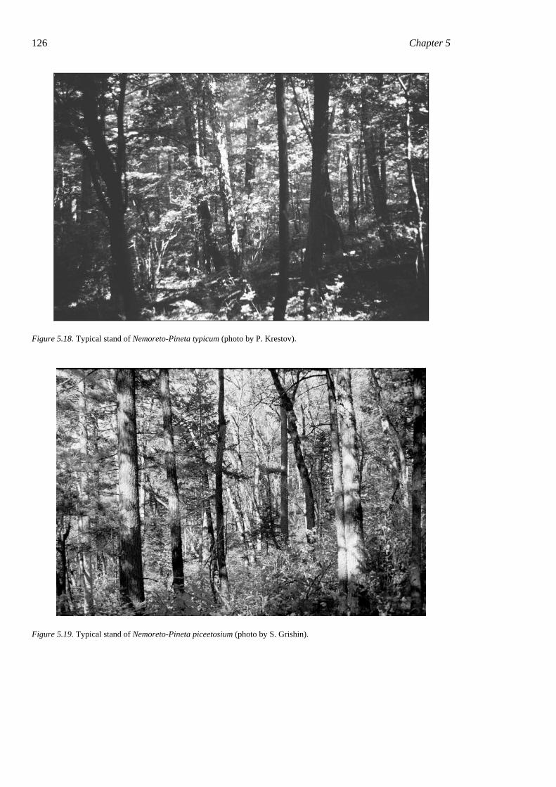
126 Chapter 5
Figure 5.18. Typical stand of Nemoreto-Pineta typicum (photo by P. Krestov).
Figure 5.19. Typical stand of Nemoreto-Pineta piceetosium (photo by S. Grishin).
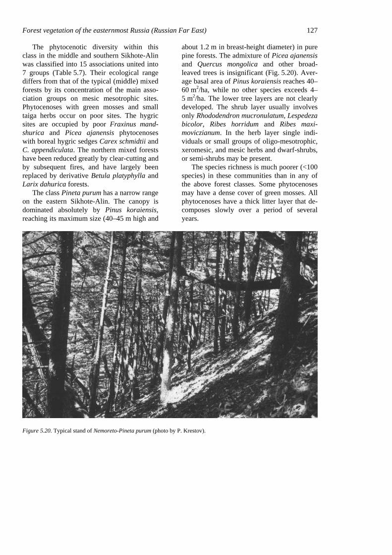
Forest vegetation of the easternmost Russia (Russian Far East) 127
The phytocenotic diversity within this class in the middle and southern Sikhote-Alin was classified into 15 associations united into 7 groups (Table 5.7). Their ecological range differs from that of the typical (middle) mixed forests by its concentration of the main asso-ciation groups on mesic mesotrophic sites. Phytocenoses with green mosses and small taiga herbs occur on poor sites. The hygric sites are occupied by poor Fraxinus mand-shurica and Picea ajanensis phytocenoses with boreal hygric sedges Carex schmidtii and C. appendiculata. The northern mixed forests have been reduced greatly by clear-cutting and by subsequent fires, and have largely been replaced by derivative Betula platyphylla and Larix dahurica forests.
The class Pineta purum has a narrow range on the eastern Sikhote-Alin. The canopy is dominated absolutely by Pinus koraiensis, reaching its maximum size (40–45 m high and
about 1.2 m in breast-height diameter) in pure pine forests. The admixture of Picea ajanensis and Quercus mongolica and other broad-leaved trees is insignificant (Fig. 5.20). Aver-age basal area of Pinus koraiensis reaches 40–60 m2/ha, while no other species exceeds 4–5 m2/ha. The lower tree layers are not clearly developed. The shrub layer usually involves only Rhododendron mucronulatum, Lespedeza bicolor, Ribes horridum and Ribes maxi-moviczianum. In the herb layer single indi-viduals or small groups of oligo-mesotrophic, xeromesic, and mesic herbs and dwarf-shrubs, or semi-shrubs may be present.
The species richness is much poorer (<100 species) in these communities than in any of the above forest classes. Some phytocenoses may have a dense cover of green mosses. All phytocenoses have a thick litter layer that de-composes slowly over a period of several years.
Figure 5.20. Typical stand of Nemoreto-Pineta purum (photo by P. Krestov).
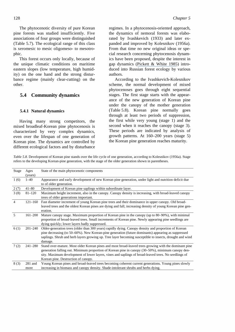
128 Chapter 5
The phytocenotic diversity of pure Korean pine forests was studied insufficiently. Five associations of four groups were distinguished (Table 5.7). The ecological range of this class is xeromesic to mesic oligomeso- to mesotro-phic.
This forest occurs only locally, because of the unique climatic conditions on maritime eastern slopes (low temperature, high humid-ity) on the one hand and the strong distur-bance regime (mainly clear-cutting) on the other.
5.4 Community dynamics
5.4.1 Natural dynamics
Having many strong competitors, the mixed broadleaf-Korean pine phytocenosis is characterized by very complex dynamics, even over the lifespan of one generation of Korean pine. The dynamics are controlled by different ecological factors and by disturbance
regimes. In a phytocenosis-oriented approach, the dynamics of nemoral forests was elabo-rated by Ivashkevich (1933) and later ex-panded and improved by Kolesnikov (1956a). From that time no new original ideas or spe-cial research concerning phytocenosis dynam-ics have been proposed, despite the interest in gap dynamics (Pickett & White 1985) intro-duced into Russian forest ecology by various authors.
According to the Ivashkevich-Kolesnikov scheme, the normal development of mixed phytocenoses goes through eight sequential stages. The first stage starts with the appear-ance of the new generation of Korean pine under the canopy of the mother generation (Table 5.8). Korean pine normally goes through at least two periods of suppression, the first while very young (stage 1) and the second when it reaches the canopy (stage 3). These periods are indicated by analysis of growth patterns. At 160–200 years (stage 5) the Korean pine generation reaches maturity.
Table 5.8. Development of Korean pine stands over the life cycle of one generation, according to Kolesnikov (1956a). Stage refers to the developing Korean-pine generation, with the stage of the older generation shown in parentheses.
Stage Ages (years)
State of the main phytocenotic components
1 (6) 1–40 Appearance and early development of new Korean pine generation, under light and nutrition deficit due to of older generation.
2 (7) 41–80 Development of Korean pine saplings within subordinate layer. 3 (8) 81–120 Maximum height increment, also in the canopy. Canopy density is increasing, with broad-leaved canopy
trees of older generations important. 4 121–160 Fast diameter increment of young Korean pine trees and their dominance in upper canopy. Old broad-
leaved trees and the oldest Korean pines are dying and fall; increasing density of young Korean pine gen-eration.
5 161–200 Mature canopy stage. Maximum proportion of Korean pine in the canopy (up to 80–90%), with minimal proportion of broad-leaved trees. Small increments of Korean pine. Newly appearing pine seedlings are dying quickly; lower layers badly suppressed.
6 (1) 201–240 Older-generation trees (older than 300 years) rapidly dying. Canopy density and proportion of Korean pine decreasing (to 50–60%). New Korean-pine generation (future dominants) appearing as suppressed saplings. Shrub and herb layers growing up. Tree layer becoming susceptible to insects, drought and wind damage.
7 (2) 241–280 Stand over-mature. Most older Korean pines and most broad-leaved trees growing with the dominant pine generation falling out. Minimum proportion of Korean pine in canopy (30–50%), minimum canopy den-sity. Maximum development of lower layers, vines and saplings of broad-leaved trees. No seedlings of Korean pine. Destruction of canopy.
8 (3) 281 and more
Young Korean pines and broad-leaved trees becoming coherent current generations. Young pines slowly increasing in biomass and canopy density. Shade-intolerant shrubs and herbs dying.
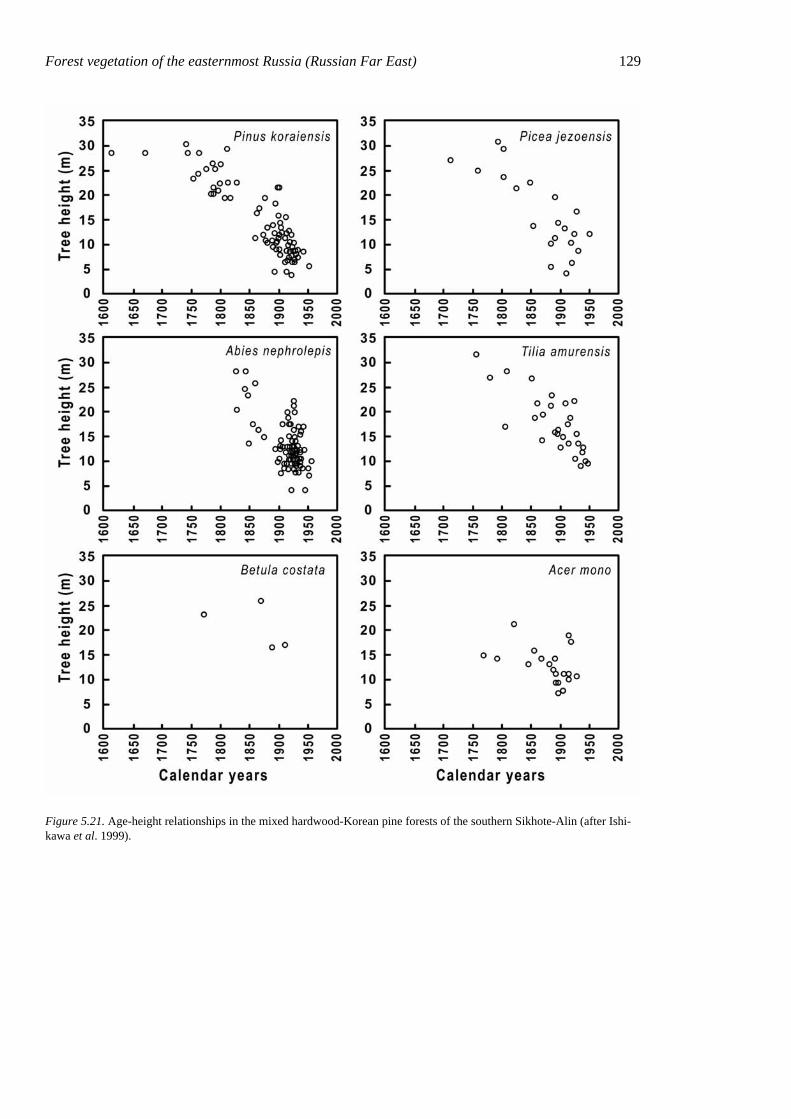
Forest vegetation of the easternmost Russia (Russian Far East) 129
Figure 5.21. Age-height relationships in the mixed hardwood-Korean pine forests of the southern Sikhote-Alin (after Ishi-kawa et al. 1999).
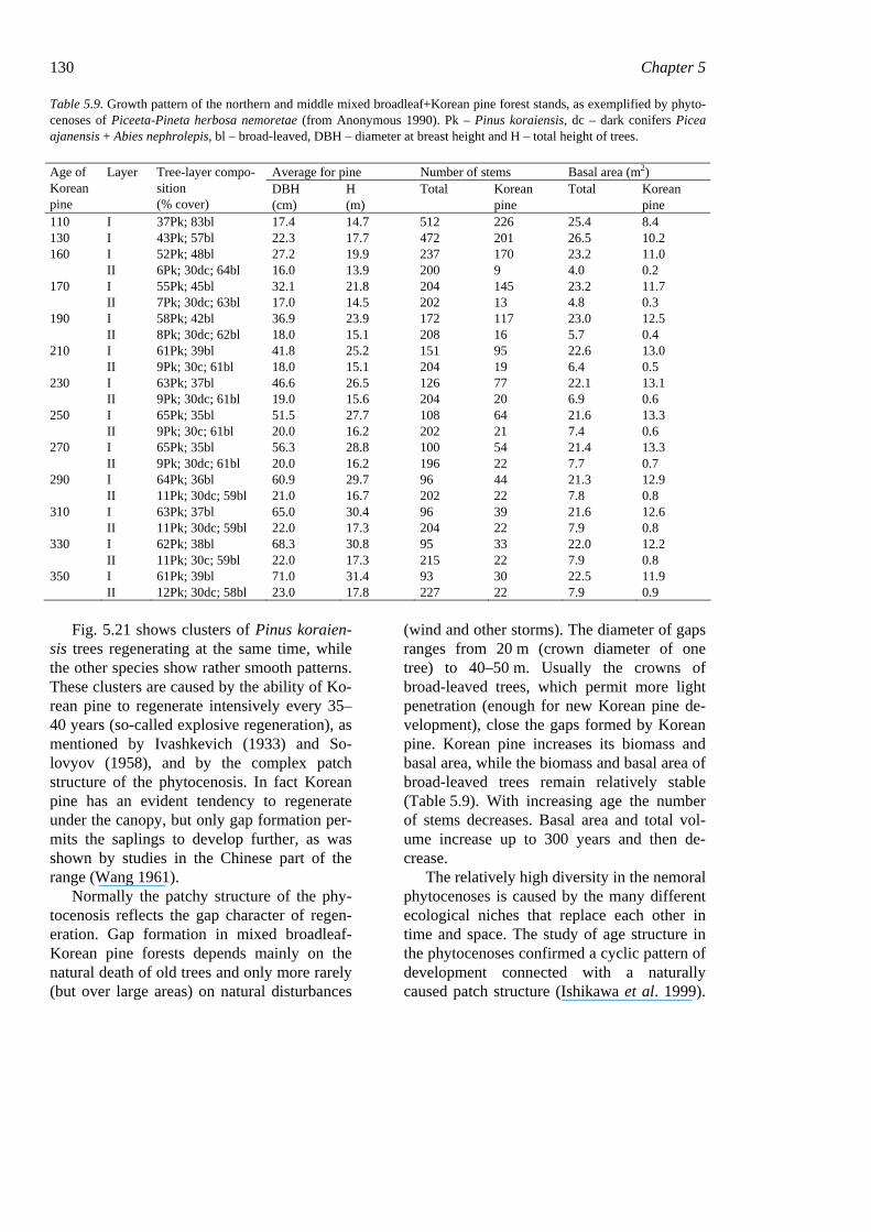
130 Chapter 5 Table 5.9. Growth pattern of the northern and middle mixed broadleaf+Korean pine forest stands, as exemplified by phyto-cenoses of Piceeta-Pineta herbosa nemoretae (from Anonymous 1990). Pk – Pinus koraiensis, dc – dark conifers Picea ajanensis + Abies nephrolepis, bl – broad-leaved, DBH – diameter at breast height and H – total height of trees.
Average for pine Number of stems Basal area (m2) Age of Korean pine
Layer Tree-layer compo-sition (% cover)
DBH (cm)
H (m)
Total Korean pine
Total Korean pine
110 I 37Pk; 83bl 17.4 14.7 512 226 25.4 8.4 130 I 43Pk; 57bl 22.3 17.7 472 201 26.5 10.2 160 I 52Pk; 48bl 27.2 19.9 237 170 23.2 11.0 II 6Pk; 30dc; 64bl 16.0 13.9 200 9 4.0 0.2 170 I 55Pk; 45bl 32.1 21.8 204 145 23.2 11.7 II 7Pk; 30dc; 63bl 17.0 14.5 202 13 4.8 0.3 190 I 58Pk; 42bl 36.9 23.9 172 117 23.0 12.5 II 8Pk; 30dc; 62bl 18.0 15.1 208 16 5.7 0.4 210 I 61Pk; 39bl 41.8 25.2 151 95 22.6 13.0 II 9Pk; 30c; 61bl 18.0 15.1 204 19 6.4 0.5 230 I 63Pk; 37bl 46.6 26.5 126 77 22.1 13.1 II 9Pk; 30dc; 61bl 19.0 15.6 204 20 6.9 0.6 250 I 65Pk; 35bl 51.5 27.7 108 64 21.6 13.3 II 9Pk; 30c; 61bl 20.0 16.2 202 21 7.4 0.6 270 I 65Pk; 35bl 56.3 28.8 100 54 21.4 13.3 II 9Pk; 30dc; 61bl 20.0 16.2 196 22 7.7 0.7 290 I 64Pk; 36bl 60.9 29.7 96 44 21.3 12.9 II 11Pk; 30dc; 59bl 21.0 16.7 202 22 7.8 0.8 310 I 63Pk; 37bl 65.0 30.4 96 39 21.6 12.6 II 11Pk; 30dc; 59bl 22.0 17.3 204 22 7.9 0.8 330 I 62Pk; 38bl 68.3 30.8 95 33 22.0 12.2 II 11Pk; 30c; 59bl 22.0 17.3 215 22 7.9 0.8 350 I 61Pk; 39bl 71.0 31.4 93 30 22.5 11.9 II 12Pk; 30dc; 58bl 23.0 17.8 227 22 7.9 0.9
Fig. 5.21 shows clusters of Pinus koraien-
sis trees regenerating at the same time, while the other species show rather smooth patterns. These clusters are caused by the ability of Ko-rean pine to regenerate intensively every 35–40 years (so-called explosive regeneration), as mentioned by Ivashkevich (1933) and So-lovyov (1958), and by the complex patch structure of the phytocenosis. In fact Korean pine has an evident tendency to regenerate under the canopy, but only gap formation per-mits the saplings to develop further, as was shown by studies in the Chinese part of the range (Wang 1961).
Normally the patchy structure of the phy-tocenosis reflects the gap character of regen-eration. Gap formation in mixed broadleaf-Korean pine forests depends mainly on the natural death of old trees and only more rarely (but over large areas) on natural disturbances
(wind and other storms). The diameter of gaps ranges from 20 m (crown diameter of one tree) to 40–50 m. Usually the crowns of broad-leaved trees, which permit more light penetration (enough for new Korean pine de-velopment), close the gaps formed by Korean pine. Korean pine increases its biomass and basal area, while the biomass and basal area of broad-leaved trees remain relatively stable (Table 5.9). With increasing age the number of stems decreases. Basal area and total vol-ume increase up to 300 years and then de-crease.
The relatively high diversity in the nemoral phytocenoses is caused by the many different ecological niches that replace each other in time and space. The study of age structure in the phytocenoses confirmed a cyclic pattern of development connected with a naturally caused patch structure (Ishikawa et al. 1999).
Forest vegetation of the easternmost Russia (Russian Far East) 131 The first trees in the new generation of Korean pine appear before gap formation, under the canopy of mature mixed forest. During the first 80 years the growth of these new trees is suppressed because of low light and nutrient levels. This is the time of the best develop-ment of shade-tolerant nemoral herbs with “patient” (stress-tolerant) life strategies (Ramenskiy 1932). Species richness is high-est, with the herb layer including typical rep-resentatives of the nemoral cenoflora. The plants form the normal forest synusiae, com-mon in mixed forest.
Over the next 40 years the young Korean pine trees reach the canopy, which then be-comes densest. Species richness does not de-crease, but most species are not able to form synusiae; herbs have their lowest cover.
When the young generation of Korean pine reaches 120 years old, the process of natural gap formation is starting, as both old broad-leaved and coniferous trees begin to die. In the first stages of this process, small initial gaps are closed by the crowns of young Korean pines, which are growing fastest in diameter and height. Shrub cover increases, but herbs continue to be suppressed. Seral species (Populus tremula, Betula platyphylla, etc.) begin to appear, increasing the species rich-ness slightly. This process continues until the young generation of Korean pine reaches about 200 years old. During this time the cover of young Korean pines and broad-leaved species in the canopy increases to 60–70%, but the number of overly mature trees decreases rapidly. The increment of Korean pine is smallest, with new seedlings dying quickly. The lower layers are badly sup-pressed, and synusial structure in the under-growth is scarcely visible.
Next the oldest trees disappear completely. Canopy density and the proportion of Korean pines decrease to 40–60%. The new Korean pine generation (future dominant generation) appears as suppressed saplings under the can-opy. Cover in the shrub and herb layers in-creases. The tree layer becomes susceptible to damage by insects and sensitive to desiccation
and wind impact. In most large gaps the synu-siae of ruderal and seral species develop in-tensely. The nemoral species common to mixed forests are suppressed by light-demanding species with more rapid growth. The activity of the light-demanding species, however, increases the diversity of the whole phytocenosis. This stage continues about 40 years, during which the new generation begins to close the gaps and the usual nemoral spe-cies form the normal synusiae in small gaps. Branches of broad-leaved species with crown deformations close the gaps.
Thus, over the cyclic dynamics of forest stands, the shade-tolerant nemoral species as well as the light-demanding species have the possibility to complete their life cycles. Be-cause these cycles normally do not coincide in old-growth forests, diversity within a phyto-cenosis with stable edapho-climatic conditions is maintained at a certain level.
In old-growth forests, different cycles normally take place in the same phytocenoses on the area of each gap. Since the stages do not occur simultaneously, they create a com-plicated dynamic mosaic, allowing the coexis-tence of species of different growth forms and life strategies.
5.5 Dynamics after disturbances
The most important disturbance factors that constrain the recovery of nemoral forests are wood harvesting and fires. The pattern of community development after cutting is simi-lar to that of the natural dynamics. Most nemoral species remain in the phytocenosis but sharply decrease their biomass, due to the appearance of seral gap-dependent species (Betula platyphylla, Padus maackii, Aralia elata, Actinidia kolomikta, etc.). During the first years of succession, nemoral-species di-versity shows only small decreases due to competition from gap-dependent species (for nutrients and space), so community species richness reaches a maximum at this time. With the formation of a forest environment, the re-covery of the former diversity may take 20–30
132 Chapter 5 years. The recovery of community diversity requires more time, equal to the lifespan of the dominant trees.
Fire is a complicating factor that affects diversity in different ways but always de-creases it over the long term. Wildfires are rare events in the nemoral forest zone because litter decomposition is relatively fast and there is no large accumulation of flammable mate-rial. Wildfire does occasionally occur in the driest years. Post-fire succession can continue for several hundred years and may not reach the climatic climax stage if a stable secondary phytocenosis develops, dominated by self-regenerating long-living species (e.g. Larix dahurica), especially in the northern nemoral forest subzone. In this case the original nemoral cenoflora changes to one composed of species with wide ranges (Holarctic, Bo-real, Eurasian, Siberian, Far Eastern geoele-ments). This, as a whole, decreases diversity.
Ground fires are very common in nemoral ecosystems but seldom affect species diversity greatly because most nemoral species are rela-tively fire tolerant. Spring ground fires stimu-late germination by seeds of some gap-dependent species (Chelidonium asiaticum, Betula platyphylla, Chamerion angustifolium), which can take a leading position in early post-fire succession (Komarova 1992). If can-opy cover remains the same, the growth abil-ity of the nemoral species may recover quickly. Conifer seedlings, however, are badly damaged by fire and usually die. If ground fires recur regularly every 1–3 years, the nemoral phytocenoses are gradually trans-formed into fire-tolerant forms. Nemoral spe-cies decrease their abundance and diversity, first of all the nemoral trees. Fire-tolerant spe-cies of all growth forms become more com-petitive and take the leading position in all layers. Regular fires usually affect intra-community competition even more than they change site properties. The community changes into a more stable state, which in the nemoral forest zone means into a pure oak forest. Oak forests (Formation Betuleto da-huricae-Querceta mongolicae) are monoto-
nous in community and floristic diversity and simple in structure. Relatively rich in species composition (alpha diversity of 70–75 species per phytocenosis), they are quite poor in community diversity and have very low beta-diversity. They are widespread mainly in more populated areas where human activity insures regular fires.
The increasing biodiversity after artificial canopy disturbances in the mixed broadleaf-Korean pine forests, declared by several au-thors (Seledetz 1992, Dobrynin 2000), is no more than an illusion from the ecosystem point of view. The species entering the phyto-cenosis after disturbance often turn out to be strong competitors in open forests, especially if the disturbance factor is recurrent. Because the nemoral plants are the main components of the phytocenoses, with considerable biomass, reducing their reproductive capacity reduces the number of ecological niches, which are needed for the normal development of climax species. Under optimal climatic conditions (middle and southern forests), strong distur-bances result in long-term succession tending to the climax type. If disturbances recur (fires becoming an important stabilizing factor), monotonous oak forests replace the diverse nemoral vegetation; and if disturbances are too strong, forests may be replaced by shrub or meadow vegetation. With low tempera-tures, the mixed broadleaf-Korean pine forests can be replaced by monotonous larch forests, even after a single disturbance. This process was well illustrated by data from the Russian Forest Service. From 1966 to 1983 the for-ested area in the Primorskiy krai increased by 3.4%. The proportion of Korean pine forest decreased by 10.6% and that of predominately broad-leaved forest by 18.4%. At the same time, shrub areas increased by 51.8%, oak for-ests by 35.8%, and larch forests by 4.3% (Anonymous 1990).
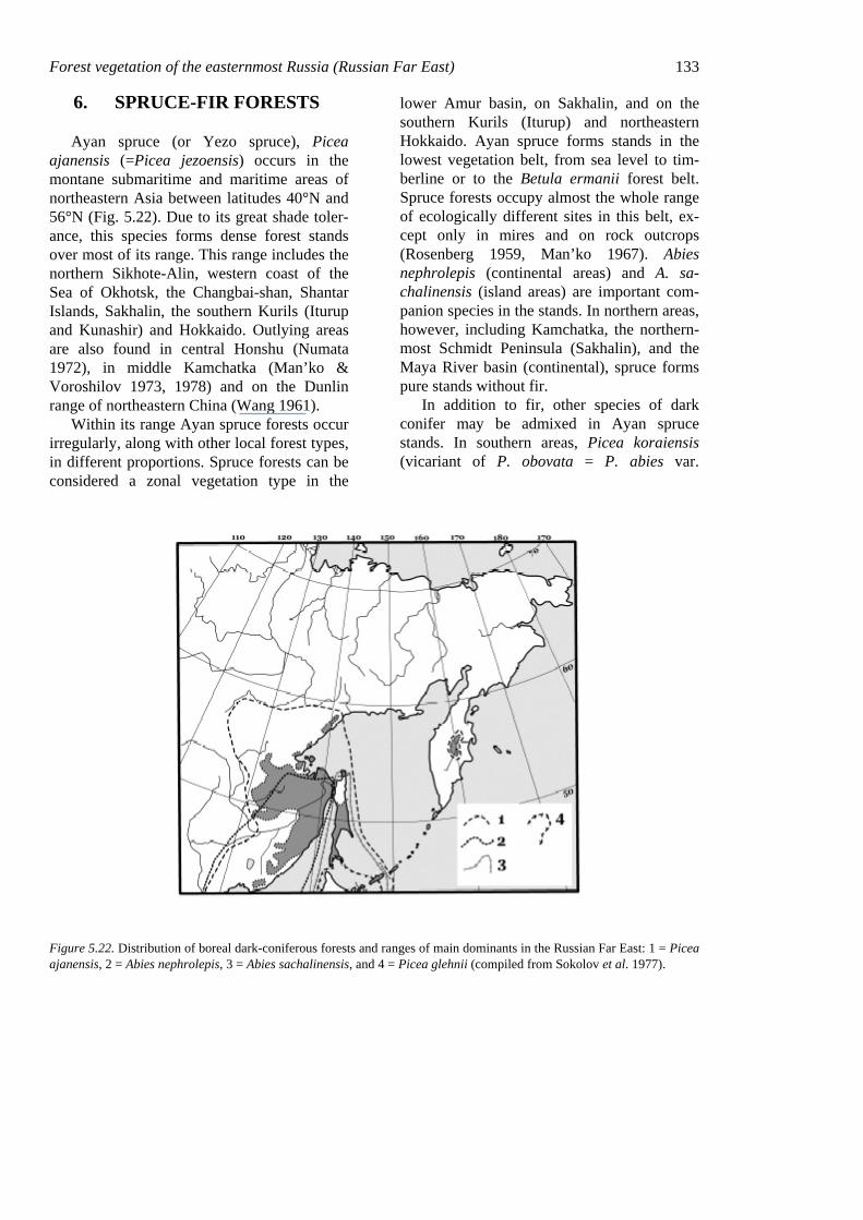
Forest vegetation of the easternmost Russia (Russian Far East) 133
6. SPRUCE-FIR FORESTS
Ayan spruce (or Yezo spruce), Picea ajanensis (=Picea jezoensis) occurs in the montane submaritime and maritime areas of northeastern Asia between latitudes 40°N and 56°N (Fig. 5.22). Due to its great shade toler-ance, this species forms dense forest stands over most of its range. This range includes the northern Sikhote-Alin, western coast of the Sea of Okhotsk, the Changbai-shan, Shantar Islands, Sakhalin, the southern Kurils (Iturup and Kunashir) and Hokkaido. Outlying areas are also found in central Honshu (Numata 1972), in middle Kamchatka (Man’ko & Voroshilov 1973, 1978) and on the Dunlin range of northeastern China (Wang 1961).
Within its range Ayan spruce forests occur irregularly, along with other local forest types, in different proportions. Spruce forests can be considered a zonal vegetation type in the
lower Amur basin, on Sakhalin, and on the southern Kurils (Iturup) and northeastern Hokkaido. Ayan spruce forms stands in the lowest vegetation belt, from sea level to tim-berline or to the Betula ermanii forest belt. Spruce forests occupy almost the whole range of ecologically different sites in this belt, ex-cept only in mires and on rock outcrops (Rosenberg 1959, Man’ko 1967). Abies nephrolepis (continental areas) and A. sa-chalinensis (island areas) are important com-panion species in the stands. In northern areas, however, including Kamchatka, the northern-most Schmidt Peninsula (Sakhalin), and the Maya River basin (continental), spruce forms pure stands without fir.
In addition to fir, other species of dark conifer may be admixed in Ayan spruce stands. In southern areas, Picea koraiensis (vicariant of P. obovata = P. abies var.
Figure 5.22. Distribution of boreal dark-coniferous forests and ranges of main dominants in the Russian Far East: 1 = Picea ajanensis, 2 = Abies nephrolepis, 3 = Abies sachalinensis, and 4 = Picea glehnii (compiled from Sokolov et al. 1977).
134 Chapter 5 obovata, Schmidt-Vogt 1974, 1977) some-times forms pure stands, usually in river val-leys or gentle lower or middle slopes (Ku-rentsova 1960, 1968). It occurs also mixed with Ayan spruce on such sites. The ranges of P. obovata and P. ajanensis overlap in the Okhotsk part of the P. ajanensis range, al-though P. obovata occasionally forms pure stands across all its range, mainly in river val-leys. P. glehnii occurs on southern Sakhalin (Tatewaki 1958, Tolmachov 1959), in the southern Kurils (Vorobiov 1963, Ishizuka 1974) and on Hokkaido (Numata 1972). Unlike P. ajanensis, the edaphic optimum of P. glehnii is on saturated sites with groundwa-ter at or above ground level at some time dur-ing the growing season. These species form mixed stands where their ranges overlap on slope–mires ecotones (Man’ko 1987). In Hok-kaido P. glehnii occupies the wide range of azonal sites, such as volcanic deposits, and forms stands near timberline (Miyawaki & Nakamura 1988).
Different aspects of Picea ajanensis and its stands in eastern Russia were thoroughly stud-ied by Tolmachov (1954, 1955, 1956), Rosenberg (1959, 1961, 1963, 1967, 1971), and Man’ko (1961, 1965, 1967, 1974, 1980, 1987). It is commonly accepted that spruce-fir forests represent the vegetation of the southern and middle boreal subzones in the submari-time and maritime sectors (Kolesnikov 1961, Hämet-Ahti et al. 1974, Grishin 1995, Krestov 2000). Spruce forests, as a zonal vegetation type, are characteristic for the western coast of the Sea of Okhotsk (extending west into the continent for about 1500 km) and for the “conifer island” of central Kamchatka. The first area is called the Western Okhotsk Area and the second the Eastern Okhotsk Area of dark conifer forests (Kolesnikov 1961).
6.1 Physiography
6.1.1 Terrain
Picea ajanensis forms mono-dominant or
fir-mixed stands from sea level to 1500–2000 m, depending on latitude. The upper limit of spruce forests exceeds 2000 m only in the Japanese Alps (Central Honshu), outside the boreal zone.
The range of Ayan spruce lies in deeply dissected montane territory. Most ranges, es-pecially those along the Sea of Okhotsk and Sea of Japan, are oriented north-south. The main ranges are the Sikhote-Alin and Dzhugdzhur on the continent, Sredinniy and Vostochniy on Kamchatka, and Vostochno-Sakhalinskiy and Zapadno-Sakhalinskiy on Sakhalin. The mountain ranges along the coast produce a sharp continentality gradient toward the continental interior, blocking the moist maritime air masses in summer but not, block-ing the very cold continental air masses in winter.
The mountain systems differ in time of origin and orogeny. The oldest part of the Ayan spruce range, the Aldan shield at the edge of the East-Siberian Platform, was formed in Pre-Cambrian time; most of the ter-ritory, however, is related to the zone of Mesozoic folded mountains. The eastern edge of the continent was formed in the Cenozoic period, by folding accompanied with intensive volcanism (Nikolskaya 1974). The youngest range, the Sikhote-Alin, was formed in the late Cretaceous.
The coastline changed shape in the differ-ent geological epochs, with several important land bridges temporarily connecting presently isolated islands. At the last glacial maximum (ca. 18,000 years ago), northern Sakhalin and the Shantar Archipelago were united with the continent (Grichuk 1984) and Hokkaido was united with southern Sakhalin. Sakhalin sepa-rated from the continent at the end of the Pleistocene. Land bridges served as important routes for species migrations that partly ex-plain the known similarity in species composi-tion of spruce forests of northern Sakhalin and the Amgu basin, or southern Sakhalin and Hokkaido. In regions of modern volcanism, on Kamchatka and the Kuril Islands, different forms of volcanic activity influenced the proc-
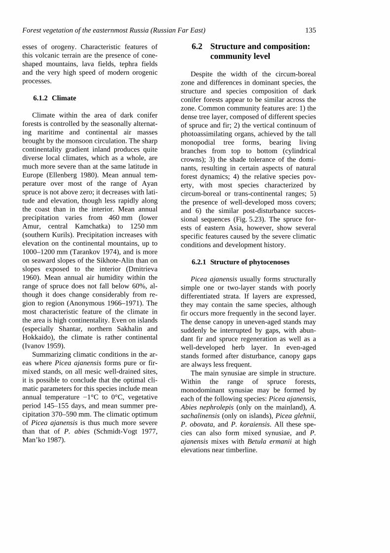
Forest vegetation of the easternmost Russia (Russian Far East) 135 esses of orogeny. Characteristic features of this volcanic terrain are the presence of cone-shaped mountains, lava fields, tephra fields and the very high speed of modern orogenic processes.
6.1.2 Climate
Climate within the area of dark conifer forests is controlled by the seasonally alternat-ing maritime and continental air masses brought by the monsoon circulation. The sharp continentality gradient inland produces quite diverse local climates, which as a whole, are much more severe than at the same latitude in Europe (Ellenberg 1980). Mean annual tem-perature over most of the range of Ayan spruce is not above zero; it decreases with lati-tude and elevation, though less rapidly along the coast than in the interior. Mean annual precipitation varies from 460 mm (lower Amur, central Kamchatka) to 1250 mm (southern Kurils). Precipitation increases with elevation on the continental mountains, up to 1000–1200 mm (Tarankov 1974), and is more on seaward slopes of the Sikhote-Alin than on slopes exposed to the interior (Dmitrieva 1960). Mean annual air humidity within the range of spruce does not fall below 60%, al-though it does change considerably from re-gion to region (Anonymous 1966–1971). The most characteristic feature of the climate in the area is high continentality. Even on islands (especially Shantar, northern Sakhalin and Hokkaido), the climate is rather continental (Ivanov 1959).
Summarizing climatic conditions in the ar-eas where Picea ajanensis forms pure or fir-mixed stands, on all mesic well-drained sites, it is possible to conclude that the optimal cli-matic parameters for this species include mean annual temperature −1°C to 0°C, vegetative period 145–155 days, and mean summer pre-cipitation 370–590 mm. The climatic optimum of Picea ajanensis is thus much more severe than that of P. abies (Schmidt-Vogt 1977, Man’ko 1987).
6.2 Structure and composition: community level
Despite the width of the circum-boreal zone and differences in dominant species, the structure and species composition of dark conifer forests appear to be similar across the zone. Common community features are: 1) the dense tree layer, composed of different species of spruce and fir; 2) the vertical continuum of photoassimilating organs, achieved by the tall monopodial tree forms, bearing living branches from top to bottom (cylindrical crowns); 3) the shade tolerance of the domi-nants, resulting in certain aspects of natural forest dynamics; 4) the relative species pov-erty, with most species characterized by circum-boreal or trans-continental ranges; 5) the presence of well-developed moss covers; and 6) the similar post-disturbance succes-sional sequences (Fig. 5.23). The spruce for-ests of eastern Asia, however, show several specific features caused by the severe climatic conditions and development history.
6.2.1 Structure of phytocenoses
Picea ajanensis usually forms structurally simple one or two-layer stands with poorly differentiated strata. If layers are expressed, they may contain the same species, although fir occurs more frequently in the second layer. The dense canopy in uneven-aged stands may suddenly be interrupted by gaps, with abun-dant fir and spruce regeneration as well as a well-developed herb layer. In even-aged stands formed after disturbance, canopy gaps are always less frequent.
The main synusiae are simple in structure. Within the range of spruce forests, monodominant synusiae may be formed by each of the following species: Picea ajanensis, Abies nephrolepis (only on the mainland), A. sachalinensis (only on islands), Picea glehnii, P. obovata, and P. koraiensis. All these spe-cies can also form mixed synusiae, and P. ajanensis mixes with Betula ermanii at high elevations near timberline.
136 Chapter 5
Figure 5.23. Profile of an Ayan spruce stand on the northern Sikhote-Alin Range (5 m x 25 m): 1 = Picea ajanensis, 2 = Acer ukurunduense (after Krylov 1984).
The shrub layer is generally sparse or poorly developed. The herb layer may be well expressed on richer, wetter sites, but its struc-ture is rather simple. The moss cover is usu-ally well developed. The undergrowth in spruce-fir forests is represented mainly by bo-real species, except near the southern border, where invasion of temperate species is signifi-cant. In maritime and suboceanic areas, spe-cies with Far Eastern distribution may aug-ment the species composition.
6.2.1.1 The upper tree layer The main species in the dark-conifer for-
ests is Picea ajanensis, forming dense cano-pies 20–25 m high with trees 50–60 cm in di-ameter. Maximum stand height varies from 30 m with 80–85 cm diameters in the north (Man’ko & Voroshilov 1971) to 37 m in the south, in the Ussuri reserve (Ya. Vasiliev 1938). Recorded maximum stand height on Kamchatka is 33.5 m with a diameter of 102 cm (Man’ko & Voroshilov 1978) and on
Sakhalin 37 m with a diameter of 164 cm (Vlasov 1959).
In different parts of the area, different broad-leaved tree species may also be found in the canopy. In the north (Kamchatka) and near upper limits in mountains, spruce may mix with Betula ermanii. In the south, nemoral broad-leaved B. costata and Fraxinus mand-shurica may form mixed stands with spruce.
On southern Sakhalin and the southern Ku-rils, the dominant layer may also be formed by Abies sachalinensis, with spruce present only as individuals. Abies nephrolepis may form pure stands on the mainland only after major disturbances remove big trees from the canopy and release the growth of understorey fir sap-lings.
Due to its high shade tolerance, spruce is less dependent on canopy gaps (Ishikawa et al. 1999). Horizontal stand structure is com-monly random, but under moisture deficit spruce may regenerate successfully on de-composing fallen logs and stumps that serve
Forest vegetation of the easternmost Russia (Russian Far East) 137 as moisture reservoirs (Tolmachov 1954, Man’ko 1967, 1987, Chumin 1965, Nechaev 1975, Mayer 1978, etc.). In this case spruce trees may form small patches within a stand.
6.2.1.2 The lower tree layer In most stands the lower tree layer contains
the same species as in the upper layers, sup-pressed or simply younger. On the most pro-ductive sites, however, where spruce reaches its maximum size, common companion spe-cies such as Abies nephrolepis or A. sachalin-ensis may form a clear lower layer. Shorter trees Sorbus amurensis and S. sibirica (conti-nental areas) as well as S. commixta (island areas) always occur individually in spruce-fir forests. In the south Acer ukurunduense may form a lower layer in mountain spruce forests.
6.2.1.3 Seral species After extensive disturbances the spruce
forest may be replaced by broad-leaved spe-cies with short lifespans, in particular Betula platyphylla and Populus tremula. In continen-tal areas extensive Larix dahurica stands re-place spruce forests after wildfires.
6.2.1.4 The shrub layer The shrub layer usually cannot develop in
dark-conifer forests due to the low light levels under the dense canopy. Rosa acicularis, R. amblyotis, Euonymus macroptera, Spiraea beauverdiana, S. betulifolia and shrubby Acer ukurunduense may form a sparse shrub layer on mesic sites. At the contact with the temper-ate zone, shade-tolerant nemoral shrubs such as Eleutherococcus senticocus, Oplopanax elatus, and Euonymus pauciflora. may occur in the spruce forests. Weigela middendorffi-ana, Rhododendron aureum, and Ledum pal-ustre form a well-expressed layer in subalpine spruce stands. On islands, Ilex rugosa, Skim-mia repens, Vaccinium axillare, and V. hirtum are significant components of the shrub layer in spruce forests. In floodplains, Swida alba, Sorbaria sorbifolia, Ribes triste and Spiraea salicifolia increase the shrub diversity. Never-
theless, all of these species form relatively dense cover only in canopy openings.
6.2.1.5 The herb layer The herb layer in the dark-conifer forests
may be composed of plants from a pool of about 250 mainly boreal vascular species. The patchy structure of the herb layer, with clearly distinguishable dominance by certain species in the synusiae, is a very characteristic feature for spruce forests.
The main synusiae occurring in the Ayan spruce forests on mesic sites are Maianthe-mum bifolium + Chamaepericlymenum cana-dense, Vaccinium vitis-idaea, Carex falcata or C. xyphium, Leptorumohra amurensis + Dryopteris expansa + Diplazium sibiricum, and Pseudocystopteris spinulosa.
6.2.1.6 The moss layer Mosses are always present in spruce phy-
tocenoses on mesic sites. On nutrient-poor sites they form a continuous cover with no vascular plants. The most common species are Hylocomium splendens, Pleurozium schreberi, Ptilium crista-castrensis, Rhytidiadelphus tri-quetrus, Polytrichum commune, and Di-cranum spp. On the richer sites mosses occur in herb-layer gaps.
6.3 Dynamics of phytocenoses
6.3.1 Natural dynamics
Fire is an important factor in the formation and dynamics of spruce forests due to the great amount of flammable material that ac-cumulates and due to the occurrence of dry periods in summer. Most research on dynam-ics considers fire or other disturbance as a ref-erence point for spruce forest development. Most spruce stands in easternmost Russia have an even-aged canopy with the age of the trees indicating the time of disturbance. Cyclic dynamics of uneven-aged spruce phyto-cenoses was also studied, however, in some continental areas and on Kamchatka (Shavnin
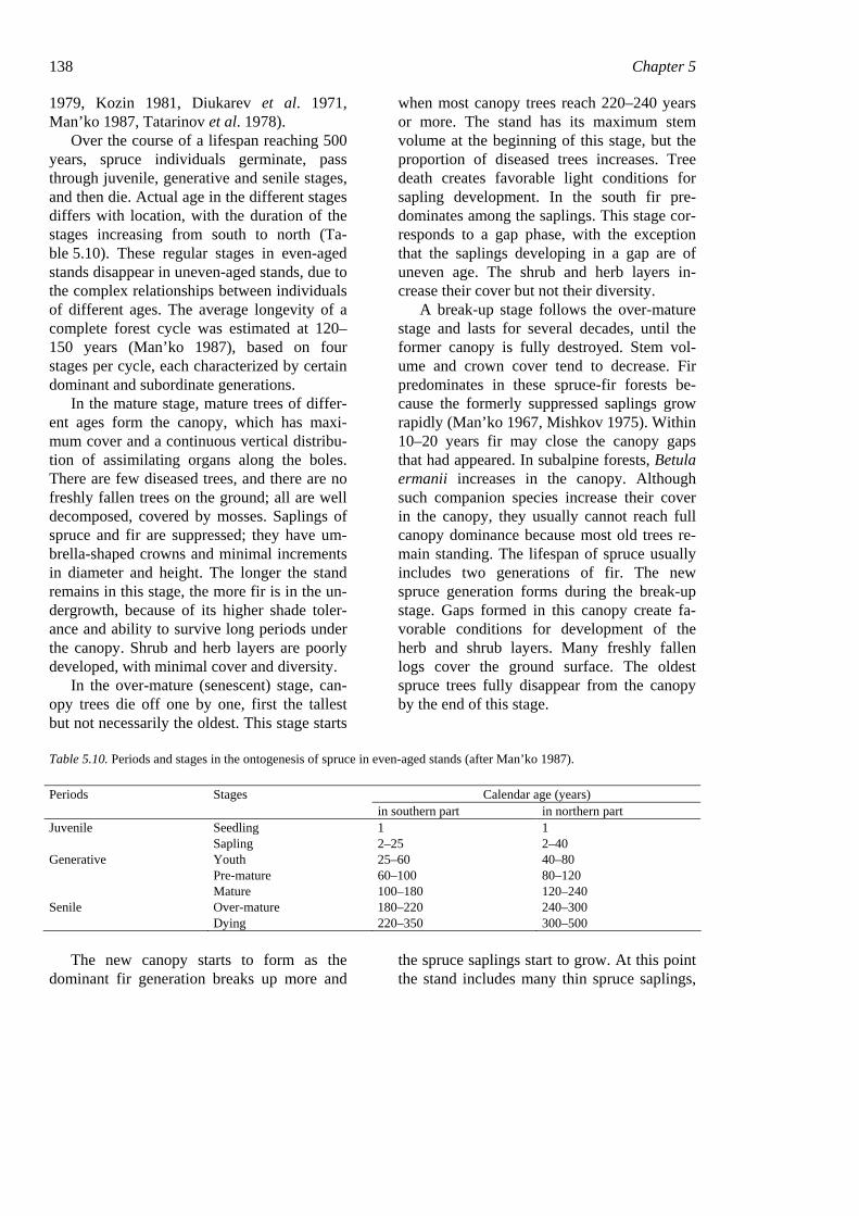
138 Chapter 5 1979, Kozin 1981, Diukarev et al. 1971, Man’ko 1987, Tatarinov et al. 1978).
Over the course of a lifespan reaching 500 years, spruce individuals germinate, pass through juvenile, generative and senile stages, and then die. Actual age in the different stages differs with location, with the duration of the stages increasing from south to north (Ta-ble 5.10). These regular stages in even-aged stands disappear in uneven-aged stands, due to the complex relationships between individuals of different ages. The average longevity of a complete forest cycle was estimated at 120–150 years (Man’ko 1987), based on four stages per cycle, each characterized by certain dominant and subordinate generations.
In the mature stage, mature trees of differ-ent ages form the canopy, which has maxi-mum cover and a continuous vertical distribu-tion of assimilating organs along the boles. There are few diseased trees, and there are no freshly fallen trees on the ground; all are well decomposed, covered by mosses. Saplings of spruce and fir are suppressed; they have um-brella-shaped crowns and minimal increments in diameter and height. The longer the stand remains in this stage, the more fir is in the un-dergrowth, because of its higher shade toler-ance and ability to survive long periods under the canopy. Shrub and herb layers are poorly developed, with minimal cover and diversity.
In the over-mature (senescent) stage, can-opy trees die off one by one, first the tallest but not necessarily the oldest. This stage starts
when most canopy trees reach 220–240 years or more. The stand has its maximum stem volume at the beginning of this stage, but the proportion of diseased trees increases. Tree death creates favorable light conditions for sapling development. In the south fir pre-dominates among the saplings. This stage cor-responds to a gap phase, with the exception that the saplings developing in a gap are of uneven age. The shrub and herb layers in-crease their cover but not their diversity.
A break-up stage follows the over-mature stage and lasts for several decades, until the former canopy is fully destroyed. Stem vol-ume and crown cover tend to decrease. Fir predominates in these spruce-fir forests be-cause the formerly suppressed saplings grow rapidly (Man’ko 1967, Mishkov 1975). Within 10–20 years fir may close the canopy gaps that had appeared. In subalpine forests, Betula ermanii increases in the canopy. Although such companion species increase their cover in the canopy, they usually cannot reach full canopy dominance because most old trees re-main standing. The lifespan of spruce usually includes two generations of fir. The new spruce generation forms during the break-up stage. Gaps formed in this canopy create fa-vorable conditions for development of the herb and shrub layers. Many freshly fallen logs cover the ground surface. The oldest spruce trees fully disappear from the canopy by the end of this stage.
Table 5.10. Periods and stages in the ontogenesis of spruce in even-aged stands (after Man’ko 1987).
Periods Stages Calendar age (years) in southern part in northern part Juvenile Seedling 1 1 Sapling 2–25 2–40 Generative Youth 25–60 40–80 Pre-mature 60–100 80–120 Mature 100–180 120–240 Senile Over-mature 180–220 240–300 Dying 220–350 300–500
The new canopy starts to form as the dominant fir generation breaks up more and
the spruce saplings start to grow. At this point the stand includes many thin spruce saplings,
Forest vegetation of the easternmost Russia (Russian Far East) 139 many fir trees of intermediate size, and a few big spruces from the previous generation. In several decades the young spruce replaces the fir canopy. Self-thinning causes an abrupt de-crease in stem number, but stem volume gradually increases. Diseased trees are few or absent. This stage has darker conditions under the canopy and minimal undergrowth devel-opment. The development of the spruce can-opy improves the light conditions, and many fir and spruce saplings appear. This stage may last up to 50–80 years, until the young spruce trees become mature.
6.3.2 Post-fire dynamics
All post-fire succession in the areas of dark-conifer forest results in the formation of spruce stands, but various factors may deflect succession from the standard sequence: sub-strate mineralization and erosion rates, cli-matic advantages for companion species or potential competitors (inhibitors), and pres-ence or absence of seed sources. The fastest regeneration of spruce forests after wildfire occurs when: 1) the soil is not eroded after fire and still contains its fine fraction, 2) seed sources are nearby, and 3) spruce seeds reach the site in the first year(s) after fire. In this case, complete regeneration requires 100–180 years, following the stages shown in Ta-ble 5.11.
Herb and shrub communities appear on the burned sites in the first year after a fire. The first plants, Chamerion angustifolium, Rubus sachalinensis and Sambucus racemosa, form a sparse cover creating favorable conditions (substrate stabilization, reduced evaporation from sunny sites) for germination and growth of tree species. In the next year or two, grasses (Calamagrostis langsdorffii) and sedges (Carex campylorhina, C. sordida) form a dense herb cover, inhibiting germination by woody species. If unfavorable weather condi-tions prevent the arrival or germination of spruce seeds in the first year (or two), the de-
velopment of a spruce stand may be delayed considerably.
In the next stage, Betula platyphylla or Larix dahurica forms a closed forest stand with spruce developing under the canopy, due to its shade tolerance. Birch and spruce then tend to grow normally until the birch reaches its age limit of 100–120 years and begins to die. Then a pure spruce or a spruce-fir stand can develop.
Thus, in the area of spruce-fir forests, stands with mainly spruce form 90–100 years after fire, or perhaps as long as 150 years after fire in Kamchatka (Man’ko & Voroshilov 1978). Recovery of spruce forest under a larch canopy takes different amounts of time in dif-ferent regions. Kozin et al. (1975), working in the middle Sikhote-Alin, found a closed spruce subcanopy under larch after 34 years; Baburin (1976) on the upper Bikin plateau after 50–60 years; and Kartashov (1984) on Sakhalin after 50 years. Glagolev (1984), however, described stands in the northern Sik-hote-Alin in which larch continued to domi-nate 200–250 years after fire, with only indi-vidual spruce trees under the canopy.
The post-fire development of spruce for-ests through the larch stage remains poorly investigated in the Russian Far East. Seral pure larch stands without spruce saplings may be formed in the first years after fire due to lack of a spruce seed source or a bad crop of seeds. Absence of spruce may often be ex-plained by arrival of spruce only after a dense grass cover had already formed. The grass cover may be transformed into a dense dwarf-shrub cover (Vaccinium vitis-idaea, Ledum palustre) peculiar to larch forests, but this also inhibits the successful establishment of viable spruce and results in long-lasting seral larch stands. The simultaneous establishment of spruce and larch saplings in most cases sup-ports the formation of a spruce subcanopy and full replacement of larch by spruce, after the larch canopy breaks up.
140 Chapter 5
Table 5.11. Post-fire dynamics of spruce-fir forests (after Man'ko 1987).
Time after fire State of main phytocenotic components 0–10 years Formation of herb-shrub community, with simultaneous arrival of birch, larch and spruce. 10–40 years Formation of young birch or larch stand, with spruce or fir under canopy. Exclusion of shade-intolerant
species from the herb and shrub layers. 40–60 years Spruce and fir form a subcanopy, gradually invading the canopy of birch or larch. Development of a
species composition characteristic for spruce forests. 60–100 years Break-up of the birch canopy; increasing canopy of role of spruce and fir. 100–180 years Further increase of spruce in the canopy, with birch disappearing from the canopy. Development of
structure and species composition typical for even-aged spruce forests. 180–220 years First post-fire spruce generation starting to die, with appearance of new generations in the canopy.
Characteristics of an uneven-aged stand appearing.
6.3.3 Spruce forest decline
Spruce-fir forests have a tendency to de-cline in the southern portion of their range on the Sikhote-Alin (Man’ko & Gladkova 2001). Several waves of decline occurred over exten-sive areas in the recent past, including the last, in 1970–1980, in the central Sikhote-Alin (Man’ko 1987, Man’ko & Gladkova 1993, 1995, Man’ko et al. 1998). Stand dieback started with the simultaneous death of several trees in 1972, not necessarily the oldest trees in the stand. After 1978 the area of dead stands increased, and the patches of dead trees merged. In 1983 the total area of dead forest was not considered a large-scale decline, but the subsequent merging of existing breakdown sites and appearance of new patches caused canopy degradation over an area of 140 km2 (Kamibayashi et al. 1994).
According to Man’ko et al. (1998), forest decline is expressed as death of canopy trees preceded by appearance of dead branches along the mid-stem and yellowing needles on the whole stem. The authors discovered that stem death tended to increase with increasing diameter and that it was mainly fir that was dying. The dead trees ranged between 100 and 160 years old, and dying stands were uneven-aged. The young sub-canopy spruce genera-tion did not suffer when the canopy trees dis-
appeared but rather tended to grow better. Spruce and fir saplings successfully regener-ated the stands with dead canopies.
Analyses and experiments carried out in dying or dead forests did not show a definite factor causing the forest decline. The authors hypothesize that drought during the growing season may play a crucial role, citing the complex mechanisms of forest response to water stress and various accompanying stresses. These include excesses of various elements (Zn, Li, Ni, Co, Pb, Ti) in the soil, fungal diseases in the dead centers, and con-sequent damage by insects (Man’ko et al. 1998, Man’ko & Gladkova 2001).
6.4 Phytocenotic diversity
Dark-conifer vegetation in the boreal zone of eastern Russia involves two basic types of spruce forest: Formation Piceeta ajanensis, widely occurring in continental as well as in-sular regions, and at high elevations in north-eastern China; and Formation Piceeta glehnii, a rare vegetation type occurring locally on the islands (southernmost Sakhalin, Iturup and Kunashir). The largest mass of Picea glehnii forest occurs on Hokkaido (Tatewaki 1943). Classification of dark-conifer forests of east-ernmost Russia is shown in Table 5.12.
Forest vegetation of the easternmost Russia (Russian Far East) 141
Table 5.12. Classification of dark-conifer forests, with indicator species, ecology, and topographical position of association groups. Abbreviations for edatopes as in table 5.7.
Grex associationum Indicator plants Edatope Topography, aspect Formatio: Piceeta ajanensis
Classus associationum: Piceeta purum Piceeta purum fruticulosa Vaccinium vitis-idaea, Diphasiastrum complanatum,
Gymnocarpium dryopteris SD, P–MN
Steep southern slopes
Piceeta purum nano-herbosa taigae
Maianthemum bifolium, M. dilatatum, Linnaea bo-realis, Chamaepericlymenum canadense
F, MN Gentle slopes at differ-ent elevations
Piceeta purum hylocomiosa Hylocomium splendens, Pleurozium schreberii, Ptil-ium crista-castrensis
SD–F, P–MN
Flats and gentle northern slopes
Piceeta purum filicosa Diplazium sibiricum M, MN Small terraces on moun-tain slopes
Piceeta purum grandiherbosa Senecio cannabifolius, Calamagrostis langsdorffii, Athyrium felix-femina
M–VM, MN–R
Moist river valleys
Piceeta purum sphagno-ledosa
Ledum palustre, Sphagnum fuscum, Polytrichum commune
VM, P–MN
Poorly drained valleys
Classus associationum: Piceeta abietosium nephrolepis Abieto-Piceeta fruticulosa Vaccinium vitis-idaea, Diphasiastrum complanatum,
Orthilia secunda SD, P–MN
Northern steep slopes
Abieto-Piceeta nanocaricosa taigae
Carex callitrichos, Pseudocystopteris spinulosa SD, MN–R
Insolated steep slopes
Nemoreto-Piceeta herbosa nemoretae
Dryopteris crassirhizoma, Aconitum umbrosum, Thalictrum tuberiferum
F–M, MN–R
Gentle (<20°) southern slopes and river valleys
Nemoreto-Piceeta filicosa Dryopteris expansa, Leptorumohra amurensis, Diplazium sibiricum, Phegopteris connectilis
F, MN–R Gentle (<20°) northern slopes
Nemoreto-Piceeta nano-herbosa taigae
Maianthemum bifolium, Chamaepericlymenum ca-nadense, Carex falcata, C. xyphium
F, MN Gentle slopes and ter-races
Abieto-Piceeta hylocomiosa Hylocomium splendens, Pleurozium schreberii, Rhytidiadelphus triquetrus, Pleurosiopsis ruthenica
SD–F, MN
Gentle and medium slopes and flats
Abieto-Piceeta oplopanaxosa elati
Oplopanax elatus, Euonymus macroptera, Carex xyphium
F–M, R Micro-terraces on moun-tain slopes
Abieto-Piceeta grandi-filicosa Cornopteris crenulatoserrulata, Koniogramme in-termedia, Athyrium filix-femina
VM, MN–R
Well-drained river val-leys
Abieto-Piceeta grandi-caricosa
Carex appendiculata, Ledum palustre, Calama-grostis langsdorffii
VM–W, MN–R
Poorly-drained valleys
Classus associationum: Piceeta abietosium sachalinensis Abieto sachalinensis-Piceeta sasosa
Sasa kurilensis, S. senanensis, Ilex rugosa, Skimmia repens
F–M, MN–R
Gentle slopes
Abieto sachalinensis-Piceeta hylocomiosa
Hylocomium splendens, Pleurozium schreberi, Pleuroziopsis ruthenica
F, P–MN Gentle northern slopes
Abieto sachalinensis-Piceeta filicosa taigae
Leptorumohra amurensis, Dryopteris expansa F–M, MN–R
Gentle concave slopes
Abieto sachalinensis-Piceeta nano-herbosa taigae
Maianthemum dilatatim, Linnaea borealis, Vaccin-ium praestans
F, MN Gentle slopes and ter-races
Abieto sachalinensis-Piceeta sphagno-ledosa
Ledum palustre, Rubus chamaemorus, Sphagnum fuscum, Vaccinium uliginosum, Carex schmidtii
VM–W, VP–MN
Poorly drained river valleys
Formatio: Piceeta glehnii Classus associationum: Piceeta glehnii laricetosium dauricae
Lariceto-Piceeta glehnii sphagno-ledosa
Ledum palustre, Sphagnum fuscum, Betula midden-dorffii, Rubus chamaemorus
W, VP–P Poorly drained valleys
Lariceto-Piceeta glehnii nano-herbosa taigae
Maianthemum dilatatum, Ilex rugosa, Sphagnum girgensohnii
M–VM, MN
Gentle slopes
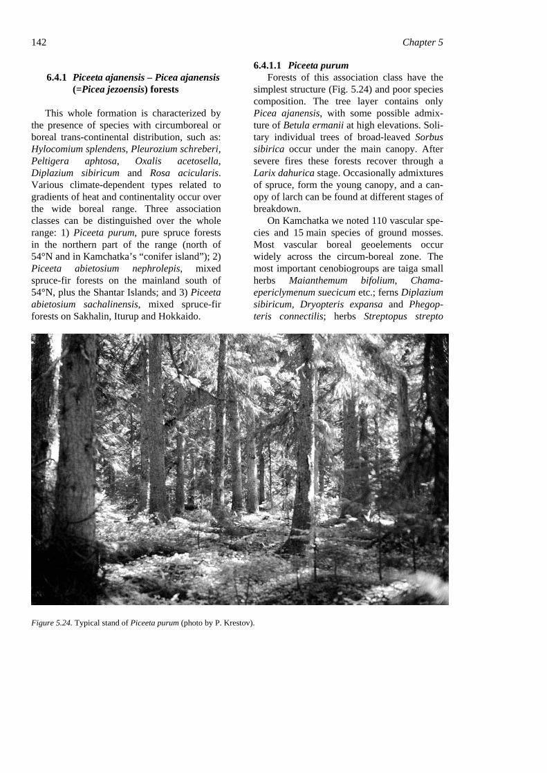
142 Chapter 5
6.4.1 Piceeta ajanensis – Picea ajanensis (=Picea jezoensis) forests
This whole formation is characterized by the presence of species with circumboreal or boreal trans-continental distribution, such as: Hylocomium splendens, Pleurozium schreberi, Peltigera aphtosa, Oxalis acetosella, Diplazium sibiricum and Rosa acicularis. Various climate-dependent types related to gradients of heat and continentality occur over the wide boreal range. Three association classes can be distinguished over the whole range: 1) Piceeta purum, pure spruce forests in the northern part of the range (north of 54°N and in Kamchatka’s “conifer island”); 2) Piceeta abietosium nephrolepis, mixed spruce-fir forests on the mainland south of 54°N, plus the Shantar Islands; and 3) Piceeta abietosium sachalinensis, mixed spruce-fir forests on Sakhalin, Iturup and Hokkaido.
6.4.1.1 Piceeta purum Forests of this association class have the
simplest structure (Fig. 5.24) and poor species composition. The tree layer contains only Picea ajanensis, with some possible admix-ture of Betula ermanii at high elevations. Soli-tary individual trees of broad-leaved Sorbus sibirica occur under the main canopy. After severe fires these forests recover through a Larix dahurica stage. Occasionally admixtures of spruce, form the young canopy, and a can-opy of larch can be found at different stages of breakdown.
On Kamchatka we noted 110 vascular spe-cies and 15 main species of ground mosses. Most vascular boreal geoelements occur widely across the circum-boreal zone. The most important cenobiogroups are taiga small herbs Maianthemum bifolium, Chama-epericlymenum suecicum etc.; ferns Diplazium sibiricum, Dryopteris expansa and Phegop-teris connectilis; herbs Streptopus strepto
Figure 5.24. Typical stand of Piceeta purum (photo by P. Krestov).

Forest vegetation of the easternmost Russia (Russian Far East) 143 poides, Saussurea oxyodonta, S. pseudotilesii (only on Kamchatka), Solidago spiraeifolia and Veratrum alpestre; the taiga dwarf-shrub Vaccinium vitis-idaea; and taiga shrubs Rosa acicularis, Juniperus sibirica, Spiraea beau-verdiana and Ribes triste.
Chamaepericlymenum suecicum and Lo-nicera chamissoi characterize this association class. Common species for Piceeta purum and Piceeta abietosium nephrolepis not present in Piceeta abietosium sachalinensis are Maian-themum bifolium and Mitella nuda.
The basic, mostly widespread zonal com-munity types in the Piceeta purum are the as-sociation groups Piceeta purum hylocomiosa occurring on middle or upper slopes and Piceeta purum nano-herbosa taigae occurring on flats and gentle slopes. Other association groups occupy a wide range of sites, with dif-ferent soil moisture and soil nutrient regimes.
Near upper belt limits in mountains, subalpine Rhododendron aureum and Sorbus sambucifo-lia may invade the spruce stands. These subalpine species, however, require extensive gaps to maintain their cenopopulations.
6.4.1.2 Piceeta abietosium nephrolepis These stands normally involve at least two
tree species, Abies nephrolepis and Picea ajanensis, forming a dense forest canopy (Fig. 5.25). Picea obovata (in the west) and Picea koraiensis (in the south) may also occa-sionally be present in the canopy. Differences in eco-biological characteristics of fir and spruce cause well-expressed cyclic dynamics of these spruce-fir forests, with dominance by different species in different stages of stand development. In addition to conifers, various broad-leaved species characterize this associa-tion class.
Figure 5.25. Typical stand of Piceeta abietosium nephrolepis (photo by P. Krestov).
The canopy of spruce-fir forests may con-tain individual trees or groups of Sorbus
amurensis or Betula ermanii (at higher eleva-tions). Acer ukurunduense occurs and occa-
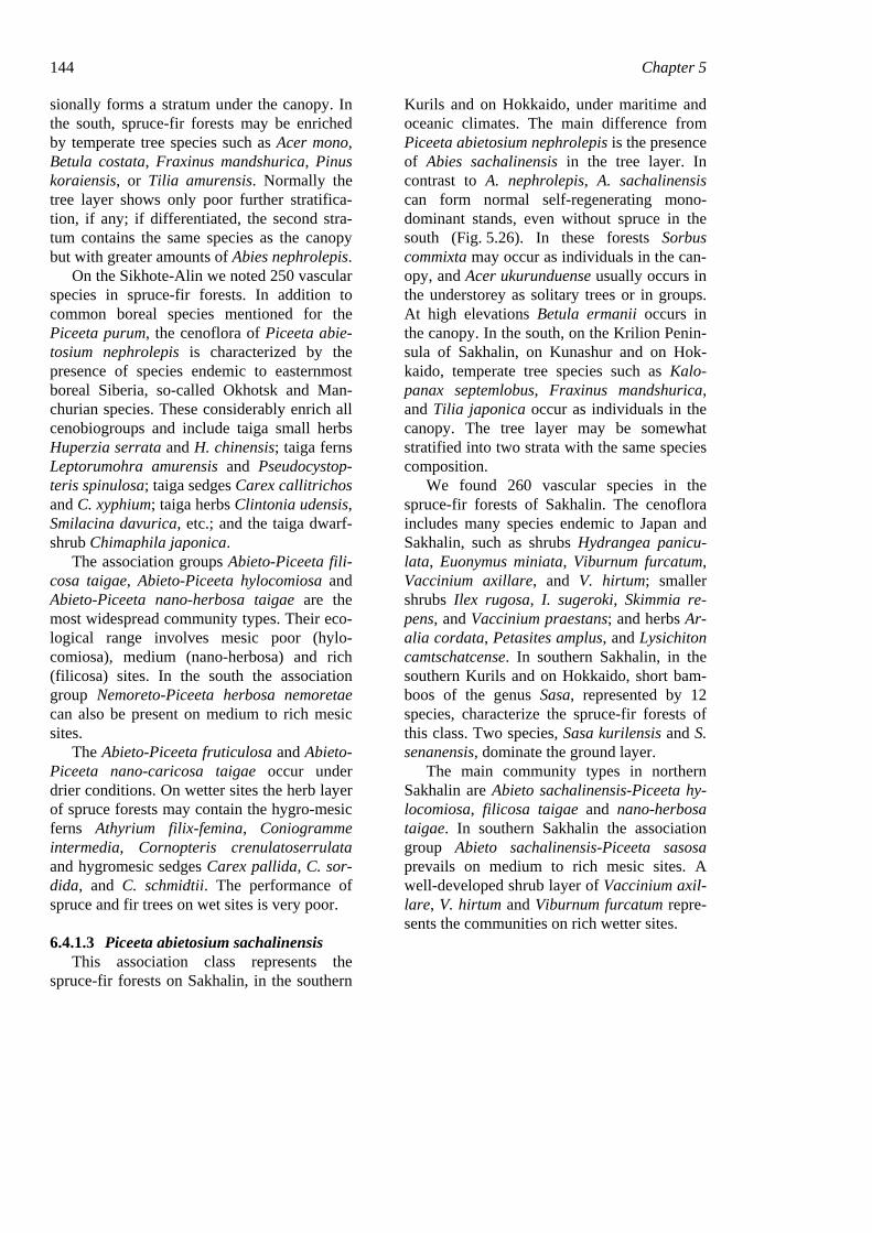
144 Chapter 5 sionally forms a stratum under the canopy. In the south, spruce-fir forests may be enriched by temperate tree species such as Acer mono, Betula costata, Fraxinus mandshurica, Pinus koraiensis, or Tilia amurensis. Normally the tree layer shows only poor further stratifica-tion, if any; if differentiated, the second stra-tum contains the same species as the canopy but with greater amounts of Abies nephrolepis.
On the Sikhote-Alin we noted 250 vascular species in spruce-fir forests. In addition to common boreal species mentioned for the Piceeta purum, the cenoflora of Piceeta abie-tosium nephrolepis is characterized by the presence of species endemic to easternmost boreal Siberia, so-called Okhotsk and Man-churian species. These considerably enrich all cenobiogroups and include taiga small herbs Huperzia serrata and H. chinensis; taiga ferns Leptorumohra amurensis and Pseudocystop-teris spinulosa; taiga sedges Carex callitrichos and C. xyphium; taiga herbs Clintonia udensis, Smilacina davurica, etc.; and the taiga dwarf-shrub Chimaphila japonica.
The association groups Abieto-Piceeta fili-cosa taigae, Abieto-Piceeta hylocomiosa and Abieto-Piceeta nano-herbosa taigae are the most widespread community types. Their eco-logical range involves mesic poor (hylo-comiosa), medium (nano-herbosa) and rich (filicosa) sites. In the south the association group Nemoreto-Piceeta herbosa nemoretae can also be present on medium to rich mesic sites.
The Abieto-Piceeta fruticulosa and Abieto-Piceeta nano-caricosa taigae occur under drier conditions. On wetter sites the herb layer of spruce forests may contain the hygro-mesic ferns Athyrium filix-femina, Coniogramme intermedia, Cornopteris crenulatoserrulata and hygromesic sedges Carex pallida, C. sor-dida, and C. schmidtii. The performance of spruce and fir trees on wet sites is very poor.
6.4.1.3 Piceeta abietosium sachalinensis This association class represents the
spruce-fir forests on Sakhalin, in the southern
Kurils and on Hokkaido, under maritime and oceanic climates. The main difference from Piceeta abietosium nephrolepis is the presence of Abies sachalinensis in the tree layer. In contrast to A. nephrolepis, A. sachalinensis can form normal self-regenerating mono-dominant stands, even without spruce in the south (Fig. 5.26). In these forests Sorbus commixta may occur as individuals in the can-opy, and Acer ukurunduense usually occurs in the understorey as solitary trees or in groups. At high elevations Betula ermanii occurs in the canopy. In the south, on the Krilion Penin-sula of Sakhalin, on Kunashur and on Hok-kaido, temperate tree species such as Kalo-panax septemlobus, Fraxinus mandshurica, and Tilia japonica occur as individuals in the canopy. The tree layer may be somewhat stratified into two strata with the same species composition.
We found 260 vascular species in the spruce-fir forests of Sakhalin. The cenoflora includes many species endemic to Japan and Sakhalin, such as shrubs Hydrangea panicu-lata, Euonymus miniata, Viburnum furcatum, Vaccinium axillare, and V. hirtum; smaller shrubs Ilex rugosa, I. sugeroki, Skimmia re-pens, and Vaccinium praestans; and herbs Ar-alia cordata, Petasites amplus, and Lysichiton camtschatcense. In southern Sakhalin, in the southern Kurils and on Hokkaido, short bam-boos of the genus Sasa, represented by 12 species, characterize the spruce-fir forests of this class. Two species, Sasa kurilensis and S. senanensis, dominate the ground layer.
The main community types in northern Sakhalin are Abieto sachalinensis-Piceeta hy-locomiosa, filicosa taigae and nano-herbosa taigae. In southern Sakhalin the association group Abieto sachalinensis-Piceeta sasosa prevails on medium to rich mesic sites. A well-developed shrub layer of Vaccinium axil-lare, V. hirtum and Viburnum furcatum repre-sents the communities on rich wetter sites.
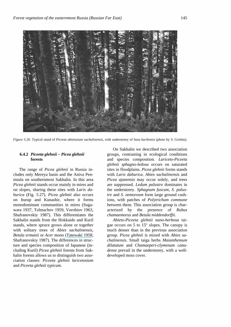
Forest vegetation of the easternmost Russia (Russian Far East) 145
Figure 5.26. Typical stand of Piceeta abietosium sachalinensis, with understorey of Sasa kurilensis (photo by S. Grishin).
6.4.2 Piceeta glehnii – Picea glehnii forests
The range of Picea glehnii in Russia in-cludes only Mereya basin and the Aniva Pen-insula on southernmost Sakhalin. In this area Picea glehnii stands occur mainly in mires and on slopes, sharing these sites with Larix da-hurica (Fig. 5.27). Picea glehnii also occurs on Iturup and Kunashir, where it forms monodominant communities in mires (Suga-wara 1937, Tolmachov 1959, Vorobiov 1963, Shafranovskiy 1987). This differentiates the Sakhalin stands from the Hokkaido and Kuril stands, where spruce grows alone or together with solitary trees of Abies sachalinensis, Betula ermanii or Acer mono (Tatewaki 1958, Shafranovskiy 1987). The differences in struc-ture and species composition of Japanese (in-cluding Kuril) Picea glehnii forests from Sak-halin forests allows us to distinguish two asso-ciation classes: Piceeta glehnii laricetosium and Piceeta glehnii typicum.
On Sakhalin we described two association groups, contrasting in ecological conditions and species composition. Lariceto-Piceeta glehnii sphagno-ledosa occurs on saturated sites in floodplains. Picea glehnii forms stands with Larix dahurica. Abies sachalinensis and Picea ajanensis may occur solely, and trees are suppressed. Ledum palustre dominates in the understorey. Sphagnum fuscum, S. palus-tre and S. nemoreum form large ground cush-ions, with patches of Polytrichum commune between them. This association group is char-acterized by the presence of Rubus chamaemorus and Betula middendorffii.
Abieto-Piceeta glehnii nano-herbosa tai-gae occurs on 5 to 15° slopes. The canopy is much denser than in the previous association group. Picea glehnii is mixed with Abies sa-chalinensis. Small taiga herbs Maianthemum dilatatum and Chamaeperi-clymenum cana-dense prevail in the understorey, with a well-developed moss cover.
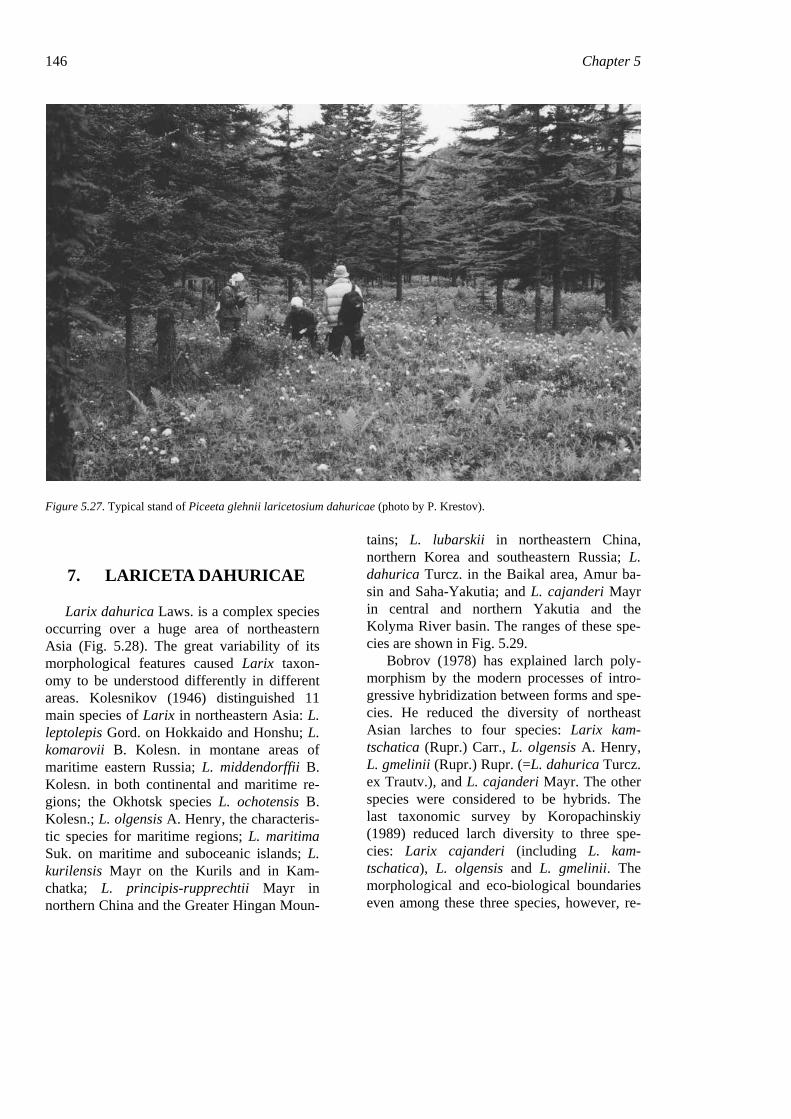
146 Chapter 5
Figure 5.27. Typical stand of Piceeta glehnii laricetosium dahuricae (photo by P. Krestov).
7. LARICETA DAHURICAE
Larix dahurica Laws. is a complex species occurring over a huge area of northeastern Asia (Fig. 5.28). The great variability of its morphological features caused Larix taxon-omy to be understood differently in different areas. Kolesnikov (1946) distinguished 11 main species of Larix in northeastern Asia: L. leptolepis Gord. on Hokkaido and Honshu; L. komarovii B. Kolesn. in montane areas of maritime eastern Russia; L. middendorffii B. Kolesn. in both continental and maritime re-gions; the Okhotsk species L. ochotensis B. Kolesn.; L. olgensis A. Henry, the characteris-tic species for maritime regions; L. maritima Suk. on maritime and suboceanic islands; L. kurilensis Mayr on the Kurils and in Kam-chatka; L. principis-rupprechtii Mayr in northern China and the Greater Hingan Moun-
tains; L. lubarskii in northeastern China, northern Korea and southeastern Russia; L. dahurica Turcz. in the Baikal area, Amur ba-sin and Saha-Yakutia; and L. cajanderi Mayr in central and northern Yakutia and the Kolyma River basin. The ranges of these spe-cies are shown in Fig. 5.29.
Bobrov (1978) has explained larch poly-morphism by the modern processes of intro-gressive hybridization between forms and spe-cies. He reduced the diversity of northeast Asian larches to four species: Larix kam-tschatica (Rupr.) Carr., L. olgensis A. Henry, L. gmelinii (Rupr.) Rupr. (=L. dahurica Turcz. ex Trautv.), and L. cajanderi Mayr. The other species were considered to be hybrids. The last taxonomic survey by Koropachinskiy (1989) reduced larch diversity to three spe-cies: Larix cajanderi (including L. kam-tschatica), L. olgensis and L. gmelinii. The morphological and eco-biological boundaries even among these three species, however, re-
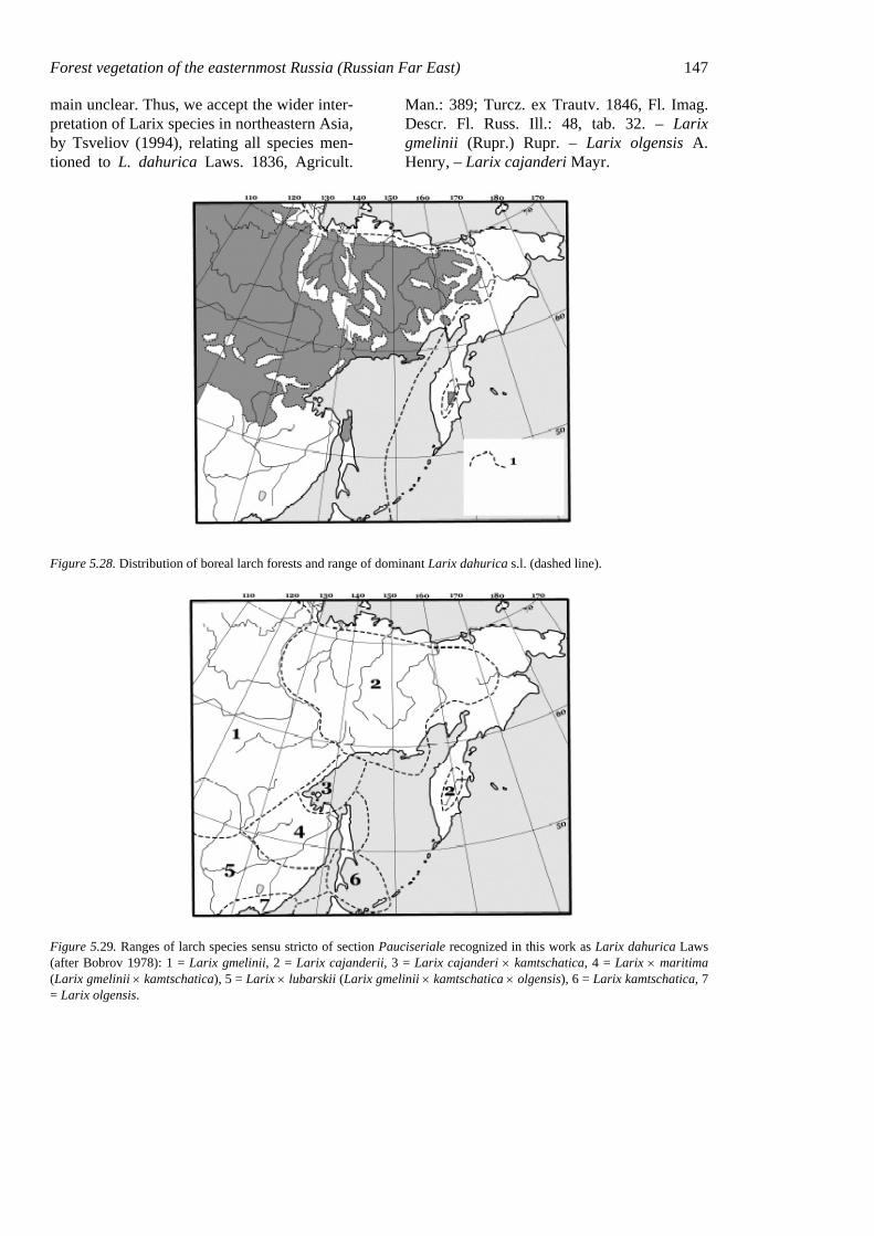
Forest vegetation of the easternmost Russia (Russian Far East) 147 main unclear. Thus, we accept the wider inter-pretation of Larix species in northeastern Asia, by Tsveliov (1994), relating all species men-tioned to L. dahurica Laws. 1836, Agricult.
Man.: 389; Turcz. ex Trautv. 1846, Fl. Imag. Descr. Fl. Russ. Ill.: 48, tab. 32. – Larix gmelinii (Rupr.) Rupr. – Larix olgensis A. Henry, – Larix cajanderi Mayr.
Figure 5.28. Distribution of boreal larch forests and range of dominant Larix dahurica s.l. (dashed line).
Figure 5.29. Ranges of larch species sensu stricto of section Pauciseriale recognized in this work as Larix dahurica Laws (after Bobrov 1978): 1 = Larix gmelinii, 2 = Larix cajanderii, 3 = Larix cajanderi × kamtschatica, 4 = Larix × maritima (Larix gmelinii × kamtschatica), 5 = Larix × lubarskii (Larix gmelinii × kamtschatica × olgensis), 6 = Larix kamtschatica, 7 = Larix olgensis.
148 Chapter 5
7.1 Physiography in the larch-forest area
7.1.1 Terrain
Larix dahurica forests occupy a large area in northeastern Asia, on sites ranging from river valleys to mountain tops. In interior northeast Asia larch forms the subarctic treeline, reach-ing 72°N latitude. In many mountain areas larch is a main or the only species forming the alpine treeline, at elevations above 1000 m even at the Arctic Circle. Terrain within the range of Larix dahurica is very diverse. Larch forms mono-dominant stands on extensive plains (East Siberian Plain, Middle Amur Lowlands) just as successfully as on massive mountain ranges (Stanovoy, Tukuringra, Kolymskiy, and Anujskiy ranges).
7.1.2 Climate
Climate in the larch-forest area is continen-tal to ultra-continental, despite proximity to the Sea of Okhotsk. The monsoon circulation, characteristic for all of easternmost Russia, determines the main climatic characteristics in the area.
The Sea of Okhotsk, covered with ice 8 months a year, strongly affects the climate in the narrow land strip (100–200 km) between the coast and the Dzhugdzhur Mountains. Winter lasts about 7 months here, from late October to late May. Strong northwest winds, bringing very cold air masses from the conti-nental interior, result in sunny winter weather with humidity not exceeding 65%, very low for a coastal area. In the north temperatures remain below −20°C from December to Feb-ruary, and in the south from January to Febru-ary. Extremes of −35 to −40°C are common along the Okhotsk coast. Because winter cy-clones have almost no affect in the area, the snow cover is much lower than in Kamchatka and the lower Amur region. It disappears in late May, and by mid-June air temperature
increases to the +5°C needed for plant activ-ity.
From May to August the weather is deter-mined by winds from the Sea of Okhotsk, where ice melts in June. Because seawater temperatures do not exceed 10–12°C, air tem-peratures remain cool all summer. Mean day-time temperatures are above 10°C only in July and August and do not reach 15°C. Summer precipitation ranges from 200 mm in the north to 600 mm in the south. Although precipita-tion amounts are low, rainy periods along the coast may be long.
Behind the Dzhugdzhur Range the climate becomes much more continental, with warmer summers and much colder winters. Winter lasts almost 8 months, from late September to the end of May. Winter temperatures are very low, with the January mean below −40°C and March mean lower than the January mean on the coast. Temperature inversions are common in all of this area, with lower air temperatures in valleys and lowlands than on slopes or in highlands. Under the anticyclonic conditions there is little snow, and the snow cover does not exceed 30 cm even in the highlands.
In the spring temperatures increase rapidly, reaching above freezing by mid-May and ex-ceeding 5°C by the end of May. Summer is short, cool and dry. The period with daytime temperatures above 10°C lasts from mid-June to mid-August. Highest temperatures are July and can reach as high as 30°C, with relative humidity not above 50%.
The range of pure larch forests coincides with the area of continetal to ultra-continental climates, with cool summers and extremely cold winters (absolute minimum of −72°C in Oymiakon). Climatic dryness in winter, the short vegetative season, and the high insola-tion in spring, when soils are still frozen, have a crucial effect on vegetation development in the areas occupied by larch forests. Permafrost is the most important factor limiting all tree species except larch. The slow thawing of the permafrost, moderate summer air temperatures and consequent low evapotranspiration rates compensate for the climatic moisture deficit,
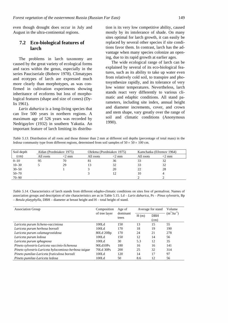
Forest vegetation of the easternmost Russia (Russian Far East) 149 even though drought does occur in July and August in the ultra-continental regions.
7.2 Eco-biological features of larch
The problems in larch taxonomy are caused by the great variety of ecological forms and races within the genus, especially in the series Pauciseriale (Bobrov 1978). Climatypes and ecotypes of larch are expressed much more clearly than morphotypes, as was con-firmed in cultivation experiments showing inheritance of ecoforms but loss of morpho-logical features (shape and size of cones) (Dy-lis 1961).
Larix dahurica is a long-living species that can live 500 years in northern regions. A maximum age of 526 years was recorded by Nedrigaylov (1932) in southern Yakutia. An important feature of larch limiting its distribu-
tion is its very low competitive ability, caused mostly by its intolerance of shade. On many sites optimal for larch growth, it can easily be replaced by several other species if site condi-tions favor them. In contrast, larch has the ad-vantage when many species colonize an open-ing, due to its rapid growth at earlier ages.
The wide ecological range of larch can be explained by several of its eco-biological fea-tures, such as its ability to take up water even from relatively cold soil, to transpire and pho-tosynthesize rapidly, and its tolerance of very low winter temperatures. Nevertheless, larch stands react very differently to various cli-matic and edaphic conditions. All stand pa-rameters, including site index, annual height and diameter increments, cover, and crown and stem shape, vary greatly over the range of soil and climatic conditions (Anonymous 1990).
Table 5.13. Distribution of all roots and those thinner than 2 mm at different soil depths (percentage of total mass) in the ledosa community type from different regions, determined from soil samples of 50 × 50 × 100 cm.
Aldan (Pozdniakov 1975) Olekma (Pozdniakov 1975) Kamchatka (Efremov 1964) Soil depth (cm) All roots <2 mm All roots <2 mm All roots <2 mm 0–10 95 70 81 36 33 32 10–30 5 29 13 32 33 32 30–50 1 3 20 22 28 50–70 3 12 10 4 70–90 2 2
Table 5.14. Characteristics of larch stands from different edapho-climatic conditions on sites free of permafrost. Names of association groups and description of site characteristics are as in Table 5.15. Ld – Larix dahurica, Ps – Pinus sylvestris, Bp – Betula platyphylla, DBH – diameter at breast height and H – total height of stand.
Average for stand Association Group Composition of tree layer
Age of dominant trees H (m) DBH
(cm)
Volume (m3.ha-1)
Lariceta purum licheno-vacciniosa 100Ld 150 13 15 55 Lariceta purum herbosa boreali 100Ld 170 18 19 190 Lariceta purum calamagrostidosa 80Ld 20Bp 170 24 21 278 Lariceta purum ledosa 100Ld 150 12 14 56 Lariceta purum sphagnosa 100Ld 30 5.3 12 35 Pineto sylvestris-Lariceta vaccinio-lichenosa 90Ld10Ps 180 16 16 141 Pineto sylvestris-Lariceta hylocomioso-herbosa taigae 70Ld 30Ps 200 25 32 314 Pineto pumilae-Lariceta fruticulosa boreali 100Ld 120 14 17 97 Pineto pumilae-Lariceta ledosa 100Ld 50 8.6 12 56
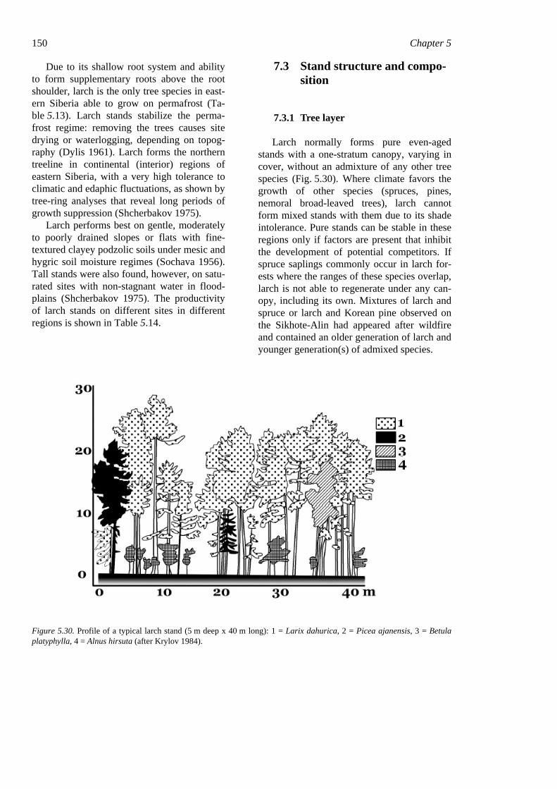
150 Chapter 5
Due to its shallow root system and ability to form supplementary roots above the root shoulder, larch is the only tree species in east-ern Siberia able to grow on permafrost (Ta-ble 5.13). Larch stands stabilize the perma-frost regime: removing the trees causes site drying or waterlogging, depending on topog-raphy (Dylis 1961). Larch forms the northern treeline in continental (interior) regions of eastern Siberia, with a very high tolerance to climatic and edaphic fluctuations, as shown by tree-ring analyses that reveal long periods of growth suppression (Shcherbakov 1975).
Larch performs best on gentle, moderately to poorly drained slopes or flats with fine-textured clayey podzolic soils under mesic and hygric soil moisture regimes (Sochava 1956). Tall stands were also found, however, on satu-rated sites with non-stagnant water in flood-plains (Shcherbakov 1975). The productivity of larch stands on different sites in different regions is shown in Table 5.14.
7.3 Stand structure and compo-sition
7.3.1 Tree layer
Larch normally forms pure even-aged stands with a one-stratum canopy, varying in cover, without an admixture of any other tree species (Fig. 5.30). Where climate favors the growth of other species (spruces, pines, nemoral broad-leaved trees), larch cannot form mixed stands with them due to its shade intolerance. Pure stands can be stable in these regions only if factors are present that inhibit the development of potential competitors. If spruce saplings commonly occur in larch for-ests where the ranges of these species overlap, larch is not able to regenerate under any can-opy, including its own. Mixtures of larch and spruce or larch and Korean pine observed on the Sikhote-Alin had appeared after wildfire and contained an older generation of larch and younger generation(s) of admixed species.
Figure 5.30. Profile of a typical larch stand (5 m deep x 40 m long): 1 = Larix dahurica, 2 = Picea ajanensis, 3 = Betula platyphylla, 4 = Alnus hirsuta (after Krylov 1984).
Forest vegetation of the easternmost Russia (Russian Far East) 151
In the western part of the Russian Far East and eastern Siberia larch forms mixed stands with Pinus sylvestris (Scots pine) on sandy soils. Both species are shade intolerant and adapted to a wide range of ecological condi-tions. Saplings of Scots pine appear to be more fire tolerant than larch saplings, and larch is replaced by pine if ground fires are frequent. In the early stages of post-fire suc-cession, however, larch always wins the com-petition with pine since it can form young stands earlier than pine.
The cover by a larch canopy is usually low, even with many stems in a stand. The canopy remains transparent for light, provid-ing good conditions for understorey develop-ment. Under favorable conditions larch may reach 30–35 m in height, but larch stands in the north are never higher than 10–12 m.
Uneven-aged stands are found on sites free from fire over long periods. Such stands may contain several even-aged generations of larch with younger generations appearing in canopy gaps. In some cases all trees in uneven-aged stands may still have the same height and di-ameter.
7.3.2 Shrub layer
Due to light availability under the larch canopy, a shrub layer is normally well devel-oped, composed of both circumboreal shrubs and shrubs restricted to the eastern part of bo-real Asia. On moist flats the shrub layer may contain Alnus fruticosa, Vaccinium uligino-sum, Betula middendorffii, Ledum palustre and L. hypoleucum (south only). In river val-leys the shrub layer includes Rosa acicularis, R. amblyotis, Sorbaria sorbifolia, Spiraea salicifolia, Ribes spp. and Lonicera spp. In highlands the main shrubs in the larch stands are Pinus pumila (in the north), Rhododendron dauricum, R. parvifolium and Ledum palustre. Some of these species may occur within the herb layer.
7.3.3 Herb layer
The herb layer usually includes many spe-cies, and the same sets of species may occur on similar sites across the whole range of larch forests. The species composition of a community depends mostly on substrate con-ditions. Low shade tolerance characterizes most species of larch forests, and many can also be found in meadow and bog communi-ties without a tree layer.
In wet lowlands Carex schmidtii, C. ap-pendiculata, C. globularis, Eriophorum vagi-natum, E. gracile, Calamagrostis langsdorffii can dominate or be main components of the herb layer. Some shrubs and dwarf-shrubs, including Ledum spp., Myrica tomentosa, Chamaedaphne calyculata, etc., may also be present in the herb layer. On well-drained sites in river valleys the mesophilous herbs may be the main component of the herb layer. On up-lands the most abundant species are Vaccin-ium vitis-idaea, Arctostaphylos uva-ursi, Soli-dago spiraeifolia, Carex vanheurckii, and Pteridium aquilinum.
The flora of the larch-forest area was formed from different cenoelements at the time of the last Pleistocene glaciation. Meadow and bog complexes, with species including Carex globularis, C. cespitosa, Chamaedaphne calyculata, Andromeda poli-folia and other ericaceous species, as well as Larix dahurica, formed in ancient Beringia from the warmer-climate pre-Pleistocene flora and subsequently adapted to the severe Pleis-tocene conditions (Vasiliev 1958).
7.3.4 Moss and lichen layer
Mosses and lichens are an important com-ponent of larch stands on certain ecotopes. Sphagnum spp. mosses occur on wet and very wet sites, Pleurozium schreberi and Hyloco-mium splendens form moss layers on moun-tain slopes, and lichens (Cladonia spp., Cladina spp. and Stereocaulon spp.) are common on slopes in earlier stages of post-fire succession.
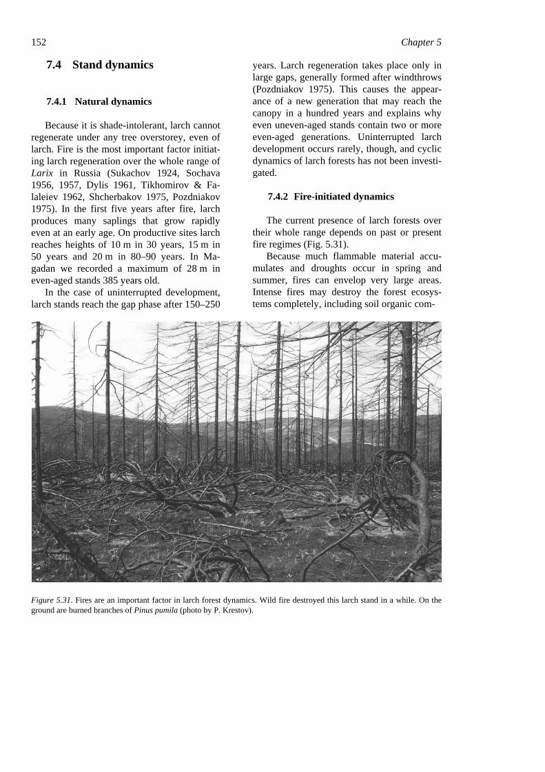
152 Chapter 5
7.4 Stand dynamics
7.4.1 Natural dynamics
Because it is shade-intolerant, larch cannot regenerate under any tree overstorey, even of larch. Fire is the most important factor initiat-ing larch regeneration over the whole range of Larix in Russia (Sukachov 1924, Sochava 1956, 1957, Dylis 1961, Tikhomirov & Fa-laleiev 1962, Shcherbakov 1975, Pozdniakov 1975). In the first five years after fire, larch produces many saplings that grow rapidly even at an early age. On productive sites larch reaches heights of 10 m in 30 years, 15 m in 50 years and 20 m in 80–90 years. In Ma-gadan we recorded a maximum of 28 m in even-aged stands 385 years old.
In the case of uninterrupted development, larch stands reach the gap phase after 150–250
years. Larch regeneration takes place only in large gaps, generally formed after windthrows (Pozdniakov 1975). This causes the appear-ance of a new generation that may reach the canopy in a hundred years and explains why even uneven-aged stands contain two or more even-aged generations. Uninterrupted larch development occurs rarely, though, and cyclic dynamics of larch forests has not been investi-gated.
7.4.2 Fire-initiated dynamics
The current presence of larch forests over their whole range depends on past or present fire regimes (Fig. 5.31).
Because much flammable material accu-mulates and droughts occur in spring and summer, fires can envelop very large areas. Intense fires may destroy the forest ecosys-tems completely, including soil organic com-
Figure 5.31. Fires are an important factor in larch forest dynamics. Wild fire destroyed this larch stand in a while. On the ground are burned branches of Pinus pumila (photo by P. Krestov).
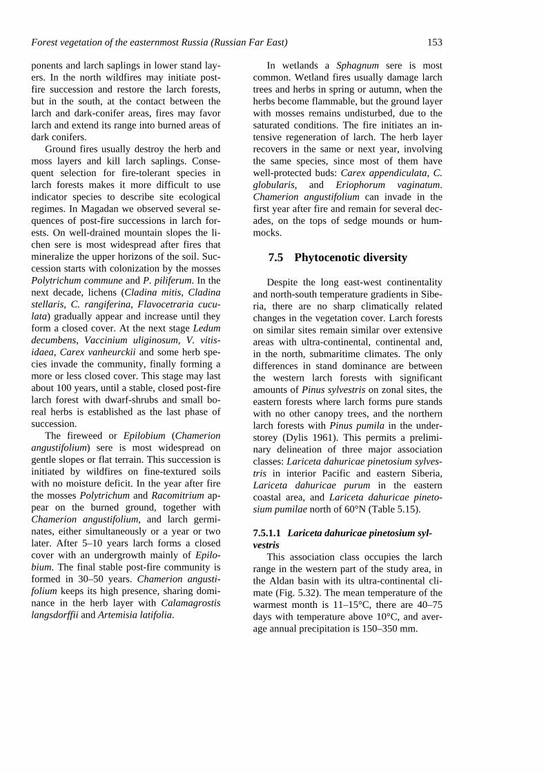
Forest vegetation of the easternmost Russia (Russian Far East) 153 ponents and larch saplings in lower stand lay-ers. In the north wildfires may initiate post-fire succession and restore the larch forests, but in the south, at the contact between the larch and dark-conifer areas, fires may favor larch and extend its range into burned areas of dark conifers.
Ground fires usually destroy the herb and moss layers and kill larch saplings. Conse-quent selection for fire-tolerant species in larch forests makes it more difficult to use indicator species to describe site ecological regimes. In Magadan we observed several se-quences of post-fire successions in larch for-ests. On well-drained mountain slopes the li-chen sere is most widespread after fires that mineralize the upper horizons of the soil. Suc-cession starts with colonization by the mosses Polytrichum commune and P. piliferum. In the next decade, lichens (Cladina mitis, Cladina stellaris, C. rangiferina, Flavocetraria cucu-lata) gradually appear and increase until they form a closed cover. At the next stage Ledum decumbens, Vaccinium uliginosum, V. vitis-idaea, Carex vanheurckii and some herb spe-cies invade the community, finally forming a more or less closed cover. This stage may last about 100 years, until a stable, closed post-fire larch forest with dwarf-shrubs and small bo-real herbs is established as the last phase of succession.
The fireweed or Epilobium (Chamerion angustifolium) sere is most widespread on gentle slopes or flat terrain. This succession is initiated by wildfires on fine-textured soils with no moisture deficit. In the year after fire the mosses Polytrichum and Racomitrium ap-pear on the burned ground, together with Chamerion angustifolium, and larch germi-nates, either simultaneously or a year or two later. After 5–10 years larch forms a closed cover with an undergrowth mainly of Epilo-bium. The final stable post-fire community is formed in 30–50 years. Chamerion angusti-folium keeps its high presence, sharing domi-nance in the herb layer with Calamagrostis langsdorffii and Artemisia latifolia.
In wetlands a Sphagnum sere is most common. Wetland fires usually damage larch trees and herbs in spring or autumn, when the herbs become flammable, but the ground layer with mosses remains undisturbed, due to the saturated conditions. The fire initiates an in-tensive regeneration of larch. The herb layer recovers in the same or next year, involving the same species, since most of them have well-protected buds: Carex appendiculata, C. globularis, and Eriophorum vaginatum. Chamerion angustifolium can invade in the first year after fire and remain for several dec-ades, on the tops of sedge mounds or hum-mocks.
7.5 Phytocenotic diversity
Despite the long east-west continentality and north-south temperature gradients in Sibe-ria, there are no sharp climatically related changes in the vegetation cover. Larch forests on similar sites remain similar over extensive areas with ultra-continental, continental and, in the north, submaritime climates. The only differences in stand dominance are between the western larch forests with significant amounts of Pinus sylvestris on zonal sites, the eastern forests where larch forms pure stands with no other canopy trees, and the northern larch forests with Pinus pumila in the under-storey (Dylis 1961). This permits a prelimi-nary delineation of three major association classes: Lariceta dahuricae pinetosium sylves-tris in interior Pacific and eastern Siberia, Lariceta dahuricae purum in the eastern coastal area, and Lariceta dahuricae pineto-sium pumilae north of 60°N (Table 5.15).
7.5.1.1 Lariceta dahuricae pinetosium syl-vestris
This association class occupies the larch range in the western part of the study area, in the Aldan basin with its ultra-continental cli-mate (Fig. 5.32). The mean temperature of the warmest month is 11–15°C, there are 40–75 days with temperature above 10°C, and aver-age annual precipitation is 150–350 mm.
154 Chapter 5
Table 5.15. Classification of larch forests, with indicator species, ecology, topographical position of association groups. Abbreviations for edatopes as in table 5.7.
Grex associationum Indicator plants Edatope Topography, aspect Formatio: Lariceta dahuricae
Classus associationum: Lariceta dahuricae pinetosium sylvestris Pineto sylvestris-Lariceta vac-cinio-lichenosa
Cladina stellaris, C. rangiferina, Vaccinium vitis-idaea, Arctostaphylos uva-ursi
D–SD, VP–P
Rocky southern slopes
Pineto sylvestris-Lariceta dryace-tosa
Dryas punctata, Arctous erythrocarpa, Toefieldia coccinea, Cotoneaster uniflorum
SD–F, P–MN
Steep northern slopes at 300–800 m
Pineto sylvestris-Lariceta her-bosa boreali
Lymnas stellerii, Equisetum scirpoides, Linnaea borealis
F–M, MN–R
Gentle southern slopes
Pineto sylvestris-Lariceta hylo-comioso-vacciniosa
Hylocomium splendens, Pleurozium schreberi, Vaccinium vitis-idaea, Carex vanheurckii
SD–F, P Gentle northern slopes at 300–700 m
Pineto sylvestris-Lariceta ledosa Vaccinium uliginosum, Carex globularis, Ledum palustre, Betula middendorffii, Aulacomnium tur-gidum
M–VM, P–MN
Moist flats and gentle slopes
Pineto sylvestris-Lariceta sphag-nosa
Sphagnum fuscum, Rubus chamaemorus, Tomen-thypnum nitens, Aulacomnium palustre
W, VP–P Poorly drained valleys with stagnant water
Classus associationum: Lariceta dahuricae purum Lariceta purum licheno-vacciniosa
Cladina rangiferina, Vaccinium vitis-idaea, Em-petrum nigrum, Ledum decumbens
SD, P–MN
Northern gentle rocky slopes
Lariceta purum herbosa boreali Fragaria orientalis, Spiraea media, Antennaria dioica, Lycopodium clavatum, Calamagrostis ne-glecta
SD, MN–R
Gentle well-drained slopes
Lariceta purum rhododendrosa Rhododendron dauricum, Cetraria islandica, Di-phasiastrum complanatum
SD, P–MN
Steep southern slopes and ridges
Lariceta purum hylocomioso-herbosa taigae
Hylocomium splendens, Pleurozium schreberii, Maianthemum bifolium
F, P–MN Gentle (<20°) northern slopes
Lariceta purum ledosa Ledum palustre, Vaccinium uliginosum, Betula middendorffii, Pleurozium schreberi
M, P–MN
Gentle slopes and terraces
Lariceta purum calamagrosti-dosa
Calamagrostis langsdorffii, Chamerion angusti-folium, Sanguisorba officinalis
M–VM, MN–R
Gentle slopes and flats
Lariceta purum caricosa appen-diculatae
Carex appendiculata, C. globularis, Myrica tomen-tosa, Chamaedaphne calyculata, Eriophorum spp.
VM–W, MN–R
Flats with moving water
Lariceta purum sphagnosa Sphagnum spp., Aulacomnium palustre, Rubus chamaemorus
W, P River valleys and flats with stagnant water
Classus associationum: Lariceta dahuricae pinetosium pumilae Lariceta pinetosium pumilae lichenosa
Cladina rangiferina, C. mitis, Flavocetraria cucu-lata, Hierochloë odorata, Carex vanheurckii
D–SD, VP–P
Gentle rocky southern slopes
Lariceta pinetosium pumilae fruticulosa boreali
Vaccinium vitis-idaea, Ledum decumbens, Em-petrum nigrum, Salix reinii, S. arctica
SD–F, P Gentle northern slopes
Lariceta pinetosium pumilae hylocomiosa
Hylocomium splendens, Pleurozium schreberi, Aconogonum tripterocarpum, Maianthemum bi-folium
F, P–MN Gentle concave slopes
Lariceta pinetosium pumilae ledosa
Ledum palustre, Vaccinium vitis-idaea, V. uligino-sum
M, P–MN
Gentle slopes and terraces
Lariceta pinetosium pumilae fruticosa boreali
Betula middendorffii, Salix saxatilis, S. krylovii, S. pulchra
VM–W, P–MN
Poorly drained river valleys
Lariceta pinetosium pumilae sphagno-caricosa boreali
Carex globularis, C. appendiculata, Sphagnum palustre, Eriophorum vaginatum
W, VP–P Poorly drained valleys with stagnant water from permafrost
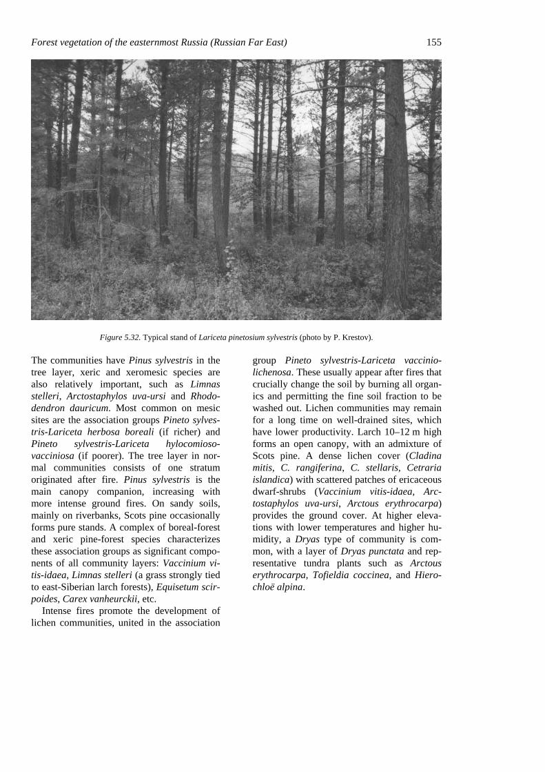
Forest vegetation of the easternmost Russia (Russian Far East) 155
Figure 5.32. Typical stand of Lariceta pinetosium sylvestris (photo by P. Krestov).
The communities have Pinus sylvestris in the tree layer, xeric and xeromesic species are also relatively important, such as Limnas stelleri, Arctostaphylos uva-ursi and Rhodo-dendron dauricum. Most common on mesic sites are the association groups Pineto sylves-tris-Lariceta herbosa boreali (if richer) and Pineto sylvestris-Lariceta hylocomioso-vacciniosa (if poorer). The tree layer in nor-mal communities consists of one stratum originated after fire. Pinus sylvestris is the main canopy companion, increasing with more intense ground fires. On sandy soils, mainly on riverbanks, Scots pine occasionally forms pure stands. A complex of boreal-forest and xeric pine-forest species characterizes these association groups as significant compo-nents of all community layers: Vaccinium vi-tis-idaea, Limnas stelleri (a grass strongly tied to east-Siberian larch forests), Equisetum scir-poides, Carex vanheurckii, etc.
Intense fires promote the development of lichen communities, united in the association
group Pineto sylvestris-Lariceta vaccinio-lichenosa. These usually appear after fires that crucially change the soil by burning all organ-ics and permitting the fine soil fraction to be washed out. Lichen communities may remain for a long time on well-drained sites, which have lower productivity. Larch 10–12 m high forms an open canopy, with an admixture of Scots pine. A dense lichen cover (Cladina mitis, C. rangiferina, C. stellaris, Cetraria islandica) with scattered patches of ericaceous dwarf-shrubs (Vaccinium vitis-idaea, Arc-tostaphylos uva-ursi, Arctous erythrocarpa) provides the ground cover. At higher eleva-tions with lower temperatures and higher hu-midity, a Dryas type of community is com-mon, with a layer of Dryas punctata and rep-resentative tundra plants such as Arctous erythrocarpa, Tofieldia coccinea, and Hiero-chloë alpina.
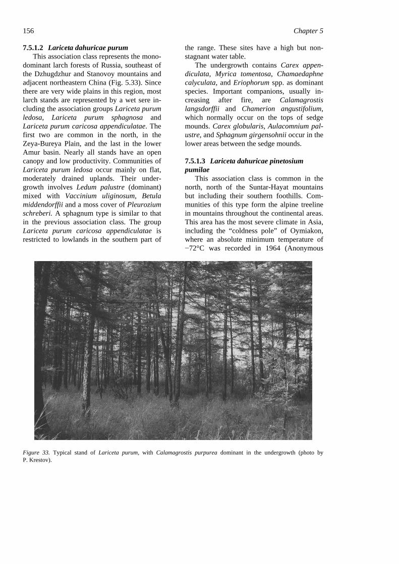
156 Chapter 5 7.5.1.2 Lariceta dahuricae purum
This association class represents the mono-dominant larch forests of Russia, southeast of the Dzhugdzhur and Stanovoy mountains and adjacent northeastern China (Fig. 5.33). Since there are very wide plains in this region, most larch stands are represented by a wet sere in-cluding the association groups Lariceta purum ledosa, Lariceta purum sphagnosa and Lariceta purum caricosa appendiculatae. The first two are common in the north, in the Zeya-Bureya Plain, and the last in the lower Amur basin. Nearly all stands have an open canopy and low productivity. Communities of Lariceta purum ledosa occur mainly on flat, moderately drained uplands. Their under-growth involves Ledum palustre (dominant) mixed with Vaccinium uliginosum, Betula middendorffii and a moss cover of Pleurozium schreberi. A sphagnum type is similar to that in the previous association class. The group Lariceta purum caricosa appendiculatae is restricted to lowlands in the southern part of
the range. These sites have a high but non-stagnant water table.
The undergrowth contains Carex appen-diculata, Myrica tomentosa, Chamaedaphne calyculata, and Eriophorum spp. as dominant species. Important companions, usually in-creasing after fire, are Calamagrostis langsdorffii and Chamerion angustifolium, which normally occur on the tops of sedge mounds. Carex globularis, Aulacomnium pal-ustre, and Sphagnum girgensohnii occur in the lower areas between the sedge mounds.
7.5.1.3 Lariceta dahuricae pinetosium pumilae
This association class is common in the north, north of the Suntar-Hayat mountains but including their southern foothills. Com-munities of this type form the alpine treeline in mountains throughout the continental areas. This area has the most severe climate in Asia, including the “coldness pole” of Oymiakon, where an absolute minimum temperature of −72°C was recorded in 1964 (Anonymous
Figure 33. Typical stand of Lariceta purum, with Calamagrostis purpurea dominant in the undergrowth (photo by P. Krestov).
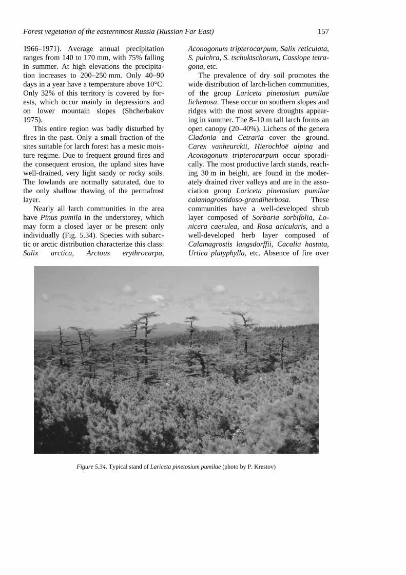
Forest vegetation of the easternmost Russia (Russian Far East) 157 1966–1971). Average annual precipitation ranges from 140 to 170 mm, with 75% falling in summer. At high elevations the precipita-tion increases to 200–250 mm. Only 40–90 days in a year have a temperature above 10°C. Only 32% of this territory is covered by for-ests, which occur mainly in depressions and on lower mountain slopes (Shcherbakov 1975).
This entire region was badly disturbed by fires in the past. Only a small fraction of the sites suitable for larch forest has a mesic mois-ture regime. Due to frequent ground fires and the consequent erosion, the upland sites have well-drained, very light sandy or rocky soils. The lowlands are normally saturated, due to the only shallow thawing of the permafrost layer.
Nearly all larch communities in the area have Pinus pumila in the understorey, which may form a closed layer or be present only individually (Fig. 5.34). Species with subarc-tic or arctic distribution characterize this class: Salix arctica, Arctous erythrocarpa,
Aconogonum tripterocarpum, Salix reticulata, S. pulchra, S. tschuktschorum, Cassiope tetra-gona, etc.
The prevalence of dry soil promotes the wide distribution of larch-lichen communities, of the group Lariceta pinetosium pumilae lichenosa. These occur on southern slopes and ridges with the most severe droughts appear-ing in summer. The 8–10 m tall larch forms an open canopy (20–40%). Lichens of the genera Cladonia and Cetraria cover the ground. Carex vanheurckii, Hierochloë alpina and Aconogonum tripterocarpum occur sporadi-cally. The most productive larch stands, reach-ing 30 m in height, are found in the moder-ately drained river valleys and are in the asso-ciation group Lariceta pinetosium pumilae calamagrostidoso-grandiherbosa. These communities have a well-developed shrub layer composed of Sorbaria sorbifolia, Lo-nicera caerulea, and Rosa acicularis, and a well-developed herb layer composed of Calamagrostis langsdorffii, Cacalia hastata, Urtica platyphylla, etc. Absence of fire over
Figure 5.34. Typical stand of Lariceta pinetosium pumilae (photo by P. Krestov)
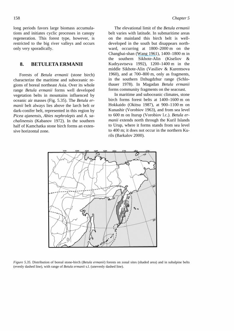
158 Chapter 5 long periods favors large biomass accumula-tions and initiates cyclic processes in canopy regeneration. This forest type, however, is restricted to the big river valleys and occurs only very sporadically.
8. BETULETA ERMANII
Forests of Betula ermanii (stone birch) characterize the maritime and suboceanic re-gions of boreal northeast Asia. Over its whole range Betula ermanii forms well developed vegetation belts in mountains influenced by oceanic air masses (Fig. 5.35). The Betula er-manii belt always lies above the larch belt or dark-conifer belt, represented in this region by Picea ajanensis, Abies nephrolepis and A. sa-chalinensis (Kabanov 1972). In the southern half of Kamchatka stone birch forms an exten-sive horizontal zone.
The elevational limit of the Betula ermanii belt varies with latitude. In submaritime areas on the mainland this birch belt is well-developed in the south but disappears north-ward, occurring at 1800–2000 m on the Changbai-shan (Wang 1961), 1400–1800 m in the southern Sikhote-Alin (Kiseliov & Kudryavtseva 1992), 1200–1400 m in the middle Sikhote-Alin (Vasiliev & Kurentsova 1960), and at 700–800 m, only as fragments, in the southern Dzhugdzhur range (Schlo-thauer 1978). In Magadan Betula ermanii forms community fragments on the seacoast.
In maritime and suboceanic climates, stone birch forms forest belts at 1400–1600 m on Hokkaido (Okitsu 1987), at 900–1100 m on Kunashir (Vorobiov 1963), and from sea level to 600 m on Iturup (Vorobiov l.c.). Betula er-manii extends north through the Kuril Islands to Urup, where it forms stands from sea level to 400 m; it does not occur in the northern Ku-rils (Barkalov 2000).
Figure 5.35. Distribution of boreal stone-birch (Betula ermanii) forests on zonal sites (shaded area) and in subalpine belts (evenly dashed line), with range of Betula ermanii s.l. (unevenly dashed line).
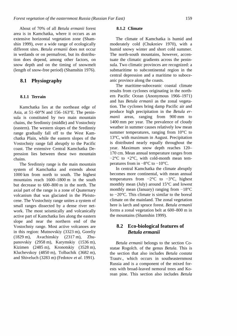
Forest vegetation of the easternmost Russia (Russian Far East) 159
About of 70% of all Betula ermanii forest area is in Kamchatka, where it occurs as an extensive horizontal vegetation zone (Sham-shin 1999), over a wide range of ecologically different sites. Betula ermanii does not occur in wetlands or on permafrost, but its distribu-tion does depend, among other factors, on snow depth and on the timing of snowmelt (length of snow-free period) (Shamshin 1976).
8.1 Physiography
8.1.1 Terrain
Kamchatka lies at the northeast edge of Asia, at 51–60°N and 156–163°E. The penin-sula is constituted by two main mountain chains, the Sredinniy (middle) and Vostochniy (eastern). The western slopes of the Sredinniy range gradually fall off to the West Kam-chatka Plain, while the eastern slopes of the Vostochniy range fall abruptly to the Pacific coast. The extensive Central Kamchatka De-pression lies between these two mountain chains.
The Sredinniy range is the main mountain system of Kamchatka and extends about 1000 km from north to south. The highest mountains reach 1600–1800 m in the south but decrease to 600–800 m in the north. The axial part of the range is a zone of Quaternary volcanism that was glaciated in the Pleisto-cene. The Vostochniy range unites a system of small ranges dissected by a dense river net-work. The most seismically and volcanically active part of Kamchatka lies along the eastern slope and near the northern end of the Vostochniy range. Most active volcanoes are in this region: Mutnovskiy (3323 m), Goreliy (1829 m), Avachinskiy (2317 m), Zhu-panovskiy (2958 m), Karymskiy (1536 m), Kizimen (2485 m), Kronotskiy (3528 m), Kluchevskoy (4850 m), Tolbachik (3682 m), and Shiveluch (3283 m) (Fedotov et al. 1991).
8.1.2 Climate
The climate of Kamchatka is humid and moderately cold (Chukreiev 1970), with a humid snowy winter and short cold summer. The north-south mountains, however, accen-tuate the climatic gradients across the penin-sula. Two climatic provinces are recognized: a submaritime to subcontinental region in the central depression and a maritime to suboce-anic province along the coasts.
The maritime-suboceanic coastal climate results from cyclones originating in the north-ern Pacific Ocean (Anonymous 1966–1971) and has Betula ermanii as the zonal vegeta-tion. The cyclones bring damp Pacific air and produce high precipitation in the Betula er-manii areas, ranging from 900 mm to 1400 mm per year. The prevalence of cloudy weather in summer causes relatively low mean summer temperatures, ranging from 10°C to 13°C, with maximum in August. Precipitation is distributed nearly equally throughout the year. Maximum snow depth reaches 120–170 cm. Mean annual temperature ranges from −2°C to +2°C, with cold-month mean tem-peratures from in −8°C to −10°C.
In central Kamchatka the climate abruptly becomes more continental, with mean annual temperatures from −2°C to −3°C, highest monthly mean (July) around 15°C and lowest monthly mean (January) ranging from −18°C to −20°C. This climate is similar to the boreal climate on the mainland. The zonal vegetation here is larch and spruce forest. Betula ermanii forms a zonal vegetation belt at 600–800 m in the mountains (Shamshin 1999).
8.2 Eco-biological features of Betula ermanii
Betula ermanii belongs to the section Co-statae Rogolch. of the genus Betula. This is the section that also includes Betula costata Trautv., which occurs in southeasternmost Russia and is a component of the mixed for-ests with broad-leaved nemoral trees and Ko-rean pine. This section also includes Betula
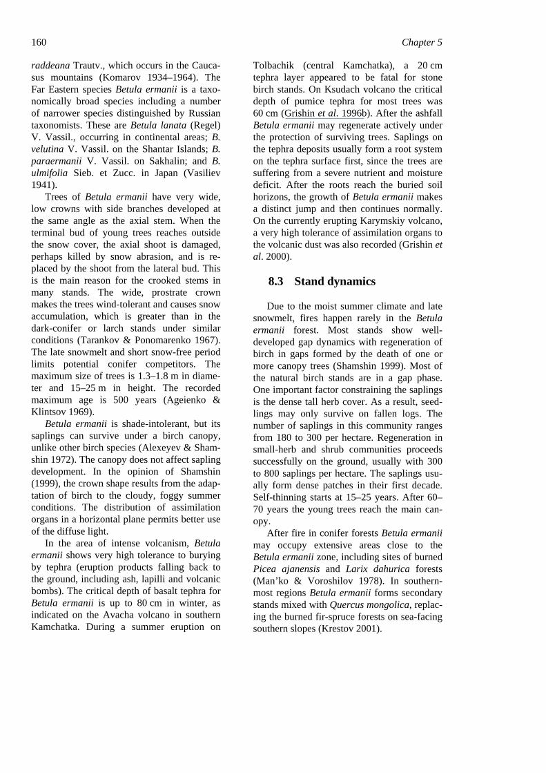
160 Chapter 5 raddeana Trautv., which occurs in the Cauca-sus mountains (Komarov 1934–1964). The Far Eastern species Betula ermanii is a taxo-nomically broad species including a number of narrower species distinguished by Russian taxonomists. These are Betula lanata (Regel) V. Vassil., occurring in continental areas; B. velutina V. Vassil. on the Shantar Islands; B. paraermanii V. Vassil. on Sakhalin; and B. ulmifolia Sieb. et Zucc. in Japan (Vasiliev 1941).
Trees of Betula ermanii have very wide, low crowns with side branches developed at the same angle as the axial stem. When the terminal bud of young trees reaches outside the snow cover, the axial shoot is damaged, perhaps killed by snow abrasion, and is re-placed by the shoot from the lateral bud. This is the main reason for the crooked stems in many stands. The wide, prostrate crown makes the trees wind-tolerant and causes snow accumulation, which is greater than in the dark-conifer or larch stands under similar conditions (Tarankov & Ponomarenko 1967). The late snowmelt and short snow-free period limits potential conifer competitors. The maximum size of trees is 1.3–1.8 m in diame-ter and 15–25 m in height. The recorded maximum age is 500 years (Ageienko & Klintsov 1969).
Betula ermanii is shade-intolerant, but its saplings can survive under a birch canopy, unlike other birch species (Alexeyev & Sham-shin 1972). The canopy does not affect sapling development. In the opinion of Shamshin (1999), the crown shape results from the adap-tation of birch to the cloudy, foggy summer conditions. The distribution of assimilation organs in a horizontal plane permits better use of the diffuse light.
In the area of intense volcanism, Betula ermanii shows very high tolerance to burying by tephra (eruption products falling back to the ground, including ash, lapilli and volcanic bombs). The critical depth of basalt tephra for Betula ermanii is up to 80 cm in winter, as indicated on the Avacha volcano in southern Kamchatka. During a summer eruption on
Tolbachik (central Kamchatka), a 20 cm tephra layer appeared to be fatal for stone birch stands. On Ksudach volcano the critical depth of pumice tephra for most trees was 60 cm (Grishin et al. 1996b). After the ashfall Betula ermanii may regenerate actively under the protection of surviving trees. Saplings on the tephra deposits usually form a root system on the tephra surface first, since the trees are suffering from a severe nutrient and moisture deficit. After the roots reach the buried soil horizons, the growth of Betula ermanii makes a distinct jump and then continues normally. On the currently erupting Karymskiy volcano, a very high tolerance of assimilation organs to the volcanic dust was also recorded (Grishin et al. 2000).
8.3 Stand dynamics
Due to the moist summer climate and late snowmelt, fires happen rarely in the Betula ermanii forest. Most stands show well-developed gap dynamics with regeneration of birch in gaps formed by the death of one or more canopy trees (Shamshin 1999). Most of the natural birch stands are in a gap phase. One important factor constraining the saplings is the dense tall herb cover. As a result, seed-lings may only survive on fallen logs. The number of saplings in this community ranges from 180 to 300 per hectare. Regeneration in small-herb and shrub communities proceeds successfully on the ground, usually with 300 to 800 saplings per hectare. The saplings usu-ally form dense patches in their first decade. Self-thinning starts at 15–25 years. After 60–70 years the young trees reach the main can-opy.
After fire in conifer forests Betula ermanii may occupy extensive areas close to the Betula ermanii zone, including sites of burned Picea ajanensis and Larix dahurica forests (Man’ko & Voroshilov 1978). In southern-most regions Betula ermanii forms secondary stands mixed with Quercus mongolica, replac-ing the burned fir-spruce forests on sea-facing southern slopes (Krestov 2001).
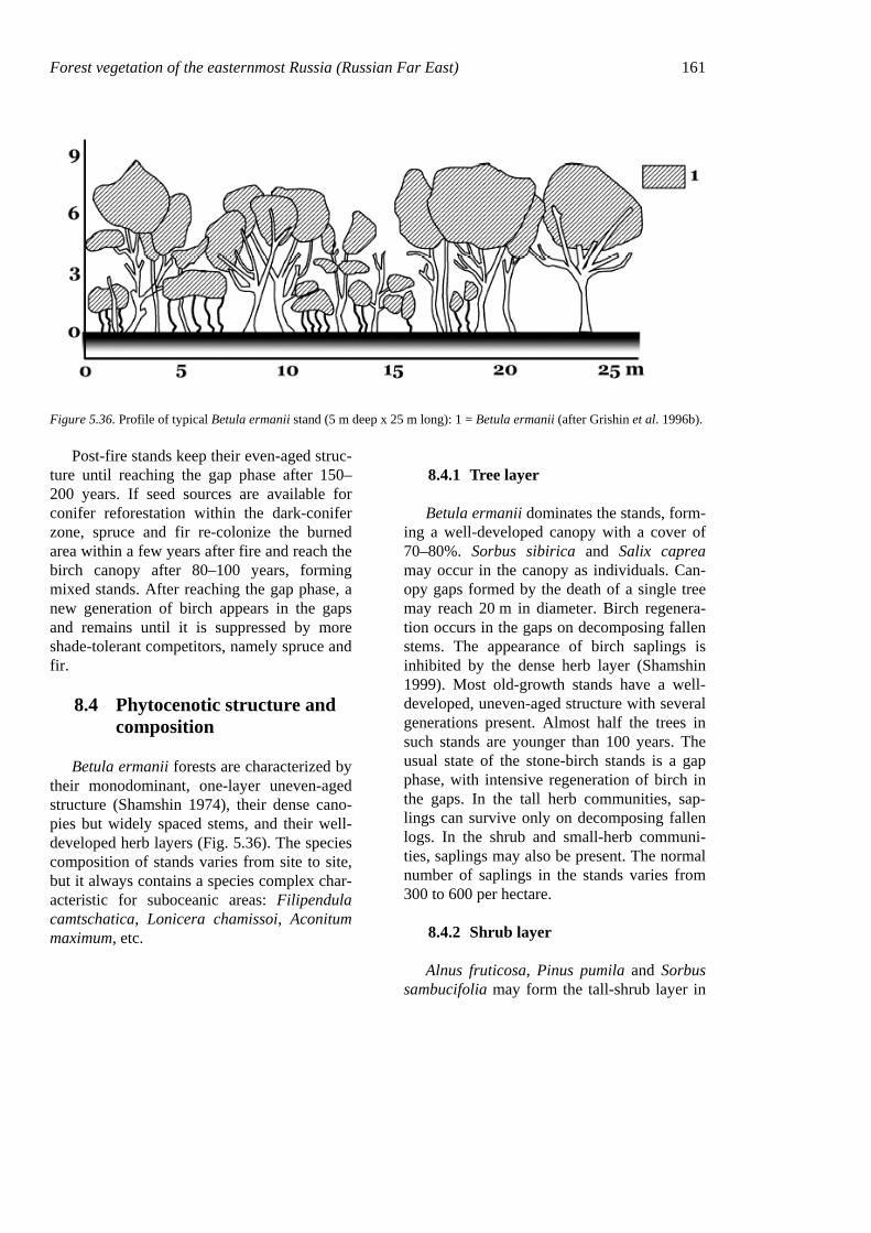
Forest vegetation of the easternmost Russia (Russian Far East) 161
Figure 5.36. Profile of typical Betula ermanii stand (5 m deep x 25 m long): 1 = Betula ermanii (after Grishin et al. 1996b).
Post-fire stands keep their even-aged struc-ture until reaching the gap phase after 150–200 years. If seed sources are available for conifer reforestation within the dark-conifer zone, spruce and fir re-colonize the burned area within a few years after fire and reach the birch canopy after 80–100 years, forming mixed stands. After reaching the gap phase, a new generation of birch appears in the gaps and remains until it is suppressed by more shade-tolerant competitors, namely spruce and fir.
8.4 Phytocenotic structure and composition
Betula ermanii forests are characterized by their monodominant, one-layer uneven-aged structure (Shamshin 1974), their dense cano-pies but widely spaced stems, and their well-developed herb layers (Fig. 5.36). The species composition of stands varies from site to site, but it always contains a species complex char-acteristic for suboceanic areas: Filipendula camtschatica, Lonicera chamissoi, Aconitum maximum, etc.
8.4.1 Tree layer
Betula ermanii dominates the stands, form-ing a well-developed canopy with a cover of 70–80%. Sorbus sibirica and Salix caprea may occur in the canopy as individuals. Can-opy gaps formed by the death of a single tree may reach 20 m in diameter. Birch regenera-tion occurs in the gaps on decomposing fallen stems. The appearance of birch saplings is inhibited by the dense herb layer (Shamshin 1999). Most old-growth stands have a well-developed, uneven-aged structure with several generations present. Almost half the trees in such stands are younger than 100 years. The usual state of the stone-birch stands is a gap phase, with intensive regeneration of birch in the gaps. In the tall herb communities, sap-lings can survive only on decomposing fallen logs. In the shrub and small-herb communi-ties, saplings may also be present. The normal number of saplings in the stands varies from 300 to 600 per hectare.
8.4.2 Shrub layer
Alnus fruticosa, Pinus pumila and Sorbus sambucifolia may form the tall-shrub layer in
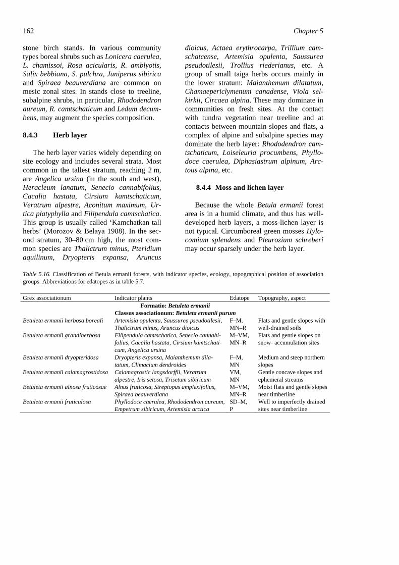
162 Chapter 5 stone birch stands. In various community types boreal shrubs such as Lonicera caerulea, L. chamissoi, Rosa acicularis, R. amblyotis, Salix bebbiana, S. pulchra, Juniperus sibirica and Spiraea beauverdiana are common on mesic zonal sites. In stands close to treeline, subalpine shrubs, in particular, Rhododendron aureum, R. camtschaticum and Ledum decum-bens, may augment the species composition.
8.4.3 Herb layer
The herb layer varies widely depending on site ecology and includes several strata. Most common in the tallest stratum, reaching 2 m, are Angelica ursina (in the south and west), Heracleum lanatum, Senecio cannabifolius, Cacalia hastata, Cirsium kamtschaticum, Veratrum alpestre, Aconitum maximum, Ur-tica platyphylla and Filipendula camtschatica. This group is usually called ‘Kamchatkan tall herbs’ (Morozov & Belaya 1988). In the sec-ond stratum, 30–80 cm high, the most com-mon species are Thalictrum minus, Pteridium aquilinum, Dryopteris expansa, Aruncus
dioicus, Actaea erythrocarpa, Trillium cam-schatcense, Artemisia opulenta, Saussurea pseudotilesii, Trollius riederianus, etc. A group of small taiga herbs occurs mainly in the lower stratum: Maianthemum dilatatum, Chamaepericlymenum canadense, Viola sel-kirkii, Circaea alpina. These may dominate in communities on fresh sites. At the contact with tundra vegetation near treeline and at contacts between mountain slopes and flats, a complex of alpine and subalpine species may dominate the herb layer: Rhododendron cam-tschaticum, Loiseleuria procumbens, Phyllo-doce caerulea, Diphasiastrum alpinum, Arc-tous alpina, etc.
8.4.4 Moss and lichen layer
Because the whole Betula ermanii forest area is in a humid climate, and thus has well-developed herb layers, a moss-lichen layer is not typical. Circumboreal green mosses Hylo-comium splendens and Pleurozium schreberi may occur sparsely under the herb layer.
Table 5.16. Classification of Betula ermanii forests, with indicator species, ecology, topographical position of association groups. Abbreviations for edatopes as in table 5.7.
Grex associationum Indicator plants Edatope Topography, aspect Formatio: Betuleta ermanii
Classus associationum: Betuleta ermanii purum Betuleta ermanii herbosa boreali Artemisia opulenta, Saussurea pseudotilesii,
Thalictrum minus, Aruncus dioicus F–M, MN–R
Flats and gentle slopes with well-drained soils
Betuleta ermanii grandiherbosa Filipendula camtschatica, Senecio cannabi-folius, Cacalia hastata, Cirsium kamtschati-cum, Angelica ursina
M–VM, MN–R
Flats and gentle slopes on snow- accumulation sites
Betuleta ermanii dryopteridosa Dryopteris expansa, Maianthemum dila-tatum, Climacium dendroides
F–M, MN
Medium and steep northern slopes
Betuleta ermanii calamagrostidosa Calamagrostic langsdorffii, Veratrum alpestre, Iris setosa, Trisetum sibiricum
VM, MN
Gentle concave slopes and ephemeral streams
Betuleta ermanii alnosa fruticosae Alnus fruticosa, Streptopus amplexifolius, Spiraea beauverdiana
M–VM, MN–R
Moist flats and gentle slopes near timberline
Betuleta ermanii fruticulosa Phyllodoce caerulea, Rhododendron aureum, Empetrum sibiricum, Artemisia arctica
SD–M, P
Well to imperfectly drained sites near timberline
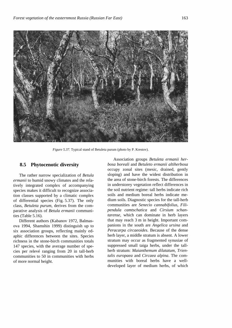
Forest vegetation of the easternmost Russia (Russian Far East) 163
Figure 5.37. Typical stand of Betuleta purum (photo by P. Krestov).
8.5 Phytocenotic diversity
The rather narrow specialization of Betula ermanii to humid snowy climates and the rela-tively integrated complex of accompanying species makes it difficult to recognize associa-tion classes supported by a climatic complex of differential species (Fig. 5.37). The only class, Betuleta purum, derives from the com-parative analysis of Betula ermanii communi-ties (Table 5.16).
Different authors (Kabanov 1972, Balmas-ova 1994, Shamshin 1999) distinguish up to six association groups, reflecting mainly ed-aphic differences between the sites. Species richness in the stone-birch communities totals 147 species, with the average number of spe-cies per relevé ranging from 20 in tall-herb communities to 50 in communities with herbs of more normal height.
Association groups Betuleta ermanii her-bosa boreali and Betuleto ermanii altiherbosa occupy zonal sites (mesic, drained, gently sloping) and have the widest distribution in the area of stone-birch forests. The differences in understorey vegetation reflect differences in the soil nutrient regime: tall herbs indicate rich soils and medium boreal herbs indicate me-dium soils. Diagnostic species for the tall-herb communities are Senecio cannabifolius, Fili-pendula camtschatica and Cirsium schan-tarense, which can dominate in herb layers that may reach 3 m in height. Important com-panions in the south are Angelica ursina and Peracarpa circaeoides. Because of the dense herb layer, a middle stratum is absent. A lower stratum may occur as fragmented synusiae of suppressed small taiga herbs, under the tall-herb stratum: Maianthemum dilatatum, Trien-talis europaea and Circaea alpina. The com-munities with boreal herbs have a well-developed layer of medium herbs, of which

164 Chapter 5 diagnostic species are: Artemisia opulenta, Geranium erianthum, Saussurea pseudotilesii, Solidago spiraeifolia, Thalictrum minus and Moehringia lateriflora (in lower stratum). The lower stratum is well developed, with the prevalence of Maianthemum dilatatum, Lyco-podium clavatum, Chamaepericlymenum ca-nadense, Rubus arcticus, etc.
9. PINETA PUMILAE
The Siberian dwarf-pine, Pinus pumila, is one of the most unusual and interesting woody species in its appearance and adaptations. It occurs widely in northeastern Asia, in Ma-gadan (Kolyma basin, upper Anadyr basin), the Koryakia region, and northern Kamchatka (Tikhomirov 1949, Sochava & Lukitchova 1953, Grosset 1959). As a vertical vegetation belt, dwarf-pine also occurs over all of boreal and north-temperate eastern Asia, including Hokkaido (Kojima 1979, Okitsu & Ito 1984, 1989), eastern Siberia (Molozhnikov 1976, Tiulina 1976), central and southern Kam-chatka (Neshataev & Neshataeva 1985, Neshataeva 1994, Khomentovskiy 1995, Grishin 1996) and the southern half of Pacific Russia (Grishin et al. 1996a, Krestov 1999). Pinus pumila communities form a horizontal vegetation zone across submaritime, maritime and suboceanic sectors of the subarctic zone, named by Kolesnikov (1961, 1963) the Berin-gian woodlands (Fig. 5.38). Alnus fruticosa thickets increase in this zone towards the Pa-cific Ocean and appear to be the dominant vegetation type on zonal sites in the northern Kurils. Meanwhile, dwarf-pine stands occur on well-drained substrates, such as coastal sand dunes, mountain ridges, old lava flows and tephra deposits (Grishin 2000).
Pinus pumila belongs to the section Cem-brae of the genus Pinus, together with P. albi-caulis, P. sibirica and P. koraiensis. Morpho-logically P. pumila is close to P. sibirica ex-cept that it never forms straight vertical stems;
eco-biologically it appears to be somewhat similar to the western North American species P. albicaulis (Khomentovskiy 1995). A closely related species, P. parviflora Sieb. et Zucc., occurs in Japan and was described by Regel.
From a total area of 35 million hectares occupied by Pinus pumila communities, 25 million hectares represent its horizontal zone, stretching from the Kolyma River to Koryakia and northern Kamchatka (Krylov et al. 1983), roughly between latitude 60 and 68°N.
9.1 Physiography
9.1.1 Terrain
The area where Pinus pumila forms monodominant communities on zonal sites stretches approximately from 60°N to 67°N, within the intensively dissected mountainous terrain of northeasternmost Asia that includes Magadan, Koryakia and Kamchatka. The ba-sic mountain systems in the continental areas are the Koryakia Uplands, the Anadyr and Aniuy ranges, the Yukagir Uplands, and the Okhotsk-Kolyma Uplands. Mountains in more coastal areas include the foothills of the north-ern Sredinniy and Vostochniy ranges in Kam-chatka, with elevations up to 4850 m (Klu-chevskoy volcano). The Koryakia Uplands are separated from the Magadan mountains by the extensive Penzhina lowlands, stretching over several hundred kilometers along the Penzhina River. On Kamchatka Pinus pumila occupies the lower montane belt in the north, most of the volcanic mountains along the Pacific coast, and Cape Lopatka at the southern tip. In the rest of its range, P. pumila thickets form a well-developed vertical belt above treeline, at elevations from 1600 m in the south (Sikhote-Alin) to 400–500 in the north.
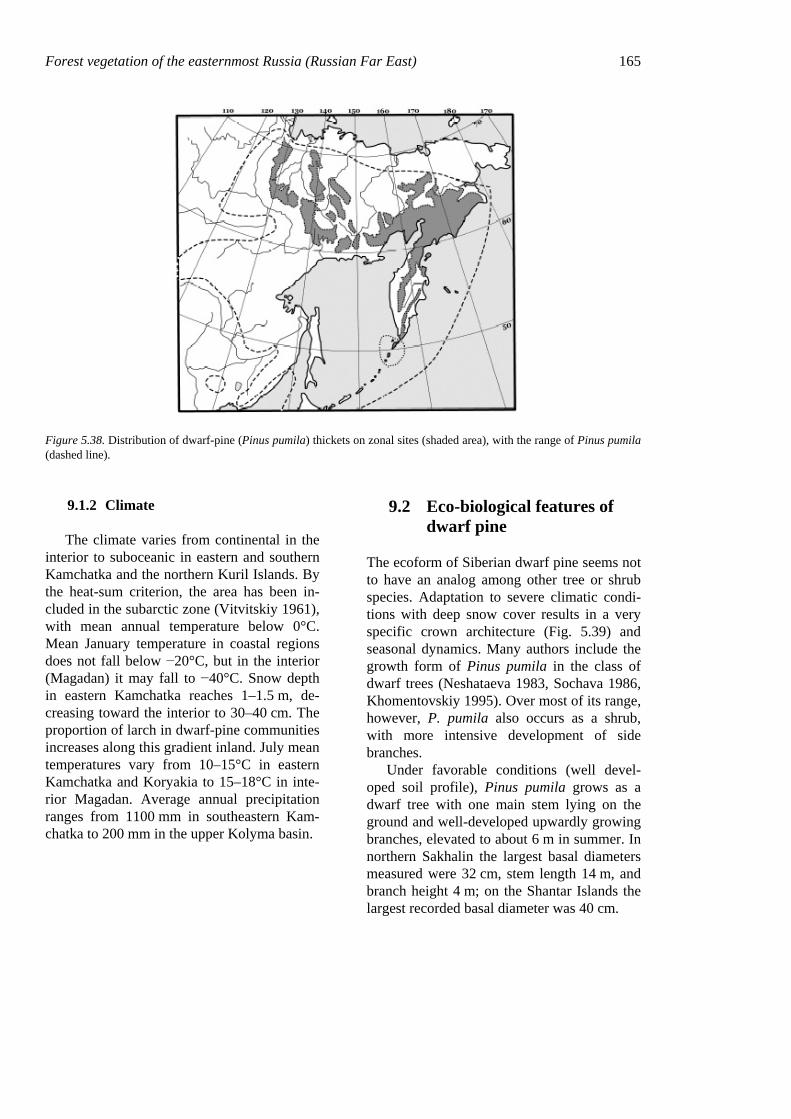
Forest vegetation of the easternmost Russia (Russian Far East) 165
Figure 5.38. Distribution of dwarf-pine (Pinus pumila) thickets on zonal sites (shaded area), with the range of Pinus pumila (dashed line).
9.1.2 Climate
The climate varies from continental in the interior to suboceanic in eastern and southern Kamchatka and the northern Kuril Islands. By the heat-sum criterion, the area has been in-cluded in the subarctic zone (Vitvitskiy 1961), with mean annual temperature below 0°C. Mean January temperature in coastal regions does not fall below −20°C, but in the interior (Magadan) it may fall to −40°C. Snow depth in eastern Kamchatka reaches 1–1.5 m, de-creasing toward the interior to 30–40 cm. The proportion of larch in dwarf-pine communities increases along this gradient inland. July mean temperatures vary from 10–15°C in eastern Kamchatka and Koryakia to 15–18°C in inte-rior Magadan. Average annual precipitation ranges from 1100 mm in southeastern Kam-chatka to 200 mm in the upper Kolyma basin.
9.2 Eco-biological features of dwarf pine
The ecoform of Siberian dwarf pine seems not to have an analog among other tree or shrub species. Adaptation to severe climatic condi-tions with deep snow cover results in a very specific crown architecture (Fig. 5.39) and seasonal dynamics. Many authors include the growth form of Pinus pumila in the class of dwarf trees (Neshataeva 1983, Sochava 1986, Khomentovskiy 1995). Over most of its range, however, P. pumila also occurs as a shrub, with more intensive development of side branches.
Under favorable conditions (well devel-oped soil profile), Pinus pumila grows as a dwarf tree with one main stem lying on the ground and well-developed upwardly growing branches, elevated to about 6 m in summer. In northern Sakhalin the largest basal diameters measured were 32 cm, stem length 14 m, and branch height 4 m; on the Shantar Islands the largest recorded basal diameter was 40 cm.
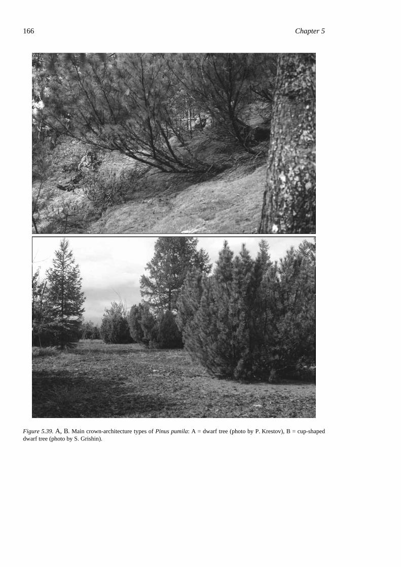
166 Chapter 5
Figure 5.39. A, B. Main crown-architecture types of Pinus pumila: A = dwarf tree (photo by P. Krestov), B = cup-shaped dwarf tree (photo by S. Grishin).
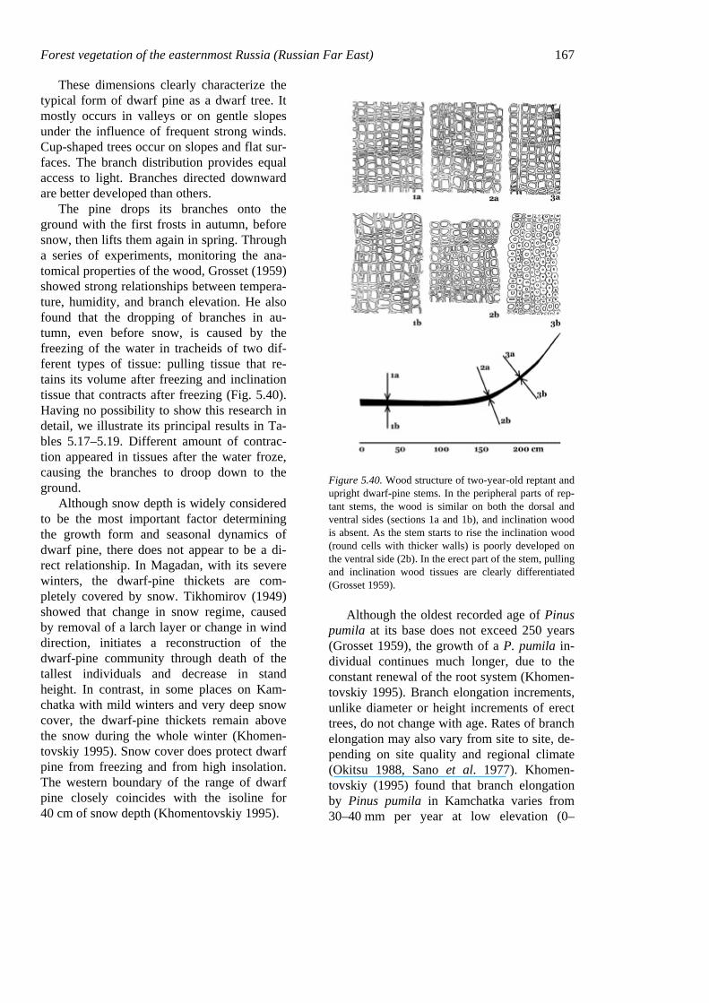
Forest vegetation of the easternmost Russia (Russian Far East) 167
These dimensions clearly characterize the typical form of dwarf pine as a dwarf tree. It mostly occurs in valleys or on gentle slopes under the influence of frequent strong winds. Cup-shaped trees occur on slopes and flat sur-faces. The branch distribution provides equal access to light. Branches directed downward are better developed than others.
The pine drops its branches onto the ground with the first frosts in autumn, before snow, then lifts them again in spring. Through a series of experiments, monitoring the ana-tomical properties of the wood, Grosset (1959) showed strong relationships between tempera-ture, humidity, and branch elevation. He also found that the dropping of branches in au-tumn, even before snow, is caused by the freezing of the water in tracheids of two dif-ferent types of tissue: pulling tissue that re-tains its volume after freezing and inclination tissue that contracts after freezing (Fig. 5.40). Having no possibility to show this research in detail, we illustrate its principal results in Ta-bles 5.17–5.19. Different amount of contrac-tion appeared in tissues after the water froze, causing the branches to droop down to the ground.
Although snow depth is widely considered to be the most important factor determining the growth form and seasonal dynamics of dwarf pine, there does not appear to be a di-rect relationship. In Magadan, with its severe winters, the dwarf-pine thickets are com-pletely covered by snow. Tikhomirov (1949) showed that change in snow regime, caused by removal of a larch layer or change in wind direction, initiates a reconstruction of the dwarf-pine community through death of the tallest individuals and decrease in stand height. In contrast, in some places on Kam-chatka with mild winters and very deep snow cover, the dwarf-pine thickets remain above the snow during the whole winter (Khomen-tovskiy 1995). Snow cover does protect dwarf pine from freezing and from high insolation. The western boundary of the range of dwarf pine closely coincides with the isoline for 40 cm of snow depth (Khomentovskiy 1995).
Figure 5.40. Wood structure of two-year-old reptant and upright dwarf-pine stems. In the peripheral parts of rep-tant stems, the wood is similar on both the dorsal and ventral sides (sections 1a and 1b), and inclination wood is absent. As the stem starts to rise the inclination wood (round cells with thicker walls) is poorly developed on the ventral side (2b). In the erect part of the stem, pulling and inclination wood tissues are clearly differentiated (Grosset 1959).
Although the oldest recorded age of Pinus pumila at its base does not exceed 250 years (Grosset 1959), the growth of a P. pumila in-dividual continues much longer, due to the constant renewal of the root system (Khomen-tovskiy 1995). Branch elongation increments, unlike diameter or height increments of erect trees, do not change with age. Rates of branch elongation may also vary from site to site, de-pending on site quality and regional climate (Okitsu 1988, Sano et al. 1977). Khomen-tovskiy (1995) found that branch elongation by Pinus pumila in Kamchatka varies from 30–40 mm per year at low elevation (0–
168 Chapter 5 300 m), through 50–60 mm at 300–900 m, to 10–20 mm from 900 to 1300–1400 m.
Our research on the areas influenced by volcanism showed very low tolerance of Pinus pumila to volcanic ash. Even small amounts of tephra destroy the buds on branches, and mi-nor abrasion causes death of the whole branch
(Grishin et al. 2000). Occurrence of dwarf-pine thickets decreases abruptly in the areas influenced by ashfall, until they disappear completely, as in the northern Kurils. On southern Paramushir, dwarf pine was excluded from the vegetation cover by the activity of the Chikurachki volcano (Grishin 2000).
Table 5.17. Hygroscopic moisture content and contraction of pulling and inclination wood tissue of dwarf pine relative to relative air humidity (after Grosset 1959).
Relative air humidity at 20°C Observation number
Type of wood tissue 98 91 75 50 25 0
1 Pulling - - 26.05 0.23 16.20 0.44 10.75 0.55 6.62 0.66 0.00 0.97 Inclination - - 29.00 3.13 17.62 5.73 12.2 7.14 7.65 8.36 0.00 10.27 2 Pulling 30.00 0.00 23.40 0.02 17.70 0.04 8.84 0.06 6.71 0.06 0.00 0.08 Inclination 31.2 0.35 26.13 1.06 18.55 2.25 10.06 3.30 7.89 3.58 0.00 4.43
Table 5.18. Contraction (length) of inclination and pulling wood of dwarf pine as temperature decreases from +18°C to −25°C ex situ: length at −25°C as % of length at +18°C (after Grosset 1959).
Moisture of wood as % of absolutely dry weight Observation number
Type of wood tissue 10 20 30 40 50 60 70 80 90 100
1 Pulling 0.00 0.00 0.00 0.00 0.00 0.00 0.00 0.00 0.00 0.00 Inclination 0.00 0.00 0.72 1.18 1.33 1.80 2.00 1.90 1.70 1.50 2 Pulling 0.00 0.00 0.00 0.00 0.00 0.00 0.00 0.00 0.00 - Inclination 0.00 0.00 1.25 1.80 2.16 2.12 2.00 1.70 1.50 - 3 Pulling 0.00 0.00 0.00 0.00 0.00 0.00 0.00 0.00 0.00 - Inclination 0.00 0.00 0.21 0.57 1.12 1.56 1.85 1.60 1.50 - 4 Pulling 0.00 0.00 0.00 0.00 0.00 0.00 0.00 0.28 0.00 0.28 Inclination 0.00 0.00 0.20 0.56 0.81 1.11 1.30 1.20 1.10 1.00 5 Pulling 0.00 0.00 0.00 0.00 0.00 0.00 0.00 0.00 0.00 0.20 Inclination 0.00 0.00 0.31 0.56 1.11 1.55 1.45 1.40 1.30 - 6 Pulling 0.00 0.00 0.00 0.00 0.00 0.00 0.08 0.08 0.08 0.04 Inclination 0.00 0.00 0.10 0.51 0.81 0.96 1.20 1.10 1.00 0.80
Table 5.19. Change of branch-top vertical position, lengthwise contraction of inclination wood and amount of water freez-ing in pinewood branches of 130 cm, with 1°C temperature decreases within 5°C intervals (after Grosset 1959).
Parameters Temperature intervals (°C) 50 to 0 0 to −5 −5 to −10 −10 to −15 −15 to −20 −20 to −25 Change of branch top (cm per 1°C) 0.00 5.08 3.35 2.27 2.08 1.72 Lengthwise contraction (%) 0.00 0.15 0.12 0.10 0.05 0.02 Amount of freezing water (% of absolute dry weight of wood) 0.00 7.00 1.20 0.60 0.20 0.20
Forest vegetation of the easternmost Russia (Russian Far East) 169
9.3 Stand structure and dynam-ics
A main feature of dwarf-pine stands is the lack of any generation structure in the canopy due to the continuous growth. Old-growth stands typically look like completely closed communities, with little or no moss cover and with very few herbs or dwarf-shrubs. A dwarf-pine community may reach this stage after 100–150 years, as roughly estimated by Khomentovskiy (1995). Dwarf pine may re-generate from seeds within occasional gaps appearing after disturbances or forming above dying old basal parts (Tikhomirov 1946). The process of natural regeneration in the old-growth communities has not been studied.
Dwarf pine is an important species in pri-mary succession on new subalpine and subarc-tic substrates, such as coastal sand dunes, lava flows and ash deposits after volcanic erup-tions, and areas affected by wildfires. Seed-lings of Pinus pumila may appear on the new substrate a year after disturbance, growing from seeds brought by the nutcracker Nuci-fraga caryocatactes ssp. macrorhynchos in eastern Siberia or N. caryocatactes ssp. kam-tschatkensis in the northern Far East. In the first 40–60 years dwarf pine grows in length, forming a well-developed crown by the end of the period. New shrubby trees never form a closed cover on new substrates or on space made available after fire, and the whole stand looks like a well-spaced woodland with tundra communities developing between the shrubs. Over all this period, new seedlings appear on the pine-free spaces, gradually forming a closed stand by a stand age of 100–150 years.
Light deficiency under the pine canopy limits the development of herb and moss lay-ers, but these layers can form in old-growth stands with long branches. There is a complex of species closely related to the pine thickets in the subarctic or the subalpine belts: Rhodo-dendron aureum, Carex rigidioides, Salix ber-berifolia, and Bistorta elliptica. Over the whole range of dwarf-pine thickets, the main
companions are: Alnus fruticosa, Betula exilis, B. middendorffii, Calamagrostis lapponica, Carex lugens, Empetrum nigrum, Eriophorum vaginatum, Aconogonum tripterocarpum, Salix fuscescens, Vaccinium uliginosum, Peta-sites frigidus, Pinguicula spathulata, etc. Also Arctous alpina, Cassiope ericoides, C. tetra-gona, Diapensia obovata, Hierochloë alpina, Loiseleuria procumbens, Salix glauca and Saussurea alpicola appear at the contacts be-tween dwarf-pine thickets and tundra commu-nities. In dwarf-pine communities within for-est zones, on a wide range of ecotopes, Pinus pumila may form stands together with Larix dahurica, which is present as solitary trees. Such stands may also include Andromeda polifolia, Calamagrostis langsdorffii, Carex appendiculata, C. globularis, Ledum palustre, Lycopodium annotinum, Linnaea borealis, Maianthemum bifolium, Pentaphylloides fruti-cosa, Rosa acicularis, Salix myrtilloides, Spi-raea betulifolia, Vaccinium myrtillus, etc.
9.4 Phytocenotic diversity
The wide distribution of Pinus pumila causes slight differences in species composi-tion between communities occurring as a hori-zontal zone, (subarctic Beringian Woodlands) and as subalpine belts (in southeastern and eastern Siberia). Due to the great radiation of subarctic species to the south, through the mountain ranges, the dwarf-pine thickets keep a relatively stable species composition and structure across their whole range. They can-not be classified by differential species indi-cating climatic variations. All variation within Pinus pumila communities is caused mainly by substrate type and proximity to tundra or forest vegetation.
The only association class, Pineta pumilae purum, was described over the whole range of Pinus pumila (Table 5.20). The main features of this class are: 1) dominance by Pinus pumila, which forms a closed canopy (40–95% cover); 2) presence and cenotic activity by a complex of subarctic/subalpine species
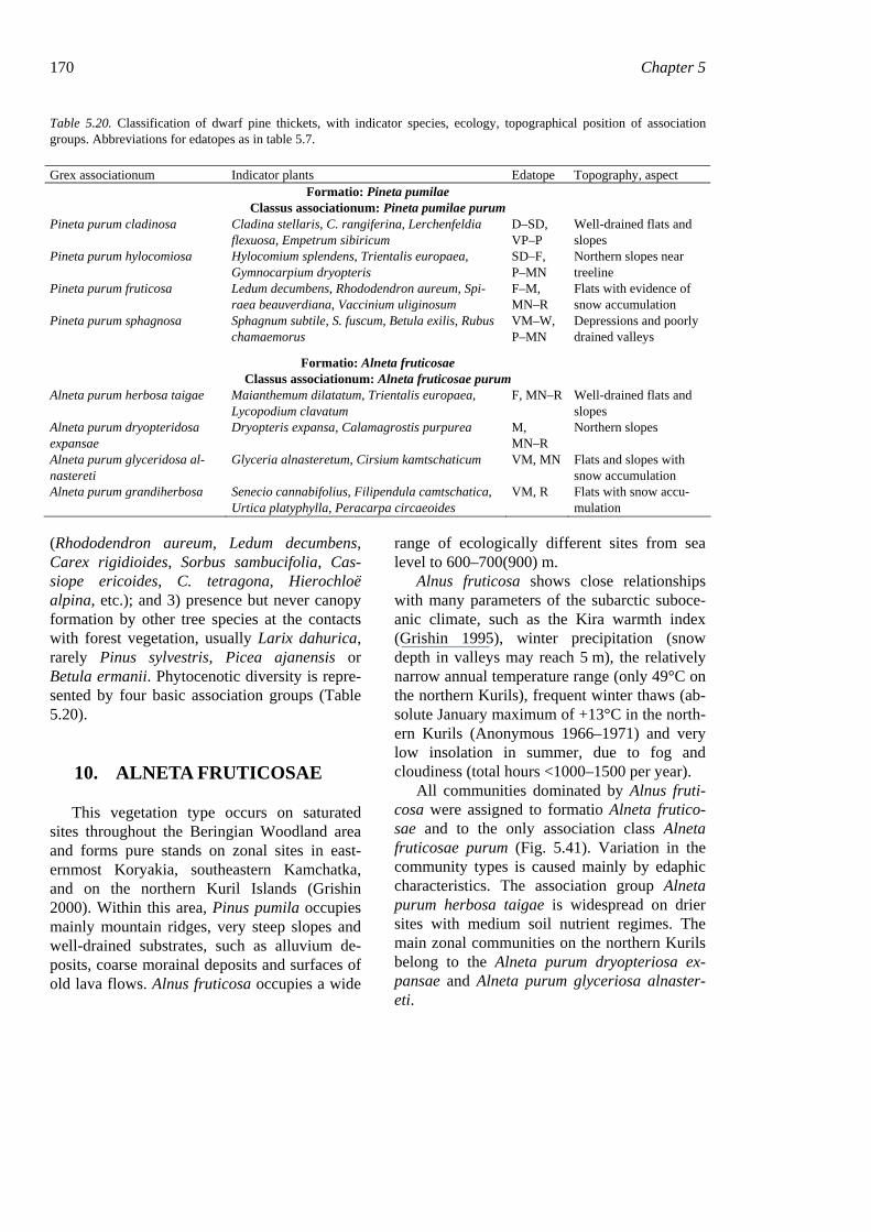
170 Chapter 5
Table 5.20. Classification of dwarf pine thickets, with indicator species, ecology, topographical position of association groups. Abbreviations for edatopes as in table 5.7.
Grex associationum Indicator plants Edatope Topography, aspect Formatio: Pineta pumilae
Classus associationum: Pineta pumilae purum Pineta purum cladinosa Cladina stellaris, C. rangiferina, Lerchenfeldia
flexuosa, Empetrum sibiricum D–SD, VP–P
Well-drained flats and slopes
Pineta purum hylocomiosa Hylocomium splendens, Trientalis europaea, Gymnocarpium dryopteris
SD–F, P–MN
Northern slopes near treeline
Pineta purum fruticosa Ledum decumbens, Rhododendron aureum, Spi-raea beauverdiana, Vaccinium uliginosum
F–M, MN–R
Flats with evidence of snow accumulation
Pineta purum sphagnosa Sphagnum subtile, S. fuscum, Betula exilis, Rubus chamaemorus
VM–W, P–MN
Depressions and poorly drained valleys
Formatio: Alneta fruticosae Classus associationum: Alneta fruticosae purum
Alneta purum herbosa taigae Maianthemum dilatatum, Trientalis europaea, Lycopodium clavatum
F, MN–R Well-drained flats and slopes
Alneta purum dryopteridosa expansae
Dryopteris expansa, Calamagrostis purpurea M, MN–R
Northern slopes
Alneta purum glyceridosa al-nastereti
Glyceria alnasteretum, Cirsium kamtschaticum VM, MN Flats and slopes with snow accumulation
Alneta purum grandiherbosa Senecio cannabifolius, Filipendula camtschatica, Urtica platyphylla, Peracarpa circaeoides
VM, R Flats with snow accu-mulation
(Rhododendron aureum, Ledum decumbens, Carex rigidioides, Sorbus sambucifolia, Cas-siope ericoides, C. tetragona, Hierochloë alpina, etc.); and 3) presence but never canopy formation by other tree species at the contacts with forest vegetation, usually Larix dahurica, rarely Pinus sylvestris, Picea ajanensis or Betula ermanii. Phytocenotic diversity is repre-sented by four basic association groups (Table 5.20).
10. ALNETA FRUTICOSAE
This vegetation type occurs on saturated sites throughout the Beringian Woodland area and forms pure stands on zonal sites in east-ernmost Koryakia, southeastern Kamchatka, and on the northern Kuril Islands (Grishin 2000). Within this area, Pinus pumila occupies mainly mountain ridges, very steep slopes and well-drained substrates, such as alluvium de-posits, coarse morainal deposits and surfaces of old lava flows. Alnus fruticosa occupies a wide
range of ecologically different sites from sea level to 600–700(900) m.
Alnus fruticosa shows close relationships with many parameters of the subarctic suboce-anic climate, such as the Kira warmth index (Grishin 1995), winter precipitation (snow depth in valleys may reach 5 m), the relatively narrow annual temperature range (only 49°C on the northern Kurils), frequent winter thaws (ab-solute January maximum of +13°C in the north-ern Kurils (Anonymous 1966–1971) and very low insolation in summer, due to fog and cloudiness (total hours <1000–1500 per year).
All communities dominated by Alnus fruti-cosa were assigned to formatio Alneta frutico-sae and to the only association class Alneta fruticosae purum (Fig. 5.41). Variation in the community types is caused mainly by edaphic characteristics. The association group Alneta purum herbosa taigae is widespread on drier sites with medium soil nutrient regimes. The main zonal communities on the northern Kurils belong to the Alneta purum dryopteriosa ex-pansae and Alneta purum glyceriosa alnaster-eti.
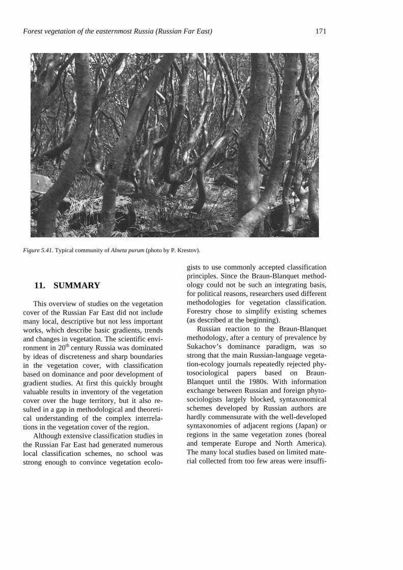
Forest vegetation of the easternmost Russia (Russian Far East) 171
Figure 5.41. Typical community of Alneta purum (photo by P. Krestov).
11. SUMMARY
This overview of studies on the vegetation cover of the Russian Far East did not include many local, descriptive but not less important works, which describe basic gradients, trends and changes in vegetation. The scientific envi-ronment in 20th century Russia was dominated by ideas of discreteness and sharp boundaries in the vegetation cover, with classification based on dominance and poor development of gradient studies. At first this quickly brought valuable results in inventory of the vegetation cover over the huge territory, but it also re-sulted in a gap in methodological and theoreti-cal understanding of the complex interrela-tions in the vegetation cover of the region.
Although extensive classification studies in the Russian Far East had generated numerous local classification schemes, no school was strong enough to convince vegetation ecolo-
gists to use commonly accepted classification principles. Since the Braun-Blanquet method-ology could not be such an integrating basis, for political reasons, researchers used different methodologies for vegetation classification. Forestry chose to simplify existing schemes (as described at the beginning).
Russian reaction to the Braun-Blanquet methodology, after a century of prevalence by Sukachov’s dominance paradigm, was so strong that the main Russian-language vegeta-tion-ecology journals repeatedly rejected phy-tosociological papers based on Braun-Blanquet until the 1980s. With information exchange between Russian and foreign phyto-sociologists largely blocked, syntaxonomical schemes developed by Russian authors are hardly commensurate with the well-developed syntaxonomies of adjacent regions (Japan) or regions in the same vegetation zones (boreal and temperate Europe and North America). The many local studies based on limited mate-rial collected from too few areas were insuffi-
172 Chapter 5 cient to characterize the dominant community types.
All of this outlines a viscous circle of prob-lems, which may be addressed in the near fu-ture. These problems are: 1) vegetation classi-fication of eastern Russia, providing the op-portunity to assess the biodiversity of the re-gion properly; 2) identification of the position of the Russian Far East in the ecological, bio-geographical, social, economic, and cultural values of the world community; and 3) guar-anteeing support for these values for future generations.
12. ACKNOWLEDGEMENTS
Some of the studies referenced in this chapter were carried out under support from the Russian Foundation for Basic Research, grants # 01-04-48593, 01-04-63024, 01-04-63096 and 99-05-64556. I thank Drs. Sergei Grishin, Valentine Yakubov, Valentina Verkholat and Prof. Dr. Claus Dierβen for valuable comments on primary versions of manuscript and submitted photographs, Prof. Elgene Box making the English text readable; and editors Drs. Jiří Kolbek and Miroslav Šrůtek for the idea of this book and very valu-able supervision at all stages of work.
13. REFERENCES
Ageienko, A.S. & Klintsov, A.P. 1969. Forests of Sakha-lin and Kuril Islands. [Lesa Sakhalina i Kurilskih os-trovov.] In: Anonymous. Forests of [Russian] Far East. [Lesa Dalnego Vostoka.] Lesnaya Promyshlen-nost, Moscow (in Russian).
Alexandrova, V.D. 1973. Russian approaches to classifi-cation of vegetation. In: Whittaker, R.H. (ed.), Ordi-nation and classification of communities. Handbook of Vegetation Science, pp. 493–527. W. Junk, The Hague.
Alexeiev, V.A. & Shamshin, V.A. 1972. On ecology and structure of stonebirch forests on Kamchatka. [Ob ecologii i strukture kamennoberezovyh lesov Kamchatki.] Bot. Zhurn. 57: 1055–1068 (in Russian, with English summary).
Aliokhin, V.V. 1930. The map of vegetation of the Asian part of Russia. Scale 1: 16,000,000. [Karta rastitelnosti asiatskoy chasti Rossii. Masshtab 1:16,000,000.] Goskartogeodezia, Leningrad (in Rus-sian).
Aliokhin, V.V. 1950. The map of vegetation of the USSR. Scale 1: 18,000,000. [Karta rastitelnosti SSSR. Masshtab 1:18,000,000.] In: Aliokhin, V.V. (ed.), The plant geography. [Geografiya rasteniy.] Uchpedgiz, Moscow.
Anonymous. 1990. Reference Book for the taxation of forests of [Russian] Far East. [Spravochnik dlya tak-satsii lesov Dalnego Vostoka.] Dal’NIILKh, Kha-barovsk, 526 pp. (in Russian).
Anonymous. 1966–1971. Reference book on the climate of the USSR [Spravochnik po klimatu SSSR] (Series of volumes). Gidrometeoizdat, Leningrad (in Rus-sian).
Baburin, A.A. 1976. Flora and vegetation of upper-Bikin plateau. [Flora i rastitelnost Verkhne-Bikinskogo plato.] Bulleten GBS 99: 32–33 (in Russian).
Balmasova, M.A. 1994. Birch forests. [Berezoviye lesa.] In: Neshataev, Yu.N., Neshataeva, V.Yu. & Naumenko, A.T. (eds.), Vegetation of Kronotskiy state reserve [Rastitelnost Kronotskogo gosu-darstvennogo zapovednika], pp. 41–76. Komarov Bo-tanical Institute, St-Peterburg (in Russian).
Barkalov, V.Yu. 2000. Phytogeography of the Kuril Islands. Nat. Hist. Res. 7: 1–14.
Bobrov, E.G. 1978. Forest forming conifers of the USSR. [Lesoobrazuyushchiye khvoyniye SSSR.] Nauka, Leningrad, 189 pp. (in Russian).
Braun-Blanquet, J. 1951. Pflanzensoziologie. Grundzuge der Vegetationskunde. Springer-Verlag, Wien, 632 pp.
Budishchev, A.O. 1898. Description of forests of south-ern part of Prymorskaya oblast’. [Opisaniye lesov yuzhnoy chasti Primorskoy oblasti.] 2nd edition. Kancellaria Priamurskogo General-Qubernatorstva, Irkutsk (in Russian).
Cajander, A.K. 1926. The theory of forest types. Acta For. Fenn. 29: 1–108.
Chukreiev, V.K. 1970. The thermic indices for estima-tion of seasonality and zonality. [Teploviye indeksy dlya otsenki sezonnosti i zonalnosti.] Izvestia Vse-soyuznogo Geographicheskogo Obshchestva 4: 326–333 (in Russian).
Chumin, V.T. 1965. The role of fallen trees in regenera-tion of spruce forests. [Rol valezha v vozobnovlenii yelovyh lesov.] Publications of Dal’NIILKh 7: 135–149 (in Russian).
Chun, L.J. 1994. The broad-leaved Korean pine forest in China. In: Anonymous. Proceedings of the Interna-tional Workshop on subalpine stone pines and their environment: the status of our knowledge, pp. 81–84. U.S. Department of Agriculture, Ogden.
Forest vegetation of the easternmost Russia (Russian Far East) 173 Diukarev, V.N., Kozin, E.K. & Rosenberg, V.A. 1971.
Age development and phytomass of moss-fern spruce forests of Sikhote-Alin. [Vozrastnoye razvitiye i fi-tomassa zelenomoshno-paporotnikovyh yelnikov Sikhote-Alinya.] In: Anonymous. Biological produc-tivity of spruce forests [Biologichaskaya produktiv-nost yelovyh lesov], pp. 77–82. Tartu (in Russian).
Dmitrieva, N.G. 1960. Water cycle and drainage progno-sis in Priamurye. [Vodniy tsikl i prognoz stoka v Pri-amurye.] Nauka, Moscow, 211 pp. (in Russian).
Dobrynin, A.P. 2000. Oak forests of the Russian Far East: biology, geography, origin. [Duboviye lesa ros-siyskogo Dalnego Vostoka: biologiya, geografiya, proiskhozhdeniye.] Dal’nauka, Vladivostok, 260 pp. (in Russian).
Dokhman, G.I. 1960. On the system of diagnostic char-acters of vegetation units. [K sisteme diagnosticheskih ptiznakov edinits rastitelnosti.] Bot. Zhurn. 45: 637–648 (in Russian, with English sum-mary).
Dolukhanov, A.G. 1957. On the key and discussional problems of mountain forests typology. [O nekotoryh uzlovyh i discussionnyh voprosah tipologii gornyh lesov.] Bot. Zhurn. 42: 1158–1171 (in Russian).
Dylis, N.V. & Vypper P.B. 1953. Forests of western slope of middle Sikhote-Alin. [Lesa zapadnogo makrosklona srednego Sikhote-Alinya.] Izdatel’stvo Akademii Nauk SSSR, Moscow, 336 pp. (in Rus-sian).
Dylis, N.V. 1961. The larches of the Eastern Siberia and [Russian] Far East. [Listvennitsy Vostochnoy Sibiri i Dalnego Vostoka.] Izdatel’stvo Akademii Nauk SSSR, Moscow, 210 pp. (in Russian).
Efremov, D.F. 1964. Root systems of larch on Kam-chatka. [Korneviye sistemy listvennitsy na Kam-chatke.] Izvestia Sibirskogo Otdelenia AN SSSR 8: 12–19 (in Russian).
Ellenberg, H. 1980. Am Ost- und Westlands Eurasiens – ein vegetationsökologischer Vergleich. Phytocoe-nologia 7: 507–511.
Fedotov, S.A., Masurenkov, Yu.P. & Balesta, S.T. (eds.) 1991. Active volcanoes of Kamchatka. [Aktivniye vulkany Kamchatki.] Vol. 1 and 2. Nauka, Moscow.
Frey, T.E.A. 1973. The Finnish school and forest site types. In: Whittaker, R.H. (ed.), Ordination and Clas-sification of Communities. Handbook of vegetation Science, pp. 403–433. W. Junk, The Hague.
Glagolev, V.A. 1984. The age dynamics of larch forests in Bikin River basin (Middle Sikhote-Alin). [Vosstanovitelno-vozrastnaya dinamika listvennich-nikov basseina reki Bikin.] In: Anonymous. Dynamic processes in the forests of the Far East [Di-namicheskiye processy v lesah Dalnego Vostoka], pp. 91–103. Vladivostok (in Russian).
Gorodkov, B.N. 1958a. The vegetation and soils of the Wrangell Island. [Rastitelnost i pochvy ostrova Vrangelya.] In: Tikhomirov, B.A. (ed.), The vegeta-
tion of Far North of the USSR and its management [Rastitelnost Dalnego Severa SSSR i yeyo ispol-zovaniye], pp. 5–58. Izdatel’stvo Akademii Nauk, Moscow (in Russian).
Gorodkov, B.N. 1958b. Analysis of the vegetation of the arctic desert zone on the basis of the investigations on the Wrangell Island. [Analiz rastitelnosti zony arc-ticheskih pustyn na osnove issledovaniy na ostrove Vrangelya.] In: Tikhomirov, B.A. (ed.), The vegeta-tion of Far North of the USSR and its management [Rastitelnost Dalnego Severa SSSR i yeyo ispol-zovaniye], pp. 59–94. Izdatel’stvo Akademii Nauk, Moscow (in Russian).
Gorovoi, P.G. (ed.) 1973. Flora, vegetation and re-sources of the Far East. Bibliography (1928–1969 years). [Flora, rastitelnost i rastitelniye resursy Dal-nego Vostoka (1928–1969 gg.).] FEB RAS, Vladi-vostok, 552 pp. (in Russian).
Grichuk, V.P. 1984. Late Pleistocene Vegetation His-tory. In: Anonymous. Late Quaternary environments of Soviet Union, pp. 155–178. Univ. Minnesota Press, Minneapolis.
Grishin, S.Yu. 1995. The boreal forests of northeastern Eurasia. Vegetatio 121: 11–21.
Grishin, S.Yu. 1996. The vegetation of subalpine belt of Kluchevskaya group of volcanoes. [Rastitelnost subalpiyskogo poyasa Klyuchavskoy gruppy vulka-nov.] Dal’nauka, Vladivostok, 156 pp (in Russian).
Grishin, S.Yu. 2000. On phytogeography of Kuril Is-lands. [K fitogeografii Kurilskih ostrovov.] Izvestia Vserossiyskogo Geographicheskogo Obshchestva 132: 65–76 (in Russian).
Grishin, S.Yu., Krestov, P.V. & Okitsu, S. 1996a. The subalpine vegetation of Mt. Vysokaya, central Sik-hote-Alin. Vegetatio 127: 155–172.
Grishin, S.Yu., del Moral, R., Krestov, P.V. & Verkholat, V.P. 1996b. The succession after catastro-phic eruption of Ksudach volcano (Kamchatka, 1907). Vegetatio 127: 129–153.
Grishin, S.Yu., Krestov, P.V. & Verkholat, V.P. 2000. Influence of 1996 eruptions in the Karymskiy vol-cano group, Kamchatka, on vegetation. Nat. Hist. Res. 7: 39–48.
Grosset, H.E. 1959. Pinus pumila (Pall.) Regel. Materi-als on its biological study and economical utilization. [Pinus pumila (Pall.) Regel. Materialy po yego biologicheskomu issledovaniyu i economicheskomu ispolzovaniyu.] Moskovskoie Obshchestvo Ispy-tateley Prirody, Moscow, 144 pp. (in Russian, with English summary).
Hämet-Ahti, L., Ahti, T. & Koponen, T.A. 1974. Scheme of vegetation zones for Japan and adjacent regions. Ann. Bot. Fennici 11: 59–88.
Ishikawa, Yu., Krestov, P.V. & Namikawa, K. 1999. Disturbance history and tree establishment in old-growth Pinus koraiensis – hardwood forests in the Russian Far East. J. Veget. Sci. 10: 439–448.
174 Chapter 5 Ishizuka K. 1974. Mountain vegetation. In: Numata, M.
(ed.), The flora and vegetation of Japan, pp. 173–210. Kodansha, Tokyo.
Ivanov, N.N. 1959. The belts of continentality on the Earth. [Poyasa kontinentalnosti Zemli.] Izvestiya Vsesoyuznogo Geographicheskogo obshchestva 91: 410–423 (in Russian).
Ivashinnikov, Yu.K. 1999. Phisical geography of the Russian Far East. [Fizicheskaya geografia rossiy-skogo Dalnego Vostoka.] Far Eastern State Univer-sity Press, Vladivostok, 324 pp. (in Russian).
Ivashkevich, B.A. 1933. Far Eastern forests and their industrial future. [Dalnevostochniye lesa i ih pro-myshlennoye budushcheye.] DV OGIZ, Khabarovsk, 169 pp. (in Russian).
Kabanov, N.E. 1972. Stone birch forests in relation to its phytogeography and forestry. [Kamennoberezoviye lesa v otnoshenii ih fitogeografii i lesovodstvennyh svoystv.] Nauka, Moscow, 137 pp. (in Russian).
Kamibayashi, N., Man’ko, Yu.I., Kondho, A. & Gladkova, G.A. 1994. Detection of forest decline in northeast Primorye, Russia. Photogrammetry and Remote Sensing 5: 213–216 (in Japanese).
Kartashov, Yu. G. 1984. Stand structure in spruce forests with Vaccinium ovalifolium on Sakhalin. [Struktura nasazhdeniya v chernichnyh yelnikah Sakhalina.] In: Anonymous. Sustainable management of forest re-sources on the [Russian] Far East [Neistoshchimoye lesopolzovaniye na Dalnem Vostoke], pp. 45–53. Khabarovsk (in Russian).
Kharkevich, S.S. (ed.) 1985–1996. The vascular plants of the Soviet Far East. Vol. 1–8. [Sosudisteye ras-tenia sovetskogo Dalnego Vostoka.] Nauka, Lenin-grad.
Kharkevich, S.S., Cherepanov, S.K. (eds.) 1981. Guide-book to the vascular plants of Kamchatka. [Oprede-litel sosudistyh rasteniy Kamchatki.] Nauka, Mos-cow, 410 pp. (in Russian).
Khokhriakov, A.P. 1985. Flora of Magadan Region. [Flora Magadanskoy oblasti.] Nauka, Moscow, 397 pp. (in Russian).
Khomentovskiy, P.A. 1995. Ecology of dwarf pine on Kamchatka. [Ecologiya kedrovogo stlanika na Kam-chatke.] Dal’nauka, Vladivostok, 226 pp. (in Rus-sian).
Kim, J.-W. & Manyko, Yu.I. 1994. Syntaxonomical and synchorological characteristics of the cool-temperate mixed forest in the southern Sikhote-Alin, Russian Far East. Korean J. Ecol. 17: 391–413.
Kiseliov, A.N. & Kudryavtseva, E.P. 1992. High moun-tain vegetation of southern Primorye. [Vysokogor-naya rastitelnost yuzhnogo Primorya.] Nauka, Mos-cow, 117 pp. (in Russian).
Kojima, S. 1979. Biogeoclimatic zones of Hokkaido Island, Japan. J. College of Liberal Arts. Toyama Univ. 12: 97–141.
Kolesnikov, B.P. 1937. Chosenia (Chosenia macrolepis (Turch.) Kom.) and its coenoses on the [Russian] Far East. [Chozenia i yeyo tsenozy na Dalnem Vostoke] Trudy DVF AN SSSR. Ser. Bot. 2: 703–800 (in Rus-sian, with English summary).
Kolesnikov, B.P. 1938. Vegetation of eastern slopes of middle Sikhote-Alin. [Rastitelnost vostochnyh sklonov srednego Sikhote-Alinya.] Trudy Sikhote-Alinskogo Gosudarstvennogo Zapovednika 1: 25–208 (in Russian, with English summary).
Kolesnikov, B.P. 1946. To the taxonomy and the histori-cal development of larches (section Pauciseriales Patschke). [K taksonomii i istoricheskomu razvitiyu listvennits (sectsiya Pauciseriales Patschke).] In: Anonymous. Materials on the history of the flora and vegetation of the USSR. [Materialy po istorii flory i rastitelnosti SSSR.] Vol. 2., pp. 321–364. Izdatel’stvo Akademii Nauk SSSR, Moscow (in Russian).
Kolesnikov, B.P. 1955. The outlines of vegetation of [Russian] Far East. [Ocherk rastitelnosti Dalnego Vostoka.] Khabarovskoie Knizhnoe Izdatel’stvo, Khabarovsk, 104 pp. (in Russian).
Kolesnikov, B.P. 1956a. Korean pine forests of the [Russian] Far East. [Kedroviye lesa Dalnego Vostoka.] Trudy DVF AN SSSR, Ser. Bot., Izdatel-stvo AN SSSR, Moscow 2: 1–264 pp. (in Russian).
Kolesnikov, B.P. (ed.) 1956b. Geobotanical map of Pri-morskiy kray. Scale 1: 500,000. [Geobotanicheskaya karta Primorskogo kraya. Masshtab 1: 500,000.] Moscow (in Russian).
Kolesnikov, B.P. 1961. Vegetation. [Rastitelnost.] In: Richter, G.D. (ed.), Far East. Physiogeography [Dalniy Vostok. Ocherki po fizicheskoy geografii], pp. 183–245. Izdatel’stvo Akademii Nauk SSSR, Moscow (in Russian).
Kolesnikov, B.P. 1963. Geobotanical zonation of the [Russian] Far East and distribution of vegetational re-sources. [Geobotanicheskoye raionirovanie Dalnego Vostoka i zakonomernosti rasprostraneniya rastitel-nyh resursov.] Voprosy Geografii Dalnego Vostoka 6: 158–182 (in Russian).
Komarov, V.L. 1917. Vegetation types of southern Us-surian region. [Tipy rastitelnosti yuzhno-ussuriyskogo kraya.] In: Anonymous. Trudy poch-venno-geobotanicheskoy expeditsii po issledovaniyu kolonizatsionnych rayonov Asiatskoy Rossii. Iz-datel’stvo Bratyev Sabashnikovykh, St. Petersburg, 296 pp. (in Russian).
Komarov, V.L. (ed.) 1934–1964. Flora of the USSR. [Flora SSSR.] Izdatel’stvo Akademii Nauk SSSR, Moscow (in Russian).
Komarov, V.L. 1927. Flora of Kamchatka Peninsula. [Flora Kamchatki.] Vol. 1. Leningrad, 339 pp. (in Russian).
Komarov, V.L. 1928. Bibliography on flora and vegeta-tion of the [Russian] Far East. [Bibliografiya po flore i rastitelnosti Dalnego Vostoka.] Zapiski Yuzhno-
Forest vegetation of the easternmost Russia (Russian Far East) 175
Ussuriyskogo Otdelenia Russkogo Geographicheskog Obshchestva 2: 1–278.
Komarova, T.A. 1992. Post fire successions in the for-ests of southern Sikhote-Alin. [Poslepozharniye suktsessii v lesah yuzhnogo Sikhote-Alinya.] Dal’nauka, Vladivostok, 224 pp. (in Russian).
Koropachinskiy, I.Yu. 1989. Pine family – Pinaceae. [Sosnoviye - Pinaceae.] In: Kharkevich, S.S. (ed.), Vascular plants of the Soviet Far East. [Sosudistiye rasteniya sovetskogo Dalnego Vostoka.] Vol. 4., pp. 9–20. Nauka, Leningrad (in Russian).
Kozhevnikov, Yu.P. 1996. Vegetation cover of northern Asia in historical perspective. [Rastitelniy pokrov severnoy Asii v istoricheskoy perspektive.] Mir i Semya, St. Petersburg, 400 pp. (in Russian).
Kozin, E.K. 1981. The scheme of development of virgin fir-spruce forest. [Skhema razvitiya devstvennogo pikhtovo-yelovogo lesa.] Lesnoye Khoziaystvo 10: 50–53 (in Russian).
Kozin, E.K., Grigoriev, V.I. & Rosenberg, V.A. 1975. The materials to the taxation of spruce forests of Sik-hote-Alin. [Materialy po taksatsii yelovyh lesov Sik-hote-Alinya.] In: Anonymous. The stationary studies in the fir-spruce forests of Sikhote-Alin [Statsion-arniye issledovaniya pikhtovo-yelovyh lesov Sikhote-Alinya], pp. 8–29. Vladivostok (in Russian).
Krajina, V.J. 1969. Ecology of forest trees in British Columbia. Ecol. West. N. Amer. 2: 1–147.
Krasheninnikov, S.P. 1949. The description of land Kamchatka. [Opisanie zemli Kamchatka.] Izdatel’stvo Akademii Nauk SSSR, Moscow, 842 pp. (in Russian).
Krestov, P.V. 1997. The main features of phytocenotic diversity of the broad-leaved Korean pine forests of the Russian Far East. [Osobennosti fitot-senoticheskogo raznoobraziya shirokolistvenno-kedrovyh lesov rossiyskogo Dalnego Vostoka.] Ko-marovskiye Chteniya 46:15–42 (in Russian).
Krestov, P.V. 1999. Floristic aspects of the vertical vegetation zones on the middle Sikhote-Alin Mt. Range. [Floristicheskiye aspekty vysotno-poyasnoy rastitelnosti v srednem Sikhote-Aline] In: Anony-mous. Botanical research on the Russian Far East [Botanicheskiye issledovaniya na rossiyskom Dal-nem Vostoke], pp. 193–200. Dal’nauka, Vladivostok (in Russian).
Krestov, P.V. 2000. The botanico-geographical relations on the Far East of Russia: an attempt of integrated view. In: Abstracts for the IAVS Symposium in Na-gano, July 24 – August 01, p. 48. Nagano.
Krestov, P.V. 2001. Vegetation on Livadiyskiy Mt. Range (southern Sikhote-Alin). [Rastitelnost khrebta Livadiyskiy (yuzhniy Sikhote-Alin).] In: Anony-mous. Landscape and vegetation zonality of Livadiyskiy Mt. range, Southern Primorye region [Landshafty i rastitelnaya zonalnost khrebta
Livadiyskiy, yuzhnoye Primorye], pp. 7–28. Dal’nauka, Vladivostok (in Russian).
Krestov, P.V. & Ishikawa, Yu. 2000. Natural dynamics in the broad-leaved – Korean pine forests of the Sik-hote-Alin Reserve. [Yestestvennaya dinamika v shi-rokolistvenno-kedrovyh lesah Sikhote-Alinskogo zapovednika.] In: Galanin, A.V. (ed.), Vegetation of the Sikhote-Alin Biosphaeric Reserve: diversity, dy-namics and monitoring [Rastitelnost Sikhote-Alinskogo biosfernogo zapovednika: raznoobraziye, dinamika, monitoring], pp. 208–218. Dal’nauka, Vladivostok (in Russian).
Krylov, A.G. 1984. Life form of forest phytocenoses. [Zhiznenniye formy lesnyh fitotsenozov.] Nauka, Moscow, 181 pp. (in Russian).
Krylov, G.V. & Salatova, N.G. 1969. History of botani-cal and forest researches in the Siberia and [Russian] Far East. [Istoriya botanicheskih i lesnyh issledo-vaniy v Sibiri i na Dalnem Vostoke.] Nauka, Novosi-birsk (in Russian).
Krylov, G.V., Talantsev, N.K. & Kozakova, N.F. 1983. The pine. [Kedr.] Nauka, Moscow, 216 pp. (in Rus-sian).
Kutentsova, G.E. 1960. The forests of Picea koraiensis in the Ussuri River basin. [Lesa iz yeli koreiskoy v basseyne reki Ussuri.] Soobshchenia DVF SO AN SSSR 12: 97–101 (in Russian).
Kurentsova, G.E. 1968. Vegetation of Primorskiy region. [Rastitelnost Primorskogo kraya.] Dalnevostochnoye Knizhnoye Izdatelstvo, Vladivostok, 192 pp. (in Russian).
Kurentsova, G.E. 1973. Natural and antropogenic dy-namics of vegetation of Primorye and southern Pria-murye. [Yestestvenniye i antropogenniye smeny rastitelnosti v Primoriye i yuzhnom Priamuriye.] Nauka, Novosibirsk, 233 pp. (in Russian).
Lavrenko, E.M. 1950. Main features of phytogeographi-cal regionalization of the USSR and bordering coun-tries. [Osnovniye cherty fitogeograficheskogo raioni-rovaniya SSSR i prigranichnyh stran.] In: Anony-mous. The problems of botany. [Problemy Botaniki.] Vol. 1., pp. 530–548. Izdatel’stvo Akademii Nauk SSSR, Moscow (in Russian).
Lavrenko, E.M. (ed.) 1939. The map of vegetation of the USSR. Scale 1: 5,000,000. [Karta rastitelnosti SSSR. Masshtab 1:5,000,000.] Komarov Botanical Institute Press, Leningrad (in Russian).
Lavrenko, E.M. & Sochava, V.B. (eds.) 1954. Geobotanical map of the USSR. Scale 1: 4,000,000. [Geobotanicheskaya karta SSSR. Masshtab 1:4,000,000.] Komarov Botanical Institute Press, Leningrad (in Russian).
Lavrenko, E.M. & Sochava, V.B. (eds.) 1956. The vege-tation cover of the USSR. The explanatory notes to the ”Geobotanical map of the USSR”. [Rastitelniy pokrov SSSR. Poyasnitelniy tekst k Geobotanicheskoy karte SSSR.] Vol. 1 and 2. Iz-
176 Chapter 5
datel’stvo Akademii Nauk SSSR, Moscow (in Rus-sian).
Man’ko, Yu.I. 1961. Brief sketch of forest vegetation of the upper half of Urmi River. [Ocherk lesnoy rastitelnosti verkhnego techeniya reki Urmi.] Koma-rovskie Chtenia 9: 42–71 (in Russian).
Man’ko, Yu.I. 1965. The materials on study of decline of the fir-spruce forests in the left side of Amur River basin. [Materialy po izucheniyu usikhaniya pikhtovo-yelovyh lesov levoberezhya Amura.] In: Anonymous. Forestry studies on the Far East [Lesokhoziaystven-niye issledovaniya na Dalnem Vostoke], pp. 21–73. Vladivostok (in Russian).
Man’ko, Yu.I. 1967. Fir-spruce forests of the northern Sikhote-Alin. [Pikhtovo-yeloviye lesa severnogo Sikhote-Alinya.] Nauka, Leningrad, 244 pp. (in Rus-sian).
Man’ko, Yu.I. 1974. Some features of dynamics of for-est vegetation of Kamchatka under the influence of dry rivers. [Nekotoriye osobennosti dinamiki lesnoy rastitelnosti Kamchatki pod vozdeystviyem sukhikh rechek.] Bot. Zhurn. 59: 707–716 (in Russian).
Man’ko, Yu.I. 1980. Volcanism and vegetation dynamics. [Vulkanizm i dinamika rastitelnosti.] Bot. Zhurn. 65: 457–469 (in Russian).
Man’ko, Yu.I. 1987. The Ayan Spruce. [Ayanskaya Yel.] Nauka, Leningrad, 280 pp. (in Russian).
Man’ko, Yu.I. & Gladkova, G.A. 1993. On the history of the hypothesis for fir-spruce forests drying in the Far East. [K istorii gipotezy ob usykhanii pikhtovo-yelovyh lesov na Dalnem Vostoke.] Pochvovedenie 9: 94–97 (in Russian).
Man’ko, Yu.I. & Gladkova, G.A. 1995. On factors of fir-spruce forest decline on the [Russian] Far East. [O faktorakh usyhaniya pikhtovo-yelovyh lesov na Dal-nem Vostoke.] Lesovedenie 2: 3–12 (in Russian).
Man’ko, Yu.I. & Gladkova, G.A. 2001. Spruce decline in the light of global deterioration of dark-coniferous forests. [Usykhaniye yeli v svete globalnogo uhudsheniya temnokhvoynyh lesov.] Dal’nauka, Vladisvostok, 228 pp. (in Russian).
Man’ko, Yu.I. & Voroshilov, V.P. 1971. On the northern limit of distribution of Picea ajanensis in the conti-nental part of Far East. [O severnom predele raspros-traneniya ayanskoy yeli v kontinentalnoy chasti Dal-nego Vostoka.] Bot. Zhurn. 56: 1343–1351 (in Rus-sian).
Man’ko, Yu.I. & Voroshilov, V.P. 1973. The spruce forests of Kamchatka and their management. [Ye-loviye lesa Kamchatki i ih ispolzovaniye.] In: Anonymous. Soils and vegetation of the permafrost regions of the USSR [Pochvy i rastitelnost merzlot-nyh raionov SSSR], pp. 218–224. IBPS, Magadan (in Russian).
Man’ko, Yu.I. & Voroshilov, V.P. 1978. Spruce forests of Kamchatka. [Yeloviye lesa Kamchatki.] Nauka, Moscow, 256 pp. (in Russian).
Man’ko, Yu.I., Gladkova, G.A., Butovets, G.N. & Kamibayashi, N. 1998. An experience of monitoring of fir-spruce forest decline in central Sikhote-Alin. [Opyt monitoringa usykhaniya pikhtovo-yelovyh le-sov v Tsentralnom Sikhote-Aline.] Lesovedenie 1: 3–16 (in Russian).
Mayer, H. 1978. Über die Bedeutung der Urwaldforschung für den Gebirgswaldbau. Allgem. Forstzeitschrift 24: 691–693.
Maximowicz, C.J. 1859. Primitiae florae amurensis. Versuch einer Flora des Amurlandes. St. Petersburg, 504 pp.
Miki, S. 1956. Remains of Pinus koraiensis S. et Z. and associated remains in Japan. Bot. Mag. Tokyo 69: 447–454.
Mirkin, B.M. & Naumova, L.G. 1998. Vegetation sci-ence. (History and modern state of some concept). [Nauka o rastitelnosti (Istoriya i sovremennoye sostoyaniye nekotoryh kontseptsiy).] Gilem, Ufa, 414 pp. (in Russian).
Mishkov, F.F. 1975. Development and species replace-ment in the hardwood-conifer forests of Khekhtsir Mt. range. [Razvitie i smena vidov v shirokolist-venno-khvoynyh lesah Hehtsira.] In: Anonymous. The use and reproduction of forest resources of the [Russian] Far East [Ispolzovaniye i vosproizvodstvo lesnyh resursov Dalnego Vostoka], pp. 91–108. Dal’NIILKh, Khabarovsk (in Russian).
Miyawaki, A. & Nakamura, Yu. 1988. Übersicht über die japanische Vegetation und Flora in der nemoralen und borealen Zone. Veröff. Geobot. Inst. ETH, Stiftung Rübel 98: 100–128.
Molozhnikov, V.N. 1976. Siberian pine in the montane landscapes of northern Baikal area. [Kedroviy stlanik v gornyh landshaftah severnogo Pribaikalya.] Nauka, Moscow, 203 pp. (in Russian).
Morozov, V.L. & Belaya, G.A. 1988. Ecology of Far Eastern tall-form meadows. [Ecologiya dal-nevostochnogo krupnotravya.] Nauka, Moscow, 255 pp. (in Russian).
Moskaliuk, T.A. 1988. The structure and productivity of the northern Okhotian forests. [Struktura i produktiv-nost severookhotskih lesov.] Dal’nauka, Vladivostok, 144 pp. (in Russian).
Nechaev, A.P. 1975. The role of animals in spruce re-generation on fallen trees. [Rol zhivotnyh v vozob-novlenii yeli na valezhnike.] Flora and Fauna of the [Russian] Far East 3: 14–22 (In Russian).
Nedrigailov, S.N. 1932. Forests and forest resources in northwest Yakutia. [Lesa i lesniye resursy v severo-zapadnoy Yakutii.] In: Anonymous. Forest resources of Yakutia. [Lesniye resursy Yakutii.] Vol. 3., pp. 38–59. Nauka, Moscow (in Russian).
Neshataev, Yu.N. & Neshataeva, V.Yu. 1985. The dis-tribution of Pinus pumila communities in Kronotskiy state reserve. [Rasprostraneniye soobshchestv Pinus
Forest vegetation of the easternmost Russia (Russian Far East) 177
pumila v Kronotskom gosudarstvennom zapoved-nike.] Bot. Zhurn. 70: 382–389 (in Russian).
Neshataeva, V.Yu. 1983. Ecologo-biological analysis of the species composition of the dwarf pine formation in the Kronotskiy Reserve on Kamchatka. [Ecologo-biologicheskiy analiz vidovogo sostava formatsii kedrovogo stlanika v Kronotskom zapovednike na Kamchatke.] Vestnik Leningradskogo Gosudarstven-nogo Universiteta 9: 53–63 (in Russian).
Neshataeva, V.Yu. 1994. Dwarf pine communities. [Soobshchestva kedrovogo stlanika.] In: Neshataev, Yu.N., Neshataeva, V.Yu. & Naumenko, A.T. (eds.), Vegetation of Kronotskiy State Reserve [Rastitelnost Kronotskogo gosudarstvennogo zapovednika], pp. 81–105. Komarov Botanical Institute Press, St-Peterburg (in Russian).
Nikolskaya, V.V. 1974. On natural trends of develop-ment of physiogeographic provinces of the southern Far East [of Russia.] [O yestestvennyh napravleniyah razvitiya fiziko-geographicheskih provintsiy yuga Dalnego Vostoka.] Nauka, Moscow, 126 pp. (in Rus-sian).
Numata, M. 1972. Ecological interpretation of vegeta-tional zonation of high mountains, particularly in Ja-pan and Taiwan. In: Troll, C. (ed.), Geoecology of the high mountain regions of Eurasia, pp. 288–299. F. Steiner, Wiesbaden.
Okitsu, S. 1987. Betula ermanii zone. In: Ito, K. (ed.), Vegetation of Hokkaido, pp. 168–199. Hokudai To-sho Kankoukai, Sapporo.
Okitsu, S. 1988. Geographical variation of annual fluc-tuations in stem elongation of Pinus pumila Regel on high mountains of Japan. Jap. J. Ecol. 38: 177–189.
Okitsu, S. & Ito, K. 1984. Vegetation dynamics of the Siberian dwarf pine (Pinus pumila Regel) in the Taisetsu mountain range, Hokkaido, Japan. Vegetatio 58: 103–113.
Okitsu, S. & Ito, K. 1989. Conditions for the develop-ment of the Pinus pumila zone of Hokkaido, North-ern Japan. Vegetatio 84:127–132.
Pickett, S.T.A. & White, P.S. 1985. The ecology of natu-ral disturbance and patch dynamics. Academic Press, Orlando, 472 pp.
Pogrebnyak P.S. 1955. The fundamentals of the forest typology. [Osnovy lesnoy tipologii.] Naukova Dumka, Kiev, 456 pp. (in Russian).
Pojar, J., Klinka, K. & Meidenger, D.V. 1987. Biogeo-climatic ecosystem classification in British Colum-bia. For. Ecol. Manage. 22: 119–154.
Pozdniakov, L.K. 1975. Daurian larch. [Daurskaya list-vennitsa.] Nauka, Moscow, 402 pp. (in Russian).
Ramenskiy, L.G. 1953. On ecological study and sys-tematization of plant communities. [K izucheniyu ecologii i sistematizatsii rastitelnyh soobshchestv.] Byull. Mosk. Obshch. Ispyt. Prir., Otd. Biol. 58: 35–54 (in Russian).
Ramenskiy, L.G. 1932. Die Projektionsaufnahme und Beschreibung der Pflanzendecke. Handb. Biol. Arb. Meth. 11: 137–190.
Rozenberg, V.A. & Vasiliev, N.G. 1967. On the altitud-inal distribution of vegetation on a middle Sikhote-Aline. [K vysotnomu raspredeleniyu rastitelnosti v tsentralnom Sikhote-Aline.] Problemy Botaniki. Rastitel’niy Mir Vysokogoriy SSSR i Voprosy Ego Ispol’zovaniya 9: 143–151 (in Russian).
Rozenberg, V.A. 1959. Dark-conifer forests of the northern end of Sikhote-Alin Mt. range. [Tem-nokhvoyniye lesa severnoy chasti Sikhote-Alinya.] Soobshchenia DVF SO AN SSSR, Biologia 11: 57–80 (in Russian).
Rozenberg, V.A. 1961. Some aspects of development of fir spruce forests of the southern Sikhote-Alin. [Ne-kotoriye voprosy razvitiya pikhtovo-yelovyh lesov yuzhnogo Sikhote-Alinya.] In: Anonymous. Agricul-ture and forestry of the [Russian] Far East [Voprosy selskogo i lesnogo khoziaystva na Dalnem Vostoke], pp. 195–215. Vladivostok (in Russian).
Rozenberg, V.A. 1963. On characteristics of fir-spruce forests of Primorye and lower Priamurye. [K kharak-teristike pikhtovo-yelovyh lesov Primorya i nizhnego Priamurya.] In: Anonymous. Materials on the study of forests of the Siberia and Far East [Materialy po issledovaniyu lesov Sibiri i Dalnego Vostoka], pp. 39–49. Krasnoyarsk (in Russian).
Rozenberg, V.A. 1967. The formations of spruce and fir forests of the soviet Far East. [Formatsii yelovyh i pikhtovyh lesov sovetskogo Dalnego Vostoka.] In: Anonymous. The summary of forest studies on the [Russian] Far East [Itogi izucheniya lesov Dalnego Vostoka], pp. 98–101, Vladivostok (in Russian).
Rozenberg, V.A. 1971. The classification of the fir-spruce forests of the Sikhote-Alin. [Klassifikatsiya pikhtovo-yelovyh lesov Sikhote-Alinya.] In: Anony-mous. Geographical aspects of mountain forest man-agement [Geograficheskiye aspekty ispolzovaniya gornyh lesov], pp. 22–24. Chita (in Russian).
Sano, Y., Matano, T. & Ujihara, A. 1977. Growth of Pinus pumila and climate fluctuation in Japan. Nature 226: 159–161.
Schlothauer, S.D. 1978. Flora and vegetation of western Okhotsk region. [Flora i rastitelnost zapadnoy Ok-hotii.] Nauka, Moscow, 132 pp. (in Russian).
Schmidt-Vogt, H. 1974. Die systematische Stellung der gemeinen Fichte (Picea abies (L.) Karst.) und der sibirischen Fichte (Picea obovata Ledeb.) in der Gattung Picea. Allgem. Forst- und Jagzeitung 3–4: 45–60.
Schmidt-Vogt, H. 1977. Die Fichte. Bd. 1.: Taxonomie, Verbreitung, Morphologie, Ökologie, Waldgesellschaften. Hamburg, 647 pp.
Seledetz, V.P. 1992. Botanico-geographical base for the protection of vegetation cover of the Russian Far East. [Botaniko-geograficheskaya osnova dlya sok-
178 Chapter 5
hraneniya rastitelnogo pokrova Rossiyskogo Dalnego Vostoka.] Resume for Dr. Sci. thesis. Dal’nauka, Vladivostok, 45 pp. (in Russian).
Seledetz, V.P. 2000. Method of ecological scales for vegetation studies in the Russian Far East. [Metod ecologicheskih shkal dlya izucheniya rastitelnosti Rossiyskogo Dalnego Vostoka.] FESAEM Press, Vladivostok, 246 pp. (in Russian).
Shafranovskiy, V.A. 1987. Picea glehnii (Fr. Schmitd) Mast. on the island Kunashir (Kuril Islands). [Picea glehnii (Fr. Schmitd) Mast. na Kunashire (Kurilskiye ostrova).] In: Anonymous. Spruce on the [Russian] Far East, pp. 15–58. FESC, Vladivostok (in Russian).
Shamshin, V.A. 1974. Age structure of stone birch stands of Kamchatka. [Vozrastnaya struktura kamennobereznyakov Kamchatki.] In: Anonymous. Materials on forests on the northeast of the USSR. [Materialy po lesam na severo-vostoke SSSR.] IBPS, Magadan (in Russian).
Shamshin, V.A. 1976. Snow cover and soil frozen in the stone birch forests of the southeast Kamchatka. [Sne-govoy pokrov i promerzaniye pochv v kamennobere-zovyh lesah yugo-vostovnoy Kamchatki.] In: Anonymous. Glaciological research, pp. 97–113. Nauka, Moscow (in Russian).
Shamshin, V.A. 1999. The stone birch forests of Kam-chatka: biology, ecology and stand structure. [Kamennoberezoviye lesa Kamchatki: biologia, ecologia i stroyeniye rastitelnih soobshchestv.] GEOS, Moscow, 170 pp. (in Russian).
Shavnin, A.G. 1979. The comparative assessment of productivity in evenaged and unevenaged spruce for-ests. [Sravnitelnaya otsenka produktivnosti odnovoz-rastnyh i raznovozrastnyh yelnikov.] Lesnoye Khoziaystvo 5: 54–55 (in Russian).
Shcherbakov, I.P. 1975. Forest cover of northwestern USSR. [Lesnoy pokrov severo-zapada SSSR.] Nauka, Novosibirsk, 344 pp. (in Russian).
Shennikov, A.P. 1935. The principles of botanical classi-fication of meadows. [Printsipi botanicheskoy klassi-fikatsii lugov.] Sovetskaya Botanika 5: 35–49 (in Russian).
Smagin, V.N. 1965. Forests of Ussuri River basin. [Lesa basseyna Ussuri.] Nauka, Moscow, 270 pp. (in Rus-sian).
Sochava, V.B. 1957. Taiga on the northwest of Mid-Siberian Plains. [Taiga na severo-zapade tsentralno-Sibirskoy ravniny.] Bot. Zhurn. 42: 32–48 (in Rus-sian).
Sochava, V.B. 1956. Larch forests. [Listvennichniye lesa.] In: Anonymous. Vegetation cover of the USSR. Notes to the ”Geobotanical map of the USSR” [Ras-titelniy pokrov SSSR. Poyasnitelniy tekst k "Geobotanicheskoy karte SSSR"], pp. 249–318. Iz-datel’stvo Akademii Nauk SSSR, Moscow (in Rus-sian).
Sochava, V.B. (ed.) 1969a. Vegetation map of Amur River basin. Scale 1: 2,500,000. [Karta rastitelnosti basseyna Amura. Masshtab 1: 2,500,000.] In: Yunatov, A.A. (ed.), Amurskaya taiga. Nauka, Moscow (in Russian).
Sochava, V.B. 1969b. The botaniko-geographical rela-tionships in Amur River basin. [Botaniko-geograficheskiye sootnosheniya v basseyne Amura] In: Yunatov, A.A. (ed.), Amurskaya taiga, pp. 5–15. Nauka, Moscow (in Russian).
Sochava, V.B. 1986. The problems of the physical geog-raphy and geobotany: selected papers. [Problemy fizicheskoy geografii i geobotaniki: izbranniye statyi.] Nauka, Novosibirsk, 344 pp. (in Russian).
Sochava, V.B. & Bayborodin, V.N. (eds.) 1977. The correlation ecologo-phytocoenological map [of Asian Russia.] Scale 1:7,500,000. [Korreliatsionnaya ecologo-tsenoticheskaya karta. Masshtab 1:7,500,000.] Institute of Geography of Siberia and Far East Press, Novosibirsk (in Russian).
Sochava, V.B. & Lukitchova, A.N. 1953. Geography of the Siberian dwarf pine. [Geografiya kedrovogo stlanika.] Doklady Akademii Nauk SSSR 90: 1163–1166 (in Russian).
Sokolov, S.Ya., Sviazeva, O.A. & Kubli, V.A. 1977. The ranges of trees and shrubs of the USSR. [Arealy der-eviyev i kustarnikov SSSR.] Nauka, Leningrad, 164 pp., 91 maps (in Russian).
Solovyov, K.P. 1958. Korean pine - broad-leaved forests of [Russian] Far East and their management. [Kedrovo-shirokolistvenniye lesa Dalnego Vostoka i khoziaystvo v nih.] Khabarovskoye Knizhnoye Iz-datel’stvo, Khabarovsk, 368 pp. (in Russian).
Solovyov, K.P. & Sheingauz, A.S. 1981. The groups of forest types for management and systems of ma-gagement acts for the southern part of the [Russian] Far East. [Khozyaystvenniye gruppy tipov lesa i sis-temy normativnyh aktov dlya yuzhnoy poloviny Dal-nego Vostoka.] Dal’NIILKh, Khabarovsk, 48 pp. (in Russian).
Song J.S. 1988. Phytosociological study of the mixed coniferous and deciduous broad-leaf forests in South Korea. Hikobia 10: 145–156.
Sugawara, S. 1937. Illustrated flora of Saghalien with descriptions and figures of phanerogams and higher cryptogamsindigenous to Saghalien. Vol. 1. Tokyo, 504 pp. (in Japanese).
Sukachev, V.N. & Dylis, N. 1964. Fundamentals of forest biogeocoenology. Oliver and Boyd, Edinburg, 672 pp.
Sukachov, V.N. 1928. Plant communities (Introduction in phytosociology). [Rastitelniye soobshchestva (Vvedeniye v fitosotsiologiyu).] Kniga, Leningrad, 232 pp. (in Russian).
Sukachov, V.N. 1957. General principles and a program for study of forest types. [Osnovniye printsipy i pro-gramma k izucheniyu tipov lesa.] In: Sukachov,
Forest vegetation of the easternmost Russia (Russian Far East) 179
V.N., Zonn, S.V. & Motovilov, G.P. (eds.), Methods of forest typology. [Metodicheskiye ukazania k izucheniyu tipov lesa.], pp. 9–63. Izdatelstvo Akademii Nauk SSSR, Moscow (in Russian).
Sukachov, V.N. 1924. On a history of genus Larix. [K istorii roda Larix.] In: Anonymous. Forestry, pp. 25–78. Moscow (in Russian).
Tarankov, V.I. 1974. Microclimate in the forests of southern Primorye. [Mikroklimat v lesah yuzhnogo Primorya.] Nauka, Novosibirsk, 224 pp. (in Russian).
Tarankov, V.I. & Ponomarenko, V.M. 1967. Microcli-mate on the treeline on the Sikhote–Alin mountains. [Mikroklimat u verkhney granitsy lesa v gorah Sik-hote-Alinya.] In: Anonymous. Vegetation cover of highlands of the USSR and its management. [Ras-titelniy pokrov vysokogoriy SSSR i yego ispol-zovaniye.] Frunze (in Russian).
Tatarinov, V.V., Trus, M.V. & Nechaev, A.A. 1978. The analysis of parcel structure of dark-conifer forests for the age dynamics study. [Analiz partsellarnoy struk-tury temnokhvoynyh lesov dlya issledovaniya voz-rastnoy dinamiki.] Lesovedenie 1:10–20 (in Russian).
Tatewaki, M. 1943. Phytosociological study on the Picea glehnii forest. Res. Bull. College Experiment Forest (Hokkaido Imperial Univ.) 50: 371–486.
Tatewaki, M. 1958. Forest Ecology of the islands of the north Pacific Ocean. J. Fac. Agriculture (Hokkaido University) 50: 371–486.
Tikhomirov, B.A. 1946. On the origin of the dwarf pine (Pinus pumila Regel) associations. [K proisk-hozhdeniyu assotsiatsiy kedrovogo stlannika (Pinus pumila Regel).] In: Anonymous. Materials on the his-tory and flora of the USSR [Materialy po flore i ras-titelnosti SSSR.] Vol. 2., pp. 491–537. Izdatel’stvo Akademii Nauk SSSR, Moscow (in Russian).
Tikhomirov, B.A. 1949. Siberian dwarf pine, its biology and management. [Kedroviy stlanik, ego biologiya i ispolzovaniye.] Moskovskoie Obshchestvo Ispy-tateley Prirody, Moscow, 106 pp. (in Russian).
Tikhomirov, B.A. & Falaleiev, E.N. 1962 Characteristics of the larch forests of the USSR. [Kharakteristika listvennichnyh lesov SSSR.] In: Anonymous. The larch. [Listvennitsa.] Vol. 2., Krasnoyarsk (in Rus-sian).
Tiulina, L.N. 1976. Humid Baikalian type of vertical zone vegetation. Izdatel’stvo Nauka, Novosibirsk, 318 pp. (in Russian).
Tolmachov, A.I. 1954. On the origin and development of dark conifer taiga. [Proiskhozhdeniye i razvitiye tem-nokhvoynoy taigi.] Izdatel’stvo Nauka, Moscow, 156 pp. (in Russian).
Tolmachov, A.I. 1955. The geobotanical regionalization of Sakhalin Island. [Geobotanicheskoye raioniro-vaniye ostrova Sakhalin.] Nauka, Moscow, 79 pp. (in Russian).
Tolmachov, A.I. 1956. On vertical distribution of vege-tation on Sakhalin Island. [Vertikalnoye
raspredeleniye rastitelnosti na ostrove Sakhalin.] In: Anonymous. Vegetation cover of Sakhalin [Rastitel-niy pokrov Sakhalina], pp. 15–48. Nauka, Moscow (in Russian).
Tolmachov, A.I. 1959. Flora of Sakhalin Island. [Flora ostrova Sakhalin.] Nauka, Moscow, 103 pp. (in Rus-sian).
Trass, H. & Malmer, N. 1973. North European approach to classification. In: Whittaker, R.H. (ed.), Ordination and classification of communities, pp. 529–574. W.Junk, The Hague.
Tsatsenkin, I.A. (ed.) 1978. The procedure instruction on ecological estimating of fodder land of tundra and forest zones of Siberia and Far East [of Russia] on a plant cover. [Metodicheskiye ukazaniya po ecologicheskoy otsenke kormovyh ugodiy tundrovoy i lesnoy zon Sibiri i Dalnego Vostoka po rastitelnomu pokrovu.] Moscow, 302 pp. (in Russian).
Tsveliov, N.N. 1994. On the names of some larches in Russia. [O nazvaniyah nekotoryh listvennits Rossii.] Bot. Zhurn. 79: 90–91 (in Russian).
Vasiliev, N.G. & Kolesnikov, B.P. 1962. The broad-leaved - black-fir [Abies holophylla] forests of south-ern Prymorye. [Shirokolistvenno-chernopikhtoviye lesa yuzhnogo Primorya.] Izdatel’stvo Akademii Nauk SSSR, Moscow, 147 pp. (in Russian).
Vasiliev, N.G. & Kurentsova, G.E. 1960. The altitudinal zonation on Mt. Ko in the middle Sikhote-Alin. [Vysotnaya poyasnost na gore Ko v srednem Sikhote-Aline.] Komarovskie Chteniya 8: 21–40 (in Russian).
Vasiliev, V.N. 1941. Stone birch (Betula ermanii Cham. s.l.). [Kamennaya bereza (Betula ermanii Cham. s.l.).] Bot. Zhurn. 26: 172–208 (in Russian).
Vasiliev, V.N. 1958. Origin of flora and vegetation of Far East and Eastern Siberia. [Proiskhozhdeniye flory i rastitelnosti Dalnego Vostoka i Vostochnoy Sibiri.] In: Anonymous. Materials on the history and flora of the USSR. [Materialy po istorii flory i rastitelnosti SSSR.] Vol. 3, pp. 361–457. Izdatel’stvo Akademii Nauk SSSR, Moscow (in Russian, with English summary).
Vasiliev, Ya.Ya. 1938. The forest association of Su-putinskiy Reserve. [Lesnye assotsiatsii Suputinskogo zapovednika.] Trudy GTS DVF SO AN SSSR 2: 5–136 (in Russian).
Vasiliev, Ya.Ya. 1947. Geobotanical regionalization of southern part of [Russian] Far East. [Geobotani-cheskoye raionirovaniye yuzhnoy chasti Dalnego Vostoka.] In: Anonymous. Geobotanical regionaliza-tion of the USSR [Geobotanicheskoye raionirovaniye SSSR], pp. 50–60. Izdatel’stvo Akademii Nauk SSSR, Moscow (in Russian).
Verkholat, V.P. & Krylov, A.G. 1982. Analysis of the flora of vascular plants of the oak forests of southern Sikhote-Alin. [Analiz flory sosudistyh rasteniy dubovyh lesov yuzhnogo Sikhote-Alinya.] Koma-rovskiye Chteniya 29: 3–22 (in Russian).

180 Chapter 5 Vitvitskiy, G.N. 1961. Climate. In: Anonymous. Far East
Physiogeography [Fiziogeografiya Dalnego Vostoka], pp. 93–158. Izdatel’stvo Akademii Nauk, Moscow (in Russian).
Vlasov, S.T. 1959. The forests of Sakhalin: Reference Materials. [Lesa Sakhalina: spravochniye materialy.] Yuzhno-Sakhalinsk, 108 pp. (in Russian).
Vorobiov, D.P. 1963. The vegetation of Kuril Islands. [Rastitelnost Kurilskih ostrovov.] Nauka, Moscow, 92 pp. (in Russian).
Vorobiov, D.P. 1982. Guidebook to the vascular plants of Vladivostok and its suburbs. [Opredelitel sosudistyh rasteniy Vladivostoka i ego okrestnostey.] Nauka, Leningrad, 252 pp. (in Russian).
Vorobiov, D.P., Voroshilov, V.P. & Gurzenkov, N.N. 1974. The guidebook to the vascular plants of Sakha-lin and Kuril Islands. [Opredelitel sosudistyh rasteniy Sakhalina i Kuril.] Nauka, Leningrad, 372 pp. (in Russian).
Wang, C.-W. 1961. The forests of China, with a survey of grassland and desert vegetation. Maria Moors Cabot Foundation Publ. No. 5, Harvard Univ., Cam-bridge, Mass, 313 pp.
Yurtsev, B.A., Tolmatchov, A.I. & Rebristaia O.V. 1978. Floristic delineation and subdivision of Arc-tica. [Floristicheskoye deleniye i raiony Arctiki.] In: Anonymous. Arctic floristic area [Arkticheskaya floristicheskaya oblast], pp. 9–104. Nauka, Leningrad (in Russian).