Spatio-temporal structure of diatom assemblages in a temperate estuary. A STATICO analysis
Upload
independentCategory
view
4download
0
Forest History as a Basis for EcosystemRestoration—A Multidisciplinary Case Study ina South Swedish Temperate Landscape
Matts Lindbladh,1,2 Jorg Brunet,1 Gina Hannon,1 Mats Niklasson,1 Per Eliasson,3
Goran Eriksson,4 and Anders Ekstrand5
Abstract
Basic knowledge of the previous forest types or ecosystempresent in an area ought to be an essential part of all land-scape restoration. Here, we present a detailed study of for-est and land use history over the past 2,000 years, froma large estate in southernmost Sweden, which is currentlyundergoing a restoration program. In particular, the aimwas to identify areas with long continuity of importanttree species and open woodland conditions. We employeda multidisciplinary approach using paleoecological analy-ses (regional and local pollen, plant macrofossil, tree ring)and historical sources (taxation documents, land surveys,forest inventories). The estate has been dominated bytemperate broad-leaved trees over most of the studiedperiod. When a forest type of Tilia, Corylus, and Quercusstarted to decline circa 1,000 years ago, it was largely re-placed by Fagus. Even though extensive planting of Piceastarted in mid-nineteenth century, Fagus and Quercus
have remained rather common on the estate up to presenttime. Both species show continuity on different parts ofthe estate from eighteenth century up to present time, butin some stands, for the entire 2,000 years. Our suggestionsfor restoration do not aim for previous ‘‘natural’’ condi-tions but to maintain the spatial vegetational pattern cre-ated by the historical land use. This study gives anexample of the spatial and temporal variation of the vege-tation that has historically occurred within one area andemphasizes that information from one methodologicaltechnique provides only limited information about anarea’s vegetation history.
Key words: analysis, Fagus, forest conservation, forestopenness, historical sources, macrofossil, paleoecology,Picea, pollen analysis, Quercus, tree-ring analysis, treespecies continuity.
Introduction
Restoration of broad-leaved forests is a trend in manycountries in the temperate zone today, particularly innorthern Europe (Stanturf & Madsen 2005). A commonform of restoration is the replacement of monocultures ofexotic coniferous trees with native broad-leaved trees. Inmost cases, the restoration aim is an alteration to a more‘‘natural’’ forest condition (Bradshaw 1997). In a more far-reaching form, called ‘‘ecological restoration,’’ the goal isthe ecosystem present before the human influence becamepronounced on the landscape.
Whichever approach used, basic knowledge of the pre-vious forest types or ecosystem present in the area oughtto be an essential part of all landscape restoration, if onlyas a reference point in the decision-making process ofwhat goal is to be achieved (Davis 1989; Birks 1996; Foster2002). Because of the marked human influence on temper-
ate European ecosystems over the past few thousands ofyears, it is not enough to identify which forest type or veg-etation composition occurred in the area just prior to theexisting forest—an even longer time perspective isneeded.
In this article, we present a detailed study of forest andland use history over the past 2,000 years, from a largeestate in southernmost Sweden, which is currently under-going a thorough restoration program. An importantquestion during this process has been what today’s domi-nating coniferous forest (>60% of total area, mainly Nor-way spruce [Picea abies]) should be replaced with andwhere on the estate the conversion should take place. Oak(Quercus robur) and Beech (Fagus sylvatica) are key spe-cies for biodiversity in Sweden today (Jonsell et al. 1998;Gardenfors 2005), and several red-listed (endangered)lichen and beetle species associated with old individualsand dead wood of these tree species have been found onthe estate (Malmqvist 1999, 2002). It has been shown thatlong tree species continuity (here defined as the same treespecies present in a site for more than two tree genera-tions) is a key factor for the occurrence and conservationof many of these rare species (Fritz & Larsson 1997;Honnay et al. 2004) because they are often dispersal
1 Southern Swedish Forest Research Centre, Swedish University for Agricul-tural Sciences—SLU, Box 49, 230 53 Alnarp, Sweden2 Address correspondence to M. Lindbladh, email [email protected] School of Teacher Education, Malmo University, 205 06 Malmo, Sweden4 County Board of Jamtland, 831 86 Ostersund, Sweden5 Region Skane, Stortorget 9, 252 20 Helsingborg, Sweden
� 2007 Society for Ecological Restoration International
284 Restoration Ecology Vol. 15, No. 2, pp. 284–295 JUNE 2007

limited (Ranius & Hedin 2001). The degree of openness isanother important factor in conservation in northernEurope because many threatened forest species aredependent of sunny and warm conditions (Berg et al.1994; Vera 2000), in particular wood-dependent beetlespecies (Jonsell et al. 1998; Ranius & Jansson 2000). Froma conservational point of view, it could therefore beadvantageous to identify the stands on the estate with longcontinuity of temperate broad-leaved trees and to deter-mine how open they were in the past.
The aim of this study was to give an example of howknowledge of local and regional forest and vegetation his-tory can give insights to be used during restoration andmanagement of this particular estate, as well as restora-tion and management of areas in other types of landscapes(Foster 2002). In particular, we:
d Investigate which tree species and forest types havedominated on different parts of the estate over the past2,000 years.
d Identify the areas of the estate that have long con-tinuity of tree species and forest types important forconservation.
d Investigate how the degree of openness has varied ondifferent parts of the estate over time, and in particularidentify the areas that have a long continuity of openwoodland conditions up to present time.
d Investigate the importance, and spatial patterns, of pastland use activities.
We take a multidisciplinary approach and use paleoeco-logical analyses (pollen, plant macrofossils, tree rings) incombination with historical sources (taxation documents,land surveys, forest inventories). A simultaneous use ofthese methods could give insights on spatial and temporalvariations, for instance regarding openness, which is notpossible to achieve using one method alone (Fig. 1). For
the investigation of the long-term vegetation historywithin the estate, pollen and macrofossil analyses havebeen carried out at ‘‘small hollow sites’’ (sensu Jacobson &Bradshaw 1981) in three different locations on the estate.It has been shown in theory (Sugita 1998; Bunting et al.2004) and in practice (Calcote 1998) that the variations inthe pollen load between small sites could be considerable(as the variation in the vegetation that they reflect).Therefore, in order to extract as much information as pos-sible of the estate’s vegetation history, we choose to maxi-mize the number of sites, rather than the number of levelsat a particular core. We have compared the three smallsites to a nearby ‘‘large bog site’’ to investigate how smallhollow records, which reflect forest structure at the standscale, differ from a record that presumably shows vegeta-tion patterns at a larger spatial scale.
Methods
The Estate
The 2,000-ha Fulltofta estate is located in southernmostSweden in the province of Scania (lat 55�529N, long13�379E). It has been publicly owned since 1920. The man-agement aim of the estate has recently shifted from beingalmost entirely focused on timber production to multipleuse, where conservation, recreation, and economic valuesare regarded with equal importance (Ekstrand 1999). Theeastern part of the estate rises to 145 m above sea level,lying on the slopes of the horst Linderodsasen, which con-sists of orthogneiss, whereas the western part meets theshores of Lake Ringsjon at 50 m above sea level and issedimentary clay (Germundsson & Schlyter 1999). Theyearly precipitation in the area is 700 mm, and the meanJanuary and July temperatures are 21.5 and 15.5�C,
Figure 1. The spatial and temporal scales of the methods used in this study. Figure courtesy of A. White and G. L. Jacobson,
University of Maine, U.S.A.
Forest History as a Basis for Ecosystem Restoration
JUNE 2007 Restoration Ecology 285

respectively (Germundsson & Schlyter 1999). The arealies within the nemoral (temperate) vegetation zone (Ahtiet al. 1968).
Paleoecological Methods
The Haggenas site (lat 55�5393799N, long 13�3691199E) islocated in the former western infield (Fig. 2). It is awetland that measures circa 10–20 m in width, stretchesseveral hundreds of meters east-northeast, and is nowovergrown by Birch (Betula spp.) and Alder (Alnus gluti-nosa). A 90-cm peat core was extracted in August 2002.The Kyllingahus site (lat 55�5394399N, long 13�3993999E) islocated in the former central infields. It is a wetland circa15 3 50 m in size. A 90-cm peat core was extracted circa3 m in May 2003. The Vasahus site (lat 55�549899N, long13�3895599E) is located in the former outland and is a tree-less, 25 3 40–m wetland surrounded by a fringe of trees,most of which are Betula. A 100-cm peat core was ex-tracted from the center of the wetland in 1996. The analy-sis from Agerods mosse (lat 55�569N, long 13�259E) waspublished by Nilsson (1964). Agerods bog has a diameterof circa 1.3 km, located circa 12 km northwest of the Full-tofta estate.
The pollen samples were prepared for analysis usingstandard techniques (Berglund & Ralska-Jasiewiczowa1986). A minimum of 400 pollen grains were counted fromeach level. Altogether, 36 levels from Haggenas, 27 fromKyllingahus, and 19 from Vasahus covered the past 2,000years. At Agerods mosse, a minimum of 500 tree pollengrains were counted from the 36 levels that cover the time
period in question. The results from all sites are presentedas percent data, with pollen from all vascular plants as thetotal pollen sum, except for Agerods mosse, whereHeather (Calluna) was not included.
After subsampling for pollen, continuous plant macro-fossil analyses were carried out on the cores from Haggenasand Kyllingahus at 2-cm intervals according to methodsdescribed by Wasylikowa (1986). The 100-mL sedimentslices were washed through two sieves of mesh sizes500 and 280 lm. Identifications were made using plantkeys and atlases (Bertsch 1941; Berggren 1969, 1981;Anderberg 1994) and a reference collection. The resultsare presented as concentration of macrofossils per 100 mLof sediment.
A dendroecological survey of Quercus robur andJuniper (Juniperus communis) from the Haggenas site wascarried out. Seven transects (50 3 4 m each in total 7 3
200 m ¼ 0.14 ha) within 800 m of the paleoecological sitewere sampled (Fig. 2). Sampling also included deadstumps from earlier cuttings of Quercus, which were cross-dated using a master tree-ring chronology from the livingQuercus trees. All tree rings were measured on a LINTABmeasuring stage (precision 0.01 mm), and cross-dating wasdone both visually and with the aid of COFECHA corre-lation program (Grissino-Mayer et al. 1992). Because allstumps were more or less eroded in the outer part, the lastring represents an earlier date than the real cutting year.In two other sites, Jagarehyddan and Ramstorp (Fig. 2),tree ring cores were sampled and the ages of living treesestimated by counting the rings without being measured.The age of a living veteran Quercus in the western infields
Figure 2. Map of forest stands in 2001 classified in historical land use categories according to the land survey from 1772. Stands on former
infield and outland and the location of the cored sites and the tree-ring investigation (ellipse) are shown. R and J denote two stands discussed in
the text, Ramstorp and Jagarehyddan, respectively. Black lines are modern roads, and wide white lines are electrical power lines.
Forest History as a Basis for Ecosystem Restoration
286 Restoration Ecology JUNE 2007
was estimated by counting rings in a core and by extrapo-lating the age for the missing center.
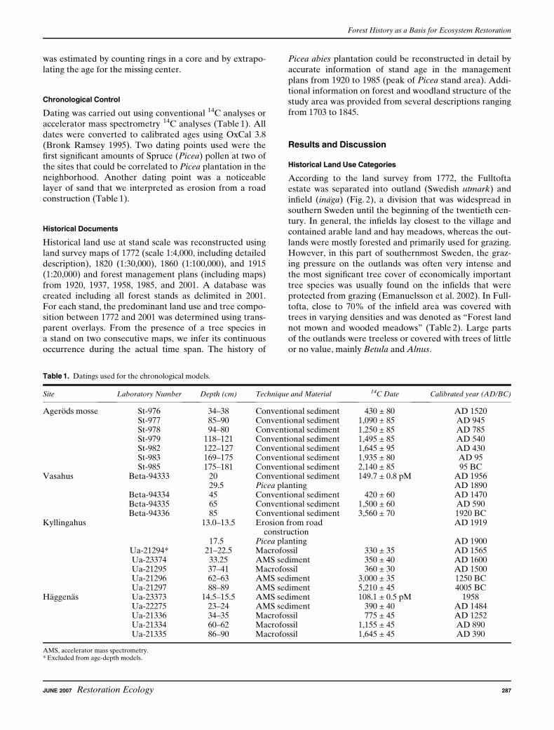
Chronological Control
Dating was carried out using conventional 14C analyses oraccelerator mass spectrometry 14C analyses (Table 1). Alldates were converted to calibrated ages using OxCal 3.8(Bronk Ramsey 1995). Two dating points used were thefirst significant amounts of Spruce (Picea) pollen at two ofthe sites that could be correlated to Picea plantation in theneighborhood. Another dating point was a noticeablelayer of sand that we interpreted as erosion from a roadconstruction (Table 1).
Historical Documents
Historical land use at stand scale was reconstructed usingland survey maps of 1772 (scale 1:4,000, including detaileddescription), 1820 (1:30,000), 1860 (1:100,000), and 1915(1:20,000) and forest management plans (including maps)from 1920, 1937, 1958, 1985, and 2001. A database wascreated including all forest stands as delimited in 2001.For each stand, the predominant land use and tree compo-sition between 1772 and 2001 was determined using trans-parent overlays. From the presence of a tree species ina stand on two consecutive maps, we infer its continuousoccurrence during the actual time span. The history of
Picea abies plantation could be reconstructed in detail byaccurate information of stand age in the managementplans from 1920 to 1985 (peak of Picea stand area). Addi-tional information on forest and woodland structure of thestudy area was provided from several descriptions rangingfrom 1703 to 1845.
Results and Discussion
Historical Land Use Categories
According to the land survey from 1772, the Fulltoftaestate was separated into outland (Swedish utmark) andinfield (inaga) (Fig. 2), a division that was widespread insouthern Sweden until the beginning of the twentieth cen-tury. In general, the infields lay closest to the village andcontained arable land and hay meadows, whereas the out-lands were mostly forested and primarily used for grazing.However, in this part of southernmost Sweden, the graz-ing pressure on the outlands was often very intense andthe most significant tree cover of economically importanttree species was usually found on the infields that wereprotected from grazing (Emanuelsson et al. 2002). In Full-tofta, close to 70% of the infield area was covered withtrees in varying densities and was denoted as ‘‘Forest landnot mown and wooded meadows’’ (Table 2). Large partsof the outlands were treeless or covered with trees of littleor no value, mainly Betula and Alnus.
Table 1. Datings used for the chronological models.
Site Laboratory Number Depth (cm) Technique and Material 14C Date Calibrated year (AD/BC)
Agerods mosse St-976 34–38 Conventional sediment 430 ± 80 AD 1520St-977 85–90 Conventional sediment 1,090 ± 85 AD 945St-978 94–80 Conventional sediment 1,250 ± 85 AD 785St-979 118–121 Conventional sediment 1,495 ± 85 AD 540St-982 122–127 Conventional sediment 1,645 ± 95 AD 430St-983 169–175 Conventional sediment 1,935 ± 80 AD 95St-985 175–181 Conventional sediment 2,140 ± 85 95 BC
Vasahus Beta-94333 20 Conventional sediment 149.7 ± 0.8 pM AD 195629.5 Picea planting AD 1890
Beta-94334 45 Conventional sediment 420 ± 60 AD 1470Beta-94335 65 Conventional sediment 1,500 ± 60 AD 590Beta-94336 85 Conventional sediment 3,560 ± 70 1920 BC
Kyllingahus 13.0–13.5 Erosion from roadconstruction
AD 1919
17.5 Picea planting AD 1900Ua-21294* 21–22.5 Macrofossil 330 ± 35 AD 1565Ua-23374 33.25 AMS sediment 350 ± 40 AD 1600Ua-21295 37–41 Macrofossil 360 ± 30 AD 1500Ua-21296 62–63 AMS sediment 3,000 ± 35 1250 BCUa-21297 88–89 AMS sediment 5,210 ± 45 4005 BC
Haggenas Ua-23373 14.5–15.5 AMS sediment 108.1 ± 0.5 pM 1958Ua-22275 23–24 AMS sediment 390 ± 40 AD 1484Ua-21336 34–35 Macrofossil 775 ± 45 AD 1252Ua-21334 60–62 Macrofossil 1,155 ± 45 AD 890Ua-21335 86–90 Macrofossil 1,645 ± 45 AD 390
AMS, accelerator mass spectrometry.* Excluded from age-depth models.
Forest History as a Basis for Ecosystem Restoration
JUNE 2007 Restoration Ecology 287

Tree Species History
According to the data from Agerods mosse, Quercus wasrather common in the region in the beginning of therecord (Fig. 3). Quercus was also locally rather common(circa 10%) in Vasahus in the beginning of the period butwith continuously decreasing values up to recent times.The surroundings of Kyllingahus seem to have been domi-nated by Quercus (circa 20%) until the eighteenth cen-tury, when it became less common for a couple ofhundred years. Thereafter, the Quercus pollen percen-tages increased to circa 10% in recent time. Quercus mac-rofossils were found in the sediment from this site from
AD 400 and onward, evidence that the species was locallypresent close to the coring point. The large numbers ofmacrofossils found at the top of the core probably reflectan overgrowing of the site by sapling trees when the agri-cultural activities became less intense in the twentieth cen-tury. At Haggenas, both the pollen and the plantmacrofossil data show that Quercus was common untilabout the eleventh century. The decrease after that isprobably due to opening up of the site and the start ofagricultural activities (Fig. 4). However, the macrofossilfinding from the sixteenth century shows that Quercus wasalso locally present during the period when the pollen
Table 2. Areas (ha) of different forests and land use on different parts of the Fulltofta estate according to the land survey of 1772.
Vegetation Type Western Infield Central Infield Eastern Infield Infield Total Outland
Fagus 0 (0) 38 (8) 147 (37) 185 (19) 18 (2)Quercus/Fagus 0 (0) 174 (36) 51 (13) 225 (23) 0 (0)Mixed Quercus 30 (31) 98 (20) 11 (3) 140 (14) 0 (0)Alnus/Betula 20 (21) 78 (16) 18 (4) 116 (12) 138 (16)Sum woodland 50 (52) 388 (81) 227 (57) 666 (68) 156 (18)Open land 47 (48) 92 (19) 174 (43) 314 (32) 718 (82)Sum 97 480 401 978 874
Values in parentheses are percentages of the total area on the different parts.
Figure 3. Pollen percentages for Quercus (black area) and the
number of Quercus macrofossils (bars) from the different sites.
Figure 4. Pollen percentages for Poaceae (gray area) and Cerealia
(black area). Note that the two types are added. Cerealia was not
differentiated in Vasahus. Bars are number of Poaceae macrofossil.
Forest History as a Basis for Ecosystem Restoration
288 Restoration Ecology JUNE 2007
percentages were low. In 1772, Quercus was a commonspecies on the infield according to the land survey(Table 2).
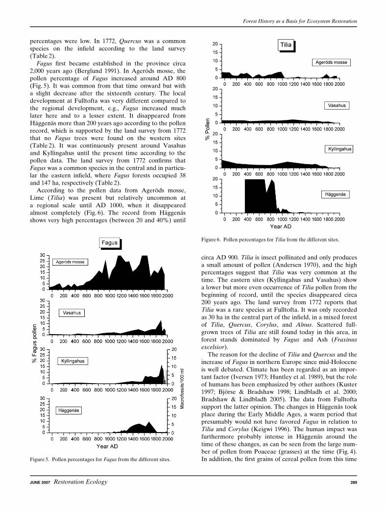
Fagus first became established in the province circa2,000 years ago (Berglund 1991). In Agerods mosse, thepollen percentage of Fagus increased around AD 800(Fig. 5). It was common from that time onward but witha slight decrease after the sixteenth century. The localdevelopment at Fulltofta was very different compared tothe regional development, e.g., Fagus increased muchlater here and to a lesser extent. It disappeared fromHaggenas more than 200 years ago according to the pollenrecord, which is supported by the land survey from 1772that no Fagus trees were found on the western sites(Table 2). It was continuously present around Vasahusand Kyllingahus until the present time according to thepollen data. The land survey from 1772 confirms thatFagus was a common species in the central and in particu-lar the eastern infield, where Fagus forests occupied 38and 147 ha, respectively (Table 2).
According to the pollen data from Agerods mosse,Lime (Tilia) was present but relatively uncommon ata regional scale until AD 1000, when it disappearedalmost completely (Fig. 6). The record from Haggenasshows very high percentages (between 20 and 40%) until
circa AD 900. Tilia is insect pollinated and only producesa small amount of pollen (Andersen 1970), and the highpercentages suggest that Tilia was very common at thetime. The eastern sites (Kyllingahus and Vasahus) showa lower but more even occurrence of Tilia pollen from thebeginning of record, until the species disappeared circa200 years ago. The land survey from 1772 reports thatTilia was a rare species at Fulltofta. It was only recordedas 30 ha in the central part of the infield, in a mixed forestof Tilia, Quercus, Corylus, and Alnus. Scattered full-grown trees of Tilia are still found today in this area, inforest stands dominated by Fagus and Ash (Fraxinusexcelsior).
The reason for the decline of Tilia and Quercus and theincrease of Fagus in northern Europe since mid-Holoceneis well debated. Climate has been regarded as an impor-tant factor (Iversen 1973; Huntley et al. 1989), but the roleof humans has been emphasized by other authors (Kuster1997; Bjorse & Bradshaw 1998; Lindbladh et al. 2000;Bradshaw & Lindbladh 2005). The data from Fulltoftasupport the latter opinion. The changes in Haggenas tookplace during the Early Middle Ages, a warm period thatpresumably would not have favored Fagus in relation toTilia and Corylus (Keigwi 1996). The human impact wasfurthermore probably intense in Haggenas around thetime of these changes, as can be seen from the large num-ber of pollen from Poaceae (grasses) at the time (Fig. 4).In addition, the first grains of cereal pollen from this timeFigure 5. Pollen percentages for Fagus from the different sites.
Figure 6. Pollen percentages for Tilia from the different sites.
Forest History as a Basis for Ecosystem Restoration
JUNE 2007 Restoration Ecology 289

emphasizes the importance of human factors behind thepattern, as do the fast rate of the changes.
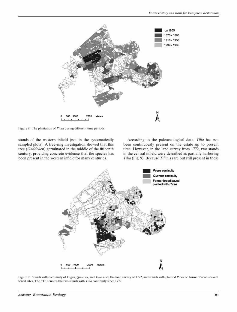
Picea did not occur in the region until it was planted inthe nineteenth century (Hesselman & Schotte 1906). Thespecies shows very low values in the regional pollen dia-gram (Fig. 7). Picea pollen is virtually absent in Fulltoftauntil the upper part of all three cores, when it becomesvery common in the diagrams from the eastern sites butnot at the western site. The latter is in line with the well-documented historical data about the Picea plantationsin Fulltofta. The very first plantation took place on the70-ha ‘‘Maltesholm’s Clearcut’’ (Maltesholmshygget) inthe 1850s (Fig. 9). This pioneer effort was followed by twophases of plantations: the first from 1876 to 1893, when onaverage 10–20 ha/yr were planted, and a second phasefrom 1921 onward. In the 1980s, the area of Picea forestsculminated to a total of 1,196 ha.
Hazel (Corylus) shows the same general decreasingtrend as Quercus in the three Fulltofta sites but with thedifference that Corylus has much lower values or is miss-ing in the uppermost samples. This is in contrast to theregional site (Agerods mosse) where high pollen percen-tages (10–15%) of Corylus persist up to present time. Theland survey of 1772 mentions Corylus in a mixture withQuercus, Fagus, and Tilia on approximately 250 ha.Today, only a small fraction of these areas contain Corylus.
In all three Fulltofta sites, Alnus pollen percentagesdecreased gradually from 20–40% in the beginning of therecord to just a few percentages in recent time. Alnus wasa common tree on the outland areas in 1772.
The Fulltofta sites show very low Pinus pollen percen-tages, most of the time below 5%. Pinus trees producelarge amounts of well-dispersed pollen (Brostrom et al.2004), and such low values in ‘‘small hollow’’ sites proba-bly represents pollen transported from distant sources.
At all three small sites from Fulltofta, Betula becameincreasingly common over the course of time, particularlyduring the nineteenth century. Betula was a very commonspecies on the outland of the estate in 1772 according tothe land survey. In total, 138 ha was covered by Betula ina mixture with Alnus on the outland at that point of time.
Tree Species Continuity
There is evidence for stand-level continuity of Fagus from1772 up to the present time. Although the individualstands to a large extent are spatially unconnected, threeblocks of Fagus can be identified (Fig. 9). The largestblock is located on the infield in the central part of theestate. Today, these stands consist almost exclusively ofFagus trees, but in AD 1772, it was in a mixture with otherbroad-leaved species such as Quercus and Tilia. The twoother blocks are located on the infield in the easternmostpart of the estate. Both these areas were completely domi-nated by Fagus in 1772, but in the late nineteenth or thebeginning of the twentieth century, many stands wereplanted with Picea (Figs. 8 & 9). The pollen and plantmacrofossil analyses from Kyllingahus show that Fagushas been continuously present in the central infield, notonly since the eighteenth century but also for several hun-dred years before that. In the two dendrochronology studysites in the central infield where Fagus has been continu-ously present since 1772 (Jagarhyddan and Ramstorp),Fagus trees are up to 180 years old. In Ramstorp, an ex-ceptionally large, recently deceased Fagus tree was coredand estimated to be at least 300 years old.
There is also a continuity of Quercus since 1772 in manystands in the central part of the infield, although they areeven more disaggregated than the Fagus stands (Fig. 9).One of the stands that have Quercus continuity accordingto the land survey is located adjacent to the wetland thatwas cored in Kyllingahus. The pollen and plant macrofos-sil data show that Quercus has been continuously presentin the surroundings at that site during the past 2,000 years(Fig. 3). One Quercus stump close to the site was dated tohave germinated around AD 1820. Quercus continuity isalso recorded in the western part of the estate since 1772,also even if these stands are disaggregated. The pollenand plant macrofossil data at the Haggenas site show thatQuercus has been continuously present in the westerninfield throughout the time period, although it was some-what less common the past 800 years than previously. Theoldest known Quercus in the area is found in one of the
Figure 7. Pollen percentages for Picea (black area) and the number
of Picea macrofossils (bars) from the different sites.
Forest History as a Basis for Ecosystem Restoration
290 Restoration Ecology JUNE 2007
stands of the western infield (not in the systematicallysampled plots). A tree-ring investigation showed that thistree (Gaddeken) germinated in the middle of the fifteenthcentury, providing concrete evidence that the species hasbeen present in the western infield for many centuries.
According to the paleoecological data, Tilia has notbeen continuously present on the estate up to presenttime. However, in the land survey from 1772, two standsin the central infield were described as partially harboringTilia (Fig. 9). Because Tilia is rare but still present in these
Figure 8. The plantation of Picea during different time periods.
Figure 9. Stands with continuity of Fagus, Quercus, and Tilia since the land survey of 1772, and stands with planted Picea on former broad-leaved
forest sites. The ‘‘T’’ denotes the two stands with Tilia continuity since 1772.
Forest History as a Basis for Ecosystem Restoration
JUNE 2007 Restoration Ecology 291
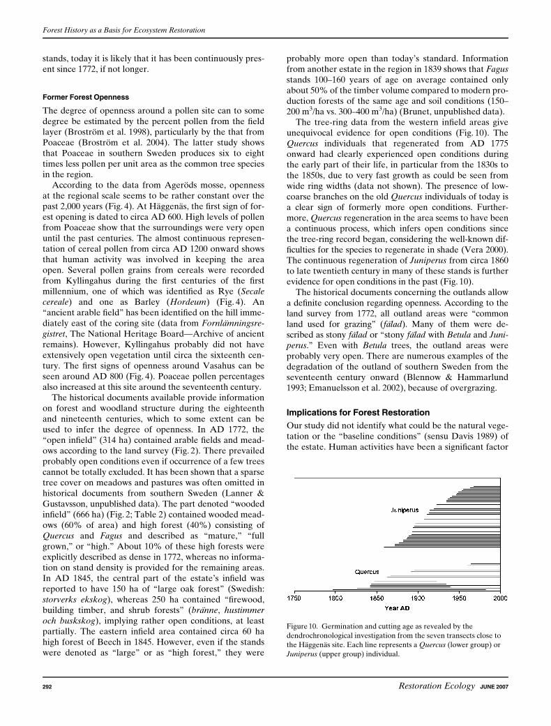
stands, today it is likely that it has been continuously pres-ent since 1772, if not longer.
Former Forest Openness
The degree of openness around a pollen site can to somedegree be estimated by the percent pollen from the fieldlayer (Brostrom et al. 1998), particularly by the that fromPoaceae (Brostrom et al. 2004). The latter study showsthat Poaceae in southern Sweden produces six to eighttimes less pollen per unit area as the common tree speciesin the region.
According to the data from Agerods mosse, opennessat the regional scale seems to be rather constant over thepast 2,000 years (Fig. 4). At Haggenas, the first sign of for-est opening is dated to circa AD 600. High levels of pollenfrom Poaceae show that the surroundings were very openuntil the past centuries. The almost continuous represen-tation of cereal pollen from circa AD 1200 onward showsthat human activity was involved in keeping the areaopen. Several pollen grains from cereals were recordedfrom Kyllingahus during the first centuries of the firstmillennium, one of which was identified as Rye (Secalecereale) and one as Barley (Hordeum) (Fig. 4). An‘‘ancient arable field’’ has been identified on the hill imme-diately east of the coring site (data from Fornlamningsre-gistret, The National Heritage Board—Archive of ancientremains). However, Kyllingahus probably did not haveextensively open vegetation until circa the sixteenth cen-tury. The first signs of openness around Vasahus can beseen around AD 800 (Fig. 4). Poaceae pollen percentagesalso increased at this site around the seventeenth century.
The historical documents available provide informationon forest and woodland structure during the eighteenthand nineteenth centuries, which to some extent can beused to infer the degree of openness. In AD 1772, the‘‘open infield’’ (314 ha) contained arable fields and mead-ows according to the land survey (Fig. 2). There prevailedprobably open conditions even if occurrence of a few treescannot be totally excluded. It has been shown that a sparsetree cover on meadows and pastures was often omitted inhistorical documents from southern Sweden (Lanner &Gustavsson, unpublished data). The part denoted ‘‘woodedinfield’’ (666 ha) (Fig. 2; Table 2) contained wooded mead-ows (60% of area) and high forest (40%) consisting ofQuercus and Fagus and described as ‘‘mature,’’ ‘‘fullgrown,’’ or ‘‘high.’’ About 10% of these high forests wereexplicitly described as dense in 1772, whereas no informa-tion on stand density is provided for the remaining areas.In AD 1845, the central part of the estate’s infield wasreported to have 150 ha of ‘‘large oak forest’’ (Swedish:storverks ekskog), whereas 250 ha contained ‘‘firewood,building timber, and shrub forests’’ (branne, hustimmeroch buskskog), implying rather open conditions, at leastpartially. The eastern infield area contained circa 60 hahigh forest of Beech in 1845. However, even if the standswere denoted as ‘‘large’’ or as ‘‘high forest,’’ they were
probably more open than today’s standard. Informationfrom another estate in the region in 1839 shows that Fagusstands 100–160 years of age on average contained onlyabout 50% of the timber volume compared to modern pro-duction forests of the same age and soil conditions (150–200 m3/ha vs. 300–400 m3/ha) (Brunet, unpublished data).
The tree-ring data from the western infield areas giveunequivocal evidence for open conditions (Fig. 10). TheQuercus individuals that regenerated from AD 1775onward had clearly experienced open conditions duringthe early part of their life, in particular from the 1830s tothe 1850s, due to very fast growth as could be seen fromwide ring widths (data not shown). The presence of low-coarse branches on the old Quercus individuals of today isa clear sign of formerly more open conditions. Further-more, Quercus regeneration in the area seems to have beena continuous process, which infers open conditions sincethe tree-ring record began, considering the well-known dif-ficulties for the species to regenerate in shade (Vera 2000).The continuous regeneration of Juniperus from circa 1860to late twentieth century in many of these stands is furtherevidence for open conditions in the past (Fig. 10).
The historical documents concerning the outlands allowa definite conclusion regarding openness. According to theland survey from 1772, all outland areas were ‘‘commonland used for grazing’’ (falad). Many of them were de-scribed as stony falad or ‘‘stony falad with Betula and Juni-perus.’’ Even with Betula trees, the outland areas wereprobably very open. There are numerous examples of thedegradation of the outland of southern Sweden from theseventeenth century onward (Blennow & Hammarlund1993; Emanuelsson et al. 2002), because of overgrazing.
Implications for Forest Restoration
Our study did not identify what could be the natural vege-tation or the ‘‘baseline conditions’’ (sensu Davis 1989) ofthe estate. Human activities have been a significant factor
Figure 10. Germination and cutting age as revealed by the
dendrochronological investigation from the seven transects close to
the Haggenas site. Each line represents a Quercus (lower group) or
Juniperus (upper group) individual.
Forest History as a Basis for Ecosystem Restoration
292 Restoration Ecology JUNE 2007

even at the beginning of the record, 2,000 years ago, whichas can be seen in the evidence for agriculture around Kyl-lingahus (Fig. 4). Furthermore, even if the record did gofurther back in time and we could identify a period witha minimum of human impact, it is doubtful whether a res-toration with that time period as a goal would be meaning-ful, considering the large changes in vegetation that havetaken place during the millennia. The infield/outland sys-tem in Fulltofta has had a long history, perhaps at leastsince approximately AD 1100. From a conservational andrecreational point of view, many of the valuable elementson the estate are connected to the former cultural land-scape. Our suggestions therefore aim to maintain the spa-tial vegetational pattern that this land use created, even ifthe associated agricultural activities are gone.
In the western infield, the presence of many old Quercusindividuals, valuable for conservation, and the fact thatQuercus is the only important tree species with long conti-nuity in many of the stands argue for a continuous promo-tion of this species. Maintenance of the mosaic of openand denser stands would probably benefit the high diver-sity of lichens and wood-dependent beetles that can befound in the area today (Malmqvist 1999, 2002). In thecentral infield, Quercus has been continuously present forthousands of years and Fagus for several hundred years.Furthermore, it was a stronghold for both Quercus andFagus during the period of minimum forest cover from thesixteenth to the nineteenth century. We therefore suggestthat many of the Picea stands in the area should be con-verted to Quercus and Fagus forest. Increased connectiv-ity between the stands of rich deciduous tree species couldbe beneficial for rare species with low dispersal abilityassociated with these tree species (Ranius & Hedin 2001).In some places, we propose to restore the forest type thatthe paleoecological record tells us was very common inthe past—a semiopen mixed forest with Quercus, Tilia,and Corylus. As we lack paleoecological information fromthe eastern infield, we do not know the long-term historyof the area. However, as the dominance of Fagus thatcould be seen in 1772 today is no longer evident, we pro-pose that many of the Picea plantations should be restoredto rather dense Fagus forest, but mixed with some standsdominated by Quercus. The former outland in Fulltoftalacks continuity of broad-leaved trees. We propose that inthe future, the main part of the Picea forest should belocated to that area, in particular the eastern part of theoutland. To secure the connectivity between the broad-leaved forests on the former infield areas, it could be nec-essary to convert some strategically located Picea standsto broad-leaved stands, in particular in the area separatingthe easternmost infield area from the other infield areas.
General Conclusions
Although this study is constrained to a single estate, someconclusions can be drawn that are valid for restorationactions in general.
The comparison between the sites in the study showsthat the temporal and spatial variation within and betweensites in the landscape has been considerable over theyears, as also found in other studies (Foster 2002). A strik-ing example of the local variation is the occurrence ofTilia. This species was much more common in Fulltofta2,000 years ago than in the region (Fig. 6). The disappear-ance of Tilia occurred too long ago for it to be importantfrom a conservational point of view, and rather few red-listed species are dependent of Tilia in comparison withQuercus and Fagus in Sweden today (Jonsell et al. 1998).But perhaps, the species could be interesting to promotebecause of recreational or historical reasons.
Fagus on the other hand shows the opposite trend interms of abundance compared to Tilia. Fagus history inFulltofta is rather short (approximately 400 years) and notvery prominent compared to the regional data. This rela-tively short period of time has apparently been enough forFagus to develop to an important tree species for manywood-dependent organisms. Other studies from southernSweden show the same pattern, with Fagus having animportant conservational role, despite having a relativelyshort and modest history (Lindbladh & Bradshaw 1998,Niklasson et al. 2002; Bradshaw & Lindbladh 2005).
Our study highlights the difficulties when decision-making in nature conservation (e.g., forest restoration orselection of areas to preserve) is based on a limited knowl-edge of the landscape history. In many cases, the onlyreferences available are a regional paleoecological recordand/or historical maps. In practical restoration work, it isseldom possible to carry out an extensive vegetation inves-tigation, but this study gives an example of the variationthat can occur within one area and emphasizes that oneregional pollen record or one historical map only giveslimited information of an area’s vegetation history. Ourresults argue for a network of studies in each importantvegetation zone.
We used several different techniques, and the interpre-tation of the different records was facilitated by the pos-sibility to calibrate on both spatial and temporal scaleswhere the records overlapped. For instance, low pollenpercent levels are often difficult to interpret and the pres-ence of Quercus in Haggenas from AD 1200 onward couldhave been overlooked if the plant macrofossil and histori-cal data had not been available. Multiproxy reconstruc-tions of vegetation history are often constrained by thelack of suitable paleoecological sites in places where his-torical maps and written records of land use history areavailable. This is illustrated in our study because one ofthe paleoecological sites was located on the outskirts ofthe estate and there were no sites in the eastern infields.Remaining undisturbed wetlands are rare in many areas,and investigations are therefore often biased toward moreremote and inaccessible sites. With our experience, if theaim is to investigate multiple small hollows in areas witha history of long human impact, we recommend targetingsuitable wetlands as the first step.
Forest History as a Basis for Ecosystem Restoration
JUNE 2007 Restoration Ecology 293
Implications for Practice
The study shows:
d How knowledge of local and regional forest and veg-etation history can give insights to be used duringrestoration and management of an estate or an area.
d How a detailed reconstruction of forest and vege-tation history is possible via a multidisciplinaryapproach.
d That changing patterns of vegetation compositionand structure across time and space emphasizes thata single technique yields only limited information.
d The difficulties in identifying the natural vegetationof an area. We suggest that other criteria, forinstance previous land use systems, could be used asa goal for a restoration project.
Acknowledgments
The study was a part of the research program, The Con-servation Chain, with financial support from Swedish En-vironmental Protection Agency. Thanks to M. Anderssonfor GIS support.
LITERATURE CITED
Ahti, T., L. Hamet-Ahti, and J. Jalas. 1968. Vegetation zones and their
sections in northwestern Europe. Annales Botanica Fennica 5:
169–211.
Anderberg, A.-L. 1994. Atlas of seeds. Part 4. Resedaceae-Umbelliferae.
Naturhistoriska Riksmuseet, Stockholm, Sweden.
Andersen, S. T. 1970. The relative pollen productivity of North European
trees, and correction factors for tree pollen spectra. Danmarks
Geologiske Undersøgelse II 96:1–99.
Berg, A., B. Ehnstrom, L. Gustafsson, T. Hallingback, M. Jonsell, and
J. Weslien. 1994. Threatened plant, animal, and fungus species in
Swedish forests: distribution and habitat associations. Conservation
Biology 8:718–731.
Berggren, G. 1969. Atlas of seeds. Part 2. Cyperaceae. Naturhistoriska
Riksmuseet, Stockholm, Sweden.
Berggren, G. 1981. Atlas of seeds. Part 3. Salicacee-Cruciferae. Naturhis-
toriska Riksmuseet, Stockholm, Sweden.
Berglund, B. E., editor. 1991. The cultural landscape during 6000 years in
southern Sweden—the Ystad project. Ecological Bulletins, Copen-
hagen, Denmark.
Berglund, B. E., and M. Ralska-Jasiewiczowa. 1986. Pollen analysis and
pollen diagrams. Pages 455–484 in B. E. Berglund, editor. Hand-
book of holocene palaeoecology and palaeohydrology. John Wiley
& Sons, Chichester, United Kingdom.
Bertsch, K. 1941. Fruchte und Samen. Ein Bestimmungsbuch zur Pflan-
zenkunde der vorgeschichtlichen Zeit (in German). Page 247 in
H. Reinerth, editor. Handbucher der praktischen Vorgeschichtsfor-
schung, Band 1. Verlag Ferdinand Enke, Stuttgart, Germany.
Birks, H. J. B. 1996. Contributions of quaternary palaeoecology to nature
conservation. Journal of Vegetation Science 7:89–98.
Bjorse, G., and R. H. W. Bradshaw. 1998. 2000 years of forest dynamics in
southern Sweden: suggestions for forest management. Forest Ecol-
ogy and Management 104:15–26.
Blennow, K., and K. Hammarlund 1993. Form heath to forest: land-use
transformation in Halland, Sweden. Ambio 22:561–567.
Bradshaw, A. D. 1997. What do we mean by restoration? Pages 8–14 in
K. M. Urbanska, N. R. Webb, P. J. Edwards, editors. Restoration
ecology and sustainable development. Cambridge University Press,
Cambridge, United Kingdom.
Bradshaw, R. H. W., and M. Lindbladh. 2005. Regional spread and stand-
scale establishment of trees in North-West Europe. Ecology 86:
1679–1686.
Bronk Ramsey, C. 1995. Radiocarbon calibration and analysis of stratig-
raphy: the OxCal program. Radiocarbon 37:425–430.
Brostrom, A., M. J. Gaillard, M. Ihse, and B. Odgaard. 1998. Pollen-
landscape relationships in modern analogues of ancient cultural
landscapes in southern Sweden—a first step towards quantification
of vegetation openness in the past. Vegetation History and Archae-
obotany 7:189–201.
Brostrom, A., S. Sugita, M. J. Gaillard. 2004. Pollen productivity esti-
mates for the reconstruction of past vegetation cover in the cultural
landscape of southern Sweden. Holocene 14:368–381.
Bunting, M. J., M. J. Gaillard, S. Sugita, R. Middleton, and A. Brostrom.
2004. Vegetation structure and pollen source area. Holocene
14:651–660.
Calcote, R. 1998. Identifying forest stand types using pollen from forest
hollows. The Holocene 8:423–432.
Davis, M. B. 1989. Retrospective studies. Pages 71–89 in G. E. Likens,
editor. Long-term studies in ecology. Springer-Verlag, London,
United Kingdom.
Ekstrand, A. 1999. Region Skanes skogar (in Swedish). Skanes Natur
86:55–60.
Emanuelsson, U., C. Bergendorff, M. Billqvist, B. Carlsson, and N. Lewan.
2002. Det skanska kulturlandskapet (in Swedish). Arsbok for
Naturskyddsforeningen i Skane, Lund, Sweden, 2001.
Foster, D. R. 2002. Insights from historical geography to ecology and
conservation: lessons from the New England landscape. Journal of
Biogeography 29:1269–1275.
Fritz, O., and K. Larsson. 1997. Betydelsen av skoglig kontinuitet for
rodlistade lavar. En studie av hallandsk bokskog. (The significance
of long forest continuity to red-listed lichens. A study of beech for-
est in the province of Halland, SW Sweden.) (in Swedish with
English summary). Svensk Botanisk Tidskrift 90:243–262.
Gardenfors, U. 2005. Red-listed species in Sweden 2005. ArtDatabanken,
SLU, Uppsala, Sweden.
Germundsson, T., and P. Schlyter, editors. 1999. Atlas over Skane (in
Swedish). Almqvist & Wiksell, Uppsala, Sweden.
Grissino-Mayer, H., R. Holmes, and H. C. Fritz. 1992. International tree-
ring data bank program library. Version 1.1. Laboratory of tree-ring
research, University of Arizona, Tucson.
Hesselman, H., and G. Schotte. 1906. Granen vid sin sydvastgrans i
Sverige—Meddelanden fran Statens skogsforsoksanstalt 3:1–52.
Honnay, O., K. Verheyen, B. Bossuyt, and M. Hermy, editors. 2004.
Forest biodiversity: lessons from history for conservation. IUFRO
Research Series, vol. 10. CAB International, Wallingford, United
Kingdom.
Huntley, B., P. J. Bartlein, and I. C. Prentice. 1989. Climatic control of
the distribution and abundance of beech (Fagus L.) in Europe and
North America. Journal of Biogeography 16:551–560.
Iversen, J. 1973. The development of Denmark’s nature since the last
glacial. Danmarks Geologiske Undersøgelse series V 7-C: 1–126.
CA Reitzels Forlag, Copenhagen, Denmark.
Jacobson, G. L., and R. H. W. Bradshaw. 1981. The selection of sites for
paleovegetational studies. Quaternary Research 16:80–96.
Jonsell, M., J. Weslien, and B. Ehnstrom. 1998. Substrate requirements of
red-listed saproxylic invertebrates in Sweden. Biodiversity and Con-
servation 7:749–764.
Keigwi, L. D. 1996. The little ice age and medieval warm period in the
Sargasso sea. Science 274:1503–1508.
Forest History as a Basis for Ecosystem Restoration
294 Restoration Ecology JUNE 2007
Kuster, H. 1997. The role of farming in the postglacial expansion of beech
and hornbeam in the oak woodlands of central Europe. The Holo-
cene 7:239–242.
Lindbladh, M., and R. H. W. Bradshaw. 1998. The origin of present forest
composition and pattern in southern Sweden. Journal of Biogeogra-
phy 25:463–477.
Lindbladh, M., R. H. W. Bradshaw, and B. H. Holmquist. 2000. Pattern
and process in south Swedish forests during the last 3000 years
sensed at stand and regional scales. Journal of Ecology 88:113–128.
Malmqvist, A. 1999. Rodlistade lavar i Horby och Hoors kommuner 1999
(in Swedish). Horby & Hoors kommun, Hoor, Sweden.
Malmqvist, A. 2002. Inventering av vedlevande skalbaggar i Hoor och Horby
kommuner 2002 (in Swedish). Naturcentrum AB, Stenungsund, Sweden.
Niklasson, M., M. Lindbladh, and L. Bjorkman. 2002. A long-term record
of Quercus decline, logging and fire history in a southern Swedish
Fagus-Picea forest. Journal of Vegetation Science 13:765–774.
Nilsson, T. 1964. Standard pollen diagramme und C14 datiengen aus dem
Agerods mosse in mittleren schonen (in German). Lund universitets
arsskrift N.F. 2 59:52.
Ranius, T., and J. Hedin. 2001. The dispersal rate of a beetle, Osmoderma
eremita, living in tree hollows. Oecologia 126:363–370.
Ranius, T., and N. Jansson. 2000. The influence of forest regrowth, origi-
nal canopy cover and tree size on saproxylic beetles associated with
old oaks. Biological Conservation 95:85–94.
Stanturf, J. A., and P. Madsen. 2005. Restoration of boreal and temperate
forests. CRC Press, Boca Raton, Florida.
Sugita, S. 1998. Modelling pollen representation of vegetation. Pages 1–16
in M. J. Gaillard and B. Berglund, editors. Quantification of land
surfaces cleared of forests during the Holocene—modern pollen/
vegetation/landscape relationships as an aid to the interpretation of
fossil pollen data, Volume 27. Gustav Fischer Verlag, Stuttgart,
Germany.
Vera, F. W. M. 2000. Grazing ecology and forest history. CABI Publish-
ing, Oxon, United Kingdom.
Wasylikowa, K. 1986. Analysis of fossil fruits and seeds. Pages 571–590
in B. E. Berglund, editor. Handbook of holocene palaeoecology
and palaeohydrology. John Wiley & Sons, Chichester, United
Kingdom.
Forest History as a Basis for Ecosystem Restoration
JUNE 2007 Restoration Ecology 295
Copyright © 2022 FDOKUMEN