Folleto Nº 1/2015 Avisos Nº 1 al 37 31 de Enero de 2015
76
Folleto Nº 1/2015 Avisos Nº 1 al 37 31 de Enero de 2015
-
Upload
khangminh22 -
Category
Documents
-
view
2 -
download
0
Transcript of Folleto Nº 1/2015 Avisos Nº 1 al 37 31 de Enero de 2015
Folleto Nº 1/2015Avisos Nº 1 al 37
31 de Enero de 2015

ISSN 0797-8898
REPUBLICA ORIENTAL DEL URUGUAYARMADA NACIONAL
SERVICIO DE OCEANOGRAFIA, HIDROGRAFIAY METEOROLOGIA DE LA ARMADA
A V I S O S A L O S
N A V E G A N T E S
Contenido
I INSTRUCCIONES II AVISOS A LOS NAVEGANTES III RADIOAVISOS NAUTICOS IV INFORMACION NAUTICA V CARTAS NAUTICAS ELECTRONICAS (ENC) VI CORRECCIONES A CARTAS Y PUBLICACIONES NAUTICAS VII CARTAS Y PUBLICACIONES NAUTICAS PUBLICADAS POR SOHMA VIII HIDROVIA PARANA - PARAGUAY
Folleto Nº 1/2015Avisos Nº 1 al 37
31 de Enero de 2015
Se solicita a los navegantes, Prácticos, Organismos del Estado, Entes Autónomos, Compañías Navieras, Empresas de Obras Portuarias y toda otra persona relacionada con el ámbito marítimo, comuniquencualquier alteración o irregularidad que pueda afectar la seguridad de la navegación al:
Servicio de Oceanografía, Hidrografía y Meteorología de la Armada.Dirección: Capurro 980 - Montevideo - URUGUAY
-Casilla de Correos: 1381 / *Código Postal: 11700
)Teléfonos: (+598) 2307 1777 / 2309 3775 / 2309 3861 - Tel./Fax: (+598) 2309 9220
+E-mail: [email protected]
ó a la Autoridad Marítima más próxima.
8Página Web: www.sohma.armada.mil.uy
Marea en tiempo real BAHIA MONTEVIDEO (+598) 99679071
Capitán de Navío (CG) GUSTAVO MUSSOJefe del Servicio de Oceanografía, Hidrografía y
Meteorología de la Armada
Publicación Mensual
PublicaciónNº 8
SERV
ICIODEOCEANOGRAFI
A, HIDR
OGRAFIA YMETE
OROLOGIADELAAR
MADA
-URUGUAY -
Folleto Nº 1/2015 Pág. 2 de 72 Publicación Nº 8Servicio de Oceanografía, Hidrografía y Meteorología de la Armada.- Uruguay
I
INSTRUCCIONES
1.- AVISOS A LOS NAVEGANTES Los Avisos al navegante brindan toda la información de utilidad relacionada con las modifi caciones en las Ayudas a la Navegación, los peligros para la navegación, nuevos sondajes de importancia y de una manera más general, toda información que afecta a las Cartas y Publicaciones Náuticas. El Servicio de Oceanografía, Hidrografía y Meteorología de la Armada (SOHMA) publica los Avisos a los Navegantes mensualmente a través de este Folleto (Publicación Nº 8).
AVISO IMPORTANTE: El formato de presentación de esta publicación está adaptado para facilitar su transmisión por correo electrónico, así como su consulta de la página WEB (www.sohma.armada.mil.uy). El pie de página luce a efectos de poder identifi car a qué publicación pertenece cada hoja suelta al obtenerse de la página WEB, su ubicación dentro de la misma y el número total de páginas que integra cada Folleto.
2.- CLASIFICACION DE AVISOS A LOS NAVEGANTES El SOHMA origina los siguientes tipos de Avisos a los Navegantes: 2.1.- AVISOS GENERALES (G) Comunican a los navegantes toda información o instrucción que, por su naturaleza, no altera un documento náutico específi co, y por tanto no implican correcciones a las Cartas y Publicaciones Náuticas. (Sección IV) 2.2.- AVISOS DEFINITIVOS Informan un cambio permanente en las cartas y/o publicaciones afectadas. (Sección II). En la Sección VI se incluye las correcciones a Cartas y Publicaciones Náuticas, ello los constituyen los pegotes para las Cartas y Publicaciones, así como las nuevas páginas, a incluir o sustituir, para las Publicaciones. 2.3.- AVISOS PRELIMINARES (P) Advierten anticipadamente acaecimientos de cualquier naturaleza, que van a producirse en el ámbito vinculado con la Náutica. (Sección II) 2.4.- AVISOS TEMPORARIOS (T) Informan novedades o alteraciones de naturaleza transitoria. (Sección II) Los Avisos Preliminares y Temporarios vienen separados a efectos de que puedan ser extraídos del folleto y tenerlos en un lugar visible en el puente o sala de derrota del buque. 2.5.- RADIO AVISOS NAUTICOS (AVUR) Mensaje transmitido por medio de telecomunicaciones y que contiene información urgente relacionada con la seguridad a la navegación. Se transcribe en la Sección III los Radioavisos vigentes al momento de la publicación del Folleto. Los Radio avisos Náuticos son transmitidos por: a) Las estaciones Costeras de la Prefectura Nacional Naval. b) La estación costera de ANTEL c) Otros medios para uso interno de la Armada. El Aviso General Nº *5/2015(G) provee información de las Estaciones de Radio Nacionales que transmiten Radio Avisos Náuticos y Boletines Meteorológicos.
3.- PERIODO DE EMISION Y VIGENCIA DE LOS AVISOS 3.1.- AVISOS GENERALES (G) Tienen vigencia anual. Todos los Avisos Generales que permanecen vigentes del año anterior son sustituidos por uno idéntico que aparece publicado en el Folleto Nº 1. 3.2.- AVISOS DEFINITIVOS Anualmente, en el último Folleto, aparece un listado de todos los Avisos Defi nitivos que fueron publicados durante el año y las cartas y publicaciones que corrigieron. (Sección VI) 3.3.- AVISOS PRELIMINARES (P) De ser posible se avisará con dos meses de anticipación. Una vez cumplido el aviso anticipado será sustituido por un Defi nitivo o Temporario, según corresponda. Al fi nal de la Sección II aparece la lista de Avisos Preliminares y Temporarios vigentes, así como la de aquellos anulados. Anualmente en el primer Folleto del año, se repiten todos los Avisos Preliminares y Temporarios que permanecen en vigencia.

Folleto Nº 1/2015 Pág. 3 de 72 Publicación Nº 8Servicio de Oceanografía, Hidrografía y Meteorología de la Armada.- Uruguay
I
INSTRUCCIONES
4.- NUMERACION 4.1.- Los Avisos a los Navegantes son identifi cados por un número de aviso que se compone de dos partes, separada por una barra inclinada. Los dígitos ubicados a la izquierda de la barra indican el número del aviso que es anual y correlativo. Los cuatro dígitos ubicados a la derecha de la barra identifi can el año del aviso. 4.2.- La secuencia de numeración que identifi ca a los Avisos Generales, Defi nitivos, Temporarios y Preliminares es una sola. Los Avisos Generales, Temporarios y Preliminares son identifi cados por las anotaciones (G), (T) o (P) respectivamente ubicada a la derecha del número del Aviso. 4.3.- El símbolo *, ubicado a la izquierda del Número del Aviso, indica que la información es de origen nacional (Uruguay). 4.4.- Los Radio Avisos Náuticos se identifi can por la palabra AVUR seguida de un número de hasta 4 dígitos que es correlativo y separado por un punto, una cifra de dos dígitos que representará las últimas dos del año en que se originó el AVUR.
5.- REFERENCIAS DE LA INFORMACION 5.1.- Las marcaciones son verdaderas, dadas en grados contadas de 000º a 359º59’ en el sentido del movimiento de las agujas del reloj. 5.2.- Las relativas a las luces, incluso sus sectores de iluminación o de peligros, están dadas desde el mar. 5.3.- Cuando las posiciones sean informadas por marcación y distancia, las mismas estarán dadas a partir del punto establecido como referencia. 5.4.- Las situaciones geográfi cas son referidas a la carta de mayor escala, salvo indicación contraria. 5.5.- Las horas corresponden a la hora legal vigente. 5.6.- Las profundidades son referidas a los planos de reducción de sonda fi jadas para la carta de mayor escala. 5.7.- Las alturas están dadas sobre el nivel medio del mar.
6.- POSICIONAMIENTO MEDIANTE GPS La totalidad de las Cartas editadas por el SOHMA, están en Sistema Geodésico Mundial (WGS-84), lo cual permite leer las coordenadas desde GPS.
7.- TEXTO EN INGLES El SOHMA publica la traducción no ofi cial al inglés, de los Avisos Generales, Defi nitivos, Temporales, Preliminares y Radioavisos. El texto en inglés no constituye una traducción ofi cial, sino una traducción realizada por personal idóneo, cuya fi nalidad es facilitar el uso del folleto a los navegantes que no conocen o no entienden correctamente el idioma español.
8.- CARTAS NAUTICAS ELECTRONICAS (Sección V) En esta Sección se informa: 8.1.- Las nuevas ediciones de celdas de Cartas Náuticas Electrónicas publicadas en el mes. 8.2.- Las celdas actualizadas durante el mes. 8.3.- Como informativo, las versiones vigentes.
9.- INFORMACION NAUTICA (Sección IV) En esta Sección se incluyen todo tipo de información o instrucción de interés para la navegación que no genera correcciones a Cartas y Publicaciones Náuticas del SOHMA. Dentro de esta información se incluyen los Avisos Generales.
10.- ADVERTENCIA La ausencia de novedades en el Folleto de Avisos a los Navegantes o en los Radio Avisos Náuticos (AVUR) no debe ser interpretada como situación normal en las rutas de navegación, sino que, sobre ellas, no se han recibido informes o denuncias.
Folleto Nº 1/2015 Pág. 4 de 72 Publicación Nº 8Servicio de Oceanografía, Hidrografía y Meteorología de la Armada.- Uruguay
AVISOS A LOS NAVEGANTES
II
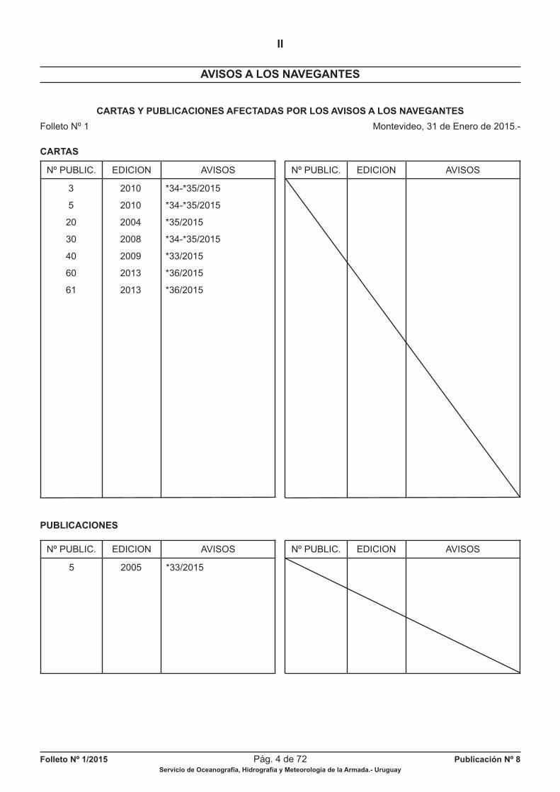
CARTAS Y PUBLICACIONES AFECTADAS POR LOS AVISOS A LOS NAVEGANTES
Folleto Nº 1 Montevideo, 31 de Enero de 2015.-
CARTAS
PUBLICACIONES
5 2005 *33/2015
3 2010 *34-*35/2015
5 2010 *34-*35/2015
20 2004 *35/2015
30 2008 *34-*35/2015
40 2009 *33/2015
60 2013 *36/2015
61 2013 *36/2015
Nº PUBLIC. EDICION AVISOS Nº PUBLIC. EDICION AVISOS
Nº PUBLIC. EDICION AVISOS Nº PUBLIC. EDICION AVISOS
Folleto Nº 1/2015 Pág. 5 de 72 Publicación Nº 8Servicio de Oceanografía, Hidrografía y Meteorología de la Armada.- Uruguay
AVISOS A LOS NAVEGANTES
II
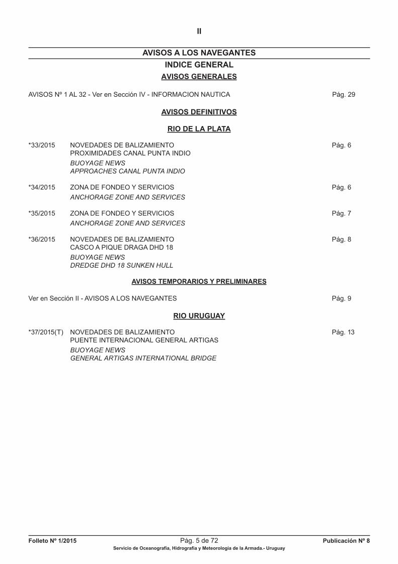
INDICE GENERAL
AVISOS GENERALES
AVISOS Nº 1 AL 32 - Ver en Sección IV - INFORMACION NAUTICA Pág. 29
AVISOS DEFINITIVOS
RIO DE LA PLATA
*33/2015 NOVEDADES DE BALIZAMIENTO Pág. 6 PROXIMIDADES CANAL PUNTA INDIO
BUOYAGE NEWS
APPROACHES CANAL PUNTA INDIO
*34/2015 ZONA DE FONDEO Y SERVICIOS Pág. 6
ANCHORAGE ZONE AND SERVICES
*35/2015 ZONA DE FONDEO Y SERVICIOS Pág. 7
ANCHORAGE ZONE AND SERVICES
*36/2015 NOVEDADES DE BALIZAMIENTO Pág. 8 CASCO A PIQUE DRAGA DHD 18
BUOYAGE NEWS
DREDGE DHD 18 SUNKEN HULL
AVISOS TEMPORARIOS Y PRELIMINARES
Ver en Sección II - AVISOS A LOS NAVEGANTES Pág. 9
RIO URUGUAY
*37/2015(T) NOVEDADES DE BALIZAMIENTO Pág. 13 PUENTE INTERNACIONAL GENERAL ARTIGAS
BUOYAGE NEWS
GENERAL ARTIGAS INTERNATIONAL BRIDGE
Folleto Nº 1/2015 Pág. 6 de 72 Publicación Nº 8Servicio de Oceanografía, Hidrografía y Meteorología de la Armada.- Uruguay
AVISOS A LOS NAVEGANTES
II
AVISOS DEFINITIVOS
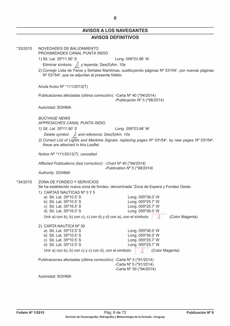
*33/2015 NOVEDADES DE BALIZAMIENTO PROXIMIDADES CANAL PUNTA INDIO
1) Sit. Lat. 35º11.90’ S Long. 056º23.96’ W
Eliminar símbolo: y leyenda: Des(5)Am. 10s
2) Corregir Lista de Faros y Señales Marítimas, sustituyendo páginas Nº 53a/54c, por nuevas páginas Nº 53a/54d, que se adjuntan al presente folleto.
Anula Aviso Nº *111/2013(T)
Publicaciones afectadas (última corrección): -Carta Nº 40 (*94/2014) -Publicación Nº 5 (*98/2014)
Autoridad: SOHMA
BUOYAGE NEWS
APPROACHES CANAL PUNTA INDIO
1) Sit. Lat. 35º11.90’ S Long. 056º23.96’ W
Delete symbol: and reference: Des(5)Am. 10s
2) Correct List of Lights and Maritime Signals, replacing pages Nº 53a/54c, by new pages Nº 53a/54d,
these are attached in this Leafl et.
Notice Nº *111/2013(T), cancelled
Affected Publications (last correction): -Chart Nº 40 (*94/2014)
-Publication Nº 5 (*98/2014)
Authority: SOHMA
*34/2015 ZONA DE FONDEO Y SERVICIOS Se ha establecido nueva zona de fondeo, denominada “Zona de Espera y Fondeo Oeste.
1) CARTAS NAUTICAS Nº 3 Y 5 a) Sit. Lat. 35º10.5’ S Long. 055º36.0’ W b) Sit. Lat. 35º10.5’ S Long. 055º25.7’ W c) Sit. Lat. 35º16.5’ S Long. 055º25.7’ W d) Sit. Lat. 35º16.5’ S Long. 055º36.0’ W
Unir a) con b), b) con c), c) con d) y d) con a), con el símbolo: (Color Magenta)
2) CARTA NAUTICA Nº 30 a) Sit. Lat. 35º12.5’ S Long. 055º36.0’ W b) Sit. Lat. 35º10.5’ S Long. 055º36.0’ W c) Sit. Lat. 35º10.5’ S Long. 055º25.7’ W d) Sit. Lat. 35º12.5’ S Long. 055º25.7’ W
Unir a) con b), b) con c) y c) con d), con el símbolo: (Color Magenta)
Publicaciones afectadas (última corrección): -Carta Nº 3 (*91/2014) -Carta Nº 5 (*91/2014) -Carta Nº 30 (*94/2014)
Autoridad: SOHMA
ghts
Folleto Nº 1/2015 Pág. 7 de 72 Publicación Nº 8Servicio de Oceanografía, Hidrografía y Meteorología de la Armada.- Uruguay
AVISOS A LOS NAVEGANTES
II
AVISOS DEFINITIVOS
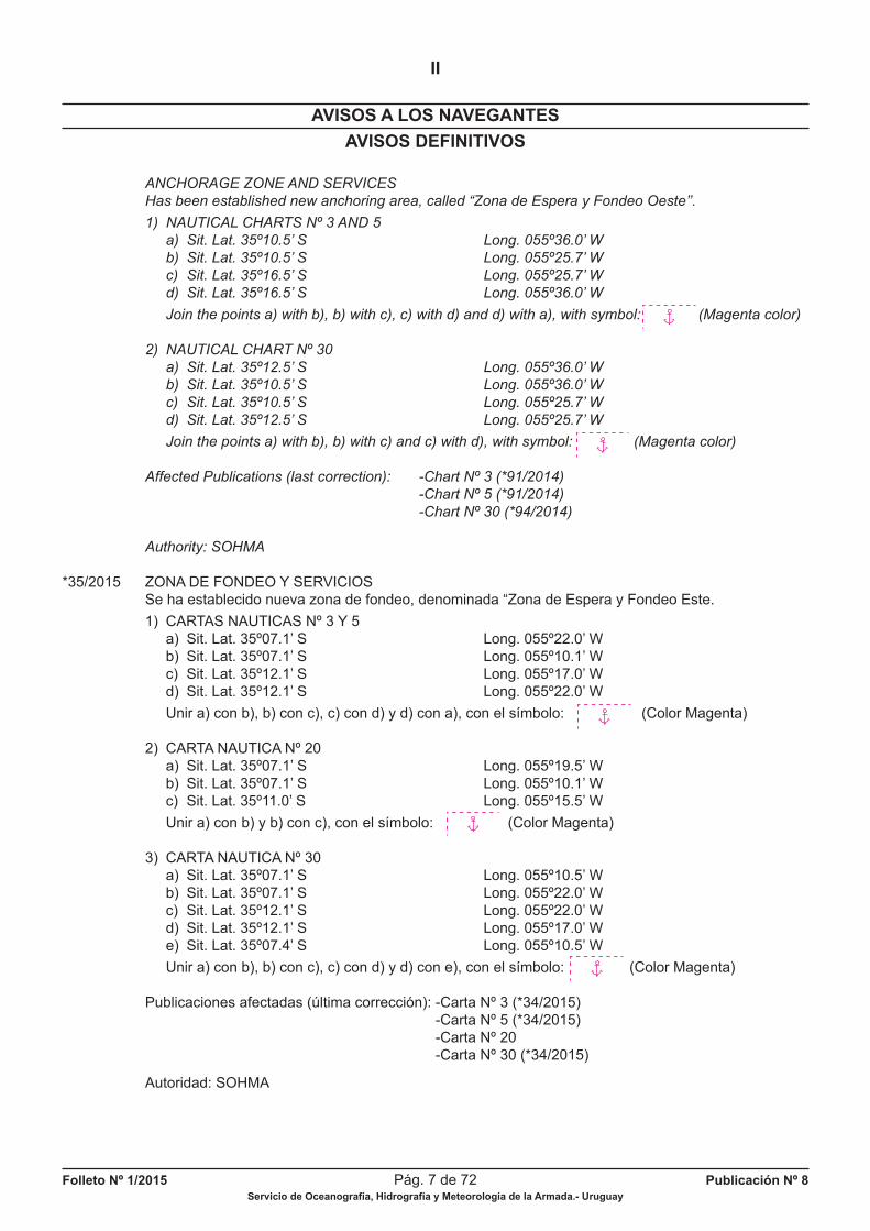
ANCHORAGE ZONE AND SERVICES
Has been established new anchoring area, called “Zona de Espera y Fondeo Oeste’’.
1) NAUTICAL CHARTS Nº 3 AND 5
a) Sit. Lat. 35º10.5’ S Long. 055º36.0’ W
b) Sit. Lat. 35º10.5’ S Long. 055º25.7’ W
c) Sit. Lat. 35º16.5’ S Long. 055º25.7’ W
d) Sit. Lat. 35º16.5’ S Long. 055º36.0’ W
Join the points a) with b), b) with c), c) with d) and d) with a), with symbol: (Magenta color)
2) NAUTICAL CHART Nº 30
a) Sit. Lat. 35º12.5’ S Long. 055º36.0’ W
b) Sit. Lat. 35º10.5’ S Long. 055º36.0’ W
c) Sit. Lat. 35º10.5’ S Long. 055º25.7’ W
d) Sit. Lat. 35º12.5’ S Long. 055º25.7’ W
Join the points a) with b), b) with c) and c) with d), with symbol: (Magenta color)
Affected Publications (last correction): -Chart Nº 3 (*91/2014)
-Chart Nº 5 (*91/2014)
-Chart Nº 30 (*94/2014)
Authority: SOHMA
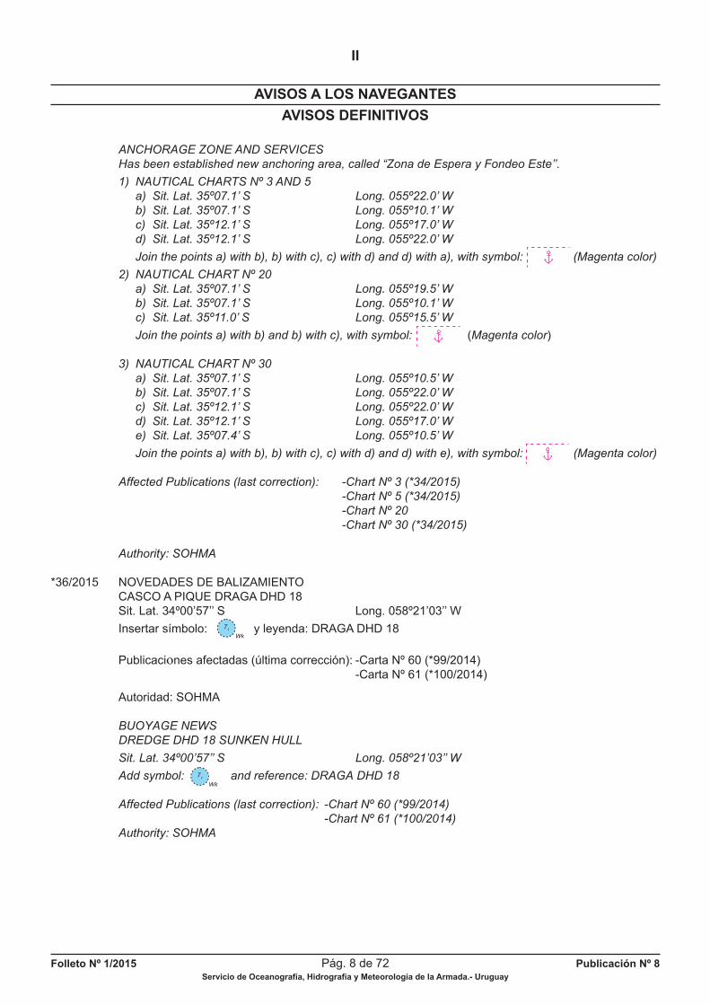
*35/2015 ZONA DE FONDEO Y SERVICIOS Se ha establecido nueva zona de fondeo, denominada “Zona de Espera y Fondeo Este.
1) CARTAS NAUTICAS Nº 3 Y 5 a) Sit. Lat. 35º07.1’ S Long. 055º22.0’ W b) Sit. Lat. 35º07.1’ S Long. 055º10.1’ W c) Sit. Lat. 35º12.1’ S Long. 055º17.0’ W d) Sit. Lat. 35º12.1’ S Long. 055º22.0’ W
Unir a) con b), b) con c), c) con d) y d) con a), con el símbolo: (Color Magenta)
2) CARTA NAUTICA Nº 20 a) Sit. Lat. 35º07.1’ S Long. 055º19.5’ W b) Sit. Lat. 35º07.1’ S Long. 055º10.1’ W c) Sit. Lat. 35º11.0’ S Long. 055º15.5’ W
Unir a) con b) y b) con c), con el símbolo: (Color Magenta)
3) CARTA NAUTICA Nº 30 a) Sit. Lat. 35º07.1’ S Long. 055º10.5’ W b) Sit. Lat. 35º07.1’ S Long. 055º22.0’ W c) Sit. Lat. 35º12.1’ S Long. 055º22.0’ W d) Sit. Lat. 35º12.1’ S Long. 055º17.0’ W e) Sit. Lat. 35º07.4’ S Long. 055º10.5’ W
Unir a) con b), b) con c), c) con d) y d) con e), con el símbolo: (Color Magenta)
Publicaciones afectadas (última corrección): -Carta Nº 3 (*34/2015) -Carta Nº 5 (*34/2015) -Carta Nº 20 -Carta Nº 30 (*34/2015)
Autoridad: SOHMA
Folleto Nº 1/2015 Pág. 8 de 72 Publicación Nº 8Servicio de Oceanografía, Hidrografía y Meteorología de la Armada.- Uruguay
AVISOS A LOS NAVEGANTES
II
AVISOS DEFINITIVOS
ANCHORAGE ZONE AND SERVICES
Has been established new anchoring area, called “Zona de Espera y Fondeo Este’’.
1) NAUTICAL CHARTS Nº 3 AND 5
a) Sit. Lat. 35º07.1’ S Long. 055º22.0’ W
b) Sit. Lat. 35º07.1’ S Long. 055º10.1’ W
c) Sit. Lat. 35º12.1’ S Long. 055º17.0’ W
d) Sit. Lat. 35º12.1’ S Long. 055º22.0’ W
Join the points a) with b), b) with c), c) with d) and d) with a), with symbol: (Magenta color)
2) NAUTICAL CHART Nº 20
a) Sit. Lat. 35º07.1’ S Long. 055º19.5’ W
b) Sit. Lat. 35º07.1’ S Long. 055º10.1’ W
c) Sit. Lat. 35º11.0’ S Long. 055º15.5’ W
Join the points a) with b) and b) with c), with symbol: (Magenta color)
3) NAUTICAL CHART Nº 30
a) Sit. Lat. 35º07.1’ S Long. 055º10.5’ W
b) Sit. Lat. 35º07.1’ S Long. 055º22.0’ W
c) Sit. Lat. 35º12.1’ S Long. 055º22.0’ W
d) Sit. Lat. 35º12.1’ S Long. 055º17.0’ W
e) Sit. Lat. 35º07.4’ S Long. 055º10.5’ W
Join the points a) with b), b) with c), c) with d) and d) with e), with symbol: (Magenta color)
Affected Publications (last correction): -Chart Nº 3 (*34/2015)
-Chart Nº 5 (*34/2015)
-Chart Nº 20
-Chart Nº 30 (*34/2015)
Authority: SOHMA
*36/2015 NOVEDADES DE BALIZAMIENTO CASCO A PIQUE DRAGA DHD 18 Sit. Lat. 34º00’57’’ S Long. 058º21’03’’ W
Insertar símbolo: y leyenda: DRAGA DHD 18
Publicaciones afectadas (última corrección): -Carta Nº 60 (*99/2014) -Carta Nº 61 (*100/2014)
Autoridad: SOHMA
BUOYAGE NEWS
DREDGE DHD 18 SUNKEN HULL
Sit. Lat. 34º00’57’’ S Long. 058º21’03’’ W
Add symbol: and reference: DRAGA DHD 18
Affected Publications (last correction): -Chart Nº 60 (*99/2014)
-Chart Nº 61 (*100/2014)
Authority: SOHMA
Wk
71
Wk
71
Folleto Nº 1/2015 Pág. 9 de 72 Publicación Nº 8Servicio de Oceanografía, Hidrografía y Meteorología de la Armada.- Uruguay
AVISOS TEMPORARIOS Y PRELIMINARES
AVISOS A LOS NAVEGANTES
II
OCEANO ATLANTICO
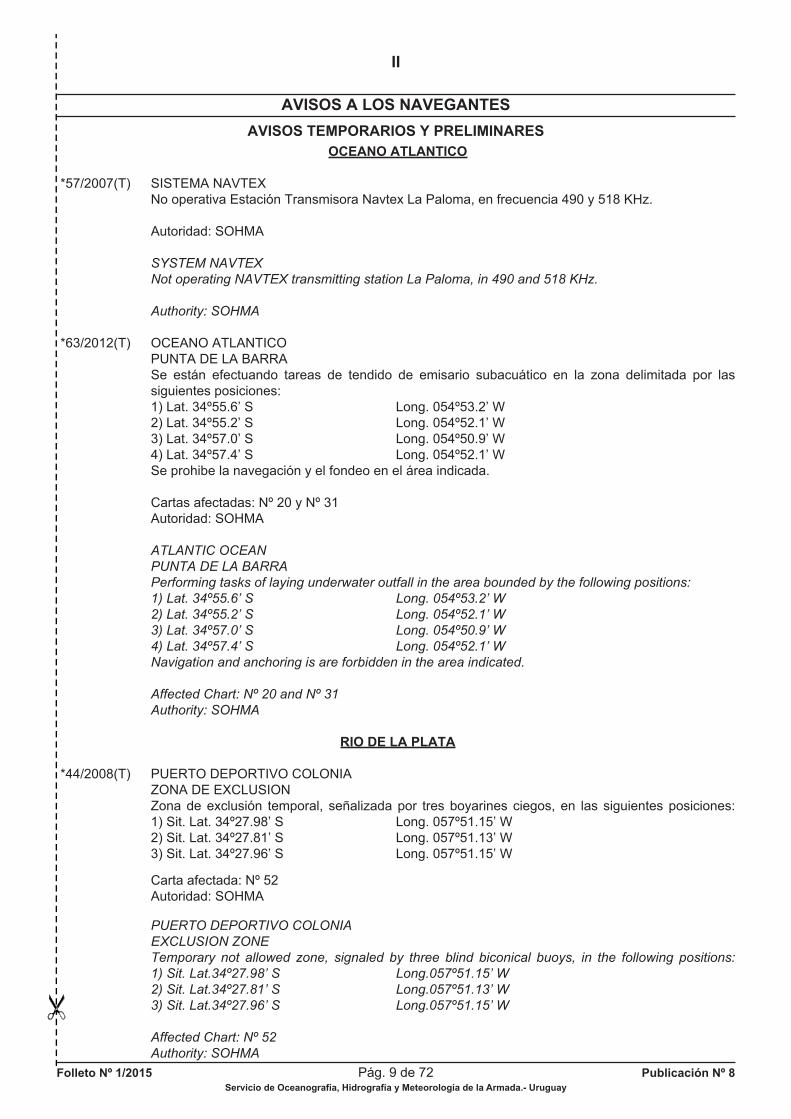
*57/2007(T) SISTEMA NAVTEX No operativa Estación Transmisora Navtex La Paloma, en frecuencia 490 y 518 KHz.
Autoridad: SOHMA
SYSTEM NAVTEX
Not operating NAVTEX transmitting station La Paloma, in 490 and 518 KHz.
Authority: SOHMA
*63/2012(T) OCEANO ATLANTICO PUNTA DE LA BARRA Se están efectuando tareas de tendido de emisario subacuático en la zona delimitada por las siguientes posiciones: 1) Lat. 34º55.6’ S Long. 054º53.2’ W 2) Lat. 34º55.2’ S Long. 054º52.1’ W 3) Lat. 34º57.0’ S Long. 054º50.9’ W 4) Lat. 34º57.4’ S Long. 054º52.1’ W Se prohibe la navegación y el fondeo en el área indicada.
Cartas afectadas: Nº 20 y Nº 31 Autoridad: SOHMA
ATLANTIC OCEAN
PUNTA DE LA BARRA
Performing tasks of laying underwater outfall in the area bounded by the following positions:
1) Lat. 34º55.6’ S Long. 054º53.2’ W
2) Lat. 34º55.2’ S Long. 054º52.1’ W
3) Lat. 34º57.0’ S Long. 054º50.9’ W
4) Lat. 34º57.4’ S Long. 054º52.1’ W
Navigation and anchoring is are forbidden in the area indicated.
Affected Chart: Nº 20 and Nº 31
Authority: SOHMA
RIO DE LA PLATA
*44/2008(T) PUERTO DEPORTIVO COLONIA ZONA DE EXCLUSION Zona de exclusión temporal, señalizada por tres boyarines ciegos, en las siguientes posiciones: 1) Sit. Lat. 34º27.98’ S Long. 057º51.15’ W 2) Sit. Lat. 34º27.81’ S Long. 057º51.13’ W 3) Sit. Lat. 34º27.96’ S Long. 057º51.15’ W
Carta afectada: Nº 52 Autoridad: SOHMA
PUERTO DEPORTIVO COLONIA
EXCLUSION ZONE
Temporary not allowed zone, signaled by three blind biconical buoys, in the following positions:
1) Sit. Lat.34º27.98’ S Long.057º51.15’ W
2) Sit. Lat.34º27.81’ S Long.057º51.13’ W
3) Sit. Lat.34º27.96’ S Long.057º51.15’ W
Affected Chart: Nº 52
Authority: SOHMA
Folleto Nº 1/2015 Pág. 10 de 72 Publicación Nº 8Servicio de Oceanografía, Hidrografía y Meteorología de la Armada.- Uruguay
AVISOS TEMPORARIOS Y PRELIMINARES
AVISOS A LOS NAVEGANTES
II
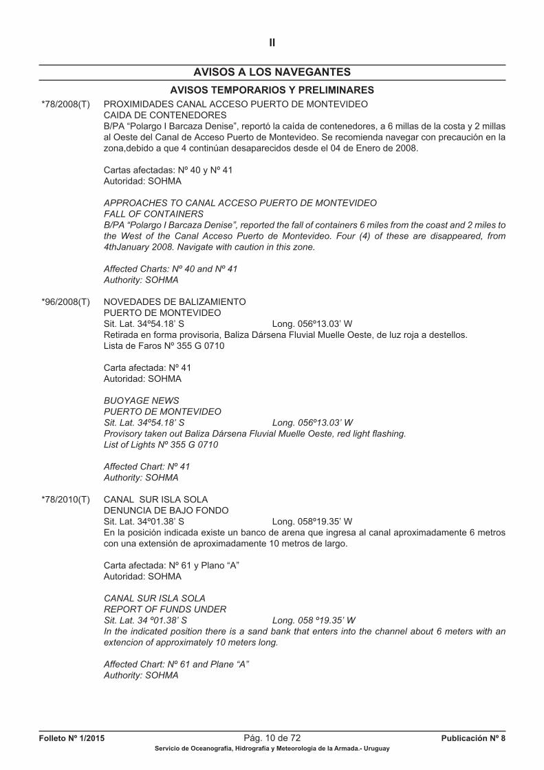
*78/2008(T) PROXIMIDADES CANAL ACCESO PUERTO DE MONTEVIDEO CAIDA DE CONTENEDORES B/PA “Polargo I Barcaza Denise”, reportó la caída de contenedores, a 6 millas de la costa y 2 millas al Oeste del Canal de Acceso Puerto de Montevideo. Se recomienda navegar con precaución en la zona,debido a que 4 continúan desaparecidos desde el 04 de Enero de 2008.
Cartas afectadas: Nº 40 y Nº 41 Autoridad: SOHMA
APPROACHES TO CANAL ACCESO PUERTO DE MONTEVIDEO
FALL OF CONTAINERS
B/PA “Polargo I Barcaza Denise”, reported the fall of containers 6 miles from the coast and 2 miles to
the West of the Canal Acceso Puerto de Montevideo. Four (4) of these are disappeared, from
4thJanuary 2008. Navigate with caution in this zone.
Affected Charts: Nº 40 and Nº 41
Authority: SOHMA
*96/2008(T) NOVEDADES DE BALIZAMIENTO PUERTO DE MONTEVIDEO Sit. Lat. 34º54.18’ S Long. 056º13.03’ W Retirada en forma provisoria, Baliza Dársena Fluvial Muelle Oeste, de luz roja a destellos. Lista de Faros Nº 355 G 0710
Carta afectada: Nº 41 Autoridad: SOHMA
BUOYAGE NEWS
PUERTO DE MONTEVIDEO
Sit. Lat. 34º54.18’ S Long. 056º13.03’ W
Provisory taken out Baliza Dársena Fluvial Muelle Oeste, red light fl ashing.
List of Lights Nº 355 G 0710
Affected Chart: Nº 41
Authority: SOHMA
*78/2010(T) CANAL SUR ISLA SOLA DENUNCIA DE BAJO FONDO Sit. Lat. 34º01.38’ S Long. 058º19.35’ W En la posición indicada existe un banco de arena que ingresa al canal aproximadamente 6 metros con una extensión de aproximadamente 10 metros de largo.
Carta afectada: Nº 61 y Plano “A” Autoridad: SOHMA
CANAL SUR ISLA SOLA
REPORT OF FUNDS UNDER
Sit. Lat. 34 º01.38’ S Long. 058 º19.35’ W
In the indicated position there is a sand bank that enters into the channel about 6 meters with an
extencion of approximately 10 meters long.
Affected Chart: Nº 61 and Plane “A”
Authority: SOHMA
Folleto Nº 1/2015 Pág. 11 de 72 Publicación Nº 8Servicio de Oceanografía, Hidrografía y Meteorología de la Armada.- Uruguay
AVISOS TEMPORARIOS Y PRELIMINARES
AVISOS A LOS NAVEGANTES
II
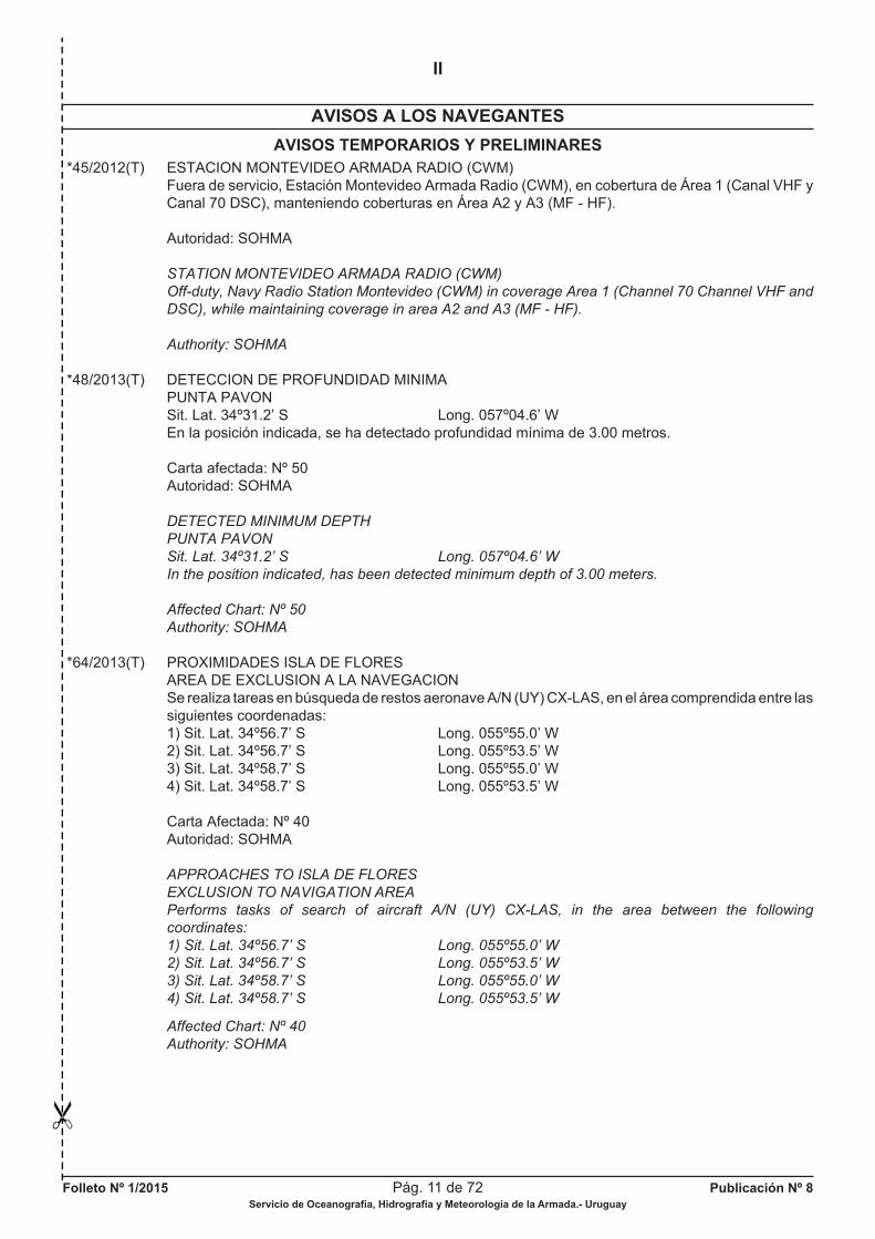
*45/2012(T) ESTACION MONTEVIDEO ARMADA RADIO (CWM) Fuera de servicio, Estación Montevideo Armada Radio (CWM), en cobertura de Área 1 (Canal VHF y Canal 70 DSC), manteniendo coberturas en Área A2 y A3 (MF - HF).
Autoridad: SOHMA
STATION MONTEVIDEO ARMADA RADIO (CWM)
Off-duty, Navy Radio Station Montevideo (CWM) in coverage Area 1 (Channel 70 Channel VHF and
DSC), while maintaining coverage in area A2 and A3 (MF - HF).
Authority: SOHMA
*48/2013(T) DETECCION DE PROFUNDIDAD MINIMA PUNTA PAVON Sit. Lat. 34º31.2’ S Long. 057º04.6’ W En la posición indicada, se ha detectado profundidad mínima de 3.00 metros.
Carta afectada: Nº 50 Autoridad: SOHMA
DETECTED MINIMUM DEPTH
PUNTA PAVON
Sit. Lat. 34º31.2’ S Long. 057º04.6’ W
In the position indicated, has been detected minimum depth of 3.00 meters.
Affected Chart: Nº 50
Authority: SOHMA
*64/2013(T) PROXIMIDADES ISLA DE FLORES AREA DE EXCLUSION A LA NAVEGACION Se realiza tareas en búsqueda de restos aeronave A/N (UY) CX-LAS, en el área comprendida entre las siguientes coordenadas: 1) Sit. Lat. 34º56.7’ S Long. 055º55.0’ W 2) Sit. Lat. 34º56.7’ S Long. 055º53.5’ W 3) Sit. Lat. 34º58.7’ S Long. 055º55.0’ W 4) Sit. Lat. 34º58.7’ S Long. 055º53.5’ W
Carta Afectada: Nº 40 Autoridad: SOHMA
APPROACHES TO ISLA DE FLORES
EXCLUSION TO NAVIGATION AREA
Performs tasks of search of aircraft A/N (UY) CX-LAS, in the area between the following
coordinates:
1) Sit. Lat. 34º56.7’ S Long. 055º55.0’ W
2) Sit. Lat. 34º56.7’ S Long. 055º53.5’ W
3) Sit. Lat. 34º58.7’ S Long. 055º55.0’ W
4) Sit. Lat. 34º58.7’ S Long. 055º53.5’ W
Affected Chart: Nº 40
Authority: SOHMA
Folleto Nº 1/2015 Pág. 12 de 72 Publicación Nº 8Servicio de Oceanografía, Hidrografía y Meteorología de la Armada.- Uruguay
AVISOS TEMPORARIOS Y PRELIMINARES
AVISOS A LOS NAVEGANTES
II
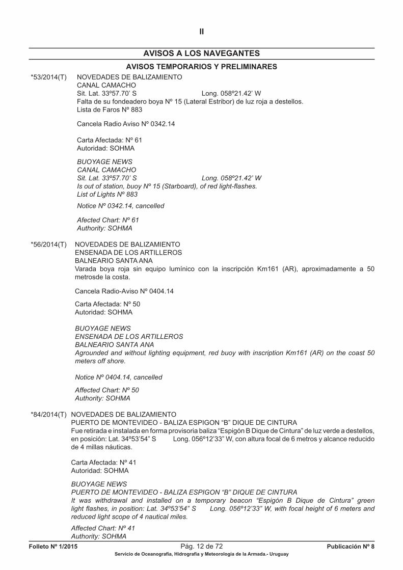
*53/2014(T) NOVEDADES DE BALIZAMIENTO CANAL CAMACHO Sit. Lat. 33º57.70’ S Long. 058º21.42’ W Falta de su fondeadero boya Nº 15 (Lateral Estribor) de luz roja a destellos. Lista de Faros Nº 883
Cancela Radio Aviso Nº 0342.14
Carta Afectada: Nº 61 Autoridad: SOHMA
BUOYAGE NEWS
CANAL CAMACHO
Sit. Lat. 33º57.70’ S Long. 058º21.42’ W
Is out of station, buoy Nº 15 (Starboard), of red light-fl ashes.
List of Lights Nº 883
Notice Nº 0342.14, cancelled
Afected Chart: Nº 61
Authority: SOHMA
*56/2014(T) NOVEDADES DE BALIZAMIENTO ENSENADA DE LOS ARTILLEROS BALNEARIO SANTA ANA Varada boya roja sin equipo lumínico con la inscripción Km161 (AR), aproximadamente a 50 metrosde la costa.
Cancela Radio-Aviso Nº 0404.14
Carta Afectada: Nº 50 Autoridad: SOHMA
BUOYAGE NEWS
ENSENADA DE LOS ARTILLEROS
BALNEARIO SANTA ANA
Agrounded and without lighting equipment, red buoy with inscription Km161 (AR) on the coast 50
meters off shore.
Notice Nº 0404.14, cancelled
Affected Chart: Nº 50
Authority: SOHMA
*84/2014(T) NOVEDADES DE BALIZAMIENTO PUERTO DE MONTEVIDEO - BALIZA ESPIGON “B” DIQUE DE CINTURA Fue retirada e instalada en forma provisoria baliza “Espigón B Dique de Cintura” de luz verde a destellos, en posición: Lat. 34º53’54” S Long. 056º12’33” W, con altura focal de 6 metros y alcance reducido de 4 millas náuticas.
Carta Afectada: Nº 41 Autoridad: SOHMA
BUOYAGE NEWS
PUERTO DE MONTEVIDEO - BALIZA ESPIGON “B” DIQUE DE CINTURA
It was withdrawal and installed on a temporary beacon “Espigón B Dique de Cintura” green
light fl ashes, in position: Lat. 34º53’54” S Long. 056º12’33” W, with focal height of 6 meters and
reduced light scope of 4 nautical miles.
Affected Chart: Nº 41
Authority: SOHMA

Folleto Nº 1/2015 Pág. 13 de 72 Publicación Nº 8Servicio de Oceanografía, Hidrografía y Meteorología de la Armada.- Uruguay
AVISOS TEMPORARIOS Y PRELIMINARES
AVISOS A LOS NAVEGANTES
II
RIO URUGUAY
*83/2011(T) PROXIMIDADES DE NUEVA PALMIRA NOVEDADES DE BALIZAMIENTO Sit. Lat. 33º53.07’ S Long. 058º25.47’ W Falta de su fondeadero, boya Ciega (Cardinal Norte). Lista de Faros Nº 1544
Cartas afectadas: Nº 61 y Nº 701 Autoridad: SOHMA
APPROACHES TO NUEVA PALMIRA
BUOYAGE NEWS
Sit. Lat. 33º53.07’ S Long. 058º25.47’ W
Out of station, buoy (North), whitout light.
List of Lights Nº 1544
Affected Charts: Nº 61 and Nº 701
Authority: SOHMA
*46/2014(T) PROXIMIDADES TERMINAL CORPORACION NAVIOS AMPLIACION DE INSTALACIONES PORTUARIAS Se efectúan tareas de construcciones portuarias. Se recomienda a las embarcaciones que naveguen por fuera del canal, mantenerse apartados del área indicada entre los siguientes puntos:
1) Sit. Lat. 33º 52’ 59’’ S Long. 058º 25’ 20’’ W 2) Sit. Lat. 33º 52’ 59’’ S Long. 058º 25’ 26’’ W 3) Sit. Lat. 33º 53’ 09’’ S Long. 058º 25’ 26’’ W 4) Sit. Lat. 33º 53’ 09’’ S Long. 058º 25’ 20’’ W
Cancela Radio-Aviso Nº 0057.14
Carta Afectada: Nº 701 Autoridad: SOHMA
PROXIMITIES TERMINAL CORPORACION NAVIOS
EXTENSION OF PORT FACILITIES
Harbor constructions tasks are performed. It is recommended that vessels navigating outside the
channel, stay clear of the area indicated:
1) Sit. Lat. 33º 52’ 59’’ S Long. 058º 25’ 20’’ W
2) Sit. Lat. 33º 52’ 59’’ S Long. 058º 25’ 26’’ W
3) Sit. Lat. 33º 53’ 09’’ S Long. 058º 25’ 26’’ W
4) Sit. Lat. 33º 53’ 09’’ S Long. 058º 25’ 20’’ W
Notice Nº 0057.14, cancelled
Afected Chart: Nº 701
Authority: SOHMA
*37/2015(T) NOVEDADES DE BALIZAMIENTO PUENTE INTERNACIONAL GENERAL ARTIGAS Apagadas luces de pilares y defensas. Lista de Faros Nº 3534
Cancela Radio-Aviso Nº 0010.15
Carta afectada: Nº 806 Autoridad: SOHMA
Folleto Nº 1/2015 Pág. 14 de 72 Publicación Nº 8Servicio de Oceanografía, Hidrografía y Meteorología de la Armada.- Uruguay
AVISOS TEMPORARIOS Y PRELIMINARES
AVISOS A LOS NAVEGANTES
II
BUOYAGE NEWS
GENERAL ARTIGAS INTERNATIONAL BRIDGE
Pillars and defences lights off.
List of Lights Nº 3534
Notice Nº 0010.15, cancelled
Afected Chart: Nº 806
Authority: SOHMA
RIO ROSARIO
*33/2006(T) NUEVA BATIMETRIA RIO ROSARIO Habiéndose efectuado un relevamiento hidrográfi co en la Boca del Río Rosario, se adjunta el siguiente croquis de referencia (ver Folleto Nº 1/2006, pág. Nº 51, Sección V Información Náutica), a fi n de facilitar el acceso a las embarcaciones considerando la irregularidad del canal por problema de profundidades.
Carta afectada: Nº 50 Autoridad: SOHMA
BATHYMETRY NEWS
RIO ROSARIO
Reference sketch attached from hydrographic survey at Boca del Río Rosario (see at Leafl et Nº 1/2006,
page Nº 51, Section V Información Náutica), in order to facilitate the access to vessels, considering the
irregularity in the channel due to depth problems.
Affected Chart: Nº 50
Authority: SOHMA
PUBLICACIONES
*54/2012(P) NUEVA EDICION DE PUBLICACION NAUTICA LISTA DE FAROS Y SEÑALES MARITIMAS El Servicio de Oceanografía, Hidrografía y Meteorología de la Armada, próximamente publicará nueva Edición de Lista de Faros y Señales Marítimas Publicación Nº 5. La misma se encontrará a disposición de los usuarios y público en general.
Autoridad: SOHMA
NAUTICAL PUBLICATION NEW EDITION
LIST OF LIGHTS AND MARITIME SIGNALS
The Oceanographic, Hydrographic and Meteorological Service of the Navy (SOHMA), will publish
soon a new edition of List of Lights and Maritime Signals, Publication Nº 5.
It will be shortly available to users and general public.
Authority: SOHMA
Folleto Nº 1/2015 Pág. 15 de 72 Publicación Nº 8Servicio de Oceanografía, Hidrografía y Meteorología de la Armada.- Uruguay
AVISOS TEMPORARIOS Y PRELIMINARES
AVISOS A LOS NAVEGANTES
II
*84/2013(P) NUEVA EDICION DE PUBLICACION NAUTICA CARTA NAUTICA Nº 20 La misma se encontrará a disposición de los usuarios y público en general proximamente.
Autoridad: SOHMA
NEW EDITION NAUTICAL PUBLICATION
NAUTICAL CHART Nº 20
It will be shortly available to users and general public.
Authority: SOHMA
*85/2013(P) NUEVA EDICION DE PUBLICACION NAUTICA CARTA NAUTICA Nº 31 La misma se encontrará a disposición de los usuarios y público en general proximamente.
Autoridad: SOHMA
NEW EDITION NAUTICAL PUBLICATION
NAUTICAL CHART Nº 31
It will be shortly available to users and general public.
Authority: SOHMA
*47/2014(P) NUEVA PUBLICACION NAUTICA ATLAS CARTOGRAFICO DEL RIO URUGUAY - SERIE 900 La misma se encontrará a disposición de los usuarios y público en general proximamente.
Autoridad: SOHMA
NEW NAUTICAL PUBLICATION
CARTOGRAPHIC ATLAS - RIO URUGUAY - SERIES 900
It will be shortly available to users and general public.
Authority: SOHMA
*75/2014(P) NUEVA PUBLICACION NAUTICA CARTA NUEVA N° 930 DESDE PUERTO DE CONCORDIA HASTA PUERTO DE SALTO La misma se encontrará a disposición de los usuarios y público en general próximamente.
Autoridad: SOHMA
NEW NAUTICAL PUBLICATION
NEW CHART N° 930
FROM CONCORDIA PORT TO SALTO PORT
It will be shortly available to users and general public.
Authority: SOHMA
Folleto Nº 1/2015 Pág. 16 de 72 Publicación Nº 8Servicio de Oceanografía, Hidrografía y Meteorología de la Armada.- Uruguay
AVISOS TEMPORARIOS Y PRELIMINARES
AVISOS A LOS NAVEGANTES
II
NºAVISOAÑO
CARTASAFECTADAS
LAT/LONGKM
LUGAR Y OBJETO
OCEANO ATLANTICO
*58/2012(T) 20 PROXIMIDADES DESEMBOCADURA ARROYO MALDONADO.
RIO DE LA PLATA
41/2008(T) 3, 5, 30 y 40 35º06.45’ S PROXIMIDADES CANAL PUNTA INDIO 055º57.87’ W Pontón Prácticos Recalada.
*77/2008(T) 40 y 41 PROX. CANAL ACCESO PUERTO DE MONTEVIDEO Hundimiento de vehículos y contenedores.
*43/2009(T) 5 35º04.00’ S EMBARCACION HUNDIDA 055º30.00’ W Piria I.
*64/2012(T) 50 34º32’ S PROXIMIDADES PUNTA PAVON 057º04’ W Aprox. Embarcación hundida.
*66/2012(T) 20 y 32 34º54’ S PROXIMIDADES PUNTA IMAN 055º18’ W Aprox. Embarcación hundida.
*67/2012(T) 30 y 32 34º52.3’ S PROXIMIDADES PUERTO DE PIRIAPOLIS 055º17.0’ W Aprox. Denuncia de obstrucción.
*73/2012(T) 40 NOVEDADES DE BALIZAMIENTO Desembocadura Arroyo Pando.
*74/2012(T) 40 NOVEDADES DE BALIZAMIENTO Balneario Solymar.
*75/2012(T) 40 34º50.1’ S NOVEDADES DE BALIZAMIENTO 055º57.0’ W Boya varada.
*78/2012(T) 41 34º53.989’ S NOVEDADES DE BALIZAMIENTO 056º.13.350’ W Antepuerto de Montevideo.
*88/2012(T) NUEVO BALIZAMIENTO
*63/2013(T) 40 y 41 34º59’ S CANAL ACCESO PUERTO DE MONTEVIDEO 056º10’ W Aprox. Embarcación Hundida.
*65/2013(T) 40 CANAL ACCESO PUERTO DE MONTEVIDEO Area de Prohibición a la Navegación.
*73/2013(T) 40 y 41 NOVEDADES DE BALIZAMIENTO Proximidades Canal Acceso Puerto de Montevideo.
*82/2013(T) 61 CANALES A MARTIN GARCIA Punta Pereira.
*111/2013(T) 40 35º11.90’ S NOVEDADES DE BALIZAMIENTO 056º23.96’ W Proximidades Canal Punta Indio.
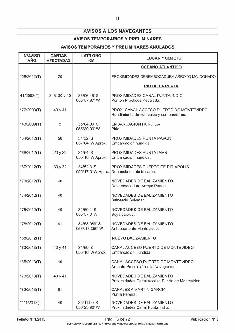
AVISOS TEMPORARIOS Y PRELIMINARES ANULADOS
Folleto Nº 1/2015 Pág. 17 de 72 Publicación Nº 8Servicio de Oceanografía, Hidrografía y Meteorología de la Armada.- Uruguay
RADIOAVISOS NAUTICOS
III
0008.15 RIO DE LA PLATA CANALES A MARTIN GARCIA - PASO DE SAN JUAN Sit. Lat. 34º20.91’ S Long. 058º00.95’ W Apagada boya par Km 80.1 (Lateral Estribor) de luz roja a destellos. Lista de Faros Nº 1309
Anula Aviso Nº 1246.14
RIO DE LA PLATA
CANALES A MARTIN GARCIA - PASO DE SAN JUAN
Sit. Lat. 34º20.91’ S Long. 058º00.95’ W
Off buoy Km 80.1 (Starboard), of red light-fl ashes.
List of Lights Nº 1309
Notice Nº 1246.14, cancelled
0009.15 RIO DE LA PLATA CANALES A MARTIN GARCIA - POZOS DE SAN JUAN Sit. Lat. 34º16.84’ S Long. 058º02.59’ W Apagada boya par Km 88.1 (Lateral Babor) de luz verde a destellos. Lista de Faros Nº 1331
Anula Aviso Nº 1247.14
RIO DE LA PLATA
CANALES A MARTIN GARCIA - POZOS DE SAN JUAN
Sit. Lat. 34º16.84’ S Long. 058º02.59’ W
Off buoy Km 88.1 (Port), of green light-fl ashes.
List of Lights Nº 1331
Notice Nº 1247.14, cancelled
0011.15 RIO DE LA PLATA ZONA DE PROHIBICION A LA NAVEGACION Se ha dispuesto un área de prohibición a la navegación entre los siguientes puntos: 1) Sit. Lat. 34º54’56.7’’ S Long. 056º15’38.0’’ W 2) Sit. Lat. 34º54’06.6’’ S Long. 056º16’57.7’’ W 3) Sit. Lat. 34º55’11.2’’ S Long. 056º17’57.4’’ W 4) Sit. Lat. 34º56’01.2’’ S Long. 056º16’30.5’’ W Buques que se encuentren navegando en proximidades de dicha área deberán tener precaución y reducir su velocidad a menos de 5 nudos.
Anula Aviso Nº 1253.14 RIO DE LA PLATA
FORBIDDEN NAVIGATION ZONE
Forbidden zone navigation between the following points:
1) Sit. Lat. 34º54’56.7’’ S Long. 056º15’38.0’’ W
2) Sit. Lat. 34º54’06.6’’ S Long. 056º16’57.7’’ W
3) Sit. Lat. 34º55’11.2’’ S Long. 056º17’57.4’’ W
4) Sit. Lat. 34º56’01.2’’ S Long. 056º16’30.5’’ W
Ships near this area, should navigate with caution and reduce their speed below 5 Knots.
Notice Nº 1253.14, cancelled
Vigentes al 31 de Enero de 2015.-

Folleto Nº 1/2015 Pág. 18 de 72 Publicación Nº 8Servicio de Oceanografía, Hidrografía y Meteorología de la Armada.- Uruguay
RADIOAVISOS NAUTICOS
III
0014.15 OCEANO ATLANTICO PUERTO LA PALOMA Sit. Lat. 34º39.02’ S Long. 054º08.65’ W Sin equipo lumínico boya Par 3 (Lateral Babor), de luz verde a destellos. Lista de Faros Nº 41.5
Anula Aviso Nº 1255.14
ATLANTIC OCEAN
LA PALOMA PORT
Sit. Lat. 34º39.02’ S Long. 054º08.65’ W
Without lighting equipment buoy 3 (Port), of green light-fl ashes.
List of Lights Nº 41.5
Notice Nº 1255.14, cancelled
0015.15 RIO DE LA PLATA CANALES A MARTIN GARCIA BARRA DEL FARRALLON - PASO DEL FARALLON Entre las 06:00 y las 22:00 hora local se realizan tareas de dragado por parte de draga (AR) 258-C “Santa Fe’’, entre el Km 52 y Km 55. Obstruye parcialmente la navegación. Buques deberán solicitar paso a la draga con una hora de antelación a la zona de operaciones por canal 16 y 81 VHF.
Anula Aviso Nº 1256.14
RIO DE LA PLATA
CANALES A MARTIN GARCIA
BARRA DEL FARALLON - PASO DEL FARALLON
Since 06:00 to 22:00 local time, dredging tasks by dredge (AR) 258-C “Santa Fe” between
Km 52 and Km 55. Partially obstructs navigation. Vessels should request step at a dredge one hour in
advance to the operations area by VHF channel 16 and 81.
Notice Nº 1256.14, cancelled
0016.15 RIO DE LA PLATA CANALES A MARTIN GARCIA - BARRA DEL FARALLON Sit. Lat. 34º33.63’ S Long. 057º55.80’ W Fuera de servicio boya Par Km 54.1 (Lateral Estribor), de luz roja a destellos. Lista de Faros Nº 1225
Anula Aviso Nº 1257.14
RIO DE LA PLATA
CANALES A MARTIN GARCIA - BARRA DEL FARALLON
Sit. Lat. 34º33.63’ S Long. 057º55.80’ W
Out of service buoy Km 54.1 (Starboard), of red light-fl ashes.
List of Lights Nº 1225
Notice Nº 1257.14, cancelled
Vigentes al 31 de Enero de 2015.-
Folleto Nº 1/2015 Pág. 19 de 72 Publicación Nº 8Servicio de Oceanografía, Hidrografía y Meteorología de la Armada.- Uruguay
RADIOAVISOS NAUTICOS
III
0017.15 RIO DE LA PLATA CANALES A MARTIN GARCIA - CANAL PRINCIPAL Sit. Lat. 33º59.34’ S Long. 058º23.32’ W Falta de su fondeadero boya “Ciudad de Buenos Aires Km 136.9” (Peligro Aislado), de luz blanca a destellos, encontrándose garreada 500 metros al NW. Lista de Faros Nº 1441
Anula Aviso Nº 1259.14
RIO DE LA PLATA
CANALES A MARTIN GARCIA - CANAL PRINCIPAL
Sit. Lat. 33º59.34’ S Long. 058º23.32’ W
Out of station, buoy “Ciudad de Buenos Aires Km 136.9” (Isolated Danger), of white light-fl ashes,
being found 500 meters NW.
Lista de Faros Nº 1441
Notice Nº 1259.14, cancelled
0018.15 OCEANO ATLANTICO FONDEO DE EQUIPAMIENTO OCEANOGRAFICO Y METEOROLOGICO Ha sido fondeado equipamiento oceanográfi co, en los siguientes puntos: 1) Sit. Lat. 34º34’25’’ S Long. 054º00’11’’ W 2) Sit. Lat. 34º58’30’’ S Long. 054º54’00’’ W Mantenerse apartado 1 milla de radio con centro en los puntos indicados. Se prohibe “fondear y pesca de arrastre” para todas las embarcaciones.
Anula Aviso Nº 1260.14
ATLANTIC OCEAN
ANCHORED OCEANOGRAPHIC AND METEOROLOGICAL EQUIPMENT
Sit. Lat. 34º34’25” S Long. 054º00’11’’ W
Centering the points indicated with 1 nautical mile radius.
It is forbidden “anchoring and trawling” for all vessels.
Notice Nº 1260.14, cancelled
0019.14 RIO DE LA PLATA CANALES A MARTIN GARCIA - CANAL PRINCIPAL (KM 133) EMBARCACION HUNDIDA Sit. Lat. 34º00.96’ S Long. 058º21.04’ W (Aprox.) En la posición indicada sobre veril rojo, se encuentra hundida draga (UY) “DHD 18”, con las siguientes características: Eslora:12.40 m, Manga: 4.80 m, Puntal: 1.22 m. No obstruye la navegación.
Anula Aviso Nº 1261.14
RIO DE LA PLATA
CANALES A MARTIN GARCIA - CANAL PRINCIPAL (KM 133)
SUNKED BOAT
At the indicated position over red side canal, sunked dredger (UY) “DHD 18”, with the characteristics:
Length: 12.40 m Breadth: 4.80 m Depth: 1.22 m.
Not obstruct the navigation.
Notice Nº 1261.14, cancelled
Vigentes al 31 de Enero de 2015.-
Folleto Nº 1/2015 Pág. 20 de 72 Publicación Nº 8Servicio de Oceanografía, Hidrografía y Meteorología de la Armada.- Uruguay
RADIOAVISOS NAUTICOS
III
0022.15 RIO DE LA PLATA CANALES A MARTIN GARCIA - CANAL PRINCIPAL Sit. Lat. 34º00.51’ S Long. 058º22.23’ W Falta de su fondeadero boya Km 134.2 (Cardinal Este), de luz blanca rápida a destellos. Lista de Faros Nº 1439
RIO DE LA PLATA
CANALES A MARTIN GARCIA - CANAL PRINCIPAL
Sit. Lat. 34º00.51’ S Long. 058º22.23’ W
Out of station Km 134.2 (East) buoy, of quick white light-fl ashes.
List of Lights Nº 1439
0030.15 RIO DE LA PLATA PROXIMIDADES PUNTA ESPINILLO Sit. Lat. 34º49.549’ S Long. 056º30.824’ W En la posición indicada, se encuentra hundida embarcación de pesca artesanal “Baitti” Mat. Nº 354.
Anula Aviso Nº 1275.14
RIO DE LA PLATA
APPROACHES OF PUNTA ESPINILLO
Sit. Lat. 34º49.549’ S Long. 056º30.824’ W
In the position indicated, is sunked artisanal fi shing vessel “Baitti” Mat. Nº 354.
Notice Nº 1275.14, cancelled
0031.15 RIO URUGUAY PUENTE INTERNACIONAL GRAL. SAN MARTIN Corridas 250 metros hacia el puente, las siguientes señales: 1) Sit. Lat. 33º06.0’ S Long. 058º15.3’ W Boya Km 104.2 (Lateral Babor) de luz verde a destellos Lista de Faros Nº 3213
2) Sit. Lat. 33º06.1’ S Long. 058º15.3’ W Boya Km 104.2 (Lateral Estribor) de luz roja a destellos. Lista de Faros Nº 3216
Anula Aviso Nº 1276.14
RIO URUGUAY
GRAL. SAN MARTIN INTERNATIONAL BRIDGE
Out of position 250 meters to the bridge, the following signals:
1) Sit. Lat. 33º06.0’ S Long. 058º15.3’ W
Buoy Km 104.2 (Port), of green light-fl ashes
List of Lights Nº 3213
2) Sit. Lat. 33º06.1’ S Long. 058º15.3’ W
Buoy Km 104.2 (Starboard), of red light-fl ashes
List of Lights Nº 3216
Notice Nº 1276.15, cancelled
Vigentes al 31 de Enero de 2015.-
Folleto Nº 1/2015 Pág. 21 de 72 Publicación Nº 8Servicio de Oceanografía, Hidrografía y Meteorología de la Armada.- Uruguay
RADIOAVISOS NAUTICOS
III
0032.15 RIO DE LA PLATA PROXIMIDADES CANAL ACCESO PUERTO DE MONTEVIDEO Sit. Lat. 35º06.45’ S Long. 055º57.87’ W Garreado Pontón Prácticos Recalada de luz blanca a destellos, encontrándose en: Lat. 35º06.21’ S Long. 055º57.88’ W. Lista de Faros Nº 919 G 0812
Anula Aviso Nº 1279.14
RIO DE LA PLATA
APPROACHES OF ACCESS CANAL OF MONTEVIDEO HARBOUR
Sit. Lat. 35º06.45’ S Long. 055º57.87’ W
Out of station Pontón Prácticos Recalada of white light-fl ashes being found in Lat. 35º06.21’ S
Long. 055º57.88’ W.
List of Lights Nº 919 G 0812
Notice Nº 1279.14, cancelled
0042.15 RIO URUGUAY PUERTO DE PAYSANDU No operativo por creciente del Río Uruguay.
RIO URUGUAY
PAYSANDU HARBOUR
Not operative by increasing of Río Uruguay.
0045.15 RIO DE LA PLATA ZONA DE FONDEO Y SERVICIOS A partir del día 05 de Noviembre de 2014, se encuentra en servicio una nueva zona de fondeo, denominada “Zona de Espera y Fondeo Oeste’’, en el área comprendida por los siguientes puntos: 1) Sit. Lat. 35º10.5’ S Long. 055º36.0’ W 2) Sit. Lat. 35º10.5’ S Long. 055º25.7’ W 3) Sit. Lat. 35º16.5’ S Long. 055º36.0’ W 4) Sit. Lat. 35º16.5’ S Long. 055º25.7’ W
Anula Aviso Nº 1281.14
RIO DE LA PLATA
ANCHORAGE ZONE AND SERVICES
Since November 5th 2014, on service new anchorage area, designated waiting “Zona de Espera y Fondeo
Oeste’’ in the area determined by the coordinates:
1) Sit. Lat. 35º10.5’ S Long. 055º36.0’ W
2) Sit. Lat. 35º10.5’ S Long. 055º25.7’ W
3) Sit. Lat. 35º16.5’ S Long. 055º36.0’ W
4) Sit. Lat. 35º16.5’ S Long. 055º25.7’ W
Notice Nº 1281.14, cancelled
Vigentes al 31 de Enero de 2015.-
Folleto Nº 1/2015 Pág. 22 de 72 Publicación Nº 8Servicio de Oceanografía, Hidrografía y Meteorología de la Armada.- Uruguay
RADIOAVISOS NAUTICOS
III
0046.15 RIO DE LA PLATA ZONA DE FONDEO Y SERVICIOS A partir del día 05 de Noviembre de 2014, se encuentra en servicio una nueva zona de fondeo, denominada “Zona de Espera y Fondeo Este’’, en el área comprendida por los siguientes puntos: 1) Sit. Lat. 35º07.1’ S Long. 055º22.0’ W 2) Sit. Lat. 35º07.1’ S Long. 055º10.1’ W 3) Sit. Lat. 35º12.1’ S Long. 055º22.0’ W 4) Sit. Lat. 35º12.1’ S Long. 055º17.0’ W
Anula Aviso Nº 1282.14
RIO DE LA PLATA
ANCHORAGE ZONE AND SERVICES
Since November 5th 2014, on service new anchorage area, designated waiting “Zona de Espera y Fondeo
Este’’ in the area determined by the coordinates:
1) Sit. Lat. 35º07.1’ S Long. 055º22.0’ W
2) Sit. Lat. 35º07.1’ S Long. 055º10.1’ W
3) Sit. Lat. 35º12.1’ S Long. 055º22.0’ W
4) Sit. Lat. 35º12.1’ S Long. 055º17.0’ W
Notice Nº 1282.14, cancelled
0048.15 RIO URUGUAY PUERTO NUEVA PALMIRA - MUELLE ONTUR Sit. Lat. 33º 52.42’ S Long. 058º 25.41’ W Caída y apagada baliza Cabecera Sur de luz roja a destellos. Lista de Faros Nº 1553 G 0773.2
Anula Aviso Nº 1286.14
RIO URUGUAY
PUERTO NUEVA PALMIRA - MUELLE ONTUR
Sit. Lat. 33º 52.42’ S Long. 058º 25.41’ W
Off, Headboard South beacon.
List of Lights Nº 1553 G 0773.2
Notice Nº 1286.14, cancelled
0051.14 RIO DE LA PLATA CANALES A MARTIN GARCIA - CANAL PRINCIPAL Sit. Lat. 33º54.96’ S Long. 058º25.24’ W Apagada boya Km 145.5 (Lateral Estribor) de luz roja a destellos. Lista de Faros Nº 1449
Anula Aviso Nº 1290.14
RIO DE LA PLATA
CANALES A MARTIN GARCIA - CANAL PRINCIPAL
Sit. Lat. 33º54.96’ S Long. 058º25.24’ W
Off, Km 145.5 (Starboard) buoy, of red light-fl ashes.
List of Lights Nº 1449
Notice Nº 1290.14, cancelled
Vigentes al 31 de Enero de 2015.-
Folleto Nº 1/2015 Pág. 23 de 72 Publicación Nº 8Servicio de Oceanografía, Hidrografía y Meteorología de la Armada.- Uruguay
RADIOAVISOS NAUTICOS
III
0052.15 RIO URUGUAY PROXIMIDADES PUERTO DE NUEVA PALMIRA Sit. Lat. 33º53.07’ S Long. 058º25.47’ W Falta de su fondeadero boyarín (Cardinal Norte), ciego.
Anula Aviso Nº 1292.14
RIO URUGUAY
APPROACHES OF NUEVA PALMIRA HARBOUR
Sit. Lat. 33º53.07’ S Long. 058º25.47’ W
Out of station biconical buoy (North), without light.
Notice Nº 1292.14, cancelled
0053.15 RIO NEGRO PUERTO VILLA SORIANO No operativo muelle de Villa Soriano por reformas del mismo.
Anula Aviso Nº 1293.14
RIO NEGRO
VILLA SORIANO HARBOUR
Not operating Villa Soriano dock, for renovations.
Notice Nº 1293.14, cancelled
0054.15 RIO DE LA PLATA PUERTO COMERCIAL DE COLONIA A partir del día 23 de Abril de 2014, de lunes a jueves, no se podrá utilizar el muelle de cabotaje, salvo por autorización expresa de la “Administración Nacional de Puertos”, debido a reformas del mismo.
Anula Aviso Nº 1294.14
RIO DE LA PLATA
COMERCIAL HARBOUR OF COLONIA
Since April 23, 2014, from Monday to Thursday, is not allowed to use cabotage dock, except by express
permission of the “Administración Nacional de Puertos”, due to reforms.
Notice Nº 1294.14, cancelled
0057.15 RIO DE LA PLATA CANALES A MARTIN GARCIA - CANAL PRINCIPAL Sit. Lat. 35º56.22’ S Long. 058º24.98’ W Corrida al Sur boya “Km 143.2 Báltico” (Cardinal Este) de luz blanca rápida a destellos. Lista de Faros Nº 1447
Anula Aviso Nº 1299.14
RIO DE LA PLATA
CANALES A MARTIN GARCIA - CANAL PRINCIPAL
Sit. Lat. 35º56.22’ S Long. 058º24.98’ W
Out of station to South “Km 143.2 Báltico” (East) buoy, of quick white light-fl ashes.
List of Lights Nº 1447
Notice Nº 1299.14, cancelled
Vigentes al 31 de Enero de 2015.-
Folleto Nº 1/2015 Pág. 24 de 72 Publicación Nº 8Servicio de Oceanografía, Hidrografía y Meteorología de la Armada.- Uruguay
RADIOAVISOS NAUTICOS
III
0061.15 RIO URUGUAY MUELLE NUEVO BERLIN No operativo por creciente del Río Uruguay.
RIO URUGUAY
NUEVO BERLIN DOCK
Not operative due the increasing of Río Uruguay.
0063.15 OCEANO ATLANTICO LEVANTAMIENTO DE CAMPO ELECTROMAGNETICO Se encuentra operando M/V “EM LEADER’’ en tareas de levantamiento de campo electromagnético, llevara cables por debajo de la superfi cie del agua. Estos cables pueden ser peligrosos para la navegación. Mantenerse apartados de la derrota 2 millas por popa, 1 millas de través y 2 millas a proa. Opera con maniobra restringida, en el área delimitada por los siguientes puntos:
1) Sit. Lat. 35º41’27’’ S Long. 052º41’15’’ W 2) Sit. Lat. 36º47’41’’ S Long. 051º36’21’’ W 3) Sit. Lat. 37º38’40’’ S Long. 053º00’30’’ W 4) Sit. Lat. 36º32’57’’ S Long. 054º08’35’’ W
Anula Aviso Nº 1306.14
ATLANTIC OCEANOC
ELECTROMAGNETIC SURVEY
M/V “EM LEADER” is performing electromagnetic survey towing cables, below the water surface.
These cables can be dangerous for navigation, stay out of the way 2 miles astern, 1 miles beam and
2 miles ahead. Restricted manoeuvring in the area bounded by the points:
1) Sit. Lat. 35º41’27’’ S Long. 052º41’15’’ W
2) Sit. Lat. 36º47’41’’ S Long. 051º36’21’’ W
3) Sit. Lat. 37º38’40’’ S Long. 053º00’30’’ W
4) Sit. Lat. 36º32’57’’ S Long. 054º08’35’’ W
Notice Nº 1306.14, cancelled
0067.15 RIO DE LA PLATA PROXIMIDADES PUNTA YEGUAS Sit. Lat. 34º54’09’’ S Long. 056º18’24’’ W Por trabajos de instalación de gasoducto subacuático, se ha dispuesto un área de prohibición a la navegación de 400 metros de radio con centro en el punto indicado.
Anula Aviso Nº 1310.14
RIO DE LA PLATA
APPROACHES PUNTA YEGUAS
Sit. Lat. 34º54’09’’ S Long. 056º18’24’’ W
By installation underwater water gas pipeline a forbidden area to navigation 400 meters radius centered at
the point indicated.
Notice Nº 1310.14, cancelled
Vigentes al 31 de Enero de 2015.-
Folleto Nº 1/2015 Pág. 25 de 72 Publicación Nº 8Servicio de Oceanografía, Hidrografía y Meteorología de la Armada.- Uruguay
RADIOAVISOS NAUTICOS
III
0070.15 RIO DE LA PLATA CANALES A MARTIN GARCIA CANAL DE LAS LIMETAS (NUEVO) Varada boya de luz verde a destellos (4 cada 12 segundos), encontrándose en: Lat. 34º 13.47’ S Long. 058º 07.57’ W
Anula Aviso Nº 1313.14
RIO DE LA PLATA
CANALES A MARTIN GARCIA
CANAL DE LAS LIMETAS (NUEVO)
Grounded buoy of green light-fl ashes (4 every 12 seconds), found in: Lat. 34º 13.47’ S Long 058º 07.57’ W.
Notice Nº 1313.14, cancelled
0075.15 RIO DE LA PLATA CANALES A MARTIN GARCIA BARRA DEL FARALLON A partir del día 18 de Octubre de 2014, entre las 06:00 y las 22:00 hora local, comenzará tareas de dragado draga 261-C “CORDOBA” entre el Km 47.4 y Km 50.1. Embarcaciones deberán solicitar paso a dicha draga con una hora de antelación por Canal 81 y 16 VHF.
Anula Aviso Nº 1315.14
RIO DE LA PLATA
CANALES A MARTIN GARCIA
BARRA DEL FARALLON
Since October 18, 2014, between 06:00 and 22:00 local time, dredging work by dredge 261-C
“CORDOBA” between Km 47.4 and Km 50.1. Vessels should request step to the dredge one hour in
advance the operations area by VHF channel 81 and 16.
Notice Nº 1315.14, cancelled
0076.15 RIO URUGUAY PUERTO DE NUEVA PALMIRA Sit. Lat. 33º52.47’ S Long. 058º25.23’ W Fuera de servicio baliza Duque de Alba (Especial) de luz amarilla a destellos, encontrándose señalizado con cintas refl ectivas. Lista de Faros Nº 1552 G 0773 Anula Aviso Nº 1316.14
RIO URUGUAY
NUEVA PALMIRA HARBOUR
Sit. Lat. 33º52.47’ S Long. 058º25.23’ W
Out of service Duque de Alba (Special) beacon, of yellow light-fl ashes, signalized with refl ective bands.
List of Lights Nº 1552 G 0773
Notice Nº 1316.14, cancelled
0077.15 RIO DE LA PLATA ENSENADA DE RIO SANTA LUCIA Sit. Lat. 34º47.75’ S Long. 056º25.61 W Falta de su fondeadero, boya ciega Nº 4 (Lateral Babor). Lista de Faros Nº 457
Anula Aviso Nº 1318.14
Vigentes al 31 de Enero de 2015.-
Folleto Nº 1/2015 Pág. 26 de 72 Publicación Nº 8Servicio de Oceanografía, Hidrografía y Meteorología de la Armada.- Uruguay
RADIOAVISOS NAUTICOS
III
RIO DE LA PLATA
ENSENADA DE RIO SANTA LUCIA
Sit. Lat. 34º47.75’ S Long. 056º25.61 W
Out of station buoy Nº 4 (Lateral Babor), without light.
List of Lights Nº 457
Notice Nº 1318.14, cancelled
0078.15 RIO URUGUAY PUNTA DEL ARENAL ZONA DE ALIJO Y COMPLEMENTO DE CARGA PUNTA DEL ARENAL SUR Operando en proximidades del Km 20 sobre margen izquierda, pontón (UY) “FIORUCCI INTERNACIONAL” Mat. 39 y embarcación (UY) “TITON” Mat. 8407 en tareas de balizamiento. Las tareas se realizan en horas diurnas. Las embarcaciones permanecerán fondeadas durante horas nocturnas, en proximidades del canal no obstruyendo la navegación. Se recomienda navegar con precaución en la zona.
Anula Aviso Nº 1319.14
RIO URUGUAY
PUNTA DEL ARENAL - STASH AREA AND LOAD COMPLEMENT
In proximity of Km 20 on left side, is operating pontoon (UY) “FIORUCCI INTERNATIONAL” Mat. 39 and boat
(UY) “TITON” Mat. 8407 in buoyage tasks, performed on daytime. The boats remain moored
during night hours, in the vicinity of channel. Not obstruct navigation. It is recommended to navigate with
caution in the area.
Notice Nº 1319.14, cancelled
0079.15 RIO URUGUAY PUNTA DEL ARENAL ZONA DE ALIJO Y COMPLEMENTO DE CARGA SUR Fondeadas boyas de amarre de color amarillo según el siguiente detalle: 2 Boyas de amarre para buques de ultramar: 1) Norte: Lat. 33º44.24’ S Long. 058º25.84’ W 2) Sur: Lat. 33º44.46’ S Long. 058º25.85’ W
2 Boyas de amarre para barcazas: 1) Norte: Lat. 33º44.52’ S Long. 058º25.75’ W 2) Sur: Lat. 33º44.74’ S Long. 058º25.76’ W No poseen al momento balizamiento nocturno.
Anula Aviso Nº 1320.14
RIO URUGUAY
PUNTA DEL ARENAL - STASH AREA AND COMPLEMENT TO LOAD
Mooring yellow buoys wek anchored as follows:
Two mooring buoys for ships oversea:
1) North: Lat. 33º44.24’ S Long. 058º25.84’ W
2) South: Lat. 33º44.46’ S Long. 058º25.85’ W
Two mooring buoys for barges:
1) North: Lat. 33º44.52’ S Long. 058º25.75’ W
2) South: Lat. 33º44.74’ S Long. 058º25.76’ W
There is no night lighting.
Notice Nº 1320.14, cancelled
Vigentes al 31 de Enero de 2015.-

Folleto Nº 1/2015 Pág. 27 de 72 Publicación Nº 8Servicio de Oceanografía, Hidrografía y Meteorología de la Armada.- Uruguay
RADIOAVISOS NAUTICOS
III
0087.15 RIO DE LA PLATA CANAL SANTO DOMINGO Sit. Lat. 34º05.33’ S Long. 058º14.13’ W Falta de su fondeadero boya Nº 7 (Lateral Babor), de luz verde a destellos. Lista de Faros Nº 712
Anula Aviso Nº 1333.14
RIO DE LA PLATA
CANAL SANTO DOMINGO
Sit. Lat. 34º05.33’ S Long. 058º14.13’ W
Out station buoy Nº 7 (Port), of green light-fl ashes.
List of Lights Nº 712
Notice Nº 1333.14, cancelled
0092.15 RIO DE LA PLATA CANALES A MARTIN GARCIA - CANAL PRINCIPAL Sit. Lat. 34º00.72’ S Long. 058º21.62’ W Falta de su fondeadero boya Km 133.4 (Lateral Estribor), de luz roja a destellos. Lista de Faros Nº 1437
Anula Aviso Nº 1339.14
RIO DE LA PLATA
CANALES A MARTIN GARCIA - CANAL PRINCIPAL
Sit. Lat. 34º00.72’ S Long. 058º21.62’ W
Out station buoy Km 133.4 (Starboard), of red light-fl ashes.
List of Lights Nº 1437
Notice Nº 1339.14, cancelled
0094.15 RIO DE LA PLATA PROXIMIDADES GASODUCTO Sit. Lat. 34º40.11’ S Long. 057º50.07’ W Hundido pontón “INDIO” con las siguientes características: Eslora: 34.20 mts., Manga: 15.85 mts., Puntal: 2.95 mts., señalizado con 2 boyas a franjas verticales amarillas y azules con luz fi ja de color blanco en las siguientes posiciones:
1) Sit. Lat. 34°40.10’ S Long. 057°50.55’ W 2) Sit. Lat. 34°39.90’ S Long. 057°50.80’ W
Anula Aviso Nº 1353.14
RIO DE LA PLATA
APPROACHES GASODUCTO
Sit. Lat. 34º40.11’ S Long. 057º50.07’ W
Sunken pontoon “INDIO” with the following characteristics: Length:. 34.20 m, Beam: 15.85 m,
Strut: 2.95 m, 2 buoys marked yellow and blue vertical stripes with white fi xed light in the following positions:
1) Sit. Lat. 34°40.10’ S Long. 057°50.55’ W
2) Sit. Lat. 34°39.90’ S Long.057°50.80’ W
Notice Nº 1353.14, cancelled
Vigentes al 31 de Enero de 2015.-
Folleto Nº 1/2015 Pág. 28 de 72 Publicación Nº 8Servicio de Oceanografía, Hidrografía y Meteorología de la Armada.- Uruguay
RADIOAVISOS NAUTICOS
III
0095.15 RIO DE LA PLATA CANALES A MARTIN GARCIA Sit. Lat. 34º17.77’ S Long. 058º01.85’ W Retirada boya Par Km 86.1 (Lateral Estribor) de luz roja a destellos. Listas de Faros Nº 1321
Anula Aviso Nº 1355.14
RIO DE LA PLATA
CANALES A MARTIN GARCIA
Sit. Lat. 34º17.77’ S Long. 058º01.85’ W
Removed buoy Km 86.1 (Starboard), of red light-fl ashes.
List of Lights Nº 1321
Notice Nº 1355.14, cancelled
0098.15 OCEANO ATLANTICO LEVANTAMIENTO DE CAMPO ELECTROMAGNETICO Se encuentra operando M/V “EM LEADER’’ en tareas de levantamiento de campo electromagnético, llevara cables por debajo de la superfi cie del agua. Estos cables pueden ser peligrosos para la navegación. Mantenerse apartados de la derrota 2 millas por popa, 1 Millas de través y 2 millas a proa. Opera con maniobra restringida, en las siguientes líneas:
Día 30/I/2015 Línea Rumbo 320º Sit. Lat. 37º12’01’’ S Long. 052º36’32’’ W Sit. Lat. 36º16’45’’ S Long. 053º31’34’’ W
Días 30 y 01/II/2015 Línea Rumbo 140º Sit. Lat. 36º24’21’’ S Long. 053º32’39’’ W Sit. Lat. 37º11’12’’ S Long. 052º46’02’’ W
ATLANTIC OCEAN
ELECTROMAGNETIC SURVEY
M/V “EM LEADER” is performing electromagnetic survey towing cables, below the water surface.
These cables can be dangerous for navigation, stay out of the way 2 miles astern, 1 miles beam and
2 miles ahead. Operates with restricted manoeuvring in the following lines:
Day 30/I/2015 Lines Course 320º
Sit. Lat. 37º12’01’’ S Long. 052º36’32’’ W Sit. Lat. 36º16’45’’ S Long. 053º31’34’’ W
Days 30/I/2015 and 01/II/2015 Lines Course 320º
Sit. Lat. 36º24’21’’ S Long. 053º32’39’’ W Sit. Lat. 37º11’12’’ S Long. 052º46’02’’ W
0096.15 RIO URUGUAY PROXIMIDADES ARROYO DEL SAUCE Sit. Lat. 33º50.91’ S Long. 058º25.51’ W Corrida 60 metros al Sur boya de amarre Nº 3 (Especial), ciega. Lista de Faros Nº 1562
Anula Aviso Nº 1357.14
RIO URUGUAY
APPROACHES DEL SAUCE BROOK
Sit. Lat. 33º50.91’ S Long. 058º25.51’ W
Out of station 60 meters South buoy Nº 3 (Special), without light.
List of Lights Nº 1562
Notice Nº 1357.14, cancelled
Vigentes al 31 de Enero de 2015.-
Folleto Nº 1/2015 Pág. 29 de 72 Publicación Nº 8Servicio de Oceanografía, Hidrografía y Meteorología de la Armada.- Uruguay
INFORMACION NAUTICA
IV
INDICEAVISOS GENERALES
*1/2015(G) AREAS GEOGRAFICAS CUBIERTAS POR EL SERVICIO DE AVISOS A LOS NAVEGANTES Pág. 31
GEOGRAPHICAL AREAS COVERED THE SERVICE OF NOTICES TO MARINERS
*2/2015(G) AREAS DE PRONOSTICO METEOROLOGICO MARINO Pág. 32
MARINE METEOROLOGICAL FORECAST AREAS
*3/2015(G) SERVICIOS HIDROGRAFICOS EXTRANJEROS A LOS QUE SE ENVIAN AVISOS A LOS Pág. 34 NAVEGANTES, CARTAS Y PUBLICACIONES NAUTICAS URUGUAYAS.
HYDROGRAPHIC FOREIGN SERVICES ADDRESSEES OF NOTICES TO MARINERS,
URUGUAYAN CHARTS AND NAUTICAL PUBLICATIONS
*4/2015(G) INFORMACION HIDROGRAFICA EXTRANJERA Pág. 34
FOREIGN HYDROGRAPHIC INFORMATION
*5/2015(G) ESTACIONES DE RADIO NACIONALES QUE TRANSMITEN RADIOAVISOS NAUTICOS Pág. 34 Y BOLETINES METEOROLOGICOS
NATIONAL RADIO STATIONS THAT BROADCAST RADIO NAUTICAL
NOTICES AND METEOROLOGICAL BULLETINS
*6/2015(G) RADIOAVISOS NAVAREA Pág. 38
RADIO NOTICES NAVAREA
*7/2015(G) NAVTEX Pág. 42
NAVTEX
*8/2015(G) SERVICIOS AL NAVEGANTE Pág. 44
SERVICE TO NAVIGATOR
*9/2015(G) INFORMACION SOBRE PELIGROS PARA LA NAVEGACION Pág. 45
INFORMATION ABOUT RISKS TO NAVIGATION
*10/2015(G) SISTEMA DE BALIZAMIENTO I.A.L.A. REGION “B” Pág. 46
BUOYAGE SYSTEM I.A.L.A. REGION “B”
*11/2015(G) CONSERVACION DEL BALIZAMIENTO Pág. 46
BUOYAGE CONSERVATION
*12/2015(G) AVISOS DE VIENTOS FUERTES, DE TEMPORAL Y DE VISIBILIDAD REDUCIDA Pág. 47
NOTICES OF HARD WINDS, STORM AND REDUCED VISIBILITY
*13/2015(G) JURISDICCION MARITIMA DE LA REPUBLICA ORIENTAL DEL URUGUAY Pág. 47
MARITIME JURISDICTION THE REPUBLICA ORIENTAL DEL URUGUAY
*14/2015(G) TRATADO DEL RIO DE LA PLATA Y SU FRENTE MARITIMO ENTRE LA REPUBLICA Pág. 48 ARGENTINA Y LA REPUBLICA ORIENTAL DEL URUGUAY
TREATY OF RIO DE LA PLATA AND ITS MARITIME FOREHEAD
BETWEEN REPUBLICA ARGENTINA AND REPUBLICA ORIENTAL DEL URUGUAY
*15/2015(G) LIMITE LATERAL MARITIMO URUGUAYO-BRASILEÑO Pág. 49
URUGUAYAN-BRAZILIAN MARITIME LATERAL LIMIT
*16/2015(G) RIO URUGUAY Pág. 49 VARIACION DEL CAUDAL DEL RIO URUGUAY
RIO URUGUAY
VARIANCE IN FLOW OF RIO URUGUAY
*17/2015(G) NAVEGACION EN EL RIO URUGUAY Pág. 50
NAVIGATION ON RIO URUGUAY
Folleto Nº 1/2015 Pág. 30 de 72 Publicación Nº 8Servicio de Oceanografía, Hidrografía y Meteorología de la Armada.- Uruguay
INFORMACION NAUTICA
IV
INDICEAVISOS GENERALES
18/2015(G) SERVICIOS DE INFORMACION SOBRE EL ESTADO DE LA MAREA Pág. 50
INFORMATION SERVICES ABOUT THE TIDE SITUATION
*19/2015(G) DERROTAS DE ALTA VELOCIDAD Pág. 52
SHIP’S COURSES OF HIGH VELOCITY
20/2015(G) ESTACIONES DE REFERENCIA DEL SISTEMA GLOBAL DIFERENCIAL DE Pág. 54 POSICIONAMIENTO (D.G.P.S.)
STATIONS OF REFERENCE OF THE DIFFERENTIAL GLOBAL POSITIONING
SYSTEM (D.G.P.S.)
21/2015(G) VANDALISMO EN BOYAS RECOPILADORAS DE DATOS OCEANOGRAFICOS Y Pág. 55 METEOROLOGIGOS (ODAS)
VANDALISM OF BUOYS WHICH COMPILE OCEANOGRAPHIC AND
METEOROLOGICAL INFORMATION (ODAS)
*22/2015(G) INFORMACION DE DATOS DE MAREA Pág. 55
INFORMATION OF TIDE DATA
*23/2015(G) PUBLICACION Nº 6 Pág. 56 ALMANAQUE
PUBLICATION Nº 6
ALMANAC
*24/2015(G) PREDICCION DE MAREAS Pág. 56
TIDES PREDICTION
*25/2015(G) CARTAS NAUTICAS IMPRESAS A DEMANDA Pág. 57
NAUTICAL CHARTS PRINTED TO DEMAND
*26/2015(G) TRADUCCION AL INGLES Pág. 59
TRANSLATING TO ENGLISH
*27/2015(G) NUEVA SECCION NAUTICA Pág. 59
NEW NAUTICAL SECTION
*28/2015(G) NUEVO SERVICIO A LOS NAVEGANTES Pág. 59 ESTACION AUTOMATICA DE MAREA BAHIA DE MONTEVIDEO
NEW SERVICE TO MARINERS AUTOMATIC STATION OF TIDE IN MONTEVIDEO BAY
*29/2015(G) TAREAS DE DRAGADO Pág. 60 PUERTO DE MONTEVIDEO
DREDGING WORK
PUERTO DE MONTEVIDEO
*30/2015(G) NUEVA SECCION NAUTICA Pág. 60
NEW NAUTICAL SECTION
*31/2015(G) NUEVA DISPOSICION MARITIMA Pág. 61
NEW MARITIME DISPOSITION
Folleto Nº 1/2015 Pág. 31 de 72 Publicación Nº 8Servicio de Oceanografía, Hidrografía y Meteorología de la Armada.- Uruguay
INFORMACION NAUTICA
IV
AVISOS GENERALES
*1/2015(G) AREAS GEOGRAFICAS CUBIERTAS POR EL SERVICIO DE AVISOS A LOS NAVEGANTES Los Avisos a los Navegantes que publica mensualmente el Servicio de Oceanografía, Hidrografía y Meteorología de la Armada (SOHMA) de la República Oriental del Uruguay, informan sobre novedades de interés para la navegación de las siguientes áreas geográfi cas:
OCEANO ATLANTICO: Desde el Puerto de Río Grande, en la República Federativa del Brasil, hasta el Puerto de Necochea, en la República Argentina.
RIO DE LA PLATA: Desde su límite exterior, constituido por la loxodrómica que une Punta del Este en la República Oriental del Uruguay con Punta Rasa del Cabo San Antonio en la República Argentina, hasta el paralelo geográfi co de Punta Gorda (República Oriental del Uruguay).
RIO URUGUAY: Desde el paralelo de Punta Gorda hasta la desembocadura del Río Cuareim.
LAGUNA MERIN
RIOS Y LAGUNAS INTERIORES de la República Oriental del Uruguay.
Para las áreas de jurisdicción argentina se emplea, como única fuente de información, los Avisos a los Navegantes publicados por el Servicio de Hidrografía Naval de la República Argentina. Para las áreas de jurisdicción brasileña se emplea, como única fuente de información, los Avisos a los Navegantes publicados por la Directoría de Hidrografía y Navegación de la Marina de la República Federativa del Brasil. Para el Río de la Plata y el Río Uruguay se emplea, además de la información recabada por este Servicio, la de los Avisos a los Navegantes Argentinos.
Sustituye Aviso General Nº *1/2014(G) Autoridad: SOHMA
GEOGRAPHICAL AREAS COVERED THE SERVICE OF NOTICES TO MARINERS
Notices to Mariners published monthly by The Oceanographic, Hydrographic and Meteorological Service
of the Navy (SOHMA) of República Oriental del Uruguay, informs about news of interest to navigation of
the following geographical areas:
OCEANO ATLANTICO: From Puerto de Rio Grande, in República Federativa del Brasil, to Puerto de
Necochea, in República Argentina.
RIO DE LA PLATA: From its exterior limit, constituted by the loxodromic which joins Punta del Este in
República Oriental del Uruguay with Punta Rasa of Cabo San Antonio in República Argentina, to the
geographical parallel of Punta Gorda (República Oriental del Uruguay).
RIO URUGUAY: From parallel of Punta Gorda to mouth of Rio Cuareim.
LAGUNA MERIN
RIVERS AND INTERIOR LAGOONS of República Oriental del Uruguay.
For areas of argentinian jurisdiction Notices to Mariners published by Argentine Naval Hydrographic
Service are the only one source of information.
For areas of brazilian jurisdiction Notices to Mariners published by Diretoría de Hidrografi a y Navegacion
de la Marina de Brasil are the only one source of information.
For Río de la Plata and Rio Uruguay it is used the information gotten by this Service and argentinian
Notices to Mariners.
General Notice Nº *1/2014(G) replaced
Authority: SOHMA
Folleto Nº 1/2015 Pág. 32 de 72 Publicación Nº 8Servicio de Oceanografía, Hidrografía y Meteorología de la Armada.- Uruguay
INFORMACION NAUTICA
IV
AVISOS GENERALES
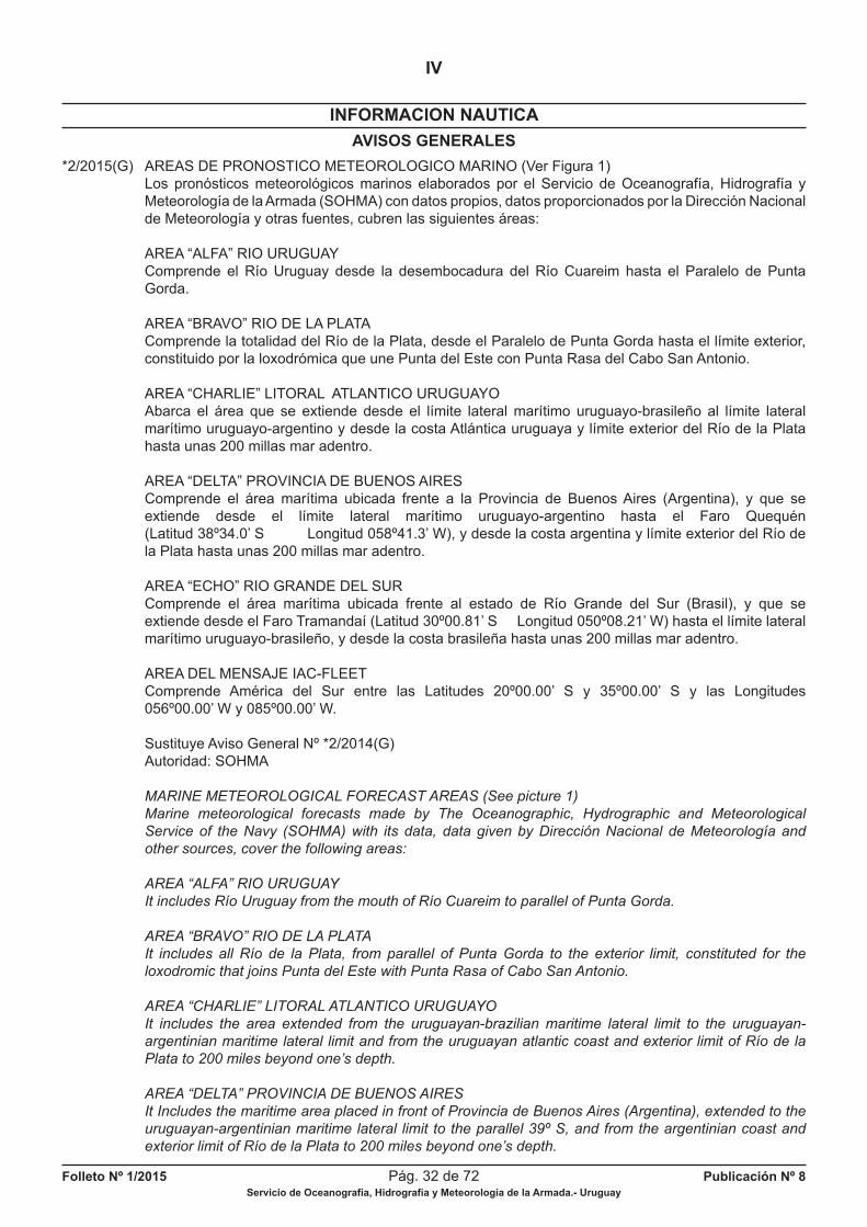
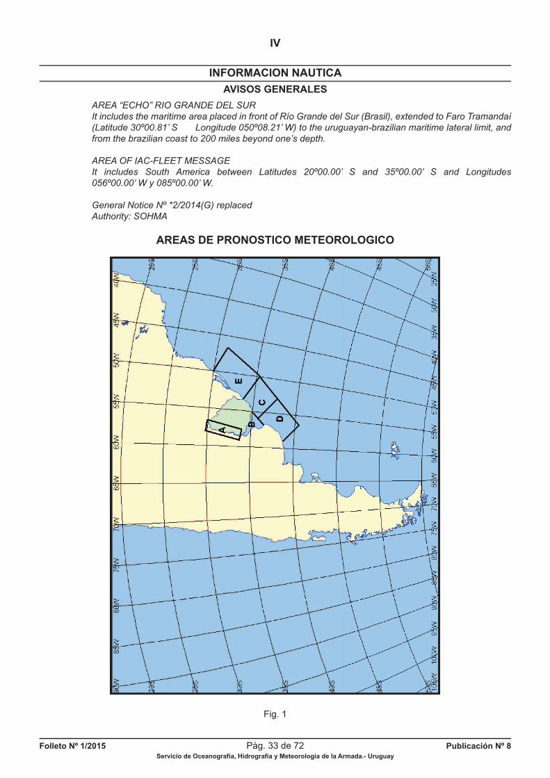
*2/2015(G) AREAS DE PRONOSTICO METEOROLOGICO MARINO (Ver Figura 1) Los pronósticos meteorológicos marinos elaborados por el Servicio de Oceanografía, Hidrografía y Meteorología de la Armada (SOHMA) con datos propios, datos proporcionados por la Dirección Nacional de Meteorología y otras fuentes, cubren las siguientes áreas:
AREA “ALFA” RIO URUGUAY Comprende el Río Uruguay desde la desembocadura del Río Cuareim hasta el Paralelo de Punta Gorda.
AREA “BRAVO” RIO DE LA PLATA Comprende la totalidad del Río de la Plata, desde el Paralelo de Punta Gorda hasta el límite exterior, constituido por la loxodrómica que une Punta del Este con Punta Rasa del Cabo San Antonio.
AREA “CHARLIE” LITORAL ATLANTICO URUGUAYO Abarca el área que se extiende desde el límite lateral marítimo uruguayo-brasileño al límite lateral marítimo uruguayo-argentino y desde la costa Atlántica uruguaya y límite exterior del Río de la Plata hasta unas 200 millas mar adentro.
AREA “DELTA” PROVINCIA DE BUENOS AIRES Comprende el área marítima ubicada frente a la Provincia de Buenos Aires (Argentina), y que se extiende desde el límite lateral marítimo uruguayo-argentino hasta el Faro Quequén (Latitud 38º34.0’ S Longitud 058º41.3’ W), y desde la costa argentina y límite exterior del Río de la Plata hasta unas 200 millas mar adentro.
AREA “ECHO” RIO GRANDE DEL SUR Comprende el área marítima ubicada frente al estado de Río Grande del Sur (Brasil), y que se extiende desde el Faro Tramandaí (Latitud 30º00.81’ S Longitud 050º08.21’ W) hasta el límite lateral marítimo uruguayo-brasileño, y desde la costa brasileña hasta unas 200 millas mar adentro.
AREA DEL MENSAJE IAC-FLEET Comprende América del Sur entre las Latitudes 20º00.00’ S y 35º00.00’ S y las Longitudes 056º00.00’ W y 085º00.00’ W.
Sustituye Aviso General Nº *2/2014(G) Autoridad: SOHMA
MARINE METEOROLOGICAL FORECAST AREAS (See picture 1)
Marine meteorological forecasts made by The Oceanographic, Hydrographic and Meteorological
Service of the Navy (SOHMA) with its data, data given by Dirección Nacional de Meteorología and
other sources, cover the following areas:
AREA “ALFA” RIO URUGUAY
It includes Río Uruguay from the mouth of Río Cuareim to parallel of Punta Gorda.
AREA “BRAVO” RIO DE LA PLATA
It includes all Río de la Plata, from parallel of Punta Gorda to the exterior limit, constituted for the
loxodromic that joins Punta del Este with Punta Rasa of Cabo San Antonio.
AREA “CHARLIE” LITORAL ATLANTICO URUGUAYO
It includes the area extended from the uruguayan-brazilian maritime lateral limit to the uruguayan-
argentinian maritime lateral limit and from the uruguayan atlantic coast and exterior limit of Río de la
Plata to 200 miles beyond one’s depth.
AREA “DELTA” PROVINCIA DE BUENOS AIRES
It Includes the maritime area placed in front of Provincia de Buenos Aires (Argentina), extended to the
uruguayan-argentinian maritime lateral limit to the parallel 39º S, and from the argentinian coast and
exterior limit of Río de la Plata to 200 miles beyond one’s depth.
Folleto Nº 1/2015 Pág. 33 de 72 Publicación Nº 8Servicio de Oceanografía, Hidrografía y Meteorología de la Armada.- Uruguay
INFORMACION NAUTICA
IV
AVISOS GENERALES
AREA “ECHO” RIO GRANDE DEL SUR
It includes the maritime area placed in front of Río Grande del Sur (Brasil), extended to Faro Tramandaí
(Latitude 30º00.81’ S Longitude 050º08.21’ W) to the uruguayan-brazilian maritime lateral limit, and
from the brazilian coast to 200 miles beyond one’s depth.
AREA OF IAC-FLEET MESSAGE
It includes South America between Latitudes 20º00.00’ S and 35º00.00’ S and Longitudes
056º00.00’ W y 085º00.00’ W.
General Notice Nº *2/2014(G) replaced
Authority: SOHMA
AREAS DE PRONOSTICO METEOROLOGICO
Fig. 1
Folleto Nº 1/2015 Pág. 34 de 72 Publicación Nº 8Servicio de Oceanografía, Hidrografía y Meteorología de la Armada.- Uruguay
INFORMACION NAUTICA
IV
AVISOS GENERALES
*3/2015(G) SERVICIOS HIDROGRAFICOS EXTRANJEROS A LOS QUE SE ENVIAN AVISOS A LOS NAVEGANTES, CARTAS Y PUBLICACIONES NAUTICAS URUGUAYAS Argentina-Bolivia-Brasil-Colombia-Chile-Ecuador-Paraguay-Perú-Venezuela-Estados Unidos de América- España-Francia-Gran Bretaña. También se envían Avisos, Cartas y Publicaciones Náuticas a la Organización Hidrográfi ca Internacional (OHI).
Sustituye Aviso General Nº *3/2014(G) Autoridad : SOHMA
HYDROGRAPHIC FOREIGN SERVICES ADDRESSEES OF NOTICES TO MARINERS, URUGUAYAN
CHARTS AND NAUTICAL PUBLICATIONS
Argentina-Bolivia-Brazil-Colombia-Chile-Ecuador-Paraguay-Peru-Venezuela -USA-Spain-France-Britain.
They are also sent to International Hydrographic Organization (IHO).
General Notice Nº *3/2014(G) replaced
Authority: SOHMA
*4/2015(G) INFORMACION HIDROGRAFICA EXTRANJERA Periódicamente se reciben en el SOHMA Avisos a los Navegantes, Cartas y Publicaciones Náuticas de Servicios o Institutos Hidrográfi cos de otras Naciones. Los mismos están disponibles para ser consultados por navegantes y público en general en la sede del SOHMA.
Sustituye Aviso General Nº *4/2014(G) Autoridad: SOHMA
FOREIGN HYDROGRAPHIC INFORMATION
SOHMA receives periodically Notices to Mariners, Charts and Nautical Publications from Services or
Hydrographic Institutes of other Nations.
These are available in SOHMA in order to be consulted by navigators and general public.
General Notice Nº *4/2014(G) replaced
Authority: SOHMA
*5/2015(G) ESTACIONES DE RADIO NACIONALES QUE TRANSMITEN RADIOAVISOS NAUTICOS Y BOLETINES METEOROLOGICOS A.- ESTACIONES DE LA ARMADA NACIONAL 1. LA PALOMA RADIO (CWC 30) (CWS 27) Situación: Lat. 34º39.50’ S Long. 054º08.50’ W Frecuencia (Tipo de emisión) [Potencia]: 2722.1 KHz (J3E) [1KW]; 4146 KHz (J3E) [1 KW]; 56.75 MHz Canal 15 (F3E) [0,1 KW] Horario (UTC): 03:03, 15:33, 23:03 Radioavisos Náuticos y Boletín Meteorológico. 2. PUNTA DEL ESTE RADIO (CWC 34) CONTROL PUNTA DEL ESTE PREFECTURA Situación: Lat. 34º57.80’ S Long. 054º57.10’ W Frecuencia (Tipo de emisión) [Potencia]: 2722.1 KHz (J3E) [0,15 KW]; 156.75 MHz Canal 15 (F3E) [0,025 KW]. Horario (UTC): 01:33, 15:03, 21:33 Radioavisos Náuticos y Boletín Meteorológico.
Folleto Nº 1/2015 Pág. 35 de 72 Publicación Nº 8Servicio de Oceanografía, Hidrografía y Meteorología de la Armada.- Uruguay
INFORMACION NAUTICA
IV
AVISOS GENERALES
3. PIRIAPOLIS RADIO (CWC 33) CONTROL PIRIAPOLIS PREFECTURA Situación: Lat. 34º52.80’ S Long. 055º16.20’ W Frecuencia (Tipo de emisión) [Potencia]: 156.75 MHz Canal 15 (F3E) [0,025 KW]. Horario (UTC): 07:03, 13:33, 21:03. Radioavisos Náuticos y Boletín Meteorológico.
4. ATLANTIDA RADIO (CWC 43) Situación: Lat. 34º46.80’ S Long. 055º45.40’ W Frecuencia (Tipo de emisión) [Potencia]: 156.75 MHz Canal 15 (F3E) [0,025 KW]. Horario (UTC): 05:33, 13:03, 19:33. Radioavisos Náuticos y Boletín Meteorológico.
5. MONTEVIDEO TROUVILLE RADIO (CWC 39) Situación: Lat. 34º52.00’ S Long. 056º18.66’ W Frecuencia (Tipo de emisión) [Potencia]: 2722.1 KHz (J3E) [1KW]; 4146 KHz (J3E) [1KW]. Horario (UTC): 01:03, 11:33, 19:03. Radioavisos Náuticos y Boletín Meteorológico.
6. MONTEVIDEO CENTRO DE RADIO CONTROL PREFECTURA (CWC) Situación: Lat. 34º54.30’ S Long. 056º12.70’ W Frecuencia (Tipo de emisión) [Potencia]: 156.75 MHz Canal 15 (F3E) [0,1 KW]. Horario (UTC): 01:03, 11:33, 19:03. Radioavisos Náuticos y Boletín Meteorológico.
7. PUERTO SAUCE PREFECTURA RADIO (CWC 27) Situación: Lat. 34º26.30’ S Long. 057º26.30’ W Frecuencia (Tipo de emisión) [Potencia]: 156.75 MHz Canal 15 (F3E) [0,025 KW]. Horario (UTC): 01:33, 13:03, 19:33. Radioavisos Náuticos y Boletín Meteorológico. 8. COLONIA PREFECTURA RADIO (CWC 23) Situación: Lat. 34º28.20’ S Long. 057º51.10’ W Frecuencia (Tipo de emisión) [Potencia]: 156.75 MHz Canal 15 (F3E) [0,025 KW]. Horario (UTC): 03:30, 13:30, 21:00. Radioavisos Náuticos y Boletín Meteorológico.
9. CARMELO PREFECTURA RADIO (CWC 22) Situación: Lat. 34º00.50’ S Long. 058º17.70’ W Frecuencia (Tipo de emisión) [Potencia]: 156.75 MHz Canal 15 (F3E) [0,025 KW]. Horario (UTC): 03.03, 15:03, 21:33. Radioavisos Náuticos y Boletín Meteorológico.
10. NUEVA PALMIRA PREFECTURA RADIO (CWC 31) Situación: Lat. 33º52.70’ S Long. 058º25.20’ W Frecuencia (Tipo de emisión) [Potencia]: 156.75 MHz Canal 15 (F3E) [0,025 KW]. Horario (UTC): 03:00, 09:00, 15:00, 21:00. Radioavisos Náuticos y Boletín Meteorológico.
11. FRAY BENTOS PREFECTURA RADIO (CWC 25) Situación: Lat. 33º06.80’ S Long. 058º18.40’ W Frecuencia (Tipo de emisión) [Potencia]: 156.75 MHz Canal 15 (F3E) [0,025 KW] Horario (UTC): 05:00, 11:00, 17:00, 23:00. Radioavisos Náuticos y Boletín Meteorológico.
Folleto Nº 1/2015 Pág. 36 de 72 Publicación Nº 8Servicio de Oceanografía, Hidrografía y Meteorología de la Armada.- Uruguay
INFORMACION NAUTICA
IV
AVISOS GENERALES
12. PAYSANDU PREFECTURA RADIO (CWC 32) Situación: Lat. 32º18.10’ S Long. 058º05.10’ W Frecuencia (Tipo de emisión) [Potencia]: 156.75 MHz Canal 15 (F3E) [0,025 KW]. Horario (UTC): 03:00, 09:00, 15:00, 21:00. Radioavisos Náuticos y Boletín Meteorológico.
13. SALTO PREFECTURA RADIO (CWC 37) Situación: Lat. 31º23.00’ S Long. 057º59.00’ W Frecuencia (Tipo de emisión) [Potencia]: 156.75 MHz Canal 15 (F3E) [0,025 KW]. Horario (UTC): 05:00, 11:00, 17:00, 23:00. Radioavisos Náuticos y Boletín Meteorológico. 14. RIO BRANCO PREFECTURA RADIO (CWC 36) Situación: Lat. 32º34.40’ S Long. 053º22.60’ W Frecuencia (Tipo de emisión) [Potencia]: 2722.1 KHz (J3E) [0,2 KW]; 56.75 MHz Canal 15 (F3E) (0,025 KW). Horario (UTC): 09:33, 17:03, 23:33. Radioavisos Náuticos y Boletín Meteorológico.
B.- ESTACION DE ANTEL (ADMINISTRACION NACIONAL DE TELECOMUNICACIONES)
15. CERRITO RADIO (CWA) Situación: Lat. 34º51.10’ S Long. 056º10.80’ W Frecuencia (Tipo de emisión) [Potencia]: 421.5 KHz (A1A, A2A) [2 KW]; 4346 KHz (A1A) [1 KW]; 8602 KHz (A1A) [1 KW]; 12750 KHz (A1A) [5 KW]; 17230 KHz (A1A) [1 KW]. Horario (UTC): 00:00, 14:00, 19:00. Radioavisos Náuticos y Boletín Meteorológico.
La red de Prefectura que transmite en 156.75 MHz Canal 15 (F3E) [0,025 KW] realiza un anuncio previo en Canal 16. Las estaciones de ANTEL, en telefonía, hacen un anuncio previo en 2182 KHz y, en radiotelegrafía, en 500 KHz.
AVISO IMPORTANTE: Para la navegación en el Río de la Plata y en el Río Uruguay, se recomienda la recepción de radioavisos náuticos uruguayos y argentinos, a efectos de disponer de información completa y actualizada de las rutas de navegación.
Sustituye Aviso General Nº *5/2014(G) Autoridad: SOHMA
NATIONAL RADIO STATIONS THAT BROADCAST RADIO NAUTICAL NOTICES AND
METEOROLOGICAL BULLETINS
A.- ARMADA NACIONAL STATIONS
1. LA PALOMA RADIO (CWC 30) (CWS 27)
Situation: Lat. 34º39.50’ S Long. 054º08.50’ W
Frecuency (kind of broadcast) [Potency]: 2722.1 KHz (J3E) [1KW]; 4146 KHz (J3E) [1 KW];
156.75 MHz Channel 15 (F3E) [0,1 KW]
Schedule (UTC): 003:03, 15:33, 23:03.
Radio nautical notices and Meteorological Bulletin.
Folleto Nº 1/2015 Pág. 37 de 72 Publicación Nº 8Servicio de Oceanografía, Hidrografía y Meteorología de la Armada.- Uruguay
INFORMACION NAUTICA
IV
AVISOS GENERALES
2. PUNTA DEL ESTE RADIO (CWC 34)
CONTROL PUNTA DEL ESTE PREFECTURA
Situation: Lat. 34º57.80’ S Long. 054º57.10’ W
Frecuency (kind of broadcast) [Potency]: 2722.1 KHz (J3E) [0,15 KW]; 156.75 MHz Channel 15 (F3E)
[0,025 KW].
Schedule (UTC): 01:33, 15:03, 21:33.
Radio nautical notices and Meteorological Bulletin.
3. PIRIAPOLIS RADIO (CWC 33)
CONTROL PIRIAPOLIS PREFECTURA
Situation: Lat. 34º52.80’ S Long. 055º16.20’ W
Frecuency (kinf of broadcast) [Potency]: 156.75 MHz Channel 15 (F3E) [0,025 KW].
Schedule (UTC): 07:03, 13:33, 21:03.
Radio nautical notices and Meteorological Bulletin.
4. ATLANTIDA RADIO (CWC 43)
Situation: Lat. 34º46.80’ S Long. 055º45.40’ W
Frecuency (kind of broadcast) [Potency]: 156.75 MHz Channel 15 (F3E) [0,025 KW].
Schedule (UTC): 05:33, 13:03, 19:33.
Radio nautical notices and Meteorological Bulletin.
5. MONTEVIDEO TROUVILLE RADIO (CWC 39)
Situation: Lat. 34º52.00’ S Long. 056º18.66’ W
Frecuency (kind of broadcast) [Potency]: 2722.1 KHz (J3E) [1KW]; 4146 KHz (J3E) [1KW].
Schedule (UTC): 01:03, 11:33, 19:03.
Radio nautical notices and Meteorological Bulletin.
6. MONTEVIDEO CENTRO DE RADIO CONTROL PREFECTURA (CWC)
Situation: Lat. 34º54.30’ S Long. 056º12.70’ W
Frecuency (kind of broadcast) [Potency]: 156.75 MHz Channel 15 (F3E) [0,1 KW].
Schedule (UTC): 01:03, 11:33, 19:03.
Radio nautical notices and Meteorological Bulletin.
7. PUERTO SAUCE PREFECTURA RADIO (CWC 27)
Situation: Lat. 34º26.30’ S Long. 057º26.30’ W
Frecuency (kind of broadcast) [Potency]: 156.75 MHz Channel 15 (F3E) [0,025 KW].
Schedule (UTC): 01:33, 13:03, 19:33.
Radio nautical notices and Meteorological Bulletin.
8. COLONIA PREFECTURA RADIO (CWC 23)
Situation: Lat. 34º28.20’ S Long. 057º51.10’ W
Frecuency (kind of broadcast) [Potency]: 2722.1 KHz (J3E)[0,15 KW]; 156.75 MHz Channel 15 (F3E)
[0,025 KW].
Schedule (UTC): 03:30, 13:30, 21:00.
Radio nautical notices and Meteorological Bulletin.
9. CARMELO PREFECTURA RADIO (CWC 22)
Situation: Lat. 34º00.50’ S Long. 058º17.70’ W
Frecuency (kind of broadcast) [Potency]: 156.75 MHz Channel 15 (F3E) [0,025 KW].
Schedule (UTC): 03:03, 15:03, 21:33.
Radio nautical notices and Meteorological Bulletin.
10. NUEVA PALMIRA PREFECTURA RADIO (CWC 31)
Situation: Lat. 33º52.70’ S Long. 058º25.20’ W
Frecuency (kind of broadcast) [Potency]: 156.75 MHz Channel 15 (F3E) [0,025 KW].
Schedule (UTC): 03:00, 09:00, 15:00, 21:00.
Radio nautical notices and Meteorological Bulletin.
Folleto Nº 1/2015 Pág. 38 de 72 Publicación Nº 8Servicio de Oceanografía, Hidrografía y Meteorología de la Armada.- Uruguay
INFORMACION NAUTICA
IV
AVISOS GENERALES
11. FRAY BENTOS PREFECTURA RADIO (CWC 25)
Situation: Lat. 33º06.80’ S Long. 058º18.40’ W
Frecuency (kind of broadcast) [Potency]: 156.75 MHz Channel 15 (F3E) [0,025 KW]
Schedule (UTC): 05:00, 11:00, 17:00, 23:00.
Radio nautical notices and Meteorological Bulletin.
12. PAYSANDU PREFECTURA RADIO (CWC 32)
Situation: Lat. 32º18.10’ S Long. 058º05.10’ W
Frecuency (kind of broadcast) [Potency]: 156.75 MHz Channel 15 (F3E) [0,025 KW].
Schedule (UTC): 03:00, 09:00, 15:00, 21:00.
Radio nautical notices and Meteorological Bulletin.
13. SALTO PREFECTURA RADIO (CWC 37)
Situation: Lat. 31º23.00’ S Long. 057º59.00’ W
Frecuency (kind of broadcast) [Potency]: 156.75 MHz Channel 15 (F3E) [0,025 KW].
Schedule (UTC): 05:00, 11:00, 17:00, 23:00.
Radio nautical notices and Meteorological Bulletin.
14. RIO BRANCO PREFECTURA RADIO (CWC 36)
Situation: Lat. 32º34.40’ S Long. 053º22.60’ W
Frecuency (kind of broadcast) [Potency]: 2722.1 KHz (J3E) [0,2 KW]; 56.75 MHz Channel 15 (F3E)
(0,025 KW).
Schedule (UTC): 09:33, 17:03, 23:33.
Radio nautical notices and Meteorological Bulletin.
B.- ANTEL (ADMINISTRACION NACIONAL DE TELECOMUNICACIONES). STATION
15. CERRITO RADIO (CWA)
Situation: Lat. 34º51.10’ S Long. 056º10.80’ W
Frecuency (kind of broadcast) [Potency]: 421.5 KHz (A1A, A2A) [2 KW]; 4346 KHz (A1A) [1 KW];
8602 KHz (A1A) [1 KW]; 12750 KHz (A1A) [5 KW]; 17230 KHz (A1A) [1 KW].
Schedule (UTC): 00:00, 14:00, 19:00.
Radio nautical notices and Meteorological Bulletin.
The stations of Prefectura which broadcast at 156.75 MHz Channel 15 (F3E) [0,025 kw] makes a
previous announcement at Channel 16.
ANTEL stations, in telephony, make a previous announcement at 2182 KHz and, in radiotelegraphy, at
500 KHz.
IMPORTANT NOTICE: For navigation in Río de la Plata and Río Uruguay it is recommended the
reception of uruguayan and argentinian nautical radio news, in order to get complete and updated
information about navigation ways.
General Notice Nº *5/2014(G) replaced
Authority: SOHMA
*6/2015(G) RADIOAVISOS NAVAREA Es un radioaviso de largo alcance con el objeto de difundir información importante relativa a la seguridad de las grandes navegaciones, como ser: averías o alteraciones en las ayudas importantes a la navegación, naufragios o peligros recientemente descubiertos próximos a las vías principales de navegación, operaciones diversas que pueden afectar a la seguridad (búsqueda y salvamento, trabajos con minas, tendido de cables o conductos submarinos, ejercicios de fuerzas navales, etc.) y en general, todo lo que pueda ocasionar cambios en las derrotas previstas. Este servicio forma parte del Servicio Mundial de Radioavisos Náuticos SMRN (World Wide Navigational Warning Service WWNWS), que fue establecido conjuntamente por la Organización Marítima Internacional (OMI) y la Organización Hidrográfi ca Internacional (OHI), en el cual se establecen las normas y orientaciones para los radioavisos de larga distancia (NAVAREA), radioavisos costeros y locales.
Folleto Nº 1/2015 Pág. 39 de 72 Publicación Nº 8Servicio de Oceanografía, Hidrografía y Meteorología de la Armada.- Uruguay
INFORMACION NAUTICA
IV
AVISOS GENERALES
Para el funcionamiento del SMRN el mundo fue dividido en 16 zonas denominadas NAVAREAS e identifi cadas con un número romano (Ver Figura 2). En cada zona, un coordinador de zona es la autoridad encargada de coordinar, recopilar y emitir los radioavisos NAVAREA. Estos son transmitidos por estaciones potentes que cubren su zona y las limítrofes hasta una distancia de 700 millas de sus límites. Los programas y modalidades de difusión fi guran en las Radioayudas publicadas por los Servicios Hidrográfi cos y en las publicaciones de la Unión Internacional de Telecomunicaciones (UIT).
NAVAREAS VI Las áreas marítimas del Uruguay forman parte de la NAVAREA VI. Comprende además las costas de la República Argentina, prolongándose esta área hasta la Antártida (Ver Figura 2). El coordinador de esta zona es el Servicio de Hidrografía Naval de la República Argentina. Las frecuencias y horarios de transmisión son los siguientes:
Frecuencia Señal Clase de Horario Emite distintiva emisión TMG
4304 L2C A 1 A 00:30 Radioavisos 8447 LSO 5 15:30 Radioavisos 12728 LSO 5 21:00 Boletín 16925,6 LSO 3 Idiomas empleados: español e inglés.
La información sobre NAVAREA VI fue extraída de la publicación argentina H-221, Radioayudas a la Navegación.
NAVAREA V
El área del Océano Atlántico limitado por los Paralelos 07º00.00’ N y 35º50.00’ S el Meridiano 020º00.00’ W y la costa brasileña, constituye la NAVAREA V (Ver Figura 2.). El coordinador de ésta zona es la Directoría de Hidrografía y Navegación de la Marina de Brasil. Los avisos son precedidos de la expresión NAVAREA V y numerados secuencialmente de 0001 al 3999, anualmente. Los avisos son transmitidos por las siguientes estaciones:
BELEN RADIO (PPL) Situación: Lat. 01º25.00’ S Long. 048º26.00’ W Frecuencia: 4369 KHz (J3E); 4321 y 8462 KHz ( A1A). Potencia: 1 KW. Horario de transmisión (HMG): J3E- 01:03, 06:03, 10:03, 12:03, 15:03 y 21:03; A1A- 06:00 y 18:00. Emite además avisos costeros y locales de la siguiente área: de Bahía de Oiapoque a la desembocadura de Río Paranaíba, inclusive los ríos de la cuenca Amazónica.
OLINDA RADIO (PPO) Situación: Lat. 08º04.00’ S Long. 034º55.00’ W Frecuencia: 4369 KHz (J3E); 4321 y 8462 KHz ( A1A). Potencia: 1 KW. Horario de transmisión (HMG): J3E- 01:03, 06:03, 10:03, 12:03, 15:03 y 21:03; A1A- 02:00 y 14:00. Emite además avisos costeros y locales. Trecho de la costa abarcada por los avisos costeros y locales: de la desembocadura del Río Paranaíba al Puerto de los Islotes.
ESTACION RADIO DE LA MARINA DE RIO DE JANEIRO (PWZ-33) Situación: Lat. 22º48.00’ S Long. 043º18.00’ W Frecuencia: 4266, 6448, 8580, 12709, 16974 KHz (J2D); 4266, 6448, 8580, 12709,16974 KHz (F1B) Potencia: 10 KW. Horario de transmisión (HMG): J2D- 14:30; F1B- 04:00 y 21:30
Folleto Nº 1/2015 Pág. 40 de 72 Publicación Nº 8Servicio de Oceanografía, Hidrografía y Meteorología de la Armada.- Uruguay
INFORMACION NAUTICA
IV
AVISOS GENERALES
Emite además avisos costeros y locales. Trecho de la costa abarcado por los avisos costeros y locales: Toda la costa brasilera. La frecuencia 4266 KHz será utilizada a pedido de las estaciones receptoras.
JUNÇAO RADIO (PPJ) Situación: Lat. 32º11.00’ S Long. 052º10.00’ W Frecuencia: 4321 y 8462 KHz (A1A); 4381 KHz (J3E) Potencia: 1.0 KW. Horario de transmisión (HMG): A1A- 08:00 y 20:00; J3E- 01:03, 12:03, 15:03 y 21:03 Trecho de la costa abarcado por los avisos costeros y locales: desde Puerto de Santos al Arroyo Chuy. Idiomas empleados: portugués e inglés.
La información sobre NAVAREA V fue extraída de la publicación brasileña DH-8 Lista de Auxilios- Radios.
Sustituye Aviso General Nº *6/2014(G) Autoridad: SOHMA
RADIO NOTICES NAVAREA
It is a radio notice of long reach to send important information about security of great navigations as:
damages or alterations in the important navigational warnings, wrecks or recent risks discovered close
to the main navigational ways, different works that can affect the security (search and rescue, works
with mines, installation of cables or submarine conduits, navy force exercises, etc.) and in general, all
that could cause changes in the anticipated ship’s courses.
This service belongs to SMRN (World Wide Navigational Warning Service WWNWS), which was
established together by International Maritime Organization (IMO) and International Hydrographic
Organization(IHO), where there are set up the norms and orientations for radio notices of long
distance (NAVAREA), coastal and local radio notices.For the functioning of SMRN the world was
divided in 16 zones called NAVAREAS and they are identifi ed by a roman number (See picture 2).
En each zone there is one coordinator who is the authority to coordinate, compile and send the radio
notices NAVAREA.
Those are transmited by powerful stations covering its zone and the bounding areas to 700 miles of
distance from their limits.
The programms and difussion ways are fi gured in the Radio aids published by the Hdrographic
Services and in the publications of International Telecommunication Union (ITU).
NAVAREAS VI
The maritime areas of Uruguay belong to NAVAREA VI. It also includes the coasts of República Argentina,
extending this area to Antártida (See picture 2). Argentina Naval Hydrographic Service is the coordinator
of this zone. Frecuency and schedule of transmission below:
Frecuency Signal Kind of Schedule Emit
distinctive emission TMG
4304 L2C A 1 A 00:30 Radio notices
8447 LSO 5 15:30 Radio notices
12728 LSO 5 21:00 Bulletin
16925,6 LSO 3
Languages used: Spanish and English.
The information about NAVAREA VI was taken from the argentinian publication H 221, Radioayudas a
la Navegación.
NAVAREA V
NAVAREA V is constituted for the area of Atlantic Ocean limited by parallels 07º00.00’ N y 35º50.00’ S
to meridian 20º00.00 W and the brazilian coast (See picture 2).
Directorate of Hydrography and Navigation of the Brazilian Navy (DHN) is the coordinator of this zone.
Folleto Nº 1/2015 Pág. 41 de 72 Publicación Nº 8Servicio de Oceanografía, Hidrografía y Meteorología de la Armada.- Uruguay
INFORMACION NAUTICA
IV
AVISOS GENERALES
Notices go before the expression NAVAREA V and sequentially numbered from 0001 to 3999, anually.
Notices are transmited by the following stations:
BELEN RADIO (PPL)
Situation: Lat. 01º25.00’ S Long. 048º26.00’ W
Frecuency: 4369 KHz (J3E); 4321 and 8462 KHz ( A1A).
Potency: 1 KW.
Trasmission schedule (HMG): J3E- 01:03, 06:03, 10:03, 12:03, 15:03 and 21:03; A1A- 06:00 and 18:00.
It also transmits coastal and local notices of the area: from Bahía de Oiapoque to Foz de Río
Paranaiba, and also the rivers of amazonian basin.
OLINDA RADIO (PPO)
Situation: Lat. 08º04.00’ S Long. 034º55.00’ W
Frecuency: 4369 KHz (J3E); 4321 and 8462 KHz ( A1A).
Potency: 1 KW.
Transmission schedule (HMG): J3E- 01:03, 06:03, 10:03, 12:03, 15:03 and 21:03; A1A- 02:00 and
14:00.
It also transmits coastal and local notices.
Coastal stretch included for the coastal and local notices: from mouth of Río Paranaíba to Puerto de los
Islotes.
ESTACION RADIO DE LA MARINA DE RIO DE JANEIRO (PWZ-33)
Situation: Lat. 22º48.00’ S Long. 043º18.00’ W
Frecuency: 4266, 6448, 8580, 12709, 16974 KHz (J2D); 4266, 6448, 8580, 12709,16974 KHz (F1B)
Potency: 10 KW.
Transmission schedule (HMG): J2D- 14:30; F1B- 04:00 and 21:30
It also transmits coastal and local notices.
Coastal stretch included for the coastal and local notices: all the brazilian coast.
The frecuency 4266 KHz will be used on request of the receiver stations.
JUNÇAO RADIO (PPJ)
Situation: Lat. 32º11.00’ S Long. 052º10.00’ W
Frecuency: 4321 and 8462 KHz (A1A); 4381 KHz (J3E)
Potency: 1.0 KW.
Transmission schedule (HMG): A1A- 08:00 and 20:00; J3E- 01:03, 12:03, 15:03 and 21:03
Coastal stretch included for the coastal and local notices: from Puerto de Santos to Arroyo Chuy.
Languages used: Portuguese and English.
The information about NAVAREA V was taken from the brazilian Publication DH-8 Lista de Auxilios-
Radios.
General Notice Nº *6/2014(G) replaced
Authority: SOHMA
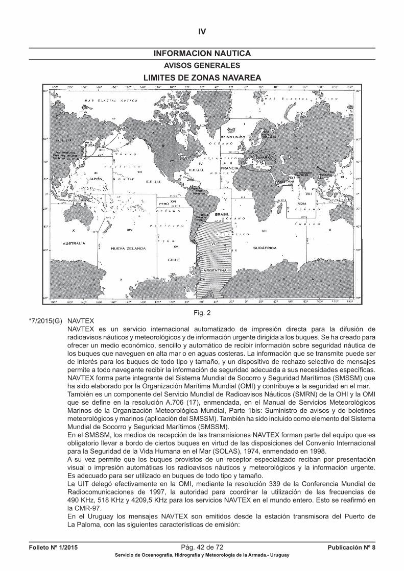
Folleto Nº 1/2015 Pág. 42 de 72 Publicación Nº 8Servicio de Oceanografía, Hidrografía y Meteorología de la Armada.- Uruguay
INFORMACION NAUTICA
IV
AVISOS GENERALES
LIMITES DE ZONAS NAVAREA
Fig. 2*7/2015(G) NAVTEX NAVTEX es un servicio internacional automatizado de impresión directa para la difusión de radioavisos náuticos y meteorológicos y de información urgente dirigida a los buques. Se ha creado para ofrecer un medio económico, sencillo y automático de recibir información sobre seguridad náutica de los buques que naveguen en alta mar o en aguas costeras. La información que se transmite puede ser de interés para los buques de todo tipo y tamaño, y un dispositivo de rechazo selectivo de mensajes permite a todo navegante recibir la información de seguridad adecuada a sus necesidades específi cas. NAVTEX forma parte integrante del Sistema Mundial de Socorro y Seguridad Marítimos (SMSSM) que ha sido elaborado por la Organización Marítima Mundial (OMI) y contribuye a la seguridad en el mar. También es un componente del Servicio Mundial de Radioavisos Náuticos (SMRN) de la OHI y la OMI que se defi ne en la resolución A.706 (17), enmendada, en el Manual de Servicios Meteorológicos Marinos de la Organización Meteorológica Mundial, Parte 1bis: Suministro de avisos y de boletines meteorológicos y marinos (aplicación del SMSSM). También ha sido incluido como elemento del Sistema Mundial de Socorro y Seguridad Marítimos (SMSSM). En el SMSSM, los medios de recepción de las transmisiones NAVTEX forman parte del equipo que es obligatorio llevar a bordo de ciertos buques en virtud de las disposiciones del Convenio Internacional para la Seguridad de la Vida Humana en el Mar (SOLAS), 1974, enmendado en 1998. A su vez permite que los buques provistos de un receptor especializado reciban por presentación visual o impresión automáticas los radioavisos náuticos y meteorológicos y la información urgente. Es adecuado para ser utilizado en buques de todo tipo y tamaño. La UIT delegó efectivamente en la OMI, mediante la resolución 339 de la Conferencia Mundial de Radiocomunicaciones de 1997, la autoridad para coordinar la utilización de las frecuencias de 490 KHz, 518 KHz y 4209,5 KHz para los servicios NAVTEX en el mundo entero. Esto se reafi rmó en la CMR-97. En el Uruguay los mensajes NAVTEX son emitidos desde la estación transmisora del Puerto de La Paloma, con las siguientes características de emisión:
Folleto Nº 1/2015 Pág. 43 de 72 Publicación Nº 8Servicio de Oceanografía, Hidrografía y Meteorología de la Armada.- Uruguay
INFORMACION NAUTICA
IV
AVISOS GENERALES
1) A.- -Frecuencia: 518 Khz -Identifi cación: F -Idioma: Inglés -Horario de trasmisión (UTC): 00:50, 04:50, 08:50, 12:50, 16:50, 20:50. -Esta frecuencia corresponde al Servicio NAVTEX internacional. B.- -Frecuencia: 490 Khz -Identifi cacíon: A -Idioma: Español -Horario de trasmisión (UTC): 00:00, 04:00, 08:00, 12:00, 16:00, 20:00. -Esta frecuencia corresponde al Servicio NAVTEX nacional. 2) Información que se emite a través del Servicio NAVTEX a) Radioavisos Náuticos Se emitirán radioavisos náuticos de la siguiente área: -Océano Atlántico Mar Territorial y Zona Económica Exclusiva de la República Oriental del Uruguay, exceptuando Boya Bajo Falkland y Bajo 18 de Julio. -Río de la Plata Desde el Límite Exterior hasta el meridiano Oeste de la Isla de Flores (Longitud 055º56.00’ W). Se emitirán además novedades de las siguientes señales ubicadas al Oeste de la Isla de Flores: - Faros de Punta Brava, Montevideo y La Panela - Baliza de la Escollera Sarandí y del Morro Sur de la Escollera Oeste de Acceso al Puerto de Montevideo. - Boya Nº 1 Emisario Punta Brava (Cardinal Sur), Graf Spee (Peligro Aislado) y Boya Eje Canal de Acceso al Puerto de Montevideo del Km. 9.35 (Aguas Seguras) b) Radioavisos Meteorológicos Se emiten “Avisos de Viento Fuerte” (Escala Beaufort Fuerza 7) y los Avisos de Temporal (Escala Beaufort Fuerza 8 o más), cuando se prevé una persistencia en la intensidad o dirección por un término de 12 a 24 horas, como está establecido en el Aviso General Nº *12/2015(G).
c) Pronósticos Meteorológicos Se emitirán pronósticos para las áreas Bravo (Río de la Plata) y Charlie (Mar Territorial y Zona Económica Exclusiva Uruguaya), defi nidas en el Aviso General Nº *2/2015(G). d) Código IAC Fleet que permite al navegante el Ploteo de la Carta de Superfi cie Meteorológica. e) Búsqueda y Rescate Se emite información del reporte de situación (SITREP) de incidentes que ocurran en: -Río de la Plata -Area de Responsabilidad SAR de la República Oriental de Uruguay
Sustituye Aviso General Nº *7/2014(G) Autoridad: SOHMA
NAVTEX
NAVTEX is an automated internacional service of direct print for the difussion of nautical and meteorological
radionotices and urgent information to vessels. It was created in order to give an economic, plain and
automatic way to receive information about nautical security of vessels which navigate in coastal or high
seas. The information transmited can be of interest for vessels of any type and size and a dispositive of
selective rebound of messages allows to the navigator to receive the information of security properly to
his necessities.
NAVTEX belongs to Global Maritime Distress Safety Systems (GMDSS) which has been created by
International Maritime Organization (IMO) and it contributes to the sea security.
The Service NAVTEX allows the vessels which have a specialised receiver, to receive the
meteorological and radionanautical notices and urgent information by visual presentation or automatic
imprint. It is proper to be used in vessels of any kind and size.
The Service NAVTEX is a component of World Wide Navigational Warning Service of IHO and IMO
defi ned in resolution A.706 (17), amend, in the Manual on Marine Meteorological Services of the
World Meteorological Organization, Part 1bis: Supply of notices and meteorological bulletins (application
of GMDSS). It also has included as element of Global Maritime Distress Safety Systems.
Folleto Nº 1/2015 Pág. 44 de 72 Publicación Nº 8Servicio de Oceanografía, Hidrografía y Meteorología de la Armada.- Uruguay
INFORMACION NAUTICA
IV
AVISOS GENERALES
In the GMDSS, the ways of reception of transmissions NAVTEX belong to the obligatory equipment
to take aboard in some vessels in reason of the dispositions of Safety of Life at Sea (SOLAS), 1974,
amend in 1998.
UIT delegated to OMI the authority to coordinate the utilization of the frecuencies of 490 KHz,
518 KHz and 4209,5 KHz for services NAVTEX in the whole world, by the resolution 339 of Conferencia
Mundial de Radiocomuncaciones in 1997. It was reaffi rmed in the CMR-97.
In Uruguay messages NAVTEX are broadcast from the coastal station of Puerto La Paloma with the
following characteristics of emission:
1) A.- -Frecuency: 518 Khz
-Indentifi cation: F
-Language: English
-Schedule of transmission (UTC): 00:50, 04:50, 08:50, 12:50, 16:50, 20:50.
B.- -Frecuency: 490 Khz
-Indentifi cation: A
-Language: Spanish
-Schedule of trasmission (UTC): 00:00, 04:00, 08:00, 12:00, 16:00, 20:00.
-This frecuency corresponds to national Service NAVTEX.
2) Information trasmited by Service NAVTEX
a) Radionautical notices
It will be transmited radionautical notices of the following area:
-Océano Atlántico
Territorial Sea and Exclusive Economic Zone of República Oriental del Uruguay, except Boya
Bajo Falkland and Bajo 18 de Julio.
-Río de la Plata
From Exterior Limit to meridian West of de la Isla de Flores (Longitude 055º56.00’ W). It will be
also emit news about the following signals placed to the West of Isla de Flores:
-Light-houses of Punta Brava, Montevideo and La Panela
-Beacon of Escollera Sarandí and Morro Sur of Escollera Oeste de Acceso al Puerto de
Montevideo.
-Buoy Nº 1 Emisario Punta Brava (South), Graf Spee (Isolated Danger) and Buoy Eje Canal de
Acceso al Puerto de Montevideo del Km. 9.35 (Safe Waterways)
b) Meteorological Radionotices
It emits “Notices of Hard Wind” (Scale Beaufort Force 7) and “Notices of Storm” (Scale Beaufort
Force 8 or more), when it foresees the persistence in the intensity or direction for a term of 12 to
24 hours, as it is established in the General Notice Nº *12/2015(G).
c) Meteorological Forecasts
It will emit forecasts to areas Bravo (Río de la Plata) and Charlie (Territorial Sea and
uruguayan Exclusive Economic Zone), defi ned in the General Notice Nº *2/2015(G).
d) Code IAC Fleet which allows to navigator the plotting of the Meteorological Chart of Surface.
e) Search and Rescue
It emits information of the report of situation (SITREP) about incidents which occur in:
-Río de la Plata
-Area of Responsability SAR of República Oriental de Uruguay
General Notice Nº *7/2014(G) replaced
Authority: SOHMA
*8/2015(G) SERVICIOS AL NAVEGANTE La Armada Nacional pone a disposición una página WEB (www.armada.mil.uy). También puede ingresar directamente al SOHMA a través de: www.sohma.armada.mil.uy, que brinda acceso a los siguientes servicios al navegante: -Pronóstico de las 09:00 hora local (de actualización diaria). -Pronóstico Meteorológico Principal de las 14:00 hora local (de actualización diaria). -Pronóstico de las 18:00 hora local (ratifi cación o rectifi cación del Pronóstico Meteorológico Principal, de actualización diaria). -Carta Sinóptica de Superfi cie según lo establecido en el Aviso General Nº *2/2015(G).
Folleto Nº 1/2015 Pág. 45 de 72 Publicación Nº 8Servicio de Oceanografía, Hidrografía y Meteorología de la Armada.- Uruguay
INFORMACION NAUTICA
IV
AVISOS GENERALES
-Datos meteorológicos en planilla actualizados diariamente provenientes de las Estaciones de Punta Brava, La Paloma, Juan Lacaze, Chuy, Laguna del Sauce y Punta del Este. -Almanaque (Salidas y Puestas de Sol y Luna) - Versión Completa -Catálogo de Cartas y Publicaciones Náuticas - Información General - Cartas Náuticas editadas por el SOHMA (listado) - Publicaciones Náuticas editadas por el SOHMA (listado) -Predicción de altura de mareas para algunos puertos uruguayos: La Paloma, Punta del Este, Montevideo, Colonia y Base Científi ca Antártica Artigas. Estos servicios son actualizados por el Servicio de Oceanografía, Hidrografía y Meteorología de la Armada. Sustituye Aviso General Nº *8/2014(G) Autoridad: SOHMA
SERVICE TO NAVIGATOR
Uruguay Navy puts to disposition a WEB page (www.armada.mil.uy). It also can be directly enter to
SOHMA through: www.sohma.armada.mil.uy, getting access to the following services to navigators:
-Meteorological Forecast at 09:00 local time (daily updated).
-Main Meteorological Forecast at 14:00 (daily updated).
-Meterological Forecast at 18:00 local time (ratifi cation or rectifi cation of the Main Meteorological
Forecast, daily updated).
-Synoptic Chart of Surfaceaccording to General Notice Nº *2/2015(G).
-Meteorological data in real time in Punta Brava, La Paloma, Juan Lacaze, Chuy, Laguna del Sauce
and Punta del Este.
-Almanac (rises and sunsets of Sun and Moon) - Complete version
-Catalogue of Charts and Nautical Publications - General information
- Nautical Charts edited by SOHMA (list)
- Nautical Publications edited by SOHMA (list)
-Prediction of tides height for some uruguayan harbours: La Paloma, Punta del Este, Montevideo,
Colonia and Base Científi ca Antártica Artigas.
These services are updated by Servicio de Oceanografía, Hidrografía y Meteorología de la Armada.
General Notice Nº *8/2014(G) replaced
Authority: SOHMA
*9/2015(G) INFORMACION SOBRE PELIGROS PARA LA NAVEGACION Se solicita a los Navegantes, Prácticos, Organismos del Estado, Entes Autónomos, Compañías Navieras, Empresas de Obras Portuarias, y toda persona relacionada con el ámbito marítimo, comuniquen de inmediato y por las vías más rápidas al Servicio de Oceanografía, Hidrografía y Meteorología de la Armada (SOHMA) toda información que afecte a la seguridad de la navegación como ser: denuncias de rocas o bajos fondos, obstrucciones, irregularidades en el funcionamiento de Faros, Radiofaros y Balizas, Boyas apagadas y/o fuera de posición, diferencias o errores que se constaten en Cartas y Publicaciones Náuticas nacionales o extranjeras, instalación accidental de señales, construcción de obras portuarias, dragado, o cualquier otra novedad que constituya un peligro para la navegación o que altere una información dada. Dirección: Capurro 980 - Montevideo - URUGUAY
Casilla de Correos: 1381 / Código Postal: 11700Teléfonos: (+598) 2307 - 1777 / 2309 - 3775 / 2309 - 3861 / Tel./Fax: (+598) 2309 - 9220
E-mail: [email protected]
ó a la Autoridad Marítima más próxima.Página Web: www.sohma.armada.mil.uy
Sustituye Aviso General Nº *9/2014(G) Autoridad: SOHMA
Folleto Nº 1/2015 Pág. 46 de 72 Publicación Nº 8Servicio de Oceanografía, Hidrografía y Meteorología de la Armada.- Uruguay
INFORMACION NAUTICA
IV
AVISOS GENERALES
INFORMATION ABOUT RISKS TO NAVIGATION
It requests to Navigators, Pilots, State Organisms, Autonomous Entities, Shipping Companies,
Harbour Work Enterprises, and any person related with the maritime ambience to communicate
inmediately and by the fastest ways to Oceanographic, Hydrographic and Meteorological Service of the
Navy (SOHMA) all the information that affects navigation as: denunciation of rocks or low bottoms,
obstructions, irregularities in the functioning of beaconage, unlit and/or off station buoys, differences or
mistakes in national or foreign Nautical Charts and Publications, accidental installation of signals,
construction of harbour work, dredging, and any information which constitutes danger to navigation or
alters a given information.
Address: Capurro 980 – Mail Box 1381
Telephones: (+598) 2309 - 3775 / 2309 - 3861 / Fax: (+598) 2309 - 9220
E-Mail: [email protected]
Montevideo - Uruguay
or to the closest Maritime Authority.
Web Page: www.sohma.armada.mil.uy
General Notice Nº *9/2014(G) replaced
Authority: SOHMA
*10/2015(G) SISTEMA DE BALIZAMIENTO I.A.L.A. REGION “B” La República Oriental del Uruguay ha adoptado, para el balizamiento de sus aguas, el “Sistema de Boyado Marítimo de la Asociación Internacional de Señalización Marítima” (IALA - AISM) REGIÓN “B”, utilizado el sistema de referencia son las siguientes regiones: OCEANO ATLANTICO - desde el Límite Lateral Marítimo uruguayo-brasileño hasta el Límite Lateral Marítimo uruguayo-argentino. RIO DE LA PLATA - desde su Límite Exterior hasta el Paralelo de Punta Gorda. RIO URUGUAY - desde el Paralelo de Punta Gorda hasta la desembocadura del Río Cuareim.
Sustituye Aviso General Nº *10/2014(G) Autoridad: SOHMA
BUOYAGE SYSTEM I.A.L.A. REGION “B”
The system of reference is used in the regions below:
OCEANO ATLANTICO - from uruguayan-brazilian Lateral Maritime Limit to uruuguayan-argentinian
Lateral Maritime Limit.
RIO DE LA PLATA - from its Exterior Limit to parallel of Punta Gorda.
RIO URUGUAY - from parallel of Punta Gorda to mouth of Río Cuareim.
General Notice Nº *10/2014(G) replaced
Authority: SOHMA
*11/2015(G) CONSERVACION DEL BALIZAMIENTO La destrucción o deterioro de las señales de navegación y de balizamiento es castigado por Ley (Art. 216 del Código Penal Uruguayo).
Sustituye Aviso General Nº *11/2014(G) Autoridad: SOHMA
BUOYAGE CONSERVATION
The destruction or deterioration of navigation signals and beaconage is punished by Law (Art. 216 of
uruguayan Penal Code).
General Notice Nº *11/2014(G) replaced
Authority: SOHMA
Folleto Nº 1/2015 Pág. 47 de 72 Publicación Nº 8Servicio de Oceanografía, Hidrografía y Meteorología de la Armada.- Uruguay
INFORMACION NAUTICA
IV
AVISOS GENERALES
*12/2015(G) AVISOS DE VIENTOS FUERTES, DE TEMPORAL Y DE VISIBILIDAD REDUCIDA Se comunica a los usuarios de los Radioavisos Náuticos que los “Avisos de Viento Fuerte” (Escala Beaufort F7) y los “Avisos de Temporal” (Escala Beaufort F8 o más), son emitidos cuando se prevé una persistencia en la intensidad o dirección por un término de 12 a 24 horas. En caso de períodos cortos de Viento Fuerte, como por ejemplo durante el pasaje de una línea de inestabilidad, estos serán incluidos en la sección “Fenómenos Signifi cativos” de los pronósticos emitidos por el SOHMA. La expresión “Vientos Fuertes Arrachados” indica períodos de Escala Beaufort F7 o superior en el área de pronóstico o en puntos locales del área asociados a zonas de tormentas. AVISOS DE VISIBILIDAD REDUCIDA Los “Avisos de Visibilidad Reducida” se emiten cuando se prevé visibilidad igual o inferior a 1000 metros por niebla, indicándose área y período de validez.
Sustituye Aviso General Nº *12/2014(G) Autoridad: SOHMA
NOTICES OF HARD WINDS, STORM AND REDUCED VISIBILITY
It comunicates to user of Radionautical Notices that “Notices of Hard Wind” (Beaufort Scale F7) and
“Notices of Storm” (Beaufort Scale F8 or more), are emited when it foresees a persistance in the
intensity or direction for a term of 12 to 24 hours. For short periods of Hard Wind, for example during
the passage of a instability line, these will be included in section “Signifi cant Phenomenons” of forecasts
emited by SOHMA. The expression “Squall Hard Winds” indicates periods of Beaufort Scale F7 or more
in the forecast area or local points of the area associated to storm zones.
NOTICES OF REDUCED VISIBILITY
“Notices of Reduced Visibility” are emited when it foresses visivility equal or minus than 1000 meters
by fog, indicating area and validity period.
General Notice Nº *12/2015(G) replaced
Authority: SOHMA
*13/2015(G) JURISDICCION MARITIMA DE LA REPUBLICA ORIENTAL DEL URUGUAY Ley Nº 17033. Esta Ley ha determinado cuáles son las Líneas de Base (normal y rectas) para la costa oceánica de la República Oriental del Uruguay. Asimismo determina la extensión del Mar Territorial, Zona Contigua y Zona Económica Exclusiva. La ley fue redactada de acuerdo a las disposiciones de la Convención de las Naciones Unidas sobre el Derecho del Mar, suscrito por el Uruguay el 10 de Diciembre de 1982 en Montego Bay (Jamaica) y aprobada la adhesión por la Ley 16287 del 29 de Julio de 1992.
Sustituye Aviso General Nº *14/2014(G) Autoridad: SOHMA
MARITIME JURISDICTION THE REPUBLICA ORIENTAL DEL URUGUAY
Law Nº 17033.
This Law has determined what are the Line Bases (normal and right) for the oceanic coast of
República Oriental del Uruguay.
It also determines the extension of Territorial Sea, Contiguous Zone and Exclusive Economic Zone.
The Law was drawn up in agreement with the dispositions of United States Convention about right of
Sea, subscribed by Uruguay on December 10th of 1982 in Montego Bay (Jamaica) and the adhesion
approved by Law 16287 of July 29th, 1992.
General Notice Nº *13/2014(G) replaced
Authority: SOHMA
Folleto Nº 1/2015 Pág. 48 de 72 Publicación Nº 8Servicio de Oceanografía, Hidrografía y Meteorología de la Armada.- Uruguay
INFORMACION NAUTICA
IV
AVISOS GENERALES
*14/2015(G) TRATADO DEL RIO DE LA PLATA Y SU FRENTE MARITIMO ENTRE LA REPUBLICA ARGENTINA Y LA REPUBLICA ORIENTAL DEL URUGUAY (Firmado en Montevideo, el 19 de Noviembre de 1973). Se transcriben a continuación algunas partes del mencionado Tratado de interés para el navegante:
FRENTE MARITIMO LIMITE LATERAL MARITIMO: El límite lateral marítimo y el de la plataforma continental, entre la República Oriental del Uruguay y la República Argentina, está defi nido por la línea de equidistancia determinada por el método de costas adyacentes, que parte del punto medio de la línea de base constituida por la recta imaginaria que une Punta del Este (República Oriental del Uruguay) con Punta Rasa del Cabo San Antonio (República Argentina). Nota: Ver Carta Náutica Nº 1 ACCESO AL RIO DE LA PLATA, Esc. 1/1 000.000, Ed. 2011. NAVEGACION: Ambas partes garantizan la libertad de navegación y sobrevuelo en los mares bajo sus respectivas jurisdicciones más allá de las doce millas marinas medidas desde las correspondientes líneas de base y en la desembocadura del Río de la Plata a partir de su límite exterior, sin otras restricciones que las derivadas del ejercicio, por cada Parte, de sus potestades en materia de exploración, conservación y explotación de recursos; protección y preservación del medio; investigación científi ca y construcción y emplazamiento de instalaciones y las referidas en el Artículo 86 (Defensa).
ZONA COMUN DE PESCA: Las partes acuerdan establecer una Zona Común de Pesca, más allá de las doce millas marinas medidas desde las correspondientes líneas de base costeras, para los buques de su bandera debidamente matriculados. Dicha zona es la determinada por dos arcos de circunferencias de 200 millas marinas de radio, cuyos centros de trazado están ubicados respectivamente en Punta del Este (República Oriental del Uruguay) y en Punta Rasa del Cabo San Antonio (República Argentina). ZONA COMUN DE PROHIBICION DE ACCIONES CONTAMINANTES: Se prohibe el vertimiento de hidrocarburos provenientes del lavado de tanques, achiques de sentinas, de lastre y en general, cualquier otra acción capaz de tener efectos contaminantes, en la zona que está limitada por los siguientes puntos: a) Punta del Este (República Oriental del Uruguay). b) Latitud 36º14.00’ S Longitud 053º32.00’ W c) Latitud 37º32.00’ S Longitud 055º23.00’ W d) Punta Rasa del Cabo San Antonio (República Argentina).
Sustituye Aviso General Nº *14/2014(G) Autoridad: SOHMA
TREATY OF RIO DE LA PLATA AND ITS MARITIME FOREHEAD BETWEEN REPUBLICA
ARGENTINA AND REPUBLICA ORIENTAL DEL URUGUAY
(Signed in Montevideo, on November 19th of 1973).
Below it is transcribed some parts of this treaty interesting to navigator:
MARITIME FOREHEAD
MARITIME LATERAL LIMIT: The maritime lateral limit and continental shelf, between República
Oriental del Uruguay and República Argentina, is defi ned by a line of equidistance determined by the
method of adjoining coasts, which goes from the middle point of the base line constituted by the
imaginary right which joins Punta del Este (República Oriental del Uruguay) with Punta Rasa of Cabo
San Antonio (República Argentina).
Note: See Nautical Chart Nº 1 ACCESS TO RIO DE LA PLATA, Esc. 1/1 000.000, Ed. 2011.
NAVIGATION: Both parts guarantee free navigation and fl ying in seas under their respective jusrisdictions
beyond 12 nautical miles measured from the corresponding base lines and mouth of Río de la Plata
from its exterior limit, without other restrictions than the derivated of the exercise, for each Part, of their
authorities about exploration, conservation and exploitation of resources; protection and preservation of
Folleto Nº 1/2015 Pág. 49 de 72 Publicación Nº 8Servicio de Oceanografía, Hidrografía y Meteorología de la Armada.- Uruguay
INFORMACION NAUTICA
IV
AVISOS GENERALES
the environment; cientifi c investigation and construction and emplacement of installations and the
refered at Article 86 (Defense).
FISHING COMMON ZONE: Parts agree to establish a Fishing Common Zone beyond the 12 nautical
miles measured from the corresponding coastal base lines for vessels of its fl ag properly matriculated.
This zone is the determined by two bows of circunference of 200 nautical miles of radius, the centres
of drawing are respectively placed in Punta del Este (República Oriental del Uruguay) and in Punta
Rasa of Cabo San Antonio (República Argentina).
COMMON ZONE NOT ALLOWED TO CONTAMINANT ACTIONS: It is forbidden the spilling of
hydrocarbons from tanks washing, to free the ships, ballast, and any action able to cause contaminant
effects in the zone limited by the following points:
a) Punta del Este (República Oriental del Uruguay).
b) Latitude 36º14.00’ S Longitude 053º32.00’ W
c) Latitude 37º32.00’ S Longitude 055º23.00’ W
d) Punta Rasa del Cabo San Antonio (República Argentina).
General Notice Nº *14/2014(G) replaced
Authority: SOHMA
*15/2015(G) LIMITE LATERAL MARITIMO URUGUAYO-BRASILEÑO El límite lateral marítimo uruguayo-brasileño, acordado por ambos países, está defi nido por la línea loxodrómica que, partiendo del Faro del Chuy, tiene un acimut de ciento veintiocho grados sexagesimales (Az=128º) a contar desde la dirección Norte verdadero. Nota: Ver Carta Náutica Nº 1 ACCESO AL RIO DE LA PLATA, Esc. 1/1 000.000, Ed. 2011.
Sustituye Aviso General Nº *15/2014(G) Autoridad: SOHMA
URUGUAYAN-BRAZILIAN MARITIME LATERAL LIMIT
The uruguayan-brazilian maritime lateral limit agreed for the both countries, is defi ned by the
loxodromic line, which going from Faro del Chuy has an acimuth of one hundred twenty-eight sexagesimal
grades (Az=128º) counting from direction North true.
Note: See Nautical Chart Nº 1 ACCESS TO RIO DE LA PLATA, Esc. 1/1 000.000, Ed. 2011.
General Notice Nº *15/2014(G) replaced
Authority: SOHMA
*16/2015(G) RIO URUGUAY VARIACION DEL CAUDAL DEL RIO URUGUAY Se comunica a los navegantes que con motivo de aperturas y cierres de las compuertas de la Represa de Salto Grande, pueden producirse variantes signifi cativas del caudal de aguas del Río Uruguay. El conocimiento al momento del nivel de agua y caudal del río podrá obtenerse a través de la Prefectura del Puerto de Salto.
Sustituye Aviso General Nº *16/2014(G) Autoridad: SOHMA
RIO URUGUAY
VARIANCE IN FLOW OF RIO URUGUAY
It communicates to navigators that by reason of opening and closing of the fl ood-gathes of Salto
Grande dam, it could occur signifi cant variants in the fl ow of waters in Río Uruguay. The knowledge at
the moment of level water and fl ow of the river could get through Prefectura del Puerto de Salto.
General Notice Nº *16/2014(G) replaced
Authority: SOHMA
Folleto Nº 1/2015 Pág. 50 de 72 Publicación Nº 8Servicio de Oceanografía, Hidrografía y Meteorología de la Armada.- Uruguay
INFORMACION NAUTICA
IV
AVISOS GENERALES
*17/2015(G) NAVEGACION EN EL RIO URUGUAY Permanece vigente el Aviso Nº *18/92(G), el cual transcribe dos temas de interés para el Navegante del Digesto sobre el Uso y Aprovechamiento del Río Uruguay. El Digesto fue elaborado por la Comisión Administradora del Río Uruguay (CARU), y aprobado por notas reversales intercambiadas entre la República Oriental del Uruguay y la República Argentina. Los temas transcriptos en el Aviso mencionado son: a) Generalidades b) Navegación en el Río y uso del Canal Principal Para consultar el Aviso Nº *18/92(G) ver el Folleto Nº 1 de Avisos a los Navegantes (Publicación Nº 8) publicado por el Servicio de Oceanografía, Hidrografía y Meteorología de la Armada el 31 de Enero de 1992.
Sustituye Aviso General Nº *17/2014(G) Autoridad: SOHMA
NAVIGATION ON RIO URUGUAY
Notice Nº *18/92(G) remains vaild, which transcribes two topics of interest to Navigator of Digesto
about uses and development of Río Uruguay. Digesto was elaborated by Administrative Commission of
Río Uruguay (CARU), and approved by notes interchanged between República Oriental del Uruguay
and República Argentina.
The topics transcribed in this Notice are:
a) Generalities
b) Navigation in the River and use of the Main Canal
To consult Notice Nº *18/92(G) see Leafl et Nº 1 of Notices to Mariners (Publication Nº 8) published by
Servicio de Oceanografía, Hidrografía y Meteorología de la Armada on January 31st of 1992.
General Notice Nº *17/2014(G) replaced
Authority: SOHMA
18/2015(G) SERVICIOS DE INFORMACION SOBRE EL ESTADO DE LA MAREA Se transcribe a continuación la información de la Publicación H-610 “Tablas de Marea” editada por el Servicio de Hidrografía Naval Argentino. La misma hace referencia a ciertos servicios de información sobre mareas que brindan algunas instituciones de la República Argentina.
TEXTO TRANSCRIPTO: (...)“En el Río de la Plata la infl uencia de los fenómenos meteorológicos, locales o lejanos, hace que en algunas oportunidades la diferencia entre la marea observada y la predicha supere el valor de +/- 1,20 m. Para ajustar las predicciones con los efectos causados por estos fenómenos, se confecciona en el Centro de Prevención de Crecidas del Río de la Plata (Sección del Departamento Oceanografía de este Servicio) un Boletín Mareológico con las horas y alturas corregidas de las pleamares y bajamares de los puertos de Isla Martín García, San Fernando, Buenos Aires, La Plata y Torre Oyarvide. Este boletín es difundido diariamente por la Armada Argentina para sus buques en VHF canal 67 a 07:00, 15:00 y 23:00 horas y por la Prefectura Naval Argentina, a través del Centro de Control de Tráfi co Río de la Plata. Dicho boletín es grabado en un contestador telefónico que puede ser consultado comunicándose con el número 4301-2918, del Centro de Prevención de Crecida del Río de la Plata y difundido a traves del sitio INTERNET de este Servicio: www.hidro.gov.ar. A demás se brinda a Radio Nacional (870 KHz) para su difusión. También como una medida conducente a mejorar la seguridad náutica en el Río de la Plata, las alturas provenientes de los Mareógrafos de Buenos Aires, Torre Oyarvide y Santa Teresita, correspondientes al minuto cuarenta y cinco de cada hora, son transmitidas a la Prefectura Naval Argentina para su difusión por intermedio del Centro de Control de Tráfi co Río de la Plata a los cinco minutos siguientes a cada hora entera, en las frecuencias 156,750 MHz (canal 15) F3E y 416 KHz A1A (consultar Publicación H-221 RADIOAYUDAS A LA NAVEGACION ú O.M. Nº 6/82 PNA). La estación mareográfi ca Mar del Plata tiene un contestador telefónico que suministra los valores de las alturas del mar codifi cadas. Para comunicarse con la misma deberá discarse el número 451-4238 (anteponer 0223 si la comunicación es de larga distancia). Las alturas se codifi can mediante cuatro grupos de pulsos, conformando cada grupo un dígito. El cero está representado por un pulso largo y
Folleto Nº 1/2015 Pág. 51 de 72 Publicación Nº 8Servicio de Oceanografía, Hidrografía y Meteorología de la Armada.- Uruguay
INFORMACION NAUTICA
IV
AVISOS GENERALES
los demás dígitos están dados por la cantidad de pulsos cortos que componen cada grupo. El primer grupo de pulsos indica el signo de la altura, pudiendo tomar solamente dos valores: cero que signifi ca que la altura es positiva o nueve que indica que es negativa. En ésta última situación el valor de la altura se obtiene restando de 10.000 el número decodifi cado (incluyendo el nueve del primer grupo). Las alturas así obtenidas están en centímetros y referidas al plano de reducción que pasa a 0,91 m. por debajo del nivel medio, carta argentina H-251.
Ejemplos: a) Altura positiva Grupo de pulsos Pulsos escuchados Número que signifi ca 1ro. 1 pulso largo 0 2do. 2 pulsos cortos 2 3ro. 1 pulso largo 0 4to. 7 pulsos cortos 7 La altura de marea es de 207 cm. sobre el plano de reducción de la carta argentina correspondiente.
b) Altura negativa Grupo de pulsos Pulsos escuchados Número que signifi ca 1ro. 9 pulsos cortos 9 2do. 9 pulsos cortos 9 3ro. 6 pulsos cortos 6 4to. 1 pulso largo 0
10.000 - 9960 = 40. La altura de marea es de -40 cm., o sea 40 cm. por debajo del plano de reducción de la carta argentina correspondiente.(...)”
Sustituye Aviso General Nº 18/2014(G) Autoridad: Servicio de Hidrografía Naval Argentino
INFORMATION SERVICES ABOUT THE TIDE SITUATION
It is transcribed the information of Publication H-610 “Tablas de Marea” edited by Servicio de
Hidrografía Naval Argentino. It refers to some information services about tides given by some institutions
of República Argentina.
...“In Río de la Plata the infl uence of local or far meteorological phenomenons, sometimes makes that
the difference between the tide observed and the tide predicted exceedes of +/- 1,20 m. In order
to adjust the predictions with the effects causes for these phenomenons, it makes in Centro de
prevención de Crecida del Río de la Plata (Section of Dpto. de Oceanografía of this Service) Boletín
Mareológico with the hours and height corrected of high and low tides of harbours: Isla Martín García,
San Fernando, Buenos Aires, La Plata and Torre Oyarvide. This bulletin is diffused daily through Radio
Nacional (870 KHz) at 10:00, 16:00 and 22:00 hours, by Armada for its vessels at VHF channel 67 at
07:00, 15:00 and 23:00 hours by Prefectura Naval (CONTRASE) and it is record in a automatic
answering machine which can be consulted by munication with number 4301-2918 of Centro de
prevención de Crecida del Río de la Plata.
Also as a way to improve the nautical secure in Río de la Plata, heights from Mareógrafos de Buenos
Aires, Torre Oyarvide and San Clemente del Tuyu (harbour) are transmited to Prefectura Naval
Argentina for its diffussion through Sistema de Control de Tráfi co y Seguridad (CONTRASE), at the
fi ve following minutes to each entire hour, at frecuency 156,750 MHz (channel 15) F3E and 416 KHz A1A
(consult Publication H-221 RADIOAYUDAS ALA NAVEGACION ú O.M. Nº. 6/82 PNM).
The mareographical stations Mar del Plata and San Clemente del Tuyu have an automatic answering
machine which gives the valors coded of sea heights. To communicate with Mar del Plata you will dial
the number 451-4238 (dial 0223 if the communication is of long distance). In both
cases the heights are codifi ed through four group of pulses, forming each group a digit. The zero
is represented by a long pulse and the other digits are given for the quantity of pulses which form
each group. The fi rst group of pulses indicates the mark of the height, and it can take just two valors:
zero that means zero the height is positive or nine that indicates the height is negative. In this situation
the valor of the height is obtained substracting from 10.000 the codifi ed number (including the nine of the
Folleto Nº 1/2015 Pág. 52 de 72 Publicación Nº 8Servicio de Oceanografía, Hidrografía y Meteorología de la Armada.- Uruguay
INFORMACION NAUTICA
IV
AVISOS GENERALES
fi rst group).The obtained heights are in centimeters and they are refered, in the case of Mar del Plata,
to the plan of reduction which goes to 0,91 m under the middle level, argentinian chart H-251.
Examples:
a) Positive height
Pulse Listened pulses Number that means
1st 1 long pulse 0
2nd 2 short pulses 2
3rd 1 long pulse 0
4th 7 short pulses 7
Tide height is 207 cm. on the plan of reduction of the corresponding argentinian chart:
b) Negative height
Pulse Listened pulses Number that means
1st 9 short pulses 9
2nd 9 short pulses 9
3rd 6 short pulses 6
4th 1 long pulse 0
10.000 - 9960 = 40. Tide height is -40 cm., that is 40 cm. under plan of reduction of the corresponding
argentinian chart....”
General Notice Nº 18/2014(G) replaced
Authority: SOHMA
*19/2015(G) DERROTAS DE ALTA VELOCIDAD Se comunica a los Navegantes las derrotas diarias de los Servicios de Pasajeros realizados con embarcaciones de alta velocidad (superiores a 30 nudos)
1.- LINEA COLONIA-BUENOS AIRES-COLONIA Desde Puerto de Colonia hasta Canal Martín García (entre los Km 58 y 60.1) desde éste a Casco Tupi (Lat. 34º33.01’S. Long. 058º02.10’ W) y desde éste al Casco Cholo (Lat. 34º36.10’ S Long. 058º08.10’ W) y desde éste al Casco Arlapla V (Lat. 34º36.10’ S Long. 058º10.10’W) y desde éste al Km 14 Canal Emilio Mitre (Lat. 34º35.90’ S Long. 058º15.10’ W) y desde éste a Boya Km 4 Canal de Acceso Puerto de Buenos Aires (Lat. 34º35.60’ S Long. 058º19.30’ W) y desde éste a Canal Norte (Dársena Norte) (Lat. 34º35.70’ S Long. 058º21.20’ W) 2.- LINEA MONTEVIDEO-BUENOS AIRES-MONTEVIDEO Desde Punto A1 (Lat. 34º55.80’S Long. 056º13.60’ W) proximidades Canal de Acceso Puerto de Montevideo hasta Punto B1 (Lat. 34º54.20’ S Long. 056º26.60’ W) proximidades Faro La Panela y de éste al Punto D (Lat. 34º49.00’ S Long. 057º18.80’ W) proximidades Boya Km 93 del Canal Intermedio y de éste a Punto E (Lat. 34º43.00’ S Long. 057º44.40’ W) Boya Km 57 del Canal Intermedio y de éste a Punto F (Lat. 34º42.20’ S Long. 057º49.00’ W) prox. Boya Km 50 del Canal Intermedio y de éste a Punto G (Lat. 34º41.80’ S Long. 057º51.00’W) prox. Casco Hillstone y de éste a Punto H (Lat. 34º40.10’S Long. 057º58.00’ W) prox. Boya Km 41.4 Canales a Martín García y de éste a Punto I (Lat. 34º37.00’ S Long. 058º07.00’ W) prox. Boya Km 22.2 Canal de Acceso al Puerto de Buenos Aires y de éste a Punto J (Lat. 34º36.10’S Long. 058º14.10’W) prox. Km 14 Canal Emilio Mitre y de éste a punto K (Lat. 34º35.10’ S Long. 058º19.00’ W) prox. Km 4 Canal de Acceso al Puerto de Buenos Aires y de éste a punto L (Lat. 34º35.60’ S Long. 058º21.20’ W) del Canal Norte (Dársena Norte).
3.- LINEA PIRIAPOLIS-BUENOS AIRES-MONTEVIDEO-PIRIAPOLIS Desde Punto A (Lat. 34º52.60’ S Long. 055º17.40’ W) Puerto Piriápolis hasta Punto B (Lat. 34º57.90’ S Long. 055º55.80’ W) proximidades Isla de Flores y de éste al Punto C (Lat. 34º57.90’ S Long. 056º13.40’ W) Km 6 Canal de Acceso Puerto Montevideo y de éste al Punto D (Lat. 34º49.00’ S Long. 057º18.80’ W) proximidades Boya Km 93 del Canal Intermedio y de éste a Punto E (Lat. 34º43.00’ S Long. 057º44.40’ W) Boya Km 57 del Canal Intermedio y de éste a Punto F (Lat. 34º42.20’ S
Folleto Nº 1/2015 Pág. 53 de 72 Publicación Nº 8Servicio de Oceanografía, Hidrografía y Meteorología de la Armada.- Uruguay
INFORMACION NAUTICA
IV
AVISOS GENERALES
Long. 057º49.00’ W) prox. Boya Km 50 del Canal Intermedio y de éste a Punto G (Lat. 34º41.80’ S Long. 057º51.00’ W) prox. Casco Hillstone y de éste a Punto H (Lat. 34º40.10’S Long. 057º58.00’ W) prox. Boya Km 41.4 Canales a Martín García y de éste a Punto I (Lat. 34º37.00’ S Long. 058º07.00’ W) prox. Boya Km 22.2 Canal de Acceso al Puerto de Buenos Aires y de éste a Punto J (Lat. 34º36.10’S Long. 058º14.10’W) prox. Km 14 Canal Emilio Mitre y de éste a Punto K (Lat. 34º35.10’ S Long. 058º19.00’ W) prox. Km 4 Canal de Acceso al Puerto de Buenos Aires y de éste a Punto L (Lat. 34º35.60’ S Long. 058º21.20’ W) del Canal Norte (Dársena Norte).
4.- DERROTA ALTERNATIVA ENTRE EL PUERTO DE PIRIAPOLIS Y TRAVES DE PUNTA BRAVA Entre Puerto de Piriápolis y través de Punta Brava, se establece la siguiente derrota alternativa, cuando las condiciones hidrometeorológicas sean adversas: Punto 1.- Puerto de Piriápolis Punto 2.- Sit. Lat. 34º51.50’ S Long. 055º42.50’ W al Sur de desembocadura Arroyo Solís Chico Punto 3.- Sit. Lat. 34º56.50’ S Long. 056º00.00’ W al Sur de Bajo Sara Punto 4.- Sit. Lat. 34º57.80’ S Long. 056º09.50’ W través de Punta Brava Punto 5.- Sit. Lat. 34º57.90’ S Long. 056º13.40’ W Km 6 del Canal de Acceso al Puerto de Montevideo y viceversa. No navegan por canales. Se recomienda Navegar con precaución en las zonas antes citadas.
Sustituye Aviso General Nº *19/2014(G) Autoridad: SOHMA/Aviso Nº 203/15-X-1998 SERVICIO HIDROGRAFIA NAVAL, RA.
SHIP’S COUSES OF HIGH VELOCITY
It communicates to navigators the daily ship’s courses of the Passenger Services done with vessels of
high velocity (more than 30 knots).
1.- LINE COLONIA-BUENOS AIRES-COLONIA
From Puerto de Colonia to Canal Martín García (between Km 58 and 60.1) from this, to Casco Tupi
(Lat. 34º33.01’S. Long. 058º02.10’ W) and from this, to Casco Cholo (Lat. 34º36.10’ S Long. 058º08.10’ W)
and from this to Casco Arlapla V (Lat. 34º36.10’ S Long. 058º10.10’W) and from this to Km 14 Canal
Emilio Mitre (Lat. 34º35.90’ S Long. 058º15.10’ W) and from this to Buoy Km 4 Canal de Acceso
Puerto de Buenos Aires (Lat. 34º35.60’ S Long. 058º19.30’ W) and from this to Canal Norte (Dársena
Norte) (Lat. 34º35.70’ S Long. 058º21.20’ W).
2.- LINE MONTEVIDEO-BUENOS AIRES-MONTEVIDEO
From Point A1 (Lat. 34º55.80’S Long. 056º13.60’ W) approaches to Canal de Acceso Puerto de
Montevideo to Point B1 (Lat. 34º54.20’ S Long. 056º26.60’ W) approaches to Faro La Panela and from
this to Point D (Lat. 34º49.00’ S Long. 057º18.80’ W) approaches to Buoy Km 93 of Canal Intermedio
and from this to Point E (Lat. 34º43.00’ S Long. 057º44.40’ W) Buoy Km 57 of Canal Intermedio and from
this to Point F (Lat. 34º42.20’ S Long. 057º49.00’ W) approaches to Buoy Km 50 of Canal Intermedio
and from this to Point G (Lat. 34º41.80’ S Long. 057º51.00’W) approaches to Casco Hillstone and from
this to Point H (Lat. 34º40.10’S Long. 057º58.00’ W) approaches to Buoy Km 41.4 Canales a Martín
García and from this to Point I (Lat. 34º37.00’ S Long. 058º07.00’ W) approaches to Buoy Km 22.2 Canal
of Acceso al Puerto de Buenos Aires and from this to Point J (Lat. 34º36.10’S Long. 058º14.10’W)
approaches to Km 14 Canal Emilio Mitre and from this to Point K (Lat. 34º35.10’ S Long. 058º19.00’ W)
approaches to Km 4 Canal of Acceso al Puerto de Buenos Aires and from this to Point L (Lat. 34º35.60’ S
Long. 058º21.20’ W) of Canal Norte (Dársena Norte).
3.- LINE PIRIAPOLIS-BUENOS AIRES-MONTEVIDEO-PIRIAPOLIS
From Point A (Lat. 34º52.60’ S Long. 055º17.40’ W) Puerto Piriápolis to Point B (Lat. 34º57.90’ S
Long. 055º55.80’ W) approaches to Isla de Flores and from this to Point C (Lat. 34º57.90’ S
Long. 056º13.40’ W) Km 6 Canal de Acceso Puerto Montevideo and from this to Point D (Lat. 34º49.00’ S
Long. 057º18.80’ W) approaches to Buoy Km 93 del Canal Intermedio and from this to Point E
(Lat. 34º43.00’ S Long. 057º44.40’ W) Buoy Km 57 of Canal Intermedio and from this to Point F
(Lat. 34º42.20’ S Long. 057º49.00’ W) approaches to Boya Km 50 of Canal Intermedio and from this to
Point G (Lat. 34º41.80’ S Long. 057º51.00’ W) approaches to Casco Hillstone and from this to Point H
Folleto Nº 1/2015 Pág. 54 de 72 Publicación Nº 8Servicio de Oceanografía, Hidrografía y Meteorología de la Armada.- Uruguay
INFORMACION NAUTICA
IV
AVISOS GENERALES
(Lat. 34º40.10’S Long. 057º58.00’ W) approaches to Boya Km 41.4 Canales a Martín García and from
this to Point I (Lat. 34º37.00’ S Long. 058º07.00’ W) approaches to Boya Km 22.2 Canal de Acceso al
Puerto de Buenos Aires and from this to Point J (Lat. 34º36.10’S Long. 058º14.10’W) approaches
to Km 14 Canal Emilio Mitre and from this to Point K (Lat. 34º35.10’ S Long. 058º19.00’ W) approaches to
Km 4 Canal de Acceso al Puerto de Buenos Aires and from this to Point L (Lat. 34º35.60’ S
Long. 058º21.20’ W) of Canal Norte (Dársena Norte).
4.- ALTERNATIVE SHIP’S COURSE BETWEEN PUERTO DE PIRIAPOLIS AND CROSSBEAM OF
PUNTA BRAVA
Between Puerto de Piriápolis and crossbeam of Punta Brava, it is established the following alternative
ship’s course when the hydrometeorological conditions are adverse:
Point 1.- Puerto de Piriápolis
Point 2.- Sit. Lat. 34º51.50’ S Long. 055º42.50’ W to the South of mouth of Arroyo Solís Chico
Point 3.- Sit. Lat. 34º56.50’ S Long. 056º00.00’ W to the South of Bajo Sara
Point 4.- Sit. Lat. 34º57.80’ S Long. 056º09.50’ W crossbeam of Punta Brava
Point 5.- Sit. Lat. 34º57.90’ S Long. 056º13.40’ W Km 6 of Canal de Acceso al Puerto de
Montevideo and vice versa.
They do not navigate through canals. It is recommended to navigate with caution in these zones.
General Notice Nº *19/2014(G) replaced
Authority: SOHMA
20/2015(G) ESTACIONES DIFERENCIALES DEL SISTEMA GLOBAL DE POSICIONAMIENTO (D.G.P.S.) La Subsecretaría de Puertos y Vías Navegables de la República Argentina tiene bajo su dependencia dos (2) estaciones de referencia del Sistema Global Diferencial de Posicionamiento (D.G.P.S.) cuyas coordenadas geográfi cas son: BUENOS AIRES Latitud 34º37’23.6599” S Longitud 058º21’14.8870” W ROSARIO Latitud 32º58’24.626” S Longitud 060º37’09.993” W Emiten en forma permanente, en las frecuencias de 2570,00 Khz (Buenos Aires) y 2950,00 Khz (Rosario) modo de emisión A3A, moduladas con sistema PACTOR en RTCM 104.
Sustituye Aviso General Nº 20/2014(G) Autoridad: Servicio de Hidrografía Naval Argentina. Publicación H-221 8ª Edición 1999.
STATIONS DIFFERENTIAL GLOBAL SYSTEM POSITIONING (D.G.P.S.)
The Subsecretaría de Puertos y Vías Navegables of Argentina has under its control two (2) stations of
reference of the Differential Global Positioning System (D.G.P.S.) and its geographical positions are:
BUENOS AIRES
Latitude 34º37’23.6599” S
Longitude 058º21’14.8870” West
ROSARIO
Latitude 32º58’24.626” S
Longitude 060º37’09.993” W
Kind of emission A3A, modulated with System PACTOR in RTCM 104.
General Notice Nº 20/2014(G) replaced
Authority: SOHMA
Folleto Nº 1/2015 Pág. 55 de 72 Publicación Nº 8Servicio de Oceanografía, Hidrografía y Meteorología de la Armada.- Uruguay
INFORMACION NAUTICA
IV
AVISOS GENERALES
21/2015(G) VANDALISMO EN BOYAS RECOPILADORAS DE DATOS OCEANOGRAFICOS Y METEOROLOGIGOS (ODAS) La circular 30/2000 de la Organización Hidrográfi ca Internacional (OHI), ha solicitado se comunique a los navegantes que debido a los hechos de vandalismo ocurridos en los últimos tiempos en aquellas boyas que tienen el fi n de recoger datos Oceanográfi cos y/o Meteorológicos (ODAS), los cuales resultan de suma importancia, aquella Organización recomienda: a.-No levantar las boyas utilizadas para recoger datos en el mar debido a que si eso ocurriese estas continuarían transmitiendo los datos Meteorológicos y/o Oceanográfi cos erróneamente sobre la cubierta del buque. b.-Las boyas poseen un dispositivo el cual permite la visualización de las mismas en la pantalla de radar. c.-Siempre dejar bien clara la maniobra de pesca de las mismas de forma de no enredar las redes en las amarras. d.-No amarrar a éstas de forma de no dañarlas o destruirlas. e.-Educar dentro de lo posible a su tripulación acerca del importante uso de estas boyas.
Sustituye Aviso General Nº 22/2014(G) Autoridad: Organización Hidrográfi ca Internacional
VANDALISM OF BUOYS WHICH COMPILE OCEANOGRAPHIC AND METEOROLOGICAL
INFORMATION (ODAS)
The Circular 30/2000 of International Hydrographic Organization (IHO), has requested the communication
to navigators that due to the facts of vandalism occured in the last times on the buoys which have the
purpose to compile Oceanographic and/or Meteorological information (ODAS), very important
information, this Organization recommends:
a.- Do not pick up the buoys used to compile information due to if it happens these buoys would
remain transmiting the Meteorological and/or Oceanographic wrong information on the vessel deck.
b.- The buoys have a dispositive which allows the visualization of them at the radar display.
c.- Establish a clear fi shing maneuver in order to do not enmesh the nets in the moorings.
d.- Do not moor to these bouys in order to not damage or destroy them.
e.- Point out the crew about the important use of these buoys.
General Notice Nº 22/2014(G) replaced
Authority: International Hydrographic Organization
*22/2015(G) INFORMACION DE DATOS DE MAREA Es necesario tener en cuenta las alteraciones en la predicción de las alturas de marea que pueden ocasionar los fenómenos meteorológicos. A continuación se hace referencia al párrafo de la página N° 9, Capítulo 1, de la publicación “Tablas de Marea” editada por el Servicio de Oceanografía, Hidrografía y Meteorología de la Armada (SOHMA).
(...)“Esta predicción no considera los efectos perturbadores de la marea astronómica ocasionados por la acción eólica, la cual incide en forma preponderante. Alteraciones de hasta +300 cm y hasta –180 cm se han registrado, siendo comunes diferencias de ± 120 cm incluso adelantando o retardando pleamares y bajamares. Sobre la costa uruguaya desde Colonia hasta José Ignacio, vientos persistentes en 8 horas o más con intensidad superior a 10 nudos, provenientes del sector del Sur al WSW y del Sur al ESE provocan elevaciones de niveles de agua; contrariamente, vientos con las citadas características de intensidad y persistencia pero provenientes del sector del Norte al WNW y del Norte al ENE, producen bajantes’’(...)
Sustituye Aviso General Nº *23/2014(G) Autoridad: SOHMA
Folleto Nº 1/2015 Pág. 56 de 72 Publicación Nº 8Servicio de Oceanografía, Hidrografía y Meteorología de la Armada.- Uruguay
INFORMACION NAUTICA
IV
AVISOS GENERALES
INFORMATION OF TIDE DATA
It is necessary to bear in mind the alterations in the prediction of tide height caused by meteorological
phenomenons.
Following it refers to the paragraph of page Nº 9, Chapter 1, of the publication “Tablas de Mareas”
published by Servicio de Oceanografía, Hidrografía y Meteorología de la Armada (SOHMA).
(...)“This prediction does not consider the disturbing effects of the astronomical tide, caused for the
eolic action, which infl uences in a preponderant form.
It was registered alterations until +300 cm and until –180 cm, being common differences of ± 20 cm
even getting on or delaying high or low tides.
From Colonia to José Ignacio, persistant winds in 8 hours or more with intensity more than 10 knots,
from S to WSW and from S to ESE cause elevations of level water; on the contrary, winds with these
characteristics of intensity and persistance, but from N to WNW and from N to ENE, produce low
tides’’(...)
General Notice Nº *23/2014(G) replaced
Authority: SOHMA
*23/2015(G) PUBLICACION Nº 6 ALMANAQUE El SOHMA informa que está a disposición del público en general, la Publicación Nº 6 Almanaque 2015, que puede ser obtenida gratuitamente de la página web del Servicio, (www.sohma.armada.mil.uy). Sustituye Aviso General Nº *24/2014(G) Autoridad: SOHMA
PUBLICATION Nº 6
ALMANAC
SOHMA informs there is available to general public the Publication Nº 6 Almanaque 2015,which can
be obtained free through the web page of this Service (www.sohma.armada.mil.uy).
General Notice Nº *24/2014(G) replaced
Authority: SOHMA
*24/2015(G) PREDICCION DE MAREAS El Servicio de Oceanografía, Hidrografía y Meteorología de la Armada, ha puesto a disposición de navegantes y usuarios en general, la predicción de mareas para el año 2015, de los siguientes Puertos: Puerto La Paloma, Puerto Punta del Este, Puerto Montevideo y Puerto Colonia. También la predicción para la Base Científi ca Antártica ARTIGAS. Esta información está disponible en la siguiente dirección: (www.sohma.armada.mil.uy).
Sustituye Aviso General Nº *25/2014(G) Autoridad: SOHMA
TIDES PREDICTION
Servicio de Oceanografía, Hidrografía y Meteorología de la Armada, has made available to navigators
and users in general, the tides prediction to year 2015, of the following harbours:
Puerto La Paloma, Puerto Punta del Este, Puerto Montevideo and Puerto Colonia.
Also the prediction for Base Científi ca Antártica ARTIGAS.
This information is available in the address: (www.sohma.armada.mil.uy).
General Notice Nº *25/2014(G) replaced
Authority: SOHMA

Folleto Nº 1/2015 Pág. 57 de 72 Publicación Nº 8Servicio de Oceanografía, Hidrografía y Meteorología de la Armada.- Uruguay
INFORMACION NAUTICA
IV
AVISOS GENERALES
*25/2015(G) CARTAS NAUTICAS IMPRESAS A DEMANDA El Servicio de Oceanografía Hidrografía y Meteorología de la Armada (SOHMA) ha comenzado a proveer a los navegantes y usuarios en general de CARTAS NAUTICAS IMPRESAS A DEMANDA. Las Cartas Náuticas Impresas a Demanda publicadas por el SOHMA cumplen todos los requisitos técnicos de la Organización Hidrográfi ca Internacional (OHI) y de la Organización Marítima Internacional (OMI) para ser empleadas para navegar. Estas Cartas Náuticas son impresas en papel mediante un plotter a medida que van siendo requeridas por los usuarios. Las citadas Cartas Náuticas Impresas a Demanda también son entregadas con las correcciones contenidas en el último Folleto de Avisos a los Navegantes que haya sido publicado. La diferencia fundamental con la tradicional Carta Náutica es que esas correcciones no están hechas a mano, sino que ya están incorporadas al dibujo de la misma, lo cual benefi cia en forma sustancial la claridad de la misma.- Las Cartas Náuticas Impresas a Demanda publicadas por el SOHMA se distinguen por: 1. Un cartel en color magenta ubicado en el margen inferior derecho que indica
CARTA NAUTICA IMPRESA A DEMANDA
2. Un cartel en color negro ubicado en el margen inferior izquierdo que indica el número del último Aviso a los Navegantes que corrigió la Carta y el Número del Folleto donde está publicado ese último Aviso que corrigió la Carta:
Corregido por Aviso a los Navegantes hasta Folleto XX/ 2015Aviso XX/2015
3. Un Sello y Firma del funcionario del SOHMA que entrega la Carta y que acredita que se trata de una publicación ofi cial del Servicio, y por tanto habilitada para ser empleada para navegar.-
4. En el dorso de la Carta se contará con un sello numerador, el mismo compuesto por un conjunto de letras y números que identifi can individualmente cada una de las cartas impresas y distribuidas por el SOHMA. Las Cartas Náuticas publicadas por el SOHMA ya disponibles en esta modalidad de Impresión a Demanda son las que se indican a continuación: •Carta Náutica N° 1 edición Diciembre 2011 •Carta Náutica N° 19 edición Diciembre 2012 •Carta Náutica N° 21 edición Octubre 2013 •Carta Náutica N° 30 edición Diciembre 2008 •Carta Náutica N° 32 edición Junio 2006 •Carta Náutica N° 40 edición Noviembre 2009 •Carta Náutica N° 52 edición Agosto 2007 •Carta Náutica N° 60 edición Noviembre 2013 •Carta Náutica N° 61 edición Noviembre 2013 •Carta Náutica N° 62 edición Diciembre 2014
5. El usuario que no haya obtenido la Carta Náutica Impresa a Demanda directamente en el Servicio o en alguno de los Agentes de Venta autorizados podrá consultar la autenticidad de las mismas comunicándose por correo electrónico o vía telefónica dando Número de la misma, fecha de adquirida y el código de letras y números.
Sustituye Aviso General Nº *26/2014(G) Autoridad: SOHMA
Folleto Nº 1/2015 Pág. 58 de 72 Publicación Nº 8Servicio de Oceanografía, Hidrografía y Meteorología de la Armada.- Uruguay
INFORMACION NAUTICA
IV
AVISOS GENERALES
NAUTICAL CHARTS PRINTED TO DEMAND
Servicio de Oceanografía Hidrografía y Meteorología de la Armada (SOHMA) has begun to give to
navigators and users in general NAUTICAL CHARTS PRINTED TO DEMAND.
The Nautical Charts Printed to Demand published by SOHMA complies all the technical requisites of
Organización Hidrográfi ca Internacional (OHI) and Organización Marítima Internacional (OMI) in order
to be used to navigate.
These Nautical Charts are printed by plotter when they are requested by the users.
These Nautical Charts Printed to Demand are also given with the corrections contained in the last
Leafl et to Notices to Mariners published, the main difference with the traditional Nautical Chart is that
these corrections are not hand-made, but they are already incorporated to the drawing and it is benefi cial
to the clearness of the Chart.
These Nautical Charts Printed to Demand published by SOHMA are distinguished for:
1. A poster of magenta color in the right inferior margin indicating:
CARTA NAUTICA IMPRESA A DEMANDA
2. A poster of black color in the left inferior margin indicating the number of the last Notice which has
corrected the Chart and the number of the last Leafl et where there is published the Notice which
corrected the Chart.
Corregido por Aviso a los Navegantes hasta Folleto XX/ 2015Aviso XX/2015
3. A Stamp and Signature of the functionare of SOHMA who gives the Chart and accredits that it is a
offi cial publication of this Service, and therefore it is allowed to be used for navigation.
4. At dorsal side of the Chart there is a numbered stamp compost for letters and numbers which
indentify indivudually each of the printed charts and distributed by SOHMA.
The Nautical Charts published by SOHMA, Printed to Demand already available, are detailing below:
•Nautical Chart N° 1 edition December 2011
•Nautical Chart N° 19 edition December 2012
•Nautical Chart N° 21 edition October 2013
•Nautical Chart N° 30 edition December 2008
•Nautical Chart N° 32 edition June 2006
•Nautical Chart N° 40 edition November 2009
•Nautical Chart N° 52 edition August 2007
•Nautical Chart N° 60 edition November 2013
•Nautical Chart N° 61 edition November 2013
•Nautical Chart N° 62 edition December 2014
5. The user who has not gotten the Nautical Chart Printed to Demand directly in the Service or in any
of the authorized sale agents could consult the authenticity of these by comunication by e-mail or
telephone giving the Chart number, date of the acquisition and the code of letters and numbers.
General Notice Nº *26/2014(G) replaced
Authority: SOHMA
Folleto Nº 1/2015 Pág. 59 de 72 Publicación Nº 8Servicio de Oceanografía, Hidrografía y Meteorología de la Armada.- Uruguay
INFORMACION NAUTICA
IV
AVISOS GENERALES
*26/2015(G) TRADUCCION AL INGLES A partir del Folleto Nº 5/2008, el SOHMA publica la traducción al inglés de los Avisos Generales, Defi nitivos, Temporarios, Preliminares y Radioavisos. El texto en inglés no constituye una traducción ofi cial, sino una traducción realizada por personal idóneo, cuya fi nalidad es facilitar el uso del Folleto a los navegantes que no conocen o no entienden correctamente el idioma español. Dando cumplimiento así, a lo recomendado por la OHI. El texto en inglés se escribe a continuación del texto en español en letra cursiva.
Sustituye Aviso General Nº *31/2014(G) Autoridad: SOHMA
TRANSLATING TO ENGLISH
Since the Leafl et Nº 5/2008, SOHMA publishes the translating to English language of General, Defi nitives,
Temporary, Preliminary Notices and Radio Navigational Warnings.
The english text is not an offi cial translating, but a translating done by suitable personnel, in
order to facilitate the Leafl et use to navigators that do not know or do not understand correctly the
Spanish language, as OHI recommends. The text in English is written in cursive font, following the text
in Spanish.
General Notice Nº *31/2014(G) replaced
Authority: SOHMA
*27/2015(G) NUEVA SECCION NAUTICA A partir del Folleto Nº 6/2008, se incluye una nueva Sección llamada INFORMACION CARTAS NAUTICAS ELECTRONICAS (ENC). -En esta sección se informará todos los meses, sobre las versiones vigentes de todas las Cartas Náuticas Electrónicas (ENC) del SOHMA. De esta manera, quien haya adquirido una (ENC) podrá controlar si recibió o no, la última versión de cada celda disponibles comercialmente. Además servirá a aquellos navegantes que accedan a una ENC del SOHMA, saber si está o no vigente, y por tanto si puede o no usarse para navegar. -Se incluyó en esta sección información sobre las nuevas ENCs, que el SOHMA libera al uso público. -También son mencionadas en la sección cualquier otra novedad que sea de interés sobre las ENCs.
Sustituye Aviso General Nº *32/2014(G) Autoridad: SOHMA
NEW NAUTICAL SECTION
From this number of Notice to Mariners 6/2008, a new Section called INFORMATION ABOUT
ELECTRONIC NAUTICAL CHARTS (ENC) is included.
In the new section it is possible to observe, the effective versions of the ENCs used to sail every month.
Also it can fi nd any other newness about Uruguayan ENCs
General Notice Nº *32/2014(G) replaced
Authority: SOHMA
*28/2015(G) NUEVO SERVICIO A LOS NAVEGANTES ESTACION AUTOMATICA DE MAREA BAHIA DE MONTEVIDEO A partir del día 23 de Octubre de 2008 entró en funcionamiento un contestador automático en la estación mareográfi ca de Punta Lobos (Latitud 34°54.2’ S y Longitud 056°15.4’ W), que al llamar al celular (+598)99679071 brindará al navegante la altura de las aguas en la Bahía de Montevideo. El mensaje que escucha es “ALTURA DE MAREA BAHIA DE MONTEVIDEO XXXX CENTIMETROS”, el cuál se repite en dos oportunidades.
Sustituye Aviso General Nº *33/2014(G) Autoridad: SOHMA
Folleto Nº 1/2015 Pág. 60 de 72 Publicación Nº 8Servicio de Oceanografía, Hidrografía y Meteorología de la Armada.- Uruguay
INFORMACION NAUTICA
IV
AVISOS GENERALES
NEW SERVICE TO MARINERS AUTOMATIC STATION OF TIDE IN MONTEVIDEO BAY
Since October 23rd, 2008 there is an automatic answering machine in Punta Lobos tide station
(Lat.34º54’.2 S and Long.056º15’.4 W). Calling to cellular (+598)99679071 navigator can get tide height
in Montevideo Bay. The message you listen is “ALTURA DE MAREA BAHIA DE MONTEVIDEO
XXXX CENTIMETROS” which will be repeated twice.
General Notice Nº *33/2014(G) replaced
Authority: SOHMA
*29/2015(G) TAREAS DE DRAGADO PUERTO DE MONTEVIDEO Se están llevando a cabo tareas de dragado y mantenimiento del dragado en Canal de Acceso al Puerto de Montevideo y Antepuerto. Las tareas en general no obstruyen la navegación del canal. La coordinación de maniobra se realizará a través de Control Montevideo por canal 11 VHF.
Sustituye Aviso General Nº *35/2014(G) Autoridad: SOHMA
DREDGING WORK
PUERTO DE MONTEVIDEO
Dredging and dredging maintenance works at Montevideo Harbour Reach and Outer Harbour.
Navigation not obstructed in general. Manoeuvre coordination through Control Montevideo channel 11
VHF.
General Notice Nº *35/2014(G) replaced
Authority: SOHMA
*30/2015(G) NUEVA SECCION NAUTICA A partir del Folleto Nº 12/2011, se incluye una nueva Sección llamada CARTAS, PUBLICACIONES, HOJAS Y LAMINAS PUBLICADAS POR SOHMA. -En esta sección se informará todos los meses, sobre las versiones vigentes de todas las Cartas Náuticas, Publicaciones, Hojas y Láminas del SOHMA. De esta manera, quien tenga la necesidad de adquirir este material en SOHMA, podrá previamente consultar la disponibilidad de las mismas y en que formato, accediendo al sitio web del SOHMA: www.sohma.armada.mil.uy o a través de la Publicación Nº 2 “Catálogo de Cartas y Publicaciones Náuticas”.
Sustituye Aviso General Nº *36/2014(G) Autoridad: SOHMA
NEW NAUTICAL SECTION
From this number of Notice to Mariners 12/2011, includes a new section called Charts, Publications,
PUBLISHED sheet and SOHMA. - This section will report monthly on the current versions of all Charts
Nautical Publications, fact sheets and SOHMA Blades. Thus, whoever has the need to purchase this
material SOHMA may previously check the availability of the same and in what format, accessing the
website SOHMA: www.sohma.armada.mil.uy or through the Publication Nº 2 “Catalogue of Charts and
Nautical Publications”
General Notice Nº *36/2014(G) replaced
Authority: SOHMA
Folleto Nº 1/2015 Pág. 61 de 72 Publicación Nº 8Servicio de Oceanografía, Hidrografía y Meteorología de la Armada.- Uruguay
INFORMACION NAUTICA
IV
AVISOS GENERALES
*31/2015(G) NUEVA DISPOSICION MARITIMA El Servicio de Oceanografía, Hidrografía y Meteorología de la Armada, pone en conocimiento a los señores usuarios en general, el contenido de la nueva Disposición Marítima Nº 128 del 22 de Febrero de 2011 puesta en vigencia, y de la modifi cación del Decreto Nº 100/991 de 26/II/1991 al haberse incluido el Artículo Nº 148vo sobre la PROHIBICION DE FONDEAR O REALIZAR ACTIVIDADES EN ZONAS DE CABLES SUBMARINOS LIMITACION AL USO DE ARTES DE PESCA EN ZONAS QUE SE DELIMITAN 1.-Prohíbese el fondeo de cualquier clase de buque y asimismo la realización de actividades de pesca que mantengan total o parcialmente contacto con el fondo, en una zona de veda de 1 milla náutica a cada lado de los cables submarinos de comunicaciones ubicados en la zona económica exclusiva y debidamente señalizados en las cartas náuticas publicadas por el Servicio de Oceanografía, Hidrografía y Meteorología de la Armada. 2.-La infracción a esta disposición será sancionada en los términos establecidos en el Decreto Nº 100/991 de 26/II/1991.
Sustituye Aviso General Nº *37/2014(G) Autoridad: PREFECTURA NACIONAL NAVAL
NEW MARITIME DISPOSITION
The Oceanographic, Hydrographic and Meteorological Service of the Navy (SOHMA) informs to the
users about the content of the new Maritime Disposition Nº 128 of February 22nd, 2011 in force, and the
modifi cation of the Decree Nº 100/991 of 26/II/1991 in which was included the Article Nº 148 about the
FORBIDDEN TO ANCHORING OR DOING ACTIVITIES IN ZONES OF SUBMARINE CABLES.
LIMITATION TO THE USE OF FISHING GEARS IN DELIMITED ZONES
1.-Prohibited anchoring of any type of ship and fi shing activities which maintain total or partial contact
with the bottom, in a closed zone of 1 nautical mile to both sides of the submarine cables of
communications located in the exclusive economic zone and properly signalized in the nautical charts
published by the Oceanographic, Hydrographic and Meteorological Service of the Navy (SOHMA).
2.-The infraction to this disposition will be sanctioned in the terms established in the Decree Nº 100/991
of 26/II/1991.
General Notice Nº *37/2014(G) replaced
Authority: PREFECTURA NACIONAL NAVAL
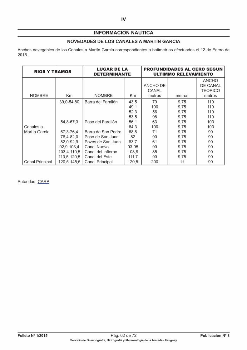
Folleto Nº 1/2015 Pág. 62 de 72 Publicación Nº 8Servicio de Oceanografía, Hidrografía y Meteorología de la Armada.- Uruguay
INFORMACION NAUTICA
IV
NOVEDADES DE LOS CANALES A MARTIN GARCIA
Anchos navegables de los Canales a Martín García correspondientes a batimetrías efectuadas el 12 de Enero de 2015.
RIOS Y TRAMOSLUGAR DE LA
DETERMINANTE
PROFUNDIDADES AL CERO SEGUN
ULTIMMO RELEVAMIENTO
NOMBRE Km NOMBRE Km
ANCHO DE CANALmetros metros
ANCHO DE CANAL TEORICO
metros
Canales aMartín García
Canal Principal
39,0-54,80
54,8-67,3
67,3-76,476,4-82,082,0-92,9
92,9-103,4103,4-110,5110,5-120,5120,5-145,5
Barra del Farallón
Paso del Farallón
Barra de San PedroPaso de San JuanPozos de San JuanCanal NuevoCanal del Infi ernoCanal del EsteCanal Principal
43,549,152,353,556,164,368,882
83,793-95103,8111,7120,5
79100569863
100719061908590
200
9,759,759,759,759,759,759,759,759,759,759,759,7511
11011011011010010090909090909090
Autoridad: CARP
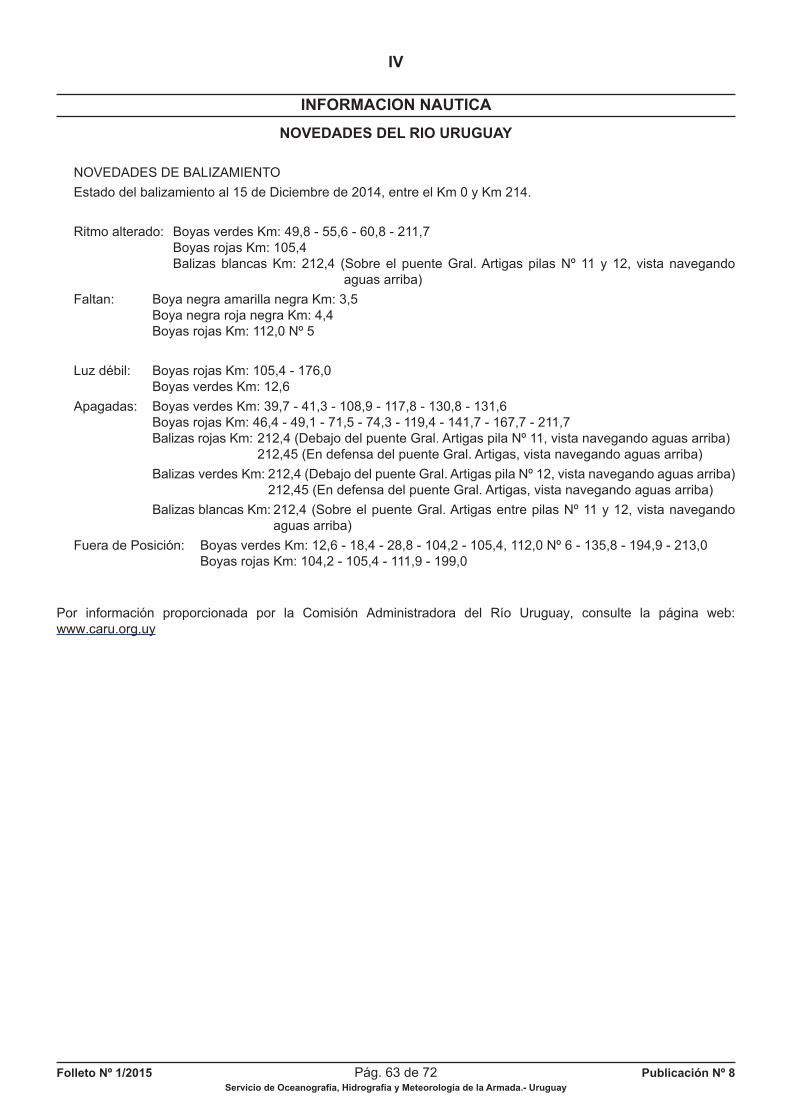
Folleto Nº 1/2015 Pág. 63 de 72 Publicación Nº 8Servicio de Oceanografía, Hidrografía y Meteorología de la Armada.- Uruguay
INFORMACION NAUTICA
IV
NOVEDADES DEL RIO URUGUAY
NOVEDADES DE BALIZAMIENTO
Estado del balizamiento al 15 de Diciembre de 2014, entre el Km 0 y Km 214.
Ritmo alterado: Boyas verdes Km: 49,8 - 55,6 - 60,8 - 211,7 Boyas rojas Km: 105,4 Balizas blancas Km: 212,4 (Sobre el puente Gral. Artigas pilas Nº 11 y 12, vista navegando aguas arriba)
Faltan: Boya negra amarilla negra Km: 3,5 Boya negra roja negra Km: 4,4 Boyas rojas Km: 112,0 Nº 5
Luz débil: Boyas rojas Km: 105,4 - 176,0 Boyas verdes Km: 12,6
Apagadas: Boyas verdes Km: 39,7 - 41,3 - 108,9 - 117,8 - 130,8 - 131,6 Boyas rojas Km: 46,4 - 49,1 - 71,5 - 74,3 - 119,4 - 141,7 - 167,7 - 211,7 Balizas rojas Km: 212,4 (Debajo del puente Gral. Artigas pila Nº 11, vista navegando aguas arriba) 212,45 (En defensa del puente Gral. Artigas, vista navegando aguas arriba)
Balizas verdes Km: 212,4 (Debajo del puente Gral. Artigas pila Nº 12, vista navegando aguas arriba) 212,45 (En defensa del puente Gral. Artigas, vista navegando aguas arriba)
Balizas blancas Km: 212,4 (Sobre el puente Gral. Artigas entre pilas Nº 11 y 12, vista navegando aguas arriba)
Fuera de Posición: Boyas verdes Km: 12,6 - 18,4 - 28,8 - 104,2 - 105,4, 112,0 Nº 6 - 135,8 - 194,9 - 213,0 Boyas rojas Km: 104,2 - 105,4 - 111,9 - 199,0
Por información proporcionada por la Comisión Administradora del Río Uruguay, consulte la página web:www.caru.org.uy

Folleto Nº 1/2015 Pág. 64 de 72 Publicación Nº 8Servicio de Oceanografía, Hidrografía y Meteorología de la Armada.- Uruguay
CARTAS NAUTICAS ELECTRONICAS (ENC)
V
Navegantes y usuarios en general:
“Las Cartas Náuticas Electrónicas (CEN) producidas por el SOHMA vienen siendo validadas por el IC-ENC desde Enero de 2012, a efectos de cumplir con la Norma S-57 de la Organización Hidrográfi ca Internacional (OHI) yLa Guía para la Implementación de los Principios WEND de la OHI.
Las mismas se encuentran encriptados según la Norma S-63 (OHI), y deben ser adquiridas por el navegante a través de los agentes ofi ciales de distribución mundial, tomando SOHMA como referencia los agentes ofi ciales del Servicio Hidrográfi co del Reino Unido (UKHO)”.
Electronic Nautical Charts (ENC) produced by SOHMA are validated by the IC-ENC since January 2012, in order
to accomplish with S-57 Standard of the International Hydrographic Organization (IHO) and the Guide for the Implementation of the IHO WEND principles.
They are encrypted according with S-63 Standard (OHI), and must be purchased by the Mariners in the ADMIRALTY
Chart Agents. SOHMA takes as reference the global network of ADMIRALTY Chart Agents.
CARTAS NAUTICAS ELECTRONICAS VIGENTES (ENC) PUBLICADAS POR SOHMA
DISTRIBUCION IC - ENC
UY200001.000 Aproximación al Río de la Plata
UY300003.000 Desde Arroyo Chuy hasta Montevideo
UY40003A.000 La Coronilla
UY40003B.000 Cabo Castillos y Cabo Polonio
UY500019.000 Puerto la Paloma desde Punta Rubia hasta Cabo Santa María
UY400020.013 Aproximación a Bahía de Maldonado desde Punta José Ignacio hasta Piriápolis
UY400030.005 Desde Punta Rasa hasta Isla de Flores y Banco Inglés
UY500031.010 Bahía de Maldonado e Isla de Lobos
UY60031A.000 Puerto de Punta del Este
UY50031B.000 Punta Ballena
UY500032.006 Puerto de Piriápolis desde Punta Rasa hasta Punta de los Burros
UY60032A.002 Puerto de Piriápolis
UY400040.015 Aproximación al Puerto de Montevideo desde Isla de Flores hasta Banco de Santa Lucía
UY50040A.001 Isla de Flores
UY50040B.000 Puerto del Buceo
UY500041.014 Puerto de Montevideo
UY300050.001 Desde Montevideo hasta proximidades Punta Mocharife
UY500052.001 Puerto de Colonia del Sacramento desde Punta Riachuelo hasta Islas Hornos
UY300060.006 Desde Puerto de Colonia del Sacramento hasta Puerto de Nueva Palmira
UY400701.001 Desde Isla Juncalito hasta Km 18
UY50701A.000 Puerto de Nueva Palmira y Dársena Higueritas
UY400702.002 Desde el Km 19 al Km 41
UY400703.000 Desde el Km 42 al Km 66 a Acceso a Villa Soriano
UY50704A.000 Riacho Yaguarí
UY400705.000 Desde el Km 67 al Km 82
UY400706.000 Desde Km 83 al Km 100
UY50706A.000 Puerto de Fray Bentos
ENC TITULO DE LA CARTA NAUTICA ELECTRONICA
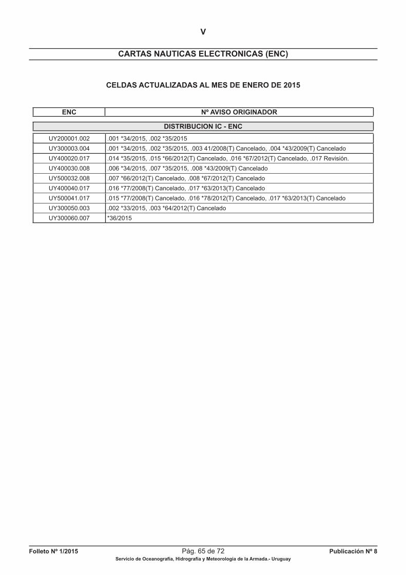
Folleto Nº 1/2015 Pág. 65 de 72 Publicación Nº 8Servicio de Oceanografía, Hidrografía y Meteorología de la Armada.- Uruguay
CARTAS NAUTICAS ELECTRONICAS (ENC)
V
CELDAS ACTUALIZADAS AL MES DE ENERO DE 2015
DISTRIBUCION IC - ENC
UY200001.002 .001 *34/2015, .002 *35/2015
UY300003.004 .001 *34/2015, .002 *35/2015, .003 41/2008(T) Cancelado, .004 *43/2009(T) Cancelado
UY400020.017 .014 *35/2015, .015 *66/2012(T) Cancelado, .016 *67/2012(T) Cancelado, .017 Revisión.
UY400030.008 .006 *34/2015, .007 *35/2015, .008 *43/2009(T) Cancelado
UY500032.008 .007 *66/2012(T) Cancelado, .008 *67/2012(T) Cancelado
UY400040.017 .016 *77/2008(T) Cancelado, .017 *63/2013(T) Cancelado
UY500041.017 .015 *77/2008(T) Cancelado, .016 *78/2012(T) Cancelado, .017 *63/2013(T) Cancelado
UY300050.003 .002 *33/2015, .003 *64/2012(T) Cancelado
UY300060.007 *36/2015
ENC Nº AVISO ORIGINADOR

Folleto Nº 1/2015 Pág. 66 de 72 Publicación Nº 8Servicio de Oceanografía, Hidrografía y Meteorología de la Armada.- Uruguay
PAGINA EN BLANCO
Folleto Nº 1/2015 Pág. 67 de 72 Publicación Nº 8Servicio de Oceanografía, Hidrografía y Meteorología de la Armada.- Uruguay
PAGINAS A SUSTITUIR
EN
LISTA DE FAROS
Y
SEÑALES MARITIMAS
CORRECCIONES A CARTAS Y PUBLICACIONES NAUTICAS
VI

Folleto Nº 1/2015 Pág. 68 de 72 Publicación Nº 8Servicio de Oceanografía, Hidrografía y Meteorología de la Armada.- Uruguay
PAGINA EN BLANCO
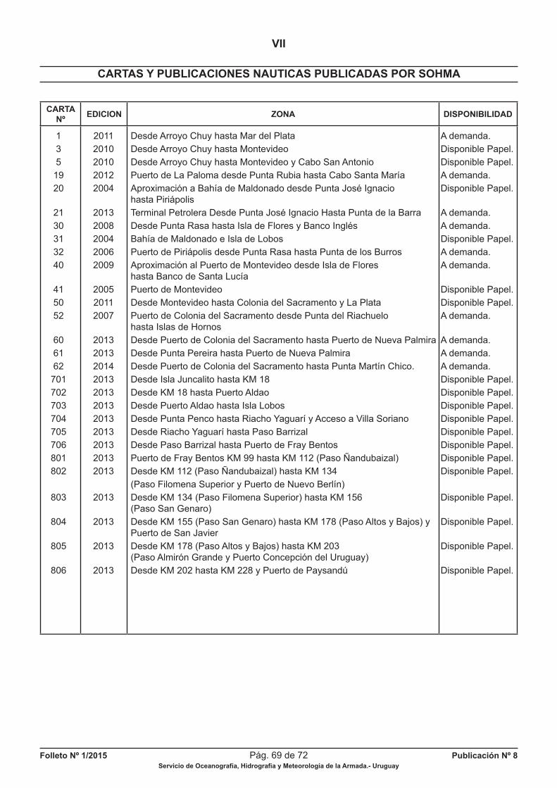
Folleto Nº 1/2015 Pág. 69 de 72 Publicación Nº 8Servicio de Oceanografía, Hidrografía y Meteorología de la Armada.- Uruguay
CARTAS Y PUBLICACIONES NAUTICAS PUBLICADAS POR SOHMA
VII
CARTANº
EDICION ZONA DISPONIBILIDAD
1 2011 Desde Arroyo Chuy hasta Mar del Plata A demanda.
3 2010 Desde Arroyo Chuy hasta Montevideo Disponible Papel.
5 2010 Desde Arroyo Chuy hasta Montevideo y Cabo San Antonio Disponible Papel.
19 2012 Puerto de La Paloma desde Punta Rubia hasta Cabo Santa María A demanda.
20 2004 Aproximación a Bahía de Maldonado desde Punta José Ignacio Disponible Papel. hasta Piriápolis
21 2013 Terminal Petrolera Desde Punta José Ignacio Hasta Punta de la Barra A demanda.
30 2008 Desde Punta Rasa hasta Isla de Flores y Banco Inglés A demanda.
31 2004 Bahía de Maldonado e Isla de Lobos Disponible Papel.
32 2006 Puerto de Piriápolis desde Punta Rasa hasta Punta de los Burros A demanda.
40 2009 Aproximación al Puerto de Montevideo desde Isla de Flores A demanda. hasta Banco de Santa Lucía
41 2005 Puerto de Montevideo Disponible Papel.
50 2011 Desde Montevideo hasta Colonia del Sacramento y La Plata Disponible Papel.
52 2007 Puerto de Colonia del Sacramento desde Punta del Riachuelo A demanda. hasta Islas de Hornos
60 2013 Desde Puerto de Colonia del Sacramento hasta Puerto de Nueva Palmira A demanda.
61 2013 Desde Punta Pereira hasta Puerto de Nueva Palmira A demanda.
62 2014 Desde Puerto de Colonia del Sacramento hasta Punta Martín Chico. A demanda.
701 2013 Desde Isla Juncalito hasta KM 18 Disponible Papel.
702 2013 Desde KM 18 hasta Puerto Aldao Disponible Papel.
703 2013 Desde Puerto Aldao hasta Isla Lobos Disponible Papel.
704 2013 Desde Punta Penco hasta Riacho Yaguarí y Acceso a Villa Soriano Disponible Papel.
705 2013 Desde Riacho Yaguarí hasta Paso Barrizal Disponible Papel.
706 2013 Desde Paso Barrizal hasta Puerto de Fray Bentos Disponible Papel.
801 2013 Puerto de Fray Bentos KM 99 hasta KM 112 (Paso Ñandubaizal) Disponible Papel.
802 2013 Desde KM 112 (Paso Ñandubaizal) hasta KM 134 Disponible Papel.
(Paso Filomena Superior y Puerto de Nuevo Berlín)
803 2013 Desde KM 134 (Paso Filomena Superior) hasta KM 156 Disponible Papel. (Paso San Genaro)
804 2013 Desde KM 155 (Paso San Genaro) hasta KM 178 (Paso Altos y Bajos) y Disponible Papel. Puerto de San Javier
805 2013 Desde KM 178 (Paso Altos y Bajos) hasta KM 203 Disponible Papel. (Paso Almirón Grande y Puerto Concepción del Uruguay)
806 2013 Desde KM 202 hasta KM 228 y Puerto de Paysandú Disponible Papel.
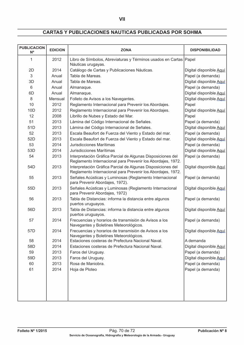
Folleto Nº 1/2015 Pág. 70 de 72 Publicación Nº 8Servicio de Oceanografía, Hidrografía y Meteorología de la Armada.- Uruguay
CARTAS Y PUBLICACIONES NAUTICAS PUBLICADAS POR SOHMA
VII
PUBLICACIONNº
EDICION ZONA DISPONIBILIDAD
1 2012 Libro de Símbolos, Abreviaturas y Términos usados en Cartas Papel Náuticas urugayas.
2D 2014 Catálogo de Cartas y Publicaciones Náuticas. Digital disponible Aquí
3 Anual Tabla de Mareas. Papel (a demanda)
3D Anual Tabla de Mareas. Digital disponible Aquí
6 Anual Almanaque. Papel (a demanda)
6D Anual Almanaque. Digital disponible Aquí
8 Mensual Folleto de Avisos a los Navegantes. Digital disponible Aquí
10 2012 Reglamento Internacional para Prevenir los Abordajes. Papel
10D 2012 Reglamento Internacional para Prevenir los Abordajes. Digital disponible Aquí
12 2008 Librillo de Nubes y Estado del Mar. Papel
51 2013 Lámina del Código Internacional de Señales. Papel (a demanda)
51D 2013 Lámina del Código Internacional de Señales. Digital disponible Aquí
52 2013 Escala Beaufort de Fuerza del Viento y Estado del mar. Papel (a demanda)
52D 2013 Escala Beaufort de Fuerza del Viento y Estado del mar. Digital disponible Aquí
53 2014 Jurisdicciones Marítimas Papel (a demanda)
53D 2014 Jurisdicciones Marítimas Digital disponible Aquí
54 2013 Interpretación Gráfi ca Parcial de Algunas Disposiciones del Papel (a demanda) Reglamento Internacional para Prevenir los Abordajes, 1972.
54D 2013 Interpretación Gráfi ca Parcial de Algunas Disposiciones del Digital disponible Aquí Reglamento Internacional para Prevenir los Abordajes, 1972.
55 2013 Señales Acústicas y Luminosas (Reglamento Internacional Papel (a demanda) para Prevenir Abordajes, 1972).
55D 2013 Señales Acústicas y Luminosas (Reglamento Internacional Digital disponible Aquí para Prevenir Abordajes, 1972)
56 2013 Tabla de Distancias: informa la distancia entre algunos Papel (a demanda) puertos uruguayos.
56D 2013 Tabla de Distancias: informa la distancia entre algunos Digital disponible Aquí puertos uruguayos.
57 2014 Frecuencias y horarios de transmisión de Avisos a los Papel (a demanda) Navegantes y Boletines Meteorológicos.
57D 2014 Frecuencias y horarios de transmisión de Avisos a los Digital disponible Aquí Navegantes y Boletines Meteorológicos. 58 2014 Estaciones costeras de Prefectura Nacional Naval. A demanda
58D 2014 Estaciones costeras de Prefectura Nacional Naval. Digital disponible Aquí
59 2013 Faros del Uruguay. Papel (a demanda)
59D 2013 Faros del Uruguay. Digital disponible Aquí
60 2013 Rosa de Maniobra. Papel (a demanda)
61 2014 Hoja de Ploteo Papel (a demanda)
Folleto Nº 1/2015 Pág. 71 de 72 Publicación Nº 8Servicio de Oceanografía, Hidrografía y Meteorología de la Armada.- Uruguay
HIDROVIA PARANA - PARAGUAY
VIII
ARGENTINA - BOLIVIA - BRASIL - PARAGUAY - URUGUAY
TRAMO COMPRENDIDO DESDE KM 0 HASTA KM 9,300 DEL RIO URUGUAY
En esta sección el Servicio de Oceanografía, Hidrografía y Meteorología de la Armada (SOHMA), ofrece infor-mación de las condiciones y facilidades de navegación, novedades de balizamiento, rutas, puertos, servicios e ins-trumentos jurídicos nacionales e internacionales, etc., de la Hidrovía Paraná - Paraguay, en el sector comprendido desde el KM 0 (paralelo de Punta Gorda) hasta el KM 9,300 del Río Uruguay.
SIN NOVEDAD
A los efectos de mantener actualizada esta Sección, se solicita a los Navegantes, Prácticos, Instituciones Públicas o Privadas, Compañías Navieras, Empresas de Obras Portuarias, etc., comuniquen cualquier alteración o irregula-ridad que pueda afectar la seguridad de la navegación al:
Servicio de Oceanografía, Hidrografía y Meteorología de la ArmadaCapurro 980 - Montevideo - URUGUAY
Casilla de Correo 1381- C.P. 11700E-MAIL: [email protected] - FAX: (+598) 2309 9220
Teles: (+598) 2309 3775 / 2309 3861
ó a la Autoridad Marítima más próxima.
REFERENCIA PARA CONVERSION PIES - METROS - BRAZAS
Folleto Nº 1/2015 Pág. 72 de 72 Publicación Nº 8Servicio de Oceanografía, Hidrografía y Meteorología de la Armada.- Uruguay
VENTA DE CARTAS Y PUBLICACIONES NAUTICAS
Todas las Cartas y Publicaciones Náuticas producidas por el Servicio de Oceanografía, Hidrografía y Meteorología de la Armada se encuentran disponibles en la Ofi cina de Ventas: Capurro 980 esquina Av. Agraciada.Horarios de atención: Días hábiles lunes a viernes de 08:00 a 13:00 horas excepto feriados.Tel: (+598) 2307 1777 / 2309 3861 / 2309 3775 Fax: (+598) 2309 9220Pedidos y consultas por el correo electrónico: [email protected]
AGENTES DE VENTAS DE CARTAS Y PUBLICACIONES NAUTICAS AUTORIZADOS
Captain Stephan Nedelchev
MARINE TECHNICAL SERVICES
MONTEVIDEO:
Tel.: (+598) 2916 3386 Fax: (+598) 2915 6802 Teléfono fuera de horario: (+598) 99228546Circunv. DURANGO 344, Esc. 50211000 MONTEVIDEO, URUGUAYE-Mail: [email protected]
AGENCIAS EN EL EXTRANJERO
Argentina
Captain Stephan Nedelchev
Viamonte 726 1°B1053 Buenos AiresTel.: (+)5411-4326-2715Fax: (+)5411-4322-0451 (+) 5411-4292-5468Móvil: (15) 4424-2306E-mail: [email protected]
C.P. c1053 ABPEl Pulpo Negro
Uruguay 802 (B 1643 EIV) BéccarTe!./Fax 4742-0848E-mail: [email protected]://www.pulponegro.com.ar
‘‘NAVEGUEMOS SEGUROS’’ADQUIERA SUS CARTAS Y PUBLICACIONES NAUTICAS EN NUESTRA OFICINA CENTRAL
O EN NUESTROS AGENTES DE VENTAS AUTORIZADOS
El Servicio de Oceanografía, Hidrografía y Meteorología de la Armada de la República Oriental del Uruguay,mantiene su cartografía permanentemente actualizada, por lo que recomienda su empleo en Buques Nacionales y
Extranjeros cuando naveguen aguas uruguayas.
El S.O.H.M.A. no se responsabiliza por Cartas Náuticas y Publicaciones que no hayan sido adquiridas en su local de ventas, o a través de sus Agentes autorizados o de la Autoridad Marítima de la zona.La ofi cina entregará el material con el sello correspondiente en el cual fi gura el número del último Folleto de Avisos a los Navegantes (Publicación Nº 8 S.O.H.M.A.), certifi cando la actualización hasta esa fecha correspondiendo al usuario su posterior actualización.
MANTENGA LIMPIO SU MAR
PEGAR AQUI
Fecha:........................Observador:.............................................................................................................
Buque:..............................................................Empresa:...........................................................................
Dirección/Tel./Fax:.......................................................................................................................................
Asunto:........................................................................................................................................................
Fecha de la observación:..................................Hora de la observación (GMT)..........................................
Posición: Lat. ..................................................Long. .........................................................................
Sistema Posicionamiento:...........................................................................................................................
Datum (WGS 84/Otro indicar): ...................................................................................................................
Cartas afectadas:.................Edición: ................Reimpresión: .................Última corrección: .....................
Cartas afectadas:.................Edición: ................Reimpresión: .................Última corrección: .....................
Doblar Doblar
Publicaciones afectadas:...........................Nº de Página:..................Nº de Señal: ...........................................
Publicaciones afectadas:...........................Nº de Página:..................Nº de Señal: ...........................................
Si informa profundidades, por favor agregue el ecograma e indique el calado del sensor:...............................
¿Las profundidades están corregidas por mareas? ¿Y por calado del Sensor?NOSI NOSI
..............................Firma del Observador
PEGAR AQUI

URGENTECONTIENE INFORMACION REFERENTE A SEGURIDAD PARA LA NAVEGACION
Señor
JEFE DEL SERVICIO DE OCEANOGRAFIA, HIDROGRAFIA YMETEOROLOGIA DE LA ARMADA
Capurro 980
Casilla de Correo Nº 1381 - C. P: 11700 - MONTEVIDEO
REPUBLICA ORIENTAL DEL URUGUAY
INSTRUCCIONES DE USO:
1.- Esta hoja esta destinada para facilitar información al Servicio de Oceanografía, Hidrografía y Meteorología de la Armada sobre irregularidades constatadas que puedan afectar la navegación, datos útiles para estudios Oceanográfi cos, etc.2.- La información debe ser lo más completa posible mencionando los elementos esenciales que caracterizan perfectamente las irregularidades, visibilidad normal de Faros, enfi laciones, señales marítimas, peligros, etc.3.- En el caso de Faros, Balizas apagadas resulta de prioridad detallar fecha y hora de la anormalidad detectada, Cuando se registren sondajes relacionados con peligros o bajos fondos debe verifi car la profundidad con todos los medios disponibles, enviando de ser posible el ecograma, los datos técnicos del equipo, el calado del censor, las condiciones hidrometeorológicas y si el sondaje fue corregido por marea o altura hidrométrica. La posición geográfi ca deberá ser complementado con información sobre el sistema de posicionamiento usado. Si se utiliza GPS deberá indicarse el Datum seleccionado y de ser posible una estimación de error (PDOP). Si se usa DGPS deberá informarse la estación de Referencia sintonizada. Si la información corresponde a ríos, la posición debe ser referida al Kilometraje, distancia al Eje del Canal y margen correspondiente (Izquierda o Derecha defi nidos mirando aguas abajo). Se deberá indicar la publicación o carta utilizada indicando edición, página y el Servicio Hidrográfi co que la publico.4.- Las informaciones que no pueden ser confi rmadas por carecer de más detalles o por imperfección en las observaciones efectuadas y métodos empleados, no deben de ser enviadas.5.- La información contenida en esta hoja deberá ser remitida al Servicio de Oceanografía, Hidrografía y Meteorología de la Armada.
Fax: (+598) 2309 9220, por Correo a Capurro 980 C.C. 1381 C.P. 11700 Montevideo o por correo electrónico a la dirección: [email protected]