Floods in Nepal: Genesis, Magnitude, Frequency and Consequences
17
Proc. of the International Conference on Hydrology and Climate Change in Mountainous Areas, November 15-17, 2008, Kathmandu, Nepal 1 Floods in Nepal: Genesis, Magnitude, Frequency and Consequences Kiran S. Yogacharya and Dilip K. Gautam Society of Hydrologists and Meteorologists-Nepal Abstract Nepal has been frequently affected by the extreme weather events resulting in natural disasters such as floods and landslides. Nepal’s fragile geological conditions, topographical extremities, climatic extremities and seismic activities coupled with population growth, poverty, illiteracy, deforestation, unscientific agricultural practices, land use changes, and developmental activities such as construction of roads, irrigation systems, hydropower and urbanization are making it vulnerable to several natural disasters. Heavy rainfall in central and eastern regions of Nepal during 19-21 July, 1993 had disastrous consequences with heavy loss of life and property as well as damages to infrastructures by floods, landslides and debris flows. In 1993, 87 % of the total deaths of human life occurring in the country had resulted from floods and landslides. Within the country, more than 500,000 people of 85,254 families were directly affected, 1336 people dead and 163 injured. About 25,425 livestock were lost; and 17,113 houses were destroyed. In agriculture sector, more than 57,584 hectares of arable lands were damaged. Sixty-seven small and large irrigation projects along with thousands of farmer-managed irrigation schemes were seriously damaged. The estimated loss of properties amounted to about NRs. 4,904 million. This was the worst disaster in last 20 years. On 18 August, 2008, the breach of the left embankment of Koshi River near Kusaha village in Sunsari district of Nepal affected 4 village development committees causing more than 60,000 people homeless in Nepalese side and more than 3,000,000 people displaced in Indian side. About 6,000 hectares of agricultural land has been inundated; and agricultural products worth more than US $ 3.7 million have been damaged. Similarly, heavy rainfall in far-western Nepal during 19-20 September, 2008 has resulted in devastating floods in Kanchanpur, Kailali and Bardiya districts causing widespread damage to life and properties. It is seen that medium size rivers originating from middle mountain ranges such as Kankai, Kamala, Bagmati, East Rapti and West Rapti are causing more flood problems than the large rivers such as Koshi, Narayani and Karnali. This paper presents an overview of extreme flood events in several rivers, causes and consequences of those floods, and the ways to mitigate flood disasters in Nepal. 1 Introduction Nepal has been affected by the extreme weather events resulting in natural disasters such as floods and landslides. Nepal’s fragile geological conditions, topographical extremities, climatic extremities and seismic activities coupled with population growth, poverty, illiteracy, deforestation, unscientific agricultural practices, land use changes, and developmental activities such as construction of roads, irrigation systems, hydro-powers and urbanization are making it vulnerable to several natural disasters. Extreme precipitation events during monsoon periods are common in Nepal. Extreme rainstorms in the past 120 years (17-18 September 1880, 28-30 September 1924, and 19-21 July 1993) have been induced by abnormal behaviour of monsoon depression paths originating from Bay of Bengal when associated with low-pressure systems in Nepal.
Transcript of Floods in Nepal: Genesis, Magnitude, Frequency and Consequences

Proc. of the International Conference on Hydrology and Climate Change in Mountainous Areas, November 15-17, 2008, Kathmandu, Nepal
1
Floods in Nepal: Genesis, Magnitude, Frequency and Consequences
Kiran S. Yogacharya and Dilip K. Gautam
Society of Hydrologists and Meteorologists-Nepal
Abstract
Nepal has been frequently affected by the extreme weather events resulting in natural disasters such as
floods and landslides. Nepal’s fragile geological conditions, topographical extremities, climatic
extremities and seismic activities coupled with population growth, poverty, illiteracy, deforestation,
unscientific agricultural practices, land use changes, and developmental activities such as construction of
roads, irrigation systems, hydropower and urbanization are making it vulnerable to several natural
disasters.
Heavy rainfall in central and eastern regions of Nepal during 19-21 July, 1993 had disastrous
consequences with heavy loss of life and property as well as damages to infrastructures by floods,
landslides and debris flows. In 1993, 87 % of the total deaths of human life occurring in the country had
resulted from floods and landslides. Within the country, more than 500,000 people of 85,254 families
were directly affected, 1336 people dead and 163 injured. About 25,425 livestock were lost; and 17,113
houses were destroyed. In agriculture sector, more than 57,584 hectares of arable lands were damaged.
Sixty-seven small and large irrigation projects along with thousands of farmer-managed irrigation
schemes were seriously damaged. The estimated loss of properties amounted to about NRs. 4,904 million.
This was the worst disaster in last 20 years.
On 18 August, 2008, the breach of the left embankment of Koshi River near Kusaha village in Sunsari
district of Nepal affected 4 village development committees causing more than 60,000 people homeless in
Nepalese side and more than 3,000,000 people displaced in Indian side. About 6,000 hectares of
agricultural land has been inundated; and agricultural products worth more than US $ 3.7 million have
been damaged. Similarly, heavy rainfall in far-western Nepal during 19-20 September, 2008 has resulted
in devastating floods in Kanchanpur, Kailali and Bardiya districts causing widespread damage to life and
properties.
It is seen that medium size rivers originating from middle mountain ranges such as Kankai, Kamala,
Bagmati, East Rapti and West Rapti are causing more flood problems than the large rivers such as Koshi,
Narayani and Karnali. This paper presents an overview of extreme flood events in several rivers, causes
and consequences of those floods, and the ways to mitigate flood disasters in Nepal.
1 Introduction
Nepal has been affected by the extreme weather events resulting in natural disasters such as
floods and landslides. Nepal’s fragile geological conditions, topographical extremities, climatic
extremities and seismic activities coupled with population growth, poverty, illiteracy,
deforestation, unscientific agricultural practices, land use changes, and developmental activities
such as construction of roads, irrigation systems, hydro-powers and urbanization are making it
vulnerable to several natural disasters.
Extreme precipitation events during monsoon periods are common in Nepal. Extreme rainstorms
in the past 120 years (17-18 September 1880, 28-30 September 1924, and 19-21 July 1993) have
been induced by abnormal behaviour of monsoon depression paths originating from Bay of
Bengal when associated with low-pressure systems in Nepal.

Proc. of the International Conference on Hydrology and Climate Change in Mountainous Areas, November 15-17, 2008, Kathmandu, Nepal
2
Land use changes, urbanization and other natural causes result in river course changing in
southern parts of Nepal, aggravating the unprecedented consequences due to extreme floods.
Increase of agricultural lands and settlements at the expense of forest cover along with other
socio-economic drivers also predisposes Nepal to more disaster proneness in both frequency and
intensity.
Flood forecasting and warning is an effective non-structural method of flood management. This
method has been well accepted by the planners and public in flood disaster mitigation and flood
plain management. Recognizing this fact, the Department of Hydrology and Meteorology
(DHM) is working for the development of flood forecasting and warning system in major rivers
of Nepal. This paper presents an overview of extreme flood events in several rivers,
consequences of those floods and activities related to flood forecasting in Nepal.
Floods of varying magnitudes occur almost every year in Nepal during monsoon and some of
them become catastrophic. Catastrophic floods could be defined as floods that give rise to
inundations, which have very large impact in terms of life and property losses and major
disruption to infrastructure.
Based on recurrence interval, floods could be classified into the three severity classes: (1) Large
flood with recurrence interval less than 20 years, (2) Very large flood with recurrence interval
between 20 and 100 years, and (3) Extreme flood with recurrence exceeding 100 years.
2 Genesis of Floods
There are basically two causes of flooding, natural and anthropogenic. The natural causes of
flooding in Nepalese rivers consist of fragile geological conditions, extremities in Climates,
topographical extremities, and seismic activities. The anthropogenic causes of flooding include
socio-economic changes (population growth, poverty and illiteracy), deforestation, unscientific
agricultural practices, Land use changes, and other developmental activities (roads, irrigations,
hydro-powers, and urbanization).
2.1 Geology
Geologically, Nepal can be divided into five major tectonic zones. These are separated by three
major fault systems. The area north to Main Central Thrust (MCT) is the Higher Himalaya
whereas the area between Main Central Thrust (MCT) and Main Boundary Thrust (MBT) can be
divided into High Mountains and Middle Mountains. The higher Himalayas are mainly
composed of gneiss and migmatites and are perpetually covered by snow. The High Mountains
and Middle Mountains are mainly composed of phyllites, quartzites, schists, limestones,
dolomites etc. The area between the MBT and Himalayan Frontal Faults (HFF) is called the
Siwalik range; and below the HFF is the Terai plain. The Siwaliks are composed of mollase
formation represented mainly by sandstones, mudstones, siltstones, shales, sandy beds and
conglomerates. The Terai is composed of thick alluvium deposited by the Nepalese tributaries of
the Ganges.
Proc. of the International Conference on Hydrology and Climate Change in Mountainous Areas, November 15-17, 2008, Kathmandu, Nepal
3
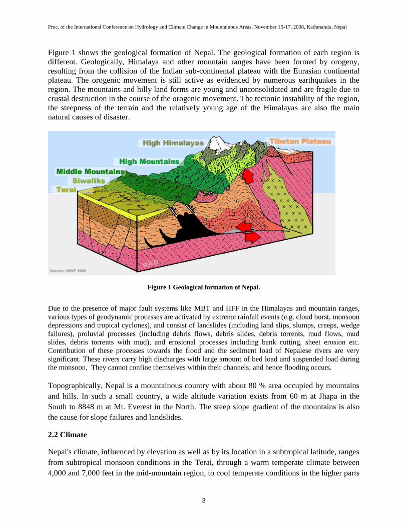
Figure 1 shows the geological formation of Nepal. The geological formation of each region is
different. Geologically, Himalaya and other mountain ranges have been formed by orogeny,
resulting from the collision of the Indian sub-continental plateau with the Eurasian continental
plateau. The orogenic movement is still active as evidenced by numerous earthquakes in the
region. The mountains and hilly land forms are young and unconsolidated and are fragile due to
crustal destruction in the course of the orogenic movement. The tectonic instability of the region,
the steepness of the terrain and the relatively young age of the Himalayas are also the main
natural causes of disaster.
Figure 1 Geological formation of Nepal.
Due to the presence of major fault systems like MBT and HFF in the Himalayas and mountain ranges,
various types of geodynamic processes are activated by extreme rainfall events (e.g. cloud burst, monsoon
depressions and tropical cyclones), and consist of landslides (including land slips, slumps, creeps, wedge
failures), proluvial processes (including debris flows, debris slides, debris torrents, mud flows, mud
slides, debris torrents with mud), and erosional processes including bank cutting, sheet erosion etc.
Contribution of these processes towards the flood and the sediment load of Nepalese rivers are very
significant. These rivers carry high discharges with large amount of bed load and suspended load during
the monsoon. They cannot confine themselves within their channels; and hence flooding occurs.
Topographically, Nepal is a mountainous country with about 80 % area occupied by mountains
and hills. In such a small country, a wide altitude variation exists from 60 m at Jhapa in the
South to 8848 m at Mt. Everest in the North. The steep slope gradient of the mountains is also
the cause for slope failures and landslides.
2.2 Climate
Nepal's climate, influenced by elevation as well as by its location in a subtropical latitude, ranges
from subtropical monsoon conditions in the Terai, through a warm temperate climate between
4,000 and 7,000 feet in the mid-mountain region, to cool temperate conditions in the higher parts

Proc. of the International Conference on Hydrology and Climate Change in Mountainous Areas, November 15-17, 2008, Kathmandu, Nepal
4
of mountains between 7,000 and 11,000 feet, and to an Alpine climate at altitudes between
14,000 and 16,000 feet along the lower slopes of the Himalaya mountains. At altitudes above
16,000 feet, the temperature is always below freezing and the surface covered by snow and ice.
Figure 2 shows the physiographic regions of Nepal. The diversity in topography has big
influence in the climate of the region. The main climatic types of Nepal include (1) Subtropical
climate in the Terai with mean annual temperature between 20 and 30 0C, (2) Warm temperate
climate in the Siwalik ranges with mean annual temperature between 15 to 20 0C, (3) Cool
temperate climate in the middle and high mountains with mean annual temperature between 10
and 15 0C, and (4) Alpine climate in the Himalayas. The climatic factors of flooding are
generally the heavy rainfall (monsoonal rain, brief torrential rain), snowmelt, ice jam breakup
(GLOF), avalanche, landslides, etc. Generally, summer monsoon onset is observed in the eastern
Nepal on June 10. It advances westwards and covers the whole Nepal within a week. It is
maintained until September and normally retreats by September 21. It contributes about 60-80 %
of the annual rainfall in Nepal.
Figure 2 Physiographic regions of Nepal
During the summer monsoon season, a belt of low atmospheric pressure known as ‘monsoon
trough’ is normally established over the northern plains of India. Sometimes, it moves northward
to the foothills of the Himalayas and stays there for a couple of days before retreating back.
Proc. of the International Conference on Hydrology and Climate Change in Mountainous Areas, November 15-17, 2008, Kathmandu, Nepal
5
Because of the lowest pressure, it creates most unstable weather conditions in and around this
area, the severity of which depends mainly upon the moisture content in the air. During this
period, a heavy down-pour of rain occurs, triggering severe floods and landslides. In Bagmati
basin, the mean annual precipitation is 1500 mm on the Terai plain to 2500 mm at the foot of the
Mahabharat and Siwalik. In 1993, the monsoon onset was observed in the eastern Nepal on June
6, four days earlier than usual. It advanced westwards and covered the whole Nepal by June 14;
and it was maintained until September. Generally, monsoon goes in full swing in July with
consequent swelling of rivers as expected causing damages due to floods and landslides every
year.
0
10
20
30
40
50
60
70
19.07.1993
12
19.07.1993
16
19.07.1993
20
19.07.1993
24
20.07.1993
4
20.07.1993
8
20.07.1993
12
20.07.1993
16
20.07.1993
20
20.07.1993
24
Time [Hours]
Pre
cip
itati
on
[m
m]
Figure 3 Hourly rainfall at Tistung
0
100
200
300
400
500
600
700
1 3 5 7 9 11 13 15 17 19 21 23 25 27 29 31 33 35 37
Time [Hours]
Cu
mula
tiv
e R
ain
fall
[m
m]
Figure 4 Cumulative rainfall at Tistung
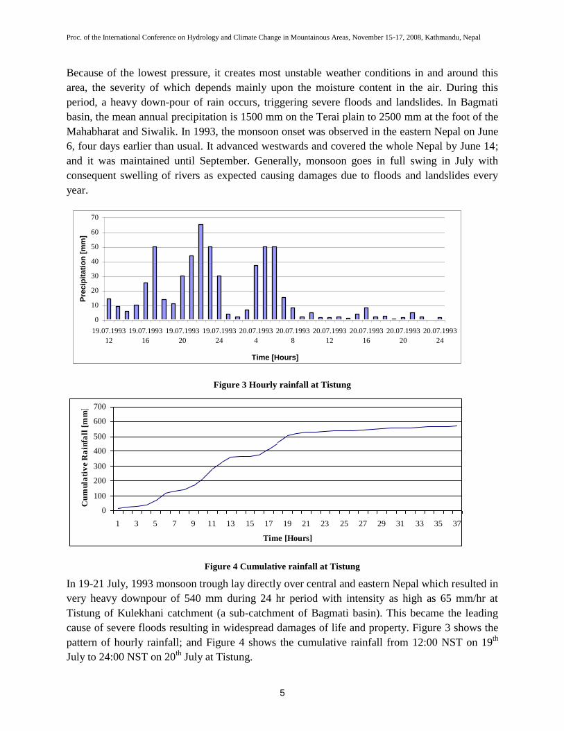
In 19-21 July, 1993 monsoon trough lay directly over central and eastern Nepal which resulted in
very heavy downpour of 540 mm during 24 hr period with intensity as high as 65 mm/hr at
Tistung of Kulekhani catchment (a sub-catchment of Bagmati basin). This became the leading
cause of severe floods resulting in widespread damages of life and property. Figure 3 shows the
pattern of hourly rainfall; and Figure 4 shows the cumulative rainfall from 12:00 NST on 19th
July to 24:00 NST on 20th
July at Tistung.

Proc. of the International Conference on Hydrology and Climate Change in Mountainous Areas, November 15-17, 2008, Kathmandu, Nepal
6
Heavy rainfalls that were observed during 48 hour period from 8:45 NST of 19th
July to 8:45
NST of 21st July in four stations located at Ghantemadi, Nibuwatar (outside Bagmati basin),
Tistung, and Simlang respectively amounted to 599, 596, 579, and 431 mm.
2.3 Land Use and Land Cover
The monsoonal climate and huge altitudinal range found in Nepal creates a wide array of
habitats, from the lowland evergreen tropical forests in the Terai (below 200m), through warm
temperate evergreen, cool temperate deciduous forests and then coniferous forest to the tree line.
Above this, Rhododendron scrubland extends up to the high alpine meadows before plant life
gives way to the frozen wastes of the barren snow capped peaks of the world’s highest mountains
(the highest recorded flowering plants are found at around 6100 m). The deep river valleys create
their own microclimates; and dramatic changes in the vegetation can be seen in relatively small
areas with differing aspect and altitude.
Altitude-wise, the tropical moist lowland Indo-Malayan forest exists below 1000 m amsl (to
1200 m in Churia hills), subtropical broad-leaved evergreen forest between 1000 to 2000 m, and
subtropical pine forest between 1000 and 2200 m. The lower temperate broad-leaved forest lies
within the altitudes of 2000 and 2700 m in the west, and 1700 and 2400 m in the east). The mid-
hill forests are confined to the river banks of the Mugu Karnali (2130-2440m). Lower temperate
mixed broad-leaved forest exists between the altitudes of 1700 and 2200. Upper temperate
broad-leaved forest lies between the altitudes of 2200 and 3000 m, upper temperate mixed broad-
leaved forest between 2500 and 3500 m, temperate coniferous forest between 2000 and 3000 m,
sub-alpine forest between 3000 and 4100 m, alpine scrub above 4100 m, and perpetual snow
above 5200 m.
The natural forests are degraded by the gathering of fodder and firewood. Because of population
pressure, many degraded forests and the rangelands are rapidly converting into rain-fed
agricultural lands. Deforestation and unmanaged agricultural practices have contributed to land
degradation and soil erosion.
2.4 Break-up of Dams/Levy
Flooding may occur due to break up of dams and levies. Breach may occur either by
overtopping, scouring or by piping.
2.5 Construction of roads
Construction of mountain roads has strong effect on slope failures contributing to landslides and
soil erosion, which aggravates the flood problem.
2.6 Urbanization

Proc. of the International Conference on Hydrology and Climate Change in Mountainous Areas, November 15-17, 2008, Kathmandu, Nepal
7
Major urban centers have developed along the river banks. For example, Kathmandu and
Lalitpur municipalities lie in Bagmati river basin. Narayanghat is situated on the banks of
Narayani and vulnerable to flooding. Butwal has many experiences of damage due to floods in
Tinau. Many industries have been established within the valley of these rivers; and due to rapid
urbanisation, the river valleys are encroached for settlement, road construction and other
development activities. The household and industrial sewages are directly disposed into the river.
The pavement of roads by asphalt or concrete has increased the surface drainage. Urbanization
has aggravated the flood problem by the decrease in runoff retarding functions which the river
basin used to have as well as by the acceleration in flood flows induced by pavements and
rooftops covering a large area and installation of drainage systems.
3 Magnitude and Frequency
The Department of Hydrology and Meteorology (DHM) has a network of hydrological and
meteorological stations to collect river stage, river discharge and climatic data all over Nepal.
DHM publishes the records of these data annually.
According to the DHM publication, the instantaneous maximum discharge of Bagmati River at
Pandheradovan from 1979 to 2007 along with the floods of 20 year and 100 year return periods
are shown in Figure 5(a).
The flood discharge varies from 2,000 m3/s to 16,000 m
3/s. It is clearly seen that very large flood
with return period of about 100 years has occurred in 1993, which was catastrophic.
0
2000
4000
6000
8000
10000
12000
14000
16000
18000
1979 1981 1983 1985 1987 1989 1991 1993 1995 1997 1999 2001 2003 2005 2007
Year
Flo
od
Flo
ws
(m
3/s
)
Qpeak
Q20
Q100
Figure 5(a) Instantaneous Maximum Discharge of Bagmati River at Pandheradovan (Karmaiya)
Proc. of the International Conference on Hydrology and Climate Change in Mountainous Areas, November 15-17, 2008, Kathmandu, Nepal
8
Figure 5(b) Flood frequency plot for Bagmati River at Pandheradovan (Karmaiya)
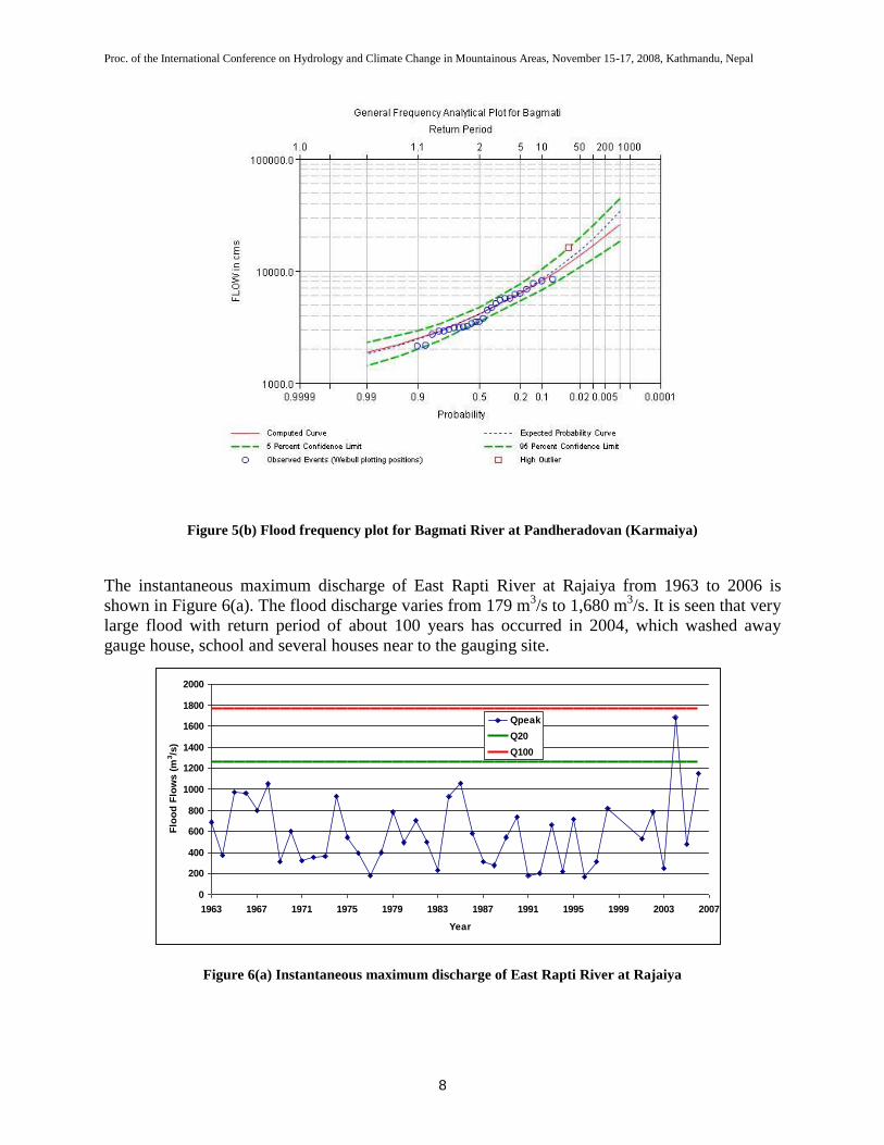
The instantaneous maximum discharge of East Rapti River at Rajaiya from 1963 to 2006 is
shown in Figure 6(a). The flood discharge varies from 179 m3/s to 1,680 m
3/s. It is seen that very
large flood with return period of about 100 years has occurred in 2004, which washed away
gauge house, school and several houses near to the gauging site.
0
200
400
600
800
1000
1200
1400
1600
1800
2000
1963 1967 1971 1975 1979 1983 1987 1991 1995 1999 2003 2007
Year
Flo
od
Flo
ws (
m3/s
)
Qpeak
Q20
Q100
Figure 6(a) Instantaneous maximum discharge of East Rapti River at Rajaiya

Proc. of the International Conference on Hydrology and Climate Change in Mountainous Areas, November 15-17, 2008, Kathmandu, Nepal
9
Figure 6(b) Flood frequency plot for East Rapti River at Rajaiya
The instantaneous maximum discharge of Narayani River at Narayanghat from 1963 to 2007 is
shown in Figure 7(a). The flood discharge varies from 6,130 m3/s to 15,300 m
3/s. It is seen that
very large floods have occurred in 1974 and 1999.
0
2000
4000
6000
8000
10000
12000
14000
16000
18000
1963 1967 1971 1975 1979 1983 1987 1991 1995 1999 2003 2007
Year
Flo
od
Flo
ws
(m
3/s
)
Qpeak
Q20
Q100
Figure 7(a) Instantaneous maximum discharge of Narayani River at Narayanghat
Proc. of the International Conference on Hydrology and Climate Change in Mountainous Areas, November 15-17, 2008, Kathmandu, Nepal
10
Figure 7(b) Flood frequency plot for Narayani River at Narayanghat
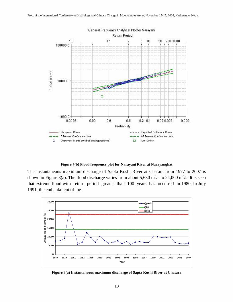
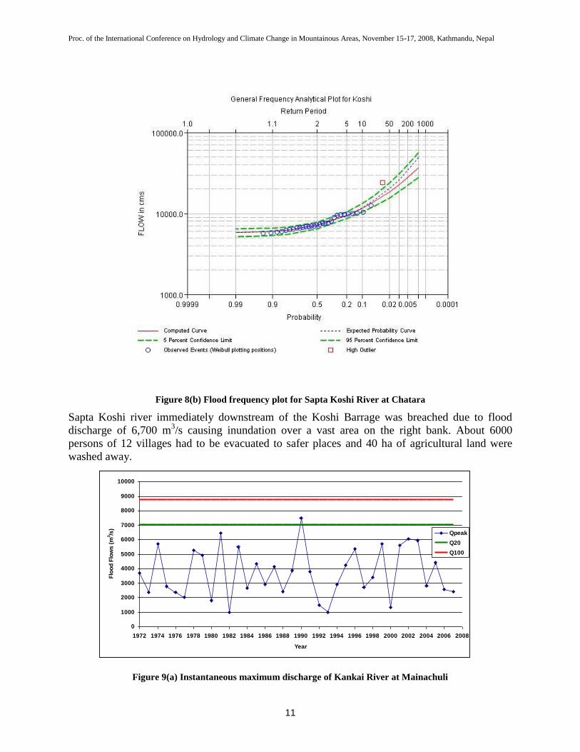
The instantaneous maximum discharge of Sapta Koshi River at Chatara from 1977 to 2007 is
shown in Figure 8(a). The flood discharge varies from about 5,630 m3/s to 24,000 m
3/s. It is seen
that extreme flood with return period greater than 100 years has occurred in 1980. In July
1991, the embankment of the
0
5000
10000
15000
20000
25000
30000
1977 1979 1981 1983 1985 1987 1989 1991 1993 1995 1997 1999 2001 2003 2005 2007
Year
An
nu
al
Flo
od
Flo
ws (
m3/s
)
Qpeak
Q20
Q100
Figure 8(a) Instantaneous maximum discharge of Sapta Koshi River at Chatara
Proc. of the International Conference on Hydrology and Climate Change in Mountainous Areas, November 15-17, 2008, Kathmandu, Nepal
11
Figure 8(b) Flood frequency plot for Sapta Koshi River at Chatara
Sapta Koshi river immediately downstream of the Koshi Barrage was breached due to flood
discharge of 6,700 m3/s causing inundation over a vast area on the right bank. About 6000
persons of 12 villages had to be evacuated to safer places and 40 ha of agricultural land were
washed away.
0
1000
2000
3000
4000
5000
6000
7000
8000
9000
10000
1972 1974 1976 1978 1980 1982 1984 1986 1988 1990 1992 1994 1996 1998 2000 2002 2004 2006 2008
Year
Flo
od
Flo
ws
(m
3/s
)
Qpeak
Q20
Q100
Figure 9(a) Instantaneous maximum discharge of Kankai River at Mainachuli

Proc. of the International Conference on Hydrology and Climate Change in Mountainous Areas, November 15-17, 2008, Kathmandu, Nepal
12
Figure 9(b) Flood frequency plot for Kankai River at Mainachuli
The instantaneous maximum discharge of Kankai River at Mainachuli from 1972 to 2007 is
shown in Figure 9(a). The flood discharge varies from 992 m3/s to 7,500 m
3/s. It is seen that
large floods have occurred in 1981, 1990, 2001, 2002 and 2003. In recent years, the frequency of
large floods is increasing.
0
1000
2000
3000
4000
5000
6000
7000
1975 1977 1979 1981 1983 1985 1987 1989 1991 1993 1995 1997 1999 2001 2003 2005 2007
Year
Flo
od
Flo
ws
(m
3/s
)
Qpeak
Q20
Q100
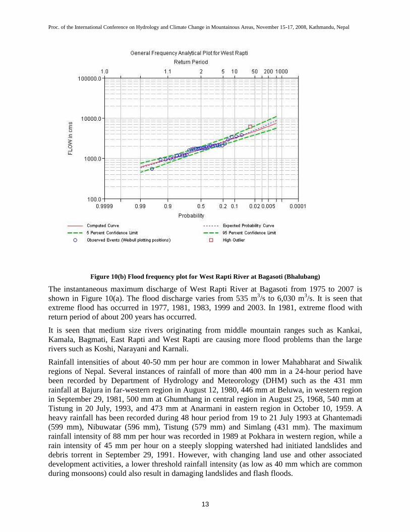
Figure 10(a) Instantaneous maximum discharge of West Rapti River at Bagasoti (Bhalubang)
Proc. of the International Conference on Hydrology and Climate Change in Mountainous Areas, November 15-17, 2008, Kathmandu, Nepal
13
Figure 10(b) Flood frequency plot for West Rapti River at Bagasoti (Bhalubang)
The instantaneous maximum discharge of West Rapti River at Bagasoti from 1975 to 2007 is
shown in Figure 10(a). The flood discharge varies from 535 m3/s to 6,030 m
3/s. It is seen that
extreme flood has occurred in 1977, 1981, 1983, 1999 and 2003. In 1981, extreme flood with
return period of about 200 years has occurred.
It is seen that medium size rivers originating from middle mountain ranges such as Kankai,
Kamala, Bagmati, East Rapti and West Rapti are causing more flood problems than the large
rivers such as Koshi, Narayani and Karnali.
Rainfall intensities of about 40-50 mm per hour are common in lower Mahabharat and Siwalik
regions of Nepal. Several instances of rainfall of more than 400 mm in a 24-hour period have
been recorded by Department of Hydrology and Meteorology (DHM) such as the 431 mm
rainfall at Bajura in far-western region in August 12, 1980, 446 mm at Beluwa, in western region
in September 29, 1981, 500 mm at Ghumthang in central region in August 25, 1968, 540 mm at
Tistung in 20 July, 1993, and 473 mm at Anarmani in eastern region in October 10, 1959. A
heavy rainfall has been recorded during 48 hour period from 19 to 21 July 1993 at Ghantemadi
(599 mm), Nibuwatar (596 mm), Tistung (579 mm) and Simlang (431 mm). The maximum
rainfall intensity of 88 mm per hour was recorded in 1989 at Pokhara in western region, while a
rain intensity of 45 mm per hour on a steeply slopping watershed had initiated landslides and
debris torrent in September 29, 1991. However, with changing land use and other associated
development activities, a lower threshold rainfall intensity (as low as 40 mm which are common
during monsoons) could also result in damaging landslides and flash floods.
Proc. of the International Conference on Hydrology and Climate Change in Mountainous Areas, November 15-17, 2008, Kathmandu, Nepal
14
Major floods occurred in 1993 in Bagmati River, and in 1964, 1981 and 1984 in Sunkoshi River.
Floods in Tinau in 1981 washed hectares of fertile lands and took several lives.
4 Consequences of Extreme Floods
The numbers in the Table 1 show the annual losses due to floods, landslides and avalanches in
Nepal since 1983 to 2006. About 300 people die and about 626 million Rupees worth of property
is lost each year due to floods and landslides. It is seen that the number of lives lost due to
extreme events is decreasing but at the same time the number of families affected, agricultural
areas impacted and monetary damages is steadily increasing. This shows that while the exposure
and even the vulnerability is increasing, the systems and institutions have been able to limit
casualties but not so successful in reducing risks or preventing increasing impacts on livelihoods.
Heavy rainfall in central and eastern regions of Nepal during 19-21 July 1993 had disastrous
consequences with heavy loss of life and property as well as damages to infrastructures by
floods, landslides and debris flows. In 1993, 87 % of the total deaths of human life occurring in
the country had resulted from floods and landslides. Within the country, more than 500,000
people of 85,254 families were directly affected, 1336 people dead and 163 injured. 25,425
livestock were lost, and 17,113 houses destroyed. In agriculture sector, more than 57,584
hectares of arable lands were damaged; and 67 small and large irrigation projects along with
thousands of farmer-managed irrigation schemes were seriously damaged. The estimated loss of
properties was NRs. 4,904 million. This was the worst disaster in last 20 years.
The flood of unprecedented magnitude along with massive debris severely damaged the Bagmati
Barrage and caused extensive flooding on both sides of the river up to the Indo-Nepal border
affecting many villages with the biggest loss of human lives. The floods in the East Rapti
breached the 850 m long embankment and washed away several villages. Hydroelectric plant of
Kulekhani was also severely damaged. The main highways were gravely damaged; and several
bridges were washed away.
Similarly, the 1998 floods and landslides that severely affected the Terai and Middle Hill region
claimed 273 human lives, injured 80 people, and killed 982 cattle, affecting 33,549 families,
damaging 13,990 houses, and ruining 45,000 hectares of land and agricultural crops resulting in
a total loss of about NRs. 2 billion.
The devastating floods in the low land areas and severe landslides in the hills during July 2002
affected 49 out of the country's 75 districts causing more than 445 deaths after leaving some
12,800 families homeless, and affecting over 300,000 people over a large and dispersed area.
Check dams and embankments in the Butwal area (West Nepal), constructed after the 1970
floods, collapsed in 1981; and 41 people, 120 houses, two mills and one bridge were swept away.
In the Himalayan region of Nepal, glacier lakes are common. A total of 159 glacial lakes have
been found in Koshi basin and 229 in Tibetan part of Arun basin. Among them 20 are potentially
dangerous as these lakes contain huge volume of water and remain in unstable condition, and can
burst any time, while damaging life and property. Fourteen such glacier lake outburst floods have
already been experienced from 1935 to 1998, with the last one occurring in Sabai Tsho, Dudh
Koshi on 3 September 1993. On 4 August 1985, a glacier lake outburst flood (GLOF) had
occurred in Bhote Koshi River due to the collapse of Dig Tsho Lake. Damage was extensive up

Proc. of the International Conference on Hydrology and Climate Change in Mountainous Areas, November 15-17, 2008, Kathmandu, Nepal
15
to 40 km downstream. Namche Hydropower station was destroyed, 12 bridges and more than 30
houses were washed away.
Table 1: Annual losses due to floods, landslides and avalanches in Nepal
Year Death Injured Families
affected
(Nos.)
Livestock
Loss (Nos.)
Houses
destroyed
(Nos.)
Land
affected
(Ha.)
Public
Infrastructure
Estimated Loss
(Million NRs)
1983 293 NA NA 248 NA NA NA 240
1984 363 NA NA 3114 7566 1242 869 37
1985 420 NA NA 3058 4620 1355 173 58
1986 315 NA NA 1886 3035 1315 436 16
1987 391 162 96151 1434 33721 18858 421 2000
1988 342 197 4197 873 2481 NA NA 1087
1989 700 4 NA 297 6203 NA NA 29
1990 307 26 5165 314 3060 1132 NA 44
1991 93 12 1621 36 817 283 25 21
1992 71 17 545 179 88 135 44 11
1993 1336 163 85254 25425 17113 5584 NA 4904
1994 49 34 3697 284 569 392 NA 59
1995 246 58 128540 1535 5162 41867.28 NA 1419
1996 262 73 36824 1548 14037 6093.4 NA 1186
1997 87 69 5833 317 1017 663.4 NA 104
1998 273 80 33549 982 13990 326.89 NA 969
1999 209 92 9768 309 2538 182.4 NA 365
2000 173 100 15617 822 5417 888.9 NA 932
2001 196 88 7901 377 3934 NA NA 251.1
2002 441 265 39309 2024 18181 10077.5 NA 418.91
2003 232 76 7167 865 3017 NA NA 234.78
2004 131 24 14238 495 3684 321.82 NA 219.28
2005 141 31 2088 360 1102 NA NA 130.56
2006 114 39 18385 9980 3334 3396.84 NA 288.63
Average 299 81 27150 2365 6725 5229 328 626
Source: DWIDP, 2007 and Ministry of Home Affairs. (NA= not available).
On 18th
August 2008, the breach of the left embankment of Koshi River near Kusaha village in
Sunsari district of Nepal affected 4 village development committees causing more than 107,000
people homeless in Nepalese side and more than 3,000,000 people displaced in Indian side.
About 6000 hectares of agricultural land has been inundated; and agricultural products worth
more than US $ 3.7 million have been damaged.
Catastrophic floods could lead to outcomes that undermine development, such as crop failures,
disease outbreaks, livelihood damages and losses, and food insecurity.
5 Comprehensive Flood Management
Large areas of the Nepalese Terai Region, with the largest concentration of Nepal’s population
and development activities, are frequently subjected to natural disasters caused by floods and
Proc. of the International Conference on Hydrology and Climate Change in Mountainous Areas, November 15-17, 2008, Kathmandu, Nepal
16
landslides. Every year, it is reported that many people are killed or missing, thousands of people
are rendered homeless and huge amount of public and private properties are damaged.
Several structural measures such as construction of flood control reservoirs, levees, floodways,
channel improvements etc. have been taken by concerned agencies for the mitigation of floods.
However, the losses from floods are not decreasing. This might be due to the growth of potential
losses in flood plains, caused by growing population, agriculture, industrialization, and the
expansion of urban areas despite efforts to construct flood control structures. This trend can be
reversed with the non-structural measures such as flood plain management, flood proofing
facilities, flood forecasting and warning, flood fighting and evacuation etc. in co-ordination with
structural measures. This coordinated plan is called comprehensive flood management [9]. The
comprehensive flood management which includes both structural as well as non-structural
measures consists of the following activities:
1. Structural Measures
i. River Improvement
Dikes and Flood Walls
Channel Improvements
Flood Diversion
ii. Retention of Runoff
Reservoirs
Retarding Ponds
Rainfall Retention Facilities
2. Non-Structural Measures
i. Conservation of Upper Watershed
Regulation of Development
Afforestation
ii. Flood Plain Management
Land Use Regulation
Regulation of Land Development
Regulation of Land Reclamation
Flood-Proofing of Facilities
Flood Insurance
iii. Flood Warning and Evacuation
Flood Forecasting and Warning
Dissemination of Flood Information

Proc. of the International Conference on Hydrology and Climate Change in Mountainous Areas, November 15-17, 2008, Kathmandu, Nepal
17
6 Conclusions
DHM has the responsibility to provide flood and weather information for people and agencies
involved in hydro-meteorological disaster management. The daily weather forecasts and climate
information are provided to the decision-making requirements of the stakeholders for agriculture,
mountaineering, aviation, and water resources. DHM needs to build the capacity in the field of
modeling and generation of a suite of high-resolution flood and weather information.
DHM has infrastructure for generating weather and climate forecasts and for developing flood
forecasting and warning system but work has to be done in terms of increasing the spatial
resolution and lead-time of current weather forecast products such as for floods and landslides. It
is necessary to improve DHM's short range weather forecasting system. This can be done by
customizing high resolution meso-scale modeling system (Weather Research and Forecast or
WRF model) for Nepal. There should be a real time data acquisition and transmission system for
water level and rainfall data so that the performance of the forecast model could be improved by
data assimilation techniques.
7 References
DWIDP, 2007. Annual Disaster Review, 2006, Government of Nepal, Ministry of Water
Resources, Department of Water Induced Disaster Prevention (DWIDP), Kathmandu.