Flood risk management in Central Viet Nam: challenges and potentials
25
Flood Risk Management in Central Vietnam: Challenges and Potentials EEPSEA Climate Change Conference Bali, Indonesia , 13-15 Feb 2008 Challenges and Potentials Phong Tran Graduate School of Global Environmental Studies Kyoto University
-
Upload
independent -
Category
Documents
-
view
1 -
download
0
Transcript of Flood risk management in Central Viet Nam: challenges and potentials

Flood Risk Management in Central Vietnam:
Challenges and Potentials
EEPSEA Climate Change Conference
Bali, Indonesia , 13-15 Feb 2008
Challenges and Potentials
Phong TranGraduate School of Global Environmental Studies
Kyoto University

Outline
♦ Introduction
♦Research location and conceptual framework
♦Results
♦Conclusions♦Conclusions

Introduction
♦ Vietnamese nation regarded flooding as one of the four biggest
dangers to people, along with fires, robbers, and invaders
♦ Floods are well known phenomena and occur in all regions of
the country, especially in the Central Coast region
♦ Large systems of river and coastal dykes have been ♦ Large systems of river and coastal dykes have been
constructed to control flooding and Vietnamese people have
experiences of coping floods, but these mechanisms are under
pressure
♦ Conditions inducing floods are intensifying e.g. climate change,
urbanization, etc.

Research problems
Disaster -Environment Convergence
EnvironmentManagement
Goal: resilient ecosystems that
support livelihoods
Disaster Risk ManagementGoal: Save lives
and protect livelihoods
Environment Development Convergence
Disaster Development Convergence
Development ManagementGoal: Increasing human well being

Objectives and scope of the study
♦To explore the impacts of
floods on economy,
environment, and society
♦To identify the villager’s flood ♦To identify the villager’s flood
coping mechanisms
♦To formulate an appropriate
flood risk management model
for Central Viet Nam
Research location: Thua Thien Hue
♦ Most disaster prone areas of Vietnam
♦ The province has an area of 5,053 square km
♦ The estimated population ♦ The estimated population is 1,150,000 in 2006
♦ Infrastructure and industry lies in the coastal plain
♦ Most of the population lives within 25 km of the coast

Huong river basin

Environmental riskor Disaster Event
Human Vulnerability Natural Hazard
Resistance
Research framework
Exposure Resilience
Severity Frequency
Location relative to hazard
Environmental Surroundings
Livelihood Health
Adjustments Preparation
Global social, economic and political pressureHuman induced global environmental change
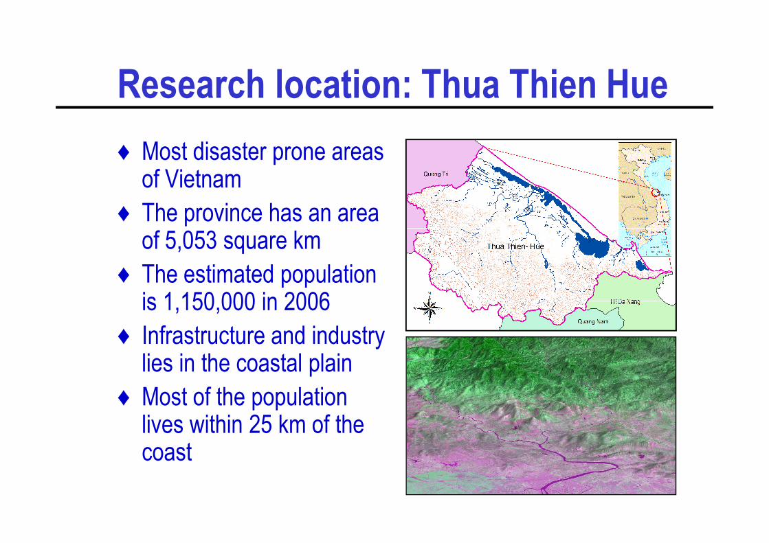
Research methodologies
- Satellite image- Hydrology map- Topographic map- Transportation system map- Land cover map- Land use map
Secondary data collection
- Computer
- Human resources- Hardware- Software
GIS preparation
Integrated Flood Passed
- Flood levels- Private house conditions- Public facility conditions- Loss and damage caused by floods- Vulnerable areas- High and safe places
GPS field data collection
- Major hazards- Factors contribute flood vulnerabilities- Factors ranking and weighting- Physical capacity
indentification (through PRA)Risk, vulnerability and capacity factors
Integrated Flood
Adjust weights
Risk Hazard MapGIS AnalysisIncorporation in planning
Passed
Field verification Failed
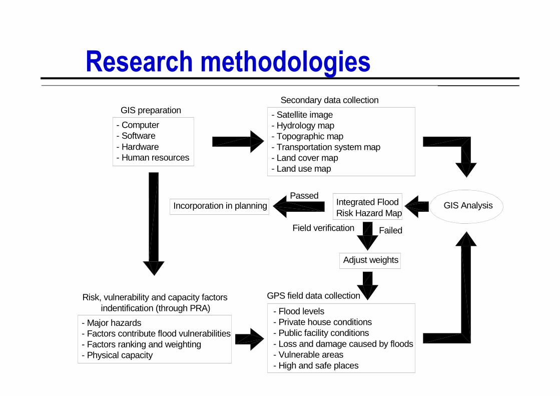
Disaster trendsA
vera
ge m
onth
ly p
reci
pita
tion
(mm
) in
floo
d se
ason 700
600
500
400
300 0
2
4
6
8
10
12
14
16
18
Year
2010200019901980197019601950
Ave
rage
mon
thly
pre
cipi
tatio
n (m
m)
in fl
ood
seas
on
300
200
100
Average monthly precipitation in rainy season
(Aug-Dec) from 1960 to 2004
0
Jan Feb Mar Apr May Jun Jul Aug Sep Oct Nov Dec
Number of major disasters from 1804 to 1945
Number of major disasters from 1975 to 1999
Disaster frequency by month in
Thua Thien Hue Province

Upland-lowland linkages

Flood impacts on environment
16
21
23
28
34
37
38
16
27
17
28
14
Stagnant w ater, extended vector habitat such asmosquitoes
Unsafe drinking w ater
Solid w aste, household w aste
Environmental problems during the flood season
5
15
16
15
29
28
38
33
33
42
23
23
0% 10% 20% 30% 40% 50% 60% 70% 80% 90% 100%
Spread of pig manure, human w aste
Large amount of mud/debris
Dead bodies of animals
Most serious (%) Serious (%) Less serious (%) No serious (%)
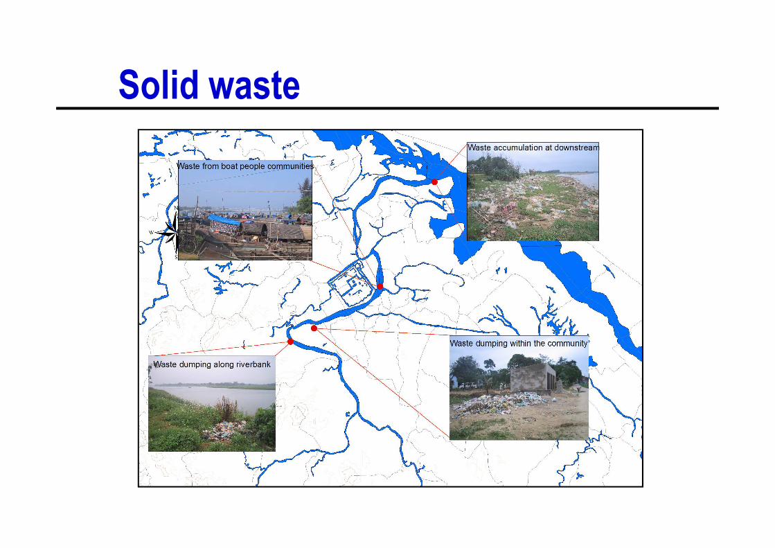
Solid waste

Flood impacts on economy
32
72
18
21
16
6
10
1
25
1
13
1
Flood 1999 (catastrophicf lood)
Flood 2004 (normal f lood)
18 23 11 5 42 9
0% 10% 20% 30% 40% 50% 60% 70% 80% 90% 100%
Flood 1985 (f lood andstorm)
Aquaculture Capture f isheries Agriculture Livestock Housing Household appliences
Percentage productivity loss and damage caused by three major floods

Positive impacts of floods
16
10
13
31
21
35
27
34
27
26
35
26
Necessary for lagoonsystem
Increase aquacultureproductivity
Increase agricultureproductivity
16
19
7
43
38
40
19
30
39
22
13
13
0% 20% 40% 60% 80% 100%
Make lagoon, river cleaner
Fertilize agriculture land
Kill the insects, rats
Strongly agree Agree Not sure Don't agree
Positive impacts of yearly flood on environment

Impacts on society

Flood impacts on povertyAverage of 1999 flood level and current level of plinth by household category
– The poor are more exposed to flood water
– The poor have fewer resources upon which to draw to counteract the
impacts of flooding
– The poor may be forced to exploit environmental resources for
survival, thereby increasing both the risk of, and exposure to
disasters

Social and physical vulnerability
♦ The same outside flood risk may not the same indoor flood risk
♦ High percentage temporary houses located far from safe shelters but close to the riverbank
♦ Unequal distribution of public building in the ♦ Unequal distribution of public building in the residential areas
♦ People tend to live close to the riverbank, despite the threat of flooding
– 8% houses located within 20m river buffer zones
– 33% households live very close to the rivers (within 60m from the riverbanks)

Flood risk perception and coping mechanism
♦ At commune level, DM plan only focuses on emergency situation
♦ At district and provincial level, detailed plan is prepared only for high-risk areas
♦ Disaster-development linkages have been mentioned, but no concrete intervention.
♦ Development program, such as relocation failed to integrate disaster aspects

The Gap…
♦ Little attention paid to the linkages
♦ Some project recognized the effect of environmental
degradation on disaster risks, but take actions in different
angles
♦ Recently some projects addressed the linkages, but…
♦ Lack of disaster consideration in environment programs
♦ Some initiatives try to incorporate multiple sectors such as
ICZM, IMOLA
♦ PAM programs on reforestation

Challenges of flood risk management
♦Changes resulting from moving a planned to a
market economy;
♦There has been substantial environmental
degradation;degradation;
♦The area may already be experiencing the effects of
climate change; and
♦The traditional methods of flood risk mitigation are
less effective than they used to be.

Potentials of flood risk management♦ There is a good opportunity to integrate flood risk reduction
programs into poverty alleviation, socio-economic development and capacity building programs
♦ The overall changing economic structure of Viet Nam holds potentials for an integrated flood risk management
♦ The role of local communities has been recognized; ♦ The role of local communities has been recognized; community based disaster management approaches are widely used
♦ The rise of civil society that could mediate between theindividual and state has potentials to promote governmentresponsiveness and accountability in disaster management.
♦ Community still has strong social capital and rich local knowledge to cope with natural disasters
Key findings
♦ Flood disaster is not a pure hazard-led disaster, but has
deep roots in social vulnerabilities
♦ Inappropriate environment management increases the
negative impacts of the floods
♦ Floods, although cause losses and damages (that often
inhibit economic development), are also essential elements
for the subsistence of the coastal populations of the Hue
Lagoon
♦ Coping mechanisms are under pressures due to
environmental degradation and improper development of
the build environment

Policy implications♦ Social vulnerabilities should be considered as a core risk
component of flood disasters
♦ Increasing disaster education and disaster awareness within flood vulnerable communities
♦ Participatory flood risk assessments should be carried out before formulating any development projects in the region
♦before formulating any development projects in the region
♦ Pre-existing local knowledge and concerns should be kept central in the decision-making process and
♦ The incentive structures should encourage a larger degree of local ownership and responsibility
♦ Traditional coping mechanisms are becoming less effective, new initiatives of integrated flood risk management are becoming necessary

Thank You
For full papers/reports:
http://www2.hawaii.edu/~tranphon/