Flash Flooding at the Colorado National Monument 1921 – 2003
24
Flash Flooding at the Colorado National Monument 1921 – 2003 Photo Credit: Jim Johnson Gigi A. Richard, Ph.D. Assistant Professor of Geology Department of Physical and Environmental Sciences Mesa State College Prepared in cooperation with the Colorado National Monument U.S. National Park Service and with the assistance of the Association of Women Geoscientists’ Geologist in the Park Program
Transcript of Flash Flooding at the Colorado National Monument 1921 – 2003

Flash Flooding at the Colorado National Monument 1921 – 2003
Photo Credit: Jim Johnson
Gigi A. Richard, Ph.D. Assistant Professor of Geology Department of Physical and Environmental Sciences Mesa State College Prepared in cooperation with the Colorado National Monument U.S. National Park Service and with the assistance of the Association of Women Geoscientists’ Geologist in the Park Program

ii
Flash Flooding at the Colorado National Monument 1921 – 2003 Prepared by: Gigi A. Richard, Ph.D. Assistant Professor of Geology Department of Physical and Environmental Sciences Mesa State College Prepared in cooperation with the Colorado National Monument U.S. National Park Service and with the assistance of the Association of Women Geoscientists’ Geologist in the Park Program
February 2004

iii
CONTENTS Abstract.............................................................................................................................................1
Introduction .......................................................................................................................................1
Site Background .................................................................................................................................2
Drainages of the Colorado National Monument ................................................................................2 Geology and Soils ...........................................................................................................................8 Precipitation Data .........................................................................................................................11
History of flooding – 1921-2003........................................................................................................12
Discussion of historic floods and precipitation ....................................................................................18 Conclusion .......................................................................................................................................20
Acknowledgements ..........................................................................................................................21
FIGURES Figure 1 – Location of the Colorado National Monument and identification of the major drainages.
Background images are Mesa County 2001 aerial photos. ..............................................................3
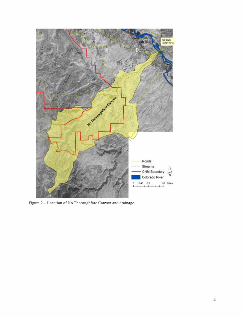
Figure 2 – Location of No Thoroughfare Canyon and drainage. .............................................................4
Figure 3 – Floodwaters in No Thoroughfare Creek flowing past bridge washout on Monument Road as the floodwaters are receding, September 7, 1978 (Photo Credit: Jim Johnson). ................................5
Figure 4 – Bridge washout on Monument Road after the floodwaters receded, September 7, 1978 (Photo Credit: Jim Johnson)....................................................................................................................6
Figure 5 – Mud line on side of house shows height of floodwaters on September 7, 1978 in No Thoroughfare Canyon (Photo Credit: Jim Johnson)........................................................................6
Figure 6 - Major drainages of the Colorado National Monument ranked from largest to smallest. The ID numbers correspond to map. ........................................................................................................7
Figure 7 – Sediment deposit in No Thoroughfare Canyon with a windblown sand layer at the surface. Gradation and size of deposits indicates potential for transport by floodwaters................................8
Figure 8 – Permeability of drainages of the monument from NRCS soil survey.......................................9
Figure 9 – Areas of the monument drainages exhibiting slopes in excess of 25%. .................................10
Figure 10 – Location of NWS rain gages near the Colorado National Monument ..................................11
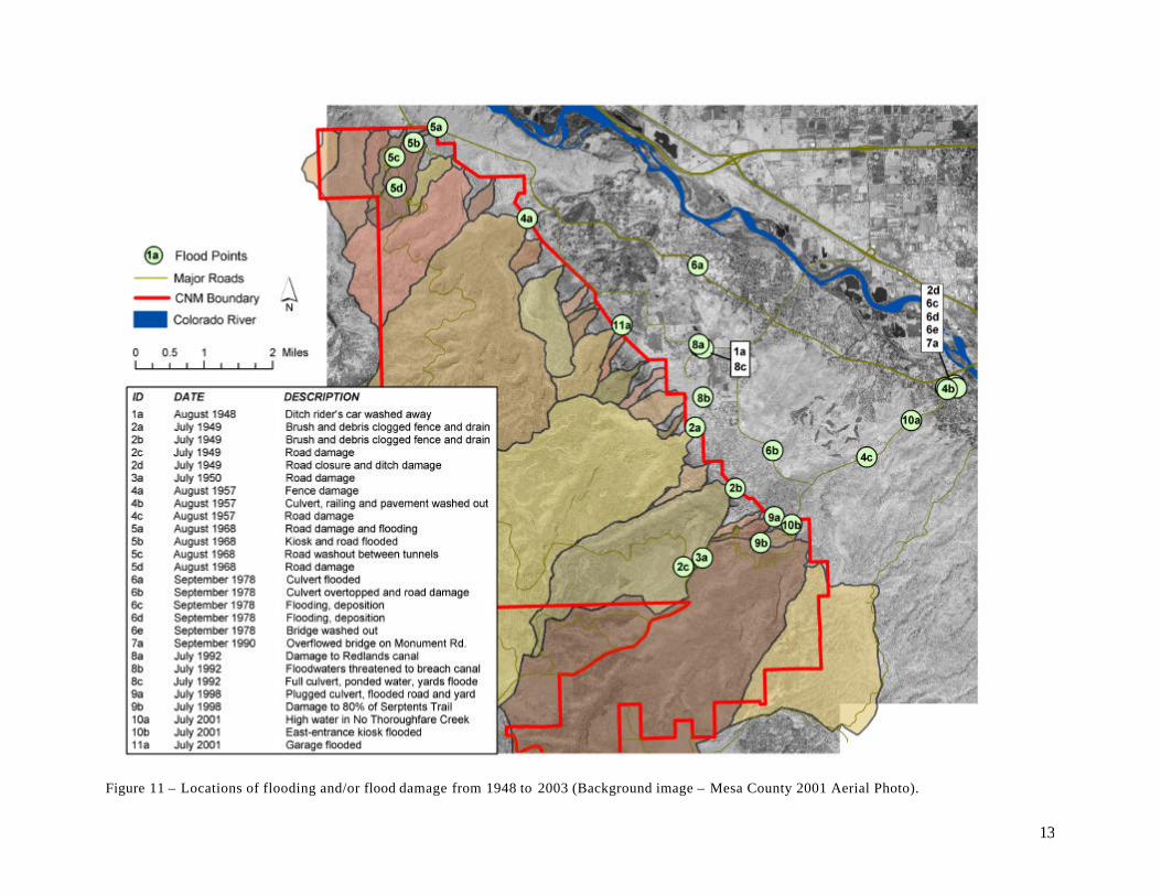
Figure 11 – Locations of flooding and/or flood damage from 1948 to 2003 (Background image – Mesa County 2001 Aerial Photo). .......................................................................................................13
Figure 12 – View looking upstream toward Red Canyon from the downstream side of the South Camp Road culvert following the September 7, 1978 storm (Photo Credit: Jim Johnson).........................16
TABLES Table 1 – Summary of reported rainfall associated with flood events described above...........................19
Table 2 – Rainfall amounts at the CNM headquarters for different recurrence intervals and durations computed from rain gage data (1948-2002) and determined from the NOAA Atlas 2 (1973). .........20

1
Flash Flooding at the Colorado National Monument 1921 – 2003 by Gigi A. Richard, Ph.D. Assistant Professor of Geology Department of Physical and Environmental Sciences Mesa State College
Abstract
The physical environment of the Colorado National Monument - steep canyons, bare rock, semi-desert climate – creates conditions that are ideal for the production of flash floods. Intense summer monsoonal thunderstorms raining over the watersheds within and above the National Monument can concentrate water rapidly in the steep canyons and dry washes creating swift and forceful floods. The Colorado National Monument was established in 1911 to protect spectacular geologic features that were formed by the erosive power of water. Since human settlement of the region, flash floods emanating from these canyons have damaged houses, washed out roads, carried cars away, and threatened irrigation ditches. Between 1948 and 2003 at least 11 documented flash floods occurred that caused damage and/or flooding in the community bordering the monument. The threat of future flash floods has not diminished and with recent intensified development in this area, a thorough understanding of the flash flooding potential is imperative.
INTRODUCTION
Several factors contribute to flash flooding including the rate of rainfall, how long the rainfall lasts, topography, soil conditions, and ground cover. Flash floods occur rapidly and usually without warning. As a result, flash floods result in more deaths than other floods.1 Severe rainfall can also trigger mudslides. Flash floods can move boulders, trees, destroy buildings and bridges, erode streambanks and sometimes carve new channels.
Intense rainfall of sufficient duration combined with the topography, geology, and soils within the canyons draining the Colorado National Monument (the monument or CNM) (Figure 1) create conditions that are conducive to flash flooding. Floodwaters resulting from storms over the headwaters of the drainages of the monument are not uncommon. Since 1948 there are reports of 11 storms over the monument that resulted flooding and/or damage to roads or homes downstream. On September 7, 1978 a severe thunderstorm in the monument created floodwaters in No Thoroughfare wash (Figure 2) equivalent to twice the flow in the Colorado River that day2. The floodwaters of September 7, 1978 washed out a major bridge (Figure 3 and Figure 4), carried away a trailer home, and deposited sediment in several homes and yards (Figure 5).
Understanding the history of flooding downstream from the monument becomes pertinent as increased suburban development occurs in Mesa County and in particular the Redlands area, west of the City of Grand Junction, downstream of the monument. The objective of this report is to compile information regarding flash floods originating in the canyons draining the Colorado National Monument.
1 NWS, 1992, “Flash floods and floods…the Awesome Power! A Preparedness Guide”, U.S. Department of Commerce, National Oceanic and Atmospheric Administration, National Weather Service 2 USGS, 1978, No Thoroughfare Creek Near Grand Junction, CO, US Geological Survey Miscellaneous Measurement, Slope-Area Computation, Flood of September 7, 1978, Surveyed September 12, 1978.

2
The objective was achieved through literature review and research of Grand Junction’s newspaper The Daily Sentinel, US Geological Survey and National Park Service records and reports, and personal interviews with people who witnessed and/or studied these floods.
SITE BACKGROUND
The Colorado National Monument, near the Colorado-Utah border, was established in 1911 to preserve the steep-walled canyons and spectacular erosional features of this semi-desert environment. The total watershed or drainage areas of the canyons draining the monument encompasses nearly 50 square miles of pinyon-juniper highlands and deep canyons. The monument is located 50 miles from the northeastern margin of the Colorado Plateau physiographic province, a 150,000 square mile elevated semi-desert province, and on the edge of the Uncompaghre uplift. The highest elevations in the headwaters of the monument’s canyons are as high as 2,600 ft above the Redlands area, the Colorado River, and the Grand Valley3. The uplifted landforms of the Uncompaghre Plateau create an obstacle to storms moving from both the north and south. Stalled storms can result in cloudbursts and localized intense rainfall in the late summer and early fall. Intense rain falling on steep gradients and exposed rock creates ideal conditions for flash flooding.
Drainages of the Colorado National Monument
Drainage from the Colorado National Monument is primarily to the northeast through a series of canyons that flow into washes and gulches that eventually drain into the Colorado River. Most of the drainages are ephemeral streams, meaning that they are dry most of the year. Many of these ephemeral streams drain un-named watersheds of 20 to 30 acres. Even the largest watersheds, Ute Canyon (14.3 square miles or 9,200 acres) and No Thoroughfare Canyon (12.5 square miles or 8,000 acres), can be dry for portions of the year. There are 10 drainages flowing out of the monument with watershed areas greater than 300 acres and at least another 18 drainages with watershed areas less than 300 acres (Figure 6).
The volume of floodwaters that will runoff following a rainstorm is related to the size of the watershed. The larger the watershed, the greater is the potential volume of floodwater. However, even the smallest watersheds are capable of producing rapid and potentially damaging flash floods. Flood damages can even occur from water running off bare rock and not concentrating into an established gully or wash.
3 Scott et al., 2001, Geologic Map of the Colorado National Monument and Adjacent Areas, Mesa County, Colorado, U.S. Geological Survey.

3
Figure 1 – Location of the Colorado National Monument and identification of the major drainages. Background images are Mesa County 2001 aerial photos.
Redlands Area
City of Grand
Junction
4
Figure 2 – Location of No Thoroughfare Canyon and drainage.

5
Figure 3 – Floodwaters in No Thoroughfare Creek flowing past bridge washout on Monument Road as the floodwaters are receding, September 7, 1978 (Photo Credit: Jim Johnson).

6
Figure 4 – Bridge washout on Monument Road after the floodwaters receded, September 7, 1978 (Photo Credit: Jim Johnson).
Figure 5 – Mud line on side of house shows height of floodwaters on September 7, 1978 in No Thoroughfare Canyon (Photo Credit: Jim Johnson).

7
Map ID # Name
Drainage Area
(acres)3 Ute Canyon 9166
17 No Thoroughfare Canyon 80158 Monument Canyon 3969
18 Echo Canyon 208116 Red & Columbus Canyons 1953
9 Wedding Canyon 12697 Gold Star Canyon 483
14 Kodels Canyon 48311 Fruita Canyon 372
5 31222 16315 159
4 13910 Lizard Canyon 130
1 12012 12013 11529 8920 8219 8228 8127 7023 6721 5025 5024 49
2 3026 23
Figure 6 - Major drainages of the Colorado National Monument ranked from largest to smallest. The ID numbers correspond to map.

8
Geology and Soils
The Colorado National Monument is comprised of sedimentary layers, forming the canyon walls and surfaces of the plateaus, which are underlain by harder metamorphic and igneous rocks that form the bottoms of the canyons. The modern landforms of the monument – steep canyons, spires and monoliths - are a result of erosive forces of water. Fluvial deposits or gravel bars in streams drain ing the monument indicate that historic floods carried large amounts and sizes of cobbles and boulders (Figure 7). The canyon-cutting process that created the monument’s canyons through the action of floodwaters continues today.4
Steep slopes combined with rock outcrops and soils with low permeability in the monument create rapid runoff during and following a rainstorm. Within the boundaries of the monument’s watersheds, 57% of the area is comprised of soil complexes that are classified as “Rock Outcrop” or as soils having moderately slow to very slow permeability5 (Figure 8). The monument is famous for its spectacular cliff walls , and as such, 34% of the monument watersheds exhibit slopes that exceed 25%6 (Figure 9).
Figure 7 – Sediment deposit in No Thoroughfare Canyon with a windblown sand layer at the surface. Gradation and size of deposits indicates potential for transport by floodwaters.
4 Scott et al., 2001 5 U.S. Bureau of Land Management, Grand Junction Center, Recorrelated Mesa County Soil Survey, January, 2001, from NRCS Field Sheets , 1990-2000. 6 Slope data from Mesa County GIS data download page dated 3/17/1997. The elevation data is from USGS DEM's (interpreted) acquired in 1995 (1:24000).

9
Figure 8 – Permeability of drainages of the monument from NRCS soil survey.
DescriptionArea
(acres)
Rock Outcrop 4,734
Slow to Very Slow Permeability 9,744
Moderately Slow Permeability 3,046
Total Moderately Slow to Impermeable 17,524
Total Area 31,007 Percentage of Total Area Moderately Slow to Impermeable 57%

10
Figure 9 – Areas of the monument drainages exhibiting slopes in excess of 25%.
DescriptionArea
(acres)
Area exhibiting slope >25% 10,514
Total drainage area 31,007
Percentage of total area with slope >25% 34%

11
Precipitation Data
The National Park Service operates an official National Weather Service (NWS) rain gage at the park headquarters at the west end of the monument (Figure 10). The precipitation record from the monument gage represents 54 years (1948-2002). Other nearby weather stations are located in Glade Park (NWS observer) and at Walker Field Airport in Grand Junction (Figure 10). None of these precipitation records, including the monument gage, provide accurate accounting of rainfall in the numerous canyons of the monument. The recorded rainfall can vary significantly between gages for individual storms. The 54-year rainfall record from CNM headquarters rain gage provides the best available information on the magnitude and frequency of the type of storms that can produce floods in the canyons of the monument. An analysis of the magnitude and recurrence intervals of rainstorms at the CNM headquarters is described later in this report.
Figure 10 – Location of NWS rain gages near the Colorado National Monument

12
HISTORY OF FLOODING – 1921-2003
The following section describes the recorded rainfall and resulting flooding within and downstream of the monument from 1921 to 2003. Locations of reported flooding and/or damage are shown in Figure 11. Information is summarized from National Park Service records and the Grand Junction’s local newspaper The Daily Sentinel, and as such is not a comprehensive review of every flood that occurred adjacent to the monument.
August 1921 – The Daily Sentinel reported that in August 1921 3.65 inches of rain fell on the Grand Valley. On August 24, 1921 cloudbursts derailed a passenger train in Debeque Canyon killing 2 and injuring 35 people near Cameo. The same storm running off the Bookcliffs washed away part of the Highline canal and damaged 20 county bridges and made the road between Fruita and Grand Junction impassable.7 No reports of damage from flooding in the monument were found, however, August 1921 is an indication of the potential volumes and intensities of rainfall that can occur in this area.
August 1948 - Precipitation in August 1948 was 0.65 inch above normal at CNM headquarters. Total precipitation for the month was 2.34 inches and more rain was reported on other portions of the monument with a flash flood along the eastern boundary on August 8.8
According to The Daily Sentinel the storm on August 8, 1948 produced 0.42 inches of rain in just 15 minutes in the Grand Valley. The total for the storm was 0.89 inches. Two bridges crossing Buffalo Canyon wash “toward the west end of the Redlands farming area” were washed out in the Redlands and “irrigation ditches flooded, and roads turned into streams”. One of the bridges crosses the wash “…to the area in which Buttolph, Woodward, and DeBlaquiere ranches are located.” The other bridge was on the main road to Monument canyon “…near the West and old Dressell ranches.” The exact location of Buffalo Canyon is unclear and is not noted on the map in Figure 11. The ditch rider attempted to ford Lime Kiln wash (Point 1a, Figure 11) on the south loop road, but the water washed into the windows of his car and carried it away.9
July 1949 – Heavy storms on July 3rd and 7th resulted in the need for extensive road repairs due to flood damage.10 Considerable flood damage occurred to Rimrock Drive (Section E, south of Cold Shivers Point) and Serpent’s Trail (Point 2c, Figure 11). On both occasions, only light showers occurred at CNM headquarters. Total precipitation for July at CNM headquarters was 0.85 inch. The storm on July 3rd caused high flows in Ute and Red Canyons, piling brush and debris against drains along the buffalo fence (Points 2a and 2b, Figure 11).11
The storm on July 3rd was a cloudburst in Glade Park that also caused high water in No Thoroughfare Canyon. The runoff completely covered the College Farm Crossing in No Thoroughfare wash and left behind mud and debris that forced closure of the road (Point 2d, Figure 11). The waters also knocked out part of the main Redlands ditch and some of the flumes (exact location unknown).12
7 The Daily Sentinel, September 1, 1999, V. 106, no. 286, “Sopping August broke no records”, by Barker, C., p. 1A. 8 Summary of the August, 1948 Monthly Narrative Report for the Colorado National Monument, September 4, 1948. 9 The Daily Sentinel, Grand Junction, Colorado, Vol. LV, No. 263, Monday Evening, August 9, 1948. 10 Summary of Monthly Narrative Report ---- Colorado National Monument July, 1949. 11 Monthly Narrative Report for July 1949. Memorandum for the Coordinating Superintendent, Mesa Verde National Park from Russell L. Mahan, Superintendent, Colorado National Monument, July 26, 1949. 12 The Daily Sentinel, Grand Junction, Colorado, Vol. LVI, No. 226, Monday Evening, July 4, 1949.
13
Figure 11 – Locations of flooding and/or flood damage from 1948 to 2003 (Background image – Mesa County 2001 Aerial Photo).
14
July and August 1950 – Total precipitation for the month of August was 0.65 inch, most of which fell during the first part of the month. The heavy rain on July 28th occurred in the vicinity of Cold Shivers Point and the resulting floodwaters caused damage to two diversion ditches13 and Section E of Rimrock Drive (Point 3a, Figure 11)14.
The Daily Sentinel reported that while only 0.12 inch of rain was recorded at Walker Field on July 28th, probably twice as much fell in the City and heavy rain and some hail fell in the Redlands. Rains were heavy enough in some areas to send water over the roads. The exact location of the heavy rain and flooding were not clear. The heaviest showers occurred around 4 pm.15
August 1957 – This was the wettest month recorded since 1940 (through 1957). A total of 6.66 inches of rain fell in August with 2.55 inches (1.87 inches in a two hour period) falling on August 6th. Flash floods occurred on August 6th, 23rd, and 25th from cloud bursts. The flood on the 6th caused damage to the buffalo fence in East Monument Canyon (Point 4a, Figure 11) and was responsible for numerous rock and mud slides on Rimrock Drive. (Photos available).16
On August 8, 1957, The Daily Sentinel reported that a flash flood on August 6th had washed away the railings and pieces of the pavement of the slab culvert structure crossing No Thoroughfare wash below Mesa College Farm (Point 4b, Figure 11). The flood waters in a tributary to No Thoroughfare wash also washed away sections of the shoulder of the Colorado National Monument approach road west of the city dump (Point 4c, Figure 11). Mud and silt were washed over roads in numerous other places, though the locations were not specifically mentioned. The city received 0.21 inch of rain and the storm in No Thoroughfare Canyon was described to have approached cloudburst proportions.17 The storms on August 23rd and 25th received little mention in the newspaper. The unofficial total rainfall at The Daily Sentinel was 0.41 inch on the 25th and Fruita received 0.58 inch on the 26th.18
December 1966 – There was major flooding at Zion National Park and Grand Canyon. On December 5-6 Walker Field reported 1.20 inches of rain and the unofficial total in the city was 1.31 inches. Rockslides blocked roads in DeBeque and Plateau canyons.19 No reports of problems in the CNM or the Redlands were found.
August 1968 – The total precipitation on August 8 at the CNM headquarters was 2.09 inches. The storm resulted in a major washout of Rimrock Drive between the two tunnels above the west entrance. 20 According to the ranger who was on duty at the west entrance kiosk during the storm, the culverts on Rimrock Drive about 100 yards south of the entrance station overtopped creating a 40 feet wide and 2.5 to 3 feet deep stream of water and debris over the road. The flood overtopped the road, flowed down the road along the west side of the kiosk, and flooded the kiosk 13 Monthly Narrative Report for August 1950. Memorandum to the Coordinating Superintendent, Mesa Verde National Park from Russell L. Mahan, Superintendent, Colorado National Monument, August 29, 1950. 14 Summary of Monthly Narrative Report ----Colorado National Monument August, 1950. 15 The Daily Sentinel, Saturday Evening, July 29, 1950, “Heavy showers here Friday; Hail Hits Parts of Redlands”. 16 Memorandum to Director, National Park Service from Superintendent, Colorado and Black Canyon of the Gunnison National Monuments, September 4, 1957. 17 The Daily Sentinel, Thursday Evening, August 8, 1957, “Izzy the Lizard All Washed Out after Hard Thunderstorm”, p. 1, by Nelson, W. 18 The Daily Sentinel, Monday Evening, August 26, 1957, “Chance Said Good for More Showers”, p.1. and Tuesday, August 27, 1957, “Lower valley area hi harder by electric storm; Hay burns”. 19 The Daily Sentinel, December 7, 1966, “Storm dumps heavy rains, snows across slope, Utah”, p. 1. 20 Colorado National Monument Superintendent Paul Ellis narrative of events related to storm on August 8, 1968.

15
with 1.5 inches of water and mud (Point 5b, Figure 11). Also, there were reports of Highway 340 being overtopped by floodwaters and debris at the point where the drainage from Fruita Canyon flows through culverts under the highway. The flooding resulted in erosion of the south shoulder of the highway, which undercut the asphalt in some areas (Point 5a, Figure 11).21
The August 8 storm was the most severe rain storm recorded at the CNM weather station according to the 28 years of precipitation record available at the time. The monument superintendent suggested that the rainfall above the tunnel section was even higher than that recorded at the weather station. The road was complete ly washed out for a distance of 182 feet (Point 5d, Figure 11)with all of the fill material being washed down to the vicinity of the West Entrance. Slippage and slope failure were also evident for another 100 feet south of the washout. National Park Service rangers estimated that about three to four feet of water was flowing through the upper tunnel on Rimrock Drive at the peak of the flood. Other washouts occurred below the lower tunnel with one approximately 65 feet long (Point 5c, Figure 11).22 The government agencies provided $475,000 in emergency funds to repair the washouts by using more than 130,000 cubic yards of fill material.
Above the upper tunnel a large drainage area flows into a 20 foot waterfall that should fall into a 5-foot diameter quarried hole on the uphill side of the road. Water falling into the hole then drains into a quarried (4 foot x 6 foot) tunnel that runs under the road. During the August 8, 1968 rain storm floodwater overshot the quarried hole and flowed onto the road. The floodwaters then flowed through the upper tunnel where it subsequently washed out the filled section of road between the upper and lower tunnels.23
September 1978 – On September 7, 1978 a slow-moving thunderstorm over the Colorado National Monument produced flash floods in No Thoroughfare Canyon and Red Canyon.24 The storm, according to the NWS, moved into the area from Arizona considerably slower than the average of 15 to 20 miles per hour. The slow movement of the storm allowed the rain to concentrate in certain drainages and created a larger flood peak. The NWS issued a flash flood warning and local residents evacuated before the peak flows hit, which carried away a trailer home and filled other homes and yards with up to 3 feet of sediment, muck and debris.
The USGS performed an analysis of the peak flows in No Thoroughfare wash and the combined outflow of Red and Columbus canyons. The report stated that local observers noted that the high flow in No Thoroughfare wash only lasted about 10 minutes. Using indirect methods the USGS estimated the peak flow for the floods in each canyon. In No Thoroughfare Canyon, the discharge was estimated to be 9,290 cfs and in Red Canyon 2,890 cfs25, which combined are nearly three times the flow in the Colorado River that day26. Unit runoff estimates
21 Narrative of events related to the storm on August 8, 1968 as told by George E. Shank, Colorado National Monument employee. 22 Letter from CNM Superintendent J.M. Carpenter dated August 16, 1968 to the A.R. Abelard, Division Engineer, Bureau of Public Roads requesting assistance and emergency fund to reconstruct Rimrock Drive. 23 Memorandum from J.L. Dunning, Regional Chief of Maintenance to Assistant Regional Director, Operations dated February 19, 1969. 24 The Daily Sentinel, Friday, September 8, 1978, V. 85, No. 303, “Furious Storm hits area” 25 USGS, 1978, No Thoroughfare Creek Near Grand Junction, CO, US Geological Survey Miscellaneous Measurement, Slope-Area Computation, Flood of September 7, 1978, Surveyed September 12, 1978. USGS, 1978, Red Canyon Creek Near Grand Junction, CO, US Geological Survey Miscellaneous Measurement, Culvert Computation, Flood of September 7, 1978, Surveyed September 11, 1978. 26 The mean daily flow in the Colorado River at Cameo that day was 1,730 cfs (USGS, National Water Information System, Retrieved: 2003-12-24 15:11:23 EST, USGS 09095500 COLORADO RIVER NEAR CAMEO, CO) and the Gunnison River at Grand Junction carried a mean flow of 1,100 cfs (USGS,

16
indicate the unit discharge (total volume discharge divided by the drainage area) from Red Canyon (664 ft3/sec /mi2) exceeded that of No Thoroughfare Canyon (494 ft3/sec /mi2).
Reported rainfall amounts varied. According to The Daily Sentinel rainfall measurements ranged from 0.43 inch at Walker Field, 0.64 inch in downtown Grand Junction, and from 0.5-0.75 inch at the west end of the monument. As much as three inches of rain were reported between Grand Junction and Clifton, while only 0.05 inch was measured in Glade Park and 1 inch in Little Park. No estimate of rainfall in No Thoroughfare Canyon was available.27
The storm created high flows that rushed out of Ute Canyon, Red and Columbus Canyons, and No thoroughfare Canyon. Reports from a CNM ranger stated that an 8-foot wide and two to three feet deep stream was flowing through Ute Canyon during the storm (Point 6a, Figure 11). The floodwaters through No Thoroughfare Canyon washed away a bridge on Monument Road (Figure 3, Figure 4, and Point 6c, Figure 11), downed power lines, and forced evacuation of residents. The storm caused flooding in downtown Grand Junction while the flash floodwaters from No Thoroughfare Canyon wreaked havoc on homes along D Road and South Broadway. A trailer was washed away on S. Broadway and one homeowner reported two feet of mud and silt deposited in his yard (Point 6d, Figure 11). Some homes had as much as three feet of mud and silt deposited from the flood (Figure 5). The floodwaters carried away cars, motorcycles, pets, stereos, and other household items. Other damage included destruction of flume structures at the new Tiara Rado golf course and loss of a total of $35,000 worth of irrigation equipment owned by Redlands Power (exact location unknown and not located on map). Phone service to 50 to 100 customers was interrupted and 100 families were without domestic water after a section of pipe washed away. The Daily Sentinel did not mention the floodwaters in Red Canyon associated with the same storm; however, the culvert at South Camp Road washed out (Figure 12 and Point 6b, Figure 11). The Daily Sentinel reported that the cloudburst was the worst in the Grand Junction area in 20 years since the 1958 flood in Indian Wash (2,200 cfs).28
Figure 12 – View looking upstream toward Red Canyon from the downstream side of the South Camp Road culvert following the September 7, 1978 storm (Photo Credit: Jim Johnson).
National Water Information System, Retrieved: 2003-12-24 15:11:23 EST, USGS 09152500 GUNNISON RIVER NEAR GRAND JUNCTION, CO). 27 The Daily Sentinel, Friday, September 8, 1978, V. 85, No. 303, “Furious Storm hits area”, “Flood victims feeling ‘lucky’”, “Worst cloudburst in last 20 years”, pp. 1, 5, 23. 28 The Daily Sentinel, Friday, September 8, 1978, V. 85, No. 303, “Furious Storm hits area”, “Flood victims feeling ‘lucky’”, “Worst cloudburst in last 20 years”, pp. 1, 5, 23.

17
September 1990 – The NWS reported that on September 2nd 0.53 inch of rain were reported on the Redlands and near Walker Field Airport. The Daily Sentinel reported that as much as 0.75 inch of rain fell in 45 minutes beginning at 5 p.m. The cloudburst resulted in rockfall requiring closure of Rimrock Drive in the monument and flooding that “engulfed one bridge on Monument Road and threatened others” (Point 7a, Figure 11).29
August 1991 – According to a National Weather Service storm spotter in the headwaters of the No Thoroughfare Canyon drainage, an intense thunderstorm occurred on August 4. The storm produced heavy rain, small hail and considerable lightening. Total rainfall was 1.20 inch, most of which fell in less than 30 minutes. The resulting floodwaters were described by the storm spotter:
Water cascaded from an escarpment back of my house, an event which occurred only once during the time that I lived there. A flash flood came down arroyos southeast of my house inundating part of my property and flooding CS Road [Little Park Road], which was not paved at the time, for several hundred feet. I was privileged to witness an awesome torrent of muddy water producing a thundering waterfall as it cascaded into No Thoroughfare Canyon.30
The floodwaters eroded the No Thoroughfare Canyon trail and moved large rocks and boulders. The resulting damage necessitated reconstruction of part of the trail. On August 2, a thundershower produced 0.68 inch of rain in about 20 minutes, but the resulting runoff did not cause any damage or flooding in the arroyos.
July 1992 – On July 11, 1992 floodwaters poured out of Ute Canyon from an afte rnoon thunderstorm that later dumped 0.44 inch of rain in one hour at Walker Field. The “tremendous surge of brick-red water spilling off the Colorado National Monument” threatened to breach one of the Redlands Water & Power Co. canals (Point 8b, Figure 11). The culvert crossing at the intersection of South Broadway and Wildwood Drive was flowing full. Above the culvert the water was overflowing the channel and backing up onto adjoining property (Points 8a and 8c, Figure 11).31
July 1998 – On July 24, two inches of rain fell in only 40 minutes near the east entrance to the Colorado National Monument and caused a wall of debris to flow down an un-named canyon, across Fallen Rock Road, and into the yard of downstream residents. The flooding resulted from the high rainfall and a plugged culvert (Point 9a, Figure 11) that had filled with 1.5 feet of sediment and debris from earlier rainstorm runoff. Mesa County Public Works reported that the culvert had been cleaned out only 10 days before the flood. Runoff from the same storm also caused damage to as much as 80% of the Serpents Trail (Point 9b, Figure 11).32
August 2000 – In August of 2000 a monsoon thunderstorm passed over the north portion of the monument and dropped about 1/2" of rain in about 20 minutes. The resulting runoff of water and debris plugged up the drainage tunnel under Rim Rock Drive at milepost 5.0. The water backed up to within 5 feet of the road surface. An overflow culvert that is just above the tunnel inlet carried enough of the runoff to prevent overtopping of the road. The monument's 29 The Daily Sentinel, September 3, 1990, “Storm water floods Redlands roads”, by Grant, G., v. 98, no. 277, p. 1A. 30 National Weather Service Storm Spotter, Personal Communication, October 11, 2003. 31 The Daily Sentinel, July 12, 1992, “Heavy rains flood streets, Redlands area”, by Cleary, C.P., v. 99, no. 236, p. 1A. 32 The Daily Sentinel, July 25, 1998, “Heavy rain damages yard, monument trail”, by Paul Lloyd-Davies, v. 105, no. 248.

18
maintenance crew cleaned out the tunnel inlet and discovered that the trash grating that covered the mouth of the tunnel had collapsed under the weight of the debris. A new grating was installed in the fall of 2003. 33
July 2001 – Monsoonal storms on July 10 resulted in a flash-flood warning as well as flooding along Broadway in the Redlands , the monument’s Visitor Center, and the east entrance to the monument. According to The Daily Sentinel 0.30 inch of rain fell in Grand Junction at Walker field.34 National Park Service records indicated that 1.6 inches of rain fell in less than two hours causing flash floods throughout the monument.35
The floods deposited mud and rocks on roadways, and flooded Park Service buildings. Mud covered Rim Rock Drive near the east entrance to the monument. Mud and rocks covered roads in the monument in other places causing temporary closures. The monument’s visitor center flooded and “water blasted under the door at the east entrance kiosk” (Point 10b, Figure 11). No Thoroughfare Creek along Monument Road was full of fast-moving water (Point 10a, Figure 11). In Glade Park a National Weather Service reporter recorded a total of 0.9 inches of rain with 0.75 inches falling between 6 p.m. and 7 p.m. The rain caused “normally dry gulches” to swell with “rushing red-colored water at the base of the monument”.36
August 2001 – Floodwaters emanating from an unnamed canyon south of Gold Start Canyon caused significant damage to a home on Tiara Drive (Point 11a, Figure 11). The home was constructed in the middle of the drainage whose floodwaters left behind 6 inches of sand, silt and mud throughout much of the house and three feet of mud in the garage. The 48-inch culvert upstream of the home failed to carry all of the floodwaters. The Tiara Rado golf course, located behind the home, also flooded with muddy water. The floodwaters continued down South Broadway damaging yards and carrying debris to the Colorado River.37 No rainfall was recorded at the monument’s rain gage at the Visitor’s Center.38
DISCUSSION OF HISTORIC FLOODS AND PRECIPITATION
Two of the most damaging floods (September 1978 and August 1968) did not occur on days of highest reported rainfall. The 1978 storm created flooding outside of park boundaries downstream from Ute Canyon, Red and Columbus Canyons, and No Thoroughfare Canyon. Damages included flooded homes, washed out bridges and culverts, flooded roads, and deposit ion of thick layers of sediment, muck and debris in yards and homes, and on roads. The 1968 storm caused a major washout of Rimrock Drive near the west entrance to the park. Flooding, road damage, and sediment deposition also occurred outside of park boundaries, though the area is less developed so damages were not extensive.
The discrepancy between measured rainfall amounts and resulting floodwaters is highlighted by comparing the recorded daily rainfall amounts on the dates of reported floods (Table 1). On September 7, 1978, the CNM rain gage did not record any rainfall at all and Walker Field measured 0.43 inch. However, the 1968 storm which was centered at the west end of the monument where the rain gage is located recorded 1.93 inches of rain. This measurement is 33 Tordoff, J., Facility Manager, Colorado National Monument, National Park Service, Personal Communication, January 29, 2004. 34 The Daily Sentinel, July 11, 2001, “Summer Soaking - Monsoon catches up with valley Tuesday”, by M. B. Vader, p. 1A, v. 108, n. 234. 35 Colorado National Monument, Flood Chronology – 2001, Park Superintendent records for July 30, 2001. 36 The Daily Sentinel, July 11, 2001, “Summer Soaking - Monsoon catches up with valley Tuesday”, by M. B. Vader, p. 1A, v. 108, n. 234. 37 The Daily Sentinel, August 4, 2001, “Flood slams home”, by M. B. Vader, p. 1A, v. 108, n. 258. 38 CNM Daily Precipitation Records, 1948-2003, from the Western Regional Climate Center.

19
probably a more accurate representation of the extreme rainfalls that trigger the most damaging flash floods. The storm on August 6, 1957 was the largest daily amount recorded at the CNM gage for the entire period of record (2.55 inches). The resulting floodwaters in Monument Canyon and No Thoroughfare wash caused minor damage to roads and associated structures, such as railing and shoulders. The flooded area was more rural and less developed resulting in less damage.
Table 1 – Summary of reported rainfall associated with flood events described above.
Date
CNM Daily Rainfall * (inches)
Grand Junction Walker Field Daily Rainfall * (inches)
GJDS Daily Rainfall (inches) Storm Rainfall (inches)
CNM Monthly Rainfall * (inches)
August 24, 1921 1.43 3.65 in at Walker Field (GJDS)August 8, 1948 0.13 0.89 0.89 in (0.42in/15min) (CNM) 2.34
July 3, 1949 0.16 0.85July 7, 1949 0.02 1.02
July 28, 1950 0.14 0.12 1.70August 6, 1957 2.55 0.56 0.21 1.87 in/2hrs (CNM) 6.66August 8, 1968 1.93 4.24
September 7, 1978 0.66 0.43 0.64 3 in between GJ & Clifton (GJDS) 0.75September 2, 1990 0.26 0.53 0.75 in/45 min (GJDS) 1.74
July 11, 1992 0.02 0.44 0.74July 24, 1998 0.09 2 in/40 min (GJDS) 0.89July 10, 2001 1.61 0.3 0.9 in total, 0.75in/1hr (GJDS - in Glade Park) 2.33
CNM = Colorado National Monument Gage and Records*GJDS = Grand Junction's The Daily Sentinel*All gage records were obtained from the Western Regional Climate Center, http://www.wrcc.dri.edu/
The discrepancies between measured rainfall amounts at established rain gages and resulting floodwaters demonstrate how the flashflood-producing storms can be isolated and localized. Heavy rain could be falling on the headwaters of the monument canyon drainages while little or no rainfall is recorded in Grand Junction. Even though the rain gages did not measure the events that produced the flash floods described above, it is still useful to analyze the rain gage record to determine the probability of simila r storms occurring in the future.
Flash floods usually result from intense short duration rainstorms that occur relatively infrequently. Typically the amount of rainfall (magnitude) increases as the frequency or probability of occurrence decreases. In other words, on average, more intense storms occur less often. Historic rainfall records provide insights into the intensity and frequency of storms that are likely to produce a flash flood. The frequency of a rain event gives an indication of how often that size of storm is likely to occur on average. The frequency is often stated as a recurrence interval, which explains how often an event is likely to occur on average. For instance, a 100-year storm is considered to occur on average once every 100 years. Each year it has a probability of 1 in 100 of occurring.
While understanding the magnitude and frequency of storms is important, the recurrence interval of a storm does not necessarily equal the recurrence interval of the resulting flood. Storm size, intensity, antecedent conditions, and location in the watershed all affect the magnitude of the resulting flood, which in turn affects the recurrence interval of the flood. For example, a 100-yr storm event might result in a 50-year flood if the soils were dry and the storm was focused in the upper portions of the watershed.

20
The recurrence intervals of 24-hour storms were determined using the 1949-2002 daily precipitation record for the months of June through September (Table 2).39 The months of June through September were selected because all of the flood-producing storms occurred between June and September. Historic rain gage data from the NWS is reported as daily (24-hour) rainfall amounts recorded in depth of rainfall (inches). The 24-hour rainfall is the total amount of rain that fell during a 24-hour period. Flash floods can result from very intense and often short duration storms (often just a few hours), however, the 24-hour data is all that is available for the CNM gage.
The National Oceanic and Atmospheric Administration (NOAA) produced an Atlas of rainfall frequency and magnitude for the entire United States in 1973 for different duration storms. The magnitudes of 6-hour and 24-hour storms of different recurrence intervals were estimated from the NOAA maps for the state of Colorado for the location of CNM headquarters (Table 2).
The measured rainfall amounts that produced the flash floods described above (Table 1) correspond to recurrence intervals varying from less than 2 years to more than 50 years. The largest rainstorm on record at the CNM gage (2.55 inches, 1957) has a recurrence interval of nearly 100 years. The resulting flood however was not necessarily a 100-year flood. The second largest rainstorm at the CNM gage (1.93 inches, 1968) has a recurrence interval of 10 to 25 years.
Table 2 – Rainfall amounts at the CNM headquarters for different recurrence intervals and durations computed from rain gage data (1948-2002) and determined from the NOAA Atlas 2 (1973).
Recurrence Interval
CNM Headquarters
Rainfall (inches)
24-hr 24-hr 6-hr100-yr 2.6 2.6 1.850-yr 2.3 2.3 1.625-yr ----- 2.1 1.510-yr 1.5 1.7 1.2
5-yr 1.0 1.4 1.02-yr 0.7 1.0 0.8
NOAA Atlas 2 Rainfall (inches)
CONCLUSION
Flash floods resulting from intense rainstorms over the Colorado National Monument are not uncommon and have occurred in repeatedly recent, historic and geologic times. Flash flood potential depends on the size of the drainage, the steepness of the canyon, the permeability of the surfaces, antecedent moisture conditions, and the intensity and duration of the rainfall. Even very small drainages are capable of producing swift and forceful flash floods. The conditions and processes leading to flash floods are a natural and integral part of the semi-desert landscape of the monument, which was established to protect erosional features created by the force of such floodwaters.
39 An empirical frequency distribution was determined using a plotting position formula as outlined in Cunnane, C., 1978. Unbiased plotting positions – a review. Journal of Hydrology, 37:205-222.

21
One condition that has changed in the regions downstream from the monument is the increased suburban development in potentially flood prone areas. Floodplains associated with the ephemeral streams that drain the monument are not defined. The Federal Emergency Management Agency (FEMA) maps floodplains associated with larger waterways, such as the Colorado River and the Gunnison River, but FEMA does not typically estimate flood prone areas associated with minor, ephemeral streams unless urban development encroaches in the floodway.
Continued research would provide beneficial information to enhance understanding of the risks associated with development downstream from the monument. This report is by no means a comprehensive coverage of all available information on historic flash floods. Future research into historic flooding could include interviews with long-time local residents and more extensive searches of local news sources and agency records. Installation of rain gages and event-triggered streamflow gages in individual canyons would be essential to understanding the relationship between the magnitude and frequency of rainfall and the resulting flash floods that originate in the monument. Application of the September 7, 1978 USGS unit discharge measurements to each of the monument’s drainages would provide a rough estimation of flood discharge that could result from a storm similar to the September 7, 1978 storm. Additionally, identification of floodplain surfaces and determination of discharge necessary to inundate those surfaces using modeling techniques could provide insights into pre-history flash floods and how the streams shape and form the landscape.
ACKNOWLEDGEMENTS
Funding for this study was provided by the Association of Women Geoscientists through the Geologist in the Park program. Megan McGuire, biology student, Mesa State College, contributed to the development of many of the maps used in this report. Thanks to Paul Von Guerard, USGS, Dave Price, NPS, and Bill Hood for their reviews of drafts and extensive comments. Most gracious thanks are extended to Jim Johnson for the contribution of his slides from the September 7, 1978, No Thoroughfare Canyon flood, and to Peter Larson for his photos of Ute Canyon.