FIVE YEAR REVIEW - Records Collections
164
United States Air Force Environmental Restoration Program FINAL FIVE-YEAR REVIEW REPORT Homestead Air Force Base, Florida May 2003 10055096
-
Upload
khangminh22 -
Category
Documents
-
view
2 -
download
0
Transcript of FIVE YEAR REVIEW - Records Collections
United States Air Force
Environmental Restoration Program
FINAL
FIVE-YEAR REVIEW REPORT
Homestead Air Force Base, Florida
May 2003
10055096
UNITED STATES ENVIRONMENTAL PROTECTION AGENCY
* REGION 4ATLANTA FEDERAL CENTER
61 FORSYTH STREET .ATLANTA, GEORGIA 30303-8960 10220762
AUG 2 5 2005
4WD-FFB
Lawrence Ventura, Environmental Flight ChiefHomestead Air Reserve Base482d SPTG/CEV360 Coral Sea Blvd.Homestead ARB, FL 33039-1299
SUBJ: Homestead Air Reserve Base Five Year ReviewHomestead Air Reserve Base, Florida
Dear Mr. Ventura:
The Environmental Protection Agency (EPA) has reviewed the subject document anddetermined that it meets all requirements of the Comprehensive Five-Year Review Guidance,EPA 540-R-007; OSWER No. 9355.7-03B-P. June 2001. Please note that an EPA Region IVrepresentative was not present when the on-site review was conducted so EPA's approval isbased on the information contained in the subject document along with personal informationEPA representatives obtained during ongoing oversight of work at the former Homestead AirForce Base through periodic progress reports, site visits, and meetings. A summary of the Five-Year Review as contained in the subject report follows.
The Comprehensive Environmental Response, Compensation, and Liability Act(CERCLA) requires that all remedies selected under CERCLA §121, which result in hazardoussubstances, pollutants, or contaminants remaining at the site, be subject to a Five-Year Review.Executive Order 12580 delegated CERCLA remedial responsibilities, including Five-YearReviews, to the Secretary of Defense, with respect to releases from any facility or vessel underthe jurisdiction, custody, or control of the Department of Defense. At Homestead Air ReserveBase (HARB), certain remedial actions are being performed in accordance with CERCLA thatrequire Five-Year Reviews to verify that previously implemented remedies remain protective ofhuman health and the environment.
Former Homestead Air Force Base (HAFB) originally encompassed 2,938 acres.However, in 1994, part of the installation (i.e., 852 acres) transitioned from an active base to anAir Reserve Station under management of the Air Force Reserve Command (AFRC). In 2003,HARS was officially realigned as HARB that is comprised of 1,943 acres, which includes therunway and main taxiways. This retained property, referred to as the cantonment area, comprisesthe current HARB. The Air Force Real Property Agency (AFRPA), formerly known as the Air
Internet Address (URL) • http://www.epa.govRecycled/Recyclable • Printed with Vegetable OH Based Inks on Hecyclad Paper (Minimum 30% Postconsumer)

Force Base Conversion Agency (AFBCA), is transitioning the remaining property that is withinthe confines of the former HAFB but is outside of the AFRC cantonment area to civilian use.This Five-Year Review addresses sites located within the cantonment area within HARBproperty. Sites located outside the HARB cantonment area were addressed in a separate Five-Year Review finalized by the AFRPA.
This Five-Year Review for 2003 constitutes the first required review/reporting cycle forHARB. The report addresses thirteen (13) Operable Units (OUs) and one Area of Concern(AOC).
1) OU 1 Fire Protection Training Area No. 2 (FT-05, FPTA-2)2) OU 2 Residual Pesticide Disposal Area (OT-11, P-3)3) OU 3 Polychlorinated Biphenyl (PCB) Spill Area )SS-13, SP-3)4) OU 4 Motor Pool Oil Leak Area (SS-08, SP-2)5) OU 5 Electroplating Waste Disposal Area (WP-1, SP-1)6) OU 7 Entomology Storage Area (SS-07, P-2)7) OU 8 Fire Protection Training Area No. 3 (FT-04, FPTA-3)8) OU 12 Entomology Shop - Building 371 (OT-25, P-l)9) OU 13 Hardfill Storage Area (SS-22)10) OU 15 Hazardous Waste Storage Area - Building 153 (SS-30)11) OU 19 Aircraft Ground Equipment Shop - Building 208 (SS-19)12) OU 25 Hush House Area (SWMU 59)13) OU 27 Jet Engine Test Cell Facility (SS-27)14) AOC 3 Munitions Storage Area
The decision documents for each CERCLA site identify the remedial action objectives(RAOs), which define the scope and purpose of the cleanup action required to address thepotential threats to human heaJth and the environment. The decision documents for OU 1, OU 2,OU 4, OU 5, OU 7, OU 8, OU 13, and AOC 3 identify remedies that result in contaminantsremaining on site at concentrations above unrestricted reuse and unlimited exposure criteria.Therefore, these sites are subject to the CERCLA Five-Year Review requirements. The selectedremedies are designed to monitor, and prevent unacceptable exposure to, the residualcontamination. Long-term ground-water monitoring and/or Land Use Controls (LUCs) are theprimary elements of each of the selected remedies. On March 15, 1999, HARS entered into aMemorandum of Agreement (MOA) with the U.S. Environmental Protection Agency (USEPAand the Florida Department of Environmental Protection (FDEP) regarding the implementationof LUCs. The MOA requires that LUC Implementation Plans be prepared for all sites requiringLUCs with quarterly monitoring of implemented LUCs to verify ongoing effectiveness andannual reporting.
The AFRC affirmed(certified) that the remedies for all of the sites addressed in the Five-Year Review Report remain protective of human health and the environment. The remedies alsocomply with Applicable or Relevant and Appropriate Requirements (ARARs) and are reasonably

cost-effective. EPA concurs with the Air Force's protectiveness determinations that theremedies remain protective of human health and the environment, consistent with EPA'sstatutory and regulatory authorities. It is expected that the remedial activities andLUCs/Institutional Controls (ICs) at HARB will permanently reduce the risks to human health byeliminating, reducing, or controlling exposures to human receptors through engineering andinstitutional controls. Furthermore, there are no known areas of noncompliance.
General recommendations for HARB include:
1) The remedial actions should continue to be implemented in accordance with the USEPAand FDEP approved plans governing maintenance and long-term monitoring.
2) Evaluations of environmental monitoring should continue and be used as a means ofidentifying opportunities to refine long-term monitoring activities.
3) Future evaluations of long-term monitoring should attempt to identify the level ofprogress toward meeting site- or zone-specific cleanup goals developed during theremedy decision-making process.
RODs have been approved for all of the above sites except for OU 12, OU 15, OU 25,and OU 27. EPA expects that all of these remaining RODs wil l involve LUCs with the possibleexception of OU 27. Remedial Investigations and Feasibility Studies (RI/FSs) are underway atthese remaining Operable Units.
Based on the information provided in the subject document, EPA approves the subjectdocument. If you have any questions, please call me at (404) 562-8651, or Doyle T. Brittain at(404) 562-8549.
Sincerely,
Winston A. SmithDirectorWaste Management Division
cc: Carol Devier Heeney, HAFB/AFRPADavid Grabka, FDEPWilbur Mayorga, DERM
TABLE OF CONTENTS
SECTION PAGE
List of Acronyms ix Executive Summary ES-1 Five-Year Review Summary Form 3
1.0 INTRODUCTION 5 1.1 Site Chronology 6 1.2 Background 7
1.2.1 Physical Characteristics 7 1.2.2 Land and Resource Use 8 1.2.3 History of Contamination 8
1.3 Five-Year Review Process 9 1.3.1 Administrative Components 9 1.3.2 Community Involvement 9 1.3.3 Interviews 10
2.0 OPERABLE UNIT 6 11 2.1 HISTORY OF CONTAMINATION 11 2.2 INITIAL RESPONSE AND BASIS FOR TAKING ACTION 11 2.3 REMEDIAL ACTIONS 12
2.3.1 Remedy Selection 12 2.3.2 Remedy Implementation 13 2.3.3 System Operations/Operation and Maintenance 13
2.4 FIVE-YEAR REVIEW PROCESS 13 2.4.1 Document Review 13 2.4.2 Data Review 13 2.4.3 Site Inspection 14
2.5 TECHNICAL ASSESSMENT 14 2.6 ISSUES 14 2.7 RECOMMENDATIONS AND FOLLOW-UP ACTIONS 14 2.8 PROTECTIVENESS STATEMENT 14 2.9 NEXT REVIEW 14
3.0 OPERABLE UNIT 9 15 3.1 HISTORY OF CONTAMINATION 15 3.2 INITIAL RESPONSE AND BASIS FOR TAKING ACTION 16 3.3 REMEDIAL ACTIONS 17
3.3.1 Remedy Selection 17 3.3.2 Remedy Implementation 17 3.3.3 System Operations/Operation and Maintenance 17
3.4 FIVE-YEAR REVIEW PROCESS 17 3.4.1 Document Review 17 3.4.2 Data Review 18
i
TABLE OF CONTENTS (CONTINUED)
SECTION PAGE3.4.3 Site Inspection 18
3.5 TECHNICAL ASSESSMENT 18 3.6 ISSUES 18 3.7 RECOMMENDATIONS AND FOLLOW-UP ACTIONS 18 3.8 PROTECTIVENESS STATEMENT 18 3.9 NEXT REVIEW 18
4.0 OPERABLE UNIT 10 19 4.1 HISTORY OF CONTAMINATION 19 4.2 INITIAL RESPONSE AND BASIS FOR TAKING ACTION 19 4.3 REMEDIAL ACTIONS 19
4.3.1 Remedy Selection 19 4.3.2 Remedy Implementation 20 4.3.3 System Operations/Operation and Maintenance 20
4.4 FIVE-YEAR REVIEW 20 4.4.1 Document Review 20 4.4.2 Data Review 20 4.4.3 Site Inspection 20
4.5 TECHNICAL ASSESSMENT 20 4.6 ISSUES 20 4.7 RECOMMENDATIONS AND FOLLOW-UP ACTIONS 20 4.8 PROTECTIVENESS STATEMENT 20 4.9 NEXT REVIEW 20
5.0 OPERABLE UNIT 11 21 5.1 HISTORY OF CONTAMINATION 21 5.2 INITIAL RESPONSE AND BASIS FOR TAKING ACTION 22 5.3 REMEDIAL ACTIONS 23
5.3.1 Remedy Selection 23 5.3.2 Remedy Implementation 24 5.3.3 System Operations/Operation and Maintenance 24
5.4 FIVE-YEAR REVIEW 24 5.4.1 Document Review 24 5.4.2 Data Review 24 5.4.3 Site Inspection 24
5.5 TECHNICAL ASSESSMENT 24 5.6 ISSUES 245.7 RECOMMENDATIONS AND FOLLOW-UP ACTIONS 24 5.8 PROTECTIVENESS STATEMENT 24 5.9 NEXT REVIEW 24
6.0 OPERABLE UNIT 14 25 6.1 HISTORY OF CONTAMINATION 25
ii
TABLE OF CONTENTS (CONTINUED)
SECTION PAGE
6.2 INITIAL RESPONSE AND BASIS FOR TAKING ACTION 25 6.3 REMEDIAL ACTIONS 26
6.3.1 Remedy Selection 26 6.3.2 Remedy Implementation 26 6.3.3 System Operations/Operation and Maintenance 26
6.4 FIVE-YEAR REVIEW 26 6.4.1 Document Review 26 6.4.2 Data Review 26 6.4.3 Site Inspection 27
6.5 TECHNICAL ASSESSMENT 27 6.6 ISSUES 27 6.7 RECOMMENDATIONS AND FOLLOW-UP ACTIONS 27 6.8 PROTECTIVENESS STATEMENT 27 6.9 NEXT REVIEW 27
7.0 OPERABLE UNIT 16 28 7.1 HISTORY OF CONTAMINATION 28 7.2 INITIAL RESPONSE AND BASIS FOR TAKING ACTION 28 7.3 REMEDIAL ACTIONS 28
7.3.1 Remedy Selection 28 7.3.2 Remedy Implementation 28 7.3.3 System Operations/Operation and Maintenance 29
7.4 FIVE-YEAR REVIEW PROCESS 29 7.4.1 Document Review 29 7.4.2 Data Review 29 7.4.3 Site Inspection 29
7.5 TECHNICAL ASSESSMENT 29 7.6 ISSUES 29 7.7 RECOMMENDATIONS AND FOLLOW-UP ACTIONS 29 7.8 PROTECTIVENESS STATEMENT 29 7.9 NEXT REVIEW 29
8.0 OPERABLE UNIT 17 30 8.1 HISTORY OF CONTAMINATION 30 8.2 INITIAL RESPONSE AND BASIS FOR TAKING ACTION 30 8.3 REMEDIAL ACTIONS 30
8.3.1 Remedy Selection 30 8.3.2 Remedy Implementation 30 8.3.3 System Operations/Operation and Maintenance 30
8.4 FIVE-YEAR REVIEW PROCESS 31 8.4.1 Document Review 31 8.4.2 Data Review 31
iii
TABLE OF CONTENTS (CONTINUED)
SECTION PAGE
8.4.3 Site Inspection 31 8.5 TECHNICAL ASSESSMENT 31 8.6 ISSUES 31 8.7 RECOMMENDATIONS AND FOLLOW-UP ACTIONS 31 8.8 PROTECTIVENESS STATEMENT 31 8.9 NEXT REVIEW 31
9.0 OPERABLE UNIT 18 32 9.1 HISTORY OF CONTAMINATION 32 9.2 INITIAL RESPONSE AND BASIS FOR TAKING ACTION 32 9.3 REMEDIAL ACTIONS 32
9.3.1 Remedy Selection 32 9.3.2 Remedy Implementation 33 9.3.3 System Operations/Operation and Maintenance 33
9.4 FIVE-YEAR REVIEW 33 9.4.1 Document Review 33 9.4.2 Data Review 33 9.4.3 Site Inspection 34
9.5 TECHNICAL ASSESSMENT 34 9.6 ISSUES 34 9.7 RECOMMENDATIONS AND FOLLOW-UP ACTIONS 35 9.8 PROTECTIVENESS STATEMENT 35 9.9 NEXT REVIEW 35
10.0 OPERABLE UNIT 20/21 36 10.1 HISTORY OF CONTAMINATION 36 10.2 INITIAL RESPONSE AND BASIS FOR TAKING ACTION 36 10.3 REMEDIAL ACTIONS 37
10.3.1 Remedy Selection 37 10.3.2 Remedy Implementation 38 10.3.3 System Operations/Operation and Maintenance 38
10.4 FIVE-YEAR REVIEW 39 10.4.1 Document Review 39 10.4.2 Data Review 39 10.4.3 Site Inspection 39
10.5 TECHNICAL ASSESSMENT 39 10.6 ISSUES 39 10.7 RECOMMENDATIONS AND FOLLOW-UP ACTIONS 39 10.8 PROTECTIVENESS STATEMENT 39 10.9 NEXT REVIEW 40
iv

TABLE OF CONTENTS (CONTINUED)
SECTION PAGE
11.0 OPERABLE UNIT 22 41 11.1 HISTORY OF CONTAMINATION 41 11.2 INITIAL RESPONSE AND BASIS FOR TAKING ACTION 41 11.3 REMEDIAL ACTIONS 43
11.3.1 Remedy Selection 43 11.3.2 Remedy Implementation 43 11.3.3 System Operations/Operation and Maintenance 43
11.4 FIVE-YEAR REVIEW PROCESS 44 11.4.1 Document Review 44 11.4.2 Data Review 44 11.4.3 Site Inspection 44
11.5 TECHNICAL ASSESSMENT 44 11.6 ISSUES 44 11.7 RECOMMENDATIONS AND FOLLOW-UP ACTIONS 44 11.8 PROTECTIVENESS STATEMENT 44 11.9 NEXT REVIEW 44
12.0 OPERABLE UNIT 26 45 12.1 HISTORY OF CONTAMINATION 45 12.2 INITIAL RESPONSE AND BASIS FOR TAKING ACTION 45 12.3 REMEDIAL ACTIONS 46
12.3.1 Remedy Selection 46 12.3.2 Remedy Implementation 46 12.3.3 System Operations/Operation and Maintenance 47
12.4 FIVE-YEAR REVIEW PROCESS 47 12.4.1 Document Review 47 12.4.2 Data Review 47 12.4.3 Site Inspection 48
12.5 TECHNICAL ASSESSMENT 49 12.6 ISSUES 49 12.7 RECOMMENDATIONS AND FOLLOW-UP ACTIONS 4912.8 PROTECTIVENESS STATEMENT 49 12.9 NEXT REVIEW 49
13.0 OPERABLE UNIT28 50 13.1 HISTORY OF CONTAMINATION 50 13.2 INITIAL RESPONSE AND BASIS FOR TAKING ACTION 50 13.3 REMEDIAL ACTIONS 51
13.3.1 Remedy Selection 51 13.3.2 Remedy Implementation 51 13.3.3 System Operations/Operation and Maintenance 52
v
TABLE OF CONTENTS (CONTINUED)
SECTION PAGE
13.4 FIVE-YEAR REVIEW PROCESS 52 13.4.1 Document Review 52 13.4.2 Data Review 52 13.4.3 Site Inspection 52
13.5 TECHNICAL ASSESSMENT 52 13.6 ISSUES 53 13.7 RECOMMENDATIONS AND FOLLOW-UP ACTIONS 53 13.8 PROTECTIVENESS STATEMENT 53 13.9 NEXT REVIEW 53
14.0 OPERABLE UNIT 29 54 14.1 HISTORY OF CONTAMINATION 54 14.2 INITIAL RESPONSE AND BASIS FOR TAKING ACTION 54 14.3 REMEDIAL ACTIONS 55
14.3.1 Remedy Selection 55 14.3.2 Remedy Implementation 55 14.3.3 System Operations/Operation and Maintenance 56
14.4 FIVE-YEAR REVIEW PROCESS 56 14.4.1 Document Review 56 14.4.2 Data Review 56 14.4.3 Site Inspection 56
14.5 TECHNICAL ASSESSMENT 56 14.6 ISSUES 57 14.7 RECOMMENDATIONS AND FOLLOW-UP ACTIONS 57 14.8 PROTECTIVENESS STATEMENT 57 14.9 NEXT REVIEW 57
15.0 OPERABLE UNIT 30 58 15.1 HISTORY OF CONTAMINATION 58 15.2 INITIAL RESPONSE AND BASIS FOR TAKING ACTION 58 15.3 REMEDIAL ACTIONS 59
15.3.1 Remedy Selection 59 15.3.2 Remedy Implementation 60 15.3.3 System Operations/Operation and Maintenance 61
15.4 FIVE-YEAR REVIEW PROCESS 62 15.4.1 Document Review 62 15.4.2 Data Review 62 15.4.3 Site Inspection 62
15.5 TECHNICAL ASSESSMENT 62 15.6 ISSUES 62 15.7 RECOMMENDATIONS AND FOLLOW-UP ACTIONS 62
vi
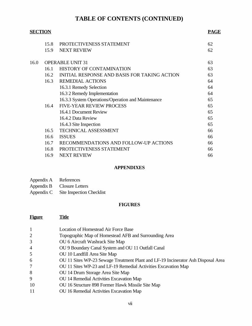
TABLE OF CONTENTS (CONTINUED)
SECTION PAGE
15.8 PROTECTIVENESS STATEMENT 62 15.9 NEXT REVIEW 62
16.0 OPERABLE UNIT 31 63 16.1 HISTORY OF CONTAMINATION 63 16.2 INITIAL RESPONSE AND BASIS FOR TAKING ACTION 63 16.3 REMEDIAL ACTIONS 64
16.3.1 Remedy Selection 64 16.3 2 Remedy Implementation 64 16.3.3 System Operations/Operation and Maintenance 65
16.4 FIVE-YEAR REVIEW PROCESS 65 16.4.1 Document Review 65 16.4.2 Data Review 65 16.4.3 Site Inspection 65
16.5 TECHNICAL ASSESSMENT 66 16.6 ISSUES 66 16.7 RECOMMENDATIONS AND FOLLOW-UP ACTIONS 66 16.8 PROTECTIVENESS STATEMENT 66 16.9 NEXT REVIEW 66
APPENDIXES
Appendix A References Appendix B Closure Letters Appendix C Site Inspection Checklist
FIGURES
Figure Title
1 Location of Homestead Air Force Base 2 Topographic Map of Homestead AFB and Surrounding Area 3 OU 6 Aircraft Washrack Site Map 4 OU 9 Boundary Canal System and OU 11 Outfall Canal 5 OU 10 Landfill Area Site Map 6 OU 11 Sites WP-23 Sewage Treatment Plant and LF-19 Incinerator Ash Disposal Area 7 OU 11 Sites WP-23 and LF-19 Remedial Activities Excavation Map 8 OU 14 Drum Storage Area Site Map 9 OU 14 Remedial Activities Excavation Map 10 OU 16 Structure 898 Former Hawk Missile Site Map 11 OU 16 Remedial Activities Excavation Map
vii
12 OU 17 Building 793 C-130 Fuel Release Site Map 13 OU 18 Contractor Storage Area/Construction Debris Landfill Site Map 14 OU 18 Monitoring Well Map 15 OUs 20/21, 30 and 31 Location Map 16 OUs 20/21 Outdoor Staging Area/Base Supply Hazardous Materials Storage Site Map 17 OU 20 Remedial Action Excavation Map 18 OU 20 2001 Groundwater Analytical Results 19 OU 21 Remedial Action Excavation Map 20 OU 21 2001 Groundwater Analytical Results 21 OU 22 Former Buildings 761 and 764 Site Map 22 OU 22 Remedial Activities Excavation Map 23 OU 22 Monitoring Well Location 24 OU 26 Aircraft Fabrication Shop Site Map 25 OU 26 Remedial Activities Excavation Map 26 OU 26 2002 Remedial Activities Map 27 OU 26 Monitoring Well Locations Map 28 OU 28 Propulsion Maintenance Facility Site Map 29 OU 28 Remedial Activities Excavation Map 30 OU 29 Avionics/Aircraft Ground Equipment Maintenance Facility Site Map 31 OU 29 Remedial Activities Excavation Map 32 OU 30 Former Building 767 Contractor Storage Area Site Map 33 OU 30 Remedial Activities Excavation 1 Map 34 OU 30 Remedial Activities Excavations 2 and 3 Map 35 OU 30 Remedial Activities Excavation 4 Map 36 OU 30 Groundwater Analytical Results 37 OU 30 Pilot Study Groundwater Analytical Results 38 OU 31 Building 755 Non-destructive Inspection Lab Site Map 39 OU 31 Remedial Activities Excavation 1 Map 40 OU 31 Remedial Activities Excavation 2 Map 41 OU 31 Groundwater Analytical Results
TABLES
Table Title
1 History of Base Operations 2 OU 18 Groundwater Analytical Results 3 OU 20 Groundwater Analytical Results 4 OU 21 Groundwater Analytical Results 5 OU 22 Groundwater Analytical Results 6 OU 26 Groundwater Analytical Results 7 OU 30 Groundwater Analytical Results 8 OU 31 Groundwater Analytical Results
viii
LIST OF ACRONYMS
ACC Air Combat Command AFB Air Force Base AFBCA Air Force Base Conversion Agency AFCEE Air Force Center for Environmental Excellence AFRC Air Force Reserve Command AFRPA Air Force Real Property Agency AOC area of concern ARAR applicable or relevant and appropriate requirement ARS Air Reserve Station ARB Air Reserve Base AST above ground storage tank bcy bank cubic yards bgs below ground surface bls below land surfaceBNA base/neutral and acid extractable BRA baseline risk assessment BRAC Base Realignment and Closure BCT BRAC Cleanup TeamBTEX benzene, toluene, ethylbenzene, and xylenes CAH chlorinated aliphatic hydrocarbons CERCLA Comprehensive Environmental Response, Compensation, and Liability Act CFR Code of Federal Regulations COC contaminants of concern CTL cleanup target level (FDEP) cy cubic yard DCE dichloroethene DERM Miami-Dade County Department of Environmental Resources Management DNAPL dense nonaqueous-phase liquid EPA U.S. Environmental Protection Agency FDEP Florida Department of Environmental Protection FAC Florida Administrative Code FFA Federal Facilities Agreement FOST Finding of Suitability to Transfer FS feasibility study ft foot GCTL groundwater cleanup target level (FDEP) gpm gallon per minute HAFB Homestead Air Force Base HRS hazard ranking system HSWA hazardous and solid waste amendments IRA interim remedial action IRP Installation Restoration ProgramLF Landfill LNAPL light nonaqueous-phase liquid
ix
MCL maximum contaminant level MOA memorandum of agreement MSL mean sea level NAPL nonaqueous-phase liquid NCP National Contingency Plan NFRAP no further remedial action plannedNPL National Priorities List OTU operable training unit OU Operable Unit OWS oil/water separator PAH polynuclear aromatic hydrocarbon PA/SI preliminary assessment/site inspection PCB polychlorinated biphenyls PCE tetrachloroethene ppb parts per billion PSC possible source of contamination PQL practical quantification limit RAB Restoration Advisory Board RAO remedial action objectiveRBC risk based concentration RCRA Resource Conservation and Recovery ActRD remedial design RFI RCRA Facility InvestigationRG remedial goal RI remedial investigation RI/BRA remedial investigation/baseline risk assessment ROD record of decision SAC Strategic Air Command SCTL soil cleanup target level (FDEP) SERA screening ecological risk assessment SVOC semivolatile organic compound SWMU solid waste management unitsTAC Tactical Air Command TCE trichloroethene TCLP toxicity characteristic leaching procedure TFW Tactical Fighter Wing TPH total petroleum hydrocarbon TRPH total recoverable petroleum hydrocarbons TTW Tactical Training Wing UCL upper confidence limit µg microgram USACE United States Army Corps of Engineers USAF United States Air Force USEPA United States Environmental Protection Agency UST underground storage tank VCA voluntary custodial action VOC volatile organic compound
x
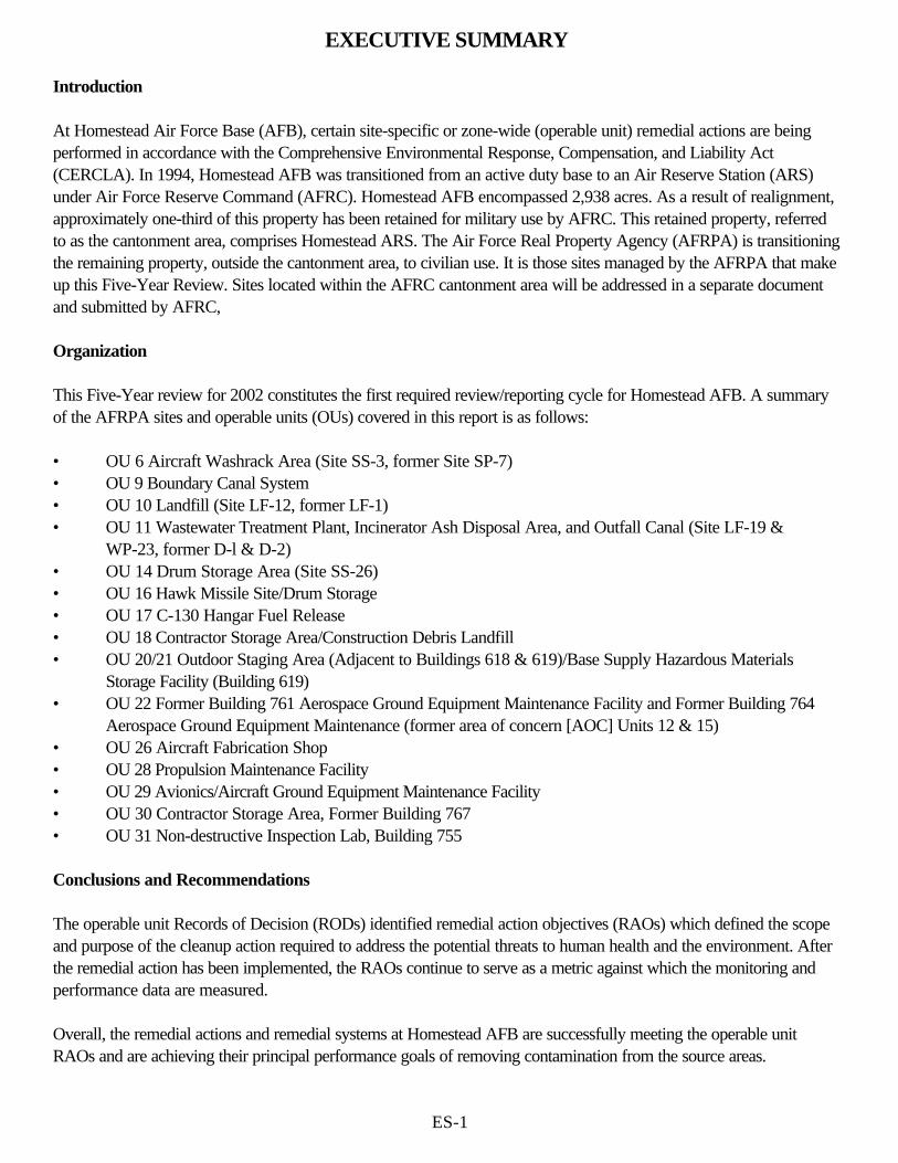
EXECUTIVE SUMMARY
Introduction
At Homestead Air Force Base (AFB), certain site-specific or zone-wide (operable unit) remedial actions are beingperformed in accordance with the Comprehensive Environmental Response, Compensation, and Liability Act(CERCLA). In 1994, Homestead AFB was transitioned from an active duty base to an Air Reserve Station (ARS)under Air Force Reserve Command (AFRC). Homestead AFB encompassed 2,938 acres. As a result of realignment,approximately one-third of this property has been retained for military use by AFRC. This retained property, referredto as the cantonment area, comprises Homestead ARS. The Air Force Real Property Agency (AFRPA) is transitioningthe remaining property, outside the cantonment area, to civilian use. It is those sites managed by the AFRPA that makeup this Five-Year Review. Sites located within the AFRC cantonment area will be addressed in a separate documentand submitted by AFRC,
Organization
This Five-Year review for 2002 constitutes the first required review/reporting cycle for Homestead AFB. A summaryof the AFRPA sites and operable units (OUs) covered in this report is as follows:
• OU 6 Aircraft Washrack Area (Site SS-3, former Site SP-7) • OU 9 Boundary Canal System • OU 10 Landfill (Site LF-12, former LF-1) • OU 11 Wastewater Treatment Plant, Incinerator Ash Disposal Area, and Outfall Canal (Site LF-19 &
WP-23, former D-l & D-2) • OU 14 Drum Storage Area (Site SS-26) • OU 16 Hawk Missile Site/Drum Storage • OU 17 C-130 Hangar Fuel Release • OU 18 Contractor Storage Area/Construction Debris Landfill • OU 20/21 Outdoor Staging Area (Adjacent to Buildings 618 & 619)/Base Supply Hazardous Materials
Storage Facility (Building 619) • OU 22 Former Building 761 Aerospace Ground Equipment Maintenance Facility and Former Building 764
Aerospace Ground Equipment Maintenance (former area of concern [AOC] Units 12 & 15) • OU 26 Aircraft Fabrication Shop • OU 28 Propulsion Maintenance Facility • OU 29 Avionics/Aircraft Ground Equipment Maintenance Facility • OU 30 Contractor Storage Area, Former Building 767 • OU 31 Non-destructive Inspection Lab, Building 755
Conclusions and Recommendations
The operable unit Records of Decision (RODs) identified remedial action objectives (RAOs) which defined the scopeand purpose of the cleanup action required to address the potential threats to human health and the environment. Afterthe remedial action has been implemented, the RAOs continue to serve as a metric against which the monitoring andperformance data are measured.
Overall, the remedial actions and remedial systems at Homestead AFB are successfully meeting the operable unitRAOs and are achieving their principal performance goals of removing contamination from the source areas.
ES-1
Where cleanup goals are presented in the RODs, the applicable or relevant and appropriate requirements (ARARs)identified remain current. Additionally, no new state or federal laws have been enacted which may call into question theselection and protectiveness of the implemented remedies.
The Air Force affirms (certifies) that the remedies for the sites addressed in this report remain protective of humanhealth and the environment. The remedies also comply with ARARs and are reasonably cost-effective. Those remediesthat rely on some form of treatment are reducing the toxicity, mobility, and/or volume of hazardous substances at thosesites. It is expected that the remedial activities and Land Use Controls/Institutional Controls (LUC/IC) at HomesteadAFB will permanently reduce the risks to human health and environment by eliminating, reducing, or controllingexposures to human and environmental receptors through engineering and institutional controls. Furthermore, there areno known areas of non-compliance.
General recommendations for Homestead AFB include:
• The remedial actions should continue to be implemented in accordance with the United States EnvironmentalProtection Agency (USEPA) and Florida Department of Environmental Protection (FDEP) approved plansgoverning system operation, maintenance, and long-term monitoring.
• Evaluations of system operation and environmental monitoring should continue and be used as a means ofidentifying opportunities to both optimize the operation of the system (either to accelerate contaminant removalor improve cost-effectiveness) and refine long-term monitoring activities.
• Future evaluations of the remedial systems and long-term monitoring should attempt to identify the level ofprogress toward meeting site- or zone-specific cleanup goals developed during the remedy decision-makingprocess.
ES-2
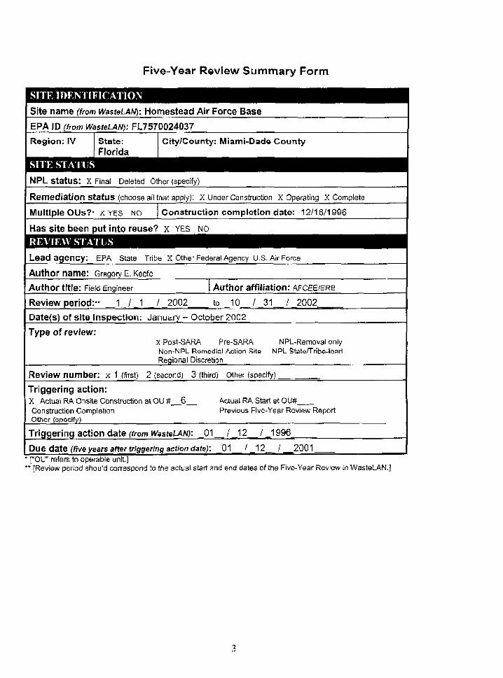
Five-Year Review Summary Form
SITE IDENTIFICATIONSite name (from WasteLAN): Homestead Air Force Base
EPA ID (from WasteLAN): FL757Q024037
Region; IV State:Florida
City/County: Miami-Dade County
NPL status: X Final Deleted Other (specify)
Remediation status (choose all that apply): X Under Construction X Operating X Complete
Multiple OUs?" X YES NO Construction completion date: 12/16/1996
Has site been put into reuse? x YES NO
REVIEW STATUSLead agency: EPA State Tribe X Other Federal Agency U.S. Air Force
Author name: Gregory E. Keefe
Author title: Field Engineer Author affiliation: AFCEE/ERB
Review period:- _ _ W 1 ..../ 2002 to 10 /_31_/_2002_
Date{s) of site inspection: January - October 2002
Type of review:x Post-SARA Pre-SARANon-NPL Remedial Action SitsRegional Discretion
NPL-Removal onlyNPL State/Tribe-lead
Review number: x 1 (first) 2 (second) 3 (third) other (specify) _
Triggering action:X Actual RA Onsite Construction at OU #_Construction CompletionOther (specify)
Actual RA Start at OU#Previous Five-Year Review Report
Triggering action date (from WasteLAN): _ 0 1 _ / _12 / _1996_
Due date (five years after triggering action date): 01 / 12 / 2001_* ["OU" refers to operable unit.]** [Review period should correspond to the actual start and end dates of the Five-Year Review in WasteLAN.]
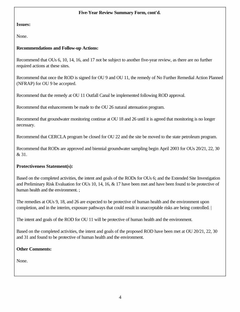
Five-Year Review Summary Form, cont'd.
Issues:
None.
Recommendations and Follow-up Actions:
Recommend that OUs 6, 10, 14, 16, and 17 not be subject to another five-year review, as there are no furtherrequired actions at these sites.
Recommend that once the ROD is signed for OU 9 and OU 11, the remedy of No Further Remedial Action Planned(NFRAP) for OU 9 be accepted.
Recommend that the remedy at OU 11 Outfall Canal be implemented following ROD approval.
Recommend that enhancements be made to the OU 26 natural attenuation program.
Recommend that groundwater monitoring continue at OU 18 and 26 until it is agreed that monitoring is no longernecessary.
Recommend that CERCLA program be closed for OU 22 and the site be moved to the state petroleum program.
Recommend that RODs are approved and biennial groundwater sampling begin April 2003 for OUs 20/21, 22, 30& 31.
Protectiveness Statement(s):
Based on the completed activities, the intent and goals of the RODs for OUs 6; and the Extended Site Investigationand Preliminary Risk Evaluation for OUs 10, 14, 16, & 17 have been met and have been found to be protective ofhuman health and the environment. ;
The remedies at OUs 9, 18, and 26 are expected to be protective of human health and the environment uponcompletion, and in the interim, exposure pathways that could result in unacceptable risks are being controlled. |
The intent and goals of the ROD for OU 11 will be protective of human health and the environment.
Based on the completed activities, the intent and goals of the proposed ROD have been met at OU 20/21, 22, 30and 31 and found to be protective of human health and the environment.
Other Comments:
None.
4
HOMESTEAD AIR FORCE BASE HOMESTEAD, FLORIDA
FIRST FIVE-YEAR REVIEW REPORT
1.0 INTRODUCTION
The purpose of five-year reviews is to determine whether the remedies at a site are protective of human health and theenvironment. The methods, findings, and conclusions of reviews are documented in five-year review reports. Inaddition, five-year review reports identify issues found during the review, if any, and recommendations to address them.
The United States Air Force is preparing this five-year review pursuant to CERCLA § 121 and the NationalContingency Plan (NCP). CERCLA § 121 states:
If the President selects a remedial action that results in any hazardous substances, pollutants, or contaminants remaining at the site, the President shall review such remedial action no less often than each five years afterthe initiation of such remedial action to assure that human health and the environment are being protected bythe remedial action being implemented. In addition, if upon such review it is the judgment of the President that action is appropriate at such site in accordance with the section [104] or [106], the President shall take or require such action. The President shall report to the Congress a list of facilities for which such review is required, the results of all such reviews, and any actions taken as a result of such reviews.
The United States Air Force interpreted this requirement further in the NCP; 40 Code of Federal Regulations (CFR) § 300.430(f)(4)(ii) states:
If a remedial action is selected that results in hazardous substances, pollutants, or contaminants remaining atthe site above levels that allow for unlimited use and unrestricted exposure, the lead agency shall review suchaction no less often than every five years after the initiation of the selected remedial action.
The United States Air Force (USAF) conducted the first five-year review of the remedial actions implemented atHomestead AFB in Homestead, Florida. This review was conducted from January 2002 through October 2002. Thereport documents the results of the review.
The triggering action for this statutory review is the initiation of a remedial action at OU 6 on January 12, 1996. Thefive-year review is required due to the fact that hazardous substances, pollutants, or contaminants remain at the siteabove levels that allow for unlimited use and unrestricted exposure. In 1994, Homestead AFB was transitioned from anactive duty base to an ARS under AFRC. Homestead AFB encompassed 2,938 acres. As a result of realignment,approximately one-third of this property has been retained for military use by AFRC. This retained property, referredto as the cantonment area, comprises Homestead ARS. The remaining property, outside the cantonment area, is beingtransitioned to civilian use by the AFRPA. It is those sites managed by the AFRPA that make up this five-year review.
The operable units to be discussed are as follows:
• OU 6 Aircraft Washrack Area (Site SS-3, former Site SP-7) • OU 9 Boundary Canal System • OU 10 Landfill (Site LF-12, former LF-1) • OU 11 Wastewater Treatment Plant, Incinerator Ash Disposal Area, and Outfall Canal (Site LF-19 & WP-23,
former D-1& D-2) • OU 14 Drum Storage Area (Site SS-26)
5
• OU 16 Hawk Missile Site/Drum Storage• OU 17 C-130 Hangar Fuel Release • OU 18 Contractor Storage Area/Construction Debris Landfill • OU 20/21 Outdoor Staging Area (Adjacent to Buildings 618 & 619)/Base Supply Hazardous Materials
Storage Facility (Building 619) • OU 22 Former Building 761 Aerospace Ground Equipment Maintenance Facility and Former Building 764
Aerospace Ground Equipment Maintenance (former AOC Units 12 & 15) • OU 26 Aircraft Fabrication Shop • OU 28 Propulsion Maintenance Facility • OU 29 Avionics/Aircraft Ground Equipment Maintenance Facility • OU 30 Contractor Storage Area, Former Building 767 • OU 31 Non-destructive Inspection Lab, Building 755
As there are many operable units to be discussed in the five-year review, each will be discussed individually, to includethe following:
Operable Unit Chronology History of Contamination Initial Response Basis for Taking Action Remedial Actions Five-Year Review Process (some portions) Technical Assessment Issues Recommendations and Follow up Actions Protectiveness Statement
An introductory section will include information that is consistent for all of the sites discussed in this Five-Year Review,and thus, will not be included in the site-specific sections of this report. Additionally, those sites that received closureprior to production of this document (OUs 6, 10, 14, 16 and 17) were not subject to data review.
1.1 SITE CHRONOLOGY
Homestead Army Air Field, a predecessor of Homestead AFB, was officially activated in September 1942, when theCaribbean Wing Headquarters took over the air field previously used by Pan American Air Ferries, Inc. The airline haddeveloped the site a few years earlier and used it primarily for pilot training. Prior to that time, the site wasundeveloped. Initially, Homestead Army Air Field served as a staging facility for the Army Transport Command, whichwas responsible for maintaining and dispatching aircraft to overseas locations. In 1943, the field mission was changedwhen the 2nd Operational Training Unit (OTU) was activated to train the transport pilots and crews.
In September 1945, a severe hurricane caused extensive damage to the air field. Both, the cost of rebuilding the fieldand the anticipated post-war reductions in military activities led to the base being placed on an inactive status inOctober 1945. The base property was turned over to the Dade County Port Authority, which retained possession of itfor the next eight years. The runways were used by crop dusters, and the buildings housed a few small industrial andcommercial operations.
In 1953, the federal government again acquired the installation and some surrounding property and rebuilt it as aStrategic Air Command (SAC) base. The first operational squadron arrived at Homestead AFB in February 1955, and
6
the base was formally reactivated in November of the same year. Except for a short period during 1960, whenmodifications were made to accommodate B-52 aircraft, the base remained an operational SAC base until 1968.
The command of Homestead AFB was changed from SAC to the Tactical Air Command (TAC) in July 1968, and the4531st Tactical Fighter Wing (TFW) became the new host unit. F-100 Cs and Ds were flown there during this time.When the 31st TFW returned from Southeast Asia in October 1970, the 4531st TFW was deactivated and the 31stTFW became the host unit for Homestead AFB, flying F-4 D and E aircrafts. In 1981, the 31stTFWwasredesignatedthe 31st Tactical Training Wing (TTW). In October 1984, the base was converted to the 31st TFW and was home toF-16 aircraft. The base was transferred to Headquarters Air Combat Command (ACC) on 1 June 1992.
On 24 August 1992, Hurricane Andrew struck south Florida, causing extensive damage and leaving approximately 97percent of base facilities dysfunctional. As a result of the destruction. Homestead AFB was recommended forrealignment by the Department of Defense Base Realignment and Closure (BRAC) Commission in 1993. The ACCdeparted the base on 31 March 1994, and one-third of the base property was transferred to AFRC, while theremaining two-thirds were transferred to the AFRPA, formerly known as the Air Force Base Conversion Agency(AFBCA). The cantonment area, retained for military use as Homestead ARS, is under the command of AFRC,Homestead ARS is hosted by the 482nd Reserve Fighter Wing and currently flies F-16 aircraft.
On 1 October 1996, responsibility for IRP sites located within the cantonment area was transferred from the AFBCAto Homestead ARS. In 2002 the AFBCA became the AFRPA and retains responsibility for managing IRP sites withinthe remaining two-thirds of the former installation property.
A historical listing of general industrial operations conducted at Homestead ARB is provided in Table I.
1.2 BACKGROUND
1.2.1 Physical Characteristics
Homestead AFB is located along the flank of the Atlantic Coastal Ridge and the Southern Coastal Slope, which aresubdivisions of the southern distal zone of the Atlantic Coastal Plain physiographic province. The surface topography atthe base is relatively flat, with elevations ranging from 2 feet above mean sea level (ft-MSL) to 10 ft MSL.
The prevailing weather pattern at Homestead AFB is typical of subtropical climates. The average annual temperature is74/ F, with approximately 37 days reaching temperatures above 90/ F. The mean annual precipitation is approximately58 inches, with 70 percent of the rainfall occurring between May and October.
Surface soils at Homestead AFB are typically less than 6 inches thick and consist of native marl, weathered limestonebedrock, or imported fill. The uppermost lithologic unit at the base contains 15 to 20 feet of oolitic and bryozoanlimestone facies of the Miami Oolite, consisting of soft, cream or tan limestone, interbedded with sandy limestone, andthin layers of hard limestone. The underlying Fort Thompson Formation contains 50 feet of alternating shallow marine,brackish marine, and freshwater limestone consisting of white and tan to gray calcareous sandstone and sandy limestonewith some quartz sand. Both of the formations are highly permeable and are the principal components of the BiscayneAquifer. Underlying the Fort Thompson Formation is the Tamiami Formation consisting of clayey, calcareous marl, siltyshelly sands, and limestone, and the Hawthorn Formation consisting of green dolosilt to quartz sand.
The water table occurs at depths ranging from 0 to 5 ft below ground surface. Although the general direction ofgroundwater flow, within the shallow aquifer beneath Homestead AFB, is southeasterly toward Biscayne Bay, thehydraulic gradients throughout the base are very flat. As a result, local flow directions are strongly influenced by rainfall
7
and the presence of the drainage canal along the base boundary (boundary canal). The surficial aquifer, the Biscayne, isthe sole source of potable water in Miami-Dade County, and has been declared a sole-source aquifer by the USEPA,pursuant to Section 1425 of the Safe Drinking Water Act.
1.2.2 Land and Resource Use
Homestead AFB is located in southeastern Miami-Dade County near the southern tip of peninsular Florida (Figure 1).Homestead AFB is located along U.S. Highway 1 approximately 25 miles southwest of Miami, 7 miles east ofHomestead, and 2 miles west of Biscayne Bay. The former military installation covered 2,938 acres, and approximatelyone-third of the original base comprises the cantonment area, which has been retained for military use by AFRC asHomestead ARB. The base is bordered on the west and south by agricultural land, and to the north, east, and west byresidential and agricultural lands (Figure 2).
1.2.3 History of Contamination
The IRP at Homestead AFB was initiated in 1983 with a Phase I Records Search to identify potential IRP sites andAOCs at the base. On 30 August 1990, Homestead AFB was placed on the National Priorities List (NPL), whichbrought it under the federal facility provisions of Section 120 of CERCLA. This action required the Air Force to enterinto a Federal Facilities Agreement (FFA) with the USEPA Region IV and the FDEP.
The realignment process at the installation has not adversely affected the progression of the IRP. Environmentalactivities Within the cantonment area are administered by the AFRC in conjunction with AFRPA's operations outsidethe cantonment area. There have been 1S IRP sites identified within the cantonment area currently managed byHomestead ARS, and 20 IRP sites identified outside the cantonment area which are managed by AFRPA.
IRP studies, investigations, remedial designs (RDs), and RAs have been performed at Homestead AFB. Key regulatorydates/actions for IRP activities conducted at the base are as follows:
• In August 1983, Homestead AFB initiated a Phase I Records Search to identify IRP sites and AOCs.The Phase I Records Search document, prepared by Engineering Science, identified 13 locations ashaving the potential for environmental contamination.
• In March 1986, a Phase II-Confirmation/Quantification IRP report was prepared by ScienceApplications International Corporation to quantify the extent and degree of contamination at the 13sites.
• In September 1987, Geraghty & Miller, Inc., was retained by the U.S. Army Corps of Engineers(USACE) to conduct Phase IV IRP RIs at OUs I through 9. The objectives of the RI were todetermine the horizontal and vertical extent of subsurface constituents at each Possible Source ofContamination (PSC), and determine the risks to public health and the environment. RIs wereconducted according to CERCLA guidelines for each PSC.
• On 5 January 1990, a permit was issued to Homestead AFB under the Resource Conservation andRecovery Act (RCRA) as amended by the Hazardous and Solid Waste Amendments (HSWA) of1984. The permit listed 21 Solid Waste Management Units (SWMUs), required that RCRA FacilityInvestigations (RFIs) be performed at eight of the 21 SWMUs, and required further assessment of oneof the 21 SWMUs. Each of the eight sites requiring RFIs have been investigated under the IRP,pursuant to Executive Order 12580. and in accordance with RCRA guidelines.
8
• In accordance with Section 120(d)(2) of the Superfund Amendments and Reauthorization Act (SARA)of 1986, the USEPA prepared a final Hazard Ranking System (HRS) scoring package. As a result ofthe HRS score, the facility was proposed for inclusion on the NPL on 14 July 1989.
• As a result of the proposed placement on the NPL, USEPA Region IV, State of Florida, and the AirForce entered into an FFA for Homestead AFB on 25 May 1990 (see Attachment A).
• On 30 August 1990, the base installation was officially added to the NPL.
• In January 1991, the base entered into a Consent Agreement with FDEP making it subject to therequirements of Florida Administration Code (FAC) 62-770, governing discharges of petroleumproducts to the environment.
• On 24 August 1992, Hurricane Andrew struck south Florida, destroying 97 percent of HomesteadAFB capabilities. The base was subsequently slated for realignment in 1993. This listing resulted in theIRP being subject to the requirements of the Community Environmental Response Facilitation Act,accelerating the CERCLA process. The listing also resulted in the establishment of an operating locationof the AFRPA on site. The AFRPA is responsible for the cleanup and transition oi base propertytargeted for civilian use. The AFRPA maintained complete responsibility for the IRP until late 1995,when a USAF funding policy mandated that AFRC manage the sites within the cantonment area.
• In 1993 Montgomery Watson was retained by the USACE to perform data gap completion on nineCERCLA sites within the cantonment area, and ten potential sources of contamination.
• In April 1993, a second RFI was conducted to evaluate possible releases resulting from HurricaneAndrew. Sixty-eight SWMUs were identified.
• In 1994, upon the departure of ACC from Homestead AFB, the installation was transitioned to AFRC.Homestead ARS encompasses approximately one-third of the installation's former property holdings
• In 1994, through an AFBCA initiative, Woodward-Clyde was retained by the USACE to conductconfirmation sampling at 38 of the SWMUs identified in the 1993 RCRA Facility Assessment.
• In October 1996, administration of the IRP within the cantonment area was transferred from AFBCAto AFRC.
1.3 Five-Year Review Process
1.3.1 Administrative Components
Members of the BRAC Cleanup Team (BCT) and the Restoration Advisory Board (RAB) wore notified of theinitiation of the five-year review during BCT and RAB meetings held March 19, 2002. Members of the BCT wereinformed that inspections of the CERCLA sites were to be conducted and were invited to participate. The HomesteadAir Force Base Five-Year Review team was lead by Mr. Gregory Keefe, AFCEE Field Engineer.
1.3.2 Community Involvement
The Air Force has a public participation program at Homestead AFB to promote public understanding of the cleanup
9
process and its results, and to ensure that the community's concerns are solicited, considered, and thoroughlyaddressed. The backbone of this program is the Community Relations Plan, which assesses the public's level ofknowledge, interest, and information needs by conducting community interviews and researching local social,demographic, economic, and political information. The Community Relations Plan recommended compatible publicinvolvement strategies that included a RAB, newsletters and fact sheets, an Information Repository, and public meetingsat project milestones.
RABs are a joint creation of the Department of Defense and the USEPA and are a vehicle for community input duringenvironmental restoration. A RAB was formed for Homestead AFB in October 1993 and meets routinely. Communitymembers of the RAB exchange information and discuss restoration issues with the BCT which includes representativesfrom the USAF, USEPA, and the FDEP. Currently, there are seven community members on the Homestead AFBRAB.
RAB meetings provide opportunities for direct public participation. Presentation topics include current investigations,results, plans for the environmental restoration program, and current issues and decisions facing the BCT. All RABmeetings are open to the public and include a public comment period for the audience members to ask questions andexpress opinions and/or concerns.
Newsletters and fact sheets are developed to update community members on the current issues and environmentalinvestigation and/or remediation activities. Newsletters are published four times a year and fact sheets are publishedwhen needed to provide more detail on specific activities and at major milestones in the environmental restorationprocess at Homestead AFB.
The public has access to current and historical information regarding environmental restoration activities at HomesteadAFB through the Information Repository located at the library of the Miami-Dade Community College, HomesteadCampus, Included in the repository are technical documents such as investigation and remedial action reports, workplans, and RAB meeting minutes and handouts.
The USAF has kept the public informed of and involved in the decision making process for the five-year review through the RAB.
1.3.3 Interviews
As all of the sites listed in this report are closed, in long term monitoring or undergoing remediation, no interviews wereconducted.
10
2.0 OPERABLE UNIT 6
2.1 HISTORY OF CONTAMINATION
OU6 is the Aircraft Washrack Area, Site SS-3 (former Site SP-7) located in the central portion of the base,approximately 720 feet north of the former Building 720 (Figure 3). The site covers an area approximately three acresin size and has dimensions of 320 feet by 400 fuel. The site is bordered on the northwest by a drainage ditch (parallel toBikini Boulevard), on the southwest by a low grassy swale, on the northeast by a ditch, and on the southeast by asphaltflight apron. Prior to Hurricane Andrew, the site consisted of a covered, concrete and asphalt aircraft washrackstructure, a utility building and Building 723 Due to damage experienced during the hurricane, the cover and frame ofthe washrack are no longer present. The area surrounding the washrack is covered with grass. Approximately 35percent of the site is covered with asphalt and/or concrete.
Two aboveground storage tanks (ASTs) with capacities of 750 and 1,500 gallons were used to store waste oils,hydraulic fluids, spent solvents, and other liquid wastes from the flightline shops. The tanks were located in the westernportion of the site, During storage and removal operations, frequent spills and overflows onto the ground occurred.Dumping of liquid wastes in the area were also reported. Once liquid waste disposal operations were halted, the tankswere removed for off-site disposal in 1980. Soils in the former tank area, which were reportedly discolored at the timeof the tank removal, have either been removed or covered, leaving no visible evidence of waste residue.
A list of important OU 6 Aircraft Washrack Area (Site SS-3, former Site SP-7) historical events and relevant dates inthe site chronology is shown below. The identified events are illustrative, not comprehensive.
Event Date
OU 6 Aircraft Washrack Operation 1970 to 1980
ASTs Removed 1980
Initial Site Investigation 1986
Additional Investigations 1987
RI/FS (FS) 1990, 1991 and 1993
ROD 1995
ROD Amendment 1997
ROD Implementation 1996
Groundwater Monitoring 1997-1998
Site Closure 1999
2.2 INITIAL RESPONSE AND BASIS FOR TAKING ACTION
An IRP Phase I - Records Search was conducted in 1983 and the Aircraft Washrack was determined to havemoderate to high contamination potential. Thus the site was recommended for the IRP Phase II - Confirmation/Quantification. Three shallow monitoring wells were installed on the site during this phase (1986). Floating non-aqueousphase liquid (NAPL) was found in one well. Although the extent of the contamination was not determined, this Phase II
11
investigation indicated that contamination at the site was attributable to oil and grease and elevated total organic carbon(TOC).
In 1987, the IRP Phase IV - Additional Investigations was conducted in order to determine the lateral extent of thecontamination. Based upon the results of this investigation, a RI was conducted in 1990 and 1991, with additionalinvestigation activities conducted in 1993.
Results of these investigations revealed the following:
Soils Contaminants detected in OU 6 soils include VOCs, BNAs, pesticides and metals. The VOCs detected (acetone andmethyl ethyl keytone) are both common laboratory contaminants; the acetone is thought to be related to thedecontamination process. BNAs, primarily polynuclear aromatic hydrocarbons (PAHs), were detected in shallow soilsand at depths up to 6 feet bls. Dichlorodiphenyltrichloroethane (DDT) metabolites were detected in shallow soils. Themetal arsenic was identified above background.
Groundwater Groundwater contaminants consist of VOCs, primarily benzene, toluene, ethylbenzene, and xylenes (BTEX), and theBNA compounds (naphthalenes, bis[2-ethylhexyl] phthalate and fluorine). Light nonaqueous-phase liquid (LNAPL)was also detected in one monitoring well.
Based on the results of the remedial investigation/baseline risk assessment (RI/BRA), the site moved on to the FS andProposed Plan phases of the CERCLA process.
2.3 REMEDIAL ACTIONS
2.3.1 Remedy Selection
The ROD for this OU was signed in 1995. The alternative selected was:
Alternative 4: Excavation and Off-Site Thermal Treatment Disposal of Contaminated Soils, and NaturalAttenuation and Institutional Controls of Groundwater
The alternative consists of: • Institutional Controls to restrict the placement of potable wells in the contaminated groundwater near or down
gradient of the site until such time as the protectiveness of the groundwater is reached. It is estimated thatprotectiveness will be reached within a 5-year period.
• Excavation of soil/rock to meet performance standards, approximately 2,100 cubic yards and replacement withan equal volume of fill material.
• Off-site thermal treatment and disposal of excavated soil. • LNAPL recovery during soil excavation using a skimmer pump. • Sending LNAPL to off-site disposal through energy recovery. • Disposal of water collected during excavation at a publicly-owned treatment works which meets the required
Standards, if Water does not meet performance standards, treatment will need to occur before disposal. • Groundwater monitoring with five-year site review until contaminants are at levels considered protective of
human health and the environment.
A ROD Amendment was signed in 1997. The amended remedy addresses revised waste volumes, revisions to thewaste management approach, and revised costs associated with the above revisions.
12

2.3.2 Remedy Implementation
OHM Remediation Services Corporation began remedial action activities January 8, 1996 with the abandonment offour groundwater monitoring wells. Between January 12,1996 and December 16, 1996, approximately 3,450 cubicyards of contaminated soil/limestone were excavated and removed. Approximately 4,635 tons of contaminatedsoil/limestone were transported off-site and disposed at a CERCLA approved, RCRA Subtitle D landfill facility.
Throughout the excavation activities, limited areas of LNAPL were primarily observed in areas of solution cavitieswithin the soil/limestone. A total of fifteen 55-gallon drums of used LNAPL absorbent material was generated duringLNAPL recovery. Approximately 30 gallons of a LNAPL/wastewater was generated during consolidation of these 15drums. In addition, approximately 2,225 gallons of wastewater was generated during equipment decontaminationactivities. The used LNAPL absorbent material was transported off-site and disposed of at CERCLA approved,RCRA Subtitle C and D landfill facilities. The wastewater and LNAPL/wastewater mixture was transported off-siteand disposed of at an FDEP-approved industrial wastewater treatment facility.
Nine random confirmation soil/limestone samples were collected from the finished sidewalls of the excavation inaccordance with the amended RA work plan. Concentrations of detected VOCs and semivolatile organic compounds(SVOCs) were below the applicable FDEP Soil Cleanup Goals (industrial scenario) and Homestead AFB-specificstandards established by the BCT. Total petroleum hydrocarbons (TPH) were not detected above the practicalquantification limit (PQL) in the nine confirmation soil/limestone samples.
2.3.3 System Operations/Operation and Maintenance
OHM Remediation Services Corporation conducted semiannual groundwater monitoring in 1997 and 1998. Resultsfrom all four sampling events indicated that no analytes exceeded the standards defined by FAC Chapter 62-550Primary Drinking Water Standards Maximum Contaminant Levels, FAC Chapter 62-770 Petroleum ContaminationCleanup Criteria, and the USEPA National Primary Drinking Water Standards. Based on these results, the Air Forcerecommended and received unrestricted No Further Action for the site (FDEP letter dated December 9, 1998;Miami-Dade County Department of Environmental Resources Management [DERM] letter dated March 15, 1999;and USEPA letter dated June 3, 1999).
2.4 FIVE-YEAR REVIEW PROCESS
2.4.1 Document Review
This five-year review consisted of a review of relevant documents including operations and maintenance records andmonitoring data. Applicable groundwater cleanup standards were reviewed.
2.4.2 Data Review
Groundwater Monitoring OHM Remediation Services Corporation conducted semiannual groundwater monitoring in 1997 and 1998. Resultsfrom all four sampling events indicated that no analytes exceeded the standards defined by FAC Chapter 62-50Primary Drinking Water Standards Maximum Contaminant Levels, FAC Chapter 62-770 Petroleum ContaminationCleanup Criteria and the USEPA National Primary Drinking Water Standards. Based on these results, the Air Forcerecommended and received unrestricted No Further Action tor the site (FDEP letter dated December 9, 1998; DERMletter dated March 15, 1999; and USEPA letter dated June 3,1999).
13
2.4.3 Site Inspection
AFRPA conducted a site visit as part of this five-year review process. The site visit consisted of a visual inspection ofthe OU 6 area, Several monitoring wells were found to be on the site, and were subsequently abandoned in place inNovember 2002. No other unusual observations were documented during this visit.
2.5 TECHNICAL ASSESSMENT
Not applicable.
2.6 ISSUES
There are no issues at this site.
2.7 RECOMMENDATIONS AND FOLLOW UP ACTIONS
As OU 6 has received unrestricted No Further Action (FDRP letter dated December 9, 1998, DERM letter dated March 15, 1999; and USEPA letter dated June 3, 1999), there are no further required actions. Thus, OU 6 will not besubject to another five-year review.
2.8 PROTECTIVENESS STATEMENT
Based on the completed activities, the intent and goals of the ROD for OU 6 have been met and have been found to beprotective of human health and the environment.
2.9 NEXT REVIEW
As this OU has received closure, the site will not be included in the next five-year review.
14
3.0 OPERABLE UNIT 9
3.1 HISTORY OF CONTAMINATION
The Boundary Canal system at Homestead AFB is shown in Figure 4. This system includes the Boundary Canal, theflightline canal, associated drainage canals, and the stormwater reservoir. The Boundary Canal is approximately 8 milesin length. A control structure (pumphouse) separates the stormwater reservoir from the Outfall Canal (OU 31). TheBoundary Canal is composed of two major segments, the West-South segment and the North-East segment. A dike ispresent along the outside bank of the Boundary Canal to minimize off-base runoff from entering the canal. The segmentsof the Boundary Canal lead to the reservoir at the southeast corner of the base.
West-South Boundary Canal Segment
The West-South Boundary Canal segment begins in the northwestern corner of the base at Biscayne Drive (S.W.288th Street). It flows south and then turns west at the Ordnance Storage Area past Phantom Lake. The segment flowsalong the west and south perimeters of the base and leads to the Stormwater Reservoir at its western edge. The totallength of the West-South Boundary Canal segment is approximately 25,800 feet (4.9 miles).
The width of the West-South Boundary Canal varies from less than 10 feet wide near its origin at Biscayne Drive andgenerally widens downstream to over 40 feet. Total depth of the West-South Boundary Canal segment ranges from 4to 6 feet, while water depth ranges from 2 to 5 feet with the greatest depths occurring after precipitation events.
The bottom of the West-South Boundary Canal segment has significant plant cover. Vegetation has been observed tocover 75 to 100 percent of the sediment bed.
North-East Boundary Canal Segment
The North-East Boundary Canal segment begins at the north end of the base south of the former golf course at S.W.280th Street (Walden Drive). It flows east past Mystic Lake and along the north and east perimeters of the base. TheNorth-East Boundary Canal segment leads to the Stormwater Reservoir in its northeast corner. The total length Of theNorth-East Boundary Canal segment is approximately 15,400 feet (2.9 miles).
The width of the North-East Boundary Canal segment ranges from 5 feet at the upper reaches (in urbanized areas) to20 to 35 feet in other areas. Total depth of the canal ranges from 4 to 6 feet; water depth generally ranges from 3 to 6feet, with the greatest water depths occurring after precipitation events.
The bottom of the North-East Boundary Canal segment has significant plant cover. Vegetation has been observed tocover 75 to 100 percent of the sediment bed.
Flightline Canal and Other Drainage Canals
The primary Flightline Canal generally runs parallel to and is located southeast of the base flightline. Secondary drainagecanals connect the primary Flightline canal with the parallel canal north of the flightline and run beneath the flightline. Theprimary Flightline Canal leads into the West-South Boundary Canal segment at a point approximately 1,000 feet westof the reservoir. The primary Flightline Canal is approximately 19,400 feet long (3.7 miles) and the secondary canal isapproximately 4,200 feet long (0.8 miles). Its width ranges from 20 to 30 feet and is generally consistent throughout itslength Total canal depth ranges from 3 to 6 feet while water depth ranges from 2 to 6 feet. The flightline canal hassignificant plant cover.
15
Several canals receive stormwater runoff from other areas of the base. The system that drains the eastern portions ofthe base includes three canals that run parallel to Bikini and St. Lo Boulevards. One canal is located just north of St. LoBoulevard, one is located between St. Lo and Bikini Boulevards and one is located just south of Bikini Boulevard.These canals converge along Schweinfurt Road and lead to the North-East segment of the Boundary Canal. The totallength of these drainage canals is approximately 12,800 feet (2.4 miles).
A drainage canal is also located on the western edge of the base. This canal begins along Westover Road and runs tothe northwest, bends to the west, and connects to the West-South segment of the Boundary Canal. This canal isapproximately 2,200 feet long (0.4 miles).
In addition to the primary and secondary Flightline Canals described, a drainage canal is also located near thesouthwest end of the flightline and taxi way. This canal runs southwest past the Ordnance Storage Area and enters theWest-South segment of the Boundary Canal just southwest of the runway. It is approximately 3,800 feet long (0.7miles).
The widths of these drainage canals range from 5 to 20 feet. Total canal depths range from 3 to 5 feet, while waterdepths are highly variable and range from less than one foot to 5 feet.
The east and west drainage canals are very highly vegetated by cattails and ferns, which cover virtually all of thesediment bed in these canals. In many locations, cattails extend above the top of the canal banks. Where cattails are notpresent, the canal bed is covered by algae and/or ferns.
Stormwater Reservoir
The Stormwater Reservoir is located on the east side of the base at the convergence of the West-South andNorth-East segments of the Boundary Canal. The reservoir is approximately 300 feet wide and 900 feet long andtypical depths range from 10 to 20 feet. A control structure (pumphouse) is located at the eastern edge of the reservoir.This control structure discharges water into the Outfall Canal from the reservoir when the water level of the basereaches above a critical level
A list of important OU 9 Boundary Canal System historical events and relevant dates in the site chronology is shownbelow. The identified events are illustrative, not comprehensive.
Event Date
Initial Site Investigation 1991 & 1992
Designated OU 1993
RI/BRA 1995
ROD Submitted 1997
ROD Rescinded 2001
3.2 INITIAL RESPONSE AND BASIS FOR TAKING ACTION
In 1991 and 1992, sediment and surface water samples were collected at 18 locations from the Boundary Canal.SVOCs, metals, and pesticides were reported in the 18 sediment samples. In 1995 a RI/BRA was implemented to
16
determine the nature and extent of contamination, evaluate the fate and transport of contamination, and assess the risksto human health and the environment. The results of this study indicated that there were no unacceptable human healthrisks or ecological risks posed by OU 9.
Voluntary custodial actions (VCAs) were completed in the drainage swales, ditches, and canals associated with theformer oil/water separator (OWS) Numbers 792, 795, 779, 4787, and 723 (OU 6); OU 4 (located on the AFRCportion of the former base); and OU 5 (same as OU 4). Each of the former OWSs discharged directly to the drainageswale or canal. The areas of the discharge were sampled during the closure of each OWS. Results from these samplesexceeded site-specific or FDEP soil cleanup goals for various target analytes. Rased on exceedances of the goals,VCAs were performed at the request of the FDEP and DERM to remove the soil and/or sediment from the areas.After the excavation of materials, confirmation sampling of the excavation sidewall and floors was conducted to verifythat this contamination had been removed.
In addition to the VCAs, general housekeeping activities were conducted in the Boundary Canal by Miami-DadeCounty Aviation Department (MDAD) in 1995 to remove debris material associated with Hurricane Andrew,vegetative overgrowth, and associated materials.
Based on the results of the RI/BRA, this site was recommended to move to the ROD stage of the CERCLA process.
3.3 REMEDIAL ACTIONS
3.3.1 Remedy Selection
A No Remedial Action response or No Further Action has been selected for OU 9 based on the evaluation of theextensive data collected during the RI. These data and supporting studies indicate that the sediment and surface water inthe Boundary Canal do not pose an unacceptable risk to human health or the environment. However, during the courseof the OU 11 investigation, the Air Force voluntarily rescinded the OU 9 ROD to accomplish the following:
• Develop a basewide screening ecological risk assessment (SERA) of OU 9/OU 11; and
• Incorporate portions of the OU 9 reservoir into the development of appropriate remedial alternatives at OU 11.
By taking these actions, OU 9 will be recommended for NFRAP and has been presented in the ROD for the aquaticportion of OU 11 (the Outfall Canal).
3.3.2 Remedy Implementation
Not applicable.
3.3.3 System Operations/Operation and Maintenance
Not applicable.
3.4 FIVE-YEAR REVIEW PROCESS
3.4.1 Document Review
This five-year review consisted of a review of relevant documents including monitoring data. Applicable sediment andsurface water cleanup standards were reviewed.
17
3.4.2 Data Review
Not applicable.
3.4.3 Site Inspection
AFRPA conducted a site visit as part of this five-year review process. The site visit consisted of a visual inspection ofthe OU 9 area. No unusual observations were documented during this visit.
3.5 TECHNICAL ASSESSMENT
Not applicable.
3.6 ISSUES
Not applicable.
3.7 RECOMMENDATIONS AND FOLLOW-UP ACTIONS
The remedy of No Further Remedial Action Planned will be recommended in the ROD for OU 9 for regulatoryconcurrence.
3.8 PROTECTIVENESS STATEMENT
The remedy at OU 9 is expected to be protective of human health and the environment upon completion, and in theinterim, exposure pathways that could result in unacceptable risks are being controlled.
3.9 NEXT REVIEW
The next five-year review for OU 9 is required by December 2007, five years from the date of this review.
18
4.0 OPERABLE UNIT 10
4.1 HISTORY OF CONTAMINATION
This site (Site LF-12/OU 10. formerly LF-1) was a former landfill for general refuse generated on base. It is located inthe southern portion of the base, near the base boundary, in the undeveloped marshlands between the existing runwayand the Boundary Canal (Figure 5). The site is approximately 750 feet by 2000 feet and includes two small lakes.
Pan American Air Ferries, Inc. operated the site as an open dump prior to government acquisition of the area in 1943.In 1943. operation of this area was changed to cut and fill procedures wherein the top two feet of soil were removed,then refuse was spread out and covered with soil. General refuse was reportedly disposed and no burning of waste wasconducted at the site.
Operation of the landfill continued until 1946 when the base was destroyed by a hurricane, Some additional waste mayhave been deposited in the area between 1946 and 1 955. When the base was reactivated in 1955, newly generatedrefuse was taken off-site for disposal.
A list of important OU 10 Landfill Area (Site LF-12, formerly LF-1) historical events and relevant dates in the sitechronology is shown below. The identified events are illustrative, not comprehensive.
Event Date
Operation as AF Landfill 1943-1955
Initial Site Investigations 1983
Preliminary Assessment/Site Inspection (PA/SI) 1993, 1995
Extended Site Investigation/Preliminary Risk Evaluation 1996
Site Closure 1997
4.2 INITIAL RESPONSE AND BASIS FOR TAKING ACTION
The initial investigation performed at the site was Phase I of the ERP and was completed in August 1983. The sitereceived a low Hazard Assessment Rating Methodology score. Therefore, the IRP Phase I Records Search Reportconcluded that further investigative activities were not warranted.
In 1990 a Draft Decision Document concluded that OU 10 posed no significant threat to public health or theenvironment and recommended a No Further Action alternative. Subsequent review by the USEPA producedcomments requiring site sampling and analysis to further evaluate impacts of the previous disposal activities.
In 1993 a PA/SI was conducted. Exceedences of PAHs and metals were discovered. Based on these findings,additional groundwater and soil sampling as a part of the Confirmation Sampling Program was recommended. Resultsindicated that no contaminants exceeded remedial goals (RGs) in the soil and only antimony and manganese weredetected in the groundwater.
4.3 REMEDIAL ACTIONS
4.3.1 Remedy Selection 19
Based on the results of the 1993 and 1995 sampling activities and the findings of the preliminary risk evaluation. NoFurther Investigation was recommended and accepted for OU 10 in 1997.
4.3.2 Remedy Implementation
Not applicable.
4.3.3 System Operations/Operation and Maintenance
Not applicable.
4.4 FIVE-YEAR REVIEW
4.4.1 Document Review
This five-year review consisted of a review of relevant documents including monitoring data. Applicable groundwaterand soil standards were reviewed.
4.4.2 Data Review Not applicable.
4.4.3 Site Inspection
AFRPA conducted a site visit as part of this five-year review process. The site visit consisted of a visual inspection ofthe OU 10 area. Several monitoring wells were observed and subsequently abandoned in place in October 2002. Noother observations were documented during this visit.
4.5 TECHNICAL ASSESSMENT
Not applicable.
4.6 ISSUES
Not applicable.
4.7 RECOMMENDATIONS AND FOLLOW-UP ACTIONS
OU 10 received NFRAP concurrence from the USEPA on September 24, 1997; therefore, there are no furtherrequired actions. Thus OU 10 will not be subject to another five-year review.
4.8 PROTECTIVENESS STATEMENT
Based on the completed activities, the intent and goals of the Extended Site Investigation and Preliminary RiskEvaluation have been met at OU 10 and found to be protective of human health and the environment.
4.9 NEXT REVIEW
As this OU has received closure, the site will not be included in the next five-year review. 20
5.0 OPERABLE UNIT 11
5.1 HISTORY OF CONTAMINATION
OU 11 includes the former Ash Incinerator/Sewage Treatment Plant Disposal Area (Sites WP-23 and LF-19, formerlyD-l and D-2, also known as the "terrestrial sites") and the Outfall Canal. The terrestrial sites (the AshIncinerator/Sewage Treatment Plant Disposal Area) are located in the southeastern comer of the base near the propertyboundary (Figure 6). These sites comprise an area of approximately 3.5 acres and are bordered on the east, south andwest by agricultural fields and to the north by the Boundary Canal Reservoir and pumphouse. The Outfall Canal portionof this operable unit extends from the stormwater reservoir approximately two miles east to Biscayne Bay (Figure 4).Outfall Canal is man-made and was designed to reduce surface flooding of Homestead AFB.
The incinerator was operated at the base from the mid-1950s to the late 1950s, or possibly the early 1960s, afterwhich it remained idle until it was dismantled in the late 1970s. The incinerator was constructed at the sewage treatmentplant for the incineration of solid wastes generated at the base. Ash from the incinerator was reportedly disposed ofalong the eastern boundary of the site,
The sewage treatment process utilized primary clarification, trickling filters, secondary clarification, anaerobic sludgedigestion, and sludge drying beds. The plant treated all domestic and industrial wastewater generated on the base fromthe 1950s to early 1983. The plant was taken out of service and demolished by base personnel in 1983, The sludgefrom the drying beds was reportedly spread on the ground surrounding the treatment plant. Wastewater from the baseis currently discharged to a regional wastewater treatment system.
The Outfall Canal had previously been a part of the OU 9 Boundary Canal site, but was removed for further evaluationas part of OU 11 (as requested by the BCT).
A list of important OU 11 historical events and relevant dates in the site chronology is shown below. The identifiedevents are illustrative, not comprehensive.
Event Date
Operation as AF Wastewater Treatment Plant 1950s-1983
Operation of AF Ash Incinerator 1950s-1960s
Initial Site Investigations 1983
Decision Document 1990
PA/SI 1993, 1995
Extended Site Investigation/Preliminary Risk Evaluation 1996
RI/BRA 1998
Interim Remedial Action - Terrestrial Sites 1999
Focused FS - Outfall Canal 2001
Proposed Plan 2001
ROD 2002
21
5.2 INITIAL RESPONSE AND BASIS FOR TAKING ACTION
The initial investigation performed for LF-19 and WP-23 (OU 11) was Phase I of the IRP. IRP Phase I activities werecompleted in August 1983 and were limited to a historical records search and interviews with Base personnel. ThePhase I Report concluded that these sites had a low potential for contaminant migration and that further investigativeactivities were not warranted.
Draft Decision Documents developed in 1990 concluded that the OU 11 posed no significant threat to public health orthe environment and concluded that the No Further Action alternative was appropriate. However, review by USEPAproduced comments requiring sampling and analysis at these sites to further evaluate impacts from previous operations.
In 1993 a Preliminary Assessment/Site Investigation was conducted at the site. Soil and groundwater samples weretaken and analyzed. Arsenic and lead were found in the soil; arsenic, manganese and iron were discovered in thegroundwater.
Based upon the detection of potential contaminants of concern, additional soil and groundwater sampling as part of theConfirmation Sampling Program was recommended. In addition, sediment and surface water samples were collectedfrom the discharge line into Outfall Canal. A Risk Evaluation was then conducted. A review of the data indicated thatcompounds in exceedence of industrial and residential Risk-Based Concentrations (RBCs) in soil included benzo(a)pyrene, benzo(b) fluoranthene, dibenzo(a, h) anthracene, 4,4-DDT, chlordane, antimony, arsenic and beryllium.Exceedences of the above-referenced RBCs in groundwater included 1,2-dichloroethene, tetrachloroethene, arsenicand beryllium. No compounds detected in surface water exceeded the screening criteria; however, compoundsexceeding the screening criteria for sediments included chlordane, 4,4-DDE and 4,4-DDT.
These findings were then compared with the federal, state and local risk-based guidance. Only arsenic and lead werefound to be in exceedence of these benchmarks in soil: arsenic and lead exceeded in groundwater. Chlordane,4,4-DDE and 4,4-DDT exceeded the sediment screening benchmarks and it was stated that, due to the ecologicalsignificance of the presence of these compounds, further evaluation might be necessary. Thus, the site wasrecommended to proceed to the RI/FS stage of CERCLA.
In 1999, Interim Remedial Actions (IRAs) were conducted on the terrestrial portions of OU 11. The IRA consisted ofremoval and disposal of approximately 320 tons of contaminated soil/limestone from four areas of concern at the site(Excavation Areas 1-4, Figure 7). The contaminants of concern were arsenic and lead. Regulatory responses to thepost-IRA Report (Final ROD Implementation Report for OUs 26, 28, 29 and IRAs) stated that "No additionalexcavation work is warranted on the land portion of this OU. However, I recommend that the BCT delay any action atthis OU until the issue of the Outfall Canal is resolved." (FDEP letter December 13, 2000, Jorge Caspary).
In 2000, a Final RI/BRA Report was prepared for OU 11. The Purpose of the RI/BRA Report was to further evaluatethe nature and extent of contaminants present at the site, to perform fate and transport modeling, and evaluate thepotential risks to human health and the environment.
Based on the findings of the RI/BRA investigations, there does not appear to be significant impact to the soil orgroundwater at the Ash Incinerator/Sewage Treatment Plant Disposal Area. Groundwater exceeded acceptable risklevels due primarily to arsenic concentrations. However, the likely source area of the arsenic contamination waseliminated during the 1999 IRA.
The SERA indicated a potential risk to sensitive ecological receptors in the Outfall Canal and Biscayne National Parkdue to concentrations detected in canal sediments. Surface water results did not indicate significant impacts to the
22
Outfall Canal. Risks to current and potential future receptors to soils at the Sewage Treatment Plant were withinUSEPA acceptable levels. Impacts to the Outfall Canal as a result of past operations, as determined in the BaselineHuman Health Risk Assessment, did not include significant levels of contaminants that would adversely affect humanreceptors.
Based on the results of the SERA and concurrence by the BCT, a focused FS was recommended to address thepotential risks to sensitive ecological receptors exposed to canal sediment. Additionally, the focused FS addressed thereduction of future transport of sediment from OU 9, primarily the stormwater reservoir into the Outfall Canal. Thefocused FS also addressed the closure of the open manholes and conduits located at the former sewage treatmentplant. Also at this time it was determined by the BCT, that only the Outfall Canal portion of OU 11 would be pursuedto the ROD phase. The terrestrial portions of OU 11 (the former Ash Incinerator/Sewage Treatment Plant DisposalArea) would be handled under a separate ROD once land use control issues were resolved. It was also decided thatthe final action for OU 9 would be considered in the ROD for the Outfall Canal.
A Proposed Plan and subsequently a draft ROD were developed for the site.
5.3 REMEDIAL ACTIONS
5.3.1 Remedy Selection
The selected alternative per the draft ROD is:
Alternative 3: OU 9 Sediment Transport Control Structure, Support of DERM's Pilot Wetland Project andTotal Encapsulation of the Outfall Canal
The details of this alternative, as per the Proposed Plan, are as follows:
• Placing a sediment control structure in the reservoir before stormwater enters the Outfall Canal to eliminatefuture transport of contaminated sediment into the canal.
• Encapsulating contaminated sediment in the Outfall Canal to prevent migration to Biscayne National Park andprotect the marine and fresh water environment from potential ecological risks.
In addition to the RAs. the Air Force proposes to support a DERM pilot wetland project planned for constructionadjacent lo the Outfall Canal. The support will be provided in the form of reimbursement for the following tasks, not toexceed $800,000:
• Purchase and install submersible pumps • Provide necessary power to the site to operate the pump system • Construct and install pump well housing • Install intake box with manatee exclusion grate/trash rack • Install two discharge culverts with stabilizer headwall • Construct a fill pad for pump station • Construct a culvert connecting the pilot project with the L31 Canal
Additionally, during the course of the OU 11 investigation, the Air Force voluntarily rescinded the OU 9 ROD toaccomplish the following:
• Develop a basewide SERA of OU 9/OU 11 23
• Incorporate portions of the OU 9 reservoir into the development of appropriate remedial alternatives at OU 11
By taking these actions. OU 9 has been recommended for NFRAP.
5.3.2 Remedy Implementation
Field work to commence December 2002 and completed Summer 2003.
5.3.3 System Operations/Operation and Maintenance
The operations/operation and maintenance of the system will be evaluated after one year of operation following installation.
5.4 FIVE-YEAR REVIEW
5.4.1 Document Review
This five-year review consisted of a review of all relevant documents for the site(s).
5.4.2 Data Review
Not applicable.
5.4.3 Site Inspection
AFRPA conducted a site visit as part of this five-year review process. The site visit consisted of a visual inspection ofthe OU 11 area. No unusual observations were documented during this visit.
5.5 TECHNICAL ASSESSMENT
Not applicable.
5.6 ISSUES
Not applicable.
5.7 RECOMMENDATIONS AND FOLLOW-UP ACTIONS
It is recommended that the remedy be implemented following the approval of the ROD.
5.8 PROTECTIVENESS STATEMENT
The intent and goals of the ROD for OU 11 will be protective of human health and the environment.
5.9 NEXT REVIEW
The next five-year review for OU 11 is required by December 2007, five years from the date of this review.
24
6.0 OPERABLE UNIT 14
6.1 HISTORY OF CONTAMINATION
The former Drum Storage Area (Site SS-26) is located in the central portion of the base, near the current flightline(Figure 8). The site consists of a former drum storage area northwest and adjacent to Building 720. Fifty-five-gallondrums of paint and solvent related wastes were stored on the west side of Building 720 from the early 1980s through1985. Records indicated that no significant spills occurred at the site while it was in service. Building 720 was formerlyused as an aircraft painting facility. The site is no longer in operation and all surficial features have been dismantled.
A list of important OU 14 Drum Storage Area (Site SS-26) historical events and relevant dates in the site chronology isshown below. The identified events are illustrative, not comprehensive.
Event Date
Operation as Drum Storage Area 1980s-1985
Initial Site Investigations 1983
PA/SI 1993,1995
Extended Site Investigation/Preliminary Risk Evaluation 1997
IRA 1999
No Further Investigation w/Deed Notification 2000
6.2 INITIAL RESPONSE and BASIS FOR TAKING ACTION
The initial investigation conducted for OU 14 was Phase I of the IRP and was completed in August 1983. The IRPPhase 1 Report concluded that the site had a low potential for contaminant migration and therefore further investigativeactivities were not warranted.
In 1990 a Draft Decision Document concluded that OU 14 posed no significant threat to public health or theenvironment and recommended that a No Further Action alternative was appropriate for the site. However, review byUSEPA produced comments requiring sampling and analysis to further evaluate impacts of previous site relatedactivities.
In 1993 a PA/SI was conducted to evaluate potential hazards and determine if further action at the site was necessary.Sampling and analysis conducted at the site indicated that arsenic was present in the soil, but there were nogroundwater exceedences for any compounds.
In 1995 additional sampling was conducted as part of the Confirmation Sampling Program. Sampling and analysisindicated that benzo(a) pyrene, benzo(b) fluoranthene and arsenic were detected in soils above establishedbenchmarks. No compounds were detected in the groundwater exceeding established benchmarks.
Based on results of 1993 and 1995 sampling activities, (the Air Force recommended No Further Investigation for thesite. However, an IRA was implemented at the site to address elevated levels of arsenic and PAH at two locations.
25
6.3 REMEDIAL ACTIONS
6.3.1 Remedy Selection
The selected IRA consisted of soil removal and disposal from two areas of concern at the site. The contaminants ofconcern were arsenic and PAHs. Soil was removed in the vicinity of soil borings SS26-SL-0004 and SS26-SS-0003.
6.3.2 Remedy Implementation
In 1999, an IRA was conducted. This ERA consisted of removal and disposal of approximately 70 tons ofcontaminated soil/limestone at two areas (Excavation 1 and 2. Figure 9). The contaminant of concern (COC) atExcavations 1 and 2 was arsenic, and PAH, respectively. Details of each excavation are as follows:
Excavation 1 • Exceedences were observed in sidewall and floor samples • The southern end of the excavation was extended to asphalt pavement • The areal extent of the excavation was increased 20 feet north and 5 feet west • Analytical results from soil samples from the additional excavations exceeded the remedial goal (RG) on the
north end of the excavation, and did not exceed the RG for arsenic on the west side of the excavation • The excavation was 5 feet deep, which is below the direct exposure pathway • An additional 40 tons of soil were removed and disposed from the excavation • IRA actions are complete
Excavation 2 • Exceedences were observed in sidewall and floor samples • The excavation was 2 feet deep, which is below the direct exposure pathway • Because the excavation is bordered by asphalt and concrete on all sides, additional excavation work was not
completed since the paved surfaces act as a cap to prevent rainwater from infiltrating to the soil and preventdirect exposure to contaminated soil
• IRA actions are complete
In December 2000 it was determined that "No additional excavation work is warranted at the OU. The proposal to address exceedences of PAHs in soil via deed transfer documents is acceptable" (FDEP letter dated December 13, 2000, Jorge Caspary).
6.3.3 System Operations/Operation and Maintenance
Not applicable.
6.4 FIVE-YEAR REVIEW
6.4.1 Document Review
This five-year review consisted of a review of all relevant documents for the site.
6.4.2 Data Review
Not applicable.
26
6.4.3 Site Inspection
APRPA conducted a site visit as part of this five-year review process. The site visit consisted of a visual inspection ofthe OU 14 area. No evidence of surficial contamination or erosion was documented during this visit.
6.5 TECHNICAL ASSESSMENT
Not applicable.
6.6 ISSUES
Not applicable.
6.7 RECOMMENDATIONS AND FOLLOW-UP ACTIONS
As OU 14 has received No Further Investigation with Deed Notification approval, there are no further requiredactions.
6.8 PROTECTIVENESS STATEMENT
Based on the completed Interim Remedial Action activities, objectives of the recorded remedy were achieved andfound to be protective of human health and the environment.
6.9 NEXT REVIEW
OU 14 will not be subject to another five-year review.
27
7.0 OPERABLE UNIT 16
7.1 HISTORY OF CONTAMINATION
During the early to mid 1970s, Homestead AFB was a host facility for a U.S. Army Hawk Missile Battery located offthe northeastern end of the main runway and near Building 4072 (Figure 10). The area, also known as Structure 898,was originally surrounded by earthen berm walls (approximately 7 feet high by 12 feet wide) with native bedrock actingas the primary ground surface for the missile launch pads. The area is approximately 120 feet by 120 feet. Followingdeactivation as a missile pad, 55-gallon drums of paint thinners, pesticides, motor oils, and hydraulic oils were stored atthe site. Interviews conducted by Air Force personnel with base employees also revealed that open dumping occurredwithin the bermed area between 1973 and 1978, which reportedly resulted in ecological stress to the vegetation nearthe driveway entrance to the structure. During the 1980s, the ground surface within the bermed area was covered byasphalt and was used as a parking Compound.
A list of important OU 16 Hawk Missile Site/Drum Storage Area historical events and relevant dates in the sitechronology is shown below. The identified events are illustrative, not comprehensive.
Event Date
Operation as Hawk Missile Site/Drum Storage Area 1970s
PA/SI 1997
Site Closure 1997
IRA 1999
No Further Action confirmed 2000
7.2 INITIAL RESPONSE AND BASIS FOR TAKING ACTION
hi 1997 a PA/SI was completed to determine the vertical and horizontal extent of potential soil and groundwatercontamination associated with the previous operations at the site. The results of sampling and analysis conducted at thesite revealed exceedences of arsenic in the soil and antimony in the groundwater. Sediment samples taken from adrainage ditch located adjacent to the site indicated exceedences of arsenic, cadmium, 4,4-DDD, 4,4-DDE and4,4-DDT.
7.3 REMEDIAL ACTIONS
7.3.1 Remedy Selection
Based on the results of the PA/SI, the Air Force recommended No Further Action for the site. Site closure wasreceived April 9, 1997; however an IRA was proposed to address the exceedances of arsenic and pesticides in thedrainage ditch sediments adjacent to the site.
7.3.2 Remedy Implementation
An IRA was conducted in 1999, which consisted of removing and disposing of approximately 20 tons of contaminatedsediments from the drainage ditch located east of Structure 898 (Areas 1, 2, and 3, Figure 11). The COCs were
28
arsenic and pesticides. Following these IRA activities, additional "hot spot" removal actions were undertaken in May2000. This action removed the remaining sediments (approximately 12 tons) from the OU 16 ditch. In October 2000,the Air Force requested confirmation of No Further Action for OU 16.
7.3.3 System Operations/Operation and Maintenance
Not applicable.
7.4 FIVE-YEAR REVIEW PROCESS
7.4.1 Document Review
This five-year review consisted of a review of all relevant documents for the site.
7.4.2 Data Review
Not applicable.
7.4.3 Site Inspection
AFRPA conducted a site visit as part of this five-year review process. The site visit consisted of a visual inspection ofthe OU 16 area. No unusual observations were documented during this visit.
7.5 TECHNICAL ASSESSMENT
Not applicable.
7.6 ISSUES
Not applicable.
7.7 RECOMMENDATIONS AND FOLLOW-UP ACTIONS
As OU 16 has received No Further Action, there are no further required action';
7.8 PROTECTIVENESS STATEMENT
Based on the completed Interim Remedial Action activities, the intent and goals of the Preliminary Assessment/SiteInvestigation at OU 16 have been met and found to be protective of human health and the environment.
7.9 NEXT REVIEW
OU 16 will not be subject to another five-year review.
29
8.0 OPERABLE UNIT 17
8.1 HISTORY OF CONTAMINATION
Building 793 was used as a C-130 maintenance hangar by the 301st Air Rescue Squadron (a Homestead AFB tenantorganization) (Figure 12). During Hurricane Andrew, this building was destroyed and a C430, parked on the concreteapron in front of the hangar, was partially torn apart, resulting in a JP-4 fuel release from one of the aircraft's wings. Itwas estimated that approximately 2,000 gallons of fuel were in the wing when the fuel spill occurred. The release of theJP-4 was believed to be limited to each side of the concrete apron and the area where one of the wings landed (agrassy swale located along Bull Run to the northwest of former Building 793).
A list of important OU 17 Former Building 793 historical events and relevant dates in the site chronology is shownbelow. The identified events are. illustrative, not comprehensive.
Event Date
Release 1992
PA/SI 1995-1997
Site Closure 1997
8.2 INITIAL RESPONSE AND BASIS FOR TAKING ACTION
In 1995 a PA/SI was implemented to evaluate the vertical and horizontal extent of potential groundwater and soilcontamination associated with the JP-4 fuel spill and to determine if additional action was necessary at the Site. Theselection of the soil boring/monitoring well locations was based upon site topography and information about where andhow the spill occurred. Two soil borings/monitoring wells were placed in unpaved low spots on either side of theconcrete apron in front of the hangar where the C-130 was parked prior to the hurricane. Based upon the localtopography, if a release occurred here prior to the wing being ripped off, the resultant runoff would most likely haveentered one or both of these unpaved grassy areas. The wing containing the fuel tank that ruptured was eventuallyblown into the shallow swale to the northwest of former Building 793. Three additional soil borings/monitoring wellswere placed in this swale to assess the potential for soil and/or groundwater contamination.
The results of the sampling and analysis for this OU indicated that there were no exceedences in soil or groundwater.Therefore, a No Further Action was recommend for the site.
8.3 REMEDIAL ACTIONS
8.3.1 Remedy Selection
Based on the results Of the 1995 PA/SI, the Air Force recommended No Further Action for the site. Site closure wasgranted in 1997.
8.3.2 Remedy Implementation
Not applicable.
8.3.3 System Operations/Operation and Maintenance 30
Not applicable.
8.4 FIVE-YEAR REVIEW PROCESS 8.4.1 Document Review
This five-year review consisted of a review of all relevant documents for the site.
8.4.2 Data Review
Not applicable.
8.4.3 Site Inspection
AFRPA conducted a site visit as part of this five-year review process. The site visit consisted of a visual inspection ofthe OU 17 area. No unusual observations were documented during this visit.
8.5 TECHNICAL ASSESSMENT
Not applicable.
8.6 ISSUES
Not applicable.
8.7 RECOMMENDATIONS AND FOLLOW-UP ACTIONS
As OU 17 has received No Further Action approval, there are no further required actions.
8.8 PROTECTIVENESS STATEMENT
The intent and goals of the Preliminary Assessment/Site Investigation at OU 17 have been met and found to be protective of human health and the environment.
8.9 NEXT REVIEW
OU 17 will not be subject to another five-year review,
31
9.0 OPERABLE UNIT 18
9.1 HISTORY OF CONTAMINATION
The former contractor storage area was used to store various materials including pipes, equipment, cans of paint, emptycontainers and tools since the early 1980s. The former construction debris landfill was used for disposal of crushedasphalt, most likely generated from the occasional resurfacing of runways. The site occupies an area of approximately2.5 acres near the corner of Bikini Boulevard and Schweinfurt Road at the northeastern edge of the base (Figure 13).The southern and southwest edge of the operable unit is bounded by grass, brush and small trees, while the north andwest sides are bounded by canals.
A list of important OU 18 Contractor Storage Area/Construction Debris Landfill historical events and relevant dates inthe site chronology is shown below. The identified events are illustrative, not comprehensive.
Event Date
Operation as Contractor Storage Area/Construction Debris Landfill 1980s to 1995
Preliminary Investigation 1994
RI/BRA 1997
FS 1997
ROD 1998
ROD Implementation 1999
ROD Implementation Report 2000
Semi Annual Groundwater Sampling 0ngoing
9.2 INITIAL RESPONSE AND BASIS FOR TAKING ACTION
Preliminary investigations were completed for OU 18 as part of the Confirmation Sampling Program. PAHs andpesticides were detected in the soils and groundwater at the site. Based on these results, a RI/BRA was conducted atthe site. Sampling and analysis revealed that the soil (primarily surface soils) at the site had exceedences of PAHs,SVOCs, and pesticides. There were some slight exceedences in groundwater of PAHs, specifically benzo(a) pyrene.PAHs and arsenic were detected in sediments adjacent to the site. As a result of this evaluation, it was determined thatthe contaminants found at the site in surface soils posed a potential unacceptable risk to human health. Thus, the sitewas recommended for a FS.
Based on the results of the FS, a ROD was required for the OU.
9.3 REMEDIAL ACTIONS
9.3.1 Remedy Selection
The remedy selected for OU 18 was identified in the Final ROD as Alternative OU 18-3, Soil Cover. This alternativeincluded the removal and consolidation of asphaltic sediments (a potential source of PAH contamination) from both the
32
Boundary Canal (north of the site) and the drainage canal (northwest of the site). This alternative also requiredexcavation of ail existing asphalt fill material within 15 feet of the edge of the canals to create a buffer zone between thefill area and the canals. Additional asphalt fill might be excavated as warranted.
The excavated sediments and fill materials were to be plated and compacted on top of the existing pile of asphaltlocated in the middle of OU 18. The sides of the pile were to be graded with a slope no greater than 3 feet horizontal to1 foot vertical. After excavation, placement, compaction, and sloping tasks were completed, a 2 foot thick mixed coverwas to be placed over the entire pile. Erosion protection was tn be placed on the side slopes adjoining the banks of thecanals.
This alternative also mandated institutional controls by way of perimeter fencing with warning signs arid a long-term groundwater monitoring program.
9.3.2 Remedy Implementation
In 1999 the ROD was implemented. Approximately 22,000 tons of material was moved to restore the site. The landfillis capped by 18 inches of limerock (35,000 tons of clean fill), six inches of topsoil, and sod. Perimeter fencing has beeninstalled. As part of the ROD, semiannual groundwater sampling (for acetone, carbazole, 3,3' dichlorobenzideine,aldrin, chlordane, 4-4' DDE. dieldrin, heptachlor epoxide, methoxychlor. PAHs, antimony, chromium, iron, manganeseand ammonia) is ongoing.
9.3.3 System Operations/Operation and Maintenance
Ground-water monitoring wells will be maintained for sampling for at least five years, and if sampling is to continue, forup to 30 years. Well maintenance includes aboveground inspection and painting well covers, so that the wells can beeasily identified in the field. Locks will be replaced, if necessary, to secure the monitoring wells from unauthorized entry.If filter pack and screens become plugged by sediment or biological growth, they will be cleaned in accordance withaccepted methods prior to sampling events.
9.4 FIVE-YEAR REVIEW
9.4.1 Document Review
This five-year review consisted of a review of all relevant documents, including monitoring data
9.4.2 Data Review
Review of records and monitoring reports through April 2002 indicates that three years of semi annual monitoring andsampling events have been conducted (Figure 14). The most recent round of sampling (April 2002) indicates that onlyPAHs and metals are of concern and of these, detection rates have been reduced. The other contaminants of concernare not detected or are below their respective FDEP groundwater cleanup target levels (GCTLs).
The following conclusions have been developed based on the findings of the April 2002 groundwater sampling andanalysis event (See Table 2 for analytical results):
• Groundwater elevations decreased an average of 0.88 feet from October 2001. Historically,groundwater elevations are higher in October as compared to April.
• There have been no detections of the volatile organic compound acetone above the GCTL in any of thewells sampled for four consecutive sampling events.
33
• The semivolatile organic compound 3,3'-dichlorobenzidine has not been detected in any samplescollected during the past four sampling events. During the same four sampling events, there have been no detections of the semivolatile organic compound carbazole in three of the four wells sampled. Detected concentrations of carbazole have been below the GCTL in the remaining well,OU18-MW2R, for three consecutive sampling events.
• Ten PAHs were detected above GCTLs. • Pesticides have not been detected in any of the samples collected from three of the four wells during the
past four sampling events. Detected concentrations of the pesticides heptachlor epoxide, DDE, 4,4; andchlordane have been below GCTLs in the remaining well, OU18-MW4R. No pesticides were detectedin the most recent round of monitoring at well OU18-MW4R.
• Iron and manganese continue to be detected at concentrations above GCTLs in three of the four wells sampled.
• Ammonia continues to be detected at concentrations above the GCTL in all of the wells sampled.
The next semiannual groundwater sampling event is scheduled for October 2002 at which time monitoring wellsOU18-MW1R, MW2RA, MW3R. and MW4R will be sampled. Because the detected concentrations of pesticides,the volatile organic compound acetone, and the semi volatile organic compounds carbazole and 3,3'-dichlorobenzidinehave remained below GCTLs in each of the locations sampled for no less than three consecutive sampling events, it wasrecommended and subsequently approved by the regulators that sampling for these analytes be discontinued.
9.4.3 Site Inspection
AFRPA conducted a site visit as part of this five-year review process. The site visit consisted of a visual inspection ofthe OU 18 area. No unusual observations were documented during this visit.
9.5 TECHNICAL ASSESSMENT
Question A: Is the remedy functioning as intended by the decision documents?
The review of documents, ARARs, risk assumptions and results of the site inspection indicates that the remedy isfunctioning as intended by the ROD.
Question B: Are the exposure assumptions, toxicity data, cleanup levels, and RAQs used at the time of the remedyselection still valid?
There have been no changes to the physical conditions of the site that would affect the protectiveness of the remedy.Furthermore, the exposure assumptions, toxicity data, cleanup levels, and RAOs used at the time of the remedyselection are still valid.
Question C: Has any other information come to light that could call into question the protectiveness of the remedy?
There is no other information that calls into question the protectiveness of the remedy.
9.6 ISSUES
None.
34
9.7 RECOMMENDATIONS AND FOLLOW-UP ACTIONS
The continuation of the groundwater monitoring program is recommended for this OU, until such time as the regulatoryagencies agree that monitoring is no longer required.
9.8 PROTECTIVENESS STATEMENT
The remedy at OU 18 is expected to be protective upon completion and in the interim, exposure pathways that couldresult in unacceptable risks are being controlled.
9.9 NEXT REVIEW
The next five-year review for OU 18 is required by December 2007, five years from the date of this review.
35
10.0 OPERABLE UNIT 20/21
10.1 HISTORY OF CONTAMINATION
OU 20/21 was a hazardous materials storage facility (OU 21. Building 619) for flammables and acids prior toHurricane Andrew in 1992 (Figures 15 and 16). After the hurricane, a paved parking lot (OU 20) at the site was usedas an outdoor staging area for collecting hazardous wastes, The Outdoor Staging Area (OU 20) occupies an area of14,000 square feet near the intersection of St. Lo Boulevard and St. Na2aire Boulevard. The site is bounded by grasson the northwest and northeast, by Building 618 on the southwest and by OU 21 on the southeast. The Base SupplyHazardous Material Storage Facility, Building 619 (OU 21) occupies approximately 2,400 square feet and is locatedwest of the Bikini Boulevard and St. Nazaire Boulevard intersection. The site is bounded by an asphalt parking lot (OU20) to the northwest, and grass on the remaining sides.
A list of important OU 20/21 historical events and relevant dates in the site chronology is shown below. The identifiedevents are illustrative, not comprehensive.
Event Date
PA/SI 1996-1997
RI/BRA 1998
FS 1999
Draft Final ROD 1999
IRAs in Support of Proposed ROD February-July 2001
IRAs in Support of Proposed ROD Report December 2001
Biennial Groundwater Sampling April 2003
10.2 INITIAL RESPONSE AND BASIS FOR TAKING ACTION
Preliminary investigations were completed at this site as part of the Confirmation Sampling Program. This samplingprogram indicated that arsenic exceeded RBCs in soils and groundwater. Based on these results an expanded SI wasconducted. This investigation concluded as there were arsenic exceedences in the soils and groundwater, the OUshould move on to the RI stage of the CERCLA process.
Additionally, in 1994, a UST located near the northern end of the northwest side of Building 618 (OU 20) wasexcavated under the Base UST/OWS Remediation Program. No visual contamination was observed during theexcavation activities. Subsequent sampling of a monitoring well installed in the previous excavation area revealed no contaminants of concern.
In 1996, a voluntary IRA was performed to remove relatively high concentrations of arsenic near the previousConfirmation Sampling Program soil boring locations. The excavation at OU 20 was centered on Confirmation SamplesSM31-SS-01 and SM31-SS-02. Arsenic concentrations reported in sidewall and floor samples ranged from 2.1 to21.2 mg/kg. A monitoring well was installed in the center of the excavation and subsequent sampling of the groundwaterrevealed an arsenic concentration of 80 µg/L. Approximately 100 tons of contaminated soil was removed at OU 20.
36
The excavation at OU 21 was centered on Confirmation Sample SM32-SS-03. Arsenic concentrations reported insidewall and floor samples ranged from 1 mg/kg to 11.7 mg/kg. Approximately 140 tons of soil was removed at OU21.
A RI/BRA was completed for the site in 1998. Additional soil boring/monitoring wells were installed at the sites.Sampling and analysis indicated that arsenic was still a contaminant of concern in the soils and groundwater at the sites.Arsenic was also found in sediments in the canal segment adjacent to OU 21. As a result of this information, it wasdetermined that arsenic found at the sites posed a potential unacceptable risk to human health. Therefore. OU 20/21was recommended for a FS.
Based on the results of the FS and the Proposed Plan, a ROD was developed for the site.
10.3 REMEDIAL ACTIONS
10.3.1 Remedy Selection
The remedies selected for these operable units were identified in the Draft Final ROD as:
Soil OUs20/21-3S- Remove and Landfill
This alternative involves removal of soils containing arsenic at levels above the Homestead AFB specific soil cleanupgoal for disposal in a solid waste (RCRA Subtitle D) landfill. This alternative would be implemented by:
• Removal of the upper 6 inches of impacted surface soils (estimated at 1,700 bulk cy). Removal would be doneusing appropriately sized, conventional earthmoving equipment.
• Backfilling the excavations with uncontaminated fill followed by regrading and revegetation of the groundsurface.
• Transportation and disposal of excavated soils at a local solid waste (RCRA Subtitle D) landfill. The totalestimated weight is 2,400 tons.
Groundwater Ous20/21-2G - Groundwater Monitoring
This alternative includes groundwater monitoring of the arsenic plume and implementation of institutional controls. Thisalternative would be implemented by:
• Long-term groundwater monitoring of arsenic concentrations to document and quantify the concentrations ofarsenic and associated risk to human health and the environment.
• Initial overdevelopment and resampling of all site monitoring wells with arsenic concentrations above the federaland state MCLs of 50 µg/L.
• Placing restrictions on current and future land and groundwater use in the contaminated area (e.g., restrictoperation of Base supply wells and future groundwater users). Specific language regarding land use restrictionswill be incorporated in the Finding of Suitability to Transfer (FOST) and approved by FDEP as a third-partybeneficiary.
37
10.3.2 Remedy Implementation
Beginning February 2001, a voluntary IRA was implemented and followed the selected remedy in the unsigned DraftROD OU 20/21, OU 30 and OU 31 (June 1999), despite the fact that the ROD had not been signed. Approximately4,700 tons of contaminated soil/limestone (2,300 more tons than specified in the draft ROD) and 22 tons of sedimentfrom the canal bordering OU 20 and a portion of OU 21 were removed and disposed of during implementation Of thevoluntary IRA. The following is a summary of activities and results for OU 20 (Figure 17):
• Exceedences of arsenic were observed in sidewall and floor samples • Soil boring analytical results indicated elevated levels of arsenic were confined to the 1.0 to 1.5 foot depth
interval • The depth of the excavation was extended an additional 0.5 feet (1.0 feet total depth) over the entire site • Two "hot spot" areas were extended an additional 1.0 feet (2.0 feet total depth) • All the sediment (22 tons) was removed from the drainage ditch adjacent to OU 20 • One sample (OU 20-SS4, 10.3 mg/kg) remained above the RG for arsenic. This sample location is adjacent to
asphalt • A statistical evaluation showed the 95A upper confidence limit (UCL) of the mean arsenic concentration
decreased 95 percent (from 105 to 5.8 mg/kg) as a result of the removal action. This is below the base specificsoil cleanup target level (SCTL) of 10 mg/kg
• Soil removal actions are complete
The following is a summary of activities and results for OU 21 (Figure 19):
• Exceedences of arsenic were observed in sidewall and floor samples • Soil boring analytical results indicated elevated levels of arsenic were confined to the 1.0 to 1.5 foot depth
interval • The depth of the excavation was extended an additional 0.5 feet (1.0 feet total depth) over the entire site • Four "hot spot" areas were extended and additional 1.0 feet (2.0 feet total depth) • Five samples (OU21-SS13B, 19.8 mg/kg; OU 21-SS15, 12.3 mg/kg; OU 21-SS18, 34.8 mg/kg; OU
21-SS19, 37,6 mg/kg, and OU21-D8, 107 mg/kg) remain above the base specific RG of 10 mg/kg for arsenic.Most of these locations arc limited by physical constraints such as asphalt, canal edge, and the Building 619footer A statistical evaluation showed the 95th UCL of the mean arsenic concentration decreased 68 percent(from 31 to 9.92 mg/kg) as a result of the removal action. This is below the base specific SCTL of 10 mg/kg
• Soil removal actions are complete
Also as part of this voluntary IRA. groundwater sampling and monitoring well overpumping was conducted. The resultsof the baseline monitoring revealed that three monitoring wells had arsenic concentrations in excess of 50 µg/L. Basedon these results, the three monitoring wells were overpumped to potentially reduce the arsenic concentrations in thegroundwater. Approximately 15,000 gallons of groundwater were pumped from each monitoring well. Subsequentsampling of the monitoring wells (after groundwater recovery) showed no appreciable affect on the arsenicconcentrations.
10.3.3 System Operations/Operation and Maintenance
Following the voluntary IRA operations, groundwater samples were obtained from the existing monitoring wells locatedon the site. A summary of the results follows:
Three groundwater samples were collected from OU 20 monitoring wells (Figure 18). All samples were analyzed for
38
arsenic, iron, and alkalinity. Arsenic was detected above the GCTL in monitoring well B618-MW-0001 at 0.0797mg/L. Iron was not detected in any of the samples. The arsenic results were slightly increased from the previoussampling event (March 2001). Groundwater results are provided in Table 3.
Eight groundwater samples were collected from OU 21 groundwater monitoring wells (Figure 2U). All samples wereanalyzed for arsenic, iron and alkalinity. Arsenic was detected in monitoring wells MW-0001 (0.158 mg/L) andMW-0002 (0.288 mg/L) above the GCTL, Iron was detected in MW-0008 (1.41 mg/L) above the secondarydrinking water standard of 0.3 mg/L. Concentrations remained relatively unchanged from the previous sampling event inMarch 2001. Groundwater results are provided in Table 4.
10.4 FIVE-YEAR REVIEW
10.4.1 Document Review
This five-year review consisted of a review of all relevant documents.
10.4.2 Data Review
Not applicable.
10.4.3 Site Inspection
AFRPA conducted a site visit as part of this five-year review process. The site visit consisted of a visual inspection ofthe OU 20/21 area. No unusual observations were documented during this visit.
10.5 TECHNICAL ASSESSMENT
The USEPA Drinking Water Standard for arsenic will change from 50 µg/L to 10 µg/L effective January 23, 2006.
10.6 ISSUES
The change in the USEPA Drinking Water Standard for arsenic and its effect on the site will be addressed in the nextfive-year review.
10.7 RECOMMENDATIONS AND FOLLOW-UP ACTIONS
A conference call was held on February 24,2003 with FDEP, USEPA and DERM to discuss OU 20/21, 30 and 31. Itwas agreed that OU 20 would be subject to groundwater use restrictions and granted a No Further Action for soils.OU 21 would be subject to groundwater use restrictions and No Further Action with restrictions for soil along thefootprint of Building 618. A statement regarding the relationship of the OU 9 canal system with the OU 21 groundwaterand drainage ditch would be inserted to the forthcoming OU 20/21, 30 & 31 ROD. Biennial groundwater sampling willbegin April 2003.
10.8 PROTECTIVENESS STATEMENT
Based on the completed activities, the intent and goals of the proposed ROD have been met at OU 20/21 and found to be protective of human health and the environment.
39

10.9 NEXT REVIEW
The next five-year review for OU 20/21 is required by December 2007, five years from the date of this review.
40
11.0 OPERABLE UNIT 22
11.1 HISTORY OF CONTAMINATION
This site is located along the edges of a large concrete and asphalt parking lot east of St. Nazaire and north of the mainflightline (Figure 21). Five storage buildings, originally on site, have been removed. The site was originally identified asincluding two AOCs, 12 and 15.
During the 1993 visual inspection, oil staining and dead vegetation were observed beneath 55-gallon drums of mobilewaste fuel and oil tanks located along a block wall at the southwest edge of the parking lot (AOC 12). Three ASTs,with approximately 1,000 gallon capacities, were located along the southeast edge of the parking lot (AOC 15). Thetanks were contained in a 90-foot by 40-foot by 3-foot high sand and limestone berm with coarse limestone gravel inthe bottom of the containment area A fuel dispenser was located just outside the bermed area.
A list of important OU 22 historical events and relevant dates in the site chronology is shown below. The identifiedevents are illustrative, not comprehensive.
Event Date
Visual Inspection 1993
Confirmation Sampling 1994
IRA 1996
RI 1996
Draft Final ROD (unsigned) 1998
IRA 1999
Confirmation Groundwater Sampling 2000
Monitoring Well Overdevelopment and Resampling 2000
Monitoring Well Replacement and Groundwater Sampling 2000
Draft Final ROD Addendum 2001
11.2 INITIAL RESPONSE AND BASIS FOR TAKING ACTION
Preliminary investigations were completed at OU22 as part of the Confirmation Sampling Program in 1994.Investigative activities were concentrated around the former block wall on the southeast edge of the parking lot (AOC12) and the former AST locations (AOC 15). Sampling activities included the collection of surface soil samples,subsurface soil samples, and groundwater samples. The results of the confirmation sampling are summarized below.
Former Block Wall (AOC 12)
BTEX compounds and 1,2-dichloroethene (DCE) were detected at elevated concentrations (up to 5,450 µg/L) ingroundwater samples collected near the former wall. The highest concentration was reported in a Geoprobe®screening sample. The highest concentration reported in the groundwater sample were total xylenes from well
41

SM12-MW1 at 1,800 µg/L. Arsenic and manganese were also detected in the groundwater at concentrations abovebackground levels. PAHs and metals were detected in surface soil samples. However, the levels of PAHs appeared tobe consistent with the concentrations of PAHs which appear to be widely distributed throughout the base. ElevatedBTEX concentrations (up to 98 mg/kg of xylene) and total PAHs (3.610 mg/kg) were also detected in subsurface soils.
Former ASTs (AOC 15)
BTEX compounds, DCE, and metals above background concentrations were detected in groundwater samplescollected near the former AST locations. The highest concentration was for xylene (15 µg/L) in a Geoprobe® screeningsample. The highest concentration from the groundwater sample from well SM1S-MW1 was 1,2, DCE at 2 µg/L.PAHs (maximum total concentration of 5.23 mg/kg) and metals (maximum concentration of 1,710 mg/kg for lead)above background levels were detected in surface soil samples. The PAH concentrations appeared to be consistentwith PAH detections that have been recorded across the base.
An ERA was completed in 1996 to remove lead contamination in surface soil (1,710 mg/kg) detected in the area of theformer ASTs. During excavation activities, petroleum contaminated soil was encountered and the size the excavationwas enlarged. An area approximately 40 feet by 48 feet by 4 feet deep was excavated to remove the contaminated soilaround the former ASTs. All contamination above FDEP action levels was removed during the IRA activities. Theexcavation was backfilled with clean fill material.
RI sampling activities were completed at OU22 in 1996. Surface soil samples collected in areas of likely site surfacedrainage accumulation indicated elevated concentrations of total PAHs, semivolatile organic compounds, and pesticidesmainly in surface soil in the eastern portion of the site. Low concentrations of toluene were detected in many RI surfacesoil samples throughout the site. Lead was detected in surface soil in the western portion of the site.
Subsurface samples collected during the Confirmation Sampling indicated that high concentrations of total BTEXcompounds and total PAHs were present in the southern portion of the site. A subsurface sample from a RI soil boringimmediately west of this location had a lower concentration of total BTEX along with low concentrations of1,1,2,2-tetrachloroethane, PAHs. and pesticides. The subsurface sample from the RI boring in the eastern portion ofthe site, outside the excavation for the lead removal, exhibited low concentrations of BTEX, PAHs. SVOCs. acidpesticides. The lead concentration in this subsurface sample was below the background concentration.
Groundwater screening with Geoprobe® samples indicated that low concentrations of halogenated VOCs andrelatively high concentrations of BTEX compounds were present in site groundwater, mainly in the southern portion ofthe site (AOC 12). Resampling of the monitoring wells installed during the Confirmation Sampling showed greatlydecreased total BTEX concentrations in monitoring well SM12-MW1 (less than 10 µg/L) and no organics detected inmonitoring well SM15-MW1.
Based on the results of the RI and previous investigations, a No Further Action ROD was prepared for this site in1998. However, this ROD remained unsigned.
In July 1999, an IRA was initiated at OU22 in which soil contaminated with PAHs was excavated from five separateareas (Excavations A through E). The IRA was implemented to reduce the risk to human health caused by contact withelevated concentrations of PAHs in the soil. The initial excavation plan was to remove six inches of surficial soil atvarious locations that had exhibited elevated concentrations of PAHs in past sampling events. It was agreed by theBCT, where confirmation floor samples indicated the continued presence of PAHs in excess of the SCTLs, soil wasremoved to 2 feet below land surface (bls) or to competent rock and backfilled with clean fill to remove the directexposure pathway. Additionally, where high concentrations were observed in sidewall samples abutting paved areas,
42
the excavation was not continued since the paved surfaces act as a cap to prevent rainwater from infiltrating to the soiland thus preventing direct exposure to contaminated soil.
Between July 1, 1999 and July 6, 1999, IT Corporation excavated contaminated surface soils at five locations atOU22 (Figure 22). The contaminants of concern at each location were PAHs. Approximately 315 tons ofcontaminated soil/limestone were excavated as follows:
Excavation A - 50 tons Excavation B - 160 tons Excavation C - 70 tons Excavation D - 35 tons
Monitoring well OU22-SM12-MW1 was sampled on January 11, 2000. The analytical results indicated the presenceof benzene and naphthalene (5.1 and 3.8 [F] µg/L, respectively). Benzene exceeded the GCTL of 1 µg/L. Thenaphthalene concentration was flagged with a (F) qualifier indicating that the reported value was less than the reportinglimit and greater than the method detection limit.
In an effort to reduce the benzene levels detected in monitoring well OU22-SM12-MW1, a monitoring welloverdevelopment was completed in May 2000. Approximately 12,820 gallons of groundwater were removed from thewell over a three-day pumping period. Subsequent groundwater sampling indicated that elevated concentrations ofbenzene were still present.
11.3 REMEDIAL ACTIONS
11.3.1 Remedy Selection
A Draft Final ROD Addendum was submitted to the regulators on June 4, 2001. This ROD Addendum proposed NoFurther Investigation with Deed Notification. DERM approved the document July 20, 2001. However, due to lack ofconsensus on Land Use Control language, the ROD has remained unsigned.
11.3.2 Remedy Implementation
Not applicable.
11.3.3 System Operations/Operation and Maintenance
On 18-May-00, a groundwater sample was collected for laboratory analyses from well SM12-MW1. Analyticalresults from the groundwater sample detected 11 µg/L benzene and 12 µg/L naphthalene. The benzene concentrationexceeded the FAC Chapter 62-770, Table V guideline of 1.0 µg/L.
Groundwater analytical results of SM12-MW1 overdevelopment activities indicated the benzene concentrationcontinued to exceed FAC Chapter 62-770 Table V guidelines. As discussed in the 1-Jun-00 BCT, the Air Forceabandoned monitoring well SM12-MW1 and installed a replacement well (OU22-MW12R) within five feet of the well.The monitoring well was replaced to determine if the benzene detected in the well is representative of the aquifer or arelict of previous contamination that persists in the well sand pack material. Following installation of the replacementwell, the Air Force collected a sample from the well for volatile organic aromatics (VOAs) analysis using SW846Method 8260B.
43
On 6-Jul-00 a groundwater sample was collected for laboratory analyses from replacement monitoring wellOU22-MW12R. Analytical results from the groundwater sample detected the following compounds at concentrationsexceeding the FAC Chapter 62-777, Table 1, GCTL: benzene (9 µg/L); ethylbenzene (61 µg/L); isopropyl benzene (7µg/L); naphthalene (27 µg/L); 1,2,4-trimethylbenzene (96 µg/L); 1,3,5-trimethylbenzene (18 µg/L); and m, p-xylene (33µg/L).
Groundwater samples were taken from OU22-MW12R on July 16, 2002. Analytical results indicate that benzene(20.4 µg/L), isopropyl benzene (16.3 µg/L) and naphthalene (28.8 µg/L) were above GCTL, See Table 5 for analyticalresults.
11.4 FIVE-YEAR REVIEW PROCESS
11.4.1 Document Review
This five-year review consisted of a review of all relevant documents for the site.
11.4.2 Data Review
Not applicable.
11.4.3 Site Inspection
AFRPA conducted a site visit as part of this five-year review process. The site visit consisted of a visual inspection ofthe OU 22 area. No unusual observations were documented during this visit.
11.5 TECHNICAL ASSESSMENT
Not applicable.
11.6 ISSUES
None.
11.7 RECOMMENDATIONS AND FOLLOW-UP ACTIONS
The Air Force has formally requested that OU 22 be transferred to the State of Florida Petroleum Program (letterdated April 7, 2003). Once this OU is accepted into the Petroleum Program, the Air Force will request a No FurtherAction (NFA) with conditions (land use controls/institutional controls) and will provide recent data.
11.8 PROTECTIVENESS STATEMENT
Based on the completed activities, the intent and goals of the ROD have been met at OU 22 and found to be protectiveof human health and the environment.
11.9 NEXT REVIEW
The next five-year review for OU 22 is required by December 2007, five years from the date of this review.
44
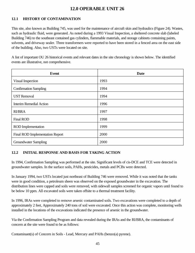
12.0 OPERABLE UNIT 26
12.1 HISTORY OF CONTAMINATION
This site, also known as Building 745, was used for the maintenance of aircraft skin and hydraulics (Figure 24). Wastes,such as hydraulic fluid, were generated. As noted during a 1993 Visual Inspection, a sheltered concrete slab (labeledBuilding 746) to the southeast contained gas cylinders, flammable materials, and storage cabinets containing paints,solvents, and driveway sealer. Three transformers were reported to have been stored in a fenced area on the east sideof the building. Also, two USTs were located on site.
A list of important OU 26 historical events and relevant dates in the site chronology is shown below. The identifiedevents are illustrative, not comprehensive.
Event Date
Visual Inspection 1993
Confirmation Sampling 1994
UST Removal 1994
Interim Remedial Action 1996
RI/BRA 1997
Final ROD 1998
ROD Implementation 1999
Final ROD Implementation Report 2000
Groundwater Sampling 2000
12.2 INITIAL RESPONSE AND BASIS FOR TAKING ACTION
In 1994, Confirmation Sampling was performed at the site. Significant levels of cis-DCE and TCE were detected ingroundwater samples. In the surface soils, PAHs, pesticides, metals and PCBs were detected.
In January 1994, two USTs located just northeast of Building 746 were removed. While it was noted that the tankswere in good condition, a petroleum sheen was observed on the exposed groundwater in the excavation. Thedistribution lines were capped and soils were removed, with sidewall samples screened for organic vapors until found tobe below 10 ppm. All excavated soils were taken offsite to a thermal treatment facility.
In 1996, IRAs were completed to remove arsenic contaminated soils. Two excavations were completed to a depth ofapproximately 2 feet, Approximately 240 tons of soil were excavated. Once this action was complete, monitoring wellsinstalled in the locations of the excavations indicated the presence of arsenic in the groundwater.
Via the Confirmation Sampling Program and data revealed during the IRAs and the RI/BRA, the contaminants ofconcern at the site were found to be as follows:
Contaminant(s) of Concern in Soils - Lead, Mercury and PAHs (benzo(a) pyrene).
45
Contaminant(s) of Concern in Groundwater - Trichlorethylene (TCE)
12.3 REMEDIAL ACTIONS
12.3.1 Remedy Selection
As per the ROD. the following remedies were selected:
Soils Alternative OU26-4S Remove and Landfill This alternative involved removal of contaminated soils for disposal in a solid waste (RCRA Subtitle D) landfill. Thedetails, as per the ROD, were to:
• Remove the upper 1 foot of contaminated surface soils (estimated at 120 bank cubic yards). • Backfill the excavations with uncontaminated fill followed by regrading and revegetation of the ground surface. • Transportation and disposal of excavated soils at a local solid waste landfill.
Groundwater Alternative OU26-3G Intrinsic Remediation of the Groundwater This alternative includes monitoring for natural attenuation of the TCE plume and implementation of institutional controls.Natural attenuation involves all naturally occurring processes that reduce contaminant concentrations over time. Thesein-situ processes (intrinsic remediation) include biodegiadation, abiotic transformation, dispersion, adsorption, andvolatilization. The implementation details were:
• Long-term groundwater monitoring (for TCE and daughter products) to document, quantify, and confirm thenatural attenuation processes indicated in the initial screening study and pilot study.
• Placing restrictions on current and future land and groundwater use in the contaminated area (e.g., restrictoperation of base supply wells and future groundwater users).
• Long-term management and health and safety oversight by USAF personnel for any new construction projectsin the contaminated area.
• Evaluation of the long-term monitoring to determine if natural attenuation is occurring as predicted. Theevaluation will be part of the annual groundwater monitoring report.
12.3.2 Remedy Implementation
In June-July 1999, the OU26 ROD was implemented. Approximately 250 tons of contaminated soil/limestone (130more tons than specified in the ROD) were removed and transported off site. The following is a description of soilremoval activities at each excavation at the OU (Figure 25):
Excavation 1 • Analytical results from soil samples did not exceed the RGs for all compounds analyzed. • Soil Removal and ROD actions are complete.
Excavation 2 • Exceedences were observed in sidewall and floor samples. • The depth of the excavation was extended an additional 1 foot (2 feet total depth). • The lateral extent of the excavation was not increased because of low concentrations of benzo(a) pyrene
observed in two sidewall samples.
46
• An additional 55 tons of soil was removed and disposed from the excavation. • Soil removal ROD actions arc complete.
Excavation 3 • An exceedence was observed in one floor sample. • The depth of the excavation was extended an additional 3 feet (4 feet total depth) in the southeast quadrant of
the excavation. • An additional 30 tons of soil was removed and disposed from the excavation, • Soil removal ROD actions are complete.
During the week of 29 November 1999, in accordance with the ROD, the first quarterly groundwater samples werecollected from existing monitoring wells at OU 26, The groundwater samples were analyzed for VOCs, and thefollowing natural attenuation parameters: nitrite-nitrate nitrogen, sulfate, TOC. methane, ethane and ethene, The resultsof the sampling indicated exceedences of TCE, DCE and VC. Of the natural attenuation parameters sampled onlymethane, nitrate-nitrogen, sulfate and TOC were detected.
In May 2002, excavation of the effluent pipe, suspected of contributing to the contamination, was conducted (Figure26). The discharge piping and surrounding soils were excavated and removed from the point at which the industrialwaste line exists Building 745 to a point upgradient of monitoring well SM60-MW01. The pipe was composed ofvitrified clay segments that were connected together with water tight gasket seals. Approximately 50 feel of thedischarge piping was removed. The depth of the discharge pipeline ranged from between 3 and 5 feet below landsurface (bls), The excavation was approximately 1.5 feet wide and extended 25 feet north from Building 745 beginningapproximately 10 feet from the edge of the building. The excavation was then extended east (at the elbow) an additional25 feet. The depth of the trench ranged from 5 feet deep to 8.5 feet deep. The discharge pipe was grouted shut whereit disconnected from the building drain system. The trench was then backfilled with clean gravel and a biomassamendment. The biomass amendment was comprised of plant mulch and was intended to enhance the naturalattenuation process at the site by adding a source of organic carbon and lowering dissolved oxygen concentrations inthe shallow aquifer.
12.3.3 System Operations/Operation and Maintenance
Groundwater monitoring wells will be maintained for sampling for at least five years, and if sampling is to continue, forup to 30 years. Well maintenance includes aboveground inspection and painting well covers, so that the wells can beeasily identified in the field. Locks will be replaced, if necessary, to secure the monitoring wells from unauthorized entry.If filter pack and screens become plugged by sediment or biological growth, they will be cleaned in accordance withaccepted methods prior to sampling events.
12.4 FIVE-YEAR REVIEW PROCESS
12.4.1 Document Review
This five-year review consisted of a review of relevant documents, including the ROD implementation report andmonitoring reports.
12.4.2 Data Review
Groundwater Monitoring
47
As per the ROD, groundwater monitoring has been conducted quarterly since November 1999 (Figure 27), Asummary of the most recent groundwater sampling event (July 2002) follows:
One or more chlorinated aliphatic hydrocarbons (CAH) were detected in each of the shallow monitoring wells Sampled With the exception of B745-MW01 and OU26-MW09. TCE was detected at concentrations at or above the GCTL of 3 µg/L in samples collected from monitoring wells SM60-MW01, OU26-MW03, OU26-IMW01, OU26-IMW03, and OU26-IMW04, The detected concentrations ranged from 3.26 µg/L to 163 µg/L. Cis-1,2-DCEwas also detected above GCTL (70 µg/L) in OU26-1MW03 at 169 µg/L. No other CAHs were detected above theirrespective GCTLs. Analytical results are summarized in Table 6.
Two lines of evidence were used to determine the contribution of natural attenuation to ground water restoration. Thefirst line of evidence documented the loss of contaminant mass over time. Specific observations with regard to the firstline of evidence are:
• When compared to April 2002 data, the July 2002 concentrations of TCE have decreased in two of the fiveimpacted wells (SM60-MW01 and OU26-MW04) and increased slightly in three wells (OU26-IMW01,OU26-Mw03, and OU26-IMW03).
• The presence of cis-l, 2-DCE as the dominant DCE isomer in all wells with detectable concentrations of DCEsuggests the occurrence of reductive dechlorination.
The second line of evidence involved changes in groundwater geochemistry that are directly correlated with biologicalactivity. The pertinent observations supporting the occurrence of natural attenuation are:
• Detected concentrations of total organic carbon in impacted wells are below the levels necessary to supportreductive dechlorination.
• Dissolved oxygen levels in three of the five impacted wells exceed 0.5mg/L suggesting that during July 2002oxygen levels were high enough in the aquifer to inhibit the occurrence of reductive dechlorination.
• The pH of the aquifer is within the optimal range for microbial activity. • The observation of methane production in half of the wells sampled is indicative of reducing conditions that are
favorable for the degradation of chlorinated solvents.
Evidence supports the conclusion that reductive dechlorination is occurring at the site, although the rate is limited by thelack of organic carbon and by relatively high dissolved oxygen levels measured in July 2002. Seasonal, historic,measured dissolved oxygen levels arc generally within the ideal range for reductive dechlorination suggesting the July2002 data are somewhat of an outlier. The reduction in contaminant concentrations in two of the impacted wells andrelatively stable concentrations in another over time supports this conclusion. The high cis-l, 2-DCE to total DCE ratiosalso indicate the occurrence of reductive dechlorination.
By removing the industrial waste discharge line exiting from the northwest side of Building 745 and surroundingcontaminated soil, a source of groundwater contamination has been eliminated. The addition of a biomass amendmentto the material used to backfill the excavation should enhance natural attenuation processes at the site by adding asource of organic carbon and lowering dissolved oxygen concentrations in the shallow aquifer.
12.4.3 Site Inspection
AFRPA conducted a site visit as part of this five-year review process. The site visit consisted of a visual inspection ofthe OU 26 area. Several of the monitoring wells were found without locking caps and this situation was remedied. Noother unusual observations were documented during this visit.
48
12.5 TECHNICAL ASSESSMENT
Question A: Is the remedy functioning as intended by the decision documents?
The remedy is functioning as intended by the decision documents. Evidence supports the conclusion that reductivedechlorination is occurring at the site, although the rate is limited by the lack of organic carbon and by relatively highdissolved oxygen levels measured in July 2002. Seasonal, historic, measured dissolved oxygen levels are generallywithin the ideal range for reductive dechlorination suggesting the July 2002 data are somewhat of an outlier. Thereduction in contaminant concentrations in two of the impacted wells and relatively stable concentrations in another overtime supports this conclusion. The high cis-1,2-DCE to total DCE ratios also indicate the occurrence of reductivedechlorination.
Question B: Are the exposure assumptions, toxicity data, cleanup levels, and RAOs used at the time of the remedyselection still valid?
The exposure assumptions, toxicity data, cleanup levels, and RAO used at the time of the remedy selection are stillvalid.
Question C: Has any other information come to light that could call into question the protectiveness of the remedy?
No other information has come to light that could call into question the protectiveness of the remedy.
12.6 ISSUES
There are no issues at this site.
12.7 RECOMMENDATIONS AND FOLLOW-UP ACTIONS
The continuation of the groundwater monitoring program is recommended for this OU, until such time as the regulatoryagencies require further remedial action or agree that monitoring is no longer needed.
12.8 PROTECTIVENESS STATEMENT
The remedy at OU 26 is expected to be protective upon completion and in the interim, exposure pathways that couldresult in unacceptable risks are being controlled.
12.9 NEXT REVIEW
The next five-year review for OU 26 is required by December 2007, five years from the date of this review.
49
13.0 OPERABLE UNIT 28
13.1 HISTORY OF CONTAMINATION
The Propulsion (Engine) Maintenance Facility, Building 750, occupies approximately 4 acres located in thesouthwestern portion of the Base (Figure 28). An OWS and sump were located in the southwest portion of the site.Four USTs associated With electroplating operations at the facility were located at the northwest corner of the building,near Bikini Boulevard. Building 744, an AST. and Building 743, an emergency generation building, are located to thesouth of the site. The site had been used for jet engine teardown, rebuilding, inspection and repair since approximately1950. In the past, waste oils were collected in a mobile, 500-gallon capacity aboveground storage tank that wasapproximately 15 percent full and was located on the asphalt drive at the southeast of the building during the 1993visual inspection.
Removal of the OWS and its associated sump was conducted between December 1993 and February 1994. At thistime the floor drains in the building and on the concrete pad were grouted. A two-phase subsurface investigation wascompleted at the sump/separator area in March-May 1994 and November 1994. Sampling indicated the presence oftoluene, total recoverable petroleum hydrocarbons (TRPH), and benzene. Groundwater samples indicated the presenceof PCE, TCE, Naphthalene, 1-Metblynapthalene, 2-Methlynapthalene, Arsenic, Chromium, and Lead.
Removal of the USTs was conducted in March 1994. There was no visible evidence of leakage from the USTs to thesurrounding site media. Soil samples taken from the excavation indicated no exceedences. Four monitoring wells weresubsequently installed. Samples of the groundwater indicated no exceedences.
A list of important OU 28 historical events and relevant dates in the site chronology is shown below. The identifiedevents are illustrative, not comprehensive.
Event Date
Visual Inspection 1993
OWS Removal 1993-1994
UST Removal 1994
RI/BRA 1997
Final ROD 1998
ROD Implementation 1999
Final ROD Implementation Report 2000
13.2 INITIAL RESPONSE AND BASIS FOR TAKING ACTION
A RI was conducted at OU 28 in 1997, Surface soil samples collected during the RI indicated relatively lowconcentrations of BTEX compounds. PAHs and SVOCs were also detected. Pesticides were also detected in thesurface soils. Lead and arsenic were detected in elevated concentrations in surface soil surrounding Building 744.
Subsurface samples collected from the borings near the OWS and sump excavations indicated that relatively lowconcentrations of BTEX and PAHs are present in the subsurface. Low concentrations of one SVOC and pesticides
50
were detected in one subsurface sample. Seven metals were reported above background concentrations in thesubsurface samples.
Groundwater sampling from monitoring wells installed for the OWS investigation indicated that low concentrations ofPCE and TCE were present at concentrations of concern. Further investigation during the RI via Geoprobe indicatedthat these concentrations were very localized and most at or below action levels. Thus, the groundwater was found topose no risk.
13.3 REMEDIAL ACTIONS
13.3.1 Remedy Selection
Per the ROD, Alternative OU28-4 Remove and Landfill was chosen as the appropriate remedial action for this site.The alternative involves removal of contaminated soils for disposal in a solid waste (RCRA Subtitle D) landfill andwould be implemented by:
• Removal of the upper 1 feet of contaminated surface soils (estimated at about 1.500 bank cubic yards).Removal would be done by using appropriately sized, conventional earthmoving equipment.
• Backfilling the excavations with uncontaminated fill followed by regarding and revegetation of the groundsurface.
• Encapsulation/stabilization of any excavated soils determined to be characteristically hazardous based ontoxicity characteristic leaching procedure (TCLP) testing. To be conservative, it was assumed that about 460bank cubic yards of soil containing lead around the tank at OU28 are characteristically hazardous; however,only one out of four analytical tests for total lead indicated a level that could potentially exceed the TCLPstandard for lead. Encapsulation/stabilization would be done using pozzolonic of proprietary agents, andtreatability testing would be needed to design the mix. Following successful stabilization, the soils would betransported to a local solid waste landfill for disposal.
• Transportation and disposal of excavated soils at a local solid waste (RCRA Subtitle D) landfill.
13.3.2 Remedy Implementation
The remedial actions and associated field activities for OU 28 were conducted between May 1999 and September1999. Approximately 1,450 tons of contaminated soil/limestone (50 tons less than specified in the ROD) were removedand disposed during the implementation of the ROD. The following is a summary of the excavation activities at the site(Figure 29):
Excavation 1 • Exceedences were observed in floor samples (lead, arsenic and benzo(a) pyrene) • The excavation was 2 feet deep, which is below the direct exposure pathway • ROD actions are complete
Excavation 2 • Exceedences were observed in sidewall and floor samples (dibenzo(a, h) anthracene and benzo(a) pyrene) • The excavation was 2 feet deep, which is below the direct exposure pathway
51
• Because the excavation is bordered by asphalt on all sides, additional excavation work was not completedsince the paved surfaces act as a cap to prevent rainwater from infiltrating to the soil and prevent directexposure to contaminated soil
• ROD actions are complete
Excavation 3 • Exceedences were observed in sidewall and floor samples (benzo(a) pyrene) • The excavation was 2 feet deep, which is below the direct exposure pathway • The east sidewall of the excavation was extended an additional 5 feet to an asphalt layer (1 foot bls) which will
act as a cap to prevent rainwater from infiltrating to the soil and prevent direct exposure to contaminated soil • An additional 10 tons of soil was removed and disposed from the excavation • ROD actions are complete
Excavation 4 • Exceedences were observed in sidewall samples (dibenzo(a, h) anthracene and benzo(a) pyrene) • Because the excavation is bordered by asphalt on all sides, additional excavation work was not completed
since the paved surfaces act as a cap to prevent rainwater from infiltrating to the soil and prevent directexposure to contaminated soil
• ROD actions are complete
Excavation 5 • Exceedences were observed in floor samples (benzo(a) pyrene, benzo(a) anthracene, and dibenzo(a)
anthracene) • The excavation was 2 feet deep, which is below the direct exposure pathway • ROD actions are complete
13.3.3 System Operations/Operation and Maintenance
Not applicable.
13.4 FIVE-YEAR REVIEW PROCESS
13.4.1 Document Review
This five-year review consisted of a review of relevant documents, including the ROD implementation report andmonitoring reports.
13.4.2 Data Review
Not applicable.
13.4.3 Site Inspection
AFRPA conducted a site visit as part of this five-year review process. The site visit consisted of a visual inspection ofthe OU 28 area. No unusual observations were documented during this visit.
13.5 TECHNICAL ASSESSMENT
Not applicable. 52

13.6 ISSUES
None.
13.7 RECOMMENDATIONS AND FOLLOW-UP ACTIONS
Based upon a letter from the FDEP (dated December 13, 2000), "No additional excavation work is warranted at theOU. The proposal to address exceedences of PAHs in soil via deed transfer documents is acceptable." No furtheractions at this site are required.
13.8 PROTECTIVENESS STATEMENT
Based on the completed activities, the intent and goals of the ROD have been met at OU 28 and found to be protectiveof human health and the environment.
13.9 NEXT REVIEW
As there will be LUC/ICs at the site, the next five-year review for OU 28 is required by December 2007, five yearsfrom the date of this review.
53
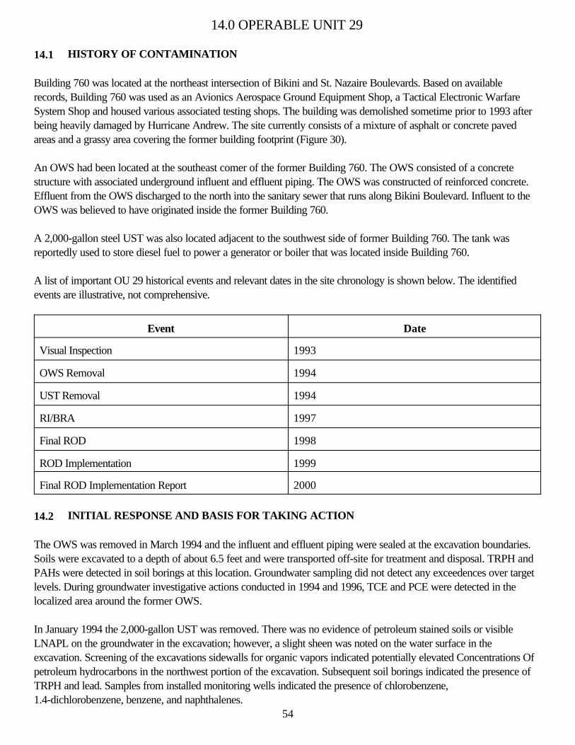
14.0 OPERABLE UNIT 29
14.1 HISTORY OF CONTAMINATION
Building 760 was located at the northeast intersection of Bikini and St. Nazaire Boulevards. Based on availablerecords, Building 760 was used as an Avionics Aerospace Ground Equipment Shop, a Tactical Electronic WarfareSystem Shop and housed various associated testing shops. The building was demolished sometime prior to 1993 afterbeing heavily damaged by Hurricane Andrew. The site currently consists of a mixture of asphalt or concrete pavedareas and a grassy area covering the former building footprint (Figure 30).
An OWS had been located at the southeast comer of the former Building 760. The OWS consisted of a concretestructure with associated underground influent and effluent piping. The OWS was constructed of reinforced concrete.Effluent from the OWS discharged to the north into the sanitary sewer that runs along Bikini Boulevard. Influent to theOWS was believed to have originated inside the former Building 760.
A 2,000-gallon steel UST was also located adjacent to the southwest side of former Building 760. The tank wasreportedly used to store diesel fuel to power a generator or boiler that was located inside Building 760.
A list of important OU 29 historical events and relevant dates in the site chronology is shown below. The identifiedevents are illustrative, not comprehensive.
Event Date
Visual Inspection 1993
OWS Removal 1994
UST Removal 1994
RI/BRA 1997
Final ROD 1998
ROD Implementation 1999
Final ROD Implementation Report 2000
14.2 INITIAL RESPONSE AND BASIS FOR TAKING ACTION
The OWS was removed in March 1994 and the influent and effluent piping were sealed at the excavation boundaries.Soils were excavated to a depth of about 6.5 feet and were transported off-site for treatment and disposal. TRPH andPAHs were detected in soil borings at this location. Groundwater sampling did not detect any exceedences over targetlevels. During groundwater investigative actions conducted in 1994 and 1996, TCE and PCE were detected in thelocalized area around the former OWS.
In January 1994 the 2,000-gallon UST was removed. There was no evidence of petroleum stained soils or visibleLNAPL on the groundwater in the excavation; however, a slight sheen was noted on the water surface in theexcavation. Screening of the excavations sidewalls for organic vapors indicated potentially elevated Concentrations Ofpetroleum hydrocarbons in the northwest portion of the excavation. Subsequent soil borings indicated the presence ofTRPH and lead. Samples from installed monitoring wells indicated the presence of chlorobenzene,1.4-dichlorobenzene, benzene, and naphthalenes.
54
Based on the finding from the removal actions, a RI/BRA was conducted. Chemicals of Potential Concern, as determined in the RI, are as follows:
Surface Soil - SVOCs, Pesticides/PCBs, and Metals
Subsurface Soils - VOCs, SVOCs, Pesticides/PCBs and Metals
Groundwater - VOCs (1,2-dichloroethene, TCE, and vinyl chloride)
Further investigation during the RI via Geoprobe indicated that these concentrations were very localized and most at orbelow action levels. Thus, the groundwater was found to pose no risk.
14.3 REMEDIAL ACTIONS
14.3.1 Remedy Selection
Per the ROD, Alternative OU29-4 - Remove and Landfill was selected as the appropriate remedial action for this site, The alternative involves removal of contaminated soils for disposal in a solid waste (RCRA Subtitle D) landfill. The alternative would be implemented by:
• Removal of the upper 2 feet of contaminated surface soils (estimated at about 920 bank cubic yards). Removalwould be done using appropriately sized, conventional earthmoving equipment.
• Backfilling the excavations with uncontaminated fill followed by regrading and revegetation of the groundsurface.
• Transportation and disposal of excavated soils at a local solid waste (RCRA Subtitle D) landfill.
14.3.2 Remedy Implementation
The remedial actions and associated field activities for OU 29 were conducted between May 1999 and September1999. Approximately 1,350 tons of contaminated soil/limestone (400 more tons than specified in the ROD) wereremoved and disposed of during the implementation of the ROD. The following is a summary of the excavation activitiesat the site (Figure 31);
Excavation 1 • Exceedences were observed in sidewall and floor samples (PAHs) • On portions of the excavation bordered by asphalt, additional excavation work was not completed since the
paved surfaces act as a cap to prevent rainwater from infiltrating to the soil and prevent direct exposure tocontaminated soil
• The excavation was 2 feet deep, which is below the direct exposure pathway • The areal extent of the excavation was increased 10 feet north and 5 feet east • Analytical results from soil samples from additional excavations did not exceed the RGs for all compounds
analyzed • An additional 85 tons of soil was removed and disposed from the excavation • ROD actions are complete
55
Excavation 2 • Exceedences were observed in sidewall and floor samples (benzo(a) pyrene) • The excavation was 2 feet deep, which is below the direct exposure pathway • The areal extent of the excavation was increased 5 feet southeast • Because of the low concentration of benzo(a) pyrene observed in one sidewall sample from the additional
excavation, the lateral extent of the excavation was not increased • An additional 40 tons of soil was removed and disposed from the excavation • ROD actions are complete
Excavation 3 • Exceedences were observed in one sidewall and one floor sample (benzo(a) pyrene) • The excavation was 2 feet deep, which is below the direct exposure pathway • Because of the low concentrations of benzo(a) pyrene observed in one sidewall sample, the lateral extent of the
excavation was not increased • ROD actions are complete
Excavation 4 • Exceedences were observed in sidewall samples (benzo(a) pyrene) • The areal extent of the excavation was increased 5 feet northeast and southwest • Analytical results from soil samples from the additional excavations did not exceed the RGs for all compounds
analyzed • An additional 35 tons of soil were removed and disposed from the excavation • ROD actions are complete
14.3.3 System Operations/Operation and Maintenance
Not applicable.
14.4 FIVE-YEAR REVIEW PROCESS
14.4.1 Document Review
This five-year review consisted of a review of relevant documents, including the ROD implementation report.
14.4.2 Data Review
Not applicable.
14.4.3 Site Inspection
AFRPA conducted a site visit as part of this five-year review process. The site visit consisted of a visual inspection ofthe OU 29 area. No unusual observations were documented during this visit.
14.5 TECHNICAL ASSESSMENT
Not applicable.
56
14.6 ISSUES
None.
14.7 RECOMMENDATIONS AND FOLLOW-UP ACTIONS
Based upon a letter from the FDEP (dated December 13, 2000), "No additional excavation work is warranted at theOU. The proposal to address exceedences of PAHs in soil via deed transfer documents is acceptable." No furtheractions at this site are required.
14.8 PROTECTIVENESS STATEMENT
Based on the completed activities, the intent and goals of the ROD have been met at OU 29 and found to be protectiveof human health and the environment.
14.9 NEXT REVIEW
As there will be LUC/ICs at the site, the next five-year review for OU 29 is required by December 2007, five yearsfrom the date of this review.
57
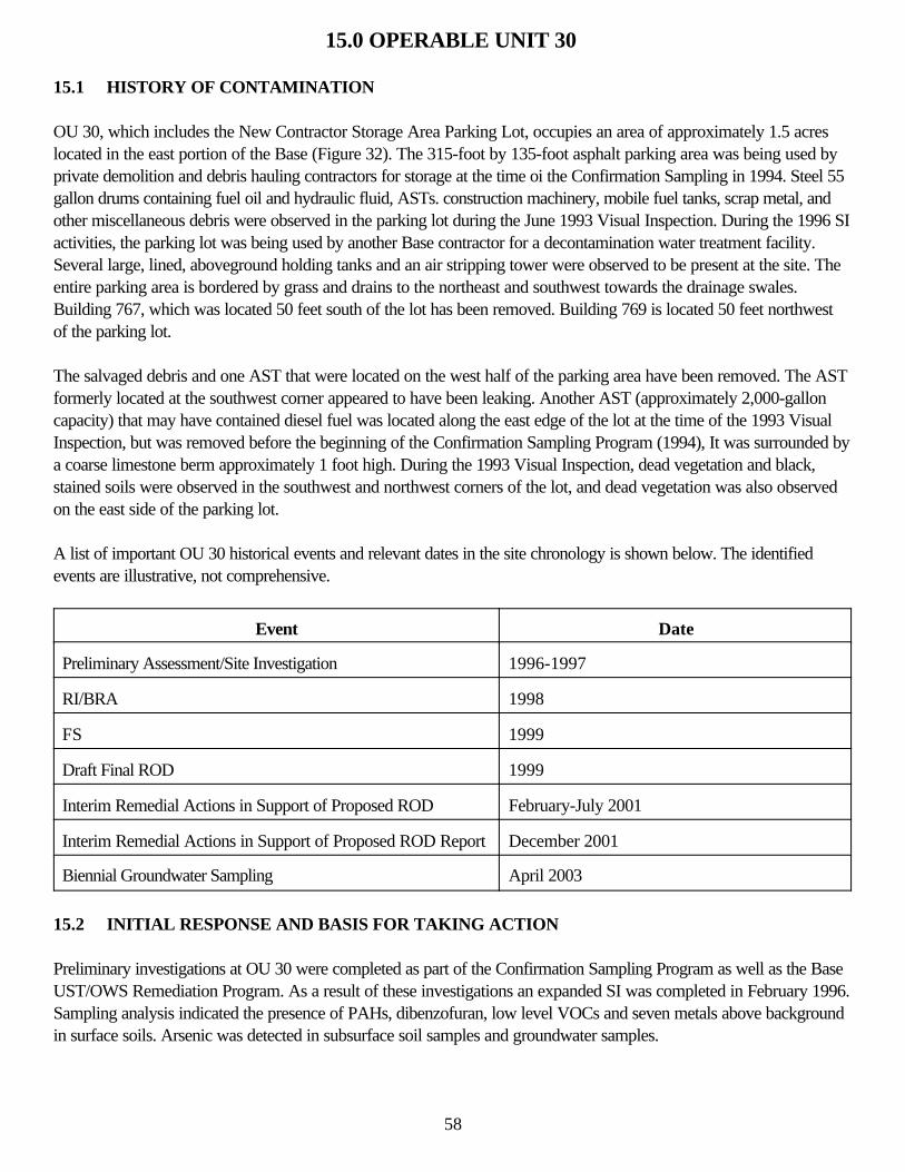
15.0 OPERABLE UNIT 30
15.1 HISTORY OF CONTAMINATION
OU 30, which includes the New Contractor Storage Area Parking Lot, occupies an area of approximately 1.5 acreslocated in the east portion of the Base (Figure 32). The 315-foot by 135-foot asphalt parking area was being used byprivate demolition and debris hauling contractors for storage at the time oi the Confirmation Sampling in 1994. Steel 55gallon drums containing fuel oil and hydraulic fluid, ASTs. construction machinery, mobile fuel tanks, scrap metal, andother miscellaneous debris were observed in the parking lot during the June 1993 Visual Inspection. During the 1996 SIactivities, the parking lot was being used by another Base contractor for a decontamination water treatment facility.Several large, lined, aboveground holding tanks and an air stripping tower were observed to be present at the site. Theentire parking area is bordered by grass and drains to the northeast and southwest towards the drainage swales.Building 767, which was located 50 feet south of the lot has been removed. Building 769 is located 50 feet northwestof the parking lot.
The salvaged debris and one AST that were located on the west half of the parking area have been removed. The ASTformerly located at the southwest corner appeared to have been leaking. Another AST (approximately 2,000-galloncapacity) that may have contained diesel fuel was located along the east edge of the lot at the time of the 1993 VisualInspection, but was removed before the beginning of the Confirmation Sampling Program (1994), It was surrounded bya coarse limestone berm approximately 1 foot high. During the 1993 Visual Inspection, dead vegetation and black,stained soils were observed in the southwest and northwest corners of the lot, and dead vegetation was also observedon the east side of the parking lot.
A list of important OU 30 historical events and relevant dates in the site chronology is shown below. The identifiedevents are illustrative, not comprehensive.
Event Date
Preliminary Assessment/Site Investigation 1996-1997
RI/BRA 1998
FS 1999
Draft Final ROD 1999
Interim Remedial Actions in Support of Proposed ROD February-July 2001
Interim Remedial Actions in Support of Proposed ROD Report December 2001
Biennial Groundwater Sampling April 2003
15.2 INITIAL RESPONSE AND BASIS FOR TAKING ACTION
Preliminary investigations at OU 30 were completed as part of the Confirmation Sampling Program as well as the BaseUST/OWS Remediation Program. As a result of these investigations an expanded SI was completed in February 1996.Sampling analysis indicated the presence of PAHs, dibenzofuran, low level VOCs and seven metals above backgroundin surface soils. Arsenic was detected in subsurface soil samples and groundwater samples.
58
In October 1994, UST 769-1 was excavated and removed. The UST was located immediately northeast of Building 769 next to an unnumbered building. Field screening concentrations for soils were reported to be below 10 ppm;however, petroleum product globules were noted on the groundwater surface in the UST excavation. A temporarymonitoring well was installed after the excavation was backfilled. Sampling did not indicate any exceedences. An ASTwas subsequently installed in the same location.
A 750-gallon diesel fuel UST was also located along the northern edge of the site. It was removed in January 1994.Field screening for soil vapors indicated that all concentrations were below 10 ppm. No petroleum sheen or productwas observed on the groundwater surface in the excavation. The product distribution lines were capped at theexcavation boundary and the excavation was backfilled with clean fill material. A monitoring well was installed andsampled. No analytes were reported above their respective PQLs.
Results of the expanded site investigation indicated that PAHs and arsenic were present in the surface and subsurfacesoils on the site. Arsenic was also present in the groundwater samples. Based on these findings, it was recommendedthat a RI be conducted at OU 30.
The RI/BRA found that arsenic in the groundwater posed an unacceptable risk to human health. It was also determinedthat arsenic and some individual PAHs exceeded the respective FDEP risk-based industrial soil cleanup goals. Thus,the OU was recommended for a FS.
Based on the results and conclusions of the FS and Proposed Plan, a ROD was submitted to the regulatory agencies in1999. Due to Land Use and memorandum of agreement (MOA) discussions, the ROD remains unsigned.
15.3 REMEDIAL ACTIONS
15.3.1 Remedy Selection
As per the unsigned ROD, dated October 1999, the remedial alternatives selected for the OU are as follows:
Soil Alternative OU30-4S - Remove and Landfill This alternative involves removal of contaminated soils for disposal in a solid waste (RCRA Subtitle D) landfill. Thisalternative would be implemented by: • Removal of the upper 0.5 feet to 4.5 feet of impacted surface soils (estimated at about 2,400 bank cubic yards
[bcy]). Removal would be done using appropriately sized, conventional earthmoving equipment. • Backfilling the excavations with uncontaminated fill followed by regrading and revegetation of the ground
surface. • Transportation and disposal of excavated soils at a local solid waste (RCRA Subtitle D) landfill. The total
estimated weight is about 3,4UU tons.
Groundwater Alternative OU30-2G - Groundwater Monitoring and Evaluation of In-Situ Remedial Technologies This alternative includes groundwater monitoring of the arsenic plume and implementation of institutional controls and anevaluation of in-situ groundwater treatment technologies. This includes: • Long-term groundwater monitoring of arsenic concentrations to document and quantify the concentrations of
arsenic and associated risk to human health and the environment. • Initial over-development and resampling of the site monitoring wells with arsenic concentrations above the
federal and state MCLs of 50 µg/L.
59
• Placing restrictions on current and future land and groundwater use in the contaminated area (e.g., restrictoperation of Base supply wells and future groundwater users). Specific language regarding land use restrictionswill be incorporated in the FOST and approved by FDEP as a third-party beneficiary.
• In accordance with Air Force policy, implementation of a remedial action will require the submission of a healthand safety plan that conforms to 29 CFR 1910.120.
• Completion of a pilot study to evaluate the effectiveness of the in-situ adsorption alternative. The USAF hasCommitted to the smaller-scale pilot study to allow for the potential unrestricted reuses of OUs 20/21, 30 and31.
The in-situ adsorption alternative would be implemented by: • Installing five vertical injection wells, one at each "hotspot", designed to operate at injection rates between 29
and 40 gpm. • Connecting each injection well to an injection line that runs to a trailer-mounted mixing plant. The mixing plant
would be designed for a total injection rate of up to 40 gpm of potable water containing 29 mg/L of ferricchloride. This concentration of ferric chloride will precipitate iron oxide in-situ and thereby facilitate adsorptionof arsenic. The mixing plant would consist of a storage tank (with hose or piping to the nearest fire hydrant), amixing tank and mixer, a chemical metering pump to feed ferric chloride, a ferric chloride storage tank, andinjection pump.
15.3.2 Remedy Implementation
Beginning February 2001, a voluntary IRA was implemented and followed the selected remedy m the Draft ROD OU20/21, OU 30 and OU 31 (June 1999), despite the fact that the ROD had not been signed. Approximately 2,800 tonsof contaminated soil/limestone (600 tons less than specified in the draft ROD) were removed and disposed of duringimplementation of the voluntary IRA. The following is a summary of activities and results for OU 30 (Figures 33, 34,and 35):
Excavation 1:
• Exceedances of arsenic were observed in sidewall and floor samples • The excavation is bordered by asphalt on all sides, therefore additional excavation work at most of the site was
not completed since the paved surface acts as a cap to prevent rainwater from infiltrating to the soil as well asprevent direct exposure to contaminated soil
• The excavation was 2 feet deep, which is below the direct exposure pathway • Soil removal actions are complete
Excavation 2:
• Exceedences of arsenic and PAHs were observed in sidewall and floor samples • Additional excavation activities removed remaining contaminated soil from sidewalls that were not bordered by
asphalt • Seven floor samples exceeding RGs for one or more PAH compounds were not excavated due to the hardness
of the limestone at that location • Soil removal actions; are complete
Excavation 3:
• Exceedences of arsenic and PAHs were observed in sidewall and floor samples
60
• Additional excavation activities removed remaining contaminated soil from sidewalls that were not bordered byasphalt
• The floor of the excavation in one "hot spot" was extended to 1.5 feet below original grade reducing PAHcompounds and arsenic to less than RGs
• Soil removal actions arc complete
Excavation 4:
• Exceedences of arsenic and PAHs were observed in sidewall and floor samples • Additional excavation activities (Phases II. III and IV) removed remaining contaminated soil from side-walls
that were not bordered by asphalt with the exception of OU30-4-SS1B (3.4 mg/kg, B(a) P) and OU30-4-3A(10.6 mg/kg, As)
• Soil removal actions are complete
Pilot Study
Following completion Of the voluntary IRA, an Evaluation of In-Situ Remedial Technologies was completed at OU 30.The contaminant of concern is arsenic. The evaluation involved completion of Bench Scale and Pilot Test studies toevaluate the effectiveness of an in-situ adsorption technology using ferric chloride.
Prior to pilot study implementation, bench scale testing was completed on a representative groundwater sample toevaluate the effectiveness of ferric chloride versus ferric sulfate solutions for in-situ arsenic adsorption. The bench scaletesting indicated that the groundwater at the site was acceptable for the proposed treatment.
Installation of the pilot test injection and monitoring point clusters was completed during the week of July 16, 2001,Monitoring wells MW-2 and MW-6 as well as monitoring point clusters MP-1 and MP-2 were sampled and analyzedfor arsenic and iron. MW-2 and MW-6 exceeded FDEP GCTLs for arsenic (Figure 37). However, analytical resultsfrom the monitoring point clusters did not detect arsenic above GCTLs. This suggests the occurrence of arsenic may bemore localized to the vicinity of the monitoring wells than originally thought.
A thorough search for suppliers of ferric chloride (FeCl) solution was completed. However, the search revealed that theavailable raw material contained trace metals (arsenic, copper, lead, and molybdenum) that exceeded FDEP GCTLs.The fact that no trace metal-free raw ferric chloride could be found caused the Air Force to reconsider the pilot studyand ultimately decide not to continue.
15.3.3 System Operations/Operation and Maintenance
Also as part of this voluntary IRA, groundwater sampling was conducted. Seven groundwater samples were Collectedfrom OU 30 groundwater monitoring wells (Figure 36). All samples were analyzed for arsenic, iron and alkalinity.Arsenic was detected in monitoring well AOC1-MW-0002 (0.204 mg/L) and MW-0006 (0.278 mg/L) above GCTL.Iron was not detected in excess of the secondary drinking water standard. Arsenic concentrations demonstrated a slightdecrease in monitoring well AOC1-MW-0002 and a slight increase in MW-0006. However, concentrations remainedrelatively unchanged from the previous sampling event (March 2001). Groundwater overpumping was not conducted atthis site due to poor results at OUs 20/21 and 31. Analytical results are provided in Table 7.
61
15.4 FIVE-YEAR REVIEW PROCESS
15.4.1 Document Review
This five-year review consisted of a review of relevant documents, including the ROD implementation report andmonitoring reports.
15.4.2 Data Review
Not applicable.
15.4.3 Site Inspection
AFRPA conducted a site visit as part of this five-year review process. The site visit consisted of a visual inspection ofthe OU 30 area. No unusual observations were documented during this visit.
15.5 TECHNICAL ASSESSMENT
Not applicable.
15.6 ISSUES
None.
15.7 RECOMMENDATIONS AND FOLLOW-UP ACTIONS
A conference call was held on February 24, 2003 with FDEP, USEPA and DERM to discuss OU 20/21, 30 and 31.It was agreed that OU 30 would be subject to groundwater use restrictions and No Further Action with land usecontrols for soil. A ROD is forthcoming. Biennial groundwater sampling will begin April 2003.
15.8 PROTECTIVENESS STATEMENT
Based on the completed activities, the intent and goals of the proposed ROD have been met at OU 30 and found to beprotective of human health and the environment.
15.9 NEXT REVIEW
The next five-year review for OU 30 is required by December 2007, five years from the date of this review.
62
16.0 OPERABLE UNIT 31
16.1 HISTORY OF CONTAMINATION
OU 31, which includes the Nondestructive Inspection Lab (Building 755), is located at the southern end of St. NazaireStreet near the main runway (Figure 38). The building originally contained a garage, X-ray room and dark room,offices, furnace room, and a mechanical room. During the 1993 Visual Inspection, a fill cap labeled "Fuel Oil" waslocated in the pavement south of the building. A concrete pad located northwest of the building may have been used tocontain electrical equipment. Two areas of stressed vegetation were observed along the northeast boundary of the site.
A list of important OU 31 historical events and relevant dates in the site chronology is shown below. The identifiedevents are illustrative, not comprehensive.
Event Date
Preliminary Assessment/Site Investigation 1996-1997
RI/BRA 1998
FS 1999
Draft Final ROD (unsigned) 1999
Interim Remedial Actions in Support of Proposed ROD February-July 2001
Interim Remedial Actions in Support of Proposed ROD Report December 2001
Biennial Groundwater Sampling April 2003
16.2 INITIAL RESPONSE AND BASIS FOR TAKING ACTION
Preliminary investigations were completed at OU 31 as part of the Confirmation Sampling Program and BaseOWS/UST Remediation Program. Compounds detected in soil samples were PAHs and arsenic. Groundwater analysisindicated no contaminants of concern.
In 1994 a UST located at the southeast corner of Building 755 was removed. Subsequently four monitoring wells wereinstalled and sampled. Soil and groundwater analysis did not indicate any contaminants of concern.
In March 1996 an Interim Removal Action was completed west of Building 755 at the location of a former concretetransformer pad. High levels of arsenic had been detected at this location during the Confirmation Sampling Program.An area of approximately 37 feet by 27 feet by 3.25 feet deep was excavated. Soil samples were collected from theexcavation sidewalls to determine when acceptable arsenic concentrations had been reached. The east wall of theexcavation was not excavated to acceptable arsenic concentrations due to power line obstructions in the area. Agroundwater sample collected from a monitoring well placed in the center of the excavation area indicated arsenicconcentrations of 310 µg/L, exceeding the federal and FDEP guidance concentration of 50 µg/L.
An expanded SI was conducted in 1996. PAHs and arsenic were detected in surface and subsurface soils. Arsenicwas also detected in the groundwater. Based on these findings, the site was recommended for a RI.
The RI/BRA for OU 31 was completed in 1998. As a result of this evaluation, it was determined that PAHs and
63
arsenic found in surface and subsurface soils and arsenic found in the groundwater posed unacceptable risks to humanhealth. Thus, the OU was recommended for a FS.
Based on the results and conclusions of the FS and Proposed Plan, a ROD was submitted to the regulatory agencies in1999. Due to Land Use and MOA discussions, the ROD remains unsigned.
16.3 REMEDIAL ACTIONS
16.3.1 Remedy Selection
As per the unsigned ROD. dated October 1999, the remedial alternatives selected for the OU are as follows:
Soil Alternative OU31-4S - Remove and Landfill This alternative involves removal of contaminated soils for disposal in a solid waste (RCRA Subtitle D) landfill. Thealternative would be implemented by: • Removal of the upper 0.5 to 1 foot of impacted surface soil (estimated at about 270 bcy). Removal would be
done using appropriately sized, conventional earthmoving equipment. • Backfilling the excavation with uncontaminated fill followed by regrading and revegetation of the ground surface • Transportation and treatment of excavated soils at a local low temperature thermal desorption incinerator, and
subsequent beneficial reuse of the by-products in pavement materials. The total estimated weight is about 370tons.
Groundwater Alternative OU31-2G - Groundwater Monitoring This alternative includes groundwater monitoring of the arsenic plume and implementation of institutional controls. Thegroundwater monitoring alternative includes: • Long-term groundwater monitoring of arsenic concentrations to document and quantify the concentrations of
arsenic and associated risk to human health and the environment. • Initial over-development and sampling of all site monitoring wells with arsenic concentrations above federal and
state MCLs of 50 µg/L. • Placing restrictions on current and future land and groundwater use in the contaminated area (e.g., restrict
operation of Base supply wells and future groundwater users). Specific language regarding land use restrictionswill be incorporated in the FOST and approved by FDEP as a third-party beneficiary.
• In accordance with Air Force policy, implementation of a remedial action will require submission of a health andsafety plan that conforms to 29 CFR 1910.120.
16.3.2 Remedy Implementation
Beginning February 2001, a voluntary IRA was implemented and followed the selected remedy in the Draft ROD forOU 20/21, OU 30 and OU 31 (June 1999), despite the fact that the ROD has remained unsigned. Approximately 450tons of contaminated soil/limestone (70 more tons than the excavations specified in the draft ROD) were removed anddisposed of during implementation of the voluntary IRA. The following is a summary of activities and results for OU 31(Figures 39 and 40):
Excavation 1:
• Exceedences of PAH compounds were observed in sidewall and floor samples
64
• Additional excavation activities removed remaining contaminated soil from the floor of the excavation andsidewalls that were not bordered by asphalt
• Analytical results from soil samples from the additional excavations did not exceed the RGs for all compoundsanalyzed
• Soil removal actions are complete
Excavation 2:
• Exceedences of arsenic were observed in sidewall and floor samples • The depth of the excavation was extended 1.5 feet deep in areas where floor samples exceeded RG • The areal extent of the excavation was increased 5 feet on the north, east, and south sides • Analytical results from soil samples from additional excavations did not exceed the RGs for arsenic • A statistical evaluation showed the 95th UCL of the mean arsenic concentration decreased 88 percent (from
30.8 to 3.8 mg/kg) as a result of the removal action. This is below the base specific SCTL of 10 mg/kg • Soil removal actions are complete
Also as part of this voluntary IRA, groundwater sampling and monitoring well overpumping was conducted. The resultsof the baseline monitoring revealed that two monitoring wells had arsenic concentrations above GCTL prior to the soilremoval actions.
Based on these results, overpumping of these two wells was performed. Approximately 15,000 gallons of groundwaterwere pumped from each well. Subsequent sampling of the monitoring wells revealed that arsenic concentrationsdecreased (from 155 µg/L to 52.9 µg/L in B755-MW0001: and from 98 µg/L to 43.2 µg/L in OU31-MW0003).
16.3.3 System Operations/Operation and Maintenance
Also as part of this voluntary IRA, groundwater sampling was conducted after the overpumping activities. Twogroundwater samples were collected from OU 31 groundwater monitoring wells (Figure 41). All samples wereanalyzed for arsenic, iron, and alkalinity. Arsenic was not detected at a concentration that exceeded the GCTL of 0.05mg/L in either of the monitoring wells. Iron was detected at a concentration in excess of the secondary drinking waterstandard. Analytical results are provided in Table 8.
16.4 FIVE-YEAR REVIEW PROCESS
16.4.1 Document Review
This five-year review consisted of a review of relevant documents, including the Interim Remedial Actions in Support ofProposed ROD report.
16.4.2 Data Review
Not applicable.
16.4.3 Site Inspection
AFRPA conducted a site visit as part of this five-year review process. The site visit consisted of a visual inspection ofthe OU 31 area. No unusual observations were documented during this visit.
65
16.5 TECHNICAL ASSESSMENT
Not applicable.
16.6 ISSUES
None.
16.7 RECOMMENDATIONS AND FOLLOW-UP ACTIONS
A conference call was held on February 24, 2003 with FDEP, USEPA and DERM to discuss OU 20/21, 30 and 31.It was agreed that OU 31 would be subject to groundwater use restrictions and granted a No Further Action for soils.A ROD for this site is forthcoming. Biennial groundwater sampling will begin April 2003.
16.8 PROTECTIVENESS STATEMENT
Based on the completed activities, the intent and goals of the proposed ROD have been met at OU 31 and found to beprotective of human health and the environment.
16.9 NEXT REVIEW
The next five-year review for OU 31 is required by December 2007, five years from the date of this review.
66
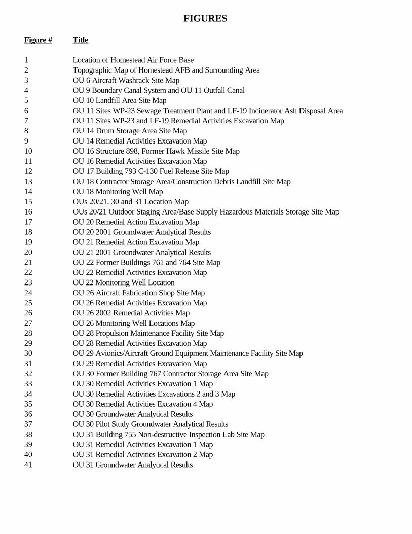
FIGURES
Figure # Title
1 Location of Homestead Air Force Base 2 Topographic Map of Homestead AFB and Surrounding Area 3 OU 6 Aircraft Washrack Site Map 4 OU 9 Boundary Canal System and OU 11 Outfall Canal 5 OU 10 Landfill Area Site Map 6 OU 11 Sites WP-23 Sewage Treatment Plant and LF-19 Incinerator Ash Disposal Area 7 OU 11 Sites WP-23 and LF-19 Remedial Activities Excavation Map 8 OU 14 Drum Storage Area Site Map 9 OU 14 Remedial Activities Excavation Map 10 OU 16 Structure 898, Former Hawk Missile Site Map 11 OU 16 Remedial Activities Excavation Map 12 OU 17 Building 793 C-130 Fuel Release Site Map 13 OU 18 Contractor Storage Area/Construction Debris Landfill Site Map 14 OU 18 Monitoring Well Map 15 OUs 20/21, 30 and 31 Location Map 16 OUs 20/21 Outdoor Staging Area/Base Supply Hazardous Materials Storage Site Map 17 OU 20 Remedial Action Excavation Map 18 OU 20 2001 Groundwater Analytical Results 19 OU 21 Remedial Action Excavation Map 20 OU 21 2001 Groundwater Analytical Results 21 OU 22 Former Buildings 761 and 764 Site Map 22 OU 22 Remedial Activities Excavation Map 23 OU 22 Monitoring Well Location 24 OU 26 Aircraft Fabrication Shop Site Map 25 OU 26 Remedial Activities Excavation Map 26 OU 26 2002 Remedial Activities Map 27 OU 26 Monitoring Well Locations Map 28 OU 28 Propulsion Maintenance Facility Site Map 29 OU 28 Remedial Activities Excavation Map 30 OU 29 Avionics/Aircraft Ground Equipment Maintenance Facility Site Map 31 OU 29 Remedial Activities Excavation Map 32 OU 30 Former Building 767 Contractor Storage Area Site Map 33 OU 30 Remedial Activities Excavation 1 Map 34 OU 30 Remedial Activities Excavations 2 and 3 Map 35 OU 30 Remedial Activities Excavation 4 Map 36 OU 30 Groundwater Analytical Results 37 OU 30 Pilot Study Groundwater Analytical Results 38 OU 31 Building 755 Non-destructive Inspection Lab Site Map 39 OU 31 Remedial Activities Excavation 1 Map 40 OU 31 Remedial Activities Excavation 2 Map 41 OU 31 Groundwater Analytical Results
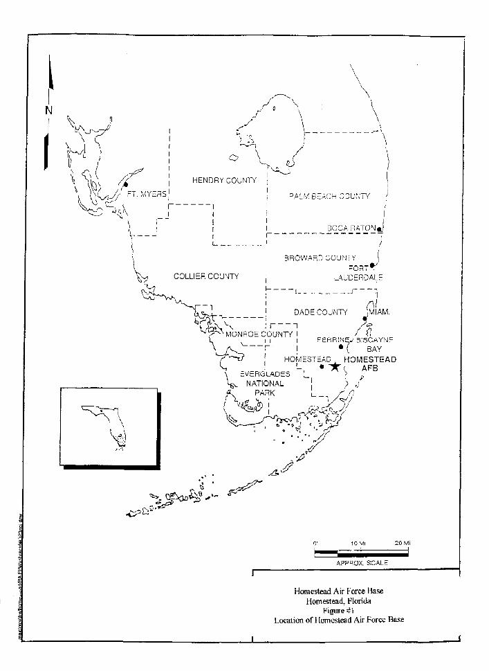
*o e* r"Ai
o \
HENDRYCOUNTY
IIIIIi |
PALM BEACH COUNTY \
BOCA RATON
BROWARD COUNTY
V COLLIER COUNTY L J \ U D E R D A L E
II
DADECOUNTY
MONROE COUNTY
r , —i t 'HOMESTEAD , HOMESTEAD
BISCAYNE• ( BAY
AFB
1 APPROX. SCALE
Homestead Air Force BaseHomestead, Florida
Figure #1Location of Homestead Air Force Base
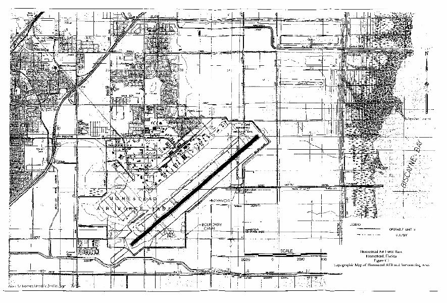
•I
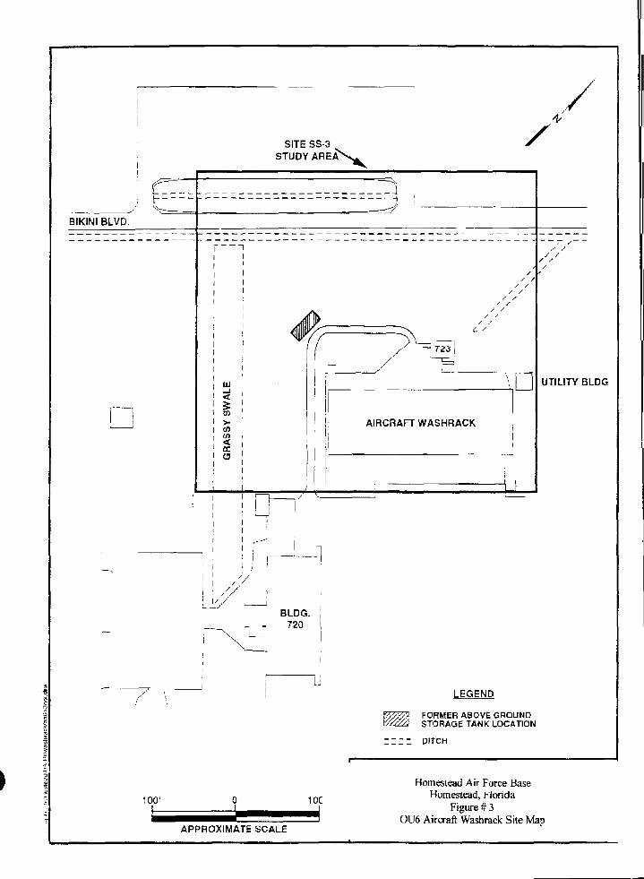
BIKINI BLVD.
Cl.
SITE SS-3STUDY
_ _ a—i
—i
LU
V)
en
j
BLDG.720
UTILITY BLDG
LEGEND
FORMER ABOVE GROUNDSTORAGE TANK LOCATION
: : : : DITCH
100'
APPROXIMATE SCALE
Homestead Air Force BaseHomestead, Florida
Figure # 3OU6 Aircraft Washrack Site Map
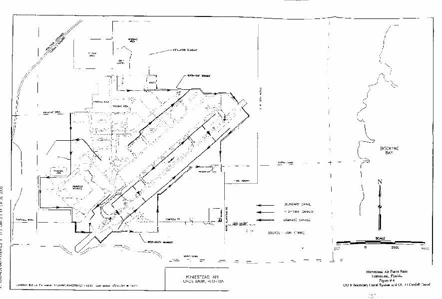
r^
BISCAYNEBAY
Homestead Air Fortfe EiaseH(Hn«siad, Florida
Figu-e#4OU 9 Boundary Canal System and OU 11 Ouifall Canal
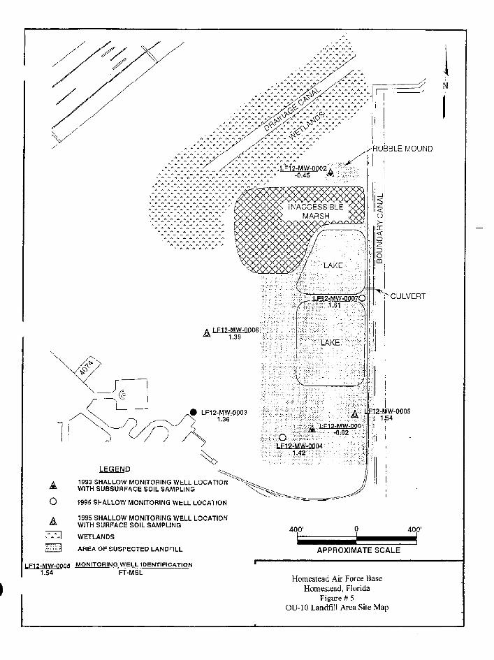
AO
LEGEND
1993 SHALLOW MONITORING WELL LOCATIONWITH SUBSURFACE SOIL SAMPLING
1995 SHALLOW MONITORING WELL LOCATION
1995 SHALLOW MONITORING WELL LOCATIONWITH SURFACE SOIL SAMPLING
WETLANDS
AREA OF SUSPECTED LANDFILL
LF12-MW-0005 MONITORING WELL IDENTIFICATION1.54 FT-MSL
400'
APPROXIMATE SCALE
Homestead Air Force BaseHomestead, Florida
Figure # 5OU-10 Landfill Area Site Map

APPROXIMATE SITED O U N D A R Y X
PUMPSTATION
ASH DISPOSAL"AREA
DIRT ROAD
WP23-MW-00032.73
A
LF19-MW-00013.38
MANHOLE
. LF19-MW-0QQ3A 2.56
/TRICKLING FILTERS'I
SECONDARY CLARIFIER:PRIMARY CLARIFIER
i
ANAEROBICDIGESTERS
i irI INCINERATOR! lI t!! I!1 I! . LF19-MW-Q002I I! A 2.54I II
1
^/AGRICULTURAL FIELD
A
CI!
A
LF19-MW-0D013.38
1993 SHALLOW MONITOFIING WELL LOCATIONWITH SUBSUFACE SOIL SAMPLING
1993 SHALLOW MONITORING WELL LOCATION
LOCATION OF FORMER OPERATING UNITS
1995 SHALLOW MONITORING WELL LOCATIONWITH SUBSURFACE SOIL SAMPLING
MONITORING WELL IDENTIFICATIONFT-MSL
100'
APPROXIMATE SCALE
Homestead Air Force BaseHomestead, Florida
Figure U 6OU 11 Sites WF-23 Sewage Treatment PlantIncinerator Ash Disposal Area
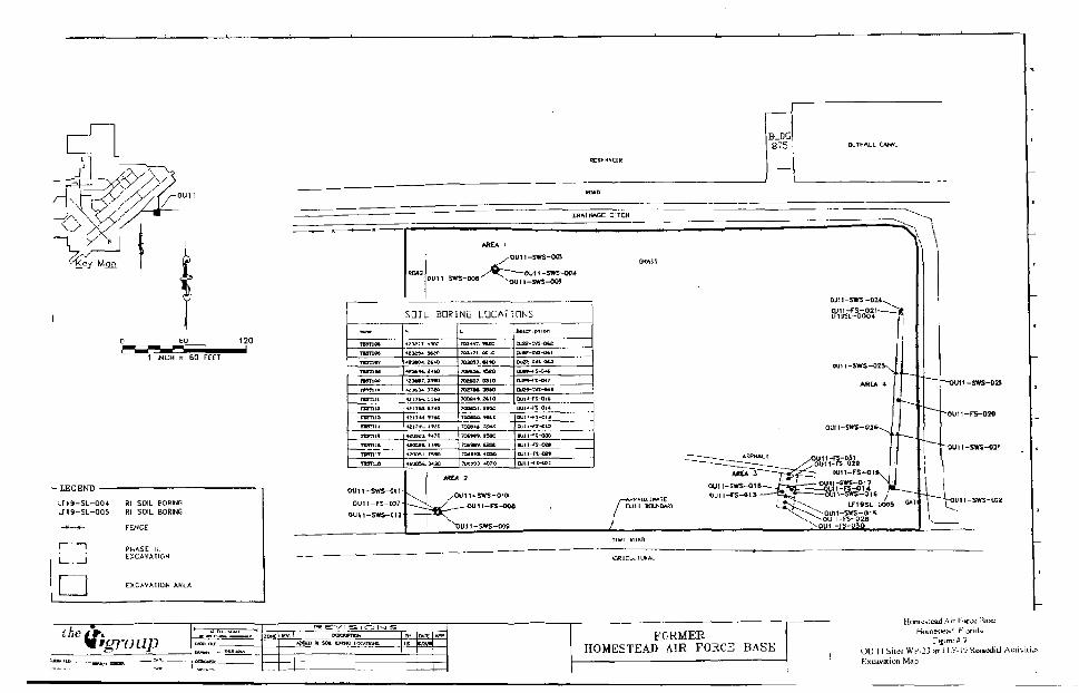
1 INCH TZ 60 FEET
Rt SOIL BORNGLM9-SL-O05 Rl SOIL BORHG
PHASE IIIEXCAVATION
EXCAVATION AREA
OUI1-SWS-00S
-SWS-M+-5WS-OGJ
SOIL BORING LOCATIONS
TCUK-nsnoen m m
1M1Hn m u
IWT1JI
rirniarcmiaTWTIH
n m mTtmnTWTUT
TWUi
*3£J7 1300
t3OT* JKfiES*CH i t - *
EXK, J frO
Z3M7. 3390
I K H 3iatirt-,. uw
4£LtUL »?4d
421T+4 I ' M
UI I41 491C
inos«.*49gwB5i . n*o
UO0M.343Q
t
7034-17. W20
703171, O510
7DHS&. «^O
7UUO7. COI0
7DE7H. 3SW
TOt**-* 2*10
70DBSL i H C
7OOC9C MLD
70(»«<- TOM
TO**** 13B0
?»4W, t£OC
Totrra -tcso
DUW-TJ-MTUJB^-'.VS-ft**
BJH-TJ-Ul*
•UM-ft-014OUH-Fi-OIJ
OuH-fI-013
DUJI-^S-OK
ajii-ft-on
oun-sws-oiiOUIl-FS-OW
04J11-SWS-C1!
OU11-5W3-01011-FS-OOS
BLDG
875
DJU-SWS-O;CL111-F5-0IVI?13SL-QOG4
N
-SWS-Ol 7
LFI9SL-KH9 " T
OU l-FS-028oil I -F5~0MI
ouii-sira-o;2
/V'group
VISIONSFORMER
HOMESTEAD AIR FORCE BASE
Hymcstead Air I -jrce Bast;Homestead, Hurida
OU I I Skes WP-23 and LJ-'-ISt Rcinedid AahExcavation Map
gordonn
gordonn
gordonn
5S26-MW-00021.62 FORMER DRUM
STORAGE AREABUILDING 720
LEGEND
A 1993 SHALLOW MONITORING WELL LOCATION" WITH SUBSURFACE SOIL SAMPLING
O ABANDONED MONITORING WELL
HUD DRUM STORAGE AREA
S26-MW-Q0Q1 MONITORING WELL IDENTIFICATION1.32 FT-MSL
100'
APPROXIMATE SCALE
Homestead Air Force Base
Homestead, Florida
Figure # 8
OU 14 Drum Storage Area Site Map
1 INIH = 30 FEP
- LEGEND
—
! i1 1
1-
Rl SOIL BORING LOCATION
CURB
PHASE 11EXCAVATION
EXCAVATION AREA
OU14-FS-01a0U14-FS-017
0UI4-SWS-012
OU14-FS-0070U14-SWS-0Q9
0U14-FS-QI
OU14-FS-015
14-FS-01BOU14-FS-014
S26-SL-O002OU14-SWS-0U
OU14-FS-00aOU14-SWS~C10
0UU-SWS-Q06SS26-SL-0003
0U14-FS-C01OU14-FS-00J
OU! 4-SWS-005
0U14-FS-O02
OU14-SWS-00*
the,I'group FORMER
HOMESTEAD AIR FORCE BASE
pr Fococ BaseHomestead, Klorida
Figue * *OU ]4 temoiial Ativilies Excavaliun Map
OTJ:
gordonn
gordonn
gordonn
OU-16 Structure 898, Former HawkMissile Area
—. /— BRIDGE
BOUNDARY .CANAL
696DSi/89SQg1R
4.4-DOD NO/7.5 ug/kg4,4-OOE IS.6/20.3 ug/Kg
-GATE
__>r-DIHT KOAD.—p. . . .^-s-FENCE .
I-:-:-:-:-:-:-?:-:-:-:-:-:-:-:-:-:89SD53
CAOMIUM u.B mg/kg
DEP REGULATORY GUIDELINES
1601
O H M Remcdl&t[«nService* Corp,
LEGEND
a
iu'iorini Well 1btur^ice Sample
ent Sample Lc-caJon
PEL • fiotablc Effcn Liml
Homestead Air Force Base
Homestead, Florida
Figure # 10
OU 16 Structure 898, Former hawk Missile Site Map
BOUNDARY CANAL
-*-
AREA 1PHASF IEXCAVATION
89BDS1
698DS2
B9BDS3
898DS4
STRUCTURE 898DS5898
GRASS
AREA 2 _ J 9 B D S 8PHASE I ~T~EXCAVATION ®
898-3
898DS9
LEGEND:
• GRASSY AREAS
fe MONITORING WELL 4 SUBSURFACE SAMPLE
9 FORMER SEDIMENT SAMPLE LOCATION
A CONFIRMATION SEDIMENT SAMPLE LOCATION
G E S PHASE I SEOIMENT REMOVAL AREA
I I I I 11 PHASE II SEDIMENT REMOVAL AREA
the
-BRIDGE
-GATE
- DIRT HOAD—7 -FENCE
CHECKED
APPROVED BT
REV,
0
-AREA 1PHASE IIEXCAVATION
PAVED SURFACEROAD
-PAVED ROAD
898-5
8B8DSS
•898DS7
" 898-4
DRAINAGEDITCH
GRASS
160'
Homestead Air Force Base
Homestead, FluiiUa
Figure # 11
OU-16 Remedial Activities Excavation Map
SHEET fI
PROJECTNO. 920685
HOMESTEAD AIR FORCE BASEMIAMI-DADE COUNTY, FLORIDA
J:\OHU2\HOMSTEAO\2O6B5\WP-20685\20685-0U16
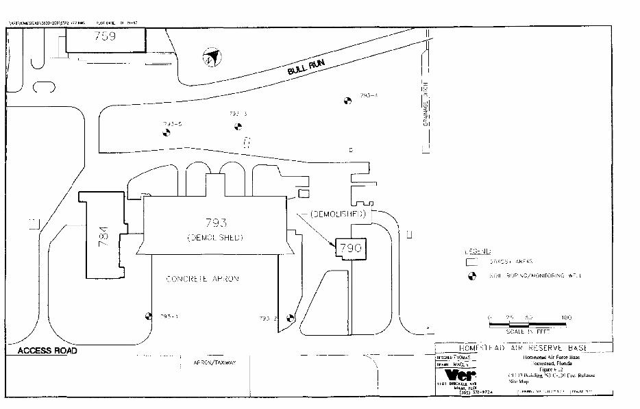
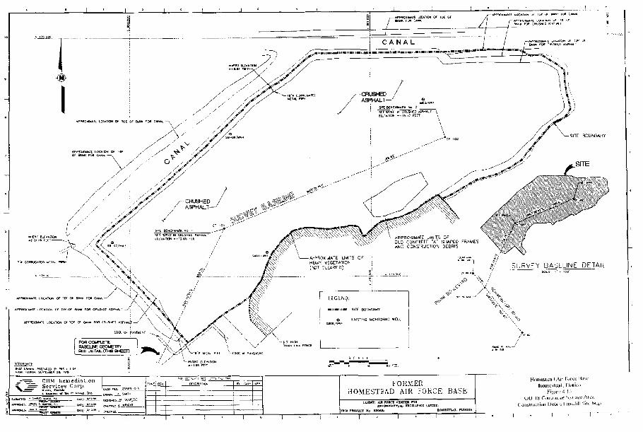
SHAPED FRAMES \ « s ; , ' ; ' ' ^0E6SIS ^ W
j f- SURVEY BASELINE DETAIL
OHM BeioediaiionServices Corp. FORMER
1OMESTEAD AIR FORCE BASE
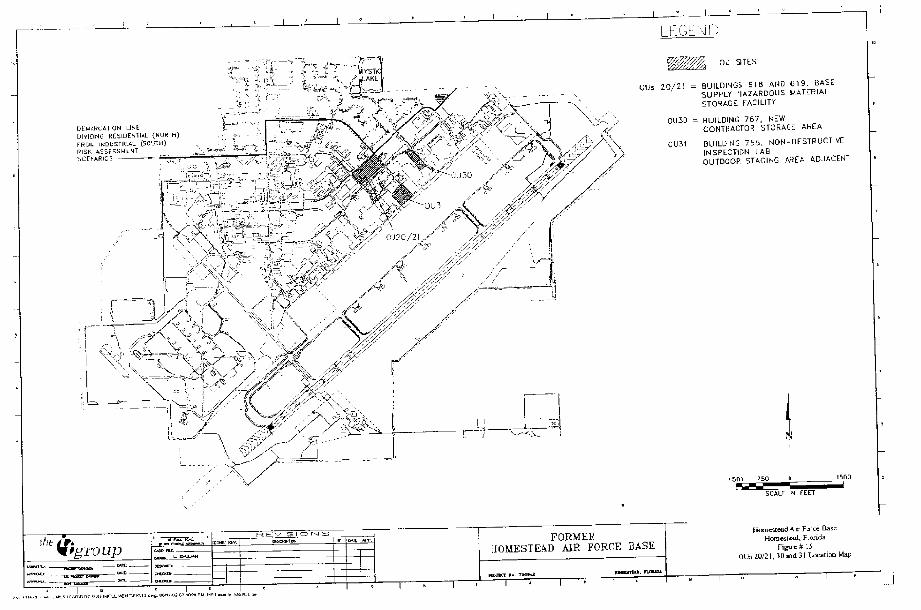
LEGEND
LUM/RCATION LINEDIVIDING RESIDENTIAL (NORTH)FROk INDUSTRIAL (5OUTH)PISK ASSESSMENTSCthAPIOS >— r' "^ rr
o u
OUs 2 0 / 2 ! = BUILDINGS 518 AND 619, BASESUPPLY HAZARDOUS MATERIALSTORAGE FACILITY
01130 = BUILDING 767, NEWCONTRACTOR STORAGE AREA
0U31 = BUILDING 755. NON-DESTRUCTIVEINSPECTION LABOUTDOOR STAGING ASEA ADJACENT
1503 750
SCALE t) EEET
FORMERHOMESTEAD AIR FORCE BASE
Homestead Air Furce BaseHotne&leid, Florida
figiri:#lJOUs 20/21, )0 n d 31 Location Map
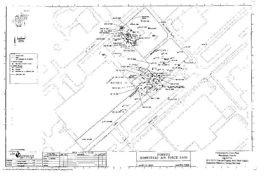
FORMERHOMESTEAD AIR FORCE BASE Figu-e# 16
OUs 20/21 Uuldoor Siging Area .'Base Supply[ [azardous Materials Storage Sile Map
MONITORING WELL
WOOD POWE^ POLE
CONCRETE FOWER POLE
C G R R U G A T E C METAL PPE
CONCRETE
©
\
FIRE HYDRANT
MANHOLE
OUCH / CMJAL
5IDEWALLSAMPLE
FLOOR5AWP-E
ROCK EORIN^ SAMPLE
INITIAL EXCAVATION LIMITS
Denotes c f armarexcavation found
"—' -"-j Denctes Phase 1_ i . I Addiiiono: digging
(1.0 feet total depth):V^7Sj Denotes -hase 3CX.X] Additional digging
(2.0 feet tote I depth)1 Oeno.es untouched
Acdifonai 1 '(2.0 feet tota1 depth)was sxcavatec Iromth's 3rea (pr ic to SB1samples)
No;e: Phcse il excavation removec adc tionol0,5' I1.C feet tctal depth) from entirearea (prior to SB1 samples)
WELL NAMES | COORDINATESDESJCMATION HORTHNC
B618-HW1SBO5/MW2
SB-06/HW3
42393S-024Z396'.6S423935.68
ELEVATIONS
702060.^9703304.23702078.37
GFKHIMD
7.as5.727-97
7.697.197.71
S C A L E
Figure ft 17O U 20 RemediaJ Action HxcaKaCion Map
LMh-
i.ONC
©
CONCRETE PO"VER POLL
CORRUGATED MEIAL PIPE
CONCRETE
RRE HYDFtAMT
3DLWVLL
FINAL EXCAVA.1 IC>. U Ml" SJ
WELL NAMES COORDINATEa |DESIGNAUJtl HOftlHlMS
BS16-UW1 123939.02SBO5/MW2 421964.69
5S-06/UW3 42J935 6B
EASING
702060.497033D+.2i702076.37
ELEVATIONSGROUND
7.B9i 727.97
7.6£
7 71
HuillcsLi^iJ A i l i-'iircc lia.
5 C A L E
O 40 80 FEET
LJl.^U i<WM (.JU>LIIK1WULT_T A alv i io l K^-bu!
5MET M.—
Sjj
•<,•
3-SAs -, -jif'^S
F.< * ; pri.&Grr-ipltt
-•--Sr v & > • % '
' , « • •
V
cm^ - e x
*^VXJ*M\
^ / : , f : : - : ; > i >
L.-' /
/ S C A U
WH^ NAMt' i:W)h! )NATb: ; hiiVAIiuN^
L .
J /
« HONITORING WEI L
ji TOOD POWER P j L t
'/i CONCRETE P I M R POLE
Ct.1^- CORRUGATED METAL PIPE
•VOH" CONCRETE
'& HRE H-DF^T
DIP DUC1ILE IRON F\PL
(M) MANHOLE
V :TCH /' CANA.
FLOOR" 5AMPLL
-•• • 1NIIIAL EXCAVATION LIMIT1
• H'JCr. BORING SAMPLE
: • ]"j] Denotes Phase 3: • u Aodiianui digging
(.2.0 feat tctal deo'h)
Derives Phase i
Aud lional digging
(2.0 feet tctal depth)
WiiiicJial Aclimi I
X WOOD POWER PCLE
X CONCRETE POWER PQ-i
Flf t i HfDRANT
DIP DUCTILE IRON PIPE
(f i) MAW HOLE
•j / DJICh / CANAL
= FINAL EXCAVATION UMIFS
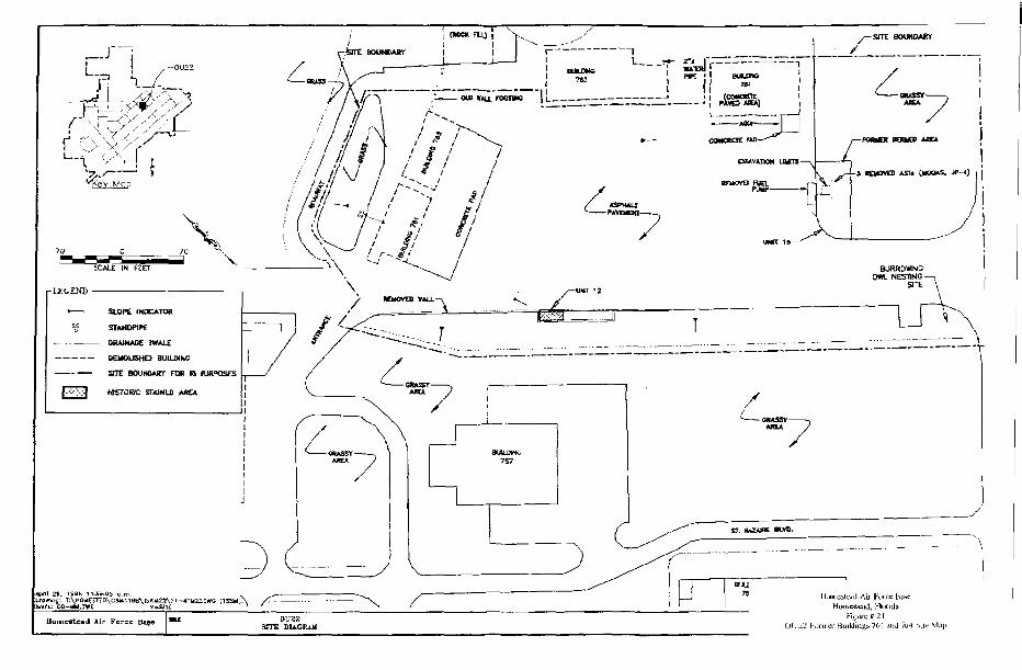
_-J~~iL_
J -•/•• • X S / /
\ y ll \
SCALE IN FEET
r LEGEND •
SLOPE INOCATOfl
STAHOP1PE
DRAINASE SWALE
K U 0 U 5 H D BUILDING
SITE BOUHttAKr FOR Rl BiHPOSES
HISTORIC STAINED AREA
SITE: SOUHDAOT
Z
\*pri\ 29. tsas
UameBte*<l Air Force OU22SITE DIAGRAM
we fl 2!Ot.Zi Fonna-BuilJinissWt] JJIJ «1 SHI-
I
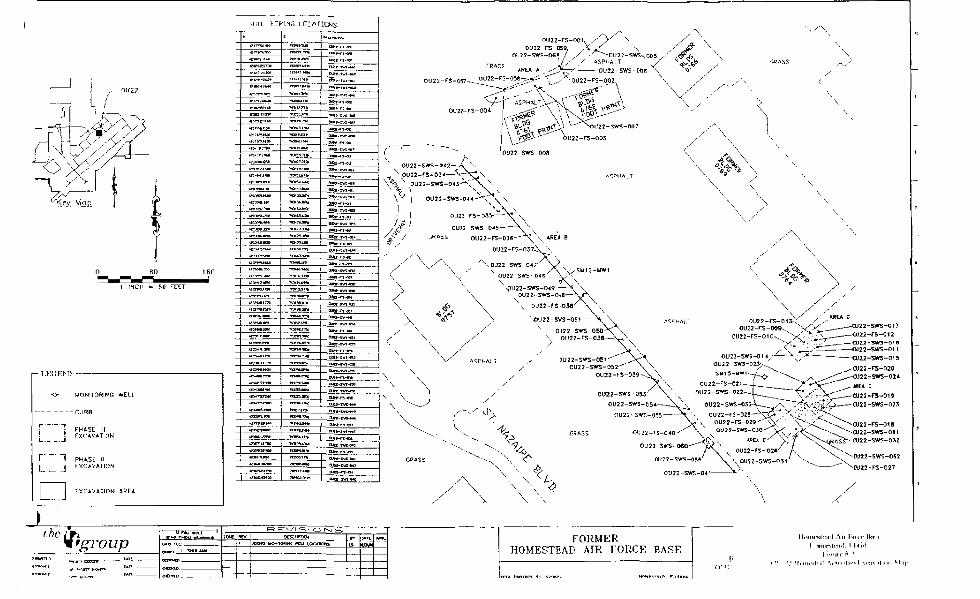
I INCH = 80 FEET
•<^ MONITORING WELL
CURB
f 1 PHASE III^ J EKC4VVUI0N
~\ PHASE IIj EXCAVATION
NOVATION 4REA
'groupr a ."-mi 'r i n
MXK3 yQW(TOfttfW WELL LOCtTKifp.FORMER
HOMESTEAD AIR FORCE BASF.
u tTWUHTT Ho B?<Hin\
gordonn
gordonn
gordonn
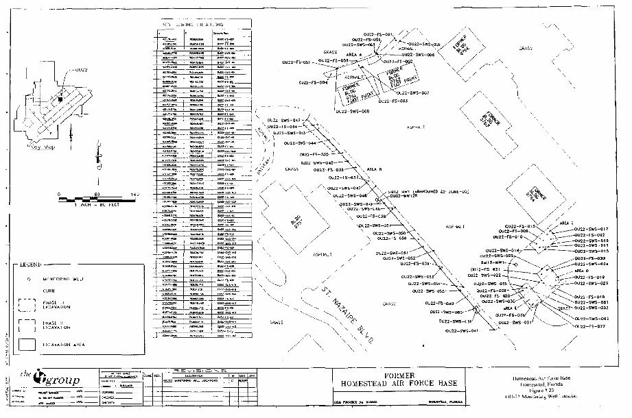
1 INCH - SO FE.ET
-LEGENU
">
I 1i 1i i
1 1L 1
•
UGNITOR1NG WELL
CLJflB
PltASL IIIEXCAVAFION
IJHASE IIEXCAVATION
LXLAVAllON AREA
\fgroupFORMER
HOMESTEAD AIR FORCE HASE
OU-22 MuniLurin^ Well LoeaiL

nit
y/ •
\
••
X
/>
/
y
/'
/' '' .y ss
\ 1
;/
/\ • \ y
„•
-•
'
'' ,y
'y'
i,
/
y
:?• \
y-.
\
S
5 S
3
L
n
5 ?
S
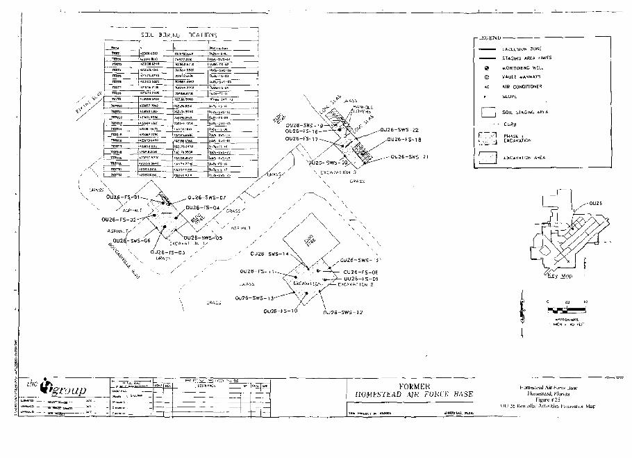
m i lT B nTtsra
roT*
n = m
TESTS
TESH
TESTB
TKTV
TiwnoTESTII
Jramrasna
ttsnt
TESTlfi
TOnt
rramTE3T1B
"~^ rTESTS
SOIL BQR:
N
4S3H»BD10
4?3I3S^?4O
1 f3 IS3Aa«
*23IDb ?U i
1? 3* i 7 'Obi
^ ' j w * <«*••
i ? 3 l S3 !.+•*:•
1J32131DL0
* a 3 a l 3 i 7 3 .
^ , , J K
NU LDCAT1DNS
roisrD.-*t,£c
ja i i r7 3iio
»)»*•* 55»
?0|-KH.tfhl*5
JOSt** 7?5t
? c o m m i e
70?IPJ2tBt
7D5.7tt9330
DWh-rS-flL
ajat-rs-ia
I*JBfr-S«-»
iijE4-r:-Li
QDU«^SWi-l3 1
aj2t-« s-ifl
Uj?f.-rs-M
O^(.-5Vi-Ji.
JUJE.-FS-06
uu*t,-sws-aiDu2b-ri-[fi
OU26-SWS-ZI
\ ^ / 'y ASPriALl
<^ XOU25-SWS^05
% \ oujs-rs-oj% v OKAS:
% s • - / ' ,
CU26-SWS-ii"~
OU26-FS-O6OU25-FS-OS
0U26-SW5-13"
OU26-FS-10 OU25-SWS-12
-LEGEND
©AC
[ |
m
EXCLUSION ZQKt
STAGING AREA LIMITS
WON1TORINC WELL
WAHJL1 UANWAYS
AIR CONDITIONER
SLOPE:
SOIL SiftGlNG AREA
CLJftB
PHASE »lEXCAVATION
EXCAVflTlDtH AHfA
-ac '
c in «
FORMERHOMESTEAD AIK FOKCT BASE
urat&naitl Air-Force Base
Humcstcad, Florida
Figure n i t
neJinl Activities L;i.cavatiui Map
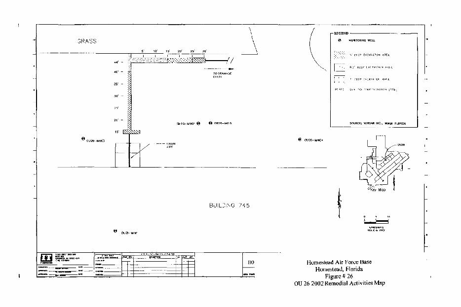
3RASS
5' 101 15' SD1 25' JO1
I I I I I .
TO DRAINAGEDITOII
SU60-UWO! f* £ OU26-MM0
BUILDING 745
FflHO
€ 0U26-MW0+
- LEGEND
nz
MONITORING WELL
T" PEEP CKCA'.'iriOh
Qun, Pif) C.DtJrrujnt,
SOURCE; VERSAH INC
ARE ft
•1 AT I A
ArSTfl.
IOM (PP
, MIAMI FLCHIOA
liomestead Air Force BaseHomestead, Florida
Figure # 26OU 26 2002 Remedial Activities Map
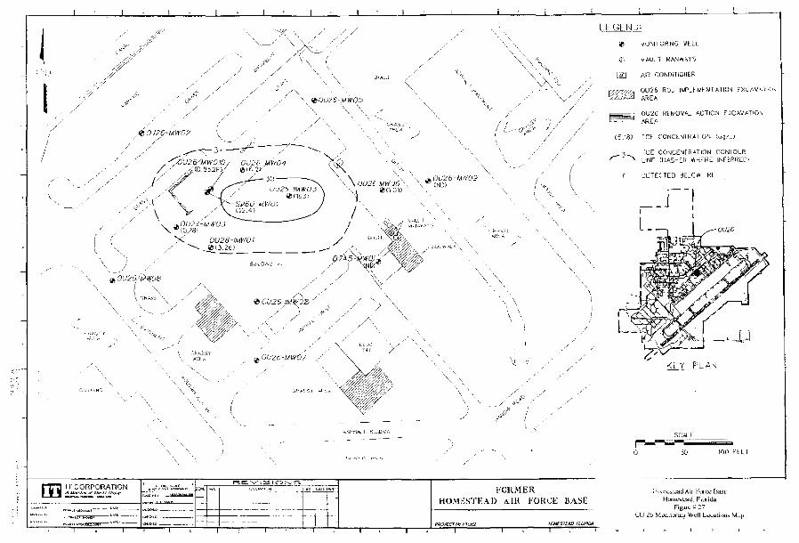
ll,0U2£-MW0J
>i OU26-1MW01
X
i , 1 * —
LB'GE.NU:
* uUNITOftING WELL
(fi VAULT MANWAYS
[ i l l AJR CONDiTIOUER
OU26 ROD IMPLtUtNTATICJ EXCAVAllOJ
OU26 REMOVAL ACTION EXCAVATIONAREA
C5.16) TCE CONCENFRATIOK (ug/L)
"CE CONCEMFRATION CONTOURLINE CDASHLO WrlERE INFtRREDi
IT CORPORATION FORMERHOMESTEAD \ IR FORCE BASli
KFY PLAN
50 100 F-'ttl
Huintistt»iJ Air l:H.irce FiaHt)rnesUati Florida
Figirt S 27CU 26 Muuhoruijf Well Luuit i
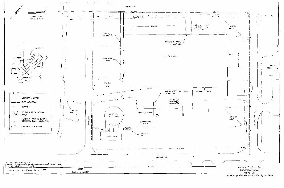
• I .EGSMJ
DRAINAGE SWALE
SITE: BOi.
— SLOPE
• :.:'i'- FORUER
~~| FORMES- . 1 STORAGE
j \ CULVERT
UOAftf
EXCAVATION
UNDERGROUNDTANK LOCAT1CN
LOCATION
L
y i !
Q_
3LDS 744 \FUEL TANK ,'
_ WOBIU; ASI (75^ ruu.) •COMCRE1E P»D
GRASS TAREA L
CRAS3TAREA
\
I \ .... — . ...A
SITE DUGHAMmesitai:
FigureFaciliiy Sku
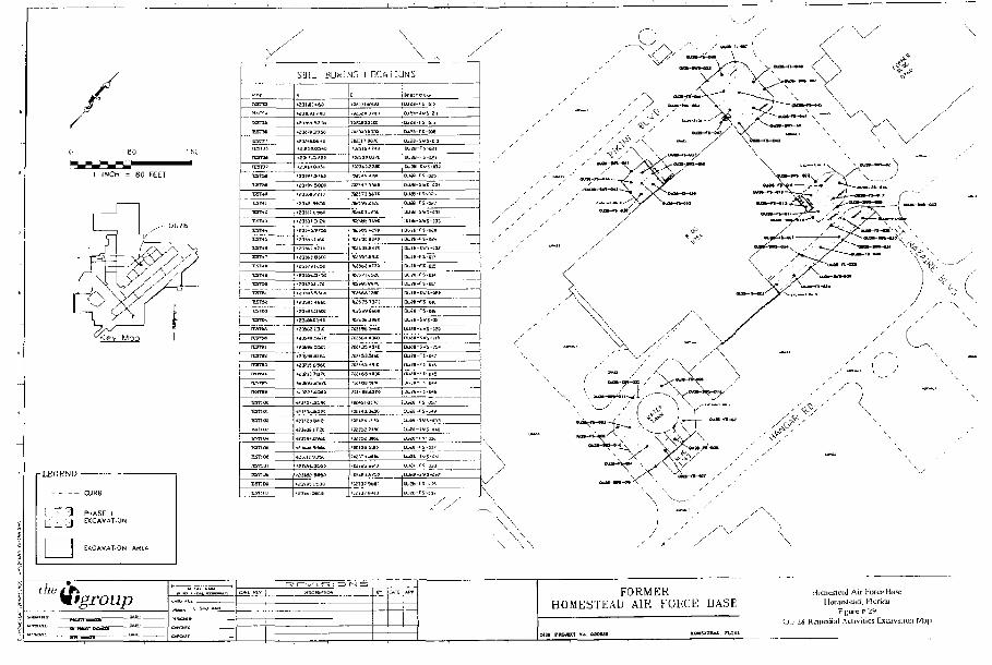
1 INCH = 80 FEET
• L E G E N D
CURB
P-iASE HEXCAVATION
UCAVATJON AKtA
[tSTCJ
tESTE*
i£sT2S
rcsrwFESTZ7
rcsrwIT3T3P
rcrrvaresHi
rESTii
T5T17rtsi.n
PESTi*
rCSTM
res™
rcsni
reiuITSTM
reSTftl
rc?Tw
rcfTwu
rcsrv
rtaivs
•ESUiM
-fcsti UL
T5T11K
tsnai
Tsnw*csno6
xsnoa
SOIL BD^l
t£3 iW 5BB&
"»-«™- , ^ . . . M
\
\ ^ . ^ ^
M3 LDCftTIGNS
JH3S< J'8O
73?Ma3L2Q
^ 3 0 1 0 3 3 0
3W31T MIC
IM53J037C
7 M 5 « *»?C
?aS5<5 5StO
CuSH-Sul-311
HJ2S-F5 ICJ
Uuf3-W5-Eia
UJ»EwX-ll3fl
OJ E E. I S3*
oua-r£-a?r3U«-5W5-a3i
?C3«BJt.9D [ [U i6 -SVS-P3J
'L£bO5*iW B J i t - f S - B f i *
.?3i7S!^5«
-?]i73.IL7C
-?3rtS3bJX
UlSbf 13LC
• £ Ji< 9^.1,70
»;3ni.65*E
i?J^Vl. 35Sf
IK:7573»t
IWi t " •300
JK1SB9I9E
DU€e-F5-yu
DufB-FS-015
(uifi-ivs-tii
OUiB-WS-ttfQ
•Ui8-StfS-BJ*
OJtO-S^S-BS*Qjid-rs-ii*r
ak^fl-Fs-wE.
OJSB-E S-P<5UiH- l 'S- IM.
7ffi-t6l 067^
70SJ5£3*6£
LJLJ£S-SVS-O*C
JJife-l * -03t
•UM-rs-DJ'UU3E-WS-MI
' / ^ 'i YA<s J
\ \
*'f''
the tf'group FORMERHOMESTEAD AIR FOKCE BASE lloniesLeud, Honda
F.gure & ^
(J.. 2S Remedial ,\clivjties Ext^iviiiuii Ma|
\
Houicslead Aij H\ir* baseHanestead, E'larith
FLBUIC P 30
UU 2* Avioiiii v Airmail Ground EinpinaitFacility. Sile Map
OU29-FS-OW
FORMERHOMESTEAD MR FORCE BASE
gordonn
gordonn
gordonn
the if-t
H'groupFOKMEK
HOMESTEAD AIR FORCE BASE
Site
Kijrure P 3 "ding 7&7<"uuLt\u
•
X-R
EF
O
FFIC
E
\ ^
/ 'c ?
m x o o 2
ny
"'"
! '
•'
X'.*
IS
r"
c
3:
I;
o frntnl
Q.
CL O f j
tl
c a
-'•
© 5:
IT
2?
>
O
I h
S E
SC
F
J 1
^
S m
^
T
1s
j ^
c >
g "
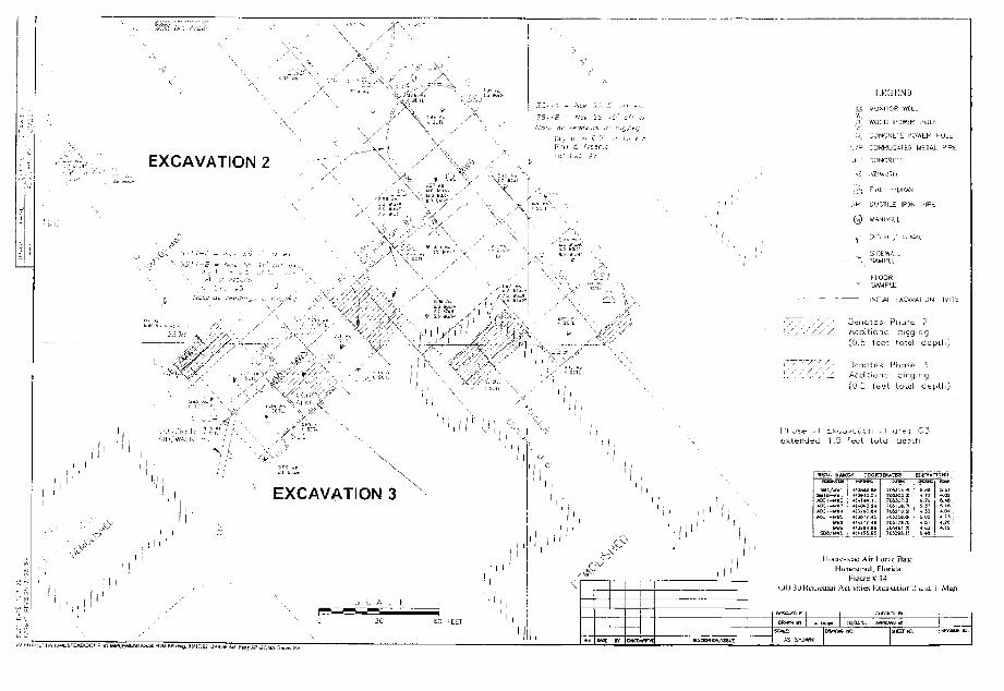
LEGEND
WOOL POWER
EXCAVATION 2 .uu,: CONCRETE
-.1 AZIMUTH
.!••• FIKb hYDKAM'.
^ H LJUCTILE IRC'N
& +
-v -
X
I ' M 'V
SlfJEVvALL
fLOORSAMPLE
IN3T.AL L X ^ A \
Addit ionci cigc
(O.b 1ee". tolol
DeAd
(C'
nc
,5
>tes Pru*£
feet toial
-AIIUN , M
• ?_
d e p 111;
i 3
i depth)
SllJrtf-l I
EXCAVATION 3i ,' ' :
Pi" ose JN Lxcu^ci^cn ill area C3extended 1.5 feet total aesth
BELL
n 2
WX.-WW5
COQRI
:is-as.B6
i+1+4 IL:-H"«i 24
: » 7 i 45
fJ»S4BSHI5B.65
m*TES
701301
JC421I
.
K7OJJ&BB-
7GJ4& ?:
EIJTVit
f n
+.33
tuna
•*.aj
n ifl
4. IS
sLeyJ Air I\wix. Bain<iiiKa.d, Florida
) 3u kciiicdiai Aciivities t.^uaviniurj '1 ajui j Map

is"
GEN;HAT (BU LDiNG
'i,
V \
- 4-'
.-on: CONCRETE
AZ «ZiMUIH
vVJ FIRE NVDSANT
DIP UUCTILE IhvJN FII'T
(HJ WAMrlGL-i
• 4 " . EXCAVATION 4
*v .
&.ICH / CANA
FLCORSAMPLE
••'.•] A s p h a; • i c r n c * & r i a I d; g g
""\ Denotes Phu^e 2~ j Additional Ciggin^
(1.0 feet total depth)7n Denotes Phase 2() Additronal ciggi'ig
(0,5 fee- tutul dep:n)
/; Denotes Phase 3^J Add.tionai aigymg
(0.5 feet total depth,)
/\ Additional diggng(O S feet tola: deptn.)
TEH. NAUl
ADC1-UW2
tnre
sae/uwe
H COOKDWATES ELEVATION i
424-144.11
42M77.4S
113131 4S
42*156 66
T31MU.16T03M7.il E ID
s.*a
!•£
.72
. l i
S C A L £.'_
.SSlj 1 Imn e itatl -\jr fitmc ban:llomisiead, Klurida
j1
I F . H I E
|
0 h-""1Bd
-,«v--|
r- r
4 Mup
4O.vtyu« PKJ
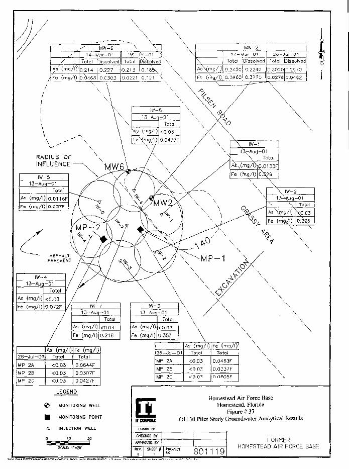
/A/ (mg/\f\Fe (mg/l)
MW-614-Mor-0t
Total
Q.214
0.04S3
Dissolved
0.227
0.0303
\
2fi-_Total
0.253
0.0221
\
DisSplved
0.185\0.121 v
UW-2
\
As\(mg/I)
Fe (\/\)
14-Mar-01Total
0.24000.3960
Dissolved
0.22400.3770
26 - .Total
0.3020
0.0276
ul-01Dissolved
0.2970
0,0462
RADIUS OFINFLUENCE
IW- 413-Aug-01
As (mg/l)
Fe (mg/l)
Total
<0.030.072F
As
Fe
IW-713-Auq-01
(mg/l)
(mg/l)
Total
<0.03
0.218
As
Fe
IW-313-Aug-01
(mg/l)
(mg/l)
Total
<0.03
0.353
\
\
\
26-Jul-01
MP 2A
MP 2B
MP 2C
As (mg/l)Total
<0.03
<0.03
Fe (mg/l)Total
0.0644F0.0307F
0.0427F
26-Jul-01
MP 2A
MP 2B
UP 2C
As (mg/l)Total
<0.03<0.03
Fe (mg/l)Total
0.0463F
0.0337F0.0605F
\
\
\
A
0
LEGEND
MONITORING WELL
MONITORING POINT
INJECTION WELL
10
SC*1£ T-20'
ITCORFOiU
Homestead Air Force BaseHomestead, Florida
Figure # 37OU 30 Pilot Study Groundwater Analytical Results
CHECKED BY
APPROVED BY
REV. SHEET PROJECTNO. 801119
hORMERHOMESTEAD AIR FORCE BASE
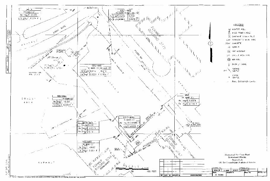
, . / M14-M*R-Pi"[?6-JUL-0!
Mom<sicsid. Florida
OV Hit (irumid*dter Analyii
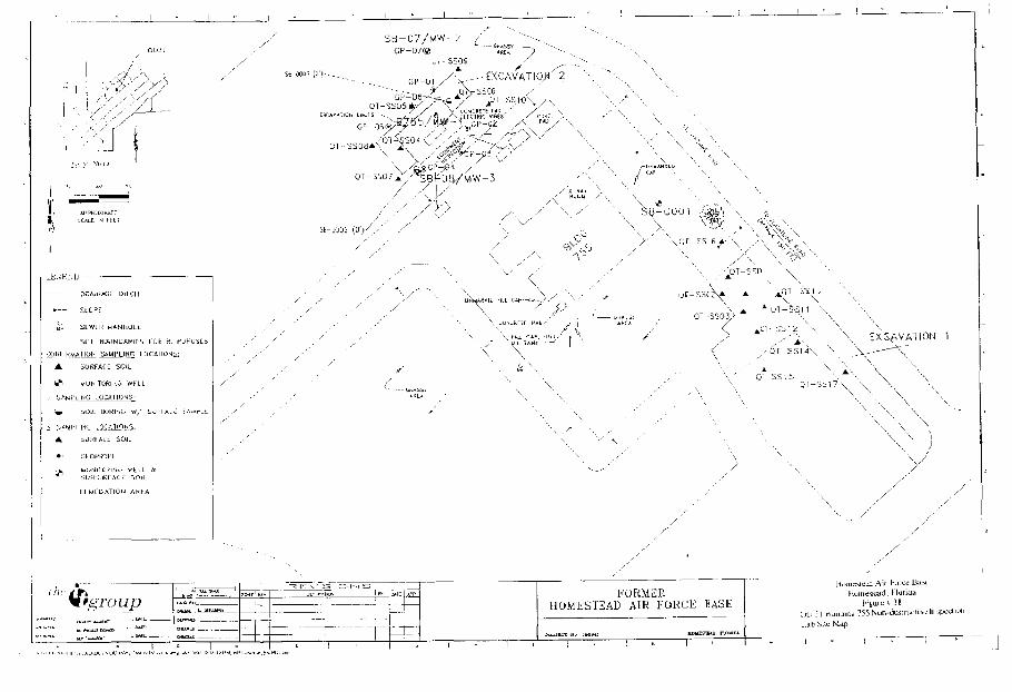
r r 1 ::'• r- I 1 _ _
'A 1 \ ill
\ I i | !;
1 1 f " 1
:
3 c t; 1 BL
T
T
F i i 1 f
j E E e 1
110 £ K tA-
^i
M
pj
s K ts i> r/.
si
= I
\\%
:£
:? 1=
- ^
(5
y'
fe
kr
X..
\
i? SE
• ho
'• /
O C
LI
°''.
in k
.'"
lil
\ x
:.
/,
-\
\/
/
\
'\
/
./
/
/
•
-
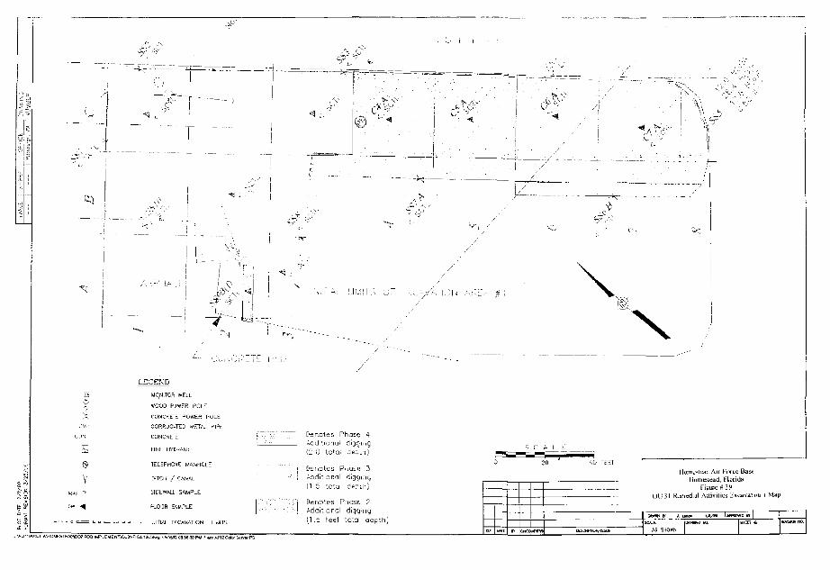
-y •-•:
V
-4 .
-—--'': Kl.
LEGEND
WCM1T0R WELL
WOOD FUWER HOLE
CONCHElt POft'EH POLE
CORR'JG^TTD virTA^ P I?L
CONCRE1E
HRL hr tRAN;
TELEPHONE MATsiHOLE
DITCH / CANAL
SICEWAU SAMPLE
FLOOR SAMPLE
- INITIAL EXCAVATION L I ^ T i
~T
D^notes Phase 4Aed:tionui digging(2 0 totai depLh.)
Denotes Paase 3Aadit onol digging(1 5 ;oto depth)
Denc:es Pnase 2Additional digging(1.5 feet to'.al oepth)
lC\-< A . r ; L - i
'?
I lorn CSLI IL Air Furcfi liawHumes cad, Fiends
Figure $ 39OU3I Kjnedial Activilies lixtii^at i»i i ^ap
| owy;__t'' _j_ _ _
I A5 SHOW
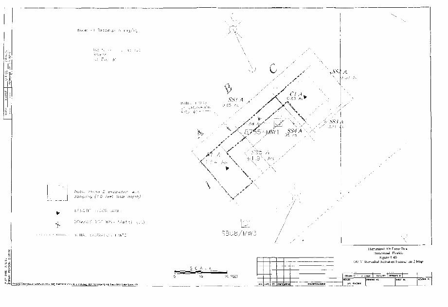
X-K
LF
I Q
JTlC
C _
V-
I
t/J c: cc
A:1,'
I £
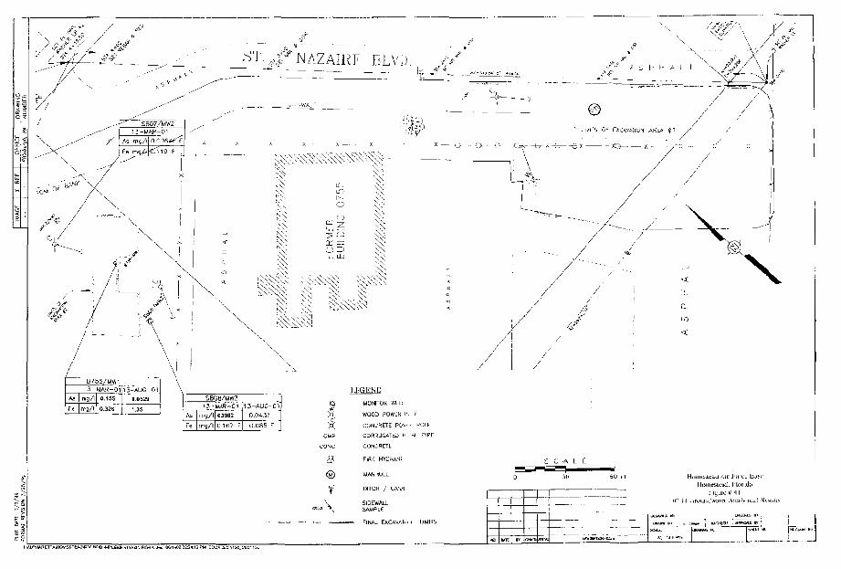
si
SB06/MW3
As
Fe
m g / l
mg/l • 167 F
1J-AUC-C1
0.0-432
0.085 F
$
CMP
tONC
@
V"\
IJ^GEND
MONITOR WELL
WOOD PQWLK I1'
CONCrtETE PO1*-
CORRLJGATLJ ^L
CONCRETE
F I R L MYCftANT
WANHOLt
DIICH / UANA
SAMPLE
F HULE
: AJL PIPE
< UHIT5
«iiaii. I lor Lib
I UVAHIA- I " I I
. - I M»~"L.
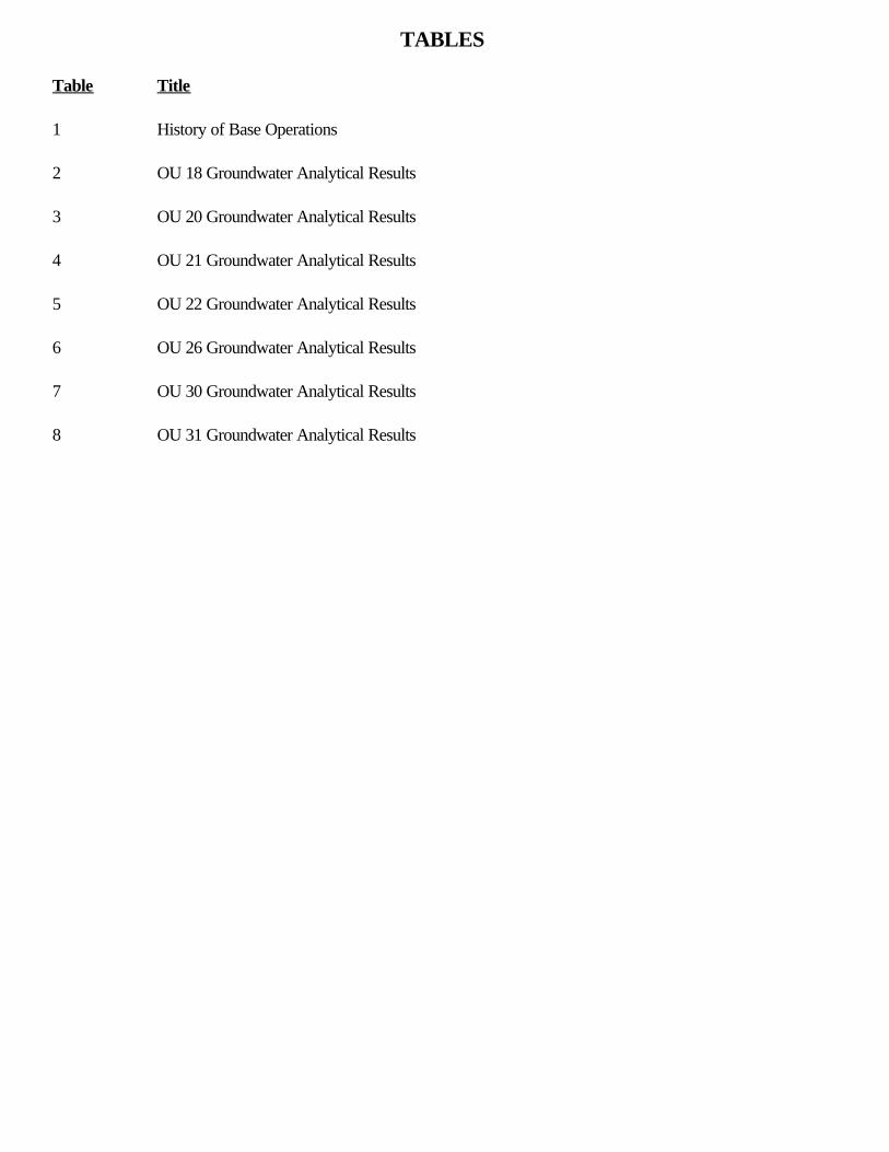
TABLES
Table Title
1 History of Base Operations
2 OU 18 Groundwater Analytical Results
3 OU 20 Groundwater Analytical Results
4 OU 21 Groundwater Analytical Results
5 OU 22 Groundwater Analytical Results
6 OU 26 Groundwater Analytical Results
7 OU 30 Groundwater Analytical Results
8 OU 31 Groundwater Analytical Results
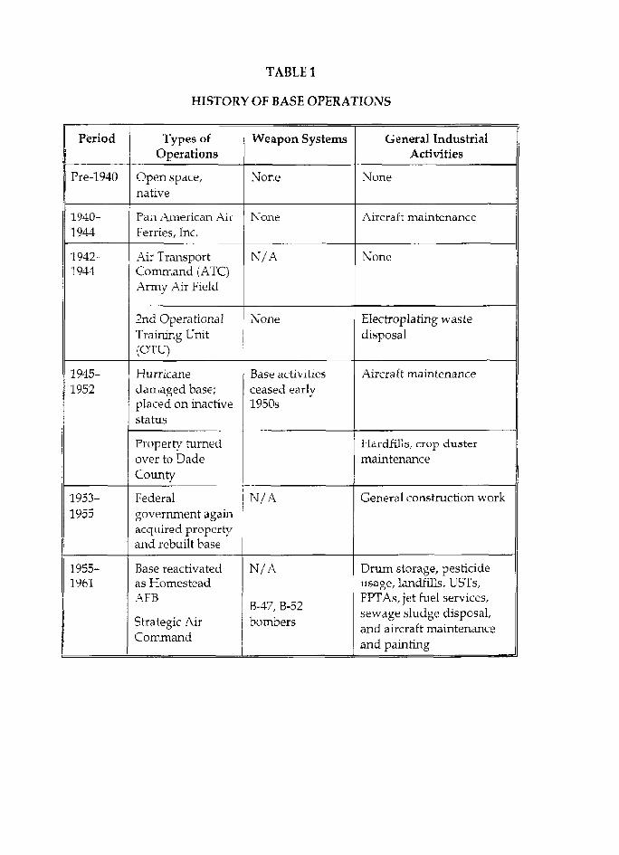
TABLE 1
HISTORY OF BASE OPERATIONS
Period
Pre-1940
1940-1944
1942-1944
1945-1952
1953-1955
1955-1961
Types ofOperations
Open space,native
Pan American AirFerries, Inc.
Air TransportCommand (ATC)Army Air Field
2nd OperationalTraining Unit(OTU)
Hurricanedamaged base;placed on inactivestatus
Property turnedover to DadeCounty
Federalgovernment againacquired propertyand rebuilt base
Base reactivatedas HomesteadAFB
Strategic AirCommand
Weapon Systems
None
None
N / A
None
Base activitiesceased earlv1950s
N/A
N/A
B-47, B-52bombers
General IndustrialActivities
None
Aircraft maintenance
None
Electroplating wastedisposal
Aircraft maintenance
I Iardfills, crop dustermaintenance
General construction work
Drum storage, pesticideusage, landfills, Ubl's,FPTAs, jet fuel services,sewage sludge disposal,and aircraft maintenanceand painting
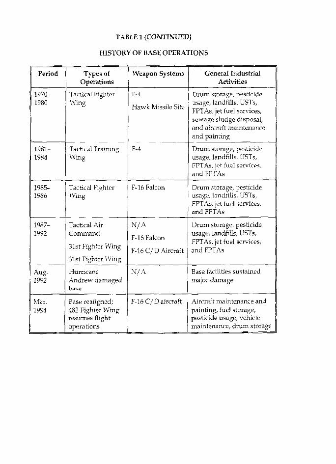
TABLE 1 (CONTINUED)
HISTORY OF BASE OPERATIONS
Period
1970-1980
1981-1984
1985-1986
1987-1992
Aug.1992
Mai.1994
Types ofOperations
Tactical FighterWing
Tactical TrainingWing
Tactical FighterWing
Tactical AirCommand
31st Fighter Wing
31st Fighter Wing
HurricaneAndrew damagedbase
Base realigned;482 Fighter Wingresumes flightoperations
Weapon Systems
F-4
Hawk Missile Site
F~4
F-16 Falcon
N/A
F-16 Falcon
F-16 C/D Aircraft
N/A
F-16 C/D aircraft
General IndustrialActivities
Drum storage, pesticideusage, landfills, USTs,FPTAs, jet fuel services,sewage sludge disposal,and aircraft maintenanceand painting
Drum storage, pesticideusage, landfills, USTs,FPTAs, jet fuel servirps,and FPTAs
Drum storage, pesticideusage, landfills, USTs,FPTAs, jet fuel services,and FPTAs
Drum storage, pesticideusage, landfills, USTs,FPTAs, jet fuel services,and FPTAs
Base facilities sustainedmajor damage
Aircraft maintenance andpainting, fuel storage,pesticide usage, vehiclemaintenance, drum storage

Table 2OU 18
GroundwaterAnalytical Results
Sample LocationSample Event
Sample DateUnique ID Number
Parameter Units I GCTLi FSWC6! MDL."
OU1E-MW1RY1SA1
26-Oct-99910841
Result Qual
OU18-MW1RY1SA2
12-AprOO0429401
Result Qual
OU1J-MW1RY2SA1
1S-Oct-00200758-01
Result Qual
0U18-MW1RY2SA2
25-Apr-01L0104539-01
Result Qua!
OU18-MW1RY3SA1
22-Oct-01L0110466-01
Result I Qual
0U1B-MW1RY3SA2
24-flpr-02CY3SA23000
Result I QualVolatiles Organb Compounds
AcGlone pg/L 730 16S2 2.5 na na -
Semiwokitiles Oiganic CompoundsCarbazoleDchlorobenzidine, 3,3'-
ug/Lug/L
)12
46.50.06
2.85
2.5na
nanana
- - -R -
'olynuclear Aromatic HydrocarbonsAcenaphtheneAcenaphthylene
AnthraceneBenzo(a)anthfacene
Benzo(a)pyreneBe nzo(b)fluoranlheneBenzo(g,h,i)peryleneBenzo(k)fluoranthene
ChryseneDibenzo(a,h)anthraceneFluorantheneFluorenelndeno(1,2,3-cd)PyreneMethylnaphthalene, 1-
Methylnaphthalene, 2-NaphthalenePhenanthrene
Pyrene
PB'Lug/Lug/Ljg/L
P9^L
[jg/L
Mg/Lpg/L
ug/Ljg/L
pg/L
[jg/L
20210
2-00C2
C,2C.2210C.5i . 8
ri.22B0
2800.2
102020;io510
30031
0.30.0310.0310.031Q.O310,031
0,0310.031
0.3
300.03"
9530
260.Q31
0.3
0.05
0.050.050.05
0,05O.OS0.050.05
0.050.050.050.05
0.050.050.05
0.050.050.05
• 5
2. . . • 2
-
1.6---
3.32
2-
667
4• •;,.•: ., 2
3.68--
0.183
0.188-
0.078
-•1.844.32-
nana
1.17
0.9741.13
JR
F
F
F
J
J
F
4.7-058
0:052
---
0 047-
2.64.2
--
-
1.5
J
1.1--
0.09-
--
0.09
1:81.4
----
1.2
F
F
0.73
-
0.40.29
0.360.23
0.2
0.42-
2.20.3
0.19-
--
1.7
RRMMMJ
MMRMJJR
R
M
0.205-
--
--
0.7910,140
-
• 0:532
PesticidesAidrin
C.rilordane"DDE. 4,4'-DioldrinHeptachlor epoxideMethoxychlor
r'9/L
pg/LM9^LUQ/L
jjg/Lpg/L
a .0052
0.10.D05
0.240
30.O043
0.1O.O019
00020.03
0.01
0.250.0250.0250.01
0.025
nana
nanana
na
nananananana
----
-
--
---
-
---
-
MetalsAntimonyChromium
IronManganese
mg/lmg/lmg/lmg'l
00060.1
3.3COS
4.3NS1
NS
0,0005
0.000570.0133
0.00021
nana
nana
riana
nana
--
6.810-295
-0.OOO75
: 3:720.0772
F 0.0074
3.72o:o5ti
F-
1.960.0241
General ChemistryAmmonia mg/l 2,8 O.02 0.06 | 1 .1 | 1.9 1 3 6 | " I - : ••:.: 0 . B 9 1 , . : '••:• 0.47| 0.7J6I
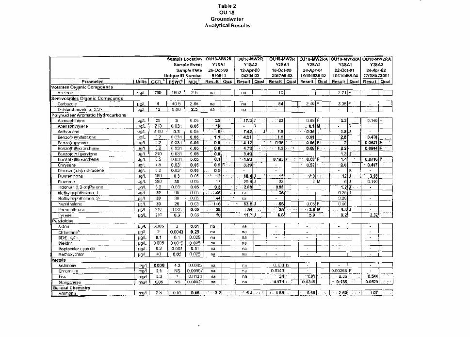
Table 2OLJ 18
GroundwaterAnalytical Results
Sample LocationSample Event
Sample DateUnique ID Number
Parameter Units e<;TLb FSyycM MDLb
OU18-MW2RY1SA1
26-Oct-99910S41
Result Qua!
OU18-MW2RY1SA2
12-AprOO0429403
Result Qua!
OU1B-MW2RY2SA1
16-Oct-00200758-03
Result I Qua!
OU18-MW2RAY2SA2
24-Apr-01L0104539-02Result Qua
OU18-MW2RAY3SA1
22-Oct-01L0110466-04Result Qual
Volatiles Organic CompoundsAcetone lig/L | 700 | 1692 2.5 ria na 10 2.71 F
OU18MW2RAYJSA2
24-*pr-02CY3SA23001Result Qual
-
Semivolatiies Organic CompoundsCarbazoleDchlorobenzidine, 3,3'-
vanMg'L
Polynudear Aromatic HydrocarbonsAcenaphtheneAcenaphthyiefieAnthraceneBenzo(a)anthraceneBenzo(a)pyreneBenzo(n)fluorantheneBen2O(o,,h,i (peryleneBen20(k)fluora ntheneChryseneDibenz(i(a, li JanthraceneRuorantheneFluorenelndeno(1,2,3-cd)PyreneMethylnaphthalene, 1-Meihylnaptithalene, 2-NaphthalenePhenanlhrenePyrene
Pg/LM9-'L
fft'L
ra'Lpg/LMg'Lpg/L
(Jg'LMg/L
pg/L
pg'LM9/L
H9/Lpg/L
MQ/L
MQ/L
412
46,50.06
2.852.5
nana
nana
34 2.49 F 3.08 F-
202102'00C.2C.2G.22100.5i.a0.2280
2800.2
202020
210210
30.031
0.30.03100310.0310.0310.0310.0310.03'
0.330
0.03-9530
260.031
0.3
0.050.050.050.050.050.050.050.050.05o.os0.05
0 050.050.050.05
0.050.050 0 5
25
19; • • • . - . »
1.1: : o.a
0.80.B0.30:9
:•:: 0 .5
1217
0.34-S44
: 1102810
PesticidesAldrinChlordane*DDE, 4,4'-OieldrinHeptachlof epoxideMethoxychlor
ijg'LIjg/l.^g/LMS/LUfl/L
D.oas2
0.10005
0.240
3
0.00430.1
0.00190.0020.03
0.01
0.250.025
0.0250.01
0.025
nana
nananana
F • • • • •
17.3-
. 7.424:514.124.723.491.933.39-18^429.62.89
nana
•: S3 .5
•• 5 4
11.7
JR
J
JJ
J
J
22
^ 5....; i.s
0,95• • • • : : • , \ 2
-
0.183
15
230.63
36
55•;-.:':: '.35'
68
F... .
0.890.1
0:360.610.060.09-
o.oe0.52
7.92
-
-0.082.65:9
FM
F:: : ' i 'F
F :••
M
FM
3.2
1.82.8
• • • • 2
2.21.31.4
: • 2 .6
-
6
"-••[•" • \ ; 2
0.250.290.96
4.39.2
RJ
4
RJJj ' ' • : :
J
J
0.106
-
0.4780.05110 0984
-
: 0.07H60.497-3,93
0.196.
---
3.52
F
FF . . . • • • . : . •
F
f\S
nana
nanana
-----
-
-
-----
-
--•
MetalsAntimonyChromiumIronManganese
mg/lmg/l
mg/lmyfl
0006D.1
0.30.O5
4.3NS1
N S
0.O0050.OO057
0.0133O.OO021
nana
nana
nanana :
na
0.3030.0S43
340.971
B
1.010.0346
-
0.00 26S2.36
0.135
F
-
0.5440.0529
General ChemistryAmmonia mq/l 2.8 0.02 0.06 3.2| : ••-v^il..::.;.: >: : .. S.B8| .. 0.66 ::: 2.50\ Ami
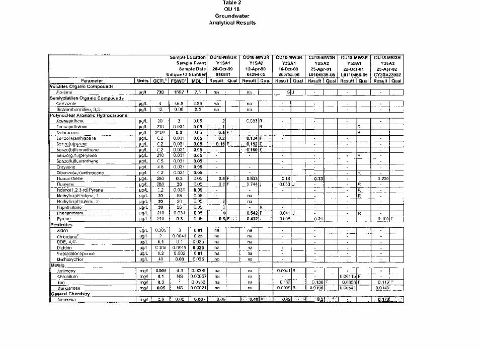
Table 20U18
GroundwaterAnalytical Results
Sample LocationSample Event
Sample DateUnique ID Number
Parameter Units GCTL" I FSWC' MDL"
OU1B-MW3RY1SA1
26-Oct-99910841
Result Qual
OU18-MW3RY1SA2
12-Apr-0004294-05
Result Qua!Volililes Organic Compounds
Acetone H9 / L 730 1692 2.5 na na
>emivolatiles Organic CompoundsCarbazoleDichlorabenzidine, 3,3'- l>9lL
Polynuclear Aromatic HydrocarbonsAcenaphtheneAcenaphthyleneAnthraceneB8nzo(a)anlliiaceneBenzo(a)pyreneBenzo(b}1luorantheneBenzo{g,h,i)peryleneBenzo(k)flijoranttieneChiyseneDibenzo(a,h)anthraceneFluorantheneFluorenehdeno(1,2,3-cd)PyreneMethylnaphthalene, 1-Mettiylnaphthalene, 2-NaphthalenePhenanthmnePyrcne
ngVL
t*9 / L
i>g/L
Hfl'L
ug/L
(jg/L
M3'LM9'L
12
46.50.06
2.85
2.5
nana
20210
2-00
C.2
C.2C.2210C.5
4.8C.2280260
C.22020
20210210
30.031
0.30.031
0.0310.0310.0310.031
0.0310.031
0.3
300,031
953026
0.031
0.3
0.050.050.050 05
0.050.050.050.05
0.050.O50,05
0,050.050.050.05
0.050.050.05
2; -: ';;•. i
0.50.2
0.16-----
0.80-3
-
231
0.5
nana
F •:
F
F
F
f • • . - . • • . •
0.983--
0.134: 0.1520.169----
0.6330.744-
nana-
0.5420.432
RR
F : • • :
FF .
j
R
F -
PesticidesAldrinChlordane"DDE, 4,4'-DieldrinHeptachkx epoxideMelhoxychlor
(Jfl'L
H3 / L
Hfl'Lijg/L
COOS
20.1
0305
0.240
30.0043
0.1O.0O19
0.0020.03
0.010.2S
0.025
0,0250.01
0,025
na
nanana
nana
nanana
nanana
MetalsAntimonyChromiumIronManganese
mgritng/lmg/lmg/l
0.DO60.10.30.05
4.3NS1
NS
0.00050.000570.01330.00021
nananana
nananana
General ChemistryAmmonia mg/l 2.8 0.02 0.06- 0 0 6 : &46| : :
OU1S-MW3RY2SA1
16-Oct-0020OF58-06
Result Qual
CU1B-MW3RY2SA2
25-Apr-01LD104539-05
Result Qual
OU18-MW3RY3SA1
22-Oct-01L0110466-06Result Qual
OU18-MW3RY3SA2
25-Apr-02CY3SA23002Result Qual
9|J - -
1j -
--
--
0180.053
----
0.0410,036
J
J
---
0.33---
--
0.21
-
-
----
----
--
FSft
R
R
RRR
R
-
--
-
-----
O.220
--
-
0.100 F
------
-----
--
--
--
--
0,0041-
0.1630.0095
B
B
--
0.1380.OI96
f
-
0.001150.0856
0,00541
FF
-
0.1130.O14J
F
:.. 0.42 |: •;•; 0 : 2 1 "•••: - 0;i7Dl •-
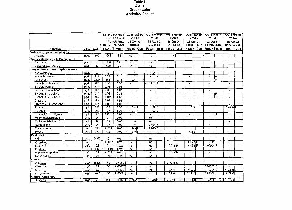
Table 2OU 18
GroundwaterAnalytical Results
Sample LocationSample EventSample Date
Unique ID NumberParameter I
Volatiles Organic CompoundsAcetone
Semivolatiles Organic CompoundsCaoa^oleDichlorobenzidine, 3,3-
Polynudear Aromatic HydrocarbonsAcenaphthenGAcenaphthyleneAnthraceneBenzo(a)antriraceneBenzo(a)pyreneBenzo(b)fluoranlheneBenzo(g,h,i)[jeryloneBenzo(k)*luoraniheneChiyseneDibenzo(a,h>antriraceneFluiiran thaneFluorenelnd3no(1,2,3-cd)PyreneMethylnaphthalene, 1-Meihylnaphlhalene, 2-NaphthalenePhenanthrenePytene
Jnits
F9/L
M9'L
PS'Lfg/Ltig/Lug/LH9'LP9/L
yg'L
ijg'L
ug/L|jg/L
GCTLb
70C
412
202102100020.7
0.22100.64.8
0.228028002
2020
20213213
FSWCb
1692
46.50.06
30.031
0.30.0310.031
0,0310.0310.03100310.031
0.330
0.031953026
0.0310.3
M D l "
2.5
2.852.5
0.050.05O.050.050.050.050.050.050.050.050.050.050 050.050.050.050.050.05
CU18-MW4RY1SA1
26-Oct-99910841
Result Qual
na
na
na
1
30.4
----
-
.:: . 0.90.5
--
36
;:; U90.5
\"...: .F
FF
f:-: .F
OU1B-MW4RY1SA2
12-Apr-CO04294-C6
Result | Qual
na
nans
1.54--
0.155----
-
1.92
nana
0-6940.815
1
R
R
r
M
R
F
PesticidesAldrinChordane3
DCE, 4,4'-DieldrinHeptachlor epoiideMethoxyciilor
MetalsAntimonyCtiromjumSrmManganese
General ChemistryAmmonia
Mfl/L
ug/L
Mfl'L
mg/lmg/l
mg/lmgfl
I mfl/l
0.0052
0.10.0350.240
o.oas0.1
0.3O.«5
2B
30.0043
0.1
000190.OG20.03
4.3NS
1NS
0.02
0.010.250,0250.0250.01
0.025•
0.00050.000570 0133
0.00021
0.06
na
nanana
nana
nananana
i.::..;:i;6l : :
nana
nananana
nana
nana
:3.6| :
OU18MW4RY2SA1
16-Gct-00200758-04
Result Qual
OU1B-MW4RY2SA2
24-Apr-01L9104539-07
Result I Qual
"Ml
-
--
------
-----
-------
-
0.2---
--
0.13
OU18-MW4RY3SA1
22-OCJ-01L011046607
Result Guai
-
- R
----
---
--
--
----
-
RR
R
R
RRR
R
OU18MW4RY3SA2
25-A[>r-02CY3SA23003
Resull Qual
-
-
---
-
-
0.0730-----
F
--
0.OS8-
0.0*3-
P
P
-
0.0700.063
---
FF
0.0031-
0.134
0.054
B --
0.2850.0115
M l • . - : . - 0 , 4 1 1 :••:•
-
0.19
0.0504-
FF
-
0.003550.2B1
0,00593
FJ
O.1B0I
------
-
07020.0293
J
0.6101 ::•
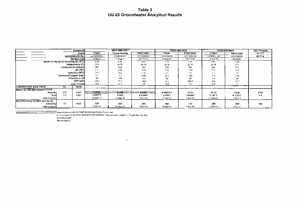
Table 3OU-20 Groundwater Analytical Results
Sample IDEvent
Laboratory ID No.Sampla Dale
Depth I f Waloi At Sairpitng (ft, BTC
LABORATORY ANALYSESMetals by SW-B46 Method 6010B
ArsenicI n n
Dale Analyzed
Wet-Chemistry by EPA 300 seriesAlkalinity
Date Analyzed
Temperature (C)Conductivity (uSJcm)
pH (SU)huhldity iNTU
Dissolved Oxygen (nig/IChloride {mg/l
ORP ImVJIron n (mg/l
RL
0 030.2
10
Units
mg/Lmg/l
rng/L
Beis-r.iw-oooiY1SA1
L0103340-0112-Mar-01
5.6824 94627 01043 260
-&4 g<0 2
. WB5& •0 0837 F22 lUar-Cf
f& Ater-£'J
OuarpumpingL3108340-061 J^Aiig. Q^
5 252b 534467 05321 3100
73.1<0 2
0 24616-Aug-0i
250
PRAY1SA1L0111004-03
29-Ocr-014 53K» 74
• » 7
7 00•^10
OSG10n a<2
Q D39S F7-Nov-(i1
214
OU20-MW-0002Y1SA1
10103148 Q212-War-01
5 3324 96
376
7 235 142 360
35 Sto 2
1! 00683 F0.039 F
2?Mar-0!
160ISMar-Of
PRAY1SA1L0111004-04
29-Oct 015.DO26 731517 3BS.I3 &5GO
225 5<2
<0.D3a.0Z9G F7-Wcw-O/
1472-Woi/O)
OU20MW-0003Y1SA1
L010334S0412-MarO1
4 9 4
26 03584
7 01! 13 3
40
-5 4
C 6
<0.03D.187 F
22-Mai-01
240
PRAY15A1L0111001-G1
29-Oct01
5 4 9
27 3-
Ci71
114440
44 7<2
<D.OJ0 072> F
2E92-Nw-Jf
FAC Chapter$2-777GCTLs
DOS0.3
NS
Cor>centf3tion » eeds the FD6P GiounflwaieF Cltawp Tj js positivsly idemtrled DLII the a=.siwaLt!d n is below (hi Rl am) above the MCL
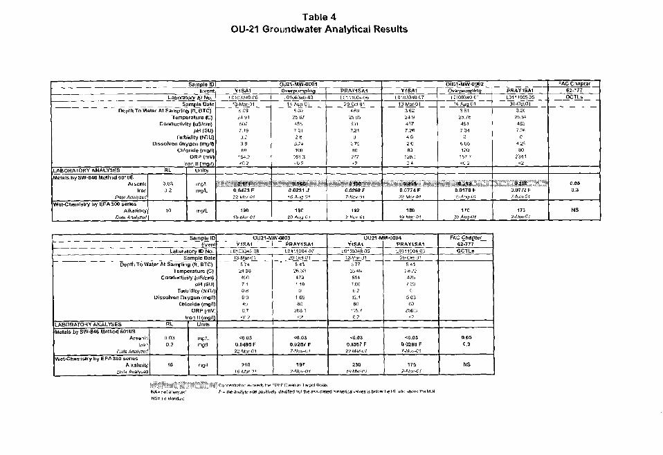
Table 4OU-21 Groundwater Analytical Results
Sample IDEvent
Labwatory ID No.Sample Date
Depth To Water At Samping (ft, BTC)Temperature (CJ
Conductivity (uSIcm)„» |SU)
Turbidity (NTlflDissorved Oxygen (mg/fj
Chloride (mgll)ORP (mV|
Iran 11 (mq/l)LABORATORY ANALYSES RLMetals bySW-346 Method 601 OB
ArsenicIron
Pate Anslyzm!
Wet-Chemistry by EPA 300 sarissAlkalinity
Date Analy7Q<l
0 0 30.2
10
Units
rngrtmg/L
mg'L
Y1SA1
IO1DM'J8-O613-Mar-ot
5 0324 815077 19
0.23361]
154,2•=0 2
« n0 0421F
22 M.sr 01
190
fSi-Mar 01
OU21-N1VU-0001Overpumping[0106340-03
H Aug^OI5 0 025 674557 31
26E24100
161 3ct>2
»,«&0.0231 J
1 } 0
20-AIJIJ-O I
PRAY1SA1
LO', 11004-0629-Ocl-QI
4 6 S
2SB5
so r7 21
02 79SO717<2
ftm
?-Ao^-0i
192
2 -Nov-01
Y1SA1L01033480T
13-MarO13 6224 9457
7 264 6
2 680
126.104
0.0774 F22-UarOf
180
lS-Mer-01
OU;1-MW-OOC2Ovarpumping
IC10BS40 01H-Auq-01
3 SI25.76451
7 340
6fjb120
1b7 /<02
D.017BF6-Auy-O1
170!0Aug-OI
PHAY1SA110111005-05
30-OcUJt
3.2!25.91
45;7.36
042680
2341<2
0.0772 F7-WiiW'm
17)2-A/ul/Or
FACCIiapter62-777GCTLs
oas0.3
NS
Sample IDEvent
Laboratory ID No.Sample Date
Depth To Water At Sampling (ft. BTC)Temperature (C)
Conductivity fuSlciri)j>H (SU)
Turbidity (NTU|Dissolved Oxygen (mg l)
Chloriije (rig'HORP fmv;
Iron 11 (mfl/l|tABORATOHY ANALYSES RLMauls by SW-B« Method 6010B
Arsonb\tcn
DafH AnnlyztzlWet-Chemistry by EPA 300 series
AlkalinityDate Analytea
0.030 2
10
Units
mgAmr/l
irig/L
OU21-MW-0B03Y1SA1
L010J34B-06!3Mar-01
5 7 4
24 994007 1
0 80 9
40
0.7ctl 2
<0.03O0495F
22-Mar-OI
21019-Mar-O;
PRAY1SA1
L01110O4.O72S-OCI-01
5 «26 33
4797 18
01 63
ac26B 1
• s i
•=0.030.028/ F
1ST2-iVoK-itr
OU21-MW-0004Y1SA1
LU1OM4B05!2-Msf-01
57725 4B514
7 09
ti.2i£.4
eu•1570 2
«(!.O30.(367 F22War-tJl
230
PRAY1SA1L0111004-05
29-Oci-OI5 41
26/247 b7.23
05 0360
2563•r-2
<0.D300298 F7-MMMJI
1752-Wot'-0/
FAC Chapter62-777GCTLs
0.050.3
NS
HA- rol aNS= 110 sl
Concentration e»t«edsltie FDtP Cleanup largei CoalsF - (heafTSl^ie was posfSweJy J-dentifi&rt but the assaciated numerical values is. below the RL a
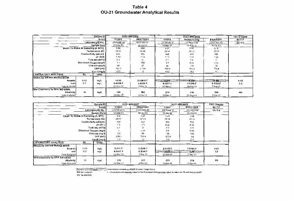
Table 4OU-21 Groundwater Analytical Results
Sample ID
EvertLaboratory ID No.
Sample DateDaptti To Water At Sampling (ft, BTC)
Tamperaure (C)Conductivity (u5/cm)
pH (SU)Turbidity <NTU)
Dissolved Oxygen (rng/ijChloride (niii.'ti
ORP (mV)
Iron It (mg^OLABORATORY ANALYSES R L
Metals by SW-84S Method 6O10BAr&anic
Iron
Date AnalytQd
We'-Chemistry b/ EPA 300 seriesAlkalinity
0.030.2
10
Units
mg/L
mg/L
OU21-MW-O005
Y1SA1.0103348 O9
13 Mar 013 62
2521bib
7 13U31.7
60
1B7 1« 0 2
<0.030 0 3 4 9 F22-Mw-Ot
180
19-Mar-OT
PRAY1SA1
L0I11D05 01
30 Oct-01388
2S.5ti5657 t a
0162
802 V 4
t2
0.00615 F0.0124 F7-Nlv-O!
1842ftDK-0t
OUZ1-MW-0006Y1SA1
LDia334a-'D
13-Mar-015 57
24 944487 10
0 11 7
40me at0.2
0.0177 F22Mar-D:
210
O^erpumpingLLMC1S34D-C5
14-Au9-01S50
25 72
4 4 i7.311 4
12018J4*0 2
*SW00206 FIfr-Auq 01
Z1020All( l-01
PRAY1SA1L0111005-02
30-O£t-G1
5 625B84«B
7.«4C
3 3
63
27S.4<3
0.0322F
7-Ncv-OI
2D62-Nos-O!
FAC Criapta-62-777
GCTLs
0.050.3
NS
Simple 10
Event
Laboratory ID Ha.Sample Data
Depth To Water At Sampling ((•. BTC)
LABORATORY ANALYSES
Melals by SVJ-846 Method 60 UBArsenic
IronDale btialyi&d
Wet-Chemistry by EPA 300 seriesAlkalinity
O3t& Qnalyzod \
Temperature (C)
Conductivity (uS/cm)pH (SU|
Turbidiy (NTU|
Dissolved Oxygon (mg^l)
Chloride imo'ilO^P (mV)
Ironll (mg/ l )RL
0,03
0 2
10
Units
mg/Lmg/L
mg/L
OUI1-MW-0007Y1SA1
1.0103348-1113-Mar-01
5 5
26014627 3
8 /2
100
238 10.4
0.011 F
0.0417 F22Mar-0\
170IS-Mar-01
PRAV1SA110111005-03
30-0ct-01
6 27
2773
4517.31
aS6160
269.4<l
0.0136 F
O.0244F7-No^-yi
(77
2-NOk-DI
OU21-MW-00C8
Y1SA1LD103343-12
13-MarXil3 4B
25 15
554
6 940 3
0 5100
-107.0
1.8
0.013SF
mmmmmmm22-MarOJ
19-Mar-m
PRAY1SA1L0111005-04
30-oa-oi3 09
26,14
7226.?6sa
0.S51S0
-&a2 8
0.0185 F
mmmmmmm
27S2-fVoi/-0(
FAC ChapterG2-r77
GCrLS
CDS
0.3
MS
Conc»ntr3tion exceeds itv5 FOEP Cleanup Target t^oals
F - tie analyte was positively identified bill ihe associated numerical values s below ihe RL and above thi« M0L
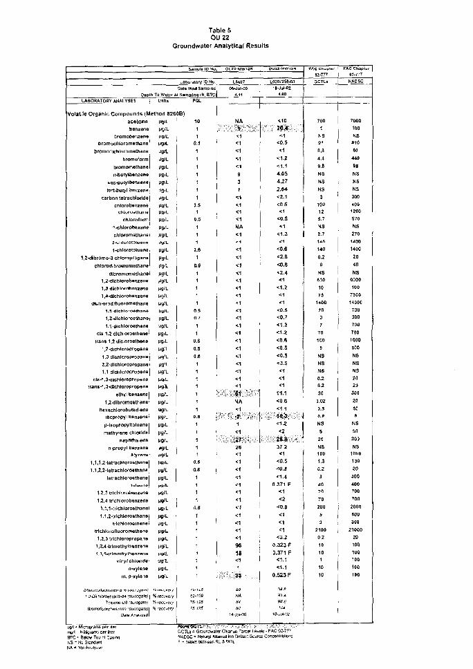
Table 50UZ2
Groundwater Analytical Results
D«B(h To Water ALABORATORY ANALYSES Units
Lafroralory 10 N^.Date w«li SamptHrJi Sampling |tt, BTC
PQL
Volatile Organic Compounds {Method 826013)ace ton*benzene
bromobeniens
bromochloromatrtang
bromoLtlchloromeihane
bfomaform
b/omomaihana
n-butylbenzene
ten-butyl frsmena
carbon tatrachlor.de
cfiioTDb«nzBndchloruethjne
chloroform
1 -chlorobexane
2-thlofotoiuwno4-chforotoluerta
1,2-dibromo-3-chioropropatia
Chlorodl bromcm ethane
1.2-tile h lore hflnienu
1,3-d.chlnroheniona
1,4-dichlorabanzene
iHc hk>rgd rfl uorom o tha n e
1T1-dlehlon»4han*
1,2-dLchloro&tfiano
1,1-cMcMoroetl"ien9
ds 1T2 dlchloroathene
trans 1+2 dlctoroethena
1,2-dicr.ioroprrjpan&
1.3 dicJiIoropropane
2,2-dlchtoropfopano
1T1 dlctiloropropene
cis-1.3-dicriloroDrapari9
trans-1,3-^ich.oropropene
othyl b&niene
1,2-dibromy<Jth3n&
hexachlorotoutadrane
isopropyi OBntene
p-lBopropylttHuena
maihy^efie chlorldii
naphthalene
ri-propyl bentsne
Styrene
1,1,1.2-tatrachtorcmthanB
1,1,2,2-le tractl lords thane
tfltTachtoro^ttiene
1,2r3 trichlorotienxerie
1,2,4 triehlcrobenzene
1,^,1-trichlaroftthanQ
1,1,2-trich.lorosthanB
trlchlorogthsne
trlchlorofluoromeihane
1,2,3 trichlorapF-ctpans
1.2,4-trimuiliyitxtrm*™
•t.XZ-trimathyihanxttna
vrnyl cfrtorftf*
a-xylfirt8
m, p-xylena
BromoOuoroMn/ens raurrasalel•afe ^nar/zeo
jfl/l - Uhcrograms per litermg/l = Will^rams w r iterHTC = Below TOO ol Cas^aNS - No starwJaro
MgiL
Mg'L
UO/L
M"-
Ul'L
Mg'L
Pfl'L
w"-V&L
M9/L
Ma'LMWL
ug/L
(JO/L
MS'L
Jy-L
MgJL
Mg'L
Mg'L
uglL
W9'L
HS'L
M9/L
ug/L
MQiL
UB-L
M9JL
Mg'L
MS'L
Mg'L
W9<L
Mg'L
Mg'L
uaJL
Mg'L
Mg'L
M9IL
wg'L
MSIfl-
M9<L
Mg'L
Mg'L
Mg'L
M9»L
W L
MgA.
Mg'L
f9'L
M9'L
M9'L
cgi-|ig)L
Mg'L
M9«L
MB'L
Mg'L
MO/L
CB"-
M9'L
M9'L
% recu«;;y% lECOvery
?S r«O«ry
10
1
1
O.S
1
1
1
1
1
1
1
0.51
0.5
1
1
1
0.6
10.8
1
1
1
1
1
a s
0.7
1
1
D.6
o.;0.5
1
1
1
1
1
1
1
o.a1
11
1
1
o.s0.8
1
1
11
o.s1
1
1
i
1
1
1
1
1
62-13S75-525/-J- til
GCTL5 = Grouridwa
LM0706-JUI-OO
4.11
HA
• ', '.':•'. " S1
" : ':.'•;:.
•:1
< f
<1
<:111
3
1
<1
•51
•C1
<1
NA<1
' 1
<1^1
<1
<1<1<1
<1
<1<1
<1
<1<1
<1
t 1
<1<1<1
<1
<1
• • , - . • * ! : • •
NA
<1
r . • > ; ! '1
<1
. : & • • • , .
2a<1
<i
<i<1
i i
<1
<1
< 7
<1<1<1
<194
18<11
• • • • « . : .
MlSi
80<4.jUMJ0
L02O725a-Q3
1t-JuW>24.60
<10
<1
<0.5<1
<1.2
<1.14.054.272.64
<2.1
<0.5
<1<Q.S
*1<1.3
^1
<o.e<2.6
<o.e<2.4< i
<1.2<1
<1<o.s<0.?
<1.2<1.2<0.«<0.5
<o.s<3.5<1
<1<1
11.1<0.8<1,1
. . • * * •» .
<1.2
37.2
<1
<0,5
<O.S
<1.40 371 F
<1
•eO.B
<1
<1<3.2
0.323 f0.371 F
<1.1<1.1
0.523 F
33.4SS.ii104
<e-jui-o?
er Cleanuo TarcBt Levels • FAC S2-77fNfcDSC - NaturaJ Mlenuaiiori OetiuK Suurce ConcentratorF - aetect tieiween
82-777GCTLs
700
1
NS
91
o.a4.4
9.8
NS
NS
NS
3
100
12
5.7
NS
2.7
U f l
140
0.2
0
NS
too10
75
1400
70
3
7
70
100
5
NS
NS
NS
0.2
0.2
30
0.02
3.5
o.e
NS
5
20
NS
100
1.3
0.2
3
40
70
70
200
5
3
2100
0 2
101
10
10
H-777
NADSC
7000
1(10
NS
010
60
440
98
NS
NS
NS
300
40D
1!00
570
NS
270
1400
1400
20
40
NS
6000
100
730O
14000
700
300
700
700
1000
500
MS
NS
NS
;o20
300
2a509
US
so200
NS1(11)11
1J0
20
300
400
700
700
2000
500
300
21000
20
100
100
100
100
1DQ
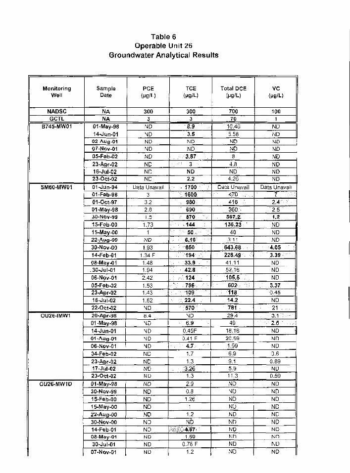
Table 6Operable Unit 26
Groundwater Analytical Results
MonitoringWell
NADSCGCTL
B745-MW01
SM60-MW01
OUZ6-IMW1
OU26-MW1D
SampleDate
NANA
01-May-9814-Jun-01
02 Aug-0107-Nov-OI05-Feb-02
23-A»r-0216-Jul-0223-Oct-02
01-Jun-9401-F9b-9601-Oct-9701-May-9830-NOV-99
15-Feb-OO15-May-0022-Aug-0030-Nov-OO14-Feb-0108-Mav-01,30-Jul-01
06-Nov-0105-Feb-0223-Apr-0216-Jul-0222-Oct-0220-Apr-9801-May-98
14-Jun-0101-Aug-0106-Nov-0104-Feb-0223-Apr-0217-Jul-0223-Oct-02
01-May-9830-Nov-9915-Feb-OO15-May-0022-Aug-OO30-Nov-OO14-Feb-0108-May-01
30-Jul-OI07-Nov-01
PCE(pg'L)
3003
ND
NDND
ND
ND
NDNDND
Data Unavail3
3.22.81.5
1.731
ND
1.931.34 F1.481.94
2.42
1.531.43
1.62ND
8.4
NDNDNDNDND
NDNDND
ND
NDNDNDNDNDNDND
NDND
TCE(Mfl/L)
3003
8.93.5ND
ND3.87
•: : : 3 - ; : • • • •
ND2.2
••r 1 7 0 0
•:. 1600 :
• : 9 8 0
690870144so •:
S.1S
: 650
.: 194
33.9
42.8
124
796. 109
22.4
570 ;
ND: 6.90.45F0.41 F
4.71.71.3
3.261.3
2.90.81.26
11.2
ND::::^.!;:!-..-*.87:
1.590.78 F
1.2
Total DCE
70070
10.46
5.58NDND8
4.8ND
4.26
Data Unavail47Q v
416360
567.2
136.2348
3 11
643.68228.49 i
41.1152.16
105.56 0 2 •:!•;•
11814.2781
29.449
18.1620.59
1.996.9
9.15.911.3
NDND
NDND
NDNDNDND
NDND
VC
1001
NDNDNDNDND
NDNDND ||
Data Unavail7 •:•.- : :
2.4 :
• : 2 . 5
• 1 . 2 .
NDNDND
4053.39NDNDND
3:370.45ND213,1 :2 . 6 '. •
NDNDND0.6
0.89ND
0.59
NDNDNDNDNDNDNDNn
NDND
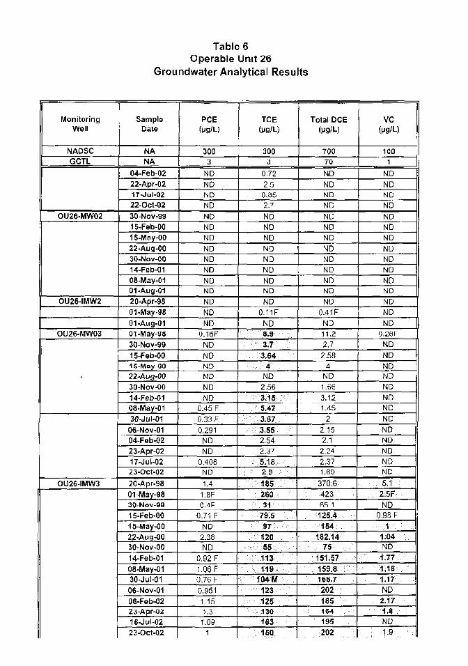
Table 6Operable Unit 26
Groundwater Analytical Results
MonitoringWell
NADSCGCTL
OU26-MW02
OU26-IMW2
OU26-MW03
•
OU26-IMW3
SampleDate
NANA
04-Feb-0222-Apr-0217-Jul-0222-Oct-02
30-NOV-9915-Feb-OO15-May-00
22-Aug-0030-Nov-0014-Feb-01
08-May-0101-Aug-0120-Apr-9801-May-98
01-Aug-01oi-May-98
30-Nov-99
15-Feb-0015-May 0022-Aug-0030-Nov-OO
14-Feb-0108-May-0130-Jul-0106-Nov-0104-Feb-0223-Apr-0217-Jul-0223-Oct-02
20-Apr-98
01-May-9830-Nov-99
15-Feb-0015-May-0022-Aug-0030-Nov-OO
14-Feb-01
08-May-0130-Jul-01
06-Nov-0106-Feb-0223-Apr-0216-Jul-02
23-Oct-02
PCE(ug/L)
3003
NDNDND
NDNDNDNDNDNDNDNDNDND
NDND
0.16F
ND
NDND
NDNDND
0.45 F0.33 F
0.291NDND
0.408ND
1.41.8F0.-1F
0.71 F
ND2.38ND
0.92 F
1.06 F
0.76 F
0.9511.151.3
1.091
TCE(pg/L)
3003
0.72
2.50.052.7
NDNDNDNDND
NDNDND
ND0.11F
NDS.9
• 3 . 7 ; •
3.$44
ND
2.56
:- 3:15 :5.47
. 3.673.552.542.37
5.18:2.9
18526031
79.597
; 12055113119
104 M
123 :
125130
163150
Total DCE(yg/L)
70070
NDNDND
ND
NDNDNDNDNDNDNDNDND
0.41 F
ND11.22.72.58
4
ND
1.66
3.121.45
22.152.12.242.371.69
370.6: 423; :
65.1
125.4154:
182.14• / 7 5 •.. •...
151.57 ; :
159.8166.7
202185164195202
VC(Mg/L)
1C01
NDNDND
ND
NDNDND
NDNDND
NDNDND
NDND ||
0.28F
NDNDNDND
NDNDND
ND
NDND
NDNDND
.: 5.1 ;2.5FND
0.9SF
• • • • : • * • • - • . :
1.04ND
;••;.• 1 . 7 7
1.181,17ND2.171,8ND
: 1-9

Table 6Operable Unit 26
Groundwater Analytical Results
MonitoringWell
NADSCGCTL
OU26-MW04
OU26-MW05
OU26-MW06
OU26-MW08
OU26-MW09
SampleDate
NANA
01-May-98
30-Nov-9915-Feb-0015-May-0022-Aug-OO30-Nov-OO
14-Feb-0108-May-0130-Jul-01
07-Nov-01
Ofi-Feb-0223-Apr-02
16-Jul-0222-Oct-02
01-May-9814-Jun-01
01-May-9815-May-0022-Aug-OO30-Nov-OO14-Feb-0108-May-01
02-Aug-0106-Nov-01OB.Peb-02
23-Apr-0216-Jul-0223-Oct-0201-May-98
01-Aug-01
08-May-0102-Aug-0106-Nov-0106-Feb-0223-Apr-0216-Jul-0222-Oct-02
PCE(MB'L)
3003
1.1F
1.5• - . • • • 3 . « r : :.;
NDND1.611.81
1.56 M1.981.6
2.232.491.630.98
NDND0.5ND1.71
NDNDNDNDNDNDNDNDNDNDND
NDNDND
NDNDND
ND
TCE
(M9/L)
3003
; • : • • • • • • 2 0 • • : •
43M66.3 M
163.B2
.•:-'. i s • :26.5 M
217 M•:-..:-4:57.-:;- : :
15.1 M34.429.6
6.2: : - : : - 7 . a ' . . : ..•;
0.55F0.940 F
• : ' , : , • : . 5 . 8 : / ; •
•:• W ..
11
r: 2214.11.18
3.572.63
15.1M
1.01
16ND
ND5.12ND
ND0.812.10ND
ND
Total DCE(M9/L)
70070
4463.4
: : . : : . : : ; = 3 3 v Z 4 : •:•:;:;
293.34
28.64
49.39
46.976.9
23.4
61.648.48.5
12.86
0.16F1.91
3.2
1120.6517.05
11.480.77
2.951.98
16.311
0.8611.61
NDND
1.78ND
ND0.320.83
NDND
VC
(M9'L)
1001
•2.4F.:::. :
NDND
NDNDND
0.56 F
ND
NDND0.54NDNDND
NDNDND
NDND
NDNDNDNDND
NDNDNDND
NDND
NDND
ND
NDNDNDND
Bold above GCTLs.
"-" = Not applicable.F = detected below RLM = matrix interferenceND= not detected

Table 6Operable Unit 26
Groundwater Analytical Results
MonitoringWell
NADSCGCTL
SampleDate
NA
NA
PCEftjg/L)
3003
TCE(MQ/L)
3003
Total DCE(ug/U
70070
vc(W/L)
1001

Table 7OU-30 Ground water Analytical Results
Sample IDEvent
Laboratory ID No.Sample Date
Depth To Wjter At Sampling (ft, BTC)
LABORATORY ANALYSES
Metals b-y SW-B46 Method 6010BAluminum
ArsenicDissolved Arsenic
IronDissolved Iron
Dais AnalysedWet-Chemistry by EPA 300 series
AlkalinityChloride
TDSDate Attal/?ei1
Temperature (C)Conductivity [us/cm]
pH (SU)Turbidity (NTU)
Dissolved Oxygen (mg/l)Chloride (mg/l)
OHP (mV)Iron II <mg/l|
RL
0 20 0 30 0 30 2
0.2
10210
Units
mg/Lmg/Lmg/Lmg/lmg/L
mg/Lmg/Lmg/L
SM10-MW-0001Y1SA1
L01O334B-2114-Mar-OI
2.123 S62767285 41 540
-46.60.2
NA0.0273 F
NA0-16 F
NA2OMor-»f
120NANA
)9-Mar-OT
PRAY1SA1
10111(130-0301 Hou-O1
1.84
2S.B1
2097.53170
0i260
-100 5«2
NA0.024B F
NA0.126 F
NAB-rtov-a J
102NANA
2-tiov-oi
AOC1-MW-nO02Y1SA1
K 0103348-2214 Maf-01
4 6224. BSS737 013 40
100236.6»O.2
< 0 2?::**::>:&S^*J:|:K:i£
0.224
0.37T FZU-Mitr-01
24026350
JS-Mar-01
BASELINE
L0107491-O226-JNI01
3 7S2<i564M716083 38i*.A
HONA
<02*:3£w*:0i5fli:;s:*¥:::i
0.1970 0S78F0 0462 F
130232S0
1 -Aug 0 J
PRAY1SA1
10111031-0231-Oct-m
4 0026 865926 94
00 7240
210^2
NA:?::^:::i:30^S|&::;:^£
NA0.0219 F
NA7-NQU 01
246 MNAMA
2-Nov-O t
FAC Cliapter
62-777GCTLs
0.C5
o.:
NS250000
NS
Sample IDEvent
Laboratory ID No.Sample Date
Depth To Water At Sampling (ft, BTC)Temperature (C)
Conductivity (uS/cm)pH(SU(
Tuibldlty (NTU)Dissolved Oxygen (mg/l)
Chloride (mg/l)ORP (mV)
Iron II (mg/l)LAB0 MTORY ANALYSES RL
Metals l i / SW-e-te Method 60103Aluminurr
ArsenicDissolved Arsenic
IrorDissolved Iror
Dale Analyze?
Wet-Chamistry by EPA 300 seriesAlkalinityChloride
TDSDate Anatysed
0 20 030 030 20.2
10210
Units
nigzi.mg/Lmg/Lnig/Lmg/L
mij,'Lrng,'Lrng/L
A0C1-MW-0004Y1SA1
LO10334825I4-Mar 01
2 2124391314
7 1
1 1
0 5
80142 b
^0.2
NA<0.03
HA0.0327 F
NA21) Mart)/
190NANA
JU-Msr-oi
PRAY1SA1101 1031-07
31 Oct-011 83
26.08419?.2b
0DB4ao1 4<?
NA-:003
NA0.0718 F
NAB-Vov-OI
162NANA
2-Vov-OI
AOC1-MW-0005Y1SA1
L 0103346-2714-Mar-01
2 9123 743657.291.10. 160
9a 4- 0 2
NA0 0O9&6F
NA0.0225 F
NA20-Mar-Of
160NANA
/9-Mjr-DI
PRAY1SA1MANANANAUAUAUANAUAUAUA
MAUAUAUAUA
MAMANA
FAC Chapter
62-777GCTLs
0.2
o.os
0.3
NS250000
NS
c standard
> ihe FDEP Cleanup Target Goals
= the analyte was passively idenbTied turi T I ^ as$COTie4 rujmencal values s l*kiw the R l and abaie th* MDL
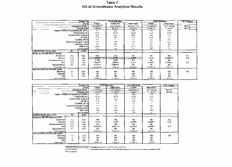
Table 7OU-30 Groundwater Analytical Results
Sample 10Evenl
Laboratory ID No.Sample Date
Depth To Wlier At Sampling (ft, BTC)
LABORATORY ANALYSESMetals by SW-S46 Method 601 OB
AluminumArsenic
Dissolved ArsenicIron
Dissolved IronDdle Analyzed!
Wet-Chemlslry by EPA 300 seriesAlkalinityChloride
TDSDate Ai\a!y&u
Temperature (CJConductivity (LlS/cm)
pH |S(J)Turbidity (NTU)
Dissolved Oxygen [mg/|)Chloride (dig/l)
ORP (mV|Iron N (rttflfll
RL
0.20 0 30.030.20.2
10210
Units
mg/Lmg/Lmg/Lmg/Lmg/L
mg/lmg/LmgVI
OU30-MW-O006Y1SA1
L010334B-2S14-Mar-oi
4 fl25 315877 020 30 480
2382*2
<0 2
0.1850.0221 F0.121 F
20-Maj-<?I
24029S40
t9-Ma<-0t
BASELINE
L010M91-0526-Jul-O!
4.022S7SiAt.7 033
2 88MA
147 1MA
•0 2
0,2270.(34 F
C.0HJFI-A*g-(il
20023280
7Jlufl-Ol
PRAY1SA1
LO111031-O631-Ocld
3.962Sb954a7 10
01 6
m251 9
<?
NA
NA0,12 F
NA8-Nov-01
199NANA
2 Woi- 01
OU30-MW-0007Y1SM
1 Dia3348-3D14-M;r-O1
3.5224:3
6580205BS
b2fl<02
NAeO.J3
NA0,051 F
NA20-Mir-01
2X
PRAY1SA1
L11111031-083IOct01
33825 933797225 8
0.4550s a<2
NA0.00664 F
NA0 0265 F
MA
167NANA
2 M>f 01
FAC Cluptor
62-717GCTLs
0.2a us
0.3
NS
Sample IDEvent
Laboratory ID No.5ample Pate
Depth To Water At Samplng (ft, BTC)
LABORATORY ANALYSESMetals by SW-846 Method 6C10B
AluminumArsenk
Dissolved Arseniclion
Dissolved IronDare Anvlyted
Wet-Chemistry by EPA 300 seriesAlkali nit;Chloric
TDSDate Anntytei
Temperature (C)Conductivity (uS/cm)
pH [SU|Turbidity (NTU)
Dissolved Qkygen {mg/l)Chlodde (mgll)
ORP (mV|Iron II (rnsj'lj
RL
0 20.D30 030.20 2
102
10
Units
mg/lnig/Lmg/Lmg'LmgiL
mg/Lmg/Lmg/L
ou3a-Mw-oaosY1SA5
LD103348-3I14-Wsr-OI
24123445847.D50 50 180180
t0 2
NA<n.O3
NA0.0242 F
NA20-Mdr-O!
210NANA
19-Mer-01
PRAY1SA1LDI1103O-O1
01-4OV-01: 1125 75323'.120
I 23100
iO2.B«2
MA<Q.O3
NA0.(211 f
NAH-Hov-01
207NANA
2 IJav 01
:>U3C-MW-00l»Y1SA1
L010334a 3214 Mar-01
23523 955137 061.20
40241<0.2
NA0.0379
MA0.174 F
NA20MM-01
22QNANA
19-Mar-o:
PRAY1SA1L011103O-O3
0l-Nav^12.B5
27 075^y
7 11(•
04563
"fil B<i
NA0.02W F
NA0.0519 F
NAa-wci/-o(
210NANA
2-fjTO-CU
FAC Chapter
62-777GCTLs
0.20.05
0.3
NS
MA- not analyzed
MS- no standarct
DEP Cleanup TargetC
y hdenlrfiet but the as&t values i b«icrw the RL and above ine MDL
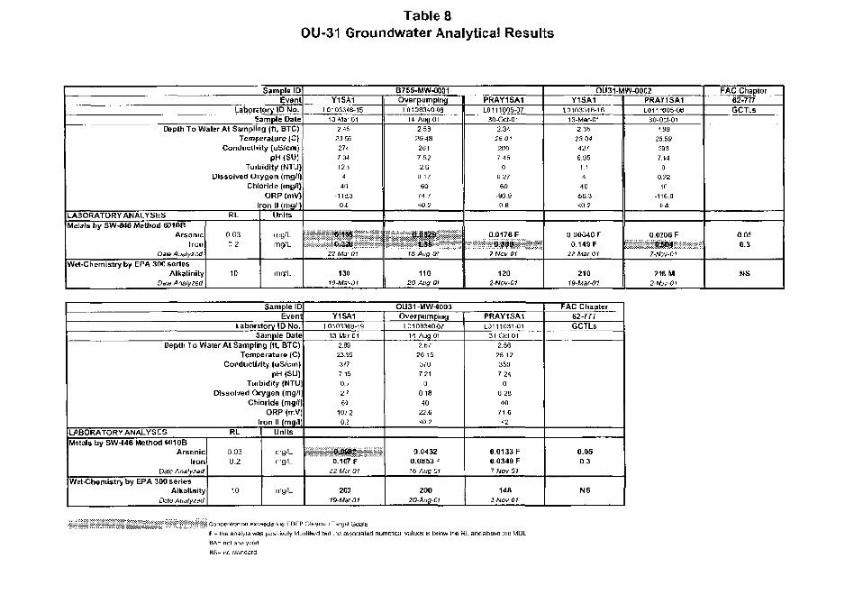
Table 8OU-31 Groundwater Analytical Results
Sample IDEvent
Laboratory ID No.Sample Dale
Depth To Water At Sampling (ft, BTC)Temperature |C)
Conductivity (uS/cm)pH <SU)
Turbidlt/ (NTU)Dissolved Oiygen (mg/l)
Chloride (mg/l)ORP (mV)
Iron II (mg/l)LABORATORY ANALYSES RLMetals by SW-B4C Method 601OB
ArsenicIron
Dale Analyzed
Wet-Chemistry by EPA 300 seriesAlkalinity
Dais A nalyzed
0.030 2
10
Units
irtQ/Lmg/L
mg/L
B755-MW-0001Y1SA1
LC103348-1E13-Mar-01
2.4$23 66
2T-
Z.3412 1
4
40
-1153.30£
27-Mar-m
130
19-MW-01
OverpumplngL0108340-«a
14-Aug-CI2,59
26.48261
7.522.B
0 . 1 /60
/A I< 0 2
16-Aug-OI
11020-Atig-Ql
PRAY1SA1L0111005-07
30-Ocl-C12.34
26.012B0
7 450
a 2760
-90.9oa
0.0176 F>:t>—:.-:::::-::W^Jgp..;.:::::.:.j.;.;.;.:.;.:.
7-Nov 01
1202 NOV-Q1
OU31-MW-0002Y1SA1
1.0103348-1613-Mar-C1
2.3523.04
427
6 9 5
1.1
4
40
•5B.3-502
0.00646 F0.149 F
22-Mar-Of
21019Mar-01
PRAY1SA1L01V005-OB
30-0ct-011.99
2559293
7,14
a0.22
40
-116.8OS
0 0206 FQS.04
7-MJV-O)
216 M2-NDV-01
FAC Chapter62-777GCTLs
0.0E0.3
N S
Sample IDEvent
Laboratory ID No.Sample Date
Depth To Water At Sampling (ft, BTC)
LABORATORY ANALYSESMetals by SW-446 Method 6010B
ArsenicIron
Date Analyzed
Wet-Chemistry by EPA 300 seriesAlkalinity
Dzte Analyzed
Temperature (C)Conductivity (uS/cm)
pH (SU)Turbidity (NTU)
Dissolved Oxygen (mg/l|Chloride {mg/l]
ORP (mV)Iron II (mg/l]
RL
0.030.2
10
Units
mg/Lmg/L
mg/L
OU31-MW-00Q3Y1SM
10103348-1913-Mar-01
2 .K
23.353*7
7 150.5
2 '
60
10/2O.i
OJ3SS2:0.1B7F
22-Mar 01
2C0
OverpumpinqL0106340O7
14-Aug-012.B7
26 15370
7.210
0 1840
22.6< 0 2
0.04320.0B53 F16-Aug-C1
200
2O-Aiig-C1
PRAY1SA1L0111O31-01
31-Oct-012.56
26.12350
7.240
0.2840
7 1 6
<2
0.0133 F0.0349 FT-Nov-01
1482-Noi/OI
FAC Chapter62-777GCTLs
0.050.3
NS
^ Concentration exceeds Ihe FDEP Cleanup Targel GoalsF - Ihe analyte was positively identified hut the associated nume-ical values is befow Ihe RL and above the WDLHA- nol analyzailHS= r\o siandani

APPENDIX A
REFERENCES
REFERENCES
Engineering-Science, 1983. Installation Restoration Program Phase 1 Records Search, HAFB, Florida, 1983.
Geraghty & Miller, Inc., 1988. Final Report, Remedial Action Plan, Electroplating Waste Disposal Area (FormerSite SP-1), Homestead Air Force Base, Florida, 1988.
Geraghty & Miller, Inc., 1991. Remedial Investigation Work Plan, Homestead Air Force Base. Florida, 1991.
Geraghty and Miller. Inc., 1992. Field Report for the Boundary Canal, HAFB, Florida. Preliminary Draft. May 1992.
Geraghty and Miller. Inc., 1993a. OU-9 Remedial Investigation Work Plan. Homestead Air Force Base, Florida.September 1993.
Geraghty and Miller, Inc., 1993b, Ecological Inventory for Homestead Air Force Base, Florida. Geraghty and Miller,Inc., 1740 Ski Lane, Suite 102, Madison, Wisconsin 53713, 1993.
Geraghty & Miller, 1990. NFA Decision Document for Site LF-19/WP-23. Homestead Air Force Base, Florida.November 1990.
IT Corporation, Final Operable Units OU-26, OU-28, OU-29, and IRAs, ROD Implementation Report, FormerHomestead Air Force Base, Miami-Dade County, Florida, October 2000.
IT Corporation, Operable Unit 22 Groundwater Sampling Report, August 2000
IT Corporation, Draft Post-Remedial Action Y3Q4 Groundwater Monitoring Report, Operable Unit 26, October2002
IT Corporation, Final ROD Implementation Report, Operable Unit 18, May 2000.
IT Corp., Final Report of Interim Remedial Actions in Support of the Proposed ROD for OUs20/21, OU30 andOU31, Former Homestead Air Force Base, Miami-Dade County, Florida, dated August-02
IT Corp., Draft Final Interim Remedial Action Y1SA Groundwater Monitoring Report for OUs20/21, OU30 andOU31, Former Homestead Air Force Base, Miami-Dade County, Florida, dated April-02
FT Corp., Final Remedial Action Work Plan for OUs20/21, OU30 and OU31, Former Homestead Air Force Base,Miami-Dade County, Florida, dated May-00
Law Engineering and Environmental Services and OHM Remediation Services Corporation, Final Remedial ActionWork Plan for Operable Unit 6/SS-3, Aircraft Washrack Area, Homestead Air Reserve Base, Florida, dated January1996 and amended February 1997
Montgomery Watson, Inc., 1993. Final Site Investigation Report far Site LF19/WP23, Homestead Air Force Base,Florida.
Montgomery Watson, Inc., 1996. Final Extended Site Investigation Report/Preliminary Risk Evaluation,Operable Units 10 through 14, Homestead Air Force Base. Florida. March 1996.
Montgomery Watson. Inc., 1998a. Draft Final Remedial Investigation/Baseline Risk Assessment Report, OU-11,Sewage Treatment Plant Sludge/Incinerator Ash Disposal Area and Outfall Canal. Volume I. September 1998.
Montgomery Watson, Inc.. 1998b. Draft Military Canal Special Study Report, Homestead Air Force Base, Florida.June 1998.
Montgomery Watson, Inc., 1999. Final Screening Ecological Risk Assessment Report, Operable Units 9 and 11,Homestead Air Force Base, Florida. September 1999.
Montgomery Watson, Inc., 2001 Final OU-11 Remedial Investigation/Baseline Risk Assessment. Homestead AirForce Base, Florida. January 2000.
Montgomery Watson, Final Record of Decision for Operable Unit 6/Site SS-3, Aircraft Washrack Area, MontgomeryWatson, Metairie, Louisiana, January 1995
Montgomery Watson, Final Record of Decision Amendment for Operable Unit 6/Site SS-3, Aircraft Washrack Area,Montgomery Watson, Metame, Louisiana, January 1995
Montgomery Watson, Final Record of Decision, for OU18, OU26, OU28, and OU29, Oct-98.
Montgomery Watson, Final Site Investigation Report for Sites WP-23 and LF-19 Sewage Treatment Plant,Homestead Air Reserve Base, Oct-94
Montgomery Watson. Final Site Investigation Report for Sites SS-26, Drum Storage Area, Building 720, HomesteadAir Reserve Base, Oct-94
Montgomery Watson, Draft Record of Decision, for OUs20/21, OU30, and OU31, June-98.
Montgomery Watson, Final Remedial Investigation/Baseline Risk Assessment Report for OUs20/21, OU30, andOU31, Dec-98
Montgomery Watson, Draft Feasability Study Report for OUs20/21, OU30, and OU31, Sept-98
OHM Remediation Services Corp., Oil/Water Separator Closure and Site Investigation Report 28 OWS Sites,Former Homestead Air Force Base, Mar-95
OHM Remediation Services Corp., Oil/Water Separator Closure and Site Investigation Report Eight OWS Sites, Nos,164, 706, 711, 723, 750, 766, 779, and 7312, Former Homestead Air Force Base, May-95
OHM Remediation Services Corporation, Final Remedial Action Work Plan for OU26, OU28, OU29, and IRAS,Former Homestead Air Force Base, Dadc County, Florida, dated May-99
Versar, Inc., Final Technical Report - Preliminary Assessment/Site Investigation Structure 793 (OU 17) Site, Jul-97
Versar, Inc., Final Technical Report - Preliminary Assessment/Site Investigation Structure 898 (OU16) Site, Jul-97
Woodward-Clyde, 1995. Final OU-9 Remedial Investigation. Homestead Air Reserve Base, Florida, November1995.
Woodward-Clyde, 1996. Supplemental Investigation of the Outfall Canal, HAFB, Florida. March 1996.
APPENDIX B
CLOSURE LETTERS
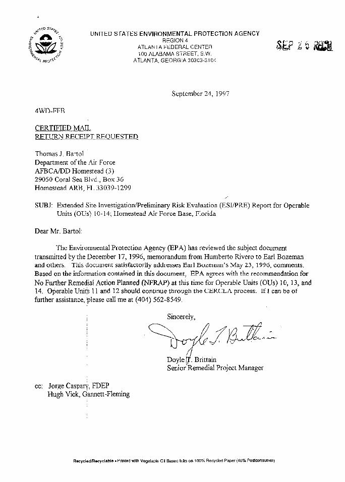
UNITED STATES ENVIRONMENTAL PROTECTION AGENCYREGION 4
ATLANTA FEDERAL CENTER100 ALABAMA STREET, S.W.
ATLANTA, GEORGiA 30303-310/,
September 24, 1997
4WD-FFR
CERTIFIED MAILRETURN RECEIPT REQUESTED
Thomas J. BartolDepartment of the Air ForceAFBCA/DD Homestead (3)29050 Coral Sea Blvd., Box 36Homestead ARB, FL 33039-1299
SUBJ: Extended Site Investigation/Preliminary Risk Evaluation (ESI/PRE) Report for OperableUnits (OUs) 10-14; Homestead Air Force Base, Florida
Dear Mr. Bartol:
The Environmental Protection Agency (EPA) has reviewed the subject documenttransmitted by the December 17, 1996, memorandum from Humberto Rivero to Earl Bozemanand others. This document satisfactorily addresses Earl Bozeman's May 23, 1996, comments.Based on the information contained in this document, EPA agrees with the recommendation forNo Further Remedial Action Planned (NFRAP) at this time for Operable Units (OUs) 10, 13, and14. Operable Units 11 and 12 should continue through the CERCLA process. If 1 can be offiirther assistance, please call me at (404) 562-8549.
i Sincerely,
Doyle [J. BrittainSenior Remedial Project Manager
cc: Jorge Caspary, FDEPHugh Vick, Gannett-Fleming
Recycled/Recyclable • Printed with Vegetable Oil Based Inks on 100% Recycled Paper (40% Postconsumer)
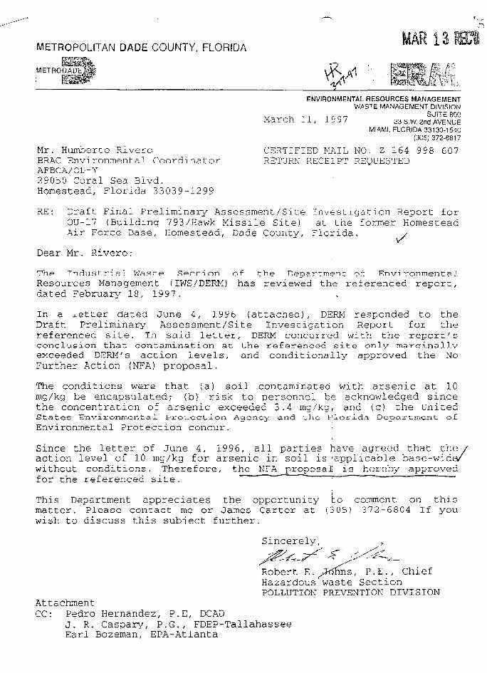
METROPOLITAN DADE COUNTY, FLORIDA
ENVIRONMENTAL RESOURCES MANAGEMENTWASTE MANAGEMENT DIVISION
v- v, - 1 i r m SUITE 800M a r c h : 1 , 1 9 9 / 33 S.W. 2nd AVENUE
MIAMI, FLORIDA 33130-1540(305) 372-6817
Mr. Humberto Rivero CERTIFIED MAIL NO. Z 164 998 607BRAC Environmental Coordinator RETURN RECEIPT REQUESTEDAFBCA/OL-Y29050 Coral Sea Blvd.Homestead, Florida 33039-1299
RE: Draft Final Preliminary Assessment/Site Investigation Report forOU-17 (Building 793/Hawk Missile Site) at the former HomesteadAir Force Base, Homestead, Dade County, Florida, /
Dear Mr. Rivero:
The Industrial Wast-.e Spf-l-.inn of the Department of EnvironmentalResources Management (IWS/DERM) has reviewed the referenced report,dated February 18, 1997.
in a letter dated June 4, 1996 (attached) , DERM responded to theDraft Preliminary Assessment/Site Investigation Report for thereferenced site. In said letter, DERM concurred with the report'sconclusion that contamination at the referenced site only maircrinallyexceeded DERM'S action levels, and conditionally approved the NoFurther Action (NFA) proposal.
The conditions were that (a) soil contaminated with arsenic at 10mg/kg be encapsulated; (b) risk to personnel be acknowledged sincethe concentration of arsenic exceeded 3.4 mg/kg, and <c) the UnitedStates Environmental Protection Agency and the Florida Department o£Environmental Protection concur. :
Since the letter of June 4, 1996, all parties have agreed that the /action level of 10 mg/kg for arsenic in soil is applicable base-wida/without conditions. Therefore, the NFA _proposal is hereby approvedfor the referenced site. "~ : ' " "
This Department appreciates the opportunity to comment on thismatter. Please contact me or James Carter at (305) 372-6804 If youwish to discuss this subiect further.
Sincerely,
Robert E. y3<$tms, P.E., ChiefHazardous waste SectionPOLLUTION PREVENTION DIVISION
AttachmentCC: Pedro Hernandez, P.E, DCAD
J. R. Caspary, P.G., FDEP-TallahasseeEarl Bozeman, EPA-Atlanta
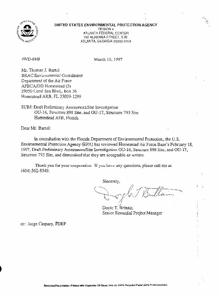
UNITED STATES ENVIRONMENTAL PROTECTION AGENCYREGION 4
ATLANTA FEDERAL CENTER100 ALABAMA STREET, S.W.
ATLANTA, GEORGIA 30303-3104
4WD-FFB March 18, 1997
Mr. Thomas J. BartolBRAC Environmental CoordinatorDepartment of the Air ForceAFBCA/DD Homestead (3)29050 Coral Sea Blvd., Box 36Homestead ARB, FL 33039-1299
SUBJ: Draft Preliminary Assessment/Site InvestigationOU-I6, Structure 898 Site, and OU-17, Structure 793 SiteHomestead AFB, Honda
Dear Mr. Bartol:
In consultation with the Florida Department of Environmental Protection, the U.S.Environmental Protection Agency (EPA) has reviewed Homestead Air Force Base's February 18,1997, Draft Preliminary Assessment/Site Investigation OU-16, Structure 898 Site, and OU-17,Structure 793 Site, and determined that they are acceptable as written.
Thank you for your cooperation. If you have any questions, please call me at(404) 562-8549.
Sincerely,
Doyle T. BrittainSenior Remedial Project Manager
cc: Jorge Caspary, FDEP
n»eycl«<l/n«cyclablB • Printed with Veoetable OH Based inks on 100% Recycled Paper (40"£ Posteonsiimar)
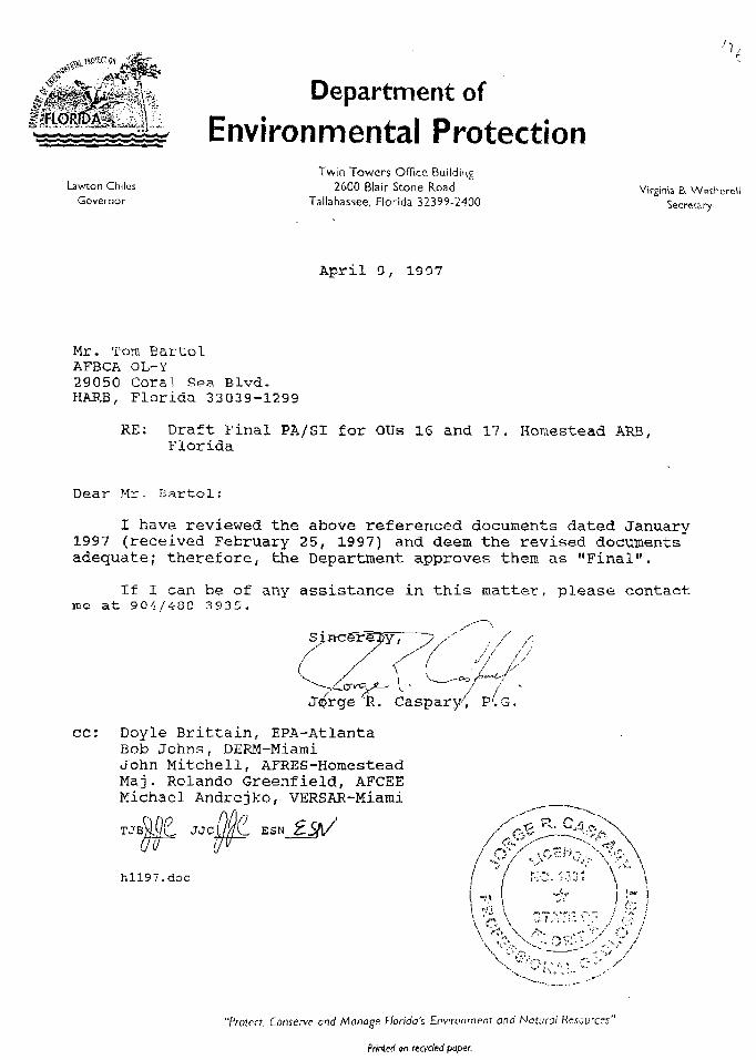
Lawton ChilesGovernor
Department of
Environmental ProtectionTwin Towers Office Building
2600 Blair Scone RoadTallahassee, Florida 32399-2400
Virginia B. WetherellSecretary
April 9, 1397
Mr. Tom BartolAFBCA OL-Y29050 Coral Sea Blvd.HARB, Florida 33039-1299
RE: Draft Final PA/SI for OUs 16 and 17. Homestead ARB,Florida
Dear Mr. Bartol:
I have reviewed the above referenced documents dated January1997 (received February 25, 1997) and deem the revised documentsadequate; therefore, the Department approves them as "Final".
If 1 can be of any assistance in this matter, please contactme at 904/488-3935.
je K. Caspar
cc: Doyle Brittain, EPA-AtlantaBob Johns, DERM-MiamiJohn Mitchell, AFRES-HoiuesteadMaj. Rolando Greenfield, AFCEEMichael Andrejko, VERSAR-Miami
ESN
hll97.doc
"Protect, Conserve and Manage Florida's Environment and Natural Resources"
Printed or KCfded paper.
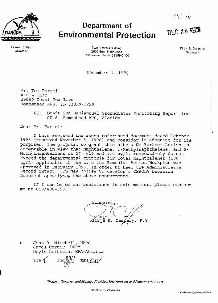
oa-c-Department of
Environmental Protection "VAjl%
LawTon Chiles Twin Towers Building Kirby B GreenGovernor 2600 Blair Stona Road Secretary '
Tallahassee, Florida 32399-2400
December 9, 1998
Mr. Tom BartolAFBCA OL/Y29050 Coral Sea BlvdHomestead ARS, FL 33039-1299
RE: Draft 2nd Semiannual Groundwater Monitoring Report forOU-6. Homestead ARS, Florida
Dear Mr. Bartol:
I have reviewed the above referenced document dated October1998 (received November 5, 1998) and consider it adequate for itspurposes. The proposal to grant this site a No Further Action isacceptable in view that Naphthalene, 1-Methylnaphthalene, and 2-Mcthylnaphthalene at 27, - 10 and ^10 ug/1, respectively do notexceed the departmental criteria for Total Naphthalenes (100ug/L) applicable at the time the Remedial Action Workplan wasapproved in February 1996. In order to keep the AdministraiveRecord intact, you may choose to develop a CERCLA. DecisionDocument specifying the above concurrence.
If I cjctu be of Any sssistance in this matter, please contactme at 850/488-3935.
c: John B. Mitchell, HARSJames Carter, DERMDoyle Brittain, EPA-Atlanta
TJB % JJCMu£, ESN {/>Y\/
Conserve and Manage Florida's Environment and Natural Resources"
Printed on recycled paper.irUndcx\form5\ imsctaisc 0006 dot
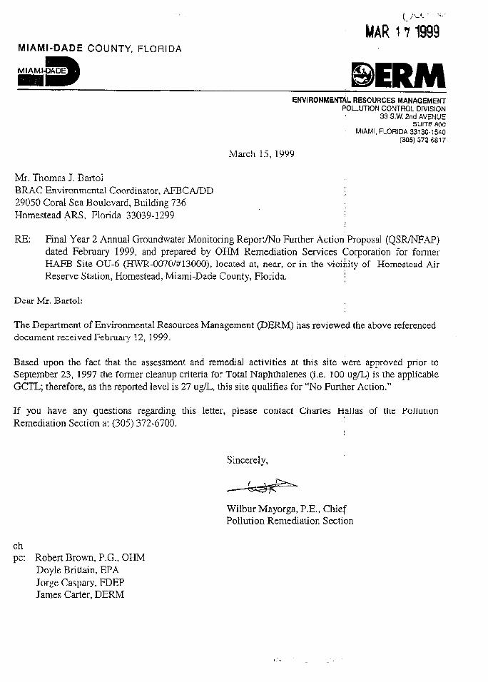
MAR 17 1999MIAMI-DADE COUNTY. FLORIDA
MIAMI-DADE
ENVIRONMENTAL RESOURCES MANAGEMENTPOLLUTION CONTROL DIVISION
33 S.W. 2nd AVENUESUIT5 BOO
; MIAMI, FLORIDA 33130-1540' (305)372-6817
March 15, 1999
Mr. Thomas I Bartol •BRAC Environmental Coordinator, AFBCA/DD [29050 Coral Sea Boulevard, Building 736 'Homestead ARS, Florida 33039-1299 I
i
RE: Final Year 2 Annual Groundwater Monitoring Report/No Further Action Proposal (QSR/NFAP)dated February 1999, and prepared by OHM Remediation Services Corporation for formerHAFB Site OU-6 (HWR-0070/#13000), located at, near, or in the vicinity of Homestead AirReserve Station. Homestead, Miami-Dade County, Florida. •
Dear Mr. Bartol:
The Department of Environmental Resources Management (DERM) has reviewed the above referenceddocument received February 12, 1999.
Based upon the fact that the assessment and remedial activities at this site were approved prior toSeptember 23, 1997 the former cleanup criteria for Total Naphthalenes (i.e. 100 ug/L) is the applicableGCTL; therefore, as the reported levei is 27 ug/L, this site qualifies for "No Further Action."
If you have any questions regarding this letter, please contact Charles Hallas of the PollutionRemediation Section at (305) 372-6700.
Sincerely,
Wilbur Mayorga, P.E., ChiefPollution Remediation Section
chpc: Robert Brown, P.G., OHM
Doyle Brittain, EPAJorge Caspary, FDEPJames Carter, DERM
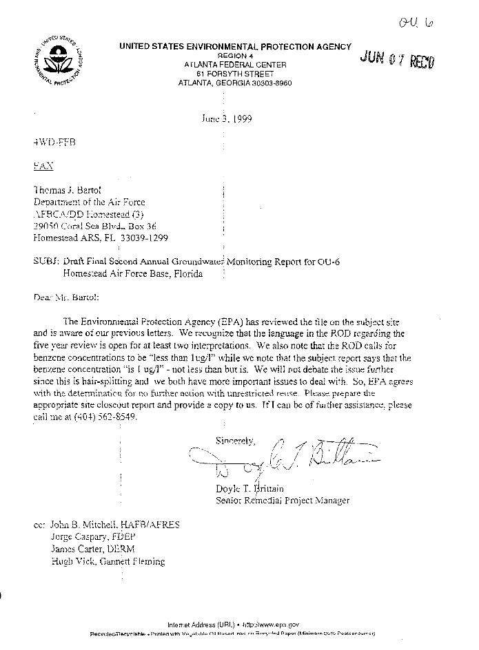
\UNITED STATES ENVIRONMENTAL PROTECTION AGENCY
REGION 4ATLANTA FEDERAL CENTER
61 FORSYTH STREETATLANTA, GEORGIA 30303-8960
June 3. 1999
4WD-FFB
FAX
Thomas J. Barto! ;Department of the Air Force ;AFBCA/DD Homestead (3) ;29050 Coral Sea Blvd., Box 36 ;Homestead ARS, FL 33039-1299
SUBJ: Draft Final Second Annual Groundwateii Monitoring Repon for OU-6Homestead Air Force Base, Florida ,;
Dear Mr. BarLol:
T'he Environmental Protection Agency (EPA) has reviewed the file on the subject siteand is aware of our previous letters. We recognize that the language in the ROD regarding thefive year review is open for at least two interpretations. We also note that the ROD cails forbenzene concentrations to be "less than lug/1" while we note that the subject, report says that thebenzene concentration "is I ug/1" - not less than but is. We will not debate the issue furthersince this is hair-splitting and we both have more important issues lo deai with. So, EPA agreeswith the determination for no further action with unrestricted reuse. Please prepare theappropriate site closeout repon and provide a copy to us. If I can be of further assistance, pleasecall me at (404) 562-8549.
Doyle T. r^ritiainSenior Remedial Project Manager
cc: John B. Mitchell, HAFB/AFRESJorge Caspary, FDEPJames Carter, DERMHugh Vick, Gannett Fleming
Internet Address (URL) • http://www.epa.gov
flecvcled/Recyclable • Printer! with r (Minimum Q5°/v Poolconouin t r)
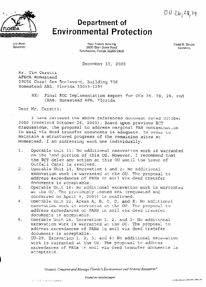
Department ofEnvironmental Protection
Jeb Bu3h Twin Towers Building David B. StruhsGovernor 2600 Blair Stone Road Secretary
Tallahassee, Florida 32399-2400
December 13, 2000
Mr. Tim CarettiAFBCA Homestead29050 Goral Sea Boulevard, Building 736Homestead ARS, Florida 33039-1299
RE: Final ROD Implementation Report for OUs 26, 28, 29, andIRAs. Homestead AFB, Florida
Dear Mr. Caretti:
reviewed the above referenced document dated October2000 (received October 26, 2000) . Based upon previous BCTdiscussions, the proposal to address marginal PAH contaminationin soil via deed transfer documents is adequate. In order tomaintain a structured progress of the remaining sites atHomestead, I am addressing each one individually.
1. Operable Unit 11: No additional excavation work is warrantedon the land portion of this OU. However, I recommend thatthe BCT delay any action at this OU until the issue ofOutfall Canal is resolved.
2. Operable Unit 14, Excavation 1 and 2: No additionalexcavation work is warranted at the OU. The proposal toaddress exceedances of PAHs in soil via deed transferdocuments is acceptable.
3. Operable Unit 16: No additional excavation work is warrantedat the OU. The previously issued NFA (requested andconcurred on April 9, 2 000) is confirmed.
4. Operable Unit 22, Areas A, B, C, D, and E: No additionalexcavation work ia warranted at the OU. The proDosal toaddress exceedances of PAHs in soil via deed transferdocuments is acceptable.
5. Operable Unit 26, Excavation 1, 2, and 3: No additionalexcavation work is warranted at the OU. The proposal toaddress exceedances of PAHs in soil via deed transferdocuments is acceptable.
6. OU-29, Excavation 1, 2, 3, and 4: No additional excavationwork is warranted at the OU. The proposal to addressexceedances of PAHs in soil via deed transfer documents isacceptable.
"Protect, Conserve and Manage Florida's Environment and Natural Resources"
Printed on recycled paper.
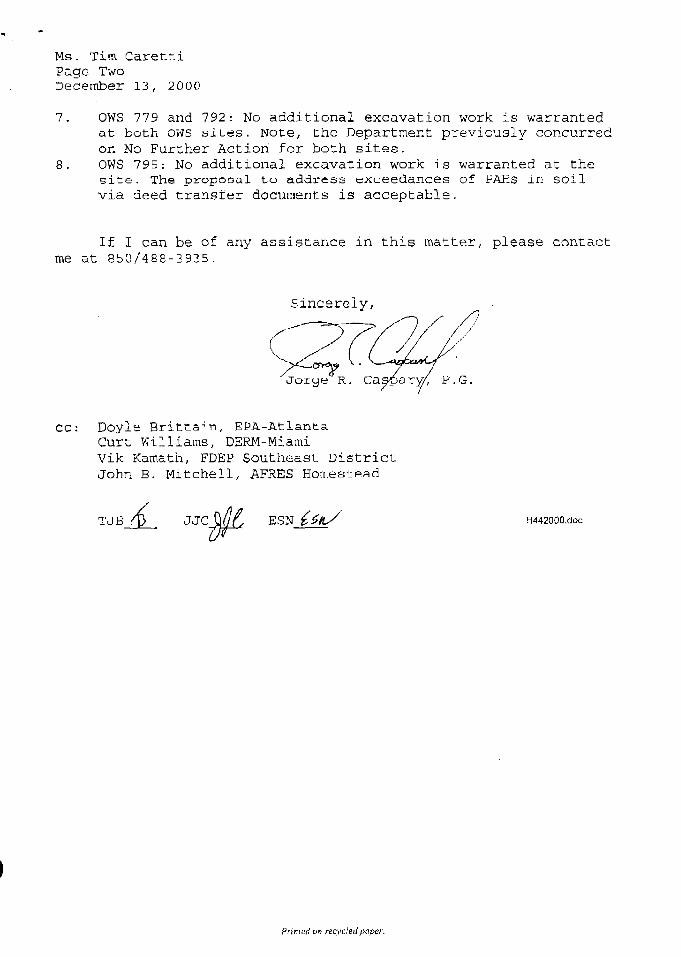
Ms. Tim CarettiPage TwoDecember 13, 2000
7. OWS 779 and 792: No additional excavation work is warrantedat both ows sites. Note, the Department previously concurredon No Further Action for both sites.
8. OWS 795: No additional excavation work is warranted at thesite. The proposal to address exueedances of PAHs in soilvia deed transfer documents is acceptable.
If I can be of any assistance in this matter, please contactme at 850/488-3935.
Sincerely,
P.G.
CC: Doyle Brittain, EPA-AtlantaCurt Williams, DERM-MiamiVik Kamath, FDEP Southeast DistrictJohn B. Mitchell, AFRES Homestead
TJB•A. JJC ESN H4420OQ.doc
Printed on recycled paper.
Florida Department of Environmental Protection
OFFICIAL CORRESPONDENCE - This electronic message is sent in li«u of regular mail
To: Tim Caretti
Facility; Homestead Air Force Base
Date: March 21, 2002
From: Jorge R. Caspary, P.G.
Sit© or Document: Final OU-28 ROD Implementation Report.
Document Date: October 2000
Receipt Date of Document: October 2002
Based on Ms. Lee Conesa's request, I am confirming receipt of the above report. Asstated in previous correspondence, the Department expectes soil and groundwateraccess restrictions at OU-28. However, based on the recent results for OU-21 soilresampling, perhaps resampling the areas at OU-28 is warranted since it is possible thatsince the excavation, natural soil processes might have contributed to degrading thecontaminants found in OU-28.
If you have any questions, please contact me at (850) 921-9986.
Jorge R. Caspary, P.G.
APPENDIX C
SITE INSPECTION CHECKLIST
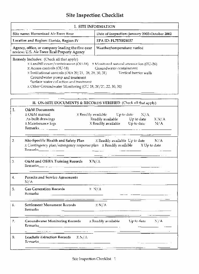
Site Inspection Checklist
I. SITE INFORMATION
Site name: Homestead Air Force Base
Location and Region: Florida, Region IV
Agency, office, or company leading the five-yearreview: U.S. Air Force Real Property Agency
Date of inspection: January 2002-October 2002
EPA ID: FL7570024037
Weather/temperature: varied
Remedy Includes: (Check all that apply)X Landfill rovpr/rcmtainmpr^ (OU-18) X Monitored natural attenuation (OU-26)X Access controls (OU-18) Groundwater containmentX Institutional controls (OUs 20/21, 28, 29, 30, 31) Vertical barrier walls
Groundwater pump and treatmentSurface water collection and treatment
x Other Groundwater Monitoring (OU 18, 20/21, 22, 30, 31)
1.
2.
3.
4.
5,
6.
7.
S.
II. ON-SITE DOCUMENTS & RECORDS VERIFIED
O&M DocumentsX O&M manual X Readily available UpAs-built drawings Readily availableX Maintenance logs X Readily availableRemarks
(Check
to dateUpUp
Site-Specific Health and Safety Plan X Readily available UpX Contingency plan/emergency response plan X Readily availableRemarks
O&M and OSHA Training Records XN/ARemarks
Permits and Service AgreementsN/A
Gas Generation Records x N/ARemarks
Settlement Monument Records x N / ARemarks
Groundwater Monitoring Records X Readily availableRemarks
Leachate Extraction Records XN/ARemarks
Up
all that apply)
N/Ato dateto date
XN/AN/A
to date N/AX Up to date
to date N / A
Site Inspection Checklist -1
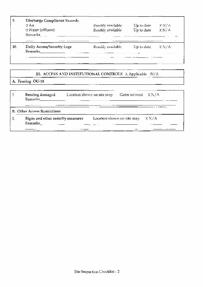
•I
9.
10.
Discharge Compliance RecordsG AirG Water (effluent)Remarks
Daily Access/Security LogsRemarks
Readily availableReadily available
Readily available
Up to dateUp to date
Up to date
XN/AXN/A
XN/A
III. ACCESS AND INSTITUTIONAL CONTROLS X Applicable N/A
A. Fencing OU-18
1.
B.
1.
Fencing damaged Location shownRemarks
Other Access Restrictions
Signs and other security measuresRemarks
on site map Gates secured
Location shown on site map
XN/A
XN/A
Site Inspection Checklist - 2
J
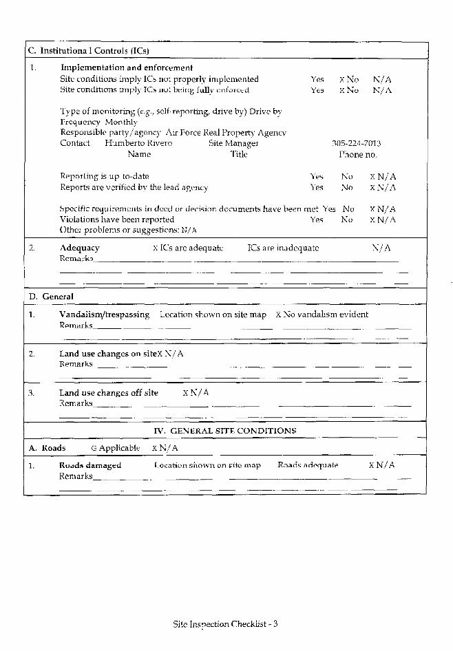
c.1.
2.
D.
1.
3.
A.
1.
Instihitiona I Controls (ICs)
Implementation and enforcementSite conditions imply ICs not properly implementedSite conditions imply ICs nut being fully enforced
Type of monitoring (e.g., self-reporting, drive by) Drive byFrequency MonthlyResponsible party/agency Air Force Real Property AgencyContact Humberto Rivero Site Manager
Name Title
Reporting is up-to-dateReports are verified by the lead agency
Specific requirements in deed or decision documents have beenViolations have been reportedOther problems or suggestions: N/A
YesYes
X Nox N o
N / AN / A
305-224-7013
YesYes
met YesYes
Adequacy X ICs are adequate ICs are inadequateRemarks
General
Vandalism/trespassing Location shown on site map X No vandalismRemarks
Land use changes on siteX N/ARemarks
Land use changes off site XN/ARemarks
IV. GENERAL SITE CONDITIONS
Roads G Applicable XN/A
Roads damaged Location shown on site map RoadsRemarks
adequate
Phone
NoNo
NoNo
no.
XN/AXN/A
XN/AXN/A
N/A
evident
XN/A
Site Inspection Checklist - 3
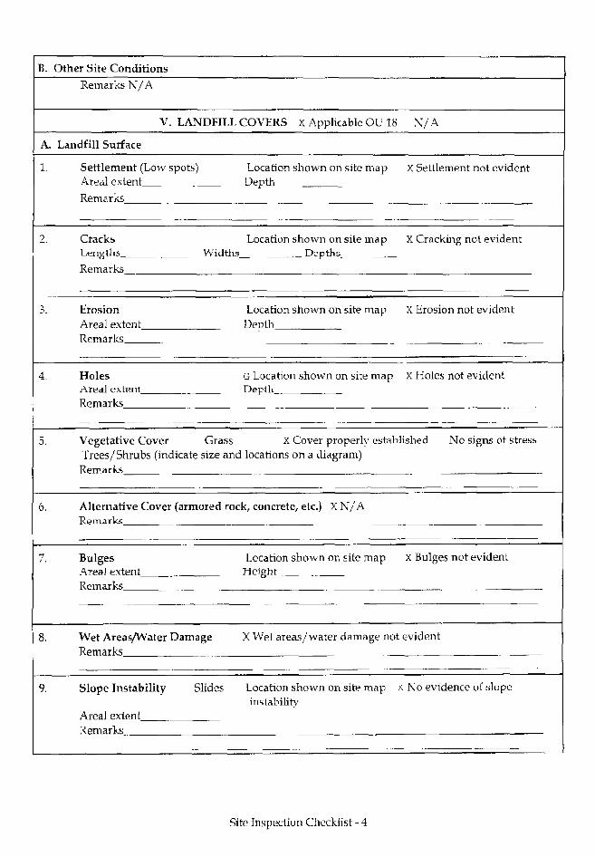
B.
A.
1.
2.
3.
4,
5.
6.
7.
8.
9.
Other Site ConditionsRemarks N/A
V. LANDFILL
Landfill Surface
Settlement (Low spots)Areal extentRemarks
CracksLengths WidthsRemarks
ErosionAreal extentRemarks
HolesAreal extentRemarks
COVERS X Applicable OU 18
Location shown on site mapDepth
Location shown on site mapDepths
Location shown on site mapDepth
G Location shown on site mapDepth
X / A
X Settlement not evident
X Cracking not evident
X Erosion not evident
X Holes not evident
Vegetative Cover Grass X Cover properly established No signs of stressTrees/Shrubs (indicate size and locations on a diagram)
Remarks
Alternative Cover (armored rock, concrete, etc.) X N/ARemarks
BulgesAreal extentRemarks
Wet Areas/Water DamageRemarks
Slope Instability Slides
Areal extentRemarks
Location shown on site mapHeight
X Bulges not evident
X Wet areas/ water damage not evident
Location shown on site map .,instability
>L No evidence of slope
Site Inspection Checklist - 4
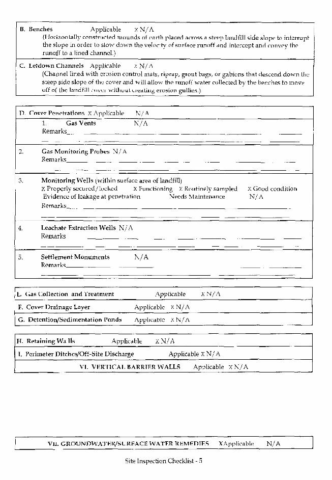
B. Benches Applicable XN/A(Horizontally constriirteid mounds of earth placed arrnss a steep landfill side slopp to interruptthe slope in order to slow down the velocity of surface runoff and intercept and convey therunoff to a lined channel.)
C. Letdown Channels Applicable x N/A(Channel lined with erosion control mats, riprap, grout bags, or gabions that descend down theSteep side slope of the cover and will allow the runoff water collected by the benches to moveoff of llie landfill cover without creating erosion gullies.)
- Cover PenptratinnR X Applicable N/A
1. Gas VentsRemarks
N/A
2. Gas Monitoring Probes N/ARem arks
3. Monitoring Wells (within surface area of landfill)X Properly secured/locked X Functioning X Routinely sampled X Good conditionEvidence of leakage at penetration Needs Maintenance N/A
Remarks
Leachate Extraction Wells N/ARemarks
5. Settlement MonumentsRemark";
N/A
t .
F.
G
Gas Collection and Treatment
Cover Drainage Layer
. DetentioiVSedimentation Ponds
Applicable
Applicable xN/A
Apphcable X N/A
XN/A
H. Retaining Walls Applicable X N/A
I, Perimeter Ditches/Off-Site Discharge Applicable x N/A
VT. VFRT1CAL BARRIER WALLS Applicable XN/A
VII. GROUNDWATEfi/SURFACEWATFRttEMFDTFS XApplicable N/A
Site Inspection Checklist - 5
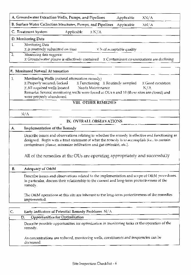
A. Groundwater Extraction Wells, Pumps, and Pipelines Applicable XN/A
B. Surface Water Collection Structures, Pumps, and Pipelines Applicable XN/A
C. Treatment System Applicable XN/A
D. Monitoring Data
1. Monitoring DataX Is routinely submitted on time X Is of acceptable quality
2. Monitoring data suggests:X Groundwater plume is effectively contained X Contaminant concentrations are declining
E. Monitored Natural At tenuation
1. Monitoring Wells (natural attenuation remedy)X Properly secured/locked X Functioning X Routinely sampled X Good conditionX All required wells located Needs Maintenance N/ARemarks: Several monitoring wells were found at OUs 6 and 10 (these sites are closed) andwere properly abandoned.
VIII. OTHER REMEDIES
N/A
IX. OVERALL OBSERVATIONS
A. Implementation of the Remedy
Describe issues and observations relating to whether the remedy is effective and functioning asdesigned. Begin with a brief statement of what the remedy is to aixuniplish (i.e., to containcontaminant plume, minimize infiltration and gas emission, etc.).
All of the remedies at the OUs are operating appropriately and successfully
B. Adequacy of O&M
Describe issues and observations related to the implementation and scope of O&M procedures.In particular, discuss their relationship to the current and long-term protectiveness of theremedy.
The O&M operations at this site are inherent to the long-term protectiveness of the remediesimplemented.
C Early Indicators of Potential Remedy Problems N/A
D. Opportunities for Optimization
Describe possible opportunities for optimization in monitoring tasks or the operation of theremedy.
As concentrations are reduced, monitoring wells, constituents and frequencies can bedecreased.
Site Inspection Checklist - 6

UNITED STATES ENVIRONMENTAL PROTECTION AGENCY
* REGION 4ATLANTA FEDERAL CENTER
61 FORSYTH STREET .ATLANTA, GEORGIA 30303-8960 10220762
AUG 2 5 2005
4WD-FFB
Lawrence Ventura, Environmental Flight ChiefHomestead Air Reserve Base482d SPTG/CEV360 Coral Sea Blvd.Homestead ARB, FL 33039-1299
SUBJ: Homestead Air Reserve Base Five Year ReviewHomestead Air Reserve Base, Florida
Dear Mr. Ventura:
The Environmental Protection Agency (EPA) has reviewed the subject document anddetermined that it meets all requirements of the Comprehensive Five-Year Review Guidance,EPA 540-R-007; OSWER No. 9355.7-03B-P. June 2001. Please note that an EPA Region IVrepresentative was not present when the on-site review was conducted so EPA's approval isbased on the information contained in the subject document along with personal informationEPA representatives obtained during ongoing oversight of work at the former Homestead AirForce Base through periodic progress reports, site visits, and meetings. A summary of the Five-Year Review as contained in the subject report follows.
The Comprehensive Environmental Response, Compensation, and Liability Act(CERCLA) requires that all remedies selected under CERCLA §121, which result in hazardoussubstances, pollutants, or contaminants remaining at the site, be subject to a Five-Year Review.Executive Order 12580 delegated CERCLA remedial responsibilities, including Five-YearReviews, to the Secretary of Defense, with respect to releases from any facility or vessel underthe jurisdiction, custody, or control of the Department of Defense. At Homestead Air ReserveBase (HARB), certain remedial actions are being performed in accordance with CERCLA thatrequire Five-Year Reviews to verify that previously implemented remedies remain protective ofhuman health and the environment.
Former Homestead Air Force Base (HAFB) originally encompassed 2,938 acres.However, in 1994, part of the installation (i.e., 852 acres) transitioned from an active base to anAir Reserve Station under management of the Air Force Reserve Command (AFRC). In 2003,HARS was officially realigned as HARB that is comprised of 1,943 acres, which includes therunway and main taxiways. This retained property, referred to as the cantonment area, comprisesthe current HARB. The Air Force Real Property Agency (AFRPA), formerly known as the Air
Internet Address (URL) • http://www.epa.govRecycled/Recyclable • Printed with Vegetable OH Based Inks on Hecyclad Paper (Minimum 30% Postconsumer)
Force Base Conversion Agency (AFBCA), is transitioning the remaining property that is withinthe confines of the former HAFB but is outside of the AFRC cantonment area to civilian use.This Five-Year Review addresses sites located within the cantonment area within HARBproperty. Sites located outside the HARB cantonment area were addressed in a separate Five-Year Review finalized by the AFRPA.
This Five-Year Review for 2003 constitutes the first required review/reporting cycle forHARB. The report addresses thirteen (13) Operable Units (OUs) and one Area of Concern(AOC).
1) OU 1 Fire Protection Training Area No. 2 (FT-05, FPTA-2)2) OU 2 Residual Pesticide Disposal Area (OT-11, P-3)3) OU 3 Polychlorinated Biphenyl (PCB) Spill Area )SS-13, SP-3)4) OU 4 Motor Pool Oil Leak Area (SS-08, SP-2)5) OU 5 Electroplating Waste Disposal Area (WP-1, SP-1)6) OU 7 Entomology Storage Area (SS-07, P-2)7) OU 8 Fire Protection Training Area No. 3 (FT-04, FPTA-3)8) OU 12 Entomology Shop - Building 371 (OT-25, P-l)9) OU 13 Hardfill Storage Area (SS-22)10) OU 15 Hazardous Waste Storage Area - Building 153 (SS-30)11) OU 19 Aircraft Ground Equipment Shop - Building 208 (SS-19)12) OU 25 Hush House Area (SWMU 59)13) OU 27 Jet Engine Test Cell Facility (SS-27)14) AOC 3 Munitions Storage Area
The decision documents for each CERCLA site identify the remedial action objectives(RAOs), which define the scope and purpose of the cleanup action required to address thepotential threats to human heaJth and the environment. The decision documents for OU 1, OU 2,OU 4, OU 5, OU 7, OU 8, OU 13, and AOC 3 identify remedies that result in contaminantsremaining on site at concentrations above unrestricted reuse and unlimited exposure criteria.Therefore, these sites are subject to the CERCLA Five-Year Review requirements. The selectedremedies are designed to monitor, and prevent unacceptable exposure to, the residualcontamination. Long-term ground-water monitoring and/or Land Use Controls (LUCs) are theprimary elements of each of the selected remedies. On March 15, 1999, HARS entered into aMemorandum of Agreement (MOA) with the U.S. Environmental Protection Agency (USEPAand the Florida Department of Environmental Protection (FDEP) regarding the implementationof LUCs. The MOA requires that LUC Implementation Plans be prepared for all sites requiringLUCs with quarterly monitoring of implemented LUCs to verify ongoing effectiveness andannual reporting.
The AFRC affirmed(certified) that the remedies for all of the sites addressed in the Five-Year Review Report remain protective of human health and the environment. The remedies alsocomply with Applicable or Relevant and Appropriate Requirements (ARARs) and are reasonably
cost-effective. EPA concurs with the Air Force's protectiveness determinations that theremedies remain protective of human health and the environment, consistent with EPA'sstatutory and regulatory authorities. It is expected that the remedial activities andLUCs/Institutional Controls (ICs) at HARB will permanently reduce the risks to human health byeliminating, reducing, or controlling exposures to human receptors through engineering andinstitutional controls. Furthermore, there are no known areas of noncompliance.
General recommendations for HARB include:
1) The remedial actions should continue to be implemented in accordance with the USEPAand FDEP approved plans governing maintenance and long-term monitoring.
2) Evaluations of environmental monitoring should continue and be used as a means ofidentifying opportunities to refine long-term monitoring activities.
3) Future evaluations of long-term monitoring should attempt to identify the level ofprogress toward meeting site- or zone-specific cleanup goals developed during theremedy decision-making process.
RODs have been approved for all of the above sites except for OU 12, OU 15, OU 25,and OU 27. EPA expects that all of these remaining RODs wil l involve LUCs with the possibleexception of OU 27. Remedial Investigations and Feasibility Studies (RI/FSs) are underway atthese remaining Operable Units.
Based on the information provided in the subject document, EPA approves the subjectdocument. If you have any questions, please call me at (404) 562-8651, or Doyle T. Brittain at(404) 562-8549.
Sincerely,
Winston A. SmithDirectorWaste Management Division
cc: Carol Devier Heeney, HAFB/AFRPADavid Grabka, FDEPWilbur Mayorga, DERM