
FINAL REPORT - European Investment Bank
219
IEE for the GCWWMIIP – project 02 for Narahenpita and Kirula-Narahenpita areas DCEE, Faculty of Engineering, University of Ruhuna i FINAL REPORT INITIAL ENVIRONMENTAL EXAMINATION (IEE) FOR THE GREATER COLOMBO WATER AND WASTEWATER MANAGEMENT IMPROVEMENT INVESTMENT PROGRAMME – PROJECT 02 FOR NARAHENPITA AND KIRULA-NARAHENPITA AREAS Department of Civil and Environmental Engineering Faculty of Engineering University of Ruhuna November 2019
-
Upload
khangminh22 -
Category
Documents
-
view
3 -
download
0
Transcript of FINAL REPORT - European Investment Bank

IEE for the GCWWMIIP – project 02 for Narahenpita and Kirula-Narahenpita areas
DCEE, Faculty of Engineering, University of Ruhuna
i
FINAL REPORT
INITIAL ENVIRONMENTAL EXAMINATION (IEE) FOR
THE GREATER COLOMBO WATER AND WASTEWATER
MANAGEMENT IMPROVEMENT INVESTMENT
PROGRAMME – PROJECT 02 FOR NARAHENPITA AND
KIRULA-NARAHENPITA AREAS
Department of Civil and Environmental Engineering
Faculty of Engineering
University of Ruhuna
November 2019

IEE for the GCWWMIIP – project 02 for Narahenpita and Kirula-Narahenpita areas
DCEE, Faculty of Engineering, University of Ruhuna
ii
Table of Contents
1 INTRODUCTION .................................................................................................................. 1
1.1 Objective and justification of the project ........................................................................... 4
1.2 Objectives of the IEE report ..................................................................................................... 5
1.3 Compatibility with other projects/programs/plans in the area ................................ 6
2 POLICY, LEGAL AND LEGISLATIVE FRAMEWORK ........................................... 7
2.1 Zoning Requirements ................................................................................................................ 7
2.2 Approvals for the proposed development from state agencies................................... 8
2.3 Legislative and National Policy Requirements ................................................................ 9
2.3.1 Initial Environmental Evaluation (IEE) ....................................................................................... 11
2.4 ADB Policies with reference to Environmental Assessments (EAs) ....................... 12
2.4.1 Environmental Management Plans (EMP) under ADB policies ................................ 13
2.4.2 Public Disclosure under ADB policies .................................................................................... 13
2.5 Gap analysis between national/local and ADB requirements .................................. 13
3 DESCRIPTION OF THE PROPOSED PROJECT ..................................................... 17
3.1 The Study Area/ Project Location ........................................................................................ 17
3.2 Location maps / Photographs ................................................................................................ 17
3.3 Existing Condition of Sewer Collection System ............................................................ 27
3.4 Proposed Components ............................................................................................................. 28
3.5 Implementation Schedule ...................................................................................................... 31
3.6 Project implementation ........................................................................................................... 31
3.6.1 Pre-construction activities ............................................................................................................. 31
3.6.2 Construction activities ..................................................................................................................... 32
3.6.3 Operational and maintenance activities and procedures .............................................. 41
3.7 Resources/ facilities required/ provided ........................................................................... 41
3.8 Work force .................................................................................................................................... 42
4 DESCRIPTION OF THE ENVIRONMENT (BASELINE DATA) ....................... 43
4.1 Physical Environment .............................................................................................................. 43
4.1.1 Topography .......................................................................................................................................... 44
4.1.2 Hydrology and Drainage ............................................................................................................... 44
4.1.3 Climatic Conditions .......................................................................................................................... 45
4.1.4 Land Use ................................................................................................................................................ 47
4.1.5 Air Quality, Noise, Vibration ....................................................................................................... 51
4.2 Biodiversity ................................................................................................................................. 54
4.3 Physical and Cultural Heritage ............................................................................................ 56
4.4 Human, Economic and Socio Cultural ............................................................................... 56
4.5 Existing environmental considerations problems .................................................... 60
5 ENVIRONMENTAL IMPACTS AND MITIGATION MEASURES ................. 64
5.1 Design Phase ............................................................................................................................... 64
5.2 Construction Phase ................................................................................................................... 66
5.2.1 Pre-construction phase .................................................................................................................... 66

IEE for the GCWWMIIP – project 02 for Narahenpita and Kirula-Narahenpita areas
DCEE, Faculty of Engineering, University of Ruhuna
iii
5.2.2 Construction phase ........................................................................................................................... 66
5.2.3 Post-Construction .............................................................................................................................. 82
5.3 Operations and Maintenance Phase ................................................................................... 83
6 INFORMATION DISCLOSURE, CONSULTATION AND PARTICIPATION
6.1 The process .................................................................................................................................. 87
6.1.1 Data collection methods ................................................................................................................. 87
6.1.2 Data analysis methods .................................................................................................................... 88
6.2 The description of the baseline socio-economic condition ........................................ 89
6.2.1 Population ............................................................................................................................................. 89
6.2.2 Diversity of the project relevant population ........................................................................ 90
6.2.3 Education Diversity .......................................................................................................................... 91
6.2.4 Economic activities and employment ...................................................................................... 92
6.3 Properties located facing the road edges in sub-project area..................................... 92
6.4 Sensitive institutions ............................................................................................................... 92
6.5 Other observations of the sub-culture of the people living in the project area .. 93
6.6 Issues and problems in the existing socio-economic environment ......................... 93
6.7 Potential social impacts ........................................................................................................... 94
6.7.1 Views of the stakeholders on potential impacts ................................................................. 97
6.7.2 Sub Project’s involved involuntary resettlement, impacts on vulnerable groups,
Indigenous Peoples......................................................................................................................................... 100
6.7.3 The type of affected structures .................................................................................................. 101
6.7.4 Vulnerability related information of the households to be relocated .................... 101
6.7.5 Willingness for Resettlement ..................................................................................................... 101
7 GRIEVANCE REDRESS MECHANISM .................................................................. 103
7.1 Plan for monitoring impact mitigatory process ........................................................... 105
7.2 Stakeholders and their views ............................................................................................. 107
7.2.1 The methodology to be used to get stakeholders involved in the project ........... 108
7.3 Grievance redress mechanism (GRM) ............................................................................ 108
8 ENVIRONMENTAL MANAGEMENT PLAN ....................................................... 114
8.2 Safeguard Implementation Arrangement ............................................................................. 114
Monitoring committee ......................................................................................................................... 114
8.3 Monitoring and reporting ........................................................................................................... 127
8.3.2 Objectives of Environmental Monitoring Program (EMP) .............................................. 127
8.3.3 Salient features of a monitoring program and monitoring plan ................................... 128
8.3.4 Monitoring responsibility................................................................................................................ 129
8.3.5 Monitoring methodology ................................................................................................................ 130
8.3.6 The monitoring plan recommended for the proposed project ...................................... 133
9 CONCLUSIONS AND RECOMMENDATIONS .................................................. 145
10 REFERENCES ..................................................................................................................... 148
11 ANNEXES ............................................................................................................................ 149

IEE for the GCWWMIIP – project 02 for Narahenpita and Kirula-Narahenpita areas
DCEE, Faculty of Engineering, University of Ruhuna
iv
List of Figures
Figure 1.1- Proposed Sub Project Area ................................................................................ 3
Figure 1.2- Plan view of proposed sewer network ............................................................ 4
Figure 2.1: Zoning Plan 2020 – Colombo Municipal Council Area (Source: UDA) ...... 7
Figure 2.2- Environmental Requirements in ADB’s Business Processes ...................... 15
Figure 3.1- Location map of the project area with the wards of Kirula, Narahenpita
and Thimbirigasyaya .................................................................................................... 18
Figure 3.2- Layout arrangement of Kirula-Narahenpita sewer network ...................... 19
Figure 3.3 - Close views of the sites proposed for the pumping stations at Dabare
Mawatha in Narahenpita; at Nawala Road............................................................... 20
Figure 3.4 - Selected photographs of the road network in the project area .................. 27
Figure 3.5 – Kirula pump station – topographic layout .................................................. 29
Figure 3.6 - Narahenpita pump station – topographic layout ........................................ 30
Figure 3.7 - Project implementation schedule ................................................................... 31
Figure 3.8- Proposed land for Pump station at Dabare Mawatha, Narahenpita ......... 33
Figure 3.9 - Proposed land for Pump station at Nawala road, Narahenpita ............... 33
Figure 3.10 – Sewer network (variation of pipe diameter) ............................................. 36
Figure 3.11 – Areas proposed for micro tunneling and open trench method .............. 37
Figure 3.12 - Micro tunneling method for laying pressure sewer lines ........................ 38
Figure 4.1- Study area map with surrounding land features ......................................... 43
Figure 4.2 - Terrain map in study area with associated drainage paths ....................... 45
Figure 4.3 - Updated IDF Curves for Colombo Meteorological Station ....................... 46
Figure 4.4 - Project area in the UDA Zoning Plan ............................................................ 48
Figure 4.5 - Existing Landuse in the project area ............................................................. 49
Figure 4.6 - Satellite image of the project area .................................................................. 50

IEE for the GCWWMIIP – project 02 for Narahenpita and Kirula-Narahenpita areas
DCEE, Faculty of Engineering, University of Ruhuna
v
Figure 4.7 - Major canals and waterways in the project area and suburbs .................. 51
Figure 4.8 - Air quality sample locations ........................................................................... 52
Figure 4.9 - Vegetation in the bank-side and land selected for pumping station. ...... 54
Figure 4.10 - Drainage directed to urban canals/streams in project area ..................... 61
Figure 4.11 - Map showing the sampling location ........................................................... 62
Figure 7.1 - Complaint handling process......................................................................... 112
Figure 8.1 - The Institutional arrangement for monitoring program ........................... 115
Figure 8.4 - Chemical sampling program for key environmental sectors ................... 132
IEE for the GCWWMIIP – project 02 for Narahenpita and Kirula-Narahenpita areas
DCEE, Faculty of Engineering, University of Ruhuna
vi
List of Tables
Table 2.1: Permissible uses of land in Mixed Development zones and Primary
Residential zones ............................................................................................................. 8
Table 2.2 - Difference between ADB EIA procedure and CEA EIA procedure ........... 16
Table 3.1 – List of roads where pipelines will be laying in Kirula area ........................ 21
Table 3.2 - List of roads where pipelines will be laying in Narahenpita area .............. 24
Table 3.3 – Types and sizes of pipes used in the project ................................................. 35
Table 4.1 - Wind data based on observations taken between 11/2009 - 09/2014 ........ 47
Table 4.2 - Air quality in sampled locations on different times ..................................... 52
Table 4.3 - Noise level results at the proposed pumping stations P1 and P2............... 53
Table 4.4 - Primary Occupation of Household Heads ..................................................... 57
Table 4.5 - Sensitive Institutions in the area ...................................................................... 58
Table 4.6 - Water quality data of collected 5 samples from urban canals/streams and
a ground water sample ................................................................................................ 63
Table 5.1 - Anticipated Noise Emissions during the Construction Phase .................... 73
Table 5.2 - Interim Standards for vibration of the Operation of Machinery,
Construction Activities and Vehicle Movements Traffic ........................................ 74
Table 5.3 - Types of livelihood groups affected and need income restoration
assistance ........................................................................................................................ 80
Table 5.4 - Issues / potential impacts with reference to the operation and
maintenance of the sewer network and remedial measures needed .................... 83
Table 5.5 - Issues / potential impacts with reference to the operation and
maintenance of the pumping stations and remedial measures needed ............... 85
Table 5.6 - Noise and vibration related impacts in the operation and maintenance of
the pumping stations and remedial measures needed ............................................ 86
Table 6.1 - Data collection methods for the social impact assessment .......................... 87
Table 6.2 - Data analysis methods used in the social impact assessment ..................... 88

IEE for the GCWWMIIP – project 02 for Narahenpita and Kirula-Narahenpita areas
DCEE, Faculty of Engineering, University of Ruhuna
vii
Table 6.3 - Population in sub-project area ......................................................................... 89
Table 6.4 - Population with ethnic diversity ..................................................................... 90
Table 6.5 - Gender Diversity of Population ....................................................................... 91
Table 6.6 - Education levels of population in Thimbirigasyaya DSD ........................... 91
Table 6.7 - Potential positive and negative impacts during construction and
operation periods .......................................................................................................... 94
Table 6.8 - Willingness for Resettlement.......................................................................... 102
Table 7.1 - Potential Monitoring Indicators ..................................................................... 105
Table 7.2 - Types of Stakeholders ..................................................................................... 107
Table 7.3 - Members of Grievance redress mechanism ................................................. 110
Table 8.1 - Interaction matrix for the construction phase of the proposed project
(During construction) ................................................................................................. 117
Table 8.2 - Interaction matrix for the construction phase of the proposed project
(Post-construction phase)........................................................................................... 123
Table 8.3 - Interaction matrix for the operational phase of the proposed project ..... 124
Table 8.4 - Environmental Monitoring program during construction phase ............. 134

IEE for the GCWWMIIP – project 02 for Narahenpita and Kirula-Narahenpita areas
DCEE, Faculty of Engineering, University of Ruhuna
viii
List of Annexes
Annex 1- Terms of Reference issued by the CEA ........................................................... 149
Annex 2 - Approvals from state agencies ........................................................................ 163
Annex 3 – ADB Rapid Environmental Assessment Checklist – Sewage treatment .. 179
Annex 4 - Thimbirigasyaya DSD ...................................................................................... 181
Annex 5 - Kirula- Narahenpita sewer network key map .............................................. 182
Annex 6 - Types of Manholes ............................................................................................ 183
Annex 7 – List of flora and fauna recorded in the study area ...................................... 185
Annex 8 – Additional data for Chapter 6 ........................................................................ 189
Annex 9 – Sample Monitoring Template ......................................................................... 200
Annex 10 – Views of the Stakeholders ............................................................................. 202
Annex 11 - Sample Grievance Registration Form ......................................................... 203
Annex 12 - List of Preparers .............................................................................................. 205

IEE for the GCWWMIIP – project 02 for Narahenpita and Kirula-Narahenpita areas
DCEE, Faculty of Engineering, University of Ruhuna
ix
Abbreviations
ADB- Asian Development Bank
CEA-Central Environmental Authority
CEB- Ceylon Electricity Board
CMP-Contingency Management Plan
CMC- Colombo Municipal Council
DSD- Divisional Secretariat Division
DSIDC - Design Supervision, and Institutional Development Consultants
EAs-Environmental Assessments
EIA-Environmental Impact Assessment
EMP-Environmental Management Plan
EPA-Environmental Protection Agency
EPL- Environmental Protection License
GOSL - Government of Sri Lanka
GCWMP - Greater Colombo Wastewater Management Project
GN - Grama Niladhari
GNDs - Grama Niladhari Divisions
GoSL- Government of Sri Lanka
GRM -Grievance Redress Mechanism
IUCN - International Union of Conservation Nature
NEA-National Environmental Act
NWSDB - National Water Supply & Drainage Board
PAA-Project Approving Agency

IEE for the GCWWMIIP – project 02 for Narahenpita and Kirula-Narahenpita areas
DCEE, Faculty of Engineering, University of Ruhuna
x
PMU- Project Management Unit
PP- Project Proponent
PS-Pumping Station
RDA- Road Development Authority
SLLR&DC- Sri Lanka Land Reclamation and Development Cooperation
ToR – Terms of Reference
UDA - Urban Development Authority

IEE for the GCWWMIIP – project 02 for Narahenpita and Kirula-Narahenpita areas
DCEE, Faculty of Engineering, University of Ruhuna
xi
Executive Summary
The Greater Colombo Water and Wastewater Management Improvement Investment
Project (GCWMIIP) was implemented by the Ministry of Local Government &
Provincial Councils via Colombo Municipal Council (CMC) and National Water
Supply & Drainage Board (NWSDB) to improve the urban environment and public
health for the urban and suburban residents in Colombo through improvements of
wastewater management services.
Existing sewerage system in Greater Colombo area serves Colombo Municipal
Council (CMC), Dehiwala-Mount Lavinia Municipal Council (MC) and Kolonnawa
Urban Council (UC). However, the existing system is relatively old, and coverage is
limited only up to 80 % of the CMC. Further the system has various issues related to
operation and management. Therefore, there is emerging requirement for a new
sewage system. In this background, CMC has requested for financial support to
expand the sewer service to unsewered areas. Subsequently, GOSL has obtained loans
from the Asian Development Bank (ADB) and European Investment Bank (EIB) to
execute the GCWWMIIP. Presently, priority has been given to three unsewered wards
namely Kirupalapone, Pamankade and Kirula. However, this report describes the
proposed activities to be carried out in the Kirula-Narahenpita area only. The
proposed sub-project aims at developing wastewater disposal sewer network in
Kirula and Narahenpita area will be funded by the EIB as a loan (EIB/ADB Loan No.
3348 SRI (SF)). It is expected that the proposed project will help to meet the basic
sanitation needs of a large population of low-income community in the unsewered
area in the Kirula–Narahenpita area. Hence, the project aims to deliver improved
wastewater management services in an effective and efficient manner in the Greater
Colombo Area by connecting the unsewered areas to the main sewer system.
Kirula-Narahenpita project area has an extent of approximately 0.89 km2 (around
2.4% of the CMC area) and coming under the Thimbirigasyaya Divisional Secretariat
Division (DSD). In the Kirula-Narahenpita area, the project work comprises of laying
12.3 km of sewer pipelines using dig and non-dig trenchless methods along with
construction of 2 pumping stations (i.e., one at “Dabare Road” and the other at
“Nawala Road”; to be discussed later). This consists of 9.97km length identified for
open cut method and 2.33 km length for micro tunneling method. The project will give
beneficial effects in social, sanitary and environmental by enhancing living standard
of the people residing in this area and the floating community. The considerations of
environmental impacts during construction and operational stages are to be
concerned according to environmental regulations in Sri Lanka and ADB. The
proposed project is included under the prescribed projects list needing approval
under EA regulation in Sri Lanka and as well as the project can be categorized under

IEE for the GCWWMIIP – project 02 for Narahenpita and Kirula-Narahenpita areas
DCEE, Faculty of Engineering, University of Ruhuna
xii
Category-B project under ADB SPS, 2009, hence need to obtain an Environmental
Approval. To execute the project the approval should be granted by the CEA based
on the Initial Environmental Examination (IEE) report. Therefore, this IEE report was
aimed;
• to evaluate the baseline data and information relating to physical, biological
and social environments within the Kirula-Narahenpita area to study the
existing environmental conditions.
• to study the potential positive/negative impacts anticipated during the
construction and operation phases of the proposed sewage collection network
covering Kirula-Narahenpita area.
• to propose environmental impact mitigation methods to avoid/reduce the
effects of adverse impacts
• to develop a suitable environmental management plan covering the different
phases of the project
• to propose a suitable environmental monitoring program at the different stages
of the project to ensure the success of proposed mitigation measures
It was well noticed that the existing septic tank facilities at the CMC area are not
considered suitable for the requirements, therefore a new sewer to convey sewage
flows to the existing public sewerage system for treatment is required. On the other
hand, with the rapid growth of residing and floating population and economic growth
in CMC areas including Kirula-Narahenpita area that could increase more pressure
on land availability and hence the current practice of septic tank effluent disposal
system could become more ineffective in future, by deteriorating environmental and
sanitary conditions. Therefore, it is expected this new improved wastewater
management services, by connecting the unsewered areas to the main sewer system,
will give beneficial effects in social, sanitary and environmental by enhancing living
standard of the people and creating a pleasant environment.
Anticipated environmental impacts were identified as moderate and to occur during
both the construction and operational phases. Proper design consideration is needed
to minimize the emissions of odor causes gases which may induce an annoyance to
the surrounding neighborhood. During the construction phase, soil erosion and
siltation in nearby water bodies may happen. The natural drainage pattern in the
construction area may be disturbed with the discharge of construction debris, solid
waste and any run-off carrying construction debris. Most of the anticipated impacts
during the construction phase can be mitigated by the construction measures decided
to be followed for the proposed project. It is recommended to carry out construction
of the wet well structures and micro tunneling work, demolishing work only during
dry season. It is also recommended to remove the excavated soil and other

IEE for the GCWWMIIP – project 02 for Narahenpita and Kirula-Narahenpita areas
DCEE, Faculty of Engineering, University of Ruhuna
xiii
construction/demolishing wastes as soon as possible and to storage, treatment and
recycling of the bentonite slurry (drilling fluid) under the proper approval and
supervised by relevant officers. It is also expected that generated noise and vibration
due to the construction activities may affect the residents in the project area. IEE team
recommend minimizing construction activities during the night and scheduling
construction work that cause high noise and vibration within authorized construction
embodiment times with the least inconvenience to the public. It is expected that dust
may also generate due to demolition, exaction and trenching work although the
impact is temporary and short term. The existing public utilities may be disturbed by
the construction activities of the sewerage network and two pumping stations. The
proposed project will hardly affect the archeologically interested sites and on flora and
fauna. Traffic congestion may be envisaged especially at the construction work sites
of collection system and two pumping stations. Apart from potential impacts during
construction phase the sub-project will require resettlement of 6 families residing in 5
houses established in land plot belongs to Sri Lanka Railways.
In general, it is unlikely that there would be any significant adverse or negative socio-
cultural impacts affect to the community, residents and both commercial and public
establishments. The Project Monitoring Unit (PMU) should be responsible for
implementing and monitoring safeguards compliance activities, public relations
activities and community participation activities in the project areas covered by CMC.
It is highly recommended PMU to have an environment specialist, who is responsible
for safeguards functions. It is also strongly recommended to strictly follow the
proposed construction activities, mitigatory measures and monitoring plan
recommended by this IEE report.

IEE for the GCWWMIIP – project 02 for Narahenpita and Kirula-Narahenpita areas
DCEE, Faculty of Engineering, University of Ruhuna
1
1 INTRODUCTION
Colombo is the commercial capital and the largest city of Sri Lanka. Colombo
metropolitan area has a population of around 750,000 (according to 2011 census). The
city has a large floating population also. Therefore, under Colombo city development,
the Government of Sri Lanka (GOSL) has proposed a wastewater management project
with the aim of the improving wastewater management and hence improving sanitary
condition and public health in the capital.
The Ministry of Local Government & Provincial Councils via Colombo Municipal
Council (CMC) executes proposed Greater Colombo Wastewater Management Project
(GCWMP). The GCWMP is designed to improve the urban environment and public
health for the urban facilities and suburban residents in Colombo through
improvements of wastewater management services. The project involves in
upgrading the sewerage infrastructures, strengthening institutional and operational
capacity and project management and implementation.
Existing sewerage system in Greater Colombo area serves Colombo Municipal
Council (CMC), Dehiwala-Mount Lavinia Municipal Council (MC) and Kolonnawa
Urban Council (UC). However, the existing system is relatively old and limited only
for around 80 % coverage of the CMC. The existing septic tank facilities at the CMC
area are not considered suitable for the requirements, therefore a new sewer to convey
sewage flows to the existing public sewerage system for treatment is required. Further
the system has various issues related to operation and management. Therefore, there
is emerging requirement for a new sewage system. In this background, CMC has
requested for financial support to expand the sewer service to unsewered areas.
Subsequently, GOSL has obtained loans from the Asian Development Bank (ADB) and
European Investment Bank (EIB) (EIB/ADB Loan No. 3348 SRI (SF)). On the other
hand, CMC needs institutional capacity development support to fulfill its aim to
deliver an efficient wastewater management service to ensure adequate sanitation,
together with good hygiene.
Presently, priority has been given to three unsewered wards namely Kirupalapone,
Pamankade and Kirula. However, this report describes the proposed activities to be
carried out in the Kirula-Narahenpita area only.
This report evaluates the proposed design, construction and operation and
maintenance activities related to Kirula- Narahenpita sewer network development
project. Kirula-Narahenpita project area has an extent of approximately 0.89 km2
(around 2.4% of the CMC area) and coming under the Thimbirigasyaya Divisional
Secretariat Division (DSD). The project area has recorded a population of about 35,000

IEE for the GCWWMIIP – project 02 for Narahenpita and Kirula-Narahenpita areas
DCEE, Faculty of Engineering, University of Ruhuna
2
in approximately according to 2011 census. The project area has a large population
living in underserved settlements.
In the Kirula-Narahenpita area, the project work comprises of laying 12.3 km of sewer
pipelines using dig and non-dig trenchless methods along with construction of 2
pumping stations (i.e., one at “Dabare Road” and the other at “Nawala Road”; to be
discussed later). This consists of 9.97km length identified for open cut method and
2.33 km length for micro tunneling method. Proposed sub project area is shown in
Figure 1.1 and the proposed sewer network for Kirula- Narahenpita area is shown in
Figure 1.2.

IEE for the GCWWMIIP – project 02 for Narahenpita and Kirula-Narahenpita areas
DCEE, Faculty of Engineering, University of Ruhuna
3
Figure 1.1- Proposed Sub Project Area

IEE for the GCWWMIIP – project 02 for Narahenpita and Kirula-Narahenpita areas
DCEE, Faculty of Engineering, University of Ruhuna
4
Figure 1.2- Plan view of proposed sewer network
1.1 Objective and justification of the project
Objectives
Objectives of this proposed project are to upgrade sewerage infrastructure in Greater
Colombo; by providing proper sewerage facilities to the citizens and to strengthen the
CMC in providing wastewater management services. This report evaluates the
proposed activities to be carried out in the Kirula-Narahenpita area in the viewpoint
of environment and social aspect.

IEE for the GCWWMIIP – project 02 for Narahenpita and Kirula-Narahenpita areas
DCEE, Faculty of Engineering, University of Ruhuna
5
The expected benefits of the project are (Kirula-Narahenpita) to rehabilitate existing
sewer network and improve health and hygienic conditions in Colombo City.
Justification
Existing sewerage system in Greater Colombo area serves Colombo Municipal
Council (CMC), Dehiwala-Mount Lavinia Municipal Council (MC) and Kolonnawa
Urban Council (UC). However, the existing system is relatively old and having limited
coverage only upto 80 % of the CMC. Further the system has various issues related to
operation and management. The existing septic tank facilities at the CMC area are not
considered suitable for the requirements, therefore a new sewer to convey sewage
flows to the existing public sewerage system for treatment is required. This situation
has led to a challenging condition in wastewater disposal in Colombo. Therefore, there
is emerging requirement for a new sewage system.
Therefore, this project will help to meet the basic sanitation needs of a large population
of low-income community in the unsewered area in the Kirula–Narahenpita area.
Hence, the project aims to deliver improved wastewater management services in an
effective and efficient manner in the Greater Colombo Area by connecting the
unsewered areas to the main sewer system. Expected project benefits in the project
area are the prevention of the ground and surface water pollution and particularly
protection of the public health.
1.2 Objectives of the IEE report
The construction and operation of the proposed wastewater management network
requires an approval under provisions in part IVC of the National Environmental Act
47 of 1980 (The Government Gazette No: 772/22 of 24th June 1993). The approval
should be granted by the CEA by issuing an EPL for which an Environmental Impact
Assessment (EIA) or Initial Environmental Examination (IEE) report based on the
Terms of Reference (TOR) (Annex 1) developed by the CEA, is necessary.
Following are the objectives of this IEE report:
1. To evaluate the baseline data and information relating to physical, biological
and social environments within the Kirula-Narahenpita area to study the
existing environmental conditions.
2. To study the potential positive/negative impacts anticipated during the
construction and operation phases of the proposed sewage collection network
covering Kirula-Narahenpita area.

IEE for the GCWWMIIP – project 02 for Narahenpita and Kirula-Narahenpita areas
DCEE, Faculty of Engineering, University of Ruhuna
6
3. To propose environmental impact mitigation methods to avoid/reduce the
effects of adverse impacts
4. To develop a suitable environmental management plan covering the different
phases of the project
5. To propose a suitable environmental monitoring program at the different
stages of the project to ensure the success of proposed mitigation measures
1.3 Compatibility with other projects/programs/plans in the area
The area falls into a mixed development zone and a primary residential zone
according to UDA zoning plan for Colombo city. The possible uses under this
planning are listed in the Table 2.1. Accordingly, future development trends of the
area including private sector investments will be high-rise buildings for
condominiums, offices, hospitals, schools etc. All these developments will need
sewerage and wastewater disposal. Therefore, the project will facilitate possible future
development activities.

IEE for the GCWWMIIP – project 02 for Narahenpita and Kirula-Narahenpita areas
DCEE, Faculty of Engineering, University of Ruhuna
7
2 POLICY, LEGAL AND LEGISLATIVE FRAMEWORK
2.1 Zoning Requirements
Figure 2.1: Zoning Plan 2020 – Colombo Municipal Council Area (Source: UDA)

IEE for the GCWWMIIP – project 02 for Narahenpita and Kirula-Narahenpita areas
DCEE, Faculty of Engineering, University of Ruhuna
8
The project area falls into a primary residential zone and a mixed development
zone as per the zoning plan by Urban Development Authority (Figure 2.1). The
permissible uses for these zones are listed in Table 2.1.
Table 2.1: Permissible uses of land in Mixed Development zones and Primary Residential zones (Source: City of Colombo Development Plan according to Colombo Municipal Council)
Permissible uses in Mixed Development Zone
Permissible uses in Primary Residential Zone
Diplomatic Embassies (Chanceries) Dwelling Houses/Units, Apartment Buildings
Banks, Commercial Offices, Professional
Offices and Retail Shops.
Banks, Professional Offices – each of net floor area not exceeding 200 sq.m., each within sites of extent exceeding 500 sq.m.
Hotels and Restaurants Retail shops not exceeding a floor area of 100 sq.m.
Dwelling Houses/Units and Apartment
buildings
Customer Care Services – Barber Shops, Beauty Salons, health & fitness centres and allied activities; each having a net floor area not exceeding 200 sq.m, each within sites of extent exceeding 500 sq.m.
Health Institutions Places of Religious Worship - each within a site extent exceeding 500 sq.m.
Educational Institutions Educational Institutions – Preschool and Primary Schools, each within sites of extent exceeding 500 sq.m. and 0.5 ha, respectively.
Open Air Trading Areas Socio Cultural Institutions
Customer Care Services - Barber Shops,
Beauty
Public Outdoor Recreational Spaces
Salons and allied activities Vehicle Parks
Indoor Amusement and Entertainment Petrol Filling Stations
Establishments
Places of public worship – each within sites of
extent exceeding 500 sq.m.
Socio-Cultural Institutions
Service Industries - Bakeries, Laundries,
Printing
Presses, Computer Repair and allied activities,
subject to regulatory requirements of Central
Environmental Authority, where necessary.
Public Outdoor Recreational Spaces
Vehicle Parks
Petrol Filling Stations
2.2 Approvals for the proposed development from state agencies
The project-approving agency for this project is CEA along with other approving
bodies such as the Road Development Authority (RDA), Sri Lanka Land Reclamation

IEE for the GCWWMIIP – project 02 for Narahenpita and Kirula-Narahenpita areas
DCEE, Faculty of Engineering, University of Ruhuna
9
and Development Corporation (SLLR&DC), Urban Development Authority (UDA),
Sri Lanka Railways, Ceylon Electricity Board (CEB), Sri Lanka Telecom, Land
Commissioner and Department of Archaeology. The consent letters are shown in
Annex 2.
The Road Development Authority (RDA)
Since the proposed project has interactions with the existing roads in constructing
sewer network, the approval of this authority must be obtained.
Sri Lanka Land Reclamation and Development Corporation (SLLR&DC)
If the construction activities of the project have an impact on areas declared controlled
by the SLLR&DC, then their approval should be obtained. Consent letter issued from
SLLR&DC for the land to be used for sewer pipe lying is attached in Annex 2.
The Urban Development Authority (UDA)
If the construction activities of the project have an impact on areas declared under the
UDA Act, then the UDA has a regulatory power on the development of such project.
Consent letter issued from the Urban Development Authority (UDA) for the land to
be used for pumping stations is attached in Annex 2.
Sri Lanka Railways, Ceylon Electricity Board (CEB), Sri Lanka Telecom
Since this project may have impact on the services provided by these organizations
and their land the approval of these organizations must be obtained. Consent letter
issued from Sri Lanka Railways for the land to be used for pumping stations is
attached in Annex 2.
The Department of Archaeology
All undiscovered antiquities (other than monuments) whether lying or hidden
beneath the surface of the ground or in any water or lake or within the territorial sea
of Sri Lanka, shall be deemed to be subject to the provisions of the Antiquities
Ordinance, No.9 of 1940 (now Act) and the subsequent amendments, particularly the
Antiquities (Amendment) Act No. 24 of 1998.
2.3 Legislative and National Policy Requirements
National Environmental Act (NEA) was enacted in 1980 and Central Environmental
Authority (CEA) was established in 1981 as a regulatory and enforcement agency
under the NEA. The CEA’s statutory and enforcement powers were strengthened
significantly in 1988, by an amendment to the NEA. A cabinet level ministry to handle

IEE for the GCWWMIIP – project 02 for Narahenpita and Kirula-Narahenpita areas
DCEE, Faculty of Engineering, University of Ruhuna
10
the subject of environment was created in 1990, with the appointment of a Minister of
Environment to ensure that environmental issues are given the required attention.
Following enactments comprises the policy, legal and administrative framework of
the proposed project:
● National Environment Act. No. 47 of 1980 as amended by Act No. 56 of 1988
● Fauna and Flora Protection Ordinance as amended by Act No. 49 of 1993 and
subsequent amends.
● The Antiquities Ordinance, No.9 of 1940 (now Act) and the subsequent
amendments, particularly the Antiquities (Amendment) Act No. 24 of 1998 is
the primary Act.
● Sri Lanka Land Reclamation and Development Corporation Act No 15 of 1968
as amended by Act No 52 of 1982
● National Water Supply and Drainage Board Law, 1974
● Urban Development Authority Law No 37, 1978
Central Environmental Authority
The National Environmental Act No. 47 of 1980 as amended by Act No. 56 of 1988 (NEA)
The requirements for undertaking the IEE/EIA for the proposed WWCTDS are
governed by the National Environmental Act (NEA) No. 47 of 1980 (as amended by
Act No. 56 of 1988). The CEA maintains overall responsibility for the EIA
requirements of the NEA. The IEE/EIA process is implemented through a designated
PAA, who takes the responsibility for administering individual IEE/EIAs according
to the location and nature of the project. CEA is the PAA of this IEE. The CEA has
carried out scoping sessions through an Environmental Scoping Committee, with
representatives from the all stakeholders and concerning parties of this project and
prepared the ToR for this IEE.
The Department of Wildlife Conservation
Fauna and Flora Protection Ordinance as amended by Act No. 49 of 1993
The Department of Wildlife Conservation has been vested with the powers of
authority in granting permission to development projects proposed to be within a
national reserve, sanctuary or any other area declared under the Fauna and Flora
Protection Ordinance or within 1 km boundary of such area.
The Archaeological Department
The Antiquities Ordinance, No.9 of 1940 and the subsequent amendments, particularly the
Antiquities (Amendment) Act No. 24 of 1998 is the primary Act.

IEE for the GCWWMIIP – project 02 for Narahenpita and Kirula-Narahenpita areas
DCEE, Faculty of Engineering, University of Ruhuna
11
Any development project on such land shall not be permitted, until the Director-
General of Archaeology submits a report, as to the effects the implementation of such
scheme, or project may have upon such land or any antiquities within it.
In addition to approval of the EIA, under the requirements of Sections 43A and 43B of
the Antiquities (Amendment) Act No. 24 of 1998, separate approval is required from
the Director General, Department of Archaeology, for the satisfactory completion of
an IEE/EIA. This is put into effect through the ‘Project Procedure Regulation No. 1 of
2000 (published in Gazette Extraordinary No. 1152/14, October 2000).
2.3.1 Initial Environmental Evaluation (IEE)
Following the submission of preliminary information, the PAA decides whether an
Initial Environmental Examination (IEE) or Environmental Impact Assessment (EIA)
is required, based on the likely significance of the proposed project’s impacts on the
environment. The PAA issues terms of reference (TOR) for preparation of the IEE or
EIA reports. A series of guidelines for implementing the IEE/EIA process have been
issued by the CEA, commencing with a general guide for PAAs (now in its third
edition: CEA 1998). All costs associated with environmental impact assessment must
be borne by the project proponent.
The EIA / IEE requirements under the NEA have been already discussed in the
previous chapter. Project Proponent has been requested to undertake an IEE study at
the discretion of the CEA along with the ADB (to be discussed later) since the
proposed project is a prescribed project as per the NEA. Furthermore, compliance is
required in design, construction, and operation and maintenance stages of the
proposed project including with other environmental regulations and mandatory
requirements listed as follows.
● Mines and Minerals Act No. 33 of 1992
● Occupational Health and Safety – Sri Lankan Manual on Traffic Control Devices
(Part II - Road Work Areas)
● National Environmental (Noise Control) Regulations No.1 1996
● Manual on Traffic Control Devices, 2nd Edition, 2007 by the Ministry of Roads and
Highways and the Road Development Authority
● Felling of Trees (Control) Act No 9 (1951)
● Factories Ordinance No 45 of 1942 (as amended)
● Workmen’s Compensation Ordinance No 19 of 1934 (as amended)
● Presidential Directive, PD/498 dated 1.8.1991, captioned “Safety Precautions to be
taken in the construction of buildings”
● Presidential Directive, PD/498 dated 1.8.1991, captioned “Safety Precautions to be
taken in the construction of buildings”

IEE for the GCWWMIIP – project 02 for Narahenpita and Kirula-Narahenpita areas
DCEE, Faculty of Engineering, University of Ruhuna
12
2.4 ADB Policies with reference to Environmental Assessments (EAs)
The proposed sub-project aims at developing wastewater disposal sewer network in
Kirula and Narahenpita area will be funded by the EIB as a loan (EIB/ADB Loan No.
3348 SRI (SF)). EIB does not have detailed policies regarding the projects funded by
them. Therefore, the ADB procedures for environmental assessments are in operation
in Sri Lanka and are described in the ADB’s Environmental Policy and Operational
Procedures, which form part of the Bank’s Operations Manual (SPS 2009; IEE,
Kirulapone, 2015). ADB requires the consideration of environmental issues in all
aspects of ADB’s operations, and the requirements for environmental assessment are
described in ADB SPS, 2009. According to the manual, ADB requires environmental
assessment for project loans. The project proponent is responsible for the
environmental assessment.
ADB Policy uses a categorization system to reflect the significance of a project’s
potential environmental impacts. “A project’s category is determined by the category
of its most environmentally sensitive component, including direct, indirect,
cumulative, and induced impacts in the project’s area of influence” (SPS, para. 50).
There are four main categories of projects that are recognized by the ADB. These are;
i. Category A projects: significant adverse environmental impacts that are irreversible,
diverse or unprecedented. Category A projects requires a full-scale Environmental
Impact Assessment (EIA). A draft EIA, including the Environmental Management
Plan, must be made available on the ADB’s website at least 120 days prior to Board
approval.
ii. Category B projects: less adverse environmental impacts that are site specific, few
of which are irreversible, and mitigation measures that can be designed more readily
than for Category A projects. Category B projects require an initial environmental
evaluation.
iii. Category C projects: minimal or no adverse environmental impacts. Category C
projects require further environmental assessment actions/documents.
iv. Category FI: Projects involve a credit line through a financial intermediary or an
equity investment in a financial intermediary. The financial intermediary must apply
an environmental and social management system, unless all Projects will result in
insignificant impacts.
In this case, the ADB has categorized the GCWMP as a Category B project such that
IEE is mandatory. This is because once completed, its environmental and social
impacts will be largely beneficial; any negative impacts of location, design,
construction, or operation are expected to be minor; and avoidance, mitigation, or
compensation for negative impacts should to be relatively straightforward. Hence the

IEE for the GCWWMIIP – project 02 for Narahenpita and Kirula-Narahenpita areas
DCEE, Faculty of Engineering, University of Ruhuna
13
TOR issued by the CEA has been refined by the ADB with the consent of the CEA
(Annex 1).
2.4.1 Environmental Management Plans (EMP) under ADB policies
To addresses the potential impacts and risks identified by the environmental
assessment Environmental Management Plans (EMP) is to be prepared. Chapter 8 of
this IEE report discuss the level of detail and complexity of the EMP and the priority
of the identified measures and actions to be taken. ADB requires that an EMP must be
developed as part of the EIAs/IEEs.
2.4.2 Public Disclosure under ADB policies
Usually, ADB posts the draft EIA/IEE report at least 120 days before Board
consideration, Final or updated EIA and/or IEE upon receipt; and Environmental
Monitoring Reports submitted by Project Management Unit (PMU) during project
implementation upon receipt, so that other stakeholders or affected people or general
public can provide inputs into the proposed project design and implementation.
Along with the national rules and regulations, any international conventions which of
which Sri Lanka is a party, are applicable for selection and screening of projects under
restricted or sensitive areas. However, this proposed project, have no relevance to
those international conventions (e.g., no Ramsar and World Heritage Sites).
2.5 Gap analysis between national/local and ADB requirements
CEA’s Procedures
The requirement for environmental assessment (EA) of projects was established under
the amendment introduced to National Environmental Act (NEA). EA regulations
were originally gazetted in 1993 (Gazette (Extra Ordinary) No. 772/22 of June 24)) and
updated in 1995 (859/14 of Feb. 23). The gazettes list development activities requiring
environmental approval under the Act (“Prescribed Projects”). For this proposed
project, the activities such as “laying of gas and liquid (excluding water) transfer
pipelines of length exceeding 1 km”, and “construction of waste treatment plants
treating toxic or hazardous waste” are included under the prescribed projects list
needing approval under EA regulation.
The Central Environmental Authority is empowered to implement regulations under
national environmental act in Sri Lanka. An environmental assessment must be done
through initial environmental examination (IEE) process for the concerned project as
IEE for the GCWWMIIP – project 02 for Narahenpita and Kirula-Narahenpita areas
DCEE, Faculty of Engineering, University of Ruhuna
14
decided by CEA. IEE process is being done presently through a third-party
consultancy firm as per the TOR issued by the CEA for this project. The CEA will form
a technical evaluation committee TEC including different government agencies that
have been already identified to be relevant to the proposed project and will then
request for presentations to be made by the Project Proponent for the TEC during a
scoping committee meeting. In the scoping committee meeting, a decision would be
taken whether to undertake an IEE or EIA based on the TOR (Annex 1).
ADB`s Procedures
The ADB’s new business processes require an assessment of environmental
considerations as a fundamental part of the supporting thematic analyses for the
Country Strategy and Program (CSP). Environment is considered at all stages of the
ADB’s business processes from CSP development through Project Preparation
Technical Assistance and Loan (PPTA/Loan) processing to completion and post
evaluation (Figure 2.2). During loan implementation and supervision, ADB review
missions are undertaken to review the progress on implementation of the mitigation
and monitoring requirements outlined the environmental management plan. During
project completion and project evaluation, reports are prepared to document the
actual environmental impacts, the degree of implementation of the environmental
management plan, and to evaluate the overall effectiveness of the EMP in reducing
and preventing adverse environmental impacts.
ADB evaluates the project briefs and other relevant documents submitted by the
project proponent. Environment categories are to be determined using rapid
environmental assessment (REA). REA uses sector-specific checklists developed
based on the ADB’s past knowledge and experience (ADB, 2003). Checklists have been
developed for many sectors and are included in Annex 3. Through REA, any project
is classified as one of the environmental categories (A, B, C, or FI) by ADB. Project’s
category is determined by the category of its most environmentally sensitive
component (ADB, 2003).
(i) Category A: Projects with potential for significant adverse environmental
impacts. An environmental impact assessment (EIA) is required to address
significant impacts.
(ii) Category B: Projects judged to have some adverse environmental impacts, but
of lesser degree and/or significance than those for category A projects. An
initial environmental examination (IEE) is required to determine whether or
not significant environmental impacts warranting an EIA are likely. If an EIA
is not needed, the IEE is regarded as the final environmental assessment report.

IEE for the GCWWMIIP – project 02 for Narahenpita and Kirula-Narahenpita areas
DCEE, Faculty of Engineering, University of Ruhuna
15
(iii) Category C: Projects unlikely to have adverse environmental impacts. No EIA
or IEE is required, although environmental implications are still reviewed.
(iv) Category FI: Projects are classified as category FI if they involve a credit line
through a financial intermediary or an equity investment in a financial
intermediary. The financial intermediary must apply an environmental
management system, unless all subprojects will result in insignificant impacts
Therefore, this proposed project is considered as “Category B” where an IEE is
required to determine whether environmental impacts are significant or not.
Figure 2.2- Environmental Requirements in ADB’s Business Processes (Source ADB, 2003)
Recent IEE reports for similar sub-project in Kirulapone (IEE, Kirulapone, 2015)
summarized the differences between ADB EIA procedure and CEA EIA procedure as
shown in Table 2.2.

IEE for the GCWWMIIP – project 02 for Narahenpita and Kirula-Narahenpita areas
DCEE, Faculty of Engineering, University of Ruhuna
16
Table 2.2 - Difference between ADB EIA procedure and CEA EIA procedure
(Source: IEE, Kirulapone, 2015)
S.NO ADB EIA Procedure CEA EIA Procedure Differences
1 ADB’s environmental categorization has four categories, namely, A, B, C and FI.
Under National Environmental Act, the Prescribed list for EIA is given in the Acts
In the Local EIA prescribed list, no definition for IEE is given. The categorization is defined by the Technical Evaluation Committee appointed by the PPA
2 Detail TOR provided Details TOR provided Analysis of alternatives in discussed in Chapter 2. Specific topics such as Information Disclosure, Consultation and Participation and Grievance redress mechanisms are very rarely or not at all considered in CEA and other PAA issued TORs for EAs.
3 A draft EIA, including the Environmental Management Plan, must be made available on the ADB’s website at least 120 days prior to Board approval.
The draft EIA report is usually made available to the public for 30 working days in the local government offices and made available in the web
It is mandatory to publish a notice in the paper to enable the interested parties to access the report.

IEE for the GCWWMIIP – project 02 for Narahenpita and Kirula-Narahenpita areas
DCEE, Faculty of Engineering, University of Ruhuna
17
3 DESCRIPTION OF THE PROPOSED PROJECT
3.1 The Study Area/ Project Location
The project is within the Colombo Municipal Council (CMC) limits, Western Province
of Sri Lanka. The CMC having an area of 37 km2, covers the Colombo and
Thimbirigasyaya Divisional Secretariat Divisions (DSDs). The project implementing
area falls under the Thimbirigasya DSD (Annex 4), which mainly covers south part of
Colombo city within the wards of Narahenpita and Kirula (Figure 3.1).
The area is located between longitudes 79˚52′30˝E and 79˚53′00˝E, and latitudes
6˚53′00˝N and 6˚54′00˝N in Narahenpita and Kirula Grama Niladhari (GN) Divisions
which are densely populated. The populations in Narahenpita and Kirula GN
divisions are 11,194 and 20,237 respectively (Census of Population and Housing 2012).
3.2 Location maps / Photographs
Layout arrangement of Kirula-Narahenpita sewer network is shown in Figure 3.2
together with locations of the two proposed pump houses at; Dabare Mawatha in
Narahenpita (6˚53′51.36˝N, 79˚52′41.21˝E) and Nawala Road (6˚53′26.70˝N,
79˚52′45.68˝E).
The land reserved for proposed pump station at Dabare Mawatha in Narahenpita is
owned by Sri Lanka Railways (SLR) and covers an extent of 25 perches. Currently the
land is occupied by six families (in five houses) and declared as unauthorized
settlements (Figure 3.3).
The land reserved for proposed pump station at Nawala Road is 40 perches in extent
and belongs to Urban Development Authority (UDA). The land is currently used for
temporary labor camp for a building construction company and categorized as a bare
land (Figure 3.3).

IEE for the GCWWMIIP – project 02 for Narahenpita and Kirula-Narahenpita areas
DCEE, Faculty of Engineering, University of Ruhuna
18
Figure 3.1- Location map of the project area with the wards of Kirula, Narahenpita and Thimbirigasyaya

IEE for the GCWWMIIP – project 02 for Narahenpita and Kirula-Narahenpita areas
DCEE, Faculty of Engineering, University of Ruhuna
19
Figure 3.2- Layout arrangement of Kirula-Narahenpita sewer network

IEE for the GCWWMIIP – project 02 for Narahenpita and Kirula-Narahenpita areas
DCEE, Faculty of Engineering, University of Ruhuna
20
A) Pumping station 1 – “Dabare Road” pumping station
B) Pumping station 2- “Nawala Road” pumping station
Figure 3.3 - Close views of the sites proposed for the pumping stations at Dabare Mawatha in Narahenpita; at Nawala Road

IEE for the GCWWMIIP – project 02 for Narahenpita and Kirula-Narahenpita areas
DCEE, Faculty of Engineering, University of Ruhuna
21
Table 3.1 – List of roads where pipelines will be laying in Kirula area
Sewer Name Road Name Beginning of the Road
End of the Road Road Minor roads connected to the road
length-(m)
width-(m)
DM - 1 Kinda Ela Road Heen Ela (D25 Manhole)
1st lane - evergreen garden - D5-11 Manhole
100 15 Heen ela road 1st Lane 2nd lane 3rd Lane
Heen Ela Road Heen Ela No 21/R35 house- D14 Manhole
D25 manhole Kinda elaroad
300 4 Kinda Ela road Victor dabare road circular Road A
E.Victor Dabare Mawathe
Vinston prera Sport gorund
D14 Manhole - Heen Ela road
400 5 Mohandiram E DabareMawathe Heen Ela road
Mohandiram E.Dabare mawatha
proposed pumping station in Muhandiram Dabare Mawatha
evergreen road- victor dabare road
150 7 Evergreen Road E victor Dabare road
DM - 2 Mohandiram E.Dabare mawatha
Mohandiram E Dabare Mawatha-Kelani weli railroad
CMC Reception hall 20 8 Kelani weli rail line
DM - 3 Kinda Ela Road D5 -11 Manhole - Evergreen garden 1st crossroad
B5-13 manhole 8th lane
50 15 1st crossroad 8th lane
1st crossroad D5-9 Manhole, Circular road A
D5-11 manhole kinda ela road
100 8 Circular road A middle road Kinda ela road
Circular road A D5-2 Manhole- Circular road junction
D5-9Manhole 1st lane circular road A
400 9 Evergreen road 1 st lane 2nd Lane 3rd lane 4th lane 5th lane 6th lane 1st crossroad
Ever Green Road
D5 Manhole Evergreen road junction
D5-2 manhole circular road A evergreen road
50 10 Muhandiram E Dabare mawatha circular Road A
DM-4 Kinda Ela Road Circular road B- Kinda Ela road
8th lane - kinda ela road
50 15 Circular r road B 9th Lane 8th Lane
Circular road B Oasis hospital gate Kinda ela road 500 10 Evergreen road 1 st lane 2nd Lane 3rd lane 4th lane 5th lane 6th lane Middle road

IEE for the GCWWMIIP – project 02 for Narahenpita and Kirula-Narahenpita areas
DCEE, Faculty of Engineering, University of Ruhuna
22
Sewer Name Road Name Beginning of the Road
End of the Road Road Minor roads connected to the road
length-(m)
width-(m)
Ever Green Road
Circularod A junction - Evergreen road
Circular road B junction evergreen road
50 10 circular Road A circular RoadB
DM - 5 Kirimandala road
Evergreen road- kirimandala mawatha
elvitigala mawatha Baseline road
200 10 Evergreen road Baseline road
Ever Green Road
Oasis hospital main gate
Near Asiri hospital - kirimandala Mawatha
100 10 Circular road A Kirimandala Mawatha
DM - 6 Kirimandala road
Evergreen road- kirimandala mawatha
N14 manhole- kirimandala road
25 10 Evergreen road
DM - 7 9th Lane D5-2-16 manhole - circular road B
D5-14 manhole 8th lane Kinda ela road
40 8 Middle road Kinda Ela Road
Middle road D5-2-11 manhole circular road B
D5-2-16 manhole 9th lane middle road
40 8 Circular road 9th Lane
DM - 8 Middle road D5 - 16 manhole - middle road 9th lane
D5-13 -1 Manhole 8th lane middle road
30 8 8th Lane 9th lane
DM - 9 Kinda Ela Road D5-2-12 manhole circular road B kinda ela road
Kirimandala mawatha Bridge
30 10 circular road B Kirimandala mawatha
DM - 10 D5-2-15 to D5-2-13
D5-2-13 manhole- Kinda ela road
D5-2-15 manhole 50 8 Kinda Ela road
DM - 11 1st lane 1st lane circular road B
1st lane Circular road A
75 5 circular Road A circular RoadB
DM - 12 2nd lane 2nd lane circular road B
2nd lane Circular road A
75 5 circular Road A circular RoadB
DM - 13 3rd lane 3rd Lane Circular road B
3rd lane Circular road A
75 5 circular Road A circular RoadB
DM - 14 4th lane D5-6 Manhole circular road A
4th lane - man hole D5-6-1
50 5 circular Road A circular RoadB
DM - 15 5th lane 5th lane circular road B
5th lane circular road A
75 5 circular Road A circular RoadB
DM - 16 6th lane 6th lane circular road B
6th lane circular road A
75 5 circular Road A circular RoadB
DM - 17 Middle road 1st crossroad middle road junction
7th lane middle road
25 6 1 st coss road 7th lane
7th Lane 7th lane middle road
Kinda ela road 40 6 Middle road Kinda Ela Road
DM - 18 Middle road 7th lane middle road
8th lane junction middle road
25 6 7th lane 8th Lane

IEE for the GCWWMIIP – project 02 for Narahenpita and Kirula-Narahenpita areas
DCEE, Faculty of Engineering, University of Ruhuna
23
Sewer Name Road Name Beginning of the Road
End of the Road Road Minor roads connected to the road
length-(m)
width-(m)
8th Lane 8th lane middle road
Kinda ela road 25 6 Middle road Kinda Ela Road
DM - 19 Mohandiram E. Dabare mawatha
evergreen junction- Mohandiram E dabare road
No 64 house mohandiram E dabare mawatha
200 9 Ever green road E victor Dabare road
DM - 20 D7-5 to D7-4 D7-1 to D7
Children park- Victor dabare road
No21/R/64 house on victor dabare mawatha
200 3.5 Victor E Dabare road
DM - 21 D7-5 to D13-11 No21/R/64 house national housing road
Heen ela road 200 3.5 Heen ela road
DM - 22 Circular road A 1st crossroad junction circular road A
Heen ela road 200 8 1st crossroad 2nd lane 3rd lane heen Ela road
DM - 23 3rd lane 3rd lane circular road A
Kinda ela road 50 6 circular road A Kinda Ela Road
DM - 24 2nd lane 2nd lane circular road A
Kinda ela road 50 6 circular road A Middle road kinde Ela road
DM - 25 Middle road 2nd lane middle road
1st lane middle road
60 6 2nd lane 1st crossroad

IEE for the GCWWMIIP – project 02 for Narahenpita and Kirula-Narahenpita areas
DCEE, Faculty of Engineering, University of Ruhuna
24
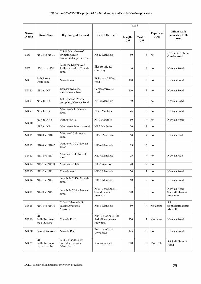
Table 3.2 - List of roads where pipelines will be laying in Narahenpita area
Sewer Name
Road Name Beginning of the road End of the road
Road
Populated Area
Minor roads connected to the
road Length-(m)
Width-(m)
NR 1
Kirimandala mawatha
Agriculture Department building
Heen Ela road 200 10 Highly populated
Economic center road,Samanala uyana road,Kinda Ela road
Kinda Ela road Kirimandala Mawatha junction - Kinda Ela road
Nawala road 400 6 Highly populated
Kirimandala mawatha,Nawala road,Economic center road
Nawala road Kinda Ela road
Ramasamwatte road near proposed pump house,Nawala road
300 12 Highly populated
Kinda Ela road, Sri Sadhdharma Mawatha,entraance road to Open University
N8 - N3 Ramashamiwaththa Road
infront of proposed pump house,Nawala road
15 12 highly populated
Ramasamwaththe road
N3 - N2 N3 Manhole - Nawala road
infront of proposed pump house,Nawala road
15 6 no Nawala road
NR 2 N6-3 to N6-2 infront of agricultural department office
7 Moderate Economic center road,Samadhi wihara road
N6-2 to N5 Samadh Vihara Mawatha, NLDB milk Center
milco company,Samadhi wihara road
200 7 Moderate Nawala road,Economic center road
NR 3 N6-5 to N6-1 Survey department office Vihara Mawatha
Near Sanasa Office 100 6 no Samadhi wihara mawatha
NR 4
N5-14 to N5-8
near Thimbirigasyaya DS office /oliver Gunathilaka Garden Junction
Oliver Gunathulaka Garden Road
150 8 no Elvitigala Mawatha
Elvitigala Mawatha
Nawalaroad junction,Elwitigala Mawatha
Srimath Oliver Gunathilaka Garden Junction,Elvitigala Mawatha
200 15 highly populated
Nawala road, Srimatha Oliver Gunathilaka Garden Road
Nawala road Coconut development authority Nawala Road
Nawala road junction,Elwitigala Mawatha
150 12 Highly populated
Samdhiwihara Mawatha,Pichchamalwatte road, Elvitigala Mawatha, Kelani Weli Rail Road
NR5 N5-10 to N5-9 Srimath Oliver Gunathilaka garden road - N5-9 Man hole
N5-10 Man hole of Srimath Oliver Gunathilaka road
50 7 no Oliver Gunathilka Garden road
IEE for the GCWWMIIP – project 02 for Narahenpita and Kirula-Narahenpita areas
DCEE, Faculty of Engineering, University of Ruhuna
25
Sewer Name
Road Name Beginning of the road End of the road
Road
Populated Area
Minor roads connected to the
road Length-(m)
Width-(m)
NR6 N5-13 to N5-11 N5-11 Mana hole of Srimath Oliver Gunathilaka garden road
N5-13 Manhole 50 6 no Oliver Gunathilka Garden road
NR7 N5-1-1 to N5-1 Near the Kelani Weli Railway road of Nawala road
Electro private company
40 8 no Nawala Road
NR8 Pichchamal watte road
Nawala road Pichchamal Watte road
100 3 no Nawala Road
NR 23 N8-1 to N7 RamasamWatthe road,Nawala Road
Ramasamiwatte road
100 3 no Nawala Road
NR 24 N8-2 to N8 LH Piyasena Private company, Nawala Road
N8 - 2 Manhole 50 8 no Nawala Road
NR 9 N9-2 to N9 Manhole N9 - Nawala road
N-9-2 Manhole 75 5 no Nawala Road
NR 10
N9-4 to N9-3 Manhole N -3 N9-4 Manhole 50 7 no Nawala Road
N9-3 to N9 Manhole 9- Nawala road N9-3 Manhole 50 7 no
NR 11 N10-3 to N10 Manhole 10 - Nawala road
N10- 3 Manhole 60 7 no Nawala road
NR 12 N10-4 to N10-2 Manhole 10-2 /Nawala Road
N10-4 Manhole 25 6 no
NR 13 N11-4 to N11 Manhole N11 -Nawala road
N11-4 Manhole 25 7 no Nawala road
NR 14 N13-1 to N11-3 Manhole N11-3 N13-1 manhole 20 7 no
NR 15 N11-2 to N11 Nawala road N11-2 Manhole 50 7 no Nawala Road
NR 16 N14-1 to N13 Manhole N 13 - Nawala road
N14-1 Manhole 60 7 no Nawala Road
NR 17 N14-9 to N15 Manhole N14 -Nawala road
N-14 -9 Manhole -Srisadhharma mawatha
300 6 no Nawala Road Sri Sadhdharma mawathe
NR 18 N14-8 to N14-4 N 14 -1 Manhole, Sri sadhharmarama Mawatha
N14-8 Manhole 50 7 Moderate Sri Sadhdharmarama Mawathe
NR 19 Sri Sadhdharmarama Mawatha
Nawala Road N14- 3 Manhole - Sri Sadhdharmarama Mawatha
150 7 Moderate Nawala Road
NR 20 Lake drive road Nawala Road End of the Lake Drive road
125 8 no Nawala Road
NR 21 Sri Sadhdharmarama Mawatha
N14-3 Manhole, Sri Sadhdharmarama Mawatha
Kinda ela road 200 8 Moderate Sri Sadhdhrama Road

IEE for the GCWWMIIP – project 02 for Narahenpita and Kirula-Narahenpita areas
DCEE, Faculty of Engineering, University of Ruhuna
26
Sewer Name
Road Name Beginning of the road End of the road
Road
Populated Area
Minor roads connected to the
road Length-(m)
Width-(m)
NR 22 Economic center road
Economic center, Agriculture department
Kinda ela road 350 8 Moderate Kinda Ela road
IEE for the GCWWMIIP – project 02 for Narahenpita and Kirula-Narahenpita areas
DCEE, Faculty of Engineering, University of Ruhuna
27
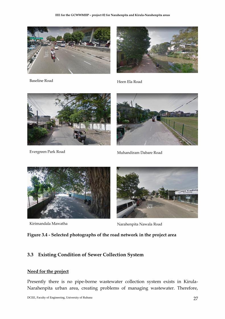
Figure 3.4 - Selected photographs of the road network in the project area
3.3 Existing Condition of Sewer Collection System
Need for the project
Presently there is no pipe-borne wastewater collection system exists in Kirula-
Narahenpita urban area, creating problems of managing wastewater. Therefore,
Kirimandala Mawatha
Baseline Road
Evergreen Park Road
Heen Ela Road
Muhandiram Dabare Road
Narahenpita Nawala Road

IEE for the GCWWMIIP – project 02 for Narahenpita and Kirula-Narahenpita areas
DCEE, Faculty of Engineering, University of Ruhuna
28
establishment of a new sewer network for Kirula-Narahenpita has become vital. The
objective of the project is to implement a new sewerage collection network in
unsewered area in Kirula-Narahenpita, which will bring sustainable solution for the
existing problem of sewerage disposal while enhancing living standard of the people
residing in this area and the floating community. In underserved settlements in the
area having small houses located close to each other, storm water and other
wastewater congestion has become a common problem. Particularly during rainy
seasons, sewerage pits located in high water table areas overflow frequently creating
environmental and social problems in the community. Therefore, the proposed project
is reasonably justifiable investment to improve the socio economic, environmental and
public health condition in Kirula-Narahenpita area. The project is likely to have
significant positive impacts on inland, surface waters, environmental health, public
health and institutional development.
3.4 Proposed Components
The estimated demand for sewerage disposal in Kirula area is 2333 m3/day, while that
in Narahenpita 3456 m3/day. Kirula-Narahenpita unsewered area will be connected
to main sewer system by installing sewerage pipes in 67 public roads (Main roads,
Sub roads and Narrow lanes) (Table 3.1, 3.2 and Figure 3.4) and construction of two
pumping stations in public lands (Topography maps - Figure 3.5 and 3.6) (Kirula
Narahenpita sewer network key map is shown in Annex 5 and manhole details are
shown in Annex 6). The project required pipelines to be installed along 11 main roads
including the by roads in urban built up area in Kirula-Narahenpita where
government department buildings, commercial buildings and residences are located
densely. About 67 sections of roads will be used for project implementation. The land
plots demarcated for construction of the two pumping stations are in Kirula (40
perches) and Narahenpita (25 perch) Grama Niladhari divisions and belong to Urban
Development Authority (UDA) and Sri Lanka Railways (SLR), respectively.
Land ownerships
The new sewer lines will be installed along the existing public roads. Lands for the
proposed two pump stations are owned by two public institutions, Sri Lanka Railways
(25 perches land in Narahenpita) and Urban Development Authority (40 perches land
in Kirula). Both authorities have agreed to allocate above-mentioned proposed lands
for the project on lease basis (See Annex 2). Thus, there is no need to look for
alternative lands for laying of sewer pipes and construction of two pumping stations.

IEE for the GCWWMIIP – project 02 for Narahenpita and Kirula-Narahenpita areas
DCEE, Faculty of Engineering, University of Ruhuna
29
Figure 3.5 – Kirula pump station – topographic layout

IEE for the GCWWMIIP – project 02 for Narahenpita and Kirula-Narahenpita areas
DCEE, Faculty of Engineering, University of Ruhuna
30
Figure 3.6 - Narahenpita pump station – topographic layout

IEE for the GCWWMIIP – project 02 for Narahenpita and Kirula-Narahenpita areas
DCEE, Faculty of Engineering, University of Ruhuna
31
3.5 Implementation Schedule
The implementation schedule of the project in details including planning, designing,
tendering and bid documentation and construction is shown in Figure 3.7.
Figure 3.7 - Project implementation schedule
3.6 Project implementation
3.6.1 Pre-construction activities
At the pre-construction phase, the appointed contractor should find the suitable
sources to get construction materials such as aggregates; sand and soil (backfilling
materials) from licensed borrow pits or quarries. The contractor should ensure that
these borrow pits or quarries should possess licenses such as licenses from the GSMB
for exploration (EL licenses), mining (Industrial Mining Licenses/IML) and
transportation of minerals including sand and soil as per the Mines and Minerals Act
No. 33 of 1992. Permits are needed from the Forest Department to fell crucial trees
such as jack (if available within the development) as per the Felling of Trees (Control)
Act No 9 (1951). Further, the contractor should select the suitable batching plant/s
with valid EPL to get the ready mixed concrete prior to start the construction activities.

IEE for the GCWWMIIP – project 02 for Narahenpita and Kirula-Narahenpita areas
DCEE, Faculty of Engineering, University of Ruhuna
32
Necessary arrangements need to be made by the Contractor (under the supervision of
the Project Management Unit of the GCWMP) with the CMC to dispose municipal
solid wastes (MSW) and construction and demolition wastes (CDW) (including
excavated material or soil) on a regular basis. The Contractor should appoint a
qualified and experienced Environmental Manager / Officer who is responsible to
address environmental and social issues including implementation of necessary
safeguards and monitoring works to ensure the success of the safeguards and
measures implemented.
As such, the Contractor should provide details pertaining to suitable sources of
materials, disposal site/s, work camps (if required), material storage areas, etc. to the
Project Management Unit (PMU) for approval. Note that establishment of labour
camps, site offices, stockpile yards, stores and vehicle yards shall be in comply with
rules and regulations of the government. Further, comprehensive geotechnical
investigations together with land surveying should be conducted to identify the
subsurface soil profile before starting the detail design and construction.
The prospective contractor should submit an acceptable Environmental Management
Implementation Plan (EMIP) as detailed in the contract document and get it approved
by the Project Management Unit (PMU) of the GCWMP, ADB, CEA and other relevant
government agencies and implemented throughout the contract period to mitigate all
negative consequences which may arise due to the work being carried out. Contractor
is expected to prepare EMIP based on the EMP mentioned in the IEE report (see
Chapter 8) prior to commencement of the civil works. Due consideration should be
required to be given by the contractor for the rules imposed by all agencies related to
the control of all kind of environmental consequences such as pollution of air, ground
water, water courses, drains, roads, etc. The Contractor is expected to provide details
of signage, information boards, barricades, etc. with the approval of the Project
Management Unit (PMU) of the GCWMP, ADB and relevant government agencies for
site safety.
3.6.2 Construction activities
Details of land preparation activities
With reference to the 2 pumping stations, it is necessary to clear the lands using
excavators and backhoes as well as demolition of the existing infrastructure.
Demolition of the existing infrastructure too would be done using excavators and
backhoes.
Construction details of Pumping Stations
Two lands have been reserved for the proposed pump stations. The land reserved for
the proposed pump station at Dabare Mawatha at Narahenpita is 25 perches in extent

IEE for the GCWWMIIP – project 02 for Narahenpita and Kirula-Narahenpita areas
DCEE, Faculty of Engineering, University of Ruhuna
33
with home garden type vegetation where few mango trees, coconut trees, jack tress
and jackfruit trees are grown as shown in Figure 3.8. At present, six families have
occupied in 05 houses which are claimed as unauthorized settlements as the
concerned land belongs to Sri Lanka Railways. These families should be relocated
once the lease is signed by the Sri Lanka Railways with CMC for the construction of
pump station (Annex 2).
The reserved land for the proposed second pump station at Nawala road is 40 perches
in extent. This is a bare land (Figure 3.9) and the Urban Development Authority (UDA)
owns it. In order to construct the pump station in this land, lease has been already
signed by UDA with CMC (Annex 2).
Figure 3.8- Proposed land for Pump station at Dabare Mawatha, Narahenpita
Figure 3.9 - Proposed land for Pump station at Nawala road, Narahenpita
With reference to the 2 pumping stations, it is necessary to clear the lands using
excavators and backhoes as well as demolition of the existing infrastructure.
Demolition of the existing infrastructure too would be done using excavators and
backhoes.

IEE for the GCWWMIIP – project 02 for Narahenpita and Kirula-Narahenpita areas
DCEE, Faculty of Engineering, University of Ruhuna
34
According to drawings provided, at both pumping stations, it is necessary to excavate
about 13.0 m from the existing ground surface. As such, it is necessary to construct a
secant pile shoring system together with struts to support the surrounding soil. Both
pumping stations will be constructed of reinforced concrete up to the ground surface
and the super-structure with normal building materials. Further, during the
underground construction, stability of the secant piled wall should be verified by
installing inclinometers at regular intervals. The possibility of floods during heavy
rain at two pump station locations is remote due to the location of both stations close
to canals with adequate draining up to the sea but ingress of ground water is a
possibility.
Excavation of roads, method of laying pipelines
Sewers will be laid only in public right of way or easement due to operation and
maintenance difficulties if laid in private lands. The public right of ways and
easements are owned or under the jurisdiction of public institutions (i.e., RDA, CMC,
SLLRDC, UDA and Sri Lanka Railways). The width of the roads proposed to be used
for sewer laying ranges from 3 m wide small by lanes to highways of width around
26 m. Diameter of sewers vary from 225 to 600 mm as shown in Figure 3.6. It is planned
to lay sewers along by lanes at the edge of the road with minimum damages to the
boundary walls and fences. Further, it is important to avoid conflicts with other
utilities. Even in wider roads network will be laid on edge of the road without
disturbing other utilities. It is very important to identify the trace of the other utilities
prior to start the laying of sewers.
All public roads in the area belong to CMC except Baseline road and B307 Nawala-
Narahenpita road which are maintained by the RDA. Right of way or easements
belonging to SLLRDC are required to lay pipes along roads adjacent to Kinda Canal.
Some reservations belonging to Sri Lanka Railways are also used for pipe laying in
areas close to the railway track.
Excavation using open cut method will have to be done in most part of the pipe laying
sections. Micro tunneling will have to be carried out in some sections where pipe
laying depth is more than 3.0 m and sensitive locations due to narrow roads with high
density of population in the adjacent areas of the roads. The total length of pipe laying
will be around 12.3 km. This consists of 7.35 km length identified for open cut method
and 4.95 km length for micro tunneling method. Figure 3.10 shows the pipes that will
be laid using trench-based methods and trenchless technologies (i.e. micro tunneling).
The depth and width of the trench to be excavated for open cut method will vary from
1.5 m to 3.0 m and 0.8 m to 1.2 m respectively. A suitable gradient of the sewer pipes
needs to be maintained for effective flow in gravity sewers to maintain smooth flow.
The Open cut trench approach is adopted for pipe laying in the roads with good

IEE for the GCWWMIIP – project 02 for Narahenpita and Kirula-Narahenpita areas
DCEE, Faculty of Engineering, University of Ruhuna
35
subsurface conditions and low water table. However, it can be noted that there is
considerable amount of soft soils presence within the areas proposed for the open cut
trench approach. As such, “Remove and replacement method” has been proposed as
a ground improvement technique if the soft soil presence within the open cut trench
areas before lay the pipes. According to borehole investigations done by the
Engineering Laboratory Services (ELS) in March-April 2017, most of the locations,
water table is very close to the ground surface (about 0.7-1.5m). As such, dewatering
is required in most of the locations during the open cut trench approach. It is a
responsibility of the contractor to provide adequate shoring during the open trench
excavation to provide safe environment for the workers. Further, shoring is required
to control the seepage towards the trench to protect the differential settlement of the
surrounding structures. Contractor should test all the sewer pipes after laying and
before starting the backfilling.
Cranes will be used to carry the pipes and then lay to the excavated trenches as well
as to carry the sewer pipes when doing micro tunneling too. The details of pipe types
and sizes used for the project is as shown in the Table 3.3.
Table 3.3 – Types and sizes of pipes used in the project
Force main
Type of laying 315 mm HDPE
Open cut length (m) 1600
Gravity pipes
Type of laying 225 mm VC
300 mm VC
400 mm VC
500 mm VC
600 mm VC
Open cut length (m) 4749 540
Micro Tunneling length (m) 2112 2017 298 436 218
Total length (m) 6861 2556 298 436 218
Micro Tunneling
Force mains (minimum depth to top of pipe will be 1.2 m) will be laid in shallow
trenches using micro tunneling. Micro tunneling will also be adopted while laying
sewers along certain roads due to the following reasons and it is estimated that the
length of such laying will be around 4.95 km (Figure 3.11).
1. Deep sewers, high water table and encountering sand, silt and similar fine
materials
2. Heavy traffic along some roads such as Baseline road and Nawala-Narahenpita
road
3. Location of houses and other buildings close to the road
4. Railway crossing at Nawala-Narahenpita road and another road crossing etc.

IEE for the GCWWMIIP – project 02 for Narahenpita and Kirula-Narahenpita areas
DCEE, Faculty of Engineering, University of Ruhuna
36
Figure 3.10 – Sewer network (variation of pipe diameter)

IEE for the GCWWMIIP – project 02 for Narahenpita and Kirula-Narahenpita areas
DCEE, Faculty of Engineering, University of Ruhuna
37
Figure 3.11 – Areas proposed for micro tunneling and open trench method

IEE for the GCWWMIIP – project 02 for Narahenpita and Kirula-Narahenpita areas
DCEE, Faculty of Engineering, University of Ruhuna
38
Micro-tunneling is a trenchless construction method, which utilizes hydraulic jacks to
push pipes through the ground behind a remotely operated Tunnel Boring Machine
(TBM). Excavation for micro-tunneling is limited to the endpoints for each drive at
designated launching (jacking) and receiving pits. The launching pit contains the
hydraulic jacks used to push the pipes. The receiving pit is used to recover the TBM
at the end of each drive. The excavated material is carried via augers and conveyors,
or by recycled slurry through closed system pipelines to the surface for processing
and disposal. The remote-control cabin for operating the TBM, as well as cranes and
other construction equipment, is at the surface near the jacking pit. Because of the
nature of the work, micro-tunneling operation may extend beyond normally
permitted hours for construction activities. In micro tunneling, the 2 end points
(excavated pits) will be converted to manholes (Figure 3.12).
Figure 3.12 - Micro tunneling method for laying pressure sewer lines
To prevent inconvenience to public by opening of roads ad-hoc basis by the
contractors, pipe laying program should be included in the Contract document. This
program will set sequence of roads for pipe laying and sets limits for laying distances.
Contractor will be allowed to move to other areas for work only after completing the
previous work. In the preparation of this program which will be a guide to the
Contractor, the prevailing traffic arrangements/demand and minimizing the period
without vehicular access to properties should be considered.

IEE for the GCWWMIIP – project 02 for Narahenpita and Kirula-Narahenpita areas
DCEE, Faculty of Engineering, University of Ruhuna
39
Mobilization heavy machinery
Mobilization of heavy machineries should be done by the contractor according to the
construction programme. Key machineries at the initial stages of construction would
involve excavators and backhoes, cranes, dump trucks / tippers, compacting rollers,
micro tunneling and rotational drilling machines. Further, it is a responsibility of the
contractor to park all machineries involve for the construction at appropriate locations
without disturbing the public activities. Noise and vibration generated during the
usage of heavy machineries should be properly monitored and take appropriate
actions if it is needed.
Disposal of excavated material and other solid waste
The appointed Contractor will be required to safely store and dispose
excavated/dredged materials and construction and demolition (CD) wastes which
will include land clearing debris (including infrastructure material or building
material) and soil under the supervision of the Project Proponent, ADB/EIB and
relevant government agencies such as CEA. The approximate loose volume of the
excavated soil at pumping stations is about 8800 m3 whereas loose volume of the
excavated soil at open trenches is about 1000 m3. It is a responsibility of the appointed
contractor to find a suitable dump site with the approval of the relevant organizations
such as CEA and CMC (or relevant local authority) etc. to dispose these materials.
Further, contractor should transport these materials accordance to the government
regulations with minimum disturbance to the surrounding environment and public.
Some of these excavated materials (suitable soil) can be used for backfilling with the
approval of the Engineer; as such it is a responsibility of the contractor to store these
materials at suitable location/s without disturbing the surrounding environment.
Trench backfilling and compaction
All the trenches which are excavated to lay the pipes and to construct the manholes
should be backfilled with suitable materials and should be properly compacted using
rammers or compaction rollers. Certain portion of the backfilling material can be
obtained from the excavated soil (suitable soil) with the approval of the Engineer.
Finally, all the roads which are used to lay the sewer pipes should be reinstatement.
Techniques and equipment to be used
Key machinery at the initial stages of construction would involve;
i. Excavators and backhoes (for land clearing and building demolition at the
proposed pumping station sites and excavations for sewer pipe laying),
ii. Tippers or dump trucks (to transport construction material including sewer
pipes and CD wastes)

IEE for the GCWWMIIP – project 02 for Narahenpita and Kirula-Narahenpita areas
DCEE, Faculty of Engineering, University of Ruhuna
40
iii. Containers (to transport construction material)
iv. Cranes (to carry and lay the sewer pipes to the excavated trenches as well
as to carry the sewer pipes and HDPE force mains during micro-tunneling
works). Micro tunneling machines (for sewer pipe laying covering a total of
4.95 km; examples of such locations are; along Baseline road, Nawala-
Narahenpita road, section close to Kinda canal, railway crossing at Nawala-
Narahenpita road etc.) and the congested areas.
v. Concrete pump cars and concrete mixture trucks (for supply ready mixed
concrete for secant pile construction and other concrete works)
Discharge of dewatered water
Since water table is very close to the ground surface, dewatering is required in most
of the locations during the open cut trench approach. The pumped-out water should
be sent through the existing road drains with suitable silt traps. The nominated
contractors are advised to do adequate trial pits along those roads selected for open
cut trenching to obtain necessary information for pipe laying. Further, the contractor
should make sure that existing drainage system will not be clogged due to discharge
of pump out water. The contractor should frequently monitor the existing drainage
system and if it is clogged due to construction activities, it is a responsibility of the
contractor to rectify the drainage system immediately.
Construction of site offices
The Contractor would construct temporary offices (containers) at suitable locations
and at the proposed pumping station sites at Dabare Mawatha and Nawala road.
Excavation and pipe laying along canal banks
According to pipe laying drawing shown in Figure 3.7, both open trench and micro
tunneling methods have been proposed to lay sewers along the canal banks. However,
according to the SLLRDC canal maintenance work, there is a strict requirement to
maintain a reservation of 3 m from the edge of the canal bank without any
construction/excavation to protect existing Gabion structures (Annex 2). Hence, trace
of the sewer pipes along the canal bank should be located accordingly. Further, it is a
responsibility of the contractor to get permission from the SLLRDC before starting any
excavation along the canal bank.

IEE for the GCWWMIIP – project 02 for Narahenpita and Kirula-Narahenpita areas
DCEE, Faculty of Engineering, University of Ruhuna
41
3.6.3 Operational and maintenance activities and procedures
Responsible agency for operation for the project
Operation and maintenance of the system will be handed over to the CMC upon the
completion of construction works and commissioning the system. CMC already has a
division dedicated to operation and maintenance of the sewer system which includes
sewer networks and associated structures including pumping stations. Therefore,
CMC already has the experience required for operation and maintenance of the
system. The personnel required consists of engineers, technical officers, operators,
electricians, mechanics and trained staff for the maintenance of sewer network
including attending to new connections which will be provided by the CMC.
Operational and maintenance procedures
It is necessary to closely follow the preventive maintenance practices outlined in the
pump O&M (operation and maintenance) manual including operational “check-ups”.
In addition to the pump stations, it is necessary to frequently monitor the pipe network
to identify any leakages for necessary maintenance/repair work.
Maintenance activities
Take careful note of any abnormal sound or vibration and act to promptly correct
any problems. Check motors and rotating elements of pumps for higher than
normal temperature, using a thermometer frequently. Visually inspect pumps and
motors for coating failure and oxidation and reapply protective coatings/paint as
necessary. The issues related to operational and management of pump stations
and sewer network are described in the Chapter 5.
3.7 Resources/ facilities required/ provided
Construction materials should be sourced from the approved quarries and the
necessary pipes and fitting should be imported according to the acceptable standards.
The contractor should provide basic facilities such as works camps with adequate
water supply and sanitation and require PPE. Required manpower should be
provided by the contractor and it is suggested to recruit labors from the local area. It
is a responsibility of the client (CMC) to provide enough resources for the proper
operation of the pump stations and sewer network. Further, it is a responsibility of the
CMC to provide sufficient training for the operational staff to have a proper
operational management system.

IEE for the GCWWMIIP – project 02 for Narahenpita and Kirula-Narahenpita areas
DCEE, Faculty of Engineering, University of Ruhuna
42
3.8 Work force
Labor requirements, availability of labor and employment of local people as well as
migratory workers, etc. are not yet finalized and it is expected that the appointed
Contractor would be responsible to address these issues. However, Health and safety
of all parties during the construction period including the defects liability period
should be addressed in the bidding documents and provisions should be made to
compensate the prospective contractor for the effective implementation of all aspects
related to the safety and health at all sites where work is going to be carried out. Due
consideration would be given for all safety aspects during dewatering, shoring, trench
excavation and backfilling including traffic control during the pipe laying along roads.
Conditions imposed by the SLLRDC should be strictly followed during the work
adjoining the canal banks. Due consideration should be given for the safety of
property and people during the construction of pumping stations since secant piling,
dewatering and disposal of ground water are required for an extended period
specially during the completion of the sub structure works. Method statements for all
work should be duly approved before the commencement of any work at the site.
Provisions should be made in the Contract to provide a dedicated Health and Safety
Officer on full time basis throughout the contract. Also, it should be mandatory to use
appropriate PPE (such as dust masks, boots, hard hats, gloves, etc) by the workforce
including site personnel such as engineers, supervisors and technical officers.
Contractor should be required to obtain necessary insurance to cover the workmen
and on workers (third party) against injuries and loss of life. Further, it is a
responsibility of the contractor to provide enough Occupational Health and Safety
(OHS) training and awareness, and capacity building programs to enhance the labor
quality.
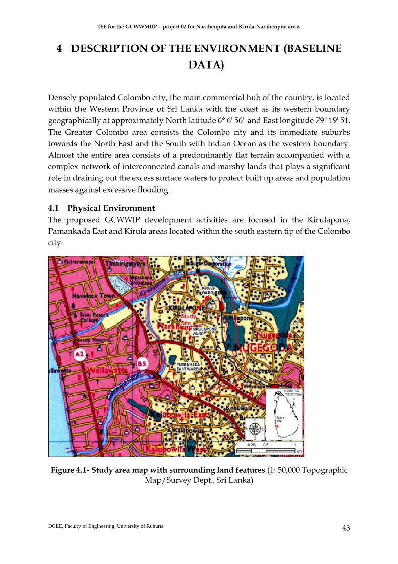
IEE for the GCWWMIIP – project 02 for Narahenpita and Kirula-Narahenpita areas
DCEE, Faculty of Engineering, University of Ruhuna
43
4 DESCRIPTION OF THE ENVIRONMENT (BASELINE
DATA)
Densely populated Colombo city, the main commercial hub of the country, is located
within the Western Province of Sri Lanka with the coast as its western boundary
geographically at approximately North latitude 6° 6' 56" and East longitude 79" 19' 51.
The Greater Colombo area consists the Colombo city and its immediate suburbs
towards the North East and the South with Indian Ocean as the western boundary.
Almost the entire area consists of a predominantly flat terrain accompanied with a
complex network of interconnected canals and marshy lands that plays a significant
role in draining out the excess surface waters to protect built up areas and population
masses against excessive flooding.
4.1 Physical Environment
The proposed GCWWIP development activities are focused in the Kirulapona,
Pamankada East and Kirula areas located within the south eastern tip of the Colombo
city.
Figure 4.1- Study area map with surrounding land features (1: 50,000 Topographic Map/Survey Dept., Sri Lanka)

IEE for the GCWWMIIP – project 02 for Narahenpita and Kirula-Narahenpita areas
DCEE, Faculty of Engineering, University of Ruhuna
44
The project area is marked by the Kirulapone Canal (Wellawatta Canal) connected to
Diyawanna Oya marshland and associated wetland canal system in the upper
boundary, Baseline road and Kirulapone-Nugegoda road (Figure. 4.1).
4.1.1 Topography
Sri Lanka’s general topography has three clear distinct geographical areas or well-
marked peneplains consisting the coastal belt, the plains, and the central highlands.
This unique and great topographic diversity is created by long years of faulting and
erosion of the landscape. The central mountainous region of the country with the
highest elevations covered by virgin forests and grasslands rises to about 2,500 m
above mean sea level. The surrounding plains, which rise to about 50 to 100 m above
sea level, are largely used for agriculture and homesteads, but still have virgin
scrubland where the population distribution is moderate to lower. The project area
which situated within the Colombo district falls into the so called lowest peneplain of
Sri Lanka (after P.G. Cooray – Geology of Sri Lanka, 1984).
The maximum elevation variation of coastal Colombo district ranges to a 150 m in
inland areas from seacoast. The Greater Colombo area terrain largely consists of gently
undulating plains and low-lying flatlands accompanied by densely distributed
drainage paths resulting a geography that includes a mix of land and water,
comprising wetlands/marshes, many canals and water bodies like Beira Lake,
Diyawanna Lake, Bolgoda Lake and other waterway features.
4.1.2 Hydrology and Drainage
SRTM data has been used to develop Digital Elevation Model (DEM) followed by
derivation of drainage paths based on the flow directions through which the surface
drainage pattern in the area is derived. The project area drains towards the sea and
Bolgoda Lake system in the south (downstream) and through Kirulapone Canal and
Dehiwala Canal open to the sea and Diyawanna/Parliament/ Kolonnawa Lake
System connected to the sea via Beire Lake and North Lock/Gate (connected to Kelani
River outfall) in the north (upstream) (Figure 4.2).

IEE for the GCWWMIIP – project 02 for Narahenpita and Kirula-Narahenpita areas
DCEE, Faculty of Engineering, University of Ruhuna
45
Figure 4.2 - Terrain map in study area with associated drainage paths (SRTM DEM data)
All the water bodies that are connected through the canal system having fluctuating
water level during monsoonal and dry periods. Inundating low lying marshes and
wetlands in the system is common during monsoonal periods with no major floods
except for localized temporary inundation caused due to minor drainage issues
recorded within the project area. According to a hydrological analysis performed by
Sri Lanka Land Reclamation and Development Corporation (SLRDC), the maximum
expected flood levels corresponding to 50-year return period storm are ranging from
+2.68 m MSL at Kirullapone canal (At Baseline Road Bridge) to +1.46 m MSL at
Dehiwala Canal (Galle Road Bridge). High groundwater levels are recorded during
such rainy periods (about 0.4 ~ 0.5 m on average close to the Canal and other low-
lying areas) and the water levels drop as low as 3.0 ~ 4.0 m during extended dry
periods.
4.1.3 Climatic Conditions
The Greater Colombo climate condition is classified, as tropical monsoon comprises
with a bi-modal rainfall mechanism having two wet weather seasons followed by a
short dry weather season. The area is located within the country’s wet zone, which is
also a part of the southern quarter coastal belt of the island. Southwest monsoon from
May to September, and northeast monsoon from December to February are the two
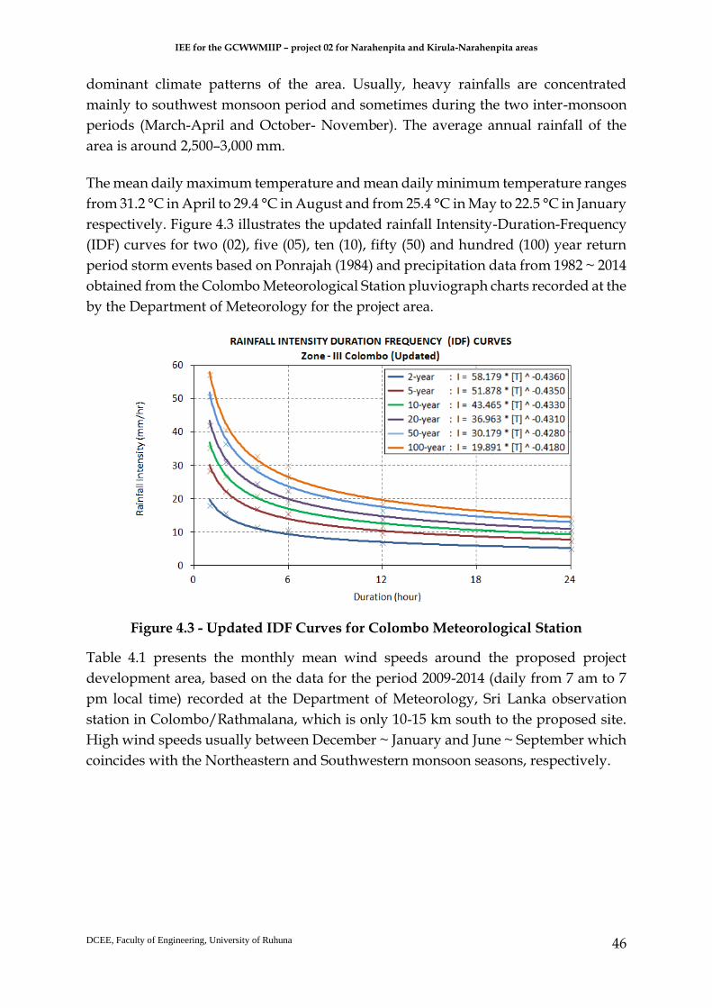
IEE for the GCWWMIIP – project 02 for Narahenpita and Kirula-Narahenpita areas
DCEE, Faculty of Engineering, University of Ruhuna
46
dominant climate patterns of the area. Usually, heavy rainfalls are concentrated
mainly to southwest monsoon period and sometimes during the two inter-monsoon
periods (March-April and October- November). The average annual rainfall of the
area is around 2,500–3,000 mm.
The mean daily maximum temperature and mean daily minimum temperature ranges
from 31.2 °C in April to 29.4 °C in August and from 25.4 °C in May to 22.5 °C in January
respectively. Figure 4.3 illustrates the updated rainfall Intensity-Duration-Frequency
(IDF) curves for two (02), five (05), ten (10), fifty (50) and hundred (100) year return
period storm events based on Ponrajah (1984) and precipitation data from 1982 ~ 2014
obtained from the Colombo Meteorological Station pluviograph charts recorded at the
by the Department of Meteorology for the project area.
Figure 4.3 - Updated IDF Curves for Colombo Meteorological Station
Table 4.1 presents the monthly mean wind speeds around the proposed project
development area, based on the data for the period 2009-2014 (daily from 7 am to 7
pm local time) recorded at the Department of Meteorology, Sri Lanka observation
station in Colombo/Rathmalana, which is only 10-15 km south to the proposed site.
High wind speeds usually between December ~ January and June ~ September which
coincides with the Northeastern and Southwestern monsoon seasons, respectively.

IEE for the GCWWMIIP – project 02 for Narahenpita and Kirula-Narahenpita areas
DCEE, Faculty of Engineering, University of Ruhuna
47
Table 4.1 - Wind data based on observations taken between 11/2009 - 09/2014
4.1.4 Land Use
Existing Land use
Major land use patterns within the key areas of the project are shown in Figure 4.1 and
in the satellite image (Figure 4.2). Project area comprises busy Class A and B roads of
the Road Development Authority with commercial, institutional and residential areas
(having home gardens). Major Land use type is residential and commercial covering
about 0.8 km2. Surface water drainage system in the project area and suburbs which
comprised of number of canals and waterways are shown in Figure 4.3.
Pipe laying in the area will have to be done along main roads and by roads where
government department buildings, commercial buildings and residences are located
densely. Proposed land for the pumping station in Dabare Mawatha in Narahenpita
comprised of home garden type vegetation where few mango trees, coconut trees and
jackfruit trees are grown. The land reserved for proposed pump station at Nawala
road can be categorized as a bear land.
There are no protected areas, sanctuaries under the Department of Wildlife
Conservation and sites having any cultural, historical and/or archaeological
significance as per the Antiquities Ordinance No. 9 of 1940 and Amendment Act No.
24 of 1998. Furthermore, the project area is not located within one mile of the boundary
of any National Reserves.
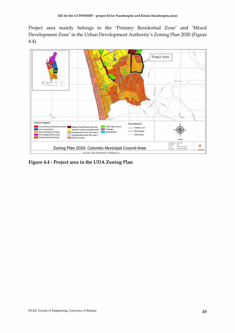
IEE for the GCWWMIIP – project 02 for Narahenpita and Kirula-Narahenpita areas
DCEE, Faculty of Engineering, University of Ruhuna
48
Project area mainly belongs to the ‘Primary Residential Zone’ and ‘Mixed
Development Zone’ in the Urban Development Authority’s Zoning Plan 2020 (Figure
4.4).
Figure 4.4 - Project area in the UDA Zoning Plan

IEE for the GCWWMIIP – project 02 for Narahenpita and Kirula-Narahenpita areas
DCEE, Faculty of Engineering, University of Ruhuna
49
Figure 4.5 - Existing Land use in the project area

IEE for the GCWWMIIP – project 02 for Narahenpita and Kirula-Narahenpita areas
DCEE, Faculty of Engineering, University of Ruhuna
50
Figure 4.6 - Satellite image of the project area
(Source: Imagery@2019 Digitalglobe, Map, data@2019 Google)
Project Area
Proposed Pump House
in Dabare Mawatha
Proposed Pump House
in Nawala Road

IEE for the GCWWMIIP – project 02 for Narahenpita and Kirula-Narahenpita areas
DCEE, Faculty of Engineering, University of Ruhuna
51
Figure 4.7 - Major canals and waterways in the project area and suburbs
(Source: Map, data@2019 Google)
4.1.5 Air Quality, Noise, Vibration
Air Quality
The surrounding area of the project location can be considered in general as highly
urban, having a high population density. Its transportation is mainly concentrated in
the town area. As the air quality is not recorded routinely in this project area 1hr
average air quality data were measured in 7 locations, including 2 propose pumping
stations’ locations, as shown in the Figure 4.7. The location A3 and A4 were located
on Baseline road. Two pumping stations are marked as P1 and P2. Table 4.3 shows the
ambient air quality measurements for baseline study.
Kinda canal
Project
Area
Kirulapana
canal

IEE for the GCWWMIIP – project 02 for Narahenpita and Kirula-Narahenpita areas
DCEE, Faculty of Engineering, University of Ruhuna
52
Figure 4.8 - Air quality sample locations
Table 4.2 - Air quality in sampled locations on different times
Location Sampling Time
(1hr Averaging Time
Particle dust
(PM 2.5), (µg/m3)
SO2
(ppm) NO2
(Ppm) CO2
(ppm)
CO
(ppm)
O2, %
P-1
(Pumping Stn)
9:15 am to 10.15 am
37 0.02 0.00 353 6.2 20.3
A-3 10:25 am to 11:25 am
38 0.01 0.10 420 7.1 20.3
A-4 11:40 am to 12:40 pm
37 0.01 0.05 597 5.5 20.3
A-5 1:05 pm to 2:05 pm
37 0.09 0.00 693 8.6 20.3

IEE for the GCWWMIIP – project 02 for Narahenpita and Kirula-Narahenpita areas
DCEE, Faculty of Engineering, University of Ruhuna
53
A-6 2:30 pm to 3:30 pm
27 0.04 0.07 572 6.2 20.3
A-7 3:50 pm to 4:50 pm
9 0.01 0.02 358 5.6 20.4
P-2
(Pumping Stn)
5:15 pm to 6:15 pm
8 0.01 0.05 387 5.7 20.2
According to the results, it seems that air quality deterioration is not significant
considering the limits enacted under the Environmental (Ambient Air Quality)
Regulations, published in 1994 and amended in 2008 though the Baseline Road are
often characterized with a high traffic volume including congestions. These findings
are compatible with a previous study conducted by the Industrial Training Institute
(ITI) as a part of the feasibility study for the proposed elevated highway from
Kirulapana to New Kelani Bridge and from New Kelani Bridge to Galle face (Colombo
port) over the existing Baseline road and Port accesses road in 2014. It is expected that
similar air quality levels shown in Table 4.3 would prevail in similar busy road
environments within the Project Area but may be even slightly lower in roads where
there are plenty of residential areas. There are no stationary sources of emissions
within the Project Area.
Noise and Vibration
Noise is traditionally defined as unwanted sound that interferes with normal activities
in a way that reduces the quality of the environment. Sound measurements were
carried out at two proposed pumping location locations (P1 and P2 in the Figure 4.8)
mainly aiming to measure the existing background noise level.
Table 4.3 - Noise level results at the proposed pumping stations P1 and P2
Date and Time Pumping Station 1 (P1) (ENL-LAeq, h), Db
Pumping Station 2 (P2) (ENL-LAeq, h), Db
29th Nov 2018,
(8:00 am to 9:00 am)
45 61
29th Nov 2018,
(3:00 pm to 4:00 pm)
60 64
From the sample noise measurements, it can be noted that at both locations noise
levels have exceeded the permitted noise levels of the National Environmental (Noise
Control) Regulations No. 1 of 1996 i.e. for urban residential areas daytime is 60dB.
Such noise level exceeds are mainly expected due to traffic noise.
In a previous study (IEE Kirulapone, 2015) carried out at the Baseline Road close to
the Calvary Church mentioned the vibration levels and the results showed that

IEE for the GCWWMIIP – project 02 for Narahenpita and Kirula-Narahenpita areas
DCEE, Faculty of Engineering, University of Ruhuna
54
existing vibration levels at some points along the route are way below the vibration
limits for sensitive structures (made of lightweight materials), set by the CEA.
According to this study Peak particle velocities (PPVs) were less than the interim
standards on vibration for Category Type 3 structures with reference to the operation
of machinery, construction activities and vehicle movement. It is expected that similar
or less vibration levels would prevail in similar busy road environments within the
Project Area too.
4.2 Biodiversity
4.2.1. Present Status of Fauna and Flora in the Study Area The proposed project site is located within urban area including Kirula ward and
Narahenpita ward. Currently the project site consists of network of roads and poor
vegetation on roadsides and home gardens.
A) B)
Figure 4.9 - A) Vegetation in the bank-side of Heen ela, B) Vegetation in the land selected for “Dabare Mawatha” pumping station.
Currently the vegetation of the study area consists of native, introduced, exotic and
invasive floral species. There are few economically important plants in the study area
(Figure 4.9).

IEE for the GCWWMIIP – project 02 for Narahenpita and Kirula-Narahenpita areas
DCEE, Faculty of Engineering, University of Ruhuna
55
4.2.2. Flora and Fauna in the Study Area
To understand potential ecological impacts of the project, it is very important to
investigate on key habitat types and biodiversity in the area. In order to identify the
species in the proposed project area, a rapid assessment on terrestrial and aquatic
ecological resources was carried out within the project area and surrounded area. It
was carried out during daytime species encountered were recorded. Line transect
method was used to survey the fauna and flora of the project area and different
sampling techniques were used to sample different taxon. Terrestrial fauna observed
25m either side of the line transects were recorded. Hand net was used to sample the
aquatic fauna present in the shallow water. Point counts were also carried out for
birds. A binocular was used to observe birds and butterflies. No live specimen was
collected, and night sampling was not conducted during the field studies.
Species identification and nomenclature of the species present was based on the latest
literature published on the fauna and flora of Sri Lanka. The conservation status of the
species was determined according to the 2012 Red list of Threatened Fauna and Flora
of Sri Lanka by IUCN. Further, relevant secondary information was gathered from
people living nearby communities. Flora and fauna identified in the project site is
presented in Annex 7.
4.2.3 Existing Natural Habitat with the Ecology of the Ecosystems There are no significant natural habitats for wildlife is identified within the study area,
which is primarily because the area is subjected to human settlement. Home gardens
with planted vegetation were the major terrestrial habitat type in the area. No any
undisturbed natural ecosystems available in the area.
A total of 50 species were observed belonging to 23 families. Majority of plant species
recorded in the study site are tree species (27), followed by herb (8), Shrub (7) and
climber (5). Among the recorded species 24% are introduced, exotic, and invasive to
Sri Lanka. None of the recorded species are endemic, unique or restricted to the project
area. None of the plant species recorded in the project site is threatened or near
threatened.
Fauna in the Project Site A total of 37 faunal species were recorded during the survey representing dragonflies,
butterflies, freshwater fish, reptiles, birds and mammals. Among them no species are
endemic to Sri Lanka while others are native and exotic species.
IEE for the GCWWMIIP – project 02 for Narahenpita and Kirula-Narahenpita areas
DCEE, Faculty of Engineering, University of Ruhuna
56
Sampling of fauna was done in parallel to the floral transacts. Visual Encounter Survey
method was used to record the faunal species. Faunal survey was carried out within
the proposed project area and 50 m away from the project boundary. Reviewing of
published documents and unpublished data was also carried out. In addition,
photographic records were used to identify the visual aspect of habitats of proposed
project area.
Most of the species that observed in the project area are common residents in such
kind of habitats throughout the island. A detailed summery of the faunal species
encountered in the project area is given in Annex 7.
Only one species (Crocidura sp. – all Crocidura species in Sri Lanka are listed under CR
category) among the fauna recorded in the project area are listed under critically
endangered category according to the 2012 Red List of Threatened Fauna and Flora of
Sri Lanka by IUCN. All other species are categorized under LC- Least concern
according to the 2012 Red List of Threatened Fauna and Flora of Sri Lanka by IUCN.
Sri Lankan torque monkey is the only endemic species recorded during the study in
the proposed project area. The conservation status is categorized under LC in National
Conservation Status, but in Global Conservation Status of Sri Lankan torque monkey
is categorized under EN (Endangered).
One species of Freshwater fish was recorded during the study. Poecilia reticulate,
Guppy is a Least Concern freshwater fish species commonly found in the water bodies
with polluted water due to anthropogenic activities.
Existing Natural Habitat with the Ecology of the Ecosystems
Major terrestrial ecosystem type in the area is home gardens. There are no any
undisturbed ecosystems in the area since it is a densely populated area.
4.3 Physical and Cultural Heritage
Important archeological, historical, religious and cultural sites in the Coastal Zone
were identified through a survey in 1989 and updated in 2002 by Coast Conservation
department (ESAR Kirula-Narahenpita, 2018). However, no identified places are lying
in the area.
4.4 Human, Economic and Socio Cultural
The Kirula-Narahenpita subproject area is densely populated. The project
implementing area falls under Thimbirigasyaya Divisional Secretariat Division. The
population of Thimbirigasyaya DS division can be considered as sub project
beneficiaries residing in larger catchment. The population of Thimbirigasyaya DS

IEE for the GCWWMIIP – project 02 for Narahenpita and Kirula-Narahenpita areas
DCEE, Faculty of Engineering, University of Ruhuna
57
division is 264,767. Nearly 80% of the population in this catchment area is Sinhalese
and the rest belongs to Tamil and Muslim. The subproject implementing area is
located in Narahenpita and Kirula Grama Niladhari (GN) Divisions. The populations
in Narahenpita and Kirula GN divisions are 12,229 and 20,330 respectively. Except
communities residing in the vicinity of main roads, most of the other communities in
this sub project area are living in underserved settlements known as “Watta” in local
language. The houses in underserved settlement are close to each other and they
appear as Slum and Shanties.
There is direct co- relation between residential areas and economic status in the project
implementing area. It was observed that the population close to the main road areas
is having good houses. According to our information most of them are involved in
high-income employments in private and public institutions but these situations in
completely changed in areas where low-income communities are living. Majorities’ of
the low-income areas are laborers in nearby town centers and involved in various
informal sector income generation activities.
The population connected to the sub-project relevant public roads such as Kinda
Canal road, Muhandiram Dabare Mawatha, Evergreen Garden Road, Circular Roads
A and B, Central Road are comparatively economically well-off community. Most of
the persons within employable ages are involved in private and public sector regular
income generation employments. The households in underserved settlements such as
21 Watta, 37 Watta, 100 Watta, 26 Watta, Pichchamalwatta, 84 Watta, 80 Watta and
Samagi Watta are mainly involved in different types of daily paid labor work in
informal sector organizations and also public institutions such as CMC. The table 4.4
includes the percentage of employments of Chief householders of the families in the
DSD area.
Table 4.4 - Primary Occupation of Household Heads
Chief householders Primary Occupation %
Govt/Semi Govt. 10
Unskilled/daily paid/contract labor 18
Self-employed 20
Retired with pension 30
Foreign employment 5
Old 3
Disabled 2
Un employed -
Not specified 12
Total 100 (Source- Resource profile of Thimbirigasyaya DSD -2012)

IEE for the GCWWMIIP – project 02 for Narahenpita and Kirula-Narahenpita areas
DCEE, Faculty of Engineering, University of Ruhuna
58
Existing infrastructure facilities
The project area has a few private hospitals, churches and temples and a few
government offices. The social impact assessment team has been observed the
availability of sensitive institutions that may have indirect negative impacts mainly
disturbances due to construction activities of proposed sub project. These
observations were carried out within about 50 m distance from the boundaries of the
project implementing roads and 2 plots of lands demarcated for proposed pumping
stations. The results of the observations are presented in Table 4.5.
Table 4.5 - Sensitive Institutions in the area
Names of roads and pumping stations
Sensitive institutions Distance
(m)
Significance
Heen Ela Mawatha No sensitive institutions located
- -
Kinda Canal road SINYO N Lanka Preschool and
Cultural Center,
5
Institution functions with the assistance under Japan Friendship program, A preschool and other socio-cultural programs are being carried out
A.O.G Christian Church
5
Religious activities for Christian community
Kirimandala Road Sujatha Vidyalaya 8
School with about 2000 student population, girl school
Auesis Hospital Main Entrance
8 A private hospital with modern facilities
Nine wiles Private hospital
8 A modern private hospital with gynecological facilities
Asiri surgical Hospital 6 Most famous private hospital for surgeries
Sri maha Bodhi Viharaya
5 A new Buddhist temple with about 50-60 religious members regularly visiting for religious activities
Muhandiram Dabare Road
Parakrambahu Vidyalaya
8 A school with about 1200 student population
Mahawaththa Community hall and dispensary
3 Center conducting child clinics
Mahawaththa Eksath Sport Ground
3 Place use for holding sports meets specially during new year period
E. Victor Dabare Mawatha
CMC community hall and children park
3 Holding clinics for the pregnant women in the area

IEE for the GCWWMIIP – project 02 for Narahenpita and Kirula-Narahenpita areas
DCEE, Faculty of Engineering, University of Ruhuna
59
and children use the park for their sports and other recreation activities
Buddhist shrine and Boo tree
2 New center being developed for religious activities
Evergreen Garden Road
Entrance for Auesis Hospital
8 A private hospital with modern facilities
Main entrance of Car park of Asiri surgical Hospital
5 Most famous private hospital for surgeries
Circular Road A Sri Gauthama viharaya 8 Popular religious place in the area with about 100-member ship
Circular Road B There are no Sensitive institutions
- -
Central Road There are no Sensitive institutions
- -
Nawala Road (Narahenpita Road)
Police Hospital 5 The main hospital managed by the police department
Office of Coconut Development Board
5 A branch office of the Coconut Development Board and about 200 employees work in this institution
Access to open University from Nawala Road
8 About 400-500 university students reach the university from this access/a day
Economic center Road
Office of the District Agriculture Director’s Office
5 Certification of crop seeds, agriculture extension and other agriculture research related activities
M.D factory 6 Production of Jam, cordial and other processed fruits, About 500 employees work
Narahenpita Economic center
5 One of the main economic centers established to wholesale/ retail of vegetables and all other grocery types products
Elvitigala Mawatha National Blood collection center
8 Main center of the health Department involved in blood collection and storage
Main administrative building of Colombo
8 Colombo District secretariat and Thimbirigasyaya DS office are located in this premises
Sir Oliver Gunathilaka park
There are no Sensitive institutions
- -
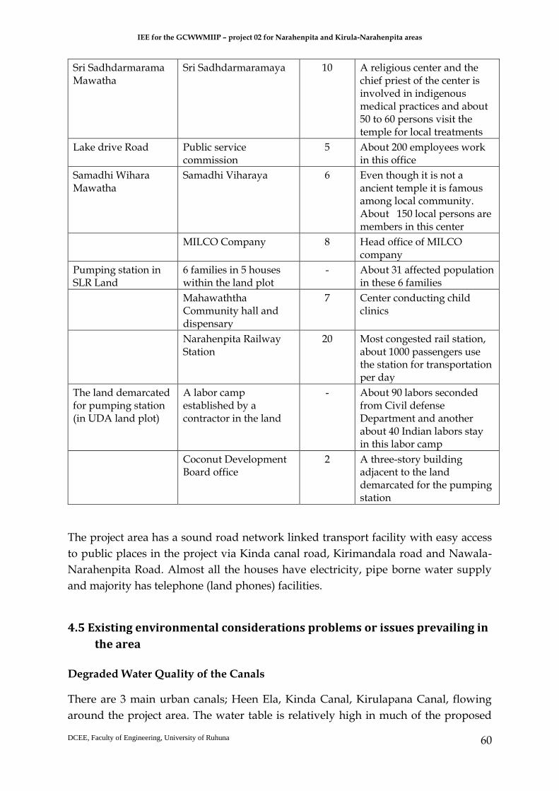
IEE for the GCWWMIIP – project 02 for Narahenpita and Kirula-Narahenpita areas
DCEE, Faculty of Engineering, University of Ruhuna
60
Sri Sadhdarmarama Mawatha
Sri Sadhdarmaramaya 10 A religious center and the chief priest of the center is involved in indigenous medical practices and about 50 to 60 persons visit the temple for local treatments
Lake drive Road Public service commission
5 About 200 employees work in this office
Samadhi Wihara Mawatha
Samadhi Viharaya 6 Even though it is not a ancient temple it is famous among local community. About 150 local persons are members in this center
MILCO Company 8 Head office of MILCO company
Pumping station in SLR Land
6 families in 5 houses within the land plot
- About 31 affected population in these 6 families
Mahawaththa Community hall and dispensary
7 Center conducting child clinics
Narahenpita Railway Station
20 Most congested rail station, about 1000 passengers use the station for transportation per day
The land demarcated for pumping station (in UDA land plot)
A labor camp established by a contractor in the land
- About 90 labors seconded from Civil defense Department and another about 40 Indian labors stay in this labor camp
Coconut Development Board office
2 A three-story building adjacent to the land demarcated for the pumping station
The project area has a sound road network linked transport facility with easy access
to public places in the project via Kinda canal road, Kirimandala road and Nawala-
Narahenpita Road. Almost all the houses have electricity, pipe borne water supply
and majority has telephone (land phones) facilities.
4.5 Existing environmental considerations problems or issues prevailing in
the area
Degraded Water Quality of the Canals
There are 3 main urban canals; Heen Ela, Kinda Canal, Kirulapana Canal, flowing
around the project area. The water table is relatively high in much of the proposed

IEE for the GCWWMIIP – project 02 for Narahenpita and Kirula-Narahenpita areas
DCEE, Faculty of Engineering, University of Ruhuna
61
project area, and a significant factor affecting the options for on-site sanitation.
Pollution of urban water bodies by domestic and industrial wastes may cause both
environmental problems and health hazards (See Figure 4.10).
Figure 4.10 - Drainage directed to urban canals/streams in project area
It was noted that uncontrolled and illegal dumping of domestic waste origin in
waterways, embankments and low-lying lands and discharge of sewage into canal
water bodies mainly by informal settlements along canals and around the flood
detention areas. These drainages directed to urban canals (as in the Figure 4.10) carry
domestic untreated or partially treated domestic wastewater.
Water samples were also collected from these urban canals/streams as part of the
baseline surface water program. Five (L1 ~ L5) sampling locations are shown in the
map as in Figure 4.10. The primary objective of this baseline study was to analyze the
current surface water quality in those urban canals/streams around the proposed
project area.

IEE for the GCWWMIIP – project 02 for Narahenpita and Kirula-Narahenpita areas
DCEE, Faculty of Engineering, University of Ruhuna
62
Figure 4.11 - Map showing the sampling location
Analysis of temperature, dissolved oxygen (DO) and pH were performed in-situ with
calibrated equipment, while the remainder of the analysis was conducted offsite in
standard laboratories. All laboratory analyses were performed in accordance with the
relevant test methods set out in the Standard Methods for the Examination of Water
and Wastewater. Table 4.6 shows the water quality data of collected samples from
small canals and watercourse.
Urban canals/streams in project area had near neutral to slightly alkaline pH (6.7 to
7.2). The presence of high concentration of Coliform bacteria in the canals/streams is
a good indication of pollution arising from domestic wastes of humans and solid
waste.
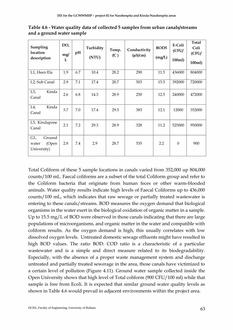
IEE for the GCWWMIIP – project 02 for Narahenpita and Kirula-Narahenpita areas
DCEE, Faculty of Engineering, University of Ruhuna
63
Table 4.6 - Water quality data of collected 5 samples from urban canals/streams and a ground water sample
Sampling
location
description
DO,
mg/
L
pH Turbidity
(NTU)
Temp.
( ̊C )
Conductivity
(μS/cm)
BOD5
(mg/L)
E-Coli
(CFU/
100ml)
Total
Coli
(CFU/
100ml)
L1, Heen Ela 1.9 6.7 10.4 28.2 290 11.5 436000 804000
L2, Sub Canal 2.9 7.1 17.4 28.7 503 15.5 392000 720000
L3, Kinda
Canal 2.6 6.8 14.3 28.9 250 12.5 240000 472000
L4, Kinda
Canal 3.7 7.0 17.4 29.5 383 12.1 12000 352000
L5, Kirulapone
Canal 2.1 7.2 29.3 28.9 328 11.2 525000 950000
G1, Ground
water (Open
University)
2.8 7.4 2.9 28.7 535 2.2 0 900
Total Coliform of these 5 sample locations in canals varied from 352,000 up 804,000
counts/100 mL. Faecal coliforms are a subset of the total Coliform group and refer to
the Coliform bacteria that originate from human feces or other warm-blooded
animals. Water quality results indicate high levels of Faecal Coliforms up to 436,000
counts/100 mL, which indicates that raw sewage or partially treated wastewater is
entering to these canals/streams. BOD measures the oxygen demand that biological
organisms in the water exert in the biological oxidation of organic matter in a sample.
Up to 15.5 mg/L of BOD were observed in those canals indicating that there are large
populations of microorganisms, and organic matter in the water and compatible with
coliform results. As the oxygen demand is high, this usually correlates with low
dissolved oxygen levels. Untreated domestic sewage effluents might have resulted in
high BOD values. The ratio BOD: COD ratio is a characteristic of a particular
wastewater and is a simple and direct measure related to its biodegradability.
Especially, with the absence of a proper waste management system and discharge
untreated and partially treated sewerage in the area, those canals have victimized to
a certain level of pollution (Figure 4.11). Ground water sample collected inside the
Open University shows that high level of Total coliform (900 CFU/100 ml) while that
sample is free from Ecoli. It is expected that similar ground water quality levels as
shown in Table 4.6 would prevail in adjacent environments within the project area.

IEE for the GCWWMIIP – project 02 for Narahenpita and Kirula-Narahenpita areas
DCEE, Faculty of Engineering, University of Ruhuna
64
5 ENVIRONMENTAL IMPACTS AND MITIGATION
MEASURES
5.1 Design Phase
a. Design considerations
Impact due to noise from the pumping stations
Wastewater traveling through the buried pipeline will not emit audible noise above
the surface nor their perceptible levels of vibration associated with water movement
through the pipeline. Common sources of noise in sewerage works include the pump,
generator, or ventilation system. Wet wells are required in pumping stations to store
the sewage before it is pumped. However, it is expected that any noise and vibration
occur due to the operation of the submersible pumps in the wet well will be negligible
due to the dampening effects of the wastewater.
Noise from the emergency generators can also considered as negligible because they
would be sound-proof ones with an enclosure fixation within a metal covering and a
silencer. However, in view of public concerns on nuisances such as noise, carful design
and selection of equipment should be done.
Mitigatory Measures
Detailed design of noise control for these equipment items shall be carried out with
reference to the recommendation of the equipment manufacturer. On the other hand,
the pumping stations should be designed by the design consultants. The pumping
stations should be constructed such that they are fully enclosed infrastructure that
provide adequate ventilation systems to provide around adequate O2 to the workers
inside.
● Exhaust silencers may require at the two pumping stations to minimize the low
frequency throbbing typically associated with diesel meetings.
● Pump stations should be lined with sound absorptive panels, and particularly
noisy items should be enclosed.
● Noise transfer through the building shells should be controlled with improved
roof and wall construction, sound rated doors and acoustic louvers.
● Ground-borne vibration should be readily prevented through incorporation of
suitable vibration dampers in the equipment mounting.

IEE for the GCWWMIIP – project 02 for Narahenpita and Kirula-Narahenpita areas
DCEE, Faculty of Engineering, University of Ruhuna
65
Impact due to odor from the Pumping stations
Odors from domestic wastewater usually result from bacterial activities in the sewer
collection system, sewage pumping stations. Typical compounds which contribute to
odors are hydrogen supplied, ammonia, other sulphur containing organic species,
amines, other nitrogen containing organic species and organic fatty acids. In many
cases, hydrogen sulphide that may emit from anaerobic decomposition of sewage is
the dominant gas. Dead zones in the pump chamber encourage settlement of solids
and encourage sulphide formation. Proper design consideration is needed to
minimize to the odor emissions due to these gases such as these gases may induce an
annoyance to the surrounding neighborhood especially in some households or
religious places.
Mitigatory measures
The steps in odor control begin with prevention of the formation of odorous
compound in sewage. It is very important to design an enclosed structure with enough
ventilation systems. Soil filters or dual bed activated carbon filters connected to
exhaust fans have to be provided for odor control.
Usage of Concrete sewer pipes and forced mains
Total length of gravity sewer lines would be laid with concrete. However, exact
locations are not clear. In the long run (where the concrete sewer lines are laid), there
will be groundwater contamination with nutrients and pathogens as H2S could
corrode concrete sewer pipes.
The force mains are underground pipes made of HDPE. The disadvantage is that
material is highly flexible (through thick walled).
Mitigatory Measures
Use vitrified clay pipes rather than concrete gravity sewers throughout the entire
project but handle with care especially during handling (transporting and laying)
since vitrified clay pipes are brittle. Where the HDPE pipes would be laid for the
forced mains, use good bedding material such as metal aggregates, sand or quarry
dust to prevent any collapsing.
b. Location/Siting considerations
Locations for pumping stations should be carefully selected to minimize impact of
inhabitants and environment. Basically, proximity of proposed sewerage
infrastructure should be considered while selecting the locations of pump stations. On
the other hand, economic and design considerations dictate that the pump station be
located. Selecting lands owned by the government might be a feasible option in this
regard. Pumping stations and access to pumping stations are to be located above the

IEE for the GCWWMIIP – project 02 for Narahenpita and Kirula-Narahenpita areas
DCEE, Faculty of Engineering, University of Ruhuna
66
flood limits. A one hundred (100) year flood recurrence interval should be considered
in the design for protection of structure and electrical and mechanical equipment from
physical damage. The station should be easily accessible under all weather conditions
and preferably located off the traffic ways of streets and alleys. The Design Engineer
shall determine the availability of electric service in the selected location and
coordinate the available electrical service with that required for the facility. As the the
noise and odor from the pump stations are significant, external factors such as wind
direction, topography, and proximity of nearby buildings should be considered while
selecting the location. On the other hand, selected sites should have sufficient land
available to accommodate the structure, wet well, and ultimate capacity of the
pumping station, allow for the connection of incoming sewers at a relatively shallow
depth reducing construction costs, and result in less impact to the natural
environment and human. Considering those factors, selected two sites can be
considered as technically feasible, and identified as the preferred locations for the
proposed Pumping Stations.
5.2 Construction Phase
5.2.1 Pre-construction phase
Obtaining necessary Approvals Obtaining necessary approval is very critical in project implementation. Delay in
getting approvals may result in delays in project implementation.
Mitigation measures
Before awarding the contract the IEE should be approved by CEA.
Background noise levels, ambient air quality and surface and ground water quality
measurement have been made in this study and those observations can be used as
baseline data in obtaining necessary approvals.
5.2.2 Construction phase
a) Hydrology Impacts i. Disturbances to natural drainage pattern
The Canal is relatively stagnant (blocked) and has very low flow velocity at present.
Further siltation of the Canal will be expected during the rainy periods due to the

IEE for the GCWWMIIP – project 02 for Narahenpita and Kirula-Narahenpita areas
DCEE, Faculty of Engineering, University of Ruhuna
67
entry of sediment-loaded runoff. Also, the risk of flooding of the nearby areas due to
water level rising shall not be totally ignored.
ii. Siltation of nearby water bodies, marshes, during construction
The work has been planned within the available buffer zone of 6 m from the edge of
the Canal bank and excavations will be limited to the 2 endpoints used for micro-
tunneling (for each drive at designated launching (jacking) and receiving pits), which
will be ultimately converted to manholes. However, the excavated material from the
2 end points may get easily washed away during the rainy seasons to the canal unless
the excavated material is immediately removed from the site or stacked with covering
to ensure minimum washing off sediments end up inside the Canal, causing further
siltation of this stagnant waterway. On the other hand, the Canal seems to be free of
aquatic life and is characterized with nutrient pollution with a bad odor.
iii. Water pollution due to contaminant leakage from machinery, workers sites during
construction phase
Mitigation measures
The exposed soil shall be bundled temporarily and the flows from heavy runoff areas
that threaten to erode or result in substantial surface runoff to adjacent water bodies
shall be redirected. The areas of exposed soil shall be monitored during periods of
heavy rainfall throughout the construction phase of the project so as to implement
sediment dispersal measures as appropriate.
b) Soil Impacts
Naturally at the construction stage, the work sites are disturbed and as a result the
rate of soil erosion will be enhanced due to the earth movements in the leveling
process. Soil erosion along the roads will be enhanced due to cutting and filling on the
surface when trenching for pipelines. Moreover, vegetation clearance in pump house
construction and excavation works in pipe laying will expose soils in the affected
project areas leaving them vulnerable to erosion by surface run-off. Furthermore, the
condition will be worsened if excavated earth is left exposed. Soil washed from the
trenched roadsides will be a serious problem arising from soil erosion. Some soil
erosion from the construction site will occur at least for a short time. In addition,
certain volume of earth will be cut for installation of pumps at the pumping stations.
All the above-mentioned sources of soil erosion will ultimately threat adjacent water
bodies with high turbidity and sediment deposition, a negative consequence

IEE for the GCWWMIIP – project 02 for Narahenpita and Kirula-Narahenpita areas
DCEE, Faculty of Engineering, University of Ruhuna
68
especially during the periods of intense rainfall.
Mitigation measures Restrain the land clearing and infrastructure demolition works and excavations for
the end pipes to be used for micro-tunneling works during the drier seasons to the
extent possible, hence, to avoid the generation of TSS, oil and metal laden surface
runoff and siltation in water bodies.
Fuel, lubricants and hazardous goods shall be stored at predefined enclosed storage
locations (example, elevated containers). Otherwise, storage of oil and fuel whether in
large tanks or drums, should be within a concrete bund capable of retaining the entire
volume of liquid in the event of leakage or rupture. Storage locations should have
good ventilation, but not directly exposed to sunlight, devoid of ignition sources and
should not be subjected to floods or close to waterways.
c) Water quality- adjacent water bodies Impacts i. Contamination due to unmanaged bentonite slurry Bentonite mixed with water to form a viscous, shear thinning material often referred to as bentonite slurry is commonly used as drilling fluid in micro tunneling. Some amount of bentonite slurry after the drilling works need to be disposed and rest bentonite slurry is normally recycled and reused during the drilling process. Inadvertent release of bentonite slurry or improper disposal may lead to contamination of the nearby water bodies. ii. Contamination due to unmanaged excavated soil There are possibilities of surface water quality degradation during the construction of
pump stations which consist of wet wells, pipe laying, etc. Laying of sewers using
open cut method consists of dewatering, excavation, placing bedding materials, laying
and testing of sewer pipes, manholes backfilling of trenches and reinstatement of
roads. Therefore, it is possible to increase water turbidity and alkalinity during the
construction stage as the soil may get easily washed during the rainy seasons to the
canal (if the excavated material is simply stacked without any covering), causing
siltation of adjacent canals; Heen Ela, Kinda Canal, Kirulapana Canal.
iii. Spillage, leak and accidental discharge of fossil oil, waste oil generated from construction

IEE for the GCWWMIIP – project 02 for Narahenpita and Kirula-Narahenpita areas
DCEE, Faculty of Engineering, University of Ruhuna
69
Wastes generated during construction stage will mainly comprise construction wastes
(e.g. rubble, wood plants, metals), excavated soil, domestic wastes, and oil wastes.
These wastes will be generated during the construction of entire sewerage network.
There will be oil spills during refueling and lubricating applications as well as due to
leaks from machinery such as cranes and excavators. There is possibility of further
contamination of the canal (which seems to be polluted at present) due to the entry of
metal (e.g., Pb) and oil-laden surface runoff during the rainy periods from spills,
careless stacking / storage of oil drums, etc and due to inappropriate disposal of
lubricating oil and fuel, waste oil. On the other hand, lubricant and
vehicle/equipment washing effluent and solid waste (fuel filters, oily rags) are likely
to be produced from repair and maintenance of machinery and equipment during the
construction stage.
iv. Groundwater Quality Degradation during Construction Insertion of concrete underground during construction of the structures’ foundation,
wet well may affect the alkalinity (pH) of groundwater. This may occur only when
hardening of the cement is done underground because alkaline substances dissolve in
the water. For the wet well, solid concrete foundation structures will be installed.
Thus, potential impact on groundwater is very limited because alkaline substances
will not dissolve in the water. Once built, the foundation structures will have
negligible impact on groundwater quality. Sometime, sites may need to be drained to
provide suitable conditions for construction works to occur, resulting in temporary
changes to ground water flow.
v. Disposal of wastewater generated from workers during construction stage Since the project area is within an urban area and it is expected that construction
workers will commute from their accommodation and hence the domestic wastes
generated by construction workers will be minimum during the construction period.
However, there may be some laborers who will reside in the site, particularly two
pumping sites, and their wastewater and sewage may be diverted to temporary toilets.
Mitigation Measures for Impacts on Surface and Groundwater Quality The following mitigatory measures should be implemented by the Contractor under
the supervision of the Project Proponent (PMU of the GCWMP) and relevant
government agencies if needed.
The storage, treatment and recycling of the bentonite slurry (drilling fluid) will only
be conducted at the proposed launching site depending on Contractor’s proposal and
under the proper approval and supervised by GCWMP.

IEE for the GCWWMIIP – project 02 for Narahenpita and Kirula-Narahenpita areas
DCEE, Faculty of Engineering, University of Ruhuna
70
Construction of the wet well structures and micro tunneling work, demolishing work
should be strictly limited to dry season and critical monsoon periods such as April-
June and September to November will be avoided using the rain forecasts from the
Department of Meteorology and other international weather information sources. The
construction works should be properly programmed to minimize soil excavation in
rainy seasons to prevent soil erosion from exposed soil surfaces.
Remove the excavated soil and other construction/demolishing wastes as soon as
possible once it is generated. Provision of earth bunds or sandbags in areas where a
large amount of exposed soils exists would be required to avoid wash them into
waterways. On the other hand, stockpiles should be well covered with relevant
materials such as tarpaulin sheets.
Stockpiles of construction (eg: concrete) and dusty materials should not be placed near
the canals, to avoid the release of dusty materials into the water. Suitable locations
should be selected on site to place the stockpiles so as to avoid release of materials into
the drainage channels.
The risk of spillage, leak and accidental discharge of fuels from construction
equipment should be minimized and manage with proper spill prevention measures.
Mitigation measures such as good use and maintenance of construction machines and
heavy vehicles, install oil and grease traps in the drainage system and establish and
implement emergency and contingency plan in case of spills should be be
implemented during construction stage.
It is recommended that, the contractor shall provide a list of hazardous chemicals
and/or material to be used in the project work to the Engineer of the GCWMP with
details pertaining to proposed disposal, prior to commencement of work. Hazardous
wastes should be stored separately from other construction material.
The Contractor should prepare a specific Construction Waste Management Plan
(outlining methods of segregation of different construction wastes, areas designated
for storage, methods of storage) with procedures to document the progress based on
their construction schedule and method statements and submitted to the GCWMP for
approval.
Water turbidity and alkalinity could increase during construction stage. However, this
impact is temporary and limited to the construction stage. Water quality in adjacent
canals within project area should be monitored to detect abnormal water quality
changes.
The potential impact on groundwater is very limited because alkaline substances will
not dissolve in the water. Hence no special mitigation measures are necessary.

IEE for the GCWWMIIP – project 02 for Narahenpita and Kirula-Narahenpita areas
DCEE, Faculty of Engineering, University of Ruhuna
71
However, the groundwater monitoring will be conducted near the two pumping
stations area to confirm the potential contamination
There is a possibility of limited number of construction workers may live on the site,
particularly at the two pumping stations sites, therefore, adequate sanitary facilities
such as temporary toilets should be provided.
d) Air quality
Air Quality Degradation During Construction and operation Stage
Usually air quality could be impacted by dust as well as generators. Air emissions in
terms of unburnt HCs, particulates and gases such as NOx, SOx and CO are expected
during the operation of the standby generators if the generators have faulty exhaust
silencers or not well maintained. The impact on air quality shall be addressed in terms
of exhaust emissions and generation of airborne particles and dust. The impact on the
air quality due to increased vehicular traffic will have a minor impact on the air quality
of the area. Proper maintenance of the vehicles and maintenance of access roads will
minimize this effect further.
Any open burning of plastic and polythene wastes (eg; packaging wastes and plastic
material, PET bottles) may result in the generation of noxious emissions such as CO,
CO2 and VOCs.
Dust emissions (PM) are limited to the 2 proposed pumping station sites at Dabare
Mawatha in Narahenpita and at Nawala Road (due to land clearing, existing building
demolition works and foundation excavations activities - from the bare / exposed
earth) and where ever open trenches (12 km as a total) would be used for sewer pipe
laying during drier, windy hot weather conditions. It is expected that dust may also
generate due to demolition of the existing infrastructure at the proposed pumping
station site although the impact is temporary and short term. Uncovered soil & other
construction and demolished wastes piles could be considered as dust sources during
the windy, drier weather conditions.
It is also expected that several vehicles would be employed to remove excavated soil,
construction materials such as sand and cement though quantities expected are not
yet known. These vehicles may also generate dust and increase the PM level in the air.
IEE for the GCWWMIIP – project 02 for Narahenpita and Kirula-Narahenpita areas
DCEE, Faculty of Engineering, University of Ruhuna
72
Mitigation measures
Several mitigations measures will require to be adopted during the construction phase
to reduce dust generation. This includes the water spraying of surfaces which are
prone to dust emission. Soil compaction and timely debris removal are also important.
Dust generation from crusher plants should be controlled by covering using wetted
fabrics. Wetting the materials (e.g. aggregate) earmarked to be loaded should be
practiced, to avoid dust stir.
It is also important to ensure that vehicles transporting construction material such as
sand, metal and cement are covered adequately to reduce dust generation. The dust
levels should be monitored periodically to ensure that the levels are not too high.
Limiting speed of construction vehicles and display speed limiting sign boards are
few more mitigation measures to control dust from moving vehicles.
It is recommended to locate cement mixing places and batching plants away from
sensitive receptors and avoid operations during windy conditions.
Dust and emissions should be prevented, suppressed and contain exposure of
workers, public or sensitive receptors. A schedule for dust/emission generation
activities should be prepared and inform public in the environs regarding such
activities
To prevent adverse impacts on air quality from heavy vehicles these vehicles will be
maintained in optimum condition always.
e) Noise and Vibration
Noise Impacts due to the construction
Noise impacts from construction activities are generally a function of the type of
construction equipment, equipment locations, the sensitivity of nearby land uses, and
the timing and duration of the noise‐generating activities. Site preparation typically
involves the use of a tractor/loader/backhoe and rubber-tired dozer. Demolition
typically involves the use of concrete saw, dozer, and tractor/loader/backhoe.
Excavation typically involves the use of a drill rig, excavator, tractor/loader/backhoe,
grader, rubber-tired dozer, and scraper. Pipe laying typically involves the use of a
tractor/loader/backhoe and pump. Pump house construction typically involves the
use of cranes, a forklift, tractor/loader/backhoe, welders, a generator set, pump, air
compressor, pavement equipment, paver, and roller. Anticipated noise emissions
during the construction phase are shown in Table 5.1.

IEE for the GCWWMIIP – project 02 for Narahenpita and Kirula-Narahenpita areas
DCEE, Faculty of Engineering, University of Ruhuna
73
Table 5.1 - Anticipated Noise Emissions during the Construction Phase
It is anticipated that during the construction phase, noise levels generated by the
machinery, etc. would certainly exceed 75 dB (A) and 50 dB (A), which is the
maximum allowable limit during daytime (6 am to 9 pm) and night time (9 pm to 6
am the following day) for construction works, respectively (i.e., at the boundaries of
the land in which the noise source is located) as per the National Environmental
(Noise Control) Regulations No. 01 of 1996 under the National Environmental Act No.
47 of 1980 (as amended). The noise generating from these construction activities are
mostly mainly intermittent, with continuous emission of noise within shorter
durations at certain locations. Overall, above noise impacts are direct and significant,
but short to medium term especially in highly residential areas.
A temporary residual noise impact as a result of road traffic noise from construction
vehicles associated with the construction is expected on residents living the project
area. This will only occur in the hours when construction workers will be travelling to
and from site and transportation of construction materials and equipment.
Pipe jacking or micro-tunneling involves the boring of a tunnel for the proposed sewer
pipelines, by a tunneling shield from a launch shaft towards a reception
shaft. Construction noise emissions from micro-tunneling would be dominated by
stationary equipment. The main noise sources include process noise, hydraulic
equipment, electric motors, ventilation equipment, slurry pump

IEE for the GCWWMIIP – project 02 for Narahenpita and Kirula-Narahenpita areas
DCEE, Faculty of Engineering, University of Ruhuna
74
Vibration generated by a tunnel boring machine, either for a large-diameter tunnel or
a micro tunnel, would be attenuated by the soil between the tunnel and the ground
surface, depending on soil types and distance to sensitive receptors.
Table 5.2 - Interim Standards for vibration of the Operation of Machinery, Construction Activities and Vehicle Movements Traffic
There could be some noise during trench excavation for foundations and the
placement of steel beams on columns etc. Such noise or vibration will be minimum
and limited to the construction stage and such impacts are not continuous but
sporadic.
It is expected some pile driving works would produce some impulsive noises around
110-140 dB with significant ground borne vibration to impact neighboring properties
around the two pumping stations.
It is important to note that vibration limits stipulated in the Sri Lankan regulation
(Table 5.2) is in terms of peak particle velocity (PPV) in the unit mm/s (millimetre per
second). This measurement considers movement of particles in the ground and the
potential impacts on built structures. According to the USEPA pile driving impact can

IEE for the GCWWMIIP – project 02 for Narahenpita and Kirula-Narahenpita areas
DCEE, Faculty of Engineering, University of Ruhuna
75
be high as 38mm/sec which may exceed the CEA enacted Standards on vibration for
the operation of machinery, Construction Activities and vehicle movement of traffic
(for built structures), irrespective of the type of structures.
Noise Impacts due to the operation
Noise and vibrations will result from the functions of electrical and mechanical
equipment/machinery during the operation of the collection network (pumping at
pump stations, standby power generators, flow in piping). Pumping stations will have
backup emergency generators, which will only be used at power failure occasions.
This noise impact will be infrequent and negligible. It is expected that any noise and
vibration occur due to the operation of the submersible pumps in the wet well will be
negligible due to the dampening effects of the wastewater and will be limited to the
vicinity of the facilities.
Wastewater traveling through the buried pipeline will not emit audible noise above
the surface nor will there be perceptible levels of vibration associated with water
movement through the pipeline.
Mitigation measures
If necessary, residents shall be given notice of intended noisy activities so as to reduce
degree of annoyances. Workers operating equipment that generates noise shall be
equipped with noise protection gear. Equipment shall be kept in good condition to
keep the noise level within 90 dBA. Workers operating equipment generating noise
levels greater than 80 dBA continuously for 8 hours or more shall use earmuffs.
Workers experiencing prolonged noise levels of 70 – 80 dBA shall wear earplugs. These
protective gears shall continue to be provided to the workers and their use by workers
shall be enforced. Proper maintenance of vehicles shall be done to reduce the noise
generating due to vehicles. High noise generating equipment, if used, shall be
sparingly operated during the night times to minimize any discomfort to the nearby
residents. Provision of greenbelt and plantation will further help in attenuating noise.
Some mitigatory measures to minimize the construction vibration are highlighted as
follows:
a) Heavily loaded trucks shall be routed away from highly residential areas, if
possible and streets with less populated areas, if no alternative is available, shall be selected;
b) Earthmoving and ground-impacting operations shall be operated at different
times so as not to make a cumulative vibration effect;
IEE for the GCWWMIIP – project 02 for Narahenpita and Kirula-Narahenpita areas
DCEE, Faculty of Engineering, University of Ruhuna
76
c) Construction activities, that produce high noise and vibration, during the night
shall be minimized since the human beings are more sensitive to vibration during the night;
d) Scheduling of construction work that cause high noise and vibration must be within authorized construction embodiment times with the least inconvenience to the public
e) All construction equipment will be used in good service condition and low noise/vibration generating construction equipment will be used.
f) The construction site can be separated with corrugated sheets or other suitable material especially at locations near noise sensitive receptors.
g) Carry out a property condition survey (crack survey) of nearby structures and record the present condition of the structure, to accurately assess any damage to these structures during the construction stage
h) Establishing a complaint mechanism and implementing a procedure to effectively deal with any issue raised by the community.
f) Ecology - Flora and fauna
Noise, vibrations, dust generation and other intrusive activities related to construction
works such as excavation, cutting, filling and compaction work as well as operation
of construction related vehicles will cause disturbances to both humans as well as
some animals that inhabit the area. However, the flora and fauna inhabiting in the
area already bear many disturbances due to human settlement. Hence the flora and
fauna available in the area is adopted for disturbances and the impact by the project
activities is short-term and will not have a significant impact, therefore. Hence, no
mitigation will be needed.
Couple of plants each, Breadfruit (Artocarpus altilis), Jak fruit (Artocarpus heterophyllus),
Mango (Mangifera indica), Teak (Tectona grandis), Kenda (Macaranga peltata), Coconut
(Cocos nucifera) and tropical almond (Terminalia catappa) were observed in the land
allocated for Dabare Mawatha pumping station. In the land allocated for Nawala Road
pumping station there were no available trees.
Felling trees should be carried out if unavoidable following the legal procedures in
the country. Clearing of the site will impact on the ground cover vegetation.
Reinstatement of ground cover/ landscaping the site after construction will mitigate
this impact.
IEE for the GCWWMIIP – project 02 for Narahenpita and Kirula-Narahenpita areas
DCEE, Faculty of Engineering, University of Ruhuna
77
g) Traffic and accessibility
The road network in the designated project area is likely to be affected as a result of
project related construction activities such as laying of sewer lines, construction of
manholes and two numbers of pump stations. Out of all the roads, Elvitigala Road
(Baseline Road), Kirimandala Road, Nawala Road and the Muhandiram E. Dabare
Road have been identified as most critical road links in terms of traffic congestion as
a result of the proposed sewer network construction. In addition to the impact from
sewer line construction, Nawala Road and the Muhandidram E. Dabare Road could
possibly be affected by the project related logistics to the construction sites of two
pumping houses located in each of the aforesaid roads.
It was observed that traffic flow exceeds the capacity and breaking congestion in the
Elvitigala Road starting from 6.30 am to 9.30 am and 4.00pm to 8.00pm in weekdays,
which could be identified as the morning and evening peaks in the urban region of
Colombo metropolitan. Besides, it was also identified a congestion peak during 1.00
pm to 3.00 pm on the same road in weekdays as a result of school traffic. In weekends,
the condition is much similar to the weekdays on Saturdays while a mild traffic
congestion seldom occurs on Sundays in general. Similarly, traffic congestion was
observed on Kirimandala Road, Nawala Road and Muhandiram E. Dabare Road from
7.00 am to 9.00 am in the morning and 4.00 pm to 7.30 pm in the evening on weekdays
while mild congestion might be experienced during Saturdays and rarely on Sundays.
In contrast, no significant traffic flow or a congestion breakout was observed on minor
roads of the project area.
Impacts
The construction activities of the proposed project would require temporary closure
of lanes and divert traffic from both direction to one lane with the support of a traffic
controller or complete barricading of the road for the laying of pipe network and
construction of manholes. This would result reduction of the capacity of the existing
road in a situation of unchanged demand. Hence, the road links will instantly become
jammed and such gridlock condition could be easily appeared on Elvitigala Road
(Baseline Road), Kirimanadala Road, Nawala Road and Muhandiram E. Dabare Road
from morning to evening owing to the higher traffic demand.
In addition, disturbing the mobility of lanes could form traffic queues in length and
in case if the length of such queue forms beyond a signalized or unsignalized junction
creating spill out condition, the entire junction will be grid locked. Consequently, that
impact could transfer as a wave to other road links triggering a larger scale urban
gridlock. Some possibilities of said phenomena in this project are Police Garage
Junction and Narahenapita Junction. If the on traffic from Elvitigala Road (Baseline
Road) to the Muhandiram E. Dabare Road and Nawala Road gets significantly

IEE for the GCWWMIIP – project 02 for Narahenpita and Kirula-Narahenpita areas
DCEE, Faculty of Engineering, University of Ruhuna
78
disturbed, a queue might possibly form beyond the junction with a complete blocking
of through traffic of Elvitigala Road (Baseline Road).
The Keleni Velly railway line cross the Muhandiram E. Dabare Road, Kirimandala
Road and Nawala Road, close to the junctions to Elvitigala Road (Baseline Road) . In
case if unmanageable queuing occurs on these roads during peak hours, it would be
difficult to barricade the crossings to allow train to pass and hence, could delay the
entire schedule on the Kelani Valley line.
Mitigation Measures
In order to mitigate the traffic impact, it is required to prepare a Traffic Management
Plan aligning with the construction programme of the project and moreover, with the
association of Road Development Authority and Colombo Municipal Council. In the
absent of a construction work programme, feasible mitigatory measures are difficult
to derive as the impact to the road network as a result of construction could be
distinctly different in two locations of the project. However, it is strongly
recommended to consider nighttime constructions only on Elvitigala Road (Baseline
Road) and Nawala Road. In addition, it is also advice to consider nighttime
construction on Kirimandala Road and Muhandiram E. Dabare Road. However, there
is a possibility of conducting daytime construction on Kirimandala Road and
Muhandiram E. Dabare Road by considering a diversion through Lake Drive Road
from Kirimandala Road to Nawala Road. Although the Lake Drive is in the possibility
to absorb such traffic, it may be required to ease the bottleneck located at the entrance
to Lake Drive Road from Nawala Road.
Furthermore, it is beneficial if the traffic flow from Muhandiram E. Dabare Road to
Police Garage Junction could be minimized by barricading the oncoming traffic flow
from Kirimandala Road to Evergreen Park Road and encouraged to use Kirimandala
Road in order to minimize the traffic impact due to the construction of pump house at
Muhandiram E. Dabare Road.
Moreover, adequate sign boards must be installed to guide the traffic flow during
construction and in addition, it is recommended to install notice boards informing the
possible congestion due to construction on Muhandiram E. Dabare Mawatha,
Kirimandala Mawatha and Nawala Road on suitable locations to discourage the
inflow traffic to aforesaid roads from Elvitigala Road (Baseline Road),
Thimbirigasyaya Road and Kirula Road.
In view of minimizing the impact on minor roads, it is recommended to inform the
residents and general public about the road closure schedules on minor roads and
private roads well in advance to minimize the chaos.

IEE for the GCWWMIIP – project 02 for Narahenpita and Kirula-Narahenpita areas
DCEE, Faculty of Engineering, University of Ruhuna
79
h) Existing utilities along alignment
During the construction phase, existing service cables and pipelines such as water
lines, electric cables may get damaged, thus may temporarily interrupt supplies to
consumers during the installation of new subsurface infrastructure. These will create
uncomfortable living environment to the people in the city.
There will be temporary obstruction in accessing to the areas in which the construction
activities going on and, resident during the construction period and these will be
minimal due to minimum excavation work.
Following activities shall mitigate these impacts:
• In order to minimize the number of exposed sites at a given time, a construction
sequence of work shall be prepared.
• Residents shall be informed on allocated dates for pipe laying in an area
through public announcements.
• Ceylon Electricity Board and Sri Lanka Telecom shall be contacted for
removing transmission lines or to have any other mitigatory measure as
applicable for their transmission lines during the period of construction.
• Public announcements shall be made on service interruptions well in advance
(electricity, water and telecommunication services).
• Train the contractor to adopt methods to minimize the disturbances and
inconvenience to the public that are likely to occur.
• Damaged roads shall be repaired immediately after finishing pipe laying.
• Nighttime work may be considered to speed up construction work reducing
period of construction to minimize the duration of minute degree of
obstruction, disturbances to public utilities and inconveniences to public.
However, construction activities that produce high noise and vibration should
be avoided during night since the human beings are more sensitive to vibration
during the night.
i) Livelihood
Apart from potential impacts during construction phase the sub-project will require
resettlement of 6 families residing in 5 houses established in land plot belongs to SLR.
The 5 housing structures also have been constructed by the SLR. Therefore, the land
and the housing structures are public properties and it’s not necessary to pay
compensation for the land and the structures. However, these 6 families are to be
resettled in alternative locations. CMC has agreed to provide required housing units
at the new housing scheme constructed by UDA. The letters sent to the owners of

IEE for the GCWWMIIP – project 02 for Narahenpita and Kirula-Narahenpita areas
DCEE, Faculty of Engineering, University of Ruhuna
80
above 5 households by GCWMP are attached in Annex 2. The SLR has agreed to
allocate this land plot for the proposed pumping station of the sub-project.
A total of 421 houses were countered and 94 of them are observed as physically weak
houses in Narahenpita GN division. The total houses in Kirula GN division is 158 and
54 are physically weak (Physically weak houses are vulnerable for damages due to
vibration during construction period).
Other than the livelihood disturbances to the communities in some areas, road
sections will lead to create temporary negative impacts to the livelihood systems of
the communities and other public and private institutions. However, temporary
access will be provided to the houses and all other public places in all sub-project road
sections if their accesses get disturbed due to project activities. In some road sections
small and medium scale shops are located, 28 mobile vendors operate their routine
business activities and three-wheel operators park their three wheelers (3 three-wheel
parks will be disturbed.) (Table 5.3). All these livelihood activities will be disturbed
during construction phase of the sub-project.
Table 5.3 - Types of livelihood groups affected and need income restoration assistance
Livelihood
group Assistance need
Small and
medium scale
shops
Providing information on the construction schedules about 30
days before the project activities are commenced. Steel plates will
be provided to use as alternative access to the shops if the access
is disturbed. Priority action to complete the construction activities
within short period of time in the sub-project road sections of these
shops
Mobile venders These mobile venders also will be provided with construction
schedules of the sub-projects 30 days prior to commencement of
the construction activities. They can walk on other roads in the
vicinity of the sub-project during construction period. If they walk
along the sub-roads linked to the project roads, they can reach the
same customers.
Three-wheel
operators
This group will also be provided with information about the
construction program prior to commencement of the construction
work. The priority will be given to complete the construction work
in the three-wheel parking areas within short period of time. The
three-wheel operators themselves mentioned about various

IEE for the GCWWMIIP – project 02 for Narahenpita and Kirula-Narahenpita areas
DCEE, Faculty of Engineering, University of Ruhuna
81
alternatives possible for them to continue their operations without
serious negative impacts on the income (moving to neighboring
roads or other areas known to them etc).
j) Community and workers health and safety
Mitigation measure for community health and safety during construction stage
Mitigation measures are required to protect people within the project area and
workers from accidents in the work sites. The accidental hazards for the workers as
well as general public are considered particularly important because the project will
be carried out in a built up, developed areas where there are relatively narrow roads
with no pavements for pedestrian movements. The project will take optimum
measures to assure the protection of people living, working and moving in the project
areas.
• In order to minimize the number of exposed sites at a given time, a construction
sequence of work shall be prepared. Residents shall be informed on allocated
dates for pipe laying in an area through public announcements.
• Temporary sanitary facilities should be provided at all construction sites,
especially for the pumping stations.
• Contractor should provide the workforce (drivers and traffic controllers cum
flagmen should be included) involved in handling dust generating material
(example, cement, soil, metal aggregates, bricks, etc) with dust masks and
goggles or safety glasses.
• Environmental pollution control measures, including watering standard
maintenance of machinery will be implemented.
• Arrange construction activities and schedule to minimize the impact on
surrounding communities (e.g. prohibit high noise generating activity on
nighttime)
• Heavily loaded trucks shall be routed away from highly residential areas, if possible and streets with less populated areas, if no alternative is available, shall be selected
• Limiting speed of construction vehicles and display speed limiting sign boards are few more mitigation measures to control dust from moving vehicles.

IEE for the GCWWMIIP – project 02 for Narahenpita and Kirula-Narahenpita areas
DCEE, Faculty of Engineering, University of Ruhuna
82
• Avoid peak traffic hours with reference to material delivery and taking away
the soil or construction wastes. It is advised that appointed contractor could
prepare a Traffic Management Plan and implement it accordingly with the
support of the project proponent.
• Dust generation from crusher plants should be controlled by covering using
wetted fabrics. Wetting the materials (e.g. aggregate) earmarked to be loaded
should be practiced, to avoid dust stir.
• It is recommended to sprinkle some water to the cleared and exposed (bare)
surfaces frequently when dust plumes are likely to get generated under hot,
sunny and windy conditions.
• It is also important to ensure that vehicles transporting construction material
such as sand, metal and cement are covered adequately to reduce dust
generation. The dust levels should be monitored periodically to ensure that the
levels are not too high.
• It is recommended to locate cement mixing places and batching plants away
from sensitive receptors and avoid operations during windy conditions.
• If needed, temporary worker camps and the site offices, storage areas etc
should be provided with adequate number of well closing bins to collect
municipal garbage and the bins should be regularly emptied (Contractor/s
should make necessary arrangements with the CMC to remove the collected
wastes).
5.2.3 Post-Construction
Impacts
There will be temporary structures, temporary offices and labor huts and cesspits built
in the construction phase. These structures may create inconveniences to the general
public if remained after finishing construction.
Mitigation measures
Once construction phase is completed all of the above-mentioned structures must be
removed and labor huts should be completely backfilled by the appointed
Contractor/s to prevent vermin/vector breeding centers (some of the excavated
material generated from the trenches or site preparation works and debris from
demolition works may be used) to the satisfaction of the Project Proponent.

IEE for the GCWWMIIP – project 02 for Narahenpita and Kirula-Narahenpita areas
DCEE, Faculty of Engineering, University of Ruhuna
83
5.3 Operations and Maintenance Phase
a. Defects Liability Period
Proposal made in the IEE -report for Kirulapone ward (2015), another ward of same
project, was adopted for this project too.
Table 5.4 summarizes the issues / impacts and relevant measures to be implemented
with reference to the operation and maintenance of the sewer network. Necessary
action must be implemented by the CMC / Project Proponent.
Table 5.4 - Issues / potential impacts with reference to the operation and maintenance of the sewer network and remedial measures needed (Source : IEE,
Kirulapone, 2015)
Issues / Impacts Remedial Measures recommended
The workers involved in the - O&M procedures are not given appropriate PPE nor are they willing to wear PPE even if
provided
It needs to be made mandatory (punitive action should be imposed on those who are violating the OHS policies) for all workers (including drivers involved in driving the gully bowzers, jet bowsers, etc) to wear hard hats, goggles, strong gum boots and gloves up to the elbow length with full protective clothing. Provide first aid facilities in the vehicles in accordance to the General Register of the Department of Labour & the Factories (First Aid) Regulation No 1 of 1995.
Special provisions should be made available in their offices to store the given PPE with toilet facilities for the workers to thoroughly clean themselves.
Pre-recruitment and periodic health checkups of the workers has to be initiated by the CMC (example, skin irritation checkups such as dermatitis & rashes, blood tests and lung examinations including breathing / lung functioning’s and X-rays) through reputed agencies such as the National Institute of Occupational Safety and Health (NIOSH) with maintenance of records and treatment initiated & compensation where necessary.
Other OHS measures with reference to sewer cleaning works are;
Slippery algal growths should be scrubbed off and washed away whenever they appear.
Check the O2 levels (should not be < 19.5%) and other gases such as H2S, NH3 etc using calibrated multi gas meters before allowing workers to get into the manholes. The gas levels shall be checked continuously until work is over. If O2 levels are < 19.5, then provide the workers with self-contain breathing apparatus (SCBA) or supplied air respirators.

IEE for the GCWWMIIP – project 02 for Narahenpita and Kirula-Narahenpita areas
DCEE, Faculty of Engineering, University of Ruhuna
84
Keep all areas clear of spilled oil or grease. Use soap and water, not gasoline or solvents, for cleaning.
Wear long-sleeved glows when working with equipment or while in direct contact with wastewater.
Do not leave tools, equipment and materials where they could create a safety hazard.
Adequate lighting should be provided for night work and in areas with limited existing lighting.
Remove only sections of handrails, deck plates or grating necessary for the immediate job.
Removed sections should be properly stored out of the way and properly secured against falling into tanks.
The area should be barricaded to prevent unauthorized personnel entry and possible injury.
Do not walk on top of the sidewalls of structures; to prevent slips and falling into the ditch.
Usage of jetting machines and gully suckers
Ensure that when attending to cleaning any blockages over pump any sewage flowing from the upstream manhole to downstream manhole until completed.
Odor emissions from sewer manholes due to possible blockages, etc
Frequent / daily inspections (morning and evening) should be carried out to see whether odor emanates and attend to any blockages.
Ensure that the manholes to be provided are ventilated manholes to minimize odor generation to the surrounding environment
Damaged sewer lines are removed if complaints are received. In this respect, excavations are carried out to remove the damaged lines which are then replaced with 1000 T PVC pipes. The newly laid PVC lines will be connected to the existing undamaged lines
Use “No digging methods” such as glass reinforced plastic for sewer rehabilitation or repairing of damaged manholes wherever possible.
Sewerage leakage from damaged pipes causing contamination
Sewer pipe network should be continuously monitored for leakage and rectify such leakage immediately.
Table 5.5 summarizes the issues / impacts and relevant measures to be implemented
with reference to the operation and maintenance of the pumping stations. Necessary

IEE for the GCWWMIIP – project 02 for Narahenpita and Kirula-Narahenpita areas
DCEE, Faculty of Engineering, University of Ruhuna
85
actions as described in Table 5.4 have to be implemented by the CMC / Project
Proponent.
Table 5.5 - Issues / potential impacts with reference to the operation and maintenance of the pumping stations and remedial measures needed (Modified
after IEE, Kirulapone, 2015)
Issues / Impacts Remedial Measures recommended
Odor emissions and vermin The pumping stations should be designed by the Design Consultants and then constructed such that they are fully enclosed infrastructure that will have adequate ventilation systems (mechanical ventilation may be provided with intake ducts fixed with fine mesh to prevent access to vermin such as flies) to provide around 21% of O2 to the workers inside and either soil filters or dual bed activated carbon filters connected to exhaust fans have to be provided for odor control.
Overflows from the wet well may lead to intense pollution of the nearby canals (if highly concentrated volumes are discharged especially during dry weather conditions) during operational failures (due to mechanical breakdowns of pumping stations and equipment)
Maintain and operation all pumping stations and equipment in and effective condition and keep records of the maintenance
Identification of critical components and a system to ensure adequate and timely access to spare parts.
Ensure to provide around 4-6 standby pumping equipment and associated controls (they need be alternately operated) and some 5000 L capacity gully suckers at site to attend to emergency needs
Removal of grit materials and sludge
Sewage sludge and grit material may contain organic matter and is rich in macro- and micronutrients, heavy metals and human pathogens which should be considered when it is disposed. The grit materials and sludge removed from the wet well should be collected in proper containers and dewatered at the pumping station. The dewatered materials should be disposed at the suitable/appropriate dumping site. It is also recommended to transport the sludge and grit material that remove from wet well as soon as possible and to dispose appropriately and eliminate possible contamination of surface/groundwater and disposal should be done under the proper approval and supervised by relevant officers.
H2S related OHS issues Automated H2S detectors should be installed in plenty throughout the pumping station. They should be capable of setting up an alarm when dangerous levels are detected. Therefore, the workers should be educated regarding the dangers posed by different levels of H2S.
Also provide portable H2S meters to those involved in removing grit and repairing and maintenance works in the wet well
There needs to be a first aid unit / facilities as per the General Register of the Department of Labour & the Factories (First Aid) Regulation No 1 of 1995 with medically competent persons and

IEE for the GCWWMIIP – project 02 for Narahenpita and Kirula-Narahenpita areas
DCEE, Faculty of Engineering, University of Ruhuna
86
an ambulance to reach the nearest hospital/s on a 24 hrs. basis. Also provide a stretcher.
Other OHS issues (example, OHS concerns arising during wet cleaning and repairs, grit and screening removal)
Provide suitable PPE.
Within the pumping station premises there needs to be special areas allocated to store the given PPE with toilet facilities for the workers to thoroughly clean themselves. Smoking and consumption of food items should be prohibited in the wet well /working areas with displaying of appropriate sign boards.
Ladders and railings around the wet well, screening chambers, penstock gate chambers and grit chambers should be hard, well fixed solid structures (example, made of stainless steel).
Ladders provided to the wet well and screening removal area should have well fixed railings on both sides with broad footsteps. Ladders leading to the screening removal area should not be placed above ditches such as penstock gate chamber, grit chamber, etc.
Pre-recruitment and periodic health checkups of the workers has to be initiated by the CMC (example, skin irritation checkups such as dermatitis & rashes, blood tests and lung examinations including breathing / lung functioning) through reputed agencies such as the NIOSH with maintenance of records and treatment initiated & compensation where necessary.
Automated Fire/ smoke detectors with an alarm are mandatory with provision of adequate gear to put off fires.
The workers should be thoroughly trained to put off any fires.
b. Operations and Maintenance Period
Defects Liability Period
Table 5.6 - Noise and vibration related impacts in the operation and maintenance of the pumping stations and remedial measures needed (Source : IEE, Kirulapone, 2015)
Impacts Mitigation Measures
Noise emissions and ground-borne vibration from the pumping stations (due to operation of the electromechanical units) may annoyance to the public in the close vicinity
Doors and windows of Pump stations should be kept closed during the operational time.
Ensure the exhaust silencers are in good conditions
Emergency generator rooms should be kept closed during the operational Period.
Odor emissions from the pumping stations
Needs to be an enclosed structure with enough ventilation systems

IEE for the GCWWMIIP – project 02 for Narahenpita and Kirula-Narahenpita areas
DCEE, Faculty of Engineering, University of Ruhuna
87
6 INFORMATION DISCLOSURE, CONSULTATION AND
PARTICIPATION
6.1 The process
This chapter mainly explained the information and comments received from stakeholder’s community including affected people of the project area. It includes their suggestions as mitigation measures. In aiming provide the background to the consultation process, at the beginning this chapter provides a brief socioeconomic profile of the area as well.
6.1.1 Data collection methods
The data obtained for this chapter was collected conducting series of following
activities (Table 6.1).
Table 6.1 - Data collection methods for the social impact assessment
Activity Purpose
Discussion with team leader of design supervision and institutional development consultants (DSIDC)
To gain some knowledge about overall project and proposed sub project in Kirula- Narahenpita area.
Review of social safeguard and environmental guideline of EIB
Understanding the policies and guidelines of EIB about social safeguard aspects of project they are funding.
Meeting with design engineer of DSIDC Understanding the nature of designs, they introduce for the sub project area.
Visits to sub project area with design engineer of DSIDC
To identify the project implementing area and specifically the roads that will be used for laying new sewerage pipelines.
Consultation with divisional secretary of Thimbirigasyaya and Grama Niladharies of Kirula and Narahenpita.
Document the views of these two types of stakeholder agency personal and to explain the project to these key government officers in the sub project area.
Identification of access roads that may be disturbed due to the implementation of proposed sub project activities.
Identification of potential disturbances and their magnitude due to the proposed project activities.
Consultation of other stakeholders including community leaders in the proposed sub project area.
Documentation of the views of these stakeholders on the impacts and benefit of the proposed sub project.
Focus group discussions with local community members
Documentation of the views of local people on sub project related impact.
Taking photographs of some important features in the sub project implementing area.
To explain the salient features to the users of the social impact assessment report

IEE for the GCWWMIIP – project 02 for Narahenpita and Kirula-Narahenpita areas
DCEE, Faculty of Engineering, University of Ruhuna
88
Preparing manual sketch showing project implementing roads and their vicinity
To explain the nature of project implementing roads and their salient features.
Household questionnaire survey with 5 households (with 6 families) in one of the land plots (SLR land plot) demarcated for pumping station
To prepare the socio-economic profile and document the views of the householders to be resettled
6.1.2 Data analysis methods
The data for the social assessment was analyzed using 6 criteria and relevant
indicators that were used for collecting data. The information on these aspects is
summarized below (Table 6.2).
Table 6.2 - Data analysis methods used in the social impact assessment
Criteria Indicators/indices Relevant data
Existing socio-economic environment
Likelihood impacted households and population (direct/indirect)
Population and families and houses
Likelihood impacted land(direct/indirect)
Number of plots and land area
Possible impacts on infrastructure in the area
Number and names of roads that may be disturbed
Possible impacts Number of families affected
Data on directly affected families with their socio-economic condition.
Number of business establishments affected
Data on number of business establishments and their owners and operators
Legal and policy related safeguards
Sri Lankan and funding agency related policies and other procedures
Names and descriptions of such policies and procedures
Institutions available Relevant institutions for planning and implementation of social safeguard
The roles and responsibilities of project executing and implementing agencies about management
Monitoring of the social impacts due to the proposed sub project
Number of households impacted, and number mitigated
Details of impacts and measures implemented for mitigation in each household
Other complaints of local people related to the construction induced impacts
Details of the persons who complain about potential impacts
Grievances Institutional mechanisms and grievance redressed procedure
Review of grievance redress institutional mechanisms and procedures already available in the project

IEE for the GCWWMIIP – project 02 for Narahenpita and Kirula-Narahenpita areas
DCEE, Faculty of Engineering, University of Ruhuna
89
The description of the baseline socio-economic condition
6.1.3 Population
The proposed sub project implementing area is in Narahenpita and Kirula GN
divisions of Thimbirigasyaya DS Division. The population in these 3 units is
considered as beneficiary community of the proposed sub project. The population
residing in about 50m radius from the project implementing locations is considered as
indirect impacted population due to the proposed sub-project implementation. In the
land plot proposed for one of the pumping stations, there are 5 houses constructed by
SLR and these 5 houses are presently used by 6 families. These 5 houses with 6 families
will be provided with alternative residences in other possible locations (letters are
attached in Annex 2). The 6 families agree to resettle in alternative locations provided
to them. The population in these sub project implementing areas including beneficiary
population are mentioned in Table 6.3.
Table 6.3 - Population in sub-project area
Project implementing area
Population
Approximate Road user
population in the local area
Families facing the road edge
Population of the households/
business structures facing
the road edge
Mobile Population in
the roads
Thimbirigasyaya DS
264767 - - -
Kirula GN 20330 - - -
Narahenpita GN 12229 - - -
Heen Ela Mawatha 100 22 82 200
Kinda Canal Road 150 35 112 250
Kirimandala Road 150 28 98 4000
Mohandiram Dabare Mawatha
200 53 174 500
E Victor Dabare Mawatha
600 164 558 800
Evergreen Garden Road
100 20 64 250
Circular Road A 300 82 288 300
Circular Road 200 41 135 200
Central Road 100 28 88 150
Nawala Road (Narahenpita Road)
600 131 420 5000

IEE for the GCWWMIIP – project 02 for Narahenpita and Kirula-Narahenpita areas
DCEE, Faculty of Engineering, University of Ruhuna
90
Economic Center Road
50 1 3 2500
Elvitigala Mawatha 150 0 0 3000
Srimath Oliver Gunathilake Garden
75 17 56 200
Sri Saddharmarama Road
100 26 86 300
Lake Drive Road 50 8 28 100
Samadhivihara Road
150 - - 350
SLR Land for Pumping Station
31* - - -
UDA Land for Pumping Station
130** - - -
(Source: Resource profile of Thimbirigasyaya DS Office and Socio-economic survey team)
*There are 6 families residing in 5 houses located in SLR land (25 perch) proposed for construction of
pumping station in Narahenpita GN Division
**There is a temporary labor camp established in this UDA 40 perch land plot by a private contractor
and about 130 labors working in their construction sites are temporary staying in this labor camp.
6.1.4 Diversity of the project relevant population
The project implementing 11 public roads (main roads) and 2 land plots demarcated
for construction of pumping stations are in Kirula and Narahenpita GN divisions of
Thimbirigasyaya DS division. A larger percentage of sub project relevant population
belongs to Sinhalese and communities of other ethnic groups are also living in the
same area. The ethnic diversity of the population is shown in Table 6.4
Table 6.4 - Population with ethnic diversity
Project implementing area
Total population
Sinhala Tamil Muslim Burger Other
No % No % No % No % No %
Thimbirigasyaya DS
264767 148567 56 74184 28 33784 13 4362 2 3870 1
Kirula GN 20330 13579 67 5348 26 724 4 142 1 537 2
Narahenpita GN 12229 9989 82 1400 11 560 4 85 1 195 2
Project area 2192 (ethnic diversity of project area population is similar to the ethnic diversity in other units, DSD and GNDs)
(Source: Resource profile of Thimbirigasyaya DS Office and Socio-economic survey team)

IEE for the GCWWMIIP – project 02 for Narahenpita and Kirula-Narahenpita areas
DCEE, Faculty of Engineering, University of Ruhuna
91
Gender diversity in the project implementing area is somewhat different from the
gender composition of population in other GN and DS divisions of the country.
According to the data on population in Census and statistics Department (2015)
female population is more than male population in most of the GN and DS divisions
of the country. However, according to the data available in Thimbirigasyaya DS office
and Kirula and Narahenpita GN offices male population is greater than female
population in these administrative areas as shown in Table 6.5.
Table 6.5 - Gender Diversity of Population
Project implementing area
Female Population Male population Total population No % No %
Thimbirigasyaya DS
126445 48 138322 52 264767
Kirula GN 9970 49 10360 51 20330
Narahenpita GN 5947 49 6282 51 12229
Project area 1074 49 1118 51 2192 (Source: Resource profile of Thimbirigasyaya DS Office and Socio-economic survey team)
6.1.5 Education Diversity
Except population residing close to the main roads the areas close to the interior roads
are occupied by low income communities. The low-income communities located
within sub project implementing area include 21 Watte, 37 Watte, Dabare lane, 100
Watte, 26 Watte, Pichcha Mal Watte, and 84 Watte, 80 Watte and Samadhi Watte. The
education level of the communities residing in the vicinity of main roads is
significantly higher than the communities living in all these low-income areas. The
data available on education levels in Thimbirigasyaya DS division (percentages of
persons under different education levels) indicate the general situation of the
education levels of the sub-project relevant area population. The Table 6.6 includes
percentages of population studied up to different levels of education.
Table 6.6 - Education levels of population in Thimbirigasyaya DSD
Level of Education % of persons
Children <5 years (not yet schooling 7
Illiterate with no formal education 4
Can place signature 3
Up to Gr.5 13
Up to GCE(O/L) 50
Passed GCE(O/L) 10
Up to GCE(A/L) 6
Passed GCE(A/L) 4
Voc. Training -
Diploma -
IEE for the GCWWMIIP – project 02 for Narahenpita and Kirula-Narahenpita areas
DCEE, Faculty of Engineering, University of Ruhuna
92
Undergraduate 1
Graduate 1
Postgraduate 1
Total 100
(Source- profile of Thimbirigasyaya DSD -2012)
6.1.6 Economic activities and employment
There is direct co-relation between residential areas and economic status in the project
implementing area. It was observed that the population close to the main road areas
is having good houses. According to our information most of them are involved in
high income employments in private and public institutions but these situations in
completely changed in areas where low income communities are living. Majorities’ of
the low-income areas are laborers in nearby town centers and involved in various
informal sector income generation activities.
The population connected to the sub-project relevant public roads such as Kinda
Canal road, Muhandiram Dabare Mawatha, Evergreen Garden Road, Circular Roads
A and B, Central Road are comparatively economically well-off community. Most of
the persons within employable ages are involved in private and public sector regular
income generation employments. The households in Underserved settlements such as
21 Watta, 37 Watta, 100 Watta, 26 Watta, Pichchamalwatta, 84 Watta, 80 Watta and
Samagi Watta are mainly involved in different types of daily paid labor work in
informal sector organizations and public institutions such as Colombo Municipal
council. The Table 4.4 (See Chapter 4) includes the percentage of employments of
Chief householders of the families in the DSD area.
6.2 Properties located facing the road edges in sub-project area
The properties located facing to all the main roads and sub roads under each sewer
line proposed for installation of pipelines are included in Annex 8. A total of 421
houses were countered and 94 of them are observed as physically weak houses in
Narahenpita GN division. The total houses in Kirula GN division is 158 and 54 are
physically weak (Physically weak houses are vulnerable for damages due to vibration
during construction period).
6.3 Sensitive institutions
The social impact assessment team observed the availability of sensitive institutions
that may have indirect negative impacts mainly disturbances due to construction
activities of proposed sub project. These observations were carried out within about

IEE for the GCWWMIIP – project 02 for Narahenpita and Kirula-Narahenpita areas
DCEE, Faculty of Engineering, University of Ruhuna
93
50 m distance from the boundaries of the project implementing roads and 2 plots of
lands demarcated for proposed pumping stations. The results of the observations are
presented in Table 4.5 (See Chapter 4). There were 148 institutions and 32 out of them
were sensitive institutions.
6.4 Other observations of the sub-culture of the people living in the
project implementing area
Two different communities are observed within proposed sub project implementing
area. Comparatively economically better off communities are observed residing in
large houses located close to the main roads. The second types of socio-economic
groups are living in interior areas and these communities are known as “Watte”. They
are living in small houses constructed close to each other.
The upper level socio economic groups are living in isolated houses with covered
boundaries. They are not keeping close relation with each other. They expressed their
willingness for a sewerage improvement project implemented in their locality.
The community living in low income areas known as Watte, have related each other
and comparatively significant percentage of them are addicted to liquor and other
drugs. They tend to get disturbed even in small incidents. In such incidents they get
together and create problems to the external interventionists. In this context, dealing
with these low-income communities popularly known as slum and shanty should be
carried out carefully and strategically.
6.5 Issues and problems in the existing socio-economic environment
The socio-economic issues common to the 11 main public road areas and 2 pumping
areas are observed. Some of the key socio-economic related issues experienced by the
project related community are mentioned below:
● The Heen Ela, storm water drainage canal located in the periphery of sub
project area is highly polluted due to discharge of sewerage water and all other
wastewater from the households. During rainy seasons water level in Heen Ela
goes up and this results to increase the water level of sanitary toilets in
households.
● Some members of the communities in low income areas known as “Watta” are
addicted to alcohol and other drugs and therefore, frequent quarrels and other
disturbances are observed. These community members create serious
disturbances to the neighboring communities.
● Another problem in the existing environment is sewerage pumping station
established in Dabare Watte housing scheme. This was established in 1971 by
national housing development authority for about 222 houses. It is managed

IEE for the GCWWMIIP – project 02 for Narahenpita and Kirula-Narahenpita areas
DCEE, Faculty of Engineering, University of Ruhuna
94
by a community base organization, but they are incapable of managing it
effectively. Frequent problems such as blockage of dilapidated pipes are
observed. Some houses are constructed on berried pipes. Frequent
dysfunctions’ sewerage system and serious odor spreads in the area.
● Rapid fragmentation of home gardens is a problem experienced by the
community. This has resulted in construction of new houses in small pieces of
land. In these small land plots, it is difficult to construct septic tank & soakage
pits because such sewerage pits cannot be emptied through gully browsers
when they are filled. Most of the access roads to these small land plots are
extremely narrow and congested.
6.6 Potential social impacts
There will not be need for acquisition of private lands but 6 families in one of the land
plots proposed for construction of pumping station need to be resettled. Apart from
this involuntary Resettlement impact some construction related disturbances will be
expected. The potential positive and negative impacts that might emerge in each sub
project implementing location are mentioned in Table 6.7.
Table 6.7 - Potential positive and negative impacts during construction and operation periods
Sub project location Positive impact Negative impact
Heen ela The householders in Heen ela catchment
area will have sustainable solution for the
existing problem of sewerage disposal (long
term impact).
There will be some disturbances to the
Sinyo Montessori school and AOG
catholic religious center during
construction period due to dust, mud,
noise and access disturbances. Two sub-
roads connected to the Heen Ela road will
get disturbed during construction, Access
to houses and business establishments
located close to the road edges can be
expected, (impacts confined to
construction phase). This is a narrow
road about 4m width and therefore about
22 houses facing to the road edge will
have access difficulties, 12 of these 22
houses are vulnerable due to their
closeness to the road edge.
The present pollution of Heen ela will be
arrested due to diversion of sewerage to the
main sewerage disposal network. (Long
term impact). Some households discharge
the overflows from the sewerage pits to the
Heen Ela during rainy seasons. (Long term
impact).
There are 8 sub roads connected to Heen
ela road that will be used for sewerage
pipe installation. The residence using
these sub roads will have access
difficulties during construction period.
Apart from access difficulties dust, mud
and noise during construction period will
disturb the people residing close to the
road edges (short term impact confined to
construction phase)
The householders will be able to save cost
presently incurred for emptying of
-

IEE for the GCWWMIIP – project 02 for Narahenpita and Kirula-Narahenpita areas
DCEE, Faculty of Engineering, University of Ruhuna
95
frequently filled sewerage pits in home
gardens (most of the sewerage pits to be
emptied in every six months spending about
Rs 2000-3000 for private gully bourses), this
is also a long-term impact
Kinda Canal Road Ability for householders to connect their
sewerage disposal pipes to the main system.
The Kinda canal at present is polluted due to
the discharge of wastewater overflowing
from drainage pits in households. This
problem will be permanently arrested by the
project. (Long term impact)
The Sinyo Pre-school and AOG Church
will have disturbances due to dust, mud
and Noise during construction period, the
visitors to these institutions also will have
difficulties to park the vehicles, about 7
sub-roads connected to Kinda Canal will
have traffic related and other
disturbances during construction period.
Kirimandala Road The residents in the road catchment and also
larger institutions such as Asiri Surgical
Hospital, OASIS hospital, Nine wells
hospital and economic center will have
opportunity to divert their sewerage to the
main system established under the proposed
sub project (long term impact).
Even though the road is somewhat wider
it is highly congested due to 3 private
hospitals and therefore there will be some
disturbances to the visitors to the
hospitals during construction period. The
dust, noise and other construction
induced impacts will be there during
construction period.
The main access to one major girls’
school known as Sujatha is connected to
this road and therefore, there can be
disturbances and other potential negative
impacts to the school population
especially to the school children during
construction period.
A Buddhist temple called Sri Maha
Bodhi Viharaya is located facing to this
road and therefore religious activities of
this temple may get disturbed during
construction
The economic center in Kirimandala road
is also connected to this road and its
activities will have some disturbances
during construction.
Kalani Valley (KV) rail line runs across
this road and there can be some
disturbances to the schedules of the rail
transportation.
Muhandiram Dabare Road
This project may help to reduce wastewater
related difficulties and problems created by
haphazard wastewater disposal in the area
(mosquito problems)
The visitors of common institutions such
as Parakramabahu vidyalaya, Mahawatta
community hall and community medical
center will have difficulties due to traffic
congestion, dust and noise during
construction period, KV rail line runs
across this road and there can be some
disturbances to the rail line operations
during construction period.
E Victor Dabare lane The sewerage management is the most
significant problem in Victor Dabare
housing scheme. This problem will have
sustainable solution due to the proposed sub
project
This road is extremely narrow (4m wide)
and installation of pipes will lead to
create significant access difficulties,
sewerage pipe line of existing Dabare
housing scheme are installed in these
narrow road therefore there can be some
damages to such roads(this will be a short
term impact because the sewerage system

IEE for the GCWWMIIP – project 02 for Narahenpita and Kirula-Narahenpita areas
DCEE, Faculty of Engineering, University of Ruhuna
96
of scheme can be connected to the main
sewerage system)
Evergreen garden road
The residents in the road command will have
long term solutions to their sewerage
disposal problem
There will be difficulties for the visitors
to Asiri Surgical hospital vehicle park
during construction period, one of the
access of OASIS hospital is also
connected to this road and this also get
disturbed during construction period.
Circular road A The residents in the road command will have
long term solutions to their sewerage
disposal problem
Six narrow lanes are connected to this
road and these lanes are extremely
narrow and therefore there can be
potential damages to the parapet walls
apart from significant access difficulties.
(limited to construction period)
Circular road B The residents in the road command will have
long term solutions to their sewerage
disposal problem
Seven narrow lanes are connected to this
road and these lanes are extremely
narrow and therefore there can be
potential damages to the parapet walls
apart from significant access difficulties.
(limited to construction period)
Central Road Ground water table in this area is at high
level and septic tanks frequently overflow.
The proposed sub-project is a long-term
solution
The area as whole is calm and quiet and
this environment will get disturbed
during construction period, almost all the
houses have at least one vehicle and
access to houses will be disturbed.
Nawala Road The sewerage system in large public
institutions such as Police hospital, Coconut
cultivation board can be connected to main
sewer network
This road is heavily congested, and that
congestion will get aggravated during
construction period. The Sri Lanka police
hospital access is connected to this road
and visitors to the hospital might get
some difficulties.
Economic center road
The sewerage systems in major institutions
such as Narahenpita Economic center,
Office of the Director agriculture and MD
fruit processing industry can connect their
sewer systems to the main sewer network
under the sub-project
The entrance to Narahenpita economic
center from Navala road will get
disturbed, the access to office of the
Director agriculture and MD food
processing industry will get disturbed
during construction
Elvitigala Mawatha The public institutions such as National
blood collection center, Colombo
Kachcheri, Thimbirigasyaya DS office will
have opportunity to connect their sewer
systems to the main sewer network
This is one of the main road sections in
the area heavily congested. The
congestion will get aggravated during
construction period
Sir Oliver Gunathilaka Mawatha
The land in this area is highly fragmented
and therefore, it is difficult to construct
sewerage pits in such small land plots, it is
also difficult to take Gully bourses to interior
households due to extremely narrow roads.
In this context, the householders in this area
will have opportunity to connect their toilets
to the main sewer network
The vehicles coming to Colombo
Kachcheri office are parked in this road
area and this activity will get disturbed
during construction period
Sri Saddharma Mawatha
The ground water level in this area is at a
high level and therefore, toilet pits/septic
tanks frequently overflow. The proposed
sub-project is an opportunity for the
institutions and householders to connect
their septic tanks to the main sewer line
There will be access difficulties to the Sri
Sadhdarmaramaya religious center and
Asset line leasing company. There also
some disturbances to the existing
environment when the sewer line is
installed across the main storm water
canal in this area

IEE for the GCWWMIIP – project 02 for Narahenpita and Kirula-Narahenpita areas
DCEE, Faculty of Engineering, University of Ruhuna
97
Lake drive Road The public service commission will be able
to connect its sewerage system to the main
sewer net work
There can be damages to the properly
improved surface of the road due to
installation of pipelines; The access to
public service commission will get
disturbed.
Samadhivihara Road The Milco Institute presently spends
considerable cost to maintain its sewerage
disposal system. They will be able connect
their sewer system to the main sewer
network and thereby they can reduce the cost
of sewerage management in the institute
The access to Milco and
Samadhiviharaya will get disturbed
during construction period
Pumping station in SLR land
- Six families residing in 5 houses will
have to be resettled. The affected
population in 6 families is 31.
- - Mahawatta community hall and medical
center are located about 25m away from
the land proposed for pumping station
there can be some disturbances to the
activities of these centers during
construction period.
Pumping station in SLR UDA land
- There will be needed to demolish the
temporary constructed labor camp in this
land plot. This labor camp is occupied by
about 90 persons seconded from Civil
Defense Department to a contractor,
about 40 Indian laborers also stay in this
labor camp. The other infrastructure such
as kitchen and toilets of the labor camp
will also need to be demolished.
The office building (3 story building) of
Coconut development Board is located
on east side of the land. Therefore, there
can be some disturbances to the activities
of this office during construction and
even operation period of the project.
About 13 houses of Ramasami Watta are
located adjacent to the land on western
side. These houses may be vulnerable for
negative impacts during construction
period,
Another 3 houses belong to
Pichchamalwatta Underserved
Settlement (USS) on north of the land are
located adjacent to the land. These
houses may also be vulnerable for
possible damages during construction
period.
6.6.1 Views of the stakeholders on potential impacts
According to the findings all most all the positive impacts are long term while most
of the negative impacts are temporary in nature i.e disturbance for the routine work
of the community during construction period.
IEE for the GCWWMIIP – project 02 for Narahenpita and Kirula-Narahenpita areas
DCEE, Faculty of Engineering, University of Ruhuna
98
Positive impact Negative impact
1. Proposed project will be a sustainable solution for the existing problem of sewerage disposal (long term impact).
2. Small Cannel will be arrested due to diversion of sewerage to the main sewerage disposal network. (Long term impact)
3. The householders will be able to save cost presently incurred for emptying of frequently filled sewerage pits in home gardens (most of the sewerage pits to be emptied in every six months spending about Rs 2000-3000 for private gully bourses (long term impact)
4. Ability for householders to connect their sewerage disposal pipes to the main system
5. Solve the problems of Polluted cannel 6. The residents in the road catchment and
larger institutions will have opportunity to divert their sewerage to the main system established under the proposed sub project (long term impact).
7. This project may help to reduce wastewater related difficulties and problems created by haphazard wastewater disposal in the area (mosquito problems)
8. Ground water table in this area is at high level and septic tanks frequently overflow. The proposed sub-project is a long-term solution
9. The land in this area is highly fragmented and therefore, it is difficult to construct sewerage pits in such small land plots, it is also difficult to take Gully bourses to interior households due to extremely narrow roads. In this context,
10. The ground water level in this area is at a high level and therefore, toilet pits/septic tanks frequently overflow. The proposed sub-project is an opportunity for the institutions and householders to connect their septic tanks to the main sewer line
1. some disturbances to the school religious centres, residents of the area during construction period due to dust, mud, noise and access disturbances.
2. sub-roads will get disturbed during construction,
3. Access to houses and business establishments located close to the road edges will have access difficulties.
4. Traffic related and other disturbances during construction period near institutions
5. Access problems to some School during construction period
6. Disturbance to some economic centres during construction period
7. some disturbances to the schedules of the rail transportation.
8. potential damages to the parapet walls apart from significant access difficulties. (limited to construction period)
9. be damages to the properly improved surface of the road due to installation of pipelines
10. some families residing in the project area will have to be resettled.

IEE for the GCWWMIIP – project 02 for Narahenpita and Kirula-Narahenpita areas
DCEE, Faculty of Engineering, University of Ruhuna
99
Mitigation measures: Point of Stakeholders view
• Carry out construction activities in front of Schools during nighttime and
weekends. If the access to these public places get blocked alternative
arrangement should be provided to reach these institutions.
• Carry out pipe laying activities in section by section without disturbing the
entire length of the road. This will help to reduce the disturbances of the entire
road. (staggered construction)
• Come up with harmonious and jointly agreed construction program to be
carried out in front of people gathering public places such as hospitals
• All the possibilities should be worked out to introduce alternative roads to
access affected houses, business locations and other public places during
construction period. This intervention should be carried out jointly by
contractors, community leaders and PMU staff before construction activities is
begun and the list of alternative roads should be informed to the affected
parties along with the construction timetable.
• The construction activities in front of public institutions such as schools,
religious places, etc should be completed within agreed period without
unnecessary delays.
• Pipe laying in narrow roads should be carried out using modern technology
and if possible, trenchless technology may be applied depending on the
complexity of narrow roads. This may be much relevant to the locations where
pipe need to be buried under the rail line.
• Construction activities in front of religious places should be carried out with
proper consultation of religious leaders in the place. A program agreeable to
both parties should be prepared and carried out within the agreed time period.
• Due attention should be paid by the construction contractors to mitigate dust
related problems using water. The road damaged due to pipe laying should be
immediately attended with the involvement of CMC and RDA.
Apart from above mentioned measures the following specific measures will also be
implemented to mitigate the potential negative impacts.
• Action will be taken to resettle families displaced with the proposed project.
They will be resettled prior to commencement of the construction activities in
the pumping station.

IEE for the GCWWMIIP – project 02 for Narahenpita and Kirula-Narahenpita areas
DCEE, Faculty of Engineering, University of Ruhuna
100
• According to the Engineer of Coconut Development Board (A T Rathnasiri)
three story building adjacent to the proposed land plot is vulnerable due to its
poor establishment in a filled wetland. He is of the opinion that there can be
some negative impacts on the building due to the construction activities of the
pumping station. This situation should be better informed to the contractors of
the pumping station to be vigilant during construction period. If any damage
to the building occurred such damages will be immediately attended by the
project with the involvement of the contractor.
• In addition to the three-story building belongs to coconut development board
there are about 15 poorly constructed houses available adjacent to the land
proposed for the pumping station. The contractors will be made aware of the
vulnerability of these houses during construction period. If any damage occurs,
project will attend to such damage through the involvement of the contractors.
• The resettlement study team observed about 148 vulnerable houses adjacent to
the road edge that will be used to install wastewater pipelines. There can be
incidents of damages to these vulnerable houses during construction period. If
such incidents occur the project will attend to repair or replace these damaged
houses depending on their degree of damages.
6.6.2 Sub Project’s involved involuntary resettlement, impacts on vulnerable
groups, Indigenous Peoples
Apart from potential impacts during construction phase the sub-project will require
resettlement of 6 families residing in 5 houses established in land plot belongs to SLR.
The 5 housing structures also have been constructed by the SLR. Therefore, the land
and the housing structures are public properties and not necessary to pay
compensation for the land and the structures. However, these families are to be
resettled in alternative locations (see Annex-2). The SLR has agreed to allocate this
land plot for the proposed pumping station of the sub-project.
Five of 6 families belong to same ethnic and same religious group, Muslim and Islamic.
One family is Sinhala Buddhist. All the families are residing as one homogeneous
group and they are related to each other. Except one Chief householder (CHH) all
others are private sector employees. In all the family’s family income is more than the
CHH’s monthly income. All the CHHs are below 56 in age and all of them have
studied only up to G.C.E (O/L) or below. The basic information related to socio-
economic condition of the 5 households (the house number 1 is an extended family
having sub-family residing in the same house (Annex 8).
IEE for the GCWWMIIP – project 02 for Narahenpita and Kirula-Narahenpita areas
DCEE, Faculty of Engineering, University of Ruhuna
101
6.6.3 The type of affected structures
The material used for the houses are uniform and it is mainly due to construction of
these houses by SLR using uniform design for its employees. After retirements of the
employees their second and third generation family members are occupying the
houses as squatters. The floor areas of the houses were uniform in the original houses,
but some householders have expanded the floor areas and therefore, the present floor
area is different from house to house. The values of the houses are given by the
householders. The details of the houses are shown in Annex 8.
All 5 houses are occupied by the second or third generation family members of the
original occupants. The present occupants have been in these houses for the last few
decades since their births. They are aware that houses are owned by the SLR and
therefore, they are squatters in public properties. The ownership related details of the
houses are shown in Annex 8.
6.6.4 Vulnerability related information of the households to be relocated
All 6 families in 5 households are headed by male members. Except 1 family in all
other families more than one member is employed. The monthly income of the
families ranges from Rs 28,000 to 52,000. The per-capita monthly family income ranges
from Rs. 5600 to Rs. 9170 and therefore, all the families are above the below poverty
level. The details on income related poverty are mentioned in Table 6.15.
Apart from income data some other indicators were also used to identify the aspects
of vulnerability of the households to be resettled. The further information related to
such indicators used is summarized in Annex 8.
6.6.5 Willingness for Resettlement
Two of the five householders have heard about the proposed sub-project. They have
no objections for the development interventions under the sub-project. Three of them
expressed their willingness to connect their toilet system to the proposed main system
(this issue is irrelevant because these houses will be demolished and removed for the
sub-project activities). They also mentioned that they can afford about Rs 500/= per
month for the service provided by the CMC. The views expressed by the 5
householders are mentioned in Table 6.8.
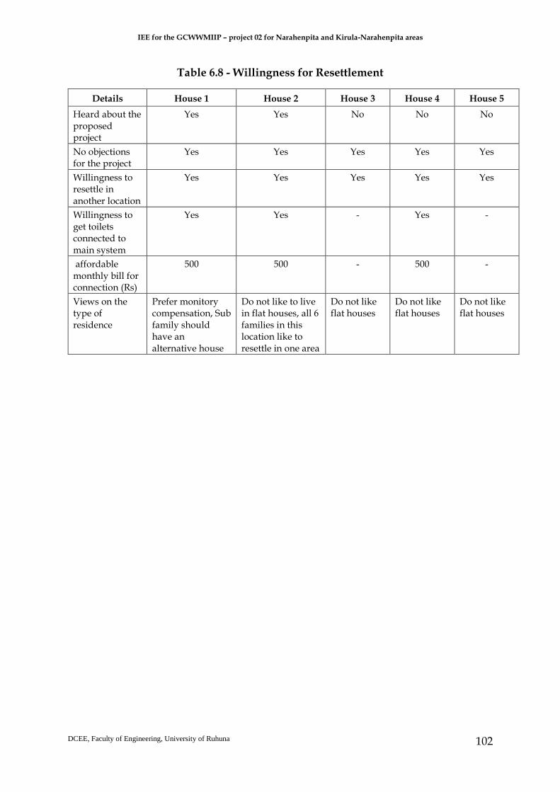
IEE for the GCWWMIIP – project 02 for Narahenpita and Kirula-Narahenpita areas
DCEE, Faculty of Engineering, University of Ruhuna
102
Table 6.8 - Willingness for Resettlement
Details House 1 House 2 House 3 House 4 House 5
Heard about the proposed project
Yes Yes No No No
No objections for the project
Yes Yes Yes Yes Yes
Willingness to resettle in another location
Yes Yes Yes Yes Yes
Willingness to get toilets connected to main system
Yes Yes - Yes -
affordable monthly bill for connection (Rs)
500 500 - 500 -
Views on the type of residence
Prefer monitory compensation, Sub family should have an alternative house
Do not like to live in flat houses, all 6 families in this location like to resettle in one area
Do not like flat houses
Do not like flat houses
Do not like flat houses

IEE for the GCWWMIIP – project 02 for Narahenpita and Kirula-Narahenpita areas
DCEE, Faculty of Engineering, University of Ruhuna
103
7 GRIEVANCE REDRESS MECHANISM
7.1 General
This chapter explain grievance redress framework (both informal and channels)
setting out the time framework mechanism framework for resolving complaining
about environment performance. The possible impact mitigatory measures are
mentioned below:
● Possibility should be explored to carry out construction activities in front of
SINYO Montessori School and AOG Catholic Church during nighttime and
weekends. If the access to these public places get blocked alternative
arrangement should be provided to reach these institutions. This measure
should be implemented in Heen Ela sub project area. (steel plates may be used
to provide alternative access through the open trenches dug on the road)
● If the access to houses, business places, public institutions or any other location
get disturbed due to construction of trenches for pipe laying contractors should
create alternative access to all the affected places. This is a common
recommendation for the entire sub project pipe laying areas.
● Possibility should be explored to carry out pipe laying activities in section by
section without disturbing the entire length of the road. This will help to reduce
the disturbances of the entire road. (staggered construction)
● During construction period in Kirimandala road and Evergreen garden road
the construction schedule should be discussed with management of Asiri,
Auesis and NineWells hospitals to come up with harmonious and jointly
agreed construction program to be carried out in front of these people
gathering public places.
● All the possibilities should be worked out to introduce alternative roads to
access affected houses, business locations and other public places during
construction period. This intervention should be carried out jointly by
contractors, community leaders and PMU staff before construction activities is
begun and the list of alternative roads should be informed to the affected
parties along with the construction timetable.
● The construction activities in front of public institutions such as schools,
religious places etc. should be completed within agreed period without
unnecessary delays.
● Pipe laying in narrow roads should be carried out using modern technology
and if possible, trenchless technology may be applied depending on the
complexity of narrow roads. This may be much relevant to the locations where
pipe need to be buried under the Kelani valley rail line.

IEE for the GCWWMIIP – project 02 for Narahenpita and Kirula-Narahenpita areas
DCEE, Faculty of Engineering, University of Ruhuna
104
● Construction activities in front of religious places should be carried out with
proper consultation of religious leaders in the particular place. A program
agreeable to both parties should be prepared and carried out within the agreed
time period.
● During the construction period in front of Narahenpita Economic Center
visitors to the economic center should be directed to reach it through the
alternative access in Samadhi Vihara Road.
● The construction activities started in each road should be continuously carried
out without having intermittent breaks.
● Due attention should be paid by the construction contractors to mitigate dust
related problems using water. The road damaged due to pipe laying should be
immediately attended with the involvement of CMC and RDA.
Apart from above mentioned measures the following specific measures will also be
implemented to mitigate the potential negative impacts.
● Action will be taken to resettle 6 families presently residing in SLR land plot
demarcated for pumping station. These 6 families will be resettled in one of the
UDA constructed high-rise buildings. Three of six families are not willing to
get resettled in high-rise buildings. They will be resettled prior to
commencement of the construction activities in the pumping station.
● The UDA will clear the temporary labor camp presently existing in its land plot
agreed to provide to the project for construction of the second pumping station.
The cost for clearing of the land for the project will be paid to the UDA.
● According to the Engineer of Coconut Development Board (Mr. A.T.
Rathnasiri) three story building adjacent to the proposed land plot is vulnerable
due to its poor establishment in a filled wetland. He is of the opinion that there
can be some negative impacts on the building due to the construction activities
of the pumping station. This situation should be better informed to the
contractors of the pumping station to be vigilant during construction period. If
any damage to the building occurred such damages will be immediately
attended by the project with the involvement of the contractor.
● In addition to the three-story building belongs to coconut development board
there are about 15 poorly constructed houses available adjacent to the land
proposed for the pumping station. The contractors will be made aware of the
vulnerability of these houses during construction period. If any damage occurs,
project will attend to such damage through the involvement of the contractors.
● The resettlement study team observed about 148 vulnerable houses adjacent to
the road edge that will be used to install waste water pipelines. There can be
incidents of damages to these vulnerable houses during construction period. If
such incidents occur the project will attend to repair or replace these damaged

IEE for the GCWWMIIP – project 02 for Narahenpita and Kirula-Narahenpita areas
DCEE, Faculty of Engineering, University of Ruhuna
105
houses depending on their degree of damages. This will be done with the
involvement of the contractors.
7.1 Plan for monitoring impact mitigatory process
The present institutional mechanism available in main project will be used to monitor
the construction sites to ensure proper mitigation of potential negative impacts. In this
context social safeguard officer of PMU together with resettlement expert in DSIDC
will make regular visits to the sub project sites to observe the implications of the sub
project implementation activities and the local communities. The local communities
will be made aware of the sub projects and its construction program for them to
prepare for possible mitigatory measures. The social impact mitigation process will be
monitored using specific criteria and indicators to understand the magnitude of the
impacts and to work out appropriate solution.
The section below provides the monitoring methods and the reporting system of the
sub-project. The PMU-Sociologist will monitor whether social safeguard system
implementation is effective, make recommendations for change where necessary, and
report to the Project Director. The DSIDC-RS will provide the PMU with training in
resettlement and other social safeguard related issues, social survey methods and data
analysis and recording, and he will also be supported by the PMU-Sociologist in
performing this role. Monitoring data will be collected from PMU, DSIDC,
contractors, and individual APs, and will be compared with entitlements and
disbursement schedules established in the RP. Various indicators will be used,
including those shown in Table 7.1. The PMU-Sociologist will provide donor agency
(EIB) with bi-annual monitoring reports.
Table 7.1 - Potential Monitoring Indicators
Monitoring Issues Monitoring Indicators
Management, budget, and program PMU has been established and strengthened and
trained; management & monitoring systems already
established and in functioning
PMU Sociologist has been appointed and will continue
in monitoring the activities related this sub-project
DSIDC Resettlement Specialist also has been appointed
and will continue in providing inputs for this sub-
project
IEE for the GCWWMIIP – project 02 for Narahenpita and Kirula-Narahenpita areas
DCEE, Faculty of Engineering, University of Ruhuna
106
DMS for the affected properties in this sub-project has
been conducted as planned, completed on time
ESMP has been prepared according to schedule
Funds for resettlement to be released on schedule
Sites to be prepared on time for start of construction
Delivery of AP entitlements APs to be received entitlements according to amounts
and program specified in SEMP
Compensation will be provided before loss incurred
Arrangements for livelihood to be made to vulnerable
APs
Consultation, grievance and other
issues
Public meetings held to disclose impacts and
entitlements, this will be continued
Meetings with individual APs to agree compensation
will be held
APs aware of entitlements and grievance procedure,
further meetings will be held.
SC meetings will be held, and grievances resolved
depending on the needs
Benefit monitoring Post-impact meetings will be held with APs to check
receipt of entitlements and satisfaction
Check of any disproportionate impacts on vulnerable
households will be carried out.
The PMU will implement a program with the involvement of UDA to resettle sub-
project affected 6 families in new locations, most probably in UDA built high rise
buildings. The Monitoring Unit of PMU will assess the resettlement process
implemented by UDA. This will be done for compliance monitoring to check that
entitlements have been provided as specified in the RP, and social impact evaluations
to determine whether the compensation measures have mitigated the effects of the
Project and delivered the intended social improvements. Compliance monitoring will
focus on: determining whether APs have been provided with the compensation and
other entitlements specified in the RP; and assessing the adequacy of the resettlement
policies, resettlement management staff and structures, complaints and grievance
procedures, and resettlement budgets. Data will be gathered through reviews and
audits and unscheduled and unannounced inspections, as well as interviews with
APs, PMU and District Office staff, contractors, UDA and others involved in the

IEE for the GCWWMIIP – project 02 for Narahenpita and Kirula-Narahenpita areas
DCEE, Faculty of Engineering, University of Ruhuna
107
process at all levels, and structured direct observations on the ground. A sample
monitoring plan is shown in Annex 9.
Social Impact Evaluation (SIE) will be conducted by DSIDC following implementation
of the RP, at least six months after completion of the resettlement process. The SIE will
assess post-project socioeconomic conditions in affected areas and communities,
compared with pre-project baseline levels established by the DMS. The status of
groups in relation to vulnerability and other factors will be assessed, together with the
gender impacts of the RP.
The DSIDC will produce an annual report that will identify any outstanding issues
that need to be addressed, and any departures from Government or EIB policy,
together with recommended remedial action. The PMU will allocate required
resources for the SIE to be done by DSIDC to have unbiased views of the project. The
SIE report will also identify any strategic lessons that need to be learned, so that these
can be incorporated into future resettlement activities relevant to the Government or
EIB.
7.2 Stakeholders and their views
The proposed project is implemented by Colombo Municipal Council through project
management unit established with required number of staffs with relevant skills and
experience. The executing agency of the proposed project is Ministry of Provincial
Council and Local Government. The construction activities of the project will be
carried out by contractors. The Design preparation and construction Supervision
(DSIDC) will be handled by a separate consultant working under the supervision of
project management unit (Design Preparation, Supervision and Institutional
Development Consultants – DSIDC). Apart from these direct actors of the project there
are stakeholders having direct and indirect stakes of the project. The details of these
stakeholders are mentioned Table 7.2.
Table 7.2 - Types of Stakeholders
Stakeholder Type of stake
Urban Development Authority (UDA)
Supports in providing alternative housing for 6 affected families and implementation of Resettlement activities with PMU, CMC and DSIDC
National Water supply and Drainage Board (NWSDB)
There can be negative impacts on drinking water pipelines established by NWSDB in the roads used for the sub-project
Colombo District Secretary and Thimbirigasyaya Divisional Secretary
Public agencies having legal power in implementation of resettlement project
Narahenpita and Kirula Grama Niladharis
Project level public officers having authority to support the project for resettlement plan implementation
Road Development Authority (RDA)
The project will use some of RDA managed roads for the installation of pipelines
IEE for the GCWWMIIP – project 02 for Narahenpita and Kirula-Narahenpita areas
DCEE, Faculty of Engineering, University of Ruhuna
108
Electricity board and Sri Lanka Telecom
There can be need for shifting of electricity posts and telecommunication cables
Ministry of Health and Thimibirigasyaya MOH Office
MOH office will have role in public awareness and education campaign of the project.
Members of Colombo Municipal Council
The municipal members in the project area are concerned to establish main sewer system in their jurisdictions
CBOs in the area The service of CBOs will be required during awareness and education campaign of the project
Community leaders in the area Community leaders will act as key persons during public awareness and education campaigns
Environmental Organizations in the area
The project will have to seek the support of local level environmental Organizations during implementation of the public awareness and education activities
General Public General public will be the direct beneficiaries of the proposed project
The social assessment and resettlement study team consulted most relevant
stakeholders to document their views on the proposed project. These views are
summarized in Annex 10.
7.2.1 The methodology to be used to get stakeholders involved in the project
activities
The following sequential steps should be followed in consultation and engagement
of the stakeholders relevant to the project.
● Identification of the stakeholders within the proposed project implementing
area in Narahenpita and Kirula
● Making the stakeholders aware of the proposed project and its benefits to the
community and the area
● Facilitate the stakeholders to discuss about forming a committee at project
level to interact with the project during its construction and post construction
stages. This committee may be headed by the divisional secretariat of
Thimbirigasyaya DSD
● The stakeholders may decide a suitable stakeholder to act as convener of the
committee meetings and committee may meet once a month during
construction period and when necessary during post construction stage.
7.3 Grievance redress mechanism (GRM)
A grievance redress mechanism (GRM) is a set of arrangements that enable local
communities, employees, out growers, and other affected stakeholders from the
proposed project to raise grievances when they perceive a negative impact on social
and environment arising at all the levels of the project. It is a keyway to mitigate,

IEE for the GCWWMIIP – project 02 for Narahenpita and Kirula-Narahenpita areas
DCEE, Faculty of Engineering, University of Ruhuna
109
manage, and resolve potential or realized negative impacts, as well as fulfill
obligations and contribute to positive relations with communities and project
proponent. The GRM will aim to provide a time-bound and transparent mechanism
to voice and resolve social and environmental concerns linked to the project. Expected
issues from these sub projects are mostly from the construction activities which can be
amicably settled by both parties. In the case of grievances that are immediate and
urgent in the perception of the complainant, the contractor and supervision personnel
from the PMU/DSIDC on site will provide the most easily accessible contact for quick
resolution of such grievances. Contact phone numbers and names of the PMU Social
Development/Safeguards Officer, DSIDC safeguards specialists, and contractor’s site
engineer will be posted at all construction sites in visible locations.
Four types of issues may emerge during construction period of the proposed project.
If these issues are not properly addressed the affected parties will be interested to
reach responsible authority to seek solutions. These four possible issues include:
● Resettlement related issues of the 6 families in Land plot demarcated for the
first pumping station (SLR land)
● Issues related to removal of temporary established labor camp in the land plot
proposed for the second pumping station (UDA land)
● Disturbances to common service facilities to the people in the project
implementing area (electricity, water and telecommunication)
● Disturbances to access facilities to houses, other institutions and sub roads
connected to the project roads
● Possible negative impacts on the income generation activities of the mobile
vendors in the structures located adjacent to the road edge and three-wheel
parks
The Greater Colombo Wastewater Management and Improvement project has already
established institutional mechanism to address grievances of the project affected
parties. The project affected parties will have different opportunities to meet
responsible agencies/officers to solve the grievances. These different layers include:
● Construction contractors
● DSIDC Consultants
● Project Management Unit
● Colombo Municipal Council
● Grievance redress committee established with the leadership of the assistant
secretary of the ministry of Provincial councils and local government.
● legal action through the judiciary system of the country (court)

IEE for the GCWWMIIP – project 02 for Narahenpita and Kirula-Narahenpita areas
DCEE, Faculty of Engineering, University of Ruhuna
110
Grievances of APs will first be brought to the attention of the PMU Sociologist within
3 days after complaint/s made by the APs. Grievances not redressed by the PMU
Sociologist will be brought to the Project Director (PD) again within 3-4 days.
Grievances not addressed by the PD will be brought to the Safeguards Committee (SC)
constituted in each Municipal District within one-week time. There is a long history
of grievance redress for CMC services through the District Engineer. The community
members in CMC areas make their grievances on CMC provided services to the
District engineers and the District engineers’ offices have made arrangements to
inspect the problems of the community members and help to solve the problems in
the field itself if possible or otherwise they take actions to forward the grievances of
the communities that cannot be solved at their level to the higher authorities of the
CMC. This practice will be formalized for resettlement purposes through the SC. The
SC will comprise the Additional secretary of the Ministry of provincial councils and
local government, District Engineer as chair, a representative from UDA, the PMU
Sociologist. The PMU Sociologist will observe and take minutes of the SC meetings
held depending on the needs.
● The project (Phase 1) has already established GRM committee with the memberships of officers from CMC and the project. Some of these individual government officers may change due to transfers of work sites or any other reasons but, the positions will remain same in the committee. The details of positions are mentioned below:
Table 7.3 - Members of Grievance redress mechanism
Member Position Contact details
1. Senior Assistant secretary of the Ministry of Provincial Councils and Local Governments
011-2345971
2. District Engineer of CMC (District 4) 011-2362205
3. Sociologist attached to PMU 01126665331, No 86, Millennium Center, Ananda Kumaraswamy Mawatha, Colombo
4. A representative/s from the community in the neighbouring area)
To be mentioned after identification
● The SC will meet when grievances are put forwarded by the Project Director to
determine the merit of each grievance and resolve grievances within a month
of receiving the complaint. Further grievances will be referred by APs to the
Project Steering Committee. Records will be kept of all grievances received
including, contact details of complainant, date that the complaint was received,
nature of grievance, agreed corrective actions and the date these were affected
and outcome. The CMC has already formed the SC for GCWWMIIP for
implementation of RPs in other sub-projects and the same SC will serve for this

IEE for the GCWWMIIP – project 02 for Narahenpita and Kirula-Narahenpita areas
DCEE, Faculty of Engineering, University of Ruhuna
111
sub-project too. All costs involved in resolving the complaints will be borne by
the PMU. The grievance redress mechanisms will continue to function
throughout the project period.
● A project information document (PID) including brief description of the sub-
project, likelihood negative impacts and institutions to be contacted and their
locations to seek for solutions to the problems and constraints faced during
construction phase will be prepared by PMU. This document will be
distributed among APs at least one month prior to commencement of the
construction work. It is noted that APs in this sub-project area are already
aware about the likelihood their evacuation and the types of assistants they will
receive from the resettlement survey team of this sub-project.
The focal point of receiving complaints /queries will be social and environmental
safeguard division of PMU office and the sociologist of this division is responsible for
taking actions to solve the problems with the help of other parties. The PMU
sociologist together with DSIDC resettlement expert will make frequent visits to the
sub-project sites. The affected communities also can contact the PMU sociologist
through the telephone number 0112665331 and make their complaints. They also can
post letters with their complaints to the PMU office to its address mentioned below.
The communities in the project area can easily access to the social and environmental
safeguard division of PMU office located at no 86, Millennium Center, Ananda
Kumaraswamy Mawatha, and Colombo. There is well established public transport
system for the communities to reach the PMU office within a short period of time. The
communities in the sub-project area can also reach the site offices established in the
sub-project area during construction period and make their complaints/grievances
to the DSIDC engineers. These grievances will be collected by the PMU sociologist to
offer solutions through the institutional process established. The Figure 7.1 depicts the
complaint handling mechanism during implementation phase of the sub-project.

IEE for the GCWWMIIP – project 02 for Narahenpita and Kirula-Narahenpita areas
DCEE, Faculty of Engineering, University of Ruhuna
112
Figure 7.1 - Complaint handling process
A form will be used to register the complaints of the sub-project affected communities
in project implementing area (Annex 11). The copies of the form will be given to the
site engineers of the contractors, construction supervision engineers of DSIDC
attached to the site and the PMU sociologist will also use this form. The registered
complaints using this form will be received by the Sociologist attached to PMU and
take necessary actions to provide timely solutions.
During resettlement survey period information about the project and likelihood
impacts have been conveyed to the community leaders and other key stakeholders. A
detailed leaflet with specific details about the sub-project and GRM arrangements will
be disbursed to the affected community members prior to commencement of civil
work. The PMU sociologist together with the DSIDC resettlement expert will conduct
awareness meetings to the affected communities and the construction crew to explain
about the GRM arrangements in each sub-project site.
AP’s complain to
contractor/DSIDC engineer
attached to site office
If the contractor/DSIDC
engineer cannot solve the
problem, forward the same
to PMU sociologist
PMU sociologist/DSIDC
resettlement expert attempt at
to resolve this issue and if fail
same problem will be
forwarded to the PD
If the PD cannot solve it
GRM committee is
requested to attend the
If the GRM solution is not
acceptable to the AP, he/she
has flexibility to take legal
actions
Step 1
Step 2
Step 3
Step 4
Step 5

IEE for the GCWWMIIP – project 02 for Narahenpita and Kirula-Narahenpita areas
DCEE, Faculty of Engineering, University of Ruhuna
113
The PMU sociologist and the resettlement expert of DSIDC will play key roles in
monitoring of sub-project sites during construction period. These two safeguard
officers will educate the APs, community leaders and other stakeholders on the GRM
mechanism available. The construction crew also will be made aware about the GRM
mechanism by these two safeguard officers. They will be responsible to monitor the
social safeguard related activities in the sub-project site during implementation
period. The information on the social safeguard implementation will be include

IEE for the GCWWMIIP – project 02 for Narahenpita and Kirula-Narahenpita areas
114
8 ENVIRONMENTAL MANAGEMENT PLAN
8.1 General
These chapter 8 summaries the monitoring to be carried out during the design,
construction and operation of the proposed sewage network and two pump houses. As
explained in the previous chapters, it was noticed that there are no major impacts, due
to the construction and operations of this project. Therefore, it is not essential to have a
complex monitoring system. Nevertheless, it is recommended to ensure not to violate
the rules and regulations and adhere to national standards and guidelines pertaining to
environmental protection and management. Therefore, an experienced and qualified
professional should be appointed by the contractor to ensure environmental compliance
during the implementation of the project. The local community’s satisfaction and their
support over the execution is very important for the sustainability of the project.
Therefore, the Environmental Monitoring Plan will be executed under the following
institutional arrangement. Hence the following monitoring committee has been
suggested for the implementation of the project.
8.2 Safeguard Implementation Arrangement
Monitoring committee
Environmental Monitoring Program shall be undertaken by an inter-agency
committee compromising the key agencies that have jurisdiction on various entities of
the project area. A core monitoring team shall be formed with the representatives of the
most relevant organizations mentioned as follows:
a. Colombo Municipal council (CMC)
b. Central Environmental Authority (CEA)
c. Marine Environmental Protection Authority
d. Road Development Authority (RDA)
e. Ministry of fisheries
f. National Aquatic Research Agency (NARA)
g. Coastal Conservation Department (CCD)
h. Sri Lanka Land Reclamation and Development Cooperation (SLLRDC)
i. Department of Irrigation
j. Department of Archaeology
k. Divisional Secretariat Office-Thimbirigasyaya

IEE for the GCWWMIIP – project 02 for Narahenpita and Kirula-Narahenpita areas
115
The institutional arrangement for monitoring program is shown by Figure 8.1.
Figure 8.1 - The Institutional arrangement for monitoring program
Central Government
Ministry
CMC (PP)
Construction of a wastewater disposal system
Feasibility Studies (CMC)
Central
Government
IEE IEE Team Post Feasibility Studies
Approval
CEA & Evaluation
Committee
No
Tender preparation, evaluation
& award
Detailed Design and Construction by Contractor
Construction
(Contractor supervised by CMC)
O&M
(BY NWS&DB)
Social Groups
NGO’s
MONITORING BY
INTER AGENCY
COMMITTEE
CORE MONITORING
COMMITTEE
NWS&DB
UDA
MCs & PS (i.e LA’s)
SUPPLEMENTA
RY
MONITORING
COMMITTEE
Utility Services MCs & PS (Premises etc.)
RDA – roads CEB – Electricity Utilities
SLT – Phone Utilities NWS&DB – Water lines

IEE for the GCWWMIIP – project 02 for Narahenpita and Kirula-Narahenpita areas
116
This monitoring committee brings together key personnel from all stakeholder groups
involved with the project and its implementation. The aim of this monitoring program is
to achieve a better understanding of cause-effect relationships between the project and
its environment and hence, to improve the IEE predictions and mitigatory measures for
the purpose of an effective impact management. Project Monitoring Unit (PMU) together
with other institutions such as Design Preparation, Construction Supervision, and
Institutional Development Consultants (DSIDC) will be responsible for mitigating the
negative impacts during construction period.
It is recommended this committee should assemble at least once in a month during the
construction period. Any violation of rules, regulations and standard specified by the
government agencies should be discussed and problems identified should be sorted out
immediately. Any additional plans, guidelines or conditions may be recommended by
the relevant government agencies, depend on the situation, to minimize adverse impacts
likely to arise from the implementation of the project with the consent of the monitoring
committee. Further, any complaints should follow the Grievance Redress proposed
elsewhere in the report.
DSIDC will be engaged to work closely with and advise the CMC PMU to build capacity
on wastewater management, and to be involved in project supervision, including
construction. The DSIDC will have an environment specialist and a resettlement
specialist. For environmental related work, the DSIDC environment specialist will work
closely with the contractor and relevant agencies mentioned above to ensure the proper
implementation of environmental safeguard activities including the implementation
environmental management plan. Table 8.1 below shows the level of impact, their
significant and the nature and migratory measures during construction period while
Table 8.2 show that for post-construction period. Table 8.3 shows the similar interaction
matrix for the operational phase of the proposed project.

IEE for the GCWWMIIP – project 02 for Narahenpita and Kirula-Narahenpita areas
117
Table 8.1 - Interaction matrix for the construction phase of the proposed project (During construction)
Environmental factor/Resource
Existing quality/Status
Intensity of the impact/s
Resultant quality/Status
Mitigation measures
Hydrology The existing canal
is relatively stagnant
(blocked) and has very low flow
velocity
A/M
Siltation during the
rainy periods and the risk of flooding in all surface water
bodies
The exposed soil shall be bundled temporarily; The flows from heavy runoff areas causing erosion or runoff shall be redirected; Implementing sediment dispersal measures by monitoring areas of exposed soil during periods of heavy rainfall.
Soil Typical to the area A/M
Increase in soil erosion
The excavated soil shall not be exposed to rains
Surface water quality
Not in compliance with
the ambient water quality standards
A/M
Increase in TSS, oil, metal particles and some other
chemicals used for
construction
Restrain the activities causing contaminated run-off to only dry periods. Fuel, lubricants and hazardous goods shall be stored at predefined enclosed storage locations (example, elevated containers). Otherwise, storage of oil and fuel whether in large tanks or drums, shall be within a concrete bund capable of retaining the entire volume of liquid in the event of leakage or rupture. Storage locations shall have good ventilation, but shall not be exposed to sunlight directly, devoid of ignition sources and shall not be subjected to floods or close to waterways. The storage, treatment and recycling of the bentonite slurry (drilling fluid) will only be conducted at the proposed launching site under the proper approval and supervision by GCWMP. The excavated and soil materials shall be removed as soon as possible once they are generated. Provision of earth bunds or sandbags in areas having a large amount of exposed soils. Stockpiles shall be well covered with relevant materials such as tarpaulin sheets. Good management practices shall be implemented.

IEE for the GCWWMIIP – project 02 for Narahenpita and Kirula-Narahenpita areas
118
The contractor shall prepare a construction waste management plan and shall provide a list of hazardous chemicals to be used during construction so that precautionary measures be implemented.
Air quality In compliance with the air
quality standards
a/M Dust, Airborne particulate
matter, CO and NOx
Water spraying of surfaces being prone to dust emission. Soil compaction and timely removal of debris. Dust generation from crusher plants shall be controlled by covering with wetted fabrics. Wetting the materials (e.g. aggregate) earmarked to be loaded shall be practiced. Vehicles transporting construction materials shall be covered adequately. The dust levels shall be monitored periodically. Limiting speed of construction vehicles and displaying speed limiting sign boards shall be practiced. Cement mixing places and batching plants shall be located away from sensitive receptors and operations shall be avoided during windy conditions. A schedule for dust/emission generation activities shall be prepared and the public shall be informed of such activities. Heavy vehicles shall be maintained in good condition.

IEE for the GCWWMIIP – project 02 for Narahenpita and Kirula-Narahenpita areas
119
Noise and vibration
Not in compliance with
the permissible noise levels;
Vibration is within the
permissible limits.
A/M Increase in noise and a
slight increase in vibration
Heavily loaded trucks shall be routed away from highly residential areas. Earthmoving and ground-impacting operations shall be operated at different times so as not to make a cumulative vibration effect. Construction activities during the night shall be minimized since the human beings are more sensitive to vibration during the night. Scheduling of construction work causing high noise and vibration shall be within the authorized construction embodiment times with the least inconvenience to the public. All construction equipment shall be used in good service condition and low noise/vibration generating construction equipment shall be used. The construction site shall be separated with corrugated sheets or other suitable material. Carrying out a property condition survey (crack survey) of nearby structures and recording the present condition of the structure to accurately assess any damage to these structures during the construction stage
Establishing a complaint mechanism and implementing a procedure to deal with any issue raised by the community effectively.
Ground water Satisfactory for the area
a/M A slight increase in pH
No special mitigation measure shall not be needed because the alkaline substances will not dissolve in the water so that no significant adverse water quality issue will arise. The groundwater monitoring shall be conducted near the two pumping stations area to confirm the potential contamination
Flora and fauna No exotic and threatened
species; Having been adapted to a
crowded environment.
a/M Insignificant additional
disturbance compared to the present condition
No mitigation measure is needed.
Land use Typical to the area a/M Small alteration

IEE for the GCWWMIIP – project 02 for Narahenpita and Kirula-Narahenpita areas
120
Human health High prevalence of adverse health
issues
A/M Slight increase of risk
Traffic and accessibility
Typical to the area A/M Increase in congestion
A Traffic Management Plan with Colombo Municipal Council and Roads Development Authority (RDA) shall be implemented. Nighttime constructions should be limited only to Elvitigala Road (Baseline Road) and Nawala Road. Nighttime construction shall be implemented on Kirimandala Road and Muhandiram E. Dabare Road. Alternatively, the possibility of conducting daytime construction on Kirimandala Road and Muhandiram E. Dabare Road by considering a diversion through Lake Drive Road from Kirimandala Road to Nawala Road shall be considered. The oncoming traffic flow from Kirimandala Road to Evergreen Park Road shall be barricaded and encouraged to use Kirimandala Road. Adequate sign boards shall be installed to guide the traffic flow during construction. Notice boards displaying the possible congestion due to construction on Muhandiram E. Dabare Mawatha, Kirimandala Mawatha and Nawala Road
shall be installed at suitable locations to discourage the inflow traffic to aforesaid roads from Elvitigala Road (Baseline Road), Thimbirigasyaya Road and Kirula Road. Residents and general public shall be informed of the road closure schedules on minor and private roads well in advance,

IEE for the GCWWMIIP – project 02 for Narahenpita and Kirula-Narahenpita areas
121
Utilities along alignments
Typical to the area A/M May get damaged
In order to minimize the number of exposed sites at a given time, a
construction sequence of work shall be prepared. Residents shall be informed of the allocated dates for pipe laying in an area
through public announcements. Ceylon Electricity Board and Sri Lanka Telecom shall be contacted for
removing transmission lines or to have any other mitigatory measure as
applicable for their transmission lines during the period of construction. Public announcements shall be made on service interruptions well in advance
(electricity, water and telecommunication services). Training the contractor to adopt methods to minimize the disturbances and
inconvenience to the public. Damaged roads shall be repaired immediately after finishing pipe laying.
Nighttime work shall be considered to speed up construction work reducing
period of construction to minimize the duration of minute degree of
obstruction, disturbances to public utilities and inconveniences to public.
Livelihood Typical to the area A/M Small-scale livelihood
systems will considerably be
affected adversely.
Information on the construction schedules shall be disseminated about 30 days before the commencement of the project activities. Steel plates shall be provided to be used as alternative accesses to the shops if the accesses are disturbed. Actions to complete the construction activities within a short period of time in the sub-project road sections of small-scale shops shall be prioritized. Mobile venders shall be provided with construction schedules of the subprojects 30 days prior to the commencement of the construction activities so that they can walk on other roads in the vicinity of the sub-project during the construction period.
Three-wheeler drivers shall be informed of the construction program prior to commencement of the construction work. Completion of the construction work in the three-wheel parking areas shall be done within a short period of time.

IEE for the GCWWMIIP – project 02 for Narahenpita and Kirula-Narahenpita areas
122
Community and workers’ health and safety
Typical to the area A/M Will be adversely affected
In order to minimize the number of exposed sites at a given time, a construction sequence of work shall be prepared. Residents shall be informed on allocated dates for pipe laying in a particular area through public announcements. Temporary sanitary facilities shall be provided at all construction sites, especially for the pumping stations. Contractor shall provide the workforce (drivers and traffic controllers cum flagmen should be included) involved in handling dust generating material (example, cement, soil, metal aggregates, bricks, etc) with dust masks and goggles or safety glasses. Environmental pollution control measures, including watering standard maintenance of machinery shall be implemented. Construction activities shall be scheduled so as to minimize the impact on surrounding communities (e.g. prohibit high noise generating activity on nighttime) Heavily loaded trucks shall be routed away from highly residential areas, if possible and streets with less populated areas, if no alternative is available, shall be selected The speed of construction vehicles shall be limited, and speed limiting sign boards shall be displayed. Peak traffic hours shall be avoided with reference to material delivery and taking away the soilt or construction wastes. It is advised that appointed contractor could prepare a Traffic Management Plan and implement it accordingly with the support of the project proponent. Dust generation from crusher plants shall be controlled by covering wetted fabrics. Wetting the materials (e.g. aggregate) earmarked to be loaded shall be practiced. Water shall be sprinkled to the cleared and exposed (bare) surfaces frequently when dust plumes are likely to get generated under hot, sunny and windy conditions.
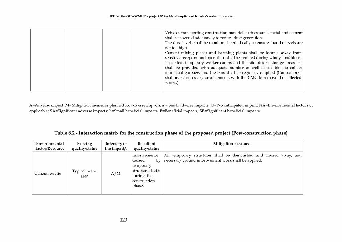
IEE for the GCWWMIIP – project 02 for Narahenpita and Kirula-Narahenpita areas
123
Vehicles transporting construction material such as sand, metal and cement shall be covered adequately to reduce dust generation. The dust levels shall be monitored periodically to ensure that the levels are not too high. Cement mixing places and batching plants shall be located away from sensitive receptors and operations shall be avoided during windy conditions. If needed, temporary worker camps and the site offices, storage areas etc shall be provided with adequate number of well closed bins to collect municipal garbage, and the bins shall be regularly emptied (Contractor/s shall make necessary arrangements with the CMC to remove the collected wastes).
A=Adverse impact; M=Mitigation measures planned for adverse impacts; a = Small adverse impacts; O= No anticipated impact; NA=Environmental factor not
applicable; SA=Significant adverse impacts; b=Small beneficial impacts; B=Beneficial impacts; SB=Significant beneficial impacts
Table 8.2 - Interaction matrix for the construction phase of the proposed project (Post-construction phase)
Environmental factor/Resource
Existing quality/status
Intensity of the impact/s
Resultant quality/status
Mitigation measures
General public Typical to the
area A/M
Inconvenience caused by temporary
structures built
during the construction phase.
All temporary structures shall be demolished and cleared away, and necessary ground improvement work shall be applied.

IEE for the GCWWMIIP – project 02 for Narahenpita and Kirula-Narahenpita areas
124
Table 8.3 - Interaction matrix for the operational phase of the proposed project
Environmental factor/Resource
Existing quality/status
Intensity of the impact/s
Resultant quality/status
Mitigation measures
Operational health and safety
- A/M
Workers’ possible
reluctance to follow
operational health and
safety (OHS) measures
stipulated and wear personal
protection equipment
(PPE); Accidents
Punitive action shall be imposed on those violating the OHS policies. Special provisions shall be made available in their offices to store the given PPE with toilet facilities for the workers to thoroughly clean themselves. Pre-recruitment and periodic health check-ups of the workers shall be initiated by the CMC. OHS measures with reference to sewer cleaning works shall be implemented. All areas shall be devoid of spilled oil or grease. Soap and water, not gasoline or solvents, shall be used for cleaning. Long-sleeved glows shall be worn when working with equipment or while in direct contact with wastewater. Tools, equipment and materials shall not be left at places prone to safety hazards. Adequate lighting shall be provided for night work and in areas with limited existing lighting. Only sections of handrails, deck plates or grating necessary for the immediate job shall be removed. Removed sections shall be properly stored out of the way and properly secured against falling into tanks. The area shall be barricaded to prevent unauthorized personnel entry and possible injury. Walk on top of the sidewalls of structures shall be prohibited. Any sewage flowing from the upstream manhole to downstream manhole shall be stopped until the completion of the cleaning work of any blockage. Within the pumping station premises, special areas shall be allocated to store the given PPE with toilet facilities for the workers to thoroughly clean themselves. Smoking and consumption of food items shall be prohibited in the wet well /working areas by displaying appropriate sign boards. Ladders and railings around the wet well, screening chambers, penstock gate chambers and grit chambers shall be hard, well fixed solid structures (example, made of stainless steel).

IEE for the GCWWMIIP – project 02 for Narahenpita and Kirula-Narahenpita areas
125
Ladders provided to the wet well and screening removal area shall have well fixed railings on both sides with broad footsteps. Ladders leading to the screening removal area shall not be placed above ditches such as penstock gate chamber, grit chamber, etc. Pre-recruitment and periodic health check-ups of the workers shall initiate by the CMC. Automated Fire/ smoke detectors with an alarm shall be made mandatory with provision of adequate gear to put off fires. The workers shall be thoroughly trained to put off any fire. Automated H2S detectors shall be installed in plenty throughout the pumping station. They should be capable of setting up an alarm when dangerous levels are detected. Therefore, the workers shall be educated regarding the dangers posed by different levels of H2S. Portable H2S meters shall be provided to those involved in removing grit and repairing and maintenance works in the wet well. A first aid unit / facilities as per the General Register of the Department of Labor & the Factories (First Aid) Regulation No 1 of 1995 shall be installed with medically competent persons and an ambulance shall be available to reach the nearest hospital/s on a 24 hrs. basis. A stretcher shall also be provided. The grit materials and sludge removed from the wet well shall be collected in proper containers and dewatered at the pumping station. The dewatered materials shall be disposed at suitable/appropriate dumping sites. All pumping stations and equipment shall be maintained and operated in an effective condition and records of the maintenance shall be kept. A system to identify critical components shall be placed, and a system to ensure adequate and timely access to spare parts shall also be placed. Around 4-6 standby pumping equipment shall be provided and associated controls (they need be alternately operated) and some 5000 L capacity gully suckers at site to attend to emergency needs shall also be provided. “No digging methods” such as glass reinforced plastic for sewer rehabilitation or repairing of damaged manholes shall be used wherever possible.

IEE for the GCWWMIIP – project 02 for Narahenpita and Kirula-Narahenpita areas
126
Air quality In compliance
with the air a/M Localized odor Frequent / daily inspections (morning and evening) shall be carried out to see whether odor emanates, and any blockages can immediately be attended.
quality standards The manholes to be provided shall be ventilated to minimize odor generation to the surrounding environment. The pumping stations shall be designed by design consultants and then constructed such that they are fully enclosed infrastructure that will have adequate ventilation systems (mechanical ventilation shall be provided with intake ducts fixed with fine mesh to prevent access to vermin such as flies) to provide around 21% of O2 to the workers inside and either soil filters or dual bed activated carbon filters connected to exhaust fans shall be provided for odor control. Pumping stations shall be enclosed with enough ventilation systems.
Noise and vibration
Typical to the area
a/M (pumps)
The general public will be annoyed by
the noise and vibration
Doors and windows of pump stations shall be kept closed during the operational time. The exhaust silencers shall be in good condition. Emergency generator rooms shall be kept closed during the operational period.
A=Adverse impact; M=Mitigation measures planned for adverse impacts; a = Small adverse impacts; O= No anticipated impact; NA=Environmental factor not
applicable; SA=Significant adverse impacts; b=Small beneficial impacts; B=Beneficial impacts; SB=Significant beneficial impacts

IEE for the GCWWMIIP – project 02 for Narahenpita and Kirula-Narahenpita areas
127
8.3 Monitoring and reporting
8.3.1 Background
Monitoring refers to the collection of data through a series of repetitive measurements
or other systematic observations of environmental and socio‐economic parameters.
This usually includes a review of available literature data. The ‘effects or impact
monitoring’ refers to the measurement of environmental parameters in order to detect
changes, which are attributable to the project. The ‘compliance monitoring’ is the
periodic or continuous measurement of environmental parameters to ensure that
regulatory requirements and environmental quality standards are met. Both types of
monitoring permit only reactive impact management, since they detect violations or
adverse changes after they have taken place. It is therefore important to respond to the
outcomes of monitoring by establishing a linkage to impact management, for example
by establishing protocols to be followed and actions to be taken if a certain threshold
value is exceeded. Consequently, the implementation of a monitoring programs is
imperative.
The aim of a monitoring program is to achieve a better understanding of cause effect
relationships between the project and its environment, hence, to improve the EIA
predictions and mitigatory measures for the purpose of an effective impact
management. Thus, a monitoring program should be targeted at the information that
is necessary to manage significant impacts and to review the aspects of EIA practice
that are of importance.
Conducting monitoring programs also instills confidence in the project communities,
the project proponent and regulatory bodies that the identified impacts are adequately
mitigated. Environmental monitoring of the project is therefore advocated in order to
ensure that the mitigation processes put in place have adequately taken care of the
predicted impacts.
8.3.2 Objectives of Environmental Monitoring Program (EMP)
The objective of the EMP is to provide useful information and help:
a. Assist in detecting the development of any adverse environmental situation, and
thus provide opportunities for adopting appropriate control measures;
b. Define the responsibilities of the project proponents, contractors, and
environmental monitors and provide means of effectively communicating
environmental issues among them;
c. Define a monitoring mechanism and identify monitoring parameters;

IEE for the GCWWMIIP – project 02 for Narahenpita and Kirula-Narahenpita areas
128
d. Evaluate the performance and effectiveness of mitigatory measures proposed in
the environment monitoring plan (EMP) and suggest improvements if required.
8.3.3 Salient features of a monitoring program and monitoring plan
If a permit is granted for the proposed project, and before site preparation and
construction activities begin, the project developers should submit an Environmental
Management and Monitoring Plan to CEA/Urban Development Authority, if this is
requested by the agency. The environmental monitoring plan details the monitoring
of the proposed mitigatory measures for all the identified significant and potential
impacts in all the project activities, throughout the phases of the project from pre-
mobilization to decommissioning and abandonment. It also specifies the compliance to
any statutory regulations, if any, the monitored parameter, the frequency of the
monitoring and the action party responsible for the monitoring. This will enhance
project benefits and introduce standards of good practice to be adopted for all project
works.
The monitoring program is based on several impact streams. Environmental impacts
rendered by the project on physio-chemical, biotic and social environments can be
classified as;
a. Negative baseline impacts
b. Positive long-term impacts
c. Negative long-term impacts
d. Negative short-term impacts
e. (Negative) Contingency impacts
The following requirements are addressed in the monitoring plan:
a. Impacts causing environmental element (Physio chemical, biotic or social)
b. Rendered impact
c. Parameters to be measured or monitored
d. Frequency of monitoring
e. Responsible agency/authority
f. Reporting requirements

IEE for the GCWWMIIP – project 02 for Narahenpita and Kirula-Narahenpita areas
129
8.3.4 Monitoring responsibility
The development of a framework for monitoring and evaluation to the extent possible
shall be done in consultation with key stakeholders, especially beneficiaries and
affected people. Periodic monitoring shall be carried out by an independent
monitoring body on behalf of the contractor at the construction stage of the project. In
addition, the compliance monitoring of some of the environmental parameters
specified by the Environmental Protection License (EPL) shall be carried out by an
independent monitoring body on behalf of C M C . The key objectives of compliance
monitoring are to adhere to limit conditions such as volume, mass, load and
concentration limits for water quality constituents in the discharged effluent, ambient
water quality monitoring and ecosystem in receiving waters as a response to the
discharge of wastewater. Consequently, key environmental areas, which shall be
monitored under periodic monitoring include;
a. Surface water quality;
b. Ground water quality;
c. Ambient air quality;
d. Noise and vibration; and
e. Social impacts
Developing a monitoring culture within an organization is vital to an effective
functioning of any project. Hence the understanding of monitoring responsibility is a
must. The main organization who takes the overall responsibility for monitoring the
mitigatory measures suggested during specific stages of the proposed project is the
C M C . The other stakeholders would play a facilitative role to provide information
for monitoring the implementation of the mitigatory measures suggested in Chapter
5. Furthermore, active involvement of the local authorities shall be obtained to the
monitoring program. It is a responsibility of them to highlight the benefits of the
project to community and obtain the active participation of the community in all the
project activities. The environmental officer attached to the Divisional Secretariat
office shall also play a significant role during the monitoring program. He/she may
be the representative of the CEA at the divisional level. It is also recommended to share
the water quality monitoring data with relevant authorities such as SLRDC during pre-
construction and construction stages.
In terms of monitoring, the environmental issues that may emerge at each pumping
station, WWTP and the pipelines; the community leaders also can play a significant
role. However, their role shall be limited only to report the problems encountered by
the community due to some draw backs in each project component. They shall be
properly informed to whom they should provide information and the mechanism of

IEE for the GCWWMIIP – project 02 for Narahenpita and Kirula-Narahenpita areas
130
communication in order to avoid social conflicts.
In consultation with the Environmental Management and Assessment (EM & A)
Division of the CEA, the CMC shall finalize the sampling locations for periodic
monitoring of the environmental parameters. Once the sampling locations are
finalized, the CMC shall establish monitoring data to represent baseline conditions
of the existing water quality, and noise levels before the commencement of the
construction work of the project.
The EMP shall be prepared by the C M C based on the proposed mitigatory
measures of the EIA and conditions of the EIA approval letter issued by the CEA at
the detailed design phase of the project. The environmental management plan shall
be incorporated into the contract as part of the contractual documents. The contractor
shall prepare his environmental management action plan based on the EMP. The
implementation strategy shall conform to all relevant regulations for the project. The
project manager shall be responsible for the implementation of the EMP and
performance monitoring until after commissioning.
Moreover, it is imperative to establish organizational mechanisms to carry out
monitoring activities systematically. Therefore, the NWS&DB shall establish a
committee to create an organization for monitoring. The stakeholder agencies and
the community leaders will be the community. The divisional secretary office may be
the venue for holding meeting of the monitoring committee. During the construction
stage of the project, this committee may decide to meet more frequently. During the
operation period, minimum of two meetings per year shall be held as a routine
practice, but there must be flexibility to hold meetings if there are problems to be
discussed.
8.3.5 Monitoring methodology
Sampling techniques and equipment
The accuracy of water quality data is closely linked with the way in which the water
samples are collected and handled. While analytical errors can occur, most variability
in water quality data is a function of errors in sample collection, preservation or
storage. Minimizing these errors requires careful consideration of where to sample,
what equipment to use to obtain the sample and appropriate means of storage and
transport. A sample field data sheet is attached at the end of this chapter.
Field measurements and observations
Field measurements, which are carried out under the water quality monitoring
IEE for the GCWWMIIP – project 02 for Narahenpita and Kirula-Narahenpita areas
131
program include pH, dissolved oxygen, turbidity, temperature and conductivity.
There are numerous factors that influence water quality at a site, and these must be
documented to assist the interpretation of the water quality sampling results. This is
especially important when management decisions are made based on the results of
one or two sampling rounds. The sorts of things that need to be documented include:
a. Sampling location/position (e.g., bankside or midstream), especially if it
differs from the usual location;
b. Weather conditions, especially rainfall;
c. River flow, including tidal state if the site is saline;
d. Sample appearance (e.g., colored or turbid);
e. Presence of any fish and/or plant growth, especially unusual or
extensive periphyton growth;
f. Bank erosion or point source discharges.
Sample collection
In order to assess water quality in nearby water bodies through the collection of
water samples, samples must be representative of the water body being monitored.
As an example, water quality of the main surface water bodies and areas in the
immediate vicinity of the sea outfall shall be monitored carefully. Prior to the sample
collection, appropriate sampling locations shall be selected. In addition, both
upstream and downstream samples shall be collected in the affected water body. To
provide the most useful data, water quality samples shall be taken as often as
possible at regular time intervals. Preferably samples shall be collected weekly to
better capture concentration variability.
Sample preservation, storage, transport and testing
All the collected water samples must be preserved, stored and transported to the
laboratory in accordance with standard, nationally approved procedures to ensure
that they remain representative of the canal, from which they are collected. Ideally
samples shall be analyzed within 6 hours if possible. All the samples must be kept
cool and out of direct sunlight. All the collected samples shall be preserved and stored
according to the standards (For an example APHA 2007). Testing of all the collected
samples shall be carried out complying to the standard methods. Typical water
quality monitoring parameters at both construction and operational stages include;
Total Suspended solids/Total dissolved solids, Nitrogen and Phosphorus, Heavy
metals and coliform. Figure 8.4 shows a chemical sampling program for key
environmental sectors.

132
Laboratory
SO2, NOx,O3 , H2S,
NH3
Air quality
PM
In situ: pH, EC,
temp. DO, turbidity
Nutrients (N and P)
Physio Chemical
Parameters Water quality
Heavy Metals
Hydrocarbons
Project area
Groundwater quality
Figure 8.2 - Chemical sampling program for key environmental sectors
In situ: pH, EC, temp.
DO, turbidity
Nutrients (N and P)
Physio-chemical
Parameters
Heavy Metals

133
8.3.6 The monitoring plan recommended for the proposed project
The detailed monitoring plan to monitor the effectiveness of the recommended
mitigatory measures for the proposed WWTP system are provided in Table 8 .4 and
Table 8.5 for construction phase and operation phase, respectively.
Monitoring social impacts
It is imperative to monitor social impacts of the project in order to ensure the minimal
disturbance to the people in the vicinity of the project area. The objective of this monitoring
is to ensure that the public complaints are investigated, and their social concerns are
addressed effectively and hence to enhance the beneficial social impacts from the project.
The items to be monitored are adverse effects on social infrastructure, impacts on
infrastructure and potential conflict situations and payment of compensation if required.
Monitoring social impacts will commence as soon as the pre-construction phase starts
and continues until all the construction works are completed and until all the operations of
the project are smoothly carried out.
Reporting mechanism and frequency
Reporting mechanism will determine the successfulness of all project activities. For this
purpose, the contractor shall maintain log entries on the management of environment,
mitigation of environmental and social impacts and monitoring the project activities. The
key objective of reporting is to inform the consultants, CMC, funding agency and the
CEA of the contractor’s commitment to carry out the project in an environmentally
friendly and socially acceptable manner. Hence the contractor shall prepare monthly
monitoring reports and quarterly monitoring reports on an agreed format approved by
the Environmental Consultant and CMC. The reviewed version of the report shall be
submitted to the CEA through the CMC.

134
Table 8.4 - Environmental Monitoring program during construction phase
Fie
ld
Imp
act
s
Mit
iga
tio
n
me
asu
res
Re
spo
nsi
ble
fo
r
imp
lem
en
tati
on
Mo
nit
ori
ng
ind
ica
tor
Fre
qu
en
cy o
f
mo
nit
ori
ng
Co
st (
LK
R M
n)
an
d s
ou
rce
of
fun
ds
Co
nst
ruct
ion
Ph
ase
(Wa
ter
bo
die
s)
Siltation in surrounding
surface water, mainly
including the existing canal
The exposed soil shall be bundled temporarily; The flows from heavy runoff areas causing erosion or runoff shall be redirected; Implementing sediment dispersal measures by monitoring areas of exposed soil during periods of heavy rainfall. Sediment must be filtered as much as possible during the pumping and not allowed to enter pumps Sedimentation tanks shall be fixed to trap sediments
CM
C[P
P};
Co
ntr
act
or
Wa
ter
qu
alit
y p
ara
met
ers
Every fortnight.
The locations for
the monitoring
should be
implemented
where the
particular
parameters have
been measured
in the pre-
constructio
n phase
OR
8.16
Contamination of surface water
bodies by construction
materials
Restrain the activities causing contaminated run-off to only dry periods. Fuel, lubricants and hazardous goods shall be stored at predefined enclosed storage locations (example, elevated containers). Otherwise, storage of oil and fuel whether in large tanks or drums, shall be within
2.88

135
a concrete bund capable of retaining the entire volume of liquid in the event of leakage or rupture. Storage locations shall have good ventilation, but shall not be exposed to sunlight directly, devoid of ignition sources and shall not be subjected to floods or close to waterways. The storage, treatment and recycling of the bentonite slurry (drilling fluid) will only be conducted at the proposed launching site under the proper approval and supervision by GCWMP. The excavated and soilt materials shall be removed as soon as possible once they are generated. Provision of earth bunds or sandbags in areas having a large amount of exposed soils. Stockpiles shall be well covered with relevant materials such as tarpaulin sheets. Good management practices shall be implemented. The contractor shall prepare a construction waste management plan and shall provide a list of hazardous chemicals to be used during construction so that precautionary measures be implemented.
As directe
d by the
Engineer
Co
nst
ruct
ion
Ph
ase
(Ro
ads)
Siltation and soil erosion
along the site and roads due to excavation
and construction
works
Restrain the activities causing contaminated run-off to only dry periods. The exposed soil shall be bundled temporarily; The flows from heavy runoff areas causing erosion or runoff shall be redirected; Implementing sediment dispersal measures by monitoring areas of exposed soil during periods of heavy rainfall. C
MC
[PP
], C
on
tra
cto
r, R
DA
To
po
gra
ph
ic l
evel
s, s
tatu
s o
f
ero
sio
n p
rote
ctio
n m
easu
res As directed
by the Engineer
0.51

136
Co
nst
ruct
ion
Ph
ase
(Atm
osp
her
e)
Air quality deterioration such as Dust,
Airborne particulate
matter, CO and NOx
Water spraying of surfaces being prone to dust emission. Soil compaction and timely removal of debris. Dust generation from crusher plants shall be controlled by covering with wetted fabrics. Wetting the materials (e.g. aggregate) earmarked to be loaded shall be practiced.
Vehicles transporting construction materials shall be covered adequately. The dust levels shall be monitored periodically. Limiting speed of construction vehicles and displaying speed limiting sign boards shall be practiced. Cement mixing places and batching plants shall be located away from sensitive receptors and operations shall be avoided during windy conditions. A schedule for dust/emission generation activities shall be prepared and the public shall be informed of such activities. Heavy vehicles shall be maintained in good condition.
CM
C [
PP
], C
on
tra
cto
r
Mo
nit
ori
ng
NO
x,
SO
2, C
O e
tc.,
Du
st l
evel
Twice a day at
dry weather
condition or as
directed or
on complai
nt (when
and where
necessary)
5.62

137
Increase in noise and a
slight increase in vibration
Heavily loaded trucks shall be routed away from highly residential areas. Earthmoving and ground-impacting operations shall be operated at different times so as not to make a cumulative vibration effect. Construction activities during the night shall be minimized since the human beings are more sensitive to vibration during the night. Scheduling of construction work causing high noise and vibration shall be within the authorized construction embodiment times with the least inconvenience to the public. All construction equipment shall be used in good service condition and low noise/vibration generating construction equipment shall be used. The construction site shall be separated with corrugated sheets or other suitable material. Carrying out a property condition survey (crack survey) of nearby structures and recording the present condition of the structure to accurately assess any damage to these structures during the construction stage. Establishing a complaint mechanism and implementing a procedure to deal with any issue raised by the community effectively.
CM
C [
PP
], C
on
tra
cto
r
No
ise
lev
el
Twice a day or as directed or on
complaint (when and where necessary)
1.12 C
on
stru
ctio
n P
has
e
(Gro
un
dw
ater
)
A slight increase in pH
in groundwater
No special mitigation measure shall not be needed because the alkaline substances will not dissolve in the water so that no significant adverse water quality issue will arise. The groundwater monitoring shall be conducted near the two pumping stations area to confirm the potential contamination
CM
C [
PP
], C
on
tra
cto
r
pH
in
gro
un
dw
ater
Once a month
0.05

138
Co
nst
ruct
ion
Ph
ase
(Uti
liti
es)
Utilities along alignments may
get damaged
In order to minimize the number of exposed sites at a
given time, a construction sequence of work shall be
prepared.
Residents shall be informed of the allocated dates for pipe
laying in a particular area through public
announcements.
Ceylon Electricity Board and Sri Lanka Telecom shall be
contacted for removing transmission lines or to have any
other mitigatory measure as applicable for their
transmission lines during the period of construction.
Public announcements shall be made on service
interruptions well in advance (electricity, water and
telecommunication services).
Training the contractor to adopt methods to minimize the
disturbances and inconvenience to the public.
Damaged roads shall be repaired immediately after finishing pipe laying. Nighttime work shall be considered to speed up construction work reducing period of construction to minimize the duration of minute degree of obstruction, disturbances to public utilities and inconveniences to public.
CM
C[P
P]
an
d C
on
tra
cto
r fo
r el
ectr
ica
l li
nes
, wat
er a
nd
was
tew
ate
r li
nes
, a
nd
ro
ads
an
d d
rain
s C
EB
fo
r el
ectr
ica
l
lin
es;
LA
fo
r ro
ads
an
d d
rain
s
Lia
isin
g a
ctiv
itie
s w
ith
CE
B, N
WS
&D
B,
RD
A a
nd
LA
fo
r
elec
tric
al
lin
es,
wat
er a
nd
was
tew
ate
r li
nes
, a
nd
ro
ads
an
d
dra
ins,
res
pec
tiv
ely
.
As directed by the Engineer
10.0

139
Co
nst
ruct
ion
Ph
ase
(Tra
ffic
) Increase in
traffic congestion
A Traffic Management Plan with Colombo Municipal Council and Roads Development Authority (RDA) shall be implemented. Nighttime constructions should be limited only to Elvitigala Road (Baseline Road) and Nawala Road. Nighttime construction shall be implemented on Kirimandala Road and Muhandiram E. Dabare Road. Alternatively, the possibility of conducting daytime construction on Kirimandala Road and Muhandiram E. Dabare Road by considering a diversion through Lake Drive Road from Kirimandala Road to Nawala Road shall be considered. The oncoming traffic flow from Kirimandala Road to Evergreen Park Road shall be barricaded and encouraged to use Kirimandala Road. Adequate sign boards shall be installed to guide the traffic flow during construction. Notice boards displaying the possible congestion due to construction on Muhandiram E. Dabare Mawatha, Kirimandala Mawatha and Nawala Road shall be installed at suitable locations to discourage the inflow traffic to aforesaid roads from Elvitigala Road (Baseline Road), Thimbirigasyaya Road and Kirula Road. Residents and general public shall be informed of the road closure schedules on minor and private roads well in advance.
CM
C [
PP
], C
on
tra
cto
r, R
DA
, LA
Tra
ffic
co
ng
esti
on
, hin
dra
nce
lev
el, n
um
ber
of
acc
iden
ts
While construction in
progress
14.2

140
Co
nst
ruct
ion
Ph
ase
(So
cial
) Small-scale livelihood
systems will considerably be affected adversely.
Information on the construction schedules shall be disseminated about 30 days before the commencement of the project activities. Steel plates shall be provided to be used as alternative accesses to the shops if the accesses are disturbed. Actions to complete the construction activities within a short period of time in the sub-project road sections of small-scale shops shall be prioritized. Mobile venders shall be provided with construction schedules of the subprojects 30 days prior to the commencement of the construction activities so that they can walk on other roads in the vicinity of the sub-project during the construction period. Three-wheeler drivers shall be informed of the construction program prior to commencement of the construction work. Completion of the construction work in the three-wheel parking areas shall be done within a short period of time.
CM
C [
PP
], C
on
tra
cto
r, L
A
So
cia
l re
spo
nse
, eg
. P
rote
sts
or
com
pla
ints
Continually
1.2

141
Community and workers’ health and safety will be adversely
affected
In order to minimize the number of exposed sites at a given time, a construction sequence of work shall be prepared. Residents shall be informed on allocated dates for pipe laying in a particular area through public announcements. Temporary sanitary facilities shall be provided at all construction sites, especially for the pumping stations. Contractor shall provide the workforce (drivers and traffic controllers cum flagmen should be included) involved in handling dust generating material (example, cement, soil, metal aggregates, bricks, etc) with dust masks and goggles or safety glasses. Environmental pollution control measures, including watering standard maintenance of machinery shall be implemented. Construction activities shall be scheduled so as to minimize the impact on surrounding communities (e.g. prohibit high noise generating activity on nighttime) Heavily loaded trucks shall be routed away from highly residential areas, if possible and streets with less populated areas, if no alternative is available, shall be selected The speed of construction vehicles shall be limited, and speed limiting sign boards shall be displayed. Peak traffic hours shall be avoided with reference to material delivery and taking away the soil or construction wastes. It is advised that appointed contractor could prepare a Traffic Management Plan and implement it accordingly with the support of the project proponent. Dust generation from crusher plants shall be controlled by covering wetted fabrics. Wetting the materials (e.g. aggregate) earmarked to be loaded shall be practiced. Water shall be sprinkled to the cleared and exposed (bare) surfaces frequently when dust plumes are likely to get generated under hot, sunny and windy conditions. Vehicles transporting construction material such as sand, metal and cement shall be covered adequately to reduce dust generation. The dust levels shall be monitored periodically to ensure that the levels are not too high. Cement mixing places and batching plants shall be located away from sensitive receptors and operations shall be avoided during windy conditions. If needed, temporary worker camps and the site offices, storage areas etc shall be provided with adequate number of well closed bins to collect municipal garbage, and the bins shall be regularly emptied (Contractor/s shall make necessary arrangements with the CMC to remove the collected wastes).
CM
C[P
P],
Co
ntr
act
or,
LA
, PH
I
So
cia
l re
spo
nse
, eg
. P
rote
sts
or
com
pla
ints
Continually
12.2

142
Po
st-c
on
stru
ctio
n
ph
ase
Inconvenience caused by temporary
structures built during the
construction phase on
general public.
All temporary structures shall be demolished and cleared away, and necessary ground improvement work shall be applied.
CM
C[P
P],
Co
ntr
act
or
So
cia
l re
spo
nse
, eg
.
pro
test
s o
r co
mp
lain
ts
Continually
0.5

143
Op
era
tio
nal
Ph
ase
(H
ealt
h a
nd
Safe
ty)
Operational health and
safety- Workers’ possible
reluctance to follow
operational health and
safety (OHS) measures
stipulated and wear personal
protection equipment
(PPE); Accidents
Punitive action shall be imposed on those violating the OHS policies. Special provisions shall be made available in their offices to store the given PPE with toilet facilities for the workers to thoroughly clean themselves. Pre-recruitment and periodic health check-ups of the workers shall be initiated by the CMC. OHS measures with reference to sewer cleaning works shall be implemented. All areas shall be devoid of spilled oil or grease. Soap and water, not gasoline or solvents, shall be used for cleaning. Long-sleeved glows shall be worn when working with equipment or while in direct contact with wastewater. Tools, equipment and materials shall not be left at places prone to safety hazards. Adequate lighting shall be provided for night work and in areas with limited existing lighting. Only sections of handrails, deck plates or grating necessary for the immediate job shall be removed. Removed sections shall be properly stored out of the way and properly secured against falling into tanks. The area shall be barricaded to prevent unauthorized personnel entry and possible injury. Walk on top of the sidewalls of structures shall be prohibited. Any sewage flowing from the upstream manhole to downstream manhole shall be stopped until the completion of the cleaning work of any blockage. Within the pumping station premises, special areas shall be allocated to store the given PPE with toilet facilities for the workers to thoroughly clean themselves. Smoking and consumption of food items shall be prohibited in the wet well /working areas by displaying appropriate sign boards. Ladders and railings around the wet well, screening chambers, penstock gate chambers and grit chambers shall be hard, well fixed solid structures (example, made of stainless steel). Ladders provided to the wet well and screening removal area shall have well fixed railings on both sides with broad footsteps. Ladders leading to the screening removal area shall not be placed above ditches such as penstock gate chamber, grit chamber, etc. Pre-recruitment and periodic health check-ups of the workers shall be initiated by the CMC. Automated Fire/ smoke detectors with an alarm shall be made mandatory with provision of adequate gear to put off fires. The workers shall be thoroughly trained to put off any fire. Automated H2S detectors shall be installed in plenty throughout the pumping station. They should be capable of setting up an alarm when dangerous levels are detected. Therefore, the workers shall be educated regarding the dangers posed by different levels of H2S. Portable H2S meters shall be provided to those involved in removing grit and repairing and maintenance works in the wet well. A first aid unit / facilities as per the General Register of the Department of Labor & the Factories (First Aid) Regulation No 1 of 1995 shall be installed with medically competent persons and an ambulance shall be available to reach the nearest hospital/s on a 24 hrs. basis. A stretcher shall also be provided. The grit materials and sludge removed from the wet well shall be collected in proper containers and dewatered at the pumping station. The dewatered materials shall be disposed at suitable/appropriate dumping sites. All pumping stations and equipment shall be maintained and operated in an effective condition and records of the maintenance shall be kept. A system to identify critical components shall be placed, and a system to ensure adequate and timely access to spare parts shall also be placed. Around 4-6 standby pumping equipment shall be provided and associated controls (they need be alternately operated) and some 5000 L capacity gully suckers at site to attend to emergency needs shall also be provided.
“No digging methods” such as glass reinforced plastic for sewer rehabilitation or repairing of damaged manholes shall be used wherever possible.
CM
C[P
P],
LA
[PH
I]
Social response, eg. Protests or complaints
Regularly
0.06

144
Op
era
tio
nal
Ph
ase
(Air
Qu
ali
ty)
Air quality deterioration
(Localized odor)
Frequent / daily inspections (morning and evening) shall be carried out to see whether odor emanates, and any blockages can immediately be attended. The manholes to be provided shall be ventilated to minimize odor generation to the surrounding environment. The pumping stations shall be designed by design consultants and then constructed such that they are fully enclosed infrastructure that will have adequate ventilation systems (mechanical ventilation shall be provided with intake ducts fixed with fine mesh to prevent access to vermin such as flies) to provide around 21% of O2 to the workers inside and either soil filters or dual bed activated carbon filters connected to exhaust fans shall be provided for odor control. Pumping stations shall be enclosed with enough ventilation systems.
CM
C [
PP
]
Mo
nit
ori
ng
Twice a week for 24 hours, Ad Hoc
0.05
Op
era
tio
nal
Ph
ase
(So
cial)
The general public will be annoyed by
the noise and vibration
Doors and windows of pump stations shall be kept closed during the operational time. The exhaust silencers shall be in good condition. Emergency generator rooms shall be kept closed during the operational period.
CM
C [
PP
], C
on
tra
cto
r, L
A
So
cia
l re
spo
nse
, eg
.
Pro
test
s o
r co
mp
lain
ts
Continually
Note: 1 CMC= Colombo Municipal Council, LA= Local Authority, CEB= Ceylon Electricity Board, PHI= Public Health Inspector, CEA= Central Environmental
Authority, RDA= Road Development authority

145
9 CONCLUSIONS AND RECOMMENDATIONS
Conclusions
The improvement of sewerage system has been a long felt need in Kirula-Narahenpita
urban area where no pipe borne wastewater collection system exists presently.
Therefore, the proposed Greater Colombo Wastewater Management Project
(GCWMP) will enhance the environmental quality in the Kirula-Narahenpita area by
protecting ground and surface water bodies, which are the recipients of the untreated
sewage at present. The aesthetic appearance of the CMC area will be improved by the
elimination of nuisance odor and unpleasant sight at surface water bodies upon the
discharge of untreated sewage.
The IEE team concludes that anticipated environmental impacts were identified as
moderate and to occur during both the construction and operational phases. Proper
design consideration is needed to minimize the emissions of odor causes gases which
may induce an annoyance to the surrounding neighborhood. During the construction
phase, soil erosion and siltation in nearby water bodies may happen. The natural
drainage pattern in the construction area may be disturbed with the discharge of
construction debris, solid waste and any run-off carrying construction debris. It is also
expected that generated noise and vibration due to the construction activities may
affect the residents in the project area. It is expected that dust may also generate due
to demolition, exaction and trenching work although the impact is temporary and
short term. The existing public utilities may be disturbed by the construction activities
of the sewerage network and two pumping stations. The proposed project will hardly
affect the archeologically interested sites and on flora and fauna. Traffic congestion
may be envisaged especially at the construction work sites of collection system and
two pumping stations. In general, it is unlikely that there would be any significant
adverse or negative socio-cultural impacts affect to the community, residents and both
commercial and public establishments. However, during construction phase the sub-
project will require resettlement of 6 families residing in 5 houses established in land
plot belongs to Sri Lanka Railways. Further, proposed project is likely to have
significant positive impacts on groundwater and inland surface waters by minimizing
bad odor, improve public health, and institutional development. On the other hand,
the citizens of project area in Thibirigasyaya DS in Greater Colombo will be the major
beneficiaries of the new sewerage system. This would improve the environment of the
Kirula-Narahenpita and adjacent areas, and in conjunction with the development of
other infrastructure water supply and sanitation. If all aspects are considered aiming
at benefiting the environment, it can be concluded that the proposed project with the

146
proposed mitigatory measurements will not give any adverse impacts but enhance
the environment with many social benefits.
Recommendation
It is strongly recommended to strictly follow the proposed construction activities,
mitigatory measures, and monitoring plan proposed by this IEE report. In summary,
the measures described below are recommended to minimize the impacts at the
various stage of the proposed project and to be considered by the Project Proponent
during the designing, construction and operation phase.
Proper design consideration is needed to minimize the emissions of odor causes gases
which may induce an annoyance to the surrounding neighborhood. It is
recommended to design an enclosed structure with enough ventilation systems.
Most of the anticipated impacts during the construction phase can be mitigated by the
construction measures decided to be followed for the proposed project. It is
recommended to carry out construction of the wet well structures and micro tunneling
work, demolishing work only during dry season. It is also recommended to remove
the excavated soil and other construction/demolishing wastes as soon as possible and
to storage, treatment and recycling of the bentonite slurry (drilling fluid) under the
proper approval and supervised by relevant officers.
IEE team recommend minimizing construction activities during the night and
scheduling construction work that cause high noise and vibration within authorized
construction embodiment times with the least inconvenience to the public.
It is also highly recommended to ensure that vehicles transporting construction
material such as sand, metal and cement are covered adequately to reduce dust
generation. The dust levels should be monitored periodically to ensure that the levels
are not too high. It is further suggested for limiting speed of construction vehicles and
display speed limiting sign boards are few more mitigation measures to control dust
from moving vehicles.
IEE team further suggested that a schedule for dust/emission generation activities
should be prepared and inform public in the environs regarding such activities.
In view of minimizing the impact on minor roads, it is recommended to inform the
residents and general public about the road closure schedules on minor roads and
private roads well in advance to minimize the chaos. Carry out a property condition
survey (crack survey) of nearby structures and record the present condition of the

147
structure, to accurately assess any damage to these structures during the construction
stage. It is better to establishing a complaint mechanism and implementing a
procedure to effectively deal with any issue raised by the community
Moreover, the conduct of public awareness and education program to raise public
awareness of sanitation, hygiene, and solid wastes issues so the health of the
community would also likely to improve. It is also recommended to transport the
sludge and grit material that remove from wet well as soon as possible and to dispose
appropriately under the proper approval and supervised by relevant officers.
Furthermore, it is recommended to have a Contingency Management Plan and to have
a standby, experienced and qualified technical staff with proper equipment to attend
to emergencies promptly.
The Project Monitoring Unit (PMU) should be responsible for implementing and
monitoring safeguards compliance activities, public relations activities and
community participation activities in the project areas covered by CMC. It is highly
recommended PMU to have an environment specialist, who is responsible for
safeguards functions.

148
10 REFERENCES
ADB, Asian Development Bank, Environmental Assessment Guidelines, 2003
Environmental and social assessment report on provision of new gravity sewers, force
mains and pump stations for Kirula/narahenpita sewerage network development,
June 2018.
Initial Environmental Examination (IEE) for Kirulapone sewer network development
work, final report, December 2015.
Ponrajah, A.J.P. Design of irrigation headworks for small catchments, 1984
Cooray, P.G. , Geology of Sri Lanka, 1984
USEPA, Noise from Construction Equipment and Operations, Building Equipment,
and Home Appliances, 1971

149
11 ANNEXES
Annex 1- Terms of Reference issued by the CEA
TERMS OF REFERENCE (TOR) FOR THE INITIAL ENVIRONMENTAL EXAMINATION
REPORT FOR THE PROPOSED GREATER COLOMBO WASTEWATER
MANAGEMENT IMPROVEMENT INVESTMENT PROGRAMME, PROJECT -02 FOR
NARAHENPITA AND KIRULA-NARAHENPITA AREAS.
This TOR is valid only for one and half years from the date of issue. The IEE report should be
submitted within the validity period.
Project Title: Proposed Colombo wastewater management improvement investment project.
Project Proponent: Colombo Municipal Council.
Project Approving Agency: Central Environmental Authority
Date of Issue: 16/01/2016
Objective: Specify purpose of TOR
Outline of the IEE Report:
Executive Summary
Chapter 1 - Introduction
Chapter 2 - Policy, Legal and Administrative Framework
Chapter 3 - Description of the proposed project
Chapter 4 - Description of the existing environment
Chapter 5 - Environmental impacts and mitigation measures
Chapter 6 - Information disclosure, consultation, and participation
Chapter 7 - Grievance redress mechanism
Chapter 8 - Environmental Management Plan
Chapter 9 - Conclusions and recommendations
Annexures
I - Terms of Reference (TOR)
II - Source of data and information

150
III - References
IV - List of preparers including their work allocation (report should be authenticated by the
preparers)
V - List of persons and organizations contacted
VI - Complete set of relevant maps, charts, tables, layout plans
Note: This TOR is only a guideline document. Any additional information, impacts,
mitigation measures etc. which will be useful in decision making could be incorporated in
the IEE report based on the finding of the IEE study.
Executive Summary
This section can be very brief (should not be more than 3 pages) and need not summarize each
chapter of the report. Summary information on the following is recommended:
Project proponent, need, components and location;
Exactly what national legislation will apply and what approval/permits are required (if any)
and how is it meeting ADB SPS 2009; A very brief outline of the status of current environment,
what significant impact (excluding all routine ones) is anticipated and what measure has been
proposed. A one-page summary table indicating the significant impacts and mitigation
measures should also be presented. Highlight any special measure that may have been
proposed to enhance institutional capacity, offsetting biodiversity impacts etc.
CHAPTER 1: INTRODUCTION
This chapter should include the following;
Background of the proposed project
Objectives and justification of the project (summarize the need or problem being addressed
by the project)
Objectives of the IEE report (specify the objectives of the assessment and the relationship of
the results to project design and implementation)
Compatibility with other projects/ programs/ plans in the area
CHAPTER 2: POLICY, LEGAL AND LEGISLATIVE FRAMEWORK
Identify zoning (where appropriate) and all approving authorities for the project and
legislative (national) and policy (both ADB and national) requirements including
requirements for IEE and EIA;
151
Identify any international agreements, national and/or local environmental planning
instruments that may apply to the project and how the project design meet those
requirements;
Advise on any strategies being developed by the government which may affect the proposal,
yet may not be reflected in any formal planning documents;
A matrix of any gap analysis between national/local and ADB requirements should be
provided;
Approvals needed for the project from other state agencies and any conditions laid down
by Government agencies for implementation of the project (e.g., Road Development
Authority for use of roads). Status of any approval (where appropriate) from relevant
authority; Consent Letters from Land Reform Commission (LRC) and Ministry of Megapolis
and Western Development
Search result of all national and local database (including any archeological Society) to
identify environmentally significant zones/species/heritage structures.
CHAPTER 3: DESCRIPTION OF THE PROPOSED PROJECT
3.1 The Study Area/Project Location
Location of the project site
Province, District, Local Authority, DS Division
It is essential to provide exact boundaries (with good legible maps and colored indicating
sensitive areas) of the area where impacts are presumed and have been studied. A description
of the overall study area in relation to the project site should be made.
3.2 Location maps/ photographs
A location map of the project area
Adequate photographic coverage is essential
Should illustrate the location of the proposed activity within the context of the area.
Captions, identifying key items within each photograph should be indicated. A map
indicating where the photographs were taken, and the direction of their view should also be
provided.
References to relevant photos should be made throughout the IEE.

152
3.3 Existing Condition of Sewer Collection System
Provide in detail the ‘need for the project’ – establish the ‘fit’ of the proposed activity with
strategic issues as well as why is it needed now.
3.4 Proposed Components
Give description on following.
Number and types (domestic/ non-domestic, commercial, residential, industrial or hospital
based etc) of service connections.
Anticipated quality and quantity of their effluent (average) flow (present and future)
Collection system from individual service connections
Piped sewer collection system including dimensions
Details of pumping stations
(No. of pumping stations and locations)
Provide Layout of project components indicating all project components (site of the pumping
stations, sewer pipelines, site offices etc) at a reasonable scale.
Ownership and survey plan of pumping station sites etc.
3.5 Implementation Schedule
3.6 Project implementation
(i) Pre-construction activities
All relevant associated activities, such as batching plant, site compound, stockpiles,
geotechnical and surveying investigations, borrow and soil/waste disposal sites should be
included. If the sites are not likely to be determined until closer to construction, the activities
can still be included and assessed by indicating the most likely sites for these activities, as well
as the areas where they would not be established.
permits/clearances required
designation of contractor’s focal person for safeguard
identification of suitable sources of materials, disposal site/s, work camps (if required),
storage areas, etc. Environmental Management Plan (EMP) implementation orientation prior
to commencement of civil works details of signages, information boards, barricades, etc.
153
(ii) Construction activities
Each step in the construction methodology and activities (as per construction staging) will
be elaborated including type of plant and equipment to be used, working hours and the
approximate duration at each stage of the construction period
Details of land preparation activities (land clearing/ cutting/ filling/ any other)
Excavation of roads, Method of laying pipelines, depth etc.
Construction details of pumping stations
Mobilization heavy machinery
Disposal of excavated material and other solid waste
Trench backfilling and compaction
Techniques and equipment to be used
• Discharge of dewatered water
• Construction of site offices
• Excavation and pipe laying along canal banks (if any)
(iii) Operational and maintenance activities and procedures
• Responsible agency for operation of the project
• Operational and maintenance procedures
• Maintenance activities
3.7 Resources/ facilities required/ provided
3.8 Work force
Labor requirements, availability of labour, employment of local people, migratory workers,
occupational health and safety facilities required/ provided.
CHAPTER 4 : DESCRIPTION OF THE ENVIRONMENT (BASELINE DATA)
The study area for the assessment shall include the following
a. Sites of pumping stations
b. Service area to be served by the project
c. Area for disposal of excavated materials

154
d. Area beyond the project sites where there is potential for environmental impacts
Assemble, evaluate and present baseline data on the following environmental characteristics
of the study area.
4.1 Physical Environment
General description for the overall study area and possible details for the land application
sites of the following sectors.
4.1.1 Topography
Topography (recent topographical data including reserve areas, water bodies, rivers/ streams
tanks and drainage channels)
4.1.2 Hydrology and Drainage
Surface drainage pattern
Occurrence of flooding and inundation levels
Height of ground water table
4.1.3 Climatic Conditions
Features that need consideration are:
Rainfall (seasonal intensity and annual distribution)
Winds (average velocity, duration and prevailing direction)
Annual and daily temperature range, evaporation characteristics
4.1.4 Land Use
Existing land use (Maps, photographs or satellite images to be provided)
Zoning (if any)
4.1.5 Air Quality, Noise, Vibration
Baseline information an air quality, noise, vibration levels
4.2 Biodiversity
The most important criterion for establishing the significance of flora and fauna in an area is
to identify the species that occur there and their habitat. A thorough search of information
(all known local and international database search) and field surveys should be undertaken

155
by a competent qualified person. The nature and scale of the proposed activity will no doubt
determine the depth and detail required however, all flora and fauna assessments of the
existing environment should include:
A list of plant and animals occurring in the area (i.e. the construction site and within the study
area). Marine species is to be included where relevant;
A list of aquatic and terrestrial species and its communities occurring in the study area;
A list of threatened, vulnerable and endangered species in the study area, if any;
A map of the study area indicating the distribution;
Information indicating if there is a corridor of vegetated area that links or joins to larger areas
of natural habitat?
4.3 Physical and Cultural Heritage
Any building, sites or items of heritage significance listed by the local and/or national
authority and/or internationally (UNESCO) and that occur within or adjacent to the proposed
activity should be identified and indicated on a locality map. A statement on the heritage
significance should be provided. Any matters of cultural heritage in addition to archeological
relics should also be discussed if these are identified.
4.4 Human, Economic and Socio Cultural
Existing residential, commercial or administrative buildings which will be affected or
benefited by the project. Existing infrastructure facilities which will be affected such as
transportation, communications, power supply, health care (Hospitals), schools, water supply
etc.
4.5 Existing environmental considerations problems or issues prevailing in the area.
CHAPTER 5 : ENVIRONMENTAL IMPACTS AND MITIGATION MEASURES
This chapter should evaluate the anticipated environmental impacts due to the project at all
stages of site development and operation on the component of the environment. The
assessment should focus on following principle areas.
5.1 Design Phase
a. Design considerations
- Describe design considerations to avoid, or if unavoidable, mitigate potential impacts

156
- Provide specific mitigation measures for impacts that cannot be avoided thru design change.
b. Location/siting considerations
- Describe location/siting criteria considered or to be considered to avoid potential impacts
(alignment of sewer network, sources of materials, sites for work camp if required, storage
area, disposal sites for excess soil, construction-related materials, etc).
- Provide specific mitigation measures for impacts that cannot be avoided due to location of
components or associated facilities
5.2 Construction Phase
5.2.1 Pre-construction
Identify all requirements prior to commencement of construction work, example
clearance/permits, baseline surveys, development of plans (soils handling, waste
management, health and safety, traffic management, etc), putting up of signages,
consultations with project-affected people, etc.
5.2.2 Construction
a. Hydrology
impacts
Disturbances to natural drainage pattern
Siltation of nearby water bodies, marshes, during construction
Water pollution due to contaminant leakage from machinery, workers sites during
constructional phase
Include others as per assessment of sites and design
mitigation measures
identify mitigation measures and any residual negative mitigation measures and any residual
negative impacts that cannot be mitigated; explores opportunities for enhancement
b. Soil
impacts
Land degradation due to excavated material disposal

157
Slope failures due to extensive earth work
Include others as per assessment of sites and design
mitigation measures
identify mitigation measures and any residual negative mitigation measures and any residual
negative impacts that cannot be mitigated; explores opportunities for enhancement
c. Water Quality - Adjacent Water Bodies
impacts
degradation due to unmanaged excavated materials
contamination due to improper storage of fuels, oils and other chemicals
Include others as per assessment of sites and design
mitigation measures
identify mitigation measures and any residual negative mitigation measures and any residual
negative impacts that cannot be mitigated; explores opportunities for enhancement
include soils management plan
include waste management plan
d. Air Quality
impacts
-increase in dust due to transport of materials
- air emissions from power generators
- air pollution due to increased vehicle trips within the vicinity of the sites
- fugitive emissions from open burning of wastes
- Include others as per assessment of sites and design
mitigation measures
identify mitigation measures and any residual negative mitigation measures and any residual
negative impacts that cannot be mitigated; explores opportunities for enhancement
e. Noise and vibrations
impacts

158
• increase in noise level and vibrations within vicinity of sites (use of jackhammers,
excavators, workers, vehicles, etc.)
• increase in noise level due to use of power generators for night works (delete if not
applicable)
• Include others as per assessment of sites and design, identify any specific sensitive
receptors
mitigation measures
identify mitigation measures and any residual negative mitigation measures and any residual
negative impacts that cannot be mitigated; explores opportunities for enhancement
f. Ecology - Flora and fauna
impacts
• tree cutting
• vegetation clearing
• include others as per assessment of sites and design
mitigation measures
identify mitigation measures and any residual negative mitigation measures and any residual
negative impacts that cannot be mitigated; explores opportunities for enhancement
g. Traffic and accessibility
impacts
• road closures
• partial blocking of roads
• re-routing of vehicles
• increased vehicular movement
• Include others as per assessment of sites and design
mitigation measures
• identify mitigation measures and any residual negative mitigation measures and any
residual negative impacts that cannot be mitigated; explores opportunities for
enhancement

159
• include traffic management plan as per CMC regulations
h. Existing utilities along alignment
impacts
• disruption of services due to shifting
• damage to underground utilities (water pipes, electricity and communication cables,
etc.)
• include others as per assessment of sites and design
mitigation measures
• identify mitigation measures and any residual negative mitigation measures and any
residual negative impacts that cannot be mitigated; explores opportunities for
enhancement
• include contingency plan in case of services disruption
i. Livelihood
impacts
• involuntary resettlement impacts due to road closures
• loss of access to business due to open trenching
• include others as per assessment of sites and design
mitigation measures
• identify mitigation measures and any residual negative mitigation measures and any
residual negative impacts that cannot be mitigated; explores opportunities for
enhancement
j. Operations and Maintenance Period
impacts
• identify as per O&M manual and commissioning activities of sites and design
mitigation measures

160
• identify mitigation measures and any residual negative mitigation measures and any
residual negative impacts that cannot be mitigated; explores opportunities for
enhancement
5.2.3 Post-construction
Identify post-construction activities to (i) ensure sites (work camps, storage areas, etc) are
restored to pre-construction period; and (ii) materials not required for O&M are
dismantled/removed.
5.3 Operations and Maintenance Phase
a. Defects Liability Period
impacts
• identify as per O&M manual and commissioning activities of sites and design
mitigation measures
• identify mitigation measures and any residual negative mitigation measures and any
residual negative impacts that cannot be mitigated; explores opportunities for
enhancement
5.4 Any other impacts not listed here but may be significant in view of the project
proponent
CHAPTER 6: INFORMATION DISCLOSURE, CONSULTATION, AND
PARTICIPATION
Describe the process undertaken during project design and preparation for engaging
stakeholders, including information disclosure and consultation with affected people and
other stakeholders;
Summarize comments and concerns received from affected people and other stakeholders and
how these comments have been addressed in project design and mitigation measures, with
special attention paid to the needs and concerns of vulnerable groups, including women, the
poor, and Indigenous Peoples; and
Describe the planned information disclosure measures (including the type of information to
be disseminated and the method of dissemination) and the process for carrying out
161
consultation with affected people and facilitating their participation during project
implementation.
CHAPTER 7: GRIEVANCE REDRESS MECHANISM
Describe the grievance redress framework (both informal and formal channels), setting out
the time frame and mechanisms for resolving complaints about environmental performance.
CHAPTER 8: ENVIRONMENTAL MANAGEMENT PLAN
This section will mainly describe the process by which it is proposed to ensure that the
safeguard measures detailed in the IEE would be implemented.
Prescribe the arrangement to transfer environmental safeguard requirements as contract
specifications.
8.1 Safeguard Implementation Arrangement
Specify implementation schedule showing phasing and coordination with overall project
implementation
Include the structure of project management for the specific project with reference to
environmental responsibilities on and off site
Describe institutional or organizational arrangements, namely, who is responsible for
carrying out the mitigation and monitoring measures, which may include one or more of the
following additional topics to strengthen environmental management capability: technical
assistance programs, training programs, procurement of equipment and supplies related to
environmental management and monitoring, and organizational changes.
8.2 Summary of significant environmental impacts together with mitigation measures
Identify and summarize anticipated significant adverse environmental impacts and risks;
Describe each mitigation measure with technical details, including the type of impact to which
it relates and the conditions under which it is required (for instance, continuously or in the
event of contingencies), together with designs, equipment descriptions, and operating
procedures, as appropriate; and
Provides link to any other mitigation plans (for example, for involuntary resettlement,
Indigenous Peoples, or emergency response) required for the project.

162
8.3 Monitoring and reporting
Describe monitoring measures with technical details, including parameters to be measured,
methods to be used, sampling locations, frequency of measurements, detection limits and
definition of thresholds that will signal the need for corrective actions; and
Describe monitoring and reporting procedures to ensure early detection of conditions that
necessitate mitigation measures and
Document the progress and results of mitigation.
Table below should be completed as per discussion in the main text.
Table XXX:
Environmental
Management
and
Monitoring
Plan Field
Impacts Mitigation
Measures
Responsible for
Implementation
Monitoring
Indicator
Frequency of
Monitoring
Cost and
Source of
Funds
1. Pre-Construction Activities
2. Construction Phase
3. Post-Construction Activities
4. Defects Liability Period
5. O&M
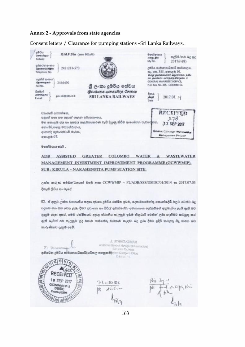
163
Annex 2 - Approvals from state agencies
Consent letters / Clearance for pumping stations –Sri Lanka Railways.

164

165
Consent letter/ Clearance for pumping stations – UDA.

166
Consent letter / Clearance for sewer pipe laying –SLLRC&DC

167
Consent letter- Land Reform Commission

168
Consent Letter – Ministry of Megapolis & Western Development

169
Letter 1-Resettling households located in the land belongs Sri Lanka Railways

170

171
Letter 2-Resettling households located in land belongs Sri Lanka Railways

172

173
Letter 3-Resettling households located in land belongs Sri Lanka Railways

174

175
Letter 4-Resettling households located in land belongs Sri Lanka Railways

176

177
Letter 5-Resettling households located in land belongs Sri Lanka Railways

178

179
Annex 3 – ADB Rapid Environmental Assessment Checklist – Sewage treatment

180

181
Annex 4 - Thimbirigasyaya DSD

182
Annex 5 - Kirula- Narahenpita sewer network key map

183
Annex 6 - Types of Manholes

184

185
Annex 7 – List of flora and fauna recorded in the study area
List of Flora Recorded in the Study area - None of the species are threatened or
endangered species.
Scientific Name Common Name
Amaranthus viridis Koora thampala Mangifera indica Amba Annona muricata Katu anoda Allamanda cathartica Wel Rukattana Alstonia scholaris Rukattana Dragia volubilis Aguna Tabernaemontana divaricata Wathusudda Alocasia macrorrhizos Habarala Cocos nucifera Pol Mikania micrantha Wathu paalu Cleome viscosa Wal aba Terminalia arjuna Kumbuk Terminalia catappa Kottamba Ipomea sp. Elaeocarpus serratus Weralu Flueggea leucopyrus Katu pila Ricinus communis Endaru Acasia melanoxylon Acasia Calopogonium mucunoides Clitoria ternatea Katarolu Crotalaria sp. Delenox regia Mai mara Gliricidia sepium Watahiriya Leucaena leucocephala Ipil Pithecellobium dulce Andara Senna alata Eth-thora Senna occidentalis Pani thora Senna sophera Tamarindus indica Siyambala Tectona grandis Thekka Taxillus sp. Pilila Ceiba pentandra Pulun imbul Grewia sp. Jam Urena lobata Epala Artocarpus heterophyllus Kos

186
Artocarpus altilis Del Ficus pumila Ficus racemosa Attikka Ficus sp. Nuga Psidium guajava Pera Syzygium cumini Maa-dan Nyctanthes arbor-tristis Sepalika Averrhoa bilimbi Bilin Ixora macrothyrsa Rath-mal Morinda citrifolia Ahu Macaranga peltata Kenda Filicium decipines Pihimbiya Pouteria campechiana Rata lawulu Scheleichera oleosa koan Citrus grandis Jambola Vitex trifolia Nika

187
List of Terrestrial and Aquatic Fauna Recorded in the Study area - None of the
species are endangered or threatened species.
Reptiles
Family Scientific Name Common Name (English)
Agamidae Calotes Garden lizard
Agamidae Calotes versicolor Common garden lizard
Geckonidae Hemidactylus parvimaculatus Spotted house gecko
Varanidae Varanus bengalensis Land monitor
Varanidae Varanus salvator Water monitor
Birds
Family Scientific Name Common Name (English)
Alcedinidae Halcyon smyrnensis White breasted kingfisher
Ardeidae Ardeola grayii Indian Pond heron
Ardeidae Egretta garzetta Little egret
Columbidae Columba livia domestica Domestic pigeon
Columbidae Stigmatopelia chinensis Spotted dove
Corvidae Corvus splendens House crow
Cuculidae Centropus sinensis Greater coucal
Dicruridae Dicrurus caerulescens White bellied drongo
Muscicapidae Copsychus saularis Oriental magpie-robin
Nectariniidae Nectarinia zeylonica Purple rumped sunbird
Rallidae Amaurornis phoenicurus White breasted waterhen
Sturnidae Acridotheres tristis Common Myna
Timaliidae Turdoides affinis Yellow bellied babbler
Mammels
Family Scientific Name Common Name (English)
Canidae Canis lupus familiaris Domestic dog
Cercopithecidae Macaca sinica Sri Lankan torque monkey (Endemic species)
Felidae Felis catus Domestic cat
Muridae Bandicuta indica Malabar bandicoot
Muridae Rattus Common rat
Sciuridae Funambulus palmarum Palm squirrel
Butterflies

188
Family Scientific Name Common Name (English)
Hesperiidae Taractrocera maevius Common grass dart
Lycanidae Spalgis epeus Ape fly
Nymphalidae Elymnias hypermnestra Common palm fly
Nymphalidae Mycalesis perseus Common bush-brown
Nymphalidae Ypthima ceylonica White four ring
Pieridae Catopsilia pyranthe Mottled emigrant
Pieridae Delias eucharis Common Jezebel
Pieridae Leptosia nina Psyche
Freshwater fish
Family Scientific Name Common Name (English)
Poeciliidae Poecilia reticulata Guppy
Dragonflies
Family Scientific Name Common Name (English)
Libellulidae Orthetrum sabina Green skimmer
Libellulidae Potamarcha congener Blue Pursuer
Libellulidae Trithemis aurora Crimson Dropwing

189
Annex 8 – Additional data for Chapter 6
Properties located facing the road edges in sub-project-Kirula area
Sewer
Name Road name
Number of
houses
No of
vulnerab
le houses
Number of
public
institutions
Number of
business
establishments
Number
of mobile
vendors
No of three wheel
parks
DM1
Kinda Canal road 6 - 1 - - -
Heen Ela road 22 12 - - 2 -
E.Victor Dabare road 39 17 - 2 3 -
Muhandiram E.Dabare
road 7 2 2 11 2 -
DM2 Muhandiram E.Dabare
road 7 - - 4 2 -
DM3
Kinda Canal road 4 - - - - -
1st cross street 16 - - - - -
circular road A 16 - - - - -
Evergreen Park road 4 - 1 - - -
DM4 Kinda Canal road 6 - - - - -

190
circular road B 13 - 1 - - -
Evergreen Park road 8 - 2 - - -
DM5 Kirimandala road 9 - 4 12 - 1
Evergreen Park road 8 6 3 3 - -
DM6 Kirimandala road - - 2 - - -
DM7 9th lane 6 - - - - -
Center road 11 - - - - -
DM8 Center road 4 - - - - -
DM9 Kinda Canal road - - 1 - - -
DM10 D5-2-15 to D5-2-13 10 - - - - -
DM11 1st lane 12 - - - - -
DM12 2nd lane 6 - - - - -
DM13 3rd lane 6 - - - - -
DM14 4th lane 6 - - - - -
DM15 5th lane 9 - - - - -

191
DM16 6th lane 15 - - - - -
DM17 Center road 2 - - - - -
7th lane 4 - - - - -
DM18 Center road 5 - - - - -
8th lane 4 - - - - -
DM19 Muhandiram E.Dabare
road 25 - 4 5 3 1
DM20 D7-5 to D7-4, D7-1 to
D7 56 28 1 2 3 -
DM21 D7-5 toD13-11 58 29 - 2 3 -
DM22 Circular Road A 7 - - - - -
DM23 3rd lane 5 - - - - -
DM24 2nd lane 5 - - - - -
DM25 Center road 6 - - - - -
Total 421 94 22 41 18 2
Source : Socio-economic survey Team

192
Properties located facing the road edges in sub-project-Narahenpita area
Sewer
Name Road Name
Number of
houses
No of
vulnerable
houses
Number of
public
institutions
Number of
business
establishments
Number of
mobile
vendors
No of three
wheel parks
NR1
Kirimandala
mawatha 1 - 5 6 - -
Kinda Canal
Road 6 - 11 3 - -
Nawala Road 1 - 22 9 - -
N8 - N3 - - 1 1 - -
N3 - N2 - - - - - -
NR2 N6-3 To N6-2 - - 2 - - -
N6-2 to N5 - - 6 - - -
NR3 N6-5 to N6-1 - - 7 - - -
NR4
N5-14 to N5-8 - - 7 - - -
Elvitigala
mawatha - - 5 - - -

193
Nawala Road - - 8 8 2 1
NR5 N5-10 to N5-9 4 - 1 - - -
NR6 N5-13 to N5-11 12 - - 1 - -
NR7 N51-1 to N5-1 - - 2 - - -
NR8 Pichchamal
watte road 13 13 1 2 3 -
NR23 N8-1 to N7 32 32 - 1 3 -
NR24 N8-2 to N8 - - 3 - - -
NR9 N9-2 to N9 2 - 9 - - -
NR10 N9-4 to N9-3 5 - 2 - - -
N-3 to N9 4 - 3 - - -
NR11 N10-3 to N10 1 - 2 - - --
NR12 N10-4 to N10-2 2 - 2 - - -
NR13 N11-4 to N11 6 - 1 2 - -
NR14 N13-1 to N11-3 3 - - - - -
NR15 N11-2 to N11 5 - 5 - - -

194
NR16 N14-1 to N13 6 - 3 - - -
NR17 N14-9 to N 15 21 - 6 2 - -
NR18 N14-8 to N14-4 17 9 - - 2 -
NR19
Sri
Saddarmarama
Mawatha
2 - 2 - - -
NR20 Lake drive road 8 - 3 - - -
NR21
Sri
Saddarmarama
Mawatha
6 - 3 1 - -
NR22 Economic Center
road 1 - 4 - - -
Total 158 54 126 36 10 1
Source : Socio-economic survey Team
Basic socio-economic profile of households (HH) to be resettled
Detail HH1 HH2 HH3 HH4 HH5

195
Name M I S Marikkar M L Mohommad E Tuan Amjan B. Harrel Chandrasiri
Perera
M. G. M. Nausser
Address 5/2/A. Dabare
Mawatha,
Narahenpita,
Colombo 5
No 5/2/B, E D
Dabare Mawatha,
Narahenpita,
Colombo 5
5/2/1, Dabare
Mawatha,
Narahenpita,
Colombo 5
5/1,Daabare Mawatha,
Narahenpita, Colombo 5
5/2, Dabare Mawatha,
Narahenpita, Colombo 5
NIC no 621682890V 661691786V 681782745V 710612439V 742742156V
Tel no 0777717278 0755539716 0712338120 0715484761 0718015368
Employ
ment
Mechanic Labor Private Sector Government -Office
Assistant
Private Sector
Monthly
income
(Rs)
25000 25000 28000 20000 24000
Ethnicity Muslim Muslim Muslim Sinhala Muslim
Religion Islam Islam Islam Buddhist Islam
Age 56 52 49 46 44
Educatio
n Grade 8 Grade 6 O/L O/L Grade 10

196
Details of the affected house and other properties
Detail HH1 HH2 HH3 HH4 HH5
Affected
property Entire house Entire House Entire House Entire House Entire House
Area of the
property
(sq.feet)
874 450 570 825 570
Roof type Asbestos Asbestos Asbestos Asbestos Asbestos
Wall type Concrete
Block
Concrete
Block
Concrete
Block
Concrete
Block
Concrete
Block
Floor type Cement Cement Cement Cement Cement and
tile
Approximate
value 0.5 mil 0.5 mil 0.5 mil 0.5 mil 0.5 mil

197
Legal status of the property
Legal status
and other
details
HH1 HH2 HH3 HH4 HH5
Ownership Encroacher Encroacher Encroacher Encroacher Encroacher
Tenure Owner Owner Owner Owner Owner
History of
occupancy
48 years 52 years 47 years 46 years 42 years
Present user Owner Owner Owner Owner Owner
Note – House hold (HH1) belongs Mr.M.I.S Marikkar is also occupied by a sub family in which information is provided in Table
6.19.

198
Household income
Detail HH1 HH2 HH3 HH4 HH5
Household size 6 6 5 7 7
Gender of chief
householder Male Male Male Male Male
Household type Extended
(one sub
family)
Nuclear
Family
Nuclear
Family
Nuclear
Family
Nuclear
Family
Number of
employed
persons
2 2 1 3 2
Income of chief
householder 25000 25000 28000 20000 24000
Family income 45000 55000 28000 52000 42000
Per capita
monthly income 7500 9170 5600 7430 6000

199
Other information identifies the vulnerability status
Vulnerability Details HH1 HH2 HH3 HH4 HH5
Has alternative house No No No No No
Has alternative land No No No No No
Received samurdhi benefits No Yes No No No
Received other government
subsidies No No No No No
Disabled No Yes No No No
Widow with employment No No No No No
Widow without
employment No No No No No
Chief householder above 61
years No No No No No
Household income below
poverty line No No No No No
Chief house holder
chronically ill Yes No No No No
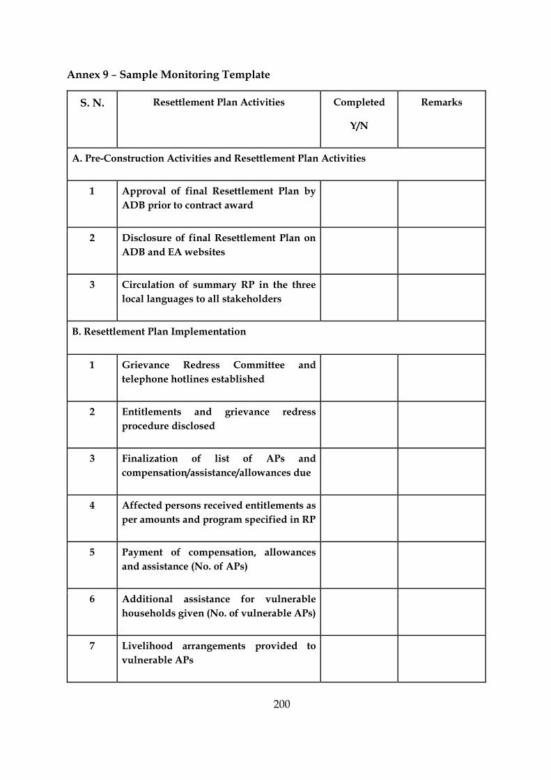
200
Annex 9 – Sample Monitoring Template
S. N. Resettlement Plan Activities Completed
Y/N
Remarks
A. Pre-Construction Activities and Resettlement Plan Activities
1 Approval of final Resettlement Plan by
ADB prior to contract award
2 Disclosure of final Resettlement Plan on
ADB and EA websites
3 Circulation of summary RP in the three
local languages to all stakeholders
B. Resettlement Plan Implementation
1 Grievance Redress Committee and
telephone hotlines established
2 Entitlements and grievance redress
procedure disclosed
3 Finalization of list of APs and
compensation/assistance/allowances due
4 Affected persons received entitlements as
per amounts and program specified in RP
5 Payment of compensation, allowances
and assistance (No. of APs)
6 Additional assistance for vulnerable
households given (No. of vulnerable APs)
7 Livelihood arrangements provided to
vulnerable APs

201
8 Reinstallation of affected common
facilities
9 Grievances
No. of grievances registered
No. of grievances redressed
Outstanding complaints
Disclosure of grievance redress statistics
10 Consultation, participation and disclosure
as per Plan
C. Monitoring
1 Survey on socio-economic status of APs
(including vulnerable APs) completed and
compared with baseline survey results
2 Survey on satisfaction levels of APs with RP
implementation completed
D. Labor
1 Implementation of all statutory provisions
on labor like health, safety, welfare,
sanitation, and working conditions by
Contractors
2 Equal pay for equal work for men and
women
NOTE: Where applicable, the information provided in the table should be
supported by detailed explanatory report, receipts and other details.

202
Annex 10 – Views of the Stakeholders
Date Stakeholder Views
8/5/2017 Thimbirigasyaya DS and Kirula and Narahenpita GNs
This is a development need for the Kirula and Narahenpita area, With the increased population managing sewerage within the home garden is becoming a social and serious environmental problem, it is an essential need to educate the general public and operators of all public and private institutions within the project area on the details of the proposed project, the maintenance activities of the sewer system established should be handled by CMC..
9/5/2017 Officers and owners of private and public institutions located in the vicinity of the roads to be used for the project
Most of the institutions are facing difficulties to manage their sewerage disposal system within the premises due to some problems with the limitation of land extents and high level of ground water, all the relevant public and private institutions should be made aware of the proposed project before its construction phase is begun. The institutions must be facilitated to find alternative access to their places during construction phase.
12/5/2017 Religious Leaders The communities in underserved settlements frequently discharged their overflowing wastewater from the septic tanks to the storm water drainage canals in the area; this behaviour has created critical environmental and social problems to the area as whole. The proposed project area is highly populated and therefore establishment of main sewer network is an appropriate intervention.
14/5/2017 Community leaders This is going to be an essential project for the communities specially residing in underserved settlements such as 21watte, 37watte, 100watte, 26watte, 84watte, Pichchamalwatte and 80watte. This project will address the existing social, environment and public health related issues such as odour, wastewater stagnation and water borne diseases. At present the septic tanks or soakage pits in small home gardens overflow frequently and therefore householders are compelled to hire gully bowsers spending Rs. 2000-3000 at every 5-6-month interval
15/5/2017 Members of General Public
It is difficult to take gully bowsers into interior locations of the settlements due to extremely narrow roads. The proposed project should be implemented even in the interior areas as far as possible where low income households are located in narrow lanes.

203
Annex 11 - Sample Grievance Registration Form (To be available in Sinhala, Tamil and English)
The Greater Colombo Wastewater Management Improvement Investment Program welcomes
complaints, suggestions, queries and comments regarding project implementation. We encourage
persons with grievance to provide their name and contact information to enable us to get in touch with
you for clarification and feedback. Should you choose to include your personal details but want that
information to remain confidential, please inform us by writing/typing *(CONFIDENTIAL)* above
your name. Thank you.
Date Place of registration
Contact Information/Personal Details
Name Gender * Male
* Female
Age
Home Address
Place
Phone no.
Complaint/Suggestion/Comment/Question Please provide the details (who, what, where and how) of your
grievance below:
If included as attachment/note/letter, please tick here:
How do you want us to reach you for feedback or update on your comment/grievance?

204
FOR OFFICIAL USE ONLY
Registered by: (Name of Official registering grievance)
Mode of communication:
1. Note/Letter 2. E-mail 3. Verbal/Telephonic
Reviewed by: (Names/Positions of Official(s) reviewing grievance)
Action Taken:
Whether Action Taken Disclosed:
4.
Yes No
Means of Disclosure:

205
Annex 12 - List of Preparers
Name of Consultant Designation Position in IEE Program Qualifications Signature
Dr (Eng). G.G. Tushara Chaminda
Senior Lecturer
/DCEE/ FoE / UoR
Team Leader and EIA Specialist
PhD (Kyoto)
MEng. (AIT),
BSc-Eng. (Hons) (Peradeniya), C.Eng, MIE (SL)
Dr (Eng). W. K. C. Neetha Dayanthi
Senior Lecturer
/DCEE/ FoE/ UoR
Water and Wastewater Engineer
Ph.D (Tokyo),
M.Eng (AIT),
B.Sc-Eng. (Hons) (Peradeniya)
AMIE (SL)
Dr (Eng). W.M.K.R.T.W. Bandara
Senior Lecturer
/DCEE/ FoE / UoR
Environmental Engineer and Environmental Economist
PhD (Hokkaido, Japan)
BSc-Eng. (Hons) (Peradeniya)
AMIE (SL)
Dr (Eng). Champika Ellawala
Senior Lecturer
/DCEE/ FoE / UoR
Environmental and Ecological Engineer
PhD (Saitama),
MSc (Moratuwa),
BSc-Eng (Hons)(Moratuwa)
AMIE (SL)
Dr (Eng). T.N. Wickramaarachchi
Senior Lecturer
/DCEE/FoE/ UoR
Hydro-Environmental Engineer
Ph.D. (Yamanashi),
M.Phil. (Moratuwa),
B.Sc-Eng. (Hons) (Moratuwa)
AMIE (SL)
Dr (Eng). G.H.A.C. Silva Senior Lecturer
/DCEE/ FoE/ UoR Hydrologist
Ph.D. (Tokyo),
M.Eng. (Tokyo),
B.Sc-Eng. (Hons) (Moratuwa)
C.Eng, MIE (SL)
206
Dr (Eng). N.H. Priyankara Senior Lecturer
/DCEE/ FoE/ UoR Geologist
PhD (Tohoku),
MEng. (AIT),
BSc-Eng (Hons) (Moratuwa)
C.Eng, MIE (SL)
Prof. T.P.D. Gamage
Professor
/Dept of Limnology
/Faculty of Marine Science & Technology/ UoR
Biologist and Ecologist
PhD (Saitama, Japan),
BSc –Biology (Hons) (Ruhuna)
Prof. Mallika Pinnawala
Professor (Sociology)/ Department of Sociology/University of Peradeniya
Sociologist
BA (Sociology-Hon),
MA (By Research),
PhD (The Netherlands)
Eng. Kasun Wimalasena Lecturer/DCEE/ FoE/ UoR
Traffic and Transportation Engineer
MSc. (Tokyo, Japan),
BSc-Eng. (Hons) (Moratuwa)
UoR – University of Ruhuna;
FoE – Faculty of Engineering
DCEE – Department of Civil and Environmental Engineering