
Environmental Impact Report - European Investment Bank
174
HPZZINo. B2606 YH No.2004-29 Yichang Changfeng Hydropower Development Co., Ltd. Changfeng Hydropower Project Environmental Impact Report (For Approval) Construction by:Yichang Changfeng Hydropower Development Co., Ltd. Prepared by: Scientific Research Institute for Environmental Protection of Xiangfan City Yichang Environmental Protection Design and Research Institute Date: September 2004
-
Upload
khangminh22 -
Category
Documents
-
view
1 -
download
0
Transcript of Environmental Impact Report - European Investment Bank

HPZZINo. B2606 YH No.2004-29
Yichang Changfeng Hydropower Development Co., Ltd.
Changfeng Hydropower Project
Environmental Impact Report (For Approval)
Construction by:Yichang Changfeng Hydropower Development Co., Ltd.
Prepared by: Scientific Research Institute for Environmental Protection of
Xiangfan City
Yichang Environmental Protection Design and Research Institute
Date: September 2004

Table of Contents
1.INTRODUCTION ··············································································································································1
1.1 Project Outline and Background 1
1.2 Purpose of Assessment 2
1.3 Reference documents 2
1.3.1 Laws and Regulations 2
1.3.2 Technical Guidelines 3
1.3.3. Relevant Documents 4
1.3.4 工程设计文件 ····················································· Error! Bookmark not defined.
1.3.4 Design Documents 4
1.4 Objective of Damage Control and Ecological Environment Protection 4
1.5 Grade and Scope of Assessment 5
1.5.1 Water Environment 5
1.5.2 Ecological environment 6
1.5.3 Atmospheric Environment and Noise Environment 6
1.6 Assessment Standard 6
1.6.1 Environmental Quality Standard 6
1.6.2 Pollutant Discharge Standard 6
1.7 Assessment Period 6
1.8 Main Points of Assessment 6
2 Project Overview 8
2.1 Valley Overview 8
2.2 Location, Tasks, Scale and Layout of the Project 9
2.2.1 Project Location 9
2.2.2 Tasks and Scale of Project 9

2.2.3 Project Layout 10
2.3 Reservoir Inundation and Permanent Land Use 12
2.3.1 Reservoir Inundation and Loss 12
2.3.2 Permanent Land Use 13
2.4 Project Construction Plan 13
2.4.1 Construction Condition 13
2.4.2 Construction and Diversion 14
2.4.3 Construction of Main Buildings 14
2.4.4 Construction Layout 16
2.4.5 Earth Rock Volume and Construction Volume 16
2.5 Waste Residue Plan 16
2.6 General Construction Schedule 17
2.7 Project Management 18
2.7.1 Project Management 18
2.7.2 Labor Safety and Industrial Sanitary Design 18
2.8 Investment and Profit 18
2.9 Project Characteristics 19
2.10 Construction Pollution Analysis 27
2.10.1Main factor and measures of environmental impact during construction
period 27
2.10.2 Reservoir Inundation Period 32
2.10.3 Project Operation Period 33
3 Existing Environment 34
3.1 Natural Environment Introduction 34

3.1.1 Natural Condition 34
3.1.2 Climate 34
3.1.3 Regional Geological Environment 36
3.1.4 Geological Environment of Reservoir Construction 37
3.1.5 Engineering Geological Condition of Dam Site 38
3.1.6 Runoff and sediment 39
3.1.7 Soil 40
3.1.8 Vegetation and aquatic organisms 40
3.2 Water & soil loss and water & soil conservation 42
3.2.1 Existing water and soil Loss in project site 42
3.2.2 Existing water and soil conservation in project site 42
3.3 Social environment 43
3.3.1 Social economic condition of Changyang County 43
3.3.2 Social and economic condition of project site 44
3.3.3 Population health and main diseases 45
3.4 Exiting environment quality and assessment 45
3.4.1 Existing environmental air quality and assessment 45
3.4.2 Existing surface aquatic environment quality monitoring and assessment 47
3.4.3 Existing noise monitoring and assessment 48
3.4.4 Assessment on existing ecological environment quality 49
3.5 Main environmental problems 51
4 Prediction and assessment on environmental impact 52
4.1 Hydrology and sediment 52
4.1.1. Hydrology 52
4.1.2 Sediment 52

4.2 Local climate 53
4.3 Environmental geology 54
4.3.2 Leakage analysis 54
4.3.2. Stability analysis 55
4.4 Estimation (analysis) and assessment on aquatic environmental impact 56
4.4.1 Pollutant analysis 56
4.4.2 Estimation and assessment of reservoir water quality 57
4.4.3 Reservoir water temperature estimation 60
4.5 Analysis and assessment on ecological environmental impact 62
4.5.1 Assessment on the integrity of ecological environment 62
4.5.2 Analysis of impact on terrestrial plant 63
4.5.3 Analysis of impact on terrestrial animals 64
4.5.4 Analysis of impact on aquatic organism 64
4.5.5 Impact of tunnel construction on ecological environment 65
4.6 Analysis and assessment on water & soil loss 66
4.6.1 Destroyed area of water and soil conservation faculties 66
4.6.2 Quantity of waste earth and disposal 68
4.6.3 Prediction of new water and soil loss 68
4.7 Analysis on environmental impact of reservoir inundation and immigration
settlement 71
4.7.1 Index of reservoir inundated items 71
4.7.2 Analysis on immigration environmental capacity and impact 71
4.8 Analysis on impact of population health 72
4.9 Analysis of impact on social economy 73
4.10 Analysis and assessment on impact of project construction 74

4.10.1 Analysis of impact on wastewater in construction period 74
4.10.2 Environmental air quality 76
4.10.3 Noise environment 77
4.10.4 Solid waste 79
4.11 Analysis of impact on Geheyan hydropower project of Changfeng hydropower
project construction 79
5. Analysis of environmental risk 81
5.1 Risk identification 81
5.2 Dam break risk 81
5.2.1 Risk identification 81
5.2.2 Risk analysis 81
5.2.3 Risk alleviation 83
5.3 Environmental geological risk 83
6. Measures and recommendations for environmental protection 84
6.1 水环境保护对策及建议 ······································ ERROR! BOOKMARK NOT DEFINED.
6.1 Measures and recommendations for aquatic environmental protection 84
6.1.1 Control measures and recommendations in construction period 84
6.1.2 Protection measures and recommendations during operation period 86
6.2 Precautions and suggestions for air pollution 87
6.3 Noise control 87
6.4 Disposal of solid waste 88
6.5 Ecological environmental protection 88
6.5.1 Terrestrial animals 88
6.5.2 Aquatic organism 89
6.5.3 Other recommendations for ecological protection 89
6.6 Measures for water and soil conservation 89
6.6.1 Responsibility of water and soil loss control 89
6.6.2 Instructional recommendations 90
6.6.3 Control objectives of water and soil conservation 90
6.6.4 General layout of water and soil conservation measures 91
6.6.5 Main training plans 92
6.7 Protection on public health 92
6.7.1 Clean the reservoir bed 93
6.7.2 Sanitary and anti-epidemic plan 94
6.7.3 Public hygienic facility 95
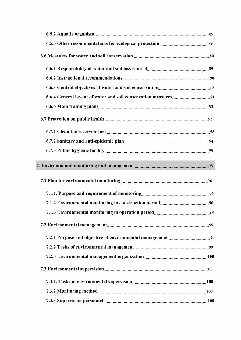
7. Environmental monitoring and management 96
7.1 Plan for environmental monitoring 96
7.1.1. Purpose and requirement of monitoring 96
7.1.2 Environmental monitoring in construction period 96
7.1.3 Environmental monitoring in operation period 98
7.2 Environmental management 99
7.2.1 Purpose and objective of environmental management 99
7.2.2 Tasks of environmental management 99
7.2.3 Environmental management organization 100
7.3 Environmental supervision 100
7.3.1. Tasks of environmental supervision 100
7.3.2 Monitoring method 100
7.3.3 Supervision personnel 100

8. Analysis on environmental protection investment and its profit and loss 101
8.1 Investment estimation of environmental protection 101
8.1.1 Investment principles 101
8.1.2 Estimation basis 101
8.1.3 Classification of investment projects 101
8.1.4 Major environmental investments 102
8.2 Analysis on economic profit and loss of ecological impact 103
8.2.1 Economic benefit 103
8.2.2 Social Benefit 103
8.2.3 Ecological effect 104
8.2.4 Environmental effect 104
8.2.3 Comprehensive analysis on environmental economic profit and loss 104
9. Public participation 105
9.1 Scope, mode and content of public participation 105
9.1.1 Mode, object and scope of participation 105
9.1.2 Content of questionnaire 105
9.2 Statistic analysis on survey result 106
9.2.1 Basic information of the surveyed persons 106
9.2.2 Statistic analysis on feedbacks 107
9.2.3 Most Concerned problems of the public 109
9.3 Conclusion and suggestion of public participation 110
10. Conclusions and suggestions 111
10.1 Assessment conclusion of major environmental factors 111

10.2 Measures and conclusion of environmental protection 113
10.3 General assessment and conclusion 114
10.4 Suggestions 114
Figures:
Figure 1:Location of the project
Figure 2: General floor plan of the project
Figure 3: floor plan of dam site Figure 4: floor plan of power house
Figure 5: General floor plan of project construction
Figure 6: Regional geological conditions
Figure 7 : Engineering geological conditions of dam site
Figure 8: Monitoring Station Layout for environment air
Figure 9: Layout of surface water quality monitoring faces
Appendixes:
Attachment 1:Changyang Tujia Autonomous County Bureau of Development and
Planning,CJ No. [2004]30, Approval for the Project Proposal of Changfeng Hydropower
Station and Lengshuiqiao Hydropower Station by Bureau of Development and Planning,
March, 29th, 2004.
Attachment 2:Letter of Authorization on Writing the Report for Environmental
Impact of Changfeng Hydropower Station by Yichang Changfeng Hydropower
Development Co., Ltd.

Attachment 3:Approval of executive standard for Report on Environmental Impact of
Changfeng Hydropower Project by Yichang Changfeng Hydropower Development Co.,
Ltd.
Appendix 4: Commitment Made by Villagers' Committee of Bajiaomiao on Drinking
Water Problem for Human Beings and Livestock within Construction Influence Area of
Changfeng Hydropower Project;
Appendix 5: Commitment Made by Changyang Tujia Autonomous County
Government on Resident Relocation within Construction Influence Area of Changfeng
Hydropower Project;
Appendix 6: Approval for Assessment Outline and Experts' Review Comments on It;
Attachment 7: Review Comments and Member List of Experts for Report on
Environmental Impact of Changfeng Hydropower Project by Yichang Changfeng
Hydropower Development Co., Ltd.
Appendix 8: Approval Sheet for Environmental Protection of Construction Project.

1. Introduction
1.1 Project Outline and Background
Changyang Tujia Autonomous County is located at southwest mountain area in Hubei Province, at
the middle and downstream of Qingjiang River Valley. The county is at longitude 110°21′-111°20′ E and
latitude 30°12′-30°46′ N, covering an area of 3430 km2, which is governed by Yichang municipal
government, Hubei Province. Changyang Tujia Autonomous County has 11 towns, which include 154
villages with population of 415000 in total. This county is mainly located at mountain area, with
Qingjiang River running through it from west to east. The county boasts abundant resources, especially
water energy, minerals, forestry and tourism. Changyang Tujia Autonomous County has achieved great
development both in social and economic aspect. With more and more industrial enterprises, stronger
economic power and increasingly improved infrastructures including transportation, communication and
energy industry, the county is ready for new industry. The total GDP of the county has reached 2.6
billion in 2002.
Ganhe Creek is the largest branch at the left bank of downstream from Zhaolai River, the secondary
branch of Qingjiang Water System, which originates from Guanjianao at 1998m altitude. The main
watercourse of Ganhe Creek is 34.2m long, covering 183.5km2 drainage areas, with height difference of
1694m, and weighted average watercourse descent of 34‰. The theoretical reserves of the main stream
are 23000kw, among which the theoretical reserves of river running through Changyang are 19400kw.
Changyang has rich hydropower resources. Ganhe Creek water energy development is planned as
follows: the first level runoff hydropower station on Zhichang Creek upstream from the River, Longtan
hydropower station has 2×320kW installed capacity; the planned secondary hydroelectric power station,
Changfeng hydropower station has 2×5000kW installed capacity; the planned third-level runoff
hydropower station downstream Zhichang Creek, Dengjia River hydropower station has 2×200kW
installed capacity; the Qiyan Creek hydropower station has 2×1000kW installed capacity and the Ganhe
Creek hydropower station has 2×1250kW installed capacity. Yichang Water Resources & Hydropower
Bureau has approved the above plan by issuing the YSS [2004] document.

In May 2004, Yichang Changfeng Hydropower Development Co., Ltd. entrusted Yichang
Qingjiang Design and Investigation Institute of Hydropower to finish the preliminary design report for
Changfeng Hydropower Project in Changyang, Hubei. According to applicable local and national laws
and regulations for environmental protection, Yichang Changfeng Hydropower Development Co., Ltd.
entrusted Yichang Environmental Protection Design and Research Institute of on July 19th, 2004 to
assess environmental impact of the project. With field exploration, investigation and information
collection, Yichang Environmental Protection Design and Research Institute finished Assessment
Outline for Environmental Impact of Changfeng Power Station and Lengshuiqiao Power Station built
by Yichang Changfeng Hydropower Development Co., Ltd. (thereafter referred to as the assessment
outline) The assessment outline is made according to Law on Environmental Impact Assessment of
People’s Republic of China and Technical Guidelines for Environmental Impact Assessment, Decree
No.253 of the State Council of the People’s Republic of China, Regulations on the
Administration of Construction Project Environmental Protection, and the industrial standard
of environmental protection of People’s Republic of China. On August 19th, 2004, experts from Yichang
Bureau of Environmental Protection examined the assessment outline and gave comments on it. The
Report on Environmental Impact of Changfeng Hydropower Project with Yichang Changfeng
Hydropower Development Co., Ltd. is made based on the above comments from experts. On September
24th, 2004, Yichang Bureau of Environmental Protection held a meeting to appraise the report and
amended it according to the group suggestions of the attended experts. The report is handed over to the
construction company to be submitted to relevant authority of environmental protection for further
examination and approval.
1.2 Purpose of Assessment
Through field exploration, investigation and inspection on environment status quo and public
survey, we investigated the natural and social environment of Changyang Tujia Autonomous County in
Hubei Province, where Changfeng Hydropower Station is located, analyzing the main environmental
problems and giving thorough and systematic assessment on the positive and negative impact on natural
environment, social environment and ecological environment of project construction, reservoir
inundation and project operation. Regarding the negative environmental impact of the project, we raise
practical measures for environmental protection and remedy measures to reduce the negative impacts, so

as to fully display the positive impact. All measures aims to ensure that the project improves social and
economic development and protect local ecological environment as well.
The assessment on environmental impact of the project can also be used as evidence for
environmental feasibility of the project. The assessment helps to complete the design documents of the
project and promotes project construction. The assessment also provides scientific evidence for
environment management, supervision and examination.
1.3 Reference documents
1.3.1 Laws and Regulations
(1) Environmental Protection Law of the People’s Republic of China (1986.12)
(2) Law of the People’s Republic of China on Appraising of Environmental Impact
(2003.9)
(3)Water Law of the People’s Republic of China (2002.8 revised)
(4) Land Administration Law of the People’s Republic of China (1998 revised)
(5) Law of the People’s Republic of China on the Prevention and Treatment of
Infectious Diseases (1989.2)
(6) Law of the People’s Republic of China on Water and Soil Conservation (1991.6)
(7) Forest Law of the People’s Republic of China (1998 revised)
(8) Law of the People’s Republic of China on the Protection of Wild Life (1988.11)
(9) Fisheries Law of the People’s Republic of China (2000.10)
(10) Law of the People’s Republic of China on the Prevention and Control of Water
Pollution (2002.11)
(11) Law of the People’s Republic of China on the Prevention and Control of
Atmospheric Pollution (2000.4 revised)
(12) Law of the People’s Republic of China on the Prevention and Control of
Environmental Noise Pollution (1997.3)
(13) Regulations on the Administration of Construction Project Environmental
Protection (1998.11)
(14) Administration Measures for Water and Soil Conservation Plan of Construction
Project (1994.11)

(15) Regulations on the Sanitary Administration in Public Places (1987.4)
(16) Measures for the Implementation of the Law of the People’s Republic of China
on the Prevention and Treatment of Infectious Diseases (1991.12)
(17) Classified Administration Directory for Construction Project Environmental
Protection (Decree No.253 of the State Council, 1998)
(18) Notice on Improving Public Consultation for Environmental Impact Appraising
of Construction Project (EHB No.2003) and other applicable regional and national laws
and regulations.
1.3.2 Technical Guidelines
(1) Technical Guidelines for Environmental Impact Assessment, Non-Polluted
Ecological Impact (HJ/T19-1997)
(2) Technical Guidelines for Environmental Impact Assessment (HJ/T2.1~2.3-93)
(3) Technical Guidelines for Environmental Impact Assessment-Noise Environmental
Impact (HJ/T2.4-1995)
(4) Technical Guidelines for Environmental Impact Assessment on Water
Conservancy and Hydropower Projects (SDJ88-2003)
(5) Technical Guidelines for Environmental Impact Assessment-Water Conservancy
and Hydropower Projects (HJ/T88-2003)
(6) Technical Specifications for Medical Assessment of Environmental Impart on
Water Conservancy and Hydropower Projects (GB/T16124-1995)
(7) Technical Regulations on Water and Soil Conservation Plan of Development and
Construction Projects (SL204-98)
(8) General Rules of Planning for Comprehensive Control of Water and Soil
Conservation (GB/T15772-1995)
(9) Technical Regulations for Comprehensive Control of Water and Soil Conservation
(GB/T16543-1996)
(10) Lists of Wild Plants under Special State Protection (first list) (1999.8)
(11) Lists of Wildlife under Special State Protection (1989.1)
(12) Lists of Terrestrial Wildlife under Special Protection of Hubei Province (1994.6)

(13) List of Aquatic Animal under Special Protection of Hubei Province (1994.12)
(14) Technical Standard for Disinfection (Promulgated by Ministry of Health in 1992)
(15) Technical Specifications Requirments for Monitoring Surface Water and Waste
Water (HJ/T91-2002)
(16) Sanitary Standard for Drinking Water Quality (2001.6) and other technical
regulations
(17) Rules for Environmental Assessment of Rural Hydropower Station
(18) Standards for Classification and Gradation of Soil Erosion (SL190-96)
1.3.3. Relevant Documents
(1) CJ No. [2004]30, Approval for the Project Proposal of Changfeng Hydropower
Station and Lengshuiqiao Hydropower Station by Bureau of Development and Planning,
Changyang Tujia Autonomous County, dated March, 29th, 2004. See Attachment 1.
(2) Assessment Outline on Environmental Impact of Changfeng Hydropower Station
and Lengshuiqiao Hydropower Station of Yichang Changfeng Hydropower Development
Co., Ltd. finished by Yichang Research Institute of Environmental Protection in August
2004.
(3) Letter of Authorization on Writing the Report for Environmental Impact of
Changfeng Hydropower Station by Yichang Changfeng Hydropower Development Co.,
Ltd., dated July 19th, 2004. See Attachment 2.
(4) Approval of Assessment Criteria for Environmental Impact of Changfeng
Hydropower Station. See Attachment 3.
(5) Letter of Examination for the Environmental Impact Assessment of Hydropower
Station Construction Project at Changfeng, Lengshuiqiao and Changshatou by Yichang
Changfeng Hydropower Development Co., Ltd., issued by Yichang Bureau of
Environmental Protection, dated September 6th, 2004, see Attachment 4.
(6) Review Comments and Member List of Experts for Report on Environmental
Impact of Changfeng Hydropower Project by Yichang Changfeng Hydropower
Development Co., Ltd., dated September 24th, 2004, see attachment 5.
1.3.4 Design Documents

(1) Draft Design Report of Changfeng Hydropower Project at Changyang, Hubei
Province, prepared by Yichang Qingjiang Design and Investigation Institute of
Hydropower dated May, 2004.
(2) Report on Water and Soil Conservation Plan of Changfeng Hydropower Project
at Changyang Hubei Province, prepared by Yichang Qingjiang Design and Investigation
Institute of Hydropower dated April, 2004.
1.4 Objective of Damage Control and Ecological Environment Protection
(1) Water Quality: control the waste discharge in order to protect the reservoir water
quality. During the construction period, the discharge density of waste water should be
controlled in accordance with GB8978-1996 Integrated Wastewater Discharge Standard
Level I. During Operation, the reservoir water quality should reach GB3838-2002
Environmental Quality Standard for Surface Water Level II.
(2) Surrounding Atmosphere Quality and Noise Environment
It should be ensured that project construction will not cause obvious damage to
surrounding atmosphere quality and noise environment. The surrounding atmosphere
quality inside the construction spot should meet the Standard for Surrounding Atmosphere
Quality (GB3095-1996) level II and the noise environment should meet the Standard for
Urban Regional Noise Environment (GB3096-93) level I.
(3) Water and Soil Loss: due to the excavation, filling, building and occupying
occurred during the project construction, the water and soil conservation function of the
land may be damaged or deprived, measures will be taken in time to recover or improve the
function and ensure that the treatment for water and soil conservation will reach 85% at
least. By precautions and treatment for additional water and soil loss, the control rate of
water and soil loss will be above 80% and the treatment rate of land disturbance will be
more than 60%. The waste residue will be well disposed. Thus the water and soil loss can
be controlled and treated.
(4) Vegetation: by controlling the damage to vegetation during project construction,
the vegetation on exposed soil surface inside the construction area will be mostly recovered
and reduces the negative impact on aquatic wildlife due to changed hydrological condition.

(5) Land resources: reduce waste residue disposal during project construction by land
reclamation, so as to reduce land loss due to the project construction.
(6) Society and Economy: make a complete population health plan for the
construction period and prevent any possible epidemic diseases during construction, work
to reduce the impact of air and noise pollution on construction staff and local residents.
Main Objectives for Environmental Protection (See Table 1-1)
Table 1-1 Objectives for Environmental Protection of Changfeng Hydropower Project Object
Protected Distance Position Span Protection Level
Ganhe Creek - -
River from 2km upstream end of
the dam site to hydropower
station outlet
Standard for Surface
Water Quality Level II
Lengshuiqiao
Restraurant
and local
residents
Within 500m to
Lengshuiqiao
hydropower
station
nearby 2-3 resident houses,small
restaurants
Surrounding
Atmosphere Quality
Level II, improved life
quality
1.5 Grade and Scope of Assessment
1.5.1 Water Environment
Changfeng Hydropower Project hardly discharges any waste water during
construction period, the project only impacts water environment during preliminary stages
of construction and and reservoir filling.
Water environment assessment standards: � waste water discharge: according to the
report of project feasibility study, waste water discharged during construction mainly
concludes washing waste from sandstone filling device, waste water discharged by
concrete production system and regular pit discharge, and domestic wastewater produced by
construction staff. During major construction period, wastewater discharge is 1758.7m3/d;
� complexity of wastewater quality: the main pollutant of wastewater discharged during
construction is SS, main pollutants of domestic are BOD5, COD and NH3-N, the
complexity of the wastewater quality is medium; � scale of surface water: average annual
flow of Ganhe Creek is 0.99m3/s, the scale of surface water is small river; � requirement
of surface water quality: the water quality in the project area should reach Standard for
Surface Water Environment Quality (GB3838-2002) level II. According to the criteria of

Technical Guidelines for Environmental Impact Assessment-Surface Water Environment
(HJ/T2.3-1993), the water environment in construction area is Grade III.
1.5.2 Ecological environment
Since hydropower is clean energy, little waste is discharged during station operation.
Therefore, the project construction causes non-polluting ecological impact on the
environment. According to preliminary survey result, the reduction of species, number of
living creatures and species variety due to project construction will be far less than 50%.
No endangered species will extinct due to project construction. Though the land
connectivity will be reduced, the reduction rate will be controlled within 1/2, thus the
chemical and physical property of water and soil will not deteriorate and there is no
sensitive zone in the construction area. The impact area of the project construction is about
0.36km2, which is less than 20km2. According to Technical Guidelines for Environmental
Impact Assessment-Non-pollution Ecological Impact (HJ/T19-1997), the ecological
environment impact of the project is assessed as Grade III.
1.5.3 Atmospheric Environment and Noise Environment
Due to the construction of main works and road, it will cause some impact on
atmospheric environment and noise environment of the construction filed and areas nearby
the road and the field. Since the three households in the dam site have been moved, there is
no resident within 2km from the dam site. There are only 2-3 households and activity
places within 500m from the hydropower station, and nothing sensitive to atmospheric
environment and noise environment exits in this area. There are no other sensitive receivers
such as households or schools along the road under construction. Therefore, only brief
assessment is needed for the impact on atmospheric environment and noise environment.
The major assessment scope is the construction field and its nearby zone, covering an area
of about 1km2.
1.6 Assessment Standard
1.6.1 Environmental Quality Standard
(1) GB3838-2002 Environmental Quality Standard for Surface Water, Class II
(2) GB3095-1996 Environmental Air Quality Standard Level II

(3) GB3096-93 Environmental Noise Standard for Urban Region, Class I, IV
1.6.2 Pollutant Discharge Standard
(1) GB8978-1996 Integrated Wastewater Discharge Standard Level I
(2) GB12523-90 Noise Limits for Construction Sites
(3) GB16297-96 Integrated Emission Standard for Air Pollutants Level II
1.7 Assessment Period
The environmental impact assessment for the project includes construction period and
operation period. The year of existing condition assessment is 2004 while the level year of
prediction assessment is 2010.
1.8 Main Points of Assessment
Based on the nature, scale and scope of impact, we take environmental impact
assessment for hydropower project of the same kind as reference. The main points of this
assessment are water environment, immigration, ecological environment and construction
site environment, while local climate, water, sediment, geology and public health are of
average assessment.

2 Project Overview
2.1 Valley Overview
Ganhe Creek is the largest branch downstream Langping River on its left bank, which
starts from Guanjianao at 1998m altitude and outflows to Zhaolai River Hydropower
Station Reservoir after running through Longtan, Zhichang Creek, Dengjia River, Qiyan
Creek and Ganhe Creek. It has 34.2km long watercourse, a 183.5km2 catchment area, a
1694m height difference and weighted average watercourse descent of 34‰. The
vegetation within the watercourse is fine. The upper reaches of the river is narrow with
slow channel descent while the middle and lower reaches of the river has steep channel
descent. The theoretical reserves of the main stream are 23000kw, among which the
theoretical reserves in Changyang are 19400kw. Only Xiufengqiao hydropower station is
to be built at middle reaches of the river with installed capacity of 2×40kW.
Hydropower development in this valley adopts trans-basin water diversion. Built a
reservoir at the section of Zhichang Creek in Ganhe Creek Valley (elevation 1078m) for
water reserve, then build a hydropower station at Changfeng River with trans-basin water
diversion, and generate power in the station at lower reaches of the river. The average flow
rate of Zhichang Creek during past years is 0.99m3/s, by inducing water to Jiangjiawan
hydropower station (tail water elevation 345m), its theoretical reserves are 6759kw and its
annual hydraulic energy is 59.21million kWh.
The first level runoff hydropower station, Longtan Hydropower Station, built at
Zhichang Creek, which is on upper reaches of Ganhe Creek, has 2×320kW installed
capacity with annual energy output of 2663800kWh; the secondary hydropower station,
Changfeng hydropower station has 2×5000kW installed capacity with annual energy output
of 34525800 kWh. The third level runoff hydropower station, built at lower reaches of
Zhichang Creek, Dengjiahe Hydropower Station, has 2×200kW installed capacity with
annual energy output of 1651300 kWh; Qiyan Creek hydropower station has 2×1000kW
installed capacity with annual energy output of 8114400 kWh and Ganhe Creek

hydropower station has 2×1250kW installed capacity with annual energy output of
10432500 kWh.
Power generation by trans-basin water diversion is good for the peak load regulating
power station and benefits more from peak load regulation. With trans-basin water
diversion, head available for first level power generation is 580m, with designed flow rate
of 2.4m3/s and installed capacity of 10000kW. Its main construction includes 5284.91m
pressure water transfer tunnel and 1321m penstock besides the reservoir and power house.
The distance that the tunnel and the penstock go through is short and the areas are of good
geological condition. If a peak load regulating power station of the same capacity is built in
the original basin, besides the construction of reservoir, and penstock an 11.3km pressure
water transfer tunnel is need, which is as twice long as the tunnel in the first plan (i.e.
5220m longer). Regarding to transportation condition, the powerhouse in first plan of
trans-basin water diversion is situated along the 318 national highway, which is rather
convenient in transportation. This plan is also good for improving the efficiency of
hydropower station. With trans-basin water diversion, tail water of the power station flows
into the channel of the Jiangjiawan hydropower station (installed capacity: 2×2500kW) at
lower reaches, which helps to regulates the efficiency of Jiangjiawan hydropower station.
Ganhe Creek valley only has a 80kw hydropower station that has been running for almost
20 years, which is to be rejected. Yichang Water Resources & Hydropower Bureau has
approved the above plan.
2.2 Location, Tasks, Scale and Layout of the Project
2.2.1 Project Location
(1) Dam Site
Changfeng hydropower project is one of the major cascade development projects in
Langping River valley. The project is mainly focused on power generation, which also
provides sand shelter, drinking water for residents and domestic animals. The project is to
regulate 3 hydropower stations at lower reaches, i.e. Changfeng hydropower station,
Langping hydropower station and Jiangjiawan hydropower station, the water head of the
regulating station is 780m. The dam site is situated at Zhichang Creek upstream the Ganhe

Creek, 2.2km away above Xiufengqiao town, and 0.4km from the lower reaches of Hongtu
Creek outlet. The river flow direction is from northeast to southwest (SW200°) upstream
the dam axis and from northeast to southwest (SW220°) downstream the dam axis. The
valley is U shaped, with valley bottom of 20-30m wide, and the valley bottom starts to be
flat and wide 20m away upstream dam axis. The valley inside the dam is quite straight,
elevation of the hill top is 1580-1600m and the water level of the river is 1075-1078m, with
4-8m wide water surface and 0.1-0.6m deep water. It is a tangential valley. The slope toes
on each side of the dam and the bedrock of the river bed are first to thirteen layer of
Shilongdong Formation of Cambrian system (�11shl~�131shl ), which are mostly layer
structure and the rocks are mainly limestone, Dolomitic limestone and some shale. The
rock structures are basically fractures and layers, which are well integrated. Between some
layers, there are sheared zones. The rocks are mostly Class III. In some position with more
shale and coal line (�101sh ), the rocks is classified to Class IV.
(2) Power House Location
The power house is located at Lengshuiqiao, from the dam site to the surge shaft,
there are 5319.4m long pressure tunnel, 1321m long penstock,571.65m designed water
head, 10000kW installed capacity and 34525800 kWh annual energy output. There is a
spring in the powerhouse site, whose average flow rate during past years is 0.6m3/s. The
power house location is good for graded terrace development, which is to fully use the
water energy and well complies with the Hydraulic Energy Development Plan Report for
Langping River Valley.
(3) Route of Water Diversion
According to the selected dam site and power house location, the straight route is
adopted for water diversion after overall consideration. A straight tunnel will connect the
dam site and the surge shaft for water diversion. The water diversion tunnel is 5319.4m
long.
Besides, in the office area of Changfeng hydropower project at Lengshuiqiao, there is
a spring, where a 200kW power station is to be built in order to provide electricity for
office. See figure 1 for location of main projects.

2.2.2 Tasks and Scale of Project
(1) Project Tasks
Changfeng hydropower project adopts trans-basin water diversion. Water is induced
form upstream Ganhe Creek to the middle reaches of Changfeng River for power
generation. This also regulates the power load of the downstream power station, which is
good for peak load regulating and improves the efficiency of existing hydropower station.
The main task of the project is power generation in order to provide electricity
necessary for local living and production. Electricity will also promote the development of
local forestry, pharmacy, specialty and mining industry, which helps to increase the income
of local farmers and gradually replaces fire woods with electricity. The tasks is obviously
helpful for local forest conservation and restoration.
After considering the proportion between hydropower station capacity and electricity
system capacity, the regulating function of designed hydropower station and the capacity
range, the design probability of this power station is 85%.
(2) Project Scale
The reservoir capacity of Changfeng Hydropower Station project at normal pool level
(1125m) is 3815900 m3, and its capacity is 545500 m3 at dead storage level, the regulating
reservoir capacity is 3270400 m3, the reservoir capacity factor β=10.43%. It is an annually
regulated reservoir. After calculating the flood regulation, its flood regulating level is
1125.96m and total reservoir capacity is 4001000 m3.
Changfeng Hydropower Station is a reservoir hydropower station. During drought
period the station is to regulate peak load and used as standby mechanism. The installed
capacity is 2×4000kW after technical and economic comparison, the average annual energy
output is 35,000,000kWh, annual utilization hours reach 3453h and the firm power
(P=85%) is 1675kW.
According to Standard for Flood Control of the People’s Republic of China
(GB50201-94) and Standard for Classification and Flood Control of Water Resources and
Hydroelectric Project (SL252-2000), the project scale is class 1.
2.2.3 Project Layout
(1) Dam Type and Project Layout

Since the dam site of Changfeng Hydropower Station is in good topographical and
geological condition, thus concrete arch dam is adopted in the plan.
Concrete arch dam adopts log spiral shape concrete double curvature arch dam, the
dam top elevation is 1128.0m, the elevation of valley bottom is 1067.5m and the max dam
height is 60.5m. The included angle between symmetrical central axis of arch dam and
central axis of flood releasing outlet is 1.5°. The orientation angle on the symmetrical
central axis of arch dam is 221.8°, which goes through Point K (Geodetic Coordinate Xk=
60737.5m,Yk=65542.7m); The axis of double curvature arch dam (the arc upstream the
top arch) is 102.7m away from point K. The bottom arc of the upper dam surface is 15.9m
long; the top arc (arch dam axis) is 139.1m long, among which the left half arch is 65.4m
and the right half arch is 73.7m. The dam is divided into 9 sections by 8 full-bore
transverse joints. Since max dam thickness is only 12m, there is no longitudinal joints. On
upper reaches of the dam top, there are maintenance gate on sediment hole and hydraulic
hoist of orifice working gate. The basic riverbed grout gallery is situated at elevation
1075.0m in city gate section with W2.5×H3.5 (m). On its lower reaches, there is collecting
gallery for leakage water and discharge pump room. The basic grout gallery goes up to
elevation 1110m to connect with relevant grout tunnel and observation-transportation
gallery on the same elevation when flows out through the downstream radial gallery.
The angle between the central line of surface hole and the dam axis is 1.5°. there are 2
surface holes on the dam. Each hole is 6m wide, the intermediate pier on the upper reaches
is 4.5m and the side pier is 3.0m. The weir crest is at 1118.8m elevation, with arc steel gate
control and cable hoist, the hoist is at 1133.0m elevation. Discharge of a single hole in
flood regulation level is 229m3/s. In order to simplify the structure for easy construction,
the surface hole adopts ski-jump energy dissipation. In order to protect dam toe, a
30m-long apron slab will be put in the riverbed of the lower reaches, the slab is 2.0m thick.
The foundation rock is combined with anchor bar.
(2) Water Diversion Building
Water diversion building is mainly made of inlet, shaft, pressure tunnel, surge shaft
and penstock.

By comparing the tower intake and shaft inlet for pressure inlet, the shaft inlet is
finally adopted after analyzing investment and production management. The inlet is
arranged on the right slope, which has inlet section, gate chamber and transition section.
The inlet tunnel is a round pressure tunnel with excavation diameter of 2.30m and laid with
0.30m-thick steel bar concrete.
The excavation diameter of shaft is 3.0m, and its tunnel liner is 40cm thick. A steel
gate is fixed in the gate chamber for maintenance. There is no operation gate, which will be
replaced by the main valve on the end of the penstock. At 1128m elevation of shaft, a hoist
chamber will be build with 3.0m long and 3.0m wide. A hoist is in the hoist chamber. Max
width of the hoist is 1.36m, which is laid in the center of the shaft. The width of the
passage had met the requirement.
The pressure tunnel is 5284.91m long from the shaft center (0+34.50) to surge shaft
(5+319.41) with longitudinal slope designed 4/1000. It has round section with diameter of
1.7m. In order to lower the construction difficulty and increase water catchment area, a
skew tunnel is designed at Huangyangping, with horizontal distance of 745m and height
difference of 321.33m. The skew tunnel uses city gate shape, which is 1.8m wide, 2.0m
high with arch camber of 0.4m.
The surge chamber adopts simple cylinder structure lined with steel bar concrete. The
internal diameter of surge chamber is 4.0m with 0.5m thick liner. The highest water level
of the surge chamber elevation during check working condition is 1130.95m and the water
level is 1132m by adding 1m.
The power install 2 sets, the pressure steel pipeline is 1321.04m long from the surge
chamber to branch pipeline center, with diameter of 800mm. The center of branch pipeline
is 8.92m from unit 1#, and the center of branch pipeline is 15.61m from unit 2# with
pipeline diameter of 500mm.
(3) Power House and Switching Station
The power house is diversion type ground powerhouse with installed capacity of
10000kW. the mian power house includes machine hall and installation yard. The mian
power house is 30.4m long and 12.4m wide with elevation of 543.2m. Total elevation of
the main power house above ground level is 10.52m. The auxiliary power house is 30.4m

long, 6.0m wide and 4.5m high with ground elevation of 543.60m.
The booster station is on the slope west to the power house, whose size is 23m Long
×15m Wide, 1m away from the retaining wall in every direction. There is a master
transformer(12500kVA) in the station.
Figure 2: general floor plan of the project, Figure 3: floor plan of dam site; Figure 4:
floor plan of power house
2.3 Reservoir Inundation and Permanent Land Use
2.3.1 Reservoir Inundation and Loss
Changfeng Hydropower Station is situated at Langping Town, Changyang, which
adopts trans-basin water diversion. The dam is located at upper reaches of Ganhe Creek
and the power house is at middle reaches of Changfeng River. 2km away from Xiufengqiao
Town, the concrete double curvature arch dam has max height of 60.5m. Normal water
level of Changfeng reservoir is 1125m, and the check flood level is 1125.96m.
Downstream check flood level, on the left and right bank are woodlands, there is no
minerals worthy of mining or other inundation loss.
Based on Design Guidelines for Reservoir Inundation Treatment of Water
Conservancy and Hydropower Projects, the use land area should zoned according to the
wave impact at normal water level plus 0.5m and 5-year-return-period flood level on
reservoir end; the immigration area should be zoned according to wave impact at normal
water level plus 1.0m and 10-year-return-period flood level on reservoir end. Since the
inundation area is small, the use land area and immigration area are both zoned according
to wave impact at normal water level plus 1.0m and 10-year-return-period flood level on
reservoir end. Due to the short reservoir area and gorge at reservoir end, there is no
inundation loss of cultivated land or non-wood forest or immigration, thus no return water
is counted.
Compensation for land use will be calculated according to CZBF No. [2003]12
Document, compensation standard for land occupation and immigration of Changyang
section project, Wuhan gas pipeline and Yichang Highway is as follows:
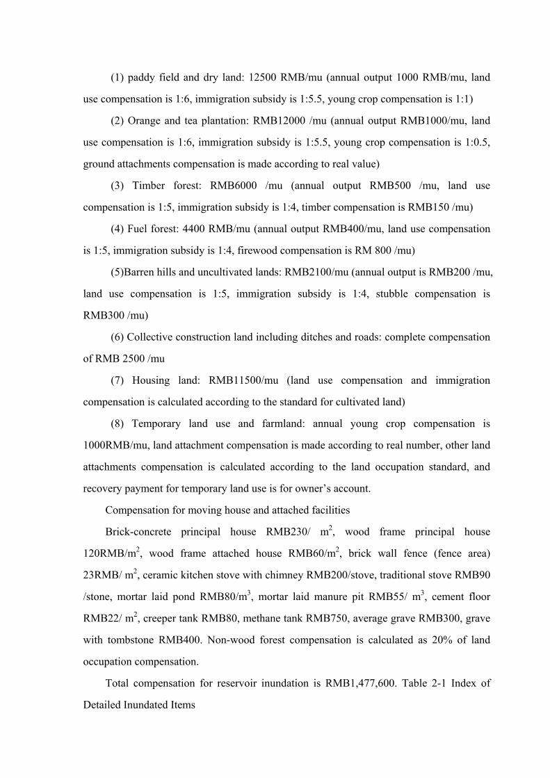
(1) paddy field and dry land: 12500 RMB/mu (annual output 1000 RMB/mu, land
use compensation is 1:6, immigration subsidy is 1:5.5, young crop compensation is 1:1)
(2) Orange and tea plantation: RMB12000 /mu (annual output RMB1000/mu, land
use compensation is 1:6, immigration subsidy is 1:5.5, young crop compensation is 1:0.5,
ground attachments compensation is made according to real value)
(3) Timber forest: RMB6000 /mu (annual output RMB500 /mu, land use
compensation is 1:5, immigration subsidy is 1:4, timber compensation is RMB150 /mu)
(4) Fuel forest: 4400 RMB/mu (annual output RMB400/mu, land use compensation
is 1:5, immigration subsidy is 1:4, firewood compensation is RM 800 /mu)
(5)Barren hills and uncultivated lands: RMB2100/mu (annual output is RMB200 /mu,
land use compensation is 1:5, immigration subsidy is 1:4, stubble compensation is
RMB300 /mu)
(6) Collective construction land including ditches and roads: complete compensation
of RMB 2500 /mu
(7) Housing land: RMB11500/mu (land use compensation and immigration
compensation is calculated according to the standard for cultivated land)
(8) Temporary land use and farmland: annual young crop compensation is
1000RMB/mu, land attachment compensation is made according to real number, other land
attachments compensation is calculated according to the land occupation standard, and
recovery payment for temporary land use is for owner’s account.
Compensation for moving house and attached facilities
Brick-concrete principal house RMB230/ m2, wood frame principal house
120RMB/m2, wood frame attached house RMB60/m2, brick wall fence (fence area)
23RMB/ m2, ceramic kitchen stove with chimney RMB200/stove, traditional stove RMB90
/stone, mortar laid pond RMB80/m3, mortar laid manure pit RMB55/ m3, cement floor
RMB22/ m2, creeper tank RMB80, methane tank RMB750, average grave RMB300, grave
with tombstone RMB400. Non-wood forest compensation is calculated as 20% of land
occupation compensation.
Total compensation for reservoir inundation is RMB1,477,600. Table 2-1 Index of
Detailed Inundated Items

Table 2-1 Index of Reservoir Inundated Items
Name of inundated item Unit Unit
compensation price (RMB)
Quantity Cost (RMB)
Cultivated land
Dry land mu 12500 22.65 283100
Barren hill
mu 2100 102.31 214800
Timber land
mu 6000 30.30 181800 Woodland
Fuel forest
mu 4400 121.5 534600
Housing land mu 11500 0.9 10400
Land development cost mu 2500 22.65 56600
Tax on cultivated land occupation
mu 3000 22.65 68000
House moving M2 120 650 78000
Farms immigration subsidy /person 2100 12 25200
Enclosed house M2 60 135.45 8100
Wire pole pole 500 25 12500
grave pc 300 15 4500
shoal mu 0 19.34 0
Total / / / 1477600
2.3.2 Permanent Land Use
Permanent land use of project includes building premises and controlled zones. To
ensure safety operation of the project, area within 50m from the building is control zone of
the power station.
Permanent land use of cultivated land covers 22.65mu, which costs total compensation
of RMB283200 for RMB12500 /mu; permanent land use of barren hills and uncultivated
lands covers 181.35mu, which costs total compensation of RMB 380800 of RMB2100/mu;
permanent land use of houses covers 400.2m2, which costs total compensation of 48000
RMB of 120RMB/m2. Total compensation for permanent land use of project costs
RMB711900.
Temporary land use of cultivated land covers 29.1mu, its compensation for young

crops for two years adds up to RMB58200 of RMB1000/mu every year; temporary land
use of barren hills and uncultivated lands covers 0.9mu, its compensation for two years add
up to RMB5400 of RMB300/mu every year; temporary land use of fuel forest covers
24.9mu, its compensation for tow years adds up to RMB39800 of RMB800/mu every year;
total compensation for temporary land use is RMB103400. The above compensation,
excluding reservoir inundation compensation, totals RMB815300.
工程永久占地和临时占地详见表 2-2。
Table 2-2 Permanent and Temporary Land Use of Project
Table 2-2 Permanent and Temporary Land Use of Project Temporary land use(hm2) Permanent land use(hm2) Total
No Item Culti
vated
land
Timb
er
forest
Fuel
forest
Uncu
ltivat
ed
land
Shoal
Culti
vated
land
Timb
er
forest
Barren
hill
Fuel
forest Shoal
Hous
e
1 Reservoir area 1.51 2.02 6.82 8.10 1.29 0.06 19.8
2 Arch dam 0.06 0.13 0.19
3 Diversion tunnel 0.01 0.01
4 Penstock 0.20 1.03 1.23
5 Power house &
booster station 0.23 0.04 0.27
6 Waste disposal
area 1.94 1.66 0.72 4.32
7
Work shed and
material storage
area
0.6 0.60
8 Construction road 1.08 10.92 12.00
Total 1.94 1.66 0.6 0.78 3.02 2.02 18.91 8.10 1.29 0.1 38.42
2.4 Project Construction Plan
2.4.1 Construction Condition
The dam of Changfeng hydropower project is 2km from Xiufengqiao town, 12km
from Langping town, 110km from Changyang County and 111km from Yichang City. The
power house is 7km from Langping town, 100km from Changyang County and 101km
from Yichang, which is rather convenient in transportation.
The terrain 400m upstream the dam site is wide and flat, which is available for

building work shed and repair yard. The vacant houses in Leyuan Government can be used
as warehouse. In front of every entrance (or branch entrance) of water diversion tunnels,
there are slow slopes, which can be used for setting up work sheds, air pressure station, etc.
Since the power house is close to 318 National Highway, there is enough vacant lot for
setting up work sheds. The hydrological and meteorological condition is adequate for
hydropower project construction.
The project needs 15000tons of cement, which can be purchased from cement factory
in Changyang County or in Yidu Huaxin Cement Factory; the dam concrete is made of
dam silicate cement from Jingmen. Steels can be purchased from construction marterial
market in Yichang or Changyang. Woods will be supplied nearby by local forestry
department. Fire work materials will be supplied by local chemical construction company
or through local public security station. The gasoline and diesel used in construction will be
purchased by the construction organization. The electricity needed for construction of the
dam and tunnel extrance is to be provided by Leyuan transformer station by setting up a
2km-long 10KV line with a 1000KVA transformer. The electricity needed for tunnel exit is
provided by setting up a 1.5km long 10KV line at Lengshuiqiao with a 180KVA
transformer. The power electricity needed at power house area is provided through T
shaped connection. Sandstones needed for construction will adopt artificial aggregate.
2.4.2 Construction and Diversion
According to scale and features of construction, diversion period is set from
November to April in the next year. Diversion standard (return period) is 5 years, relevant
flood flow rate is 45.7m3/s. When construction period is extended, then flood season
should be taken into account. The standard for flood season (return period) is 10 years, the
relevant peak flood flow rage is 235m3/s.
Based on local hydrological features, geological condition and project layout, the
project construction adopts the plan of building a weir and diversion water through tunnel.
Diversion building is used for water transfer during preliminary dam excavation,
preliminary treatment and dam concrete placing. Using earth-rock weir, it obtains material
from local source, reduces investment and has easy construction. The diversion tunnel is
located on the right bank, the elevation of tunnel floor at entrance is 1082m, elevation of
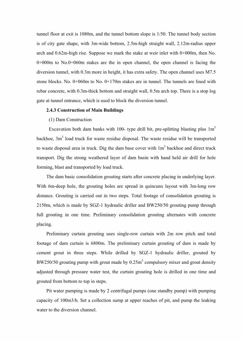
tunnel floor at exit is 1080m, and the tunnel bottom slope is 1/50. The tunnel body section
is of city gate shape, with 3m-wide bottom, 2.5m-high straight wall, 2.12m-radius upper
arch and 0.62m-high rise. Suppose we mark the stake at weir inlet with 0+000m, then No.
0+000m to No.0+060m stakes are the in open channel, the open channel is facing the
diversion tunnel, with 0.3m more in height, it has extra safety. The open channel uses M7.5
stone blocks. No. 0+060m to No. 0+170m stakes are in tunnel. The tunnels are lined with
rebar concrete, with 0.3m-thick bottom and straight wall, 0.5m arch top. There is a stop log
gate at tunnel entrance, which is used to block the diversion tunnel.
2.4.3 Construction of Main Buildings
(1) Dam Construction
Excavation both dam banks with 100- type drill bit, pre-splitting blasting plus 1m3
backhoe, 3m3 load truck for waste residue disposal. The waste residue will be transported
to waste disposal area in truck. Dig the dam base cover with 1m3 backhoe and direct truck
transport. Dig the strong weathered layer of dam basin with hand held air drill for hole
forming, blast and transported by load truck.
The dam basic consolidation grouting starts after concrete placing in underlying layer.
With 6m-deep hole, the grouting holes are spread in quincunx layout with 3m-long row
distance. Grouting is carried out in two steps. Total footage of consolidation grouting is
2150m, which is made by SGZ-1 hydraulic driller and BW250/50 grouting pump through
full grouting in one time. Preliminary consolidation grouting alternates with concrete
placing.
Preliminary curtain grouting uses single-row curtain with 2m row pitch and total
footage of dam curtain is 6800m. The preliminary curtain grouting of dam is made by
cement grout in three steps. While drilled by SGZ-1 hydraulic driller, grouted by
BW250/50 grouting pump with grout made by 0.25m3 compulsory mixer and grout density
adjusted through pressure water test, the curtain grouting hole is drilled in one time and
grouted from bottom to top in steps.
Pit water pumping is made by 2 centrifugal pumps (one standby pump) with pumping
capacity of 100m3/h. Set a collection sump at upper reaches of pit, and pump the leaking
water to the diversion channel.

Dam concrete is transported by tower crane. The dam concrete intensity should be
enough to bear operation load and anti-split during operation. For holes inside the dam and
flood releasing positions, high graded concrete can be used. For elevation below 1077.5m,
it adopts preliminary concrete placing of about 6000m3. Since it is main foundation
consolidation part, the concrete placing must be made in winter and spring. Dam concrete
placing is separated into different layers. The thickness of preliminary consolidation dam at
riverbed and concrete in flood season is 1.5m. Above the consolidation layer, the thickness
is 3.0m. The dam bank is 3.0m thick.
(2) Construction of Diversion Power Tunnel
Dig the shaft platform and water inlet by hand held air drill. Since it is a small project
(329m3), stone ballasts can be transported to the riverbed (below dead storage level). The
tunnel is 5284.91m long with designed longitudinal slope of 4/1000 and round section.
With 2.2m excavation diameter, 3.8m2 section area, 22220m3 earth excavation, 4 actual
working faces of tunnel excavation, 1321m average excavation distance of single face,
2000m initial excavation distance at inlet, 1800m excavation distance at outlet, the
excavation distance at two working faces of the adit is 1484.91m (752m without adit). The
tunnel construction uses hand held air drill. After full section boring, smooth blasting and
manual waste residue load, the waste residue is transported by 10t driving machine with
mining truck on light rail. Concrete placing is made by 0.8m3 mixer (placed at tunnel
intake), carried by mining truck, placed manually and shake by internal vibrator.
(3) Construction of Surge Shaft and Penstock
The surge shaft is constructed through pilot shaft method, which digs a 58.86m-long
hole in one time. It uses hand held air drill enlargement, smooth blast, and discharge waste
residue through tunnel in shaft bottom, the waste residue is loaded by manpower and
carried to waste disposal area outside the tunnel by mine truck .The concrete construction
uses 0.8m3 compulsory mixer, concrete delivery pump, internal vibrator and 1500×150×55
steel form composition.
The penstock excavation adopts hand held air drill digging blast from top to down and
1m3backhoe. The waste residue will be transported to waste disposal area by tractor. Steel
pipes are installed from bottom to top after concrete placed at anchorage block and rest pier.
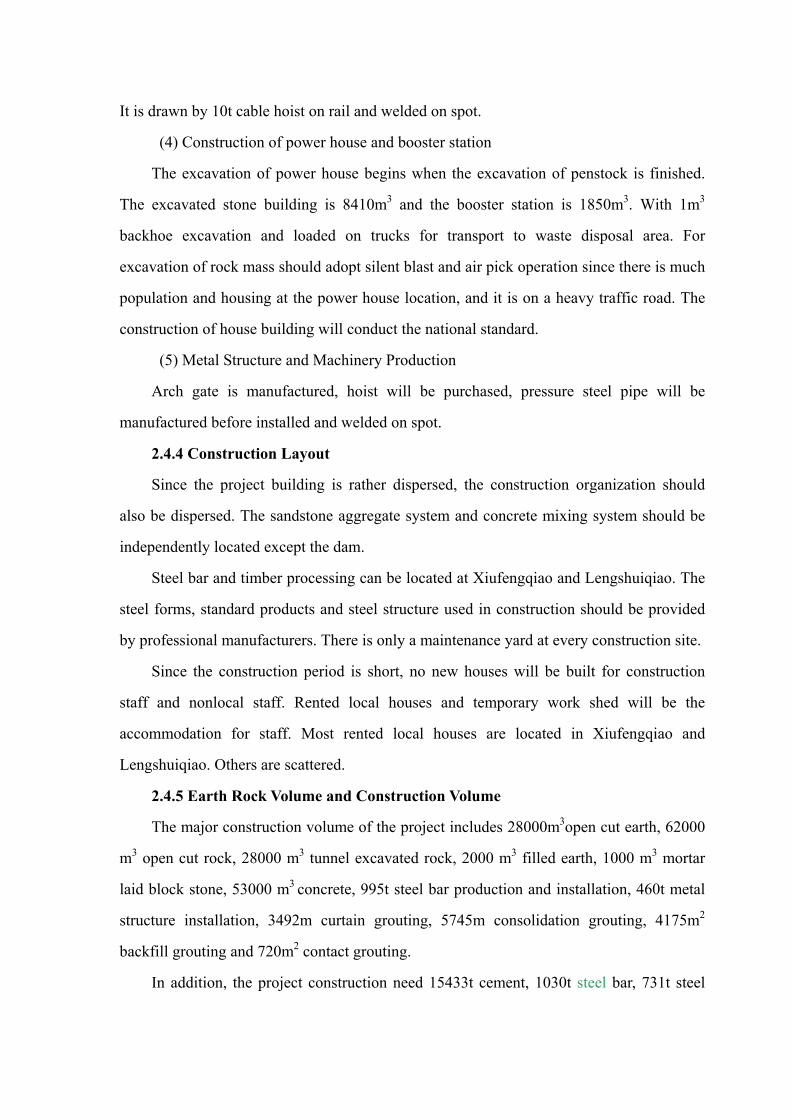
It is drawn by 10t cable hoist on rail and welded on spot.
(4) Construction of power house and booster station
The excavation of power house begins when the excavation of penstock is finished.
The excavated stone building is 8410m3 and the booster station is 1850m3. With 1m3
backhoe excavation and loaded on trucks for transport to waste disposal area. For
excavation of rock mass should adopt silent blast and air pick operation since there is much
population and housing at the power house location, and it is on a heavy traffic road. The
construction of house building will conduct the national standard.
(5) Metal Structure and Machinery Production
Arch gate is manufactured, hoist will be purchased, pressure steel pipe will be
manufactured before installed and welded on spot.
2.4.4 Construction Layout
Since the project building is rather dispersed, the construction organization should
also be dispersed. The sandstone aggregate system and concrete mixing system should be
independently located except the dam.
Steel bar and timber processing can be located at Xiufengqiao and Lengshuiqiao. The
steel forms, standard products and steel structure used in construction should be provided
by professional manufacturers. There is only a maintenance yard at every construction site.
Since the construction period is short, no new houses will be built for construction
staff and nonlocal staff. Rented local houses and temporary work shed will be the
accommodation for staff. Most rented local houses are located in Xiufengqiao and
Lengshuiqiao. Others are scattered.
2.4.5 Earth Rock Volume and Construction Volume
The major construction volume of the project includes 28000m3open cut earth, 62000
m3 open cut rock, 28000 m3 tunnel excavated rock, 2000 m3 filled earth, 1000 m3 mortar
laid block stone, 53000 m3 concrete, 995t steel bar production and installation, 460t metal
structure installation, 3492m curtain grouting, 5745m consolidation grouting, 4175m2
backfill grouting and 720m2 contact grouting.
In addition, the project construction need 15433t cement, 1030t steel bar, 731t steel

material, 398m3 timber, 117t explosives, 129940 detonators, 140389m wires,19t gasoline,
293t diesel, 794m3 block stone, 29575m3 sand, 55881m3 cobbles, and 3743t coal ash。
267410 total working days and 49347 machine operators.
Figure 5 General Floor Plan of Project Construction
2.5 Waste Residue Plan
Based on the principle of “everything useful should be used”, the earth rock waste
residue volume is 117400 m3.
Waste residue from water intake project is 41800 m3. Since there is no waste vacant
yard near the lower reaches of dam site, all these waste residue must be transported to a
cultivated land 2.5km away from downstream dam site, which is the only low lying land
near the shoal. It is 4# waste disposal area. Water diversion tunnel (including water intake,
surge shaft and inclined shaft) construction produces 18100 m3 waste residue, among
which 4700 m3 near the tunnel intake is transported to 4# waste disposal area downstream
of the dam site; 4700 m3 near the tunnel outlet is transported to 3# waste disposal area, a
low lying valley on the right side of tunnel outlet; the remaining 8700 m3 from inclined
shaft is transported to 5#waste disposal area. Measures for project and plants are taken to
prevent the waste residue being washed away.
The excavation of penstock produces 33200m3 waste residue. According to the actual
terrain, the waste residue is separately disposed. The 12300m3 waste residue produced
between 1-3# anchorage block are all transported to 3# waste disposal area on the right of
tunnel outlet. The 8200m3 waste residue produced below 10# anchorage block are
transported to 1# waste disposal area, and the 12700m3 waste residue produced below
between 3-10# anchorage block can only be separately disposed on the low lying land on
the left of penstock due to the terrain and transportation limit. Measures for project and
plants are taken to prevent the waste residue being washed away.
Excavation of power house produces 7500 m3 waste residue, which are transported to
1# waste disposal area outside the power house area. Measures are taken to retain the waste
residue and greening measures when project is finished. The excavation of road

construction also produces waste residue which are separately disposed. See table 2-3 for
details of waste disposal areas.
Table 2-3 List of waste disposal areas
No. of waste disposal area
Location Volume of disposed waste
residue(m3)
1# Power house area 15700
2# Along the penstock 12700
3# Low lying valley at right of tunnel outlet 17000
4# 2.5km downstream dam site 46500
5# Inclined shaft outlet 8700
6# Along the road 16800
total / 117400
Plan of waste residue is made according to the construction volume calculated in
general construction distribution and Feasibility Study Report provided by the owner. The
construction volume of diversion tunnel is calculated according to length of main tunnel
and branch tunnel in the general construction distribution made by the owner. The
construction volume of main tunnel and branch tunnel are calculated by 4.0m3/m tunnel
stone excavation, concrete lined 1.87m3/m. According to the organization and design for
construction, the sand and gravel used in construction are all processed by machines.
According to the feasibility study report, the concrete lined in diversion tunnel is calculated
by 20% of the tunnel length, while the sand and gravel are all from excavation. The waste
residue mainly include waste earth and waste stone from excavation, dam cleaning and
slope cutting. Based on the principal of “everything useful should be fully used” , the waste
earth and stone disposal of the construction amounts to 81100m3 (bank measured volume) ,
among which the earth excavation volume is 17100 m3 and stone excavation volume is
64000 m3, or all together 107900 m3 in loose measured volume.
2.6 General Construction Schedule
The construction period of the project is 2 years. The dam construction starts from
November 2009 and finishes before December 31st 2010; The construction of diversion
tunnel starts from July 1st 2009 and finishes before December 31st 2010; the penstock

construction starts from early August in 2009 and finishes before February 28th 2011; the
booster station in the power house should begins construction after the excavation of the
penstock is finished. The machine units are installed from September 1st 2010 to December
31st 2010.
2.7 Project Management
2.7.1 Project Management
According to the technical guidelines and rules of marketing economy, the owner has
set up Yichang Changfeng Hydropower Development Co., Ltd. The management will
include 11 persons.
The management of Changfeng hydropower station covers dam, water diversion
building, and power house. The station is managed without guard. The reservoir regulation
only concerns about power output efficiency. As required by the owner, no office and
accommodation in the power house area. The powerhouse is close to 318 National
Highway, which is 7km to marketing town, 100km to the county, and 101km to Yichang.
Only 2 vehicles are needed for transportation. The power house also needs 3 program
controlled telephones and 20 internal program controlled telephones.
2.7.2 Labor Safety and Industrial Sanitary Design
According applicable regulations in Labor Law of the People’s Republic of China
(effected on January 1st, 1995) and Design Code for Labor Safety and Industrial Sanitation
of Water Conservancy and Hydropower Projects (DL5061-1996), labor and industrial
sanitation measures are worked out. The labor safety measures mainly cover fireproof,
anti-explosion, electric injury avoiding, mechanical injury avoiding, anti-falling, flood
control, anti-drowning. The industrial sanitation measures cover noise and vibration proof,
temperature and humidity control, lighting and illumination, dust proof, anti contamination,
corrosion resistant, gas proof, and electromagnetic radiation proof.
2.8 Investment and Profit
The statistic investment for Changfeng hydropower project amounts to RMB78.7682
million, and its total investment is RMB81.8496 million including construction period
interest. The investment for transmission project is RMB22.70 million, the total investment
for project is RMB 104.5496 million. The project mainly obtains its needed capital through
self financing and loan. Total loan amount is RMB43.9491million and capital from self
financing is RMB21.7781million.
Economic assessment includes financial assessment and national economic
assessment. The assessment is made according to Economic Evaluation Code on Small
Hydropower Projects (SL16-95), Guidelines for Economic Assessment on Water
Conservation Projects (SL72-94) and the existing national financial and tax measures.
The national economic assessment index is economic internal rate of return
EIRR=13.77%>12%; the economic net present value ENPV=RMB8.01 million>0, the
economic benefit-cost ratio EBCR=1.11>1. All indexes meet the requirements of the
above guidelines.
The financial assessment index is financial internal rate of return before income tax
FIRR=9.17%<10%; The financial assessment index is financial internal rate of return
after income tax FIRR=7.59%; the financial net present value before income tax
FNPV=RMB4.0194 million; the financial net present value after income tax
FNPV=RMB-10.8565 million; the fixed asset investment load payback period
Pd=12.1years. All indexes meet the requirement of the above guidelines.
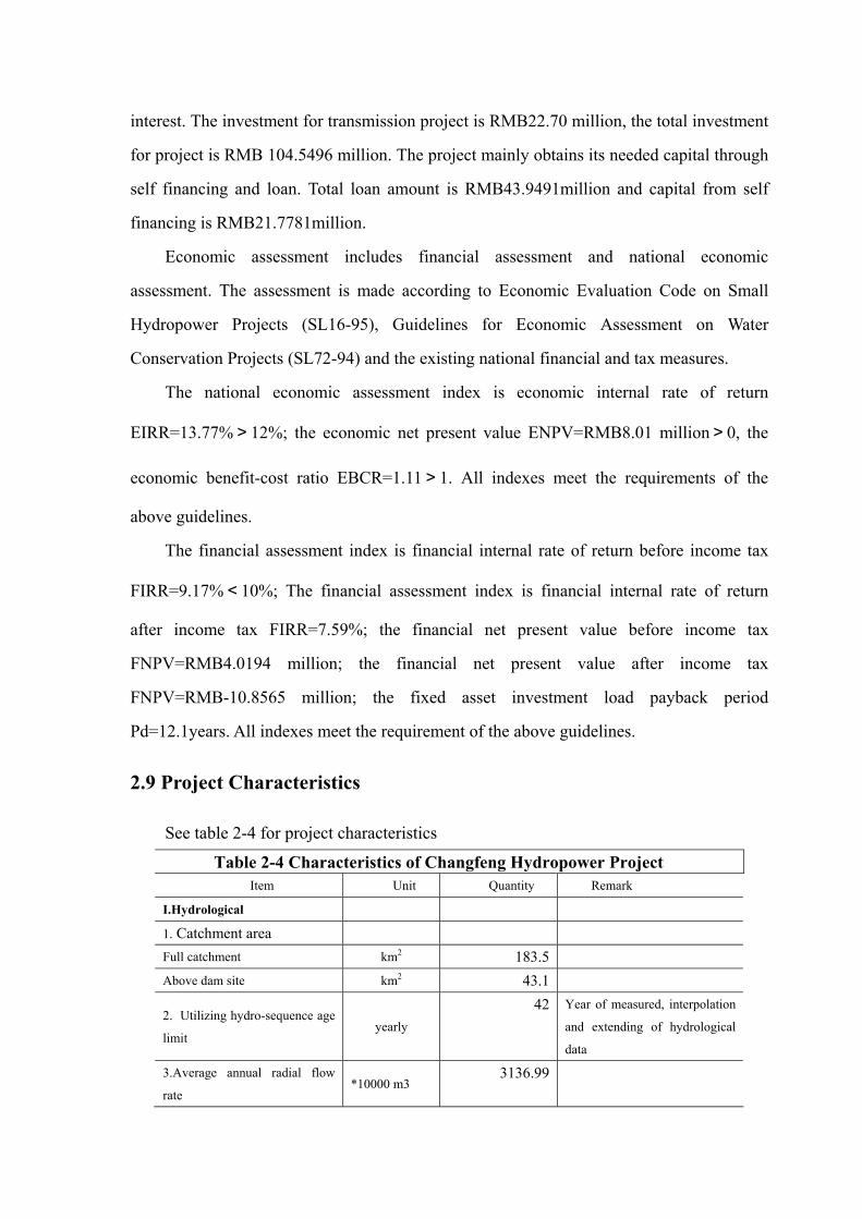
2.9 Project Characteristics
See table 2-4 for project characteristics
Table 2-4 Characteristics of Changfeng Hydropower Project
Item Unit Quantity Remark
I.Hydrological
1. Catchment area
Full catchment km2 183.5
Above dam site km2 43.1
2. Utilizing hydro-sequence age
limit yearly
42 Year of measured, interpolation
and extending of hydrological
data
3.Average annual radial flow
rate *10000 m3
3136.99
4.Representative flow rate
Average annual flow rate m3/s 0.99
Max measured flow rate m3/s Measured date
Min measured flow rate m3/s Measured date
Designed flood flow rate
(P=2%) m3/s
525.8
Check flood flow rate(P=0.5%) m3/s 677.6
(P=0.5%)
Construction diversion flow rate
(P=5 %)(P=0.5%)
m3/s
45.7
Drought period
5.Flood flow
Max measured flood flow
*100,000,000
m3
Measured date
Designed flood flow *10000 m3 617.56
Check flood flow *10000 m3 800.8
6.Sediment
Average annual sediment rate kg/m3 0.67
Max measured sediment rate kg/m3
Average annual suspended
sediment discharge rate
万 t
*10000t
2.1033
Average annual bed load
sediment discharge rate
万 t
*10000t
0.3155
7.Natural water level
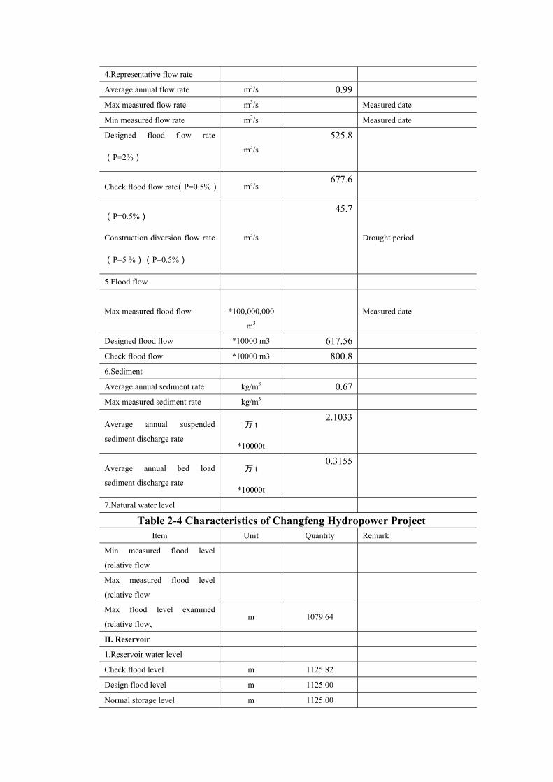
Table 2-4 Characteristics of Changfeng Hydropower Project
Item Unit Quantity Remark
Min measured flood level
(relative flow
Max measured flood level
(relative flow
Max flood level examined
(relative flow, m 1079.64
II. Reservoir
1.Reservoir water level
Check flood level m 1125.82
Design flood level m 1125.00
Normal storage level m 1125.00

Flood control high water level
(P= %) m
Flood control limited water level
Dead storage level m 1098.20
2.Reservoir area at normal
storage level *10000 m2 19.21
3.Return water distance m 1790
4.Reservoir capacity
Total capacity *10000 m3 397.36
Reservoir capacity below
normal storage level *10000 m3 381.59
Regulated reservoir capacity *10000 m3 327.04
Flood control reservoir capacity *10000 m3 15.77
Beneficial reservoir capacity *10000 m3 327.04
Dead storage reservoir capacity *10000 m3 54.55
5.Reservoir capacity index % 10.43
6. Regulating characteristic Annual regulation Indicate characteristics
7、Use of water flow coefficient % 93.47
III. Discharged flow and related
downstream water level
1.Max discharge flow at design
flood level m3/s 525.8
Related downstream water level m 1079.77
2.Max discharge flow at check
flood level m3/s 677.6
Related downstream water level m 1080.01
3.Regulating flow(P= %) m3/s
Related downstream water level m
Min. flow m3/s
Table 2-4 Characteristics of Changfeng Hydropower Project
Item Unit Quantity Remark
Related downstream water level m
IV.Project benefit index
1.Flood control benefit
Protected land area (P= %) *10000mu
Protected town and plant area
(P= %) Km2
2.Power output benefit
Installed capacity kW 2×5000
Firm output (P=85%) kW 1768

Average annual power output *10000kW.h 3676.62
Number of hours used per year h 3676
3.Irrigation benefit
Area (P= %) *10000mu Separately listed for paddy field,
dry land and grassland
Max. quotative flow m3/s
Gross annual water consumption
(P= %)
亿 m3
*100million m3
4. Flood control benefit
Area (P= %) *10000mu
Drainage discharge m3/s
5.Water supply benefit
Max. quotative discharge(P=
%) m3/s
Gross annual water consumption
6. Navigation and log passing
benefit
Improving channel mileage km
Ship passing tonnage t
Design annual tonnage capacity t
Wood/bamboo raft size m
Design annual wood/bamboo
traffic volume m3
7. Aquaculture benefit
V.Inundation loss and
permanent land use of project
1.Inundated cultivated land mu 22.65
2.Immigration person 12
3.Inundated house m2 650
Table 2-4 Characteristics of Changfeng Hydropower Project
Item Unit Quantity Remark
4.Moved grave pc 15
5.Inundated timber forest mu 30.30
6.Inundated barren hill mu 102.31
7.Inundated timer forest mu 121.50
8.Permanent land use (exclude
reservoir inundation)
亩
mu
204.60
VI. Main structures and
facilities
1.Water retaining building

Type Concrete double curvature arch
dam
Foundation rock type Grey rock of Shilongdong
formation of Cambrian system
Dam top elevation m 1128.00
Max dam height m 60.5
Dam axis length m 139.1
Seismic basic intensity/ seismic
fortification intensity �/�
2.Discharge building
Type Open flood discharge channel
Foundation rock type Grey rock of Shilongdong
formation of Cambrian system
Weir crest elevation m 1117.06
Length of discharge flow (size
and number of gate hole) m 2×6
Size of flood discharge tunnel m
Unit width flow rate m3/(s.m) 43.8
Energy Dissipation measures ski-jump
Gate size m 6×8.5
Hoist type Cable hoist
Weight of hoist t 2×3.2
3. Water diversion building
Designed diversion flow m3/s 2.36
Max diversion flow m3/s 2.5
Intake type Shaft
Foundation rock type Grey rock of Shilongdong
formation of Cambrian system
Table 2-4 Characteristics of Changfeng Hydropower Project
Item Unit Quantity Remark
Base plate elevation m 1094.40
Gate type Ceiling chain
wheel type
Hoist type Screw type
Hoist capability t 30
Diversion pipeline type Pressure diversion tunnel
Foundation rock type Carbonates
Length m 5419.41
Excavation face size m D2.2
Lined face size m D1.7
Max. design water head m 58

Surge shaft type Simple cylinder structure
Shaft inner diameter m 4.0
Shaft height m 58.86
Penstock type Surface stee pipeline
Foundation rock type Ordovician system carbonates
Main pipe length m 1321.04
Main pipe inner diameter m 0.9
Number and length of branch
pipe m 1×15.6 1×8.92
Inner diameter of branch pipe m 0.6
Bifurcated pipe type Crescent rib reinforced
4.Power house
Type Ground type
Foundation rock type siltstone
Size of main power house
(L*W*H) m 30.4×12.4×11.6
Installed elevation of hydraulic
turbine m 543.84
5.Switch station
Type Ground type
Foundation rock type Siltstone
Area (L*W) m2 23×15
6.Main electromechanical
facilities
Table 2-4 Characteristics of Changfeng Hydropower Project
Item Unit Quantity Remark
A. Hydraulic turbine type CJA237-W-125/2×9
Qty Set 2
Rated output kW 5263
Rated speed r/min 750
Rated flow m3/s 1.18
Max. working water head m 581.65
Min. working water head m 529.05
Exsuction lift head m
Rated water head m 529.05
Specific speed of turbine m.kW 13.9
B.Generator type SFW5000-8/1730 Qty Set 2
Rated output kW 5000
Rated speed r/min 750
Rated voltage kV 6300
Rated power factor cosφ 0.8

C.Main transformer Type S9-12500/35
Qty Set 1
Rated capacity kVA 12500
Voltage ratio kV 35±3×2.5%/6.3
D. Intake valve type Z941H-25-φ500 Diameter m 600
Max. water head m E.In-plant crane type LD20-10.5
Span m 10.5 Lifting capacity t 20
7.Power transmission line Voltage kV 35
Loop Loop 1 Transmission destination
Transmission distance km 7
Table 2-4 Characteristics of Changfeng Hydropower Project
Item Unit Quantity Remark
8. Navigation structure
Type
Listed in accordance with
different types of struture
Main size m
Ship tonnage t
Annual traffic capacity 10000t
Navigation discharge m3/s
9.Log and raft passing structure
Type
Main size m
Annual traffic capacity *10000t
Wood/bamboo passing discharge
m3/s
10. Other structure
Construction
1.Main construction volume
Filled earth *10000 m3 1.21
Earth-rock excavation *10000 m3 13.8
Mortar laid block stone *10000 m3 0.10
Backfill grouting *10000 m2 0.50
Consolidation grouting *10000m 0.77
Land area m2 2061
Construction area m2 1944

Concrete *10000 m3 6.62
Curtain grouting *10000m 0.68
2.Main construction material
Detonator *10000pcs 12.99
Cement *10000t 1.53
Steel bar t 1029.66
Steel material t 731.19
Timber m3 397.82
Explosives t 116.79
Table 2-4 Characteristics of Changfeng Hydropower Project
Item Unit Quantity Remark
Fuse *10000m 14.04
Gasoline t 19.12
Diesel t 292.99
Coal ash t 3743
Block stone m3 794
Cobble *10000 m3 5.59
Sand 万 m3
*10000 m3
2.96
3.Labor needed
Total working days *10000
working days 26.741
Average staff number Person 245
Peak staff number Person 367
4.Construction temporary house
5.Construction power
Electricity kW 1×800、1×150
Other power facilities kW
5.External transportation km 8
6.Construction diversion
Diversion type Weir, open
channel, tunnel
Type of building City gate type
tunnel
Major size m 3×3.1
9.Construction land use mu 74.7
10.Construction period
Construction period month 12
Total period Year 2

Ⅷ. Economic index
1.Total statistic investment *RMB10000 7876.82
Total investment *RMB10000 8184.96
Construction project *RMB10000 4351.08
Mechanical facilities and
installation *RMB10000
882.11
Metal facilities and installation *RMB10000 745.55
Table 2-4 Characteristics of Changfeng Hydropower Project
Item Unit Quantity Remark
Temporary project *RMB10000 482.39
Compensation for reservoir
inundation *RMB10000
147.76Single
Other cost *RMB10000 592.28
Basic budget reserve *RMB10000 352.67 Only calculating the key project
part
Price variation *RMB10000
Load interest during
construction period *RMB10000
293.44 Only calculating the key project
part
1.Main economic index
Investment per kW RMB/kW 7877
Investment per kWh RMB/kWh 2.14
Power output cost *RMB10000 996.3
Economic internal rate of return % 13.77
Financial internal rate of return % 7.59 Before income tax
Power purchase price RMB/kWh 0.28
Loan payback period a 12.1
Back-calculation power price
(FIRR=10%) RMB yuan
0.322
2.10 Construction Pollution Analysis
2.10.1Main factor and measures of environmental impact during construction
period
2.10.1.1 Analysis on Earth-rock Volume Balance, Construction Waste Residue and

Domestic Wastes
(1) Analysis on earth-rock volume balance and utilization of waste residue
See table 2-5 for earth-rock volume balance of construction waste residue
Table 2-5 Earth-rock Volume Balance of Construction Waste Residue
Unit: *10000 m3 Earth excavation Rock excavation
Project Excavated
volume
Used
volume
Wasted
volume
Excavated
volume
Used
volume
Wasted
volume
Total wasted volume
Water intake
works 0.93 0.10 0.83 3.51 0.15 3.35 4.18
Water diversion
tunnel 2.98 1.17 1.81 1.81
Penstock 1.01 1.01 2.45 0.14 2.31 3.32
Powerhouse 0.46 0.46 0.56 0.28 0.29 0.75
Construction road 1.68 0.67 1.01 3.12 2.45 0.67 1.68
Total 4.08 0.77 3.31 12.62 4.19 8.43 11.74
Disposal Measures for Domestic Wastes
The number of working staff per daily during peak construction period is about 367
persons, if one person produces 1.0kg wastes per day, then max domestic wastes
production per day is about 0.367t. The whole construction needs 18 months with average
number of working staff per day of 245 persons, then total domestic wastes produced
during construction is about 132.3t. If these wastes are not properly disposed, they may
produce many mosquitos, flies and lead to second pollution.
Thus domestic wastes should be classified and kept in a special yard and to be
disposed as compost after recycling the useful part.
2.10.1.2 Water Supply and Sewerage During Construction and Analysis on Main
Pollutants Discharge
Total water consumption of Changfeng hydropower station project during
construction is 221300m3, and total wastewater discharge is 177040m3, including sewerage
of construction wastewater and domestic wastewater.
(1) Water Used in Construction, Major Wastewater Pollution Source and Pollutants
Total water used in construction amounts to 194840m3 and total wastewater
discharged during construction is 155872m3. Wastewater discharged during construction

mainly comes from concrete placement and conservation, washing water of the sandstone
processing system, washing water from machines and vehicles used in construction and so
on. In addition, during construction there is also a lot of wastewater from foundation pit,
which mainly comes from rainfall and weir water leakage, which amounts to 200m3/d
during peak period. Since project construction adds more suspensions to the water in
foundation pit, a catchment pit will be built, in which wastewater will be settled for more
than 2 hours before its suspension concentration is below 70mg/L and then discharged by
pump, thus it reduces its impact on surface water environment.
• Wastewater from Concrete Placement and Conservation
Due to concrete placement, conservation and grouting, the suspension concentration
of its wastewater is quite high and its PH value may reach 11~12.
• Washing Water for Sandstone Processing System
The procedures for sandstone processing system is: mining in material yard→raw
material yard→filtration→semi-finished material yard→filtration station→finished
aggregate yard→gravel sand processing →mixture→finished gravel sand. Usually
processing 1t concrete aggregate costs about 2.7m3 water. If the average sand content in
gravel sand is 8%, then the suspension concentration of the washing water for gravel sand
is about 2.5×10⁴mg/L based on the principal of material balance. The water loss due to
material surface water, evaporation and leakage makes 20% of the total water consumption,
while the rest 80% is production wastewater which is about 110m3/h.
Washing water from machines and vehicles used construction
According to the design by construction organization and compared to other
hydropower projects of similar scale, main machines and vehicles used in construction area
are about 40, which are parked together. Suppose washing a vehicle once produce 0.6m3
wastewater and the washing rate is 50% per day, then oily wastewater produced per day is
about 12.0m3 and total wastewater produced during construction is 6480m3.
There is no specific treatment for construction wastewater in the feasibility study
report of the project. Referring to regular measures for similar wastewater treatment, we
suggest in this assessment that the production wastewater should be disposed as follows:
since main pollutants in the wastewater of gravel sand processing is SS, it should disposed

by rectangular sediment tank; since PH value of wastewater of concrete placement and
conservation is 11~12, it should adopts neutralizing sediment tank; since washing water of
machines and vehicles used in construction is oily wastewater, it should be disposed by oil
separating tank. With the above treatments, the wastewater can reach the standard for
discharge. See table 2-3 for production and discharge of construction wastewater and its
main pollutant of Changfeng hydropower project.
Table 2-3 Production of Construction Wastewater and Main Pollutants
Item Wastewater
catalogue
Wastewater in
peak period
(m3/d)
Total wastewater
during
construction
Before treatment After treatment
1
Wastewater from
gravel sand
processing
1600 142992(1091.6) SS:2.5×10⁴mg/L,
27290kg/d
SS:70mg/L,
76.41kg/d
SS:5000mg/L
53.5kg/d
SS:70mg/L
0.749kg/d 2
Wastewater from
concrete
placement and
conservation
80 6400(10.7)
pH:11-12 pH:6-9
Petroleum: 15mg/L
0.18kg/d
Petroleum: 5mg/L
0.06kg/d
3
Washing water
of machines and
vehicles used in
construction
20 6480(12.0) SS:300mg/L
3.6kg/d
SS:70mg/L
0.84kg/d
Total 1700 155872(1114.3) / /
Note: wastewater in foundation pit mainly comes from rainfall and weir water leakage, which is not calculated in the wastewater of construction. Data in ()is average wastewater discharge per day, and the concentration after treatment is calculated by standard concentration.
(1) Domestic water and sewerage
It mainly includes domestic wastewater of construction staff. The max number of
working staff per day in the peak period of construction is 376 persons, and the average
number of working staff per day is 245 persons. Based on the regular domestic water
consumption of construction staff for hydropower projects, the average water consumption
per day of construction staff is about 200L and the total water consumption is about
26460m3 during the whole construction period, and 80% of which will be discharged as
sewage. The sewage discharge standard is 160L/d, and the max domestic sewage discharge

per day is 58.7m3, the average domestic sewage discharge per day is 39.2m3, the total
domestic sewage discharged during construction period is 21168m3. Its main pollutants are
COD, BOD5, SS, NH3-N.
The construction site is located in barren mountains, which is far always from villages
and cities. By considering the general condition of construction site and existing regional
environment, temporary toilets and simple constructed septic tank built near the
construction site will fit the existing objective and technical condition.
See table 2-4 for discharge of domestic sewage and its main pollutants.
Table 2-4 Discharge of Domestic Sewage and Main Pollutants during Construction Wastewater amount Before treatment After treatment
Production amount Discharge amount
m3/d
Total
construction
period m3/a
Pollutant Concent
ration
mg/L kg/d 合计 T
Concentrati
on
mg/L kg/d
合计 T
Total T
COD 400 15.68 8.467 160 6.272 3.387
BOD5 200 7.84 4.234 80 3.136 1.693
SS 220 8.624 4.657 66 2.587 1.397 39.2 21168
NH4 15 0.588 0.318 15 0.588 0.318
2.10.1.4 Waste Gas Pollution Source and Pollutants in Construction
The waste gas pollution source in construction mainly includes flying dust produced
by concrete mixing system, powder produced by manmade gravel stone crashing system,
waste gas produced by excavating machine and blasting, waste gas produced by domestic
coal burning, dust and tail gas of transportation, powder of concrete and coal ash
transportation and flying dust of earth-rock excavation. Its main pollutants are particle
suspension (TSP), SO2, CO, etc.
Based on the designed of construction organization and estimation, the fuel used in
construction site is fuel oil, and total oil consumption in 18 months is 312.11t. According to
the pollutant discharge coefficient, the major types and numbers of pollutants produced by
construction fuel oil are listed in table 2-5.
Table 2-5 Type and Number of Main Pollutant Produced by Fuel Oil in Changfeng
Hydropower Project Construction
Characteristic Oil Number and type of main pollutants of fuel oil emission(t)

amount consumption
(t)
SO2 NO2 CO
Daily average
amount 0.58 0.655 9.965 16.39
Total amount
in construction
period
312.11 353.7 5381.1 8850.6
Since it is a small scaled project with scattered construction site, the pollutant source
intensity is also dispersed, thus the project construction has small impact on regional air
environment, however it has certain impact to the construction part and staffs on site, thus
treatment measures should be taken to reduce its negative impact.
The air impact of the project is only limited to its construction period, which will be
eliminated when the construction is finished.
2.10.1.5 Facility and Noise
See table 2-6 for main construction facilities
Table 2-6 Main Mechanical Facilities for Construction Catalogue Name and specification Unit Quantity
Load machine Single bucket excavator, oil actuated 1.0m3 Loader 3.0m3 Bulldozer 59kW-74kW
set Set set
5 3 4
Rock drill machine
Hand held air drill Air feed leg drill Drill bit type 100 dresser
set set set set
6 15 5 5
Drills
Hammer drill Geological drilling rig, oil hydraulic handle type 150 Grouting pump for low pressure grout Grout mixer Mortar mixer
set set set set set
2 3 5 2 5
Aggregate processing
Jaw Crusher 600×900mm gyratory crusher bottom φ1650mm gyratory crusher bottom φ1750mm Ball mill φ2150mm×φ3600mm Single screw sand washer φ1200mm Spiral classifier φ1200mm Heavy duty shaker 1500×3000 Heavy duty shake 1750×3500
set set set set set set set set
5 3 3 2 2 2 1 1

Disk feeder DB-1600 Chute feeder K3-500t/h Electromagnetic feeder 45DA
set set set
2 1 1
Concrete construction
Concrete mixing building (2×1.0)45DA
Concrete mixer discharge 0.8m3 Concrete mixing truck capacity 3.0m3 Concrete transport pump 30m3/h Concrete sprayer HPZ-30B Vibrator Z2D-100 Concrete bucket capacity 3m3 Wind consumed of sand water gun 2-6m3/min Internal vibrator HZ6X-70
set set set Set set set set set set
2 2 2 2 2 3 1 3
10
Transportation
Truck, gasoline 5t Pumper dump truck, diesel 10-12t Dumper truck diesel 15-18t Tractor 59kW Tractor 74kW Battery locomotives (small narrow gauge) Tower crane Spiral air delivery pump 65t/h
set set set set set set set set
5 5 5 4 4 4 1 1
Other machines
Hoist 10t Centrifugal water pump Submerged pump Reversible axial flow ventilator 37kW Welding machine
set set set set set
1 3 2 3 5
From table 2-6 and other main construction facilities, we can see that the noise of the
construction mainly comes from 140 equipments, including earth-rock machines (such as
drill bit, excavator, loader, stone crusher, etc.), concrete equipments (such as crawler crane,
concrete pump, concrete bucket, etc.), drilling and grouting equipments, concrete
production equipments (crusher, shaker, sand washer, concrete mixing building) and
auxiliary processing equipments (wood works, mechanical maintenance, air compressor,
water pump, transformer). According to the performing features of the machines, the noise
source can be divided into two catalogue: fixed source and mobile source.
According to the measured value and estimation of machine noises of similar
construction period, the noise sources intensity of the project are listed in table 2-7.

Table 2-7 Sources and Levels of Main Project Noise
Type of noise source Machine name Equivalent sound level dB
(A)
Fixed point source Excavator, loader, mixer, grouter, etc. 95-100
Mobile line source Truck, bulldozer 85-95
Blasting noise Blast 130
Since the construction site is in the valley, the noise spread is cut off by surrounding
mountains; therefore its impact is limited to areas nearby the construction site only. The
construction noise mainly has influence on the working staff. The tunnel excavation and
mountain blasting will break the silence in the mountainous area, which may disturb the
wild life, however, the impact is limited to the construction period only.
2.10.2 Reservoir Inundation Period
The reservoir inundation area of Changfeng hydropower project only covers one
county (town) , since its construction site is in the deep mountain valley areas, the mian
inundated land are bush land and barren land. The total inundated land is 276.76mu, among
which cultivated land is 22.65mu, fuel land is 121.5mu, timber land 30.3mu, barren hills
102.31mu; permanent land use of construction is about 204mu, and temporary land use is
54.9. In the reservoir inundation area, there are 3 households to move and 120 m2 housing
to be moved. There is mining area, cultural or historical relics in the reservoir inundation
area.
According to the Design Guidelines for Reservoir Inundation Treatment of Water
Conservancy and Hydropower Projects, the design standard of the project reservoir
inundation is that land occupation is made according to normal reservoir water storage. The
inundation area is decided on the above water level. The index of inundated items should
be investigated and provided by the owner.
Reservoir water storage inundates some vegetation and changes the number of plant
biomass; the enlarged area of aquatic organism changes the types and distribution of
aquatic organism and fishes; reservoir storage inundates land and reduces living areas for
wild life. During the preliminary stage of reservoir water storage, the inundated soil and

decomposition of vegetation organism will release nutrition to the water, which may cause
water environment problems. In addition, reservoir water storage may lead to landslide,
leakage and other environmental geological problems.
In summary, reservoir inundation has some impact on environmental factors such as
terrestrial plants, terrestrial animals, ways of land use, aquatic environment, and
environmental geology.
2.10.3 Project Operation Period
The project operation is the process of water storage, power output and water
discharge. The project itself discharges no wastewater or other pollutants. When the project
is finished, the reservoir operation and dam separation will bring some irreversible impact
on the environment.
When the reservoir stores water, the water level will rise and flow rate will slow down,
silt will settle in the reservoir, and the water temperature will be different from natural state,
which will turn the upstream water of Ganhe Creek above Changfeng hydropower station
from the natural river into an artificial lake, thus its hydrological conditions including
water level, flow rate, water temperature and silts will change. Since the reservoir flow rate
will slow down, the self-cleaning ability of the water is will reduced, which may lower the
water quality. Meanwhile, the reservoir water storage will change the connectivity of the
upstream and downstream rivers at the dam site, which has quite major effect on
environment of aquatic organism. Due to reservoir regulation, there will be a
water-level-fluctuating-zone, where the ecological environment is impacted.
3 Existing Environment
3.1 Natural Environment Introduction
3.1.1 Natural Condition
Changfeng hydropower project is situated at upper reaches of Ganhe Creek, 2km from

Xiufengqiao, 29km from 318 National Highway, 110km from Changyang County and
111km from Yichang City.
Ganhe Creek is the largest branch at the left bank of downstream from Zhaolai River,
the secondary branch of Qingjiang Water System, which originates from Guanjianao at
1998m altitude and outflows to Zhaolai River Power Station Reservoir after running
through Longtan, Zhichang Creek, Dengjia River, Qiyan Creek and Ganhe Creek before
going to the reservoir of Zhaolai river hydropower station. The main watercourse is 34.2m
long, covering 183.5km2 catchment areas, with height difference of 1694m, and weighted
average watercourse descent of 34‰. The upper reaches of the river is narrow with slow
channel descent while the lower reaches of the river has steep channel descent. The
theoretical reserves of the main stream are 23000kw, among which the theoretical reserves
in Changyang are 19400kw. Only Xiufengqiao hydropower station is to be built at middle
reaches of the river with installed capacity of 2×40kW, which has been in operation for
nearly 20 years. Changfeng hydropower project controls 43.1km2 drainage area and
weighted average channel descent of 51.6‰.
The river basin is fan shaped, along which stands many mountains and peaks arising
one after another. It has narrow watercourse and large channel descent, which is mountain
stream. The terrain of the river is descending from east to west which most watersheds
above 1600m altitude. The altitude of Guanjianao in the east is 1998m, while the altitude of
Zhaojia Bay in the south, Xiaoguanmen in the west and Tanjia Bay in the north are 1637m,
1689m and 1810m respectively. The riverbed is 15-60m wide with most U shaped river
valley and some V shaped river valley. Most rocks on both banks of the riverbed are
exposed which adds more natural advantage to the reservoir construction.
The vegetation in the river basin is good, with forest coverage rate above 70%. From
river valley to mountain, it is always green and luxuriant with pine trees, cypress, hard
large-leaved forests, firs, bushes, arbors, deciduous forest and evergreen forest. Good
vegetation efficiently prevents water and soil loss and reduces sand concentration of the
river.
3.1.2 Climate
Ganhe creek basin is located in subtropical humid monsoon climate area in the

Northern hemisphere, with obvious winter-summer monsoon, absolutely distinct four
seasons, adequate sunshine, abundant rainfall, changeable spring, rainfall summer, dry
autumn and cold winter, which is obviously mountain climate. The river basin has crossed
river valleys, multiple terrains, complicated landforms, stable river valley climate and long
frost-free period, while the high mountain area has more rainfall, less heat, long frost
period. With obvious vertical distribution of hydrological climate factors, the same river
basin may have different climates.
Ganhe creek basin has no weather station, thus its weather information comes from
Changyang weather station. Changyang weather station (at altitude 120m), was set up in
1956 by Hubei Meteorological Bureau and began to measure surface meteorological
factors from 1957 including air temperature, humidity, air pressure, wind direction, wind
velocity, rainfall, sunshine, cloud condition, visibility, evaporation, and ground temperature
at different depth. Changyang weather station is one of primary national weather stations in
Hubei province, whose measured information is edited and printed by Hubei
Meteorological Bureau, which is reliable, precise and can be taken as reference by nearby
regions. According to statistics, the average annual air temperature is 16.4�, the highest
average monthly air temperature is in July reaching 27.6�, and January has the lowest
average monthly air temperature of 4.6�. The extreme highest air temperature was on
August 6th, 1966 reaching 42.1� and January 31st, 1977 saw the lowest air temperature of
-12.0�. The average annual sunshine hour reaches 1553h. The average annual relevant
humidity is 80% and the absolute humidity is 16.3mb. The average annual wind velocity is
1.5m/s with prevailing wind direction towards east. July 22nd 1975 saw the max wind
velocity of 16m/s with south east wind direction. The frost period usually occurred during
November to March in the next year, and average annual frost-free period is 282d, and
average annual rainfall is 1347.2mm.
In addition there is a Huoshaoping weather station to the south east of construction
site, only 12.5km from the site, at altitude of 1800m, with 30 years of meteorological
documents, which shows that the average annual air temperature is 7.4�, and the highest
monthly air temperature is in July reaching 18�, while the lowest monthly air temperature
is in January of -3.3�. The extreme highest air temperature is 29� while the extreme

lowest air temperature is -20.1�. Average annual sunshine hour is 1800h, average annual
frost-free period is 192d, and average annual rainfall is 1485mm.
Changfeng hydropower project is at altitude of about 1100m, where the
meteorological parameters of Changfeng hydropower project site can be estimated
according to similar construction experiences. See table 3-1 for details.
Table 3-1 Meteorological Parameters of Changfeng Hydropower Project Site No. Item Unit Value remark
1 Average annual air
temperature � 12.5
2
Average lowest
monthly air
temperature
� 0.7 January
3
Average highest
monthly air
temperature
� 23.2 July
4 Extreme lowest air
temperature � -16.5 January 30th, 1977
5 Extreme highest air
temperature � 37.6 August 6th, 1966
6 Average annual
absolute humidity mb 16.3
7 Average annual
relevant humidity % 80.0
8 Average annual wind
velocity m/s 1.3
9 Max wind velocity m/s 16.0
10 Prevailing wind
direction E
11 Average annual
sunshine hour h 1697
12 Average annual
frost-free period d 245.0
13 Average annual
rainfall mm 1129.2
Adopts the information
from Xiufengqiao
station
There is Xiufengqiao rainfall station and Baozhen railfall station near the river basin
controlled by Changfeng reservoir, and basin center is close to the midpoint between the
two stations. Up to the end of 2002, the average annual rainfall measured by Xiufengqiao

precipitation gauging station is 1129.2mm and the average annual rainfall measured by
Baozhen precipitation gauging station is 1721.3mm. Through weighted average, we work
out the average annual rainfall of the river basin controlled by Changfeng reservoir of
1425.3mm. Meanwhile we looked into Yichang Average Annual Rainfall Isoline Map from
1956-1990 and found its average annual rainfall of 1500mm, which only has 5% difference
with the above calculated value and meets the design requirement. The rainfall distribution
is related to the river basin elevation. When the elevation turns higher, there is more rainfall.
Baozhen near the river basin is a well known rainstorm area in west Hubei province, where
its max annual rainfall is 2307.4mm (1983) The rainfall fluctuates greatly between years,
the year with more rainfall usually has flood while the year with less rainfall is usually
drought.
See table 3-2 for detailed rainfall distribution in a year of Changfeng reservoir
controlled river basin
Table 3-2 Rainfall Distribution in a Year
Item Jan Feb Mar Apr May Jun Jul Aug Sep Oct Nov Dec Annual
average
Rainfall 32.3 40.3 77.2 124.
7 169.6 194.5 256.1 200.4 134.5 106.9 66.9 26.7 1425.3
Distribut
ion rate 2.3% 2.8% 5.4%
8.7
% 11.9% 13.6% 18.0% 14.1% 9.4% 7.5% 4.7% 1.9% 100.0%
The features of rainfall distribution is that from April to October is the rainfall high
water period, which has 83.1% rainfall of the year reaching 1184.3mm, while from
November to March in the next year is rainfall low water period, which has 16.9% rainfall
of 241.0mm.
In addition, from the Yichang evaporation isogram chart, the reservoir water surface
evaporation is 700mm and the land evaporation is 600mm.
3.1.3 Regional Geological Environment
3.1.3.1 Landform and Geomorphy
The construction site is at folded mountain area in south west Hubei province. The
elevation of mountains in the construction site is 1300~1600m. The mountains are going
east to west, which is same as the regional structure. Most river valley types are gorge and

a open river valley is formed near Langping with valley bottom elevation of 500~600m.
3.1.3.2 Stratum Lithology
The whole area is made of sediment rocks and the exposed stratum is grey rock,
dolomite, and shale of Cambrian and Ordovician system in palaeozoic group as well as
sandstone and shale of the Silurian system. It is mostly made of grey rock and shale of the
Cambrian system along the dam site, while in the power house area is siltstone of Silurian
system. Quaternary system over burden is scattered with thickness of 0~20m.
3.1.3.3 Structure and earthquake
(1) Geological Structure
The site is located in the third uplift belt of Neocathaysian system with Huaiyang
epsilom type west reflex arc to the northeast-Huangling anticline and betwixtoland. See
figure 6 for regional geological environment.
The structure style includes close linear fold and open fold with non-developed fault.
The folds have clear direction going from east to west in parallel alternating with linear
anticline and syncline-Changyang anticline, syncline area in the middle, Wufeng anticline,
Liulihuang syncline, Quanping anticline, etc. The whole construction site is located in
Changyang anticline. Other folds have no direct influence on the construction site. There
are obviously five planation surfaces with elevations of level I 1700~2000m, level II
1250~1550m, Level III 950~1000m, level VI 750~900m and level V 250~500m. the
diversion tunnel and dam site is located between level III to level II, while the power house
is at level V planation.
(2) Earthquake
Based on the historical earthquake data near the measured area (Yuan’an, Dangyang,
Yichang and Changyang), the measured area in located in historical weak earthquake area
with earthquake intensity below level IV and some area is level V. during 1905 to 1947,
seven earthquakes occurred with earthquake intensity of 4-5, some particular earthquakes
occurred in areas near NNW Tongyu River fault and EW striking Tianyangping fault can
reach earthquake intensity of 6-7. According to Seismic Ground Motion Parameter Zoning
Map of China scaled 1:4,000,000 (GB18306~2001), the peak acceleration of seismic
ground motion in this area is 0.05g, and the characteristic period of the seismic response

spectrum is 0.35s, which is equivalent to basic earthquake intensity of level VI.
3.1.4 Geological Environment of Reservoir Construction
(1) Landform and Geomorphy
Most river valleys in the reservoir site are narrow with width of 15-30m, except for
the one 200m from the dam site (width 40-160m). On both sides of the river bank, there are
steep hills, most of which are exposed bedrock. They are middle and high mountains with
crest elevation of 1500-1600m and good vegetation. At normal pool level of 1130m (dam
height of 50), the reservoir back water is about 2.1km long.
(2) Stratum Lithology
The reservoir stratum is made of lower Cambrian system carbonates and its periphery
areas are made of middle Cambrian system-lower Ordovician system carbonates.
(3) Geological Structure
Controlled by Huaiyang epsilom type west reflex arc, the reservoir is located at south
of near the core of the Changyang anticline, with monocline structure, the faults and
sub-level folds in the reservoir site are not developed. The structure style is joint style.
Some joints extend longer, and regular karst develops along the joint surface.
(4) Karst
The stratum lithology of banks of reservoir site, the Cambrian system on periphery
and the Ordovician system are mainly carbonates. These rocks develop karst. Relatively,
the karst development in Honghuayuan formation and Najinguan formation of lower
Ordovician system are strong while the karst development of Shibei and Shilongdong
formation inside the reservoir basin are weak. The karst scale are different and has various
shapes such as discharge tunnel, underground driver, blind valley, karst cave, karst hole,
karst fissures, etc.
According to the survey, most visible surface karst caves are located above the
reservoir water level and are dry caves. The biggest kasrt cave is Huangyangping karst
cave, with 1430m cave entrance elevation, 30 wide, 12m high, 15m deep. In the cave, there
is water year around and sand loam. Near Huangyangping, there are many water discharge
caves and groundwater is deeply laid hidden in earth. These water discharge caves have
elevation of about 1380~1450m. There is no big exposed spring on the northern (right)

bank of reservoir, while there is a big exposed spring in Lengshuiqiao, with estimated flow
rate of 90L/S, which has some hydraulic connection with ground water in Huangyangping.
During level period, Huangyangping area will be dried up to be a blind valley.
Karst caves in the reservoir basin are small, from tens of centimeters to 1.5m, which
are blind caves filled with clay and less connected to the nearby area. At the two river
mouths, there is a 20m-wide-120m-long strong karst belt and karst fissures are developing
along the stratum surface, or small karst caves are developed along vertical fissures with
size of 5~15cm. The karst belt mainly has shallow development, which is less extended to
nearby area and less connected to other karst caves. In summary, the stratum karst in the
reservoir basin is not developed.
(5) Hydrogeology
Groundwater has three ways of storage: pore water in loose stratum, fissure water in
bed rock, karst fissure water and penstock water. There are 3 karst outlets in the reservoir
zone, all of which are running into the reservoir zone. There is no karst outlet within 2km
downstream reservoir zone. There is a big exposed spring at Lengshuiqiao in the near
valley, which has no direct hydraulic connection with the reservoir zone.
3.1.5 Engineering Geological Condition of Dam Site
Generally speaking, the bed rocks expose well within the dam site. In this stage, it
originally lays 7 drill holes, 2 adits and 1 exploratory trench. After finishing drilling ZK1,
ZK4, ZK5, the owner and the designers concluded from site investigation that 6 drill holes
can meet the requirement. Therefore, 6 drill holes are actually used in construction, with
total advance of 297.6m, 2 adits with total advance of 45.50m and 1 exploratory trench.
The above has basically meet the design requirement for this stage.
(1) Landform and Morphology
The dam axis is at 100~120m upstream to Xiufengqiao intake dam. The general flow
direction of the river is as follows: from northern east to southern west (SW200°) of
upstream to dam axis, and from northern east to southern west (SW220°) of downstream to
dam axis. The river valley is U shaped, with valley bottom of 20-30m wide. Valley at 20m
upstream to dam axis are wide and flat, while valley in the dam site is straight, with
mountain top elevation of 1580~1600m, river water level of 1075~1078, water surface

width of 4~8m and water depth of 0.1~0.6m. It is a tangential valley.
The landforms of the banks are quite complicated. On the left bank upstream to dam
axis, there is a west-east small watershed, which is free surface of upstream to the dam
abutment rock. At 40~60m downstream to the dam abutment is a south-north watershed.
The dam abutment rock between two watersheds within elevation of 1085~1130m, is a
upside-down cone. The natural slope angle near the dam axis is 40~50°.
It is valley slope on convex bank on the right and stepped steep slope near the dam
axis. Below elevation of 1130m, is natural slope with angle same as stratum dip angle,
40~50°. On the upslope side of hole ZK5 is a 3m-high steep ridge, while above 1130m
elevation is 80-high steep cliff. After 30m upstream to the dam axis, the slope starts to
become slow, and the bank slope downstream to the dam axis is contracting toward internal
bank. There is a small watershed at the water intake dam in Xiufengqiao village with large
gradient and shallow cutting. The river valley inside mainly has much more erosion than
less deposit with over burden thickness of 3~4m and no river terrace.
(2) Stratum lithology
The exposed stratum at the dam site is mainly Shilongdong formation of the lower
Cambrian system, which is divided into 13 layers with total thickness of more than 200m.
On the left bank of elevation above 1120m, there is Tanjiamiao shale of the middle
Cambrian system with thickness of 4.60m.
(3) Geological structure
The geological structure of the dam site is quite simple, there is no big fracture
structures going through the dam site. The dam site is located near the core of Changyang
anticline to the south with geological structure style of small faults, joints and shear zone
between layers.
The stratum of dam site is monocline, with steep rock dip angle. The attitude of rocks:
striking 281~286°, dipping SW with dip angle of 45~46°. The attitude of rocks is basically
stable. See attached figure 7 for engineering geological conditions of dam site.
(4) hydro-geology
The groundwater of dam site includes fissure water of loose stratum and fissure karst
water in bed rock. The pore water is in alluvium, proluvium, eluvial deposit and slope

deposit, and stays as perch groundwater and phreatic water, which is greatly effected by
rainfall, and discharge through evaporation and discharge to low lying area at lower
reaches. It is not developed at dam site. The fissure kasrst water in bed rock is also not
developed at dam site. The stratum in the dam site is limestone, dolomite limestone, shale
and argillaceous rocks. The former has good water permeability or water bearing while the
latter has bad water permeability or water bearing and can separate water partly. Since the
two stratums are close, the karst water is not developed. Due to its structure and weathering,
the shallow bed rock in the dam site has developed fissures, which will store some fissure
water.
The general trend of recharge and discharge of groundwater in dam site: the ground
water is recharged by rainfall and the ground water at both banks recharges the river. the
chemical type of ground water in dam site is heavy calcium magnesium carbonate, which
is same as the river and is not erosive to concrete.
3.1.6 Runoff and sediment
3.1.6.1 Runoff
In the river basin where Ganhe Creek situates, there is a Zhailai River Hydrometrical
station downstream to Zhailai River. Inside and near the river basin, there are Xiufengqiao
and Baozhen precipitation gauging station, which can calculate the runoff result at the dam
site of Changfeng hydropower project by using hydrological area comparison and
precipitation gauging correction. Its average annual flow rate is 0.99m3/s, its average
annual runoff of 31369900 m3 , average annual runoff depth of 727.8mm and runoff
modulus of 0.023m3(s.km2), Cv=0.35, Cs=2Cv.
We sort the annual runoff document of bench mark station-Zhailai river hydrometrical
station in 1960-2002 by frequency, and use P-III curve fitting to get the result Qa
=16.46m3/s, Cv=0.35, Cs=2Cv. The average annual flow rate of Rainy year (P=15%)
Qf==23.20m3/s; the average annual flow rate in average year (P=50%) Qp=16.46m3/s; and
the average annual flow rate in dry year (P=85%) Qk=10.78m3/s. From the runoff data, we
choose a year as typical year, which has flow rate similar to the representative year and is
badly distributed: the typical rainy year is April 1973 to March 1974, whose flow rate
Qfd=23.63m3/s; the typical average year is April 1970 to March 1971, whose flow rate

Qpd=16.82m3/s; the typical dry year is April 1978 to March 1979, whose flow rate
Qkd=10.26m3/s. To correct the daily runoff data in the typical year from Zhailai river
hydrometrical station, we adopts hydrological area comparison and precipitation gauging
correction and difference correction between data of typical year and representative year.
This is the how we calculate the daily runoff of Changfeng hydropower station.
3.1.6.2 sediment
There is no measurement data of sediment in Ganhe creek. We adopts the sediment
data of Zhailai river hydropower project at the lower reaches, whose average suspended
load sediment transport modulus is 488t/km2. The suspended and transport sediment
capacity is 1.3t/m3 and 1.5t/m3 separately. The sediment detention rate estimated according
to the reservoir capacity is 80% and the average sediment into reservoir is 14600 m3.
According to No.4.7.4 of Design code for small hydropower station (GB50071-2002) ,
the sediment deposition limit of the project is 20 years with sediment into reservoir of
292500 m3, and deposition height before dam site is 1093.4m.
3.1.7 Soil
The soil of construction area mainly consists of yellow brown soil, brown soil,
limestone soil and river alluvial deposits in modern times. The yellow born spreads mostly
in mountains, which is acid and sorted as transition soil. The brown soil spreads mostly in
mountains with thick soil and good vegetation, which is good for growing hardy plants.
The limestone soil is lithological soil developed on limestone subsoil, whose soil is usually
thin with gravels, which is good for deciduous broad leaf forest and coniferous broad leaf
mixed forests in northern subtropical area, such as pine, cypress, fir, oak, etc.
3.1.8 Vegetation and aquatic organisms
3.1.8.1 Vegetation
(1) Natural vegetation zone
The county has total forest land of 3602400mu, covering 70% of total county land
area. Due to climate influence, the subtropical and temperate zone plants distributed from
river valley to mountain has a vertical distribution. Below the lower mountain area, the
total forest land area covers 31.3% of total land area with main vegetation of evergreen
broad leaf mixed forest and scattered with Chinese red pine, bamboo, cypress, etc; In semi

high mountain area, the forest land covers 22.2% of total area with main vegetation of
evergreen broadleaf forest and coniferous missed forest; In the high mountain area, the
forest land covers 16.8% of total land area, with main vegetation of evergreen broad leaf
forest and dark coniferous leaf mixed forest. The Leyuan forest at 1000-1900m altitude has
more than 20 species of rare precious trees community. The Bengjianzi Mountain in Machi
village at altitude above 2000m has rare Rhododendron pulchrum community.
(2) Artificial vegetation zone
The county has total cultivated land of 748909mu, covering 14.58% of total land area
of the county. The crops in various climate zones are different due to different terrain and
climate. The low hill river valley has paddy rice, wheat, sweet corn, sweet potato and oil
crop, which covers total cultivated land area of 170400mu, 30.24% of total reported
cultivated land area of the county. The area mainly grows paddy rice and wheat of two
crops a year, and dry land crops of three crops a year. The low mountain area mainly grows
wheat, sweet corn, oil crops and other dry land crops, covering total cultivated area of
126700mu, 22.5% of the total cultivated land area of the county. The paddy field is
9900mu, which covers7.8% of cultivated land area. The whole area is the early season crop
field, which mainly grows three-crops-a-year plant through intercropping. On mountainside,
there are 154900mu cultivated land areas for sweet corn, potato and soy bean, covering
27.5% of total cultivated land area of the county. There is 8000mu paddy field, covering
5.2% of total cultivated land area. The area and output of sweet corn and potato covers the
largest part in the county. The plant period is between one crop and two crops a year. On
the high mountain, there are field of potato, sweet corn and soy bean covering 111500mu
cultivated land area, 19.8% of total cultivated land area of the county.
(3) Plant species
Influenced and limited by geology, geomorphy, climate, latitude and other factors,
there are a lot of plant species. According to the forestry survey of trees, there are 561
species of 253 genuses in 90 families. According to the statistics of special plants, there are
1438 species of 718 genuses in 207 families of 6 categories.
3.1.8.2 Animal
Animals, especially wildlife such as precious animals including tigers and deer are

extinct due to the increasingly explored mountain area, smaller forest vegetation area,
smaller activity zone and excessive hunting.
3.1.8.3 Plants and animals in construction area
Ganhe Creek river basin is located in ecological system area of humid subtropical
forest, which mostly grows evergreen broad leaf forest ecological system, including over
200 plants varieties. The timber forest mainly consists of pine, Chinese fir, chestnut and
cypress.
The project area is transiting from high mountains to low mountains, with vegetation
changing from forest land to scattered woodland. The high mountain area mainly grows
coniferous forest while low mountain area grows coniferous broad leaf mixed forest. The
coniferous trees include cryptomeria, pine and cypress and the broad leaf trees include
Chinese toon trees, Campthotheca Acuminata Trees and tung oil trees. This area has forest
coverage of 60.59% and its ecological water use mainly comes from rainfall.
Ganhe Creek is a stream river with clear seasons and rapid flow rate. The river bed is
made of rocks or cobbles, with less organic sediment. The floating plants in the river are
chrysophyta, bacillariophyta, chlorophyta, cyanophyta, euglena, etc. The floating animals
are protozoan, trochelminrhes, copepoda and cladocera; Benthic animals mainly include
oligochaeta such as tubifex worm. The aquatic insect is chironomus plumosus. The
mollusca include nacrobrachium, anodonta, parafossarulus, cipanopaludina, etc. The
arthropoda in the area is crab. The fishes in the area are Onychostoma, black porgy, loach
and other fresh water fishes. There are few fishes, which are not evenly distributed. There
is no migration or half migration fish in the area.
The terrestrial animals in the area are small beasts and birds, including hare, wild hog,
sand badger, otter, yellow weasel, bat, mouse, etc. Domestic animals in this area are pig,
cattle, sheep, rabbit, dog, cat, etc. Wild birds in this area are turtledove, sparrow, pigeon,
wild duck, quail, etc, while domestic birds are chicken, duck and goose. There are no
plants or animals under level II provincial special protection or above.
3.2 Water & soil loss and water & soil conservation
3.2.1 Existing water and soil Loss in project site

According to the Announcement on Major Controlled Zone of Water and Soil Loss by
Hubei Municipal Government, the construction site is located at Qingjiang river basin, one
of the eight major controlled zones in Hubei province. On the upper reaches of Qingjiang
River, the resident population is quite dense, while the water ands oil loss is relatively
serious.
The water and soil conservation in Changyang County is mainly displayed in surface
erosion and gully erosion with considerable landslides, collapse, collapsing hills. The total
land area of Langping Town in the construction site is 531.3km2, among which the area of
water and soil loss is 225.9km2, covering 45% of total land area. The water and soil loss
has low intensity, moderate intensity and high intensity. Among the total area of water and
soil loss, the low intensity loss area is 55.8km2, covering 24.7% of total loss area; the
medium intensity loss area is 9km2, covering 48.3% of total loss area; the heavy intensity
loss area is 48.3km2, covering total 20.5% of total loss area; the extreme high intensity loss
area is 9km2, covering 4% of total loss area; the violent intensity loss area is 5.9km2,
covering 2.6% of total loss area. The total annual water and soil loss is 1,005,000t. The
large water soil loss results in scouring of surface soil in the field and rich soils are scoured,
which has direct impact on agricultural production, leading to less output with more
agricultural input.
In the project construction area, the water and soil loss is mainly caused by artificial
excessive forest destroy and timber cutting in forests, which leads to barren mountains.
Large area of cultivating in mountain slope, as well as excessive earth rock excavations
from house building, quarrying, mining and road building as well as disordered piling of
waste residue, seriously damages surface vegetation, lowers forest retaining and increases
water and soil loss on slopes. Mountain landslide and other natural factors also lead to
water and soil loss.
3.2.2 Existing water and soil conservation in project site
The vegetation on upstream of dam site in project site is improving in recent years.
Some terrace and cultivated lands are distributed at both banks in the area, and there are
also some scattered slope cultivated lands in mountains. The water and soil loss in this area
is mainly caused by cultivating, road building and project construction; the soil erosion

modulus is about 2584t/km2.
The controlled water and soil loss in the project site is 2024.4 hectare, among which
basic farmland is 198.2 hectare, water conservation forest is 200.7 hectare, non-wood
forest 168.2 hectare, and forest conservation area is 754.6 hectare.
3.3 Social environment
3.3.1 Social economic condition of Changyang County
(1) Existing Social economic condition
The natural land area of the whole Changyang County is 3430 km2, which is home to
400800 persons including 355100 agricultural population from 127483 households divided
into 992 villager groups of 154 villages in 11 towns. Changyang County has population of
multi-nationality, among which the most population belongs to Tujia nationality and the
second is the Han nationality. Agriculture is the basic industry of Changyang County. The
total agricultural output of the country is RMB0.871 with farmer’s net income per capita of
RMB1809. The GDP of Changyang County is RMB2.619 billion.
(2) Industrial distribution
Through painful experience of marketing economy and restructuring reform, the
economy of Changyang County sees its new vitality and energy with increasingly enlarged
general enterprise scale and strengthened general industrial economic power. The industrial
increase amounts to RMB1.36 billion at average annual increase rate of 8.1%. The industry
contribution rate in economic development is rising to 7.6%, with industrial profit of
RMB11.72million and industrial economic profit composite index of 97.3%.
The county has low industrialization rate with agricultural increase reaches 19.3% of
GDP, which is 4.3% higher compared to the international standard of 15%. The farm
employment covers 64.9% of total employment, which is 44.9% higher than the
international standard of 20%. The urban population rate is13.8%, which is 46.2% lower
compared to the international standard of 60%.
(3) Agricultural development
Changyang County mainly focuses on increasing income of farmers by putting

agriculture development and agricultural economy first by completing family based
contracted responsibility system, developing market economy, strengthening social service
system, optimizing agricultural industrial structure and agricultural product structure,
stabilizing food production and emphasizing production multiple cash crops. The county
develops large area mountain non-pollution vegetable without reducing food production.
The agricultural products are sold to various cities throughout the country, which brings
great economic benefit to farmers. The average net income of farmers per capita is
RMB1809 and the average living expense per capita is RMB1263 by annual increase of
6.0%.
By adhering to market orientation, Changyang County uses resource advantage in
structure adjustment. It reinforces industrialization by developing six featured industries
including vegetables, fruits, medical materials, tea, goats and Qingjiang fish, which has
obtained great achievement. At present, the county has developed 106mu greenhouse
vegetables, 3068mu orange fields, 533mu clonal tea gardens, 8119mu medical material
field, 2070mu pasture, 3708 mu improved orange & tangerine fields, 2477 improved tea
garden and 63900 goats. Based on the featured industry, the county mainly supports the
development of leading enterprise such as Yishui Natural Pigment Factory, Qingjiang
Alcohol Factory, Mushroom Processing Factory, Lamb Processing Factory, Big Qingjiang
Company, Qingjiang Ponkan Company and Qingjiang Whitebait Company. A
non-pollution agricultural product processing park is being established in Langping,
Hejiaping as well as other villages and towns.
(4) Existing regional power system
Up to the end of 2002, Changyang has established 3 transformer substation of 110kv,
i.e. Jinyangkou transformer substation, Taoshan transformer substation, Gaojiayan
transformer substation, whose capacity is 2×20000kVA, 1×16000+1×6300kVA and
1×16000kVA respectively. There also established 9 transformer substations of 35KV,
namely the Baishiping transformer substation, Moshi transformer substation, Dayan
transformer substation, Zhuangxi transformer substation, Yazikou transformer substation,
Huoshaoping transformer substation, Leyuan transformer substation, Hejiaping transformer
substation and Langping transformer substation.

The transformer substations are divided into two groups according to its regions, the
Qingjiang region and Houhe region. In the Qingjiang region, there are Qingtaoxian
transformer substation and Taoshan transformer substation, which is mainly responsible for
transforming power electricity from west to east. These two transformer substation are
established in 1980s. By considering the Hongyao power station in the network, the
designed wire diameter is quite narrow and the designed transformer capacity is small,
which is now providing electricity for west of half Changyang County. Taoshan
transformer substation is a formal transformer substation; however, with its outdated
facilities and simple wiring, it is hard to meet the increasingly developing power demand of
industrial and agricultural development as well as the main power development. In the
Houhe area, there are only 3 transformer substations, the 110KV Gaojiayan transformer
substation established in 2003, the Hejiaping transformer substation and Langping
transformer substation established in early 1980s, which are all simple transformer
substations with old facilities, inadequate transformer capacities and high facility
maintenance rate. The Hejiaping transformer substation is established at the end of Gaojiu
cable while the Langping transformer substation is established at the end of Taolang cable.
The cable is long with small diameter. At the same time, there is no other connecting cable
between the two transformer substations, thus there is no looped power network and the
power supply stability is low. The Changyang power network has the following obvious
problems: first, the structure of the power network is not reasonable since the 110K major
network is fragile; second, the transform capacity of the existing power network can not
satisfy the increasingly developed load; third, the transform capacity of the existing power
network can not meet the requirements of main power development; fourth, the operation
mode is not flexible and power failure in half county often occurs; fifth, the comprehensive
automation of the transformer substation is low.
With start of three major projects including Lurong Highway (part in west Hubei),
Yiwan Railway and Zhonghan Natural Gas Pipeline, the planned 110KV Hejiaping
transformer substation and 110KV Langping transformer substation will be finished one
after the other and put into operation.
3.3.2 Social and economic condition of project site

The location of Changyang hydropower station is governed by Langping Town, which
is home to 11606 households of 88 villager groups in 12 villages. The total population is
41882, including agricultural population of 39650, countryside labor force of 21361
persons, with natural population increase rate of -0.52‰. The land area is 531.3km2,
among which the cultivated land area is 4817hm2. The river basin mainly develops
agriculture by growing multiple cash crops such as dry fruits, medical material and so on.
The total food production is 15700t, the total agricultural output is RMB0.121billion, and
the average net income of farmers per capita is RMB1662. The industries there include
coal industry, hydropower industry and vintage industry with total industrial output of
RMB 490 billion.
Langping Town is located in the western border area of Changyang County, like a
western door of Yichang City. Changyang Tujia Autonomous County governed by
Langping Town, is a poverty county with many old people and children, mountain areas,
reservoirs and poor financial condition. It governs 11 towns of 154 villages, including
127483 households of 992 village groups. Among the total population of 410793, the
agricultural population is 355133 and the countryside labor is 197303 persons with natural
population increase rate of -0.71‰. The land area is 3430km2, among which the cultivated
land area is 32787hm2. The total food production in Changyang is 151800t, the agricultural
output is RMB0.871 billion and the net income of farmers per capita is RMB1809. The
GDP of Changyang reaches RMB2.619 billion with average annual increase rate of 5%.
3.3.3 Population health and main diseases
There are town hospitals, county clinics and village clinics in the counties and towns
that the reservoir area of Changyang hydropower station is situated. According to the
information provided by health and epidemic prevention offices of Changyang Tujia
Autonomous County, the infectious diseases and verminosis occurred in recent years are
mainly hepatitis, diarrhea and phthisis, while influenza, leptospirosis and hemorrhagic
fever occur sporadically
There is no natural epidemic focused disease near the construction site of Changyang
hydropower project.

3.4 Exiting environment quality and assessment
3.4.1 Existing environmental air quality and assessment
(1) Layout of monitoring station
In order to get find out the existing environmental air quality of the project
construction area, the environmental monitoring station of Changyang Tujia Autonomous
County monitors the environmental air quality of the above area for 5 successive days from
August 1st 2004 to August 5th, 2004.
Based on climate features, environmental sensitive site and valley strike, three
monitoring sites are set up near the dam and the power house. See attached figure 8 for
detailed location. See table 3-3 for names and functions of each site.
Table 3-3 Monitoring Station Layout
No. Monitoring station
location Relative distance
(m) Location and function
1 Dam site 50 At dam site
2 Overflow gravity
dam below cofferdam
400 North to dam site, wind direction monitoring point below dam site
3 Lengshuiqiao, close to 318
National Highway 100
South east to power house, background monitoring point at power house
(2) Items and measures of monitor
The monitoring factors of environmental air quality are sulfur dioxide, nitrogen
dioxide and total suspension particles. The sampling and analyzing are done in a way
required by the State Ministry of Environmental Protection. The sampling points and
sampling height are chosen as required in accordance with the Technical Specification for
Environmental Monitoring-Atmosphere. See table 3-4 for methods of sampling and
analysis
Table 3-4 Sampling and Analyzing Methods for Environmental Air Pollutants
Pollutan
t
Monitorin
g period
per day
Sampling
measure Sampling instrument Analyzing measure
Analyzing
instrument
Reference
standard
TSP ≥12h Membran
e filter
Intelligent large capacity
sampling instrument for Gravity method
TG328A
analysis
GB3095-1996
GB/T15432-95

concentrat
ion
total suspension particles
TH-1000C
scale
SO2 ≥18h Liquid
absorption
Microcomputer sampling
instrument for average
daily air pollution
concentration TH-3000A
Mercury salts
tetrachloride-
saniline
hydrochloride
spectropthotometri
c method
721(B) spectrophot
ometer
GB3095-1996
GB8970-88
NO2 ≥18h Liquid
absorption
Microcomputer sampling
instrument for average
daily air pollution
concentration TH-3000A
Naphthyl
ethylenediamine
dihydrochloride
colorimetry
721(B) spectrophot
ometer
GB/T15435-95
(3) Monitoring result and assessment
The environmental air quality monitoring obtains 45 effective daily averages, among
which there are 15 data for SO2, NO2 and TSP. See table 3-5 for statistic analysis of
monitored results in two points.
Table 3-5 Environmental air quality result
item 1# dam site
2# Overflow gravity
dam below
cofferdam
3#Lengshuiqiao near
318 National
Highway
Range of daily average
(mg/m3) 0.001-0.020 0.001-0.023 0.001-0.013
Success rate (%) 100 100 100 SO2
Max exceeded times
(time) 0 0 0
Range of daily average
(mg/m3) 0.001-0.012 0.001-0.010 0.001-0.013
Success rate (%) 100 100 100 NO2
Max exceeded times
(time) 0 0 0
Range of daily average
(mg/m3) 0.028-0.032 0.030-0.034 0.028-0.038
Success rate (%) 100 100 100 TSP
Max exceeded times
(time) 0 0 0
According the assessment on monitoring results, the monitoring range of SO2 daily
average is 0.001-0.020mg/m3, 0.001-0.023mg/m3, and 0.001-0.013mg/m3 respectively at
dam site, overflow gravity dam below cofferdam and Lengshuiqiao 318 National

Highway, all of which meet the daily average concentration limit of 0.15mg/m3 in the
Environmental Air Quality Standard level II; the monitoring range of NO2 daily average is
0.001-0.012mg/m3, 0.001-0.010mg/m3mg/m3, and 0.001-0.013mg/m3 respectively at dam
site, overflow gravity dam below cofferdam and Lengshuiqiao 318 National Highway, all
of which meet the daily average concentration limit of 0.12mg/m3 in the Environmental Air
Quality Standard level II; the monitoring range of TSP daily average is 0.028-0.032mg/m3,
0.030-0.034mg/m3, and 0.028-0.038mg/m3respectively at dam site, overflow gravity dam
below cofferdam and Lengshuiqiao 318 National Highway, all of which is lower than the
daily average concentration limit of 0.3mg/m3 in the Environmental Air Quality Standard
level II. In general, the environmental control quality at the dam and power house of the
project site is quite good.
3.4.2 Existing surface aquatic environment quality monitoring and assessment
(1) Layout of monitoring face
In order to master the existing quality of pollutant taking water, the monitoring station
at Changyang Tujia Autonomous County monitored the water quality in the reservoir river.
Since there is no sewage drainage upstream and downstream of Changfeng Dam site, a
monitoring face is set up on the upstream and downstream of planned dam site. Each
monitoring face has a sampling point.
See attached figure 9 for specific locations of each faces and see table 3-6 for name
and functions of each point
Table 3-6 Layout of water quality monitoring faces No. of monitoring
face Face name Relative distance Face function
1# Near the resident area
to be moved
About 800m from upstream of
dam site Comparison face
2# Overflow gravity dam
below cofferdam
About 400m from downstream
of dam site Controlled face
(2) Monitoring items and analyzing methods
Based on the main pollutant in wastewater of project construction, the eight
monitoring items for existing water quality are PH value, water temperature, SS, DO.
permanganic acid index, BOD5, ammonia-nitrogen and total phosphor.
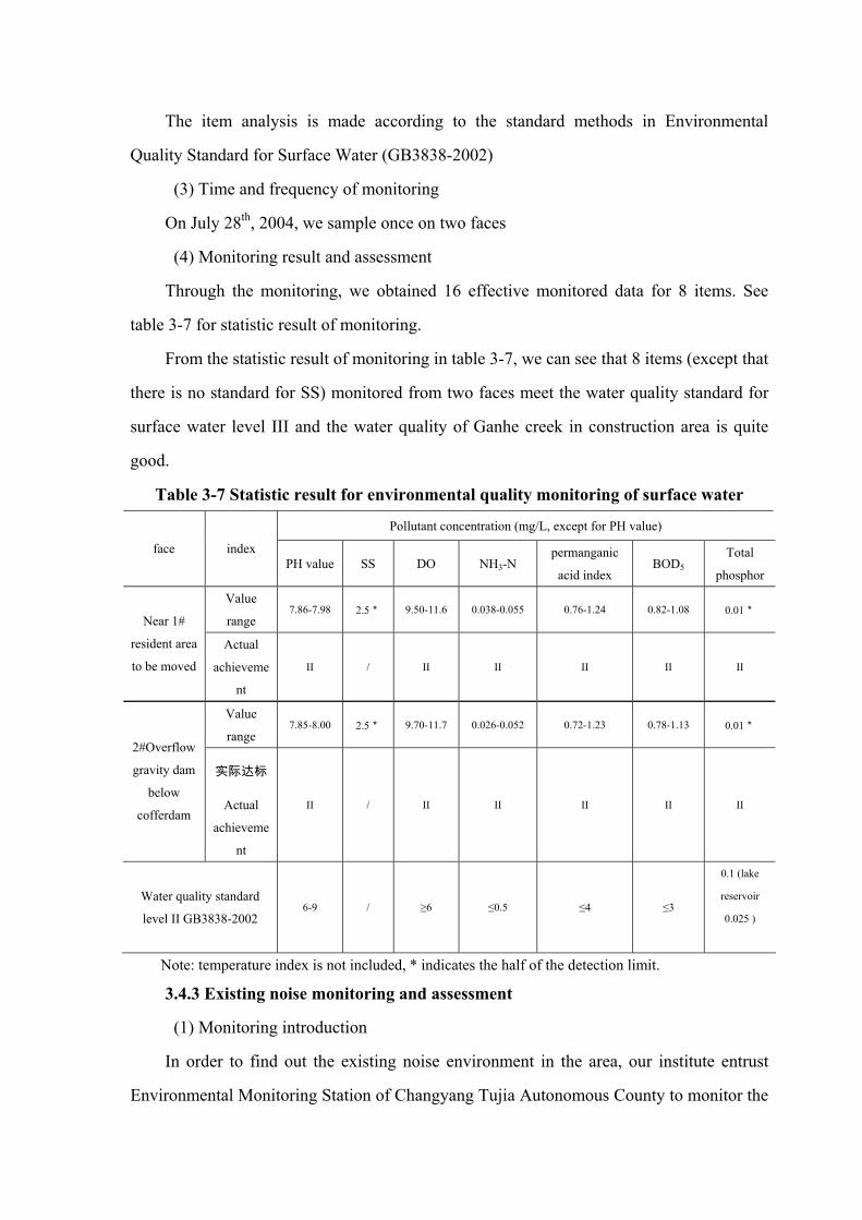
The item analysis is made according to the standard methods in Environmental
Quality Standard for Surface Water (GB3838-2002)
(3) Time and frequency of monitoring
On July 28th, 2004, we sample once on two faces
(4) Monitoring result and assessment
Through the monitoring, we obtained 16 effective monitored data for 8 items. See
table 3-7 for statistic result of monitoring.
From the statistic result of monitoring in table 3-7, we can see that 8 items (except that
there is no standard for SS) monitored from two faces meet the water quality standard for
surface water level III and the water quality of Ganhe creek in construction area is quite
good.
Table 3-7 Statistic result for environmental quality monitoring of surface water
Pollutant concentration (mg/L, except for PH value)
face index PH value SS DO NH3-N
permanganic
acid index BOD5 Total
phosphor
Value
range 7.86-7.98 2.5* 9.50-11.6 0.038-0.055 0.76-1.24 0.82-1.08 0.01*
Near 1#
resident area
to be moved
Actual
achieveme
nt
II / II II II II II
Value
range 7.85-8.00 2.5* 9.70-11.7 0.026-0.052 0.72-1.23 0.78-1.13 0.01*
2#Overflow
gravity dam
below
cofferdam
实际达标
Actual
achieveme
nt
II / II II II II II
Water quality standard
level II GB3838-2002 6-9 / ≥6 ≤0.5 ≤4 ≤3
0.1 (lake
reservoir
0.025 )
Note: temperature index is not included, * indicates the half of the detection limit.
3.4.3 Existing noise monitoring and assessment
(1) Monitoring introduction
In order to find out the existing noise environment in the area, our institute entrust
Environmental Monitoring Station of Changyang Tujia Autonomous County to monitor the

regional noise environment in the dam site and power house area of the project on July 28th,
2004. Though there are resident houses near the power house, it keeps the original
ecological environment in the dam site and power house area. Therefore only 2
representative monitoring points are set up in the above site respectively. One monitoring
point at dam site is at 10m near the river while another monitoring point is at 50m near the
river. One monitoring point at power house is in front of the Lengshuiqiao Restaurant on
the east of planed power house while another point is near the 318 National Highway on
the north of the planned power house.
(2) Monitoring period
Both daytime and nighttime noise environments are conducted. The daytime
monitoring period is 8:00-20:00, while the nighttime monitoring period is from 23:00 to
6:00 in the next day.
(3) Monitoring result and assessment
4 data for equivalent noise monitoring are obtained through the monitoring. See table
3-8 for monitoring results.
Table 3-8 Monitoring results of noise environment No. and
name of
monitoring
point
Monitoring
period
Equivalent
sound level
Assessment
standard level
Assessment
standard value
Standard
achieving or
exceeding
Main effective
factors
Daytime 48.0 55 Achieve the
standard running water 1# dam
site, 10m
from the
river
Nighttime 46.0
1
45 Not achieve the
Standard Running water
Daytime 47.0 55 Achieve the
standard
Background
value 2# dam site,
50m from the
river Nighttime 42.0
1
45 Achieve the
standard
Background
value
Daytime 48.9 55 Achieve the
standard
Background
value
3#
powerhouse,
Lengshuiqiao
restaurant Nighttime 42.5
1
45 Achieve the
standard
Background
value
4#
powerhouse, Daytime 56.8 4 70
Achieve the
standard
Background
value

near 318
National
Highway
Nighttime 48.6 55 Achieve the
standard
Background
value
Based on the monitoring results in table 3-8, the assessment is made according to
Standard of Environmental Noise of Urban Area (GB3096-93). Due to the running water,
at the dam site 10m from the river, the background noise is high, which achieves the
standard at daytime while the equivalent sound level at nighttime exceeds relative standard
value limit. At the dam site 50m from the river, it is less effected by running water, where
the equivalent sound levels of background noise at daytime and nighttime falls in
42-45dB(A), which meet the relative standard value limit of 55dB(A) and 45dB(A) for
daytime and nighttime respectively. At the powerhouse near 318 National Highway, there
is resident houses and resident activity area with small traffic flow, where the daytime and
nighttime noise meets the standard value limit of 70dB (A) and 55dB (A) respectively.
The dam site situated in remote mountains or between valleys is less effected by the
outside. Without considering the effective factors of running water, insects and twittering,
the planed site has good acoustic environment; the powerhouse is not developed with rather
small crowd and traffic flow and quite good regional acoustic environment.
3.4.4 Assessment on existing ecological environment quality
3.4.4.1 Complete background assessment on natural ecological system
(1) Background production capacity of natural system
The net primary productivity of natural vegetation reflects the production capacity of
the plant community in natural environment, that is, the production capacity of the natural
system without any external artificial disturbance. By Comparing with many ecological
matrixes and referring to the eco-physiological features of plants and thermal water balance
equation, the comprehensive net primary productivity matrix of natural vegetation is
established based on the measured data. Compared to other matrixes, this matrix better
reflects the primary productivity of natural vegetation. The calculation formula of the
matrix is as follows:
NPP = RDI2· ( )( ) ( ) ( )RDIExp
RDIRDIRDIRDIr 25.687.9
111 2
+−×+⋅+++⋅

RDI=(0.629+0.237PER-0.00313PER2)2
PER=PET/r=BT×58.93/r
BT=∑ 365/t 或∑ 12/T
In the formula: RDI-radiation dry index
r-annual rainfall, mm
NPP-natural veneration net primary productivity, t/(hm2·a),
PER- possible evaporation rate
PET – annual possible evaporation rate, mm,
BT – average annual biological temperature, �,
t – Daily average between 0� and 30�
T – Monthly average between 0� and 30�
Based on the measured hydrological and weather information of Changyang County
and the river basin, the average annual air temperature of the area is 16.6�, the average
annual rainfall in the controlled area of Changfeng reservoir is 1425.3mm. After calculated
and analyzed through the above matrix, the background net primary productivity of natural
vegetation in the assessed area is 3.16g/m2·d, which is quite high.
(2) Stability of the natural system background
According to the calculated results, the productivity of the assessed area is 3.23g/m2·d
(1178.95g/m2·a). Through comparing and analyzing the research result of net productivity
of ecological systems on the earth and plant biomass, the average net productivity of the
area is close to the average net productivity of temperate zone broad leaf forest
(1200g/m2·a) with high vegetation productivity and strong restoration stability of the
system. The background restoration stability of the assessed area is quite high.
3.4.4.2 Existing ecological integrality of natural system
(1) Existing productivity of natural system
According to the site investigation and the existing surface vegetation coverage of the
assessed area, the vegetation in this area is categorized into woodland, shrubbery, farmland
vegetation and river shoal. Calculated according to the investigation result, the average net
productivity of the area is 1024.5g/m2·a or so, which is lower than the background value of
1178.95g/m2·a. This shows that the vegetation in the area is disturbed and damaged by

human activity; however, the productivity of the natural system in this area is higher than
the global productivity(720g/m2·a) in general.
The comprehensive analysis shows that human activities has certain disturbance on
the productivity of natural system in this area, however, the character of natural grade has
not changed fundamentally and the natural system still has quite strong restoring and
adjusting ability.
(2) Landscape Stability
� Impedance stability of landscape
Due to severe disturbance from human being, the biological component heterogeneity
is lower than background value. However, we see from the map of existing usable land in
the area that the woodland section has better connectivity among various sections of
landscape in the assessed area and appears more frequently, which shows that the
vegetation type in the area is mainly the woodland. Thus, the natural ecological system has
strong impedance stability.
� Biological restorability of landscape
Though the vegetation primary productivity in this area is lower than its background
value, it still maintains as transition ecological system between northern coniferous forest
and temperate zone broadleaf forest, which show that the natural system in the area has
strong biological restoring ability.
3.5 Main environmental problems
In the area and basin that the project is situated, there is no industrial enterprise, small
population, less cultivated land, good vegetation, less usage of pesticide and chemical
fertilizer. Therefore, the impact of environmental pollution is quite small. The main
environmental problems of the project area are listed as follows:
(1) Water and soil loss: generally speaking, the vegetation coverage in the river basin
is quite good, though there is natural landslide, landslip and debris avalanche in some area.
As a rainstorm area, it has 4-5 rainstorms annually on average. Usually, rainstorms and
floods occur in summer and autumn. Continuous rainstorms will lead to mountain flood,
which will cause severe water and soil loss, and even jeopardize residents and their
property. Heavy rains and rainstorms often cause landslide, and the collapse of fields, roads
and houses will ever cause casualties.
(2) Traffic Restriction
The dam site and the power house of the project is not far from the main traffic line
nearby, which is only 3kmm away. However the main transportation depends on low level
road in villages or mountain areas. The less developed traffic condition seriously restricts
the development of regional economy, which also has some impact on project construction.
4 Prediction and assessment on environmental impact
4.1 Hydrology and sediment
The construction actives in the construction period of the project and the water

retention and diversion occurred in project operation have changed the natural characters of
the water, which brings changes to the water level, flow rate, flow velocity as well as
sediment scouring and deposition at assessed reservoir zone, downstream of dam site and
river mouth, which has direct or indirect impact on the environment.
4.1.1. Hydrology
The project plans to built diversion tunnel from the dam site to power house of
Changfeng hydropower station, the water intake and diversion tunnel at power house is at
the right bank of the dam, which is about 100m away from the dam and the main tunnel is
5319.4m long. There are 5 adits along the tunnel and all together 10 working surfaces
including the intake and outlet, which can be used for tunnel boring the same time. It has
axial flow blower for ventilating and smoke exhausting, smooth blasting by artificial
trolley or tractor. Due to the spanning watersheds diversion, it will certainly, to some extent,
have impact on the runoff and water level of downstream of the diversion river basin.
Ganhe creek basin is a mountain-area river, where the flood is influenced by rainstorm
intensity and landform. It has heavy intensity rainstorm in the basin, steep river slope, short
flow concentration period, rapid flow rate and flash flood. The catchment area at upstream
of the dam site of Changfeng hydropower project is 55.8km2. When the reservoir starts
reserving water in operation, the runoff into reservoir is natural flow, while the discharge
runoff is related to the reservoir operation. In general, the annual runoff into reservoir and
discharge runoff are basically balanced.
After finishing building the reservoir, the flow rate and velocity of the river in the
reservoir zone will changes greatly. Due to the dam retention, the reservoir capacity is
much larger than the original natural watercourse, thus the flow rate of the reservoir reach
will be slower while the flow velocity and flow rate is related to the flood scale at that time.
The average annual flow rate at the dam site of Changfeng hydropower project is 0.99m3/s,
and the average annual runoff is 31.3699 million m3. The preliminary design does not
consider the perennial discharge flow. Since there is a 2km long watercourse from the dam
site to the outlet, a minimum discharge flow should be maintained during dry period in
order to ensure that the ecological environment of the lower reaches will not have sudden
change. In this circumstance, the hydrological environment of the lower reaches will not

have change a lot.
4.1.2 Sediment
There is no measurement data of sediment in Ganhe creek. We adopt the sediment
data of Zhailai river hydropower project at the lower reaches, whose average suspended
load sediment transport modulus is 488t/km2. The suspended and transport sediment
capacity is 1.3t/m3 and 1.5t/m3. The sediment detention rate estimated according to the
reservoir capacity coefficient is 80% and the average sediment into reservoir is 14600 m3.
According to No.4.7.4 of Design Code for Small Hydropower Station
(GB50071-2002), the sediment deposition limit of the project is 20 years with sediment
into reservoir of 292500 m3, deposition height before dam site is 1093.4mnm, and reservoir
sediment ratio higher than 30. Therefore the deposition of sediment into reservoir during
reservoir operation can be ignored.
4.2 Local climate
When the reservoir is built and starts to store water, the reservoir area is 0.185km2
(276.76mu). Since the original land is turning into water surface, the evaporation rate of the
reservoir zone will be larger than before and the vapor into the air will increase, thus the
humidity and temperature near the reservoir zone and its nearby area will change, which
will cause changes to the small local climate.
(1) Rainfall
According to relevant research results, the reservoir has no obvious change to the
precipitation of the area. It only has little change to the rainfall distribution. The annual
rainfall and summer rainfall in the reservoir central area is less than before, while the
rainfall in nearby area will increase. Since the reservoir river is rainstorm river, where
summer rainstorm is quite frequent, small changes in rainfall has weak impact to the whole
reservoir zone.
(2) Air temperature
When the reservoir starts to store water, the underlying surface of the reservoir area
turned from land into water, the physical property of the underlying surface changes a lot.
The natural watercourse is turned into relatively still water surface with higher water level,

larger water surface and larger water depth. The thermal exchange between the water in
reservoir zone and the air changes, which lead to air temperature rise after water storage in
reservoir zone. In addition the air temperature change will become moderate after water
storage, while the daily temperature range and annual temperature range becomes smaller,
the max annual air temperature get lower and the minimum annual air temperature rises.
The above air temperature change is rather tiny.
(3) Humidity
After water storage of the project, the evaporation rate of the water surface increases
and the reservoir humidity will be different compared with the condition before reservoir
construction with increased average annual relative humidity. As regard to season
distribution, the summer time is getting longer and winter is getting shorter, while spring
and autumn sees little change.
(4) Wind
The planned construction project is a typical watercourse reservoir, the prevailing
wind after reservoir construction has no obvious change due to major climate and landform
conditions. The reservoir zone belongs to the weak wind area. Due to the temperature
difference between water surface and land surface, the frequency of prevailing wind
increase while the frequency of static wind decreases; smooth ground replaces the original
uneven land with less roughness, which increases the surface wind velocity in reservoir
zone.
(5) Fog
When the project is finished, the temperature rise in daytime and summer in reservoir
zone, as well as the temperature fall in nighttime and in winter will be slower than that in
the air and land. The above cooling & heating source function helps to form steam fog in
winter and radiating fog in summer. In the meantime, due to the temperature, humidity and
wind effect of the reservoir, the air temperature rise in winter and falls in summer; the
humidity decreases in winter and increases in summer; the wind velocity in the whole year
increases. These changed factors have some impact on fog, while the major factor of fog
forming is air circulation. It is estimated that the construction and operation of the planed
project will not change the fog.

4.3 Environmental geology
4.3.2 Leakage analysis
(1) Reservoir leakage
a. Leakage on right bank
The rocks on the right bank of reservoir are thick. The nearest valley to the reservoir is
Qingyan creek of 5km away. The elevation of Qingyan creek valley is 540m, which is
lower than the normal pool level of reservoir of 500m. From the reservoir zone
investigation, there are two exposed spring on the right bank Q1 and Q2, and water in the
small branches is running into the reservoir. The rocks of reservoir bank do not develop
karst. We conclude through analysis that the groundwater near the watershed on the right
bank is running into the reservoir zone. Based on outlet ZK6, the elevation of groundwater
is 1082.4m, which is a litter higher than the river water level. It is estimated that the there is
no karst groundwater low land on the right bank of reservoir. Therefore, it is concluded that
there is no reservoir leakage on the right bank.
b. Leakage of left bank
The rocks on the left bank of reservoir are relatively thin. The nearest valley is only
2km away from the river valley of the branch of the main ditch in Xiufengqiao village.
Since the reservoir bank stratum is limestone –shale of upper Shipai formation and
limestone-shale of Shilongdong formation as well, which is aquiclude itself. From reservoir
bank zone to the nearby valley, there is Dawan formation, which is better aquiclude. The
strike of the stratum parallels with the reservoir bank, thus it is impossible for the left bank
to leak into the near valley.
From the investigation result of land surface, there is a kW1underground river doing
into the reservoir. Other part of the reservoir has dry rocks and karst is not developed. No
karst pipeline is found that connects the internal and external reservoir. The drilled hole
exposes no strong karst area; the groundwater level in the drilled hole is much higher than
the river water level. It is concluded that the left bank has no leakage either.
c. Leakage of reservoir bed
The reservoir bed is not wide, where the stratum is mostly limestone and shale of

upper Shibei formation of lower Cambrian system, as well as dolomitic limestone,
limestone and shale of Shilongdong formation near dam site. There is a strong karst belt
near two river mouths and some small karst caves in other parts. The geological and
hydrological environment of the reservoir decides that the reservoir bed has no leakage
problem.
d. Penetrability of dam monolith stratum
The rock mass of the dam monolith is complete. There is no strong karst in the land
surface or any possibility for leakage along the karst pipeline to external reservoir. The
shallow rock mass has developed joint fissure. The rock mass has weak to moderate
penetrability and curtain grouting should be made to prevent leakage.
4.3.2. Stability analysis
The slope height of both valley banks is 300~600m with slope angle of 40~80° and
rock stratum dip angle of 31~45°. There is no large scale unstable part and the general
reservoir bank is quite stable. However the right bank slope near the dam monolith is not
stable. It is made of rock fall karst deposition, which is loose and not bonded with
thickness of 5-10m. With reservoir water storage, there is possibility of landslide near the
immersion line. Though it has small impact on the reservoir, the swell due to landslide into
reservoir has concern impact on the dam, which should be placed much attention.
(2) Karst
The stratum lithology of banks of reservoir zone, the Cambrian system on periphery
and the Ordovician systemn which are mainly carbonates. These rocks develop karst.
Relatively, the karst development in Honghuayuan formation and Najinguan formation of
lower Ordovician system are strong while the karst development of Shibei and
Shilongdong formation inside the reservoir basin are weak. The karst scale are different
and has various shapes such as discharge tunnel, underground driver, blind valley, karst
cave, karst hole, karst fissures, etc.
According to the survey, most visible surface karst caves are located above the
reservoir water level and are dry caves. The biggest kasrt cave is Huangyangping karst
cave, with 1430m cave entrance elevation, 30 wide, 12m high, 15m deep. In the cave, there
is water year around and sandy loam. Near Huangyangping, there are many water

discharge caves and groundwater is deeply laid hidden in earth. These water discharge
caves have elevation of about 1380~1450m. There is no big exposed spring on the northern
(right) bank of reservoir, while there is a big exposed spring in Lengshuiqiao, with
estimated flow rate of 90L/S, which has some hydraulic connection with ground water in
Huangyangping. During level period, Huangyangping area will be dried up to be a blind
valley.
Karst caves in the reservoir basin are small, from tens of centimeters to 1.5m, which
are blind caves filled with clay and less connected to the nearby area. At the two river
mouths, there is a 20m-wide-120m-long strong karst belt and karst fissures are developing
along the stratum surface, or small karst caves are developed along vertical fissures with
size of 5~15cm. The karst belt mainly has shallow development, which is less extended to
nearby area and less connected to other karst caves. In summary, the stratum karst in the
reservoir basin is not developed.
(3) Rock fall
The slope toe of the banks in dam zone has lot of colluvial deposits, which is
several-meter-thick to over ten-meter-thick with small excavation volume. The natural
slope angle is stable at present. With a free face formed after excavating dam foundation
and the impact of previous blasting, there may has new unstable rock mass.
(4) Dam body stability analysis
The max dam height of the project is 58.8m, the designed upstream dam slope is 1:
1.4while the downstream dam slope is 1:1.4. The deck rockfill dam is located at
downstream water load. The whole rock-fill body and water gravity is resisting dam slide
because the horizontal thrust of water load is about 1/8 of the rock-fill body while the water
weight and the resultant forces of water load on dam axis is transmitting to the groundwork,
which is good for stabilizing the dam slope. By using steel bar concrete leakage proof deck,
the rock-fill body is hardly affected by penetrability. If there is any leakage in the deck, the
leakage can be discharged out of the dam since the rock-fill body has good penetrabitliy,
which will not affect the stability of the dam. The 1:1.4 dam slope is equivalent to slope
angle of 35°32′, which is smaller than the natural repose angle (about 37°) of loose fill and

much smaller than the internal friction angle of roller compacted rock-fill body. Therefore,
the deck rock-fill dam has good integral stability.
(5) Reservoir induced earthquake
The total reservoir capacity of the project is 4.001million m3, which is a small
reservoir. The reservoir is situated at stable-structure area without large fault or active fault
going through the reservoir zone. The water storage in the reservoir will not lead to
structure induced earthquake. However, due to regional karst developed in carbonate
terrane in the reservoir zone, the reservoir water infiltration may result in deep circulation
of groundwater. This may induce earthquake with weak intensity.
4.4 Estimation (analysis) and assessment on aquatic environmental
impact
4.4.1 Pollutant analysis
(1) Agricultural pollutant
According to the survey, there are Wenjiaping village, Xiufengqiao village and
Bajiaomiao village near the reservoir zone with total cultivated land area of 18616mu in
2003 while the 5500mu land area is involved in the reservoir project. The chemical
fertilizer amount applied per area differs little with average application volume of 30kg/mu
or so. Restricted by the traffic condition and cultivation in the planed project area, the
actual fertilizer application is lower than average. Based on the average volume, the
fertilizer application in the reservoir zone should be 165t/a. It is calculated by the
application proportion of nitrogenous fertilizer and phosphorous fertilizer, the nitrogenous
fertilizer applied is about 100t/a while the phosphorous fertilizer is about 50t/a.
According to the statistics, the fertilized in Wenjiaping village, Xiufengqiao village
and Bajiaomiao village in past five years changes little. The land area will not change
much as well. Therefore, when the reservoir is built, it can be predicted that the chemical
fertilizer application in 2010 can be decided based on the application volume in 2003.
Meanwhile, the average total soil loss in the reservoir zone is 17800 m3 according to the
preliminary design report. In this assessment, the nitrogen loss and phosphor loss due to

soil loss is considered at 10%.
Method of estimation: it is calculated according to the estimation equation for soil
nutrition loss provided by Code for Environmental Impact Assessment of Water
Conservancy and Hydropower Project (On trial) (SDJ88-2003), namely:
E=aSNp+bcdFNp In the equation:
E – Estimated total soil nitrogen and phosphor loss into the reservoir, t/a
SNP-total nitrogen and phosphor into water and soil, total soil into reservoir multiply
total nitrogen and total phosphor;
a-Longitudinal consumption coefficient of nitrogen and phosphor, Nitrogen70%,
phosphor 95%, the nitrogen into water is 30%, while the phosphor into water is 5%;
FNP-Fertilizer application
b-average nitrogen and phosphor amount in chemical fertilizer, standard average
nitrogen amount in fertilizer is 23% and standard average phosphor amount is 15%;
c-fertilizer utilization rate of crops, nitrogen 30% and phosphor 15%, the 70%
nitrogen and 85% phosphor are discharged into water
d-fertilizer loss rate after discharged into soil and water, nitrogen 30%, phosphor
5%.
Based above calculation, total nitrogen and phosphor brought into to the reservoir
through farming in 2010 is 10.97t/a and 3.55t/a respectively.
The farmland runoff pollution load is not only affected by rainfall, landform, soil and
other natural factors but also the number and transferring process of land surface pollutant.
Through comparison with the research result of farmland runoff pollution in the
three-gorge area, it is preliminarily estimated that the discharge of runoff pollutant COD
and BOD5 in farmland surface of Ganhe creek reservoir zone in 2010 is about 187.8t/a and
76.2t/a respectively.
(2) Domestic pollution source

According to the survey, it is sparsely populated in the reservoir zone. The back water
zone and upper reaches of reservoir involves Maping village, Zilangping village and
Sheping village. There is no enterprise of industrial pollution in the villages. The total
resident population of the villages is 9909 persons in 3023 households, among whom about
1980 persons in 600 households are draining their domestic sewerage into Ganhe creek.
The drained domestic sewerage is the main domestic pollutant in reservoir zone. The
estimated drained domestic sewerage is calculated by following equation:
In the equation: X2—estimated sewerage drainage in level year (t/a);
Lt – sewerage drainage per capita (t/a);
Y0 – population in benchmark year
μ- population growth rate (‰).
Referring to the design code for outdoor drainage, the domestic sewerage per capita is
calculated as 150L/d per capita, the main pollutants COD, BOD5, T-P and T-N are
calculated according to the regular drainage concentration of domestic sewerage of
400mg/L, 200mg/L、 2.0mg/L and 25mg/L respectively. It is estimated that the domestic
sewerage drainage in 2010 is about 108400 t/a and the drainage of main pollutants COD,
BOD5, T-P and T-N is 43.36t/a, 21.68t/a, 0.22t/a and 2.71t/a respectively.
4.4.2 Estimation and assessment of reservoir water quality
4.4.2.1. General water quality of reservoir
(1) Preliminary stage of water storage
During the preliminary stage of water storage in reservoir, various organics are
released from inundated land and vegetation. The dripped and decomposed organics will
cause some adverse impact on the reservoir water quality. The monitored data from
reservoirs at home and abroad shows that the dissolved oxygen, mineralization, nutrition
and plant growth in the water are related to the water-retaining-level of the reservoir.
Changfeng hydropower project has 0.163km2 reservoir area with smaller inundation area.
Meanwhile, sanitary cleaning is made in the reservoir bed before water storage, which
reduces the quantity of organics in the reservoir. The impact from various dripped and
0)1(0tt
tt YLX −+= μ

decomposed organics in the inundated land after reservoir water storage is also reduced and
the impact on the reservoir water quality is small.
(2) Normal reservoir operation period
During the normal operation period of Changfeng hydropower project, the main
pollutants in the reservoir consists of background values of upstream river, domestic
sewerage from upstream villages and farmland runoff near the reservoir zone. The general
water quality during reservoir operation period is estimated by zero- dimension-matrix.
The matrix of estimation:
( )tKVK
WCVK
WC hh
hh
t −⎟⎟⎠
⎞⎜⎜⎝
⎛−+= exp00
)(
KVQK h +=
In the equation: C(t)-pollutant concentration in calculating period, mg/L;
W0-rate of pollutant into reservoir, g/s;
Kh-intermediate variable, s-1;
V-reservoir capacity, m3
Q-reservoir discharge rate, m3/s;
K-comprehensive pollutant decontamination factor, s-1;
C0-Existing reservoir pollutant concentration, mg/L.
Taking BOD5 as estimation factor and other item are used in qualitative analysis. The
estimated average BOD5 concentration after water storage in 2010 is listed in table 4-1.
Table 4-1 Estimated average concentration of main pollutant BOD5 in Changfeng
hydropower project in 2010
Calculation period t(s) Calculation period
1 1000 3600
Result of estimation 0.018 0.018 0.016
From the estimated result, the average concentration of BOD5 in reservoir zone in the
level year of 2010 meets the level II water standard in Environmental Quality Standard for

Surface Water (GB3838-2002) .
It can be concluded that the hydrological change caused by water storage during
reservoir operation of Changfeng hydropower project will not lead to any obvious adverse
impact on the general reservoir water quality. The reservoir water will maintain its original
quality in general.
(3) Estimation and assessment on reservoir eutrophication
The Dillon Matrix
In the equation: P—nitrogen and phosphor concentration of reservoir, mg/l;
L—nitrogen and phosphor load into reservoir, g/m2·a;
H—average water depth of reservoir, m.
In the equation:
Q—annual flow into reservoir, m3/a;
V—reservoir capacity, m3;
R=0.246exp(-0.271Qi)+0.574exp(-0.00949Qi)
In the equation: Qi—hydraulic load,Qi=Q/A,m/a;
A —reservoir water area, m2.
We work out that the nitrogen and phosphor load (L) after reservoir construction is
67.3g/m2·a and 21.8g/m2·a respectively. The above result does not take into account the
water and soil loss due to land inundation or reduced artificial control as well as fertilizer
application. The nitrogen and phosphor into reservoir are calculated based on present data
of the nitrogen and phosphor into river. The calculation results of estimated parameters are
listed in table 4-2.
Table 4-2 Estimated parameters of reservoir eutrophication of Changfeng
hydropower project
Item Q(m3/a) V(m3) A(m2) H(m) ρω Qi(m/a) R
VQ
=ωρ
[ ] ( )ωρHRLP −
=1

Reference value 0.3122×10⁸ 0.04001×10⁸ 0.185×10⁶ 34 7.8 168.8 0.1157
The estimation level year is 2010. From the above matrix and parameters, we work
out the total nitrogen concentration and total phosphor concentration of reservoir water is
0.0254mg/l and 0.0078mg/l respectively.
In the eutrophication of lakes and reservoirs, the eutrophic elements are the main
control factors. According the AGP measurement in Lake Eutrophication Investigation
Standard (2nd version), it is found that most lakes are phosphor restricting while some are
nitrogen restricted lakes. There is no domestic standard for lake eutrophication. In this
assessment, the eutrophication after reservoir construction of Changyang hydropower
project is assessed by referring to some domestic standard for lake eutrophication. See
table 4-3 for detailed standard.
Table 4-3 Domestic standard for reservoir eutrophication unit: mg/L
Main water quality index Index of Tahu LakeIndex of Lake Eutrophication
Investigation Standard Type of nutrition Total
nitrogen Total
phosphor Total
nitrogenTotal
phosphorTotal nitrogen Total phosphor
oligotrophic <0.25 <0.02
Oligotrophic- mesotrophic
0.2~0.4 0.005~0.01 0.16 0.01 0.16 0.01
Mesotrophic 0.3~0.65 0.01~0.03 0.31 0.023 0.310 0.023
Mesotrophic -eutrophic
0.5~1.5 0.03~0.10 0.65 0.050 0.650 0.05
Eutrophic >1.5 >0.10 1.20 0.110 1.20 0.11
According to the assessment result of the report, the quality index of water upstream
the dam site meets Environmental Quality Standard for Surface Water (GB3838-2002)
level II.
It can be concluded from table 4-3 that the reservoir water quality after construction of
Changfeng hydropower project is oligotrophic. From the dam site to reservoir zone, the
area along the river is sparsely populated, the existing upstream pollutant load is limited
and water exchange is frequent, thus the eutrophication is less possible though the water
depth is increased and the flow rate is lowered. It is concluded that under the existing
trophic condition, the general water qualify of Changfeng hydropower project will not
developing into eutrophication.

(4) Water quality analysis and assessment on downstream face of dam
The landform and geomorphy of upper reaches from dam site of Changfeng
hydropower project to river mouth is similar to that of the upstream of dam, which is
sparsely populated with no domestic drinking water intake or sewerage drainage outlet.
The runoff regulation on the lower reaches of dam through reservoir operation and the
water quality of discharge water are the main factors that effects the water quality of lower
reaches of dam.
� Analysis on water quality change in flood season
For the flood protection requirement of Changfeng hydropower project, its task is to
ensure the safety of the dam and the normal operation of power house. The limiting level
during flood season is the normal pool level of reservoir. If the flood retarding exceeds the
pool level, all gates will be opened for flood discharge. The impact on hydrological
condition of lower reaches of the dam is small as compared with the original condition of
natural watercourse. With reservoir sediment, the quality of discharged water is better than
natural water condition, which helps to improve the water qualify of lower reaches of the
dam. According to the analysis on the operation of other reservoirs, the reservoir operation
in flood season only has small impact the water quality of downstream of the dam.
� Analysis on water quality change in non-flood season
By referring to the average annual flow in other hydropower projects, the water
discharge of reservoir regulating operation is compared with natural water inflow. The
reservoir starts retaining water after flood season. The water discharge is less than natural
water inflow and the water discharge in dry season does not exceed the natural water
inflow.
The reservoir water storage after flood season, the dam water discharge is less than the
natural water discharge. Analyzing from the capacity of aquatic environment, it is larger
when the flow is large. Since the flow after flood season is smaller than the natural water
flow, which has some impact on the aquatic environment of the lower reaches of the dam.
However the flow after flood season will not be smaller than the capacity of aquatic
environment in dry season. Therefore, there is no obvious impact on the water quality of
this reaches.

4.4.3 Reservoir water temperature estimation
Reservoir temperature is a major index of aquatic environment. The fishes in the
country are mainly warm-water fishes. The appropriate water temperature for warm-water
fish growth and breeding is 15-30�. The water temperature change in downstream
reservoir will have certain impact on the aquatic organism in downstream of dam. The
water temperature is closely related to water quality, which has obvious influence on
indexes such as DO, BOD5, COD and fecal coliform. Water temperature is also the
necessary data of researching and monitoring the water leakage and permeating in concrete
dam. Therefore, researching and analyzing the reservoir water temperature important for
the comprehensive utilization of water, water quality protection and fully displaying the
reservoir benefit.
(1) Structure of reservoir water temperature
When the reservoir starts water storage in operation, the water temperature will
change as a hydrological factor showing thermal condition. The distribution of reservoir
water temperature is influenced by many factors including solar radiation, reservoir
capacity, reservoir water inflow and outflow, water temperature, shape of reservoir,
sediment, reservoir regulating methods and so on.
To see if the reservoir water temperature is stratified due to water retarding, two
methods can be applied: judge from the number of reservoir water exchange α and the ratio
between one flood discharge and actual reservoir capacity β; or judge by Ford density
index Fd. , At the preliminary stage Three-gorges project constriction, Changjiang Water
Resources Protection Institute(CWRPI) has researched on this. The institute has conducted
complete research on reservoir water temperature effect in its national major scientific task
of Water Temperature Estimation of Three-Gorges Hydropower Project. The water
temperature in the reservoir changes with water depth. Usually reservoirs are divided into
thermal mixed, thermal stratified and thermal transition. See table 4-4.
Table 4-4 Judgment of reservoir water temperature α
α value Type of reservoir water temperature
<10 thermal stratified reservoir
>20 Thermal mixed reservoir

10~20 Thermal transition reservoir
Thermal mixed reservoir: the water temperature is distributed evenly in the
reservoir at any time with small gradient.
Thermal stratified reservoir: in temperature rising period, the water temperature
of reservoir surface is obviously higher than that of middle and lower level of
reservoir water temperature with gradient above 1.5�/m. The annual difference of
water temperature in reservoir bed is within 15�。
Thermal transition reservoir: the water temperature in this reservoir features both
the thermal mixture reservoir and thermal stratified reservoir.
(2) Type and impact of reservoir water temperature
This assessment adopts factorαto assess the structure of reservoir water temperature of
Changfeng hydropower project. The factor αis quite simple, which is checked by reservoirs
with measured water temperature data. The result of the above method is basically same as
the actual data. Its equation is listed below:
α=average annual runoff/total reservoir capacity
The α value of Changfeng hydropower project is 7.8(<10), which shows that the
structure of reservoir water temperature is typically thermal stratified. Since there is
obvious seasonal flow and flood flow in Ganhe creek, the flood in this river basin is mainly
caused by heavy rain which usually occurs in May-August. The flood rise and fall violently
in short period with large flow. After building the reservoir, the water is relatively static,
thus its thermal storage is better than river, and its surface water temperature is higher than
that of natural rivers. According to measured data from the branch reservoir in the
Gezhouba Dam, the temperature of water inflow in temperature rise period will rise as well
as the surface water temperature along the reservoir; the surface temperature of water
inflow in reservoir tail is similar to that of natural rivers; the surface temperature of water
inflow in reservoir and dam front in winter is similar to that of natural watercourse, while it
is different in spring, summer and autumn; the surface temperature in general reservoir is
about 2� higher than that of natural watercourse, while the temperature of reservoir bed is
similar to that of surface water temperature.

(3) Temperature analysis on reservoir water discharge
The temperature of reservoir water discharge is related to many factors such as the
location of reservoir water outlet, reservoir water flow rate, inflow water temperature and
local air temperature at that time. Based on the measured data of Xinanjiang reservoir and
Danjiangkou reservoir in China, the watercourse temperature below the dam is well related
to the reservoir water temperature in certain depth, which should be 15~20m in the
reservoir. The water temperature difference in the reservoir of Changfeng hydropower
project is small. Therefore, the outflow water temperature differs little with that of natural
rives at the same time.
Based on the investigation, the water flow in the reaches is rapid with no large spawn
area of commercial fishes and precious fishes, no demand for production water and
domestic water, and no demand for irrigation as well. Therefore, it has no adverse impact
on the fish growth and breeding, water quality and aquatic organism at downstream face of
dam, and farmland irrigation.
4.5 Analysis and assessment on ecological environmental impact
The impact on ecological environment by hydropower project features obviously.
During the construction period of the project, it mainly causes unfavorable impacts on the
ecological environment, while during operation period; it has multiple impacts on the
ecological environment. Its unfavorable impacts includes: possible reduction of biomass
and bio-system change due to reservoir inundation. Its favorable impacts includes:
developing small hydropower station can change villagers’ bad habit of using firewood and
lowers the possibility of reducing wildlife habitat due to villagers’ wood cutting; improved
regional climate in the reservoir zone will provide better condition for vegetation
replacement near the reservoir zone; the construction of project may have effective control
on artificial and original water & soil conservation, which reduces floods, landslides and
mud-rock flow, thus improves ecological environment.
4.5.1 Assessment on the integrity of ecological environment
Changfeng hydropower project has impact on the integrity of natural system, which is
due to reservoir inundation and project land use. Construction of Changfeng hydropower

project will inundate 276.76mu land, among which there are 22.65mu cultivated land,
121.5mu fuel forest, 30.3mu timber forest and 102.31mu barren mountains; the permanent
land use of project is about 204mu and the temporary land use is 54.9mu. In the reservoir
inundated area, there are 3 households and 120 m2 housing to be moved. The reservoir
inundation and project land use will reduce the regional green area and change the
productivity and stability of natural system, which has certain impact on the integrity of
regional landscape ecological system.
(1) Analysis on productivity change in regional natural system
The productivity of landscape ecological system is influenced by reservoir inundation
and project land use, which changes the type and area of various sections of the landscape
in the assessed area, and reduces the area of woodland and bushes with high higher
productivity due to inundation and project land use. Due to reservoir water storage, the
river and shoal with lower productivity will be changed from unstable stream river into
stable reservoir, where the biomass in aquatic ecological system will be increased
obviously and productivity will be improved greatly. In a short period, the general regional
productivity is in falling trend.
(2) Analysis on change of landscape ecological system stability
The stability of landscape ecological system has two features: restorability and
impedance. Restorability is the capability of restore to the original state when the system is
change; impedance is the capability of resisting or preventing the environmental change or
potential disturbance. When the regional land ecological system in project area is inundated,
it is transiting to aquatic ecological environmental system. The productivity of each system
will reach new balance after short fluctuation. Since the area influenced by inundation and
permanent project land use cover less than 1% of the area, the impedance of natural system
will not decline to lower level due to the small inundated woodland by reservoir water
storage. The construction of hydropower station has little impact on the stability of
landscape ecological system. Therefore, the impact on regional landscape from
construction and operation of hydropower station is within the ecological load limit, which
is endurable for the regional natural system.
(3) Comprehensive assessment on quality of landscape ecological system

After construction and operation of Changfeng hydropower project, the land use
pattern in the region is changed. After project operation, the advantage of various land
types will change, among which the aquatic section will have more advantage due to
reservoir inundation, the advantage of bushes will decrease a little due to reservoir
inundation and the advantage of woodland maintain the same. The total water surface area
in reservoir zone is 0.185km2, while the landscape ecological system in the zone is far
larger than the changed area. Therefore, the woodland and grass land are still the mold land
in the zone. This shows that the construction and operation of project has no major impact
on the landscape quality of natural system in the assessed zone.
4.5.2 Analysis of impact on terrestrial plant
During the construction period of the project, there is certain impact on the vegetation
due to excavation of quarry area and earth, changed traffic route, building of water
diversion power system, residue yard and so on.
According to the on spot investigation, there are small paths in mountain area going to
the construction site, which is being improved and updated. In the areas along the paths
there are Chinese red pine forest and bushes. In the zone within the road excavation line,
the vegetation will be destroyed and excavation free surface on the roadside, which will
likely cause water and soil loss in stormy days. The temporary land use of the project is
54.9mu and the vegetation type is shrubberies and grasslands.
According to the on spot investigation, the plants impacted by inundation are mainly
the widely distributed species in the reservoir zone and Hubei province. There is no special
plant under national or regional special protection in within the inundation area. Thus the
reservoir inundation will not cause extinction of regional species. Since the land use of
project construction is small, which is limited within the project construction zone, it has
no obvious impact on the forest coverage in the construction impacted area.
When the reservoir starts water storage, with more project investment and improved
regional climate in reservoir zone, it will provide more favorable condition for vegetation
alternation in reservoir zone and its nearby area, and also brings favorable impact on the
growth and progressive succession of forest vegetation. Meanwhile, after project
construction, the water area in the reservoir zone is increased, which helps to improve
regional climate and is good for plant growth in reservoir zone.
4.5.3 Analysis of impact on terrestrial animals
Project construction will have certain impact on the amphibian and reptilian in the
construction zone, some of which may move out of the construction area and inundation
area, where its existence will not be threatened. The construction will force the birds and
animals on the temporary used zone to move out of original habitat. Birds, medium and
large beasts living near the construction zone may be scared by the blasting and drilling in
the construction period and move out of their original habitat. These unfavorable impact is
only limited to the construction period. With the recovery of vegetation in temporary used
zone of construction, the habitat will be restored. There will be more snakes in the
construction area, among which the bamboo snake is highly poisonous, and precautions
should be taken during the construction period.
When the reservoir is constructed, the reservoir inundation will reduce the distribution
zone of the terrestrial animals as the vegetation and shrubbery ecological system on
original watercourse and banks will be turned into reservoir ecological system. The animals
living in original reservoir zone are not special local species which can move to the
periphery of reservoir zone. The project construction will not cause severe threat to the
existence of these species. Meanwhile, with risen water level and enlarged water area, it
provides better living environment for lentic amphibian, which helps to increase its species
numbers. It will attract water birds and secondary water birds and increases there species
and numbers.
4.5.4 Analysis of impact on aquatic organism
(1) Analysis of impact on aquatic habitat
In natural condition, Ganhe creek is the habitat of rapid river valley with high flow
rate, large flow, water level fluctuation, large flow fluctuation in flood season and dry
season, river bottom of rocks, cobbles and sands, which is unfavorable for primary
productivity growth in aquatic ecological environment. When the reservoir is built, the
hydrological condition of the reaches in reservoir zone of Changfeng hydropower project is
changed. The fluctuation of reservoir water level is smaller, and the original open rapid
flow aquatic habitat is turned into tranquil flow aquatic habitat. The aquatic ecological

environment is changed from watercourse ecological environment to lake ecological
environment. When the reservoir operation reaches normal pool level of 1125.0m, the
reservoir area is 0.185km2 which is larger than that of natural condition and pool level in
dam front is 10-50m higher. With larger water area, water depth and water body, smaller
flow rate and deposited sediment, the water transparency is increased. Due to inundation,
the trophic salts in the reaches of the reservoir zone increase, which leads to improved
primary productivity, improved bait condition, increased biomass for tranquil water
environment and decreased biomass for rapid water environment.
(2) Impact on planktons
With reservoir water storage, the water flow is slower, which reduces the turbidity of
reservoir water, increases transparency and promotes photosynthesis of phytoplanktons.
Meanwhile the exudation of soluble substance in inundated area and the trophic substance
in land surface runoff will stay longer in the reservoir zone, which provides rich material
foundation for growth of planktons in reservoir water area. When compared with original
ecological river, the species structure and species number of the phytoplankton in reservoir
water area increases obviously. The distribution density and location of plankton are
changed with more plankton biomass. Meanwhile, there will be copepoda and cladocera
for tranquil or static water environment will appear in the reservoir zone, and the
chironomus plumosus and big tubifex worm for deep water and anoxic environment will
increase and become the dominant species in reservoir.
(3) Impact on benthic animals
With reservoir water storage, the pool level of dam front will be higher, which
changed the water exchange capability of natural watercourse. The sediment deposition
will change the bottom sediment and destroy the inhabiting environment of benthic animals.
It is estimated that the when the project is finished, the community structure of benthic
animals will be changed greatly, with less species that likes running water environment in
original watercourse. The community structure in the shallow water area of reservoir will
be mollusca, oligochaeta and chironomus plumosus.
(4) Impact on fishes
With reservoir operation, the aquatic ecological environment of original watercourse

changed a lot, which will directly influence the inhabiting, breeding and feeding condition
of fishes in original watercourse. Fishes suitable for living environment of valleys, rapid
water and shoals will move out. While the highly adaptable polyphagia fishes with high
breeding rate will be the dominant species in the reservoir zone such as carps and crucian
carps. The other fishes adaptable in both running water and tranquil water environment
keep stay in the reservoir zone. In general the dominated species of fish community will be
changed from flowing water habitat species to tranquil water or static water habitat species.
When the retention dam of Changfeng hydropower station is built, the original rapid
water ecological system is being destroyed successively. Construction of the dam cut off
the sailing upstream route of the fishes, which reduces the fishes resource in reservoir zone.
The hydrological condition in reservoir zone is much better then original watercourse. With
reservoir construction, the original open rapid water aquatic habitat is changing into
tranquil water aquatic habitat. The primary productivity in water will increase which is
good for the inhabiting and breeding of fishes in tranquil or static water.
4.5.5 Impact of tunnel construction on ecological environment
The diversion tunnel of the project is 5319.4m long, going downstream of Ganhe
creek on its right bank, which is one of the major projects. During constriction, 5 adits will
be built along the tunnel. There will be all together 10 working surface including the inlet
and outlet, which can be used for tunnel boring the same time. It has axial flow blower for
ventilating and smoke exhausting, smooth blasting and mucking by artificial trolley or
tractor. The depth of diversion tunnel is from 50m to more than 100m, which will not cut
off the migration route of animals. Thus the impact of tunnel construction on ecological
environment mainly includes vegetation damage and water & soil loss due to the waste
residue from tunnel excavation.
The over burden on the intake of hydropower water diversion tunnel is 3~5m thick. Its
bed rock is dark grey dolomite limestone of Shilongdong formation of lower Cambrian
system. Going through Changyang anticline in the tunnel to the outlet in Beiji, the stratums
are limestone-shale of Shilongdong formation of lower Cambrian system, Kelly shale of
Shibei formation, Calcareous siltstone and black slate; dolomite limestone of middle
Tanjiamiao formation, dark grey thick stratum dolomite limestone and white dolomite of

upper Sanyoudong formation; grey thick stratum macrocrystal limestone-shale of
Nanjinguan formation of lower Ordovician system; grey black thick stratum block
macrocrystal limestone of Fenxiang formation and black shale; dark grey thick stratum
macrocrystal limestone of Honghuayuan formation and nodular limestone and shale of
Dawan formation.
Along the tunnel, there are a few secondary faults of small scale with main structure
feature of joint, fissure and fault. The tunnel is going through the core area of Changyang
anticline. Though there is obvious partial fault in land surface, it is possible that there is
fault and close joint belt developed in the core according to the features of anticline
structure. Its impact on the tunnel can be hardly predicted. General speaking, there is no
large scaled adverse impact. The depth of the diversion tunnel in most areas is more than
200m. There is level II plantation surface above elevation with discharge tunnel developed
in Huangyangping area. The groundwater is discharged toward the north or the west. The
elevation of groundwater is higher than that of the tunnel crest. During construction, it can
be found that the groundwater in some area is quite rich.
In the preliminary report of main project, the waste residue is to be placed in 6 places.
The waste disposal area will have drainage ditches at three directions, lined with mortar
laid stone. The drainage ditch will be connected to nearby river and a sediment deposit will
be built at the outlet. Before placing waste residue, the surface mellow soil should be
separated and piled in the corner of the waste disposal area. When the construction is
finished and waste residue is disposed, the waste disposal area can be restored to farmland.
The detailed measure is listed as follows: clean, level off and earth up (45cm thick) the
waste disposal area before planting trees and grasses. Choose the 3-year-old-seeding of
Japan cedar with seeding height ≥0.8m and stem base≥3.5cm (or cypress as the second
choice) , 2-year-old seeding of bunge pine with seeding height ≥0.3m and stem
base≥1.5cm (or Chinese red pine as second choice). Plant trees in band in proportion of 3:2,
with band width of 6.0m, band space between of 1.0m and row spacing of 2.0m. The space
between trees in Japan cedar bank is 2.0m while the space between trees in bunge pine
band is 3.0m. Each band is optimized in square. Procumbent vine magnolia should be

planted under the trees (second choice kudzu vine), branches planted underground with
row spacing of 2.0m×2.0m and optimized in square.
By conducting the above measure, the adverse impact of tunnel construction can be
reduced.
4.6 Analysis and assessment on water & soil loss
This part is written according to the approved Report on Water and Soil Conservation
Plan of Changfeng Hydropower Project in Changyang, Hubei.
4.6.1 Destroyed area of water and soil conservation faculties
The project land use include permanent land use, construction road, restoration road,
borrow area, waste disposal area, construction road and restoration road, construction
temporary land use. According to the draft design report and the exploration investigation,
the construction land area is 38.42hm2. See table 4-5.
In the construction land area, the construction excavation or waste residue burying
will destroy to some extent the original geomorphy, surface rock structure and surface
vegetation, thus the original water and soil conservation function will be reduced or lost,
and accelerates water and soil loss. The damage caused by project construction will be
counted in destroyed area of water and soil conservation facility, which is 16.82hm2, see
table 4-6.
Table 4-5 Statistics of Construction land use unit: hm2
Item Water intake
works
Diversion
tunnel Penstock Power house Total
1.Project permanent land use 19.99 0.01 1.23 0.27 21.50
2.Construction traffic land use 2.00 2.00 8.00 12.00
3.Waste disposal area 1.94 0.57 1.09 0.72 4.32
4.Construction temporary
land use 0.20 0.20 0.20 0.60
Total 24.13 2.78 10.52 0.99 38.42
Table 4-6 Statistics of destroyed area of water and soil conservation facilities
Unit: hm2
Content Water intake
works
Diversion
tunnel Penstock Power house Total
1.Project permanent land use 0.19 0.01 1.23 0.27 1.70

2.Land use of construction road 2.00 2.00 8.00 12.00
3.Land use of waste disposal
area 1.94 0.57 1.09 0.72 4.32
4.Construction temporary land
use 0.20 0.20 0.20 0.60
Total 4.33 2.78 10.52 0.99 18.62
According to the water and soil loss before construction, the destroyed area of water
and soil conservation facilities are sorted as new water and soil loss area (for land without
water and soil loss before construction, including cultivated land, woodland, sparse
woodland with good forest coverage) and added water and soil loss area (land with serious
water and soil loss before construction). According to on spot investigation, the new water
and soil loss area is 18.62hm2, and the added water and soil loss area is 0.41hm2, see table
4-7.
Table 4-7 Type of project land use and destroyed water & soil conversation facilities
Type and quantity of land (hm2) Destroyed area of water and soil
conservation facilities (hm2)
Item Cultivated
land woodland
Sparse
woodland
Barren
land shoal Total
N e w w a t e r
and soil loss
area
Added water
and soil loss
area
Total
Project permanent
land use 1.98 6.10 15.35 1.37 21.50 1.70 0.41 2.11
Land use of
construction road 1.08 10.92 12.00 12.00 12.00
Land use of
waste disposal
area
1.94 1.66 0.72 4.32 4.32 4.32
Construction
temporary land
use
0.60 0.60 0.60 0.60
Total 5.00 6.10 27.93 0.60 2.09 38.42 18.62 0.41 19.03
4.6.2 Quantity of waste earth and disposal
The waste residue produced in the construction of Changfeng hydropower project
mainly comes from the main project as well as the excavation, base cleaning and slope
cutting of quarry area, borrow area, construction road.
From the draft design report, it is found that the waste residue from excavation, base
cleaning and slope cutting of main project is about 10.06万m3, among which waste rock

excavation is 84300m3 of about 170300t, waste earth excavation is 33100 m3 of about
56300t. The waste excavation from construction road, waste disposal area and temporary
facilities is about 16800m3,among which the waste rock excavation is 6700m3 of about
13400t and waste earth excavation is 10100m3 of about 17200t. The total waste residue is
117400m3 of about 226600t.
See table 4-8 for total waste residue of the project
Table 4-8 Total waste residue of project Waste earth
excavation
Waste earth
excavation
Total waste
excavation Item
10000m3 10000t 10000m3 10000t 10000m3 10000t
Piling area
Water
intake
works
0.83 1.41 3.35 6.70 4.18 8.11 4#waste disposal area
tunnel 1.81 3.62 1.81 3.62 3#、4#waste disposal area
Penstock 1.01 1.72 2.31 4.62 3.32 6.34 1#、2#、3# waste disposal area
powerhouse 0.46 0.78 0.29 0.75 0.58 1.36 1# waste disposal area
Constructio
n road 1.01 1.72 0.67 1.34 1.68 3.06
Measures are taken as to local
condition
Total 3.31 5.63 8.43 17.03 11.74 22.49
4.6.3 Prediction of new water and soil loss
4.6.3.1 Prediction of possible water and soil loss
Erosion mainly refers to the various destroying, moving and piling of soil and its
parent material occurred by external force (including natural and artificial forces). For
this project, it mainly refers to waste residue of construction excavation, geomorphic state,
soil structure and accelerated erosion with destroyed surface vegetation.
(1) Prediction of waste residue loss
The waste earth excavation, waste rock excavation and waste residue during
construction are the major reason for water and soil loss. However, not all waste residues
will cause water and soil loss. It cannot be considered as water and soil loss until it is
effectively transferred to rivers. It is calculated by following equation:
WS2=ΣDeiWi

In the equation: WS2-water and soil loss caused by waste residue discharge(t);
Dei-waste residue storage of each waste disposal area(t);
Wi-water and soil loss coefficient of each waste disposal area
There are many factors that affect the coefficient of waste residue loss, which is
mainly related to the location, rainstorm runoff and other dynamic conditions of waste
disposal area, as well as the composition of waste residue and precautions. According to on
spot investigation, the waste residue of the project is earth-rock mixture (which mainly
consists of earth excavation), stored in mountain. By considering the rainfall intensity in
the construction zone, the waste residue loss coefficient is 0.75t. The waste residue stored
in the waste disposal area of the construction is 117400m3 of about 224900t。It is calculated
that water and soil loss caused by waste residue is 88100m3 of about 170000t。It can be
concluded that if the massive waste earth disposal, waste rock disposal of the construction
are loosely piled without disposal, it will cause large scaled loss.
(2) Prediction of new loss on destroyed land surface
New erosion is calculated by following equation:
In the equation:Ws—annual new erosion (t);
Fi—area of new erosion(km2);
Msi—Erosion modulus of original land(t/km2·a);
M′si—erosion modulus after construction disturbance(t/km2·a)。
•Determination of erosion modulus of original land
It is estimated by the documents of Changyang County. The total annual soil erosion
in Changyang County is 8600000t and its total county land area is 3420km2, thus average
soil erosion modulus is 2515t/km2·a by taking into account the sand retention effect of
iiSi
n
iSs FMMW ⋅−= ∑
=
)(1
'

woodlandη=85%. Since the construction area is in river valley, the average erosion
modulus of original land surface in added loss area is 2584t/km2·a, the erosion modulus of
original land surface in new loss area is Ms=(1-η)×2584=258t/km2·a.
Determination of erosion modulus after project construction
The erosion modulus in construction period is determined according to the erosion
modulus of exposed land. During the impact period, we adopt the average of exposed land
and barren slope erosion modulus. During the impact period after project construction, we
adopt the average of erosion modulus before construction and erosion modulus in
construction period. Therefore, the erosion modulus during construction impact period is
Ms′=2713t/km2·a.
Calculation result of new erosion
According to the area of new erosion and land erosion modulus before and after
construction disturbance, the new erosion caused by project construction is calculated on
the basis of construction period (1.5 years) and impact period (3.5 years)
It is calculated that the average annual new erosion is 48.0t/a in construction period
and the average annual new erosion is 24.0t/a in impact period (excluding the building land
use). The new erosion in construction period is 720000t while the new erosion in
construction impact period is 820000t, the total new erosion in construction period is
1560000t, and average annual new erosion is 312000t.
(3) Estimated total erosion
The total erosion in project construction consists of added erosion caused by waste
excavation and new erosion caused by destroyed land surface. The total added erosion in
construction is 1730000t,and the average annual new erosion is 346000t.
4.6.3.2 Estimated of possible harm caused by water and soil loss
During project construction, the land surface within project land use area will be
destroyed in different extent and partial geomorphic state will change greatly. If no
measures are taken for water and soil conservation, then new water and soil loss in project
zone will reach 1730000t, which has different impact on regional productivity, regional
ecological environment and scouring change in watercourse of Ganhe creek.

(1) Impact on land productivity
The storage and burying of much waste earth, rock and disposal produced in project
construction as well as excavation all disturbs land surface vegetation, which destroys
original geomorphic state, soil composition and land surface vegetation. The farming soil
formed through years of fertilizer application or natural curing and the vegetation cover are
severely destroyed or disappear. There is water loss, soil loss and fertilizer loss in the
farmland and fertilizer effect is reduced. The local agricultural developed is impacted.
(2) Impact on project itself
Water and soil loss will impact the construction and operation of the project. If the
waste earth produced in project construction area is not disposed effectively and timely, the
lost water and soil may get to the construction zone, which will hinders the construction
schedule, effects safety operation in production period, and threats the personal safety of
staff.
(3) Impact on watercourse
With sediment inflow, there will be certain deposition in downstream watercourse.
The harmful substance in the soil loss will pollute the water of downstream watercourse,
and impact the production and living environment of residents at the river banks.
(4) Impact on ecological environment: water and soil loss not only cause direct
economic loss of the land, but also impact the whole environment due to pollution of
sediments and other reasons.
According to the water and soil conservation plan, the main project measure for water
and soil conservation is to dispose the waste residue of project. Thus, there is a drainage
measure for the temporary aggregate storage area in the construction zone, and constructive
suggestions are forwarded for building of construction road. According to the waste residue
of the project, we designed plant measures for the waste disposal area produced in project
construction. It is suggest that Japan cedars, procumbent magnolia, bunge pine should be
planted in the above area with wood-grass mixture. With these green measures, it can best
control the impact of water and soil loss on environment.
4.7 Analysis on environmental impact of reservoir inundation and
immigration settlement
4.7.1 Index of reservoir inundated items
According to the draft design report of the project, the reservoir inundation of
Changfeng hydropower project has impact four villages of Langping Town in Changyang
Tujia Autonomous County, which are Xiufengqiao villege and Wenjiaping village at
upstream of dam site, Bajiaomiao village at downstream of dam site, and Xiaosheping
village at powerhouse area. The total immigration is 12 persons in 3 households, who are
all residents of Xiufengqiao village. See table 2-1 for index of items within inundated area.
4.7.2 Analysis on immigration environmental capacity and impact
Population environmental capacity is the population limit of the land with certain
production standard, living standard and environmental quality. Once the population
exceeds the limit, the ecological environment in this area will deteriorate, the living
standard will fall, and the regional economic developed will be hindered. The index that is
most close to population environmental capacity is land load capacity, which refers to the
impact of quantity and quality of cultivated land and output of agricultural production in a
region on the living standard of supported residents. Usually, land resource, especially the
cultivated land resource is important for immigration settlement in countryside.
(1) Analysis on land load capacity
The land load capacity depends on the quantity of land resource and agricultural
production. See table 4-9 for land load capacity in villages impacted before reservoir
inundation
Table 4-9 Existing land load capacity before inundation
Item Cultivated
land area
Land
per
capita
Food
production
Food
per
capita
Income per
capita
Before
inunda
tion
23137mu
1.83mu
per
capita
4267.625t
337.5kg
per
capita
RMB1911.5
According to table 4-9, the existing living standard in reservoir zone is anti-poverty by
referring to the living standard made by World Bank: subsistence (300kg per capita),
anti-poverty (400kg per capita), adequate (500kg per capita) and prosperous (600kg per

capita). With reservoir construction, the part of the inundated 276.76mu land will be
compensated by restoring the waste disposal area to farmland which is built by the
reservoir road. The average food per capita for immigration population will be lowered.
But with other compensation and increased regional water area, there will be better
condition for development of aquaculture in reservoir zone, which is to improve the land
use structure adjustment and land productivity in immigration area.
(2) Impact on natural resource
Ganhe creek banks of Langping river basin are slopes with less cultivated land, good
forest coverage on upper reaches, and natural vegetation mainly consists of shrubbery. The
riverbed in reservoir zone is deep with less human activities and higher vegetation
coverage.
The wildlife in reservoir zone is mainly small animals with no animal under national
or provincial special protection. Only villagers in one small zone in a village are involved
in immigration. The area of impact is rather small. The aquatic organisms in Ganhe creek
are small carps and black carps. With less fishes, it has small commercial value.
In addition, the immigrant may be settled in the area behind the original area or
moved to the town. The population density of the settlement area does not change much.
New production and living will inevitably utilize some barren mountains, grasslands and
woodlands, which will also reduce the living area for small animals in bushes in this area
and changes their living environment and condition. However, the effected shrubbery is
quite limited. It has no obvious impact on the vegetation distribution. It is estimated that
the reservoir inundation will not greatly destroy the natural resource in reservoir zone.
(3) Impact on water and soil loss
Generally speaking, the immigrant development of Changyang hydropower project
has impacts on local water and soil loss in two sides. The adverse impact is that if
immigrant adopts positive slope cultivation instead of contour tillage, the newly cultivated
farming slope may produce severe water and soil loss. The favorable impact is that
immigrants change the slopes into terrace and dry land into water when developing the
original and new cultivated barren slope, which not only improves the quality and
production of cultivated land but also reduces water and soil loss. Therefore, during the

settlement and production of immigrants, existing water and soil loss should be controlled
in order to prevent new water and soil loss, improve water and soil conservation and
ecological environment, and effectively control the water and soil loss in reservoir zone.
During the project construction and immigration settlement, road construction, house
building and construction of other infrastructures will also cause one-time water and soil
loss in short period. Though its impact is limited, the water and soil conservation should be
emphasized. During project construction and immigrant settlement, grass land and wood
land should be restored in time and no long-term soil exposure should be found near
construction area in order to prevent water and soil loss.
(4) Impact on regional economy and living standard
The reservoir inundation and immigrant settlement will bring new opportunity to
regional economic development. The immigrants may get to know new concepts and new
ideas, replacing some of the old, outdated living customs, get to change living environment
and adjust production structure. Therefore, the reservoir construction many greatly promote
the development of regional economy and society.
In addition, with the construction of Changfeng hydropower project, the hydropower
cascade development in river valley is to finish. The power supply system in the valley will
be more complete, which will provide sufficient energy for the economic development of
Changyang County. With construction of hydropower station, the regional transportation,
communication, medical treatment and environmental protection will be improved
increasingly. The project provides better condition for local residents to live and work in
peace and contentment.
4.8 Analysis on impact of population health
(1) Analysis of construction period
The present medical treatment in construction zone is less developed. There are only
village clinics with simple medical treatment facilities. In peak period of construction,
there will be about 367 persons in the construction area, producing 39.2m3/d domestic
sewerage and 0.37t/d domestic waste.
The highly intense field physical work will impact the immunity of construction staff.

If the domestic sewerage, production wastewater and domestic waste are not effectively
disposed, it will be the medium for growing and breeding of mosquitoes and flies, which
may cause insect borne infectious diseases and water borne diseases. Therefore, the
sanitary quarantine and health inspection of staff should be stressed, the water source
control as well as control and inspection of external staff should be emphasized, and the
medical treatment condition in construction zone should be improved. In addition, the
sanitary control of foods should be stressed so as to prevent group food poisoning accident.
(2) Analysis of operation period
During the reservoir inundation and water storage, wastes, excrements, pathogenic
germs and other pollutants in the inundated barren mountains will flow into to the water
and increase the organic pollutants in water, which will deteriorate its sanitary condition.
When the reservoir is built, the water area is larger, the flow rate is slower, and the regional
climate change is more favorable for growing and breeding of bacteria, virus and insect
worms. If the reservoir bed is not cleared thoroughly before reservoir water storage, the
water at the preliminary stage of reservoir water storage will be contaminated, which may
cause the burst and widespread of bowel diseases in the nearby of reservoir zone.
According to the investigation, there are no natural focus diseases near the reservoir.
During the water storage and reservoir inundation, mice will move to higher location due to
the increase of water level, which will increase the possibility of the crowd infected by
mouse-spread-diseases within and near the reservoir zone. The reservoir construction
changes regional climate condition and aquatic environment, which is more suitable for
growing and breeding of mosquitoes. The increased water area and slower flow rate will
provide more breeding area for mosquitoes, which will increase mosquito density and
increase the possibility of occurring and prevailing of infectious diseases spread by
mosquitoes. In order to prevent the increase of mosquitoes in reservoir zone, weed and
shrubbery in reservoir drawdown zone should be thoroughly cleaned before reservoir water
storage so that there will be no more environment for growing and breeding of mosquitoes
and flies.
4.9 Analysis of impact on social economy
Changfeng hydropower project is situated in an area with less developed economy in
Hubei province with weak industrial and agricultural foundation. Ever since the reform and
opening up policy, the domestic economic power is increased gradually with improved
transportation. However, limited by its natural condition, its economic development is
rather slow compared to other parts of Hubei province with domestic economic index falls
far behind.
The construction of Changfeng hydropower project is to develop and utilize the rich
hydropower resource in the county and promote the regional economic development. When
the project is put to operation, the annual network power output of the station is
32982400kw•h, multiplied by unit price of RMB 0.30/kw•h, the annual sales income
reaches RMB 9.5965million. Meanwhile, large project investment will be the driven force
for economic development in Changyang Tujia Autonomous County; the project will
recruit some local labor force and solve some employment problems. With many
construction staff moved in, the local consumption will be increased. When the project is
finished, the residents in reservoir zone can fully utilize the tourism resource of Changfeng
hydropower project to develop local tourism industry and improve employment. In general,
Changfeng hydropower project will promote the development of local society and
economy in many aspects.
4.10 Analysis and assessment on impact of project construction
4.10.1 Analysis of impact on wastewater in construction period
The impact on water quality by project construction mainly comes from wastewater
discharge in project construction and domestic sewerage discharge in living area. The
construction wastewater mainly consists of washing wastewater from sand filling system,
water discharge of pit excavation, washing wastewater of construction machinery
maintenance and wastewater from concrete mixing. The main pollutants are suspension
substance, alkaline water and petroleum. The domestic sewerage mainly consists of daily
discharge of domestic water by construction organization and production staff, in which the
main pollutants are BOD5, COD and NH3-N.
(1) Estimation matrix and its coefficients

It is to adopt impact estimated by one-dimensional matrix, the one-dimensional matrix
for water quality:
)exp(0 uxkCCx −=
)/()(0 QQQCQCC phpp ++=
In the equation: Cx—pollutant concentration flowed in distance X , mg/L ;
C0—pollutant concentration at preliminary fault , mg/L ; k - pollutant degradation
(settlement) coefficient ,1/d;u-average flow rate,m/s;Cp-pollutant discharge
concentration,mg/L;Qp-wastewater discharge,m3/s;Ch-background concentration of
river pollutant,mg/L;Q-river flow rate,m3/s。
See table 4-9 main parameters of dry period in lower reaches of dam site of
Changfeng hydropower project
Table 4-9 Parameter for estimation of water quality in construction area of
Changfeng hydropower project
Reducing coefficient K(1/d)
Item
Flow velocity u(m/s)
Water depth H(m)
Flow rate Q(m3/s)
Oxide Consumption
coefficient
Settlement coefficient
value 2.0 0.5 0.22 0.25 value
(2) Wastewater of aggregate processing system
The processing procedures of aggregate consist of screening and grading. During
screening, water should be added to reduce dust, most of which is discharge as wastewater
expect that some water is consumed in production. When aggregate is washed in
processing system, the mortar in the raw material and sand smaller than 0.15mm will be
carried by water flow, therefore, the SS concentration of washing waste water is high. In
usual aggregate area, the sediment concentration of aggregate is between 2.26~13.6%
while in this project the sediment concentration of aggregate is calculated as 8%. Usually,
producing 1t aggregate needs 2.7t water, the SS concentration in washing wastewater of
aggregate is 2.6×10⁴mg/L based on material balance, which is much larger than the

allowable discharge of suspension substance in Integrated Wastewater Discharge Standard
(GB8978-1996). Based on construction analysis, the estimated wastewater discharge from
aggregate processing system is about 110m3/h. See table 4-10 for estimated impact of
wastewater discharge on water quality of Changfeng hydropower project.
Table 4-10 Estimated result of suspension substance in wastewater discharge from
aggregate processing in construction area
Unit: mg/L
Distance (m) 50 100 200 300 400 500 800 1000 1300
Concentration(mg/L) 832.8 684.8 616.2 557.6 480.9 436.3 222.8 86.6 32.2
From the table, we can see that the when the wastewater from aggregate processing
system of Changfeng hydropower project is discharged, the concentration of suspension
substance in river will be lowered quickly after settlement. After full mixing, the
concentration will be retrieved to natural state on the lower reaches of 1300m away.
(3) Pit drainage
The pit drainage consists of preliminary drainage and regular drainage. The
wastewater drainage consists of rainfall, water leakage and construction used water. Due to
the pit excavation and concrete placing and curing, the suspension concentration and PH
value of pit water is quite high. According to measured data from other hydropower
projects, the suspension concentration of pit drainage is about 2000mg/L, which will
retrieve to about 100mg/L after settlement. The PH value of concrete curing water is 11~
12, which has certain impact on water quality of regional lower reaches.
(4) Washing wastewater of concrete mixing system
Wastewater of mixing system is produced by washing roller and material tank. The
suspension concentration in wastewater is about 5000mg/L with pH value of 12. The
concrete washing water is discharged intermittently. The little wastewater has no big
impact on water quality.
(5) Oily wastewater
There is a facility station on the south bank of construction zone, whose task is to
provide regular maintenance and replacement of simple components for transportation

vehicles and construction machines. The oily wastewater comes from the wastewater
drained from mechanical maintenance workroom and washing wastewater of vehicles,
whose main pollutants are oil and suspension substance. If the oily wastewater is not
disposed, the oil film formed on the surface when it is drained into water will prevent the
oxygen restoration of water, which leads to adverse impact on water quality.
(6) Domestic sewerage in office and resident area
It mainly consists of the domestic sewerage of construction staff. The max staff
number during peak period in project construction is 367 persons per day, the average staff
number per day is 245 persons. Based on the regular domestic water consumption of
construction staff for hydropower projects, the average water consumption per day of
construction staff is about 200L and the total water consumption is about 26460m3 during
the whole construction period, and 80% of which will be discharged as sewage. The
sewage discharge standard is 160L/d, and the max domestic sewage discharge per day is
58.7m3, the average domestic sewage discharge per day is 39.2m3, the total domestic
sewage discharged during construction period is 21168m3. Its main pollutants are COD,
BOD5, SS, NH3-N.
The construction site is located in barren mountains, which is far always from villages
and cities. By considering the general condition of construction site and existing regional
environment, temporary toilets and simple constructed septic tank built near the
construction site will fit the existing objective and technical condition. The purification
efficiency of average cesspool is 50%-90%. The purification efficiency of COD and
BOD5 is 60% while the purification of SS is 70%. The drainage concentration of COD and
BOD5 after in the purified wastewater is hard to reach discharge standard level I. Since the
project scale is small with scattered buildings and small wastewater discharge in each
construction, the impact of the above measures is not large. However, the peak period of
construction is in winter when the river flow is small. If the wastewater is discharged
without disposal, it will cause staged regional impact on water quality of the pollutant
taking water.

4.10.2 Environmental air quality
Due to the preliminary excavation, backfill of earth-rock excavation, aggregate
screening and processing and material loading of the main project during construction
period, it produces powder and flying dust. Due to the operation of construction machines,
internal and external transportation, it produces flying dust and vehicle tail gas. Due to
operation of excavating machines, explosives blasting, and domestic coal burning in living
area, it produces waste air. All of the above will impact the ambient air. The main
pollutants in the waste air are TSP, SO2, NOx, CO, hydrocarbon and lead compound.
Based on construction analysis and compared with other hydropower project, the
discharge of main pollutant of CO and NO2 during construction reaches 8850.6t and
5381.1t respectively.
(1) Mode of estimation
The existing canyon mode is categorized into experiential mode, box mode and Gauss
mode. In K theory mode, the canyon size is small, and the critical condition and flow field
is too complicated. It is seldom used for vehicle tail air diffusion in canyon. The pollutant
concentration monitored in canyon has two parts: C=Cb+�C,among which Cb is the
environmental background concentration, �C is the concentration of tail air discharged
vehicles in the street, which can be estimated by canyon mode.
The project construction area has obvious features of a canyon with prevailing wind
direction paralleling the canyon. We use Gauss mode to simulate vehicle tail air diffusion
in a large sized canyon. Since the prevailing wind direction in canyon bottom is paralleling
with the driving road, and the canyon is much wider than the driving road, thus the Gauss
mode with paralleled wind and infinite linear source is adopted to simulate the vehicle tail
air diffusion in canyon.
Mode of estimation:
r=(x2+z2)1/2,σz(r)is 0.48r。
In the equation:σz is vertical air diffusion parameter;r=(x2+z2)1/2,σz(r)is 0.48r.
(2) Result of estimation and impact analysis
)()2( 21 ruQC
z
L
σπ=Δ

In normal operation, the max hourly NO2 concentration in windy or small windy times
usually appears at 80km from the both sides of the canyon central line, the concentration is
0.500mg/m3 in windy time, which is 1.08 times higher than the standard limit level II of
about 0.24mg/m3, and the concentration is 0.342mg/m3in small windy time, which is 0.425
times higher than the standard limit level II. The area with excessive concentration is
within 200m from the central line of road. The max daily concentration is 0.180mg/m3,
which is 0.5 times higher than the standard limit level II of 0.12mg/m3, which is also at the
area 80m from the road, within 220m from the central line of the road. From the plan
layout and background of air environment in construction area, the area with excessive
concentration is within the regional construction area while its impact on external
environment is within the standard level II of Ambient Air Quality Standard
(GB3838-2002)
4.10.3 Noise environment
4.9.3.1 Mode of estimation
(1) Static noise source
The large static noise source in construction mainly comes from aggregate processing
system, pit excavation, concrete mixing building and comprehensive processing.
According to the Technical Guidelines for Environment Impact Assessment-Noise
Environment (HJ/T2.4-1995), the following equation of estimation is applied:
Equation of static point noise source: LA(r)=LwA-20lgr-8
In the equation, LA(r)—noise level A r(m)from noise source, dB;
LwA-noise power rate A, dB;
r-distance between testing point and noise source,m。
The noise level of estimation point if calculated by superimposing sound energy:
∑=
=n
i
LiL1
1.0 )10lg(10总
In the equation; L 总—estimated noise level,dB;

Li —each superimposed noise level,dB;
n—noise pressure level n。
(2) Moving noise source
The noise produced by transportation of various heavy load vehicles and bulldozers
can be seen as moving noise source. Its noise is related to quantity, size and speed of
vehicle and road condition. It attenuation rate is calculated by following matrix:
Estimation mode for moving noise source
Lm=10lg(N/r)+30lg(v/50)+64
In equation: Lm-noise pressure level r(m)from the noise source, dB;
N-vehicle flow,unit/h;
v-vehicle speed,km/h;
r-distance from testing point to noise source,m。
4.9.3.2 Impact analysis
(1) Static and successive point source noise
Considering the most unfavorable condition, we use the max source intensity, the
source intensity of aggregate processing, concrete mixing system, steel and wood
processing factory, pit excavating are 110dB, 88dB, 105dB and 112dB respectively. See
table 4-11 for its range of impact.
Table 4-11 Estimated noise source of static successive noise in construction area of
Changfeng hydropower project
Estimated noise at different distance from noise source (dB) Noise source
Source
intensit
y (dB) 10m 20m 30m 40m 50m 80m 100m 120m
Aggregate
processing 110 82.0 76.0 72.5 70.0 68.0 63.9 62.0 60.4
Steel & wood
processing
factory 77.0 71.0 67.5 65.0 63.0 58.9 57.0 55.4 77.0

Concrete
mixing system 88 60.0 54.0 50.5 48.0 46.0 41.9 40.0 38.4
Pit 112 84.0 78.0 74.5 72.0 70.0 65.9 64.0 62.4
The noise intensity of pit excavating and artificial aggregate processing system in dam
site is large, which has negative impact on construction staff nearby.
There is no resident near the construction area, and noise mainly impacts the
construction staff in the construction living area. According to the impact of various noise
sources and background of noise environment, the comprehensive impact of noises on
construction staff in construction living area is estimated. See table 4-12 for the result.
Table 4-12 Impact on sensitive points by construction of Changfeng hydropower
project
Sensitive point Min distance from the noise source(m)
Location name Aggregate processing system
Concrete processing system
Noise impact(dB)
Left bank of dam site
Living area in construction
zone 60 600 65.6
The noise pollution impacts the construction staff in living area in construction, with
noise value exceeding the Standard of Environmental Noise in Urban Area level I
(GB3096-93). The actual noise environment is lower than the estimated value due to
mountain separation.
(2) Moving noise
The daytime vehicle flow in main transportation route during project construction is
80units/h at speed of 35km/h; its nighttime vehicle flow is 40units.h at speed at 15km/h.
See table 4-13 for impact area of transportation noise
Table 4-13 Estimated impact area on both sides of main transportation route in
construction
Estimated noise at different distance from noise source (dB) Noise time
5m 10m 20m 30m 40m 50m 60m 70m
standard distance (m)
daytime 71.4 68.4 65.4 63.6 62.4 61.4 60.6 59.9 10
Nighttime 57.3 54.3 51.3 49.6 48.3 47.3 46.6 45.9 10
At 10m from the road, its noise in daytime or nighttime in construction meets the
standard. Since the construction living area is beside the entrance on the road, it is greatly

impacted by noise.
(3) Noise of blasting
The noise of blasting last short period and occurs at fixed time in fixed place. Its noise
intensity may reach 130~140dB(A). The major blasting points of the project are left of
main dam, right bank of dam abutment, dam power house and block quarry area. Blasting
has certain impact on construction staff.
4.10.4 Solid waste
Solid wastes mainly consist of waste earth and waste residue of construction, and
domestic waste of construction staff.
(1) Waste earth and waste residue of construction
The waste residue produced in project construction are waste earth excavation and
waste rock exaction from foundation excavation of main project, base cleaning, slope
cutting and surface cleaning of quarry area and borrow area. See table 2-2 for calculation
of balanced earth-rock filling and excavating. The total waste residue from leveling off of
main project and construction area is 100600m3, which is piled to the planed large pit
waste disposal area. If the waste residue in construction is not transferred to specific area to
for treatment, it will impact ambient environment by unplanned piling, which will cause
water and soil loss. The large pit waste disposal area utilizes the karst depression with
enough piling area, which is barren land and no nearby natural landscape will be destroyed.
(2) Domestic waste of construction staff
Lots of construction staffs are gathering in the construction area during project
construction. The number of construction staff reaches 376 persons in peak time. Suppose
the daily domestic waste discharge per capita is 1kg, the daily domestic waste discharge in
peak time is about 0. 367t. If the domestic waste are not disposed as requested by
environmental sanitary standard, it not only impacts landscape and pollutes the air, but also
cause growing and breeding of mosquitoes, flies, and mice in certain climate. It is possible
cause and spread or even epidemic of insect borne diseases, which will impact the health of
construction staff. Meanwhile, when various pollutants and germina in the domestic waste
get into Loushui River with rainfall and runoff, it will also pollute the river water.
4.11 Analysis of impact on Geheyan hydropower project of Changfeng
hydropower project construction
Geheyan project is situated in Changyang County Hubei province, which is the
secondary hydropower project in Qingjiang river valley. It is jointly invested and built by
the state government and Hubei provincial government. Based on power generation, it also
functions in flood protection and shipping. It began constructing in January 1987 and the 4
units began power generation on December 4th 1994. The dam is 151m high, which is a
gravity dam with dam crest of 653.5 long. The steel concrete in main project is 2120000 m3,
with reservoir capacity of 3.4 billion m3,available storage of 2.2 billion m3 and flood
control storage of 0.87 billion m3. It builds a diversion power house on the right bank with
installed capacity of 1212millionW, 103.0m design head and annual power output of 3.04
billion kw·h, which is a major peak regulation and frequency regulation power house in the
power network in central China. There is 300t vertical ship lift with one-way navigation
capacity of 3,000,000 ton/year.
Qingjiang river is the first branch of Yangze River to the right bank when it flows out
of Nanjinguan, which originates in the crossing area of west south Hubei province and
Sichuan Province. It is 423km long with water basin area of 170,000 km2, which goes
through 10 counties and cities in Hubei (within the territory of Hubei province) with
overall basin drop of 1480m, average annual rainfall of 1400mm, average annual flow rate
of 423m3/s, average annual runoff of 12.3 billion m3/a. Langping river is the primary
branch of Qingjiang river, with basin catchment area of 318.4km2. The average annual
flow rate at the hydropower station is only 0.99m3/s , which is tens of kilometers from the
dam site of Geheyan project. Therefore, it has no impact on the normal operation of
Geheyan project in its construction or operation period.

5. Analysis of environmental risk
5.1 Risk identification
The environmental risk analysis of Changfeng hydropower project is to analyze the
probability and possibility of future emergency disaster caused by construction and
operation of project. The environmental risk of project construction is latent, which is not
harmful until it bursts as emergency disaster.
According to the development task, scale, construction layout, design of main

buildings, reservoir operation mode of Changfeng hydropower project, and the geological
environment, climate condition, landscape vegetation, hydrological and sediment condition,
aquatic environment quality, aquatic organism of construction area, together with estimated
assessment of environmental impacts on project construction and preliminary risk
identification, the main environmental risk of Changfeng hydropower project is dam
break and environmental geological risk.
5.2 Dam break risk
5.2.1 Risk identification
Once dam break occurs in Changfeng hydropower project, there will be severe power
shortage in the region, which will waste the project investment and lead to unforeseeable
casualty and bring immeasurable loss to the region. Reasons for reservoir dam break are:
earthquake, extraordinary flood and bad reservoir operation management.
5.2.2 Risk analysis
(1) Earthquake
The neotectonic movement in west south Hubei succeeds the features of old tectonic
both in intensity and rising extent. Ever since late Cenozoic, it mainly has large area
intermittent uplift and differential re-active of some faults. Since Quaternary period, the
crust rising is intensified with annual uplift rate of 2.9~9.5mm (cited from the Report of
Investigation and Research on Mountain Stability and Rock Fall Landslide in Western
Hubei (Yichang Area) Made by Hubei Hydrological Team). The uplift and differential
movement results in late Cenozoic geomorphic state such as deep riverbed,
multi-denudated plantation area and river terrace. The main active faults are at both sides
of Xiannu mountain and Tianyangping Fault, which usually is the turning point of regional
uplift and sedimentation. These faults belong to Neocathaysian tectonic system, which are
also main active seismogenic fault.
Based on the achievements of seismic and geological research and the historical
seismic documents for nearby areas (Yuan’an, Dangyang, Yichang and Changyang), the
measured area in located at historical weak earthquake area with earthquake intensity

below level IV and some area is at level V. During 1905 to 1947, 7 earthquakes occurred
with intensity of 4-5, some particular earthquakes occurred in areas near NNW Tongyu
river fault, EW striking Tianyangping fault and its crossing area can reach earthquake
intensity of 6-7. The total reservoir capacity of the project is 4.001million m3, which is a
small reservoir. The reservoir is situated at stable-structure area without large fault or
active fault going through the reservoir zone. The water storage in the reservoir will not
lead to structure induced earthquake. However, due to regional karst developed in
carbonate terrane in the reservoir zone, the reservoir water infiltration may result in deep
circulation of groundwater. This may induce earthquake with weak intensity, which will
not threat the project safety.
According to Seismic Ground Motion Parameter Zoning Map of China scaled
(GB18306~2001), the peak acceleration of seismic ground motion in this area is 0.05g, and
the characteristic period of the seismic response spectrum is 0.35s, which is equivalent to
basic earthquake intensity of level VI. However, with Xiannu mountain and Tianyangping
fault nearby, it is suggested that the project design should take into account the anti-seismic
construction.
(2) Extraordinary flood
Since floods in the river basin are caused by rainstorms, the flood seasons are closely
related to rainstorms. The rainfall in a year mainly happens in April to October and the max
flood peak flow usually shows in May to August with high frequency. Since the basin has
high mountains, steep slopes, deep valleys and narrow river-course, the flood concentrates
quickly with rapid water rise and fall, which features the mountain river flood. The flood
mainly has single peak with multi-peak at some time. With flood storage of karst cave,
underground river and open pit, as well as the long and narrow river basin, the flood peak
modulus are smaller than the nearby river basin.
The designed flood standard of Changfeng hydropower project is that: the design
standard for water retaining structure and water release structure is 50-year-return-period
with relative peak flow of 377m3/s; since the construction zone is sparsely populated in a
remote mountain area, the water retaining structure and water release structure are made of
concrete with check flood standard of 200-year-return-period. And related peak flow of

526m3/s. Based on Standard for Classification and Flood Control of Water Resources and
Hydroelectric Project (SL252-2000) , Design Specification for River-Bank Spillway
(SL253-2000) and Design Specification for Concrete Gravity Dams (DL5108-1999), and
the fact that the ski-jump energy dissipation zone is close to the dam, the design flood
standard for energy dissipation facilities at lower reaches of the dam is
30-year-return-period flood with relative peak flow of 374m3/s, and the check flood
standard is 50-year-return-period flood with relative peak flow of 407m3/s. For flood with
return period longer than 50 years, it should be forecasted so that the reservoir storage can
be discharged in advance in order to protect the dam. Thus it is less possible for the
reservoir dam to lose stability due to extraordinary flood.
(3) Reservoir operation management
Reservoir operation in flood season
During reservoir operation in flood season, especially when there is extraordinary
flood, if flood is not discharged timely due to reservoir operation mistake, it will threat the
dam, which may cause dam overtopping. Then the dam will lose stability and results in
disaster. There are previous cases at home and abroad. Nowadays, with better weather
forecast and hydrological forecast, the forecast period is longer and it is more accurate,
which wins more time for reservoir operation, thus effectively protect the dam.
•Reservoir daily management
During reservoir daily management, improper maintenance may destroy the dam and
threaten the safety of the dam. At present, the safeguard of reservoir structure is technically
guaranteed and it is less probable to see dam break due to neglect in management and
maintenance.
5.2.3 Risk alleviation
Improving reservoir management is the effective method to alleviate the risk of dam
break of Chanfeng hydropower project. The management staff of reservoir operation
should operate in strict accordance with the scientific regulation plan. The staff should pay
close attention to regional weather forecast and river basin hydrological forecast, and make
reasonable analysis. Improve daily safeguard of dam structure and deal with the problems
and hidden troubles immediately as discovered. The guidelines for management and
operation should be carried out strictly, and supervision should be emphasized. Measure
and emergency plans of dam break should be made in order to reduce or prevent
environmental loss.
5.3 Environmental geological risk
The environmental geological risk mainly lies in the slopes in reservoir zone and its
stability.
The rocks on the right bank of reservoir are thick. The nearest valley to the reservoir is
Qingyan creek of 5km away. The elevation of Qingyan creek valley is 540m, which is
lower than the normal pool level of reservoir of 500m. From the reservoir zone
investigation, there are two exposed spring on the right bank Q1 and Q2, and water in the
small branches is running into the reservoir. The rocks of reservoir bank do not develop
karst. We conclude through analysis that the groundwater near the watershed on the right
bank is running into the reservoir zone. It is estimated that the there is no karst groundwater
low land on the right bank of reservoir. Therefore, it is concluded that there is no reservoir
leakage on the right bank. The rocks on the left bank of reservoir are relatively thin. The
nearest valley is only 2km away from the branch of the main ditch in Xiufengqiao village.
Since the reservoir bank stratum is limestone–shale and siltstone of upper Shipai formation
and limestone-shale of Shilongdong formation as well, which is aquiclude itself. From
reservoir bank zone to the nearby valley, there is Dawan formation, which is better
aquiclude. The strike of the stratum parallels with the reservoir bank, thus it is impossible
for the left bank to leak into the near valley. The reservoir bed is not wide, where the
stratum is mostly limestone and shale of upper Shibei formation of lower Cambrian system,
as well as dolomitic limestone, limestone and shale of Shilongdong formation near dam
site. There is a strong karst belt near two river mouths and some small karst caves in other
parts. The geological and hydrological environment of the reservoir decides that the
reservoir bed has no leakage problem.
No regional fault is found going through the reservoir zone. The region is relatively
stable. However, as it is impacted by Neocathaysian tectonic movement, there are some
small faults and fissures in the reservoir zone. The faults in reservoir zone are mainly
feather fault of north-east strike. In general, the reservoir zone is stable with few bad
geological structures. But for some part in the left bank of reservoir zone, its rock dip is
same with the strike with dip angle smaller than the slope angle, which may lead to
collapse and landslide.
More monitors and observations should be made in order to get the stable condition of
reservoir area. Emergency plans and measures should be made so that if there is any
collapse or landslide, it can be disposed according to the emergency plan.
6. Measures and recommendations for environmental
protection
6.1 Measures and recommendations for aquatic environmental protection
6.1.1 Control measures and recommendations in construction period
(1) Washing wastewater of aggregates
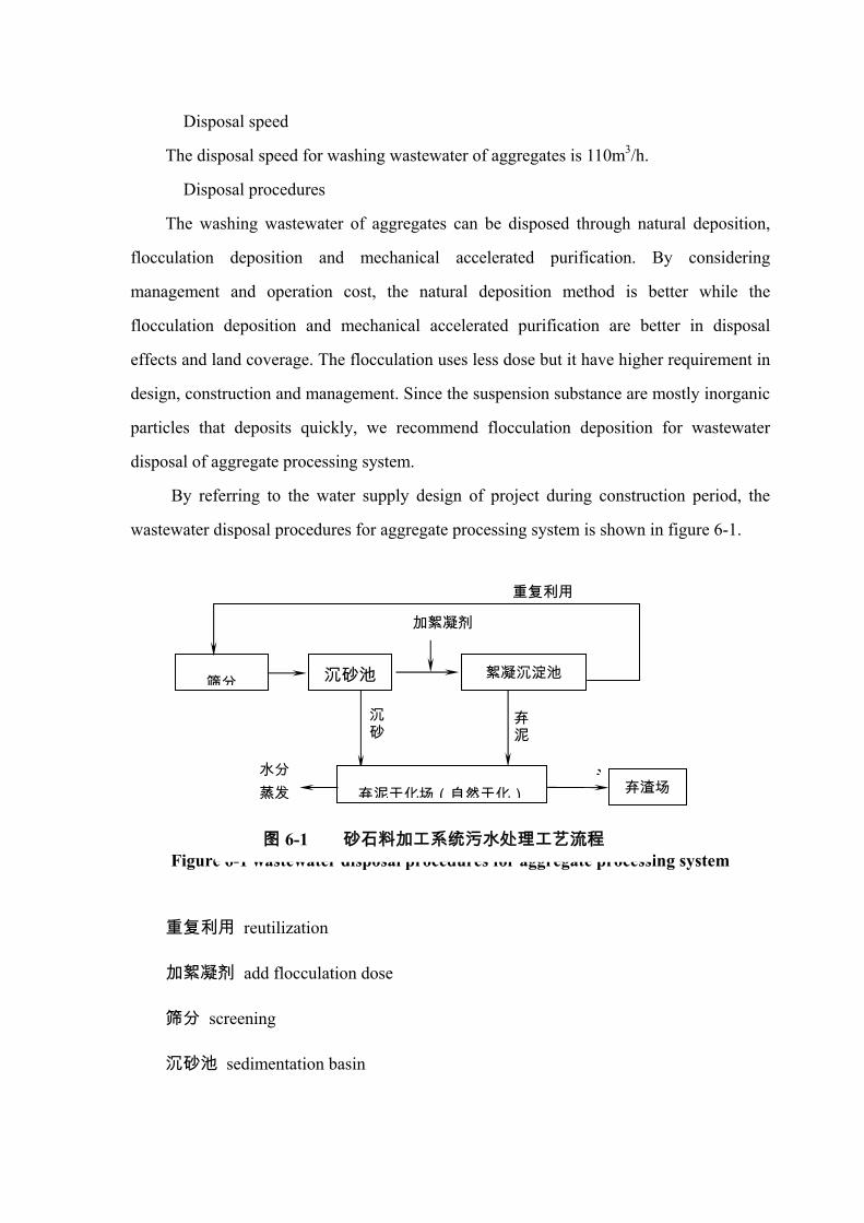
� Disposal speed
The disposal speed for washing wastewater of aggregates is 110m3/h.
� Disposal procedures
The washing wastewater of aggregates can be disposed through natural deposition,
flocculation deposition and mechanical accelerated purification. By considering
management and operation cost, the natural deposition method is better while the
flocculation deposition and mechanical accelerated purification are better in disposal
effects and land coverage. The flocculation uses less dose but it have higher requirement in
design, construction and management. Since the suspension substance are mostly inorganic
particles that deposits quickly, we recommend flocculation deposition for wastewater
disposal of aggregate processing system.
By referring to the water supply design of project during construction period, the
wastewater disposal procedures for aggregate processing system is shown in figure 6-1.
Figure 6-1 wastewater disposal procedures for aggregate processing system
重复利用 reutilization
加絮凝剂 add flocculation dose
筛分 screening
沉砂池 sedimentation basin
筛分 沉砂池 絮凝沉淀池
弃泥干化场(自然干化) 弃渣场
沉砂
加絮凝剂
泥水分 蒸发
弃泥
重复利用
图 6-1 砂石料加工系统污水处理工艺流程

絮凝沉淀池 flocculation deposit basin
沉砂 sediment
弃泥 waste silt
水分蒸发 water evaporation
弃泥干化场(自然干化) waste silt drying area (natural drying)
弃渣场 waste disposal area
The washing wastewater from screening and aggregate processing workroom flows
into sedimentation basin, and will be reutilized after it is disposed by the flocculation
deposit basin. Usually the water will reused for screening and aggregate washing in
aggregate processing workroom. The waste silt from sedimentation basin and flocculation
deposit basin is sent to the drying area and then delivered to waste disposal area after it is
dried. According to the features of Changfeng hydropower project and construction layout,
the waste silt is disposed through natural drying before transported to the large pit waste
disposal area.
� Plan design
Size of the planned sedimentation basin and deposit basin are: sedimentation basin
area is 16m2, size 8m(L)×2m(W)×3m(H);flocculation deposit basin area is 144m2,
size 24m(L)×6m(W)×4m(H). Use polyacrylamide (PAM) as flocculation dose and
the flocculation basin is not necessary.
The sedimentation basin and deposit basin are built near the aggregate processing
system at downstream direction of the aggregate processing system. The drying area is
designed near the sewerage disposal basin which can be laid flexibly according to the silt
volume and existing landform.
(2) Pit wastewater disposal
The suspension concentration of regular pit dewatering is about 2000mg/L, the pH
value of concrete curing is 11-12. The rock-earth-powders and cement mortar in regular pit
dewatering is easier to deposit. Referring to the monitored result of other hydropower

project constructed or under construction, the suspension concentration can reach the
discharge standard when the regular pit water is allowed to stand in pit for about 2 hours.
During standing, it should be neutralized by acid, which can effectively lower the alkalinity
of dam concrete curing water. Therefore, the disposal plan for pit wastewater of the project
is to allow the water to stand for over 2 hours after neutralized by acid, which should not be
discharged until it meets the requirement. The pit wastewater is can tested by the acid-base
indicator.
(3) Washing wastewater of concrete mixing system
Wastewater of mixing system produced by washing roller and material tank is
discharged together intermittently. The suspension concentration in the wastewater is about
5000mg/L with pH value of 12. Since there is only little amount wastewater, a wastewater
deposit basin is planed to be built beside the mixing system covering an area of 2m2 with
capacity of about 2m3. After deposition, the supernatant liquor can be reused and the
sediment should be disposed regularly and transported to the drying area.
(4) Disposal of oily wastewater
The mechanical maintenance factory of the project is close to the aggregate
processing system in construction zone. In the wastewater of mechanical vehicle
maintaining and washing, the concentration of petroleum and suspension is quite high.
Wastewater disposal plan
The oily wastewater can be gathered and disposed by oil-water separator and adding
flocculating agent regularly. The oil-water separator can clearly separates oil and water, but
it requires more investment with higher maintenance requirement. The method of adding
flocculating agent regularly is simple with low cost and easy management. Since the
volume of water used in mechanical maintenance is small with little wastewater discharge,
the method of adding flocculating agent regularly is recommended.
Plan designed
There should be mortar lined stone drainage ditch around the mechanical maintenance
area. Wastewater in the area is collected to the rectangular mortar lined disposal basin,
which is close to the living area covering land area of 6m2 with size of 3m(L)×2m(W)

×1.5m(H).When the oily sewerage collected to the disposal basin, flocculating agent
should be put into the basin at night and the wastewater should be discharged the next day
after flocculation and deposition for the whole night.
Operation management and maintenance
Due to small amount of sewerage, the disposal basin is built in simple structure
without machines and maintenance, which only requites regular flocculation cleaning
during operation.
(5) Domestic sewerage disposal
Sewerage amount
Domestic sewerage mainly comes from domestic water used by construction staff and
excrement discharge. There is one office-living area in the construction zone. The domestic
sewerage discharge in peak period is 58.7m3m/d. The main pollutant in wastewater is SS,
BOD5, COD and NH3-N.
Disposal plan
The domestic sewage can be disposed by buried disposal facilities, cesspool,
micropower sewage and methane tank. The disposal plan of buried unpowered disposal
facility or septic tank has its own advantage. But the disposed sewage can not reach the
discharge standard. As for the methane tank disposal, the capacities of the methane tank is
too large which can be hardly built in the construction area.
The construction site is located in barren mountains, which is far always from villages
and cities. By considering the general condition of construction site and existing regional
environment, temporary toilets and simple constructed septic tank built near the
construction site will match the existing objective and technical condition. The purification
efficiency of average septic tank is 50%-90%. The purification efficiency of COD and
BOD5 is 60% while the purification efficiency of SS is 70%. The drainage concentration of
COD and BOD5 in the purified wastewater is hard to reach discharge standard level I.
According to the project analysis and environmental impact assessment analysis, its impact
is limited, which interim and local.
Based on environmental protection requirements, dry toilets are recommended to fully

reduce the pollution caused by domestic sewage and its impact. The disposed domestic
sewage can be regularly used in fertilizing farmland by nearby farmers.
6.1.2 Protection measures and recommendations during operation period
(1) Clean the reservoir bed. Before the reservoir storage, the project construction
organization should thoroughly clean the aquatic pollution sources in the inundation area as
required by the cleaning standard for reservoir bed, which is to prevent water quality
deterioration during the preliminary stage of reservoir storage. At the same time, regular
cleaning should be done to planktons and floating substances.
(2) Surface pollution control in reservoir zone. In order to reduce the impact of
surface pollution load on reservoir water quality, the water and soil conservation near the
reservoir zone and the upper reaches of the reservoir should be carried out quickly by local
authorities of water conservancy, agriculture and forestry. The farmland should be turned
into horizontal terrace. Cultivated land on inclining slope with slope angle over 25°should
be restored to forest. The project construction organization should take greening measures
to make forest coverage rate of impacted reservoir zone reaching 40% or above. Use of
pesticide and chemical fertilizer in reservoir zone should be controlled. Fertilizers should
be applied effectively in a scientific way according to different soil types, crops and
seasons in order to prevent and reduce water quality pollution caused by loss of pesticide
and chemical fertilizer.
(3) Domestic sewage disposal. When the project is put to operation, its main sewage
produced mainly comes from domestic sewage of staffs. Though pollutant discharge is of
small amount, it does not reach the discharge stand unless it is disposed. It is required that
domestic sewage disposal facilities should be constructed during project construction,
which can be small micro-power domestic sewage disposal device, so that the sewage can
meet the discharge standard.
(4) Since the reservoir capacity is small, it is not suitable for fishery breeding, or it
can easily cause eutrophication of the water.
(5) Do not built wastewater discharge outlet on upper reaches and in reservoir.
(6) Regular monitoring forecast should be done on reservoir water quality, which
provides scientific basis for aquatic environmental management of the reservoir.

6.2 Precautions and suggestions for air pollution
(1) Reduction and control of fuel waste gas
With stressed management of large construction machines and vehicles, the project
construction subcontractor should equip the mechanical facilities with relevant smoke and
dust control facilities. Regular examination and maintenance should be made so as to
ensure that the environmental protection indexes of construction machines and vehicles
meet the discharge standard for tail gas.
(2) Dust reduction and control in construction
The aggregate processing, the wet crushing procedures with low dust should be
applied in priority, which reduces dusts. For drilling and blasting, wet working is preferred.
In dam zone, quarry zone and other construction zones with more excavations and blasting,
watering measures can be used to reduce dust and pollution area. For underground
excavation, water spraying and additional ventilation facilities are needed to reduce
pollutant diffusion and dust concentration in operation zone.
(3) Dust reduction and control in transportation
The surface of permanent roads in construction zone is made of concrete or cement
solidification, which reduces the dusts produced by transportation on earth and gravel roads.
Regular curing, maintenance and cleaning should be applied to roads in order to maintain
normal use of roads. Dusty materials should be wetted or covered with canvas before
loading. The storage tank on vehicles for bulk cement delivery should keep in airtight state,
and that delivers bag packed cement should be covered closely. The delivery vehicles
should be cleaned frequently. In sunny and windy days, the construction area should be
watered for 2-3 times a day.
(4) Health protection
The construction staff with much pollution impact should use individual protection
measures such as wearing dust preventing respirator. Planting on the both sides of roads
and office-living area reduces dust and helps water and soil conservation. Speed limit of
15km/h should be applied to vehicles going through the office-living area.

6.3 Noise control
In order to control the noise source in construction zone, regular maintenance should
be applied the construction machines and low noise production machines and facilities
should be used. For equipments with much vibration, buffering seat can be used. Planting
on the both sides of main transportation roads and construction area reduces noise pollution.
Operation of high-noise equipments should avoid the resting period of people. Labor
protection of construction staffs should be applied. For construction staff working in high
noise environment, the working time should not exceed 6h per day and noise proof
products for labor protection should be provided to them.
6.4 Disposal of solid waste
(1) Disposal of waste residue
The construction waste residue of the project should be piled to planed area and
control measures should be made to prevent water and soil loss. See the chapter of water
and soil conservation for detail.
(2) Disposal of domestic waste
The working staff in peak period of the project construction is 376 persons, whose
average domestic waste per day in peak period amounts to 0.367t. Sanitary facilities should
be set up in construction area with garbage bins in fixed places for collecting domestic
wastes in construction area and the layout of garbage bins are basically same as toilets. The
garbage bins should be cleaned disinfected frequently to prevent growing and breeding of
mosquitoes, flies or other pests. The project construction organization should send persons
or entrust the local organization of environmental sanitation to clean the construction zone
every day by disposing domestic wastes and improve the environmental sanitary condition
in the construction zone.
6.5 Ecological environmental protection
6.5.1 Terrestrial animals
(1) Vegetation protection in construction zone

During earth and rock excavation in construction, forest vegetation destroy in
construction zone should be reduced. Surface soil should be kept for re-cultivating and
vegetation recovery. For construction zone, powerhouse and dam site, environmental
planning and design should be carried out, where planting should be made to beautify the
new landscape environment
(2) Vegetation restoration around the reservoir and in reservoir zone
With reservoir water storage of Changfeng hydropower project, the inundated land is
276.76mu, among which cultivated land is 22.65mu, fuel land is 121.5mu, timber land
30.3mu, barren hills 102.31mu; permanent land use of construction is about 204mu, and
temporary land use is 54.9mu. In the reservoir inundation area, there are 3 households to
move and 120m2 housing to be moved. The inundated woodland should recover vegetation
by planting at other places. The local forestry authority should plan the vegetation recovery
site and woodland type based on actual site conditions. Based on its altitude, the forest
belts in reservoir zone should be built from top to down by stages in sequence of watershed
forest, water and soil conservation forest and bank protection forest, the ecological
protection forests further enlarges the forest coverage rate, protecting and improving the
landscape ecological environment in reservoir zone. New landscape ecological system in
reservoir zone can be built through ecological projects such as slope-developed-into-terrace,
biological fence and planted forests.
(3) To close hillsides for afforestation, prohibit destructive lumbering of forest, and
restore cultivated land with slope angle over 25° to forest, the original ecological system
can be recovered naturally. Better habitat environment for terrestrial animals helps the
growing and inhabiting of terrestrial animals and plants, which prevents new water and soil
loss.
(4) Prohibit destructive lumbering of forests in reservoir zone and protect the
inhabiting environment of wildlife. Widely propaganda and strictly carry out the wildlife
protection law and emphasize the protection for rare and precious endangered wildlife,
especially the wildlife under special national or provincial protection, so as to maintain the
stable variety of regional organism.
6.5.2 Aquatic organism

(1) Natural growth based with cage culture prohibited
With natural reservoir operation for some time, the fish species structure in the reservoir
can reach new equilibrium. Since the reservoir capacity is small, cage culturing of fishes
should be prohibited so as to prevent pollution of reservoir water quality.
(2) Stresses aquatic organism monitoring
After reservoir construction, monitor and investigation on bait organism, aquatic
environment and structural change of fish species should be conducted. Find out the
developing trend of fish resources in the reservoir zone based on the monitoring and
investigation result in order to adjust relevant protection measures.
6.5.3 Other recommendations for ecological protection
(1) To ensure the production and domestic security under the dam site, the water
storage in the first reservoir can not be used as production or domestic water, and relevant
measures should be taken to propaganda and monitor this.
(2) To ensure the existing ecological environment of the downstream watercourse of
the dam is not destroyed, certain amount of water discharge should be maintained
according to actual situation and seasons.
6.6 Measures for water and soil conservation
The project construction organization entrusted Yichang Qingjiang Design and
Investigation Institute of Hydropower to finish the report for the project, predicting the
water and soil loss caused by the project and forwarding control plans of water and soil
loss. This report cites the main content in it.
6.6.1 Responsibility of water and soil loss control
The responsibility of water and soil loss mainly consists of project construction area
and direct impact area. The project construction area refers to the land use area controlled
by zoning of occupied or rented land by the construction organization. Based on the
principal of “developer responsible for protection and control” and Technical Regulation
on Water and Soil Conservation Plan of Development and Construction Projects
(SL204-98), the project construction area includes main project land area, waste disposal
area, construction area, construction shortcut, etc. based on the construction zone boundary,

the project construction land use is 38.42hm2, among which the permanent land use is
21.5hm2 and temporary land use is 16.92hm2(including construction road area of 12.0hm2,
temporary construction land use of 0.6hm2 and waste disposal area of 4.32hm2). The land
use of project construction area is water intake works area of 19.99hm2, water diversion
structure area of 0.01hm2, penstock of 1.23hm2, power house of 0.27hm2, construction road
of 12.0hm2, waste disposal area of 4.32 hm2, temporary land use of 0.6 hm2. The land use
types are occupied cultivated land of 5.0hm2, occupied timber land of 2.02hm2, occupied
fuel land of 21.72hm2, occupied barren land of 7.67hm2 and occupied shoal of 2.01hm2。
The direct impact area refers to water and soil loss area and its direct impact area
caused by project development and construction. The direct impact area of the project is
zoned as 6-10m from impact area in lower reaches of the waste disposal area, while the
impact area of the road construction is 1m from upper slope, 1.5m from lower slope, and
5m from the excavation zoning of buildings. The direct impact area of the project is
5.73hm2.
6.6.2 Instructional recommendations
New water and soil loss is mainly the waste residue produced by project construction.
Thus the major control area is the project construction area, waste residue transition area
and waste disposal area.
Based on the estimation of water and soil loss intensity, construction measures should
be taken to retain waste residue together planting. Drainage facilities should be built near
the temporary waste disposal area in order to prevent waste residue being scoured by rain.
Based on estimation of water and soil loss intensity as well as total flow, the major
monitoring period is the construction period and the major monitoring area is the
temporary waste residue storage area and waste disposal area.
6.6.3 Control objectives of water and soil conservation
According to the Technical Regulation on Water and Soil Conservation Plan of
Development and Construction Projects (SL204-98), the general control objective of water
and soil conservation is to prevent and control the water and soil loss in area of
responsibility, to protect project production security and the ecological environment

construction in project area, which is stated specifically as follows:
(1) For cultivated land, woodland or other facilities for water and soil conservation
that is destroyed by the impact of project construction, should be restored and rebuilt as
possible in order to protect ecological environment and reduce water and soil loss. The
training rate of disturbed land should be over 60%.
(2) For land that has lost water and soil conservation function which is caused by the
excavation, filling and occupying in project construction, construction and plant measures
should be taken to restore or improve its water and soil function. The training rate of water
and soil loss should be over 85%. New water and soil loss should be controlled, and the
control rate of water and soil loss should be over 80%.
(3) The construction waste residue should be stored together. For loose deposit of
waste residue, construction and plant measures should be taken to effectively control the
loss of waster residue, and its protection rate should be over 90%.
(4) For permanent and temporary project land use, greening measures such as
re-cultivating, trees planting and planting should be taken when the projected is constructed
or under construction. The vegetation coverage rate should be over 80%, and the wood and
grass coverage rate should be over 60% in the control area of responsibility. Improve the
ecological environment in the project zone to effectively prevent and control the original
and new water and soil loss.
6.6.4 General layout of water and soil conservation measures
Based on the landform, geology, soil condition and regional water and soil loss, as
well as the construction characteristics, construction layout, short term and long term
development plan, the impact of water and soil loss and its training objective, different
training measures should to taken according to the specific features of different training
areas of water and soil loss
6.6.4.1 Dam area
(1) All waste residues produced in project construction should be transported to 4#
waste disposal area in the riverside 2.5km from the downstream face of dam site. 4# waste
disposal area covers area of 1.94hm2. As a temporary used area, it can storage 50000 m3
waste residue. The major construction measure for the waste residue is building residue

retaining walls, which can be restored to farmland when project is finished.
(2) For aggregate excavation area of project, it should be leveled off after exploration
and make green by planting trees.
(3) For permanent project land use, precautions should be taken by forwarding
requirement for construction excavation.
(4) Construction requirements should be made for road construction. Drainage
measures and roadside trees should be included in the design,
(5) Since the construction temporary land use is situated below the normal storage
pool level, drainage facility is only needed in the aggregate storage area and cleaned when
construction is finished.
6.64.2. Tunnel area
(1) The waste disposal areas should be laid out together. The waste residue of tunnel
intake should be stored at 4# waste disposal area, the waste residue of tunnel outlet should
be stored at 3# waste disposal area at the right of tunnel outlet and the waste residue in
middle part of tunnel should be transported together to the 5# waste disposal area at the
inclined shaft outlet.
(2) The aggregate used in the construction area comes from tunnel excavation, for
which no aggregate area is designed.
(3) The temporary construction land use covers an area of about 0.2hm2, which
should be leveled off after construction is finished and make green by planting trees.
6.6.4.3 Penstock area
(1) All waste residue produced in project construction should be transported to 1#,
2# and 3# waste disposal area for storage together with relevant construction measures.
Plant measures should be taken after construction is finished.
(2) The 0.2hm2 construction temporary land use should be leveled off and make
green by planting tree after construction is finished.
(3) The aggregates used in penstock construction come from the tunnel excavation,
and no aggregate excavation area is needed.
6.6.4.4 Power house
(1) All waste residue produced by project construction should be transported to 1#

waste disposal area for storage together with relevant construction measures. Plant
measures should be taken after construction is finished.
(2) The construction temporary land use should be leveled off and make green by
planting tree after construction is finished.
(3) The aggregates used in power house construction come from excavation in the
powerhouse area and the remaining part is purchased from Qingyan creek special
aggregate area. No other aggregate excavation area is needed.
6.6.5 Main training plans
The hydropower project construction has its own characteristics. The training plan is
stated as follows based on local geological, geomorphic and construction features.
6.6.5.1 Dam area
(1) Disposal of waste residue
Total earth-rock excavation of dam area and tunnel intake is 46500 m3. In the training
plan, all excavation are transported to 4# waste disposal area for storage together which is
2.5km of the lower reaches of dam site. The total capacity of 4# waste disposal area is
about 50000m3. The construction measures taken before waste disposal piled is: first, the
0.6m thick cultivating soil should be excavated and transported to the out of waste disposal
area for storage and used for farmland restoration after the construction is finished. Second,
build a waste retaining wall.
(2) Project permanent land use
Most land area of water intake works are inundated in water and covered by buildings.
The water conservation measure is to taken precautions to the excavated slope during
construction period.
(3) Construction temporary land use
As for the construction temporary occupied land at dam site, only the temporary
occupied land of work shed for construction facilities and material storage area are
designed, covering an area of 0.2hm2. It is recommended that the permanent occupied land
should be used as possible.
6.6.5.2 Tunnel area
(1) Training of waste residue

The waste residue in the area is 17400 m3, among which the 4700 m3 waste residue at
tunnel intake is arranged to be stored at 4# waste disposal area, the 4700 m3 waste residue
at tunnel outlet is planed to be stored at the low lying land 350m from the right of tunnel
outlet. A 15m long and 2m high waste residue retaining wall should be built and
0.3m×0.3m drainage ditches of 398m long should be built at both side of the waste residue
of mountainside. The water from slope should be transferred to the sediment basin at ditch
tail, the rest 8000m3 waste residue is transported from the middle inclined shaft to 5# waste
disposal area for storage. When the construction is finished, the waste residue should be
leveled off for planting. The total planting area is 0.82hm2 with 2100 trees planted.
(2) Project permanent land use
The surface area of tunnel construction occupied land is small and precautions are
mainly adopted.
(3) Construction temporary land use
The construction temporary land use is 0.2hm2, which should be cleaned after
construction is finished and made green by planting trees. The total planting area is 0.2hm2
and 500 trees can be planted there.
6.6.5.3 Penstock area
(1) Training of waste residue
The total waste residue in the area is 33200m3, among which the 12300 m3 waste
earth excavation between 1-3# anchanchor block should be transported together for storage
at 3# waste disposal area on the right of tunnel outlet, 8200 m3 waste excavation below 10
anchanchor blocks are transported together for storage at 1# waste disposal area at the
power house area, the remaining 12700 m3 waste residue are stored at 2# waste disposal
area nearby on the left of penstock. When the project is finished, the area should be leveled
off for planting. The total planting area is 0.65hm2 with 1600 trees planted.
(2) Project permanent land use
As for the project permanent occupied land for penstock area, some of which is
sheltered by buildings and other excavation disturbed surfaces are designed to be concrete
sprayed in the construction design. The water and soil conservation measures are mainly
precautions.

(3) Project temporary land use
Clean the field after construction is finished for planting. The planting area is 0.2hm2
with 500 trees to be planted.
6.6.5.4 Power house area
(1) Training of disposal residue
The area has 7000 m3 waste residue, all of which is to be transported to store at the
shoal 0.2km from the lower reaches of power house. The plan is designed to built 320m
long, 2m high residue retaining wall made of M5 mortar lined block stone at the water
facing side of the waste residue. Since the shoal is flat, no drainage ditch is needed. When
the project is finished, soils are covered at the top of waste residue and level off for
planting. The total planting area of 0.70hm2, with 1800 trees and 5.4kg grasses planted.
(2) Project permanent land use
Most project permanent occupied land is sheltered by building, and concrete is
backfilled to the nearby area of the buildings. Thus the water and soil conservation
measures are mainly precautions. In order to beautify the environment, some decorative
flowers and nursery stocks can be planted nearby the permanent buildings.
(3) Project temporary land use
There is little project temporary land use in powerhouse area. When the construction
is finished, the area is to be cleaned for planting.
6.7 Protection on public health
6.7.1 Clean the reservoir bed
Sanitary cleaning should be made in construction area to lower the density of various
pathogeny microbes and insect borne animals so that the epidemic of infectious diseases
can be prevented and controlled in the construction area.
(1) Area disinfection
Cleaning and disinfection should be done in construction camp, activity places of
construction staffs, original toilets, cesspools, barns, waste storage area and tombs. When
construction is finished, the temporary living area, temporary toilets and waste storage area
can be moved. Disinfection can be done by sprayer with carbolic acid medicines according

to Technical Standard for Disinfection. And clean the waste at the same time.
(2) Disinfestation
In the construction period, regular disinfectation should be done in the living area in
Spring and Autumn annually, which mainly kills mice, mosquitoes and flies in order to
control the infection source of various infectious diseases and cut off the spread route. Use
mouse trap or poisonous bait to kill mouse and use pesticide named Miehailing to kill
mosquitoes and flies. With guidance from sanitary and anti-epidemic staff, the medicines
and tools are given out to the construction staff to put to use.
6.7.2 Sanitary and anti-epidemic plan
(1) Sanitary quarantine
The construction staff should be sanitary quarantined before entering into the
construction area which is to find and control germ carriers and new diseases into the
construction area. Thus the inter-infection and epidemic between the construction staff and
local residents can be prevented. The random quarantine should be done according to
investigation results, which includes vital hepatitis, hemorrhagic fever, malaria, etc. The
quarantine frequency: construction staff and management staff must be quarantined before
entering the area. After that the 20% of construction staffs should be quarantined twice
during construction period. The health examination of construction staff and epidemic
situation should be filed regularly during construction period.
(2) Health examination
When the project began construction, the environmental medicine situation in
construction zone is gradually changed. The construction staff with large labor intensity
and various physical conditions, new infectious diseases may occur. The construction staffs
should be observed and examined during construction period in order to know labor health
conditions in various construction periods, so as to prevent and control the occurring and
spreading of various diseases in time and ensure normal construction operation. The
physical examination should be decided by actual situations. The catering staff in
construction area, construction staff in dusty or noisy environment and construction staff

engaged in works harmful to health, should be examined once a year and their examination
result should be filed.
(3) Precaution and immunity
Since the construction area is densely populated. The construction work is of large
intensity. In order to improve the diseases immunity of construction staff in construction
period and prevent the inter-infection or epidemic of typhoid fever, hemorrhagic fever,
malaria and other infectious diseases, the construction staff should be planed for immunity.
Based on the epidemic features of disease and the epidemic rules of diseases in
hydropower project, precaution medicines or inoculation can be applied. In addition, the
medical unit in construction area should store enough tetanus immunity preparations and
medicines for poisonous snakes in order to make emergency rescue for tetanus infected
staff or viper bite staff.
(4) Health propaganda and management
The construction and construction organization should decide person in charge of
sanitary quarantine, who is responsible for managing the staff health propaganda and
management, setting up and completing the epidemic report network and reporting to
higher authority once epidemic is discovered. Regular sanitary inspection should be done
on foods in construction zone and the health certificate of catering staff in construction
zone should also be examined. The drinking water in the construction zone should be
disinfected and monitored.
6.7.3 Public hygienic facility
The layout of public health facility in construction zone should be decided based on
the general construction layout. The temporary toilets should be built according to the
management situation and distribution of construction staff. Requirement for location of
temporary toilets: it should be at least 30m from the canteen and its convenience should
also be taken into account; the squatting position should be designed according to the
Hygienic Standards for the Design of Industrial Enterprises (TJ35-79) by National Ministry
of Health and National Labour Office; The number of toilets and squatting positions in
each toilets should ne decided by the population density nearby.

According to the distribution of construction staff and layout of living area, garbage
bins should be placed in construction living area and domestic wastes should be cleaned
and transported timely. Do not dump waste into the river or drainage ditch or it will pollute
the water.

7. Environmental monitoring and management
7.1 Plan for environmental monitoring
7.1.1. Purpose and requirement of monitoring
The Environmental change and impact during construction and operation period of
Changfeng hydropower project should be monitored, in order to master the change of
environmental factors and effective result of environmental protection in the project impact
area, which is to find out environmental problems and forward related measures and
reducing negative project impact. The monitoring result is to provide scientific basis for
environmental management and project completing inspection.
The ecological and environment monitoring of the project should utilize the existing
monitoring section (point) of local environmental monitoring station, sanitary epidemic
preventing station, bureau of aquatic products and forestry bureau. The environmental
monitoring is planed to be entrusted to competent organization to finish.
7.1.2 Environmental monitoring in construction period
7.1.2.1 Water quality
(1) Monitoring of river water quality
Section setting: there should be one monitoring section at the end of resersvoir back
water zone, 200m at upstream face of the dam and 500m at downstream face of the dam
respectively, among which the sections in front of the dam and at downstream face of the
dam are also used as water quality section. There are 3 sections in construction.
Monitoring items: 11 items including water temperature, pH value, suspension
substance, dissolved oxygen, BOD5, permanganate index, petroleum, total phosphor, total
nitrogen, NH3-N and fecal coli-form.
Monitoring method: monitoring conducted as required by the Specifications
Requirements for Monitoring of Surface Water and Waste Water (HJ/T91-2002).
Monitoring period and frequency: monitor the river water quality for 1 year before
water storage and the monitoring period of sections in construction area is 20 months of
construction period. The monitoring frequency is three times per year at flood period, level

period and dry period respectively.
(2) Monitoring at sewage drainage outlet
Monitoring point setting: there is one monitoring point at aggregate processing system,
parking lot of mechanical maintenance area, wastewater drainage outlet of concrete mixing
station and domestic sewage drainage outlet.
The monitoring item: the monitoring of production wastewater is pH value,
suspension substance, etc. Other monitoring items can also be added in if necessary. The
monitoring item of domestic sewage is chemical oxygen demand, 5-day biochemical
oxygen demand, suspension substance, total phosphor, total nitrogen, petroleum and fecal
coli-form.
Monitoring method: monitoring conducted as required by the Specifications
Requirements for Monitoring of Surface Water and Waste Water (HJ/T91-2002).
Monitoring period and frequency: conducted at synchronously with water quality
monitoring in construction period.
7.1.2.2 Atmosphere monitoring
Monitoring point setting: a monitoring point should be set up in construction zone of
dam site, construction zone of power house and living area.
Monitoring items: nitrogen dioxide, sulfur dioxide, PM10(or TSP).
Monitoring method: monitoring conducted as required by the Ambient Air Quality
Standard.
Monitoring period and frequency: monitoring should be conduct once every year for 5
successive days. The monitoring period is construction period.
7.1.2.3 Noise monitoring
(1) Monitoring of regional environmental noise
Monitoring point setting: there should be one monitoring point at construction zone of
dam, construction zone of powerhouse, aggregate area, and concrete mixing building
respectively and one monitoring point set near the road entering the living area of
construction staff and aggregate processing system. There are altogether 5 monitoring
points.

Monitoring frequency: monitoring should be conducted once in a year in construction
period. Each monitoring is conducted for 24h. The monitoring is limited to the construction
period.
(2) Monitoring of road traffic noise
Monitoring point setting; one monitoring point is set up beside the main road. The
specific monitoring point should meet the requirement of The Technical Specification for
Environmental Monitoring.
Monitoring frequency: the monitoring is conducted once in a year and records the
flow of transit vehicle.
7.1.2.4 Monitoring of aquatic organism
Monitoring section: a monitoring section should be set up at the tail of reservoir back
water zone, 200m at upstream face of the dam and 500m at downstream face of the dam
respectively.
Monitoring content: including planktons, benthos, advanced aquatic plants and fishes.
Monitoring period and frequency: monitoring is conducted in the year before reservoir
water storage in April.
7.1.2.5 Public health
Monitoring content: the regular monitoring of public health is conducted by medical
networks of three levels by monitoring the epidemic change in construction zone. It is to
know the relation between pollution caused by construction activities and public health.
The infectious diseases should be monitored such as natural focus disease, water borne
infection disease, insecte born infection disease and endemy. In epidemic seasons and
regions of infectious disease, random examination and immunization should be done to
susceptible crowds. Establish the epidemic report system, report, investigate and dispose
epidemic as soon as discovered. Practical protection should be done to health of
construction staffs.
Monitoring objective: staffs in construction zone.
Monitoring period: one monitoring is conducted in peak period of construction and
period before the end of construction respectively. The monitoring is to be conducted by
local sanitary quarantine authority as required by the sanitation authority.

7.1.2.6 Water and soil loss
Monitoring factor: rainfall, wind, slope angle, slope length and land composition in
construction zone, intensity, features and hazards of water and soil loss in construction,
plant growth, vegetation and its coverage rata, soil loss rate, soil nutrition, quantity and
quality change of water and soil conservation facilities.
Monitoring content: includes water and soil loss, hazard of water and soil loss, benefit
of water and soil conservation project.
Monitoring methods: includes on spot investigation and monitoring at fixed point.
Monitoring point setting: one observation point is set up the waste disposal area and
the borrow area respectively. Two monitoring sections are set up at the typical parts of
construction road. 1-2 monitoring points are set up in each monitoring section.
Monitoring period and frequency: to be conducted once in construction period.
7.1.3 Environmental monitoring in operation period
(1) Water quality
Section setting: there should be one monitoring section at the end of reservoir back
water zone, 200m at upstream face of the dam and 500m at downstream face of the dam
respectively.
Monitoring items: 11 items including water temperature, pH value, suspension
substance, dissolved oxygen, BOD5, permanganate index, petroleum, total phosphor, total
nitrogen, NH3-N and fecal coli-form.
Monitoring method: monitoring conducted as required by the Specifications
Requirements for Monitoring of Surface Water and Waste Water (HJ/T91-2002).
Monitoring period and frequency: the monitoring frequency is three times per year at
flood period, level period and dry period respectively for two successive years.
(2) Water temperature
Monitoring section setting: there should be one monitoring section at dam front, 300m
at upstream face of the dam and river mouth at downstream face of the dam respectively.
Monitoring period and frequency: it is conducted for 3 successive years after reservoir
water storage. The monitoring is conducted 5 times each year in February, April, July,
August and December respectively.

(3) Aquatic organism
Monitoring section: a monitoring section should be set up at the tail of reservoir back
water zone, 200m at upstream face of the dam and 500m at downstream face of the dam
respectively.
Monitoring content: including planktons, benthos, advanced aquatic plants and fishes.
Monitoring period and frequency: after reservoir water storage.
(4) Water and soil loss
Monitoring factor: rainfall, wind, slope angle, slope length and land composition in
construction zone, intensity, features and hazards of water and soil loss in construction,
plant growth, vegetation and its coverage rata, soil loss rate, soil nutrition, quantity and
quality change of water and soil conservation facilities.
Monitoring content: includes water and soil loss, hazard of water and soil loss, benefit
of water and soil conservation project.
Monitoring methods: includes on spot investigation and monitoring at fixed point.
Monitoring point setting: one observation point is set up the waste disposal area and
the borrow area respectively. Two monitoring sections are set up at the typical parts of
construction road. 1-2 monitoring points are set up in each monitoring section.
Monitoring period and frequency: to be conducted in first 3 operation years of
hydropower station. The monitoring is conducted before flood, after flood and in winter
respectively.
7.2 Environmental management
Environmental management is a major part of construction management the of
Changfeng hydropower project, which goes through the construction period and operation
period of project.
7.2.1 Purpose and objective of environmental management
It is stated clearly in the Environmental Protection Law of China that the purpose of
environmental management is protecting and improving people’s environment and the
ecological environment, preventing and controlling pollution and other public hazards,
safeguarding human health and facilitating the development of socialist modernization.

The major part of environmental management of the project is ecological environmental
management. The purpose of ecological environmental protection is protecting ecological
environment, preventing and controlling ecological damage caused during construction
and operation period of project, promoting sustainable development of society, economy
and ecology. The major objective of project ecological management is:
(1) Preventing ecological environment damage caused during construction and
operation period of project, protecting the general ecological environment in project impact
area.
(2) Strengthening controlling of environmental pollution including water quality,
atmosphere and noise of project construction, preventing reservoir eutrophication and
degenerating of water function of Changfeng hydropower project, and protecting public
health.
(3) Water and soil conservation of project construction.
(4) Protecting the biological variety in assessment area.
(5) Conducting environmental protection measures of project and fully carrying out
the policy of “developers responsible for protection, destroyers responsible for restoration
and users responsible fore compensation”
7.2.2 Tasks of environmental management
(1) Carrying out state laws, regulations of environmental protection and related
management system of local environmental protection authority, establishing rules and
regulations for environmental protection of the project, clarifying the responsibility,
rewards and punishments for environmental protection.
(2) Organizing and coordinating all tasks forwarded by the report and approval
advices, fixing in advance the cost and expenses for ecological environmental
compensation and pollution training.
(3) Responsible for dealing with the ecological environment polluting and damaging
accident.
(4) Preparing and carrying out the ecological environmental monitoring plan.
(5) Carrying out supervision.
(6) Establishing complete information archives of project environment management.

(7) Organizing professional trainings for environmental management and monitoring
staffs of the project.
(8) Improving contacts with local environmental protection authority for instructions
an helps.
7.2.3 Environmental management organization
The environmental protection management should be conducted by professional
organizations. According to state regulations on environmental protection, Changfeng
hydropower project should set up an environmental management office in the construction
management department, which is to be instructed by local environmental protection
authority in professional field. Its main responsibility includes daily environmental
management, coordinating and dealing with environmental disputes and accidents, carrying
out the environmental monitoring and supervising plan as well s the environmental
protection measures in different stages and being monitored and inspected by relevant
authorities of water conservancy, environmental protection and sanitary quarantine.
The environmental management office needs one staff and the recruited staff should
master professional techniques of environmental protection.
7.3 Environmental supervision
Environmental supervision is a major part of project supervision, which should go
through the whole construction period. Entrusted by the environmental management office,
the environmental supervising engineer is to supervise and check the environmental
protection tasks conducted by professional organizations and project subcontractors during
construction period.
7.3.1. Tasks of environmental supervision
(1) Randomly checking and supervising environmental protection of professional
organizations conducting environmental protection tasks and project subcontractors, based
on relevant laws, rules, regulations and agreement of environmental protection, and
requiring the deadline of fulfilling environment protection tasks.
(2) Assisting environmental protection management office and relevant authorities in
dealing with environmental pollution accidents and disputes in project impact area.

(3) Preparing monthly report and half-yearly report of environmental supervision,
submitting report to environmental management office, concluding environmental
supervision, Bring up major environmental problems and suggested solutions, indicating
environmental supervision arrangement and focus in the future.
7.3.2 Monitoring method
Monitor through inspection and instructional documents.
7.3.3 Supervision personnel
Based on the environmental supervision work (excluding supervision on
water and soil conservancy) of Changfeng hydropower project, 1
environmental supervisor is needed.
8. Analysis on environmental protection investment and
its profit and loss
8.1 Investment estimation of environmental protection
Based on environmental economics, environmental laws and regulations, and basic
ecological environmental principle of “the destroyer responsible for training”, prediction
on possible ecological impact and estimation of precaution investment are made in order to
avoid major environmental damage of project construction, to avoid ecological
deterioration, to promote good economic and ecological circulation and to realize
sustainable development. It is necessary to lower environmental risks to minimum.
8.1.1 Investment principles
The following investment principles are determined based on applicable state laws,
regulations and policies and referring to the actual situation of project.
(1) The principle of “pollution makers responsible fore controlling and developers
responsible for protection: the investment project of environment protection is determined
by the above principles, which is also used in investment apportionment when necessary.
(2) The principle of “functional protection”: pollution control is aimed at protecting
project functions.
(3) The principle of “function recovery”: the investment scale should be adequate for
protecting or recovering the ecological environmental function before project construction.
(4) The principle of “one time compensation”; ecological environmental losses
caused by project is to be compensated by one-time compensation.
8.1.2 Estimation basis
(1) Design Methods and Calculating Criteria of Hydropower Projects (State
Department of Economy and Trade, No.78 in 2002)
(2) Notice for regulating charges of environment impact consultant by National
department of planning and developing, National Administration of Environmental
Protection, (JJG No. [2002]125)
(3) Design for environmental protection measures of Changfeng hydropower project
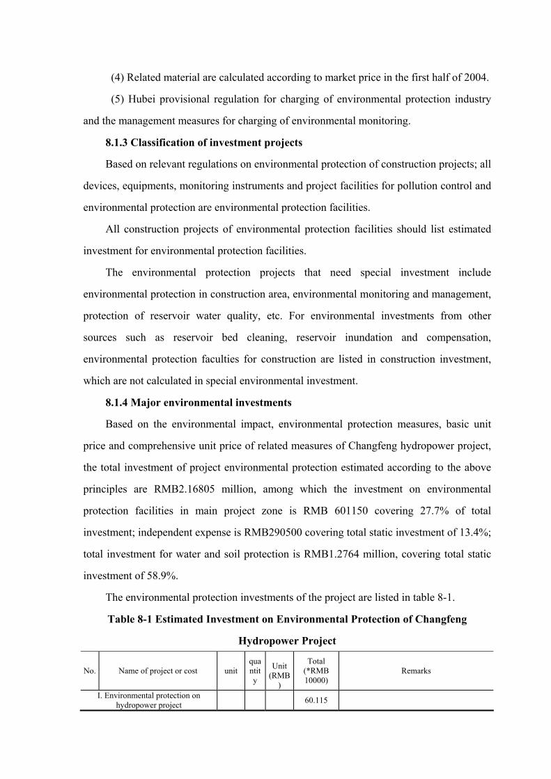
(4) Related material are calculated according to market price in the first half of 2004.
(5) Hubei provisional regulation for charging of environmental protection industry
and the management measures for charging of environmental monitoring.
8.1.3 Classification of investment projects
Based on relevant regulations on environmental protection of construction projects; all
devices, equipments, monitoring instruments and project facilities for pollution control and
environmental protection are environmental protection facilities.
All construction projects of environmental protection facilities should list estimated
investment for environmental protection facilities.
The environmental protection projects that need special investment include
environmental protection in construction area, environmental monitoring and management,
protection of reservoir water quality, etc. For environmental investments from other
sources such as reservoir bed cleaning, reservoir inundation and compensation,
environmental protection faculties for construction are listed in construction investment,
which are not calculated in special environmental investment.
8.1.4 Major environmental investments
Based on the environmental impact, environmental protection measures, basic unit
price and comprehensive unit price of related measures of Changfeng hydropower project,
the total investment of project environmental protection estimated according to the above
principles are RMB2.16805 million, among which the investment on environmental
protection facilities in main project zone is RMB 601150 covering 27.7% of total
investment; independent expense is RMB290500 covering total static investment of 13.4%;
total investment for water and soil protection is RMB1.2764 million, covering total static
investment of 58.9%.
The environmental protection investments of the project are listed in table 8-1.
Table 8-1 Estimated Investment on Environmental Protection of Changfeng
Hydropower Project
No. Name of project or cost unit quantity
Unit
(RMB)
Total (*RMB 10000)
Remarks
I. Environmental protection on hydropower project 60.115

No. Name of project or cost unit quantity
Unit
(RMB)
Total (*RMB 10000)
Remarks
I Disposal of sewage and wastewater
18.52
1 Disposal of domestic sewage m3 39.2 1000 3.92 Micro-power domestic sewage disposal facilities, cesspool
2 Disposal of oily wastewater Per
location
1 20000 2.0
3 Wastewater disposal of aggregate processing 12.0 Already listed in aggregate processing
system
�Construction cost Per
location
2 40000 8.0 Preliminary construction state
�Operation cost Per year 2 20000 4.0 Operation cost for washing wastewater
disposal of aggregate processing system
4 Wastewater disposal of concrete production system
Per locati
on 1 6000 0.6 Including operation cost in construction
period
II Ambient air quality protection 10.37
(1) Water spray Per year 2 25000 5.0 Including wages and water cost
(2)Bag dust collector for concrete mixing system
Per set 1 50000 5.0
(3) Dustproof respirator Per set 367 10 0.37
III Noise training 0.37
Individual protection for high noise Per set 367 10 0.37
IV Disposal of domestic waste 0.829
Garbage bin Per pc 6 500 0.3
Disposal of domestic waste t 132.3 40 0.529
V Public health protection 7.526
1 Sanitary cleaning m2 20000 0.3 0.6 Conduct once before construction begins or
after it finishes respectively
2 Sanitary quarantine Per person 734 60.0 4.404
3 Immunization Per person 734 25 1.835
4 Mouse and mosquito killing /year/capita
2×367 5.0 0.367 Comprehensive unit price
5 Toilet Per
location
4 800.0 0.32
VI Aquatic organism protection 年 Per year
6 20000 12.0
VII Ecological and environmental monitoring 10.5
1 Aquatic environment 3.0
2 Ambient air quality 1.5
3 Noise 0.4
4 Aquatic organism 5.0
5 Epidemic monitoring 0.6

No. Name of project or cost unit quantity
Unit
(RMB)
Total (*RMB 10000)
Remarks
II. Independent cost 29.05
I Construction management cost 18.3
1 Regular cost for environmental protection staff 1.80 3% of part I
2 Cost for research, survey and design 15.0
3 Environmental protection propaganda and technical training
1.50 2.5% of part I
II Environmental monitoring cost
/capita/year 1×2 50000 10.0
III Project quality Monitoring cost 0.75 0.25% of part I Total static investment on environmental protection 89.165
III.Total static investment on water and soil conservation 127.64
Based on plan of water and soil conservation
Total environmental protection investment 216.805
8.2 Analysis on economic profit and loss of ecological impact
8.2.1 Economic benefit
Changfeng hydropower project mainly focuses on power generation, whose benefit
mainly shows in the direct economic profit of power generation, and the social benefit
produced by protecting and improving regional ambient environment.
The installed capacity of power station is 2×4000kW with average annual power
output of 0.35 million kWh, annual utilized hour of 3453h and firm output of 1675kW。
Though its installed capacity is not large, it can participate in system peak regulation and
will be a regulating power source with free long regulation of Changyang County power
system, which is to alleviate the conflict of power consumption and regulation in local
power system, and helps the system to provide better power quality. The development of
power industry will inevitably promote the development of regional economy, industrial
and agricultural production.
When the project is completed, the financial internal rate of return of total investment
is 10.68%, higher than the 10% financial standard rate of return. The investment payment
period is 10.2 years (including construction period). The domestic economy investment and

profit adjustment is calculated with shadow prices on commercial electricity power
(RMB0.30/kW.h). The domestic economic internal rate of return is 14.76%, which is
higher than social discounting rate of 12%. Therefore, the project is feasible from the point
of national economy.
Referring to the industrial and agricultural output value of power kWh in middle and
east China, the industrial and agricultural output value of Changyang County can reach
RMB0.13 billion.
8.2.2 Social Benefit
The project fully utilizes the local natural geographical condition and advantages by
adopting trans-basin water diversion power generation, which is to bring considerable
social benefit.
(1) When the project is completed, it will reduce damages to certain extent cause by
flood, landslide and debris flow, which helps to create a safe production and living
environment for nearby residents so that they can live and work in peace and content
environment. With woods and grasses, the mountains become more beautiful, which also
provide better working environment for power station employees.
(2) The planned project has real benefit of land resource protection and utilization. It
improves flood storage capability of hydropower projects and its flood protection rate.
With construction of diversion dam and diversion tunnel, local flood discharge capability is
improved to some extent, which reduces the area and period of inundation.
(3) When the project is put to operation, it provides employment opportunities and
employment environment for the society, improving local economic income and bringing
better social benefit.
8.2.3 Ecological effect
During the project construction period, it has certain impact on ecological
environment. When the project is completed, its impacts on ecological environment are
mainly positive impacts. The project reduces the threats of downstream floods, enlarges
land reclamation area, improves flood protection rate, avails hillsides closed for
afforestation,controls water and soil loss, and improves ecological environment. The

general water quality of reservoir and downstream face of the dam will be improved. In
summary, the project construction brings better ecological environmental benefit.
8.2.4 Environmental effect
Compared to other heat power project with similar output, it has better environmental
benefit. Hydropower is renewable energy and clean energy. Compared with heat power
station with same power energy output, take 480g/kW·h as the standard coal consumption
of heat power station, then when it is replaced by hydropower station, the coal
consumption reduced is 1.68×10⁴t/a, reduced SO2 discharge is 87.3t/a, and NO2, CO2, CO,
smokes, dusts and other hazardous substances. The damage caused by hazardous substance
from heat power station into air and water is also reduced. The hydropower station reduces
waste disposal cost of RMB2.5×104/a annually. Since there is no fuel coal transportation,
large transportation equipment investment and land use of special transportation line are
reduced, which also reduces the damage to environment by project construction.
8.2.3 Comprehensive analysis on environmental economic profit and loss
From above analysis on environmental protection investment, environmental benefit,
economic benefit and social benefit, we can see that the environmental loss is smaller than
the environmental benefit, and the positive environmental impact is obviously more than
negative impact. The social and economic benefits of the project are mainly in power
generation and local economy promotion. Its environmental benefit is alleviating the
regional ecological damage, while the losses are land inundation, water and soil loss, etc.
the above losses can be reduced through relevant compensation and environmental
protection measures. In summary, the environmental economic profit of the project is
better.

9. Public participation
Public participation is a major part of environmental impact assessment. In order to
make the public realize the construction, operation features and related problems of
Changfeng hydropower project, to collect the public opinions and suggestions for the
project, to avoid negative environmental impact as possible, to make more reasonable and
complete planning and designing of project and to display comprehensive project benefit to
maximum, the assessment organization launched various public participated activities in
2004 with support from relevant local authorities.
9.1 Scope, mode and content of public participation
9.1.1 Mode, object and scope of participation
By visiting and meeting at the reservoir zone and dam zone, we sent out public
participation questionnaire to make a survey with residents in reservoir zone and
inundating land as well as related persons with different occupation in the county
The objects of public participation are 50 persons from social groups, management
organizations and residents in reservoir zone, who are project technicians, government
officers, representatives of People’s Congress Council (P.C.C), members of Chinese
People’s Political Consultative Conference (C.P.P.C.C.), common people and moving
residents, most of whom are influenced persons in construction zone and reservoir zone.
The survey result fairly reflects the desire of persons in construction zone the objectively
9.1.2 Content of questionnaire
See table 9-1 for content of form of the questionnaire.
Table 9-1 Questionnaire for public participation Basic information of the surveyed person
Name gender Age Education Occupation Nationality
Male
Female -year-old
college
Middle
cadre
worker

school
Primary
school
Below
primary school
farmer
other
company
name
Home
address
Telephone
survey content
1、Did you know about the project?
Yes □ no □
2、What is your attitude towards the project?
Agree □ disagree □
3、If you agree with project construction, when is the best time for construction in your opinion?
Immediately □ later in the future □
4、What impact may the project have on regional economy in your opinion?
Big promotion □ Small promotion □ no promotion □
5、What do you think of the existing ecological environment of the construction area?
Excellent □ average □ bad□
6、What impact the hydropower station will have in your opinion?
Important promotion of general development □
Promote the local economic development □
Improve regional environment □
Improve flood protection of dam downstream □
Improve regional ecological environment □
Improve people’s living standard □
Increase employment opportunity □
Improve transportation condition □
Others:
7、What are the negative impacts of hydropower station construction in your opinion?
Immigration □
Land inundation □
Inundation of rare animals and plants □
More water and soil loss □

Others:
8、What your opinion on immigration and settlement?
Unwilling to move □ move by getting over difficulties □ willing to move □
9、What is your demand for immigration?
Move to nearby area □ move to other places □
10、What are the environmental problems in your place?
Inconvenient transportation □ water and soil loss □ natural calamity □
Others:
11、What are the rare animals and plant in your place?
(1)rare animals:
(2)rare plants(including medical medicines):
Your suggestions in supplement is
9.2 Statistic analysis on survey result
9.2.1 Basic information of the surveyed persons.
50 questionnaires are send out in this survey for public investigation with 50
questionnaires returned. The return rate is 100%. The distribution of the surveyed are listed
in table 9-2
Table 9-2 Distribution of the surveyed persons
Surveyed person type
farmer worker cadre Soldier
Other
occupation
Total
male 12 9 6 2 8 37
female 6 4 3 0 0 13 gender
total 18 13 9 2 8 50
50
college 0 0 4 0 3 7 Middle school
11 11 5 2 4 33 Education
Primary school
7 2 0 0 1 10
50

From the statistic result of the surveyed persons, we see that 36.0% of the surveyed
are local farmers with largest proportion, among which 12 farmers are from inundated area
and nearby area covering 24.0%, workers and cadres cover 26.0% and 18.0% respectively.
Analyzing from genders, most of the surveyed are males, covering 74.0%. Analyzing from
education background, most of the surveyed are of middle school education background
covering 66.0% while the proportion of college and primary education background are
similar.
Among all surveyed persons, there is one representative of People’s Congress Council
(P.C.C) of the County, and one members of Chinese People’s Political Consultative
Conference (C.P.P.C.C.) of Yichang City.
9.2.2 Statistic analysis on feedbacks
See table 9-3 for statistic results of questionnaire contents
Table 9-3 Statistics of Public opinions
NO. Opinions
Number
of
persons
Classified
number of
persons
Percent
yes 50 100% 1
Did you know
about the project? no 50
0 0
Immediately 45 90%
2
when is the best
time for
construction? Later in the future
50 5 10%
Big promotion 40 83.3%
Small promotion 8 16.7% 3
What impact
may the project
have on regional
economy? no promotion
48
0 0
Excellent 43 86%
average 7 14%
4
What is
the existing
ecological
environment of the
construction area?
bad
50
0 0
Inconvenient
transportation 26 52%
water and soil loss 18 36% 5
What are the
environmental
problems in your
place?
natural calamity
44
0 0

NO. Opinions
Number
of
persons
Classified
number of
persons
Percent
Important promotion of
general development 50 100%
Promote the local
economic development 50 100%
Improve regional
environment 32 64%
Improve flood protection
of dam downstream 25 50%
Improve regional
ecological environment 12 24%
Improve people’s living
standard 21 42%
Increase employment
opportunity 22 44%
6
What impact will
the hydropower
station have?
Improve transportation
condition
50
45 90%
immigration 5 10%
Land inundation 38 76%
Inundation of rare animals
and plants 0 0 7
What are the
negative impacts
of hydropower
station
construction?
More water and soil loss
50
0 0
Unwilling to move 0 0
move by getting over
difficulties 3 100% 8
What your opinion
on immigration
and settlement?
willing to move
3
0 0
Move to nearby area 3 100%
9
What is your
demand for
immigration?
move to other places
3 0 0
Rare animals: no 0 0
10
What are the rare
animals and plant
in your place?
Rare plants: no 0
0 0
(1) Among all surveyed persons, 50 persons know about the preparation of
Changfeng hydropower project covering 100%. It means that most of the surveyed know
about construction of the project, which is quite influential and common people concerns
much about it. (2) 45 persons require immediate construction covering 90% of the total surveyed

persons. 5 persons require starting the project later, covering 10%, whose main reason is
worrying about the investment. It shows that common people are very active about
economic activities in the zone and their desire for changing existing regional situation is
strong.
(3) 86% of the surveyed consider that the existing ecological environment quality is
excellent in the construction area, with green mountains and clean water, which is suitable
for residents and tourism. 14% of the surveyed maintain that the existing ecological
environment quality is average, whose main reasons are less controlled regional water and
soil loss, frequent occurred geological disasters including landslide and the auxiliary
facilities are not complete.
(4) For main problems at present in living, 52% common people chose inconvenient
transportation which also impacts the development in other aspects; 36% chose water and
soil loss.
(5) For positive effects of the hydropower project, most of the surveyed are quite
affirmative about this with high expectations. 100% of the surveyed think it important to
general regional development, 100% of the surveyed consider it will promote local
economic development, 24% of the surveyed think it will improve regional environment,
42% of the surveyed think it will improve living standard of people, 90% of the surveyed
maintain that it will improve transportation situation and 44% of the surveyed think it will
increase employment opportunities.
(6) The possible negative impact of the project are classified as follows:
38 persons chose land inundation covering 76% of total.
No other problems are forwarded
(7) Immigration and settlement
In 3 representatives from all 3 households that are involved in immigration, 100% of
them maintain that they will get over difficulties and move to nearby place. This shows that
the public is especially concerned about immigration and places much importance on
mountain lands.
(8) Regard to the question of rare animals and plants, more surveyed persons are
familiar with animals than plants. No one answers the question of whether there are any

rare animals or plants.
9.2.3 Most Concerned problems of the public
By visiting villagers and hold discussions with persons from different occupation, we
collect public opinions and the feedbacks of the questionnaire for public participation. The
most concerned problems and opinions of the public are listed as follows.
(1) Concerned about reservoir zone land compensation. The villagers hope that local
government and construction organization make compensation plans and relevant
implementation measures according state policy. For land use compensation, reasonable
land use price should be determined based on state policy and standard combining local
actual situations. Fully understand the opinions and requirements of villagers and actually
solve the problem without any possible problem left behind.
(2) Concerned about construction quality of project. The project quality is of vital
and lasting importance. The public do not expect a “jerry-built project”.
(3) Concerned about further development and utilization when project is finished.
The project should be utilized in long-term planning of local economic development. It is
suggested by the public that government should make construction plans for infrastructures
(including road, telecommunication, etc.) matched to the project and auxiliary welfare
facilities. Speed up in making the plans of promoting local economic development and
improving people’s living standard and collecting construction fund.
(4) Concerned about the timely flood discharge in operation, the flood protection,
and water and soil loss after project is completed. The villagers hope that government
could concern about these problems and examine careful of the technical measures and
solutions for these problems in the project design report and environmental assessment
report.
9.3 Conclusion and suggestion of public participation
From the above suggestions, it is reflected that most of the surveyed know about and
agree with the project. Most of the surveyed agree that project construction can improve
people’s living standard, promote local economic development and increase employment
opportunities. The most concerned problems are land use compensation, environmental

pollution, ecological damage, etc.
According to the suggestions from public survey, it is advised that construction
organization should strictly conduct all pollution control measures, alleviate the pollutions
caused by ambient air, surface water, noise and solid waste, and reduce water and soil loss
as well as damage to ecological environment.
10. Conclusions and suggestions
10.1 Assessment conclusion of major environmental factors
(1) Local climate
When the reservoir begins water storage, the original land is turned into water. With
enlarged water surface, the evaporation rate in the reservoir zone will be higher than before.
With more vapor into the air, the solar radiant heat is adjusted. The factors such as
humidity and temperature of the reservoir zone its nearby area will change, which will
cause changes in local climate. Reservoir water storage is to slow the temperature change
with smaller daily difference and yearly difference of air temperature, lower max air
temperature and higher min temperature in a year. Since the water surface is enlarged, the
roughness of underlying surface of the reservoir is reduced and surface wind speed in the
reservoir is increased. However the reservoir zone is not large and the impact area is
limited within reservoir zone with small extent of change.
(2) Hydrology and sediments
Ganhe creek basin is a mountain-area river, where the flood is influenced by rainstorm
intensity and landform. It has heavy intensity rainstorm in the basin, steep river slope, short

flow concentration period, rapid flow rate and flash flood. The catchment area at upstream
of the dam site is 55.8km2. The project changes the original condition of natural water
course. With reservoir water storage, the sediment deposits in the reservoir year by year.
The hydrological conditions of reservoir will see relative change in pool level, flow, flow
rate, etc. With larger change in average annual reservoir pool level, the average flow rate is
also slower than that of natural situation.
The water of Changfeng hydropower project is gathered to dam reservoir zone
through karst caves, which has small amount of sediments and no deposition problems will
be caused.
(3) Ambient geology
The rocks on the right bank of reservoir of Changfeng hydropower project are thick.
From reservoir zone to nearby valley, there is Daye formation and Dalong formation with
better aquiclude. In relevant part of the nearby valley, there is no obviously exposed spring
or ground water pipe, thus reservoir water will not leak to the nearby valley. The stratum of
the reservoir zone near the dam is made of limestone of Changxing formation with
developed karst. The water pressure test in borehole shows that it is medium aquiclude,
which should be treated with leakage proof measures together with dam site grouting. The
mountain stratum of left reservoir bank is limestone-shale of lower Daye formation with
certain aquiclude. The left reservoir bank will not leak to the nearby valley. With reservoir
water storage, some part of the zone is possible to cause collapse or small landslide. There
is no large landslide or any major security problems after reservoir water storage. There are
no minable minerals and cultural relics in the inundation area with no land immersion
problems. The regional geologic structure is stable, which is weak seismic zone, it is
almost impossible to see strong earthquake induced by the project, however anti-seismic
capability should be taken into account in project design.
(4) Water quality and temperature
When reservoir of Changfeng hydropower project starts water storage, the change in
hydrological situation will not lead to obvious negative impact on general reservoir quality.
The reservoir water quality can maintain its original state in general. Small amount of
domestic sewage drainage from upstream reservoir will not impact the general reservoir

water quality. When Changfeng hydropower project is completed, the reservoir is
oligotrophic.
Based on analysis, the reservoir of Changfeng hydropower project is thermal stratified.
The reservoir water exchanges frequently with no large spawn area of commercial fishes
and precious fishes. There is no demand for production water and domestic water, and no
demand for irrigation of Changfeng hydropower project. Thus the low-temperature
reservoir water in summer of Changfeng hydropower project has little impact on
downstream rivers.
(5) Terrestrial ecological environment
When the hydropower station is put to operation, some woodland with high
productivity is inundated and the use of land is changed relevantly, which lowers the
productivity of the natural system in area. But it is still of high productivity. The project
construction has small impact on ecological environment of landscape in the area.
Project construction and reservoir inundation will have negative impact on vegetation.
Main vegetation in inundated area is shrubbery. There is no original vegetation,
large-area-commercial-forest or rare plants in reservoir inundation area. The project has
small impact on wildlife, which will not cause any obvious impact on biomass structures
and variety of wildlife.
(6) Aquatic organism
With reservoir water storage, inundation cause the increase of trophic salts in the
reaches in reservoir zone, leading to improved primary productivity and improved bait
condition, which is good for growing and breeding of fishes suitable for tranquil water or
static water.
With water storage of Changfeng hydropower project, the dam cut off the continuity
of the original rapid water ecological system. Construction of the dam also cuts off the
sailing upstream route of the fishes, which reduces the fish resource in reservoir zone.
Six waste disposal areas are setting up in the tunnel constriction zone and dam site
construction zone, which are situated at the main dam site and near each adits. The waste
disposal area will have drainage ditches at three directions, lined with mortar laid stone.
The drainage ditch will be connected to nearby river and a sediment deposit will be built at

the outlet. Before placing waste disposal, the surface mellow soil should be separated and
piled in the corner of the waste disposal area. When the construction is finished and waste
disposal is disposed, the waste disposal area can be restored to farmland. The above
measures not only slow down its impact on the ecological environment but also reduce its
impact.
(7) Impact on construction environment
The construction zone is in mountain area with good existing air environment and
noise environment. Since the dusts produced in project construction, exhaust air from
machines, tail gas of transportation vehicles and road flying dusts has no obvious impact on
the ambient air quality in the region. For impact on construction staff on spot, more
protections should be applied. The pollutants in construction that has impact on aquatic
environment mainly comes from washing wastewater of aggregate processing system,
water discharge of pit excavation, washing wastewater of construction machinery
maintenance, wastewater from concrete mixing and domestic sewage from construction
staff. The construction wastewater and domestic waste has impact on part of the water area
in construction zone. Gathered construction staffs produce domestic wastes. The
wastewater, exhaust air, noise and domestic waste of construction zone have certain impact
on the environmental quality of construction zone. However this impact is small which will
disappear when construction is completed.
(8) Water and soil loss
Due to road construction inside the zone, earth-rock excavation, exploration in quarry
area and borrow area in construction, it produces waste residues and destroys surface
vegetation. It no measures of water and soil conservation is adopted, the new water and soil
loss in the project zone may reach 1.73 million t, which will have different levels of impact
on land productivity, watercourse deposition and change in regional ecological
environment.
(9) Public health.
Construction staffs are engaged in high intensity physical labor in the field, which will
lower their immunity. If the domestic sewage and production wastewater are not
effectively disposed, they will become medium for growing and breeding of mosquitoes

and flies, thus lead to epidemic of some insect borne or water borne infectious diseases. At
the preliminary stage of reservoir water storage, there may be higher morbidity of water
borne diseases and natural focus disease. Thus precautions should be taken. Project
construction has no impact on endemy.
10.2 Measures and conclusion of environmental protection
(1) Measures of environmental protection in construction area
The main aquatic environmental pollutant in construction mainly comes from
wastewater of aggregate processing and domestic sewage. Wastewater of aggregate
processing is to be disposed by sedimentation basin while the domestic sewage is to be
disposed by dry toilet together with cesspool. For air pollutions such as dusts, flying dust in
road and noise pollution in project construction, the suggested measures are providing
individual protection for construction staff, water spraying on roads and vehicle speed limit.
With above measures, the impact on ambient air quality and noise environment of project
construction will be reduced.
(2) Ecological environment
For possible negative impact on aquatic organism by Changfeng hydropower project,
the following suggestions are put forward: fish tagging propagation, aquatic organism
monitoring and guaranteeing water use of downstream ecology of the dam during reservoir
operation. For impact on terrestrial ecological environment by reservoir inundation and
project construction, suggestions such as vegetation restoration, strengthened propaganda
and management are put forward. In order to ensure that the existing ecological
environment of downstream watercourse will not be damaged after dam construction, it is
suggested that certain amount of ecological water discharge of the dam should be
guaranteed. When calculated by existing minimum flow in dry season, the water flow
should not be less than 0.22m3/s.
(3) Water and soil conservation
For new water and soil loss in project development zone (construction zone), plant
measures and construction measures for water and soil conservation plan are brought
forward based on various areas including project construction area, transportation area,

waste disposal area, quarry area, borrow area and powerhouse area.
(4) Public health
Since the project involves no settlement of immigrants, protection object of public
health is construction staff. Main protection measures for public health in construction area
are sanitary cleaning, vector control, sanitary examination of infectious diseases and
vaccination, and sanitary and health propaganda.
(5) Ecological and environmental monitoring
In order to master environment change during project construction, knowing the
changes of environmental factors such as water, air, noise and aquatic organism as well as
effective results of environmental measures in the impact area, the ecological and
environmental monitoring plan for Changyang hydropower project is put forward.
10.3 General assessment and conclusion
The project can meet the power supply demand of the power network in Changyang
Tujia Autonomous Country, alleviating regional power shortage problems, and having
positive impact on promoting local economic development. Meanwhile, the profit of power
output can bring more direct economic income like taxes to Changyang County. The large
investment will be the driven force for the local economic development. The project
construction with many construction staff moved in will greatly increase local
consumption.
Main negative impacts of the projects are: inundation of terrestrial vegetation by
reservoir storage, potential negative impact on downstream ecological environment of the
dam by reservoir operation, exhaust air, wastewater and waste residue produced in
construction, water and soil loss in construction, etc. The negative impacts caused by
construction can be alleviated or reduced by measures.
To sum up, the environmental impacts of Changfeng hydropower project are on both
sides. The construction of hydropower station lowers the natural environmental quality in
part of construction zone. From integrated and long-term view, the project has large
economic profit, environmental benefit, social benefit and small change in general
environment quality in project zone. Therefore, Changfeng hydropower project of Yichang

Changfeng Hydropower Development Co., Ltd. is feasible from the point of environmental
analysis.
10.4 Suggestions
In order to reduce the negative impact of project to minimum and fully display the
social benefit, economic benefit and environmental benefit, the followings are suggested:
(1) To strengthen environmental management and improve environmental
protection in construction zone.
(2) To improve water and soil conservation in construction area by conducting water
and soil conservation plans
(3) To set up environmental management organization to establish relevant
environmental management system and bring it into effect.
(4) To fix in advance the environmental protection investment, establish relevant
monitoring system and ensure that the special investment is used for environmental
protection with its specified purpose only.