Identifying the Cells Breaching Self-Tolerance in Autoimmunity
Upload
independentCategory
view
1download
0
RESEARCH ARTICLE
Extreme rainfall-induced lahars and dike breaching,30 November 2006, Mayon Volcano, Philippines
E. M. R. Paguican & A. M. F. Lagmay & K. S. Rodolfo &
R. S. Rodolfo & A. M. P. Tengonciang & M. R. Lapus &
E. G. Baliatan & E. C. Obille Jr.
Received: 23 October 2007 /Accepted: 20 January 2009 /Published online: 24 February 2009# Springer-Verlag 2009
Abstract On 29–30 November 2006, heavy rains fromSupertyphoon Durian remobilized volcanic debris on thesouthern and eastern slopes of Mount Mayon, generatingmajor lahars that caused severe loss of life and property indownstream communities. The nearby Legaspi City weatherstation recorded 495.8 mm of rainfall over 1.5 days at rates ashigh as 47.5 mm/h, far exceeding the initiation threshold forMayon lahars. For about 18 h, floods and lahars from theintense and prolonged rainfall overtopped river bends,
breaching six dikes through which they created new paths,buried downstream communities in thick, widespreaddeposits, and caused most of the 1,266 fatalities. In order tomitigate damage from future lahars, the deposits weredescribed and analyzed for clues to their generation andimpact on structures and people. Post-disaster maps weregenerated from raw ASTER and SPOT images, usingautomated density slicing to characterize lahar deposits,flooded areas, croplands, and urbanized areas. Fieldworkwas undertaken to check the accuracy of the maps, especiallyat the edges of the lahar deposits, and to measure the depositthicknesses. The Durian event was exceptional in terms ofrainfall intensity, but the dikes eventually failed because theywere designed and built according to flood specifications,not to withstand major lahars.
Keywords Supertyphoon Durian (Reming) . MayonVolcano . Lahar . Dike breaching . Rainfall . ASTER . SPOT
Introduction
On 29 November 2006, Supertyphoon Durian (Philippinecode name Reming), with maximum sustained winds of190 km/hr and gusts as high as 230 km/hr, made landfall onthe southeast coast of the Philippine island of Luzon,delivering 495.8 mm of rain over a period of 36 hrs(PAGASA 2006). Its impact was greatest in AlbayProvince, where runoff from its rainfall remobilizedvolcanic debris on the slopes of Mount Mayon into laharsthat caused severe loss of life and property in downstreamcommunities. Fatalities totaled 1,266, including 740 peoplemissing and presumed dead (Rabonza 2006).
In terms of their volumes, runout lengths and devastativeeffects, the lahars of typhoon Durian are unprecedented in
Bull Volcanol (2009) 71:845–857DOI 10.1007/s00445-009-0268-8
Editorial responsibility: J. White.
E. M. R. Paguican (*) :A. M. F. Lagmay :K. S. Rodolfo :R. S. Rodolfo :M. R. Lapus : E. G. BaliatanNational Institute of Geological Sciences, College of Science,University of the Philippines, Diliman,Quezon City 1101, Philippinese-mail: [email protected]
K. S. RodolfoDepartment of Earth and Environmental Sciences,University of Illinois at Chicago,845 W. Taylor St.,Chicago, IL 60607, USA
A. M. F. Lagmay :K. S. Rodolfo :A. M. P. Tengonciang :M. R. LapusEarthprobe Incorporated,P. Guevarra,San Juan, Metro Manila, Philippines
A. M. P. TengonciangDepartment of Physical Sciences, College of Science,University of the Philippines,Governor Pack Road,Baguio City 2600, Philippines
E. C. Obille Jr.National Institute for Science and Mathematics Education,University of the Philippines, Diliman,Quezon City 1101, Philippines

the recent history of Mayon. The closest event generatingthis magnitude of death and destruction on the lower slopesof Mayon was the 1825 lahar event that caused 1,500fatalities (Task Group for the International Decade ofNatural Disaster Reduction 1990) and buried the town ofCagsawa, 11 km southeast of the summit, 11 years after oneof Mayon’s largest eruptions during the 19th century(Ramos-Villarta et al. 1985). The November 2006 laharsfollowed a relatively minor effusive episode earlier in theyear. This study describes and analyzes the deposits left bythe lahars of typhoon Durian in order to understand thefactors governing their generation and destructive impact. Itis hoped that the descriptive accounts and analyses will aidin planning and design to mitigate future losses from laharsat Mayon and other volcanoes.
Mount Mayon
Mayon Volcano is a composite cone of andesite andbasaltic-andesite lavas with associated pyroclastic-flowand lahar deposits (Newhall 1977, 1979; Punongbayanand Ruelo 1985; Rodolfo and Arguden 1991). It is veryactive; its latest eruption on 14 July 2006 was the 48th sincerecords were first kept in 1616 (Ramos-Villarta et al. 1985;Philippine Institute of Volcanology and Seismology 2008).During many of Mayon's eruptions, heavy rains from stormsor from eruption updrafts of moist surface air generate laharson its slopes (Rodolfo 1989). Even during quiescent periods,monsoonal and typhoon rains of sufficient intensity and
duration can mobilize debris into lahars. Typical major rainlahars, such as the one triggered by Typhoon Rosing 2 yearsafter the 1993 eruption, last from several hours to 2 days andare mainly hyperconcentrated streamflows with intersperseddebris-flow pulses with velocities of 3–6 m/s that each lastsseveral minutes to an hour (Arguden and Rodolfo 1990;Rodolfo and Arguden 1991).
The extraordinary symmetry of Mayon (Figs. 1 and 2)signifies that all radial sectors are equally affected byaggradational and degradational processes over the longterm. In the short term, however, activity is far from even.Limited volumes of lava add only one or two narrow, radialtongues to the edifice; pyroclastic flows and lahars leavelarge, discrete deposits. During quiescent periods, erosionaland depositional processes vary significantly between areas,and even between closely spaced channels.
Methodology
Remote-sensing data
Prior to field work, raw pre- and post-disaster AdvancedSpaceborne Thermal Emission and Reflection Radiometer(ASTER) and panchromatic SPOT 5 imageries, dated 15December 2006 and 3 May 2006 respectively, wereprocessed using ERDAS Imagine® software to generate apost-disaster map (Fig. 1). Flooded areas, croplands, andurbanized lands were classified through automated densityslicing. Supervised (automated) classification of the lahar
Fig. 1 Drainages and freshlahar deposits (50% black) atMayon volcano. Flood-proneareas are shown as 90% black;urban areas as 10% black. BoxesA, B, C, D, E and F are thelocations of schematic diagramsA to F in Fig. 11. The base mapis a 15 December 2006 ASTERimage of Mount Mayon
846 Bull Volcanol (2009) 71:845–857

deposits was not possible because they appeared too similarto flooded crop lands. Instead, the lahar deposits anddrainages were manually delineated based on their arealdistributions and associations with channels. Concrete dikesconstructed along major channels around Mayon weredelineated as light-colored linear features (Fig. 3a) in bothradar and optical (Fig. 3b) imageries. Maps at a scale of1:25,000 were validated in the field using hand-held GlobalPositioning System (GPS) instruments.
Field mapping
The lahar deposits were mapped in detail at communitieswith recorded casualties, all of which lay on the southernand eastern slopes of the volcano: Barangays (villages)Maipon and Tandarora in Guinobatan municipality, Sua inCamalig municipality, Budiao and Busay in Daragamunicipality, Pawa and Padang in Legaspi City and SanAntonio in Sto. Domingo municipality (Figs. 1 and 11;Table 1). Deposit thicknesses were measured along themargins of the deposit fields and across them to determinethe volume of the lahar deposits. Stretches of constructeddikes were traced using hand-held GPS and parts where itwas overtopped by lahar deposits and breached were noted.
Grain-size analysis
The fine-grained contents of lahars greatly influence theirflow behaviors (Hampton 1975; Middleton and Hampton1976; Qian et al. 1980; Costa 1984; Pierson and Costa1987), and to determine their contents in the Durian lahars,matrices of seven debris-flow deposits and four hyper-concentrated-flow deposits were sampled (Fig. 2). One kgsamples were oven-dried and cone-and quartered to obtaina subsample for granulometric analysis, which was passedthrough a stack of 2,000 µ and 62 µ sieves. To determinethe clay fraction, subsample of five g except for Sample 4,were subjected to the pipette analysis recommended byLewis and McConchie (1994).
Rainfall
The Philippine Atmospheric Geophysical and AstronomicalServices (PAGASA) weather-monitoring station closest toMayon is at Legaspi City, Albay, 12 km to the southeast ofthe volcano summit, and only 10 m above sea level.
Fig. 2 The southern and eastern catchments of Mayon volcano. Thewhite numbers are the locations of the 11 granulometric samples inFig. 6a, b
Fig. 3 Concrete dikes appear as light-colored linear features on both radar (a) and optical (b) images
Bull Volcanol (2009) 71:845–857 847
Records of rainfall, taken every 6 h using an 8-in. diameterstandard manual rain gauge, were recovered in order toestablish lahar-triggering intensities and durations.
Results
Remote-sensing
The southern and eastern sectors of Mayon's edifice comprisethe catchments of Guinobatan–Camalig (67×106 m2),Daraga–Legaspi (74.2×10⁶ m2), Matanag (14×106 m2),Padang (10.6×10⁶ m2), Lidong (12.7×10⁶ m2) and San
Antonio (20.0×10⁶ m2) rivers (Fig. 2). After TyphoonDurian, these radial channels now terminate in new lahardeposits that form debris fans on the volcano apron, extendingdownward along gradients of 5.5°–2.0° from elevations ofabout 245 to 100 m. Lahars along the Matanag, Padang,Lidong and San Antonio catchments reached Albay Gulf(Figs. 1 and 2). New channels formed by avulsion from pre-disaster gullies served as alternative pathways for these lahars.
Ricefields and coconut groves lying between drainagechannels on the lower and gentler slopes of the volcanowere heavily inundated (Fig. 1). Spectral reflectance offlood water and fresh lahar deposits are very similar in the2006 ASTER image because their water contents made
Table 1 Casualties in barangays of five municipalities on the eastern and southern flanks of Mayon volcano
Statistics of typhoon Durian in five heavily affected municipalities
Settlement Latitude Longitude Elevation(m asl)
Census year Population Houses Barangaysrecorded deaths
Casualties
Central (UTM Zone 51 N, WGS-84) Totallydamaged
Substantiallydestroyed
Legaspi City 13.152162 123.735098 20 2007 194,580 12,095 18,636 Data not availableGuinobatan 13.190602 123.600567 80 2000 71,071 5,291 7,196 Maipon 82
San Rafael 22Tandarora 13San Francisco 10Minto 7Maguiron 3Masarawag 2Morera 1Iraya 1Travesia 1
Camalig 13.179444 123.654853 215 2003 60,280 7,386 6,406 Bariw 8Tinago 6Sumlang 4Sua 3Ilawod 2Cotmon 2Cabangan 2Balanog 1Quitinday 1Caguiba 1
Daraga 13.150491 123.709801 120 2006 6,664 8,544 9,833 Busay 57Bañag 26Budiao 8Tagas 5Binitayan 5Malabog 3Cullat 1
Sto. Domingo 13.235914 123.776751 35 2000 27,392 3,855 3,106 San Isidro 14Buhatan 7Alimsog 4Lidong 4Nagsiya 1Fidel Surtida 1
848 Bull Volcanol (2009) 71:845–857
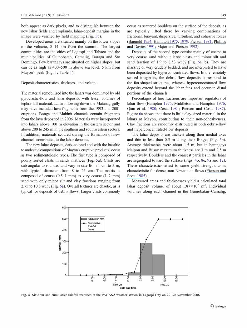
both appear as dark pixels, and to distinguish between thenew lahar fields and croplands, lahar-deposit margins in theimage were verified by field mapping (Fig. 5b).
Developed areas are situated mainly on the lower slopesof the volcano, 8–14 km from the summit. The largestcommunities are the cities of Legaspi and Tabaco and themunicipalities of Guinobatan, Camalig, Daraga and StoDomingo. Few barangays are situated on higher slopes, butcan be as high as 400–500 m above sea level, 5 km fromMayon's peak (Fig. 1; Table 1).
Deposit characteristics, thickness and volume
Thematerial remobilized into the lahars was dominated by oldpyroclastic-flow and lahar deposits, with lesser volumes oftephra-fall material. Lahars flowing down the Matanag gullymay have included lava fragments from the 1993 and 2001eruptions. Bonga and Mabinit channels contain fragmentsfrom the lava deposited in 2006. Materials were incorporatedinto lahars above 100 m elevation in the eastern sector andabove 200 to 245 m in the southern and southwestern sectors.In addition, materials scoured during the formation of newchannels contributed to the lahar deposits.
The new lahar deposits, dark-colored and with the basalticto andesitic compositions ofMayon's eruptive products, occuras two sedimentologic types. The first type is composed ofpoorly sorted clasts in sandy matrices (Fig. 5a). Clasts aresub-angular to rounded and vary in size from 1 cm to 3 m,with typical diameters from 8 to 25 cm. The matrix iscomposed of coarse (0.5–1 mm) to very coarse (1–2 mm)sand with only minor silt and clay fractions ranging from2.75 to 10.8 wt.% (Fig. 6a). Overall textures are chaotic, as istypical for deposits of debris flows. Larger clasts commonly
occur as scattered boulders on the surface of the deposit, asare typically lifted there by varying combinations offrictional, buoyant, dispersive, turbulent, and cohesive forces(Bagnold 1954; Hampton 1975, 1979; Pierson 1981; Phillipsand Davies 1991; Major and Pierson 1992).
Deposits of the second type consist mainly of coarse tovery coarse sand without large clasts and minor silt andsand fraction of 1.9 to 8.53 wt.% (Fig. 6a, b). They aremassive or very crudely bedded, and are interpreted to havebeen deposited by hyperconcentrated flows. In the remotelysensed imageries, the debris-flow deposits correspond tothe fan-shaped structures, whereas hyperconcentrated-flowdeposits extend beyond the lahar fans and occur in distalportions of the channels.
Percentages of fine fractions are important regulators oflahar flow (Hampton 1975; Middleton and Hampton 1976;Qian et al. 1980; Costa 1984; Pierson and Costa 1987).Figure 6a shows that there is little clay-sized material in thelahars at Mayon, contributing to their non-cohesiveness.Clay fractions are randomly distributed in both debris-flowand hyperconcentrated-flow deposits.
The lahar deposits are thickest along their medial axesand thin to less than 0.5 m along their fringes (Fig. 5b).Average thicknesses were about 1.5 m, but in barangaysMaipon and Busay maximum thickness are 3 m and 2.5 mrespectively. Boulders and the coarsest particles in the laharare segregated toward the surface (Figs. 4b, 8e, 9a and 12).These characteristics attest to some yield strength, as ischaracteristic for dense, non-Newtonian flows (Pierson andScott 1985).
Measured areas and thicknesses yield a calculated totallahar deposit volume of about 1.87×10⁷ m3. Individualvolumes along each channel in the Guinobatan–Camalig,
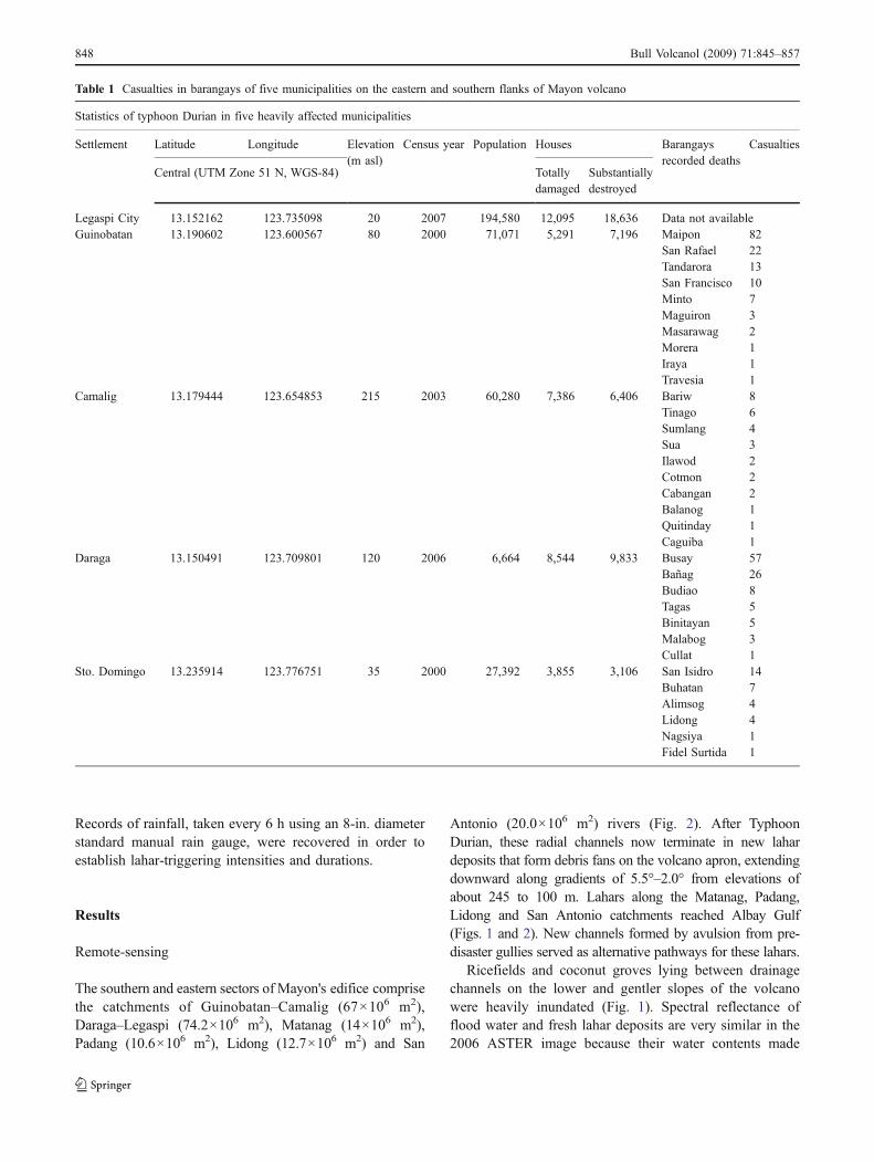
Fig. 4 Six-hour and cumulative rainfall recorded at the PAGASA weather station in Legaspi City on 29–30 November 2006
Bull Volcanol (2009) 71:845–857 849
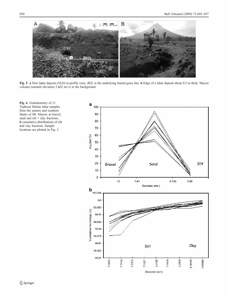
Fig. 6 Granulometry of 11Typhoon Durian lahar samplesfrom the eastern and southernflanks of Mt. Mayon. a Gravel,sand and silt + clay fractions;b cumulative distributions of siltand clay fractions. Samplelocations are plotted in Fig. 2
Fig. 5 a New lahar deposit (NLD) in profile view; BGL is the underlying buried grass line. b Edge of a lahar deposit about 0.5 m thick. Mayonvolcano (summit elevation 2,462 m) is in the background
850 Bull Volcanol (2009) 71:845–857
Daraga–Legaspi, Matanag, Padang, Lidong, and SanAntonio watersheds are listed in Table 2.
Dikes
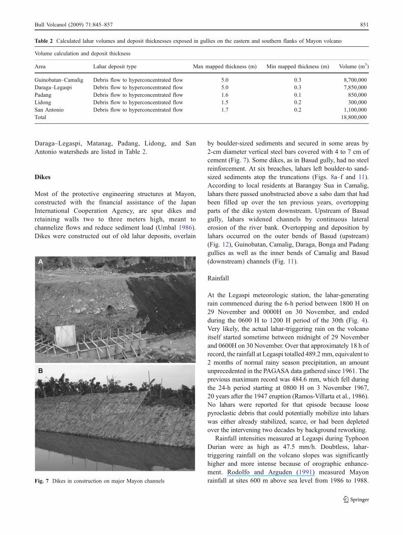
Most of the protective engineering structures at Mayon,constructed with the financial assistance of the JapanInternational Cooperation Agency, are spur dikes andretaining walls two to three meters high, meant tochannelize flows and reduce sediment load (Umbal 1986).Dikes were constructed out of old lahar deposits, overlain
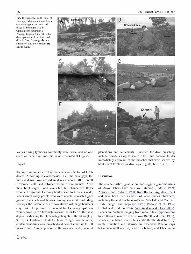
by boulder-sized sediments and secured in some areas by2-cm diameter vertical steel bars covered with 4 to 7 cm ofcement (Fig. 7). Some dikes, as in Basud gully, had no steelreinforcement. At six breaches, lahars left boulder-to sand-sized sediments atop the truncations (Figs. 8a–f and 11).According to local residents at Barangay Sua in Camalig,lahars there passed unobstructed above a sabo dam that hadbeen filled up over the ten previous years, overtoppingparts of the dike system downstream. Upstream of Basudgully, lahars widened channels by continuous lateralerosion of the river bank. Overtopping and deposition bylahars occurred on the outer bends of Basud (upstream)(Fig. 12), Guinobatan, Camalig, Daraga, Bonga and Padanggullies as well as the inner bends of Camalig and Basud(downstream) channels (Fig. 11).
Rainfall
At the Legaspi meteorologic station, the lahar-generatingrain commenced during the 6-h period between 1800 H on29 November and 0000H on 30 November, and endedduring the 0600 H to 1200 H period of the 30th (Fig. 4).Very likely, the actual lahar-triggering rain on the volcanoitself started sometime between midnight of 29 Novemberand 0600H on 30 November. Over that approximately 18 h ofrecord, the rainfall at Legaspi totalled 489.2 mm, equivalent to2 months of normal rainy season precipitation, an amountunprecedented in the PAGASA data gathered since 1961. Theprevious maximum record was 484.6 mm, which fell duringthe 24-h period starting at 0800 H on 3 November 1967,20 years after the 1947 eruption (Ramos-Villarta et al., 1986).No lahars were reported for that episode because loosepyroclastic debris that could potentially mobilize into laharswas either already stabilized, scarce, or had been depletedover the intervening two decades by background reworking.
Rainfall intensities measured at Legaspi during TyphoonDurian were as high as 47.5 mm/h. Doubtless, lahar-triggering rainfall on the volcano slopes was significantlyhigher and more intense because of orographic enhance-ment. Rodolfo and Arguden (1991) measured Mayonrainfall at sites 600 m above sea level from 1986 to 1988.Fig. 7 Dikes in construction on major Mayon channels
Table 2 Calculated lahar volumes and deposit thicknesses exposed in gullies on the eastern and southern flanks of Mayon volcano
Volume calculation and deposit thickness
Area Lahar deposit type Max mapped thickness (m) Min mapped thickness (m) Volume (m3)
Guinobatan–Camalig Debris flow to hyperconcentrated flow 5.0 0.3 8,700,000Daraga–Legaspi Debris flow to hyperconcentrated flow 5.0 0.3 7,850,000Padang Debris flow to hyperconcentrated flow 1.6 0.1 850,000Lidong Debris flow to hyperconcentrated flow 1.5 0.2 300,000San Antonio Debris flow to hyperconcentrated flow 1.7 0.2 1,100,000Total 18,800,000
Bull Volcanol (2009) 71:845–857 851
Values during typhoons commonly were twice, and on oneoccasion even five times the values recorded at Legaspi.
Impacts
The most important effect of the lahars was the toll of 1,266deaths. According to eyewitnesses in all the barangays, themassive dense flows arrived suddenly at about 1400H on 30November 2006 and subsided within a few minutes. Afterthese brief surges, flood levels fell, but channelized flowswere still vigorous. Carrying boulders up to 4 meters wide,lahars swept away people who were unable to reach higherground. Lahars buried houses; among scattered, protrudingrooftops, the barren fields are now strewn with large boulders(Fig. 9a). The portions of coconut trunks facing upstreamwere scarred up to a few meters above the surface of the lahardeposit, indicating the climax-stage heights of the lahars (Fig.9d, e, f). Upstream of all the lahar ravaged communities,containment dikes were breached and new channels up to 100m wide and 15 m deep were cut through rice fields, coconut
plantations and settlements. Evidence for dike breachinginclude boulders atop truncated dikes, and coconut trunksimmediately upstream of the breaches that were scarred byboulders at levels above dike tops (Fig. 8a, b, c, d, e, f).
Discussion
The characteristics, generation, and triggering mechanismsof Mayon lahars have been well studied (Rodolfo 1989;Arguden and Rodolfo 1990; Rodolfo and Arguden 1991)and have been used as basis of lahar studies elsewhere,including those at Pinatubo volcano (Arboleda and Martinez1996; Tungol and Regalado 1996; Rodolfo et al. 1996;Umbal and Rodolfo 1996; Van Westen and Daag 2005).Lahars are continua ranging from more dilute hyperconcen-trated flows to massive debris flows (Smith and Lowe 1991),which are initiated when site-specific thresholds defined byrainfall duration and intensity are exceeded. Relationshipsbetween rainfall intensity and distribution, and lahar initia-
Fig. 8 Breached earth dike atBarangay Maipon in Guinobatan(a); overtopping at breacheddikes in Barangay Sua inCamalig (b); upstream ofPadang, Legaspi City (c); Sabodam upstream of the breacheddike in Sua, Camalig (d); up-stream (e) and downstream (f)Basud Gully
852 Bull Volcanol (2009) 71:845–857

tion have been investigated previously at Merapi Volcano,Central Java in Indonesia following its 1984 eruption(Sutikno and Sakatani 1993; Suwa and Sumaryono 1995;Lavigne et al. 2000a, b), and at Sakurajima (Daido 1985)and Yakedake volcanoes (Okunishi and Suwa 1985;Okunishi et al. 1988; Ikeya 1989) in Japan. In a study of39 lahar-forming events by Rodolfo and Arguden (1991), thethreshold of debris flow initiation was determined by anempirical relationship:
I ¼ 27:3D�0:38
where I is intensity and D the duration of rainfall.Compared to the worldwide intensity threshold values fordebris flow generation (Balducci 2007), the triggeringintensity for Mayon lahars is higher due to the coarse,granular, and very porous volcaniclastic surface material,which also renders the lahar-generating role of antecedentrain relatively insignificant (Rodolfo and Arguden 1991).
Fig. 10 Rainfall intensity-duration threshold for the generation ofMayon lahars (after Rodolfo and Arguden 1991), and the 6-h averageintensities and duration during Typhoon Durian
Fig. 9 Lahar impacts. a Buriedhouses with scattered boulders.b Channel 80 m wide and 15 mdeep that formed when thelahar-containment dike atPadang was breached.c Reconstructed breached dikein Barangay Sua, Camalig witha 20 m wide breach; the arrowindicates the thin armor of un-reinforced concrete. d, e, fScarred coconut trees (whitearrows) facing upstream
Bull Volcanol (2009) 71:845–857 853
Grain size is also strongly correlated with erosion rates,because fine-grained ash decreases surface permeability,increasing run-off (Segerstrom 1950; Waldron 1967; Collinsand Dunne 1986; White 1991).
Plotted against the graph of the average intensitycomputed from the rainfall record of 29–30 November2006 (Fig. 10), the equation shows that lahars probablystarted forming early on the morning of 30 November 2006and were continuously generated until the early afternoonof 30 November 2006. Although it may be argued that therelationship of rainfall intensity and duration with laharinitiation threshold values is not linear from the time of aneruption but instead approximates a power law relation(Van Westen and Daag 2005), the rainfall intensity valuesfrom the evening of 29 November 2006 to noon of 30November 2006 plot far in excess of the minimumthreshold determined by the equation of Rodolfo andArguden (1991).
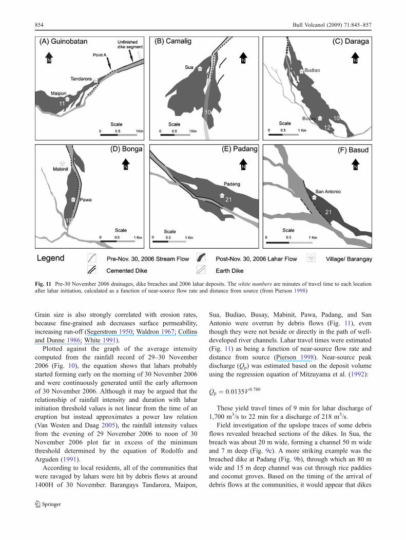
According to local residents, all of the communities thatwere ravaged by lahars were hit by debris flows at around1400H of 30 November. Barangays Tandarora, Maipon,
Sua, Budiao, Busay, Mabinit, Pawa, Padang, and SanAntonio were overrun by debris flows (Fig. 11), eventhough they were not beside or directly in the path of well-developed river channels. Lahar travel times were estimated(Fig. 11) as being a function of near-source flow rate anddistance from source (Pierson 1998). Near-source peakdischarge (Qp) was estimated based on the deposit volumeusing the regression equation of Mitzuyama et al. (1992):
Qp ¼ 0:0135V 0:780
These yield travel times of 9 min for lahar discharge of1,700 m3/s to 22 min for a discharge of 218 m3/s.
Field investigation of the upslope traces of some debrisflows revealed breached sections of the dikes. In Sua, thebreach was about 20 m wide, forming a channel 50 m wideand 7 m deep (Fig. 9c). A more striking example was thebreached dike at Padang (Fig. 9b), through which an 80 mwide and 15 m deep channel was cut through rice paddiesand coconut groves. Based on the timing of the arrival ofdebris flows at the communities, it would appear that dikes
Fig. 11 Pre-30 November 2006 drainages, dike breaches and 2006 lahar deposits. The white numbers are minutes of travel time to each locationafter lahar initiation, calculated as a function of near-source flow rate and distance from source (from Pierson 1998)
854 Bull Volcanol (2009) 71:845–857
all over the southern and eastern sectors of Mayon werebreached at about 1400H, several hours after the first laharswere initiated.
However, upstream of Barangays Tandarora and Maiponin Guinobatan, the areas with the highest death toll, none ofthe existing concrete dikes breached. No evidence ofovertopping was observed. Lahars that breached throughthe earthdike (Figs. 8a and 11) in Guinobatan, upslope ofBarangays Tandarora and Maipon, created a new channeland inundated them. A portion of the pre-2006 river channelwas transgressed along its bend (point A of Fig. 11a(Guinobatan)).
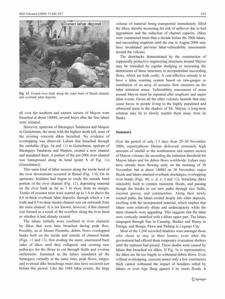
This same kind of lahar erosion along the inside bend ofthe river downstream occurred in Basud (Fig. 11f). On itsupstream, boulders had begun to erode the outside bendportion of the river channel (Fig. 12), depositing materialon the river bank as far as 7 m away from its margin.Trunks of coconut trees were scarred up to 1.6 m above the0.6 m-thick overbank lahar deposits, through which a 1-mwide and 0.5-m deep stream channel was cut outwards fromthe main channel. It is not known, however, if this channelwas formed as a result of the overflow along the river bendor whether it had already existed.
The lahars initially were confined in river channelsby dikes that were later breached during peak flow.Possibly, as at Mount Pinatubo, debris flows overtoppedbanks both on the inside and outside of channel bends(Figs. 11 and 12), first eroding the outer, unarmored backsides of dikes until they collapsed, and creating newpathways for the flows to cut through fields and overrunsettlements. Inasmuch as the lahars inundated all thebarangays virtually at the same time, peak flows, surges,and eventual dike breachings must also have occurred justbefore this period. Like the 1984 lahar events, the large
volume of material being transported immediately filledthe dikes, thereby increasing the risk of spillover due to bedaggradation and the reduction of channel capacity. Dikeswere constructed more than a decade before the 2006 lahars,and succeeding eruptions until the one in August 2006 mayhave invalidated previous lahar-vulnerability assessmentsaround the volcano.
The drawbacks demonstrated by the construction ofsupposedly protective engineering structures around Mayonmay be remedied by regular dredging or increasing thedimensions of these structures to accommodate succeedingflows, which are both costly. A cost-effective remedy is tohave a lahar warning system based on rain-gauges orinstallation of an array of acoustic flow monitors on thelahar initiation zones. Vulnerability assessment of areasaround Mayon must be repeated after eruptions and majorlahar events. Given all the other volcanic hazards that maycause havoc to people living in the highly populated andurbanized areas in the shadow of Mt. Mayon, a long-termsolution may be to slowly resettle them away from itsflanks.
Summary
Over the period of only 1.5 days from 29–30 November2006, supertyphoon Durian delivered extremely highamounts of rainfall to the southeastern and eastern sectorsof Mayon volcano, far exceeding the initiation threshold forMayon lahars and for debris flows worldwide. Lahars mayhave already been flowing early on the morning of 30November, but at about 1400H on 30 November, majorfloods and lahars attained overbank discharges, overtoppingriver bends (Figs. 8b, c, d, e, f and 12), breaching dikesostensibly built to contain rainstorm floods, and passingthough the breaks to cut new paths through rice fields,coconut groves, and communities. Along their newlycreated paths, the lahars eroded deeply into older deposits,swelling with the incorporated material, which implies thatlahars were relatively dilute and undercapacity while themain channels were aggrading. This suggests that the laharwere vertically stratified with a dilute upper part. The laharsrampaged through Sua in Camalig, Budiao and Busay inDaraga, and Bonga, Pawa and Padang in Legaspi City.
Most of the 1,266 recorded fatalities were amongst thosewho chose to stay in their homes, even after thegovernment had offered them temporary evacuation sheltersuntil the typhoon had passed. These deaths were caused bylahars that breached six dikes. If Fig. 9c is representative,the dikes are far too fragile to withstand debris flows. Evenwithout overtopping, concrete armor only a few centimetersthick cannot withstand the impact of boulders rafted bylahars, or even logs flung against it by storm floods. It
Fig. 12 Eroded river bank along the outer bend of Basud channel,and overbank lahar deposits
Bull Volcanol (2009) 71:845–857 855

might be argued that the Durian event was exceptional, butcontainment structures must be built to withstand worst-case events. The dikes were able to contain the lahars intheir channels for a prolonged period during the typhoon,but eventually failed along channel bends after about18 h of continuous intense rainfall.
Acknowledgments This work was supported as part of the project,“Monitoring the Impacts of Disaster Risk in Albay Province: TowardsRisk-sensitive Development” in collaboration with The ManilaObservatory and The Luis A. Yulo Foundation for SustainableDevelopment and Christian Aid and Oxfam Great Britain, our funders.Cristina Remotigue, Catherine Abon, Christine Bellen and MargaretLouise Honrado provided invaluable field assistance. Finally, weacknowledge the careful editing of James DL White and the thoroughreviews by Vernon Manville and Thomas Pierson.
References
Arboleda R, Martinez M (1996) 1992 lahars in the Pasig-Potrero Riversystem. In: Newhall C, Punongbayan R (eds) Fire and mud:eruptions and lahars of Mount Pinatubo. Philippine Inst VolcanolSeismol, Quezon City, pp 1045–1052
Arguden AT, Rodolfo KS (1990) Sedimentologic and dynamicdifferences between hot and cold laharic debris flows of MayonVolcano, Philippines. Geol Soc Am Bull 102:865–876
Bagnold RA (1954) Experiments on a gravity-free dispersion of largesolid spheres in a Newtonian fluid under shear. Proc R SocLondon Ser A 225:49–63
Balducci V (2007) Rainfall thresholds for the initiation of landslides.http://rainfallthresholds.irpi.cnr.it/credit.htm. Accessed September23, 2007
Collins BD, Dunne T (1986) Erosion of tephra from the 1980 eruptionof Mount St. Helens. Geol Soc Am Bull 97:896–905
Costa JE (1984) Physical geomorphology of debris flows. In: Costa JE,Fleisher PJ (eds) Developments and applications of geomorphology.Springer, Berlin, pp 269–317
Daido A (1985) Effect of volcanic ash on occurrence of mud-debris flows.In: Proceedings of International Symposium on erosion, debris flowsand disaster prevention. Tsukuba, Toshinto Printers, pp 250–260
Hampton MA (1975) Competence in fine-grained debris flows. J SedPetrol 45:834–844
HamptonMA (1979) Buoyancy in debris flows. J Sed Petrol 49:753–758Ikeya H (1989) Debris flow and its countermeasures in Japan. Bull Int
Assoc Eng 40:15–33Lavigne F, Thouret JC, Voight B, Suwa H, Sumaryono A (2000a)
Lahar at Merapi Volcano, Central Java: an overview. J VolcanolGeotherm Res 100:423–253
Lavigne F, Thouret JC, Voight B, Young K, Lahusen R, Marso J,Suwa H, Sumaryono A, Sayudi DS, Dejean M (2000b)Instrumental lahar monitoring at Merapi Volcano, Central Java,Indonesia. J Volcanol Geothermal Res 100:457–478
Lewis DW, McConchie D (1994) Analytical sedimentology. Chapman& Hall, New York
Major JJ, Pierson TC (1992) Debris flow rheology: experimentalanalysis of fine-grained slurries. Water Res Res 28:841–857
Middleton GV, Hampton MA (1976) Subaqueous sediment transportand deposition by sediment gravity flows. In: Stanley DJ, SwiftDJP (eds) Marine sediment transport and environmental man-agement. New York, Wiley, pp 197–218
Mitzuyama T, Kobashi S, Ou G (1992) Prediction of debris flow peakdischarge. Proc Interprevent Int Symp (Bern) 4:99–108
Newhall CG (1977) Geology and petrology of Mayon Volcano (MSThesis): Davis, California, University of California, 292 p
Newhall CG (1979) Temporal evolution of the lavas of MayonVolcano, Southeastern Luzon, Philippines. J Volcanol Geother-mal V 6:61–83
Okunishi K, Suwa H (1985) Hydrological approach to debris flow. In:Proceedings of the International Symposium on Erosion, DebrisFlow and Disaster Prevention, pp 243–247
Okunishi K, Suwa H, Hamana S (1988) Hydrological controls oferosion and sediment transport in volcanic torrents. Hydrol Sci J33:575–587
PAGASA (2006) Philippine Atmospheric Geophysical and Atmo-spheric Services Rainfall archive. Data record
Philippine Institute of Volcanology and Seismology (2008) MayonVolcano. www.phivolcs.dost.gov.ph/Volcano/Volcanolist/mayon.htm.Accessed 11 February 2008
Phillips CJ, Davies TRH (1991) Determining rheological parametersof debris flow material. Geomorphology 4:101–110
Pierson TC (1981) Dominant particle support mechanism in debrisflows at Mount Thomas, New Zealand and implications for flowmobility. Proc 1985 Geomorphol Symp 18:49–60
Pierson TC (1998) An empirical method for estimating travel times forwet volcanic mass flows. Bull Volcanol 60:98–109
Pierson TC, Costa JE (1987) A rheologic classification of subaerialsediment-water flows. In: Costa JE, Wieczorek GF (eds) Debrisflows/avalanches—process, recognition, and mitigation: Rev EngGeology 7:1–12
Pierson TC, Scott KM (1985) Downstream dilution of a lahar:transition from debris flow to hyperconcentrated streamflow.Water Res Res 21:1511–1524
Punongbayan RS, Ruelo HB (1985) Profile morphology and internalstructure of Mayon Volcano. Philippine J Volcanol 2 (1 & 2)
Qian Y, Wenhai Y, Wenlin Z, Xiuwen C, Longrong Z, Wengui X(1980) Basic characteristics of flow with hyperconcentration ofsediment. In: Boning L (ed) Proc Int Symp River Sedimentation.Beijing, Guanghua, pp 175–184
Rabonza G (2006) Philippines: NDCC media update-TyphoonReming (Durian). Technical Report. Office of Civil Defense
Ramos-Villarta S, Corpuz E, Newhall C (1985) Eruptive history ofMayon volcano, Philippines. Philippine J Volcanol 2:1–35
Rodolfo K (1989) Origin and early evolution of lahar channel at Mabinit,Mayon Volcano, Philippines. Geol Soc Amer Bull 101:414–426
Rodolfo K, Arguden A (1991) Rain-lahar generation and sediment-delivery systems at Mayon Volcano, Philippines. In: Fisher R,Smith G (eds) Sedimentation in volcanic settings. Soc EconPaleontol Mineral Spec Pub 45, pp 71–87
Rodolfo K, Umbal J, Alonso R, Remotigue C, Melosantos M,Salvador J, Evangelista D, Miller Y (1996) Two years of laharson the western flank of Mount Pinatubo: initiation, flowprocesses, deposits, and attendant geomorphic and hydraulicchanges. In: Newhall C, Punongbayan R (eds) Fire and mud:eruptions and lahars of Mount Pinatubo, pp 989–1013. PhilippineInst Volcanol Seismol, Quezon City, pp 989–1013
Segerstrom K (1950) Erosion studies at Paricutin volcano, State ofMichoacan, Mexico: US Geol Surv Bull 956-A:164
Smith GA, Lowe DR (1991) Lahars: Volcano-hydrologic events anddeposition in the debris flow—hyperconcentrated flow continuum.In: Fisher RV, Smith G (eds) Sedimentation in Volcanic Settings.Soc Econ Paleontol Mineral Spec Pub 45, pp 59–70
Sutikno H, Sakatani (1993) Present conditions of mudflow forecastingand warning system in the area of Merapi, Central Java. FirstSeminar on Sabo Engineering, Sabo Technical Center, Yogyakarta,17–20 February 1993, pp 1–17
Suwa H, Sumaryono A (1995) Sediment transportation by stormrunoff at the Bebeng river on Mount Merapi. Proceedings ofWorkshop on erosion control through volcanic hydrological
856 Bull Volcanol (2009) 71:845–857
approach (WECVHA), Sabo Technical Center, Yogyakarta, 10–11 January 1995, pp 106–107
Task Group for the International Decade of Natural Disaster Reduction(1990) Report. Bull Volc Soc Japan Ser 2: 35: pp 80–95
Tungol N, Regalado M (1996) Rainfall, acoustic flow monitor records,and observed lahars of the Sacobia River in 1992. In: Newhall C,Punongbayan R (eds) Fire and mud: eruptions and lahars of MountPinatubo. University of Washington Press, Seattle, pp 1045–1052
Umbal JV (1986) Mayon lahars during and after the 1984 eruption.Philippine J Volcanol 3:38–59
Umbal JV, Rodolfo KS (1996) The 1991 lahars of southwesternMount Pinatubo. Philippines and the evolution of a lahar-dammed lake: pp 951–970. In: Newhall C, Punongbayan R
(eds) Fire and mud: eruptions and lahars of Mount Pinatubo.Philippine Inst of Volcanol Seismol, Quezon City, pp 1045–1052
Van Westen CJ, Daag AS (2005) Analyzing the relationshipbetween rainfall characteristics and lahar activity at MountPinatubo, Philippines. Earth Surf Process Landf 30:1663–1674
Waldron HW (1967) Debris flow and erosion control problems causedby the ash eruptions of the Irazu volcano, Costa Rica. US GeolSurv Bull 1241-I:37
White JDL (1991) The depositional record of small, monogeneticvolcanoes within terrestrial basins. In: Fisher RV, Smith G (eds)Sedimentation in volcanic settings. Soc Econ Paleontol Mineral,Spec Pub 45: pp 155–171
Bull Volcanol (2009) 71:845–857 857
Copyright © 2022 FDOKUMEN