Subtropical Arctic Ocean temperatures during the Palaeocene/Eocene thermal maximum
Upload
independentCategory
view
0download
0
I I I
I I I I I I I I
Evolution of Subsurface Palaeocene Sequence and Shoal Carbonates, South-Central Sirt Basin
R.N. SINHA 1 AND l.Y. MRIHEEL 2
cs--h ,,ti ~ ~~~I ~I ttl:a J.,,Ja3 u.JM' ~.P Ja.....J.J y~ ~$1 ~ o'ifl J~.J
r=J 4-i-J I · 1.4,.,ll r=J .!.,JIJ r=J. ( t+-JJi ) .,s)..JI JL!I r=J ..uJ.1.;yfa UJ"" ._,;,_,....la...)) y~.) ..;.,-.~~I _,.....JI t!l.:r ~
_pl.).1._;-fa J.-!..i . ~J ~ ._;.,.l.)1 ~1.;r ;,,;,,,..L>J ..W.I ._;-fa UJ~ . ( ~.1.>i l ...,.;LIJ _p l.,,>J .).JJJ , ;,,;,,,..L>J i.,¢)1 .,,_,is:.;J ;,,_,w1 . 1.4,.,J I
. .:.:WI ;J.i.; ~;,,Al J.,.;....JI .;r ~I U.Ji.:JJ . ~ ~ ;,,~ 1J_,;...... ...,.;LIJ
- y~ J L....!JI •lfl .;::.:JI 1.i.. ,l,;.L_, . ~ .;,:.:.i !.:.. ~ ci .>.,jJ J.; .;r ~ ~ r1 l,.iL;.l Li:.i ~I .;:,d. U ~'l'I ..:.L;L,..,.JI .#J
. ~J'!I_, J.,.,.Al l JJJ i.s-4..i> .;r-.)).JI ..W.I ._,;,_,... J.....i.._, .l.4,.,JI U.,.....JJ ..,..Al J)I U::-! j......._, ..;_,.:. y~
. ( ..W.I .;yfa ) .iS..,.-.. ;.,,..:..1 J_,.;....J ~.}J ._,;,_,j-1 Jl..1..:.tl ~ L~ lj_,l.f J Jl....!.ll ·Lfl.) rWI J...l lJ t.l..:dl J~ ~IJJI il.> )I u.J+! JJ_,
l,,.,.-; WJ u .i+! ..W ;_.¥1 ~..1,,~IJ ~_,.LI il> )I L.iJ . <,?)..J I JL! I _,.:,= .;r ~ J_,;-~..!-.,.>;.,.,_,All. L.a.,..,JI U.,.....J r}J f ..::.i)I..,...;; .)J
y)Li;'l'I .)! d H C::J. .>,j_, • ;_+WI .;yfa_, i...,J..L...JI . l.4.,..,J I_, ._,_,l..J I. L4.,..,) I .;,;_,5..; ;.,.J).JI ._,;, [,.>~ IJ il...J ~I~ .>.,jJ . .!.,JU .;,;fa_ L~ • W._,
. ;,,,i..... ..:.~.., 1~ ~.,..,__,;JI UL .:.;LS" Lc..JJ . ;..J)all ._,;,l_,.>)U ,_,;_~ I
.,s_,;;-. y~ tl..A;J! .;yj ..W.1.;yfa J!t_, ~..1,,~I il>) l '-! IJ..i ..? ~_,..!.) I ._,,,l....!.J I ·l?,'l'I.) i..i..i,;.1.;yfa ~I J.,.;....JI r5°1,,.; _,...;-1 JJJ
~ i....+liJ IJ ;,,_µ1. L.a.,..,.ll_, 4.,.1..WI . L.a...,,.ll_, ~L:_, <,?)..J I Jh.-U ;,,_;.......JI ..:.1.1.>)I ;,ifa ~~I U.~ ~ 'iJ~! .)! (L::.......-' ~l e:h-
;,,~I J_,.;.......u ._,..;~I .,..,__,;Jr.:!.1.;_, . 4;.,.l...ll ~1 0-'fa J_,;...... ~_, L~ 13_,l_f ;_µ1 ~..1,,")IJI il>)l '-!l,+.; u.J+! JJ_, . U.~l ,,U .,,_,is:; ~ Jl~ I ~ ~Jl..i.::l l ..:.lSrJ..J l.;l.J..U_, ~ l!ll:.>) .fa , '-.,.;~ I ..:.U....)I ~ ..;L ._..:) IJ, ;__.;.l:.L I ~.1.;~I il>.)1 .;r .;,J:Jj 0-'fa ~~
. _pl.).1.;yfa ~~I_, ;,,Al J_,.;.......JI .;r 4-:5,; LS"); 4.-...1..i.; _........; I .,s.iJIJ J.!>v .S?J. .sJJl.f J~ .).13 .;yfa .,...,_,;'-!\+ .:..-:.....;I JJJ . t_J.i....al l
J_,.;....JI .;r °4-:!,; ...,_.,; .)1.,sJI .,s.iJIJ ~J"!'l'IJ ~~L.JI U::-! J...W I ~I ~ L,S'I,,.:.. ._;1.).1 '-"'fa'-![+.;~ i~I, ..&.,.i.> .S/". ]J4'-:J _,>i J_,1 1!!1.:..J
..;.,-J'!'l' I _,.....JI .) ._,fa.J ~ .J~ fl,;.)! .,sJiJ • .,,....~ ._,;,_,j-1 J...!. _....,JI e:b-- .,s_,;;-..) t-IJ ._,;,w..;1 c.!lH cf .>,j_, . _,,,;I.I _,,_,>..:;J ~IJ ;,,Al
. _.¥ 1
<!J I.:.._, . ~l .:;z.JI..;_,; L,LU;..:..s'l,;J ( 4.,::;_,.llil>,,11.;r l ~IJ Y-i--Jl.L;....,.,Jlo,?~ .fa 4:-~L,.Jl~IJ_,;- ..:.~i JJJ
o,?.r!": J.>J J~ j.).ll ~ ._;-~ o,?.r.>: J.J. .._,+ZjJ tWI J,;.J.. .,,:..,1 o,?.r.>: J.>y, 'iJJJ JS i~J . ~IJ 4.,.:.-__,All ;,,.,,..,+I J_,.;.....J I ._,.,. 4..,.... iJ ..:. IJJJ ;~
~IJ <?~I J.> )I .:r'- ..:iL_,.:-.. "-! ..;.,-1.sr->:o J.> J ~ ~ .s.....-; J L...,,..,,; ~ .).J ~I i.i.; . J.>.lr 'i..:.":J.J .;r il.lj4 .:.;LS".~ 'iJJJ J5_, , .S.r.>: _,,_;&..J
"----.!JL!J I il> )I ..L:.&. \..!.:.,; u-=-_,.JI .,s~I J.)I L. I_, . .,s_.....,J I ) ..... ....;'l' I ),.._;...I J....i.; ..:..s'I,; .SJ"!": ~JJ .S.r.>: J.>_, .fa ~l.!ll il> )I .S~J . ~
1 Deceased 1994. 2 Petroleum Research Centre, P.O. Box 643 1, Tripoli, Libya, G.S.P.L.AJ.

154 R.N. SINHA AND LY. MRIHEEL
-,..4..J ..fai .)! J.......<..:ll. Lf:.;1.)1 , y L,.,-~I .;.:.:JI .:,LS" .s.lll .)..JI _;j.i..:JI -s~i .ti.J . ._r!.)1 _;jJ..:.11 ~LS:.,.. .,;.._,l, ,;r- ;_,il.-) 1.J i..._).J I • L4,.,l!
4~ "-! ._r:.;.,5~ ~ <$.r."': J>.J 4--1_,..i ~ ;.,~ .)t'-" dJ..i.5 ~.,; L...S . i...__....,..11 .:,l.l.!J.11 ':-'.J~ r-'-1. .:il.,..>'11 ~ .).J wt~ ~.J ~
. " .h,:..::.-11 " ..;.:.:! I ..;_,.; ~I .).! ..i .:.rfa .) .:..U l....;._.
Abstract. The subsurface Palaeocene sequence in the south-central Sirt Basin is differentiated into Hagfa-Upper Sarai (oldest), Thalith, Lower Beda, Upper Beda, Dahra, Khalifa, Zelten, Harash and Kheir (youngest) formations. The Hagfa and Khalifa formations consist main! of shales. Harash and Kheir formations include carbonates wi th shales. The rest comprise mainly carbonates with sdrce shales.
Analysis of regional subsurface data rev~al an additional and hitherto unrecognised horse herein named Infe rred Horst. This horst trends NW-SE, links the So them Shelf with Al Bay9a• Platform and separates the Al Hagfah Trough from Diir al 'Abd and Abii Tumayam trough .
The Danian witnessed rejuvenation of aults, a general northerly down tilting, basin-wide marine transgression and deposition of thick shales (Hagfa ForJnation). Simultaneously, the western Al Bay9a' Platform was uplifted and covered by carbonates of Upper Satal f ormation. The Montian and Early Landenian were marked by relative uplift, and carbonates of Thalith, Lower Beda, Upper Beda and Dahra formations covered the platforms and troughs. This may be ascribed to tectonic inversion of troughs. The depositional area possibly resembled a ramp with local shoaling. Deposition of shales of Hagfa Fo ation, however, continued in the northeastern parts till early Landenian. The Hagfa Formation is time transgressive and needs to be redesignated as Hagfa Group with Upper Satal, Thalith, Lower Beda, Upper Beda and Dahra lithol~gic units as its formations. The close of the Early Landenian wimessed a basin-wide marine transgression and the shales of Khalifa Formation were laid. Uniform development of Late Landenian carbonates of the succeeding Zelten Formation over all the tectonic units suggests shallowing and a lack of di fferential movements along most of th
1 faults. The close of Zelten sedimentation was marked by a minor marine
transgressive phase which gradually receded and the shale carbonate suite of Harash Formation was evolved. During another phase of mild marine transgression, which began with the close of the Harash Formation and which straddled the Palaeocene-Eocene boundary, the shale
1 carbonate suite of Kheir Formation was laid. This was succeeded by a
basin-wide fall in sea level leading to the evolution of Early Eocene carbonates and evaporites. The Palaeocene shoal carbonates are copfined to the Lower and Upper Beda formations (Montian) and developed
preferentially over the Inferred Horst. Several cycles of upward shoaling oolitic calcarenites are developed. Each cycle starts with argillaceous calcilutites a d traces of shale near the base and culminates in moderate to well sorted oolitic calcarenites through calcilutites and fine-grained calcarenites. Each of the shoaling cycles developed possibly through three stages. The first commencing with the onset of regression resulted in the formation of arg illaceous calcilutites locally with levels of calcarenit9s and shale. The second stage includes calcarenites and calcilutites formed as a result of continued regression. Oolitic calcarenites developed during the third stage due to tectonic uplift of the Inferred Horst, a fall in sea level and higher energy levels. Limestones of Lower and Upper Beda were subsequently dolomitized mainly by seepage reftuxion /mechanism. Local flooding caused by subsidence of the Inferred Horst terminated upward shoaling and brought a~out the formation of argillaceous and at times burrowed calcilutites. Shoal carbonates comprising glauconitic skeletal calcarenites with fossil fragments are also present in the Zelten Formation developed over the Inferred Horst.
INTRODUCTION
Libya forms a part of the Mediterranean foreland of the pan-African plate. Its tectonic evolution has been worked out by Conant and Goudarzi (196p), Klitzsch (1971 ), Goudarzi (1980), Van Houten (198)) and Massa and Delort (1984). Tectonic events largely associated with extensional movements resulted in faulting and tilting and gave rise to various geologic provinces. Of these, the Sirt Basin is the most e tensive and petroliferous and dates back to the Cambr~-Ordovician (Sinha, 1992a).
Major tectonic events in the Sirt basiin appertain to Taconic, Caledonian, and Hercynian p ases (Sinha, 1992a). Several others occurred during th Cretaceous, Palaeocene and also as late as the Middle Tertiary
(Selley, 1968; Berggren, 1969; Burke and Dewey, 1974; Goudarzi, 1980; Kebeasy, 1980; Gumati and Shamel, 1988). The various tectonic events resulted in unroofing of the Precambrian basement, epeirogenic uplift, formation of horsts and grabens (or troughs) as well as their repeated activation, several transgressive-regressive episodes and also vulcanism. The Late Mesozoic-Early Cenozoic period appears to have been relatively more eventful from the viewpoint of tectonic evolution and the attendant sedimentational history. Most of the horsts and grabens (troughs) are aligned NW-SE which is similar to the preferred orientations displayed by the igneous-metamorphic basement rocks exposed to the south of Sirt Basin. The subsidence of the basin was initiated during the Cambro-Ordovician, and it is thought to have been at its maximum
I I I I I I I I I I I I I I

I I I I I I I I I I I I I I I
i I I I
EVOLUTION OF SUBSURFACE PALAEOCENE SEQUENCE AND SHOAL CARBONATES, SOUTH-CENTRAL SIRT BASIN 155
during the Palaeocene and Eocene (Gumati and Kanes, 1985).
The sedimentary sequence in the Sirt Basin ranges in age from Cambra-Ordovician to Recent. That of Silurian-?Devonian age is known from only a few localities, is ill preserved and includes graptolitic shales and possibly marine-paralic sandstones (Sinha, 1992a). There are no reports yet of sediments of Carboniferous-Permian age. Sandstones and shales of Middle Triassic age are known only from the Maradah Trough, eastern Sirt Basin (Fig. 1). The Late Jurassic-Early Cretaceous sequence comprises mainly non-marine paralic sandstones and variegated shales. Sediments of Late Cretaceous-Late Miocene age include marine carbonates, evaporites and shales and also paralic non-marine sandstones and shales. The earliest marine transgression, inferred from palynologic data (Bonnefous, 1972), is concluded to have occurred during the Cambro-Ordovician (Sinha, l 992b) Thereafter, the basin witnessed several phases of marine transgressive episodes interrupted by periods of regression.
The study area covers the south-central Sirt Basin (Fig. 1). It covers approximately 26 500 km2 and includes parts of several tectonic elements (Fig. 2). An attempt is made to study the evolution of various lithologic units of the Palaeocene sequence (Fig. 3), more especially the shoal carbonates included in the Lower and Upper Beda formations of Montian age. The study is based on geologic data obtained from logs of about 150 wells and detailed megascopic as well as petrographic study of cored intervals of the shoal carbonates. The stratigraphic nomenclature of Barr and Weegar (1972) and Banerjee (1980) has been followed.
BASIN ARCHITECTURE
The south-central Sirt Basin is differentiated into several positive and negative tectonic elements delimited by normal faults (Mouzughi and Taleb, 1981; N.O.C., 1983 revised 1989 and 1990). These include the Az. '.(:ahrah Platform in the northwest, Al Bay9a' Platform in the west and the Southern Shelf in the southeast (Fig. 2). The Zal!an Platform, a N-S promontory of the Southern Shelf (Fig. 2) is decipherable in the eastern parts. The NE-SW striking Al Kotlah Graben separates the Az. '.(:ahrah Platform from the Al Bay9a' Platform. The Dur al 'Abd Trough borders the Al Bay9a' Platform to the south. The Al Bay9a' Platform is separated from the Southern Shelf by the Abii Tumayam Trough and from the Zal!an Platform by the Al J:Iagfah Trough.
The tectonic maps of Mouzughi and Taleb (1981) and N.O.C. (op. cit.) show that:
1. the Abii Tumayam Trough continues to the north and joins the Al J:Iagfah Trough (Fig. l);
2. the Al Bay9a' Platform is separated from the Southern Shelf by the northern part of Abii Tumayam Trough and the southern part of Al J:Iagfah Trough (Fig. 2) and that its SE margin is faulted (F-F; Fig. 2).
Preliminary geologic studies by Sinha (1990) revealed the presence of a new tectonic element, a horst (Inferred Horst) which occupies the basinal part otherwise considered by Mouzughi and Taleb (1981) and N.O.C. (op. cit.) to represent the northern parts of Ab!! Tumayam and the southern part of Al J:Iagfah troughs. Sinha's (1990, 1992a) conclusions are given below.
l. The Abii Tumayam trough is not joined with the Al J:Iagfah Trough. Instead, they are separated from one another by the Inferred Horst (Fig. 2)
2. The Al Bay9a' Platform is linked to the Southern Shelf through the Inferred Horst and its SE margin is not faulted (Fig. 2).
A comprehensive study of subsurface geologic data involving detailed correlation of well logs, preparation of isopach as well as lithofacies maps for various formations (Figs 4-22), geologic sections (Figs 23, 24), structural attitude of different formational tops (Figs 25-32) and palaeotectonic analysis (Fig. 33) further strengthen the earlier conclusions of Sinha (1990,1992) and establish the presence of the new tectonic element, the Inferred Horst. Major faults define the SW and NE limits of the Inferred Horst. They are aligned NW-SE and are reflected by the structure contour maps for the tops of Kalash, Lower Beda, Upper Beda, Khalifa, Zelten, Harash and Kheir formations (Figs 25-32). They have a common upthrown block which forms the Inferred Horst. The downthrown block towards the southwest forms the Abii Tumayam Trough and that to the northeast, the Al J:Iagfah Trough. The Inferred Horst trends NW-SE, links the Al Bay9a' Platform to the Southern Shelf and separates the Al J:Iagfah Trough from the Abii Tumayam and Diir al 'Abd troughs (Fig. 2). The two major faults delimiting the horst may comprise several faults of similar orientation and the Inferred Horst may itself be a composite tectonic unit encompassing several minor positive and negative blocks.
GENERALIZED PALAEOCENE STRATIGRAPHY AND LITHOFACIES
The Palaeocene sequence, sandwiched between the tops of the Kalash and Kheir formations, comprises mainly limestones, dolomites and shales (Fig. 3).
The sequence is resoluble into nine conformable formations over most of the study area (Fig. 3). They are

156 R.N. SINHA AND LY. MRIHEEL
15°
32
28°
G. GRABEN
H. HIGH
< . PLATFORM
R. RIDGE
T. TROUGH
MEDITERRANEAN
I
20°
SEA
\r \ i I SIRT
I \BASIN ) 1 \ \ ,--"'
...._ LIBYA .._ ... ..,, ,_ ''- I
........_' J INDEX MAP 'J
100 km .
Fig. 1. Tectonic elemen1
ts, Sirt Basin, Libya. After Mozoughi and Taleb, 1981.
aptly indicated by geophysical well logs which enable their classification and correlation. In the far eastern part of the study area, only five formations are identifiable due to shaling-out of a few carbonate units to Hagfa Formation (Fig. 3). The sequence is, in general, ihinner over the basinal positive elements, but thicker in /the troughs (Fig. 4). The constituent lithologies are adequately fossiliferous and the respective formations are fairly well dated (Barr and Weegar, 1972; Banerjee, 19SO).
HAGFA FORMATION (DANIAN TO POSSIBLY EARLY LANDENIAN)
This formation is the oldest unit of the Palaeocene succession and is developed throughout the area except on the western margins of Al Bayc;ta' Platform and the crestal parts of Ad Daffah High (Fig. 5). In general, it conformably overlies the Maastrichtian Kalash Formation or the Lower Satal Formation in western marginal
I I I I I I I I I I I I I I I I I I I ~

I
I I I I I I I I I
I I I I I I I I I
EVOLUTION OF SUBSURFACE PALAEOCENE SEQUENCE AND SHOAL CARBONATES, SOUTH-CENTRAL SIRT BASIN 157
FIG. 2 OIL IN PALAEOCENE CARBO NA TES
.,.. 'T" T" .,. 11\FERRED FAUL TS
0
Fig. 2. Tectonic elements and section lines across study area.
areas of Al BaycJa' Platform (Fig. 3). In the western part of the study area it is conformably overlain by the Thalith or Lower Beda formations and in the eastern parts, by the Khalifa Formation (Fig. 3).
The Hagfa Formation includes shales with rare and thin levels of calcilutites in its upper part. The shales are dark green, greenish grey, greenish brown, firm to moderately soft, splintery, at times blocky, non-calcareous to very calcareous, usually pyritiferous, infrequently grading to marl and very rarely silty and sandy. Car-
bonaceous matter is rare. The calcilutites are off white, light to medium grey, tan, soft to medium hard and cryptocrystalline. These contain glauconite pellets and very rare oolites.
The thickness of the Hagfa Formation ranges from 500 to 1000 ft over the platforms. It is about 500 ft thick over the Inferred Horst (Fig. 5). Sequences exceeding 1500 ft in thickness are met in the troughs. Over 85% of the formation comprises shales. The rest includes calcilutites. Locally, the calcilutites range to as much

158 R.N. SINHA AND 1.Y. MRIHEEL
AZ ZAHRAH _j 2ALTAN PiATFdKJI AL BAY..PA PLATFO!?N AL l:IAGFAll TROUGH PLATFORM (SQVTN) (WEST) <EAST) (S()UTH) (NORTH) rw.cs;T)
KHEIR FORMATION
NARASH FORMATION
I
ZEL TEN FORMATION
fHALIFA ,t:ORMATl(}N
~~~r-~.l>.:D)~VH~R~~~~~-, r-.--:(~?~£~A~R~L~Y~LA7N~~~E~~~'IA~N~):---f;~~ a::==-=- /:ORNATltJN
HAG FA GROUP
(DAN/AN)
GE/VERALIZ~J) PALAEOCENE S"TRATIGRAPHY
Fig. l Generalised palaeocene stratigraphy.
as 50% (Fig. 6). Lithofacies variations are scarce and mainly relate to changes from shales to argillaceous calcilutites at a few control points.
UPPER SATAL FORMATION (DANIAN)
This formation is developed over the western marginal parts of Al Bay9a' Platform. It i homotaxial to the Hagfa Formation. Light grey to /grey argillaceous calcilutites and grey, tan dolomite . with traces of anhydrites are the main constituents. ~is formation laterally changes to shales of Hagfa Form tion towards the eastern parts of the Al Bay9a' Platfo (Figs 3, 23, 24).
THALITH FORMATION (PARTLY EARLY MONTIAN)
This formation is developed over the /western parts of Al Bay9a' Platform and the adjoining Al Kotlah Graben. It comprises fossiliferous carbodates and subordinate shale. The calcilutites are light gJey to tan grey, argillaceous, fossiliferous, at times chalicr and very often with levels of greenish-grey shale. The associated
dolomites are grey to tan and finely crystalline. The shales are light greenish-grey, calcareous and fissile . This formation is generally 100 ft in thickness. Thicker sequences are developed only in the northern part of Al Kotlah Graben (Fig. 24, section 6). It changes laterally to shales of Hagfa Formation (Fig. 3).
LOWER BEDA FORMATION (POSSIBLY EARLY MONTIAN)
This formation is developed over almost the entire study area except for a small NE part (Fig. 7) where it laterally changes to Hagfa Formation (Fig. 3). It conformably overlies the Hagfa Formation and comprises mainly carbonates. The calcilllfites are white, tan, buff, light gray to dark grey, soft to medium hard, poorly to moderately indurated, microcrystalline, at times chalky, partly dolomitic, argillaceous and locally very fossiliferous. These are interbedded with thin levels of calcarenites, and are locally oolitic, glauconitic, as well as pelletal. The calcarenites are light grey to dark grey, pale brown, sometimes mottled, fine- to mediumand also coarse-grained, friable to medium hard, occasionally argillaceous, dolomitic , fossiliferous and partly
I
I I I I I I I I I
• I I
-I I I I I I

I
I I I I I I I I I I I I I I I I I I I
EVOU.fTIO:\ OF SUBSCRFACE PALAEOCENE SEQUENCE AND SHOAL CARBONATES, SOUTH-CENTRAL SIRT BASIN 159
SOUTH-CENTRAL SIRT BASIN, LIBYA
im . ..,.. ..,.. ..,.. INFERRED FAULTS C. I. 100 FEE T
Fig. 4. Regional isopach, Top Kheir Fm- Top Kalash Fm.
pyritiferous. Fossil fragments and skeletal matter are observed. Srylolites are present. Oolitic calcarenites are light grey, tan, moderately indurated, friable, soft to medium hard, rarely argillaceous, pyritiferous, oolitic, pelletal, glauconitic, dolomitic and often with fossil fragments and skeletal maner. Vugs due to dissolution of oolites and leaching are observed. Thin to very thin levels of shales and calcilutites are present. Dolomites are buff, tan, grey, brownish, finely crystalline, some-
times sucrosic, medium hard to friable, mottled, occasionally vuggy, slightly calcareous, rarely glauconitic, seldom fossiliferous and at times anhydritic. The shales are greenish to dark greenish-grey, olive grey, splintery, subfissile to fissile, at times foliated, calcareous to very calcareous and often glauconitic.
The thickness reaches up to 250 ft. Successions developed over the Inferred Horst, parts of Southern Shelf and NE Al Bay~a' Platform are thicker (Fig. 7).

160 R.N. SINHA AND I.Y. MRIHEEL
SOUTH-CENTRAL SIRT BASIN, LIBYA
0
0
0
v·~·~· / . / o ~
/F1V,s a
REGIONAL JSOPACH HAGFA FM. I ,ABSENT
km. 1 9°
TTT T INFERRED FAULTS C. 1.100 FE:=T OL POINTS
ig. 5. Regional isopach, Hagfa Fm.
Lithofacies variations are well marked an~ occur from limestones to dolomites and to shales as is evident from the percentage plots of principal liiliologies (Fig. 8). Limestones are equally developed ovbr positive as well as negative tectonic elements and 1usually comprise more than 75% of the sequence (F~g . 7). These, however, gradually change over to shales in the Al I:Iagfah Trough and to dolomites and dblomites with
anhydrites over the western marginal area of Al Bay<;ia' Platform (Fig. 9). Calcilutites are most common. Calcarenites are abundantly developed over the eastern Al Bay<;ia' Platform, Inferred Horst and northern parts of the Southern Shelf (Fig. 10). Oolitic, glauconitic and pelletal calcarenites with fossil/shell fragments form the shoal deposits and are developed preferentially over the Inferred Horst (Fig. 9).
I
I I I I I I I I I I I I I I I I I I I

I I I I I I I I I I I I I I I I I I
EVOLUTION OF SUBSURFACE PALAEOCENE SEQUENCE AND SHOAL CARBONATES, SOUTH-CENTRAL SIRT BASIN 16 1
SOUTH-CENTRAL SIRT BASIN, LIBYA
Fig. 6. Regional lithofacies, Hagfa Fm.
UPPER BEDA FORMATION (POSSIBLY LATE MONTIAN)
This formation is developed throughout the study area except in its NE parts (Fig. 11). It conformably overlies the Lower Beda Formation. The sequence comprises calcilutites, calcarenites, oolitic-pelletal-glauconitic skeletal calcarenite, dolomites and anhydritic and vuggy dolomites. Some of the calcarenites are vuggy
and at times display stylolites. Shales are fairly scarce. The lithologic characters are very similar to those of the Lower Beda Formation. Anhydrite is usually associated with dolomites as blebs, stringers and nodules and rarely as beds. These are white, very light grey to grey, off white, buff, opaque to translucent, dense and aphanitic to finely crystalline. Shales are more frequent in the upper part of the formation and interbedded with calcilutites.
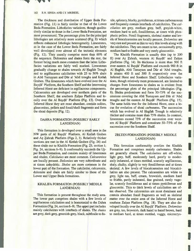
162 R.N. SINHA AND I.Y. MRIHEEL
The thickness and distribution of Upper Beda Formation (Fig. 11) is fairly similar to that of the Lower Beda Formation. Lithofacies variations, though qualitatively similar to those in the Lower Beda Fomfation, are most pronounced. The percentage plots for th~ principal lithologies are relatively more scattered (Fig.
1 8) which
reflects enhanced lithologic heterogeneity. L·mestones, as in the case of the Lower Beda Formation, are fairly well developed over almost all the tectonid elements (Fig. 12). They usually comprise more tha 60% of the sequence. Dolomites and shales form the rest, the former being much more common than the la ter. Lithofacies variations are fairly well marked. tlimestones
I gradually change to shales towards Al I:Jagfah Trough and to argillaceous calcilutites with 25 to 0% shale in Abu Tumayam and Dur al 'Abd troughs and Kotlah Graben. The limestones which have evolved pver the Al Bay<;Ia' Platform, the Southern Shelf and the intervening Inferred Horst are deficient in argillaceous components.
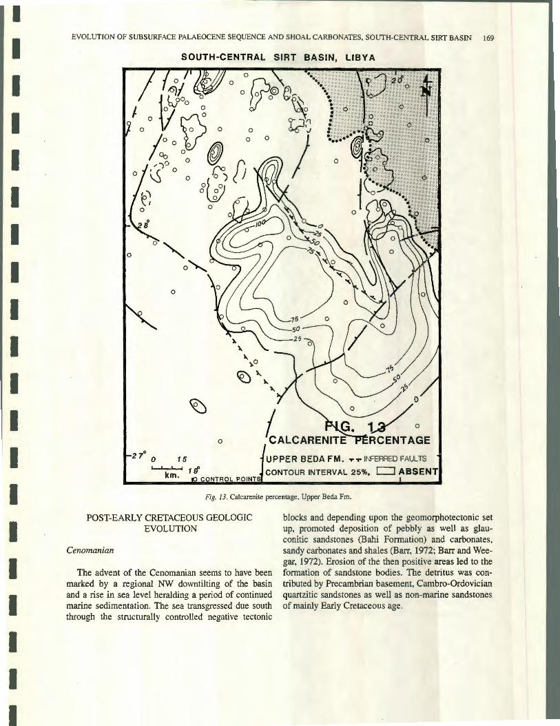
~~~~:e~it~~e%~ t~:v~~oJr~~;v~~l~::~~~f~:sa~~ ~~~ cally over the Al Bay<;la' Platform (Fig. 13 . Over the Inferred Horst they are most abundant, con
1ain oolites,
glauconites, pellets and fossil/shell fragments and form the shoal deposits (Fig. 12).
DAHRA FORMATION (POSSIBLY 1ARLY
LANDENIAN)
This formation is developed over a smal area in the NW parts of Al Bay<;la' Platform, Al Ko !ah Graben and A"?- Zahrah Platform (Figs 2, 3). Reiaqvely thicker sec tions are met in the Al Kotlah Graben (Fig. 24) and these shale out to Khalifa Formation (Fig. 213, section l ; Fig. 24, sections 6- 9). It conformably succeeds the Upper Beda Formation, and consists mainly f limestones and shales. Calciluties are most common. e alcarenites are locally present. Dolomites are very subordinate and at times anhydritic. Shales are more common in the lower part of the formation. The calcilutit<1, calcarenite, dolomite and shale are fairly similar to those of the Lower and Upper Beda formations.
KHALIFA FORMATION (POSSIBLY MIDDLE LANDENIAN)
This formation is present throughout t(/ e study area. The lower part comprises shales with a ew levels of argillaceous calcilutites and is homotaxia to the Dahra Formation (Fig. 24, section 6-9). The upper part includes mainly calcilutites with interbeds of shalds. The shales are grey, dark grey, greenish-grey, black, subfissile to tis-
sile, splintery, blocky, pyritiferous, at times carbonaceous and frequently contain interbeds of calcilutites. The calcilutites are grey, medium grey, buff, greyish-white, medium hard to soft, fossiliferous, at times with phosphatic pellets. Fossil fragments, skeletal matter and levels of biocalcarenites are locally present. Dolomites are very rare and present as thin to very thin levels along with the calcilutites. They are cream to tan, occasionally grey, medium hard to friable and very rarely glauconitic.
The Khalifa Formation is usually thin (up to 200 ft) over A"?- Zahrah, western Al Bay<;Ia' and Zal~an platforms (Fig. 14). Its thickness is more than 500 ft over eastern Al Bay<;Ia' Platform and exceeds 900 ft in Al I:Jagfah, Abu Tumayam and Dur al 'Abd troughs. It attains 400 ft and 300 ft respectively over the Inferred Horst and Southern Shelf. Lithofacies variations, though relatively more pronounced, are limited to changes from limestones to shales as is evident from the percentage plots of the principal lithologies (Fig. 8). Shales predominate and form 50-75% of the successions covering the Abu Tumayam and Dur al 'Abd troughs and the eastern Al Bay<;la' Platform (Fig. 15). The same holds true for the Inferred Horst, once a locus for evolution of shoal carbonates. The succession which has evolved in Al I:Jagfah Trough is relatively thicker and contains more than 75% shales. In contrast, limestones exceed 75% of the succession over western Al Bay<;la' Platform and constitute 50-75% of the succession over the Southern Shelf.
ZELTEN FORMATION (POSSIBLY MIDDLE LANDENIAN)
This formation conformably overlies the Khalifa Formation and comprises mainly carbonates. Shales are generally absent. The calcilutites are off-white, light grey, buff, moderately hard, poorly to moderately indurated, at times mottled, scarcely argillaceous, shaly, chalky, slightly to very fossiliferous and at times skeletal. A few levels of biocalcarenites and biocalcilutites are also present. The calcarenites are white to grey, light tan, buff, cream, brownish, medium hard to friable, partly indurated, fine grained, rarely vugular, scarcely fossiliferous and at times pyritiferous and glauconitic. Thin to thick levels of calcilutites are often observed. The calcarenites are most dominant and contain abundant fossil fragments as well as skeletal matter over the entire area of the Inferred Horst and southern Zal~an Platform (Fig. 18). They are also developed locally over the Al Bay<;la' Platform. Dolomites are grey, tan, brownish, dark hazel to hazel brown, hard to medium hard, at times mottled, vuggy, microcrys-
I I I I I I I I I I I I I I I I I I I

I
I I I I I I I I I I I I I I I I I I I
EVOLUTION OF SUBSURFACE PALAEOCENE SEQUENCE AND SHOAL CARBONATES, SOUTH-CENTRAL SIRT BASIN 163
SOUTH-CENTRAL SIRT BASIN, LIBYA
0~0
0@ "' 0 ....
0
CONTBOL POINTS ,.. ,....,.. IN!=ERRED FAULTS c.1. 25 FEET
Fig. 7. Regional isopach, Lower Beda Fm.
talline, often anhydritic, at times argillaceous, locally sucrosic, very rarely fossiliferous and often with thin levels of calcilutites. Anhydrites are usually associated with the dolomites. These are white to grey, opaque to translucent, dense, aphanitic, finely crystalline and occur as streaks, sttfogers and nodules. Shales are grey to greenish-grey, subfissile, at times, pyritiferous and usually calcareous. These are present near the top and bottom of the formation.
The Zelten Formation is well developed throughout the study area. Its thickness varies from 300 to over 600 ft (Fig. 16). The Al I:Iagfah Trough and western Al Bay~ii' Platform are covered by thinner (up to 300 ft) sequences. Successions over the eastern Al Bay~ii' Platform, Inferred Horst, Southern Shelf, Abu Tumayam and Dur al 'Abd troughs are usually 400 ft thick. Sections developed over western margins of Zal!an Platform are more than 600 ft thick. These

164 R.N. SINHA AND I.Y. MRIHEEL
100 ~'.> DOL.+MJHY.
100%LST. L. SEDA FM. 100%SH. U.OEDA FM .
zaT::Ol\J FM .
HARASH FM . l~HEI~ FM .
MANY PLOTS REPf ESENT r,10 RE THAN ONE CONTROL POINT
Fig. 8. Percentage plots of principal lithofacies met at 150 central points (wells).
rapidly thin towards west and east (Fig. 16)./ Lithofacies variations (Fig. 17) are limited to changes ram mainly limestones to dolomites. Sequences with hales seem to be developed only in the Al I:Iagfah Trough and those in its northern part may even contai more than 50% shales (Fig. 17). The rest of the study area including Kotlah Graben, Al Bay~a' Platform,iur al 'Abd Trough, Abu Tumayam Trough, Inferred , orst, Southern Shelf and the northern part of the Zal.an Platform are covered by sequences with over 75% limestones. Dolomites dominate towards the southern {fart of Zal!an Platform and are present locally in the Dur al 'Abd .
Trough as well as over the Southern Shelf. The shoal carbonates include calcarenites, contain abundant fossil fragments as well as skeletal matter and are most dominant over the entire area of the Inferred Horst and the southern Zal!an Platform (Fig. 18). Local occurrences are also noted over the Al Bay~a' Platform.
HARASH FORMATION (POSSIBLY LATE LANDENIAN)
This formation conformably overlies the Zal!an Formation and is developed throughout the study area. It
I
I I I I I I I I I I I I I I I I I I I

I
I I I I I I I I I I I I I I I I I I I
EVOLUTION OF SUBSURFACE PALAEOCENE SEQUENCE AND SHOAL CARBONATES, SOUTH-CENTRAL SIRT BASIN 165
SOUTH-CENTRAL SIRT BASIN, LIBYA
m.
_- --- = - - -
-- - -
Fig. 9. Regional lithofacies, Lower Beda Fm.
includes mainly calcilutites and shales. Dolomites are scarce to very scarce and developed locally. Shales and carbonates are more common in, respectively, the lower and upper part of the formation. The calcilutites are light grey, grey, brownish-grey, tan, soft to medium hard, poorly to moderately indurated, argillaceous, at times dolomitic, chalky nummulitic, and often very fossiliferous. The calcarenites are very grey to grey, tan, brownish, scarcely indurated, muddy, argillaceous,
nummulitic, fossiliferous and with traces of pyrite. Shale interbeds are present in both the calcilutites and calcarenites. The dolomites are grey to tan, dark brown, medium hard to hard, microcrystalline, rarely sucrosic, often vuggy and anhydritic.
The thickness of Harash Formation exceeds 300 ft in the troughs whereas it is less than 200 ft over the positive tectonic elements (Fig. 19). Lithofacies variations are more marked compared to those in Zelten Forma-

166 R. N. SINHA AND LY. MRIHEEL
SOUTH-CENTRAL SIRT BASIN, LIBYA
0
0
2 7° 0
km .
LOWER BEDA FM.T..,.. ..,..INFERRED FAUL
CONTOUR INTERVAL 25%. c::J ABSENT
Fig. JO. Cakarenite percentage, Lower Beda Fm.
tion. The most common change is from limestone to shale through shale-rich carbonates. Limestones form more than 75% of the formation develoRed over the central Al Bay<;la' Platform, Inferred Horst, Southern Shelf and Zal!an Platform (Fig. 20). Sqquences towards the southwest in Dur al 'Abd and A1'ii Tumayam troughs contain up to 50% shales whereas those over the eastern margins of the Al Bay<;la' Platfon'n and in the Al I:Jagfah Trough comprise over 75% sh~les . Changes
to dolomites are local and noticeable over the Southern Shelf.
KHEIR FORMATION (POSSIBLY LATE LANDENIAN-EARLY YPRESIAN)
This formation comprises shales and carbonates. The shales are fairly abundant, grey, greenish-grey, olive-grey, subfissile to fissile, poorly to moderately
I
I I I I I I I I I I I I I I I I I I I

I
I I I I I I I I I I I I I I I I I I I
EVOLUTION OF SUBSURFACE PALAEOCENE SEQUENCE AND SHOAL CARBONATES, SOUTH-CENTRAL SIRT BASIN 167
SOUTH-CENTRAL SIRT BASIN, LIBYA
0
I F / 0
2 70 _..,...150 ----~ -0 15
REGIONAL ISOPACH UPPER BEDA FM_..,...-.,..1NFERt1ED FAULT
19o-/50 km. CONTROL POINTS I d ABSENT C.1.25 FEE T
Fig. 11 . Regional isopach, Upper Beda Fm.
indurated, gummy, often blocky, foliated, calcareous to very calcareous, pyritiferous, rarely silty and very frequently contain interbeds of calcilutites. The calcilutites are off white, light grey to tan grey, greyish-brown, poorly to moderately indurated, medium hard to soft, microcrystalline, marly, chalky, argillaceous to very argillaceous, partly dolomitic and fossiliferous to very fossiliferous . Some rare levels of grey to light tan, fine- to medium-grained calcarenites are present. The
dolomites are tan to brown, microcrystalline, often vuggy and only rarely fossiliferous.
The thickness of Kheir Formation extends to more than 400 ft. Thicker sections usually developed in the troughs while those over the platforms are relatively much thinner (Fig. 21). It exceeds 400 ft in Abu Tumayam, Dur al 'Abd and Al I:Iagfah troughs whereas it ranges from 100-250 ft over Al Bay<;Ia' Platform, Inferred Horst and Southern Shelf. Sequences over west-

168 R.N. SINHA AND LY. MRIHEEL
SOUTH-CENTRAL SIRT BASIN, LIBYA
8 ~[O
lo<: 0
0
7 ln 0
m Vo" b
v 0 7 L
0
-~ I.
~DOL.+ ANHY.
.·/5\
- .~' 6~' _02
7 3 \ .._ .A
- ~::2-:-';:".::::'.
11
1111 .J ... ' .. ·'iJ ... 'J ... ' ... 'i.:' .• i',.:1·' ... '·1.:',· ... ·'! .. ·'·· ... ·'·· .. ·'·· ... ·':.·'·····' ... '· .. ''.· ... ''.·J ... ' ... ·'i, ... '! ... ·' .. ·'··' .. :!.'.'1 ... ':
8. ] ? 6? :::::::::::::::;::::::=:: :~:~ fU\:f~:
•.•• Mt : 1 ~
" I - -
II - -~ -:;B:C9
:K
9
0
R ,
:·~~i ~FIG. 1~ ~
itsT. SH - - '7EG ONAL LITHOFA t~IF-~
km UPPER BEbA FM:-tm !:!: ibAec:::i::,,.
..... ~.- T .,. T NFFRRED FAI n T~
Fig. 12. Regional lithofacies, Upper Beda Fm.
em Zaltan Platform are 50-150 ft thick. Lithofacies changes. are more varied than those in H~ash Formation and appertain to those from limestones to dolomite and also to shales (Fig. 8). While the foriner is most pronounced over southern Zal!an Platform and northern parts of Southern Shelf, the latter is dollfinant in Al I:Iagfah Trough (Fig. 22). Successions with more than 75% limestones are developed over central Al Bayc)a' Platform, Inferred Horst and Southern helf and m
northern Kotlah Graben. The Abu Tumayam and Dur al 'Abd troughs and SW as well as NE Al Bayc)a' Platform are covered by sequences containing 50-75% carbonates, and more than 75% of successions developed in the Al I:Iagfa Trough comprise shales. In contrast, those which have evolved over the NE Southern Shelf and southern Zal!an Platform consist of over 75% dolomites which gradually give place to limestones due south and to shales towards the north (Fig. 22).
I
I I I I I I I I I I I I I I I I I I I
I
I I I I I I I I I I I I I I I I I I I
EVOLUTION OF SUBSURFACE PALAEOCENE SEQUENCE AND SHOAL CARBONATES, SOUTH-CENTRAL SIRT BASIN 169
SOUTH-CENTRAL SIRT BASIN, LIBYA
0
0 0" o"-. 0
0
2 7° 0 15
km . Hf
UPPER BEDA FM . ... ,.. INFERRED FAULTS
CONTOUR INTERVAL 25%. ~ABSENT ONT.AOL POINT
Fig. 13. Calcarenite percentage, Upper Beda Fm.
POST-EARLY CRETACEOUS GEOLOGIC EVOLUTION
Cenomanian
The advent of the Cenomanian seems to have been marked by a regional NW downtilting of the basin and a rise in sea level heralding a period of continued marine sedimentation. The sea transgressed due south through the structurally controlled negative tectonic
blocks and depending upon the geomorphotectonic set up, promoted deposition of pebbly as well as glauconitic sandstones (Bahi Formation) and carbonates, sandy carbonates and shales (Barr, 1972; Barr and Weegar, 1972). Erosion of the then positive areas led to the formation of sandstone bodies. The detritus was contributed by Precambrian basement, Cambro-Ordovician quartzitic sandstones as well as non-marine sandstones of mainly Early Cretaceous age.

170 R.N. SINHA AND LY. MRIHEEL
SOUTH-CENTRAL SIRT BASIN, LIBYA
"' C> C>
0
\ 0
2 7\0
qflo / I\~ f 5 I 00 l)
0
FIG. EGJONAL
0
0
o z{}Q
14/ 0
JSbPACH KHALIFA FM.
0
0
1/ i km. coNTBOL POINTS
.,.. -r "T" INFERRED FAUL TS C. 1.100 FEf:T
Fig. 14. Regional isopach, Khalifa Fm.
Turonian
The Turonian is represented by the Etel Formation. Constituent lithologies include dolomit . s, dolomitic limestones, shales and at times evaporitqs. Sands are present in the lower part of the formation. This lithologic suite possibly designates a period of very shallow marine sabk.ha deposition (Barr, 1972). /Recycling of older sediments overlying the then positive tectonic elements could have sourced the sands. CFontemporary
deposits in the northern part of Sirt Basin comprise shallow marine carbonates and shales.
Santonian-Coniacian
The Santonian-Coniacian started with a renewed marine transgression which terminated the sabkha deposition over most areas. Shales were laid into the Rachmat Formation with minor interbeds of sandstones and limestones as well as dolomites.
I
I I I I I I I I I I I I I I I I I I I

I
I I I I I I I I I I I I I I I I I I I
EVOLUTION OF SUBSURFACE PALAEOCENE SEQUENCE AND SHOAL CARBONATES, SOUTH-CENTRAL SIRT BASIN 17 1
SOUTH-CENTRAL SIRT BASIN, LIBYA
=-~~=~===~~~~=====~=~~~ll~~llllt ---==== ======== ========= ------------:::0::--
----======+~===---- -~=~=~=~=~~=====~ = -=-2====~===-===== - - ~~=~~~=~=~=
I~~l1~~~~~~1~=~~illliill = ~~~~====~~~~=~~~I~~~~~~~~III~~~=:_ - - - - - --- _______________________ -
9
- -
-
- -
-
-
=~=~E;~~;~~=~~;~~=~=~=~=~~~==--_ =; -= - ---- - = = -====~:::;-- 5 -=======~===:=:=::=:=:=::::;.-_ --= = = = = -~ =.: = = =-= ~ = = = = =
--:~=:?E=============== ~ -= = = = -= = = = - --=-=-=-=-=+=-=-=- - ------------------ -
Fig. 15. Regional lithofacies, Khalifa Fm.
Campanian
The advent of the Campanian was marked by a severe transgressive episode. It is represented by marine, generally anoxic, dark grey to dark brown, at times black, subfissile to fissile, splintery, carbonaceous, and for the most part fossiliferous , calcareous shales designated as Sirte Shale (Barr and Weegar, 1972). These shales are considered to be the principal source rocks of
hydrocarbons in the Sirt Basin (Hamyouni et al., 1984). The Campanian transgression covered almost the entire study area. Some parts of a few positive elements, such as at Al W~ah and Jabal over western Zal!an Platform, the SE portion of Southern Shelf and western as well as south-central parts of Al Bay9a' Platform, being devoid of Sirte Shale, seem to have been highs during this transgressive phase. The thickness of Sirte Shale over western Zal!an Platform is generally 300 ft.

172 R.N. SINHA AND LY. MRIHEEL
SOUTH-CENTRAL SIRT BASIN, LIBYA
0
2 7° 0 15
0 0 0
Fl;.0 \ c
IONAL ~;oPkH ZELTEN FM.
km. 1 ~o 16 CONTR L POINTS .,. .,. .,..
INFERRED FAUL TS C. I. 50 FEET
Fig. 16. Regional isopach, Zelten Fm.
It ranges from 200-300 ft over the SE Al ~ay9a' Platform and is usually about 200 ft over the Inferred Horst. Isopach data suggests that these tectonic eldments were strongly positive and that the Inferred Horst served as a structural link between the Al Bay9a' Platf~rm and the Southern Shelf during the Campanian. The thickness of Sirte Shale abruptly increases to more than 1500 ft in the Al J:Iagfah and Abu Tumayam troGghs which adjoin the Inferred Horst (Fig. 2). Similar thicknesses
are noted in the Diir al 'Abd as well as the northern parts of Al J:Iagfah and Ajdabiya troughs. Excessive thickness in these troughs and relatively very reduced sections over the positive elements indicate restitution of the horst-graben morphology due to further release of tension by reactivation of faults and resultant differential block movements. Subsidence curves (Gumati and Kanes, 1985) also suggest increased rates of subsidence and rapid sedimentation during the Campanian.
I
I I I I I I I I I I I I I I I I I I I

I
I I I I I I I I I I I I I I I I I I I
EVOLUTION OF SUBSURFACE PALAEOCENE SEQUENCE AND SHOAL CARBONATES, SOUTH-CENTRAL SIRT BASIN 173
SOUTH-CENTRAL SIRT BASIN, LIBYA
-~
--= l<hl ""l=-.l
- -· ~
x
~
0
"'1> 0-~& - 1 D o
·. 0 -
oi_,..---
~
II~
""" -IILST. ·SH.
:zELTEN F ::::
m ..... -r .... .... 1NFERREn FAl JL rs ::::
Fig. 17. Regional Iithofacies, Zelten Fm.
The Sirte Shale thickens due north and northwest in which directions the basin appears to have been down tilted.
Maastrichtian
The Maastrichtian is represented by the Kalash Limestone. This lithologic unit includes white, tan-grey, argillaceous, chalky calcilutites with rare to very rare
thin levels of shales. This formation laterally changes to the dolomites and non-chalky limestones of the Lower Satal Formation only over the western marginal areas of Al Bayc;la' Platform. It appears that the advent of the Maastrichtian was accompanied by widespread lowering of the sea level possibly in response to a regional basinal uplift. The Campanian transgressive episode was terminated and the calcilutites of the Kalash Formation evolved. The general presence of calcarenites

174 R.N. SINHA AND LY. MRIHEEL
SOUTH-CENTRAL SIRT BASIN, LIBYA
J 0
0
0
0 0
I FIG. 18
20° 0
0
0
0
' I 0
2 7° 0 15
Hf
0 CALCARENITE PERCENTAGE ZEL TEN FM . ..,.. ..... ..,.. INFERRED FAULTS
km. CONTOUR INTERVAL 25%. NTROLI POINT
Fig. f 8. Calcarenite percentage, Zelten Fm.
in the upper part of this formation refl cts relative shallowing. Its fairly uniform lithologic haracter indicates that the basin, in general, had b .come fairly passive, and was no longer being resolve© into active tectonic entities nor did the respective te9tonic blocks suffer any significant differential movements across formerly active tensional faults. The subside ce curves of Gumati and Kanes (1985) exhibit a sudden flattening corresponding to the Maastrichtian there~y indicating
termination of the Campanian transgressive phase and suspended subsidence during the Maastrichtian.
Danian
The advent of the Danian witnessed an agressive phase of negative tectonism. This was followed by a general northwesterly downtilting concomitant with a S-SE marine transgression.
I
I I I I I I I I I I I I I I I I I I I

I
I I I I I I I I I I I I I I I I I I I
EVOLUTION OF SUBSURFACE PALAEOCENE SEQUENCE AND SHOAL CARBONATES, SOUTH-CENTRAL SIRT BASIN 175
SOUTH-CENTRAL SIRT BASIN, LIBYA
0
2 7° 0
# ()
l/1 0
FIG. 19 GIONAL /SOPACH
HARASH FM. 1S I ~1-..JL........,j 1 9°
km. 0 CONTROL POINTS T T"T" INFERRED F.A.UL TS C.I. 50 FE[T
Fig. 19. Regional isopach, Harash Fm.
This transgressive episode was one of the most intense during evolution of the Sirt Basin as is also evident from the subsidence curves of Gumati and Kanes (1985). The Hagfa Formation, comprising over 75% shales was laid throughout the study area (Fig. 6). Pre-existing faults (Figs 23, 24) were rejuvenated and the horst-graben morphology re-established. The Al I:Iagfah, Abu Tumayam and Dur al 'Abd troughs and Al Kotlah Graben formed major loci for deposition of
thick(> 1500 ft) shales included in the Hagfa Formation. The Ad Daffah area (Fig. 2) of SE Zal~an Platform was positive and is thus devoid of these shales. Instead, coeval deposits comprise the richly fossiliferous coarser carbonates included in the Ad Daffah Limestones (Barr and Weegar, 1972). These facies change to Hagfa Shales towards the structurally negative areas (mainly the troughs). Synchronous deposits developed over the western margins of Al Bay~a.· Platform include

176 R.N. SINHA AND LY. MRIHEEL
SOUTH-CENTRAL SIRT BASIN, LIBYA
IC9 -~--- ==== 1~- : --- -- - - =- -
i
111.1.~..:-2 -----~ - _:; :
8~~ -~=-~~~ -~.z::. ----~ - =- - :--...::; - 9
--=-=-~ -
9
· o
9
c:::;:::r ri 0 L.+ ANH Y. () 7
a:':=
.,' I. \-ao, - ~ 61X\~9
9 FLJi~;. IC -£~ ... -;::-LST. SH
-.Fl~. 2 n .~EGIONAL LITHOFACIES
HARASH FM .
km .,. .,. .,. -r. .1NFERRED FAULT~ -
Fig. 20. Regional lithofacies, Harash Fm.
the carbonates of Upper Satal Formation which also give place to the shales of Hagfa Formation towards the east and northeast. This, along with the thickening of Hagfa Formation in the same direction, (Fig. 5) indicates E-NE downtilting of Al Bay~a' Plat£ rm (Fig. 24, section 7; Fig. 34).
The evolution of Hagfa Shale over Al ~ay~a', western Zal~an and southern A'? Z,ahrah platforms, the Inferred Horst and the Southern Shelf as '1'ell as in the
Abii Tumayam and Dur al 'Abd troughs, Al Kotlah Graben and the southern part of Al I:Iagfah Trough was confined mainly to the Danian (Barr and Weegar, 1972). In these basinal areas the Hagfa Formation is conformably succeeded by the Montian carbonates included in the Thalith, Lower Beda and Upper Beda formations . These carbonates also give place to shales of Hagfa Formation over the eastern as well as northeastern Zal~an Platform and in the northern parts of Diir
I
I I I I I I I I I I I I I I I I I I I

I
I I I I I I I I I I I I I I I I I I I
EVOLUTION OF SUBSURFACE PALAEOCENE SEQUENCE AND SHOAL CARBONATES, SOUTH-CENTRAL SIRT BASIN 177
SOUTH-CENTRAL SIRT BASIN, LIBYA
0
FIG. i" 0
G/ONAL ISOPACH KHEIR FM.
km. 1 90 -r ..,.. -.- INFERRED FAUL TS
CONTf'!OL PO INTS C. I. 0 Ff:: t:T
Fig. 21. Regional isopach, Kheir Fm.
al 'Abd and Al J:lagfah troughs. The evolution of shales of Hagfa Formation in these basinal elements thus continued from Danian to Early Landenian. The Hagfa Formation is, hence, a time-transgressive unit and it appears logical to accord it the status of a "Group" with the shales of Hagfa and the carbonates of Upper Satal, Thalith, Lower Beda, Upper Beda and Dahra as its "formations" (Fig. 3).
Montian
The Montian carbonates include Thalith, Lower Beda and Upper Beda formations in that order of superposition. The Thalith is developed only in the NW part of the study area (Fig. 23, section 1; Fig. 24, sections 6-10) and succeeds the Hagfa Formation. It includes argillaceous to very argillaceous calcilutites with several levels of shales. Such a lithologic

178 R.N. SINHA AND LY. MRIHEEL
SOUTH-CE~TRAL SIRT BASIN, LIBYA
~9
· c
R
!2EfDOL.+ANHY
-8;_
;.,'~'
FIG_~22J~ -:JqEGIONAL LITHOFAC ES - KHEIR FM.
km ' - - - NR=RR~ FAUL ts :::=:::::::::
Fi . 22. Regional lithofacies, Kheir Fm.
suite, besides indicating a transition frofu the shales of Hagfa to the carbonates of Thalith Formation, also reflects considerable shallowing possibly ip response to a general lowering of the sea level at thd close of the Danian.
The Lower Beda Formation conformably overlies Thalith Formation and is succeeded by the Upper Beda Formation. It comprises mainly calciluti'tes, calcarenites and subordinate dolomites. Shales ate scarce and
developed mainly in the Al Hagfah Trough (Fig. 9). The Upper Beda Formation displays a fairly similar lithologic suite (Fig. 12) except that it occasionally includes thin beds of anhydrites and its constituent dolomites are anhydritic and relatiYely more vuggy. These attributes bespeak a further general uplift of the basin and consequently, an additional lowering of the sea level. The major fault blocks do not seem to have been differentially active during this time. As a result a
I
I I I I I I I I I I I I I I I I I I I

I
I I I I I I I I I I I I I I I I I I I
EVOLUTION OF SUBSURFACE PALAEOCENE SEQUENCE AND SHOAL CARBONATES, SOUTH-CENTRAL SIRT BASIN
1-1 0 1-72
- - - 1? OUR Al A~O -+-----
TROUGH
2-2 Fl-72
2 3
4
9
3 4
9
11 11
DUR IAL 1ASD ' TROUGH~----AL BAYDA PLATFORM-----u
3-3 NNl -71
~ ;:: " ";-0
..J 0 KKl-71 ..J w 0 w
3
4 4
9 9
I 1 11 -----~11 I
11 I
ABU TUMAYAM TROUGH!---INFERRED HORST---1----
4-4 CCl-71 Fl -71
3
9
11 I I
C1> I()
' i "'
I. KHEIR F.M . 2. HA RASH F.M . 3. ZELTEN F.M . 4. KHA LI FA F.M .
5. DAHRA F.M. 6. U. SEDA F.M . 7. L . SEDA F.M . 8. THALITH F.M .
9 . HAGFA F.M. 10. U. SATAL F.M. II. KA LASH F.M .
0 10 HORIZONTAL L___J km .
VERTICAL
"' ' iii "'
11
0 250 '---' m.
- I 11 I I 11 I I ABU TUMAYAM TROUGH -j---1NFERRED HORST ~AL HAGFAH TROUGH r---ZALTAN PLATFORM --
C1> C1> 5-5 ;:;: ~ ";- ~ ~ ;:: ~ '.'.Z '.'.Z a: (J) ..., I-
HHl -71 001 -71 :i: ::I! (!) (J) a: 0 " "'
Fig. 23. Diagrammatic sections (datum Top Kheir Fm.).
179

180 R. N. SINHA AND LY. MRIHEEL
... 6-6 7
.!
QQ -47 Cl - 47 ::c ::c
AMiWHf--AL
7-7 ~ PPl- 47 111-47 ii
I 11 I I I
!2 I
0
I AM~TE~Hl-- AL
8-8 301-59
I I
5
9 11
~ a> '2
f:= "' f-- "'
A~RWfNA~AL
9-9 01-72 Jl -72
a> a> "! "I iii ;:;:; 7 "'
"' .. ...J
!2 !2 !2 I I
iii .! 0
-· BAYl;>A
a>
"' ,a>
N 1"! ...J >
;;:: ;:;: I
" :::;
" ...J
I 11 I I I
"' "' a>
"'' "' "' I I ·- I iii ;;: _::c u::c z "' "'
"' ' u u
I. KHEIR FM . 2- HARASH FM. 3. ZELTEN FM. 4. KHALIFA FM. 5 DAHR A FM .
6 . U. BED A FM.
7. L.BEDA FM . 8. THALIT H FM. 9 . HAGFA FM. 10. U. SATAL FM . 11. KALAS H FM .
PLATFORM -a>
"' a> a> I "I "' "' ~
,;, ii: ct LL
4
9
11
4 4
I 11
_ , : 11 I OUR AL ABO TROUG H ~AL 8 YDA PLATFORM 8 INFERRED HORST -f SOUTHERN SHELF
10-10 Fl - 72
;:;: ... i7 ";" ... i7 z I .! iii z ii: :;: ::: a: "'
3
4
9 VERT ICAL o 2so m. L-.._J
2 FOR LOCATION OF SECTIONS
OUR l L ABO ERRED HORST-- -+- SOUTHERN SHELF----
Fig. 24. Diagrammatic sections (datum Top Kheir Fm.).
I
I I I I I I I I I I I I I I I I I I I

I
I I I I I I I I I I I I I I I I I I I
EVOLUTION OF SUBSURFACE PALAEOCENE SEQUENCE AND SHOAL CARBONATES, SOUTH-CENTRAL SIRT BASLL'l J 8 1
SOUTH-CENTRAL SIRT BASIN, LIBYA
Fig. 25. Regional structure, Top Kalash Fm.
fairly uniform carbonate suite containing locally abundant calcarenites (Fig. 10) was evolved over the positive tectonic blocks. The gross lithologic homogeneity particularly of Lower Beda carbonates (Fig. 9) indicates cessation of the differential block movements which dominated the Danian scenario. As a result, the entire area of sedimentation exclusive of the northern part of Al J:lagfah Trough behaved almost as a single tectonic entity, possibly resembling a ramp (Ahr, 1973; Wilson,
1975; Read, 1982, 1985; Wright, 1986; Mullins et al. , 1988). The subsidence was probably in the form of a broad and gentle downwarp superimposed over the Danian horst-graben morphology. This illustrates tectonic inversion, particularly of the troughs, probably caused by reversal of block movements . The northern part of Al Hagfah Trough, however, remained negative thereby promoting evolution of mainly shale sequences (Fig. 6).

182 R.N. SINHA AND 1.Y. MRIHEEL
SOUTH-CENITRAL SIRT BASIN, LIBYA
J
2 7° 0 TOP HAGFA FM. C.I. 250 FEET
BIBfill ABSENT -,- -,- INFERRE FALLTS
Fig. 26. Regional structure, Top Hagfa Fm.
The lichologic suite of the Upper Bedal Formation, though fairly similar to that of Lower Bepa, displays subtle variations. Limestones, limestones wich a thin level of dolomites and anhydritic dolomi es are relatively more dominant over the positive el . ments. The Upper Beda developed in the Abu Tumayam and Dur al 'Abd croughs contains up co 50% shales which exceed 75% of that in the Al J:Iagfah Trough (Fig. 12). These characteristics indicate that the AbTI Tumayam
and Dur al 'Abd troughs resumed their negative tectonic behaviour whereas the northern part of Al J:Iagfah Trough continued its subsidence during the evolution of Upper Beda Formation. Consequently, the positive elements underwent uplift causing a considerable fall in sea level. This inference is supported by the increased incidence of vuggy dolomites and dolomites with anhydrites in the Upper Beda Formation developed over tectonically positive elements.
I
I I I I I I I I I I I I I I I I I I I
I I I I I I I I I I I I I I I I I I I I
EVOLUTION OF SUBSURFACE PALAEOCENE SEQUENCE AND SHOAL CARBONATES, SOUTH-CENTRAL SIRT BASIN 183
SOUTH-CENTRAL SIRT BASIN, LIBYA
J
CONTROL POINTS
TOP LOWER BEDA FM. C. I. 250 FEET
k: :d ABSENT TT INFERRED FAULTS
Fig. 27. Regional structure, Top Lower Beda Fm.
Landenian
The Dahra Formation of Early Landenian age conformably overlies the Beda Formation (Figs 3, 23, 24). It is well developed in the Al Kotlah Graben and covers only a very small western part of Al Bay9a' Platform. It is not developed elsewhere. The lithologic suite comprises mainly calcilutites and diagenetic dolomites with traces of anhydrites . Calcarenites are scarce and devel-
oped locally. Calcareous shales are present only in the lower part of the Dahra Formation.
In the NW part of the study area the Dahra Formation is overlain by a sequence of calcilu.tites with very thin levels of shales forming the upper part of Khalifa Formation. Over the eastern Al Bay9a' Platform, Al I:Jagfah Trough, Abu Tumayam Trough, the Inferred Horst and the Zal\an Platform, the Dahra Formation lithofacies changes to calcareous shales which form the

184 R.N. SINHA AND I.Y. MRIHEEL
J 0 g {( ··@,
0
.
·.,· .•. ·:.=.·.,· .•. ·:.=.· .. =•.·:.=,·.=•,·i=,·.,1,·;,,·.=·,··=.,·=·.=··· .. =·····'! .. ,···.==··.·.=··· .. =•.·.,··· .. =!'i.':i.·,1.·,: .·.=•,·.=·.·.:11
vi
2 7° 0
km.
Fig. 28. Regional structure, Top Upper Beda Fm.
lower part of Khalifa Fonnation. The Kha1 ifa Fonnation thus overlies the Dahra Formation in the western part and the Beda Formation in the eastenlj part of the study area (Fig. 3). It is, hence, a time-t~ansgressive unit and its age ranges from Early to Middle Landenian. It appears very probable that the close of the Montian was marked by a renewed transgressive ep~sode which covered mainly the eastern part of the study area. The eastern half of the Al Bay<;Ia' Platfonn together with the
Al I:Iagfah, Abu Tumayam and Dur al 'Abd troughs and the Inferred Horst tilted down and were thus covered by thick shales (Figs 14, 15) which belong to the Khalifa Fonnation. The western part of Al Bay<;Iii' Platform, Zal!an Platfonn and the Southern Shelf, however, remained positive and promoted evolution of calcilutites and argillaceous calcilutites (Fig. 15).
The Late Landenian is represented by the Zelten and Harash fonnations. The Kheir Formation strad-
I I I I I I I I I I I I I I I I I I I I
I
I I I I I I I I I I I I I I I I I I I
EVOLUTION OF SUBSURFACE PALAEOCENE SEQUENCE AND SHOAL CARBONATES, SOUTH-CENTRAL SIRT BASIN 185
SOUTH-CENTRAL SIRT BASIN, LIBYA
0
0
0
2 7° 0
km. ,. -r INFERRED FAUL TS
Fig. 29. Regional structure, Top Khalifa Fm.
dies the Late Landenian-Early Ypresian. The lithologic suite of Zelten Formation is characterized by limestones which are locally calcarenitic and skeletal. Dolomites are subordinate, diagenetic and present mainly over the southern part of Zalran Platform (Fig. 17). The succeeding Harash Formation, though comprising mainly lime.stones (Fig. 20), contains shales in its lower parts. The overlying Kheir Formation is formed by limestones and shales in varying proportions (Fig. 22). The foregoing lithologic suite indicates that the close of Khalifa trans-
gressive phase was marked by a general lowering of sea level which promoted development of a dominantly carbonate suite throughout the study area. The northern part of Al .E:Iagfah Trough, however, maintained its relatively negative character. While shales developed in northern parts, the southern parts experienced deposition of calcilutites with some shales (Fig. 17). Apart from this trough all the rest of the tectonic elements remained more or less positive. The Inferred Horst and southern part of Zelten Platform were relatively more

186 R.N. SINHA AND l.Y. MRIHEEL
SOUTH-CENTRAL SIRT BAS .
0
2 7° 0
0
15
Hf km.
.· ... '
- · 2<! t 0
0
0
0
0
TOP ZEL TEN FM. C.I. 250 FEET
,.. T INFERRED FAULTS
Fig. 30. Regional structure, Top Zelten Fm.
positive and thus got covered by calcarenites (Fig. 18). Shoaling, which promoted evolution of s'keletal glauconitic calcarenites with fossil fragments, was confined mainly to the Inferred Horst. This tectonic element, therefore, appears to have been relatively ryore positive.
The close of Zelten deposition was marked by a brief rise in sea level thereby promoting evolutibn of calcareous shales which usually form the lower part of Harash Formation. This episode was fairly brief a"qd it waned to form the limestones of the upper part of ~arash Forma-
tion. Soon after, the area experienced fluctuations in sea level and the calcilutite-shale suite of the Kheir Formation was evolved. This episode continued and straddled the Landenian-Ypresian boundary till it was terminated by the basin-wide lowering of sea level as is reflected by the carbonate-evaporite suite of the overlying Gir Formation.
The isopach and lithofacies maps for Harash (Figs 19, 20) and Kheir (Figs 21 , 22) formations seem to suggest that the regional faults bordering major tectonic
I
I I I I I I I I I I I I I I I I I I I
I I I I I I I I I I I I I I I I I I I I
EVOLUTION OF SUBSURFACE PALAEOCENE SEQUENCE AND SHOAL CARBONATES, SOUTH-CENTRAL SIRT BASIN 187
SOUTH-CENTRAL SIRT BASIN, LIBYA
J
0
I
l \) tj tj
/,/ 0/
270 0 15 /
./ km. 1 9': TOP HARASH FM.
"T "T" INFERRED FAULTS C. l.250 FEET
Fig. 31 . Regional structure, Top Harash Fm.
elements (Fig. 2) became active after the evolution of Zelten Formation. The Al J:lagfah Trough maintained its persistent negative movement thereby promoting deposition of mainly shales. The Abu Tumayam and Dur al 'Abd troughs, which were tectonically quiescent during the evolution of Zelten Platform resumed their negative behaviour. They were thus marked by deposition of calcilutites and argillaceous calcilutites with shale interbeds. The SE part of the Al Bay~ii ' Platform together
with the Inferred Horst and Southern Shelf, however, remained persistently positive and consequently were covered by sequences with over 75% limestones.
The Beda shoal carbonates
The shoal carbonates are stratigraphically mainly confined to the Lower and Upper Beda formations. These are preferentially developed over the Inferred

188 R.N. SINHA AND I.Y. MRIHEEL
LIBYA
J 0
0
\ ...... "'o
0
TOP KHEIR FM. C.I. 250 FEET
TT INFERRED FAULTS
2 7'' 0 15
km. Hf
Fig. J;)- Regional structure, Top Kheir Fm.
Horst (Figs 9, 12, 35). The shoal sequences occur above a succession of interbedded calcareous shale-argillaceous, calciluti te-argillaceous Falcarenite or a calcareous shale sequence (Fig. 35) ithin the Hagfa Formation. A representative vertical section of Lower and Upper Beda formations reconstrur;: ted on the basis of completion logs of various wells located over the Inferred Horst is shown in Table 1.
Shoaling upward sequences generally culminate in
moderate to well sorted oolitic calcarenites though argillaceous calcilutites with traces of shales (near the base), calcilutites and fine-grained calcarenites (Wilson, 1975; Asquith, 1979). A succession of several similar shoaling upward cycles are relatively more common in the Lower Beda Formation and can be traced spatially (Fig. 35). The gross lithologic character of these shoal carbonates seems to resemble those described by Purdy (1961), Hackel (1972), Hine (1977), Asquith et
I I I I I I I I I I I I I I I I I I I I

I I I I I I I I I I I I I I I I I I I I
EVOLUTION OF SUBSURFACE PALAEOCENE SEQUENCE AND SHOAL CARBONATES, SOUTH-CENTRAL SIRT BASIN 189
;::: UI
~ ;::: ;::: ;::: ;::: ~ __ ,._
"' ...!. 1 l'-1'- I I I I I I -
::i: 8 a: I en __ ...., I-:c i ::i: a. (!) en a. o~ ,.,
END KHEIR
;::: ;::: ;::: - ;::: UI ;::: -- r:: 10
...!. ...!. 1 ,._ ,,_
I l'-1'- I I I I I I I
::i: 0 a: en f: :c i ~ -- ....,
::i: 0 a. en a. 0 ~ ,., END ZELTEN
END KHALIFA
<•>>:>=:;:::::::; .. .:;:;:;:;::;:.;.·.· -:.;-:-:.; . . ··
---- -- r ==f r-~ n- r -'-- END UPPER SEDA
--- . J
- 1-r==t r-~ r I
- --- END LOWER BED A
-~
~H r-- .....
rr--~ - - END
1HAGF A
>>
•••••••••••••••••••••••••• > !•••=•••••=•=•=•=•••, : •= >> >- :;: '>::::1<1::: .,:i: ::·,: ... :..;_.:
-
- -
1-KHEIR FM . 2-HARASH FM .
-r r I
I I~
END ALAS
Vert ical 0L-.J250m. Horiz. OL._J IOkm.
__J AL 3-ZELTEN FM. ABU ruMAYAM r .+-1NFERRED H. tAG:1zALTAN P. - 4-KHALI FA FM .
6-U. BED A FM .
7 - L. BEDA FM. 9- HAGFA FM . 11 - KALASH FM . 12 - SIRTE SHALE 13 - PRE- SI RTE SHALE
T-TROUGH P. - PLATFORM H.- HORST F-FORMATION
Fig. 33. Palaeotectonic profiles along section 5 of Fig. 23.
al. (1977), Cluff (1984) and Harris et al. (1984). Development of the shoaling upward sequence appears to have been accomplished in three stages. The first
stage followed onset of marine regression and argillaceous calcilutites were deposited locally with levels of calcarenites and thin interbeds of shale. The second

190 R.N. SINHA AND I.Y. MRIHEEL
,..._ v
I
a: a.
FEET
-400
- 6000-
-7000-
r- r- Ol Ol ,..._ ,..._ ,..._ v v I{) I{) v v v I I ...!. I
.!. C/l <X <X ii: ..... 0:: ::::> (/') <X ct a. .....
I) KHEIR FM . 8) THALIT H FM. 2) HARASH FM . 9) HAGFA FM . 3) ZELTEN FM . 10) U. SATAL I 4) KHALIFA FM . 11) L . SATA l 8 KALASH FM .
POST-GIR
Ol I{)
I
:::E r<>
Ol I{)
I I{)
<X
GIR
11
Ol I{)
MSL
5) OAHRA FM .
6) u. BEDA FM . 9 HORIZONTAL ~0km .
7 l L. BEDA FM . 111 VERTICAL ~c.m . AZ ZAHRAH AL KOTLAH AL HAGFAH ~ . --!GRABEN-+AL BAY!?A PLATFORM----'11-TROUGH ~ZALTAN PLATFORM
SECTION LI NE SHOWN IN FIG. 2
Fig. 34. Section 7 of Fig. 24 redrawn on MSL as datum.
Table 1.
Khali fa Formation - Calcareous shale with minor calcilutite in upper part.
Upper Beda Formation Top - Argillaceous calcilutite with frequent 1 vels of thin calcareous shale and vuggy dolomite.
- White to light grey nodular anhydrite. - Sl ightly argillaceous calcarenite with abundant shells, laminated dolomite, and thin levels of dolomitic calcilutite as well as
calcareous shale. Pellets, vugs, stroma\ol ites and stylolites are present. - Calcarenite with oolites: partly dol3mitic, vuggy, moderately sorted, skeletal, glauconitic, pelletal and with burrows.
Stylolites filled by clays and pyrites. Bivalves and shell fragments are common.
Lower Beda Formation / Top - Argillaceous calcilutites with some le\ els of thin calcareous shale. Burrows and pellets are present. Vugs are rare.
- Bioturbated, oolitic, skeletal and part y argillaceous with thin to very thin levels of calcareous shale. Burrows, stylolites, bivalves and pellets are present.
- Vuggy, moderately well sorted, partly dolomitic and oolitic calcarenite with fossil fragments . Low to very low argillaceous content. Milliolids are present. J
- Relatively better sorted and at times laminated, oolitic, skeletal and glauconitic calcarenite with fossil fragments, shells and very little argillaceous content. Stylolites are present.
- Argillaceous calcilutite and calcarenite succeeded by moderately well sorted calcarenite with skeletal matter. Several levels of oolitic calcarenite, fossil fragments pelletal matter and thin shale are present. Burrows are observed.
Hagfa Formation - Mainly greenish-grey calcareous shale, with thin levels of calcilutite in upper part.
I I I I I I I I I I I I I I I I I I I I

- -- -
- -- -
- --
F1-71
8 l
::.
St-
'\ --~----:s
j ... -'
"';~_= •. ...
__
)5500
~
_:::::>
___
---
:E
-La
.. ~ ~
~ ::::
.. HA
G ff
JF~~
---)l
~O
~1~:\-1~
.,p
( 5
c
~
56
0
:;::::
,,.
::;;i
,s
... .....
5
90
~ ... ,
SP
-SP
ON
TA
NE
OU
S
PO
TE
NT
IAL
. R
-
FO
RM
AT
ION
R
ES
IST
IVIT
Y.
<{
C
) w
al
er
w
Cl.
Cl.
::::> :ii
u..
<{
C
) w
al
C -
CA
RB
ON
AC
EO
US
. G
. -G
LAU
CO
N I
TE
. P
-P
EL
LE
T.
V-
VU
GG
Y.
FM
-FO
RM
AT
ION
.
> /).:,
---':f
-
LIM
ES
TO
NE
S
US
UA
LL
Y
CO
MP
RIS
E
CA
LC
AR
EN
ITE
S
WIT
H
FO
SS
ILS
A
ND
TH
EIR
F
RA
GM
EN
TS
. C
AL
CIL
UT
ITE
S
AR
E
PR
ES
EN
T.
SH
AL
ES
A
RE
C
AL
CA
RE
OU
S.
- -- -
- -LI
TH
OLO
GIC
A
SS
OC
IATI
ON
OF
CA
RB
ON
ATE
S
HO
AL
SE
QU
EN
CE
IN
LOW
ER
&
UP
PE
R
BE
DA
FO
RM
ATI
ON
S
ffig
LIM
ES
TO
NE
~ O
OL
I T
.IC
LIM
ES
TO
NE
ft-n{
tl A
RG
. L
IME
ST
ON
E
~ D
OL
OM
ITIC
L
IME
ST
ON
E
~DOLOMITE
I"'"
' I A
NH
YD
RIT
E
E===
==3
SH
AL
E
SOUT
H-C
ENTR
AL S
IRT
BASI
N,
LIBY
A.
. .
' .,-
. . '
. .
., ... ·
. . ...
' ~
.. 1.r
·: ,,_~·
.~
g·J=
.
• ••
• 0
• ••
a:::
~
• • ~
• •
j I-
e•z
a:.
• •
• •
"'
0 f .
. •
· s.
a J .
......
LL.
• •
q:.
1.1...•
la
...J
l-
1. • ..
• • :\
.. C
l ~
..
...
'_'\/!
'ae•
,-,
cl
N..
.J
• Ac
y.:
ea
.'(
:r
. •
a a
O..
(•
OJV
• a
a•
'II
1 ...
J a
• •
a
, v
• ..
x··
2 "
• 'C"
' 2
·:--
o,..
..... •
'( '"'.
.P •
.....
•
"-1>0
·« '
\• FE
RR(D
-..;
VG',y
"6>o
' HO
RST
.,
'\ 7
I
:,,.~
""· ~~ ~
..
,,
v
... ../
0 -1:
-"'
v 6
""
-.
. A
BU
TU
MA
YA
M
J •
TR
OU
GH
. 'L
OC
ATI
ON
M
AP
21
° I,
1•
21
1
9°
1 l,
_j
km.
20
°
Fil{
. 35
. L
ilho
logi
c as
soci
alio
n o
f ca
rho
nale
sho
al s
equ
ence
in
Low
er a
nd U
pper
13e
da f
on11
a1io
ns.
- tT1 <
0 r ;; 0 z 0 'Tl
(/) §3 ~ () tT1 ~ :>
tT1 0 ()
tT1 ?;l (/
)
tT1 ~ z (
)
tT1 ~ (
/)
:r: ~ () ~ 0 z ~ tT1
Y
' (/)
0 ~ n tT1 ~ s;' r (
/) ~ tJ:
l :>
(/)
z "'
-

192 R.N. SINHA AND LY. MRIHEEL
stage marked development of calcarenites a d calcilutites due to continued regression. During the third stage, oolitic, skeletal, glauconitic calcarenites were evolved locally in response to a further fall in sea leyel caused possibly by a relative tectonic uplift of the Inferred Horst. This was followed by local flooding possibly due to tectonic subsidence of the Inferred Horst and shoaling was terminated. With the considerabiy reduced
I energy levels, the Inferred Horst was covered by bur-rowed and argillaceous calcilutites. The occurrence of several cycles of oolitic calcarenites indicates that the Inferred Horst underwent several phases of tectonic uplift and subsidence. The strike of carbonate shoal deposits developed over the horst appears to IDe NW-SE as is evident from the calcarenite percentage rhaps (Figs 10, 13). The bi-directional currents which f:ll"e necessary for the formation of oolites (Loreau and Purser, 1973) seem to have had a NE-SW movement Vugs and cavities formed by dissolution of oolites, the presence of carbonaceous matter as well as vuggyJanhydritic dolomites and at times nodular anhydrites particularly in Upper Beda shoal carbonates, point to considerable uplift, brief interludes of supratidal environbents and also exposure possibly due to tectonic uplift land accretionary shoaling. In general, the dolomites of the Lower and Upper Beda formations are diagenetic and seem to represent dolomitised limestones formed /mostly by seepage refluxion (Adams and Rhodes, l p60). Stylolitic seams in the calcarenites contain doloT.ite which could be ascribed to circulation of dolomitising fluids (Friedman and Sanders, 1967) along the stylolitic openings formed probably by compaction. The presence of peloidal and partly argillaceous oolitic cAlcarenites, thin levels of shale, ill-defined bedding and bioturbation, noticed at some levels within the shoa~ sequence, may suggest periods of relatively lower enbrgy levels (Wilson, 1975; Burchette and Britton, 1985).
The oolite shoal facies developed preferentially over the Inferred High which was tectonically ac ive particularly during the Montian. The shoal laterally grades to deep ramp basinal facies represented by l the shales of Hagfa Group towards the northeast where~s, towards the south and southwest it grades to inner ramp facies represented by shallow subtidal limestones and supratidal-intertidal dolomitized carbonates with at times subaqueous anhydrites. Compaction diagenetic features, such as stylolites and pressure solution searris are more common in the inner ramp facies.
Lateral facies changes reconstructed from completion logs and study of available cores aloni a NE-SW profile across the Inferred Horst are shown lin Fig. 36. Four major depositional facies are recognised. These
include the following:
a. Deep ramp-basinal facies. The sediments of this facies are represented by the shales of Hagfa Group. The shales are fissile, greenish-grey, calcareous and contain a diverse foraminiferal assemblage. Planktonic forams are at times present.
b. Outer ramp facies. In general, this facies is represented by argillaceous carbonates with a relatively more diverse fossil fauna and mixed fossil debris along with a few open marine fauna. Levels of shales are also present.
c. Oolite shoal facies. This facies comprises higher energy oolitic packstones and grainstones. Other constituents include peloids, glauconites and miliolids.
d. Inner ramp facies. Light brown to grey miliolid wackestone/packstone with predominant peloidal packstones represent this facies. Pelecypods and gastropods seem less abundant. Locally, the limestones are burrowed and contain levels of dark grey calcareous shales. White to light grey nodular anhydrite, dolomitic limestones, laminated dolomite, stromatolites and shales are at times present. These also suggest deposition under restricted lagoonal environments marked by shallow depths of water.
Dolomitisation of Beda Formation
The studied inner ramp facies of the Beda Formation is dominated by sediments interpreted as having been deposited in lagoonal to supratidal environments of a restricted shallow ramp. This is evidenced by the presence of miliolid wackestone/packstone and anhydrite nodules in most of the studied sections as well as the occurrence of laminated dolomite and possible stromatolite structures at well NNl-71.
Dolomitisation of this carbonate rock took place during a regressive phase in Montian time in a shallow lagoon on a restricted ramp where shallow subtidal and supratidal-intertidal conditions prevailed.
The dolomitisation of Beda Formation was mostly early diagenetic (eogenetic dolomite) and was accomplished mainly by a "seepage refluxion" mechanism. Most of the magnesium required for dolomitisation was probably provided by magnesium-rich brines derived from concentration of sea water through precipitation of evaporites. The possibility of magnesium having also been derived from compaction of the underlying shales of Hagfa Group as well as from dissolution of
I I I I I I I I I I I I I I I I I I I I

I I I I I I I I I I I I I I I ·1 I I I I
EVOLUTION OF SUBSURFACE PALAEOCENE SEQUENCE AND SHOAL CARBONATES, SOUTH-CENTRAL SIRT BASIN 193
SW NE
Inner Ramp Shoal or Barrier Outer Ramp Deep Ramp - Basi nal
I I I SL
In ner ramp facies : Argillaceous mudstone and wackestone/packsto ne, shale, dolomite, and anhydrite nodules
Ooli tic shoal : Ooidal-pcloidal packstone/grainstone
Outer ramp facies : Argillaceous wackestone/packs tone, fossil debri;. , open marine fau na and shale
Deep ramp - Basinal : Shale with planktonic forams
Fig. 36. Generalised depositional model for Lower and Upper Beda formations.
early deposited carbonates cannot be ruled out. The proposed model is similar to that proffered for the Permian reef complex in West Texas and New Mexico (Adams and Rhodes, 1960) and the south end of the island of Bonaire in the Netherlands Antilles (Deffeys et al., 1965). It appears that in the study area hypersaline waters .were involved in the dolomitisation of Beda carbonates by seepage reftuxion.
Dolomitisation of the Beda Formation thus occurred during the Montian in a lagoonal setting with a peritidal environment similar to that in which many modern eogenetic replacement dolomites are reported to have been formed, such as those of Florida and the Bahamas Platform (Shinn and Ginsburg, 1964); Funafuti and Eniwetok Atolls (Berner, 1965); Bonaire, Netherlands Antilles (Deffeyes et al. , 1965) and the Persian Gulf (Illing et al., 1965).
CONCLUSIONS
1. The study area includes the south-central Sirt Basin. It comprises several tectonic elements. Subsurface geologic studies have revealed an additional tectonic unit, a hitherto unrecognized horst (Inferred Horst) . It separates the Abii Tumayam Trough from the Al l:fagfah Trough, trends NW-SE and links the Al Bay9a' Platform with the Southern Shelf. It is reflected by ·the structural configuration of the tops of all the
formations beginning with at least that of Sirte Shale (Campanian). The NW-SE striking faults which delimit the Inferred Horst have been deduced mainly from well data.
2. The Danian was marked by rejuvenation of block movements and a severe marine transgression during which the Hagfa Formation was laid. The evidence suggests that this formation is time-transgressive (Danian-Early Landenian) and needs to be accorded the status of a Group with Hagfa-Upper Sata1, Thalith, Lower Beda, Upper Beda and Dahra lithologic units as its formations.
3. Several transgressive-regressive marine cycles are recognised. Reversal of block movements, particularly of the Al Kotlah Graben and southern parts of Al l:fagfah Trough, was very evident during the Montian. They behaved as mildly positive blocks during the evolution of Upper Satal, Thalith, Lower Beda, Upper Beda and Zelten formations .
4. The basinal area underwent a NW downtilting. The Al Bay9a' Platform suffered an additional E-NE downtilting as well. The troughs seem to have provided tectonically controlled conduits for the several SE (general) transgressive episodes during the Palaeocene.
5. The high-energy oolitic-pelletal-glauconitic-calcarenitic shoal carbonates are stratigraphically established within the Lower Beda and Upper Beda formations (Montian) enveloping the Inferred Horst. The sustained

194 R.N. SINHA AND 1.Y. MRIHEEL
positive behaviour of the Inferred Horst uring the Montian seems to have tectonically controlled development of these shoal carbonates. Their preferential development within the confines of the Infei;red Horst is thus neither fortuitous nor accidental. The dolomitisation of Beda Formation was mostly early Fiagenetic (eogenetic dolomite) and was accomplished 1:>y a "seepage refluxion" mechanism.
ACKNOWLEDGEMENTS
The authors are grateful to Mr. M. ldri , General Manager, and Mr. M. T. El-Bakai and Mr. S. A. Sulaiman, Supervisors, Exploration Division, Petroleum Research Centre for help, encouragement a~d permission to publish and to Mr. R. Aburawi, Exploration Manager, Waha Oil Co. for some of the <i:ompletion logs.
They are obliged to Drs M. T. Busrewil, ~- J.Salem and A. M. Sbeta, Professors, Department o{ Geology, University of Al Fateh for discussions. Tha~ks are due to Mr. A. S. Dardur, geologist, for valuable help and to Mrs. Hussein, for typing the manuscript.
REFERENCES
ADAMS, J .E. AND RHODES, M.L. (1960). Dolomitizacion by seepage reHuxion. Bull. Am. Assoc. Petrol. Geo/., 44, 1912-1920.
A HR , N .W. (1973). The carbonate ramp: An alcernati e to the shelf model. Trans. G11lfCoast Assoc. Geo/. Soc., 23, 221 225.
ASQUITH , G .B . (1979). Subsurface Carbonate Depositional Models: A Concise Review. Penn Well Books, Tulsa, Oklahoma, 121 p.
ASQUITH, G .B., RUSSEL, S .R . AND DRAKE, J.F. (1977). Depositional history of the Lower Permian Council Groove B-Zone oolice shoal, Ochilcree County, Texas. The Compa s, 54(2), 20-28.
BANERJEE, S. (1980). Stratigraphic Lexicon of Libya. Ind. Res. Cem., Tripoli, Bull. , 13, 300 p. 1
BARR, F. T. (1972). Cretaceous bioscracigraphy aAd planktonic Foraminifera of Libya. Micropaleontology, 18, l-4f .
BARR, F.T. AND WEEG AR, A.A. (1972). Stratigrapbic Nomenclature of the Sirte Basin, Libya. Petrol. Exp/or. S c. Libya, 179 p .
BERGGREN, W.A. (1969). Biostracigraphy and planktonic foraminifera zonacion of the Tertiary Sy.stem of jhe Sirte basin of Libya, North Africa. In: Proc. I st Int. Conf f lankt. Microf ossils (eds P. Bronnimann and H.H. Renz). E.J. Brill, Leiden, I , 104-120.
BERNER, R .A. (1965). Dolomicizacion of the mid-Pa ific acols. Science, 147, 1297-1299.
BONNEFOUS, J . (1972). Geology of the quartzitic "Gargaf Formation" in the Sirte Basin , Libya. Bull. Cent. Rech. P. u, SNPA, 6(2), 225-261.
BURCHETTE, T.P. AN D BRITTON, S .R. (1985). Carbonate facies analysis in the exploration for hydrocarbons: a c se study from the Cretaceous of the Middle Ease. In : Sedimento//ogy - Rece/lf
Developmems and Applied Aspects (eds P.J. Brenchley and B.P.J. William). Blackwell Scientific, Oxford, 311-338.
BURKE , K. AND DEWEY, J . (1974). Two places in Africa during the Cretaceous? Nature, 246, 313-316.
CLUFF, R .M. (1984). Carbonate sand shoals in the Middle Mississipian (Valmeyran), Salem-Sc. Louis Ste. Genevieve Limestones, Illinois Basin. In: Carbonate Sands-A Core Workshop (ed. P.M. Harris). Soc. Econ. Paleontol. Mineral. , Core Workshop 5, 94-135.
CO NANT, L.C . AND GOUDARZI, G.H . (1 967). Stratigraphic and tectonic framework of Libya. B11/l. Am. Assoc. Petrol. Geo!. , 51 (5), 719-730.
D EFFEYES , K.S ., LUCIA, F.J . AND WEYL, P.K . (1965). Dolomitizacion of Recent and Plio-Pleistocene sediments by marine evaporice waters on Bonaire, Netherlands Antilles. In: Dolomitization and Limestone Diagenesis (eds L.C. Pray and R.C. Murray). Soc. Econ. Paleontol. Mineral., Spec. Pub!. , 13, 71-88.
FRIEDMAN, G .M . AND SANDERS, J .Ei . (1967). Origin and occurrence of doloscone. In : Carbonate Rocks: Developmems in Sedimentolgy (eds G.V. Chilingar, H.J. Bissel and R.W. Fairbridge). Elsevier, Amsterdam, 9A, 267-348.
G UMATI , Y.D . AND KA NES , W.H. (1985). Early Tertiary subsidence and sedimentary facies - northern Sirt Basin, Libya. Bull. Am. Assoc. Petrol. Geo/., 69(1 ), 39-52.
GUMATI , Y.D . AND SCHAMEL, s. (1988). Thermal maturation history of the Sirte Basin, Libya. J. Petrol. Geo/., 11, 205-218.
GOUDARZI, G .H . (1980). Structure-Libya. In: The Geology of Libya (eds M.J. Salem and M.T. Busrewil). Academic Press, London, III, 879-892.
HACKEL, P.H . (1972). Recognition of ancient shallow marine environments. In: Recognition of ancient sedimentary environments (eds J.K. Rigby and W.K. Hamblin). Soc. Econ. Paleontol. Mineral. , Spec. Pub!. , 16, 226-286.
HAMYOUN I, E .A. , AMR, I.A ., RIA N!, M.A. , EL GH ULL , A.B . AND RAHOMA, S .A . (1 984). Source and habitat of oil in Libyan basins. In: Seminar on Source and Habitat of Petroleum in the Arab Countries, Kuwait, October 1984, 127-1 80.
HARRIS, P.M ., DODMAN, G .A. AND BLI EFNICK, D .M. (1984). Permian (Guadalupian) reservoir facies, MC El roy Field, West Texas. In: Carbonate Sands-A Core Workshop (ed. P.M. Harris). Soc. Econ. Paleontol. Mineral. , Core Workshop 5, 136-174.
HINE, A.C. (1977). Lily Bank, Bahamas. History of an active oolice sand shoal. J. Sediment. Petrology, 47, 1554-1582.
lLLI NG, L.V., WELLS , A.J . AND TAY LOR , J.C .M. (1965). Penecontemporaneous dolomite in the Persian Gul f. In: Dolomitizacion and Limestone Diagenesis (eds L.C. Pray and R.C. Murray). Soc. Econ. Paleontol. Mineral., Spec. Pub!. , 13, 89-111.
KEBEASY, R.M. (1980). Seismicity and seismotectonics of Libya. In: The Geology of Libya (eds M.J. Salem and M.T. Busrewil). Academic Press, London, III, 955-964.
KLJTZSCH , E . (1971). The structural development of parts of North Africa since Cambrian time. In: Symp. Geo/. Libya (ed. C. Gray) . Fae. Sci., Univ. Libya, Tripoli , 253-262.
LOREAU, J .P. AND PURSER, B .H. (1973). Distribution and ulcrastructure of Holocene ooids in Persian Gulf. In: The Persian Gulf, Holocene Carbonate Sedimentation and Diagenesis in a Shallow Epicolllinental Sea (ed. B.H. Purser) . Springer-Verlag, Berlin, 279-328.
MASSA, D . AND DELORT, T. (1984). Evolution du bassin de Syrte (Libye) du Cambrien au Cretace basal. Bull. Soc. Geo/. Fr., XXVl(6), 1087-1096.
I I I I I I I I I I I I I I I I I I I I

I I I I I I I I I I I I I I I I I I I I
EVOLUTION OF SUBSURFACE PALAEOCENE SEQUENCE AND SHOAL CARBONATES, SOUTH-CENTRAL SIRT BASIN 195
MOUZUG HI , A.J . AND TALEB, T.M . (1981). Tectonic Elements of Libya ( 1:2 000 000) . National Oil Corporation, Libya.
MULLINS, H.T., GARDULSKI , A.F., HINCHEY, E .J . AND HINE, A.C . (1988). The modem carbonate ramp slope of central West Florida. J. Sediment. Petrology, 58(2), 273-290.
N.O.C. (1983). Tectonic elements of Libya, 1:1 000 000 (revised 1989 and 1990). National Oil Corporation of Libya (unpubl.) .
PURDY, E .G. (196 1). Bahamian oolite shoals. Bull. Am. Assoc. Petrol. Geo/., 45, 53-62.
READ , J.F. (1982). Carbonate platforms of passive (extensional) continental margins: types, characteristics and evolution. Tectonophysics, 81, 195-212.
READ, J.F. (1985). Carbonate platform facies models. Bull. Am. Assoc. Petrol. Geo/., 69, 1-21.
SELLEY, R .C. (1968). Fac ies profiles and other new methods of graphic data presentation: application in a qua.ntitative study of Libyan Tertiary shoreline deposits. J. Sediment. Petrology, 35, 353-372.
SHINN, E.A . AND GINSBURG, R.N. (1964). Formation of Recent dolomite in Florida and Bahamas. Bull. Am. Assoc. Petrol. Geo/.,
48, 547. SI NHA, R.N. (1990). Palaeocene palaeogeography and hydrocarbon
prospects, Sirte Basin, Libya. National Oil Corporation, Libya, Unpubl. Rept.
SINHA, R.N . (1992a). Antiquity of Sirt Basin, Libya - a discussion. Peiroleum. Res. Cent., Tripoli, Unpubl. Rept.
SINHA, R.N . (l992b). The subsurface palaeocene shoal carbonates, south-central Sirte Basin, Libya. Petroleum. Res. Cem. , Tripoli , Unpubl. Rept.
TISSOT, B .P. A D WELTE, D . (1984). Petroleum Fonnation and Occurrence. 2nd edn. Springer-Verlag, New York, 699 p.
VAN HOUTEN, F.B. (1983). Sirte basin, north-central Libya. Cretaceous rifting over a fixed mantle hotspot? Geology, 11, 115-118.
WILSON, J .L. (1975). Carbonate Facies in Geologic History. Springer-Verlag, New York, 471 p.
WRIGHT, V.P. (1986). Facies sequence on a carbonate ramp: the Carboniferous limestone of south Wales. Sedi111enrology, 23, 221-241.
..
Copyright © 2022 FDOKUMEN