Estimation of Recharge from Floods in Disconnected Stream-Aquifer Systems
11
Estimation of Recharge from Floods in Disconnected Stream-Aquifer Systems by E. Va ´zquez-Sun ˜e ´ 1 , B. Capino 2 , E. Abarca 2 , and J. Carrera 3 Abstract Stream-aquifer interaction has been the subject of much research for cases of good hydraulic connection (continuous saturated zone) between a river and an aquifer. Under these conditions, floods do not represent a very large net input to the aquifer because most of the water that enters the aquifer during the flood returns to the river when its stage recedes. The situation is different in disconnected stream-aquifer systems, where the streambed lies above the water level in the aquifer, thus preventing return flow from the aquifer. Under these conditions, floods may represent large, but hard to quantify, water inputs. Here, we present a methodology to estimate recharge from floods for disconnected stream-aquifer systems. Recharge is estimated as the product of a flood time function (dependent on the streamflow) and an unknown factor, which is obtained from calibrating a ground water flow model to aquifer heads. The approach can also benefit from concentration data, which can be very informative when river water concentrations vary over time. This methodology is applied to a field situation where recharge from river flooding is found to amount to nearly 15 million m 3 /year on the average, which represents 40% of the total aquifer inputs. Recharge from flooding helps explain major head recoveries, suggesting that basin water man- agement programs should allow some floods to occur. Introduction Stream-aquifer interaction has traditionally been the subject of much research (see reviews by Lerner et al. 1990; Winter 1995, 1999; Sophocleous 2002; Custodio and Llamas 1984; Custodio 1997; Sahuquillo 1997). Depend- ing on stream stage, ground water elevation, and satura- tion state between streambed and the aquifer, two general types of interaction can be identified (Figure 1). Hydrau- lic connection occurs when the water table intersects the streambed (Figures 1a and 1b). In the second one, an unsaturated zone develops between the streambed and the phreatic surface, which causes river infiltration to become nearly independent of aquifer head, so that the two water bodies are hydraulically disconnected (Figure 1c) (Sophocleous 2002). In this context, stream-aquifer inter- action research has covered a wide range of topics, including bank storage (Cooper and Rorabaugh 1963; Pinder and Sauer 1971; Hunt 1990; Squillace 1996; Bar- low and Moench 1998; Moench and Barlow 2000; Barlow et al. 2000), induced recharge (Glover and Balmer 1954; Hantush 1965; Jenkins 1968; Hunt 1999), hyporheic zone (Boulton et al. 1998; Cardenas et al. 2004; Salehin et al. 2004; Hancock et al. 2005), and aquifer characterization (Carrera and Neuman 1986b; Sophocleous et al. 1995; Sophocleous 2005; Holzbecher 2005; Rotting et al. 2006). Nevertheless, recharge during flood events has not re- ceived as much attention. The scant attention devoted to recharge from floods probably reflects that most of the previous studies assume connected stream-aquifer systems. Under these condi- tions, net recharge is usually low (Winter et al. 1998). Stream water infiltrates into the aquifer when the stage rises and water flows away from the stream. However, 1 Corresponding author: Department of Geotechnical Engi- neering and Geoscience, School of Civil Engineering, Universitat Politecnica de Catalunya (UPC), C/Jordi Girona 1-3, Building D2, Barcelona, 08034, Spain; (34) 934011859; fax (34) 934017251; [email protected] 2 Department of Geotechnical Engineering and Geoscience, School of Civil Engineering, Universitat Politecnica de Catalunya (UPC), C/Jordi Girona 1-3, Building D2, Barcelona, 08034, Spain. 3 Institut de Cie `ncies de la Terra Jaume Almera (CSIC) C/Lluis Sole-Sabarı ´s s/n, Barcelona, 08028, Spain. Received August 2006, accepted February 2007. Copyright ª 2007 The Author(s) Journal compilation ª 2007 National Ground Water Association. doi: 10.1111/j.1745-6584.2007.00326.x GROUND WATER—2007 1
-
Upload
independent -
Category
Documents
-
view
0 -
download
0
Transcript of Estimation of Recharge from Floods in Disconnected Stream-Aquifer Systems

Estimation of Recharge from Floods inDisconnected Stream-Aquifer Systemsby E. Vazquez-Sune1, B. Capino2, E. Abarca2, and J. Carrera3
AbstractStream-aquifer interaction has been the subject of much research for cases of good hydraulic connection
(continuous saturated zone) between a river and an aquifer. Under these conditions, floods do not represent a verylarge net input to the aquifer because most of the water that enters the aquifer during the flood returns to the riverwhen its stage recedes. The situation is different in disconnected stream-aquifer systems, where the streambed liesabove the water level in the aquifer, thus preventing return flow from the aquifer. Under these conditions, floodsmay represent large, but hard to quantify, water inputs. Here, we present a methodology to estimate recharge fromfloods for disconnected stream-aquifer systems. Recharge is estimated as the product of a flood time function(dependent on the streamflow) and an unknown factor, which is obtained from calibrating a ground water flowmodel to aquifer heads. The approach can also benefit from concentration data, which can be very informativewhen river water concentrations vary over time. This methodology is applied to a field situation where rechargefrom river flooding is found to amount to nearly 15 million m3/year on the average, which represents 40% of thetotal aquifer inputs. Recharge from flooding helps explain major head recoveries, suggesting that basin water man-agement programs should allow some floods to occur.
IntroductionStream-aquifer interaction has traditionally been the
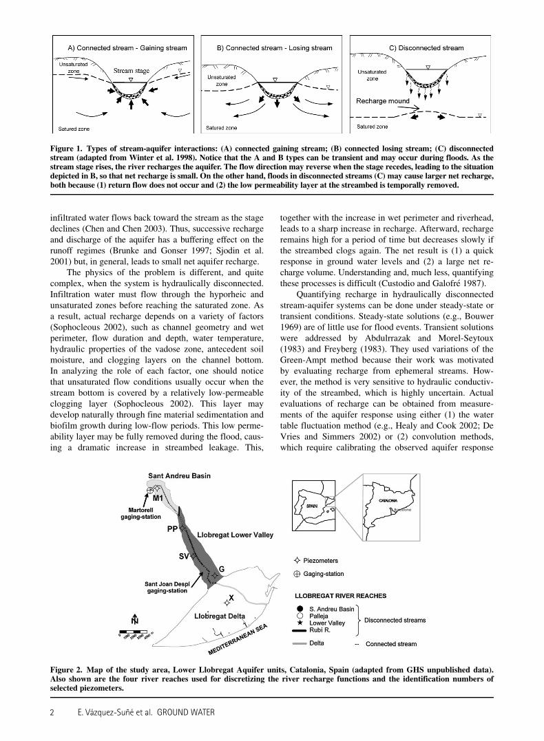
subject of much research (see reviews by Lerner et al.1990; Winter 1995, 1999; Sophocleous 2002; Custodio andLlamas 1984; Custodio 1997; Sahuquillo 1997). Depend-ing on stream stage, ground water elevation, and satura-tion state between streambed and the aquifer, two generaltypes of interaction can be identified (Figure 1). Hydrau-lic connection occurs when the water table intersects thestreambed (Figures 1a and 1b). In the second one, an
unsaturated zone develops between the streambed and thephreatic surface, which causes river infiltration to becomenearly independent of aquifer head, so that the twowater bodies are hydraulically disconnected (Figure 1c)(Sophocleous 2002). In this context, stream-aquifer inter-action research has covered a wide range of topics,including bank storage (Cooper and Rorabaugh 1963;Pinder and Sauer 1971; Hunt 1990; Squillace 1996; Bar-low and Moench 1998; Moench and Barlow 2000; Barlowet al. 2000), induced recharge (Glover and Balmer 1954;Hantush 1965; Jenkins 1968; Hunt 1999), hyporheic zone(Boulton et al. 1998; Cardenas et al. 2004; Salehin et al.2004; Hancock et al. 2005), and aquifer characterization(Carrera and Neuman 1986b; Sophocleous et al. 1995;Sophocleous 2005; Holzbecher 2005; Rotting et al. 2006).Nevertheless, recharge during flood events has not re-ceived as much attention.
The scant attention devoted to recharge from floodsprobably reflects that most of the previous studies assumeconnected stream-aquifer systems. Under these condi-tions, net recharge is usually low (Winter et al. 1998).Stream water infiltrates into the aquifer when the stagerises and water flows away from the stream. However,
1Corresponding author: Department of Geotechnical Engi-neering and Geoscience, School of Civil Engineering, UniversitatPolitecnica de Catalunya (UPC), C/Jordi Girona 1-3, Building D2,Barcelona, 08034, Spain; (34) 934011859; fax (34) 934017251;[email protected]
2Department of Geotechnical Engineering and Geoscience,School of Civil Engineering, Universitat Politecnica de Catalunya(UPC), C/Jordi Girona 1-3, Building D2, Barcelona, 08034, Spain.
3Institut de Ciencies de la Terra Jaume Almera (CSIC) C/LluisSole-Sabarıs s/n, Barcelona, 08028, Spain.
Received August 2006, accepted February 2007.Copyright ª 2007 The Author(s)Journal compilationª2007 National Ground Water Association.doi: 10.1111/j.1745-6584.2007.00326.x
GROUND WATER—2007 1
infiltrated water flows back toward the stream as the stagedeclines (Chen and Chen 2003). Thus, successive rechargeand discharge of the aquifer has a buffering effect on therunoff regimes (Brunke and Gonser 1997; Sjodin et al.2001) but, in general, leads to small net aquifer recharge.
The physics of the problem is different, and quitecomplex, when the system is hydraulically disconnected.Infiltration water must flow through the hyporheic andunsaturated zones before reaching the saturated zone. Asa result, actual recharge depends on a variety of factors(Sophocleous 2002), such as channel geometry and wetperimeter, flow duration and depth, water temperature,hydraulic properties of the vadose zone, antecedent soilmoisture, and clogging layers on the channel bottom.In analyzing the role of each factor, one should noticethat unsaturated flow conditions usually occur when thestream bottom is covered by a relatively low-permeableclogging layer (Sophocleous 2002). This layer maydevelop naturally through fine material sedimentation andbiofilm growth during low-flow periods. This low perme-ability layer may be fully removed during the flood, caus-ing a dramatic increase in streambed leakage. This,
together with the increase in wet perimeter and riverhead,leads to a sharp increase in recharge. Afterward, rechargeremains high for a period of time but decreases slowly ifthe streambed clogs again. The net result is (1) a quickresponse in ground water levels and (2) a large net re-charge volume. Understanding and, much less, quantifyingthese processes is difficult (Custodio and Galofre 1987).
Quantifying recharge in hydraulically disconnectedstream-aquifer systems can be done under steady-state ortransient conditions. Steady-state solutions (e.g., Bouwer1969) are of little use for flood events. Transient solutionswere addressed by Abdulrrazak and Morel-Seytoux(1983) and Freyberg (1983). They used variations of theGreen-Ampt method because their work was motivatedby evaluating recharge from ephemeral streams. How-ever, the method is very sensitive to hydraulic conductiv-ity of the streambed, which is highly uncertain. Actualevaluations of recharge can be obtained from measure-ments of the aquifer response using either (1) the watertable fluctuation method (e.g., Healy and Cook 2002; DeVries and Simmers 2002) or (2) convolution methods,which require calibrating the observed aquifer response
Figure 1. Types of stream-aquifer interactions: (A) connected gaining stream; (B) connected losing stream; (C) disconnectedstream (adapted from Winter et al. 1998). Notice that the A and B types can be transient and may occur during floods. As thestream stage rises, the river recharges the aquifer. The flow direction may reverse when the stage recedes, leading to the situationdepicted in B, so that net recharge is small. On the other hand, floods in disconnected streams (C) may cause larger net recharge,both because (1) return flow does not occur and (2) the low permeability layer at the streambed is temporally removed.
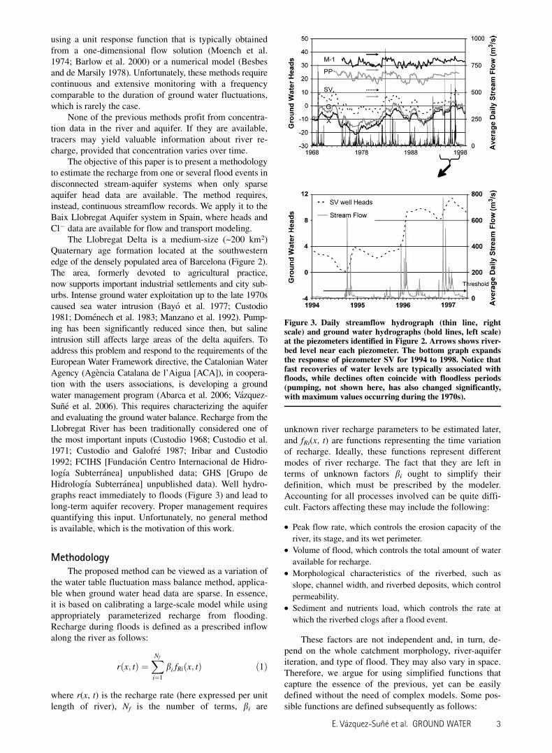
Figure 2. Map of the study area, Lower Llobregat Aquifer units, Catalonia, Spain (adapted from GHS unpublished data).Also shown are the four river reaches used for discretizing the river recharge functions and the identification numbers ofselected piezometers.
2 E. Vazquez-Sune et al. GROUND WATER
using a unit response function that is typically obtainedfrom a one-dimensional flow solution (Moench et al.1974; Barlow et al. 2000) or a numerical model (Besbesand de Marsily 1978). Unfortunately, these methods requirecontinuous and extensive monitoring with a frequencycomparable to the duration of ground water fluctuations,which is rarely the case.
None of the previous methods profit from concentra-tion data in the river and aquifer. If they are available,tracers may yield valuable information about river re-charge, provided that concentration varies over time.
The objective of this paper is to present a methodologyto estimate the recharge from one or several flood events indisconnected stream-aquifer systems when only sparseaquifer head data are available. The method requires,instead, continuous streamflow records. We apply it to theBaix Llobregat Aquifer system in Spain, where heads andCl2 data are available for flow and transport modeling.
The Llobregat Delta is a medium-size (~200 km2)Quaternary age formation located at the southwesternedge of the densely populated area of Barcelona (Figure 2).The area, formerly devoted to agricultural practice,now supports important industrial settlements and city sub-urbs. Intense ground water exploitation up to the late 1970scaused sea water intrusion (Bayo et al. 1977; Custodio1981; Domenech et al. 1983; Manzano et al. 1992). Pump-ing has been significantly reduced since then, but salineintrusion still affects large areas of the delta aquifers. Toaddress this problem and respond to the requirements of theEuropean Water Framework directive, the Catalonian WaterAgency (Agencia Catalana de l’Aigua [ACA]), in coopera-tion with the users associations, is developing a groundwater management program (Abarca et al. 2006; Vazquez-Sune et al. 2006). This requires characterizing the aquiferand evaluating the ground water balance. Recharge from theLlobregat River has been traditionally considered one ofthe most important inputs (Custodio 1968; Custodio et al.1971; Custodio and Galofre 1987; Iribar and Custodio1992; FCIHS [Fundacion Centro Internacional de Hidro-logıa Subterranea] unpublished data; GHS [Grupo deHidrologıa Subterranea] unpublished data). Well hydro-graphs react immediately to floods (Figure 3) and lead tolong-term aquifer recovery. Proper management requiresquantifying this input. Unfortunately, no general methodis available, which is the motivation of this work.
MethodologyThe proposed method can be viewed as a variation of
the water table fluctuation mass balance method, applica-ble when ground water head data are sparse. In essence,it is based on calibrating a large-scale model while usingappropriately parameterized recharge from flooding.Recharge during floods is defined as a prescribed inflowalong the river as follows:
rðx; tÞ ¼XNf
i¼1
bi fRiðx; tÞ ð1Þ
where r(x, t) is the recharge rate (here expressed per unitlength of river), Nf is the number of terms, bi are
unknown river recharge parameters to be estimated later,and fRi(x, t) are functions representing the time variationof recharge. Ideally, these functions represent differentmodes of river recharge. The fact that they are left interms of unknown factors bi ought to simplify theirdefinition, which must be prescribed by the modeler.Accounting for all processes involved can be quite diffi-cult. Factors affecting these may include the following:
d Peak flow rate, which controls the erosion capacity of the
river, its stage, and its wet perimeter.d Volume of flood, which controls the total amount of water
available for recharge.d Morphological characteristics of the riverbed, such as
slope, channel width, and riverbed deposits, which control
permeability.d Sediment and nutrients load, which controls the rate at
which the riverbed clogs after a flood event.
These factors are not independent and, in turn, de-pend on the whole catchment morphology, river-aquiferiteration, and type of flood. They may also vary in space.Therefore, we argue for using simplified functions thatcapture the essence of the previous, yet can be easilydefined without the need of complex models. Some pos-sible functions are defined subsequently as follows:
Figure 3. Daily streamflow hydrograph (thin line, rightscale) and ground water hydrographs (bold lines, left scale)at the piezometers identified in Figure 2. Arrows shows river-bed level near each piezometer. The bottom graph expandsthe response of piezometer SV for 1994 to 1998. Notice thatfast recoveries of water levels are typically associated withfloods, while declines often coincide with floodless periods(pumping, not shown here, has also changed significantly,with maximum values occurring during the 1970s).
E. Vazquez-Sune et al. GROUND WATER 3

1. fR1(x, t) ¼ Q(t), where Q(t) is flow rate in the stream. This
function can be used to represent recharge during low-
flow periods.
2. fR2(x, t) ¼ Qc(t), where c > 1 is an exponent to be esti-
mated by trial and error. This function reflects that the
increase in recharge with streamflow rate is nonlinear.
3. fR3(x, t) ¼ aQ(t) 1 (1 2 a)Qmi, where a < 1 is a weighting
parameter and Qmi is the mean flow rate during the ith time
step. This kind of function may be used to represent two
components of the river recharge: (1) recharge from flood
events, aQ(t) and (2) recharge from base flow, (1 2 a)Qmi.
4. fR4ðx; tÞ ¼RsQðsÞfDðt 2 sÞds, where fD is a decay function
representing clogging of the riverbed after a flood: for
example, fD(t) ¼ exp(t/T) with T being a characteristic
clogging time (t).
The modeler may choose one or several of these func-tions to define the flood recharge function (Equation 1).The b parameters are then calibrated as discussed sub-sequently.
Calibration consists of adjusting river recharge para-meters bi, together with the remaining model parameters,so as to fit observations, while ensuring that both estimatedparameters and the resulting model are consistent withprior information. The topic is very broad and a full de-scription falls beyond the scope of this paper (see Carreraet al. 2005, for a recent review) The fact that river rechargeparameters are estimated does not require any special atten-tion. The only issue is that, in practice, one needs to useinversion codes. Here, we used the Maximum LikelihoodMethod (Carrera and Neuman 1986a) as implemented inVisualTRANSIN (GHS 2003; Medina and Carrera 1996),which leads to minimizing an objective function.
F ¼X
khFh 1X
kcFc 1X
kpFp ð2Þ
where Fh ¼ ðh2h�ÞtC21h ðh 2 h�Þis the head objective
function, which penalizes departures between computedand measured heads (h and h*, respectively) witha weighting matrix C21
h . Similar definitions hold for Fc
and Fp, the objective functions for concentrations andmodel parameters, respectively. Appropriate weightingbetween these three terms can be obtained with the para-meters kh, kc, and kp.
Different river recharge functions, or combinationsof them, are defined until a satisfactory calibration isachieved.
Example ApplicationThe Llobregat River near Barcelona, Spain, flows
156.5 km from northwest to southeast with a catchmentarea of 4948.4 km2. The study area corresponds to thelower part of the catchment (250.6 km2) and is dividedinto three parts: Sant Andreu Basin, Lower Valley Basin,and the Llobregat Delta (Figure 2). The climate is typi-cally Mediterranean, with extreme temperatures in Janu-ary and August, and a yearly average temperature of15�C. Rainfall averages around 600 mm/year. Averagestreamflow is 16.8 m3/s at the Martorell gaging station(Figure 2). The Llobregat River is a good example of
a Mediterranean fluvial system, with low base flow(modal flow is 4 to 5 m3/s), marked ebb flood, strongfloods (more than 600 m3/s), and very irregular flow pat-terns (Marques 1984, Llasat et al. 2005, Thorndycraftet al. 2005) (Figure 3).
Hydraulic parameters are controlled by geology,which is complex (Llamas and Molist 1967; Marques1984; PHPO [Plan Hidrologıco del Pirineo Oriental] 1985).We performed a thorough sedimentological study to updatethe geological model with new information obtained forcivil works projects in the delta area. This allowed us todefine in detail the three-dimensional geological structure,to redefine aquifer units, their geometries, and the lateralconnections both between the units and the sea (GHSunpublished data; Simo et al. 2005; Gamez et al. 2005).
The aquifers are formed by Quaternary sedimentsthat rest discordantly on top of materials that range fromPaleozoic to Pliocene. The Sant Andreu and Lower Val-ley basins are typical fluvial aquifers, consisting of accu-mulations of alluvial sand and gravels. The delta itselfbegins at the end of the Lower Valley and consists of fourdeltaic sedimentary cycles. The youngest cycle displaysa wedge geometry with silts and clays separating twopackages of sands and gravels. These geological bodiescomprise three hydrogeological units: (1) shallow aquifer,which is an unconfined aquifer formed by sands; (2)main aquifer, which is made up of the deep aquifer at thedelta, and the Sant Andreu Basin and Lower Valley aqui-fers; and (3) silt wedge (aquitard), which separates theshallow and deep aquifers.
Areal recharge was initially estimated for rural areasby means of a hydrometeorological water balance. Thisled to recharge time functions that were then multipliedby a factor that was estimated during calibration. In urbanareas, we used the values estimated by Vazquez-Suneet al. (2005).
Yearly estimates of pumping for industries were pro-vided by the Ground Water Users Association and theCatalonia Water Agency. Still, monthly rates were avail-able for water supply wells, which account for more thanhalf of the total pumping. Maximum pumping occurredin the 1970s, reaching values above 130 hm3/year (hm3 ¼million m3). This caused heads to fall to 25 m below sealevel in the central portion of the delta. Low heads,together with coastal construction (enlargement of aninland dock), caused severe sea water intrusion and led toa progressive reduction of pumping to around 50 hm3/year in 2004.
The Llobregat River’s irregular flow pattern is re-flected in the well hydrographs (Figure 3). These showthat (1) the aquifers respond to river floods, but (2) headsat Sant Andreu and Lower Valley are between 5 and 10 mbelow the riverbed so that river and aquifer are hydrauli-cally disconnected (Figure 1). On the other hand, theriver is hydraulically connected to the shallow aquifer atthe delta.
Upstream of the study area, the Llobregat Riversalinity is influenced by evaporite mining. This causedCl2 concentrations to steadily increase up to 800 mg/L in1990, when the brine was diverted to the sea througha pipeline. As a result, Cl2 concentration dropped to
4 E. Vazquez-Sune et al. GROUND WATER
about 300 mg/L, which eventually is reflected in concen-trations in the aquifer. This, together with sea water intru-sion, implies that salinity is a good indicator of thehydraulics of the aquifer.
ModelingSeveral ground water models have been developed
for the main aquifer (Cuena and Custodio 1971; PHPO1985; Custodio et al. 1989; Iribar et al. 1997). Yet, a new,more detailed model, incorporating the new geologicaldata, was needed for the new ground water managementprogram, which needs to address sea water intrusion andthe impact of numerous civil works projects (Abarca et al.2006; Vazquez-Sune et al. 2006). The VisualTRANSINcode (GHS 2003) was used for this purpose. The modelconsists of two layers representing the shallow and mainaquifers, respectively. The spatial domain was discretizedinto 9848 triangular elements, especially refined near themain pumping areas, and the mesh was adapted to themain hydrogeological features. The time domain (1965 to2002) was discretized into time steps of 1 month becausemost data are available monthly. The observation pointsprovide a good coverage of the model domain. Head dataat many observation points extend over most of the cali-bration period (1965 to 2002). However, concentrationdata are more disperse in time.
The calibration procedure requires specifying priorestimates for all model parameters. For transmissivity,these were based on the geological conceptual model,which led to 101 transmissivity zones, whose prior esti-mates were conditioned by aquifer thickness, lithofaciesdescription, hydraulic test values, and so on. A similarprocedure was applied to the remaining parameters (stor-age coefficient, areal recharge, boundary flows, andpumping rates). Porosity was fixed to 0.3 and dispersivityto the lowest value ensuring stability.
Streams, channels, and underground linear worksinteract with aquifers. When hydraulically connected tothe aquifer (i.e., at the delta), exchange flow rates were ex-pressed as a leakage parameter times the head differencebetween the aquifer and the water body (Cauchy boundarycondition). Where hydraulically disconnected, the riverwas treated as a Neumann boundary, with inflows inde-pendent of the aquifer head as described subsequently.
Simulation of Recharge from Flood EventsAvailable data include daily streamflow rates (Qd) for
the period between 1966 to 2002 in the Martorell and SantJoan Despı gaging stations (Figure 2). The average stream-flow (Qb) in the period 1965 to 2002 is around 15 m3/s.
The river at the Sant Andreu and Lower Valleybasins was divided into four reaches (Figure 2). Thesewere defined so as to assume approximately uniformmorphological characteristics of the riverbed, such asslope, channel width, riverbed deposits, and so on. Theriver flow rate is taken to be the same in all reaches.Therefore, the functions representing the time variation ofrecharge, fRi(x, t), are identical for all reaches. But theunknown river recharge parameter (bi) is different in eachand must be obtained during calibration.
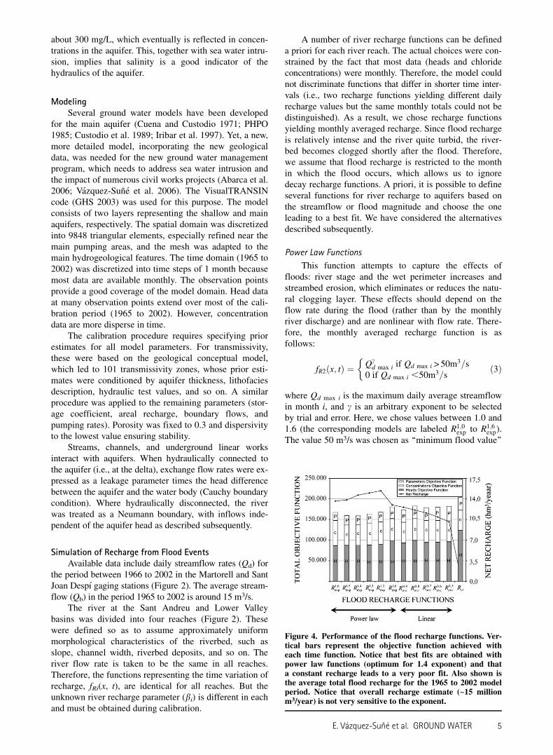
A number of river recharge functions can be defineda priori for each river reach. The actual choices were con-strained by the fact that most data (heads and chlorideconcentrations) were monthly. Therefore, the model couldnot discriminate functions that differ in shorter time inter-vals (i.e., two recharge functions yielding different dailyrecharge values but the same monthly totals could not bedistinguished). As a result, we chose recharge functionsyielding monthly averaged recharge. Since flood rechargeis relatively intense and the river quite turbid, the river-bed becomes clogged shortly after the flood. Therefore,we assume that flood recharge is restricted to the monthin which the flood occurs, which allows us to ignoredecay recharge functions. A priori, it is possible to defineseveral functions for river recharge to aquifers based onthe streamflow or flood magnitude and choose the oneleading to a best fit. We have considered the alternativesdescribed subsequently.
Power Law Functions
This function attempts to capture the effects offloods: river stage and the wet perimeter increases andstreambed erosion, which eliminates or reduces the natu-ral clogging layer. These effects should depend on theflow rate during the flood (rather than by the monthlyriver discharge) and are nonlinear with flow rate. There-fore, the monthly averaged recharge function is asfollows:
fR2ðx; tÞ ¼�
Qcd max i if Qd max i > 50m3=s
0 if Qd max i ,50m3=sð3Þ
where Qd max i is the maximum daily average streamflowin month i, and c is an arbitrary exponent to be selectedby trial and error. Here, we chose values between 1.0 and1.6 (the corresponding models are labeled R1;0
exp to R1;6exp).
The value 50 m3/s was chosen as ‘‘minimum flood value’’
Figure 4. Performance of the flood recharge functions. Ver-tical bars represent the objective function achieved witheach time function. Notice that best fits are obtained withpower law functions (optimum for 1.4 exponent) and thata constant recharge leads to a very poor fit. Also shown isthe average total flood recharge for the 1965 to 2002 modelperiod. Notice that overall recharge estimate (~15 millionm3/year) is not very sensitive to the exponent.
E. Vazquez-Sune et al. GROUND WATER 5

because no significant head response is observed belowthis value (Figure 3). Still, results are not very sensitive tothis threshold.
Linear Functions
These functions attempt to capture both the effect ofconcentrated recharge during the actual flood and thedeferred recharge afterward. Therefore, they consist oftwo components: (1) recharge during the flood event and(2) recharge during the rest of the month. These two com-ponents are linearly averaged, which leads to:
fR3ðx; tÞ ¼�aQd max i 1 ð12 aÞQmi if Qd max i > 50m3=s0 if Qd max i ,50m3=s
ð4Þ
where Qmi is the monthly average streamflow, a is anarbitrary factor to be selected by trial and error. Here, wechose values of a between 0.5 and 0.9 (models Rave 0.5
to Rave 0.9).
Constant Flow Rate
This function is defined as a constant streamflow.
fR1ðx; tÞ ¼ Qb ð5Þ
The function Rct disregards temporal variability ofstreamflow and will be used as a blank reference to eval-uate the importance of temporal variability in riverrecharge.
To find the best-fitting function, it is necessary tocalibrate the model for each of the 14 recharge functionsconsidered. Calibration consists of updating the wholemodel parameters (transmissivities, storage coefficients,areal recharge from rain and irrigation infiltration, bound-ary flow, bi recharge parameter in each river reach, etc.).
Results and DiscussionResults of all calibration runs in terms of objective
functions, and net floods recharges for each recharge
Figure 5. Spatial distribution of head calibration errors (average of the absolute value of the residual for each observationwell). In general, largest errors correspond to wells with few head measurements. Also shown is the time evolution of mea-sured and computed heads at several of the piezometers with longest measurement records.
6 E. Vazquez-Sune et al. GROUND WATER

function (Figure 4), show that power law functions leadto better fits than linear functions. The best fit, as mea-sured by total objective function F (Equation 2), was ob-tained with model R1;4
exp, which uses fR2 (Equation 3), withexponent c ¼ 1.4, for time variability, as the only termdefining the river inflow (Equation 1) for each riverreach. The calibrated values of b are 0.0071, 0.001,0.0221, and 0.0706 for Sant Andreu Basin, Palleja, LowerValley, and Rubı River reaches (Figure 2), respectively.
Differences in terms of fit among recharge functionsare minor, except for the constant flow function (Rct),which led to a very poor fit. However, each component ofthe objective function was optimal for a different rechargefunction. The best fit for heads Fh was obtained for expo-nent c ¼ 1.6 (R1;6
exp) because it best fits the head peaks fol-lowing flood events. The best parameters fit (Fp) was alsoobtained for the R1;6
exp, although it was very similar to therest of the power law functions. The best fit for concen-trations, Fc, was obtained for Rct. This result may reflectthe small variability of aquifer concentration togetherwith the dampening effect of the large volume of ground
water, which results in a small dependence of concen-trations on flood recharge variability.
The results suggest two conclusions. First, the cali-bration procedure leaves some room for uncertainty inthe choice of recharge function. This is probably a conse-quence of the monthly frequency of measurements, whichprevents accurate identification of recharge variability.Second, fortunately, all models yield similar results (aver-age recharge of 14 to 15 hm3/year for power law modelsand 10 to 13 hm3/year for linear models). The only modelleading to significantly different results was Rct (totalriver recharge of 1 hm3/year). For this model, calibrationyielded unrealistically high rainfall recharge. Again, thiscan be attributed to the fact that the model demands someimportant cause of time variability. In short, including theeffect of floods is very important, but results are not dra-matically sensitive to the precise manner in which this isachieved.
Figures 5 and 6 display measured and computedhead and Cl2 concentration, respectively, at severalobservation points for model R1;4
exp. Parameter values
Figure 6. Spatial distribution of concentration absolute errors. Also shown is the time evolution of measured (dots) and com-puted (continuous lines) concentrations at some of the wells with longest measurement records. Notice that concentrations atthe lower valley have dropped in recent years, in response to diversion of mine brines. The middle portion of the delta still re-flects the past increase in river concentrations. Both trends are properly reproduced by the model, which suggests that concen-trations are indeed relevant for quantifying river recharge.
E. Vazquez-Sune et al. GROUND WATER 7

obtained from calibration are consistent with prior in-formation. The fit both in terms of heads and chlorideconcentrations is very satisfactory. Salinity trends in theaquifer of the Lower Valley and Llobregat Delta are alsoreproduced satisfactorily.
Average mass balance calculations during the period1965 to 2002 show that the highest inputs are total arealrecharge from rain and irrigation infiltration (21.6 hm3/year for both shallow and main aquifers) and Llobregat
River recharge from floods. For the total recharge fromthe river (including the Llobregat River through the SantAndreu Basin and the Lower Valley, and a portion of thetributary Rubı River), most of the runs with power lawfunctions yield recharge inflows above 14 hm3/year. Thebest model (R1;4
exp) led to a total river recharge of 14.7 hm3/year (Figure 7).
Moreover, sea water inputs to the main aquifer arequite significant with a value of 6.8 hm3/year. The
Figure 7. Schematic description of water balance for the shallow and main aquifers expressed in million m3/year. The leftgraph displays the main aquifer balance and the right graph displays the shallow aquifer balance. Two parallel arrows showthe flux from the shallow to main aquifer.
Figure 8. Yearly recharge from floods computed with R1;4exp time function (left). Fitted relationships between monthly recharge
and flood streamflow (right). Notice that recharge is similar for all recharge functions, especially for moderate floods.
8 E. Vazquez-Sune et al. GROUND WATER

opposite occurs at the shallow aquifer that dischargesabout 0.5 hm3/year to the sea. The main output is pump-ing in the main aquifer with 71.8 hm3/year. Flow fromshallow to main aquifer is determined by the balance foreach aquifer that is 19.6 hm3/year.
The evolution of the annual river recharge from theriver (Figure 8) shows that significant recharge values areobtained in wet years (up to 70 hm3/year), but those con-tributions are extremely low during dry years. Variationsin aquifer storage are mainly controlled by the con-tributions of the Llobregat River at flood events and byground water extractions.
The estimation of recharge from floods is quiterobust and not very sensitive to the selected power lawfunction (Figure 8), but sensitivity increases for higherriver floods. Still, it is apparent that periodic floods,which are beneficial for many other river processes, alsocause a sizeable amount of recharge. This may becomeimportant for water resources management; the amount ofwater recharged to aquifers can be estimated by thesize of the flood. This knowledge should help in design-ing artificially generated flood events by controlling thefloodgates.
Summary and ConclusionsRecharge from floods may be an important input in
disconnected stream-aquifer systems. Yet, accurate evalu-ation of this input is difficult. We presented a method-ology to estimate the recharge from flood events. Theproposed method is essentially similar to the water tablefluctuation mass balance method, applicable whenground water head data are sparse, so that lack of spatialand temporal coverage is automatically interpolated bythe model. The methodology requires (1) definition ofa conceptual model; (2) implementation into a numericalmodel; (3) parameterization of flood recharge (rechargeduring floods is implemented as a prescribed inflowalong the river); and (4) calibration of all the model pa-rameters to find the best fit. This methodology is applica-ble to complex systems, taking into account temporalvariability of all water sources.
A transient (1965 to 2002) ground water flow and sol-ute transport model of an aquifer system near Barcelona,Spain, calibrated to heads, and chloride concentrationdata were used to illustrate the methodology. This applica-tion shows the importance of flood events on the mass bal-ance, being second only to surface recharge from rainfalland irrigation return flows. We believe that the high contri-bution from flooding events found in this application maybe typical of many disconnected stream-aquifer systems.
It is also relevant to point out that best results wereobtained with power law functions with an exponent of1.4. This implies that recharge is nonlinear function ofthe flood flow rate, which is relevant for defining rivermanagement schemes. From the perspective of maintain-ing the ground water reservoir, floods should be allowedto occur. In fact, it may be advisable to artificially gener-ate them. This is also beneficial to riverbed and riparianforest maintenance, and also provides low-salinity waterto the aquifer.
AcknowledgmentsThis work was funded and supported by the Catalo-
nian Water Agency (ACA). We would like to thank EmilioCustodio, Andres Sahuquillo, and one anonymous reviewerfor valuable comments on the original manuscript.
ReferencesAbarca, E., E. Vazquez-Sune, J. Carrera, B. Capino, D. Gamez,
and F. Batlle. 2006. Optimal design of measures to correctseawater intrusion. Water Resources Research 42, W09415,doi: 10.1029/2005WR004524.
Abdulrrazak, M.J., and H.J. Morel-Seytoux. 1983. Rechargefrom an ephemeral stream following wetting front arrivalto water-table. Water Resources Research 19, no. 1: 194–200.
Barlow, P.M., and A.F. Moench. 1998. Analytical solutions andcomputer programs for hydraulic interaction of stream-aquifer systems. USGS Open-File Report 98-415A. Reston,Virginia: USGS.
Barlow, P.M., L.A. DeSimone, and A.F. Moench. 2000. Aquiferresponse to stream-stage and recharge variations. II. Con-volution method and applications. Journal of Hydrology230, no. 3: 211–229.
Bayo, A., E. Batista, and E. Custodio. 1977. Sea waterencroachment in Catalonia coastal aquifers In GeneralAssembly IAH, vol. XIII, F.1–14. Birmingham: Interna-tional Association of Hydrogeolosists.
Besbes, M., and G. de Marsily. 1978. Identification of rechargeprocess—comprehensive approach. Transactions-AmericanGeophysical Union 59, no. 4: 274–275.
Boulton, A.J., S. Finlay, P. Marmonier, E.H. Stanley, and H.M.Valett. 1998. The functional significance of the hyporheiczone in streams and rivers. Annual Review of Ecology andSystematics 29, no. 1: 59–81.
Bouwer, H. 1969. Calculating infiltration into non-uniform soilwith Green and Ampt approach. Agricultural Engineering50, no. 10: 610.
Brunke, M., and T. Gonser. 1997. The ecological significance ofexchange processes between rivers and ground-water.Freshwater Biology 37, no. 1: 1–33.
Cardenas, M.B., J.L. Wilson, and V.A. Zlotnik. 2004. Impact ofheterogeneity, bed forms, and stream curvature on sub-channel hyporheic exchange. Water Resources Research40, no. 8: Art. No. W08307.
Carrera, J., and S.P. Neuman. 1986a. Estimation of aquifer pa-rameters under steady state and transient conditions: Maxi-mum likelihood method incorporating prior information.Water Resources Research 22, no. 2: 199–210.
Carrera, J., and S.P. Neuman. 1986b. Estimation of aquiferparameters under steady-state and transient conditions:III. Aplications. Water Resources Research 22, no. 2:228–242.
Carrera, J., A. Alcolea, A. Medina, J. Hidalgo, and L.J. Slooten.2005. Inverse problem in hydrogeology. HydrogeologyJournal 13, no. 1: 206–222.
Cooper, H.H., and M.J. Rorabaugh. 1963. Groundwater move-ments and bank storage due to flood stages in surfacestreams. USGS Water Supply Paper 1536-J. Reston, Virginia:USGS.
Chen, X., and X.H. Chen. 2003. Stream water infiltration, bankstorage, and storage zone changes due to stream-stage fluc-tuations. Journal of Hydrology 280, no. 1–4: 246–264.
Cuena, S., and E. Custodio. 1971. Construction and adjustmentof a two layer mathematical model of the Llobregat Delta,Barcelona, Spain. In Mathematical Models in Hydrology,Studies and Reports in Hydrology, vol. 15, 960–964. Paris:UNESCO.
Custodio, E. 1997. Recarga a los acuıferos: Aspectos generalessobre el proceso, la evaluacion y la incertidumbre. En Eval-uacion de la Recarga a los Acuıferos en la Planificacion
E. Vazquez-Sune et al. GROUND WATER 9
Hidrologica, ed. E. Custodio, M.R. Llamas, and J. Samper,19–40. Madrid: IGME.
Custodio, E. 1981. Sea water encroachment in the Llobregatdelta and Besos areas, near Barcelona (Catalonia, Spain).In Sea Water Intrusion Meeting: Intruded and FossilGroundwater of Marine Origin, vol. 27, ed. U.S.G. Under-sokning, 120–152. Uppsala, Sweden: Sveriges GeologikaUndersokning.
Custodio, E. 1968. Datacion de aguas subterraneas en el deltadel rıo Llobregat. In Documentos de Investigacion Hidrol-ogica, 205–237. Barcelona: Centro de Estudios, Inves-tigacion y Aplicaciones del Agua.
Custodio, E., and A. Galofre. 1987. Fast release of salinityafter a flood in the Llobregat Valley (Catalonia). In Vulner-ability of Soil and Groundwater to Pollutants, ed. W. vanDuijvenbooden and H.G. Waegeningh, 563–573. The Hague:Elsevier.
Custodio, E., and M.R. Llamas. 1984. Hidrologıa Subterranea.Barcelona, Spain: Ed omega.
Custodio, E., A. Bayo, and M.D. Pelaez. 1971. Geoquımica ydatacion de aguas para el estudio del movimiento de lasaguas subterraneas en el delta del Llobregat (Barcelona). InPrimer congreso Hispano-Luso-Americano de GeologıaEconomica, Madrid-Lisboa Comunicacion E-5-2, vol. 5, 2–23. Madrid: IGME.
Custodio, E., L. Glorioso, M. Manzano, and E. Skupien. 1989.Evolucion y alternativas de un acuıfero sobreexplotado:El delta del Llobregat. In La Sobreexplotacion de Acuı-feros, 207–227. Madrid, Spain: AIH (Grupo Espanol)—AEHS.
De Vries, J.J., and I. Simmers. 2002. Groundwater recharge:An overview of processes and challenges. HydrogeologyJournal 10, no. 1: 5–17.
Domenech, J., E. Batista, A. Bayo, and E. Custodio. 1983. Someaspects of sea water intrusion in Catalonia (Spain). In8th SWIM Bari, 15. Bari: I. di Geologıa Appicata eGeotecnia.
Freyberg, D.L. 1983. Modeling the effects of a time-dependentwetted-perimeter on infiltration from ephemeral channels.Water Resources Research 19, no. 2: 559–566.
Gamez, D., J.A. Simo, E. Vazquez-Sune, J.M. Salvany, andJ. Carrera. 2005. Variacion de las tasas de sedimentacion enel Complejo Detrıtico Superior del Delta del Llobregat(Barcelona): su relacion con causas eustaticas, climaticas yantropicas. Geogaceta 38, 175–178.
Glover, R.E., and C.G. Balmer. 1954. River depletion resultingfrom pumping a well near a river. American GeophysicalUnion Transactions 35, no. 3: 468–470.
Grupo de Hidrologıa Subterranea (GHS). 2003. Visual TransinCode. GHS—Universitat Politecnica de Catalunya. http://www.h2ogeo.upc.es (accessed July 2006).
Hancock, P.J., A.J. Boulton, and W.F. Humphreys. 2005. Theaquifer and its hyporheic zone: Ecological aspects ofhydrogeology. Hydrogeology Journal 13, 98–111.
Hantush, M.S. 1965. Wells near streams with semiperviousbeds. Journal of Geophysical Research 70, no. 12: 2829–2838.
Healy, R.W., and P.G. Cook. 2002. Using groundwater levels toestimate recharge. Hydrogeology Journal 10, no. 1: 91–109.
Holzbecher, E. 2005. Modelling the hydrology of the Nile Delta.In Coupled Models for the Hydrological Cycle. IntegratingAtmosphere, Biosphere, and Pedosphere, Chapter 4.3, ed.A. Bronstert, P. Rabat, J. Carrera, and S. Lutkemeier.Heidelberg, Germany: Springer.
Hunt, B. 1999. Unsteady stream depletion from ground waterpumping. Ground Water 37, no. 1: 98–102.
Hunt, B. 1990. An approximation for the bank storage effect.Water Resources Research 26, no. 11: 2769–2765.
Iribar, V., and E. Custodio. 1992. Advancement of seawaterintrusion in the Llobregat delta aquifer. In SWIM Studyand Modelling of Saltwater Intrusion into Aquifers, ed.E. Custodio and A. Galofre, 35–50. Barcelona: CIMNE–UPC.
Iribar, V., J. Carrera, E. Custodio, and A. Medina. 1997. Inversemodelling of sea water intrusion in the Llobregat delta deepaquifer. Journal of Hydrology 198, no. 1–4: 226–244.
Jenkins, C.T. 1968. Techniques for computing rate and volumeof stream depletion by wells. Ground Water 6, no. 2: 37–46.
Lerner, D.N., A.S. Issar, and I Simmer. 1990. Groundwaterrecharge. A guide to understanding and estimating naturalrecharge. In IAH International Contributions to Hydro-geology, vol. 8, 345. Hannover: Heinz Heise.
Llamas, M.R., and J. Molist. 1967. Hidrologia de los deltas delos rıos Besos y Llobregat. Documentos de InvestigacionHidrologica, no. 2. Barcelona: Centro de Estudios, Aplica-ciones e Investigaciones del Agua.
Llasat, M.C., M. Barriendos, A. Barrera, and T. Rigo. 2005.Floods in Catalonia (NE Spain) since the 14th Century.Climatological and meteorological aspects from historicaldocumentary sources and old instrumental records. Journalof Hydrology 313, no. 1–2: 32–47.
Manzano, M., E. Custodio, and J. Carrera. 1992. Fresh and saltwater in the Llobregat delta aquifer: Application of ionchromatography to the field data. In SWIM Study and Mod-elling of Saltwater Intrusion into Aquifers, ed. E. Custodioand A. Galofre, 207–228, Barcelona: CIMNE–UPC.
Marques, M.A. 1984. Les Formacions Quaternaries del Deltadel Llobregat. Barcelona, Spain: Institut d’Estudis Catalans.
Medina, A., and J. Carrera. 1996. Coupled estimation of flowand solute transport parameters. Water Resources Research32, no. 10: 3063–3076.
Moench, A.F., and P.M. Barlow. 2000. Aquifer response tostream-stage and recharge variations. I. Analytical step-response functions. Journal of Hydrology 230, no. 3–4:192–210.
Moench, A.F., V.B. Sauer, and M.E. Jennings. 1974. Modifica-tion of routed streamflow by channel loss and base flow.Water Resources Research 10, no. 5: 963–968.
PHPO. 1985. Modelo de simulacion de los acuıferos del deltadel Bajo Llobregat. Plan Hidrologico Nacional. TechnicalReport, Confederacion Hidrografica del Pirineo Oriental.Barcelona, Spain: Comisaria de Aguas del Pirineo Oriental(PHPO).
Pinder, G.F., and S.P. Sauer. 1971. Numerical simulation offlood wave modification due to bank storage effects. WaterResources Research 7, no. 1: 63–70.
Rotting, T., J. Carrera, J. Bolzicco, and J.M. Salvany. 2006.Stream-stage response tests and their joint interpretationwith pumping tests. Ground Water 44, no. 3: 371–385.
Sahuquillo, A. 1997. Evaluacion de la recarga de acuıferos enabanicos aluviales, torrentes, piedemontes y cauces efı-meros. En Evaluacion de la Recarga a los Acuıferos en laPlanificacion Hidrologica, ed. E. Custodio, M.R. Llamas,and J. Samper, 125–140. Madrid: IGME.
Salehin, M., A.I. Packman, and M. Paradis. 2004. Hyporheicexchange with heterogeneous streambeds: Laboratoryexperiments and modeling. Water Resources Research 40,no. 11: Art. No. W11504.
Simo, J.A., D. Gamez, J.M. Salvany, E. Vazquez-Sune, J.Carrera, A. Barnolas y, and F.J. Alcala. 2005. Arquitecturade facies de los deltas cuaternarios del Rıo Llobregat,Barcelona, Espana. Geogaceta 38, 171–174.
Sjodin A., W.M. Lewis, and J.F. Saunders. 2001. Analysis ofgroundwater exchange for a large plains river in Colorado(USA). Hydrological Processes 15, no. 4: 609–620.
Sophocleous, M. 2005. Groundwater recharge and sustainabilityin the high plains aquifer in Kansas, USA. HydrogeologyJournal 13, no. 2: 351–365.
Sophocleous, M. 2002. Interactions between groundwater andsurface water: the state of the science. Hydrogeology Jour-nal 10, no. 1: 52–67.
Sophocleous, M., A. Koussis, J.L. Martin, and S.P. Perkins. 1995.Evaluation of simplified stream-aquifer depletion models forwater rights administration. Ground Water 33, no. 4: 579.
Squillace, P.J. 1996. Observed and simulated movement ofbank-storage water. Ground Water 34, no. 1: 121–134.
10 E. Vazquez-Sune et al. GROUND WATER

Thorndycraft, V.R., G. Benito, M. Rico, A. Sopena, Y. Sanchez-Moya, and A. Casas. 2005. A long term flood discharge re-cord derived from slackwater flood deposits of the LlobregatRiver, NE Spain. Journal of Hydrology 313, no. 1–2: 16–31.
Vazquez-Sune E., E. Abarca, J. Carrera, B. Capino, D. Gamez,M. Pool, T. Simo, F. Batlle, J.M. Ninerola, and X. Ibanez.2006. Groundwater modelling as a tool for the EuropeanWater Framework Directive (WFD) application. TheLlobregat case. Physics and Chemistry of the Earth 31, no.17: 1015–1029.
Vazquez-Sune, E., X. Sanchez-Vila, and J. Carrera. 2005. Intro-ductory review of specific factors influencing urban
groundwater, an emerging branch of hydrogeology, withreference to Barcelona, Spain. Hydrogeology Journal 13,no. 3: 522–533.
Winter, T.C. 1999. Relation of streams, lakes, and wetlands togroundwater flow systems. Hydrogeology Journal 7, no. 1:28–45.
Winter, T.C. 1995. Recent advances in understanding the inter-action of groundwater and surface-water. Reviews of Geo-physics 33, Suppl.: 985–994.
Winter, T.C., J.W. Harvey, and O.L. Franke. 1998. Groundwaterand surface water a single resource. USGS Circular 1139.Reston, Virginia: USGS.
E. Vazquez-Sune et al. GROUND WATER 11