Ephemeral wetlands along a spatially intermittent river: Temporal patterns of vegetation development
13
EPHEMERAL WETLANDS ALONG A SPATIALLY INTERMITTENT RIVER: TEMPORAL PATTERNS OF VEGETATION DEVELOPMENT Juliet C. Stromberg 1 , Andrea F. Hazelton 1 , Margaret S. White 1 , Jacqueline M. White 1 , and Richard A. Fischer 2 1 School of Life Sciences, Arizona State University, Tempe, Arizona, USA 85287-450. E-mail: [email protected] 2 U.S. Army Engineer Research and Development Center, Environmental Laboratory, Vicksburg, Mississippi, USA 39180-6199 Abstract: Dryland rivers are characterized by high spatio-temporal variability in water resources, with alternating wet and dry reaches and fluctuating stream flow rates. To investigate response to this dynamic, riparian plant communities from perennial, temporally intermittent, and ephemeral-flow reaches of the Hassayampa River and an ephemeral tributary (southwestern USA) were characterized over a three year period, and soil seed banks (emergence method) were assessed. Variance through time in cover and diversity of wetland (hydric) species was lowest at perennial sites and highest at ephemeral flow sites. Wetland plants established along the active channel of the ephemeral reach following a 10-year recurrence interval flood, and compositional similarity between perennial and ephemeral sites was high during this wet year. About half of the wetland species growing at ephemeral flow sites were present in floodplain soil seed banks. Wetland species emerged from soils of the ephemeral Hassayampa River (but not of the ephemeral tributary) but their density and diversity declined with distance downstream of the perennial reach. Wetland species in the seed banks of ephemeral-flow sites were a nested subset of those at wetter sites, raising the possibility of dispersal from upstream sites. These results indicate that wetlands develop episodically on ephemeral reaches of spatially intermittent rivers of the Sonoran Desert following high winter runoff, and suggest that the wetland plants arise from local seed banks and off-site sources. The study also suggests that riverine restoration success is sensitive to location within a stream network: upon re-watering, sites closer to perennial reaches will have greater capacity to self-assemble wetland plant communities. Key Words: dryland river, intermittent flow, riparian vegetation, seed bank, temporary stream INTRODUCTION The longitudinal pattern of stream flow varies among dryland rivers (Nanson et al. 2002, Bunn et al. 2006). Some have ephemeral flow over their entire length, with surface water present only following major storm events; these are classified as endogenic dryland rivers. Others, classified as allogenic, have headwaters in humid mountains and sustain perennial flow in hydrogeomorphically suitable portions of the arid basin. Such rivers often are spatially intermittent, with perennial flow occurring in areas with shallow bedrock or high hydraulic connectivity to regional aquifers and ephemeral to temporally intermittent flow occurring in areas with deeper alluvial basins or greater distance from the headwaters. Given their wetter headwaters, the allogenic dryland rivers also expe- rience larger and more sustained flood pulses than their endogenic counterparts. Adjacent perennial and ephemeral reaches within rivers support distinct aquatic and riparian commu- nities owing to difference in surface water perma- nence and ground-water hydrology (Stromberg et al. 205, Wood et al. 2005). In many dryland regions, the floodplains of perennial dryland rivers have shallow water tables, and this permanent water source sustains tall, phreatic hydric trees (Lite and Strom- berg 2005, Froend and Drake 2006). In ephemeral reaches, episodic flood run-off and precipitation are the main sources of soil water, although a temporary perched water table can develop during high-flow periods; thus, xeric plant species predominate (Bloss and Brotherson 1979, de Soyza et al. 2004, Rassam et al. 2006). In some hydrogeomorphic settings, ground-water hydrology can be fairly similar in perennial and non-perennial reaches, producing more subtle differences in riparian structure and function (Birkeland 1996, Kolb et al. 1997, Strom- berg 2001). Although perennial and ephemeral stream reaches support different biotic communities, the degree of difference varies through time. Community structure and function differ most during the dry, low-flow season (Stromberg et al. 2005, Gazal et al. 2006). During wet seasons, floods create a more uniform WETLANDS, Vol. 29, No. 1, March 2009, pp. 330–342 ’ 2009, The Society of Wetland Scientists 330
Transcript of Ephemeral wetlands along a spatially intermittent river: Temporal patterns of vegetation development

EPHEMERAL WETLANDS ALONG A SPATIALLY INTERMITTENT RIVER:
TEMPORAL PATTERNS OF VEGETATION DEVELOPMENT
Juliet C. Stromberg1, Andrea F. Hazelton1, Margaret S. White1, Jacqueline M. White1, and
Richard A. Fischer2
1School of Life Sciences, Arizona State University, Tempe, Arizona, USA 85287-450. E-mail: [email protected]. Army Engineer Research and Development Center, Environmental Laboratory, Vicksburg, Mississippi,
USA 39180-6199
Abstract: Dryland rivers are characterized by high spatio-temporal variability in water resources, with
alternating wet and dry reaches and fluctuating stream flow rates. To investigate response to this
dynamic, riparian plant communities from perennial, temporally intermittent, and ephemeral-flow
reaches of the Hassayampa River and an ephemeral tributary (southwestern USA) were characterized
over a three year period, and soil seed banks (emergence method) were assessed. Variance through time in
cover and diversity of wetland (hydric) species was lowest at perennial sites and highest at ephemeral flow
sites. Wetland plants established along the active channel of the ephemeral reach following a 10-year
recurrence interval flood, and compositional similarity between perennial and ephemeral sites was high
during this wet year. About half of the wetland species growing at ephemeral flow sites were present in
floodplain soil seed banks. Wetland species emerged from soils of the ephemeral Hassayampa River (but
not of the ephemeral tributary) but their density and diversity declined with distance downstream of the
perennial reach. Wetland species in the seed banks of ephemeral-flow sites were a nested subset of those
at wetter sites, raising the possibility of dispersal from upstream sites. These results indicate that wetlands
develop episodically on ephemeral reaches of spatially intermittent rivers of the Sonoran Desert following
high winter runoff, and suggest that the wetland plants arise from local seed banks and off-site sources.
The study also suggests that riverine restoration success is sensitive to location within a stream network:
upon re-watering, sites closer to perennial reaches will have greater capacity to self-assemble wetland
plant communities.
Key Words: dryland river, intermittent flow, riparian vegetation, seed bank, temporary stream
INTRODUCTION
The longitudinal pattern of stream flow varies
among dryland rivers (Nanson et al. 2002, Bunn et
al. 2006). Some have ephemeral flow over their
entire length, with surface water present only
following major storm events; these are classified
as endogenic dryland rivers. Others, classified as
allogenic, have headwaters in humid mountains and
sustain perennial flow in hydrogeomorphically
suitable portions of the arid basin. Such rivers often
are spatially intermittent, with perennial flow
occurring in areas with shallow bedrock or high
hydraulic connectivity to regional aquifers and
ephemeral to temporally intermittent flow occurring
in areas with deeper alluvial basins or greater
distance from the headwaters. Given their wetter
headwaters, the allogenic dryland rivers also expe-
rience larger and more sustained flood pulses than
their endogenic counterparts.
Adjacent perennial and ephemeral reaches within
rivers support distinct aquatic and riparian commu-
nities owing to difference in surface water perma-
nence and ground-water hydrology (Stromberg et al.
205, Wood et al. 2005). In many dryland regions, the
floodplains of perennial dryland rivers have shallow
water tables, and this permanent water source
sustains tall, phreatic hydric trees (Lite and Strom-
berg 2005, Froend and Drake 2006). In ephemeral
reaches, episodic flood run-off and precipitation are
the main sources of soil water, although a temporary
perched water table can develop during high-flow
periods; thus, xeric plant species predominate (Bloss
and Brotherson 1979, de Soyza et al. 2004, Rassam
et al. 2006). In some hydrogeomorphic settings,
ground-water hydrology can be fairly similar in
perennial and non-perennial reaches, producing
more subtle differences in riparian structure and
function (Birkeland 1996, Kolb et al. 1997, Strom-
berg 2001).
Although perennial and ephemeral stream reaches
support different biotic communities, the degree of
difference varies through time. Community structure
and function differ most during the dry, low-flow
season (Stromberg et al. 2005, Gazal et al. 2006).
During wet seasons, floods create a more uniform
WETLANDS, Vol. 29, No. 1, March 2009, pp. 330–342’ 2009, The Society of Wetland Scientists
330

hydrologic environment over the length of the river,
and this can result in increased compositional
similarity between perennial and non-perennial
reaches (Lake 2003, Wood et al. 2005) and between
habitats within a reach (Thomaz et al. 2007). For
example, many riparian plant species form persistent
soil seed banks, and seeds that are quiescent during
long dry periods may germinate during periods of
flooding (Brock and Rogers 1998, Goodson et al.
2002, Nicol et al. 2003, Capon and Brock 2006,
Capon 2007), increasing compositional similarity
among river sites. Further, plant seeds (and plant
fragments) are broadly dispersed by flood waters
(Johansson et al. 1996, Jansson et al. 2005, Merritt
and Wohl 2006, Vogt et al. 2006), and this may unify
plant communities during the flood recession period.
The spatial patterning of wet and dry reaches on
dryland rivers changes through time in response to
climatic fluctuations and to human modifications of
the landscape. Extreme drought, which may become
more prevalent in some regions as the global climate
changes, can cause long, continuous wet reaches to
fragment into short, disconnected sections (Stanley
et al. 1997). Anthropogenic water extraction
(streamflow diversion and ground-water pumping)
also can result in expansion of dry reaches (Uys and
Okeefe 1997; Webb and Leake 2006). Other types of
human actions can cause wet reaches to expand. For
example, perennial segments can increase in spatial
extent where flow-regulating dams dampen flow
extremes (McMahon and Finlayson 2003) or where
dry reaches receive input from interbasin water
transfers, urban run-off, or urban wastewater. These
‘‘new’’ water sources, such as urban effluent,
sometimes are used for ecosystem restoration
purposes but often are discharged without consid-
ering the hydrologic context of the landscape.
The spatio-temporal patterns of wet and dry
reaches within a watershed — including the length of
wet reaches, their persistence through time, and the
length of intervening dry reaches — may influence
riverwide patterns of biota. Some plants exist along
rivers as metapopulations (Menges 1990), with flood
dispersal of seeds maintaining connectivity between
populations. Seed dispersal distance and seed
emigration rate have an important effect on
metapopulation persistence in temporally dynamic
habitats (Bossuyt and Honnay 2006). Connectivity
may be reduced if the dispersal distance between
suitable sites is too great. Such population-level
phenomena may carry through to higher levels of
ecosystem organization. Metacommunity dynamics
have been noted to occur laterally within a riparian
corridor, wherein the spatially structured communi-
ties along the stream to upland hydrogradient are
linked via dispersal processes (Boudell and Strom-
berg 2008). A similar dynamic may occur over the
longitudinal dimension. Wetland plant communities
may develop at ephemeral sites along a river, and
may show high seasonal similarity to those at
perennial sites, only if the former are in proximity
to the latter.
As the arid southwestern United States continues
to urbanize and undergo climate change, landscape-
scale patterns of river hydrology will be altered,
heightening the need to understand consequences to
riparian and aquatic biota. This investigation
contrasted riparian plant communities (inclusive of
the soil seed bank) between perennial, temporally
intermittent, and ephemeral stream reaches of a
spatially intermittent river, through multiple years,
to address the roles of landscape patterns of stream
hydrology and annual flow variability on vegetation
patterns. We asked: 1) Does extant plant community
composition at perennial and ephemeral reaches
become more similar during periods of high-flow,
and if so, does this reflect contributions from the
seed bank? 2) Are hydric (wetland) plants present in
soil seed banks of ephemeral and perennial reaches
alike? 3) Are diversity and composition of the soil
seed bank influenced by the spatial patterning of wet
and dry reaches and, in particular, by the proximity
to a wet reach?
METHODS
Study Sites
Eight study sites were established along the
Hassayampa, a free-flowing (undammed), spatially
intermittent river in the Sonoran Desert of central
Arizona (Figure 1). One additional site was estab-
lished in an ephemeral tributary (Jackrabbit Wash).
The Hassayampa drains portions of the Bradshaw,
Date Creek, Weaver, and Vulture Mountains. The
lower watershed is in the Basin and Range
physiographic province and the upper watershed is
in the Central Highlands physiographic province.
Elevations in the watershed rise to over 2130 m.
Of the eight Hassayampa River study sites, two
were within a seven kilometer reach with perennial
to temporally intermittent flow that is managed as a
preserve by The Nature Conservancy in Arizona.
One of the eight was in an upstream ephemeral
reach, two kilometers from the starting point of
perennial stream flow. Five sites were in the
downstream ephemeral reach at respective distances
of two, 19, 28, 43, and 48 km from the typical
downstream limit of perennial surface flow. We refer
to these latter sites as ephemeral-2 km, ephemeral-
Stromberg et al., EPHEMERAL WETLANDS 331

19 km, etc. Most of the ephemeral sites were on
private land; some were grazed by livestock and/or
used recreationally by off-road vehicle riders. Site
elevation above sea level ranged from 335 m to
603 m.
The study area is hot and arid. Mean annual
temperature is 19uC and mean annual precipitation
is 29ucm at the Wickenburg station (# 029287,
http://www.wrcc.dri.edu). The Hassayampa River
has mean annual discharge of 0.8 m3 s21 at the
Morristown gaging station (USGS #9516500; htp://
waterdata.usgs.gov), located 0.6 km upstream of site
ephemeral-2 km. The flood pattern is dominated by
winter precipitation events, arising from Pacific
frontal storms; floods also occur in late summer
and fall following monsoonal thunderstorms and
tropical storms, respectively (Sheppard et al. 2002).
The coefficient of variation in annual discharge is
1.85; discharge ranges from 0.0 m3 s21 in dry years
to greater than 6.0 m3 s21 in years with large, winter
flood events.
El-Nino weather patterns occurred in 2005, and
streamflow was well above average in winter/spring;
the peak flow on February 12, 2005 had an
approximate recurrence interval of 10 years, and
flow was present at the stream gage for four months
(through mid-June). Streamflow was below average
in winter/spring of 2006 and 2007 (Figure 2). Based
on monthly site measurements of streamflow
presence/absence for an 18-month period from April
2006 through September 2007, streamflow was
present 17% of the time at the upstream ephemeral
site, 72% at the intermittent site, 100% at the
perennial site, 22% at the nearest downstream
ephemeral site (ephemeral-2 km), and 0% at all
other sites. The mean streamflow rate (m3 s21) at the
Hassaympa-Morristown station in three-month
blocks preceding each sampling period was 0.66
(June 2005), 0.06 (August 2005), 0.02 (April/May
2006), 0.00 (August 2006), and 0.00 (June 2007).
Precipitation (cm) in these same blocks was 0.5
(June 2005), 2.4 (August 2005), 0.8 (April/May
2006), 2.3 (August 2006), and 0.7 (June 2007).
The floodplains of the perennial and temporally
intermittent sites were vegetated mainly by Populus
fremontii -Salix gooddingii hydric forests (moderate-
ly deep-rooted, obligate phreatophytes) and Bac-
charis salicifolia hydric shrubs. Prosopis velutina
mesic forests (a very deep-rooted, facultative phre-
atophyte) and Hymenoclea monogyra shrublands (a
xerophyte) occur at these sites on the higher
floodplain surfaces where ground water is at depths
of three meters or more (Stromberg et al. 1997). The
downstream ephemeral sites were vegetated by xeric
shrublands (Hymenoclea) intermixed with Prosopis
velutina. The upstream ephemeral site supported low
densities of Populus fremontii, suggesting the pres-
ence of a shallow water table; it thus may not qualify
as ephemeral according to Meinzer’s (1923) criteria
which include infrequent surface flow (in response to
Figure 1. Location of study sites along the Hassayampa
River and tributary, Arizona, USA. Site types include
those with perennial or temporally intermittent surface
flow (round symbols) or with ephemeral flow (square
symbols). The triangle denotes the site along the
ephemeral tributary. Asterisk indicates location of the
Morristown stream gage (USGS #9516500).
332 WETLANDS, Volume 29, No. 1, 2009

storm runoff events) and a deep water table (that
consistently remains below the channel bed). How-
ever, we placed it in the ephemeral category based
on our surface flow measurements.
Vegetation and Seedbank Sampling
To characterize floodplain vegetation, three, two-
meter wide cross-floodplain belt transects were
established per site. The transects were approxi-
mately 100 meters apart, with the location of the
first being randomly selected. Each belt transect was
divided into 10 equidistant segments, with the
segment lengths scaled to the length of each
floodplain, and species presence/absence was record-
ed in one, 10 m2 plot (two 3 five m, long axis
perpendicular to stream) per segment. To charac-
terize vegetation along the active channel (bars and
banks of the low-flow channel), cover, by species,
was sampled in 18 one-m2 plots per site (six plots
within a 20-meter long segment of the active channel
at each belt transect location). Data were collected
in June and August 2005, May and August of 2006,
and June of 2007. Not all sites were sampled at all
sampling times.
The soil seed bank was assessed using the seedling
emergence method (Roberts et al. 1981). Soil
samples were collected in June 2005 at four of the
study sites (upstream ephemeral, intermittent, pe-
rennial, and ephemeral-2 km), and again in June
2006 at eight of the sites (intermittent, perennial,
ephemeral sites at 2-km, 19-km, 28-km, 43-km and
48-km, and Jackrabbit Wash). At each site, 15 soil
samples were obtained (five samples from alternat-
ing segments of three transects); each sample was a
composite of three sub-samples, to capture the
heterogeneously distributed propagules. The sub-
samples consisted of the uppermost 2.5 cm of soil
(litter removed), as collected with a five-cm diameter
split-core soil sampler. Species accumulation plots
(not shown) indicate this sample size captures only a
portion of the species present; more intensive
sampling is needed to fully characterize the seed
bank community (Stromberg et al. 2008).
The soil samples were spread on a sterile
commercial potting soil mix and maintained for
one year in a controlled environmental chamber
programmed to mimic the temperature and day
length of the study river. Plants were watered as
needed to maintain moist soil conditions. The
number and identity of all emerging plants was
determined monthly. After one year, remaining
unidentified samples were transferred to a green-
house to allow for flowering and species identifica-
tion. A few Juncus individuals remained vegetative
and could not be identified beyond genus, and a few
flowering individuals (e.g., Cryptantha sp.) could be
identified only to genus. Plants were identified using
Kearney and Peebles (1960) and recent treatises;
nomenclature follows the USDA Plant database
(http://plants.usda.gov/).
Data Analysis
Plants were classified into one of three groups
(hydric, mesic, xeric) that indicate water needs and
habitat affinity. Plants were placed into these
categories based primarily on published wetland
indicator classes (http://plants.usda.gov/), with obli-
gate wetland and facultative wetland species classed
as hydric, facultative and facultative upland as
mesic, and non-wetland as xeric. For some analyses,
hydric and mesic species were combined into a
hydromesic group.
Sorenson’s community coefficient (using presence/
absence data) was calculated to assess the degree of
similarity in plant community composition between
perennial-flow and non-perennial sites for each
sampling time (using the program EstimateS;
Colwell 2005). For soil seed banks, the community
coefficient was calculated using the year-round data
set. To further examine patterns of floristic similar-
ity and distinctiveness between hydrologic site types,
the nestedness (i.e., the degree that species at certain
sites are a nested subset of those at other sites) of
hydromesic and xeric plant groups in the vegetation
Figure 2. Streamflow rate of the Hassayampa River
(Morristown gaging station) during the study period. The
gage is located in an ephemeral reach, 0.6 km upstream of
study site Ephemeral-2 km.
Stromberg et al., EPHEMERAL WETLANDS 333

and seed banks was assessed using a nestedness
temperature calculator developed by Atmar and
Patterson (November 1998 version of software).
With this calculator, a low temperature indicates a
high degree of nestedness within the flora (Atmar
and Patterson 1993). This calculator can overesti-
mate the degree of nestedness (Rodriguez-Girones
and Santamaria 2006) but is useful for making
relative comparisons within a study area. To
determine if the seed bank plant community varied
with location along the river, Pearson correlation
coefficients (using SYSTAT Vers. 11) were calculat-
ed between the distance of each ephemeral-flow site
from the typical downstream limit of perennial flow
and the density and richness of species in the seed
bank (for all species combined, and by plant
moisture group). Species richness was used as our
measure of diversity in this study.
RESULTS
Extant Vegetation
For the Hassayampa River active channel and
floodplain vegetation, the degree of compositional
similarity between perennial and ephemeral sites was
highest during the period of highest stream flow
(early summer of 2005) and lowest during driest
periods (late summer of 2006 and early summer of
2007) (Table 1). Cover and richness remained fairly
constant among sampling times at sites where flow
was perennial but showed much greater variance
at sites where flow was ephemeral (Table 2, Fig-
ures 3, 4).
Most of the hydric species present during the wet
early summer of 2005 were recorded at perennial
and ephemeral sites alike (Figure 5, upper left).
Among the hydric species present along the active
channel at all hydrologic site types were the annuals
Calibrachoa parviflora, Juncus bufonius, Mimetanthe
pilosa, and Polypogon monspeliensis, the herbaceous
perennials Polygonum punctatum, Typha domingen-
sis, and Veronica anagallis-aquatica, and the shrub
Baccharis salicifolia. Xeric species also showed high
overlap among hydrologic site types during early
summer of 2005. Several, however, including the
desert annuals Cryptantha sp. and Pectocarya
platycarpa, were detected only at ephemeral sites.
During the subsequent dry sampling periods,
hydric species were sparse to absent at ephemeral
sites. The lone hydric species present along the active
channel of an ephemeral site in June 2007 was
Polypogon monspeliensis, with very low cover at
ephemeral-2 km, and juvenile Populus fremontii,
with very low cover at the upstream ephemeral site.
Xeric species also were very sparse at ephemeral sites
during the dry sampling times. Several xeric species
were recorded only at perennial sites during dry
time; many of these were annuals commonly
associated with Prosopis riparian forest understory
including Bowlesia incana, Bromus diandrus, Her-
niaria hirsuta ssp. cinerea, Hordeum murinum ssp.
glaucum, and Parietaria hespera. During the dry
sampling times, the hydromesic species and xeric
species groups both showed significant nesting, with
species at the ephemeral sites being a nested subset
of those at wetter sites (Table 3).
Soil Seed Bank
There was a high degree of compositional
similarity between the seed bank of the Hassayampa
River perennial flow site and the nearby ephemeral
flow sites (i.e., upstream ephemeral, ephemeral-
2 km, and ephemeral-19 km; Table 1). The degree
of similarity declined with increasing distance of an
ephemeral site from the perennial reach (Table 1).
The lowest similarity recorded (zero) was between
the perennial Hassayampa site and the ephemeral
tributary (Jackrabbit Wash).
Hydric species were present in soils of all
Hassayampa ephemeral sites, including the most
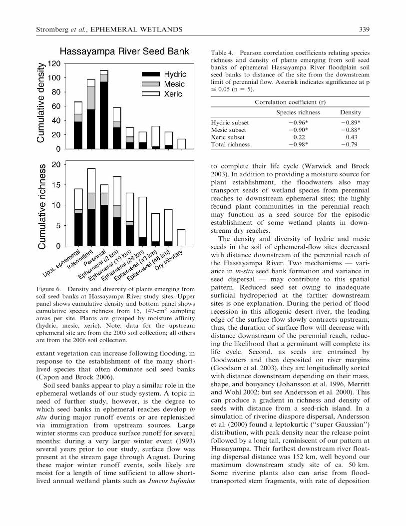
distant one (48 km) (Figure 6). However, their
diversity and density declined significantly with
distance downstream from the perennial reach
(Table 4). Patterns for mesic species were similar
to those for hydric species in that they decreased in
diversity and density with distance downstream.
However, in contrast to hydric species, mesic species
were not present at all Hassayampa ephemeral sites,
being absent from soils of the three farthest
downstream sites. No hydric or mesic species
emerged from seed banks of the ephemeral tributary
(Jackrabbit Wash). Xeric species did not change in
abundance or diversity along the distance gradient.
The hydromesic seed bank species at the dry
Hassayampa River sites were a nested subset of
those at the wetter sites; all but one of the
hydromesic species at the ephemeral sites were also
found at the perennial site, while the perennial site
contained many hydromesic species not found at
ephemeral sites (Table 3, Figure 5, bottom right).
Among the hydric species present in soils of
perennial and ephemeral sites alike were Juncus
bufonius, Polypogon monspeliensis, Typha domingen-
sis, and Veronica anagallis-aquatica; those recorded
only at a perennial site included Eleocharis parishii,
Heliotropium currassivicum, Nasturtium officinale,
Juncus torreyi, Polygonum lapathifolium, and Sym-
phyotrichum expansum.
334 WETLANDS, Volume 29, No. 1, 2009
For xeric species, the seed bank data set was not
nested; many species overlapped between perennial
and ephemeral sites and each site type had unique
species. The majority of the xeric seed bank species
were cool-season annuals: those common to soils of
perennial and ephemeral sites included Bowlesia
incana, Bromus sp., Erodium cicutarium, and Schis-
mus arabicus. Ten species, all characteristic Sonoran
desert annuals (e.g., Cryptantha sp., Pectis papposa,
Plantago ovata) were detected only at ephemeral-
flow sites. Two (Herniaria hirsuta ssp. cinerea, a
forest understory species, and Astragalus nuttalia-
nus) were detected only in soils at perennial-flow
sites.
Overlap between Seed Bank and Extant Vegetation
Approximately half of the wetland species record-
ed in extant vegetation were detected in a site’s soil
seed bank. Of the 15 hydric species that grew along
the low-flow channel of ephemeral-2 km during the
wet early summer of 2005, seven (four annuals and
three herbaceous perennials) were detected in soil
seed bank samples of the site. Similarly, of the 15
hydric species growing along the low-flow channel
of the perennial site at that time, six (three annuals
and three herbaceous perennials) emerged from soil
samples. Of the 12 hydroroparian species along the
low-flow channel of the perennial site in dry 2007,
six were detected in seed bank samples.
DISCUSSION
Ephemeral Wetlands and River Dynamics
Ephemeral wetlands are defined as wetlands
dominated by annuals or seasonally active herba-
ceous perennials sustained by periodic saturation
events and characterized by high year to year
variability in hydrologic conditions (Deil 2005).
Ephemeral wetlands develop in a variety of hydro-
geomorphic settings but for the most part such plant
communities have been little studied in North
America. Our study documents occurrence of
Table 1. Sorenson classic similarity coefficients among riparian plant communities of hydrologic site types within the
Hassayampa River drainage. Values are similarities between site pairs (i.e., perennial site vs. a non-perennial site) and are
shown separately for active channel vegetation, floodplain vegetation, and soil seed banks.
Perennial site
versus:
Sorenson similarity coefficient
Upstream Ephem. Intermittent Eph-2 km Eph-19 km Eph-28 km Eph-43 km Eph-trib.
Active channel vegetation
June 2005 0.36 0.54 0.55 – – – –
Aug. 2005 0.42 0.37 0.39 – – – –
May 2006 0.17 0.52 0.46 0.00 0.00 0.00 0.00
Aug. 2006 0.16 0.30 0.08 0.00 0.11 0.00 0.00
June 2007 0.06 0.56 0.13 0.00 0.00 0.00 –
Floodplain vegetation
June 2005 0.55 0.56 0.63 – – – –
May 2006 0.41 – 0.46 0.10 0.00 0.04 0.04
June 2007 – 0.72 0.19 0.13 0.07 0.03 –
Soil seed bank
2006 seed bank – 0.52 0.43 0.40 0.21 0.13 0.11
2005 seed bank 0.39 0.32 0.60 – – – –
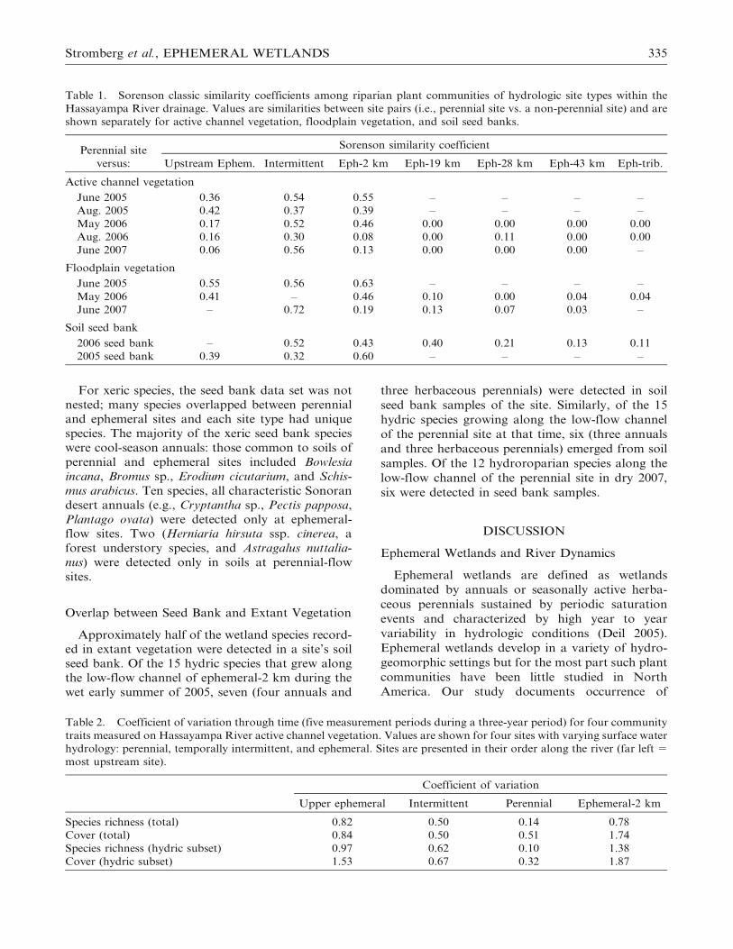
Table 2. Coefficient of variation through time (five measurement periods during a three-year period) for four community
traits measured on Hassayampa River active channel vegetation. Values are shown for four sites with varying surface water
hydrology: perennial, temporally intermittent, and ephemeral. Sites are presented in their order along the river (far left 5
most upstream site).
Coefficient of variation
Upper ephemeral Intermittent Perennial Ephemeral-2 km
Species richness (total) 0.82 0.50 0.14 0.78
Cover (total) 0.84 0.50 0.51 1.74
Species richness (hydric subset) 0.97 0.62 0.10 1.38
Cover (hydric subset) 1.53 0.67 0.32 1.87
Stromberg et al., EPHEMERAL WETLANDS 335

Figure 3. Cover and richness of plants growing along the active channel of the Hassayampa River during 2005, 2006, and
2007. Left panel shows mean ground cover; right panel shows cumulative species richness from 18, 1-m2 plots. Plants are
grouped by moisture affinity (hydric, mesic, xeric, unknown). Sites are presented in their order along the river (left5 most
upstream sites). During the study, there was a temporal shift from a wet period (uppermost panel) to a dry period
(lowermost panel). Data were not collected at all study sites in all years.
336 WETLANDS, Volume 29, No. 1, 2009

ephemeral wetlands along an allogenic desert river
with a mountainous catchment. Sampling of vege-
tation through a wet to dry period along the
spatially intermittent Hassayampa River indicated
that plant communities in ephemeral reaches had
higher compositional similarity to those in perennial
reaches during a period of sustained winter flood
runoff. Hydric vegetation was abundant along the
low-flow channel at ephemeral-flow sites during this
period of above average stream flow, and was absent
during the driest year.
The wetland communities in the ephemeral
reaches of this spatially intermittent river are
transient, fluctuating temporally with the highly
variable annual stream flow pattern that character-
izes arid region rivers. In some dryland regions
around the world, seasonal floods occur with fairly
high reliability (Gasith and Resh 1999). Rivers in the
semiarid Chihuahuan Desert, for example, have
reliable summer monsoonal rains and floods, and
wetland vegetation establishes fairly frequently in
temporally intermittent and ephemeral-flow reaches
(Bagstad et al. 2005, Stromberg et al. 2005). For the
Hassayampa River in the arid Sonoran Desert, the
flood pattern is driven largely by winter Pacific
frontal systems, which are strongly tied to the El
Nino/Southern Oscillation (ENSO) global weather
pattern. Floods of sufficient magnitude and dura-
tion to sustain wetland development in ephemeral
reaches are more episodic and occur perhaps once or
twice per decade: for the 10-year period from 1998–
2007, for example, surface flows at the Hassayampa
River Morristown stream gage occurred throughout
the month of May during only two years (1998,
2005).
Prior studies along a perennial reach of the
Hassayampa River showed that the lateral extent
of marshlands (wet meadows) expands and contracts
dramatically following major flooding events owing
to changes in floodplain geomorphology and
hydrology (Stromberg et al. 1997). This current
study indicates that the longitudinal extent of the
riverine wetlands along the river also can fluctuate
through time (although our downstream sampling
extent was limited during the flood-influenced
season), as also documented for aquatic ecosystems
in spatially intermittent desert rivers (Stanley et al.
1997). This pattern was evident in the extant
vegetation, and also suggested by the presence of
viable seeds of wetland plant species at sites many
kilometers downstream in the ephemeral reach.
Mechanisms: Seed Banks and Dispersal
Many ephemeral wetlands are sustained by
persistent soil seed banks. In response to periodic
flooding, ephemeral plant communities develop
through germination of long-lived seeds in the soil
seed bank and through expansion of vegetative
propagules that survive drought (Casanova and
Brock 2000, Bissels et al. 2005). The similarity
between the composition of the soil seed bank and
Figure 4. Richness of plant species growing in the
floodplain at Hassayampa River study sites during 2005,
2006, and 2007. All panels show cumulative species
richness (from 30, 10-m2 plots per site). Plants are
grouped by moisture affinity category (hydric, mesic,
xeric, unknown). Data were not collected at all sites in
all years.
Stromberg et al., EPHEMERAL WETLANDS 337

Figure 5. ‘‘Spider’’ charts showing the numbers of hydric, mesic, and xeric plant species occurring only at a perennial site,
only at an ephemeral site, or present at both hydrologic site types. Values for floodplain vegetation are for early summer of
each of three study years, and are based on data from one perennial site and one ephemeral site. Values for the soil seed
bank (2006 collection) are for two wet sites (perennial and temporally intermittent) and two ephemeral sites.
Table 3. Level of nestedness in species composition, by moisture group, among sites along the spatially intermittent
Hassayampa River. Low ‘‘temperature’’ values (close to zero) indicate a high degree of nestedness and high values (close to
100) indicate a low degree of nestedness. Values are based on data sets that include seven sites (2006 seed bank), six sites
(2006 and 2007 floodplain vegetation), and four sites (2005 floodplain vegetation).
Nestedness temperature Probability value Direction of nestedness
Seed Bank
Hydromesic subset 12.0 ,0.01 Dry sites nested within wet
Xeric subset 42.5 0.54 Not nested
Floodplain Vegetation
June 2005, Hydromesic subset 44.2 0.93 Not nested
June 2005, Xeric subset 36.1 0.73 Not nested
May 2006, Hydromesic subset 7.2 ,0.01 Dry sites nested within wet
May 2006, Xeric subset 31.1 0.13 Not nested
June 2007, Hydromesic subset 5.6 ,0.01 Dry sites nested within wet
June 2007, Xeric subset 26.8 0.05 Dry sites nested within wet
338 WETLANDS, Volume 29, No. 1, 2009
extant vegetation can increase following flooding, in
response to the establishment of the many short-
lived species that often dominate soil seed banks
(Capon and Brock 2006).
Soil seed banks appear to play a similar role in the
ephemeral wetlands of our study system. A topic in
need of further study, however, is the degree to
which seed banks in ephemeral reaches develop in
situ during major runoff events or are replenished
via immigration from upstream sources. Large
winter storms can produce surface runoff for several
months: during a very larger winter event (1993)
several years prior to our study, surface flow was
present at the stream gage through August. During
these major winter runoff events, soils likely are
moist for a length of time sufficient to allow short-
lived annual wetland plants such as Juncus bufonius
to complete their life cycle (Warwick and Brock
2003). In addition to providing a moisture source for
plant establishment, the floodwaters also may
transport seeds of wetland species from perennial
reaches to downstream ephemeral sites; the highly
fecund plant communities in the perennial reach
may function as a seed source for the episodic
establishment of some wetland plants in down-
stream dry reaches.
The density and diversity of hydric and mesic
seeds in the soil of ephemeral-flow sites decreased
with distance downstream of the perennial reach of
the Hassayampa River. Two mechanisms — vari-
ance in in-situ seed bank formation and variance in
seed dispersal — may contribute to this spatial
pattern. Reduced seed set owing to inadequate
surficial hydroperiod at the farther downstream
sites is one explanation. During the period of flood
recession in this allogenic desert river, the leading
edge of the surface flow slowly contracts upstream;
thus, the duration of surface flow will decrease with
distance downstream of the perennial reach, reduc-
ing the likelihood that a germinant will complete its
life cycle. Second, as seeds are entrained by
floodwaters and then deposited on river margins
(Goodson et al. 2003), they are longitudinally sorted
with distance downstream depending on their mass,
shape, and bouyancy (Johansson et al. 1996, Merritt
and Wohl 2002; but see Andersson et al. 2000). This
can produce a gradient in richness and density of
seeds with distance from a seed-rich island. In a
simulation of riverine diaspore dispersal, Andersson
et al. (2000) found a leptokurtic (‘‘super Gaussian’’)
distribution, with peak density near the release point
followed by a long tail, reminiscent of our pattern at
Hassayampa. Their farthest downstream river float-
ing dispersal distance was 152 km, well beyond our
maximum downstream study site of ca. 50 km.
Some riverine plants also can arise from flood-
transported stem fragments, with rate of deposition
Figure 6. Density and diversity of plants emerging from
soil seed banks at Hassayampa River study sites. Upper
panel shows cumulative density and bottom panel shows
cumulative species richness from 15, 147-cm2 sampling
areas per site. Plants are grouped by moisture affinity
(hydric, mesic, xeric). Note: data for the upstream
ephemeral site are from the 2005 soil collection; all others
are from the 2006 soil collection.
Table 4. Pearson correlation coefficients relating species
richness and density of plants emerging from soil seed
banks of ephemeral Hassayampa River floodplain soil
seed banks to distance of the site from the downstream
limit of perennial flow. Asterisk indicates significance at p
# 0.05 (n 5 5).
Correlation coefficient (r)
Species richness Density
Hydric subset 20.96* 20.89*
Mesic subset 20.90* 20.88*
Xeric subset 0.22 0.43
Total richness 20.98* 20.79
Stromberg et al., EPHEMERAL WETLANDS 339

also decreasing with distance from a source popu-
lation (Riis and Sand-Jensen 2006, Truscott et al.
2006). It is also possible that the seeds are being
transported downstream by wind or by animals,
which would also produce a sorting in terms of
species composition. The few wetland species
present in soils of the far-downstream Hassayampa
River ephemeral sites all have small diaspores,
consistent with a pattern of differential sorting
along a longitudinal river gradient, but also
consistent with patterns for small-seeded species to
be the most common type to form persistent seed
banks (Stromberg et al. 2008).
Implications for Riparian Restoration
and Conservation
Many riparian restoration efforts are underway
around the world, but most focus narrowly on a
given piece of land, with less consideration for the
landscape setting and for river-wide processes (Ward
et al. 2001, Kondolf et al. 2007). Our study suggests
that restoration success does depend on the land-
scape matrix in which a project is embedded, and on
connectivity between landscape elements (Boon
1998). Specifically, our results suggest that potential
for self-assembly of ephemeral wetlands varies with
proximity to a perennial reach.
These results can provide guidance for riparian
site selection. Assuming that our findings are
representative of rivers in the region, it appears that
ephemeral reaches located proximal to a perennial
reach are the strongest candidate sites for flow-
restoration projects; those located at greater dis-
tances are weaker candidates; and those located in
completely ephemeral tributaries are least suitable.
While the seeds that are present in the soil of
ephemeral reaches of spatially intermittent rivers are
only a subset of the riparian flora, this subset is one
that is likely to be overlooked by traditional
restoration seeding efforts. The composition of seeds
that are present in the soil seed bank or that arrive
via flood transport or other vectors from seed-rich
upstream sites will vary from year to year (Anders-
son and Nilsson 2002, Gutierrez and Meserve 2003),
contributing to temporal heterogeneity in riparian
plant diversity patterns.
River-wide factors such as perennial reach length
and interval length between perennial reaches are
changing in some dryland rivers, and such changes
will influence metapopulation and metacommunity
processes. For example, changes in the degree of
between-reach connectivity conferred by flood
dispersal may influence the degree of genetic
variability within river metapopulations (Kudoh
and Whigham 2001, Carini et al. 2006). Our study
raises the possibility that changes in between-reach
connectivity may influence metacommunity process-
es. Boudell and Stromberg (2008) posited that the
riparian plant communities within perennial stream
reaches are linked by hydrochorous dispersal of
seeds across lateral floodplain gradients, which
creates a common seed bank pool in the component
plant associations; this, in turn provides opportuni-
ties for establishment of hydric to xeric communities
wherever flood hydrogeodynamics stochastically
create suitable growing conditions. With respect to
the longitudinal wet-dry river gradient, further
studies are needed to determine whether hydric
plants at perennial stream reaches function as a seed
source for episodic development of wetlands in
downstream dry reaches, and if so, how this process
is affected by changes in the spatial distribution of
perennial reaches within the drainage network.
ACKNOWLEDGMENTS
Support for this project was provided by the U.S.
Army Corps of Engineers, Ecosystem Management
and Restoration Research Program; the U.S. EPA
Science to Achieve Results program; and the
National Science Foundation’s center for Sustain-
ability of semi-Arid Hydrology and Riparian Areas.
We are grateful to The Nature Conservancy and
private landowners for providing site access. We
thank Elizabeth Makings, Theresa Price, and
Bethany Lund for assisting with plant species
identification.
LITERATURE CITED
Andersson, E. and C. Nilsson. 2002. Temporal variation in thedrift of plant litter and propagules in a small boreal river.Freshwater Biology 47:1674–84.
Andersson, E., C. Nilsson, and M. E. Johansson. 2000. Plantdispersal in boreal rivers and its relation to the diversity ofriparian flora. Journal of Biogeography 27:1095–1106.
Atmar, W. and B. D. Patterson. 1993. The measure of order anddisorder in the distribution of species in fragmented habitat.Oecologia 96:373–82.
Bagstad, K. J., J. C. Stromberg, and S. J. Lite. 2005. Response ofherbaceous riparian plants to rain and flooding on the SanPedro River, Arizona, USA. Wetlands 25:210–23.
Birkeland, G. H. 1996. Riparian vegetation and sandbarmorphology along the lower Little Colorado River, Arizona.Physical Geography 17:534–53.
Bissels, S., T. W. Donath, N. Holzel, and A. Otte. 2005.Ephemeral wetland vegetation in irregularly flooded arablefields along the northern Upper Rhine: the importance ofpersistent seedbanks. Phytocoenologia 35:469–88.
Bloss, D. A. and J. D. Brotherson. 1979. Vegetation response to amoisture gradient on an ephemeral stream in central Arizona.Great Basin Naturalist 39:161–76.
Boon, P. J. 1998. River restoration in five dimensions. AquaticConservation- Marine and Freshwater Ecosystems 8:257–64.
340 WETLANDS, Volume 29, No. 1, 2009
Boudell, J. A. and J. C. Stromberg. 2008. Flood pulsing andmetacommunity dynamics in a desert riparian ecosystem.Journal of Vegetation Science 19:373–80.
Bossuyt, B. and O. Honnay. 2006. Interactions between plant lifespan, seed dispersal capacity and fecundity determine meta-population viability in a dynamic landscape. LandscapeEcology 21:1195–1205.
Brock, M. A. and K. H. Rogers. 1998. The regeneration potentialof the seed bank of an ephemeral floodplain in South Africa.Aquatic Botany 61:123–35.
Bunn, S. E., M. C. Thoms, S. K. Hamilton, and S. J. Capon.2006. Flow variability in dryland rivers: boom, bust and the bitsin between. River Research and Applications 22:179–86.
Capon, S. J. 2007. Effects of flooding on seedling emergence fromthe soil seed bank of a large desert floodplain. Wetlands27:904–14.
Capon, S. J. and M. A. Brock. 2006. Flooding, soil seed bankdynamics and vegetation resilience of a hydrologically variabledesert floodplain. Freshwater Biology 51:206–23.
Carini, G., J. M. Hughes, and S. E. Bunn. 2006. The role of water-holes as ‘refugia’ in sustaining genetic diversity and variation oftwo freshwater species in dryland river systems (WesternQueensland, Australia). Freshwater Biology 51:1434–46.
Casanova, M. T. and M. A. Brock. 2000. How do depth, durationand frequency of flooding influence the establishment ofwetland plant communities? Plant Ecology 147:237–50.
Colwell, R. K. 2005. EstimateS: Statistical estimation of speciesrichness and shared species from samples. Version 7.5 PersistentURL ,purl.oclc.org/estimates..
Deil, U. 2005. A review on habitats, plant traits and vegetation ofephemeral wetlands - a global perspective. Phytocoenologia35:533–705.
de Soyza, A. G., K. T. Killingbeck, and W. G. Whitford. 2004.Plant water relations and photosynthesis during and afterdrought in a Chihuahuan desert arroyo. Journal of AridEnvironments 59:27–39.
Froend, R. H. and P. L. Drake. 2006. Defining phreatophyteresponse to reduced water availability: preliminary investiga-tions on the use of xylem cavitation vulnerability in Banksiawoodland species. Australian Journal of Botany 54:173–79.
Gasith, A. and V. H. Resh. 1999. Streams in Mediterraneanclimate regions: abiotic influences and biotic responses topredictable seasonal events. Annual Review of Ecology andSystematics 30:51–81.
Gazal, R. M., R. L. Scott, D. C. Goodrich, and D. G. Williams.2006. Controls on transpiration in a semiarid ripariancottonwood forest. Agricultural and Forest Meteorology137:56–67.
Goodson, J. M., A. M. Gurnell, P. G. Angold, and I. P.Morrissey. 2002. Riparian seed banks along the lower RiverDove, UK: their structure and ecological implications. Geo-morphology 47:45–60.
Goodson, J. M., A. M. Gurnell, P. G. Angold, and I. P.Morrissey. 2003. Evidence for hydrochory and the depositionof viable seeds within winter flow-deposited sediments: theRiver Dove, Derbyshire, UK. River Research and Application19:317–34.
Gutierrez, J. R. and P. L. Meserve. 2003. El Nino effects on soilseed bank dynamics in north-central Chile. Oecologia134:511–17.
Jansson, R., U. Zinko, D. M. Merritt, and C. Nilsson. 2005.Hydrochory increases riparian plant species richness: acomparison between a free-flowing and a regulated river.Journal of Ecology 93:1094–1103.
Johansson, M. E., C. Nilsson, and E. Nilsson. 1996. Do riversfunction as corridors for plant dispersal? Journal of VegetationScience 7:593–98.
Kearney, T. H. and R. H. Peebles. 1960. Arizona Flora (withSupplement). University of California Press, Berekely, CA,USA.
Kolb, T. E., S. C. Hart, and R. Amundson. 1997. Boxelder watersources and physiology at perennial and ephemeral stream sitesin Arizona. Tree Physiology 17:151–60.
Kondolf, G. M., S. Anderson, R. Lave, L. Pagano, A.Merenlender, and E. S. Bernhardt. 2007. Two decades of riverrestoration in California: What can we learn? RestorationEcology 15:516–23.
Kudoh, H. and D. F. Whigham. 2001. A genetic analysis ofhydrologically dispersed seeds of Hibiscus moscheutos (Mal-vaceae). American Journal of Botany 88:588–93.
Lake, P. S. 2003. Ecological effects of perturbation by drought inflowing waters. Freshwater Biology 48:1161–72.
Lite, S. J. and J. C. Stromberg. 2005. Surface water and ground-water thresholds for maintaining Populus - Salix forests, SanPedro River, Arizona. Biological Conservation 125:153–67.
McMahon, T. A. and B. L. Finlayson. 2003. Droughts and anti-droughts: the low flow hydrology of Australian rivers.Freshwater Biology 48:1147–60.
Meinzer, O. E. 1923. Outline of ground-water hydrology, withdefinitions. U.S. Geological Survey Water-Supply Paper494:1–71.
Menges, E. S. 1990. Population viability analysis for anendangered plant. Conservation Biology 4:52–62.
Merritt, D. M. and E. E. Wohl. 2002. Processes governinghydrochory along rivers: hydraulics, hydrology, and dispersalphenology. Ecological Applications 12:1071–87.
Merritt, D. M. and E. E. Wohl. 2006. Plant dispersal along riversfragmented by dams. River Research and Applications 22:1–26.
Nanson, G. C., S. Tooth, and A. D. Knighton. 2002. A globalperspective on dryland rivers: perceptions, misconceptions anddistinctions. p. 17–54. In L. J. Bul and M. J. Kirby (eds.)Dryland Rivers: Hydrology and Geomorphology of Semi-aridChannels. John Wiley and Sons, Chichester, UK.
Nicol, J. M., G. C. Ganf, and G. A. Pelton. 2003. Seed banks of asouthern Australian wetland: the influence of water regime onthe final floristic composition. Plant Ecology 168:191–205.
Rassam, D. W., C. S. Fellows, R. De Hayr, H. Hunter, and P.Bloesch. 2006. The hydrology of riparian buffer zones; two casestudies in an ephemeral and a perennial stream. Journal ofHydrology 325:308–24.
Roberts, H. A. 1981. Seed banks in soils. Advances in AppliedBiology 6:1–54.
Riis, T. and K. Sand-Jensen. 2006. Dispersal of plant fragmentsin small streams. Freshwater Biology 51:274–286.
Rodriguez-Girones, M. A. and L. Santamaria. 2006. A newalgorithm to calculate the nestedness temperature of presence-absence matrices. Journal of Biogeography 33:924–35.
Sheppard, P. R., A. C. Comrie, G. D. Packin, K. Angersbach,and M. K. Hughes. 2002. The climate of the US Southwest.Climate Research 21:219–38.
Stanley, E. H., S. G. Fisher, and N. B. Grimm. 1997. Ecosystemexpansion and contraction in streams. BioScience 47:427–35.
Stromberg, J. C. 2001. Biotic integrity of Platanus wrightiiriparian forests in Arizona: first approximation. Forest Ecologyand Management 142:249–64.
Stromberg, J. C., K. J. Bagstad, J. M. Leenhouts, S. J. Lite, andE. Makings. 2005. Effects of stream flow intermittency onriparian vegetation of a semiarid region river (San Pedro River,Arizona). River Research and Applications 21:925–38.
Stromberg, J. C., J. A. Boudell, and A. F. Hazelton. 2008.Differences in seed mass between hydric and xeric plantsinfluence seed bank dynamics in a dryland riparian ecosystem.Functional Ecology 22:205–12.
Stromberg, J. C., J. Fry, and D. T. Patten. 1997. Marshdevelopment after large floods in an alluvial, arid-land river.Wetlands 17:292–300.
Thomaz, S. M., L. M. Bini, and R. L. Bozelli. 2007. Floodsincrease similarity among aquatic habitats in river-floodplainsystems. Hydrobiologia 579:1–13.
Truscott, A. M., C. Soulsby, S. C. F. Palmer, L. Newell, and P. E.Hulme. 2006. The dispersal characteristics of the invasive plantMimulus guttatus and the ecological significance of increasedoccurrence of high-flow events. Journal of Ecology 94:1080–91.
Uys, M. C. and J. H. OKeeffe. 1997. Simple words and fuzzyzones: early directions for temporary river research in SouthAfrica. Environmental Management 21:517–31.
Stromberg et al., EPHEMERAL WETLANDS 341

Vogt, K., L. Rasran, and K. Jensen. 2006. Seed deposition in driftlines during an extreme flooding event - evidence for hydro-chorous dispersal? Basic and Applied Ecology 7:422–32.
Ward, J. V., K. Tockner, U. Uehlinger, and F. Malard. 2001.Understanding natural patterns and processes in river corridorsas the basis for effective river restoration. Regulated Rivers –Research and Management 17:311–23.
Warwick, N. W. M. and M. A. Brock. 2003. Plant reproductionin temporary wetlands: the effects of seasonal timing, depth,and duration of flooding. Aquatic Botany 77:153–67.
Webb, R. H. and S. A. Leake. 2006. Ground-water surface-waterinteractions and long-term change in riverine riparian vegeta-tion in the southwestern United States. Journal of Hydrology320:302–23.
Wood, P. J., J. Gunn, H. Smith, and A. Abas-Kutty. 2005. Flowpermanence and macroinvertebrate community diversity withingroundwater dominated headwater streams and springs.Hydrobiologia 545:55–64.
Manuscript received 14 May 2008; accepted 29 October 2008.
342 WETLANDS, Volume 29, No. 1, 2009