Mexico - Annotated List of Wetlands of International Importance
48
Annotated List of Wetlands of International Importance Mexico 142 Ramsar Site(s) covering 8,657,057 ha Agua Dulce Site number: 1,813 | Country: Mexico | Administrative region: Sonora Area: 39 ha | Coordinates: 31°55'N 113°01'W | Designation dates: 02-02-2008 View Site details in RSIS Agua Dulce. 02/02/08; Sonora; 39 ha; 31°55'N 113°01'W. Located within the Biosphere Reserve Del Picante y Desierto de Altar, which highlights the only riparian ecosystem of the region, Sonoyta river, considered of binational interest and shared between the USA and Mexico. At present, there is a mutual interest in establishing indicators for its management and conservation. Agua Dulce is a 3km stretch of the Sonoyta where water comes to the surface, creating conditions of an oasis in a desert. Among the main species found in the site is the Pupfish (Cyprinodon macularius), listed as endangered by the US and as endemic and endangered in Mexico's legal system. There is a considerable presence of the turtle species Kinonsternon sonoriense longifemorale. The resident and migratory bird species that use the Pacific Flyway find in Agua Dulce a habitat of importance for food, shelter, resting and reproduction. Agua Dulce is characteristic for retaining water throughout the year, acting as the main source of water for wildlife in the area, and supporting an excellent biological diversity. Ramsar site no. 1813. Most recent RIS information: 2008. Anillo de Cenotes Site number: 2,043 | Country: Mexico | Administrative region: Estado de Yucatán Area: 891 ha | Coordinates: 20°43'21"N 89°19'23"W | Designation dates: 02-02-2009 View Site details in RSIS Anillo de Cenotes. 02/02/09; Yucatán; 891 ha; 20º43'21"N 089º19'23"W. A complex of 99 cenotes (or sinkholes) that cover approximately 5 km wide with a radius of 90 km in a zone of high permeability. Anillo de Cenotes ("ring of cenotes") is a unique water system in Mexico and the world and is the product of a large meteor impact 65 million years ago, the Chicxulub Crater, which fractured the surface layers of the Earth's crust and led to the ring alignment of the aquifer outcrops. It forms a cavernous complex network which acts as a weir and pipeline of large bodies of water. These cenotes serve as resting grounds for waterfowl during their migration to the South and hold endemic species of reptiles, such as the Yucatan Box Turtle (Terrapene carolina yucatana), amphibians like the Yucatan Mushroomtongue Salamander (Bolitoglossa yucatana), and birds such as the Ridgway's Rough-winged Swallow (Stelgidopteryx ridgwayi), the Yucatan Jay (Cyanocorax yucatanicus), and the Black Catbird (Melanoptila glabirostris). The cenotes are also home to a number of endangered or threatened species, such as the fish species Ogilbia pearsei, Ophisternon infernale, and Poecilia velifera. Among the factors adversely affecting the site are the accidental introduction of exotic species, environmental changes due to tourism, and the extraction of large volumes of water for tourist resorts. Ramsar Site no. 2043. Most recent RIS information: 2009. Ramsar Sites Information Service Annotated List of Wetlands of International Importance - 1/48
-
Upload
khangminh22 -
Category
Documents
-
view
0 -
download
0
Transcript of Mexico - Annotated List of Wetlands of International Importance

Annotated List of Wetlands of International Importance
Mexico142 Ramsar Site(s) covering 8,657,057 ha
Agua DulceSite number: 1,813 | Country: Mexico | Administrative region: SonoraArea: 39 ha | Coordinates: 31°55'N 113°01'W | Designation dates: 02-02-2008View Site details in RSIS
Agua Dulce. 02/02/08; Sonora; 39 ha; 31°55'N 113°01'W. Located within the Biosphere Reserve DelPicante y Desierto de Altar, which highlights the only riparian ecosystem of the region, Sonoyta river,considered of binational interest and shared between the USA and Mexico. At present, there is a mutualinterest in establishing indicators for its management and conservation. Agua Dulce is a 3km stretch ofthe Sonoyta where water comes to the surface, creating conditions of an oasis in a desert. Among themain species found in the site is the Pupfish (Cyprinodon macularius), listed as endangered by the USand as endemic and endangered in Mexico's legal system. There is a considerable presence of the turtlespecies Kinonsternon sonoriense longifemorale. The resident and migratory bird species that use thePacific Flyway find in Agua Dulce a habitat of importance for food, shelter, resting and reproduction.Agua Dulce is characteristic for retaining water throughout the year, acting as the main source of waterfor wildlife in the area, and supporting an excellent biological diversity. Ramsar site no. 1813. Mostrecent RIS information: 2008.
Anillo de CenotesSite number: 2,043 | Country: Mexico | Administrative region: Estado de YucatánArea: 891 ha | Coordinates: 20°43'21"N 89°19'23"W | Designation dates: 02-02-2009View Site details in RSIS
Anillo de Cenotes. 02/02/09; Yucatán; 891 ha; 20º43'21"N 089º19'23"W. A complex of 99 cenotes (orsinkholes) that cover approximately 5 km wide with a radius of 90 km in a zone of high permeability.Anillo de Cenotes ("ring of cenotes") is a unique water system in Mexico and the world and is the productof a large meteor impact 65 million years ago, the Chicxulub Crater, which fractured the surface layersof the Earth's crust and led to the ring alignment of the aquifer outcrops. It forms a cavernous complexnetwork which acts as a weir and pipeline of large bodies of water. These cenotes serve as restinggrounds for waterfowl during their migration to the South and hold endemic species of reptiles, such asthe Yucatan Box Turtle (Terrapene carolina yucatana), amphibians like the Yucatan MushroomtongueSalamander (Bolitoglossa yucatana), and birds such as the Ridgway's Rough-winged Swallow(Stelgidopteryx ridgwayi), the Yucatan Jay (Cyanocorax yucatanicus), and the Black Catbird (Melanoptilaglabirostris). The cenotes are also home to a number of endangered or threatened species, such as thefish species Ogilbia pearsei, Ophisternon infernale, and Poecilia velifera. Among the factors adverselyaffecting the site are the accidental introduction of exotic species, environmental changes due totourism, and the extraction of large volumes of water for tourist resorts. Ramsar Site no. 2043. Mostrecent RIS information: 2009.
Ramsar Sites Information Service
Annotated List of Wetlands of International Importance - 1/48

Área de Protección de Flora y Fauna CuatrociénegasSite number: 734 | Country: Mexico | Administrative region: CoahuilaArea: 84,347 ha | Coordinates: 26°51'N 102°07'59"W | Designation dates: 22-06-1995View Site details in RSIS
Área de Protección de Flora y Fauna Cuatrociénegas. 22/06/95; Coahuila; 84,347 ha; 26°51'N 102°08'W.Área de Protección de Flora y Fauna. An intermontane valley with springs linked by a channel system,keeping the water circulating constantly; includes extensive areas subject to flooding. There are gypsumdeposits in the form of dunes, one of only three such landforms in North America. Riparian woodland,grassland, montane forests, chaparral and desert scrub communities are present. Long isolation inspecialized habitats has given rise to high biological diversity and endemism, with the site providinghabitat for numerous threatened or vulnerable species. Human activities include plant collection, limitedgrazing and agriculture, and sport fishing. Industrial-scale extraction of minerals from gypsum dunes hasoccurred since 1979. Ramsar site no. 734. Most recent RIS information: 2002.
Área de Protección de Flora y Fauna Laguna de TérminosSite number: 1,356 | Country: Mexico | Administrative region: CampecheArea: 705,016 ha | Coordinates: 18°40'N 91°45'W | Designation dates: 02-02-2004View Site details in RSIS
Área de Protección de Flora y Fauna Laguna de Términos. 02/02/04; Campeche; 705,016 ha; 18°40'N091°45'W. Wildlife Reserve. The largest coastal lagoon on the Mexican shore of the Gulf of Mexico.Mangrove forests of approximately 127,000 ha are a major feature and produce as much as 716,000tons of dead leaves every year. The coastal waters are enriched with nutrients by upwelling andturbulence, while the lagoon receives freshwater from rivers and swamps. Other vegetation types areevergreen tropical forest, thorny forest, palmetto (Sabal Mexicana) forest, reedbeds of cattail (Typhalatifolia) and Jointed Flatsedge (Cyperus articulatum), and patches of Bent Alligator Flag Thaliageniculata. Flagship animals of the site include the Jabiru Jabiru mycteria, the Horseshoe Crab Limuluspolyphemus and endemic amphibians Rana brownorum, Bolitoglossa yucatana; and reptiles Anolisustus, A. cozumelae, A. quercorum, amongst others. Ciudad del Carmen, with a population of almost100,000, is an important industrial port located on the barrier island of the lagoon. A variety of fishing,agricultural and livestock raising activities are done in the site, all of which are causing problems ofsedimentation, pollution, deforestation and reduction of stocks. Further conflicts have arisen with the oilpipes that traverse the area. Ramsar site no. 1356.Most recent RIS information: 2004. Most recent RISinformation: 2006.
Área de Protección de Flora y Fauna Yum BalamSite number: 1,360 | Country: Mexico | Administrative region: Quintana RooArea: 154,052 ha | Coordinates: 21°28'N 87°19'W | Designation dates: 02-02-2004View Site details in RSIS
Área de Protección de Flora y Fauna Yum Balam. 02/02/04; Quintana Roo; 154,052 ha; 21°28'N087°19'W. Wildlife Sanctuary. A coastal lagoon and a mosaique of low and medium forests on thenorthern coast of the Yucatan Peninsula, home to a rich fauna., including the jaguar, Baird's TapirTapirus bairdii, Crocodiles (Crocodylus acutus and C. moreletii), sea turtles, American ManateesTrichechus manatus, Spiny Lobsters Panulirus argus, and the near -threatened Ocellated TurkeyAgriocharis ocellata. Besides the well preserved forests, noteworthy vegetation communities are thoseof Everglades palms (Acoelorreaphe wrightii), mangroves and petenes. Fishing is the main incomesource for locals yet the main problem for the area as well, as fishing intensity has increased and stocksdiminished. Tourism, forestry, cattle ranching and agriculture are of low intensity today, yet their impactcould grow in the next years. Ramsar site no. 1360. Most recent RIS information: 2004.
Annotated List of Wetlands of International Importance - 2/48

Área Natural Protegida Estatal Presa de Silva y Zonas AledañasSite number: 2,024 | Country: Mexico | Administrative region: GuanajuatoArea: 3,934 ha | Coordinates: 20°55'36"N 101°50'48"W | Designation dates: 02-02-2011View Site details in RSIS
Área Natural Protegida Estatal Presa de Silva y Zonas Aledañas. 02/02/11; Guanajuato; 3,934 ha;20°55'37"N 101°50'48"W. State Natural Protected Area. A number of dams with shallow waterspresenting different habitats, including emerged vegetation and flooded vegetation areas whoseclimatic, trophic, structural and functional characteristics make them important sites for aquatic birds,both resident and migratory. The migratory birds share distribution of habitat with the USA and Canadawithin the Central Americas Flyway. There are records of 79 species of birds in the site such as Anasplatyrhynchos diazi, Anas platyrhynchos platyrhynchos, Fulica americana, Recurvirostra americana,Ardea alba, Egretta thula, and Charadrius vociferus, among others. The site plays an important role insustaining terrestrial wildlife under adequate water quality conditions in the region. The Ramsar Site islocated within the Natural Protected Area Presa de Silva y Zonas Aledañas declared in 1997 and containsa portion outside the protected area, including important groundwater recharge areas and otherstreams that have to be protected as well. Ramsar Site no. 2024. Most recent RIS information: 2011.
Áreas de Protección de Flora y Fauna de Nahá y MetzabokSite number: 1,331 | Country: Mexico | Administrative region: ChiapasArea: 7,216 ha | Coordinates: 17°03'N 91°36'W | Designation dates: 02-02-2004View Site details in RSIS
Áreas de Protección de Flora y Fauna de Nahá y Metzabok. 02/02/04; Chiapas; 7,216 ha; 17°03'N091°36'W. Natural Protected Area. Part of the Selva Lacandona region, considered the most importantfor biodiversity in North America, as the physiographic conditions and humidity enhance thedevelopment of ecosystems ranging from pine tree forests and marshes to tall everlasting forests andproduce a high number of animal and vegetal species per surface unit. Some 40,000 species of faunaand flora live in these habitats - in other words, an area of only 0.4% of the country's surface contains48% of the birds species, 33% of bats, 11% of the reptiles and 25% of the mammals of Mexico. Theimportance of the Selva Lacandona region for biodiversity is highlighted by the presence of 5 otherprotected areas in the surroundings, though the main threats (water pollution from pesticides, habitatfragmentation, fire risk, and land invasion due to a poor productivity of the surrounding cultivated lands)are still threatening this area. Ramsar site no. 1331. Most recent RIS information: 2004.
Arroyos y manantiales de TanchachínSite number: 1,766 | Country: Mexico | Administrative region: San Luis PotosíArea: 1,174 ha | Coordinates: 21°49'59"N 99°07'59"W | Designation dates: 02-02-2008View Site details in RSIS
Arroyos y manantiales de Tanchachín. 02/02/08; San Luis Potosí; 21°50'N 099°08'W. Located in theHuasteca region, southeast of the Sierra Madre Oriental, the system is a source of water and has a greatnumber of streams and springs. It supports a number of fauna species found under national specialprotection such as the Lithobates berlandieri, Crocodylus moreletii, Buteogallus anthracinus, Myotisnigricans, and Panthera onca which is endangered. The site also supports endemic species at a nationallevel, which are also threatened, such as Ctenosaura pectinata, Pituophis deppei andVireo griseus. Manyflora species found in the site are of great importance for the surrounding human communities, such asof Cedrela mexicana (artisanal use and precious woods), Sabal mexicana (domestic use for theconstruction of roofs), Acacia farnesiana (construction of fences), Quercus oleoides (domestic use as acombustible), Persea americana, Manilkara zapota y Diospyros digyna (as a source of food). The presentuses of land are agriculture (mainly sugar cane) and livestock, which are also considered the mainthreats to this site. Ramsar site no. 1766. Most recent RIS information: 2008.
Annotated List of Wetlands of International Importance - 3/48

Bahía de San QuintínSite number: 1,775 | Country: Mexico | Administrative region: Baja CaliforiniaArea: 5,438 ha | Coordinates: 30°25'59"N 115°58'W | Designation dates: 02-02-2008View Site details in RSIS
Bahía de San Quintín. 02/02/08 ; Baja California ; 5,438 ha; 30°26'N 115°58'W. Located in aMediterranean transitional biogeographic region between temperate and subtropical zones, the site ishome to a number of threatened or endangered bird species such as Rallus longirostris levipes,Laterallus jamaicensis, Sterna antillarum browni, Passerculus sandwichensis beldingi, Polioptilacalifornica atwoodi and Charadrius alexandrinus nivosus, and holds the densest population of Polioptilacalifornica atwoodi couples. It is the only area in the Pacific coast of Baja California where Laterallusjamaicensis have been sighted. More than 25,000 migratory waterbirds hibernate in the wetland, whichsupports 30-50% of the total Branta bernicla nigricans population during that period. Astragalusharrisonii, Chorizanthe chaetophora, Chorizanthe interposita, Chorizanthe jonesiana are endemic floraspecies of the Mediterranean area found here. The collection of bivalve mollusks, mining, salt mines,hunting, livestock and sand and gravel extraction are among the most important economic activitiescarried out in the site. The extensive use of agrochemicals, as well as disorganized urban growth, are themain factors that negatively affect the bay. Ramsar site no. 1775. Most recent RIS information: 2008.
Bala'an K'aaxSite number: 1,332 | Country: Mexico | Administrative region: Quintana RooArea: 131,610 ha | Coordinates: 19°19'N 89°03'W | Designation dates: 02-02-2004View Site details in RSIS
Bala'an K'aax. 02/02/04; Quintana Roo; 131,610 ha; 19°19'N 089°03'W. Reserva Estatal. Flooded loweverlasting forests, with an endemic vegetation type from the Yucatán peninsula. They are a shelter forthe great majority of animal species in the region, enhanced by the site's inaccessibility. The importanceof the area's vegetation lies in the great quantity of endemic species, but also because it supplies waterfor the region and other, more coastal wetlands. Because of the karstic nature of the ground, a complexsubterranean system is present, including an associated unique and unknown biodiversity. The areacontains around 601 vertebrate species, of which 27% are threatened, under special protection orendangered according to international or national lists. Changes in land property and planning are themain threat to this area. Ramsar site no. 1332. Most recent RIS information: 2004.
BalandraSite number: 1,767 | Country: Mexico | Administrative region: Baja California SurArea: 448.7 ha | Coordinates: 24°18'N 110°19'W | Designation dates: 02-02-2008View Site details in RSIS
Balandra.02/02/08; Baja California Sur; 449 ha; 24°19'N 110°20'W. A coastal wetland in the Gulf ofCalifornia that supports the largest mangrove community in La Paz Bay, including three of the fourmangrove species found in Mexico: Rhizophora mangle, Avicenia germinans and Lagunculariaracemosa. It belongs to the Neartic biogeographic region, characteristic of North America, and is abreeding site for migratory and resident birds such as Pelicanus occidentales, Pandion haliaetus, Fregatamagnificens and Egretta caerulea.. The dominant reptile species is the Dipsosaurus dorsalis and themost abundant the Callisaurus dracanoides, which is also threatened. The richness in marine mammalsis one of the highest in the world, including whales species such as Balaenoptera physalus, Balaenopteraedén, Megaptera novaeangliae and Eschrichtius robustus. There are records of seven among the elevenrecognized species of baleen whales and 20 of the 68 of the toothed whales. Among the hydrologicalvalues provided are coast line stabilization, protection against storms, and retention of sediments andnutrients. Balandra is a recreational center for local visitors, who use the site mainly for artisanal fishingof bivalves and fish. Ramsar site no. 1767. Most recent RIS information: 2008.
Annotated List of Wetlands of International Importance - 4/48

Baño de San IgnacioSite number: 1,981 | Country: Mexico | Administrative region: Nuevo LeónArea: 4,225.4 ha | Coordinates: 24°51'59"N 99°20'41"W | Designation dates: 02-02-2009View Site details in RSIS
Baño de San Ignacio.02/02/09; Nuevo Léon; 4,225 ha; 24°52'00"N 099°20'41"W. The protected areaincludes a hydrothermal sulphurous spring that serves as habitat for five endemic species of fish:Astyanax mexicanus, Cyprinodon nv. sp, Fundulus ca. grandis, Poecilia ca. formosa and Cichlastoma nv.sp. In addition, the area supports a great diversity of waterfowl, such as Black-bellied Whistling-Duck(Dendrocygna autumnalis), Muscovy Duck (Cairina moschata), Canada Goose (Branta canadensis),White-fronted goose (Anser albifrons), Mallard (Anas platyrhynchos), Mottled Duck (Anas fluvigula), andpintail (Anas acuta), among others. Unregulated tourist activities are a source of contamination and amajor threat to the site. Another threat in the region is the coypu (Myocastor coypus Molina), which is anintroduced rodent native to South America. The site was declared an Area Subject to EcologicalConservation in 2000. Ramsar Site no. 1981. Most recent RIS information: 2011.
Canal del Infiernillo y esteros del territorio ComcaacSite number: 1,891 | Country: Mexico | Administrative region: SonoraArea: 29,700 ha | Coordinates: 29°10'39"N 112°14'14"W | Designation dates: 27-11-2009View Site details in RSIS
Canal del Infiernillo y esteros del territorio Comcaac (Xepe Coosot). 27/11/2009; Sonora; 29,700 ha;29°10'N 112°14'W. A channel between Island Tiburón and the Sonora coast in northwestern Mexico,characterized by the presence of sea-grass beds, mangrove estuaries, seasonal creeks and small coralreef patches. The sea-grass beds are the largest concentration of annual marine grasses in the easternPacific, and the mangroves are located at the northern limit of this vegetation type. These wetlandsprovide refuge, substrate and food to several species that are the basis for commercial and artisanalfisheries. In addition, the site is habitat of 81 endemic invertebrate species of Gulf of California andseveral threatened species, such as mangroves (Avicennia germinans, Laguncularia racemosa andRhizophora mangle), totoaba (Totoaba macdonaldi), marine turtles (Eretmochelys imbricata, Carettacaretta, Dermochelys coriaceai, Lepidochelys olivacea and Chelonia mydas agassizi) and Brant Goose(Branta bernicla). For more than 2000 years the ethnic group Comcaac has inhabited this region andshow an extensive ecological traditional knowledge, upon which they base their fisheries managementpractices. In contrast to several other regions in the Gulf, the seabeds in the site have not been disturbedby the nets of shrimp vessels, but they are currently threatened by overfishing and tourist development.Ramsar site no. 1891. Most recent RIS information: 2009.
Cascadas de Texolo y su entornoSite number: 1,601 | Country: Mexico | Administrative region: VeracruzArea: 500 ha | Coordinates: 19°24'N 97°00'W | Designation dates: 02-02-2006View Site details in RSIS
Cascadas de Texolo y su entorno. 02/02/06; Veracruz; 500 ha; 19°24'N 097°00'W. Situated in theNeovolcanic Transversal Axis, the Texolo waterfalls are a wetland surrounded by mountain cloud foreststhat host a high proportion of endemic fauna and flora, as well as internationally threatened andvulnerable species such as Magnolia schiedeana, Symplocos coccinea and Stanhopea tigrina. In the past,the introduction of rainbow trout (Oncorhynchus mykis) has affected the integrity of the site, while atpresent the greatest threats are posed by illegal logging, poaching and changes in land use foragricultural, cattle and urban uses. Ramsar site No. 1601.Most recent RIS information: 2006.
Annotated List of Wetlands of International Importance - 5/48

Ciénaga de TamasopoSite number: 1,814 | Country: Mexico | Administrative region: San Luis de PotosíArea: 1,364.2 ha | Coordinates: 21°49'59"N 99°18'W | Designation dates: 02-02-2008View Site details in RSIS
Ciénaga de Tamasopo. 02/02/08; San Luis Potosí; 1,364 ha; 21°50'N 099°18'W. One of the last lenthicwetlands of Neotropical climate found in San Luis Potosí, which allows it to hold many flora and faunaspecies of ecological importance. Among them are the Tule (Typha sp), water lilies, the freshwater turtleKinosternon integrum, serpents, migratory birds, and the Moreletti Crocodile (Crocodylus moreletii). Thesite is important for waterfowl species such as Anas clypeata, A. strepera, and A. americana, which usethis area for resting during their migration journey. Other important fauna species include Boaconstrictor, Crotalus scutulatus, Ctenosaura pectinata, Kinosternon integrum, Lampropeltis triangulum,Pituophis deppei, Accipiter striatus and Buteo albicaudatus. The flora species Dioon edule is underspecial protection in Mexican law. Agriculture and livestock are the main activities undertaken in the site.Ramsar site no. 1814. Most recent RIS information: 2008.
Ciénegas de LermaSite number: 1,335 | Country: Mexico | Administrative region: Estado de MéxicoArea: 3,023 ha | Coordinates: 19°13'59"N 99°30'W | Designation dates: 02-02-2004View Site details in RSIS
Ciénegas de Lerma. 02/02/04; Estado de México; 3,023 ha; 19°14'N 099°30'W. The biggest remnantwetlands in central Mexico, and especially in the Mexico and Toluca valleys, spreading over more than3,000 ha and three lakes (lagunas) which are what remains from the 27,000 ha wetland present at theend of the 19th century. They contain several types of habitats, among which are deep water areas(more than 5m), floating and submerged vegetation areas, and areas of riparian vegetation. There is agreat diversity of aquatic fauna and flora, including dozens of endemic and threatened species. The siteis also important for migratory species as it is one of the biggest wetland areas they find during theirjourney. The Ciénegas also supply some aquatic plants used for local art craft, medicine and cooking.The different water holes are also sacred places for local people, though the lack of water has preventedthem from practicing their ritual in recent years. The restitution of the water flows in the central parts ofMexico is, nowadays, the main issue for conserving these areas. Ramsar site no. 1335. Most recent RISinformation: 2004.
Complejo Lagunar Bahía Guásimas - Estero LobosSite number: 1,790 | Country: Mexico | Administrative region: SonoraArea: 135,197.5 ha | Coordinates: 27°31'59"N 110°28'59"W | Designation dates: 02-02-2008View Site details in RSIS
Complejo Lagunar Bahía Guásimas Estero Lobos. 02/02/08; Sonora; 135,198 ha; 27°32'N 110°29'W. Awetland ecosystem located in the northwest coast of the Mexican Pacific, with mangrove areascomposed of the species Avicennia germinans, Laguncularia racemosa and Rhizophora mangle. It is ofgreat importance for hibernation of aquatic migratory and coastal birds, supporting 4% of the aquaticmigratory bird populations in the winter and 9.4% of the coastal birds observed in the northern Pacificcoastal zone. Among the bird species found are Egretta rufescens, Rallus longirostris, Rallus limicola,Sterna antillarum, Grus canadensis, Branta bernicla, among others. Mammal species such as Zalophuscalifornianus californianus, Tursiops truncatus, Globicephala macrorhynchus, Delphinus delphis andMyotis vivesi can also be observed. Its bays and estuaries are reproduction, nursery and developmentgrounds for species such as the Blue Shrimp (Penaeus stylirostris). Fishing (mainly shrimp and oyster),agriculture, hunting and extensive livestock are the most common activities undertaken. There iscurrently a proposal to establish the Aquatic Wildlife (Flora and Fauna) Protection Area Bahía Lobos.Ramsar site no. 1790. Most recent RIS information: 2008.
Annotated List of Wetlands of International Importance - 6/48

Corredor Costero La Asamblea-San FrancisquitoSite number: 1,595 | Country: Mexico | Administrative region: Baja CaliformiaArea: 44,304 ha | Coordinates: 29°27'N 113°49'59"W | Designation dates: 27-11-2005View Site details in RSIS
Corredor Costero La Asamblea - San Francisquito. 27/11/05; Baja California; 44,304 ha; 29°27'N113°50'W. The physical characteristics of the site and its coastal, marine and insular diversity promotesthe existence of abundant flora and fauna, including around 35% of the 3,452 marine species recordedfor the Gulf of California, of which at least 21 are threatened. Among the species present are the marineturtles Chelonia mydas, Caretta caretta, Lepidochelys olivacea, Eretmochelys imbricata andDermochelys coriacea, as well as the whale shark (Rhincodon typus). The site contains seagrass bedsand coral formations, both of which are underrepresented in the Ramsar List. The introduction of exoticspecies, the collection of eggs, and various other human activities are adversely affecting the site, whichis only partially regulated by a management plan. Ramsar site No. 1595. Most recent RIS information:2005.
Cuencas y corales de la zona costera de HuatulcoSite number: 1,321 | Country: Mexico | Administrative region: OaxacaArea: 44,400 ha | Coordinates: 15°46'59"N 96°12'W | Designation dates: 27-11-2003View Site details in RSIS
Cuencas y corales de la zona costera de Huatulco. 27/11/03; Oaxaca; 44,400 ha; 15°47'N 096°12'W.National Park, Community Reserves. The site features coral reefs, uncommon in the Pacific littoral ofMexico, associated with shallow inlets in a coast dominated by cliffs. Mangrove forests are found at theoutlet of some rivers and associated with several coastal lagoons. Inland, dry forests of priorityimportance for conservation are crossed by several freshwater currents. A wealth of fauna and florainhabits the site, including several endangered and endemic species, including the amphibians Bufomarmoreus and Hyla sartori, the Sinaloa Wren Thryothorus sinaloa, the Golden-cheeked WoodpeckerMelanerpes chrysogenys and the West Mexican Chacalaca Ortalis poliocephala, as well as numerousmarine mammals that transit the coastline, such as the Pygmy and False Killer Whales (Feresa attenuataand Pseudorca crassidens) and the Long-finned Pilot Whale Globicephala macrorhynchus. Shellfishing,agriculture and tourism are the main activities in the area. Tourism development is considered to be themain threat due to large concentrations of people seasonally and the effect of new infrastructures.Forest clearing, hurricanes and hunting are also of concern. A management plan is in place for theHuatulco National Park and research activities are coordinated with several universities. Gathering ofinformation for designation of the site was supported by the Ramsar Wetlands for the Future Initiative.Ramsar site no. 1321. Most recent RIS information: 2003.
DzilamSite number: 1,045 | Country: Mexico | Administrative region: YucatánArea: 61,706.8 ha | Coordinates: 21°35'N 88°35'W | Designation dates: 07-12-2000View Site details in RSIS
Dzilam (reserva estatal). 07/12/00; Yucatán; 61,707 ha; 21°35'N 088°35'W. Reserva Estatal. A coastaland marine reserve located in the north of the Yucatán Peninsula, adjacent to the Ría Lagartos Ramsarsite. The site includes a unique hydrological system, "anillo de cenotes", a formation caused by theimpact of a huge meteor. This site comprises various habitats: marine areas of the continental platform,seagrass beds, intertidal lagoons, sandy dune shores, flooded jungle, dry low jungle and medium heightjungle. The site provides important habitat for more than 20,000 waterbirds, such as the Mexican pinkflamingo and many other migratory species. It is also an important habitat for a wide diversity of speciesand life history stages of fish, molluscs and crustaceans, some of them with a high commercial value,and it provides habitat for several endemic, threatened and endangered species of cactus, reptiles andamphibians. The site has extremely important cultural values, as it was an area of residence ofprehispanic cultures. 14,000 hectares of the site belong to private landowners. About 68% of thepopulation residing in the area derive their livelihoods from fishing, hunting and agriculture, 8.5% fromtrade, 7.5% from industry, 4% from tourism, and the rest work for the government. Ramsar site no. 1045.Most recent RIS information: 2000.
Annotated List of Wetlands of International Importance - 7/48

Ecosistema Ajos-Bavispe, zona de influencia Cuenca Río San PedroSite number: 2,044 | Country: Mexico | Administrative region: SonoraArea: 182,623 ha | Coordinates: 31°10'30"N 110°11'17"W | Designation dates: 02-02-2010View Site details in RSIS
Ecosistema Ajos-Bavispe, zona de influencia Cuenca Río San Pedro. 02/02/10; Sonora; 182,623 ha,31°10'30"N 110°11'17"W. The site covers the principal course of San Pedro River in northern Mexico and10 swamps in its surroundings. It is representative of the rivers, streams and swamps of the region andthe only climax wetlands of the Chihuahua's Desert and the Sierra Madre Occidental. The system has amajor hydrological influence in this semi-arid zone by regulating the impact of droughts. It works as awildlife corridor, providing shelter, food and resting zone for aquatic birds. As well as hosting endemicspecies like Agosia chrysogaster and Gila intermedia, the site also works as a wildlife corridor for theAmerican Bear (Ursus americanus). It supports a number of species IUCN red-listed such as Ranachiricahuensis, Ambystoma tigrinum, and Empidonax traillii. Threats include inappropriate livestockpractices, the overexploitation of aquifers, and pollution, especially in the urban area of Cananea. Theplanning and management of the basin is being consolidated, and it is led by The Nature Conservancy,Naturalia, and BIDA, A.C. Ramsar Site no. 2044. Most recent RIS information: 2010.
Ecosistema Arroyo Verde APFF Sierra de Álamos Río CuchujaquiSite number: 1,934 | Country: Mexico | Administrative region: SonoraArea: 174.1 ha | Coordinates: 27°01'N 108°45'W | Designation dates: 02-02-2010View Site details in RSIS
Ecosistema Arroyo Verde APFF Sierra de Álamos Río Cuchujaqui.02/02/10; Sonora; 174 ha; 27°01'N108°45'W. This Ramsar Site includes three streams located within the "Sierra de Alamos-Rio Cuchujaqui"Protected Area and Biosphere Reserve. It contains high biological diversity because of elements from theNearctic and Neotropical biogeographic regions. This includes a number of rare species such as Ayeniapurpusii and Cardiospermum cuchujaquense as well as species listed in Mexican regulation asendangered, like the Green Macaw (Ara militaris) and Palma de la Virgen (Dioon Sonorense). The site, onthe Sierra Madre Occidental migratory route, provides support to Neotropical migratory birds such asCooper's Hawk (Accipiter Cooper) and Willow Flycatcher (Empidonax traillii). The main threat to this siteis water extraction for human consumption; hence alternative water sources have been identified toreduce pressure on the site. Currently the Management Plan for the Sierra de Alamos-Rio Cuchujaqui"Protected Area is under review and consensus. Ramsar Site no. 1934. Most recent information: 2010.
(El Jagüey) “Buenavista de Peñuelas”Site number: 1,972 | Country: Mexico | Administrative region: AguascalientesArea: 34.7 ha | Coordinates: 21°43'30"N 102°19'36"W | Designation dates: 02-02-2011View Site details in RSIS
El Jagüey, Buenavista de Peñuelas. 02/02/2011; Aguascalientes; 35 ha; 21°43' N 102°19'W. The sitefeatures six seasonal freshwater and two artificial ponds that are home to eight species of amphibians(four of them endemic to Mexico) and five species of invertebrates endemic to this wetland, as well as tothe only viable breeding population currently known worldwide of the endangered species Smiliscadentata (Upland Burrowing Treefrog), whose habitat type, the natural grassland-huizachal, is restricted.Natural floods during the summer are key to the balance of the biological community gathering as partof their life cycles, such as feeding, breeding, resting and shelter. Adverse factors affecting the siteinclude motor traffic on the boulevard to the Jesus Teran Airport causing the trampling of individuals ofthe Smilisca dentata, the construction of houses, warehouses and silos for livestock feed, and anincrease in the number of paddocks. The planned creation of a Natural Protected Area in the Category ofSanctuary of the Upland Burrowing Treefrog will consist of 201 ha, including all eight ponds of theRamsar Site. There is presently no management plan in place, but it will be prepared after the Ramsardesignation. Ramsar Site no. 1972. Most recent RIS information: 2011.
Annotated List of Wetlands of International Importance - 8/48

Ensenada de PabellonesSite number: 1,760 | Country: Mexico | Administrative region: SinaloaArea: 40,638.7 ha | Coordinates: 24°25'59"N 107°33'W | Designation dates: 02-02-2008View Site details in RSIS
Ensenada de Pabellones.02/02/08; Sinaloa; 40,639 ha; 24°26´N 107°34´W. Área Natural Protegida. Thesite on the Gulf of California coast includes a series of lagoon complexes, estuarine waters, swamps,marshes and meadows supporting important biodiversity. Representing one of the most importantrefugees of waterfowl in Sinaloa, it supports more than 292 species of migratory and resident birdspecies. Because of its location in the Pacific Migratory Corridor, it is classified as a Priority Wetland inMexico, in the Ib IUCN Category (Wilderness Area). The site is of regional importance for the Americanavocet (Recurvirostra americana), supporting 10% of the total world population of this species.Rhizophora mangle, Avicenia germinans, Laguncularia racemosa y Guayacum coulteri are amongst thenoteworthy flora found in the site. The main land uses are aquaculture and fishing, with the latternegatively affecting the site. Ramsar site no. 1760. Most recent RIS information: 2008.
Estero de Punta BandaSite number: 1,604 | Country: Mexico | Administrative region: Baja CaliformiaArea: 2,393 ha | Coordinates: 31°43'59"N 116°37'59"W | Designation dates: 02-02-2006View Site details in RSIS
Estero de Punta Banda. 02/02/06; Baja California; 2,393 ha; 31°44'N 116°38'W. This wetland preserves avariety of intertidal marshes, mud and sand flats, and seagrass beds that has completely disappearedfrom the biological corridor stretching from Ensenada to southern California, USA. Apart from thecommon dolphin (Delphinus delphis), gray whale (Eschrichtius robustus), seal (Phoca vitulina) andCalifornia sea lion (Zalophus californianus), the fauna includes a rich diversity of benthic invertebratesthat support the entire food chain of the estuary. Punta Banda is the breeding, feeding and nursingground of at least 150 species of fish, many of them of commercial importance. The site has also beenused for at least the past 2000 years by the Kumiai indians, hunter-gatherers whose language gaveorigin to many of the languages now spoken in the area. Since the 1980s the construction of oilexploration and housing infrastructure has affected a considerable portion of the site, and still threatensits integrity. Ramsar site no. 1604. Most recent RIS information: 2006.
Estero El ChorroSite number: 1,791 | Country: Mexico | Administrative region: JaliscoArea: 267.1 ha | Coordinates: 19°54'N 105°24'W | Designation dates: 02-02-2008View Site details in RSIS
Estero El Chorro. 02/02/08; Jalisco; 267 ha; 19°54'N 105°24'W. An estuarine system located alongMexico's western central littoral. Its mouth is open only 6 months a year and most of the lagoon issurrounded by low and spiny forest vegetation, as well as some mangrove areas with the speciesLaguncularia racemosa and Conocarpus erectus. This vegetation allows the site to be an ideal habitat fora great variety of fish, molluscs, crustaceans, reptiles and resident and migratory birds. It is of greatimportance as resting and feeding grounds for Himantopus mexicanus, Calidris mauri, Catoptrophorussemipalmatus, Ardea alba, and Butorides virescens. Productive activities include artisanal fishing andguided tours through the site. Mangrove deforestation and agricultural expansion are the main threats.Ramsar site no. 1791. Most recent RIS information: 2008.
Annotated List of Wetlands of International Importance - 9/48

Estero El SoldadoSite number: 1,982 | Country: Mexico | Administrative region: SonoraArea: 349.9 ha | Coordinates: 27°57'47"N 110°58'32"W | Designation dates: 02-02-2011View Site details in RSIS
Estero El Soldado. 02/02/11; Sonora; 350 ha; 27°57'48"N 110°58'33"W. Despite its small size the estuarycontains high biodiversity, which has earned the title of "unique among the estuaries of the Sea ofCortez." It is representative of a natural coastal wetland of the Mexican Pacific Ocean and is consideredthe healthiest and most flourishing of its distribution in the northern Gulf of California. Three species ofmangrove occur, the Black Mangrove (Avicennia germinans), the Red Mangrove (Rizophora mangle),and the White Mangrove (Laguncularia racemosa). There is an initial registration of 408 species: 121invertebrates, 80 fish, 75 birds, 11 reptiles, 9 amphibians, 9 mammals, and 103 plants. The estuarycontributes to flood control when there are meteorological events such as cyclones and storms thatbring large amounts of water. The uses of the estuary include the extraction and consumption of fisheryresources as well as research and education activities. The site is an Area Subject to EcologicalConservation area since 2006. Ramsar Site no. 1982. Most recent RIS information: 2011.
Estero La ManzanillaSite number: 1,789 | Country: Mexico | Administrative region: JaliscoArea: 264 ha | Coordinates: 19°16'59"N 104°46'59"W | Designation dates: 02-02-2008View Site details in RSIS
Estero La Manzanilla. 02/02/08; Jalisco; 264 ha; 19°18'N 104°47'W. An estuarine system located inTenacatita Bay, one of the five most important bays of Mexico's Pacific coast, surrounded by largeclusters of mangrove in good condition, including Rhizophora mangle, Laguncularia racemosa, andConocarpus erectus. A variety of flora and fauna species are also found, e.g., the site is one of the threeareas with large populations of the American crocodile (Cocodrylus acutus). The estuary is essential forthe reproduction of several species of aquatic animals and holds the largest reproductive colony of Boat-billed Heron (Cochlearius cochlearius) in the area. 55 different species of aquatic birds have beenidentified, and 42 different species of fish, of 10 different orders and 21 families, use this area as feedingground. Since 1970, human activities such as urban growth and deforestation have caused a negativeimpact on the estuary, including the construction of a paved coastal road which has had negativeimpacts to the mangroves and limited the flow of water to the estuary. Ramsar site no. 1789. Most recentRIS information: 2008.
Estero MajahuasSite number: 1,792 | Country: Mexico | Administrative region: JaliscoArea: 786.1 ha | Coordinates: 19°49'59"N 105°21'W | Designation dates: 02-02-2008View Site details in RSIS
Estero Majahuas. 02/02/08; Jalisco; 786 ha; 19°50'N 105°21'W. A good representative of the transitionzone where biotic elements of the Neartic and Neotropical biogeographic regions come together. Thevegetation found in the margins of the marsh is composed mainly of the mangrove species Rhizophoramangle and Laguncularia racemosa, both under special protection. The site supports around 60 speciesof aquatic birds including Fulica americana, Porphyrula martinica y Gallinula chloropus), Anas spp,Dendrocygna autumnales, Chroroceryle americana, Ceryle alción, Larus heermanni, Sterna elegans,Mycteria americana, Egretta refucens and Ardea herodians. The marsh holds a great number of thecrocodile species Crocodylus acutus and the marine turtle Lepidochelys olivacea, which uses thebeaches during nesting periods. Traditional river fishing and ecotourism are the main activitiesundertaken in the site. Among the threats to this ecosystem are mangrove deforestation and extensionof agriculture and livestock areas. Ramsar site no. 1792. Most recent RIS information: 2008.
Annotated List of Wetlands of International Importance - 10/48

Humedal de Importancia Especialmente para la Conservación de AvesAcuáticas Reserva Ría LagartosSite number: 332 | Country: Mexico | Administrative region: YucatánArea: 60,348 ha | Coordinates: 21°30'N 88°00'W | Designation dates: 04-07-1986View Site details in RSIS
Humedal de Importancia Especialmente para la Conservación de Aves Acuáticas Ría Lagartos. 04/07/86;Yucatán; 60,348 ha; 21°30'N 088°00'W. Added to the Montreux Record, 4 July 1990, removed from theRecord, 7 August 1996. Biosphere Reserve. An extensive complex of small estuaries and hypersalinecoastal lagoons separated from the Gulf of Mexico by a dune cordon. Certain parts receive fresh waterfrom subterranean aquifers. Eight specific vegetation zones are present, providing habitat for severalnotable or endangered species of plants. The vegetative diversity gives rise to an abundant fauna,representing a high percentage of species known in the Yucatan, including numerous threatened orendangered species. Several villages and archaeological areas are located within the site. Humanactivities include, fishing, tourism, agriculture, livestock rearing, and salt extraction. Special research andeducational efforts are devoted to the protection and conservation of marine turtles. Subject of RamsarAdvisory Missions in 1989 and 1991. Area significantly extended in September 2002. Ramsar site no.332. Most recent RIS information: 2001.
Humedales de Bahía AdairSite number: 1,866 | Country: Mexico | Administrative region: SonoraArea: 42,429.8 ha | Coordinates: 31°34'N 113°52'59"W | Designation dates: 02-02-2009View Site details in RSIS
Humedales de Bahía Adair. 02/02/09; Sonora; 42,430 ha; 31° 34' N and 113° 53' W. This site is composedby three types of habitats, including estuaries, artesian wells and salt marshes and is located in the GranDesierto de Altar, one of the most arid and extreme deserts of North America. These habitats presentparticular flora and fauna species. The site supports 12 fauna species found under special protection inthe Mexican Normative NOM-059-ECOL-2001, such as the Desert Pupfish (Cyprinodon macularius)endemic of the region and endangered, and species listed in CITES such as the marine turtles Carettacaretta, Chelonia agassizi, Chelonia mydas, Dermochelys coriacea y Lepidochelys olivacea. Three fishspecies Gillichthys seta, Anchoa mundeoloides and Leuresthes sardina endemic of the northern Gulf ofCalifornia, as well as two endemic flora species: Distichlis palmeri y Suaeda puertopenascoa. The mainhydrological value of these wetlands is the presence of the Sonoyta-Puerto Peñasco Aquifer ofprehistoric formation. The main land uses include tourism and real estate in the coastal zone,conservation, salt extraction, scientific research, environmental education, subsistence fishing, oysterculture and ecotourism. A portion of the site is found in the Alto Golfo y Delta del Río Colorado BiosphereReserve and another portion adjoins El Pinacate y el Gran Desierto de Altar Biosphere Reserve. This siteis found under the following IUCN management categories: Ia (Strict Nature Reserve), Ib (WildernessArea), VI (Managed Resource Protected Area).
Humedales de Bahía San JorgeSite number: 1,983 | Country: Mexico | Administrative region: SonoraArea: 12,197.8 ha | Coordinates: 31°05'59"N 113°04'10"W | Designation dates: 02-02-2010View Site details in RSIS
Humedales de Bahía de San Jorge. 02/02/10; Sonora; 12,198 ha; 31°06'00"N 113°04'11"W. Includes eighttypes of habitats that connect the terrestrial system with one of the most productive marine systems inthe world, the Gulf of California, and are also part of an extremely arid desert ecosystem. It supports agreat diversity of flora and fauna adapted to extreme conditions of the region, such as halophytic plants,four endemic species of fish (Gillichthys seta, Anchoa mundeoloides, Colpichthys regis and Leuresthessardina) and two endemic plant species (Distichlis palmeri and Suaeda puertopenascoa). The site is partof the Pacific Flyway and serves as a nesting site for birds such as Wilson's Plover (Charadrius wilsonia),the Least Tern (Sternula antillarum browni), the American Oystercatcher (Haematopus palliatus) and theLarge-billed Savannah Sparrow (Passerculus sandwichensis rostratus). The channels and marshes of thesite serve as refuge and feeding areas for larval and juvenile stages of fish and invertebrates. The sitealso holds a resident population of Bottlenose Dolphin (Tursiop truncatus). The wetlands are importantfor mitigation of floods and prevention of coastal erosion. Among the major land uses are aquacultureand fishing. Ramsar Site no. 1983. Most recent RIS information: 2011.
Annotated List of Wetlands of International Importance - 11/48

Humedales de GuachochiSite number: 2,205 | Country: Mexico | Administrative region: ChihuahuaArea: 57.5 ha | Coordinates: 26°50'08"N 107°07'31"W | Designation dates: 30-10-2013View Site details in RSIS
Humedales de Guachochi. 30/10/13; Chihuahua; 57.5 ha; 26°50’8”N 107°7’31”W. The Site is comprised ofeight endorheic reservoirs and lagoons located in the Sierra Madre Occidental range in south-easternChihuahua. Its importance is due to its role in controlling and preventing flooding and in retainingseasonal water. It supports numerous species, including migratory birds. Threatened or endangeredspecies include the birds Anas platyrhynchos diazi and Ardea Herodias, the parrot Rhynchopsittapachyrhyncha, the endemic squirrel Sciurus aberti durangi and the endemic hare Lepus californicusSheldoni. It is also important for the Rarámuri indigenous groups that use the Site for subsistence fishingand farming. The distribution of migratory water birds is threatened by deforestation in the surroundingarea and the demand for spaces for ecotourism and for water and energy supply. Ramsar Site No.: 2205.Most recent RIS information: 2014.
Humedales de la Laguna La CruzSite number: 2,154 | Country: Mexico | Administrative region: SonoraArea: 6,665.2 ha | Coordinates: 28°47'14"N 111°52'52"W | Designation dates: 02-02-2013View Site details in RSIS
Humedales de la Laguna La Cruz. 02/02/13; Hermosillo, Sonora; 6,665.146 ha; 111°52'52.65''W28°47'14.76'' N. The importance of this Ramsar Site is based on its location, physical characteristics andon the large number of species it supports. This wetland is part of the Pacific Migratory Route and is animportant rest area for migratory birds. The Site provides food and refuge to a total of 154 species ofbirds. 84 of these are aquatic bird species and of those, 9 have populations of over 1% of the totalspecies population that live at this Ramsar Site. In terms of fish, 96 species have been identified at theSite which is also vital for some species during adverse climatic conditions and as a breeding area ofvarious fish, mollusc and crustacean species. The Site is particularly important for species of theGobiidae, Atherinidae, Gerreidae and the Engraulidae families during their larval and juvenile stages.The Site is characterized by its mangrove forests, which are unique as they are located within thenorthern limit of their distribution, lack fresh water inputs and are within the Sonorean Desert area. As aresult, species such as the Frankenia spp., which are adapted to the very saline conditions, are found atthe Site. This Ramsar Site also supports threatened species such as the marine turtle Chelonia mydasand the elegant tern Sterna elegans among others. Furthermore, the Site is highly significant for thelocal communities as it maintains the fisheries of the area. It is also an important area for tourism andresearch. The main threats to the Site are related to the shrimp farms located in the outskirts of the Siteand their effluents. Ramsar Site No. 2154
Humedales de la Laguna La PopoteraSite number: 1,462 | Country: Mexico | Administrative region: VeracruzArea: 1,975 ha | Coordinates: 18°40'N 95°31'W | Designation dates: 05-06-2005View Site details in RSIS
Humedales de la Laguna La Popotera. 05/06/05; Veracruz; 1,975 ha; 18°40'N 095°31'W. An extensive sitecontaining at least 24 wetland types and a large number of marshes, ponds, rivers and sand dunescombined with a thick mangrove forest. The estuarine nature of the waters make the site an ideal restingand breeding ground for numerous species. A total of 78 endangered or threatened species inhabit thearea, among them the manatee (Trichechus manatus), river otter (Lontra longicaudis), and an endemiclizard species that resembles a snake (Ophisaurus ceroni). An estimated 300 species of waterfowlinhabit the area. Sugar cane agriculture, cattle ranching and poaching constitute the main potentialthreats to this site. Ramsar site No.1462. Most recent RIS information: 2005.
Annotated List of Wetlands of International Importance - 12/48

Humedales del Delta del Río ColoradoSite number: 814 | Country: Mexico | Administrative region: Baja California,SonoraArea: 250,000 ha | Coordinates: 31°49'59"N 114°58'59"W | Designation dates: 20-03-1996View Site details in RSIS
Humedales del Delta del Río Colorado. 20/03/96; Baja California, Sonora; 250,000 ha; 31°50'N 114°59'W.Reserva de la Biosfera, Shorebird Reserve. A system of natural and artificial wetlands consisting ofintertidal wetlands, brackish deltas, riverine environments, and permanent, freshwater lakes and ponds,set in one of the largest hydrographic basins in North America. Vegetation consists of diverse aquaticplants and coastal halophytic (salt tolerant) species, representing numerous endemic, rare orthreatened species. Over 400 species of flora are present, with resident and migratory waterbirdsrepresenting the most important wildlife. Human activities include fishing, hunting, agriculture, scientificresearch, environmental education, ecotourism, and ranching. Small settlements of indigenous peopleare present. The delta, intensively modified due to agriculture and the lowering of the water table,represent the main threats. Ramsar site no. 814. Most recent RIS information: 2001.
Humedales del Lago de PátzcuaroSite number: 1,447 | Country: Mexico | Administrative region: MichoacánArea: 707 ha | Coordinates: 19°34'N 101°40'W | Designation dates: 02-02-2005View Site details in RSIS
Humedales del Lago de Pátzcuaro. 02/02/05; Michoacán; 707 ha: 19°34'N 101°40'W. The southwesternsector of Lake Pátzcuaro, lying at 2,035 meters asl in an endorrheic basin of volcanic origin, is theshallowest area of the lake, with extensive areas of marshes of American bulrush Scirpus americanus,Cattail Typha latifolia, Grassleaf arrowhead Sagitaria graminea and Black flatsedge Cyperus niger, aswell as communities of Banana waterlily Nymphaea mexicana and Illinois pondweed Potamogetonillinoensis. The lake is rich in endemic fish species such as the Bulldog goodeid Alloophorus robustus,Chirostoma estor, Algansea lacustris, Goodea luitpoldii and the molluscs Opeas patzcuarense andPotamopyrgus patzcuarensis. It also provides habitat for two globally endangered species: the Black-Polled Yellowthroat Geothlypis speciosa and the salamander Ambystoma dumerilii. Surrounding areasare densely populated and the lake has provided livelihoods for the P'urepecha indigenous people andtheir descendants. The lake is renowned worldwide for hosting the Day of the Dead celebrations inNovember in several of the villages on its shores and islands. Problems arise from eutrophication andsiltation due to erosion in the basin, disposal of untreated waters from agriculture and urban areas,overfishing and invasive species. There is a permanent dredging program of silted areas and an ongoingplan to recover populations of Chirostoma estor. Ramsar site no. 1447. Most recent RIS information:2004.
Humedales de Montaña La KisstSite number: 1,787 | Country: Mexico | Administrative region: ChiapasArea: 35.7 ha | Coordinates: 16°43'59"N 92°39'W | Designation dates: 02-02-2008View Site details in RSIS
Humedales de Montaña La Kisst. 02/02/08; Chiapas; 36 ha, 16°44'N 092°39'W. Área Natural Protegida. Ahigh altitude wetland (2,120m asl), important for humans as it captures, filters, stores and provides cleanwater; the springs found in the area are the primary supply of clean water to San Cristobal de las Casas.The site supports great populations of fish and amphibians, of which 10 have been identified as endemicor under a protection category, e.g., the endemic fish Profundulus hildebrandi and Ergaticus versicolor,both in danger of extinction. The Bearded Screech-Owl (Otus barbarus) is a threatened species, andsubject to special protection are: the frog species Plectrohyla pycnochila and Eleutherodactylus glaucus.The site is also an important resting place for migratory birds. Among negative factors are the constantincrease of the population and the unorganized spread of housing, which have caused the area todiminish in size and led to deforestation, and constant freshwater pumping has caused the depletion ofwater and the drying out of many parts of the wetland. Ramsar site no. 1787. Most recent RISinformation: 2008.
Annotated List of Wetlands of International Importance - 13/48

Humedales de Montaña María EugeniaSite number: 2,045 | Country: Mexico | Administrative region: ChiapasArea: 86 ha | Coordinates: 16°43'N 92°37'W | Designation dates: 02-02-2012View Site details in RSIS
Humedales de Montaña María Eugenia. 02/02/12; Chiapas; 86 ha, 16°43'N 092°37'W. Área NaturalProtegida. A high altitude wetland (2,120m asl), important for its major role in the prevention and controlof flooding. As an urban wetland, it is important for the recharge of aquifers to supply water to SanCristobal de las Casas. The site supports large populations of fish, birds, and amphibians, of which 5have been identified as endemic or under a protection category, according to the IUCN Red list: theendemic fish Profundulus hildebrandi and Ergaticus versicolor, both in danger of extinction, and criticallyendangered Plectrohyla pycnochila, Abronia lythrochila, and Carduelis atriceps. The site is also animportant resting place for migratory birds, and a refuge for local species. It is critical for the survival ofpopulations of resident species, e.g, Micropterus salmoides, Lithobates brownorum, and Tamnophisproximus. Among negative factors are the constant increase of the population and the unorganizedspread of housing, which have caused the area to diminish in size and led to deforestation. Since 2006,there is a recreational area designed for tourism and environmental education. A promisingmanagement programme has been approved. Ramsar Site no. 2045. Most recent RIS information: 2012
Humedales de Yavaros-MoroncaritSite number: 1,984 | Country: Mexico | Administrative region: SonoraArea: 13,627.2 ha | Coordinates: 26°43'39"N 109°31'W | Designation dates: 02-02-2010View Site details in RSIS
Humedales de Yavaros-Moroncarit. 02/02/10; Sonora; 13,627 ha; 26º43'39"N 109º31'00"W. A lagooncomplex considered to be a critical habitat for a variety of species, some of them under legal protectionin Mexico, such as the Yellow-footed gull (Larus livens), the Peregine Falcon (Falco peregrinus), andBlack-Bellied Brent Goose (Branta bernicla nigricans). There are also 66 species of birds that are on thelists of priority species for the North American Wetlands Conservation Act (NAWCA) and the NeotropicalMigratory Bird Conservation Act (NBCA). Each year over 50,000 individuals of shorebirds visit themarshes, mud flats and mangroves of the Moroncarit lagoon, and it is also an important wintering sitefor 47,000 ducks, geese and other waterfowl. Due to its high biodiversity and versatility in the use ofnatural resources, the southern coast of Sonora is a marine priority area of Mexico. The Gray Whale(Eschrichtius robustus) has been breeding here since 1988, and other marine mammals recorded arethe Killer Whale (Orcinus orca) and the Sea Lion (Zalophus californianus). Among the adverse factorsaffecting the site are the uncontrolled fishing and tourism activities. The most common land uses withinthe site include agriculture and ranching. Ramsar Site no. 1984. Most recent RIS information: 2011.
Humedales La LibertadSite number: 1,774 | Country: Mexico | Administrative region: ChiapasArea: 5,432 ha | Coordinates: 17°39'N 91°43'W | Designation dates: 02-02-2008View Site details in RSIS
Humedales La Libertad. 02/02/08; Chiapas; 5,432 ha;17°39'N 091°43'W. Situated in the Usumacinta RiverBasin, the site is composed of a complex of lagoons and temporary floodplains formed by the river LaLibertad. The Manatee (Trichechus manatus), the Neotropical Otter (Lontra longicaudis) and the BlackHowler Monkey (Alouatta pigra) are amongst the endangered species living in the area. The sitepresents ideal conditions for the reproduction stages of many species of importance including: theCoatimundi (Nasua narica), Paca (Agouti paca), the Banded Anteater (Tamandua mexicana), theMesoamerican River Turtle (Dermatemys mawii), the Morelet's crocodile (Crocodilus moreletii), and fishspecies including Atractosteus tropicus and Cichlasoma heterospilum. It also shelters at least 99 speciesof resident and migratory birds. Fishing is the main productive activity. Factors negatively affecting thesite include agricultural and livestock practices, deforestation, soil compaction caused by grazing, thedischarge of waste waters, etc. The National History and Ecology Institute is in charge of themanagement of the site, and it is found under the IV IUCN Category of protected areas. Ramsar site no.1774. Most recent RIS information: 2008.
Annotated List of Wetlands of International Importance - 14/48

Humedales Mogote - Ensenada La PazSite number: 1,816 | Country: Mexico | Administrative region: Baja California SurArea: 9,184.1 ha | Coordinates: 24°09'N 110°21'W | Designation dates: 02-02-2008View Site details in RSIS
Humedales Mogote-Ensenada de La Paz . 02/02/08; Baja California Sur; 9,184 ha; 24°09'N 110°21'W. Acoastal lagoon separated from the La Paz Bay by a sandy barrier (El Mogote), with temporal pluvialwater incoming during the summer. The mangroves of Ensenada de La Paz have floodplains and internalwater bodies, creating small lagoons that are important nesting areas for many bird species such asArdea herodias, Bubulcus ibis, Egretta rufescens, E. thula, E. tricolor, E. caerulea, Nyctanassa violacea,Nycticorax nictycorax, Eudocimus albus, Butorides striatus, Rallus limicola (endemic), Charadius wilsoniaand Sternula antillarum, most of them under special legal protection. 37% of the bird species aremigratory more than 20,000 migratory shorebirds on their journey south stop in for a few days or weeksto eat and rest during the winter season. The most common mammal is the California Sea Lion(Zalophus californianus), and other species like Procyón lotor, Canis latrans and Urocyoncinereoargentus can also be seen. There are 390 registered fish species in the Bay, including 14 speciesof sharks. The main activities undertaken are agricultural, livestock, industrial, and tourism. A Site ofRegional Importance in the Western Hemisphere Shorebird Reserve Network (WHSRN, 2006). Ramsarsite no. 1816. Most recent RIS information: 2008.
Humedal La Sierra de GuadalupeSite number: 1,815 | Country: Mexico | Administrative region: Baja California SurArea: 348,087 ha | Coordinates: 26°40'N 112°30'W | Designation dates: 02-02-2008View Site details in RSIS
Humedal La Sierra de Guadalupe. 02/02/08; Baja California Sur; 348,087 ha; 26°40'N 112°30'W. Thissystem comprises four intermittent riverine systems that form several oases, and a coastal marinewetland. It is located between the Pacific Ocean and the Gulf of California coasts and is important as theonly freshwater source available in a territory where these sources are very scarce during the year,playing a vital role for local and migratory fauna. Two endemic flora species have been registered for thesite, Washingtonia robusta y Prosopis articulata, as well as eight endemic reptile species including theamphisbaenid Bipes biporus. The long drought season is the factor most likely to alter this wetland,followed by anthropogenic threats that derive mainly from the extraction of water for humanconsumption and subsistence agriculture. Ramsar site no. 1815. Most recent RIS information: 2008.
Humedal Los ComondúSite number: 1,761 | Country: Mexico | Administrative region: Baja California SurArea: 460,959 ha | Coordinates: 26°04'N 111°46'59"W | Designation dates: 02-02-2008View Site details in RSIS
Humedal Los Comondú.02/02/08; Baja California Sur; 460,959 ha; 26°05'N 111°48'W. Situated in SierraLa Giganta, the wetland is distinguished by three large oases. It supports threatened species such asGeothlypis beldingi, Vireo bellii, Poliopotila californica, and endemic species like the Xantus'sHummingbird (Hylocharis xantusi). The site is of great importance for 36 species of Neotropicalmigratory birds, providing them with shelter and food. The main land uses are grazing and agriculturalpractices, as well as water extraction for agricultural, livestock and urban purposes. The greatest threatsto the integrity of the site include hurricanes (which provoke flooding), the introduction of exotic floraspecies like the Common reed (Phragmites australis), Phoenix datylifera, the Buffelgrass (Pennisetumciliare), and the Palay rubbervine (Cryptostegia grandiflora) causing the displacement of native species,and introduced fish species like the Guppy (Poecilia reticulata) and the Redbelly tilapia (Tilapia zilli).Ramsar site no. 1761. Most recent RIS information: 2008.
Annotated List of Wetlands of International Importance - 15/48

Isla RasaSite number: 1,603 | Country: Mexico | Administrative region: Baja CaliformiaArea: 66 ha | Coordinates: 28°49'N 112°58'59"W | Designation dates: 02-02-2006View Site details in RSIS
Isla Rasa. 02/02/06; Baja California; 66 ha; 28°49'N 112°59'W. An island of volcanic origin with 3 coastallagoons, located in a zone of high marine productivity. Over 80 species of terrestrial, land and marinebird species have been registered on the island and its surroundings, and according to some authors thissite hosts almost the whole population of the Heermann's gull (Larus heermanni) and elegant tern(Sterna elegans), with tens of thousands of individuals in each case. The island also hosts two endemicreptile species: a gecko and a lizard (Uta stansburiana), but no native mammals. The exotic rodentsRattus rattus and Mus musculus, introduced in the late 19th and early 20th centuries, were successfullyeradicated from the island in 1995. Ramsar site no. 1603. Most recent RIS information: 2006.
Isla San Pedro MártirSite number: 1,359 | Country: Mexico | Administrative region: SonoraArea: 30,165 ha | Coordinates: 28°22'59"N 112°19'W | Designation dates: 02-02-2004View Site details in RSIS
Isla San Pedro Mártir. 02/02/04; Sonora; 30,165 ha; 28°23'N 112°19'W. Reserva de la Biosfera. A smallisland of 127 ha off the coast of Sonora, regarded as one of the best preserved islands in the Gulf ofCalifornia. The island is a favourite site for marine birds, as it hosts very large colonies of Blue-footedBoobies Sula nebouxii, Brown Boobies Sula leucogaster, Brown Pelican Pelecanus occidentalis and Red-billed Tropicbirds Phaethon aethereus. Two endemic lizards also inhabit the islands, Uta palmeri andCnemidophorus martyris, and there is a colony of ca.2,500 California Sea Lions Zalophus californianus.The island is bordered by trenches more than 900 metres deep, where the waters of the northern andsouthern parts of the Gulf meet and generate an upwell. Cliffs and steep slopes dominate the island,which has very little vegetation apart from a small forest of Pachycereus pringlei and seasonal meadowsof Wild Poppy Sphaeralcea hainesii. Its large guano deposits were exploited until 1978, when the islandwas declared a protected area. Presently there are only temporary fishing camps on the island, andecotourism is still a minor activity. Ramsar site no. 1359. Most recent RIS information: 2004.
Islas MarietasSite number: 1,345 | Country: Mexico | Administrative region: NayaritArea: 1,357 ha | Coordinates: 20°42'N 105°34'W | Designation dates: 02-02-2004View Site details in RSIS
Islas Marietas. 02/02/04; Nayarit; 1,357 ha; 20°42'N 105°34'W. Reserva de Biosfera. Lying off the coast ofNayarit, in Bahía de Banderas, the archipelago consists of two small islands and two islets of volcanicorigin. The wind, sun, rain and waves have transformed the substrate, creating various settings thatproduce an enormous biodiversity. The Islas Marietas are home to a large variety of resident andmigratory seabirds, including brown boobies (Sula leucogaster) commonly known as motmots, seagullsand pelicans. The archipelago is also important for the breeding of some marine species like theHumpback whales (Megaptera novaengliae) and the Olive Ridley Sea Turtle (Lepidochelys olivacea). Themain threat to the site is the "Escalera Náutica del Golfo de California" project which would imply thebuilding of marinas and other associated infrastructures (hotels, airports, etc.), as well as the increase ofthe number of boats and visitors sailing around or coming to the islands. The archipelago was recentlydeclared a Special Biosphere Reserve and a National Park. Ramsar site no. 1345. Most recent RISinformation: 2004.
Annotated List of Wetlands of International Importance - 16/48

La Alberca de los EspinosSite number: 1,922 | Country: Mexico | Administrative region: MichoacánArea: 33 ha | Coordinates: 19°54'N 101°46'W | Designation dates: 02-02-2010View Site details in RSIS
La Alberca de los Espinos. 02/02/09; Michoacán; 33 ha; 19°54´N 101°46´W. The area is characterized bya cineritic cone with a water body in the centre. This Ramsar Site is an importantattraction to both localand international tourists. Inside the crater, there is a tropical deciduous forest and a gallery forestaround the lake. The site is home to various species protected by the Mexican legislation including:Cedrela dugesii, Albizia plurijuga and Erythrina coralloides. The most common flora species are Salixbonplandiana, Fraxinus uhdei and Lasiacis sp. The volcanic structure working as a catchment area forthe lake, the permanence of healthy forests in the crater contributing to the retention of the sedimentsremoved by erosion are considered as the main hydrological values of the site. In 2003, the site wasdeclared a Natural Protected Area, and is now documented as a Zone of Ecological Preservation. RamsarSite n°1922. Most recent RIS information: 2009.
Lago de ChapalaSite number: 1,973 | Country: Mexico | Administrative region: Jalisco y MichoacanArea: 114,659 ha | Coordinates: 20°13'59"N 103°03'W | Designation dates: 02-02-2009View Site details in RSIS
Lago de Chapala. 02/02/2009; Jalisco, Michoacán; 114,659 ha; 20°14´N 103°03´W. Lake Chapala, in thewestern part of Mexico, is the largest lake in the country, the 3rd largest in Latin America, and the 2ndhighest in the Americas, surpassed only by Lake Titicaca. It serves as an area of refuge, feeding,hibernation and breeding for birds, of which migratory waterfowl are the most important, with apopulation of over 20,000 birds. The site is home to endemic species, of which the most representativeare fish species such as Menidia contrerasi, Menidia sphyraena, Ictalurus dugesii, and Menidiapromelas. It also supports endangered bird species such as Botaurus lentiginosus and Rallus limicolaand mammals like the Mexican Long-nosed Bat (Leptonycteris nivalis) and the Collared peccary (Tayassutajacu), as well as the endangered Puma (Felis concolor). The lake is vitally important to the surroundingcommunities, not least because it is the largest water source in the country and the main water supplysource for the metropolitan area of Guadalajara. In addition, the site has a favorable influence on thetemperature and precipitation regimes in the region and is an important source of employment forlocals, who benefit mainly from fishing and tourism. The lake has suffered the consequences ofnumerous water projects, modifications of the environment and pollution. A Conservation andManagement Programme for Lake Chapala has been developed and will become effective in 2011.Ramsar Site no. 1973. Most recent RIS information: 2011.
Lago de San Juan de los AhorcadosSite number: 1,920 | Country: Mexico | Administrative region: ZacatecasArea: 1,099.5 ha | Coordinates: 24°01'N 102°18'W | Designation dates: 02-02-2009View Site details in RSIS
Lago de San Juan de los Ahorcados. 02/02/09; Zacatecas; 1,099 ha; 24°01'N 102°18'W. This wetland is ashallow, natural retention, water body with scarce superficial currents. It has great biodiversity and ahigh level of endemism, including protected species such as Ferocactus pilosus, Hamatacantusuncinatus, Echinocactus platyacanhtus, Peniocereus greggi, Ariocarpus fissuratus, Lephophora williamsiand Coryphanta poselgeriana. The Aquila chrysaetos and other birds of prey nest in the higher parts ofthe site, and are protected along with other threatened species such as Crotalus molosus, C. atrox and C.scutulatus. This Ramsar Site is part of the Chihuahua Desert, the biggest desert of North America. It is arefuge for migratory birds and its main land uses are agriculture and livestock. Abusive exploitation ofthe water resource extracted for irrigation is considered to be the main threat to this site. There is aproposal in progress to declare this area a Protected Natural Area in order to regulate the negativeimpacts of such activities. Ramsar Site n°1920. Most recent RIS information: 2009.
Annotated List of Wetlands of International Importance - 17/48

Laguna Barra de NavidadSite number: 1,817 | Country: Mexico | Administrative region: JaliscoArea: 794 ha | Coordinates: 19°10'59"N 104°40'W | Designation dates: 02-02-2008View Site details in RSIS
Laguna Barra de Navidad. 02/02/08; Jalisco; 794 ha; 19°11'N 104°40'W. An estuarine system alongMexico's western central littoral with permanent communication with the ocean. The vegetation found inthe margins of the lagoon is composed mainly of the mangrove species Rhizophora mangle,Laguncularia racemosa, Avicennia germinans and Conocarpus erectus. Sixty aquatic bird species havebeen identified in this site, representing 50% of the species identified for the coast of Jalisco. Theseinclude Ardea herodias, Egretta rufescens, Mycteria americana, Larus heermanni, Sterna elegans,Buteogallus anthracinus and Nomonyx dominicus, all but the last of which are under legal protection.The Snow goose Chen caerulescens has been observed in the lagoon, a new record for the coast ofJalisco The lagoon is essential for the reproduction of migratory and resident waterfowl, and is also ofgreat importance for fish species in different stages of their life cycles. Ramsar site no. 1817. Mostrecent RIS information: 2008.
Laguna ChalacatepecSite number: 1,818 | Country: Mexico | Administrative region: JaliscoArea: 1,093.4 ha | Coordinates: 19°39'N 105°13'W | Designation dates: 02-02-2008View Site details in RSIS
Laguna Chalacatepec. 02/02/2008. Jalisco. 1,093 ha. 19°40'N 105°13'W. This coastal lagoon isrepresentative of the transition regions where biotic elements of the Neartic and Neotropicalbiogeographic regions come together. Mangroves are the predominant vegetation, including the speciesLaguncularia racemosa, Rhizophora mangle, Conocarpus erectus y Avicennia germinans. Importantpopulations of the American Crocodile (Crocodylus acutus) have been found in this site, as well as thepresence of the Southern River Otter (Lutra annectens), a threatened species according to the Mexicannormative. This lagoon is essential for the reproduction of resident waterfowl such as Nyctanassaviolacea, Ardea alba, Egretta thula, y Phalacrocorax brasilianus, and is used by migratory waterfowl(Anas acuta, Fulica Americana y Dendrocygna aututumnali) as a staging point for eating and resting ontheir long-distance journeys. The main activities undertaken are local fishing, agriculture and extensivelivestock in the surroundings.This site lies adjacent to the Marine Turtle Sanctuary El Playuón deMismaloya, dedicated mainly to the conservation of marine turtles, activity that is becoming more andmore popular as a touristic attraction, and helping to create awareness regarding the importance of theprotection of natural resources.
Laguna Costera El CaimánSite number: 1,448 | Country: Mexico | Administrative region: MichoacánArea: 1,125 ha | Coordinates: 17°58'N 102°16'W | Designation dates: 02-02-2005View Site details in RSIS
Laguna Costera El Caimán. 02/02/05; Michoacán; 1,125 ha; 17°58'N 102°16´W. A long coastal lagoonbordering the steep Pacific shoreline close to the port of Lázaro Cárdenas, the site has two mouthsconnecting intermittently to the sea and dividing a sand bar. The lagoon is covered by stands of buttonmangrove Conocarpus erectus, Red mangrove Rhizophora mangle and White mangrove Avicenniagerminans. Several endangered species inhabit the site, such as the American Crocodile Crocodylusacutus, the Yellow-headed Parrot Amazona oratrix, the Jaguar Panthera onca and the Green turtleChelonia mydas. Coconut production, subsistence fishing and small-scale tourism are the main uses ofthe area. Adverse impacts arise from the felling of mangroves, sewage and industrial discharges,invasive alien species, dredging, filling, housing development and waste disposal. The site is expected tobe declared a Protected Area soon after designation. Ramsar site no. 1448.Most recent RIS information:2005.
Annotated List of Wetlands of International Importance - 18/48

Laguna de AtotonilcoSite number: 1,607 | Country: Mexico | Administrative region: JaliscoArea: 2,850 ha | Coordinates: 20°22'N 103°39'W | Designation dates: 18-03-2006View Site details in RSIS
Laguna de Atotonilco. 18/03/06; Jalisco; 2,850 ha; 20°22'N 103°39'W. Priority Area for Conservation.Situated along the neovolcanic axis, the area around the site presents geothermal springs often used forrecreational activities. Noteworthy fauna includes reptiles such as a nationally endangered toad (Bufomarinus), snake (Thamnophis eques), striped lizard (Cnemidophorus communis) and an endemic frog(Rana megapoda) also considered vulnerable by IUCN. In addition, the aquatic vegetation also providesspawning ground for several fish species. Archeological excavations have unearthed rudimentaryobjects (arrow heads and clay figures), as well as mammoth, rhino and bison fossil remains.Deforestation and water infrastructure works are two of the greatest threats to the integrity of the site.Ramsar site No. 1607. Most recent RIS information: 2006.
Laguna de BabícoraSite number: 1,762 | Country: Mexico | Administrative region: ChihuahuaArea: 26,045.1 ha | Coordinates: 29°19'59"N 107°49'59"W | Designation dates: 02-02-2008View Site details in RSIS
Laguna de Babícora.02/02/08; Chihuahua; 26,045 ha; 29°20'N 107°50'W. Located in the biogeographicregion of the Sierra Madre Occidental, this complex is composed of a series of small lagoons that bondtogether as the source of the basin recharges, arising to the surface. It is of great importance for 122species of migratory birds including the Greater White-fronted Goose (Anser albifrons) and theWhimbrel (Numenius phaeopus). Threatened species like the Mexican Duck (Anas platyrhyncos diazi)and the Mountain Plover (Charadrius montanus) find shelter in this lagoon, which also holds the greatestnumber of geese in the Mexican Highlands, 5 endemic flora species (new for Mexico) Desmonim sp.,Helenium chihuahuense, Hydropectis estradii, Thynchosia macrocarpa and Tragon porrifolius and twonew for science: Hydropectis estradii and Desmonium sp. Agriculture and livestock are the mainproductive activities in the site. Among the threats the most damaging are drying of lagoons for livestockand agriculture purposes, agrochemical pollution, and urban waste waters. Babícora is part of theprogram Areas of Importance for the Conservation of Birds. Ramsar site no. 1762. Most recent RISinformation: 2008.
Laguna de ChichankanabSite number: 1,364 | Country: Mexico | Administrative region: Quintana RooArea: 1,999 ha | Coordinates: 19°52'N 88°46'W | Designation dates: 02-02-2004View Site details in RSIS
Laguna de Chichankanab. 02/02/04; Quintana Roo; 1,999 ha; 19°52'N, 088°46'W. A complex of inlandfreshwater lakes following a fault line. Seasonally flooded grasslands dominated by Jamaica SawgrassCladium jamaicense, partially evergreen forests of Alseis yucatensis, Clusia salvini, and others, plus anda rare enclave of Rhizophora mangle mangrove surround the lakes. Five endemic and threatened fish("cachorritos") are known only in this location: Cyprinodon beltrani, C. labiosus, C. maya, C. simus and C.verecundus. The site has been proposed as a nationally protected area. Ramsar site no. 1364. Mostrecent RIS information: 2004.
Annotated List of Wetlands of International Importance - 19/48

Laguna de Cuyutlán vasos III y IVSite number: 1,985 | Country: Mexico | Administrative region: ColimaArea: 4,051 ha | Coordinates: 18°58'09"N 104°06'42"W | Designation dates: 02-02-2011View Site details in RSIS
Laguna de Cuyutlán vasos III y IV. 02/02/11; Colima; 4,051 ha; 18º58'09"N 104º06'42"W. This lagoonrepresents 90% of wetlands in the state of Colima, is the fourth largest coastal wetland in the country,and is characterized by a diversity of flora and wildlife. The mangrove community, represented by WhiteMangrove (Laguncularia recemosa), Red Mangrove (Rhizophora mangle) and Black Mangrove(Avicennia germinans), is an important habitat for a variety of species of resident wildlife, migratorybirds, fish and invertebrates that use the lagoon for feeding, resting, reproduction and/or breeding. Thesite also supports species under special protection, as well as endemic species such as the LilacCrowned Amazon Parrot (Amazona finschi), the Great Horned Owl (Bubo virginianus), the Banana Bat(Musonycteris harrisoni), and the Mexican Mud Turtle (Kinosternon integrum), among others. The mainuses of the lagoon include the use of fishery resources and extraction of salt, the latter being a factorthat negatively affects the site along with agriculture. Ramsar Site no. 1985. Most recent RIS information:2011.
Laguna de HueyapanSite number: 1,933 | Country: Mexico | Administrative region: MorelosArea: 276.1 ha | Coordinates: 18°54'N 99°09'W | Designation dates: 02-02-2010View Site details in RSIS
Laguna de Hueyapan (El Texcal). 02/02/10; Morelos; 276 ha; 18°54'N 99°09'W. This Ramsar Site includesa permanent freshwater spring and its surrounding area is located within "The Texcal" EcologicalConservation Area. The site is recognised for its hydrological importance for the region, including themain recharge area for the aquifers in the State of Morelos. It provides a reservoir of water for wildlifeand is the habitat of endemic amphibians and birds like the Dusky Hummingbird (Cynanthus sordidus),and fish like the Balsas Shiner (Notropis boucardi). The Laguna de Hueyapan also sustains threatenedspecies such as the Mexican leaf frog (Pachymedusa dacnicolor) and the Ridged Treefrog (Hyla plicata)listed as rare under Mexican regulation. The site is partially surrounded by the urban and industrialareas of Cuernavaca city. These areas put pressure on the site with main threats being the expansion ofillegal settlements, water extraction for consumption, extraction of flora and fauna and the introductionof invasive species such as Rainbow Trout (Oncorhynchus mykiss). A Management Programme waspublished in 2005. Ramsar Site no. 1933. Most recent RIS information: 2010.
Laguna de MetztitlánSite number: 1,337 | Country: Mexico | Administrative region: HidalgoArea: 2,937 ha | Coordinates: 20°40'59"N 98°52'W | Designation dates: 02-02-2004View Site details in RSIS
Laguna de Metztitlán. 02/02/04; Hidalgo; 2,937 ha; 20°41'N 098°52'W. Reserva de la Biosfera. A naturaldam formed when a limestone landslide blocked the course of the Venados River. It has an averagedepth of 9 to 10 m, covering 700 ha, yet it may flood 5,000 ha under exceptional conditions. Vegetationtypes present include montane shrubs, oak-pine forest, deciduous tropical forest, "crasicaule" shrub,desert scrub, Juniperus forest and aquatic vegetation. The lake is a stopover and wintering ground formigratory birds. It feeds aquifers that are tapped for agriculture and which feed the Almolón Riversprings downstream. The scarce native fish life prompted the introduction of tilapias, carps and catfish,which are harvested and destined forlocal markets. Silting due to erosion in the hillsides and waterpollution are generating problems of eutrophication. The use of small-eyed fishing nets also posesproblems for sustaining fish stocks. A management plan is in place for the Biosphere Reserve. Ramsarsite no. 1337. Most recent RIS information: 2004.
Annotated List of Wetlands of International Importance - 20/48

Laguna de SantiaguilloSite number: 2,046 | Country: Mexico | Administrative region: DurangoArea: 24,016 ha | Coordinates: 24°50'15"N 104°51'34"W | Designation dates: 02-02-2012View Site details in RSIS
Laguna de Santiaguillo. 02/02/12; Durango; 24,016 ha; 24°50'15"N 104°51'35"W. Comprises two smalllakes, Laguna Superior, which is permanent, and Laguna Inferior, intermittent. Located along one of themost important routes for birds that nest in Alaska and Canada, the site has become the most importantsite for aquatic bird hibernation in Durango, and this semi-desert region, it has a major hydrologicalinfluence of climate regulation. It provides habitat to a variety of IUCN Red-Listed mammals, such asChoeronyteris mexicana, Leptonycteris curasoae, Leptonycteris nivalis, and the badger Taxidea taxus. Italso supports 31 species of endemic herpetofauna, and 292 bird species have been reported, of which29 are considered to be endangered. The site is considered one of the 30 Most Important Wetlands inNorth America, and is listed as an Important Area for Bird Conservation by Mexican authorities.Together with groundwater over-extraction and water pollution, threats include management problemsand drought conditions of the system. Ramsar Site no. 2046. Most recent RIS information: 2012.
Laguna de SayulaSite number: 1,338 | Country: Mexico | Administrative region: JaliscoArea: 16,800 ha | Coordinates: 20°01'59"N 103°31'59"W | Designation dates: 02-02-2004View Site details in RSIS
Laguna de Sayula. 02/02/04; Jalisco; 16,800 ha; 20°02'N 103°32'W. Located in the Zacoalco-Sayula Valley,between the two big mountains (sierras) of Mexico (Tapalpa and Tigre), the Laguna de Sayula is acontinental salt marsh sheltering 132 species of birds, 40 mammals and 14 amphibians and reptiles. Fiveof the 56 species of waterfowl are considered globally threatened, and the site supports about 40,000individuals of some of these. The area is also important for its cultural and historical value, and 170points have been identified as important for archeological values. The Laguna is the main area for theproduction and export of the Pitahaya de Queretaro cactus but also an important production area fornuts and coffee. Changes in land use and management and the alteration of the water flows supplyingthe Laguna are the main threats. The area is considered Área Prioritária para la Conservación de laRegión II (South Mexico) and also site of interest for the conservation of migratory waterfowl species.Ramsar site no. 1338. Most recent RIS information: 2004.
Laguna de TamiahuaSite number: 1,596 | Country: Mexico | Administrative region: VeracruzArea: 88,000 ha | Coordinates: 20°58'N 97°19'W | Designation dates: 27-11-2005View Site details in RSIS
Laguna de Tamiahua. 27/11/05; Veracruz; 88,000 ha; 20°58'N 097°19'W. The third largest coastal lagoonin Mexico, with the largest well-structured mangrove forest to the north of the Papaloapan river, actingas an industrial and urban waste water filtration and treatment system. The site is also of importance formarine turtles and fish (around 120 registered species). Among the species under protection are theturtle Chelonia mydas (endangered), the fish Poecilia latipunctata (critically endangered) and the seahorse Hippocampus erectus (vulnerable), as well as several waterbird species. Deforestation of themangrove forest, overfishing and water pollution constitute the greatest threats to the integrity of theLagoon. Ramsar site No. 1596.Most recent RIS information: 2005.
Annotated List of Wetlands of International Importance - 21/48

Laguna de TecocomulcoSite number: 1,322 | Country: Mexico | Administrative region: HidalgoArea: 1,769 ha | Coordinates: 19°52'N 98°22'59"W | Designation dates: 27-11-2003View Site details in RSIS
Laguna de Tecocomulco. 27/11/03; Hidalgo; 1,769 ha; 19°52'N 098°23'W. Lying at 2514 m in theendorrheic basin of Tecocomulco, considered to be the last remnant of the ancient freshwater wetlandsystem that dominated the Mexico Valley Basin in the centre of the country. Underlying aquifers arerecharged through the lake, whose water level fluctuations are high. The site is noteworthy for 15 duckspecies, with congregations of Ruddy Ducks Oxyura jamaicensis of up to 5000 individuals, and ofMoorhens Gallinula chloropus of up to 3000. The endangered Axolotl salamander Ambystomamexicanum also inhabits the site. The Asian Carp (Cyprinus carpo) is commercially exploited by localfishermen. There are quotas for waterfowl hunting, which takes place especially during the winter.Erosion in the basin caused by agricultural activities and overgrazing provokes a high rate ofsedimentation and turbidity in the lake. To address this problem, erosion control and forestation projectshave been undertaken for basin management. Different universities are engaged in research andtraining. Ramsar site no. 1322. Most recent RIS information: 2003.
Laguna de YuririaSite number: 1,361 | Country: Mexico | Administrative region: GuanajuatoArea: 15,020 ha | Coordinates: 20°15'N 101°07'59"W | Designation dates: 02-02-2004View Site details in RSIS
Laguna de Yuriria. 02/02/04; Guanajuato; 15,020 ha; 20°15'N 101°08'W. National Protected Area. Anartificial freshwater lake built as a consequence of the deviation of the Lerma River through a canal builtin 1548, considered to be the first hydraulic engineering construction of colonial America. It is one of themost important freshwater lakes in Mexico, located in a semi-arid zone at 1740m and supportingimportant populations of migratory birds, including Buteo jamaisensis (Red-tailed hawk), Falcoperegrinus (Peregrine falcon), Myadestes townsendi (Townsend's solitaire), Anas discors (Blue-wingedteal), Anas americana (American wigeon), Icterus wagleri (Black-vented oriole), Icterus cucullatus(Hooded oriole), Anas diazi, and Geothlypies speciosa. Water supply is a key role played by this lake andit has an important effect in the microclimate of the area. Agricultural expansion and urban developmentare the main threats to the site's character. The management and restoration plans are being drafted bythe National Institute of Ecology (INE) to undertake concrete actions to achieve the sustainablemanagement of the Yuruiria Basin. Ramsar site no. 1361. Most recent RIS information: 2004.
Laguna de ZacapuSite number: 1,465 | Country: Mexico | Administrative region: MichoacánArea: 40 ha | Coordinates: 19°49'59"N 101°46'59"W | Designation dates: 05-06-2005View Site details in RSIS
Laguna de Zacapu. 05/06/05; Michoacán; 40 ha; 19°50'N 101°47'W. A relatively small lagoon that hostsapproximately 1.1% of the Mexican duck population (Anas [platyrhynchos] diazi), as well as at least nineindigenous fish species and the endemic Allotoca zacapuensis, which is only found in this lagoon. Thearea includes forested and non-forested peatlands as well as underground water reservoirs, amongother wetland types. Pollution, increasing sedimentation and the advance of the Zacapu town's frontierall constitute potential threats to this lagoon. Ramsar site No.1465. Most recent RIS information: 2005.
Annotated List of Wetlands of International Importance - 22/48

Laguna de ZapotlánSite number: 1,466 | Country: Mexico | Administrative region: JaliscoArea: 1,496 ha | Coordinates: 19°45'N 103°28'59"W | Designation dates: 05-06-2005View Site details in RSIS
Laguna de Zapotlán.05/06/05; Jalisco; 1,496 ha; 19°45'N 103°29'W. Located in the lowest part of theZapotlán endorreic watershed, the lagoon stands out for hosting a considerable number of threatenedand endangered species such as the Mexican long-tongued bat (Choeronycteris mexicana), the milksnake (Lampropeltis triangulum), whipsnake (Masticophis flagellum), and Mexican pine snake (Pituophisdeppei). It is an area of refuge for an average of 25,000 waterfowl. The site contains around 50 wells andsix freshwater springs, and constitutes a key water reservoir in the region, as well as a water bodyreceiving nearly 34,000 m3 of treated urban wastewater. The Zapotlán Lagoon is currently underpressure caused by the surrounding population. Ramsar Site No. 1466. Most recent RIS information:2005.
Laguna Hanson, Parque Nacional Constitución de 1857Site number: 1,923 | Country: Mexico | Administrative region: Baja CaliforniaArea: 511 ha | Coordinates: 32°01'59"N 115°54'W | Designation dates: 02-02-2010View Site details in RSIS
Laguna de Hanson, Parque Nacional Constitución de 1857. 02/02/10; Baja California; 510 ha; 32°02'N115°54'W; This Ramsar Site comprises a freshwater lagoon and a floodplain located in the 1857Constitución National Park. The Hanson lagoon is considered the only natural semi-permanent waterbody in the forested areas of the Baja California State. Consequently, the site supports important birdpopulations and plays a significant role in climate regulation for the Baja California Peninsula. TheRamsar Site is also designated as an Important Bird Area (IBA) as it provides shelter, rest andreproduction areas for at least 29 bird species including migratory birds such as the Gadwall (Anasstreptera) and the Redhead duck (Aythya americana). The main threat to this site comes from theextensive livestock rearing activities undertaken by the communities surrounding the National Park, whouse the site as a source of water and food during the summer. Conservation and wise use activitiesplanned to protect this Ramsar Site are currently being revised in a National Park management plan.Ramsar Site n°1923. Most recent RIS information: 2010.
Laguna Huizache-CaimaneroSite number: 1,689 | Country: Mexico | Administrative region: SinaloaArea: 48,282.7 ha | Coordinates: 22°49'59"N 105°55'W | Designation dates: 02-02-2007View Site details in RSIS
Laguna Huizache-Caimanero. 02/02/07; Sinaloa; 48,283 ha; 22°50'N 105°55'W. Located in thesoutheastern part of the Gulf of California, the site consists of a series of wetlands, ranging from costaland continental to artificial. Due to its location along the Migratory Corridor of the Pacific, it is a site ofhigh importance for migratory birds in Mexico, including the American White Pelican (Pelecanuserythrorhynchus) and the Roseate Spoonbill (Ajaia ajaia). It is also the habitat of a wide range of fish,mammals, reptiles, amphibians and invertebrates, including species in danger of extinction orvulnerable, such as the American Crocodile (Crocodylus acutus), the Mexican Beaded Lizard (Helodermahorridum), the Boa (Boa constrictor), the Mallard (Anas platyrhynchos) and the Olive Ridley (Lepidochelysolivacea). The riverside of the lagoon is mainly constituted by mangrove forest, including red (Rhizophoramangle), black (Avicennia germinans) and white (Laguncularia racemosa) mangroves. The fishingresources of the lagoon are the main protein source for the surrounding communities and shrimp fishingis the main economic activity of the area. Among the negative factors affecting the site are: thesedimentation of rivers Presidio and Baluarte, deforestation, overfishing, and wastewaters dischargeinto the lagoon. According to the IUCN Protected Area Categories, the site belongs to Category IV and isunder the federal jurisdiction of the National Water Commission of Mexico. Ramsar site no. 1689. Mostrecent RIS information: 2007.
Annotated List of Wetlands of International Importance - 23/48

Laguna La JuanotaSite number: 2,206 | Country: Mexico | Administrative region: ChihuahuaArea: 231.7 ha | Coordinates: 26°29'12"N 106°28'27"W | Designation dates: 30-10-2013View Site details in RSIS
Laguna La Juanota. 30/10/13; Chihuahua; 232 ha; 26°29’13”N 106°28’28”W. The Site, an endorheiclagoon, is located in the Sierra Madre Occidental range at 2,697 metres above sea level, making it thewater body with the highest altitude in the State of Chihuahua. Its importance is due to its role incontrolling and preventing floods and in retaining seasonal water. It supports numerous species,including migratory birds. Threatened or endangered species and subspecies include the parrotRhynchopsitta pachyrhyncha, the endemic squirrel Sciurus aberti durangi, the endemic hare Lepuscalifornicus sheldoni and the duck Anas platyrhynchos diazi. The lagoon has historically been consideredthe most important habitat for this last subspecies. Besides its importance for fauna and flora, it is vitalfor the economy of the neighbouring communities, which include Rarámuri indigenous groups. Thelagoon captures the water they need for their agricultural livelihoods. As the only input of water is fromrain, the main threat is extended drought. Overgrazing and deforestation in the surrounding area alsopose threats as they result in soil erosion and increased water salinity. Ramsar Site No. 2206. Mostrecent RIS information: 2014.
Laguna MadreSite number: 1,362 | Country: Mexico | Administrative region: TamaulipasArea: 307,894 ha | Coordinates: 24°43'59"N 97°34'59"W | Designation dates: 02-02-2004View Site details in RSIS
Laguna Madre. 02/02/04; Tamaulipas; 307,894 ha; 24°44'N 97°35'W. The largest water body in thecountry, on the Gulf of Mexico near the Texas border, it is a coastal lagoon system bordered by a sandbarrier 223km long. Salinity varies greatly depending on rainfall. The site is of critical importance toresident and migratory waterbirds, especially shorebirds such as Pluvialis squatarola, Calidris alba,Calidris minutilla and the endangered Piping Plover Charadrius melodus. 26 waterfowl species are foundon the lake, where concentrations of over 100,000 individuals of Redheads Aythya americana andNorthern Pintail Anas acuta stand out. Desert scrub of mesquite Prosopis glandulosa, Blackbrush Acaciarigidula, Castela tortuosa, amongst others, is the most representative terrestrial vegetation. Seagrassbeds of Halodule wrightii and others cover large areas. Fishing is by far the most important humanactivity on the site, yet the over-exploitation of resources has diminished stocks. The IntracoastalWaterway project from Tampico to Brownsville would seriously alter the site's character. The area isregarded as the first priority wetland for migratory birds in Mexico by Ducks Unlimited, whichcontributed towards the site designation. Ramsar site no. 1362. Most recent RIS information: 2004.
Laguna Ojo de LiebreSite number: 1,339 | Country: Mexico | Administrative region: Baja California SurArea: 36,600 ha | Coordinates: 27°45'N 114°04'59"W | Designation dates: 02-02-2004View Site details in RSIS
Laguna Ojo de Liebre. 02/02/04; Baja California Sur; 36,600 ha; 27°45'N 114°05'W. Reserva de laBiosfera, World Heritage Natural Site. A hypersaline coastal lagoon, one of the main refuges for greywhales (Eschrichtius robustus) where they meet for pairing, breeding and raising their young. It alsogives shelter to a wide variety of birds along the river and in the islands in the lagoon - a total of 94species have been counted between 1995 and 1996. The area contains a lagoon, coastal and marineecosystems as well as tidal channels and intertidal areas; the surroundings also contain unstable dunes,saltpeter areas, halophilous bushes and marshes. Waste disposal, a consequence of the fishingactivities, and the over-exploitation of the area for fishing are the main threats. The lagoon has beendeclared a sheltered area for whales since 1972. Ramsar site no. 1339. Most recent RIS information:2004.
Annotated List of Wetlands of International Importance - 24/48

Laguna Playa Colorada-Santa María La ReformaSite number: 1,340 | Country: Mexico | Administrative region: SinaloaArea: 53,140 ha | Coordinates: 25°01'59"N 108°09'W | Designation dates: 02-02-2004View Site details in RSIS
Laguna Playa Colorada-Santa María La Reforma. 02/02/04; Sinaloa; 53,140 ha; 25°02'N 108°09'W. Thesite consists of three bays with wide mouths to the sea featuring 153 islands, 25 marshes, and 18,700 haof mangroves. The endangered Black-vented Shearwater Puffinus opisthomelas, the Brant Brantabernicla and numerous waterfowl species inhabit the site. The intertidal flats host very large numbers ofshorebirds, with past counts reaching over 300,000 individuals - thus the site is listed as an internationalsite on the Western Hemispheric Shorebird Reserve Network. Economically important fish species arethe mullets (Mugil cephalus and M. curema), Bullseye Puffer Sphoeroides annulatus, Mojarra Diapterusperuvianus, Spanish Mackerel Scomberomorus sierra, snappers Lutjanus spp., and snooks Centropomusspp. In terms of fish catch, it is one of the most significant areas on the Pacific coast of Mexico; the areahas now over 2,000 small fishing boats navigating its waters. There are over 10,000 ha of shrimp farms,which have brought many environmental impacts, such as silting, pollution with pesticides, spread ofviruses from farmed to wild populations, drying up of nearly 10% of the mangroves and disruption of thehydrological flows. Conservation International and the Universidad Autónoma de Sinaloa are pushingforward a community management initiative of the coastal wetlands and raising environmentalawareness among locals. Ramsar site no. 1340. Most recent RIS information: 2004.
Laguna San IgnacioSite number: 1,341 | Country: Mexico | Administrative region: Baja California SurArea: 17,500 ha | Coordinates: 26°45'N 113°07'W | Designation dates: 02-02-2004View Site details in RSIS
Laguna San Ignacio. 02/02/04; Baja California Sur; 17,500 ha; 26°45'N 113°07'W. Part of BiosphereReserve and World Heritage Site. On the very arid western side of the Baja California peninsula, thiscoastal brackish lagoon with large intertidal flats is an important nesting site for the Grey WhaleEschrichtius robustus, reaching 300-400 individuals each winter. Other marine mammals are resident:Elephant Seals Mirounga angustirostris and California Sea Lions Zalophus californianus. In addition, SanIgnacio is one of the main wintering areas for the Black Brant Branta bernicla nigricans, contains thenorthernmost mangrove forests in the continent, and is an important nursery ground for fish. The site ispart of "El Vizcaíno" World Heritage Site, which receives a significant number of tourists for whale-watching, adventure and ecotourism in general. Overfishing and inadequate waste disposal areregarded as the main problems. A management plan is in place since 2000. Ramsar site no. 1341. Mostrecent RIS information: 2004.
Lagunas de ChacahuaSite number: 1,819 | Country: Mexico | Administrative region: OaxacaArea: 17,424 ha | Coordinates: 16°00'N 97°40'W | Designation dates: 02-02-2008View Site details in RSIS
Lagunas de Chacahua. 02/02/08; Oaxaca; 17,424 ha; 16°00'N 097°40'W. Natural Protected Area, turtlesanctuary. A coastal lagoon system and a sandy beach facing the Pacific Ocean. It is distributed in lowlands associated with alluvial, fluvial and deltaic plains, low intertidal marshes, and highlands up to 140masl. These water bodies are home for several species such as the Crocodile (Crocodylus acutus) that areunder special protection, and fish species such as Centropomus nigriscens and Centropomus robalito.The beach portion of the site is a nesting ground for three marine turtles, especially the endangeredLeatherback Turtle (Dermochelys coriacea). The site is also important for many resident and migratorybird species. The mangroves are a source of food and refuge for many birds, mammals, reptiles, amongothers. Fishing is the main human activity of the site, and the main potential threat is caused by the rapidpopulation growth in its surroundings. The site has been a Natural Protected Area since 1937 and part ofthe Playa de la Bahía de Chacahua Sanctuary for the protection of marine turtles since 1986. Ramsar siteno. 1819. Most recent RIS information: 2008.
Annotated List of Wetlands of International Importance - 25/48

Lagunas de Santa María-Topolobampo-OhuiraSite number: 2,025 | Country: Mexico | Administrative region: SinaloaArea: 22,500 ha | Coordinates: 25°36'33"N 109°06'23"W | Designation dates: 02-02-2009View Site details in RSIS
Lagunas de Santa María-Topolobampo-Ohuira. 02/02/09; Sinaloa; 22,500 ha; 25°36'33"N 109°06'23"W.World Heritage site, UNESCO Biosphere Reserve. A system of three coastal lagoons, with a total of eightislands: six in Ohuira Bay, one in Topolobampo Bay and one in Santa María Bay. Mangroves includeRhizophora mangle, Laguncularia racemosa, Avicennia germinans and Conocarpus erectus. The site ishome to 84% of the migratory waterfowl distributed in Mexico during the winter. It is subject to floodingand storms caused by tropical cyclones that regularly occur in the area, so the system functions as ashoreline stabilizer by reducing the energy of runoff caused by rainfall. Among the potential factors thatcould cause degradation in water quality and landscape are the large amounts of wastewaterdischarges, especially agricultural runoff, to the coastal zone. Fishing is the most important use in thearea. The site is located within the Area of Protection of Flora and Fauna "Islas del Golfo de California", aWorld Heritage natural site and UNESCO Biosphere Reserve. Ramsar Site no. 2025. Most recent RISinformation: 2011.
Laguna Xola-ParamánSite number: 1,768 | Country: Mexico | Administrative region: JaliscoArea: 775 ha | Coordinates: 19°43'59"N 105°16'W | Designation dates: 02-02-2008View Site details in RSIS
Laguna Xola-Paramán. 02/02/08; Jalisco; 775 ha.; 19°44'N 105°16'W. Marine Turtle Sanctuary. A coastalwetland is representative of the transition between the Neartic and Neotropical biogeographic regions.The lagoon is surrounded by low forest vegetation and characterized by small bays of sandy beachesand rocky areas that are part of small alluvial valleys. The mangrove species Laguncularia racemosa,Avicennia germinans and Conocarpus erectus are an important source of nutrients. The site is of greatimportance for the reproduction of migratory and resident waterfowl, including Ardea herodias, Egrettarufescens, Mycteria americana, Larus heermanni, Sterna elegans and Sterna antillarum, all of which areunder special protection. It supports flora species such as Bursera spp., Eysenhardtia polistachya, Acaciapennatula, Forestiera spp., among others. The marine turtles Dermochelys coriacea, Lepidocheysolivacea, and Chelonia agassizi spawn on the beach next to the lagoon, which is under protection by theNational Council of Protected Areas of Mexico as a Marine Turtle Sanctuary. Salt extraction and fishingare the main activities carried out in the site. Currently, it shows different states of deterioration,affected mainly by mangrove deforestation, agricultural practices, and pollution of water throughagrochemicals. Ramsar site no. 1768. Most recent RIS information: 2008.
La Mancha y El LlanoSite number: 1,336 | Country: Mexico | Administrative region: State of VeracruzArea: 1,414 ha | Coordinates: 19°36'N 96°22'59"W | Designation dates: 02-02-2004View Site details in RSIS
La Mancha y El Llano. 02/02/04; Veracruz; 1,414 ha; 19°36'N 096°23'W. Two coastal lagoons in the Gulfof Mexico surrounded by mangroves and two humid dune slacks. The latter are shallow freshwater lakessupplied by groundwater and surrounded with deciduous seasonally flooded forest of Crysobalanusicaco and Enterolobium cyclocarpum and communities of Cyperus articulatus and Phyla nodiflora. Theseare threatened and unique ecosystems in the whole coast of Veracruz where coastal dunes can reach 80m in height but are being filled in for urban growth. Mangroves host populations of Belize CrocodilesCrocodylus moreletii, Wood Stork Mycteria americana and Reddish Egret Egretta rufescens. Oysters,clams and shrimp are fished regularly. The lagoons are being silted due to mangrove and upper basindeforestation, and impacts of infrastructure such as oil pipelines, road and railway building presentthreats. The Instituto de Ecología A.C. is located on the site, maintaining ongoing research activities andelaborating a community management plan. Ramsar site no. 1336. Most recent RIS information: 2004.
Annotated List of Wetlands of International Importance - 26/48

La MintzitaSite number: 1,919 | Country: Mexico | Administrative region: MichoacánArea: 56.8 ha | Coordinates: 19°37'59"N 101°16'W | Designation dates: 02-02-2009View Site details in RSIS
La Mintzita. 02/02/09; Michoacán; 57 ha; 19°38'N 101°16'W. La Mintzita is a reservoir formed by a seriesof springs. The site is home to species that are protected under Mexican legislation, some of which arethreatened, such as the Zoogoneticus quitzeoensis and Skiffia lermae (fish species). The site countsmore than a hundred bird species such as the threatened Anas platyrhynchos diazi and Bubovirginianus, and endangered Buteo jamaicensis and Regulus calendula. This wetland plays an importantrole in the retention of sediments that come from higher altitudes of the catchment area, as well as tofilter nutrients produced in the Cointzio Resort. Threats to this Ramsar Site, such as the overuse of waterresources, illegal domestic drainage, the deforestation of the gallery forests and human encroachmentare activities that should be regulated once the Management Programme for the State Protected Area isfinalized. The area is already designated as a Zone Subject to Ecological Preservation and amanagement plan is currently being prepared to regulate, limit and sanction illegal activities. The plan isexpected to be finalized by the end of 2010. Ramsar Site n°1919. Most recent RIS information: 2009.
La TovaraSite number: 1,776 | Country: Mexico | Administrative region: NayaritArea: 5,733 ha | Coordinates: 21°34'55"N 105°14'35"W | Designation dates: 02-02-2008View Site details in RSIS
La Tovara. 02/02/08; Nayarit; 5,733 ha; 21°35'N 105°15' W. A transition area of continental and oceanicwaters, caused by the mixed tide phenomenon. The mangrove area consists of four species: Rhizophoramangle, Laguncularia racemosa, Avicennia germinans and Conocarpus erectus, all of which are foundunder special protection according to the Mexican legislation. Mastichodendron capiri andChamaedorea pochutlensis are threatened species also found in the site, the latter also endemic to thecountry. Many bird species under special protection are also found in the site, such as Amazona finschi,Ara militaris, Ardea herodias, Cyanocorax beecheii, Forpus cyanopygius, Icterus spurius, Melanotiscaerulescens, Tigrisoma mexicanum and Vireo atricapillus. It is home to six feline species found underspecial protection.Agriculture, livestock, forestry, fishing, acuaculture and turism are the main economicactivities. Ramsar site no. 1776. Most recent RIS information: 2008.
Manantiales Geotermales de JulimesSite number: 2,201 | Country: Mexico | Administrative region: ChihuahuaArea: 367.6 ha | Coordinates: 28°24'46"N 105°25'48"W | Designation dates: 30-10-2013View Site details in RSIS
Manantiales Geotermales de Julimes. 30/10/2013; Chihuahua; 368 ha; 28°24’46’’N 105°25’48’’W. The siteis made up of a group of geothermal springs in the Chihuahuan desert. Its topography and hydrologydetermine how the hydrothermal aquifer system is recharged and also the characteristics of theseunique ecosystems and the organisms which have adapted to the extreme conditions which theypresent. Some of these organisms are endemic to the area such as the pupfish Cyprinodon julimes, theisopod Thermosphaeroma macrura and the gastropod Tryonia julimensis. These species are allendangered and their whole life cycle takes place within these wetlands. The entire known habitat of thepupfish has been reduced to a small canal. The site is also a Grassland Priority Conservation Area, as itacts as a resting and feeding area for migratory birds travelling over the desert areas of ChihuahuaState, which have very few water bodies especially during the dry season. The threats to the Site areassociated with local activities, including the extraction of water via a system of canals, for agricultural,recreational and therapeutic uses. The search for new springs and the subsequent construction ofcanals to transport the water also threaten the site, as does pollution from urban and agriculturaldischarge. Ramsar Site No. 2201. Most Recent RIS Information: 2013.
Annotated List of Wetlands of International Importance - 27/48

Manglares de NichuptéSite number: 1,777 | Country: Mexico | Administrative region: Quintana RooArea: 4,257 ha | Coordinates: 21°04'N 86°48'W | Designation dates: 02-02-2008View Site details in RSIS
Manglares de Nichupté. 02/02/08; Quintana Roo; 4,257 ha; 21°04'N 086°48'W. This vegetation type isonly found in the Caribbean coast, where its distribution is particularly discontinuous. There are densestrips of mangrove (Rhizophora mangle, Avicennia germinans, Conocarpus erectus, Lagunculariaracemosa) which protect inland areas against hurricanes and storms. It is home to fauna species underspecial protection such as Crocodylus moreletii and Rana berlandieri, Ctenosaura similis (threatened)and Chelonia mydas (endangered). The threatened palm species Thrinax radiata is also present in thesite. Low impact tourism is carried out as one of the main economic activities. Archaeological remains ofthe Mayan culture have been recently found in the area. Ramsar site no. 1777. Most recent RISinformation: 2008.
Manglares y humedales de la Laguna de SontecomapanSite number: 1,342 | Country: Mexico | Administrative region: VeracruzArea: 8,921 ha | Coordinates: 18°31'59"N 95°01'59"W | Designation dates: 02-02-2004View Site details in RSIS
Manglares y humedales de la Laguna de Sontecomapan. 02/02/04; Veracruz; 8,921 ha; 18°32'N,095°02'W. Part of a Biosphere Reserve. A coastal lagoon featuring an important mangrove forest on thewestern coast of the Gulf of Mexico, as well as a low seasonally flooded forest, reedbeds and coastaldunes. The site is an important stopover site for migratory birds using the coastal route from North toCentral and South America, and it is part of the Tuxtlas Biosphere Reserve. Nationally threatenedspecies inhabit the site, such as the howling monkey Alouatta palliata, otter Lutra longicaudis, royal duckCairina moschata, and Unicolored Rail Amaurolimnas concolor. The mangroves are vital spawning andnursery grounds for marine fish, while the freshwater wetlands harbor endemic species such asAtherinella ammophila, Priapella olmecae and Cychlasoma fenestratum. Fishing in the lagoon is animportant economic activity, as well as cattle ranching and small-scale agriculture. Though deforestationhas diminished since the site was declared a protected area, it remains the main problem of the reserve.The paving of a road poses problems if tourism increases in an unregulated manner. A managementplan is being drafted for the Biosphere Reserve. Ramsar site no. 1342. Most recent RIS information:2004.
Manglares y Humedales del Norte de Isla CozumelSite number: 1,921 | Country: Mexico | Administrative region: Quintana RooArea: 32,786 ha | Coordinates: 20°34'59"N 86°48'W | Designation dates: 02-02-2009View Site details in RSIS
Manglares y humedales del Norte de Isla Cozumel. 02/02/09; Quintana Roo; 32,786 ha; 20°35'N 86°48'W.This Ramsar Site is located in the northern part of Cozumel Island. It is a natural habitat to many endemicbut also threatened or endangered species, such as Caretta caretta, Ctenosaura similis, Cheloniamydas, Eretmochelys imbricada, among others. The Flamingo Phoenicopterus ruber and the White-crowned Pigeon (Columba leucocephala) use this area as their seasonal habitat. It includes mangrovespecies that are under special protection, such as Rhizophora mangle, Avicennia germinans,Laguncularia racemosa and Conocarpus erecta, that represent a natural barrier for the coastline andprotect the island from various climate phenomena, reducing the damage caused inland. The main landuses in the site are related to tourism and commerce. Some of the main factors that negatively affect thesite include tourism, biodiversity loss, overfishing, water pollution, extraction of material for construction.There is a federal proposal to protect a land portion of the northern part of the island by designating it asan Area for Protection of Flora and Fauna in Cozumel Island (APFFC). Once this area is designated as anAPFCC, a Programme of Conservation and Management will be put in place to regulate the activities thatnegatively affect this site. Ramsar Site n°1921. Most recent RIS information: 2009.
Annotated List of Wetlands of International Importance - 28/48

Manglares y Humedales de TuxpanSite number: 1,602 | Country: Mexico | Administrative region: VeracruzArea: 6,870 ha | Coordinates: 21°00'N 97°21'W | Designation dates: 02-02-2006View Site details in RSIS
Manglares y humedales de Tuxpan. 02/02/06; Veracruz; 6,870 ha; 21°00'N 097°21'W. The Tuxpan riverseparates the mangroves and wetlands of Tuxpan into the northern mangroves of the Tampamachocolagoon and the southern mangroves associated with the Tumilco and Jácome estuaries. The importanceof this site lies in its vast and well-preserved mangrove area, one of the largest in the Gulf of Mexico,with approximately 3,500 ha of mangroves reaching 8-15m in height. Some 179 fish species make thiswetland one of the richest in fish diversity in the Atlantic coast of Mexico. Threatened species include thecantil snake (Agkistrodon bilineatus), the pale-billed woodpecker (Campephilus guatemalensis), thespiny-tailed or black iguana (Ctenosaura acanthura) and the monarch butterfly (Danaus plexippus).Ramsar site No. 1602. Most recent RIS information: 2006.
Marismas NacionalesSite number: 732 | Country: Mexico | Administrative region: Sinaloa, NayaritArea: 200,000 ha | Coordinates: 22°07'59"N 105°31'59"W | Designation dates: 22-06-1995View Site details in RSIS
Marismas Nacionales. 22/06/95; Sinaloa, Nayarit; 200,000 ha; 22°08'N 105°32'W. Large network ofbrackish coastal lagoons, mangroves, swamps, and saltmarshes fed by several rivers. The site includesestuaries, the most extensive mangroves of the Mexican Pacific (20% of all the mangroves in thecountry), timber-grade forests, and pastures. At least 60 species of nationally or internationallyendangered vertebrates occur here, including 51 endemic ones, 36 of which are endemic birds. TheOrbygnia palm forests on sand bars constitute a threatened community. Numerous creeks have beentransformed into large prawn farms, and pressure continues. This could become an economicallyimportant activity in the area. Other human activities include traditional fishing and cattle ranching;limited numbers of pigs, fowl and bees are also kept. Fruit and seeds are exploited by industry andleaves are gathered for handicrafts and roof thatch. Ramsar site no. 732. Most recent RIS information:2001.
Oasis de la Sierra El PilarSite number: 1,794 | Country: Mexico | Administrative region: Baja California SurArea: 180,802.6 ha | Coordinates: 24°43'N 110°54'W | Designation dates: 02-02-2008View Site details in RSIS
Oasis de la Sierra El Pilar. 02/02/2008; Baja California Sur; 180,803 ha; 24° 43' N 110° 54´ W. Located inthe western slope of Sierra del Mechudo, this site is composed by numerous oasis which are of greathydrological and biological importance, supporting unique fauna species such as the Peninsular clingfish(Gobiesox juniperoserrai) and the Killifish (Fundulus lima), both considered endangered. This oasisrepresent very fragile ecosystems, mainly affected by natural causes such as extreme draughts, andhuman activities including unsustainable agriculture and livestock. Among the main threats thatnegatively affect this site are: the presence of invasive fish species (Tilapia cf. zilli, Poecillia reticulata,Xiphophorus helleri and X. maculatus) and plants (Cryptostegia grandiflora); the construction ofhydroelectric power stations to use water from the springs; and the use of biotic resources without amanagement plan and control, such as illegal hunting and extensive livestock of ungulates.
Annotated List of Wetlands of International Importance - 29/48

Oasis Sierra de La GigantaSite number: 1,793 | Country: Mexico | Administrative region: Baja California SurArea: 41,181.4 ha | Coordinates: 25°51'N 111°22'59"W | Designation dates: 02-02-2008View Site details in RSIS
Oasis Sierra de La Giganta. 02/02/2008. Baja California Sur. 41,181 ha. 25° 51'N 111° 23'W. This site ischaracterized by sheer slopes in the oriental side of Sierra de la Giganta, with small coastal alluvialplains. In the coast, small clusters of mangroves Avicennia germinans, Laguncularia racemosa andRhizophora mangle are registered. The pools support a population of the species Ovis canadensis, whichis found under special protection. There are endemic flora species including the Prosopis palmeri andfauna species such as Gambelia copeii, endemic of the Peninsula. The coastal area of this site belongs tothe zone of marine restricted use Protected Natural Area Parque Nacional Bahía de Loreto. Tourism,forestry, agriculture and water extraction for urban consumption are amongst the main land uses of thissite.
Otoch Ma'ax Yetel KoohSite number: 1,763 | Country: Mexico | Administrative region: Quintana RooArea: 5,367.4 ha | Coordinates: 20°37'59"N 87°37'W | Designation dates: 02-02-2008View Site details in RSIS
Otoch Ma´ax Yetel Kooh.02/02/08;Yucatán; 5,367 ha; 20°38'N 087°37'W. Área de Protección de Flora yFauna. Complex of lagoons, wide flooding depressions, and cenotes (a type of sinkholes containinggroundwater), functioning for water retention and recharge of groundwater. The site is important forclimate regulation at a regional level and supports a rich composition of flora and fauna species. It isknown as one of the five potential focal points of action for the conservation of primates of the YucatanPeninsula, in particular the black-handed spider monkey (Ateles geoffroyi). This complex of wetlandsshelters a number of endangered species, including the King Vulture (Sarcoramphus papa), the BandedAnteater (Tamandua mexicana), the Black-handed spider monkey (Ateles geoffroyi), black howlermonkey (Alouatta pigra), the Margay (Leopardus wiedii), and the Tayra (Eira Barbara). The mostcommon land uses in the site include coal production, apiculture, subsistence hunting, ecotourism, andcorn crops. The National Commission of Protected Natural Areas is in charge of the administration ofthis site. Ramsar site no. 1763. Most recent RIS information: 2008.
Parque Estatal Cañón de FernándezSite number: 1,747 | Country: Mexico | Administrative region: DurangoArea: 17,001.5 ha | Coordinates: 25°19'59"N 103°43'W | Designation dates: 02-02-2008View Site details in RSIS
Parque Estatal "Cañón de Fernández". 02/02/08; Durango; 17,002 ha; 25°21'N 103°44'W. Parque Estatal.A riparian wetland crossed by the Nazas river, located in northwest Mexico. It supports a great numberof vulnerable and endangered species, as well as threatened ecological communities, and is a hotspot offlora and fauna endemism. The landscape is dominated by xerophytic brush in slopes and plains. Thesite also supports a variety of species important for sustaining the biological diversity of thebiogeographic region, constituting a germoplasm bank and an important shelter area for wildlife duringdroughts and extreme temperatures. This wetland contributes to the recharge of aquifers and themoderation of local climate. It works as a biological corridor between two ecosystems of regionalimportance (the Chihuahuense Desert and the Temperate Forests of the Sierra Madre Occidental). Themain land uses are agriculture, livestock, fishing, industry and recreation. The main threat to the site isrelated to the mortality and morbidity of tree species, caused mainly by the dispersion of mistletoe(Phoradendron sp.), as it compromises the viability of the Montezuma Cypress (Taxodium mucronatum)and the Cottonwood (Populus sp.) populations. Other threats are related to the decrease of circulatingwater, the change in the regime of running and standing waters, and in general, the landscape changescreated by the Francisco Zarco Dam. These are permanent threats that will remain as long as the dam isin operation. The Park has had a management plan since 2003. Ramsar site no. 1747. Most recent RISinformation: 2008.
Annotated List of Wetlands of International Importance - 30/48

Parque Estatal Lagunas de YalahauSite number: 1,690 | Country: Mexico | Administrative region: YucatánArea: 5,683.3 ha | Coordinates: 20°37'59"N 89°13'W | Designation dates: 02-02-2007View Site details in RSIS
Parque Estatal Lagunas de Yalahau. 02/02/07; Yucatán; 5,683 ha; 20°38'N 089°13'W. Parque Estatal.Comprising a series of continental wetlands, with lagoons and deep underground water reservoirs beingthe most representative. The underground reservoirs are typical of the karstic systems of the YucatanPeninsula. This, combined with the topography of the region, allows a diversity of habitats which host avariety of animal and plant species, many of which are migratory, endemic and/or in danger ofextinction; among the latter are the Northern Tamandua (Tamandua mexicana), the Muscovy Duck(Cairina moschata), the Tayra (Eira barbara), the Spider Monkey (Ateles geoffroyi), the Margay(Leopardus wiedii) and the Ocelot (Leopardus pardalis). During winter, the park gives shelter tomigratory birds, and during the dry season, the lagoons and the deep underground water reservoirsprovide a source of water for species like the Crocodile (Crocodylus moreletti), the White-tailed Deer(Odocoileus virginianus) and the Jaguar (Panthera onca). The dominant vegetation type is tropicaldeciduous forest with more than 200 plant species, a high number given the small size of the area. Thelow inundated forests, found in small portions adjacent to the lagoons, are dominated by tree speciessuch as Dalbergia glabra, Haematoxylum campechianum, and Mimosa bahamensi). Land and cattleactivities are common in the site. Illegal hunting is the main activity negatively affecting the site. Areaspreviously affected by anthropogenic activity are already under restoration. Ramsar site no. 1690. Mostrecent RIS information: 2007.
Parque Nacional Arrecife AlacranesSite number: 1,820 | Country: Mexico | Administrative region: YucatánArea: 334,113.2 ha | Coordinates: 22°28'N 89°40'59"W | Designation dates: 02-02-2008View Site details in RSIS
Parque Nacional Arrecife Alacranes.02/02/08; Yucatán; 334,113 ha; 22°28´N 089°41´W. National Park.The most important coral formation in the Gulf of Mexico and one of the largest coral reefs of thecountry. It has five islands and supports a great biological diversity. The site is important for thepreservation of germoplasm of endangered, endemic and useful species for humans. The conservationstatus of the coral reef is considered good, although the impact of human activities in the subaquaticmedium is less known than in the terrestrial. It is BirdLife International Important Bird Area (IBA) forbeing the most important nesting site in the Gulf of Mexico for the bird species S. dactylatra, S.leucogaster, Sterna fuscata and Anous stolidus. In the sandy islands of Arrecife Alacranes, a greatnumber of resident, migratory and occasional bird species have been registered. The site also supportsfour endangered species of marine turtles, threatened bird species Accipiter striatus, Falco peregrinusand Charadrius melodus and the coral species Plexaura homomalla, Plexaurelladichotoma, Acroporacervicornis and A. palmata. Until the 1940s, the Caribbean Monk Seal (Monachus tropicales) lived in thispark but was exploited to extinction. The main threats the site faces are the presence of introducedspecies and the extraction of corals as souvenirs. The site has had a management plan since 2006.Ramsar site no. 1820.
Annotated List of Wetlands of International Importance - 31/48

Parque Nacional Arrecife de Puerto MorelosSite number: 1,343 | Country: Mexico | Administrative region: Quintana RooArea: 9,066 ha | Coordinates: 20°55'N 86°49'59"W | Designation dates: 02-02-2004View Site details in RSIS
Parque Nacional Arrecife de Puerto Morelos. 02/02/04; Quintana Roo; 9,066 ha; 20°55'N 86°50'W.National Park. Part of the great Mesoamerican reef, known as the second biggest coral reef in the world.It contains rich biological communities among the coral formations and a wide reef lagoon with seagrasses fields. All these ecosystems are well conserved and have great ecological, economic,recreational, commercial, historical, educative and aesthetic values as well as an important interest forscientific research. From the human point of view, the conservation of the coral reef is vital for the 5,000inhabitants of Puerto Morelos, who live by fishing, tourism income and scientific activities, the future ofwhich depend on the health of the ecosystem. The terrestrial part of the designated site is also importantbecause of the presence of some mangrove area and some turtle breeding beaches. Mangroves aretoday the most threatened ecosystem in this area. Gathering of information for designation of the sitewas supported by the Ramsar Wetlands for the Future Initiative. Ramsar site no. 1343. Most recent RISinformation: 2004.
Parque Nacional Arrecifes de CozumelSite number: 1,449 | Country: Mexico | Administrative region: Quitana RooArea: 11,987 ha | Coordinates: 20°16'N 87°01'59"W | Designation dates: 02-02-2005View Site details in RSIS
Parque Nacional Arrecifes de Cozumel. 02/02/05; Quintana Roo; 11,987 ha; 20°16'N 087°02'W. NationalPark. The site covers the coral reefs off the southern coast of Cozumel island, one of the primedestinations for divers worldwide. Hard and soft corals, zoanthids, polychaets, actinarians, hydroids,sponges, crustaceans, mollusks, echinoderms and reef fish are very diverse, as well as algae and seagrasses. The park is habitat to numerous endangered species, such as the Loggerhead (Caretta caretta),Hawksbill (Eretmochelys imbricata) and Green (Chelonia mydas) turtles, the Queen triggerfish (Balistesvetula) and the endemic Splendid Toadfish (Sanopus splendidus). Lobster, crab and pink conch Strombusgigas are comercially fished, populations of the latter having recovered following a prolonged fishingban. Highly conspicuous fish are the Cat (Ginglymostoma cirratum), Tiger (Galeocerdo cuvieri) andBlacktip (Carcharinus limbatus) sharks, as well as the Southern stingray (Dasyatis americana). The reefsdevelop in underwater cliffs, whereas there are some coastal lagoons and sand bars at the tip of theisland. On the shore, stands of Red Mangrove Rhizophora mangle and coastal scrub are the mainvegetation types. Over 1,500 divers visit the park every day, and there are concerns over the impacts ofscuba diving, especially at night. Hotel development has contributed to a deterioration of water qualitythrough their discharges. A management plan is in place since 1998 regulating diving, fishing,navigation, anchoring and other activities. Ramsar site no. 1449. Most recent RIS information: 2004.
Parque Nacional Arrecifes de XcalakSite number: 1,320 | Country: Mexico | Administrative region: Quintana RooArea: 17,949 ha | Coordinates: 18°19'59"N 87°48'W | Designation dates: 27-11-2003View Site details in RSIS
Parque Nacional Arrecifes de Xcalak. 27/11/03; Quintana Roo; 17,949 ha; 18°20'N 087°48'W. NationalPark. A well preserved area on the Caribbean coast bordering Belize, comprising coral reefs, coastallagoons, beaches, mangrove swamps and karstic aquifers. An atypical submarine relief of massifs andchannels, known as "La Poza", is one of the main highlights of the site. Endangered and near-threatenedanimals such as Baird's Tapir Tapirus bairdii, the Jaguar Panthera Onca, the American ManateeTrichechus manatus, the Central American Cacomistle Bassariscus sumichrasti, and the Black CatbirdMelanoptila glabrirostris inhabit the park. A number of waterbirds are common nesters in the site, whilethe mangrove swamps and lagoons are important for spawning Rock-cod Ephinephelus striatus. Coralreefs are dominated by Elkhorn Coral Acropora palmata and fish species such as Noronha wrasseThalassoma bifasciatum and Blue Tang Acanthurus coeruleus. Commercial fishing is regulated, thoughclosed seasons are not fully enforced. Scuba diving and sport fishing are the main tourist activities, butlarge-scale hotel developments are expected in the near future, with possible threats to the ecosystem.A management plan will soon be published addressing these issues. Ramsar site no. 1320. Most recentRIS information: 2003.
Annotated List of Wetlands of International Importance - 32/48

Parque Nacional Bahía de LoretoSite number: 1,358 | Country: Mexico | Administrative region: Baja California SurArea: 206,580.8 ha | Coordinates: 25°49'N 111°07'59"W | Designation dates: 02-02-2004View Site details in RSIS
Parque Nacional Bahía de Loreto. 02/02/04; Baja California Sur; 206,581 ha; 25°49'N 111°08'W. NationalPark. The Coronados, Danzante, Montserrat, Catalana and del Carmen islands form this archipelago offthe eastern shores of Baja California. The diversity of marine mammals in the islands is higher thananywhere else in Mexico, with frequent sightings of Blue Whales Balaenoptera musculus, Fin Whales B.physalus, Humpbacked Whales Megaptera noveangliae; as well as Orcas and dolphins, amongst others.Spondylus calcifer, Pinctada mazatlanctica and the Widemouth Rocksnail Purpura patula are protectedmussel species found in the park, while the Jumbo Squid Dosidicus gigas comes to lay its eggs in itswaters. Endemic species or subspecies of mammals and reptiles in the different islands are also to behighlighted. The islands have arid climate, rocky slopes and desert vegetation, including seven endemicspecies, plus small inlets with mangrove forests. Seaweeds (Sargassum spp.) are found to 5m depth,while Amphiroa spp. and others reach 20 to 30m depth. Fishing is the main economic activity, and thebreach of fishing laws and sustainable practices the main problem. Tourism is also important - visitorsnot only enjoy the natural landscape but also historical ruins of missions and an ancient whale greaseprocessing plant. A management plan has been approved. Ramsar site no. 1358. Most recent RISinformation: 2004.
Parque Nacional Cabo PulmoSite number: 1,778 | Country: Mexico | Administrative region: Baja California SurArea: 7,100.2 ha | Coordinates: 23°27'N 109°25'W | Designation dates: 02-02-2008View Site details in RSIS
Parque Nacional Cabo Pulmo. 02/02/08; Baja California Sur; 7,100 ha; 23°27'N 109°25'W. National Park.UNESCO World Heritage site. This is one of the only coral reefs found in the eastern Pacific and the onlyone in the Gulf of California. More than 20,000 years old, it is one of the oldest coral reefs in theAmerican Pacific. Among the noteworthy fauna are five endangered marine turtle species (Carettacaretta, Chelonia agassizi, Dermochelys coriacea, Eretmochelys imbricata y Lepidochelys olivacea) andsix cetacean species (Balaenoptera edén, Balaenoptera physalus, Megaptera novaeangliae, Stenellalongirostris, Steno bredanensis, Tursiops truncatus) found under special protection. The site is home to11 of the 14 species of hermatypic corals. Concerning fish communities, 226 reef species have beensighted, and the site is extremely important for numerous bird species. 99% of the site is marine and theonly land portion comprises the beaches included in the Terrestrial Federal Marine Zone. The adversefactors in the site are mainly sport fishing, nautical traffic and pollution damaging corals and otherspecies. The site has had a management plan since 2006. Ramsar site no. 1778. Most recent RISinformation: 2008.
Parque Nacional Cañón del SumideroSite number: 1,344 | Country: Mexico | Administrative region: ChiapasArea: 21,789 ha | Coordinates: 16°52'N 93°07'W | Designation dates: 02-02-2004View Site details in RSIS
Parque Nacional Cañón del Sumidero. 02/02/04; Chiapas; 21,789 ha. 16°52'N 093°07'W. National Park.The Grijalva River cuts a canyon landscape of chalk and basalt rockwalls up to 1000 meters in height,partially flooded by the Chicoasén Dam. Threatened species like the Great Curassow Crax rubra, theSpider Monkey Ateles geoffroyi, the American Crocodile Crocodylus acutus and the ocelot Leoparduswiedii find refuge in the park. Vegetation types range from deciduous forest to oak-pine forest,crasicaule (plants growing on the canyon walls), grasslands and agricultural areas. The canyon is thesymbol in the coat of arms of Chiapas, whose capital, Tuxtla Gutiérrez, is close to the south border of thepark. Besides power generation, the main human activities in the park are coffee planting at low scale.Rapid population growth is posing threats to the park as more areas are destined to agriculture andgrazing in steep zones subject to wind erosion and soil loss. Nearly 300,000 tourists visit the site everyyear, and sport activities such as rappeling, mountain biking, kayaking and swimming are done regularly.A management plan is being reviewed for implementation. Ramsar site no. 1344. Most recent RISinformation: 2004.
Annotated List of Wetlands of International Importance - 33/48

Parque Nacional Isla ContoySite number: 1,323 | Country: Mexico | Administrative region: Quintana RooArea: 5,126 ha | Coordinates: 21°28'59"N 86°46'59"W | Designation dates: 27-11-2003View Site details in RSIS
Parque Nacional Isla Contoy. 27/11/03; Quintana Roo; 5,126 ha; 21°29'N 086°47'W. National Park. One ofthe northernmost islands in the Mesoamerican Barrier Reef, 50km north of Cancún and 13km off themainland Yucatán peninsula, the principal nesting site for seabirds in the Mexican Caribbean. Coastaldunes, mangroves, lagoons, low forest and coconut palm trees dominate the terrestrial landscape of theisland, while marine environments include sea-grass beds and coral reefs. Marine fish stocks aresignificant due to the abundance of plankton provided by the upwelling of cold submarine currents.Mammals are notably absent from the island. The endangered Green, Loggerhead, Hawksbill andLeatherback turtles nest on Isla Contoy, as well as the Horseshoe Crab Limulus polyphemus and largecolonies of Magnificent Frigatebird Fregata magnificens, Double-crested Cormorant Phalacrocoraxauritus and Brown Pelican Pelecanus occidentalis. A management plan regulates lobster fishing, sportsfishing and tourist activities, and there is a fully equipped visitor and information centre. Rapid touristdevelopment on the mainland coast poses threats to the island, as well as hurricanes such as Isidore in2002. Ramsar site no. 1323. Most recent RIS information: 2003.
Parque Nacional Isla IsabelSite number: 1,324 | Country: Mexico | Administrative region: NayaritArea: 93.7 ha | Coordinates: 21°51'N 105°52'59"W | Designation dates: 27-11-2003View Site details in RSIS
Parque Nacional Isla Isabel. 27/11/03; Nayarit; 94 ha; 21° 51'N 105° 53'W. National Park. Volcanic islandin the Pacific Ocean 70km off the port of San Blas. Deciduous tropical forest over lava soils, grasses,bare rock, islets, cliffs, sand beaches, surrounding coral reefs and a crater lake with hypersaline watercompose a stunning landscape. Isla Isabel is one of the main nesting islands for seabirds in the Pacific,including large colonies of Magnificent Frigate birds Fregata magnificens (11,800 individuals), Blue-footed Boobies Sula nebouxii, Brown Boobies Sula leucogaster and Sooty Terns Sterna fuscata. Marinelife is rich, with over 24 shark and ray species, three species of sea turtles, the California Sea LionZalophus californianus, Humpback Whale Megaptera novaeangliae and Killer Whale Orcinus orca. Theisland is uninhabited, though there is a seabird reproductive research program run by UNAM andtourists visit to camp, fish and bird watch. After having depleted a huge colony of Sooty Terns, which in1978 had over 150,000 pairs, cats were finally eradicated from the island in 1995 and the Terns areslowly recovering. The impact of hurricanes, fishing activities and tourism has been of concern. Amanagement plan is in a final stage of approval. Ramsar site no. 1324. Most recent RIS information:2003.
Parque Nacional Lagunas de MontebelloSite number: 1,325 | Country: Mexico | Administrative region: ChiapasArea: 6,022 ha | Coordinates: 16°06'N 91°43'W | Designation dates: 27-11-2003View Site details in RSIS
Parque Nacional Lagunas de Montebello. 27/11/03; Chiapas; 6,022 ha; 16°06'N 091°43'W. National Park,Important Bird Area. A complex of permanent and seasonal freshwater karstic wetlands and caves onthe border with Guatemala, average altitude 1500m, amidst forests that share traits of tropical andtemperate vegetation. Mixed communities of pine, oak and sweetgum Liquidambar styraciflua aredominant within the park. The site is noteworthy for its diversity of orchids, butterflies, and birds, thelatter including the endangered Golden-cheeked Warbler Dendroica chrysoparia. Many of the caves areconsidered holy by indigenous communities, who visit them on pilgrimage. Locals live mainly offagriculture and tourism. Forest fires are increasingly common: in 1998, 50% of the park was burnt. Waterpollution and unregulated tourism are also of concern, but a management mlan was recently finished toaddress these and other issues. Awareness campaigns are constantly carried out with locals and thereare ongoing research activities. Ramsar site no. 1325. Most recent RIS information: 2003.
Annotated List of Wetlands of International Importance - 34/48

Parque Nacional Sistema Arrecifal VeracruzanoSite number: 1,346 | Country: Mexico | Administrative region: VeracruzArea: 52,238 ha | Coordinates: 19°07'59"N 96°00'W | Designation dates: 02-02-2004View Site details in RSIS
Parque Nacional Sistema Arrecifal Veracruzano. 02/02/04; Veracruz; 52,238 ha; 19°08'N 096°00'W.National Park. Just offshore the city of Veracruz, this National Park in the Gulf of Mexico comprises 23coral reefs in two distinct areas, rising from depths of around 40m. The reef is very rich in fauna and afavorite diving destination, boasting 84 different coral species, 339 mollusks, 47 sponges and 140crustaceans. There are large seagrass beds, and pioneer coastal dune vegetation, coconut palms andmangroves are present in the emerged keys, as well as the Florida Cherry palm Pseudophoenixsargentii. Three main rivers have outlets in the vicinity, La Antigua, Jamapa-Atoyac, and Papaloapan,jointly discharging significant amounts of freshwater and sediments in the area, which pose a problem ofturbidity. Additionally, water pollution comes from sewage and industrial waters from Veracruz and largevessels navigating close to the reefs. Overfishing is also affecting populations of lobsters, octopi andother species. In spite of these pressures, the recovery rate of the reef is greater than that of others inthe Gulf of Mexico. The Veracruz Aquarium carries out monitoring of turtle nesting in the keys and amanagement plan is being drafted for the site. Ramsar site no. 1346. Most recent RIS information: 2004.
Playa Barra de la CruzSite number: 1,821 | Country: Mexico | Administrative region: OaxacaArea: 17.7 ha | Coordinates: 15°49'59"N 95°55'W | Designation dates: 02-02-2008View Site details in RSIS
Playa Barra de la Cruz. 02/02/2008; Oaxaca; 18 ha; 15°50'N 95°55'W. This site consists of sandy beachesand is of great importance as a nesting ground for three marine turtle species: Dermochelys coriaceafrom October to March, Lepidochelys olivacea through out the year and Chelonia mydas from October toJanuary. It also supports a great variety of vertebrates including migratory birds such as Pelecanusoccidentalis, Charadrius sp., Sterna sp; resident bird species like Fregata magnificens, Larus argentatus,Casmerodius alvus and Phalacrocorax sp., and in less quantities small mammals such as Nassua Larica,Procyon lotor, and Conepatus mesoleucus, as well as reptiles, amphibians and fish. During the winter,migratory birds have been registered using the estuaries as a resting stop during their long journeys.Bottlenose Dolphins (Tursiops truncates) are regularly observed close to the coast line and groups ofHumpback Whales Megaptera novaengliae can be seen when migrating to the South West duringDecember and January, and going back to the North East during March and April.
Playa de CololaSite number: 1,788 | Country: Mexico | Administrative region: MichoacanArea: 286.8 ha | Coordinates: 18°18'N 103°25'W | Designation dates: 02-02-2008View Site details in RSIS
Playa de Colola. 02/02/08; Michoacán; 286.83 ha; 18° 18' N y 103 ° 25' W. This site is located in thewestern central region of Mexico, in the state of Michoacán and consists of 4.8 Km of sandy beaches,with a 150 m width, surrounded by different types of shrubs. This beach is highly significant as a majornesting site for three specific marine turtles found under different categories of protection IUCN, thenational legislation and Appendix I of CITES: the Olive Ridley (Lepidochelys olivacea), the Leatherback(Dermochelys coriacea) and the Green Turtle (Chelonia agassizii). It is estimated that about 70% of thepopulation of the green turtle comes to this beach to nest and breed in the waters near the beach whichfurther emphasizes the importance of this site for the future of these species. The turtles are exposed tothe dangers caused by humans since the nesting females can be easily caught. The eggs are extractedby the locals for personal consumption, or can also be extracted by animals digging through the nests.Another situation in which the turtles are found in danger is during the reproductive interactions, whichtake place near the beach at sea. Males and females are then vulnerable to illegal capture anddistribution by coastal fishing vessels. Causes that negatively affect this site are due to populationincrease of Colola, in an unorganized manner and compromise the habitat where the turtles have laidtheir eggs. At the same time, tourism activities are increasing which can also cause disturbances tonesting females and the site itself, if it goes on unmonitored. This beach is found inside a FederalProtected Area under the Santuary category.
Annotated List of Wetlands of International Importance - 35/48

Playa de MaruataSite number: 1,795 | Country: Mexico | Administrative region: MichoacanArea: 80.4 ha | Coordinates: 18°16'N 103°19'59"W | Designation dates: 02-02-2008View Site details in RSIS
Playa de Maruata. 02/02/08; Michoacán; 80 ha; 18°16'N 103°21'W. This site, located in the westerncentral region of Mexico, is a marine-costal wetland which includes three beaches. This beach is of greatimportance as a nesting site for three marine turtles: the Olive Ridley (Lepidochelys olivacea), theLeatherback (Dermochelys coriacea) and the Green Turtle (Chelonia agassizii), all of them found underdifferent categories of protection (IUCN, the national legislation and Appendix I of CITES). 20% of thetotal population of Chelonia agassizii´s reproductive population nests in Playa de Maruata, which makesthem vulnerable to predation. The site is a Natural Protected Area dedicated to conservation activities ofmarine turtles.
Playa Tortuguera CahuitánSite number: 1,347 | Country: Mexico | Administrative region: OaxacaArea: 65 ha | Coordinates: 16°16'59"N 98°28'59"W | Designation dates: 02-02-2004View Site details in RSIS
Playa Tortuguera Cahuitán. 02/02/04; Oaxaca. 65 ha; 16°17'N 098°29'W. An important nesting beach forthree species of endangered marine turtles in the Pacific Ocean: Leatherback Dermochelys coriacea,nesting from October to March; Olive Ridley Turtle Lepidochelys olivacea, nesting year-round; and theGreen Turtle Chelonia mydas, nesting from October to January. The beach is a highly dynamic systemwith large tidal surges, which can form sand walls of up to 2 metres high. Adjacent areas have beenseverely deforested, but extensions of Red Mangrove Rhizophora mangle, Enterolobiun cyclocarpum andRoseodendron donellsmithi remain, used locally for house building and woodwork. Leatherback turtleshave been intensely surveyed since 1996, protecting nestlings and releasing newborns to the sea.However, there is an alarming diminishing trend of nestlings, attributed to nest looting by locals and theaccidental capture of females by fishing lines in South America. Artificial illumination, waste disposal andthe prospects of tourism development are also reported as threats for the turtles. There are future plansfor designating this beach as a Wildlife Sanctuary. Ramsar site no. 1347. Most recent RIS information:2004.
Playa Tortuguera ChenkánSite number: 1,348 | Country: Mexico | Administrative region: State of CampecheArea: 121 ha | Coordinates: 19°06'N 91°00'W | Designation dates: 02-02-2004View Site details in RSIS
Playa Tortuguera Chenkán. 02/02/04; Campeche; 121 ha; 19°06'N 091°00'W. An important nesting sitefor the endangered Hawksbill Turtle Eretmochelys imbricata and the Green Turtle Chelonia mydas.Coastal dune communities feature the Seagrape Coccoloba uvifer, Largeleaf Geigertree Cordiasebestana, Ipomea pescaprea and Jaquinia flamma. A stretch of mangrove forest is found behind thebeach, as well as deciduous forest. Lylisoma bahamensis, Piscidia piscipula, Bursera simaruba andCroton flavens are the more common species of trees. Oil and natural gas exploration in the CampecheSound have caused some water pollution, and there are concerns for the risks for turtles. Northerlywinds, tropical depressions and hurricanes have made the beach retreat in width, while coconut palmsare suffering from lethal yellowing. A research camp has been built to monitor turtle populations and doawareness activities with local communities. There are plans to designate this beach as a WildlifeSanctuary. Ramsar Site no. 1348. Most recent RIS information: 2009.
Annotated List of Wetlands of International Importance - 36/48

Playa Tortuguera El Verde CamachoSite number: 1,349 | Country: Mexico | Administrative region: SinaloaArea: 6,454 ha | Coordinates: 23°24'N 106°31'59"W | Designation dates: 02-02-2004View Site details in RSIS
Playa Tortuguera El Verde Camacho. 02/02/04; Sinaloa; 6,454 ha; 23°24'N 106°32'W. Wildlife Reserve.The 25km long beach is the most important reproductive area for the Olive Ridley Turtle Lepidochelysolivacea in the state of Sinaloa (Gulf of California), where they arrive to nest in groups of 40-50individuals per night. It is also feeding and migration habitat for the Hawksbill Turtle Eretmochelysimbricata, Black turtle Chelonia agassizi, and sporadically, the Leatherback Turtle Dermochelys coriacea,all of them endangered species and experiencing notorious decline in numbers. Due to the influx of theQuelite River, coastal lagoons behind the beach are both brackish and freshwater. They provide refugeto resident and migratory birds and nursery waters to economically important fish species such aspargos Lutjanus spp. Mangrove forests dominated by Laguncularia racemosa and deciduous tropicalforest are the dominant vegetation. Aquaculture, fishing, agriculture and tourism are the main uses ofthe site. Building, night illumination, waste disposal and the transit of 4x4 vehicles affect the quality of thebeach as turtle nesting ground, while fish farming and agriculture are modifying the hydrological regimeand causing pollution and sedimentation. Turtle nesting has been monitored and researched since 1975,and a management plan is pending official approval. Ramsar site no. 1349. Most recent RIS information:2006.
Playa Tortuguera Rancho NuevoSite number: 1,326 | Country: Mexico | Administrative region: TamaulipasArea: 30 ha | Coordinates: 23°13'59"N 97°46'W | Designation dates: 27-11-2003View Site details in RSIS
Playa Tortuguera Rancho Nuevo. 27/11/03; Tamaulipas; 30 ha; 23°14'N 097°46'W. Wildlife Reserve. Astretch of sandy and gently sloping beach of over 30km on Gulf of Mexico, the only reproductive area inthe world for the Atlantic Ridley Sea Turtle Lepidochelys kempi, which is endemic and criticallyendangered. The also endangered Green Turtle Chelonia mydas nest on the beach, and sporadically theLoggerhead and Hawksbill Turtle. Since 1964, study and monitoring of the turtle nesting seasons havetaken place jointly between Mexican and U.S. institutions. Areas of intertidal marshes, mangroves,lagoons and low deciduous forests are other features of the site. There is an important level of diversityof mollusks, crustaceans, fish, birds and marine mammals. The area is off limits to outside visitors, butlocal people harvest oyster and crab. Ramsar site no. 1326. Most recent RIS information: 2003.
Playa Tortuguera Tierra ColoradaSite number: 1,327 | Country: Mexico | Administrative region: GuerreroArea: 54 ha | Coordinates: 16°25'N 98°37'59"W | Designation dates: 27-11-2003View Site details in RSIS
Playa Tortuguera Tierra Colorada. 27/11/03; Guerrero; 54 ha; 16°25'N 098°38'W. Wildlife Reserve. Anocean-battered beach on the south central Pacific Coast, one of the most important nesting areas for thecritically endangered Leatherback Turtle Dermochelys coriacea, and relevant also for the endangeredOlive Ridley Turtle Lepidochelys olivacea and Green Turtle Chelonia mydas. American CrocodilesCrocodilus acutus have also been reported. Coastal dune vegetation, mangrove forests and desert scrubare found in the area, which although modified by anthropic uses sustain important biodiversity. Fishingis an important economic activity, and there is considerable exploitation of turtles and other reptiles forselling and eating. Cattle and dogs on the beaches are a problem, as well as coconut and mangoplantations and potential threats from plans for new tourism development and the dredging of the beachfor a wharf. Since 1995, UNAM and SEMARNAT have carried out research on marine turtles andseasonal beach cleaning campaigns. Ramsar site no. 1327. Most recent RIS information: 2003.
Annotated List of Wetlands of International Importance - 37/48
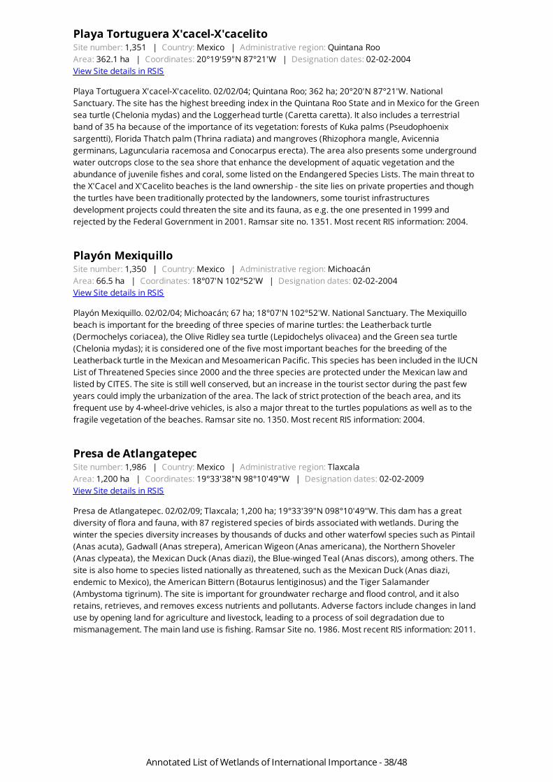
Playa Tortuguera X'cacel-X'cacelitoSite number: 1,351 | Country: Mexico | Administrative region: Quintana RooArea: 362.1 ha | Coordinates: 20°19'59"N 87°21'W | Designation dates: 02-02-2004View Site details in RSIS
Playa Tortuguera X'cacel-X'cacelito. 02/02/04; Quintana Roo; 362 ha; 20°20'N 87°21'W. NationalSanctuary. The site has the highest breeding index in the Quintana Roo State and in Mexico for the Greensea turtle (Chelonia mydas) and the Loggerhead turtle (Caretta caretta). It also includes a terrestrialband of 35 ha because of the importance of its vegetation: forests of Kuka palms (Pseudophoenixsargentti), Florida Thatch palm (Thrina radiata) and mangroves (Rhizophora mangle, Avicenniagerminans, Laguncularia racemosa and Conocarpus erecta). The area also presents some undergroundwater outcrops close to the sea shore that enhance the development of aquatic vegetation and theabundance of juvenile fishes and coral, some listed on the Endangered Species Lists. The main threat tothe X'Cacel and X'Cacelito beaches is the land ownership - the site lies on private properties and thoughthe turtles have been traditionally protected by the landowners, some tourist infrastructuresdevelopment projects could threaten the site and its fauna, as e.g. the one presented in 1999 andrejected by the Federal Government in 2001. Ramsar site no. 1351. Most recent RIS information: 2004.
Playón MexiquilloSite number: 1,350 | Country: Mexico | Administrative region: MichoacánArea: 66.5 ha | Coordinates: 18°07'N 102°52'W | Designation dates: 02-02-2004View Site details in RSIS
Playón Mexiquillo. 02/02/04; Michoacán; 67 ha; 18°07'N 102°52'W. National Sanctuary. The Mexiquillobeach is important for the breeding of three species of marine turtles: the Leatherback turtle(Dermochelys coriacea), the Olive Ridley sea turtle (Lepidochelys olivacea) and the Green sea turtle(Chelonia mydas); it is considered one of the five most important beaches for the breeding of theLeatherback turtle in the Mexican and Mesoamerican Pacific. This species has been included in the IUCNList of Threatened Species since 2000 and the three species are protected under the Mexican law andlisted by CITES. The site is still well conserved, but an increase in the tourist sector during the past fewyears could imply the urbanization of the area. The lack of strict protection of the beach area, and itsfrequent use by 4-wheel-drive vehicles, is also a major threat to the turtles populations as well as to thefragile vegetation of the beaches. Ramsar site no. 1350. Most recent RIS information: 2004.
Presa de AtlangatepecSite number: 1,986 | Country: Mexico | Administrative region: TlaxcalaArea: 1,200 ha | Coordinates: 19°33'38"N 98°10'49"W | Designation dates: 02-02-2009View Site details in RSIS
Presa de Atlangatepec. 02/02/09; Tlaxcala; 1,200 ha; 19°33'39"N 098°10'49"W. This dam has a greatdiversity of flora and fauna, with 87 registered species of birds associated with wetlands. During thewinter the species diversity increases by thousands of ducks and other waterfowl species such as Pintail(Anas acuta), Gadwall (Anas strepera), American Wigeon (Anas americana), the Northern Shoveler(Anas clypeata), the Mexican Duck (Anas diazi), the Blue-winged Teal (Anas discors), among others. Thesite is also home to species listed nationally as threatened, such as the Mexican Duck (Anas diazi,endemic to Mexico), the American Bittern (Botaurus lentiginosus) and the Tiger Salamander(Ambystoma tigrinum). The site is important for groundwater recharge and flood control, and it alsoretains, retrieves, and removes excess nutrients and pollutants. Adverse factors include changes in landuse by opening land for agriculture and livestock, leading to a process of soil degradation due tomismanagement. The main land use is fishing. Ramsar Site no. 1986. Most recent RIS information: 2011.
Annotated List of Wetlands of International Importance - 38/48

Presa JalpanSite number: 1,352 | Country: Mexico | Administrative region: QuerétaroArea: 68 ha | Coordinates: 21°12'N 99°28'W | Designation dates: 02-02-2004View Site details in RSIS
Presa Jalpan. 02/02/04; Querétaro; 68 ha; 21°12'N 099°28W. The Jalpan dam was built on the riverbed ofthe Jalpan river, its only water source; it has a maximum capacity of 8 million liters and is a breeding siteand shelter for 33 resident and migratory bird species. The greatest colonies are the NeotropicCormorant (Phalacrocorax brasilianus) and some herons like the Snowy egret (Egretta thula), the Cattleegret (Bubulca ibis), and the Great egret (Casmerodius albus). There are in total 140 bird species aroundthe dam, including waterfowl. Of the "non water" species, 8 have a special protection status and 5 areendemic in Mexico. Around the dam several mammal species can be found like the White-nosed Coati(Nasua narica), the Tree Ocelot (Leopardus weidii), the Jaguarondi (Herpailurus yagouaroundi) andoccasionally the Cougar or Florida Panther (Felis concolor). The Jalpan dam is used primarily for watersupply for domestic uses. Sedimentation caused by deforestation and erosion is the main threat to thearea, though massive tourism is also a potentially key factor. Ramsar site no. 1352. Most recent RISinformation: 2004.
Presa La VegaSite number: 2,026 | Country: Mexico | Administrative region: Estado de JaliscoArea: 1,950 ha | Coordinates: 20°37'59"N 103°50'49"W | Designation dates: 02-02-2010View Site details in RSIS
Presa La Vega. 02/02/10; Jalisco; 1,950 ha; 20°37'59"N 103°50'50"W. An artificial wetland including adam and open water, permanent and intermittent rivers and streams, and the irrigation systemsurrounding the reservoir. The site has a high socio-economic importance because it is the largest waterbody in the state's central-western area, which generates jobs and is the main source of water forsurrounding irrigation systems. It sustains a diversity of waterfowl species, some of which are protectedunder national law, such as the wood duck (Aix sponsa), as well as endemic fish like the Butterfly Splitfin(Ameca splendens). The main threat to the site is water pollution from neighboring communities. Amanagement plan adopted in 2008 is being partially implemented. Ramsar Site no. 2026. Most recentRIS information: 2011.
Presa Manuel Ávila CamachoSite number: 2,027 | Country: Mexico | Administrative region: PueblaArea: 23,612 ha | Coordinates: 18°55'N 98°10'58"W | Designation dates: 02-02-2012View Site details in RSIS
Presa Manuel Ávila Camacho (Presa Valsequillo). 02/02/12; Puebla; 23,612 ha; 18º55'00"N 098º10'58"W.Located on the southern side of the municipality of Puebla, the site is part of a network of conservationsites and part of an important wildlife corridor. It is also a center where three key endemism areas of theecoregions Temperate Sierras and Dry tropical forest converge. The site provides refuge to at least 97species of migratory birds, representing at least the 42% of the species recorded in the site. It alsoharbors a wide range of species of birds, mammals and reptiles under national protection, as well as theIUCN Red-Listed Chestnut-collared Longspur (Calcarius ornatus). Besides the ecological services that itprovides, the long cultural history of the site is an important heritage of humanity. Its zone of influenceprovides considerable documentation of prehispanic civilizations, including the oldest evidence of humanpresence in America, and the present city, founded in 1531, was one of the most important colonial citiesand is now Mexico's fourth largest. Challenges to the site include urban and industrial growth; anddeforestation is a problem for the whole area. Ramsar Site no. 2027. Most recent RIS information: 2011.
Annotated List of Wetlands of International Importance - 39/48

Reserva de la Biosfera Archipiélago de RevillagigedoSite number: 1,357 | Country: Mexico | Administrative region: ColimaArea: 636,685 ha | Coordinates: 18°49'59"N 112°46'59"W | Designation dates: 02-02-2004View Site details in RSIS
Reserva de la Biosfera Archipiélago de Revillagigedo. 02/02/04; Mexican Island Territory; 636,685 ha;18°50'N 112°47'W. Reserva de la Biosfera. Nearly 400km offshore in the Pacific Ocean, this volcanicarchipelago is home to a unique set of endemic flora and fauna as well as well-preserved terrestrial andmarine ecosystems. Isla Socorro is the largest island, with the Evermann volcano peaking 1050 meters,followed by Clarión, San Benedicto and Roca Partida islands. Socorro presents an interesting array ofvegetation following the altitudinal gradient, featuring coastal halophytes, shrubs of Dodonaea viscosa,Guettarda insularis, Croton masonii; forests of Figs Ficus cotinifolia, Bumelia socorroensis and Psidiumgalapageium. Ten endemic species and subspecies of birds have been recorded in Socorro; however,three of them, including the Soccorro Dove Zenaida graysoni are considered extinct in the wild (there areplans of reintroduction with several captive individuals in Germany). The site is well preserved anduninhabited, apart from some navy officers. Diving and fishing groups visit the islands regularly. Volcaniceruptions, hurricanes and fires pose risks to the islands' wildlife, but invasive species remain the mainthreat. The federal government funds a group of technicians to eradicate introduced sheep, pigs andrabbits. A management plan is in place. Ramsar site no. 1357. Most recent RIS information: 2004.
Reserva de la Biosfera Banco ChinchorroSite number: 1,353 | Country: Mexico | Administrative region: Quintana RooArea: 144,360 ha | Coordinates: 18°34'59"N 87°19'59"W | Designation dates: 02-02-2004View Site details in RSIS
Reserva de la Biosfera Banco Chinchorro. 02/02/04; Quintana Roo; 144,360 ha; 18°35'N 87°20'W.Reserva de la Biosfera. Reefs complex classified as a false atoll, or platform reef, the lagoon containsseagrass beds and sandy areas, with an average depth of 6m. It has four types of habitats: coral reefs,seagrass beds, sandy areas and mangroves. At least 15 species of threatened fauna and flora arepresent in this area, despite its small size. Two species of great economic importance are also present inthe lagoon: the Spiny lobster (Panulirus argus) and the Queen conch (Strombus gigas) - controlled fishingtechniques allow for the conservation of both species. The merging parts of the area are frequently usedby migratory and local birds for feeding and resting. Fishing is the only economic activity in the area butsome tourist plans may prove to be a threat. Gathering of information for designation of the site wassupported by the Ramsar Wetlands for the Future Initiative. Ramsar site no. 1353. Most recent RISinformation: 2004.
Reserva de la Biosfera Chamela-CuixmalaSite number: 1,334 | Country: Mexico | Administrative region: JaliscoArea: 13,142 ha | Coordinates: 19°28'59"N 104°58'59"W | Designation dates: 02-02-2004View Site details in RSIS
Reserva de la Biosfera Chamela-Cuixmala. 02/02/04; Jalisco; 13,142 ha; 19°29'N 104°59'W. Reserva de laBiosfera. The site comprises a mountainous landscape, rocky coasts and a deltaic plain on the Pacificcoast, noteworthy for its communities of deciduous tropical forest. The estuary of the Cuixmala River andthe lagoons of El Corte y La Manzanillera are home of a population of 600 American Crocodiles andnesting site of several marine turtles and the southernmost colony of Least Terns Sterna antillarum. Theforests host pumas, ocelots and jaguars and is the only known site for the rat Xenomys nelsoni. Thereserve is uninhabited and the vegetation is well preserved. Fishing, hunting and scientific research byUNAM are the main human activities, thus making the site one of the best known tropical areas in termsof ecology. A management plan is being implemented. Ramsar site no. 1334. Most recent RISinformation: 2004.
Annotated List of Wetlands of International Importance - 40/48

Reserva de la Biosfera La EncrucijadaSite number: 815 | Country: Mexico | Administrative region: ChiapasArea: 144,868 ha | Coordinates: 15°10'59"N 92°52'59"W | Designation dates: 20-03-1996View Site details in RSIS
Reserva de la Biosfera La Encrucijada. 20/03/96; Chiapas; 144,868 ha; 15°11'N 092°53'W. Reserva de laBiosfera. The only area in Chiapas that protects the ecosystems, fauna, and flora of coastal wetlands.Composed of coastal lagoons, swamps and marshes forming the largest area of mangrove forest in theNorth American Pacific, it is also the only zapotonal woodland (Pachira acuatica) in Central America. Thesite supports a large variety of wildlife that is threatened, endemic, rare, or in danger of extinction. 183bird species have been reported, and it is a temporary and seasonal habitat for numerous migratoryspecies. Nine of 19 vegetative associations recorded for Chiapas are present. Archaeological remainsfrom 5,500 years ago are found as well. Human activities include an important commercial fishery,slash-and-burn agriculture, extensive cattle ranching, and exploitation of the area's fauna.Sedimentation due to poorly planned water projects, deforestation, and slash-and-burn agricultureimpact upon lagoons and lakes. Ramsar site no. 815. Most recent RIS information: 2001.
Reserva de la Biosfera Los PetenesSite number: 1,354 | Country: Mexico | Administrative region: CampecheArea: 282,857 ha | Coordinates: 20°10'59"N 90°31'59"W | Designation dates: 02-02-2004View Site details in RSIS
Reserva de la Biosfera Los Petenes. 02/02/04; Campeche; 282,857 ha; 20°11'N 090°32'W. Reserva de laBiosfera. Located in the western Yucatan peninsula just north of the city of Campeche, whose old town isa World Heritage Site. Los Petenes owes its name to this unique ecosystem, consisting of islands of lowseasonally flooded and/or mangrove forests associated with underwater springs from sinkholes orcenotes. The marine parts of the site are noteworthy for their seagrass beds, while inland the landscapeis dominated by a saline wetland dotted with petenes. Worth highlighting are the communities of ButtonMangrove Conocarpus erectus and Campeche Wood Haematoxylum campechianum. There are severalglobally near-threatened species, such as the Horseshoe Crab Limulus polyphemus and the Jabiru Jabirumycteria. The site also hosts relatively large colonies of the White Ibis Eudocimus albus and GreaterFlamingoes Phoenicopterus ruber. Cod, sardines, shrimp and octopus fishing are the main humanactivities in the site. Overfishing of stocks and illegal tree felling are the main problems, as well as thelack of the implementation of the management plan. In 2003, a joint council of several institutions wasestablished to carry out a conservation initiative in western Yucatan. Ramsar site no. 1354. Most recentRIS information: 2004.
Reserva de la Biosfera Pantanos de CentlaSite number: 733 | Country: Mexico | Administrative region: TabascoArea: 302,706 ha | Coordinates: 18°18'N 92°27'W | Designation dates: 22-06-1995View Site details in RSIS
Reserva de la Biosfera Pantanos de Centla. 22/06/95; Tabasco; 302,706 ha; 18°18'N 092°27'W. Reservade la Biosfera. Hydrologically, one of the most important sites of its kind in Mesoamerica, influencing theecology from southern Mexico to northern Guatemala. The site consists of 110 (permanent andtemporary) freshwater bodies important for fishing and flood regulation. Permanently floodedfreshwater swamp is the most prevalent wetland type, and the site includes brackish lagoons, estuaries,mangroves, seasonally flooded saltmarshes, freshwater swamps and agricultural land. The lagoons playa key role in the life cycles of many marine species. The area has one of the most important aquaticvascular floras of Mesoamerica, consisting of 76 plant species used by people, 13 rare or threatenedspecies of flora, and several nationally or internationally rare or threatened species of animals. Landuses include various traditional subsistence activities. The fishery is the most important source of proteinand income for local people. There is intensive commercial hunting. Ramsar site no. 733. Most recent RISinformation: 2001.
Annotated List of Wetlands of International Importance - 41/48

Reserva de la Biosfera Ría CelestúnSite number: 1,333 | Country: Mexico | Administrative region: Yucatán, CampecheArea: 81,482.3 ha | Coordinates: 20°45'N 90°22'W | Designation dates: 02-02-2004View Site details in RSIS
Reserva de la Biosfera Ría Celestún. 02/02/04; Yucatán; 81,482 ha; 20°45'N 090°22'W. Reserva de laBiosfera. A diverse complex of wetlands including mangroves, seagrass beds, small estuaries, coastaldunes, hypersaline coastal lagoons, karstic caves and other coastal wetland types. Fresh water fromsubterranean aquifers have an outlet in the site. Eight specific vegetation zones are present, providinghabitat for several notable or endangered species of plants. The vegetative diversity gives rise to anabundant fauna, representing a high percentage of species known in the Yucatan, including numerousthreatened or endangered species. The site is of particular importance as a nesting and feeding site forturtles and migratory birds. Human activities include fishing, tourism, and salt extraction. Specialresearch and educational efforts are devoted to the protection and conservation of biodiversity in thearea. Ramsar site no. 1333. Most recent RIS information: 2004.
Reserva Estatal El PalmarSite number: 1,328 | Country: Mexico | Administrative region: YucatánArea: 50,177.4 ha | Coordinates: 21°03'N 90°12'W | Designation dates: 27-11-2003View Site details in RSIS
Reserva Estatal El Palmar. 27/11/03; Yucatán; 50,177 ha; 21°03'N 090°12'W. State Reserve. The site lieson the northwestern coast of the Yucatán peninsula and features mangroves, seagrass beds and tidalflats, as well as coastal dune vegetation, petenes (emerging islands of forests protected from salineintrusions), sinkholes or cenotes, swamp forests and low deciduous forest. El Palmar harbours asignificant population of Greater Flamingos Phoenicopterus ruber, and 15 duck species have beenrecorded. The site also provides nesting ground for the endangered Hawksbill turtle Eretmochelysimbricata, for which a nest survey and liberation programme is underway. Fishing, agriculture, huntingand palm leaf collection are the main economic activities, which also represent the main potentialthreats to the site. Federal, state and municipal authorities as well as NGOs, communities and academicinstitutions participate in a board that manages the reserve. Training, restoration and awarenessactivities have been carried out successfully. Ramsar site no. 1328. Most recent RIS information: 2003.
Río SabinasSite number: 1,769 | Country: Mexico | Administrative region: Coahuila de ZaragozaArea: 603,123 ha | Coordinates: 27°52'59"N 101°09'W | Designation dates: 02-02-2008View Site details in RSIS
Río Sabinas.02/02/08; Coahuila de Zaragoza; 603,123 ha; 27°53'N 101°09'W. Natural ResourcesProtection Area. The Rio Sabinas sub-basin, belonging to the Neartic region and influenced byNeotropical elements, is considered one of the most important of the state of Coahuila and itsprotection, conservation and restoration are considered a high priority for its great ecological andeconomical importance. The vegetation of the area is mainly represented by semiarid brushes and smalloak communities and riparian vegetation. It supports endemic species such as Yucca coahuilenses.Among the endangered species supported are the Castor canadensis mexicanus, Erethizon dorsatumcouesi, and the Ursus americanus eremicus. Its name comes from the great number of Montezuma Baldcypress (Taxodium mucronatum) found along the shores of the river. Ramsar site no. 1769. Most recentRIS information: 2008.
Río San Pedro - MeoquiSite number: 2,047 | Country: Mexico | Administrative region: ChihuahuaArea: 374 ha | Coordinates: 28°16'59"N 105°26'39"W | Designation dates: 02-02-2012View Site details in RSIS
Annotated List of Wetlands of International Importance - 42/48

Santuario Playa Boca de Apiza - El Chupadero - El TecuanilloSite number: 1,764 | Country: Mexico | Administrative region: ColimaArea: 40 ha | Coordinates: 18°48'N 103°43'59"W | Designation dates: 02-02-2008View Site details in RSIS
Santuario Playa Boca de Apiza - El Chupadero - El Tecuanillo. 02/02/08; Colima; 40 ha; 18o45'N103o49'W. Natural coastal wetland with dominant thorn scrubs and low deciduous forest vegetation, andin the surroundings, coastal dunes, seagrass beds and mangroves. Three of the 7 species of marineturtles registered in Mexico hatch their eggs in these beaches: Lepidochelys olivacea, Dermochelyscoriacea, and Chelonia agassizi. The Sanctuary provides a habitat for a number of resident andmigratory, terrestrial and aquatic birds, many of which are threatened or endangered, such as the WoodStork (Mycteria americana), the Reddish Egret (Egretta rufescens), the Great Blue Heron (Ardeaherodias), the Bare-throated Tiger-Heron (Tigrisoma mexicanum), and the Agami Heron (Agamiaagami). Agriculture, livestock, fishing and tourism are the most common activities in the site. Among thethreats are the hunting of female turtles during their hatching period to obtain meat, eggs, oil,depredation of nests by wild and introduced species, and contamination of nest zones, among others.The site is listed under IUCN Management Categories: Ia (Strict Nature Reserve), Ib (Wilderness Area), IV(Habitat/Species Management Area) and VI (Managed Resource Protected Area). The Park has had amanagement plan since 2003. Ramsar site no. 1764. Most recent RIS information: 2008.
Sian Ka'anSite number: 1,329 | Country: Mexico | Administrative region: Quintana RooArea: 652,193 ha | Coordinates: 19°30'N 87°37'W | Designation dates: 27-11-2003View Site details in RSIS
Sian Ka'an. 27/11/03; Quintana Roo; 652,193 ha; 19°30'N 087°37'W. World Heritage Site, UNESCOBiosphere Reserve, Wildlife Protection Area. The site lies on a large karstic plain along a 120km-longbarrier reef. Two large, shallow bays surrounded by mangroves, as well as numerous sinkholes orcenotes, are main landmarks in a landscape of tropical deciduous forests. Endemic communities ofswamp forests and of petenes, emerging islands of forests protected from saline intrusions, are mostlypristine and of global significance. There is a wealth of flora and fauna, including 320 bird species and 5Neotropical felines. Endangered species include Green, Loggerhead, Hawksbill and Leatherback turtles,American and Belize Crocodiles Crocodylus acutus and C. moreletii, Baird's Tapir Tapirus bairdii, JaguarPanthera Onca, Puma Puma concolor, American Manatee Trichechus manatus and Sperm WhalesPhyseter catodon. Mayan archeological sites have been found in the Reserve. Several tree species areused for wood, and forest products such as thatch palm leaves and resin for chewing gum are extracted.The main problems are due to overfishing, increasing tourism, forest fires and invasive species. There isa management plan in place and several research activities have been undertaken. A communityprogram training locals as tourist guides has started in order to manage tourism beneficially. Ramsarsite no. 1329. Most recent RIS information: 2003.
Sistema de Humedales Remanentes del Delta del Río ColoradoSite number: 1,822 | Country: Mexico | Administrative region: Baja California, SonoraArea: 127,614 ha | Coordinates: 32°19'N 115°15'W | Designation dates: 02-02-2008View Site details in RSIS
Sistema de Humedales Remanentes del Delta del Río Colorado. 02/02/2008; Baja California and Sonora;127,614 ha; 32°19´N 115°15´W. This site includes the remanents of the Delta of the Colorado River(Ramsar site 814), and is of great importance, as it represents and ideal habitat for many migratory andresident species in a desert area in the northwest of Mexico. This wetlands form part of the PacificFlyway of migratory waterfowl in their journey from Canada or the U.S. to the south of the continent,including species such as Dendroica coronata, Tachycineta bicolor, Vermivora celata. Other bird speciesuse it as reproduction and nesting grounds, such as is the case of Charadrius vociferans andHimantopus mexicanus. This wetlands present several values at a regional level, including the rechargeof aquifers in a desert area, the prevention of floods, among others. Agriculture is the main activityundertaken in this area.
Annotated List of Wetlands of International Importance - 43/48

Sistema de Lagunas Interdunarias de la Ciudad de VeracruzSite number: 1,450 | Country: Mexico | Administrative region: VeracruzArea: 140.6 ha | Coordinates: 19°10'N 96°10'W | Designation dates: 02-02-2005View Site details in RSIS
Sistema de Lagunas Interdunarias de la Ciudad de Veracruz. 02/02/05; Veracruz; 141 ha. 19°10'N096°10'W. On the periphery of the city of Veracruz and within the city itself, 18 humid dune slackscomprise the site, the largest being Laguna Olmeca with 60 ha. These are rare geomorphologic featuresthat have permanent water but depend entirely of rainfall recharging the aquifers. Communities ofjointed flatsedge Cyperus articulatus, Frog fruit Phyla nodiflora, Cattail Typha latifolia, and Pontederiasagittata populate the site. Noteworthy fauna include Western grebe Aechmophorus occidentalis, SnowyEgret Egretta thula, American Coot Fulica americana, Black-bellied Whistling-Duck Dendrocygnaautumnalis and Wood Stork Mycteria americana. Filling or dredging for land reclamation andurbanization are the biggest threats to the lagoons, and many have already disappeared, thus reducingthe flood control services the slacks provide for the city. Low water quality is also a concern in most ofthe lagoons. Foot paths have been constructed along the shores and some restoration work has beencarried out, dredging sediments in some of the water bodies. The municipality of Veracruz has recentlytaken over the management and restoration of the lagoon system. Ramsar site no. 1450. Most recent RISinformation: 2004.
Sistema de Represas y Corredores biológicos de la Cuenca Hidrográficadel Río NecaxaSite number: 1,796 | Country: Mexico | Administrative region: Hidalgo, PueblaArea: 1,541.4 ha | Coordinates: 20°09'N 98°03'W | Designation dates: 02-02-2008View Site details in RSIS
Sistema de Represas y Corredores biológicos de la Cuenca Hidrográfica del Río de Necaxa. 02/02/2008;Hidalgo and Puebla; 1,541 ha; 20° 09' N 98° 04' W. Located in the central area of the Mexican Republic,this site is composed by 5 dams which are part of the Necaxa River Basin. This system acts as a corridorfor aquatic and semiaquatic waterfowl such as Casmerodius albus, Egretta thula, Egretta caerulea,Phalacrocorax olivaceus, Ceryle torquita, Chloroceryle americana, among others. It also supportsendangered species listed in the Mexican normative such as Cyathea mexicana and Litobathes (Rana)pueblae. The main landuse consists in water storage for electric energy production, and at a minor scale,forestry activities are practiced around the dams. The site is contained in the Natural ResourcesProtection Area Zona Protectora Forestal Vedada Cuenca Hidrográfica del Río Necaxa.
Sistema Estuarino Boca del CieloSite number: 1,770 | Country: Mexico | Administrative region: ChiapasArea: 8,931 ha | Coordinates: 15°48'N 93°34'59"W | Designation dates: 02-02-2008View Site details in RSIS
Sistema Estuarino Boca del Cielo.02/02/08; Chiapas; 8,931 ha; 15°48'N 93°35'W. Marine Turtle Reserve.Coastal wetland with predominantly dune and coastal brush vegetation. The site is important for thespawning of three endangered turtle species: Lepidochelys olivacea, Dermochelys coriacea, andChelonia agassizi. The marshes and channels are strongly influenced by mangrove vegetation, includingRhizophora mangle, Laguncularia racemosa, Avicenia germinans and Conocarpus erecta. The systemsupports endangered and threatened species of migratory and resident birds, and commercial andsubsistence fishing is practiced along the beaches. The main threats include the plundering of turtlenests, pollution of the spawning zones, the construction of infrastructure and tourist development,tropical depressions, thunderstorms, and hurricanes that lead to flooding. Environmental education andpublic awareness programs are developed through a project for the conservation and protection ofmarine turtles. Ramsar site no. 1770. Most recent RIS information: 2008.
Annotated List of Wetlands of International Importance - 44/48

Sistema Estuarino Puerto AristaSite number: 1,823 | Country: Mexico | Administrative region: ChiapasArea: 62,138.5 ha | Coordinates: 16°00'N 93°52'59"W | Designation dates: 02-02-2008View Site details in RSIS
Sistema Estuarino Puerto Arista. 02/02/2008; Chiapas; 62,138 ha; 16°00' N 93°39'W. This estuarinesystem is a natural coastal wetland. The main flora species includes Pithecellobium dulce, Coccolobacaracasana, Acanthocerus pentagonus, Bursera excelsa, among others. In the estuarine zone, 4mangrove species can be found (Rhizophora mangle, Laguncularia racemosa, Avicennia germinans yConocarpus erecta). Its beaches are used as nesting grounds by the endangered marine turtles:Lepidochelys olivacea, Dermochelys coriacea and Chelonia agassizi. The presence of juveniles ofEretmochelys imbricata bissa has also been registered in the site. The site is considered an ImportantBird Area (IBA), and supports many resident and migratory waterfowl such as Recurvirostra americana,Tringa flavipes, Tringa melanoleuca, Calidris minutilla. The main activities undertaken are fishing ofsubsistence, touristic activities, as well as furtive use of marine turtles that use this area for nesting.
Sistema Lacustre Ejidos de Xochimilco y San Gregorio AtlapulcoSite number: 1,363 | Country: Mexico | Administrative region: Distrito FederalArea: 2,657 ha | Coordinates: 19°16'59"N 99°04'W | Designation dates: 02-02-2004View Site details in RSIS
Sistema Lacustre Ejidos de Xochimilco y San Gregorio Atlapulco. 02/02/04; Distrito Federal; 2,657 ha;19°17'N 099°04'W. Protected area; World Heritage Site. A remaining ecosystem of the Mexico valleysurrounded by the urban growth of Mexico City, consisting of seasonal freshwater lakes feeding fromgroundwater deposits, the site maintains today the cultural traditions of chinampas (crops in thewetlands). Vegetation is mainly of cattail Typha latifolia, bulrush Schoenoplectus americanus, theinvasive water hyacinth Eichhornia crassipes, and trees such as Salix bonplandiana. The vulnerableAxolotl Salamander Ambystoma mexicanum inhabits the site, as well as other threatened or endemicspecies of reptiles, amphibians and birds. Water levels in the aquifers are being depleted, thus causingthe terrain to sink and the soil to dry. Eutrophication, pollution, silting, salinization and invasive speciesare putting pressure on the site, not to mention the impacts of the surrounding urban environment.During weekends, thousands of tourist draw to the site for rides in typical boats (trajineras). Amanagement plan is due to be ready in 2004. Ramsar site no. 1363. Most recent RIS information: 2004.
Sistema Lagunar Agiabampo - Bacorehuis - Río Fuerte AntiguoSite number: 1,797 | Country: Mexico | Administrative region: Sonora, SinaloaArea: 90,804.4 ha | Coordinates: 26°10'N 109°13'59"W | Designation dates: 02-02-2008View Site details in RSIS
Sistema Lagunar Agiabampo Bacrehuis Río Fuerte Antiguo. 02/02/08; Sonora; 90,804 ha; 26° 12´ N and109° 14´ W. This estuarine system is located in the coastal area south of the state of Sonora and to thenorth of the state of Sinaloa, with direct communication with the Gulf of California. It consists of fivebodies of water, almost all linked to each other, sharing a single opening to the Gulf of California, as wellas sharing two bays and many estuaries. In the bodies of water there is no important freshwater supply,except for the Agiabampo Bacorehuis lagoon, which is important because it is surrounded, as well asthe estuaries, by Red mangrove (Rhizophora mangle), Black mangrove (Aviciennia germinans), Whitemangrove (Laguncularia racemosa) and Buttonwood mangrove (Conocarpus erectus). Agriculture,fisheries, aquaculture and tourism are economic activities that are practiced in the area and havenegative impacts on the site, posing a threat to the biodiversity of the area. The site is located in themigratory pathway of various species of birds, providing them food and protection; it is also an area ofrefuge, feeding and growth for aquatic species such as crustaceans, fish, mollusks and marinemammals. The resident and migratory birds are represented by seventy species of which nine areendangered. The site is proposed as a priority area for conservation by Ducks Unlimited and isconsidered an Important Bird Area (IBA).
Annotated List of Wetlands of International Importance - 45/48

Sistema Lagunar AlvaradoSite number: 1,355 | Country: Mexico | Administrative region: VeracruzArea: 267,010 ha | Coordinates: 18°39'N 95°51'W | Designation dates: 02-02-2004View Site details in RSIS
Sistema Lagunar Alvarado. 02/02/04; Veracruz; 267,010 ha; 18°39'N 095°51'W. A lagoon and estuarinecomplex comprising several coastal brackish lagoons, more than 100 interior lagoons and parts of thePapaloapan, Acula, Blanco and Limón rivers. The site features representative and diverse ecosystems ofthe coastal plain of the Gulf of Mexico, such as coastal dunes, reedbeds of Cyperus spp., cattail Typhaspp., palm forests of Sabal mexicana, Scheelea liebmaniim Acrocomia mexicana, oak forests of Quercusoleoides; apompales (Pachira aquatica); and large mangrove forests. It is regarded as the mostimportant site for the American Manatee Trichechus manatus in Veracruz. Silting, agriculturalexpansion, mangrove cutting and extensive cattle raising are threatening the site, as are increases infish catch and the use of banned fishing nets. The area is highly regarded as of conservation priority andlisted as an Important Bird Area. The Biological Research Institute of the Universidad Veracruzana hascarried out several research activities in the area. Ramsar site no. 1355. Most recent RIS information:2004.
Sistema Lagunar CeutaSite number: 1,824 | Country: Mexico | Administrative region: SinaloaArea: 14,973 ha | Coordinates: 24°01'N 107°04'W | Designation dates: 02-02-2008View Site details in RSIS
Sistema Lagunar Ceuta. 02/02/2008; Sinaloa; 1,497 ha; 24°01'N 107°04'W. Located in the North West ofMexico, this system is formed by several lagoon complexes and marshes and has an importantextension of mangrove vegetation including the following species: Conocarpus erecta, Rhizophoramangle, Laguncularia racemosa and Avicennia germinans. It is considered a Site of Regional Importanceby the Western Hemisphere Shorebird Reserve Network (WHSRN) in Mexico, supporting populations of :Calidris mauri 20,000, Phalaropus tricolor 15,000, Recurvirostra americana 15,000, Charadriusalexandrinus 650, and Sterna maxima 2,500. Its beaches are used by the Leatherback turtle(Lepidochelys olivacea) as a nesting ground. The main activities undertaken in the site are fishing,aquiculture and agriculture. The site is also found under the Sanctuary category at a national level.
Sistema Lagunar Estuarino Agua Dulce - El ErmitañoSite number: 1,825 | Country: Mexico | Administrative region: JaliscoArea: 1,281.4 ha | Coordinates: 20°00'N 105°30'W | Designation dates: 02-02-2008View Site details in RSIS
Sistema Lagunar Estuarino Agua Dulce El Ermitaño. 02/02/2008; Jalisco; 1,281 ha; 20°0'N 105°30'W. Thislagoon system is considered as the main coastal water body of the State of Jalisco, and is composed bytwo water bodies: Agua Dulce Lagoon and El Ermitaño Estuary, interconnected with a channelconstructed in the 60s, with floodgates that regulate the entrance from the estuary to the lagoon. 95species of waterfowl has been reported in the site, of which 69 species are migratory and 26 resident ofthis system and its surroundings, playing and important role for the reproduction, nesting, and feedinggrounds for these species. This system is also home to species found under special protection accordingto the Mexican normative, such as Heloderma horridum, Iguana iguana and Crocodylus acutus, asendangered, and Branta bernicla, Anas platyrhynchos y Nomonyx dominicus, as threatened. Three newspecies for the coast of Jalisco have been observed in the lagoon: Melanita perspicillata, Branta berniclaand Anas penelope. The main threats that negatively affect this system include: the diversion of waterfor agricultural purposes, the use of agrochemicals in the surrounding crops, sewage water coming fromrivers which supply the estuary, and deforestation. The main activities undertaken are fishing andtourism. The site is located next to the Marine Turtle Sanctuary El Playón de Mismaloya.
Annotated List of Wetlands of International Importance - 46/48

Sistema Lagunar San Ignacio - Navachiste - MacapuleSite number: 1,826 | Country: Mexico | Administrative region: SinaloaArea: 79,872.9 ha | Coordinates: 25°25'59"N 108°48'W | Designation dates: 02-02-2008View Site details in RSIS
Sistema lagunar San Ignacio-Navachiste-Macapule. 02/02/08; Sinaloa; 79,873 ha. 25°26´N 108°48´W.This coastal/lagoon system is situated in the Gulf of California and is habitat to 21 endangered speciesand considered of great importance for maintaining biological diversity. 87 species of terrestrial andhalofitic plants have been registered. The mangroves found in the site are Laguncularia racemosa,Avicennia germinans y Rizophora mangle. Among the noteworthy fauna found in this site are the dolphinTursiops truncatus, sea lion Zalophus californianus and three marine turtles (Chelonia agassizii,Eretmochelys imbricata and Lepidcochelys olivacea). It is considered an Important Bird Area (IBA),supporting nesting species such as Phalacrocorax olivaceus and Fregata magnifiscens and other speciessuch as Ardea herodias herodias, Cathartes aura, Pandión haliaetus and Caracara cheriway. Traditionalfishing and shrimp farming (species Litopenaeus stylirostris, L. vanamei, Farfantepenaeus californiensisand F. brevirostris) are the main activities undertaken in the site.
Sistema Ripario de la Cuenca y Estero de San José del CaboSite number: 1,827 | Country: Mexico | Administrative region: Baja California SurArea: 124,219 ha | Coordinates: 23°03'N 109°40'59"W | Designation dates: 02-02-2008View Site details in RSIS
Sistema Ripario de la Cuenca y Estero de San José del Cabo. 02/02/2008; Baja California Sur; 124,219 ha;23°03'N 109°42'W. This ecosystem is of great relevance for the region, from an hydric as well as abiological perspective, as it supports a great number of unique flora species which constitute importantcorridors and refugees for wildlife. Among this unique flora species found in the riparian system areWashingtonia robusta and Erythea brandegeei endemic of Baja California; Populus brandegeei varglabra endemic of Sierra La Laguna, as well as Prunus serotina, Ilex brandegeana, Heteromelesarbutifolia y Salíx lasiolepis. One of the main characteristics of the site is the presence of the San Joseoasis and the estuary of the same name, as it constitutes one of the greatest epicontinentalenvironments of the Baja California Peninsula, and the only one of its type in the Cabo Region. Thecharacteristic vegetation of this estuarine system is formed by typical oasis species such as palms andaquatic species. It plays an important role for migratory species, as it is the last resting stop for aquaticbird species migrating to areas in the south of Mexico, Central America or South America. A total of 217species of waterfowl have been registered in the site, of which 97 are migratory, and 19 consideredunder a risk category, such as the Sterna antillarum browni. For the role it plays for birds, this estuaryhas been recognized as an Important Bird Area (IBA). The biggest threat the site undergoes is mainlydue to a big touritic Project in Puerto Los Cabos, 800 meters away form the water body. Another threat isthe introduction of invasive species such as the Tilapia (Cryptostegia grandiflora). Since 1994, this site isconsidered an Area Subject to Ecological Conservation.
Zona Sujeta a Conservación Ecológica Cabildo - AmatalSite number: 1,771 | Country: Mexico | Administrative region: ChiapasArea: 2,832 ha | Coordinates: 14°46'N 92°27'W | Designation dates: 02-02-2008View Site details in RSIS
Zona Sujeta a Conservación Ecológica Cabildo-Amatal.02/02/08; Chiapas; 2,832 ha; 14°46'N 092°28'W.Located in the coastal planes of the Pacific, the site is considered to be in a good conservation state. Itprovides shelter for a number of flora and fauna species, including the Olive Ridley (Lepidochelysolivacea), the Boa, Boa constrictor, the Royal Duck, Cairina moschat, the Piping Plover (Charadriusmelodus), the Wood Stork (Mycteria Americana), Snail Kite (Rosthramus sociabilis), Tamandua(Tamandua mexicana) and the Margen (Leopardus wiedii), as well as the Mangrove species Rhizophoramangle and Laguncularia racemosa. The main activities practiced in the site are agriculture, livestockand fishing. The main threats include the use of agrochemicals, deforestation, flora and fauna trafficking,furtive hunting, new human settlements, and open dumpsters. Many conservation activities such asmangrove restoration are carried out. Ramsar site no. 1771. Most recent RIS information: 2008.
Annotated List of Wetlands of International Importance - 47/48

Zona Sujeta a Conservación Ecológica El Gancho - MurilloSite number: 1,772 | Country: Mexico | Administrative region: ChiapasArea: 4,643 ha | Coordinates: 14°40'59"N 92°16'59"W | Designation dates: 02-02-2008View Site details in RSIS
Zona Sujeta a Conservación Ecológica El Gancho Murillo.02/02/08; Chiapas; 4,643 ha; 14°37'N092°18'W. Located in the Physiographic Region of the Coastal Plains of the Pacific, this area has anextension of more than 280 km adjacent to the Pacific littoral, from the State of Oaxaca to Guatemala. Itpresents a compact surface of mangroves, cattails, palm forests, tropical deciduous forests andsecondary vegetation areas in different stages of development. It is mainly composed by mangroves,with dominancy of red (Rhizophora mangle) and white (Laguncularia racemosa). Regarding fauna, thefollowing species can be found: Felis pardales, Felis wiedii, Lepidochelys olivacea (categorized asendangered). The threatened species include Tamandua mexicana, Ardea herodias and Caimancrocodylus fuscus under special protection. The main land uses are agriculture, river fishing, and prawncapture, as well as livestock farming. Its beaches are a tourist attraction where sports fishing, swimming,boat rides and camping are the main activities. Ramsar site no. 1772. Most recent RIS information: 2008.
Zona Sujeta a Conservación Ecológica Sistema Lagunar CatazajáSite number: 1,765 | Country: Mexico | Administrative region: ChiapasArea: 41,059 ha | Coordinates: 17°39'N 91°43'W | Designation dates: 02-02-2008View Site details in RSIS
Zona Sujeta a Conservación Ecológica Sistema Lagunar Catazajá.02/02/08; Chiapas; 41,059 ha; 17°39'N091°43'W. System of lagoons located in the physiographic region of the southern Gulf of Mexico,characterized by smooth slopes and the presence of multiple lagoons and floodplains. The site is ofgreat importance for the conservation of three endangered species in particular: the Manatee(Trichechus manatus), the Neotropical Otter (Lontra longicaudis), and the Black Howler Monkey(Alouatta pigra). The main factors affecting this system include the rapid demographic growth, pollution,unstable socio-political situation in the area, tourism, agriculture and livestock. The site is under the IVIUCN Category (Habitat/Species Management Area) and is managed by the Natural History and EcologyInstitute. Catazajá comes from a Mayan word meaning "valley covered in water". The Park has had amanagement plan since 2003. Ramsar site no. 1764. Most recent RIS information: 2008.
Annotated List of Wetlands of International Importance - 48/48