Police Districting Problem: Literature Review and Annotated ...
20
Police Districting Problem: Literature Review and Annotated Bibliography Federico Liberatore, Miguel Camacho-Collados and Bego˜ na Vitoriano Abstract The Police Districting Problem concerns the efficient and effective design of patrol sectors in terms of performance attributes. Effectiveness is particularly im- portant as it directly influences the ability of police agencies to stop and prevent crime. However, in this problem, a homogeneous distribution of workload is also desirable to guarantee fairness to the police agents and an increase in their satis- faction. This chapter provides a systematic review of all the literature on the Police Districting Problem, whose history dates back to almost 50 years ago. Contributions are categorized in terms of attributes and solution methodology adopted. Also, an annotated bibliography that presents the most relevant elements of each research is given. 1 Introduction We are the lucky witnesses of a revolution taking place in the way police agencies work. In the last decade, we have seen the rise of Predictive Policing, i.e., the use of mathematical and statistical methods in law enforcement to predict future crim- inal activity based on past data. Its importance has been even recognized by TIME Magazine that in November 2011 named predictive policing as one of the 50 best inventions of 2011 [15]. Federico Liberatore Department of Statistics and Operational Research and Institute of Interdisciplinary Mathematics, Universidad Complutense de Madrid, Madrid, Spain , e-mail: fl[email protected] Miguel Camacho-Collados State Secretariat for Security, Interior Ministry, Madrid, Spain e-mail: [email protected] Bego˜ na Vitoriano Department of Statistics and Operational Research and Institute of Interdisciplinary Mathematics, Universidad Complutense de Madrid, Madrid, Spain , e-mail: [email protected] 1
-
Upload
khangminh22 -
Category
Documents
-
view
2 -
download
0
Transcript of Police Districting Problem: Literature Review and Annotated ...

Police Districting Problem: Literature Reviewand Annotated Bibliography
Federico Liberatore, Miguel Camacho-Collados and Begona Vitoriano
Abstract The Police Districting Problem concerns the efficient and effective designof patrol sectors in terms of performance attributes. Effectiveness is particularly im-portant as it directly influences the ability of police agencies to stop and preventcrime. However, in this problem, a homogeneous distribution of workload is alsodesirable to guarantee fairness to the police agents and an increase in their satis-faction. This chapter provides a systematic review of all the literature on the PoliceDistricting Problem, whose history dates back to almost 50 years ago. Contributionsare categorized in terms of attributes and solution methodology adopted. Also, anannotated bibliography that presents the most relevant elements of each research isgiven.
1 Introduction
We are the lucky witnesses of a revolution taking place in the way police agencieswork. In the last decade, we have seen the rise of Predictive Policing, i.e., the useof mathematical and statistical methods in law enforcement to predict future crim-inal activity based on past data. Its importance has been even recognized by TIMEMagazine that in November 2011 named predictive policing as one of the 50 bestinventions of 2011 [15].
Federico LiberatoreDepartment of Statistics and Operational Research and Institute of Interdisciplinary Mathematics,Universidad Complutense de Madrid, Madrid, Spain , e-mail: [email protected]
Miguel Camacho-ColladosState Secretariat for Security, Interior Ministry, Madrid, Spain e-mail: [email protected]
Begona VitorianoDepartment of Statistics and Operational Research and Institute of Interdisciplinary Mathematics,Universidad Complutense de Madrid, Madrid, Spain , e-mail: [email protected]
1

2 F. Liberatore, M. Camacho-Collados, B. Vitoriano
Apart from crime forecasting, mathematics still have a major role to play in polic-ing and its various disciplines can help by giving police agency a new edge in thefight against crime. This is also recognized by the RAND corporation and the Na-tional Institute of Justice of the United States (NIJ). In fact, both these prestigiousinstitutions acknowledge the need for taking a step forward and developing explicitmethodologies and tools to take advantage of the information provided by PredictivePolicing models to support decision makers in law enforcement agencies [24].
Districting models are a natural way to make use of crime forecasts to designpolice districts tailored to the criminal behavior of an area. During most of the 20thcentury, police districts were drawn by police officers on a road map with a marker,just by following the major streets in the area, or according to neighborhood perime-ters, without considering workload efficiency or balance [3]. The first model for thedesign of police district was formulated by Mitchell [23], almost 50 years ago. Sincethen, a number of mathematical optimization models have been proposed and thePolice Districting Problem (PDP) was born. The objective of the PDP is to partitionthe territory under the jurisdiction of a Police Department in the “best possible way.”PDP models normally consider several attributes, such as time, cost, performance,and other topological characteristics.
Geographic Information Systems (GIS), thanks to their ability to represent andmanipulate geographical data using a reasonable amount of computational time,gained popularity among both academics and practitioners which started to con-template the possibility of adopting automatic methodologies for the definition ofpolice districts [28]. However, studies integrating GIS and sophisticated mathemat-ical modeling for police districting remain a rarity [3], and the the design of policedistricts is often based on the experience and intuition of few experts. Nevertheless,the importance of a balanced definition of the police districts is unquestioned andthe implementation of decision-aid tools for the allocation of police resources hasproven to be extremely beneficial, as shown by the numerous papers presented inthe academic literature in the last decades [13]. In fact, all the researches reporta dramatic improvement in workload distribution compared to hand-made districtswhich, in turn, results in enhanced performances and efficiency.
In this chapter we provide a general definition for the PDP and analyze in detailall the literature on the subject. The PDP is formally presented in Section 2. InSection 3, previous contributions in this line of research are categorized in terms ofattributes considered and methodologies and approaches adopted for the problemsolution. Next, an annotated bibliography is provided, where a brief description ofthe most salient points of each research is given (see Section 4). Conclusions aregiven in Section 5.
2 The Police Districting Problem
In the United States, the territory under the jurisdiction of a police department ispartitioned according to a hierarchical structure constituted by command districts (or

Police Districting Problem: Literature Review and Annotated Bibliography 3
precincts), patrol sectors (or beats), and reporting districts (or r-districts, or blocks).Command districts host the headquarters where the commanding officer supervisesthe operations and are fractioned into patrol sectors. Patrol sectors have one or morecars assigned which patrol the area and attend to the calls for service that originate inthe sector. R-districts represent the smallest geographical unit for which statistics arekept and are, de facto, the atomic element in the hierarchy. Sarac et al. [26] explainthat r-districts can coincide with census block groups as it is convenient to do so foradministrative reasons. The territorial structure in Europe is not as homogeneous asin the United States, as it depends on the country or the region considered. However,a hierarchal structure similar to the one adopted in United States is predominant.
The PDP concerns the optimal grouping of blocks into “homogeneous” patrolsectors in such a way that all the territory is partitioned and that no sector is empty.It is desirable for the patrol sectors to be connected and topologically efficient (e.g.,compact). In fact, the car(s) assigned to the patrol sector should respond to all the in-cidents taking place in the area and, therefore, topologically efficient sectors wouldresult in a diminished travel time and, in turns, in a higher operational effectiveness.Normally, if all the cars in a sector are busy responding calls, a car from a neigh-boring sector has to attend the incoming calls. This generally leads to a dominoeffect where cars are pulled from their area to another, leaving the patrol sectorunattended and, therefore, more susceptible to criminal incidents (as pointed out byMayer [21]). In the light of this scenario, balanced workload among the districts andenforcement of a maximal response time become of primary importance.
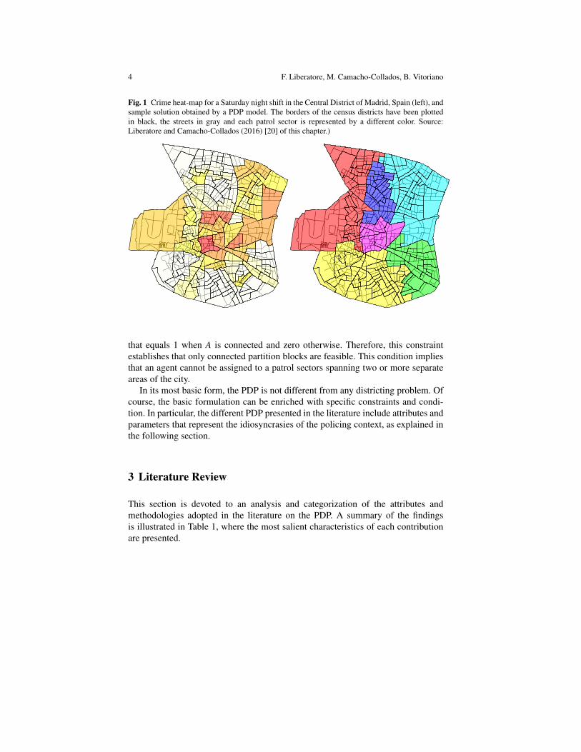
Figure 1 shows a crime heat-map for a Saturday night shift in the Central Districtof Madrid, Spains, and the corresponding PDP solution.The borders of the censusdistricts have been plotted in black, the streets in gray and each patrol sector isrepresented by a different color. It can be observed that the sector design is adjustesto provide an equitable territory partition among the beats.
A generic formulation for the PDP is given in the following.
min ob j (P) (1)s.t. /0 /∈ P (2)⋃
A∈P A = N (3)A∩B = /0 ∀A,B ∈ P |A 6= B (4)|P|= p (5)
Conn(A) = 1 ∀A ∈ P (6)(7)
The model optimizes a certain objective function evaluated on a partition P. Con-straints (2)-(4) represent the conditions held by a partition P defined on the set ofblocks N: P should not contain the empty set /0 (2), the partition covers entirely N(3) and the sectors are pairwise disjoint (4). The restriction (5) concerns the partitioncardinality and enforces the number of patrol sectors to be exactly p. Finally, condi-tion (6) regards the geometry of the patrol sectors. Conn(A) is an indicator function
4 F. Liberatore, M. Camacho-Collados, B. Vitoriano
Fig. 1 Crime heat-map for a Saturday night shift in the Central District of Madrid, Spain (left), andsample solution obtained by a PDP model. The borders of the census districts have been plottedin black, the streets in gray and each patrol sector is represented by a different color. Source:Liberatore and Camacho-Collados (2016) [20] of this chapter.)
that equals 1 when A is connected and zero otherwise. Therefore, this constraintestablishes that only connected partition blocks are feasible. This condition impliesthat an agent cannot be assigned to a patrol sectors spanning two or more separateareas of the city.
In its most basic form, the PDP is not different from any districting problem. Ofcourse, the basic formulation can be enriched with specific constraints and condi-tion. In particular, the different PDP presented in the literature include attributes andparameters that represent the idiosyncrasies of the policing context, as explained inthe following section.
3 Literature Review
This section is devoted to an analysis and categorization of the attributes andmethodologies adopted in the literature on the PDP. A summary of the findingsis illustrated in Table 1, where the most salient characteristics of each contributionare presented.

Police Districting Problem: Literature Review and Annotated Bibliography 5
Table 1: Mapping of attributes considered and methodology adopted, byarticle.
Reference Attributes MethodologyWorkload Response Time Geometry OtherMitchell (1972)[23]
Expected servicetime, expected
travel time
Expected traveltime
Modifiedclusteringheuristic
Bodily (1978) [2] Fraction of timespent servicing
calls
Average traveltime
Utility theory
Benveniste(1985) [1]
Probability of aserver beingfound busy
Total expectedstation-alarm
distance
Stochasticoptimization
Sarac et al.(1999) [26]
Homogeneity interms of
population andcall volume
Area,compactness,
contiguity
Easy access todemographic
data, suitable foruse by otheragencies, and
respect ofexisting district
boundaries
Redefinitionaccording tocensus blocks
D’Amico et al.(2002) [13]
Utilization ofservers
Queuing responsetime and travel
time
Size,compactness,
contiguity,convexity
Queuing modeland simulatedannealing
Curtin et al.(2005) [12]
Maximumincident load per
sector
Maximumservice distance
GIS andmathematicalprogrammingoptimization
Kistler (2009)[19]
Total hoursworked, number
of calls,population
Average traveltime
Area, total lengthof streets,
compactness
Boundaries ofgang territories,
city councilwards,
neighborhoodassociations, andAir Force Base
GIS
Curtin et al.(2010) [11]
Maximumincident load per
sector
Maximumservice distance
Backup coverage GIS andmathematicalprogrammingoptimization
Zhang and Brown(2013) [29]
Homogeneity interms of averagetravel time andresponse time
Average traveltime
GIS andagent-basedsimulation

6 F. Liberatore, M. Camacho-Collados, B. Vitoriano
Zhang and Brown(2014) [30]
Homogeneity interms of averagetravel time andresponse time
Average traveltime
Simulatedannealing anddiscrete-eventsimulation
Zhang and Brown(2014) [31]
Homogeneity interms of averagetravel time andresponse time
Average traveltime
GIS,experimentaldesign methods,agent-basedsimulation anddiscrete-eventsimulation
Bucarey et al.(2015) [4]
Homogeneity interms of sector
demand
Sector boundaries Preventiondemand
component
Mathematicalprogrammingoptimization
Camacho-Collados et al.(2015) [6]
Homogeneity interms of area,
risk, isolation anddiameter
Diameter. Sectorsmust be
connected andconvex.
Isolation, i.e.,how far the sector
is from othersectors
Mathematicalprogrammingoptimization
Cheung et al.(2015) [9]
Mathematicalprogrammingoptimization
Chow et al.(2015) [10]
Mathematicalprogrammingoptimization
Liberatore andCamacho-Collados (2016)[20]
Homogeneity interms of area,
risk, isolation anddiameter
Diameter. Sectorsmust be
connected andconvex.
Isolation, i.e.,how far the sector
is from othersectors
Mathematicalprogrammingoptimization
Piyadasun et al.(2017) [25]
Crime-severityweighteddistance.
Homogeneitymeasured using
Gini index.
Rectangular areaneeded to coverthe whole sector.
Isoperimetricquotient
Clusteringheuristic

Police Districting Problem: Literature Review and Annotated Bibliography 7
3.1 Attributes
While analyzing the existing literature on the PDP, certain basic features common toall contributions emerged. In fact, all the applications considered include measuresfor workload, response time, and geometrical properties of the districts. Neverthe-less, the implementation shows significant variations. Differently from Kalcsics andSchroeder [17], the denomination “attributes” has been adopted instead of “criteria”with the aim to provide a more generic framework that classifies all the relevantcharacteristics of a PDP solution, regardless of whether they are optimized in theobjective function, or expressed as constraints.
3.1.1 Workload
Given the complex nature of police procedures and operations, and the great vari-ability of tasks that an agent can undertake, defining workload could be complicated.Bruce [3] poses a number of questions that can help to clarify what to consider aspart of the workload. Albeit difficult, an accurate definition of workload is desirableas it ensures homogeneity in terms of quality and speed of service, and equalizesthe burden on police officers [2].
In the literature on the PDP, different definitions of workload have been adopted.Mitchell [23] computes the workload as the sum of the total expected service timeand the total expected travel time. Curtin et al. [12, 11] use the number (or fre-quency) of calls (or incidents) occurring at each district as a proxy for the workload.As different calls can have different service time, some authors reckon that thismeasure is too naıve as it might produce unbalanced patrol districts. For Bodily[2] and D’Amico et al. [13] workload is defined as the fraction of working timethat an agent spends attending to calls. An equivalent measure is proposed by Ben-veniste [1]. Given the stochastic nature of her model, workload is measured in termsof probability of a patrol car being busy. Once the probability is known, the timespent attending and answering calls can be easily calculated. More recently, work-load has been defined as a combination of different characteristics. Sarac et al. [26]aggregate population and call volume. Kistler [19] makes use of the convex combi-nation of total hours worked (i.e., from dispatch to call clearance), number of calls,and population. Zhang and Brown [29, 30, 31] consider both average travel timeand response time. Camacho-Collados et al. and Liberatore and Camacho-Collados[6, 20] define workload as the weighted combination of multiple attributes: area,risk, isolation and diameter. Finally, Piyadasun et al. define the workload as the sumof the distance of the district center to its crime points, weighted by the severity ofthe crime. Interestingly, equality in the distribution of the workload among patrolsectors is measured using the Gini coefficient.

8 F. Liberatore, M. Camacho-Collados, B. Vitoriano
3.1.2 Response Time
Response time is an important performance measure representing the time betweenthe arrival of a call for service and the arrival of a unit at the incident location.According to Bodily [2], the reduction of the response time results in a number ofbeneficial effects such as:
• Increased likelihood of intercepting a crime in progress.• Deterrent effect on criminals.• Increased confidence of citizens in the police.
Generally speaking, most of the authors consider exclusively travel times [23, 2, 19,29, 30, 31] or travel distances [1, 12, 11]. The only study considering queuing effectis by D’Amico [13], where the authors apply an external model - PCAM [7, 8] - tocompute the total response time including calls queuing time and travel time to theincident location.
3.1.3 Geometry
In 1812 Albright Gerry, the Governor of the State of Massachusetts at the time,manipulated the division of his state and proposed a salamander-shaped districtto gain electoral advantage, leading to the expression “gerrymandering” (resultingfrom merging “Gerry” and “salamander”). Since then, designing electoral districtshaving certain geometric properties is of primary importance to ensure neutralityand prevent political interference in the districting process.
In the context of the PDP, geometric attributes are still relevant for efficiency(e.g., establishing boundaries that would be easy to patrol and would not frus-trate patrol officers) and for administrative reasons (e.g., coordination with otheragencies). A number of researches explicitly include geometric properties in thedesign process, as the properties of compactness [26, 13, 19, 6, 20], contiguity[26, 13, 6, 20], and convexity [13, 6, 20] are generally obtained as a consequenceof optimizing the travel distance or the travel time. Also, the district area is con-sidered in all the mentioned works. Camacho-Collados et al. and Liberatore andCamacho-Collados [6, 20] achieve compactness by minimization of the sectors’diameter. Additionally, Kistler [19], Camacho-Collados et al. and Liberatore andCamacho-Collados [6, 20] include the total length of the streets in a patrol sector.
3.1.4 Other Attributes
Recently, a number of attributes that do not fall into any of the previous categorieshave been introduced by some works. These attributes generally try to capture com-plex real-world requirements. The Buffalo Police Department needed to redesignr-districts in such a way that the existing district boundaries would be respected,and the access to demographic data as well as the use by other agencies would be

Police Districting Problem: Literature Review and Annotated Bibliography 9
easy [26]. The Tucson Police Department needed to consider the boundaries of gangterritories, city council wards, neighborhood associations, and the Davis-MonthanAir Force Base [19]. Curtin et al. [11] introduce backup coverage (i.e., multiple cov-erage) of incident locations. Camacho-Collados et al. and Liberatore and Camacho-Collados [6, 20] define an isolation attribute that expresses how far the sector iswith respect to the others. The rationale is that a more isolated sector can receiveless support than a more central one. Finally, Bucarey et al. [4] propose a preventiondemand component that represent the the need for police resources used for preven-tive patrols. This component is calculated as the maximum between three factors,each multiplied by a scaling coefficient. The factors considered are: reported crime,population, and total kilometers of roads in the sector.
3.2 Methodologies and Approaches
Many districting approaches have appeared in the literature. In this subsection, thecontributions are categorized according to the methodology adopted and their maincharacteristics are presented.
3.2.1 Optimization Models
According to Kalcsics and Schroeder [17], the first mathematical program for theDistricting Problem was proposed by Hess et al. [16], and regarded the neutral defi-nition of political district. Since then, a large number of models have been presented,mostly in the context of Location Analysis. Mitchell [23] defines a Set Partitioningmodel that considers minimizing the expected distance inside of each subset andequalizing workload among all the subsets. Curtin et al. [12, 11], propose maximalcovering models. Cheung et al. (2015) [9] and Chow et al. (2015) [10] consider boththe p-median problem and the maximum coverage problem. Bucarey et al. [4] for-mulate their problem as an enriched p-median model. Finally, Camacho-Colladoset al. and Liberatore and Camacho-Collados [6, 20] introduce a Multi-Criteria Po-lice Districting Problem that provides a balance between efficience and workloadhomogeneity, according to the preferences of a decision maker. It is important tonotice that all these formulations, due to the size of the application context, are of-ten solved heuristically. This is also the case for Piyadasun et al. [25] that, despitenot presenting any mathematical formulation for their problem, solve it by means ofan ad-hoc clustering heuristic.
A different perspective is adopted by Benveniste [1] and D’Amico et al. [13],where patrol cars and agents are modeled as servers in a stochastic model. In par-ticular, Benveniste [1] proposes a Stochastic Optimization model, while D’Amicoet al. [13] include a queuing model inside of a simulated annealing algorithm tocompute response times that incorporate queuing effects.

10 F. Liberatore, M. Camacho-Collados, B. Vitoriano
3.2.2 Geographic Information Systems (GIS)
The first application of geography to crime analysis dates back to 1829, when theItalian geographer Adriano Balbi and the French lawyer Andre-Michel Guerry drewthree maps of crimes in France, highlighting geographic patterns of crime and theirrelations [18]. Since then, the marriage between geography and criminology gavebirth to numerous methodologies. When the GIS were developed, their implemen-tation in law enforcement agencies and crime research was only natural, and in thelast decade we are assisting to an extremely rapid growth of adoption, supported bythe promotion of the NIJ (United States National Institute of Justice). For a reviewof GIS application to crime research the reader is referred to the overview by Wang[28].
According to this trend, the last works on the PDP are developed in the frame-work of the GIS. Kistler [19] uses a GIS to redesign the Tucson Police Depart-ment districts. Most commercial GIS can be extended to integrate optimizationroutines. Curtin et al. [12, 11], use GIS in conjunction with a maximal coveringmodel. Finally, Zhang and Brown [29, 30, 31] implement agent-based simulationand discrete-event simulation inside of a GIS.
3.2.3 Other Methods
Two studies adopted approaches that do not fall into any of the other categories.Bodily [2] devises a decision model based on utility theory to achieve the best solu-tion with respect to the surrogate utility of three interest groups. The work by Saracet al. [26] is an example of the idiomatic expression “simpler is better.” After at-tempting to redesign r-districts by using a multi-criteria set partitioning model, theauthors realized that census blocks satisfied all the requirements. It is important tonotice that their approach is successful because of the specific requisites the Buf-falo PD had on the r-district configuration (e.g., easy access to demographic data,suitable for use by other agencies).
4 Annotated Bibliography
In the following, an annotated bibliography providing a description of the mostsalient points, achievements, and characteristics of the most relevant contributionsin the PDP is given. The contributions are presented in chronological order.

Police Districting Problem: Literature Review and Annotated Bibliography 11
Mitchell (1972) [23]
In his seminal work, Mitchell presents a mathematical formulation for the problemof designing police patrol sectors. The model is based on the assumption that in-cident distribution is known and that each call is serviced by the nearest availableunits. Multiple incident types are considered. Each type is characterized by a ser-vice time and a vector of weights that define the importance of the incident beingattended by a specified number of units. The model minimizes the total expectedweighted distance. Also, the workload, defined as the sum of the expected servicetime and the expected travel time, is equalized across the sectors. The problem issolved by means of an adapted clustering heuristic and applied to incident data forAnaheim, California. The solution improves the sector plan adopted at the time.
Bodily (1978) [2]
Bodily (1978) proposes a decision model based on utility theory, which makes useof the preferences of three interest groups in the design process of police sectors:citizens (minimize travel time, equalize travel time), administrators (minimize traveltime, equalize travel time, and equalize workload), and service personnel (equalizeworkload). The problem is solved by local search algorithm that transfers one blockfrom one sector to another, so that the greatest improvement in terms of surrogateutility is achieved. The algorithm stops when no improvement is possible.
Benveniste (1985) [1]
The author presents a stochastic optimization problem for the combined zoning andlocation problem for several emergency units. Namely, the problem involves thedivision of an area in sectors, the definition of location for the servers, and a set ofrules, assigning for service an alarm to a list of servers in order of preference. Theobjective function considered minimizes the total expected distance between thealarm and the first available server. Stochastic alarms rates, alarms spatial densityfunctions, and probabilities that the servers are busy are considered. The resultingmodel is a non-linear program. The author proposes an approximation algorithm.An equal workload case is also examined and solved.

12 F. Liberatore, M. Camacho-Collados, B. Vitoriano
Sarac et al. (1999) [26]
The authors describe a study undertaken to reconfigure the police reporting districtsused by the Buffalo Police Department. The following districting criteria were con-sidered:
• Homogeneity in terms of population, area and call volume.• Geometrical properties such as compactness and contiguity.• Feasibility with respect to existing boundaries of five police districts.• Easy access to demographic data for each district.• Suitability for use by other agencies.
Initially, the authors formulated the problem as a multi-objective set partition prob-lem which proved incapable to solve the real-world size problem at hand. Subse-quently, a practical approach has been proposed: basically, the new districts weredefined according to the census block groups that intrinsically present most of thedesired characteristics (homogeneity in terms of population, compactness, contigu-ity, easy access to demographic data, and suitable for use by other agencies). Withminor modifications, this solution proved to be very effective.
D’Amico et al. (2002) [13]
The authors solve a PDP subject to constraints of contiguity, compactness, convex-ity, and equal size. The novelty of the model lies in the incorporation of queuingmeasures to compute patrol offices workloads and response times to calls for ser-vice, computed by external software, PCAM. PCAM optimizes a queuing model fordeployment of police resources, providing the optimal number of cars per district.The authors solve the problem by means of a simulated annealing algorithm thatiteratively calls the PCAM routine. At each step, the neighborhood is determined bya simple exchange procedure that takes into account the following constraints:
• The average response time per district is bounded from above.• The ratio of the size of the largest and smallest districts is bounded from above.• Sectors must be connected.• The ratio of the longest Euclidean path and the square root of the area in each
sector is bounded from above to preserve compactness.• Sectors must be convex.
The algorithm is applied to a real-world case for the Buffalo Police Department.The following objectives were considered: minimization of the maximum workload(by decremental bounding constraining) and minimization of the maximum averageresponse time.

Police Districting Problem: Literature Review and Annotated Bibliography 13
Curtin et al. (2005) [12]
The authors apply a covering model to determine police patrol sectors. The coveringmodel defines the centers of police patrol sectors in such a way that the maximumnumber of (weighted) incidents is covered. An incident is considered to be coveredif it lies within an acceptable service distance from the center of a patrol sector. Themodel is integrated in a GIS and applied to a case study on the City of Dallas, Texas.In the final part of this chapter, the authors present a number of possible refinementsto their model, including a maximum workload restriction (in terms of number ofweighted incidents).
Scalisi et al. (2009) [27]
The issue of Geography & Public Safety presents numerous articles by police an-alysts describing their experiences with police redistricting within their police de-partment.
• Bruce (2009) [3]: C. Bruce, President of the International Association of CrimeAnalysts, poses some interesting questions that an analysts should answer to de-termine how workload should be measured.
• Kistler (2009) [19]: A. Kistler, from the Tucson Police Department, devises a dis-trict evaluation measure built as the weighted sum of the following criteria: totalhours worked, number of call responses, average response time, total length of allstreets within the division, area of the division, and population. TPD staff used aGIS in combination with a software program called Geobalance to manually de-sign alternative districting configurations. Future evaluations of the implementedplan showed that the projected workload ratios were reliable and realistic.
• Douglass (2009) [14]: J. Douglass, from the Overland Park Police Department,explains how the introduction of a new real-time deployment paradigm, basedon criminal hot-spots identification and treatment, had been implemented in thedepartment. Unfortunately, no long-term statistical analysis was available at thetime the article was written.
• Mayer (2009) [21]: A. Mayer, from the East Orange Police Department, reportsa similar strategy. In fact, the East Orange Police Department implemented ageographical technology called Tactical Automatic Vehicle Locator (TAC-AVL).TAC-AVL allows for GPS tracking, visualization on a map, and recording ofinformation regarding patrol cars and incidents. This tool has been coupled witha new deployment strategy that allows for the introduction of Impact, Resource,Response, and Conditions cars to backup understaffed zones of the jurisdiction.
• Mielke (2009) [22]: P. Mielke, from Redlands Police Department, explains howto use ESRI districting tool, a free extensions for ESRI ArcGIS that allows cre-ating new police districts in a city or region.

14 F. Liberatore, M. Camacho-Collados, B. Vitoriano
• Other successful applications of geographical technologies to police redistrictinghave been reported from Austin PD and Charlotte-Mecklenburg PD.
Curtin et al. (2010) [11]
Following Curtin et al. (2005) [12], the authors extend the covering model to includebackup coverage (e.g., multiple coverage of high priority locations). The resultingmodel is bi-objective in nature. The authors propose a single objective model thatmaximizes the priority weighted coverage (each time a location is covered is ac-counted for separately), while ensuring a minimum covering level in terms of pri-ority weighted number of locations covered (each covered location is accounted foronly once). The model is tested with the police geography of Dallas, Texas, andrefinements on the model are proposed (e.g., maximum workload per patrol sector).
Wang (2012) [28]
The author takes us on a journey across the main application areas of GIS in policepractices. Among the various applications, Wang mentions the possibility of usingGIS as a police force planning tool. Namely, he refers to hot-spot policing and policedistricting. Concerning the latter, Wang identifies three main objectives: meeting aresponse time threshold, minimizing the cost of operation, and balancing workloadacross districts. The author mentions the work by Curtin et al. (2005, 2010) [12,11] and states that future works in this area should explore other goals, such asminimizing total cost (response time), minimizing the number of sectors (dispatchcenters), maximizing equal accessibility, or a combination of multiple goals.
Zhang and Brown (2013) [29]
In this work a parametrized redistricting procedure for police patrols sectors is pro-posed. The methodology consists of a heuristic algorithm that generates alternativedistricting configurations. Next, the configurations are evaluated in terms of averageresponse time and workload. With this aim, an agent-based simulation model wasimplemented in a GIS. The location and times of the incidents taking place at eachsector are modeled by an empirical distribution based on real incident data. Finally,the procedure identifies the set of non-dominated solutions. The methodology hasbeen tested on a case study based on the Charlottesville Police Department, VA,USA.

Police Districting Problem: Literature Review and Annotated Bibliography 15
Zhang et al. (2013) [32]
The focus of this research is the evaluation of three different methods for scoringpolice districting designs: a closed form probability based approach, a discrete-eventsimulation based on hypercube models for spatial queuing systems, and an agent-based simulation model. The scoring measures are evaluated on designs generatedusing the methodology presented in Zhang and Brown (2013) [29]. According to theauthors, the three methods provide similar evaluations of the districting plans whenthe emergency response system is not stressed. However, in the face of high systemstress, only the agent-based simulation model is capable of accurately represent thesignificantly changes in the workload scores due to complex behaviors of the systemsuch as cross-boundary support, that is, when an agent assigned to a district servicesa call for service in another district.
Zhang and Brown (2014) [30]
The research presented in this paper focuses on the definition of a simulated anneal-ing algorithm for the problem of finding optimal police patrol districting designs.The optimization procedure makes use of a discrete-event simulation to evaluate thesolutions according to multiple criteria, such as average response time and work-load variation among sectors. Districting designs are generated using a simulatedannealing procedure. In this procedure two different neighborhoods are compared.In the first one, only changes of one block are allowed. The second one consists ofa cutting and merging process that allows for more significant changes. The authorsshow empirically that the second approach uses fewer iterations to reach good so-lutions and is, therefore, preferable when used in conjunction with discrete-eventsimulation.
Zhang and Brown (2014) [31]
In this paper, Zhang and Brown extend their previous research in Zhang and Brown(2013) [29]. The main changes with respect to the previous contribution are thefollowing. First, both discrete-event simulation and agent-based simulation are con-sidered. The former is more computational efficient while the latter is more precise.Second, an iterative searching procedure is used to optimize the parameters of thedistricting algorithm, instead of adopting a completely randomized approach. Theauthors propose using experimental design methods to explore the parameter space,but classical metaheuristics, such as simulated annealing and genetic algorithms,could be used as well. The methodology is tested on real data provided by the Char-lottesville Police Department, VA, USA.

16 F. Liberatore, M. Camacho-Collados, B. Vitoriano
Bucarey et al. (2015) [4]
In this paper the authors define a variant of the classical p-median problem to tacklethe problem of defining balanced police sectors. The model is designed keepingin mind the requirements of the Chilean National Police Force, but can be appliedto any country. The model proposed enriches the classical p-median in a numberof ways. First, it enforces bounds on the demand of each sectors. The bounds canbe specified according to the acceptable percentage of deviation from the averagedemand in order to ensure homogeneity. The objective function is defined as theweighted sum of three terms. The first one is the sum of the blocks distances to theassociated median. The second term enforces compactness by considering the sumof a measure of the sectors’ boundaries size. The function measuring the boundariesis non-linear in nature and is approximated by a piece-wise linear function. Finally,the third term represents the prevention demand component associated with a block.This component is defined as the maximum of three factors: the length of roadsin the block, the amount of reported crime in the block, and the population of theblock. The model is solved on a realistic case study considering 1266 blocks and upto p = 7 neighbors. Due to the size of the problem, the model is solved by means ofa location-allocation heuristic algorithm.
Camacho-Collados et al. (2015) [6]
This paper presents the Multi-Criteria Police Districting Problem (MC-PDP), amulti-criteria optimization model for partitioning the territory under the jurisdic-tion of a Police Department into sectors. The goal is the automatic definition ofsectors that adapts to a particular shift. Initially, the territory is divided into a squaregrid. Each cell of the grid (which represent a block) is characterized by a crime risk,representing the expected crime, and an area, representing the total street length. Afeasible design requires the sectors to be connected and convex. The workload foreach sector is computed as the weighted sum of different factors: area, risk, isolation(i.e., how far the sector is from other sectors) and diameter. The objective functionminimizes the weighted combination of the total workload and of the maximumworkload. Assigning more weight to the first term results in solutions that are moreefficient, while favoring the second term provides solutions that are more equal interms of workload distribution. The model is solved by means of a multi-start ran-domized local search algorithm. The algorithm is tested on a real dataset includingdata from Central District of Madrid, Spain. A comparison with the configurationcurrently adopted by the Spanish National Police shows how this is suboptimal com-pared to the solutions found by the algorithm.

Police Districting Problem: Literature Review and Annotated Bibliography 17
Camacho-Collados and Liberatore (2015) [5]
In this article, the authors embed the model and algorithm presented in Camacho-Collados et al. (2015) [6] within a decision support system for predictive policepatrolling. The decision support system combines predictive policing features withthe MC-PDP for the automatic definition of police districts that are tailored to the re-quirements of future shifts. The authors tackle the problem of adequately describingcrime events in which the time and the location of the incidents are indeterminate.Previous research on the subject only contemplated temporally indetermined crimes.
Cheung et al. (2015) [9]
In this paper, a police force deployment optimization framework is proposed. Theframework is comprised of two optimization problems solved in sequence: a policelocation problem and a patrolling area problem, respectively. The first problem istackled as a p-median problem where nodes represents centroids generating crimeand/or feasible locations for police facilities and the distances are weighted by thecrime rate associated to the node. In the second problem, given the locations ofpolice stations, the model determines the patrol area of the police force such thatthe total covered area of the police force is maximised. This is obtained by meansof a maximum coverage problem. The framework is applied to a case study on theGreater London Area.
Chow et al. (2015) [10]
The authors apply classical Operational Research models - i.e., the p-median and themaximum coverage problems - for the location of p police facilities. Travel costs(distances) and crime generated at each location are considered. The solutions tothese problems provide a definition of police districts, that is crisp for the p-medianproblem (i.e., a location is always assigned to the closest facility) and fuzzy for themaximum coverage problems (i.e., a location is assigned to all the facilities that“cover” it, that is, the distance between the location and the facility is inferior to apredefined distance). The algorithms are tested on data representing the crime ratein January 2014 for all wards (i.e., blocks) in Greater London.
Liberatore and Camacho-Collados (2016) [20]
The focus of this article is the extention of the MC-PDP [6] to general graph struc-tures. This allows for increased versatility in terms of applicability of the model.

18 F. Liberatore, M. Camacho-Collados, B. Vitoriano
With respect to the model, the same criteria (i.e., area, risk, isolation and diameter)and objective function are considered. However, the authors defined an efficient andpractical condition for set convexity derived from the classical definition of convex-ity in graphs. In terms of solution methodologies, the authors propose three localsearch algorithms for the MC-PDP on a graph: Simple Hill Climbing, Steepest De-scent Hill Climbing, and Tabu Search. Thanks to its ability to escape from localoptima, the Tabu Search algorithms finds solutions that are on average better thanthe other two methodologies.
Piyadasun et al. (2017) [25]
Piyadasun et al. propose a multi-step heuristic procedure that clusters census blocksinto sectors. Initially, crimes are assigned to census blocks and the crime-weightedcentroid of each census block is identified. Distances are determined using actualroad distance. Then, k non-contiguous centroids are chosen as the sector seeds. Next,the sectors are grown by adding a census block to a single sector at each iteration.The census block to be added is chosen in such a way that the resulting sector is ascompact and efficient as possible. This is achieved by considering both the distancebetween the census block and the sector center (close census blocks are preferred)and the increase in terms of minimum rectangular area needed to cover the wholesector after the census block is added to it (small increases are preferred). The algo-rithm has been applied to crime data for the San Francisco County, CA, USA, cor-responding to years from 2003 to 2015. The performance of the solutions obtainedhas been evaluated considering workload distribution, compactness of the districts,and patrol car response time. The workload definition used by the authors considersthe number of calls for service in a district, as well as their severity and the dis-tance travelled to service them. Homogeneity in workload distribution is computedusing the Gini index. Concerning compactness, the measure adopted is the Isoperi-metric quotient (i.e. the ratio of the polygon area to the area of a circle with sameperimeter). Finally, efficiency is obtained by considering the average time taken totravel to any point in the sector from the seed point (which is where the patrol car ishypothetically located).
5 Conclusions
District design is the problem of grouping elementary units of a given territory intolarger districts, according to relevant attributes. Depending on the problem faced,the attributes considered might belong to different contexts, including economical,demographic, geographical, etc. In the last decades, the districting problem has beenapplied to a broad number of fields. The application of this family of problems tothe policing context has given rise to the Police Districting Problem.

Police Districting Problem: Literature Review and Annotated Bibliography 19
In this chapter, a comprehensive review of the Police Districting Problem isgiven. Initially, a general definition of the problem is provided. Next, the literatureon the subject is analyzed in terms of attributes and methodology. Then an anno-tated bibliography is presented, where the most salient points of each contributionare summarized.
The results of the analysis show that the models proposed in the literature mostlydiffer on the definitions adopted for the most relevant attributes. In fact, it can beobserved a great variability in terms of how sector workload is computed, or onwhich geometric and topological characteristics should be considered. Also, thereis no common agreement on how homogeneity among sector should be measured. Itis the authors’ opinion that the research community should work toward a standarddefinition of the Police Districting Problem. This would allow to focus most theefforts on a single model, similar to what happened in other areas, such as LocationAnalysis or Vehicle Routing. In particular, it would permit to take steps toward thedefinition exact solution approaches for the Police Districting Problem.
Acknowledgements The research of Liberatore and Vitoriano has been supported by the Govern-ment of Spain, grant MTM2015-65803-R, and by the Government of Madrid, grant S2013/ICE-2845. All financial supports are gratefully acknowledged. The information and views set out in thispaper are those of the author(s) and do not necessarily reflect the official opinion of the financialsupporters and of the affiliation institutions.
References
1. Benveniste, R.: Solving the combined zoning and location problem for several emergencyunits. Journal of the Operational Research Society 36(5), 433–450 (1985)
2. Bodily, S.: Police sector design incorporating preferences of interest groups for equality andefficiency. Management Science 24(12), 1301 (1978)
3. Bruce, C.: Districting and resource allocation: A question of balance. Geography & PublicSafety 1(4), 1–3 (2009)
4. Bucarey, V., Ordonez, F., Bassaletti, E.: Shape and balance in police districting. In: Applica-tions of Location Analysis, pp. 329–347. Springer (2015)
5. Camacho-Collados, M., Liberatore, F.: A decision support system for predictive police pa-trolling. Decision Support Systems 75, 25–37 (2015)
6. Camacho-Collados, M., Liberatore, F., Angulo, J.M.: A multi-criteria police districting prob-lem for the efficient and effective design of patrol sector. European Journal of OperationalResearch 246(2), 674–684 (2015)
7. Chaiken, J., Dormont, P.: A patrol car allocation model: Background. Management Science24(12), 1280–1290 (1978)
8. Chaiken, J., Dormont, P.: A patrol car allocation model: Capabilities and algorithms. Man-agement Science 24(12), 1291–1300 (1978)
9. Cheung, C.Y., Yoon, H., Chow, A.H.: Optimization of police facility deployment with a casestudy in greater london area. Journal of Facilities Management 13(3), 229–243 (2015)
10. Chow, A.H., Cheung, C., Yoon, H.: Optimization of police facility locationing. TransportationResearch Record: Journal of the Transportation Research Board (2528), 60–68 (2015)
11. Curtin, K., Hayslett-McCall, K., Qiu, F.: Determining optimal police patrol areas with maxi-mal covering and backup covering location models. Networks and Spatial Economics 10(1),125–145 (2010)

20 F. Liberatore, M. Camacho-Collados, B. Vitoriano
12. Curtin, K., Qui, F., Hayslett-McCall, K., Bray, T.: Geographic Information Systems and CrimeAnalysis, chap. ”Integrating GIS and maximal coverage models to determine optimal policepatrol areas”, pp. 214–235. Idea Group Inc. (2005)
13. D’Amico, S., Wang, S., Batta, R., Rump, C.: A simulated annealing approach to police districtdesign. Computers & Operations Research 29(6), 667–684 (2002)
14. Douglass, J.: Tactical deployment: The next great paradigm shift in law enforcement? Geog-raphy & Public Safety 1(4), 6–7 (2009)
15. Grossman, L., Brock-Abraham, C., Carbone, N., Dodds, E., Kluger, J., Park, A., Rawlings, N.,Suddath, C., Sun, F., Thompson, M., et al.: The 50 best inventions. Time Magazine 28 (2011)
16. Hess, S., Weaver, J., Siegfeldt, H., Whelan, J., Zitlau, P.: Non-partisan political redistrictingby computer. Operations Research 13(6), 998–1008 (1965)
17. Kalcsics, J., Schroeder, M.: Towards a unified territorial design approach - applications, algo-rithms and GIS integration. TOP 13(1), 1–74 (2005)
18. Kenwitz, J.: Cartography in France: 1660-1848. University of Chicago Press (1987)19. Kistler, A.: Tucson police officers redraw division boundaries to balance their workload. Ge-
ography & Public Safety 1(4), 3–5 (2009)20. Liberatore, F., Camacho-Collados, M.: A comparison of local search methods for the mul-
ticriteria police districting problem on graph. Mathematical Problems in Engineering 2016(2016)
21. Mayer, A.: Geospatial technology helps east orange crack down on crime. Geography &Public Safety 1(4), 8–10 (2009)
22. Mielke, P.: Using ESRI’s districting tool in policing. Geography & Public Safety 1(4), 10–13(2009)
23. Mitchell, P.: Optimal selection of police patrol beats. The Journal of Criminal Law, Criminol-ogy and Police Science 63(4), 577 (1972)
24. Perry, W., McInnis, B., Price, C., Smith, S., Hollywood, J.: Predictive Policing. The Role ofCrime Forecasting in Law Enforcement Operations. RAND Corporation (2013)
25. Piyadasun, T., Kalansuriya, B., Gangananda, M., Malshan, M., Bandara, H.D., Marru, S.:Rationalizing police patrol beats using heuristic-based clustering. In: Engineering ResearchConference (MERCon), 2017 Moratuwa, pp. 431–436. IEEE (2017)
26. Sarac, A., Batta, R., Bhadury, J., Rump, C.: Reconfiguring police reporting districts in the cityof Buffalo. OR Insight 12(3), 16–24 (1999)
27. Scalisi, N., Beres, J., Sharpe, S., Wilson, R., Brown, T., Whitworth, A. (eds.): Geography &Public Safety Bulletin, vol. 1(4). COPS and NIJ (2009)
28. Wang, F.: Why police and policing need GIS: An overview. Annals of GIS 18(3), 159–171(2012)
29. Zhang, Y., Brown, D.: Police patrol districting method and simulation evaluation using agent-based model & GIS. Security Informatics 2(7) (2013)
30. Zhang, Y., Brown, D.: Simulation optimization of police patrol district design using an ad-justed simulated annealing approach. In: Proceedings of the Symposium on Theory of Mod-eling & Simulation-DEVS Integrative, p. 18. Society for Computer Simulation International(2014)
31. Zhang, Y., Brown, D.: Simulation optimization of police patrol districting plans using responsesurfaces. Simulation 90(6), 687–705 (2014)
32. Zhang, Y., Huddleston, S.H., Brown, D.E., Learmonth, G.P.: A comparison of evaluationmethods for police patrol district designs. In: Simulation Conference (WSC), 2013 Winter,pp. 2532–2543. IEEE (2013)