
Environmental Statement - Peel Group
309
Environmental Statement Prepared by AECOM Version 1.0 February 2017 Volume 4 Appendix 14.1: Final Hulton Park Desk Study 2015
-
Upload
khangminh22 -
Category
Documents
-
view
0 -
download
0
Transcript of Environmental Statement - Peel Group
Environmental Statement
Prepared by AECOM
Version 1.0 February 2017
Volume 4 Appendix 14.1: Final Hulton Park Desk Study 2015
"HULTON PARK"
"April 2015" Page i
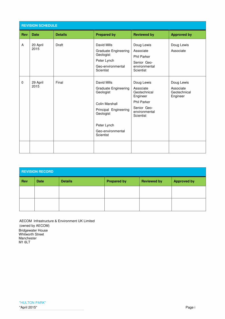
REVISION SCHEDULE
Rev Date Details Prepared by Reviewed by Approved by
A 20 April 2015
Draft David Mills
Graduate Engineering Geologist
Peter Lynch
Geo-environmental Scientist
Doug Lewis
Associate
Phil Parker
Senior Geo-environmental Scientist
Doug Lewis
Associate
0 29 April 2015
Final David Mills
Graduate Engineering Geologist
Colin Marshall
Principal Engineering Geologist
Peter Lynch
Geo-environmental Scientist
Doug Lewis
Associate Geotechnical Engineer
Phil Parker
Senior Geo-environmental Scientist
Doug Lewis
Associate Geotechnical Engineer
REVISION RECORD
Rev Date Details Prepared by Reviewed by Approved by
AECOM Infrastructure & Environment UK Limited
(owned by AECOM)
Bridgewater House Whitworth Street Manchester M1 6LT

"HULTON PARK"
"April 2015" Page ii
Limitations
AECOM Infrastructure and Environment UK Limited (AECOM) a wholly owned subsidiary of AECOM has prepared this Report for the sole use of Peel Holdings in accordance with generally accepted practices and the Agreement under which our services were performed. No other warranty, expressed or implied, is made as to the professional advice included in this Report or any other services provided by us. This Report may not be relied upon by any other party without the prior and express written agreement of AECOM. Unless otherwise stated in this Report, the assessments made assume that the sites and facilities will continue to be used for their current purpose without significant change. The conclusions and recommendations contained in this Report are based upon information provided by others and upon the assumption that all relevant information has been provided by those parties from whom it has been requested. Information obtained from third parties has not been independently verified by AECOM unless otherwise stated in the Report. Despite the steps undertaken as part of this project, AECOM cannot rule out that certain material liabilities or non-compliance issues may exist that have not been identified or described in this report if not disclosed by the site.
This report is intended to be used in its entirety and no extract is to be taken to be representative of the overall findings of this review. In providing any comments or opinions in respect of environmental law and associated guidance, AECOM is not rendering legal advice, for which a legal practitioner qualified to advise on such matters in the relevant jurisdiction, should be consulted.
Where field investigations have been carried out, these have been restricted to a level of detail required to achieve the stated objectives of the services. The results of any measurements taken may vary spatially or with time and further confirmatory measurements should be made after any significant delay in using this Report.
Where assessments of works or costs required to reduce or mitigate any environmental liability identified in this Report are made, such assessments are based upon the information available at the time and are subject to further investigations or information which may become available. Costs may therefore vary outside the ranges quoted. No allowance has been made for changes in prices or exchange rates or changes in any other conditions which may result in price fluctuations in the future. Cost estimates exclude tax e.g. VAT. Where assessments of works or costs necessary to achieve compliance have been made these are based upon measures which, in AECOM’s experience, could normally be negotiated with the relevant authorities under present legislation and enforcement practice, assuming a pro-active and reasonable approach by site management and a reasonable position being adopted by the authorities.
Copyright
© This Report is the copyright of URS Infrastructure and Environment UK Limited a wholly owned subsidiary of AECOM. Any unauthorised reproduction or usage by any person other than the addressee is strictly prohibited.
"HULTON PARK"
"April 2015" Page iii
TABLE OF CONTENTS
1. INTRODUCTION ....................................................................... 1
1.1 Introduction ............................................................................. 1
1.2 Proposed Development .......................................................... 1
1.3 Methodology ............................................................................ 1
1.4 Information Sources ............................................................... 2
2. SITE SETTING .......................................................................... 3
2.1 Location ................................................................................... 3
2.2 Site Description ....................................................................... 3
3. GEOLOGY ................................................................................ 4
3.1 Introduction ............................................................................. 4
3.2 Published Geology .................................................................. 4
3.2.1 Made Ground ........................................................................... 4
3.2.2 Superficial and Bedrock Geology .......................................... 4
3.3 Structural Geology .................................................................. 4
3.4 Economic Geology .................................................................. 5
4. HYDROLOGY AND HYDROGEOLOGY .................................. 6
4.1 Hydrology ................................................................................. 6
4.2 Hydrogeology .......................................................................... 6
5. HISTORIC MAPPING ............................................................... 7
5.1 Summary .................................................................................. 7
6. SUMMARY OF ENVIRONMENTAL DATA ............................ 17
6.1 Introduction ........................................................................... 17
6.2 Discharge Consents ............................................................. 17
6.3 Water Abstractions ............................................................... 17
6.4 Nitrate Vulnerable Zone ........................................................ 17
6.5 Flooding ................................................................................. 17
6.6 Pollution Incident Register ................................................... 17
6.7 Natural Hazards ..................................................................... 17
6.8 Contemporary Trade Directory Entries ............................... 18
6.9 Designated Ecological Site and Sites of Biological Interest18
6.10 Known Landfill Sites (Active & Historical) ......................... 18
7. GEOTECHNICAL ASSESSMENT .......................................... 19
7.1 Anticipated Ground Conditions ........................................... 19
7.2 Geotechnical Considerations .............................................. 19
7.3 Ground Investigation ............................................................ 20
8. MINING ASSESSMENT ......................................................... 21
8.1 Introduction ........................................................................... 21
8.2 Information Sources ............................................................. 21
8.3 Coal Mining Geology - General ............................................ 21
8.4 Coal Mining Geology – Detail ............................................... 21
"HULTON PARK"
"April 2015" Page iv
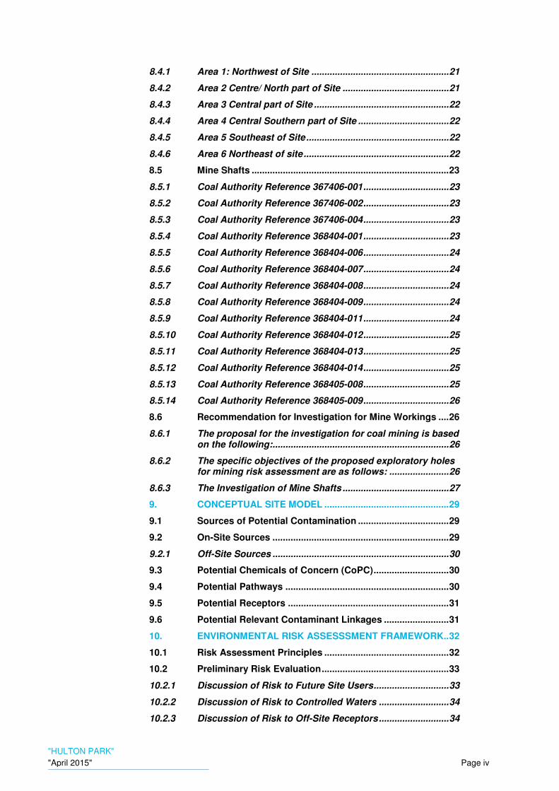
8.4.1 Area 1: Northwest of Site ..................................................... 21
8.4.2 Area 2 Centre/ North part of Site ......................................... 21
8.4.3 Area 3 Central part of Site .................................................... 22
8.4.4 Area 4 Central Southern part of Site ................................... 22
8.4.5 Area 5 Southeast of Site ....................................................... 22
8.4.6 Area 6 Northeast of site ........................................................ 22
8.5 Mine Shafts ............................................................................ 23
8.5.1 Coal Authority Reference 367406-001 ................................. 23
8.5.2 Coal Authority Reference 367406-002 ................................. 23
8.5.3 Coal Authority Reference 367406-004 ................................. 23
8.5.4 Coal Authority Reference 368404-001 ................................. 23
8.5.5 Coal Authority Reference 368404-006 ................................. 24
8.5.6 Coal Authority Reference 368404-007 ................................. 24
8.5.7 Coal Authority Reference 368404-008 ................................. 24
8.5.8 Coal Authority Reference 368404-009 ................................. 24
8.5.9 Coal Authority Reference 368404-011 ................................. 24
8.5.10 Coal Authority Reference 368404-012 ................................. 25
8.5.11 Coal Authority Reference 368404-013 ................................. 25
8.5.12 Coal Authority Reference 368404-014 ................................. 25
8.5.13 Coal Authority Reference 368405-008 ................................. 25
8.5.14 Coal Authority Reference 368405-009 ................................. 26
8.6 Recommendation for Investigation for Mine Workings .... 26
8.6.1 The proposal for the investigation for coal mining is based on the following:.................................................................... 26
8.6.2 The specific objectives of the proposed exploratory holes for mining risk assessment are as follows: ....................... 26
8.6.3 The Investigation of Mine Shafts ......................................... 27
9. CONCEPTUAL SITE MODEL ................................................ 29
9.1 Sources of Potential Contamination ................................... 29
9.2 On-Site Sources .................................................................... 29
9.2.1 Off-Site Sources .................................................................... 30
9.3 Potential Chemicals of Concern (CoPC) ............................. 30
9.4 Potential Pathways ............................................................... 30
9.5 Potential Receptors .............................................................. 31
9.6 Potential Relevant Contaminant Linkages ......................... 31
10. ENVIRONMENTAL RISK ASSESSSMENT FRAMEWORK.. 32
10.1 Risk Assessment Principles ................................................ 32
10.2 Preliminary Risk Evaluation ................................................. 33
10.2.1 Discussion of Risk to Future Site Users ............................. 33
10.2.2 Discussion of Risk to Controlled Waters ........................... 34
10.2.3 Discussion of Risk to Off-Site Receptors ........................... 34

"HULTON PARK"
"April 2015" Page v
10.2.4 Discussion of Risk to Development Infrastructure ........... 34
10.2.5 Discussion of Risk to Flora and Fauna ............................... 35
10.2.6 Discussion of Risk to Construction Workers ..................... 36
11. CONCLUSIONS ...................................................................... 37
11.1 Summary ................................................................................ 37
11.2 Geotechnical .......................................................................... 37
11.3 Mining ..................................................................................... 37
11.4 Geo-Environmental ............................................................... 37
12. RECOMMENDATIONS ........................................................... 39
12.1 Environmental Investigation ................................................ 39
12.2 Geotechnical Investigation .................................................. 39
12.3 Mining Investigation ............................................................. 40
13. REFERENCES ........................................................................ 41
FIGURES FIGURE 1 – SITE LOCATION PLAN
FIGURE 2 – MINING PLAN
FIGURE 3 – GEOLOGICAL PLAN
FIGURE 4 – CONSTRAINTS PLAN
FIGURE 5 – CONCEPTUAL SITE MODEL
FIGURE 6 – PROPOSED EXPLORATORY HOLE LOCATION PLAN
TABLES TABLE 3.1 – SUMMARY OF SUPERFICIAL AND BEDROCK GEOLOGY
TABLE 5.1 – REVIEW OF HISTORIC MAPS
TABLE 6.6 – POLLUTION INCIDENTS
TABLE 6.10 – HISTORICAL LANDFILLS
TABLE 10.1 – SEVERITY OF RISK
TABLE 10.2 – PROBABILITY OF RISK OCCURRENCE
TABLE 10.3 – COMPARISON OF PROBABILITY AND SEVERITY OF RISK
TABLE 10.4 – SUMMARY OF RISK TO FUTURE SITE USERS
TABLE 10.5 – SUMMARY OF RISK TO CONTROLLED WATERS
TABLE 10.6 – SUMMARY OF RISK TO OFF-SITE RECEPTORS
TABLE 10.7 – SUMMARY OF RISK TO DEVELOPMENT INFRASTRUCTURE

"HULTON PARK"
"April 2015" Page vi
APPENDICES APPENDIX A – PROPOSED REDEVLOPMENT PLAN
APPENDIX B – GROUNDSURE REPORT
APPENDIX C – COAL AUTHORITY REPORT

HULTON PARK
April 2015 Page 1
1. INTRODUCTION
1.1 Introduction
AECOM were commissioned by Peel Holdings PLC (Peel) (‘the Client’) to complete a geotechnical and geo-environmental desk study for the Hulton Park Project, Nr Bolton, Greater Manchester. The purpose of the report is to identify any potential geo-environmental and geotechnical constraints that could affect the proposed redevelopment based on information provided by the Client, and third party historic and environmental information.
This report has been prepared to ascertain the scope of the ground investigation that will be required for the proposed Hulton Park Project.
1.2 Proposed Development
The approximately 250 hectare site is located near Bolton, Greater Manchester, as shown on Figure 1. It is proposed to construct a world class golfing facility comprising an 18 hole golf course, club house, golf academy, conference center and a 120 bed hotel development. There is also a provision for a tented village in the southwest of the site which will be utilized during the hosting of prestigious golf competitions.
Access to these facilities will be made by the existing Hulton Park Road which is accessed from the Newbrook Road running along the eastern margin of the site. A secondary access to the site is proposed towards the southeast corner from Woodlands Drive, a residential road that is also accessed from Newbrook Road. An additional access road to the west of the site is proposed to be constructed travelling south from a new exit off the Manchester Road Roundabout to the northwest of the site.
In addition to the golf facilities, large areas of the periphery of the site are zoned for residential properties. Access to these properties is proposed to be made by the same access roads detailed above.
1.3 Methodology
This report has been completed in accordance with the guidance set out in BS10175 (2011) ‘Code of Practice for Potentially Contaminated Sites’, and CLR 11 (2004) ‘Model Procedures for the Management of Land Contamination’ and other relevant documentation. This report has also been completed in accordance with the Town and Country Planning Act 1990 (as amended) and associated guidance such as The National Planning Policy Framework (2012) and considers the implications of Part 2A of the Environmental Protection Act 1990 (Part 2A) and the associated Contaminated Land (England) Regulations 2006 and statutory guidance (2012).
The assessment includes the following aims:
• Identification of geotechnical hazards, such as soft / weak ground, old foundations, mine working or shafts.
• Identification of potential contamination sources, such as historical and current operations, both on and adjacent to the site.
• An evaluation of plausible contaminant migration pathways.
• An evaluation of the environmental sensitivity of the site and the potential receptors at risk of exposure to contamination, such as future site users and controlled waters.
• Assessment of the degree of risk associated with each relevant contaminant linkage.
• Recommendations to verify, delineate, and manage any significant geo-environmental risks identified.
• To achieve this, the following tasks were performed:
• A review of the geology, hydrology, hydrogeology, under-mining potential and potential for voids.

HULTON PARK
April 2015 Page 2
• Review of the existing environmental information to assist in the determination of the environmental setting / sensitivity and current / historical land use of the site and surrounding area.
• Preparation of a preliminary conceptual site model and qualitative risk assessment.
• Assessment of any geotechnical considerations which may impact upon the development of the site.
1.4 Information Sources
The primary information and documents reviewed for the purpose of this report are:
• Google maps and Bing maps, accessed February 2015.
• British Geological Survey website (ww.bgs.ac.uk), accessed February 2015.
• Environmental Agency website (www.environemnet-agency.gov.uk), accessed February 2015.
• Groundsure Report (April 2015)
• Coal Authority Report.(April 2015)
HULTON PARK
April 2015 Page 3
2. SITE SETTING
As part of the desk study a Groundsure environmental data report was obtained by AECOM (17 Apr 2015), and was reviewed with relation to the proposed development. A summary of the relevant information contained within the Groundsure report is given in the following sections and is reproduced in full in Appendix A. The Groundsure report provides information for an area 250m beyond the site boundary considered appropriate to determine risks from potential offsite features e.g. landfills.
2.1 Location
The proposed development is located south of Bolton, Greater Manchester. The center of the site is located at National Grid Reference 367927, 405177. A site location plan is presented as Figure 1.
2.2 Site Description
The site comprises an area of approximately 250ha. The area is approximately square in shape with irregular edges and an elongate thin section extending from the southeast corner, which takes in Woodlands Drive, one of the proposed access roads.
The site is bounded to the southeast by residential properties and in the central south area by large open fields. The southwest boundary is formed by further residential properties and a rehabilitation centre . The site is bounded to the west by a series of unnamed streams. Beyond the streams, large open fields are present. The northern perimeter of the site is defined by the A6 Manchester Road and occasional residential properties that front onto the A6. The northeast of the site is demarked by a row of large detached and semi-detached residential properties. The eastern boundary is formed by residential properties and towards the centre, by the A579 Newbrook Road.
The majority of the site comprises open, presumed agricultural land and a number of large wooded areas to the south, central and northeast of the site. Smaller wooded areas occupy much of the northern and western margins of the site. The wooded areas include: New Park Wood, Mill Dam Wood, Dog Kennel Wood and Rawsthorne Wood in the south of the site. Stone Holes Wood is shown in the north of the site, Cow Wood in the northeast and Back o’ th’ Lawn Wood and Stone Shed Wood in the center of the site.
There are several farms and farm buildings. The largest of these farms, Home Farm is located towards the center of the site and consists of a large house, several large sheds, outbuildings and some derelict older residential buildings. It is accessed from a gravel track which runs west to east from an entrance off the A579 Newbrook Road. Park End Farm is located on the southeast portion of the site at the end of Woodlands Drive. It consists of a medium sized house, a large shed and various other outbuildings. Deardens Farm is located on the northeast of the site and is accessed from the A6 Manchester Road. This farm consists of a large residential property, three large sheds and several outbuildings. Wood End Farm is shown on the southwest of the site and is accessed from the same track that leads to Home Farm. Wood End Farm consists of a large farmhouse and a medium sized shed.
There are several named and unnamed brooks and streams across the site. The largest of these watercourses is Mill Dam Stream which flows from the northwest to the southeast. In the center and southwest portion of the site along Mill Dam Stream two historic embankments are shown, which are assumed to dam the water course. Carr Brook flows from the southeastern pond in a southerly direction and exits the site. An unnamed stream runs along the western boundary in a north south direction. This stream forms small ponds at three locations before bending to the west and running off site. There are several other much smaller streams and ponds across the whole area. It is possible that many of these ponds are man-made and used for watering livestock.
The site topography slopes gently from north to south from approximately 120m AOD to 80m AOD.
HULTON PARK
April 2015 Page 4
3. GEOLOGY
3.1 Introduction
The geology of the site has been assessed from the British Geological Surveys (BGS) 1:50,000 geological map Sheet 84 (Wigan) drift, and solid editions and map Sheet 85 (Manchester) drift, and solid editions. The nearest BGS boreholes to the site accessed on the BGS Geoscience Data Index, accessed April 2015 have also been used to assess the geology of the site.
3.2 Published Geology
3.2.1 Made Ground
The BGS mapping indicates no made ground within the site boundaries. However, the Thirlmere Aqueduct, (indicated on Sheet 85, drift edition) the farms, old buildings and associated tracks within the site boundary would suggest that made ground will be present associated with the construction of these structures.
Many of the BGS boreholes recorded on the site are colliery shaft borehole records. This would suggest the likely presence of colliery waste and spoil at the surface in the vicinity of these shafts.
3.2.2 Superficial and Bedrock Geology
The superficial deposits and bedrock geology indicated on the published geological mapping for the area are presented in Table 3.1 below.
Table 3.1 Summary of Superficial and Bedrock Geology
APPROX LOCATION ON SITE SUPERFICIAL & BEDROCK GEOLOGY
Covers the entire site except for a small portion of the southwest and small portions of the south east
Glacial Till, Devensian - Diamicton. Superficial Deposits formed up to 2 million years ago in the Quaternary Period.
Covers the southwest of the site. Glaciofluvial Deposits, Devensian - Sand and Gravel. Superficial Deposits formed up to 2 million years ago in the Quaternary Period.
Present in the northwest and northeast of the site.
Cannel Rock (south Lancashire) - Sandstone. Sedimentary Bedrock formed approximately 312 to 313 million years ago in the Carboniferous Period
Underlies much of the centre and southwest of the site. Appears as slivers between other formations in the south and east.
Pennine Lower Coal Measures Formation - Mudstone, Siltstone And Sandstone. Sedimentary Bedrock formed approximately 312 to 313 million years ago in the Carboniferous Period
Underlies much of the south, east and southeast of the site
Pennine Middle Coal Measures Formation - Mudstone, Siltstone And Sandstone. Sedimentary Bedrock formed approximately 309 to 312 million years ago in the Carboniferous Period.
Present as slivers between the above formation in the south and southeast of the site.
Pennine Middle Coal Measures Formation - Sandstone. Sedimentary Bedrock formed approximately 309 to 312 million years ago in the Carboniferous Period
3.3 Structural Geology
As indicated in Table 3.1 above, that the site is underlying by bedrock of Pennine Middle Coal Measures there are five known faults to cross the site, four of which run northeast-southwest, the downthrow of some of these faults is to the south-east and others to the north-west. The
HULTON PARK
April 2015 Page 5
sixth fault is labelled as the Padiham Fault which runs north-west to south-east, located on the east edge of the site, with a downthrow to the north-east side of the fault. The beds within this area dip down to the south-east, typically at an angle of 8 degrees.
For additional information on this refer to Section 8 within this report.
3.4 Economic Geology
The Groundsure report identifies 14 unspecified old or disused shafts within the site boundaries. However, on closer inspection the grid references of several of these shafts are coincident or so close as to be within one shaft diameter of each other and it is likely that some of these are the same shafts but have been recorded on different occasions. By comparing the clustering of the grid references with the shafts shown on the historical maps it can be seen that there are two shafts identified. One shaft dates from between 1851 and 1892, and the other dates from between 1892 and 1907. They are identified as old coal shafts. A further 44 shafts are recorded between 6m - 999m from the site.
Also two trial shafts have been recorded they are likely to be the same shaft, this is located approximately. 545m from the site boundary, dated around 1938.
An air shaft has been recorded to the south-east of the site 972m to the south-east of the site, dated around 1907.
Four colliery sites have also been recorded within the site boundaries, these are dated from 1907-1927, with a further 11 between 3m-892m from the site, dated 1982-1927.
Four open cast workings have been recorded between 176m -736m to the east of the site, dated 1956-1966.
The Groundsure reports confirms that there are no non-coal mining areas within 1000m of the boundary.
There are no recorded Tin, Clay, Gypsum, Brine or any natural cavities recorded within 1000m of the site boundary.

HULTON PARK
April 2015 Page 6
4. HYDROLOGY AND HYDROGEOLOGY
4.1 Hydrology
The Environment Agency website for the area indicates that flooding from surface waters is possible from all rivers known to cross the site and also from all ponded areas, i.e. due to low permeability Glacial Till the site is potentially at risk from flash flooding. The highest risk areas are centered on Mill Dam Stream and its two lakes.
However, as the site is generally sloping south and not extensively covered with surface water features the majority of the site is not noted to be at risk from flooding. Nonetheless, localised flooding may occur in the immediate vicinity of the stream, brook, pond or lake. The area onsite considered at high risk of flooding from rivers or sea without defenses is concentrated around Carr Brook in the southeast of the site.
The Thirlmere Aqueduct is noted on BGS drift edition maps and on the historic mapping. The aqueduct crosses the site from the northwest travelling east along the north of the site for 700m before bending to the south for a further 450m and eventually turning southwest for a final 300m to the western margin of the site. The aqueducts location would cross the proposed residential areas in the north, the golf course and the proposed residential areas in the east of the site. Constructed around 1892 the aqueduct is subterranean with air valves along its length and is still present today although not noted on the mapping since 1956.
Another significant feature is the presence of a dam across the upper Mill Stream River Lake which is located close to the center of the site.
4.2 Hydrogeology
As indicated on the Environmental Agency groundwater map the site is underlain by Bedrock – Secondary Aquifer A. This aquifer type is characterised by permeable layers capable of supporting water supplies at a local rather than strategic scale, and in some cases forming an important source of base flow to rivers. These are generally aquifers formerly classified as minor aquifers.
HULTON PARK
April 2015 Page 7
5. HISTORIC MAPPING
5.1 Summary
Historic Ordnance Survey (OS) maps of the site were obtained as part of the Groundsure report. The information contained in these maps is summarized in the following table and copies of the maps are provided in the Groundsure report in Appendix A.
The following table summarises the main features present on and within 250m of the site, including selected important features located greater than 250m from the site. Where dates are given, these refer to the dates of maps on which the features appear, and do not necessarily refer to the date at which the feature was present on the ground. Maps of scales 1:1250, 1:2500, 1:10000 and 1:10560 were consulted in the analysis of historic land use.
Table 5.1 Review of Historic Maps
DATE SCALE ONSITE LAND USE OFF SITE LAND USE
1849 1:10,560 The site is bounded to the north by the Wigan to Manchester road, to the northeast by agricultural land, to the east by the Bolton to St Helens Road and to the south and west by agricultural land. The majority of the site comprises Hulton Park which consists of areas of open parkland, enclosed fields and wooded areas with some ponds. Hulton Hall, a large stately home with outbuildings and an ice house is present near to the centre of the site. A stream runs across from the northwest to the southeast of the site. Three lakes are shown along the course of the stream, a small lake to the of Hulton Hall, A larger lake immediately to the west of Hulton Hall and a further lake in the southeast of the site with a boat house at the northwest (upstream) end. The river approaching the lake adjacent to Hulton Hall form the north is marked as having an ‘Old Dam’. The wooded areas are concentrated along the site boundaries and along the course of the stream through Hulton Park. Along the western side of the park, these are Hollin Hey in the northwest, Rawsthorn Plantation and Dog Kennel plantation, and New Park Wood in the southwest of the site. Along the stream the wooded areas are, from northwest to southeast, Mistress Fold Plantation, Old dam, Crow Yard and Mill Bank Plantation. Along the north side of the park the wooded areas are Engine Clump in the northwest and Top of the Hardwick,s in the northeast. Along the east side of the park the wooded areas are cow Wood in the northeast , Firs, and Kearsley Plantation in the southeast. Other wooded areas are Dog Kennel Plantation (second plantation of this name on the site), and Hurst Hole, each of which are located to the
The surrounding area is open and presumed to represent agricultural land. A railway track runs to the west of the site, forming the western boundary in the southwest, an engine house siding runs off this track to the northwest. A coal pit and an engine house are shown just outside the site boundary between the railway and the site in the northwest. There are several buildings along the Manchester Wigan road which bounds the north of the site to the northwest. Hulton Colliery pits are located across the road, north of the colliery buildings noted in the area. There are several other coal pit collieries to the north and another rail track leading to the collieries. The closest of these collieries is 100m to the north of the area. The north of the area is bounded by a road. ‘Chequerbent’ a small village, is located across the railway track to the northwest. School Farm and an infant school are shown across the Manchester Wigan Road north of the site. Runger Wall Farm is across the road to the north east. There is a ‘Delf’ which appears to be a quarried feature, recorded next to the farm to the west. There are two coal pits located 200m-300m north of the area and Whitegate Colliery is located ~700m to the north also. There is a coal pit 50m to the east of the area in the southeast. There is a smiths, the Red Lion Inn and the Hulton Arms Inn at Hulton Lane Ends, located the crossroads between the Manchester – Wigan and the Boltonn St Helens Road 400m east of the northeast corner of the site. Several houses, named Hulton Lane, Pasquil Row and Number Thirty Five are present along the Bolton - St Helens road between 200m and 400m from the site boundary. There is a coal pit 40m to the east of the site across the Bolton - St Helens road from the Entrance to Hulton park and a further coal pit 600m to the south at Hollow Cottage within 100m of the southeast extremity of the site. There are several buildings on the Bolton St Helens road between 200m and 400m from the
HULTON PARK
April 2015 Page 8
DATE SCALE ONSITE LAND USE OFF SITE LAND USE
northeast of Hulton Hall and surround ponds. Coal Pit Plantation and Marl Pit Plantation are located to the east of Hulton Hall. It is assumed that a coal pit and a marl pit were located in these areas. a square feature, possibly a shaft, is shown within Coal Pit Plantation. A pond, possibly a flooded marl pit is present within Marl Pit Wood. The main access to Hulton Hall runs from Hulton Hall southeast then east across open parkland and then through firs wood onto the Bolton to St Helens road. There is also access due north to the Manchester Wigan road to a location described as ‘Back gate’ Wood End Farm is shown within the southwest boundary of Hulton Park. Two wells are shown near to Wood End Farm and a spa well is shown within the agricultural land outside the Park at the southern boundary of the site The western part of the site, and a small area adjacent to the southern boundary around Park House and the area around Deardens farm in the northeast comprise agricultural fields outside Hulton Park. Small cottages, Hulton Colliery buildings, and a, brick kiln are present in the northwest of Hulton Park. Keepers Cottage is located along the northern boundary of the site. There is a coal pit and there are two named cottages to the southeast of the area – Park Cottage and Woodland Cottage respectively.
southeast corner of the site. There is an engine fold and old coal pit 400m to the southeast. The area to the south and west of the site is sparsely populated with only a few isolated dwelling and farms.
1891-2 1:10,560 The lake towards the southeast of Hulton Park is now named Mill Dam A pond is shown in the northwest of the site adjacent to ‘Chequerbent Pits (Nos. 1 & 2)’ which are located just outside the site boundary where coal pit and engine house were previously recorded. The railway recorded bounding the west of the area has new sidings, structures and embankments. Embankments could be spoil heaps for the neighbouring pits. There is a small embankment south of the engine house in the north. Hulton Collier no longer marked on map. The lake bordering Halton Hall has a weir at its southern end. Thirlmere Aqueduct runs along the northeast of the area in an east west direction before turning northwest off the area to the northwest. The wooded area of Hollin Hey is now named Markland Plantation. Coal Pits Plantation and Marl Pits Plantation have now been enlarged and form one larger wood named Park Pits
Coal Pit and Engine House in northwest of site between site boundary and railway now replaced by ‘Chequerbent Pits (Nos. 1 & 2)’Collieries to the north of the area have embankments not previously recorded. The pits of Hulton Colliery have been filled in and are now recorded as a small wooded area. Road bounding area to the north now named ‘Manchester Road’. Railway line to west, where it passes area adjacent to the northwest has been extended to include a second line in cutting passing beneath Manchester Road and additional sidings. In addition a street of terraced houses Brancker Street is present between the old and new railway lines south of Manchester road. Chequerbent now has a police station, school, and church. New collieries are shown approximately 200m north and north east of the site with rail connection to the Railway north of Chequerbent. The delf associated with Runger Wall Farm now appears infilled and a raised are is now located at approximately the same location.. A new spur from the railway line

HULTON PARK
April 2015 Page 9
DATE SCALE ONSITE LAND USE OFF SITE LAND USE
Wood. There is an old shaft recorded in the area previously recorded as Coal Pit Plantation. Surrounding this shaft is a disturbed raised area. A gently curved track gives access to a mineral railway serving a colliery to the north indicating that the shaft had railway access at some time between 1851 and 1891. Thirlmere Aqueduct is recorded as running along the north of the area in an east west direction before turning south for approximately 450m. The aqueduct then turns towards the southwest for 300m before leaving the area where it crosses the Bolton St Helens road approximately 600m south of Hulton Lane Ends. Coal pit no longer recorded at Park Cottage at the southeast corner of the site. There is a sluice recorded at the southern end of the lake in the south east of the site now recorded as Mill dam. There is a well recorded to the southwest of Sunny Brow. There are three wells recorded near Park End Farm – 25m to the south, 100m to the southeast and 100m to the northeast of the farm respectively. Wells near Wood End Farm no longer marked on map. Embankments showing as part of a railway overbridge in the southwest of the site which goes over the railway line bounding the west of the site in the southwest. ‘Rawsthorn Plantation’ has been renamed ‘Belgrave Plantation’. Plantation to west outside Hulton Park but within site boundary is now named ‘Rawsthorn Plantation’.
in to the west leads to collieries 150m north of Runger Wall Farm. An old shaft is recorded just across the road from the area east of Runger Wall Farm. There are two old shafts recorded approximately 400m and 600m to the northeast of the area.. ‘Boardman’s Plantation’ is shown approximately northeast of the site. Some of the buildings to the east formerly called are re-named ‘Brook House Farm’. New railway line Pendleton and Hindley Line shown running southeast to northwest. Approximately 200m to 500m south of the site. Atherton Central Station is approximately 450m south of southeast corner of site.. Goods shed and bolt works south of railway line at Atherton Central Station. Old engine houses recorded 400m to the southeast of southeast corner of site boundary. A further station is located approximately 2km east of Atherton Central Station at Rose Hill. A Print Works and reservoir are present south of this station, approximately 1km west of the southwest corner of the site.
1893 1:2,500 The following information supplements the findings of the 1:10,560 maps for 1891-92: Gasometer shown to north of Hulton hall. Old shaft in coal pits wood described as old shaft (coal) Formal gardens appear to be present within Hulton Park approximately 200m south of Hulton Hall.
The following information supplements the findings of the 1:10,560 maps for 1891-92: Shafts are shown within the buildings at ‘Chequerbent Pits 1 and 2’ Platforms, probably for a station, present on new railway line constructed under Manchester Road at Chequerbent. One of the collieries approximately 200m north of the site is named Arley No 2 Pit. The print works south of the station at Rose Hill is now called Green vale Print Works.
1907-08 1:10,560 Pond in northwest of site associated with ‘Chequerbent pits 1 and 2’ named as ‘reservoir’. ‘Filter Bed’ present in northwest adjacent to railway siding and possible spoil piles which have enlarged. Embankment from railway overbridge enters site from west mid way along western boundary immediately north of Hulton Collieries Atherton Pits 1 and 2.
Railway station, rope and twine works and goods yard now marked on map to northwest of the site. Chequerbent now includes a football ground, tennis ground and bowling green. . Previously unnamed collieries now named as ‘Hulton Collieries (School Pit)’ with a reservoir (previously a pond) marked adjacent to the collieries. Collieries to the north east now named as ‘Hulton Collieries (Deep Arley Pit)’. Some extension noted to existing collieries

HULTON PARK
April 2015 Page 10
DATE SCALE ONSITE LAND USE OFF SITE LAND USE
One siding and an area of raised ground extends south from Atherton Pits 1 and 2 onto the southwest of the site. Boat house present on the lake side to the west of Hulton Hall. There is a tank, approximately 35m square present adjacent to the east side of Hulton Hall. There is a new weir shown on the stream flowing through the site adjacent to the formal gardens to the south of Hulton Hall. . Thirlmere Aqueduct showing ‘V’s spaced along its route at 250m intervals. These are assumed to be air or inspection shafts to the aqueduct. Pheasantry and a trough present in northwest of the site. Old shaft now present to the approximately 100m south of shaft in Park Pits Wood within open parkland to the north of the access road to Hulton Hall. Lodge present north of the entrance to Hulton Park from Hulton Lane. There is a mineral railway present in the southwest of the site providing access from the railway to the west of the site to Hulton Colliery No’s 3 and 4 Pits. There is also a siding extending east from the colliery onto the southeast part of the site immediately north of Sunny Brow. One small reservoir to the north of Hulton colliery extends approximately 30m into the site within New Park Wood.
embankments. Hulton Collieries, Atherton Pits Nos. 1 & 2, are now present just outside western site boundary, between the railway and the site boundary with railway sidings from the existing rail line that bounds the site to the west. New siding is on an embankment and the colliery buildings are between the siding and the main rail line to the west. Shafts are shown to the south and east of the colliery and sidings. Spring noted 50m to the southwest of the southwest corner of the site. Hulton Colliery No’s 3 and 4 Pits are located just outside the central part of the southern site boundary There are numerous colliery buildings and multiple track sidings within the colliery complex together with the two shafts. Two reservoirs are present, one outside but adjacent to the site boundary, and the other inside the site boundary within New Park Wood. Laburnum Mill and adjacent reservoir present north of railway line and Atherton Central Station.
1908-09 1:2,500 The following information supplements the findings of the 1:10,560 maps for 1891-92: The mineral railway running across the south west of the site to Hulton Colliery No’s 3 and 4 Pits has 3 to 6 tracks including sidings The Old Shaft located between park Pits wood and the Hulton Hall access road is described as Old Shaft (coal).
1926-27 1:10,560 The Boat House on the lake towards the southeast of the site has been moved approximately 50m east along the north shore. The embankments associated with the railway sidings at Hulton Collieries – Bank pits No’s 1 and 2 have extended south within the western site boundary to join the mineral railway to Hulton Colliery No’s 3 and 4 pits. Spoil tips extend southeast from Bank Pits no’s 1 and 2 across the site boundary. There are two additional beds associated with the ‘Filter Beds’at the western site boundary between Chequerbent Pits No’s 1 and 2 and Hulton Collieries Bank Pits No’s 1 and 2.
Between Chequerbent Pits No’s 1 and 2 sidings and embankments have extended southwards nearly to Hulton collieries Bank Pits No’s 1 and 2. Hulton Collieries –Atherton Pits no’s 1 and 2 now called Bank Pits no’s 1 and 2. Additional pool showing next to reservoir adjacent to these pits. Chequerbent no longer has a football ground, tennis court or bowling green. Hulton Collieries (School Pit) now recorded as disused. Filter beds present south of Hulton Collieries (Deep Arley Pit). Rows of houses built along approaches to Hulton Lane Ends crossroads to the northeast. Spoil heaps at Hulton collieries No’s 3 and 4 Pits extended to south of colliery and

HULTON PARK
April 2015 Page 11
DATE SCALE ONSITE LAND USE OFF SITE LAND USE
A row of five houses built along the Manchester Road adjacent to the west of Dearden’s Farm. Pump house now present adjacent to the east of the small reservoir north of Hulton Collieries No’s 3 and 4 Pits just within the site boundary. Tanks present adjacent to the east of Hulton Collieries No’s 3 and 4 Pits within the southeast part of the site. Tank present between mineral railway tracks which run across southwest of the area to Hulton Collieries No’s 3 and 4 Pits.
accessed by a tramway coming from the colliery buildings. Pump house now present adjacent to the spoil heaps to the southwest of Hulton Collieries No’s 3 and 4 Pits. Rows of houses to the southeast and east of the site. Laburnum Mills has extended in size towards the west. Albion Works are now shown to the West of the railway running south from Chequerbent approximately 750m south of the southwest corner of the site. The Green Vale works is no longer described as a print works.
1928-1929
1:2,500 No significant features other than those on 1:10,560 mapping.
No significant features other than those on 1:10,560 mapping.
1936 1:2,500 The following information supplements the findings of the 1:10,560 maps for 1891-92: The gasometer and ice house near Hulton Hall are disused. The boat house at the lake adjacent to Hulton Hall is no longer present and the lake appears to be largely silted up.
An Old Shaft is recorded within the land occupied by the former Hulton Colliery Arley No 2 Pit. A flooded excavation is present to the east of the shaft. A building located at the north end of Brancker Street is described as an electrical substation. Two old shafts are recorded at the location of the former Hulton Collieries Bank Pits No’s 1 and 2. The more southerly pit is shown within 10m of the site boundary. Two old shafts are recorded at the location of the former ‘Hulton Colliery No’s 3 and 4 Pits’. The remaining buildings at the colliery site unidentified on the 1:10,560 mapping are shown as ‘Brick Works’. The former reservoir east of former ‘Hulton Colliery No’s 3 and 4 Pits’ is now described only as base of old reservoir. Significant housing development south of the railway to the south of the site and west of Atherton Central Station
1938 1:10,560 The filter beds associated with ‘Chequerbent No’s 1 and 2 pits’ are disused. The reservoir and the pump house north of Hulton Colliery No’s 3 and 4 Pits located within the site boundary remain although much of the colliery has been demolished.
Chequerbent Pits 1 and 2 are no longer present but two old shafts are shown on at the location of the former pits. Hulton Colliery Bank Pits No’s 1 and 2 are no longer shown. The reservoirs at the site are recorded as disused. Hulton Collieries Deep Arley Pit and Arley No 2 Pit no longer present, only the spoil tips and track beds of former railway lines and sidings are present. A reservoir adjacent to Arley Deep pit is shown as disused. Field south of Chequerbent town is shown as a recreation ground Hulton Colliery No’s 3 and 4 Pits have been largely demolished and the railway tracks have been removed. Two unidentified colliery buildings remain. New residential development is present south of the railway located to the south of the site.
1948 1:10,560 The northeast end of Mill Dam lake, upstream of the boat house appears to be silted up. The line of the disused railway across
The 1:10,560 mapping now shows the shafts at Hulton Collieries Arley No 2 pit, Bank Pits No’s 1 and 2, and Hulton Colliery No’s 3 and 4 Pits, and the use of the
HULTON PARK
April 2015 Page 12
DATE SCALE ONSITE LAND USE OFF SITE LAND USE
the south west of the site to the location of Hulton colliery No’s 3 and 4 pits is now shown crossing open fields, all fencing along the route has been removed.
remaining buildings at Hulton colliery as a brick works. Small groups of new houses are shown on Park road, running southwest from Chequerbent to Westhoughton. There is further housing development along the north side of Manchester Road to the north of the site west of Runger hill farm and to the east of Hulton Lane Ends. There is housing development between the properties along the south side of Manchester Road east of Dearden’s Farm and Boardman’s Plantation to the south. Further housing development has taken place along the Bolton St Helens road which is now called New Brook Road. There is now continuous ‘ribbon’ development along each side of Brook Road from Hulton Lane Ends to the railway at Atherton Central Station, except where the west side forms the boundary of Hulton Park. Further housing development south of the railway to the west of Atherton Central Station
1952 - 1953
1:2,500 The former formal gardens to the south of Hulton Hall now comprise areas of rough ground and woodland, remaining structures on the site are described as ruins. The boat house on Mill Dam lake is no longer shown. The Old shafts at the former ‘Chequerbent No’s 1 and 2 Pits’ are no longer shown. A circular pond is shown north of the disused filter beds located on site to the east of the former ‘Chequerbent No’s 1 and 2 Pits’. The route of the mineral railway across the south west of the site to the former ‘Hulton Colliery No’s 3 and 4 pits’ is now shown as an area of rough ground with a footpath.
An engineering works and coach building works are present to the northwest of Chequerbent station. The tracks have been removed from the original more easterly route of the railway closest to the former Chequerbent No’s 1 and 2 Pits. Only the tracks passing under Manchester Road and through Chequerbent Station remain. The Old shafts at the former Hulton Collieries ‘Bank Pits No’s 1 and 2’ are no longer shown. The disused reservoirs at the site of the former Hulton collieries ‘Bank Pits No’s 1 and 2’ appear to be silted up or infilled. The brickworks at the site of the former ‘Hulton Colliery No’s 3 and 4 pits’ have been removed. The former reservoir to the east is now shown as rough ground. The residential area south of the railway to the west of Atherton Central Station occupies most of the area from the railway south to Atherton town centre and east to the southern continuation of the railway to the west of the site.
1956- 1959
1:10.560 The stream through Hulton Park is now named the Mill Bank Stream upstream of Mill Bank lake and Carr Brook downstream of Mill Bank lake.
New Brook Road is now shown as the A579. Manchester Road is now shown as the A6. More houses are now present along Park Road. Areas labelled open cast coal workings are shown to the rear of the residential properties east of New Brook Road to the northeast of Hulton Park and within 100m of the rear of residential properties to the east of Hulton Park. It is assumed that these are areas selected for open cast mining at some date after 1956 as no excavated areas or spoil heaps are shown. The area to the south east of Hulton Park

HULTON PARK
April 2015 Page 13
DATE SCALE ONSITE LAND USE OFF SITE LAND USE
between New Brook Road and the downstream end of Mill Bank lake has been largely developed for housing. The station at Rose Hill is now named Daisy Hill Station. The Albion Works have been extended and are now called the Albion Iron “Works
1966-1967
1:10,560 Hulton Hall Has been demolished. Thirlmere aqueduct is no longer shown on the mapping but is understood to be present.
There is now almost continuous ribbon development of residential properties along park road from Chequerbent to Westhoughton. There is also some infill of residential development at Chequerbent, between Manchester Road and Park Road west of the junction between those two roads. Open cast workings to the northeast on the east side of New Brook Road complete. Some residential property is shown on former opencast immediately east of the properties on the east side of New Brook Road. Extensive residential development taken place in area immediately to north east of Hulton Park, and south west of Hulton Lane Ends bounded by Manchester road to the north, New Brook Road to the east, and Hulton park to the southeast, Boardman’s Plantation has been completely removed. Residential development has been undertaken immediately south of the site to the southwest of the former Hulton Colliery No’s 3 and 4 Pits. Between the site boundary and the railway west of Atherton Central Station. Playing fields are present immediately south of the former colliery site. The Green Vale Works and the Albion Works are now just shown as unnamed ‘works’
1965-1968
1:2,500 No significant Change from detail on the 1:10,560 mapping for 1966 – 1967.
The following information supplements the findings of the 1:10,560 maps for 1966-1967: A further plot of ground with buildings, probably for industrial use, is present to the north of the Coach Building Works north of Chequerbent
1973-1980
1:10,000 No significant change The tracks have been removed from the railway running through Chequerbent to the west of the site. The houses along Brancker Street have been demolished M61 Motorway is present running from northwest to southeast between 200m and 500m north of the northern site boundary. A new roundabout is present at the junction of Manchester Road and Park Road which runs southwest from Chequerbent to Westhoughton. A new link road runs northeast from the roundabout to a junction with the M61 with a further roundabout. Several buildings in Chequerbent have been removed including a public house and the school enable construction of the roundabout. The coach works to the north of
HULTON PARK
April 2015 Page 14
DATE SCALE ONSITE LAND USE OFF SITE LAND USE
Chequerbent is no longer present. A travelling crane is present on the steel works site. The former Hulton Collieries sites to the north of Manchester road are now wooded. There is extensive residential development east of Hulton park up to 200m east of New Brook Road. There has been substantial residential development and a school to the north of Atherton Central Station up to the southern site boundary. The sidings south of Atherton Central Station have been removed and the site of the former sidings is vacant.
1987-1993
1:10,000 The site of the former Hulton Hall is shown as a scout camp. The buildings to the north of Hulton Hall have been enlarged and are now shown as Home Farm. The tank formerly adjacent to Hulton Hall is no longer shown. The spoil associated with the former ‘Chequerbent No’s 1 and 2 Pits’ and the ‘Hulton Collieries Bank Pits No’s 1 and 2’ extending onto the site has been removed and the areas restored to agricultural fields. The area of former railway sidings extending east from ‘Hulton Colliery No’s 3 and 4 Pits’ is now shown as woodland.
The site of the former ‘Chequerbent No’s 1 and 2 Pits’ and the ‘Hulton Collieries Bank Pits No’s 1 and 2’ has been completely cleared and restored to agricultural fields. The site of the former ‘Hulton Colliery No’s 3 and 4 Pits’ is now wooded. The location of the two shafts on the site, and spoil mounds in the south of this area are shown within the woodland. The former reservoir in the northeast of this area is shown as a pond. There has been further residential development south of the site between the former ‘Hulton Colliery No’s 3 and 4 Pits’ and the railway west of Atherton, including on former playing fields. A new playing field and a football pitch have been created adjacent to the railway. Atherton Station is no longer referred to as Atherton Central Station but only as ‘Station’. Buildings that appear to be industrial units occupy the south part of the former sidings. The dreaded Wood End Assessment Centre is present immediately outside the southern site boundary in the southwest of the site. The former Arley Deep Pit and one other former Hulton Collieries pit to the northeast are now wooded, the larger and more northerly. The remaining former collieries north of Manchester Road have been restored to agriculture. The residential area between Manchester Road and Park Road to the west of Chequerbent has become more extensive. A further large residential area is present to the south of Park road approximately 1km west of the site. As a result of these developments Chequerbent now forms part of Westhoughton.
1988-1994
1:1,250 No significant Change from detail on the 1:10,000 mapping for 1987 – 1993.
Within the industrial area north of Chequerbent the most northerly two plots have been combined and are occupied by a scrapyard.
2002 1:10,000 Scout Camp at site of former Hulton Hall no longer shown. Shallow pit indicated by hachuring approximately 200m south of the
Course of former railway to west of site shown as a linear wooded area from the former Chequerbent station for 600m south. A path is present along the wooded

HULTON PARK
April 2015 Page 15
DATE SCALE ONSITE LAND USE OFF SITE LAND USE
main access to Hulton Park and 200m from the eastern boundary of the site.
section and continues to the southwest corner of the site. There are now buildings that appear to be industrial units across northern part of the former sidings south of Atherton Central Station. The football ground located north of the railway to the west of Atherton Central Station is now named Crilly Park. The works near Daisy Hill Station are again named Green Vale Works.
2010 1:10,000 Park Pits Wood is no longer identified as a wooded area and now forms part of the open parkland within Hulton Park. The track north from Home Farm to the ‘back gate’ onto Manchester road is no longer shown
The area of open cast workings to the east of the site is now shown as woodland. The name Green Vale Works is still shown on the map south of daisy Hill Station, but the site appears to be occupied by residential development. Part of the works formerly known as the Albion Works has now been demolished and replaced by housing.
2014 1:10,000 No significant change There has been a further reduction in the size of the former Albion Works, still referred to as a ‘works’.
In summary, Hulton Park, a large country estate occupies most of the site. Within the estate a large house, Hulton Hall has been shown since before the commencement of Ordnance Survey mapping in this area (1851).
Most of the remainder of the site has comprised agricultural land from before 1851 to the present day. In addition, coal mining has occurred within Hulton Park from before 1851 until after 1892 in and adjacent to Park Pits Wood which is located in the east of the park.
Coal mining took place on a much larger scale from several collieries located outside the site boundary. between 1851 and 1936 with some of the collieries infrastructure crossing onto the site. Although the colliery buildings were partly or wholly demolished within a few years of closure and railway lines removed, the spoil tips generally remained until between 1974 and 1987. From 1974 the spoil tips were levelled and the land either wooded or returned to agriculture.
Railways were constructed immediately to the west of the site by 1851 and 200m to 500m to the south of the site by 1891. The earlier railway to the west had several branch lines added to serve the collieries in the vicinity. This railway was closed by 1974 and the track bed is now a footpath. The latter railway (1891) to the south of the site crossed beneath the earlier railway. There was no connection between the two railway lines and the latter railway (to the south of the site) did not serve any of the collieries or industry within or adjacent to the site. Atherton Station, formerly Atherton Central Station, is located less than 500m from the south east corner of the site on this line.
The site is bounded to the north by Manchester Road and to the east by New Brook Road. Both of these roads were established turnpike trust roads by 1851 and have not been significantly altered in the immediate vicinity of the site since then. Further from the site, the M61 motorway was constructed between 1967 and 1974. A link road was constructed to meet the Manchester Road (A6) at Chequerbent approximately 250m from the northwest corner of the site, and a roundabout was constructed at the junction of these two roads.
The most significant infrastructure development onsite is the construction of the Thirlmere Aqueduct which was constructed between 1851 and 1894 and crosses the north and east parts of the site.

HULTON PARK
April 2015 Page 16
In 1851 the site was located in a rural area with only isolated farms adjacent to the site, and small settlements at Chequerbent to the northwest and Hulton Lane Ends to the northeast. Atherton was the nearest town but was separated from the site by open country. Since 1851 Chequerbent developed as a settlement, but has recently been absorbed into Westhoughton by the spread of residential properties . There has also been extensive residential development along and adjacent to New Brook Road, and to the south of the site, this latter development bringing the built up area of Atherton to the southern site boundary.
HULTON PARK
April 2015 Page 17
6. SUMMARY OF ENVIRONMENTAL DATA
6.1 Introduction
In the following section, searches provided by Groundsure have been reviewed along with the Environment Agency ‘what’s in your backyard?’ website accessed April 2015. Appendix A contains the full register of information.
6.2 Discharge Consents
A total of seven discharge consents are noted within 500m radius of the site with four records reported onsite. The onsite discharge consents relate to the sewage discharge of final treated effluent to a tributary of the Hindsford Brook. Based on the Groundsure information it is unclear whether these discharge consents have been revoked.
6.3 Water Abstractions
There are no records of groundwater or potable water abstractions located within 2km radius of the site.
There is one surface water abstraction (reference 2569016020) located with 1.15km south of the site for the abstraction of process water for boiler feed purposes. The surface water abstraction volume is unknown however the start date is noted as 28
th August 1996. No
further details were provided.
6.4 Nitrate Vulnerable Zone
Based on the GroundSure report and review of the Environment website, the site was located within nitrate vulnerable area with a further area noted approximately 1.172km east of the site.
6.5 Flooding
According the Environment Agency flood maps, the site was located within a Zone 2 and Zone 3 flood plain and classified as ‘very low risk’ (1 in 1000 (0.1%)) with respect to flooding from surface water features.
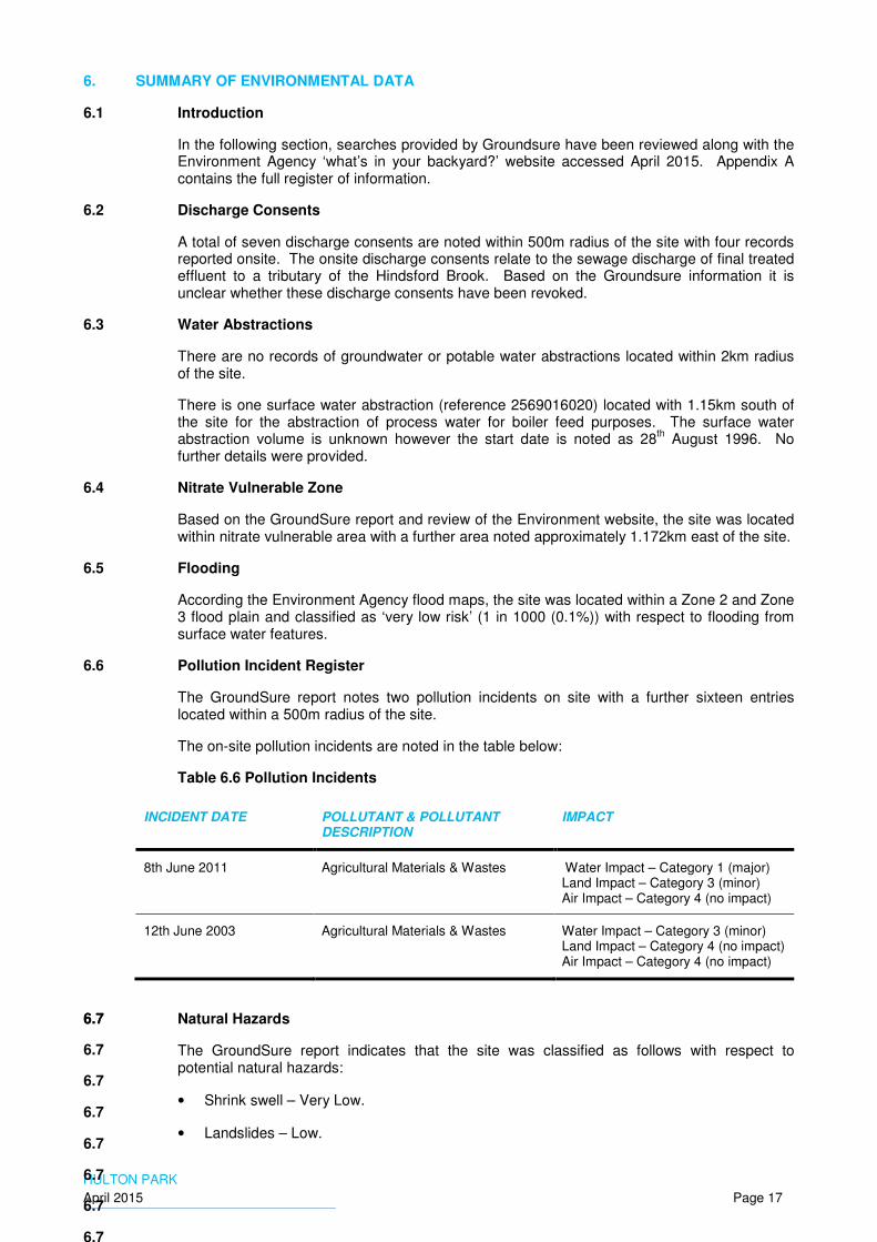
6.6 Pollution Incident Register
The GroundSure report notes two pollution incidents on site with a further sixteen entries located within a 500m radius of the site.
The on-site pollution incidents are noted in the table below:
Table 6.6 Pollution Incidents
INCIDENT DATE POLLUTANT & POLLUTANT DESCRIPTION
IMPACT
8th June 2011 Agricultural Materials & Wastes Water Impact – Category 1 (major) Land Impact – Category 3 (minor) Air Impact – Category 4 (no impact)
12th June 2003 Agricultural Materials & Wastes Water Impact – Category 3 (minor) Land Impact – Category 4 (no impact) Air Impact – Category 4 (no impact)
6.7
6.7
6.7
6.7
6.7
6.7
6.7
6.7
6.7 Natural Hazards
The GroundSure report indicates that the site was classified as follows with respect to potential natural hazards:
• Shrink swell – Very Low.
• Landslides – Low.

HULTON PARK
April 2015 Page 18
• Soluble rocks – Negligible.
• Compressible ground – Negligible.
• Collapsible rocks – Very Low.
• Running sand – Very Low.
6.8 Contemporary Trade Directory Entries
The GroundSure report records one contemporary trade entry on site with a further twenty- seven entries located with a 250m radius of the site. The onsite entry was recorded as Deardens Farm for dairy farm operations.
Although not considered contemporary trade entries, a total of three shafts (disused) are noted on site with a single tank, inferred to be associated with the dairy farm and an electricity substation.
6.9 Designated Ecological Site and Sites of Biological Interest
The GroundSure report indicated the site was located within a green belt area. The report also recorded an ancient woodland along the southern site boundary.
The Groundsure report indicated the site to be in an area of ancient woodland. A Local Nature Reserve (LNR) is located approximately 830m to the west.
6.10 Known Landfill Sites (Active & Historical)
The GroundSure report noted
• that there were no active or historical landfills onsite, or within a 250m radius.
• The nearest Environment Agency registered landfill was located approximately 457m north of the site. The landfill was registered to ‘The Coal Authority’ at Garnet Fold (reference: 53712.0) with accepted waste streams noted as inert, industrial and commercial, household liquid sludges. The landfill license was issued on 1
st June 1990
with the status noted as closed.
Three historical landfills are located within a 950m and 1.2km radius of the site. The details of the landfills are presented in the table below:
Table 6.10 Historical Landfills
DISTANCE & DIRECTION FROM SITE (M)
LICENSE DETAILS
SITE REFERENCE
ACCEPTED WASTE
LICENSE ISSUE DATE
STATUS
985m South Swan Island, Atherton
A048 Inert; Industrial; Commercial; Household; Special; and Liquid Sludges.
1st January 1974
Unknown
1.04km North Bolton-Kenyon Junction Railway
B028, 0367 Industrial; Commercial; Household; and Special.
Unknown Unknown
1.159km North Bolton-Kenyon Junction Railway
Unknown Inert Unknown Unknown.

HULTON PARK
April 2015 Page 19
7. GEOTECHNICAL ASSESSMENT
7.1 Anticipated Ground Conditions
The BGS map showed the site to be underlain by superficial deposits of glacial till or glacio-fluvial deposits of sands and gravels. The underlying bedrock is reported to be the Pennine Middle Coal Measures Formation, comprising a cyclic sequence of mudstone, sandstone, siltstone and coal. A section of sandstone referred to as “Cannel Rock” was also recorded to the north-west and south-east of the site. Further, sandstone or “Trencherbone Rock” was recorded across the central / north part of the site.
The BGS borehole records from the numerous boreholes for the proposed Bolton – Wigan Link Road to the west of the site indicate that the superficial deposits comprise predominantly slightly gravelly clay till, with subordinate beds of fluvio-glacial sand and gravel. The more basic shaft records from the east of the site record “marl” to rock head, indicating cohesive strata. The thickness of superficial deposits ranges from 7m to 24m, with a typical thickness of approximately 15m to 20m across most of the site.
The clay is typically recorded as soft or soft to firm to between 1m and 2.5m depth and firm or stiff thereafter. The fluvio-glacial sand and gravel is typically medium dense. Groundwater entries are recorded in the fluvio-glacial soils at depths exceeding 5m, shallow groundwater was not recorded.
Made ground is not likely to be anticipated across the majority of the site, however there could be some located by the old railways sidings to the south of the site, and or within areas that have been in-filled, although this is likely to comprise re-worked natural deposits.
7.2 Geotechnical Considerations
An initial assessment of the ground conditions at the site has been made with regard to the proposed development, together with comments relating to the requirements for any proposed ground investigation:
• Any existing made ground is unlikely to provide a suitable founding stratum for structural foundations. It may require excavation and replacement, or treatment for new hardstanding areas.
• For pavement design, the proposed sub-grade level for the residential, golf course and hotel access roads should be confirmed prior to construction. Any soft ground or unsuitable materials should be excavated out and replaced with engineering fill, before starting any pavement construction works.
• It is likely that conventional low-rise development, such as the proposed residential development, and clubhouse could be undertaken using conventional spread footings, or where the soft near surface material is deeper, more than approximately 1.5m, deeper trench fill foundations could be considered away from areas of shallow coal mining, see Section 8 for further details.
• For heavy structures, such as the proposed hotel and conference centre, an alternative foundation solution is likely to be required. Piles supported by a combination of shaft adhesion and end bearing within the glacial till, or socketed into bedrock are typically the preferred foundation solutions. However, because there is a potential risk that shallow mine workings could underlie the hotel and conference area consideration may need to be given to an alternative foundation solution such as a raft foundation.
• Where the ground is to be re-graded, so as to produce features on the golf course, the material will require classification for re-use. Slope stability analyses may be required for detailed earthworks design if it is proposed to construct steep slopes. The long-term settlement of cohesive strata beneath raised areas may need to be assessed.
• A review of the BGS logs and anticipated geological conditions suggests that superficial material should be capable of being excavated by conventional excavators with toothed buckets.

HULTON PARK
April 2015 Page 20
• Although the existing information on the ground conditions does not indicate the presence of shallow or perched groundwater the possibility of encountering shallow groundwater in the east of the site, away from the existing borehole data should not be discounted. An investigation into the groundwater levels including seasonal variations and an estimation of flow rates is recommended prior to commencement of any detailed earthworks or foundation design.
• It is anticipated that a detailed assessment of the risk associated with former coal mining across the site will be required, see Section 8 for further details.
• The site is not within a brine affected area.
7.3 Ground Investigation
A ground investigation will be required for the following geotechnical purposes:
• To define the thickness of the superficial deposits across the site.
• To confirm the nature of the superficial deposits and determine characteristic parameters for geotechnical design in all areas in which development is proposed including, all built development, infrastructure and creation of landforms associated with the golf course.
• To investigate the coal measure bedrock and determine properties of the rock types encountered for geotechnical design in the vicinity of the hotel and conference centre.
• To determine the depth to groundwater and seasonal variation.
• To determine the characteristics of road subgrade for pavement design.
• To determine the agressivity of the ground to buried concrete.
HULTON PARK
April 2015 Page 21
8. MINING ASSESSMENT
8.1 Introduction
The site is underlain by rocks of the Pennine Middle Coal Measures of Carboniferous age. These are productive coal measures and the site has a long history of coal mining extending back to 1571. Whilst the deep mining beneath the site has been recorded, and has been undertaken by total extraction resulting in closure of mining voids within a few years of completion, there is the potential for this site to have been underlain by shallow unrecorded mine workings that could have remained open. These areas could collapse, giving rise to settlement at the surface at some time in the future. The Coal Authority Development Risk Map for the Bolton area highlights several zones of “high risk” from shallow coal mining crossing the site from southwest to northeast.
8.2 Information Sources
Information has been obtained from the BGS 1:50,000 Sheet 84 Wigan, Solid Edition and Sheet 85 Manchester, Solid Edition. There is also a good record of the depths rock head and any coal seams within 20m of rock head, from the many boreholes undertaken for the proposed Bolton - Wigan link road to the west of the site boundary and available to view on the BGS borehole scans. This is supplemented by information from deep boreholes carried out for coal exploration and shaft records from within and just outside the site boundaries.
8.3 Coal Mining Geology - General
The site is underlain by rocks of the Pennine Middle Coal measures which contain the majority of the productive coal seams of the Coal Measures. Several named productive coal seams underlie the site at varying depths. The coal seams beneath the site typically dip down to the southeast at an angle of around 8 degrees. The coal measures are divided into several blocks by faulting parallel to the bedding from northeast to southwest. In addition there is a major fault normal to the dip running northwest to southeast which cuts across the northeast of the site.
For this coal mining assessment the site is divided into 6 areas based on faulted blocks as shown in Figure 3.
8.4 Coal Mining Geology – Detail
8.4.1 Area 1: Northwest of Site
This area lies to the north of the northernmost fault running across the site. The Cannel Mine coal seam is shown sub-cropping at the northwest corner dipping beneath the site. Although BGS records indicate a thickness of only 0.15m, the Coal Authority Development Risk Plan for Bolton indicates a high level of risk in this area, down dip of the sub crop of the Cannel Mine coal seam. A deep BGS borehole indicates the presence of the Plodder Mine seam at 92m bgl, the Sapling Mine coal should be present approximately 30m higher in the succession, but this is still over 60m bgl, and approximately 40m to 50m below rock head. Even allowing for an adjustment of depth to the up-dip extremity of the site, the depth of bedrock is still likely to be more than 30m, given the seam thickness recorded in a borehole just outside the site boundary as 2m it not considered to be of concern. Therefore the only seam potentially of concern in the northwest of the site would be the Cannel Mine which has been found to be too thin to be workable in this area.
8.4.2 Area 2 Centre/ North part of Site
This area lies between the most northerly and central of three roughly east west running faults and is underlain by the Trencherbone Rock, a major sandstone unit that overlies the extensively worked Trencherbone Mine coal seam which has a recorded thickness of up to 2.25m within the immediate vicinity of the site. The workings in the Trencherbone Mine coal seam are also noted for remaining open due to the sandstone roof. BGS boreholes drilled up to 20m below rock head, drilled on the line of the proposed link road to the west of the site did not encounter any coal or voids. However, the indicative dip and strike of the rock, from the BGS mapping suggests that the coal could be slightly shallower at the site, in particular beneath the proposed residential development near the eastern site boundary. The Hell Hole Mine coal seam, which has been encountered 40m above the Trencherbone Mine coal seam at a BGS borehole within the site, is shown sub-cropping at the southeast corner of this area.

HULTON PARK
April 2015 Page 22
8.4.3 Area 3 Central part of Site
This area lies between the central and most southerly of the three quite closely spaced east west running faults (approx. 150m- 250m). This area is shown to include the sub crop of the Doe Mine and the Five Quarters (or Parker) Mine coal seams. The Hell Hole Mine coal seam, is located approximately 30m below the Five Quarters coal seam within the site. The Hell Hole Mine coal seam has a recorded thickness of between 0.6m and 0.8m in the vicinity of the site and is unlikely to be of concern in this area. The Five Quarters mine coal seam, with a recorded thickness of between 0.6m and 0.8m within the site, is identified in two deep boreholes sunk for the Atherton Mines Company and recorded on the BGS database. The Doe Mine is identified in the borehole records but is not named which suggests that it may not have been considered a workable seam in this area. This area includes possible proposed locations for a car park, the Club House and the Hotel and Conference Centre which are at or near the location of the existing farm buildings at Home Farm. It appears from the information available that the proposed car park and Club House are underlain by shallow coal seams and potentially, shallow mine workings.
8.4.4 Area 4 Central Southern part of Site
This is a broad area approximately 500m from north to south, extending from the southernmost of the closely spaced faults crossing the central part of the site to a further fault which crosses the southern part of the site. The Five Quarters Mine and Doe Mine coal seams are shown sub cropping in the northern part of this area. The southernmost of the Atherton Collieries boreholes shows that the Hell Hole Mine coal seam is located very close to the base of the superficial deposits at the northern boundary of this area. A BGS Shaft record for the park pits wood shaft, located in the east of the area approximately mid-way between the northern and southern boundary faults to this area show that the Five Quarters Mine coal is at a depth of 42m bgl, approximately 27m below the base of the superficial deposits. The Hell Hole Mine coal is shown to be at a depth of approximately 73m bgl. BGS records for the two Hulton Colliery shafts (Hulton No 3 and Hulton No 4) just outside the southern boundary of the site indicate the presence of unnamed coal seams over 0.6m in thickness approximately 10m and 20m above the Doe Mine coal seam. It is proposed that the vast majority of this area will be occupied by the golf course and wooded areas with some lakes. Residential development is proposed for the northern part of the east perimeter of this area. The access road to the proposed hotel and conference centre is shown passing through this area from the eastern boundary.
8.4.5 Area 5 Southeast of Site
This area lies south of the southernmost east west trending fault which crosses the site. There are minor northwest to southeast trending faults of relatively small displacement shown within this area. The sub crop of the Black and White Mine coal seam, over 2m in thickness, is shown crossing the south east corner of the site. No other coal seams are shown sub cropping within this area, but shaft records for the Hulton Pit located just beyond the southern site boundary indicate that the Doe Mine coal seam is only a few metres below rock head in the west of this area further east, east of a minor northwest to southeast trending fault. The Doe Mine Coal seam is deeper onsite, but is overlain be coal seams of potentially workable thickness (about 0.6m) approximately 10m and 20m higher in the succession. BGS records show that very closely spaced boreholes were undertaken to investigate the Black and White Mine coal seam beneath a recently constructed residential area immediately south of the southeast corner of the site. Residential development is proposed in the southern extremity of this area, including the vicinity of the sub crop of the Black and White Mine coal seam, at the eastern boundary, and in the south west corner of this area. Much of the remainder of the area comprises existing woodland which is to be retained and a smaller area is within the proposed golf course.
8.4.6 Area 6 Northeast of site
This area lies to the northeast of a major northwest- southeast trending fault, the Padiham Fault. A BGS record of a shaft located northeast (up-dip) of the site indicates that the Cannel Mine coal is 0.87m thick in this area and is present approximately 7m below rock head. The Sapling Mine coal seam (1.42m thick) is located approximately 33m below the Cannel Mine and is unlikely to be within influencing depth of the surface. The next significant coal seam
HULTON PARK
April 2015 Page 23
above the Cannel Mine is the Trencherbone seam which is shown sub-cropping south of the area.
8.5 Mine Shafts
The Coal Authority have identified 14 mine shafts present on or within 20m of the site .These are discussed individually below
8.5.1 Coal Authority Reference 367406-001
Associated with Hulton Pits adjacent to north boundary in northwest of site which closed between 1851 and 1892, this shaft is located in an area of fenced woodland that is to be retained. In the proposed development there is an ornamental pond shown in an open area approximately 25m southwest of the indicative position of the mineshaft.
The Coal Authority has no record of treatment of this shaft.
Given the position of the shaft within woodland, intrusive investigation to locate this shaft could be difficult. If the shaft can be positively identified by inspection at the surface this should be carried out. The nearest point of the proposed pond should be located at least 20m from the mineshaft. If the shaft cannot be located it is recommended that pond should be located at least 20m from the northern edge of the open area in which the pond is to be situated.
8.5.2 Coal Authority Reference 367406-002
This shaft is also associated with Hulton Pits and is also within the same fenced wooded area. The nearest features to the indicated location of the shaft are proposed bunkers and a green between 100m and 150m distance.
The Coal Authority has no record of treatment of this shaft.
Given the position of the shaft within woodland and the absence of sensitive development in the vicinity of the shaft, investigations should be staged starting with a walkover to try and identify its location, intrusive investigation may be required.
8.5.3 Coal Authority Reference 367406-004
This shaft is the more southerly of the two shafts at the Hulton Collieries Bank Pits No’s 1 and 2, also referred to as Atherton Pits No’s 1 and 2. It is shown outside but within 20m of the site boundary. The shaft location is within a small area of woodland located outside the site boundary. A new wooded area is proposed within the site boundary with open land, possibly to be used as a campsite, beyond.
The Coal Authority has no record of treatment of this shaft.
Given the position of the shaft within woodland and the absence of sensitive development in the vicinity of the shaft, investigations should be staged starting with a walkover to try and identify its location, intrusive investigation may be required.
8.5.4 Coal Authority Reference 368404-001
This is the shaft for Park Pit which was sunk and became disused between 1892 and 1907. The shaft is located in the eastern part of Hulton Park approximately 100m south of Park Pits wood and 100m north of the main access to the former Hulton Hall. The shaft now lies within a small circular copse. Current development proposals are for a fairway to be constructed to the north of the copse and south of Park Pits Wood.
The Coal Authority has anecdotal evidence that the shaft was infilled with colliery shale at some time in the past but no other details of treatment.
Given the position of the shaft probably lies within a copse, investigations should be staged starting with a walkover to try and identify its location, intrusive investigation may be required.
It would be prudent not to carry out any earthworks associated with the proposed fairway within 20m of the shaft. If the shaft location cannot be accurately identified, earthworks should not be carried out within 20m of the edge of the copse.

HULTON PARK
April 2015 Page 24
8.5.5 Coal Authority Reference 368404-006
This shaft is one of a group of seven recorded shafts located in the south east corner of the site, probably associated with the coal pit recorded in 1851 in the vicinity of the former Park Cottage, and possibly other earlier coal pits in that area. It is proposed that residential development is undertaken in this area.
The shaft is recorded as being filled and then capped with a 3.7m square non-structural concrete cap in 1977 by the National Coal Board (NCB). The shaft is marked by a concrete obelisk which is shown on the 1:1,250 scale mapping and the site plan.
Location of the shaft is unnecessary if it is marked at surface. New buildings must not be constructed within 20m of the shaft and detailed development plans must take this into account. If site infrastructure were to be constructed over the shaft, investigation and possibly treatment of the infill would be required together with a structural cap.
8.5.6 Coal Authority Reference 368404-007
This is also one of the seven recorded shafts in the southeast corner of the site, located in an area in which residential development is proposed.
The shaft has been filled at some time in the past but the Coal Authority have no details of the fill materials used.
It will be essential to positively locate this shaft prior to site development. As the infill details are unknown, there is a potential risk to any one undertaking activities which disturb the shaft. Once the shaft is located appropriate detailed investigation of the shaft and treatment can be carried out using an appropriate safe working plan. New buildings must not be constructed within 20m of the shaft and detailed development plans must take this into account.
8.5.7 Coal Authority Reference 368404-008
This is also one of the seven recorded shafts in the southeast corner of the site, located in an area in which residential development is proposed.
The shaft is recorded as being filled and then capped with a 3.7m square non-structural concrete cap in 1977 by the National Coal Board (NCB). The shaft is marked by a concrete obelisk which is shown on the 1:1,250 scale mapping and the site plan.
Location of the shaft is unnecessary if it is marked at surface. New buildings must not be constructed within 20m of the shaft and detailed development plans must take this into account. If site infrastructure were to be constructed over the shaft a structural cap would have to be constructed.
8.5.8 Coal Authority Reference 368404-009
This is also one of the seven recorded shafts in the southeast corner of the site, located in an area in which residential development is proposed.
The Coal Authority has no record of treatment of this shaft.
It will be essential to positively locate this shaft prior to site development. As the infill details are unknown, there is a potential risk to any one undertaking activities which disturb the shaft. However this shaft is situated at or very close to the site boundary and extreme caution must be taken when investigating its location or treating the shaft, and in any event there must be no trespass onto the adjoining property which is a back garden. New buildings must not be constructed within 20m of the shaft and detailed development plans must take this into account.
8.5.9 Coal Authority Reference 368404-011
This is also one of the seven recorded shafts in the southeast corner of the site, located in an area in which residential development is proposed.
The shaft is recorded as being filled and then capped with a 3.7m x 2.7m x 1.2m thick truncated concrete cone plug in 1977 by the NCB. The shaft is recorded as marked by a

HULTON PARK
April 2015 Page 25
concrete obelisk, but no such feature is shown on the 1:1,250 scale mapping or the site plan, therefore it is possible that this feature has been lost in which case it will be necessary to relocate the shaft.
If the surface marker has been lost it will be essential to positively locate this shaft prior to site development. New buildings must not be constructed within 20m of the shaft and detailed development plans must take this into account.
8.5.10 Coal Authority Reference 368404-012
This is also one of the seven recorded shafts in the southeast corner of the site, located in an area in which residential development is proposed.
The shaft is recorded as being filled and then capped with truncated concrete cone plug in 1977 by the NCB. The shaft is recorded as marked by a concrete pyramid, but no such feature is shown on 1:1,250 scale mapping or the site plan, therefore it is possible that this feature has been lost in which case it will be necessary to relocate the shaft. Particular care will be required because a stream is shown issuing close to the location of the shaft.
If the surface marker has been lost it will be essential to positively locate this shaft prior to site development. New buildings must not be constructed within 20m of the shaft and detailed development plans must take this into account.
8.5.11 Coal Authority Reference 368404-013
This is also one of the seven recorded shafts in the southeast corner of the site, located in an area in which residential development is proposed.
The Coal Authority has no record of treatment of this shaft.
It will be essential to positively locate this shaft prior to site development. As the infill details are unknown, there is a potential risk to any one undertaking activities which disturb the shaft. However this shaft is situated at or very close to the existing buildings at Park End Farm. Given the high risk of movement if shaft infill material is disturbed it will not be safe to undertake intrusive investigations to locate the shaft whilst these buildings are occupied. Present development plans indicate that the farm buildings are not to be retained, and it would be safer to carry out shaft location after demolition has taken place. The demolition contractor will need to ensure they undertake their own risk assessment to ensure the mine shafts / working are not disturbed. New buildings must not be constructed within 20m of the shaft and detailed development plans must take this into account.
8.5.12 Coal Authority Reference 368404-014
This shaft is in an area some distance from any mining recorded on the historical mapping since 1851, and it is assumed that this mine shaft was infilled at some time prior to 1851. The shaft is located approximately 80m south of the access road to the former Hulton Hall to the south of Park Pits Wood.
In 2004 JMC Engineering, under the direction of the Coal Authority, infilled the shaft to within 1m of the surface with stone and finished with a conical plug of concrete covered over with topsoil.
It is proposed that a fairway will occupy the area in the vicinity of the shaft.
It would be prudent to locate the shaft and ensure that the fairway was designed to be level and at grade, within 20m of the shaft.
8.5.13 Coal Authority Reference 368405-008
This shaft is located in Park Pits Wood in an area that was mined prior to 1851 and between 1851 and 1892. The shaft is shown within 20m to the north of a second shaft, Coal Authority Reference368405-009. The shaft is shown to be in the immediate vicinity of a proposed tee on the golf course.
The Coal Authority has no record of treatment of this shaft.
HULTON PARK
April 2015 Page 26
It will be prudent to positively locate the shaft and investigate the fill, and if appropriate undertake shaft treatment prior to carrying out regrading to form the tee. Alternatively, once the shaft has been located the golf tee could be moved further to the north to avoid the need for detailed investigation and treatment. The large concrete cap on Shaft 368405-009 can be used to provide a marker for commencing location of this shaft. It should be noted that the woodland in park pits wood is fairly open and it is anticipated that plant used for locating the shaft will be able to operate without difficulty.
8.5.14 Coal Authority Reference 368405-009
This shaft was located in Park Pits Wood and has been shown on the historical mapping since 1851. It is shown to be on the edge of an area that is to be retained as woodland immediately south of a proposed golf tee.
This shaft was recorded as being capped with a non-structural concrete cap, 12.2m x 9.6m x 0.68m thick, by the NCB in 1977. No detail of infill is given.
The cap is clearly shown on the site plan and the 1:10,000 and 1:1,250 mapping.
Location of the shaft is unnecessary if it is marked at surface. Given that shaft 368405-008 is closer to any proposed development than this shaft, investigations should be staged starting with a walkover to try and identify its location, intrusive investigation may be required.
8.6 Recommendation for Investigation for Mine Workings
A targeted investigation is recommended to define areas at risk of subsidence at the surface specifically in areas in which subsidence would have an impact on the proposed development.
8.6.1 The proposal for the investigation for coal mining is based on the following:
• Areas in which settlement at the surface will have a significant impact should have sufficient investigation to define any zones potentially at risk and requiring detailed investigation and treatment. These ‘critical’ areas are
− areas of proposed residential development
− the vicinity of the proposed hotel and conference centre
− The vicinity of the club house and car park
− Access routes
• Areas overlying coal seams 0.4m or greater in thickness are considered to be potentially workable. Where there is less than 10 times seam thickness cover of bedrock, the collapse of workings is considered to pose a potential risk to development at the surface.
• The existence and approximate location of faults as shown on the BGS maps is assumed to be correct, and a general dip of strata to the southeast is assumed. However, sufficient exploratory holes should be drilled to sufficient depth to define the fault locations and dip of strata with greater accuracy in ‘critical’ areas of the site.
• BGS borehole data for boreholes penetrating bedrock and shaft records have been used in conjunction with the geological mapping in the design of the ground investigation.
• It is assessed that sufficient information will be gained from the investigation of ‘critical’ areas of the site to enable a reasonable assessment to be made of the areas of the golf course potentially at risk from shallow mine workings. In particular informed decisions can be made to decide whether any greens require re-siting.
8.6.2 The specific objectives of the proposed exploratory holes for mining risk assessment are as follows:
• Residential areas within the east part of the proposed golf course, spa, car park and club house. To define the extent of the northern central part of the site (Area 2) between the faults defining the areas underlain by the Trencherbone Rock with the Trencherbone Mine
HULTON PARK
April 2015 Page 27
coal seam beneath, and establish the minimum thickness of bedrock cover over the Trencherbone Mine coal seam and whether it poses a risk to development. In addition, to define the areas potentially at risk from shallow mining in the Five Quarters Mine or Doe Mine coal seams in the central belt (Area 3).
• Residential area south west of the proposed golf course. Delineation of the area at risk from any shallow mining in the Five Quarters Mine, or Doe Mine coal seams.
• Delineation of any areas at risk from shallow mining in the Trencherbone Mine, Five Quarters Mine and the Doe Mine coal seams in the vicinity of the proposed Hotel and Conference Centre. It is considered that these boreholes may be located in open ground to the north, east and south of the proposed Hotel and Conference Centre as the general dip of strata is quite uniform. This increases the confidence in the location of faulting and areas at risk from shallow mine workings across the central part of the site (Areas 2 and 3).
• Determination of areas at risk from shallow mine workings in the Hell Hole Mine coal seam in the east of the site, to assist in golf course layout.
• Investigation of the ground beneath the residential area northeast of the Padiham Fault to determine whether the Cannel Mine coal is sufficiently close to rock head to pose a risk from shallow mine workings in that area. (Area 6)
• To determine the areas at risk from shallow mine workings in the Five Quarters and Doe Mine coal seams in the central southern part of the site (Area 4). This will assist the design of the proposed Golf Course and in the proposed residential development at the eastern site boundary.
• To determine the location of the sub crop of the Black and White Mine coal seam and define the extent of the areas requiring detailed investigation and treatment in the proposed residential area in the southeast corner of the site.
• To determine the areas at risk from shallow mine workings in the recorded un-named coal seams between the Doe Mine coal seam and the Black and White Mine coal seam beneath the proposed residential areas in the southeast of the site.
• To confirm whether there is a potential risk from shallow mining in the Cannel Mine coal seam in the north west of the site.
8.6.3 The Investigation of Mine Shafts
Prior to undertaking any intrusive investigation of mineshafts a more detailed report on those mine entries considered to have a potential impact on the proposed development will be required. It would be reasonable to omit some of the mine entries which are now, and will continue to be within woodland after site development. It would also be reasonable to omit obtaining detailed reports for mine shafts which are clearly marked at the surface and sufficient information exists to assess whether treatment is required.
It is considered that mine entry reports should be obtained for the following mine entries.
• 367406-001
• 368404-009
• 368404-011
• 368404-012
• 368404-013
• 368404-014
• 368406-008

HULTON PARK
April 2015 Page 28
Where mine shafts are to be located by intrusive investigation the method which minimises the risk to plant and personnel working on the investigation is by use of a long reach excavator. The method involves stripping the topsoil and any made ground to reveal the top of the natural ground. The presence of an infilled shaft is evident by the contrast between the infill and surrounding natural ground. There are five particular advantages of this method over probing using vertical holes over the shaft.
• The method is much quicker over thick superficial deposits where drilling each hole is time consuming.
• The shape and size of the shaft is immediately apparent.
• Plant and personnel are remote from the shaft and are not at risk from a collapse.
• The chance of collapse is lower because there is less disturbance to the fill than when drilling, particularly if the superficial deposits are deep.
• The chance and severity of collapse are reduced because the weight of the machine is not bearing down on the shaft fill and the weight of the machine bucket can be removed completely at the first sign of instability.
Where treatment is identified as being required this should be carried out separately as pre construction development works.
HULTON PARK
April 2015 Page 29
9. CONCEPTUAL SITE MODEL
The site in terms of potential land contamination will be regulated by the local authority under the Town and Country Planning Act 1990 (as amended), taking account of the National Planning Policy Framework 2012, with the Environment Agency, Natural England and English Heritage acting as statutory consultees.
The “suitable for use” approach is adopted for the assessment of contaminated land where remedial measures are only undertaken where unacceptable risks to human health or the environment are realised taking into account the use (or proposed use) of the land in question and the environmental setting.
Additional environmental liabilities can arise through provisions contained within statutory legislation including Part 2A of the Environmental Protection Act 1990, the Water Resources Act 1991, the Groundwater Regulations 2009 and the Water Act 2003.
Current best practice recommends that the determination of health hazards due to contaminated land is based on the principle of risk assessment, as outlined in the Statutory Guidance to Part 2A (2012).
The risk assessment process for environmental contaminants is based on a source-pathway-receptor analysis. These terms can be defined as follows:
• Source: hazardous substance that has the potential to cause adverse impacts.
• Pathway: route whereby a hazardous substance may come into contact with the receptor: examples include ingestion of contaminated soil and leaching of contaminants from soil into watercourses.
• Receptor: target that may be affected by contamination: examples include human occupants/users of site, water resources (surface waters or groundwater), or structures.
For a risk to be present, there must be a relevant contaminant linkage; i.e. a mechanism whereby a source impacts on a sensitive receptor via a pathway.
The following sections detail the preliminary conceptual site model (CSM) which has been developed for the site with a view to assessing the potential risks/ liabilities associated with the site in its current condition prior to any land transaction. Risks associated with future construction and upon completion of the proposed development are also assessed. The potential sources of contamination, potential receptors and potential contaminant pathways are identified for the site.
9.1 Sources of Potential Contamination
9.2 On-Site Sources
The following are considered to be sources of potential contamination at the site of the proposed development:
• Former agricultural land - heavy metals and inorganic compounds, fertilizers and pesticides and organic wastes and sludges;
• Former onsite colliery activities:
− Made ground: Former infilled colliery and associated buildings – Fuels and oils, coal, ash and clinker including PAHs, heavy metals and inorganic compounds, chlorinated and non-chlorinated organic solvents;
− Made ground & fill material: Hulton Hall – asbestos and asbestos containing materials, paints, oils and fuels including coal;
− Above ground and underground storage tanks – Bulk storage of oils and fuels;
− Railway sidings & bunkers: Coal, coal dust and ash;

HULTON PARK
April 2015 Page 30
• Bulk soil gases: methane, carbon dioxide and other trace gases may be generated from made ground, natural deposits and the underlying coal seam;
• Soil vapours: Volatile organic compounds may be present emanating from soil/ groundwater sources of organic contaminants; and
• Shallow coal mining & instability associated with former underground mining of the coal seam.
9.2.1 Off-Site Sources
The following are considered to be potential sources of contamination located adjacent to or within 250m radius of the site:
• Infilled ponds, spoil heaps and made ground associated with wider colliery activities
9.3 Potential Chemicals of Concern (CoPC)
Soils
• Heavy metals & inorganic compounds;
• Polycyclic Aromatic Hydrocarbons (PAHs);
• Petroleum Hydrocarbons including heating oils and fuels (petroleum/ diesel);
• Pesticides and fertilizers associated with former agricultural land uses; and
• Asbestos Containing Materials (ACMs) in soils;
Groundwater
• Dissolved heavy metals and inorganic compounds;
• Dissolved phase TPH and free phase products; and
• Dissolved chlorinated solvents and non-chlorinated solvents including free phase products.
Bulk ground gases and vapours
• Ground gases including methane, carbon dioxide, carbon monoxide and hydrogen sulphide; and
• Soil vapours associated with volatile chlorinated and non-chlorinated solvents.
9.4 Potential Pathways
Human Health
• Direct dermal contact including ingestion of soil particulates and dusts;
• Inhalation of soil vapours / bulk ground gas, and
• Plant / vegetable uptake associated with residential gardens, soft landscaped and open amenity areas.
Controlled Waters
• Leaching of chemicals from the made ground deposits and infilled material in to the underlying Secondary A glacio-fluvial deposits;
• Leaching of residual contamination in the Secondary A glacio-fluvial deposits into the Secondary A PLCM aquifer; and
HULTON PARK
April 2015 Page 31
• Lateral and vertical migration of groundwater in the Secondary A aquifers towards identified surface water features including the Carr Brook.
Bulk Ground Gases/ Soil Vapour
• Vertical migration of ground gases/ soil vapour from underlying infilled materials and deeper PLCM deposits into proposed on-site buildings/ enclosed structures (i.e. manholes/ chambers etc.)
9.5 Potential Receptors
Human Health – Future
• Future construction and maintenance workers (acute exposure risk)1;
• Future maintenance workers (acute exposure risk), and
• Future residents (chronic exposure risk).
Controlled Waters
• Underlying Secondary A aquifer (superficial glacio-fluvial deposits in the SW and PLCMF);
• Carr Brook located on-site and flows in a north-south direction; and
• A tertiary river and culvert is located on-site to the south west.
Buildings
• Proposed residential properties, hotels and conference centre including foundations and services.
Flora and Fauna
• Landscaping, gardens and potential open amenity areas.
9.6 Potential Relevant Contaminant Linkages
• Direct dermal contact and ingestion of soil particulates and dusts (including ACMs) by future site residents associated with residual made ground and infilled wastes;
• Inhalation of volatile soil vapours and bulk ground gases by future site residents associated with made ground including those located in the vicinity of any former ASTs or infilled wastes;
• Ingestion of fruit and vegetables grown within residual made ground and infilled waste deposits and residual soil particulates adhered to vegetables grown within potentially impacted shallow soils;
• Leaching - vertical migration of mobile CoPC’s present within shallow soils into the underlying Secondary A glacio-fluvial deposits and lateral migration into on-site primary and tertiary rivers and culverts.
• Leaching – vertical migration of mobile CoPC’s present within underlying Secondary A glacio-fluvial deposits into the Secondary A PLCM aquifer and lateral migration into on-site tertiary rivers and culverts.
1 Not assessed in this report. This is the responsibility of the Principal Contractor/ developer to ensure the health and safety of their site
personnel.

HULTON PARK
April 2015 Page 32
10. ENVIRONMENTAL RISK ASSESSSMENT FRAMEWORK
10.1 Risk Assessment Principles
Using criteria broadly based on those presented in Section 6.3 of the CIRIA Report “Contaminated Land Risk Assessment: A Guide to Good Practice” (CIRIA Report C552) the magnitude of the risk associated with potential contamination at the site has been assessed.
To do this an estimate is made of:
• the potential severity of the risk; and,
• The likelihood of the risk occurring.
The severity of the risk is classified according to the criteria in Table 9.1.
Table 10.1 Severity of Risk
Severe
Acute risks to human health likely to result in “significant harm” (e.g. very high concentrations of contaminants/ground gases)
Catastrophic damage to buildings/property (e.g. by explosion, sites with high gassing potential, extensive VOC contamination)
Major pollution of controlled waters (e.g. surface watercourses or Principal aquifers/source protection zones)
Short term risk to a particular ecosystem
Medium
Chronic (long-term) risk to human health likely to result in “significant harm” (e.g. elevated concentration of contaminants/ground gases)
Pollution of sensitive controlled waters (e.g. surface watercourses or Principal/ Secondary aquifers)
Significant effects on sensitive ecosystems or species
Mild
Pollution of non-sensitive waters (e.g. smaller surface watercourses or non-aquifers)
Significant damage to crops, buildings, structures or services (e.g. by explosion, sites with medium gassing potential, elevated concentrations of contaminants)
Minor
Non-permanent human health effects (requirement for protective equipment during site works to mitigate health effects)
Damage to non-sensitive ecosystems or species
Minor (easily repairable) damage to buildings, structures or services (e.g. by explosion, sites with low gassing potential)
The probability of the risk occurring is classified according to the criteria in Table 9.2.
Table 10.2 Probability of Risk Occurrence
High likelihood Contaminant linkage may be present that appears very likely in the short-term and risk is almost certain to occur in the long term, or there is evidence of harm to the receptor
Likely Contaminant linkage may be present, and it is probable that the risk will occur over the long term
Low likelihood Contaminant linkage may be present and there is a possibility of the risk occurring, although there is no certainty that it will do so.
Unlikely Contaminant linkage may be present but the circumstances under which harm would occur even in the long-term are improbable.

HULTON PARK
April 2015 Page 33
An overall evaluation of the level of risk is gained from a comparison of the severity and probability, as shown in Table 9.3.
Table 10.3 Comparison of Probability and Severity of Risk
Severity
Severe Medium Mild Minor
Pro
ba
bil
ity
High likelihood
Very High Risk High Risk Moderate Risk Moderate/Low
Risk
Likely High Risk Moderate Risk Moderate/Low
Risk Low Risk
Low likelihood
Moderate Risk Moderate/Low
Risk Low Risk Very Low Risk
Unlikely Moderate/Low
Risk Low Risk Very Low Risk Very Low Risk
10.2 Preliminary Risk Evaluation
A preliminary evaluation of the potential risks associated with the identified sources at the site to the various potential receptors is discussed and presented in the following sections (please refer to Table 9.4). The level of risk is determined based on the current condition of the site (i.e. the effects of mitigation measures are not included).
10.2.1 Discussion of Risk to Future Site Users
Table 10.4 Summary of Risk to Future Site Users
Contaminant linkage Potential Severity Likelihood of occurrence
Level of Risk
Dermal contact / ingestion of contaminants derived from Made Ground deposits.
Medium Low Likelihood Moderate / Low
Risk
Inhalation of contaminants derived from Made Ground deposits
Medium Low Likelihood Moderate / Low
Risk
Inhalation of bulk ground gases and soil vapours derived from Made Ground deposits.
Medium Low Likelihood Moderate / Low
Risk
Risks from explosion of ground gases associated with historical shallow mining activities
Severe Unlikely Moderate / Low
Risk
The overall risks posed by the site to future site users are considered to be moderate / low risk dependent upon the exposure pathway.
It is considered to be a low likelihood of future site users are undergoing an extended exposure to any significant contaminants. However consideration should be given to the potential presence of contamination in the made ground and a clean topsoil cover system may
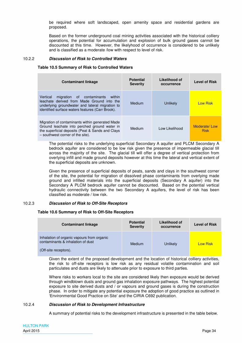
HULTON PARK
April 2015 Page 34
be required where soft landscaped, open amenity space and residential gardens are proposed.
Based on the former underground coal mining activities associated with the historical colliery operations, the potential for accumulation and explosion of bulk ground gases cannot be discounted at this time. However, the likelyhood of occurrence is considered to be unlikely and is classified as a moderate /low with respect to level of risk.
10.2.2 Discussion of Risk to Controlled Waters
Table 10.5 Summary of Risk to Controlled Waters
Contaminant linkage Potential Severity
Likelihood of occurrence
Level of Risk
Vertical migration of contaminants within leachate derived from Made Ground into the underlying groundwater and lateral migration to identified surface waters features (Carr Brook).
Medium Unlikely Low Risk
Migration of contaminants within generated Made Ground leachate into perched ground water in the superficial deposits (Peat & Sands and Clays – southwest corner of the site).
Medium Low Likelihood Moderate/ Low
Risk
The potential risks to the underlying superficial Secondary A aquifer and PLCM Secondary A bedrock aquifer are considered to be low risk given the presence of impermeable glacial till across the majority of the site. The glacial till will offer a degree of vertical protection from overlying infill and made ground deposits however at this time the lateral and vertical extent of the superficial deposits are unknown.
Given the presence of superficial deposits of peats, sands and clays in the southwest corner of the site, the potential for migration of dissolved phase contaminants from overlying made ground and infilled materials into the superficial deposits (Secondary A aquifer) into the Secondary A PLCM bedrock aquifer cannot be discounted. Based on the potential vertical hydraulic connectivity between the two Secondary A aquifers, the level of risk has been classified as moderate / low risk.
10.2.3 Discussion of Risk to Off-Site Receptors
Table 10.6 Summary of Risk to Off-Site Receptors
Contaminant linkage Potential Severity
Likelihood of occurrence
Level of Risk
Inhalation of organic vapours from organic contaminants & inhalation of dust
(Off-site receptors).
Medium Unlikely Low Risk
Given the extent of the proposed development and the location of historical colliery activities, the risk to off-site receptors is low risk as any residual volatile contamination and soil particulates and dusts are likely to attenuate prior to exposure to third parties.
Where risks to workers local to the site are considered likely then exposure would be derived through windblown dusts and ground gas inhalation exposure pathways. The highest potential exposure to site derived dusts and / or vapours and ground gases is during the construction phase. In order to mitigate any potential exposure the adoption of good practice as outlined in ‘Environmental Good Practice on Site’ and the CIRIA C692 publication.
10.2.4 Discussion of Risk to Development Infrastructure
A summary of potential risks to the development infrastructure is presented in the table below.

HULTON PARK
April 2015 Page 35
Table 10.7 Summary of Risk to Development Infrastructure
Contaminant linkage Potential Severity
Likelihood of occurrence
Level of Risk
Direct contact with contaminants within Made Ground
Mild Likely Moderate / Low
Risk
Direct contact with contaminants in leachate Mild Likely Moderate / Low
Risk
Instability associated with potential shallow coal mining of coal seams.
Severe Likely High Risk
The overall risk to the development infrastructure is considered to be moderate / low to high risk due to the potential for ground instability associated with the former coal mining activities beneath the site that cannot be discounted.
Where in-situ ground structures (i.e. buried foundations and underground structures) are proposed residential, hotel and conference centre buildings then consideration for potential aggregative soil conditions would require further consideration. Given the uncertainty with respect to ground conditions, the level of risk is classified as moderate / low risk.
In addition where potable water supply pipes, buried services are proposed as part of the development it would be deemed necessary to consider this further prior to placement /installation.
The potential risk from ground instability associated with the former underground coal mining are considered to be high and as such further consideration is deemed necessary through intrusive investigation.
10.2.5 Discussion of Risk to Flora and Fauna
Contaminant linkage Potential Severity
Likelihood of occurrence
Level of Risk
Direct contact with contaminants within Made Ground
Minor Low Likelihood Very Low Risk
Direct contact with contaminants in leachate Minor Low Likelihood Very Low Risk
Ground Gases affecting root system Minor Low Likelihood Very Low Risk
The risks to flora and fauna from soil contaminants, leachate and ground gasses are considered to be a very low risk.
There are no sensitive or protected ecosystems located on the site or within the wider environs that would require further consideration. However, given the potential presence of significant thicknesses of made ground and fill materials associated with the former colliery

HULTON PARK
April 2015 Page 36
activities the presence of phyto-toxic contaminants (copper and zinc) cannot be discounted. It may be deemed necessary to employ clean cover systems in areas of residential gardens, open amenity areas and soft landscaped areas to mitigate the potential for plant distress and dieback.
10.2.6 Discussion of Risk to Construction Workers
The preliminary qualitative human health risk assessments presented in this report focuses on the long-term chronic health risks. An assessment of this type is not applicable to the potential risk to site workers during construction (acute risks).
Prior to work commencing, a health and safety risk assessment should be carried out by the principal contractor in accordance with current health and safety regulations.
A H&S assessment should cover potential risks to both construction staff and the local population. Based on the findings of this preliminary qualitative risk assessment, appropriate mitigation measures should be implemented during the construction period. This risk assessment should include concern for potential ACM within the Made Ground, if identified during any intrusive investigation.
The greatest potential for generation of dust will be during the site works therefore dust generation should be kept to a minimum in accordance with general best practice, as outlined in ‘Environmental Good Practice on Site’ and CIRIA C692 publications.
The risk to construction workers in terms of potential exposure to high concentrations of contaminants is considered to be low to moderate given the historical land uses identified at the site. Where local high concentrations of contamination are identified during the construction phase, these may pose a potential acute risk to construction works however can be effectively managed through good health and safety practices.

HULTON PARK
April 2015 Page 37
11. CONCLUSIONS
11.1 Summary
AECOM have undertaken a geotechnical and geo-environmental desk study for a proposed redevelopment at Hulton Park on behalf of Peel Holdings. The site is located approximately 5km southwest of Bolton and comprises an area of approximately 250 hectares. The site consists of the former Hulton Park Estate and areas of agricultural land. The site is to be developed for a combination of residential and leisure activities and will include a hotel and conference centre, a golf course and residential properties with gardens around the periphery.
11.2 Geotechnical
The site is underlain by superficial deposits comprising mostly glacial till which is underlain by mudstones and sandstones of the Pennine Middle Coal Measures which contained many productive coal seams.
It is envisaged that the majority of the proposed residential properties will be founded on conventional shallow spread foundations and locally on deeper trench fill foundations where the glacial till is soft near the surface.
It is envisaged that the hotel and conference centre require more substantial foundations. Normally this would comprise piled foundations taken to bedrock, but because of the risk of subsidence due to the potential for the collapse of shallow mine workings an alternative solution, such as using raft foundations may be more appropriate.
There are likely to be some earthworks associated with the fairways, greens and tees on the golf course. This may include the reworking of soils on site although it is likely that imported free draining granular soil will also be required.
11.3 Mining
The site is underlain by the Pennine Middle Coal Measures which contain many coal seams, several of which have been mined from within the site or from coal mines outside the site with workings extending beneath the site.
Whilst mining of the deeper coal seams beneath the site has been carried out from within large collieries and is recorded, the mining of the shallow coal seams is mostly from small pits abandoned before mining abandonment records became mandatory. As Hulton Park has a history of mining back to 1571, it is probable that unrecorded shallow worked coal seams are present beneath the site.
The available information from BGS Geological Maps and borehole records are useful but is based on too few data points to enable the specific areas potentially at risk of shallow mine workings to be defined. However, this information does enable a more detailed targeted investigation to be designed.
The Coal Authority mining report for the site identifies fourteen recorded mineshafts on or within 20m of the site. Of these, six require further investigation, because they are within areas in which they could affect the proposed development, and are not or may not be visible at the surface. The remaining recorded shafts should be visually located with additional investigations as necessary to define their state of remediation.
11.4 Geo-Environmental
The review of historical and environmental information including hydrogeological and hydrological data has identified the site as potentially low to moderate sensitivity with respect to potential risks to human health and controlled water receptors from the proposed mixed residential and open space/leisure redevelopment scheme.
Based on the historical site activities including the potential infilling of former colliery ponds, mine shafts, and shallow coal mining, the preliminary conceptual site model has identified the following potential sources of contamination:
HULTON PARK
April 2015 Page 38
• Made ground associated with former colliery activities and infilling with chemicals of concern including fuels and oils, coal, ash and clinker including PAHs, heavy metals and inorganic compounds, chlorinated and non-chlorinated organic solvents.
• Made ground including asbestos and asbestos containing materials, paints, oils and fuels including coal associated with the demolished Hulton Hall and other on-site buildings.
• Former railway sidings & bunkers: Coal, coal dust and ash.
• Bulk soil gases (methane, carbon dioxide and other trace gases) & soil vapours associated with historical made ground deposits associated with former colliery activities.
Based on the context of the proposed development and the preliminary Conceptual Site Model the following complete pollution linkages have been identified that would require further consideration.
• Direct dermal contact and ingestion of soil particulates and dusts (including ACMs) by future site residents associated with residual made ground and infilled wastes.
• Inhalation of volatile soil vapours and bulk ground gases by future site residents associated with made ground including those located in the vicinity of any former ASTs or infilled wastes.
• Ingestion of fruit and vegetables grown within residual made ground and infilled waste deposits and residual soil particulates adhered to vegetables grown within potentially impacted shallow soils.
• Leaching - vertical migration of mobile CoPC’s present within shallow soils into the underlying Secondary A glacio-fluvial deposits and lateral migration into on-site primary and tertiary rivers and culverts.
• Leaching – vertical migration of mobile CoPC’s present within underlying Secondary A glacio-fluvial deposits into the Secondary A PLCM aquifer and lateral migration into on-site tertiary rivers and culverts.
Based on the environmental review of the all available pertinent information, it is considered that the main risk driver for the site is potential geotechnical development constraints. However, given the proposed moderate to high sensitivity of the proposed redevelopment (residential properties with gardens and open leisure facilities) it is considered prudent to undertake a ground investigation in order to quantify and assess the potential risks to future residents, site occupants and visitors and identified controlled water receptors.

HULTON PARK
April 2015 Page 39
12. RECOMMENDATIONS
An intrusive ground investigation is recommended to provide sufficient information to:
• Facilitate environmental characterisation of the site.
• Enable characteristic geotechnical parameters to be determined for the various strata beneath the site.
• Enable areas at risk from shallow mine workings and mine shafts to be determined.
12.1 Environmental Investigation
To characterise the site in sufficient detail to enable development proposals to go forward for outline planning it will be necessary to carry out environmental sampling at a spacing of approximately 100m across the most of the site, with the exception of established woodland areas that are to be retained. Areas of proposed built development, located mostly in plots around the periphery of the site will require environmental sampling at a spacing less than 75m.
To meet this requirement it is assessed that approximately 220 sampling locations will be required. At each sampling location an exploratory hole must be taken to at least 1m below the topsoil or any made ground. It is envisaged that the majority of the site will be underlain by natural ground immediately below the topsoil and shallow pits 2m - 3m in depth will suffice.
Suites of contamination tests should be undertaken on selected samples of near surface soil and groundwater.
12.2 Geotechnical Investigation
It is assessed that to provide characteristic geotechnical parameters of the site approximately 35 cable percussion boreholes will be required mostly in the proposed areas of built development, but also in areas of the proposed golf course that will have mounded features, bunkers and raised greens and tees. The cable percussion boreholes should be taken to rock head to enable the ground model to be developed.
In the vicinity of the proposed hotel and conference centre it is considered that four of the boreholes should continue into rock by rotary coring to enable pile design. The rotary core holes will also supplement the mining assessment.
Window sample holes are also proposed in the vicinity of the Hotel and Conference Centre in the immediate vicinity of Home Farm, where larger drilling plant cannot operate.
Approximately 35 trial pits will also be required to supplement the geotechnical information in areas of earthworks on the golf course and along proposed access routes.
Standpipes should be installed in each borehole and window sample hole, most with shallow gas and groundwater monitoring holes and a few with deeper standpipes or standpipe piezometers. No standpipes should penetrate the coal measures.
Environmental samples will be taken from the geotechnical boreholes and trial pits to minimise the total number of exploratory holes required.
A program of laboratory testing should be undertaken comprising the following
• Classification tests.
• Compaction tests.
• Laboratory CBR tests.
• Consolidation tests.
• Unconsolidated undrained triaxial compression tests.
• Uniaxial compression tests on rock.
• Point load index tests on rock.

HULTON PARK
April 2015 Page 40
• Soil aggressivity tests in accordance with BRE Special Digest 1.
12.3 Mining Investigation
To supplement the information obtained from the BGS mapping and borehole records it is assessed that approximately 25 rotary boreholes will be required to define the areas at risk from shallow mine workings. The penetration of the holes into rock will vary according to the thickness of specific coal seams subject to investigation and the total depth will also vary according to the thickness of superficial deposits.
Most of the rotary boreholes should be drilled in areas of proposed built development, but a few boreholes are also proposed in the golf course area to provide better coverage of the site.
The majority of the rotary boreholes to investigate the presence of coal seams will be rotary open hole with examination of the flush, however it is recommended that a few cored holes are drilled to better define the thickness of the coal seams, evidence of ground disturbed by settlement and the quality of any particular coal seam.
In most cases rotary drilling will take place from the termination of cable percussion boreholes to minimise the total number of exploratory holes and the total meterage drilled.
To investigate the location of mine shafts it is recommended that a mine entry report is obtained for each Coal Authority recorded shaft identified as having the potential to impact on any proposed development. On the basis of the additional information provided, in particular the coordinates, an intrusive investigation should then be carried out using a long reach excavator to remove the topsoil and any made ground so as to reveal the shaft infill.

HULTON PARK
April 2015 Page 41
13. REFERENCES
Online topographical mapping services - https://maps.google.co.uk/
British Geological Survey online geological maps - http://www.bgs.ac.uk/ (Feb 2015);
British Geological Survey online boreholes scans - http://www.bgs.ac.uk/ (Feb 2015)
Environment Agency website http - http://maps.environment-agency.gov.uk (Feb 2015);
Coal Authority Gazeteer - http://coal.decc.gov.uk/ (Feb 2015);
Coal Authority Development Risk Map – Bolton Area (October 2014);
Groundsure Radon, Map-insight, Enviro-insight and Geo-insight Reports (April 2015).
CIRIA C552 : Contaminated Land Risk Assessment: A Guide to Good Practice
DEFRA/Environment Agency Contaminated Land Report CLR11 ‘Model Procedures for the Management of Land Contamination’;
CIRIA C665 (2007): Assessing risks posed by hazardous ground gases to buildings;
NHBC (2007): Guidance on evaluation of development where methane and carbon dioxide are present, report edition no. 4;
Environment Agency Code of Practice ‘Managing Japanese knotweed on development sites’.

"HULTON PARK"
"April 2015"
TABLES

"HULTON PARK"
"April 2015"
FIGURES

"HULTON PARK"
"April 2015"
APPENDIX A – PROPOSED REDEVLOPMENT PLAN
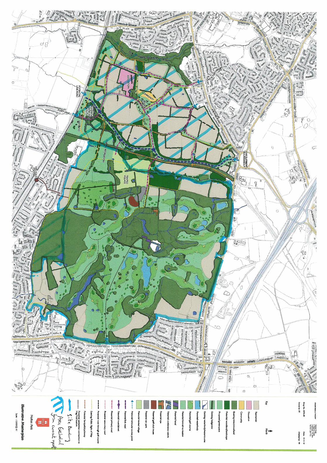
"HULTON PARK"
"April 2015"
APPENDIX B – GROUNDSURE REPORT
AECOM
4TH FLOOR, BRIDGEWATER HOUSE,60, WHITWORTH STREET, MANCHESTER, M1 6LT
Groundsure Reference:
GS-2024512
Your Reference: Purchase_Order_03147172_-_Hulton_Park
Report Date 17 Apr 2015
Report Delivery Method:
Email - pdf
Groundsure Enviroinsight
Address: 367927 405177,
Dear Sir/ Madam,
Thank you for placing your order with Groundsure. Please find enclosed the Groundsure Enviroinsight as requested.
If you need any further assistance, please do not hesitate to contact our helpline on 08444 159000 quoting the above Groundsure reference number.
Yours faithfully,
Managing DirectorGroundsure Limited
Enc.Groundsure Enviroinsight

GroundsureEnviroinsight
Address: 367927 405177,
Date: 17 Apr 2015
Reference: GS-2024512
Client: AECOM
NW N NE
W E
SW S SE
Aerial Photograph Capture date: 01-May-2011Grid Reference: 368217,404542Site Size: 236.32ha
Contents Page Contents Page ..............................................................................................................................................................3Overview of Findings...................................................................................................................................................5Using this report...........................................................................................................................................................91. Environmental Permits, Incidents and Registers Map...................................................................................101. Environmental Permits, Incidents and Registers............................................................................................11
1.1 Industrial Sites Holding Licences and/or Authorisations.........................................................................................111.1.1 Records of historic IPC Authorisations within 500m of the study site:..........................................................................................................111.1.2 Records of Part A(1) and IPPC Authorised Activities within 500m of the study site:.................................................................................111.1.3 Records of Water Industry Referrals (potentially harmful discharges to the public sewer) within 500m of the study site:..............111.1.4 Records of Red List Discharge Consents (potentially harmful discharges to controlled waters) within 500m of the study site:.....111.1.5 Records of List 1 Dangerous Substances Inventory Sites within 500m of the study site:.........................................................................111.1.6 Records of List 2 Dangerous Substance Inventory Sites within 500m of the study site:...........................................................................121.1.7 Records of Part A(2) and Part B Activities and Enforcements within 500m of the study site: ................................................................121.1.8 Records of Category 3 or 4 Radioactive Substances Authorisations:............................................................................................................121.1.9 Records of Licensed Discharge Consents within 500m of the study site:.....................................................................................................121.1.10 Records of Planning Hazardous Substance Consents and Enforcements within 500m of the study site:...........................................13
1.2 Dangerous or Hazardous Sites...................................................................................................................................... 131.3 Environment Agency Recorded Pollution Incidents.................................................................................................14
1.3.1 Records of National Incidents Recording System, List 2 within 500m of the study site:...........................................................................141.3.2 Records of National Incidents Recording System, List 1 within 500m of the study site:...........................................................................15
1.4 Sites Determined as Contaminated Land under Part 2A EPA 1990......................................................................162. Landfill and Other Waste Sites Map..................................................................................................................172. Landfill and Other Waste Sites...........................................................................................................................18
2.1 Landfill Sites..................................................................................................................................................................... 182.1.1 Records from Environment Agency landfill data within 1000m of the study site: .....................................................................................182.1.2 Records of Environment Agency historic landfill sites within 1500m of the study site: ...........................................................................182.1.3 Records of BGS/DoE non-operational landfill sites within 1500m of the study site:..................................................................................192.1.4 Records of Local Authority landfill sites within 1500m of the study site:.....................................................................................................19
2.2 Other Waste Sites........................................................................................................................................................... 202.2.1 Records of waste treatment, transfer or disposal sites within 500m of the study site: ............................................................................202.2.2 Records of Environment Agency licensed waste sites within 1500m of the study site: ............................................................................21
3. Current Land Use Map..........................................................................................................................................253. Current Land Uses.................................................................................................................................................26
3.1 Current Industrial Data.................................................................................................................................................. 263.2 Petrol and Fuel Sites....................................................................................................................................................... 273.3 Underground High Pressure Oil and Gas Pipelines...................................................................................................28
4. Geology....................................................................................................................................................................294.1 Artificial Ground and Made Ground............................................................................................................................. 294.2 Superficial Ground and Drift Geology ........................................................................................................................ 294.3 Bedrock and Solid Geology ........................................................................................................................................... 29
5. Hydrogeology and Hydrology............................................................................................................................315a. Aquifer Within Superficial Geology.................................................................................................................315b. Aquifer Within Bedrock Geology and Abstraction Licenses......................................................................325c. Hydrogeology – Source Protection Zones and Potable Water Abstraction Licenses..........................335d. Hydrology Source Protection Zones within confined aquifer...................................................................345 e. Hydrology – Detailed River Network and River Quality.............................................................................355. Hydrogeology and Hydrology............................................................................................................................36
5.1 Aquifer within Superficial Deposits.............................................................................................................................. 365.2 Aquifer within Bedrock Deposits.................................................................................................................................. 36
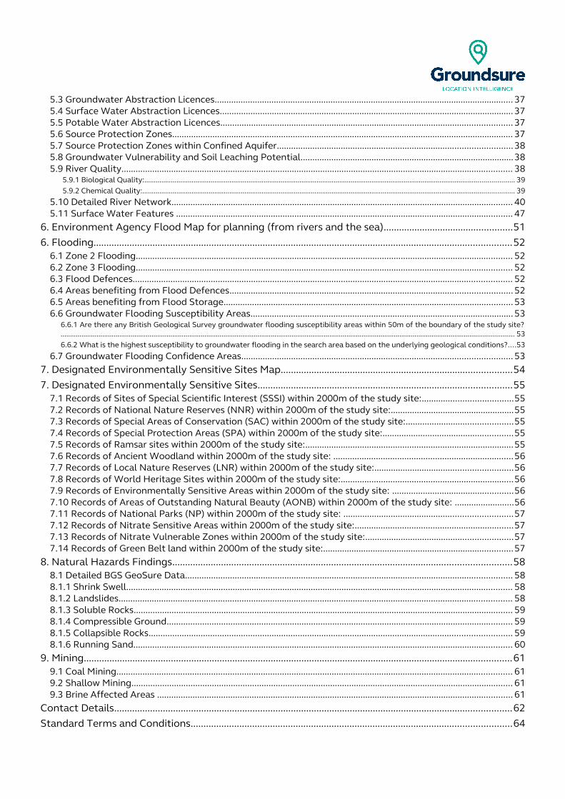
5.3 Groundwater Abstraction Licences.............................................................................................................................. 375.4 Surface Water Abstraction Licences............................................................................................................................ 375.5 Potable Water Abstraction Licences........................................................................................................................... 375.6 Source Protection Zones................................................................................................................................................ 375.7 Source Protection Zones within Confined Aquifer...................................................................................................385.8 Groundwater Vulnerability and Soil Leaching Potential..........................................................................................385.9 River Quality..................................................................................................................................................................... 38
5.9.1 Biological Quality:................................................................................................................................................................................................... 39 5.9.2 Chemical Quality:.................................................................................................................................................................................................... 39
5.10 Detailed River Network................................................................................................................................................ 405.11 Surface Water Features .............................................................................................................................................. 47
6. Environment Agency Flood Map for planning (from rivers and the sea)..................................................516. Flooding...................................................................................................................................................................52
6.1 Zone 2 Flooding............................................................................................................................................................... 526.2 Zone 3 Flooding............................................................................................................................................................... 526.3 Flood Defences................................................................................................................................................................ 526.4 Areas benefiting from Flood Defences....................................................................................................................... 526.5 Areas benefiting from Flood Storage.......................................................................................................................... 536.6 Groundwater Flooding Susceptibility Areas............................................................................................................... 53
6.6.1 Are there any British Geological Survey groundwater flooding susceptibility areas within 50m of the boundary of the study site?............................................................................................................................................................................................................................................... 536.6.2 What is the highest susceptibility to groundwater flooding in the search area based on the underlying geological conditions?....53
6.7 Groundwater Flooding Confidence Areas.................................................................................................................. 537. Designated Environmentally Sensitive Sites Map..........................................................................................547. Designated Environmentally Sensitive Sites...................................................................................................55
7.1 Records of Sites of Special Scientific Interest (SSSI) within 2000m of the study site:......................................557.2 Records of National Nature Reserves (NNR) within 2000m of the study site:....................................................557.3 Records of Special Areas of Conservation (SAC) within 2000m of the study site:.............................................557.4 Records of Special Protection Areas (SPA) within 2000m of the study site:.......................................................557.5 Records of Ramsar sites within 2000m of the study site:........................................................................................557.6 Records of Ancient Woodland within 2000m of the study site: ............................................................................567.7 Records of Local Nature Reserves (LNR) within 2000m of the study site:..........................................................567.8 Records of World Heritage Sites within 2000m of the study site:.........................................................................567.9 Records of Environmentally Sensitive Areas within 2000m of the study site: ...................................................567.10 Records of Areas of Outstanding Natural Beauty (AONB) within 2000m of the study site: .........................567.11 Records of National Parks (NP) within 2000m of the study site: .......................................................................577.12 Records of Nitrate Sensitive Areas within 2000m of the study site:...................................................................577.13 Records of Nitrate Vulnerable Zones within 2000m of the study site:..............................................................577.14 Records of Green Belt land within 2000m of the study site:................................................................................57
8. Natural Hazards Findings....................................................................................................................................588.1 Detailed BGS GeoSure Data.......................................................................................................................................... 588.1.1 Shrink Swell................................................................................................................................................................... 588.1.2 Landslides...................................................................................................................................................................... 588.1.3 Soluble Rocks................................................................................................................................................................ 598.1.4 Compressible Ground.................................................................................................................................................. 598.1.5 Collapsible Rocks......................................................................................................................................................... 598.1.6 Running Sand................................................................................................................................................................ 60
9. Mining.......................................................................................................................................................................619.1 Coal Mining....................................................................................................................................................................... 619.2 Shallow Mining................................................................................................................................................................. 619.3 Brine Affected Areas ...................................................................................................................................................... 61
Contact Details...........................................................................................................................................................62Standard Terms and Conditions.............................................................................................................................64
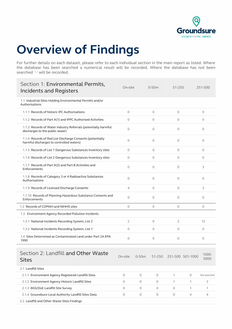
Overview of FindingsFor further details on each dataset, please refer to each individual section in the main report as listed. Where the database has been searched a numerical result will be recorded. Where the database has not been searched '-' will be recorded.
Section 1: Environmental Permits, Incidents and Registers
On-site 0-50m 51-250 251-500
1.1 Industrial Sites Holding Environmental Permits and/or Authorisations
1.1.1 Records of historic IPC Authorisations 0 0 0 0
1.1.2 Records of Part A(1) and IPPC Authorised Activities 0 0 0 0
1.1.3 Records of Water Industry Referrals (potentially harmful discharges to the public sewer)
0 0 0 0
1.1.4 Records of Red List Discharge Consents (potentially harmful discharges to controlled waters)
0 0 0 0
1.1.5 Records of List 1 Dangerous Substances Inventory sites 0 0 0 0
1.1.6 Records of List 2 Dangerous Substances Inventory sites 0 0 0 0
1.1.7 Records of Part A(2) and Part B Activities and Enforcements
0 0 0 3
1.1.8 Records of Category 3 or 4 Radioactive Substances Authorisations
0 0 0 0
1.1.9 Records of Licensed Discharge Consents 4 0 0 3
1.1.10 Records of Planning Hazardous Substance Consents and Enforcements
0 0 0 0
1.2 Records of COMAH and NIHHS sites 0 0 0 0
1.3 Environment Agency Recorded Pollution Incidents
1.3.1 National Incidents Recording System, List 2 2 0 2 12
1.3.2 National Incidents Recording System, List 1 0 0 0 0
1.4 Sites Determined as Contaminated Land under Part 2A EPA 1990
0 0 0 0
Section 2: Landfill and Other Waste Sites
On-site 0-50m 51-250 251-500 501-1000 1000-5000
2.1 Landfill Sites
2.1.1 Environment Agency Registered Landfill Sites 0 0 0 1 0 Not searched
2.1.2 Environment Agency Historic Landfill Sites 0 0 0 1 1 2
2.1.3 BGS/DoE Landfill Site Survey 0 0 0 0 1 1
2.1.4 Groundsure Local Authority Landfill Sites Data 0 0 0 0 4 4
2.2 Landfill and Other Waste Sites Findings
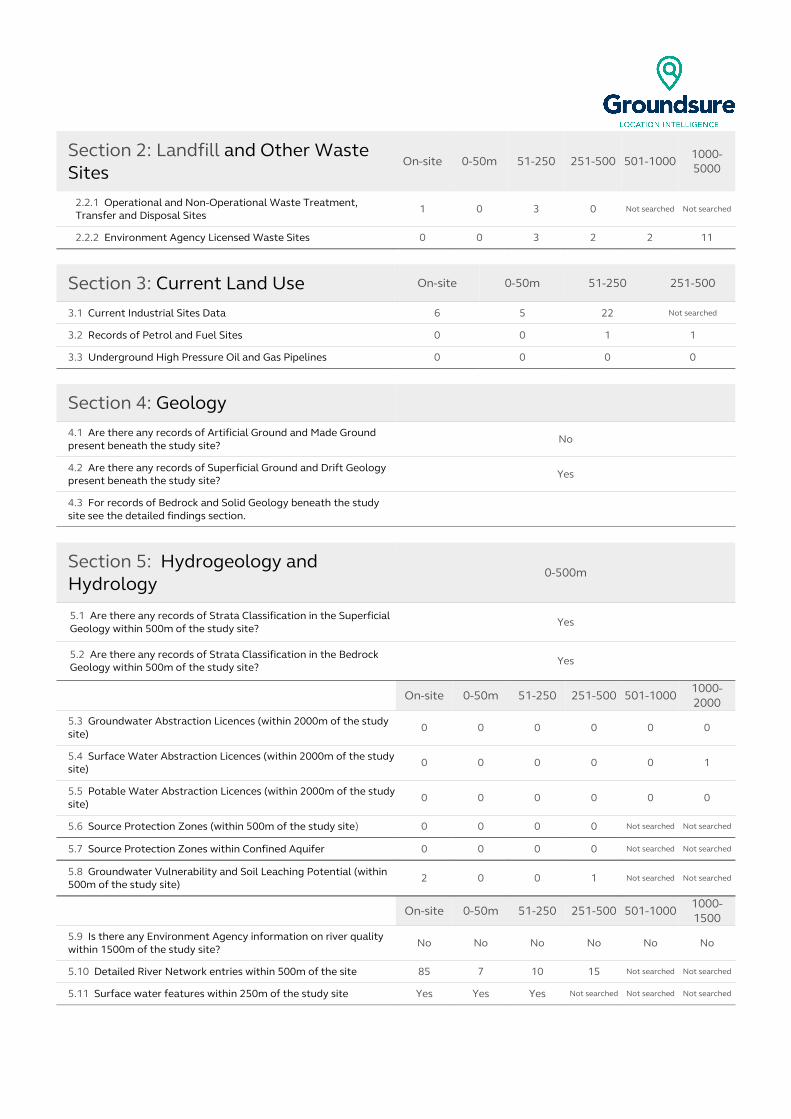
Section 2: Landfill and Other Waste Sites
On-site 0-50m 51-250 251-500 501-1000 1000-5000
2.2.1 Operational and Non-Operational Waste Treatment, Transfer and Disposal Sites
1 0 3 0 Not searched Not searched
2.2.2 Environment Agency Licensed Waste Sites 0 0 3 2 2 11
Section 3: Current Land Use On-site 0-50m 51-250 251-500
3.1 Current Industrial Sites Data 6 5 22 Not searched
3.2 Records of Petrol and Fuel Sites 0 0 1 1
3.3 Underground High Pressure Oil and Gas Pipelines 0 0 0 0
Section 4: Geology4.1 Are there any records of Artificial Ground and Made Ground present beneath the study site?
No
4.2 Are there any records of Superficial Ground and Drift Geology present beneath the study site?
Yes
4.3 For records of Bedrock and Solid Geology beneath the study site see the detailed findings section.
Section 5: Hydrogeology and Hydrology
0-500m
5.1 Are there any records of Strata Classification in the Superficial Geology within 500m of the study site?
Yes
5.2 Are there any records of Strata Classification in the Bedrock Geology within 500m of the study site?
Yes
On-site 0-50m 51-250 251-500 501-10001000-2000
5.3 Groundwater Abstraction Licences (within 2000m of the study site)
0 0 0 0 0 0
5.4 Surface Water Abstraction Licences (within 2000m of the study site)
0 0 0 0 0 1
5.5 Potable Water Abstraction Licences (within 2000m of the study site)
0 0 0 0 0 0
5.6 Source Protection Zones (within 500m of the study site) 0 0 0 0 Not searched Not searched
5.7 Source Protection Zones within Confined Aquifer 0 0 0 0 Not searched Not searched
5.8 Groundwater Vulnerability and Soil Leaching Potential (within 500m of the study site)
2 0 0 1 Not searched Not searched
On-site 0-50m 51-250 251-500 501-10001000-1500
5.9 Is there any Environment Agency information on river quality within 1500m of the study site?
No No No No No No
5.10 Detailed River Network entries within 500m of the site 85 7 10 15 Not searched Not searched
5.11 Surface water features within 250m of the study site Yes Yes Yes Not searched Not searched Not searched
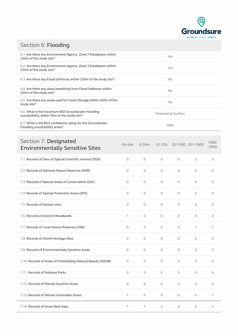
Section 6: Flooding
6.1 Are there any Environment Agency Zone 2 floodplains within 250m of the study site?
Yes
6.2 Are there any Environment Agency Zone 3 floodplains within 250m of the study site?
Yes
6.3 Are there any Flood Defences within 250m of the study site? No
6.4 Are there any areas benefiting from Flood Defences within 250m of the study site?
No
6.5 Are there any areas used for Flood Storage within 250m of the study site?
No
6.6 What is the maximum BGS Groundwater Flooding susceptibility within 50m of the study site?
Potential at Surface
6.7 What is the BGS confidence rating for the Groundwater Flooding susceptibility areas?
High
Section 7: Designated Environmentally Sensitive Sites
On-site 0-50m 51-250 251-500 501-1000 1000-2000
7.1 Records of Sites of Special Scientific Interest (SSSI) 0 0 0 0 0 0
7.2 Records of National Nature Reserves (NNR) 0 0 0 0 0 0
7.3 Records of Special Areas of Conservation (SAC) 0 0 0 0 0 0
7.4 Records of Special Protection Areas (SPA) 0 0 0 0 0 0
7.5 Records of Ramsar sites 0 0 0 0 0 0
7.6 Records of Ancient Woodlands 1 0 0 0 0 0
7.7 Records of Local Nature Reserves (LNR) 0 0 0 0 1 1
7.8 Records of World Heritage Sites 0 0 0 0 0 0
7.9 Records of Environmentally Sensitive Areas 0 0 0 0 0 0
7.10 Records of Areas of Outstanding Natural Beauty (AONB) 0 0 0 0 0 0
7.11 Records of National Parks 0 0 0 0 0 0
7.12 Records of Nitrate Sensitive Areas 0 0 0 0 0 0
7.13 Records of Nitrate Vulnerable Zones 1 0 0 0 0 1
7.14 Records of Green Belt Data 1 1 2 0 0 2

Section 8: Natural Hazards
8.1 What is the maximum risk of natural ground subsidence? Very Low
8.1.1 What is the maximum Shrink-Swell hazard rating identified on the study site?
Very Low
8.1.2 What is the maximum Landslides hazard rating identified on the study site? Low
8.1.3 What is the maximum Soluble Rocks hazard rating identified on the study site?
Negligible
8.1.4 What is the maximum Compressible Ground hazard rating identified on the study site? Negligible
8.1.5 What is the maximum Collapsible Rocks hazard rating identified on the study site?
Very Low
8.1.6 What is the maximum Running Sand hazard rating identified on the study site? Very Low
Section 9: Mining
9.1 Are there any coal mining areas within 75m of the study site? Yes
9.2 What is the risk of subsidence relating to shallow mining within 150m of the study site?
Low-Moderate
9.3 Are there any brine affected areas within 75m of the study site? No
Using this reportThe following report is designed by Environmental Consultants for Environmental Professionals bringing to-gether the most up-to-date market leading environmental data. This report is provided under and subject to the Terms & Conditions agreed between Groundsure and the Client. The document contains the following sections:
1. Environmental Permits, Incidents and RegistersProvides information on Regulated Industrial Activities and Pollution Incidents as recorded by Regulatory Au-thorities, and sites determined as Contaminated Land. This search is conducted using radii up to 500m.
2. Landfills and Other Waste SitesProvides information on landfills and other waste sites that may pose a risk to the study site. This search is con-ducted using radii up to 1500m.
3. Current Land UsesProvides information on current land uses that may pose a risk to the study site in terms of potential contamina-tion from activities or processes. These searches are conducted using radii of up to 500m. This includes informa-tion on potentially contaminative industrial sites, petrol stations and fuel sites as well as high pressure under -ground oil and gas pipelines.
4. GeologyProvides information on artificial and superficial deposits and bedrock beneath the study site.
5. Hydrogeology and HydrologyProvides information on productive strata within the bedrock and superficial geological layers, abstraction li -censes, Source Protection Zones (SPZs) and river quality. These searches are conducted using radii of up to 2000m.
6. FloodingProvides information on surface water flooding, flood defences, flood storage areas and groundwater flood areas. This search is conducted using radii of up to 250m.
7. Designated Environmentally Sensitive Sites Provides information on the Sites of Special Scientific Interest (SSSI), National Nature Reserves (NNR), Special Areas of Conservation (SAC), Special Protection Areas (SPA), Ramsar sites, Local Nature Reserves (LNR), Areas of Outstanding Natural Beauty (AONB), National Parks (NP), Environmentally Sensitive Areas, Nitrate Sensitive Areas, Nitrate Vulnerable Zones and World Heritage Sites and Scheduled Ancient Woodland. These searches are conducted using radii of up to 2000m.
8. Natural HazardsProvides information on a range of natural hazards that may pose a risk to the study site. These factors include natural ground subsidence.
9. MiningProvides information on areas of coal and shallow mining.
10. ContactsThis section of the report provides contact points for statutory bodies and data providers that may be able to provide further information on issues raised within this report. Alternatively, Groundsure provide a free Technic-al Helpline (08444 159000) for further information and guidance.
Note: MapsOnly certain features are placed on the maps within the report. All features represented on maps found within this search are given an identification number. This number identifies the feature on the mapping and correlates it to the additional information provided below. This identification number precedes all other information and takes the following format -Id: 1, Id: 2, etc. Where numerous features on the same map are in such close proxim -ity that the numbers would obscure each other a letter identifier is used instead to represent the features. (e.g. Three features which overlap may be given the identifier “A” on the map and would be identified separately as features 1A, 3A, 10A on the data tables provided). Where a feature is reported in the data tables to a distance greater than the map area, it is noted in the data table as “Not Shown”. All distances given in this report are in Metres (m). Directions are given as compass headings such as N: North, E: East, NE: North East from the nearest point of the study site boundary.

1. Environmental Permits, Incidents and Registers Map
NW N NE
W E
SW S SE
Environmental Permits, Incidents and Registers Legend
© Crown copyright and database rights 2015. Ordnance Survey license 100035207.
Report Reference: GS-2024512Client Reference: Purchase_Order_03147172_-_Hulton_Park
10

1. Environmental Permits, Incidents and Registers1.1 Industrial Sites Holding Licences and/or Authorisations
Searches of information provided by the Environment Agency and Local Authorities reveal the following information:
1.1.1 Records of historic IPC Authorisations within 500m of the study site: 0
Database searched and no data found.
1.1.2 Records of Part A(1) and IPPC Authorised Activities within 500m of the study site:
0
Database searched and no data found.
1.1.3 Records of Water Industry Referrals (potentially harmful discharges to the public sewer) within 500m of the study site:
0
Database searched and no data found.
1.1.4 Records of Red List Discharge Consents (potentially harmful discharges to controlled waters) within 500m of the study site:
0
Database searched and no data found.
1.1.5 Records of List 1 Dangerous Substances Inventory Sites within 500m of the study site:
0
Database searched and no data found.
Report Reference: GS-2024512Client Reference: Purchase_Order_03147172_-_Hulton_Park
11
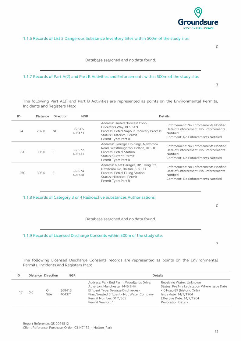
1.1.6 Records of List 2 Dangerous Substance Inventory Sites within 500m of the study site:
0
Database searched and no data found.
1.1.7 Records of Part A(2) and Part B Activities and Enforcements within 500m of the study site:
3
The following Part A(2) and Part B Activities are represented as points on the Environmental Permits, Incidents and Registers Map:
ID Distance Direction NGR Details
24 282.0 NE368905405473
Address: United Norwest Coop, Cricketers Way, BL5 3ANProcess: Petrol Vapour Recovery ProcessStatus: Historical PermitPermit Type: Part B
Enforcement: No Enforcements NotifiedDate of Enforcement: No Enforcements NotifiedComment: No Enforcements Notified
25C 306.0 E368972405731
Address: Synergie Holdings, Newbrook Road, Westhoughton, Bolton, BL5 1EJProcess: Petrol StationStatus: Current PermitPermit Type: Part B
Enforcement: No Enforcements NotifiedDate of Enforcement: No Enforcements NotifiedComment: No Enforcements Notified
26C 308.0 E368974405728
Address: Aleef Garages, BP Filling Sta, Newbrook Rd, Bolton, BL5 1EJProcess: Petrol Filling StationStatus: Historical PermitPermit Type: Part B
Enforcement: No Enforcements NotifiedDate of Enforcement: No Enforcements NotifiedComment: No Enforcements Notified
1.1.8 Records of Category 3 or 4 Radioactive Substances Authorisations:
0
Database searched and no data found.
1.1.9 Records of Licensed Discharge Consents within 500m of the study site:
7
The following Licensed Discharge Consents records are represented as points on the Environmental Permits, Incidents and Registers Map:
ID Distance Direction NGR Details
17 0.0 On Site
368415404371
Address: Park End Farm, Woodlands Drive, Atherton, Manchester, M46 9HHEffluent Type: Sewage Discharges - Final/treated Effluent - Not Water CompanyPermit Number: 01M/365Permit Version: 1
Receiving Water: UnknownStatus: Pre Nra Legislation Where Issue Date < 01-sep-89 (historic Only)Issue date: 14/7/1964Effective Date: 14/7/1964Revocation Date: -
Report Reference: GS-2024512Client Reference: Purchase_Order_03147172_-_Hulton_Park
12
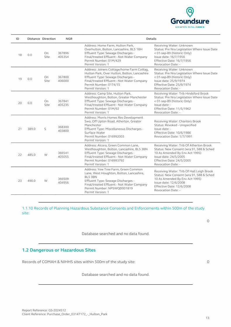
ID Distance Direction NGR Details
18 0.0 On Site
367896405354
Address: Home Farm, Hulton Park, Overhulton, Bolton, Lancashire, BL5 1BHEffluent Type: Sewage Discharges - Final/treated Effluent - Not Water CompanyPermit Number: 01M/429Permit Version: 1
Receiving Water: UnknownStatus: Pre Nra Legislation Where Issue Date < 01-sep-89 (historic Only)Issue date: 16/7/1956Effective Date: 16/7/1956Revocation Date: -
19 0.0 On Site
367800406000
Address: Joiners Cottage/home Farm Cottag, Hulton Park, Over Hulton, Bolton, LancashireEffluent Type: Sewage Discharges - Final/treated Effluent - Not Water CompanyPermit Number: 0174/15Permit Version: 1
Receiving Water: UnknownStatus: Pre Nra Legislation Where Issue Date < 01-sep-89 (historic Only)Issue date: 25/9/1974Effective Date: 25/9/1974Revocation Date: -
20 0.0 On Site
367841405235
Address: Camp Site, Hulton Park, Westhoughton, Bolton, Greater ManchesterEffluent Type: Sewage Discharges - Final/treated Effluent - Not Water CompanyPermit Number: 01M/92Permit Version: 1
Receiving Water: Trib Hindsford BrookStatus: Pre Nra Legislation Where Issue Date < 01-sep-89 (historic Only)Issue date: -Effective Date: 11/5/1962Revocation Date: -
21 389.0 S368300403800
Address: Morris Homes Res Development Swo, Off Upton Road, Atherton, Greater ManchesterEffluent Type: Miscellaneous Discharges - Surface WaterPermit Number: 016992003Permit Version: 1
Receiving Water: Chanters BrookStatus: Revoked - UnspecifiedIssue date: -Effective Date: 10/6/1986Revocation Date: 1/7/1991
22 485.0 W366541405055
Address: Alcora, Green Common Lane, Westhoughton, Bolton, Lancashire, BL5 3BNEffluent Type: Sewage Discharges - Final/treated Effluent - Not Water CompanyPermit Number: 016993792Permit Version: 1
Receiving Water: Trib Of Atherton BrookStatus: New Consent (wra 91, S88 & Sched 10 As Amended By Env Act 1995)Issue date: 24/5/2005Effective Date: 24/5/2005Revocation Date: -
23 490.0 W366509404956
Address: Yew Tree Farm, Green Common Lane, West Houghton, Bolton, Lancashire, BL5 3BNEffluent Type: Sewage Discharges - Final/treated Effluent - Not Water CompanyPermit Number: NPSWQD001819Permit Version: 1
Receiving Water: Trib Of Hall Leigh BrookStatus: New Consent (wra 91, S88 & Sched 10 As Amended By Env Act 1995)Issue date: 12/6/2008Effective Date: 12/6/2008Revocation Date: -
1.1.10 Records of Planning Hazardous Substance Consents and Enforcements within 500m of the study site:
0
Database searched and no data found.
1.2 Dangerous or Hazardous Sites
Records of COMAH & NIHHS sites within 500m of the study site: 0
Database searched and no data found.
Report Reference: GS-2024512Client Reference: Purchase_Order_03147172_-_Hulton_Park
13
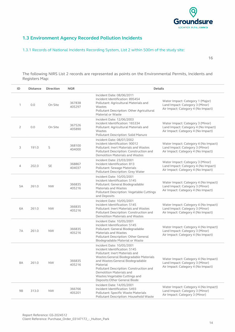
1.3 Environment Agency Recorded Pollution Incidents
1.3.1 Records of National Incidents Recording System, List 2 within 500m of the study site:
16
The following NIRS List 2 records are represented as points on the Environmental Permits, Incidents and Registers Map:
ID Distance Direction NGR Details
1 0.0 On Site367838405297
Incident Date: 08/06/2011Incident Identification: 895454Pollutant: Agricultural Materials and WastesPollutant Description: Other Agricultural Material or Waste
Water Impact: Category 1 (Major)Land Impact: Category 3 (Minor)Air Impact: Category 4 (No Impact)
2 0.0 On Site367526405890
Incident Date: 12/06/2003Incident Identification: 165334Pollutant: Agricultural Materials and WastesPollutant Description: Solid Manure
Water Impact: Category 3 (Minor)Land Impact: Category 4 (No Impact)Air Impact: Category 4 (No Impact)
3 191.0 S368100404000
Incident Date: 08/07/2002Incident Identification: 90012Pollutant: Inert Materials and WastesPollutant Description: Construction and Demolition Materials and Wastes
Water Impact: Category 4 (No Impact)Land Impact: Category 3 (Minor)Air Impact: Category 4 (No Impact)
4 202.0 SE368867404037
Incident Date: 23/03/2001Incident Identification: 813Pollutant: Sewage MaterialsPollutant Description: Grey Water
Water Impact: Category 3 (Minor)Land Impact: Category 4 (No Impact)Air Impact: Category 4 (No Impact)
5A 261.0 NW366835405216
Incident Date: 10/05/2001Incident Identification: 5145Pollutant: General Biodegradable Materials and WastesPollutant Description: Vegetable Cuttings and Deposits
Water Impact: Category 4 (No Impact)Land Impact: Category 3 (Minor)Air Impact: Category 4 (No Impact)
6A 261.0 NW366835405216
Incident Date: 10/05/2001Incident Identification: 5145Pollutant: Inert Materials and WastesPollutant Description: Construction and Demolition Materials and Wastes
Water Impact: Category 4 (No Impact)Land Impact: Category 3 (Minor)Air Impact: Category 4 (No Impact)
7A 261.0 NW 366835405216
Incident Date: 10/05/2001Incident Identification: 5145Pollutant: General Biodegradable Materials and WastesPollutant Description: Other General Biodegradable Material or Waste
Water Impact: Category 4 (No Impact)Land Impact: Category 3 (Minor)Air Impact: Category 4 (No Impact)
8A 261.0 NW366835405216
Incident Date: 10/05/2001Incident Identification: 5145Pollutant: Inert Materials and Wastes:General Biodegradable Materials and Wastes:General Biodegradable MaterialPollutant Description: Construction and Demolition Materials and Wastes:Vegetable Cuttings and Deposits:Other General Biode
Water Impact: Category 4 (No Impact)Land Impact: Category 3 (Minor)Air Impact: Category 4 (No Impact)
9B 313.0 NW366766405201
Incident Date: 14/05/2001Incident Identification: 5493Pollutant: Specific Waste MaterialsPollutant Description: Household Waste
Water Impact: Category 4 (No Impact)Land Impact: Category 3 (Minor)Air Impact: Category 3 (Minor)
Report Reference: GS-2024512Client Reference: Purchase_Order_03147172_-_Hulton_Park
14

ID Distance Direction NGR Details
10B 313.0 NW366766405201
Incident Date: 14/05/2001Incident Identification: 5493Pollutant: Inert Materials and WastesPollutant Description: Construction and Demolition Materials and Wastes
Water Impact: Category 4 (No Impact)Land Impact: Category 3 (Minor)Air Impact: Category 3 (Minor)
11B 313.0 NW 366766405201
Incident Date: 14/05/2001Incident Identification: 5493Pollutant: General Biodegradable Materials and WastesPollutant Description: Vegetable Cuttings and Deposits
Water Impact: Category 4 (No Impact)Land Impact: Category 3 (Minor)Air Impact: Category 3 (Minor)
12B 313.0 NW366766405201
Incident Date: 14/05/2001Incident Identification: 5493Pollutant: Inert Materials and Wastes:General Biodegradable Materials and Wastes:Specific Waste MaterialsPollutant Description: Construction and Demolition Materials and Wastes:Vegetable Cuttings and Deposits:Household Waste
Water Impact: Category 4 (No Impact)Land Impact: Category 3 (Minor)Air Impact: Category 3 (Minor)
13B 339.0 NW 366743405213
Incident Date: 26/05/2001Incident Identification: 6775Pollutant: Specific Waste MaterialsPollutant Description: Household Waste
Water Impact: Category 4 (No Impact)Land Impact: Category 3 (Minor)Air Impact: Category 3 (Minor)
14B 339.0 NW 366743405213
Incident Date: 26/05/2001Incident Identification: 6775Pollutant: General Biodegradable Materials and WastesPollutant Description: Vegetable Cuttings and Deposits
Water Impact: Category 4 (No Impact)Land Impact: Category 3 (Minor)Air Impact: Category 3 (Minor)
15B 339.0 NW366743405213
Incident Date: 26/05/2001Incident Identification: 6775Pollutant: Inert Materials and Wastes:General Biodegradable Materials and Wastes:Specific Waste MaterialsPollutant Description: Construction and Demolition Materials and Wastes:Vegetable Cuttings and Deposits:Household Waste
Water Impact: Category 4 (No Impact)Land Impact: Category 3 (Minor)Air Impact: Category 3 (Minor)
16B 339.0 NW366743405213
Incident Date: 26/05/2001Incident Identification: 6775Pollutant: Inert Materials and WastesPollutant Description: Construction and Demolition Materials and Wastes
Water Impact: Category 4 (No Impact)Land Impact: Category 3 (Minor)Air Impact: Category 3 (Minor)
1.3.2 Records of National Incidents Recording System, List 1 within 500m of the study site:
0
Database searched and no data found.
Report Reference: GS-2024512Client Reference: Purchase_Order_03147172_-_Hulton_Park
15
1.4 Sites Determined as Contaminated Land under Part 2A EPA 1990
How many records of sites determined as contaminated land under Section 78R of the Environmental Protection Act 1990 are there within 500m of the study site? 0
Database searched and no data found.
Report Reference: GS-2024512Client Reference: Purchase_Order_03147172_-_Hulton_Park
16

2. Landfill and Other Waste Sites Map
NW N NE
W E
SW S SE
Landfill and Other Waste Sites Legend
© Crown copyright and database rights 2015. Ordnance Survey license 100035207.
Report Reference: GS-2024512Client Reference: Purchase_Order_03147172_-_Hulton_Park
17
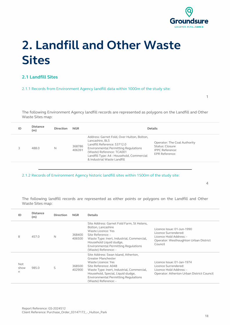
2. Landfill and Other Waste Sites2.1 Landfill Sites
2.1.1 Records from Environment Agency landfill data within 1000m of the study site:
1
The following Environment Agency landfill records are represented as polygons on the Landfill and Other Waste Sites map:
ID Distance (m)
Direction NGR Details
3 488.0 N368786406391
Address: Garnet Fold, Over Hulton, Bolton, Lancashire, BL5Landfill Reference: 53712.0Environmental Permitting Regulations (Waste) Reference: TCA001Landfill Type: A4 : Household, Commercial & Industrial Waste Landfill
Operator: The Coal AuthorityStatus: ClosureIPPC Reference: EPR Reference:
2.1.2 Records of Environment Agency historic landfill sites within 1500m of the study site:
4
The following landfill records are represented as either points or polygons on the Landfill and Other Waste Sites map:
ID Distance (m)
Direction NGR Details
8 457.0 N368400406500
Site Address: Garnet Fold Farm, St Helens, Bolton, LancashireWaste Licence: YesSite Reference: -Waste Type: Inert, Industrial, Commercial, Household Liquid sludge,Environmental Permitting Regulations (Waste) Reference: -
Licence Issue: 01-Jun-1990Licence Surrendered: Licence Hold Address: -Operator: Westhoughton Urban District Council
Not shown
985.0 S 368500402900
Site Address: Swan Island, Atherton, Greater ManchesterWaste Licence: YesSite Reference: A048Waste Type: Inert, Industrial, Commercial, Household, Special, Liquid sludge,Environmental Permitting Regulations (Waste) Reference: -
Licence Issue: 01-Jan-1974Licence Surrendered: Licence Hold Address: -Operator: Atherton Urban District Council
Report Reference: GS-2024512Client Reference: Purchase_Order_03147172_-_Hulton_Park
18

IDDistance (m)
Direction NGR Details
Not shown
1040.0 N 368500406900
Site Address: Bolton-Kenyon Junction Railway, Deane, Bolton, Greater ManchesterWaste Licence: -Site Reference: B028, 0367Waste Type: Industrial, Commercial, Household, SpecialEnvironmental Permitting Regulations (Waste) Reference: -
Licence Issue: Licence Surrendered: Licence Hold Address: -Operator: -
Not shown
1159.0 N368900407100
Site Address: Bolton-Kenyon Junction Railway Line, BoltonWaste Licence: -Site Reference: -Waste Type: InertEnvironmental Permitting Regulations (Waste) Reference: -
Licence Issue: Licence Surrendered: Licence Hold Address: -Operator: -
2.1.3 Records of BGS/DoE non-operational landfill sites within 1500m of the study site:
2
The following landfill records are represented as points on the Landfill and Other Waste Sites map:
IDDistance (m)
Direction NGR Details
Not shown
784.0 N
368300.0406700.0
Address: Garret Fold Farm, St Helens, Bolton, LancsBGS Number: 1025.0
Risk: No risk to aquiferWaste Type: N/A
Not shown
1241.0 S
368500.0402900.0
Address: Swan Island Quarry, AthertonBGS Number: 2528.0
Risk: No risk to aquiferWaste Type: N/A
2.1.4 Records of Local Authority landfill sites within 1500m of the study site:
8
The following landfill records are represented as points or polygons on the Landfill and Other Waste Sites map:
IDDistance
(m)Direction NGR Site Address Source Data Type
30 704.0 N Refuse Tip 1975 mapping Polygon
Not shown
834.0 SE Refuse Tip 1969 mapping Polygon
Not shown
837.0 SE Refuse Tip 1969 mapping Polygon
Not shown
853.0 SE Refuse Tip 1969 mapping Polygon
Not shown
1106.0 S Refuse Tip 1974 mapping Polygon
Report Reference: GS-2024512Client Reference: Purchase_Order_03147172_-_Hulton_Park
19
IDDistance
(m)Direction NGR Site Address Source Data Type
Not shown
1152.0 S Refuse Tip 1971 mapping Polygon
Not shown
1315.0 S Refuse Tip 1971 mapping Polygon
Not shown
1359.0 S Refuse Tip 1971 mapping Polygon
2.2 Other Waste Sites
2.2.1 Records of waste treatment, transfer or disposal sites within 500m of the study site:
4
The following waste treatment, transfer or disposal sites records are represented as points on the Landfill and Other Waste Sites map:
ID Distance (m)
Direction NGR Details
4 0.0On Site
367175405422
Type of Site: Ground Workings and Refuse HeapSite Address: N/A
Planning Application Reference: N/ADate: 1936
Further Details: N/AData Source: Historic MappingData Type: Polygon
5A 170.0 N367337406293
Type of Site: Scrap YardSite Address: N/A
Planning Application Reference: N/ADate: 1990
Further Details: N/AData Source: Historic MappingData Type: Polygon
6A 170.0 N 367337406293
Type of Site: Scrap YardSite Address: N/A
Planning Application Reference: N/ADate: 1988
Further Details: N/AData Source: Historic MappingData Type: Polygon
7A 203.0 N367331406275
Type of Site: Waste Processing BuildingsSite Address: Manchester Road, Westhoughton, BOLTON, Greater Manchester, BL5 3
Planning Application Reference: 77827/07Date: 21/07/2008
Further Details: Scheme comprises construction of an extension to provide additional covered facility for the waste processing use, including an end of life vehicle area together with improvements to vehicular access and associated landscaping and boundary treatment. Construction - planting site works. An application (ref: 77827/07) for detailed planning permission was granted by Bolton B.C. Work has commenced on site.Data Source: Historic Planning ApplicationData Type: Point
Report Reference: GS-2024512Client Reference: Purchase_Order_03147172_-_Hulton_Park
20
2.2.2 Records of Environment Agency licensed waste sites within 1500m of the study site:
18
The following waste treatment, transfer or disposal sites records are represented as points on the Landfill and Other Waste Sites map:
ID Distance (m)
Direction NGR Details
12 136.0 NW367309406154
Site Address: Manchester Road, Chequerbent, Bolton, Lancashire, BL5 3JAType: Metal Recycling Site (mixed MRS's)Size: < 25000 tonnesEnvironmental Permitting Regulations (Waste) Licence Number: JKH001EPR reference: -Operator: Jose K Holt & Gordon LtdWaste Management licence No: 53595Annual Tonnage: 0.0
Issue Date: 17/07/1996Effective Date: -Modified: -Surrendered Date: -Expiry Date: -Cancelled Date: -Status: IssuedSite Name: J K Holt & Gordon LtdCorrespondence Address: -, Manchester Road, Chequerbent, Bolton, Lancashire, BL5 3JA
13B 222.0 N367366406279
Site Address: Land/premises At, Manchester Road, Chequerbent, Bolton, Lancashire, BL5 3JAType: Metal Recycling Site (mixed MRS's)Size: < 25000 tonnesEnvironmental Permitting Regulations (Waste) Licence Number: JDL003EPR reference: EA/EPR/CP3890SS/V003Operator: J Doyle LtdWaste Management licence No: 53595Annual Tonnage: 19000.0
Issue Date: 17/07/1996Effective Date: 26/08/2005Modified: 23/01/2009Surrendered Date: -Expiry Date: -Cancelled Date: -Status: ModifiedSite Name: J Doyle LtdCorrespondence Address: -, -
14B 222.0 N367366406279
Site Address: Manchester Road, Chequerbent, Bolton, Lancashire, BL5 3JAType: Metal Recycling Site (mixed MRS's)Size: < 25000 tonnesEnvironmental Permitting Regulations (Waste) Licence Number: JDL003EPR reference: -Operator: J Doyle LtdWaste Management licence No: 53595Annual Tonnage: 0.0
Issue Date: 17/07/1996Effective Date: 26/08/2005Modified: -Surrendered Date: -Expiry Date: -Cancelled Date: -Status: TransferredSite Name: J Doyle LtdCorrespondence Address: -, Nelson Mill, Gaskell Street, Bolton, Lancashire, BL1 2QS
15A 258.0 N367340406310
Site Address: Land / Premises At, Manchester Road, Chequerbent, Bolton, Lancashire, BL5 2JAType: HCI Waste TS + treatmentSize: >= 25000 tonnes < 75000 tonnesEnvironmental Permitting Regulations (Waste) Licence Number: DOY003EPR reference: EA/EPR/CP3798SV/V002Operator: J Doyle LtdWaste Management licence No: 100686Annual Tonnage: 74999.0
Issue Date: 21/11/2008Effective Date: -Modified: 22/12/2010Surrendered Date: -Expiry Date: -Cancelled Date: -Status: ModifiedSite Name: J Doyle LtdCorrespondence Address: -, -
16A 258.0 N367340406310
Site Address: Land / Premises At, Manchester Road, Chequerbent, Bolton, Lancashire, BL5 2JAType: HCI Waste TS + treatmentSize: >= 25000 tonnes < 75000 tonnesEnvironmental Permitting Regulations (Waste) Licence Number: EEL005EPR reference: EA/EPR/CB3006ST/T001Operator: Easy Excavations LimitedWaste Management licence No: 100686Annual Tonnage: 74999.0
Issue Date: 21/11/2008Effective Date: 11/09/2014Modified: 22/12/2010Surrendered Date: -Expiry Date: -Cancelled Date: -Status: TransferredSite Name: J Doyle LtdCorrespondence Address: -, -
Report Reference: GS-2024512Client Reference: Purchase_Order_03147172_-_Hulton_Park
21
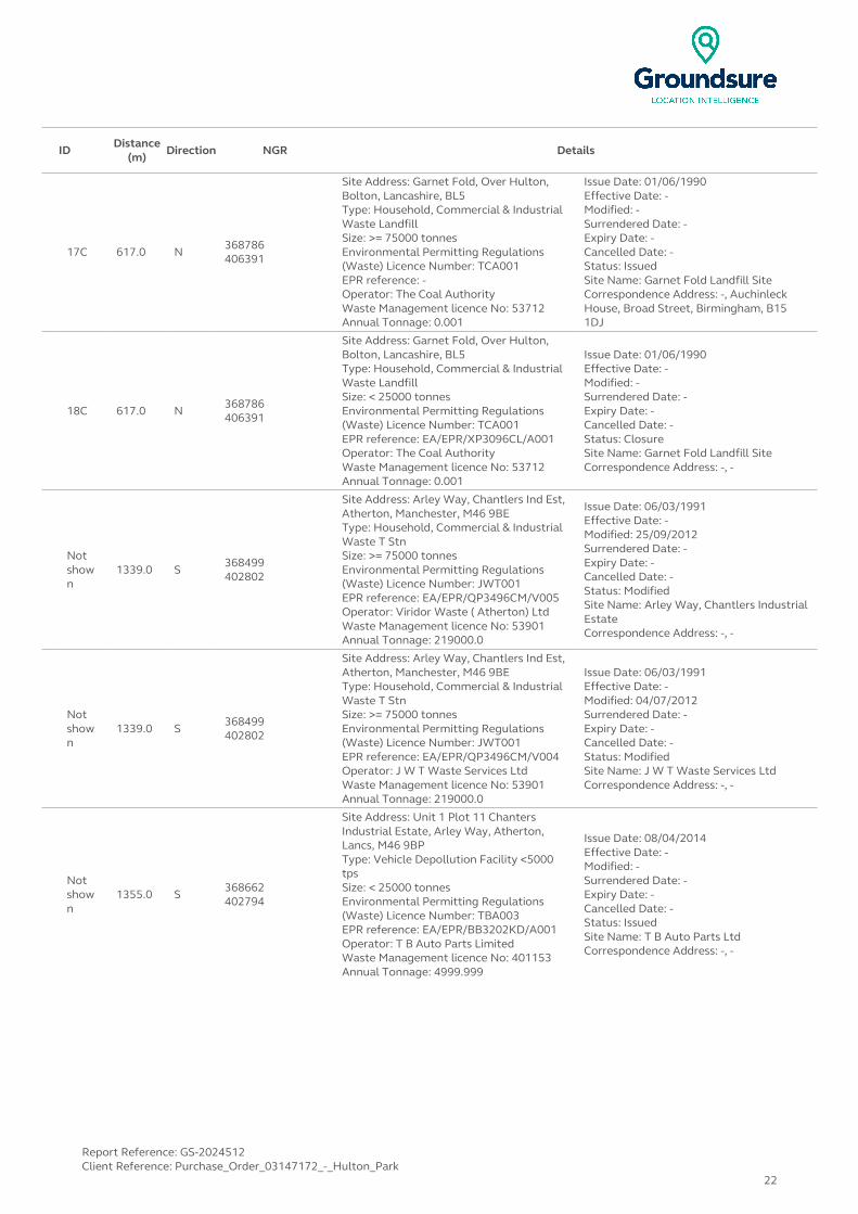
IDDistance
(m)Direction NGR Details
17C 617.0 N368786406391
Site Address: Garnet Fold, Over Hulton, Bolton, Lancashire, BL5Type: Household, Commercial & Industrial Waste LandfillSize: >= 75000 tonnesEnvironmental Permitting Regulations (Waste) Licence Number: TCA001EPR reference: -Operator: The Coal AuthorityWaste Management licence No: 53712Annual Tonnage: 0.001
Issue Date: 01/06/1990Effective Date: -Modified: -Surrendered Date: -Expiry Date: -Cancelled Date: -Status: IssuedSite Name: Garnet Fold Landfill SiteCorrespondence Address: -, Auchinleck House, Broad Street, Birmingham, B15 1DJ
18C 617.0 N368786406391
Site Address: Garnet Fold, Over Hulton, Bolton, Lancashire, BL5Type: Household, Commercial & Industrial Waste LandfillSize: < 25000 tonnesEnvironmental Permitting Regulations (Waste) Licence Number: TCA001EPR reference: EA/EPR/XP3096CL/A001Operator: The Coal AuthorityWaste Management licence No: 53712Annual Tonnage: 0.001
Issue Date: 01/06/1990Effective Date: -Modified: -Surrendered Date: -Expiry Date: -Cancelled Date: -Status: ClosureSite Name: Garnet Fold Landfill SiteCorrespondence Address: -, -
Not shown
1339.0 S368499402802
Site Address: Arley Way, Chantlers Ind Est, Atherton, Manchester, M46 9BEType: Household, Commercial & Industrial Waste T StnSize: >= 75000 tonnesEnvironmental Permitting Regulations (Waste) Licence Number: JWT001EPR reference: EA/EPR/QP3496CM/V005Operator: Viridor Waste ( Atherton) LtdWaste Management licence No: 53901Annual Tonnage: 219000.0
Issue Date: 06/03/1991Effective Date: -Modified: 25/09/2012Surrendered Date: -Expiry Date: -Cancelled Date: -Status: ModifiedSite Name: Arley Way, Chantlers Industrial EstateCorrespondence Address: -, -
Not shown
1339.0 S368499402802
Site Address: Arley Way, Chantlers Ind Est, Atherton, Manchester, M46 9BEType: Household, Commercial & Industrial Waste T StnSize: >= 75000 tonnesEnvironmental Permitting Regulations (Waste) Licence Number: JWT001EPR reference: EA/EPR/QP3496CM/V004Operator: J W T Waste Services LtdWaste Management licence No: 53901Annual Tonnage: 219000.0
Issue Date: 06/03/1991Effective Date: -Modified: 04/07/2012Surrendered Date: -Expiry Date: -Cancelled Date: -Status: ModifiedSite Name: J W T Waste Services LtdCorrespondence Address: -, -
Not shown
1355.0 S 368662402794
Site Address: Unit 1 Plot 11 Chanters Industrial Estate, Arley Way, Atherton, Lancs, M46 9BPType: Vehicle Depollution Facility <5000 tpsSize: < 25000 tonnesEnvironmental Permitting Regulations (Waste) Licence Number: TBA003EPR reference: EA/EPR/BB3202KD/A001Operator: T B Auto Parts LimitedWaste Management licence No: 401153Annual Tonnage: 4999.999
Issue Date: 08/04/2014Effective Date: -Modified: -Surrendered Date: -Expiry Date: -Cancelled Date: -Status: IssuedSite Name: T B Auto Parts LtdCorrespondence Address: -, -
Report Reference: GS-2024512Client Reference: Purchase_Order_03147172_-_Hulton_Park
22
IDDistance
(m)Direction NGR Details
Not shown
1357.0 SW366535403374
Site Address: Land/premises At, Coalpit Lane, Atherton, Lancashire, M46 0RYType: Metal Recycling Site (Vehicle Dismantler)Size: < 25000 tonnesEnvironmental Permitting Regulations (Waste) Licence Number: ATH001EPR reference: EA/EPR/PP3592CY/S002Operator: Murray Laurence AntonyWaste Management licence No: 50502Annual Tonnage: 0.0
Issue Date: 19/10/2007Effective Date: -Modified: -Surrendered Date: 27/09/2010Expiry Date: -Cancelled Date: -Status: SurrenderedSite Name: Atherton Motor CyclesCorrespondence Address: -, -
Not shown
1441.0 S 368500402700
Site Address: Unit 17 - 18 Chanters Industrial Estate, Arley Way, Atherton, Manchester, M46 9XXType: Metal Recycling Site (Vehicle Dismantler)Size: < 25000 tonnesEnvironmental Permitting Regulations (Waste) Licence Number: PEH001EPR reference: EA/EPR/WP3192CD/S002Operator: Hennedy Philip EWaste Management licence No: 53579Annual Tonnage: 0.0
Issue Date: 05/11/1996Effective Date: -Modified: -Surrendered Date: 30/03/2012Expiry Date: -Cancelled Date: -Status: SurrenderedSite Name: P E HennedyCorrespondence Address: -, -
Not shown
1441.0 S368500402700
Site Address: Chanters Industrial Estate, Plot 17, Arley Way, Atherton, Manchester, M46 9XXType: Metal Recycling Site (Vehicle Dismantler)Size: < 25000 tonnesEnvironmental Permitting Regulations (Waste) Licence Number: PEH001EPR reference: EA/EPR/WP3192CD/A001Operator: Hennedy P EWaste Management licence No: 53579Annual Tonnage: 1200.0
Issue Date: 05/11/1996Effective Date: -Modified: -Surrendered Date: -Expiry Date: -Cancelled Date: -Status: IssuedSite Name: P & R Motor SalvageCorrespondence Address: -, -
Not shown
1446.0 S368400402700
Site Address: Tyldesley Old Road, Atherton, Wigan, M46 9BPType: Household, Commercial & Industrial Waste T StnSize: < 25000 tonnesEnvironmental Permitting Regulations (Waste) Licence Number: LML004EPR reference: -Operator: Landfill Management LtdWaste Management licence No: 53818Annual Tonnage: 0.0
Issue Date: 27/01/1988Effective Date: -Modified: -Surrendered Date: -Expiry Date: -Cancelled Date: -Status: IssuedSite Name: Chanters Civic Amenity SiteCorrespondence Address: -, 9 Hemfield Court, Makerfield Way, Ince, Wigan, Lancashire, WN2 2ER
Not shown
1478.0 S 368452402664
Site Address: Chanters Industrial Estate, 11-13, Arley Way, Atherton, Manchester, M46 9BEType: Metal Recycling Site (Vehicle Dismantler)Size: < 25000 tonnesEnvironmental Permitting Regulations (Waste) Licence Number: HBS001EPR reference: EA/EPR/DP3292CL/A001Operator: Bates AnthonyWaste Management licence No: 53610Annual Tonnage: 416.667
Issue Date: 29/03/1996Effective Date: -Modified: -Surrendered Date: -Expiry Date: -Cancelled Date: -Status: RevokedSite Name: Howebridge Salvage LtdCorrespondence Address: -, -
Report Reference: GS-2024512Client Reference: Purchase_Order_03147172_-_Hulton_Park
23
IDDistance
(m)Direction NGR Details
Not shown
1483.0 E370100406150
Site Address: Smethurst Lane, Edgefold, Bolton, LancashireType: Household, Commercial & Industrial Waste T StnSize: UnknownEnvironmental Permitting Regulations (Waste) Licence Number: SED001EPR reference: -Operator: G & J Seddon LtdWaste Management licence No: 50068Annual Tonnage: 0.0
Issue Date: 22/12/2000Effective Date: -Modified: -Surrendered Date: -Expiry Date: -Cancelled Date: -Status: IssuedSite Name: Hillside WorksCorrespondence Address: -, G & J Seddon Ltd, Po Box 9, Little Hulton, Manchester, M38 0FH
Not shown
1483.0 E370100406150
Site Address: Smethurst Lane, Edgefold, Bolton, LancashireType: Household, Commercial & Industrial Waste T StnSize: < 25000 tonnesEnvironmental Permitting Regulations (Waste) Licence Number: SED001EPR reference: -Operator: G & J Seddon LtdWaste Management licence No: 50068Annual Tonnage: 0.0
Issue Date: 22/12/2000Effective Date: -Modified: -Surrendered Date: -Expiry Date: -Cancelled Date: -Status: IssuedSite Name: Hillside WorksCorrespondence Address: -, G & J Seddon Ltd, Po Box 9, Little Hulton, Manchester, M38 0FH
Not shown
1489.0 E 370106406150
Site Address: Land/premises At, Smethurst Lane, Edgefold, Bolton, Lancashire, BL3 OLSType: Household, Commercial & Industrial Waste T StnSize: < 25000 tonnesEnvironmental Permitting Regulations (Waste) Licence Number: SED001EPR reference: EA/EPR/VP3398CF/V002Operator: G & J Seddon LtdWaste Management licence No: 50068Annual Tonnage: 5000.0
Issue Date: 22/12/2000Effective Date: -Modified: 17/12/2003Surrendered Date: -Expiry Date: -Cancelled Date: -Status: ModifiedSite Name: Hillside WorksCorrespondence Address: -, -
Report Reference: GS-2024512Client Reference: Purchase_Order_03147172_-_Hulton_Park
24

3. Current Land Use MapNW N NE
W E
SW S SE
Current Land Use Legend © Crown copyright and database rights 2015. Ordnance Survey license 100035207.
Report Reference: GS-2024512Client Reference: Purchase_Order_03147172_-_Hulton_Park
25
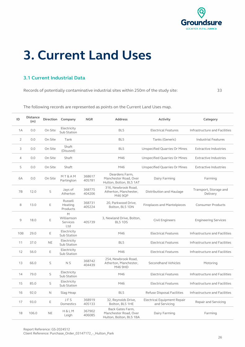
3. Current Land Uses3.1 Current Industrial Data
Records of potentially contaminative industrial sites within 250m of the study site: 33
The following records are represented as points on the Current Land Uses map.
IDDistance
(m)Direction Company NGR Address Activity Category
1A 0.0 On SiteElectricity
Sub StationBL5 Electrical Features Infrastructure and Facilities
2 0.0 On Site Tank BL5 Tanks (Generic) Industrial Features
3 0.0 On SiteShaft
(Disused)BL5 Unspecified Quarries Or Mines Extractive Industries
4 0.0 On Site Shaft M46 Unspecified Quarries Or Mines Extractive Industries
5 0.0 On Site Shaft M46 Unspecified Quarries Or Mines Extractive Industries
6A 0.0 On SiteM T & A M Partington
368617405781
Deardens Farm, Manchester Road, Over Hulton, Bolton, BL5 1AT
Dairy Farming Farming
7B 12.0 SJays of
Atherton368775404206
316, Newbrook Road, Atherton, Manchester,
M46 9QPDistribution and Haulage
Transport, Storage and Delivery
8 13.0 ERussell Heating Products
368731405224
20, Parkwood Drive, Bolton, BL5 1DN
Fireplaces and Mantelpieces Consumer Products
9 18.0 E
M Williamson
Services Ltd
4057393, Newland Drive, Bolton,
BL5 1DSCivil Engineers Engineering Services
10B 29.0 EElectricity
Sub StationM46 Electrical Features Infrastructure and Facilities
11 37.0 NE Electricity Sub Station
BL5 Electrical Features Infrastructure and Facilities
12 56.0 EElectricity
Sub StationM46 Electrical Features Infrastructure and Facilities
13 66.0 S N S368742404439
254, Newbrook Road, Atherton, Manchester,
M46 9HDSecondhand Vehicles Motoring
14 79.0 S Electricity Sub Station
M46 Electrical Features Infrastructure and Facilities
15 85.0 SElectricity
Sub StationM46 Electrical Features Infrastructure and Facilities
16 92.0 N Slag Heap BL5 Refuse Disposal Facilities Infrastructure and Facilities
17 93.0 EJ F S
Domestics368919405133
32, Reynolds Drive, Bolton, BL5 1HE
Electrical Equipment Repair and Servicing
Repair and Servicing
18 106.0 NEH & L M
Leigh367902406085
Back Gates Farm, Manchester Road, Over
Hulton, Bolton, BL5 1BADairy Farming Farming
Report Reference: GS-2024512Client Reference: Purchase_Order_03147172_-_Hulton_Park
26
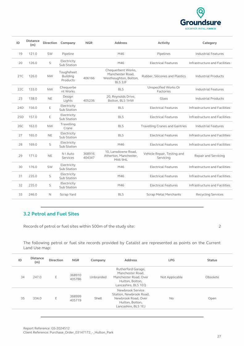
IDDistance
(m)Direction Company NGR Address Activity Category
19 121.0 SW Pipeline M46 Pipelines Industrial Features
20 126.0 S Electricity Sub Station
M46 Electrical Features Infrastructure and Facilities
21C 126.0 NWToughsheet
Building Products
406166
Chequerbent Works, Manchester Road,
Westhoughton, Bolton, BL5 3JF
Rubber, Silicones and Plastics Industrial Products
22C 133.0 NW Chequerbent Works
BL5 Unspecified Works Or Factories
Industrial Features
23 138.0 NEDesign Lights 405236
20, Reynolds Drive, Bolton, BL5 1HW
Glass Industrial Products
24D 156.0 E Electricity Sub Station
BL5 Electrical Features Infrastructure and Facilities
25D 157.0 EElectricity
Sub StationBL5 Electrical Features Infrastructure and Facilities
26C 163.0 NW Travelling Crane
BL5 Travelling Cranes and Gantries Industrial Features
27 165.0 NEElectricity
Sub StationBL5 Electrical Features Infrastructure and Facilities
28 169.0 S Electricity Sub Station
M46 Electrical Features Infrastructure and Facilities
29 171.0 NEN I Auto Services
368916404347
10, Lansdowne Road, Atherton, Manchester,
M46 9HL
Vehicle Repair, Testing and Servicing Repair and Servicing
30 176.0 SWElectricity
Sub StationM46 Electrical Features Infrastructure and Facilities
31 235.0 S Electricity Sub Station
M46 Electrical Features Infrastructure and Facilities
32 235.0 SElectricity
Sub StationM46 Electrical Features Infrastructure and Facilities
33 246.0 N Scrap Yard BL5 Scrap Metal Merchants Recycling Services
3.2 Petrol and Fuel Sites
Records of petrol or fuel sites within 500m of the study site: 2
The following petrol or fuel site records provided by Catalist are represented as points on the Current Land Use map:
ID Distance (m)
Direction NGR Company Address LPG Status
34 247.0 E368910405786 Unbranded
Rutherford Garage, Manchester Road,
Manchester Road, Over Hulton, Bolton,
Lancashire, BL5 1EQ
Not Applicable Obsolete
35 334.0 E368999405719 Shell
Newbrook Service Station, Newbrook Road,
Newbrook Road, Over Hulton, Bolton,
Lancashire, BL5 1EJ
No Open
Report Reference: GS-2024512Client Reference: Purchase_Order_03147172_-_Hulton_Park
27

3.3 Underground High Pressure Oil and Gas Pipelines
Records of high pressure underground pipelines within 500m of the study site: 0
Database searched and no data found.
Report Reference: GS-2024512Client Reference: Purchase_Order_03147172_-_Hulton_Park
28
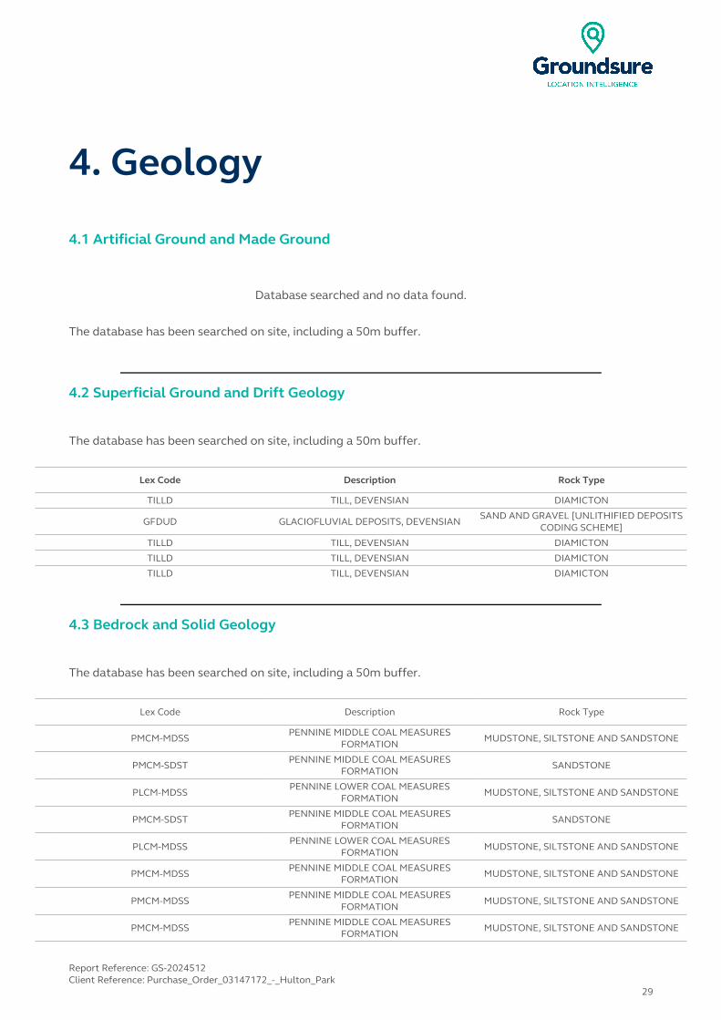
4. Geology
4.1 Artificial Ground and Made Ground
Database searched and no data found.
The database has been searched on site, including a 50m buffer.
4.2 Superficial Ground and Drift Geology
The database has been searched on site, including a 50m buffer.
Lex Code Description Rock Type
TILLD TILL, DEVENSIAN DIAMICTON
GFDUD GLACIOFLUVIAL DEPOSITS, DEVENSIANSAND AND GRAVEL [UNLITHIFIED DEPOSITS
CODING SCHEME]
TILLD TILL, DEVENSIAN DIAMICTON
TILLD TILL, DEVENSIAN DIAMICTON
TILLD TILL, DEVENSIAN DIAMICTON
4.3 Bedrock and Solid Geology
The database has been searched on site, including a 50m buffer.
Lex Code Description Rock Type
PMCM-MDSSPENNINE MIDDLE COAL MEASURES
FORMATIONMUDSTONE, SILTSTONE AND SANDSTONE
PMCM-SDST PENNINE MIDDLE COAL MEASURES FORMATION
SANDSTONE
PLCM-MDSSPENNINE LOWER COAL MEASURES
FORMATIONMUDSTONE, SILTSTONE AND SANDSTONE
PMCM-SDST PENNINE MIDDLE COAL MEASURES FORMATION
SANDSTONE
PLCM-MDSSPENNINE LOWER COAL MEASURES
FORMATIONMUDSTONE, SILTSTONE AND SANDSTONE
PMCM-MDSS PENNINE MIDDLE COAL MEASURES FORMATION
MUDSTONE, SILTSTONE AND SANDSTONE
PMCM-MDSSPENNINE MIDDLE COAL MEASURES
FORMATIONMUDSTONE, SILTSTONE AND SANDSTONE
PMCM-MDSS PENNINE MIDDLE COAL MEASURES FORMATION
MUDSTONE, SILTSTONE AND SANDSTONE
Report Reference: GS-2024512Client Reference: Purchase_Order_03147172_-_Hulton_Park
29
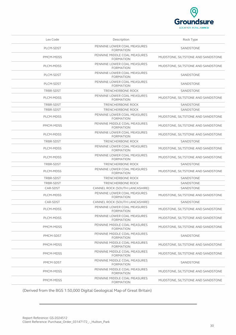
Lex Code Description Rock Type
PLCM-SDST PENNINE LOWER COAL MEASURES FORMATION
SANDSTONE
PMCM-MDSSPENNINE MIDDLE COAL MEASURES
FORMATIONMUDSTONE, SILTSTONE AND SANDSTONE
PLCM-MDSS PENNINE LOWER COAL MEASURES FORMATION
MUDSTONE, SILTSTONE AND SANDSTONE
PLCM-SDSTPENNINE LOWER COAL MEASURES
FORMATIONSANDSTONE
PLCM-SDST PENNINE LOWER COAL MEASURES FORMATION
SANDSTONE
TRBR-SDST TRENCHERBONE ROCK SANDSTONE
PLCM-MDSSPENNINE LOWER COAL MEASURES
FORMATIONMUDSTONE, SILTSTONE AND SANDSTONE
TRBR-SDST TRENCHERBONE ROCK SANDSTONE
TRBR-SDST TRENCHERBONE ROCK SANDSTONE
PLCM-MDSS PENNINE LOWER COAL MEASURES FORMATION
MUDSTONE, SILTSTONE AND SANDSTONE
PMCM-MDSSPENNINE MIDDLE COAL MEASURES
FORMATIONMUDSTONE, SILTSTONE AND SANDSTONE
PLCM-MDSS PENNINE LOWER COAL MEASURES FORMATION
MUDSTONE, SILTSTONE AND SANDSTONE
TRBR-SDST TRENCHERBONE ROCK SANDSTONE
PLCM-MDSSPENNINE LOWER COAL MEASURES
FORMATIONMUDSTONE, SILTSTONE AND SANDSTONE
PLCM-MDSS PENNINE LOWER COAL MEASURES FORMATION
MUDSTONE, SILTSTONE AND SANDSTONE
TRBR-SDST TRENCHERBONE ROCK SANDSTONE
PLCM-MDSSPENNINE LOWER COAL MEASURES
FORMATIONMUDSTONE, SILTSTONE AND SANDSTONE
TRBR-SDST TRENCHERBONE ROCK SANDSTONE
TRBR-SDST TRENCHERBONE ROCK SANDSTONE
CAR-SDST CANNEL ROCK (SOUTH LANCASHIRE) SANDSTONE
PLCM-MDSS PENNINE LOWER COAL MEASURES FORMATION
MUDSTONE, SILTSTONE AND SANDSTONE
CAR-SDST CANNEL ROCK (SOUTH LANCASHIRE) SANDSTONE
PLCM-MDSSPENNINE LOWER COAL MEASURES
FORMATIONMUDSTONE, SILTSTONE AND SANDSTONE
PLCM-MDSS PENNINE LOWER COAL MEASURES FORMATION
MUDSTONE, SILTSTONE AND SANDSTONE
PMCM-MDSSPENNINE MIDDLE COAL MEASURES
FORMATIONMUDSTONE, SILTSTONE AND SANDSTONE
PMCM-SDST PENNINE MIDDLE COAL MEASURES FORMATION
SANDSTONE
PMCM-MDSSPENNINE MIDDLE COAL MEASURES
FORMATIONMUDSTONE, SILTSTONE AND SANDSTONE
PMCM-MDSS PENNINE MIDDLE COAL MEASURES FORMATION
MUDSTONE, SILTSTONE AND SANDSTONE
PMCM-SDSTPENNINE MIDDLE COAL MEASURES
FORMATIONSANDSTONE
PMCM-MDSS PENNINE MIDDLE COAL MEASURES FORMATION
MUDSTONE, SILTSTONE AND SANDSTONE
PMCM-MDSSPENNINE MIDDLE COAL MEASURES
FORMATIONMUDSTONE, SILTSTONE AND SANDSTONE
(Derived from the BGS 1:50,000 Digital Geological Map of Great Britain)
Report Reference: GS-2024512Client Reference: Purchase_Order_03147172_-_Hulton_Park
30
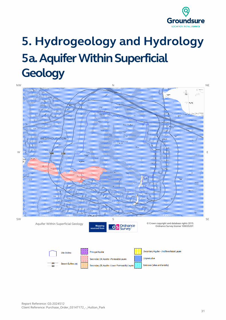
5. Hydrogeology and Hydrology5a. Aquifer Within Superficial Geology
NW N NE
W E
SW S SE
Aquifer Within Superficial Geology © Crown copyright and database rights 2015. Ordnance Survey license 100035207.
Report Reference: GS-2024512Client Reference: Purchase_Order_03147172_-_Hulton_Park
31

5b. Aquifer Within Bedrock Geology and Abstraction Licenses
NW N NE
W E
SW S SE
Aquifer Within Bedrock Geology and Abstraction Licenses
© Crown copyright and database rights 2015. Ordnance Survey license 100035207.
Report Reference: GS-2024512Client Reference: Purchase_Order_03147172_-_Hulton_Park
32

5c. Hydrogeology – Source Protection Zones and Potable Water Abstraction Licenses
NW N NE
W E
SW S SE
Map LegendSource Protection Zonesand PotableWater Abstraction
Licenses
© Crown copyright and database rights 2015. Ordnance Survey license 100035207.
Report Reference: GS-2024512Client Reference: Purchase_Order_03147172_-_Hulton_Park
33
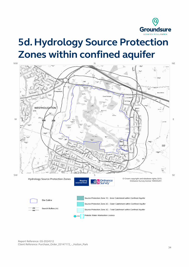
5d. Hydrology Source Protection Zones within confined aquifer
NW N NE
W E
SW S SE
Hydrology Source Protection Zones © Crown copyright and database rights 2015. Ordnance Survey license 100035207.
Report Reference: GS-2024512Client Reference: Purchase_Order_03147172_-_Hulton_Park
34
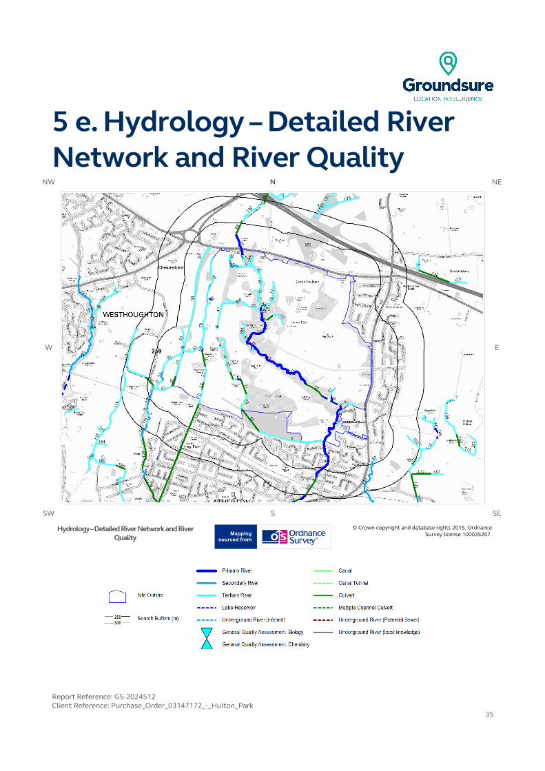
5 e. Hydrology – Detailed River Network and River Quality
NW N NE
W E
SW S SE
Hydrology – Detailed River Network and River Quality
© Crown copyright and database rights 2015. Ordnance Survey license 100035207.
Report Reference: GS-2024512Client Reference: Purchase_Order_03147172_-_Hulton_Park
35
5. Hydrogeology and Hydrology5.1 Aquifer within Superficial Deposits
Are there records of strata classification within the superficial geology at or in proximity to the property?Yes
From 1 April 2010, the Environment Agency's Groundwater Protection Policy has been using aquifer designations consistent with the Water Framework Directive. For further details on the designation and interpretation of this information, please refer to the Groundsure Enviroinsight User Guide.
The following aquifer records are shown on the Aquifer within Superficial Geology Map (5a):
ID Distance (m)
Direction Designation Description
1 0.0 On Site Secondary APermeable layers capable of supporting water supplies at a local rather than
strategic scale, and in some cases forming an important source of base flow to rivers. These are generally aquifers formerly classified as minor aquifers
3 0.0 On Site UnproductiveThese are rock layers or drift deposits with low permeability that have
negligible significance for water supply or river base flow
4 0.0 On Site Unproductive These are rock layers or drift deposits with low permeability that have negligible significance for water supply or river base flow
2 291.0 W Secondary APermeable layers capable of supporting water supplies at a local rather than
strategic scale, and in some cases forming an important source of base flow to rivers. These are generally aquifers formerly classified as minor aquifers
5.2 Aquifer within Bedrock Deposits
Are there records of strata classification within the bedrock geology at or in proximity to the property?Yes
From 1 April 2010, the Environment Agency's Groundwater Protection Policy has been using aquifer designations consistent with the Water Framework Directive. For further details on the designation and interpretation of this information, please refer to the Groundsure Enviroinsight User Guide.
The following aquifer records are shown on the Aquifer within Bedrock Geology Map (5b):
IDDistance
(m)Direction Designation Description
1 0.0 On Site Secondary APermeable layers capable of supporting water supplies at a local rather than strategic scale, and in some cases forming an important source of base flow to rivers. These are
generally aquifers formerly classified as minor aquifers
2 0.0 On Site Secondary APermeable layers capable of supporting water supplies at a local rather than strategic scale, and in some cases forming an important source of base flow to rivers. These are
generally aquifers formerly classified as minor aquifers
Report Reference: GS-2024512Client Reference: Purchase_Order_03147172_-_Hulton_Park
36

5.3 Groundwater Abstraction Licences
Are there any Groundwater Abstraction Licences within 2000m of the study site? No
Database searched and no data found.
5.4 Surface Water Abstraction Licences
Are there any Surface Water Abstraction Licences within 2000m of the study site? Yes
The following Surface Water Abstraction Licences records are represented as points, lines and regions on the Aquifer within Bedrock Geology Map (5b):
ID Distance (m)
Direction NGR Details
Not shown
1150.0 S 367300403300
Licence No: 2569016020Details: Boiler Feed
Direct Source: Surface, Non-tidal - North West RegionPoint: Reservoirs (2) Fed By Surf Drainage, Gloucester
St, AthertonData Type: Point
Annual Volume (m³): -Max Daily Volume (m³): -
Application No: 639Original Start Date: 9/2/1966
Expiry Date: -Issue No: 100
Version Start Date: 28/8/1996Version End Date:
5.5 Potable Water Abstraction Licences
Are there any Potable Water Abstraction Licences within 2000m of the study site? No
Database searched and no data found.
5.6 Source Protection Zones
Are there any Source Protection Zones within 500m of the study site? No
Database searched and no data found.
Report Reference: GS-2024512Client Reference: Purchase_Order_03147172_-_Hulton_Park
37
5.7 Source Protection Zones within Confined Aquifer
Are there any Source Protection Zones within the Confined Aquifer within 500m of the study site?
No
Historically, Source Protection Zone maps have been focused on regulation of activities which occur at or near the ground surface, such as prevention of point source pollution and bacterial contamination of water supplies. Sources in confined aquifers were often considered to be protected from these surface pressures due to the presence of a low permeability confining layer (e.g. glacial till, clay). The increased interest in subsurface activities such as onshore oil and gas exploration, ground source heating and cooling requires protection zones for confined sources to be marked on SPZ maps where this has not already been done.
Database searched and no data found.
5.8 Groundwater Vulnerability and Soil Leaching Potential
Is there any Environment Agency information on groundwater vulnerability and soil leaching potential within 500m of the study site? Yes
Distance (m) Direction Classification Soil Vulnerability Category Description
0 On Site Minor Aquifer/High Leaching Potential
HU
Soil information for urban areas and restored mineral workings.
These soils are therefore assumed to be highly permeable
in the absence of site-specific information.
0 On SiteMinor Aquifer/Low Leaching
PotentialL
Soils in which pollutants are unlikely to penetrate the soil
layer because either water movement is largely horizontal,
or they have the ability to attenuate diffuse pollutants.
270 E Minor Aquifer/Low Leaching Potential
L
Soils in which pollutants are unlikely to penetrate the soil
layer because either water movement is largely horizontal,
or they have the ability to attenuate diffuse pollutants.
5.9 River Quality
Is there any Environment Agency information on river quality within 1500m of the study site? No
Report Reference: GS-2024512Client Reference: Purchase_Order_03147172_-_Hulton_Park
38

5.9.1 Biological Quality:
Database searched and no data found.
5.9.2 Chemical Quality:
Database searched and no data found.
Report Reference: GS-2024512Client Reference: Purchase_Order_03147172_-_Hulton_Park
39

5.10 Detailed River Network
Are there any Detailed River Network entries within 500m of the study site? Yes
The following Detailed River Network records are represented on the Hydrology Map (5e):
Report Reference: GS-2024512Client Reference: Purchase_Order_03147172_-_Hulton_Park
40

IDDistance
(m)Direction Details
1 0.0 On SiteRiver Name: -
Welsh River Name: -Alternative Name: -
River Type: Tertiary RiverMain River Status: Currently Undefined
2 0.0 On SiteRiver Name: -
Welsh River Name: -Alternative Name: -
River Type: CulvertMain River Status: Currently Undefined
3 0.0 On SiteRiver Name: Drain
Welsh River Name: -Alternative Name: -
River Type: Tertiary RiverMain River Status: Currently Undefined
4 0.0 On SiteRiver Name: Carr Brook
Welsh River Name: -Alternative Name: -
River Type: Primary RiverMain River Status: Currently Undefined
5 0.0 On SiteRiver Name: Carr Brook
Welsh River Name: -Alternative Name: -
River Type: Primary RiverMain River Status: Currently Undefined
6 0.0 On SiteRiver Name: Drain
Welsh River Name: -Alternative Name: -
River Type: Tertiary RiverMain River Status: Currently Undefined
7L 0.0 On SiteRiver Name: Carr Brook
Welsh River Name: -Alternative Name: -
River Type: Primary RiverMain River Status: Currently Undefined
8 0.0 On SiteRiver Name: -
Welsh River Name: -Alternative Name: -
River Type: Tertiary RiverMain River Status: Currently Undefined
9 0.0 On SiteRiver Name: Carr Brook
Welsh River Name: -Alternative Name: -
River Type: Primary RiverMain River Status: Currently Undefined
10F 0.0 On Site
River Name: DrainWelsh River Name: -Alternative Name: -
River Type: Tertiary RiverMain River Status: Currently Undefined
11 0.0 On SiteRiver Name: Drain
Welsh River Name: -Alternative Name: -
River Type: Tertiary RiverMain River Status: Currently Undefined
12A 0.0 On Site
River Name: DrainWelsh River Name: -Alternative Name: -
River Type: Tertiary RiverMain River Status: Currently Undefined
13 0.0 On SiteRiver Name: Drain
Welsh River Name: -Alternative Name: -
River Type: Tertiary RiverMain River Status: Currently Undefined
14 0.0 On SiteRiver Name: Mill Dam Stream
Welsh River Name: -Alternative Name: -
River Type: Tertiary RiverMain River Status: Currently Undefined
15A 0.0 On Site
River Name: Mill Dam StreamWelsh River Name: -Alternative Name: -
River Type: Tertiary RiverMain River Status: Currently Undefined
16 0.0 On SiteRiver Name: Drain
Welsh River Name: -Alternative Name: -
River Type: Tertiary RiverMain River Status: Currently Undefined
17D 0.0 On Site
River Name: -Welsh River Name: -Alternative Name: -
River Type: Tertiary RiverMain River Status: Currently Undefined
18B 0.0 On Site
River Name: -Welsh River Name: -Alternative Name: -
River Type: Tertiary RiverMain River Status: Currently Undefined
19C 0.0 On Site
River Name: DrainWelsh River Name: -Alternative Name: -
River Type: Tertiary RiverMain River Status: Currently Undefined
20B 0.0 On Site
River Name: -Welsh River Name: -Alternative Name: -
River Type: Tertiary RiverMain River Status: Currently Undefined
Report Reference: GS-2024512Client Reference: Purchase_Order_03147172_-_Hulton_Park
41
IDDistance
(m)Direction Details
21C 0.0 On Site
River Name: DrainWelsh River Name: -Alternative Name: -
River Type: Tertiary RiverMain River Status: Currently Undefined
22C 0.0 On Site
River Name: DrainWelsh River Name: -Alternative Name: -
River Type: Tertiary RiverMain River Status: Currently Undefined
23C 0.0 On Site
River Name: DrainWelsh River Name: -Alternative Name: -
River Type: Tertiary RiverMain River Status: Currently Undefined
24H 0.0 On Site
River Name: Mill Dam StreamWelsh River Name: -Alternative Name: -
River Type: Tertiary RiverMain River Status: Currently Undefined
25D 0.0 On Site
River Name: Mill Dam StreamWelsh River Name: -Alternative Name: -
River Type: Primary RiverMain River Status: Currently Undefined
26E 0.0 On Site
River Name: DrainWelsh River Name: -Alternative Name: -
River Type: Tertiary RiverMain River Status: Currently Undefined
27N 0.0 On Site
River Name: DrainWelsh River Name: -Alternative Name: -
River Type: Tertiary RiverMain River Status: Currently Undefined
28E 0.0 On Site
River Name: Mill Dam StreamWelsh River Name: -Alternative Name: -
River Type: Primary RiverMain River Status: Currently Undefined
29F 0.0 On Site
River Name: Mill Dam StreamWelsh River Name: -Alternative Name: -
River Type: Tertiary RiverMain River Status: Currently Undefined
30 0.0 On SiteRiver Name: -
Welsh River Name: -Alternative Name: -
River Type: CulvertMain River Status: Currently Undefined
31 0.0 On SiteRiver Name: Mill Dam Stream
Welsh River Name: -Alternative Name: -
River Type: Primary RiverMain River Status: Currently Undefined
32 0.0 On SiteRiver Name: Drain
Welsh River Name: -Alternative Name: -
River Type: Tertiary RiverMain River Status: Currently Undefined
33 0.0 On SiteRiver Name: Mill Dam Stream
Welsh River Name: -Alternative Name: -
River Type: Primary RiverMain River Status: Currently Undefined
34 0.0 On SiteRiver Name: -
Welsh River Name: -Alternative Name: -
River Type: Tertiary RiverMain River Status: Currently Undefined
35 0.0 On SiteRiver Name: Drain
Welsh River Name: -Alternative Name: -
River Type: Secondary RiverMain River Status: Currently Undefined
36B 0.0 On Site
River Name: -Welsh River Name: -Alternative Name: -
River Type: Tertiary RiverMain River Status: Currently Undefined
37 0.0 On SiteRiver Name: Mill Dam Stream
Welsh River Name: -Alternative Name: -
River Type: Primary RiverMain River Status: Currently Undefined
38 0.0 On SiteRiver Name: Drain
Welsh River Name: -Alternative Name: -
River Type: Tertiary RiverMain River Status: Currently Undefined
39G 0.0 On Site
River Name: -Welsh River Name: -Alternative Name: -
River Type: Tertiary RiverMain River Status: Currently Undefined
40 0.0 On SiteRiver Name: Mill Dam Stream
Welsh River Name: -Alternative Name: -
River Type: Primary RiverMain River Status: Currently Undefined
Report Reference: GS-2024512Client Reference: Purchase_Order_03147172_-_Hulton_Park
42

IDDistance
(m)Direction Details
41 0.0 On SiteRiver Name: Drain
Welsh River Name: -Alternative Name: -
River Type: Tertiary RiverMain River Status: Currently Undefined
42G 0.0 On Site
River Name: DrainWelsh River Name: -Alternative Name: -
River Type: Tertiary RiverMain River Status: Currently Undefined
43 0.0 On SiteRiver Name: -
Welsh River Name: -Alternative Name: -
River Type: Tertiary RiverMain River Status: Currently Undefined
44 0.0 On SiteRiver Name: -
Welsh River Name: -Alternative Name: -
River Type: Tertiary RiverMain River Status: Currently Undefined
45H 0.0 On Site
River Name: DrainWelsh River Name: -Alternative Name: -
River Type: Tertiary RiverMain River Status: Currently Undefined
46F 0.0 On Site
River Name: Mill Dam StreamWelsh River Name: -Alternative Name: -
River Type: Tertiary RiverMain River Status: Currently Undefined
47 0.0 On SiteRiver Name: -
Welsh River Name: -Alternative Name: -
River Type: Tertiary RiverMain River Status: Currently Undefined
48 0.0 On SiteRiver Name: Drain
Welsh River Name: -Alternative Name: -
River Type: Tertiary RiverMain River Status: Currently Undefined
49 0.0 On SiteRiver Name: -
Welsh River Name: -Alternative Name: -
River Type: Lake/ReservoirMain River Status: Currently Undefined
50 0.0 On SiteRiver Name: -
Welsh River Name: -Alternative Name: -
River Type: Tertiary RiverMain River Status: Currently Undefined
51 0.0 On SiteRiver Name: -
Welsh River Name: -Alternative Name: -
River Type: CulvertMain River Status: Currently Undefined
52 0.0 On SiteRiver Name: -
Welsh River Name: -Alternative Name: -
River Type: Tertiary RiverMain River Status: Currently Undefined
53 0.0 On SiteRiver Name: Drain
Welsh River Name: -Alternative Name: -
River Type: Tertiary RiverMain River Status: Currently Undefined
54 0.0 On SiteRiver Name: -
Welsh River Name: -Alternative Name: -
River Type: CulvertMain River Status: Currently Undefined
55 0.0 On SiteRiver Name: Drain
Welsh River Name: -Alternative Name: -
River Type: Lake/ReservoirMain River Status: Currently Undefined
56I 0.0 On SiteRiver Name: -
Welsh River Name: -Alternative Name: -
River Type: CulvertMain River Status: Currently Undefined
57I 0.0 On SiteRiver Name: -
Welsh River Name: -Alternative Name: -
River Type: Tertiary RiverMain River Status: Currently Undefined
58 0.0 On SiteRiver Name: Drain
Welsh River Name: -Alternative Name: -
River Type: Tertiary RiverMain River Status: Currently Undefined
59 0.0 On SiteRiver Name: Drain
Welsh River Name: -Alternative Name: -
River Type: Tertiary RiverMain River Status: Currently Undefined
60 0.0 On SiteRiver Name: Mill Dam Stream
Welsh River Name: -Alternative Name: -
River Type: Primary RiverMain River Status: Currently Undefined
Report Reference: GS-2024512Client Reference: Purchase_Order_03147172_-_Hulton_Park
43

IDDistance
(m)Direction Details
61 0.0 On SiteRiver Name: -
Welsh River Name: -Alternative Name: -
River Type: Lake/ReservoirMain River Status: Currently Undefined
62J 0.0 On SiteRiver Name: -
Welsh River Name: -Alternative Name: -
River Type: Tertiary RiverMain River Status: Currently Undefined
63J 0.0 On SiteRiver Name: -
Welsh River Name: -Alternative Name: -
River Type: Tertiary RiverMain River Status: Currently Undefined
64K 0.0 On Site
River Name: -Welsh River Name: -Alternative Name: -
River Type: Tertiary RiverMain River Status: Currently Undefined
65K 0.0 On Site
River Name: -Welsh River Name: -Alternative Name: -
River Type: Tertiary RiverMain River Status: Currently Undefined
66P 0.0 On Site
River Name: -Welsh River Name: -Alternative Name: -
River Type: Tertiary RiverMain River Status: Currently Undefined
67 0.0 On SiteRiver Name: -
Welsh River Name: -Alternative Name: -
River Type: Tertiary RiverMain River Status: Currently Undefined
68J 0.0 On SiteRiver Name: Drain
Welsh River Name: -Alternative Name: -
River Type: Tertiary RiverMain River Status: Currently Undefined
69M 0.0 On Site
River Name: -Welsh River Name: -Alternative Name: -
River Type: Tertiary RiverMain River Status: Currently Undefined
70 0.0 On SiteRiver Name: -
Welsh River Name: -Alternative Name: -
River Type: Tertiary RiverMain River Status: Currently Undefined
71 0.0 On SiteRiver Name: -
Welsh River Name: -Alternative Name: -
River Type: CulvertMain River Status: Currently Undefined
72 0.0 On SiteRiver Name: Drain
Welsh River Name: -Alternative Name: -
River Type: Tertiary RiverMain River Status: Currently Undefined
73O 0.0 On Site
River Name: -Welsh River Name: -Alternative Name: -
River Type: Lake/ReservoirMain River Status: Currently Undefined
74L 0.0 On Site
River Name: -Welsh River Name: -Alternative Name: -
River Type: Lake/ReservoirMain River Status: Currently Undefined
75M 0.0 On Site
River Name: -Welsh River Name: -Alternative Name: -
River Type: Tertiary RiverMain River Status: Currently Undefined
76 0.0 On SiteRiver Name: Drain
Welsh River Name: -Alternative Name: -
River Type: Tertiary RiverMain River Status: Currently Undefined
77G 0.0 On Site
River Name: -Welsh River Name: -Alternative Name: -
River Type: Tertiary RiverMain River Status: Currently Undefined
78N 0.0 On Site
River Name: Mill Dam StreamWelsh River Name: -Alternative Name: -
River Type: Tertiary RiverMain River Status: Currently Undefined
79 0.0 On SiteRiver Name: Mill Dam Stream
Welsh River Name: -Alternative Name: -
River Type: Tertiary RiverMain River Status: Currently Undefined
80O 0.0 On Site
River Name: -Welsh River Name: -Alternative Name: -
River Type: Lake/ReservoirMain River Status: Currently Undefined
Report Reference: GS-2024512Client Reference: Purchase_Order_03147172_-_Hulton_Park
44
IDDistance
(m)Direction Details
81 0.0 On SiteRiver Name: Mill Dam Stream
Welsh River Name: -Alternative Name: -
River Type: CulvertMain River Status: Currently Undefined
82P 0.0 On Site
River Name: DrainWelsh River Name: -Alternative Name: -
River Type: Tertiary RiverMain River Status: Currently Undefined
83E 0.0 On Site
River Name: DrainWelsh River Name: -Alternative Name: -
River Type: CulvertMain River Status: Currently Undefined
84J 0.0 On SiteRiver Name: -
Welsh River Name: -Alternative Name: -
River Type: Tertiary RiverMain River Status: Currently Undefined
85 0.0 On SiteRiver Name: Mill Dam Stream
Welsh River Name: -Alternative Name: -
River Type: Primary RiverMain River Status: Currently Undefined
86 4.0 WRiver Name: Drain
Welsh River Name: -Alternative Name: -
River Type: Tertiary RiverMain River Status: Currently Undefined
87 7.0 WRiver Name: -
Welsh River Name: -Alternative Name: -
River Type: CulvertMain River Status: Currently Undefined
88 15.0 NWRiver Name: -
Welsh River Name: -Alternative Name: -
River Type: Tertiary RiverMain River Status: Currently Undefined
89 16.0 NRiver Name: -
Welsh River Name: -Alternative Name: -
River Type: Tertiary RiverMain River Status: Currently Undefined
90 16.0 NRiver Name: Drain
Welsh River Name: -Alternative Name: -
River Type: Tertiary RiverMain River Status: Currently Undefined
91 18.0 WRiver Name: -
Welsh River Name: -Alternative Name: -
River Type: Tertiary RiverMain River Status: Currently Undefined
92 19.0 NWRiver Name: -
Welsh River Name: -Alternative Name: -
River Type: Tertiary RiverMain River Status: Currently Undefined
93 118.0 WRiver Name: -
Welsh River Name: -Alternative Name: -
River Type: Secondary RiverMain River Status: Currently Undefined
94Q 120.0 W
River Name: -Welsh River Name: -Alternative Name: -
River Type: Tertiary RiverMain River Status: Currently Undefined
95 140.0 NRiver Name: Mill Dam Stream
Welsh River Name: -Alternative Name: -
River Type: CulvertMain River Status: Currently Undefined
96R 168.0 W
River Name: -Welsh River Name: -Alternative Name: -
River Type: Tertiary RiverMain River Status: Currently Undefined
97 185.0 SERiver Name: Hindsford Brook
Welsh River Name: -Alternative Name: -
River Type: Tertiary RiverMain River Status: Currently Undefined
98Q 189.0 W
River Name: -Welsh River Name: -Alternative Name: -
River Type: Tertiary RiverMain River Status: Currently Undefined
99R 190.0 W
River Name: -Welsh River Name: -Alternative Name: -
River Type: Tertiary RiverMain River Status: Currently Undefined
100 194.0 W
River Name: -Welsh River Name: -Alternative Name: -
River Type: CulvertMain River Status: Currently Undefined
Report Reference: GS-2024512Client Reference: Purchase_Order_03147172_-_Hulton_Park
45
IDDistance
(m)Direction Details
101 200.0 W
River Name: -Welsh River Name: -Alternative Name: -
River Type: Secondary RiverMain River Status: Currently Undefined
102 228.0 S
River Name: Hindsford BrookWelsh River Name: -Alternative Name: -
River Type: Secondary RiverMain River Status: Currently Undefined
103 272.0 N
River Name: Mill Dam StreamWelsh River Name: -Alternative Name: -
River Type: Tertiary RiverMain River Status: Currently Undefined
104 282.0 W
River Name: DrainWelsh River Name: -Alternative Name: -
River Type: Tertiary RiverMain River Status: Currently Undefined
105S 327.0 SW
River Name: -Welsh River Name: -Alternative Name: -
River Type: Tertiary RiverMain River Status: Currently Undefined
106S 340.0 SW
River Name: -Welsh River Name: -Alternative Name: -
River Type: Secondary RiverMain River Status: Currently Undefined
107 340.0 S
River Name: -Welsh River Name: -Alternative Name: -
River Type: CulvertMain River Status: Currently Undefined
108T 355.0 SW
River Name: -Welsh River Name: -Alternative Name: -
River Type: Tertiary RiverMain River Status: Currently Undefined
109 374.0 E
River Name: -Welsh River Name: -Alternative Name: -
River Type: Tertiary RiverMain River Status: Currently Undefined
110T 374.0 SW
River Name: -Welsh River Name: -Alternative Name: -
River Type: Secondary RiverMain River Status: Currently Undefined
111 400.0 SW
River Name: -Welsh River Name: -Alternative Name: -
River Type: Tertiary RiverMain River Status: Currently Undefined
112 441.0 SW
River Name: -Welsh River Name: -Alternative Name: -
River Type: Secondary RiverMain River Status: Currently Undefined
113 442.0 N
River Name: DrainWelsh River Name: -Alternative Name: -
River Type: Tertiary RiverMain River Status: Currently Undefined
114 462.0 W
River Name: -Welsh River Name: -Alternative Name: -
River Type: Tertiary RiverMain River Status: Currently Undefined
115 465.0 N
River Name: Mill Dam StreamWelsh River Name: -Alternative Name: -
River Type: Secondary RiverMain River Status: Currently Undefined
116W 473.0 N
River Name: Mill Dam StreamWelsh River Name: -Alternative Name: -
River Type: CulvertMain River Status: Currently Undefined
117 499.0 SE
River Name: -Welsh River Name: -Alternative Name: -
River Type: Tertiary RiverMain River Status: Currently Undefined
Report Reference: GS-2024512Client Reference: Purchase_Order_03147172_-_Hulton_Park
46
5.11 Surface Water Features
Are there any surface water features within 250m of the study site? Yes
The following surface water records are not represented on mapping:
Report Reference: GS-2024512Client Reference: Purchase_Order_03147172_-_Hulton_Park
47
Distance (m) Direction
0.0 On Site
0.0 On Site
0.0 On Site
0.0 On Site
0.0 On Site
0.0 On Site
0.0 On Site
0.0 On Site
0.0 On Site
0.0 On Site
0.0 On Site
0.0 On Site
0.0 On Site
0.0 On Site
0.0 On Site
0.0 On Site
0.0 On Site
0.0 On Site
0.0 On Site
0.0 On Site
0.0 On Site
0.0 On Site
0.0 On Site
0.0 On Site
0.0 On Site
0.0 On Site
0.0 On Site
0.0 On Site
0.0 On Site
0.0 On Site
0.0 On Site
0.0 On Site
0.0 On Site
0.0 On Site
0.0 On Site
0.0 On Site
0.0 On Site
0.0 On Site
0.0 On Site
0.0 On Site
0.0 On Site
0.0 On Site
0.0 On Site
0.0 On Site
0.0 On Site
0.0 On Site
0.0 On Site
0.0 On Site
0.0 On Site
0.0 On Site
0.0 On Site
0.0 On Site
0.0 On Site
Report Reference: GS-2024512Client Reference: Purchase_Order_03147172_-_Hulton_Park
48

Distance (m) Direction
0.0 On Site
0.0 On Site
0.0 On Site
0.0 On Site
0.0 On Site
0.0 On Site
0.0 On Site
0.0 On Site
0.0 On Site
0.0 On Site
0.0 On Site
0.0 On Site
0.0 On Site
0.0 On Site
0.0 On Site
0.0 On Site
0.0 On Site
0.0 On Site
0.0 On Site
0.0 On Site
0.0 On Site
0.0 On Site
0.0 On Site
0.0 On Site
0.0 On Site
0.0 On Site
0.0 On Site
0.0 On Site
0.0 On Site
0.0 On Site
0.0 On Site
0.0 On Site
0.0 On Site
0.0 On Site
0.0 On Site
0.0 On Site
0.0 On Site
0.0 On Site
0.0 On Site
0.0 On Site
0.0 On Site
0.0 On Site
0.0 On Site
0.0 On Site
0.0 NW
1.0 NE
3.0 N
3.0 W
17.0 NW
18.0 NW
18.0 W
19.0 NW
22.0 W
Report Reference: GS-2024512Client Reference: Purchase_Order_03147172_-_Hulton_Park
49

Distance (m) Direction
61.0 SW
68.0 NW
90.0 SW
105.0 SW
116.0 S
120.0 W
120.0 N
134.0 W
176.0 W
185.0 SE
190.0 W
221.0 S
229.0 N
248.0 N
250.0 S
Report Reference: GS-2024512Client Reference: Purchase_Order_03147172_-_Hulton_Park
50

6. Environment Agency Flood Map for planning (from rivers and the sea)
NW N NE
W E
SW S SE
Environment Agency Flood Map for planning (from rivers and the sea)
© Crown copyright and database rights 2015. Ordnance Survey license 100035207.
Report Reference: GS-2024512Client Reference: Purchase_Order_03147172_-_Hulton_Park
51
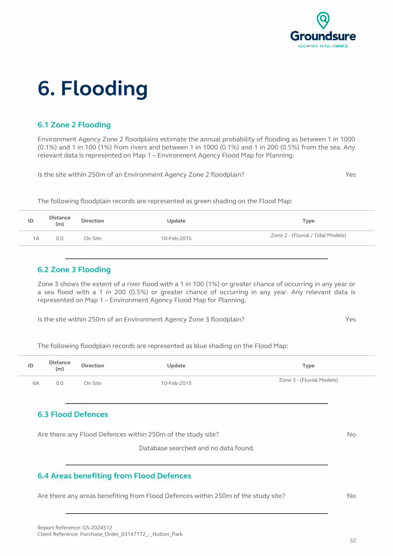
6. Flooding6.1 Zone 2 Flooding
Environment Agency Zone 2 floodplains estimate the annual probability of flooding as between 1 in 1000 (0.1%) and 1 in 100 (1%) from rivers and between 1 in 1000 (0.1%) and 1 in 200 (0.5%) from the sea. Any relevant data is represented on Map 1 – Environment Agency Flood Map for Planning:
Is the site within 250m of an Environment Agency Zone 2 floodplain? Yes
The following floodplain records are represented as green shading on the Flood Map:
ID Distance (m)
Direction Update Type
1A 0.0 On Site 10-Feb-2015 Zone 2 - (Fluvial / Tidal Models)
6.2 Zone 3 Flooding
Zone 3 shows the extent of a river flood with a 1 in 100 (1%) or greater chance of occurring in any year or a sea flood with a 1 in 200 (0.5%) or greater chance of occurring in any year. Any relevant data is represented on Map 1 – Environment Agency Flood Map for Planning.
Is the site within 250m of an Environment Agency Zone 3 floodplain? Yes
The following floodplain records are represented as blue shading on the Flood Map:
ID Distance (m)
Direction Update Type
6A 0.0 On Site 10-Feb-2015 Zone 3 - (Fluvial Models)
6.3 Flood Defences
Are there any Flood Defences within 250m of the study site? No
Database searched and no data found.
6.4 Areas benefiting from Flood Defences
Are there any areas benefiting from Flood Defences within 250m of the study site? No
Report Reference: GS-2024512Client Reference: Purchase_Order_03147172_-_Hulton_Park
52
6.5 Areas benefiting from Flood Storage
Are there any areas used for Flood Storage within 250m of the study site? No
6.6 Groundwater Flooding Susceptibility Areas
6.6.1 Are there any British Geological Survey groundwater flooding susceptibility areas within 50m of the boundary of the study site?
Yes
Does this relate to Clearwater Flooding or Superficial Deposits Flooding? Superficial Deposits Flooding
Notes: Groundwater flooding may either be associated with shallow unconsolidated sedimentary aquifers which overlie unproductive aquifers (Superficial Deposits Flooding), or with unconfined aquifers (Clearwater Flooding).
6.6.2 What is the highest susceptibility to groundwater flooding in the search area based on the underlying geological conditions?
Potential at Surface
Where potential for groundwater flooding to occur at surface is indicated, this means that given the geological conditions in the area groundwater flooding hazard should be considered in all land-use planning decisions. It is recommended that other relevant information e.g. records of previous incidence of groundwater flooding, rainfall, property type, and land drainage information be investigated in order to establish relative, but not absolute, risk of groundwater flooding.
6.7 Groundwater Flooding Confidence Areas
What is the British Geological Survey confidence rating in this result? High
Notes: Groundwater flooding is defined as the emergence of groundwater at the ground surface or the rising of groundwater into man-made ground under conditions where the normal range of groundwater levels is exceeded.
The confidence rating is on a threefold scale - Low, Moderate and High. This provides a relative indication of the BGS confidence in the accuracy of the susceptibility result for groundwater flooding. This is based on the amount and precision of the information used in the assessment. In areas with a relatively lower level of confidence the susceptibility result should be treated with more caution. In other areas with higher levels of confidence the susceptibility result can be used with more confidence.
Report Reference: GS-2024512Client Reference: Purchase_Order_03147172_-_Hulton_Park
53
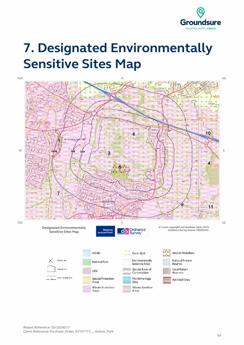
7. Designated Environmentally Sensitive Sites Map
NW N NE
W E
SW S SE
Designated Environmentally Sensitive Sites Map
© Crown copyright and database rights 2015. Ordnance Survey license 100035207.
Report Reference: GS-2024512Client Reference: Purchase_Order_03147172_-_Hulton_Park
54

7. Designated Environmentally Sensitive SitesPresence of Designated Environmentally Sensitive Sites within 2000m of the study site? Yes
7.1 Records of Sites of Special Scientific Interest (SSSI) within 2000m of the study site:
0
Database searched and no data found.
7.2 Records of National Nature Reserves (NNR) within 2000m of the study site:
0
Database searched and no data found.
7.3 Records of Special Areas of Conservation (SAC) within 2000m of the study site:
0
Database searched and no data found.
7.4 Records of Special Protection Areas (SPA) within 2000m of the study site:
0
Database searched and no data found.
7.5 Records of Ramsar sites within 2000m of the study site:
0
Database searched and no data found.
Report Reference: GS-2024512Client Reference: Purchase_Order_03147172_-_Hulton_Park
55
7.6 Records of Ancient Woodland within 2000m of the study site:
1
The following records of Designated Ancient Woodland provided by Natural England/Natural Resources Wales are represented as polygons on the Designated Environmentally Sensitive Sites Map:
ID Distance (m)
Direction Ancient Woodland Name Data Source
5 0.0 On Site UNKNOWN Ancient and Semi-Natural Woodland
7.7 Records of Local Nature Reserves (LNR) within 2000m of the study site:
2
The following Local Nature Reserve (LNR) records provided by Natural England/Natural Resources Wales are represented as polygons on the Designated Environmentally Sensitive Sites Map:
IDDistance
(m)Direction LNR Name Data Source
1 833.0 W Hall Lee Bank Park Natural England
Not shown
1822.0 W Eatock Lodge Natural England
7.8 Records of World Heritage Sites within 2000m of the study site:
0
Database searched and no data found.
7.9 Records of Environmentally Sensitive Areas within 2000m of the study site:
0
Database searched and no data found.
7.10 Records of Areas of Outstanding Natural Beauty (AONB) within 2000m of the study site:
0
Database searched and no data found.
Report Reference: GS-2024512Client Reference: Purchase_Order_03147172_-_Hulton_Park
56
7.11 Records of National Parks (NP) within 2000m of the study site:
0
Database searched and no data found.
7.12 Records of Nitrate Sensitive Areas within 2000m of the study site:
0
Database searched and no data found.
7.13 Records of Nitrate Vulnerable Zones within 2000m of the study site:
2
The following Nitrate Vulnerable Zone records produced by DEFRA are represented as polygons on the Designated Environmentally Sensitive Sites Map:
ID Distance (m)
Direction NVZ Name Data Source
3 0.0 On Site Existing DEFRA
4 1172.0 E Existing DEFRA
7.14 Records of Green Belt land within 2000m of the study site:
6
Green Belt data contains Ordnance Survey data © Crown copyright and database right [2015]
ID Distance (m)
Direction Green Belt Name Local Authority Name
6 0.0 On Site Liverpool, Manchester and West Yorks Greenbelt Bolton District (B)
7 2.0 S Liverpool, Manchester and West Yorks Greenbelt Wigan District (B)
8 221.0 SE Liverpool, Manchester and West Yorks Greenbelt Wigan District (B)
9 223.0 W Liverpool, Manchester and West Yorks Greenbelt Bolton District (B)
10 1172.0 E Liverpool, Manchester and West Yorks Greenbelt Bolton District (B)
11 1459.0 SE Liverpool, Manchester and West Yorks Greenbelt Salford District (B)
Report Reference: GS-2024512Client Reference: Purchase_Order_03147172_-_Hulton_Park
57
8. Natural Hazards Findings8.1 Detailed BGS GeoSure Data
BGS GeoSure Data has been searched to 50m. The data is included in tabular format. If you require further information on geology and ground stability, please obtain a Groundsure GeoInsight, available from our website. The following information has been found:
8.1.1 Shrink Swell
What is the maximum Shrink-Swell** hazard rating identified on the study site? Very Low
The following natural subsidence information provided by the British Geological Survey is not represented on mapping:
Hazard
Ground conditions predominantly low plasticity. No special actions required to avoid problems due to shrink-swell clays. No special ground investigation required, and increased construction costs or increased financial risks are unlikely due to potential problems with shrink-swell clays.
8.1.2 Landslides
What is the maximum Landslide* hazard rating identified on the study site? Low
The following natural subsidence information provided by the British Geological Survey is not represented on mapping:
Hazard
Possibility of slope instability problems after major changes in ground conditions. Consideration should be given to stability if changes to drainage or excavations take place. Possible increase in construction cost to reduce potential slope stability problems. Existing property no �significant increase in insurance risk due to natural slope instability problems.
* This indicates an automatically generated 50m buffer and site.
Report Reference: GS-2024512Client Reference: Purchase_Order_03147172_-_Hulton_Park
58

8.1.3 Soluble Rocks
What is the maximum Soluble Rocks* hazard rating identified on the study site? Negligible
The following natural subsidence information provided by the British Geological Survey is not represented on mapping:
Hazard
Soluble rocks are present, but unlikely to cause problems except under exceptional conditions. No special actions required to avoid problems due to soluble rocks. No special ground investigation required, and increased construction costs or increased financial risks are unlikely due to potential problems with soluble rocks.
8.1.4 Compressible Ground
What is the maximum Compressible Ground* hazard rating identified on the study site? Negligible
The following natural subsidence information provided by the British Geological Survey is not represented on mapping:
Hazard
No indicators for compressible deposits identified. No special actions required to avoid problems due to compressible deposits. No special ground investigation required, and increased construction costs or increased financial risks are unlikely due to potential problems with compressible deposits.
8.1.5 Collapsible Rocks
What is the maximum Collapsible Rocks* hazard rating identified on the study site? Very Low
The following natural subsidence information provided by the British Geological Survey is not represented on mapping:
Hazard
Deposits with potential to collapse when loaded and saturated are unlikely to be present. No special ground investigation required or increased construction costs or increased financial risk due to potential problems with collapsible deposits.
Report Reference: GS-2024512Client Reference: Purchase_Order_03147172_-_Hulton_Park
59
8.1.6 Running Sand
What is the maximum Running Sand** hazard rating identified on the study site? Very Low
The following natural subsidence information provided by the British Geological Survey is not represented on mapping:
Hazard
Very low potential for running sand problems if water table rises or if sandy strata are exposed to water. No special actions required, to avoid problems due to running sand. No special ground investigation required, and increased construction costs or increased financial risks are unlikely due to potential problems with running sand.
* This indicates an automatically generated 50m buffer and site.
Report Reference: GS-2024512Client Reference: Purchase_Order_03147172_-_Hulton_Park
60

9. Mining9.1 Coal Mining
Are there any coal mining areas within 75m of the study site? Yes
The following coal mining information provided by the Coal Authority is not represented on Mapping:
Distance Direction Details
0.0 On SiteThe study site is located within the specified search distance of an identified mining area. Further details concerning this can be obtained from the Coal Authority Helpline on 0845 762 6848.
9.2 Shallow Mining
What is the subsidence hazard relating to shallow mining on-site*? Low-Moderate
*Please note this data is searched with a 150m buffer.
9.3 Brine Affected Areas
Are there any brine affected areas within 75m of the study site? No
Guidance: No Guidance Required.
Report Reference: GS-2024512Client Reference: Purchase_Order_03147172_-_Hulton_Park
61

Contact DetailsGroundsure Helpline
Telephone: 08444 159 [email protected]
British Geological Survey Enquiries
Kingsley Dunham CentreKeyworth, Nottingham NG12 5GG
Tel: 0115 936 3143.Fax: 0115 936 3276.
Email: [email protected]:www.bgs.ac.uk
BGS Geological Hazards Reports and general geological enquiries
Environment Agency
National Customer Contact Centre, PO Box 544Rotherham, S60 1BYTel: 08708 506 506
Web:www.environment-agency.gov.ukEmail:[email protected]
Public Health England
Public information access officePublic Health England, Wellington House
133-155 Waterloo Road, London, SE1 8UGhttps://www.gov.uk/government/organisations/public-health-
englandEmail:[email protected]
Main switchboard: 020 7654 8000
The Coal Authority
200 Lichfield LaneMansfield
Notts NG18 4RGTel: 0345 7626 848
DX 716176 Mansfield 5 www.coal.gov.uk
Ordnance Survey
Adanac Drive, SouthamptonSO16 0AS
Tel: 08456 050505
Local Authority Authority: Bolton Metropolitan Borough Council
Phone: 01204 333 333 Web: http://www.bolton.gov.uk/
Address: Town Hall, Victoria Square, Bolton, Lancashire, BL1 1RU
Gemapping PLC
Virginia Villas, High Street, Hartley Witney,Hampshire RG27 8NW
Tel: 01252 845444
Report Reference: GS-2024512Client Reference: Purchase_Order_03147172_-_Hulton_Park
62

Acknowledgements: Site of Special Scientific Interest, National Nature Reserve, Ramsar Site, Special Protection Area, Special Area of Conservation data is provided by, and used with the permission of, Natural England who retain the Copyright and Intellectual Property Rights for the data.PointX © Database Right/Copyright, Thomson Directories Limited © Copyright Link Interchange Network Limited © Database Right/Copyright and Ordnance Survey © Crown Copyright and/or Database Right. All Rights Reserved. Licence Number [03421028].This report has been prepared in accordance with the Groundsure Ltd standard Terms and Conditions of business for work of this nature.
Report Reference: GS-2024512Client Reference: Purchase_Order_03147172_-_Hulton_Park
63
Standard Terms and Conditions
1 Definitions
In these terms and conditions unless the context otherwise requires:
“Beneficiary” means the person or entity for whose benefit the Client has obtained the Services.
“Client” means the party or parties entering into a Contract with Groundsure.
“Commercial” means any building or property which is not Residential.
“Confidential Information” means the contents of this Contract and all information received from the Client as a result of, or in connection with, this Contract other than
(i) information which the Client can prove was rightfully in its possession prior to disclosure by Groundsure and
(ii) any information which is in the public domain (other than by virtue of a breach of this Contract).
“Support Services” means Support Services provided by Groundsure including, without limitation, interpreting third party and in-house environmental data, providing environmental support advice, undertaking environmental audits and assessments, Site investigation, Site monitoring and related items.
“Contract” means the contract between Groundsure and the Client for the provision of the Services, and which shall incorporate these terms and conditions, the Order, and the relevant User Guide.
“Third Party Data Provider” means any third party providing Third Party Content to Groundsure.
“Data Reports” means reports comprising factual data with no accompanying interpretation.
“Fees” has the meaning set out in clause 5.1.
“Groundsure” means Groundsure Limited, a company registered in England and Wales under number 03421028.
“Groundsure Materials” means all materials prepared by Groundsure and provided as part of the Services, including but not limited to Third Party Content, Data Reports, Mapping, and Risk Screening Reports.
“Intellectual Property” means any patent, copyright, design rights, trade or service mark, moral rights, data protection rights, know-how or trade mark in each case whether registered or not and including applications for the same or any other rights of a similar nature anywhere in the world.
“Mapping” means a map, map data or a combination of historical maps of various ages, time periods and scales.
“Order” means an electronic, written or other order form submitted by the Client requesting Services from Groundsure in respect of a specified Site.
“Ordnance Survey” means the Secretary of State for Business, Innovation and Skills, acting through Ordnance Survey, Adanac Drive, Southampton, SO16 0AS, UK.
“Order Website” means the online platform through which Orders may be placed by the Client and accepted by Groundsure.
“Report” means a Risk Screening Report or Data Report for Commercial or Residential property.
“Residential” means any building or property used as or intended to be used as a single dwelling.
“Risk Screening Report” means a risk screening report comprising factual data with an accompanying interpretation by Groundsure.
“Services” means any Report, Mapping and/or Support Services which Groundsure has agreed to provide by accepting an Order pursuant to clause 2.6.
"Site" means the area of land in respect of which the Client has requested Groundsure to provide the Services.
“Third Party Content” means data, database information or other information which is provided to Groundsure by a Third Party Data Provider.
"User Guide" means the user guide, as amended from time to time, available upon request from Groundsure and on the website (www.Groundsure.com) and forming part of this Contract.
2 Scope of Services, terms and conditions, requests for insurance and quotations
2.1 Groundsure agrees to provide the Services in accordance with the Contract.
2.2 Groundsure shall exercise reasonable skill and care in the provision of the Services.
2.3 Subject to clause 7.3 the Client acknowledges that it has not relied on any statement or representation made by or on behalf of Groundsure which is not set out and expressly agreed in writing in the Contract and all such statements and representations are hereby excluded to the fullest extent permitted by law.
2.4 The Client acknowledges that terms and conditions appearing on a Client’s order form, printed stationery or other communication, or any terms or conditions implied by custom, practice or course of dealing shall be of no effect, and that this Contract shall prevail over all others in relation to the Order.
2.5 If the Client or Beneficiary requests insurance in conjunction with or as a result of the Services, Groundsure shall use reasonable endeavours to recommend such insurance, but makes no warranty that such insurance shall be available from insurers or that it will be offered on reasonable terms. Any insurance purchased by the Client or Beneficiary shall be subject solely to the terms of the policy issued by insurers and Groundsure will have no liability therefor. In addition you acknowledge and agree that Groundsure does not act as an agent or broker for any insurance providers. The Client should take (and ensure that the Beneficiary takes) independent advice to ensure that the insurance policy requested or offered is suitable for its requirements.
2.6 Groundsure's quotations or proposals are valid for a period of 30 days only unless an alternative period of time is explicitly stipulated by Groundsure. Groundsure reserves the right to withdraw any quotation or proposal at any time before an Order is accepted by Groundsure. Groundsure's acceptance of an Order shall be binding only when made in writing and signed by Groundsure's authorised representative or when accepted through the Order Website.
3 The Client’s obligations
3.1The Client shall comply with the terms of this Contract and
(i) procure that the Beneficiary or any third party relying on the Services complies with and acts as if it is bound by the Contract and
(ii) be liable to Groundsure for the acts and omissions of the Beneficiary or any third party relying on the Services as if such acts and omissions were those of the Client.
3.2 The Client shall be solely responsible for ensuring that the Services are appropriate and suitable for its and/or the Beneficiary’s needs.
3.3 The Client shall supply to Groundsure as soon as practicable and without charge all requisite information (and the Client warrants that such information is accurate, complete and appropriate), including without limitation any environmental information relating to the Site and shall give such assistance as Groundsure shall reasonably require in the provision of the Services including, without limitation, access to the Site, facilities and equipment.
3.4 Where the Client’s approval or decision is required to enable Groundsure to carry out work in order to provide the Services, such approval or decision shall be given or procured in reasonable time and so as not to delay or disrupt the performance of the Services.
3.5 Save as expressly permitted by this Contract the Client shall not, and shall procure that the Beneficiary shall not, re-sell, alter, add to, or amend the Groundsure Materials, or use the Groundsure Materials in a manner for which they were not intended. The Client may make the Groundsure Materials available to a third party who is considering acquiring some or all of, or providing funding in relation to, the Site, but such third party cannot rely on the same unless expressly permitted under clause 4.
3.6 The Client is responsible for maintaining the confidentiality of its user name and password if using the Order Website and the Client acknowledges that Groundsure accepts no liability of any kind for any loss or damage suffered by the Client as a consequence of using the Order Website.
4 Reliance
4.1The Client acknowledges that the Services provided by Groundsure consist of the presentation and analysis of Third Party Content and other content and that information obtained from a Third Party Data Provider cannot be guaranteed or warranted by Groundsure to be reliable.
4.2 In respect of Data Reports, Mapping and Risk Screening Reports, the following classes of person and no other are entitled to rely on their contents;
(i) the Beneficiary,
(ii) the Beneficiary's professional advisers, (iii) any person providing funding to the Beneficiary in relation to the Site (whether directly or as part of a lending syndicate),
(iv) the first purchaser or first tenant of the Site, and
(v) the professional advisers and lenders of the first purchaser or tenant of the Site.
4.3 In respect of Support Services, only the Client, Beneficiary and parties expressly named in a Report and no other parties are entitled to rely on its contents.
4.4 Save as set out in clauses 4.2 and 4.3 and unless otherwise expressly agreed in writing, no other person or entity of any kind is entitled to rely on any Services or Report issued or provided by Groundsure. Any party considering such Reports and Services does so at their own risk.
5 Fees and Disbursements
5.1Groundsure shall charge and the Client shall pay fees at the rate and
frequency specified in the written proposal, Order Website or Order acknowledgement form, plus (in the case of Support Services) all proper disbursements incurred by Groundsure. The Client shall in addition pay all value added tax or other tax payable on such fees and disbursements in relation to the provision of the Services (together “Fees”).
5.2 The Client shall pay all outstanding Fees to Groundsure in full without deduction, counterclaim or set off within 30 days of the date of Groundsure’s invoice or such other period as may be agreed in writing between Groundsure and the Client ("Payment Date"). Interest on late payments will accrue on a daily basis from the Payment Date until the date of payment (whether before or after judgment) at the rate of 8% per annum.
5.3 The Client shall be deemed to have agreed the amount of any invoice unless an objection is made in writing within 28 days of the date of the invoice. As soon as reasonably practicable after being notified of an objection, without prejudice to clause 5.2 a member of Groundsure’s management team will contact the Client and the parties shall then use all reasonable endeavours to resolve the dispute within 15 days.
6 Intellectual Property and Confidentiality
6.1 Subject to
(i) full payment of all relevant Fees and
(ii) compliance with this Contract, the Client is granted (and is permitted to sub-licence to the Beneficiary) a royalty-free, worldwide, non-assignable and (save to the extent set out in this Contract) non-transferable licence to make use of the Groundsure Materials.
6.2 All Intellectual Property in the Groundsure Materials are and shall remain owned by Groundsure or Groundsure's licensors (including without limitation the Third Party Data Providers) the Client acknowledges, and shall procure acknowledgement by the Beneficiary of, such ownership. Nothing in this Contract purports to transfer or assign any rights to the Client or the Beneficiary in respect of such Intellectual Property.
6.3 Third Party Data Providers may enforce any breach of clauses 6.1 and 6.2 against the Client or Beneficiary.
6.4 The Client shall, and shall procure that any recipients of the Groundsure Materials shall:
(i) not remove, suppress or modify any trade mark, copyright or other proprietary marking belonging to Groundsure or any third party from the Services;
(ii) use the information obtained as part of the Services in respect of the subject Site only, and shall not store or reuse any information obtained as part of the Services provided in respect of adjacent or nearby sites;
(iii) not create any product or report which is derived directly or indirectly from the Services (save that those acting in a professional capacity to the Beneficiary may provide advice based upon the Services);
(iv) not combine the Services with or incorporate such Services into any other information data or service;
(v) not reformat or otherwise change (whether by modification, addition or enhancement), the Services (save that those acting for the Beneficiary in a professional capacity shall not be in breach of this clause 6.4(v) where such reformatting is in the normal course of providing advice based upon the Services);
(vi) where a Report and/or Mapping contains material belonging to Ordnance Survey, acknowledge and agree that such content is protected by Crown Copyright and shall not use such content for any purpose outside of receiving the Services; and
(vii) not copy in whole or in part by any means any map prints or run-on copies containing content belonging to Ordnance Survey (other than that contained within Ordnance Survey’s OS Street Map) without first being in possession of a valid Paper Map Copying Licence from Ordnance Survey,
6.5 Notwithstanding clause 6.4, the Client may make reasonable use of the Groundsure Materials in order to advise the Beneficiary in a professional capacity. However, Groundsure shall have no liability in respect of any advice, opinion or report given or provided to Beneficiaries by the Client.
6.6 The Client shall procure that any person to whom the Services are made available shall notify Groundsure of any request or requirement to disclose, publish or disseminate any information contained in the Services in accordance with the Freedom of Information Act 2000, the Environmental Information Regulations 2004 or any associated legislation or regulations in force from time to time.
7.Liability: Particular Attention Should Be Paid To This Clause
7.1 This Clause 7 sets out the entire liability of Groundsure, including any liability for the acts or omissions of its employees, agents, consultants, subcontractors and Third Party Content, in respect of:
(i) any breach of contract, including any deliberate breach of the Contract by Groundsure or its employees, agents or
subcontractors;
(ii) any use made of the Reports, Services, Materials or any part of them; and
(iii) any representation, statement or tortious act or omission (including negligence) arising under or in connection with the Contract.
7.2 All warranties, conditions and other terms implied by statute or common law are, to the fullest extent permitted by law, excluded from the Contract.
7.3 Nothing in the Contract limits or excludes the liability of the Supplier for death or personal injury resulting from negligence, or for any damage or liability incurred by the Client or Beneficiary as a result of fraud or fraudulent misrepresentation.
7.4 Groundsure shall not be liable for
(i) loss of profits;
(ii) loss of business;
(iii) depletion of goodwill and/or similar losses;
(iv) loss of anticipated savings;
(v) loss of goods;
(vi) loss of contract;
(vii) loss of use;
(viii) loss or corruption of data or information;
(ix) business interruption;
(x) any kind of special, indirect, consequential or pure economic loss, costs, damages, charges or expenses;
(xi) loss or damage that arise as a result of the use of all or part of the Groundsure Materials in breach of the Contract;
(xii) loss or damage arising as a result of any error, omission or inaccuracy in any part of the Groundsure Materials where such error, omission or inaccuracy is caused by any Third Party Content or any reasonable interpretation of Third Party Content;
(xiii) loss or damage to a computer, software, modem, telephone or other property; and
(xiv) loss or damage caused by a delay or loss of use of Groundsure’s internet ordering service.
7.5 Groundsure’s total liability in relation to or under the Contract shall be limited to £10 million for any claim or claims.
7.6 Groundsure shall procure that the Beneficiary shall be bound by limitations and exclusions of liability in favour of Groundsure which accord with those detailed in clauses 7.4 and 7.5 (subject to clause 7.3) in respect of all claims which the Beneficiary may bring against Groundsure in relation to the Services or other matters arising pursuant to the Contract.
8 Groundsure’s right to suspend or terminate
8.1 If Groundsure reasonably believes that the Client or Beneficiary has not provided the information or assistance required to enable the proper provision of the Services, Groundsure shall be entitled to suspend all further performance of the Services until such time as any such deficiency has been made good.
8.2 Groundsure shall be entitled to terminate the Contract immediately on written notice in the event that:
(i) the Client fails to pay any sum due to Groundsure within 30 days of the Payment Date; or
(ii) the Client (being an individual) has a bankruptcy order made against him or (being a company) shall enter into liquidation whether compulsory or voluntary or have an administration order made against it or if a receiver shall be appointed over the whole or any part of its property assets or undertaking or if the Client is struck off the Register of Companies or dissolved; or
(iii) the Client being a company is unable to pay its debts within the meaning of Section 123 of the Insolvency Act 1986 or being an individual appears unable to pay his debts within the meaning of Section 268 of the Insolvency Act 1986 or if the Client shall enter into a composition or arrangement with the Client’s creditors or shall suffer distress or execution to be levied on his goods; or
(iv) the Client or the Beneficiary breaches any term of the Contract (including, but not limited to, the obligations in clause 4) which is incapable of remedy or if remediable, is not remedied within five days of notice of the breach.
9. Client’s Right to Terminate and Suspend
9.1 Subject to clause 10.1, the Client may at any time upon written notice terminate or suspend the provision of all or any of the Services.
9.2 In any event, where the Client is a consumer (and not a business) he/she hereby expressly acknowledges and agrees that:
(i) the supply of Services under this Contract (and therefore the performance of this Contract) commences immediately upon Groundsure's acceptance of the Order; and
(ii) the Reports and/or Mapping provided under this Contract are
(a) supplied to the Client's specification(s) and in any event
(b) by their nature cannot be returned.
10 Consequences of Withdrawal, Termination or Suspension
10.1 Upon termination of the Contract:
(i) Groundsure shall take steps to bring to an end the Services in an orderly manner, vacate any Site with all reasonable speed and shall deliver to the Client and/or Beneficiary any property of the Client and/or Beneficiary in Groundsure’s possession or control; and
(ii) the Client shall pay to Groundsure all and any Fees payable in respect of the performance of the Services up to the date of termination or suspension. In respect of any Support Services provided, the Client shall also pay Groundsure any additional costs incurred in relation to the termination or suspension of the Contract.
11 Anti-Bribery
11.1 The Client warrants that it shall:
(i) comply with all applicable laws, statutes and regulations relating to anti-bribery and anti-corruption including but not limited to the Bribery Act 2010;
(ii) comply with such of Groundsure's anti-bribery and anti-corruption policies as are notified to the Client from time to time; and
(iii) promptly report to Groundsure any request or demand for any undue financial or other advantage of any kind received by or on behalf of the Client in connection with the performance of this Contract.
11.2 Breach of this Clause 11 shall be deemed a material breach of this Contract.
12 General
12.1 The Mapping contained in the Services is protected by Crown copyright and must not be used for any purpose other than as part of the Services or as specifically provided in the Contract.
12.2 The Client shall be permitted to make one copy only of each Report or Mapping Order. Thereafter the Client shall be entitled to make unlimited copies of the Report or Mapping Order only in accordance with an Ordnance Survey paper map copy license available through Groundsure.
12.3 Groundsure reserves the right to amend or vary this Contract. No amendment or variation to this Contract shall be valid unless signed by an authorised representative of Groundsure.
12.4 No failure on the part of Groundsure to exercise, and no delay in exercising, any right, power or provision under this Contract shall operate as a waiver thereof.
12.5 Save as expressly provided in this Contract, no person other than the persons set out therein shall have any right under the Contract (Rights of Third Parties) Act 1999 to enforce any terms of the Contract.
12.6 The Secretary of State for Business, Innovation and Skills (“BIS”) or BIS’ successor body, as the case may be, acting through Ordnance Survey may enforce a breach of clause 6.4(vi) and clause 6.4(vii) of these terms and conditions against the Client in accordance with the provisions of the Contracts (Rights of Third Parties) Act 1999.
12.7 Groundsure shall not be liable to the Client if the provision of the Services is delayed or prevented by one or more of the following circumstances:
(i) the Client or Beneficiary’s failure to provide facilities, access or information;
(ii) fire, storm, flood, tempest or epidemic;
(iii) Acts of God or the public enemy;
(iv) riot, civil commotion or war;
(v) strikes, labour disputes or industrial action;
(vi) acts or regulations of any governmental or other agency;
(vii) suspension or delay of services at public registries by Third Party Data Providers;
(viii) changes in law; or
(ix) any other reason beyond Groundsure’s reasonable control.
In the event that Groundsure is prevented from performing the Services (or any part thereof) in accordance with this clause 12.6 for a period of not less than 30 days then Groundsure shall be entitled to terminate this Contract immediately on written notice to the Client.
12.8 Any notice provided shall be in writing and shall be deemed to be properly given if delivered by hand or sent by first class post, facsimile or by email to the address, facsimile number or email address of the relevant party as may have been notified by each party to the other for such purpose or in the absence of such notification the last known address.
12.9 Such notice shall be deemed to have been received on the day of delivery if delivered by hand, facsimile or email (save to the extent such day is not a working day where it shall be deemed to have been delivered on the next working day) and on the second working day after the day of posting if sent by first class post.
12.10 The Contract constitutes the entire agreement between the parties and shall supersede all previous arrangements between the parties relating to the subject matter hereof.
12.11 Each of the provisions of the Contract is severable and distinct from the others and if one or more provisions is or should become invalid, illegal or unenforceable, the validity and enforceability of the remaining provisions shall not in any way be tainted or impaired.
12.12 This Contract shall be governed by and construed in accordance with English law and any proceedings arising out of or connected with this Contract shall be subject to the exclusive jurisdiction of the English courts.
12.13 Groundsure is an executive member of the Council of Property Search Organisation (CoPSO) and has signed up to the Search Code administered by the Property Codes Compliance Board (PCCB). All Risk Screening Reports shall be supplied in accordance with the provisions of the Search Code.
12.14 If the Client or Beneficiary has a complaint about the Services, written notice should be given to the Compliance Officer at Groundsure who will respond in a timely manner.
12.15 The Client agrees that it shall, and shall procure that each Beneficiary shall, treat in confidence all Confidential Information and shall not, and shall procure that each Beneficiary shall not (i) disclose any Confidential Information to any third party other than in accordance with the terms of this Contract; and (ii) use Confidential Information for a purpose other than the exercise of its rights and obligations under this Contract. Subject to clause 6.6, nothing shall prevent the Client or any Beneficiary from disclosing Confidential Information to the extent required by law.
© Groundsure Limited June 2013
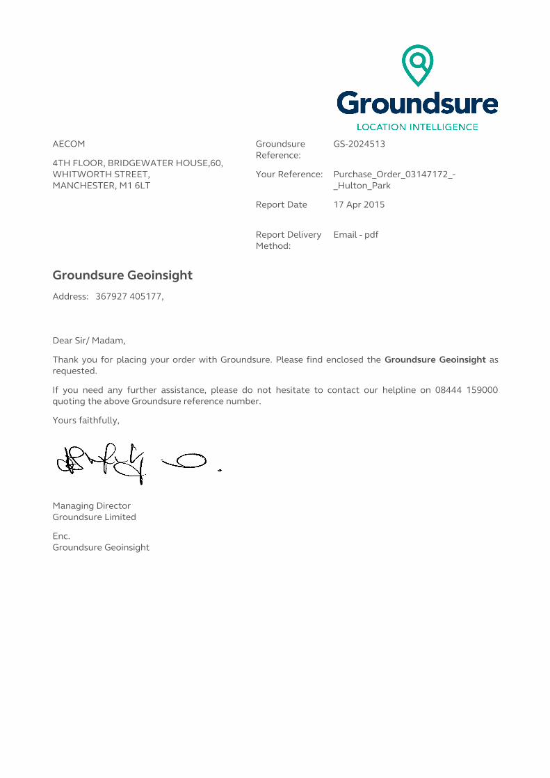
AECOM
4TH FLOOR, BRIDGEWATER HOUSE,60, WHITWORTH STREET, MANCHESTER, M1 6LT
Groundsure Reference:
GS-2024513
Your Reference: Purchase_Order_03147172_-_Hulton_Park
Report Date 17 Apr 2015
Report Delivery Method:
Email - pdf
Groundsure Geoinsight
Address: 367927 405177,
Dear Sir/ Madam,
Thank you for placing your order with Groundsure. Please find enclosed the Groundsure Geoinsight as requested.
If you need any further assistance, please do not hesitate to contact our helpline on 08444 159000 quoting the above Groundsure reference number.
Yours faithfully,
Managing DirectorGroundsure Limited
Enc.Groundsure Geoinsight

GroundsureGeoinsight
Address: 367927 405177,
Date: 17 Apr 2015
Reference: GS-2024513
Client: AECOM
NW N NE
W E
SW S SE
Aerial Photograph Capture date: 01-May-2011Grid Reference: 368217,404542Site Size: 236.32ha
Contents PageOverview of Findings........................................................................................................................................................ 51 Geology............................................................................................................................................................................ 8
1.1 Artificial Ground Map................................................................................................................................................................8
1 Geology............................................................................................................................................................................ 91.1 Artificial Ground.........................................................................................................................................................................9
1.1.1Artificial/ Made Ground......................................................................................................................................................................... 91.1.2 Permeability of Artificial Ground........................................................................................................................................................ 9
1.2 Superficial Deposits and Landslips Map.............................................................................................................................101.2 Superficial Deposits and Landslips......................................................................................................................................11
1.2.1 Superficial Deposits/ Drift Geology................................................................................................................................................. 111.2.2 Permeability of Superficial Ground................................................................................................................................................. 11
1.2.3 Landslip...................................................................................................................................................................................111.2.4 Landslip Permeability......................................................................................................................................................................... 12
1.3 Bedrock and Faults Map.........................................................................................................................................................131.3 Bedrock, Solid Geology & Faults..........................................................................................................................................14
1.3.1 Bedrock/ Solid Geology...................................................................................................................................................................... 141.3.2 Permeability of Bedrock Ground...................................................................................................................................................... 161.3.3 Faults..................................................................................................................................................................................................... 17
1.4 Radon Data................................................................................................................................................................................191.4.1 Radon Affected Areas........................................................................................................................................................................ 191.4.2 Radon Protection................................................................................................................................................................................ 19
2 Ground Workings Map................................................................................................................................................ 202 Ground Workings........................................................................................................................................................ 21
2.1 Historical Surface Ground Working Features derived from Historical Mapping......................................................212.2 Historical Underground Working Features derived from Historical Mapping..........................................................332.3 Current Ground Workings.....................................................................................................................................................36
3 Mining, Extraction & Natural Cavities Map.............................................................................................................383 Mining, Extraction & Natural Cavities...................................................................................................................... 39
3.1 Historical Mining......................................................................................................................................................................393.2 Coal Mining................................................................................................................................................................................423.3 Johnson Poole and Bloomer.................................................................................................................................................423.4 Non-Coal Mining......................................................................................................................................................................433.5 Non-Coal Mining Cavities.......................................................................................................................................................433.6 Natural Cavities........................................................................................................................................................................433.7 Brine Extraction.......................................................................................................................................................................433.8 Gypsum Extraction..................................................................................................................................................................443.9 Tin Mining..................................................................................................................................................................................443.10 Clay Mining.............................................................................................................................................................................44
4 Natural Ground Subsidence...................................................................................................................................... 454.1 Shrink-Swell Clay Map............................................................................................................................................................454.2 Landslides Map.........................................................................................................................................................................464.3 Ground Dissolution Soluble Rocks Map..............................................................................................................................474.4 Compressible Deposits Map..................................................................................................................................................484.5 Collapsible Deposits Map.......................................................................................................................................................494.6 Running Sand Map...................................................................................................................................................................50
4 Natural Ground Subsidence...................................................................................................................................... 514.1 Shrink-Swell Clays...................................................................................................................................................................514.2 Landslides..................................................................................................................................................................................514.3 Ground Dissolution of Soluble Rocks..................................................................................................................................52
Report Reference: GS-2024513Client Reference: Purchase_Order_03147172_-_Hulton_Park
3
4.4 Compressible Deposits...........................................................................................................................................................524.5 Collapsible Deposits................................................................................................................................................................524.6 Running Sands..........................................................................................................................................................................53
5 Borehole Records Map............................................................................................................................................... 545 Borehole Records........................................................................................................................................................ 556 Estimated Background Soil Chemistry.................................................................................................................... 677 Railways and Tunnels Map........................................................................................................................................ 727 Railways and Tunnels................................................................................................................................................. 73
7.1 Tunnels ......................................................................................................................................................................................737.2 Historical Railway and Tunnel Features ............................................................................................................................737.3 Historical Railways..................................................................................................................................................................767.4 Active Railways........................................................................................................................................................................767.5 Railway Projects.......................................................................................................................................................................77
Report Reference: GS-2024513Purchase_Order_03147172_-_Hulton_Park 4

Overview of FindingsThe Groundsure Geoinsight provides high quality geo-environmental information that allows geo-environmental professionals and their clients to make informed decisions and be forewarned of potential ground instability problems that may affect the ground investigation, foundation design and possibly remediation options that could lead to possible additional costs.The report is based on the BGS 1:50,000 Digital Geological Map of Great Britain, BGS Geosure data; BRITPITS database; Shallow Mining data and Borehole Records, Coal Authority data including brine extraction areas, PBA non-coal mining and natural cavities database, Johnson Poole and Bloomer mining data and Groundsure's unique database including historical surface ground and underground workings.For further details on each dataset, please refer to each individual section in the report as listed. Where the database has been searched a numerical result will be recorded. Where the database has not been searched '-' will be recorded.
Section 1:Geology
1.1 Artificial Ground 1.1.1 Is there any Artificial Ground/ Made Ground present beneath the study site?
No
1.1.2 Are there any records relating to permeability of artificial ground within the study site* boundary?
No
1.2 Superficial Geology and Landslips
1.2.1 Is there any Superficial Ground/Drift Geology present beneath the study site?
Yes
1.2.2 Are there any records relating to permeability of superficial geology within the study site boundary?
Yes
1.2.3 Are there any records of landslip within 500m of the study site boundary?
No
1.2.4 Are there any records relating to permeability of landslips within the study site boundary?
No
1.3 Bedrock, Solid Geology & Faults
1.3.1 For records of Bedrock and Solid Geology beneath the study site* see the detailed findings section.
1.3.2 Are there any records relating to permeability of bedrock within the study site boundary?
Yes
1.3.3 Are there any records of faults within 500m of the study site boundary?
Yes
1.4 Radon data 1.4.1 Is the property in a Radon Affected Area as defined by the Health Protection Agency (HPA) and if so what percentage of homes are above the Action Level?
The property is in a Radon Affected Area, as between 1 and 3% of properties are above the Action Level
1.4.2 Is the property in an area where Radon Protection Measures are required for new properties or extensions to existing ones as described in publication BR211 by the Building Research Establishment?
No radon protective measures are necessary
Section 2:Ground Workings On-site 0-50m 51-250 251-500 501-1000
2.1 Historical Surface Ground Working Features from Small Scale Mapping
173 34 136 Not Searched
Not Searched
2.2 Historical Underground Workings from Small Scale Mapping 18 17 4 4 36
2.3 Current Ground Workings 0 0 4 0 6
Report Reference: GS-2024513Purchase_Order_03147172_-_Hulton_Park
5

Section 3:Mining, Extraction & Natural Cavities On-site 0-50m 51-250 251-500 501-1000
3.1 Historical Mining 18 17 6 4 38
3.2 Coal Mining 1 0 0 0 0
3.3 Johnson Poole and Bloomer Mining Area 6 2 4 3 5
3.4 Non-Coal Mining 0 0 0 0 0
3.5 Non-Coal Mining Cavities 1 0 0 0 0
3.6 Natural Cavities 0 0 0 0 0
3.7 Brine Extraction 0 0 0 0 0
3.8 Gypsum Extraction 0 0 0 0 0
3.9 Tin Mining 0 0 0 0 0
3.10 Clay Mining 0 0 0 0 0
Section 4:Natural Ground Subsidence On-site
4.1 Shrink Swell Clay Very Low
4.2 Landslides Low
4.3 Ground Dissolution of Soluble Rocks Negligible
4.4 Compressible Deposits Negligible
4.5 Collapsible Deposits Very Low
4.6 Running Sand Very Low
Section 5:Borehole Records On-site 0-50m 51-250
5 BGS Recorded Boreholes3 41 145
Section 6:Estimated Background Soil Chemistry On-site 0-50m 51-250
6 Records of Background Soil Chemistry147 21 69
Section 7:Railways and Tunnels On-site 0-50m 51-250 251-500
7.1 Tunnels0 0 0 Not Searched
7.2 Historical Railway and Tunnel Features22 17 30 Not Searched
7.3 Historical Railways1 0 0 Not Searched
7.4 Active Railways0 0 3 Not Searched
Report Reference: GS-2024513Client Reference: Purchase_Order_03147172_-_Hulton_Park
6

Section 7:Railways and Tunnels On-site 0-50m 51-250 251-500
7.5 Railway Projects0 0 0 0
Report Reference: GS-2024513Client Reference: Purchase_Order_03147172_-_Hulton_Park
7
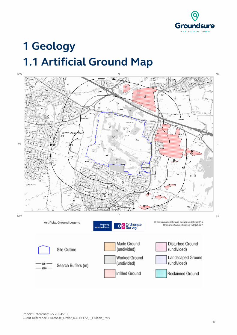
1 Geology1.1 Artificial Ground Map
NW N NE
W E
SW S SE
Artificial Ground Legend © Crown copyright and database rights 2015. Ordnance Survey license 100035207.
Report Reference: GS-2024513Client Reference: Purchase_Order_03147172_-_Hulton_Park
8

1 Geology1.1 Artificial Ground1.1.1Artificial/ Made Ground
The following geological information represented on the mapping is derived from 1:50,000 scale BGS Geological mapping, Sheet No:085
Are there any records of Artificial/Made Ground within 500m of the study site boundary? Yes
ID Distance (m)
Direction LEX Code Description Rock Description
1 74.0 E WMGR-MGRD INFILLED GROUND ARTIFICIAL DEPOSIT
2 361.0 NE WMGR-MGRD INFILLED GROUND ARTIFICIAL DEPOSIT
1.1.2 Permeability of Artificial Ground
Are there any records relating to permeability of artificial ground within the study site boundary? No
Database searched and no data found.
Report Reference: GS-2024513Client Reference: Purchase_Order_03147172_-_Hulton_Park
9
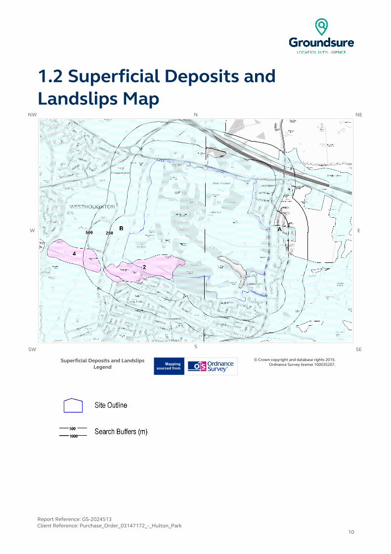
1.2 Superficial Deposits and Landslips Map
NW N NE
W E
SW S SE
Superficial Deposits and Landslips Legend
© Crown copyright and database rights 2015. Ordnance Survey license 100035207.
Report Reference: GS-2024513Client Reference: Purchase_Order_03147172_-_Hulton_Park
10
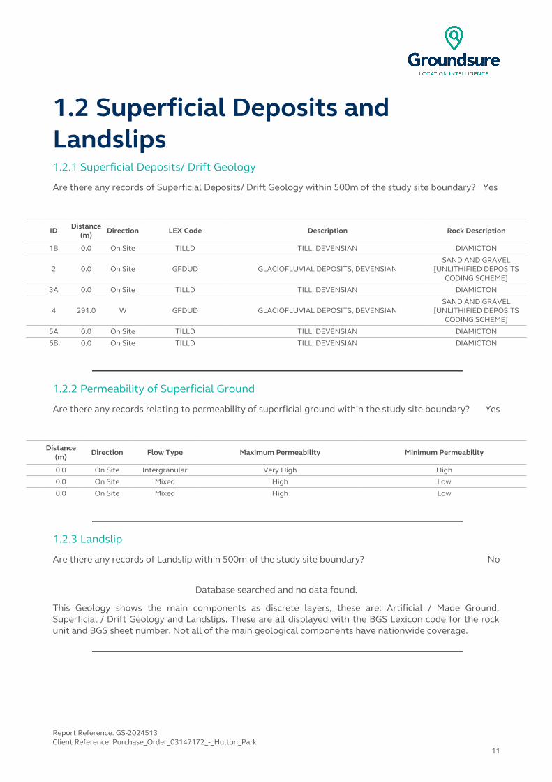
1.2 Superficial Deposits and Landslips1.2.1 Superficial Deposits/ Drift Geology
Are there any records of Superficial Deposits/ Drift Geology within 500m of the study site boundary? Yes
ID Distance (m)
Direction LEX Code Description Rock Description
1B 0.0 On Site TILLD TILL, DEVENSIAN DIAMICTON
2 0.0 On Site GFDUD GLACIOFLUVIAL DEPOSITS, DEVENSIANSAND AND GRAVEL
[UNLITHIFIED DEPOSITS CODING SCHEME]
3A 0.0 On Site TILLD TILL, DEVENSIAN DIAMICTON
4 291.0 W GFDUD GLACIOFLUVIAL DEPOSITS, DEVENSIANSAND AND GRAVEL
[UNLITHIFIED DEPOSITS CODING SCHEME]
5A 0.0 On Site TILLD TILL, DEVENSIAN DIAMICTON
6B 0.0 On Site TILLD TILL, DEVENSIAN DIAMICTON
1.2.2 Permeability of Superficial Ground
Are there any records relating to permeability of superficial ground within the study site boundary? Yes
Distance (m)
Direction Flow Type Maximum Permeability Minimum Permeability
0.0 On Site Intergranular Very High High
0.0 On Site Mixed High Low
0.0 On Site Mixed High Low
1.2.3 Landslip
Are there any records of Landslip within 500m of the study site boundary? No
Database searched and no data found.
This Geology shows the main components as discrete layers, these are: Artificial / Made Ground, Superficial / Drift Geology and Landslips. These are all displayed with the BGS Lexicon code for the rock unit and BGS sheet number. Not all of the main geological components have nationwide coverage.
Report Reference: GS-2024513Client Reference: Purchase_Order_03147172_-_Hulton_Park
11
1.2.4 Landslip Permeability
Are there any records relating to permeability of landslips within the study site** boundary? No
Database searched and no data found.
* This includes an automatically generated 50m buffer zone around the site
Report Reference: GS-2024513Client Reference: Purchase_Order_03147172_-_Hulton_Park
12

1.3 Bedrock and Faults MapNW N NE
W E
SWS
SE
Bedrock and Faults Legend © Crown copyright and database rights 2015. Ordnance Survey license 100035207.
Report Reference: GS-2024513Client Reference: Purchase_Order_03147172_-_Hulton_Park
13
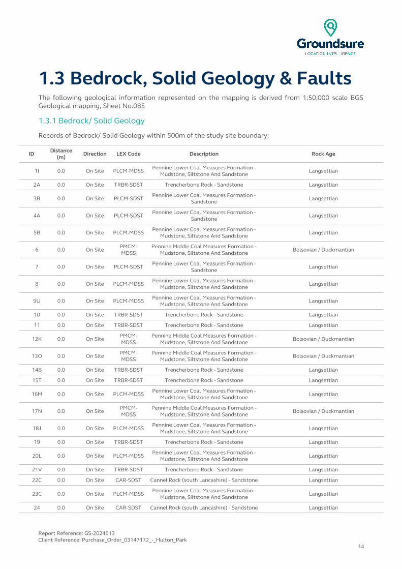
1.3 Bedrock, Solid Geology & FaultsThe following geological information represented on the mapping is derived from 1:50,000 scale BGS Geological mapping, Sheet No:085
1.3.1 Bedrock/ Solid Geology
Records of Bedrock/ Solid Geology within 500m of the study site boundary:
ID Distance (m)
Direction LEX Code Description Rock Age
1I 0.0 On Site PLCM-MDSSPennine Lower Coal Measures Formation -
Mudstone, Siltstone And SandstoneLangsettian
2A 0.0 On Site TRBR-SDST Trencherbone Rock - Sandstone Langsettian
3B 0.0 On Site PLCM-SDST Pennine Lower Coal Measures Formation - Sandstone
Langsettian
4A 0.0 On Site PLCM-SDSTPennine Lower Coal Measures Formation -
SandstoneLangsettian
5B 0.0 On Site PLCM-MDSS Pennine Lower Coal Measures Formation - Mudstone, Siltstone And Sandstone
Langsettian
6 0.0 On SitePMCM-MDSS
Pennine Middle Coal Measures Formation - Mudstone, Siltstone And Sandstone
Bolsovian / Duckmantian
7 0.0 On Site PLCM-SDST Pennine Lower Coal Measures Formation - Sandstone
Langsettian
8 0.0 On Site PLCM-MDSSPennine Lower Coal Measures Formation -
Mudstone, Siltstone And SandstoneLangsettian
9U 0.0 On Site PLCM-MDSS Pennine Lower Coal Measures Formation - Mudstone, Siltstone And Sandstone
Langsettian
10 0.0 On Site TRBR-SDST Trencherbone Rock - Sandstone Langsettian
11 0.0 On Site TRBR-SDST Trencherbone Rock - Sandstone Langsettian
12K 0.0 On SitePMCM-MDSS
Pennine Middle Coal Measures Formation - Mudstone, Siltstone And Sandstone
Bolsovian / Duckmantian
13O 0.0 On Site PMCM-MDSS
Pennine Middle Coal Measures Formation - Mudstone, Siltstone And Sandstone
Bolsovian / Duckmantian
14B 0.0 On Site TRBR-SDST Trencherbone Rock - Sandstone Langsettian
15T 0.0 On Site TRBR-SDST Trencherbone Rock - Sandstone Langsettian
16M 0.0 On Site PLCM-MDSSPennine Lower Coal Measures Formation -
Mudstone, Siltstone And SandstoneLangsettian
17N 0.0 On Site PMCM-MDSS
Pennine Middle Coal Measures Formation - Mudstone, Siltstone And Sandstone
Bolsovian / Duckmantian
18J 0.0 On Site PLCM-MDSSPennine Lower Coal Measures Formation -
Mudstone, Siltstone And SandstoneLangsettian
19 0.0 On Site TRBR-SDST Trencherbone Rock - Sandstone Langsettian
20L 0.0 On Site PLCM-MDSS Pennine Lower Coal Measures Formation - Mudstone, Siltstone And Sandstone
Langsettian
21V 0.0 On Site TRBR-SDST Trencherbone Rock - Sandstone Langsettian
22C 0.0 On Site CAR-SDST Cannel Rock (south Lancashire) - Sandstone Langsettian
23C 0.0 On Site PLCM-MDSSPennine Lower Coal Measures Formation -
Mudstone, Siltstone And SandstoneLangsettian
24 0.0 On Site CAR-SDST Cannel Rock (south Lancashire) - Sandstone Langsettian
Report Reference: GS-2024513Client Reference: Purchase_Order_03147172_-_Hulton_Park
14
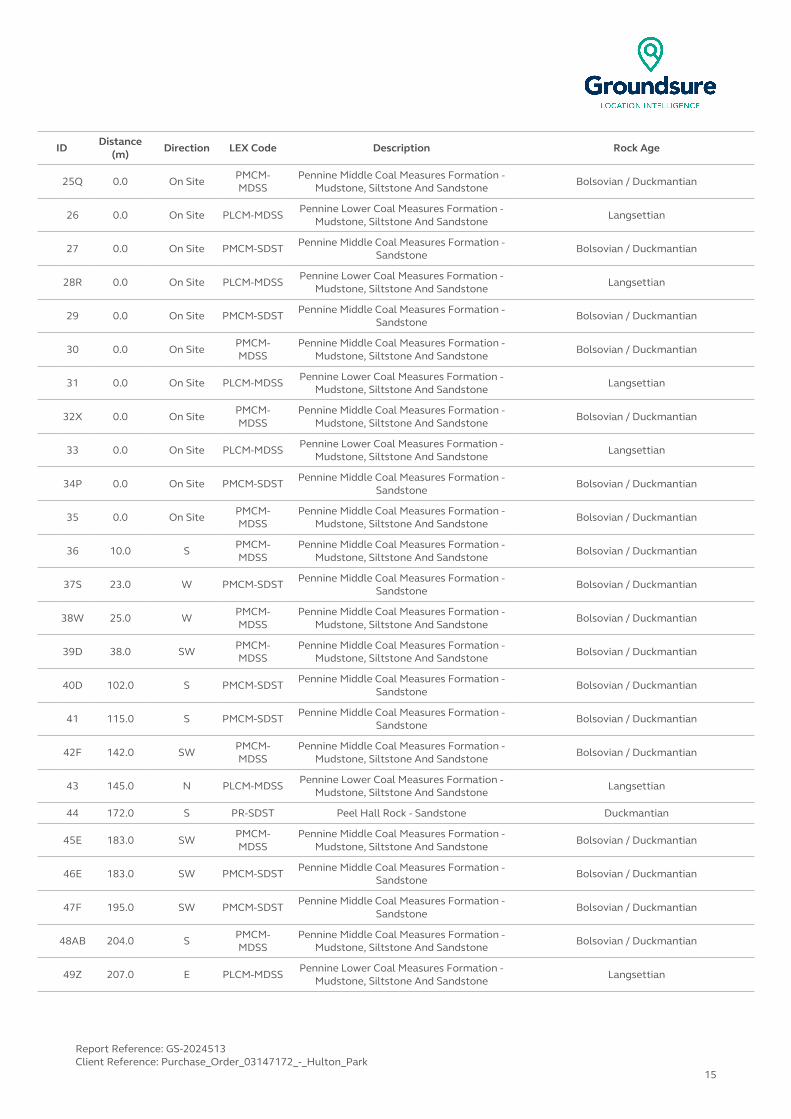
IDDistance
(m)Direction LEX Code Description Rock Age
25Q 0.0 On Site PMCM-MDSS
Pennine Middle Coal Measures Formation - Mudstone, Siltstone And Sandstone
Bolsovian / Duckmantian
26 0.0 On Site PLCM-MDSSPennine Lower Coal Measures Formation -
Mudstone, Siltstone And SandstoneLangsettian
27 0.0 On Site PMCM-SDST Pennine Middle Coal Measures Formation - Sandstone
Bolsovian / Duckmantian
28R 0.0 On Site PLCM-MDSSPennine Lower Coal Measures Formation -
Mudstone, Siltstone And SandstoneLangsettian
29 0.0 On Site PMCM-SDST Pennine Middle Coal Measures Formation - Sandstone
Bolsovian / Duckmantian
30 0.0 On SitePMCM-MDSS
Pennine Middle Coal Measures Formation - Mudstone, Siltstone And Sandstone
Bolsovian / Duckmantian
31 0.0 On Site PLCM-MDSS Pennine Lower Coal Measures Formation - Mudstone, Siltstone And Sandstone
Langsettian
32X 0.0 On SitePMCM-MDSS
Pennine Middle Coal Measures Formation - Mudstone, Siltstone And Sandstone
Bolsovian / Duckmantian
33 0.0 On Site PLCM-MDSS Pennine Lower Coal Measures Formation - Mudstone, Siltstone And Sandstone
Langsettian
34P 0.0 On Site PMCM-SDSTPennine Middle Coal Measures Formation -
SandstoneBolsovian / Duckmantian
35 0.0 On Site PMCM-MDSS
Pennine Middle Coal Measures Formation - Mudstone, Siltstone And Sandstone
Bolsovian / Duckmantian
36 10.0 SPMCM-MDSS
Pennine Middle Coal Measures Formation - Mudstone, Siltstone And Sandstone
Bolsovian / Duckmantian
37S 23.0 W PMCM-SDST Pennine Middle Coal Measures Formation - Sandstone
Bolsovian / Duckmantian
38W 25.0 WPMCM-MDSS
Pennine Middle Coal Measures Formation - Mudstone, Siltstone And Sandstone
Bolsovian / Duckmantian
39D 38.0 SW PMCM-MDSS
Pennine Middle Coal Measures Formation - Mudstone, Siltstone And Sandstone
Bolsovian / Duckmantian
40D 102.0 S PMCM-SDSTPennine Middle Coal Measures Formation -
SandstoneBolsovian / Duckmantian
41 115.0 S PMCM-SDST Pennine Middle Coal Measures Formation - Sandstone
Bolsovian / Duckmantian
42F 142.0 SWPMCM-MDSS
Pennine Middle Coal Measures Formation - Mudstone, Siltstone And Sandstone
Bolsovian / Duckmantian
43 145.0 N PLCM-MDSS Pennine Lower Coal Measures Formation - Mudstone, Siltstone And Sandstone
Langsettian
44 172.0 S PR-SDST Peel Hall Rock - Sandstone Duckmantian
45E 183.0 SWPMCM-MDSS
Pennine Middle Coal Measures Formation - Mudstone, Siltstone And Sandstone
Bolsovian / Duckmantian
46E 183.0 SW PMCM-SDST Pennine Middle Coal Measures Formation - Sandstone
Bolsovian / Duckmantian
47F 195.0 SW PMCM-SDSTPennine Middle Coal Measures Formation -
SandstoneBolsovian / Duckmantian
48AB 204.0 S PMCM-MDSS
Pennine Middle Coal Measures Formation - Mudstone, Siltstone And Sandstone
Bolsovian / Duckmantian
49Z 207.0 E PLCM-MDSSPennine Lower Coal Measures Formation -
Mudstone, Siltstone And SandstoneLangsettian
Report Reference: GS-2024513Client Reference: Purchase_Order_03147172_-_Hulton_Park
15
IDDistance
(m)Direction LEX Code Description Rock Age
50AC 234.0 SW PMCM-MDSS
Pennine Middle Coal Measures Formation - Mudstone, Siltstone And Sandstone
Bolsovian / Duckmantian
51AA 240.0 E PLCM-MDSSPennine Lower Coal Measures Formation -
Mudstone, Siltstone And SandstoneLangsettian
52 266.0 N PLCM-MDSS Pennine Lower Coal Measures Formation - Mudstone, Siltstone And Sandstone
Langsettian
53Y 339.0 S PR-SDST Peel Hall Rock - Sandstone Duckmantian
54 361.0 SPMCM-MDSS
Pennine Middle Coal Measures Formation - Mudstone, Siltstone And Sandstone
Bolsovian / Duckmantian
55 393.0 SW PR-SDST Peel Hall Rock - Sandstone Duckmantian
56 394.0 NW CAR-SDST Cannel Rock (south Lancashire) - Sandstone Langsettian
57 401.0 E PMCM-MDSS
Pennine Middle Coal Measures Formation - Mudstone, Siltstone And Sandstone
Bolsovian / Duckmantian
58 429.0 NW PLCM-MDSSPennine Lower Coal Measures Formation -
Mudstone, Siltstone And SandstoneLangsettian
59 449.0 SW PLCM-MDSS Pennine Lower Coal Measures Formation - Mudstone, Siltstone And Sandstone
Langsettian
60 489.0 SW PLCM-MDSSPennine Lower Coal Measures Formation -
Mudstone, Siltstone And SandstoneLangsettian
1.3.2 Permeability of Bedrock Ground
Are there any records relating to permeability of bedrock ground within the study site* boundary? Yes
Distance (m)
Direction Flow Type Maximum Permeability Minimum Permeability
0.0 On Site Fracture High Moderate
0.0 On Site Fracture High Low
0.0 On Site Fracture High Low
0.0 On Site Fracture High Low
0.0 On Site Fracture High Low
0.0 On Site Fracture Moderate Low
0.0 On Site Fracture High Moderate
0.0 On Site Fracture High Moderate
0.0 On Site Fracture Moderate Low
0.0 On Site Fracture High Moderate
0.0 On Site Fracture High Moderate
0.0 On Site Fracture Moderate Low
0.0 On Site Fracture High Moderate
0.0 On Site Fracture High Low
0.0 On Site Fracture High Low
0.0 On Site Fracture High Low
0.0 On Site Fracture High Low
0.0 On Site Fracture Moderate Low
25.0 W Fracture Moderate Low
42.0 E Fracture High Moderate
* This includes an automatically generated 50m buffer zone around the site
Report Reference: GS-2024513Client Reference: Purchase_Order_03147172_-_Hulton_Park
16
1.3.3 Faults
Are there any records of Faults within 500m of the study site boundary? Yes
ID Distance (m)
Direction Category Description Feature Description
91I 0.0 On Site ROCK Coal seam, inferred
92 0.0 On Site ROCK Coal seam, inferred
93 0.0 On Site ROCK Coal seam, inferred
94J 0.0 On Site ROCK Coal seam, inferred
95K 0.0 On Site FOSSIL_HORIZON Marine band
96L 0.0 On Site ROCK Coal seam, inferred
97M 0.0 On Site ROCK Coal seam, inferred
98L 0.0 On Site ROCK Coal seam, inferred
99 0.0 On Site FAULT Fault, inferred, displacement unknown
100N 0.0 On Site FOSSIL_HORIZON Marine band
101A 0.0 On Site ROCK Coal seam, observed
102B 0.0 On Site ROCK Coal seam, inferred
103 0.0 On Site FAULTFault, inferred, crossmark on downthrow side, throw in
metres
104O 0.0 On Site FAULT Fault, inferred, crossmark on downthrow side, throw in metres
105P 0.0 On Site ROCK Coal seam, inferred
106Q 0.0 On Site ROCK Coal seam, inferred
107 0.0 On Site FAULTFault, inferred, crossmark on downthrow side, throw in
metres
108 0.0 On Site FAULT Fault, inferred, displacement unknown
109R 0.0 On Site FAULT Fault, inferred, displacement unknown
110J 0.0 On Site FAULT Fault, inferred, displacement unknown
111B 0.0 On Site ROCK Coal seam, inferred
112S 0.0 On Site FAULT Fault, inferred, displacement unknown
113T 0.0 On Site FAULT Fault, inferred, crossmark on downthrow side, throw in metres
114U 0.0 On Site FAULTFault, inferred, crossmark on downthrow side, throw in
metres
115T 0.0 On Site FAULT Fault, inferred, crossmark on downthrow side, throw in metres
116 0.0 On Site FAULTFault, inferred, crossmark on downthrow side, throw in
metres
117V 0.0 On Site FAULT Fault, inferred, crossmark on downthrow side, throw in metres
118 3.0 E ROCK Coal seam, inferred
119W 25.0 W FOSSIL_HORIZON Marine band
120 36.0 NW ROCK Coal seam, inferred
Report Reference: GS-2024513Client Reference: Purchase_Order_03147172_-_Hulton_Park
17

IDDistance
(m)Direction Category Description Feature Description
121 64.0 NW ROCK Coal seam, inferred
122 81.0 E FAULT Fault, inferred, crossmark on downthrow side, throw in metres
123 89.0 N ROCK Coal seam, inferred
124D 102.0 S ROCK Coal seam, inferred
125X 107.0 S ROCK Coal seam, inferred
126F 177.0 S ROCK Coal seam, inferred
127 178.0 N ROCK Coal seam, inferred
128Y 183.0 SW FAULTFault, inferred, crossmark on downthrow side, throw in
metres
129Z 207.0 E ROCK Coal seam, observed
130 212.0 N ROCK Coal seam, inferred
131AA
240.0 E ROCK Coal seam, observed
132 266.0 N FAULT Fault, inferred, displacement unknown
133AB 287.0 S ROCK Coal seam, inferred
134 301.0 SE LANDFORMApproximate margin of buried (superficial deposit-
filled) channel or valley; beads to outside
135 331.0 NW ROCK Coal seam, inferred
136AC 348.0 SW ROCK Coal seam, inferred
137 361.0 N ROCK Coal seam, inferred
138 394.0 NW FAULT Fault, inferred, displacement unknown
139 394.0 S ROCK Coal seam, inferred
140 401.0 E FAULT Fault, inferred, crossmark on downthrow side, throw in metres
141 449.0 SW FAULT Fault, inferred, displacement unknown
142 452.0 SW ROCK Coal seam, inferred
143 489.0 SW FAULT Fault, inferred, displacement unknown
144 498.0 N ROCK Coal seam, inferred
The geology map for the site and surrounding area are extracted from the BGS Digital Geological Map of Great Britain at 1:50,000 scale.
This Geology shows the main components as discrete layers, these are: Bedrock/ Solid Geology and linear features such as Faults. These are all displayed with the BGS Lexicon code for the rock unit and BGS sheet number. Not all of the main geological components have nationwide coverage.
Report Reference: GS-2024513Client Reference: Purchase_Order_03147172_-_Hulton_Park
18
1.4 Radon Data1.4.1 Radon Affected Areas
Is the property in a Radon Affected Area as defined by the Health Protection Agency (HPA) and if so what percentage of homes are above the Action Level? The property is in a Radon Affected Area, as between 1 and 3% of properties are above the Action Level
1.4.2 Radon Protection
Is the property in an area where Radon Protection are required for new properties or extensions to existing ones as described in publication BR211 by the Building Research Establishment? No radon protective measures are necessary
Report Reference: GS-2024513Client Reference: Purchase_Order_03147172_-_Hulton_Park
19

2 Ground Workings MapNW N NE
W E
SWS
SE
Ground Workings Legend © Crown copyright and database rights 2015. Ordnance Survey license 100035207.
Report Reference: GS-2024513Client Reference: Purchase_Order_03147172_-_Hulton_Park
20

2 Ground Workings
2.1 Historical Surface Ground Working Features derived from Historical Mapping
This dataset is based on Groundsure's unique Historical Land Use Database derived from 1:10,560 and 1:10,000 scale historical mapping.
Are there any Historical Surface Ground Working Features within 250m of the study site boundary? Yes
The following Historical Surface Ground Working Features are provided by Groundsure:
ID Distance (m)
Direction NGR Use Date
1A 0.0 On Site 367189405166
Refuse Heap 1927
2A 0.0 On Site367188405168
Unspecified Heap 1948
3A 0.0 On Site 367207405166
Collieries 1927
4A 0.0 On Site367192405173
Unspecified Heaps 1980
5A 0.0 On Site 367147405178
Unspecified Heaps 1967
6E 0.0 On Site367069404966
Refuse Heap 1927
7B 0.0 On Site 366981404846
Cuttings 1948
8A 0.0 On Site367191405191
Refuse Heap 1956
9 0.0 On Site 367185405085
Unspecified Heap 1956
10B 0.0 On Site366981404849
Cuttings 1938
11B 0.0 On Site 366987404860
Cuttings 1956
12D 0.0 On Site367080405036
Unspecified Heap 1980
13C 0.0 On Site 367279405299
Pond 1927
14C 0.0 On Site367279405304
Pond 1907
15C 0.0 On Site 367279405304
Pond 1948
16C 0.0 On Site367279405304
Pond 1892
17D 0.0 On Site 367080405036
Unspecified Heap 1956
18D 0.0 On Site367080405036
Unspecified Heap 1967
19E 0.0 On Site 367012404942
Cuttings 1892
20B 0.0 On Site367016404876
Unspecified Heap 1956
Report Reference: GS-2024513Client Reference: Purchase_Order_03147172_-_Hulton_Park
21
IDDistance
(m)Direction NGR Use Date
21B 0.0 On Site367044404848
Unspecified Heap 1927
22D 0.0 On Site 367056404973
Unspecified Heap 1948
23F 0.0 On Site367571404798
Pond 1987
24E 0.0 On Site 367066404934
Unspecified Heap 1974
25E 0.0 On Site367066404934
Unspecified Heap 1956
26F 0.0 On Site 367569404787
Pond 1938
27F 0.0 On Site367574404799
Pond 1956
28E 0.0 On Site 367066404934
Unspecified Heap 1966
29 0.0 On Site367249405383
Pond 1927
30G 0.0 On Site 367235405531
Refuse Heap 1948
31G 0.0 On Site367283405528
Filter Beds 1927
32G 0.0 On Site 367282405529
Disused Filter Beds 1948
33H 0.0 On Site367299405536
Disused Filter Bed 1980
34H 0.0 On Site 367299405536
Disused Filter Bed 1967
35H 0.0 On Site367299405536
Disused Filter Bed 1956
36H 0.0 On Site 367274405560
Filter Bed 1907
37I 0.0 On Site367723405253
Pond 1988
38H 0.0 On Site 367238405605
Refuse Heap 1967
39H 0.0 On Site367238405605
Refuse Heap 1956
40L 0.0 On Site 366995404749
Pond 1966
41I 0.0 On Site367815405290
Water Body 1948
42I 0.0 On Site 367815405290
Water Body 1892
43I 0.0 On Site367815405290
Water Body 1927
44I 0.0 On Site 367815405290
Water Body 1907
45I 0.0 On Site367823405299
Pond 1956
46I 0.0 On Site 367823405299
Pond 1980
47I 0.0 On Site367823405299
Pond 1967
48J 0.0 On Site 367563405518
Ponds 1993
Report Reference: GS-2024513Client Reference: Purchase_Order_03147172_-_Hulton_Park
22

IDDistance
(m)Direction NGR Use Date
49J 0.0 On Site367563405518
Ponds 1988
50K 0.0 On Site 367798404483
Reservoir 1938
51K 0.0 On Site367798404481
Reservoir 1948
52K 0.0 On Site 367798404481
Reservoir 1927
53L 0.0 On Site366999404748
Pond 1974
54L 0.0 On Site 366999404748
Pond 1987
55L 0.0 On Site367004404757
Ponds 1956
56AI 0.0 On Site 367252405749
Unspecified Pits 1892
57M 0.0 On Site367880404334
Colliery 1907
58A 0.0 On Site 367218405209
Collieries 1907
59 0.0 On Site368014405164
Pond 1927
60M 0.0 On Site 367845404332
Refuse Heaps 1927
61M 0.0 On Site367885404332
Refuse Heap 1966
62M 0.0 On Site 367888404333
Refuse Heap 1956
63S 0.0 On Site367328405836
Reservoir 1927
64 0.0 On Site 368134405459
Unspecified Hole 1927
65N 0.0 On Site368046405541
Pond 1980
66N 0.0 On Site 368046405541
Pond 1956
67N 0.0 On Site368046405541
Pond 1993
68N 0.0 On Site 368046405541
Pond 1967
69N 0.0 On Site368046405541
Pond 1988
70N 0.0 On Site 368039405540
Pond 1948
71N 0.0 On Site368039405540
Pond 1907
72N 0.0 On Site 368039405540
Pond 1892
73N 0.0 On Site368039405540
Pond 1927
74 0.0 On Site 368199405072
Unspecified Pit 1956
75O 0.0 On Site368029404446
Unspecified Pit 1948
76O 0.0 On Site 368029404454
Pond 1987
Report Reference: GS-2024513Client Reference: Purchase_Order_03147172_-_Hulton_Park
23

IDDistance
(m)Direction NGR Use Date
77O 0.0 On Site368026404451
Reservoir 1927
78C 0.0 On Site 367280405306
Pond 1956
79C 0.0 On Site367282405307
Pond 1988
80C 0.0 On Site 367282405307
Pond 1993
81B 0.0 On Site366981404846
Cuttings 1927
82C 0.0 On Site 367281405310
Pond 1980
83C 0.0 On Site367281405310
Pond 1967
84F 0.0 On Site 367571404798
Pond 1966
85P 0.0 On Site367717406007
Unspecified Heap 1956
86F 0.0 On Site 367571404798
Pond 1974
87P 0.0 On Site367714406005
Unspecified Heap 1967
88F 0.0 On Site 367568404784
Pond 1927
89P 0.0 On Site367714406005
Unspecified Heap 1980
90P 0.0 On Site 367708405989
Unspecified Heap 1892
91P 0.0 On Site367708405989
Unspecified Heap 1927
92P 0.0 On Site 367708405989
Unspecified Heap 1948
93P 0.0 On Site367708405989
Unspecified Heap 1907
94Q 0.0 On Site 367542405949
Water Body 1907
95Q 0.0 On Site367542405949
Water Body 1927
96Q 0.0 On Site 367493405919
Pond 1988
97F 0.0 On Site367568404784
Pond 1948
98G 0.0 On Site 367236405522
Unspecified Pits 1927
99R 0.0 On Site367495405884
Pond 1967
100R 0.0 On Site 367495405884
Pond 1956
101R 0.0 On Site367542405888
Pond 1892
102R 0.0 On Site 367507405883
Pond 1980
103I 0.0 On Site367723405253
Pond 1993
104S 0.0 On Site 367333405842
Disused Reservoir 1967
Report Reference: GS-2024513Client Reference: Purchase_Order_03147172_-_Hulton_Park
24
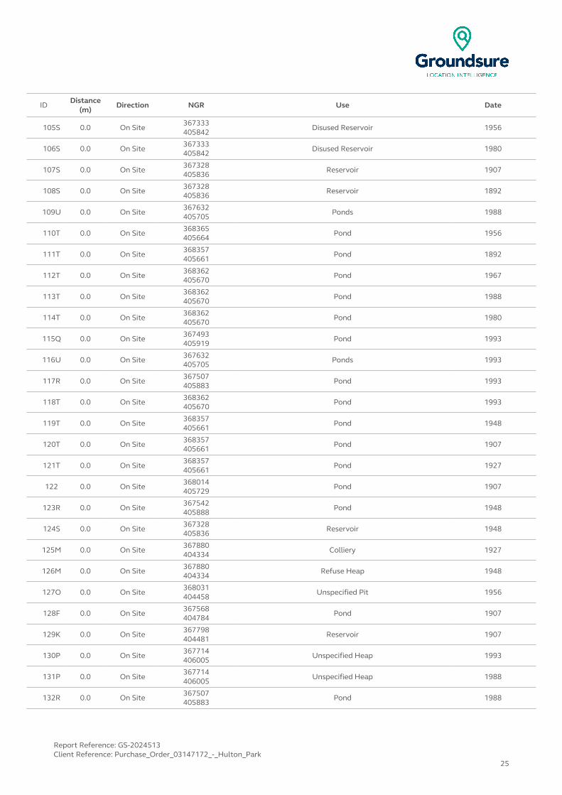
IDDistance
(m)Direction NGR Use Date
105S 0.0 On Site367333405842
Disused Reservoir 1956
106S 0.0 On Site 367333405842
Disused Reservoir 1980
107S 0.0 On Site367328405836
Reservoir 1907
108S 0.0 On Site 367328405836
Reservoir 1892
109U 0.0 On Site367632405705
Ponds 1988
110T 0.0 On Site 368365405664
Pond 1956
111T 0.0 On Site368357405661
Pond 1892
112T 0.0 On Site 368362405670
Pond 1967
113T 0.0 On Site368362405670
Pond 1988
114T 0.0 On Site 368362405670
Pond 1980
115Q 0.0 On Site367493405919
Pond 1993
116U 0.0 On Site 367632405705
Ponds 1993
117R 0.0 On Site367507405883
Pond 1993
118T 0.0 On Site 368362405670
Pond 1993
119T 0.0 On Site368357405661
Pond 1948
120T 0.0 On Site 368357405661
Pond 1907
121T 0.0 On Site368357405661
Pond 1927
122 0.0 On Site 368014405729
Pond 1907
123R 0.0 On Site367542405888
Pond 1948
124S 0.0 On Site 367328405836
Reservoir 1948
125M 0.0 On Site367880404334
Colliery 1927
126M 0.0 On Site 367880404334
Refuse Heap 1948
127O 0.0 On Site368031404458
Unspecified Pit 1956
128F 0.0 On Site 367568404784
Pond 1907
129K 0.0 On Site367798404481
Reservoir 1907
130P 0.0 On Site 367714406005
Unspecified Heap 1993
131P 0.0 On Site367714406005
Unspecified Heap 1988
132R 0.0 On Site 367507405883
Pond 1988
Report Reference: GS-2024513Client Reference: Purchase_Order_03147172_-_Hulton_Park
25
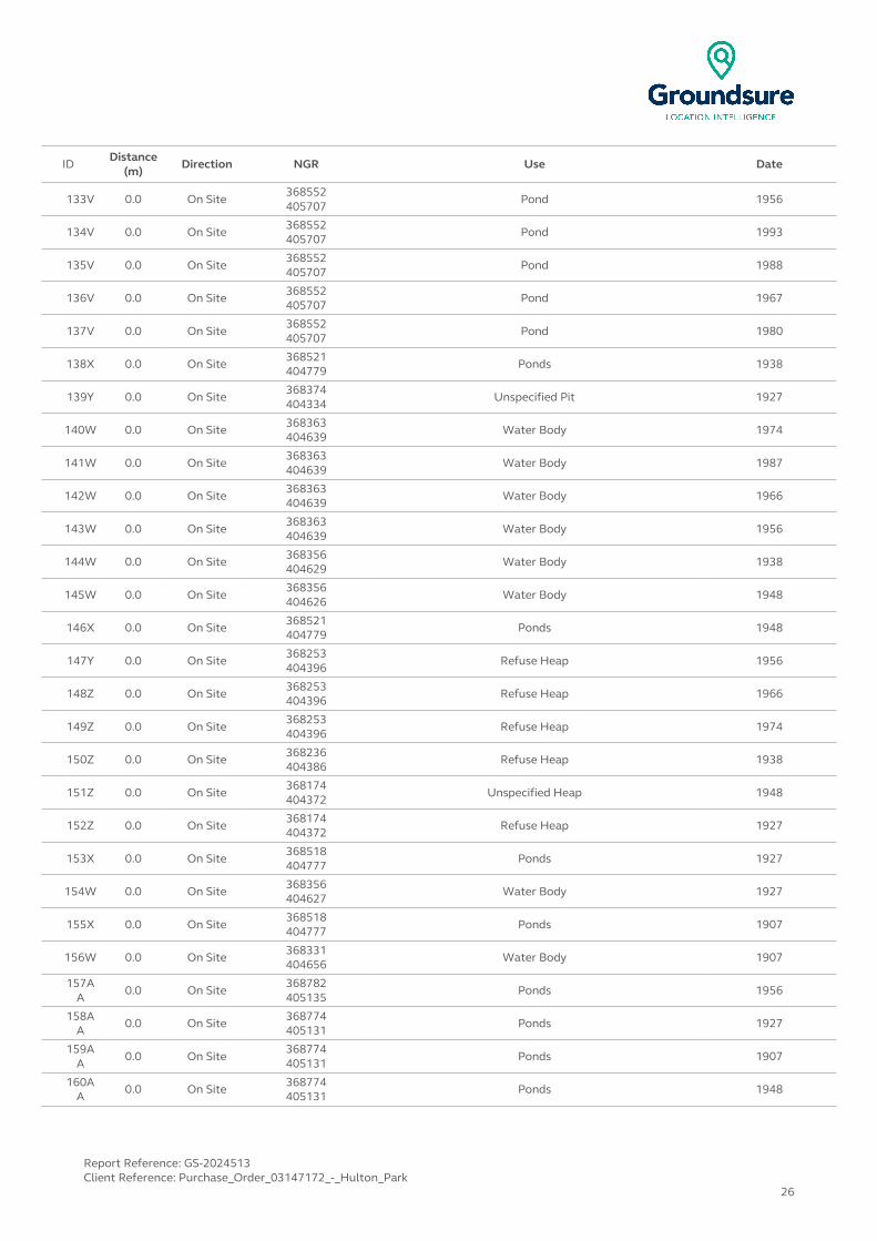
IDDistance
(m)Direction NGR Use Date
133V 0.0 On Site368552405707
Pond 1956
134V 0.0 On Site 368552405707
Pond 1993
135V 0.0 On Site368552405707
Pond 1988
136V 0.0 On Site 368552405707
Pond 1967
137V 0.0 On Site368552405707
Pond 1980
138X 0.0 On Site 368521404779
Ponds 1938
139Y 0.0 On Site368374404334
Unspecified Pit 1927
140W 0.0 On Site 368363404639
Water Body 1974
141W 0.0 On Site368363404639
Water Body 1987
142W 0.0 On Site 368363404639
Water Body 1966
143W 0.0 On Site368363404639
Water Body 1956
144W 0.0 On Site 368356404629
Water Body 1938
145W 0.0 On Site368356404626
Water Body 1948
146X 0.0 On Site 368521404779
Ponds 1948
147Y 0.0 On Site368253404396
Refuse Heap 1956
148Z 0.0 On Site 368253404396
Refuse Heap 1966
149Z 0.0 On Site368253404396
Refuse Heap 1974
150Z 0.0 On Site 368236404386
Refuse Heap 1938
151Z 0.0 On Site368174404372
Unspecified Heap 1948
152Z 0.0 On Site 368174404372
Refuse Heap 1927
153X 0.0 On Site368518404777
Ponds 1927
154W 0.0 On Site 368356404627
Water Body 1927
155X 0.0 On Site368518404777
Ponds 1907
156W 0.0 On Site 368331404656
Water Body 1907
157AA
0.0 On Site368782405135
Ponds 1956
158AA
0.0 On Site 368774405131
Ponds 1927
159AA
0.0 On Site368774405131
Ponds 1907
160AA
0.0 On Site 368774405131
Ponds 1948
Report Reference: GS-2024513Client Reference: Purchase_Order_03147172_-_Hulton_Park
26

IDDistance
(m)Direction NGR Use Date
161AA
0.0 On Site368757405118
Ponds 1892
162 0.0 On Site 368631405300
Ponds 1948
163V 0.0 On Site368583405649
Pond 1948
164V 0.0 On Site 368583405649
Pond 1907
165V 0.0 On Site368583405649
Pond 1892
166V 0.0 On Site 368583405649
Pond 1927
167AB 0.0 On Site368488405115
Unspecified Heap 1956
168AB 0.0 On Site 368488405115
Unspecified Heap 1967
169AB 0.0 On Site368420405108
Unspecified Ground Workings 1927
170AB 0.0 On Site 368420405108
Unspecified Ground Workings 1907
171AB 0.0 On Site368420405108
Unspecified Ground Workings 1892
172AB 0.0 On Site 368420405108
Unspecified Ground Workings 1948
173O 0.0 NW368027404453
Reservoir 1938
174O 1.0 NW 368026404451
Reservoir 1907
175AE 1.0 N368608405814
Unspecified Heap 1892
176 1.0 S 367746404387
Refuse Heap 1974
177M 3.0 E367850404335
Refuse Heap 1938
178AF 3.0 N 368235405970
Collieries 1892
179 5.0 W367240405623
Unspecified Pits 1907
180AC 7.0 N 368419406058
Collieries 1927
181AC 7.0 N368419406059
Collieries 1907
182AD
9.0 NE 368442405852
Unspecified Heap 1892
183AD
14.0 NE368442405858
Unspecified Heap 1907
184AE 15.0 N 368619405827
Refuse Heap 1956
185K 17.0 S367810404442
Brick Works 1907
186K 17.0 S 367810404442
Brick Works 1948
187AD
23.0 NE368447405858
Unspecified Heap 1927
188AF 24.0 N 368255405982
Unspecified Heap 1892
Report Reference: GS-2024513Client Reference: Purchase_Order_03147172_-_Hulton_Park
27

IDDistance
(m)Direction NGR Use Date
189 25.0 N368088406350
Refuse Heap 1927
190AF 26.0 N 368233406004
Unspecified Heap 1907
191AF 27.0 N368248405940
Unspecified Heap 1948
192AE 36.0 N 368632405837
Unspecified Heap 1948
193AE 36.0 N368632405837
Unspecified Heap 1927
194AE 36.0 N 368632405837
Unspecified Heap 1907
195AG
36.0 N368136406209
Refuse Heap 1967
196AG
36.0 N 368136406209
Refuse Heap 1956
197AF 37.0 N368252405974
Unspecified Ground Workings 1980
198AF 37.0 N 368252405974
Unspecified Ground Workings 1988
199AF 37.0 N368252405974
Unspecified Ground Workings 1993
200A 44.0 W 367167405187
Disused Reservoirs 1967
201A 44.0 W367167405187
Disused Reservoirs 1956
202A 44.0 W 367167405187
Disused Reservoirs 1980
203A 44.0 W367151405159
Reservoir 1927
204A 46.0 W 367164405184
Reservoir 1907
205A 46.0 W367164405184
Disused Reservoir 1948
206AH
48.0 NW 367213405900
Cuttings 1980
207AH
50.0 NW367201405870
Cuttings 1967
208AH
51.0 NW 367195405853
Cuttings 1892
209AH
51.0 NW367209405892
Cuttings 1948
210AH
51.0 NW 367209405892
Cuttings 1907
211AH
51.0 NW367209405892
Cuttings 1927
212AH
53.0 NW 367193405840
Cuttings 1956
213AK 53.0 N368573405885
Filter Beds 1927
214AM
54.0 N 368176406145
Refuse Heap 1948
215A 57.0 NW367150405160
Disused Reservoirs 1956
216A 57.0 NW 367150405160
Disused Reservoirs 1967
Report Reference: GS-2024513Client Reference: Purchase_Order_03147172_-_Hulton_Park
28

IDDistance
(m)Direction NGR Use Date
217A 57.0 NW367150405160
Disused Reservoirs 1980
218 61.0 W 367943404281
Unspecified Heap 1907
219AI 77.0 W367224405738
Unspecified Heap 1892
220AJ 91.0 SW 367074404541
Ponds 1966
221AJ 91.0 SW367074404541
Ponds 1987
222AJ 91.0 SW 367074404541
Ponds 1974
223AJ 99.0 SW367070404531
Ponds 1938
224AJ 100.0 SW 367071404530
Ponds 1927
225AJ 102.0 SW367070404528
Ponds 1948
226AJ 102.0 SW 367070404528
Ponds 1907
227AC 110.0 N368358406004
Reservoir 1907
228AC 110.0 N 368358406004
Reservoir 1927
229AC 115.0 N368357406004
Water Body 1892
230AC 115.0 N 368357406004
Disused Reservoir 1948
231AC 118.0 N368513405964
Unspecified Heap 1907
232AC 118.0 N 368513405964
Unspecified Heap 1948
233AC 119.0 NW368509405997
Collieries 1892
234AC 120.0 N 368364406006
Disused Reservoir 1980
235AC 120.0 N368364406006
Disused Reservoir 1988
236AC 120.0 N 368364406006
Disused Reservoir 1956
237AC 120.0 N368364406006
Disused Reservoir 1967
238AC 120.0 N 368364406006
Disused Reservoir 1993
239AC 120.0 N368499405990
Refuse Heap 1927
240AK 121.0 N 368677405924
Pond 1948
241AK 121.0 N368677405924
Pond 1927
242AK 121.0 N 368677405924
Pond 1892
243AK 121.0 N368677405924
Pond 1907
244AC 123.0 N 368519405970
Unspecified Heap 1993
Report Reference: GS-2024513Client Reference: Purchase_Order_03147172_-_Hulton_Park
29

IDDistance
(m)Direction NGR Use Date
245AC 123.0 N368519405970
Unspecified Heap 1956
246AC 123.0 N 368519405970
Unspecified Heap 1980
247AC 123.0 N368519405970
Unspecified Heap 1967
248AC 123.0 N 368519405970
Unspecified Heap 1988
249AL 124.0 N368266406047
Pond 1907
250AL 124.0 N 368266406047
Pond 1892
251AL 124.0 N368266406047
Pond 1948
252AL 124.0 N 368266406047
Pond 1927
253AK 124.0 N368688405926
Pond 1988
254AK 124.0 N 368688405926
Pond 1993
255AN
124.0 SE368857404092
Unspecified Pit 1956
256M 125.0 W 367890404310
Unspecified Heap 1907
257AK 126.0 N368683405928
Pond 1956
258AK 126.0 N 368683405928
Pond 1967
259AK 126.0 N368683405928
Pond 1980
260AM
131.0 N 368044406104
Unspecified Pit 1956
261 131.0 N368044406104
Unspecified Pit 1967
262AL 133.0 N 368276406054
Pond 1980
263AL 133.0 N368276406054
Pond 1988
264AL 133.0 N 368276406054
Pond 1956
265AL 133.0 N368276406054
Pond 1967
266AL 133.0 N 368276406054
Pond 1993
267AN
139.0 SE368873404073
Unspecified Ground Workings 1948
268AC 147.0 NE 368499405976
Unspecified Heap 1892
269AN
163.0 SE368900404060
Unspecified Pit 1907
270AO
168.0 E 368969404222
Unspecified Pit 1948
271AO
168.0 E368969404223
Unspecified Pit 1938
272AO
168.0 E 368969404221
Unspecified Pit 1927
Report Reference: GS-2024513Client Reference: Purchase_Order_03147172_-_Hulton_Park
30

IDDistance
(m)Direction NGR Use Date
273AQ
171.0 S367568404217
Pond 1956
274 176.0 E 369086404942
Opencast Workings 1966
275AP 185.0 SE367712404230
Pond 1956
276AP 185.0 SE 367712404230
Pond 1966
277AQ
188.0 S367562404204
Pond 1938
278AQ
190.0 S 367561404202
Pond 1927
279AQ
190.0 S367561404202
Pond 1948
280AQ
190.0 S 367561404202
Pond 1927
281AP 192.0 S367707404219
Pond 1938
282AP 194.0 S 367707404217
Pond 1927
283AP 194.0 S367707404217
Pond 1948
284AP 194.0 S 367707404217
Pond 1907
285AC 194.0 N368469406044
Unspecified Heap 1892
286AC 196.0 N 368460406046
Unspecified Heap 1948
287AC 198.0 N368528406038
Unspecified Heap 1892
288AM
198.0 N 368131406180
Unspecified Heap 1907
289AC 201.0 N368528406039
Unspecified Heap 1907
290AC 201.0 N 368528406039
Unspecified Heap 1927
291AC 201.0 N368528406039
Unspecified Heap 1948
292AR 202.0 NE 368610406093
Cuttings 1980
293AR 202.0 NE368610406093
Cuttings 1988
294AR 202.0 NE 368610406093
Cuttings 1993
295AC 202.0 N368554406026
Unspecified Heap 1993
296AC 202.0 N 368554406026
Unspecified Heap 1988
297AC 202.0 N368554406026
Unspecified Heap 1956
298AC 202.0 N 368554406026
Unspecified Heap 1980
299AC 202.0 N368554406026
Unspecified Heap 1967
300AS 204.0 E 369029404655
Pond 1966
Report Reference: GS-2024513Client Reference: Purchase_Order_03147172_-_Hulton_Park
31
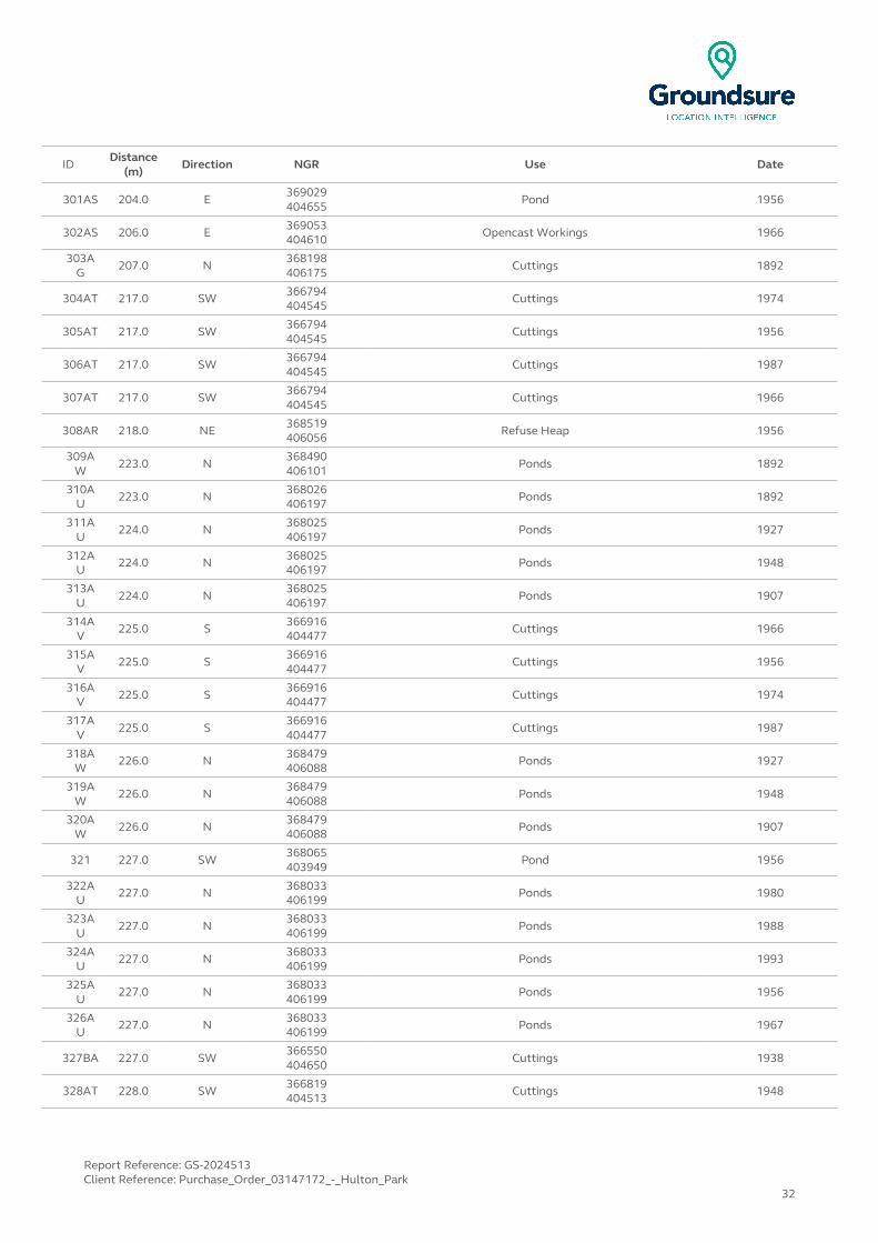
IDDistance
(m)Direction NGR Use Date
301AS 204.0 E369029404655
Pond 1956
302AS 206.0 E 369053404610
Opencast Workings 1966
303AG
207.0 N368198406175
Cuttings 1892
304AT 217.0 SW 366794404545
Cuttings 1974
305AT 217.0 SW366794404545
Cuttings 1956
306AT 217.0 SW 366794404545
Cuttings 1987
307AT 217.0 SW366794404545
Cuttings 1966
308AR 218.0 NE 368519406056
Refuse Heap 1956
309AW
223.0 N368490406101
Ponds 1892
310AU
223.0 N 368026406197
Ponds 1892
311AU
224.0 N368025406197
Ponds 1927
312AU
224.0 N 368025406197
Ponds 1948
313AU
224.0 N368025406197
Ponds 1907
314AV
225.0 S 366916404477
Cuttings 1966
315AV
225.0 S366916404477
Cuttings 1956
316AV
225.0 S 366916404477
Cuttings 1974
317AV
225.0 S366916404477
Cuttings 1987
318AW
226.0 N 368479406088
Ponds 1927
319AW
226.0 N368479406088
Ponds 1948
320AW
226.0 N 368479406088
Ponds 1907
321 227.0 SW368065403949
Pond 1956
322AU
227.0 N 368033406199
Ponds 1980
323AU
227.0 N368033406199
Ponds 1988
324AU
227.0 N 368033406199
Ponds 1993
325AU
227.0 N368033406199
Ponds 1956
326AU
227.0 N 368033406199
Ponds 1967
327BA 227.0 SW366550404650
Cuttings 1938
328AT 228.0 SW 366819404513
Cuttings 1948
Report Reference: GS-2024513Client Reference: Purchase_Order_03147172_-_Hulton_Park
32
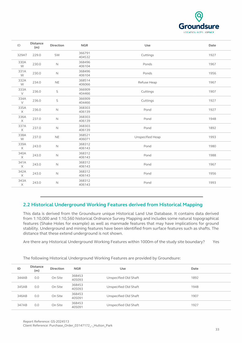
IDDistance
(m)Direction NGR Use Date
329AT 229.0 SW366791404532
Cuttings 1927
330AW
230.0 N 368496406104
Ponds 1967
331AW
230.0 N368496406104
Ponds 1956
332AW
234.0 NE 368514406066
Refuse Heap 1967
333AV
236.0 S366909404466
Cuttings 1907
334AV
236.0 S 366909404466
Cuttings 1927
335AX
236.0 N368303406139
Pond 1927
336AX
237.0 N 368303406139
Pond 1948
337AX
237.0 N368303406139
Pond 1892
338AW
237.0 NE 368521406071
Unspecified Heap 1993
339AX
243.0 N368312406143
Pond 1980
340AX
243.0 N 368312406143
Pond 1988
341AX
243.0 N368312406143
Pond 1967
342AX
243.0 N 368312406143
Pond 1956
343AX
243.0 N368312406143
Pond 1993
2.2 Historical Underground Working Features derived from Historical Mapping
This data is derived from the Groundsure unique Historical Land Use Database. It contains data derived from 1:10,000 and 1:10,560 historical Ordnance Survey Mapping and includes some natural topographical features (Shake Holes for example) as well as manmade features that may have implications for ground stability. Underground and mining features have been identified from surface features such as shafts. The distance that these extend underground is not shown.
Are there any Historical Underground Working Features within 1000m of the study site boundary? Yes
The following Historical Underground Working Features are provided by Groundsure:
ID Distance (m)
Direction NGR Use Date
344AB 0.0 On Site368453405093
Unspecified Old Shaft 1892
345AB 0.0 On Site 368453405093
Unspecified Old Shaft 1948
346AB 0.0 On Site368453405091
Unspecified Old Shaft 1907
347AB 0.0 On Site 368453405091
Unspecified Old Shaft 1927
Report Reference: GS-2024513Client Reference: Purchase_Order_03147172_-_Hulton_Park
33
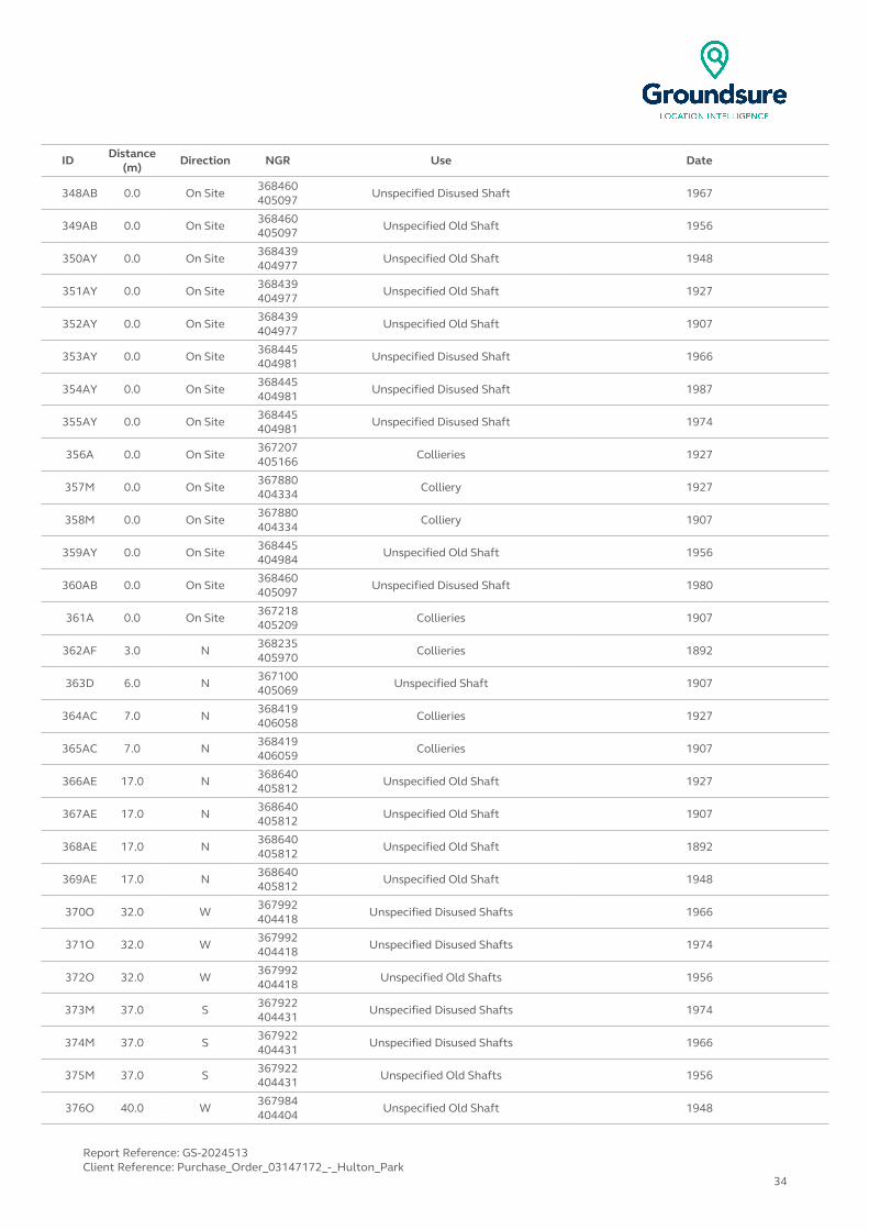
ID Distance (m)
Direction NGR Use Date
348AB 0.0 On Site368460405097
Unspecified Disused Shaft 1967
349AB 0.0 On Site 368460405097
Unspecified Old Shaft 1956
350AY 0.0 On Site368439404977
Unspecified Old Shaft 1948
351AY 0.0 On Site 368439404977
Unspecified Old Shaft 1927
352AY 0.0 On Site368439404977
Unspecified Old Shaft 1907
353AY 0.0 On Site 368445404981
Unspecified Disused Shaft 1966
354AY 0.0 On Site368445404981
Unspecified Disused Shaft 1987
355AY 0.0 On Site 368445404981
Unspecified Disused Shaft 1974
356A 0.0 On Site367207405166
Collieries 1927
357M 0.0 On Site 367880404334
Colliery 1927
358M 0.0 On Site367880404334
Colliery 1907
359AY 0.0 On Site 368445404984
Unspecified Old Shaft 1956
360AB 0.0 On Site368460405097
Unspecified Disused Shaft 1980
361A 0.0 On Site 367218405209
Collieries 1907
362AF 3.0 N368235405970
Collieries 1892
363D 6.0 N 367100405069
Unspecified Shaft 1907
364AC 7.0 N368419406058
Collieries 1927
365AC 7.0 N 368419406059
Collieries 1907
366AE 17.0 N368640405812
Unspecified Old Shaft 1927
367AE 17.0 N 368640405812
Unspecified Old Shaft 1907
368AE 17.0 N368640405812
Unspecified Old Shaft 1892
369AE 17.0 N 368640405812
Unspecified Old Shaft 1948
370O 32.0 W367992404418
Unspecified Disused Shafts 1966
371O 32.0 W 367992404418
Unspecified Disused Shafts 1974
372O 32.0 W367992404418
Unspecified Old Shafts 1956
373M 37.0 S 367922404431
Unspecified Disused Shafts 1974
374M 37.0 S367922404431
Unspecified Disused Shafts 1966
375M 37.0 S 367922404431
Unspecified Old Shafts 1956
376O 40.0 W367984404404
Unspecified Old Shaft 1948
Report Reference: GS-2024513Client Reference: Purchase_Order_03147172_-_Hulton_Park
34
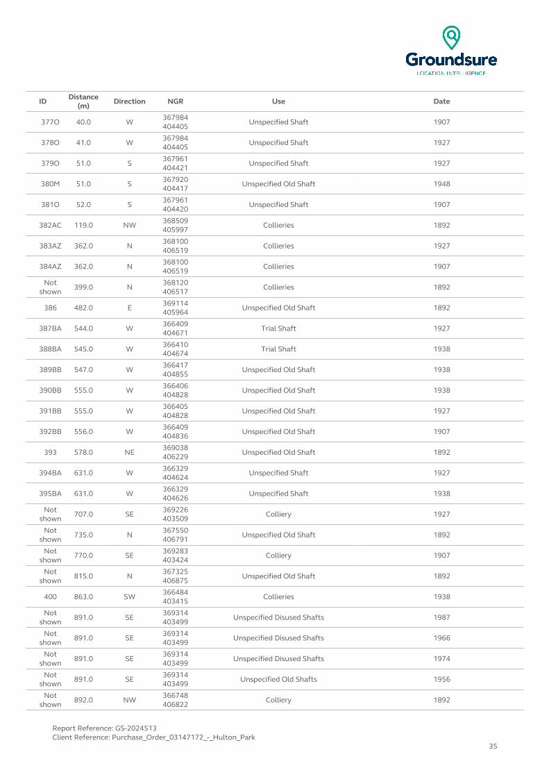
ID Distance (m)
Direction NGR Use Date
377O 40.0 W367984404405
Unspecified Shaft 1907
378O 41.0 W 367984404405
Unspecified Shaft 1927
379O 51.0 S367961404421
Unspecified Shaft 1927
380M 51.0 S 367920404417
Unspecified Old Shaft 1948
381O 52.0 S367961404420
Unspecified Shaft 1907
382AC 119.0 NW 368509405997
Collieries 1892
383AZ 362.0 N368100406519
Collieries 1927
384AZ 362.0 N 368100406519
Collieries 1907
Not shown
399.0 N368120406517
Collieries 1892
386 482.0 E 369114405964
Unspecified Old Shaft 1892
387BA 544.0 W366409404671
Trial Shaft 1927
388BA 545.0 W 366410404674
Trial Shaft 1938
389BB 547.0 W366417404855
Unspecified Old Shaft 1938
390BB 555.0 W 366406404828
Unspecified Old Shaft 1938
391BB 555.0 W366405404828
Unspecified Old Shaft 1927
392BB 556.0 W 366409404836
Unspecified Old Shaft 1907
393 578.0 NE369038406229
Unspecified Old Shaft 1892
394BA 631.0 W 366329404624
Unspecified Shaft 1927
395BA 631.0 W366329404626
Unspecified Shaft 1938
Not shown
707.0 SE 369226403509
Colliery 1927
Not shown
735.0 N367550406791
Unspecified Old Shaft 1892
Not shown
770.0 SE 369283403424
Colliery 1907
Not shown
815.0 N367325406875
Unspecified Old Shaft 1892
400 863.0 SW 366484403415
Collieries 1938
Not shown
891.0 SE369314403499
Unspecified Disused Shafts 1987
Not shown
891.0 SE 369314403499
Unspecified Disused Shafts 1966
Not shown
891.0 SE369314403499
Unspecified Disused Shafts 1974
Not shown
891.0 SE 369314403499
Unspecified Old Shafts 1956
Not shown
892.0 NW366748406822
Colliery 1892
Report Reference: GS-2024513Client Reference: Purchase_Order_03147172_-_Hulton_Park
35
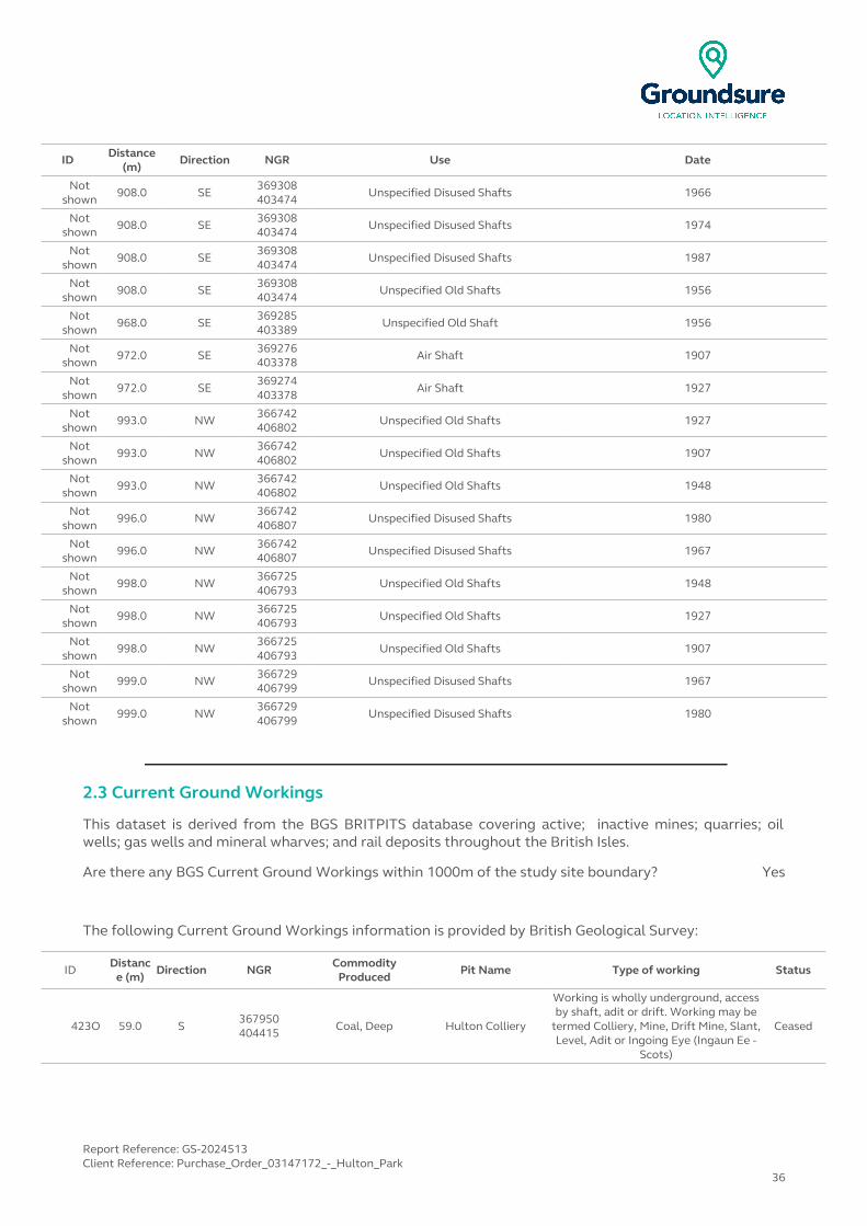
ID Distance (m)
Direction NGR Use Date
Not shown
908.0 SE369308403474
Unspecified Disused Shafts 1966
Not shown
908.0 SE 369308403474
Unspecified Disused Shafts 1974
Not shown
908.0 SE369308403474
Unspecified Disused Shafts 1987
Not shown
908.0 SE 369308403474
Unspecified Old Shafts 1956
Not shown
968.0 SE369285403389
Unspecified Old Shaft 1956
Not shown
972.0 SE 369276403378
Air Shaft 1907
Not shown
972.0 SE369274403378
Air Shaft 1927
Not shown
993.0 NW 366742406802
Unspecified Old Shafts 1927
Not shown
993.0 NW366742406802
Unspecified Old Shafts 1907
Not shown
993.0 NW 366742406802
Unspecified Old Shafts 1948
Not shown
996.0 NW366742406807
Unspecified Disused Shafts 1980
Not shown
996.0 NW 366742406807
Unspecified Disused Shafts 1967
Not shown
998.0 NW366725406793
Unspecified Old Shafts 1948
Not shown
998.0 NW 366725406793
Unspecified Old Shafts 1927
Not shown
998.0 NW366725406793
Unspecified Old Shafts 1907
Not shown
999.0 NW 366729406799
Unspecified Disused Shafts 1967
Not shown
999.0 NW366729406799
Unspecified Disused Shafts 1980
2.3 Current Ground Workings
This dataset is derived from the BGS BRITPITS database covering active; inactive mines; quarries; oil wells; gas wells and mineral wharves; and rail deposits throughout the British Isles.
Are there any BGS Current Ground Workings within 1000m of the study site boundary? Yes
The following Current Ground Workings information is provided by British Geological Survey:
ID Distance (m)
Direction NGR Commodity Produced
Pit Name Type of working Status
423O 59.0 S367950404415 Coal, Deep Hulton Colliery
Working is wholly underground, access by shaft, adit or drift. Working may be
termed Colliery, Mine, Drift Mine, Slant, Level, Adit or Ingoing Eye (Ingaun Ee -
Scots)
Ceased
Report Reference: GS-2024513Client Reference: Purchase_Order_03147172_-_Hulton_Park
36
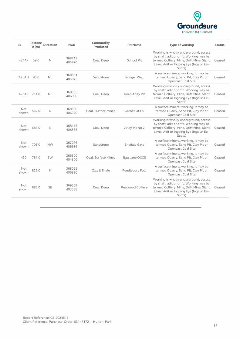
IDDistanc
e (m)Direction NGR
Commodity Produced
Pit Name Type of working Status
424AF 59.0 N368215405970
Coal, Deep School Pit
Working is wholly underground, access by shaft, adit or drift. Working may be
termed Colliery, Mine, Drift Mine, Slant, Level, Adit or Ingoing Eye (Ingaun Ee -
Scots)
Ceased
425AD 95.0 NE368501405875 Sandstone Runger Wall
A surface mineral working. It may be termed Quarry, Sand Pit, Clay Pit or
Opencast Coal SiteCeased
426AC 214.0 NE368505406030
Coal, Deep Deep Arley Pit
Working is wholly underground, access by shaft, adit or drift. Working may be
termed Colliery, Mine, Drift Mine, Slant, Level, Adit or Ingoing Eye (Ingaun Ee -
Scots)
Ceased
Not shown 562.0 N
368590406370 Coal, Surface Mined Garnet OCCS
A surface mineral working. It may be termed Quarry, Sand Pit, Clay Pit or
Opencast Coal SiteCeased
Not shown
581.0 N368115406535
Coal, Deep Arley Pit No 2
Working is wholly underground, access by shaft, adit or drift. Working may be
termed Colliery, Mine, Drift Mine, Slant, Level, Adit or Ingoing Eye (Ingaun Ee -
Scots)
Ceased
Not shown 708.0 NW
367076406686 Sandstone Snydale Gate
A surface mineral working. It may be termed Quarry, Sand Pit, Clay Pit or
Opencast Coal SiteCeased
430 781.0 SW366300404300 Coal, Surface Mined Bag Lane OCCS
A surface mineral working. It may be termed Quarry, Sand Pit, Clay Pit or
Opencast Coal SiteCeased
Not shown 829.0 N
368025406820 Clay & Shale Pendlebury Fold
A surface mineral working. It may be termed Quarry, Sand Pit, Clay Pit or
Opencast Coal SiteCeased
Not shown
885.0 SE369309403508
Coal, Deep Peelwood Colliery
Working is wholly underground, access by shaft, adit or drift. Working may be
termed Colliery, Mine, Drift Mine, Slant, Level, Adit or Ingoing Eye (Ingaun Ee -
Scots)
Ceased
Report Reference: GS-2024513Client Reference: Purchase_Order_03147172_-_Hulton_Park
37
3 Mining, Extraction & Natural Cavities Map
NW N NE
W E
SW S SE
Mining, Extraction and Natural Cavities Legend
© Crown copyright and database rights 2015. Ordnance Survey license 100035207.
Report Reference: GS-2024513Client Reference: Purchase_Order_03147172_-_Hulton_Park
38
3 Mining, Extraction & Natural Cavities3.1 Historical Mining
This dataset is derived from Groundsure unique Historical Land-use Database that are indicative of mining or extraction activities.
Are there any Historical Mining areas within 1000m of the study site boundary? Yes
The following Historical Mining information is provided by Groundsure:
ID Distance (m)
Direction NGR Details Date
2D 0.0 On Site 367880404334
Colliery 1927
3A 0.0 On Site367207405166
Collieries 1927
4A 0.0 On Site 367218405209
Collieries 1907
5B 0.0 On Site368439404977
Unspecified Old Shaft 1948
6B 0.0 On Site 368439404977
Unspecified Old Shaft 1927
7B 0.0 On Site368439404977
Unspecified Old Shaft 1907
8B 0.0 On Site 368445404981
Unspecified Disused Shaft 1966
9B 0.0 On Site368445404981
Unspecified Disused Shaft 1974
10B 0.0 On Site 368445404981
Unspecified Disused Shaft 1987
11B 0.0 On Site368445404984
Unspecified Old Shaft 1956
12C 0.0 On Site 368453405091
Unspecified Old Shaft 1907
13C 0.0 On Site368453405091
Unspecified Old Shaft 1927
14C 0.0 On Site 368453405093
Unspecified Old Shaft 1948
15C 0.0 On Site368453405093
Unspecified Old Shaft 1892
16C 0.0 On Site 368460405097
Unspecified Disused Shaft 1980
17C 0.0 On Site368460405097
Unspecified Old Shaft 1956
18C 0.0 On Site 368460405097
Unspecified Disused Shaft 1967
19D 0.0 On Site367880404334
Colliery 1907
20 3.0 N 368235405970
Collieries 1892
21 6.0 N367100405069
Unspecified Shaft 1907
Report Reference: GS-2024513Client Reference: Purchase_Order_03147172_-_Hulton_Park
39

IDDistance
(m)Direction NGR Details Date
22E 7.0 N368419406058
Collieries 1927
23E 7.0 N 368419406059
Collieries 1907
24F 17.0 N368640405812
Unspecified Old Shaft 1892
25F 17.0 N 368640405812
Unspecified Old Shaft 1948
26F 17.0 N368640405812
Unspecified Old Shaft 1927
27F 17.0 N 368640405812
Unspecified Old Shaft 1907
28G 32.0 W367992404418
Unspecified Disused Shafts 1966
29G 32.0 W 367992404418
Unspecified Disused Shafts 1974
30G 32.0 W367992404418
Unspecified Old Shafts 1956
31D 37.0 S 367922404431
Unspecified Disused Shafts 1974
32D 37.0 S367922404431
Unspecified Disused Shafts 1966
33D 37.0 S 367922404431
Unspecified Old Shafts 1956
34G 40.0 W367984404404
Unspecified Old Shaft 1948
35G 40.0 W 367984404405
Unspecified Shaft 1907
36G 41.0 W367984404405
Unspecified Shaft 1927
37G 51.0 S 367961404421
Unspecified Shaft 1927
38D 51.0 S367920404417
Unspecified Old Shaft 1948
39G 52.0 S 367961404420
Unspecified Shaft 1907
40E 119.0 NW368509405997
Collieries 1892
41 176.0 E 369086404942
Opencast Workings 1966
42 206.0 E369053404610
Opencast Workings 1966
43H 362.0 N 368100406519
Collieries 1927
44H 362.0 N368100406519
Collieries 1907
45H 399.0 N 368120406517
Collieries 1892
46 482.0 E369114405964
Unspecified Old Shaft 1892
47I 544.0 W 366409404671
Trial Shaft 1927
48I 545.0 W366410404674
Trial Shaft 1938
49J 547.0 W 366417404855
Unspecified Old Shaft 1938
Report Reference: GS-2024513Client Reference: Purchase_Order_03147172_-_Hulton_Park
40

IDDistance
(m)Direction NGR Details Date
50J 555.0 W366406404828
Unspecified Old Shaft 1938
51J 555.0 W 366405404828
Unspecified Old Shaft 1927
52J 556.0 W366409404836
Unspecified Old Shaft 1907
53 578.0 NE 369038406229
Unspecified Old Shaft 1892
54 590.0 E369426404757
Opencast Coal Workings 1956
55I 631.0 W 366329404624
Unspecified Shaft 1927
56I 631.0 W366329404626
Unspecified Shaft 1938
Not shown
707.0 SE 369226403509
Colliery 1927
Not shown
735.0 N367550406791
Unspecified Old Shaft 1892
59 736.0 E 369581404527
Opencast Workings 1966
Not shown
770.0 SE369283403424
Colliery 1907
Not shown
815.0 N 367325406875
Unspecified Old Shaft 1892
62 863.0 SW366484403415
Collieries 1938
Not shown
891.0 SE 369314403499
Unspecified Disused Shafts 1966
Not shown
891.0 SE369314403499
Unspecified Disused Shafts 1987
Not shown
891.0 SE 369314403499
Unspecified Disused Shafts 1974
Not shown
891.0 SE369314403499
Unspecified Old Shafts 1956
Not shown
892.0 NW 366748406822
Colliery 1892
Not shown
908.0 SE369308403474
Unspecified Old Shafts 1956
Not shown
908.0 SE 369308403474
Unspecified Disused Shafts 1987
Not shown
908.0 SE369308403474
Unspecified Disused Shafts 1966
Not shown
908.0 SE 369308403474
Unspecified Disused Shafts 1974
Not shown
968.0 SE369285403389
Unspecified Old Shaft 1956
Not shown
972.0 SE 369276403378
Air Shaft 1907
Not shown
972.0 SE369274403378
Air Shaft 1927
Not shown
993.0 NW 366742406802
Unspecified Old Shafts 1927
Not shown
993.0 NW366742406802
Unspecified Old Shafts 1907
Not shown
993.0 NW 366742406802
Unspecified Old Shafts 1948
Report Reference: GS-2024513Client Reference: Purchase_Order_03147172_-_Hulton_Park
41
IDDistance
(m)Direction NGR Details Date
Not shown
996.0 NW366742406807
Unspecified Disused Shafts 1980
Not shown
996.0 NW 366742406807
Unspecified Disused Shafts 1967
Not shown
998.0 NW366725406793
Unspecified Old Shafts 1907
Not shown
998.0 NW 366725406793
Unspecified Old Shafts 1927
Not shown
998.0 NW366725406793
Unspecified Old Shafts 1948
Not shown
999.0 NW 366729406799
Unspecified Disused Shafts 1967
Not shown
999.0 NW366729406799
Unspecified Disused Shafts 1980
3.2 Coal Mining
This dataset provides information as to whether the study site lies within a known coal mining affected area as defined by the coal authority.
Are there any Coal Mining areas within 1000m of the study site boundary? Yes
The following Coal Mining information provided by the Coal Authority is not represented on Mapping:
Distance (m) Direction Details
0.0 On SiteThe study site is located within the specified search distance of an identified mining area. Further details
concerning this can be obtained from the Coal Authority Helpline on 0845 762 6848.
3.3 Johnson Poole and Bloomer
This dataset provides information as to whether the study site lies within an area where JPB hold information relating to mining.
Are there any JPB Mining areas within 1000m of the study site boundary? Yes
The following information provided by JPB is not represented on mapping: In addition to being located inside an area where The Coal Authority have information on coal mining activities, Johnson Poole & Bloomer (JPB) have information such as mining plans and maps held within their archive of mining activities that have occurred within 1km of this property which may supplement this information. Further details and a quote for services can be obtained by emailing this report to [email protected].
Report Reference: GS-2024513Client Reference: Purchase_Order_03147172_-_Hulton_Park
42
3.4 Non-Coal Mining
This dataset provides information as to whether the study site lies within an area which may have been subject to non-coal historic mining.
Are there any Non-Coal Mining areas within 1000m of the study site boundary? No
Database searched and no data found.
3.5 Non-Coal Mining Cavities
This dataset provides information from the Peter Brett Associates (PBA) mining cavities database (compiled for the national study entitled “Review of mining instability in Great Britain, 1990” PBA has also continued adding to this database) on mineral extraction by mining.
Are there any Non-Coal Mining cavities within 1000m of the study site boundary? Yes
The following Non-Coal Mining Cavities information provided by Peter Brett Associates:
IDDistance
(m)Direction NGR Address Superficial Deposits Bedrock Deposits Extracted Mineral
1 0.0 On Site 367600405000
LIMESTONE MINE, Greater Manchester
- - Bath Stone, Cornstone, Limestone
3.6 Natural Cavities
This dataset provides information based on Peter Brett Associates natural cavities database.
Are there any Natural Cavities within 1000m of the study site boundary? No
Database searched and no data found.
3.7 Brine Extraction
This data provides information from the Coal Authority issued on behalf of the Cheshire Brine Subsidence Compensation Board.
Are there any Brine Extraction areas within 1000m of the study site boundary? No
Database searched and no data found.
Report Reference: GS-2024513Client Reference: Purchase_Order_03147172_-_Hulton_Park
43
3.8 Gypsum Extraction
This dataset provides information on Gypsum extraction from British Gypsum records.
Are there any Gypsum Extraction areas within 1000m of the study site boundary? No
Database searched and no data found.
3.9 Tin Mining
This dataset provides information on tin mining areas and is derived from tin mining records. This search is based upon postcode information to a sector level.
Are there any Tin Mining areas within 1000m of the study site boundary? No
Database searched and no data found.
3.10 Clay Mining
This dataset provides information on Kaolin and Ball Clay mining from relevant mining records.
Are there any Clay Mining areas within 1000m of the study site boundary? No
Database searched and no data found.
Report Reference: GS-2024513Client Reference: Purchase_Order_03147172_-_Hulton_Park
44
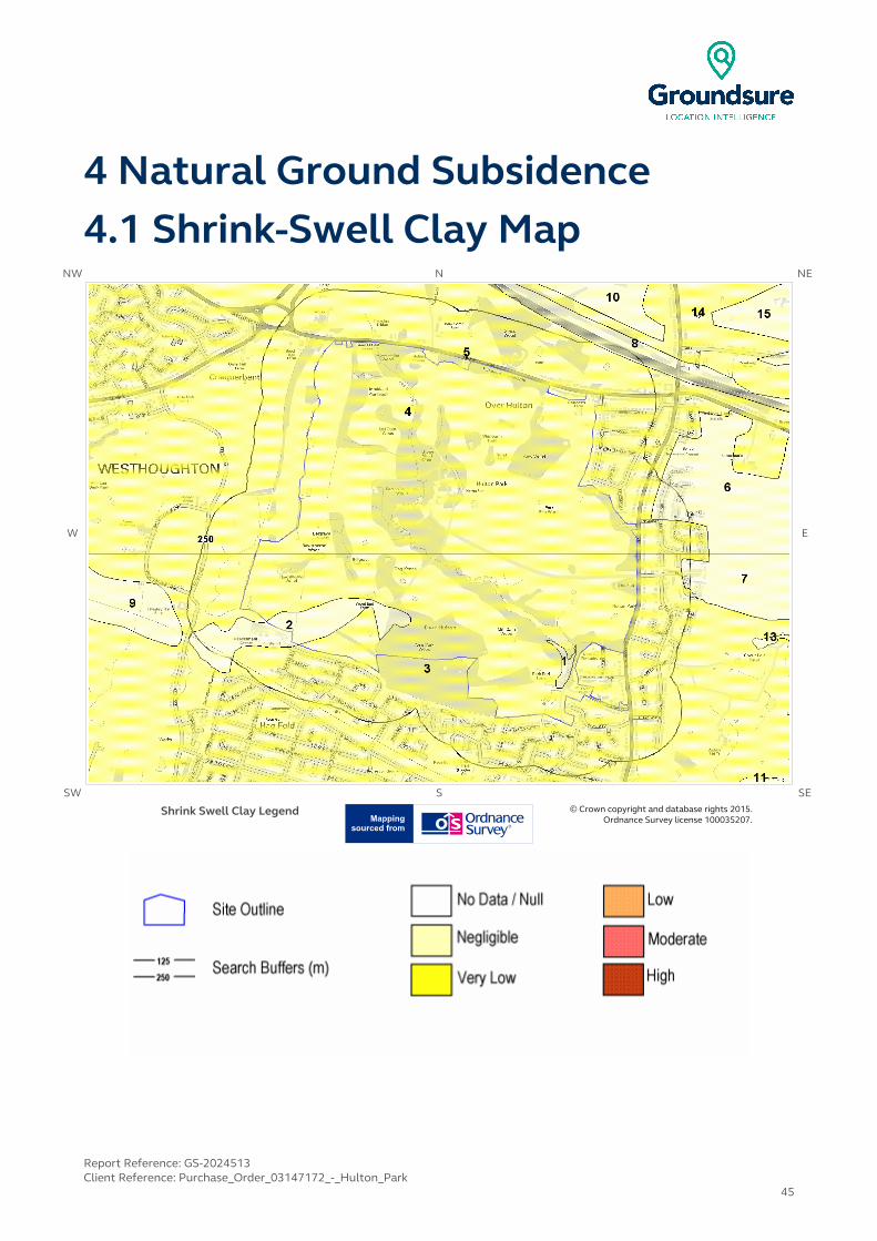
4 Natural Ground Subsidence4.1 Shrink-Swell Clay Map
NW N NE
W E
SW S SE
Shrink Swell Clay Legend © Crown copyright and database rights 2015. Ordnance Survey license 100035207.
Report Reference: GS-2024513Client Reference: Purchase_Order_03147172_-_Hulton_Park
45

4.2 Landslides MapNW N NE
W E
SW S SE
Landslides Legend © Crown copyright and database rights 2015. Ordnance Survey license 100035207.
Report Reference: GS-2024513Client Reference: Purchase_Order_03147172_-_Hulton_Park
46
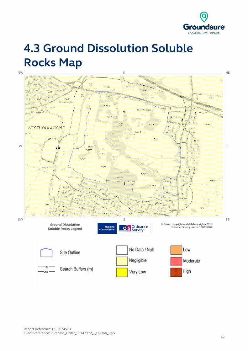
4.3 Ground Dissolution Soluble Rocks Map
NW N NE
W E
SW S SE
Ground DissolutionSoluble Rocks Legend
© Crown copyright and database rights 2015. Ordnance Survey license 100035207.
Report Reference: GS-2024513Client Reference: Purchase_Order_03147172_-_Hulton_Park
47

4.4 Compressible Deposits MapNW N NE
W E
SW S SE
Compressible Deposits Legend © Crown copyright and database rights 2015. Ordnance Survey license 100035207.
Report Reference: GS-2024513Client Reference: Purchase_Order_03147172_-_Hulton_Park
48

4.5 Collapsible Deposits MapNW N NE
W E
SW S SE
Collapsible Deposits Legend © Crown copyright and database rights 2015. Ordnance Survey license 100035207.
Report Reference: GS-2024513Client Reference: Purchase_Order_03147172_-_Hulton_Park
49
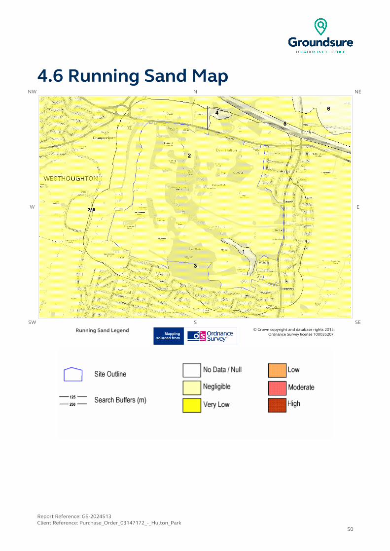
4.6 Running Sand MapNW N NE
W E
SW S SE
Running Sand Legend © Crown copyright and database rights 2015. Ordnance Survey license 100035207.
Report Reference: GS-2024513Client Reference: Purchase_Order_03147172_-_Hulton_Park
50

4 Natural Ground Subsidence
The National Ground Subsidence rating is obtained through the 6 natural ground stability hazard datasets, which are supplied by the British Geological Survey (BGS).
The following GeoSure data represented on the mapping is derived from the BGS Digital Geological map of Great Britain at 1:50,000 scale.
What is the maximum hazard rating of natural subsidence within the study site** boundary? Low
4.1 Shrink-Swell Clays
The following Shrink Swell information provided by the British Geological Survey:
ID Distance (m)
Direction Hazard Rating Details
1 0.0 On Site Negligible
Ground conditions predominantly non-plastic. No special actions required to avoid problems due to shrink-swell clays. No special ground investigation required, and
increased construction costs or increased financial risks are unlikely due to potential problems with shrink-swell clays.
2 0.0 On Site Negligible
Ground conditions predominantly non-plastic. No special actions required to avoid problems due to shrink-swell clays. No special ground investigation required, and
increased construction costs or increased financial risks are unlikely due to potential problems with shrink-swell clays.
3 0.0 On Site Very Low
Ground conditions predominantly low plasticity. No special actions required to avoid problems due to shrink-swell clays. No special ground investigation required,
and increased construction costs or increased financial risks are unlikely due to potential problems with shrink-swell clays.
4 0.0 On Site Very Low
Ground conditions predominantly low plasticity. No special actions required to avoid problems due to shrink-swell clays. No special ground investigation required,
and increased construction costs or increased financial risks are unlikely due to potential problems with shrink-swell clays.
5 26.0 NW Negligible
Ground conditions predominantly non-plastic. No special actions required to avoid problems due to shrink-swell clays. No special ground investigation required, and
increased construction costs or increased financial risks are unlikely due to potential problems with shrink-swell clays.
4.2 Landslides
The following Landslides information provided by the British Geological Survey:
IDDistance
(m)Direction Hazard Rating Details
1 0.0 On Site Low
Possibility of slope instability problems after major changes in ground conditions. Consideration should be given to stability if changes to the ground, such as
drainage or excavations, take place. Possible increase in construction cost to reduce potential slope stability problems. For existing property, no significant
increase in insurance risk due to natural slope instability problems.
* This includes an automatically generated 50m buffer zone around the site
Report Reference: GS-2024513Client Reference: Purchase_Order_03147172_-_Hulton_Park
51

IDDistance
(m)Direction Hazard Rating Details
2 0.0 On Site Very Low
Slope instability problems are unlikely to be present. No special actions required to avoid problems due to landslides. No special ground investigation required, and
increased construction costs or increased financial risks are unlikely due to potential problems with landslides.
3 0.0 On Site Very Low
Slope instability problems are unlikely to be present. No special actions required to avoid problems due to landslides. No special ground investigation required, and
increased construction costs or increased financial risks are unlikely due to potential problems with landslides.
4.3 Ground Dissolution of Soluble Rocks
The following Ground Dissolution information provided by the British Geological Survey:
IDDistance
(m)Direction Hazard Rating Details
1 0.0 On Site Negligible
Soluble rocks are present, but unlikely to cause problems except under exceptional conditions. No special actions required to avoid problems due to
soluble rocks. No special ground investigation required, and increased construction costs or increased financial risks are unlikely due to potential
problems with soluble rocks.
2 0.0 On Site Negligible
Soluble rocks are present, but unlikely to cause problems except under exceptional conditions. No special actions required to avoid problems due to
soluble rocks. No special ground investigation required, and increased construction costs or increased financial risks are unlikely due to potential
problems with soluble rocks.
4.4 Compressible Deposits
The following Compressible Deposits information provided by the British Geological Survey:
IDDistance
(m)Direction Hazard Rating Details
1 0.0 On Site Negligible
No indicators for compressible ground identified. No special actions required to avoid problems due to compressible ground. No special ground investigation
required, and increased construction costs or increased financial risks are unlikely due to potential problems with compressible ground.
2 0.0 On Site Negligible
No indicators for compressible ground identified. No special actions required to avoid problems due to compressible ground. No special ground investigation
required, and increased construction costs or increased financial risks are unlikely due to potential problems with compressible ground.
4.5 Collapsible Deposits
The following Collapsible Rocks information provided by the British Geological Survey:
IDDistance
(m)Direction Hazard Rating Details
1 0.0 On Site Very LowDeposits with potential to collapse when loaded and saturated are unlikely to be present. No special ground investigation required or increased construction costs
or increased financial risk due to potential problems with collapsible deposits.
Report Reference: GS-2024513Client Reference: Purchase_Order_03147172_-_Hulton_Park
52
IDDistance
(m)Direction Hazard Rating Details
2 0.0 On Site Very LowDeposits with potential to collapse when loaded and saturated are unlikely to be present. No special ground investigation required or increased construction costs
or increased financial risk due to potential problems with collapsible deposits.
4.6 Running Sands
The following Running Sands information provided by the British Geological Survey:
IDDistance
(m)Direction Hazard Rating Details
1 0.0 On Site Negligible
No indicators for running sand identified. No special actions required to avoid problems due to running sand. No special ground investigation required, and
increased construction costs or increased financial risks are unlikely due to potential problems with running sand.
2 0.0 On Site Very Low
Very low potential for running sand problems if water table rises or if sandy strata are exposed to water. No special actions required to avoid problems due to
running sand. No special ground investigation required, and increased construction costs or increased financial risks are unlikely due to potential
problems with running sand.
3 0.0 On Site Very Low
Very low potential for running sand problems if water table rises or if sandy strata are exposed to water. No special actions required to avoid problems due to
running sand. No special ground investigation required, and increased construction costs or increased financial risks are unlikely due to potential
problems with running sand.
4 26.0 NW Negligible
No indicators for running sand identified. No special actions required to avoid problems due to running sand. No special ground investigation required, and
increased construction costs or increased financial risks are unlikely due to potential problems with running sand.
Report Reference: GS-2024513Client Reference: Purchase_Order_03147172_-_Hulton_Park
53
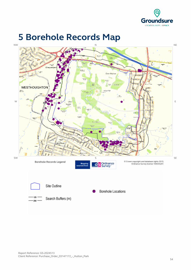
5 Borehole Records MapNW N NE
W E
SW S SE
Borehole Records Legend © Crown copyright and database rights 2015. Ordnance Survey license 100035207.
Report Reference: GS-2024513Client Reference: Purchase_Order_03147172_-_Hulton_Park
54
5 Borehole Records
The systematic analysis of data extracted from the BGS Borehole Records database provides the following information.
Records of boreholes within 250m of the study site boundary: 189
Report Reference: GS-2024513Client Reference: Purchase_Order_03147172_-_Hulton_Park
55
IDDistance
(m)Direction NGR BGS Reference Drilled Length Borehole Name
1 0.0 On Site368220404190
SD60SE577 21.0UPTON RD ATHERTON
R8
2 0.0 On Site 367091404938
SD60SE1 62.18 ATHERTON COLLIERY BORE
3 0.0 On Site368454405090
SD60NE14 367.44 PARK PIT
4 5.0 N 367099405065
SD60NE16 76.5 ATHERTON PIT NO.2
5C 7.0 S368360404190
SD60SE581 7.0UPTON RD ATHERTON
R12
6A 7.0 S 368430404170
SD60SE604 14.0 UPTON RD ATHERTON R35
7A 11.0 S368450404160
SD60SE583 16.0UPTON RD ATHERTON
R14
8A 11.0 S 368450404160
SD60SE576 15.0 UPTON RD ATHERTON R7
9A 12.0 SW368420404170
SD60SE603 11.45UPTON RD ATHERTON
R34
10B 13.0 W 367295405827
SD60NE11 397.76 HALTON COLLIERY CHEQUETANT PIT NO.1
11A 16.0 SW368410404170
SD60SE602 11.05UPTON RD ATHERTON
R33
12A 21.0 SW 368400404170
SD60SE601 10.0 UPTON RD ATHERTON R32
13D 22.0 S368310404170
SD60SE580 10.0UPTON RD ATHERTON
R11
14B 22.0 W 367293405795
SD60NE12 245.06 HALTON COLLIERY CHEQUETANT PIT NO.2
15E 23.0 SW367137404601
SD60SE379 -1.0PROP REMAND HOME
BH5
16G 24.0 S 368158404158
SD60SE414 -1.0 SPA ROAD TP6
17C 26.0 SW368390404170
SD60SE582 8.5UPTON RD ATHERTON
R13
18D 26.0 S 368350404170
SD60SE591 8.0 UPTON RD ATHERTON R22
19E 26.0 SW367098404617
SD60SE378 -1.0PROP REMAND HOME
BH4
20J 26.0 SW 367067404635
SD60SE375 -1.0 PROP REMAND HOME BH1
21F 27.0 S368260404160
SD60SE592 15.0UPTON RD ATHERTON
R23
22C 28.0 S 368370404170
SD60SE599 12.2 UPTON RD ATHERTON R30
23F 28.0 S368270404160
SD60SE593 11.0UPTON RD ATHERTON
R24
24G 28.0 W 368130404180
SD60SE861 -1.0 SPA ROAD ATHERTON 6
25D 29.0 S368280404160
SD60SE573 12.0UPTON RD ATHERTON
R4
26D 29.0 S 368280404160
SD60SE600 14.0 UPTON RD ATHERTON R31
27C 29.0 S368380404170
SD60SE578 10.0UPTON RD ATHERTON
R9
28D 30.0 S 368290404160
SD60SE594 11.0 UPTON RD ATHERTON R25
Report Reference: GS-2024513Client Reference: Purchase_Order_03147172_-_Hulton_Park
56

IDDistance
(m)Direction NGR BGS Reference Drilled Length Borehole Name
29D 31.0 S368300404160
SD60SE595 12.0UPTON RD ATHERTON
R26
30H 31.0 S 366980404690
SD60SE568 6.5 WOOD END BOYS REMAND HOME BH1
31H 31.0 S366980404690
SD60SE569 4.0WOOD END BOYS
REMAND HOME BH2
32D 33.0 S 368320404160
SD60SE596 12.0 UPTON RD ATHERTON R27
33D 34.0 S368330404160
SD60SE597 13.0UPTON RD ATHERTON
R28
34D 35.0 S 368340404160
SD60SE598 12.0 UPTON RD ATHERTON R29
35D 41.0 S368300404150
SD60SE585 16.0UPTON RD ATHERTON
R16
36 42.0 W 367985404409
SD60SE2 395.17 ATHERTON 4
37I 43.0 NW367300406000 SD60NE830 10.5
A5225 WIGAN, HINDLEY & WESTHOUGHTON
BYPASS 1725
38I 43.0 NW367300406000
SD60NE461 25.8 M6 -M61 LINK 1725
39 44.0 N368235405948
SD60NE13 164.59SCHOOL PIT SCHOOL HOUSE MANCHESTER
ROAD
40D 45.0 S 368340404150
SD60SE586 17.0 UPTON RD ATHERTON R17
41I 46.0 NW367290405990
SD60NE469 1.0 M6 -M61 LINK TP 1718
42I 46.0 NW367290405990
SD60NE857 1.5A5225 WIGAN, HINDLEY
& WESTHOUGHTON BYPASS TP1718
43F 47.0 S 368260404140
SD60SE584 16.0 UPTON RD ATHERTON R15
44K 48.0 NW367330406050
SD60NE463 24.8 M6 -M61 LINK 1728
45J 53.0 SW 367055404609
SD60SE376 -1.0 PROP REMAND HOME BH2
46K 55.0 NW367330406060 SD60NE832 7.5
A5225 WIGAN, HINDLEY & WESTHOUGHTON
BYPASS 1728
47I 55.0 NW367280405990
SD60NE470 3.0 M6 -M61 LINK TP 1718A
48I 55.0 NW367280405990
SD60NE858 3.9A5225 WIGAN, HINDLEY
& WESTHOUGHTON BYPASS TP1718A
49I 57.0 NW 367290406010
SD60NE471 4.0 M6 -M61 LINK TP 1719
50I 57.0 NW367290406010 SD60NE859 4.0
A5225 WIGAN, HINDLEY & WESTHOUGHTON
BYPASS TP1719
51 58.0 SW367079404591
SD60SE377 -1.0PROP REMAND HOME
BH3
52L 58.0 S 368370404140
SD60SE575 16.0 UPTON RD ATHERTON R6
53V 58.0 W367250405920
SD60NE458 26.7 M6 -M61 LINK 1721
54I 63.0 NW 367290406020
SD60NE472 3.0 M6 -M61 LINK TP 1719A
Report Reference: GS-2024513Client Reference: Purchase_Order_03147172_-_Hulton_Park
57

IDDistance
(m)Direction NGR BGS Reference Drilled Length Borehole Name
55M 64.0 S368220404120
SD60SE570 21.0UPTON RD ATHERTON
R1
56L 65.0 S 368340404130
SD60SE587 20.0 UPTON RD ATHERTON R18
57 65.0 S368430404110
SD60SE572 26.0UPTON RD ATHERTON
R3
58M 67.0 S 368260404120
SD60SE589 16.0 UPTON RD ATHERTON R20
59P 68.0 NW 367356406106
SD60NE506 24.0
M6-M61 LINK WIGAN HINDLEY &
WESTHOUGHTON BYPASS 1730
60N 69.0 S 368280404120
SD60SE588 19.0 UPTON RD ATHERTON R19
61N 69.0 S368280404120
SD60SE590 17.0UPTON RD ATHERTON
R21
62K 70.0 NW 367310406060
SD60NE462 34.1 M6 -M61 LINK 1727
63O 74.0 S367800404400
SD60SE836 76.63 HULTON COLLIERIES
64O 74.0 S 367800404400
SD60SE830 395.17 ATHERTON NO. 4 PIT
65Q 77.0 W368084404162
SD60SE415 -1.0 SPA ROAD TP7
66K 77.0 NW367300406060
SD60NE831 8.1A5225 WIGAN, HINDLEY
& WESTHOUGHTON BYPASS 1727
67P 77.0 NW367358406120
SD60NE541 4.0
M6-M61 LINK WIGAN HINDLEY &
WESTHOUGHTON BYPASS TP 1720
68Q 79.0 W368080404170
SD60SE857 -1.0 SPA ROAD ATHERTON 2
69S 81.0 S 368131404106
SD60SE419 -1.0 SPA ROAD TP11
70 82.0 W366950405020
SD60NE439 41.0 M6 -M61 LINK 1623
71R 82.0 NW367260406010
SD60NE829 9.5A5225 WIGAN, HINDLEY
& WESTHOUGHTON BYPASS 1724
72R 82.0 NW 367260406010
SD60NE460 24.7 M6 -M61 LINK 1724
73 91.0 N 367426406150
SD60NE542 3.0
M6-M61 LINK WIGAN HINDLEY &
WESTHOUGHTON BYPASS TP 1721
74S 94.0 S 368140404090
SD60SE859 -1.0 SPA ROAD ATHERTON 4
75T 95.0 W367210405830
SD60NE456 27.0 M6 -M61 LINK 1719
76T 95.0 W367210405830
SD60NE826 11.0A5225 WIGAN, HINDLEY
& WESTHOUGHTON BYPASS 1719
77Z 96.0 W367210405880
SD60NE854 2.7A5225 WIGAN, HINDLEY
& WESTHOUGHTON BYPASS TP1715
78R 97.0 W 367230405980
SD60NE468 4.0 M6 -M61 LINK TP 1717
Report Reference: GS-2024513Client Reference: Purchase_Order_03147172_-_Hulton_Park
58
IDDistance
(m)Direction NGR BGS Reference Drilled Length Borehole Name
79Q 99.0 S368050404180
SD60SE860 -1.0 SPA ROAD ATHERTON 5
80P 99.0 NW367323406117
SD60NE505 27.9
M6-M61 LINK WIGAN HINDLEY &
WESTHOUGHTON BYPASS 1729
81R 101.0 W367230405990 SD60NE856 4.0
A5225 WIGAN, HINDLEY & WESTHOUGHTON
BYPASS TP1717
82Y 102.0 SW368078404119
SD60SE418 -1.0 SPA ROAD TP10
83 103.0 NW367364406154
SD60NE507 22.0
M6-M61 LINK WIGAN HINDLEY &
WESTHOUGHTON BYPASS 1731
84U 105.0 S368040404175
SD60SE413 -1.0 SPA ROAD TP5
85U 108.0 S 367992404179
SD60SE417 -1.0 SPA ROAD TP9
86V 114.0 W367200405950 SD60NE827 11.0
A5225 WIGAN, HINDLEY & WESTHOUGHTON
BYPASS 1720
87 114.0 W367200405950
SD60NE457 11.0 M6 -M61 LINK 1720
88X 117.0 NW366940405110
SD60NE837 3.9A5225 WIGAN, HINDLEY
& WESTHOUGHTON BYPASS TP1615
89 118.0 NW 367111405187
SD60NE15 98.76 ATHERTON PIT 1
90U 122.0 S368010404160
SD60SE856 -1.0 SPA ROAD ATHERTON 1
91W 125.0 W367180405730
SD60NE824 11.75A5225 WIGAN, HINDLEY
& WESTHOUGHTON BYPASS 1717
92W 125.0 W 367180405730
SD60NE454 27.8 M6 -M61 LINK 1717
93X 126.0 W366930405110
SD60NE414 3.0 M6 -M61 LINK TP 1615
94Y 128.0 SW 368060404100
SD60SE858 -1.0 SPA ROAD ATHERTON 3
95AA 132.0 S368131404053
SD60SE412 -1.0 SPA ROAD TP4
96AB 134.0 W367150405650
SD60NE822 14.5A5225 WIGAN, HINDLEY
& WESTHOUGHTON BYPASS 1714
97Z 134.0 W367170405850
SD60NE825 9.5A5225 WIGAN, HINDLEY
& WESTHOUGHTON BYPASS 1718
98AC 135.0 W 367170405830
SD60NE455 25.5 M6 -M61 LINK 1718
99AA 137.0 SW368088404064
SD60SE411 -1.0 SPA ROAD TP3
100 140.0 N367448406197
SD60NE510 15.0
M6-M61 LINK WIGAN HINDLEY &
WESTHOUGHTON BYPASS 1801
Report Reference: GS-2024513Client Reference: Purchase_Order_03147172_-_Hulton_Park
59

IDDistance
(m)Direction NGR BGS Reference Drilled Length Borehole Name
101W 141.0 W 367156405700
SD60NE540 4.0
M6-M61 LINK WIGAN HINDLEY &
WESTHOUGHTON BYPASS TP 1712
102AB
143.0 W 367140405650
SD60NE452 20.7 M6 -M61 LINK 1714
103U 144.0 S368002404139
SD60SE409 -1.0 SPA ROAD TP1
104Y 146.0 SW 368044404090
SD60SE410 -1.0 SPA ROAD TP2
105AC
150.0 W367160405800
SD60NE464 4.0 M6 -M61 LINK TP 1713
106T 150.0 W367160405800
SD60NE852 4.0A5225 WIGAN, HINDLEY
& WESTHOUGHTON BYPASS TP1713
107AD
154.0 W 366880405040
SD60NE438 34.6 M6 -M61 LINK 1622
108AD 154.0 W
366880405040 SD60NE810 34.6
A5225 WIGAN, HINDLEY & WESTHOUGHTON
BYPASS 1622
109AE 156.0 N
366990405210 SD60NE838 4.0
A5225 WIGAN, HINDLEY & WESTHOUGHTON
BYPASS TP1616
110AE
156.0 N366990405210
SD60NE415 4.0 M6 -M61 LINK TP 1616
111X 164.0 W366890405110
SD60NE836 3.8A5225 WIGAN, HINDLEY
& WESTHOUGHTON BYPASS TP1614
112AE
167.0 NW366950405200
SD60NE811 41.0A5225 WIGAN, HINDLEY
& WESTHOUGHTON BYPASS 1623
113AF
168.0 E 368830405790
SD60NE682 8.5 MANCHESTER ROAD OVER HULTON BH3
114AF
169.0 E368830405800
SD60NE349 8.0 MANCHESTER ROAD 3
115AF
169.0 E 368830405800
SD60NE351 24.0 MANCHESTER ROAD R1
116AF
170.0 E368830405810
SD60NE680 7.5MANCHESTER ROAD OVER HULTON BH1
117AF
171.0 E 368830405820
SD60NE348 6.0 MANCHESTER ROAD 2
118AS
174.0 W366880405110
SD60NE413 3.0 M6 -M61 LINK TP 1614
119AD
176.0 W 366860405050
SD60NE412 4.0 M6 -M61 LINK TP 1613
120AD 176.0 W
366860405050 SD60NE835 4.0
A5225 WIGAN, HINDLEY & WESTHOUGHTON
BYPASS TP1613
121AB 177.0 W
367100405630 SD60NE851 4.0
A5225 WIGAN, HINDLEY & WESTHOUGHTON
BYPASS TP1709
122AN
181.0 W367090405570
SD60NE449 26.8 M6 -M61 LINK 1711
123W 182.0 W367130405760
SD60NE823 10.8A5225 WIGAN, HINDLEY
& WESTHOUGHTON BYPASS 1716
124W 182.0 W 367130405760
SD60NE453 21.7 M6 -M61 LINK 1716
Report Reference: GS-2024513Client Reference: Purchase_Order_03147172_-_Hulton_Park
60
IDDistance
(m)Direction NGR BGS Reference Drilled Length Borehole Name
125AG
185.0 W367120405880
SD60NE466 2.0 M6 -M61 LINK TP 1715
126AG
186.0 W367120405900
SD60NE853 3.9A5225 WIGAN, HINDLEY
& WESTHOUGHTON BYPASS TP1714
127AG
186.0 W 367120405900
SD60NE465 3.0 M6 -M61 LINK TP 1714
128AB
187.0 W367090405630
SD60NE428 4.0 M6 -M61 LINK TP 1709
129AJ 188.0 N367537406242
SD60NE511 26.8
M6-M61 LINK WIGAN HINDLEY &
WESTHOUGHTON BYPASS 1802
130AF
189.0 E368850405810
SD60NE347 7.5 MANCHESTER ROAD 1
131 191.0 S 368101404000
SD60SE416 -1.0 SPA ROAD TP8
132AH 191.0 N
367000405250 SD60NE843 3.2
A5225 WIGAN, HINDLEY & WESTHOUGHTON
BYPASS TP1701
133 195.0 W366810404940
SD60SE673 4.0 M6-M61 LINK TP 1612
134AL 196.0 W367099405702
SD60NE539 4.0
M6-M61 LINK WIGAN HINDLEY &
WESTHOUGHTON BYPASS TP 1711
135AF
198.0 E368860405790
SD60NE683 6.0MANCHESTER ROAD OVER HULTON BH4
136AQ
198.0 NW 367324406240
SD60NE62 32.2 A5225 WIGAN/HINDLEY 1820
137AF
199.0 E368860405810
SD60NE681 6.0MANCHESTER ROAD OVER HULTON BH2
138AU
200.0 NW367199406130
SD60NE504 23.8
M6-M61 LINK WIGAN HINDLEY &
WESTHOUGHTON BYPASS 1726
139AM 200.0 W
367060405480 SD60NE819 11.0
A5225 WIGAN, HINDLEY & WESTHOUGHTON
BYPASS 1709
140AH
201.0 N367000405260
SD60NE420 3.0 M6 -M61 LINK TP 1701
141AK
201.0 NW366920405220
SD60NE807 24.0A5225 WIGAN, HINDLEY
& WESTHOUGHTON BYPASS 1618
142AI 202.0 NW 366870405160
SD60NE433 39.3 M6 -M61 LINK 1616
143AI 202.0 NW366870405160 SD60NE805 24.5
A5225 WIGAN, HINDLEY & WESTHOUGHTON
BYPASS 1616
144AO
204.0 N367411406265
SD60NE77 4.0A5225 WIGAN/HINDLEY
TP 1818
145AJ 205.0 N367522406259
SD60NE543 4.2
M6-M61 LINK WIGAN HINDLEY &
WESTHOUGHTON BYPASS TP 1801
146AK
208.0 NW366910405220
SD60NE435 44.0 M6 -M61 LINK 1618
147AF
208.0 E 368870405800
SD60NE350 6.5 MANCHESTER ROAD 4
Report Reference: GS-2024513Client Reference: Purchase_Order_03147172_-_Hulton_Park
61

IDDistance
(m)Direction NGR BGS Reference Drilled Length Borehole Name
148AI 208.0 W366850405130
SD60NE411 3.0 M6 -M61 LINK TP 1611
149AI 208.0 W366850405130
SD60NE834 3.75A5225 WIGAN, HINDLEY
& WESTHOUGHTON BYPASS TP1611
150AL 209.0 W367080405680
SD60NE821 13.8A5225 WIGAN, HINDLEY
& WESTHOUGHTON BYPASS 1713
151AM
210.0 W 367050405480
SD60NE447 26.1 M6 -M61 LINK 1709
152AN
211.0 W367060405590
SD60NE448 28.0 M6 -M61 LINK 1710
153AN
211.0 W367060405590
SD60NE820 12.0A5225 WIGAN, HINDLEY
& WESTHOUGHTON BYPASS 1710
154AN
212.0 W 367060405540
SD60NE426 4.0 M6 -M61 LINK TP 1707
155AN 212.0 W
367060405540 SD60NE849 4.0
A5225 WIGAN, HINDLEY & WESTHOUGHTON
BYPASS TP1707
156AO
212.0 N367399406273
SD60NE65 32.5A5225 WIGAN/HINDLEY
1823
157AP
213.0 W367130406040
SD60NE855 3.9A5225 WIGAN, HINDLEY
& WESTHOUGHTON BYPASS TP1716
158AP
213.0 W 367130406040
SD60NE467 3.0 M6 -M61 LINK TP 1716
159AQ
215.0 NW367272406228
SD60NE75 4.0A5225 WIGAN/HINDLEY
TP 1816
160AL 219.0 W 367070405680
SD60NE451 29.0 M6 -M61 LINK 1713
161AR
219.0 W367090405940
SD60NE459 24.9 M6 -M61 LINK 1722
162AR
219.0 W367090405940
SD60NE828 9.5A5225 WIGAN, HINDLEY
& WESTHOUGHTON BYPASS 1722
163AO
220.0 N 367390406280
SD60NE44 -1.0 WESTHOUGHTON SEWER 18
164AH 223.0 NW
366940405260 SD60NE809 18.2
A5225 WIGAN, HINDLEY & WESTHOUGHTON
BYPASS 1620
165AH
223.0 NW366940405260
SD60NE437 38.0 M6 -M61 LINK 1620
166AS
224.0 W366820405080
SD60NE803 18.1A5225 WIGAN, HINDLEY
& WESTHOUGHTON BYPASS 1614
167 225.0 NW 367244406216
SD60NE60 22.0 A5225 WIGAN/HINDLEY 1818
168AO
230.0 N367468406285
SD60NE66 34.0A5225 WIGAN/HINDLEY
1824
169AP
231.0 NW 367121406065
SD60NE56 14.2 A5225 WIGAN/HINDLEY 1738
170AT
231.0 W367010405400
SD60NE444 16.9 M6 -M61 LINK 1706
171AT
231.0 W367010405400
SD60NE816 11.04A5225 WIGAN, HINDLEY
& WESTHOUGHTON BYPASS 1706
Report Reference: GS-2024513Client Reference: Purchase_Order_03147172_-_Hulton_Park
62
IDDistance
(m)Direction NGR BGS Reference Drilled Length Borehole Name
172AN 231.0 W
367040405570 SD60NE850 4.0
A5225 WIGAN, HINDLEY & WESTHOUGHTON
BYPASS TP1708
173AL 232.0 W 367063405704
SD60NE536 3.7
M6-M61 LINK WIGAN HINDLEY &
WESTHOUGHTON BYPASS TP 1710
174 233.0 W 366810405080
SD60NE431 33.3 M6 -M61 LINK 1614
175 233.0 N 367597406286
SD60NE544 4.2
M6-M61 LINK WIGAN HINDLEY &
WESTHOUGHTON BYPASS TP 1802
176 235.0 W367078405779
SD60NE502 25.0
M6-M61 LINK WIGAN HINDLEY &
WESTHOUGHTON BYPASS 1715
177AM
235.0 W367020405450
SD60NE425 4.0 M6 -M61 LINK TP 1706
178AM
235.0 W367020405450
SD60NE848 4.5A5225 WIGAN, HINDLEY
& WESTHOUGHTON BYPASS TP1706
179 240.0 W 366750404890
SD60SE676 25.0 M6-M61 LINK 1612
180AN
241.0 W367030405570
SD60NE427 4.0 M6 -M61 LINK TP 1708
181AU
241.0 NW 367153406137
SD60NE53 34.3 A5225 WIGAN/HINDLEY 1735
182AI 242.0 NW366830405170
SD60NE432 39.9 M6 -M61 LINK 1615
183AI 242.0 NW366830405170
SD60NE804 24.6A5225 WIGAN, HINDLEY
& WESTHOUGHTON BYPASS 1615
184AO
242.0 N 367461406298
SD60NE78 4.0 A5225 WIGAN/HINDLEY TP 1819
185AK
243.0 NW366880405240
SD60NE434 41.5 M6 -M61 LINK 1617
186AK
243.0 NW366880405240
SD60NE806 21.5A5225 WIGAN, HINDLEY
& WESTHOUGHTON BYPASS 1617
187 246.0 NW 367179406178
SD60NE57 34.2 A5225 WIGAN/HINDLEY 1739
188AV 247.0 W
366990405360 SD60NE844 3.8
A5225 WIGAN, HINDLEY & WESTHOUGHTON
BYPASS TP1702
189AV
247.0 W366990405360
SD60NE421 3.0 M6 -M61 LINK TP 1702
Additional online information is available for the following boreholes listed above:
#1: scans.bgs.ac.uk/sobi_scans/boreholes/14938#2: scans.bgs.ac.uk/sobi_scans/boreholes/14357#3: scans.bgs.ac.uk/sobi_scans/boreholes/13261#4: scans.bgs.ac.uk/sobi_scans/boreholes/13263#5C: scans.bgs.ac.uk/sobi_scans/boreholes/14942#6A: scans.bgs.ac.uk/sobi_scans/boreholes/14965#7A: scans.bgs.ac.uk/sobi_scans/boreholes/14944#8A: scans.bgs.ac.uk/sobi_scans/boreholes/14937
Report Reference: GS-2024513Client Reference: Purchase_Order_03147172_-_Hulton_Park
63
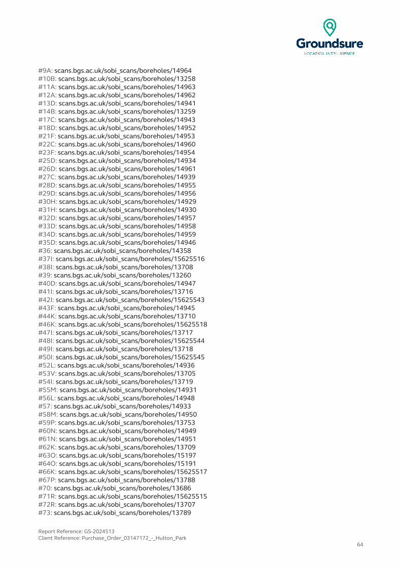
#9A: scans.bgs.ac.uk/sobi_scans/boreholes/14964#10B: scans.bgs.ac.uk/sobi_scans/boreholes/13258#11A: scans.bgs.ac.uk/sobi_scans/boreholes/14963#12A: scans.bgs.ac.uk/sobi_scans/boreholes/14962#13D: scans.bgs.ac.uk/sobi_scans/boreholes/14941#14B: scans.bgs.ac.uk/sobi_scans/boreholes/13259#17C: scans.bgs.ac.uk/sobi_scans/boreholes/14943#18D: scans.bgs.ac.uk/sobi_scans/boreholes/14952#21F: scans.bgs.ac.uk/sobi_scans/boreholes/14953#22C: scans.bgs.ac.uk/sobi_scans/boreholes/14960#23F: scans.bgs.ac.uk/sobi_scans/boreholes/14954#25D: scans.bgs.ac.uk/sobi_scans/boreholes/14934#26D: scans.bgs.ac.uk/sobi_scans/boreholes/14961#27C: scans.bgs.ac.uk/sobi_scans/boreholes/14939#28D: scans.bgs.ac.uk/sobi_scans/boreholes/14955#29D: scans.bgs.ac.uk/sobi_scans/boreholes/14956#30H: scans.bgs.ac.uk/sobi_scans/boreholes/14929#31H: scans.bgs.ac.uk/sobi_scans/boreholes/14930#32D: scans.bgs.ac.uk/sobi_scans/boreholes/14957#33D: scans.bgs.ac.uk/sobi_scans/boreholes/14958#34D: scans.bgs.ac.uk/sobi_scans/boreholes/14959#35D: scans.bgs.ac.uk/sobi_scans/boreholes/14946#36: scans.bgs.ac.uk/sobi_scans/boreholes/14358#37I: scans.bgs.ac.uk/sobi_scans/boreholes/15625516#38I: scans.bgs.ac.uk/sobi_scans/boreholes/13708#39: scans.bgs.ac.uk/sobi_scans/boreholes/13260#40D: scans.bgs.ac.uk/sobi_scans/boreholes/14947#41I: scans.bgs.ac.uk/sobi_scans/boreholes/13716#42I: scans.bgs.ac.uk/sobi_scans/boreholes/15625543#43F: scans.bgs.ac.uk/sobi_scans/boreholes/14945#44K: scans.bgs.ac.uk/sobi_scans/boreholes/13710#46K: scans.bgs.ac.uk/sobi_scans/boreholes/15625518#47I: scans.bgs.ac.uk/sobi_scans/boreholes/13717#48I: scans.bgs.ac.uk/sobi_scans/boreholes/15625544#49I: scans.bgs.ac.uk/sobi_scans/boreholes/13718#50I: scans.bgs.ac.uk/sobi_scans/boreholes/15625545#52L: scans.bgs.ac.uk/sobi_scans/boreholes/14936#53V: scans.bgs.ac.uk/sobi_scans/boreholes/13705#54I: scans.bgs.ac.uk/sobi_scans/boreholes/13719#55M: scans.bgs.ac.uk/sobi_scans/boreholes/14931#56L: scans.bgs.ac.uk/sobi_scans/boreholes/14948#57: scans.bgs.ac.uk/sobi_scans/boreholes/14933#58M: scans.bgs.ac.uk/sobi_scans/boreholes/14950#59P: scans.bgs.ac.uk/sobi_scans/boreholes/13753#60N: scans.bgs.ac.uk/sobi_scans/boreholes/14949#61N: scans.bgs.ac.uk/sobi_scans/boreholes/14951#62K: scans.bgs.ac.uk/sobi_scans/boreholes/13709#63O: scans.bgs.ac.uk/sobi_scans/boreholes/15197#64O: scans.bgs.ac.uk/sobi_scans/boreholes/15191#66K: scans.bgs.ac.uk/sobi_scans/boreholes/15625517#67P: scans.bgs.ac.uk/sobi_scans/boreholes/13788#70: scans.bgs.ac.uk/sobi_scans/boreholes/13686#71R: scans.bgs.ac.uk/sobi_scans/boreholes/15625515#72R: scans.bgs.ac.uk/sobi_scans/boreholes/13707#73: scans.bgs.ac.uk/sobi_scans/boreholes/13789
Report Reference: GS-2024513Client Reference: Purchase_Order_03147172_-_Hulton_Park
64
#75T: scans.bgs.ac.uk/sobi_scans/boreholes/13703#76T: scans.bgs.ac.uk/sobi_scans/boreholes/15625512#77Z: scans.bgs.ac.uk/sobi_scans/boreholes/15625540#78R: scans.bgs.ac.uk/sobi_scans/boreholes/13715#80P: scans.bgs.ac.uk/sobi_scans/boreholes/13752#81R: scans.bgs.ac.uk/sobi_scans/boreholes/15625542#83: scans.bgs.ac.uk/sobi_scans/boreholes/13754#86V: scans.bgs.ac.uk/sobi_scans/boreholes/15625513#87: scans.bgs.ac.uk/sobi_scans/boreholes/13704#88X: scans.bgs.ac.uk/sobi_scans/boreholes/15625523#89: scans.bgs.ac.uk/sobi_scans/boreholes/13262#91W: scans.bgs.ac.uk/sobi_scans/boreholes/15625510#92W: scans.bgs.ac.uk/sobi_scans/boreholes/13701#93X: scans.bgs.ac.uk/sobi_scans/boreholes/13661#96AB: scans.bgs.ac.uk/sobi_scans/boreholes/15625508#97Z: scans.bgs.ac.uk/sobi_scans/boreholes/15625511#98AC: scans.bgs.ac.uk/sobi_scans/boreholes/13702#100: scans.bgs.ac.uk/sobi_scans/boreholes/13757#101W: scans.bgs.ac.uk/sobi_scans/boreholes/13787#102AB: scans.bgs.ac.uk/sobi_scans/boreholes/13699#105AC: scans.bgs.ac.uk/sobi_scans/boreholes/13711#106T: scans.bgs.ac.uk/sobi_scans/boreholes/15625538#107AD: scans.bgs.ac.uk/sobi_scans/boreholes/13685#108AD: scans.bgs.ac.uk/sobi_scans/boreholes/15625495#109AE: scans.bgs.ac.uk/sobi_scans/boreholes/15625524#110AE: scans.bgs.ac.uk/sobi_scans/boreholes/13662#111X: scans.bgs.ac.uk/sobi_scans/boreholes/15625522#112AE: scans.bgs.ac.uk/sobi_scans/boreholes/15625496#113AF: scans.bgs.ac.uk/sobi_scans/boreholes/12710858#114AF: scans.bgs.ac.uk/sobi_scans/boreholes/13596#115AF: scans.bgs.ac.uk/sobi_scans/boreholes/13598#116AF: scans.bgs.ac.uk/sobi_scans/boreholes/12710856#117AF: scans.bgs.ac.uk/sobi_scans/boreholes/13595#118AS: scans.bgs.ac.uk/sobi_scans/boreholes/13660#119AD: scans.bgs.ac.uk/sobi_scans/boreholes/13659#120AD: scans.bgs.ac.uk/sobi_scans/boreholes/15625521#121AB: scans.bgs.ac.uk/sobi_scans/boreholes/15625537#122AN: scans.bgs.ac.uk/sobi_scans/boreholes/13696#123W: scans.bgs.ac.uk/sobi_scans/boreholes/15625509#124W: scans.bgs.ac.uk/sobi_scans/boreholes/13700#125AG: scans.bgs.ac.uk/sobi_scans/boreholes/13713#126AG: scans.bgs.ac.uk/sobi_scans/boreholes/15625539#127AG: scans.bgs.ac.uk/sobi_scans/boreholes/13712#128AB: scans.bgs.ac.uk/sobi_scans/boreholes/13675#129AJ: scans.bgs.ac.uk/sobi_scans/boreholes/13758#130AF: scans.bgs.ac.uk/sobi_scans/boreholes/13594#132AH: scans.bgs.ac.uk/sobi_scans/boreholes/15625529#133: scans.bgs.ac.uk/sobi_scans/boreholes/15034#134AL: scans.bgs.ac.uk/sobi_scans/boreholes/13786#135AF: scans.bgs.ac.uk/sobi_scans/boreholes/12710859#136AQ: scans.bgs.ac.uk/sobi_scans/boreholes/13309#137AF: scans.bgs.ac.uk/sobi_scans/boreholes/12710857#138AU: scans.bgs.ac.uk/sobi_scans/boreholes/13751#139AM: scans.bgs.ac.uk/sobi_scans/boreholes/15625505#140AH: scans.bgs.ac.uk/sobi_scans/boreholes/13667
Report Reference: GS-2024513Client Reference: Purchase_Order_03147172_-_Hulton_Park
65
#141AK: scans.bgs.ac.uk/sobi_scans/boreholes/15625492#142AI: scans.bgs.ac.uk/sobi_scans/boreholes/13680#143AI: scans.bgs.ac.uk/sobi_scans/boreholes/15625490#144AO: scans.bgs.ac.uk/sobi_scans/boreholes/13324#145AJ: scans.bgs.ac.uk/sobi_scans/boreholes/13790#146AK: scans.bgs.ac.uk/sobi_scans/boreholes/13682#147AF: scans.bgs.ac.uk/sobi_scans/boreholes/13597#148AI: scans.bgs.ac.uk/sobi_scans/boreholes/13658#149AI: scans.bgs.ac.uk/sobi_scans/boreholes/15625520#150AL: scans.bgs.ac.uk/sobi_scans/boreholes/15625507#151AM: scans.bgs.ac.uk/sobi_scans/boreholes/13694#152AN: scans.bgs.ac.uk/sobi_scans/boreholes/13695#153AN: scans.bgs.ac.uk/sobi_scans/boreholes/15625506#154AN: scans.bgs.ac.uk/sobi_scans/boreholes/13673#155AN: scans.bgs.ac.uk/sobi_scans/boreholes/15625535#156AO: scans.bgs.ac.uk/sobi_scans/boreholes/13312#157AP: scans.bgs.ac.uk/sobi_scans/boreholes/15625541#158AP: scans.bgs.ac.uk/sobi_scans/boreholes/13714#159AQ: scans.bgs.ac.uk/sobi_scans/boreholes/13322#160AL: scans.bgs.ac.uk/sobi_scans/boreholes/13698#161AR: scans.bgs.ac.uk/sobi_scans/boreholes/13706#162AR: scans.bgs.ac.uk/sobi_scans/boreholes/15625514#164AH: scans.bgs.ac.uk/sobi_scans/boreholes/15625494#165AH: scans.bgs.ac.uk/sobi_scans/boreholes/13684#166AS: scans.bgs.ac.uk/sobi_scans/boreholes/15625488#167: scans.bgs.ac.uk/sobi_scans/boreholes/13307#168AO: scans.bgs.ac.uk/sobi_scans/boreholes/13313#169AP: scans.bgs.ac.uk/sobi_scans/boreholes/13303#170AT: scans.bgs.ac.uk/sobi_scans/boreholes/13691#171AT: scans.bgs.ac.uk/sobi_scans/boreholes/15625501#172AN: scans.bgs.ac.uk/sobi_scans/boreholes/15625536#173AL: scans.bgs.ac.uk/sobi_scans/boreholes/13783#174: scans.bgs.ac.uk/sobi_scans/boreholes/13678#175: scans.bgs.ac.uk/sobi_scans/boreholes/13791#176: scans.bgs.ac.uk/sobi_scans/boreholes/13749#177AM: scans.bgs.ac.uk/sobi_scans/boreholes/13672#178AM: scans.bgs.ac.uk/sobi_scans/boreholes/15625534#179: scans.bgs.ac.uk/sobi_scans/boreholes/15037#180AN: scans.bgs.ac.uk/sobi_scans/boreholes/13674#181AU: scans.bgs.ac.uk/sobi_scans/boreholes/13300#182AI: scans.bgs.ac.uk/sobi_scans/boreholes/13679#183AI: scans.bgs.ac.uk/sobi_scans/boreholes/15625489#184AO: scans.bgs.ac.uk/sobi_scans/boreholes/13325#185AK: scans.bgs.ac.uk/sobi_scans/boreholes/13681#186AK: scans.bgs.ac.uk/sobi_scans/boreholes/15625491#187: scans.bgs.ac.uk/sobi_scans/boreholes/13304#188AV: scans.bgs.ac.uk/sobi_scans/boreholes/15625530#189AV: scans.bgs.ac.uk/sobi_scans/boreholes/13668
Report Reference: GS-2024513Client Reference: Purchase_Order_03147172_-_Hulton_Park
66

6 Estimated Background Soil ChemistryRecords of background estimated soil chemistry within 250m of the study site boundary: 237
For further information on how this data is calculated and limitations upon its use, please see the Groundsure Geoinsight User Guide, available on request.
Distance (m) Direction Sample Type Arsenic (As) Cadmium (Cd) Chromium (Cr) Nickel (Ni) Lead (Pb)
0.0 On Site RuralSoil 15 - 25 mg/kg <1.8 mg/kg 60 - 90 mg/kg 15 - 30 mg/kg 100 - 200 mg/kg
0.0 On Site RuralSoil 15 - 25 mg/kg <1.8 mg/kg 90 - 120 mg/kg 15 - 30 mg/kg 100 - 200 mg/kg
0.0 On Site RuralSoil 15 - 25 mg/kg <1.8 mg/kg 60 - 90 mg/kg 15 - 30 mg/kg 100 - 200 mg/kg
0.0 On Site RuralSoil <15 mg/kg <1.8 mg/kg 60 - 90 mg/kg <15 mg/kg <100 mg/kg
0.0 On Site RuralSoil <15 mg/kg <1.8 mg/kg 60 - 90 mg/kg <15 mg/kg 100 - 200 mg/kg
0.0 On Site RuralSoil 15 - 25 mg/kg <1.8 mg/kg 90 - 120 mg/kg 15 - 30 mg/kg 100 - 200 mg/kg
0.0 On Site RuralSoil 15 - 25 mg/kg <1.8 mg/kg 90 - 120 mg/kg 15 - 30 mg/kg 100 - 200 mg/kg
0.0 On Site RuralSoil <15 mg/kg <1.8 mg/kg 60 - 90 mg/kg <15 mg/kg 100 - 200 mg/kg
0.0 On Site RuralSoil <15 mg/kg <1.8 mg/kg 60 - 90 mg/kg <15 mg/kg 100 - 200 mg/kg
0.0 On Site RuralSoil <15 mg/kg <1.8 mg/kg 60 - 90 mg/kg <15 mg/kg 100 - 200 mg/kg
0.0 On Site RuralSoil 15 - 25 mg/kg <1.8 mg/kg 60 - 90 mg/kg 15 - 30 mg/kg 100 - 200 mg/kg
0.0 On Site RuralSoil 15 - 25 mg/kg <1.8 mg/kg 90 - 120 mg/kg 15 - 30 mg/kg 100 - 200 mg/kg
0.0 On Site RuralSoil 15 - 25 mg/kg <1.8 mg/kg 60 - 90 mg/kg 15 - 30 mg/kg 100 - 200 mg/kg
0.0 On Site RuralSoil <15 mg/kg <1.8 mg/kg 60 - 90 mg/kg 15 - 30 mg/kg 100 - 200 mg/kg
0.0 On Site RuralSoil 15 - 25 mg/kg <1.8 mg/kg 60 - 90 mg/kg 15 - 30 mg/kg 100 - 200 mg/kg
0.0 On Site RuralSoil 15 - 25 mg/kg <1.8 mg/kg 60 - 90 mg/kg 15 - 30 mg/kg 100 - 200 mg/kg
0.0 On Site RuralSoil <15 mg/kg <1.8 mg/kg 60 - 90 mg/kg 15 - 30 mg/kg 100 - 200 mg/kg
0.0 On Site RuralSoil 15 - 25 mg/kg <1.8 mg/kg 90 - 120 mg/kg 15 - 30 mg/kg 100 - 200 mg/kg
0.0 On Site RuralSoil <15 mg/kg <1.8 mg/kg 60 - 90 mg/kg <15 mg/kg 100 - 200 mg/kg
0.0 On Site RuralSoil <15 mg/kg <1.8 mg/kg 60 - 90 mg/kg <15 mg/kg 100 - 200 mg/kg
0.0 On Site RuralSoil <15 mg/kg <1.8 mg/kg 60 - 90 mg/kg <15 mg/kg 100 - 200 mg/kg
0.0 On Site RuralSoil 15 - 25 mg/kg <1.8 mg/kg 90 - 120 mg/kg 15 - 30 mg/kg 100 - 200 mg/kg
0.0 On Site RuralSoil <15 mg/kg <1.8 mg/kg 60 - 90 mg/kg <15 mg/kg 100 - 200 mg/kg
0.0 On Site RuralSoil 15 - 25 mg/kg <1.8 mg/kg 60 - 90 mg/kg 15 - 30 mg/kg 100 - 200 mg/kg
0.0 On Site RuralSoil 15 - 25 mg/kg <1.8 mg/kg 60 - 90 mg/kg 15 - 30 mg/kg 100 - 200 mg/kg
0.0 On Site RuralSoil 15 - 25 mg/kg <1.8 mg/kg 60 - 90 mg/kg 15 - 30 mg/kg 100 - 200 mg/kg
0.0 On Site RuralSoil 15 - 25 mg/kg <1.8 mg/kg 60 - 90 mg/kg 15 - 30 mg/kg 100 - 200 mg/kg
0.0 On Site RuralSoil <15 mg/kg <1.8 mg/kg 90 - 120 mg/kg 15 - 30 mg/kg 100 - 200 mg/kg
0.0 On Site RuralSoil 15 - 25 mg/kg <1.8 mg/kg 60 - 90 mg/kg 15 - 30 mg/kg 100 - 200 mg/kg
0.0 On Site RuralSoil 15 - 25 mg/kg <1.8 mg/kg 60 - 90 mg/kg 15 - 30 mg/kg 100 - 200 mg/kg
0.0 On Site RuralSoil 15 - 25 mg/kg <1.8 mg/kg 60 - 90 mg/kg 15 - 30 mg/kg 100 - 200 mg/kg
0.0 On Site RuralSoil 15 - 25 mg/kg <1.8 mg/kg 60 - 90 mg/kg 15 - 30 mg/kg 100 - 200 mg/kg
0.0 On Site RuralSoil 15 - 25 mg/kg <1.8 mg/kg 60 - 90 mg/kg 15 - 30 mg/kg 100 - 200 mg/kg
0.0 On Site RuralSoil 15 - 25 mg/kg <1.8 mg/kg 60 - 90 mg/kg 15 - 30 mg/kg 100 - 200 mg/kg
0.0 On Site RuralSoil <15 mg/kg <1.8 mg/kg 90 - 120 mg/kg 15 - 30 mg/kg 100 - 200 mg/kg
0.0 On Site RuralSoil 15 - 25 mg/kg <1.8 mg/kg 60 - 90 mg/kg 15 - 30 mg/kg 100 - 200 mg/kg
0.0 On Site RuralSoil 15 - 25 mg/kg <1.8 mg/kg 60 - 90 mg/kg 15 - 30 mg/kg 100 - 200 mg/kg
0.0 On Site RuralSoil 15 - 25 mg/kg <1.8 mg/kg 60 - 90 mg/kg 15 - 30 mg/kg 100 - 200 mg/kg
0.0 On Site RuralSoil <15 mg/kg <1.8 mg/kg 60 - 90 mg/kg <15 mg/kg <100 mg/kg
Report Reference: GS-2024513Client Reference: Purchase_Order_03147172_-_Hulton_Park
67

Distance (m) Direction Sample Type Arsenic (As) Cadmium (Cd) Chromium (Cr) Nickel (Ni) Lead (Pb)
0.0 On Site RuralSoil 15 - 25 mg/kg <1.8 mg/kg 60 - 90 mg/kg 15 - 30 mg/kg 100 - 200 mg/kg
0.0 On Site RuralSoil <15 mg/kg <1.8 mg/kg 60 - 90 mg/kg <15 mg/kg <100 mg/kg
0.0 On Site RuralSoil <15 mg/kg <1.8 mg/kg 60 - 90 mg/kg <15 mg/kg 100 - 200 mg/kg
0.0 On Site RuralSoil <15 mg/kg <1.8 mg/kg 60 - 90 mg/kg <15 mg/kg 100 - 200 mg/kg
0.0 On Site RuralSoil <15 mg/kg <1.8 mg/kg 60 - 90 mg/kg <15 mg/kg 100 - 200 mg/kg
0.0 On Site RuralSoil <15 mg/kg <1.8 mg/kg 60 - 90 mg/kg <15 mg/kg <100 mg/kg
0.0 On Site RuralSoil <15 mg/kg <1.8 mg/kg 60 - 90 mg/kg 15 - 30 mg/kg <100 mg/kg
0.0 On Site RuralSoil <15 mg/kg <1.8 mg/kg 60 - 90 mg/kg 15 - 30 mg/kg <100 mg/kg
0.0 On Site RuralSoil 15 - 25 mg/kg <1.8 mg/kg 60 - 90 mg/kg 15 - 30 mg/kg 100 - 200 mg/kg
0.0 On Site RuralSoil <15 mg/kg <1.8 mg/kg 60 - 90 mg/kg <15 mg/kg <100 mg/kg
0.0 On Site RuralSoil <15 mg/kg <1.8 mg/kg 60 - 90 mg/kg 15 - 30 mg/kg <100 mg/kg
0.0 On Site RuralSoil 15 - 25 mg/kg <1.8 mg/kg 60 - 90 mg/kg 15 - 30 mg/kg 100 - 200 mg/kg
0.0 On Site RuralSoil <15 mg/kg <1.8 mg/kg 60 - 90 mg/kg 15 - 30 mg/kg <100 mg/kg
0.0 On Site RuralSoil 15 - 25 mg/kg <1.8 mg/kg 60 - 90 mg/kg 15 - 30 mg/kg 100 - 200 mg/kg
0.0 On Site RuralSoil 15 - 25 mg/kg <1.8 mg/kg 60 - 90 mg/kg 15 - 30 mg/kg 100 - 200 mg/kg
0.0 On Site RuralSoil 15 - 25 mg/kg <1.8 mg/kg 60 - 90 mg/kg 15 - 30 mg/kg 100 - 200 mg/kg
0.0 On Site RuralSoil <15 mg/kg <1.8 mg/kg 60 - 90 mg/kg 15 - 30 mg/kg <100 mg/kg
0.0 On Site RuralSoil <15 mg/kg <1.8 mg/kg 60 - 90 mg/kg 15 - 30 mg/kg <100 mg/kg
0.0 On Site RuralSoil <15 mg/kg <1.8 mg/kg 60 - 90 mg/kg 15 - 30 mg/kg <100 mg/kg
0.0 On Site RuralSoil <15 mg/kg <1.8 mg/kg 90 - 120 mg/kg 15 - 30 mg/kg 100 - 200 mg/kg
0.0 On Site RuralSoil <15 mg/kg <1.8 mg/kg 90 - 120 mg/kg 15 - 30 mg/kg 100 - 200 mg/kg
0.0 On Site RuralSoil 15 - 25 mg/kg <1.8 mg/kg 60 - 90 mg/kg 15 - 30 mg/kg 100 - 200 mg/kg
0.0 On Site RuralSoil 15 - 25 mg/kg <1.8 mg/kg 60 - 90 mg/kg 15 - 30 mg/kg 100 - 200 mg/kg
0.0 On Site RuralSoil <15 mg/kg <1.8 mg/kg 90 - 120 mg/kg 15 - 30 mg/kg 100 - 200 mg/kg
0.0 On Site RuralSoil <15 mg/kg <1.8 mg/kg 90 - 120 mg/kg 15 - 30 mg/kg 100 - 200 mg/kg
0.0 On Site RuralSoil <15 mg/kg <1.8 mg/kg 90 - 120 mg/kg 15 - 30 mg/kg 100 - 200 mg/kg
0.0 On Site RuralSoil <15 mg/kg <1.8 mg/kg 60 - 90 mg/kg 15 - 30 mg/kg 100 - 200 mg/kg
0.0 On Site RuralSoil <15 mg/kg <1.8 mg/kg 60 - 90 mg/kg 15 - 30 mg/kg <100 mg/kg
0.0 On Site RuralSoil <15 mg/kg <1.8 mg/kg 90 - 120 mg/kg 15 - 30 mg/kg 100 - 200 mg/kg
0.0 On Site RuralSoil 15 - 25 mg/kg <1.8 mg/kg 60 - 90 mg/kg 15 - 30 mg/kg 100 - 200 mg/kg
0.0 On Site RuralSoil 15 - 25 mg/kg <1.8 mg/kg 60 - 90 mg/kg 15 - 30 mg/kg 100 - 200 mg/kg
0.0 On Site RuralSoil <15 mg/kg <1.8 mg/kg 90 - 120 mg/kg 15 - 30 mg/kg 100 - 200 mg/kg
0.0 On Site RuralSoil <15 mg/kg <1.8 mg/kg 90 - 120 mg/kg 15 - 30 mg/kg 100 - 200 mg/kg
0.0 On Site RuralSoil <15 mg/kg <1.8 mg/kg 60 - 90 mg/kg 15 - 30 mg/kg <100 mg/kg
0.0 On Site RuralSoil 15 - 25 mg/kg <1.8 mg/kg 60 - 90 mg/kg 15 - 30 mg/kg 100 - 200 mg/kg
0.0 On Site RuralSoil 15 - 25 mg/kg <1.8 mg/kg 60 - 90 mg/kg 15 - 30 mg/kg 100 - 200 mg/kg
0.0 On Site RuralSoil <15 mg/kg <1.8 mg/kg 60 - 90 mg/kg <15 mg/kg 100 - 200 mg/kg
0.0 On Site RuralSoil <15 mg/kg <1.8 mg/kg 60 - 90 mg/kg <15 mg/kg 100 - 200 mg/kg
0.0 On Site RuralSoil <15 mg/kg <1.8 mg/kg 60 - 90 mg/kg 15 - 30 mg/kg <100 mg/kg
0.0 On Site RuralSoil <15 mg/kg <1.8 mg/kg 60 - 90 mg/kg 15 - 30 mg/kg <100 mg/kg
0.0 On Site RuralSoil <15 mg/kg <1.8 mg/kg 60 - 90 mg/kg 15 - 30 mg/kg <100 mg/kg
0.0 On Site RuralSoil <15 mg/kg <1.8 mg/kg 90 - 120 mg/kg 15 - 30 mg/kg 100 - 200 mg/kg
0.0 On Site RuralSoil <15 mg/kg <1.8 mg/kg 60 - 90 mg/kg 15 - 30 mg/kg <100 mg/kg
0.0 On Site RuralSoil 15 - 25 mg/kg <1.8 mg/kg 60 - 90 mg/kg 15 - 30 mg/kg 100 - 200 mg/kg
0.0 On Site RuralSoil 15 - 25 mg/kg <1.8 mg/kg 60 - 90 mg/kg 15 - 30 mg/kg 100 - 200 mg/kg
0.0 On Site RuralSoil 15 - 25 mg/kg <1.8 mg/kg 60 - 90 mg/kg 15 - 30 mg/kg 100 - 200 mg/kg
0.0 On Site RuralSoil <15 mg/kg <1.8 mg/kg 90 - 120 mg/kg 15 - 30 mg/kg 100 - 200 mg/kg
0.0 On Site RuralSoil <15 mg/kg <1.8 mg/kg 60 - 90 mg/kg <15 mg/kg 100 - 200 mg/kg
0.0 On Site RuralSoil <15 mg/kg <1.8 mg/kg 90 - 120 mg/kg 15 - 30 mg/kg 100 - 200 mg/kg
0.0 On Site RuralSoil <15 mg/kg <1.8 mg/kg 90 - 120 mg/kg 15 - 30 mg/kg 100 - 200 mg/kg
0.0 On Site RuralSoil 15 - 25 mg/kg <1.8 mg/kg 60 - 90 mg/kg 15 - 30 mg/kg 100 - 200 mg/kg
0.0 On Site RuralSoil 15 - 25 mg/kg <1.8 mg/kg 60 - 90 mg/kg 15 - 30 mg/kg 100 - 200 mg/kg
Report Reference: GS-2024513Client Reference: Purchase_Order_03147172_-_Hulton_Park
68

Distance (m) Direction Sample Type Arsenic (As) Cadmium (Cd) Chromium (Cr) Nickel (Ni) Lead (Pb)
0.0 On Site RuralSoil 15 - 25 mg/kg <1.8 mg/kg 60 - 90 mg/kg 15 - 30 mg/kg 100 - 200 mg/kg
0.0 On Site RuralSoil 15 - 25 mg/kg <1.8 mg/kg 60 - 90 mg/kg 15 - 30 mg/kg 100 - 200 mg/kg
0.0 On Site RuralSoil 15 - 25 mg/kg <1.8 mg/kg 60 - 90 mg/kg 15 - 30 mg/kg 100 - 200 mg/kg
0.0 On Site RuralSoil <15 mg/kg <1.8 mg/kg 90 - 120 mg/kg 15 - 30 mg/kg 100 - 200 mg/kg
0.0 On Site RuralSoil <15 mg/kg <1.8 mg/kg 90 - 120 mg/kg 15 - 30 mg/kg 100 - 200 mg/kg
0.0 On Site RuralSoil <15 mg/kg <1.8 mg/kg 90 - 120 mg/kg 15 - 30 mg/kg 100 - 200 mg/kg
0.0 On Site RuralSoil 15 - 25 mg/kg <1.8 mg/kg 60 - 90 mg/kg 15 - 30 mg/kg 100 - 200 mg/kg
0.0 On Site RuralSoil <15 mg/kg <1.8 mg/kg 90 - 120 mg/kg 15 - 30 mg/kg 100 - 200 mg/kg
0.0 On Site RuralSoil <15 mg/kg <1.8 mg/kg 90 - 120 mg/kg 15 - 30 mg/kg 100 - 200 mg/kg
0.0 On Site RuralSoil 15 - 25 mg/kg <1.8 mg/kg 60 - 90 mg/kg 15 - 30 mg/kg 100 - 200 mg/kg
0.0 On Site RuralSoil <15 mg/kg <1.8 mg/kg 60 - 90 mg/kg <15 mg/kg <100 mg/kg
0.0 On Site Sediment 15 - 25 mg/kg <1.8 mg/kg 60 - 90 mg/kg 15 - 30 mg/kg 100 - 200 mg/kg
0.0 On Site RuralSoil <15 mg/kg <1.8 mg/kg 60 - 90 mg/kg <15 mg/kg <100 mg/kg
0.0 On Site Sediment 15 - 25 mg/kg <1.8 mg/kg 60 - 90 mg/kg 15 - 30 mg/kg 100 - 200 mg/kg
0.0 On Site RuralSoil <15 mg/kg <1.8 mg/kg 60 - 90 mg/kg <15 mg/kg 100 - 200 mg/kg
0.0 On Site RuralSoil <15 mg/kg <1.8 mg/kg 60 - 90 mg/kg <15 mg/kg <100 mg/kg
0.0 On Site RuralSoil <15 mg/kg <1.8 mg/kg 60 - 90 mg/kg <15 mg/kg <100 mg/kg
0.0 On Site RuralSoil 15 - 25 mg/kg <1.8 mg/kg 60 - 90 mg/kg 15 - 30 mg/kg <100 mg/kg
0.0 On Site RuralSoil 15 - 25 mg/kg <1.8 mg/kg 60 - 90 mg/kg 15 - 30 mg/kg <100 mg/kg
0.0 On Site RuralSoil <15 mg/kg <1.8 mg/kg 60 - 90 mg/kg <15 mg/kg <100 mg/kg
0.0 On Site RuralSoil <15 mg/kg <1.8 mg/kg 90 - 120 mg/kg 15 - 30 mg/kg 100 - 200 mg/kg
0.0 On Site RuralSoil 15 - 25 mg/kg <1.8 mg/kg 60 - 90 mg/kg 15 - 30 mg/kg 100 - 200 mg/kg
0.0 On Site RuralSoil 15 - 25 mg/kg <1.8 mg/kg 60 - 90 mg/kg 15 - 30 mg/kg 100 - 200 mg/kg
0.0 On Site RuralSoil <15 mg/kg <1.8 mg/kg 90 - 120 mg/kg 15 - 30 mg/kg 100 - 200 mg/kg
0.0 On Site RuralSoil 15 - 25 mg/kg <1.8 mg/kg 60 - 90 mg/kg 15 - 30 mg/kg 100 - 200 mg/kg
0.0 On Site RuralSoil 15 - 25 mg/kg <1.8 mg/kg 60 - 90 mg/kg 15 - 30 mg/kg 100 - 200 mg/kg
0.0 On Site RuralSoil <15 mg/kg <1.8 mg/kg 60 - 90 mg/kg <15 mg/kg 100 - 200 mg/kg
0.0 On Site RuralSoil <15 mg/kg <1.8 mg/kg 60 - 90 mg/kg 15 - 30 mg/kg 100 - 200 mg/kg
0.0 On Site RuralSoil <15 mg/kg <1.8 mg/kg 60 - 90 mg/kg 15 - 30 mg/kg 100 - 200 mg/kg
0.0 On Site RuralSoil 15 - 25 mg/kg <1.8 mg/kg 60 - 90 mg/kg 15 - 30 mg/kg 100 - 200 mg/kg
0.0 On Site RuralSoil 15 - 25 mg/kg <1.8 mg/kg 60 - 90 mg/kg 15 - 30 mg/kg 100 - 200 mg/kg
0.0 On Site RuralSoil <15 mg/kg <1.8 mg/kg 60 - 90 mg/kg <15 mg/kg 100 - 200 mg/kg
0.0 On Site RuralSoil <15 mg/kg <1.8 mg/kg 90 - 120 mg/kg 15 - 30 mg/kg 100 - 200 mg/kg
0.0 On Site RuralSoil 15 - 25 mg/kg <1.8 mg/kg 60 - 90 mg/kg 15 - 30 mg/kg 100 - 200 mg/kg
0.0 On Site RuralSoil <15 mg/kg <1.8 mg/kg 90 - 120 mg/kg 15 - 30 mg/kg 100 - 200 mg/kg
0.0 On Site RuralSoil 15 - 25 mg/kg <1.8 mg/kg 60 - 90 mg/kg 15 - 30 mg/kg 100 - 200 mg/kg
0.0 On Site Sediment <15 mg/kg <1.8 mg/kg 60 - 90 mg/kg 15 - 30 mg/kg 100 - 200 mg/kg
0.0 On Site RuralSoil <15 mg/kg <1.8 mg/kg 90 - 120 mg/kg 15 - 30 mg/kg 100 - 200 mg/kg
0.0 On Site RuralSoil <15 mg/kg <1.8 mg/kg 90 - 120 mg/kg 15 - 30 mg/kg 100 - 200 mg/kg
0.0 On Site RuralSoil <15 mg/kg <1.8 mg/kg 60 - 90 mg/kg <15 mg/kg 100 - 200 mg/kg
0.0 On Site RuralSoil <15 mg/kg <1.8 mg/kg 60 - 90 mg/kg <15 mg/kg 100 - 200 mg/kg
0.0 On Site RuralSoil 15 - 25 mg/kg <1.8 mg/kg 60 - 90 mg/kg 15 - 30 mg/kg 100 - 200 mg/kg
0.0 On Site RuralSoil <15 mg/kg <1.8 mg/kg 60 - 90 mg/kg 15 - 30 mg/kg 100 - 200 mg/kg
0.0 On Site RuralSoil <15 mg/kg <1.8 mg/kg 90 - 120 mg/kg 15 - 30 mg/kg 100 - 200 mg/kg
0.0 On Site RuralSoil <15 mg/kg <1.8 mg/kg 60 - 90 mg/kg <15 mg/kg 100 - 200 mg/kg
0.0 On Site RuralSoil <15 mg/kg <1.8 mg/kg 60 - 90 mg/kg <15 mg/kg 100 - 200 mg/kg
0.0 On Site RuralSoil 15 - 25 mg/kg <1.8 mg/kg 60 - 90 mg/kg 15 - 30 mg/kg 100 - 200 mg/kg
0.0 On Site RuralSoil <15 mg/kg <1.8 mg/kg 60 - 90 mg/kg 15 - 30 mg/kg <100 mg/kg
0.0 On Site RuralSoil 15 - 25 mg/kg <1.8 mg/kg 60 - 90 mg/kg 15 - 30 mg/kg 100 - 200 mg/kg
0.0 On Site RuralSoil 15 - 25 mg/kg <1.8 mg/kg 60 - 90 mg/kg 15 - 30 mg/kg 100 - 200 mg/kg
0.0 On Site RuralSoil 15 - 25 mg/kg <1.8 mg/kg 60 - 90 mg/kg 15 - 30 mg/kg 100 - 200 mg/kg
0.0 On Site RuralSoil <15 mg/kg <1.8 mg/kg 90 - 120 mg/kg 15 - 30 mg/kg 100 - 200 mg/kg
Report Reference: GS-2024513Client Reference: Purchase_Order_03147172_-_Hulton_Park
69

Distance (m) Direction Sample Type Arsenic (As) Cadmium (Cd) Chromium (Cr) Nickel (Ni) Lead (Pb)
0.0 On Site RuralSoil <15 mg/kg <1.8 mg/kg 90 - 120 mg/kg 15 - 30 mg/kg 100 - 200 mg/kg
0.0 On Site RuralSoil <15 mg/kg <1.8 mg/kg 90 - 120 mg/kg 15 - 30 mg/kg 100 - 200 mg/kg
0.0 On Site RuralSoil <15 mg/kg <1.8 mg/kg 90 - 120 mg/kg 15 - 30 mg/kg 100 - 200 mg/kg
0.0 On Site RuralSoil 15 - 25 mg/kg <1.8 mg/kg 60 - 90 mg/kg 15 - 30 mg/kg 100 - 200 mg/kg
2.0 S RuralSoil <15 mg/kg <1.8 mg/kg 60 - 90 mg/kg 15 - 30 mg/kg <100 mg/kg
6.0 S RuralSoil <15 mg/kg <1.8 mg/kg 60 - 90 mg/kg <15 mg/kg <100 mg/kg
10.0 S RuralSoil <15 mg/kg <1.8 mg/kg 60 - 90 mg/kg <15 mg/kg 100 - 200 mg/kg
14.0 W RuralSoil 15 - 25 mg/kg <1.8 mg/kg 60 - 90 mg/kg 15 - 30 mg/kg 100 - 200 mg/kg
21.0 N RuralSoil 15 - 25 mg/kg <1.8 mg/kg 60 - 90 mg/kg 15 - 30 mg/kg 100 - 200 mg/kg
23.0 S RuralSoil <15 mg/kg <1.8 mg/kg 60 - 90 mg/kg 15 - 30 mg/kg 100 - 200 mg/kg
23.0 W RuralSoil <15 mg/kg <1.8 mg/kg 60 - 90 mg/kg 15 - 30 mg/kg <100 mg/kg
25.0 W RuralSoil <15 mg/kg <1.8 mg/kg 60 - 90 mg/kg <15 mg/kg 100 - 200 mg/kg
27.0 W RuralSoil <15 mg/kg <1.8 mg/kg 60 - 90 mg/kg 15 - 30 mg/kg 100 - 200 mg/kg
27.0 W RuralSoil <15 mg/kg <1.8 mg/kg 60 - 90 mg/kg 15 - 30 mg/kg 100 - 200 mg/kg
28.0 W RuralSoil 15 - 25 mg/kg <1.8 mg/kg 60 - 90 mg/kg 15 - 30 mg/kg 100 - 200 mg/kg
28.0 W RuralSoil 15 - 25 mg/kg <1.8 mg/kg 60 - 90 mg/kg 15 - 30 mg/kg 100 - 200 mg/kg
38.0 SW RuralSoil <15 mg/kg <1.8 mg/kg 60 - 90 mg/kg <15 mg/kg <100 mg/kg
40.0 S RuralSoil 15 - 25 mg/kg <1.8 mg/kg 90 - 120 mg/kg 15 - 30 mg/kg 100 - 200 mg/kg
40.0 SW RuralSoil <15 mg/kg <1.8 mg/kg 60 - 90 mg/kg <15 mg/kg 100 - 200 mg/kg
40.0 SW RuralSoil <15 mg/kg <1.8 mg/kg 60 - 90 mg/kg <15 mg/kg 100 - 200 mg/kg
42.0 E RuralSoil <15 mg/kg <1.8 mg/kg 90 - 120 mg/kg 15 - 30 mg/kg 100 - 200 mg/kg
42.0 E RuralSoil <15 mg/kg <1.8 mg/kg 90 - 120 mg/kg 15 - 30 mg/kg <100 mg/kg
42.0 N Sediment <15 mg/kg <1.8 mg/kg 60 - 90 mg/kg 15 - 30 mg/kg 100 - 200 mg/kg
43.0 S RuralSoil <15 mg/kg <1.8 mg/kg 60 - 90 mg/kg <15 mg/kg <100 mg/kg
49.0 NW Sediment <15 mg/kg <1.8 mg/kg 60 - 90 mg/kg 15 - 30 mg/kg 100 - 200 mg/kg
61.0 NE Sediment <15 mg/kg <1.8 mg/kg 60 - 90 mg/kg 15 - 30 mg/kg 100 - 200 mg/kg
62.0 S RuralSoil <15 mg/kg <1.8 mg/kg 60 - 90 mg/kg 15 - 30 mg/kg <100 mg/kg
63.0 S RuralSoil <15 mg/kg <1.8 mg/kg 60 - 90 mg/kg 15 - 30 mg/kg <100 mg/kg
66.0 S RuralSoil <15 mg/kg <1.8 mg/kg 60 - 90 mg/kg <15 mg/kg <100 mg/kg
68.0 N Sediment 15 - 25 mg/kg <1.8 mg/kg 60 - 90 mg/kg 15 - 30 mg/kg 100 - 200 mg/kg
69.0 SW RuralSoil <15 mg/kg <1.8 mg/kg 60 - 90 mg/kg <15 mg/kg 100 - 200 mg/kg
102.0 S RuralSoil <15 mg/kg <1.8 mg/kg 60 - 90 mg/kg 15 - 30 mg/kg <100 mg/kg
103.0 S RuralSoil <15 mg/kg <1.8 mg/kg 60 - 90 mg/kg 15 - 30 mg/kg 100 - 200 mg/kg
103.0 S RuralSoil <15 mg/kg <1.8 mg/kg 60 - 90 mg/kg 15 - 30 mg/kg 100 - 200 mg/kg
115.0 N Sediment <15 mg/kg <1.8 mg/kg 60 - 90 mg/kg 15 - 30 mg/kg 100 - 200 mg/kg
115.0 S RuralSoil <15 mg/kg <1.8 mg/kg 60 - 90 mg/kg 15 - 30 mg/kg 100 - 200 mg/kg
125.0 SW RuralSoil <15 mg/kg <1.8 mg/kg 60 - 90 mg/kg 15 - 30 mg/kg 100 - 200 mg/kg
141.0 S RuralSoil <15 mg/kg <1.8 mg/kg 60 - 90 mg/kg <15 mg/kg 100 - 200 mg/kg
141.0 S RuralSoil <15 mg/kg <1.8 mg/kg 60 - 90 mg/kg <15 mg/kg 100 - 200 mg/kg
142.0 SW RuralSoil <15 mg/kg <1.8 mg/kg 60 - 90 mg/kg <15 mg/kg 100 - 200 mg/kg
142.0 S RuralSoil <15 mg/kg <1.8 mg/kg 60 - 90 mg/kg <15 mg/kg 100 - 200 mg/kg
142.0 S RuralSoil <15 mg/kg <1.8 mg/kg 60 - 90 mg/kg <15 mg/kg 100 - 200 mg/kg
143.0 E RuralSoil <15 mg/kg <1.8 mg/kg 60 - 90 mg/kg <15 mg/kg <100 mg/kg
145.0 N RuralSoil 15 - 25 mg/kg <1.8 mg/kg 60 - 90 mg/kg 15 - 30 mg/kg 100 - 200 mg/kg
145.0 N RuralSoil 15 - 25 mg/kg <1.8 mg/kg 60 - 90 mg/kg 15 - 30 mg/kg 100 - 200 mg/kg
156.0 S RuralSoil <15 mg/kg <1.8 mg/kg 60 - 90 mg/kg 15 - 30 mg/kg 100 - 200 mg/kg
156.0 S RuralSoil <15 mg/kg <1.8 mg/kg 60 - 90 mg/kg 15 - 30 mg/kg 100 - 200 mg/kg
164.0 N RuSoilExAs <15 mg/kg <1.8 mg/kg 90 - 120 mg/kg 15 - 30 mg/kg 100 - 200 mg/kg
166.0 SW RuralSoil <15 mg/kg <1.8 mg/kg 60 - 90 mg/kg 15 - 30 mg/kg 100 - 200 mg/kg
171.0 SW RuralSoil <15 mg/kg <1.8 mg/kg 60 - 90 mg/kg <15 mg/kg 100 - 200 mg/kg
171.0 SW RuralSoil <15 mg/kg <1.8 mg/kg 60 - 90 mg/kg <15 mg/kg 100 - 200 mg/kg
172.0 E RuralSoil <15 mg/kg <1.8 mg/kg 90 - 120 mg/kg 15 - 30 mg/kg 100 - 200 mg/kg
Report Reference: GS-2024513Client Reference: Purchase_Order_03147172_-_Hulton_Park
70

Distance (m) Direction Sample Type Arsenic (As) Cadmium (Cd) Chromium (Cr) Nickel (Ni) Lead (Pb)
172.0 E RuralSoil <15 mg/kg <1.8 mg/kg 90 - 120 mg/kg 15 - 30 mg/kg 100 - 200 mg/kg
174.0 E RuralSoil <15 mg/kg <1.8 mg/kg 90 - 120 mg/kg 15 - 30 mg/kg 100 - 200 mg/kg
174.0 E RuralSoil <15 mg/kg <1.8 mg/kg 90 - 120 mg/kg 15 - 30 mg/kg 100 - 200 mg/kg
174.0 E RuralSoil 15 - 25 mg/kg <1.8 mg/kg 60 - 90 mg/kg 15 - 30 mg/kg 100 - 200 mg/kg
174.0 E RuralSoil 15 - 25 mg/kg <1.8 mg/kg 60 - 90 mg/kg 15 - 30 mg/kg 100 - 200 mg/kg
174.0 E RuralSoil <15 mg/kg <1.8 mg/kg 90 - 120 mg/kg 15 - 30 mg/kg 100 - 200 mg/kg
174.0 E RuralSoil <15 mg/kg <1.8 mg/kg 90 - 120 mg/kg 15 - 30 mg/kg 100 - 200 mg/kg
174.0 SW RuralSoil <15 mg/kg <1.8 mg/kg 60 - 90 mg/kg 15 - 30 mg/kg 100 - 200 mg/kg
176.0 E RuralSoil <15 mg/kg <1.8 mg/kg 60 - 90 mg/kg <15 mg/kg 100 - 200 mg/kg
176.0 E RuralSoil <15 mg/kg <1.8 mg/kg 60 - 90 mg/kg <15 mg/kg 100 - 200 mg/kg
185.0 NE Sediment <15 mg/kg <1.8 mg/kg 60 - 90 mg/kg 15 - 30 mg/kg 100 - 200 mg/kg
186.0 S RuralSoil <15 mg/kg <1.8 mg/kg 60 - 90 mg/kg 15 - 30 mg/kg <100 mg/kg
189.0 SW RuralSoil <15 mg/kg <1.8 mg/kg 60 - 90 mg/kg 15 - 30 mg/kg 100 - 200 mg/kg
195.0 SW RuralSoil <15 mg/kg <1.8 mg/kg 60 - 90 mg/kg 15 - 30 mg/kg 100 - 200 mg/kg
196.0 E RuralSoil <15 mg/kg <1.8 mg/kg 60 - 90 mg/kg 15 - 30 mg/kg 100 - 200 mg/kg
196.0 E RuralSoil <15 mg/kg <1.8 mg/kg 60 - 90 mg/kg 15 - 30 mg/kg 100 - 200 mg/kg
196.0 SW RuralSoil <15 mg/kg <1.8 mg/kg 60 - 90 mg/kg 15 - 30 mg/kg <100 mg/kg
196.0 SW RuralSoil <15 mg/kg <1.8 mg/kg 60 - 90 mg/kg <15 mg/kg 100 - 200 mg/kg
196.0 SW RuralSoil <15 mg/kg <1.8 mg/kg 60 - 90 mg/kg 15 - 30 mg/kg 100 - 200 mg/kg
196.0 S RuralSoil <15 mg/kg <1.8 mg/kg 60 - 90 mg/kg 15 - 30 mg/kg 100 - 200 mg/kg
204.0 SW RuralSoil <15 mg/kg <1.8 mg/kg 60 - 90 mg/kg <15 mg/kg <100 mg/kg
208.0 SW RuralSoil <15 mg/kg <1.8 mg/kg 60 - 90 mg/kg <15 mg/kg 100 - 200 mg/kg
208.0 SW RuralSoil <15 mg/kg <1.8 mg/kg 60 - 90 mg/kg <15 mg/kg 100 - 200 mg/kg
212.0 E RuralSoil <15 mg/kg <1.8 mg/kg 60 - 90 mg/kg <15 mg/kg 100 - 200 mg/kg
212.0 E RuralSoil <15 mg/kg <1.8 mg/kg 60 - 90 mg/kg <15 mg/kg 100 - 200 mg/kg
214.0 S RuralSoil <15 mg/kg <1.8 mg/kg 60 - 90 mg/kg 15 - 30 mg/kg 100 - 200 mg/kg
214.0 S RuralSoil <15 mg/kg <1.8 mg/kg 60 - 90 mg/kg 15 - 30 mg/kg 100 - 200 mg/kg
232.0 E RuralSoil <15 mg/kg <1.8 mg/kg 60 - 90 mg/kg <15 mg/kg 100 - 200 mg/kg
232.0 E RuralSoil <15 mg/kg <1.8 mg/kg 60 - 90 mg/kg <15 mg/kg 100 - 200 mg/kg
232.0 SW RuralSoil 15 - 25 mg/kg <1.8 mg/kg 90 - 120 mg/kg 15 - 30 mg/kg 100 - 200 mg/kg
233.0 NE RuralSoil <15 mg/kg <1.8 mg/kg 60 - 90 mg/kg 15 - 30 mg/kg 100 - 200 mg/kg
233.0 NE RuralSoil <15 mg/kg <1.8 mg/kg 60 - 90 mg/kg 15 - 30 mg/kg 100 - 200 mg/kg
234.0 SW RuralSoil <15 mg/kg <1.8 mg/kg 60 - 90 mg/kg <15 mg/kg 100 - 200 mg/kg
234.0 SW RuralSoil <15 mg/kg <1.8 mg/kg 60 - 90 mg/kg <15 mg/kg 100 - 200 mg/kg
237.0 E RuralSoil <15 mg/kg <1.8 mg/kg 60 - 90 mg/kg <15 mg/kg 100 - 200 mg/kg
237.0 E RuralSoil <15 mg/kg <1.8 mg/kg 60 - 90 mg/kg <15 mg/kg 100 - 200 mg/kg
238.0 W RuSoilExAs <15 mg/kg <1.8 mg/kg 90 - 120 mg/kg 15 - 30 mg/kg 100 - 200 mg/kg
241.0 SW RuralSoil 15 - 25 mg/kg <1.8 mg/kg 60 - 90 mg/kg 15 - 30 mg/kg 100 - 200 mg/kg
241.0 SW RuralSoil <15 mg/kg <1.8 mg/kg 60 - 90 mg/kg <15 mg/kg 100 - 200 mg/kg
241.0 SW RuralSoil <15 mg/kg <1.8 mg/kg 60 - 90 mg/kg <15 mg/kg 100 - 200 mg/kg
241.0 SW RuralSoil <15 mg/kg <1.8 mg/kg 60 - 90 mg/kg <15 mg/kg 100 - 200 mg/kg
241.0 SW RuralSoil <15 mg/kg <1.8 mg/kg 60 - 90 mg/kg <15 mg/kg 100 - 200 mg/kg
*As this data is based upon underlying 1:50,000 scale geological information, a 50m buffer has been added to the search radius.
Report Reference: GS-2024513Client Reference: Purchase_Order_03147172_-_Hulton_Park
71
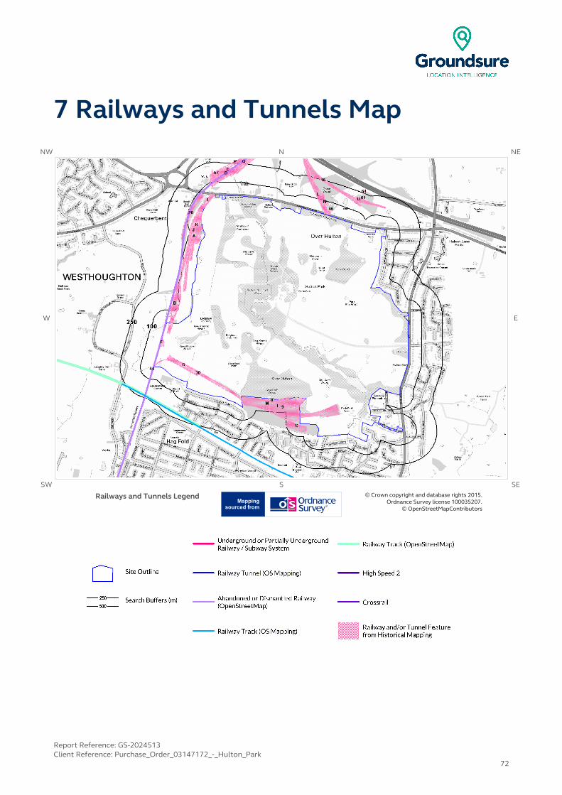
7 Railways and Tunnels MapNW N NE
W E
SW S SE
Railways and Tunnels Legend © Crown copyright and database rights 2015. Ordnance Survey license 100035207.
© OpenStreetMapContributors
Report Reference: GS-2024513Client Reference: Purchase_Order_03147172_-_Hulton_Park
72

7 Railways and Tunnels
7.1 Tunnels
This data is derived from OpenStreetMap and provides information on the possible locations of underground railway systems in the UK - the London Underground, the Tyne & Wear Metro and the Glasgow Subway.
Have any underground railway lines been identified within the study site boundary? No
Have any underground railway lines been identified within 250m of the study site boundary? No
Database searched and no data found.
Any records that have been identified are represented on the Railways and Tunnels Map.
This data is derived from Ordnance Survey mapping and provides information on the possible locations of railway tunnels forming part of the UK overground railway network.
Have any other railway tunnels been identified within the site boundary? No
Have any other railway tunnels been identified within 250m of the site boundary? No
Database searched and no data found.
Any records that have been identified are represented on the Railways and Tunnels Map.
7.2 Historical Railway and Tunnel Features
This data is derived from Groundsure's unique Historical Land-use Database and contains features relating to tunnels, railway tracks or associated works that have been identified from historical Ordnance Survey mapping.
Have any historical railway or tunnel features been identified within the study site boundary? Yes
Have any historical railway or tunnel features been identified within 250m of the study site boundary? Yes
ID Distance (m)
Direction NGR Details Date
1 0 On Site 367352406009
Mineral Railway Sidings 1938
2K 0 On Site367267405838
Mineral Railway Sidings 1907
3G 0 On Site 367172404728
Railway Sidings 1907
4A 0 On Site367267405838
Mineral Railway Sidings 1927
5A 0 On Site 367295405824
Mineral Railway Sidings 1892
6B 0 On Site367103405183
Railway Sidings 1927
Report Reference: GS-2024513Client Reference: Purchase_Order_03147172_-_Hulton_Park
73

IDDistance
(m)Direction NGR Details Date
7B 0 On Site367103405183
Railway Sidings 1907
8 0 On Site 367568404497
Mineral Railway Sidings 1927
9 0 On Site367930404405
Railway Sidings 1907
10F 0 On Site 367009404908
Railway Sidings 1938
11B 0 On Site367107405195
Railway Sidings 1927
28F 0 On Site 367011404934
Railway Sidings 1936
29G 0 On Site367189404713
Mineral Railway Sidings 1908
30 0 On Site 367189404713
Mineral Railway Sidings 1928
31H 0 On Site367175405523
Mineral Railway Sidings 1908
32H 0 On Site 367175405523
Mineral Railway Sidings 1929
33I 0 On Site367818404415
Mineral Railway Sidings 1928
34I 0 On Site 367818404415
Mineral Railway Sidings 1908
35J 0 On Site367240405762
Mineral Railway Sidings 1936
36F 0 On Site 367010404915
Railway Sidings 1929
37F 0 On Site367010404915
Railway Sidings 1908
38K 0 NW 367265405835
Mineral Railway Sidings 1893
12A 2 NW367231405693
Mineral Railway Sidings 1927
13J 2 NW 367234405766
Mineral Railway Sidings 1948
14 4 N368064406367
Railway Sidings 1892
39L 5 N 368144406082
Railway Sidings 1908
40L 6 N368144406082
Railway Sidings 1893
15 8 N 367785406427
Railway Sidings 1907
16 8 N367785406427
Railway Sidings 1927
41 9 N 368071406340
Railway Sidings 1928
42 9 NW368027404449
Railway Sidings 1908
17C 10 S 368005404259
Tramway Sidings 1938
18 10 N368057406428
Mineral Railway Sidings 1927
43M 12 S 367789404430
Railway Sidings 1936
Report Reference: GS-2024513Client Reference: Purchase_Order_03147172_-_Hulton_Park
74
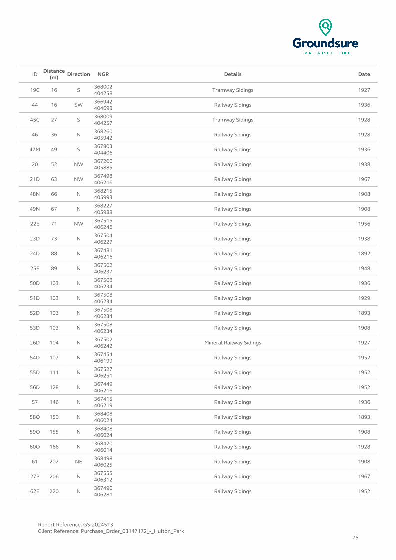
IDDistance
(m)Direction NGR Details Date
19C 16 S368002404258
Tramway Sidings 1927
44 16 SW 366942404698
Railway Sidings 1936
45C 27 S368009404257
Tramway Sidings 1928
46 36 N 368260405942
Railway Sidings 1928
47M 49 S367803404406
Railway Sidings 1936
20 52 NW 367206405885
Railway Sidings 1938
21D 63 NW367498406216
Railway Sidings 1967
48N 66 N 368215405993
Railway Sidings 1908
49N 67 N368227405988
Railway Sidings 1908
22E 71 NW 367515406246
Railway Sidings 1956
23D 73 N367504406227
Railway Sidings 1938
24D 88 N 367481406216
Railway Sidings 1892
25E 89 N367502406237
Railway Sidings 1948
50D 103 N 367508406234
Railway Sidings 1936
51D 103 N367508406234
Railway Sidings 1929
52D 103 N 367508406234
Railway Sidings 1893
53D 103 N367508406234
Railway Sidings 1908
26D 104 N 367502406242
Mineral Railway Sidings 1927
54D 107 N367454406199
Railway Sidings 1952
55D 111 N 367527406251
Railway Sidings 1952
56D 128 N367449406216
Railway Sidings 1952
57 146 N 367415406219
Railway Sidings 1936
58O 150 N368408406024
Railway Sidings 1893
59O 155 N 368408406024
Railway Sidings 1908
60O 166 N368420406014
Railway Sidings 1928
61 202 NE 368498406025
Railway Sidings 1908
27P 206 N367555406312
Railway Sidings 1967
62E 220 N 367490406281
Railway Sidings 1952
Report Reference: GS-2024513Client Reference: Purchase_Order_03147172_-_Hulton_Park
75

IDDistance
(m)Direction NGR Details Date
63E 220 N367490406281
Railway Sidings 1969
64 226 NE 368500406075
Railway Sidings 1908
65P 230 N367565406322
Railway Sidings 1969
66Q 247 N 367617406307
Mineral Railway Sidings 1908
67Q 247 N367617406307
Mineral Railway Sidings 1893
68Q 247 N 367617406307
Railway Sidings 1928
69Q 247 N367617406307
Mineral Railway Sidings 1936
Any records that have been identified are represented on the Railways and Tunnels Map.
7.3 Historical Railways
This data is derived from OpenStreetMap and provides information on the possible alignments of abandoned or dismantled railway lines in proximity to the study site.
Have any historical railway lines been identified within the study site boundary? Yes
Have any historical railway lines been identified within 250m of the study site boundary? Yes
Distance (m) Direction Status
0 On Site Abandoned
Note: multiple sections of the same track may be listed in the detail above
Any records that have been identified are represented on the Railways and Tunnels Map.
7.4 Active Railways
These datasets are derived from Ordnance Survey mapping and OpenStreetMap and provide information on the possible locations of active railway lines in proximity to the study site.
Have any active railway lines been identified within the study site boundary? No
Have any active railway lines been identified within 250m of the study site boundary? Yes
Distance (m) Direction Name Type
205 SW Not given Rail
210 SW Manchester to Southport Line Rail
212 SW Not given Multi Track
Note: multiple sections of the same track may be listed in the detail aboveAny records that have been identified are represented on the Railways and Tunnels Map.
Report Reference: GS-2024513Client Reference: Purchase_Order_03147172_-_Hulton_Park
76
7.5 Railway Projects
These datasets provide information on the location of large scale railway projects High Speed 2 and Crossrail.
Is the study site within 5km of the route of the High Speed 2 rail project? No
Is the study site within 500m of the route of the Crossrail rail project? No
Further information on proximity to these routes, the project construction status and associated works can be obtained through the purchase of a Groundsure HS2 and Crossrail Report.
Report Reference: GS-2024513Client Reference: Purchase_Order_03147172_-_Hulton_Park
77

Contact Details
Groundsure Helpline
Telephone: 08444 159 [email protected]
British Geological Survey Enquiries
Kingsley Dunham CentreKeyworth, Nottingham NG12 5GG
Tel: 0115 936 3143.Fax: 0115 936 3276.
Email:[email protected]:www.bgs.ac.uk
BGS Geological Hazards Reports and general geological enquiries
British Gypsum
British Gypsum LtdEast Leake
LoughboroughLeicestershire
LE12 6HX
The Coal Authority
200 Lichfield LaneMansfield
Notts NG18 4RGTel: 0345 7626 848
DX 716176 Mansfield 5 www.coal.gov.uk
Public Health England
Public information access officePublic Health England, Wellington House
133-155 Waterloo Road, London, SE1 8UGhttps://www.gov.uk/government/organisations/public-health-
englandEmail: [email protected]
Main switchboard: 020 7654 8000
Johnson Poole & Bloomer Limited
Harris and Pearson Building, Brettel LaneBrierley Hill, West Midlands
DY5 3LHTel: +44 (0) 1384 262 000
Email:[email protected]: www.jpb.co.uk
Ordnance Survey
Adanac Drive, SouthamptonSO16 0AS
Tel: 08456 050505Website: http://www.ordnancesurvey.co.uk/
Getmapping PLC
Virginia Villas, High Street, Hartley Witney,Hampshire RG27 8NW
Tel: 01252 845444Website:http://www1.getmapping.com/
Peter Brett Associates
Caversham Bridge HouseWaterman Place
ReadingBerkshire RG1 8DN
Tel: +44 (0)118 950 0761 E-mail:[email protected]:http://www.peterbrett.com/home
Report Reference: GS-2024513Client Reference: Purchase_Order_03147172_-_Hulton_Park
78

Contact DetailsAcknowledgements: Ordnance Survey © Crown Copyright and/or Database Right. All Rights Reserved. Licence Number [03421028].This report has been prepared in accordance with the Groundsure Ltd standard Terms and Conditions of business for work of this nature.
Report Reference: GS-2024513Client Reference: Purchase_Order_03147172_-_Hulton_Park
79
Standard Terms and Conditions
1 DefinitionsIn these terms and conditions unless the context otherwise requires:“Beneficiary” means the person or entity for whose benefit the Client has obtained the Services.“Client” means the party or parties entering into a Contract with Groundsure.“Commercial” means any building or property which is not Residential.“Confidential Information” means the contents of this Contract and all information received from the Client as a result of, or in connection with, this Contract other than
(i) information which the Client can prove was rightfully in its possession prior to disclosure by Groundsure and
(ii) any information which is in the public domain (other than by virtue of a breach of this Contract).“Support Services” means Support Services provided by Groundsure including, without limitation, interpreting third party and in-house environmental data, providing environmental support advice, undertaking environmental audits and assessments, Site investigation, Site monitoring and related items.“Contract” means the contract between Groundsure and the Client for the provision of the Services, and which shall incorporate these terms and conditions, the Order, and the relevant User Guide.“Third Party Data Provider” means any third party providing Third Party Content to Groundsure.“Data Reports” means reports comprising factual data with no accompanying interpretation.“Fees” has the meaning set out in clause 5.1.“Groundsure” means Groundsure Limited, a company registered in England and Wales under number 03421028.“Groundsure Materials” means all materials prepared by Groundsure and provided as part of the Services, including but not limited to Third Party Content, Data Reports, Mapping, and Risk Screening Reports.“Intellectual Property” means any patent, copyright, design rights, trade or service mark, moral rights, data protection rights, know-how or trade mark in each case whether registered or not and including applications for the same or any other rights of a similar nature anywhere in the world.“Mapping” means a map, map data or a combination of historical maps of various ages, time periods and scales. “Order” means an electronic, written or other order form submitted by the Client requesting Services from Groundsure in respect of a specified Site. “Ordnance Survey” means the Secretary of State for Business, Innovation and Skills, acting through Ordnance Survey, Adanac Drive, Southampton, SO16 0AS, UK. “Order Website” means the online platform through which Orders may be placed by the Client and accepted by Groundsure.“Report” means a Risk Screening Report or Data Report for Commercial or Residential property.“Residential” means any building or property used as or intended to be used as a single dwelling.“Risk Screening Report” means a risk screening report comprising factual data with an accompanying interpretation by Groundsure. “Services” means any Report, Mapping and/or Support Services which Groundsure has agreed to provide by accepting an Order pursuant to clause 2.6."Site" means the area of land in respect of which the Client has requested Groundsure to provide the Services.“Third Party Content” means data, database information or other information which is provided to Groundsure by a Third Party Data Provider."User Guide" means the user guide, as amended from time to time, available upon request from Groundsure and on the website (www.Groundsure.com) and forming part of this Contract.
2 Scope of Services, terms and conditions, requests for insurance and quotations
2.1 Groundsure agrees to provide the Services in accordance with the Contract.2.2 Groundsure shall exercise reasonable skill and care in the provision of the Services.2.3 Subject to clause 7.3 the Client acknowledges that it has not relied on any statement or representation made by or on behalf of Groundsure which is not set out and expressly agreed in writing in the Contract and all such statements and representations are hereby excluded to the fullest extent permitted by law. 2.4 The Client acknowledges that terms and conditions appearing on a Client’s order form, printed stationery or other communication, or any terms or conditions implied by custom, practice or course of dealing shall be of no effect, and that this Contract shall prevail over all others in relation to the Order.2.5 If the Client or Beneficiary requests insurance in conjunction with or as a result of the Services, Groundsure shall use reasonable endeavours to recommend such insurance, but makes no warranty that such insurance shall be available from insurers or that it will be offered on reasonable terms. Any insurance purchased by the Client or Beneficiary shall be subject solely to the terms of the policy issued by insurers and Groundsure will have no liability therefor. In addition you acknowledge and agree that Groundsure does not act as an agent or broker for any insurance providers. The Client should take (and ensure that the Beneficiary takes) independent advice to ensure that the insurance policy requested or offered is suitable for its requirements.2.6 Groundsure's quotations or proposals are valid for a period of 30 days only unless an alternative period of time is explicitly stipulated by Groundsure.
Groundsure reserves the right to withdraw any quotation or proposal at any time before an Order is accepted by Groundsure. Groundsure's acceptance of an Order shall be binding only when made in writing and signed by Groundsure's authorised representative or when accepted through the Order Website.
3 The Client’s obligations3.1The Client shall comply with the terms of this Contract and
(i) procure that the Beneficiary or any third party relying on the Services complies with and acts as if it is bound by the Contract and
(ii) be liable to Groundsure for the acts and omissions of the Beneficiary or any third party relying on the Services as if such acts and omissions were those of the Client.3.2 The Client shall be solely responsible for ensuring that the Services are appropriate and suitable for its and/or the Beneficiary’s needs.3.3 The Client shall supply to Groundsure as soon as practicable and without charge all requisite information (and the Client warrants that such information is accurate, complete and appropriate), including without limitation any environmental information relating to the Site and shall give such assistance as Groundsure shall reasonably require in the provision of the Services including, without limitation, access to the Site, facilities and equipment.3.4 Where the Client’s approval or decision is required to enable Groundsure to carry out work in order to provide the Services, such approval or decision shall be given or procured in reasonable time and so as not to delay or disrupt the performance of the Services.3.5 Save as expressly permitted by this Contract the Client shall not, and shall procure that the Beneficiary shall not, re-sell, alter, add to, or amend the Groundsure Materials, or use the Groundsure Materials in a manner for which they were not intended. The Client may make the Groundsure Materials available to a third party who is considering acquiring some or all of, or providing funding in relation to, the Site, but such third party cannot rely on the same unless expressly permitted under clause 4.3.6 The Client is responsible for maintaining the confidentiality of its user name and password if using the Order Website and the Client acknowledges that Groundsure accepts no liability of any kind for any loss or damage suffered by the Client as a consequence of using the Order Website.
4 Reliance4.1The Client acknowledges that the Services provided by Groundsure consist of the presentation and analysis of Third Party Content and other content and that information obtained from a Third Party Data Provider cannot be guaranteed or warranted by Groundsure to be reliable.4.2 In respect of Data Reports, Mapping and Risk Screening Reports, the following classes of person and no other are entitled to rely on their contents;
(i) the Beneficiary, (ii) the Beneficiary's professional advisers, (iii) any person
providing funding to the Beneficiary in relation to the Site (whether directly or as part of a lending syndicate),
(iv) the first purchaser or first tenant of the Site, and (v) the professional advisers and lenders of the first purchaser
or tenant of the Site. 4.3 In respect of Support Services, only the Client, Beneficiary and parties expressly named in a Report and no other parties are entitled to rely on its contents. 4.4 Save as set out in clauses 4.2 and 4.3 and unless otherwise expressly agreed in writing, no other person or entity of any kind is entitled to rely on any Services or Report issued or provided by Groundsure. Any party considering such Reports and Services does so at their own risk.
5 Fees and Disbursements5.1Groundsure shall charge and the Client shall pay fees at the rate and frequency specified in the written proposal, Order Website or Order acknowledgement form, plus (in the case of Support Services) all proper disbursements incurred by Groundsure. The Client shall in addition pay all value added tax or other tax payable on such fees and disbursements in relation to the provision of the Services (together “Fees”).5.2 The Client shall pay all outstanding Fees to Groundsure in full without deduction, counterclaim or set off within 30 days of the date of Groundsure’s invoice or such other period as may be agreed in writing between Groundsure and the Client ("Payment Date"). Interest on late payments will accrue on a daily basis from the Payment Date until the date of payment (whether before or after judgment) at the rate of 8% per annum.5.3 The Client shall be deemed to have agreed the amount of any invoice unless an objection is made in writing within 28 days of the date of the invoice. As soon as reasonably practicable after being notified of an objection, without prejudice to clause 5.2 a member of Groundsure’s management team will contact the Client and the parties shall then use all reasonable endeavours to resolve the dispute within 15 days.
6 Intellectual Property and Confidentiality6.1 Subject to
(i) full payment of all relevant Fees and (ii) compliance with this Contract, the Client is granted (and is
permitted to sub-licence to the Beneficiary) a royalty-free, worldwide, non-assignable and (save to the extent set out in this Contract) non-transferable licence to make use of the Groundsure Materials.6.2 All Intellectual Property in the Groundsure Materials are and shall remain owned by Groundsure or Groundsure's licensors (including without limitation the Third Party Data Providers) the Client acknowledges, and shall procure
acknowledgement by the Beneficiary of, such ownership. Nothing in this Contract purports to transfer or assign any rights to the Client or the Beneficiary in respect of such Intellectual Property.6.3 Third Party Data Providers may enforce any breach of clauses 6.1 and 6.2 against the Client or Beneficiary.6.4 The Client shall, and shall procure that any recipients of the Groundsure Materials shall:
(i) not remove, suppress or modify any trade mark, copyright or other proprietary marking belonging to Groundsure or any third party from the Services;
(ii) use the information obtained as part of the Services in respect of the subject Site only, and shall not store or reuse any information obtained as part of the Services provided in respect of adjacent or nearby sites;
(iii) not create any product or report which is derived directly or indirectly from the Services (save that those acting in a professional capacity to the Beneficiary may provide advice based upon the Services);
(iv) not combine the Services with or incorporate such Services into any other information data or service;
(v) not reformat or otherwise change (whether by modification, addition or enhancement), the Services (save that those acting for the Beneficiary in a professional capacity shall not be in breach of this clause 6.4(v) where such reformatting is in the normal course of providing advice based upon the Services);
(vi) where a Report and/or Mapping contains material belonging to Ordnance Survey, acknowledge and agree that such content is protected by Crown Copyright and shall not use such content for any purpose outside of receiving the Services; and
(vii) not copy in whole or in part by any means any map prints or run-on copies containing content belonging to Ordnance Survey (other than that contained within Ordnance Survey’s OS Street Map) without first being in possession of a valid Paper Map Copying Licence from Ordnance Survey,6.5 Notwithstanding clause 6.4, the Client may make reasonable use of the Groundsure Materials in order to advise the Beneficiary in a professional capacity. However, Groundsure shall have no liability in respect of any advice, opinion or report given or provided to Beneficiaries by the Client.6.6 The Client shall procure that any person to whom the Services are made available shall notify Groundsure of any request or requirement to disclose, publish or disseminate any information contained in the Services in accordance with the Freedom of Information Act 2000, the Environmental Information Regulations 2004 or any associated legislation or regulations in force from time to time.
7.Liability: Particular Attention Should Be Paid To This Clause7.1 This Clause 7 sets out the entire liability of Groundsure, including any liability for the acts or omissions of its employees, agents, consultants, subcontractors and Third Party Content, in respect of:
(i) any breach of contract, including any deliberate breach of the Contract by Groundsure or its employees, agents or subcontractors;(ii) any use made of the Reports, Services, Materials or any part of them; and (iii) any representation, statement or tortious act or omission
(including negligence) arising under or in connection with the Contract.7.2 All warranties, conditions and other terms implied by statute or common law are, to the fullest extent permitted by law, excluded from the Contract.7.3 Nothing in the Contract limits or excludes the liability of the Supplier for death or personal injury resulting from negligence, or for any damage or liability incurred by the Client or Beneficiary as a result of fraud or fraudulent misrepresentation.7.4 Groundsure shall not be liable for
(i) loss of profits; (ii) loss of business; (iii) depletion of goodwill and/or similar losses; (iv) loss of anticipated savings; (v) loss of goods;(vi) loss of contract; (vii) loss of use; (viii) loss or corruption of data or information; (ix) business interruption;(x) any kind of special, indirect, consequential or pure
economic loss, costs, damages, charges or expenses; (xi) loss or damage that arise as a result of the use of all or
part of the Groundsure Materials in breach of the Contract;(xii) loss or damage arising as a result of any error, omission or
inaccuracy in any part of the Groundsure Materials where such error, omission or inaccuracy is caused by any Third Party Content or any reasonable interpretation of Third Party Content;
(xiii) loss or damage to a computer, software, modem, telephone or other property; and
(xiv) loss or damage caused by a delay or loss of use of Groundsure’s internet ordering service.7.5 Groundsure’s total liability in relation to or under the Contract shall be limited to £10 million for any claim or claims. 7.6 Groundsure shall procure that the Beneficiary shall be bound by limitations and exclusions of liability in favour of Groundsure which accord with those detailed in clauses 7.4 and 7.5 (subject to clause 7.3) in respect of all claims which the Beneficiary may bring against Groundsure in relation to the Services or other matters arising pursuant to the Contract.
8 Groundsure’s right to suspend or terminate 8.1 If Groundsure reasonably believes that the Client or Beneficiary has not provided the information or assistance required to enable the proper provision of the Services, Groundsure shall be entitled to suspend all further performance of the Services until such time as any such deficiency has been made good.8.2 Groundsure shall be entitled to terminate the Contract immediately on written notice in the event that:
(i) the Client fails to pay any sum due to Groundsure within 30 days of the Payment Date; or
(ii) the Client (being an individual) has a bankruptcy order made against him or (being a company) shall enter into liquidation whether compulsory or voluntary or have an administration order made against it or if a receiver shall be appointed over the whole or any part of its property assets or undertaking or if the Client is struck off the Register of Companies or dissolved; or
(iii) the Client being a company is unable to pay its debts within the meaning of Section 123 of the Insolvency Act 1986 or being an individual appears unable to pay his debts within the meaning of Section 268 of the Insolvency Act 1986 or if the Client shall enter into a composition or arrangement with the Client’s creditors or shall suffer distress or execution to be levied on his goods; or
(iv) the Client or the Beneficiary breaches any term of the Contract (including, but not limited to, the obligations in clause 4) which is incapable of remedy or if remediable, is not remedied within five days of notice of the breach.
9. Client’s Right to Terminate and Suspend9.1 Subject to clause 10.1, the Client may at any time upon written notice terminate or suspend the provision of all or any of the Services. 9.2 In any event, where the Client is a consumer (and not a business) he/she hereby expressly acknowledges and agrees that:
(i) the supply of Services under this Contract (and therefore the performance of this Contract) commences immediately upon Groundsure's acceptance of the Order; and (ii) the Reports and/or Mapping provided under this Contract are
(a) supplied to the Client's specification(s) and in any event (b) by their nature cannot be returned.
10 Consequences of Withdrawal, Termination or Suspension10.1 Upon termination of the Contract:
(i) Groundsure shall take steps to bring to an end the Services in an orderly manner, vacate any Site with all reasonable speed and shall deliver to the Client and/or Beneficiary any property of the Client and/or Beneficiary in Groundsure’s possession or control; and
(ii) the Client shall pay to Groundsure all and any Fees payable in respect of the performance of the Services up to the date of termination or suspension. In respect of any Support Services provided, the Client shall also pay Groundsure any additional costs incurred in relation to the termination or suspension of the Contract.
11 Anti-Bribery11.1 The Client warrants that it shall:
(i) comply with all applicable laws, statutes and regulations relating to anti-bribery and anti-corruption including but not limited to the Bribery Act 2010;
(ii) comply with such of Groundsure's anti-bribery and anti-corruption policies as are notified to the Client from time to time; and
(iii) promptly report to Groundsure any request or demand for any undue financial or other advantage of any kind received by or on behalf of the Client in connection with the performance of this Contract.11.2 Breach of this Clause 11 shall be deemed a material breach of this Contract.
12 General12.1 The Mapping contained in the Services is protected by Crown copyright and must not be used for any purpose other than as part of the Services or as specifically provided in the Contract.12.2 The Client shall be permitted to make one copy only of each Report or Mapping Order. Thereafter the Client shall be entitled to make unlimited copies of the Report or Mapping Order only in accordance with an Ordnance Survey paper map copy license available through Groundsure.12.3 Groundsure reserves the right to amend or vary this Contract. No amendment or variation to this Contract shall be valid unless signed by an authorised representative of Groundsure. 12.4 No failure on the part of Groundsure to exercise, and no delay in exercising, any right, power or provision under this Contract shall operate as a waiver thereof.12.5 Save as expressly provided in this Contract, no person other than the persons set out therein shall have any right under the Contract (Rights of Third Parties) Act 1999 to enforce any terms of the Contract.12.6 The Secretary of State for Business, Innovation and Skills (“BIS”) or BIS’ successor body, as the case may be, acting through Ordnance Survey may enforce a breach of clause 6.4(vi) and clause 6.4(vii) of these terms and conditions against the Client in accordance with the provisions of the Contracts (Rights of Third Parties) Act 1999. 12.7 Groundsure shall not be liable to the Client if the provision of the Services is delayed or prevented by one or more of the following circumstances:
(i) the Client or Beneficiary’s failure to provide facilities, access or information;
(ii) fire, storm, flood, tempest or epidemic;(iii) Acts of God or the public enemy; (iv) riot, civil commotion or war;(v) strikes, labour disputes or industrial action;(vi) acts or regulations of any governmental or other agency; (vii) suspension or delay of services at public registries by Third
Party Data Providers;(viii) changes in law; or(ix) any other reason beyond Groundsure’s reasonable control.
In the event that Groundsure is prevented from performing the Services (or any part thereof) in accordance with this clause 12.6 for a period of not less than 30 days then Groundsure shall be entitled to terminate this Contract immediately on written notice to the Client.12.8 Any notice provided shall be in writing and shall be deemed to be properly given if delivered by hand or sent by first class post, facsimile or by email to the address, facsimile number or email address of the relevant party as may have been notified by each party to the other for such purpose or in the absence of such notification the last known address.12.9 Such notice shall be deemed to have been received on the day of delivery if delivered by hand, facsimile or email (save to the extent such day is not a working day where it shall be deemed to have been delivered on the next working day) and on the second working day after the day of posting if sent by first class post.12.10 The Contract constitutes the entire agreement between the parties and shall supersede all previous arrangements between the parties relating to the subject matter hereof.12.11 Each of the provisions of the Contract is severable and distinct from the others and if one or more provisions is or should become invalid, illegal or unenforceable, the validity and enforceability of the remaining provisions shall not in any way be tainted or impaired.12.12 This Contract shall be governed by and construed in accordance with English law and any proceedings arising out of or connected with this Contract shall be subject to the exclusive jurisdiction of the English courts.12.13 Groundsure is an executive member of the Council of Property Search Organisation (CoPSO) and has signed up to the Search Code administered by the Property Codes Compliance Board (PCCB). All Risk Screening Reports shall be supplied in accordance with the provisions of the Search Code.12.14 If the Client or Beneficiary has a complaint about the Services, written notice should be given to the Compliance Officer at Groundsure who will respond in a timely manner.12.15 The Client agrees that it shall, and shall procure that each Beneficiary shall, treat in confidence all Confidential Information and shall not, and shall procure that each Beneficiary shall not (i) disclose any Confidential Information to any third party other than in accordance with the terms of this Contract; and (ii) use Confidential Information for a purpose other than the exercise of its rights and obligations under this Contract. Subject to clause 6.6, nothing shall prevent the Client or any Beneficiary from disclosing Confidential Information to the extent required by law
© Groundsure Limited June 2013
Conveyancing Department
AECOM4TH FLOOR, BRIDGEWATER HOUSE,60, WHITWORTH STREET, MANCHESTER, M1 6LT
GroundsureReference:
GS-2024511
Your Reference: Purchase_Order_03147172_-_Hulton_Park
Report Date 17 Apr 2015
Report DeliveryMethod:
xml
Client Email: [email protected]
Groundsure Radon Check
Address: 367927 405177,
Dear Sir/Madam,
Thank you for placing your order with Groundsure.
Please find enclosed the Groundsure Radon Check as requested.
If you need any further assistance, please do not hesitate to contact our helpline on 08444 159000quoting the above Groundsure reference number.
Yours faithfully,
Managing DirectorGroundsure Limited
Enc.Groundsure Radon Check

GroundsureRadon Check
Address: 367927 405177,
Date: 17 Apr 2015
Groundsure Reference: GS-2024511
Your Reference: Purchase_Order_03147172_-_Hulton_Park
Grid Reference: 368217,404542
Client: AECOM
Brought to you by Groundsure
Report Reference: GS-2024511 If you would like any further assistance regarding this report then please contactGroundsure on (T) 08444 159 000, email: [email protected] Page
Brought to you by Groundsure
1. Residential Radon Potential Result
1.1 Is the property in a Radon Affected Area?
The information in this section provides an answer to one of the standard legal enquiries onhouse purchase in England and Wales, known as CON29 standard Enquiry of Local Authority;3.13 Radon Gas: Location of the Property in a Radon Affected Area.
Question: Is the property in a Radon Affected Area as defined by Public Health England(PHE)and if so what percentage of homes are above the Action Level?
Answer: The property is in a Radon Affected Area, as between 1 and 3% of properties areabove the Action Level.
1.2 Are Radon Protective Measures required?
The information in this section will detail the level of protection required for new dwellingsunder as described in the latest Building Research Establishment guidance on radon protectivemeasures for new dwellings. This may include extensions to the property.
Question: Is the property in an area where Radon Protection Measures are required for newproperties or extensions to existing ones as described in either publications BR211 (Englandand Wales) or BR376 (Scotland) by the Building Research Establishment?
Answer: No Radon Protective Measures are necessary.
1.3 Combined Radon Guidance
Radon is a colourless, odourless radioactive gas which is present in all areas of the UnitedKingdom, usually at levels that pose a negligible risk to homebuyers. However, in some areaslevels of radon are much higher than in others, and in these cases it can pose a health risk.The data supplied by the Public Health England (PHE) and the British Geological Survey (BGS)is not able to determine exact Radon levels, as this information can only be obtained throughsite-specific, in-situ testing. As 1-3% of properties in the area may be radon affected the PHErecommend carrying out a site-specific radon assessment. This costs £49.80 including VAT andthe results are confidential to the client. Please contact the PHE (01235 831 600) for furtherinformation and advice.
If planning on building an extension or a new build property, no Radon Protective Measures arerequired.
Report Reference: GS-2024511 If you would like any further assistance regarding this report then please contactGroundsure on (T) 08444 159 000, email: [email protected] Page 1
Brought to you by Groundsure
1.4 Further details on Radon
Radon is a naturally occurring radioactive gas, which enters buildings from the ground.Outdoors, it is diluted to very low levels. However, in some cases the radon level indoors canbuild up to high concentrations. In such cases, it does pose a serious risk to health. Exposureto high concentrations increases the risk of lung cancer. Public Health England recommendsthat radon levels should be reduced in homes where the annual average is at or above 200becquerels per cubic metre (200 Bq m-3). This is termed the Action Level. Public HealthEngland defines Radon Affected Areas as those with 1% chance or more of a house having aradon concentration at or above the Action Level of 200 Bq m-3.
The joint PHE-BGS digital Radon Potential Dataset used in this report provides the currentdefinitive map of Radon Affected Areas in England and Wales.
Indoor radon levels can usually be substantially reduced at a cost comparable to many homeimprovements, such as replacing carpets. Details of methods of reducing radon levels are givenon the Building Research Establishment Website. http://www.bre.co.uk/radon/index.html
Report Reference: GS-2024511 If you would like any further assistance regarding this report then please contactGroundsure on (T) 08444 159 000, email: [email protected] Page 2
Brought to you by Groundsure

2. Contact DetailsGroundsure HelplineTelephone: 08444 159 000 [email protected]
Local Authority - Bolton Metropolitan BoroughCouncil. Address: Town Hall, Victoria Square,Bolton, BL1 1RU. Web: www.bolton.gov.uk. Tel:01204 333333
British Geological Survey EnquiriesKingsley Dunham CentreKeyworth, Nottingham NG12 5GGTel: 0115 936 3143. Fax: 0115 936 3276.Email: [email protected]: www.bgs.ac.ukBGS Geological Hazards Reports and generalgeological enquiries
Public Health EnglandPublic information access office, Public HealthEngland Wellington House, 133-155 Waterloo Road,London, SE1 8UGhttps://www.gov.uk/government/organisations/public-health-englandEmail: [email protected]
Ordnance SurveyAdanac Drive, SouthamptonSO16 0ASTel: 08456 050505
CoPSO29 Harley Street, London W1G 9QR Tel: 020 7927 6836(www.copso.org.uk)
This report is produced by Groundsure Ltd, whose correspondence address is Groundsure Ltd, Sovereign House, Church Street,Brighton, BN1 1UJ (Tel: 08444 159 000, Fax: 01273 763569, Email: [email protected]). Groundsure's registered address isGreater London House, Hampstead Road, London NW1 7EJ. Registration Number: 3421028. VAT Number 486 4004 42.
This report has been prepared in accordance with the Groundsure Ltd standard Terms and Conditions of business for work of this nature.
Report Reference: GS-2024511 If you would like any further assistance regarding this report then please contactGroundsure on (T) 08444 159 000, email: [email protected] Page 3
Brought to you by Groundsure
Search Code
IMPORTANT CONSUMER PROTECTION INFORMATION
This search has been produced by Groundsure Ltd, Sovereign House, Church Street, Brighton, BN1 1UJ. Tel: 08444159 000. Email: [email protected] which is registered with the Property Codes Compliance Board (PCCB) as asubscriber to the Search Code. The PCCB independently monitors how registered search firms maintain compliancewith the Code.The Search Code:·provides protection for homebuyers, sellers, estate agents, conveyancers and mortgage lenders who rely on theinformation included in property search reports undertaken by subscribers on residential and commercial propertywithin the United Kingdom·sets out minimum standards which firms compiling and selling search reports have to meet·promotes the best practice and quality standards within the industry for the benefit of consumers and propertyprofessionals·enables consumers and property professionals to have confidence in firms which subscribe to the code, theirproducts and services.By giving you this information, the search firm is confirming that they keep to the principles of the Code. Thisprovides important protection for you.
The Code’s core principles
Firms which subscribe to the Search Code will:
·display the Search Code logo prominently on their search reports·act with integrity and carry out work with due skill, care and diligence·at all times maintain adequate and appropriate insurance to protect consumers·conduct business in an honest, fair and professional manner·handle complaints speedily and fairly·ensure that products and services comply with industry registration rules and standards and relevant laws·monitor their compliance with the Code
COMPLAINTS
If you have a query or complaint about your search, you should raise it directly with the search firm, and ifappropriate ask for any complaint to be considered under their formal internal complaints procedure. If you remaindissatisfied with the firm’s final response, after your complaint has been formally considered, or if the firm hasexceeded the response timescales, you may refer your complaint for consideration under The Property Ombudsmanscheme (TPOs). The Ombudsman can award compensation of up to £5,000 to you if they find that you have sufferedactual loss as a result of your search provider failing to keep to the Code.
Please note that all queries or complaints regarding your search should be directed to your searchprovider in the first instance, not to TPOs or to the PCCB.
TPOs Contact Details:
The Property Ombudsman schemeMilford House43-55 Milford StreetSalisburyWiltshire SP1 2BPTel: 01722 333306Fax: 01722 332296Email: [email protected] can get more information about the PCCB from www.propertycodes.org.uk.
PLEASE ASK YOUR SEARCH PROVIDER IF YOU WOULD LIKE A COPY OF THE SEARCH CODE
Report Reference: GS-2024511 If you would like any further assistance regarding this report then please contactGroundsure on (T) 08444 159 000, email: [email protected] Page 4
Brought to you by Groundsure
COMPLAINTS PROCEDURE
If you want to make a complaint, we will:
·Acknowledge it within 5 working days of receipt.·Normally deal with it fully and provide a final response, in writing, within 20 working days of receipt.·Keep you informed by letter, telephone or e-mail, as you prefer, if we need more time. ·Provide a final response, in writing, at the latest within 40 working days of receipt. ·Liaise, at your request, with anyone acting formally on your behalf.
Complaints should be sent to:Groundsure Ltd, Sovereign House, Church Street, Brighton, BN1 1UJ. Tel: 08444 159000. Email: [email protected] If you are not satisfied with our final response, or if we exceed the response timescales, you may refer the complaintto The Property Ombudsman scheme (TPOs): Tel: 01722 333306, E-mail: [email protected] will co-operate fully with the Ombudsman during an investigation and comply with their final decision.
Report Reference: GS-2024511 If you would like any further assistance regarding this report then please contactGroundsure on (T) 08444 159 000, email: [email protected] Page 5
Brought to you by Groundsure
Standard Terms and Conditions1 DefinitionsIn these terms and conditions unless the context otherwise requires:“Beneficiary” means the person or entity for whose benefit the Client has obtained the Services.“Client” means the party or parties entering into a Contract with Groundsure.“Commercial” means any building or property which is not Residential.“Confidential Information” means the contents of this Contract and all information received from the Client as a resultof, or in connection with, this Contract other than
(i) information which the Client can prove was rightfully in its possession prior to disclosure byGroundsure and
(ii) any information which is in the public domain (other than by virtue of a breach of this Contract).“Support Services” means Support Services provided by Groundsure including, without limitation, interpreting thirdparty and in-house environmental data, providing environmental support advice, undertaking environmental auditsand assessments, Site investigation, Site monitoring and related items.“Contract” means the contract between Groundsure and the Client for the provision of the Services, and which shallincorporate these terms and conditions, the Order, and the relevant User Guide.“Third Party Data Provider” means any third party providing Third Party Content to Groundsure.“Data Reports” means reports comprising factual data with no accompanying interpretation.“Fees” has the meaning set out in clause 5.1.“Groundsure” means Groundsure Limited, a company registered in England and Wales under number 03421028.“Groundsure Materials” means all materials prepared by Groundsure and provided as part of the Services, includingbut not limited to Third Party Content, Data Reports, Mapping, and Risk Screening Reports.“Intellectual Property” means any patent, copyright, design rights, trade or service mark, moral rights, dataprotection rights, know-how or trade mark in each case whether registered or not and including applications for thesame or any other rights of a similar nature anywhere in the world.“Mapping” means a map, map data or a combination of historical maps of various ages, time periods and scales. “Order” means an electronic, written or other order form submitted by the Client requesting Services fromGroundsure in respect of a specified Site. “Ordnance Survey” means the Secretary of State for Business, Innovation and Skills, acting through OrdnanceSurvey, Adanac Drive, Southampton, SO16 0AS, UK. “Order Website” means the online platform through which Orders may be placed by the Client and accepted byGroundsure.“Report” means a Risk Screening Report or Data Report for Commercial or Residential property.“Residential” means any building or property used as or intended to be used as a single dwelling.“Risk Screening Report” means a risk screening report comprising factual data with an accompanying interpretationby Groundsure. “Services” means any Report, Mapping and/or Support Services which Groundsure has agreed to provide by acceptingan Order pursuant to clause 2.6."Site" means the area of land in respect of which the Client has requested Groundsure to provide the Services.“Third Party Content” means data, database information or other information which is provided to Groundsure by aThird Party Data Provider."User Guide" means the user guide, as amended from time to time, available upon request from Groundsure and onthe website (www.Groundsure.com) and forming part of this Contract. 2 Scope of Services, terms and conditions, requests for insurance and quotations2.1 Groundsure agrees to provide the Services in accordance with the Contract.2.2 Groundsure shall exercise reasonable skill and care in the provision of the Services.2.3 Subject to clause 7.3 the Client acknowledges that it has not relied on any statement or representation made byor on behalf of Groundsure which is not set out and expressly agreed in writing in the Contract and all suchstatements and representations are hereby excluded to the fullest extent permitted by law. 2.4 The Client acknowledges that terms and conditions appearing on a Client’s order form, printed stationery or othercommunication, or any terms or conditions implied by custom, practice or course of dealing shall be of no effect, andthat this Contract shall prevail over all others in relation to the Order.2.5 If the Client or Beneficiary requests insurance in conjunction with or as a result of the Services, Groundsure shalluse reasonable endeavours to recommend such insurance, but makes no warranty that such insurance shall beavailable from insurers or that it will be offered on reasonable terms. Any insurance purchased by the Client orBeneficiary shall be subject solely to the terms of the policy issued by insurers and Groundsure will have no liabilitytherefor. In addition you acknowledge and agree that Groundsure does not act as an agent or broker for anyinsurance providers. The Client should take (and ensure that the Beneficiary takes) independent advice to ensurethat the insurance policy requested or offered is suitable for its requirements.2.6 Groundsure's quotations or proposals are valid for a period of 30 days only unless an alternative period of time isexplicitly stipulated by Groundsure. Groundsure reserves the right to withdraw any quotation or proposal at any timebefore an Order is accepted by Groundsure. Groundsure's acceptance of an Order shall be binding only when made inwriting and signed by Groundsure's authorised representative or when accepted through the Order Website. 3 The Client’s obligations3.1The Client shall comply with the terms of this Contract and
(i) procure that the Beneficiary or any third party relying on the Services complies with and acts as if itis bound by the Contract and
(ii) be liable to Groundsure for the acts and omissions of the Beneficiary or any third party relying onthe Services as if such acts and omissions were those of the Client.
Report Reference: GS-2024511 If you would like any further assistance regarding this report then please contactGroundsure on (T) 08444 159 000, email: [email protected] Page 6
Brought to you by Groundsure
3.2 The Client shall be solely responsible for ensuring that the Services are appropriate and suitable for its and/or theBeneficiary’s needs.3.3 The Client shall supply to Groundsure as soon as practicable and without charge all requisite information (and theClient warrants that such information is accurate, complete and appropriate), including without limitation anyenvironmental information relating to the Site and shall give such assistance as Groundsure shall reasonably requirein the provision of the Services including, without limitation, access to the Site, facilities and equipment.3.4 Where the Client’s approval or decision is required to enable Groundsure to carry out work in order to provide theServices, such approval or decision shall be given or procured in reasonable time and so as not to delay or disrupt theperformance of the Services.3.5 Save as expressly permitted by this Contract the Client shall not, and shall procure that the Beneficiary shall not,re-sell, alter, add to, or amend the Groundsure Materials, or use the Groundsure Materials in a manner for which theywere not intended. The Client may make the Groundsure Materials available to a third party who is consideringacquiring some or all of, or providing funding in relation to, the Site, but such third party cannot rely on the sameunless expressly permitted under clause 4.3.6 The Client is responsible for maintaining the confidentiality of its user name and password if using the OrderWebsite and the Client acknowledges that Groundsure accepts no liability of any kind for any loss or damage sufferedby the Client as a consequence of using the Order Website.4 Reliance4.1The Client acknowledges that the Services provided by Groundsure consist of the presentation and analysis ofThird Party Content and other content and that information obtained from a Third Party Data Provider cannot beguaranteed or warranted by Groundsure to be reliable.4.2 In respect of Data Reports, Mapping and Risk Screening Reports, the following classes of person and no other areentitled to rely on their contents;
(i) the Beneficiary, (ii) the Beneficiary's professional advisers, (iii) any person providing funding to the Beneficiary in
relation to the Site (whether directly or as part of a lending syndicate), (iv) the first purchaser or first tenant of the Site, and (v) the professional advisers and lenders of the first purchaser or tenant of the Site.
4.3 In respect of Support Services, only the Client, Beneficiary and parties expressly named in a Report and no otherparties are entitled to rely on its contents. 4.4 Save as set out in clauses 4.2 and 4.3 and unless otherwise expressly agreed in writing, no other person or entityof any kind is entitled to rely on any Services or Report issued or provided by Groundsure. Any party considering suchReports and Services does so at their own risk. 5 Fees and Disbursements5.1Groundsure shall charge and the Client shall pay fees at the rate and frequency specified in the written proposal,Order Website or Order acknowledgement form, plus (in the case of Support Services) all proper disbursementsincurred by Groundsure. The Client shall in addition pay all value added tax or other tax payable on such fees anddisbursements in relation to the provision of the Services (together “Fees”).5.2 The Client shall pay all outstanding Fees to Groundsure in full without deduction, counterclaim or set off within 30days of the date of Groundsure’s invoice or such other period as may be agreed in writing between Groundsure andthe Client ("Payment Date"). Interest on late payments will accrue on a daily basis from the Payment Date until thedate of payment (whether before or after judgment) at the rate of 8% per annum.5.3 The Client shall be deemed to have agreed the amount of any invoice unless an objection is made in writing within28 days of the date of the invoice. As soon as reasonably practicable after being notified of an objection, withoutprejudice to clause 5.2 a member of Groundsure’s management team will contact the Client and the parties shall thenuse all reasonable endeavours to resolve the dispute within 15 days. 6 Intellectual Property and Confidentiality6.1 Subject to
(i) full payment of all relevant Fees and (ii) compliance with this Contract, the Client is granted (and is permitted to sub-licence to the
Beneficiary) a royalty-free, worldwide, non-assignable and (save to the extent set out in this Contract) non-transferable licence to make use of the Groundsure Materials.6.2 All Intellectual Property in the Groundsure Materials are and shall remain owned by Groundsure or Groundsure'slicensors (including without limitation the Third Party Data Providers) the Client acknowledges, and shall procureacknowledgement by the Beneficiary of, such ownership. Nothing in this Contract purports to transfer or assign anyrights to the Client or the Beneficiary in respect of such Intellectual Property.6.3 Third Party Data Providers may enforce any breach of clauses 6.1 and 6.2 against the Client or Beneficiary.6.4 The Client shall, and shall procure that any recipients of the Groundsure Materials shall:
(i) not remove, suppress or modify any trade mark, copyright or other proprietary marking belongingto Groundsure or any third party from the Services;
(ii) use the information obtained as part of the Services in respect of the subject Site only, and shall notstore or reuse any information obtained as part of the Services provided in respect of adjacent or nearby sites;
(iii) not create any product or report which is derived directly or indirectly from the Services (save thatthose acting in a professional capacity to the Beneficiary may provide advice based upon the Services);
(iv) not combine the Services with or incorporate such Services into any other information data orservice;
(v) not reformat or otherwise change (whether by modification, addition or enhancement), the Services(save that those acting for the Beneficiary in a professional capacity shall not be in breach of this clause 6.4(v) wheresuch reformatting is in the normal course of providing advice based upon the Services);
Report Reference: GS-2024511 If you would like any further assistance regarding this report then please contactGroundsure on (T) 08444 159 000, email: [email protected] Page 7
Brought to you by Groundsure
(vi) where a Report and/or Mapping contains material belonging to Ordnance Survey, acknowledge andagree that such content is protected by Crown Copyright and shall not use such content for any purpose outside ofreceiving the Services; and
(vii) not copy in whole or in part by any means any map prints or run-on copies containing contentbelonging to Ordnance Survey (other than that contained within Ordnance Survey’s OS Street Map) without first beingin possession of a valid Paper Map Copying Licence from Ordnance Survey,6.5 Notwithstanding clause 6.4, the Client may make reasonable use of the Groundsure Materials in order to advisethe Beneficiary in a professional capacity. However, Groundsure shall have no liability in respect of any advice,opinion or report given or provided to Beneficiaries by the Client.6.6 The Client shall procure that any person to whom the Services are made available shall notify Groundsure of anyrequest or requirement to disclose, publish or disseminate any information contained in the Services in accordancewith the Freedom of Information Act 2000, the Environmental Information Regulations 2004 or any associatedlegislation or regulations in force from time to time.7.Liability: Particular Attention Should Be Paid To This Clause7.1 This Clause 7 sets out the entire liability of Groundsure, including any liability for the acts or omissions of itsemployees, agents, consultants, subcontractors and Third Party Content, in respect of:
(i) any breach of contract, including any deliberate breach of the Contract by Groundsure or itsemployees, agents or subcontractors;
(ii) any use made of the Reports, Services, Materials or any part of them; and (iii) any representation, statement or tortious act or omission (including negligence) arising under or in
connection with the Contract.7.2 All warranties, conditions and other terms implied by statute or common law are, to the fullest extent permittedby law, excluded from the Contract.7.3 Nothing in the Contract limits or excludes the liability of the Supplier for death or personal injury resulting fromnegligence, or for any damage or liability incurred by the Client or Beneficiary as a result of fraud or fraudulentmisrepresentation.7.4 Groundsure shall not be liable for
(i) loss of profits; (ii) loss of business; (iii) depletion of goodwill and/or similar losses; (iv) loss of anticipated savings; (v) loss of goods;(vi) loss of contract; (vii) loss of use; (viii) loss or corruption of data or information; (ix) business interruption;(x) any kind of special, indirect, consequential or pure economic loss, costs, damages, charges or
expenses; (xi) loss or damage that arise as a result of the use of all or part of the Groundsure Materials in breach
of the Contract;(xii) loss or damage arising as a result of any error, omission or inaccuracy in any part of the Groundsure
Materials where such error, omission or inaccuracy is caused by any Third Party Content or any reasonableinterpretation of Third Party Content;
(xiii) loss or damage to a computer, software, modem, telephone or other property; and(xiv) loss or damage caused by a delay or loss of use of Groundsure’s internet ordering service.
7.5 Groundsure’s total liability in relation to or under the Contract shall be limited to £10 million for any claim orclaims. 7.6 Groundsure shall procure that the Beneficiary shall be bound by limitations and exclusions of liability in favour ofGroundsure which accord with those detailed in clauses 7.4 and 7.5 (subject to clause 7.3) in respect of all claimswhich the Beneficiary may bring against Groundsure in relation to the Services or other matters arising pursuant tothe Contract. 8 Groundsure’s right to suspend or terminate 8.1 If Groundsure reasonably believes that the Client or Beneficiary has not provided the information or assistancerequired to enable the proper provision of the Services, Groundsure shall be entitled to suspend all furtherperformance of the Services until such time as any such deficiency has been made good.8.2 Groundsure shall be entitled to terminate the Contract immediately on written notice in the event that:
(i) the Client fails to pay any sum due to Groundsure within 30 days of the Payment Date; or(ii) the Client (being an individual) has a bankruptcy order made against him or (being a company) shall
enter into liquidation whether compulsory or voluntary or have an administration order made against it or if a receivershall be appointed over the whole or any part of its property assets or undertaking or if the Client is struck off theRegister of Companies or dissolved; or
(iii) the Client being a company is unable to pay its debts within the meaning of Section 123 of theInsolvency Act 1986 or being an individual appears unable to pay his debts within the meaning of Section 268 of theInsolvency Act 1986 or if the Client shall enter into a composition or arrangement with the Client’s creditors or shallsuffer distress or execution to be levied on his goods; or
(iv) the Client or the Beneficiary breaches any term of the Contract (including, but not limited to, theobligations in clause 4) which is incapable of remedy or if remediable, is not remedied within five days of notice of thebreach. 9. Client’s Right to Terminate and Suspend
Report Reference: GS-2024511 If you would like any further assistance regarding this report then please contactGroundsure on (T) 08444 159 000, email: [email protected] Page 8
Brought to you by Groundsure
9.1 Subject to clause 10.1, the Client may at any time upon written notice terminate or suspend the provision of all orany of the Services. 9.2 In any event, where the Client is a consumer (and not a business) he/she hereby expressly acknowledges andagrees that:
(i) the supply of Services under this Contract (and therefore the performance of this Contract)commences immediately upon Groundsure's acceptance of the Order; and (ii) the Reports and/or Mapping provided under this Contract are
(a) supplied to the Client's specification(s) and in any event (b) by their nature cannot be returned.
10 Consequences of Withdrawal, Termination or Suspension10.1 Upon termination of the Contract:
(i) Groundsure shall take steps to bring to an end the Services in an orderly manner, vacate any Sitewith all reasonable speed and shall deliver to the Client and/or Beneficiary any property of the Client and/orBeneficiary in Groundsure’s possession or control; and
(ii) the Client shall pay to Groundsure all and any Fees payable in respect of the performance of theServices up to the date of termination or suspension. In respect of any Support Services provided, the Client shallalso pay Groundsure any additional costs incurred in relation to the termination or suspension of the Contract. 11 Anti-Bribery11.1 The Client warrants that it shall:
(i) comply with all applicable laws, statutes and regulations relating to anti-bribery and anti-corruptionincluding but not limited to the Bribery Act 2010;
(ii) comply with such of Groundsure's anti-bribery and anti-corruption policies as are notified to theClient from time to time; and
(iii) promptly report to Groundsure any request or demand for any undue financial or other advantage ofany kind received by or on behalf of the Client in connection with the performance of this Contract.11.2 Breach of this Clause 11 shall be deemed a material breach of this Contract.12 General12.1 The Mapping contained in the Services is protected by Crown copyright and must not be used for any purposeother than as part of the Services or as specifically provided in the Contract.12.2 The Client shall be permitted to make one copy only of each Report or Mapping Order. Thereafter the Client shallbe entitled to make unlimited copies of the Report or Mapping Order only in accordance with an Ordnance Surveypaper map copy license available through Groundsure.12.3 Groundsure reserves the right to amend or vary this Contract. No amendment or variation to this Contract shallbe valid unless signed by an authorised representative of Groundsure. 12.4 No failure on the part of Groundsure to exercise, and no delay in exercising, any right, power or provision underthis Contract shall operate as a waiver thereof.12.5 Save as expressly provided in this Contract, no person other than the persons set out therein shall have anyright under the Contract (Rights of Third Parties) Act 1999 to enforce any terms of the Contract.12.6 The Secretary of State for Business, Innovation and Skills (“BIS”) or BIS’ successor body, as the case may be,acting through Ordnance Survey may enforce a breach of clause 6.4(vi) and clause 6.4(vii) of these terms andconditions against the Client in accordance with the provisions of the Contracts (Rights of Third Parties) Act 1999. 12.7 Groundsure shall not be liable to the Client if the provision of the Services is delayed or prevented by one ormore of the following circumstances:
(i) the Client or Beneficiary’s failure to provide facilities, access or information;(ii) fire, storm, flood, tempest or epidemic;(iii) Acts of God or the public enemy; (iv) riot, civil commotion or war;(v) strikes, labour disputes or industrial action;(vi) acts or regulations of any governmental or other agency; (vii) suspension or delay of services at public registries by Third Party Data Providers;(viii) changes in law; or(ix) any other reason beyond Groundsure’s reasonable control.
In the event that Groundsure is prevented from performing the Services (or any part thereof) in accordance with thisclause 12.6 for a period of not less than 30 days then Groundsure shall be entitled to terminate this Contractimmediately on written notice to the Client.12.8 Any notice provided shall be in writing and shall be deemed to be properly given if delivered by hand or sent byfirst class post, facsimile or by email to the address, facsimile number or email address of the relevant party as mayhave been notified by each party to the other for such purpose or in the absence of such notification the last knownaddress.12.9 Such notice shall be deemed to have been received on the day of delivery if delivered by hand, facsimile oremail (save to the extent such day is not a working day where it shall be deemed to have been delivered on the nextworking day) and on the second working day after the day of posting if sent by first class post.12.10 The Contract constitutes the entire agreement between the parties and shall supersede all previousarrangements between the parties relating to the subject matter hereof.12.11 Each of the provisions of the Contract is severable and distinct from the others and if one or more provisions isor should become invalid, illegal or unenforceable, the validity and enforceability of the remaining provisions shall notin any way be tainted or impaired.12.12 This Contract shall be governed by and construed in accordance with English law and any proceedings arisingout of or connected with this Contract shall be subject to the exclusive jurisdiction of the English courts.
Report Reference: GS-2024511 If you would like any further assistance regarding this report then please contactGroundsure on (T) 08444 159 000, email: [email protected] Page 9
Brought to you by Groundsure
12.13 Groundsure is an executive member of the Council of Property Search Organisation (CoPSO) and has signed upto the Search Code administered by the Property Codes Compliance Board (PCCB). All Risk Screening Reports shallbe supplied in accordance with the provisions of the Search Code.12.14 If the Client or Beneficiary has a complaint about the Services, written notice should be given to theCompliance Officer at Groundsure who will respond in a timely manner.12.15 The Client agrees that it shall, and shall procure that each Beneficiary shall, treat in confidence all ConfidentialInformation and shall not, and shall procure that each Beneficiary shall not (i) disclose any Confidential Information toany third party other than in accordance with the terms of this Contract; and (ii) use Confidential Information for apurpose other than the exercise of its rights and obligations under this Contract. Subject to clause 6.6, nothing shallprevent the Client or any Beneficiary from disclosing Confidential Information to the extent required by law
© Groundsure Limited June 2013
Report Reference: GS-2024511 If you would like any further assistance regarding this report then please contactGroundsure on (T) 08444 159 000, email: [email protected] Page 10
Brought to you by Groundsure
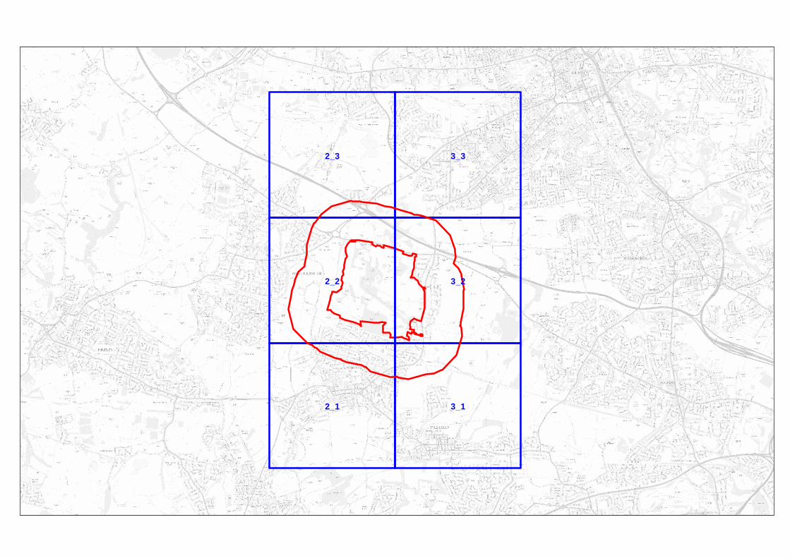
3_3
3_2
3_1
2_3
2_2
2_1

6_5
6_4
6_3
6_2
6_1
5_5
5_4
5_3
5_2
5_1
4_6
4_5
4_4
4_3
4_2
4_1
3_6
3_3
3_2
2_6
2_5
2_4
2_3
2_2
1_3
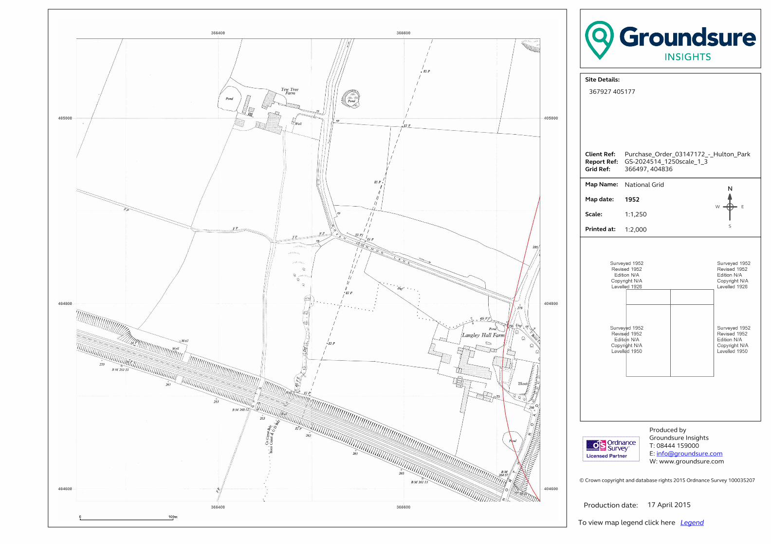
� ���������������� ���������������������������������������������������������������� �!������!�"#$%�&������'������$###(%"#)��� �������������������*+,-./-,0+123.���......41+-5,.6-73...6-89:,.6-73..�;:+<.6-73�� .�=08.>0?-3.. . . .�=08.<0,-3.. �.*@01-3....A:+5,-<.0,3.������ ��������� ���B����!����C!���!�� �#DEEE�$%F###�G �H�I�����!���J�����K ����J�����!���J������N
EW
S
367927 405177
Purchase_Order_03147172_-_Hulton_Park
GS-2024514_1250scale_1_3
366497, 404836
National Grid
1952
1:1,250
1:2,000
17 April 2015

� ���������������� ���������������������������������������������������������������� �!������!�"#$%�&������'������$###(%"#)��� �������������������*+,-./-,0+123.���......41+-5,.6-73...6-89:,.6-73..�;:+<.6-73�� .�=08.>0?-3.. . . .�=08.<0,-3.. �.*@01-3....A:+5,-<.0,3.������ ��������� ���B����!����C!���!�� �#DEEE�$%F###�G �H�I�����!���J�����K ����J�����!���J������N
EW
S
367927 405177
Purchase_Order_03147172_-_Hulton_Park
GS-2024514_1250scale_1_3
366497, 404836
National Grid
1974
1:1,250
1:2,000
17 April 2015

� ���������������� ���������������������������������������������������������������� �!������!�"#$%�&������'������$###(%"#)��� �������������������*+,-./-,0+123.���......41+-5,.6-73...6-89:,.6-73..�;:+<.6-73�� .�=08.>0?-3.. . . .�=08.<0,-3.. �.*@01-3....A:+5,-<.0,3.������ ��������� ���B����!����C!���!�� �#DEEE�$%F###�G �H�I�����!���J�����K ����J�����!���J������N
EW
S
367927 405177
Purchase_Order_03147172_-_Hulton_Park
GS-2024514_1250scale_1_3
366497, 404836
National Grid
1992
1:1,250
1:2,000
17 April 2015
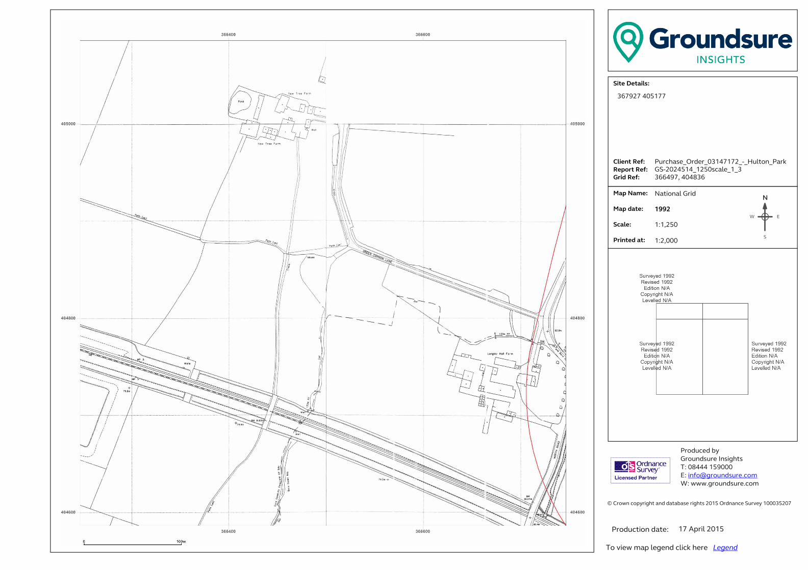
� ���������������� ���������������������������������������������������������������� �!������!�"#$%�&������'������$###(%"#)��� �������������������*+,-./-,0+123.���......41+-5,.6-73...6-89:,.6-73..�;:+<.6-73�� .�=08.>0?-3.. . . .�=08.<0,-3.. �.*@01-3....A:+5,-<.0,3.������ ��������� ���B����!����C!���!�� �#DEEE�$%F###�G �H�I�����!���J�����K ����J�����!���J������N
EW
S
367927 405177
Purchase_Order_03147172_-_Hulton_Park
GS-2024514_1250scale_1_3
366497, 404836
National Grid
1992
1:1,250
1:2,000
17 April 2015
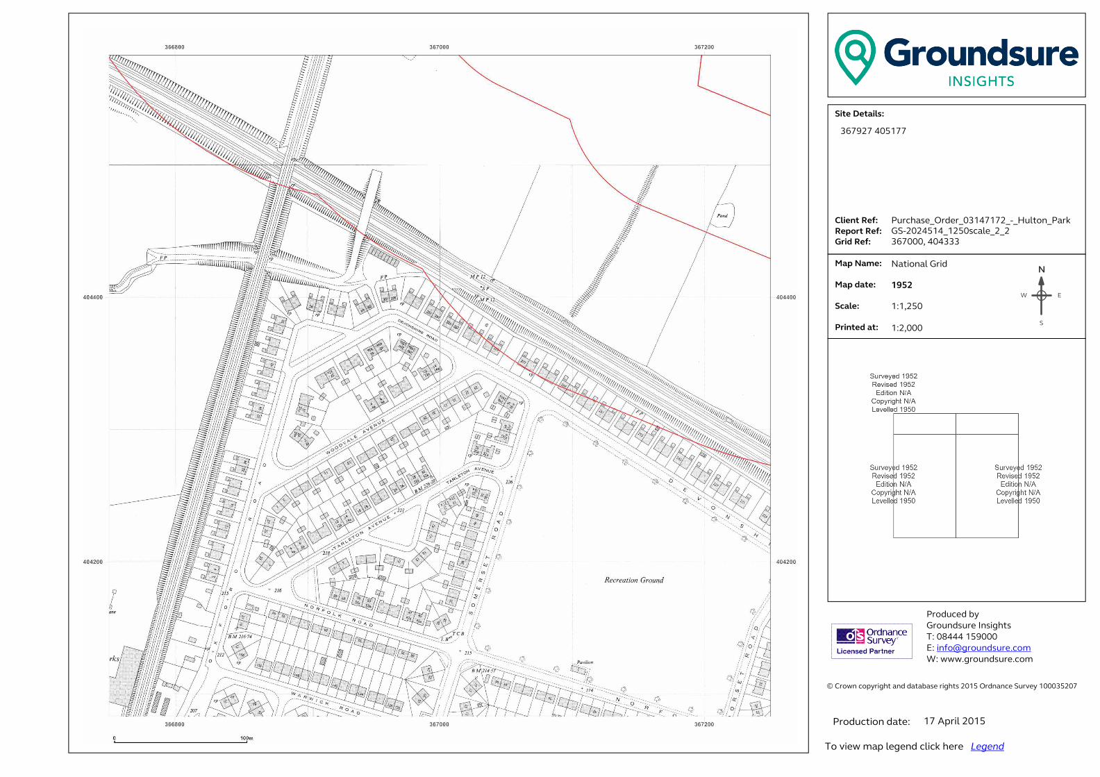
� ���������������� ���������������������������������������������������������������� �!������!�"#$%�&������'������$###(%"#)��� �������������������*+,-./-,0+123.���......41+-5,.6-73...6-89:,.6-73..�;:+<.6-73�� .�=08.>0?-3.. . . .�=08.<0,-3.. �.*@01-3....A:+5,-<.0,3.������ ��������� ���B����!����C!���!�� �#DEEE�$%F###�G �H�I�����!���J�����K ����J�����!���J������N
EW
S
367927 405177
Purchase_Order_03147172_-_Hulton_Park
GS-2024514_1250scale_2_2
367000, 404333
National Grid
1952
1:1,250
1:2,000
17 April 2015

� ���������������� ���������������������������������������������������������������� �!������!�"#$%�&������'������$###(%"#)��� �������������������*+,-./-,0+123.���......41+-5,.6-73...6-89:,.6-73..�;:+<.6-73�� .�=08.>0?-3.. . . .�=08.<0,-3.. �.*@01-3....A:+5,-<.0,3.������ ��������� ���B����!����C!���!�� �#DEEE�$%F###�G �H�I�����!���J�����K ����J�����!���J������N
EW
S
367927 405177
Purchase_Order_03147172_-_Hulton_Park
GS-2024514_1250scale_2_2
367000, 404333
National Grid
1960
1:1,250
1:2,000
17 April 2015
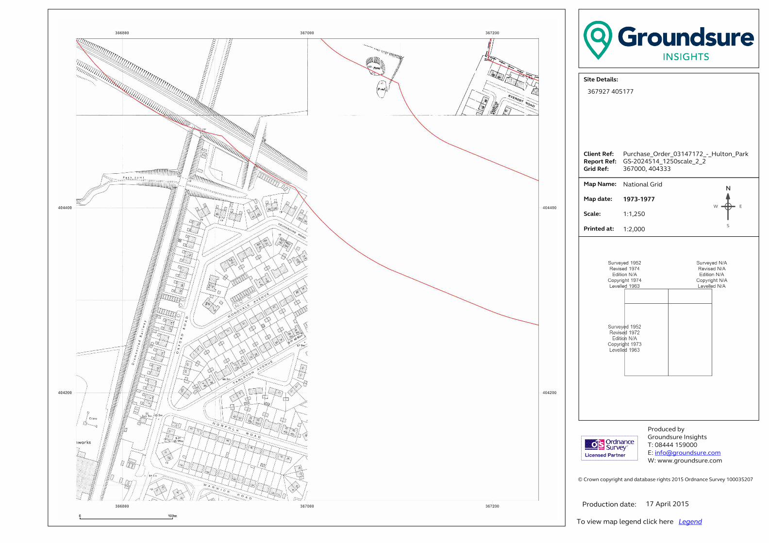
� ���������������� ���������������������������������������������������������������� �!������!�"#$%�&������'������$###(%"#)��� �������������������*+,-./-,0+123.���......41+-5,.6-73...6-89:,.6-73..�;:+<.6-73�� .�=08.>0?-3.. . . .�=08.<0,-3.. �.*@01-3....A:+5,-<.0,3.������ ��������� ���B����!����C!���!�� �#DEEE�$%F###�G �H�I�����!���J�����K ����J�����!���J������N
EW
S
367927 405177
Purchase_Order_03147172_-_Hulton_Park
GS-2024514_1250scale_2_2
367000, 404333
National Grid
1973-1977
1:1,250
1:2,000
17 April 2015
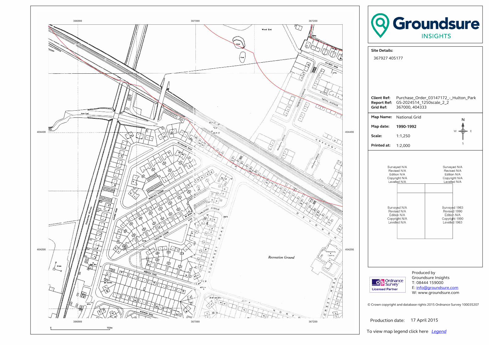
� ���������������� ���������������������������������������������������������������� �!������!�"#$%�&������'������$###(%"#)��� �������������������*+,-./-,0+123.���......41+-5,.6-73...6-89:,.6-73..�;:+<.6-73�� .�=08.>0?-3.. . . .�=08.<0,-3.. �.*@01-3....A:+5,-<.0,3.������ ��������� ���B����!����C!���!�� �#DEEE�$%F###�G �H�I�����!���J�����K ����J�����!���J������N
EW
S
367927 405177
Purchase_Order_03147172_-_Hulton_Park
GS-2024514_1250scale_2_2
367000, 404333
National Grid
1990-1992
1:1,250
1:2,000
17 April 2015

� ���������������� ���������������������������������������������������������������� �!������!�"#$%�&������'������$###(%"#)��� �������������������*+,-./-,0+123.���......41+-5,.6-73...6-89:,.6-73..�;:+<.6-73�� .�=08.>0?-3.. . . .�=08.<0,-3.. �.*@01-3....A:+5,-<.0,3.������ ��������� ���B����!����C!���!�� �#DEEE�$%F###�G �H�I�����!���J�����K ����J�����!���J������N
EW
S
367927 405177
Purchase_Order_03147172_-_Hulton_Park
GS-2024514_1250scale_2_2
367000, 404333
National Grid
1992-1993
1:1,250
1:2,000
17 April 2015
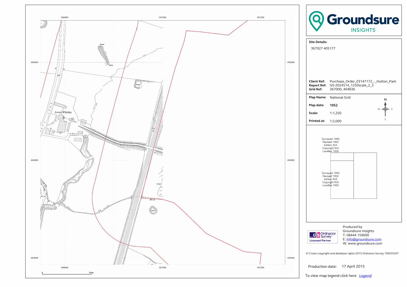
� ���������������� ���������������������������������������������������������������� �!������!�"#$%�&������'������$###(%"#)��� �������������������*+,-./-,0+123.���......41+-5,.6-73...6-89:,.6-73..�;:+<.6-73�� .�=08.>0?-3.. . . .�=08.<0,-3.. �.*@01-3....A:+5,-<.0,3.������ ��������� ���B����!����C!���!�� �#DEEE�$%F###�G �H�I�����!���J�����K ����J�����!���J������N
EW
S
367927 405177
Purchase_Order_03147172_-_Hulton_Park
GS-2024514_1250scale_2_3
367000, 404836
National Grid
1952
1:1,250
1:2,000
17 April 2015
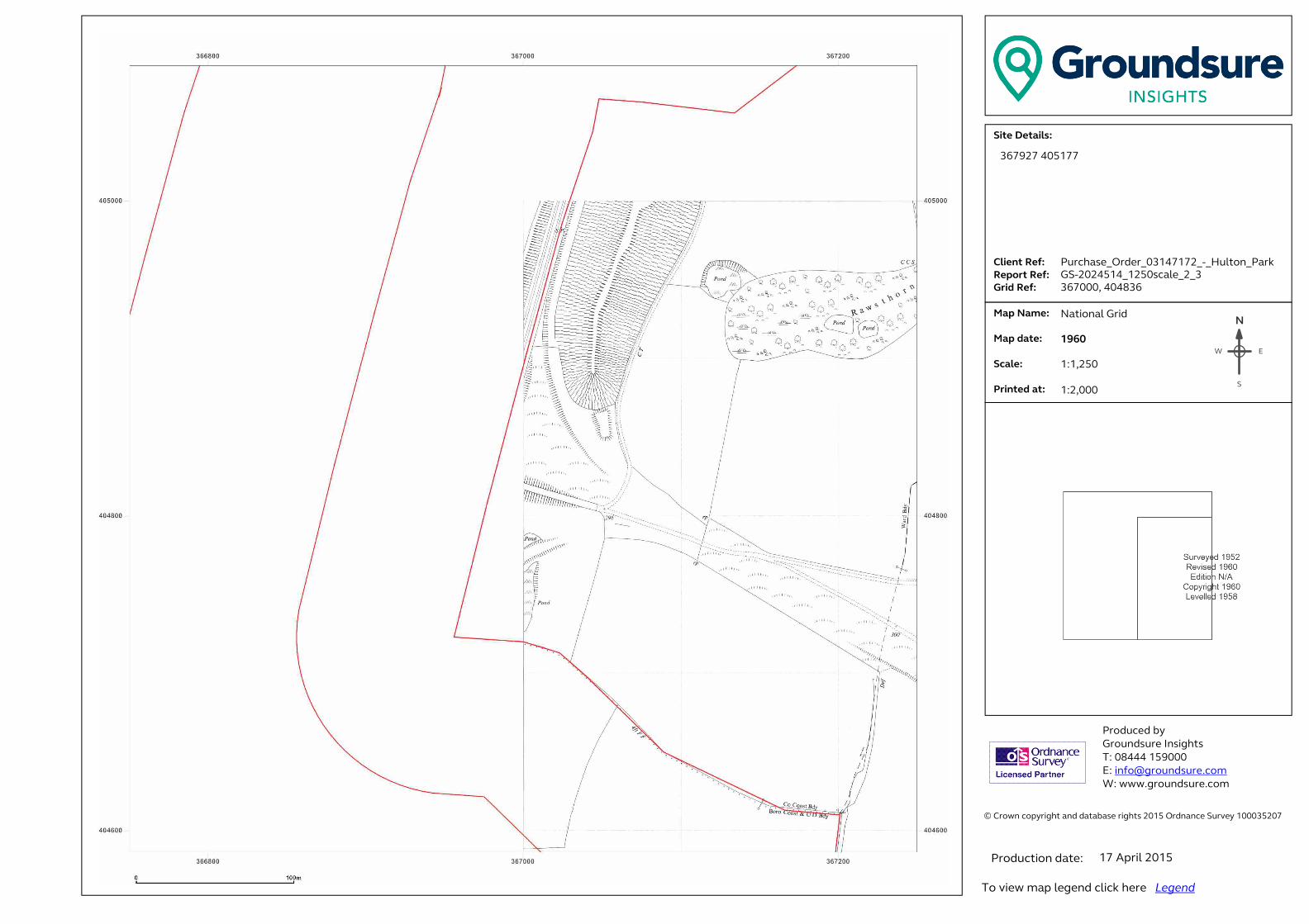
� ���������������� ���������������������������������������������������������������� �!������!�"#$%�&������'������$###(%"#)��� �������������������*+,-./-,0+123.���......41+-5,.6-73...6-89:,.6-73..�;:+<.6-73�� .�=08.>0?-3.. . . .�=08.<0,-3.. �.*@01-3....A:+5,-<.0,3.������ ��������� ���B����!����C!���!�� �#DEEE�$%F###�G �H�I�����!���J�����K ����J�����!���J������N
EW
S
367927 405177
Purchase_Order_03147172_-_Hulton_Park
GS-2024514_1250scale_2_3
367000, 404836
National Grid
1960
1:1,250
1:2,000
17 April 2015

� ���������������� ���������������������������������������������������������������� �!������!�"#$%�&������'������$###(%"#)��� �������������������*+,-./-,0+123.���......41+-5,.6-73...6-89:,.6-73..�;:+<.6-73�� .�=08.>0?-3.. . . .�=08.<0,-3.. �.*@01-3....A:+5,-<.0,3.������ ��������� ���B����!����C!���!�� �#DEEE�$%F###�G �H�I�����!���J�����K ����J�����!���J������N
EW
S
367927 405177
Purchase_Order_03147172_-_Hulton_Park
GS-2024514_1250scale_2_3
367000, 404836
National Grid
1974-1977
1:1,250
1:2,000
17 April 2015
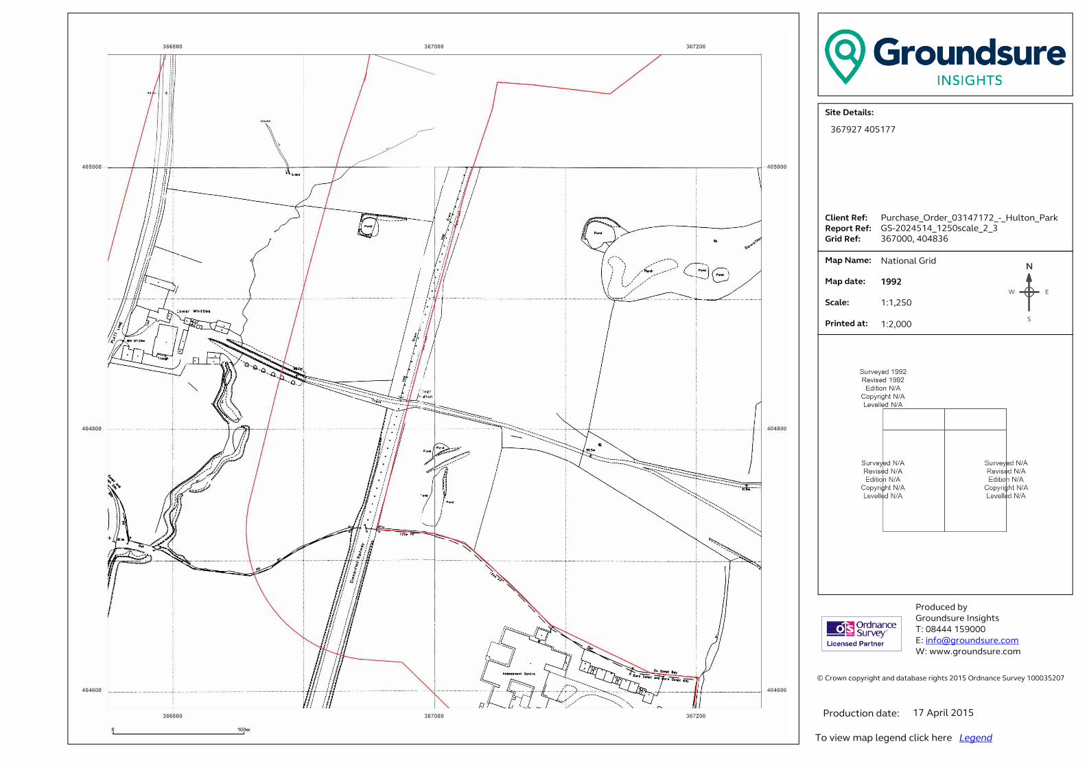
� ���������������� ���������������������������������������������������������������� �!������!�"#$%�&������'������$###(%"#)��� �������������������*+,-./-,0+123.���......41+-5,.6-73...6-89:,.6-73..�;:+<.6-73�� .�=08.>0?-3.. . . .�=08.<0,-3.. �.*@01-3....A:+5,-<.0,3.������ ��������� ���B����!����C!���!�� �#DEEE�$%F###�G �H�I�����!���J�����K ����J�����!���J������N
EW
S
367927 405177
Purchase_Order_03147172_-_Hulton_Park
GS-2024514_1250scale_2_3
367000, 404836
National Grid
1992
1:1,250
1:2,000
17 April 2015
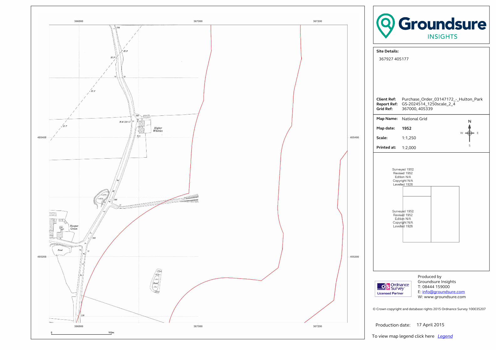
� ���������������� ���������������������������������������������������������������� �!������!�"#$%�&������'������$###(%"#)��� �������������������*+,-./-,0+123.���......41+-5,.6-73...6-89:,.6-73..�;:+<.6-73�� .�=08.>0?-3.. . . .�=08.<0,-3.. �.*@01-3....A:+5,-<.0,3.������ ��������� ���B����!����C!���!�� �#DEEE�$%F###�G �H�I�����!���J�����K ����J�����!���J������N
EW
S
367927 405177
Purchase_Order_03147172_-_Hulton_Park
GS-2024514_1250scale_2_4
367000, 405339
National Grid
1952
1:1,250
1:2,000
17 April 2015
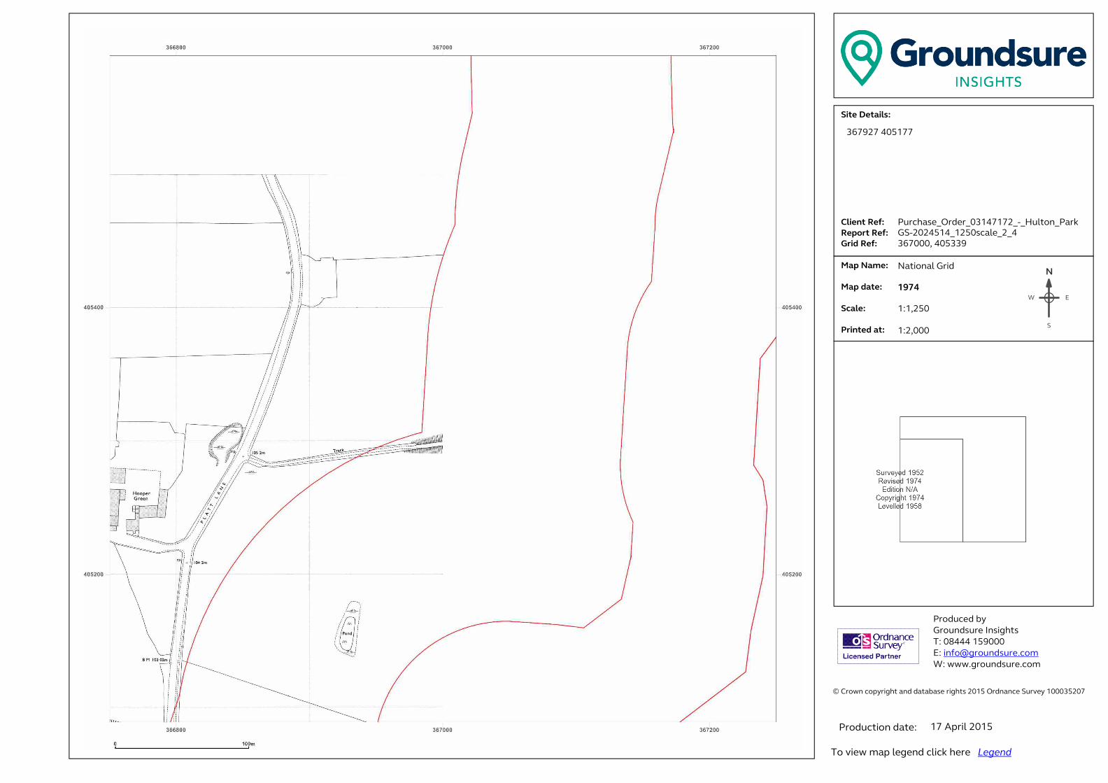
� ���������������� ���������������������������������������������������������������� �!������!�"#$%�&������'������$###(%"#)��� �������������������*+,-./-,0+123.���......41+-5,.6-73...6-89:,.6-73..�;:+<.6-73�� .�=08.>0?-3.. . . .�=08.<0,-3.. �.*@01-3....A:+5,-<.0,3.������ ��������� ���B����!����C!���!�� �#DEEE�$%F###�G �H�I�����!���J�����K ����J�����!���J������N
EW
S
367927 405177
Purchase_Order_03147172_-_Hulton_Park
GS-2024514_1250scale_2_4
367000, 405339
National Grid
1974
1:1,250
1:2,000
17 April 2015

� ���������������� ���������������������������������������������������������������� �!������!�"#$%�&������'������$###(%"#)��� �������������������*+,-./-,0+123.���......41+-5,.6-73...6-89:,.6-73..�;:+<.6-73�� .�=08.>0?-3.. . . .�=08.<0,-3.. �.*@01-3....A:+5,-<.0,3.������ ��������� ���B����!����C!���!�� �#DEEE�$%F###�G �H�I�����!���J�����K ����J�����!���J������N
EW
S
367927 405177
Purchase_Order_03147172_-_Hulton_Park
GS-2024514_1250scale_2_4
367000, 405339
National Grid
1989-1992
1:1,250
1:2,000
17 April 2015

� ���������������� ���������������������������������������������������������������� �!������!�"#$%�&������'������$###(%"#)��� �������������������*+,-./-,0+123.���......41+-5,.6-73...6-89:,.6-73..�;:+<.6-73�� .�=08.>0?-3.. . . .�=08.<0,-3.. �.*@01-3....A:+5,-<.0,3.������ ��������� ���B����!����C!���!�� �#DEEE�$%F###�G �H�I�����!���J�����K ����J�����!���J������N
EW
S
367927 405177
Purchase_Order_03147172_-_Hulton_Park
GS-2024514_1250scale_2_5
367000, 405842
National Grid
1952
1:1,250
1:2,000
17 April 2015

� ���������������� ���������������������������������������������������������������� �!������!�"#$%�&������'������$###(%"#)��� �������������������*+,-./-,0+123.���......41+-5,.6-73...6-89:,.6-73..�;:+<.6-73�� .�=08.>0?-3.. . . .�=08.<0,-3.. �.*@01-3....A:+5,-<.0,3.������ ��������� ���B����!����C!���!�� �#DEEE�$%F###�G �H�I�����!���J�����K ����J�����!���J������N
EW
S
367927 405177
Purchase_Order_03147172_-_Hulton_Park
GS-2024514_1250scale_2_5
367000, 405842
National Grid
1988-1989
1:1,250
1:2,000
17 April 2015

� ���������������� ���������������������������������������������������������������� �!������!�"#$%�&������'������$###(%"#)��� �������������������*+,-./-,0+123.���......41+-5,.6-73...6-89:,.6-73..�;:+<.6-73�� .�=08.>0?-3.. . . .�=08.<0,-3.. �.*@01-3....A:+5,-<.0,3.������ ��������� ���B����!����C!���!�� �#DEEE�$%F###�G �H�I�����!���J�����K ����J�����!���J������N
EW
S
367927 405177
Purchase_Order_03147172_-_Hulton_Park
GS-2024514_1250scale_2_5
367000, 405842
National Grid
1990-1992
1:1,250
1:2,000
17 April 2015
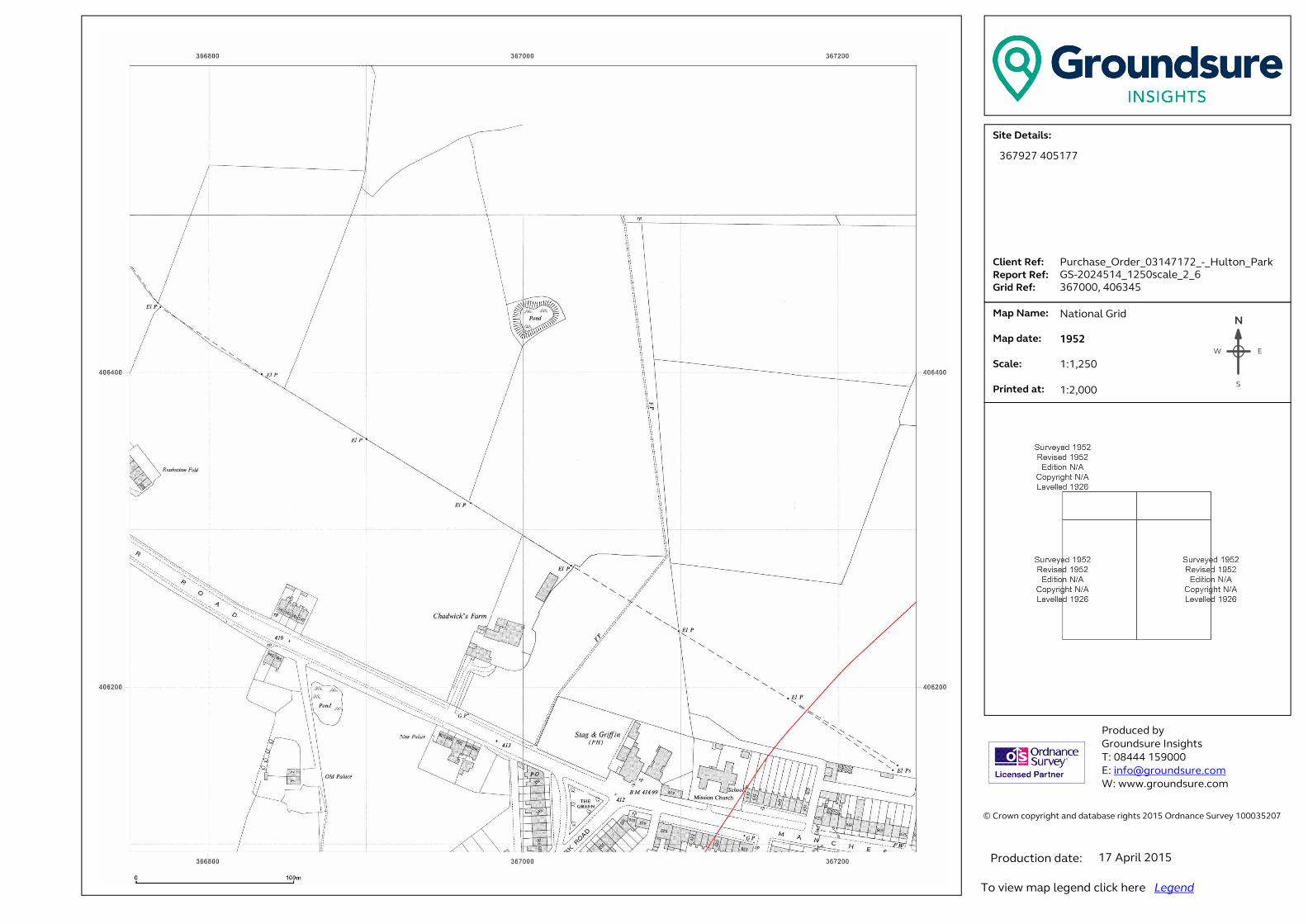
� ���������������� ���������������������������������������������������������������� �!������!�"#$%�&������'������$###(%"#)��� �������������������*+,-./-,0+123.���......41+-5,.6-73...6-89:,.6-73..�;:+<.6-73�� .�=08.>0?-3.. . . .�=08.<0,-3.. �.*@01-3....A:+5,-<.0,3.������ ��������� ���B����!����C!���!�� �#DEEE�$%F###�G �H�I�����!���J�����K ����J�����!���J������N
EW
S
367927 405177
Purchase_Order_03147172_-_Hulton_Park
GS-2024514_1250scale_2_6
367000, 406345
National Grid
1952
1:1,250
1:2,000
17 April 2015
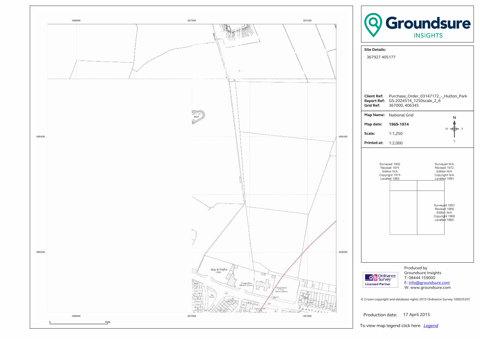
� ���������������� ���������������������������������������������������������������� �!������!�"#$%�&������'������$###(%"#)��� �������������������*+,-./-,0+123.���......41+-5,.6-73...6-89:,.6-73..�;:+<.6-73�� .�=08.>0?-3.. . . .�=08.<0,-3.. �.*@01-3....A:+5,-<.0,3.������ ��������� ���B����!����C!���!�� �#DEEE�$%F###�G �H�I�����!���J�����K ����J�����!���J������N
EW
S
367927 405177
Purchase_Order_03147172_-_Hulton_Park
GS-2024514_1250scale_2_6
367000, 406345
National Grid
1969-1974
1:1,250
1:2,000
17 April 2015
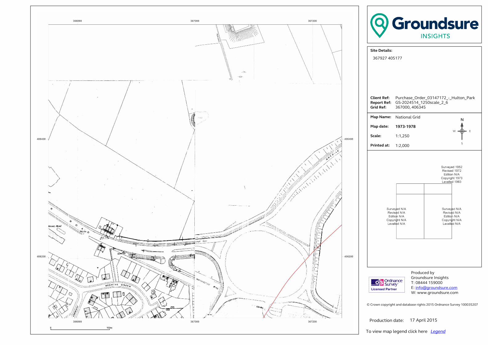
� ���������������� ���������������������������������������������������������������� �!������!�"#$%�&������'������$###(%"#)��� �������������������*+,-./-,0+123.���......41+-5,.6-73...6-89:,.6-73..�;:+<.6-73�� .�=08.>0?-3.. . . .�=08.<0,-3.. �.*@01-3....A:+5,-<.0,3.������ ��������� ���B����!����C!���!�� �#DEEE�$%F###�G �H�I�����!���J�����K ����J�����!���J������N
EW
S
367927 405177
Purchase_Order_03147172_-_Hulton_Park
GS-2024514_1250scale_2_6
367000, 406345
National Grid
1973-1978
1:1,250
1:2,000
17 April 2015

� ���������������� ���������������������������������������������������������������� �!������!�"#$%�&������'������$###(%"#)��� �������������������*+,-./-,0+123.���......41+-5,.6-73...6-89:,.6-73..�;:+<.6-73�� .�=08.>0?-3.. . . .�=08.<0,-3.. �.*@01-3....A:+5,-<.0,3.������ ��������� ���B����!����C!���!�� �#DEEE�$%F###�G �H�I�����!���J�����K ����J�����!���J������N
EW
S
367927 405177
Purchase_Order_03147172_-_Hulton_Park
GS-2024514_1250scale_2_6
367000, 406345
National Grid
1992
1:1,250
1:2,000
17 April 2015
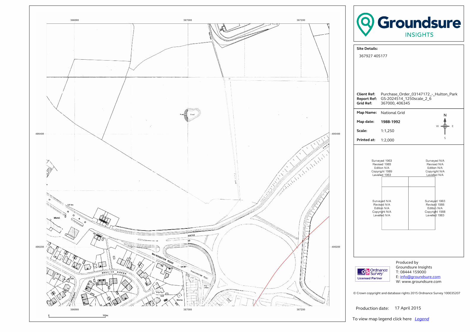
� ���������������� ���������������������������������������������������������������� �!������!�"#$%�&������'������$###(%"#)��� �������������������*+,-./-,0+123.���......41+-5,.6-73...6-89:,.6-73..�;:+<.6-73�� .�=08.>0?-3.. . . .�=08.<0,-3.. �.*@01-3....A:+5,-<.0,3.������ ��������� ���B����!����C!���!�� �#DEEE�$%F###�G �H�I�����!���J�����K ����J�����!���J������N
EW
S
367927 405177
Purchase_Order_03147172_-_Hulton_Park
GS-2024514_1250scale_2_6
367000, 406345
National Grid
1988-1992
1:1,250
1:2,000
17 April 2015
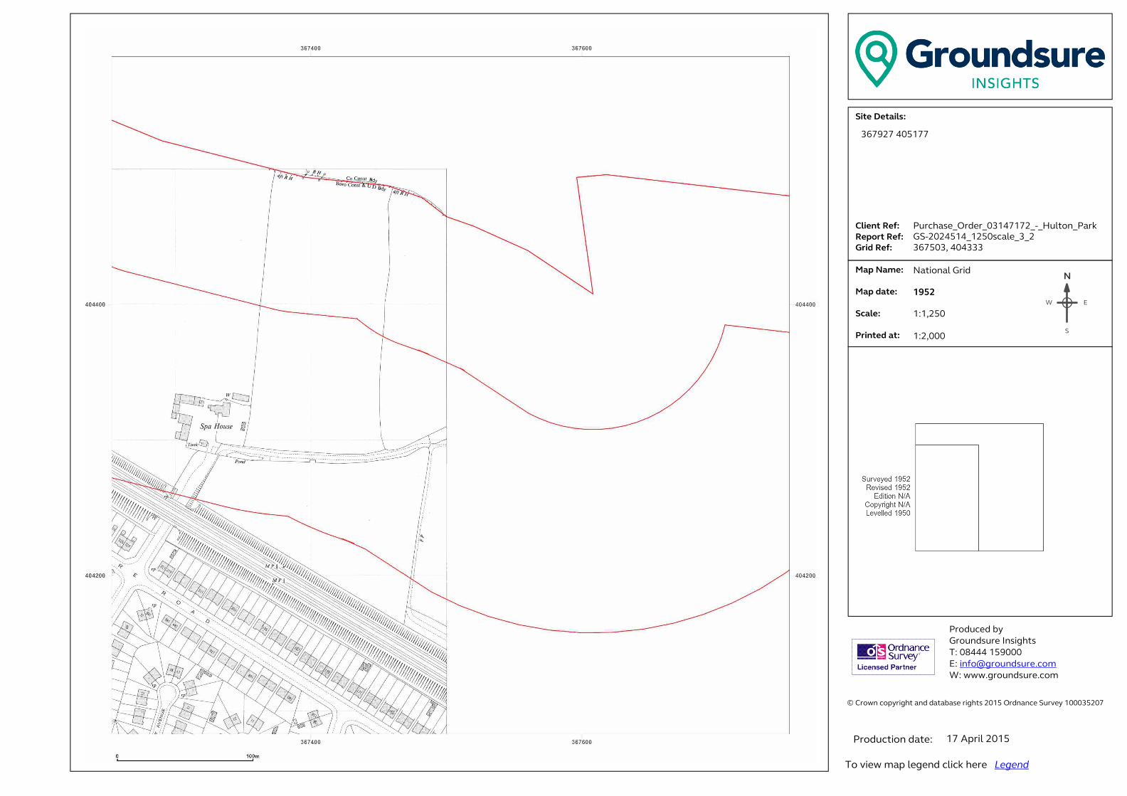
� ���������������� ���������������������������������������������������������������� �!������!�"#$%�&������'������$###(%"#)��� �������������������*+,-./-,0+123.���......41+-5,.6-73...6-89:,.6-73..�;:+<.6-73�� .�=08.>0?-3.. . . .�=08.<0,-3.. �.*@01-3....A:+5,-<.0,3.������ ��������� ���B����!����C!���!�� �#DEEE�$%F###�G �H�I�����!���J�����K ����J�����!���J������N
EW
S
367927 405177
Purchase_Order_03147172_-_Hulton_Park
GS-2024514_1250scale_3_2
367503, 404333
National Grid
1952
1:1,250
1:2,000
17 April 2015

� ���������������� ���������������������������������������������������������������� �!������!�"#$%�&������'������$###(%"#)��� �������������������*+,-./-,0+123.���......41+-5,.6-73...6-89:,.6-73..�;:+<.6-73�� .�=08.>0?-3.. . . .�=08.<0,-3.. �.*@01-3....A:+5,-<.0,3.������ ��������� ���B����!����C!���!�� �#DEEE�$%F###�G �H�I�����!���J�����K ����J�����!���J������N
EW
S
367927 405177
Purchase_Order_03147172_-_Hulton_Park
GS-2024514_1250scale_3_2
367503, 404333
National Grid
1953
1:1,250
1:2,000
17 April 2015

� ���������������� ���������������������������������������������������������������� �!������!�"#$%�&������'������$###(%"#)��� �������������������*+,-./-,0+123.���......41+-5,.6-73...6-89:,.6-73..�;:+<.6-73�� .�=08.>0?-3.. . . .�=08.<0,-3.. �.*@01-3....A:+5,-<.0,3.������ ��������� ���B����!����C!���!�� �#DEEE�$%F###�G �H�I�����!���J�����K ����J�����!���J������N
EW
S
367927 405177
Purchase_Order_03147172_-_Hulton_Park
GS-2024514_1250scale_3_2
367503, 404333
National Grid
1960
1:1,250
1:2,000
17 April 2015
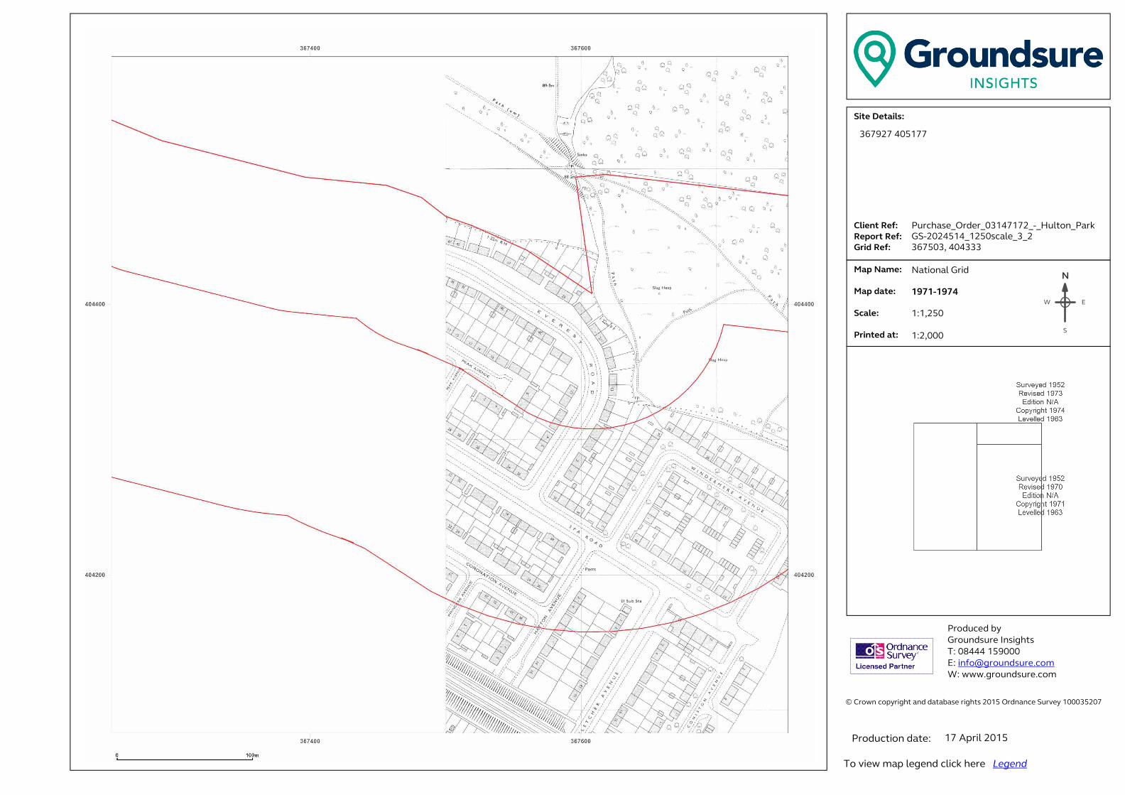
� ���������������� ���������������������������������������������������������������� �!������!�"#$%�&������'������$###(%"#)��� �������������������*+,-./-,0+123.���......41+-5,.6-73...6-89:,.6-73..�;:+<.6-73�� .�=08.>0?-3.. . . .�=08.<0,-3.. �.*@01-3....A:+5,-<.0,3.������ ��������� ���B����!����C!���!�� �#DEEE�$%F###�G �H�I�����!���J�����K ����J�����!���J������N
EW
S
367927 405177
Purchase_Order_03147172_-_Hulton_Park
GS-2024514_1250scale_3_2
367503, 404333
National Grid
1971-1974
1:1,250
1:2,000
17 April 2015

� ���������������� ���������������������������������������������������������������� �!������!�"#$%�&������'������$###(%"#)��� �������������������*+,-./-,0+123.���......41+-5,.6-73...6-89:,.6-73..�;:+<.6-73�� .�=08.>0?-3.. . . .�=08.<0,-3.. �.*@01-3....A:+5,-<.0,3.������ ��������� ���B����!����C!���!�� �#DEEE�$%F###�G �H�I�����!���J�����K ����J�����!���J������N
EW
S
367927 405177
Purchase_Order_03147172_-_Hulton_Park
GS-2024514_1250scale_3_2
367503, 404333
National Grid
1977-1979
1:1,250
1:2,000
17 April 2015
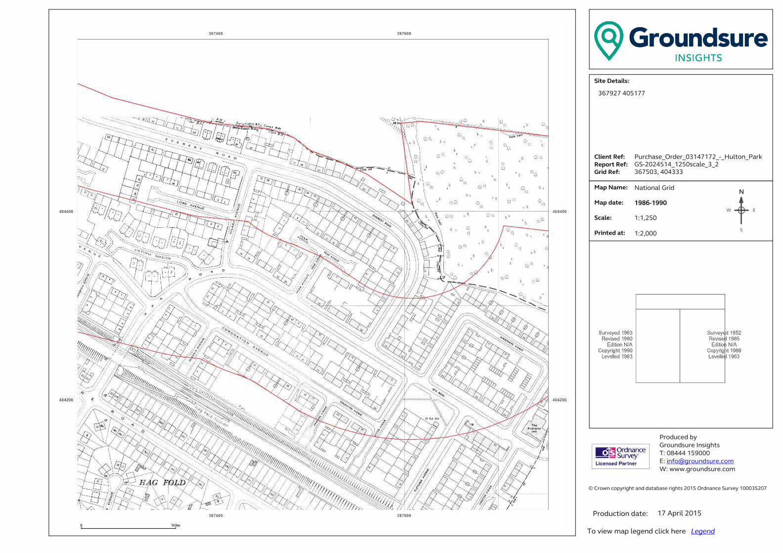
� ���������������� ���������������������������������������������������������������� �!������!�"#$%�&������'������$###(%"#)��� �������������������*+,-./-,0+123.���......41+-5,.6-73...6-89:,.6-73..�;:+<.6-73�� .�=08.>0?-3.. . . .�=08.<0,-3.. �.*@01-3....A:+5,-<.0,3.������ ��������� ���B����!����C!���!�� �#DEEE�$%F###�G �H�I�����!���J�����K ����J�����!���J������N
EW
S
367927 405177
Purchase_Order_03147172_-_Hulton_Park
GS-2024514_1250scale_3_2
367503, 404333
National Grid
1986-1990
1:1,250
1:2,000
17 April 2015

� ���������������� ���������������������������������������������������������������� �!������!�"#$%�&������'������$###(%"#)��� �������������������*+,-./-,0+123.���......41+-5,.6-73...6-89:,.6-73..�;:+<.6-73�� .�=08.>0?-3.. . . .�=08.<0,-3.. �.*@01-3....A:+5,-<.0,3.������ ��������� ���B����!����C!���!�� �#DEEE�$%F###�G �H�I�����!���J�����K ����J�����!���J������N
EW
S
367927 405177
Purchase_Order_03147172_-_Hulton_Park
GS-2024514_1250scale_3_2
367503, 404333
National Grid
1992
1:1,250
1:2,000
17 April 2015

� ���������������� ���������������������������������������������������������������� �!������!�"#$%�&������'������$###(%"#)��� �������������������*+,-./-,0+123.���......41+-5,.6-73...6-89:,.6-73..�;:+<.6-73�� .�=08.>0?-3.. . . .�=08.<0,-3.. �.*@01-3....A:+5,-<.0,3.������ ��������� ���B����!����C!���!�� �#DEEE�$%F###�G �H�I�����!���J�����K ����J�����!���J������N
EW
S
367927 405177
Purchase_Order_03147172_-_Hulton_Park
GS-2024514_1250scale_3_2
367503, 404333
National Grid
1994
1:1,250
1:2,000
17 April 2015
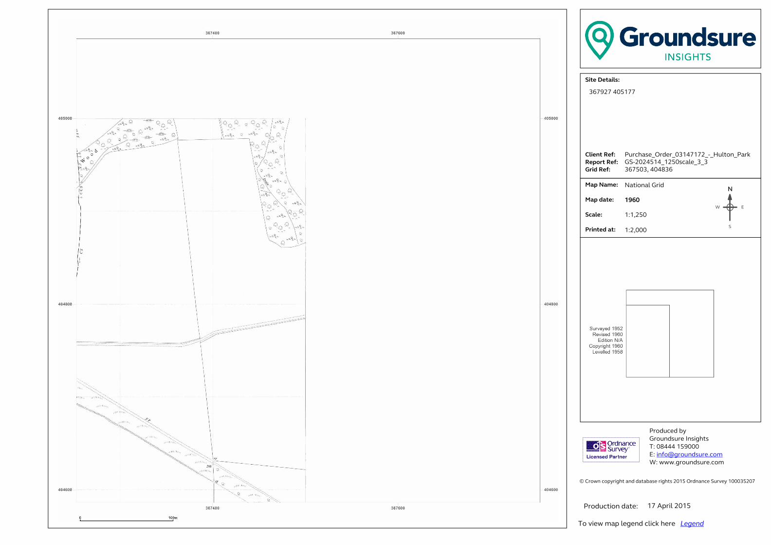
� ���������������� ���������������������������������������������������������������� �!������!�"#$%�&������'������$###(%"#)��� �������������������*+,-./-,0+123.���......41+-5,.6-73...6-89:,.6-73..�;:+<.6-73�� .�=08.>0?-3.. . . .�=08.<0,-3.. �.*@01-3....A:+5,-<.0,3.������ ��������� ���B����!����C!���!�� �#DEEE�$%F###�G �H�I�����!���J�����K ����J�����!���J������N
EW
S
367927 405177
Purchase_Order_03147172_-_Hulton_Park
GS-2024514_1250scale_3_3
367503, 404836
National Grid
1960
1:1,250
1:2,000
17 April 2015
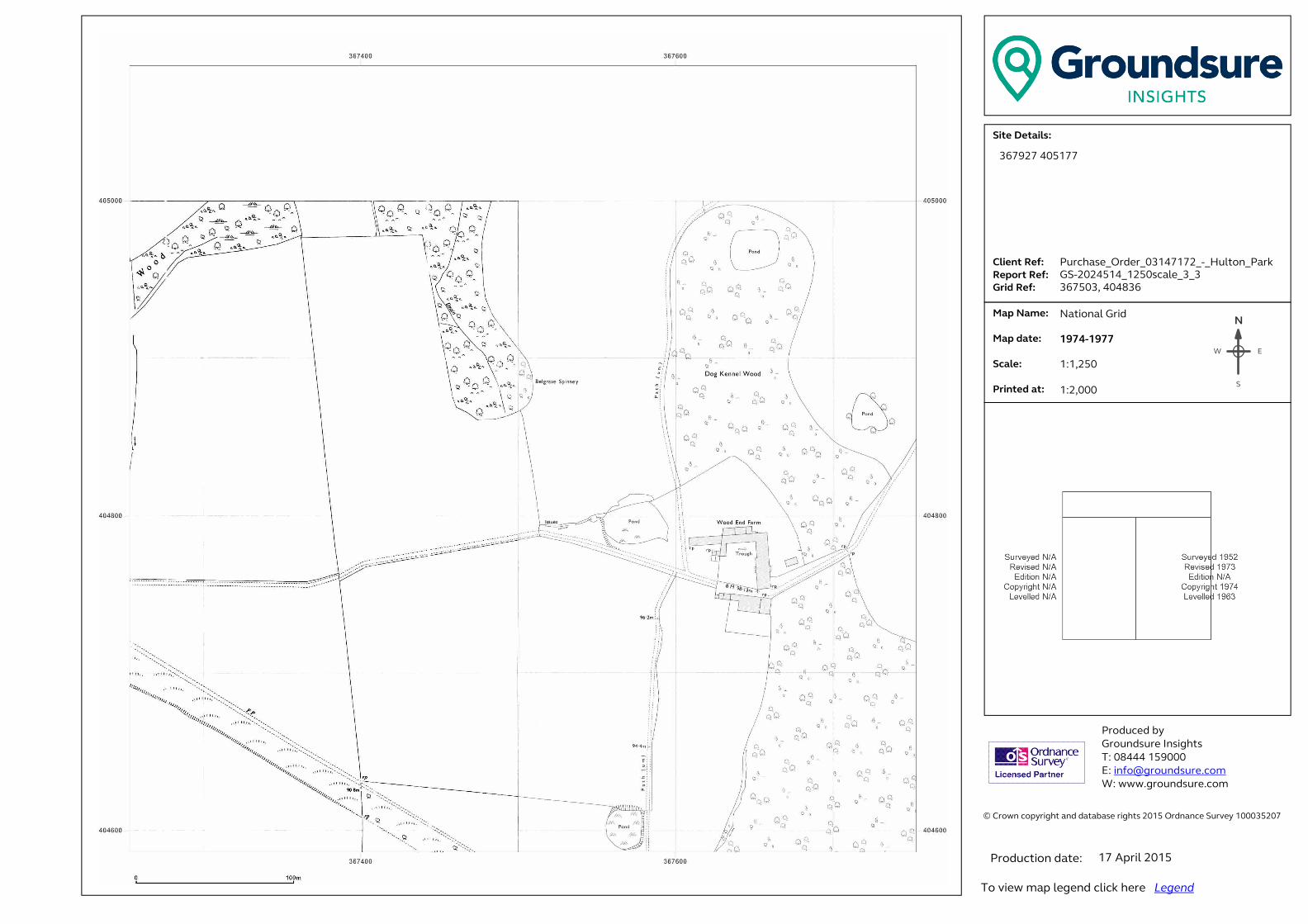
� ���������������� ���������������������������������������������������������������� �!������!�"#$%�&������'������$###(%"#)��� �������������������*+,-./-,0+123.���......41+-5,.6-73...6-89:,.6-73..�;:+<.6-73�� .�=08.>0?-3.. . . .�=08.<0,-3.. �.*@01-3....A:+5,-<.0,3.������ ��������� ���B����!����C!���!�� �#DEEE�$%F###�G �H�I�����!���J�����K ����J�����!���J������N
EW
S
367927 405177
Purchase_Order_03147172_-_Hulton_Park
GS-2024514_1250scale_3_3
367503, 404836
National Grid
1974-1977
1:1,250
1:2,000
17 April 2015

� ���������������� ���������������������������������������������������������������� �!������!�"#$%�&������'������$###(%"#)��� �������������������*+,-./-,0+123.���......41+-5,.6-73...6-89:,.6-73..�;:+<.6-73�� .�=08.>0?-3.. . . .�=08.<0,-3.. �.*@01-3....A:+5,-<.0,3.������ ��������� ���B����!����C!���!�� �#DEEE�$%F###�G �H�I�����!���J�����K ����J�����!���J������N
EW
S
367927 405177
Purchase_Order_03147172_-_Hulton_Park
GS-2024514_1250scale_3_3
367503, 404836
National Grid
1992
1:1,250
1:2,000
17 April 2015

� ���������������� ���������������������������������������������������������������� �!������!�"#$%�&������'������$###(%"#)��� �������������������*+,-./-,0+123.���......41+-5,.6-73...6-89:,.6-73..�;:+<.6-73�� .�=08.>0?-3.. . . .�=08.<0,-3.. �.*@01-3....A:+5,-<.0,3.������ ��������� ���B����!����C!���!�� �#DEEE�$%F###�G �H�I�����!���J�����K ����J�����!���J������N
EW
S
367927 405177
Purchase_Order_03147172_-_Hulton_Park
GS-2024514_1250scale_3_6
367503, 406345
National Grid
1952
1:1,250
1:2,000
17 April 2015
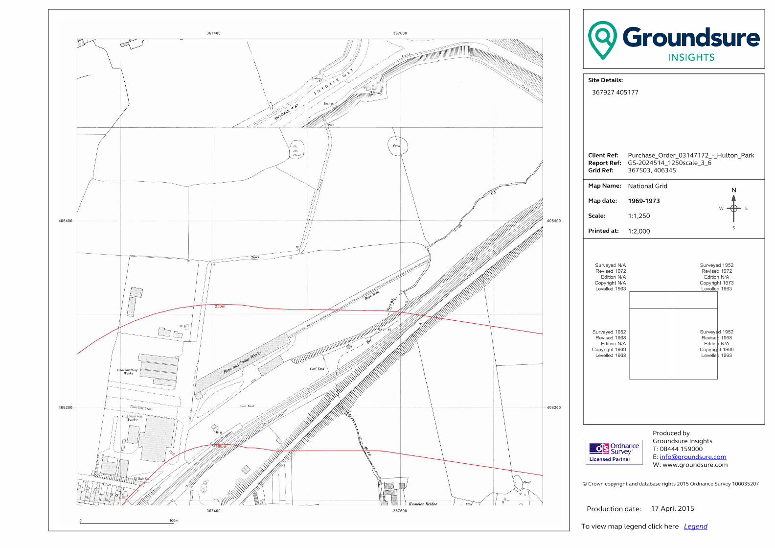
� ���������������� ���������������������������������������������������������������� �!������!�"#$%�&������'������$###(%"#)��� �������������������*+,-./-,0+123.���......41+-5,.6-73...6-89:,.6-73..�;:+<.6-73�� .�=08.>0?-3.. . . .�=08.<0,-3.. �.*@01-3....A:+5,-<.0,3.������ ��������� ���B����!����C!���!�� �#DEEE�$%F###�G �H�I�����!���J�����K ����J�����!���J������N
EW
S
367927 405177
Purchase_Order_03147172_-_Hulton_Park
GS-2024514_1250scale_3_6
367503, 406345
National Grid
1969-1973
1:1,250
1:2,000
17 April 2015
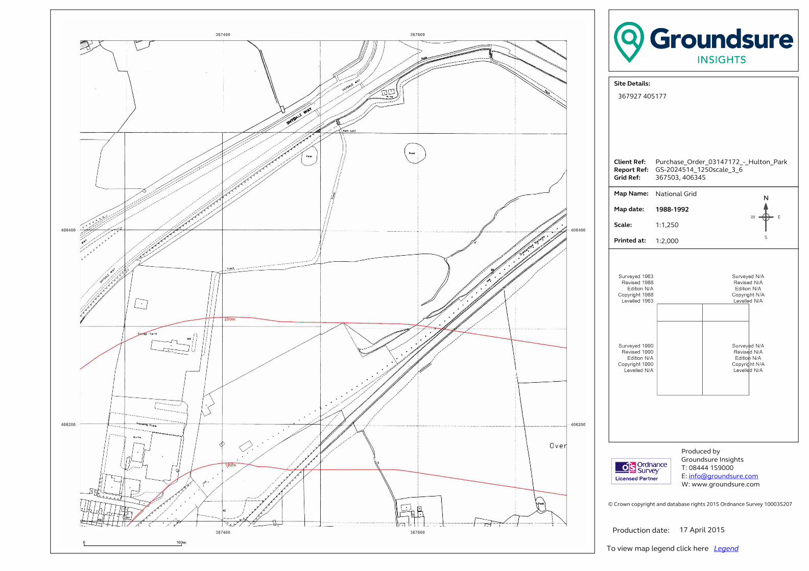
� ���������������� ���������������������������������������������������������������� �!������!�"#$%�&������'������$###(%"#)��� �������������������*+,-./-,0+123.���......41+-5,.6-73...6-89:,.6-73..�;:+<.6-73�� .�=08.>0?-3.. . . .�=08.<0,-3.. �.*@01-3....A:+5,-<.0,3.������ ��������� ���B����!����C!���!�� �#DEEE�$%F###�G �H�I�����!���J�����K ����J�����!���J������N
EW
S
367927 405177
Purchase_Order_03147172_-_Hulton_Park
GS-2024514_1250scale_3_6
367503, 406345
National Grid
1988-1992
1:1,250
1:2,000
17 April 2015

� ���������������� ���������������������������������������������������������������� �!������!�"#$%�&������'������$###(%"#)��� �������������������*+,-./-,0+123.���......41+-5,.6-73...6-89:,.6-73..�;:+<.6-73�� .�=08.>0?-3.. . . .�=08.<0,-3.. �.*@01-3....A:+5,-<.0,3.������ ��������� ���B����!����C!���!�� �#DEEE�$%F###�G �H�I�����!���J�����K ����J�����!���J������N
EW
S
367927 405177
Purchase_Order_03147172_-_Hulton_Park
GS-2024514_1250scale_3_6
367503, 406345
National Grid
1992
1:1,250
1:2,000
17 April 2015

� ���������������� ���������������������������������������������������������������� �!������!�"#$%�&������'������$###(%"#)��� �������������������*+,-./-,0+123.���......41+-5,.6-73...6-89:,.6-73..�;:+<.6-73�� .�=08.>0?-3.. . . .�=08.<0,-3.. �.*@01-3....A:+5,-<.0,3.������ ��������� ���B����!����C!���!�� �#DEEE�$%F###�G �H�I�����!���J�����K ����J�����!���J������N
EW
S
367927 405177
Purchase_Order_03147172_-_Hulton_Park
GS-2024514_1250scale_4_1
368006, 403830
National Grid
1952
1:1,250
1:2,000
17 April 2015

� ���������������� ���������������������������������������������������������������� �!������!�"#$%�&������'������$###(%"#)��� �������������������*+,-./-,0+123.���......41+-5,.6-73...6-89:,.6-73..�;:+<.6-73�� .�=08.>0?-3.. . . .�=08.<0,-3.. �.*@01-3....A:+5,-<.0,3.������ ��������� ���B����!����C!���!�� �#DEEE�$%F###�G �H�I�����!���J�����K ����J�����!���J������N
EW
S
367927 405177
Purchase_Order_03147172_-_Hulton_Park
GS-2024514_1250scale_4_1
368006, 403830
National Grid
1960-1963
1:1,250
1:2,000
17 April 2015

� ���������������� ���������������������������������������������������������������� �!������!�"#$%�&������'������$###(%"#)��� �������������������*+,-./-,0+123.���......41+-5,.6-73...6-89:,.6-73..�;:+<.6-73�� .�=08.>0?-3.. . . .�=08.<0,-3.. �.*@01-3....A:+5,-<.0,3.������ ��������� ���B����!����C!���!�� �#DEEE�$%F###�G �H�I�����!���J�����K ����J�����!���J������N
EW
S
367927 405177
Purchase_Order_03147172_-_Hulton_Park
GS-2024514_1250scale_4_1
368006, 403830
National Grid
1969-1971
1:1,250
1:2,000
17 April 2015

� ���������������� ���������������������������������������������������������������� �!������!�"#$%�&������'������$###(%"#)��� �������������������*+,-./-,0+123.���......41+-5,.6-73...6-89:,.6-73..�;:+<.6-73�� .�=08.>0?-3.. . . .�=08.<0,-3.. �.*@01-3....A:+5,-<.0,3.������ ��������� ���B����!����C!���!�� �#DEEE�$%F###�G �H�I�����!���J�����K ����J�����!���J������N
EW
S
367927 405177
Purchase_Order_03147172_-_Hulton_Park
GS-2024514_1250scale_4_1
368006, 403830
National Grid
1977-1982
1:1,250
1:2,000
17 April 2015

� ���������������� ���������������������������������������������������������������� �!������!�"#$%�&������'������$###(%"#)��� �������������������*+,-./-,0+123.���......41+-5,.6-73...6-89:,.6-73..�;:+<.6-73�� .�=08.>0?-3.. . . .�=08.<0,-3.. �.*@01-3....A:+5,-<.0,3.������ ��������� ���B����!����C!���!�� �#DEEE�$%F###�G �H�I�����!���J�����K ����J�����!���J������N
EW
S
367927 405177
Purchase_Order_03147172_-_Hulton_Park
GS-2024514_1250scale_4_1
368006, 403830
National Grid
1986-1989
1:1,250
1:2,000
17 April 2015

� ���������������� ���������������������������������������������������������������� �!������!�"#$%�&������'������$###(%"#)��� �������������������*+,-./-,0+123.���......41+-5,.6-73...6-89:,.6-73..�;:+<.6-73�� .�=08.>0?-3.. . . .�=08.<0,-3.. �.*@01-3....A:+5,-<.0,3.������ ��������� ���B����!����C!���!�� �#DEEE�$%F###�G �H�I�����!���J�����K ����J�����!���J������N
EW
S
367927 405177
Purchase_Order_03147172_-_Hulton_Park
GS-2024514_1250scale_4_1
368006, 403830
National Grid
1989-1992
1:1,250
1:2,000
17 April 2015
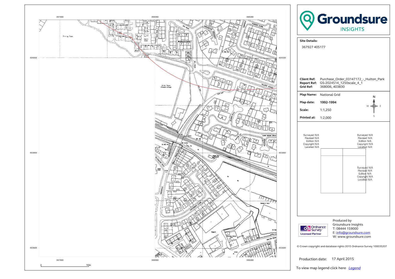
� ���������������� ���������������������������������������������������������������� �!������!�"#$%�&������'������$###(%"#)��� �������������������*+,-./-,0+123.���......41+-5,.6-73...6-89:,.6-73..�;:+<.6-73�� .�=08.>0?-3.. . . .�=08.<0,-3.. �.*@01-3....A:+5,-<.0,3.������ ��������� ���B����!����C!���!�� �#DEEE�$%F###�G �H�I�����!���J�����K ����J�����!���J������N
EW
S
367927 405177
Purchase_Order_03147172_-_Hulton_Park
GS-2024514_1250scale_4_1
368006, 403830
National Grid
1992-1994
1:1,250
1:2,000
17 April 2015
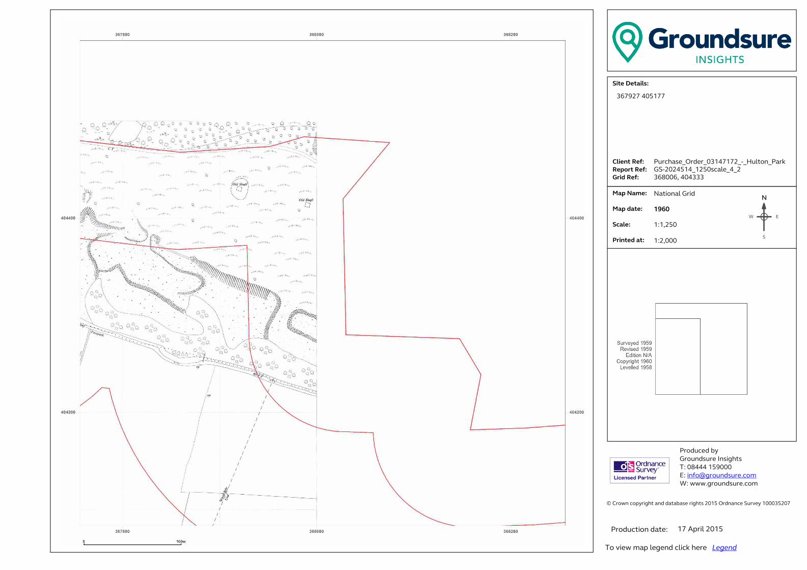
� ���������������� ���������������������������������������������������������������� �!������!�"#$%�&������'������$###(%"#)��� �������������������*+,-./-,0+123.���......41+-5,.6-73...6-89:,.6-73..�;:+<.6-73�� .�=08.>0?-3.. . . .�=08.<0,-3.. �.*@01-3....A:+5,-<.0,3.������ ��������� ���B����!����C!���!�� �#DEEE�$%F###�G �H�I�����!���J�����K ����J�����!���J������N
EW
S
367927 405177
Purchase_Order_03147172_-_Hulton_Park
GS-2024514_1250scale_4_2
368006, 404333
National Grid
1960
1:1,250
1:2,000
17 April 2015

� ���������������� ���������������������������������������������������������������� �!������!�"#$%�&������'������$###(%"#)��� �������������������*+,-./-,0+123.���......41+-5,.6-73...6-89:,.6-73..�;:+<.6-73�� .�=08.>0?-3.. . . .�=08.<0,-3.. �.*@01-3....A:+5,-<.0,3.������ ��������� ���B����!����C!���!�� �#DEEE�$%F###�G �H�I�����!���J�����K ����J�����!���J������N
EW
S
367927 405177
Purchase_Order_03147172_-_Hulton_Park
GS-2024514_1250scale_4_2
368006, 404333
National Grid
1971-1974
1:1,250
1:2,000
17 April 2015
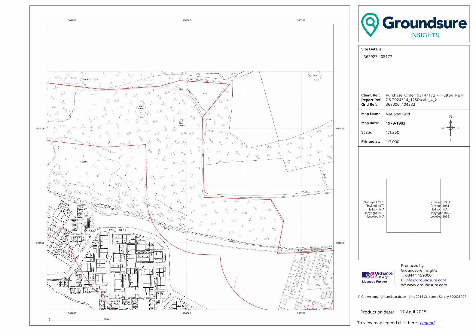
� ���������������� ���������������������������������������������������������������� �!������!�"#$%�&������'������$###(%"#)��� �������������������*+,-./-,0+123.���......41+-5,.6-73...6-89:,.6-73..�;:+<.6-73�� .�=08.>0?-3.. . . .�=08.<0,-3.. �.*@01-3....A:+5,-<.0,3.������ ��������� ���B����!����C!���!�� �#DEEE�$%F###�G �H�I�����!���J�����K ����J�����!���J������N
EW
S
367927 405177
Purchase_Order_03147172_-_Hulton_Park
GS-2024514_1250scale_4_2
368006, 404333
National Grid
1979-1982
1:1,250
1:2,000
17 April 2015

� ���������������� ���������������������������������������������������������������� �!������!�"#$%�&������'������$###(%"#)��� �������������������*+,-./-,0+123.���......41+-5,.6-73...6-89:,.6-73..�;:+<.6-73�� .�=08.>0?-3.. . . .�=08.<0,-3.. �.*@01-3....A:+5,-<.0,3.������ ��������� ���B����!����C!���!�� �#DEEE�$%F###�G �H�I�����!���J�����K ����J�����!���J������N
EW
S
367927 405177
Purchase_Order_03147172_-_Hulton_Park
GS-2024514_1250scale_4_2
368006, 404333
National Grid
1986-1989
1:1,250
1:2,000
17 April 2015

� ���������������� ���������������������������������������������������������������� �!������!�"#$%�&������'������$###(%"#)��� �������������������*+,-./-,0+123.���......41+-5,.6-73...6-89:,.6-73..�;:+<.6-73�� .�=08.>0?-3.. . . .�=08.<0,-3.. �.*@01-3....A:+5,-<.0,3.������ ��������� ���B����!����C!���!�� �#DEEE�$%F###�G �H�I�����!���J�����K ����J�����!���J������N
EW
S
367927 405177
Purchase_Order_03147172_-_Hulton_Park
GS-2024514_1250scale_4_2
368006, 404333
National Grid
1989-1992
1:1,250
1:2,000
17 April 2015
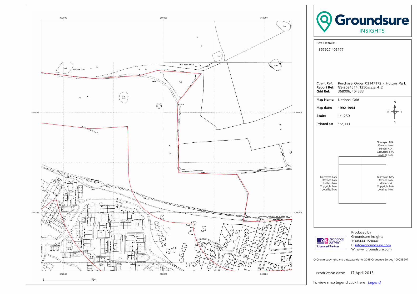
� ���������������� ���������������������������������������������������������������� �!������!�"#$%�&������'������$###(%"#)��� �������������������*+,-./-,0+123.���......41+-5,.6-73...6-89:,.6-73..�;:+<.6-73�� .�=08.>0?-3.. . . .�=08.<0,-3.. �.*@01-3....A:+5,-<.0,3.������ ��������� ���B����!����C!���!�� �#DEEE�$%F###�G �H�I�����!���J�����K ����J�����!���J������N
EW
S
367927 405177
Purchase_Order_03147172_-_Hulton_Park
GS-2024514_1250scale_4_2
368006, 404333
National Grid
1992-1994
1:1,250
1:2,000
17 April 2015
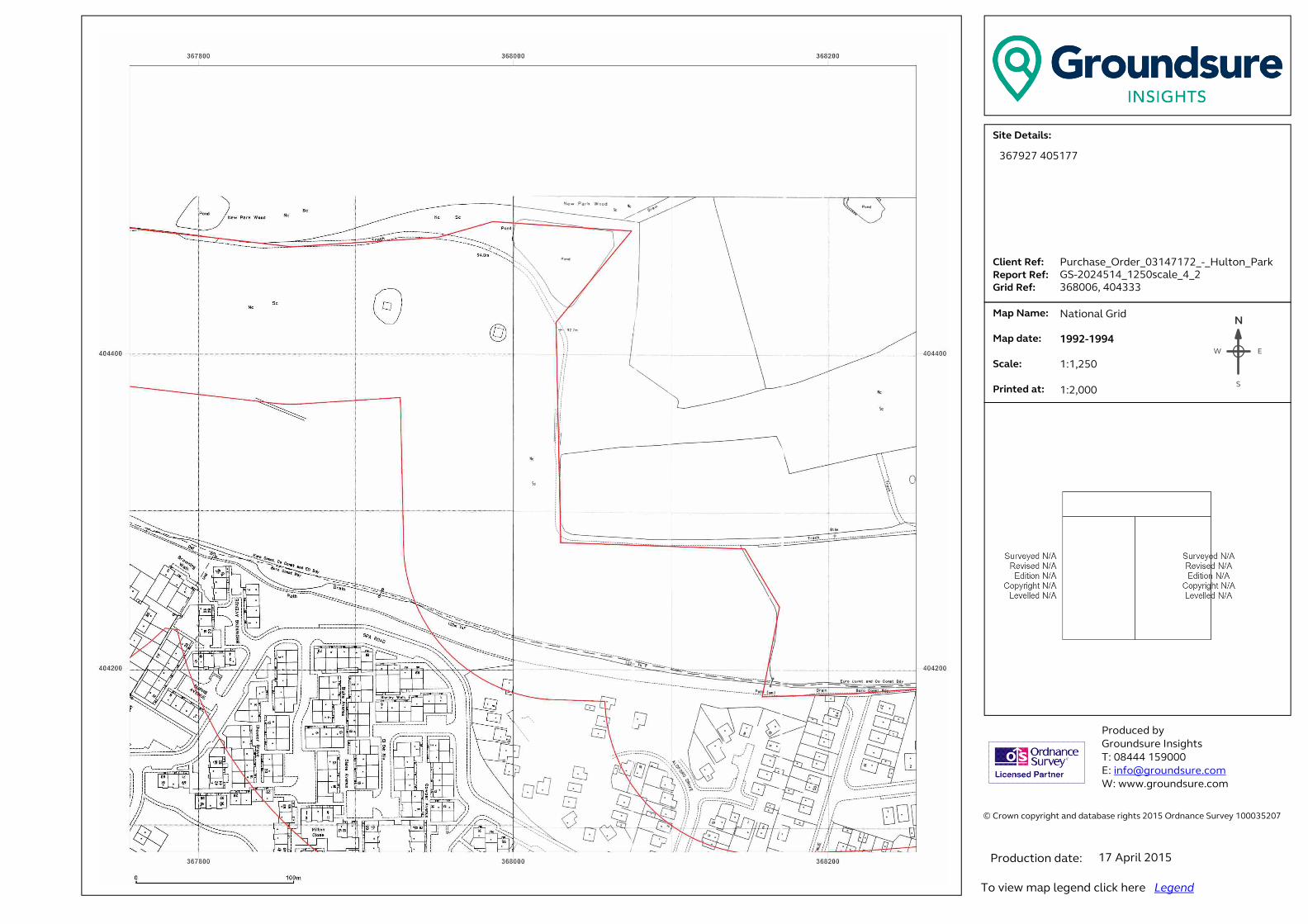
� ���������������� ���������������������������������������������������������������� �!������!�"#$%�&������'������$###(%"#)��� �������������������*+,-./-,0+123.���......41+-5,.6-73...6-89:,.6-73..�;:+<.6-73�� .�=08.>0?-3.. . . .�=08.<0,-3.. �.*@01-3....A:+5,-<.0,3.������ ��������� ���B����!����C!���!�� �#DEEE�$%F###�G �H�I�����!���J�����K ����J�����!���J������N
EW
S
367927 405177
Purchase_Order_03147172_-_Hulton_Park
GS-2024514_1250scale_4_2
368006, 404333
National Grid
1992-1994
1:1,250
1:2,000
17 April 2015
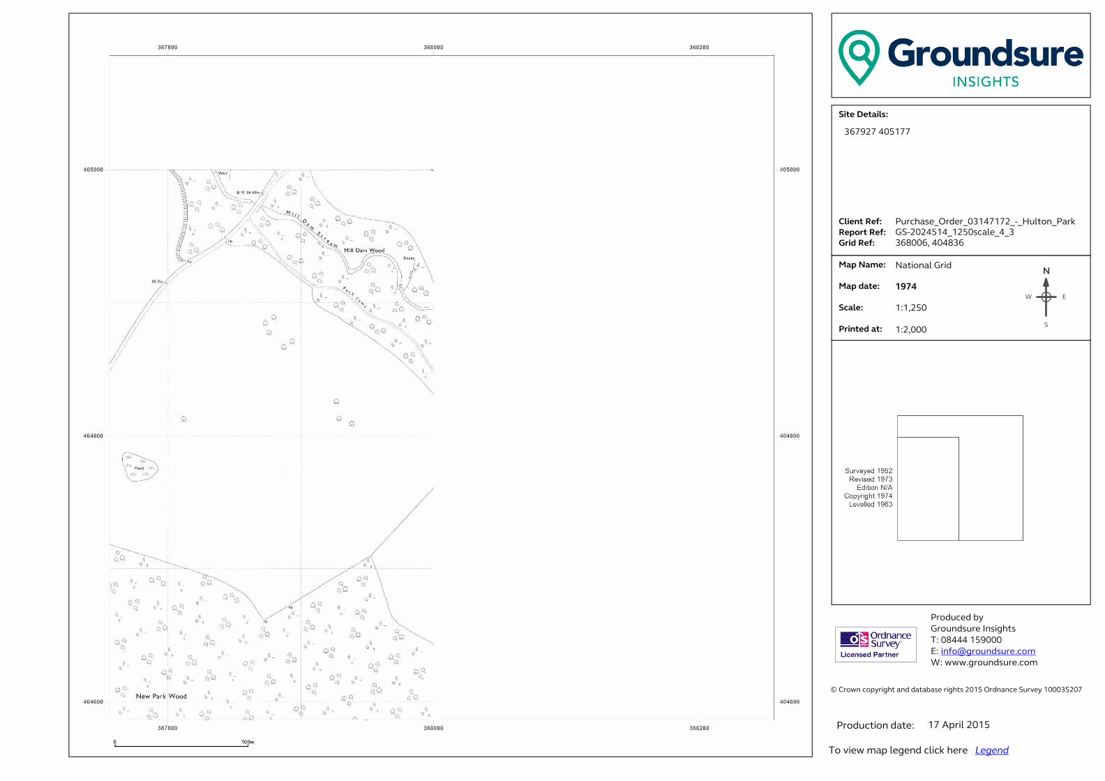
� ���������������� ���������������������������������������������������������������� �!������!�"#$%�&������'������$###(%"#)��� �������������������*+,-./-,0+123.���......41+-5,.6-73...6-89:,.6-73..�;:+<.6-73�� .�=08.>0?-3.. . . .�=08.<0,-3.. �.*@01-3....A:+5,-<.0,3.������ ��������� ���B����!����C!���!�� �#DEEE�$%F###�G �H�I�����!���J�����K ����J�����!���J������N
EW
S
367927 405177
Purchase_Order_03147172_-_Hulton_Park
GS-2024514_1250scale_4_3
368006, 404836
National Grid
1974
1:1,250
1:2,000
17 April 2015
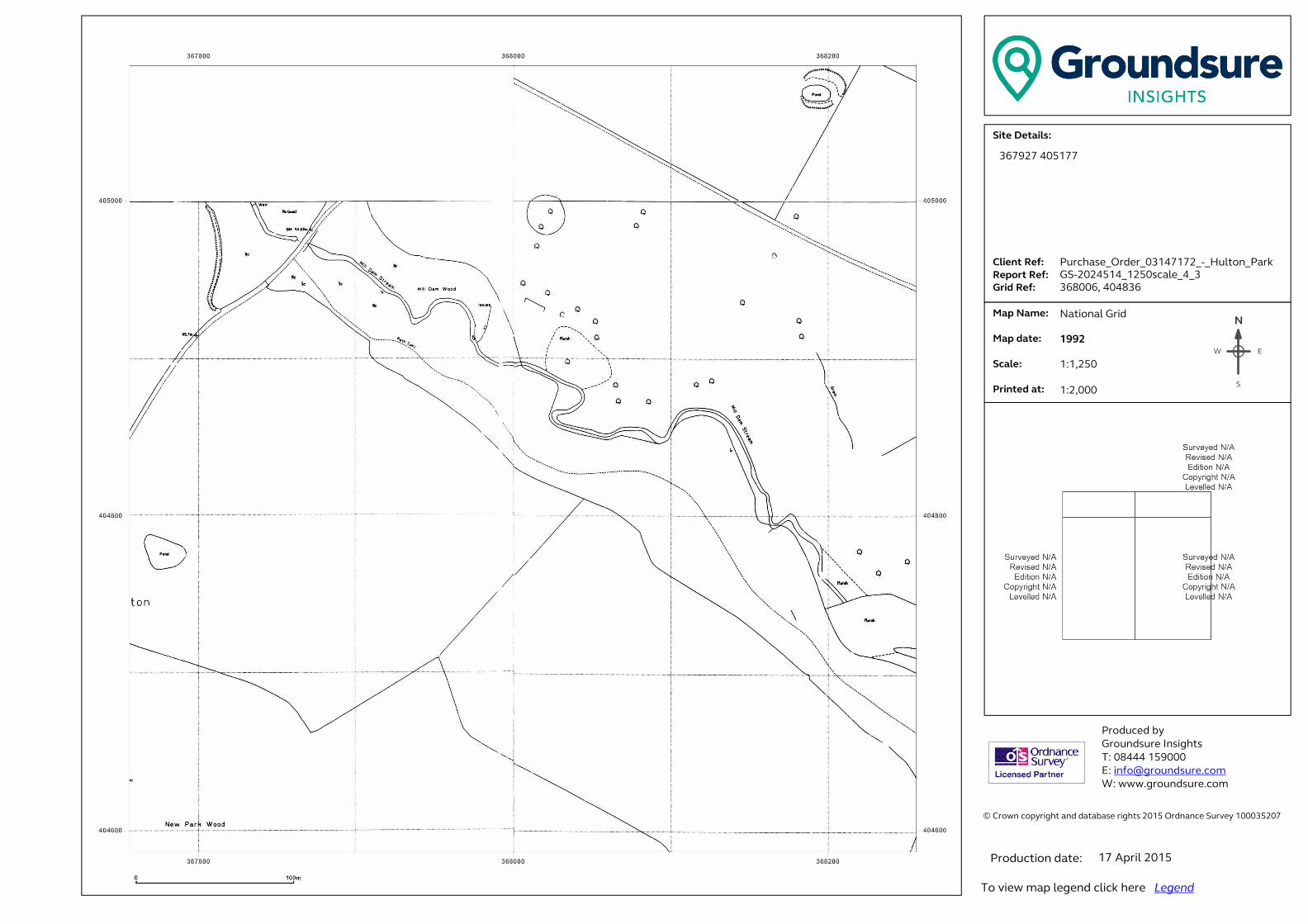
� ���������������� ���������������������������������������������������������������� �!������!�"#$%�&������'������$###(%"#)��� �������������������*+,-./-,0+123.���......41+-5,.6-73...6-89:,.6-73..�;:+<.6-73�� .�=08.>0?-3.. . . .�=08.<0,-3.. �.*@01-3....A:+5,-<.0,3.������ ��������� ���B����!����C!���!�� �#DEEE�$%F###�G �H�I�����!���J�����K ����J�����!���J������N
EW
S
367927 405177
Purchase_Order_03147172_-_Hulton_Park
GS-2024514_1250scale_4_3
368006, 404836
National Grid
1992
1:1,250
1:2,000
17 April 2015

� ���������������� ���������������������������������������������������������������� �!������!�"#$%�&������'������$###(%"#)��� �������������������*+,-./-,0+123.���......41+-5,.6-73...6-89:,.6-73..�;:+<.6-73�� .�=08.>0?-3.. . . .�=08.<0,-3.. �.*@01-3....A:+5,-<.0,3.������ ��������� ���B����!����C!���!�� �#DEEE�$%F###�G �H�I�����!���J�����K ����J�����!���J������N
EW
S
367927 405177
Purchase_Order_03147172_-_Hulton_Park
GS-2024514_1250scale_4_4
368006, 405339
National Grid
1992
1:1,250
1:2,000
17 April 2015
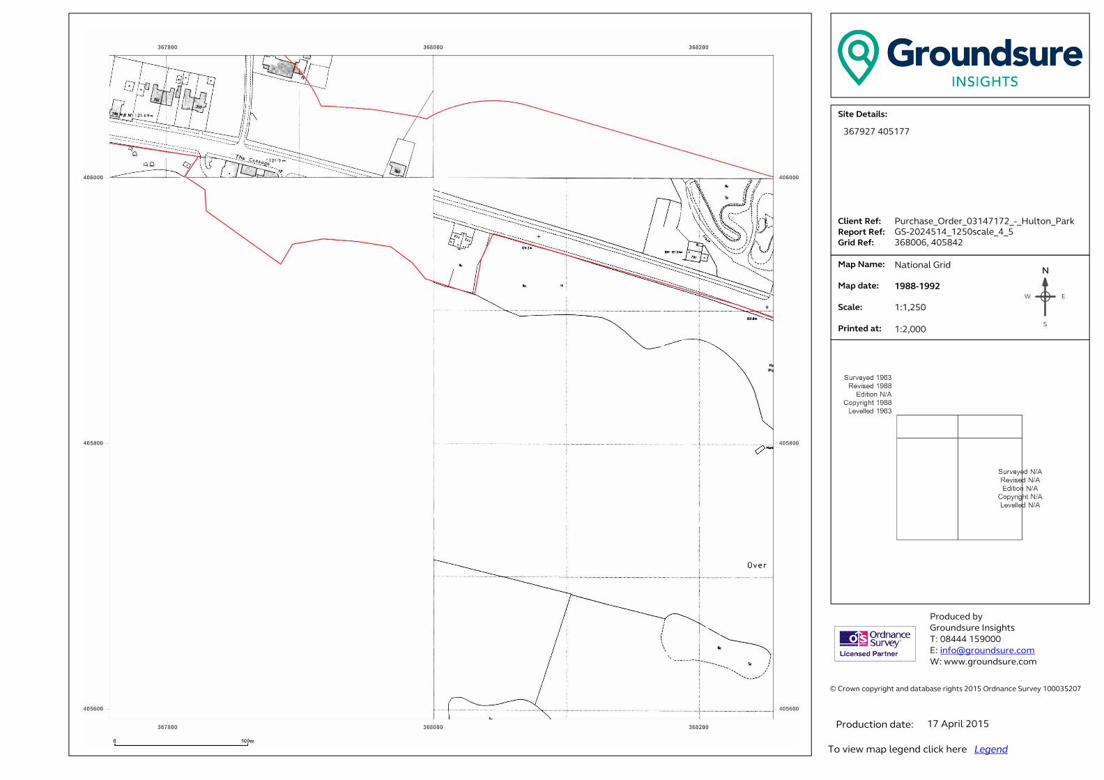
� ���������������� ���������������������������������������������������������������� �!������!�"#$%�&������'������$###(%"#)��� �������������������*+,-./-,0+123.���......41+-5,.6-73...6-89:,.6-73..�;:+<.6-73�� .�=08.>0?-3.. . . .�=08.<0,-3.. �.*@01-3....A:+5,-<.0,3.������ ��������� ���B����!����C!���!�� �#DEEE�$%F###�G �H�I�����!���J�����K ����J�����!���J������N
EW
S
367927 405177
Purchase_Order_03147172_-_Hulton_Park
GS-2024514_1250scale_4_5
368006, 405842
National Grid
1988-1992
1:1,250
1:2,000
17 April 2015
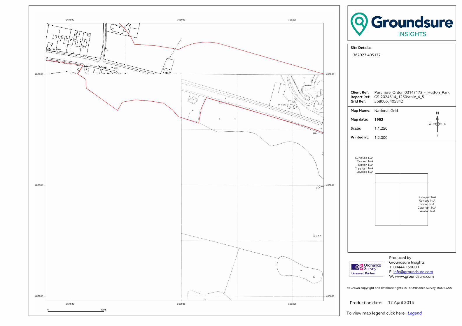
� ���������������� ���������������������������������������������������������������� �!������!�"#$%�&������'������$###(%"#)��� �������������������*+,-./-,0+123.���......41+-5,.6-73...6-89:,.6-73..�;:+<.6-73�� .�=08.>0?-3.. . . .�=08.<0,-3.. �.*@01-3....A:+5,-<.0,3.������ ��������� ���B����!����C!���!�� �#DEEE�$%F###�G �H�I�����!���J�����K ����J�����!���J������N
EW
S
367927 405177
Purchase_Order_03147172_-_Hulton_Park
GS-2024514_1250scale_4_5
368006, 405842
National Grid
1992
1:1,250
1:2,000
17 April 2015
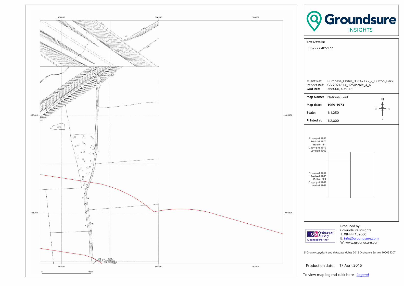
� ���������������� ���������������������������������������������������������������� �!������!�"#$%�&������'������$###(%"#)��� �������������������*+,-./-,0+123.���......41+-5,.6-73...6-89:,.6-73..�;:+<.6-73�� .�=08.>0?-3.. . . .�=08.<0,-3.. �.*@01-3....A:+5,-<.0,3.������ ��������� ���B����!����C!���!�� �#DEEE�$%F###�G �H�I�����!���J�����K ����J�����!���J������N
EW
S
367927 405177
Purchase_Order_03147172_-_Hulton_Park
GS-2024514_1250scale_4_6
368006, 406345
National Grid
1969-1973
1:1,250
1:2,000
17 April 2015

� ���������������� ���������������������������������������������������������������� �!������!�"#$%�&������'������$###(%"#)��� �������������������*+,-./-,0+123.���......41+-5,.6-73...6-89:,.6-73..�;:+<.6-73�� .�=08.>0?-3.. . . .�=08.<0,-3.. �.*@01-3....A:+5,-<.0,3.������ ��������� ���B����!����C!���!�� �#DEEE�$%F###�G �H�I�����!���J�����K ����J�����!���J������N
EW
S
367927 405177
Purchase_Order_03147172_-_Hulton_Park
GS-2024514_1250scale_4_6
368006, 406345
National Grid
1988-1992
1:1,250
1:2,000
17 April 2015

� ���������������� ���������������������������������������������������������������� �!������!�"#$%�&������'������$###(%"#)��� �������������������*+,-./-,0+123.���......41+-5,.6-73...6-89:,.6-73..�;:+<.6-73�� .�=08.>0?-3.. . . .�=08.<0,-3.. �.*@01-3....A:+5,-<.0,3.������ ��������� ���B����!����C!���!�� �#DEEE�$%F###�G �H�I�����!���J�����K ����J�����!���J������N
EW
S
367927 405177
Purchase_Order_03147172_-_Hulton_Park
GS-2024514_1250scale_4_6
368006, 406345
National Grid
1988-1992
1:1,250
1:2,000
17 April 2015
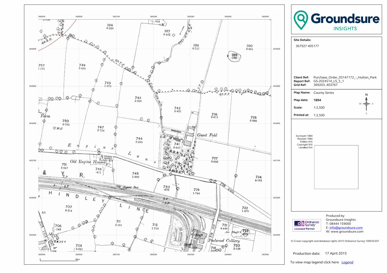
� ���������������� ���������������������������������������������������������������� �!������!�"#$%�&������'������$###(%"#)��� �������������������*+,-./-,0+123.���......41+-5,.6-73...6-89:,.6-73..�;:+<.6-73�� .�=08.>0?-3.. . . .�=08.<0,-3.. �.*@01-3....A:+5,-<.0,3.������ ��������� ���B����!����C!���!�� �#DEEE�$%F###�G �H�I�����!���J�����K ����J�����!���J������N
EW
S
367927 405177
Purchase_Order_03147172_-_Hulton_Park
GS-2024514_LS_5_1
369203, 403767
County Series
1894
1:2,500
1:2,500
17 April 2015

� ���������������� ���������������������������������������������������������������� �!������!�"#$%�&������'������$###(%"#)��� �������������������*+,-./-,0+123.���......41+-5,.6-73...6-89:,.6-73..�;:+<.6-73�� .�=08.>0?-3.. . . .�=08.<0,-3.. �.*@01-3....A:+5,-<.0,3.������ ��������� ���B����!����C!���!�� �#DEEE�$%F###�G �H�I�����!���J�����K ����J�����!���J������N
EW
S
367927 405177
Purchase_Order_03147172_-_Hulton_Park
GS-2024514_LS_5_1
369203, 403767
County Series
1908
1:2,500
1:2,500
17 April 2015
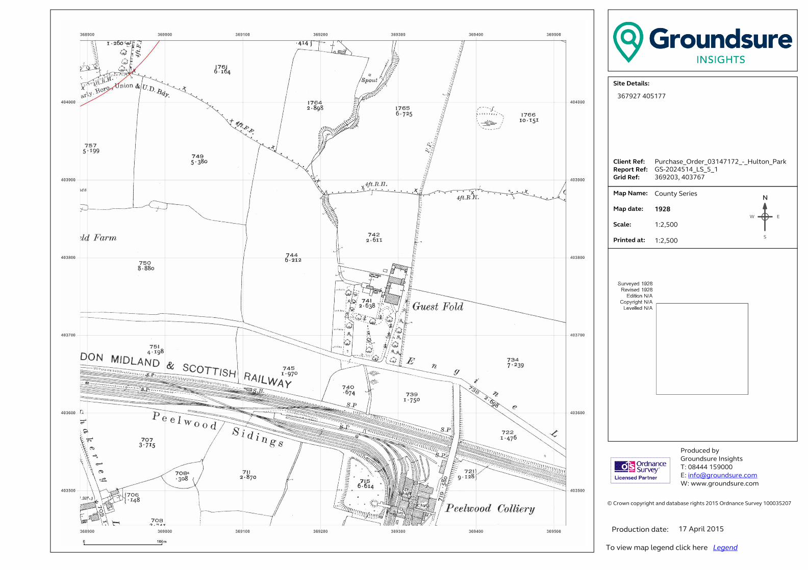
� ���������������� ���������������������������������������������������������������� �!������!�"#$%�&������'������$###(%"#)��� �������������������*+,-./-,0+123.���......41+-5,.6-73...6-89:,.6-73..�;:+<.6-73�� .�=08.>0?-3.. . . .�=08.<0,-3.. �.*@01-3....A:+5,-<.0,3.������ ��������� ���B����!����C!���!�� �#DEEE�$%F###�G �H�I�����!���J�����K ����J�����!���J������N
EW
S
367927 405177
Purchase_Order_03147172_-_Hulton_Park
GS-2024514_LS_5_1
369203, 403767
County Series
1928
1:2,500
1:2,500
17 April 2015

� ���������������� ���������������������������������������������������������������� �!������!�"#$%�&������'������$###(%"#)��� �������������������*+,-./-,0+123.���......41+-5,.6-73...6-89:,.6-73..�;:+<.6-73�� .�=08.>0?-3.. . . .�=08.<0,-3.. �.*@01-3....A:+5,-<.0,3.������ ��������� ���B����!����C!���!�� �#DEEE�$%F###�G �H�I�����!���J�����K ����J�����!���J������N
EW
S
367927 405177
Purchase_Order_03147172_-_Hulton_Park
GS-2024514_LS_5_1
369203, 403767
County Series
1936
1:2,500
1:2,500
17 April 2015
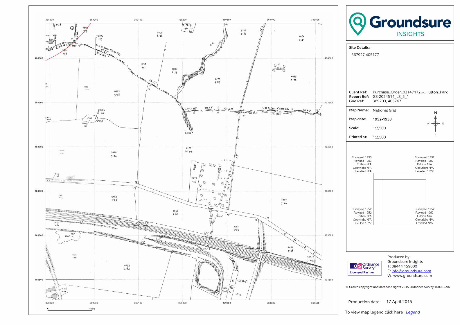
� ���������������� ���������������������������������������������������������������� �!������!�"#$%�&������'������$###(%"#)��� �������������������*+,-./-,0+123.���......41+-5,.6-73...6-89:,.6-73..�;:+<.6-73�� .�=08.>0?-3.. . . .�=08.<0,-3.. �.*@01-3....A:+5,-<.0,3.������ ��������� ���B����!����C!���!�� �#DEEE�$%F###�G �H�I�����!���J�����K ����J�����!���J������N
EW
S
367927 405177
Purchase_Order_03147172_-_Hulton_Park
GS-2024514_LS_5_1
369203, 403767
National Grid
1952-1953
1:2,500
1:2,500
17 April 2015

� ���������������� ���������������������������������������������������������������� �!������!�"#$%�&������'������$###(%"#)��� �������������������*+,-./-,0+123.���......41+-5,.6-73...6-89:,.6-73..�;:+<.6-73�� .�=08.>0?-3.. . . .�=08.<0,-3.. �.*@01-3....A:+5,-<.0,3.������ ��������� ���B����!����C!���!�� �#DEEE�$%F###�G �H�I�����!���J�����K ����J�����!���J������N
EW
S
367927 405177
Purchase_Order_03147172_-_Hulton_Park
GS-2024514_LS_5_2
369203, 404397
County Series
1894
1:2,500
1:2,500
17 April 2015
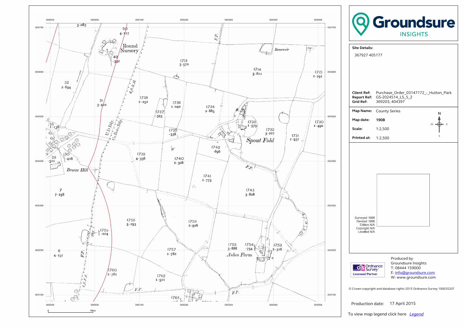
� ���������������� ���������������������������������������������������������������� �!������!�"#$%�&������'������$###(%"#)��� �������������������*+,-./-,0+123.���......41+-5,.6-73...6-89:,.6-73..�;:+<.6-73�� .�=08.>0?-3.. . . .�=08.<0,-3.. �.*@01-3....A:+5,-<.0,3.������ ��������� ���B����!����C!���!�� �#DEEE�$%F###�G �H�I�����!���J�����K ����J�����!���J������N
EW
S
367927 405177
Purchase_Order_03147172_-_Hulton_Park
GS-2024514_LS_5_2
369203, 404397
County Series
1908
1:2,500
1:2,500
17 April 2015

� ���������������� ���������������������������������������������������������������� �!������!�"#$%�&������'������$###(%"#)��� �������������������*+,-./-,0+123.���......41+-5,.6-73...6-89:,.6-73..�;:+<.6-73�� .�=08.>0?-3.. . . .�=08.<0,-3.. �.*@01-3....A:+5,-<.0,3.������ ��������� ���B����!����C!���!�� �#DEEE�$%F###�G �H�I�����!���J�����K ����J�����!���J������N
EW
S
367927 405177
Purchase_Order_03147172_-_Hulton_Park
GS-2024514_LS_5_2
369203, 404397
County Series
1928
1:2,500
1:2,500
17 April 2015

� ���������������� ���������������������������������������������������������������� �!������!�"#$%�&������'������$###(%"#)��� �������������������*+,-./-,0+123.���......41+-5,.6-73...6-89:,.6-73..�;:+<.6-73�� .�=08.>0?-3.. . . .�=08.<0,-3.. �.*@01-3....A:+5,-<.0,3.������ ��������� ���B����!����C!���!�� �#DEEE�$%F###�G �H�I�����!���J�����K ����J�����!���J������N
EW
S
367927 405177
Purchase_Order_03147172_-_Hulton_Park
GS-2024514_LS_5_2
369203, 404397
County Series
1936
1:2,500
1:2,500
17 April 2015
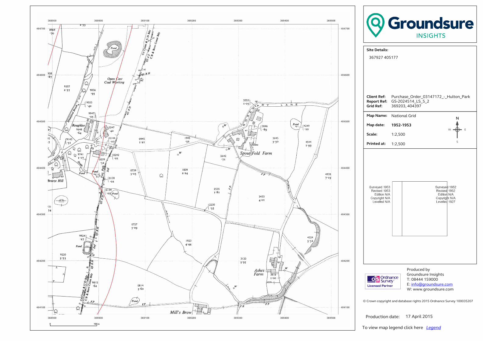
� ���������������� ���������������������������������������������������������������� �!������!�"#$%�&������'������$###(%"#)��� �������������������*+,-./-,0+123.���......41+-5,.6-73...6-89:,.6-73..�;:+<.6-73�� .�=08.>0?-3.. . . .�=08.<0,-3.. �.*@01-3....A:+5,-<.0,3.������ ��������� ���B����!����C!���!�� �#DEEE�$%F###�G �H�I�����!���J�����K ����J�����!���J������N
EW
S
367927 405177
Purchase_Order_03147172_-_Hulton_Park
GS-2024514_LS_5_2
369203, 404397
National Grid
1952-1953
1:2,500
1:2,500
17 April 2015

� ���������������� ���������������������������������������������������������������� �!������!�"#$%�&������'������$###(%"#)��� �������������������*+,-./-,0+123.���......41+-5,.6-73...6-89:,.6-73..�;:+<.6-73�� .�=08.>0?-3.. . . .�=08.<0,-3.. �.*@01-3....A:+5,-<.0,3.������ ��������� ���B����!����C!���!�� �#DEEE�$%F###�G �H�I�����!���J�����K ����J�����!���J������N
EW
S
367927 405177
Purchase_Order_03147172_-_Hulton_Park
GS-2024514_LS_5_3
369203, 405027
County Series
1893-1894
1:2,500
1:2,500
17 April 2015
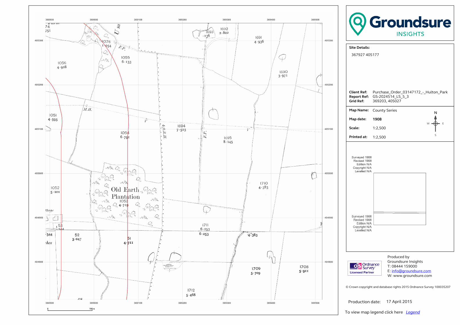
� ���������������� ���������������������������������������������������������������� �!������!�"#$%�&������'������$###(%"#)��� �������������������*+,-./-,0+123.���......41+-5,.6-73...6-89:,.6-73..�;:+<.6-73�� .�=08.>0?-3.. . . .�=08.<0,-3.. �.*@01-3....A:+5,-<.0,3.������ ��������� ���B����!����C!���!�� �#DEEE�$%F###�G �H�I�����!���J�����K ����J�����!���J������N
EW
S
367927 405177
Purchase_Order_03147172_-_Hulton_Park
GS-2024514_LS_5_3
369203, 405027
County Series
1908
1:2,500
1:2,500
17 April 2015
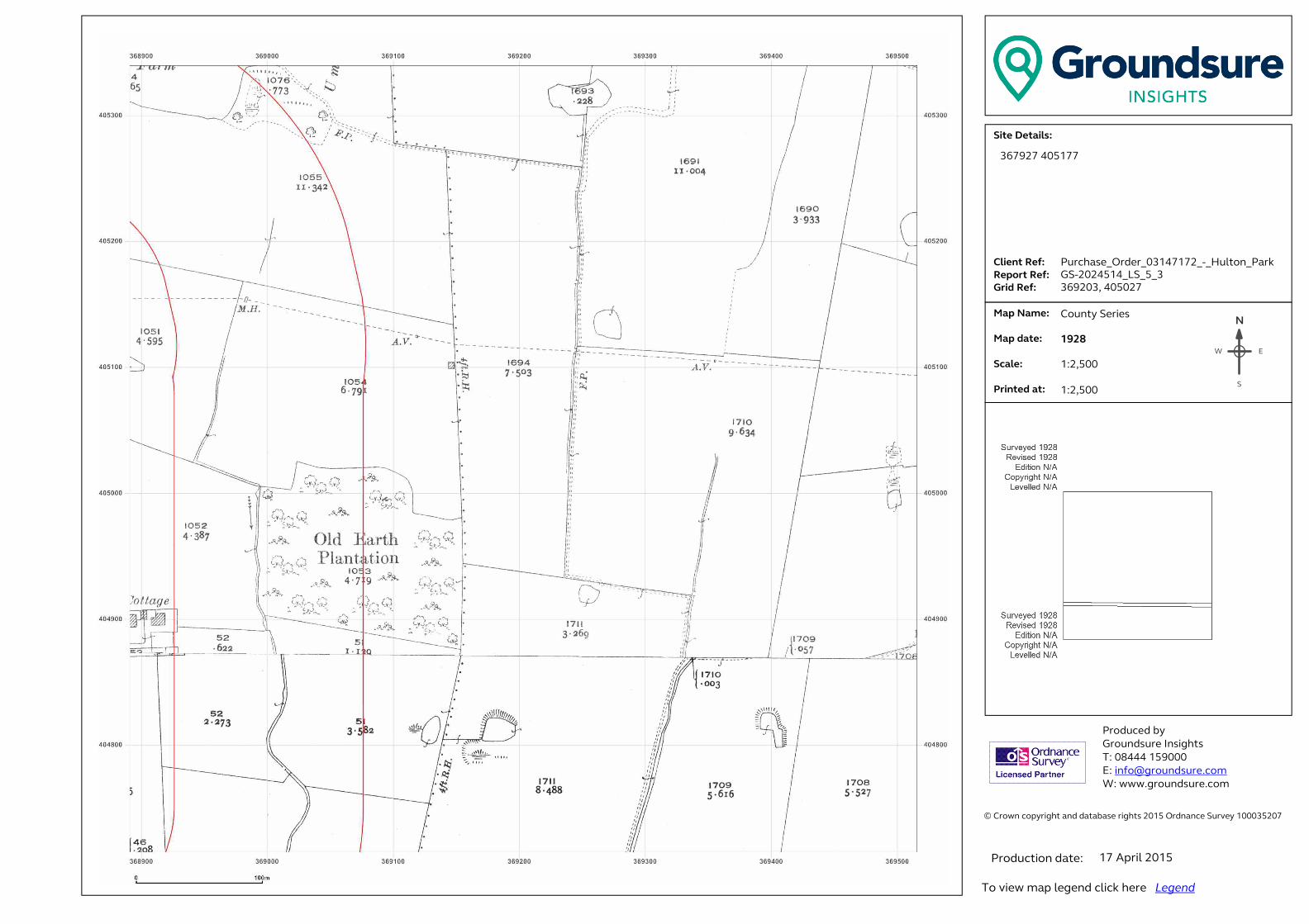
� ���������������� ���������������������������������������������������������������� �!������!�"#$%�&������'������$###(%"#)��� �������������������*+,-./-,0+123.���......41+-5,.6-73...6-89:,.6-73..�;:+<.6-73�� .�=08.>0?-3.. . . .�=08.<0,-3.. �.*@01-3....A:+5,-<.0,3.������ ��������� ���B����!����C!���!�� �#DEEE�$%F###�G �H�I�����!���J�����K ����J�����!���J������N
EW
S
367927 405177
Purchase_Order_03147172_-_Hulton_Park
GS-2024514_LS_5_3
369203, 405027
County Series
1928
1:2,500
1:2,500
17 April 2015
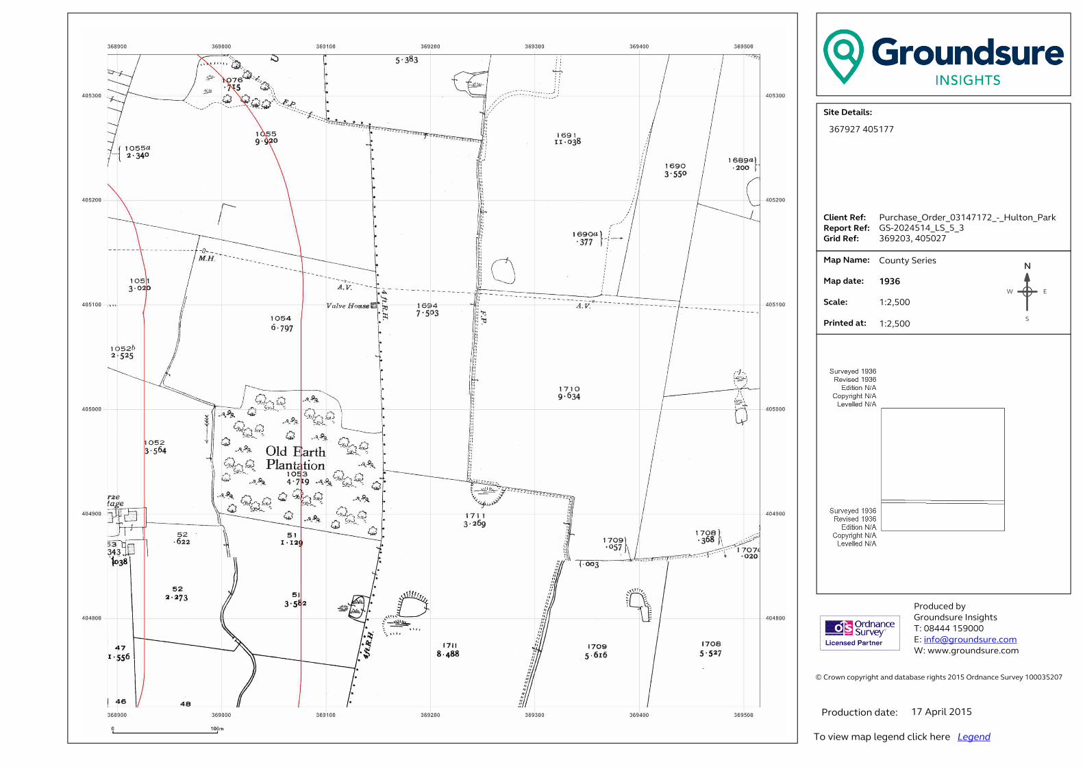
� ���������������� ���������������������������������������������������������������� �!������!�"#$%�&������'������$###(%"#)��� �������������������*+,-./-,0+123.���......41+-5,.6-73...6-89:,.6-73..�;:+<.6-73�� .�=08.>0?-3.. . . .�=08.<0,-3.. �.*@01-3....A:+5,-<.0,3.������ ��������� ���B����!����C!���!�� �#DEEE�$%F###�G �H�I�����!���J�����K ����J�����!���J������N
EW
S
367927 405177
Purchase_Order_03147172_-_Hulton_Park
GS-2024514_LS_5_3
369203, 405027
County Series
1936
1:2,500
1:2,500
17 April 2015
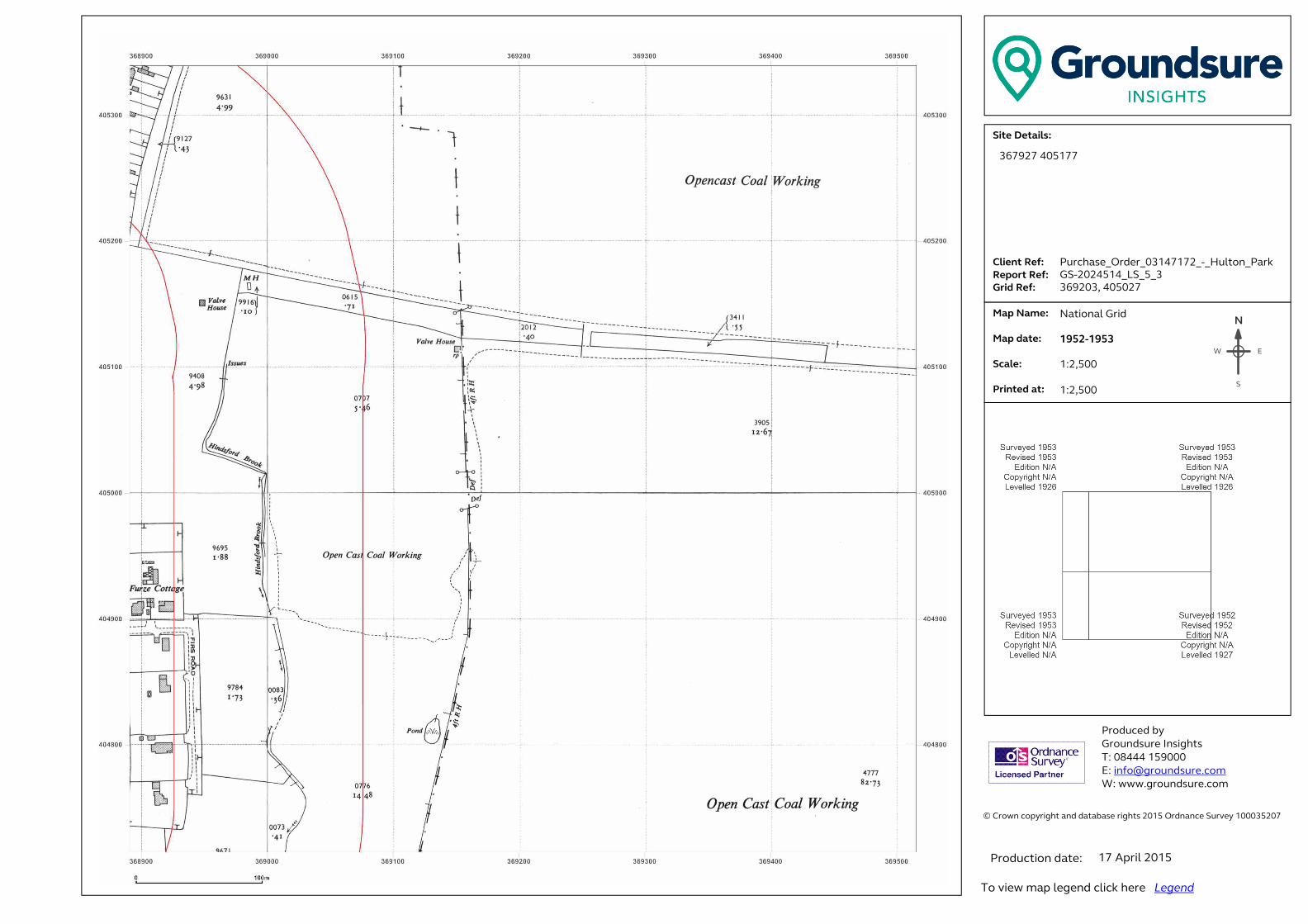
� ���������������� ���������������������������������������������������������������� �!������!�"#$%�&������'������$###(%"#)��� �������������������*+,-./-,0+123.���......41+-5,.6-73...6-89:,.6-73..�;:+<.6-73�� .�=08.>0?-3.. . . .�=08.<0,-3.. �.*@01-3....A:+5,-<.0,3.������ ��������� ���B����!����C!���!�� �#DEEE�$%F###�G �H�I�����!���J�����K ����J�����!���J������N
EW
S
367927 405177
Purchase_Order_03147172_-_Hulton_Park
GS-2024514_LS_5_3
369203, 405027
National Grid
1952-1953
1:2,500
1:2,500
17 April 2015
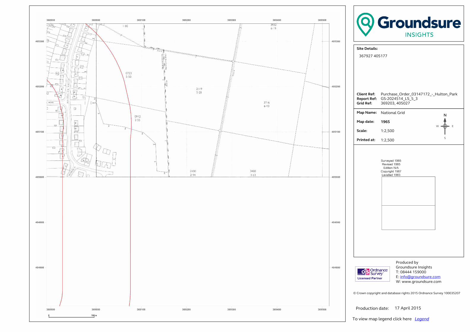
� ���������������� ���������������������������������������������������������������� �!������!�"#$%�&������'������$###(%"#)��� �������������������*+,-./-,0+123.���......41+-5,.6-73...6-89:,.6-73..�;:+<.6-73�� .�=08.>0?-3.. . . .�=08.<0,-3.. �.*@01-3....A:+5,-<.0,3.������ ��������� ���B����!����C!���!�� �#DEEE�$%F###�G �H�I�����!���J�����K ����J�����!���J������N
EW
S
367927 405177
Purchase_Order_03147172_-_Hulton_Park
GS-2024514_LS_5_3
369203, 405027
National Grid
1965
1:2,500
1:2,500
17 April 2015

� ���������������� ���������������������������������������������������������������� �!������!�"#$%�&������'������$###(%"#)��� �������������������*+,-./-,0+123.���......41+-5,.6-73...6-89:,.6-73..�;:+<.6-73�� .�=08.>0?-3.. . . .�=08.<0,-3.. �.*@01-3....A:+5,-<.0,3.������ ��������� ���B����!����C!���!�� �#DEEE�$%F###�G �H�I�����!���J�����K ����J�����!���J������N
EW
S
367927 405177
Purchase_Order_03147172_-_Hulton_Park
GS-2024514_LS_5_4
369203, 405657
County Series
1893
1:2,500
1:2,500
17 April 2015
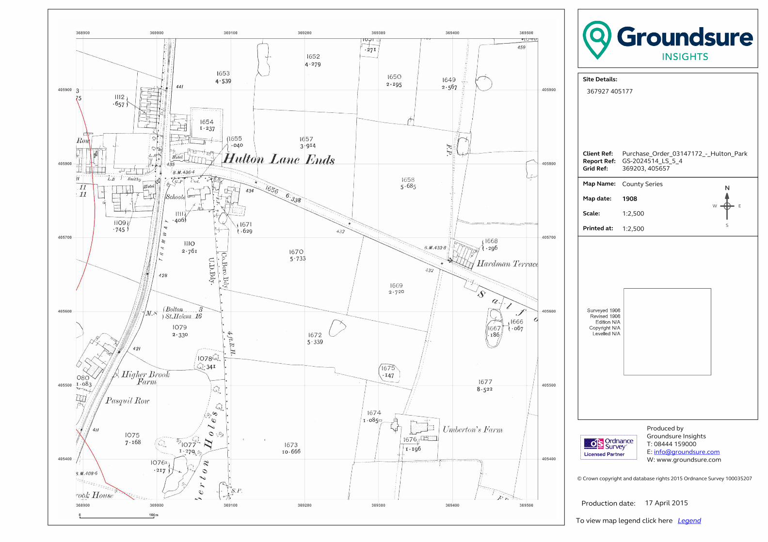
� ���������������� ���������������������������������������������������������������� �!������!�"#$%�&������'������$###(%"#)��� �������������������*+,-./-,0+123.���......41+-5,.6-73...6-89:,.6-73..�;:+<.6-73�� .�=08.>0?-3.. . . .�=08.<0,-3.. �.*@01-3....A:+5,-<.0,3.������ ��������� ���B����!����C!���!�� �#DEEE�$%F###�G �H�I�����!���J�����K ����J�����!���J������N
EW
S
367927 405177
Purchase_Order_03147172_-_Hulton_Park
GS-2024514_LS_5_4
369203, 405657
County Series
1908
1:2,500
1:2,500
17 April 2015

� ���������������� ���������������������������������������������������������������� �!������!�"#$%�&������'������$###(%"#)��� �������������������*+,-./-,0+123.���......41+-5,.6-73...6-89:,.6-73..�;:+<.6-73�� .�=08.>0?-3.. . . .�=08.<0,-3.. �.*@01-3....A:+5,-<.0,3.������ ��������� ���B����!����C!���!�� �#DEEE�$%F###�G �H�I�����!���J�����K ����J�����!���J������N
EW
S
367927 405177
Purchase_Order_03147172_-_Hulton_Park
GS-2024514_LS_5_4
369203, 405657
County Series
1928
1:2,500
1:2,500
17 April 2015
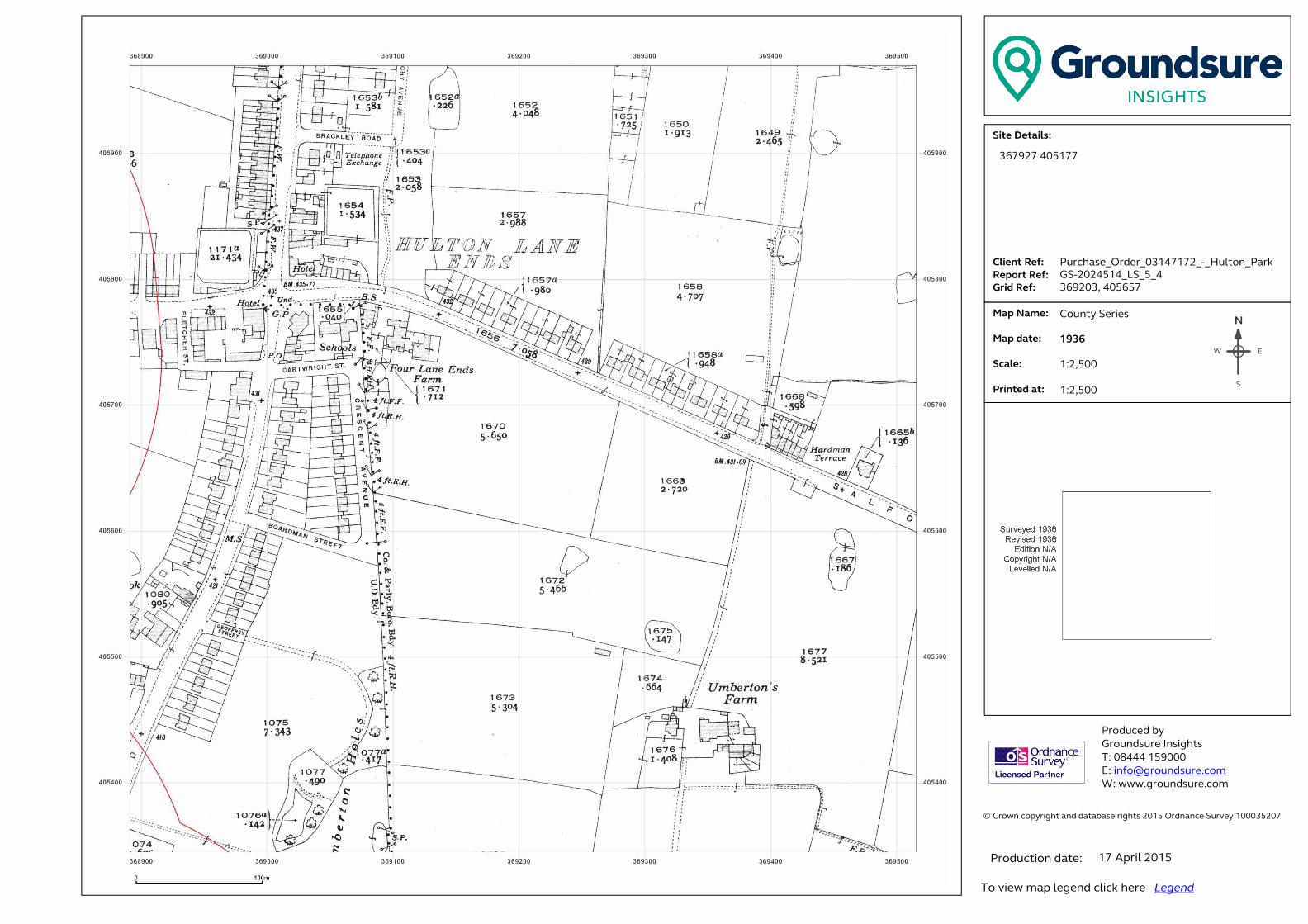
� ���������������� ���������������������������������������������������������������� �!������!�"#$%�&������'������$###(%"#)��� �������������������*+,-./-,0+123.���......41+-5,.6-73...6-89:,.6-73..�;:+<.6-73�� .�=08.>0?-3.. . . .�=08.<0,-3.. �.*@01-3....A:+5,-<.0,3.������ ��������� ���B����!����C!���!�� �#DEEE�$%F###�G �H�I�����!���J�����K ����J�����!���J������N
EW
S
367927 405177
Purchase_Order_03147172_-_Hulton_Park
GS-2024514_LS_5_4
369203, 405657
County Series
1936
1:2,500
1:2,500
17 April 2015

� ���������������� ���������������������������������������������������������������� �!������!�"#$%�&������'������$###(%"#)��� �������������������*+,-./-,0+123.���......41+-5,.6-73...6-89:,.6-73..�;:+<.6-73�� .�=08.>0?-3.. . . .�=08.<0,-3.. �.*@01-3....A:+5,-<.0,3.������ ��������� ���B����!����C!���!�� �#DEEE�$%F###�G �H�I�����!���J�����K ����J�����!���J������N
EW
S
367927 405177
Purchase_Order_03147172_-_Hulton_Park
GS-2024514_LS_5_4
369203, 405657
National Grid
1953
1:2,500
1:2,500
17 April 2015
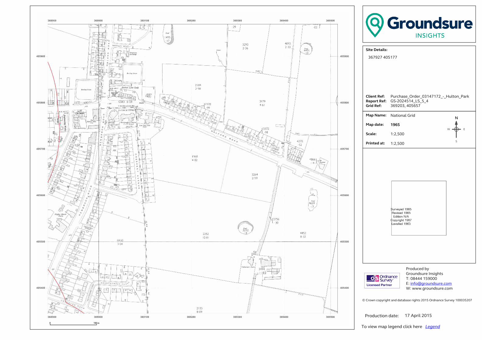
� ���������������� ���������������������������������������������������������������� �!������!�"#$%�&������'������$###(%"#)��� �������������������*+,-./-,0+123.���......41+-5,.6-73...6-89:,.6-73..�;:+<.6-73�� .�=08.>0?-3.. . . .�=08.<0,-3.. �.*@01-3....A:+5,-<.0,3.������ ��������� ���B����!����C!���!�� �#DEEE�$%F###�G �H�I�����!���J�����K ����J�����!���J������N
EW
S
367927 405177
Purchase_Order_03147172_-_Hulton_Park
GS-2024514_LS_5_4
369203, 405657
National Grid
1965
1:2,500
1:2,500
17 April 2015

"HULTON PARK"
"April 2015"
APPENDIX C – COAL AUTHORITY REPORT

Issued by:The Coal Authority, Property Search Services, 200 Lichfield Lane, Berry Hill, Mansfield, Nottinghamshire, NG18 4RGWebsite: www.groundstability.com Phone: 0345 762 6848 DX 716176 MANSFIELD 5
AECOMROYAL COURTBASIL CLOSECHESTERFIELDS41 7SL
Our reference: 51000852383001Your reference: Hulton Park
Date of your enquiry: 23 April 2015Date we received your enquiry: 23 April 2015
Date of issue: 27 April 2015
This report is for the property described in the address below and the attached plan.
Non-Residential Coal Authority Mining Report
250HA, HOME FARM, HULTON PARK, OVER HULTON, BOLTON, LANCASHIRE, BL5 1BHThis report is based on and limited to the records held by, the Coal Authority, and the Cheshire BrineSubsidence Compensation Board's records, at the time we answer the search.
Coal mining See comments belowBrine Compensation District No
Information from the Coal AuthorityUnderground coal mining
PastThe property is in the likely zone of influence from workings in 9 seams of coal at shallow to 550mdepth, and last worked in 1947.PresentThe property is not in the likely zone of influence of any present underground coal workings.FutureThe property is not in an area for which the Coal Authority is determining whether to grant alicence to remove coal using underground methods.The property is not in an area for which a licence has been granted to remove or otherwise workcoal using underground methods.The property is not in an area that is likely to be affected at the surface from any planned futureworkings.However, reserves of coal exist in the local area which could be worked at some time in thefuture.No notice of the risk of the land being affected by subsidence has been given under section 46 ofthe Coal Mining Subsidence Act 1991.
All rights reserved. You must not reproduce, store or transmit any part of this document unless you have our written permission.© The Coal AuthorityNon-Residential Coal Authority Mining Report - 51000852383001 Page 1 of 6
-- -- --

Mine entriesWithin, or within 20 metres of, the boundary of the property there are 14 mine entries, theapproximate positions of which are shown on the attached plan.
Our records disclose the following information:368404-008. This shaft was filled and capped with a 3.7m square non-structural concretecap in November 1977 by the National Coal Board. A 900mm high concrete obeliskmarks the position..368404-007. This shaft has been filled at some time in the past There are no details ofthe fill material or date of filling..368404-012. This shaft was filled and plugged with a truncated concrete coned plug inNovember 1977 by the National Coal Board. The shaft is marked with a 900mm highconcrete pyramid.368404-006. This shaft was filled and capped with a 3.7m square non-structural concretecap in November 1977 by the National Coal Board. The shaft is marked with a 900mmhigh concrete obelisk..367406-001. No treatment details.368404-013. No treatment details.368404-001. it is thought that this shaft has been filled at some time in the past withcolliery shale. There are no details of the date of filling..368404-011. This shaft was filled and plugged with a 3.7m x 2.7m x 1.2m thick truncatedconcrete cone plug in November 1977 by the National Coal Board The shaft is markedwith a 900mm high concrete obelisk.368404-014. This shaft was reported to be insecure and voided behind damaged fencingin March 2004. Subsequently it was filled to within 1m of the surface with 182 tonnes ofstone. A 2m cone was formed at the surface by the removal of the material surroundingthe shaft. A plug was formed by placing 8 cub metres of concrete within the conical spaceand the shaft. 40 tonnes of topsoil were used to repair the access route and shaft fillingarea. These works were carried out by JMC Engineering on behalf of The Coal Authority.368404-009. No treatment details.368405-008. No treatment details.367406-002. No treatment details.368405-009. This shaft was capped with a non structural cap 12.2m x 9.6m x 0.68m thickin December 1977 by the National Coal Board.367405-004. No treatment details.Records may be incomplete. Consequently, there may exist in the local area mine entries ofwhich the Coal Authority has no knowledge.For an additional fee, the Coal Authority will provide a supplementary Mine Entry InterpretiveReport. The report will provide a separate assessment for the mine entry (entries) referred to inthis report. It will give details based on information in the Coal Authority's possession, togetherwith an opinion on the likelihood of mining subsidence damage arising from ground movement asa consequence of the existence of the mine entry/entries. It will also give details of the remediesavailable for subsidence damage where the mine entry was sunk in connection with coal mining.Please note that it may not be possible to produce a report if the main building to the propertycannot be identified from Coal Authority plans (ie. for development sites and new build).For further advice on how to order this additional information visit www.groundstability.com ortelephone 0345 7626 848.
Coal mining geologyThe Authority is not aware of any evidence of damage arising due to geological faults or otherlines of weakness that have been affected by coal mining.
© The Coal AuthorityNon-Residential Coal Authority Mining Report - 51000852383001 Page 2 of 6
-- -- --
Opencast coal miningPastThe property is not within the boundary of an opencast site from which coal has been removedby opencast methods.PresentThe property does not lie within 200 metres of the boundary of an opencast site from which coalis being removed by opencast methods.FutureThe property is not within 800 metres of the boundary of an opencast site for which the CoalAuthority is determining whether to grant a licence to remove coal by opencast methods.The property is not within 800 metres of the boundary of an opencast site for which a licence toremove coal by opencast methods has been granted.
Coal mining subsidenceThere are 1 claim(s) within 50 metres of the property boundary that do not match the propertyaddress. These are shown on the attached plan.The Authority is not aware of any request having been made to carry out preventive works beforecoal is worked under section 33 of the Coal Mining Subsidence Act 1991.If further subsidence damage claims information is required in addition to that provided in thisreport, the Authority need to manually search their records. For further advice on how to order thisadditional information visit www.groundstability.com or telephone 0345 7626 848.
Mine gasThere is no record of a mine gas emission requiring action by the Coal Authority within theboundary of the property.
Hazards related to coal miningThe property has been subject to remedial works, by or on behalf of the Authority, under itsEmergency Surface Hazard Call Out procedures.
Withdrawal of supportThe property is not in an area for which a notice of entitlement to withdraw support has beenpublished.The property is not in an area for which a notice has been given under section 41 of the CoalIndustry Act 1994, revoking the entitlement to withdraw support.
Working facilities ordersThe property is not in an area for which an Order has been made under the provisions of theMines (Working Facilities and Support) Acts 1923 and 1966 or any statutory modification oramendment thereof.
Payments to owners of former copyhold landThe property is not in an area for which a relevant notice has been published under the CoalIndustry Act 1975/Coal Industry Act 1994.
© The Coal AuthorityNon-Residential Coal Authority Mining Report - 51000852383001 Page 3 of 6
-- -- --
Comments on Coal Authority informationThe attached plan shows the approximate location of the disused mine entry/entries referred to inthis report. For reasons of clarity, mine entry symbols may not be drawn to the same scale as theplan.Property owners have the benefit of statutory protection (under the Coal Mining Subsidence act1991*). This contains provision for the making good, to the reasonable satisfaction of the owner,of physical damage from disused coal mine workings including disused coal mine entries. Aleaflet setting out the rights and the obligations of either the Coal Authority or other responsiblepersons under the 1991 Act can be obtained by telephoning 0345 762 6848 or online atwww.coal.decc.gov.uk/en/coal/cms/services/claims.If you wish to discuss the relevance of any of the information contained in this report you shouldseek the advice of a qualified mining engineer or surveyor. If you or your adviser wish to examinethe source plans from which the information has been taken these are normally available at ourMansfield office, free of charge, by prior appointment, telephone 01623 637235. Should you oryour adviser wish to carry out any physical investigations that may enter, disturb or interfere withany disused mine entry the prior permission of the owner must be sought. For coal mine entriesthe owner will normally be the Coal Authority.The Coal Authority, regardless of responsibility and in conjunction with other public bodies,provide an emergency call out facility in coalfield areas to assess the public safety implications ofmining features (including disused mine entries). Our emergency telephone number at all times is01623 646333.*Note, this Act does not apply where coal was worked or gotten by virtue of the grant of a gale inthe Forest of Dean, or any other part of the Hundred of St. Briavels in the county of Gloucester.
In view of the mining circumstances a prudent developer would seek appropriate technical advicebefore any works are undertaken.Therefore if development proposals are being considered, technical advice relating to both theinvestigation of coal and former coal mines and their treatment should be obtained beforebeginning work on site. All proposals should apply good engineering practice developed formining areas. No development should be undertaken that intersects, disturbs or interferes withany coal or mines of coal without the permission of the Coal Authority. Developers should beaware that the investigation of coal seams/former mines of coal may have the potential togenerate and/or displace underground gases and these risks both under and adjacent to thedevelopment should be fully considered in developing any proposals. The need for effectivemeasures to prevent gases entering into public properties either during investigation or afterdevelopment also needs to be assessed and properly addressed. This is necessary due to thepublic safety implications of any development in these circumstances.
Information from the Cheshire Brine Subsidence Compensation BoardThe property lies outside the Cheshire Brine Compensation District.
Additional RemarksInformation provided by the Coal Authority in this report is compiled in response to the LawSociety’s Con29M Coal Mining and Brine Subsidence Claim enquiries. The said enquiries areprotected by copyright owned by the Law Society of 113 Chancery Lane, London WC2A 1PL.This report is prepared in accordance with the Law Society’s Guidance Notes 2006, the UserGuide 2006 and the Coal Authority and Cheshire Brine Board’s Terms and Conditions applicableat the time the report was produced.The Coal Authority owns the copyright in this report. The information we have used to write thisreport is protected by our database right. All rights are reserved and unauthorised use isprohibited. If we provide a report for you, this does not mean that copyright and any other rightswill pass to you. However, you can use the report for your own purposes.
© The Coal AuthorityNon-Residential Coal Authority Mining Report - 51000852383001 Page 4 of 6
-- -- --
Issued by: The Coal Authority, 200 Lichfield Lane,Mansfield, Nottinghamshire, NG18 4RG
Tax Point Date: 23 April 2015
Property Search for: 250HA, HOME FARM, HULTON PARK,OVER HULTON, BOLTON,LANCASHIRE, BL5 1BH
Reference Number: 51000852383001
Date of Issue: 27 April 2015
Cost: £740.00
VAT @ 20%: £148.00
Total Received: £888.00
VAT Registration 598 5850 68
AECOMROYAL COURTBASIL CLOSECHESTERFIELDS41 7SL
Issued to:
© The Coal AuthorityNon-Residential Coal Authority Mining Report - 51000852383001 Page 5 of 6
-- -- --

Map images are being sent under separate cover
© The Coal AuthorityNon-Residential Coal Authority Mining Report - 51000852383001 Page 6 of 6
-- -- --
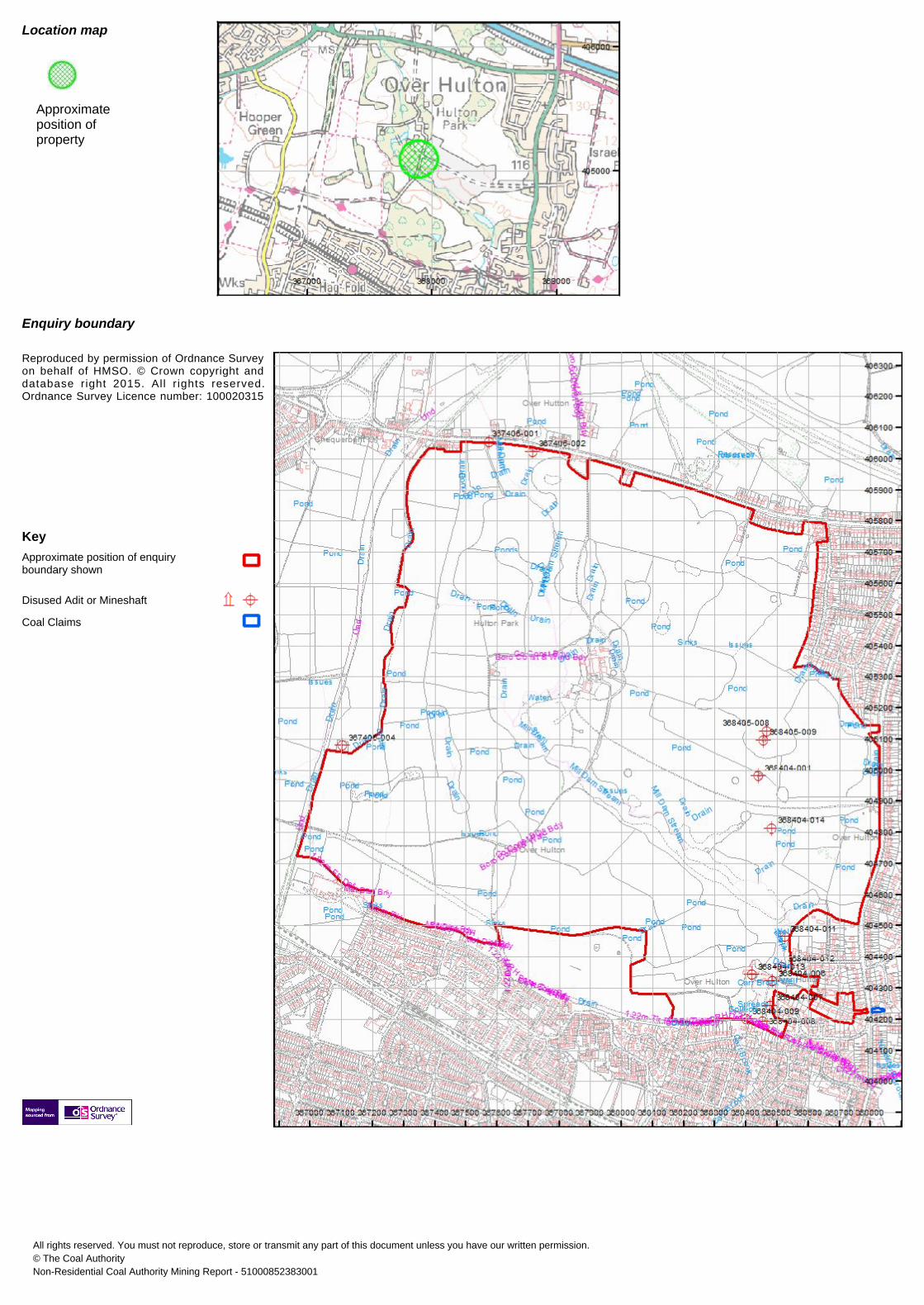
Approximateposition ofproperty
Enquiry boundary
Reproduced by permission of Ordnance Surveyon behalf of HMSO. © Crown copyright anddatabase right 2015. All r ights reserved.Ordnance Survey Licence number: 100020315
KeyApproximate position of enquiryboundary shown
Disused Adit or Mineshaft
Coal Claims
Location map
All rights reserved. You must not reproduce, store or transmit any part of this document unless you have our written permission.© The Coal AuthorityNon-Residential Coal Authority Mining Report - 51000852383001

ABOUT AECOM In a complex and unpredictable world, where growing demands have to be met with finite resources, AECOM brings experience gained from improving quality of life in hundreds of places. We bring together economists, planners, engineers, designers and project managers to work on projects at every scale. We engineer energy efficient buildings and we build new links between cities. We design new communities and regenerate existing ones. We are the first whole environments business, going beyond buildings and infrastructure. Our Europe teams form an important part of our worldwide network of nearly 100,000 staff in 150 countries. Through 360 ingenuity, we develop pioneering solutions that help our clients to see further and go further. www.aecom.com Follow us on Twitter: @aecom