Environmental Geology and Environmental Geophysics of Northern Nile Delta in terms of Neotectonic...
32
University of Mansoura Damietta Faculty of Science Department of Geology ENVIRONMENTAL GEOLOGY AND ENVIRONMENTAL GEOPHYSICS OF NORTHERN NILE DELTA IN TERMS OF NEOTECTONICS AND PHYSICAL PROCESSES BY WAEL ABDEL WAHAB MAHMOUD IBRAHEM (Damietta Faculty of Science) (B. Sc. In Geology) A Thesis Submitted in Partial Fulfillment for the Degree of Master of Science in Geology (2002)
Transcript of Environmental Geology and Environmental Geophysics of Northern Nile Delta in terms of Neotectonic...
University of Mansoura Damietta Faculty of Science Department of Geology
ENVIRONMENTAL GEOLOGY AND
ENVIRONMENTAL GEOPHYSICS OF NORTHERN NILE DELTA IN TERMS OF
NEOTECTONICS AND PHYSICAL PROCESSES
BY
WAEL ABDEL WAHAB MAHMOUD IBRAHEM
(Damietta Faculty of Science)
(B. Sc. In Geology)
A Thesis Submitted in Partial Fulfillment for the
Degree of Master of Science in Geology
(2002)
ACKNOLEDGEMENT
All gratitude is due to almighty God, who guided and aided me to
bring-forth to light this thesis.
I wish to express my great indebtedness and heartfelt thanks to Prof.
Dr. Zaki M. Zaghloul, Professor of Geology, Faculty of Science, Mansoura
University, for his critical comments, valuable suggestion, and supervising
the entire work.
Sincere thanks are due to Dr. Moharm M. Elgamal, Associate
Professor of Geology, Damietta Faculty of Science, Mansoura University,
for his useful advice, valuable suggestion, and guidance during the
supervision of this work.
I thank Dr. Hesham El- Arabey, Associate Professor of Geophysics,
Faculty of Science, Cairo University, for supervising this thesis.
My warmest thanks are due to Dr. Magdi M. Khalil, Associate
Professor of Geology, Damietta Faculty of Science, Mansoura University,
for the use of many facilities and his friendly cooperation.
Deep thanks are also due to Dr. Abu Mandour Abdel Daiem,
Associate Professor of Geology, Faculty of Science, Mansoura University,
for his continuous encouragement, which are much appreciated.
I am also grateful to all staff members of the Geology Department,
Damietta Faculty of Science, Mansoura University, for their kind help,
facilities offered during the work of this thesis.
The Author
Wael Abdel Wahab
CONTENTS Acknowledgement List of figures
CHAPTER I INTRODUCTION
I.1: Introduction ………………………………………………………………. 1
I.1.1: The scope of the present study …………………………………. 4 I.2: Geomorphology of the Nile Delta ……………………………………….. 9
I.2.1: The shoreline of the Nile Delta ………………………………… 11 I.2.2: Beach ridges ……………………………………………………. 11
I.2.3: Strand plains ……………………………………………………. 11 I.2.4: Sand dunes …………………………………………………….... 11
I.2.5: Northern lakes ………………………………………………….. 12 I.2.6: Sabkhas …………………………………………………………. 13 I.2.7: Promontories and headlands ……………………………………. 13
I.3: Stratigraphy of the Nile Delta ……………………………………………. 15
I.3.1: Pre Tertiary deposits …………………………………………… 15 I.3.2: Early Tertiary deposits …………………………………………. 17 I.3.3: Neogene deposits ……………………………………………….. 17
I.4: Tectonic and Structure Setting of the Nile Delta ………………………… 19
I.4.1: Basement tectonics ……………………………………………... 21 I.4.2: Phanerozoic Tectonics ………………………………………….. 21 I.4.3: Major structure elements ……………………………………….. 23
CHAPTER II
NEOTECTONICS (Generality and Surface Investigation)
II.1: Neotectonics …………………………………………………………….. 26 II.2: Surface investigation of lineations as indication for neotectonics ………. 31
II.2.1: lineaments of tectonic significance ……………………………. 35
CHAPTER III QUATERNARY OF NORTHERN NILE DELTA
III.1: Quaternary subsurface investigation of northern Nile Delta …………… 38
III.1.1: Quaternary lithostratigraphy of northern Nile Delta ………… 38 III.1.2: Early Quaternary structures …………………………………... 41 III.1.3: Geologic investigation of northern Nile Delta Holocene Sequence ………………………………………………………………. 44
III.1.3.1: Isopach map of the Holocene sediments of northern Nile Delta ……………………………………………………... 44
II.1.3.2: Holocene lithofacies map of northern Nile Delta …… 46 II.1.3.3: Holocene structures of northern Nile Delta ……….… 47
III.2: Neotectonic inversion …………………………………………………… 54
CHAPTER IV
MORPHOTECTONICS
IV: Morphotectonic features of northern Nile Delta …………………………. 59
IV.1: Present day Delta branches …………………………………….. 59 IV.2: The historic branches ……………………………………….…... 60
IV.2.1: The tectonic control on the defunct distributaries ……. 61 IV.2.2: Avulsion of the historic branches …………………….. 63
IV.3: The lagoons ………………………………………………….…. 64
IV.3.1: Manzala Lake ………………………………………… 64 IV.3.2: Burullus Lake ………………………………………… 69 IV.3.3: Idku Lake ……………………………………………... 71
IV.4: The coastal plains ………………………………………………. 72
IV.4.1: The western delta plain ………………………………. 72 IV.4.2: The central delta plain ……………………………….. 76
IV.4.2.1: Baltim- Gamasa coastal plain ………………. 78 IV.4.4.2.2: Gamasa- Ras El Bar coastal plain ………... 80
IV.4.3: Tinneh plain …………………………………………... 80
CHAPTER V REGIONAL TECTONIC ELEMENTS
V.1: The inheritance of the structural elements ………………………………. 83 V.2: Tectonic relationship between the Nile Delta and East Mediterranean …. 87
CHAPTER VI ACTIVE TECTONISM
VI.1:Seismicity events 91
VI.1.1: Historical seismicity events …………………………………… 91 VI.1.2: Tsunamis ……………………………………………………… 95 VI.1.3: Space distribution of recent earthquakes ……………………… 97
VI.2: Seismicity hazard assessment in the Nile Delta …………….………….. 103
CHAPTER VII NILE DELTA BUILD UP
VII.1: Delta build up process …………………………………………………. 107 VII.2: Present Delta destructive phase ………………………………………... 121
CHAPTER VIII SEA LEVEL CHANGES
VIII.1: Quaternary sea level oscillations ……………………………………... 127
VIII.2: Sea level curves ………………………………………………………. 128
III.2.1: Sea level changes curve in northern Nile Delta .………………. 128 VIII.3: Present day sea level trends …………………………………………... 131
VIII.3.1: Stric changes ………………………………………………... 132
VIII.3.2: Use of tide gauge records in sea level changes measurement 133 VIII.1.3.3.3: Satellite altimetry measurement geometry ……………... 135
VIII.4: Nile Delta areas at risk from sea level rise ……………………………. 136
CHAPTER IX SUBSIDENCE
IX: Subsidence rates of northern Nile Delta …………………………………. 138
CHAPTER X
SUMMARY AND CONCLUSION
X: Summary and Conclusion ………………………………………………… 148
REFERENCE APPENDIX I: Description of Northern Nile Delta Smithsonian Sediment Cores
APPENDIX II: Sedimentation Rates of Smithsonian Cores
ARABIC SUMMARY
List of Figures Page
Fig. 1 Land- Sat image of northern Nile Delta (compiled from Atlas of Land Sat images of Egypt, NARSS, 1990) 6
Fig. 2 Northern Nile Delta Boreholes Location Map 6
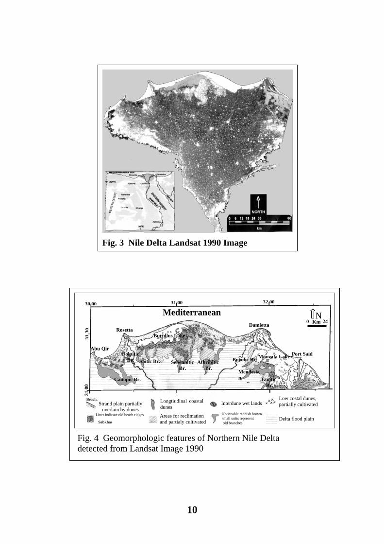
Fig. 3 Nile Delta Landsat 1990 Image 10
Fig. 4 Geomorphologic features of Northern Nile Delta detected from Landsat Image 10
Fig. 5 General Nile Delta strtigraphic column 16
Fig. 6 Nile Delta tectonic setting map, after Abdel Aal et al, 1994. 24
Fig 7 Migration of the Cenozoic Deltas along the Pelusium Line 28
Fig. 8 Regional tectonic elements affect the Nile Delta. 30
Fig. 9 Major Structure Elements Controled Nile Delta Development 32
Fig. 10 Linear Features of Northern Nile Delta Detected from Land Sat Images 34
Fig. 11 Lineation Types of Northyern Nile Delta 34
Fig. 12 Extended Lineaments of Tectonic Signficance. 36
Fig. 13 Isopach Map of Quaternary Deposits of Northern Nile Delta 42
Fig. 14 The Influence of Structures affecting on Early Pleistocene Northern Delta Basin 42
Fig. 15 Isopach map of Holocene Deposites of Northern Nile Delta 45
Fig. 16 The Influences of Structure and Old Distributaries 45
Fig. 17 Soft sediments classification according to Chamley (1990) 47
Fig. 18 Holocene Lithofacies Map of Northern Nile Delta 48
Fig. 19 Geological Cross Section across Nile Delta Coast 50
Fig. 20 Geological Sections across the Southern Margins of Northern Delta Lakes 51
Fig. 21 Neotectonic Elements of Northern Nile Delta 52
Fig. 22 Location map of uplifted shorelines and sketch of plate boundaries in the Eastern Mediterranean region (Modefied after Pirazzoli et al. 1996a) 55
Fig. 23 Examples of Holocene uplifted shorelines in Eastern Mediterranean region (from Pirazzoli, 1998: Figs. 23,96,91) 55
Fig. 24 Cross Section along Eastern Mediterranean 56
Fig. 25 3-D plot of Early Quaternary paleogeographic depositional basin 57
Fig. 26 3-D plot of Early Holocene paleogeographic depositional basin 57
Fig. 27 Old Distributaries of the Nile Delta Detected from Landsat Image 62
Fig. 28 Morphotectonic Features of Manzala Lake 67
Fig. 29 Geological sections across the Manzala Lake 67
Fig. 30 Morphotectonic features of Burullus Lake 70
Fig. 31 Geologic Section in Burullus Lagoon Region 70
Fig. 32 Morphotectonic features of western Nile Delta 73
Fig. 33 Geological section along western Nile Delta 73
Fig. 34 Epicenteral Distribution of the Earthquakes, 100 Km around Alexandria 75
Fig. 35 Centeral Delta Coastal Plain 77
Fig. 36 Morphotectonic Features of Gamasa Area 77
Fig. 37 Morphotectonic Features of Teneh Plane 81
Fig. 38 Last- squars second- order residual anomaly map of the Nile Delta 85
Fig. 39 A tentative basement topgraphic map of the Nile Delta region 85
Fig. 40 Basement structural lineament detected from RTP magnetic map 86
Fig. 41 Regional tectonics of East Mediterranean Sea 88
Fig. 42 Regional tectonic elements of East Mediterranean affecting The Nile Delta region 90
Fig. 43 Epicenteral Distribution of Instrumental Earthquakes in Northern Egypt (1900 -1997) and Active Seismic Trends 99
Fig. 44 Structural influence on intinsity distributions of some Delta's earthquakes 104
Fig. 45 Example of circular isoseismal lines 104
Fig. 46 Average pattern of intensty distributions for earthquakes in and around the Nile Delta, after Al Ibiary, 2001 106
Fig. 47 Agents controlled delta development 108
Fig. 48 Nile Delta build up stages 109
Fig. 49 Paleo- Geography of Northern Nile Delta during Early Holocene (7500 yrs B.P). 117
Fig. 50 Paleo- Geography of Northern Nile Delta during Mid Holocene (5000 yrs B.P). 118
Fig. 51 Paleo- Geography of Northern Nile Delta during Late Holocene (1500 Yrs B.P.) 119
Fig. 52 Morphotectonic features of Nile Delta Shelf Zone 123
Fig. 53 Currents along the Egyptian coast in relation to the neotectonic elements. 124
Fig. 54 Pattern of Erosion and Acretion Along the Nile Delta Coast 125
Fig. 55 Methods of plotting sea level curve 129
Fig. 56 Fairbanks sea level curve compared to the peat curve of northern Nile Delta 129
Fig. 57 Long term climatic variations over the past 400 Ka and prediction for the next 60 Ka according to Berger, 1988 131
Fig. 58 Distribution of average long term sea level change; after Pirazzoli, 1986 134
Fig. 59 Potential impact of sea level rise on the Nile Delta; UNEP/GRID- Arendal, 2000 137
Fig. 60 Peat location map 141
Fig. 61 Peat of southwest Manzala 141
Fig. 62 Peat around Burullus 142
Fig. 63 Peat of west Rosetta Branch 143
Fig. 64 Relative Subsidence rates in northern Nile Delta 145
Fig. 65 Relative Subsidence rates related to neotectonc elements of northern Nile Delta 147
1
I INTRODUCTION
I.1: General Introduction
This study aims to shed light on the environmental geology and
environmental geophysics of the northern plain of the Nile Delta. The
environmental changes either natural or human impacts leave their marks that
alter the province today and in the future. The quest of environmental geology
and geophysics is multidiscipline approach to understand the ongoing changes.
The Nile Delta like any other delta in the world is a battle land of fighting forces
in order to leave their signs of victory. Such signs show as positive or negative
alteration for the Delta.
Physical geologists and geomorphologists prescribe what on the face of the
earth. They describe the shorelines, coastal geomorphology, deltas plain, etc.
They may approach the issues with little attention to human impacts or the
tectonism.
Structural geologists are lenient on the study for recognizing the structural
elements on the surface of the deltas. Their excuse is always a handy one, that
surface of the deltas are covered by alluvium, salt marshes, sabkhas, lagoons,
urbanization and sub- urbanization. Crops and agricultural activity are obstacles
for structural geologists to examine the face of the deltas. The structural
geologists have their reliance on the information they can get from the subsurface
through boreholes or the geophysical results. Therefore their approach is looking
to the far past not to the present or the near past. They draw their own conclusion
about what happened in the far past not those of today concerns.
2
The geophysicists, in their various approaches, do not scratch the surface.
They always look deeper and deeper. They do not do that by choice. They are
confined to the limitations of their tools. For example, those who work with
reflective seismic do not have data most of the time above 0.5 second on their
seismic profiles. That is translated to about 850 meters from the surface. They are
lucky if they get data below 0.1 of a second. Meaning the lack of the information
for about 170 meters from the surface. The picture gets darker, since there is no
bother to carry out seismic interpretation for the shallow part of the vertical
seismic profiles. That is merely because the interpretations are mostly carried out
for oil companies looking for relative deep oil and gas. Other geophysicists,
occupied by the study of the gravity and magnetic data, their concern is mostly
devoted to determine the depth to the basement, nature of the crust “continental or
oceanic”, deep structural elements, and anomalies of interest in search for oil and
gas. Subsurface geologists and stratigraphers rely on data from boreholes that
often are not logged in the shallow intervals and discard to collect near surface
samples. Even shallow boreholes drilled for ground water have their lithologic
logs vaguely described in order to comply with governmental regulations. The
samples of such lithologies are often disposed. Civil engineers, on taking shallow
cores, have their sight only focused on suitability of the soil and remedies to carry
out their own projects. Beyond that these cores are wasted.
The scenario of the study of the modern deltas gets vague when deltaic
geologists approach the subject. Their dealing emphasizes the role of the physical
process in building up or destruction of the deltas. They talk about the alluvial
sedimentation, waves, currents, tides, climate, sea level, etc. even in classifying
the deltas. There is a description for wave, tide, or alluvium dominated deltas.
Inspite of recognizing the role of tectonism in forming deltas which are
commonly along the edge of the continents, there is a little mentioned about this
role.
3
Going further through the scenario of the modern deltas, environmentalists
tend to cry “wolf” about the eminent danger of rising sea level, drowning good
portions of the modern delta and coastal erosion. They draw a gloomy picture
about destroying many major cities and lively- hood of populations living on the
deltas. In this regard, they ignore the present day sea level rise is a part of the
fluctuations of geologic history and its cyclicity. Since the beginning of the
Mesozoic about 220 million years ago, the continents have a continuous general
trend to grow ocean ward. Another issue of a major concern is the subsidence of
the deltas compiled with the present sea level. This issue has been in circulation
adding to the picture of the doom day waiting for the submergence of the deltas
under water. Subsidence under the isostatic load of sediments has been generally
devoted by deltaic geologists and gaining wide acceptance. They disregard that
under the load of the sediments subsidence could be inverted and reversed.
Contrary to the alarm of the environmentalists about the eminent dangers
and hazards, developers and business people tend to be pacifiers by emphasizing
the benefits and the cash return from their projects. They often don’t show respect
for the environment and the nature.
As example of this disrespect is the development of El Tinneh plain to the
northeast of Suez canal. It is another attempt going on today to gain hold of once
the fertile flood plain of the historic the Pelusiac Branch, a defunct distributary of
the Nile Delta. The Pelusiac Branch ceased to exist about the 10th century A. D.
The digging of the Suez Canal in the Nineteenth century A. D. dried out el
Tinneh plain of the larger Manzala Lake. The excavated soil from the Suez Canal
cut off the plain from the lake. It dried out, and a layer of salt widely spreads over
El Tinneh plain especially in the Mallaha area.
4
I.1.1: THE SCOPE AND MATERIAL OF STUDY
The author has chosen the northern part of the Nile Delta to tackle the
environmental changes affecting the province. The area of study is bounded by
latitudes 30o 45` and 31o 45` N and longitudes 30o 00` and 32o 45` E. The area
extends for a straight distance of about 240 Kilometers from Tinneh Plain to the
east and Abu Qir Bay to the west. Geology and geophysics are the media utilized
here to approach the environmental changes. The present author realizes that the
work in this Thesis is a simple humble step in a long passage to reach a complete
comprehensive picture toward understanding the environmental geology and
environmental geophysics of the Nile Delta. This step also may provide some
basics for future developmental planing of the Nile Delta. The author feels today
that the title of his thesis was an ambitious dream to be accomplished in a single
study. It may take a lifetime and a whole life career as well as concerted efforts
with other scientists to reach the goal implied by the title of the Thesis. Therefore
the present author selected some geological and geophysical approaches to be
covered in the present work. He emphasizes the geomorphology as an expression
for the ongoing changes that are caused by the physical process and / or the
tectonism.
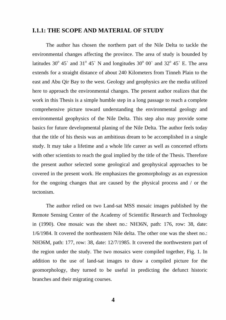
The author relied on two Land-sat MSS mosaic images published by the
Remote Sensing Center of the Academy of Scientific Research and Technology
in (1990). One mosaic was the sheet no.: NH36N, path: 176, row: 38, date:
1/6/1984. It covered the northeastern Nile delta. The other one was the sheet no.:
NH36M, path: 177, row: 38, date: 12/7/1985. It covered the northwestern part of
the region under the study. The two mosaics were compiled together, Fig. 1. In
addition to the use of land-sat images to draw a compiled picture for the
geomorphology, they turned to be useful in predicting the defunct historic
branches and their migrating courses.
5
The same land-sats were utilized to recognize the surface lineations, which
were differently categorized. Lineations that appeared to be structural elements
were checked through subsurface geologic study of the Holocene sediments. The
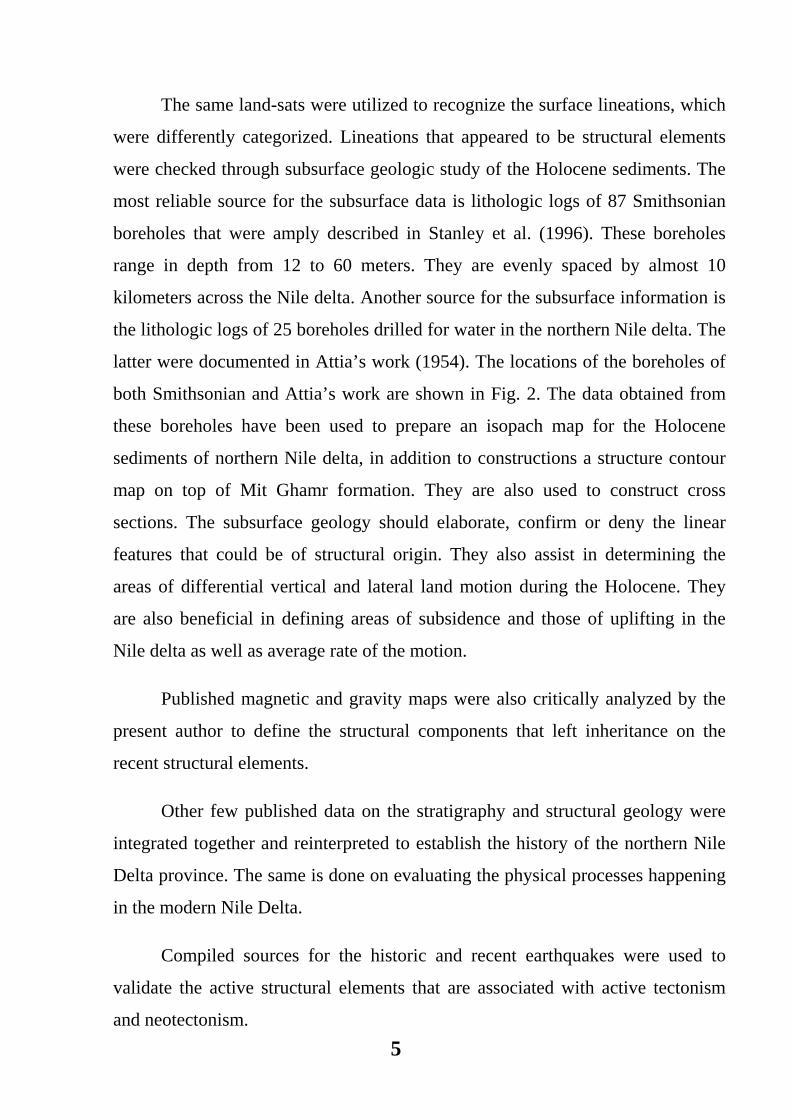
most reliable source for the subsurface data is lithologic logs of 87 Smithsonian
boreholes that were amply described in Stanley et al. (1996). These boreholes
range in depth from 12 to 60 meters. They are evenly spaced by almost 10
kilometers across the Nile delta. Another source for the subsurface information is
the lithologic logs of 25 boreholes drilled for water in the northern Nile delta. The
latter were documented in Attia’s work (1954). The locations of the boreholes of
both Smithsonian and Attia’s work are shown in Fig. 2. The data obtained from
these boreholes have been used to prepare an isopach map for the Holocene
sediments of northern Nile delta, in addition to constructions a structure contour
map on top of Mit Ghamr formation. They are also used to construct cross
sections. The subsurface geology should elaborate, confirm or deny the linear
features that could be of structural origin. They also assist in determining the
areas of differential vertical and lateral land motion during the Holocene. They
are also beneficial in defining areas of subsidence and those of uplifting in the
Nile delta as well as average rate of the motion.
Published magnetic and gravity maps were also critically analyzed by the
present author to define the structural components that left inheritance on the
recent structural elements.
Other few published data on the stratigraphy and structural geology were
integrated together and reinterpreted to establish the history of the northern Nile
Delta province. The same is done on evaluating the physical processes happening
in the modern Nile Delta.
Compiled sources for the historic and recent earthquakes were used to
validate the active structural elements that are associated with active tectonism
and neotectonism.

6
7
Summing: the approach in the present work is collecting various sources of
data, integrating and interpreting them, then finally, an attempt to draw
conclusions on the geoenvironmental aspects north Nile Delta is mode.
The Nile Delta is of prime importance to study the environmental changes.
That is due to its status as a classic example for deltas around the world. The
Greek letter was in the mind of Herdotus in 450 BC to describe the shape of the
region of the ancient Nile Delta. Subsequently the term delta has been in use to
describe many plains where the rivers unload their sediments in their receiving
basins of oceans, seas, etc. Also the environmental changes mean a lot to about
40 millions of the current total population of Egyptian Nile Delta.
The Nil Delta has been witnessing during the 20th century major changes.
The most apparent serious one is its coastal erosion on heals of the irrigation
projects constructed during this century. The blame, regardless justifiable or
unjustifiable, was attributed to the construction of barrages, Aswan dam and the
High Dam. The latter has been taken most of the blame. The deprivation of the
offshore from the load of the sediments used to be carried by the river is often
considered the reason. This deprivation caused improper environmental
imbalance leading to the dominance of the physical destructive of the
Mediterranean Sea over the constructive aspects of sediment accumulation. The
loss of sediments accelerated the physical erosion endangering many coastal
cities e.g. Baltim and Ras El Bar. Coastal protection measurements have proven
no match for the nature. There is always a continuous, effort to protect one more
coastal area or to correct the negative impact of the protection measurement.
The loss of the sediments did not only affect the coast of the Nile delta, but
deprived the fish population in the offshore with the nutrition carried out with the
sediments. The result is a drop in fish population particularly after the
construction of the High Dam. Sardines disappeared in the off coastal water.
8
However it returned on the increase of discharge during the high flood of 1998.
There was also a drop in the population of the shrimp and fish.
The irrigation projects on the River Nile caused another environmental
imbalance, by reducing the amount of discharged fresh water in the
Mediterranean Sea. Increasing the salinity of the coastal water leads to invasion
of saline seawater into the fresh ground water aquifer. It is expected that this
situation will be aggravated by further reduction in the discharge of the fresh
water on completion of Toshka agricultural project in the south Western Desert of
Egypt.
Additional environmental changes include the recent completion of the
International Coastal Highway (I.C.H) along the northern coast of the Nile delta.
This highway altered too many features of the landscape, particularly the sand
ridges and sand dunes. The impact off the highway will be seen in the coming
near future. The impact will be also attenuated by the planned developments
along the highway by allocating parcels of the land for resort developments and
industrial zones. Prior to the building of (I. C.H.), new cities e.g. New Damietta,
and Damietta Naval port, were developed, modifying the landscape and
aggravating the human on the delicate zone of the northern Nile Delta.
Among the environmentally and ecologically sensitive areas in the Nile
Delta there are the coastal lagoons, salt marshes, and sabkhas. A good portion of
the lagoons have been artificially dried out and converted into agricultural land.
The marshes were dried out to attain parcels of land for home building and other
purposes. The lagoons also are suffocated by pollutants pouring from agricultural
drainage, industrial or even unsufficiently treated or totally untreated sewage.
The pollutants in their water or bottom sediments are easily leaked beyond the
limits of the lagoons, which are in great part neotectonic features. Among the
pollutant are nitrogen and nitrogen compounds causing eutrophication and
seasonal blooms of algae and bacteria leading to oxygen deficiencies in the

9
lagoonal waters. Both eutrophication and seasonal algal blooms lead to drop in
fish population and occasional mass killing fish. Water circulation in the lagoons
is often curtailed by widespread of fish farming using artificial partitions for the
lakes. Curtailing the water circulating aggravates the oxygen deficiency.
I.2: GEOMORPHOLOGY OF THE NILE DELTA
The Nile Delta is often termed the true delta with its arcuate or fan- shaped
configuration, Fig. 3. Various authors have treated the geomorphology of the Nile
delta e.g., Sestini (1976, 1989), El Fishawy (1985), El Askary and Lotfy (1980),
Abdel Kader (1982) and Zaghloul et al (1990). The area of the study almost falls
under the 1-meter contour line above sea level and nothing is more than 3-meter
contour, except for some scattered coastal sand dunes. The geomorphology of the
area under study is highly related to the depositional environment.
Apart from the coastal lagoons, there are two basic types of morphology
that are distinguished in the northern Nile delta area. These are: (I) the coastal
morphology of the sand barriers created by waves and wind, and (II) the properly
deltaic morphology created by river discharge behind the barrier (Abdel Kader,
1982).
Fig. 4 represents geomorphologic map prepared by the writer for the
northern Nile Delta area, using the compiled landsat images and field inspection.
The different geomorphologic units were classified depending on the degree of
the tone and its brightness.
Accordingly the northern Nile Delta could be divided into two parts, the
southern part mostly occupied by old delta plain. This part is far from the sea and
is less affected by the most physical processes; and the northern part mostly
affected by the physico - hydrodynamic and neotectonic processes. The northern
10
Mediterranean N
Abu Qir
Rosetta Damietta
Port Said Manzala Lake
Burullus Lake
Canopic Br.
Bolpitic Br. Saitic Br. Sebennitic
Br. Athribitic
Br.
Bucolic Br.
Mendesian
BTanitic
Br.
Beach, Strand plain partially
overlain by dunes Lines indicate old beach ridges
Sabkhas
Longtiudinal coastal dunes
Areas for reclimation and partialy cultivated
Interdune wet lands
Noticeable reddish brown small units represent old branches
Low costal dunes, partially cultivated
Delta flood plain
0 24Km
31 00 32 00
3100
3130
30 00
Fig. 4 Geomorphologic features of Northern Nile Delta detected from Landsat Image 1990
Fig. 3 Nile Delta Landsat 1990 Image
11
part includes the shoreline, beach ridge, backshore plain, sand dunes, northern
lakes, sabkhas, and promontories.
I.2.1: The Shoreline of the Nile Delta
It extends from Abu Qir, east of Alexandria, to Port Said fore about 240
kilometer. However, the shoreline can be extended another approximately 40
kilometer east of Port Said to Tell El Mahamadiya, in Sinai, on Tinneh
embayment. The features of the shoreline are basically: cusps, spits, beaches, and
small shore line dunes.
I.2.2: The Beach Ridges
These occur at Rosetta and Damietta promontories and record the former
shoreline and the advance of the River mouths. They occupy a narrow zone of
low dunes (fore dunes) occasionally rich in black sand lamination, and shell
pavement. The old shorelines are recorded east of Rosetta, west of Gamasa, east
of Ras El- Barr and northeast of Tinneh plain. The development of ridges
indicates low wave energy, low tidal range, effective longshore currents and
predominantly fine-grained sediments (Abdel Kader, 1982).
I.2.3: The Back- shore Plains (Strand Plains)
These occur as flat areas of beach sand, sometimes superficially modified
by eolian deposits. They are usually made of finer sand than the beach sediments.
The backshore is narrow near Idku outlet, between Burullus - Kitchener drain,
and east of Ras El- Barr. It becomes wider in the area west of Rosetta, Burullus,
and between Kitchener drain to Ras El- Bar. These plains often bear traces of
former shorelines or occupied by depressions, which are flooded during stormy
seasons (Sestini, 1989).
I.2.4: Sand Dunes
They represent wind deposits. The dominating wind on the coast, mostly
from the northwest, has transported huge amounts of sand from the beaches by
12
traction particles of 0.1 – 0.3 mm size range (El- Gemmizi, 1995). These are
heaped as dunes of well-sorted particles. These dunes may include the following
classes:
I.2.4.i: continuous belts of complex dunes and barchans; reaching 25 m
high. These dunes can be seen at the northern coastal lagoons and depressions,
especially those of Idku and Baltim to Gamasa.
I.2.4.ii: Field of small dunes and sand sheets; occurring with
innumerable small depressions or flat floors. Some of them bear temporary or
permanent lakes. This type of dunes covers a large area of Baltim extending to 20
km east of Kitchener drain.
I.2.4.iii: Isolated or small groups of barchans and seif dunes; scattered
on the back- shore plains. the longest seif dunes are 1 km.
I.2.4.iv: A complex of low older dunes; found south the higher coastal
dunes at Rosetta, Kom Mastra, in the area of El Burg, Baltim and Gamasa. They
are usually vegetated and composed of reddish sand. At Rosetta and Damietta
these old dunes are 2 - 3 m above sea level.
I.2.5 :The Northern Lakes (Lagoon)
There are three lakes located in northern part of the Nile Delta. Along the
Mediterranean Sea shoreline and connected to the sea through minor Water
passes. These are from east to west: Lake Manzala, Lake Brullus and Lake Idku.
The lakes are shallow, their depth vary from 0.5 to 2m. Their outlets are coverd
by sand, but the bottom contains lagoonal clays. As the lakes represent restricted
environment, the water salinity is relativly high. In fact the water level of the
lakes and the flooding of the Nile and canals played the most important role in
this type of morphology. Lakes margins facing north and northwest winds are
rather high with ground covered by reeds. The areas sheltered from these winds
and Lake waves are marshy in nature. Many parts of the Lake shore were covered
13
by aquatic vegetation. Numerous islands are spread in Lakes Idku, Burullus,
Manzala and appear to be remnants of older features, possibly of beach ridges,
dunes or river banks. Westerly winds and lake waves modified the morphology of
these islands. The west or northwest shores are generally sharp with white,
convex eastward, shelly beaches (Abd el Kader, 1982). Eastward spits usually
developed at the north and south ends of the islands. The spits protect the islands'
eastern shores, which are marshy and irregular. Lagoons occupy large areas of
those islands' surface (El Askary and Lotfy, 1980). Many areas to the south of the
lakes are more or less permanently covered by water as a result of flooding from
the lakes and inland canals. Some areas develop salt flats, while others develop
marshes in the vicinity of the more permanently wet areas.
I.2.6: Sabkhas
They are generally a low surface of deflation formed by the removal of dry,
loose material down to the level of ground water or the zone of capillary water.
Within the framework of sedimentary materials of sabkhas, evaporite minerals
especially gypsum and anhydrite precipitate. Local depression may be
temporarily inundated by water to from playa lakes. The water lasts until
evaporation dries up the lakes again and leaves behind the suspension and
solution load. Sabkha sediments are heavily encountered southeast of Manzala
Lake and around the western side of Burullus Lake.
I.2.7: The Promontories and other Headlands
beside the two promontories of recent active Rosetta and Damietta
Branches, there are other three headlands related the ancient historical Nile
distributaries. These are the Abu Qir, Burullus, and Port Said headlands.
I.2.7.i: Rosetta promontory; was built some 500 - 1000 AD, when water
from the Canopic and Sebennitic branches were diverted naturally and/or
artificially into an existing channel known as Rosetta (CoRI / UNESCO / UNDP,
1978). In early nineteenth century before controlling water for irrigation the fast
14
growing Rosetta promontory was characterized by a bifurcated channel and a
middle – ground mouth bar, which in 1957 has become a large E - W lunate bar
(Sestini, 1989). In the twentieth century the promontory has gradually retreated
with a sharp acceleration of retreat to over 200 m/yr, since 1980 after construction
of the High Dam. The Rosetta mouth tends to be blocked by a spit - submerged
bar extending southwards from the eroding foreland. Analyzing the course of
Rosetta Branch north of the Rosetta city shows Rosetta City River Bend ends
sharply by a straight River till the point of intersection with the sea. The point of
change of the course stream, that is aligned with the southern limits of the sand
dunes to the east of the promontory. Such relations are suggestive that might be a
strong structural element influencing the change of the stream and the distribution
of the eastern sand dunes. The straightened last segment of Rosetta Branch
couples with strong departure of western shoreline might be attributed to tectonic
influence and less likely to be due the strong water inflow in the stream.
I.2.7.ii: Damietta promontory; came into existence during the 10th
century A.D (CoRI / UNESCO / UNDO, 1978). The shape of the NE oriented
Damietta mouth was strongly influenced by the northwest ward wave approach.
Active growth occurred in the eastern side with beach ridges enclosing Manzala
lagoon, which remained partly connected to both the sea and the river (Sestini,
1989). The Damietta headland retreated by 140 – 160 m/yr. since 1964. In the
extensive beach – ridge system east of Damietta, discrete groups of former strand
lines are related to stages the shore advance and retreat. Beach ridges are added
where the shoreline turns SE; a conspicuous new set of spits has grown more than
7.5 km since the late 1950’s with a coastal advance of more than 2.5 km (Frihy,
1988).
I.2.7.iii: Burullus headland; was built by the sediments brought by once
the very active Sebennitic branch that only crossed the central Nile delta. It
formed the central bulge of the Nile delta east of lake Burullus (Orlova and
Zenkovich, 1974), since the defunction of the Sebennitic Branch about 1000 yrs
15
before present the Burullus promontory became subjected to erosion and
retreating at about 5 m /yr at present (Fanos et al, 1995).
I.2.7.iv: Abu Qir headland; marks the mouth of the historic and the
defunct Canopic Branch where the ancient town of Canope stood. This town is
presently submerged under Abu Qir bay 15 Kilometers offshore along the
extension of the western edge of Lake Idku (CoRI / UBESCI / UNDP 1978). The
headland also marks a contrast in the relief of the Abu Qir promontory, there
exists the raised Pleistocene coastal oolitic limestone ridges, commonly named
“Korkar ridges”, two other Holocene ridges exist submerged under the coastal
waters (Stanley and Hamza, 1992).
I.2.7.v: Port Said headland; is the last obvious promontory along the
shoreline of the Nile delta. It was built by the defunct Tanitic Branch. It marks the
boundary between Tinneh embayment and land strip bounding the lake Manzala.
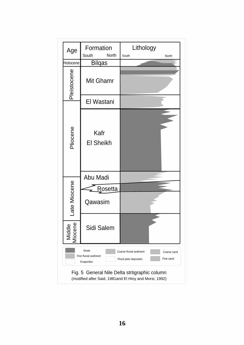
I.3: STRATIGRAPHY OF THE NILE DELTA
The stratigraphic information of the Nile Delta was scanty until 1960’s
when interested oil companies began deep drilling in the Delta. Deep wells have
shed light on the stratigraphy of the Nile delta (Rezzini et al, 1976). The wells in
the northern part generally don’t reach strata older than the Middle Miocene
depths ranging from 4000 to 4600 m, except in Abu Qir (east of Alexandria) and
Tinneh Field where Oligocene strata were penetrated (Zaghloul, 1976). Fig. 5
shows general lithostratigraphy of the Nile Delta basin, based upon well data and
recent studies (e.g. Harms and Wray, 1990, El Heiny and Morsy, 1992 and
Zaghloul et al, 2001).
I.3.1: Pre-Tertiary Deposits
The geologic history of the Nile Delta area for the pre-Tertiary is not well
known (Zaghloul et al, 2001). Based on interpretation of seismic lines Harms and
16
Fig. 5 General Nile Delta strtigraphic column
FormationAgeSouth South North
LithologyNorth
Holocene
Ple
isto
cene
Plio
cene
Late
Mio
cene
Mid
dle
Mio
cene
Bilqas
Mit Ghamr
El Wastani
KafrEl Sheikh
Abu Madi
Rosetta
Qawasim
Sidi Salem
(modified after Said, 1981and El Hiny and Morsi, 1992)
Fine fluvial sediment
Shale
Evaporites
Coarse fluvial sediment Coarse sand
Fine sandFlood plain deposites
17
Wray (1990) reported that from the Jurassic through Cretaceous time, a carbonate
shelf has been developed along an east - west line through the middle part of the
Nile delta. This feature was interpreted as a major facies change where well –
bedded platform carbonates to the south change to finer- grained slope and
basinal facies to the north. Although no penetrations exist across the north delta,
Mesozoic strata were probably deposited in slope and deep oceanic environments
north of the carbonate shelf line.
I.3.2: Early Tertiary Deposits
The depositional history of the Nile delta area for Early Tertiary is less well
known, where Paleocene and Eocene strata are absent in most Nile delta wells,
except Monaga and Mit Ghamr wells. A relatively mild early Eocene Orogeny,
well known from folds formed across North Sinai and in the Western Desert (i.e.
Syrian Arc fold system) influenced the Delta area significantly and caused either
non- deposition or erosion during this time span.
Oligocene sediments are reported mainly in the middle and eastern delta,
while towards the south basalt of Oligocene age caps Oligocene or Eocene strata.
The Oligocene beds appear to have been deposited in depth ranges typical of
upper or middle slope (Harms and Wray, op. cit.).
I.3.3: Neogene Deposits
The Neogene history of the Delta area is much better known than that of
older units. Major unconformities of regional extent subdivide the Miocene and
Pliocene intervals. A major unconformity separates Middle and Late Miocene
strata. This unconformity has a significant brief duration northward. Another
unconformity separates Late Miocene and Pliocene strata and is a widespread
over the entire Mediterranean area, where it represents the Messinian desiccation
event.

18
Early Miocene sediments rang from non- marine in the south to shelf and
slope in the north (Zaghloul et al, 2001). El- Heiny and Morsi (1992) considered
two formations of Early Miocene interval. Moghra Formation exists in the
western part of the Nile delta, and extends in the north Western Desert. It is
composed of fluvio- marine deposits. The Moghra seems to have been deposited
in a high- energy wave dominated delta, under a regime belonging to a river
system which must have flowed into the sea from the north of Fayium (Said,
1990). The second Qantara Formation exists in the eastern part of the Delta and
extends in North Sinai off- shore area. It is composed of open marine deposits.
Early Miocene beds were erosionally removed from the central part of the delta
around Bilqas by the Mid- Miocene unconformity (Harms and Wray, 1990).
Rezzini et al. (1976), studying the stratigraphy and sedimentation of the
Neogene - Quaternary section of the Nile Delta, suggested three cycles of
sedimentation; Miocene, Plio- Pleistocene and Holocene cycles. They
reconstructed a composite columnar section of the subsurface Neogene -
Quaternary deposits of the Nile Delta subdivided into eight formations, namely,
from the base to the top: Sidi Salim, Qawasim, Rosetta, Abu Madi, Kafr El-
Sheikh, El- Wastani, Mit Ghamr and Bilqas Formations. These formations
represent the above three cycles of sedimentation, distinguished on the bases of
environmental conditions of deposition. The first three bottom formations
represent Miocene transgression - regression cycle of the sea. The next four
formations represent Plio- Pleistocene cycle. The latest formation represents the
third Holocene cycle.
I.3.3.i: The Miocene Cycle, begins with a marine formation “Sidi Salim
Formation” which is overlain by a sandy formation “Qawasim Formation”. The
Qawasim underlies the evaporite deposits of Rosetta formation.
I.3.3.ii: The Pliocene- Pleistocene Cycle, comprises four formations two
of Pliocene interval (Abu Madi and Kafr El Sheikh) and the others of Pleistocene
19
interval (El- Wastani and Mit Ghamr). The Pliocene is characterized by
transgressive sea. The marine to fluvio- marine clays and sands of Abu Madi
Formation represent the base of the Lower Pliocene, overlying the Rosetta
Anhydrite or unconformably resting on the Qawasim Formation. Abu Madi
Formation is followed by the open marine clays of Kafr El- Sheikh Formation
With the gradual filling of the basin, the littoral and fluvial sands of El- Wastani
and Mit Ghamr Formations were deposited during the Pleistocene, which is
characterized by a regressive sea.
I.3.3.iii: Holocene Cycle, where the late marine transgression of the
Holocene brought lagoons and coastal deposits to the whole Delta area and
formed the Bilqas Formation, which caps the Delta area. It is equivalent to Neo-
Nile phase of Said (1981).
I.4: TECTONIC AND STRUCTURE
SETTING OF THE NILE DELTA
The Nile Delta region occupies a key position within the plate tectonic
development of the Eastern Mediterranean. It also lies on the Northern margin of
Africa plate which extends from the subduction zone adjacent to the Cretan and
Cyprus arcs to the Red Sea where it rifted apart from the Arabian plate (Said,
1990).
The northern part of the Nile Delta belongs tectonically to separate unit
forming a part of the Levantine basin which is characterized by oceanic type of
crust (Kenyon et al., 1965; Neev, 1975; 1976; Said, 1981 and Woodside and
Bowin, 1970).
The southern part of the Nile Delta region belongs to the stable shelf of the
African Platform which was elevated, during the Oligocene and the late Miocene
to great heights mainly along E - W faults. Subsurface Symmetrical folds of the
20
Aliane Orogeny were formed in Early Eocene time according to Meshref (1982)
and Orwig (1982).
According to Zaghloul, Elgmal, Shabaan, and Yousef (2001), a better
understanding of the tectonic events in the Nile Delta area provides clues to
reason and rational its geological and geophysical features as well as those of the
southeast Mediterranean basin. For example, the difficulty of locating the suture
between the African and European plates is due to the existence of the Levant
basin as a recognized tectonic unit separating between the two plates. They shed
light on the controversy of the nature of the crust of the northern delta and the
Levant basin that had gone through phases of slicing oceanic crust, into an
emerged micro- continent and then into a submerged platform. The low
geothermal gradient of the Nile delta and the Levant basin could be attributed to
thermal subsidence. The authors also recognized Mit Ghamr Shear Zone as a
probable seismicity trend in the Nile delta. Accordingly the Nile delta can be
subdivided tectonically into three major tectonic blocks, as follows:
1. The rim as the southern Delta which is bounded by the main alluvium
valley of the Nile before branching. The main tectonic feature of the Delta’s rim
is the imprint of the late Cretaceous- Early Tertiary Syrian arc folding. It is most
stable or least mobile block of the Nile delta.
2. The central block of Nile Delta situated to the north of the southern rim and
to the south of the Miocene hinge Zone to the North. It is nearly divided by the
Mit Ghamr shear.The Oligocene volcanicity is the most significant feature of the
central block, however it extends south ward into the southern block. A possible
Oligocen rift may have been in existence over the central block (Elgamal, 2001).
3. The northern Delta block which is a sub- unit of the Levant basin. It is
situated to the north of the Miocene hinge zone. This block is characterized by
thick Neogene sediments, growth faults, Oligocene diapric shale and the absence
21
of both the Paleocene and Eocene sediments. This block is the most active
tectonic block of the Nile delta.
I.4.1: Basement Tectonics
The basement structure map of Orwig (1982) shows that depth of the
basement in southern Nile Delta is about 3.000 - 4.500 Kilometers and 6.000 –
9.000 Kilometers in the central Delta. The latter is shallower than the estimate
given by Abdel Rahman et al. (1988) who calculated the thickness of the
sedimentary section in the Northern Delta to be 10.000 Kilometers at mouth of
the Nile.
Setto (1991) explained the crustal structure along a gravity profile, striking
N-S for a length of about 195 Kilometers. It crosses three blocks of Bouguer
anomalies (map of Abdel Rahman et al, 1988). This modeled gravity profile
shows two major breaks in the basement surface. Both associated with major
transverse faults cutting across the Nile Delta. Each is of about 4 Kilometers,
down throws to the north. This brings the basement surface from about 2
kilometers in the Southern Delta to about 9 Kilometers in northern delta block.
I.4.2: Phanerozoic Tectonics
During the Paleozoic the delta is thought to be the flank of a Paleozoic
basin that was centered around Abu Hammad well no. 1 and trending N.NE -
S.SW (Sestini, 1984).
Musconi et al. (1996) suggested that there are four consequent tectonic
episodes affecting the stratigraphic record of the north Sinai and the Nile delta
onshore and offshore from Early Mesozoic to present:
The Neo- Tethyan Rifting (early Triassic - early Jurassic)
The Neo- Tethyan closing event (Middle late Cretaceous - late Eocene)
22
The Gulf of Suez Rifting (late Eocene - late Miocene)
The Aqaba- Dead sea faulting (late Middle Miocene - Recent)
Zaghloul, Elgmal, Shabaan, and Yousef (2001) suggested five tectonic
stages that affected the development of the Nile delta as follows:
a. Part of an expanding sea since the opening of the Neotethys in the
Triassic through the Jurassic and most of the Cretaceous. Sedimentation during
this tectonic stage was tectonically controlled. Mit Ghamr Shear had played a
significant role as axis of the Cretaceous basin and the same time as the
Mesozoic shelf edge of the Delta. Both Mit Ghamr fault and the Mesozoic
Palaeolevant ridge were parallel to the Neotethys Mesozoic ridge.
b. Compressional foreland stage from Late Cretaceous to the end of the
Eocene periods, during which the northern delta and a great proportion of
southern Mediterranean were an emerged landmass termed as the Palaeolevant
microcontinent. This microcontinent was formed by thrust and slicing oceanic
mass.
c. A stage of vertical movement during the Oligocene where the southern
Nile delta was uplifted and Palaeolevant microcontinent was sunk down and
changed into a submarine platform. The latter process was due to change in the
suture of the Palaeolevant with African plate from a thrust zone into a normal
zone. The process was most likely accompanied by thermal subsidence of
Palaeolevant. The central block was a probable passive Oligocene rift.
d. Returns of collision and northward movement of the African plate
during the Neogene where the Palaeolevant was a growing basin ahead the
leading edge of Africa. This build- out stage extends from the Miocene to the
present during which Neogene hinge zone had been formed.
23
I.4.3: Major Structure Elements
Ben Avraham et al. (1987) reported that the tectonic deformation of the
Nile Delta is complex because of the interaction of differently oriented tectonic
fabric, such as following:
The differential vertical movement of E - W fault blocks and grabens
along the passive margin of the African plate, as the overall subsidence of the
Tethyan versus the Afro - Arabian margin.
The uplift of the Red Sea region, followed by NW - SE to NNE - SSE
rifting and sea floor spreading with NE movement of Arabia Relative to
Africa.
The effect of the sediment loading of the subsiding the Plio- Pleistocene
delta front, accompanied with the formation of growth faults, shelf margin
sliding normal faulting and holokinesis.
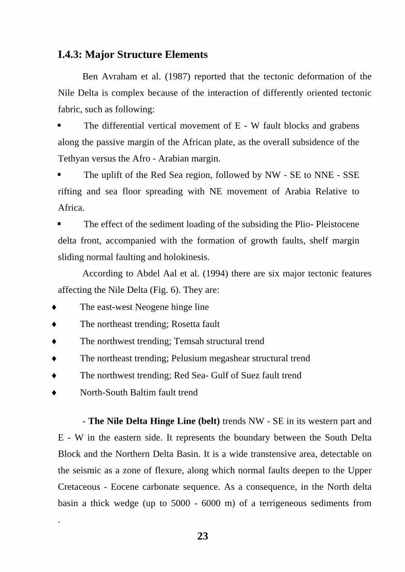
According to Abdel Aal et al. (1994) there are six major tectonic features
affecting the Nile Delta (Fig. 6). They are:
♦ The east-west Neogene hinge line
♦ The northeast trending; Rosetta fault
♦ The northwest trending; Temsah structural trend
♦ The northeast trending; Pelusium megashear structural trend
♦ The northwest trending; Red Sea- Gulf of Suez fault trend
♦ North-South Baltim fault trend
- The Nile Delta Hinge Line (belt) trends NW - SE in its western part and
E - W in the eastern side. It represents the boundary between the South Delta
Block and the Northern Delta Basin. It is a wide transtensive area, detectable on
the seismic as a zone of flexure, along which normal faults deepen to the Upper
Cretaceous - Eocene carbonate sequence. As a consequence, in the North delta
basin a thick wedge (up to 5000 - 6000 m) of a terrigeneous sediments from
.
24
Neogene Hing zone
Mediterranean Sea
Fig. 6: Nile Delta tectonic setting map, after Abdel Aal et al, 1994.
25
Oligocene to Recent occurs. Whereas the corresponding sequences in the South
Delta Block is only 500 - 1000 m thick. The Nile Delta hinge line is strongly
believed to be of Early Tertiary. It might be considered a pre- existing Mesozoic
major fault and facies boundary, between a carbonate platform to the south, and
more basinal facies northward (Mosconi et al, 1996).
- The NE trending (Rosetta fault trend) is parallel to the Pelusium line
and the Jurassic NE to ENE fault lineaments along the extension of north western
desert “Qatara- Alamein ridge”. It probably resulted in right lateral oblique slip
movement during the Early Miocene (Abdel- Aal et al., 1994). According to
Mosconi et al. (1996) the movement along Resetta fault began from Messinian
and probably still active. It causes an abrupt deepening and thickening of the
Tertiary section down to the NW. Embryonic extensional tectonics along the
Rosetta fault during Messinian is indicated by the presence of gravity gliding
structures at its downthrown towards the northwest.
- The Temsah fault trend is located parallel to the NW lineaments during
the Early Miocene (Abdel- Aal et al, 1994).
- The Pelusium Line is suggested to form a transcontinental arcuate shear,
which extends along the following three segments: (A) From Anatolia along the
eastern Mediterranean down to the eastern limit of the Nile delta; (B) across
Africa down to the Niger delta; and (C) across the Mid Atlantic Ridge along the
equatorial fracture zones (Neev, 1977). The Pelusium megashear system (Neev et
al, 1982) extends along eastern limit of the Nile delta as a system of en- echelon
left lateral faults active since Precambrian times.
- NNW normal faults parallel with the Gulf of Suez rift, late Eocene to
Miocene, are observed in the Nile Delta (Abdel- Aal et al, 1994).
- The NS Baltim structural fault trend thought to be formed by
rejuvenation and reactivating of older Pre- Tertiary structures during the Early
Miocene (Abdel- Aal et al, op. cit.).