Ilmington Geophysics
20
ILM14: Rear of Washbrook Place, Ilmington 1 FLUXGATE GRADIOMETER SURVEY, REAR OF WASHBROOK PLACE, ILMINGTON Geophysical Survey Report Site Code: ILM14 NGR: SP 2152 4352 Giles Carey with Brian Meredith 2014
Transcript of Ilmington Geophysics

ILM14: Rear of Washbrook Place, Ilmington 1
FLUXGATE GRADIOMETER SURVEY, REAR OF WASHBROOK PLACE,
ILMINGTON
Geophysical Survey Report
Site Code: ILM14
NGR: SP 2152 4352
Giles Carey with Brian Meredith
2014

ILM14: Rear of Washbrook Place, Ilmington 2
Contents
Contents.......................................................................................................................................2 List of Figures ..............................................................................................................................2 Summary......................................................................................................................................3 Summary......................................................................................................................................3 Acknowledgements......................................................................................................................3 Introduction ..................................................................................................................................4 Project Background......................................................................................................................5
Site Location.............................................................................................................................5 Aims and objectives..................................................................................................................5 Archaeological background ......................................................................................................5
Geophysical survey......................................................................................................................7 Standards .................................................................................................................................7 Field methods...........................................................................................................................7 Data processing .......................................................................................................................7
Results .........................................................................................................................................8 Fieldwalking .................................................................................................................................9 Metal detected finds...................................................................................................................10 Conclusions ...............................................................................................................................11 Bibliography ...............................................................................................................................13 Appendix 1: Technical data........................................................................................................15
List of Figures
General location of Ilmington, c.11km south of Stratford-upon-Avon in the Cotswolds fringe. Image: Google Earth....................................................................................................................4 Figure 1: Survey Location ..........................................................................................................16 Figure 2: Magnetic Data Greyscale (Raw) .................................................................................17 Figure 3: Magnetic Data Greyscale (Processed) .......................................................................18 Figure 4: Interpretation Plan.......................................................................................................19 Figure 5: LiDAR DSM, showing Topographic Location of site....................................................20

ILM14: Rear of Washbrook Place, Ilmington 3
Summary
A programme of fluxgate gradiometer survey was undertaken in 2014 on the summit of Windmill
Hill, to the east of Ilmington (centred on SP 2152 4352). Finds made in the area from the 1970s
onwards have indicated a possible settlement focus here, of Iron Age/Roman date. The aim of
the survey was to evaluate the extent to which these finds related to sub-surface archaeological
deposits. The opportunity was also taken to conduct a rapid fieldwalking exercise to provide a
date for any such deposits.
The results have been extremely promising. The main set of anomalies relate to a sub-
rectangular enclosure with a number of peripheral enclosures, suggested as being of Late Iron
Age date. The fieldwalking has suggested continued occupation here in the Roman period,
which was also seen in finds recently collected across this area through metal detecting.
Acknowledgements
The survey would not have been possible without the enthusiasm and hard work of Brian
Meredith, who enabled access to the site and assisted greatly during the survey, together with
Susan Brock. Brian also provided information on the fieldwalked finds and details of the metal
detector survey. Thanks are also due to Caroline Rann and Bryn Gethin for their support and
assistance with aspects of the survey. Permission to carry out survey was granted by the
landowner, Mr Rob Hawkins.
Background archaeological information was obtained from Warwickshire HER, with additional
information via Brian Meredith. I would also like to thank John Robinson, Warwickshire HER
and Stuart Palmer, Archaeology Warwickshire for discussion of the background material.
The geophysical survey would not have been possible without equipment loaned by English
Heritage; access was kindly arranged through the good offices of Andy Payne. Warwickshire
County Council (Archaeological Information and Advice) loaned the laptop and processing
software.
All conclusions/interpretations are the author’s responsibility alone.

ILM14: Rear of Washbrook Place, Ilmington 4
Introduction
This report presents the results of a small scale fluxgate gradiometer survey carried out atop
Windmill Hill, to the East of Ilmington (centred on SP 2152 4352). Finds made in the area from
the 1970s onwards have indicated a possible settlement focus here, of Iron Age/Roman date.
The aim of the geophysical survey was to evaluate the extent to which these finds related to
sub-surface archaeological deposits. The opportunity was also taken to conduct a rapid
fieldwalking exercise to provide a date for any such deposits.
GENERAL LOCATION OF ILMINGTON,
C.11KM SOUTH OF STRATFORD-UPON-AVON IN THE COTSWOLDS FRINGE. IMAGE: GOOGLE EARTH

ILM14: Rear of Washbrook Place, Ilmington 5
Project Background
Site Location
The survey area was an area of pasture on the summit of Windmill Hill, a glacial mound to the
east of Ilmington. The hill rises to c.180m OD. Ground conditions were generally good during
the survey. The survey was undertaken on three separate occasions throughout 2014, during
January, July and October but the weather was largely dry and fairly bright throughout the
survey.
Aims and objectives
The purpose of any geophysical survey is to “as far as reasonably possible, determine the
nature of the detectable archaeological resource within a specified area using appropriate
methods and practices” (English Heritage, 2008: 3).
The key aim of the survey was to assess the site for the survival of subsurface archaeological
remains which might respond to magnetic survey. In addition, through systematic field survey it
was hoped to provide an updated appraisal of the date of any occupation in this area, furthering
understanding of the material originally collected from this area in the 1970s.
Archaeological background
Ilmington is located within the parish of the same name, c. 11km south of Stratford-upon-Avon,
in the Cotswolds fringe. Ilmington is thought to be early medieval in origin and is recorded as a
pre-Conquest manor in Domesday, being mentioned 3 times (HER MWA8943). The place-
name is recorded as ‘Edelmitone’ in 1086 and ‘Ylmandune’ in c. AD 1000 (AOC Archaeology,
2012: 114). The name is thought to derive from the Old English ‘ulm’ (elm) and ‘dun’ (hill)
(Gower et al., 1970), possibly meaning ‘elm-tree hill’ (Key to English Place Names, 2014). First
and second edition Ordnance Survey mapping shows a nucleated settlement pattern in the 19th
century, focused around the church in the southwest of the settlement. Extensive ridge and
furrow has been recorded around the village (HER MWA6446). Subsequent 20th century
development is limited to areas along the eastern and southern fringes of the village.
The survey area, atop Windmill Hill, to the east of the village itself, is a suggested focus of Iron
Age and Roman settlement. A collection of pottery of largely Romano-British date has been
recorded in the area across which survey was carried out, most notably by the Late Major Peter
Gardner of Ilmington in the late 1960s and early 1970s (Gardner and Ibbotson, 1974: 4). 141
sherds, from a number of fieldwalked sites in and around the village, were subject to initial
analyses by Paul Booth in 1987 (unpublished information in Warwickshire HER; see MWA
6338; Booth, 1987) although it remains difficult to relate particular findspots to particular
locations in this work. It is likely that Booth wrote this report after very rapid appraisal of the
artefactual material (Stuart Palmer, pers. comm.). The composition of the assemblage is largely
of greywares and Severn Valley wares. Interestingly, Booth speculates on the presence of

ILM14: Rear of Washbrook Place, Ilmington 6
buildings in the vicinity of the Windmill Hill assemblage. He notes the find of a piece of combed
flue-tile, implying “the proximity of a building of some substance and sophistication” (ibid.: 3).
The reporting on the original assemblage is far from complete and the assemblage ideally
needs reappraisal; therefore, the current programme of work involved a rapid programme of
systematic fieldwalking, across the SE field of the survey area (undertaken by B. Meredith and
B. Gethin in October 2014). Additionally, metal detecting has been undertaken across this field
by local detectorists in 2014 (the finds from this programme of activity are reported on below).

ILM14: Rear of Washbrook Place, Ilmington 7
Geophysical survey
Standards
The surveys and subsequent reporting were carried out in accordance with English Heritage’s
guide to Geophysical Survey in Archaeological Field Evaluation (2008), the IfA’s Standard and
Guidance for Archaeological Geophysical Survey (Draft) (IfA, 2010) and the ADS’ Geophysical
Data in Archaeology: A Guide to Good Practice (Schmidt, 2001).
Field methods
An overall survey grid was established using tapes, with reference to known points on
Ordnance Survey mapping. The irregularity of grid layout was necessitated by the irregularity of
field boundary layout across the survey area.
Data collection was carried out using a standard methodology, with data collected in 30m grid
units, with all grids walked in the same direction (E-W).
A Geoscan FM36 fluxgate gradiometer was used to conduct the magnetic survey; the sample
interval used was 0.25m with a traverse interval of 1.0m, amounting to 3600 readings per grid.
All data was logged in continuous mode. All grids were walked in a zig-zag traverse scheme.
Data processing
Geoplot software (version 3) was used to download and process the magnetic survey data.
Greyscale plots of both raw and processed data were produced in Geoplot. Raw data,
processed data and interpretation diagrams, which have been georectified in AutoCAD Map 3D
and ArcView GIS, are presented in this report as figures 1-4.
The ‘raw’ data has been subject to minimal editing to remove operator error, with data
subsequently processed to remove geological and background biases and interpolated to aid
interpretation (see appendix 1).

ILM14: Rear of Washbrook Place, Ilmington 8
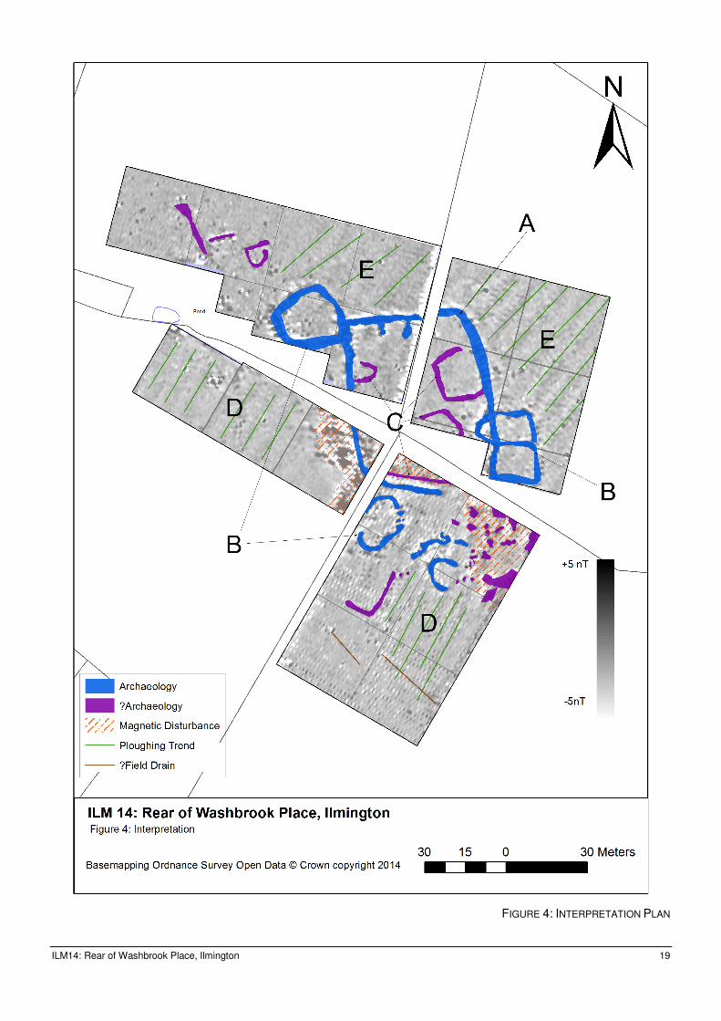
Results
An interpretative diagram is presented in figure 4, with some anomalies annotated for ease of
reference.
The survey has generally been successful in recording areas of magnetic enhancement of
probable archaeological origin. It is important, however, to note that a consistent fault in the
gradiometer’s data collection occurred in January 2014, causing a ‘stippling’ effect visible
across the SE quadrant of the survey area, which had the potential to mask subtler anomalies.
However, all anomalies noted were of high magnetic enhancement, suggesting that they
represent cut features backfilled with material that has been significantly magnetically enhanced
e.g. through burning and therefore are likely to represent domestic refuse material.
The main anomaly recorded in the geophysical survey was a sub-rectangular enclosure (A),
with an internal area of c.50m E-W and 60m N-S. The corners of the enclosure are noticeably
‘rounded’ especially to the NE. The level of magnetic enhancement of the enclosure ditches is
suggestive that they have been backfilled with domestic material.
In addition, discrete sub-circular peripheral enclosures (B) are visible conjoining this main
enclosure. This is clear on the NW corner and at the mid-point of the eastern side of enclosure
A. The anomaly to the south of the main enclosure is also suggested as representing a
peripheral enclosure, although its exact morphology and relationship to the main enclosure is
unclear due to the technical fault which pervaded the survey in this area (see above).
A number of possible internal features (C) have been suggested through weaker areas/trends of
magnetic enhancement within the main enclosure, although the exact nature of the anomalies is
difficult to interpret, given the limited internal area of the enclosure available for survey.
Two discrete areas of ridge and furrow ploughing are visible as clear linear anomalies in the
magnetic data. Ploughing ridges to the south (D) are aligned NNE-SSW; those to the north (E)
are aligned NE-SW. They are clearly visible on 1940s aerial photography of the area as
earthworks which are no longer extant.
It is noticeable that extensive damage has occurred through agricultural activity, most probably
associated with deep-ploughing in the 1980s which removed the earthwork remains of ridge and
furrow. The damage can be seen to have been most severe across the southern extent of the
survey area. Two significant areas of magnetic disturbance were also noted in the magnetic
survey results.

ILM14: Rear of Washbrook Place, Ilmington 9
Fieldwalking
By Brian Meredith
As previously noted, a rapid fieldwalking exercise was undertaken in the SE quadrant of the
survey area, which pilot work suggested was producing a diagnostic pottery assemblage.
The pottery recovered was mainly Severn Valley and grey wares, commensurate with the
material previously recovered by Major Gardner. A small assemblage of Samian and Oxford
colour coated ware was also recovered, together was some fragments of Roman roof tile.
Two refitting fragments of saddle quern were recovered. They appear to be of Upper Llandovery
Silurian sandstone from May Hill.

ILM14: Rear of Washbrook Place, Ilmington 10
Metal detected finds
By Brian Meredith
In addition, throughout 2014, a number of local detectorists have been undertaken limited
detecting on Windmill Hill. Finds have been particularly noted from the western extent of the
study area, although full find spot information has not been forthcoming.
Finds made available to Brian Meredith included:
Three brooches;
a) 1 T-shaped applied hook type AD 1-50, an early British development found mainly in the SW
in Dorset & Somerset;
b) 1 Colchester derivative rear hook bow brooch AD 43-100;
c) 1 Dolphin type bow brooch, dating to the early Roman period.
Four coins;
a) 1 Silver Trajan denarius AD 107;
b) 1 Silver Antoninus Pius denarius AD 138-161;
c) 2 radiates late third century;
d) 1 Constantine derivative coin AD 330+.
The finds assemblage also included 6 lead spindle whorls, typically dated to the Roman period.
8 conical pierced lead weights were also recorded, but these remain difficult to date although a
Roman to post-medieval date can be suggested from comparative examples (e.g.
http://finds.org.uk/database/artefacts/record/id/480937 ).

ILM14: Rear of Washbrook Place, Ilmington 11
Conclusions
The results of the geophysical survey have confirmed that Windmill Hill formed a focus for early
occupation in Ilmington, with subsurface deposits associated with a single enclosed farmstead
site. The finds indicate that this originated in the Late Iron Age, continuing in a western British
tradition for some centuries into the Roman period.
The main enclosure is of sub-rectangular form, with peripheral sub-circular enclosures. Similar
enclosures have been extensively recorded as cropmarks across the north Cotswolds (Moore,
2003) and Avon Valley (Hingley, 1996). The distribution of “rectangular ditched enclosure crop
marks” is described as ubiquitous across Warwickshire (Alexander, Palmer and Chadd, 2008:
43), although several authors have drawn attention to the issues inherent is ascribing them all
the same date or function (e.g. Palmer, nd). Moore goes further in identifying “a general
impression that settlement had a greater tendency to rectilinear enclosure in the [Upper
Cotswolds]” in the Middle Iron Age-Roman period (2003: 91-92). What is clear is that they
dominate the settlement record for this period, with sub-rectangular enclosures representing
54% of the identified cropmark record for the Iron Age and Roman period across the
Cotswolds, Gloucester Vale and upper Thames valley (ibid.: 66).
The size of the enclosure on Windmill Hill is commensurate to many other examples which have
broadly been identified as representing farmsteads of single family units (e.g. Cunliffe, 2006:
283). For instance, the Middle Iron Age-Late Iron Age settlement at Park Farm, Barford,
excavated in the 1980s (Cracknell and Hingley, 1994) was first revealed as a cropmark
enclosure measuring c.60 x c.50m. It is described as an enclosed settlement with antenna
enclosures. Other more recently excavated examples have produced extensive occupation
evidence from both the enclosure ditch itself (e.g. at Whitchurch, measuring c.37 x c.25m
[Waddington and Sharples, 2011: 25-28]) and within internal features (e.g. at Marsh Farm
Quarry, with the enclosure ditch measuring c.75 x c.75m) (Palmer, 2000)1.
The finds identified through historic surface collection, in the latest programme of fieldwalking
and in the finds recovered by metal detectorists have hinted at the longevity of occupation on
Windmill Hill, spanning the Late Iron Age and Roman periods. In this context it is of note that
despite the transitional nature of much of the metalwork, there was no Gallo-Belgic ware pottery
in the assemblage. Moore has highlighted that Belgic pottery is typically missing from north
Cotswold transitional sites (2003: 44), and the picture from Warwickshire more generally is
complex, with its presence not to be taken for granted even on securely dated Late Iron Age
sites (Alexander, Palmer and Chadd, 2008: 47).
The site on Windmill Hill is of particular significance given that it has not previously been noted
as a cropmark, and was only previously recorded through fieldwalking. Away from the
1 For further examples, including comparsons of enclosure sizes, see Hingley, 1996; Palmer, nd and Alexander,
Palmer and Chadd, 2008: 40-48.
ILM14: Rear of Washbrook Place, Ilmington 12
productive gravel river terraces, a picture of dense settlement in the Iron Age is beginning to be
postulated (e.g. Hurst, 2011) which has hitherto been underrepresented in the cropmark record.
Geophysical survey has provided confirmation that the fieldwalked finds clearly relate to
subsurface archaeological features here, and it has been possible to use both an historical
surface collection as well as renewed fieldwalking campaign to date the set of enclosures
revealed by the gradiometer survey. Such a site serves as a pertinent reminder of the limitations
of the cropmark record, with regard to fully interpreting site type and chronology for this period
(Palmer, nd).

ILM14: Rear of Washbrook Place, Ilmington 13
Bibliography
• Alexander, M., Palmer, S. and Chadd, L. 2008 Archaeological Resource Assessment of
the Aggregates Producing Areas of Warwickshire and Solihull Warwickshire County
Council [consulted online]
http://archaeologydataservice.ac.uk/archiveDS/archiveDownload?t=arch-849-
1/dissemination/pdf/Final_Report_mainreport_pp001-165.pdf
• AOC Archaeology, 2012 Historic Environment Assessment of Local Service Villages,
Stratford-on-Avon District Council AOC Archaeology project no 32127 [consulted online]
https://www.stratford.gov.uk/files/seealsodocs/125537/Historic%20Environment%20Asse
ssment%20of%20Local%20Service%20Villages%20SDC%20-%20July%202012.pdf
• Booth, P. 1987 Roman Pottery from Ilmington, Warwickshire Unpublished report.
Warwickshire HER MWA27070
• Cracknell, S. and Hingley, R. 1994 Park Farm, Barford: excavation of a Prehistoric
settlement site, 1988 Transactions of the Birmingham and Warwickshire Archaeology
Society 98 pp.1-30
• Cunliffe, B. 2006 Iron Age Communities in Britain: An Account of England, Scotland and
Wales from the Seventh Century BC until the Roman Conquest London: Routledge
• English Heritage, 2008 Geophysical Survey in Archaeological Field Evaluation [online]
http://www.english-heritage.org.uk/publications/geophysical-survey-in-archaeological-
field- evaluation/geophysics-guidelines.pdf
• Gardener, S. and Ibbotson, E. 1974 The history of Ilmington Shipston on Stour
• Geoscan Research 2005 Geoplot Instruction Manual [consulted online]
http://www.geoscan- research.co.uk/Gp300Proc3.pdf
• Gower, J. Mawer, A. and Stenton, F. 1970 The Place-Names of Warwickshire
Cambridge: Cambridge University Press
• Hingley, R. 1996 Prehistoric Warwickshire: a review of the evidence Transactions of the
Birmingham and Warwickshire Archaeology Society 100 pp.1-24
• Hurst, D. 2011 Middle Bronze Age to Iron Age: a research assessment overview and
agenda. In: Watt, S. (ed.) The Archaeology of the West Midlands. A Framework for
Research Oxford: Oxbow books pp. 101-126
• IfA, 2010 Draft Standard and Guidance for Archaeological Geophysical Survey [online]
http://www.archaeologists.net/sites/default/files/node-files/geophysicsSG.pdf
• Key to English Place Names, 2014 Key to English Place Names [online]
http://kepn.nottingham.ac.uk/
• Moore, T. 2003 Iron age societies in the Severn-Cotswolds: Developing narratives of
social and landscape change Unpublished PhD thesis [consulted online]
http://etheses.dur.ac.uk/3682/
• Palmer, S. 2000 Marsh Farm Quarry, Salford Priors, Warwickshire: Archaeological
Excavation, 4th Interim Report, Extraction Phase 9 Warwickshire Museum Field Services
Archaeological Projects Group report 0030

ILM14: Rear of Washbrook Place, Ilmington 14
• Palmer, S. nd An Archaeological Resource Assessment for the Middle Bronze Age to
Iron Age in Warwickshire and Solihull West Midlands Regional Research Framework for
Archaeology, Seminar 2 [consulted online]
http://www.birmingham.ac.uk/schools/historycultures/departments/caha/research/arch-
research/wmrrfa/seminar2.aspx
• Schmidt, A. 2001 Geophysical Data in Archaeology: A Guide to Good Practice York:
Archaeology Data Service
• Waddington, K. and Sharples, N. 2011 The excavations at Whitchurch 2006-2009 An
Interim Report Cardiff Studies in Archaeology Specialist Report 31 [consulted online]
http://www.cardiff.ac.uk/share/resources/Whitchurch%20interim%20Web.pdf

ILM14: Rear of Washbrook Place, Ilmington 15
Appendix 1: Technical data
1. ‘Raw’ Data
Clip (limits maximum and minimum values for display and subsequent processing): -5/+5 nT
Zero-Mean Grid (sets the background mean of each grid to zero; removes grid edge
discontinuities)
Zero-Mean Traverse (sets the background mean of each traverse within a grid to zero; removes
striping effects in the traverse direction)
2. Processed data
Despike (removes large anomalies above a certain threshold): x-radius 1; y-radius 1; threshold
2
Interpolation (smoothes greyscale appearance by adding extra data points into the dataset,
calculated with reference to surrounding collected data) on both the Y and X-axis.
For more technical information on data processing, see (Geoscan Research, 2005: Chapter 6).

ILM14: Rear of Washbrook Place, Ilmington 16
FIGURE 1: SURVEY LOCATION

ILM14: Rear of Washbrook Place, Ilmington 17
FIGURE 2: MAGNETIC DATA GREYSCALE (RAW)

ILM14: Rear of Washbrook Place, Ilmington 18
FIGURE 3: MAGNETIC DATA GREYSCALE (PROCESSED)
ILM14: Rear of Washbrook Place, Ilmington 19
FIGURE 4: INTERPRETATION PLAN

ILM14: Rear of Washbrook Place, Ilmington 20
FIGURE 5: LIDAR DSM, SHOWING TOPOGRAPHIC LOCATION OF SITE.
Geophysical Survey data overlain on LiDAR DSM (ASCII and JPG data from Geomatics Group). Viewed from W, 1.8x vertical exaggeration.