
environmental assessment addendum report - Government of ...
91
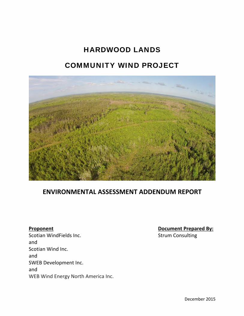
December 2015 HARDWOOD LANDS COMMUNITY WIND PROJECT ENVIRONMENTAL ASSESSMENT ADDENDUM REPORT Proponent Document Prepared By: Scotian WindFields Inc. Strum Consulting and Scotian Wind Inc. and SWEB Development Inc. and WEB Wind Energy North America Inc.
-
Upload
khangminh22 -
Category
Documents
-
view
0 -
download
0
Transcript of environmental assessment addendum report - Government of ...
December 2015
HARDWOOD LANDS
COMMUNITY WIND PROJECT
ENVIRONMENTAL ASSESSMENT ADDENDUM REPORT
Proponent Document Prepared By: Scotian WindFields Inc. Strum Consulting and Scotian Wind Inc. and SWEB Development Inc. and WEB Wind Energy North America Inc.


Environmental Assessment Addendum Report December 4, 2015 Hardwood Lands Community Wind Project Project # 14-5169
Page i
TABLE OF CONTENTS 1.0 INTRODUCTION ....................................................................................................................................... 1 2.0 MI’KMAQ TRADITIONAL USE ASSESSMENT ....................................................................................... 2
2.1 Engagement with Sipekne’katik ................................................................................................... 2
2.2 Mi’kmaq Traditional Use ............................................................................................................... 3
2.3 Preliminary Findings ..................................................................................................................... 5
2.3.1 Food Harvesting .................................................................................................................... 5
2.3.2 Ceremonial Resources .......................................................................................................... 6
2.3.3 Encampment Sites ................................................................................................................ 6
2.3.4 Burial Sites and Spirit Beings ................................................................................................ 6
2.4 Impact Discussion and Mitigation ................................................................................................. 6
3.0 LOCAL WATER SUPPLY ......................................................................................................................... 9 3.1 Methodology ................................................................................................................................ 9
3.2 Results ......................................................................................................................................... 9
3.2.1 Resulting Risk to Water Supply and Quality ........................................................................ 10
4.0 SOUND ASSESSMENT .......................................................................................................................... 12 4.1 Sound Modelling ........................................................................................................................ 12
4.1.1 Assessment Methodology.................................................................................................... 12
4.1.2 Sound Modelling Results ..................................................................................................... 13
4.2 Baseline Sound Assessment ..................................................................................................... 13
4.2.1 Assessment Methodology.................................................................................................... 13
4.2.2 Baseline Sound Results ...................................................................................................... 14
5.0 SHADOW FLICKER ASSESSMENT ...................................................................................................... 15 5.1 Assessment Methodology .......................................................................................................... 15
5.2 Shadow Flicker Modelling Results ............................................................................................. 16
6.0 ARCHEOLOGICAL SHOVEL TESTING REPORT ................................................................................ 16 7.0 WATER FEATURE CLASSIFICATION .................................................................................................. 16 8.0 SUMMARY .............................................................................................................................................. 17 9.0 REFERENCES ........................................................................................................................................ 18
Environmental Assessment Addendum Report December 4, 2015 Hardwood Lands Community Wind Project Project # 14-5169
Page ii
APPENDICES Appendix A: Correspondence with Sipekne’katik, November 2015 Appendix B: Local Water Supply Appendix C: Sound Assessment Appendix D: Shadow Flicker Assessment Appendix E: Archeological Shovel Testing Report Appendix F: Water Feature Classification

Environmental Assessment Addendum Report December 4, 2015 Hardwood Lands Community Wind Project Project # 14-5169
Page 1
1.0 INTRODUCTION Scotian WindFields Inc., Scotian Wind Inc., SWEB Development Inc. (SWEB), and WEB Wind Energy North America Inc. (the Proponent) have proposed the development of a 6.0 MW three turbine wind project in the community of Hardwood Lands, Nova Scotia (the Project). The proposed Study Area is approximately 6.8 km northeast of the community of Nine Mile River, Nova Scotia in the Municipality of the District of East Hants and is centered at 45o5’29.46”N, 63o31’23.50”W, on privately owned land. The Hardwood Lands Community Wind Project Environmental Assessment (EA) document was registered on September 10, 2015. On October 28, 2015 the Minister of Environment determined that the information provided was insufficient to make a decision. Specifically, additional information was required to evaluate potential environmental effects that may be caused by the undertaking. The information requested is outlined below:
Additional information must be provided regarding traditional use of the Project by the Mi’kmaq of Nova Scotia.
Information must be provided regarding the potential impacts to Mi’kmaq traditional use resulting from the undertaking.
Information must be provided regarding the water supply on the adjacent Indian Brook Mi’kmaq Reserve No.14.
The Proponent must demonstrate that sound levels and shadow flicker duration are within recommended guidelines at all receptors, and at the property boundary with the Indian Brook Mi’kmaq reserve No. 14.
The Proponent must provide archaeological shovel testing results to Communities Culture and Heritage and to Nova Scotia Environment.
To address the items raised in the Minister’s decision, the following tasks were completed:
Initiation and provision of preliminary results of a Mi’kmaq Ecological Knowledge Study (MEKS) to detail potential traditional use of the Project by the Mi’kmaq of Nova Scotia.
An assessment of potential impacts on traditional use as a result of the Project. A review (via desktop sources) regarding the water supply to the adjacent Indian Brook Mi’kmaq
Reserve No.14, (Sipekne’katik) and potential impacts to water supply as a result of the Project. Sound modelling including the provision of all modelling data inputs and discussion of
methodology. In addition, baseline sound monitoring has been completed at the Indian Brook Mi’kmaq Reserve No.14 property boundary.
Shadow flicker modelling was completed to ensure that applicable shadow flicker guidelines are met at the Indian Brook Mi’kmaq Reserve No.14 property boundary.
Completion of an archaeological shovel testing program and subsequent report. In addition to the above tasks, information regarding the re-classification of some on-site water features is also provided.

Environmental Assessment Addendum Report December 4, 2015 Hardwood Lands Community Wind Project Project # 14-5169
Page 2
All modelling was based on the V110 turbine model, which has the following structural characteristics (Vestas 2011):
Hub height – 95 m Rotor diameter – 110 m
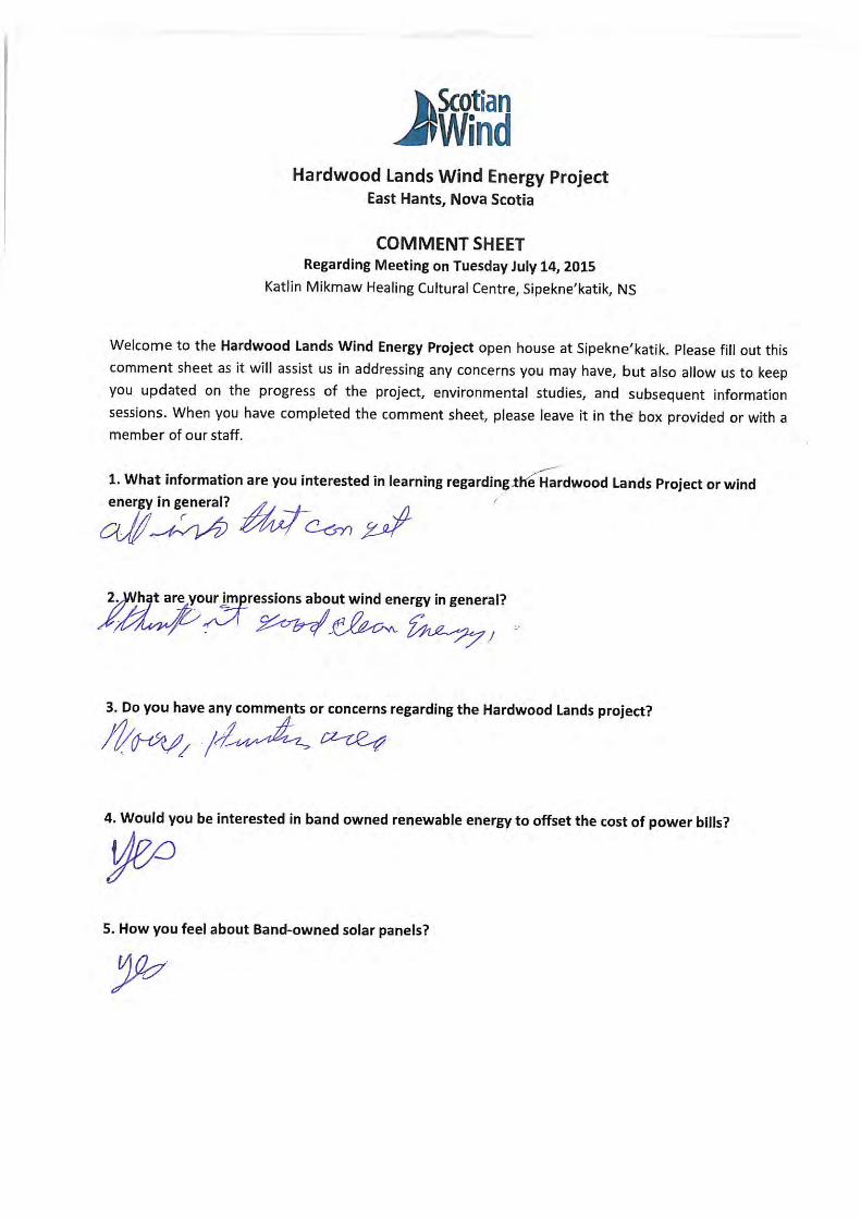
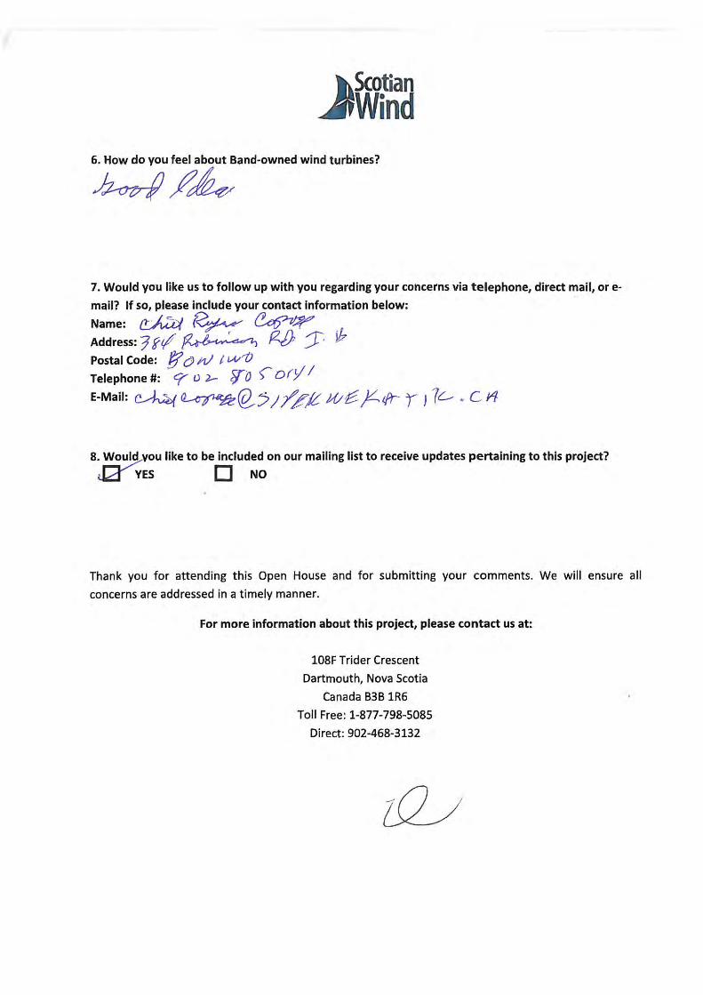
The sections that follow present the methodology and findings of the respective assessments for the Project. 2.0 MI’KMAQ TRADITIONAL USE ASSESSMENT 2.1 Engagement with Sipekne’katik The engagement process between the Sipekne’katik band and the Proponent has been developing for approximately 18 months. In order to ensure appropriate engagement, the Proponent has discussed the engagement strategy with the Office of Aboriginal Affairs (OAA) and updated the OAA on the engagement process since May 2015. The Proponent continued to undertake an engagement strategy to keep the community informed of the development process with as much information as possible, including multiple meetings with the chief, council, and staff and a public Open House information session at the Sipekne’katik church. In addition, the Proponent met in person and shuttled chief, council, staff, and residents to a turbine site to demonstrate a comparable project. A Mi’kmaq Ecological Knowledge Study (MEKS) was commissioned, which is currently underway, and further community meetings and council meetings were requested. The details of that correspondence are itemized in the registered Hardwood Lands Community Wind Project EA document. Prior to the review process of the EA, the Proponent met with the Band Liaison Officer, to drop off a hard copy of the EA document with an offer to meet with the council and/or the community at large to discuss the project and the EA process. Since the EA registration on September 10, the Proponent has reached out to Sipekne’katik in an attempt to ensure that everyone in the community was aware of the Project, and to continue to develop our offer for an ongoing partnership to develop a renewable energy retrofit pilot project in the community. The Proponent was advised that the conversations to form a partnership, and the formal EA consultation process, would proceed independently. On October 28, 2015 the EA review process yielded a ‘Request for Further Information’ decision from the minister, citing the potential impacts of the Project to the traditional use of the land. In a letter sent from Chief Copage to the Crown in October 2015, the Chief indicated a positive relationship with the Proponent, but a concern that the Project would result in a loss of traditional use (specifically hunting) in addition to potential noise impacts (see comment sheet from Chief Copage from bus site tour July 28, 2015 provided in Appendix A). Sipekne’katik also noted capacity issues within the band. To understand and mitigate these potential impacts, the Proponent reached out to Sipekne’katik in earnest again during the month of November 2015. In order to address the concerns, discussion and mitigation in relation to the potential impacts to hunting (as well as other traditional uses) is provided in Section 2.3 and a sound assessment has been completed, the results of which are provided in Section 3.0.

Environmental Assessment Addendum Report December 4, 2015 Hardwood Lands Community Wind Project Project # 14-5169
Page 3
During November 2015, after the minister’s decision, the Proponent reached out to Sipekne’katik on the two parallel dialogues simultaneously. Synopsise of the dialogues are listed below. Wind Project Consultation It is the intention of the Proponent to minimize impacts to traditional use of the land through open and ongoing dialogue.
Sent letter to the Chief Copage requesting a meeting to discuss details regarding traditional use of land. See Appendix A.
Regular calls/emails to Jennifer Copage, Band Liaison Officer, and to Chief Copage to set up a meeting to discuss the traditional usage of the land and the concerns voiced in the meeting with Sipekne’katik, Nova Scotia Environment (NSE), and OAA.
Met with Jennifer Copage who delivered a letter from Sipekne’katik Council indicating that they will be kept informed of, and discuss, the activities with the Province. See Appendix A.
The above described consultation efforts are provided in Appendix A. Pilot Project It is the intention of the Proponent to form a lasting partnership that takes advantage of the Proponent’s experience developing renewable energy projects to increase the energy independence of the Sipekne’katik community.
Met with David Nevin, Economic Development Officer, to discuss his vision of the pilot project and next steps.
Sent Draft Memorandum of Understanding (MOU) of project/tasks to David Nevin and Jennifer Copage. See Appendix A.
Met with David Nevin again to review the MOU and receive feedback. In summary, the Proponent has employed extensive engagement efforts to obtain feedback from the community on the Project, and ascertain traditional uses, which are described herein. As well, the Proponent has received positive feedback from Sipekne’katik on the concept of an MOU to build renewable energy capacity within the community. The Proponent is committed to developing a positive relationship with the community throughout the life of the Project. 2.2 Mi’kmaq Traditional Use As previously discussed, it has been the intent of the Proponent to comprehensively engage with the Sipekne’katik band in relation to all aspects of the Project including during the early planning stages, and during the initial EA process where the Proponent initiated a formal engagement strategy, to keep the community informed of the development process. Efforts included meeting with the chief, council, and staff of the Sipekne’katik band, community meetings, and invitations to hold additional meetings and updates related to the Project. A full account of engagement efforts is listed in the EA document. More recently, concerns were raised during the review process of the 2015 EA that the Project has potential to cause effect to Mi’kmaq traditional use activities, and at the request of the Minister of Environment, additional information related to the potential impacts is required.

Environmental Assessment Addendum Report December 4, 2015 Hardwood Lands Community Wind Project Project # 14-5169
Page 4
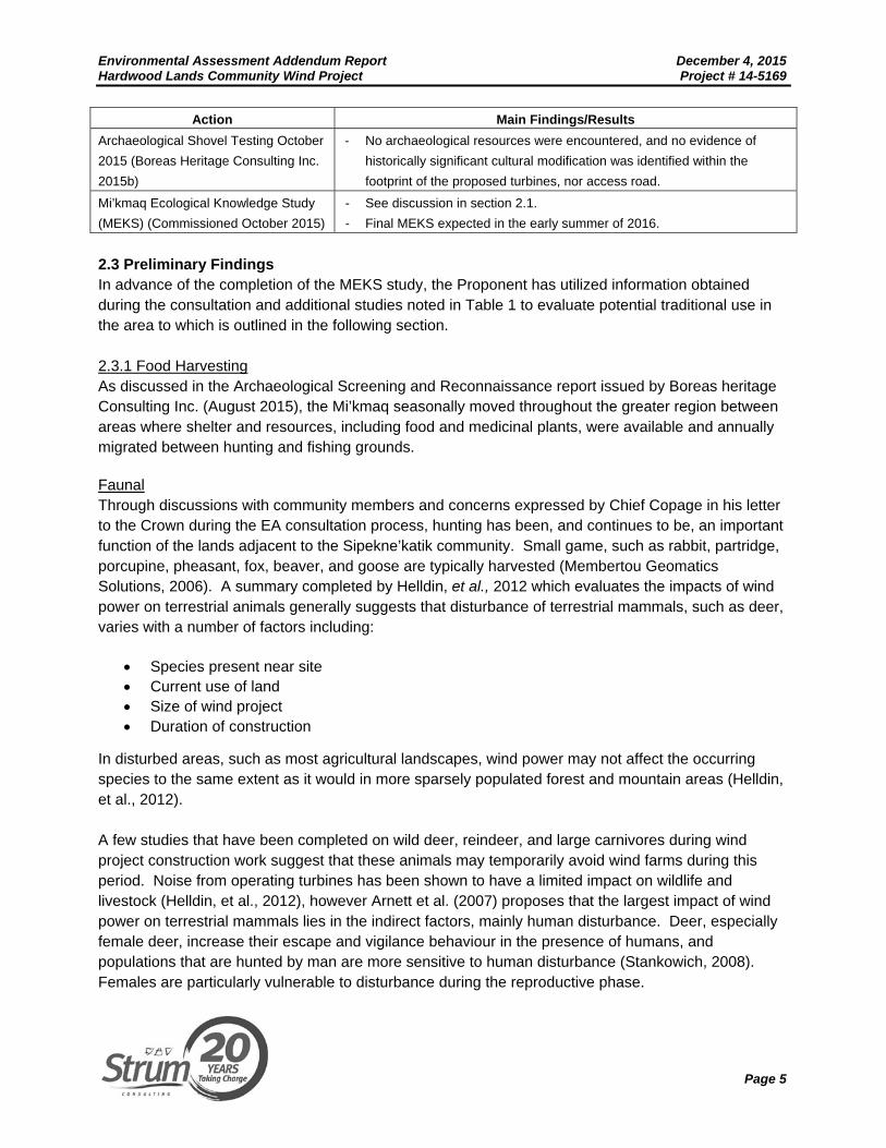
The Proponent has initiated background studies and consultation efforts with the Sipekne’katik band, the Kwilmu'kw Maw-klusuaqn Negotiations Office (KMKNO), and the OAA with an emphasis on better understanding traditional use in the area, and minimizing any impact to this provision through careful Project design. Additionally, the Proponent understands the Millbrook First Nation has a wind energy project adjacent to their community. The Proponent encourages the OAA and Sipekne’katik to confer with Millbrook on their experience with the adjacent wind energy project, particularly in the context of traditional use. To date, the additional studies and background research implemented by the Proponent in order to understand traditional use in the area, has been initiated via various methods as outlined in Table 1. As highlighted in the table, a MEKS is being completed by the Confederacy of Mainland Mi’kmaq (CMM) and is due to be completed in the summer of 2016. In advance of this report, potential traditional uses in the area are discussed in Section 2.1. Table 1: Additional Studies
Action Main Findings/Results Archaeological Screening and
Reconnaissance, January and August
2015 (Boreas Heritage Consulting Inc.
2015)
- Three turbine locations exhibit high potential for encountering Precontact
and/or early historic native archaeological resources.
- Two small areas measuring 10 m x 5 m on either side of the stream bed
within the proposed access road alignment exhibit high potential for
encountering Precontact and/or early historic native archaeological
resources.
- Based on the nature of the terrain, the distance to a significant water
source, and the lack of evidence indicating significant cultural
modification, the remainder of the Hardwood Lands Community Wind
Project Study Area is considered to exhibit low potential for encountering
significant archaeological resources.
- Concurrence on the archaeological study locations by the Sipekne’katik
liaison officer.
Nova Scotia Communities Culture and
Heritage File Review (April 2015)
- No recorded archaeology sites on file within the Project site, however the
site encompasses water bodies and lies directly adjacent to the Indian
Brook First Nation Reserve.
- Historic maps suggest possible settlement.
- Recommendation for a botanical survey to be completed to identify
potential rare plants.
KMKNO Review (June 2015) - Internal GIS database results yielded a number of traditional use
locations within the general area of the Project ranging from food
harvesting, forest products, encampment sites, ceremonial plant
collection, and spirit beings.
- The Assembly of Nova Scotia Mi’kmaq Chiefs, KMKNO and the Mi’kmaw
Nation in Nova Scotia expects evidence-based decisions rooted in
subsurface testing to demonstrate presence, absence, distribution, and
characterization of archaeological remnants from L’nu’k ancestors.
Environmental Assessment Addendum Report December 4, 2015 Hardwood Lands Community Wind Project Project # 14-5169
Page 5
Action Main Findings/Results Archaeological Shovel Testing October
2015 (Boreas Heritage Consulting Inc.
2015b)
- No archaeological resources were encountered, and no evidence of
historically significant cultural modification was identified within the
footprint of the proposed turbines, nor access road.
Mi’kmaq Ecological Knowledge Study
(MEKS) (Commissioned October 2015)
- See discussion in section 2.1.
- Final MEKS expected in the early summer of 2016.
2.3 Preliminary Findings In advance of the completion of the MEKS study, the Proponent has utilized information obtained during the consultation and additional studies noted in Table 1 to evaluate potential traditional use in the area to which is outlined in the following section. 2.3.1 Food Harvesting As discussed in the Archaeological Screening and Reconnaissance report issued by Boreas heritage Consulting Inc. (August 2015), the Mi’kmaq seasonally moved throughout the greater region between areas where shelter and resources, including food and medicinal plants, were available and annually migrated between hunting and fishing grounds. Faunal Through discussions with community members and concerns expressed by Chief Copage in his letter to the Crown during the EA consultation process, hunting has been, and continues to be, an important function of the lands adjacent to the Sipekne’katik community. Small game, such as rabbit, partridge, porcupine, pheasant, fox, beaver, and goose are typically harvested (Membertou Geomatics Solutions, 2006). A summary completed by Helldin, et al., 2012 which evaluates the impacts of wind power on terrestrial animals generally suggests that disturbance of terrestrial mammals, such as deer, varies with a number of factors including:
Species present near site Current use of land Size of wind project Duration of construction
In disturbed areas, such as most agricultural landscapes, wind power may not affect the occurring species to the same extent as it would in more sparsely populated forest and mountain areas (Helldin, et al., 2012). A few studies that have been completed on wild deer, reindeer, and large carnivores during wind project construction work suggest that these animals may temporarily avoid wind farms during this period. Noise from operating turbines has been shown to have a limited impact on wildlife and livestock (Helldin, et al., 2012), however Arnett et al. (2007) proposes that the largest impact of wind power on terrestrial mammals lies in the indirect factors, mainly human disturbance. Deer, especially female deer, increase their escape and vigilance behaviour in the presence of humans, and populations that are hunted by man are more sensitive to human disturbance (Stankowich, 2008). Females are particularly vulnerable to disturbance during the reproductive phase.
Environmental Assessment Addendum Report December 4, 2015 Hardwood Lands Community Wind Project Project # 14-5169
Page 6
Floral A traditional use of lands that continues throughout Mi’kma’ki is the collection and harvest of medicinal plants. Many elders continue to prepare traditional medicines for their friends and relatives; however, continuous development alters the natural ecosystem and limits harvesting areas (AMEC Environment & Infrastructure, 2013). In addition, Mi’kmaq people in Nova Scotia have traditionally utilized edible native plants as a food source, many of which are available in the Project area. A list of species identified within the Project footprint (i.e. access roads and turbine locations) is available in the 2015 EA document. 2.3.2 Ceremonial Resources Ceremonial resources can range from physical ceremonial sites, to items (i.e. plants, other forest products) collected and utilized in ceremonial events and traditions. Ceremonial sites may include historical and culturally important locations that were used to acknowledge the interconnectedness of everything; ceremony is how values are taught and reinforced (Blatchford, 2012). 2.3.3 Encampment Sites Encampments refer to historical or present locations that First Nation settlers utilized for temporary or permanent residence. The locations were likely identified based on availability of food (i.e. floral and faunal), and land conditions. Although studies completed to date have not identified any existing encampments on, or near to the Project footprint, it is unconfirmed if any historical locations existed on the Project site. 2.3.4 Burial Sites and Spirit Beings As discussed in the 2015 EA, during the course of the Archaeological Screening and Reconnaissance (August 2015), Boreas Heritage Consulting Inc. was informed of the reported location of a historic burial ground of European settlers, located 800 m southeast of the proposed turbine site 3 and approximately 480 m west of the proposed access road. The burial ground was not located during the field survey; however it presents a culturally significant zone and will be avoided. The potential presence of a European village burial ground near Burma Road was suggested during the public Community Meeting held on Wednesday, July 14, 2015, in Sipkne’katik. The scope of the archeological field survey was extended, but no evidence of a burial site was found. The existence of spirit beings on/or close to the Project site is unconfirmed, however they are known to be frequently co-located with archaeological or burial sites (MacLeod-Leslie, 2015). 2.4 Impact Discussion and Mitigation Table 2 provides discussion of impact and mitigation methods available to prevent potential impacts to the traditional uses discussed in Section 2.1.
Environmental Assessment Addendum Report December 4, 2015 Hardwood Lands Community Wind Project Project # 14-5169
Page 7
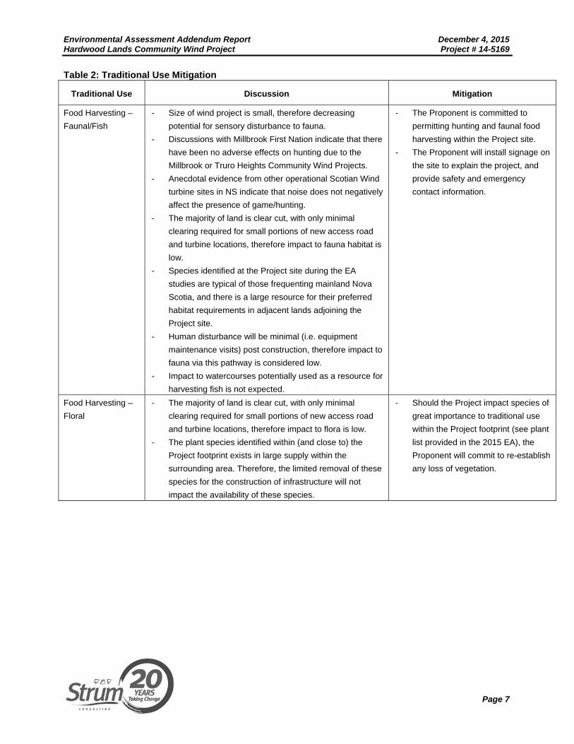
Table 2: Traditional Use Mitigation
Traditional Use Discussion Mitigation
Food Harvesting –
Faunal/Fish
- Size of wind project is small, therefore decreasing
potential for sensory disturbance to fauna.
- Discussions with Millbrook First Nation indicate that there
have been no adverse effects on hunting due to the
Millbrook or Truro Heights Community Wind Projects.
- Anecdotal evidence from other operational Scotian Wind
turbine sites in NS indicate that noise does not negatively
affect the presence of game/hunting.
- The majority of land is clear cut, with only minimal
clearing required for small portions of new access road
and turbine locations, therefore impact to fauna habitat is
low.
- Species identified at the Project site during the EA
studies are typical of those frequenting mainland Nova
Scotia, and there is a large resource for their preferred
habitat requirements in adjacent lands adjoining the
Project site.
- Human disturbance will be minimal (i.e. equipment
maintenance visits) post construction, therefore impact to
fauna via this pathway is considered low.
- Impact to watercourses potentially used as a resource for
harvesting fish is not expected.
- The Proponent is committed to
permitting hunting and faunal food
harvesting within the Project site.
- The Proponent will install signage on
the site to explain the project, and
provide safety and emergency
contact information.
Food Harvesting –
Floral
- The majority of land is clear cut, with only minimal
clearing required for small portions of new access road
and turbine locations, therefore impact to flora is low.
- The plant species identified within (and close to) the
Project footprint exists in large supply within the
surrounding area. Therefore, the limited removal of these
species for the construction of infrastructure will not
impact the availability of these species.
- Should the Project impact species of
great importance to traditional use
within the Project footprint (see plant
list provided in the 2015 EA), the
Proponent will commit to re-establish
any loss of vegetation.
Environmental Assessment Addendum Report December 4, 2015 Hardwood Lands Community Wind Project Project # 14-5169
Page 8
Traditional Use Discussion Mitigation
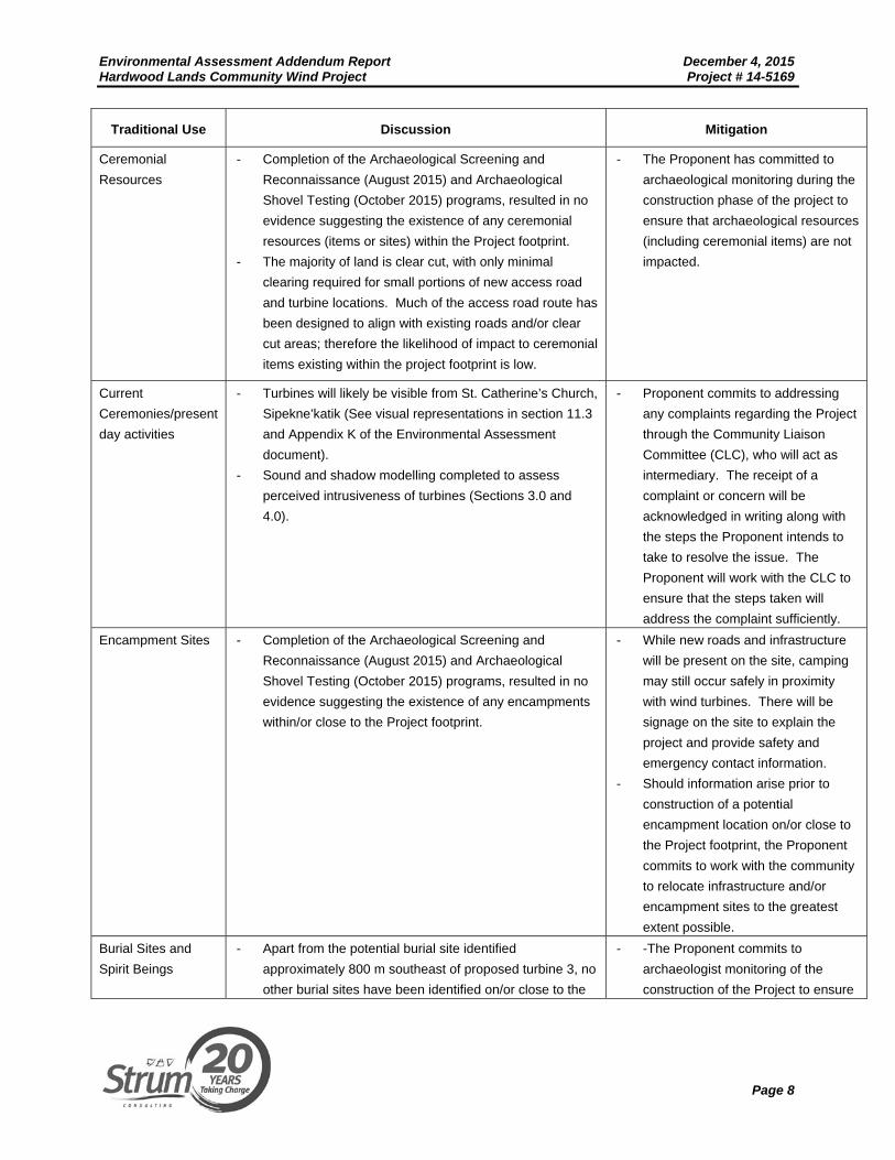
Ceremonial
Resources
- Completion of the Archaeological Screening and
Reconnaissance (August 2015) and Archaeological
Shovel Testing (October 2015) programs, resulted in no
evidence suggesting the existence of any ceremonial
resources (items or sites) within the Project footprint.
- The majority of land is clear cut, with only minimal
clearing required for small portions of new access road
and turbine locations. Much of the access road route has
been designed to align with existing roads and/or clear
cut areas; therefore the likelihood of impact to ceremonial
items existing within the project footprint is low.
- The Proponent has committed to
archaeological monitoring during the
construction phase of the project to
ensure that archaeological resources
(including ceremonial items) are not
impacted.
Current
Ceremonies/present
day activities
- Turbines will likely be visible from St. Catherine’s Church,
Sipekne’katik (See visual representations in section 11.3
and Appendix K of the Environmental Assessment
document).
- Sound and shadow modelling completed to assess
perceived intrusiveness of turbines (Sections 3.0 and
4.0).
- Proponent commits to addressing
any complaints regarding the Project
through the Community Liaison
Committee (CLC), who will act as
intermediary. The receipt of a
complaint or concern will be
acknowledged in writing along with
the steps the Proponent intends to
take to resolve the issue. The
Proponent will work with the CLC to
ensure that the steps taken will
address the complaint sufficiently.
Encampment Sites - Completion of the Archaeological Screening and
Reconnaissance (August 2015) and Archaeological
Shovel Testing (October 2015) programs, resulted in no
evidence suggesting the existence of any encampments
within/or close to the Project footprint.
- While new roads and infrastructure
will be present on the site, camping
may still occur safely in proximity
with wind turbines. There will be
signage on the site to explain the
project and provide safety and
emergency contact information.
- Should information arise prior to
construction of a potential
encampment location on/or close to
the Project footprint, the Proponent
commits to work with the community
to relocate infrastructure and/or
encampment sites to the greatest
extent possible.
Burial Sites and
Spirit Beings
- Apart from the potential burial site identified
approximately 800 m southeast of proposed turbine 3, no
other burial sites have been identified on/or close to the
- -The Proponent commits to
archaeologist monitoring of the
construction of the Project to ensure
Environmental Assessment Addendum Report December 4, 2015 Hardwood Lands Community Wind Project Project # 14-5169
Page 9
Traditional Use Discussion Mitigation
Project footprint.
that no burial sites and/or spirit being
locations on/or close to the Project
footprint are disturbed.
3.0 LOCAL WATER SUPPLY 3.1 Methodology A review was completed to determine potential impacts to water supply and water quality on the adjacent Sipekne’katik community as a result of the Project. The following sources of information were utilized to gain insight into current water supply methods, from where potential risk of impact was evaluated.
NSDNR Groundwater Atlas Review of available reports and mapping of surficial aquifers in proximity to the Project site
and Sipekne’katik lands Surface water mapping
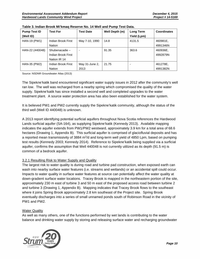
3.2 Results According to the NSDNR Groundwater Atlas, there are three wells registered under the Indian Brook Mi’kmaq Reserve No.14 (NSDNR 2013). A Drillers Well Log was available for Well ID 440048 indicating the well was installed in 1944 to a depth of 91.5 m. Lithology data was not available for the well, however a pump test (HAN-22) was completed on the well resulting in a long term yield of 363.6 Lpm. The well is located 2.1 km east of the nearest turbine proposed for the Hardwood Lands Community Wind Project (Drawing 1, Appendix B). Two additional wells (PW1 and PW2) located in the area near to Sandy Desert Road do not contain Well Logs, however, pump test data was available. PW1 is installed to a depth of 14.8 m and underwent a pump test (HAN-19) in May 1990 producing a long term yield of 4131.5 Lpm. PW2 was installed to a depth of 21.75 m and underwent a pump test (HAN-35) in May/June 2013. A long term safe yield was not provided for this pump test. Relevant well data is provided below in Table 3 and well locations are illustrated on Drawing 1 (Appendix B).
Environmental Assessment Addendum Report December 4, 2015 Hardwood Lands Community Wind Project Project # 14-5169
Page 10
Table 3. Indian Brook Mi’kmaq Reserve No. 14 Well and Pump Test Data. Pump Test ID (Well ID)
Test For Test Date Well Depth (m) Long Term Yield (Lpm)
Coordinates
HAN-19 (PW1) Indian Brook First
Nation
May 7-10, 1990 14.8 4131.5 460981E,
4991346N
HAN-22 (440048) Shubenacadie –
Indian Brook First
Nation IR 14
- 91.35 363.6 460936E,
4992879N
HAN-35 (PW2) Indian Brook First
Nation
May 31-June 2,
2013
21.75 - 461278E,
4991382N
Source: NSDNR Groundwater Atlas (2013)
The Sipekne’katik band encountered significant water supply issues in 2012 after the community’s well ran low. The well was recharged from a nearby spring which compromised the quality of the water supply. Sipekne’katik has since installed a second well and completed upgrades to the water treatment plant. A source water protection area has also been established for the water system. It is believed PW1 and PW2 currently supply the Sipekne’katik community, although the status of the third well (Well ID 440048) is unknown. A 2013 report identifying potential surficial aquifers throughout Nova Scotia references the Hardwood Lands surficial aquifer (SA-164), as supplying Sipekne’katik (Kennedy 2013). Available mapping indicates the aquifer extends from PW1/PW2 westward, approximately 3.9 km for a total area of 68.6 hectares (Drawing 1, Appendix B). This surficial aquifer is comprised of glaciofluvial deposits and has a reported mean transmissivity of 3884 m2/d and long-term well yield of 4850 Lpm, based on pumping test results (Kennedy 2003; Kennedy 2014). Reference to Sipekne’katik being supplied via a surficial aquifer, confirms the assumption that Well 440048 is not currently utilized as its depth (91.5 m) is common of a bedrock aquifer. 3.2.1 Resulting Risk to Water Supply and Quality The largest risk to water quality is during road and turbine pad construction, when exposed earth can wash into nearby surface water features (i.e. streams and wetlands) or an accidental spill could occur. Impacts to water quality in surface water features at source can potentially affect the water quality at down-gradient surface water locations. Tracey Brook is mapped in the northeastern portion of the site, approximately 230 m east of turbine 3 and 50 m east of the proposed access road between turbine 2 and turbine 3 (Drawing 1, Appendix B). Mapping indicates that Tracey Brook flows to the southeast where it joins Spring Brook approximately 2.8 km southeast of the Project site. Spring Brook eventually discharges into a series of small unnamed ponds south of Robinson Road in the vicinity of PW1 and PW2. Water Quality As well as many others, one of the functions performed by wet lands is contributing to the water balance and drinking water supply by storing and releasing surface water and recharging groundwater

Environmental Assessment Addendum Report December 4, 2015 Hardwood Lands Community Wind Project Project # 14-5169
Page 11
reservoirs (NSE, 2011). The Project has been designed to avoid areas of wetland habitat, and as such, no wetland alterations are required on the eastern portion of the site, which drain water toward Sipekne’katik lands. Two streams which currently drain via deteriorated culverts beneath existing woods roads were identified during the baseline field survey completed in support of the 2015 EA document submission (Drawing 1, Appendix B and Drawing 1, Appendix E). Both streams drain into Tracey Brook and are proposed to be crossed by the new access road. As part of the access road upgrade the existing deteriorated culverts will be replaced by the installation of new culverts in order to maintain hydrologic connectivity between up-gradient wetland habitat, and down-gradient Tracey Brook and its aquatic receptors. Potential impacts to the identified streams will be easily addressed through the provincial watercourse permitting process, however the Proponent will also take the following steps to ensure water quality is not compromised for down grade aquatic receptors:
Drainage and erosion control features will be included in the road design; An Environmental Protection Plan will be completed and approved prior to construction; An Erosion and Sedimentation Control (ESC) Plan will be completed to include:
o A point person to review, upgrade, and maintain the ESC measures; o Soil stabilization and sediment controls, silt fences, berms, ponds, and check dams will
be installed at the same time the road and crane pads are built; o No more than 1 hectare of land will be exposed without erosion controls; o The quality of ESC measures will be verified before and after a rainfall of more than 10
mm; Diversion ditches will be installed to keep clean water clean; Refuelling of equipment will not occur within 30 m of any watercourses/wetlands; Any wash water from the cleaning of construction vehicles will be disposed of on-site, using
standard industry practices and following environmental regulations/guidelines for the protection of watercourses/wetlands;
Temporary storage of waste materials on-site will be located at least 30 m from watercourses/ wetlands;
An Environmental Monitor will be on-site to ensure; o The Environmental Protection Plan is adhered to; o The safe use of fuels and lubricants associated with construction sites; o Spill kits are on-site in case of an accident.
Implementation of the above-mentioned mitigation measures, best management practices, and adherence to regulatory requirements will allow for water quality up-gradient of the surficial aquifer supplying the Sipekne’katik community to be maintained and unaffected by Project activities.
Environmental Assessment Addendum Report December 4, 2015 Hardwood Lands Community Wind Project Project # 14-5169
Page 12
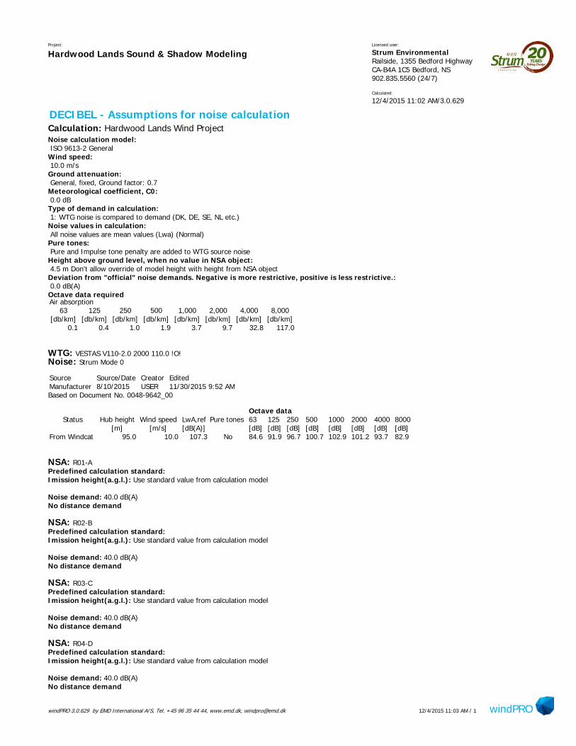
Water Supply The proposed Hardwood Lands Community Wind Project is situated approximately 2.2 km north of the surficial aquifer supplying the Sipekne’katik community. Development of the wind project will not involve blasting or require water withdrawals from the surficial or bedrock aquifer; therefore impacts to water supply are not expected as a result of the Project. 4.0 SOUND ASSESSMENT An acoustic assessment of predicted sound pressure levels associated with the proposed turbines, in addition to the collection of baseline sound information was completed for the Project. 4.1 Sound Modelling 4.1.1 Assessment Methodology An acoustic assessment was conducted for the Project to predict sound pressure levels at identified receptors within a 2 km radius of the proposed turbine locations. The assessment was completed using the “Decibel” module of the WindPro v. 3.1 software package. For the purposes of this model, receptors included all structures identified in the provincial topographic mapping, and any additional identifiable structures based on aerial imagery. No attempt to distinguish sheds and outbuildings from dwellings or cottages was made. The acoustic assessment also included two additional receptor locations, as shown in Drawing 1 (Appendix C). The two locations (R99 and R87) exist at the closest point of the adjacent Indian Sipekn’katik parcel 14 (PID 45148582) property boundary to a turbine location The sound assessment model followed ISO 9613-2 Acoustics – Attenuation of sound during propagation outdoors – Part 2: General method and calculations, and was based on the following input information:
UTM coordinates for the wind turbines; UTM coordinates for existing receptors (98) within a 2 km radius of the Project site; A downwind speed of 10.0 m/s, the speed at which the highest sound power level output is
achieved (based on test data from the manufacturer); Overall sound emission data for the Vestas V110, provided by the manufacturer; Topographic data for the surrounding area; and 1/1 and 1/3 octave level data provided by the manufacturer.
The sound power curve for the V110 is provided below (Figure 1).

Environmental Assessment Addendum Report December 4, 2015 Hardwood Lands Community Wind Project Project # 14-5169
Page 13
Source: Vestas, 2014
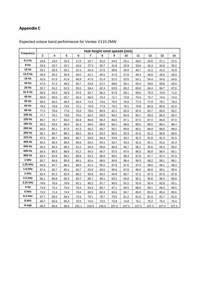
Figure 1: Sound Power Curve for V110 4.1.2 Sound Modelling Results Modelling results, including the following information, is provided in Appendix C:
Expected octave band performance for Vestas V110-2MW WindPro v. 3.1 modeling Assumptions Sheet WindPro v. 3.1 modeling Output sheet Drawing indicating predicted sound pressure levels (Drawing 1)
Results of the modelling indicate that predicted sound pressure levels will not exceed 40 dBA at any of the existing receptors, including the two locations (R99 and R87) modelled on the adjacent Sipekne’katik property boundary. 4.2 Baseline Sound Assessment In order to accurately evaluate future noise levels associated with the Project, ambient pre-construction sound levels were established through the completion of ambient baseline monitoring. 4.2.1 Assessment Methodology Ambient sound monitoring was completed from November 20 to 30, 2015 at two receptors (R87 and R99). Table 4 describes the deployment details of each receptor. Sound monitoring locations are

Environmental Assessment Addendum Report December 4, 2015 Hardwood Lands Community Wind Project Project # 14-5169
Page 14
indicated on Drawing 1 (Appendix C). The two locations (R87 and R99) exist on the property boundary of the adjacent Indian Brook Mi’kmaq Reserve No.14 (PID 45148582). The assessment was completed with Quest Technologies SoundPro DL-2-1/3 sound monitors. The monitors were configured to attenuate recorded sound levels every minute in A-weighted decibels (dBA). Data was then analysed using ‘Detection Management Software’ by the 3M Company. At each receptor location, the monitor was kept in a locked weatherproof case, with the microphone supported by a tripod at a height of 1.5 m above the ground. The microphone was mounted inside an acoustically transparent weather resistant cage that is designed to minimize the effects of environmental noise interferences, such as wind and rain. Care was also taken to locate the equipment in areas where natural sound sources (i.e. a stream) would be minimized. The assessment was conducted during mid-fall after most of the deciduous trees had dropped their leaves, and before snow had accumulated on the ground. Under these conditions, natural noise attenuation from vegetation and accumulated snow is minimized. Location characteristics and weather conditions for each monitoring location are provided in Table 4. Table 4: Sound Monitoring Location Details Monitoring Location
Dates Assessed
Location Details Weather Conditions*
R87**
November 23 to
Nov 26, 2015*
Regenerating mixedwood,
adjacent to a clear cut.
Logging road within 200 m.
Hourly averaged winds speeds range from 14
to 29 km/h, mostly clear skies with intermittent
light rain
R99
Nov 26 to Nov
30, 2015
Mature, coniferous forest
with understory canopy.
Greater than 500 m from
nearest logging roads.
Hourly average winds speeds range from 4 to
25 km/h, mostly clear skies with intermittent
rain and drizzle.
*Source: EC 2015
** Data from this sound monitor collected prior to 5:00 PM on November 23, 2015 was excluded from this analysis
due to high wind conditions (storm event) which produced uncharacteristic sound levels.
4.2.2 Baseline Sound Results The data was analysed to determine a number of parameters, which are described below:
LASeq – This is the average noise level that contains the same amount of sound energy as the actual fluctuating sound level during the sample period. This represents the average sound level over the duration of the sampling period.
LASmx – This represents the highest ‘slow’ time weighted sound pressure level expressed in decibels. This represents the highest sound level attenuated over 1 second recorded during the sampling period.

Environmental Assessment Addendum Report December 4, 2015 Hardwood Lands Community Wind Project Project # 14-5169
Page 15
LASmn – This represents the lowest ‘slow’ time weighted sound pressure level expressed in decibels. This represents the lowest sound level attenuated over 1 second recorded during the sampling period.
LAS90 – This measurement is the sound level (in dBA) that was exceeded 90% of the time. This measurement is often used as a measurement to the background noise levels.
Results are presented in Table 5, below. Table 5: Ambient Sound Monitoring Results Monitoring Location ID / Parameter (Measured
in dBA) R87 R99
LASeq 37.0 44.0
LASmx 78.4 66.3
LASmn 14 43.4
LAS90 18.9 43.5
5.0 SHADOW FLICKER ASSESSMENT A shadow flicker assessment was completed for the Project as part of the original EA to assess the potential impact of shadows at identified receptors within a 2 km radius of the proposed turbine locations. The results of the study indicated that although all identified receptors were predicted to comply with the industry standard of no more than 30 minutes of shadow on the worst day and no more than 30 hours of shadow flicker per year, some exceedances in predicted shadow flicker exist at three locations within the adjacent Sipekn’katik property (known as the “exceedance zones”) (PID
45148582) (Drawing 1, Appendix D). 5.1 Assessment Methodology The methodology employed during the EA process involved the identification of receptors using the same methodology as described in the previous section for the sound assessment. The assessment was completed using the “Shadow” module of the WindPro v. 3.1 software package using worst case scenario conditions, including:
Constant sunshine during daylight hours; Turbines are always operational; Turbine blades are oriented perpendicular to the line between the sun and all receptors; Receptor windows are oriented towards the turbine(s).
Other calculation variables included in the modelling are outlined in the Shadow module of the WindPro v. 3.1 software package output sheet (Appendix D) For the purposes of the EA Addendum, modelling has been completed at eight arbitrary receptors positioned (SF1-8) within the three former “exceedance zones”, to which detailed vegetation characteristics has been incorporated into the modelling inputs (Drawing 1 and 2, Appendix D).
Environmental Assessment Addendum Report December 4, 2015 Hardwood Lands Community Wind Project Project # 14-5169
Page 16
Vegetation effects were incorporated into the model using field data collected along the property boundary of PID 45148582, at the three “exceedance zones’. Specifically, forest stand height was included to determine if the vegetation was likely to obscure the potential effect of shadow flicker. The other worst case scenario modelling conditions noted above were used for the exercise. Vegetation height was recorded along the property boundary transect at approximately 10 m intervals. For the most part, vegetation height was very consistent within the three exceedance zones, although the northern extent of the northernmost exceedance zone comprised varying vegetation heights. In all instances, a conservative average vegetation height was used for each exceedance zone as indicated on Drawing 2 and Table D1 (Appendix D). For the purposes of the modelling, due to the future potential of the Project site undergoing tree harvesting activities, the worst case scenario approach of “no vegetation” was included as an input for the Project site lands. The NSDNR provincial forestry inventory database was used as a modelling input on the adjacent Sipekn’katik lands. Turbine visibility was calculated at a 5 m grid resolution, and provincially available 5 m contour interval topographical data was used. Arbitrary receptor points were placed within the exceedance zones to calculate the precise incidences of shadow flicker throughout the year. 5.2 Shadow Flicker Modelling Results Modelling results including the following information is provided in Appendix D:
Field observed vegetation height (Table D1) Shadow” module of the WindPro v. 3.1 software package “without vegetation“ output sheet Shadow” module of the WindPro v. 3.1 software package “with vegetation“ output sheet Drawings 1 and 2 indicating predicted shadow flicker levels
The modelling results indicate that all EA receptors, and receptors modelled in the “exceedance zones” (S1-S8) are predicted to comply with the industry standard of no more than 30 minutes of shadow on the worst day and no more than 30 hours of shadow flicker per year. 6.0 ARCHEOLOGICAL SHOVEL TESTING REPORT An Archaeological shovel testing program was completed by Boreas Heritage Consulting Inc. The Shovel testing report is provided in Appendix E. 7.0 WATER FEATURE CLASSIFICATION As part of the baseline field data collected in support of the 2015 EA document submission, four watercourses were identified within the Project Study Area. Subsequently, NSE completed a site inspection on September 2, 2015 to review the determination of the water features identified. As a result of the NSE inspection, Watercourse 1 and Watercourse 2 (as depicted in the 2015 EA submission) have been re-classified as drainage features. As such, the attached Drawing 1 (Appendix

Environmental Assessment Addendum Report December 4, 2015 Hardwood Lands Community Wind Project Project # 14-5169
Page 17
F) has been updated to reflect these changes. The NSE Inspection Report is also provided in Appendix F. 8.0 SUMMARY Through completion of the 2015 EA, in addition to findings associated with this Addendum document, it has been determined that there are no significant environmental concerns or effects that may result from the Project that cannot be effectively mitigated or monitored. The proposed capacity of the three turbines (6 MW) will produce enough energy to power approximately 1,728 households with local, clean, renewable energy and will contribute to reaching Nova Scotia’s renewable energy commitments.
Environmental Assessment Addendum Report December 4, 2015 Hardwood Lands Community Wind Project Project # 14-5169
Page 18
9.0 REFERENCES AMEC Environment & Infrastructure. (2013). Mi'kmaq Ecological Knowledge Study Goldboro LNG. Dartmouth: Pieridae Energy Inc. Arnett, E., Johnson, D., Larkin, R., Manes, S., Manville, A., Mason, R., Thresher, R. (2007). Impacts of wind energy facilities on wildlife and wildlife habitat. The Wildlie Society. doi:Technical Review 07-2 Blatchford, C. (2012). Aboriginal Customs and Protocols. Reporting in Indigenous Communities. Available online: http://www.riic.ca/the-guide/in-the-field/aboriginal-customs-and-protocols/ EC (Environment Canada). 2015. Climate Data Online. Available online: http://climate.weather.gc.ca/ Helldin, J., Jung, J., Weibke, N., Matthias, O., Anna, S., & Frderik, W. (2012). The impacts of wind power on terrestrial animals. Bromma: The Swedish Environmental Protection Agency. NSDNR (Nova Scotia Department of Natural Resources). 2013. Nova Scotia Groundwater Atlas. Available online: https://fletcher.novascotia.ca/DNRViewer/?viewer=Groundwater NSDNR (Nova Scotia Department of Natural Resources). 2012. Nova Scotia Forest Inventory. Accessed on May 15th, 2013 from http://novascotia.ca/natr/forestry/gis/forest-inventory.asp Kennedy, G.W. 2013. Identification and Preliminary Mapping of Surficial Aquifers in Nova Scotia. Mineral Resources Branch, Report of Activities. Nova Scotia Department of Natural Resources, Report ME 2013-001, p.33-43. Available online: http://novascotia.ca/natr/meb/data/pubs/14re01/14re01_Kennedy.pdf Kennedy, G.W. 2014. Potential Surficial Aquifers of Nova Scotia. DP ME 290, Version 1. NSDNR, Minerals and Energy Branch. Available online: http://novascotia.ca/natr/meb/download/dp490.asp MacLeod-Leslie, H. (2015, June 19). Email Correspondence. ARD Response - RE: Hardwoodlands (adjacent Sipe'kene'katik). Kwilmu'kw Maw-klusuaqn Negotiations Office. Membertou Geomatics Solutions. (2006). Mi'kmaq Ecological Knowledge Study - Alton Gas Storage Project. Alton Gas. NSE (Nova Scotia Environment). 2011. Nova Scotia Wetland Conservation Policy. Website: http://www.novascotia.ca/nse/wetland/docs/Nova.Scotia.Wetland.Conservation.Policy.pdf. Website accessed November 27 Stankowich, T. (2008). Ungulate flight responses to human distrubance: A review and meta-analysis. . Biological Conservation, 141:2159-2137. Vestas. 2014. 2MW Platform. V110 – 2.0 MW Facts and Figures. 9-16 pp.

APPENDIX A CORRESPONDENCE WITH SIPEKNE’KATIK, NOV 2015
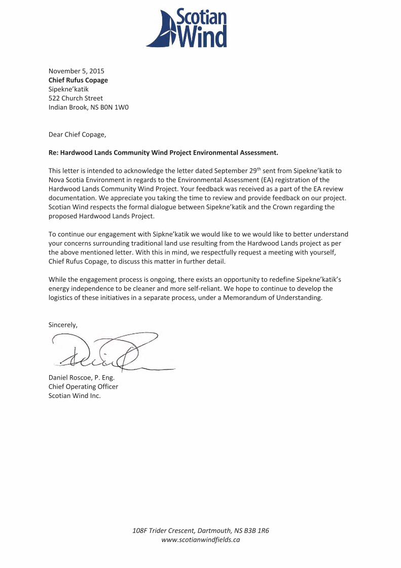
108F Trider Crescent, Dartmouth, NS B3B 1R6 www.scotianwindfields.ca
November 5, 2015 Chief Rufus Copage Sipekne’katik 522 Church Street Indian Brook, NS B0N 1W0 Dear Chief Copage, Re: Hardwood Lands Community Wind Project Environmental Assessment. This letter is intended to acknowledge the letter dated September 29th sent from Sipekne’katik to Nova Scotia Environment in regards to the Environmental Assessment (EA) registration of the Hardwood Lands Community Wind Project. Your feedback was received as a part of the EA review documentation. We appreciate you taking the time to review and provide feedback on our project. Scotian Wind respects the formal dialogue between Sipekne’katik and the Crown regarding the proposed Hardwood Lands Project. To continue our engagement with Sipkne’katik we would like to we would like to better understand your concerns surrounding traditional land use resulting from the Hardwood Lands project as per the above mentioned letter. With this in mind, we respectfully request a meeting with yourself, Chief Rufus Copage, to discuss this matter in further detail. While the engagement process is ongoing, there exists an opportunity to redefine Sipekne’katik’s energy independence to be cleaner and more self-reliant. We hope to continue to develop the logistics of these initiatives in a separate process, under a Memorandum of Understanding. Sincerely,
Daniel Roscoe, P. Eng. Chief Operating Officer Scotian Wind Inc.

Memorandum of Understanding
Between
SIPEKNE’KATIK
And
SWEB Development Inc.
as a general partner for SCOTIAN WEB II LP (“SWEB”)
This Memorandum of Understanding (MOU) describes the terms and understanding between Sipekne’katik and SWEB regarding a renewable energy partnership in good faith in relation to the Hardwood Lands Community Wind Project. Background SWEB, working with Scotian WEB II LP to proposes a three-turbine facility in lands adjacent to Sipekne’katik. Sipekne’katik is interested in developing ways to reduce their energy costs through home efficiency and renewable energy generation. Sipekne’katik is also interested in building the capacity to assess, install and maintain their own renewable energy generating systems. SWEB has extensive experience in small and large renewable energy projects. In anticipation of the Hardwood Lands Community Wind Project becoming operational, SWEB offers its experience and data to guide Sipekne’katik to increase their energy independence Purpose This MOU will describe the scope of the relationship between SWEB and Sipekne’katik and delineate the division of labour between the parties to accomplish common goals. The primary tasks of this of MOU are:
Winter / Spring 2016: A feasibility study for the development, procurement and installation of band-owned wind turbines and/or solar panels to offset power usage.
Spring / Summer 2016: A pilot project, involving an energy audit of a home in the community and the installation of energy efficiency a solar system and/or energy efficiency systems
o Training of band members to work with solar team to install and maintain solar systems, if applicable
Annually upon operation: The establishment of a Community Liaison Committee to act as communication link for project specific information and distribute funds equal to 0.75% of gross revenue from the Hardwood Lands Community Wind Project.

Tasks The above goals will be accomplished by undertaking the following activities: SWEB Sipekne’katik Collect energy usage under the band
account(s) Conduct Band Level Review of energy consumption
Identify potential energy efficiency and conservation strategies
Identify potential renewable projects for wind, solar photovoltaic and solar thermal technologies
Council to confer on which project(s) to pursue/prioritize
Define project development team Work with Sipekne’katik to develop a project schedule
Work with SWEB to develop a project schedule
Decide within community where to locate pilot project
Solar: Conduct energy audit and define scope of pilot project
Work with SWEB to decide the desired scope for
Solar: Calculate Energy savings Solar: Contract Solar team to install solar system and/or
Solar: Train certain band members on auditing and/or maintenance and/or installation of solar systems
Wind: Using proprietary local wind data, Prepare preliminary layout.
Work with SWEB on siting turbine siting.
Wind: Predict Energy Yield Wind: Investigate procurement options of turbines – must come with service and maintenance agreement
Wind: Create draft financial pro forma Wind: Identify permitting process Review layout/pro forma from SWEB Investigate available funding/grant options Wind: Work with Sipekne’katik to create finance-ready project reports.
Wind: Assist Sipekne’katik to submit all permits
Wind: Prepare scope of construction contracts Award contracts and manage contractors

Reporting (Record who will evaluate effectiveness and adherence to the agreement and when evaluation will happen) Funding The below commitments are funded by the operating revenue of the Hardwood Lands Community Wind Project. SWEB Commits to:
Annually contributing 0.75% of the gross revenue of the Hardwood Lands Community Wind Project,
o To be distributed each year for the previous year, o to be administered by the Community Liaison Committee;
Funding the installation of home efficiency and/or solar array to the approximate sum of $20 000;
Working with community members to conduct training for solar system installation and maintenance.
Waiving consulting fees regarding the above mentioned development process; Duration This MOU is at-will and may be modified by mutual consent of authorized officials from Sipekne’katik and SWEB. This MOU shall become effective upon signature by the authorized officials from the Sipekne’katik and SWEB and will remain in effect until modified or terminated by any one of the partners by mutual consent. In the absence of mutual agreement by the authorized officials from Sipekne’katik and SWEB, this MOU shall end upon the completion of the above mentioned tasks. The annual community contribution will continue for the duration of the 20-year Power Purchase Agreement relating to the Hardwood Lands Community Wind Project.
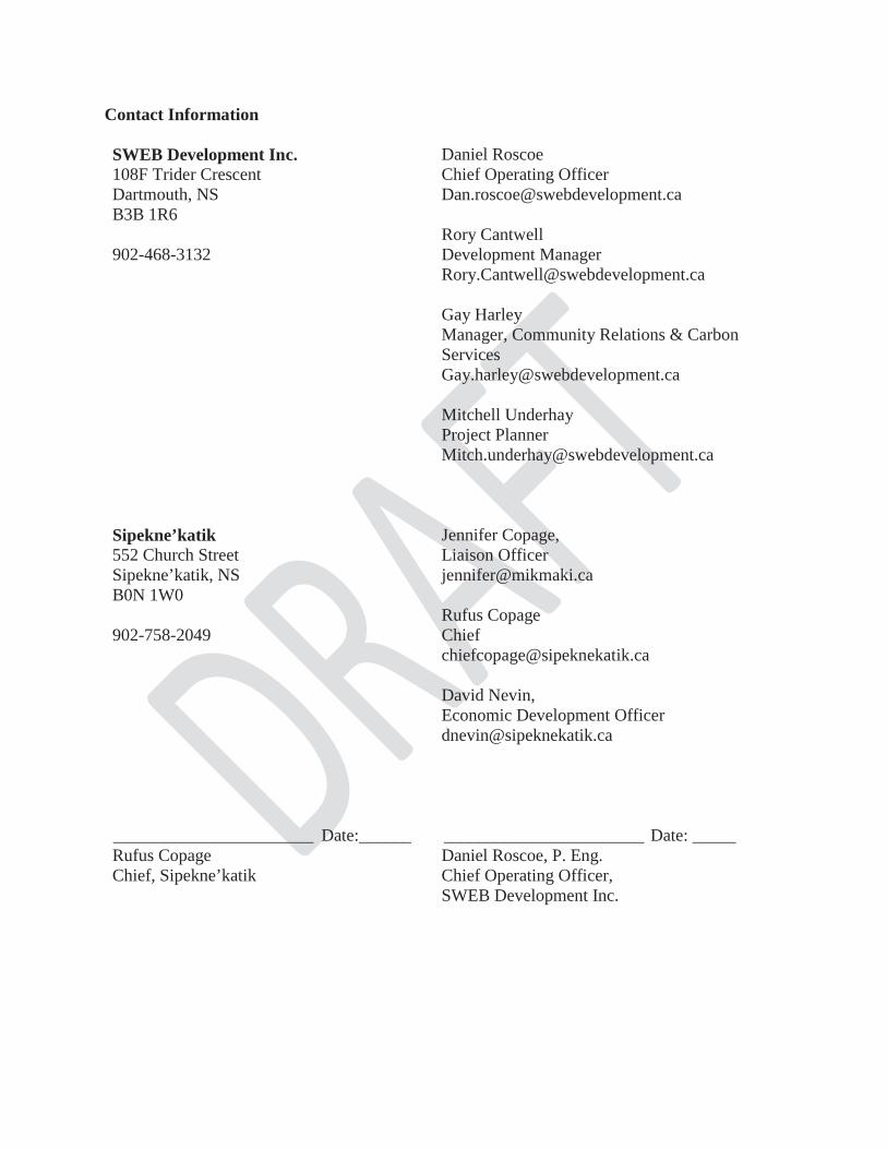
Contact Information SWEB Development Inc. 108F Trider Crescent Dartmouth, NS B3B 1R6 902-468-3132
Daniel Roscoe Chief Operating Officer [email protected] Rory Cantwell Development Manager [email protected] Gay Harley Manager, Community Relations & Carbon Services [email protected] Mitchell Underhay Project Planner [email protected]
Sipekne’katik 552 Church Street Sipekne’katik, NS B0N 1W0 902-758-2049
Jennifer Copage, Liaison Officer [email protected] Rufus Copage Chief [email protected] David Nevin, Economic Development Officer [email protected]
_______________________ Date:______ Rufus Copage Chief, Sipekne’katik
_______________________ Date: _____ Daniel Roscoe, P. Eng. Chief Operating Officer, SWEB Development Inc.


APPENDIX B LOCAL WATER SUPPLY
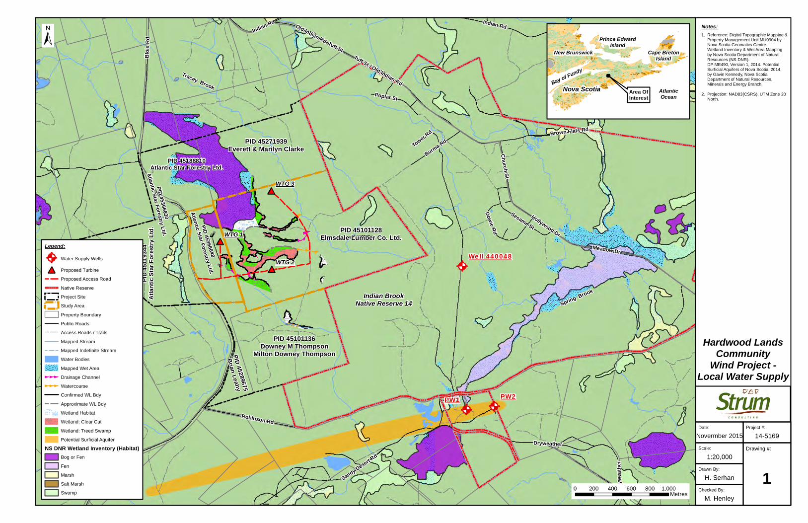
#*
#*
#*
@A @A
@A
PW2
Well 440048
PW1
WTG 1
WTG 2
WTG 3
Blois
Rd Tuff St
Indian Rd
Robinson Rd
Meadow Dr
Sandy Desert Rd
Brown Flats Rd
Old Indian Rd
Burma Rd
Sesame St
Poplar St
Church St
Dryw
eathe
r
Dowie Rd
Tower Rd
Hollywood Dr
Tuff St / Old Indian Rd
Indian Rd
Dryweather
Checked By:
M. Henley
Drawn By:
H. Serhan
Drawing #:
11:20,000
Scale:
Novermber 2015
Date: Project #:
14-5169
±
Area OfInterest
Hardwood LandsCommunity
Wind Project -Local Water Supply
Nova Scotia
New Brunswick
AtlanticOcean
Prince EdwardIsland
Bay of Fundy
Cape BretonIsland
Notes:1. Reference: Digital Topographic Mapping & Property Management Unit MU0904 by Nova Scotia Geomatics Centre. Wetland Inventory & Wet Area Mapping by Nova Scotia Department of Natural Resources (NS DNR). DP ME490, Version 1, 2014. Potential Surficial Aquifers of Nova Scotia, 2014, by Gavin Kennedy, Nova Scotia Department of Natural Resources, Minerals and Energy Branch.
2. Projection: NAD83(CSRS), UTM Zone 20 North.
PID 45101128Elmsdale Lumber Co. Ltd.
PID 45271939Everett & Marilyn Clarke
PID 45188810Atlantic Star Forestry Ltd.
PID 45
1193
44At
lantic
Star
Fore
stry L
td.
PID 45366648
Atlantic Star Forestry Ltd.
PID 45366630
Atlantic Star Forestry Ltd.
PID 45289675
Brian Leahy
Indian BrookNative Reserve 14
PID 45101136Downey M Thompson
Milton Downey Thompson
Legend:
@A Water Supply Wells
#* Proposed Turbine
Proposed Access Road
Native Reserve
Project Site
Study Area
Property Boundary
Public Roads
Access Roads / Trails
Mapped Stream
Mapped Indefinite Stream
Water Bodies
Mapped Wet Area
Drainage Channel
Watercourse
Confirmed WL Bdy
Approximate WL Bdy
Wetland Habitat
Wetland: Clear Cut
Wetland: Treed Swamp
Potential Surficial Aquifer
NS DNR Wetland Inventory (Habitat)Bog or Fen
Fen
Marsh
Salt Marsh
Swamp
Tracey Brook
Spring Brook
0 200 400 600 800 1,000Metres

APPENDIX C SOUND ASSESSMENT
Expected octave band performance for Vestas V110-2MW
Frequency Hub height wind speeds [m/s]3 4 5 6 7 8 9 10 11 12 13 14
6.3 Hz 18.6 19.0 16.3 17.5 19.7 23.2 24.5 25.1 26.0 26.6 27.1 27.5
8 Hz 23.8 23.7 22.1 24.6 27.3 30.7 31.8 32.9 33.8 34.4 34.8 35.2
10 Hz 29.1 28.4 28.1 31.5 34.3 37.6 38.8 40.0 40.7 41.2 41.5 41.8
12.5 Hz 36.9 36.2 36.9 40.0 42.1 45.5 47.0 47.8 48.4 48.8 49.0 49.3
16 Hz 42.8 41.5 41.6 46.8 47.9 51.4 52.5 53.5 54.1 54.4 54.6 54.9
20 Hz 47.0 47.2 46.5 50.7 53.8 57.2 58.0 59.1 59.4 59.6 59.8 59.9
25 Hz 52.7 53.2 52.0 55.0 58.4 62.4 63.9 65.2 65.9 66.4 66.7 67.0
31.5 Hz 56.9 56.9 56.9 59.3 62.7 66.3 67.8 69.1 69.8 70.3 70.6 71.0
40 Hz 60.9 59.5 62.7 63.3 66.5 70.4 71.7 72.8 73.4 73.7 74.0 74.3
50 Hz 66.5 65.0 68.4 68.4 71.4 74.6 76.0 76.9 77.5 77.8 78.1 78.3
63 Hz 75.3 75.8 73.5 72.1 75.0 77.9 79.2 79.1 79.8 80.3 80.6 81.0
80 Hz 77.2 76.9 77.8 75.6 78.6 80.9 82.1 82.0 82.4 82.7 83.0 83.2
100 Hz 77.7 76.1 79.8 79.5 82.5 83.8 84.2 84.9 85.1 85.2 85.3 85.4
125 Hz 80.7 79.7 83.0 82.8 85.8 86.4 86.6 87.1 87.0 87.0 86.9 87.0
160 Hz 85.0 83.6 86.9 86.3 88.6 88.6 88.4 88.6 88.5 88.5 88.4 88.4
200 Hz 84.5 85.1 87.5 87.3 90.2 90.7 90.1 89.8 89.2 88.9 88.6 88.4
250 Hz 85.7 86.7 88.1 89.2 92.4 93.3 92.6 92.3 91.6 91.2 90.8 90.5
315 Hz 87.5 88.7 89.8 90.7 93.6 94.4 93.8 93.1 92.3 91.8 91.3 91.0
400 Hz 85.6 85.9 88.8 90.8 93.3 94.1 93.7 93.4 92.6 92.1 91.6 91.3
500 Hz 85.5 86.4 88.2 91.2 94.6 96.6 96.9 96.7 96.1 95.6 95.3 95.0
630 Hz 84.3 85.8 86.8 91.2 94.2 96.7 97.5 97.0 96.3 95.8 95.4 95.1
800 Hz 83.4 84.6 86.2 89.9 93.3 96.9 98.5 98.3 97.9 97.7 97.4 97.3
1 kHz 83.7 84.6 85.8 89.1 92.4 96.6 98.6 98.4 98.3 98.2 98.1 98.1
1.25 kHz 84.8 84.7 86.2 88.5 91.2 95.2 97.8 97.6 97.9 98.0 98.1 98.3
1.6 kHz 87.4 82.7 85.1 93.7 93.9 94.0 96.9 97.8 98.4 98.8 99.1 99.4
2 kHz 82.4 81.3 82.9 86.2 90.9 94.2 94.8 96.7 97.2 97.4 97.6 97.8
2.5 kHz 82.1 80.8 82.3 83.7 86.7 90.1 93.2 94.0 95.1 95.8 96.3 96.8
3.15 kHz 78.6 76.5 79.8 82.1 85.2 87.7 90.0 91.2 91.9 92.4 92.8 93.1
4 Hz 73.9 72.2 75.9 79.3 83.3 85.7 87.1 88.5 88.9 89.1 89.3 89.5
5 kHz 73.0 71.4 74.6 76.6 80.5 82.4 83.6 84.7 85.0 85.3 85.4 85.6
6.3 kHz 67.7 65.6 68.4 73.9 78.1 78.7 79.6 81.2 81.5 81.6 81.7 81.8
8 kHz 66.7 65.6 65.3 70.5 74.5 73.5 73.8 74.9 75.1 75.2 75.3 75.4
A-wgt 96.6 96.6 98.5 101.1 103.9 105.9 107.2 107.3 107.3 107.3 107.3 107.3
Appendix C
windPRO 3.0.629 by EMD International A/S, Tel. +45 96 35 44 44, www.emd.dk, [email protected] windPRO12/4/2015 11:03 AM / 1
Project:
Hardwood Lands Sound & Shadow ModelingLicensed user:
Strum Environmental Railside, 1355 Bedford Highway CA-B4A 1C5 Bedford, NS902.835.5560 (24/7)
Calculated:
12/4/2015 11:02 AM/3.0.629
DECIBEL - Assumptions for noise calculationCalculation: Hardwood Lands Wind ProjectNoise calculation model: ISO 9613-2 GeneralWind speed: 10.0 m/sGround attenuation: General, fixed, Ground factor: 0.7Meteorological coefficient, C0: 0.0 dBType of demand in calculation: 1: WTG noise is compared to demand (DK, DE, SE, NL etc.)Noise values in calculation: All noise values are mean values (Lwa) (Normal)Pure tones: Pure and Impulse tone penalty are added to WTG source noiseHeight above ground level, when no value in NSA object: 4.5 m Don't allow override of model height with height from NSA objectDeviation from "official" noise demands. Negative is more restrictive, positive is less restrictive.: 0.0 dB(A)Octave data requiredAir absorption
63 125 250 500 1,000 2,000 4,000 8,000[db/km] [db/km] [db/km] [db/km] [db/km] [db/km] [db/km] [db/km]
0.1 0.4 1.0 1.9 3.7 9.7 32.8 117.0
WTG: VESTAS V110-2.0 2000 110.0 !O!Noise: Strum Mode 0
Source Source/Date Creator EditedManufacturer 8/10/2015 USER 11/30/2015 9:52 AMBased on Document No. 0048-9642_00
Octave dataStatus Hub height Wind speed LwA,ref Pure tones 63 125 250 500 1000 2000 4000 8000
[m] [m/s] [dB(A)] [dB] [dB] [dB] [dB] [dB] [dB] [dB] [dB]From Windcat 95.0 10.0 107.3 No 84.6 91.9 96.7 100.7 102.9 101.2 93.7 82.9
NSA: R01-APredefined calculation standard: Imission height(a.g.l.): Use standard value from calculation model
Noise demand: 40.0 dB(A)No distance demand
NSA: R02-BPredefined calculation standard: Imission height(a.g.l.): Use standard value from calculation model
Noise demand: 40.0 dB(A)No distance demand
NSA: R03-CPredefined calculation standard: Imission height(a.g.l.): Use standard value from calculation model
Noise demand: 40.0 dB(A)No distance demand
NSA: R04-DPredefined calculation standard: Imission height(a.g.l.): Use standard value from calculation model
Noise demand: 40.0 dB(A)No distance demand

windPRO 3.0.629 by EMD International A/S, Tel. +45 96 35 44 44, www.emd.dk, [email protected] windPRO12/4/2015 11:03 AM / 2
Project:
Hardwood Lands Sound & Shadow ModelingLicensed user:
Strum Environmental Railside, 1355 Bedford Highway CA-B4A 1C5 Bedford, NS902.835.5560 (24/7)
Calculated:
12/4/2015 11:02 AM/3.0.629
DECIBEL - Assumptions for noise calculationCalculation: Hardwood Lands Wind ProjectNSA: R05-EPredefined calculation standard: Imission height(a.g.l.): Use standard value from calculation model
Noise demand: 40.0 dB(A)No distance demand
NSA: R06-FPredefined calculation standard: Imission height(a.g.l.): Use standard value from calculation model
Noise demand: 40.0 dB(A)No distance demand
NSA: R07-GPredefined calculation standard: Imission height(a.g.l.): Use standard value from calculation model
Noise demand: 40.0 dB(A)No distance demand
NSA: R08-HPredefined calculation standard: Imission height(a.g.l.): Use standard value from calculation model
Noise demand: 40.0 dB(A)No distance demand
NSA: R09-IPredefined calculation standard: Imission height(a.g.l.): Use standard value from calculation model
Noise demand: 40.0 dB(A)No distance demand
NSA: R10-JPredefined calculation standard: Imission height(a.g.l.): Use standard value from calculation model
Noise demand: 40.0 dB(A)No distance demand
NSA: R11-KPredefined calculation standard: Imission height(a.g.l.): Use standard value from calculation model
Noise demand: 40.0 dB(A)No distance demand
NSA: R12-LPredefined calculation standard: Imission height(a.g.l.): Use standard value from calculation model
Noise demand: 40.0 dB(A)No distance demand
NSA: R13-MPredefined calculation standard: Imission height(a.g.l.): Use standard value from calculation model
Noise demand: 40.0 dB(A)No distance demand
windPRO 3.0.629 by EMD International A/S, Tel. +45 96 35 44 44, www.emd.dk, [email protected] windPRO12/4/2015 11:03 AM / 3
Project:
Hardwood Lands Sound & Shadow ModelingLicensed user:
Strum Environmental Railside, 1355 Bedford Highway CA-B4A 1C5 Bedford, NS902.835.5560 (24/7)
Calculated:
12/4/2015 11:02 AM/3.0.629
DECIBEL - Assumptions for noise calculationCalculation: Hardwood Lands Wind ProjectNSA: R14-NPredefined calculation standard: Imission height(a.g.l.): Use standard value from calculation model
Noise demand: 40.0 dB(A)No distance demand
NSA: R15-OPredefined calculation standard: Imission height(a.g.l.): Use standard value from calculation model
Noise demand: 40.0 dB(A)No distance demand
NSA: R16-PPredefined calculation standard: Imission height(a.g.l.): Use standard value from calculation model
Noise demand: 40.0 dB(A)No distance demand
NSA: R17-QPredefined calculation standard: Imission height(a.g.l.): Use standard value from calculation model
Noise demand: 40.0 dB(A)No distance demand
NSA: R18-RPredefined calculation standard: Imission height(a.g.l.): Use standard value from calculation model
Noise demand: 40.0 dB(A)No distance demand
NSA: R19-SPredefined calculation standard: Imission height(a.g.l.): Use standard value from calculation model
Noise demand: 40.0 dB(A)No distance demand
NSA: R20-TPredefined calculation standard: Imission height(a.g.l.): Use standard value from calculation model
Noise demand: 40.0 dB(A)No distance demand
NSA: R21-UPredefined calculation standard: Imission height(a.g.l.): Use standard value from calculation model
Noise demand: 40.0 dB(A)No distance demand
NSA: R22-VPredefined calculation standard: Imission height(a.g.l.): Use standard value from calculation model
Noise demand: 40.0 dB(A)No distance demand

windPRO 3.0.629 by EMD International A/S, Tel. +45 96 35 44 44, www.emd.dk, [email protected] windPRO12/4/2015 11:03 AM / 4
Project:
Hardwood Lands Sound & Shadow ModelingLicensed user:
Strum Environmental Railside, 1355 Bedford Highway CA-B4A 1C5 Bedford, NS902.835.5560 (24/7)
Calculated:
12/4/2015 11:02 AM/3.0.629
DECIBEL - Assumptions for noise calculationCalculation: Hardwood Lands Wind ProjectNSA: R23-WPredefined calculation standard: Imission height(a.g.l.): Use standard value from calculation model
Noise demand: 40.0 dB(A)No distance demand
NSA: R24-XPredefined calculation standard: Imission height(a.g.l.): Use standard value from calculation model
Noise demand: 40.0 dB(A)No distance demand
NSA: R25-YPredefined calculation standard: Imission height(a.g.l.): Use standard value from calculation model
Noise demand: 40.0 dB(A)No distance demand
NSA: R26-ZPredefined calculation standard: Imission height(a.g.l.): Use standard value from calculation model
Noise demand: 40.0 dB(A)No distance demand
NSA: R27-AAPredefined calculation standard: Imission height(a.g.l.): Use standard value from calculation model
Noise demand: 40.0 dB(A)No distance demand
NSA: R28-ABPredefined calculation standard: Imission height(a.g.l.): Use standard value from calculation model
Noise demand: 40.0 dB(A)No distance demand
NSA: R29-ACPredefined calculation standard: Imission height(a.g.l.): Use standard value from calculation model
Noise demand: 40.0 dB(A)No distance demand
NSA: R30-ADPredefined calculation standard: Imission height(a.g.l.): Use standard value from calculation model
Noise demand: 40.0 dB(A)No distance demand
NSA: R31-AEPredefined calculation standard: Imission height(a.g.l.): Use standard value from calculation model
Noise demand: 40.0 dB(A)No distance demand

windPRO 3.0.629 by EMD International A/S, Tel. +45 96 35 44 44, www.emd.dk, [email protected] windPRO12/4/2015 11:03 AM / 5
Project:
Hardwood Lands Sound & Shadow ModelingLicensed user:
Strum Environmental Railside, 1355 Bedford Highway CA-B4A 1C5 Bedford, NS902.835.5560 (24/7)
Calculated:
12/4/2015 11:02 AM/3.0.629
DECIBEL - Assumptions for noise calculationCalculation: Hardwood Lands Wind ProjectNSA: R32-AFPredefined calculation standard: Imission height(a.g.l.): Use standard value from calculation model
Noise demand: 40.0 dB(A)No distance demand
NSA: R33-AGPredefined calculation standard: Imission height(a.g.l.): Use standard value from calculation model
Noise demand: 40.0 dB(A)No distance demand
NSA: R34-AHPredefined calculation standard: Imission height(a.g.l.): Use standard value from calculation model
Noise demand: 40.0 dB(A)No distance demand
NSA: R35-AIPredefined calculation standard: Imission height(a.g.l.): Use standard value from calculation model
Noise demand: 40.0 dB(A)No distance demand
NSA: R36-AJPredefined calculation standard: Imission height(a.g.l.): Use standard value from calculation model
Noise demand: 40.0 dB(A)No distance demand
NSA: R37-AKPredefined calculation standard: Imission height(a.g.l.): Use standard value from calculation model
Noise demand: 40.0 dB(A)No distance demand
NSA: R38-ALPredefined calculation standard: Imission height(a.g.l.): Use standard value from calculation model
Noise demand: 40.0 dB(A)No distance demand
NSA: R39-AMPredefined calculation standard: Imission height(a.g.l.): Use standard value from calculation model
Noise demand: 40.0 dB(A)No distance demand
NSA: R40-ANPredefined calculation standard: Imission height(a.g.l.): Use standard value from calculation model
Noise demand: 40.0 dB(A)No distance demand

windPRO 3.0.629 by EMD International A/S, Tel. +45 96 35 44 44, www.emd.dk, [email protected] windPRO12/4/2015 11:03 AM / 6
Project:
Hardwood Lands Sound & Shadow ModelingLicensed user:
Strum Environmental Railside, 1355 Bedford Highway CA-B4A 1C5 Bedford, NS902.835.5560 (24/7)
Calculated:
12/4/2015 11:02 AM/3.0.629
DECIBEL - Assumptions for noise calculationCalculation: Hardwood Lands Wind ProjectNSA: R41-AOPredefined calculation standard: Imission height(a.g.l.): Use standard value from calculation model
Noise demand: 40.0 dB(A)No distance demand
NSA: R42-APPredefined calculation standard: Imission height(a.g.l.): Use standard value from calculation model
Noise demand: 40.0 dB(A)No distance demand
NSA: R43-AQPredefined calculation standard: Imission height(a.g.l.): Use standard value from calculation model
Noise demand: 40.0 dB(A)No distance demand
NSA: R44-ARPredefined calculation standard: Imission height(a.g.l.): Use standard value from calculation model
Noise demand: 40.0 dB(A)No distance demand
NSA: R45-ASPredefined calculation standard: Imission height(a.g.l.): Use standard value from calculation model
Noise demand: 40.0 dB(A)No distance demand
NSA: R46-ATPredefined calculation standard: Imission height(a.g.l.): Use standard value from calculation model
Noise demand: 40.0 dB(A)No distance demand
NSA: R47-AUPredefined calculation standard: Imission height(a.g.l.): Use standard value from calculation model
Noise demand: 40.0 dB(A)No distance demand
NSA: R48-AVPredefined calculation standard: Imission height(a.g.l.): Use standard value from calculation model
Noise demand: 40.0 dB(A)No distance demand
NSA: R49-AWPredefined calculation standard: Imission height(a.g.l.): Use standard value from calculation model
Noise demand: 40.0 dB(A)No distance demand

windPRO 3.0.629 by EMD International A/S, Tel. +45 96 35 44 44, www.emd.dk, [email protected] windPRO12/4/2015 11:03 AM / 7
Project:
Hardwood Lands Sound & Shadow ModelingLicensed user:
Strum Environmental Railside, 1355 Bedford Highway CA-B4A 1C5 Bedford, NS902.835.5560 (24/7)
Calculated:
12/4/2015 11:02 AM/3.0.629
DECIBEL - Assumptions for noise calculationCalculation: Hardwood Lands Wind ProjectNSA: R50-AXPredefined calculation standard: Imission height(a.g.l.): Use standard value from calculation model
Noise demand: 40.0 dB(A)No distance demand
NSA: R51-AYPredefined calculation standard: Imission height(a.g.l.): Use standard value from calculation model
Noise demand: 40.0 dB(A)No distance demand
NSA: R52-AZPredefined calculation standard: Imission height(a.g.l.): Use standard value from calculation model
Noise demand: 40.0 dB(A)No distance demand
NSA: R53-BAPredefined calculation standard: Imission height(a.g.l.): Use standard value from calculation model
Noise demand: 40.0 dB(A)No distance demand
NSA: R54-BBPredefined calculation standard: Imission height(a.g.l.): Use standard value from calculation model
Noise demand: 40.0 dB(A)No distance demand
NSA: R55-BCPredefined calculation standard: Imission height(a.g.l.): Use standard value from calculation model
Noise demand: 40.0 dB(A)No distance demand
NSA: R56-BDPredefined calculation standard: Imission height(a.g.l.): Use standard value from calculation model
Noise demand: 40.0 dB(A)No distance demand
NSA: R57-BEPredefined calculation standard: Imission height(a.g.l.): Use standard value from calculation model
Noise demand: 40.0 dB(A)No distance demand
NSA: R58-BFPredefined calculation standard: Imission height(a.g.l.): Use standard value from calculation model
Noise demand: 40.0 dB(A)No distance demand

windPRO 3.0.629 by EMD International A/S, Tel. +45 96 35 44 44, www.emd.dk, [email protected] windPRO12/4/2015 11:03 AM / 8
Project:
Hardwood Lands Sound & Shadow ModelingLicensed user:
Strum Environmental Railside, 1355 Bedford Highway CA-B4A 1C5 Bedford, NS902.835.5560 (24/7)
Calculated:
12/4/2015 11:02 AM/3.0.629
DECIBEL - Assumptions for noise calculationCalculation: Hardwood Lands Wind ProjectNSA: R59-BGPredefined calculation standard: Imission height(a.g.l.): Use standard value from calculation model
Noise demand: 40.0 dB(A)No distance demand
NSA: R60-BHPredefined calculation standard: Imission height(a.g.l.): Use standard value from calculation model
Noise demand: 40.0 dB(A)No distance demand
NSA: R61-BIPredefined calculation standard: Imission height(a.g.l.): Use standard value from calculation model
Noise demand: 40.0 dB(A)No distance demand
NSA: R62-BJPredefined calculation standard: Imission height(a.g.l.): Use standard value from calculation model
Noise demand: 40.0 dB(A)No distance demand
NSA: R63-BKPredefined calculation standard: Imission height(a.g.l.): Use standard value from calculation model
Noise demand: 40.0 dB(A)No distance demand
NSA: R64-BLPredefined calculation standard: Imission height(a.g.l.): Use standard value from calculation model
Noise demand: 40.0 dB(A)No distance demand
NSA: R65-BMPredefined calculation standard: Imission height(a.g.l.): Use standard value from calculation model
Noise demand: 40.0 dB(A)No distance demand
NSA: R66-BNPredefined calculation standard: Imission height(a.g.l.): Use standard value from calculation model
Noise demand: 40.0 dB(A)No distance demand
NSA: R67-BOPredefined calculation standard: Imission height(a.g.l.): Use standard value from calculation model
Noise demand: 40.0 dB(A)No distance demand

windPRO 3.0.629 by EMD International A/S, Tel. +45 96 35 44 44, www.emd.dk, [email protected] windPRO12/4/2015 11:03 AM / 9
Project:
Hardwood Lands Sound & Shadow ModelingLicensed user:
Strum Environmental Railside, 1355 Bedford Highway CA-B4A 1C5 Bedford, NS902.835.5560 (24/7)
Calculated:
12/4/2015 11:02 AM/3.0.629
DECIBEL - Assumptions for noise calculationCalculation: Hardwood Lands Wind ProjectNSA: R68-BPPredefined calculation standard: Imission height(a.g.l.): Use standard value from calculation model
Noise demand: 40.0 dB(A)No distance demand
NSA: R69-BQPredefined calculation standard: Imission height(a.g.l.): Use standard value from calculation model
Noise demand: 40.0 dB(A)No distance demand
NSA: R70-BRPredefined calculation standard: Imission height(a.g.l.): Use standard value from calculation model
Noise demand: 40.0 dB(A)No distance demand
NSA: R71-BSPredefined calculation standard: Imission height(a.g.l.): Use standard value from calculation model
Noise demand: 40.0 dB(A)No distance demand
NSA: R72-BTPredefined calculation standard: Imission height(a.g.l.): Use standard value from calculation model
Noise demand: 40.0 dB(A)No distance demand
NSA: R73-BUPredefined calculation standard: Imission height(a.g.l.): Use standard value from calculation model
Noise demand: 40.0 dB(A)No distance demand
NSA: R74-BVPredefined calculation standard: Imission height(a.g.l.): Use standard value from calculation model
Noise demand: 40.0 dB(A)No distance demand
NSA: R75-BWPredefined calculation standard: Imission height(a.g.l.): Use standard value from calculation model
Noise demand: 40.0 dB(A)No distance demand
NSA: R76-BXPredefined calculation standard: Imission height(a.g.l.): Use standard value from calculation model
Noise demand: 40.0 dB(A)No distance demand

windPRO 3.0.629 by EMD International A/S, Tel. +45 96 35 44 44, www.emd.dk, [email protected] windPRO12/4/2015 11:03 AM / 10
Project:
Hardwood Lands Sound & Shadow ModelingLicensed user:
Strum Environmental Railside, 1355 Bedford Highway CA-B4A 1C5 Bedford, NS902.835.5560 (24/7)
Calculated:
12/4/2015 11:02 AM/3.0.629
DECIBEL - Assumptions for noise calculationCalculation: Hardwood Lands Wind ProjectNSA: R77-BYPredefined calculation standard: Imission height(a.g.l.): Use standard value from calculation model
Noise demand: 40.0 dB(A)No distance demand
NSA: R78-BZPredefined calculation standard: Imission height(a.g.l.): Use standard value from calculation model
Noise demand: 40.0 dB(A)No distance demand
NSA: R79-CAPredefined calculation standard: Imission height(a.g.l.): Use standard value from calculation model
Noise demand: 40.0 dB(A)No distance demand
NSA: R81-CBPredefined calculation standard: Imission height(a.g.l.): Use standard value from calculation model
Noise demand: 40.0 dB(A)No distance demand
NSA: R82-CCPredefined calculation standard: Imission height(a.g.l.): Use standard value from calculation model
Noise demand: 40.0 dB(A)No distance demand
NSA: R83-CDPredefined calculation standard: Imission height(a.g.l.): Use standard value from calculation model
Noise demand: 40.0 dB(A)No distance demand
NSA: R84-CEPredefined calculation standard: Imission height(a.g.l.): Use standard value from calculation model
Noise demand: 40.0 dB(A)No distance demand
NSA: R85-CFPredefined calculation standard: Imission height(a.g.l.): Use standard value from calculation model
Noise demand: 40.0 dB(A)No distance demand
NSA: R86-CGPredefined calculation standard: Imission height(a.g.l.): Use standard value from calculation model
Noise demand: 40.0 dB(A)No distance demand

windPRO 3.0.629 by EMD International A/S, Tel. +45 96 35 44 44, www.emd.dk, [email protected] windPRO12/4/2015 11:03 AM / 11
Project:
Hardwood Lands Sound & Shadow ModelingLicensed user:
Strum Environmental Railside, 1355 Bedford Highway CA-B4A 1C5 Bedford, NS902.835.5560 (24/7)
Calculated:
12/4/2015 11:02 AM/3.0.629
DECIBEL - Assumptions for noise calculationCalculation: Hardwood Lands Wind ProjectNSA: R89-CHPredefined calculation standard: Imission height(a.g.l.): Use standard value from calculation model
Noise demand: 40.0 dB(A)No distance demand
NSA: R90-CIPredefined calculation standard: Imission height(a.g.l.): Use standard value from calculation model
Noise demand: 40.0 dB(A)No distance demand
NSA: R91-CJPredefined calculation standard: Imission height(a.g.l.): Use standard value from calculation model
Noise demand: 40.0 dB(A)No distance demand
NSA: R92-CKPredefined calculation standard: Imission height(a.g.l.): Use standard value from calculation model
Noise demand: 40.0 dB(A)No distance demand
NSA: R93-CLPredefined calculation standard: Imission height(a.g.l.): Use standard value from calculation model
Noise demand: 40.0 dB(A)No distance demand
NSA: R94-CMPredefined calculation standard: Imission height(a.g.l.): Use standard value from calculation model
Noise demand: 40.0 dB(A)No distance demand
NSA: R95-CNPredefined calculation standard: Imission height(a.g.l.): Use standard value from calculation model
Noise demand: 40.0 dB(A)No distance demand
NSA: R96-COPredefined calculation standard: Imission height(a.g.l.): Use standard value from calculation model
Noise demand: 40.0 dB(A)No distance demand
NSA: R97-CPPredefined calculation standard: Imission height(a.g.l.): Use standard value from calculation model
Noise demand: 40.0 dB(A)No distance demand
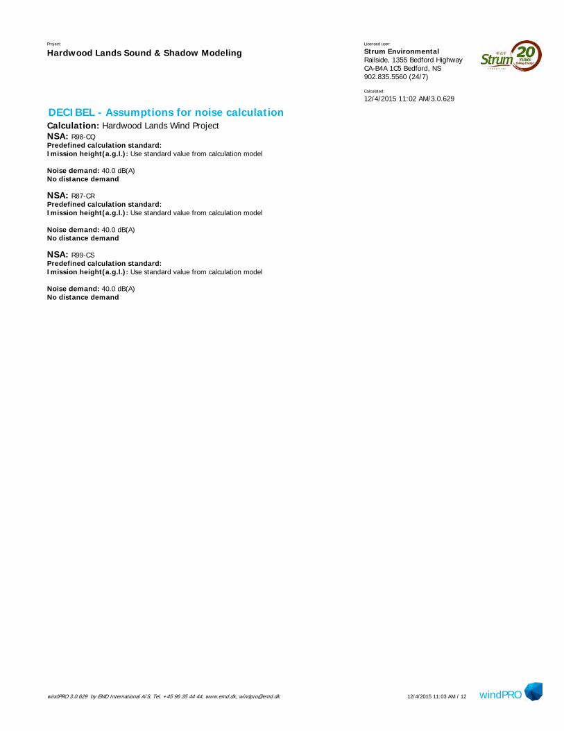
windPRO 3.0.629 by EMD International A/S, Tel. +45 96 35 44 44, www.emd.dk, [email protected] windPRO12/4/2015 11:03 AM / 12
Project:
Hardwood Lands Sound & Shadow ModelingLicensed user:
Strum Environmental Railside, 1355 Bedford Highway CA-B4A 1C5 Bedford, NS902.835.5560 (24/7)
Calculated:
12/4/2015 11:02 AM/3.0.629
DECIBEL - Assumptions for noise calculationCalculation: Hardwood Lands Wind ProjectNSA: R98-CQPredefined calculation standard: Imission height(a.g.l.): Use standard value from calculation model
Noise demand: 40.0 dB(A)No distance demand
NSA: R87-CRPredefined calculation standard: Imission height(a.g.l.): Use standard value from calculation model
Noise demand: 40.0 dB(A)No distance demand
NSA: R99-CSPredefined calculation standard: Imission height(a.g.l.): Use standard value from calculation model
Noise demand: 40.0 dB(A)No distance demand
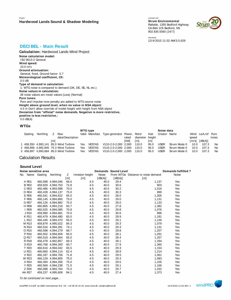
windPRO 3.0.629 by EMD International A/S, Tel. +45 96 35 44 44, www.emd.dk, [email protected] windPRO12/4/2015 11:02 AM / 1
Project:
Hardwood Lands Sound & Shadow ModelingLicensed user:
Strum Environmental Railside, 1355 Bedford Highway CA-B4A 1C5 Bedford, NS902.835.5560 (24/7)
Calculated:
12/4/2015 11:02 AM/3.0.629
DECIBEL - Main ResultCalculation: Hardwood Lands Wind ProjectNoise calculation model: ISO 9613-2 GeneralWind speed: 10.0 m/sGround attenuation: General, fixed, Ground factor: 0.7Meteorological coefficient, C0: 0.0 dBType of demand in calculation: 1: WTG noise is compared to demand (DK, DE, SE, NL etc.)Noise values in calculation: All noise values are mean values (Lwa) (Normal)Pure tones: Pure and Impulse tone penalty are added to WTG source noiseHeight above ground level, when no value in NSA object: 4.5 m Don't allow override of model height with height from NSA objectDeviation from "official" noise demands. Negative is more restrictive,positive is less restrictive.: 0.0 dB(A)
WTGsWTG type Noise data
Easting Northing Z Row Valid Manufact. Type-generator Power, Rotor Hub Creator Name Wind LwA,ref Puredata/Description rated diameter height speed tones
[m] [kW] [m] [m] [m/s] [dB(A)]1 458,350 4,993,141 85.0 Wind Turbine Yes VESTAS V110-2.0-2,000 2,000 110.0 95.0 USER Strum Mode 0 10.0 107.3 No2 458,899 4,992,845 75.3 Wind Turbine Yes VESTAS V110-2.0-2,000 2,000 110.0 95.0 USER Strum Mode 0 10.0 107.3 No3 458,897 4,993,684 85.0 Wind Turbine Yes VESTAS V110-2.0-2,000 2,000 110.0 95.0 USER Strum Mode 0 10.0 107.3 No
Calculation Results
Sound LevelNoise sensitive area Demands Sound Level Demands fulfilled ?No. Name Easting Northing Z Imission height Noise From WTGs Distance to noise demand Noise
[m] [m] [dB(A)] [dB(A)] [m]A R01 460,598 4,994,046 66.6 4.5 40.0 29.4 1,137 YesB R02 459,929 4,994,753 72.8 4.5 40.0 30.6 903 YesC R03 460,486 4,993,998 70.0 4.5 40.0 30.2 1,016 YesD R04 460,428 4,994,137 75.0 4.5 40.0 30.3 999 YesE R05 460,541 4,994,622 65.0 4.5 40.0 28.0 1,305 YesF R06 460,145 4,994,860 75.0 4.5 40.0 29.0 1,131 YesG R07 460,126 4,994,882 75.0 4.5 40.0 29.0 1,133 YesH R08 460,805 4,994,218 60.7 4.5 40.0 27.8 1,382 YesI R09 460,525 4,994,085 70.8 4.5 40.0 29.8 1,076 YesJ R10 459,990 4,994,681 70.0 4.5 40.0 30.6 896 YesK R11 460,479 4,994,480 65.0 4.5 40.0 28.9 1,181 YesL R12 460,445 4,994,470 65.0 4.5 40.0 29.1 1,146 YesM R13 459,879 4,995,022 84.3 4.5 40.0 29.3 1,079 YesN R14 460,516 4,994,281 74.1 4.5 40.0 29.3 1,131 YesO R15 460,598 4,994,279 68.7 4.5 40.0 28.8 1,207 YesP R16 460,502 4,994,659 65.0 4.5 40.0 28.1 1,291 YesQ R17 460,519 4,994,564 65.0 4.5 40.0 28.4 1,257 YesR R18 456,478 4,992,857 69.3 4.5 40.0 28.1 1,294 YesS R19 460,768 4,994,260 60.7 4.5 40.0 27.9 1,360 YesT R20 460,616 4,994,042 65.5 4.5 40.0 29.3 1,153 YesU R21 460,660 4,994,114 62.4 4.5 40.0 28.9 1,214 YesV R22 460,187 4,994,706 71.8 4.5 40.0 29.5 1,061 YesW R23 460,129 4,994,805 75.0 4.5 40.0 29.3 1,083 YesX R24 460,494 4,994,266 75.0 4.5 40.0 29.5 1,105 YesY R25 460,569 4,994,238 71.5 4.5 40.0 29.1 1,166 YesZ R26 460,098 4,994,764 75.0 4.5 40.0 29.7 1,032 Yes
AA R27 459,237 4,995,608 84.1 4.5 40.0 27.4 1,373 Yes
To be continued on next page...
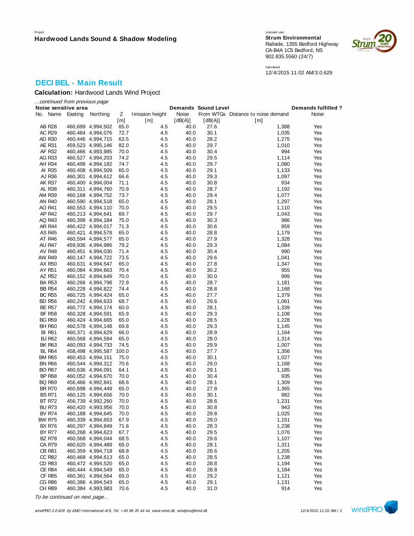
windPRO 3.0.629 by EMD International A/S, Tel. +45 96 35 44 44, www.emd.dk, [email protected] windPRO12/4/2015 11:02 AM / 2
Project:
Hardwood Lands Sound & Shadow ModelingLicensed user:
Strum Environmental Railside, 1355 Bedford Highway CA-B4A 1C5 Bedford, NS902.835.5560 (24/7)
Calculated:
12/4/2015 11:02 AM/3.0.629
DECIBEL - Main ResultCalculation: Hardwood Lands Wind Project...continued from previous pageNoise sensitive area Demands Sound Level Demands fulfilled ?No. Name Easting Northing Z Imission height Noise From WTGs Distance to noise demand Noise
[m] [m] [dB(A)] [dB(A)] [m]AB R28 460,699 4,994,502 65.0 4.5 40.0 27.6 1,388 YesAC R29 460,484 4,994,076 72.7 4.5 40.0 30.1 1,035 YesAD R30 460,446 4,994,715 63.5 4.5 40.0 28.2 1,275 YesAE R31 459,523 4,995,146 82.0 4.5 40.0 29.7 1,010 YesAF R32 460,466 4,993,985 70.0 4.5 40.0 30.4 994 YesAG R33 460,527 4,994,203 74.2 4.5 40.0 29.5 1,114 YesAH R34 460,498 4,994,182 74.7 4.5 40.0 29.7 1,080 YesAI R35 460,408 4,994,509 65.0 4.5 40.0 29.1 1,133 YesAJ R36 460,301 4,994,612 66.6 4.5 40.0 29.3 1,097 YesAK R37 460,400 4,994,004 71.1 4.5 40.0 30.8 934 YesAL R38 460,311 4,994,760 70.9 4.5 40.0 28.7 1,192 YesAM R39 460,168 4,994,752 73.7 4.5 40.0 29.4 1,077 YesAN R40 460,590 4,994,518 65.0 4.5 40.0 28.1 1,297 YesAO R41 460,553 4,994,110 70.0 4.5 40.0 29.5 1,110 YesAP R42 460,213 4,994,641 69.7 4.5 40.0 29.7 1,043 YesAQ R43 460,398 4,994,184 75.0 4.5 40.0 30.3 986 YesAR R44 460,422 4,994,017 71.3 4.5 40.0 30.6 959 YesAS R45 460,421 4,994,578 65.0 4.5 40.0 28.8 1,179 YesAT R46 460,594 4,994,577 65.0 4.5 40.0 27.9 1,328 YesAU R47 459,936 4,994,986 79.2 4.5 40.0 29.3 1,084 YesAV R48 460,451 4,994,030 71.4 4.5 40.0 30.4 990 YesAW R49 460,147 4,994,722 73.5 4.5 40.0 29.6 1,041 YesAX R50 460,631 4,994,547 65.0 4.5 40.0 27.8 1,347 YesAY R51 460,084 4,994,663 70.4 4.5 40.0 30.2 955 YesAZ R52 460,152 4,994,649 70.0 4.5 40.0 30.0 999 YesBA R53 460,266 4,994,798 72.9 4.5 40.0 28.7 1,181 YesBB R54 460,228 4,994,822 74.4 4.5 40.0 28.8 1,168 YesBC R55 460,725 4,994,424 65.0 4.5 40.0 27.7 1,379 YesBD R56 460,242 4,994,633 68.7 4.5 40.0 29.6 1,061 YesBE R57 460,772 4,994,174 60.0 4.5 40.0 28.1 1,339 YesBF R58 460,328 4,994,591 65.9 4.5 40.0 29.3 1,108 YesBG R59 460,424 4,994,665 65.0 4.5 40.0 28.5 1,228 YesBH R60 460,578 4,994,148 69.8 4.5 40.0 29.3 1,145 YesBI R61 460,371 4,994,629 66.0 4.5 40.0 28.9 1,164 YesBJ R62 460,568 4,994,594 65.0 4.5 40.0 28.0 1,314 YesBK R63 460,093 4,994,733 74.5 4.5 40.0 29.9 1,007 YesBL R64 458,498 4,995,587 100.0 4.5 40.0 27.7 1,356 YesBM R65 460,453 4,994,151 75.0 4.5 40.0 30.1 1,027 YesBN R66 460,544 4,994,312 70.6 4.5 40.0 29.0 1,168 YesBO R67 460,636 4,994,091 64.1 4.5 40.0 29.1 1,185 YesBP R68 460,052 4,994,670 70.0 4.5 40.0 30.4 935 YesBQ R69 456,466 4,992,841 68.6 4.5 40.0 28.1 1,309 YesBR R70 460,698 4,994,449 65.0 4.5 40.0 27.8 1,365 YesBS R71 460,125 4,994,656 70.0 4.5 40.0 30.1 982 YesBT R72 456,739 4,992,260 70.0 4.5 40.0 28.6 1,231 YesBU R73 460,420 4,993,956 70.0 4.5 40.0 30.8 943 YesBV R74 460,188 4,994,645 70.0 4.5 40.0 29.8 1,025 YesBW R75 460,339 4,994,653 67.9 4.5 40.0 29.0 1,151 YesBX R76 460,297 4,994,849 71.6 4.5 40.0 28.3 1,238 YesBY R77 460,268 4,994,623 67.7 4.5 40.0 29.5 1,076 YesBZ R78 460,568 4,994,044 68.5 4.5 40.0 29.6 1,107 YesCA R79 460,620 4,994,489 65.0 4.5 40.0 28.1 1,311 YesCB R81 460,359 4,994,718 68.8 4.5 40.0 28.6 1,205 YesCC R82 460,468 4,994,613 65.0 4.5 40.0 28.5 1,238 YesCD R83 460,472 4,994,520 65.0 4.5 40.0 28.8 1,194 YesCE R84 460,444 4,994,549 65.0 4.5 40.0 28.8 1,184 YesCF R85 460,361 4,994,564 65.0 4.5 40.0 29.2 1,121 YesCG R86 460,386 4,994,543 65.0 4.5 40.0 29.1 1,131 YesCH R89 460,384 4,993,983 70.6 4.5 40.0 31.0 914 Yes
To be continued on next page...
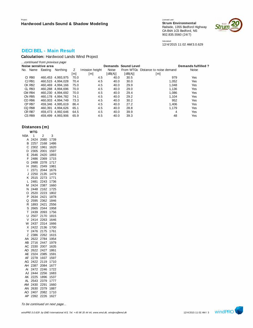
windPRO 3.0.629 by EMD International A/S, Tel. +45 96 35 44 44, www.emd.dk, [email protected] windPRO12/4/2015 11:02 AM / 3
Project:
Hardwood Lands Sound & Shadow ModelingLicensed user:
Strum Environmental Railside, 1355 Bedford Highway CA-B4A 1C5 Bedford, NS902.835.5560 (24/7)
Calculated:
12/4/2015 11:02 AM/3.0.629
DECIBEL - Main ResultCalculation: Hardwood Lands Wind Project...continued from previous pageNoise sensitive area Demands Sound Level Demands fulfilled ?No. Name Easting Northing Z Imission height Noise From WTGs Distance to noise demand Noise
[m] [m] [dB(A)] [dB(A)] [m]CI R90 460,453 4,993,975 70.0 4.5 40.0 30.5 979 YesCJ R91 460,515 4,994,028 70.4 4.5 40.0 30.0 1,052 YesCK R92 460,469 4,994,166 75.0 4.5 40.0 29.9 1,048 YesCL R93 460,288 4,994,696 70.0 4.5 40.0 29.0 1,136 YesCM R94 460,230 4,994,692 70.0 4.5 40.0 29.4 1,086 YesCN R95 460,178 4,994,782 74.1 4.5 40.0 29.2 1,104 YesCO R96 460,003 4,994,749 73.3 4.5 40.0 30.2 952 YesCP R97 459,346 4,995,619 86.4 4.5 40.0 27.2 1,406 YesCQ R98 460,391 4,994,626 65.1 4.5 40.0 28.8 1,179 YesCR R87 459,473 4,992,646 64.5 4.5 40.0 39.9 4 YesCS R99 459,499 4,993,906 65.9 4.5 40.0 39.3 48 Yes
Distances (m)WTG
NSA 1 2 3A 2424 2080 1739B 2257 2168 1486C 2302 1961 1620D 2305 2001 1597E 2646 2420 1893F 2486 2369 1715G 2488 2378 1717H 2681 2349 1981I 2371 2044 1676J 2250 2135 1479K 2515 2273 1771L 2481 2243 1736M 2424 2387 1660N 2448 2162 1725O 2520 2223 1802P 2634 2421 1878Q 2595 2362 1846R 1893 2421 2556S 2665 2344 1958T 2439 2093 1756U 2507 2170 1815V 2414 2263 1646W 2437 2314 1666X 2422 2136 1700Y 2476 2175 1761Z 2386 2262 1615
AA 2622 2784 1954AB 2716 2447 1979AC 2330 2007 1635AD 2622 2427 1861AE 2324 2385 1591AF 2278 1937 1597AG 2422 2119 1710AH 2387 2084 1677AI 2472 2246 1722AJ 2444 2256 1683AK 2225 1896 1537AL 2543 2379 1777AM 2430 2291 1660AN 2630 2379 1887AO 2407 2082 1710AP 2392 2226 1627
To be continued on next page...

windPRO 3.0.629 by EMD International A/S, Tel. +45 96 35 44 44, www.emd.dk, [email protected] windPRO12/4/2015 11:02 AM / 4
Project:
Hardwood Lands Sound & Shadow ModelingLicensed user:
Strum Environmental Railside, 1355 Bedford Highway CA-B4A 1C5 Bedford, NS902.835.5560 (24/7)
Calculated:
12/4/2015 11:02 AM/3.0.629
DECIBEL - Main ResultCalculation: Hardwood Lands Wind Project...continued from previous page
WTGNSA 1 2 3
AQ 2298 2010 1582AR 2250 1922 1561AS 2521 2306 1767AT 2665 2423 1918AU 2434 2379 1666AV 2281 1952 1592AW 2394 2254 1625AX 2680 2428 1937AY 2308 2170 1539AZ 2350 2196 1583BA 2534 2384 1765BB 2521 2382 1752BC 2700 2414 1972BD 2410 2236 1646BE 2634 2297 1938BF 2453 2257 1695BG 2574 2374 1815BH 2445 2125 1744BI 2510 2312 1751BJ 2652 2418 1903BK 2361 2233 1591BL 2451 2772 1945BM 2334 2030 1625BN 2487 2204 1762BO 2476 2137 1786BP 2288 2159 1519BQ 1907 2433 2573BR 2689 2411 1957BS 2334 2187 1566BT 1835 2238 2585BU 2225 1883 1547BV 2375 2214 1610BW 2499 2312 1738BX 2591 2443 1822BY 2424 2244 1662BZ 2395 2055 1709CA 2641 2380 1902CB 2555 2375 1791CC 2580 2364 1825CD 2532 2298 1784CE 2524 2301 1773CF 2464 2257 1708CG 2472 2256 1719CH 2202 1871 1517CI 2263 1921 1583CJ 2340 2003 1654CK 2355 2052 1645CL 2485 2314 1721CM 2437 2276 1671CN 2457 2321 1687CO 2307 2201 1536CP 2671 2810 1987CQ 2524 2323 1766CR 1228 607 1187CS 1381 1219 641
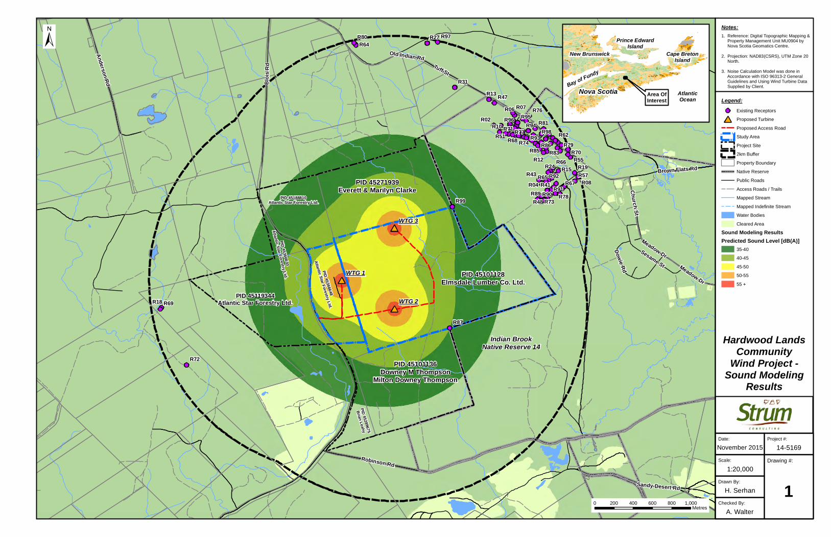
XY
XY
XY
XY
XY
XY
XY
XY
XY
XY
XY
XY
XY
XY
XY
XY
XY
XY
XY
XY
XY
XY
XY
XY
XY
XY
XY
XY
XY
XY
XY
XY
XY
XY
XY
XY
XY
XY
XY
XY
XY
XY
XY
XY
XY
XY
XY
XY
XY
XY
XY
XY
XY
XY
XY XY
XY
XY
XY
XY
XY
XY
XY
XY
XY
XY
XY
XY
XY
XY
XYXY
XY
XY
XY
XY
XY
XY
XY
XY
XY
XY
XY
XY
XY
XY
XY
XY
XY
XY
XY
XY
XY
XY
XY
XY
XY
XY
XY
XY
XY
XY
XY
XY
XY
XY
XY
XY
XY
XY
XY
XY
XY
XY
XY
XY
XY
XY
XY
XY XY XY XY
XY
XY
XY
XY
XY
XY
XY
XY
XY
XY
XY
XY
XY
XY
XY
XY
XY
XY
XY
XY
XY
XY
XY
XY
XY
XY
XY
XY
XY
XY
XY
XY
XY
XY
XY
XY
XY
XY
XY
XY
XY
XY
XY
XY
XY
XY
XY
XY
XY
XY
XY
XY
XY
XY
XY
XY
XY
XY
XY
XY
XY
XY
XY
XY
XY
XY
XY
XY
XY
XY
XY
XY
XY
XY
XY
XY
XY
XY
XY
XY
XY
XY
XY
XY
XY
XY
XY
XY
XY
XY
XY
XY
XY
XY
XY
XY
XY
XY
XY
XY
XY
XY
XY
XY
XY
XY
XY
XY
XY
XY
XY
XY
XY
XY
XY
XY
XY
XY
XY
XY
XY
XY
XY
XY
XY
XY
XY
XY
XY
XY
XY
XY
XY
XY
XY
XY
XY
XY
XY
XY
XY
XY
XY
XY
XY
XY
XY
XY
XY
XY
XY
XY
XY
XY
XY
XY
XY
XY
XY
XY
XY
XY
XY
XY
XY
XY
XY
XY
XY
XY
XY
XY
XY
XY
XY
XY
XY
XY
XY
XY
XY
XY
XY
XY
XY
XY
XY
XY
XY
XY
XY
XY
XY
XY
XY
XY
XY
XY
XY
XY
XY
XY
XY
XY
XY
XY
XY
XY
XY
XY
XY
XY
XY
XY
XY
XY
XY
XY
XY XY XY
XY
XY
XY
XY
XY
XY
XY
XY
XY
XY
XY
XY
XY
XY
XY
XY
XY
XY
XY
XY
XY
XY
XY
XY
XY
XY
XY
XY XY XY XY XY XY XY
XY
XY
#*
#*
#*
!(
!(
!(
!(
!(
!(!(
!(
!(
!(
!(!(
!(
!( !(
!(
!(
!(
!(
!(
!(
!(
!(
!(!(
!(
!(
!(
!(
!(
!(
!(
!(!(
!(
!(
!(
!(!(
!(
!(
!(
!(
!(
!( !(
!(
!(
!(
!(
!( !(
!(!(
!(
!(
!(
!(
!(
!(
!(!(
!(
!(
!(
!(
!(
!(
!(
!(
!(
!(
!(
!( !(
!(
!(
!(
!(
!(
!(
!(
!(!(!(!(
!(
!( !(!(
!(
!(!(
!(!(
!(
!(
!(
R99
R98
R97
R96 R95R94
R93
R92
R91R90R89
R87
R86R85 R83
R81
R80
R79
R78
R77
R76
R74
R73
R72
R71
R70
R69
R68
R67
R66
R65
R64
R62
R57
R55
R51
R48
R47
R43R41
R31
R27
R24 R19
R18
R15
R13
R12
R10
R08
R07R06
R04
R02
WTG 1
WTG 2
WTG 3
Blois
Rd Tuff St
Indian Rd
Sandy Desert Rd
Robinson Rd
Anderson Rd
Old Indian Rd
Sesame St
Brown Flats Rd
Church St
Dowie Rd Meadow Dr
Meadow Dr
Checked By:
A. Walter
Drawn By:
H. Serhan
Drawing #:
11:20,000
Scale:
November 2015
Date: Project #:
14-5169
±
Area OfInterest
Hardwood LandsCommunity
Wind Project -Sound Modeling
Results
0 200 400 600 800 1,000Metres
Nova Scotia
New Brunswick
AtlanticOcean
Prince EdwardIsland
Bay of Fundy
Cape BretonIsland
Notes:1. Reference: Digital Topographic Mapping & Property Management Unit MU0904 by Nova Scotia Geomatics Centre.
2. Projection: NAD83(CSRS), UTM Zone 20 North.
3. Noise Calculation Model was done in Accordance with ISO 96313-2 General Guidelines and Using Wind Turbine Data Supplied by Client.
Legend:!( Existing Receptors
#* Proposed Turbine
Proposed Access Road
Study Area
Project Site
2km Buffer
Property Boundary
Native Reserve
Public Roads
Access Roads / Trails
Mapped Stream
Mapped Indefinite Stream
Water Bodies
Cleared Area
Sound Modeling ResultsPredicted Sound Level [dB(A)]
35-40
40-45
45-50
50-55
55 +
PID 45101128Elmsdale Lumber Co. Ltd.
PID 45271939Everett & Marilyn Clarke
PID 45188810Atlantic Star Forestry Ltd.
PID 45119344Atlantic Star Forestry Ltd.
PID 45366648
Atlantic Star Forestry Ltd.
PID 45366630
Atlantic Star Forestry Ltd.
PID 45289675
Brian Leahy
Indian BrookNative Reserve 14
PID 45101136Downey M Thompson
Milton Downey Thompson

APPENDIX D SHADOW FLICKER ASSESSMENT

Project# 14-5169
Veg Zone Total Tree Height (m) Tree Type Notes Veg Zone Total Tree Height (m) Tree Type Notes
12.03 H 12.82 S7.46 H 12.55 S
13.50 H 8.37 S~7m dense stand S 11.40 S
21.52 H 12.47 S~7m dense stand S 10.67 S
16.29 H 12.67 S~7m dense stand S 20.80 S
14.07 H 16.36 S~7m dense stand S 16.32 S
14.18 H 26.84 H~7m dense stand S 18.30 H
13.35 H 19.86 H5.63 S 16.82 H
14.34 H 19.11 H8.45 H 17.27 H5.68 S 13.24 H4.94 S 16.68 S
23.95 H 11.38 S7.45 S 15.31 S6.78 S 18.30 S
11.20 S 19.54 S11.81 S 12.72 S16.74 S 13.85 H8.95 S 9.13 S
13.68 S 12.79 S13.44 S 10.74 H13.88 S 11.27 S9.10 S 16.07 H
15.56 S 12.87 S10.01 S 10.11 S12.46 S 11.40 S13.56 S 13.25 S9.34 S 12.14 S
13.71 S13.82 S14.54 S14.99 S10.40 H14.84 S14.53 S15.18 S12.67 S13.11 H14.54 S13.54 H14.04 S
4 An average of 13.5m tree height was used to model this section.
Table D1: Field Observed Vegetation Height
For this section habitat observed was represented by alternating taller hardwoods (~14-16m) and shorter softwood (~7m). We modelled based on this alternating arrangement along the transect (which was aligned along the property line).
1
2 An average of 13m tree height was used to model this section.
An average of 12 m tree height was used to model this section.5
6An average of 17.5 m tree height was used to model this section.
3 An average of 13m tree height was used to model this section.
7 An average of 11 m tree height was used to model this section.

windPRO 3.0.629 by EMD International A/S, Tel. +45 96 35 44 44, www.emd.dk, [email protected] windPRO12/4/2015 11:59 AM / 1
Project:
Hardwood Lands Sound & Shadow ModelingLicensed user:
Strum Environmental Railside, 1355 Bedford Highway CA-B4A 1C5 Bedford, NS902.835.5560 (24/7)
Calculated:
12/4/2015 11:59 AM/3.0.629
SHADOW - Main ResultCalculation: Hardwood Lands Wind Project - Without VegetationAssumptions for shadow calculationsMaximum distance for influenceCalculate only when more than 20 % of sun is covered by the bladePlease look in WTG table
Minimum sun height over horizon for influence 3 °Day step for calculation 1 daysTime step for calculation 1 minutesThe calculated times are "worst case" given by the following assumptions:
The sun is shining all the day, from sunrise to sunsetThe rotor plane is always perpendicular to the line from the WTG to thesunThe WTG is always operating
A ZVI (Zones of Visual Influence) calculation is performed before flickercalculation so non visible WTG do not contribute to calculated flicker values. AWTG will be visible if it is visible from any part of the receiver window. TheZVI calculation is based on the following assumptions:Height contours used: Height Contours: Contours.wpo (1)Obstacles used in calculationEye height: 1.5 mGrid resolution: 10.0 m
All coordinates are inUTM (north)-NAD83(NSRS/CSRS) (US+CA), geocentric, GRS80 Zone: 20
WTGsWTG type Shadow data
Easting Northing Z Row Valid Manufact. Type-generator Power, rated Rotor diameter Hub height Calculation distance RPMdata/Description
[m] [kW] [m] [m] [m] [RPM]1 458,350 4,993,141 85.0 Wind Turbine Yes VESTAS V110-2.0-2,000 2,000 110.0 95.0 1,513 0.02 458,899 4,992,845 75.3 Wind Turbine Yes VESTAS V110-2.0-2,000 2,000 110.0 95.0 1,513 0.03 458,897 4,993,684 85.0 Wind Turbine Yes VESTAS V110-2.0-2,000 2,000 110.0 95.0 1,513 0.0
Shadow receptor-InputNo. Name Easting Northing Z Width Height Height Degrees from Slope of Direction mode
a.g.l. south cw window[m] [m] [m] [m] [°] [°]
A R01 460,598 4,994,046 66.6 1.0 1.0 1.0 53.6 90.0 Fixed directionB R02 459,929 4,994,753 72.8 1.0 1.0 1.0 52.3 90.0 Fixed directionC R03 460,486 4,993,998 70.0 1.0 1.0 1.0 53.6 90.0 Fixed directionD R04 460,428 4,994,137 75.0 1.0 1.0 1.0 53.6 90.0 Fixed directionE R05 460,541 4,994,622 65.0 1.0 1.0 1.0 53.6 90.0 Fixed directionF R06 460,145 4,994,860 75.0 1.0 1.0 1.0 53.6 90.0 Fixed directionG R07 460,126 4,994,882 75.0 1.0 1.0 1.0 53.6 90.0 Fixed directionH R08 460,805 4,994,218 60.7 1.0 1.0 1.0 53.6 90.0 Fixed directionI R09 460,525 4,994,085 70.8 1.0 1.0 1.0 53.6 90.0 Fixed directionJ R10 459,990 4,994,681 70.0 1.0 1.0 1.0 53.6 90.0 Fixed directionK R11 460,479 4,994,480 65.0 1.0 1.0 1.0 53.6 90.0 Fixed directionL R12 460,445 4,994,470 65.0 1.0 1.0 1.0 53.6 90.0 Fixed directionM R13 459,879 4,995,022 84.3 1.0 1.0 1.0 30.7 90.0 Fixed directionN R14 460,516 4,994,281 74.1 1.0 1.0 1.0 53.6 90.0 Fixed directionO R15 460,598 4,994,279 68.7 1.0 1.0 1.0 53.6 90.0 Fixed directionP R16 460,502 4,994,659 65.0 1.0 1.0 1.0 53.6 90.0 Fixed directionQ R17 460,519 4,994,564 65.0 1.0 1.0 1.0 53.6 90.0 Fixed directionR R18 456,478 4,992,857 69.3 1.0 1.0 1.0 -99.9 90.0 Fixed directionS R19 460,768 4,994,260 60.7 1.0 1.0 1.0 53.6 90.0 Fixed directionT R20 460,616 4,994,042 65.5 1.0 1.0 1.0 53.6 90.0 Fixed directionU R21 460,660 4,994,114 62.4 1.0 1.0 1.0 53.6 90.0 Fixed directionV R22 460,187 4,994,706 71.8 1.0 1.0 1.0 53.6 90.0 Fixed directionW R23 460,129 4,994,805 75.0 1.0 1.0 1.0 53.6 90.0 Fixed direction
To be continued on next page...
TCooper
Text Box
Output sheet - without vegetation
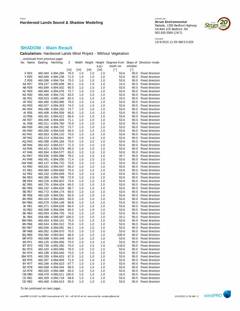
windPRO 3.0.629 by EMD International A/S, Tel. +45 96 35 44 44, www.emd.dk, [email protected] windPRO12/4/2015 11:59 AM / 2
Project:
Hardwood Lands Sound & Shadow ModelingLicensed user:
Strum Environmental Railside, 1355 Bedford Highway CA-B4A 1C5 Bedford, NS902.835.5560 (24/7)
Calculated:
12/4/2015 11:59 AM/3.0.629
SHADOW - Main ResultCalculation: Hardwood Lands Wind Project - Without Vegetation...continued from previous pageNo. Name Easting Northing Z Width Height Height Degrees from Slope of Direction mode
a.g.l. south cw window[m] [m] [m] [m] [°] [°]
X R24 460,494 4,994,266 75.0 1.0 1.0 1.0 53.6 90.0 Fixed directionY R25 460,569 4,994,238 71.5 1.0 1.0 1.0 53.6 90.0 Fixed directionZ R26 460,098 4,994,764 75.0 1.0 1.0 1.0 53.6 90.0 Fixed direction
AA R27 459,237 4,995,608 84.1 1.0 1.0 1.0 14.0 90.0 Fixed directionAB R28 460,699 4,994,502 65.0 1.0 1.0 1.0 53.6 90.0 Fixed directionAC R29 460,484 4,994,076 72.7 1.0 1.0 1.0 53.6 90.0 Fixed directionAD R30 460,446 4,994,715 63.5 1.0 1.0 1.0 53.6 90.0 Fixed directionAE R31 459,523 4,995,146 82.0 1.0 1.0 1.0 23.0 90.0 Fixed directionAF R32 460,466 4,993,985 70.0 1.0 1.0 1.0 53.6 90.0 Fixed directionAG R33 460,527 4,994,203 74.2 1.0 1.0 1.0 53.6 90.0 Fixed directionAH R34 460,498 4,994,182 74.7 1.0 1.0 1.0 53.6 90.0 Fixed directionAI R35 460,408 4,994,509 65.0 1.0 1.0 1.0 53.6 90.0 Fixed directionAJ R36 460,301 4,994,612 66.6 1.0 1.0 1.0 53.6 90.0 Fixed directionAK R37 460,400 4,994,004 71.1 1.0 1.0 1.0 53.6 90.0 Fixed directionAL R38 460,311 4,994,760 70.9 1.0 1.0 1.0 53.6 90.0 Fixed directionAM R39 460,168 4,994,752 73.7 1.0 1.0 1.0 53.6 90.0 Fixed directionAN R40 460,590 4,994,518 65.0 1.0 1.0 1.0 53.6 90.0 Fixed directionAO R41 460,553 4,994,110 70.0 1.0 1.0 1.0 53.6 90.0 Fixed directionAP R42 460,213 4,994,641 69.7 1.0 1.0 1.0 53.6 90.0 Fixed directionAQ R43 460,398 4,994,184 75.0 1.0 1.0 1.0 53.6 90.0 Fixed directionAR R44 460,422 4,994,017 71.3 1.0 1.0 1.0 53.6 90.0 Fixed directionAS R45 460,421 4,994,578 65.0 1.0 1.0 1.0 53.6 90.0 Fixed directionAT R46 460,594 4,994,577 65.0 1.0 1.0 1.0 53.6 90.0 Fixed directionAU R47 459,936 4,994,986 79.2 1.0 1.0 1.0 44.7 90.0 Fixed directionAV R48 460,451 4,994,030 71.4 1.0 1.0 1.0 53.6 90.0 Fixed directionAW R49 460,147 4,994,722 73.5 1.0 1.0 1.0 53.6 90.0 Fixed directionAX R50 460,631 4,994,547 65.0 1.0 1.0 1.0 53.6 90.0 Fixed directionAY R51 460,084 4,994,663 70.4 1.0 1.0 1.0 53.6 90.0 Fixed directionAZ R52 460,152 4,994,649 70.0 1.0 1.0 1.0 53.6 90.0 Fixed directionBA R53 460,266 4,994,798 72.9 1.0 1.0 1.0 53.6 90.0 Fixed directionBB R54 460,228 4,994,822 74.4 1.0 1.0 1.0 53.6 90.0 Fixed directionBC R55 460,725 4,994,424 65.0 1.0 1.0 1.0 53.6 90.0 Fixed directionBD R56 460,242 4,994,633 68.7 1.0 1.0 1.0 53.6 90.0 Fixed directionBE R57 460,772 4,994,174 60.0 1.0 1.0 1.0 53.6 90.0 Fixed directionBF R58 460,328 4,994,591 65.9 1.0 1.0 1.0 53.6 90.0 Fixed directionBG R59 460,424 4,994,665 65.0 1.0 1.0 1.0 53.6 90.0 Fixed directionBH R60 460,578 4,994,148 69.8 1.0 1.0 1.0 53.6 90.0 Fixed directionBI R61 460,371 4,994,629 66.0 1.0 1.0 1.0 53.6 90.0 Fixed directionBJ R62 460,568 4,994,594 65.0 1.0 1.0 1.0 53.6 90.0 Fixed directionBK R63 460,093 4,994,733 74.5 1.0 1.0 1.0 53.6 90.0 Fixed directionBL R64 458,498 4,995,587 100.0 1.0 1.0 1.0 -10.2 90.0 Fixed directionBM R65 460,453 4,994,151 75.0 1.0 1.0 1.0 53.6 90.0 Fixed directionBN R66 460,544 4,994,312 70.6 1.0 1.0 1.0 53.6 90.0 Fixed directionBO R67 460,636 4,994,091 64.1 1.0 1.0 1.0 53.6 90.0 Fixed directionBP R68 460,052 4,994,670 70.0 1.0 1.0 1.0 53.6 90.0 Fixed directionBQ R69 456,466 4,992,841 68.6 1.0 1.0 1.0 -100.9 90.0 Fixed directionBR R70 460,698 4,994,449 65.0 1.0 1.0 1.0 53.6 90.0 Fixed directionBS R71 460,125 4,994,656 70.0 1.0 1.0 1.0 53.6 90.0 Fixed directionBT R72 456,739 4,992,260 70.0 1.0 1.0 1.0 -118.5 90.0 Fixed directionBU R73 460,420 4,993,956 70.0 1.0 1.0 1.0 53.6 90.0 Fixed directionBV R74 460,188 4,994,645 70.0 1.0 1.0 1.0 53.6 90.0 Fixed directionBW R75 460,339 4,994,653 67.9 1.0 1.0 1.0 53.6 90.0 Fixed directionBX R76 460,297 4,994,849 71.6 1.0 1.0 1.0 53.6 90.0 Fixed directionBY R77 460,268 4,994,623 67.7 1.0 1.0 1.0 53.6 90.0 Fixed directionBZ R78 460,568 4,994,044 68.5 1.0 1.0 1.0 53.6 90.0 Fixed directionCA R79 460,620 4,994,489 65.0 1.0 1.0 1.0 53.6 90.0 Fixed directionCB R80 458,478 4,995,611 100.0 1.0 1.0 1.0 -16.5 90.0 Fixed directionCC R81 460,359 4,994,718 68.8 1.0 1.0 1.0 53.6 90.0 Fixed directionCD R82 460,468 4,994,613 65.0 1.0 1.0 1.0 53.6 90.0 Fixed direction
To be continued on next page...

windPRO 3.0.629 by EMD International A/S, Tel. +45 96 35 44 44, www.emd.dk, [email protected] windPRO12/4/2015 11:59 AM / 3
Project:
Hardwood Lands Sound & Shadow ModelingLicensed user:
Strum Environmental Railside, 1355 Bedford Highway CA-B4A 1C5 Bedford, NS902.835.5560 (24/7)
Calculated:
12/4/2015 11:59 AM/3.0.629
SHADOW - Main ResultCalculation: Hardwood Lands Wind Project - Without Vegetation...continued from previous pageNo. Name Easting Northing Z Width Height Height Degrees from Slope of Direction mode
a.g.l. south cw window[m] [m] [m] [m] [°] [°]
CE R83 460,472 4,994,520 65.0 1.0 1.0 1.0 53.6 90.0 Fixed directionCF R84 460,444 4,994,549 65.0 1.0 1.0 1.0 53.6 90.0 Fixed directionCG R85 460,361 4,994,564 65.0 1.0 1.0 1.0 53.6 90.0 Fixed directionCH R86 460,386 4,994,543 65.0 1.0 1.0 1.0 53.6 90.0 Fixed directionCI R89 460,384 4,993,983 70.6 1.0 1.0 1.0 53.6 90.0 Fixed directionCJ R90 460,453 4,993,975 70.0 1.0 1.0 1.0 53.6 90.0 Fixed directionCK R91 460,515 4,994,028 70.4 1.0 1.0 1.0 53.6 90.0 Fixed directionCL R92 460,469 4,994,166 75.0 1.0 1.0 1.0 53.6 90.0 Fixed directionCM R93 460,288 4,994,696 70.0 1.0 1.0 1.0 53.6 90.0 Fixed directionCN R94 460,230 4,994,692 70.0 1.0 1.0 1.0 53.6 90.0 Fixed directionCO R95 460,178 4,994,782 74.1 1.0 1.0 1.0 53.6 90.0 Fixed directionCP R96 460,003 4,994,749 73.3 1.0 1.0 1.0 53.6 90.0 Fixed directionCQ R97 459,346 4,995,619 86.4 1.0 1.0 1.0 20.8 90.0 Fixed directionCR R98 460,391 4,994,626 65.1 1.0 1.0 1.0 53.6 90.0 Fixed directionCS R87 459,471 4,992,644 64.5 1.0 1.0 1.0 -245.3 90.0 Fixed directionCT R99 459,499 4,993,906 65.9 1.0 1.0 1.0 61.7 90.0 Fixed directionCU S1 459,607 4,994,258 73.6 1.0 1.0 1.0 61.7 90.0 Fixed directionCV S2 459,415 4,994,130 70.0 1.0 1.0 1.0 61.7 90.0 Fixed directionCW S3 459,499 4,993,906 65.9 1.0 1.0 1.0 61.7 90.0 Fixed directionCX S4 459,766 4,993,621 70.0 1.0 1.0 1.0 74.5 90.0 Fixed directionCY S5 459,667 4,993,470 0.0 1.0 1.0 1.0 79.4 90.0 Fixed directionCZ S6 459,605 4,992,688 62.6 1.0 1.0 1.0 -245.3 90.0 Fixed directionDA S7 459,471 4,992,644 64.5 1.0 1.0 1.0 -245.3 90.0 Fixed directionDB S8 459,716 4,992,475 62.5 1.0 1.0 1.0 -245.3 90.0 Fixed direction
Calculation ResultsShadow receptor
Shadow, worst caseNo. Name Shadow hours Shadow days Max shadow
per year per year hours per day[h/year] [days/year] [h/day]
A R01 0:00 0 0:00B R02 0:00 0 0:00C R03 0:00 0 0:00D R04 0:00 0 0:00E R05 0:00 0 0:00F R06 0:00 0 0:00G R07 0:00 0 0:00H R08 0:00 0 0:00I R09 0:00 0 0:00J R10 2:39 19 0:10K R11 0:00 0 0:00L R12 0:00 0 0:00M R13 0:00 0 0:00N R14 0:00 0 0:00O R15 0:00 0 0:00P R16 0:00 0 0:00Q R17 0:00 0 0:00R R18 0:00 0 0:00S R19 0:00 0 0:00T R20 0:00 0 0:00U R21 0:00 0 0:00V R22 0:00 0 0:00W R23 0:00 0 0:00X R24 0:00 0 0:00Y R25 0:00 0 0:00Z R26 0:00 0 0:00
AA R27 0:00 0 0:00
To be continued on next page...

windPRO 3.0.629 by EMD International A/S, Tel. +45 96 35 44 44, www.emd.dk, [email protected] windPRO12/4/2015 11:59 AM / 4
Project:
Hardwood Lands Sound & Shadow ModelingLicensed user:
Strum Environmental Railside, 1355 Bedford Highway CA-B4A 1C5 Bedford, NS902.835.5560 (24/7)
Calculated:
12/4/2015 11:59 AM/3.0.629
SHADOW - Main ResultCalculation: Hardwood Lands Wind Project - Without Vegetation...continued from previous page
Shadow, worst caseNo. Name Shadow hours Shadow days Max shadow
per year per year hours per day[h/year] [days/year] [h/day]
AB R28 0:00 0 0:00AC R29 0:00 0 0:00AD R30 0:00 0 0:00AE R31 0:00 0 0:00AF R32 0:00 0 0:00AG R33 0:00 0 0:00AH R34 0:00 0 0:00AI R35 0:00 0 0:00AJ R36 0:00 0 0:00AK R37 0:00 0 0:00AL R38 0:00 0 0:00AM R39 0:00 0 0:00AN R40 0:00 0 0:00AO R41 0:00 0 0:00AP R42 0:00 0 0:00AQ R43 0:00 0 0:00AR R44 0:00 0 0:00AS R45 0:00 0 0:00AT R46 0:00 0 0:00AU R47 0:00 0 0:00AV R48 0:00 0 0:00AW R49 0:00 0 0:00AX R50 0:00 0 0:00AY R51 0:00 0 0:00AZ R52 0:00 0 0:00BA R53 0:00 0 0:00BB R54 0:00 0 0:00BC R55 0:00 0 0:00BD R56 0:00 0 0:00BE R57 0:00 0 0:00BF R58 0:00 0 0:00BG R59 0:00 0 0:00BH R60 0:00 0 0:00BI R61 0:00 0 0:00BJ R62 0:00 0 0:00BK R63 0:00 0 0:00BL R64 0:00 0 0:00BM R65 0:00 0 0:00BN R66 0:00 0 0:00BO R67 0:00 0 0:00BP R68 0:00 0 0:00BQ R69 0:00 0 0:00BR R70 0:00 0 0:00BS R71 0:00 0 0:00BT R72 0:00 0 0:00BU R73 0:00 0 0:00BV R74 0:00 0 0:00BW R75 0:00 0 0:00BX R76 0:00 0 0:00BY R77 0:00 0 0:00BZ R78 0:00 0 0:00CA R79 0:00 0 0:00CB R80 0:00 0 0:00CC R81 0:00 0 0:00CD R82 0:00 0 0:00CE R83 0:00 0 0:00CF R84 0:00 0 0:00CG R85 0:00 0 0:00
To be continued on next page...
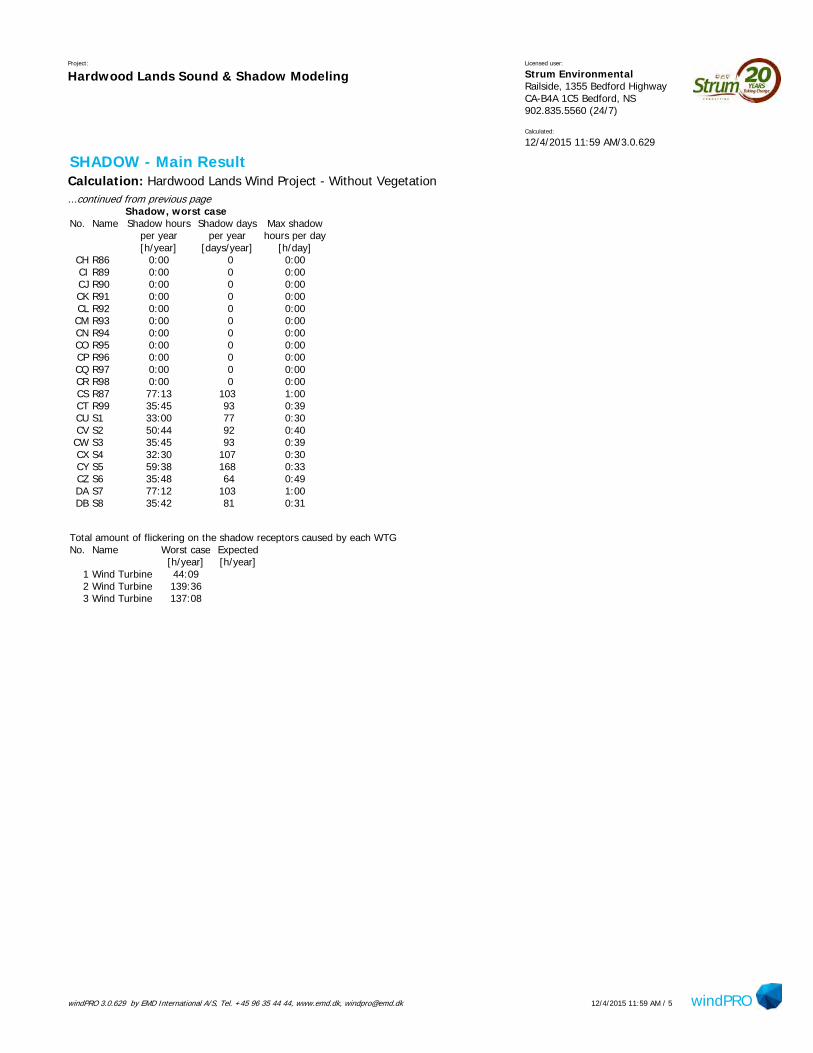
windPRO 3.0.629 by EMD International A/S, Tel. +45 96 35 44 44, www.emd.dk, [email protected] windPRO12/4/2015 11:59 AM / 5
Project:
Hardwood Lands Sound & Shadow ModelingLicensed user:
Strum Environmental Railside, 1355 Bedford Highway CA-B4A 1C5 Bedford, NS902.835.5560 (24/7)
Calculated:
12/4/2015 11:59 AM/3.0.629
SHADOW - Main ResultCalculation: Hardwood Lands Wind Project - Without Vegetation...continued from previous page
Shadow, worst caseNo. Name Shadow hours Shadow days Max shadow
per year per year hours per day[h/year] [days/year] [h/day]
CH R86 0:00 0 0:00CI R89 0:00 0 0:00CJ R90 0:00 0 0:00CK R91 0:00 0 0:00CL R92 0:00 0 0:00CM R93 0:00 0 0:00CN R94 0:00 0 0:00CO R95 0:00 0 0:00CP R96 0:00 0 0:00CQ R97 0:00 0 0:00CR R98 0:00 0 0:00CS R87 77:13 103 1:00CT R99 35:45 93 0:39CU S1 33:00 77 0:30CV S2 50:44 92 0:40CW S3 35:45 93 0:39CX S4 32:30 107 0:30CY S5 59:38 168 0:33CZ S6 35:48 64 0:49DA S7 77:12 103 1:00DB S8 35:42 81 0:31
Total amount of flickering on the shadow receptors caused by each WTGNo. Name Worst case Expected
[h/year] [h/year]1 Wind Turbine 44:092 Wind Turbine 139:363 Wind Turbine 137:08
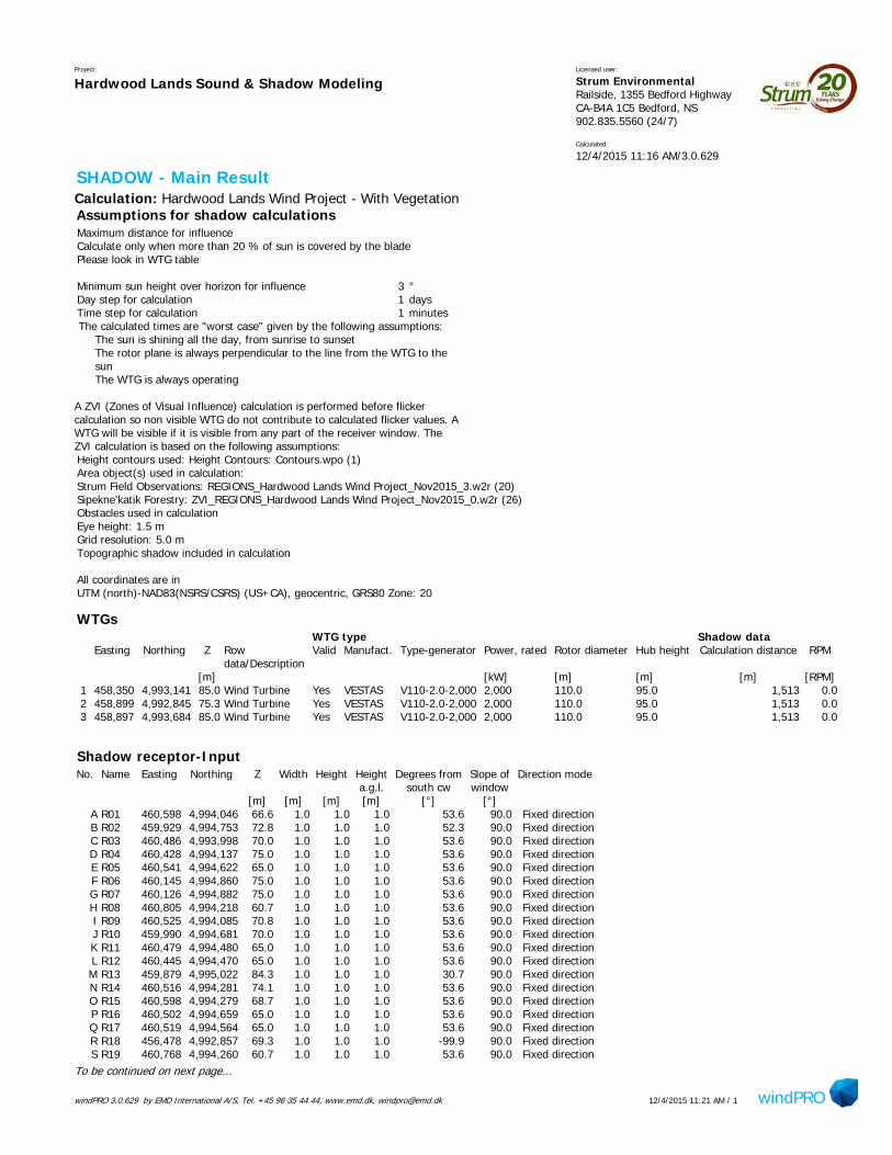
windPRO 3.0.629 by EMD International A/S, Tel. +45 96 35 44 44, www.emd.dk, [email protected] windPRO12/4/2015 11:21 AM / 1
Project:
Hardwood Lands Sound & Shadow ModelingLicensed user:
Strum Environmental Railside, 1355 Bedford Highway CA-B4A 1C5 Bedford, NS902.835.5560 (24/7)
Calculated:
12/4/2015 11:16 AM/3.0.629
SHADOW - Main ResultCalculation: Hardwood Lands Wind Project - With VegetationAssumptions for shadow calculationsMaximum distance for influenceCalculate only when more than 20 % of sun is covered by the bladePlease look in WTG table
Minimum sun height over horizon for influence 3 °Day step for calculation 1 daysTime step for calculation 1 minutesThe calculated times are "worst case" given by the following assumptions:
The sun is shining all the day, from sunrise to sunsetThe rotor plane is always perpendicular to the line from the WTG to thesunThe WTG is always operating
A ZVI (Zones of Visual Influence) calculation is performed before flickercalculation so non visible WTG do not contribute to calculated flicker values. AWTG will be visible if it is visible from any part of the receiver window. TheZVI calculation is based on the following assumptions:Height contours used: Height Contours: Contours.wpo (1)Area object(s) used in calculation:Strum Field Observations: REGIONS_Hardwood Lands Wind Project_Nov2015_3.w2r (20)Sipekne'katik Forestry: ZVI_REGIONS_Hardwood Lands Wind Project_Nov2015_0.w2r (26)Obstacles used in calculationEye height: 1.5 mGrid resolution: 5.0 mTopographic shadow included in calculation
All coordinates are inUTM (north)-NAD83(NSRS/CSRS) (US+CA), geocentric, GRS80 Zone: 20
WTGsWTG type Shadow data
Easting Northing Z Row Valid Manufact. Type-generator Power, rated Rotor diameter Hub height Calculation distance RPMdata/Description
[m] [kW] [m] [m] [m] [RPM]1 458,350 4,993,141 85.0 Wind Turbine Yes VESTAS V110-2.0-2,000 2,000 110.0 95.0 1,513 0.02 458,899 4,992,845 75.3 Wind Turbine Yes VESTAS V110-2.0-2,000 2,000 110.0 95.0 1,513 0.03 458,897 4,993,684 85.0 Wind Turbine Yes VESTAS V110-2.0-2,000 2,000 110.0 95.0 1,513 0.0
Shadow receptor-InputNo. Name Easting Northing Z Width Height Height Degrees from Slope of Direction mode
a.g.l. south cw window[m] [m] [m] [m] [°] [°]
A R01 460,598 4,994,046 66.6 1.0 1.0 1.0 53.6 90.0 Fixed directionB R02 459,929 4,994,753 72.8 1.0 1.0 1.0 52.3 90.0 Fixed directionC R03 460,486 4,993,998 70.0 1.0 1.0 1.0 53.6 90.0 Fixed directionD R04 460,428 4,994,137 75.0 1.0 1.0 1.0 53.6 90.0 Fixed directionE R05 460,541 4,994,622 65.0 1.0 1.0 1.0 53.6 90.0 Fixed directionF R06 460,145 4,994,860 75.0 1.0 1.0 1.0 53.6 90.0 Fixed directionG R07 460,126 4,994,882 75.0 1.0 1.0 1.0 53.6 90.0 Fixed directionH R08 460,805 4,994,218 60.7 1.0 1.0 1.0 53.6 90.0 Fixed directionI R09 460,525 4,994,085 70.8 1.0 1.0 1.0 53.6 90.0 Fixed directionJ R10 459,990 4,994,681 70.0 1.0 1.0 1.0 53.6 90.0 Fixed directionK R11 460,479 4,994,480 65.0 1.0 1.0 1.0 53.6 90.0 Fixed directionL R12 460,445 4,994,470 65.0 1.0 1.0 1.0 53.6 90.0 Fixed directionM R13 459,879 4,995,022 84.3 1.0 1.0 1.0 30.7 90.0 Fixed directionN R14 460,516 4,994,281 74.1 1.0 1.0 1.0 53.6 90.0 Fixed directionO R15 460,598 4,994,279 68.7 1.0 1.0 1.0 53.6 90.0 Fixed directionP R16 460,502 4,994,659 65.0 1.0 1.0 1.0 53.6 90.0 Fixed directionQ R17 460,519 4,994,564 65.0 1.0 1.0 1.0 53.6 90.0 Fixed directionR R18 456,478 4,992,857 69.3 1.0 1.0 1.0 -99.9 90.0 Fixed directionS R19 460,768 4,994,260 60.7 1.0 1.0 1.0 53.6 90.0 Fixed direction
To be continued on next page...
TCooper
Text Box
Output sheet - with vegetation

windPRO 3.0.629 by EMD International A/S, Tel. +45 96 35 44 44, www.emd.dk, [email protected] windPRO12/4/2015 11:21 AM / 2
Project:
Hardwood Lands Sound & Shadow ModelingLicensed user:
Strum Environmental Railside, 1355 Bedford Highway CA-B4A 1C5 Bedford, NS902.835.5560 (24/7)
Calculated:
12/4/2015 11:16 AM/3.0.629
SHADOW - Main ResultCalculation: Hardwood Lands Wind Project - With Vegetation...continued from previous pageNo. Name Easting Northing Z Width Height Height Degrees from Slope of Direction mode
a.g.l. south cw window[m] [m] [m] [m] [°] [°]
T R20 460,616 4,994,042 65.5 1.0 1.0 1.0 53.6 90.0 Fixed directionU R21 460,660 4,994,114 62.4 1.0 1.0 1.0 53.6 90.0 Fixed directionV R22 460,187 4,994,706 71.8 1.0 1.0 1.0 53.6 90.0 Fixed directionW R23 460,129 4,994,805 75.0 1.0 1.0 1.0 53.6 90.0 Fixed directionX R24 460,494 4,994,266 75.0 1.0 1.0 1.0 53.6 90.0 Fixed directionY R25 460,569 4,994,238 71.5 1.0 1.0 1.0 53.6 90.0 Fixed directionZ R26 460,098 4,994,764 75.0 1.0 1.0 1.0 53.6 90.0 Fixed direction
AA R27 459,237 4,995,608 84.1 1.0 1.0 1.0 14.0 90.0 Fixed directionAB R28 460,699 4,994,502 65.0 1.0 1.0 1.0 53.6 90.0 Fixed directionAC R29 460,484 4,994,076 72.7 1.0 1.0 1.0 53.6 90.0 Fixed directionAD R30 460,446 4,994,715 63.5 1.0 1.0 1.0 53.6 90.0 Fixed directionAE R31 459,523 4,995,146 82.0 1.0 1.0 1.0 23.0 90.0 Fixed directionAF R32 460,466 4,993,985 70.0 1.0 1.0 1.0 53.6 90.0 Fixed directionAG R33 460,527 4,994,203 74.2 1.0 1.0 1.0 53.6 90.0 Fixed directionAH R34 460,498 4,994,182 74.7 1.0 1.0 1.0 53.6 90.0 Fixed directionAI R35 460,408 4,994,509 65.0 1.0 1.0 1.0 53.6 90.0 Fixed directionAJ R36 460,301 4,994,612 66.6 1.0 1.0 1.0 53.6 90.0 Fixed directionAK R37 460,400 4,994,004 71.1 1.0 1.0 1.0 53.6 90.0 Fixed directionAL R38 460,311 4,994,760 70.9 1.0 1.0 1.0 53.6 90.0 Fixed directionAM R39 460,168 4,994,752 73.7 1.0 1.0 1.0 53.6 90.0 Fixed directionAN R40 460,590 4,994,518 65.0 1.0 1.0 1.0 53.6 90.0 Fixed directionAO R41 460,553 4,994,110 70.0 1.0 1.0 1.0 53.6 90.0 Fixed directionAP R42 460,213 4,994,641 69.7 1.0 1.0 1.0 53.6 90.0 Fixed directionAQ R43 460,398 4,994,184 75.0 1.0 1.0 1.0 53.6 90.0 Fixed directionAR R44 460,422 4,994,017 71.3 1.0 1.0 1.0 53.6 90.0 Fixed directionAS R45 460,421 4,994,578 65.0 1.0 1.0 1.0 53.6 90.0 Fixed directionAT R46 460,594 4,994,577 65.0 1.0 1.0 1.0 53.6 90.0 Fixed directionAU R47 459,936 4,994,986 79.2 1.0 1.0 1.0 44.7 90.0 Fixed directionAV R48 460,451 4,994,030 71.4 1.0 1.0 1.0 53.6 90.0 Fixed directionAW R49 460,147 4,994,722 73.5 1.0 1.0 1.0 53.6 90.0 Fixed directionAX R50 460,631 4,994,547 65.0 1.0 1.0 1.0 53.6 90.0 Fixed directionAY R51 460,084 4,994,663 70.4 1.0 1.0 1.0 53.6 90.0 Fixed directionAZ R52 460,152 4,994,649 70.0 1.0 1.0 1.0 53.6 90.0 Fixed directionBA R53 460,266 4,994,798 72.9 1.0 1.0 1.0 53.6 90.0 Fixed directionBB R54 460,228 4,994,822 74.4 1.0 1.0 1.0 53.6 90.0 Fixed directionBC R55 460,725 4,994,424 65.0 1.0 1.0 1.0 53.6 90.0 Fixed directionBD R56 460,242 4,994,633 68.7 1.0 1.0 1.0 53.6 90.0 Fixed directionBE R57 460,772 4,994,174 60.0 1.0 1.0 1.0 53.6 90.0 Fixed directionBF R58 460,328 4,994,591 65.9 1.0 1.0 1.0 53.6 90.0 Fixed directionBG R59 460,424 4,994,665 65.0 1.0 1.0 1.0 53.6 90.0 Fixed directionBH R60 460,578 4,994,148 69.8 1.0 1.0 1.0 53.6 90.0 Fixed directionBI R61 460,371 4,994,629 66.0 1.0 1.0 1.0 53.6 90.0 Fixed directionBJ R62 460,568 4,994,594 65.0 1.0 1.0 1.0 53.6 90.0 Fixed directionBK R63 460,093 4,994,733 74.5 1.0 1.0 1.0 53.6 90.0 Fixed directionBL R64 458,498 4,995,587 100.0 1.0 1.0 1.0 -10.2 90.0 Fixed directionBM R65 460,453 4,994,151 75.0 1.0 1.0 1.0 53.6 90.0 Fixed directionBN R66 460,544 4,994,312 70.6 1.0 1.0 1.0 53.6 90.0 Fixed directionBO R67 460,636 4,994,091 64.1 1.0 1.0 1.0 53.6 90.0 Fixed directionBP R68 460,052 4,994,670 70.0 1.0 1.0 1.0 53.6 90.0 Fixed directionBQ R69 456,466 4,992,841 68.6 1.0 1.0 1.0 -100.9 90.0 Fixed directionBR R70 460,698 4,994,449 65.0 1.0 1.0 1.0 53.6 90.0 Fixed directionBS R71 460,125 4,994,656 70.0 1.0 1.0 1.0 53.6 90.0 Fixed directionBT R72 456,739 4,992,260 70.0 1.0 1.0 1.0 -118.5 90.0 Fixed directionBU R73 460,420 4,993,956 70.0 1.0 1.0 1.0 53.6 90.0 Fixed directionBV R74 460,188 4,994,645 70.0 1.0 1.0 1.0 53.6 90.0 Fixed directionBW R75 460,339 4,994,653 67.9 1.0 1.0 1.0 53.6 90.0 Fixed directionBX R76 460,297 4,994,849 71.6 1.0 1.0 1.0 53.6 90.0 Fixed directionBY R77 460,268 4,994,623 67.7 1.0 1.0 1.0 53.6 90.0 Fixed directionBZ R78 460,568 4,994,044 68.5 1.0 1.0 1.0 53.6 90.0 Fixed direction
To be continued on next page...
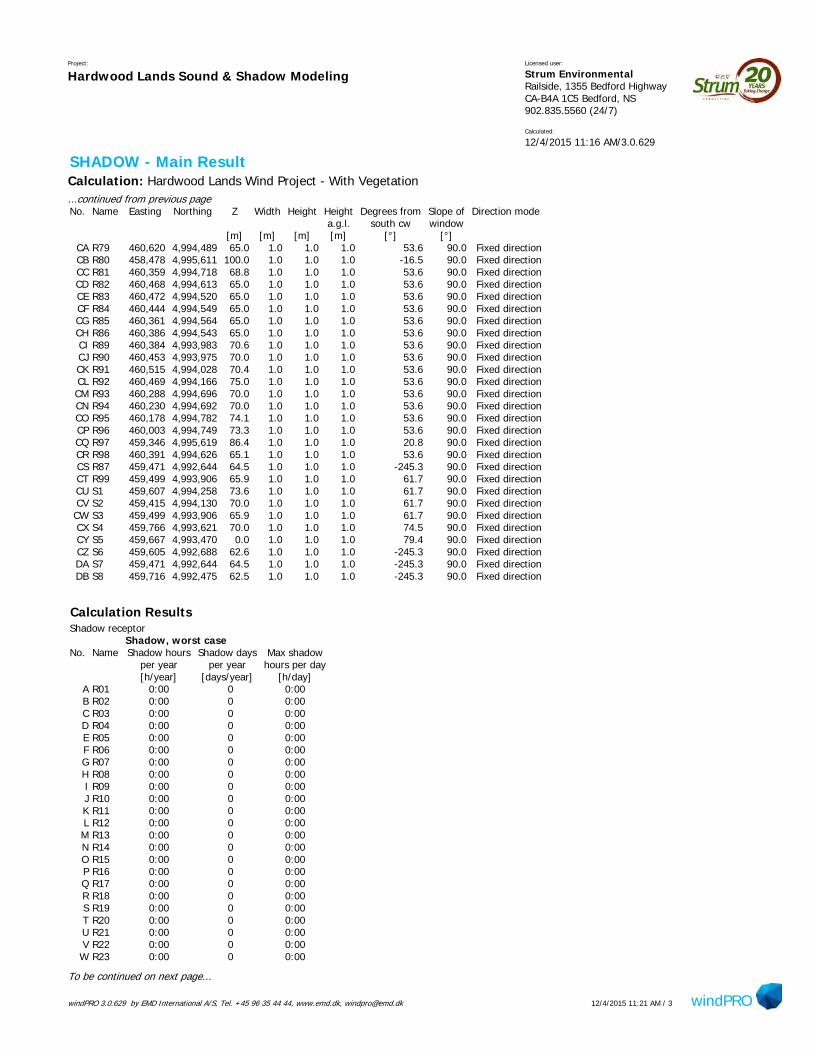
windPRO 3.0.629 by EMD International A/S, Tel. +45 96 35 44 44, www.emd.dk, [email protected] windPRO12/4/2015 11:21 AM / 3
Project:
Hardwood Lands Sound & Shadow ModelingLicensed user:
Strum Environmental Railside, 1355 Bedford Highway CA-B4A 1C5 Bedford, NS902.835.5560 (24/7)
Calculated:
12/4/2015 11:16 AM/3.0.629
SHADOW - Main ResultCalculation: Hardwood Lands Wind Project - With Vegetation...continued from previous pageNo. Name Easting Northing Z Width Height Height Degrees from Slope of Direction mode
a.g.l. south cw window[m] [m] [m] [m] [°] [°]
CA R79 460,620 4,994,489 65.0 1.0 1.0 1.0 53.6 90.0 Fixed directionCB R80 458,478 4,995,611 100.0 1.0 1.0 1.0 -16.5 90.0 Fixed directionCC R81 460,359 4,994,718 68.8 1.0 1.0 1.0 53.6 90.0 Fixed directionCD R82 460,468 4,994,613 65.0 1.0 1.0 1.0 53.6 90.0 Fixed directionCE R83 460,472 4,994,520 65.0 1.0 1.0 1.0 53.6 90.0 Fixed directionCF R84 460,444 4,994,549 65.0 1.0 1.0 1.0 53.6 90.0 Fixed directionCG R85 460,361 4,994,564 65.0 1.0 1.0 1.0 53.6 90.0 Fixed directionCH R86 460,386 4,994,543 65.0 1.0 1.0 1.0 53.6 90.0 Fixed directionCI R89 460,384 4,993,983 70.6 1.0 1.0 1.0 53.6 90.0 Fixed directionCJ R90 460,453 4,993,975 70.0 1.0 1.0 1.0 53.6 90.0 Fixed directionCK R91 460,515 4,994,028 70.4 1.0 1.0 1.0 53.6 90.0 Fixed directionCL R92 460,469 4,994,166 75.0 1.0 1.0 1.0 53.6 90.0 Fixed directionCM R93 460,288 4,994,696 70.0 1.0 1.0 1.0 53.6 90.0 Fixed directionCN R94 460,230 4,994,692 70.0 1.0 1.0 1.0 53.6 90.0 Fixed directionCO R95 460,178 4,994,782 74.1 1.0 1.0 1.0 53.6 90.0 Fixed directionCP R96 460,003 4,994,749 73.3 1.0 1.0 1.0 53.6 90.0 Fixed directionCQ R97 459,346 4,995,619 86.4 1.0 1.0 1.0 20.8 90.0 Fixed directionCR R98 460,391 4,994,626 65.1 1.0 1.0 1.0 53.6 90.0 Fixed directionCS R87 459,471 4,992,644 64.5 1.0 1.0 1.0 -245.3 90.0 Fixed directionCT R99 459,499 4,993,906 65.9 1.0 1.0 1.0 61.7 90.0 Fixed directionCU S1 459,607 4,994,258 73.6 1.0 1.0 1.0 61.7 90.0 Fixed directionCV S2 459,415 4,994,130 70.0 1.0 1.0 1.0 61.7 90.0 Fixed directionCW S3 459,499 4,993,906 65.9 1.0 1.0 1.0 61.7 90.0 Fixed directionCX S4 459,766 4,993,621 70.0 1.0 1.0 1.0 74.5 90.0 Fixed directionCY S5 459,667 4,993,470 0.0 1.0 1.0 1.0 79.4 90.0 Fixed directionCZ S6 459,605 4,992,688 62.6 1.0 1.0 1.0 -245.3 90.0 Fixed directionDA S7 459,471 4,992,644 64.5 1.0 1.0 1.0 -245.3 90.0 Fixed directionDB S8 459,716 4,992,475 62.5 1.0 1.0 1.0 -245.3 90.0 Fixed direction
Calculation ResultsShadow receptor
Shadow, worst caseNo. Name Shadow hours Shadow days Max shadow
per year per year hours per day[h/year] [days/year] [h/day]
A R01 0:00 0 0:00B R02 0:00 0 0:00C R03 0:00 0 0:00D R04 0:00 0 0:00E R05 0:00 0 0:00F R06 0:00 0 0:00G R07 0:00 0 0:00H R08 0:00 0 0:00I R09 0:00 0 0:00J R10 0:00 0 0:00K R11 0:00 0 0:00L R12 0:00 0 0:00M R13 0:00 0 0:00N R14 0:00 0 0:00O R15 0:00 0 0:00P R16 0:00 0 0:00Q R17 0:00 0 0:00R R18 0:00 0 0:00S R19 0:00 0 0:00T R20 0:00 0 0:00U R21 0:00 0 0:00V R22 0:00 0 0:00W R23 0:00 0 0:00
To be continued on next page...
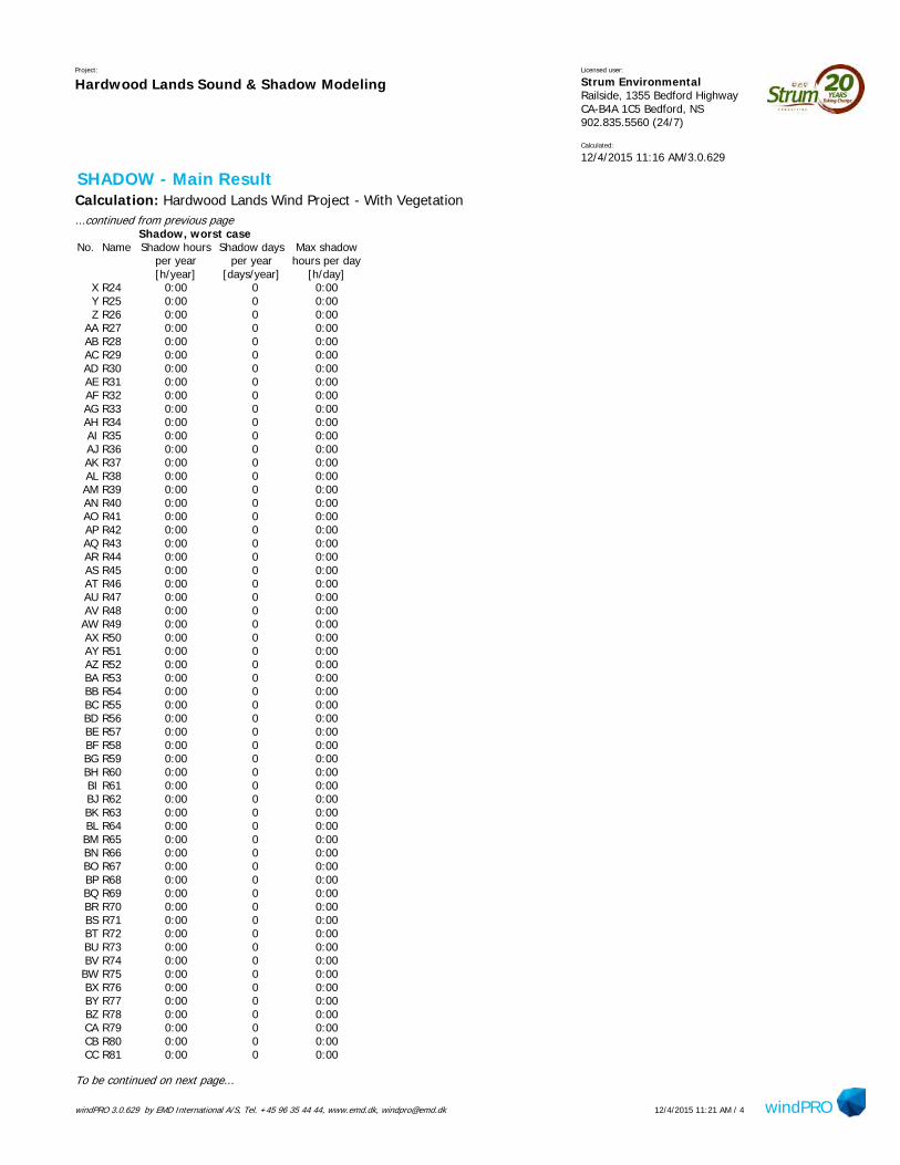
windPRO 3.0.629 by EMD International A/S, Tel. +45 96 35 44 44, www.emd.dk, [email protected] windPRO12/4/2015 11:21 AM / 4
Project:
Hardwood Lands Sound & Shadow ModelingLicensed user:
Strum Environmental Railside, 1355 Bedford Highway CA-B4A 1C5 Bedford, NS902.835.5560 (24/7)
Calculated:
12/4/2015 11:16 AM/3.0.629
SHADOW - Main ResultCalculation: Hardwood Lands Wind Project - With Vegetation...continued from previous page
Shadow, worst caseNo. Name Shadow hours Shadow days Max shadow
per year per year hours per day[h/year] [days/year] [h/day]
X R24 0:00 0 0:00Y R25 0:00 0 0:00Z R26 0:00 0 0:00
AA R27 0:00 0 0:00AB R28 0:00 0 0:00AC R29 0:00 0 0:00AD R30 0:00 0 0:00AE R31 0:00 0 0:00AF R32 0:00 0 0:00AG R33 0:00 0 0:00AH R34 0:00 0 0:00AI R35 0:00 0 0:00AJ R36 0:00 0 0:00AK R37 0:00 0 0:00AL R38 0:00 0 0:00AM R39 0:00 0 0:00AN R40 0:00 0 0:00AO R41 0:00 0 0:00AP R42 0:00 0 0:00AQ R43 0:00 0 0:00AR R44 0:00 0 0:00AS R45 0:00 0 0:00AT R46 0:00 0 0:00AU R47 0:00 0 0:00AV R48 0:00 0 0:00AW R49 0:00 0 0:00AX R50 0:00 0 0:00AY R51 0:00 0 0:00AZ R52 0:00 0 0:00BA R53 0:00 0 0:00BB R54 0:00 0 0:00BC R55 0:00 0 0:00BD R56 0:00 0 0:00BE R57 0:00 0 0:00BF R58 0:00 0 0:00BG R59 0:00 0 0:00BH R60 0:00 0 0:00BI R61 0:00 0 0:00BJ R62 0:00 0 0:00BK R63 0:00 0 0:00BL R64 0:00 0 0:00BM R65 0:00 0 0:00BN R66 0:00 0 0:00BO R67 0:00 0 0:00BP R68 0:00 0 0:00BQ R69 0:00 0 0:00BR R70 0:00 0 0:00BS R71 0:00 0 0:00BT R72 0:00 0 0:00BU R73 0:00 0 0:00BV R74 0:00 0 0:00BW R75 0:00 0 0:00BX R76 0:00 0 0:00BY R77 0:00 0 0:00BZ R78 0:00 0 0:00CA R79 0:00 0 0:00CB R80 0:00 0 0:00CC R81 0:00 0 0:00
To be continued on next page...
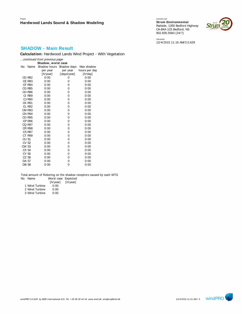
windPRO 3.0.629 by EMD International A/S, Tel. +45 96 35 44 44, www.emd.dk, [email protected] windPRO12/4/2015 11:21 AM / 5
Project:
Hardwood Lands Sound & Shadow ModelingLicensed user:
Strum Environmental Railside, 1355 Bedford Highway CA-B4A 1C5 Bedford, NS902.835.5560 (24/7)
Calculated:
12/4/2015 11:16 AM/3.0.629
SHADOW - Main ResultCalculation: Hardwood Lands Wind Project - With Vegetation...continued from previous page
Shadow, worst caseNo. Name Shadow hours Shadow days Max shadow
per year per year hours per day[h/year] [days/year] [h/day]
CD R82 0:00 0 0:00CE R83 0:00 0 0:00CF R84 0:00 0 0:00CG R85 0:00 0 0:00CH R86 0:00 0 0:00CI R89 0:00 0 0:00CJ R90 0:00 0 0:00CK R91 0:00 0 0:00CL R92 0:00 0 0:00CM R93 0:00 0 0:00CN R94 0:00 0 0:00CO R95 0:00 0 0:00CP R96 0:00 0 0:00CQ R97 0:00 0 0:00CR R98 0:00 0 0:00CS R87 0:00 0 0:00CT R99 0:00 0 0:00CU S1 0:00 0 0:00CV S2 0:00 0 0:00CW S3 0:00 0 0:00CX S4 0:00 0 0:00CY S5 0:00 0 0:00CZ S6 0:00 0 0:00DA S7 0:00 0 0:00DB S8 0:00 0 0:00
Total amount of flickering on the shadow receptors caused by each WTGNo. Name Worst case Expected
[h/year] [h/year]1 Wind Turbine 0:002 Wind Turbine 0:003 Wind Turbine 0:00

XY
XY
XY
XY
XY
XY
XY
XY
XY
XY
XY
XY
XY
XY
XY
XY
XY
XY
XY
XY
XY
XY
XY
XY
XY
XY
XY
XY
XY
XY
XY
XY
XY
XY
XY
XY
XY
XY
XY
XY
XY
XY
XY
XY
XY
XY
XY
XY
XY
XY
XY
XY
XY
XY
XY XY
XY
XY
XY
XY
XY
XY
XY
XY
XY
XY
XY
XY
XY
XY
XYXY
XY
XY
XY
XY
XY
XY
XY
XY
XY
XY
XY
XY
XY
XY
XY
XY
XY
XY
XY
XY
XY
XY
XY
XY
XY
XY
XY
XY
XY
XY
XY
XY
XY
XY
XY
XY
XY
XY
XY
XY
XY
XY
XY
XY
XY
XY
XY
XY XY XY XY
XY
XY
XY
XY
XY
XY
XY
XY
XY
XY
XY
XY
XY
XY
XY
XY
XY
XY
XY
XY
XY
XY
XY
XY
XY
XY
XY
XY
XY
XY
XY
XY
XY
XY
XY
XY
XY
XY
XY
XY
XY
XY
XY
XY
XY
XY
XY
XY
XY
XY
XY
XY
XY
XY
XY
XY
XY
XY
XY
XY
XY
XY
XY
XY
XY
XY
XY
XY
XY
XY
XY
XY
XY
XY
XY
XY
XY
XY
XY
XY
XY
XY
XY
XY
XY
XY
XY
XY
XY
XY
XY
XY
XY
XY
XY
XY
XY
XY
XY
XY
XY
XY
XY
XY
XY
XY
XY
XY
XY
XY
XY
XY
XY
XY
XY
XY
XY
XY
XY
XY
XY
XY
XY
XY
XY
XY
XY
XY
XY
XY
XY
XY
XY
XY
XY
XY
XY
XY
XY
XY
XY
XY
XY
XY
XY
XY
XY
XY
XY
XY
XY
XY
XY
XY
XY
XY
XY
XY
XY
XY
XY
XY
XY
XY
XY
XY
XY
XY
XY
XY
XY
XY
XY
XY
XY
XY
XY
XY
XY
XY
XY
XY
XY
XY
XY
XY
XY
XY
XY
XY
XY
XY
XY
XY
XY
XY
XY
XY
XY
XY
XY
XY
XY
XY
XY
XY
XY
XY
XY
XY
XY
XY
XY
XY
XY
XY
XY
XY
XY XY XY
XY
XY
XY
XY
XY
XY
XY
XY
XY
XY
XY
XY
XY
XY
XY
XY
XY
XY
XY
XY
XY
XY
XY
XY
XY
XY
XY
XY XY XY XY XY XY XY
XY
XY
#*
#*
#*
!(
!(
!(
!(
!(
!(!(
!(
!(
!(
!(!(
!(
!( !(
!(
!(
!(
!(
!(
!(
!(
!(
!(!(
!(
!(
!(
!(
!(
!(
!(
!(!(
!(
!(
!(
!(!(
!(
!(
!(
!(
!(
!( !(
!(
!(
!(
!(
!( !(
!(!(
!(
!(
!(
!(
!(
!(
!(!(
!(
!(
!(
!(
!(
!(
!(
!(
!(
!(
!(
!( !(
!(
!(
!(
!(
!(
!(
!(
!(!(!(!(
!( !(!(
!(
!(!(
!(!(
!(
!(
"/
"/
"/
"/
"/
"/"/
"/
R98
R97
R96 R95R94
R93
R92
R91R90R89
R86R85 R83
R81
R80
R79
R78
R77
R76
R74
R73
R72
R71
R70
R69
R68
R67
R66
R65
R64
R62
R57
R55
R51
R48
R47
R43R41
R31
R27
R24 R19
R18
R15
R13
R12
R10
R08
R07R06
R04
R02
S8
S7 S6
S5
S4
S3
S2S1
WTG 1
WTG 2
WTG 3
Blois
Rd Tuff St
Indian Rd
Sandy Desert Rd
Robinson Rd
Anderson Rd
Old Indian Rd
Sesame St
Brown Flats Rd
Church St
Dowie Rd Meadow Dr
Meadow Dr
Checked By:
A. Walter
Drawn By:
H. Serhan
Drawing #:
11:20,000
Scale:
August 2015
Date: Project #:
14-5169
±
Area OfInterest
Hardwood LandsCommunity
Wind Project -Shadow Flicker
Modeling ResultsWithout Vegetation
0 200 400 600 800 1,000Metres
Nova Scotia
New Brunswick
AtlanticOcean
Prince EdwardIsland
Bay of Fundy
Cape BretonIsland
Notes:1. Reference: Digital Topographic Mapping & Property Management Unit MU0904 by Nova Scotia Geomatics Centre.
2. Projection: NAD83(CSRS), UTM Zone 20 North.
3. Shadow Calculation Model was done Using Wind Turbine Data Supplied by Client.
Legend:!( Existing Receptors
"/ Arbitrary Receptors
#* Proposed Turbine
Proposed Access Road
Study Area
Project Site
2km Buffer
Property Boundary
Native Reserve
Public Roads
Access Roads / Trails
Mapped Stream
Mapped Indefinite Stream
Water Bodies
Cleared Area
Shadow Flicket Modeling ResultsPredicted Shadow (Hrs/Yr)
0-10
10-30
30-100
100 +
PID 45101128Elmsdale Lumber Co. Ltd.
PID 45271939Everett & Marilyn Clarke
PID 45188810Atlantic Star Forestry Ltd.
PID 45119344Atlantic Star Forestry Ltd.
PID 45366648
Atlantic Star Forestry Ltd.
PID 45366630
Atlantic Star Forestry Ltd.
PID 45289675
Brian Leahy
Indian BrookNative Reserve 14
PID 45101136Downey M Thompson
Milton Downey Thompson
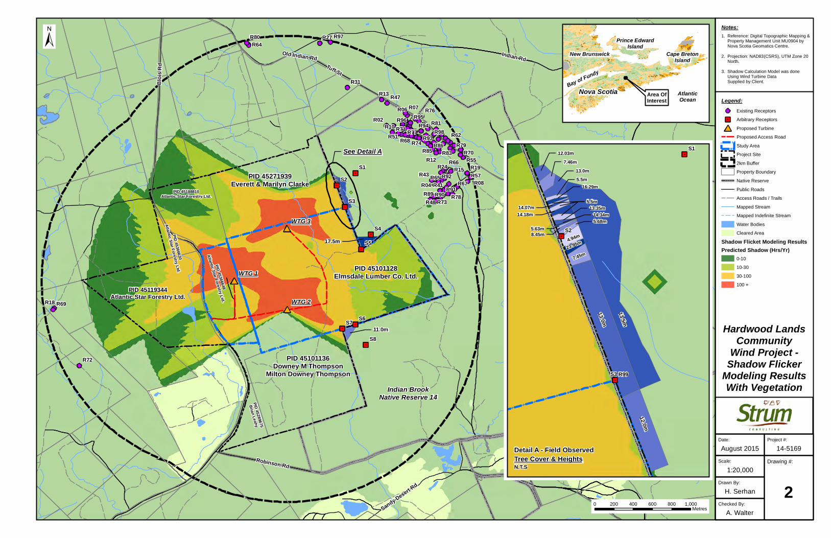
XY
XY
XY
XY
XY
XY
XY
XY
XY
XY
XY
XY
XY
XY
XY
XY
XY
XY
XY
XY
XY
XY
XY
XY
XY
XY
XY
XY
XY
XY
XY
XY
XY
XY
XY
XY
XY
XY
XY
XY
XY
XY
XY
XY
XY
XY
XY
XY
XY
XY
XY
XY
XY
XY
XY XY
XY
XY
XY
XY
XY
XY
XY
XY
XY
XY
XY
XY
XY
XY
XYXY
XY
XY
XY
XY
XY
XY
XY
XY
XY
XY
XY
XY
XY
XY
XY
XY
XY
XY
XY
XY
XY
XY
XY
XY
XY
XY
XY
XY
XY
XY XY XY XY
XY
XY
XY
XY
XY
XY
XY
XY
XY
XY
XY
XY
XY
XY
XY
XY
XY
XY
XY
XY
XY
XY
XY
XY
XY
XY
XY
XY
XY
XY
XY
XY
XY
XY
XY
XY
XY
XY
XY
XY
XY
XY
XY
XY
XY
XY
XY
XY
XY
XY
XY
XY
XY
XY
XY
XY
XY
XY
XY
XY
XY
XY
XY
XY
XY
XY
XY
XY
XY
XY
XY
XY
XY
XY
XY
XY
XY
XY
XY
XY
XY
XY
XY
XY
XY
XY
XY
XY
XY
XY
XY
XY
XY
XY
XY
XY
XY
XY
XY
XY
XY
XY
XY
XY
XY
XY
XY
XY
XY
XY
XY
XY
XY
XY
XY
XY
XY
XY
XY
XY
XY
XY
XY
XY
XY
XY
XY
XY
XY
XY
XY
XY
XY
XY
XY
XY
XY
XY
XY
XY
XY
XY
XY
XY
XY
XY
XY
XY
XY
XY
XY
XY
XY
XY
XY
XY
XY
XY
XY
XY
XY
XY
XY
XY
XY
XY
XY
XY
XY
XY
XY
XY
XY
XY
XY
XY
XY
XY
XY
XY
XY
XY
XY
XY
XY
XY
XY
XY
XY
XY
XY
XY
XY
XY
XY
XY
XY
XY
XY
XY
XY
XY
XY
XY
XY
XY
XY
XY XY XY
XY
XY
XY
XY
XY
XY
XY
XY
XY
XY
XY
XY
XY
XY
XY
XY
XY
XY
XY
XY
XY
XY
XY
XY
XY
XY
#*
#*
#*
!(
!(
!(
!(
!(
!(!(
!(
!(
!(
!(!(
!(
!( !(
!(
!(
!(
!(
!(
!(
!(
!(
!(!(
!(
!(
!(
!(
!(
!(
!(
!(!(
!(
!(
!(
!(!(
!(
!(
!(
!(
!(
!( !(
!(
!(
!(
!(
!( !(
!(!(
!(
!(
!(
!(
!(
!(
!(!(
!(
!(
!(
!(
!(
!(
!(
!(
!(
!(
!(
!( !(
!(
!(
!(
!(
!(
!(
!(
!(!(!(!(
!( !(!(
!(
!(!(
!(!(
!(
!(
"/
"/
"/
"/
"/
"/"/
"/
R98
R97
R96 R95R94
R93
R92
R91R90R89
R86R85 R83
R81
R80
R79
R78
R77
R76
R74
R73
R72
R71
R70
R69
R68
R67
R66
R65
R64
R62
R57
R55
R51
R48
R47
R43R41
R31
R27
R24 R19
R18
R15
R13
R12
R10
R08
R07R06
R04
R02
S8
S7 S6
S5
S4
S3
S2S1
WTG 1
WTG 2
WTG 3
Blois
Rd Tuff St
Indian Rd
Robinson Rd
Meadow Dr
Brown Flats Rd
Old Indian Rd
Sandy Desert Rd
Sesame St
Church St
Dowie Rd
Hollywood Dr
Checked By:
A. Walter
Drawn By:
H. Serhan
Drawing #:
21:20,000
Scale:
August 2015
Date: Project #:
14-5169
±
Area OfInterest
Hardwood LandsCommunity
Wind Project -Shadow Flicker
Modeling ResultsWith Vegetation
0 200 400 600 800 1,000Metres
Nova Scotia
New Brunswick
AtlanticOcean
Prince EdwardIsland
Bay of Fundy
Cape BretonIsland
Notes:1. Reference: Digital Topographic Mapping & Property Management Unit MU0904 by Nova Scotia Geomatics Centre.
2. Projection: NAD83(CSRS), UTM Zone 20 North.
3. Shadow Calculation Model was done Using Wind Turbine Data Supplied by Client.
Legend:!( Existing Receptors
"/ Arbitrary Receptors
#* Proposed Turbine
Proposed Access Road
Study Area
Project Site
2km Buffer
Property Boundary
Native Reserve
Public Roads
Access Roads / Trails
Mapped Stream
Mapped Indefinite Stream
Water Bodies
Cleared Area
Shadow Flicket Modeling ResultsPredicted Shadow (Hrs/Yr)
0-10
10-30
30-100
100 +
PID 45101128Elmsdale Lumber Co. Ltd.
PID 45271939Everett & Marilyn Clarke
PID 45188810Atlantic Star Forestry Ltd.
PID 45119344Atlantic Star Forestry Ltd.
PID 45366648
Atlantic Star Forestry Ltd.
PID 45366630
Atlantic Star Forestry Ltd.
PID 45289675
Brian Leahy
Indian BrookNative Reserve 14
PID 45101136Downey M Thompson
Milton Downey Thompson
#*
#*
#*
!(
"/
"/
"/R99S3
S2
S112.03m7.46m
13.0m5.5m
5.5m
16.29m
14.07m14.18m
13.35m
14.34m
5.63m8.45m
5.68m
4.94m23.95m
7.45m
13.0m
13.5m
12.0m
See Detail A
Detail A - Field Observed
N.T.S
17.5m
11.0m
Tree Cover & Heights

APPENDIX E ARCHAEOLOGICAL SHOVEL TESTING REPORT
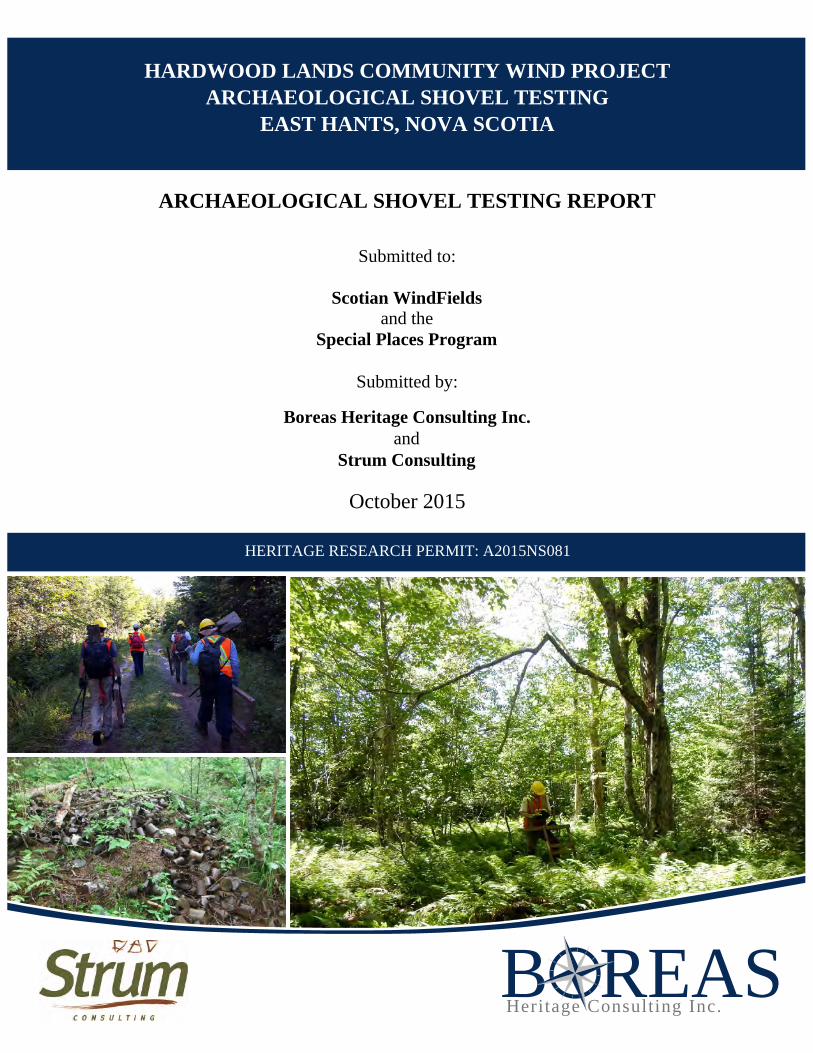
REASBHeritage1Consulting1Inc.
Submitted1to:11
ScotianVWindFields Vand1the1
SpecialVPlacesVProgram11
and1
Submitted1by:11
BoreasVHeritageVConsultingVInc.V V V
StrumVConsultingV
ARCHAEOLOGICALVSHOVELVTESTINGVREPORT
October12015
1 1HERITAGE1RESEARCH1PERMIT:1A2015NS081
HARDWOODVLANDSVCOMMUNITYVWINDVPROJECTARCHAEOLOGICALVSHOVELVTESTING
EASTVHANTS,VNOVAVSCOTIA

Page i
PROJECT PERSONNEL
PRINCIPAL INVESTIGATOR: Stephen G. Garcin, M.A. PROJECT MANAGEMENT: Sara J. Beanlands, M.A. Stephen G. Garcin, M.A. FIELD STUDY: Stephen G. Garcin, M.A. Andrea Richardson, M.A. Mikael Basque
Riley Clark David Jones
REPORT PREPARATION: Stephen G. Garcin, M.A. Sara J. Beanlands, M.A. GIS/DRAFTING: Stephen G. Garcin, M.A.
Page ii
EXECUTIVE SUMMARY
Scotian WindFields Inc. is proposing to develop a three-turbine wind energy project located approximately 5 kilometres north of the community of Hardwood Lands in the District of the Municipality of East Hants. In order to evaluate the potential for encountering archeological resources on the property, Strum Consulting retained Boreas Heritage Consulting Inc. (BHCI), on behalf of Scotian WindFields Inc., in the Spring of 2015, to undertake archaeological screening and reconnaissance of the study area, conducted according to the terms of Heritage Research Permit A2015NS044. The 2015 archaeological screening and reconnaissance consisted of a background study and visual assessment of the property. BHCI determined that all three proposed turbine locations exhibited high potential for encountering Precontact and/or early historic Native archaeological resources. In addition, two small areas measuring 10 metres by 5 metres situated on either side of a stream bed located within the proposed access road alignment to Turbine Site 3 were also considered to exhibit high potential. It was therefore recommended that a 15 metre by 15 metre area within the centre of proposed footprints of Turbine Sites 1 and 3 be subjected to a strategic programme of shovel testing in order to identify any significant deposits or features associated with the Precontact or early historic occupation of the study area. It was further recommended that a 10 metre by 5 metre area on both sides of the stream bed located within the proposed access road to Turbine Site 3 be subjected to a strategic programme of shovel testing.
In May 2015, Strum Consulting retained BHCI, on behalf of Scotian WindFields Inc., to undertake the recommended shovel testing, conducted according to the terms of Heritage Research Permit A2015NS081. The 2015 shovel testing of the Hardwood Lands study area consisted of a total of 44 shovel tests excavated within three separate areas of the greater study area. No archaeological resources were encountered and no evidence of historically significant cultural modification was identified. Based on the results of the shovel testing programme, the potential for encountering significant, intact archaeological resources within the study area is considered to be low. As a result, it is recommended that these areas be cleared of any requirement for further archaeological investigation and that development may proceed as planned.
It is important to note that BHCI previously recommended (Heritage Research Permit A2015NS044) that any mechanical excavation and/or construction activity within the proposed Turbine Site 2 footprint that may have an impact on potential archaeological resources be monitored by an archaeologist to identify any significant deposits or features associated with the Precontact or early historic occupation of the study area. In addition, it was recommended that the area in the vicinity of a reported burial ground must be avoided to prevent accidental impact during construction activities related to the development of the wind project.
Page iii
TABLE OF CONTENTS
1.0 INTRODUCTION ..................................................................................................................... 1 2.0 STUDY AREA .......................................................................................................................... 3 3.0 METHODOLOGY .................................................................................................................... 6 4.0 RESULTS .................................................................................................................................. 7 5.0 CONCLUSIONS AND RECOMMENDATIONS ................................................................. 15
LIST OF FIGURES
Figure 1: Study Area ................................................................................................................................ 4 Figure 2: Shovel Testing Areas ................................................................................................................. 5 Figure 3: Shovel Testing Results ............................................................................................................... 8
LIST OF PLATES
Plate 1: Shovel testing programme at Hardwood Lands ......................................................................... 3 Plate 2: Shovel testing Area 1; facing northeast ...................................................................................... 9 Plate 3: Typical soil profile within Area 1; facing north ......................................................................... 9 Plate 4: Shovel testing Area 2; facing west ........................................................................................... 11 Plate 5: Shovel testing Area 2; facing west ........................................................................................... 11 Plate 6: Stream bed within Area 3; facing west .................................................................................... 12 Plate 7: Surface midden within Area 3; facing west ............................................................................. 12 Plate 8: Shovel testing Area 3; facing west ........................................................................................... 13 Plate 9: Typical soil profile within Area 3; facing north ....................................................................... 13
Page 1
1.0 INTRODUCTION
Scotian WindFields Inc. is proposing to develop a three-turbine wind energy project located approximately 5 kilometres north of the community of Hardwood Lands in the District of the Municipality of East Hants. An initial archaeological assessment was conducted by Boreas Heritage Consulting Inc. (BHCI) in July 2014 under Heritage Research Permit A2014NS055. Scotian WindFields Inc. subsequently moved the proposed development to a new location from its previous configuration, which was situated approximately 2 kilometres to the southeast. Archaeological assessment of the revised study area was conducted in December 2014 under Heritage Research Permit A2014NS117. In the spring of 2015, the proposed development location shifted again and Strum Consulting retained BHCI, on behalf of Scotian WindFields Inc., to conduct archaeological screening and reconnaissance of the revised study area, situated approximately 1.5 kilometres to the north. The archaeological assessment was directed by BHCI Principal and Senior Archaeologist Sara Beanlands and conducted according to the terms of Heritage Research Permit A2015NS044.
The 2015 archaeological screening and reconnaissance consisted of a background study and visual assessment of the property. BHCI determined that all three proposed turbine locations exhibited high potential for encountering Precontact and/or early historic Native archaeological resources. In addition, two small areas measuring 10 metres by 5 metres situated on either side of a stream bed located within the proposed access road alignment to Turbine Site 3 were also considered to exhibit high potential for encountering Precontact and/or early historic Native archaeological resources. Based on the nature of the terrain, the distance to a significant water source, and the lack of evidence indicating significant cultural modification, the remainder of the Hardwood Lands Community Wind Project study area was considered to exhibit low potential for encountering significant archaeological resources.
It was therefore recommended that a 15 metre by 15 metre area within the centre of proposed footprints of Turbine Sites 1 and 3 be subjected to a strategic programme of shovel testing in order to identify any significant deposits or features associated with the Precontact or early historic occupation of the study area. It was further recommended that a 10 metre by 5 metre area on both sides of the stream bed located within the proposed access road to Turbine Site 3 be subjected to a strategic programme of shovel testing.
It was also recommended that any mechanical excavation and/or construction activity within the proposed Turbine Site 2 footprint that may have an impact on potential archaeological resources be monitored by an archaeologist to identify any significant deposits or features associated with

Hardwood Lands Community Wind Project Archaeological Shovel Testing East Hants, Nova Scotia
Page 2
the Precontact or early historic occupation of the study area. In addition, it was recommended that the area in the vicinity of a reported burial ground must be avoided to prevent accidental impact during construction activities related to the development of the wind project.
In May 2015, Strum Consulting retained BHCI, on behalf of Scotian WindFields Inc., to undertake the recommended shovel testing (Plate 1). The archaeological assessment was directed by Senior Archaeologist Stephen Garcin and conducted according to the terms of Heritage Research Permit A2015NS081, issued by the Nova Scotia Department of Communities, Culture and Heritage - Special Places Program (SPP). Technical support was provided by Andrea Richardson, with the assistance of Mikael Basque, Riley Clark and David Jones. The archaeological assessment was carried out on August 27 and 28, 2015.
This report describes the programme of archaeological shovel testing, presents the results of this investigation and offers cultural resource management recommendations.

Hardwood Lands Community Wind Project Archaeological Shovel Testing East Hants, Nova Scotia
Page 3
2.0 STUDY AREA
The Hardwood Lands study area, comprising a total area of approximately 6.75 hectares, is located in the District of the Municipality of East Hants, approximately 5 kilometres north of the community of Hardwood Lands. Situated within portions of two properties identified as PID 45366648 and PID 45101128, the study area includes three wind turbine footprints, each measuring approximately 100 metres by 100 metres, as well as an adjacent access road, measuring approximately 2.5 kilometres, of which 1.8 kilometres will be new construction (Figures 1 & 2). Located approximately 1 kilometre west of the Indian Brook Reserve (IR 14), one of the largest Mi’kmaw communities in the province, the study area can be accessed from Blois Road, situated approximately 6 kilometres northeast of Nine Mile River.
Two 15 metre by 15 metre areas within the centre of proposed footprints of Turbine Sites 1 and 3 and a 10 metre by 5 metre area on both sides of the stream bed located within the proposed access road to Turbine Site 3 are considered to exhibit high potential for encountering Precontact and/or early historic Native archaeological resources (Figure 2).
PLATE 1: Shovel testing programme at Hardwood Lands.
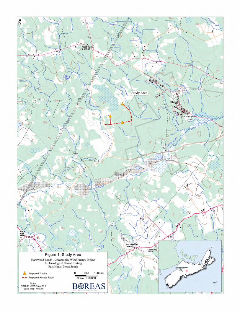
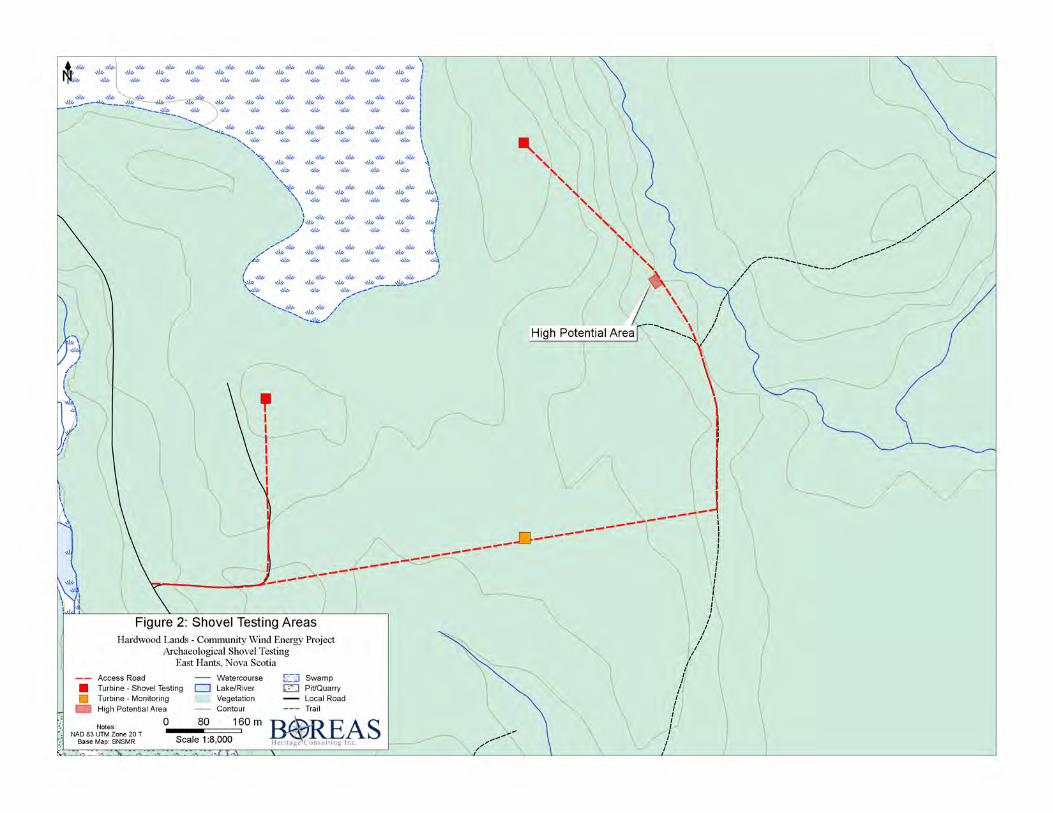
Hardwood Lands Community Wind Project Archaeological Shovel Testing East Hants, Nova Scotia
Page 6
3.0 METHODOLOGY
The objectives of the archaeological assessment are to conduct a systematic subsurface survey (shovel testing) within the previously identified areas of high archaeological potential in order to search for and evaluate buried archaeological resources, and to provide the most comprehensive information possible so that appropriate management strategies can be devised in light of the proposed development and before project implementation.
Subsurface Survey
The objective of the subsurface survey is to determine whether or not buried archaeological resources are present within the areas of high archaeological potential identified during the archaeological screening and reconnaissance. A baseline is established across each testing area to standardize and document the location of shovel tests and to facilitate detailed recording of any resources encountered.
Shovel test pits, averaging 40 centimetres by 40 centimetres, are dug through the topsoil into subsoil at 5 metre intervals. Due to the nature of the terrain, it was not necessary or possible to test all areas on a formal 5 metre grid. All soil removed from the test pits is screened through 6 millimetre wire mesh to facilitate the recovery of artifacts within the excavated soil.
Details of the testing programme are documented in field notes, site plans, stratigraphic drawings and photographs. A hand-held Global Positioning System (GPS) unit is used to record UTM coordinates within the study area. All coordinates are UTM projection with NAD 83 as datum. Any archaeological resources encountered during the course of the shovel testing programme will be evaluated and sufficiently documented for registration within the Maritime Archaeological Resource Inventory, a provincial archaeological site database maintained by the Nova Scotia Museum. All artifacts recovered are processed and catalogued in accordance with standards set by the SPP.
As per Heritage Research Permit requirements, the Kwilmu’kw Maw-klusuaqn Negotiation Office (KMKNO) was contacted and advised of the proposed archaeological investigation.
Hardwood Lands Community Wind Project Archaeological Shovel Testing East Hants, Nova Scotia
Page 7
4.0 RESULTS
Shovel Testing
Archaeological shovel testing of the study area was conducted on August 27 & 28, 2015, under overcast, warm conditions. The study area consisted of three distinct high potential areas, each of which will be discussed separately below.
Area 1
Turbine Site 1, located in the eastern portion of PID 45366648 (Figure 2), is situated approximately 85 metres above sea level. The area is characterised by undulating to gently sloping terrain, which has been subjected to previous clearing and tree-harvesting activity, as indicated by the young, regenerated forest growth, primarily consisting of spruce, fir and birch. A number of areas indicating modern land use and disturbance were also observed during the course of the initial assessment, including ruts and berms caused by heavy machinery, likely associated with past tree-harvesting activity. Nevertheless, given the long-standing and intensive traditional use of the greater area, Turbine Site 1 was considered to exhibit high potential for encountering Precontact and/or historic Native archaeological resources. As a result, it was recommended that a 15 metre by 15 metre area within the centre of the proposed Turbine Site 1 footprint be subjected to a strategic programme of shovel testing in order to identify any significant deposits or features associated with the Precontact or early historic occupation of the study area.
A total of 16 shovel tests were manually excavated across Area 1 (Figure 3; Plate 2). The general soil profile observed within Area 1 consisted of approximately 3 centimetres of leaf litter and forest duff overlying approximately 3 - 5 centimetres of dark brown organic silty clay, which overlay approximately 5 - 20 centimetres of light gray silty clay, interpreted as the “Ae” horizon, which, in turn, overlay reddish-brown sterile subsoil (Plate 3). Excavation of this layer typically continued to a depth of approximately 20 centimetres in order to confirm the sterile nature of the soil and to ensure that there were no underlying deposits. None of the test pits in Area 1 yielded archaeological material.
Area 2
Turbine Site 3, located in the northern portion of PID 45101128 (Figure 2), is characterised by generally level and undulating terrain, the majority of which has been previously subjected to clearing. The vegetation is dominated by fern growth. Given the long-standing and intensive traditional use of the greater area, Turbine Site 3 was considered to exhibit high potential for
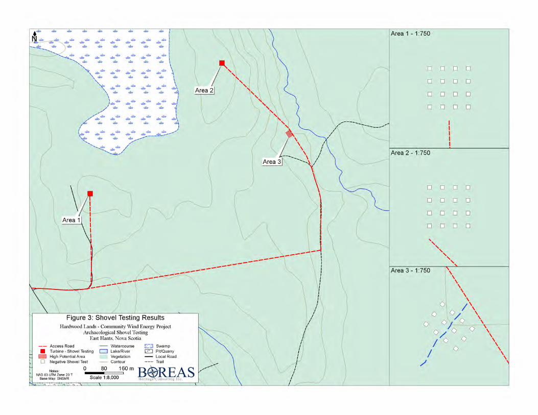
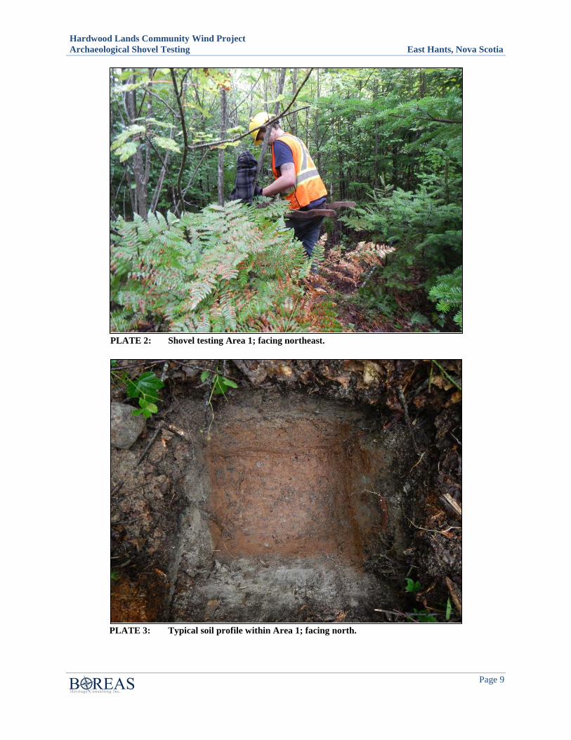
Hardwood Lands Community Wind Project Archaeological Shovel Testing East Hants, Nova Scotia
Page 9
PLATE 2: Shovel testing Area 1; facing northeast.
PLATE 3: Typical soil profile within Area 1; facing north.
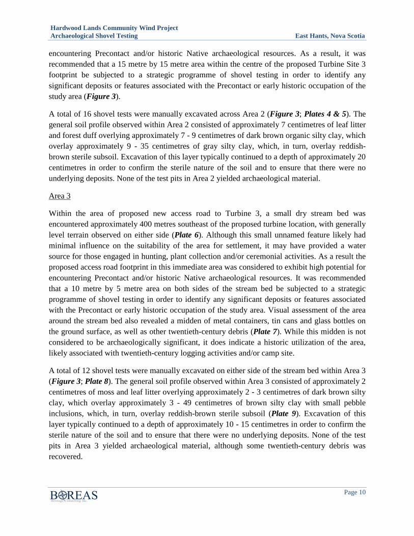
Hardwood Lands Community Wind Project Archaeological Shovel Testing East Hants, Nova Scotia
Page 10
encountering Precontact and/or historic Native archaeological resources. As a result, it was recommended that a 15 metre by 15 metre area within the centre of the proposed Turbine Site 3 footprint be subjected to a strategic programme of shovel testing in order to identify any significant deposits or features associated with the Precontact or early historic occupation of the study area (Figure 3).
A total of 16 shovel tests were manually excavated across Area 2 (Figure 3; Plates 4 & 5). The general soil profile observed within Area 2 consisted of approximately 7 centimetres of leaf litter and forest duff overlying approximately 7 - 9 centimetres of dark brown organic silty clay, which overlay approximately 9 - 35 centimetres of gray silty clay, which, in turn, overlay reddish- brown sterile subsoil. Excavation of this layer typically continued to a depth of approximately 20 centimetres in order to confirm the sterile nature of the soil and to ensure that there were no underlying deposits. None of the test pits in Area 2 yielded archaeological material.
Area 3
Within the area of proposed new access road to Turbine 3, a small dry stream bed was encountered approximately 400 metres southeast of the proposed turbine location, with generally level terrain observed on either side (Plate 6). Although this small unnamed feature likely had minimal influence on the suitability of the area for settlement, it may have provided a water source for those engaged in hunting, plant collection and/or ceremonial activities. As a result the proposed access road footprint in this immediate area was considered to exhibit high potential for encountering Precontact and/or historic Native archaeological resources. It was recommended that a 10 metre by 5 metre area on both sides of the stream bed be subjected to a strategic programme of shovel testing in order to identify any significant deposits or features associated with the Precontact or early historic occupation of the study area. Visual assessment of the area around the stream bed also revealed a midden of metal containers, tin cans and glass bottles on the ground surface, as well as other twentieth-century debris (Plate 7). While this midden is not considered to be archaeologically significant, it does indicate a historic utilization of the area, likely associated with twentieth-century logging activities and/or camp site.
A total of 12 shovel tests were manually excavated on either side of the stream bed within Area 3 (Figure 3; Plate 8). The general soil profile observed within Area 3 consisted of approximately 2 centimetres of moss and leaf litter overlying approximately 2 - 3 centimetres of dark brown silty clay, which overlay approximately 3 - 49 centimetres of brown silty clay with small pebble inclusions, which, in turn, overlay reddish-brown sterile subsoil (Plate 9). Excavation of this layer typically continued to a depth of approximately 10 - 15 centimetres in order to confirm the sterile nature of the soil and to ensure that there were no underlying deposits. None of the test pits in Area 3 yielded archaeological material, although some twentieth-century debris was recovered.
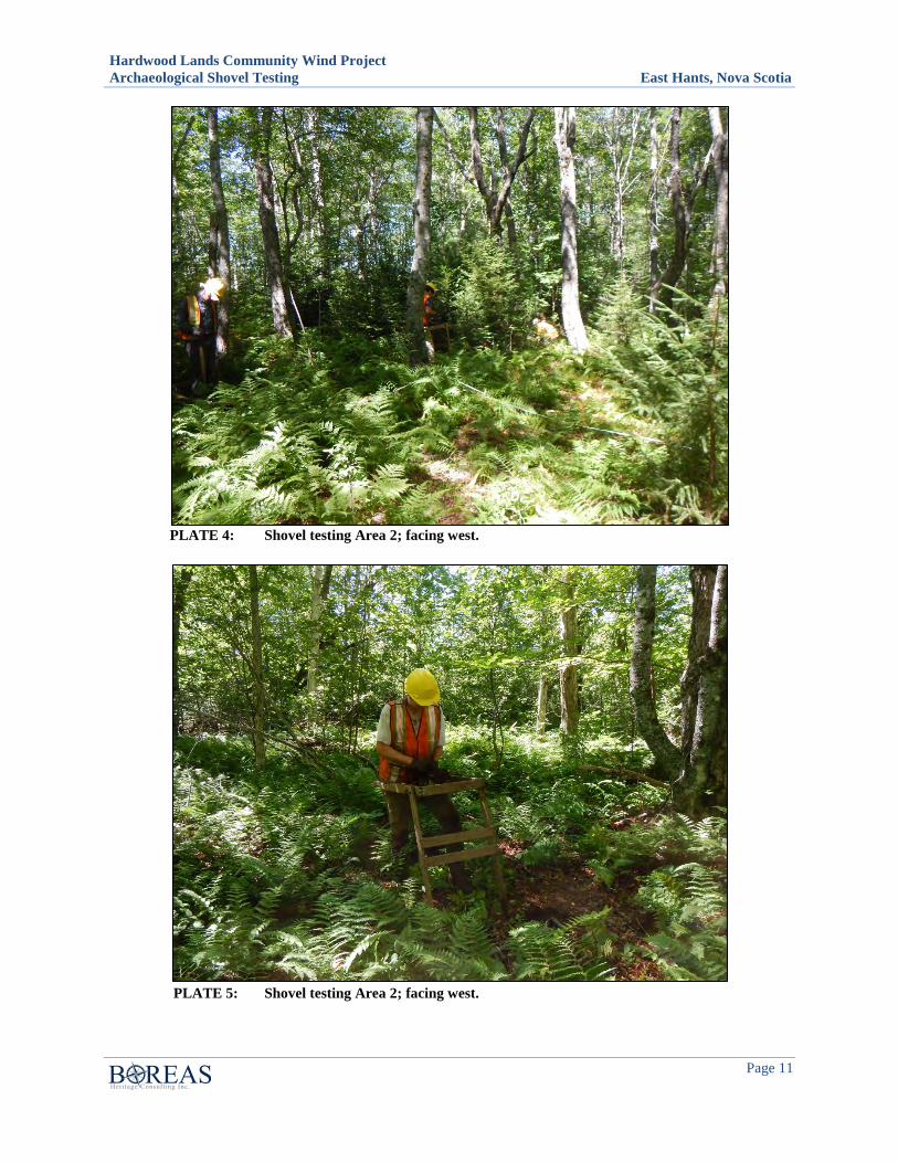
Hardwood Lands Community Wind Project Archaeological Shovel Testing East Hants, Nova Scotia
Page 11
PLATE 4: Shovel testing Area 2; facing west.
PLATE 5: Shovel testing Area 2; facing west.
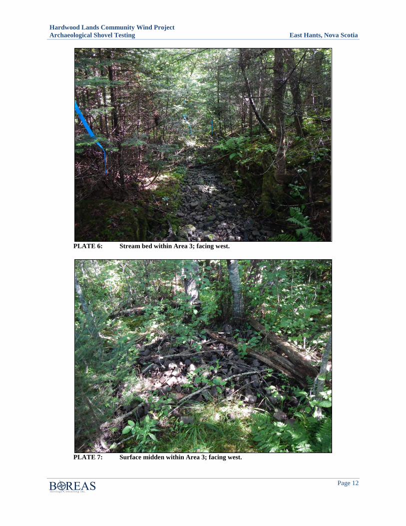
Hardwood Lands Community Wind Project Archaeological Shovel Testing East Hants, Nova Scotia
Page 12
PLATE 6: Stream bed within Area 3; facing west.
PLATE 7: Surface midden within Area 3; facing west.
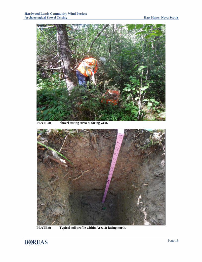
Hardwood Lands Community Wind Project Archaeological Shovel Testing East Hants, Nova Scotia
Page 13
PLATE 8: Shovel testing Area 3; facing west.
PLATE 9: Typical soil profile within Area 3; facing north.
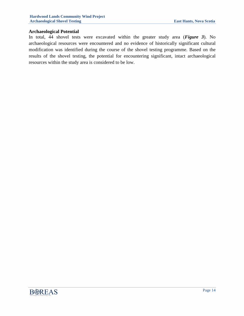
Hardwood Lands Community Wind Project Archaeological Shovel Testing East Hants, Nova Scotia
Page 14
Archaeological Potential In total, 44 shovel tests were excavated within the greater study area (Figure 3). No archaeological resources were encountered and no evidence of historically significant cultural modification was identified during the course of the shovel testing programme. Based on the results of the shovel testing, the potential for encountering significant, intact archaeological resources within the study area is considered to be low.
Hardwood Lands Community Wind Project Archaeological Shovel Testing East Hants, Nova Scotia
Page 15
5.0 CONCLUSIONS AND RECOMMENDATIONS
The 2015 archaeological shovel testing of the Hardwood Lands study area consisted of a total of 44 shovel tests excavated within three separate areas of the greater study area. No archaeological resources were encountered and no evidence of historically significant cultural modification was identified during the course of the shovel testing programme. Based on the results of the 2015 shovel testing programme, the potential for encountering significant, intact archaeological resources within the study area is considered to be low.
Based on the above results, Boreas Heritage Consulting Inc. offers the following management recommendations:
1. It is recommended that Areas 1, 2 and 3, as described in this report, be cleared of any requirement for further archaeological investigation and that development within these areas may proceed as planned.
2. In the event that archaeological resources are encountered during development activities, immediate contact should be made with the Co-ordinator of Special Places Program, Sean Weseloh McKeane.

APPENDIX F WATER FEATURE CLASSIFICATION


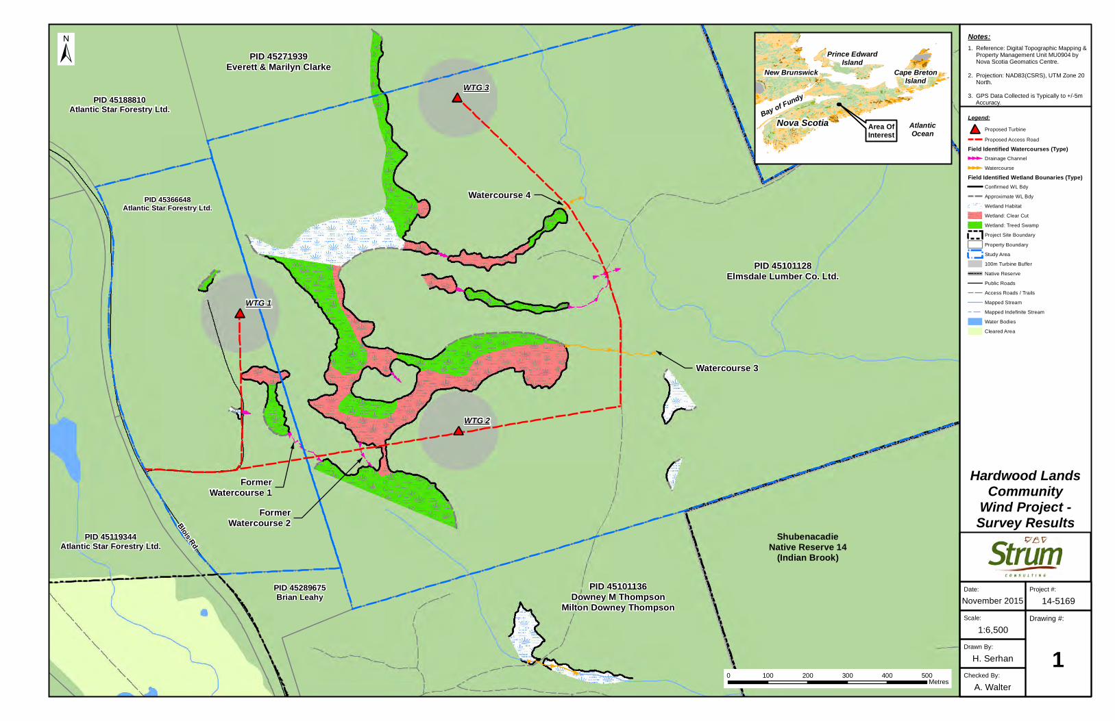
#*
#*
#*WTG 1
WTG 2
WTG 3
Blois Rd
Checked By:
A. Walter
Drawn By:
H. Serhan
Drawing #:
11:6,500
Scale:
November 2015
Date: Project #:
14-5169
±
Area OfInterest
Hardwood LandsCommunity
Wind Project -Survey Results
0 100 200 300 400 500Metres
Nova Scotia
New Brunswick
AtlanticOcean
Prince EdwardIsland
Bay of Fundy
Cape BretonIsland
Notes:1. Reference: Digital Topographic Mapping & Property Management Unit MU0904 by Nova Scotia Geomatics Centre.
2. Projection: NAD83(CSRS), UTM Zone 20 North.
3. GPS Data Collected is Typically to +/-5m Accuracy.
Legend:#* Proposed Turbine
Proposed Access Road
Field Identified Watercourses (Type)Drainage Channel
Watercourse
Field Identified Wetland Bounaries (Type)Confirmed WL Bdy
Approximate WL Bdy
Wetland Habitat
Wetland: Clear Cut
Wetland: Treed Swamp
Project Site Boundary
Property Boundary
Study Area
100m Turbine Buffer
Native Reserve
Public Roads
Access Roads / Trails
Mapped Stream
Mapped Indefinite Stream
Water Bodies
Cleared Area
ShubenacadieNative Reserve 14
(Indian Brook)
PID 45289675Brian Leahy
PID 45366648Atlantic Star Forestry Ltd.
PID 45101128Elmsdale Lumber Co. Ltd.
PID 45271939Everett & Marilyn Clarke
PID 45188810Atlantic Star Forestry Ltd.
PID 45119344Atlantic Star Forestry Ltd.
PID 45101136Downey M Thompson
Milton Downey Thompson
FormerWatercourse 1
FormerWatercourse 2
Watercourse 3
Watercourse 4