encl-1-msc1_circ1640.pdf - IRClass
50
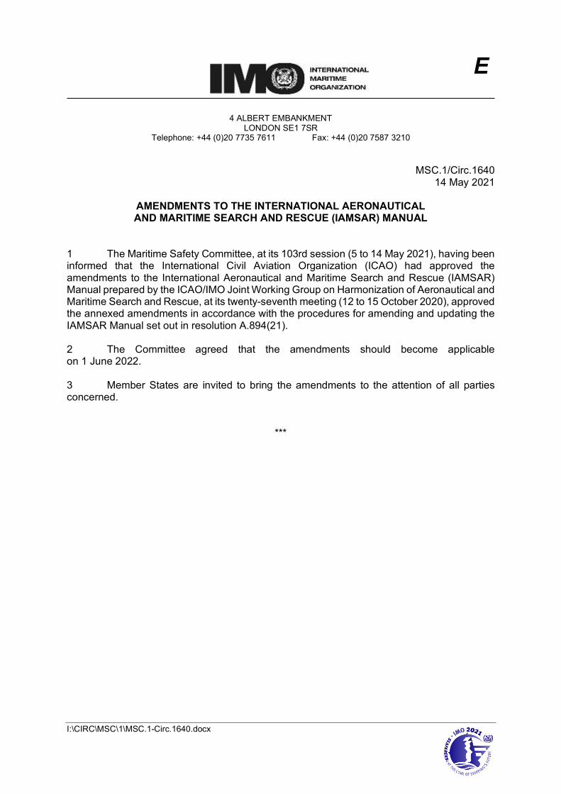
I:\CIRC\MSC\1\MSC.1-Circ.1640.docx E 4 ALBERT EMBANKMENT LONDON SE1 7SR Telephone: +44 (0)20 7735 7611 Fax: +44 (0)20 7587 3210 MSC.1/Circ.1640 14 May 2021 AMENDMENTS TO THE INTERNATIONAL AERONAUTICAL AND MARITIME SEARCH AND RESCUE (IAMSAR) MANUAL 1 The Maritime Safety Committee, at its 103rd session (5 to 14 May 2021), having been informed that the International Civil Aviation Organization (ICAO) had approved the amendments to the International Aeronautical and Maritime Search and Rescue (IAMSAR) Manual prepared by the ICAO/IMO Joint Working Group on Harmonization of Aeronautical and Maritime Search and Rescue, at its twenty-seventh meeting (12 to 15 October 2020), approved the annexed amendments in accordance with the procedures for amending and updating the IAMSAR Manual set out in resolution A.894(21). 2 The Committee agreed that the amendments should become applicable on 1 June 2022. 3 Member States are invited to bring the amendments to the attention of all parties concerned. ***
-
Upload
khangminh22 -
Category
Documents
-
view
0 -
download
0
Transcript of encl-1-msc1_circ1640.pdf - IRClass
I:\CIRC\MSC\1\MSC.1-Circ.1640.docx
E
4 ALBERT EMBANKMENT LONDON SE1 7SR
Telephone: +44 (0)20 7735 7611 Fax: +44 (0)20 7587 3210
MSC.1/Circ.1640
14 May 2021
AMENDMENTS TO THE INTERNATIONAL AERONAUTICAL AND MARITIME SEARCH AND RESCUE (IAMSAR) MANUAL
1 The Maritime Safety Committee, at its 103rd session (5 to 14 May 2021), having been informed that the International Civil Aviation Organization (ICAO) had approved the amendments to the International Aeronautical and Maritime Search and Rescue (IAMSAR) Manual prepared by the ICAO/IMO Joint Working Group on Harmonization of Aeronautical and Maritime Search and Rescue, at its twenty-seventh meeting (12 to 15 October 2020), approved the annexed amendments in accordance with the procedures for amending and updating the IAMSAR Manual set out in resolution A.894(21). 2 The Committee agreed that the amendments should become applicable on 1 June 2022. 3 Member States are invited to bring the amendments to the attention of all parties concerned.
***

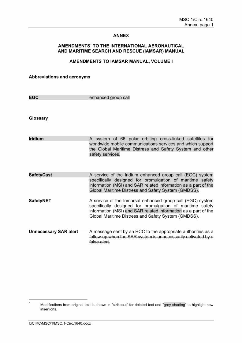
MSC.1/Circ.1640 Annex, page 1
I:\CIRC\MSC\1\MSC.1-Circ.1640.docx
ANNEX
AMENDMENTS* TO THE INTERNATIONAL AERONAUTICAL AND MARITIME SEARCH AND RESCUE (IAMSAR) MANUAL
AMENDMENTS TO IAMSAR MANUAL, VOLUME I
Abbreviations and acronyms EGC enhanced group call Glossary Iridium A system of 66 polar orbiting cross-linked satellites for
worldwide mobile communications services and which support the Global Maritime Distress and Safety System and other safety services.
SafetyCast A service of the Iridium enhanced group call (EGC) system
specifically designed for promulgation of maritime safety information (MSI) and SAR related information as a part of the Global Maritime Distress and Safety System (GMDSS).
SafetyNET A service of the Inmarsat enhanced group call (EGC) system
specifically designed for promulgation of maritime safety information (MSI) and SAR related information as a part of the Global Maritime Distress and Safety System (GMDSS).
Unnecessary SAR alert A message sent by an RCC to the appropriate authorities as a
follow-up when the SAR system is unnecessarily activated by a false alert.
* Modifications from original text is shown in "strikeout" for deleted text and "grey shading" to highlight new
insertions.

MSC.1/Circ.1640 Annex, page 2
I:\CIRC\MSC\1\MSC.1-Circ.1640.docx
Chapter 2 – System components
Table 2-1 – Capabilities of a fully capable RCC Required
24-hour availability Trained persons Persons with a working knowledge of the English language Charts which apply to the SRR (aeronautical, nautical, topographic and hydrographic) Means of plotting Ability to receive distress alerts, e.g. from MCCs, CLESs, etc. Immediate communications with:
- associated ATS units
- associated RSCs
- DF and position-fixing stations
- associated CRSs
Rapid and reliable communications with: - parent agencies of
SRUs
- adjacent RCCs
- designated meteorological offices
- employed SRUs
- alerting posts
Plans of operation Ability to coordinate provision of medical advice Ability to coordinate provision of medical assistance or evacuation
Desired Wall chart depicting SRR, SRSs and neighbouring SRRs, SAR resources Computer resources Databases Vessel tracking information including AIS, LRIT, VMS and SRS
2.3 Rescue coordination centres 2.3.1 The RCC is an operational facility responsible for promoting efficient organization of SAR services and for coordinating the conduct of SAR operations within an SRR. An RCC coordinates, but does not necessarily provide, SAR facilities throughout the internationally recognized SRR described in either the Regional Air Navigation Plans (RANPs) of ICAO or the Global SAR Plan of IMO. Aeronautical SAR responsibility may be met by means of an aeronautical RCC (ARCC). Coastal States with the added responsibility for maritime SAR incidents can meet this with a maritime RCC (MRCC). When practicable, States should consider combining their SAR resources co-locating or combining their maritime and aeronautical RCCs into a joint RCC (JRCC), responsible for both aeronautical and maritime SAR incidents or colocating their maritime and aeronautical RCCs.

MSC.1/Circ.1640 Annex, page 3
I:\CIRC\MSC\1\MSC.1-Circ.1640.docx
Note: The term RCC will be used within this Manual to apply to either aeronautical or maritime centres; ARCC or MRCC will be used as the context warrants. Note: A JRCC may be established either by physical co-location or by the integration of communications, information and computer technology between an ARCC and an MRCC to achieve full search and rescue coordination functionality. 2.3.10 The equipment of an RCC will be determined by the expected demands to be made
on the RCC, and the extent of functions it should perform.
(a) Communications. Communications needs can sometimes be met by ATS channels, public services, or installation of an Inmarsat earth station appropriate shore-based facilities for mobile satellite services. Reliable dedicated lines which can preserve message priority are preferred. In addition to telephone lines with published numbers, one telephone line should have an unlisted, confidential number to ensure the availability of one out-going line in situations where there are many incoming telephone calls. Use of the ICAO Aeronautical Fixed Telecommunications Network (AFTN) or digital Aeronautical Fixed Network (AFN) can meet some communications needs and preserve message priority. All voice equipment, including telephones, should be attached to a multi-channel tape recorder, preferably with a time recording. This allows the RCC to review verbal information. Arrangements can be made with the public telephone administration to ensure that calls from originators who do not wish to cover the charges are passed without delay to the RCC on a collect or pre-paid reply basis. Such arrangements should be widely publicized to encourage outside sources to provide information on missing or distressed craft. Chapter 4 summarizes the communications capability and equipment the RCC and RSC should have.
2.7.4 Databases can perform a number of useful functions. Most databases hold detailed
information which can be quickly accessed, used and also consolidated into reports. SAR managers can use this for SAR system management support, including budget efforts and the RCC can use it for search planning. Environmental databases, including weather and maritime currents, are maintained by numerous academic, oceanographic, military, scientific and meteorological organizations which may make them available for search planning. The SAR system has a growing global network of SAR data providers (SDPs) available to States. The International Telecommunication Union has information for identifying mobile radio stations which transmit distress alerts. Cospas–Sarsat also maintains registration databases with basic SAR information. These databases rely upon States to submit timely and correct information. Examples of other databases include Inmarsat numbers, call signs (C/S), maritime mobile service identity (MMSI) numbers and shipping registers. When such databases are implemented, the data should be made readily available on a 24-hour basis to any RCC in receipt of a distress alert.
Chapter 3 – Training, qualification, certification and exercises
3.2.11 RCC and RSC SAR training should include at least the following topics. If search planning expertise gained from formal training is not used on a regular basis for operations or exercises, periodic refresher training will normally be needed. General categories include:
MSC.1/Circ.1640 Annex, page 4
I:\CIRC\MSC\1\MSC.1-Circ.1640.docx
Aeronautical drift Aircraft coordinator duties AFN AFTN Autonomous distress tracking Bailout scenarios and planning Briefing/questioning SRUs Case studies Charts Coastal SAR planning Computer applications Cospas–Sarsat Datum marker buoys Datum determination Dealing with families Dealing with public and news media Documentation of incidents Electronic sweep width Emergency care Environmental factors Evaluation of flare sightings Fatigue factors Inmarsat IMO recognized mobile satellite services (such as Inmarsat, Iridium) International aspects Interviewing techniques Leeway drift Legal concerns Look-out skills and limitations Manoeuvring boards Mass rescue operations Medical advice
Medical evacuations Obtain and evaluate data On-scene coordinator duties Parachute drift Plotting skills Registration databases Rescue procedures Resource allocation Risk assessment SAR agreements SAR communications SAR mission coordination SAR operations conclusion SAR phases, stages, and components SAR resource capabilities SAR system organization SAR technology Search areas Search patterns Search planning Ship reporting systems for SAR SRU selection Stress management Survival equipment Vessel tracking systems (AIS, LRIT, VMS) Visual sweep width Water currents
Chapter 4 – Communications 4.4 Mobile equipment . . . Equipment used by persons in distress 4.4.4 (b) Similarly, certain vessels must carry the 406 MHz distress beacon called an emergency
position-indicating radio beacon (EPIRB) to indicate that a distress exists and facilitate location of survivors. EPIRBs are also provided with a 121.5 MHz beacon primarily for homing by aircraft. EPIRBs installed on or after 1 July 2022 will also be provided with an AIS locating signal.
MSC.1/Circ.1640 Annex, page 5
I:\CIRC\MSC\1\MSC.1-Circ.1640.docx
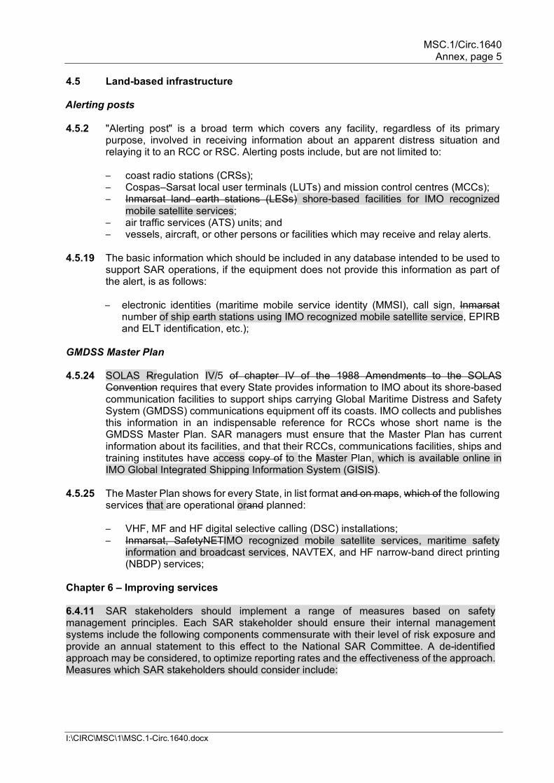
4.5 Land-based infrastructure Alerting posts 4.5.2 "Alerting post" is a broad term which covers any facility, regardless of its primary
purpose, involved in receiving information about an apparent distress situation and relaying it to an RCC or RSC. Alerting posts include, but are not limited to:
– coast radio stations (CRSs); – Cospas–Sarsat local user terminals (LUTs) and mission control centres (MCCs); – Inmarsat land earth stations (LESs) shore-based facilities for IMO recognized
mobile satellite services; – air traffic services (ATS) units; and – vessels, aircraft, or other persons or facilities which may receive and relay alerts.
4.5.19 The basic information which should be included in any database intended to be used to
support SAR operations, if the equipment does not provide this information as part of the alert, is as follows:
– electronic identities (maritime mobile service identity (MMSI), call sign, Inmarsat
number of ship earth stations using IMO recognized mobile satellite service, EPIRB and ELT identification, etc.);
GMDSS Master Plan 4.5.24 SOLAS Rregulation IV/5 of chapter IV of the 1988 Amendments to the SOLAS
Convention requires that every State provides information to IMO about its shore-based communication facilities to support ships carrying Global Maritime Distress and Safety System (GMDSS) communications equipment off its coasts. IMO collects and publishes this information in an indispensable reference for RCCs whose short name is the GMDSS Master Plan. SAR managers must ensure that the Master Plan has current information about its facilities, and that their RCCs, communications facilities, ships and training institutes have access copy of to the Master Plan, which is available online in IMO Global Integrated Shipping Information System (GISIS).
4.5.25 The Master Plan shows for every State, in list format and on maps, which of the following
services that are operational orand planned:
– VHF, MF and HF digital selective calling (DSC) installations; – Inmarsat, SafetyNETIMO recognized mobile satellite services, maritime safety
information and broadcast services, NAVTEX, and HF narrow-band direct printing (NBDP) services;
Chapter 6 – Improving services 6.4.11 SAR stakeholders should implement a range of measures based on safety management principles. Each SAR stakeholder should ensure their internal management systems include the following components commensurate with their level of risk exposure and provide an annual statement to this effect to the National SAR Committee. A de-identified approach may be considered, to optimize reporting rates and the effectiveness of the approach. Measures which SAR stakeholders should consider include:
MSC.1/Circ.1640 Annex, page 6
I:\CIRC\MSC\1\MSC.1-Circ.1640.docx
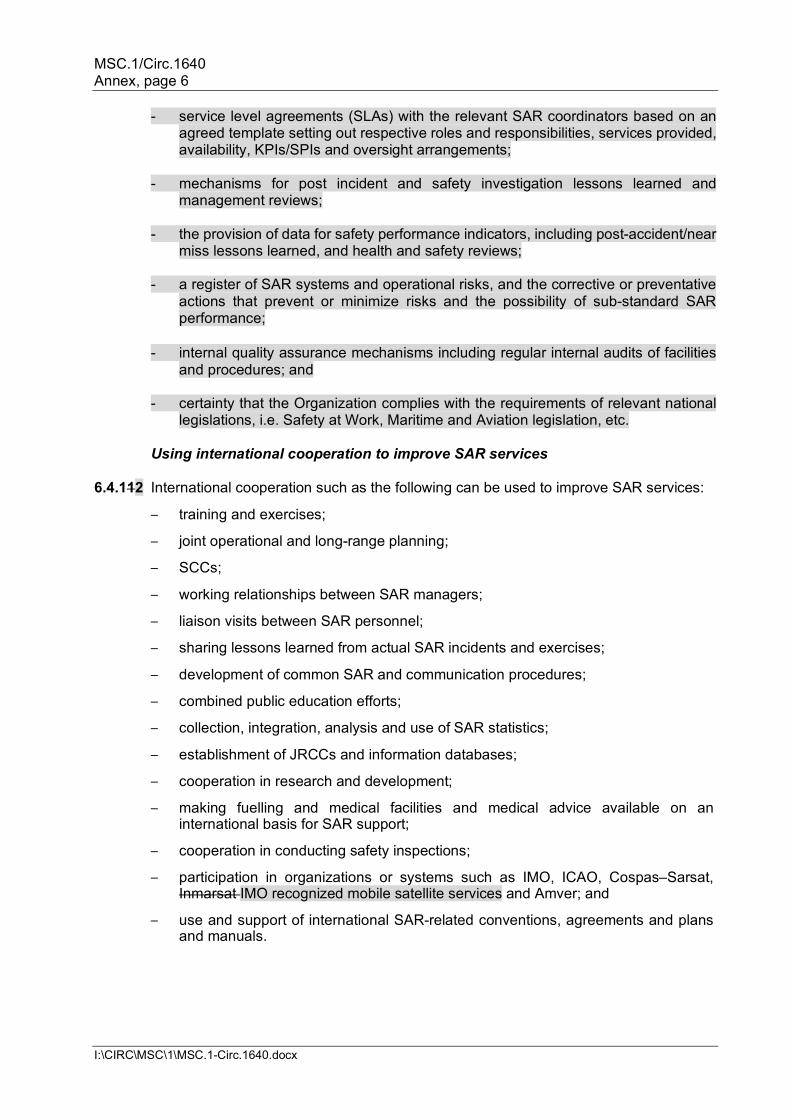
- service level agreements (SLAs) with the relevant SAR coordinators based on an agreed template setting out respective roles and responsibilities, services provided, availability, KPIs/SPIs and oversight arrangements;
- mechanisms for post incident and safety investigation lessons learned and
management reviews; - the provision of data for safety performance indicators, including post-accident/near
miss lessons learned, and health and safety reviews; - a register of SAR systems and operational risks, and the corrective or preventative
actions that prevent or minimize risks and the possibility of sub-standard SAR performance;
- internal quality assurance mechanisms including regular internal audits of facilities
and procedures; and - certainty that the Organization complies with the requirements of relevant national
legislations, i.e. Safety at Work, Maritime and Aviation legislation, etc.
Using international cooperation to improve SAR services 6.4.112 International cooperation such as the following can be used to improve SAR services:
– training and exercises;
– joint operational and long-range planning;
– SCCs;
– working relationships between SAR managers;
– liaison visits between SAR personnel;
– sharing lessons learned from actual SAR incidents and exercises;
– development of common SAR and communication procedures;
– combined public education efforts;
– collection, integration, analysis and use of SAR statistics;
– establishment of JRCCs and information databases;
– cooperation in research and development;
– making fuelling and medical facilities and medical advice available on an international basis for SAR support;
– cooperation in conducting safety inspections;
– participation in organizations or systems such as IMO, ICAO, Cospas–Sarsat, Inmarsat IMO recognized mobile satellite services and Amver; and
– use and support of international SAR-related conventions, agreements and plans and manuals.
MSC.1/Circ.1640 Annex, page 7
I:\CIRC\MSC\1\MSC.1-Circ.1640.docx
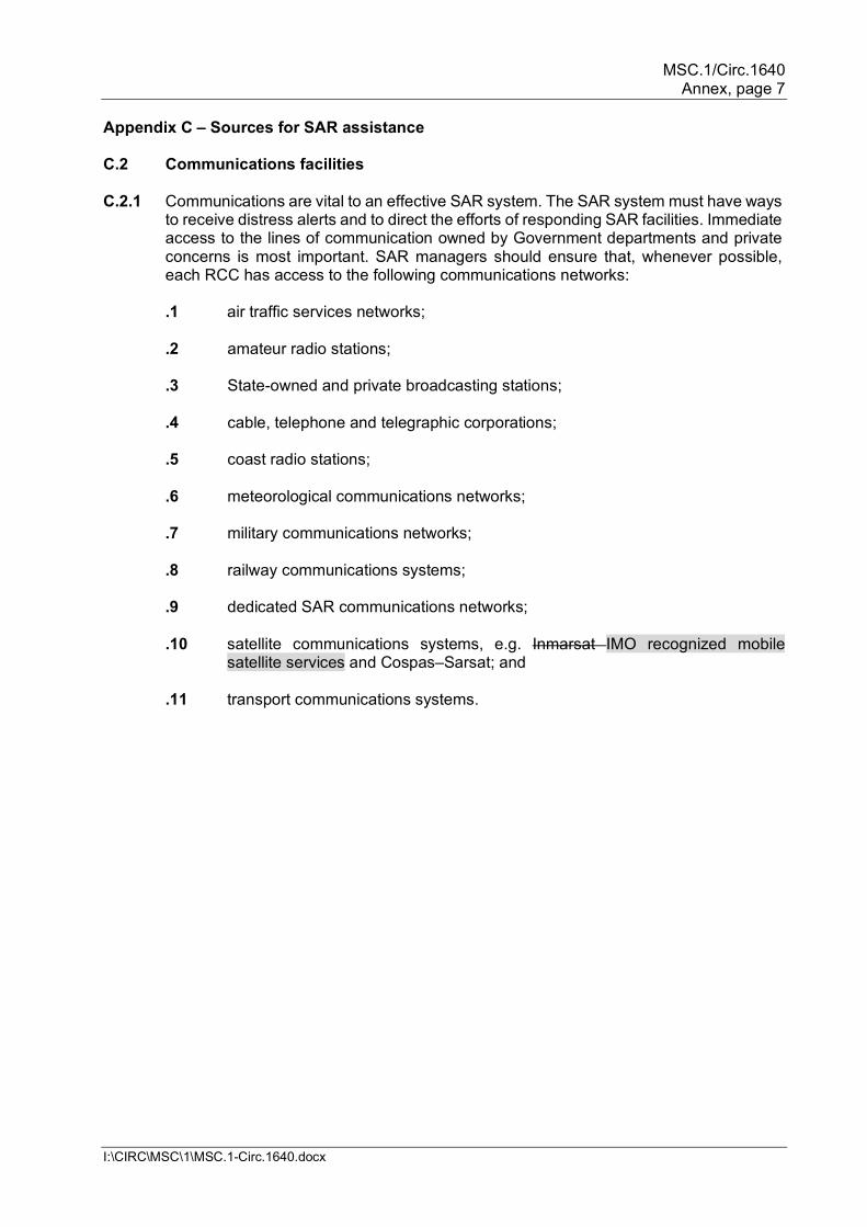
Appendix C – Sources for SAR assistance C.2 Communications facilities C.2.1 Communications are vital to an effective SAR system. The SAR system must have ways
to receive distress alerts and to direct the efforts of responding SAR facilities. Immediate access to the lines of communication owned by Government departments and private concerns is most important. SAR managers should ensure that, whenever possible, each RCC has access to the following communications networks:
.1 air traffic services networks; .2 amateur radio stations; .3 State-owned and private broadcasting stations; .4 cable, telephone and telegraphic corporations; .5 coast radio stations; .6 meteorological communications networks; .7 military communications networks; .8 railway communications systems; .9 dedicated SAR communications networks; .10 satellite communications systems, e.g. Inmarsat IMO recognized mobile
satellite services and Cospas–Sarsat; and .11 transport communications systems.
MSC.1/Circ.1640 Annex, page 8
I:\CIRC\MSC\1\MSC.1-Circ.1640.docx
Appendix D – Information sources After "Inmarsat" entry,
Iridium Communications 1750 Tysons Boulevard, Suite 1400 McLean, VA 22102, USA . . .
After "Global Navigation Satellite System (GLONASS)" entry,
Website: www.iridium.com Email: [email protected]
International Maritime Rescue Federation (IMRF) PO Box 1389, Enfield, EN1 9GF, United Kingdom
Website: www.international-maritime-rescue.org
Email: [email protected]
In addition to providing help in obtaining the reference documents mentioned in this Manual, the International Maritime Rescue Federation (IMRF) shares information on SAR lessons identified and other information sourced from the SAR community. Useful SAR information may be found at www.international-maritime-rescue.org and/or may be requested from, or supplied to, the IMRF at [email protected].
Appendix E – False alerts E.1.4 For a false alert, an unnecessary SAR alert (UNSAR) message should be sent by the
RCC to the appropriate authorities for follow-up to prevent re-occurrence of similar false alerts. The follow-up should include the person or persons responsible for the false alert and may include information such as the effort expended by the SAR organization in response to the false alert.
E.2 Preventing false alerts E.2.1 Steps SAR authorities can take to reduce false alerts are suggested below:
- inform aircraft and vessel owners and operators about implications of the rising number of false distress alerts;
- provide for vessels to properly register all communications equipment, and to ensure that this registration data is readily available to RCCs;
- follow-up on unnecessary SAR report messages; - consider establishing or using enforcement measures to prosecute those who:
- inadvertently transmit a false distress alert without proper cancellation, or who fail
to respond to a distress acknowledgement due to misuse or negligence; - repeatedly transmit false alerts; and - deliberately transmit false alerts. - use the ITU violation reporting process for false distress alerts; - ensure that communications equipment operators are well informed on how to
operate their equipment, the importance of avoiding false alerts and steps to be taken to prevent transmitting false alerts;
MSC.1/Circ.1640 Annex, page 9
I:\CIRC\MSC\1\MSC.1-Circ.1640.docx
– inform equipment approval authorities of false alert problems to draw their attention to testing and alerting functions of radio equipment during the type approval process;
– urge companies installing radio equipment to train the users to ensure they become familiar with operation of the installed equipment;
– investigate the cause when a specific model of communications equipment repeatedly transmits unwanted alerts and inform appropriate organizations;
– ensure that surveyors and inspectors are informed about communications equipment and particularly how to operate and test it without transmitting a false alert;
– require that operators be appropriately certificated for installed communications equipment;
– urge manufacturers, suppliers and installers of communications equipment to:
[Editorial note: Unitalicized fonts] – provide clear and precise operating instructions that are easy to understand
(maintenance and operating instructions should be separated, and should be delivered in English and any other language deemed necessary);
– ensure that supplier and installation personnel understand how the equipment works and the consequences of transmitting a false alert;
– ensure that equipment is designed for distress alerting so that it will be impossible to transmit an alert unintentionally; any panel for emergency operation is separated from the one for normal operation, is fitted with a cover, and has colour-coded switches; and that there are standardized arrangements of control panels and standard operational procedures;
– design test features so that testing equipment will not result in false distress alerts;
– ensure that when any communications equipment has been installed, necessary instructions are given to users, specifically pointing out the operating procedures (log that the instructions have been given);
– ensure that any distress alert activation is indicated visually and/or aurally, showing that the equipment is transmitting a distress alert, until manually deactivated;
– implement any appropriate technical and operational measures to avoid unwanted transmission of alerts;
– ensure that the ELT or EPIRB handling procedures and installations, including the location on board the aircraft or vessel and the release and activation mechanisms, preclude unwanted activation;
– design EPIRBs so that when they are out of their brackets they must also be immersed in water to activate automatically; when operated manually, a two-step activation procedure should be required; and
– consider ELT and EPIRB installation locations for new aircraft and vessels at early stages of the craft design and construction.
– urge trainers and educators to: [Editorial note: Unitalicized fonts]
– ensure that aviation and maritime education centres are informed and teach about false alert problems and implications to safety and SAR;
– obtain and use actual case histories as examples when teaching; – emphasize the need to avoid false distress alerts in all aviation and maritime
training and education; and
MSC.1/Circ.1640 Annex, page 10
I:\CIRC\MSC\1\MSC.1-Circ.1640.docx
– ensure that no inadvertent transmissions of false distress alerts occur during communications training.
– educate users of communications equipment and their employers to: [Editorial note: Unitalicized fonts]
– ensure that all personnel responsible for sending a distress alert have been instructed and are competent to operate all radio equipment aboard the aircraft or vessel;
– have the person(s) responsible for communications during distress incidents give necessary instructions and information to any crew members who should know how to send a distress alert;
– give instruction to the crew during each drill on evacuating the aircraft or vessel on how emergency equipment should be used for emergency functions;
– ensure that equipment testing is only undertaken under supervision of the person responsible for communications during distress incidents;
– ensure that equipment testing or drills are never allowed to cause false distress alerts;
– ensure that encoded identities of 406 MHz distress beacons (ELTs, EPIRBs and PLBs), which are used by SAR personnel responding to emergencies, are properly registered in a database accessible 24 h per day or automatically provided to SAR authorities (aircraft and vessel operators should confirm that their beacons have been registered with such a database to help SAR services to identify the unit in the event of distress and to rapidly obtain other information to help them respond); and
– immediately update 406 MHz distress beacon, Inmarsat ship earth stations using IMO recognized mobile satellite services and DSC registration data and, if necessary, reprogram the equipment codes, if the aircraft or vessel change ownership, name, flag, or similar information.
Appendix G – Mobile communication services G.6 Global Aeronautical Distress and Safety System [Editorial note: replace the existing section G.6 by the following:] G.6.1 The Global Aeronautical Distress and Safety System (GADSS) was established to
mitigate challenges in the global air navigation system, regarding the timely identification and localization of aircraft in distress. GADSS provides an effective and globally consistent approach to enhancing the alerting procedures of search and rescue services by addressing a number of key improvement areas.
G.6.2 GADSS has three main elements: - aircraft tracking (typically between the ATS unit and the aircraft operator); - location of an aircraft in distress (achieved through autonomous distress tracking
(ADT) of aircraft in flight); and - post-flight localization and recovery. G.6.3 GADSS ensures an up-to-date record of aircraft progress is maintained and, in case of
a crash, forced landing or ditching, ensures information on the location of survivors, the aircraft and recoverable flight data is available.
MSC.1/Circ.1640 Annex, page 11
I:\CIRC\MSC\1\MSC.1-Circ.1640.docx
G.6.4 For GADSS to function as intended, flight crew and aircraft operators, air traffic controllers and air navigation services providers, ADT service providers, and rescue coordination centres (RCCs) need to understand each other's roles, responsibilities and processes to ensure effective communication, robust coordination and harmonized implementation across the globe.
G.6.5 For aircraft tracking in GADSS, the aircraft operator is required to establish an aircraft
tracking capability throughout its area of operations. Such tracking is required in oceanic areas (airspace which overlies waters outside of the territory and territorial sea of a State) and recommended in all areas of operations. Tracking is accomplished through automated four-dimensional (latitude, longitude, altitude and time) position reports transmitted at an interval of 15 minutes or less, unless ATS surveillance obtains aircraft position information at 15-minute intervals or less.
G.6.6 The location of an aircraft in distress (achieved through autonomous distress tracking
(ADT) of aircraft in flight) element has the greatest potential impact upon aeronautical and maritime SAR services.
G.6.7 The Standard defining location of an aircraft in distress requires that, as of
1 January 2023, aircraft issued with a certificate of airworthiness for the first time, with a maximum certificated take off mass of over 27,000 kg, "shall autonomously transmit information from which a position can be determined by the operator at least once every minute, when in distress." The ICAO provisions also recommend that this requirement be applied to aircraft with a maximum certificated take off mass of over 5,700 kg.
G.6.8 More detailed information on responsibilities and procedures regarding ADT and aspects
of post-flight localization and recovery is provided in the IAMSAR Manual, Volume II, Mission Coordination, Appendix V – Autonomous distress tracking of aircraft in flight.
G.7 406 MHz distress beacons . . . G.7.3 Most 406 MHz distress beacons provide a homing capability on 121.5 MHz, 243 MHz
and 406 MHz and some may also integrate SARTs into their designs. EPIRBs installed on or after 1 July 2022 will also be provided with an AIS locating signal.
. . .
MSC.1/Circ.1640 Annex, page 12
I:\CIRC\MSC\1\MSC.1-Circ.1640.docx
G.8 Satellite communications G.8.1 The primary systems now used for SOLAS compliance are Cospas–Sarsat and Inmarsat
IMO recognized mobile satellite services. G.8.2 The most capable Inmarsat equipment can handle distress communications, telephone,
telex, facsimile, data and other general services. The Inmarsat-C SES does not handle voice communications, but it is important because of its ability to receive maritime safety information, relatively low cost to obtain and operate, versatile when coupled with a personal computer and in widespread use. Other common maritime terminals carry Inmarsat designations like B, M, Mini-C and F77. Inmarsat SESs communicate to subscribers ashore via national and international public switched telephone networks (PSTNs) and public switched data networks (PSDNs) which interlink Inmarsat to other systems and can also communicate with suitably equipped SESs in any ocean area.
G.8.3 For more information on equipment, performance standards, alert messages,
distribution procedures, users manuals and other Inmarsat-related matters, Inmarsat the IMO recognized mobile satellite service providers may be contacted.
G.8.4 Many people voluntarily use Inmarsat IMO recognized mobile satellite services and similar global or regional systems using the same frequencies. Users need to know how these systems work, how to use the equipment in emergencies, and how to ensure that position information is correctly and continually updated for distress alerting. If users send an alert, they need to be prepared to be contacted by an RCC for more information. They should understand the equipment's limitations and capabilities to receive safety and SAR broadcasts. Users should be taught to follow up their semi-automatic (distress button) alerting with additional information to SAR authorities when possible.
. . .
G.9 Inmarsat SafetyNET EGC services
G.9.1 Inmarsat EGC services can and should also be used to broadcast MSI. Every RCC should
make arrangements with an associated NAVAREA Coordinator or other authority recognized by Inmarsat authorized by the IMO EGC Coordinating Panel to make such broadcasts on its behalf over Inmarsat's SafetyNET system EGC services.
G.9.2 It is appropriate and advisable to promulgate distress alerts over both NAVTEX and SafetyNET EGC services. SOLAS ships and many fishing and other vessels sailing within NAVTEX coverage areas can be expected to carry 518 kHz NAVTEX receivers. However, some may carry equipment to receive MSI over SafetyNET EGC services in lieu of, or in addition to, NAVTEX, and some may carry neither.
G.9.3 While SafetyNET EGC services and NAVTEX are valuable tools for SAR personnel,
due to the ranges of shore facilities which transmit these broadcasts, not every State needs to provide the equipment. Normally, provision of these services should be arranged, provided, and shared on an international basis to maintain appropriate global broadcast coordination, reduce redundant alerts to vessels and reduce costs of providing these services.
MSC.1/Circ.1640 Annex, page 13
I:\CIRC\MSC\1\MSC.1-Circ.1640.docx
Appendix H – National self-assessment on search and rescue system Chapter 6 – Improving services Add new sub-paragraph .4 to question 74: .4 Are there memorandum of understanding (MOU)/service level agreements (SLAs) in
place between SAR stakeholders, both for SAR coordinators and the operational assets, which identify and implement a range of measures based on safety management principles?
MSC.1/Circ.1640 Annex, page 14
I:\CIRC\MSC\1\MSC.1-Circ.1640.docx
AMENDMENTS TO IAMSAR MANUAL, VOLUME II
. . . Contents . . .
2.35 Additional device considerations 2.36 RCC actions to consider 2.376 Social media
Editorial Note.— Confirm page numbering remains correct
. . .
Appendix U Mobile telecommunications device location process Appendix V Autonomous distress tracking of aircraft in flight . . . Abbreviations and acronyms . . . EGC…………..enhanced group calling . . . ULD………underwater locating device . . . Glossary . . . Enhanced group call (EGC) International broadcast of coordinated maritime safety
information, and search and rescue related information, to a defined geographical area using a recognized mobile satellite service.
. . . Iridium A system of 66 polar orbiting cross-linked satellites for
worldwide mobile communications services and which support the Global Maritime Distress and Safety System and other safety services.
. . . SafetyCast A service of the Iridium enhanced group call (EGC) system
specifically designed for promulgation of maritime safety information (MSI) and SAR related information as a part of the Global Maritime Distress and Safety System (GMDSS).
SafetyNET
A service of the Inmarsat enhanced group call (EGC) system specifically designed for promulgation of maritime safety information (MSI) and SAR related information as a part of the Global Maritime Distress and Safety System (GMDSS).
. . .
MSC.1/Circ.1640 Annex, page 15
I:\CIRC\MSC\1\MSC.1-Circ.1640.docx
Unnecessary SAR alert (UNSAR) A message sent by an RCC to the appropriate authorities as a follow-up when the SAR system is unnecessarily activated by a false alert.
. . . Chapter 1 – The search and rescue system . . . Aeronautical systems 1.3.10 The Global Aeronautical Distress and Safety System (GADSS) is a system of systems
and procedures that will apply initially to certain commercial air transport operations under ICAO Annex 6, Part 1 applicability. It may also extend to other civil air transport operations. The aircraft operator is required to establish an aircraft tracking capability to track their aircraft throughout its area of operations. A separate and independent autonomous distress tracking (ADT) system also forms part of the GADSS. The ADT function is applicable from 1 January 2021 for certain aircraft as described in 1.3.12.
1.3.11 Aircraft tracking is a core component of GADSS. The automated four-dimensional (latitude, longitude, altitude and time) position reporting is to occur at an interval of 15 minutes or less (recommended in all areas of operation and required in oceanic areas). The objective is to reduce the time necessary to resolve the status of an aircraft or, when necessary, help locate an aircraft. If the aircraft operator confirms that Air Traffic Services obtains an aircraft position at 15 minute intervals or less using ATS surveillance, then the aircraft operator does not need to independently track their aircraft for that part of the flight within ATS surveillance.
1.3.12 As of 1 January 2021, new aircraft with a take-off mass greater than 27,000 kilograms will
be fitted with ADT capability. ADT is used to identify the location of an aircraft in distress with the aim of establishing, to a reasonable extent, the location of an accident site within a 6 NM radius. ADT uses on-board systems to broadcast the aircraft position (latitude and longitude), or distinctive distress signals from which the aircraft position and time can be derived. The aircraft position information will be transmitted, without the need for flight crew action, at least once every minute, when an aircraft is in a distress condition.
1.3.13 When it is identified that an aircraft is considered to be in a state of emergency, the RCC
will be alerted. The alerting process envisaged in the GADSS is consistent with the current ATS alerting service provisions of ICAO Annex 11 – Air Traffic Services and Annex 12 – Search and Rescue.
– if an ATS unit detects a distress condition it will notify the RCC and the operator; – if the operator detects a distress condition it will notify the ATS unit who will in
turn notify the RCC; – if an ELT is activated the RCC will be notified via the Cospas-Sarsat system; if
the RCC receives the information from other sources, the RCC will identify to which emergency phase the situation corresponds and shall apply the procedures applicable to that phase.
1.3.14 The sharing of GADSS alerting information requires global coverage and a global interoperable systems approach. Aircraft tracking and ADT alert information for aircraft emergency conditions need to be rapidly distributed to the aircraft operator, responsible ATS unit and the responsible RCC. Effective sharing of this information to the responsible stakeholders requires well defined, accurate and readily accessible global FIR and SRR
MSC.1/Circ.1640 Annex, page 16
I:\CIRC\MSC\1\MSC.1-Circ.1640.docx
data, plus reliable emergency 24-hour contact details for the aircraft operators, ATS units and RCCs.
1.3.10 The Global Aeronautical Distress and Safety System (GADSS) was established to mitigate challenges in the global air navigation system, regarding the timely identification and localization of aircraft in distress. GADSS provides an effective and globally consistent approach to enhancing the alerting procedures of search and rescue services by addressing a number of key improvement areas.
1.3.11 GADSS has three main elements:
- aircraft tracking (typically between the ATS unit and the aircraft operator); - location of an aircraft in distress (achieved through autonomous distress tracking
(ADT) of aircraft in flight); and - post-flight localization and recovery.
1.3.12 GADSS ensures an up-to-date record of aircraft progress is maintained and, in case of a crash, forced landing or ditching, ensures information on the location of survivors, the aircraft and recoverable flight data is available. For GADSS to function as intended, flight crew and aircraft operators, air traffic controllers and air navigation services providers, ADT service providers, and rescue coordination centres (RCCs) need to understand each other's roles, responsibilities and processes to ensure effective communication, robust coordination and harmonized implementation across the globe.
1.3.13 For aircraft tracking in GADSS, the aircraft operator is required to establish an aircraft
tracking capability throughout its area of operations. Such tracking is required in oceanic areas (airspace which overlies waters outside of the territory and territorial sea of a State) and recommended in all areas of operations. Tracking is accomplished through automated four-dimensional (latitude, longitude, altitude and time) position reports transmitted at an interval of 15 minutes or less, unless ATS surveillance obtains aircraft position information at 15-minute intervals or less.
1.3.14 The aircraft tracking element enhances the ability of RCCs to obtain information on an aircraft in an emergency situation but also to provide information on other aircraft in the area that may be able to assist, for example, to divert to a distress location, relay communications, etc. However, aircraft tracking responsibilities and actions are typically performed between the ATS unit and the aircraft operator.
1.3.15 The location of an aircraft in distress (achieved through autonomous distress tracking
(ADT) of aircraft in flight) element has the greatest potential impact upon aeronautical and maritime SAR services.
1.3.16 The standard defining location of an aircraft in distress requires that, as of
1 January 2023, aircraft issued with a certificate of airworthiness for the first time, with a maximum certificated take off mass of over 27,000 kg, "shall autonomously transmit information from which a position can be determined by the operator at least once every minute, when in distress." The ICAO provisions also recommend that this requirement be applied to aircraft with a maximum certificated take off mass of over 5,700 kg.
1.3.17 More detailed information on responsibilities and procedures regarding ADT and
aspects of post-flight localization and recovery is provided in appendix V Autonomous distress tracking of aircraft in flight.
MSC.1/Circ.1640 Annex, page 17
I:\CIRC\MSC\1\MSC.1-Circ.1640.docx
1.3.18 Aircraft post flight localization and recovery is improved by standards on aircraft carriage of underwater locating devices (ULD). This is intended more for the recovery of flight recorder data by the aeronautical accident investigators. SAR services should be aware that detecting the ULD is not an SAR responsibility or task. Two types of ULD are in use, which assist in locating wreckage below the surface of water, where it is not possible to detect an ELT signal.
. . .
Chapter 2 – Communications 2.1 Distress communications . . . 2.1.4 Distress alerts may arrive at RCCs from a variety of equipment sources and via a variety
of alerting posts. Alerting posts include, but are not limited to, coast radio stations (CRSs), local user terminals (LUTs) and mission control centres (MCCs) of the Cospas-Sarsat System, land earth stations (LESs) of the Inmarsat System shore-based facilities for mobile satellite services, air traffic services (ATS) units, commercially available emergency notification device service providers, public safety units such as police and fire departments, and vessels, aircraft, or other persons or facilities which may receive and relay such alerts. Alerting posts are any intermediary facilities which relay distress alerts between their source and the responsible RCC, and may even include other RCCs.
. . . 2.5 Global Maritime Distress and Safety System . . . 2.5.13 Enhanced group call (EGC) is part of the Inmarsat system that provided by IMO
recognized mobile satellite services and complements the NAVTEX system. to supply SafetyNET and similar services (Inmarsat and SafetyNET IMO recognized mobile satellite services and their capabilities are further discussed later in this chapter). SafetyNET is Broadcasts are used by SAR, meteorological, and navigation authorities for promulgation of maritime safety information (MSI) and SAR related information. Some Inmarsat LESs also offer EGC FleetNET services used for fleet management and general information to particular groups of ships; RCCs may find such services useful for certain applications, such as sending messages to a standard list of other RCCs.
. . . 2.6 406 MHz distress beacons – EPIRB, ELT and PLB . . . 2.6.4 Most 406 MHz distress beacons provide a homing capability on 121.5/243/406 MHz;
some EPIRBs may also integrate AIS–SARTs into their designs. EPIRBs installed on or after 1 July 2022 will need to be provided with an AIS locating signal.
. . .
MSC.1/Circ.1640 Annex, page 18
I:\CIRC\MSC\1\MSC.1-Circ.1640.docx
2.7 Satellite communications 2.7.1 Other satellite systems are available which can be used for distress alerting with various
degrees of effectiveness, but the primary ones used for SOLAS compliance are Cospas-Sarsat and InmarsatIMO recognized mobile satellite services.
2.7.2 Iridium is a system of 66 polar orbiting cross-linked satellites for worldwide mobile
communications services and which support the Global Maritime Distress and Safety System and other safety services.
2.7.23 Inmarsat uses satellites in each of the areas listed below. Together the satellites provide
coverage along the entire equator between 70° latitude north and south, and serve aeronautical, land, and maritime users.
– Atlantic Ocean Region – East (AOR-E) – Pacific Ocean Region (POR) – Indian Ocean Region (IOR) – Atlantic Ocean Region – West (AOR-W)
2.7.34 Ocean area access codes for contacting vessels via satellite vary. RCCs must be aware of the telephone and telex access codes (similar in use to international telephone access numbers) appropriate for their service providers.
2.7.45 Inmarsat type-approved ship earth stations (SESs) and aeronautical earth stations
(AESs) transmit via the satellites to land earth stations (LESs). Each ocean area has at least one network coordinating station (NCS) which manages multiple system uses and users.
2.7.56 A variety of Inmarsat equipment may be used by vessels to send distress alerts, each
with its own capabilities. Some have a distress button which can send basic pre-formatted automatic data alerts. Most Inmarsat alerts provide position data which has been automatically updated, but some equipment alternatively offers manual updating, which experience has shown to be unreliable.
2.7.67 Inmarsat-B and Fleet 77 SESs can handle distress communications, telephone calls,
telex calls (Inmarsat-B only), facsimile, data, and other general services. The Inmarsat-C SES is a message-only transfer terminal; it does not handle voice communications, but it is important because of its EGC capability, relatively low cost to obtain and operate, versatility when coupled with a personal computer, and widespread use. Various types of Inmarsat-C terminals are also used on land by trucks and other mobile units. Other common maritime terminals carry Inmarsat designations such as M, Mini-C, F77, F55 and F33. In addition to its GMDSS-compliant services, Inmarsat provides a distress and urgency voice-calling service via its series of FleetBroadband terminals. These ship earth stations can connect a mobile user directly with a designated RCC depending on the vessel's geographic position. These terminals also provide urgency communication for medical advice, medical assistance and maritime assistance through the use of two-digit SACs.
2.7.78 New satellite systems are emerging which can relay distress alerts. Many vessels are
equipped with systems that provide comprehensive online connections to Internet, voice, facsimile and data communications for such functions as online email, short message system (SMS), video conferencing and medical examination and reporting. These commercial satellite systems are not primarily designed for alerting, but may be
MSC.1/Circ.1640 Annex, page 19
I:\CIRC\MSC\1\MSC.1-Circ.1640.docx
used for subsequent SAR communications between ships or aircraft and RCCs or RSCs, or as a link to the on-scene coordinator.
2.7.89 Portable satellite handsets are available which provide voice and text messaging
capabilities. Some of these handsets use GNSS to provide position information, which may be made available to the RCC. These handsets are not normally designed for use in the maritime environment, for example, they may not be waterproof. They are also not GMDSS-compliant.
. . . 2.12 Communications for SAR operations . . . 2.12.2 If they have the capabilities, vessels normally monitor any DSC distress frequency
available, as well as MSI broadcasts (NAVTEX, SafetyNETEGC, etc.) and Inmarsat broadcasts. Most vessels monitor channel 16; when practicable, some ships vessels may discontinue aural radio watches and depend more on alarms to make them aware of incoming distress traffic. Persons on board vessels or aircraft may also carry mobile telecommunications devices, e.g. mobile telephones. These devices may be a means of communicating with them.
. . . 2.14 False alerts . . . 2.14.3 SAR personnel are often in a unique position to be aware of false alerts and investigate
their causes; so it is important that records be kept on the numbers of such alerts and their causes, and that these data be provided to authorities who can use regulation enforcement, improved training or equipment standards, etc., to improve alerting integrity. An unnecessary SAR alert (UNSAR) message sent to appropriate authorities for follow-up can be used to prevent further false alerts.
. . . 2.18 Maritime safety information services . . . 2.18.2 The two principal methods used for broadcasting maritime safety information (MSI),
which include navigational warnings and meteorological information, in accordance with the provision of SOLAS are NAVTEX and SafetyNET IMO recognized mobile satellite services.
2.18.3 All NAVAREA, Sub-area and coastal warnings should be broadcast only in English in
the international NAVTEX and SafetyNET IMO recognized mobile satellite services in accordance with IMO resolution A.706(17), as amended. In addition to the required broadcast in English, NAVAREA, Sub-area and coastal warnings may be broadcast in a national language using a national service.
MSC.1/Circ.1640 Annex, page 20
I:\CIRC\MSC\1\MSC.1-Circ.1640.docx
. . . 2.19 Broadcast services . . . 2.19.2 International SafetyNET is used toIMO recognized mobile satellite services are used to
promulgate navigation and meteorological warnings and other safety-related information to vessels and may be used by SAR services and for SAR purposes.
. . . 2.19.4 The International SafetyNET and SafetyCast Manuals describes the structure and
operation of these International SafetyNET services. This includes examples and coding which must be followed for preparing SafetyNET these broadcasts, including SAR broadcasts.
2.19.5 It may be appropriate and advisable to promulgate distress alert relays over both
NAVTEX and SafetyNET IMO recognized mobile satellite services. All SOLAS ships and many fishing and other vessels sailing within NAVTEX coverage areas can be expected to carry 518 kHz NAVTEX receivers. Some may also carry equipment to receive SafetyNET EGC broadcasts.
2.19.6 Normally, the most practical way to handle SAR broadcasts over SafetyNET IMO
recognized mobile satellite services is to send them to all vessels within a desired radius of a specified position. International broadcast of coordinated MSI and SAR related information to a defined geographical area using a recognized mobile satellite service is via the enhanced group call (EGC) service. EGC broadcasts can be made via services such as SafetyNET and SafetyCast.
2.19.7 The use of an all-ships broadcast to identify a vessel to divert for SAR operations should
be considered as an initial action. It may require time to obtain responses from available vessels, and to select an appropriate one or more for the task, and can affect quite a few vessels. Although SafetyNET broadcasts over IMO recognized mobile satellite services are is a reliable, economical and important SAR tool, it they must be used wisely. It is often prudent to supplement an all-ships broadcast with direct communications as a next step using vessels identified via LRIT, AMVER or another ship reporting system. Factors that may be considered when tasking vessels should include the location of vessels in relation to the incident area, relative ability of vessels to conduct a rescue and appreciation of the impact of diversions on the responding vessels.
. . . 2.28 SAR operations messages . . . Insert new paragraph 2.28.2:
ATS Unit - RCC Alerting (ALR) message
2.28.2 When an ATS unit needs to pass distress alert information to an RCC it may call by telephone or it may send an ICAO alerting (ALR) message via an aeronautical
MSC.1/Circ.1640 Annex, page 21
I:\CIRC\MSC\1\MSC.1-Circ.1640.docx
communications link. The ALR message is based on the aircraft flight plan. If the MRCC or JRCC is not connected to an aeronautical communications link then discussion with the ATS unit may find alternative solutions such as a telephone call followed up by email or facsimile with the ALR message. The ALR message format, terms and acronyms may not be clearly understood unless the reader has been trained on the meaning of the ALR message. If the RCC is not familiar with the ALR message then it should discuss in advance with the ATS unit the means by which the RCC can understand the ALR message or other ways for the RCC to get the alert information. Further guidance is provided in ICAO document Procedures for Air Navigation Services — Air Traffic Management (PANS-ATM, Doc 4444), appendix 3.
Editorial Note.— Renumber subsequent paragraphs. . . . 2.28.167 The message normally includes sixseven parts:
(a) Situation: includes a brief description of the incident, position, and time; number of persons on board (POBs); primary and secondary search objects, including the amount and types of survival equipment; weather forecast and period of forecast; and SAR facilities on scene.
(b) Action: specific tasking for a particular SAR agency or facility. (bc) Search area(s): presented in column format with headings for area, size, corner
points, other essential data. (cd) Execution: presented in column format with headings for area, SAR facility,
parent agency, pattern, creep direction, commence search points, and altitude. (de) Coordination: designates the SMC, OSC and ACO; SAR facilities on-scene
times; track spacings and coverage factors desired; OSC instructions, e.g. on use of datum marker buoys; airspace reservations; temporary sea exclusion zones; aircraft safety instructions; SAR facility change of operational control information if pertinent; parent agency relief instructions; and authorizations for non-SAR aircraft in the area.
(ef) Communications: prescribes control channels; on-scene channels; monitor
channels; SAR vessel electronic identification; and press channels. (fg) Reports: requirements for OSC reports of on-scene weather, progress and
other SITREP information; and for parent agencies to provide at the end of daily operations, e.g. sorties, hours flown, area(s) searched, and coverage factor(s).
. . . 2.29 GMDSS Master Plan 2.29.1 SOLAS rRegulation IV/5 of chapter IV of the 1988 Amendments to the SOLAS
Convention requires that every Contracting Government provide to IMO information on its shore-based facilities to support ships carrying GMDSS communications equipment off its coasts. IMO collects and publishes this information in an indispensable reference
MSC.1/Circ.1640 Annex, page 22
I:\CIRC\MSC\1\MSC.1-Circ.1640.docx
for RCCs; its short name is the GMDSS Master Plan., which is available online in IMO Global Integrated Shipping Information System (GISIS)."
. . . 2.29.3 The GMDSS Master Plan shows for every country: the status of its VHF, MF, and HF-
DSC installations; its Inmarsat IMO recognized mobile satellite services, MSI and broadcast services, SafetyNET, NAVTEX, and HF-NBDP services; its satellite EPIRB registration information, MCCs, and LUTs; and which RCCs are using SESs. This information is given in list form and on maps and distinguishes between operational and planned facilities.
. . . 2.365.2 RCC actions to consider include: [Editorial note: pay attention to the font size] . . . 2.376 Social media [Editorial note: change all paragraph numbers in this section] . . . Chapter 3 – Awareness and initial action . . . 3.4 Awareness stage . . . 3.4.8 After evaluating all available information and if an emergency phase is declared, the
RCC or RSC should immediately inform all appropriate authorities, centres, services, or facilities. When more than one RCC may have received the distress alert, the RCCs should quickly coordinate and each should advise the other of the action it has taken on the alert. This can be done by any practical means, including Inmarsat FleetNET and Inmarsat–C service IMO recognized mobile satellite services, or ICAO's AFTN. This especially applies when an initial Cospas-Sarsat alert provides an A and a B position, the A and the B positions can be in different SRRs.
. . . 3.5 Initial action stage . . . 3.5.4 When the communication search or other information received indicates that the aircraft, ship, or other craft is not in distress, the RCC will close the incident and immediately inform the operating agency, the reporting source, and any alerted authorities, centres, services, or facilities. However, if apprehension regarding the safety of the aircraft and its occupants continues, the uncertainty phase should progress to the alert phase. . . .
MSC.1/Circ.1640 Annex, page 23
I:\CIRC\MSC\1\MSC.1-Circ.1640.docx
Chapter 5 – Search techniques and operations . . .
Night vision goggles devices
5.7.6 Use of night vision goggles devices (NVGDs) can be effective in searches carried out by helicopters, fixed-wing aircraft, rescue vessels, utility boats, and ground search parties.
5.7.7 The following factors may influence the effectiveness of NVGDs for searching:
- NVGD quality;
- crew training and experience;
- environmental conditions (meteorological visibility, moisture, moonlight, cloud coverage, precipitation, etc.);
- level and glare effects of ambient light (including natural light like moonlight and starlight, and artificial light like illumination from search, navigation and other lights, inside and outside the search facility), and whether the light sources are within the NVGD wearer's field of view;
- search-craft speed;
- height of the observers above the surface;
- surface conditions (like the presence of snow) and sea state;
- size, illumination, and reflectivity of the search object (reflective tape on survivors or their craft can significantly improve the chances of detection with NVGDs); and
- types of survival equipment or light sources (like signalling devices and pyrotechnics) used by the survivors.
5.7.8 Glare should be minimized as much as possible within the facility's environment where
the NVGD users are stationed. This may involve opening or removing windows where practicable. Also, proper scanning techniques are important for reducing the adverse effects of moonlight or artificial light sources like light-houses, offshore rigs, ships, anti-collision lights, etc.
5.7.9 Visible moonlight can significantly improve detection of unlighted search objects when
using NVGDs. Search object light sources, like strobe or similar lights, or even cigarettes, can greatly improve detection even in poor visibility conditions such as light snowfall.
. . .
MSC.1/Circ.1640 Annex, page 24
I:\CIRC\MSC\1\MSC.1-Circ.1640.docx
Chapter 7 – Multiple aircraft SAR operations – General guidance . . .
7.1.1 The information in this chapter provides guidance for the management and conduct of multiple aircraft SAR operations. Any of the described principles and procedures might have to be modified by SMCs, ACOs and SRUs, in order to deal with specific situations. Further information on multiple aircraft SAR operations is available in IAMSAR volume III, section 510.
. . .
Chapter 8 – Emergency assistance other than search and rescue . . .
8.3 Safety information 8.3.1 Maritime safety information (MSI), such as weather forecasts and warnings of hazards
to navigation, is promulgated by SAR, meteorological, and navigation authorities. These authorities make arrangements for broadcast of MSI and SAR related information by means that may include NAVTEX, Inmarsat's SafetyNET EGC services, and MF, VHF and HF radio. Broadcast of MSI can serve to prevent SAR incidents from occurring. Similar safety information may be promulgated for aircraft and distributed as arranged by aeronautical authorities.
. . .
Chapter 9 – Conclusion of SAR operations
. . .
9.5.3 A record of SAR operations is required to improve methods, evaluate mistakes, if any, and provide statistics for SAR managers to justify SAR system support. This record should include information from debriefing of survivors as discussed in section 6.168. If the SAR service maintains computer files of SAR cases, appropriate information from this case file should be extracted and entered into the database for future analysis.
. . .
Appendices . . .
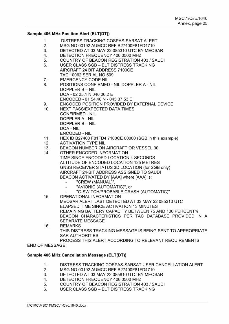
Page Appendix list iv, insert: Appendix V Autonomous distress tracking of aircraft in flight . . . Appendix B – Message formats On page B-8, add new samples "Sample 406 MHz Position Alert (ELT(DT)) and "Sample 406 MHz Cancellation Message (ELT(DT)):
MSC.1/Circ.1640 Annex, page 25
I:\CIRC\MSC\1\MSC.1-Circ.1640.docx
Sample 406 MHz Position Alert (ELT(DT)) 1. DISTRESS TRACKING COSPAS-SARSAT ALERT 2. MSG NO 00192 AUMCC REF B27400F81FD4710 3. DETECTED AT 03 MAY 22 085310 UTC BY MEOSAR 4. DETECTION FREQUENCY 406.0500 MHZ 5. COUNTRY OF BEACON REGISTRATION 403 / SAUDI 6. USER CLASS SGB – ELT DISTRESS TRACKING AIRCRAFT 24 BIT ADDRESS 7100CE TAC 10062 SERIAL NO 509 7. EMERGENCY CODE NIL 8. POSITIONS CONFIRMED - NIL DOPPLER A - NIL
DOPPLER B – NIL DOA - 02 25.1 N 046 06.2 E ENCODED - 01 54.40 N - 045 37.53 E
9. ENCODED POSITION PROVIDED BY EXTERNAL DEVICE 10. NEXT PASS/EXPECTED DATA TIMES
CONFIRMED - NIL DOPPLER A - NIL DOPPLER B – NIL DOA - NIL ENCODED - NIL
11. HEX ID B27400 F81FD4 7100CE 00000 (SGB in this example) 12. ACTIVATION TYPE NIL 13. BEACON NUMBER ON AIRCRAFT OR VESSEL 00 14. OTHER ENCODED INFORMATION
TIME SINCE ENCODED LOCATION 4 SECONDS ALTITUDE OF ENCODED LOCATION 125 METRES GNSS RECEIVER STATUS 3D LOCATION (for SGB only) AIRCRAFT 24-BIT ADDRESS ASSIGNED TO SAUDI BEACON ACTIVATED BY [AAA] where [AAA] is:
- "CREW (MANUAL)", - "AVIONIC (AUTOMATIC)", or - "G-SWITCH/PROBABLE CRASH (AUTOMATIC)"
15. OPERATIONAL INFORMATION MEOSAR ALERT LAST DETECTED AT 03 MAY 22 085310 UTC ELAPSED TIME SINCE ACTIVATION 13 MINUTES REMAINING BATTERY CAPACITY BETWEEN 75 AND 100 PERCENT% BEACON CHARACTERISTICS PER TAC DATABASE PROVIDED IN A SEPARATE MESSAGE
16. REMARKS THIS DISTRESS TRACKING MESSAGE IS BEING SENT TO APPROPRIATE SAR AUTHORITIES. PROCESS THIS ALERT ACCORDING TO RELEVANT REQUIREMENTS
END OF MESSAGE Sample 406 MHz Cancellation Message (ELT(DT))
1. DISTRESS TRACKING COSPAS-SARSAT USER CANCELLATION ALERT 2. MSG NO 00192 AUMCC REF B27400F81FD4710 3. DETECTED AT 03 MAY 22 085810 UTC BY MEOSAR 4. DETECTION FREQUENCY 406.0500 MHZ 5. COUNTRY OF BEACON REGISTRATION 403 / SAUDI 6. USER CLASS SGB – ELT DISTRESS TRACKING
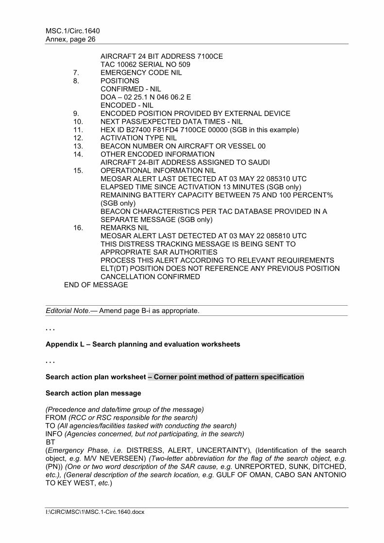
MSC.1/Circ.1640 Annex, page 26
I:\CIRC\MSC\1\MSC.1-Circ.1640.docx
AIRCRAFT 24 BIT ADDRESS 7100CE TAC 10062 SERIAL NO 509
7. EMERGENCY CODE NIL 8. POSITIONS
CONFIRMED - NIL DOA – 02 25.1 N 046 06.2 E ENCODED - NIL 9. ENCODED POSITION PROVIDED BY EXTERNAL DEVICE 10. NEXT PASS/EXPECTED DATA TIMES - NIL 11. HEX ID B27400 F81FD4 7100CE 00000 (SGB in this example) 12. ACTIVATION TYPE NIL 13. BEACON NUMBER ON AIRCRAFT OR VESSEL 00 14. OTHER ENCODED INFORMATION AIRCRAFT 24-BIT ADDRESS ASSIGNED TO SAUDI 15. OPERATIONAL INFORMATION NIL MEOSAR ALERT LAST DETECTED AT 03 MAY 22 085310 UTC ELAPSED TIME SINCE ACTIVATION 13 MINUTES (SGB only) REMAINING BATTERY CAPACITY BETWEEN 75 AND 100 PERCENT%
(SGB only) BEACON CHARACTERISTICS PER TAC DATABASE PROVIDED IN A
SEPARATE MESSAGE (SGB only) 16. REMARKS NIL MEOSAR ALERT LAST DETECTED AT 03 MAY 22 085810 UTC THIS DISTRESS TRACKING MESSAGE IS BEING SENT TO
APPROPRIATE SAR AUTHORITIES PROCESS THIS ALERT ACCORDING TO RELEVANT REQUIREMENTS ELT(DT) POSITION DOES NOT REFERENCE ANY PREVIOUS POSITION CANCELLATION CONFIRMED
END OF MESSAGE Editorial Note.— Amend page B-i as appropriate.
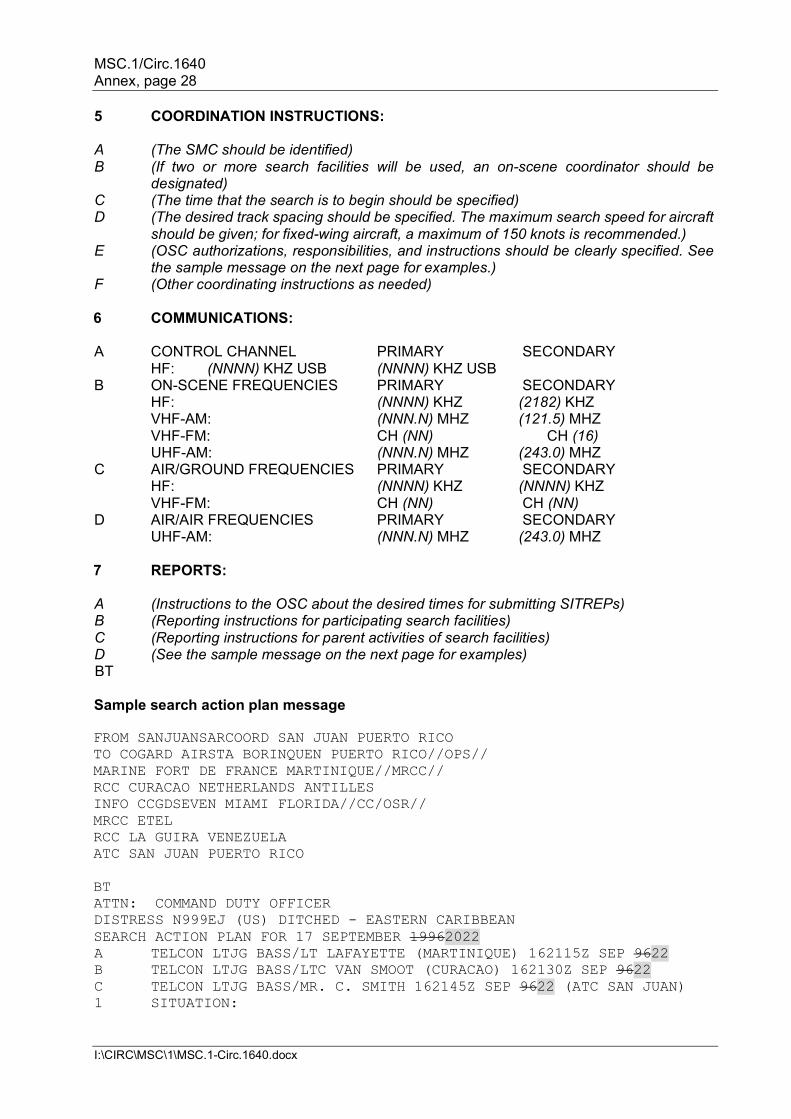
. . . Appendix L – Search planning and evaluation worksheets . . . Search action plan worksheet – Corner point method of pattern specification Search action plan message (Precedence and date/time group of the message) FROM (RCC or RSC responsible for the search) TO (All agencies/facilities tasked with conducting the search) INFO (Agencies concerned, but not participating, in the search) BT (Emergency Phase, i.e. DISTRESS, ALERT, UNCERTAINTY), (Identification of the search object, e.g. M/V NEVERSEEN) (Two-letter abbreviation for the flag of the search object, e.g. (PN)) (One or two word description of the SAR cause, e.g. UNREPORTED, SUNK, DITCHED, etc.), (General description of the search location, e.g. GULF OF OMAN, CABO SAN ANTONIO TO KEY WEST, etc.)
MSC.1/Circ.1640 Annex, page 27
I:\CIRC\MSC\1\MSC.1-Circ.1640.docx
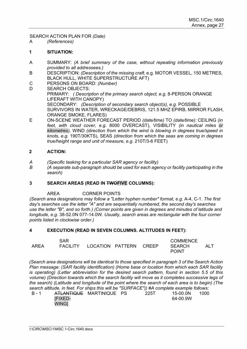
SEARCH ACTION PLAN FOR (Date) A (References) 1 SITUATION: A SUMMARY: (A brief summary of the case, without repeating information previously
provided to all addressees.) B DESCRIPTION: (Description of the missing craft, e.g. MOTOR VESSEL, 150 METRES,
BLACK HULL, WHITE SUPERSTRUCTURE AFT) C PERSONS ON BOARD: (Number) D SEARCH OBJECTS: PRIMARY: ( Description of the primary search object, e.g. 8-PERSON ORANGE
LIFERAFT WITH CANOPY) SECONDARY: (Description of secondary search object(s), e.g. POSSIBLE SURVIVORS IN WATER, WRECKAGE/DEBRIS, 121.5 MHZ EPIRB, MIRROR FLASH, ORANGE SMOKE, FLARES)
E ON-SCENE WEATHER FORECAST PERIOD (date/time) TO (date/time): CEILING (in feet, with cloud cover, e.g. 8000 OVERCAST), VISIBILITY (in nautical miles or kilometres), WIND (direction from which the wind is blowing in degrees true/speed in knots, e.g. 190T/30KTS), SEAS (direction from which the seas are coming in degrees true/height range and unit of measure, e.g. 210T/3-6 FEET)
2 ACTION: A (Specific tasking for a particular SAR agency or facility) B (A separate sub-paragraph should be used for each agency or facility participating in the
search) 3 SEARCH AREAS (READ IN TWOFIVE COLUMNS): AREA CORNER POINTS (Search area designations may follow a "Letter hyphen number" format, e.g. A-4, C-1. The first day's searches use the letter "A" and are sequentially numbered, the second day's searches use the letter "B", and so forth.) (Corner points are given in degrees and minutes of latitude and longitude, e.g. 38-52.0N 077-14.0W. Usually, search areas are rectangular with the four corner points listed in clockwise order.) 4 EXECUTION (READ IN SEVEN COLUMNS. ALTITUDES IN FEET): SAR COMMENCE AREA FACILITY LOCATION PATTERN CREEP SEARCH
POINT ALT
(Search area designations will be identical to those specified in paragraph 3 of the Search Action Plan message: (SAR facility identification) (Home base or location from which each SAR facility is operating) (Letter abbreviation for the desired search pattern, found in section 5.5 of this volume) (Direction towards which the search facility will move as it completes successive legs of the search) (Latitude and longitude of the point where the search of each area is to begin) (The search altitude, in feet. For ships this will be "SURFACE")) #A complete example follows: B - 1 ATLANTIQUE
[FIXED-WING]
MARTINIQUE PS 225T 15-00.0N 64-00.9W
1000
MSC.1/Circ.1640 Annex, page 28
I:\CIRC\MSC\1\MSC.1-Circ.1640.docx
5 COORDINATION INSTRUCTIONS: A (The SMC should be identified) B (If two or more search facilities will be used, an on-scene coordinator should be
designated) C (The time that the search is to begin should be specified) D (The desired track spacing should be specified. The maximum search speed for aircraft
should be given; for fixed-wing aircraft, a maximum of 150 knots is recommended.) E (OSC authorizations, responsibilities, and instructions should be clearly specified. See
the sample message on the next page for examples.) F (Other coordinating instructions as needed) 6 COMMUNICATIONS: A CONTROL CHANNEL PRIMARY SECONDARY HF: (NNNN) KHZ USB (NNNN) KHZ USB B ON-SCENE FREQUENCIES PRIMARY SECONDARY HF: (NNNN) KHZ (2182) KHZ VHF-AM: (NNN.N) MHZ (121.5) MHZ VHF-FM: CH (NN) CH (16) UHF-AM: (NNN.N) MHZ (243.0) MHZ C AIR/GROUND FREQUENCIES PRIMARY SECONDARY HF: (NNNN) KHZ (NNNN) KHZ VHF-FM: CH (NN) CH (NN) D AIR/AIR FREQUENCIES PRIMARY SECONDARY UHF-AM: (NNN.N) MHZ (243.0) MHZ 7 REPORTS: A (Instructions to the OSC about the desired times for submitting SITREPs) B (Reporting instructions for participating search facilities) C (Reporting instructions for parent activities of search facilities) D (See the sample message on the next page for examples) BT Sample search action plan message FROM SANJUANSARCOORD SAN JUAN PUERTO RICO TO COGARD AIRSTA BORINQUEN PUERTO RICO//OPS// MARINE FORT DE FRANCE MARTINIQUE//MRCC// RCC CURACAO NETHERLANDS ANTILLES INFO CCGDSEVEN MIAMI FLORIDA//CC/OSR// MRCC ETEL RCC LA GUIRA VENEZUELA ATC SAN JUAN PUERTO RICO BT ATTN: COMMAND DUTY OFFICER DISTRESS N999EJ (US) DITCHED - EASTERN CARIBBEAN SEARCH ACTION PLAN FOR 17 SEPTEMBER 19962022 A TELCON LTJG BASS/LT LAFAYETTE (MARTINIQUE) 162115Z SEP 9622 B TELCON LTJG BASS/LTC VAN SMOOT (CURACAO) 162130Z SEP 9622 C TELCON LTJG BASS/MR. C. SMITH 162145Z SEP 9622 (ATC SAN JUAN) 1 SITUATION:
MSC.1/Circ.1640 Annex, page 29
I:\CIRC\MSC\1\MSC.1-Circ.1640.docx
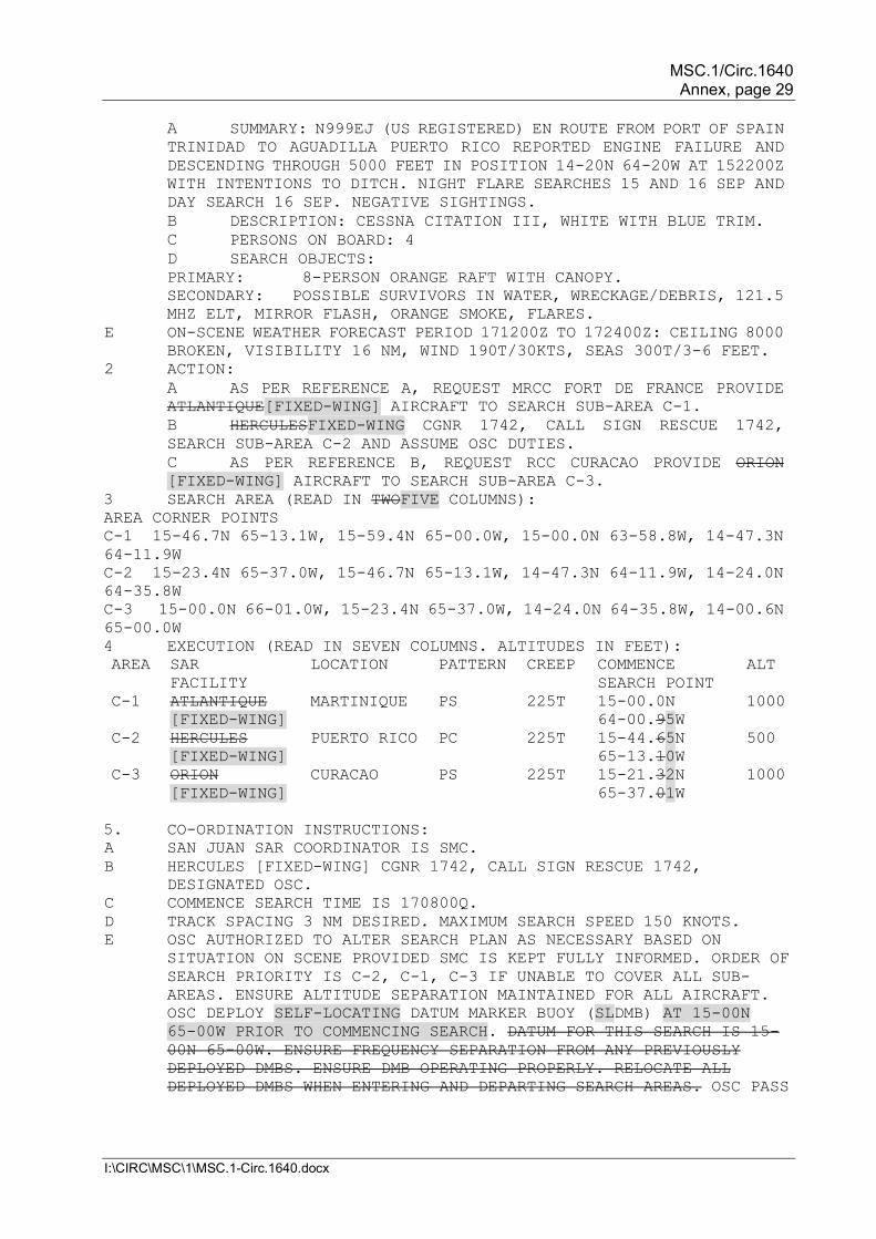
A SUMMARY: N999EJ (US REGISTERED) EN ROUTE FROM PORT OF SPAIN TRINIDAD TO AGUADILLA PUERTO RICO REPORTED ENGINE FAILURE AND DESCENDING THROUGH 5000 FEET IN POSITION 14-20N 64-20W AT 152200Z WITH INTENTIONS TO DITCH. NIGHT FLARE SEARCHES 15 AND 16 SEP AND DAY SEARCH 16 SEP. NEGATIVE SIGHTINGS. B DESCRIPTION: CESSNA CITATION III, WHITE WITH BLUE TRIM. C PERSONS ON BOARD: 4 D SEARCH OBJECTS: PRIMARY: 8-PERSON ORANGE RAFT WITH CANOPY. SECONDARY: POSSIBLE SURVIVORS IN WATER, WRECKAGE/DEBRIS, 121.5 MHZ ELT, MIRROR FLASH, ORANGE SMOKE, FLARES.
E ON-SCENE WEATHER FORECAST PERIOD 171200Z TO 172400Z: CEILING 8000 BROKEN, VISIBILITY 16 NM, WIND 190T/30KTS, SEAS 300T/3-6 FEET.
2 ACTION: A AS PER REFERENCE A, REQUEST MRCC FORT DE FRANCE PROVIDE ATLANTIQUE[FIXED-WING] AIRCRAFT TO SEARCH SUB-AREA C-1. B HERCULESFIXED-WING CGNR 1742, CALL SIGN RESCUE 1742, SEARCH SUB-AREA C-2 AND ASSUME OSC DUTIES. C AS PER REFERENCE B, REQUEST RCC CURACAO PROVIDE ORION [FIXED-WING] AIRCRAFT TO SEARCH SUB-AREA C-3.
3 SEARCH AREA (READ IN TWOFIVE COLUMNS): AREA CORNER POINTS C-1 15-46.7N 65-13.1W, 15-59.4N 65-00.0W, 15-00.0N 63-58.8W, 14-47.3N 64-11.9W C-2 15-23.4N 65-37.0W, 15-46.7N 65-13.1W, 14-47.3N 64-11.9W, 14-24.0N 64-35.8W C-3 15-00.0N 66-01.0W, 15-23.4N 65-37.0W, 14-24.0N 64-35.8W, 14-00.6N 65-00.0W 4 EXECUTION (READ IN SEVEN COLUMNS. ALTITUDES IN FEET): AREA SAR
FACILITY LOCATION PATTERN CREEP COMMENCE
SEARCH POINT ALT
C-1 ATLANTIQUE [FIXED-WING]
MARTINIQUE PS 225T 15-00.0N 64-00.95W
1000
C-2 HERCULES [FIXED-WING]
PUERTO RICO PC 225T 15-44.65N 65-13.10W
500
C-3 ORION [FIXED-WING]
CURACAO PS 225T 15-21.32N 65-37.01W
1000
5. CO-ORDINATION INSTRUCTIONS: A SAN JUAN SAR COORDINATOR IS SMC. B HERCULES [FIXED-WING] CGNR 1742, CALL SIGN RESCUE 1742,
DESIGNATED OSC. C COMMENCE SEARCH TIME IS 170800Q. D TRACK SPACING 3 NM DESIRED. MAXIMUM SEARCH SPEED 150 KNOTS. E OSC AUTHORIZED TO ALTER SEARCH PLAN AS NECESSARY BASED ON
SITUATION ON SCENE PROVIDED SMC IS KEPT FULLY INFORMED. ORDER OF SEARCH PRIORITY IS C-2, C-1, C-3 IF UNABLE TO COVER ALL SUB-AREAS. ENSURE ALTITUDE SEPARATION MAINTAINED FOR ALL AIRCRAFT. OSC DEPLOY SELF-LOCATING DATUM MARKER BUOY (SLDMB) AT 15-00N 65-00W PRIOR TO COMMENCING SEARCH. DATUM FOR THIS SEARCH IS 15-00N 65-00W. ENSURE FREQUENCY SEPARATION FROM ANY PREVIOUSLY DEPLOYED DMBS. ENSURE DMB OPERATING PROPERLY. RELOCATE ALL DEPLOYED DMBS WHEN ENTERING AND DEPARTING SEARCH AREAS. OSC PASS
MSC.1/Circ.1640 Annex, page 30
I:\CIRC\MSC\1\MSC.1-Circ.1640.docx
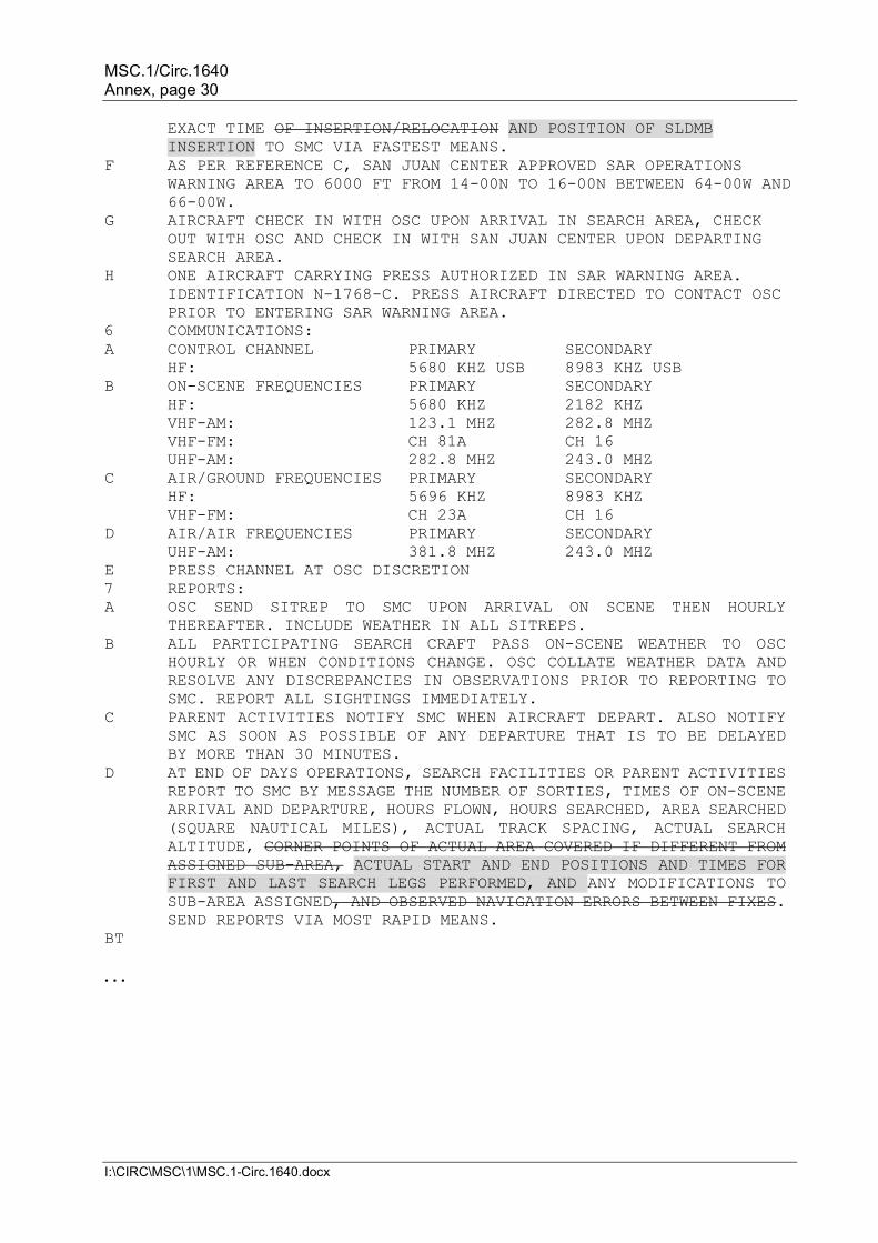
EXACT TIME OF INSERTION/RELOCATION AND POSITION OF SLDMB INSERTION TO SMC VIA FASTEST MEANS.
F AS PER REFERENCE C, SAN JUAN CENTER APPROVED SAR OPERATIONS WARNING AREA TO 6000 FT FROM 14-00N TO 16-00N BETWEEN 64-00W AND 66-00W.
G AIRCRAFT CHECK IN WITH OSC UPON ARRIVAL IN SEARCH AREA, CHECK OUT WITH OSC AND CHECK IN WITH SAN JUAN CENTER UPON DEPARTING SEARCH AREA.
H ONE AIRCRAFT CARRYING PRESS AUTHORIZED IN SAR WARNING AREA. IDENTIFICATION N-1768-C. PRESS AIRCRAFT DIRECTED TO CONTACT OSC PRIOR TO ENTERING SAR WARNING AREA.
6 COMMUNICATIONS: A CONTROL CHANNEL PRIMARY SECONDARY
HF: 5680 KHZ USB 8983 KHZ USB B ON-SCENE FREQUENCIES PRIMARY SECONDARY
HF: 5680 KHZ 2182 KHZ VHF-AM: 123.1 MHZ 282.8 MHZ VHF-FM: CH 81A CH 16 UHF-AM: 282.8 MHZ 243.0 MHZ
C AIR/GROUND FREQUENCIES PRIMARY SECONDARY HF: 5696 KHZ 8983 KHZ VHF-FM: CH 23A CH 16
D AIR/AIR FREQUENCIES PRIMARY SECONDARY UHF-AM: 381.8 MHZ 243.0 MHZ E PRESS CHANNEL AT OSC DISCRETION 7 REPORTS: A OSC SEND SITREP TO SMC UPON ARRIVAL ON SCENE THEN HOURLY
THEREAFTER. INCLUDE WEATHER IN ALL SITREPS. B ALL PARTICIPATING SEARCH CRAFT PASS ON-SCENE WEATHER TO OSC
HOURLY OR WHEN CONDITIONS CHANGE. OSC COLLATE WEATHER DATA AND RESOLVE ANY DISCREPANCIES IN OBSERVATIONS PRIOR TO REPORTING TO SMC. REPORT ALL SIGHTINGS IMMEDIATELY.
C PARENT ACTIVITIES NOTIFY SMC WHEN AIRCRAFT DEPART. ALSO NOTIFY SMC AS SOON AS POSSIBLE OF ANY DEPARTURE THAT IS TO BE DELAYED BY MORE THAN 30 MINUTES.
D AT END OF DAYS OPERATIONS, SEARCH FACILITIES OR PARENT ACTIVITIES REPORT TO SMC BY MESSAGE THE NUMBER OF SORTIES, TIMES OF ON-SCENE ARRIVAL AND DEPARTURE, HOURS FLOWN, HOURS SEARCHED, AREA SEARCHED (SQUARE NAUTICAL MILES), ACTUAL TRACK SPACING, ACTUAL SEARCH ALTITUDE, CORNER POINTS OF ACTUAL AREA COVERED IF DIFFERENT FROM ASSIGNED SUB-AREA, ACTUAL START AND END POSITIONS AND TIMES FOR FIRST AND LAST SEARCH LEGS PERFORMED, AND ANY MODIFICATIONS TO SUB-AREA ASSIGNED, AND OBSERVED NAVIGATION ERRORS BETWEEN FIXES. SEND REPORTS VIA MOST RAPID MEANS.
BT . . .
MSC.1/Circ.1640 Annex, page 31
I:\CIRC\MSC\1\MSC.1-Circ.1640.docx
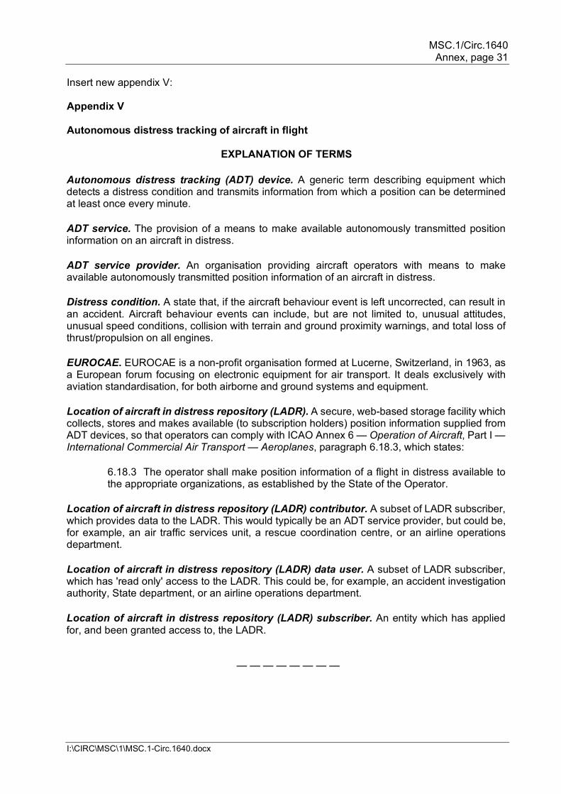
Insert new appendix V: Appendix V Autonomous distress tracking of aircraft in flight
EXPLANATION OF TERMS
Autonomous distress tracking (ADT) device. A generic term describing equipment which detects a distress condition and transmits information from which a position can be determined at least once every minute. ADT service. The provision of a means to make available autonomously transmitted position information on an aircraft in distress. ADT service provider. An organisation providing aircraft operators with means to make available autonomously transmitted position information of an aircraft in distress. Distress condition. A state that, if the aircraft behaviour event is left uncorrected, can result in an accident. Aircraft behaviour events can include, but are not limited to, unusual attitudes, unusual speed conditions, collision with terrain and ground proximity warnings, and total loss of thrust/propulsion on all engines. EUROCAE. EUROCAE is a non-profit organisation formed at Lucerne, Switzerland, in 1963, as a European forum focusing on electronic equipment for air transport. It deals exclusively with aviation standardisation, for both airborne and ground systems and equipment. Location of aircraft in distress repository (LADR). A secure, web-based storage facility which collects, stores and makes available (to subscription holders) position information supplied from ADT devices, so that operators can comply with ICAO Annex 6 — Operation of Aircraft, Part I — International Commercial Air Transport — Aeroplanes, paragraph 6.18.3, which states:
6.18.3 The operator shall make position information of a flight in distress available to the appropriate organizations, as established by the State of the Operator.
Location of aircraft in distress repository (LADR) contributor. A subset of LADR subscriber, which provides data to the LADR. This would typically be an ADT service provider, but could be, for example, an air traffic services unit, a rescue coordination centre, or an airline operations department. Location of aircraft in distress repository (LADR) data user. A subset of LADR subscriber, which has 'read only' access to the LADR. This could be, for example, an accident investigation authority, State department, or an airline operations department. Location of aircraft in distress repository (LADR) subscriber. An entity which has applied for, and been granted access to, the LADR.
— — — — — — — —
MSC.1/Circ.1640 Annex, page 32
I:\CIRC\MSC\1\MSC.1-Circ.1640.docx
ABBREVIATIONS ACC. Area control centre. ADT. Autonomous distress tracking. ANSP. Air navigation services provider (the company or organization providing ATS, not the individual ATS unit). ATS. Air traffic services. ATSU. Air traffic services unit. An overarching term covering different types of ATS unit, including area control centres, approach control units, and aerodrome towers. ELT. Emergency locator transmitter. May be suffixed: (AD) – automatic deployable; (AF) – automatic fixed; (AP) – automatic portable; (DT) – distress tracking; or (S) – survival. GADSS. Global aeronautical distress and safety system. GNSS. Global navigation satellite system. LADR. Location of an aircraft in distress repository. OPS CTRL. ICAO OPS Control directory. PFLR. Post-flight localization and recovery. RCC. Rescue coordination centre. SARPs. Standards and recommended practices.
— — — — — — — — INTRODUCTION 1 The Global Aeronautical Distress and Safety System (GADSS) was established to mitigate challenges in the global air navigation system, regarding the timely identification and localization of aircraft in distress, such as occurred with the accidents of Air France flight AF447 and Malaysia Airlines flight MH370. 2 GADSS provides an effective and globally consistent approach to enhancing the alerting procedures of search and rescue services by addressing a number of key improvement areas. 3 In order to achieve these improvements, GADSS contains three main elements:
a. aircraft tracking; b. location of an aircraft in distress (achieved through autonomous distress
tracking (ADT) of aircraft in flight); and c. post-flight localization and recovery (PFLR).
MSC.1/Circ.1640 Annex, page 33
I:\CIRC\MSC\1\MSC.1-Circ.1640.docx
4 Utilizing these elements, GADSS ensures an up-to-date record of aircraft progress is maintained and, in case of a crash, forced landing or ditching, ensures information on the location of survivors, the aircraft and recoverable flight data is available. 5 For GADSS to function as intended, flight crew and aircraft operators, air traffic controllers and air navigation services providers (ANSPs), ADT service providers, and rescue coordination centres (RCCs) need to understand each other's roles, responsibilities and processes to ensure effective communication, robust coordination and harmonized implementation across the globe. 6 This document, however, provides guidance to these entities specifically on the implementation of 3 b) – the location of an aircraft in distress – aspect of GADSS, in order to assist with the development of each entity's procedures, so as to be compliant with the ICAO standards concerned. 7 The Standard defining location of an aircraft in distress1 requires that, as of 1 January 2023, aircraft issued with a certificate of airworthiness for the first time, with a maximum certificated take off mass of over 27 000 kg, "shall autonomously transmit information from which a position can be determined by the operator at least once every minute, when in distress." The ICAO provisions also recommend that this requirement be applied to aircraft with a maximum certificated take off mass of over 5 700 kg. 8 An aircraft is in a distress condition when it is in a state that, if the aircraft behaviour event is left uncorrected, can result in an accident. EUROCAE document ED-237 Minimum Aviation System Performance Specification for Criteria to detect In-Flight Aircraft Distress Events to trigger Transmission of Flight Information sets out criteria to measure such behaviour events and determine when activation of ADT devices is required. 9 The key entities involved in implementation of the location of aircraft in distress are:
a. aircraft operators (airline companies and aircraft owners; not the flight crew); b. ADT service providers; c. ANSPs; and d. RCCs.
AUTONOMOUS DISTRESS TRACKING 10 Several significant functional requirements are necessary to permit the effective implementation of autonomous distress tracking of aircraft in flight, including:
a. detection of a distress condition; b. autonomous transmission of information from which a position can be
determined, including a time stamp. This could take the form of, inter alia, transmitted GNSS coordinates, or a radio signal which can be triangulated. The
1 Annex 6 — Operation of Aircraft, Part I — International Commercial Air Transport — Aeroplanes paragraph 6.18
refers.
MSC.1/Circ.1640 Annex, page 34
I:\CIRC\MSC\1\MSC.1-Circ.1640.docx
system used for this transmission shall be capable of transmitting the information in the event of aircraft electrical power loss, at least for the expected duration of the entire flight;
c. a means for the aircraft operator to receive such transmitted position
information; d. validation by the aircraft operator of the distress condition (i.e. it is valid and not
the result of a faulty ADT device or some other reason) to avoid unnecessary burdens to SAR services; and
e. a means for the aircraft operator to make the position information of a flight in
distress available to the appropriate organizations, as established by the State of the Operator.
11 A simplified schematic timeline for an emergency situation is shown at figure 1 to illustrate the sequence of events occurring when an ADT device is activated. 12 The initial autonomous transmission by the aircraft should commence no later than five seconds after the detection of the activation event. Pilots may also manually activate an ADT device. 13 An ADT device can only be deactivated by the same mechanism that activated it (i.e. when an ADT device is manually activated, only the flight crew can manually deactivate it; when an ADT device is automatically activated, it can only be automatically deactivated). 14 Activation of an ADT device does not constitute an emergency requiring SAR services to be alerted. Such activation, which may result from a situation recoverable by the flight crew, is instead deemed a notification. The validation of the activation is further described below in paragraph 22. 15 The ICAO Standards and Recommended Practices (SARPs) related to ADT devices are not technology-specific; aircraft operators may select the device most suited to their operations. Whilst multiple systems which meet the requirements of the SARPs are available, RCCs should note that there exists one system which behaves differently from the others in one significant aspect. Utilizing their existing data distribution network, as well as the LADR process described herein, Cospas-Sarsat has developed a system which will deliver ADT notifications to RCCs via both LADR and SIT185 messages. This system is described in Attachment A.
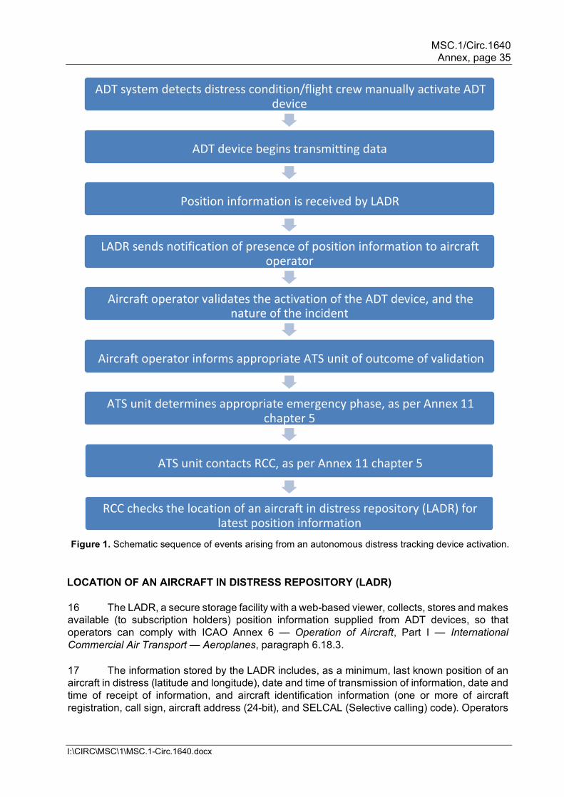
MSC.1/Circ.1640 Annex, page 35
I:\CIRC\MSC\1\MSC.1-Circ.1640.docx
Figure 1. Schematic sequence of events arising from an autonomous distress tracking device activation.
LOCATION OF AN AIRCRAFT IN DISTRESS REPOSITORY (LADR) 16 The LADR, a secure storage facility with a web-based viewer, collects, stores and makes available (to subscription holders) position information supplied from ADT devices, so that operators can comply with ICAO Annex 6 — Operation of Aircraft, Part I — International Commercial Air Transport — Aeroplanes, paragraph 6.18.3. 17 The information stored by the LADR includes, as a minimum, last known position of an aircraft in distress (latitude and longitude), date and time of transmission of information, date and time of receipt of information, and aircraft identification information (one or more of aircraft registration, call sign, aircraft address (24-bit), and SELCAL (Selective calling) code). Operators
ADT system detects distress condition/flight crew manually activate ADT device
ADT device begins transmitting data
Position information is received by LADR
LADR sends notification of presence of position information to aircraft operator
Aircraft operator validates the activation of the ADT device, and the nature of the incident
Aircraft operator informs appropriate ATS unit of outcome of validation
ATS unit determines appropriate emergency phase, as per Annex 11 chapter 5
ATS unit contacts RCC, as per Annex 11 chapter 5
RCC checks the location of an aircraft in distress repository (LADR) for latest position information
MSC.1/Circ.1640 Annex, page 36
I:\CIRC\MSC\1\MSC.1-Circ.1640.docx
may also submit other information, inter alia, level (recommended to be included), accuracy of position data, heading, and airspeed.2 The availability of this information in the LADR will fulfil the requirement of paragraphs 10 c) and e), thereby enhancing SAR and recovery capabilities. 18 ICAO will act as the LADR Administrator, and ensure only appropriate entities, such as ADT service providers, RCCs, area control centres (ACCs), or aircraft operators concerned, can gain access to, or deposit data in, the LADR. RCCs will be granted access to all data. ACCs will be granted access to data related to locations within their FIR, and the surrounding 80 nautical miles (to allow them to be informed on events close to, or about to enter, their FIR, which could have an impact on their operations, and to allow for the possibility that position inaccuracy might show the aircraft in an adjacent FIR.) Aircraft operators will be granted access only to data related to their own aircraft, based on the ICAO issued 3-letter designator for the air operator certificate holder. ACCs and RCCs could also be granted the opportunity to provide limited data, in order to update the LADR with supplementary information relevant to SAR services.
19 Appropriate entities will be able to request a free subscription to the LADR through the ICAO OPS Control Directory (OPS CTRL), which can be accessed at: www.icao.int/safety/globaltracking. Both systems will use the ICAO Data Network for Aviation (DNA) for authentication and single sign-in. 20 LADR subscribers can elect to receive a notification whenever new ADT information relevant to them arrives in the LADR. LADR subscribers will then need to look in the LADR to access the ADT data. LADR data users will have read-only access to available information according to their profile. 21 Subscribing to the LADR is voluntary for all entities other than aircraft operators, who will need to subscribe in order to "ensure that the location of an aircraft in distress repository (LADR) is automatically updated with autonomous distress tracking (ADT) data from an aircraft in a distress condition" (Doc 8168, Procedures for Air Navigation Services — Aircraft Operations, Volume III – Aircraft Operating Procedures, section 10, chapter 2). However, RCCs are strongly encouraged to subscribe in order to have access to up to date and accurate position information of aircraft potentially in distress. AIRCRAFT OPERATOR 22 Upon receipt of notification of an ADT device activation, the aircraft operator is responsible for validating the cause of the activation. There are three possible outcomes from this activity:
a. aircraft operator finds the activation to be invalid, or no longer valid, i.e. confirms there was a 'false alarm', or that the flight crew has recovered the aircraft from the distress condition;
b. aircraft operator finds the activation to be valid, i.e. confirms the aircraft is in
distress; or c. aircraft operator is uncertain whether the activation is valid or invalid (for
example, is unable to contact the flight crew), in which case a valid activation must be assumed.
2 The full list of mandatory and optional data elements is published in the LADR Functional Specification, and can be accessed at https://www.icao.int/safety/globaltracking/Documents.
MSC.1/Circ.1640 Annex, page 37
I:\CIRC\MSC\1\MSC.1-Circ.1640.docx
23 Several means of validation of an activation can be utilized, including but not limited to voice communications with the flight crew, data link communications, and observation of flight tracking data. 24 As per the responsibilities outlined in ICAO Annex 6 — Operation of Aircraft, Part I — International Commercial Air Transport — Aeroplanes, Appendix 9, the aircraft operator will inform the appropriate area control centre if there is reason to believe that the aircraft is in distress. This could be due to a confirmation of the validity of the activation, or inability to contact the crew to validate the nature of the activation. Contact details for area control centres can be obtained from the ICAO OPS Control Directory (OPS CTRL), which can be accessed at: www.icao.int/safety/globaltracking. Access to data is governed by user profiles, in line with those for the LADR. AREA CONTROL CENTRE 25 The appropriate area control centre will record all information relevant to the state of emergency of the aircraft, including the outcome of actions taken under paragraph 22, and forward such information to the appropriate RCC in accordance with the uncertainty, alert and distress phases, as per ICAO Annex 11 — Air Traffic Services, chapter 5, paragraph 5.2. 26 It is possible that the appropriate ACC and/or RCC will already be aware of a distress condition by means other than the LADR (via a MAYDAY transmission for instance), and appropriate action may already have commenced. OTHER POINTS TO NOTE 27 ICAO Annex 6 — Operation of Aircraft, Part I — International Commercial Air Transport — Aeroplanes was amended to allow an ADT device to replace the automatic ELT. Consequently, after 1 January 2023, some aircraft may no longer automatically transmit a 121.5 MHz homing signal. An ADT device is not required to have a homing transmitter. 28 The ICAO SARPs apply only to aircraft for which an individual certificate of airworthiness is first issued on or after 1 January 2023. However, operators have the option to retrofit older aircraft, thereby avoiding the need to equip with an automatic ELT.
— — — — — — — —
Attachment A
UTILIZING ELT(DT) TO LOCATE AIRCRAFT IN DISTRESS
1 The International Cospas-Sarsat Programme is a satellite-aided search and rescue initiative organized as a treaty-based, non-profit, intergovernmental, humanitarian cooperative of 45 States and agencies. Conceived and initiated by Canada, France, the United States, and the former Soviet Union in 1979, it is dedicated to detecting and locating radio beacons activated by persons, aircraft or vessels in distress, and forwarding this alert information to authorities that can take action for rescue. 2 The Cospas-Sarsat system utilizes a network of satellites that provides global coverage. Distress alerts are detected, located and forwarded to over 200 countries and territories at no cost to beacon owners or the receiving government agencies. Since the first rescue using
MSC.1/Circ.1640 Annex, page 38
I:\CIRC\MSC\1\MSC.1-Circ.1640.docx
Cospas-Sarsat technology in September 1982, the Cospas-Sarsat System has provided assistance in rescuing more than 50,000 persons in more than 15,000 SAR events. 3 Specifications for the Distress Tracking ELT (ELT(DT)) have been developed by the International Cospas-Sarsat Programme. These specifications allow aircraft operators to comply with the ICAO provisions by utilizing either manual activation of the ELT(DT) by flight crew, or automatic activation of the ELT(DT) when a distress condition is detected. 4 Notification of the activation of the ELT(DT) and other associated information will be automatically transmitted via the Cospas-Sarsat Space and Ground Segments directly to relevant RCCs, and automatically sent to the LADR. This dual delivery differs from other ADT systems, and may result in RCCs being notified of the same event by multiple means. 5 As well as the standard information transmitted in any ELT alert, Cospas-Sarsat will include in the ELT(DT) message sent to RCCs and the LADR the three letter designator for the aircraft operating agency, aircraft position and level, and whether the device was triggered manually or automatically, in compliance with the specifications of the LADR. The age of the latest position report received will also be provided; e.g. "position 23-34.44N 070-33.55W is less than 1 minute old".3 6 ELT(DT)s operate using aircraft power, with an independent back-up power supply in case of aircraft electrical failure. The specified duration of autonomous operation of ELT(DT) is a minimum of 370 minutes while using an independent power supply, and it will transmit a message with encoded location information at the following intervals:
a. every 5 seconds for the first 2 minutes following activation; b. every 10 seconds after 2 minutes until 5 minutes following activation; and c. every 30 seconds after 5 minutes following activation.
7 An ELT(DT) may also include the following capabilities:
a. for an ELT(DT) that is crash survivable, sufficient battery life to provide 24 hours of 406 MHz message transmissions, and 48 hours of 121.5 MHz direction-finding signal transmissions; or b. for an ELT(DT) combined with the function of an ELT(AF) (automatic fixed), an ELT(AP) (automatic portable), or an ELT(AD) (automatic deployable), sufficient battery life to provide 24 hours plus 370 minutes of 406 MHz message transmissions, and 48 hours of 121.5 MHz direction-finding signal transmissions.
3 Cospas-Sarsat Document C/S A.002, "Cospas-Sarsat Mission Control Centres Standard Interface Description"
provides sample ELT(DT) alert and cancellation messages.
MSC.1/Circ.1640 Annex, page 39
I:\CIRC\MSC\1\MSC.1-Circ.1640.docx
AMENDMENTS TO IAMSAR MANUAL, VOLUME III . . .
Contents . . .
Appendix F Own emergency Appendix G Rendering assistance Appendix HF Multiple aircraft SAR operations Change "appendix H" to "appendix F" on pages 8-15, 10-2, 10-3 and 11-4 . . .
Abbreviations and acronyms . . .
EGC enhanced group call . . .
Glossary . . .
Enhanced Group Call (EGC) International broadcast of coordinated maritime safety information and search and rescue related information, to a defined geographical area using a recognized mobile satellite service.
. . .
Iridium A system of 66 polar orbiting cross-linked satellites for worldwide mobile communications services and which support the Global Maritime Distress and Safety System and other safety services.
. . .
SafetyCast A service of the Iridium enhanced group call (EGC) system specifically designed for promulgation of maritime safety information (MSI) and SAR related information as a part of the Global Maritime Distress and Safety System (GMDSS).
SafetyNET A service of the Inmarsat enhanced group call (EGC) system
specifically designed for promulgation of maritime safety information (MSI) and SAR related information as a part of the Global Maritime Distress and Safety System (GMDSS).
. . .
Search and rescue facility Any mobile resource, including designated search and rescue units, used to conduct search and rescue operations.
. . .
MSC.1/Circ.1640 Annex, page 40
I:\CIRC\MSC\1\MSC.1-Circ.1640.docx
Section 2 – Distress alerts and messages Page 2-2 EPIRBs, ELTs and PLBs
• EPIRB: an EPIRB transmits a signal that alerts SAR authorities and allows rescue facilities to home in on the distressed vessel. It is activated automatically upon exposure to the sea, or manually. 406 MHz EPIRBs use Cospas–Sarsat satellites and are required on board certain vessels. EPIRBs installed on or after 1 July 2022 will need to be provided with an Automatic Identification System (AIS) locating signal.
Page 2-4 Distress alert from a vessel • Use any of the Global Maritime Distress and Safety System (GMDSS) equipment to transmit
a distress alert: Inmarsat dDistress call from a ship earth station using an IMO recognized mobile
satellite service . . .
Section 3 – Medical assistance Amend page 3-2, sub-section "MEDICO", sixth bullet point, first line: • Vessels fitted with broadband services, Fleet Broadband (F77) and VSAT (very small
aperture terminal) will permit the easy transfer of photographs and videos. . . .
Amend page 3-3, top paragraph: • When medical assistance is required, information as indicated below should be sent to the
RCC. Other information may be necessary in certain cases. (Action card 'MEDICO-MEDEVAC' applies.)
. . .
Amend page 3-4, sub-section "Evacuation by helicopter", first bullet point: • When arranging for the evacuation of a patient by helicopter, the following points should be
considered. Additional guidance is in section 16 Vessel/helicopter operations and in action card 'MEDEVAC by helicopter'.
. . .
Section 4 – Vessel emergencies at sea Amend page 4-1 by inserting new bullet point after "Man overboard" at the top: • Specific situations are discussed below and general guidance is provided in action card 'MOB
Man overboard'. (Move action card 'MOB Man overboard' to appear after the "MEDICO-MEDEVAC" action card.)

MSC.1/Circ.1640 Annex, page 41
I:\CIRC\MSC\1\MSC.1-Circ.1640.docx
. . .
Section 8 – On-scene communications . . .
Amend page 8-i: RCC communications…………………………………..8-12 Maritime safety and SAR-related information……...8-12 . . .
Amend page 8-3, frequency in upper left corner of table
DSC distress and safety calling
Radiotelephony distress and safety traffic
NBDP distress and safety traffic
2,187.5 kHz 2,182.0 kHz 2,174.5 kHz 4,0207.5 kHz 4,125.0 kHz 4,177.5 kHz 6.312.0 kHz 6,215.0 kHz 6,268.0 kHz . . . . . . . . .
. . .
Amend pages 8-12 and 8-13, sub-section "Maritime safety information": Maritime safety and SAR-related information • NAVTEX is used to promulgate initial distress and urgency alerts and navigation and safety
meteorological warnings and other safety-related information to vessels and may be used by SAR services and for SAR purposes.
• Long-range NAVAREA warnings and coastal NAVTEX warnings are promulgated over
internationally and nationally coordinated World-wide Navigational Warning Service (WWNWS). WWNWS provides for globally coordinated transmissions through NAVAREA coordinators for each NAVAREA.
It provides for globally coordinated transmissions through NAVAREA coordinators for
each NAVAREA Warnings which SAR authority may send over WWNWS include:
– distress alerts
– information about overdue or missing aircraft or vessels
• Collectively, these types of alerts, combined with nNavigation and meteorological warnings, are called maritime safety information (MSI).
• SAR-related information which the SAR service may send over the same systems used by
the WWNWS include:
– distress alert relays; and
– information about overdue or missing aircraft or vessels.
MSC.1/Circ.1640 Annex, page 42
I:\CIRC\MSC\1\MSC.1-Circ.1640.docx
• International broadcast of coordinated MSI and SAR related information to a defined geographical area using a recognized mobile satellite service is via the Enhanced Group Call (EGC) service.
• EGC broadcast service is provided by Inmarsat is also used to broadcast MSI via SafetyNET;
and, by Iridium via SafetyCast. • SafetyNET provides an automatic, global method of broadcasting SAR messages to vessels
in both fixed and variable geographic areas. A similar service of Inmarsat called FleetNET can be used to send shore-to-ship messages to predetermined groups of vessels. SafetyCast of Iridium provides similar services.
RCCs normally send relay distress alerts relays over both NAVTEX, and SafetyNET
and SafetyCast.
Normally, SAR broadcasts over SafetyNET and SafetyCast are sent to all vessels within a desired radius of a specified position.
. . .
Amend page 8-14, the final sentence above the figure: A basic communications plan structure is shown below and in the action card 'Communications'. . . .
Section 9 – On-scene coordinator . . .
Page 9-4, above "SAR operational risks", insert new second and final bullet:
• Action card 'OSC' provides a summary of key points.
. . .
Section 12 – Searching . . .
Amend page 12-1, sub-section "Search action plan and message", third bullet point: • The search action plan message includes six seven parts. Situation
A brief description of the incident Position of the incident, and time that it occurred Number of persons on board (POBs) Primary and secondary search objects Amount and types of survival equipment Weather forecast and period of forecast SAR facilities on scene
Action
action requested of SAR facilities
MSC.1/Circ.1640 Annex, page 43
I:\CIRC\MSC\1\MSC.1-Circ.1640.docx
Search area(s) (presented in column format) . . .
Amend page 12-10, add new first bullet: Expanding square search (SS) • Action card provided. . . .
Amend page 12-11, sub-section 'Sector search', add new first bullet: Sector search (VS) • Action card provided. . . .
Amend page 12-14, sub-section 'Track line search', add new first bullet: Track line search (TS) • Action card provided. . . .
Amend page 12-15, sub-section 'Parallel track search', add new first bullet: Parallel track search (PS) • Action card provided. . . .
Amend page 12-11, add new bullet just above diagram of Expanding square search (SS): • It is difficult for fixed-wing aircraft to fly legs close to datum is S is less than 2 NM • A suitable marker (for example, a smoke float or a radio beacon) may be dropped at the
datum position and used as a reference or navigational aid marking the centre of the pattern. . . .
Action Cards . . .
Move action card 'MOB Man overboard' to appear after the "MEDICO-MEDEVAC" action card. . . .
Add four new action cards:
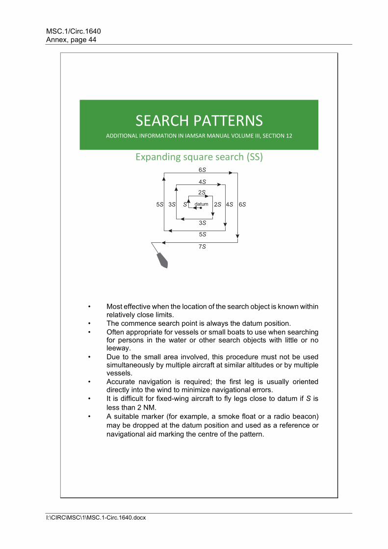
MSC.1/Circ.1640 Annex, page 44
I:\CIRC\MSC\1\MSC.1-Circ.1640.docx
SEARCH PATTERNS ADDITIONAL INFORMATION IN IAMSAR MANUAL VOLUME III, SECTION 12
Expanding square search (SS)
• Most effective when the location of the search object is known within relatively close limits.
• The commence search point is always the datum position. • Often appropriate for vessels or small boats to use when searching
for persons in the water or other search objects with little or no leeway.
• Due to the small area involved, this procedure must not be used simultaneously by multiple aircraft at similar altitudes or by multiple vessels.
• Accurate navigation is required; the first leg is usually oriented directly into the wind to minimize navigational errors.
• It is difficult for fixed-wing aircraft to fly legs close to datum if S is less than 2 NM.
• A suitable marker (for example, a smoke float or a radio beacon) may be dropped at the datum position and used as a reference or navigational aid marking the centre of the pattern.
4 S 2 S
5 S 3 S S datum 2 S 4 S 6 S
3 S 5 S
7 S
6 S
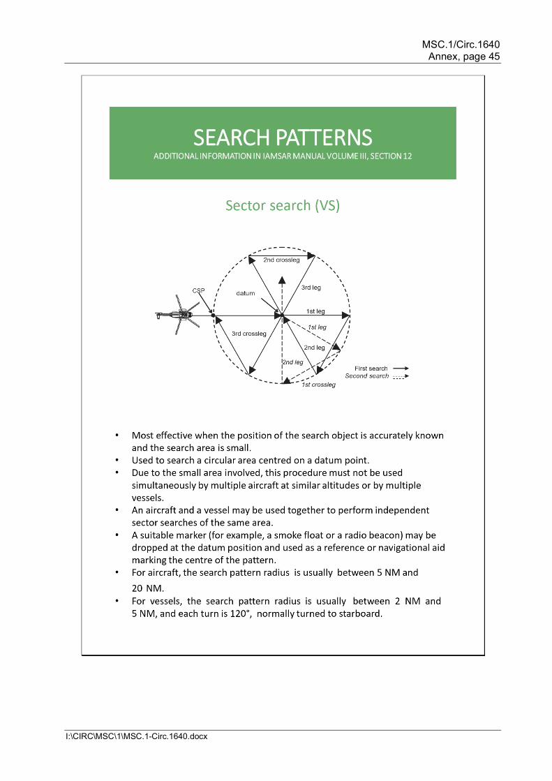
MSC.1/Circ.1640 Annex, page 45
I:\CIRC\MSC\1\MSC.1-Circ.1640.docx
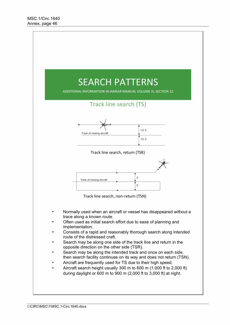
MSC.1/Circ.1640 Annex, page 46
I:\CIRC\MSC\1\MSC.1-Circ.1640.docx
SEARCH PATTERNS
ADDITIONAL INFORMATION IN IAMSAR MANUAL VOLUME III, SECTION 12
Track line search (TS)
Track line search, return (TSR)
Track line search, non-return (TSN)
• Normally used when an aircraft or vessel has disappeared without a trace along a known route.
• Often used as initial search effort due to ease of planning and implementation.
• Consists of a rapid and reasonably thorough search along intended route of the distressed craft.
• Search may be along one side of the track line and return in the opposite direction on the other side (TSR).
• Search may be along the intended track and once on each side, then search facility continues on its way and does not return (TSN).
• Aircraft are frequently used for TS due to their high speed. • Aircraft search height usually 300 m to 600 m (1,000 ft to 2,000 ft)
during daylight or 600 m to 900 m (2,000 ft to 3,000 ft) at night.
S
S Track of missing aircraft
1 /2 S Track of missing aircraft
1 /2 S
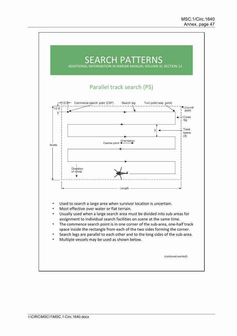
MSC.1/Circ.1640 Annex, page 47
I:\CIRC\MSC\1\MSC.1-Circ.1640.docx
SEARCH PATTERNS ADDITIONAL INFORMATION IN IAMSAR MANUAL VOLUME III, SECTION 12
Parallel track search ) ( PS
• Used to search a large area when survivor location is uncertain. • Most effective over water or flat terrain. • Usually used when a large search area must be divided into sub - areas for
assignment to individual search facilities on scene at the same time. • The commence search point is in one corner of the sub-area, one-half track
space inside the rectangle from each of the two sides forming the corner. • Search legs are parallel to each other and to the long sides of the sub-area. • Multiple vessels may be used as shown below.
( continued overleaf )
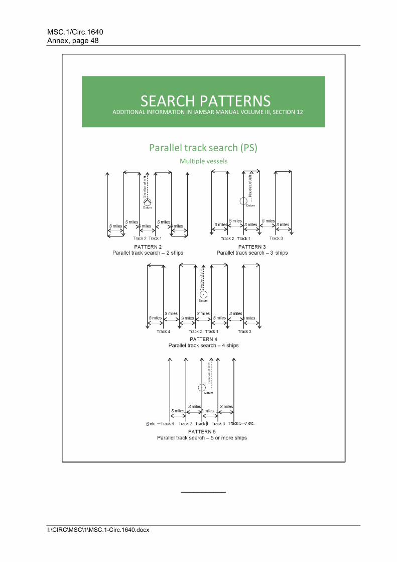
MSC.1/Circ.1640 Annex, page 48
I:\CIRC\MSC\1\MSC.1-Circ.1640.docx
___________
SEARCH PATTERNS ADDITIONAL INFORMATION IN IAMSAR MANUAL VOLUME III, SECTION 12
Parallel track search ( PS ) Multiple vessels