Effects of simulated elk grazing and trampling (II): Frequency
Upload
khangminh22Category
view
1download
0
ELK CREEK BRIDGE REPLACEMENT PROJECT
Initial Study with Proposed Mitigated Negative Declaration/Environmental Assessment
Mendocino County, California District 1- MEN-1-PM 31.5 01-0E110 / 01-1300-0125
July 2021
The environmental review, consultation, and any other actions required by applicable Federal environmental laws for this project are being, or have been, carried out by Caltrans pursuant to 23 USC 327 and the
Memorandum of Understanding dated December 23, 2016, and executed by the Federal Highway Administration (FHWA) and Caltrans.

This page left intentionally blank.

GENERAL INFORMATION ABOUT THIS DOCUMENT
What’s in this document:
The California Department of Transportation (Caltrans), as assigned by the Federal Highway Administration (FHWA), has prepared this Initial Study/Environmental Assessment, which examines the potential environmental impacts of alternatives being considered for the proposed project in Mendocino County, California. Caltrans is the lead agency under the National Environmental Policy Act (NEPA) and the California Environmental Quality Act (CEQA). The document explains why the project is being proposed, the alternatives being considered, the existing environment that could be affected, potential impacts of each of the alternatives, and proposed avoidance, minimization, and/or mitigation measures.
What you should do:
Please read this document.
The document is available for review on weekdays between 8:00 a.m. and 5:00 p.m. at the Caltrans District 1 office at 1656 Union Street, Eureka, CA, 95501. Due to COVID-19 concerns, please call (707) 441-5930 beforehand to make arrangements for document review under social distancing protocols.
This document may also be downloaded at the following website:
https://dot.ca.gov/caltrans-near-me/district-3/d3-programs/d3-environmental/d3-environmental-docs and click on the Mendocino County link.
Additional copies of the document are available for review at the Coast Community Library at 225 Main St, Point Arena, CA 95468 or the Fort Bragg Library, 499 East Laurel St, Fort Bragg, CA 95437.
Paper copies of this document are available upon request. Please contact Caltrans at (707) 441-5930 or by e-mail at [email protected].
Tell us what you think. If you have any comments regarding the proposed project, please attend the public meeting, and/or send your written comments to Caltrans by the deadline.
A virtual public meeting to provide additional information and answer the public’s questions about the project will be conducted on August 5, 2021, from 6:00-7:30 PM. To access the meeting please use the following link, meeting number, or phone number. Meeting Link: https://cadot.webex.com/cadot/j.php?MTID=m04c1251b3ec6e43f958833f655dc1465 Meeting Number (access code): 1466 58 5069, Meeting Password: Z6Xs5ZptsM3 To Join from a Mobile Device: 1-408-418-9388, 1466585069## To Join by Phone: 1-408-418-9388

To join from a video system or application: Dial [email protected] Or Dial 173.243.2.68 and enter the meeting number, above.
Submit comments via U.S. mail to:
Caltrans North Region Environmental-District 1 Attn: Stephen Umbertis 1656 Union Street Eureka, CA, 95501
Submit comments via email to: [email protected].
Submit comments by the deadline: August 20, 2021.
What happens next:
After comments are received from the public and reviewing agencies, Caltrans, as assigned by the Federal Highway Administration (FHWA), may: (1) give environmental approval to the proposed project, (2) do additional environmental studies, or (3) abandon the project. If the project is given environmental approval and funding is obtained, Caltrans could design and construct all or part of the project.
Alternative formats:
For individuals with sensory disabilities, this document can be made available in Braille, in large print, on audiocassette, or on computer disk. To obtain a copy in one of these alternate formats, please write to or call Caltrans, Attention: Stephen Umbertis, North Region Environmental – District 1, 1656 Union Street, Eureka, CA, 95501; phone number 707-441-5930 (Voice), or use the California Relay Service 1-800-735-2929 (TTY), 1-800-735-2929 (Voice), or 711.
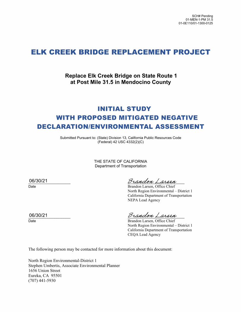
SCH# Pending 01-MEN-1-PM 31.5
01-0E110/01-1300-0125
ELK CREEK BRIDGE REPLACEMENT PROJECT
Replace Elk Creek Bridge on State Route 1 at Post Mile 31.5 in Mendocino County
INITIAL STUDY WITH PROPOSED MITIGATED NEGATIVE
DECLARATION/ENVIRONMENTAL ASSESSMENT
Submitted Pursuant to: (State) Division 13, California Public Resources Code (Federal) 42 USC 4332(2)(C)
THE STATE OF CALIFORNIA
Department of Transportation
________________________ Date Brandon Larsen, Office Chief North Region Environmental – District 1 California Department of Transportation NEPA Lead Agency ________________________ Date Brandon Larsen, Office Chief North Region Environmental – District 1 California Department of Transportation CEQA Lead Agency The following person may be contacted for more information about this document:
North Region Environmental-District 1 Stephen Umbertis, Associate Environmental Planner 1656 Union Street Eureka, CA 95501 (707) 441-5930
06/30/21
06/30/21

The following person may be contacted for more information about this document:
North Region Environmental-District 1 Stephen Umbertis, Associate Environmental Planner 1656 Union Street Eureka, CA 95501 (707) 441-5930
Elk Creek Bridge Replacement Project Initial Study with Proposed Mitigated Negative Declaration/Environmental Assessment
v

Proposed Mitigated Negative Declaration
Pursuant to: Division 13, California Public Resources Code
SCH Number: PENDING
Project Description
The California Department of Transportation (Caltrans) proposes to replace Elk Creek
agencies and the public that it is Caltrans’ intent to adopt a Mitigated Negative Declaration for this project. This does not mean that Caltrans’ decision on the project is final. This proposed Mitigated Negative Declaration is subject to change based on comments received from interested agencies and the public.
Caltrans has prepared an Initial Study for this project and, pending public review, expects to determine from this study that the proposed project would not have a significant effect on the environment based on the following:
•
Bridge on State Route (SR) 1 at post mile (PM) 31.5 in Mendocino County. The bridge and approach roadway have geometric and structural deficiencies that could result in interrupted traffic in the event of a collision or other catastrophic event, potentially reducing safety for all users. These deficiencies include narrow shoulder widths, outdated bridge railings, and raised concrete areas adjacent to the shoulders that are not compliant with the Americans with Disabilities Act (ADA). There is also scouring occurring around the north pier and abutment that threaten the integrity and stability of the bridge site.
This proposed Mitigated Negative Declaration is included to give notice to interested
The proposed project would have “No Effect” on Wild and Scenic Rivers, Parks and Recreational Facilities, Farmlands and Timberlands, Growth, Communities and Neighborhoods, Business and Housing Displacements, Utility Relocation, Environmental Justice, Geology and Soils, Energy, and Plant Species.
Elk Creek Bridge Replacement Project Initial Study with Proposed Mitigated Negative Declaration/Environmental Assessment

______________________________ _______________
• The proposed project would have “Less Than Significant Effects” to Land Use and Planning, the Coastal Zone, Relocations and Real Property Acquisition, Emergency Services, Traffic and Transportation, Aesthetics/Visual, Cultural Resources, Hydrology and Floodplain, Water Quality and Stormwater Runoff, Paleontological Resources, Hazardous Waste and Materials, Air Quality, Noise, Wetlands and Other Waters, Animal Species, Invasive Species, Cumulative Impacts, Wildfire, and Climate Change.
• The proposed project would have a “Less than Significant Effect with Mitigation Incorporated” to Threatened and Endangered Species, specifically Central California Coast Salmon Evolutionarily Significant Unit of coho salmon and North Coast Distinct Population Segment of Steelhead, with the implementation of the following mitigation measure:
o A root wad revetment would be constructed along 100-140 feet of the north bank of Elk Creek at the bridge site to mitigate for direct and indirect impacts to special status fish and their habitats resulting from the installation of the clear water diversions, fish relocation efforts, and construction operations required to replace the Elk Creek Bridge. The revetment would be built using bio-engineered Rock Slope Protection using large rock, backfilled with soil and planted with willows to fix 10-20 conifer root wads (redwood, Douglas- fir, or potentially cypress) to provide salmonid habitat and protect the north abutment of the bridge, similar to what is shown in Appendix E of this document. The final design of the bio-engineered revetment would be developed in conjunction with the California Department of Fish and Wildlife and approved by them as part of the project permitting process. The revetment would be installed at the site following installation of the new bridge and removal of the temporary bridge.
Brandon Larsen, Office Chief Date North Region Environmental-District 1 California Department of Transportation
Elk Creek Bridge Replacement Project Initial Study with Proposed Mitigated Negative Declaration/Environmental Assessment

Summary
NEPA Assignment
California participated in the “Surface Transportation Project Delivery Pilot Program” (Pilot Program), pursuant to 23 USC 327, for more than five years, beginning July 1, 2007, and ending September 30, 2012. MAP-21 (P.L. 112-141), signed by President Obama on July 6, 2012, amended 23 USC 327 to establish a permanent Surface Transportation Project Delivery Program. As a result, Caltrans entered into a Memorandum of Understanding pursuant to 23 USC 327 (NEPA Assignment MOU) with FHWA. The NEPA Assignment MOU became effective October 1, 2012, and was renewed on December 23, 2016, for a term of five years. In summary, Caltrans continues to assume FHWA responsibilities under NEPA and other federal environmental laws in the same manner as was assigned under the Pilot Program, with minor changes. With NEPA Assignment, FHWA assigned and Caltrans assumed all the United States Department of Transportation (USDOT) Secretary's responsibilities under NEPA. This assignment includes projects on the State Highway System and Local Assistance projects off the State Highway System within the State of California, except for certain categorical exclusions that FHWA assigned to Caltrans under the 23 USC 326 CE Assignment MOU, projects excluded by definition, and specific project exclusions.
The proposed project is a joint project by the California Department of Transportation (Caltrans) and the Federal Highway Administration (FHWA) and is subject to state and federal environmental review requirements. Project documentation, therefore, has been prepared in compliance with both the California Environmental Quality Act (CEQA) and the National Environmental Policy Act (NEPA). Caltrans is the lead agency under NEPA. Caltrans is the lead agency under CEQA. In addition, FHWA’s responsibility for environmental review, consultation, and any other actions required by applicable Federal environmental laws for this project are being, or have been, carried out by Caltrans pursuant to 23 United States Code Section 327 (23 USC 327) and the Memorandum of Understanding dated December 23, 2016, and executed by FHWA and Caltrans.
Some impacts determined to be significant under CEQA may not lead to a determination of significance under NEPA. Because NEPA is concerned with the significance of the project as a whole, often a “lower level” document is prepared for NEPA. One of the most common joint document types is an Environmental Impact Report/Environmental Assessment (EIR/EA).
Elk Creek Bridge Replacement Project Initial Study with Proposed Mitigated Negative Declaration / Environmental Assessment
i

Summary
After receiving comments from the public and reviewing agencies, a Final IS/MND/EA will be prepared. Caltrans may prepare additional environmental and/or engineering studies to address comments. The Final IS/MND/EA will include responses to comments received on the Draft IS/MND/EA and will identify the preferred alternative. If the decision is made to approve the project, a Notice of Determination will be published for compliance with CEQA, and Caltrans will decide whether to issue a Finding of No Significant Impact (FONSI) or require an Environmental Impact Statement (EIS) for compliance with NEPA. To comply with Executive Order 12372, a Notice of Availability (NOA) of the FONSI will be sent to the affected units of federal, state, and local government, and to the State Clearinghouse.
Proposed Project
Caltrans is proposing to replace Elk Creek Bridge (State Bridge Inventory Number 10-0120) on State Route (SR) 1 at post mile (PM) 31.5 in Mendocino County. The project is south of the unincorporated community of Elk in Mendocino County. The area surrounding the bridge is hilly with scattered vegetation and grazing land. The existing Elk Creek Bridge is a 122-foot-long structure with two 11-foot lanes and 2-foot shoulders. The bridge was constructed in 1938 and is a continuous three-span, cast-in-place reinforced concrete bridge.
The proposed project would improve the function and geometrics of the Elk Creek Bridge and approach roadway to ensure uninterrupted traffic movement in the event of a collision or emergency incident, seismic event, or other catastrophic failure, and provide safe access for pedestrians and bicyclists across the bridge. The design of the proposed project would improve traffic flow with upgrades to the bridge approach by widening the shoulders and decreasing the curve radius, thus improving safety and reducing the potential for accidents and collisions on the bridge. It would also improve pedestrian/bicycle access and safety. Furthermore, scour issues were identified on both sides of the channel at Piers 2 and 3 and failure of the concrete slope protection at Abutment 4. The proposed project would replace the existing bridge with a single span bridge approximately 20 feet longer than the existing bridge in order to remove the piers in the stream channel and reconstruct Abutment 4.
A root wad revetment would be constructed along the north bank of Elk Creek at the bridge site to mitigate for impacts to Central California Coast coho salmon and steelhead. The revetment would be constructed using large rock with planted willows to fix 10-20 conifer root wads (redwood, Douglas-fir, or potentially cypress) to provide salmonid habitat and protect the north abutment of the bridge. The final design of the revetment would be developed in conjunction with the California Department of Fish and Wildlife and approved
Elk Creek Bridge Replacement Project Initial Study with Proposed Mitigated Negative Declaration/Environmental Assessment
ii

Summary
by them as part of the project permitting process. The revetment would be installed at the site following installation of the new bridge and removal of the temporary bridge.
This Initial Study with proposed Mitigated Negative Declaration/Environmental Assessment (IS/MND/EA) evaluates the Build Alternative (Alternative 3B), which would construct a 140-foot-long replacement bridge with 12-foot lanes, 6-foot shoulders, and a 6-foot separated pedestrian and bicycle walkway on the west side of the bridge. Traffic would be maintained by constructing a temporary, one-lane, 22.5-foot-wide bridge and temporary roadway approaches east of the current bridge to accommodate alternating, one-way traffic control throughout construction. The existing bridge would be demolished and replaced with a new bridge. A No-Build Alternative is also being considered. The No-Build Alternative would make no changes to the existing conditions and safety concerns would not be addressed. The table below provides a summary of impacts under the Build Alternative (Alternative 3B) and the No-Build Alternative.
Table 1. Comparison of Potential Impacts between Alternative 3B and No-Build Alternative
Resource Alternative 3B No-Build Alternative
Land Use and Planning – Mendocino County General Plan
No impact. No changes to existing land uses; consistent with the Mendocino County General Plan
Less than significant – does not improve safety and function of bridge.
Coastal Zone Less than significant. Standard Measures and avoidance, minimization, and permit conditions would reduce impacts on Coastal Zone resources.
No impact – no Coastal Zone resources would be affected.
Wild and Scenic Rivers No impact. Elk Creek is not considered a wild and scenic river and drains directly to the Pacific Ocean.
No impact. Elk Creek is not considered a wild and scenic river and drains directly to the Pacific Ocean.
Parks and Recreational Facilities/Recreation
No impact. There are no parks and recreational facilities near the project site.
No impact. There are no parks and recreational facilities near the project site.
Farmlands and Timberlands/Agriculture and Forest Resources
No impact. There are no farmlands/agricultural or timberlands/forest resources impacted by the project.
No impact. There are no farmlands/agricultural or timberlands/forest resources impacted by the project.
Growth/Population and Housing
No impact. The proposed project is primarily safety related and would not increase capacity.
No impact. The proposed project would not be constructed.
Communities and Neighborhoods
No impact. The proposed project is in a rural uninhabited area between the established communities of Elk to the north and Manchester to the south.
No impact. The proposed project is in a rural uninhabited area between the established communities of Elk to the north and Manchester to the south.
Elk Creek Bridge Replacement Project Initial Study with Proposed Mitigated Negative Declaration/Environmental Assessment
iii

Summary
Resource Alternative 3B No-Build Alternative
Relocations and Real Less than significant. Small areas of No impact. The proposed Property Acquisition vacant land would be temporarily and
permanently acquired to construct the proposed project.
project would not be constructed.
Relocations and Real No impact. There are no homes or No impact. The proposed Property Acquisition – other improved real property in or near project would not be Business and Housing the construction area. constructed. Displacements Relocations and Real No impact. There are no utilities No impact. The proposed Property Acquisition – currently located on the bridge and project would not be Utility Service Relocation none would be installed as part of the
proposed project. constructed.
Environmental Justice No impact. There are no minority or low-income populations within the project area.
No impact. There are no minority or low-income populations within the project area.
Utilities and Emergency Services
Less than significant. Temporary disruption of emergency services; long-term improvement to route reliability.
Less than significant. Potential impacts to traffic movement, including emergency services, if bridge is blocked by a traffic accident or damaged during an earthquake.
Traffic and Transportation Less than significant. The new design would improve traffic flow through the bridge approaches by widening the shoulders and decreasing the curve radius, thus improving safety and reducing the potential for accidents and collisions on the bridge. It would also improve pedestrian/bicycle access and safety.
Less than significant. Potential impacts to ease of traffic movement; impeded pedestrian and bicycle movement.
Visual/Aesthetics Less than significant. Short-term visual change during construction. With implementation of avoidance and minimization measures, there would be no long-term impacts to visual/aesthetics.
No impact. The proposed project would not be constructed.
Cultural Resources Less than significant. Potential for undiscovered archaeological resource or human remains during construction.
No impact. The proposed project would not be constructed.
Elk Creek Bridge Replacement Project Initial Study with Proposed Mitigated Negative Declaration/Environmental Assessment
iv

Alternative 3B No Build Alternative
Summary
Resource -
ydrology/Floodplain and H ater Quality W
Less than significant. No adverse impact on the current hydraulic conditions for this bridge. The proposed bridge would replace the current scour critical bridge and eliminate any possible pier scour problems with the simple clear span design. Existing RSP on the north bank would be modified from its current configuration to minimize floodplain and water quality impacts. The bridge does not currently exacerbate flooding issues and would have less of an impact on water surface elevations once the clear span bridge is in place.
No impact. The proposed project would not be constructed.
ater Quality and W Less than significant. Impacts to water No impact. The proposed tormwater Runoff S quality would be temporary and related
to construction of temporary access roads, removal of the existing and temporary bridges, and construction of the new bridge. Permanent, beneficial impacts on erosion patterns would occur as a result of improved drainage systems and on-site improvements.
project would not be constructed.
Geology and Soils No impact. A Geotechnical Report would be completed during the design phase of the proposed project; recommendations would be used to address any soil, landslide, or seismic issues.
No impact. The proposed project would not be constructed.
aleontological P Less than significant. No previous fossil No impact. The proposed esources R localities recorded within the project
area, but fossils are known to occur in Mendocino County and unanticipated discoveries could occur.
project would not be constructed.
azardous Waste and H aterials M
Less than significant. Potential to disturb contaminated soils or encounter hazardous materials during construction. A construction site health and safety plan, standard measures, and avoidance and minimization measures would be implemented.
No impact. The proposed project would not be constructed.
ir Quality A Less than significant. Short-term construction-related impacts; Caltrans standard specifications and Dust Control Plan to be implemented.
No impact. The proposed project would not be constructed.
oise N Less than significant. Short-term construction-related noise impacts; implementation of Caltrans’ Standard Specifications and Best Management Practices.
No impact. The proposed project would not be constructed.
Elk Creek Bridge Replacement Project Initial Study with Proposed Mitigated Negative Declaration/Environmental Assessment
v
Summary
Resource Alternative 3B No-Build Alternative
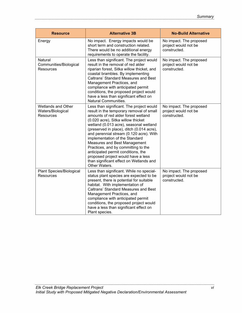
Energy No impact. Energy impacts would be short term and construction related. There would be no additional energy requirements to operate the facility.
No impact. The proposed project would not be constructed.
Natural Communities/Biological Resources
Less than significant. The project would result in the removal of red alder riparian forest, Sitka willow thicket, and coastal brambles. By implementing Caltrans’ Standard Measures and Best Management Practices, and compliance with anticipated permit conditions, the proposed project would have a less than significant effect on Natural Communities.
No impact. The proposed project would not be constructed.
Wetlands and Other Waters/Biological Resources
Less than significant. The project would result in the temporary removal of small amounts of red alder forest wetland (0.020 acre), Sitka willow thicket wetland (0.013 acre), seasonal wetland (preserved in place), ditch (0.014 acre), and perennial stream (0.120 acre). With implementation of the Standard Measures and Best Management Practices, and by committing to the anticipated permit conditions, the proposed project would have a less than significant effect on Wetlands and Other Waters.
No impact. The proposed project would not be constructed.
Plant Species/Biological Resources
Less than significant. While no special-status plant species are expected to be present, there is potential for suitable habitat. With implementation of Caltrans’ Standard Measures and Best Management Practices, and compliance with anticipated permit conditions, the proposed project would have a less than significant effect on Plant species.
No impact. The proposed project would not be constructed.
Elk Creek Bridge Replacement Project Initial Study with Proposed Mitigated Negative Declaration/Environmental Assessment
vi

Alternative 3B No Build Alternative
Summary
Resource -
Animal and Fish Less than significant. The project has No impact. The proposed Species/Biological the potential to affect Pacific lamprey, project would not be Resources Foothill yellow-legged frog, Northern
red-legged frog, Western pond turtle, white-tailed kite, Sonoma tree vole, and Western red bat, as well as migratory bird species and colonies of roosting, non-special status bats. With implementation of the Standard Measures and Best Management Practices, and by committing to the anticipated permit conditions, the proposed project would have a less than significant effect on Animal species.
constructed.
Threatened and Less than significant. The project has No impact. The proposed Endangered the potential to affect California red- project would not be Species/Biological legged frog, Northern spotted owl, and constructed. Resources Tidewater goby. With implementation of
the Standard Measures and Best Management Practices, and by committing to the anticipated permit conditions, the proposed project would have a less than significant effect on Threatened and Endangered Animal Species (California red-legged frog, Northern spotted owl, and Tidewater goby).
Threatened and Less than significant with mitigation. No impact. The proposed Endangered Species/ The project is anticipated to have project would not be Biological Resources impacts on Northern California
steelhead Distinct Population Segment, and Central California Coast coho salmon. In addition to implementing Standard Measures and Best Management Practices, and committing to anticipated permit conditions, Caltrans would implement Mitigation Measure BR-1. With the implementation of these measures, practices, conditions, and the proposed Mitigation Measure, there would be a less than significant effect on Threatened and Endangered fish species (coho salmon and steelhead).
constructed.
Invasive Species Less than significant. Short-term construction-related impacts. With implementation of Caltrans’ Standard Measures and Best Management Practices, the proposed project would create a less than significant effect from these species.
No impact. The proposed project would not be constructed.
Elk Creek Bridge Replacement Project Initial Study with Proposed Mitigated Negative Declaration/Environmental Assessment
vii

Summary
Resource Alternative 3B No-Build Alternative
Cumulative Impacts Less than significant. There could potentially be cumulative impacts to special-status fish species. However, with implementation of Caltrans’ Standard Measures and Best Management Practices, as well as the proposed mitigation (Measure BR-1, root wad revetment habitat enhancement) and compliance with permit conditions, potential cumulative effects on these species would be reduced. There would be no cumulative impacts to other resources as a result of the proposed project.
No impact. The proposed project would not be constructed.
Wildfire Less than significant. The proposed project could potentially expose workers to fire risk and hazards. However, precautions to prevent unintended fires would be taken in accordance with the California Division of Occupational Safety and Health (Cal/OSHA) Fire Protection and Prevention guidance, and the project site could be quickly evacuated in an emergency.
No impact. The proposed project would not be constructed.
Climate Change/Greenhouse Gas Emissions
Less than significant. The proposed project would not increase capacity or change travel demands or travel patterns. The amount of greenhouse gas (GHG) emissions generated during construction would be negligible.
No impact. The proposed project would not be constructed.
Elk Creek Bridge Replacement Project Initial Study with Proposed Mitigated Negative Declaration/Environmental Assessment
viii

Table of Contents
Page Table of Contents...............................................................................................................ix List of Appendices ...........................................................................................................xiii List of Figures ...................................................................................................................xv List of Tablesxvii List of Abbreviated Terms ...............................................................................................xix Chapter 1. Proposed Project .........................................................................................1
1.1. Introduction.............................................................................................................1 1.2. Project Description..................................................................................................4 1.3. Project Alternatives.................................................................................................5 1.4. Construction Scenario.............................................................................................8 1.5. Permits and Approvals Needed ............................................................................16 1.6. Standard Measures ..............................................................................................17 1.7. Comparison of Alternatives...................................................................................35 1.8. Alternatives Considered but Eliminated from Further Discussion ..........................35
Chapter 2. Affected Environment, Environmental Consequences, and Avoidance,Minimization, and/or Mitigation Measures................................................37
Topics Considered but Determined Not to be Relevant .................................................37 Human/Physical Environment........................................................................................40 2.1. Land Use and Planning.........................................................................................40
Regulatory Setting ...................................................................................................40 Environmental Consequences .................................................................................41 Avoidance, Minimization, and/or Mitigation Measures..............................................45
2.2. Coastal Zone ........................................................................................................46 Regulatory Setting ...................................................................................................46 Affected Environment ..............................................................................................47 Environmental Consequences .................................................................................50 Avoidance, Minimization, and/or Mitigation Measures..............................................53
2.3. Utilities/Emergency Services.................................................................................54 Affected Environment ..............................................................................................54 Environmental Consequences .................................................................................55 Avoidance, Minimization, and/or Mitigation Measures..............................................56
2.4. Traffic and Transportation/Pedestrian and Bicycle Facilities .................................56 Regulatory Setting ...................................................................................................56 Affected Environment ..............................................................................................58 Environmental Consequences .................................................................................60 Avoidance, Minimization, and/or Mitigation Measures..............................................61
2.5. Visual/Aesthetics ..................................................................................................62 Regulatory Setting ...................................................................................................62 Affected Environment ..............................................................................................62 Environmental Consequences .................................................................................64 Avoidance, Minimization, and/or Mitigation Measures..............................................68
2.6. Cultural Resources ...............................................................................................69
Elk Creek Bridge Replacement Project Initial Study with Proposed Mitigated Negative Declaration / Environmental Assessment
ix
Table of Contents
Regulatory Setting ...................................................................................................69 Affected Environment ..............................................................................................70 Environmental Consequences .................................................................................72 Avoidance, Minimization, and/or Mitigation Measures..............................................73
2.7. Hydrology and Floodplain .....................................................................................73 Regulatory Setting ...................................................................................................73 Affected Environment ..............................................................................................74 Environmental Consequences .................................................................................74 Avoidance, Minimization, and/or Mitigation Measures..............................................77
2.8. Water Quality and Stormwater Runoff...................................................................78 Regulatory Setting ...................................................................................................78 Affected Environment ..............................................................................................83 Environmental Consequences .................................................................................84 Avoidance, Minimization, and/or Mitigation Measures..............................................87
2.9. Geology, Soils, Seismicity and Topography ..........................................................88 Regulatory Setting ...................................................................................................88 Affected Environment ..............................................................................................88 Environmental Consequences .................................................................................91 Avoidance, Minimization, and/or Mitigation Measures..............................................93
2.10. Paleontological Resources ...................................................................................93 Regulatory Setting ...................................................................................................93 Affected Environment ..............................................................................................93 Environmental Consequences .................................................................................96 Avoidance, Minimization, and/or Mitigation Measures..............................................96
2.11. Hazardous Waste and Materials ...........................................................................97 Regulatory Setting ...................................................................................................97 Affected Environment ..............................................................................................98 Environmental Consequences .................................................................................99 Avoidance, Minimization, and/or Mitigation Measures............................................100
2.12. Air Quality ...........................................................................................................102 Regulatory Setting .................................................................................................102 Affected Environment ............................................................................................104 Environmental Consequences ...............................................................................109 Avoidance, Minimization, and/or Mitigation Measures............................................111
2.13. Noise ..................................................................................................................112 Regulatory Setting .................................................................................................112 Affected Environment ............................................................................................115 Environmental Consequences ...............................................................................116 Avoidance, Minimization, and/or Mitigation Measures............................................118
2.14. Energy ................................................................................................................118 Regulatory Setting .................................................................................................118 Affected Environment ............................................................................................118 Environmental Consequences ...............................................................................119 Avoidance, Minimization, and/or Mitigation Measures............................................119
2.15. Natural Communities ..........................................................................................120 Affected Environment ............................................................................................121 Environmental Consequences ...............................................................................124 Avoidance, Minimization, and/or Mitigation Measures............................................130
2.16. Wetlands and Other Waters................................................................................130 Regulatory Setting .................................................................................................130
Elk Creek Bridge Replacement Project Initial Study with Proposed Mitigated Negative Declaration/Environmental Assessment
x

Table of Contents
Affected Environment ............................................................................................132 Environmental Consequences ...............................................................................137 Avoidance, Minimization, and/or Mitigation Measures............................................142
2.17. Plant Species......................................................................................................143 Regulatory Setting .................................................................................................143 Affected Environment ............................................................................................143 Environmental Consequences ...............................................................................156 Avoidance, Minimization, and/or Mitigation Measures............................................156
2.18. Animal and Fish Species ....................................................................................156 Regulatory Setting .................................................................................................156 Affected Environment ............................................................................................157 Environmental Consequences ...............................................................................165 Avoidance, Minimization, and/or Mitigation Measures............................................191
2.19. Threatened and Endangered Species.................................................................191 Regulatory Setting .................................................................................................191 Affected Environment ............................................................................................192 Environmental Consequences ...............................................................................204 Avoidance, Minimization, and/or Mitigation Measures............................................210
2.20. Invasive Species.................................................................................................211 Regulatory Setting .................................................................................................211 Affected Environment ............................................................................................211 Environmental Consequences ...............................................................................213 Avoidance, Minimization, and/or Mitigation Measures............................................214
2.21. Cumulative Impacts ............................................................................................214 Regulatory Setting .................................................................................................214 Affected Environment ............................................................................................215 Environmental Consequences ...............................................................................215 Avoidance, Minimization, and/or Mitigation Measures............................................222
Chapter 3. CEQA Evaluation......................................................................................223 3.1. Aesthetics ...........................................................................................................225 3.2. Agriculture and Forest Resources.......................................................................228 3.3. Air Quality ...........................................................................................................231 3.4. Biological Resources ..........................................................................................233 3.5. Cultural Resources .............................................................................................245 3.6. Energy ................................................................................................................247 3.7. Geology and Soils...............................................................................................248 3.8. Greenhouse Gas Emissions ...............................................................................253 3.9. Hazards and Hazardous Materials ......................................................................254 3.10. Hydrology and Water Quality ..............................................................................258 3.11. Land Use and Planning.......................................................................................262 3.12. Mineral Resources..............................................................................................263 3.13. Noise ..................................................................................................................264 3.14. Population and Housing......................................................................................266 3.15. Public Services ...................................................................................................267 3.16. Recreation ..........................................................................................................269 3.17. Transportation.....................................................................................................270 3.18. Tribal Cultural Resources ...................................................................................272 3.19. Utilities and Service Systems..............................................................................274 3.20. Wildfire ...............................................................................................................276 3.21. Mandatory Findings of Significance ....................................................................278
Elk Creek Bridge Replacement Project Initial Study with Proposed Mitigated Negative Declaration/Environmental Assessment
xi

Table of Contents
3.22. Climate Change..................................................................................................281 Chapter 4. Comments and Coordination ..................................................................301
4.1. Agency Consultation...........................................................................................301 U.S. Fish and Wildlife Service.............................................................................301 National Marine Fisheries Service.......................................................................302 U.S. Army Corps of Engineers ............................................................................302 State Water Resources Control Board ................................................................302 California Department of Fish and Wildlife ..........................................................303 California Coastal Commission ...........................................................................303
4.2. Public Participation .............................................................................................303 Public Meeting ....................................................................................................303
4.3. Tribal Consultation..............................................................................................304 Chapter 5. List of Preparers.......................................................................................305
California Department of Transportation .............................................................305 ICF......................................................................................................................306 WRECO..............................................................................................................306
Chapter 6. Distribution List........................................................................................307 Chapter 7. References................................................................................................308
Elk Creek Bridge Replacement Project Initial Study with Proposed Mitigated Negative Declaration/Environmental Assessment
xii

List of Appendices
Appendix A. Title VI Policy Statement Appendix B. Species Lists, USFWS, CDFW, NMFS Appendix C. Avoidance, Minimization and/or Mitigation Summary Appendix D. List of Technical Studies Appendix E. Layouts and Construction Details
Elk Creek Bridge Replacement Project Initial Study with Proposed Mitigated Negative Declaration/Environmental Assessment
xiii

This page left intentionally blank.
Elk Creek Bridge Replacement Project Initial Study with Proposed Mitigated Negative Declaration/Environmental Assessment
xiv

List of Figures
Page Figure 1. Project Vicinity .............................................................................................. 2
Figure 2. Project Location Map .................................................................................... 3
Figure 3. Build Alternative Overview ...........................................................................14
Figure 4. Build Alternative Close-Up ...........................................................................15
Figure 5. Coastal Zone Resources in the Study Area..................................................48
Figure 6. FEMA Flood Insurance Rate Map ................................................................75
Figure 7. Noise Levels of Common Activities ............................................................114
Figure 8. Impacts on Sensitive Natural Communities ................................................127
Figure 9. Impacts to Waters of the U.S., Waters of the State and Coastal Wetlands....................................................................................................140
Figure 10. U.S. 2016 Greenhouse Gas Emissions ......................................................286
Figure 11. California 2017 Greenhouse Gas Emissions ..............................................287
Figure 12. Change in California GDP, Population, and GHG Emissions since 2000 ...288
Figure 13. California Climate Strategy.........................................................................293
Elk Creek Bridge Replacement Project Initial Study with Proposed Mitigated Negative Declaration / Environmental Assessment
xv

This page left intentionally blank.
Elk Creek Bridge Replacement Project Initial Study with Proposed Mitigated Negative Declaration / Environmental Assessment
xvi

List of Tables
Page Table 1. Comparison of Potential Impacts between Alternative 3B and No-Build
Alternative..................................................................................................... iii Table 2. Permits and Approvals .................................................................................16 Table 3. Consistency with State, Regional, and Local Plans and Programs...............41 Table 4. California Coastal Act, Public Resources Code Division 20..........................50 Table 5. Mendocino County Coastal Element ............................................................52 Table 6. Annual Average Daily Traffic........................................................................59 Table 7. Peak Hour Average Daily Trips ....................................................................59 Table 8. Dissolved Oxygen Water Quality Objectives for North Coast Region
Surface Waters ............................................................................................84 Table 9. Caltrans Paleontology Sensitivity Scale .......................................................94 Table 10. National and California Ambient Air Quality Standards Applicable
in California ................................................................................................105 Table 11. Mendocino County Adopted Air Quality CEQA Thresholds
of Significance............................................................................................108 Table 12. Noise Abatement Criteria ...........................................................................113 Table 13. Construction Equipment Noise ...................................................................116 Table 14. Noise from Impact Pile Driving Operation...................................................117 Table 15. Sensitive Natural Communities in the Biological Study Area ......................121 Table 16. Existing Shaded Riverine Aquatic Cover (Overhead Vegetation)
in the BSA..................................................................................................124 Table 17. Impacts on Sensitive Natural Communities ................................................125 Table 18. Construction-Related and Bridge Footprint Impacts on Overhead SRA
Cover Vegetation in the BSA......................................................................129 Table 19. Wetlands and Other Waters in the Biological Study Area ...........................133 Table 20. Temporal and Temporary Impacts on Waters of the U.S.,
Waters of the State, and Coastal Wetlands in Acres ..................................138 Table 21. Special-Status Plants Known or with Potential to Occur in the Biological
Study Area Region .....................................................................................144 Table 22. Summary of Pile Driving and Demolition Activities with Potential
to Exceed Injury Thresholds for Fish ..........................................................179 Table 23. Distances to Injury and Behavioral Thresholds for Impact Driving
of 10-Inch Steel H-Piles for the Temporary Construction Falsework and the 10-Inch Steel H-Piles for the Permanent Bridge Abutments...........183
Elk Creek Bridge Replacement Project Initial Study with Proposed Mitigated Negative Declaration / Environmental Assessment
xvii

List of Tables
Table 24. Distances to Injury and Behavioral Thresholds for Demolition of the Existing Bridge Piers and Abutments................................................186
Table 25. Invasive Plant Species Identified in the Biological Study Area....................211 Table 26. Cumulative Project List...............................................................................215 Table 27. Total GHG Emissions During Construction (U.S. Tons)..............................291
Elk Creek Bridge Replacement Project Initial Study with Proposed Mitigated Negative Declaration/Environmental Assessment
xviii

List of Abbreviated Terms
ABBREVIATION DESCRIPTION AADT Annual Average Daily Traffic AB Assembly Bill ACHP Advisory Council on Historic Preservation ACM Asbestos-containing Material ADA Americans with Disabilities Act ADL Aerially Deposited Lead ADL Agreement Soil Management Agreement ADT Average Daily Trips AGR Agricultural Supply AMM Avoidance and Minimization Measures APE Area of Potential Effects AQMP Air Quality Management Plan AQUA Hydropower Replenishment, Aquaculture ARB Air Resources Board BAAQMD Bay Area Air Quality Management District BMPs Best Management Practices BSA Biological Study Area °C degrees Celsius CAA Clean Air Act CAFE Corporate Average Fuel Economy CAL FIRE California Department of Forestry and Fire Protection Cal/OSHA California Division of Occupational Safety and Health Cal-IPC California Invasive Plant Council Caltrans California Department of Transportation CARB California Air Resources Board CCA California Coastal Act CCAA California Clean Air Act CCC California Coastal Commission CCC Central California Coast CCMP California Coastal Management Plan CCR California Code of Regulations CDFA California Department of Food and Agriculture CDFW California Department of Fish and Wildlife CDP Coastal Development Permit CEQA California Environmental Quality Act CERCLA Comprehensive Environmental Response, Compensation and Liability Act CERFA Community Environmental Response Facilitation Act CESA California Endangered Species Act CFR Code of Federal Regulations CGS California Geological Survey CH4 Methane
Elk Creek Bridge Replacement Project Initial Study with Proposed Mitigated Negative Declaration / Environmental Assessment
xix
List of Abbreviated Terms
ABBREVIATION DESCRIPTION CHP California Highway Patrol CIP/PS Cast-in-Place/Pre-stressed CNDDB California Natural Diversity Database CNPS California Native Plant Society CO carbon monoxide CO2 carbon dioxide CO2e carbon dioxide equivalent COLD Cold Freshwater Habitat CRHR California Register of Historical Resources CRPR California Rare Plant Rank CTP California Transportation Plan CWA Clean Water Act CZMA Coastal Zone Management Act dBA A-weighted decibels DOT Department of Transportation DPS Distinct Population Segment DSA Disturbed Soil Area DTSC Department of Toxic Substances Control EA Environmental Assessment eDNA Environmental DNA EO Executive Order ESHA Environmentally Sensitive Habitat Areas ESU Ecologically Significant Unit °F degrees Fahrenheit FCAA Federal Clean Air Act FEMA Federal Emergency Management Agency FESA Federal Endangered Species Act FHWA Federal Highway Administration FHWG Fisheries Hydroacoustic Working Group FIFRA Federal Insecticide, Fungicide, and Rodenticide Act FONSI Finding of No Significant Impact FRSH Freshwater Replenishment ft feet/foot FTA Federal Transit Administration FTIPs Federal Transportation Improvement Program(s) GHG Greenhouse Gas GWP Global Warming Potential H2S hydrogen sulfide H&SC Health and Safety Code HA Hydrologic Area HFCs hydrofluorocarbons HTL High-tide Line HU Hydrologic Unit HVF High-visibility Fencing
Elk Creek Bridge Replacement Project Initial Study with Proposed Mitigated Negative Declaration / Environmental Assessment
xx
List of Abbreviated Terms
ABBREVIATION DESCRIPTION IND Industrial Service Supply IPCC Intergovernmental Panel on Climate Change IS Initial Study IS/EA Initial Study/Environmental Assessment ISA Initial Site Assessment LBP Lead-based Paint LCFS Low Carbon Fuel Standard LCP Local Coastal Plan LEDPA Least Environmentally Damaging Practicable Alternative LSAA Lake and Streambed Alteration Agreement MBTA Federal Migratory Bird Treaty Act MCAQMD Mendocino County Air Quality Management District MCOG Mendocino Council of Governments MLD Most Likely Descendent mm millimeters MM Mitigation Measures MMTCO2e Million Metric Tons of Carbon Dioxide Equivalent MPO Metropolitan Planning Organization MS4s Municipal Separate Storm Sewer Systems MTA Mendocino Transit Authority MUN Municipal and Domestic Supply N2O nitrous oxide NAAQS National Ambient Air Quality Standards NAC Noise Abatement Criteria NAHC Native American Heritage Commission NC North Coast NCRWQCB North Coast Regional Water Quality Control Board ND Negative Declaration NEPA National Environmental Policy Act NES Natural Environment Study NESHAPs National Emissions Standards for Hazardous Air Pollutants NHPA National Historic Preservation Act NHTSA National Highway Traffic Safety Administration NMFS National Marine Fisheries Services NO2 nitrogen dioxide NOAA National Oceanic and Atmospheric Administration NMFS National Marine Fisheries Service (under NOAA) NPDES National Pollutant Discharge Elimination System NRHP National Register of Historic Places NWIC Northwest Information Center O3 Ozone OES Office of Emergency Services OHWM Ordinary High Water Mark OSHA Federal Occupational Safety and Health Administration
Elk Creek Bridge Replacement Project Initial Study with Proposed Mitigated Negative Declaration / Environmental Assessment
xxi
List of Abbreviated Terms
ABBREVIATION DESCRIPTION PA Programmatic Agreement Pb lead PBF Physical and Biological Feature PDT Project Development Team PEAR Preliminary Environmental Analysis Report PIR/PER Paleontological Identification Report and Paleontological Evaluation
Report PLACs Permits, Licenses, Agreements, and Certifications PM particulate matter PM(s) post mile(s) PM10 particles of 10 micrometers or smaller PM2.5 particles of 2.5 micrometers and smaller ppt parts per thousand PQS Professionally Qualified Staff PRC Public Resources Code PRO Industrial Process Supply proposed project Elk Creek Bridge Replacement Project RCRA Resource Conservation and Recovery Act RMS root mean square ROW Right of Way RSP Rock Slope Protection RTPs Regional Transportation Plans RTPA Regional Transportation Planning Agency RWQCB Regional Water Quality Control Board SB Senate Bill SCS Sustainable Communities Strategy SDC Seismic Design Criteria SEL Sound Exposure Level SF6 sulfur hexafluoride SHPO State Historic Preservation Officer SHS State Highway System SIP State Implementation Plan SLR Sea-level Rise SO2 sulfur dioxide SPL Sound Pressure Level SPWN Spawning, Reproduction, and/or Early Development SR State Route SRA Shaded Riverine Aquatic SRAs State Responsibility Areas STIP State Transportation Improvement program SWMP Storm Water Management Plan SWPPP Storm Water Pollution Prevention Plan SWRCB State Water Resources Control Board TCE(s) Temporary Construction Easement(s)
Elk Creek Bridge Replacement Project Initial Study with Proposed Mitigated Negative Declaration / Environmental Assessment
xxii

List of Abbreviated Terms
ABBREVIATION DESCRIPTION TMDL Total Maximum Daily Load TMP Transportation Management Plan TSCA Toxic Substances Control Act TWW Treated Wood Waste US or U.S. United States USACE U.S. Army Corps of Engineers USC United States Code USDOT U.S. Department of Transportation U.S. EPA U.S. Environmental Protection Agency USFWS U.S. Fish and Wildlife Service USGCRP U.S. Global Change Research Program VOCs Volatile Organic Compounds VMT Vehicle Miles Traveled WDRs Waste Discharge Requirements WPCP Water Pollution Control Program WQOs Water Quality Objectives
Elk Creek Bridge Replacement Project Initial Study with Proposed Mitigated Negative Declaration / Environmental Assessment
xxiii

This page left intentionally blank.
Elk Creek Bridge Replacement Project Initial Study with Proposed Mitigated Negative Declaration / Environmental Assessment
xxiv

Chapter 1. Proposed Project
1.1. Introduction
NEPA ASSIGNMENT
California participated in the “Surface Transportation Project Delivery Pilot Program” (Pilot Program) pursuant to 23 United States Code (USC) 327, for more than five years, beginning July 1, 2007, and ending September 30, 2012. MAP-21 (Public Law 112-141), signed by President Obama on July 6, 2012, amended 23 USC 327 to establish a permanent Surface Transportation Project Delivery Program. As a result, the California Department of Transportation (Caltrans) entered into a Memorandum of Understanding (MOU) pursuant to 23 USC 327 (National Environmental Policy Act [NEPA] Assignment MOU) with the Federal Highway Administration (FHWA). The NEPA Assignment MOU became effective October 1, 2012, and was renewed on December 23, 2016, for a term of five years. In summary, Caltrans continues to assume FHWA responsibilities under NEPA and other federal environmental laws in the same manner as was assigned under the Pilot Program, with minor changes. With NEPA Assignment, FHWA assigned and Caltrans assumed all of the United States Department of Transportation (USDOT) Secretary's responsibilities under NEPA. This assignment includes projects on the State Highway System and Local Assistance Projects off of the State Highway System within the State of California, except for certain categorical exclusions that FHWA assigned to Caltrans under the 23 USC 326 CE Assignment MOU, projects excluded by definition, and specific project exclusions.
PROPOSED PROJECT
The Elk Creek Bridge Replacement Project (proposed project) is subject to state and federal environmental review requirements because it would use state and federal funds. Accordingly, project documentation is being prepared in compliance with both the National Environmental Policy Act (NEPA) and California Environmental Quality Act (CEQA). Caltrans, as assigned by FHWA, is the lead agency under NEPA and CEQA.
Elk Creek Bridge Replacement Project Initial Study with Proposed Mitigated Negative Declaration / Environmental Assessment
1

Chapter 1. Proposed Project
Figure 1. Project Vicinity
Elk Creek Bridge Replacement Project Initial Study with Proposed Mitigated Negative Declaration / Environmental Assessment
2

Chapter 1. Proposed Project
Figure 2. Project Location Map
Elk Creek Bridge Replacement Project Initial Study with Proposed Mitigated Negative Declaration / Environmental Assessment
3

Chapter 1. Proposed Project
This proposed project is included in the 2019 Federal Statewide Transportation Improvement Program and is proposed for funding from the State Highway Operation and Protection Program Bridge Preservation Program (Caltrans 2019a). It is also included in the Mendocino Council of Governments Regional Transportation Plan (Mendocino Council of Governments 2018).
1.2. Project Description
1.2.1. Purpose
The purpose of the project is to improve the function and geometrics of the Elk Creek Bridge and approach roadway to ensure uninterrupted traffic movement in the event of a collision or emergency incident, seismic event, or other catastrophic failure and provide safe access for pedestrians and bicyclists across the bridge. The design of the proposed project would improve traffic flow with upgrades to the bridge approach by widening the shoulders and decreasing the curve radius, thus improving safety and reducing the potential for accidents and collisions on the bridge.
1.2.2. Need
Roadway Deficiencies
The bridge and approach roadway have geometric and structural deficiencies that could result in reduced safety to all users from interrupted traffic in the event of a collision, seismic event, or other catastrophic failure. These deficiencies include narrow shoulder widths that do not provide sufficient area for disabled vehicles or appropriate access for pedestrians and bicyclists crossing the bridge; existing bridge railing that does not meet current design standards; and raised concrete areas adjacent to the shoulders that are not compliant with the Americans with Disabilities Act (ADA).
Safety
The existing bridge has been identified as scour critical.1 A scour critical bridge is one with abutment or pier foundations that are rated as unstable due to: (1) observed scour at the bridge site, or (2) a scour potential as determined from a scour evaluation study. Caltrans performed an inspection at Elk Creek Bridge in March 2016 that revealed significant scour occurring on both sides of the channel at Piers 2 and 3 and failure of the concrete slope
1 Scour is the engineering term for the erosion of soil (caused by water) surrounding a bridge foundation (piers and abutments).
Elk Creek Bridge Replacement Project Initial Study with Proposed Mitigated Negative Declaration / Environmental Assessment
4

Chapter 1. Proposed Project
protection at Abutment 4. Subsequent storms exacerbated the scour issue resulting in emergency repairs on the adjacent slopes.
Independent Utility and Logical Termini
Regulations from FHWA (23 Code of Federal Regulations [CFR] 771.111[f]) require the project evaluate:
If the proposed project has logical termini
If the proposed project has independent utility
If the proposed project does not restrict the consideration of alternatives for other transportation improvements
Independent utility is an FWHA requirement that highway projects are usable and a reasonable expenditure even if no additional transportation improvements in the area are made. FHWA states that “as long as a project would serve a significant function by itself (i.e., it has independent utility), there is no requirement to include separate but related projects in the same analysis.” The proposed project has independent utility as the proposed bridge replacement is enough to ensure that no additional investment in the bridge or SR 1 corridor at this location would be required as a result of project completion.
Logical termini is defined by FHWA as rational end points for both a transportation improvement and a review of environmental impacts for the transportation improvement. The proposed project possesses logical termini because the project focuses on improvements to the existing Elk Creek Bridge, and the project boundaries are limited to the bridge and roadway approaches in order to reduce the environmental impacts of the project and focus the impact analysis. The proposed improvements would not restrict the consideration of alternatives for other reasonably foreseeable transportation improvements. Continuing coordination would avoid potential conflicts with alternatives for this project and other planned area transportation improvements.
1.3. Project Alternatives
This section describes the proposed action and the project alternatives developed to meet the purpose and need of the proposed project, while avoiding or minimizing potential environmental impacts. The alternatives are Alternative 3B (the proposed project or the build alternative) and the No-Build (No-Action) Alternative.
Elk Creek Bridge Replacement Project Initial Study with Proposed Mitigated Negative Declaration / Environmental Assessment
5

Chapter 1. Proposed Project
The existing Elk Creek Bridge is a 122-foot-long structure with two 11-foot lanes and 2-foot shoulders. The bridge was constructed in 1938 and is a continuous three-span, cast-in-place (CIP) reinforced concrete bridge2 with reinforced concrete pier walls3 and reinforced concrete seat abutments.4 The abutments are founded on driven timber piles and the piers on driven steel piles.
The proposed project consists of a bridge replacement alternative to improve the function and geometric concerns of the bridge as the new design would improve traffic flow through improvements to the bridge approach by widening the shoulders and decreasing the curve radius, thus improving safety and reducing the potential for accidents and collisions on the bridge. It would also improve pedestrian/bicycle access and safety and address scour concerns.
Alternative 3B (Build Alternative)
Caltrans has identified one build alternative to replace the Elk Creek Bridge—Alternative 3B. As shown in Figures 3 and 4, proposed Alternative 3B would be a 140-foot-long, cast-in-place/pre-stressed (CIP/PS) concrete box girder bridge with 12-foot lanes, 6-foot shoulders, and a 6-foot separated pedestrian and bicycle walkway on the west side of the bridge. Alternative 3B would include construction of a temporary, one-lane, 22.5-foot-wide, 140-foot-long bridge and temporary roadway approaches east of the current bridge to accommodate alternating, one-way traffic control throughout the two-season construction period. A bio engineered bank revetment consisting of rock slope protection (RSP) and root wads would be installed along the north bank of Elk Creek to provide salmonid habitat to mitigate for project impacts to Threatened and Endangered fish species and protect the northern abutment. The temporary bridge would be removed in the middle of the second construction season once the new permanent bridge is completed to allow room for the bio engineered revetment to be constructed on the north bank and to ensure activities in the channel are completed before the Oct. 15th restriction.
The existing bridge would be demolished and replaced with a new bridge. Following construction of the new bridge, traffic would be moved to the new alignment, the temporary bridge would be removed, the bio engineered revetment would be installed, and roadway
2 Cast-in-place concrete slab type bridges have no beams under the decks, but instead utilize reinforcing steel embedded in the bottom of relatively thick concrete slabs to carry the loads.
3 Piers provide support for the bridge superstructure at intermediate points, with a minimum obstruction to the flow of traffic or water.
4 Abutments provide support for the ends of the bridge superstructure and retain the approach embankment.
Elk Creek Bridge Replacement Project Initial Study with Proposed Mitigated Negative Declaration / Environmental Assessment
6

Chapter 1. Proposed Project
approaches regraded to pre-construction grade. There are no existing utilities at the Elk Creek Bridge location, and none would be added under the proposed project.
Implementing Alternative 3B would involve the following:
• Ground disturbance and excavation for the abutments on the replacement structure would be to a maximum depth of 12 feet. Ground disturbance and excavation for the abutments on the temporary structure would be to a maximum depth of 5 feet.
• Falsework pile depth for the replacement structure and permanent abutments would be to approximately 65 feet.
• Vegetation clearing around the bridge.
• Acquisition of permanent right of way (ROW) for the bridge replacement, and temporary construction access for bridge access and temporary bridge placement during construction of the replacement bridge. Temporary construction easements (TCEs) would be required on either side of SR 1 to accommodate construction activities, including storing equipment and materials, and constructing the access road. Approximately 0.29 acre would be temporarily acquired for use as staging areas and for construction of the temporary bridge. All areas used as TCEs would be returned to their pre-construction condition following the construction period. In addition, approximately 0.2 acre of land would be permanently acquired on the western side of SR 1 for incorporation into the Caltrans ROW and approximately 0.12 acre of land would be permanently acquired on the eastern side of the bridge for cut and fill activities associated with the temporary bridge. Property acquisition would be conducted in compliance with Title VI of the Civil Rights Act (42 USC 2000d, et seq.), the Uniform Act, and Title 49 CFR Part 24 (Standard Measure COM-1).
No-Build (No-Action) Alternative
Under the No-Build Alternative, the proposed project would not be constructed and the critical scour conditions at the bridge pier and abutment would not be addressed and continue to worsen. The deficiencies at the bridge, such as the lack of shoulder, deteriorating railings, and narrow lanes, would remain and continue to create unsafe conditions for the travelling public.
Elk Creek Bridge Replacement Project Initial Study with Proposed Mitigated Negative Declaration / Environmental Assessment
7

Chapter 1. Proposed Project
1.4. Construction Scenario
Work Area
The project work area consists of Caltrans’ existing right of way, temporary construction easements (TCE), and the new right of way (ROW) to be acquired. Small turnouts, plots of land directly adjacent to the bridge, and portions of the existing roadway approaches outside of the temporary traffic detour would be used for staging areas. Temporary construction easements and new ROW would be acquired to construct an access road on the southwest and northwest sides of the bridge leading down to the banks of the creek channel. Under Alternative 3B, the construction of the temporary bridge, the removal of the existing bridge, and construction of the new bridge would be accomplished from the creek banks outside of the wetted channel but would require a trestle or a clearwater diversion. Construction of the temporary bridge would include construction of temporary roadway approaches and temporary abutments.
Removal of the existing bridge would require construction of a temporary working platform and debris catchment system below the bridge. Construction of the debris catchment system and providing an area for a temporary work platform would require a clear water diversion to provide a dry work area. Installation of the bio engineered revetment and in-stream fish habitat enhancement would require a second clear water diversion during the second season of construction. The final diversion method for both seasons of work would be based on permit conditions from natural resources regulatory agencies and site conditions during construction. Intermittent natural closures of the creek mouth may cause fluctuating water levels in the creek between June and October. Establishing a stream gauging station at the bridge as far in advance of the beginning of construction may provide enough usable data to determine appropriate methods for design of the clear water diversion, the temporary working platform, and the debris catchment system below the bridge.
The proposed project’s designated work area would be cleared of any obstacles or debris prior to construction. Clearing, cutting, and trimming of vegetation would be minimized whenever possible.
Elk Creek Bridge Replacement Project Initial Study with Proposed Mitigated Negative Declaration / Environmental Assessment
8

Chapter 1. Proposed Project
Construction Phasing
Construction would be phased over two construction seasons beginning with the construction of temporary roadway approaches followed by the construction of the temporary 22.5-foot-wide bridge on the east side of the existing bridge. The temporary bridge would be offset 2 feet from the existing bridge and approximately 4 feet from the new bridge. While night work is not planned at this time, night and weekend work may be necessary when construction activities are actively in progress, depending on unforeseen delays with construction. A Transportation Management Plan (TMP) that includes the following actions would be implemented under Alternative 3B:
• The closure of one lane is allowed within the project limits using a temporary traffic-actuated signal system with 12-inch flashing beacons installed on the three advance construction signs.
• Reversing traffic control with flaggers require the use of advance flaggers during daylight hours and full matrix Portable Changeable Message Sign boards.
During installation of the temporary traffic signal, public traffic may be stopped in both directions of periods not to exceed 10 minutes.
The temporary bridge would be a prefabricated, modular steel panel truss bridge approximately 140 feet in length. Abutment 2, on the north side of the temporary bridge, would require temporary fill and temporary shoring to match the existing grade of Abutment 1. After the temporary fill/temporary shoring is in place, and roadway approaches have been constructed, abutments and footings would be constructed for the temporary bridge. Ground disturbance and excavation for the temporary bridge abutments is anticipated to be 5 feet deep on the north and south banks of Elk creek above the Ordinary High Water Mark. Once the abutments are completed, the temporary bridge would be put in place, asphalt would be placed on the driving surface and the traffic control system would be installed. Highway traffic would then be shifted over to the temporary bridge using one-way traffic control.
Bridge Demolition and Construction
Under Alternative 3B, the temporary one-lane bridge and its temporary roadway approaches would be constructed first before the existing bridge is demolished and replaced. Once the existing bridge is demolished and replaced, the temporary bridge would be removed and the northern bank of the stream would be armored with rock and a root wad revetment designed to protect the northern abutment of the bridge and provide instream salmonid habitat.
Elk Creek Bridge Replacement Project Initial Study with Proposed Mitigated Negative Declaration / Environmental Assessment
9
Chapter 1. Proposed Project
The bio engineered revetment and associated restoration work are described in more detail in the Biological Environment section (Chapter 2.15) of this document.
Once traffic is shifted to the temporary bridge, the access road would be constructed from the southwest corner of the bridge to the creek bed, where the stream diversion, debris catchment system, and temporary work platform would be constructed to facilitate the removal of the existing bridge while protecting the stream and allowing it to flow freely through the work area. The final diversion method would be based on permit conditions from natural resources regulatory agencies and contractor methods. The existing bridge would then be demolished using jackhammers, cranes, and excavators. To demolish the existing bridge, the existing bridge deck and girders would be removed, followed by removal of the concrete piers and abutments. Lastly, the existing bridge foundations would be removed and the existing piles cut off three feet below ground surface.
After the existing bridge is demolished, construction of the new bridge would begin. Excavation at the footings of Abutments 1 and Pier 2 and pile driving would be required. Heavy equipment, such as excavators, backhoes, and other machinery, would be used to excavate for the proposed new abutments. A large crane with pile leads5 and diesel hammer would be used to drive piles to the required depth. Depending on the contractor and soil conditions, pile driving for falsework may be necessary. Once the piles are installed to the required depth, temporary forms for the foundations and abutments would be constructed using timber materials and steel reinforcement. Dewatering may be necessary to provide access to pour the foundation and abutment walls. Following these activities, the concrete abutments would be poured, cured, tested, and accepted, after which the wingwalls6 would be formed. After the adjoining wingwalls have been constructed, the abutments would be backfilled with earth and compacted per engineered specifications with the proper structure drainage in place.
Following the construction of the abutment walls and temporary falsework piers, construction of the new bridge superstructure would begin, including falsework within the creek channel, as follows:
1. The falsework would be constructed across the creek. Falsework would be constructed on each side of the creek above the OHWM. Falsework materials would consist of timber materials and steel beams.
5 Pile Leads are a frame that supports and lifts the pile and hammer. 6 The wingwalls are adjacent to the abutments and act as retaining walls.
Elk Creek Bridge Replacement Project Initial Study with Proposed Mitigated Negative Declaration / Environmental Assessment
10

Chapter 1. Proposed Project
2. Steel reinforcement would be installed for the deck, timber forms would be installed, and then concrete would be poured into the forms. The prestressing operation would occur after the superstructure concrete is cured.
3. Once the concrete deck is cured, timber forms and steel reinforcement would be installed, and concrete would be poured into the forms for the pedestrian safety barriers.
4. After the proposed bridge is constructed, construction of the roadway approaches and shoulder would take place and traffic would then be shifted over to the new bridge.
5. The temporary bridge, temporary abutments, steel plates, K-rail, temporary fill, and fabric would then be removed.
6. Roadway approaches would be widened and reconstructed to conform from the proposed bridge to the profile of the existing roadway. The approaches would be widened from the existing 11-foot lanes to 12-foot lanes, and their shoulders would be widened to vary from 2 to 6 feet to conform to proposed bridge shoulders and the 6-foot separated pedestrian and bicycle walkway on the bridge. Road improvements would include installation of Midwest Guardrail System, crash cushions, roadside ditches, cross culvert at the southernly approach. Throughout construction, Caltrans would implement temporary and permanent Standard Measures and Best Management Practices (BMPs).
7. Following the removal of the temporary bridge, the north bank of Elk Creek and abutment of the new permanent bridge would be armored with a bio engineered revetment consisting of a combination of intact root wads with attached logs and bio engineered Rock Slope Protection (RSP) that would include plantings of riparian tree species (willow, salix sp.) to provide instream salmonid habitat. To complete the installation of this bank stabilization and associated habitat restoration, additional disturbance along the northeast bank would be required to access the construction site and a second season of instream work would be necessary. This installation would be the last piece of the construction effort and is described in more depth below in Site Restoration and in Chapter 2.15, Biological Environment.
8. Anticipated equipment used to construct the proposed project would include:
Front end loaders
Backhoes
Graders
Dump trucks
Elk Creek Bridge Replacement Project Initial Study with Proposed Mitigated Negative Declaration / Environmental Assessment
11

Chapter 1. Proposed Project
Concrete trucks and concrete pump trucks
Excavators
Asphalt compactor (roller)
Crane
Pile drivers (impact and vibratory)
Fork lifts
Trailer-mounted portable generators
Pick-up trucks
Light hand tools
Pumps (for dewatering to pour the foundation and abutment walls)
Hydraulic hoe ram
Prestressing Jack and post-tensioning equipment
Site Restoration
When construction is completed, the project work area would be restored by removing any construction debris and grading to the original grade and contour. The beds and banks of the creek affected during construction would be returned to pre-construction condition and seeded with an appropriate seed mix. An Erosion Control and Revegetation Plan would be implemented following construction. This project proposes to replace the current rock slope protection (RSP) east of the existing structure along the north bank of Elk Creek with a bio-engineered7 revetment (bank stabilization) to protect the roadway embankment and restore a more natural habitat. Two vegetated Riprap methods have been recommended, taken from FHWA Hydraulic Engineering Circular (HEC-23): the Willow Bundle Method and Bent Pole Method could be utilized, along with reusing the existing RSP material (FHWA 2009).
Additional habitat restoration elements, such as root wad revetments, would be constructed along the north bank of the creek, east of the bridge, in conjunction with the RSP. Final designs for these elements would be approved in the permitting phase of the project and completed according to permit. To complete necessary habitat restoration to the construction site and RSP removal upstream of the bridge, a second season of instream work would be necessary. These impacts would be of lesser intensity and shorter duration than the
7 Bioengineered revetments incorporate large rock with tree planting and soil building elements to provide scour protection that is more integrated with the landscape and provides additional riparian habitat benefits over rock alone.
Elk Creek Bridge Replacement Project Initial Study with Proposed Mitigated Negative Declaration / Environmental Assessment
12

Chapter 1. Proposed Project
construction effort itself. Standard measures and Best Management Practices would be implemented as necessary and appropriate to avoid and minimize impacts from the required work. The restoration would be a beneficial effect and would not contribute to negative cumulative impacts. The final design and extent of the revetment would be verified in the final hydraulic report and approved by the regulatory agencies as part of the permitting process.
Elk Creek Bridge Replacement Project Initial Study with Proposed Mitigated Negative Declaration / Environmental Assessment
13

Chapter 1. Proposed Project
Figure 3. Build Alternative Overview
Elk Creek Bridge Replacement Project Initial Study with Proposed Negative Declaration / Environmental Assessment
14

Chapter 1. Proposed Project
Figure 4. Build Alternative Close-Up
Elk Creek Bridge Replacement Project Initial Study with Proposed Negative Declaration / Environmental Assessment
15

Chapter 1. Proposed Project
1.5. Permits and Approvals Needed
The following permits, licenses, agreements, and certifications (PLACs) are required for project construction.
Table 2. Permits and Approvals
Agency Permit/Approval Status
California Department of Fish and Wildlife (CDFW)
Section 1602 Lake and Streambed Alteration Agreement and California Endangered Species Act Section 2081(b) (Incidental Take Permit)
Caltrans would obtain this permit during final design.
California Coastal Commission
Coastal Development Permit Caltrans would obtain this permit during final design.
County of Mendocino Local Coastal Development Permit Caltrans would obtain this permit during final design.
North Coast Regional Water Quality Control Board (NCRWQCB)
Clean Water Act Section 401 Water Quality Certification
Caltrans would obtain this permit during final design.
U.S. Army Corps of Engineers (USACE)
Clean Water Act Section 404 Nationwide Permit and Rivers and Harbors Act of 1899 Section 10: Permit for Work in Navigable Waters
Caltrans would obtain this permit during final design.
U.S. Fish and Wildlife Service (USFWS)
Section 7 consultation for potential impacts to California red legged frog and Tidewater Goby under the Endangered Species Act
In process.
National Marine Fisheries Services (NMFS)
Coordination for potential impacts to California Coast Coho and steelhead trout under the Endangered Species Act
In process.
Elk Creek Bridge Replacement Project Initial Study with Proposed Mitigated Negative Declaration / Environmental Assessment
16

Chapter 1. Proposed Project
1.6. Standard Measures
This project would incorporate standardized project measures and Best Management Practices (BMPs) which are employed on most, if not all, Caltrans projects and were not developed in response to any specific environmental impact resulting from the proposed project. These measures are addressed in more detail in the Environmental Consequences sections found in Chapter 2.
Human/Physical Environment
Property Acquisition
COM-1: Property acquisition would be conducted in compliance with Title VI of the Civil Rights Act (42 USC 2000d, et seq.), the Federal Uniform Relocation Assistance and Real Property Acquisition Policies Act of 1970 (as amended), and Title 49 CFR Part 24.
Traffic and Transportation
TR-1: A Transportation Management Plan (TMP) would be applied to the project.
Aesthetics/Visual
AE-1: Implement Section 7-1.04 of Caltrans’ Standard Specifications, which requires that temporary illumination be installed in a manner that the illumination and the illumination equipment do not interfere with public safety. Where feasible, construction lighting would be limited to within the area of work.
AE-2: Comply with Caltrans’ 2016 Highway Design Manual, which utilizes Context Sensitive Solutions consistent with the 2001 Director’s Policy memorandum DP-22, including Design Standards 304.1, Side Slope Standards; 304.4, Contour Grading and Slope Rounding; and 902.1, Design Considerations, Aesthetics.
AE-3: Where feasible, the removal of established trees and vegetation would be minimized. Environmentally sensitive areas would have Temporary High Visibility Fencing (THVF) installed before start of construction to demarcate areas where vegetation would be preserved and root systems of trees protected.
Elk Creek Bridge Replacement Project Initial Study with Proposed Mitigated Negative Declaration / Environmental Assessment
17

Chapter 1. Proposed Project
Cultural Resources
CR-1: If cultural materials are discovered during construction, work activity within a 60-foot radius of the discovery would be stopped and the area secured until a qualified archaeologist can assess the nature and significance of the find in consultation with the State Historic Preservation Officer (SHPO).
CR-2: If human remains and related items are discovered on private or State land, they would be treated in accordance with State Health and Safety Code § 7050.5. Further disturbances and activities would cease in any area or nearby area suspected to overlie remains, and the County Coroner contacted. Pursuant to California Public Resources Code (PRC) § 5097.98, if the remains are thought to be Native American, the coroner would notify the Native American Heritage Commission (NAHC) who would then notify the Most Likely Descendent (MLD).
Water Quality and Stormwater Runoff
WQ-1: Projects that result in a land disturbance of one acre or more would comply with the Provisions of the Caltrans Statewide National Pollutant Discharge Elimination System (NPDES) Permit (Order 2012-0011-DWQ) as amended by subsequent orders, which became effective July 1, 2013, for, and the Construction General Permit (Order 2009-0009-DWQ).
Before any ground-disturbing activities, the contractor would prepare a Stormwater Plan (per the Construction General Permit Order 2009-0009-DWQ) that includes erosion control measures and construction waste containment measures to protect Waters of the State during project construction.
The Stormwater Plan would identify the sources of pollutants that may affect the quality of stormwater; include construction site Best Management Practices (BMPs) to control sedimentation, erosion, and potential chemical pollutants; provide for construction materials management; include non-stormwater BMPs; and include routine inspections and a monitoring and reporting plan. All construction site BMPs would follow the latest edition of the Caltrans Storm Water Quality Handbooks: Construction Site BMPs Manual to control and reduce the impacts of construction-related activities, materials, and pollutants on the watershed.
Elk Creek Bridge Replacement Project Initial Study with Proposed Mitigated Negative Declaration / Environmental Assessment
18

Chapter 1. Proposed Project
The project Stormwater Plan would be continuously updated to adapt to changing site conditions during the construction phase.
Construction may require one or more of, but is not limited to, following temporary construction site BMPs:
• Any spills or leaks from construction equipment (i.e., fuel, oil, hydraulic fluid, and grease) would be cleaned up in accordance with applicable local, state, and/or federal regulations.
• Accumulated stormwater, groundwater, or surface water from excavations or temporary containment facilities would be removed by dewatering.
• Water generated from the dewatering operations would be discharged on-site for dust control and/or to an infiltration basin or disposed of offsite.
• Temporary sediment control and soil stabilization devices would be installed.
• Existing vegetated areas would be maintained to the maximum extent practicable.
• Clearing, grubbing, and excavation would be limited to specific locations, as delineated on the plans, to maximize the preservation of existing vegetation.
• Vegetation reestablishment or other stabilization measures would be implemented on disturbed soil areas, per the Erosion Control Plan.
• Soil disturbing work would be limited during the rainy season.
WQ-2: The project would incorporate pollution prevention and design measures consistent with the 2016 Caltrans Storm Water Management Plan as applicable. This plan complies with the requirements of the Caltrans Statewide NPDES Permit (Order 2012-0011-DWQ) as amended by subsequent orders. The project design may include one or more of the following:
• Vegetated surfaces would feature native plants, and revegetation would use the seed mixture, mulch, tackifier, and fertilizer recommended in the Erosion Control Plan prepared for the project.
• Where possible, stormwater would be directed in such a way as to sheet flow across vegetated slopes, thus providing filtration of any potential pollutants.
Elk Creek Bridge Replacement Project Initial Study with Proposed Mitigated Negative Declaration / Environmental Assessment
19
Chapter 1. Proposed Project
WQ-3: The contractor would be required to prepare and submit a Temporary Creek Diversion System Plan to Caltrans for approval prior to any creek diversion (see WW-4 below for details).
WQ-4: The project would incorporate permanent treatment BMPs to treat stormwater runoff. These measures would be incorporated into the project design during the Plans, Specifications, and Estimates (PS&E) project phase to the maximum extent practicable. Appropriate water quality infiltration systems are proposed to be incorporated to promote retention to treat runoff prior to discharge.
Geology and Soils
GE-1: The proposed project would be designed according to Caltrans seismic standards.
Paleontological Resources
PA-1: Implement the provisions of Caltrans Standard Specifications Section 14-7 addressing the unanticipated discovery of paleontological resources.
Hazardous Waste and Materials
HZ-1: Implement Caltrans Standard Specifications Section 14-11.14 for Treated Wood Waste.
HZ-2: Implement Caltrans Standard Specifications Sections 7-1.02K(6)(j) and 14-11.13 for lead.
Air Quality
AQ-1: Implement Caltrans Standard Specification Section 14-9.02, which includes specifications relating to air pollution control and requires that projects comply with air pollution control rules, regulations, ordinances, and statutes, including those provided in Government Code Section 11017 (Public Contract Code Section 10231).
AQ-2: Implement Caltrans Standard Specification Section 18 to control dust during construction.
Elk Creek Bridge Replacement Project Initial Study with Proposed Mitigated Negative Declaration / Environmental Assessment
20

Chapter 1. Proposed Project
Noise
NOI-1: Implement Caltrans Standard Specifications Section 14-8.02 Noise Control to control the generation of construction-related noise.
Greenhouse Gas Emissions
GHG-1: The construction contractor must comply with the 2018 Caltrans Standard Specifications in Section 14-9. Section 14-9.02 specifically requires compliance by the contractor with all applicable laws and regulations related to air quality.
GHG-2: Compliance with Title 13 of the California Code of Regulations (CCR), which includes idling restrictions of construction vehicles and equipment to no more than 5 minutes.
GHG-3: Caltrans 2018 Standard Specification 7-1.02C “Emissions Reduction” ensures that construction activities adhere to the most recent emissions reduction regulations mandated by the California Air Resource Board.
Biological Resources
General
GC-1: Before any work within the project limits, including equipment staging, grading, and tree and/or vegetation removal (clear and grub), or as required by permit or consultation conditions, a Caltrans biologist or ECL would meet with construction personnel (contractors and subcontractors) to brief them on environmental permit conditions and requirements relative to each stage of the proposed project, including, but not limited to, work windows, drilling site management, locations of ESAs, and how to identify and report regulated species within the project areas.
GC-2: Debris removal during construction would be conducted as often as feasible and practicable by the contractor.
Elk Creek Bridge Replacement Project Initial Study with Proposed Mitigated Negative Declaration / Environmental Assessment
21

Chapter 1. Proposed Project
Natural Communities
NC-1: After all construction materials are removed, the project area would be restored to a natural setting by grading, placing erosion control, and replanting.
• A Revegetation Plan would be submitted to permitting Agencies for review prior to implementation and would include a species list, number of each species to be planted, planting locations, and maintenance requirements. The plan would be subject to a plant establishment period as defined by project approvals, which would require Caltrans to meet defined goals for success of restoration of streambank shade, community reestablishment, as well as methods (e.g. adequately water plants, replace unsuitable plants, and control invasive species). If possible, plantings would consist of cuttings taken from local plants or plants grown from local genetic material.
• Bank stabilization techniques used would follow the guidelines outlined in the California Salmonid Stream Habitat Restoration Manual (Flosi et al., 2010).
NC-2: The contractor would be required to place temporary high-visibility fencing (THVF) or flagging along the boundaries of riparian, wetland, or other environmentally sensitive areas on land to avoid impacts to sensitive habitats that occur adjacent to the project footprint. The extent and location of THVF would be shown on the final construction plans for the proposed project. No work would occur within fenced/flagged areas.
NC-3: If possible, vegetation within proposed access roads would be cut back close to the ground with roots left undisturbed. Soils within temporarily disturbed areas would be protected from compaction and tilling of native soils would be avoided to the extent feasible.
• Any soil protection materials, barriers, or any additional road base would be completely removed upon completion of construction.
NC-4: All areas of fill would be amended with either locally sourced and relatively weed-free topsoil or with compost, as determined by Caltrans Landscape Architect specifications, to create conditions appropriate for planting and revegetation. Where feasible, existing topsoil would be removed, stockpiled, and replaced on new fill. Fill slopes may also be amended by incorporating compost into the top layer.
Elk Creek Bridge Replacement Project Initial Study with Proposed Mitigated Negative Declaration / Environmental Assessment
22

Chapter 1. Proposed Project
• No topsoil would be stockpiled or redistributed from soils where invasive plant species are abundant.
Wetlands and Other Waters
WW-1: Prior to the start of work, the contractor would be required to place temporary high-visibility fencing (THVF) or flagging along the boundaries of all riparian, wetland or other environmentally sensitive areas adjacent to the project footprint. No work would occur within fenced/flagged areas. Caltrans and/or the contractor (at the discretion of Caltrans) would ensure the fencing is maintained throughout the duration of the construction period. If the fencing is removed, damaged, or otherwise compromised during the construction period, construction activities would cease until the fencing is repaired or replaced.
WW-2: The project footprint would be minimized to the smallest possible extent.
WW-3: Wetland and riparian areas temporarily impacted by construction would be restored to pre-existing conditions (see NC-1 for details on restoration and revegetation).
WW-4: The Contractor would be required to prepare and submit a Temporary Creek Diversion System Plan for approval prior to any creek diversion or dewatering effort. The plan would require specifications for the relocation of sensitive aquatic species (see also Aquatic Species Relocation Plan in AS-4). Water generated from the diversion operations would be pumped and discharged according to the approved plan and applicable permits.
WW-5: The Contractor would retain a qualified biologist to conduct periodic site visits during construction activities that involve ground disturbance (e.g., vegetation removal, grading, excavation, temporary bridge construction) within or adjacent to wetlands and other waters.
Elk Creek Bridge Replacement Project Initial Study with Proposed Mitigated Negative Declaration / Environmental Assessment
23

Chapter 1. Proposed Project
Animal Species
AS-1: Nest Surveys: To protect migratory and nongame birds, their occupied nests and eggs, nesting prevention measures would be implemented. Vegetation removal would be restricted to September 16 through January 31 (outside of the bird breeding season) or, if vegetation removal is required during the breeding season (February 1 to September 15), a nesting bird survey by a qualified biologist would be conducted within 5 days prior to vegetation removal. If an active nest were located, the biologist would coordinate with the CDFW to establish appropriate species-specific buffer(s) and any monitoring requirements. The buffer would be delineated around each active nest, and construction activities would be excluded from these areas until birds have fledged, or the nest is determined to be unoccupied.
AS-2: Bird Exclusion: A Bird Exclusion Plan would be prepared by a qualified biologist prior to construction. Exclusion devices would be designed so they would not trap or entangle birds or bats. Exclusion devices would be installed outside of the breeding season (September 16 through January 31) to eliminate the re-occupancy of existing structures by migratory bird species that may attempt to nest on the structure during construction. On structures or parts of a structure where it is not feasible to install bird exclusion devices, partially constructed and unoccupied nests within the construction area would be removed and disposed of on a regular basis throughout the breeding season (February 1 through September 15 with biologist discretion) to prevent their occupation. Nest removal would be repeated weekly under guidance of a qualified biologist to ensure nests are inactive prior to removal. The contractor would be required to submit the Exclusion Plan for review and approval by the Caltrans Project Biologist prior to implementation.
AS-3: Raptor Surveys: Pre-construction surveys for active raptor nests within one-fourth mile of the construction area would be conducted by a qualified biologist within one week prior to the initiation of construction activities. Areas to be surveyed would be limited to those areas subject to increased disturbance because of construction activities (i.e., areas where existing traffic or human activity is greater than or equal to construction-related disturbance need not be surveyed). If any active raptor nests are identified, appropriate conservation measures (as determined by a qualified biologist and subject to approval by the Caltrans Project Biologist) would be implemented. These measures may include, but are not
Elk Creek Bridge Replacement Project Initial Study with Proposed Mitigated Negative Declaration / Environmental Assessment
24
Chapter 1. Proposed Project
limited to, establishing a construction-free buffer zone around the active nest site, biological monitoring of the active nest site, and delaying construction activities near the active nest site until the young have fledged.
AS-4: Aquatic Species Relocation: Prior to any dewatering, diversions, stream crossings or other in-channel work, the contractor would be required to provide to Caltrans for review and approval an Aquatic Species Relocation Plan (as part of the Construction Site Dewatering and Diversion Plan) prior to initiating in-channel work or installation of the dewatering system. The Aquatic Species Relocation Plan would include provisions for a pre-construction survey by professional aquatic species and fisheries biologists and clearly outline the method for dewatering and fish relocation. Fish salvage would be performed by professional fisheries biologists who have experience in safe removal of all potential species within the project area. Electrofishing for salmonids must comply with the Guidelines for Electrofishing Waters Containing Salmonids listed under the Endangered Species Act published by NMFS and any seining or other capture and removal techniques would adhere to the California Salmonid Stream Habitat Restoration Manual (Flosi et al., 2010).
At a minimum, the plan would include provisions pertaining to the timing and methods of conducting the dewatering and fish and amphibian relocation, these may include all or some of the following:
• If practicable, remove fish and amphibians before dewatering; otherwise, remove animals from an exclusion area as it is slowly dewatered with methods such as hand or dip-nets, seining, or trapping with minnow traps (or gee-minnow traps).
• Manage isolation areas in a manner to avoid multiple salvage events (e.g., do not let water or fish into the isolation during non-work times).
• Fish capture will be supervised by a qualified professional fisheries biologist with experience in work area isolation and competent to ensure the safe handling of all fish.
• Conduct fish capture activities during periods of the day with the coolest air and water temperatures possible, normally early in the morning to minimize stress and injury of species present.
Elk Creek Bridge Replacement Project Initial Study with Proposed Mitigated Negative Declaration / Environmental Assessment
25

Chapter 1. Proposed Project
• Monitor block nets frequently enough to ensure they stay secured to the banks and are free of organic accumulation.
• Electrofishing would be used during the coolest time of day, only after other means of fish capture are determined to be not feasible or ineffective.
• Do not electrofish where the water appears turbid, e.g., where objects are not visible at a depth of 12 inches.
• Do not intentionally contact fish with the anode.
• Follow NMFS (2000 or most recent) electrofishing guidelines.
• Begin electrofishing with a minimum pulse width and recommended voltage, then gradually increase to the point where fish are immobilized.
• Immediately discontinue electrofishing if fish are injured or killed, i.e., dark bands visible on the body, spinal deformations, significant de-scaling, torpid or inability to maintain upright attitude after sufficient recovery time.
• Recheck machine settings, water temperature and conductivity, and adjust or postpone procedures as necessary to reduce injuries.
Considerations specific to Pacific Lamprey (Entosphenus tridentatus):
• The Aquatic Species Relocation Plan would include provisions for a pre-construction survey for lamprey by professional aquatic species and fisheries biologists, or lamprey would be assumed to be present.
• If lamprey are present, or assumed to be so, then dewatering and electrofishing methods must also comply with Best Management Practices to Minimize Adverse Effects on Pacific Lamprey (Entosphenus tridentatus) (U.S. Fish and Wildlife Service 2010a).
If buckets are used to transport fish or amphibians:
• Minimize the time fish are in a transport bucket.
Elk Creek Bridge Replacement Project Initial Study with Proposed Mitigated Negative Declaration / Environmental Assessment
26

Chapter 1. Proposed Project
• Keep buckets in shaded areas or, if no shade is available, covered by a canopy.
• Limit the number of animals within a bucket; to minimize predation, fish will be of relatively comparable size.
• Use aerators or replace the water in the buckets at least every 15 minutes with cold clear water.
• Release fish in an area upstream with adequate cover and flow refuge; downstream is acceptable provided the release site is below the influence of construction.
• Monitor and record fish and amphibian presence, handling, and injury during all phases of fish capture. Even if no fish are caught, submit a fish salvage report to the NMFS Santa Rosa Office within 60 days of capture (or isolation) that documents date, time of day, fish handling procedures, air and water temperatures, and total numbers of each FESA-listed fish injured or killed.
The plan would also include provisions for a pre-construction survey for amphibians and reptiles by a qualified biologist within 24 hours prior to any ground-disturbing activities, in-channel work or electrofishing. Any reptiles, frogs, tadpoles, and egg masses found during the initial survey would be relocated to suitable habitat outside of the project area by a qualified biologist with the specific state and/or federal handling authorization. Additional measures specific to the California red-legged frog are listed in Section 1.5.4, Measure TS-8. The biologist would be present during all phases of in-stream construction to assist with relocation efforts as they arise.
AS-5: Bats: To protect bats, the following surveys and protective measures would be implemented as appropriate based on the type and timing of project activities:
Preconstruction Bridge Surveys
To permanently exclude bats from using the bridge for either night or day roosts (e.g. prior to demolition), a qualified biologist would:
Elk Creek Bridge Replacement Project Initial Study with Proposed Mitigated Negative Declaration / Environmental Assessment
27

Chapter 1. Proposed Project
• Survey bridge structure; if bat signs are detected, but the presence or absence of bats cannot be verified by visual inspection, then biologists would conduct evening visual emergence surveys of the bridge from one-half hour before sunset to at least 2 hours after sunset for a minimum of 2 nights, no more than 2 weeks prior to the start of bridge work. All emergence surveys would be conducted during favorable weather conditions (calm nights with temperatures conducive to bat activity (above 50 degrees F) and no precipitation predicted).
• If bats are found to be roosting in the bridge, a Bat Exclusion Plan would be prepared by a qualified biologist and submitted to the Caltrans project biologist for review and approval prior to construction. Exclusion devices would be designed so they would not trap or entangle bats or birds. The Bat Exclusion Plan would include guidelines for appropriate date of exclusion and temperature parameters based on bridge type, geographic location, and species present. At the direction of a qualified biologist, exclusion devices would be installed after the maternity season but before hibernation (generally Sept 16 – Nov 15) in the year prior to construction. If overlapping resources are present (e.g., nesting birds), coordination between the Bat Exclusion Plan and any other relevant plans would occur. Temporary exclusion measures would be monitored by a qualified biologist.
Once the bridge is determined unoccupied, the cracks would be sealed to prevent reentry prior to construction using the following methods:
• Permanently exclude bats by using a combination of half-inch-square hardware cloth and expandable foam, such as Great Stuff Big Gap Filler (Dow Chemical in Midland, MI), to fill crevices.
• Exclusion would be inspected prior to demolition to ensure it has remained intact and effective and the structure has not been re-occupied by bats/birds.
Preconstruction Tree Surveys
• Seasonally-appropriate emergence surveys prior to construction would be conducted by a qualified bat biologist to fully assess bat presence and behavior.
• If seasonal emergence surveys indicate bat roosting behavior in the ESL, areas proposed for tree removal in suitable habitat (e.g., trees with large cavities,
Elk Creek Bridge Replacement Project Initial Study with Proposed Mitigated Negative Declaration / Environmental Assessment
28

Chapter 1. Proposed Project
snags) must be surveyed by a qualified contractor-supplied bat biologist to determine if day roosting bats are present no more than 14 days prior to the beginning of tree removal, regardless of season. High-quality habitat features (e.g., tree cavities, basal hollows, loose or peeling bark, larger snags) would be identified, and the area around these features searched for bats and bat signs (e.g., guano, culled insect parts, staining). Riparian woodland and stands of mature broadleaf trees would be considered potential habitat for solitary foliage roosting bat species.
• Where bat habitat is identified, biologists would conduct additional evening visual emergence surveys, paired with an acoustic survey of the source habitat feature, from one-half hour before sunset to 1 to 2 hours after sunset, for a minimum of 2 nights; surveys would occur no more than 14 days prior to construction activities. All emergence surveys would be conducted during favorable weather conditions (calm nights with temperatures conducive to bat activity and no precipitation predicted).
• If any day roost sites are detected, tree removal would be postponed, and appropriate buffers may be implemented. Tree removal would then occur during the fall season in the year prior to construction, after the bat maternity season (ending approximately September 15) and before bats begin hibernating (November 1 or during the winter prior to February 1 if temperatures are above 50 degrees Fahrenheit). Prior to continuation of tree removal, the bat biologist would resume monitoring the roost with emergence surveys to ensure no bats are present. Additionally, a phased vegetation removal approach would be followed:
• The first day(s) of vegetation removal, remove all trees and shrubs under 12 inches dbh. The following day(s), remove remaining trees larger than 12 inches dbh. A Contractor Supplied Biologist shall be present during tree removal to stop work if day roosting bats are found.
AS-6: Seasonal In-Stream Restrictions. To avoid the primary migration periods and most vulnerable life stages of fish species that may occur in the project area, in-water work would be restricted to the period between June 15 and October 15.
Elk Creek Bridge Replacement Project Initial Study with Proposed Mitigated Negative Declaration / Environmental Assessment
29

Chapter 1. Proposed Project
AS-7: Western Pond Turtle Pre-construction survey. A preconstruction survey for WPT would be conducted by a qualified biologist if work begins during the species critical egg laying period (March–August). If any WPT nests are observed in the project footprint, consultation with CDFW would be initiated, and an appropriate course of action would be carried out with guidance from CDFW.
Threatened and Endangered Species
TS-1: A qualified biologist would monitor in-stream construction activities. The biological monitor would be present during all major construction activities, including bridge demolition, dewatering, and initial ground-disturbing activities.
TS-2: The pre-construction meeting with the contractor would include a briefing on environmental permit conditions and requirements relative to each stage of the proposed project, including, but not limited to, work windows, construction site management, and how to identify and report regulated species within the project areas.
TS-3: Artificial night lighting may be required during project construction. To reduce potential disturbance to sensitive resources, lighting would be temporary and directed specifically on the portion of the roadway actively under construction. Use of artificial lighting would be limited to Cal/OSHA work area lighting requirements.
TS-4: Fish, reptile and amphibian relocation would be performed as described under AS-4 or as specified from Section 7 consultation with NMFS and USFWS.
TS-5: To protect listed aquatic species, the following measures would be included in the Temporary Creek Diversion System Plan (WW-4) and implemented during installation of the stream diversion and cofferdam dewatering:
• All pumps used during dewatering of cofferdams would be screened according to Agency (CDFW, USFWS, NMFS) guidelines for screening pumps.
• Stream diversion and cofferdam dewatering and fish guiding and fish rescue/relocation from within de-watered areas would occur during the proposed in-water work window (between June 15 and October 15) only. Fish guiding and fish rescue/relocation would commence as soon as possible following stream diversion or cofferdam closure and commencement of
Elk Creek Bridge Replacement Project Initial Study with Proposed Mitigated Negative Declaration / Environmental Assessment
30
Chapter 1. Proposed Project
dewatering or prior to implementing pile driving or hoe-ram demolition activities (see AS-4).
TS-6: The following measures would be implemented to minimize potential impacts from pile driving and minimize exceedance of threshold sound levels during pile driving and hoe-ram operations.
Caltrans would require the contractor implement the following measures, developed in coordination with project design engineers, to minimize the exposure of listed fish species to potentially harmful underwater sounds during each construction season that impact pile driving occurs:
• Vibratory pile driving would be used in lieu of impact pile driving whenever feasible. Impact driving and hoe-ram operations would be minimized to the extent practicable.
• If possible, in-channel pile driving activities would be conducted between June 15 and October15 to avoid the primary salmonid migration season.
• During impact driving, the contractor would limit the number of strikes per day to the minimum necessary to complete the work, and would limit the total number of hammer strikes per day to stay below the cumulative sounds exposure level (SEL) injurious to fish as established by the Fisheries Hydroacoustic Working Group (FHWG) or otherwise determined through Section 7 Endangered Species Act Consultation with NMFS. Pile-driving activities would cease for the day if the noise levels approach specified thresholds.
• Pile driving activities would cease for the day if noise levels approach the thresholds established by FHWG where fish are present and pursuant to finalized Section 7 consultation agreements.
• Impact pile driving, and hoe-ram operations would be limited to daylight hours only and would be followed by a minimum period of 12 hours with no impact pile driving to allow the accumulated SEL to reset to zero.
Although not anticipated, if in-water pile driving is deemed necessary, Caltrans would require the contractor first dewater the area using a clear water diversion or install a sound attenuation device while driving piles to minimize
Elk Creek Bridge Replacement Project Initial Study with Proposed Mitigated Negative Declaration / Environmental Assessment
31

Chapter 1. Proposed Project
the extent to which the interim peak and cumulative sound exposure level thresholds are exceeded for piles driven in water (Caltrans 2021). Types of sound attenuation system include, but are not limited to:
• Confined bubble curtain
• Unconfined bubble curtain
• Isolation casings
TS-7: A Hydroacoustic Monitoring Plan would be prepared by qualified personnel prior to construction that addresses the monitoring methodology, frequency of monitoring, positions that hydrophones would be deployed, techniques for gathering and analyzing acoustic data, quality control measures, and reporting protocols.
• Hydroacoustic monitoring would be conducted during all construction activities that have the potential to produce impulsive sound waves. This includes any pile driving, hoe-ramming, or jackhammering.
• Hydroacoustic monitoring would ensure compliance with the terms and conditions resulting from Section 7 Endangered Species Act Consultation with NMFS and provide opportunity to adopt alternative construction methods to avoid or minimize project impacts where feasible.
TS-8: Implement protective measures to minimize effects on the California red-legged frog (CRLF). Specific measures would be determined through formal Section 7 consultation with USFWS, and are likely to include, but are not limited to, the following:
• A qualified biological monitor would conduct worker environmental awareness training for the construction workers prior to the start of construction activities. Awareness training would include a brief review of the biology of the California red-legged frog and guidelines that must be followed by all construction personnel to avoid take of California red-legged frogs.
• Within 24 hours prior to the onset of ground disturbance activities, the qualified biologist would survey the project area for all life stages of the California red-legged frog. Surveys must be conducted immediately prior to ground-disturbing activities to lower the probability of one or more adult or
Elk Creek Bridge Replacement Project Initial Study with Proposed Mitigated Negative Declaration / Environmental Assessment
32

Chapter 1. Proposed Project
sub-adult frogs moving into or laying eggs within the project area after a survey has already been conducted.
• Water pumps would be screened with wire mesh screens no larger than 0.2 inch to prevent California red-legged frog tadpoles, sub-adults, and adults from entering the pump system. Although pre-activity surveys may have detected no California red-legged frogs, this measure is to ensure that frogs that were missed during the survey are not harmed or killed by water pumps.
• All food-related trash would be disposed of in closed containers and removed from the project area at least twice per week during the construction period. Food may attract frog predators, such as raccoons, to the project area.
• The contractor would implement a toxic materials control and spill response plan. Equipment refueling would only occur at staging areas to avoid fuel entering the floodplain.
• Vegetation cutting and removal activities would be done with the use of hand tools (including chainsaws) to the maximum extent feasible. If vehicles or equipment are used off the existing paved or graveled surface, then the work area would first be fenced with temporary high-visibility wildlife fencing and surveyed for CRLF by a qualified biologist immediately before and during the proposed work.
• The number of access routes, numbers and sizes of staging areas, and the total area of the activity would be limited to the minimum necessary to achieve the project goal. Routes and boundaries would be clearly demarcated and bordered by specialized wildlife (frog) exclusion fencing.
• All HVF within riparian areas would also function as wildlife exclusion fencing. High visibility wildlife exclusion fencing would be installed immediately adjacent to riparian areas and waters within the project ESL and would include a climber barrier to prevent frogs from entering the construction area from occupied habitat (e.g., Ertec or Animex wildlife exclusion fencing) and would be:
Elk Creek Bridge Replacement Project Initial Study with Proposed Mitigated Negative Declaration / Environmental Assessment
33

Chapter 1. Proposed Project
• Properly installed, trenched in and vertically stout, and regularly maintained.
• At least three feet in height.
• The top few inches (3-5″) must be folded over and away from the construction area.
Invasive Species
IS-1: To prevent the spread of invasive plant species in disturbed soil after construction, all disturbed areas would be seeded with native herbaceous species and straw, straw bales, seed, mulch, or other material used for erosion control or landscaping which would be free of noxious weed seed and propagules weed-free mulch would be applied.
IS-2: All equipment would be thoroughly inspected and cleaned of all dirt and vegetation prior to entering the job site to prevent importing invasive non-native species.
IS-3: Equipment used in waterways (i.e. cofferdams, drill rigs, personal equipment, waders, etc.) would be decontaminated per CDFW protocol for removal of New Zealand mudsnails (NZMS) before use and after being removed from waterways. And project personnel would adhere to the latest version of the California Department of Fish and Wildlife Aquatic Invasive Species Cleaning/Decontamination Protocol (Northern Region) for all field gear and equipment in contact with water.
IS-4: To minimize the opportunity of spreading tree pathogens, all pine or oak trees that would be cut down, and any trimmed branches or green woody material, would be chipped to a size equal to or less than 6-inches in diameter and left on-site.
Elk Creek Bridge Replacement Project Initial Study with Proposed Mitigated Negative Declaration / Environmental Assessment
34

Chapter 1. Proposed Project
1.7. Comparison of Alternatives
Table 1 in the Summary section compares the impacts of the Build Alternative to the No-Build Alternative. After comparing and weighing the benefits and impacts of all feasible alternatives, the Project Development Team has identified Alternative 3B as the preferred alternative, subject to public review. Final identification of a preferred alternative would occur after the public review and comment period.
Under CEQA, if no unmitigable significant adverse impacts are identified, Caltrans would prepare a Negative Declaration (ND) or a Mitigated ND.
Similarly, if Caltrans, as assigned by the FHWA, determines that the NEPA action does not significantly impact the environment, Caltrans would issue a Finding of No Significant Impact (FONSI).
1.8. Alternatives Considered but Eliminated from Further Discussion
Alternatives 1, 2, and 3A
Three alternatives, Alternatives 1, 2, and 3A were initially considered, however eliminated from further consideration. The proposed alternatives consisted of two different design options and were differentiated by the construction method. The two design options for each of the alternatives were 12-foot lanes with 6-foot shoulders, or 12-foot lanes with 6-foot shoulders and a 6-foot separated pedestrian and bicycle walkway on the west side, which California Coastal Commission (CCC) staff indicated they would include as a permit condition.
Alternative 1 would have used a half-width construction strategy where one-way traffic control would have been maintained on one side of the bridge during the demolition and reconstruction of the other side. Traffic would then be switched to the completed lane of the bridge while the second side would be demolished and reconstructed. This alternative was eliminated from further consideration because the construction period would have been longer and the construction footprint would have been larger than other alternatives, which would have increased the duration and extent of construction related environmental impacts.
Alternative 2 would have maintained traffic on the existing bridge and constructed the new bridge to the east of the existing bridge using the Jack-and-Slide construction method. This alternative was eliminated from further consideration because of additional cost and adverse environmental impacts specific to utilizing the Jack-and-Slide method at this location.
Elk Creek Bridge Replacement Project Initial Study with Proposed Mitigated Negative Declaration / Environmental Assessment
35

Chapter 1. Proposed Project
Alternative 3A consisted of 12-foot lanes with 6-foot shoulders, using the temporary bridge construction method. This alternative was eliminated from further consideration because it did not include the 6-foot separated pedestrian walkway, which CCC staff indicated they would include as a permit condition.
No-Build (No-Action) Alternative
Under the No-Build Alternative, no construction would take place, no structures would be removed or built, no ground-disturbing activities would occur, and the critical scour conditions at the bridge piers and north abutment would not be addressed and continue to worsen. The deficiencies at the bridge, such as the lack of shoulder, deteriorating railings, and narrow lanes, would remain and continue to create unsafe conditions for motorists, pedestrians, and bicyclists.
Elk Creek Bridge Replacement Project Initial Study with Proposed Mitigated Negative Declaration / Environmental Assessment
36

Chapter 2. Affected Environment, Environmental Consequences, and Avoidance, Minimization, and/or Mitigation Measures
Topics Considered but Determined Not to be Relevant
As part of the scoping and environmental analysis carried out for the project, the following environmental issues were considered but no adverse impacts were identified. As a result, there is no further discussion about these issues in this document.
Existing and Future Land Use/Land Use and Planning: The proposed project would be constructed within the existing transportation right of way, the creek corridor, and immediately adjacent areas. Accordingly, no changes to existing land uses would occur. Existing land use designations would also remain unaffected. To allow the contractor access to some portions of the project area, Temporary Construction Easements and minimal permanent acquisitions would be required; however, these would not affect the existing land uses adjacent to the proposed project (Caltrans 2019b).
Wild and Scenic Rivers: There are no wild and scenic rivers in the vicinity of the proposed project. The nearest wild and scenic river is the Eel River with its headwaters at Lake Pillsbury, about 37 miles east; therefore, no impact to this resource is anticipated (National Wild and Scenic Rivers System 2018).
Parks and Recreational Facilities: There are no parks or recreational facilities in the vicinity of the proposed project. The closest parks and recreational facilities are Greenwood State Beach 2.5 miles north in Elk, and the Dimmick Memorial Grove State Park and Navarro River Redwoods State Park, approximately 4 miles to the northwest on Highway 128; therefore, no impacts are anticipated.
Farmlands/Timberlands: There is no designated Important Farmland (Prime Farmland, Farmland of Statewide Importance, Unique Farmland, or Farmland of Local Importance), timberlands, or Williamson Act land in the vicinity of the proposed project. The area surrounding the project site is categorized as grazing land, nonagricultural or natural vegetation, and urban and built-up land (California Department of Conservation 2018). Therefore, no impacts to these resources are anticipated.
Elk Creek Bridge Replacement Project Initial Study with Proposed Negative Declaration / Environmental Assessment
37

Chapter 2. Affected Environment, Environmental Consequences, and Avoidance, Minimization and/or Mitigation Measures
Growth: Caltrans conducted the first-cut screening in accordance with the Caltrans Guidance for Preparers of Growth-Related, Indirect Impact Analyses (Caltrans 2016) to determine whether there would be growth impacts from the proposed project. Projects that do not increase capacity do not require an analysis of growth-related impacts. These proposed improvements on the replacement bridge are safety improvements and are unlikely to change the accessibility of the area because the number of trips is not likely to increase substantially, would not affect travel speeds or times, and would not affect congestion. Additionally, while the project type (bridge replacement) would increase the travel lane and shoulder widths to current standards, it would not increase capacity. Therefore, no growth-related impacts are anticipated.
Community Character and Cohesion: The proposed project is located in a remote area of Mendocino County on SR 1, and is not within an established community. The closest community to the project site is the unincorporated community of Elk, approximately 2.5 miles north of the bridge. Because the proposed project is not located within a community, construction and operation of the proposed project would not have the potential to affect community character and cohesion; therefore, no impacts are anticipated.
Environmental Justice: An environmental justice population is present if the total minority population of the block group is more than 50 percent of the total population or is substantially higher than the city or county where it is located, or if the proportion of the block group population that is below the Federal Poverty level exceeds that of the city or county where it is located. The project site spans two census block groups: Tract 110.01 Block Group 1, and Tract 111.02 Block Group 1. The minority population of Tract 110.01 Block Group 1 is approximately 6 percent of the total population of the Block Group, while the minority population in Tract 111.02 Block Group 1 is approximately 30 percent of the total population. This is comparable to the minority population of Mendocino County, which is also approximately 30 percent (U.S. Census Bureau 2016a). The percentage of individuals below the poverty level is approximately 13 percent in Tract 110.01 Block Group 1 and approximately 12 percent in Tract 111.02 Block Group 1, which is lower than the percentage in Mendocino County (20 percent) (U.S. Census Bureau 2016b). Neither of the conditions to designate an environmental justice population is met for the proposed project; therefore, there are no environmental justice populations within the vicinity of the proposed project.
Elk Creek Bridge Replacement Project Initial Study with Proposed Mitigated Negative Declaration / Environmental Assessment
38

Chapter 2. Affected Environment, Environmental Consequences, and Avoidance, Minimization and/or Mitigation Measures
No minority or low-income populations that would be adversely affected by the proposed project have been identified, as determined above. Therefore, this project is not subject to the provisions of Executive Order 12898.
• Relocations and Real Property Acquisition—Business and Housing Displacements, Utility Relocation: There are no homes or other improved real property in or near the construction area. There are no utilities currently located on or near the bridge and none would be installed as part of the proposed project.
Section 4(f): There are no historic sites, parks and recreational resources, wildlife or waterfowl refuges which meet the definition of a Section 4(f) resource within the project vicinity. Therefore, this project is not subject to the provisions of Section 4(f) of the Department of Transportation Act of 1966.
Geology and Soils: There would be no impact to geology, soils, seismicity, or topography as a result of the proposed project, as discussed in the Preliminary Foundation Report prepared for this project (Caltrans 2020). A more detailed Geotechnical Report would be completed during the design phase of the proposed project to ensure that the bridge is designed to address any site-specific geologic conditions to ensure that the bridge meets current seismic standards.
Plant Species: No threatened or endangered plants were identified on the site and therefore there will be no impact as a result of the proposed project. Impacts to vegetation and riparian communities are discussed in the Natural Communities section.
Elk Creek Bridge Replacement Project Initial Study with Proposed Mitigated Negative Declaration / Environmental Assessment
39
Chapter 2. Affected Environment, Environmental Consequences, and Avoidance, Minimization and/or Mitigation Measures
HUMAN/PHYSICAL ENVIRONMENT
2.1. Land Use and Planning
Regulatory Setting
The project site is located on State Route 1 in the Coastal Zone of an unincorporated area of Mendocino County. The County has permitting authority over projects in the coastal zone in the Local Coastal Plan area. The California Coastal Commission has authority to appeal decisions and permits issued by the County under the County’s Local Coastal Plan (LCP). The LCP contains policies protecting coastal access, sensitive habitats, sensitive species, and visual resources from impacts resulting from development, and ensures that proposed development is consistent with the California Coastal Act and Federal Coastal Zone Management Act. The Coastal Commission retains permitting authority for areas that are tidally influenced or located in areas not covered by the County’s LCP. The project location contains areas under both the County’s and the Commission’s jurisdiction.
Affected Environment
The proposed project is in unincorporated Mendocino County. The study area is undeveloped, contains vegetated hillsides and is within the Coastal Zone, which is further discussed in Section 2.2., Coastal Zone. The Mendocino County General Plan, adopted in August 2009, guides the land use patterns and development for the project study area. The General Plan outlines principles, goals, and policies that recognize and aim to protect and enhance the wide range of natural systems, open spaces, and recreational opportunities in the county. Consistent with this approach, development opportunities are focused on community areas that support more compact urban development patterns, where such development can be supported by necessary infrastructure and public services (County of Mendocino 2009). However, the Mendocino County General Plan does not specify land use designations for land within the Coastal Zone; it defers to the Local Coastal Plan (LCP). The Mendocino County LCP classifies the land surrounding the bridge as rangeland (County of Mendocino 1985). The Mendocino County Zoning Code also zones the land to the north of the bridge as range land, whereas the land to the south of the bridge is zoned forest land (County of Mendocino 2013). The Zoning Code provides land use designations and development criteria for construction and development within the Coastal Zone.
The Mendocino Council of Governments (MCOG) serves as the regional transportation-planning agency for the region. The regional transportation planning process is a long-range (1–20 year) planning effort that involves federal, state, regional, local, and tribal
Elk Creek Bridge Replacement Project Initial Study with Proposed Mitigated Negative Declaration / Environmental Assessment
40

Chapter 2. Affected Environment, Environmental Consequences, and Avoidance, Minimization and/or Mitigation Measures
governments, public and private organizations, and individuals working together to plan for future regional transportation needs. MCOG prepared the 2017 Mendocino County Regional Transportation Plan (RTP), which was developed to provide a clear vision of the regional transportation goals, policies, objectives, and strategies for the county (Mendocino Council of Governments 2018).
Environmental Consequences
Build Alternative
Table 3 below analyzes the consistency of the proposed project with the relevant local plans and programs. As detailed in Table 3, the proposed project would not conflict with any State, regional or local plans and programs.
Table 3. Consistency with State, Regional, and Local Plans and Programs
Plan/Policies Build Alternative No-Build Alternative
Mendocino County General PlanPrinciple 2-1a: Conservation of Mendocino County’s natural resources, farmland, forestland, and open spaces is essential to the rural quality of life desired by residents and visitors alike.
Consistent. The Build Alternative would not affect the county’s natural resources, farmland, forestland, and open spaces because these areas would not be affected by the proposed project.
Consistent. The No-Build Alternative would not affect the county’s natural resources, farmland, forestland, and open spaces because no improvements would occur.
Mendocino County General Plan Principle 2-1b: Mendocino County’s natural, scenic, recreational, historic, and archaeological resources are vital to the quality of life and shall be protected for the enjoyment and economic prosperity of present and future generations.
Consistent. The Build Alternative would not affect the county’s natural, scenic, recreational, historic, and archaeological resources because these resources would not be affected by the proposed project.
Consistent. The No-Build Alternative would not affect the county’s natural, scenic, recreational, historic, and archaeological resources because no improvements would occur.
Mendocino County General Plan Consistent. The Build Consistent. The No-Goal DE-1 (Land Use): Land use Alternative would not affect Build Alternative would patterns that maintain the rural the land use patterns that not affect the land use character of Mendocino County, maintain the rural character patterns that maintain the preserve its natural resources, and of the county because rural character of the recognize the constraints of the land existing land uses would not county because no and the limited availability of change as a result of improvements would infrastructure and public services. construction or operation of
the proposed project. occur.
Elk Creek Bridge Replacement Project Initial Study with Proposed Mitigated Negative Declaration / Environmental Assessment
41

Chapter 2. Affected Environment, Environmental Consequences, and Avoidance, Minimization and/or Mitigation Measures
Plan/Policies Build Alternative No-Build Alternative
Mendocino County General PlanGoal DE-8 (Transportation): A balanced and coordinated transportation system that: Is an integrated and attractive part of each community. Is functional, safe and pleasant to use, and supports emergency services. Provides a choice of modes accessing and connecting places frequented in daily life. Promotes compact development and infrastructure efficiencies. Is consistent with principles of sustainability and conservation of resources. Is not solely dependent on the continuation of fossil fuel resources. Can be maintained, used, and justified if available energy sources change during the duration of the General Plan.
Consistent. The Build Alternative would include 12-foot lanes, 6-foot shoulders, and a 6-foot separated pedestrian and bicycle walkway on the west side of the bridge, which would improve the safety and function of the bridge for all modes of transportation.
Inconsistent. Under the No-Build Alternative, no improvements to the bridge would occur and it would remain unsafe for vehicles in the event of a collision or emergency incident, seismic event, or other catastrophic failure, and would also remain unsafe for pedestrians, and bicycles.
Mendocino County General Plan Consistent. The Build Inconsistent. Under the Goal DE-9 (Road Systems): A Alternative would include 12- No-Build Alternative, no countywide road system that provides foot lanes, 6-foot shoulders, improvements to the safe, efficient, and attractive access, and a 6-foot separated bridge would occur and coordinated with interstate, state, pedestrian and bicycle access could be local and area-wide systems. walkway, which would
provide safe, efficient, and attractive access, coordinated with interstate, state, local, and area-wide systems.
interrupted in the event of a collision or emergency incident, seismic event, or other catastrophic failure.
Mendocino County General PlanGoal DE-10 (Pedestrian & Bicycle): Functional, safe, and attractive pedestrian and bicycle systems coordinated with regional and local transportation plans and other transportation modes.
Consistent. The Build Alternative would include 12-foot lanes, 6-foot shoulders, and a 6-foot separated pedestrian and bicycle walkway, which would provide functional, safe, and attractive pedestrian and bicycle systems coordinated with regional and local transportation plans and other transportation modes.
Inconsistent. Under the No-Build Alternative, no improvements to the bridge would occur and it would remain unsafe for pedestrians, and bicycles.
Elk Creek Bridge Replacement Project Initial Study with Proposed Mitigated Negative Declaration / Environmental Assessment
42

Chapter 2. Affected Environment, Environmental Consequences, and Avoidance, Minimization and/or Mitigation Measures
Plan/Policies Build Alternative No-Build Alternative
Mendocino County General PlanPolicy DE-128: Ensure that transportation infrastructure accommodates the safety and mobility of motorists, pedestrians, bicyclists, and persons in wheelchairs.
Consistent. The Build Alternative would include 12-foot lanes, 6-foot shoulders, and a 6-foot separated pedestrian and bicycle walkway on the west side of the bridge, which would improve the safety and function of the bridge for all modes of transportation.
Inconsistent. Under the No-Build Alternative, no improvements to the bridge would occur and it would remain unsafe for vehicles in the event of a collision or emergency incident, seismic event, or other catastrophic failure, and would also remain unsafe for pedestrians, and bicycles.
Mendocino County General Plan Consistent. The Build Consistent. The No-Policy DE-135: Evaluate and work to Alternative would include Build Alternative would reduce the air quality impacts of all standard measures to reduce not affect air quality proposed transportation projects. air quality impacts generated
from the proposed project during construction.
because no improvements would occur.
Mendocino County General Plan Consistent. The Build Consistent. The No-Goal RM-7 (Biological Resources): Alternative would result in Build Alternative would Protection, enhancement, and temporary impacts to not affect any biological management of the biological biological resources during resources because no resources of Mendocino County and construction. However, improvements would the resources upon which they Avoidance, Minimization, and occur. depend in a sustainable manner. Mitigation Measures are
incorporated to minimize environmental effects to biological resources.
Mendocino County General Plan Consistent. The Build Consistent. The No-Goal RM-8 (Marine Resources): Alternative would result in Build Alternative would Protection and restoration, and temporary impacts on not affect any marine enhancement of Mendocino County’s freshwater environments resources because no fresh water and marine environments. during construction.
However, Avoidance, Minimization, and Mitigation Measures are incorporated to minimize environmental effects on freshwater environments.
improvements would occur.
Mendocino County General PlanGoal RM-14 (Visual Character): Protection of the visual quality of the county’s natural and rural landscapes, scenic resources, and areas of significant natural beauty.
Consistent. The Build Alternative would not result in impacts to visual quality/aesthetics and character because avoidance and minimization measures would be implemented.
Consistent. The No-Build Alternative would not affect or change the visual character of the area because no improvements would occur.
Elk Creek Bridge Replacement Project Initial Study with Proposed Mitigated Negative Declaration / Environmental Assessment
43

Chapter 2. Affected Environment, Environmental Consequences, and Avoidance, Minimization and/or Mitigation Measures
Plan/Policies Build Alternative No-Build Alternative
Mendocino County General PlanPolicy RM-1: Protect stream corridors and associated riparian habitat.
Consistent. The Build Alternative would result in temporary impacts to Elk Creek and riparian habitat during construction. However, Avoidance, Minimization, and Mitigation Measures are incorporated to minimize environmental effects to Elk Creek and riparian habitat.
Consistent. The No-Build Alternative would not affect any stream corridors or riparian habitat because no improvements would occur.
Mendocino County General Plan Consistent. The Build Consistent. The No-Policy RM-75: Protection of existing Alternative would result in Build Alternative would sensitive resources is the highest temporary impacts to not affect any sensitive priority. On-site replacement or off- biological resources during resources because no site replacement, protection or construction. However, improvements would enhancement is less desirable. Avoidance, Minimization, and
Mitigation Measures are incorporated to minimize environmental effects to biological resources, which would include on-site and off-site replacement.
occur.
Mendocino County General PlanPolicy RM-89: Conserve and enhance watercourses to protect habitat, fisheries, soils, and water quality.
Consistent. The Build Alternative would result in temporary impacts to Elk Creek. However, Avoidance, Minimization, and Mitigation Measures are incorporated to minimize environmental effects to Elk Creek.
Inconsistent. The No-Build Alternative would not address the existing scour at Piers 2 and 3 or Abutment 4. The continued scour would affect water quality by contributing sediment to the water course and reducing available fish habitat by leaving Piers 2 and 3 in the stream bed.
Mendocino County RTP. To improve our public spaces so the street, road, and transportation system meets the needs of all surface transportation modes, including vehicular, bicycle, pedestrian, and transit.
Consistent. The Build Alternative would include 12-foot lanes, 6-foot shoulders, and a 6-foot separated pedestrian and bicycle walkway on the west side of the bridge, which would meet the needs of all modes of transportation.
Inconsistent. Under the No-Build Alternative, no improvements to the bridge would occur and it would remain unsafe for vehicles in the event of a collision or emergency incident, seismic event, or other catastrophic failure, and would also remain unsafe for pedestrians, and bicycles.
Elk Creek Bridge Replacement Project Initial Study with Proposed Mitigated Negative Declaration / Environmental Assessment
44
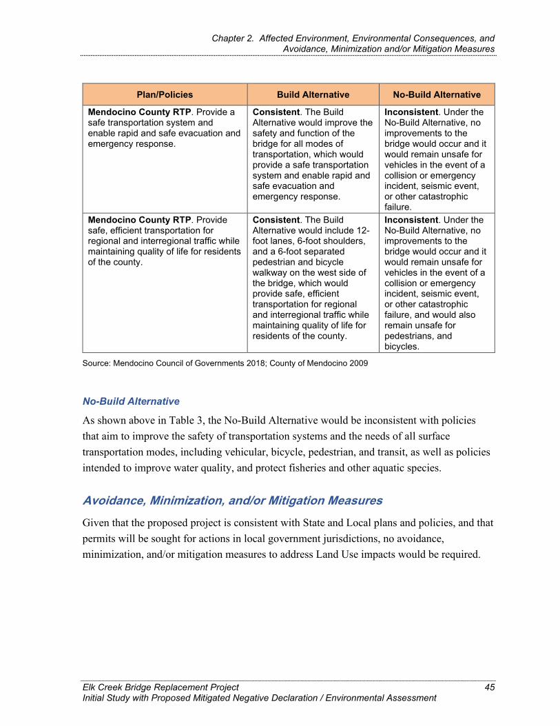
Chapter 2. Affected Environment, Environmental Consequences, and Avoidance, Minimization and/or Mitigation Measures
Plan/Policies Build Alternative No-Build Alternative
Mendocino County RTP. Provide a safe transportation system and enable rapid and safe evacuation and emergency response.
Consistent. The Build Alternative would improve the safety and function of the bridge for all modes of transportation, which would provide a safe transportation system and enable rapid and safe evacuation and emergency response.
Inconsistent. Under the No-Build Alternative, no improvements to the bridge would occur and it would remain unsafe for vehicles in the event of a collision or emergency incident, seismic event, or other catastrophic failure.
Mendocino County RTP. Provide safe, efficient transportation for regional and interregional traffic while maintaining quality of life for residents of the county.
Consistent. The Build Alternative would include 12-foot lanes, 6-foot shoulders, and a 6-foot separated pedestrian and bicycle walkway on the west side of the bridge, which would provide safe, efficient transportation for regional and interregional traffic while maintaining quality of life for residents of the county.
Inconsistent. Under the No-Build Alternative, no improvements to the bridge would occur and it would remain unsafe for vehicles in the event of a collision or emergency incident, seismic event, or other catastrophic failure, and would also remain unsafe for pedestrians, and bicycles.
Source: Mendocino Council of Governments 2018; County of Mendocino 2009
No-Build Alternative
As shown above in Table 3, the No-Build Alternative would be inconsistent with policies that aim to improve the safety of transportation systems and the needs of all surface transportation modes, including vehicular, bicycle, pedestrian, and transit, as well as policies intended to improve water quality, and protect fisheries and other aquatic species.
Avoidance, Minimization, and/or Mitigation Measures Given that the proposed project is consistent with State and Local plans and policies, and that permits will be sought for actions in local government jurisdictions, no avoidance, minimization, and/or mitigation measures to address Land Use impacts would be required.
Elk Creek Bridge Replacement Project Initial Study with Proposed Mitigated Negative Declaration / Environmental Assessment
45

Chapter 2. Affected Environment, Environmental Consequences, and Avoidance, Minimization and/or Mitigation Measures
2.2. Coastal Zone
Regulatory Setting This project has the potential to affect resources protected by the Coastal Zone Management Act (CZMA) of 1972. The CZMA is the primary federal law enacted to preserve and protect coastal resources. The CZMA set up a program under which coastal states are encouraged to develop coastal management programs. States with an approved coastal management plan are able to review federal permits and activities to determine if they are consistent with the state’s management plan.
California has developed a coastal zone management plan and has enacted its own law, the California Coastal Act of 1976, to protect the coastline. The policies established by the California Coastal Act are similar to those for the CZMA: They include the protection and expansion of public access and recreation; the protection, enhancement, and restoration of environmentally sensitive areas; the protection of agricultural lands; the protection of scenic beauty; and the protection of property and life from coastal hazards. The California Coastal Commission is responsible for implementation and oversight under the California Coastal Act.
Just as the federal CZMA delegates power to coastal states to develop their own coastal management plans, the CCA delegates power to local governments to enact their own Local Coastal Programs (LCPs). This project is subject to the County of Mendocino’s local coastal program. LCPs contain the ground rules for development and protection of coastal resources in their jurisdiction consistent with the California Coastal Act goals.
Mendocino County’s LCP is contained in the Coastal Element of the Mendocino County General Plan, which was adopted by the Mendocino County Board of Supervisors and certified by the CCC in November of 1985 and last updated on March 11, 1991 (County of Mendocino 1991). The Mendocino County Coastal Zoning Code is applicable to all properties in the unincorporated areas of Mendocino County inside the Coastal Zone. This project is subject to the California Coastal Act, Mendocino’s County’s LCP, and the Mendocino County Coastal Zoning Code. LCPs contain the ground rules for development and protection of coastal resources in their jurisdiction, consistent with the CCA goals, while the Zoning Code provides specific development criteria and restrictions to protect Coastal resources.
Elk Creek Bridge Replacement Project Initial Study with Proposed Mitigated Negative Declaration / Environmental Assessment
46

Chapter 2. Affected Environment, Environmental Consequences, and Avoidance, Minimization and/or Mitigation Measures
Affected Environment Elk Creek Bridge is approximately 0.3 mile inland from the shoreline within the Navarro River to Mallo Pass Creek Planning Area, which covers 12 miles of the Mendocino County Coastal Zone. Five sensitive natural communities within the Biological Study Area (BSA) were identified as Environmentally Sensitive Habitat Areas (ESHA) under the California Coastal Act (CCA): red alder forest wetland, Sitka willow thicket, coastal brambles, a seasonal wetland (including ditches), and a perennial stream. Under the California Coastal Act and Mendocino County LCP, wetlands may be defined using any one of the three wetland parameters established by the Army Corps of Engineers. These parameters are – hydrology (land must be inundated for at least two weeks once every 2 years), anaerobic soil indicators (soil shows chemical and physical conditions resulting from saturation), and plant species (areas must be dominated by plants adapted to saturated conditions). Therefore areas may be protected as wetlands under the Coastal Act regulations yet not be considered wetlands under the Clean Water Act. These Coastal Zone resources, as well as other potentially jurisdictional waters, are shown below in Figure 5 and discussed further in Section 2.15, Biological Environment-Natural Communities.
Elk Creek Bridge Replacement Project Initial Study with Proposed Mitigated Negative Declaration / Environmental Assessment
47

Chapter 2. Affected Environment, Environmental Consequences, and/or Avoidance, Minimization and/or Mitigation Measures
Figure 5. Environmentally Sensitive Habitat Areas (ESHA) in the Project Area
Elk Creek Bridge Replacement Project Initial Study with Proposed Negative Declaration / Environmental Assessment
48

Chapter 2. Affected Environment, Environmental Consequences, and/or Avoidance, Minimization and/or Mitigation Measures
This page intentionally left blank.
Elk Creek Bridge Replacement Project Initial Study with Proposed Negative Declaration / Environmental Assessment
49

Chapter 2. Affected Environment, Environmental Consequences, and Avoidance, Minimization and/or Mitigation Measures
Environmental Consequences
Construction and Operational Impacts
Build Alternative
The California Coastal Act (CCA) policies that pertain to the proposed project are provided in the table below to assist with the evaluation of permitting the proposed project.
Table 4. California Coastal Act, Public Resources Code Division 20
Policy Number Subject of Policy Build Alternative
Coastal Zone Assessment
Section 30210 Maximum public access and recreational opportunities shall be provided.
The proposed project would improve coastal public access by replacing the structurally deficient Elk Creek Bridge and improving access for bicyclists and pedestrians.
Section 30211 Development shall not interfere with public access to the sea.
The proposed project would not limit public access to the sea and would, upon completion, improve public access in the Coastal Zone.
Section 30211
New development projects shall provide for public access to the shoreline and along the coast.
The proposed project would improve coastal public access by replacing the structurally deficient Elk Creek Bridge and improving access for bicyclists and pedestrians on the SR 1 corridor with the construction of the separated pedestrian and bicycle path along the west side of the new bridge.
Section 30241-30242 Agricultural Land.
No important farmlands or timberlands are located in the project area. There would be no impacts.
Section 30252 Public Access.
The proposed project would improve coastal public access by replacing the structurally deficient Elk Creek Bridge and improving access for bicyclists and pedestrians on the SR 1 corridor with the construction of the separated pedestrian and bicycle path along the west side of the new bridge.
Elk Creek Bridge Replacement Project Initial Study with Proposed Mitigated Negative Declaration / Environmental Assessment
50

Chapter 2. Affected Environment, Environmental Consequences, and Avoidance, Minimization and/or Mitigation Measures
Policy Number Subject of Policy Build Alternative
Coastal Zone Assessment
Section 30221 Oceanfront land; protection for recreational use and development.
The proposed project would not impact any recreational uses along the ocean and would improve access to nearby beaches, the Pacific Coast Bike Route and California Coastal Trail.
Section 30231 Biological productivity; wastewater.
Standard Measures, BMPs and minimization measures are incorporated to minimize environmental effects to biological resources and water quality.
Section 30232 Oil and hazardous substance spills.
Standard Measures and BMPs are incorporated to minimize environmental effects of hazardous materials and potential spills during construction.
Section 30233 Diking, filling, dredging of wetlands.
This project has been designed to avoid wetland impacts as much as possible. Standard Measures (such as ESHA fencing), BMPs and restoration and revegetation measures are incorporated to minimize environmental effects to wetlands.
Section 30240 Environmentally sensitive habitat areas; adjacent developments.
Potential adverse effects to ESHAs have been reduced to the extent practicable. Standard Measures, BMPs, and restoration and revegetation measures are incorporated to minimize effects to environmentally sensitive habitat areas.
Section 30244 Archaeological or paleontological resources.
No archaeological, historic, or paleontological resources were identified in the study area. The project is not anticipated to result in an adverse effect to archaeological and historical resources. Standard Measures and BMPs are incorporated to avoid and minimize potential adverse environmental effects to archaeological resources from accidental discovery, and no adverse effects to paleontological resources are anticipated.
Source: California Coastal Commission 2019
ESHA = Environmentally Sensitive Habitat Areas
Elk Creek Bridge Replacement Project Initial Study with Proposed Mitigated Negative Declaration / Environmental Assessment
51

Chapter 2. Affected Environment, Environmental Consequences, and Avoidance, Minimization and/or Mitigation Measures
The policies in the Mendocino Coastal General Plan identified in Table 5 below pertain to the proposed project.
Table 5. Mendocino County Coastal Element and Coastal Zoning Code
Policy Number Subject of Policy Build Alternative Coastal Zone
Assessment
Coastal Element Policy 4.10-1: Elk
Elk shall be designated a Rural Village, with residential, commercial, and cottage industry uses limited mainly by sewage disposal standards. Additional overnight accommodation units shall be limited to 20 and commercial floor area limitations shall be set to keep visitor-serving uses in scale with community size.
The proposed project would replace the existing Elk Creek Bridge. While it would add safety features for bicyclists and pedestrians, no additional traffic lanes would be added, and there would be no change in capacity. The project would not conflict with the Coastal Element’s goals of maintaining the unique rural character of Elk, which is located approximately 2.5 miles north of the bridge.
Mendocino County Coastal Zoning Code, Section 20.496 – Environmentally Sensitive Habitat and Other Resource Areas
This Chapter applies to all development proposed in the Coastal Zone unless and until can be demonstrated to the approving authority that the projects will not degrade an environmentally sensitive habitat or resource area and shall be compatible with the continuance of such areas.
The project would have temporary, direct impacts to environmentally sensitive habitat areas (ESHA) at the bridge site during construction from vegetation removal, access road construction, and both bridge demolition and construction as discussed in this document. This work would be within the 50-foot buffer of ESHA required under Mendocino County’s Coastal Zoning Code. However, the proposed work would be consistent with Section 20.496.020(4)a-k as well as other applicable provisions of the section. This, in conjunction with the anticipated permit conditions, Standard Measures, BMPS, and proposed revegetation and restoration measures, would ensure project consistency with the Mendocino County Coastal Zoning Code.
Source: County of Mendocino 2009
Elk Creek Bridge Replacement Project Initial Study with Proposed Mitigated Negative Declaration / Environmental Assessment
52

Chapter 2. Affected Environment, Environmental Consequences, and Avoidance, Minimization and/or Mitigation Measures
The existing bridge is structurally deficient and would be replaced to ensure access is not blocked in the event of a collision or emergency incident, seismic event, or other catastrophic failure. State Route 1 would remain open during project construction. Construction of the project could result in temporary traffic delays; however, public access would be maintained throughout the construction period. A Transportation Management Plan would be implemented to reduce temporary delays associated with construction.
Construction and operation of the proposed project would result in short-term temporary, temporal, and permanent impacts to ESHAs, discussed in Section 2.15, Biological Environment. Caltrans’ Standard Measures, Best Management Practices, and permit conditions required by regulatory agencies would be implemented to reduce these effects. Construction and site restoration plans have been developed to ensure consistency with the Mendocino County Coastal Zoning Code, which establishes in Section 20.496.020 and other pertinent requirements that development adjacent to ESHA and within the required buffer area is compatible with the continuation of the adjacent habitat area.
Therefore, the proposed project is consistent with local, regional, and state plans, and with the Mendocino County Coastal Element.
No-Build Alternative
State Route 1 is used as a primary access road in Mendocino County, as it is the one road that traverses the cities and towns on the coast. It also provides access to the Pacific Coast Bike Route, California Coastal Trail, and public beaches. Under the No-Build Alternative, the existing Elk Creek Bridge would not be improved. Therefore, the No-Build alternative could conflict with the CCA because coastal access would not be improved and access could be impaired in the event of a collision or emergency incident, seismic event, or other catastrophic failure.
Avoidance, Minimization, and/or Mitigation Measures With implementation of the Standard Measures and Best Management Practices discussed earlier in Section 1.6, many of the potential impacts on Coastal Zone resources would be avoided. Additional permit conditions, as required by the Coastal Development Permit, are anticipated to further reduce the level of impacts and provide for restoration areas impacted by construction. Additional discussion of impacts is provided in Section 2.15, Biological Resources.
Elk Creek Bridge Replacement Project Initial Study with Proposed Mitigated Negative Declaration / Environmental Assessment
53
Chapter 2. Affected Environment, Environmental Consequences, and Avoidance, Minimization and/or Mitigation Measures
2.3. Utilities/Emergency Services
Affected Environment There are no utilities present within the project corridor; therefore, utilities are not discussed further.
The Mendocino County Office of Emergency Services (OES) is responsible for disaster planning, assistance, and coordination of all jurisdictions within the Mendocino Operational Area, which encompasses Mendocino County. The OES Director administers the Mendocino County Emergency Operations Plan for the planned response to extraordinary emergency situations associated with natural disasters, technological incidents, and national security emergencies occurring in or affecting the county (County of Mendocino 2009).
Fire protection in Mendocino County is provided by local districts, the cities of Ukiah and Fort Bragg, the California Department of Forestry and Fire Protection (CAL FIRE), and the U.S. Forest Service. In the study area, fire protection is provided by the Elk and Greenwood Ridge Fire Departments. The two departments cover a 55-square-mile area with three stations and are staffed with 15 volunteer firefighters. Of the 15 firefighters, four are Emergency Medical Technicians. Fire equipment includes three wildland engines, two pumping tankers, one rescue truck, one Type 1 city-style engine, and one ambulance (Greenwood Civic Club 2018). The firehouse is located in Elk at the Greenwood Community Center and is closest to the project site—approximately 2.5 miles north of the bridge.
The County of Mendocino OES coordinates emergency response in Mendocino County through the Fire and Rescue Mutual Aid Coordinator. The Fire and Rescue Mutual Aid Coordinator functions within the California Fire Service and Rescue Emergency Mutual Aid System. Several private companies also provide air ambulance service. Most of the first responders for local fire service agencies—excluding the City of Ukiah, CAL FIRE, and the US Forest Service—are volunteers, with relatively few paid staff. Most local fire stations are staffed by volunteer firefighters (County of Mendocino 2009).
The Mendocino County Sheriff’s Office is responsible for providing law enforcement services to the unincorporated areas of the county, including the study area. The main sheriff’s station, including dispatch and detention facilities, is at the Mendocino County Administration Center complex in the City of Ukiah. Substations are located in the cities of Willits and Fort Bragg. The California Highway Patrol (CHP) is responsible for traffic
Elk Creek Bridge Replacement Project Initial Study with Proposed Mitigated Negative Declaration / Environmental Assessment
54

Chapter 2. Affected Environment, Environmental Consequences, and Avoidance, Minimization and/or Mitigation Measures
enforcement services on state highways and county roads, and a CHP office is located in Ukiah (County of Mendocino 2009).
Environmental Consequences
Construction Impacts
Build Alternative
The proposed project would utilize a temporary one-lane, 22.5-foot-wide bridge and temporary roadway approaches east of the current bridge to accommodate alternating, one-way traffic control throughout the demolition and construction period. Following construction of the new bridge, traffic would return to the current alignment, the temporary bridge would be removed, and the temporary roadway approaches regraded to pre-construction grade. Construction of the proposed project could lead to temporary, short-term traffic delays for emergency service providers. However, at least one lane of traffic would remain open at all times, and emergency service providers would be notified in advance of construction activities. A Transportation Management Plan (TMP) would be implemented during construction to minimize traffic impacts for emergency service providers. The TMP would include the following actions:
One lane closure is allowed within the project limits using a temporary traffic-actuated signal system with 12-inch flashing beacons installed on the three advance construction signs.
Any emergency service agency whose ability to respond to incidents would be affected by any lane closure must be notified prior to that closure.
Reversing traffic control with flaggers requires the use of advance flaggers during daylight hours and full matrix Portable Changeable Message Sign boards.
During installation of the temporary traffic signal, public traffic may be stopped in both directions of periods not to exceed 10 minutes.
After installation of the temporary traffic signal, public traffic may be stopped in both directions a maximum of 5 minutes during reversing traffic control or 15 minutes during intermittent closures.
Elk Creek Bridge Replacement Project Initial Study with Proposed Mitigated Negative Declaration / Environmental Assessment
55

Chapter 2. Affected Environment, Environmental Consequences, and Avoidance, Minimization and/or Mitigation Measures
No-Build Alternative
As construction would not occur, there would be no impacts on emergency service providers under the No-Build Alternative.
Operational Impacts
Build Alternative
Access and safety through the project area would improve for emergency service providers during operations because the proposed project would improve the function and geometrics of the bridge and approach roadway to ensure uninterrupted traffic movement in the event of a collision or emergency incident, seismic event, or other catastrophic failure. The design of the proposed project would improve traffic flow with upgrades to the bridge approach by widening the shoulders and decreasing the curve radius, thus improving safety and reducing the potential for accidents and collisions on the bridge resulting in a beneficial effect.
No-Build Alternative
There would be no impacts to emergency service providers under the No-Build Alternative because operational changes would not occur.
Avoidance, Minimization, and/or Mitigation Measures As there would be no impacts to emergency service providers, no avoidance, minimization, and/or mitigation measures would be required.
2.4. Traffic and Transportation/Pedestrian and Bicycle Facilities
Regulatory Setting Caltrans, as assigned by the FHWA, directs that full consideration should be given to the safe accommodation of pedestrians and bicyclists during the development of Federal-aid highway projects (see 23 CFR 652). It further directs that the special needs of the elderly and the disabled must be considered in all Federal-aid projects that include pedestrian facilities. When current or anticipated pedestrian and/or bicycle traffic presents a potential conflict with motor vehicle traffic, every effort must be made to minimize the detrimental effects on all highway users who share the facility.
In July 1999, the U.S. Department of Transportation (USDOT) issued an Accessibility Policy Statement pledging a fully accessible multimodal transportation system. Accessibility in
Elk Creek Bridge Replacement Project Initial Study with Proposed Mitigated Negative Declaration / Environmental Assessment
56

Chapter 2. Affected Environment, Environmental Consequences, and Avoidance, Minimization and/or Mitigation Measures
federally assisted programs is governed by the USDOT regulations (49 CFR 27) implementing Section 504 of the Rehabilitation Act (29 United States Code [USC] 794). The FHWA has enacted regulations for the implementation of the 1990 Americans with Disabilities Act (ADA), including a commitment to build transportation facilities that provide equal access for all persons. These regulations require application of the ADA requirements to federal-aid projects, including Transportation Enhancement Activities.
County of Mendocino General Plan
Applicable goals, actions, and policies from the Development Element of the Mendocino County General Plan (2009) are listed below.
Goal DE-8 (Transportation): A balanced and coordinated transportation system that:
Is an integrated and attractive part of each community.
Is functional, safe, and pleasant to use, and supports emergency services.
Provides a choice of modes accessing and connecting places frequented in daily life.
Promotes compact development and infrastructure efficiencies.
Is consistent with principles of sustainability and conservation of resources.
Is not solely dependent on the continuation of fossil fuel resources.
Can be maintained, used, and justified if available energy sources change during the duration of the General Plan Goal DE-9 (Road Systems). A countywide road system that provides safe, efficient, and attractive access, coordinated with interstate, state, local and area-wide systems.
Goal DE-10 (Pedestrian & Bicycle): Functional, safe, and attractive pedestrian and bicycle systems coordinated with regional and local transportation plans and other transportation modes.
Plan Policy DE-128: Ensure that transportation infrastructure accommodates the safety and mobility of motorists, pedestrians, bicyclists, and persons in wheelchairs.
Action Item DE-136.1: The County will refer to Caltrans all development applications which propose direct access to a state highway. Affected roadways that need to meet the most current Caltrans requirements include all or portions of the following:
State Route 1
Elk Creek Bridge Replacement Project Initial Study with Proposed Mitigated Negative Declaration / Environmental Assessment
57

Chapter 2. Affected Environment, Environmental Consequences, and Avoidance, Minimization and/or Mitigation Measures
State Route 20
U.S. Highway 101
State Route 128
State Route 253
State Route 162
Policy DE-152: The County shall ensure that bicycle facilities are safe, attractive, and useful for both recreational and commuting cyclists. This will include:
Requiring that bicycle facilities be designed in accordance with the State Bikeway Design Criteria.
Periodically reviewing and updating, if needed, street standards to accommodate bicycle lanes where indicated on the Bikeway Master Plan.
Designing bridges, over passes, under passes, etc. to be compatible with bicycle travel.
Considering bicycle safety when implementing improvements for automobile traffic operations.
Provide an information/education program to encourage use of the system and to promote safe riding.
Affected Environment Unless otherwise noted, this analysis is based on the Transportation Management Plan prepared in December 2017 (Caltrans 2017b) and the Project Scope Summary Report prepared in June 2015 (Caltrans 2015).
State Route 1 is the key north-south highway through the county in the project vicinity, and the only state highway that serves the coastal area in this part of the county. Philo Greenwood Road, just north of the project, runs east to west and connects SR 1 to Cameron Road. State Route 1 is functionally classified as a rural minor arterial.
Pedestrian and Bicycle Facilities
There are no sidewalks or other pedestrian facilities within the project limits. State Route 1 is legislatively designated as the Pacific Coast Bike Route; however, the shoulders along SR 1 are limited, narrow, and functionally below current safety standards.
Elk Creek Bridge Replacement Project Initial Study with Proposed Mitigated Negative Declaration / Environmental Assessment
58

Chapter 2. Affected Environment, Environmental Consequences, and Avoidance, Minimization and/or Mitigation Measures
Transit Facilities
The Mendocino Transit Authority (MTA) provides public transit services for Mendocino County and its service area, which encompasses about 2,800 square miles. Currently MTA operates 12 fixed bus routes connecting the Mendocino coast, inland valleys, towns and communities to Ukiah—the county seat and largest of the four incorporated cities. The project area is served by MTA Route 75.
Traffic Volumes
Traffic data for the project area was provided by the Caltrans Office of Travel Forecasting and Modeling on October 10, 2013 and is included in Table 6 below.
Table 6. Annual Average Daily Traffic
Year Annual ADT
2013 1,120 2018 1,180 2028 1,290 2038 1,400
Annual average daily traffic (AADT) projections on SR 1 at PM 31.5 show an increase of 280 vehicles from the year of the study to year 2038. However, according to 2017 traffic volumes for SR 1 at PM 34.9, the AADT is 1,300 (Caltrans 2017a).
Peak hour average daily trips (ADT) are projected to increase from 150 ADT in the year of the study (2013) to 190 in year 2038. The Transportation Management Plan reports a peak hour traffic volume count of 300 vehicles per hour in the project area.
Table 7. Peak Hour Average Daily Trips
Year Peak Hour ADT
2013 150 2018 160 2028 180 2038 190
Collision Analysis
According to the collision analysis conducted for the project, there were no reported collisions during the 5-year time period between July 2007 and June 2012.
Elk Creek Bridge Replacement Project Initial Study with Proposed Mitigated Negative Declaration / Environmental Assessment
59

Chapter 2. Affected Environment, Environmental Consequences, and Avoidance, Minimization and/or Mitigation Measures
Environmental Consequences
Construction Impacts
Build Alternative
The primary impacts anticipated from the proposed project are construction related. Construction could lead to temporary, short-term traffic delays for vehicles, transit services, and emergency service providers. However, at least one lane of traffic would remain open, and travelers and emergency service providers would be notified in advance of construction activities. Estimated delays would be no more than 10 minutes during the installation of the temporary traffic signal, then 5 minutes during reversing traffic control and 15 minutes during intermittent closures thereafter.
A TMP would be prepared for the project and would be implemented during construction to minimize traffic impacts. The TMP would include, in part, the following actions:
One lane closure is allowed within the project limits, using a temporary traffic-actuated signal system with 12-inch flashing beacons installed on the three advance construction signs.
Reversing traffic control with flaggers requires the use of advance flaggers during daylight hours and full matrix Portable Changeable Message Sign boards.
During installation of the temporary traffic signal, public traffic may be stopped in both directions of periods not to exceed 10 minutes.
After installation of the temporary traffic signal, public traffic may be stopped in both directions a maximum of 5 minutes during reversing traffic control or 15 minutes during intermittent closures.
The Caltrans District Public Information Office would be informed at least 2 weeks prior to construction.
All work would be coordinated with the MTA bus service and school bus system in advance of construction.
Any emergency service agency whose ability to respond to incidents would be affected by any lane closure must be notified prior to that closure.
Signage would be in place in advance of construction to notify motorists and bicyclists.
Elk Creek Bridge Replacement Project Initial Study with Proposed Mitigated Negative Declaration / Environmental Assessment
60
Chapter 2. Affected Environment, Environmental Consequences, and Avoidance, Minimization and/or Mitigation Measures
The project is in the Coastal Zone but would not impact access to the coast or any coastal recreational areas. Temporary traffic delays would occur along SR 1, but measures described above from the TMP would reduce these impacts. Upon completion, the project would improve access along SR 1 for all modes of transportation, including nonmotorized.
No-Build Alternative
As the proposed project would not be constructed under the No-Build Alternative, construction-related traffic effects would not occur.
Operational Impacts
Build Alternative
Upon completion, the project would provide continued access across Elk Creek. The project is not a capacity-increasing project. Neither traffic patterns nor roadway capacity would change as a result of the project. The project would improve the function and geometrics of the Elk Creek Bridge and approach roadway to ensure uninterrupted traffic movement in the event of a collision or emergency incident, seismic event, or other catastrophic failure and provide safe access for pedestrians and bicyclists across the bridge. The design of the proposed project would improve traffic flow with upgrades to the bridge approach by widening the shoulders and decreasing the curve radius, thus improving safety and reducing the potential for accidents and collisions on the bridge. It would also improve pedestrian/bicycle access and safety by providing a separated pedestrian/bicycle walkway on the west side of the bridge.
No-Build Alternative
As the proposed project would not be constructed under the No-Build Alternative, the Elk Creek Bridge would not be replaced. No improvements to bicycle or pedestrian facilities would occur and the existing safety deficiencies would not be addressed.
Avoidance, Minimization, and/or Mitigation Measures As there would be no changes or impacts to Traffic and Transportation/Pedestrian and Bicycle Facilities, no avoidance, minimization, or mitigation measures would be required.
Elk Creek Bridge Replacement Project Initial Study with Proposed Mitigated Negative Declaration / Environmental Assessment
61

Chapter 2. Affected Environment, Environmental Consequences, and Avoidance, Minimization and/or Mitigation Measures
2.5. Visual/Aesthetics
Regulatory Setting The National Environmental Policy Act (NEPA) of 1969, as amended, establishes that the federal government use all practicable means to ensure all Americans safe, healthful, productive, and aesthetically (emphasis added) and culturally pleasing surroundings (42 USC 4331[b][2]). To further emphasize this point, the FHWA, in its implementation of NEPA (23 USC 109[h]), directs that final decisions on projects are to be made in the best overall public interest taking into account adverse environmental impacts, including, among others, the destruction or disruption of aesthetic values.
The California Environmental Quality Act (CEQA) establishes that it is the policy of the state to take all action necessary to provide the people of the state “with…enjoyment of aesthetic, natural, scenic and historic environmental qualities” (CA PRC Section 21001[b]).
California Streets and Highways Code Section 92.3 directs Caltrans to use drought-resistant landscaping and recycled water when feasible, and incorporate native wildflowers and native and climate-appropriate vegetation into the planting design, where appropriate.
Affected Environment The information in this section is from the Visual Impact Assessment (Caltrans 2018a). State Route 1 traverses much of California’s coast, following nearly the full length of the Mendocino County coastline, and is a popular choice for tourists using both motorized and non-motorized means of travel. Land use within the corridor is primarily rural agriculture, with minimal urban development and natural areas.
The project is within the Coastal Zone and is considered a sensitive corridor in regard to visual and scenic resources as there are enduring views of the ocean throughout the highway corridor. State Route 1 is eligible for designation as a State Scenic Highway and the County of Mendocino recommends that the entire length of SR 1 located within the county be designated. Moreover, under the Coastal and Resource Management Elements of the County’s General Plan, many visual elements within the project site are considered scenic resources within the county, including rural-open grazing or grassland, inland hills, valleys and ridges, river views, seascape, and natural wildlife and wildlife habitats. The North Coast Heritage Corridor includes the entirety of SR 1 in the county. The route is also legislatively
Elk Creek Bridge Replacement Project Initial Study with Proposed Mitigated Negative Declaration / Environmental Assessment
62

Chapter 2. Affected Environment, Environmental Consequences, and Avoidance, Minimization and/or Mitigation Measures
designated as part of the Pacific Coast Bike Route, which is internationally known and traveled extensively in the summer months by cyclists from multiple countries.
The SR 1 corridor in Mendocino County passes through the Northern California Coast section of California eco-regions. The landscape types include coastal bluffs, coastal prairie, coastal scrub, riparian forest, mixed conifer forest, rural agriculture, and small community development. Elk Creek is a riparian mixed-forest and wetland scenic corridor. The creek can be viewed from the bridge to the east and west.
Most of the SR 1 corridor is elevated on coastal bluffs with scenic vista views of the Pacific Ocean to the west and scenic views of the forested mountains and ridgelines to the east. State Route 1 is relatively straight for miles north and south, except at the project location. Directly south of the proposed project are hairpin turns that wind steeply down to the creek from the bluff tops. These turns provide views of the Elk Creek estuary and beach, Pacific Ocean, riparian forest, wetlands, and coastal bluff faces. Directly to the north of the project site, the road makes a wide, arcing loop around the riparian area and wetlands that surround Elk Creek. However, the project corridor is located within a curve and at a low spot along SR 1, where there are no scenic vista views of the Pacific Ocean. This is because the surrounding terrain and dense roadside vegetation limit views to the immediate project corridor. The views from the bridge are of the riparian vegetation in the foreground and middle ground with some views of mountain ridges.
Elk Creek Bridge Replacement Project Initial Study with Proposed Mitigated Negative Declaration / Environmental Assessment
63

Chapter 2. Affected Environment, Environmental Consequences, and Avoidance, Minimization and/or Mitigation Measures
Environmental Consequences
Construction Impacts
Build Alternative
Construction activities would introduce considerable heavy equipment and associated vehicles into the viewshed of highway users. Construction signaling and signage would also be visible to direct traffic, signifying lane shifts and closures. The presence of construction activities and equipment would affect views of and from the project corridor during the construction period. Highway users are transient, but familiar with heavy equipment and construction activities within the area associated with roadway projects along the highway. There are no highway neighbors associated with the proposed project. Highway users would experience construction delays and temporary road closures until the bridge is operational, and such delays would likely be perceived negatively by traffic that passes through this area. However, delays experienced under the project would be short-term. Therefore, visual impacts resulting from construction would only be temporary for the eligible State Scenic Highway and associated highway users. Because there are no scenic vista views, such views would not be affected during construction.
No nighttime construction is proposed, although minimal night work may be required, depending upon site specific conditions and unforeseen delays in construction. Any night work would be conducted according to Section 7-1.04 of Caltrans’ Standard Specifications which requires that temporary illumination be installed in a manner that the illumination and the illumination equipment do not interfere with public safety. Caltrans, working with contractors, would ensure that no lighting is aimed in a manner that would affect roadway users traveling at night.
No-Build Alternative
Under the No-Build Alternative, the project would not be constructed. Therefore, there would be no temporary visual impacts on the existing visual character, visual quality, light and glare, or affected viewer groups as a result of the proposed project being constructed.
Elk Creek Bridge Replacement Project Initial Study with Proposed Mitigated Negative Declaration / Environmental Assessment
64

Chapter 2. Affected Environment, Environmental Consequences, and Avoidance, Minimization and/or Mitigation Measures
Operational Impacts
Build Alternative
The proposed project falls within a non-urbanized area and, therefore, would not conflict with applicable zoning and other regulations governing scenic quality associated with an urbanized area.
Existing Visual Character or Quality of Public Views in Non-Urbanized Areas The visual character of the existing bridge would be altered by the proposed project; however, those changes would remain compatible with the existing visual character of the corridor. The proposed bridge structural upgrades would be well integrated within the existing and future corridor due to the various bridge projects along SR 1 within the region that have been, or would be, upgraded to similar design standards. Corridor consistency would be upheld by using “see-through” barrier railings, wider shoulders, and pedestrian-friendly edge treatments. Local examples of completed projects using these standards include the Noyo River Bridge, Greenwood Creek Bridge, and Ten Mile River Bridge.
The existing Elk Creek Bridge is a 122-foot-long structure with two 11-foot lanes and 2-foot-wide shoulders. The existing bridge railing is a low-profile rustic wood barrier on a concrete curb painted white and shows obvious signs of decay.
The proposed project would widen the bridge to accommodate 12-foot lanes and 6-foot shoulders, add a 6-foot separated pedestrian and bicycle walkway on the west side of the bridge, and lengthen it from 122 feet to 140 feet. The existing bridge is viewed primarily from the roadway, and this would not change due to a lack of highway neighbors and lack of visual access towards the bridge from surrounding areas. The proposed project would retain the linear shapes and masses which are seen by highway users and currently associated with the existing bridge. Plainly stated, this means that the overall shape of the railings and bridge and the mass (or size) of the bridge elements, as seen from the roadway, will be substantially similar to the existing bridge. The proposed project would not contain any new non-typical visual intrusions; it would only expand on and up-scale the existing features. Therefore, the proposed form would blend with and be compatible with the existing visual character of the project corridor.
The proposed bridge would create a somewhat more modern-looking aesthetic and have a smoother texture. The proposed barrier railing would be taller than the existing railing and would somewhat obstruct views from vehicles. However, the proposed wider shoulders and taller railing would provide safer viewing opportunities for pedestrians and bicyclists. In
Elk Creek Bridge Replacement Project Initial Study with Proposed Mitigated Negative Declaration / Environmental Assessment
65

Chapter 2. Affected Environment, Environmental Consequences, and Avoidance, Minimization and/or Mitigation Measures
addition, the proposed bridge railing would likely recede into the background somewhat more than the existing white bridge railing, with consideration of avoidance and minimization measures to stain or paint the bridge railing, which would decrease contrast with the background and increase the visual intactness of the area.
Currently, riparian vegetation grows within feet of the bridge and this vegetation would need to be removed on both sides of the bridge to accommodate construction work. However, views from vehicles of the vegetation and mountain ridgelines in the middle ground would be maintained. Removal of the vegetation next to the bridge would temporarily increase views of the creek for pedestrians and bicyclists, which could be perceived as a positive impact. However, RSP and bridge abutments would be visible for these same viewers. Vegetation removal could present a temporary change in the visual character of the area until riparian vegetation recolonizes disturbed areas and revegetation efforts (which would occur through implementation of the avoidance and minimization measures) are successful. It is anticipated that the return of riparian vegetation would soften the overall scale and texture of the new bridge.
To the extent feasible, improvements to the highway would comply with Caltrans’ 2016 Highway Design Manual, which utilizes Context Sensitive Solutions consistent with the 2001 Director’s Policy memorandum DP-22. This approach includes implementing Design Standards 304.1, Side Slope Standards; 304.4, Contour Grading and Slope Rounding; and 902.1, Design Considerations, Aesthetics. Compliance with these Highway Design Manual design standards would minimize visual impacts associated with roadside grading, slopes, and revegetating exposed slopes, thereby reducing impacts on the views associated with the interchange.
The proposed project would not change the overall viewer experience associated with the site, and the proposed bridge would continue to function as a vivid connection between areas to the north and south of the project corridor. Compliance with the Caltrans Highway Design Manual, Standard Specifications, and implementation of the avoidance and minimization measures listed below would ensure the existing visual character of the project corridor would not be substantially altered, the existing visual quality of the project corridor would not be degraded, and coastal areas would not be negatively affected by the proposed project.
Elk Creek Bridge Replacement Project Initial Study with Proposed Mitigated Negative Declaration / Environmental Assessment
66

Chapter 2. Affected Environment, Environmental Consequences, and Avoidance, Minimization and/or Mitigation Measures
Scenic Roadways The proposed project is located on a section of SR 1 that is eligible as a scenic highway. However, as SR 1 within the project limits is currently not listed as a scenic highway, there would be no impact to a scenic highway.
Overall, the proposed project would not change the viewer experience associated with the eligible scenic highway. This is because the existing visual character of the project corridor would not be substantially altered, the existing visual quality of the project corridor would not be degraded, and coastal areas would not be negatively affected by the proposed project due to compliance with the Caltrans Highway Design Manual and Standard Specifications and implementation of the avoidance and minimization measures listed below.
Scenic Vistas As described under Construction, there are no scenic vistas associated with the project site. Therefore, scenic vistas would not be affected as a result of the proposed project.
Light and Glare There are no streetlights along the project corridor, and the proposed project would not introduce new sources of permanent nighttime lighting. Therefore, nighttime lighting levels associated with the project corridor would not be affected. The amount of new pavement that would be introduced would be minor and result in a negligible increase in daytime glare that would not be perceptible.
No-Build Alternative
Under the No-Build Alternative, there would be no visual impacts on the existing visual character, visual quality, or affected viewer groups as a result of the proposed project over the short-term. However, visual impacts would result over the longer-term as the bridge structure further declines. This would detract from the overall visual character and quality of the bridge over the long term.
Elk Creek Bridge Replacement Project Initial Study with Proposed Mitigated Negative Declaration / Environmental Assessment
67

Chapter 2. Affected Environment, Environmental Consequences, and Avoidance, Minimization and/or Mitigation Measures
Avoidance, Minimization, and/or Mitigation Measures The following avoidance and minimization measures would be incorporated into the project.
AE-1: Rail Design. Incorporate architectural elements for the proposed pedestrian railing to provide a positive foreground experience to viewers. Treat bridge barrier railings to compliment and not contrast with the surrounding landscape using color or other treatments on standard railings.
AE-2: Staining. Stain the new metal elements a neutral, natural color such as brown to increase compatibility and reduce glare. This would further recede the metal elements, such as bridge railing and guardrail, into the surrounding landscape. Staining would also nearly eliminate the glare of new metal elements. If these items are both stained brown, this would also reduce temporary and permanent impacts.
AE-3: Revegetation. Revegetate the area as soon as possible following construction to minimize visual impacts from vegetation removal. As part of the bridge construction contract, planting work (including willows and other native plants) would be installed and given a 1-year plant establishment period. This revegetation work would help to ensure the visual impacts from vegetation removal would be temporary.
Elk Creek Bridge Replacement Project Initial Study with Proposed Mitigated Negative Declaration / Environmental Assessment
68

Chapter 2. Affected Environment, Environmental Consequences, and Avoidance, Minimization and/or Mitigation Measures
2.6. Cultural Resources
Regulatory Setting The term “cultural resources,” as used in this document, refers to the “built environment” (e.g., structures, bridges, railroads, water conveyance systems, etc.), places of traditional or cultural importance, and archaeological sites (both prehistoric and historic), regardless of significance. Under federal and state laws, cultural resources that meet certain criteria of significance are referred to by various terms including “historic properties”, “historic sites”, “historical resources”, and “tribal cultural resources”. Laws and regulations dealing with cultural resources include:
The National Historic Preservation Act (NHPA) of 1966, as amended, sets forth national policy and procedures for historic properties, defined as districts, sites, buildings, structures, and objects included in or eligible for listing in the National Register of Historic Places (NRHP). Section 106 of the NHPA requires federal agencies to take into account the effects of their undertakings on historic properties and to allow the Advisory Council on Historic Preservation (ACHP) the opportunity to comment on those undertakings, following regulations issued by the ACHP (36 CFR 800). On January 1, 2014, the First Amended Section 106 Programmatic Agreement (PA) among the FHWA, the ACHP, the California State Historic Preservation Officer (SHPO), and Caltrans went into effect for Caltrans projects, both state and local, with FHWA involvement. The PA implements the ACHP’s regulations, 36 CFR 800, streamlining the Section 106 process and delegating certain responsibilities to Caltrans. The FHWA’s responsibilities under the PA have been assigned to Caltrans as part of the Surface Transportation Project Delivery Program (23 USC 327).
The California Environmental Quality Act requires the consideration of cultural resources that are historical resources and tribal cultural resources, as well as “unique” archaeological resources. California PRC Section 5024.1 established the California Register of Historical Resources (CRHR) and outlined the necessary criteria for a cultural resource to be considered eligible for listing in the CRHR and, therefore, a historical resource. Historical resources are defined in PRC Section 5020.1(j). In 2014, Assembly Bill (AB) 52 added the term “tribal cultural resources” to CEQA, and AB 52 is commonly referenced instead of CEQA when discussing the process to identify tribal cultural resources (as well as identifying measures to avoid, preserve, or mitigate effects to them). Defined in PRC Section 21074(a), a tribal cultural resource is a CRHR or local register eligible site, feature, place, cultural landscape, or object which has a cultural value to a California Native American tribe. Tribal
Elk Creek Bridge Replacement Project Initial Study with Proposed Mitigated Negative Declaration / Environmental Assessment
69

Chapter 2. Affected Environment, Environmental Consequences, and Avoidance, Minimization and/or Mitigation Measures
cultural resources must also meet the definition of a historical resource. Unique archaeological resources are referenced in PRC Section 21083.2.
Public Resources Code Section 5024 requires state agencies to identify and protect state-owned historical resources that meet the NRHP listing criteria. It further requires Caltrans to inventory state-owned structures in its rights of way.
Affected Environment The following analysis and determinations are based on the Historic Property Survey Report, which includes the Archaeological Survey Report (Caltrans 2018b) prepared for the Project.
Area of Potential Effects
The Area of Potential Effects (APE) for the project consists of the horizontal and vertical maximum potential extent of direct and indirect impacts that could result from the project. The archaeological APE includes the project footprint, construction areas, easements, and staging areas. The APE is a linear corridor along SR 1 between PM 31.21 and PM 31.5 that includes the Elk Creek Bridge. It measures 3.3 acres in size and encompasses the existing and proposed ROW and TCEs necessary for the project.
Methods
Investigations for cultural resources located in the project APE were conducted in 2018 and included archival research, a records search, Native American consultation, and a cultural resources pedestrian survey.
Archival Research and Records Search
A records search of the APE was conducted on February 2, 2018, by the Northwest Information Center (NWIC). In addition, a records search of the Caltrans Cultural Resource Database for the APE was conducted. The results of the NWIC records search, along with the search of Caltrans District 1 files, determined that no previously known cultural resources exist within the project area or within a 0.25-mile radius.
Native American Consultation
Native American consultation was initiated by Caltrans with a letter sent to the Native American Heritage Commission (NAHC) in Sacramento. On January 29, 2018, the NAHC replied that their search of the sacred lands file failed to identify Native American cultural resources in the study area. The NAHC also provided a list of 15 Native American tribes,
Elk Creek Bridge Replacement Project Initial Study with Proposed Mitigated Negative Declaration / Environmental Assessment
70

Chapter 2. Affected Environment, Environmental Consequences, and Avoidance, Minimization and/or Mitigation Measures
groups, and individuals with potential interests, concerns, and/or knowledge regarding cultural resources or Traditional Cultural Properties that may be affected by the project. Caltrans wrote a letter (dated February 14, 2018) to each of the parties on the NAHC contact list, informing them of the project and requesting their participation. The only response received was from the Tribal Historic Preservation Officer of the Kashia Band of Pomo Indians of the Stewarts Point Rancheria, who stated that the project was outside of their aboriginal territory and they do not have any concerns or comments at this time.
Pedestrian Survey
An archaeological survey of the APE was conducted on April 9–10, 2018. Survey coverage methods varied in response to vegetation and terrain. Ground visibility ranged from poor (10 percent) to moderate (50 percent) since much of the APE is covered by dense vegetation and forest litter. Intensive pedestrian survey employing 10-meter-wide transects was accomplished where possible, totaling about 0.5 acre or 15 percent of the APE. Intensive survey was primarily limited to the relatively open areas alongside the SR 1 roadway and near the bridge and the creek terrace below the bridge. No archaeological resources were identified as a result.
Archaeological Sensitivity
Elk Creek has a very narrow floodplain and channel within the APE, partly because the bridge spans Elk Creek between two steep hillslopes that the roadway has been cut into. Because these hillslopes are erosional rather than depositional landforms, they are unlikely to contain buried archaeological deposits and considered to have a very low to low sensitivity for cultural deposits. Roughly 90 percent of the APE falls into this very low to low sensitivity category. As such, only about 10 percent of the APE is considered moderately sensitive for buried cultural resources.
The lack of identifying cultural resources in areas deemed the most likely to contain archaeological materials (e.g., hillside flats, the Elk Creek channel, open areas alongside SR 1), combined with the negative records search results and lack for buried site potential discussed above, indicate that the APE is not highly sensitive for archaeological resources.
Elk Creek Bridge Replacement Project Initial Study with Proposed Mitigated Negative Declaration / Environmental Assessment
71

Chapter 2. Affected Environment, Environmental Consequences, and Avoidance, Minimization and/or Mitigation Measures
Environmental Consequences
Construction Impacts
Build Alternative
Cultural resource investigations conducted for the project did not identify any archaeological resources within the APE. The historic-period Elk Creek Bridge (Bridge No. 10-0120), proposed to be replaced, is not eligible for listing in the NRHP (Status Code 5) and requires no further study under Section 106 of the NHPA (36 CFR Part 800).
Section 4(f) of the Department of Transportation Act of 1966 provides protection for historic properties. There are no historic properties present within the APE; therefore, there are no Section 4(f) historic sites affected by the proposed project.
As discussed above, the project area is not considered sensitive for buried resources, including human remains. However, there is always the potential that buried cultural resources, including human remains, may be encountered during construction. Caltrans standard measures and state regulations (listed below) would ensure these potential impacts would be minimized:
• If cultural materials are discovered during construction, earth-moving activity within and around the immediate discovery area would be diverted until a qualified archaeologist can assess the nature and significance of the find.
• If human remains are discovered, California Health and Safety Code (H&SC) Section 7050.5 states that further disturbances and activities would stop in any area or nearby area suspected to overlie remains, and the County Coroner contacted. If the remains are thought by the coroner to be Native American, the coroner would notify the NAHC, who, pursuant to PRC Section 5097.98, would then notify the Most Likely Descendent (MLD). At this time, the person who discovered the remains would contact Caltrans District 1 Professionally Qualified Staff (PQS) so that they may work with the MLD on the respectful treatment and disposition of the remains. Further provisions of PRC 5097.98 are to be followed as applicable.
No-Build Alternative
Under the No-Build Alternative, no construction would take place, no structures would be removed or built, and no ground-disturbing activities would occur. Therefore, there would be no effect on archaeological or built resources.
Elk Creek Bridge Replacement Project Initial Study with Proposed Mitigated Negative Declaration / Environmental Assessment
72

Chapter 2. Affected Environment, Environmental Consequences, and Avoidance, Minimization and/or Mitigation Measures
Operational Impacts
Build Alternative
During operations, the proposed project would convey traffic across Elk Creek. There would be no impacts on cultural resources as a result.
No-Build Alternative
Under the No-Build Alternative, no construction would take place, no structures would be removed or built, and no ground-disturbing activities would occur. Therefore, there would be no effect on archaeological or built environment resources.
Avoidance, Minimization, and/or Mitigation Measures Because there were no resources identified in the APE that would be impacted by the proposed project, no avoidance, minimization, and/or mitigation measures would be required.
2.7. Hydrology and Floodplain
Regulatory Setting Executive Order (EO) 11988 (Floodplain Management) directs all federal agencies to refrain from conducting, supporting, or allowing actions in floodplains unless it is the only practicable alternative. The FHWA requirements for compliance are outlined in 23 CFR 650 Subpart A.
To comply, the following must be analyzed:
The practicability of alternatives to any longitudinal encroachments.
Risks of the action.
Impacts on natural and beneficial floodplain values.
Support of incompatible floodplain development.
Measures to minimize floodplain impacts and to preserve/restore any beneficial floodplain values affected by the project.
The base floodplain is defined as “the area subject to flooding by the flood or tide having a one percent chance of being exceeded in any given year.” An encroachment is defined as “an action within the limits of the base floodplain.”
Elk Creek Bridge Replacement Project Initial Study with Proposed Mitigated Negative Declaration / Environmental Assessment
73

Chapter 2. Affected Environment, Environmental Consequences, and Avoidance, Minimization and/or Mitigation Measures
Affected Environment The information in this section is from the Tidal and Sea Level Rise (SLR) Assessment (Caltrans 2017c), Floodplain Evaluation Report Summary (Caltrans, 2018c), and Preliminary Hydraulic Report (Caltrans, 2018d). The bridge spans Elk Creek on SR 1 at PM 31.5, which originates in the Coastal Mountain Range of Mendocino County and flows in a northwest direction, approximately 11 miles to the bridge location. The bridge is 1,800 feet from the Pacific Ocean. Due to the proximity to the ocean, a high tide would create a tailwater condition.
The bridge location lies within a Federal Emergency Management Agency (FEMA) mapped designated floodplain area. Federal Emergency Management Agency Flood Insurance Rate Map Number 06045C1600G (Caltrans, 2018c), shown below in Figure 6, designates a Zone A 100-year floodplain/floodway at the bridge crossing. Zone A is a designated 100-year floodplain without base flood elevations. The floodplain’s width at the bridge is 347 feet. The highway north and south of the bridge is in Zone X, an area of minimal flood hazard.
Environmental Consequences
Construction Impacts
Build Alternative
The project construction activities are not expected to have any significant adverse floodplain impacts.
No-Build Alternative
Under the No-Build Alternative, the impacts would remain the same as the current condition.
Elk Creek Bridge Replacement Project Initial Study with Proposed Mitigated Negative Declaration / Environmental Assessment
74

Chapter 2. Affected Environment, Environmental Consequences, and Avoidance, Minimization and/or Mitigation Measures
Figure 6. FEMA Flood Insurance Rate Map
Elk Creek Bridge Replacement Project Initial Study with Proposed Negative Declaration / Environmental Assessment
75

Chapter 2. Affected Environment, Environmental Consequences, and Avoidance, Minimization and/or Mitigation Measures
This page left intentionally blank.
Elk Creek Bridge Replacement Project Initial Study with Proposed Negative Declaration / Environmental Assessment
76

Chapter 2. Affected Environment, Environmental Consequences, and Avoidance, Minimization and/or Mitigation Measures
Operational Impacts
Build Alternative
The proposed bridge replacement would not have an adverse impact on the current hydraulic conditions for this bridge. The proposed bridge would replace the current scour critical bridge and eliminate any possible pier scour problems with the simple span design.
With the removal of the two existing piers, the calculated water surface elevations decrease from 20.1 to 18.4 feet for the 50-year storm event, and 20.9 to 19.1 feet for the 100-year storm event. Therefore, the project would provide a beneficial change by reducing the water surface elevation in the post-project condition.
The project would not cause a longitudinal encroachment of the base floodplain, propose actions that support probable incompatible floodplain development, result in significant impacts on natural and beneficial floodplain values, and or constitute a significant floodplain encroachment as defined in 23 CFR Section 650.105(q). Routine construction procedures would be adequate to minimize impacts on the floodplain.
The streambed elevations at the bridge are high enough that the tailwater condition created from the combination of high-tide and SLR would not affect water surface elevations at the bridge. Therefore, no impacts related to SLR are anticipated.
No-Build Alternative
Under the No-Build Alternative, the impacts would remain the same as under existing conditions.
Avoidance, Minimization, and/or Mitigation Measures Because the proposed bridge replacement would not have an adverse impact on the current hydraulic conditions and floodplain, no avoidance, minimization, and/or mitigation measures would be required. However, to help prevent construction debris from changing hydraulic dynamics in case of an unforeseen rain event, the following measure would be included:
HF-1: Debris removal during construction would be conducted as often as feasible and practicable by the contractor.
Elk Creek Bridge Replacement Project Initial Study with Proposed Mitigated Negative Declaration / Environmental Assessment
77

Chapter 2. Affected Environment, Environmental Consequences, and Avoidance, Minimization and/or Mitigation Measures
2.8. Water Quality and Stormwater Runoff
Regulatory Setting
Federal Requirements
Clean Water Act
In 1972, Congress amended the Federal Water Pollution Control Act, making the addition of pollutants to the Waters of the United States (U.S.) from any point source8 unlawful unless the discharge is in compliance with a National Pollutant Discharge Elimination System (NPDES) permit. This act and its amendments are known today as the Clean Water Act (CWA). Congress has amended the act several times. In the 1987 amendments, Congress directed dischargers of storm water from municipal and industrial/construction point sources to comply with the NPDES permit scheme. The following are important CWA sections:
Sections 303 and 304 require states to issue water quality standards, criteria, and guidelines.
Section 401 requires an applicant for a federal license or permit to conduct any activity that may result in a discharge to Waters of the U.S. to obtain certification from the state that the discharge would comply with other provisions of the act. This is most frequently required in tandem with a Section 404 permit request (see below).
Section 402 establishes the NPDES, a permitting system for the discharges (except for dredge or fill material) of any pollutant into Waters of the U.S. Regional Water Quality Control Boards (RWQCBs) administer this permitting program in California. Section 402(p) requires permits for discharges of stormwater from industrial/construction and municipal separate storm sewer systems (MS4s).
Section 404 establishes a permit program for the discharge of dredge or fill material into Waters of the U.S. This permit program is administered by the U.S. Army Corps of Engineers (USACE).
The goal of the CWA is “to restore and maintain the chemical, physical, and biological integrity of the Nation’s waters.”
8 A point source is any discrete conveyance such as a pipe or a man-made ditch.
Elk Creek Bridge Replacement Project Initial Study with Proposed Mitigated Negative Declaration / Environmental Assessment
78

Chapter 2. Affected Environment, Environmental Consequences, and Avoidance, Minimization and/or Mitigation Measures
The USACE issues two types of 404 permits: General and Individual. There are two types of General permits: Regional and Nationwide. Regional permits are issued for a general category of activities when they are similar in nature and cause minimal environmental effect. Nationwide permits are issued to allow a variety of minor project activities with no more than minimal effects.
Ordinarily, projects that do not meet the criteria for a Regional or Nationwide Permit may be permitted under one of the USACE’s Individual permits. There are two types of Individual permits: Standard permits and Letters of Permission. For Individual permits, the USACE decision to approve is based on compliance with U.S. Environmental Protection Agency’s (U.S. EPA) Section 404 (b)(1) Guidelines (40 Code of Federal Regulations [CFR] Part 230), and whether the permit approval is in the public interest. The Section 404(b)(1) Guidelines (Guidelines) were developed by the U.S. EPA in conjunction with the USACE, and allow the discharge of dredged or fill material into the aquatic system (Waters of the U.S.) only if there is no practicable alternative which would have less adverse effects. The Guidelines state that the USACE may not issue a permit if there is a least environmentally damaging practicable alternative (LEDPA) to the proposed discharge that would have lesser effects on Waters of the U.S. and not have any other significant adverse environmental consequences. According to the Guidelines, documentation is needed that a sequence of avoidance, minimization, and compensation measures has been followed, in that order. The Guidelines also restrict permitting activities that violate water quality or toxic effluent9 standards, jeopardize the continued existence of listed species, violate marine sanctuary protections, or cause “significant degradation” to Waters of the U.S. In addition, every permit from the USACE, even if not subject to the Section 404(b)(1) Guidelines, must meet general requirements. See 33 CFR 320.4. A discussion of the LEDPA determination, if any, for the document is included in Section 2.16 Wetlands and Other Waters.
State Requirements
Porter-Cologne Water Quality Control Act
California’s Porter-Cologne Act, enacted in 1969, provides the legal basis for water quality regulation within California. This act requires a Report of Waste Discharge for any discharge of waste (liquid, solid, or gaseous) to land or surface waters that may impair beneficial uses for surface and/or groundwater of the state. It predates the CWA and regulates discharges to Waters of the State. Waters of the State include more than just
9 The U.S. EPA defines “effluent” as “wastewater, treated or untreated, that flows out of a treatment plant, sewer, or industrial outfall.”
Elk Creek Bridge Replacement Project Initial Study with Proposed Mitigated Negative Declaration / Environmental Assessment
79

Chapter 2. Affected Environment, Environmental Consequences, and Avoidance, Minimization and/or Mitigation Measures
Waters of the U.S., like groundwater and surface waters not considered Waters of the U.S. Additionally, it prohibits discharges of waste as defined, and this definition is broader than the CWA definition of pollutant. Discharges under the Porter-Cologne Act are permitted by Waste Discharge Requirements (WDRs) and may be required even when the discharge is already permitted or exempt under the CWA.
The State Water Resources Control Board (SWRCB) and RWQCBs are responsible for establishing the water quality standards (objectives and beneficial uses) required by the CWA and regulating discharges to ensure compliance with the water quality standards. Details about water quality standards in a project area are included in the applicable RWQCB Basin Plan. In California, RWQCBs designate beneficial uses for all water body segments in their jurisdictions, and then set criteria necessary to protect those uses. As a result, the water quality standards developed for particular water segments are based on the designated use and vary depending upon that use. In addition, the SWRCB identifies waters failing to meet standards for specific pollutants. These waters are then state-listed in accordance with CWA Section 303(d). If a state determines that waters are impaired for one or more constituents and the standards cannot be met through point source or non-point source controls (NPDES permits or WDRs), the CWA requires the establishment of Total Maximum Daily Loads (TMDLs). Total Maximum Daily Loads specify allowable pollutant loads from all sources (point, non-point, and natural) for a given watershed.
State Water Resources Control Board and Regional Water Quality Control Boards
The SWRCB administers water rights, sets water pollution control policy, issues Water Board orders on matters of statewide application, and oversees water quality functions throughout the state by approving Basin Plans, TMDLs, and NPDES permits. Regional Water Quality Control Boards are responsible for protecting beneficial uses of water resources within their regional jurisdiction using planning, permitting, and enforcement authorities to meet this responsibility.
National Pollutant Discharge Elimination System (NPDES) Program
Municipal Separate Storm Sewer Systems (MS4)
Section 402(p) of the CWA requires the issuance of NPDES permits for five categories of stormwater discharges, including MS4s. An MS4 is defined as “any conveyance or system of conveyances (roads with drainage systems, municipal streets, catch basins, curbs, gutters, ditches, human-made channels, and storm drains) owned or operated by a state, city, town,
Elk Creek Bridge Replacement Project Initial Study with Proposed Mitigated Negative Declaration / Environmental Assessment
80
Chapter 2. Affected Environment, Environmental Consequences, and Avoidance, Minimization and/or Mitigation Measures
county, or other public body having jurisdiction over stormwater, that is designed or used for collecting or conveying stormwater.” The SWRCB has identified Caltrans as an owner/operator of an MS4 under federal regulations. Caltrans’ MS4 permit covers all Caltrans rights of way, properties, facilities, and activities in the state. The SWRCB or the RWQCB issues NPDES permits for 5 years, and permit requirements remain active until a new permit has been adopted.
Caltrans’ MS4 Permit, Order No. 2012-0011-DWQ (adopted on September 19, 2012, and effective on July 1, 2013), as amended by Order No. 2014-0006-EXEC (effective January 17, 2014), Order No. 2014-0077-DWQ (effective May 20, 2014) and Order No. 2015-0036-EXEC (conformed and effective April 7, 2015) has three basic requirements:
Caltrans must comply with the requirements of the Construction General Permit (see below),
Caltrans must implement a year-round program in all parts of the state to effectively control stormwater and non-stormwater discharges; and
Caltrans stormwater discharges must meet water quality standards through implementation of permanent and temporary (construction) Best Management Practices (BMPs), to the maximum extent practicable, and other measures as the SWRCB determines to be necessary to meet the water quality standards.
To comply with the permit, Caltrans developed the Statewide Storm Water Management Plan (SWMP) to address stormwater pollution controls related to highway planning, design, construction, and maintenance activities throughout California. The SWMP assigns responsibilities within Caltrans for implementing stormwater management procedures and practices as well as training, public education and participation, monitoring and research, program evaluation, and reporting activities. The SWMP describes the minimum procedures and practices Caltrans uses to reduce pollutants in stormwater and non-stormwater discharges. It outlines procedures and responsibilities for protecting water quality, including the selection and implementation of BMPs. The proposed project would be programmed to follow the guidelines and procedures outlined in the latest SWMP to address stormwater runoff.
Elk Creek Bridge Replacement Project Initial Study with Proposed Mitigated Negative Declaration / Environmental Assessment
81

Chapter 2. Affected Environment, Environmental Consequences, and Avoidance, Minimization and/or Mitigation Measures
Construction General Permit
Construction General Permit, Order No. 2009-0009-DWQ (adopted on September 2, 2009, and effective on July 1, 2010), as amended by Order No. 2010-0014-DWQ (effective February 14, 2011) and Order No. 2012-0006-DWQ (effective on July 17, 2012). The permit regulates stormwater discharges from construction sites that result in a Disturbed Soil Area (DSA) of one acre or greater, and/or are smaller sites that are part of a larger common plan of development. By law, all stormwater discharges associated with construction activity where clearing, grading, and excavation result in soil disturbance of at least one acre must comply with the provisions of the General Construction Permit. Construction activity that results in soil disturbances of less than one acre is subject to this Construction General Permit if there is potential for significant water quality impairment resulting from the activity, as determined by the RWQCB. Operators of regulated construction sites are required to develop Storm Water Pollution Prevention Plans (SWPPPs); implement sediment, erosion, and pollution prevention control measures; and obtain coverage under the Construction General Permit.
The Construction General Permit separates projects into Risk Levels 1, 2, or 3. Risk levels are determined during the planning and design phases and are based on potential erosion and transport to receiving waters. Requirements apply according to the Risk Level determined. For example, a Risk Level 3 (highest risk) project would require compulsory stormwater runoff pH and turbidity monitoring, and before construction and after construction aquatic biological assessments during specified seasonal windows. For all projects subject to the permit, applicants are required to develop and implement an effective SWPPP. In accordance with Caltrans’ SWMP and Standard Specifications, a Water Pollution Control Program (WPCP) is necessary for projects with DSA less than one acre.
Section 401 Permitting
Under Section 401 of the CWA, any project requiring a federal license or permit that may result in a discharge to a water of the U.S. must obtain a 401 Certification, which certifies that the project would be in compliance with state water quality standards. The most common federal permits triggering 401 Certification are CWA Section 404 permits issued by the USACE. The 401 permit certifications are obtained from the appropriate RWQCB, dependent on the project location, and are required before the USACE issues a 404 permit.
In some cases, the RWQCB may have specific concerns with discharges associated with a project. As a result, the RWQCB may issue a set of requirements known as WDRs under the State Water Code (Porter-Cologne Act) that define activities, such as the inclusion of specific
Elk Creek Bridge Replacement Project Initial Study with Proposed Mitigated Negative Declaration / Environmental Assessment
82

Chapter 2. Affected Environment, Environmental Consequences, and Avoidance, Minimization and/or Mitigation Measures
features, effluent limitations, monitoring, and plan submittals, that are to be implemented for protecting or benefiting water quality. Waste Discharge Requirements can be issued to address both permanent and temporary discharges of a project.
Affected Environment The information in this section is from the Water Quality Assessment Report (Caltrans 2019c). The Project lies within the Mendocino Coast Hydrologic Unit (HU 113.00), Point Arena Hydrologic Area (HA 113.60), and in the Elk Creek Hydrologic Subarea (#113.62) with an area of 18,080 acres. The project area drains directly to Elk Creek, and the Elk Creek watershed is approximately 20 square miles.
The North Coast RWQCB’s Water Quality Control Plan for the North Coast Region (Basin Plan) lists the following beneficial uses for the waters within the Elk Creek Hydrologic Subarea.
Existing: Industrial Service Supply (IND); Groundwater Recharge; Freshwater Replenishment (FRSH); Navigation; Water Contact Recreation; Non-Contact Water Recreation; Commercial and Sport Fishing; Cold Freshwater Habitat (COLD); Wildlife Habitat; Rare, Threatened, or Endangered Species; Migration of Aquatic Organisms; Spawning, Reproduction, and/or Early Development (SPWN); Estuarine Habitat
Potential: Municipal and Domestic Supply (MUN), Agricultural Supply (AGR), Industrial Process Supply (PRO), Hydropower Replenishment, Aquaculture (AQUA)
Specific Water Quality Objectives (WQOs) for the North Coast Region are identified in Chapter 3 of the Basin Plan. According to the Basin Plan, surface waters with the beneficial uses of COLD and SPWN must conform to numerical WQOs for dissolved oxygen, as shown in Table 8 below.
Elk Creek Bridge Replacement Project Initial Study with Proposed Mitigated Negative Declaration / Environmental Assessment
83

Chapter 2. Affected Environment, Environmental Consequences, and Avoidance, Minimization and/or Mitigation Measures
Table 8. Dissolved Oxygen Water Quality Objectives for North Coast Region Surface Waters
Beneficial Use Daily Minimum Objective(mg/L)
7-Day Moving Average Objective(mg/L)1
COLD2 6.0 8.0 SPWN3 9.0 11.0
Source: Caltrans 2019c
1 A 7-day moving average is calculated by taking the average of each set of seven consecutive daily averages. 2 Water Quality Objectives designed to protect COLD-designated waters are based on the aquatic life-based
requirements of salmonids but apply to all waters designated in Table 2-1 of the Basin Plan as COLD regardless of the presence or absence of salmonids.
3 Water Quality Objectives designed to protect SPWN-designated waters apply to all fresh waters designated in Table 2-1 of the Basin Plan as SPWN in those reaches and during those periods of time when spawning, egg incubations, and larval development are occurring or have historically occurred. The period of spawning, egg incubations, and emergence generally occur in the North Coast Region between the dates of September 15 and June 4.
Elk Creek is not listed for pollutant impairments on the SWRCB’s 2014/2016 California Integrated Report, which is the latest available approved report (State Water Resources Control Board, 2019).
The proposed project is not located within a groundwater basin area identified by the California Department of Water Resources’ Groundwater Information Center application. The RWQCB Basin Plan states that groundwater may be encountered in areas not within mapped groundwater basins. All groundwater within the North Coast Region have the following existing and potential beneficial uses: MUN, IND, PRO, AGR, and FRSH. Occasionally, groundwater is used for other purposes, such as AQUA.
Environmental Consequences
Construction Impacts
Build Alternative
Temporary impacts to water quality could occur during construction from the usage and removal of temporary roads, the removal of the existing and construction of the proposed bridges, and the installation and removal of the temporary bridge. Project activities during construction include temporary staging and access, dewatering, excavation, grading, saw cutting, hammering, pile installation, RSP removal, clear water diversion, and waste management.
Elk Creek Bridge Replacement Project Initial Study with Proposed Mitigated Negative Declaration / Environmental Assessment
84

Chapter 2. Affected Environment, Environmental Consequences, and Avoidance, Minimization and/or Mitigation Measures
During construction, potential temporary water quality impacts include sediment-laden discharge, as well as increases in suspended particles and turbidity to receiving waters from disturbed soil areas and pollutant-laden discharge from storage or work areas. The disturbed soil area generated during construction is estimated to be greater than one acre. Temporary impacts can also result from construction near or within water resources, such as the construction and removal of the temporary bridge. These conditions would persist until completion of construction activities and implementation of long-term erosion control measures.
During construction, there is the potential for accidental releases of oil, grease, wash water, solvents, cement, sanitary wastes, and other construction materials to receiving waters. Materials and wastes could be tracked off-site by vehicles, deposited onto existing or temporary roads, and eventually picked up and transported into waterways.
Clearing, grubbing, and vegetation removal is also necessary to accommodate work activities related to the Build Alternative. These activities could potentially cause a reduction in shade to adjacent waters, which would temporarily increase water temperature and decrease dissolved oxygen.
In addition, groundwater baseflow and water quality impacts can potentially result from the proposed project. Dewatering of groundwater during construction may be necessary in areas of deep excavation, removal of existing piles and footings, installation of temporary and permanent bridge footings, and excavation to approximately elevation 3 feet. These activities would result in a drawdown in groundwater, which can temporarily disrupt or alter baseflow; however, because this work would be performed only during construction, the groundwater baseflow and quality would return to pre-construction conditions once the dewatering activities are completed.
Depending upon the amount and types of pollutants in the extracted water during dewatering activities, the extracted water could be used for dust control at the construction site, transported to a publicly owned treatment works facility, or disposed to an upland area. If the extracted water meets the WDRs in the Waste Discharge Requirements for Low Threat Discharges to Surface Waters in the North Coast Region (North Coast RWQCB Order No. R1-2015-0003 and General NPDES No. CAG0024902), the proposed project could discharge the extracted water to Elk Creek. Further information about dewatering operations is discussed in the Caltrans Field Guide for Construction Dewatering.
Elk Creek Bridge Replacement Project Initial Study with Proposed Mitigated Negative Declaration / Environmental Assessment
85

Chapter 2. Affected Environment, Environmental Consequences, and Avoidance, Minimization and/or Mitigation Measures
A clear water diversion is planned for work within Elk Creek for the demolition of the existing bridge and construction of the abutment walls and new bridge structure, including falsework in the creek. Dewatering is also planned within Elk Creek for access to the foundation and abutment walls of the existing and proposed bridges and to provide a work area to install the RSP and root wad revetment. Various methods of clear water diversion can be used for the proposed project, including standard water-filled cofferdams, gravel-bag berms, or temporary sheet pile walls; a temporary low-flow channel or temporary pipe system can be used to route water around the clear water diversion dry work area.
Potential temporary impacts to water quality can be addressed by implementing standard BMPs recommended for a particular construction activity. The temporary control BMPs necessary to address stormwater impacts and to protect water quality include the following: soil stabilization, sediment control, tracking control, non-stormwater management, job site management, and waste management and material pollution control. Furthermore, the contractor would be required to detail the actual in-field implementation of the BMPs in the Storm Water Plan and amend the document as necessary to match field conditions and phasing of the proposed project during construction.
With implementation of the Standard Measures, Best Management Practices, and other project features, temporary impacts related to increased sediment and turbidity, increased oil, grease, and chemical pollutants, and baseflow within receiving waters are not expected from the proposed project.
No-Build Alternative
Under the No-Build Alternative, the impacts would remain the same as the existing conditions.
Operational Impacts
Build Alternative
The proposed project involves road reconstruction, removal of the existing bridge and support structures, construction of new bridge abutments, and placement of a bio-engineered embankment. These activities have the potential to create long-term impacts to downstream water quality. Rock slope protection along the northern bank of the creek would be removed and replaced with a bio-engineered embankment to secure the bank and accommodate the realigned and widened roadway. The proposed project would involve permanent grading of
Elk Creek Bridge Replacement Project Initial Study with Proposed Mitigated Negative Declaration / Environmental Assessment
86

Chapter 2. Affected Environment, Environmental Consequences, and Avoidance, Minimization and/or Mitigation Measures
slopes, which may affect natural erosion and accretion10 patterns. The new impervious surface in the post-project condition, consisting of both new and replaced impervious surface, is anticipated to be greater than one acre.
Design pollution prevention measures would be implemented as part of the proposed project and may include the following:
Erosion control fabric or netting and hydroseeding to stabilize newly graded slopes.
Climate-appropriate landscaping to reduce the need for irrigation and runoff, promote surface infiltration, and limit the use of pesticides and fertilizers, in accordance with the statewide Model Water Efficiency Landscape Ordinance.
Post-construction stormwater treatment controls would be required because the project is anticipated to create more than one acre of new impervious surface. The treatment controls would address potential stormwater impacts after construction is completed by reducing pollutant loads in runoff prior to reaching a downstream receiving water. The treatment controls would be located and sized in accordance with the permit requirements, prioritizing treatment types that infiltrate, harvest, reuse, and/or evaporate or allow vegetation to utilize (evapotranspire) the stormwater runoff.
With implementation of the Standard Measures and Best Management Practices, and project-specific design pollution measures and post-construction stormwater treatment controls, permanent impacts related to increased turbidity and increased oil, grease, and chemical pollutants within receiving waters would not be anticipated.
No-Build Alternative
The impacts would remain the same as the existing conditions.
Avoidance, Minimization, and/or Mitigation Measures Given the implementation of the Standard Measures and Best Management Practices listed in Sections 1.6 and Appendix C, and compliance with permit conditions, there are no additional avoidance, minimization, and/or mitigation measures proposed for water quality.
10 Accretion is growth by the gradual accumulation of layers or matter, in this case the opposite of “erosion”.
Elk Creek Bridge Replacement Project Initial Study with Proposed Mitigated Negative Declaration / Environmental Assessment
87

Chapter 2. Affected Environment, Environmental Consequences, and Avoidance, Minimization and/or Mitigation Measures
2.9. Geology, Soils, Seismicity and Topography
Regulatory Setting For geologic and topographic features, the key federal law is the Historic Sites Act of 1935, which establishes a national registry of natural landmarks and protects “outstanding examples of major geological features.” Topographic and geologic features are also protected under CEQA.
This section also discusses geology, soils, and seismic concerns as they relate to public safety and project design. Earthquakes are prime considerations in the design and retrofit of structures. Structures are designed using Caltrans’ Seismic Design Criteria (SDC). The SDC provides the minimum seismic requirements for highway bridges designed in California. A bridge’s category and classification would determine its seismic performance level and which methods are used for estimating the seismic demands and structural capabilities. For more information, please see Caltrans’ Division of Engineering Services, Office of Earthquake Engineering, Seismic Design Criteria.
The County has adopted Chapter 70 of the 1991 Uniform Building Code, which regulates grading and requires a grading permit. In addition, a Coastal Development Permit would be required per the Coastal Element of the Mendocino County General Plan, which Mendocino County has implemented in accordance with the California Coastal Act (CCA). The purpose of the CCA is to provide long-term protection of California’s coastline and requires that new development minimize the risks to life and property in areas of high geologic hazard, ensure stability and structural integrity, neither create nor contribute significantly to erosion, geologic instability, or destruction of the site or surrounding area, and not use protective devices that would substantially alter natural landforms along bluffs and cliffs.
Affected Environment The information in this section is from the Structure Preliminary Geotechnical Report prepared for the project (Caltrans Division of Engineering Services 2018).
Regional Geology
The project area is in the Coast Ranges Geomorphic Province. The Coast Ranges are northwest-trending mountain ranges subparallel to the active San Andreas Fault and extend from Oregon to Santa Barbara County in southern California. To the east, the strata dip
Elk Creek Bridge Replacement Project Initial Study with Proposed Mitigated Negative Declaration / Environmental Assessment
88

Chapter 2. Affected Environment, Environmental Consequences, and Avoidance, Minimization and/or Mitigation Measures
beneath alluvium of the Great Valley. To the west, the range forms the coastline of the Pacific Ocean and is uplifted, terraced, and wave-cut. The northern Coast Ranges (i.e., the portion north of the San Francisco Bay) are characterized by the irregular, knobby, landslide-topography of the Franciscan Complex (California Geological Survey 2002).
Local Topography and Geology
According to the geotechnical report, Elk Creek is a meandering, alluvial, incised channel with moderate slope and velocity. The average (approximate) depth of the creek is about 8 to 10 feet, and the project site elevation range is approximately 5 feet in the creek bed and from 17 to 20 feet on either side of the creek.
The geotechnical report indicates that the project area is underlain by recent alluvium (stream deposits), which overlie undivided Cretaceous marine rocks (Franciscan Coastal Belt). The stream deposits consist of materials deposited by Elk Creek and consist of gravel, sand, silt, and clay. The Franciscan Coastal Belt rocks are represented at the project site by sheared shale and sandstone rocks.
The project area is in a region where landslides are common, and debris slides and debris slide slopes are present in the immediate project vicinity (Manson 1984).
Primary Seismic Hazards
The State of California considers two aspects of earthquake events as primary seismic hazards: surface fault rupture (i.e., disruption of the Earth’s surface as a result of fault activity) and seismic ground shaking.
Surface Fault Rupture
No active faults cross the project area, and the project area is not in an Alquist-Priolo Special Studies Zone; therefore, there is no potential for surface fault rupture (Caltrans Division of Engineering Services 2018).
Seismic Ground Shaking
Unlike surface rupture, ground shaking is not confined to the trace of a fault, but rather propagates into the surrounding areas during an earthquake. The intensity of ground shaking typically diminishes with distance from the fault, but ground shaking may be locally amplified and/or prolonged by some types of substrate materials.
Elk Creek Bridge Replacement Project Initial Study with Proposed Mitigated Negative Declaration / Environmental Assessment
89

Chapter 2. Affected Environment, Environmental Consequences, and Avoidance, Minimization and/or Mitigation Measures
The project area is prone to strong ground shaking due to its proximity (3 miles) to the San Andreas Fault (Caltrans Division of Engineering Services 2018).
Secondary Seismic Hazards
Secondary seismic hazards are seismically induced landslide, liquefaction, and related types of ground failure events, such as differential settlement and lateral spread. The State of California maps areas that are subject to secondary seismic hazards pursuant to the Seismic Hazards Mapping Act of 1990 (PRC §§ 2690–2699.6), which is intended to reduce damage resulting from earthquakes. These hazards are addressed briefly below based on available information.
Liquefaction is the process in which soils and sediments lose shear strength and fail during seismic ground shaking. Because shallow groundwater within 5 feet of the ground surface and loose soils are present, further evaluation of the liquefaction potential was conducted as part of the Preliminary Foundation Report and it was determined that the risk of liquefaction and related types of ground failure is low to none (Caltrans 2020). Although there is shallow groundwater present, the bridge piles would be founded on rock and the abutments would be compacted during construction, eliminating the potential for liquefaction to impact the bridge.
There is no potential of lateral spread (Caltrans Division of Engineering Services 2018). The site is stable and soils on site are not prone to this type of failure. The Preliminary Foundation Report recommends pre-excavating the abutments to 4 feet below ground level and compacting the soils at the abutments as the fill is replaced for the bridge approaches (Caltrans Division of Engineering Services 2018). This would prevent settling and spreading as a result of loose soil in the abutments and approaches.
Soils
Caltrans classifies the soil in the project area as competent, based on its Seismic Design Criteria (version 1.7) (Caltrans Division of Engineering Services 2018).
Mineral Resources
No mineral resources are present in the project area (Division of Mine Reclamation 2019).
Elk Creek Bridge Replacement Project Initial Study with Proposed Mitigated Negative Declaration / Environmental Assessment
90

Chapter 2. Affected Environment, Environmental Consequences, and Avoidance, Minimization and/or Mitigation Measures
Tsunami Hazard
The project area is in a low-lying area along the coast but is not in a tsunami inundation zone as mapped by the California Geological Survey (CGS). However, according to the Mendocino County Coastal Element:
The entire exposed coast of Mendocino County is subject to tsunami impact; particularly vulnerable areas include the area between Ten Mile River and Pudding Creek, Noyo Harbor, Albion and Manchester Beach to Iverson Point, including Point Arena. The only secure means of protection from tsunami inundation is avoidance of construction in susceptible areas.
Therefore, the project area could be at risk from a tsunami.
Environmental Consequences
Construction Impacts
Build Alternative
The project is located in a seismically active area with shallow groundwater, loose soils, and the potential for strong ground shaking, which could result in liquefaction. Expansive soils are not known to be present in the project area, and none were encountered during the subsurface investigation completed for the Preliminary Foundation Report (Caltrans 2020). The area is also highly prone to landslides, which could damage the bridge. The combination of potential strong ground shaking and the area’s susceptibility to land sliding means the bridge could be located on an unstable geologic or soil unit. Improper construction techniques could further destabilize slopes. Caltrans’ Office of Earthquake Engineering is responsible for assessing the seismic hazard for Caltrans projects, and the bridge would be designed to meet Caltrans’s stringent seismic requirements. In addition, the project would need to meet the requirements of the Coastal Development Permit to ensure stability and structural integrity; and that the project neither creates nor contributes significantly to erosion, geologic instability, or alters natural landforms along bluffs or cliffs.
The site is in a seismically active region dominated by the presence of the San Andreas Fault System, and large earthquakes may be expected to occur during the lifespan of the structure. However, the structure is not located in an Alquist-Priolo Earthquake Fault Zone or within 1000 feet of a known fault (Caltrans 2020). The structure is not considered susceptible to surface fault rupture.
Elk Creek Bridge Replacement Project Initial Study with Proposed Mitigated Negative Declaration / Environmental Assessment
91

Chapter 2. Affected Environment, Environmental Consequences, and Avoidance, Minimization and/or Mitigation Measures
Groundwater was encountered in both bore holes completed as part of the Preliminary Foundation Report (Caltrans 2020). Groundwater was found approximately 20 feet below ground surface at the abutments, at approximately the same level as the water surface of Elk Creek at the time of drilling. The surface of Elk Creek does fluctuate daily during the summer construction season due to tidal influence from the nearby Pacific Ocean.
Although the upper layers of soil in the first 20 feet of the bore holes were found to be loose soils, gravel, and contain a relatively high groundwater table, a preliminary liquefaction analysis showed that there is no potential of seismically induced liquefaction and lateral spreading (Caltrans 2020). This is because the loose soils and gravel transition to dense gravel and compressed sandstone within 85 feet of the surface, which would allow the bridge abutments to be founded on rock (Caltrans 2020).
Ground-disturbing earthwork associated with clearing and construction could increase soil erosion rates and loss of topsoil. The Standard Measures and BMPs described in Section 2.8, Water Quality and Stormwater Runoff, related to implementation of the Storm Water Plan, would minimize erosion and the loss of topsoil.
The proposed project may be in a tsunami run-up area; however, as it is replacing an existing structure, there would be no increased risk of tsunami hazard.
There are no designated mineral resource areas of state or regional importance in the project area, and the project would not impede the extraction of any known mineral resources.
Based on the conditions at the site, the proposed bridge design and construction methods, and implementation of the Standard Measure and Best Practices, there would be no impact from or to geology, soils, seismicity and topography as a result of the proposed project.
No-Build Alternative
The existing condition would remain; therefore, no impact would occur.
Operational Impacts
Build Alternative
There would be no additional operational impacts related to geology, soils, seismicity, or topography beyond those described for construction impacts.
Elk Creek Bridge Replacement Project Initial Study with Proposed Mitigated Negative Declaration / Environmental Assessment
92

Chapter 2. Affected Environment, Environmental Consequences, and Avoidance, Minimization and/or Mitigation Measures
No-Build Alternative
The existing condition would remain; therefore, no impact would occur.
Avoidance, Minimization, and/or Mitigation Measures Based on the conditions at the site, the proposed bridge design and construction methods, and implementation of the Standard Measure and Best Practices, no additional avoidance, minimization, and/or mitigation measures would be required.
2.10. Paleontological Resources
Regulatory Setting
Paleontology is a natural science focused on the study of ancient animal and plant life as it is preserved in the geologic record as fossils.
A number of federal statutes specifically address paleontological resources, their treatment, and funding for mitigation as a part of federally authorized projects.
16 USC 431-433 (the “Antiquities Act”) prohibits appropriating, excavating, injuring, or destroying any object of antiquity situated on federal land without the permission of the Secretary of the Department of Government having jurisdiction over the land. Fossils are considered “objects of antiquity” by the Bureau of Land Management, the National Park Service, the Forest Service, and other federal agencies.
23 USC 1.9(a) requires that the use of federal-aid funds must be in conformity with all federal and state laws.
23 USC 305 authorizes the appropriation and use of federal highway funds for paleontological salvage as necessary by the highway department of any state, in compliance with 16 USC 431-433 above and state law.
Under California law, paleontological resources are protected by CEQA.
Affected Environment This section is based on the Paleontological Identification Report and Paleontological Evaluation Report (PIR/PER) prepared by Cogstone Resource Management for the project (Cogstone 2019).
Elk Creek Bridge Replacement Project Initial Study with Proposed Mitigated Negative Declaration / Environmental Assessment
93

Chapter 2. Affected Environment, Environmental Consequences, and Avoidance, Minimization and/or Mitigation Measures
According to the PIR/PER, the project location is underlain by three units: Holocene debris slides less than 11,700 years old, late Pleistocene to Holocene alluvial deposits less than 126,000 years old, and the Early Jurassic to middle Miocene Franciscan Coastal Complex between 185 and 15 million years old.
The records search conducted for the PIR/PER indicates that no previous fossil localities have been recorded within the project area; however, fossils are known from Mendocino County.
The Caltrans tripartite scale was used to characterize paleontological sensitivity (Table 9).
Table 9. Caltrans Paleontology Sensitivity Scale
Caltrans Sensitivity Description
High Potential
Rock units which, based on previous studies, contain or are likely to contain significant vertebrate, significant invertebrate, or significant plant fossils. These units include, but are not limited to, sedimentary formations that contain significant nonrenewable paleontological resources anywhere within their geographical extent, and sedimentary rock units temporally or lithologically suitable for the preservation of fossils. These units may also include some volcanic and low-grade metamorphic rock units. Fossiliferous deposits with very limited geographic extent or an uncommon origin (e.g., tar pits and caves) are given special consideration and ranked as highly sensitive. High sensitivity includes the potential for containing: 1) abundant vertebrate fossils; 2) a few significant fossils (large or small vertebrate, invertebrate, or plant fossils) that may provide new and significant taxonomic, phylogenetic, ecologic, and/or stratigraphic data; 3) areas that may contain datable organic remains older than recent, including Neotoma (sp.) middens; or 4) areas that may contain unique new vertebrate deposits, traces, and/or trackways. Areas with a high potential for containing significant paleontological resources require monitoring and mitigation.
Elk Creek Bridge Replacement Project Initial Study with Proposed Mitigated Negative Declaration / Environmental Assessment
94

Chapter 2. Affected Environment, Environmental Consequences, and Avoidance, Minimization and/or Mitigation Measures
Caltrans Sensitivity Description
Low Potential
This category includes sedimentary rock units that: 1) are potentially fossiliferous, but have not yielded significant fossils in the past; 2) have not yet yielded fossils, but possess a potential for containing fossil remains; or 3) contain common and/or widespread invertebrate fossils if the taxonomy, phylogeny, and ecology of the species contained in the rock are well understood. Sedimentary rocks expected to contain vertebrate fossils are not placed in this category because vertebrates are generally rare and found in more localized stratum. Rock units designated as low potential generally do not require monitoring and mitigation. However, as excavation for construction gets underway, it is possible that new and unanticipated paleontological resources might be encountered. If this occurs, a Construction Change Order must be prepared in order to have a qualified Principal Paleontologist evaluate the resource. If the resource is determined to be significant, monitoring and mitigation would be required.
No Potential
Rock units of intrusive igneous origin, most extrusive igneous rocks, and moderately to highly metamorphosed rocks are classified as having no potential for containing significant paleontological resources. For projects encountering only these types of rock units, paleontological resources can generally be eliminated as a concern when the Preliminary Environmental Analysis Report (PEAR) is prepared and no further action taken.
Source: Caltrans 2016b
No fossils are reported from the late Pleistocene to Holocene alluvium within Mendocino County. Although fossils may be found in some of the broader valley areas of Mendocino County, the steep terrain of the project area makes fossil preservation unlikely.
Few vertebrate or invertebrate fossils have been recovered from the Franciscan Assemblage because these rocks have gone through large-scale deformation by subduction and faulting, and much of the formation was deposited in a deep marine environment, which typically limits the number of vertebrate fossils preserved.
All three units were assigned a low sensitivity for fossils based on the scarcity of fossils found in these units and their depositional environment.
Elk Creek Bridge Replacement Project Initial Study with Proposed Mitigated Negative Declaration / Environmental Assessment
95

Chapter 2. Affected Environment, Environmental Consequences, and Avoidance, Minimization and/or Mitigation Measures
Environmental Consequences
Construction Impacts
Build Alternative
Bridge replacement for the proposed project would disturb geologic units with a low sensitivity for paleontological resources. For all excavations, contactors would be required to implement the provisions of Caltrans Standard Specifications Section 14-7, which include a work stoppage and appropriate follow-up if paleontological resources are encountered during project construction. Implementation of Caltrans Standard Specifications Section 14-7 would be sufficient to avoid impacts on paleontological resources.
No-Build Alternative
The existing conditions would remain and no construction would occur; therefore, there would be no impact.
Operational Impacts
Build Alternative
No operational effects would occur because operation of the project would not result in ground disturbance.
No-Build Alternative
The existing conditions would remain and no construction would occur; therefore, there would be no impact.
Avoidance, Minimization, and/or Mitigation Measures Because no construction would occur and there would be no impacts, no avoidance, minimization, and/or mitigation measures would be required.
Elk Creek Bridge Replacement Project Initial Study with Proposed Mitigated Negative Declaration / Environmental Assessment
96

Chapter 2. Affected Environment, Environmental Consequences, and Avoidance, Minimization and/or Mitigation Measures
2.11. Hazardous Waste and Materials
Regulatory Setting Hazardous materials, including hazardous substances and wastes, are regulated by many state and federal laws. Statutes govern the generation, treatment, storage, and disposal of hazardous materials, substances, and waste, and also the investigation and mitigation of waste releases, air and water quality, human health, and land use.
The primary federal laws regulating hazardous wastes/materials are the Comprehensive Environmental Response, Compensation and Liability Act (CERCLA) of 1980, and the Resource Conservation and Recovery Act (RCRA) of 1976. The purpose of CERCLA, often referred to as “Superfund,” is to identify and clean up abandoned contaminated sites so that public health and welfare are not compromised. The RCRA provides for “cradle to grave” regulation of hazardous waste generated by operating entities. Other federal laws include:
Community Environmental Response Facilitation Act (CERFA) of 1992
Clean Water Act
Federal Clean Air Act (CAA)
Safe Drinking Water Act
Occupational Safety and Health Act
Atomic Energy Act
Toxic Substances Control Act (TSCA)
Federal Insecticide, Fungicide, and Rodenticide Act (FIFRA)
In addition to the acts listed above, EO 12088, Federal Compliance with Pollution Control Standards, mandates that necessary actions be taken to prevent and control environmental pollution when federal activities or facilities are involved.
California regulates hazardous materials, waste, and substances under the authority of the California Health and Safety Code and is also authorized by the federal government to implement RCRA in the state. California law also addresses specific handling, storage, transportation, disposal, treatment, reduction, cleanup, and emergency planning of hazardous waste. The Porter-Cologne Water Quality Control Act also restricts disposal of wastes and requires cleanup of wastes that are below hazardous waste concentrations but could impact
Elk Creek Bridge Replacement Project Initial Study with Proposed Mitigated Negative Declaration / Environmental Assessment
97

Chapter 2. Affected Environment, Environmental Consequences, and Avoidance, Minimization and/or Mitigation Measures
ground and surface water quality. California regulations that address waste management and prevention and cleanup of contamination include Title 22 Division 4.5 Environmental Health Standards for the Management of Hazardous Waste, Title 23 Waters, and Title 27 Environmental Protection.
Worker and public health and safety are key issues when addressing hazardous materials that may affect human health and the environment. Proper management and disposal of hazardous material is vital if it is found, disturbed, or generated during project construction.
Affected Environment The information in this section is based on the Initial Site Assessment (ISA) prepared for the project (Caltrans 2014).
Hazardous Waste Sites in the Project Area
To identify potential hazardous waste sites within the project area, environmental databases (Cortese List) were reviewed in 2014 (Caltrans) and 2019 (Department of Toxic Substances Control). No hazardous waste sites or facilities were identified within 0.50 mile of the proposed project.
Asbestos-Containing Materials and Lead-Based Paint
The National Emissions Standards for Hazardous Air Pollutants (NESHAPs) (40 CFR 61[M]) and federal Occupational Safety and Health Administration (OSHA) classify asbestos-containing materials (ACMs) as any materials or products that contain more than one percent of asbestos. Nonfriable ACMs are classified by the NESHAPs as either Category I or II material, including materials sometimes found in bridges, rail shims, pipes, pipe coverings, expansion joint facings, and certain cement products.
Demolition of a deteriorating lead-based paint (LBP) component would require waste characterization and appropriate disposal. Intact LBP on a component is currently accepted by most landfill facilities; however, contractors are responsible for segregating and characterizing waste streams before disposal.
As the existing bridge was built in 1938, it is likely that the bridge and associated structures contain ACMs and/or LBP.
Elk Creek Bridge Replacement Project Initial Study with Proposed Mitigated Negative Declaration / Environmental Assessment
98

Chapter 2. Affected Environment, Environmental Consequences, and Avoidance, Minimization and/or Mitigation Measures
Treated-Wood Waste
Treated wood waste (TWW) comes from old wood that has been treated with chemical preservatives. These chemicals help protect the wood from insect attack and fungal decay while it is being used. Fence posts, pilings, and guardrails are all examples of chemically treated wood. Bridge components, such as metal beam guardrails, could contain TWW.
Aerially Deposited Lead
Aerially deposited lead (ADL) can be found in the surface and near-surface soils along nearly all roadways due to the historical use of tetraethyl lead in motor vehicle fuels. Areas of primary concern are soils along routes that have had high vehicle emissions from large traffic volumes or congestion during the period when leaded gasoline was in use (generally prior to 1986). State Route 1 has been a traffic-bearing road since before 1938. As a result, soils adjacent to SR 1 may contain ADL.
Environmental Consequences
Construction Impacts
Build Alternative
The project area generally has the potential for hazardous materials in the form of ACM and LBP in various bridge components, TWW in metal beam guardrails, and ADL along the roadway within the project area. Structure demolition may result in the release or disturbance of hazardous building materials including ACM and/or TWW from pipe or bridge components. Lead-containing paint associated with steel structures, utility openings, and bridge structures may be encountered during demolition. Potential hazards exist to workers who remove or cut through LCP coatings during demolition. Dust containing hazardous concentrations of lead may be generated during scraping or cutting materials coated with LBP. Torching of these materials may produce lead oxide fumes. Disturbing TWW could expose construction workers or the general public to hazardous materials, unless standard removal protocols are followed. Exposure of construction workers or the general public to these hazardous materials or wastes could pose a possible threat to human health.
Aerially deposited lead from the historical use of leaded gasoline exists along roadways throughout California. Thus, there may be soils with elevated concentrations of lead along SR 1 within the project limits. Soil determined to contain lead concentrations exceeding stipulated thresholds must be managed under the Soil Management Agreement (ADL Agreement) of July 1, 2016, between Caltrans and the California Department of Toxic
Elk Creek Bridge Replacement Project Initial Study with Proposed Mitigated Negative Declaration / Environmental Assessment
99

Chapter 2. Affected Environment, Environmental Consequences, and Avoidance, Minimization and/or Mitigation Measures
Substances Control (DTSC). The ADL Agreement allows such soils to be safely reused within the project limits, as long as all requirements of the ADL Agreement are met.
Impacts resulting from TWW and lead would be reduced through implementation of Caltrans Standard Specifications Section 14-11.14 for TWW and Caltrans Standard Specifications Sections 7-1.02K(6)(j) and 14-11.13 for lead. Section 14-11.14 includes specifications for handling, storing, transporting, and disposing of TWW. Caltrans Standard Specifications Sections 7-1.02K(6)(j) and 14-11.13 includes specifications relating to the preparation of a lead compliance plan, disturbance of an existing paint system on a bridge, and specifications for handling, storing, transporting, and disposing of lead.
No-Build Alternative
As no construction would take place under the No-Build Alternative, there would be no potential to expose workers or nearby land uses to hazardous materials from construction activities. The No-Build Alternative would not result in ROW acquisition or construction disturbance. Therefore, this alternative would not result in any direct effect regarding hazardous materials.
Operation Impacts
Build Alternative
Operation of the Build Alternative would not require the use of any hazardous materials, nor would it generate any hazardous waste.
No-Build Alternative
Under the No-Build Alternative, existing conditions would remain; therefore, there would be no impacts related to hazardous materials or wastes.
Avoidance, Minimization, and/or Mitigation Measures Because there are no hazardous materials on the site, no storage of hazardous materials proposed as part of the operation of the bridge, and no additional exposures of sensitive receptors to hazardous materials, no mitigation would be required. The following avoidance and minimization measures would be required as part of the project to avoid and minimize effects related to hazardous materials.
Elk Creek Bridge Replacement Project Initial Study with Proposed Mitigated Negative Declaration / Environmental Assessment
100
Chapter 2. Affected Environment, Environmental Consequences, and Avoidance, Minimization and/or Mitigation Measures
HZ-1: Develop and Implement Plans to Address Worker Health and Safety – Contractors would be required to work under health and safety and soil management plans, which would be prepared to address worker safety when working with potentially hazardous materials, including potential ACM, ADL, and other construction-related materials within the project ROW. The plans would provide for identification of potential hazardous materials at the work site and specific actions to avoid worker exposure.
HZ-2: Conduct Asbestos Surveys of Bridge Components – To prevent exposure of workers and the public to asbestos, a hazardous materials survey would be conducted prior to bridge demolition. If asbestos is found, an abatement plan would be developed prior to removal or renovation. The abatement plan would provide for a California-certified asbestos consultant who would prepare hazardous materials specifications for the abatement of the asbestos-containing materials. The specification would be the basis for selecting qualified contractors to perform the proposed asbestos work. A California-licensed asbestos abatement contractor would be retained to perform the abatement of any asbestos-containing construction materials. Abatement of hazardous bridge materials would be completed prior to any work on these structures.
HZ-3: Conduct Survey for Aerially Deposited Lead (ADL) and Appropriately Dispose of Contaminated Soils – To prevent exposure of workers and the public to ADL, the ADL Agreement would be followed. A field study to determine if ADL is present within project boundaries would be conducted before ground-disturbing activities. Surface soils from potentially contaminated areas would be tested and, should they exceed standards, screened and contaminated soils would be disposed of appropriately. Soil excavated from the surface to a depth of one foot can be reused within the Caltrans ROW, if covered with at least one foot of clean soil or pavement structure. If soil excavated from the top one foot would not be reused within the Caltrans right of way, then the excavated soil should be either: (1) managed and disposed of as a California hazardous waste, or (2) stockpiled and resampled to confirm waste classification in accordance with specific disposal facility acceptance criteria, if applicable.
Elk Creek Bridge Replacement Project Initial Study with Proposed Mitigated Negative Declaration / Environmental Assessment
101

Chapter 2. Affected Environment, Environmental Consequences, and Avoidance, Minimization and/or Mitigation Measures
2.12. Air Quality
Regulatory Setting The air quality management agencies of direct importance in Mendocino County include U.S. EPA, California Air Resources Board (CARB), and Mendocino County Air Quality Management District (MCAQMD). The U.S. EPA has established federal standards for which the CARB and MCAQMD have primary implementation responsibility. The CARB and MCAQMD are also responsible for ensuring state standards are met. Federal, state, and local regulations applicable to the proposed project are described below.
The Federal Clean Air Act (FCAA), as amended, is the primary federal law that governs air quality while the California Clean Air Act (CCAA) is its companion state law. These laws, and related regulations by the U.S. EPA and the CARB, set standards for the concentration of pollutants in the air. At the federal level, these standards are called National Ambient Air Quality Standards (NAAQS), which, along with state ambient air quality standards, have been established for six transportation-related criteria pollutants that have been linked to potential health concerns: carbon monoxide (CO), nitrogen dioxide (NO2), ozone (O3), particulate matter (PM)—which is broken down for regulatory purposes into particles of 10 micrometers or smaller (PM10) and particles of 2.5 micrometers and smaller (PM2.5)—and sulfur dioxide (SO2). In addition, national and state standards exist for lead (Pb), and state standards exist for visibility reducing particles, sulfates, hydrogen sulfide (H2S), and vinyl chloride. The NAAQS and state standards are set at levels that protect public health with a margin of safety and are subject to periodic review and revision. Both state and federal regulatory schemes also cover toxic air contaminants (air toxics); some criteria pollutants are also air toxics or may include certain air toxics in their general definition.
Federal air quality standards and regulations provide the basic scheme for project-level air quality analysis under NEPA. In addition to this environmental analysis, a parallel “conformity” requirement under the FCAA also applies.
Conformity
The conformity requirement is based on FCAA Section 176(c), which prohibits the USDOT and other federal agencies from funding, authorizing, or approving plans, programs, or projects that do not conform to a State Implementation Plan (SIP) for attaining the NAAQS. Transportation conformity applies to highway and transit projects and takes place on two
Elk Creek Bridge Replacement Project Initial Study with Proposed Mitigated Negative Declaration / Environmental Assessment
102

Chapter 2. Affected Environment, Environmental Consequences, and Avoidance, Minimization and/or Mitigation Measures
levels: the regional (or planning and programming) level and the project level. The proposed project must conform at both levels to be approved.
Conformity requirements apply only in nonattainment and maintenance (former nonattainment) areas for the NAAQS and only for the specific NAAQS that are or were violated. The U.S. EPA regulations at 40 CFR 93 govern the conformity process. Conformity requirements do not apply in unclassifiable/attainment areas for NAAQS and do not apply at all for state standards regardless of the status of the area.
Regional conformity is concerned with how well the regional transportation system supports plans for attaining the NAAQS for CO, NO2, O3, particulate matter (PM10 and PM2.5), and, in some areas (although not in California), SO2. California has nonattainment or maintenance areas for all of these transportation-related criteria pollutants, except SO2, and also has a nonattainment area for Pb; however, Pb is not currently required by the FCAA to be covered in transportation conformity analysis. Regional conformity is based on emission analysis of Regional Transportation Plans (RTPs) and Federal Transportation Improvement Programs (FTIPs) that include all transportation projects planned for a region over a period of at least 20 years (for the RTP) and 4 years (for the FTIP). Regional Transportation Plan and FTIP conformity uses travel demand and emission models to determine whether or not the implementation of those projects would conform to emission budgets or other tests at various analysis years showing that requirements of the FCAA and the SIP are met. If the conformity analysis is successful, the Metropolitan Planning Organization (MPO), FHWA, and Federal Transit Administration (FTA) make the determinations that the RTP and FTIP are in conformity with the SIP for achieving the goals of the FCAA. Otherwise, the projects in the RTP and/or FTIP must be modified until conformity is attained. If the design concept and scope and the open-to-traffic schedule of a proposed transportation project are the same as described in the RTP and FTIP, then the proposed project meets regional conformity requirements for purposes of project-level analysis.
Project-level conformity is achieved by demonstrating that the proposed project comes from a conforming RTP and TIP; the project has a design concept and scope that has not changed significantly from those in the RTP and TIP; project analyses have used the latest planning assumptions and U.S. EPA-approved emissions models; and in PM areas, the project complies with any control measures in the SIP. Furthermore, additional analyses (known as hot-spot analyses) may be required for projects located in CO and PM nonattainment or maintenance areas to examine localized air quality impacts.
Elk Creek Bridge Replacement Project Initial Study with Proposed Mitigated Negative Declaration / Environmental Assessment
103

Chapter 2. Affected Environment, Environmental Consequences, and Avoidance, Minimization and/or Mitigation Measures
Affected Environment The information in this section is from the Air Quality and Noise Analysis Memorandum (Caltrans 2019d). Table 10 below indicates the national and California ambient air quality standards applicable in California.
Elk Creek Bridge Replacement Project Initial Study with Proposed Mitigated Negative Declaration / Environmental Assessment
104

Pollutant Symbol Average Time
California Standard
(ppm)
National Standard
(ppm) California National
California Violation
Criteria National Violation
Criteria
Ozone O3 1 hour 0.09 NA 180 NA If exceeded NA Ozone O3 8 hours 0.070 0.070 137 137 If exceeded If fourth highest 8-hour
concentration in a year, averaged over 3 years, is
exceeded at each monitor within an area
Carbon monoxide CO 8 hours 9.0 9 10,000 10,000 If exceeded If exceeded on more than 1 day per year
Carbon monoxide CO 1 hour 20 35 23,000 40,000 If exceeded If exceeded on more than 1 day per year
(Lake Tahoe only) CO 8 hours 6 NA 7,000 NA If equaled or exceeded
NA
Nitrogen dioxide NO2 Annual arithmetic mean 0.030 0.053 57 100 If exceeded If exceeded on more than 1 day per year
1 hour 0.18 0.100 339 188 If exceeded NA
Sulfur dioxide SO2 Annual arithmetic mean NA 0.030 NA NA NA If exceeded Sulfur dioxide SO2 24 hours 0.04 0.14 105 NA If exceeded If exceeded on more than
1 day per year
Sulfur dioxide SO2 1 hour 0.25 75 655 196 If exceeded NA
Hydrogen sulfide H2S 1 hour 0.03 NA 42 NA If equaled or exceeded
NA
Chapter 2. Affected Environment, Environmental Consequences, and Avoidance, Minimization and/or Mitigation Measures
Table 10. National and California Ambient Air Quality Standards Applicable in California in Parts per Million (ppm) and Micrograms per Cubic Meter (µg/m)
Elk Creek Bridge Replacement Project Initial Study with Proposed Mitigated Negative Declaration / Environmental Assessment
105

Chapter 2. Affected Environment, Environmental Consequences, and Avoidance, Minimization and/or Mitigation Measures
Pollutant Symbol Average Time
California Standard
(ppm)
National Standard
(ppm) California National
California Violation Criteria
National Violation Criteria
Vinyl chloride C2H3Cl 24 hours 0.01 NA 26 NA If equaled or exceeded
NA
Inhalable PM PM10 Annual arithmetic mean NA NA 20 NA If exceeded If exceeded at each monitor within area
Inhalable PM PM10 24 hours NA NA 50 150 If exceeded If exceeded on more than 1 day per year
Inhalable PM PM2.5 Annual arithmetic mean NA NA 12 12.0 If exceeded If 3-year average from single or multiple community-oriented monitors is exceeded
Inhalable PM PM2.5 24 hours NA NA NA 35 NA If 3-year average of 98th
percentile at each population-oriented monitor within an area is exceeded
Sulfate particles SO4 24 hours NA NA 25 NA If equaled or exceeded
NA
Lead particles Pb Calendar quarter NA NA NA 1.5 NA If exceeded on more than 1 day per year
Lead particles Pb 30-day average NA NA 1.5 NA If equaled or exceeded
NA
Lead particles Pb Rolling 3-month average
NA NA NA 0.15 If equaled or exceeded
Averaged over a rolling 3-month period
Notes:
All standards are based on measurements at 25ºC and 1 atmosphere pressure; national standards shown are the primary (health effects) standards.
ppm = parts per million
µg/m3 = micrograms per cubic meter
NA = not applicable.
Elk Creek Bridge Replacement Project Initial Study with Proposed Mitigated Negative Declaration / Environmental Assessment
106

Chapter 2. Affected Environment, Environmental Consequences, and Avoidance, Minimization, and/or Mitigation Measures
State Air Quality Standards
Responsibility for achieving the CAAQS (Table 11), which for certain pollutants and averaging periods are more stringent than federal standards, is placed on the CARB and local air pollution control districts. State standards are achieved through district-level air quality management plans that are incorporated into the SIP.
The CARB traditionally has established state air quality standards, maintained oversight authority in air quality planning, developed programs for reducing emissions from motor vehicles, developed air emission inventories, collected air quality and meteorological data, and approved SIPs. Air district responsibilities include overseeing stationary source emissions, approving permits, maintaining emissions inventories, maintaining air quality stations, overseeing agricultural burning permits, and reviewing air quality-related sections of environmental documents required under CEQA. It should be noted that Caltrans considers the use of locally adopted CEQA thresholds of significance for construction emissions as being non-mandatory, but they can help serve as guidance for scoping air quality studies. However, Caltrans Standard Specification Section 14-9.02 (which includes specifications relating to air pollution control) requires that projects comply with air pollution control rules, regulations, ordinances, and statutes, including those provided in Government Code Section 11017 (Public Contract Code Section 10231). In addition, Caltrans does not have the authority to require use of specific equipment or to apply other direct restrictions on contractor equipment fleet emissions in excess of U.S. EPA, the CARB, and possibly local air district regulations.
The California CAA focuses on attainment of the CAAQS and requires designation of attainment and nonattainment areas with respect to these standards. The California CAA also requires local and regional air districts expeditiously adopt and prepare an air quality attainment plan (Clean Air Plan) if the district violates state air quality standards for O3, CO, SO2, or NO2. These plans are specifically designed to attain CAAQS and must be designed to achieve an annual 5 percent reduction in district-wide emissions of each nonattainment pollutant or its precursors. No locally prepared attainment plans are required for areas that violate the state PM10 standards; CARB is responsible for developing plans and projects that achieve compliance with the state PM10 standards.
Elk Creek Bridge Replacement Project Initial Study with Proposed Mitigated Negative Declaration / Environmental Assessment
107

Pollutant Construction-Related
Operational-Related Operational-Related
Criteria Air Pollutants and Precursors (Regional)
Average Daily Emissions
(lb/day)
Indirect Average Daily Emissions
(lb/day)
Stationary Maximum Annual
Emissions (tons/year)
ROG 54 180 40 NOX 54 42 40
PM10 82 (exhaust) 82 15 PM2.5 54 (exhaust) 54 10
Fugitive Dust BMP Same as Above Same as Above Local CO None 125 tons/year 125 tons/year
GHG – Project other than Stationary Sources None
1,100 MT of CO2e/yr or 4.6 MT
CO2e/SP/yr (residents + employees)
1,100 MT of CO2e/yr or 4.6 MT
CO2e/SP/yr (residents + employees)
Odors None 5 confirmed complaints per year averaged over 3 years
5 confirmed complaints per year averaged over 3 years
Chapter 2. Affected Environment, Environmental Consequences, and Avoidance, Minimization, and/or Mitigation Measures
Local and Regional Implementation of Federal and State Requirements
At the local level, air quality is managed through land use and development planning practices, which are implemented in Mendocino County through the general planning process.
The MCAQMD is responsible for establishing and enforcing local air quality rules and regulations that address the requirements of federal and state air quality laws. The air district is also responsible for implementing strategies for air quality improvement and recommending mitigation measures for new growth and development.
The MCAQMD has issued a recommendation that agencies use adopted Bay Area CEQA thresholds for projects in Mendocino County. The Bay Area Air Quality Management District (BAAQMD) CEQA Air Quality Guidelines were adopted in May 2017 (BAAQMD 2017). The MCAQMD thresholds of significance are summarized in Table 11 below and apply to CEQA only.
Table 11. Mendocino County Adopted Air Quality CEQA Thresholds of Significance
Source: Mendocino County Air Quality Management District 2010
ROG = Reactive Organic NOX = nitrogen oxide
Elk Creek Bridge Replacement Project Initial Study with Proposed Mitigated Negative Declaration / Environmental Assessment
108

Chapter 2. Affected Environment, Environmental Consequences, and Avoidance, Minimization, and/or Mitigation Measures
PM10 = particulate matter with 10 microns PM2.5 = particulate matter with 2.5 microns Gas BMP = best management practices CO = carbon monoxide GHG = Greenhouse gasses CO2e = carbon dioxide equivalent lb = pounds MT = metric tons
Conformity
As Mendocino County is categorized as an attainment/unclassified area for all current NAAQS, transportation conformity requirements would not apply.
Climate and Topography
The North Coast primarily consists of low-density residential development and resource lands with significant areas of parklands and a small amount of agricultural land. State Route 1, largely two lanes, serves as the main transportation corridor in the area. East/west connections are virtually nonexistent on the North Coast; nearly all traffic must use SR 1, which passes through every community on the North Coast and functions as the “main street” for many of them. Because of the lack of alternate routes, traffic generated in one community would likely have an impact on other North Coast communities. The heaviest traffic typically occurs during summer weekends and special events. There is minimal industrial development on the North Coast.
The North Coast, along with the rest of Mendocino County, is non-attainment for the State of California PM10 standard. The primary manmade sources of PM10 pollution in the area are wood combustion (e.g., woodstoves, fireplaces, and outdoor burning) and fugitive dust. The District maintains no full-time monitoring equipment in the North Coast at this time.
Environmental Consequences
Impacts related to construction and operational emissions are discussed qualitatively below.
Construction Impacts
Build Alternative
As construction activities would not last for more than five years at one general location, construction-related emissions do not need to be included in regional and project-level conformity analysis (40 CFR 93.123(c)(5)).
Elk Creek Bridge Replacement Project Initial Study with Proposed Mitigated Negative Declaration / Environmental Assessment
109

Chapter 2. Affected Environment, Environmental Consequences, and Avoidance, Minimization, and/or Mitigation Measures
During construction, short-term degradation of air quality may occur due to the release of fugitive dust generated by excavation, grading, hauling, and other construction-related activities. Emissions from construction equipment also are expected and would include ozone precursors (ROG and NOX), CO, PM10 and PM2.5, volatile organic compounds (VOCs), and toxic air contaminants, such as diesel exhaust particulate matter. Construction activities are expected to increase traffic congestion in the area, resulting in increases in emissions from traffic during the delays. These emissions would be temporary and limited to the immediate area surrounding the construction site.
Fugitive dust would be generated during grading and construction operations. Sources of fugitive dust include disturbed soils at the construction site and trucks carrying uncovered loads of soils. Unless properly controlled, vehicles leaving the site may deposit mud on local streets, which could be an additional source of airborne dust after it dries. Emissions from PM10 may vary from day to day, depending upon the nature and magnitude of construction activity and local weather conditions. Emissions from PM10 depend upon soil moisture, silt content of soil, wind speed, and the amount of equipment operating. Larger dust particles would settle near the source, while fine particles would be dispersed over greater distances from the construction site.
To control the generation of construction related PM10 emissions, the project proponent would follow Standard Specification Section 14, Air Quality, which includes specifications relating to air quality. Standard Specification Section 14-9.02 requires compliance by the contractor with all rules, regulations, ordinances, and statutes that apply to work performed under the contract, including air pollution control rules, regulations, ordinances, and statutes provided in Government Code Section 11017 (Public Contract Code § 10231). In addition, implementation of Section 18 in Caltrans Standard Specifications to control dust during construction would help minimize air quality impacts from construction activities.
No-Build Alternative
Under the No-Build Alternative, there would be no new demolition, construction, or temporary impacts related to traffic congestion. No construction-related emissions would be generated; therefore, there would be no impact.
Elk Creek Bridge Replacement Project Initial Study with Proposed Mitigated Negative Declaration / Environmental Assessment
110
Chapter 2. Affected Environment, Environmental Consequences, and Avoidance, Minimization, and/or Mitigation Measures
Operational Impacts
Build Alternative
The proposed project would replace the existing Elk Creek Bridge to improve the function and geometrics of the bridge and provide safe access to pedestrians and bicyclists. The proposed project consists of a bridge replacement to improve the function and geometric concerns of the bridge as the new design would improve traffic flow through improvements to the bridge approach by widening the shoulders and decreasing the curve radius, thus improving safety and reducing the potential for accidents and collisions on the bridge. It would also improve pedestrian/bicycle access and safety and address scour concerns. No new lanes would be added; therefore, the build alternative would not change traffic volume, fleet mix, speed, or any other factor that would cause an increase in emissions relative to the No-Build Alternative. Therefore, the proposed project would not cause an increase in operational emissions.
No-Build Alternative
Under the No-Build Alternative, existing conditions would remain; therefore, there would be no impacts related to air quality.
Avoidance, Minimization, and/or Mitigation Measures Because there are no air quality impacts as a result of the bridge construction, no new sources of emissions, no increases in operational emissions, and no sensitive receptors near the project area, no avoidance, minimization, and/or mitigation measures would be required.
Climate Change
Neither U.S. EPA nor the FHWA has issued explicit guidance or methods to conduct project-level greenhouse gas (GHG) analysis. The FHWA emphasizes concepts of resilience and sustainability in highway planning, project development, design, operations, and maintenance. Because there have been requirements set forth in California legislation and Executive Orders (EOs) on climate change, the issue is addressed in the CEQA chapter of this document. The CEQA analysis may be used to inform NEPA determination for the proposed project.
Elk Creek Bridge Replacement Project Initial Study with Proposed Mitigated Negative Declaration / Environmental Assessment
111
Chapter 2. Affected Environment, Environmental Consequences, and Avoidance, Minimization, and/or Mitigation Measures
2.13. Noise
Regulatory Setting The National Environmental Policy Act and CEQA provide the broad basis for analyzing and abating highway traffic noise effects. The intent of these laws is to promote the general welfare and foster a healthy environment. However, the requirements for noise analysis and consideration of noise abatement and/or mitigation differ between NEPA and CEQA.
California Environmental Quality Act
The California Environmental Quality Act requires a strictly baseline versus build analysis to assess whether a proposed project would have a noise impact. If a proposed project is determined to have a significant noise impact under CEQA, then CEQA dictates that mitigation measures must be incorporated into the project—unless those measures are not feasible. The rest of this section will focus on the NEPA/23 CFR Part 772 (23 CFR 772) noise analysis; please see Chapter 3, CEQA Evaluation, of this document for further information on noise analysis under CEQA.
National Environmental Policy Act and 23 CFR 772
For highway transportation projects with FHWA involvement (and Caltrans, as assigned), the Federal-Aid Highway Act of 1970 and its implementing regulations (23 CFR 772) govern the analysis and abatement of traffic noise impacts. The regulations require that potential noise impacts in areas of frequent human use be identified during the planning and design of a highway project. The regulations include noise abatement criteria (NAC) that are used to determine when a noise impact would occur. The NAC differ depending upon the type of land use under analysis. For example, the NAC for residences (67 A-weighted decibels [dBA]) is lower than the NAC for commercial areas (72 dBA). Table 12 below indicates the noise abatement criteria for use in the NEPA/23 CFR 772 analysis.
Elk Creek Bridge Replacement Project Initial Study with Proposed Mitigated Negative Declaration / Environmental Assessment
112
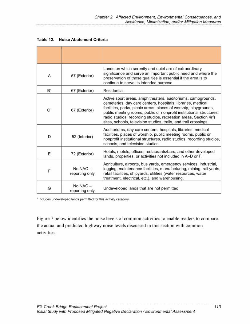
NAC, Activity Hourly A-weighted Description of Activity Category Category Noise Level, Leq(h)
Lands on which serenity and quiet are of extraordinary significance and serve an important public need and where the A 57 (Exterior) preservation of those qualities is essential if the area is to continue to serve its intended purpose.
B1 67 (Exterior) Residential.
Active sport areas, amphitheaters, auditoriums, campgrounds, cemeteries, day care centers, hospitals, libraries, medical
1 facilities, parks, picnic areas, places of worship, playgrounds, C 67 (Exterior) public meeting rooms, public or nonprofit institutional structures, radio studios, recording studios, recreation areas, Section 4(f) sites, schools, television studios, trails, and trail crossings.
Auditoriums, day care centers, hospitals, libraries, medical facilities, places of worship, public meeting rooms, public or D 52 (Interior) nonprofit institutional structures, radio studios, recording studios, schools, and television studios.
Hotels, motels, offices, restaurants/bars, and other developed E 72 (Exterior) lands, properties, or activities not included in A–D or F.
Agriculture, airports, bus yards, emergency services, industrial, No NAC – logging, maintenance facilities, manufacturing, mining, rail yards, F reporting only retail facilities, shipyards, utilities (water resources, water
treatment, electrical, etc.), and warehousing.
No NAC – G Undeveloped lands that are not permitted. reporting only
Chapter 2. Affected Environment, Environmental Consequences, and Avoidance, Minimization, and/or Mitigation Measures
Table 12. Noise Abatement Criteria
1 Includes undeveloped lands permitted for this activity category.
Figure 7 below identifies the noise levels of common activities to enable readers to compare the actual and predicted highway noise levels discussed in this section with common activities.
Elk Creek Bridge Replacement Project Initial Study with Proposed Mitigated Negative Declaration / Environmental Assessment
113

Chapter 2. Affected Environment, Environmental Consequences, and Avoidance, Minimization, and/or Mitigation Measures
Figure 7. Noise Levels of Common Activities
Elk Creek Bridge Replacement Project Initial Study with Proposed Mitigated Negative Declaration / Environmental Assessment
114

Chapter 2. Affected Environment, Environmental Consequences, and Avoidance, Minimization, and/or Mitigation Measures
According to Caltrans’ Traffic Noise Analysis Protocol for New Highway Construction and Reconstruction Projects, May 2011, a noise impact occurs when the predicted future noise level with the project substantially exceeds the existing noise level (defined as a 12 dBA or more increase) or when the future noise level with the project approaches or exceeds the NAC. Approaching the NAC is defined as coming within 1 dBA of the NAC.
If it is determined that the project would have noise impacts, then potential abatement measures must be considered. Noise abatement measures that are determined to be reasonable and feasible at the time of final design are incorporated into the project plans and specifications. This document discusses noise abatement measures that would likely be incorporated in the project.
Caltrans’ Traffic Noise Analysis Protocol sets forth the criteria for determining when an abatement measure is reasonable and feasible. Feasibility of noise abatement is basically an engineering concern. Noise abatement must be predicated to reduce noise by at least 5 dB at an impacted receptor to be considered feasible from an acoustical perspective. It must also be possible to design and construct the noise abatement measure for it to be considered feasible. Factors that affect the design and constructability of noise abatement include, but are not limited to, safety, barrier height, topography, drainage, access requirements for driveways, presence of local cross streets, underground utilities, other noise sources in the area, and maintenance of the abatement measure. The overall reasonableness of noise abatement is determined by the following three factors: 1) the noise reduction design goal of 7 dB at one or more impacted receptors; 2) the cost of noise abatement; and 3) the viewpoints of benefited receptors (including property owners and residents of the benefited receptors).
Affected Environment The information in this section is based on the Air Quality and Noise Analysis Memorandum for the Elk Creek Bridge Project (Caltrans 2019d).
The Elk Creek Bridge is located on SR 1 in Mendocino County. The surrounding area consists of forested hills and rangeland to the north, east, and south, and the Pacific coast to the west. There are no nearby sensitive receptors. The nearest residence is approximately 0.25 mile southwest at a much higher elevation than the project site. The primary sources of noise in the project area are traffic from Highway 1 and the Pacific Ocean. No noise monitoring took place as there were no sensitive or other receptors near the bridge site.
Elk Creek Bridge Replacement Project Initial Study with Proposed Mitigated Negative Declaration / Environmental Assessment
115

Chapter 2. Affected Environment, Environmental Consequences, and Avoidance, Minimization, and/or Mitigation Measures
Environmental Consequences
Construction Impacts
Build Alternative
During construction of the project, noise from construction activities may intermittently dominate the noise environment in the immediate area of construction. Construction activities include demolition of the existing structure, building the temporary bridge and new structure, and implementation of temporary lane closures. Noise generated by construction activities would be a function of the noise levels generated by individual pieces of construction equipment, the type and amount of equipment operating at any given time, the timing and duration of construction activities, and the proximity of nearby sensitive receptors.
Construction noise would primarily result from the operation of heavy construction equipment and arrival and departure of heavy-duty trucks. Construction noise levels would vary on a day-to-day basis during each phase of construction depending upon the specific task being completed. Table 13 below indicates noise levels produced by construction equipment that is commonly used on roadway construction projects. Construction equipment is expected to generate noise levels ranging from 70 to 90 dBA at a distance of 50 feet; noise produced by construction equipment is reduced over distance at a rate of about 6 dB per doubling of distance.
Table 13. Construction Equipment Noise
Equipment Maximum Noise Level (dBA at 50 feet)
Jackhammer 90 Heavy Trucks 88 Backhoe 80 Pneumatic Tools 85 Concrete Pump 82
The loudest noise-generating construction activity on this project would be pile driving. Pile driving would be required during construction of falsework and abutments for the new permanent bridge. Streambed pile driving would be required for the falsework; however, no in-water work would be required for construction of the abutments because they are above the ordinary high-water mark (OHWM). Pile driving typically occurs during daytime hours over short durations, with breaks in between each pile. Pile driving can generate noise levels
Elk Creek Bridge Replacement Project Initial Study with Proposed Mitigated Negative Declaration / Environmental Assessment
116

Chapter 2. Affected Environment, Environmental Consequences, and Avoidance, Minimization, and/or Mitigation Measures
ranging between 95 and 101 dBA Lmax at 50 feet. Table 14 below indicates noise generated by impact pile driving operations at various distances. Adverse noise impacts to residential areas from construction activities are not anticipated because no residences were identified within the project area.
Table 14. Noise from Impact Pile Driving Operation
Distance from Pile Driving (feet) Maximum Noise Level (dBA)
50 101 100 95 200 89 500 81
1,000 75
To control the generation of construction-related noise, the contractor would follow Standard Specifications Section 14-8.02 Noise Control (Standard Measure NOI-1), which states:
Do not exceed 86 dBA at 50 feet from the job site activities from 9 p.m. to 6 a.m.
Equip an internal combustion engine with the manufacturer-recommended muffler. Do not operate an internal combustion engine on the job site without the appropriate muffler.
No-Build Alternative
Under the No-Build Alternative, there would be no new demolition or construction. As no construction-related noise would be generated, there would be no impact.
Operational Impacts
Build Alternative
The proposed project is considered a Type III project and is exempt from traffic noise impact analysis under Title 23 CFR Part 772. The FHWA defines a Type I project as a proposed federal highway project for the construction of a highway on a new location, addition of through-traffic lane(s), or the physical alteration of an existing highway where there is either a substantial horizontal or substantial vertical alteration. Projects that do not meet the classification of Type I, based on the scope of work, are considered Type III. The proposed project is considered a Type III project. Traffic noise impacts are not anticipated, and traffic
Elk Creek Bridge Replacement Project Initial Study with Proposed Mitigated Negative Declaration / Environmental Assessment
117
Chapter 2. Affected Environment, Environmental Consequences, and Avoidance, Minimization, and/or Mitigation Measures
volumes, composition and speeds would remain the same in the build and No-Build condition. There would be no impact from Traffic noise.
No-Build Alternative
Under the No-Build Alternative, existing conditions would remain; therefore, there would be no impacts related to noise.
Avoidance, Minimization, and/or Mitigation Measures As traffic noise is not anticipated, no avoidance, minimization, and/or mitigation measures would be required.
2.14. Energy
Regulatory Setting The National Environmental Policy Act (42 USC Part 4332) requires the identification of all potentially significant impacts to the environment, including energy impacts.
The CEQA Guidelines, Section 15126.2(b) and Appendix F, Energy Conservation, require an analysis of a project’s energy use to determine if the project may result in significant environmental effects due to wasteful, inefficient, or unnecessary use of energy or wasteful use of energy resources.
Affected Environment This analysis is based on the Project Scope Summary Report prepared in June 2015 (Caltrans 2015) and the Air Quality and Noise Analysis Memorandum (Caltrans 2019d). Average daily trips (ADT) in 2018 at the project site were recorded at 1,180, which is projected to increase to 1,400 by 2038. Peak hour ADT is projected to increase from 150 ADT in the year of the study (2013) to 190 in 2038. Passenger vehicles are the primary types of vehicles travelling through the project site, although trucks and bicyclists also travel through the area.
Elk Creek Bridge Replacement Project Initial Study with Proposed Mitigated Negative Declaration / Environmental Assessment
118

Chapter 2. Affected Environment, Environmental Consequences, and Avoidance, Minimization, and/or Mitigation Measures
Environmental Consequences
Construction Impacts
Build Alternative
Construction of the proposed project would primarily consume diesel and gasoline through operation of heavy-duty construction equipment, material deliveries, and debris hauling. Energy use associated with proposed project construction is estimated to result in the total short-term consumption of 8,739 gallons from diesel-powered equipment and 5,620 gallons from gasoline-powered equipment. This represents a small demand on local and regional fuel supplies that would be easily accommodated, and this demand would cease once construction is complete. Moreover, construction-related energy consumption would be temporary and not a permanent new source of energy demand, and demand for fuel would have no noticeable effect on peak or baseline demands for energy. Therefore, the project would not result in an inefficient, wasteful, and unnecessary consumption of energy nor obstruct state or local plans for renewable energy or energy efficiency.
No-Build Alternative
There would be no impacts on energy under the No-Build Alternative because construction would not occur.
Operational Impacts
Build Alternative
The proposed project would not increase capacity or provide congestion relief when compared to the No-Build Alternative. As such, it is unlikely to increase direct energy consumption from mobile sources.
No-Build Alternative
Because there would be no operational changes with the No-Build Alternative, there would be no impacts on energy.
Avoidance, Minimization, and/or Mitigation Measures Because the proposed project would not increase capacity or provide congestion relief, and is unlikely to increase direct energy from mobile sources, no avoidance, minimization, and/or mitigation measures would be required.
Elk Creek Bridge Replacement Project Initial Study with Proposed Mitigated Negative Declaration / Environmental Assessment
119

Chapter 2. Affected Environment, Environmental Consequences, and Avoidance, Minimization, and/or Mitigation Measures
BIOLOGICAL ENVIRONMENT
2.15. Natural Communities
This section of the document discusses natural communities of concern. The focus of this section is on biological communities, not individual plant or animal species. This section also includes information about wildlife corridors, fish passage, and habitat fragmentation. Wildlife corridors are areas of habitat used by wildlife for seasonal or daily migration. Habitat fragmentation involves the potential for dividing sensitive habitat and thereby lessening its biological value.
Habitat areas that have been designated as critical habitat under the Federal Endangered Species Act (FESA) are discussed below in Section 2.19, Threatened and Endangered Species. Wetlands and other waters are discussed below in Section 2.16.
The California Department of Fish and Wildlife (CDFW) and the California Coastal Commission (CCC) both have jurisdiction over habitats and sensitive communities in the project area. Local jurisdictions within the Coastal Zone, such as cities and counties, also define ESHA in their Local Coastal Plans. For the Elk Creek Bridge site, the County of Mendocino is the local jurisdiction with Coastal Permit permitting authority, and the Coastal Commission has review and appeal authority over the County’s issued permits.
Sensitive natural communities are those natural communities that are of limited distribution statewide or within a county or region and are often vulnerable to environmental effects of projects. These communities may or may not contain special status taxa or their habitat. High priority sensitive natural communities are globally (G) and state (S) ranked 1 to 3, where 1 is critically imperiled, 2 is imperiled, and 3 is vulnerable. Global and state ranks of 4 and 5 are considered apparently secure and demonstrably secure, respectively. Riparian communities are also regulated by the state and are considered sensitive natural communities.
The California Department of Fish and Wildlife (CDFW) maintains records of sensitive natural communities (SNC) in the California Natural Diversity Database (CNDDB). The CCC has jurisdiction over Environmentally Sensitive Habitat Areas (ESHA) within the coastal zone. ESHA are defined by the California Coastal Act Section 30107.5 as "any area in which plant or animal life or their habitats are either rare or especially valuable because of their special nature or role in an ecosystem and which could be easily disturbed or degraded by human activities and developments." The CCC uses the CNDDB records, as well as Local
Elk Creek Bridge Replacement Project Initial Study with Proposed Mitigated Negative Declaration / Environmental Assessment
120

Chapter 2. Affected Environment, Environmental Consequences, and Avoidance, Minimization, and/or Mitigation Measures
Coastal Plans, to more specifically define ESHA for local conditions. The Mendocino Local Coastal Plan further defines ESHA as anadromous fish streams, sand dunes, rookeries and marine mammal haul-out areas, wetlands, riparian areas, areas of pygmy vegetation which contain species of rare or endangered plants and habitats of rare and endangered plants and animals (County of Mendocino, 1991).
Affected Environment The information in this section is from the Natural Environment Study (NES) prepared for the project (Caltrans 2020).
The Biological Study Area (BSA) supports three riparian natural communities: one state rank S4 riparian community (red alder forest) and two state rank S3 Sensitive Natural Communities (Sitka willow thicket and coastal brambles) shown in Figure 8.
As riparian communities located adjacent to Elk Creek, all three of these communities are also considered Environmentally Sensitive Habitat Areas (ESHAs) by the California Coastal Commission. The distribution and extent of sensitive natural communities within the BSA are shown below in Table 15 and described in the following sections.
Table 15. Sensitive Natural Communities in the Biological Study Area (BSA)
Alliance Namea Common Name BSA Acreage Statusb Comments
Alnus rubra Forest Alliance
Red alder riparian forest 4.06 G5/S4 This community is riparian
habitat along Elk Creek.
Salix sitchensis Provisional Shrubland Alliance
Sitka willow thicket 0.64 G4/S3?
This community occurs as riparian habitat on the north side of Elk Creek west of SR 1 and in a patch on the south side of Elk Creek east of SR 1.
Rubus (parviflorus, spectabilis, ursinus) Shrubland Alliance Wetland Type: N/A
Coastal brambles 3.17 G4/S3
This community occurs on both the west and east sides of SR 1 north of Elk Creek and on the east side of SR 1 south of Elk Creek.
Total Area in the BSA 7.87 Approximately 61% of the 12.9 acres BSA is classified as Sensitive Natural Community.
a Manual of California Vegetation, 2nd edition (Sawyer et. al 2009).
Elk Creek Bridge Replacement Project Initial Study with Proposed Mitigated Negative Declaration / Environmental Assessment
121
Chapter 2. Affected Environment, Environmental Consequences, and Avoidance, Minimization, and/or Mitigation Measures
b Global [G] / State [S] Status Explanations:
G1/S1 = Critically imperiled: at high risk of extinction, extremely rare
G2/S2 = Imperiled: at high risk of extinction, restricted range, very few populations
G3/S3 = Vulnerable: moderate risk of extinction, restricted range, few populations
G4/S4 = Apparently secure: uncommon, not rare, possible long-term declines
G5/S5 = Secure: common, widespread, abundant
GNR/SNR = Unranked
? = Best estimate of the rank when there are insufficient samples over the full expected range of the type, but existing information points to this rank.
-- = None
Red Alder Riparian Forest
The riparian vegetation along Elk Creek and most of the forest east of SR 1 consists of upland red alder riparian forest (Figure 8). Red alder riparian forest qualifies as a coastal wetland where it grows below the Ordinary High Water Mark (OHWM) of the creek, as described in Section 2.16, Wetlands and Other Waters. Dominant species in the forest include red alder (Alnus rubra), with areas of arroyo willow (Salix lasiolepis) and Sitka willow (Salix sitchensis), and understory species, such as thimbleberry (Rubus parviflorus), California blackberry (Rubus ursinus), red elderberry (Sambucus racemose), oceanspray (Holodiscus discolor), cape ivy (Delairea odorata), willow herb (Epilobium parviflorum), and common horsetail (Equisetum arvense). In August 2018, cape ivy was observed to be particularly extensive and growing on top of understory species in the area on the southeast side of the Elk Creek Bridge. Alders, willows, and elderberry in the forest community are of mature size. See Chapter 3, CEQA Evaluation, for specific information about trees within this community.
Sitka Willow Thicket
Sitka willow thicket comprises most of the riparian vegetation along Elk Creek on the west side of Elk Creek Bridge and a patch of riparian on the southeast side of Elk Creek Bridge (Figure 8). Sitka willow thicket also qualifies as a coastal wetland on the southeast side of Elk Creek Bridge where it grows below the OHWM of Elk Creek, as discussed below in Section 2.16 Wetlands and Other Waters. Dominant species in the forest include Sitka willow (Salix sitchensis), arroyo willow (Salix lasiolepis), red elderberry (Sambucus racemose), California blackberry (Rubus ursinus), and poison oak (Toxicodendron
Elk Creek Bridge Replacement Project Initial Study with Proposed Mitigated Negative Declaration / Environmental Assessment
122

Chapter 2. Affected Environment, Environmental Consequences, and Avoidance, Minimization, and/or Mitigation Measures
diversilobum). Willows and elderberry in the thicket community are of mature size. See Chapter 3, CEQA Evaluation, for specific information on trees within this community.
Shaded Riverine Aquatic Cover Habitat
Red alder riparian forest and Sitka willow thicket also function as Shaded Riverine Aquatic (SRA) cover habitat. USFWS defines SRA cover as “the unique, near-shore aquatic cover that occurs at the interface between a stream or river and adjacent woody riparian habitat” and is an essential component of fish habitat, especially salmonid habitat. Key features of SRA cover include the following.
An adjacent bank composed of natural, often eroding substrate that supports overhanging riparian vegetation and vegetation that may protrude into the water
A stream channel with variable amounts of woody material and detritus, and variable water velocity and depth
There are two components to SRA cover: overhead cover and instream cover. Overhead cover consists of overhanging riparian vegetation that provides important stream shading and contributes leaf litter and insects to the stream. Instream cover consists of submerged woody material (e.g., exposed roots, branches, and trunks), aquatic plants, substrate (e.g., gravel, cobble, and boulders), and undercut banks. These attributes provide high-value feeding areas, burrowing substrates, escape cover, and reproductive cover for numerous regionally important fish and wildlife species.
Table 16 below indicates the amount of SRA cover present along both banks of Elk Creek in the BSA relative to the total bank length.
Elk Creek Bridge Replacement Project Initial Study with Proposed Mitigated Negative Declaration / Environmental Assessment
123

Chapter 2. Affected Environment, Environmental Consequences, and Avoidance, Minimization, and/or Mitigation Measures
Table 16. Existing Shaded Riverine Aquatic Cover (Overhead Vegetation) in the BSA
Location Existing Bank
Length (linear feet)
Existing OverheadVegetation as Bank
Length(linear feet)
ExistingOverhead
Vegetation as Percent Bank
Length
Downstream of Existing Elk Creek Bridge North Streambank 566 476 84 South Streambank 566 456 81 Upstream of Existing Elk Creek Bridge North Streambank 268 117 44 South Streambank 268 113 42 Total 834
Coastal Brambles
Coastal brambles occur on the streambanks on three sides of the Elk Creek Bridge: the northwest, northeast, and southeast sides (Figure 8). This scrub vegetation includes California blackberry (Rubus ursinus), thimbleberry (Rubus parviflorus), nootka rose (Rosa nutkana), coyote brush (Baccharis pilularis), red elderberry (Sambucus racemose), coast man-root (Marah oreganus), and stinging nettle (Urtica dioica). On the hillside west of SR 1 and north of Elk Creek, several Douglas-fir (Pseudotsuga menziesii) and red alder trees are within areas mapped as coastal brambles, but the trees were not numerous or extensive enough to map separately as forest communities.
Environmental Consequences
Construction Impacts
Table 17 below summarizes the proposed project’s temporal and temporary construction impacts on the three sensitive natural communities. For the purposes of this impact analysis, much of the impacts are considered temporal because of the time required for the removed vegetation to regrow. True permanent impacts would be limited to the proposed bridge approaches where the roadbed would need to be widened to accommodate the proposed 12-foot lanes, 6-foot shoulders, and the separated pedestrian walkway (Table 17). The new road embankments and areas disturbed by construction would be replanted with native species similar to what would be removed to provide for future habitat areas and stream cover.
Elk Creek Bridge Replacement Project Initial Study with Proposed Mitigated Negative Declaration / Environmental Assessment
124

Chapter 2. Affected Environment, Environmental Consequences, and Avoidance, Minimization, and/or Mitigation Measures
Table 17. Impacts on Upland Sensitive Natural Communities
Sensitive Natural
Community Rank
Total Area of Sensitive Habitat in
Project Area
Impact inAcres,
Permanent
Impact inAcres,
Temporal1
Impact inAcres,
Temporary Impact in
Acres, Total
Alnus rubra Red Alder Forest Alliance (Red alder riparian forest)
G5/S4 4.06 0.016 0.48 0 0.50
Salix sitchensis Provisional Shrubland Alliance (Sitka willow thicket)
G4/S3 0.64 0.014 0.16 0 0.17
Rubus (parviflorus, spectabilis, ursinus) Shrubland Alliance (Coastal brambles)
G4/S3 3.17 .007 0.00 0.068 0.075
Total (rounded) 7.87 0.007 0.67 0.07 0.75
1 Most impacts to forested natural communities are considered temporal impacts because replacement trees in the temporarily affected areas would require more than 1 year to grow to the size of the removed trees.
Elk Creek Bridge Replacement Project 125 Initial Study with Proposed Mitigated Negative Declaration / Environmental Assessment

Chapter 2. Affected Environment, Environmental Consequences, and Avoidance, Minimization, and/or Mitigation Measures
Build Alternative
The total area of upland red alder forest in the 12.9 acre BSA is 4.06 acres. Construction of the proposed project would result in the removal of 0.5 acre of mature red alder riparian forest adjacent to Elk Creek, which would amount to 12.31 percent of the total upland riparian alder forest within the BSA, but a much smaller percentage of the total adjacent red alder riparian forest within the immediate area. The removal of red alder riparian forest is associated with vegetation removal for construction of the temporary access road, temporary bridge, new bridge deck, construction of the abutments for the replacement bridge, and access for and construction of the root wad revetment on the northern stream bank. For the purposes of this analysis, all red alder riparian forest disturbance and tree removal within red alder riparian forest are considered temporal impacts because of the time required for habitat regeneration.
The total area of upland riparian Sitka willow thicket in the 12.9 acre BSA is 0.64 acre. Construction of the proposed project would result in the temporal removal of 0.16 acre (24.4 percent) and the permanent loss of 0.014 acre (2.2 percent) Sitka willow thicket adjacent to Elk Creek, for a cumulative loss of 26.56 percent of the total Sitka willow thicket within the BSA (Table 17). The removal of Sitka willow thicket is associated with construction of abutment walls for the new bridge and new bridge deck, construction of the water infiltration areas, and the access road and work area. For the purposes of this analysis, all tree removal within Sitka willow thicket is considered a temporal impact because of the time required for habitat regeneration.
The total area of coastal brambles in the 12.9 acre BSA is 3.17 acres. Construction of the proposed project would result in the permanent removal of 0.007 acre of coastal brambles north of Elk Creek on the eastern side of SR 1, or less than 0.1 percent of the total area of coastal bramble within the BSA (Table 17). The removal of coastal brambles is associated with construction of the new bridge approach from the north and the temporary and replacement bridge abutments. Temporary removal of 0.068 acre (or 2.14 percent) of coastal brambles would occur as a result of construction of the temporary bridge and access road, and potentially from use of the proposed staging area south of the bridge (Table 17).
Elk Creek Bridge Replacement Project Initial Study with Proposed Mitigated Negative Declaration / Environmental Assessment
126
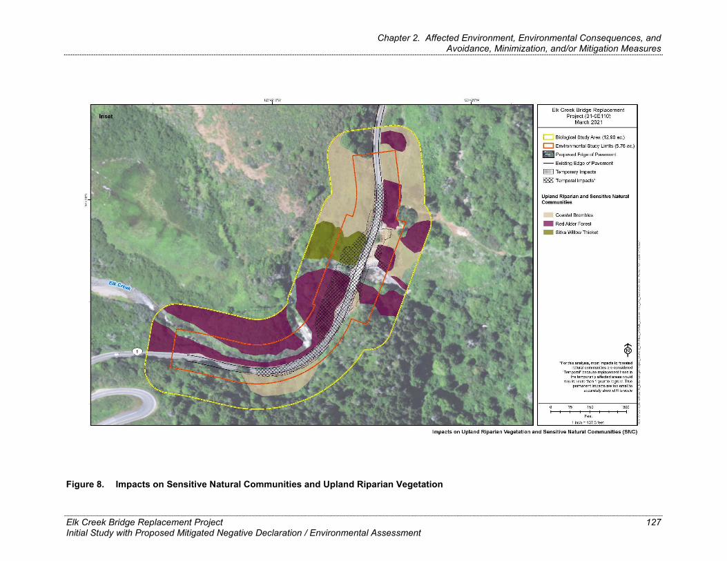
Chapter 2. Affected Environment, Environmental Consequences, and Avoidance, Minimization, and/or Mitigation Measures
Figure 8. Impacts on Sensitive Natural Communities and Upland Riparian Vegetation
Elk Creek Bridge Replacement Project Initial Study with Proposed Mitigated Negative Declaration / Environmental Assessment
127

Chapter 2. Affected Environment, Environmental Consequences, and Avoidance, Minimization, and/or Mitigation Measures
This page left intentionally blank.
Elk Creek Bridge Replacement Project Initial Study with Proposed Mitigated Negative Declaration / Environmental Assessment
128
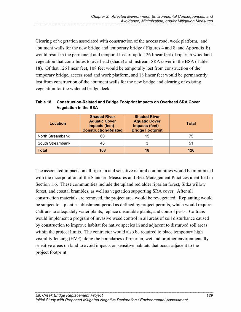
Chapter 2. Affected Environment, Environmental Consequences, and Avoidance, Minimization, and/or Mitigation Measures
Clearing of vegetation associated with construction of the access road, work platform, and abutment walls for the new bridge and temporary bridge ( Figures 4 and 8, and Appendix E) would result in the permanent and temporal loss of up to 126 linear feet of riparian woodland vegetation that contributes to overhead (shade) and instream SRA cover in the BSA (Table 18). Of that 126 linear feet, 108 feet would be temporally lost from construction of the temporary bridge, access road and work platform, and 18 linear feet would be permanently lost from construction of the abutment walls for the new bridge and clearing of existing vegetation for the widened bridge deck.
Table 18. Construction-Related and Bridge Footprint Impacts on Overhead SRA Cover Vegetation in the BSA
Location Shaded River Aquatic CoverImpacts (feet) -
Construction-Related
Shaded River Aquatic CoverImpacts (feet) -
Bridge Footprint Total
North Streambank 60 15 75
South Streambank 48 3 51
Total 108 18 126
The associated impacts on all riparian and sensitive natural communities would be minimized with the incorporation of the Standard Measures and Best Management Practices identified in Section 1.6. These communities include the upland red alder riparian forest, Sitka willow forest, and coastal brambles, as well as vegetation supporting SRA cover. After all construction materials are removed, the project area would be revegetated. Replanting would be subject to a plant establishment period as defined by project permits, which would require Caltrans to adequately water plants, replace unsuitable plants, and control pests. Caltrans would implement a program of invasive weed control in all areas of soil disturbance caused by construction to improve habitat for native species in and adjacent to disturbed soil areas within the project limits. The contractor would also be required to place temporary high visibility fencing (HVF) along the boundaries of riparian, wetland or other environmentally sensitive areas on land to avoid impacts on sensitive habitats that occur adjacent to the project footprint.
Elk Creek Bridge Replacement Project Initial Study with Proposed Mitigated Negative Declaration / Environmental Assessment
129
Chapter 2. Affected Environment, Environmental Consequences, and Avoidance, Minimization, and/or Mitigation Measures
No-Build Alternative
As no construction would take place under the No-Build Alternative, there would be no impacts on the red alder riparian forest, Sitka willow thicket, or coastal bramble sensitive natural communities. However, if the existing bridge failed and collapsed, surrounding riparian vegetation would be affected.
Operational Impacts
Upon completion of the proposed project, no additional operational impacts are anticipated to sensitive natural communities.
Avoidance, Minimization, and/or Mitigation Measures Impacts to the sensitive natural communities discussed above would be minimized with implementation of the Standard Measures and Best Management Practices and anticipated regulatory agency permit conditions.
2.16. Wetlands and Other Waters
Regulatory Setting Wetlands and other waters are protected under a number of laws and regulations. At the federal level, the Federal Water Pollution Control Act, more commonly referred to as the Clean Water Act (CWA) (33 USC 1344), is the primary law regulating wetlands and surface waters. One purpose of the CWA is to regulate the discharge of dredged or fill material into Waters of the U.S., including wetlands. Waters of the U.S. include navigable waters, interstate waters, territorial seas, and other waters that may be used in interstate or foreign commerce. In the absence of adjacent wetlands, the lateral limits of jurisdiction over non-tidal water bodies extend to the OHWM. When adjacent wetlands are present, CWA jurisdiction extends beyond the OHWM to the limits of the adjacent wetlands. To classify wetlands for the purposes of the CWA, a three-parameter approach is used that includes the presence of hydrophytic (water-loving) vegetation, wetland hydrology, and hydric soils (soils formed during saturation/inundation). All three parameters must be present, under normal circumstances, for an area to be designated as a jurisdictional wetland under the CWA. As discussed in Section 2.2, Coastal Zone, however, areas with only one of the three parameters that are located within the Coastal Zone may be considered “Coastal Wetlands” and protected as Environmentally Sensitive Habitat Areas (ESHA) under the Coastal Act and Local Coastal Plan.
Elk Creek Bridge Replacement Project Initial Study with Proposed Mitigated Negative Declaration / Environmental Assessment
130
Chapter 2. Affected Environment, Environmental Consequences, and Avoidance, Minimization, and/or Mitigation Measures
Section 404 of the CWA establishes a regulatory program that states that discharge of dredged or fill material cannot be permitted if a practicable alternative exists that is less damaging to the aquatic environment or if the nation’s waters would be significantly degraded. The Section 404 permit program is run by the USACE, with oversight by U.S. EPA.
The USACE issues two types of 404 permits: General and Individual. There are two types of General permits: Regional and Nationwide. Regional permits are issued for a general category of activities when they are similar in nature and cause minimal environmental effect. Nationwide permits are issued to allow a variety of minor project activities with no more than minimal effects.
Ordinarily, projects that do not meet the criteria for a Regional or Nationwide Permit may be permitted under one of USACE’s Individual permits. There are two types of Individual permits: Standard permits and Letters of Permission. For Individual permits, the USACE decision to approve is based on compliance with U.S. EPA’s Section 404(b)(1) Guidelines (40 CFR 230), and whether permit approval is in the public interest. The Section 404 (b)(1) Guidelines (Guidelines) were developed by the U.S. EPA in conjunction with the USACE and allow the discharge of dredged or fill material into the aquatic system (Waters of the U.S.) only if there is no practicable alternative which would have less adverse effects. The Guidelines state that the USACE may not issue a permit if there is a “least environmentally damaging practicable alternative” (LEDPA) to the proposed discharge that would have lesser effects on Waters of the U.S., and not have any other significant adverse environmental consequences.
The Executive Order for the Protection of Wetlands (EO 11990) also regulates the activities of federal agencies with regard to wetlands. Essentially, EO 11990 states that a federal agency, such as FHWA and/or Caltrans, as assigned, cannot undertake or provide assistance for new construction located in wetlands unless the head of the agency finds that: (1) there is no practicable alternative to the construction and (2) the proposed project includes all practicable measures to minimize harm. A Wetlands Only Practicable Alternative Finding must be made.
At the state level, wetlands and waters are regulated primarily by the SWRCB, the RWQCBs, and the CDFW. In certain circumstances, the Coastal Commission (or Bay Conservation and Development Commission or the Tahoe Regional Planning Agency) may also be involved. Sections 1600–1607 of the California Fish and Game Code require any
Elk Creek Bridge Replacement Project Initial Study with Proposed Mitigated Negative Declaration / Environmental Assessment
131

Chapter 2. Affected Environment, Environmental Consequences, and Avoidance, Minimization, and/or Mitigation Measures
agency that proposes a project that would substantially divert or obstruct the natural flow of or substantially change the bed or bank of a river, stream, or lake to notify CDFW before beginning construction. If CDFW determines the project may substantially and adversely affect fish or wildlife resources, a Lake and Streambed Alteration Agreement (LSAA) would be required. The CDFW jurisdictional limits are usually defined by the tops of the stream or lake banks or the outer edge of riparian vegetation, whichever is wider. Wetlands under jurisdiction of the USACE may or may not be included in the area covered by a LSAA obtained from the CDFW.
The RWQCBs were established under the Porter-Cologne Water Quality Control Act to oversee water quality. Discharges under the Porter-Cologne Act are permitted by Waste Discharge Requirements (WDRs) and may be required even when the discharge is already permitted or exempt under the CWA. In compliance with Section 401 of the CWA, the RWQCBs also issue water quality certifications for activities that may result in a discharge to Waters of the U.S. This is most frequently required in tandem with a Section 404 permit request. Please see the Water Quality portion of Section 2.8 for more details.
Affected Environment The information in this section is from the NES prepared for the project (Caltrans 2020). The BSA supports three types of wetland/other waters—seasonal wetland, ditch, and perennial stream. These features are regulated by the USACE, RWQCB, CDFW, CCC, and/or Mendocino County (for coastal wetlands as defined in Section 2.2 Coastal Zone). Federal and state jurisdictional acreage of all wetland and other waters features described below is pending verification by the USACE. The distribution and extent of Waters of the U.S. (three-parameter wetlands or non-wetland waters) or as coastal wetlands only (one- or two-parameter wetlands) within the BSA are shown in Table 19 and described in the following sections.
Elk Creek Bridge Replacement Project Initial Study with Proposed Mitigated Negative Declaration / Environmental Assessment
132
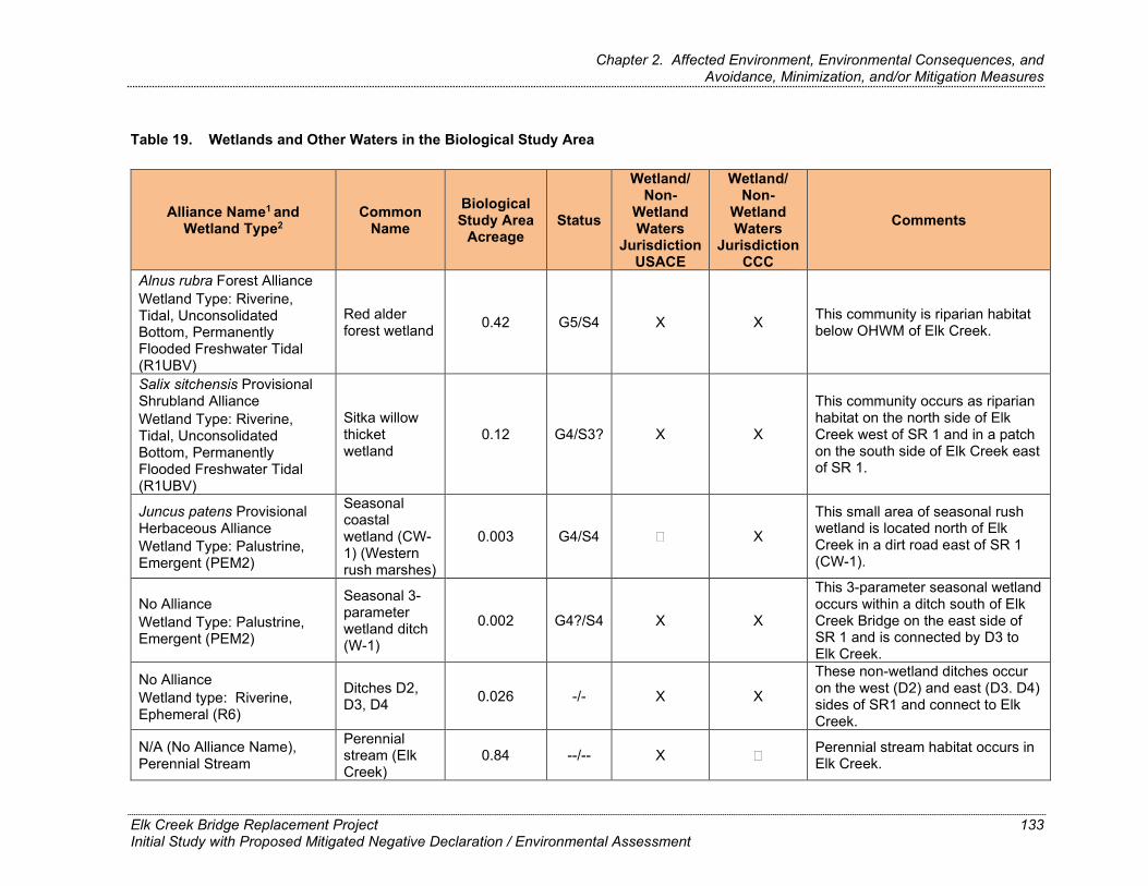
Chapter 2. Affected Environment, Environmental Consequences, and Avoidance, Minimization, and/or Mitigation Measures
Table 19. Wetlands and Other Waters in the Biological Study Area
Alliance Name1 and Wetland Type2
Common Name
Biological Study Area
Acreage Status
Wetland/Non-
Wetland Waters
Jurisdiction USACE
Wetland/Non-
Wetland Waters
Jurisdiction CCC
Comments
Alnus rubra Forest Alliance Wetland Type: Riverine, Tidal, Unconsolidated Bottom, Permanently Flooded Freshwater Tidal (R1UBV)
Red alder forest wetland 0.42 G5/S4 X X This community is riparian habitat
below OHWM of Elk Creek.
Salix sitchensis Provisional Shrubland Alliance Wetland Type: Riverine, Tidal, Unconsolidated Bottom, Permanently Flooded Freshwater Tidal (R1UBV)
Sitka willow thicket wetland
0.12 G4/S3? X X
This community occurs as riparian habitat on the north side of Elk Creek west of SR 1 and in a patch on the south side of Elk Creek east of SR 1.
Juncus patens Provisional Herbaceous Alliance Wetland Type: Palustrine, Emergent (PEM2)
Seasonal coastal wetland (CW-1) (Western rush marshes)
0.003 G4/S4 X
This small area of seasonal rush wetland is located north of Elk Creek in a dirt road east of SR 1 (CW-1).
No Alliance Wetland Type: Palustrine, Emergent (PEM2)
Seasonal 3-parameter wetland ditch (W-1)
0.002 G4?/S4 X X
This 3-parameter seasonal wetland occurs within a ditch south of Elk Creek Bridge on the east side of SR 1 and is connected by D3 to Elk Creek.
No Alliance Wetland type: Riverine, Ephemeral (R6)
Ditches D2, D3, D4 0.026 -/- X X
These non-wetland ditches occur on the west (D2) and east (D3. D4) sides of SR1 and connect to Elk Creek.
N/A (No Alliance Name), Perennial Stream
Perennial stream (Elk Creek)
0.84 --/-- X Perennial stream habitat occurs in Elk Creek.
Elk Creek Bridge Replacement Project Initial Study with Proposed Mitigated Negative Declaration / Environmental Assessment
133

Chapter 2. Affected Environment, Environmental Consequences, and Avoidance, Minimization, and/or Mitigation Measures
Alliance Name1 and Wetland Type2
Common Name
Biological Study Area
Acreage Status
Wetland/Non-
Wetland Waters
Jurisdiction USACE
Wetland/Non-
Wetland Waters
Jurisdiction CCC
Comments
Wetland Type: Estuarine, Intertidal, Forested (E2FO1)
1 Manual of California Vegetation, 2nd edition (Sawyer et al. 2009). 2 Classification of Wetlands and Deepwater Habitats of the United States (Cowardin et al. 1979), National Wetland Inventory (USFWS 2018)
c Global [G] / State [S] Status Explanations:
G1/S1 = Critically imperiled: at high risk of extinction, extremely rare
G2/S2 = Imperiled: at high risk of extinction, restricted range, very few populations
G3/S3 = Vulnerable: moderate risk of extinction, restricted range, few populations
G4/S4 = Apparently secure: uncommon, not rare, possible long-term declines
G5/S5 = Secure: common, widespread, abundant
? = Best estimate of the rank when there are insufficient samples over the full expected range of the type, but existing information points to this rank.
-- = None
Elk Creek Bridge Replacement Project Initial Study with Proposed Mitigated Negative Declaration / Environmental Assessment
134

Chapter 2. Affected Environment, Environmental Consequences, and Avoidance, Minimization, and/or Mitigation Measures
This page left intentionally blank.
Elk Creek Bridge Replacement Project Initial Study with Proposed Mitigated Negative Declaration / Environmental Assessment
135

Chapter 2. Affected Environment, Environmental Consequences, and Avoidance, Minimization, and/or Mitigation Measures
Seasonal Wetland
There are two seasonal wetlands within the BSA. One of the seasonal wetlands (W-1) is in a roadside ditch on the east side of SR 1 and south of Elk Creek. Seasonal Wetland W-1 is connected to ditch D-3 (Figure 9) and meets all three parameters of a wetland as defined by USACE (hydric soils, hydrology, and hydrophytic vegetation). At the time of the April 2018 survey, seasonal wetland vegetation in W-1 was not characterized by a vegetation alliance, but was dominated by velvet grass (Holcus lanatus), willow herb (Epilobium ciliatum ssp. watsonii), and common chickweed (Cerastium fontanum ssp. vulgare). This wetland qualifies as a water of the State and coastal wetland, and may qualify as a water of the U.S.
The other seasonal wetland (CW-1) occurs within the BSA in a dirt road north of Elk Creek and east of SR 1. This wetland extends from the slope adjacent to the road into the roadbed; however, most of the vegetation is on the slope. The dirt roadbed is bare ground and soil has sloughed onto the roadbed from the slope. At the time of the April 2018 survey, seasonal wetland vegetation in CW-1 was dominated by common rush (Juncus patens) and velvet grass. Soil in the wetland was saturated within 8 inches of the surface, but the soil did not meet hydric criteria. This wetland qualifies as a coastal wetland only.
Ditch
Three roadside ditches in the BSA (D-2, D-3, and D-4) support predominantly non-wetland herbaceous species, including common chickweed, sweet vernal grass (Anthoxanthum odoratum), common rush, rattlesnake grass (Briza maxima), ripgut brome (Bromus diandrus), Italian thistle (Carduus pycnocephalus), miner’s lettuce (Claytonia perfoliata ssp. perfoliata), yarrow-leaved woolly sunflower (Eriophyllum lanatum var. achilleoides), bird’s foot trefoil (Lotus corniculatus), broadleaf forget-me-not (Myosotis latifolia), and English plantain (Plantago lanceolata). These three ditches connect to Elk Creek either by overland flow or culverts that drain directly into the creek and qualify as potentially jurisdictional Waters of the U.S.
Perennial Stream
Elk Creek is a perennial stream that dominates the BSA. The creek drains from east to west, terminating at the Pacific Ocean, approximately 0.5 stream mile downstream. Due to the proximity to the ocean, the creek is tidally influenced for most of its length within the BSA, meaning that depth and flow velocities of the creek in the study area are influenced not only by precipitation, but tidal height and estuary closure. Like many sandbar-built estuaries, the
Elk Creek Bridge Replacement Project Initial Study with Proposed Negative Declaration / Environmental Assessment
136

Chapter 2. Affected Environment, Environmental Consequences, and Avoidance, Minimization, and/or Mitigation Measures
timing of sandbar closure also depends on the volume and duration of the creek’s flow through the spring and summer, as well as tidal variables and wave action, which also varies from year to year. As a result, the presence of riffles and the depth of pools upstream from the estuary is also highly variable and is dependent on these variables, tidal heights, and the timing and/or frequency of sandbar closure. Elk Creek extends for approximately 1,440 feet through the BSA, and the average width is 40 to 50 feet, with a total area within the BSA of 0.84 acre. The streambank on the north bank immediately upstream of the SR 1 Elk Creek Bridge is the site of the 2016 temporary repair project and is stabilized with unvegetated rock slope protection (RSP). The south bank, approximately 400 feet downstream of the SR 1 Elk Creek Bridge, is the site of a 2019 emergency repair project, and the streambank at this location is also armored with RSP. Other parts of the creek bank above the low-flow channel in the BSA were either almost vertical cut-banks up to several feet in height or were more gently sloping and covered in cobbles or woody debris.
Some of the high water areas within the creek extend into the riparian vegetation (red alder forest or Sitka willow thicket). While these areas did not meet all three parameters to qualify as wetlands that are Waters of the U.S., they do qualify as coastal wetlands. The entire creek area below the OHWM qualifies as a non-wetland Water of the U.S.
Environmental Consequences
Construction Impacts
Red alder forest wetlands, Sitka willow thicket wetlands, seasonal wetlands, ditches, and perennial streams are considered Waters of the U.S. and Waters of the State. Table 20 below summarizes the proposed project’s impacts on the Waters of the U.S. and Waters of the State.
Elk Creek Bridge Replacement Project Initial Study with Proposed Negative Declaration / Environmental Assessment
137
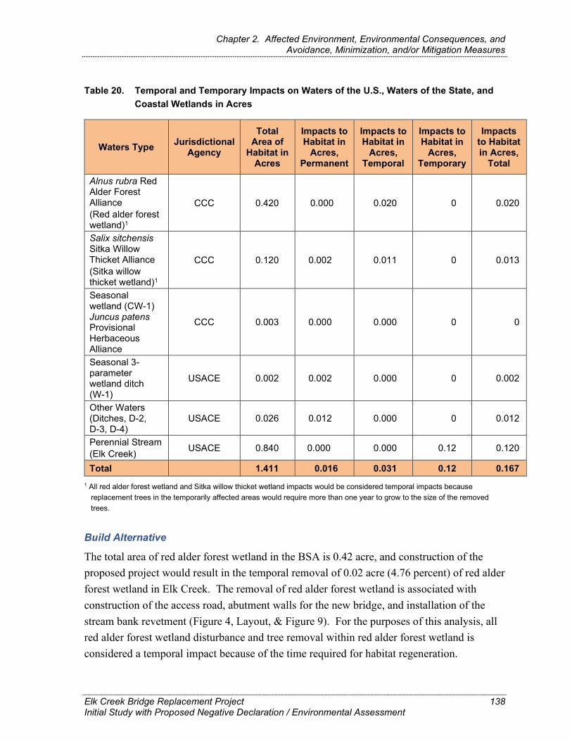
Chapter 2. Affected Environment, Environmental Consequences, and Avoidance, Minimization, and/or Mitigation Measures
Table 20. Temporal and Temporary Impacts on Waters of the U.S., Waters of the State, and Coastal Wetlands in Acres
Waters Type Jurisdictional Agency
Total Area of
Habitat in Acres
Impacts toHabitat in
Acres, Permanent
Impacts toHabitat in
Acres, Temporal
Impacts toHabitat in
Acres, Temporary
Impacts to Habitat in Acres,
Total
Alnus rubra Red Alder Forest Alliance (Red alder forest wetland)1
CCC 0.420 0.000 0.020 0 0.020
Salix sitchensis Sitka Willow Thicket Alliance CCC 0.120 0.002 0.011 0 0.013 (Sitka willow thicket wetland)1
Seasonal wetland (CW-1) Juncus patens Provisional Herbaceous Alliance
CCC 0.003 0.000 0.000 0 0
Seasonal 3-parameter wetland ditch (W-1)
USACE 0.002 0.002 0.000 0 0.002
Other Waters (Ditches, D-2, D-3, D-4)
USACE 0.026 0.012 0.000 0 0.012
Perennial Stream (Elk Creek) USACE 0.840 0.000 0.000 0.12 0.120
Total 1.411 0.016 0.031 0.12 0.167 1 All red alder forest wetland and Sitka willow thicket wetland impacts would be considered temporal impacts because
replacement trees in the temporarily affected areas would require more than one year to grow to the size of the removed trees.
Build Alternative
The total area of red alder forest wetland in the BSA is 0.42 acre, and construction of the proposed project would result in the temporal removal of 0.02 acre (4.76 percent) of red alder forest wetland in Elk Creek. The removal of red alder forest wetland is associated with construction of the access road, abutment walls for the new bridge, and installation of the stream bank revetment (Figure 4, Layout, & Figure 9). For the purposes of this analysis, all red alder forest wetland disturbance and tree removal within red alder forest wetland is considered a temporal impact because of the time required for habitat regeneration.
Elk Creek Bridge Replacement Project 138 Initial Study with Proposed Negative Declaration / Environmental Assessment

Chapter 2. Affected Environment, Environmental Consequences, and Avoidance, Minimization, and/or Mitigation Measures
The total area of Sitka willow thicket wetland in the BSA is 0.12 acre, and construction of the proposed project would result in temporal loss of 0.011 acre (9.2 percent) and permanent removal of 0.002 acre (1.7 percent) of Sitka willow thicket in and adjacent to Elk Creek. The removal of Sitka willow thicket wetland is associated with construction of the temporary bridge, the abutment walls for the new bridge, and the wider bridge deck of the new bridge (Figure 4 Layouts and Figure 9).
The total area of seasonal wetland in the BSA is 0.003 acre, comprising CW-1 with 0.001 acre and W-1 with 0.002 acre (Table 20). Construction of the proposed project would result in the permanent removal of 0.001 acre in ditch W-1 south of Elk Creek on the east side of SR 1. This is approximately 3.33 percent of the seasonal wetlands identified in the BSA. The removal of seasonal wetland would be associated with cut and fill for the temporary bridge at the location of W-1 (Figure 9. Use of the proposed staging area near CW-1 would avoid all impacts on the seasonal wetland.
The total area of ditches qualifying as Other Waters of the U.S. (D-2, D-3, D-4) in the BSA is 0.026 acre, and construction of the proposed project would result in the permanent removal of 0.012 acre of ditches at the proposed edge of pavement and new slope area. The removal of the ditches is associated with construction of the bridge approaches (Figure 9).
The total area of perennial stream in the BSA is 0.84 acre, and construction of the proposed project would result in a maximum temporary fill of 0.12 acre of perennial stream in Elk Creek per construction season. The placement of fill in perennial stream is associated with construction of the access road and work platform, and installation of the stream diversion in year one, and with installation of the stream diversion and root wad revetment in year two (Figure 9).
With implementation of Caltrans’ Standard Measures and Best Management Practices, impacts to wetlands and other waters would be Less than Significant. The contractor would be required to place temporary high-visibility fencing (HVF) along the boundaries of all riparian, wetland, or other environmentally sensitive areas adjacent to the project footprint. Caltrans, or the contractor (at the discretion of Caltrans), would ensure the fencing is maintained throughout the duration of the construction period. If the fencing is removed, damaged, or otherwise compromised during the construction period, construction activities would cease until the fencing is repaired or replaced.
Elk Creek Bridge Replacement Project Initial Study with Proposed Negative Declaration / Environmental Assessment
139

Chapter 2. Affected Environment, Environmental Consequences, and Avoidance, Minimization, and/or Mitigation Measures
Figure 9. Waters of the U.S., Waters of the State, and Coastal Wetlands
Elk Creek Bridge Replacement Project Initial Study with Proposed Mitigated Negative Declaration / Environmental Assessment
140

Chapter 2. Affected Environment, Environmental Consequences, and Avoidance, Minimization, and/or Mitigation Measures
This page left intentionally blank.
Elk Creek Bridge Replacement Project Initial Study with Proposed Mitigated Negative Declaration / Environmental Assessment
141

Chapter 2. Affected Environment, Environmental Consequences, and Avoidance, Minimization, and/or Mitigation Measures
Caltrans would also be required to restore wetland and riparian areas temporarily affected by construction to pre-existing conditions prior to completion of construction, as well as reduce the footprint to the maximum extent feasible. Before proceeding with any work within the project limits, including equipment staging, grading, and tree and/or vegetation removal (i.e., clear and grub), a qualified biologist would conduct mandatory contractor/construction worker environmental awareness training to brief them on the need to avoid effects to wetlands and other waters. A qualified biologist would also conduct periodic site visits during any construction activities that involve ground disturbance (e.g., vegetation removal, grading, excavation, shoofly track construction) within or adjacent to wetlands and other waters.
No-Build Alternative
As no construction would take place under the No-Build Alternative, there would be no impacts to wetlands and other waters. However, if the existing bridge failed and collapsed, surrounding perennial stream and wetland habitats could be affected.
Operational Impacts
Once the bridge is constructed, everyday use would not continue to impact the adjacent wetlands and other waters. Drainage improvements to the bridge and proposed stormwater treatment areas would minimize impacts to water quality from runoff from the increased impervious surfaces from the larger bridge deck and approaches. No additional operational impacts to wetlands and other waters are anticipated.
Avoidance, Minimization, and/or Mitigation Measures The ditches would be replaced in kind as part of the proposed project resulting in no net loss of ditch habitat. With implementation of the Standard Measures and Best Management Practices identified in Section 1.6 and anticipated permit conditions, no additional avoidance or minimization measures would be required to keep impacts at Less than Significant.
Elk Creek Bridge Replacement Project Initial Study with Proposed Mitigated Negative Declaration / Environmental Assessment
142

Chapter 2. Affected Environment, Environmental Consequences, and Avoidance, Minimization, and/or Mitigation Measures
2.17. Plant Species
Regulatory Setting The USFWS and CDFW have regulatory responsibility for the protection of special-status plant species. Special-status species are selected for protection because they are rare and/or subject to population and habitat declines. Special-status is a general term for species that are provided varying levels of regulatory protection. The highest level of protection is given to threatened and endangered species; these are species that are formally listed or proposed for listing as endangered or threatened under the Federal Endangered Species Act (FESA) and/or the California Endangered Species Act (CESA). Please see Section 2.19, Threatened and Endangered Species, in this document for detailed information about these species.
This section of the document discusses all other special-status plant species, including CDFW species of special concern, USFWS candidate species, and California Native Plant Society (CNPS) rare and endangered plants.
The regulatory requirements for FESA can be found at 16 USC Section 1531, et seq. See also 50 CFR Part 402. The regulatory requirements for CESA can be found at California Fish and Game Code, Section 2050, et seq. Caltrans projects are also subject to the Native Plant Protection Act, found at California Fish and Game Code, Sections 1900–1913, and CEQA, found at California PRC, Sections 21000–21177.
Affected Environment The information in this section is from the NES prepared for the project (Caltrans 2021). Plant surveys were conducted in the BSA during the appropriate identification period for all special-status plant species listed in Table 21 that have suitable habitat present in the BSA. No occurrences of special-status plants have been previously reported in the BSA, and no special-status plants were observed during the 2018 field surveys. A list of plant species observed is provided in the NES, Appendix E. Table 21 provides a description of the plant species that have habitat present within the BSA.
Elk Creek Bridge Replacement Project Initial Study with Proposed Mitigated Negative Declaration / Environmental Assessment
143

Chapter 2. Affected Environment, Environmental Consequences, and Avoidance, Minimization, and/or Mitigation Measures
Table 21. Special-Status Plants Known or with Potential to Occur in the Biological Study Area Region
Common and Scientific Name
Legal Status (Federal/State
CRPR)1 General Habitat Description
Habitat Present/Absent Rationale2
Pygmy manzanita Arctostaphylos nummularia ssp. mendocinoensis
-/-/1B.2 Found on oligotrophic soils within pygmy pine forest and chaparral. Distribution is limited to Mendocino County between 160-660 feet. Blooms in spring, March – May.
Absent No suitable habitat present in BSA.
Humboldt milk-vetch Astragalus agnicidus
–/E/1B.1 Disturbed areas and openings in broad-leaved upland forest, North Coast coniferous forest; 400–2,625 feet. North Coast, Humboldt, and Mendocino counties. Blooming period is April–September.
Present Suitable habitat occurs in red alder forest and Douglas-fir forest; species indicator is not indicated/UPL; species was not observed during April,June, or August surveys.
False gray horsehair lichen Bryoria pseudocapillaris
–/–/3.2 Typically grows on conifers in coastal dunes (San Luis Obispo County) and North Coast coniferous forest (immediate coast); below 295 feet. Del Norte, Humboldt, Mendocino, and San Luis Obispo counties; Oregon, Washington.
Present Suitable habitat occurs in red alder forest and Douglas-fir forest; no species indicators for lichens; species was not observed during April,June, or August surveys.
Bolander's reed grass Calamagrostis bolanderi
–/–/4.2 Bogs and fens, closed -cone coniferous forest, coastal scrub, seasonally wet meadows and seeps, freshwater marshes and swamps, and seasonally wet areas in North Coast coniferous forest; below 1,493 feet. North Coast in Humboldt, Mendocino, and Sonoma counties. Blooming period is May–August.
Present Suitable habitat occurs in red alder forest wetland, Sitka willow thicket wetland, and seasonal wetland; species indicator is FACW; species was not observed during April,June, or August surveys.
Elk Creek Bridge Replacement Project Initial Study with Proposed Mitigated Negative Declaration / Environmental Assessment
144

Chapter 2. Affected Environment, Environmental Consequences, and Avoidance, Minimization, and/or Mitigation Measures
Common and Scientific Name
Legal Status (Federal/State
CRPR)1 General Habitat Description
Habitat Present/Absent Rationale2
Coastal bluff morning-glory Calystegia purpurata ssp. saxicola
–/–/1B.2 Coastal dunes, coastal bluff scrub, coastal scrub, North Coast coniferous forest; 33–344 feet. North Coast with occurrences in Contra Costa, Lake, Marin, Mendocino, and Sonoma counties. Blooming period is March– September.
Present Suitable habitat occurs in red alder forest, Douglas-fir forest, and coastal brambles; species indicator is not indicated/UPL; species was notobserved during April, June, orAugust surveys.
Swamp harebell –/–/1B.2 Fresh emergent wetlands, including Present Suitable habitat occurs in red alder Campanula californica bog, marsh, swamp, and seeps and
wet areas in closed-cone coniferous forest, North Coast coniferous forest, and coastal prairie. Below 1,329 feet. North Coast, northern Central Coast: Marin, Mendocino, Santa Cruz*, and Sonoma counties. Blooming period is June–October.
forest wetland and Sitka willow thicket wetland; species indicator is OBL; species was not observed duringApril, June, or August surveys.
California sedge –/–/2B.3 Bogs and fens, closed cone coniferous Present Suitable habitat occurs in red alder Carex californica forest, coastal prairie, meadows and
seeps, marsh and swamp margins; 295–1,099 feet. Mendocino County; Idaho, Oregon, Washington. Blooming period is May–August.
forest wetland, Sitka willow thicket wetland, moist areas in sweet vernal grass meadow, and seasonal wetland; species indicator is FACW; species was not observed during April,June, or August surveys.
Lyngbye's sedge –/–/2B.2 Brackish or freshwater marshes and Present Suitable habitat occurs in red alder Carex lyngbyei swamps; below 33 feet. North Coast:
from Del Norte to Marin counties; Oregon and elsewhere. Blooming period is April–August.
forest wetland and Sitka willow thicket wetland; species indicator is OBL; species was not observed duringApril, June, or August surveys.
Elk Creek Bridge Replacement Project Initial Study with Proposed Mitigated Negative Declaration / Environmental Assessment
145

Chapter 2. Affected Environment, Environmental Consequences, and Avoidance, Minimization, and/or Mitigation Measures
Common and Scientific Name
Legal Status (Federal/State
CRPR)1 General Habitat Description
Habitat Present/Absent Rationale2
Deceiving sedge –/–/1B.2 Moist areas in coastal prairie, coastal Present Suitable habitat occurs in mesic areas Carex saliniformis scrub, meadows, coastal salt marshes,
and swamps; 10-755 feet. North Coast, Central Coast in Humboldt, Mendocino, Santa Cruz*, and Sonoma counties. Blooming period is June– July.
of coastal brambles and sweet vernal grass meadow, and seasonal wetland; species indicator is FACW; species was not observed during April,June, or August surveys.
Oregon coast paintbrush –/–/2B.2 Sandy soils in coastal bluff scrub, Present Suitable habitat occurs in coastal Castilleja litoralis coastal dunes, coastal scrub; 49-328
feet. North Coast from Del Norte to Mendocino counties; Oregon. Blooming period is March–October.
brambles; species indicator is not indicated/UPL; species was notobserved during April, June, orAugust surveys.
Mendocino Coast paintbrush –/–/1B.2 Coastal bluff scrub, closed-cone Present Suitable habitat occurs in coastal Castilleja mendocinensis coniferous forest, coastal dunes,
coastal prairie, coastal scrub; below 525 feet. North Coast in Mendocino and Humboldt counties; Oregon. Blooming period is April–August.
brambles; species indicator is not indicated/UPL; species was not observed during April, June, orAugust surveys.
Point Reyes ceanothus Ceanothus gloriosus var. gloriosus
–/–/4.3 Sandy soils in coastal bluff scrub, closed-cone coniferous forest, coastal dunes, and coastal scrub; 16–1,706 feet. Southern North Coast, northern Central Coast including portions of Mendocino, Marin, and Sonoma counties. Blooming period is March– May.
Present Suitable habitat occurs in coastal brambles; species indicator is not indicated/UPL; species was notobserved during April, June, orAugust surveys.
Pacific golden saxifrage –/–/4.3 Streambanks, sometimes seeps, Present Suitable habitat occurs in red alder Chrysosplenium sometimes roadsides in North Coast forest wetland, Sitka willow thicket glechomifolium coniferous forest, Riparian forest; Del
Norte, Humboldt, and Mendocino counties; Oregon, Washington. 33–722 feet. Blooming period is February–June.
wetland, and seasonal wetland; species indicator is OBL; species was not observed during April, June, orAugust surveys.
Elk Creek Bridge Replacement Project Initial Study with Proposed Mitigated Negative Declaration / Environmental Assessment
146

Chapter 2. Affected Environment, Environmental Consequences, and Avoidance, Minimization, and/or Mitigation Measures
Common and Scientific Name
Legal Status (Federal/State
CRPR)1 General Habitat Description
Habitat Present/Absent Rationale2
Oregon goldthread –/–/4.2 Mesic sites in meadows, and North Present Suitable habitat occurs in red alder Coptis laciniata Coast forest streambanks; 0–3,281
feet. Del Norte, Humboldt, and Mendocino counties; Oregon, Washington. Blooming period is February–November.
forest wetland, Sitka willow thicket wetland, and sweet vernal grass meadow; species indicator is FAC; species was not observed duringApril, June, or August surveys.
Coast fawn lily –/–/2B.2 Moist areas and streambanks within Present Suitable habitat occurs in red alder Erythronium revolutum bogs and fens, broad-leaved upland
forest, North Coast coniferous forest; below 5,249 feet. Del Norte, Humboldt, Mendocino, Siskiyou, Sonoma, Tehama, and Trinity counties; also Oregon, Washington. Blooming period is February–July.
forest wetland, Sitka willow thicket wetland, and seasonal wetland; species indicator is FAC; species was not observed during April, June, orAugust surveys.
American manna grass –/–/2B.3 Bogs and fens, meadows and seeps, Present Suitable habitat occurs in red alder Glyceria grandis along streambanks and lake margins
in marshes and swamps; 50–6,500 feet. Scattered occurrences along the North Coast and in the Sierra Nevada; in Fresno, Humboldt, Mendocino, Mono, and Placer counties; elsewhere. Blooming period is June-August.
forest wetland, Sitka willow thicket wetland, and seasonal wetland; species indicator is OBL; species was not observed during April, June, orAugust surveys.
Thin-lobed horkelia –/–/1B.2 Moist openings on sandy soils in Present Suitable habitat occurs in red alder Horkelia tenuiloba chaparral, broadleaved upland forest,
valley and foothill grassland; 160– 1,640 feet. Scattered occurrences in Mendocino, Marin, and Sonoma counties. Blooming period is May–July (August).
forest, coastal brambles, and sweet vernal grass meadow; species indicator is not indicated/UPL; species was not observed during April,June, or August surveys.
Elk Creek Bridge Replacement Project Initial Study with Proposed Mitigated Negative Declaration / Environmental Assessment
147

Chapter 2. Affected Environment, Environmental Consequences, and Avoidance, Minimization, and/or Mitigation Measures
Common and Scientific Name
Legal Status (Federal/State
CRPR)1 General Habitat Description
Habitat Present/Absent Rationale2
Harlequin lotus –/–/4.2 Wetlands and roadsides in broad- Present Suitable habitat occurs in red alder Hosackia gracilis leaved upland forest, coastal bluff
scrub, closed-cone coniferous forest, cismontane woodland, coastal prairie, coastal scrub, meadows and seeps, marshes and swamps, North Coast coniferous forest, valley and foothill grassland; 164–1,640 feet. Del Norte, Humboldt, Marin, Mendocino, Monterey, Sonoma, San Benito, San Luis Obispo, San Mateo, Santa Cruz, San Francisco counties; Oregon, Washington. Blooming period is March–July.
forest wetland, Sitka willow thicket wetland, moist areas in coastal brambles and sweet vernal grass meadow, seasonal wetland, and ditch; species indicator is FACW; species was not observed during April,June, or August surveys.
Small groundcone –/–/2B.3 North Coast coniferous forest, Present Suitable habitat occurs in Douglas-fir Kopsiopsis hookeri parasitic on Gaultheria shallon and
Vaccinium spp.; 295–2,904 feet. Outer North Coast Ranges in Del Norte, Humboldt, Mendocino, Marin, and Trinity counties; Oregon, Washington. Blooming period is April–August.
forest; species indicator is not indicated/UPL; species was notobserved during April, June, orAugust surveys.
Baker's goldfields Lasthenia californica ssp. bakeri
–/–/1B.2 Coastal scrub, openings in closed-cone coniferous forest, meadows and seeps, marshes and swamps; 197– 1,706 feet. North Coast: Mendocino, Marin, and Sonoma* counties. Blooming period is April–October.
Present Suitable habitat occurs in red alder forest and wetland, Sitka willow thicket and wetland, coastal brambles, and seasonal wetland; species indicator is UPL; species was not observed during April, June, or August surveys.
Elk Creek Bridge Replacement Project Initial Study with Proposed Mitigated Negative Declaration / Environmental Assessment
148

Chapter 2. Affected Environment, Environmental Consequences, and Avoidance, Minimization, and/or Mitigation Measures
Common and Scientific Name
Legal Status (Federal/State
CRPR)1 General Habitat Description
Habitat Present/Absent Rationale2
Burke’s goldfields E/-/1B.1 Annual herb that grows in vernal Absent No suitable habitat present in the BSA Lasthenia burkei pools, swales, and wet meadows.
Most occurrences have been found in the Santa Rosa Plain area of Sonoma County, but population records also exist from Napa, Lake, and inland Mendocino Counties. Bloom period is April-June.
or nearby areas and the species was not found during 2018 floristic surveys or any additional site visits. No Effect.
Perennial goldfields Lasthenia californica ssp. macrantha
–/–/1B.2 Coastal bluff scrub, coastal dunes, coastal scrub; 16–1,706 feet. Central Coast in Mendocino, Marin, San Luis Obispo, San Mateo, and Sonoma counties. North Coast in Mendocino and Sonoma counties. Blooming period is January–November.
Present Suitable habitat occurs in coastal brambles; species indicator is UPL; species was not observed duringApril, June, or August surveys.
Marsh pea –/–/2B.2 Wet areas in bogs and fens, coastal Present Suitable habitat occurs in red alder Lathyrus palustris prairie, coastal scrub, lower montane
coniferous forest, marshes and swamps, North Coast coniferous forest; 3–328 feet. Del Norte, Humboldt, Mendocino; Oregon, Washington, and elsewhere. Blooming period is March–May.
forest wetland, Sitka willow thicket wetland, and seasonal wetland; species indicator is OBL; species was not observed during April, June, orAugust surveys.
Coast lily –/–/1B.1 Broad-leaved upland forest, closed- Present Suitable habitat occurs in red alder Lilium maritimum cone Pine-cypress forest, coastal
prairie, coastal scrub, freshwater marshes and swamps, perennial grassland, North Coast coniferous forest, often in roadside ditches; 16–1,558 feet. North Coast in Mendocino, Marin, San Francisco?*, San Mateo*, and Sonoma counties. Blooming period is May–August.
forest wetland, Sitka willow thicket wetland, moist areas in coastal brambles and sweet vernal grass meadow, seasonal wetland, and ditch; species indicator is FACW; species was not observed during April,June, or August surveys.
Elk Creek Bridge Replacement Project Initial Study with Proposed Mitigated Negative Declaration / Environmental Assessment
149
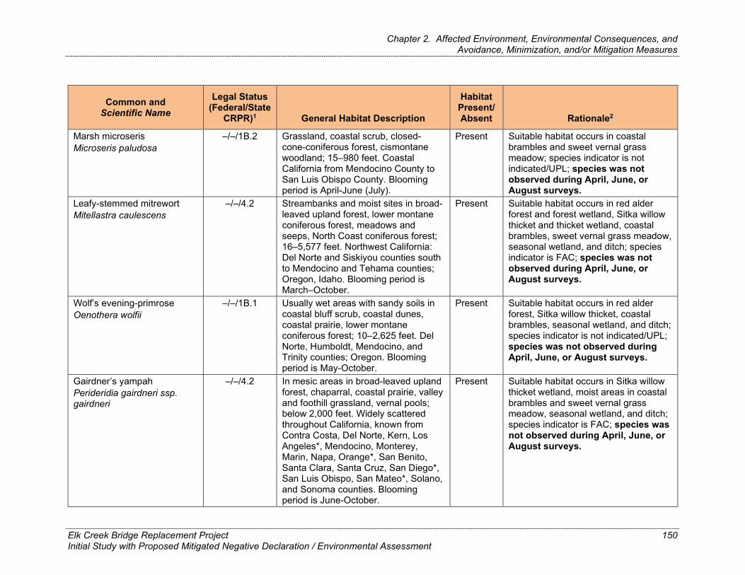
Chapter 2. Affected Environment, Environmental Consequences, and Avoidance, Minimization, and/or Mitigation Measures
Common and Scientific Name
Legal Status (Federal/State
CRPR)1 General Habitat Description
Habitat Present/Absent Rationale2
Marsh microseris –/–/1B.2 Grassland, coastal scrub, closed- Present Suitable habitat occurs in coastal Microseris paludosa cone-coniferous forest, cismontane
woodland; 15–980 feet. Coastal California from Mendocino County to San Luis Obispo County. Blooming period is April-June (July).
brambles and sweet vernal grass meadow; species indicator is not indicated/UPL; species was notobserved during April, June, orAugust surveys.
Leafy-stemmed mitrewort –/–/4.2 Streambanks and moist sites in broad- Present Suitable habitat occurs in red alder Mitellastra caulescens leaved upland forest, lower montane
coniferous forest, meadows and seeps, North Coast coniferous forest; 16–5,577 feet. Northwest California: Del Norte and Siskiyou counties south to Mendocino and Tehama counties; Oregon, Idaho. Blooming period is March–October.
forest and forest wetland, Sitka willow thicket and thicket wetland, coastal brambles, sweet vernal grass meadow, seasonal wetland, and ditch; species indicator is FAC; species was not observed during April, June, orAugust surveys.
Wolf’s evening-primrose –/–/1B.1 Usually wet areas with sandy soils in Present Suitable habitat occurs in red alder Oenothera wolfii coastal bluff scrub, coastal dunes,
coastal prairie, lower montane coniferous forest; 10–2,625 feet. Del Norte, Humboldt, Mendocino, and Trinity counties; Oregon. Blooming period is May-October.
forest, Sitka willow thicket, coastal brambles, seasonal wetland, and ditch; species indicator is not indicated/UPL; species was not observed duringApril, June, or August surveys.
Gairdner’s yampah Perideridia gairdneri ssp. gairdneri
–/–/4.2 In mesic areas in broad-leaved upland forest, chaparral, coastal prairie, valley and foothill grassland, vernal pools; below 2,000 feet. Widely scattered throughout California, known from Contra Costa, Del Norte, Kern, Los Angeles*, Mendocino, Monterey, Marin, Napa, Orange*, San Benito, Santa Clara, Santa Cruz, San Diego*, San Luis Obispo, San Mateo*, Solano, and Sonoma counties. Blooming period is June-October.
Present Suitable habitat occurs in Sitka willow thicket wetland, moist areas in coastal brambles and sweet vernal grass meadow, seasonal wetland, and ditch; species indicator is FAC; species was not observed during April, June, orAugust surveys.
Elk Creek Bridge Replacement Project Initial Study with Proposed Mitigated Negative Declaration / Environmental Assessment
150
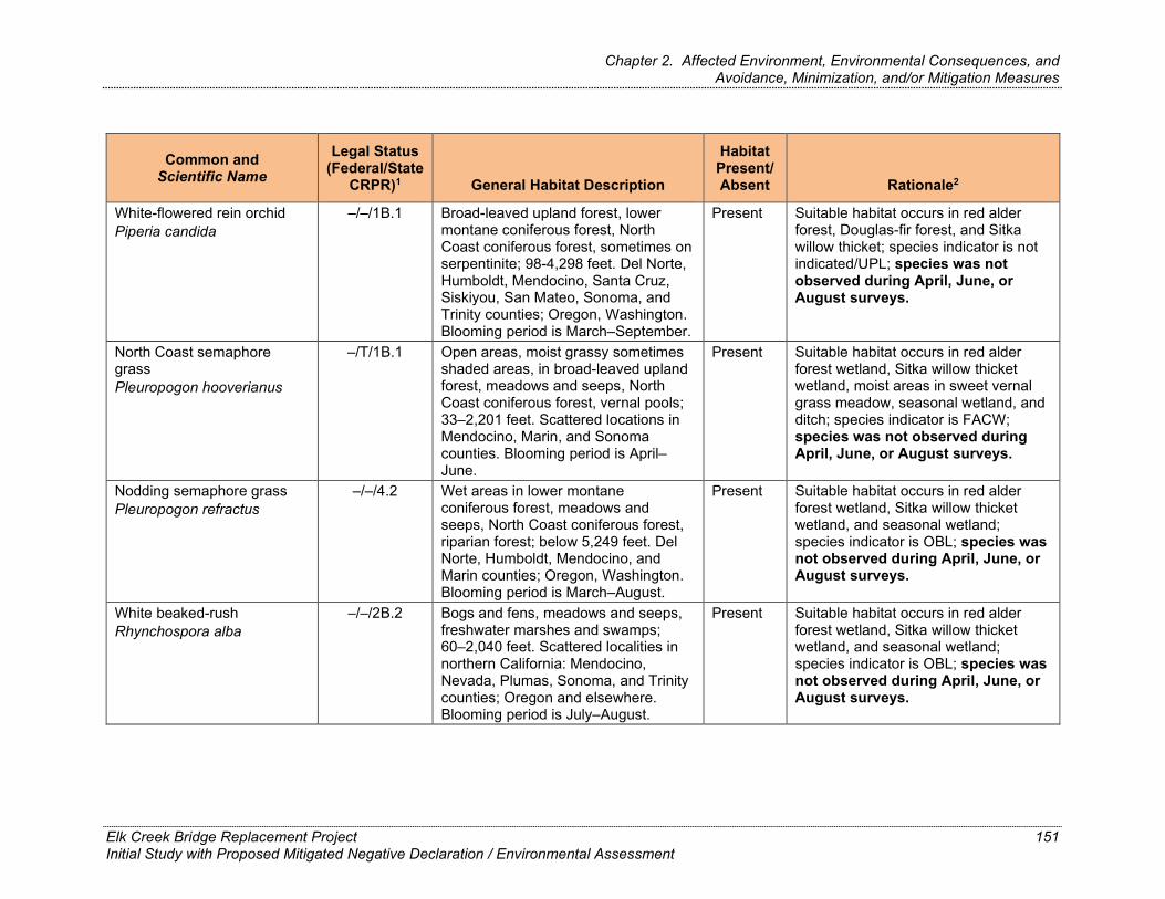
Chapter 2. Affected Environment, Environmental Consequences, and Avoidance, Minimization, and/or Mitigation Measures
Common and Scientific Name
Legal Status (Federal/State
CRPR)1 General Habitat Description
Habitat Present/Absent Rationale2
White-flowered rein orchid Piperia candida
–/–/1B.1 Broad-leaved upland forest, lower montane coniferous forest, North Coast coniferous forest, sometimes on serpentinite; 98-4,298 feet. Del Norte, Humboldt, Mendocino, Santa Cruz, Siskiyou, San Mateo, Sonoma, and Trinity counties; Oregon, Washington. Blooming period is March–September.
Present Suitable habitat occurs in red alder forest, Douglas-fir forest, and Sitka willow thicket; species indicator is not indicated/UPL; species was notobserved during April, June, orAugust surveys.
North Coast semaphore grass Pleuropogon hooverianus
–/T/1B.1 Open areas, moist grassy sometimes shaded areas, in broad-leaved upland forest, meadows and seeps, North Coast coniferous forest, vernal pools; 33–2,201 feet. Scattered locations in Mendocino, Marin, and Sonoma counties. Blooming period is April– June.
Present Suitable habitat occurs in red alder forest wetland, Sitka willow thicket wetland, moist areas in sweet vernal grass meadow, seasonal wetland, and ditch; species indicator is FACW; species was not observed duringApril, June, or August surveys.
Nodding semaphore grass –/–/4.2 Wet areas in lower montane Present Suitable habitat occurs in red alder Pleuropogon refractus coniferous forest, meadows and
seeps, North Coast coniferous forest, riparian forest; below 5,249 feet. Del Norte, Humboldt, Mendocino, and Marin counties; Oregon, Washington. Blooming period is March–August.
forest wetland, Sitka willow thicket wetland, and seasonal wetland; species indicator is OBL; species was not observed during April, June, orAugust surveys.
White beaked-rush –/–/2B.2 Bogs and fens, meadows and seeps, Present Suitable habitat occurs in red alder Rhynchospora alba freshwater marshes and swamps;
60–2,040 feet. Scattered localities in northern California: Mendocino, Nevada, Plumas, Sonoma, and Trinity counties; Oregon and elsewhere. Blooming period is July–August.
forest wetland, Sitka willow thicket wetland, and seasonal wetland; species indicator is OBL; species was not observed during April, June, orAugust surveys.
Elk Creek Bridge Replacement Project Initial Study with Proposed Mitigated Negative Declaration / Environmental Assessment
151

Chapter 2. Affected Environment, Environmental Consequences, and Avoidance, Minimization, and/or Mitigation Measures
Common and Scientific Name
Legal Status (Federal/State
CRPR)1 General Habitat Description
Habitat Present/Absent Rationale2
Great burnet –/–/2B.2 Freshwater emergent wetland, Present Suitable habitat occurs in red alder Sanguisorba officinalis including bogs, fens, marshes,
meadows, swamps, and seeps, in North Coast coniferous forest, riparian forest, often on serpentinite; 197–4,593 feet. North Coast, Del Norte, Humboldt, and Mendocino counties; Oregon, Washington, and elsewhere. Blooming period is July– October.
forest wetland, Sitka willow thicket wetland, and seasonal wetland; species indicator is FACW; species was not observed during April,June, or August surveys.
Point Reyes checkerbloom Sidalcea calycosa ssp. rhizomata
–/–/1B.2 Freshwater wetlands, including marshes, swamps, and seeps, near the coast; 10–246 feet. North Coast and northern Central Coast, Mendocino, Marin, and Sonoma counties. Blooming period is April– September.
Present Suitable habitat occurs in red alder forest wetland, Sitka willow thicket wetland, and seasonal wetland; species indicator is OBL; Sidalcea calycosa ssp. calycosa was observed during April, June, or August surveys, but not ssp. rhizomata.
Maple-leaved checkerbloom –/–/4.2 Openings in coastal scrub, perennial Present Suitable habitat occurs in red alder Sidalcea malachroides grassland, redwood forest, Douglas-fir
forest, often in disturbed areas. Below 2,395 feet. North Coast and northern Central Coast, from Humboldt to Monterey counties. Blooming period is March–August.
forest, Douglas-fir forest, and coastal brambles; species indicator is not identified/UPL; species was notobserved during April, June, orAugust surveys.
Siskiyou checkerbloom Sidalcea malviflora ssp. patula
–/–/1B.2 Coastal bluff scrub, coastal prairie, and North Coast coniferous forest, often on road cuts; 49–2,887 feet. North Coast in Mendocino, Humboldt, and Del Norte counties, and in coastal Oregon. Blooming period is May– August.
Present Suitable habitat occurs in red alder forest and wetland, Douglas-fir forest, coastal brambles, and ditch; species indicator is FACW; species was not observed during April, June, orAugust surveys.
Elk Creek Bridge Replacement Project Initial Study with Proposed Mitigated Negative Declaration / Environmental Assessment
152

Chapter 2. Affected Environment, Environmental Consequences, and Avoidance, Minimization, and/or Mitigation Measures
Common and Scientific Name
Legal Status (Federal/State
CRPR)1 General Habitat Description
Habitat Present/Absent Rationale2
Purple-stemmed –/–/1B.2 Broad-leaved upland forest, coastal Present Suitable habitat occurs in Sitka willow checkerbloom prairie; 49–279 feet. Coastal Northern thicket and wetland, moist areas in Sidalcea malviflora ssp. California in Mendocino, Marin (?), and sweet vernal grass meadow, and purpurea Sonoma counties. Blooming period is
May–June. seasonal wetland; species indicator is FACW; species was not observed during April, June, or August surveys.
Hoffman’s bristly Jewelflower -/-/1B.3 Generally occurs in rocky serpentinite Absent No suitable habitat occurs in project Streptanthus glandulosus outcrops within chaparral or BSA. ssp. hoffmanii cismontane woodland, and valley and
foothill grassland. Found at elevations of 395-1560 feet within Lake, Mendocino, and Sonoma counties. An annual herb that blooms March – July.
Closest observation was made in 2015 at approx. 4 miles east-southeast of the mouth of Elk Creek, on the south-facing slope at 1680 feet in elevation.
Twisted horsehair lichen -/-/1B.2 A epiphytic fruticose lichen can be Absent No suitable habitat occurs within Sulcaria spiralifera found on north coast coniferous
forests located on the immediate coast – found in conifers in dune forests below 390 feet. No records in Mendocino County, Sonoma dunes in Humboldt county support largest known population.
the BSA.
Santa Cruz clover –/–/1B.1 Moist grassy areas on margins of Present Suitable habitat occurs in Sitka willow Trifolium buckwestiorum broad-leaved upland forest,
cismontane woodland, and coastal prairie, sometimes in disturbed areas; 34–2,000 feet. San Francisco Bay area and central coastal California in Mendocino, Santa Cruz, and Sonoma counties. Blooming period is April-October.
thicket, sweet vernal grass meadow, and ditch; species indicator is not identified/UPL; species was notobserved during April, June, or August surveys.
Elk Creek Bridge Replacement Project Initial Study with Proposed Mitigated Negative Declaration / Environmental Assessment
153

Chapter 2. Affected Environment, Environmental Consequences, and Avoidance, Minimization, and/or Mitigation Measures
Common and Scientific Name
Legal Status (Federal/State
CRPR)1 General Habitat Description
Habitat Present/Absent Rationale2
Methuselah's beard lichen –/–/4.2 North Coast coniferous forest, broad- Present Suitable habitat occurs in red alder Usnea longissima leaved upland forest; grows on a
variety of trees in the "redwood zone," including big leaf maple, oaks, ash, Douglas-fir, and bay; 164–4,790 feet. California populations are centered in Humboldt County, with additional occurrences in Del Norte, Mendocino, Sonoma, Santa Cruz, and San Mateo counties; Alaska, Alabama, Maine, Michigan, Minnesota, Missouri, Montana, New Hampshire, New York, Oregon, Scout Carolina, Vermont, Washington, and Wisconsin.
forest, Douglas-fir forest, and Sitka willow thicket; no species indicators for lichens; species was not observed during April, June, or August surveys.
Fringed false-hellebore –/–/4.3 Moist areas, bogs and meadows in Present Suitable habitat occurs in red alder Veratrum fimbriatum coastal scrub, North Coast coniferous
forest; below 600 feet. Mendocino and Sonoma counties. Blooming period is July–September.
forest wetland, Sitka willow thicket wetland, and seasonal wetland; species indicator is OBL; species was not observed during April, June, orAugust surveys.
Sources: Caltrans 2020 (Natural Environment Study)
1 Status explanations:
Federal
E = Listed as endangered under the federal ESA. – = No listing status.
State
E = Listed as endangered under CESA. T = Listed as threatened under CESA. – = No listing status.
Elk Creek Bridge Replacement Project Initial Study with Proposed Mitigated Negative Declaration / Environmental Assessment
154

Chapter 2. Affected Environment, Environmental Consequences, and Avoidance, Minimization, and/or Mitigation Measures
CRPR
1B = List 1B species: rare, threatened, or endangered in California and elsewhere. 2B = List 2B species: rare, threatened, or endangered in California, but more common elsewhere 3 = List 3 species: more information is needed about this plant. 4 = List 4 species: limited distribution; species on a watch list .1 = Seriously endangered in California (over 80 percent of occurrences threatened—high degree and immediacy of threat). .2 = Fairly endangered in California (20-80 percent occurrences threatened). .3 = Not very threatened in California (less than 20 percent of occurrences threatened / low degree and immediacy of threat or no current threats known).
2 Wetland indicator status:
OBL (obligate)—almost always occurs in wetlands (99 percent probability of occurrence in wetlands).
FAC (facultative)—equally likely to occur in wetlands or non-wetlands (34– 66 percent probability).
FACU (facultative upland)—usually occurs in non-wetlands but occasionally occurs in wetlands (1– 33 percent probability).
FACW (facultative wetland)—usually occurs in wetlands (67–99 percent probability).
UPL (obligate upland)—almost never occurs in wetlands (1 percent probability); in general, species that are not listed on the wetland plant list are assumed to be obligate upland species.
NI (no indicator)—no indicator status assigned because regional status information is lacking; the indicator status assigned to the species in the nearest adjacent region is applied, in this case, Region 9 (Northwest).
Elk Creek Bridge Replacement Project Initial Study with Proposed Mitigated Negative Declaration / Environmental Assessment
155
Chapter 2. Affected Environment, Environmental Consequences, and Avoidance, Minimization, and/or Mitigation Measures
Environmental Consequences Build Alternative
Based on the field survey results and the lack of recorded occurrences in the BSA, no special-status plant species are anticipated to occur in the BSA; therefore, the project would not affect special-status plants.
No-Build Alternative
Under the No-Build Alternative, as no special-status plant species are anticipated to occur in the BSA, the project would not affect special-status plants.
Avoidance, Minimization, and/or Mitigation Measures As no special-status plants are anticipated to occur in the BSA, no avoidance, minimization, or mitigation measures would be required.
2.18. Animal and Fish Species
Regulatory Setting Many state and federal laws regulate impacts to wildlife. The USFWS, the National Oceanic and Atmospheric Administration (NOAA)’s National Marine Fisheries Service (NMFS) and the CDFW are responsible for implementing these laws. This section discusses potential impacts and permit requirements associated with animals not listed or proposed for listing under the federal or state Endangered Species Act. Species listed or proposed for listing as threatened or endangered are discussed in Section 2.19, Threatened and Endangered Species, below. All other special-status animal species are discussed here, including CDFW fully protected species and species of special concern, and USFWS or NMFS candidate species.
Federal laws and regulations relevant to wildlife include the following:
National Environmental Policy Act Migratory Bird Treaty Act Fish and Wildlife Coordination Act State laws and regulations relevant to wildlife include the following: California Environmental Quality Act Sections 1600–1603 of the California Fish and Game Code Sections 4150 and 4152 of the California Fish and Game Code
Elk Creek Bridge Replacement Project Initial Study with Proposed Mitigated Negative Declaration / Environmental Assessment
156

Chapter 2. Affected Environment, Environmental Consequences, and Avoidance, Minimization, and/or Mitigation Measures
Affected Environment The information in this section is from the NES prepared for the project (Caltrans 2021). Sensitive wildlife species that could occur in the BSA were identified based on a review of existing information and reconnaissance-level field surveys.
Prior to field surveys, biologists reviewed the following documents to determine the likelihood of special status species and habitats occurring in the BSA.
California Native Plant Society’s (CNPS) online Inventory of Rare and Endangered Plants of California records search of the Mallo Pass Creek, Albion, Elk, Navarro, Cold Spring, Eureka Hill, and Point Arena U.S. Geological Survey (USGS) 7.5-minute quadrangles (California Native Plant Society 2018) (Appendix C).
California Natural Diversity Database (CNDDB) records search of the Mallo Pass Creek, Albion, Elk, Navarro, Cold Spring, Eureka Hill, and Point Arena USGS 7.5-minute quadrangles (California Department of Fish and Wildlife 2020) (Appendix B).
A list of endangered and threatened species that may occur in the Mallo Pass Creek USGS 7.5-minute quadrangle (National Marine Fisheries Service 2019; California Department of Fish and Wildlife, 2020) (Appendix B).
Lists of plants identified as noxious weeds or invasive plants by the U.S. Department of Agriculture (USDA (Natural Resources Conservation Service 2010), the California Department of Food and Agriculture (CDFA) (Natural Resources Conservation Service 2003), and the California Invasive Plant Council (Cal-IPC) (2018).
Soil map for the BSA (Natural Resources Conservation Service 2017).
This information was used to develop lists of special-status species and other sensitive biological resources that could be present in the project region. Species from the lists were considered for analysis if they were known to occur in the project region or had potential habitat in the BSA and the BSA was within the species’ range. Habitat assessments for special-status wildlife were conducted for all accessible areas within the BSA. The BSA was assessed for the potential to support special-status wildlife through site visits, by reviewing aerial imagery and records of occurrences, and through discussions with agency personnel and species experts.
Elk Creek Bridge Replacement Project Initial Study with Proposed Mitigated Negative Declaration / Environmental Assessment
157

Chapter 2. Affected Environment, Environmental Consequences, and Avoidance, Minimization, and/or Mitigation Measures
After these reviews and field surveys were conducted, it was determined that the wildlife Species of Special Concern identified in the following paragraphs could potentially occur within the BSA.
Western Bumble Bee
The Western bumble bee (Bombus occidentalis) was recently accepted as a candidate species for listing as endangered under CESA on June 12, 2019. While a supreme court case in November 2020 has brought into question the eligibility of this species (and other terrestrial insects) to be listed under CESA, the species is nevertheless considered rare in California (State Rank 1), and is evaluated as such.
Historically, the Western bumble bee was the most common bumble bee in the western United States but has been declining dramatically since the late 1990s and is no longer present across much of its historic range. The Western bumble bee typically nests underground in abandoned rodent burrows or other cavities. Natural habitat for this bumble bee is open grassy areas, chaparral and shrub areas, mountain meadows, as well as urban and rural habitats. As generalist foragers, Western bumble bee do not depend on any one flower type but are most likely to use open faced flowers with short corollas such as thistles and other plant species in the sunflower family (Asteraceae).
There are 11 CNDDB records of Western bumble bee in Mendocino County; of these, only 4 are coastal, and all were recorded prior to 1984. The closest know historical occurrence of Western bumble bee comes from collections made in and around the Point Arena area in 1963. This historical occurrence is approximately 12 miles south of Elk Creek. While the proposed project is located within the species’ historical range and suitable foraging and marginal nesting habitat does exist in small areas within the BSA – there are no significant expanses of floral resources were identified within the project area and the nesting habitat is marginal. No species-specific surveys were conducted.
Foothill Yellow-legged Frog
The Northwest/North coast clade of Foothill yellow-legged frog (Rana boylii) is designated a California species of special concern. Foothill yellow-legged frog inhabits forest streams and rivers with sunny, sandy, and rocky banks, deep pools, and shallow riffles. Foothill yellow frogs disperse through riparian corridors, as well as over land, and have been found using upland habitats with an average distance of 234 feet from water.
Elk Creek Bridge Replacement Project Initial Study with Proposed Mitigated Negative Declaration / Environmental Assessment
158

Chapter 2. Affected Environment, Environmental Consequences, and Avoidance, Minimization, and/or Mitigation Measures
Focused surveys for Foothill yellow-legged frog were not conducted specifically for the proposed Elk Creek Bridge Replacement Project; however, biological monitoring of Caltrans emergency repair projects at the bridge and just downstream were conducted in May 2016 and June through August 2019, respectively. No Foothill yellow-legged frog were encountered during the May 2016 biological monitoring, which included fish relocation and monitoring in-water work on the upstream side of the bridge. Likewise, no Foothill yellow-legged frog were observed during the biological monitoring in June, July, and August 2019 at the bridge’s north pier or the repair location situated a few hundred feet downstream of the Elk Creek Bridge on the south side of the BSA, despite multiple observations of red-legged frogs. The closest California Natural Diversity Database (CNDDB) (California Department of Fish and Wildlife [CDFW] 2020) occurrences for Foothill yellow-legged frog are 1.5 and 1.8 miles southeast of the BSA in South Fork Elk Creek (Caltrans 2021).
Elk Creek provides poor quality breeding habitat from the existing bridge upstream to the eastern edge of the BSA because it lacks a wide shallow channel with cobble and boulder substrates for attaching egg masses and rearing tadpoles. Also, Elk Creek upstream of the BSA has high canopy closure that reduces the suitability for this species and would likely preclude breeding. Elk Creek downstream of the existing bridge in the BSA also would not likely be used for breeding due to high canopy closure, tidal influence, and the silty substrate.
Foothill yellow-legged frog may use Elk Creek as nonbreeding habitat, but it would most likely be limited to the period following breeding. The creek would also not likely be used as overwintering habitat because the species generally avoids larger streams and rivers, where the risk of being displaced by heavy flows is greater. Foothill yellow-legged frog could potentially use the adjacent riparian for cover and foraging, but the likelihood would be low due to the limited availability of adjacent aquatic habitat.
California Red-Legged Frog and Northern Red-legged Frog
The California red-legged frog (Rana drytonii) is a Federally threatened species found throughout California and is likely present throughout the project area. They breed in lowland and foothill streams or water associated with permanent wetlands (such as cattails, tule, hard stem bulrush) or overhanging willows, including livestock ponds (Caltrans 2021). Breeding occurs in permanent water sources such as streams, marshes, and natural and manmade ponds (Caltrans 2021). The California red-legged frog has a large range that extends from Elk Creek south along the coast and inland from the vicinity of Shasta County south to northwester Baja California, Mexico.
Elk Creek Bridge Replacement Project Initial Study with Proposed Mitigated Negative Declaration / Environmental Assessment
159

Chapter 2. Affected Environment, Environmental Consequences, and Avoidance, Minimization, and/or Mitigation Measures
The Northern red-legged frog (Rana aurora) is designated a California species of special concern. Northern red-legged frog occurs along the Coast Ranges from Del North County south into Mendocino County to around the Elk Creek watershed, usually below 4,000 feet in elevation. Northern red-legged frog is highly aquatic and prefers shorelines with extensive vegetation. Breeding occurs in permanent pools and attaches eggs to aquatic vegetation in shallow water. Water salinity may have an important influence on embryo survival. Species has been found considerable distances from breeding sites on rainy nights (Caltrans 2021).
Focused surveys for Northern red-legged frog were not conducted; however, multiple red-legged frog individuals have been observed in Elk Creek during recent Caltrans work within the BSA. A single adult red-legged frog was observed in Elk Creek downstream of the bridge on June 11, 2018, by Caltrans biologist Desiree Davenport. From June 20, 2019, to August 20, 2019, up to 47 individual red-legged frogs were observed during emergency repair work adjacent to and within the BSA. There is also one CNDDB record for Northern red-legged frog from within Elk Creek in the BSA (CDFW 2020). This record (Occurrence #104) includes a collection from prior to 2004 that was later analyzed and determined to have mitochondrial DNA from Northern red-legged frog (Caltrans 2021).
Per direction from USFWS, Elk Creek is being treated as having the potential to support both species and regulatory protections are extended to all red-legged frogs in this area because these species cannot be readily distinguished in the field (Caltrans 2021). Therefore, all red-legged frogs encountered within the project area would be treated as potential CRLF or hybrids. A more detailed account and analysis of CRLF is provided in section 2.19 below.
Western Pond Turtle
Western pond turtle (Actinemys marmorata) is a California species of special concern. Aquatic habitats used by pond turtles include ponds, lakes, marshes, rivers, streams, and irrigation ditches with a muddy or rocky bottom in grassland, woodland, and open forest areas. Pond turtles move to upland areas adjacent to watercourses to deposit eggs and overwinter.
Focused surveys for Western pond turtle were not conducted; however, no Western pond turtles were observed during the habitat assessments. Elk Creek and the adjacent uplands in the BSA represent suitable habitat for the species. The nearest CNDDB occurrence is approximately 10.7 miles south of the BSA in the Garcia River Estuary.
White-tailed Kite
Elk Creek Bridge Replacement Project Initial Study with Proposed Mitigated Negative Declaration / Environmental Assessment
160

Chapter 2. Affected Environment, Environmental Consequences, and Avoidance, Minimization, and/or Mitigation Measures
White-tailed kite (Elanus leucurus) is a CDFW fully protected species. White-tailed kite are year-round residents in coastal and valley lowlands. They generally inhabit low-elevation grassland, savannah, oak woodland, wetland, agricultural, and riparian habitats. Large shrubs or trees are required for nesting and for communal roosting sites. The nesting season lasts from February through August. Kites forage in undisturbed open grassland, meadows, farmland, and emergent wetlands.
Focused surveys for nesting birds were conducted on April 24, 2018, and June 29, 2018, with no observations of white-tailed kite. The closest CNDDB occurrence for the species is 6.7 miles northwest of the BSA upslope of Big Salmon Creek.
Riparian habitat within the BSA could provide suitable nesting and roosting habitat for the species. The BSA contains a small area of suitable foraging habitat on the northeastern side of the bridge.
Sonoma Tree Vole
The Sonoma tree vole (Arborimus pomo) is designated a California species of special concern. This species is found mainly in older Douglas-fir, redwood, and montane forests; however, younger trees may also be used. Nests are constructed from the needle resin ducts and generally found high in trees near the trunk, on branches, or on a whorl of limbs.
Focused surveys for Sonoma tree vole were not conducted; however, no Sonoma tree vole nests were observed during the habitat assessments. Occupancy by Sonoma tree voles can be difficult to determine as nests are difficult to observe from the ground. The closest CNDDB occurrence (#51) is from 1992–1997 and is 1.2 miles northwest of the BSA along SR 1 at Greenwood Creek (CDFW 2020). The same area had a total of 23 trees with signs of red tree vole in 2005. There is also a record for Sonoma tree vole (#143) approximately 4 miles southeast of the BSA along Elk Creek, where several nests were observed.
There are several Douglas-fir trees within the coastal brambles natural community in the BSA that could be used by the species; however, since Sonoma tree voles primarily occupy more dense forests, the overall likelihood that they would occur there is low.
Elk Creek Bridge Replacement Project Initial Study with Proposed Mitigated Negative Declaration / Environmental Assessment
161

Chapter 2. Affected Environment, Environmental Consequences, and Avoidance, Minimization, and/or Mitigation Measures
Western Red Bat
Western red bat (Lasiurus blossevillii) is a California species of special concern and is also considered a high priority species in California by the Western Bat Working Group. It is found throughout much of California at lower elevations, primarily in riparian and wooded habitats, but also occurs seasonally in urban areas. Western red bats roost in the foliage of trees that are often located on the edge of habitats adjacent to streams, fields, or urban areas. Western red bat forages over a wide variety of habitats including grasslands, shrublands, open woodlands, and forests.
No directed surveys for Western red bat were conducted (e.g., acoustic surveys, surveys for signs of bats). The riparian forest present in the BSA provides suitable roosting habitat for Western red bat (mature trees on the edge of open habitats) and the open areas and riparian forest provide suitable foraging habitat in the BSA. The nearest CNDDB record for Western red bat (#81) is approximately 52 miles northeast of the BSA (CDFW 2020).
Migratory Birds
The federal Migratory Bird Treaty Act (MBTA) (15 USC 703–711), Title 50 Code of Federal Regulations (CFR) Part 21 and 50 CFR Part 10, and the CDFG Game Code Sections 3503, 3513, and 3800, protect migratory birds, their occupied nests, and their eggs from disturbance or destruction. The MBTA provides protection in part by restricting the disturbance of nests during the bird nesting season.
Focused surveys for nesting birds were conducted on April 24, 2018, and June 29, 2018. During the surveys, an American dipper (Cinclus mexicanus) pair was observed feeding nestlings in a nest attached to the underside of the northern span of the Elk Creek Bridge. No other nesting was confirmed, but the majority of species observed were in suitable nesting habitat within the BSA and were probable nesters. Several non-special-status migratory birds, including barn swallow (Hirundo rustica) and black phoebe (Sayornis nigricans), could nest on the underside of the Elk Creek Bridge structure in the spring before construction. Also, 34 other species of birds observed in and near the BSA could nest on the ground or in trees and/or shrubs within the BSA.
Elk Creek Bridge Replacement Project Initial Study with Proposed Mitigated Negative Declaration / Environmental Assessment
162

Chapter 2. Affected Environment, Environmental Consequences, and Avoidance, Minimization, and/or Mitigation Measures
Colonies of Roosting Non-Special-Status Bats
Common bats may roost on the existing bridge and in trees within the BSA including Mexican free-tailed bat (Macrotus californicus), big brown bat (Eptesicus fuscus), silver-haired bat (Lasionycteris noctivagans), hoary bat (Aeorestes cinereus), California myotis (Myotis californicus), long-eared myotis (Myotis evotis), little brown myotis (Myotis lucifugus), fringed myotis (Myotis thysanodes), long-legged myotis (Myotis volans), and Yuma myotis (Myotis yumanensis). Although these bats do not have special status, the loss of known roosting habitat, especially a bridge, could affect local populations.
Based on the roosting patterns of California bats, the following species may use bridges with the following frequencies: Mexican free-tailed bat (frequently use), big-brown bat (frequently use), silver-haired bat (rarely use), California myotis (sometimes use), long-eared myotis (sometimes use), little brown myotis (sometimes use), fringed myotis (sometimes use), long-legged myotis (sometimes use), and Yuma myotis (frequently use).
Likewise, the following species may use trees with the following frequencies: Mexican free-tailed bat (rarely use), big-brown bat (frequently use), silver-haired bat (frequently use), hoary bat (frequently use), California myotis (sometimes use), long-eared myotis (frequently use), little brown myotis (sometimes use), fringed myotis (frequently use), long-legged myotis (frequently use), and Yuma myotis (sometimes use).
These species are most vulnerable during the summer maternity season (May through July), when holes and crevices may be used as maternal colonies for rearing young; whereas, during the winter months, most of these species roost individually or in small numbers.
Colonies of roosting non-special-status bats could potentially occur in trees and snags in the existing Elk Creek Bridge structure within the BSA. A single bat, thought to be a Yuma myotis, was observed day-roosting on the underside of the bridge on June 6, 2018. Small amounts of bat guano and staining were also observed below the expansion joints of the bridge in April and June 2018, indicating the bridge was also used by night-roosting bats. A small amount of guano, presumably from night-roosting bats, was also reported under the southern abutment in July 2017.
Of the relevant non-special-status bats tracked by the CNDDB (i.e., fringed myotis, long-eared myotis, long-legged myotis, silver-haired bat, and Yuma myotis), the only occurrence reported in Mendocino County is of a long-eared myotis (#85) from 1980, approximately 52 miles northeast of the BSA. Likewise, the Biodiversity Information Serving Our Nation
Elk Creek Bridge Replacement Project Initial Study with Proposed Mitigated Negative Declaration / Environmental Assessment
163

Chapter 2. Affected Environment, Environmental Consequences, and Avoidance, Minimization, and/or Mitigation Measures
database was queried for records within Mendocino County (Caltrans 2021). Those records show that two specimens of California myotis were reported from 1948 in the USGS 7.5'-Comptche quadrangle approximately 19-miles northeast of the BSA. One specimen of California myotis from 1995, one big brown bat from 1995, one Yuma myotis from 1995, and one fringed myotis from 1998 were all reported centered in the USGS 7.5'-Burbeck quadrangle, 26 miles northeast of the BSA.
Pacific Lamprey
Pacific lamprey (Lampetra tridentata) is an anadromous fish species listed as a federal species of concern and a California species of special concern; CDFW classifies the current status of the species as Moderate Concern. Critical habitat for Pacific lamprey has not been designated. Pacific lamprey is currently found along the coast of the Pacific Ocean, from Japan to Baja California, and anadromous forms occur in the rivers below impassable barriers.
Adult Pacific lamprey spend the predatory phase of their life in the ocean and migrate into freshwater streams from January through June to spawn. Most movement occurs at night. Adults spawn by constructing a nest in gravelly areas of streams containing relatively fast velocities and having depths of 1 to 5 feet. After hatching, juvenile lamprey (ammocoetes) spend a short period in the nest before being washed downstream to areas of soft sand or mud and burrow tail first into the substrate. It is thought that ammocoetes spend the next 5 to 7 years filter feeding in freshwater before metamorphosing into adult forms and migrating to the ocean (in winter and spring) (Caltrans 2021 and references therein).
Focused surveys for Pacific lamprey were not conducted within the BSA; however, suitable migration, and rearing habitat for the species exists in the BSA. Based on their life history, Pacific lamprey are likely to be present in the BSA year-round as ammocoetes, seasonally as juveniles migrating to the Pacific Ocean, and as spawning adult or adults making their way upstream toward spawning grounds. Lamprey ammocoetes are known to occur within the BSA, and several ammocoetes were collected in the BSA during fish removal activities related to a Caltrans emergency scour repair project in 2016.
Elk Creek Bridge Replacement Project Initial Study with Proposed Mitigated Negative Declaration / Environmental Assessment
164

Chapter 2. Affected Environment, Environmental Consequences, and Avoidance, Minimization, and/or Mitigation Measures
Environmental Consequences
Construction Impacts
Build Alternative
Western Bumble Bee
Project activities such as cut and fill, road widening, and vegetation removal could cause destruction of nests located within the vicinity or remove floristic resources. However, these activities are not expected to injure or kill foraging Western bumble bees. Cut and fill activities (only cutting a few feet into the bottom of the embankment) would be very minor along the grassy road banks at the northern end of the project where marginal nesting habitat for Western bumble bee is found. The sweet vernal grass meadow west of the project BSA is outside the construction footprint and no impacts would be expected to alter this potential habitat or impact existing bumble bee colonies, if present. Given the rarity of the Western bumble bee in California and particularly in coastal areas, the overall poor habitat quality/nesting habitat within the project ESL, and the limited potential for construction activities to alter potential nesting or foraging habitat, it is highly unlikely the proposed project would result in any impact to the species and no take of Western bumble bee is anticipated.
Foothill Yellow-legged Frog, California and Northern Red-legged Frogs, and Western Pond Turtle
Bridge replacement activities could potentially result in the injury and/or mortality of Foothill yellow-legged frog, California and northern red-legged frog, and Western pond turtle, if individuals are present during construction. These activities would include clearing of the access road through riparian areas, construction of the temporary bridge, installation of the clear water diversion, demolition of the existing bridge, construction of the new bridge, removing the existing RSP and installation of the root wad revetment, and restoration activities within the work area following construction. Implementing the standard measures in Section 1.6 and Best Management Practices would be expected to greatly reduce, but not eliminate, potential injury to red-legged frogs depending on timing of construction activities. The proposed standard measures combined with the low probability of occurrence within the project area are anticipated to result in no direct mortality or injury of Western pond turtle or Foothill-yellow legged frogs.
Elk Creek Bridge Replacement Project Initial Study with Proposed Mitigated Negative Declaration / Environmental Assessment
165

Chapter 2. Affected Environment, Environmental Consequences, and Avoidance, Minimization, and/or Mitigation Measures
Construction could also result in auditory and visual disturbance, which could alter foraging and basking behavior for red-legged frogs and turtles in the vicinity, which would likely attempt to leave the construction area or hide. Although less likely, these activities could also disrupt breeding behavior of Foothill yellow-legged frog due to the timing of their breeding period, but only if occurring nearby.
Project construction would result in the temporal loss of 0.67 acre and the permanent loss of 0.032 acre of potential riparian forested habitat (upland and wetland riparian forest habitats), temporarily reduce riparian coastal bramble by 0.068 acre, and temporarily impact 0.12 acre of aquatic habitat within Elk Creek for all three species. This is only a small fraction of available habitat withing the general project area and riparian habitats would be replanted and recontoured upon project completion.
The proposed project would have no indirect impacts to Foothill-yellow frog, California and northern red-legged frog, or Western pond turtle during or after construction (e.g., some impact later in time and/or removed by distance). Because replacement of the existing bridge would be at the same location and would not change the use of the area, no new indirect impacts (e.g., traffic noise, water quality) related to the bridge and its use have been identified. In addition, project Standard Measures and Best Management Practices would be used to protect water quality by limiting sediment or pollutants from entering the creek, both during and after construction.
White-tailed Kite
Construction activities would occur during the white-tailed kite nesting season (February to August) and could result in the disturbance of nesting white-tailed kite through the increased temporary presence of human activity and temporary increased noise level from construction equipment potentially leading to the abandonment of nesting attempts or premature fledging of young. Removal of suitable nest trees in the BSA would decrease the amount of available nesting habitat and result in a temporal loss of nesting habitat until replacement trees mature. Construction of the proposed project would also result in temporary less than significant impacts on suitable foraging habitat for white-tailed kite through the loss of prey availability and alteration of natural vegetation.
Focused surveys for nesting birds were conducted on April 24 and June 29, 2018 with no observations of white-tailed kite (Caltrans 2021). The closest CNDDB occurrence for the species is 6.7 miles northwest of the BSA upslope of Big Salmon Creek (CDFW 2020). The riparian forest habitat within the BSA could provide suitable nesting and roosting habitat for
Elk Creek Bridge Replacement Project Initial Study with Proposed Mitigated Negative Declaration / Environmental Assessment
166

Chapter 2. Affected Environment, Environmental Consequences, and Avoidance, Minimization, and/or Mitigation Measures
the species, and there is an approximately 0.50 acre of suitable foraging habitat (sweet vernal grass meadow, coastal brambles, and ruderal habitat) on the northeastern side of the bridge.
Construction would temporally affect approximately 0.70 acre of potential nesting habitat and temporarily affect 0.09 acre of potential foraging habitat for the species (Caltrans 2021).
Large temporary losses of suitable foraging habitat may negatively affect prey availability for nesting white-tailed kite. Reduced prey availability would require adult kites to forage further away from nesting territories or nest sites, which may increase predation risks on the nests and the adults. Additionally, reduced prey availability and reduced nesting or foraging habitat would affect the reproductive success of white-tailed kites if they nest within the BSA. Food trash left on-site overnight and not properly disposed of may attract potential white-tailed kite predators, such as raccoons, feral cats, and ravens, thereby increasing the predation risk of white-tailed kites potentially nesting or roosting in the BSA. Because replacement of the existing bridge would be at the same location and would not change the use of the area, and because the disturbance would be across a small area and temporary in nature, no new indirect impacts (e.g., traffic noise, water quality) related to the bridge and its use following completion have been identified.
Sonoma Tree Vole
The proposed project would not result in the removal of Douglas-fir, redwood and montane forest trees that represent potential habitat for Sonoma tree vole. Because of the lack of habitat in the BSA and the minimal likelihood of Sonoma tree vole occurrence, the potential for direct impacts from disturbance, injury, and/or mortality is low.
The proposed project would not indirectly impact Sonoma tree vole during construction. Because replacement of the existing bridge would be at the same location and would not change the use of the area, no new indirect impacts (e.g., traffic noise, visual disturbance) related to the bridge and its use have been identified.
Western Red Bat
The proposed project would result in the removal of trees that provide potential roosting habitat for Western red bat. The removal of red alder and sitka willow trees for the temporary access road, construction of the temporary bridge, and construction of the new bridge could all result in the injury and mortality of Western red bat if they are occupying those trees at that time.
Elk Creek Bridge Replacement Project Initial Study with Proposed Mitigated Negative Declaration / Environmental Assessment
167

Chapter 2. Affected Environment, Environmental Consequences, and Avoidance, Minimization, and/or Mitigation Measures
Construction would also result in auditory and visual disturbance, which could alter foraging and breeding behavior of the individuals within the vicinity of the BSA. Construction would remove approximately 0.70 acre of riparian forest within the ESL, thereby resulting in a long term loss of potential roosting habitat for the species.
The proposed project would not indirectly impact Western red bat during construction. Also, because replacement of the existing bridge would be at the same location and would not change the use of the area, no new indirect impacts (e.g., traffic noise, visual disturbance) related to the bridge and its use have been identified.
Caltrans would implement Standard Measure to protect bats, as described in Section 1.6, which requires surveys and protective measures as appropriate based on the type and timing of project activities.
Migratory Birds
Construction of the proposed project could result in the direct loss or abandonment of active nests of migratory birds. If construction occurs during the migratory nesting bird season (generally February 1 to September 15 along the Mendocino coast), removal of nesting habitat, such as trees, shrubs, and the bridge itself, could result in direct mortality of adults or young birds and the destruction of active nests. Clearing of ruderal vegetation and grading where ground-nesting birds may be present could also result in direct loss of nests and eggs.
Indirect impacts, such as increased noise and visual human activity associated with construction activities, could result in the disturbance of normal nesting behaviors, reduction in prey availability, and degradation of overall nesting habitat. These disturbances could cause nest abandonment and death of young or loss of reproductive potential at active nests located in or near the BSA. Improperly stored trash and food waste from construction personnel has the potential to attract wildlife that prey on nesting birds, including feral cats, ravens, skunks, and raccoons.
Standard Measures described in Section 1.6 would reduce these potential effects on migratory birds. To protect migratory and nongame birds and their occupied nests and eggs, nesting prevention measures would be implemented. Vegetation removal would be restricted to September 16 through January 31 (outside of the bird breeding season) or if vegetation removal is required during the breeding season (February 1 to September 15), a nesting bird survey by a qualified biologist would be conducted within 5 days prior to removal. If an active nest were located, the biologist would coordinate with the CDFW to establish
Elk Creek Bridge Replacement Project Initial Study with Proposed Mitigated Negative Declaration / Environmental Assessment
168
Chapter 2. Affected Environment, Environmental Consequences, and Avoidance, Minimization, and/or Mitigation Measures
appropriate species-specific buffer(s) and any monitoring requirements. The buffer would be delineated around each active nest, and construction activities would be excluded from these areas until birds have fledged or the nest is determined to be unoccupied.
Partially constructed and unoccupied nests within the construction area would also be removed and disposed of on a regular basis throughout the breeding season (February 1 to September 15) to prevent their occupation. Nest removal would be repeated weekly under guidance of a qualified biologist to ensure nests are inactive prior to removal. Removed nest material would be prevented from falling into waterways. At least 60 days prior to the installation of any wildlife exclusion devices (e.g., netting, funnels, screening), the contractor would be required to submit a Species Exclusion Plan for review and approval by the Caltrans project biologist.
Lastly, pre-construction surveys for active raptor nests within a quarter mile of the project area would be conducted by a qualified biologist within 15 days prior to the initiation of construction activities. Areas to be surveyed would be limited to those areas subject to increased disturbance because of construction activities (i.e., areas where existing traffic or human activity is greater than or equal to construction-related disturbance need not be surveyed). If any active raptor nests are identified, appropriate conservation measures (as determined by a qualified biologist and subject to approval by the Caltrans Project Biologist) would be implemented. These measures may include, but are not limited to, establishing a construction-free buffer zone around the active nest site, conducting biological monitoring of the active nest site, and delaying construction activities near the active nest site until the young have fledged.
Colonies of Roosting Non-Special-Status Bats
The proposed project would have no direct or indirect effects to roosting bats during construction. Because the replacement of the existing bridge would be at the same location and would not change the use of the area, no new indirect impacts, such as loss of bridge roost, has been identified. Additionally, removal of trees with roosting habitat would not have a measurable impact as the number of potential roost trees proposed for removal is only a small fraction of the existing potential habitat.
Construction activities, such as bridge removal, tree removal and trimming, and construction noise and vibrations, could result in direct effects on roosting bats. These effects include the disruption of normal behaviors, destruction of active roosts, the loss of individuals, or roost failure if maternal bat colonies occur in or adjacent to the BSA.
Elk Creek Bridge Replacement Project Initial Study with Proposed Mitigated Negative Declaration / Environmental Assessment
169
Chapter 2. Affected Environment, Environmental Consequences, and Avoidance, Minimization, and/or Mitigation Measures
Caltrans would implement Standard Measures to protect bats, as described in Section 1.6, which requires surveys and protective measures as appropriate based on the type and timing of project activities to limit impacts to roosting bats.
Fish Species—Pacific Lamprey and Anadromous Fish Species Habitat
Four special-status fish species -- Pacific lamprey, Northern California (NC) steelhead, Central California Coast (CCC) coho salmon, and tidewater goby-- are known to occur in the BSA based on the known range of these species and the suitability of the habitat in the BSA. In addition, critical habitat for NC steelhead and CCC coho salmon and EFH for Pacific salmon (coho salmon) occur in the BSA. A general discussion of each species and their habitats is provided below, but see section 2.19, Threatened and Endangered Species, for more details on impacts to NC steelhead and CCC coho.
Northern California steelhead was originally listed as Threatened in 2000, and the listing was reaffirmed in 2006 (Caltrans 2021). The designation includes steelhead found in all streams between Redwood Creek in Humboldt County southward to, but not including, the Russian River. Critical habitat was designated by the National Marine Fisheries Service (NMFS) in 2005 and includes Elk Creek and the area within the BSA (Caltrans 2021).
The Central California Coast Coho Salmon Evolutionarily Significant Unit (ESU) population was listed as Threatened in 1996 and reclassified as Endangered in 2005 (Caltrans 2021). The ESU population includes coho found in rivers south of Punta Gorda, California to Aptos Creek in Santa Cruz County, California, as well as coho originating from tributaries to the San Francisco Bay. Critical habitat was designated by NMFS in 1999 and includes Elk Creek and the area within the BSA (Caltrans 2021).
The tidewater goby (Eucyclogobius newberryi) was listed as an endangered species under FESA, as amended, on February 4, 1994. In 2007, USFWS completed a 5-year status review that recommended the tidewater goby be reclassified as threatened and on March 13, 2014, USFWS published a proposed rule to reclassify the tidewater goby as threatened; however, the species is still listed as endangered under FESA. Critical habitat for northern populations was designated on January 31, 2008; although the final rule designated critical habitat for tidewater goby along the Mendocino coast, the BSA and the nearby Elk Creek estuary are not included. Tidewater goby are not anadromous fish, but if present, would be subject to many of the same potential direct and indirect project impacts.
Elk Creek Bridge Replacement Project Initial Study with Proposed Mitigated Negative Declaration / Environmental Assessment
170

Chapter 2. Affected Environment, Environmental Consequences, and Avoidance, Minimization, and/or Mitigation Measures
Pacific lamprey is a federal species of concern and a California species of special concern; CDFW classifies the current status of the species as Moderate Concern. Critical habitat for Pacific lamprey has not been designated. Pacific lamprey is currently found along the coast of the Pacific Ocean, from Japan to Baja California, and anadromous forms occur in the rivers below impassable dams.
Focused surveys for Pacific lamprey were not conducted; however, suitable migration, spawning, and rearing habitat for the species exists in the BSA. Based on their life history and past observations (including several ammocoetes below the Elk Creek Bridge in 2016), Pacific lamprey are likely to be present in the BSA year-round as ammocoetes (i.e., larvae) living in the soft-bottomed substrates, seasonally as juveniles migrating to the Pacific Ocean, and as spawning adult or adults making their way upstream toward spawning grounds. Pacific Lamprey are anticipated to be in the project area during the proposed construction.
Potential project effects on these fish species and their habitat include both short-term and long-term effects. Short-term effects include temporary construction-related impacts on fish and aquatic habitat that may last from a few hours to days (e.g., suspended sediment and turbidity, pile-driving and general construction noise, fish capture and relocation, artificial lighting). Long-term effects (e.g., addition of overwater structure, loss of riparian and SRA cover habitat [described above in Section 2.15, Natural Communities]) typically would last months or years and a small percentage would be permanent (Table 17). These effects are generally due to physical alteration of important habitat attributes of the channel, shoreline, and adjacent bank. Short-term effects on fish species were evaluated qualitatively based on general knowledge of the impact mechanisms and species’ responses to construction actions. Long-term effects were measured in terms of the area and/or linear feet of artificial shade, aquatic habitat, and SRA cover habitat affected by the proposed project.
Construction Alternative
If the proposed project is constructed there would be new impacts to Pacific lamprey and fish habitat as a result of the construction effort. These impacts are discussed below and relate to water quality, construction noise, direct injury, pile driving activities, and habitat impacts. Additional species specific impacts to NC steelhead and CCC coho are discussed in Section 2.19, Threatened and Endangered Species.
Elk Creek Bridge Replacement Project Initial Study with Proposed Mitigated Negative Declaration / Environmental Assessment
171
Chapter 2. Affected Environment, Environmental Consequences, and Avoidance, Minimization, and/or Mitigation Measures
Water Quality
Turbidity and Suspended Sediment
Site clearing, earthwork, creation of new impervious surfaces, installation and removal of temporary piles for falsework and cofferdams, impact pile driving, and removal of RSP could all result in disturbance of soil and riverbed sediments, potentially resulting in temporary increases in turbidity and suspended sediments in and downstream of the affected waters. However, in-water construction activities (such as the installation and removal of a K-rail system, temporary cofferdams, water bladders, culverts, temporary fill, or other elements that may be associated with the required clear water diversion) have the greatest potential for causing increases in turbidity and sedimentation.
Depending on the concentration and duration of exposure, suspended sediment can cause lethal, sublethal, and behavioral effects on fish. The severity of these effects depends on the sediment concentration, duration of exposure, and sensitivity of the affected life stage. Short-term increases in turbidity and suspended sediment may disrupt feeding activities or result in avoidance or displacement of fish from preferred habitat. Exposure to high turbidity and suspended sediment may also affect growth and survival by impairing respiratory function, reducing tolerance to disease and contaminants, and causing physiological stress.
Increased sedimentation levels can result in habitat modification by filling pools, filling interstitial spaces between the gravel in the substrate, altering aquatic invertebrate communities (a primary food source for fish and other aquatic and terrestrial organisms), and adversely affecting the quality of spawning and rearing habitat. Fine sediment deposited in spawning gravel can reduce interstitial flow, decreasing the oxygen supply to developing embryos and fry, and can prevent the emergence of fry from the gravel. Filling pools and interstitial spaces in the gravel substrate can adversely affect rearing habitat and food abundance by reducing the amount of living space and cover for juveniles and benthic invertebrates. Fine sediment suspended in the water column can also affect the availability of food in streams by reducing primary production (aquatic plant growth). Increases in turbidity have been shown to reduce light penetration in lakes and streams, resulting in decreased primary production, decreased abundance of food organisms (secondary production), and decreased production and abundance of fish.
Based on the proposed timing restrictions for in-water construction activities and implementation of the BMPs described in Section 2.8., Water Quality and Storm Water Runoff, sedimentation events and elevation of turbidity associated with construction are
Elk Creek Bridge Replacement Project Initial Study with Proposed Mitigated Negative Declaration / Environmental Assessment
172

Chapter 2. Affected Environment, Environmental Consequences, and Avoidance, Minimization, and/or Mitigation Measures
expected to be minor and transient in nature and are not expected to lead to measurable impacts on fish.
Contaminants
Project actions that involve the storage, use, or discharge of toxic and other harmful substances near streams and other water bodies (or in areas that drain to these water bodies) can result in contamination of these water bodies and adverse effects on fish and other aquatic organisms. The operation of heavy equipment, drilling rigs, cranes, and other construction equipment in or near the creek can result in accidental spills and leakage of fuel, lubricants, hydraulic fluids, and coolants. Other sources of contaminants include wet concrete, asphalt, and discharges from vehicle and concrete washout facilities.
The potential magnitude of biological effects resulting from the accidental discharge of contaminants depends on numerous factors, including, but not limited to, the proximity of the discharge to water bodies, the type, amount, concentration, and solubility of the contaminant, and the timing and duration of the discharge. Contaminants can impact survival and growth rates, as well as the reproductive success of fish and other aquatic organisms. The level of effect depends on species and life stage sensitivity, duration and frequency of exposure, condition or health of individuals, and physical or chemical properties of the water (e.g., temperature, dissolved oxygen).
The potential exposure of fish to contaminants and other harmful substances would be avoided or minimized through implementation of Standard Measures and BMPs. Caltrans would require the contractor to prepare and implement a Storm Water Plan and construction site BMPs to control stormwater discharges and potential discharges of pollutants to Elk Creek. These BMPs are designed to avoid and minimize the potential for accidental spills, minimize the extent and potential effects of accidental spills, and avoid and minimize the potential for contaminated runoff from waste materials. Implementation of the BMPs in accordance with an approved Storm Water Plan and other requirements of the Caltrans Statewide NPDES Permit would substantially reduce or eliminate the potential for accidental spills or unintentional discharges of potentially hazardous materials to Elk Creek, wetlands, and drainage channels.
With implementation of the standard pollution prevention and control measures and project-specific construction and design measures to control stormwater discharges and minimize contaminant inputs, degradation of water quality from construction-related spills is unlikely, and any potential risk to fish or their habitat would be minimized. Furthermore, the proposed
Elk Creek Bridge Replacement Project Initial Study with Proposed Mitigated Negative Declaration / Environmental Assessment
173

Chapter 2. Affected Environment, Environmental Consequences, and Avoidance, Minimization, and/or Mitigation Measures
project would improve traffic safety with bridge upgrades, thereby potentially reducing the risk for accidents and spills as compared to the baseline condition.
General Construction Noise and Vibrations, and Visual Disturbance
General construction noise and vibrations (i.e., non-impulsive continuous sources of noise below injury thresholds, like those described under Pile Driving and Demolition Noise, below), artificial nighttime light, and other physical disturbances (e.g., movement of equipment and construction personnel, shadows) can harass fish, disrupt or delay normal activities, or increase potential exposure or vulnerability to predators. The potential magnitude of effects depends on numerous factors, including the type and intensity of the disturbance, proximity of the action to the water body, timing of actions relative to the occurrence of sensitive life stages, and frequency and duration of activities. For most activities, the effects on fish would be limited to avoidance behavior in response to movements, noises, and shadows caused by construction personnel and equipment operating in or adjacent to the water body. Potential exposure of fish to general construction noise and visual disturbance would be further reduced by the use of a temporary work platform and debris catchment system that would block visual disturbance and attenuate overhead sounds.
Construction activities that would likely cause the greatest disturbance of fish would occur during the in-water construction season (June 15 to October 15) and thereby avoid the primary migration periods of many adult and juvenile fish. However, juvenile anadromous fish as well as lamprey ammocoetes and macropthalmia are likely to be present in the BSA during this period and would therefore be subject to disturbance. The potential for behavioral effects is expected to be highest in the immediate vicinity of the construction site where noise and visual disturbances would be most intense. Although fish, including Pacific lamprey ammocoetes and macropthalmia may respond by leaving or avoiding active construction areas, substantial uncertainty exists regarding the responses of lamprey and other species to to specific stimuli, including artificial nighttime lighting, especially in natural settings.
Potential adverse effects on Pacific lamprey from general construction noise would be minimized through implementation of the Standard Measures provided in Section 1.6. In addition to restricting all in-water construction activities to June 15 to October 15 of each year during construction, Caltrans would (if needed) minimize the use of artificial lighting to the extent practicable by limiting nighttime construction activities in or near the creek to critical activities, and directing light only to locations actively under construction and not at the water surface.
Elk Creek Bridge Replacement Project Initial Study with Proposed Mitigated Negative Declaration / Environmental Assessment
174

Chapter 2. Affected Environment, Environmental Consequences, and Avoidance, Minimization, and/or Mitigation Measures
It is anticipated that small numbers of lamprey and other juvenile anadromous fish species in the immediate vicinity of construction activities may leave protective cover in response to general construction noise and visual disturbances, potentially resulting in an increased risk of predation. Based on the timing of the disturbance and the amount of habitat that would be affected by construction, the percentage of the population that may be exposed to such disturbance during the in-water construction season is expected to be very low. The timing of activities would be outside of peak migration periods and the quantity of available rearing habitat in the watershed that would be potentially affected is small. Any juvenile fish (lamprey macropthalmia or salmonid fry and smolts) that may be migrating past the construction site with the clear water diversion in place after June 15 may experience temporary delays in migration; however, any delays in migration are likely to be brief given the intermittent nature of construction activities.
General construction noise and visual disturbance would result in a temporary impact on the habitat of Pacific lamprey over the course of two summer construction seasons. The small quantity of habitat affected and short duration of effects per year would result in only minor effects on the overall quantity and quality of habitat in the lower Elk Creek. No permanent effects on spawning, rearing, and migratory habitat for fish species in Elk Creek would occur.
Direct Injury
In-Water Construction Activities
The potential exists for fish to be injured or killed by direct contact with construction equipment or materials that enter or operate within the waters of Elk Creek. Potential mechanisms include fish being impinged or crushed during installation of the temporary stream diversion system and stranded when the creek is dewatered. Restricting these activities to June 15 to October 15 of each construction year would avoid the peak adult and juvenile emigration periods. However, a small number of juveniles may continue to migrate past the construction site during late spring and early summer, and ammocoetes may use habitats at the construction site year-round. To avoid and minimize the potential for harm, biologists would capture ammocoetes from habitats prior to initiating in-water activities that use electrofishing techniques, if electrofishing is necessary, and relocate them to areas of Elk Creek unaffected by the project.
Elk Creek Bridge Replacement Project Initial Study with Proposed Mitigated Negative Declaration / Environmental Assessment
175
Chapter 2. Affected Environment, Environmental Consequences, and Avoidance, Minimization, and/or Mitigation Measures
Fish Capture and Relocation
In accordance with the Standard Measures, the Aquatic Species Relocation Plan, Caltrans proposes to implement fish guiding, capture, and relocation measures to minimize potential direct injury and stranding of fish associated with dewatering and the clear water diversion during construction. Fish capture and relocation would be required for any fish that remain in the work area proposed for dewatering following fish-guiding activities. Although fish guiding and relocation aims to decrease potential harm, fish relocation activities themselves can harm fish. The amount of unintentional injury or mortality attributable to fish capture and handling varies widely depending on the method used, stream conditions, and the experience and expertise of the field crew. Fish-collecting gear, whether passive or active, poses some risk to individual fish, including stress, disease transmission, injury, or death. In addition, relocated fish may be subject to increased predation risk or impaired growth because of competition with other fish and displacement to less favorable habitat. Data on fish relocation efforts from clear water diversion activities since 2004 show most average mortality rates are below 3 percent for salmonids. It is assumed that similar mortality rates may be observed for relocated lamprey ammocoetes.
The proposed project would avoid and minimize impacts on Pacific lamprey with incorporation of the Project Features, Standard Measures and Best Management Practices identified in Section 1.6.
Because lamprey ammocoetes may not emerge from dewatered substrates until they begin to desiccate, which often occurs at night after other fish salvage operations have ceased, dewatering and relocation efforts for lamprey would be performed in accordance with all measures outlined in the Aquatic Species Relocation Plan, including Best Management Practices to Minimize Adverse Effects to Pacific Lamprey (Entosphenus tridentatus).
Fish Passage
The proposed clear water stream diversions could potentially affect fish passage, depending on the methods used to direct flow through or around the construction site. Several options may be used to direct the creek flow and dewater the work area, including culverts, K-rail, concrete blocks or cofferdams, and water-bladders. The specific method and type of stream diversion used would likely change between the first and second in-stream work seasons and would be based on the contractor’s proposed methods and final permit conditions from natural resources regulatory agencies.
Elk Creek Bridge Replacement Project Initial Study with Proposed Mitigated Negative Declaration / Environmental Assessment
176

Chapter 2. Affected Environment, Environmental Consequences, and Avoidance, Minimization, and/or Mitigation Measures
Project construction during the first season of work would likely require that the stream channel be confined by either channeling water (and fish) into a culvert system or conveying stream flow through the work area in a confined open channel using K-rail or a similar method. The diversion in year one would span the entire channel width (an average of approximately 45 feet) and potentially extend from downstream of the proposed access point, below the bridge and extend upstream under the temporary bridge for an estimated 120 linear feet of the channel length during the in-channel construction season (June 15 to October 15). A second season of work would be required to install the proposed root-wad habitat enhancement and bank revetment on the northern bank; this work would require access to the north bank for an estimated total of 125 linear feet, starting 20 feet downstream of the new bridge structure and extending 80 feet upstream. Because construction access is only needed on the north side, the creek could be diverted to the south side and there may not be a need to contain the flow within a culvert or other isolation mechanism.
Juvenile lamprey (macropthalmia) could be affected by the altered physical and hydraulic conditions associated with either a culvert or open bypass channel. Although the proposed timing of the temporary stream diversion (June 15 to October 15) avoids the peak migration period of adult and juvenile lamprey, a small proportion of juveniles may migrate through the BSA after June 15. Channeling stream flow into a culvert or constricting the normal channel width into a bypass channel could result in increased flow velocities in the culvert or in the open channel during early summer when water flows may still be higher, presenting a temporary impediment to upstream movement of juvenile fishes for a short amount of time each summer. Regardless of the stream diversion method used, downstream passage for juvenile lamprey would be maintained, and any impediment to upstream movement would be of short duration.
Pile-Driving and Demolition Noise
Pile driving and other sources of anthropogenic noise have the potential to adversely affect fish through a broad range of behavioral, physiological, or physical effects. These effects may include behavioral responses, physiological stress, temporary and permanent hearing loss, tissue damage (auditory and non-auditory), and direct mortality, depending on the intensity and duration of exposure. In salmonids, the presence of a swim bladder to maintain buoyancy increases their vulnerability to direct physical injury (i.e., tissue and organ damage) from underwater noise. Underwater noise can damage hearing organs and temporarily affect hearing sensitivity, communication, and ability to detect predators or prey. Underwater noise may also cause behavioral effects (e.g., startle or avoidance responses) that
Elk Creek Bridge Replacement Project Initial Study with Proposed Mitigated Negative Declaration / Environmental Assessment
177

Chapter 2. Affected Environment, Environmental Consequences, and Avoidance, Minimization, and/or Mitigation Measures
can disrupt or alter normal activities (e.g., migration, holding, or feeding) or expose individuals to increased predation.
There have been no studies to determine responses of any life stages of lamprey to sound, but lamprey do not have the typical hearing structures of other fish. Ammocoetes are partially buried in the substrate, which dampens vibration and noise. As a result, at least some life stages of lamprey may be less susceptible to injury from impulsive sound waves than other fish species. The following analysis of pile-driving and demolition noise can be used to help understand the potential impacts in relation to lamprey, but are used primarily for assessing potential impacts to other “true” fish species, such as NC steelhead, CCC coho, and tidewater goby.
Among the construction activities likely to generate noise, the use of impact hammers for pile installation or demolition poses the greatest risk to fish because the levels of underwater noise produced by impulsive types of sounds can reach levels of sufficient intensity to injure or kill fish. Factors that may influence the potential for injury include species, life stage, and size of fish; type and size of pile and hammer; frequency and duration of pile driving; site characteristics (e.g., water depth); and distance of fish from the source. Dual interim criteria representing the acoustic thresholds associated with the onset of physiological effects in fish have been established to provide guidance for assessing the potential for injury resulting from pile-driving noise. These criteria have been established for impact pile driving only. Other pile-driving methods, such as vibratory, oscillatory, and drilling methods, generally produce more continuous, lower-energy sounds below the thresholds associated with injury. There are currently no established noise thresholds associated with continuous sound waves, and vibratory and oscillation methods are generally considered effective measures for avoiding or minimizing the risk of injury of fish from pile driving noise.
The dual criteria are: (1) 206 dB for peak sound pressure level (SPL), and (2) 187 dB for cumulative sound exposure level (SEL) for fish larger than 2 grams and 183 dB SEL for fish smaller than 2 grams. The peak SPL threshold is considered the maximum sound pressure level a fish can receive from a single strike without injury. The cumulative SEL threshold is considered the total amount of acoustic energy that a fish can receive from single or multiple strikes without injury. The cumulative SEL threshold is based on the total daily exposure of a fish to noise from sources that are discontinuous (in this case, noise that occurs up to 12 hours a day, with 12 hours between exposures). This assumes that fish are able to recover from any effects during this 12-hour period.
Elk Creek Bridge Replacement Project Initial Study with Proposed Mitigated Negative Declaration / Environmental Assessment
178

Chapter 2. Affected Environment, Environmental Consequences, and Avoidance, Minimization, and/or Mitigation Measures
In the following analysis, the potential for injury to fish from exposure to pile-driving sounds was evaluated using a spreadsheet model developed by NMFS to calculate the distances from the pile that sound attenuates to below the peak or cumulative criteria. These distances define the area in which the criteria are expected to be exceeded and potentially result in the injury of fish that may be present. This area is often referred to as the isopleth of impacts. The NMFS spreadsheet calculates these distances based on estimates of the single-strike sound levels for each pile type (measured at 33 feet [10 meters] from the pile) and the rate at which sound attenuates with distance. In the following analysis, the standard sound attenuation rate of 4.5 dB per doubling of distance was used in the absence of other data. To account for the exposure of fish to multiple pile-driving strikes, the model computes a cumulative SEL for multiple strikes based on the single-strike SEL and the estimated number of strikes per day or the pile-driving event. The NMFS spreadsheet also employs the concept of “effective quiet.” This assumes that cumulative exposure of fish to pile-driving sounds of less than 150 dB SEL does not result in injury. Insufficient data are currently available to support the establishment of a noise threshold for behavioral effects. For consultation purposes, NMFS generally assumes that a noise level of 150 dB root mean square (RMS) is an appropriate threshold for behavioral effects.
Pile Driving and Demolition Noise Impacts Assumptions
Table 22 below summarizes the pile driving and demolition activities (location, approximate timing, and approximate duration) that were identified as having the potential to generate underwater noise levels exceeding the peak and cumulative injury thresholds in Elk Creek.
Table 22. Summary of Pile Driving and Demolition Activities with Potential to Exceed Injury Thresholds for Fish
Activity Location Approximate
Timing
Approximate Duration (Days)
Construction Falsework: Impact driving of 10-inch steel H-piles for falsework (28 piles)
On land (minimum 15 feet from water)
Between August 27 – September 02
3
Temporary Bridge Construction: Impact driving of 14-inch steel H-piles for temporary bridge abutments (16 piles)
On land (minimum 15 feet from water)
Between April 05 – May 05 2
Bridge Demolition: Use of excavator mounted hoe-ram(s) to demolish existing bridge piers and abutments
On land or inside dewatered cofferdam
July 24 – July 29
6
Elk Creek Bridge Replacement Project Initial Study with Proposed Mitigated Negative Declaration / Environmental Assessment
179
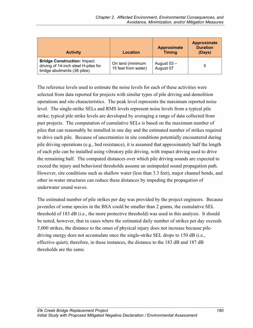
Chapter 2. Affected Environment, Environmental Consequences, and Avoidance, Minimization, and/or Mitigation Measures
Activity Location Approximate
Timing
Approximate Duration (Days)
Bridge Construction: Impact driving of 14-inch steel H-piles for bridge abutments (36 piles)
On land (minimum 15 feet from water)
August 03 – August 07 5
The reference levels used to estimate the noise levels for each of these activities were selected from data reported for projects with similar types of pile driving and demolition operations and site characteristics. The peak level represents the maximum reported noise level. The single-strike SELs and RMS levels represent noise levels from a typical pile strike; typical pile strike levels are developed by averaging a range of data collected from past projects. The computation of cumulative SELs is based on the maximum number of piles that can reasonably be installed in one day and the estimated number of strikes required to drive each pile. Because of uncertainties in site conditions potentially encountered during pile driving operations (e.g., bed resistance), it is assumed that approximately half the length of each pile can be installed using vibratory pile driving, with impact driving used to drive the remaining half. The computed distances over which pile driving sounds are expected to exceed the injury and behavioral thresholds assume an unimpeded sound propagation path. However, site conditions such as shallow water (less than 3.3 feet), major channel bends, and other in-water structures can reduce these distances by impeding the propagation of underwater sound waves.
The estimated number of pile strikes per day was provided by the project engineers. Because juveniles of some species in the BSA could be smaller than 2 grams, the cumulative SEL threshold of 183 dB (i.e., the more protective threshold) was used in this analysis. It should be noted, however, that in cases where the estimated daily number of strikes per day exceeds 5,000 strikes, the distance to the onset of physical injury does not increase because pile-driving energy does not accumulate once the single-strike SEL drops to 150 dB (i.e., effective quiet); therefore, in these instances, the distance to the 183 dB and 187 dB thresholds are the same.
Elk Creek Bridge Replacement Project Initial Study with Proposed Mitigated Negative Declaration / Environmental Assessment
180
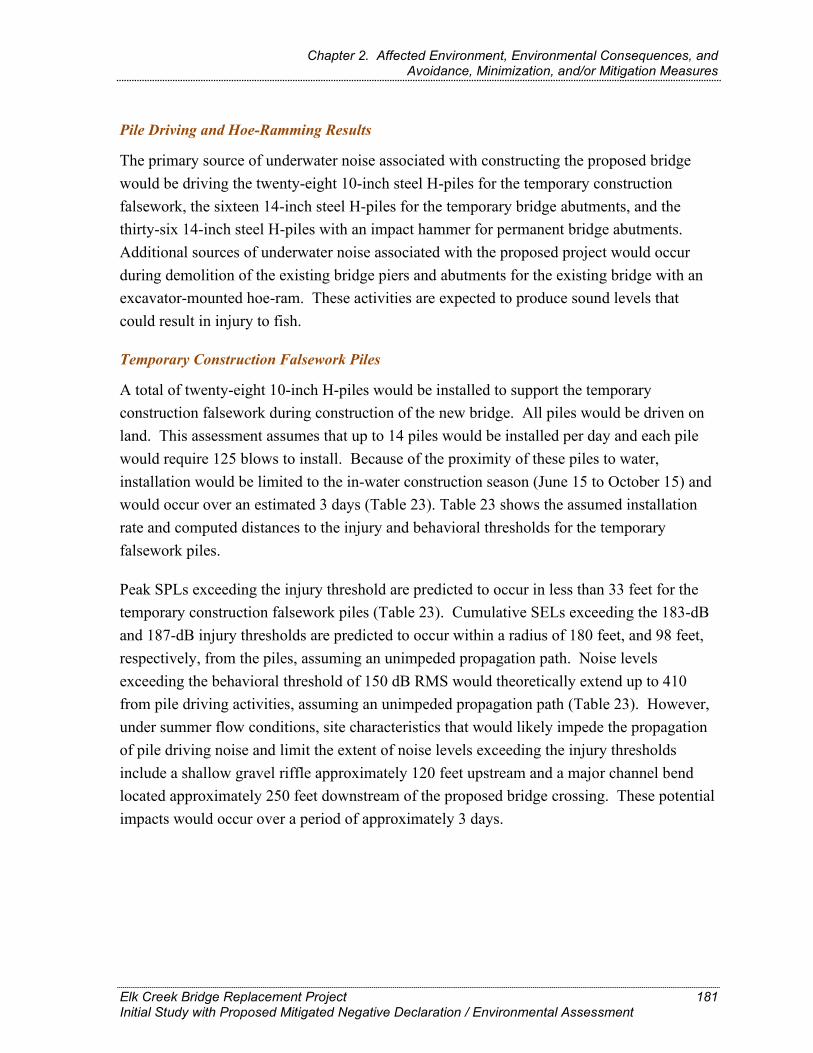
Chapter 2. Affected Environment, Environmental Consequences, and Avoidance, Minimization, and/or Mitigation Measures
Pile Driving and Hoe-Ramming Results
The primary source of underwater noise associated with constructing the proposed bridge would be driving the twenty-eight 10-inch steel H-piles for the temporary construction falsework, the sixteen 14-inch steel H-piles for the temporary bridge abutments, and the thirty-six 14-inch steel H-piles with an impact hammer for permanent bridge abutments. Additional sources of underwater noise associated with the proposed project would occur during demolition of the existing bridge piers and abutments for the existing bridge with an excavator-mounted hoe-ram. These activities are expected to produce sound levels that could result in injury to fish.
Temporary Construction Falsework Piles
A total of twenty-eight 10-inch H-piles would be installed to support the temporary construction falsework during construction of the new bridge. All piles would be driven on land. This assessment assumes that up to 14 piles would be installed per day and each pile would require 125 blows to install. Because of the proximity of these piles to water, installation would be limited to the in-water construction season (June 15 to October 15) and would occur over an estimated 3 days (Table 23). Table 23 shows the assumed installation rate and computed distances to the injury and behavioral thresholds for the temporary falsework piles.
Peak SPLs exceeding the injury threshold are predicted to occur in less than 33 feet for the temporary construction falsework piles (Table 23). Cumulative SELs exceeding the 183-dB and 187-dB injury thresholds are predicted to occur within a radius of 180 feet, and 98 feet, respectively, from the piles, assuming an unimpeded propagation path. Noise levels exceeding the behavioral threshold of 150 dB RMS would theoretically extend up to 410 from pile driving activities, assuming an unimpeded propagation path (Table 23). However, under summer flow conditions, site characteristics that would likely impede the propagation of pile driving noise and limit the extent of noise levels exceeding the injury thresholds include a shallow gravel riffle approximately 120 feet upstream and a major channel bend located approximately 250 feet downstream of the proposed bridge crossing. These potential impacts would occur over a period of approximately 3 days.
Elk Creek Bridge Replacement Project Initial Study with Proposed Mitigated Negative Declaration / Environmental Assessment
181

Chapter 2. Affected Environment, Environmental Consequences, and Avoidance, Minimization, and/or Mitigation Measures
Temporary and Permanent Bridge Abutment Piles
A total of sixteen 14-inch H-piles would be required to anchor the proposed temporary bridge abutments, eight piles for each abutment. The new permanent bridge structure would require a total of thirty-six 14-inch H-piles, eighteen at each new abutment. All the piles for both these structures would be driven on land. This assessment assumes that to reach the required pile depth for the permanent bridge up to 10 piles would be installed per day and that each pile would require 2,500 blows to install. Installation of these piles would occur over an estimated 2 days for the temporary bridge abutments and 5 days for the new permanent bridge abutments (Table 23). Table 23 shows the assumed installation rate and computed distances to the injury and behavioral thresholds for the permanent bridge abutment piles. Temporary bridge abutment piles would be driven prior to the in-water construction season to facilitate the demolition and installation of the new bridge in one construction season.
Elk Creek Bridge Replacement Project Initial Study with Proposed Mitigated Negative Declaration / Environmental Assessment
182

Chapter 2. Affected Environment, Environmental Consequences, and Avoidance, Minimization, and/or Mitigation Measures
Table 23. Distances to Injury and Behavioral Thresholds for Impact Driving of 10-Inch Steel H-Piles for the Temporary Construction Falsework and the 10-Inch Steel H-Piles for the Permanent Bridge Abutments
Pile Size/Type Location Number of Piles
Number of Piles per Day
Number of Strikes per
Day
Distance to 206-dB Peak
Criterion (feet)
Distance to 187-dB
Cumulative SEL Criterion
(feet)
Distance to 183-dB
Cumulative SEL Criterion
(feet)
Distance to 150 dB RMS
Criterion (feet)
10-inch steel H-pile for temporary construction falsework
On land 28 14 1,7501 <33 98 180 4102
14-inch steel H-pile for temporary bridge abutments
On land 16 >10 No data <33 164 164 4102
14-inch steel H-pile for permanent bridge abutments
On land 36 10 12,6003 <33 1644 1644 4102
dB = decibels RMS = root mean square SEL = sound exposure level
1 Based on an estimate of 125 strikes per pile. 2 Maximum distances may be limited due to water depth and by curves in the creek upstream and downstream. 3 Based on an estimate of 2,500 strikes per pile. 4 Pile-driving energy does not accumulate once the single strike SEL drops to 150 dB (i.e., “effective quiet”). The distance to the onset of physical injury therefore cannot extend
beyond the distance to effective quiet. Once the daily number of strikes exceeds 5,000 strikes per day, the distance to the onset of injury does not increase. For this reason, the distances to the 183-dB and 187-dB thresholds are the same.
Elk Creek Bridge Replacement Project Initial Study with Proposed Mitigated Negative Declaration / Environmental Assessment
183

Chapter 2. Affected Environment, Environmental Consequences, and Avoidance, Minimization, and/or Mitigation Measures
Peak SPLs exceeding the injury threshold are predicted to occur within less than 33 feet (<10 meters) for both the temporary and permanent bridge abutment piles (Table 23). Cumulative SELs exceeding the 187-dB and 183-dB injury thresholds are predicted to occur within a radius of 164 feet from the piles, assuming an unimpeded propagation path. As for the 10-inch falsework piles, noise levels exceeding the behavioral threshold of 150 dB RMS could theoretically extend to 410 feet from 14-inch H-pile pile driving activities, assuming an unimpeded propagation path (Table 23). However, as discussed previously, channel bends located approximately 250 feet downstream and a gravel riffle approximately 120 feet upstream of the pile driving activities likely would limit the extent of these noise levels, particularly under summer flow conditions when shallow waters could further reduce noise propagation potential. These potential impacts would occur over a combined duration of approximately 7 days.
Demolition of Existing Bridge Piers
Demolition activities involving the use of a hydraulic hammer (i.e., hoe-ram) have the potential to generate underwater noise levels of sufficient intensity to cause direct injury or mortality of fish. One or more hoe-rams would likely be used to demolish the existing bridge piers and abutments of the existing bridge.
Demolition of the existing bridge would consist of removal of the bridge deck, superstructure, piers, abutments, and pile caps. A total of four foundations would be removed, consisting of two concrete bents on land and two piers below the OHWM, one of which is in water.
Table 24 below shows the computed distances to the injury and behavioral thresholds for each bridge pier and abutment location. The computed distances to the injury and behavioral thresholds are the total distances that vibrations imparted by the hoe-ram would be transmitted through the piers and abutments and into the water below. The in-water extent of noise levels exceeding the thresholds represent the maximum impact zones that could occur during demolition of the existing bridge (see details for Pier 3). The actual impact zones would most likely be smaller based on conservative assumptions and the presence of channel bends and shallow riffles upstream and downstream of the source.
During hoe-ram operations, single-strike peak SPLs are not expected to exceed the injury threshold unless demolition operation for Pier 3 is conducted in water and not effectively isolated from the stream channel or attenuated adequately (e.g. using contained bubble curtains). If the demolition of Pier 3 is conducted in water, peak sound pressure levels may
Elk Creek Bridge Replacement Project Initial Study with Proposed Negative Declaration / Environmental Assessment
184
Chapter 2. Affected Environment, Environmental Consequences, and Avoidance, Minimization, and/or Mitigation Measures
reach 206 dB at 33 feet (Table 24). However, during demolition of Abutments 1 and 4 and Piers 2 and 3, cumulative SELs exceeding the injury thresholds are assumed to extend to the estimated distances of the effective quiet (150 db), which would include areas within Elk Creek.
Based on the distances of demolition activities from water, the in-water extent of noise levels exceeding the injury thresholds would be 164 feet from Abutments 1 and 4, and Pier 2, and 328 feet from the potential in-water demolition of Pier 3; and noise levels exceeding behavioral thresholds (150 dB) would be 410 feet and at 1,116 feet, respectively. However, as previously noted, site characteristics such as channel bends and shallow riffles would potentially reduce these distances, particularly during low summer flows. These potential impacts would occur over an estimated 6-day period of demolition activities.
Summary of Effects
Underwater noise produced by impact pile-driving and demolition activities are expected to periodically reach levels that exceed the injury thresholds for fish in Elk Creek. Based on measured noise levels for similar types of pile driving and demolition activities and worst-case assumptions regarding the use of impact driving and a standard sound attenuation rate, the potential for injury would occur over an estimated 10 days during impact pile driving and 6 days during demolition activities. Most pile driving and demolition activities that could result in injury would occur during the in-water construction season of each year (June 15 to October 15) and thereby, would avoid the most sensitive juvenile life stages and the primary migration periods of adult and juvenile fish in Elk Creek. Although juvenile fish may be present after June 15 and therefore subject to potential injury from pile-driving and demolition noise during the summer construction season, potential effects would likely be limited to small proportions of lamprey ammocoetes and salmonid juveniles that rear in the BSA through the summer.
Furthermore, hydroacoustic monitoring would be conducted during all construction activities that could potentially produce impulse sound waves that affect listed fish species. This includes any foundation work and demolition activities that require impact pile driving, hoe-ramming, or jackhammering. With monitoring in place, the injury threshold for accumulated sound exposure levels (SEL) within a greater area of the waterway would be avoided by stopping work prior to reaching the predicted accumulated SEL threshold.
Elk Creek Bridge Replacement Project Initial Study with Proposed Negative Declaration / Environmental Assessment
185

Chapter 2. Affected Environment, Environmental Consequences, and Avoidance, Minimization, and/or Mitigation Measures
Table 24. Distances to Injury and Behavioral Thresholds for Demolition of the Existing Bridge Piers and Abutments
Activity/ Equipment
Bridge Structure
Hoe-Ram Operated on Land or in Water
Number of Strikes per
Day1
Distance to 206-dB Peak
Criterion (feet)
Distance to 187-dB
Cumulative SEL Criterion
(feet)
Distance to 183-dB
Cumulative SEL Criterion
(feet)
Distance to 150 dB RMS
Criterion (feet)
Demolition / 1 Hoe-Ram Abutment 1 Land (50 feet from water)2 11,000 < 33 164 1643 4104
Demolition / 1 Hoe-Ram
Pier 2, Abutment 4 Land (25 feet from water)2 11,000 < 33 164 1643 4104
Demolition / 1 Hoe-Ram Pier 3 In water 11,000 < 33 328 3283 11154
dB = decibels RMS = root mean square SEL = sound exposure level
1 Per guidance in Caltrans (2016), a typical hoe-ram operation occurring over a 10-hour workday will result in about 11,000 strikes per day.
2 Because the pile, pier, or abutment will not have direct contact with the water, a small reduction in the source level (-3 dB) is assumed.
3 Pile-driving energy does not accumulate once the single strike SEL drops to 150 dB (i.e., “effective quiet”). The distance to the onset of physical injury therefore cannot extend beyond the distance to effective quiet. Once the daily number of strikes exceeds 5,000 strikes per day, the distance to the onset of injury does not increase. For this reason, the distances to the 183-dB and 187-dB thresholds are the same.
4 Maximum distance would be limited to 800 feet upstream and 250 feet downstream of proposed bridge location due to the presence of river bends.
Elk Creek Bridge Replacement Project Initial Study with Proposed Negative Declaration / Environmental Assessment
186

Chapter 2. Affected Environment, Environmental Consequences, and Avoidance, Minimization, and/or Mitigation Measures
Habitat Impacts
The proposed project would result in temporary and temporal impacts on several natural community and sensitive habitat types, including riparian and aquatic habitat supporting adult migration and spawning, and juvenile rearing and migration for lamprey and other fish species within the BSA. Temporary, temporal, and permanent impacts on sensitive natural community types are shown in Table 17.
Riparian Vegetation (including SRA Cover)
Riparian vegetation directly influences the quality of fish habitat, affecting cover, food, habitat complexity, streambank stability, and water temperature. Riparian vegetation and large woody debris play important roles in stabilizing stream channels and creating and maintaining diverse high-quality habitats for salmonids and other fishes. In the BSA, riparian vegetation provides several important functions that benefit fish, including bank stabilization, cover, velocity refuge, water quality functions, and a source of food and nutrients to the stream.
Clearing of vegetation is associated with construction of the access road and temporary bridge, installation of water infiltration areas, abutment walls for the new bridge and installation of the root wad bank revetment, and would result in the removal of a total of 0.77 acre of riparian vegetation (0.50 acre of upland red alder forest; 0.02 acre of red alder forest wetland; 0.17 acre of Sitka willow thicket; 0.013 acre of Sitka willow thicket wetland; and 0.068 acre of riparian coastal bramble). Given the abundance of red alder and Sitka willow riparian forests located both up and downstream of project BSA, the temporal loss of 0.67 acre and the permanent removal of 0.03 acre mature riparian forest is a small percentage of the intact riparian zone that follows the entirety of the lower Elk Creek watershed.
Because streamside vegetation also supports SRA cover, some elements of vegetation clearing would also result in the permanent and temporal loss of up approximately126 linear feet (108 feet of temporal loss from construction access and temporary bridge construction and 18 feet of permanent loss from construction of the abutment walls for the new bridge and widened new bridge deck) of riparian woodland vegetation that contributes to overhead (shade) and instream SRA cover in the BSA (Table 18, Figure 8). Agency regulations would require that areas cleared of vegetation in the riparian habitat would be replanted and restored; although the growth of a mature riparian forest, including streamside vegetation and SRA cover, would take longer than a few years
Elk Creek Bridge Replacement Project Initial Study with Proposed Mitigated Negative Declaration / Environmental Assessment
187

Chapter 2. Affected Environment, Environmental Consequences, and Avoidance, Minimization, and/or Mitigation Measures
Aquatic Habitat
Installation of the temporary stream diversion would result in seasonal disturbances to, and temporary losses of, open water and benthic habitat. The placement of the diversion and dewatering of the creek channel during the two June 15 to October 15 in-water construction seasons would result in a temporary reduction in summer rearing habitat for lamprey ammocoetes and macropthalmia and other fishes through the loss of physical habitat (living space), substrate, and food producing areas (macroinvertebrate production). The seasonal, combined footprint of the stream diversion and dewatered channel is estimated to be a maximum 5,200 square feet, or 0.12 acre. Under existing summer conditions, much of the creek bed that would be occupied by these temporary features is characterized by run and riffle habitats in months when the sandbar is open, and shallow and deep pools in periods of low flow when the sandbar closes. This area is used by juvenile fish during summer— juvenile salmonids and lamprey ammocoetes were captured in this reach during fish removal activities related to a Caltrans emergency scour repair project in 2016. Although these losses would have temporary effects on rearing habitat availability and food production, they constitute a very small fraction of the total amount of living space and creek bed area in Elk Creek. Furthermore, following completion of construction each season, the stream diversion and work platform or gravel pad would be removed, and the affected areas would be contoured to pre-project conditions. Consequently, seasonal losses of aquatic open water and benthic habitats are not likely to have measurable effects on the overall quantity or quality of rearing habitat available to fish. No permanent losses of aquatic habitat would occur. On the contrary, removal of the current bridge structure would result in a net increase of approximately 0.003 acre of aquatic habitat in the BSA because both of the existing piers would be removed and the new bridge would completely span Elk Creek without the use of piers. In addition, the installation of the proposed root wad bank revetment would provide an increase in in-stream cover, food sources, and high flow refuge pools for fish and other aquatic species.
While the substrate (gravel, pebble) size is appropriately sized for spawning, there is no evidence to suggest that spawning is likely to occur within the project area and is, in fact, unlikely to occur within the BSA based on a number of factors, including close proximity to estuary and potential for tidal influence on water depth at riffles (Caltrans 2021). In addition, no prior surveys or observations of salmonid spawning have been previously recorded within the project area and Caltrans fisheries biologist, Jason Frederickson, observed no spawning salmonids or evidence of redds within the project Fish BSA in a March 2021 spawning survey.
Elk Creek Bridge Replacement Project Initial Study with Proposed Mitigated Negative Declaration / Environmental Assessment
188

Chapter 2. Affected Environment, Environmental Consequences, and Avoidance, Minimization, and/or Mitigation Measures
Also, shade produced by overwater structures can alter rearing and holding behavior of salmonids and other fishes, potentially resulting in adverse effects on lamprey ammocoetes and juvenile salmonids. In addition, shading from bridges and other overwater structures can have beneficial incremental effects on water temperatures and negative effects on primary production and feeding efficiency of juvenile fish from reduced prey production. Following construction, the new bridge would result in a permanent increase in overwater structures and shade of approximately 0.05 acre due to the greater width of the new bridge relative to the existing bridge (46 feet versus 26 feet). However, it is unlikely that the small, localized effects of the wider structure on light levels would have measurable effects on water temperature, primary production, or the overall quantity and quality of rearing habitat in Elk Creek because the amount of added shade from the new bridge would be small. Therefore, no substantial effects on fish are expected from added bridge shading and removal of the existing bridge pier from Elk Creek.
The proposed project’s impacts to riparian streamside vegetation are minor compared to the availability of adjacent riparian habitats up and downstream; in addition, the majority of disturbed riparian habitat would be replanted and restored following construction. Fill of aquatic habitat would be temporary and removal of existing bridge piers and installation of root-wad bank revetment on the northern bank would result in a permanent net gain in area and overall quality of available aquatic habitat.
No-Build Alternative
If the proposed project is not constructed there would be no new direct or indirect impacts to Pacific lamprey or anadromous fish habitat. Scour issues associated with the abutment and piers would continue, and a lack of riparian vegetation on the northeast bank would not be addressed. The Rock Slope Protection (RSP) on the northeast bank would not be improved, and the aquatic habitat in this area would continue to be influenced by the existing bridge and related conditions. Under the No-Build Alternative, no construction would occur; therefore, there would be no impacts on animal and fish species or their habitat.
Elk Creek Bridge Replacement Project Initial Study with Proposed Mitigated Negative Declaration / Environmental Assessment
189
Chapter 2. Affected Environment, Environmental Consequences, and Avoidance, Minimization, and/or Mitigation Measures
Operational Impacts
Build Alternative
Water Quality–Contaminants
Contaminants generated by traffic due to wear of tires, brakes, and pavement, as well as exhaust emissions and fluid leaks deposited on impervious roadway surfaces, may be carried by stormwater runoff into receiving waters, resulting in chronic to acute effects on aquatic organisms depending on the concentration and duration of contaminant inputs. The existing impervious surface area of the bridge within the project limits is 0.07 acre. After construction, the new bridge would constitute approximately 0.12 acre of impervious surface, resulting in an approximate net increase in impervious surface of 0.05 acre. Therefore, the amount of polluted stormwater runoff carried to Elk Creek would increase as a result of the 0.05 acre of added roadway surface. To accommodate increases in stormwater discharge resulting from the additional impervious area, the existing roadway and bridge drainage systems would be modified or replaced to provide adequate interception and treatment of stormwater discharges, thereby reducing contaminant levels in stormwater runoff that would be discharged to Elk Creek. During construction, existing vegetated areas would be maintained to the maximum extent practicable, and new slopes and temporarily disturbed areas would be stabilized using erosion control products and vegetation planting. Bioswales and/or biostrips would be installed at multiple locations to treat stormwater discharges following construction. After construction, all stormwater conveyance systems and permanent erosion control and stormwater treatment measures would be maintained in compliance with Caltrans’ Storm Water Management Program.
No measurable long-term increases in pollutant loading from roadway runoff over the existing condition are expected as the new bridge would not result in added vehicle trips across Elk Creek and existing roadway and bridge drainage systems would be modified to accommodate the expected increases in stormwater discharge resulting from the additional impervious area.
Elk Creek Bridge Replacement Project Initial Study with Proposed Mitigated Negative Declaration / Environmental Assessment
190

Chapter 2. Affected Environment, Environmental Consequences, and Avoidance, Minimization, and/or Mitigation Measures
No-Build Alternative
Under the No-Build Alternative, contaminants generated by traffic due to wear of tires, brakes, and pavement, as well as exhaust emissions and fluid leaks deposited on impervious roadway surfaces, would continue. The existing roadway and bridge drainage systems would not be modified or replaced to provide adequate interception and treatment of stormwater discharges. Therefore, contaminant levels in stormwater runoff that are presently discharged to Elk Creek would remain.
Avoidance, Minimization, and/or Mitigation Measures The Standard Measures and Best Management Practices indicated in Section 1.6 and anticipated federal and state permit conditions would be implemented to reduce impacts on fish species. No additional avoidance and minimization measures would be required.
2.19. Threatened and Endangered Species
Regulatory Setting The primary federal law protecting threatened and endangered species is FESA: 16 USC Section 1531, et seq. See also 50 CFR Part 402. This act and later amendments provide for the conservation of endangered and threatened species and the ecosystems on which they depend. Under Section 7 of this act, federal agencies, such as the FHWA (and Caltrans, as assigned), are required to consult with the USFWS and the NOAA Fisheries Service/NMFS to ensure they are not undertaking, funding, permitting, or authorizing actions likely to jeopardize the continued existence of listed species or destroy or adversely modify designated critical habitat. Critical habitat is defined as geographic locations critical to the existence of a threatened or endangered species. The outcome of consultation under Section 7 may include a Biological Opinion with an Incidental Take Statement or a Letter of Concurrence. Section 3 of FESA defines take as “harass, harm, pursue, hunt, shoot, wound, kill, trap, capture or collect or any attempt at such conduct.”
California has enacted a similar law at the state level, CESA, California Fish and Game Code Section 2050, et seq. CESA emphasizes early consultation to avoid potential impacts to rare, endangered, and threatened species and to develop appropriate planning to offset project-caused losses of listed species populations and their essential habitats. The California Department of Fish and Wildlife is the agency responsible for implementing CESA. Section 2080 of the California Fish and Game Code prohibits “take” of any species determined to be an endangered species or a threatened species. Take is defined in Section 86 of the
Elk Creek Bridge Replacement Project Initial Study with Proposed Mitigated Negative Declaration / Environmental Assessment
191

Chapter 2. Affected Environment, Environmental Consequences, and Avoidance, Minimization, and/or Mitigation Measures
California Fish and Game Code as “hunt, pursue, catch, capture, or kill, or attempt to hunt, pursue, catch, capture, or kill.” CESA allows for take incidental to otherwise lawful development projects; for these actions an Incidental Take Permit is issued by CDFW. For species listed under both FESA and CESA requiring a Biological Opinion under Section 7 of FESA, the CDFW may also authorize impacts to CESA species by issuing a Consistency Determination under Section 2080.1 of the California Fish and Game Code.
Another federal law, the Magnuson-Stevens Fishery Conservation and Management Act of 1976, was established to conserve and manage fishery resources found off the coast, as well as anadromous species and Continental Shelf fishery resources of the United States, by exercising (A) sovereign rights for the purposes of exploring, exploiting, conserving, and managing all fish within the exclusive economic zone established by Presidential Proclamation 5030, dated March 10, 1983, and (B) exclusive fishery management authority beyond the exclusive economic zone over such anadromous species, Continental Shelf fishery resources, and fishery resources in special areas.
Affected Environment The information in this section is from the NES prepared for the project (Caltrans 2021). There are a number of threatened and endangered species who’s range overlaps the project area but site specific surveys showed there was no habitat for these species at the bridge site. For a full discussion of these threatened and endangered species that were determined to have no potential to occur at the bridge site, please refer to that Natural Environment Study for this project (Caltrans 2021).
Threatened and Endangered species that could occur in the BSA were identified based on a review of existing information and reconnaissance-level field surveys. Prior to field surveys, biologists reviewed the following documents to determine the likelihood of special status species and habitats occurring in the BSA.
California Native Plant Society’s (CNPS) online Inventory of Rare and Endangered Plants of California records search of the Mallo Pass Creek, Albion, Elk, Navarro, Cold Spring, Eureka Hill, and Point Arena U.S. Geological Survey (USGS) 7.5-minute quadrangles (California Native Plant Society 2018) (Appendix B).
California Natural Diversity Database (CNDDB) records search of the Mallo Pass Creek, Albion, Elk, Navarro, Cold Spring, Eureka Hill, and Point Arena USGS 7.5-minute quadrangles (California Department of Fish and Wildlife 2019a) (Appendix B).
Elk Creek Bridge Replacement Project Initial Study with Proposed Mitigated Negative Declaration / Environmental Assessment
192

Chapter 2. Affected Environment, Environmental Consequences, and Avoidance, Minimization, and/or Mitigation Measures
A list of endangered and threatened species that may occur in the Mallo Pass Creek USGS 7.5-minute quadrangle (National Marine Fisheries Service 2019; U.S. Fish and Wildlife Service 2019) (Appendix B).
Lists of plants identified as noxious weeds or invasive plants by the U.S. Department of Agriculture (USDA) (Natural Resources Conservation Service 2010), the California Department of Food and Agriculture (CDFA) (Natural Resources Conservation Service 2003), and the California Invasive Plant Council (Cal-IPC) (2018).
Soil map for the BSA (Natural Resources Conservation Service 2017).
This information was used to develop lists of Threatened and Endangered species and other threatened biological resources that could be present in the project region. Species from the lists were considered for analysis if they were known to occur in the project region or had potential habitat in the BSA and the BSA was within the species’ range. Habitat assessments for special-status wildlife were conducted for all accessible areas within the BSA. The BSA was assessed for the potential to support special-status wildlife through site visits, by reviewing aerial imagery and records of occurrences, and through discussions with agency personnel and species experts.
After these reviews and field surveys were conducted, it was determined that the Threatened and Endangered Species identified in the following paragraphs could potentially occur within the BSA. Other species not listed here but shown on the lists of species with potential to occur in the area were determined to not have appropriate habitat or to be outside the known range of the species and were not confirmed on site during subsequent field reviews. The project would have no effect/no impact on federal and/or state listed plant and animal for which the BSA lacks suitable habitat or is outside of the species established range – and these species are excluded from further analysis. A list of these T&E species with no suitable habitat that have been excluded from further analysis is included in Appendix B.
Seven federal and/or state listed species are known to occur in or could occupy the BSA based on the presence of suitable habitat. Each of these species is discussed below.
• Humboldt County Milk-Vetch (Astragalus agnicidus)
• North Coast Semaphore Grass (Pleuropogon hooverianus)
• California red-legged frog (Rana draytonii)
• Northern spotted owl (Strix occidentalis caurina)
Elk Creek Bridge Replacement Project Initial Study with Proposed Mitigated Negative Declaration / Environmental Assessment
193

Chapter 2. Affected Environment, Environmental Consequences, and Avoidance, Minimization, and/or Mitigation Measures
• Northern California (NC) steelhead (Oncorhynchus mykiss)
• Central California Coast (CCC) coho salmon (Oncorhynchus kisutch) ESU
• Tidewater goby (Eucyclogobius newberryi)
A Biological Assessment would be prepared and submitted to the USFWS in June 2021 and second Biological Assessment and Essential Fish Habitat Assessment would be prepared and submitted to the National Marine Fisheries Service in May 2021.Site conditions relative to wildlife and fish habitat are discussed below for each of the federal and/or state listed species with potential to occur in the project area.
PLANT SPECIES
Plant surveys were conducted in the BSA during the appropriate identification period for all special-status plant species listed in Table 21 that have suitable habitat present in the BSA. No occurrences of special-status plants have been previously reported in the BSA, and no special-status plants were observed during the 2018 field surveys. A list of plant species observed is provided in Appendix B. Descriptions of Humboldt County milk-vetch and North Coast semaphore grass are provided below, given their FESA and/or CESA listing status and the presence of suitable habitat in the BSA.
Humboldt County Milk-Vetch
Humboldt County milk-vetch (Astragalus agnicidus) is a State-listed endangered and California Rare Plant Rank (CRPR) 1B.1 species known to occur in the North Coast region in Humboldt and Mendocino counties. Suitable habitat for Humboldt County milk-vetch is in disturbed areas, roadsides, and openings in broad-leaved upland forests and North Coast coniferous forest/mixed evergreen forest at elevations between approximately 400 and 2,600 feet.
There are 61 occurrences of Humboldt County milk-vetch recorded in the CNDDB, all of which are considered extant, and the nearest recorded location to the BSA is approximately 4.5 miles south on private property. The milk-vetch was rediscovered in 1987 near Miranda in Humboldt County. The primary threats to this species are grazing, competition with other species, logging, and road maintenance.
Elk Creek Bridge Replacement Project Initial Study with Proposed Mitigated Negative Declaration / Environmental Assessment
194

Chapter 2. Affected Environment, Environmental Consequences, and Avoidance, Minimization, and/or Mitigation Measures
North Coast Semaphore Grass
North Coast semaphore grass (Pleuropogon hooverianus) is a state-listed threatened and CRPR 1B.1 species known to occur in Mendocino, Marin, and Sonoma counties. Suitable habitat for North Coast semaphore grass is in open mesic areas in broad-leaved upland forests, meadows and seeps, and North Coast coniferous forest/mixed evergreen forest at elevations between approximately 30 feet and 2,200 feet.
There are 27 occurrences of North Coast semaphore grass recorded in the CNDDB; 24 are considered extant and 3 in Marin and Sonoma counties are possibly extirpated. The nearest recorded location to the BSA is approximately 11.5 miles to the northeast. The primary threats to this species are road maintenance, development, logging, feral pigs, and competition with non-native plants.
WILDLIFE SPECIES
California Red-legged Frog
The range of California red-legged frog (Rana draytonii) extends from Elk Creek, south along the coast, and inland from the vicinity of Shasta County south to northwester Baja California, Mexico. California red-legged frog breeds in lowland and foothill streams or water associated with emergent wetlands (e.g., cattails, tule, hard stem bulrush) or overhanging willows, including livestock ponds. Aquatic breeding habitat includes permanent water sources, such as streams, marshes, and natural and human-made ponds in valley bottoms and foothills. Nonbreeding aquatic habitat consists of shallow freshwater features, such as seasonal streams, small seeps, springs, and ponds. This species may also be found in upland habitats (e.g., annual grasslands or oak woodlands adjacent to aquatic habitat) near breeding areas and along intermittent drainages connecting wetlands, seeps and springs. Adults may take refuge during dry periods in rodent burrows, under leaf litter and downed logs, in desiccation cracks, and under rip/rap in upland habitat; and studies have shown that red-legged frog may be found up to 328 feet (100 meters) from water at any time of the year (Caltrans 2021 – references therein).
Focused surveys for California red-legged frog were not conducted; however, multiple red-legged frog individuals have been observed in Elk Creek during recent Caltrans work within and just west of the BSA. A single adult red-legged frog was observed in Elk Creek, downstream of the bridge, on June 11, 2018, by Caltrans biologist Desiree Davenport. From
Elk Creek Bridge Replacement Project Initial Study with Proposed Mitigated Negative Declaration / Environmental Assessment
195
Chapter 2. Affected Environment, Environmental Consequences, and Avoidance, Minimization, and/or Mitigation Measures
June 20, 2019, to August 20, 2019, up to 47 individual red-legged frogs were observed during emergency repair work adjacent to and within the BSA.
The CNDDB record for Northern red-legged frog (Rana aurora) from Elk Creek within the BSA (Occurrence #104) includes a collection from prior to 2004 that was later analyzed and determined to have mitochondrial DNA from California red-legged frog. Per direction from USFWS (Caltrans 2021) Elk Creek is being treated as having the potential to support both species or their hybrids and regulatory protections are extended to all red-legged frogs in this area because these species cannot be readily distinguished in the field.
Northern Spotted Owl
Northern spotted owl (NSO) (Strix occidentalis caurina) is federal and state threatened. Northern spotted owl occurs in the southern Cascade Range of northern California, to the Klamath Mountains, and down the Coast Ranges through Marin County. In northwestern California, NSO individuals typically inhabit dense, old-growth, multilayered mixed conifer, coast redwood (Sequoia sempervirens), and Douglas-fir forests, from sea level up to approximately 7,600 feet.
Protocol-level focused surveys for NSO were not conducted in conjunction with the project; however, one 10-minute call station within the BSA near the north end of the bridge was surveyed on June 29, 2018, prior to a nesting bird survey. The single survey did not detect any NSO, although a great-horned owl was observed. However, protocol (six visits/year) focused surveys were completed by Lee Susan (Summit Forestry) in 2015 and 2016 on the adjacent private property to the east of the BSA (Caltrans 2021). Northern spotted owl surveys were also conducted in association with a Timber Harvest Plan that completed harvest in 2018. Two survey stations within 0.4 mile of the BSA did not detect NSO during the survey years. However, Lee Susan did confirm occupancy in 2016 of the MEN0181 activity center, which is located 0.98 mile to the northeast of the BSA.
There is no suitable habitat for NSO within the BSA, but there is suitable coniferous forest habitat present within the 0.25-mile buffer zone around it. The nearest positive observation in the CDFW spotted owl observation database is 0.43 mile to the northeast of the BSA; however, the observation was determined to be associated with the MEN0181 activity center (note the observation is of an individual bird where the activity center is an established location within a core use area, which are typically nests).
Elk Creek Bridge Replacement Project Initial Study with Proposed Mitigated Negative Declaration / Environmental Assessment
196

Chapter 2. Affected Environment, Environmental Consequences, and Avoidance, Minimization, and/or Mitigation Measures
FISH SPECIES
Northern California Steelhead DPS
NMFS listed the Northern California (NC) steelhead (Oncorhynchus mykiss) distinct population segment (DPS) on June 7, 2000, and reaffirmed the listing status as threatened on February 5, 2006. This DPS includes all naturally spawned anadromous NC steelhead (Oncorhynchus mykiss) populations below natural and human-made impassable barriers in California coastal river basins from Redwood Creek (Humboldt County) southward to, but not including, the Russian River. Two artificial propagation programs are considered part of the DPS: the Yager Creek Hatchery and the North Fork Gualala River Hatchery (Gualala River Steelhead Project) (71 FR 834). Steelhead in the Elk Creek watershed are included in this DPS.
NMFS designated critical habitat for this evolutionary significant unit (ESU) on September 2, 2005. Critical habitat includes Elk Creek, including the portion within the BSA. Steelhead are dependent on four essential freshwater habitat types to complete their life cycle: 1) freshwater spawning sites; 2) freshwater rearing sites; 3) freshwater migration corridors free of obstruction; 4) estuarine areas free of obstruction.
Within these sites, essential physical and biological features (PBFs) include adequate: 1) substrate; 2) water quality; 3) water quantity; 4) floodplain connectivity; 5) cover/shelter; 6) food; 7) vegetation (riparian and aquatic); 8) salinity in estuarine areas; and 9) unobstructed passage conditions.
In addition, the lateral extent of critical habitat is designated to be the width of the stream channel defined by the USACE ordinary high-water line, including the adjacent riparian zone and floodplain. The BSA currently supports elements of all these essential PBFs for steelhead. The existing SR 1 Elk Creek Bridge and associated RSP along the northern bank slightly diminish the quality and quantity of cover/shelter and riparian vegetation compared to upstream and downstream areas within the BSA unaffected by the bridge and RSP.
Steelhead are anadromous rainbow trout and further classified as winter or summer steelhead, based on the timing of their spawning migration. However, only winter steelhead occur in Elk Creek. In addition, steelhead populations commonly exhibit both anadromous and non-anadromous (resident) life history forms. Steelhead rear in stream or estuarine habitats for one to three years and spend one to four years in the ocean before returning to
Elk Creek Bridge Replacement Project Initial Study with Proposed Mitigated Negative Declaration / Environmental Assessment
197

Chapter 2. Affected Environment, Environmental Consequences, and Avoidance, Minimization, and/or Mitigation Measures
spawn. Unlike Pacific salmon, steelhead may survive following spawning and spawn more than once in their lifetime.
Steelhead enter Elk Creek between December and April, with a peak in January and February, although the precise timing of creek entry depends on the condition of the creek mouth and the amount of runoff. After entering the estuary, adults migrate upstream in response to increased flows. Flows must be high enough to provide suitable passage to upstream spawning areas, where stream conditions contain the appropriate mix of suitable gravel, water depth, and water velocity. Spawning occurs primarily between December and early April. Adults that survive after spawning typically return to the ocean by May or June.
Upon emergence from the gravel, steelhead fry live in shallow water close to shore; however, as they grow, they move to deeper, faster water where they defend feeding territories. Juveniles may remain in estuaries for variable periods of time before entering the ocean. Smolts—juveniles that have undergone a physiological transformation that allows them to switch to a marine environment—typically emigrate and enter the ocean between February and June, with a peak in April and May.
Because steelhead have a mandatory freshwater residency period, it is critical that suitable conditions for juvenile rearing exist year-round. Juveniles require year-round flows, suitable water temperatures, adequate cover, and abundant food to support growth and survival to the smolt stage. Summer rearing habitat, consisting of pools, cool, well-oxygenated water, and sufficient cover, often is cited as a major limiting factor for juvenile steelhead in California streams when one or more of these habitat conditions is absent.
Site Conditions
Snorkel surveys were conducted within the BSA to assess fish presence and document temporal trends of target species to the extent possible. The survey area extended from approximately 550 feet (168 meters) downstream and 650 feet (198 meters) upstream of the Elk Creek Bridge, slightly larger than the BSA surveyed for other species. NC Steelhead of various age classes were observed during every survey effort (Caltrans 2020). No seining or electrofish surveys for NC Steelhead were conducted because the protected status of this species precludes the use of these types of sampling methods. In addition to recent survey efforts for this project, data from previous sampling, general species life history accounts, and literature reviews were also used to assess fish presence information and impact assessments on steelhead within the project BSA. During the field surveys on June 11 and 12, 2018, flow depths were relatively shallow and water clarity was high, which allowed
Elk Creek Bridge Replacement Project Initial Study with Proposed Mitigated Negative Declaration / Environmental Assessment
198
Chapter 2. Affected Environment, Environmental Consequences, and Avoidance, Minimization, and/or Mitigation Measures
visual observations of substrate conditions and fish when present. Conditions during snorkel surveys conducted in July and August 2020 were characterized by high water clarity, but depths were greater overall; although no specific depth measurements were taken.
Numerous NC steelhead of various age classes were observed in the lagoon at the downstream end of the BSA, concentrated in a pool under willows beginning approximately 100 feet downstream of the bridge. Fry were observed frequently in upstream habitats throughout the BSA, including habitats directly under the Elk Creek Bridge. Steelhead have previously been observed in Elk Creek by CDFG biologists in 1973 and 2001, by Mendocino Redwood Company biologists in most sampling years, by biologists conducting electrofishing for an emergency scour repair in 2016, and by Scott Harris (CDFW) and Laurens Kupyers (Gallaway Enterprises) in 2019 (Caltrans 2021).
Based on total length, stream habitat types within the BSA consist of 22 percent riffles, 22 percent pools, and 55 percent flatwater (i.e., runs and glides). Stream flow was 8.79 cubic feet per second at the time of the stream habitat survey, based on standard field measurements conducted with a Marsh-McBirney flow meter, whereas water temperatures ranged from 55 to 59 degrees Fahrenheit (°F) over the 2 days that the stream assessment was conducted. Similar temperatures were recorded by HOBO temperature loggers placed at two locations within the project BSA in summer 2020. The HOBO temperature loggers (Caltrans #2 and #10) recorded data in 30-minute intervals from July 7 to August 6, 2020. The highest maximum temperature recorded during this time was a high of 61.18 °F (16.21 °C), recorded on August 4th at Caltrans #2 approximately 400 feet downstream of the bridge, with a slightly lower maximum temperature of 60.03 °F (15.57 °C) recorded the same day at Caltrans #10, directly under the bridge.
Riparian vegetation is present on both streambanks over the majority of the channel length. One notable exception is the north bank of Elk Creek, under and immediately upstream of the bridge, where there currently is unvegetated rock slope protection (RSP). Mean percent canopy density in the BSA is approximately 58 percent, based on densitometer measurements taken at the center of each habitat unit.
Potential spawning substrate was noted present by ICF fisheries biologists during low water depths in June 2018. However, while the substrate (gravel, pebble) size is appropriately sized for spawning (CDFW 2001, Caltrans 2021), there is no evidence to suggest that spawning is likely to occur within the project area and is, in fact, unlikely to occur within the fish BSA based on a number of factors, including close proximity to estuary and potential for
Elk Creek Bridge Replacement Project Initial Study with Proposed Mitigated Negative Declaration / Environmental Assessment
199

Chapter 2. Affected Environment, Environmental Consequences, and Avoidance, Minimization, and/or Mitigation Measures
tidal influence on water depth at riffles and flow velocity. In addition, no prior surveys or observations of salmonid spawning have historically been recorded within the project area and Caltrans fisheries biologist, Jason Frederickson, observed no spawning salmonids or evidence of redds within the project Fish BSA in a March 2021 spawning survey.
Because salmonid populations are highly influenced by the amount of available cover, biologists conducted a focused survey to quantify existing SRA cover habitat in the BSA, which was based on field observations (June 11 and 12, 2018). Numerous studies indicate a positive relationship between the amount of cover in streams and the survival and production of juvenile salmonids. Pools, woody debris, and coarse substrates provide shelter during high flows, hiding and escape cover from predators, and preferred feeding stations. Consequently, the loss of cover can reduce the rearing capacity of streams and increase the susceptibility of juveniles to predators and displacement by high flows. Within the BSA, riparian vegetation extends along much of the shoreline and therefore provides cover, shelter, and feeding areas for juvenile salmonids. During summer, observations of juvenile steelhead along the vegetated margins of the upper lagoon within the BSA highlight the value of this cover type for juvenile salmonids. The results of SRA cover survey are presented in Section 2.15, Natural Communities.
Central California Coast Coho Salmon ESU
NMFS listed the Central California Coast (CCC) coho salmon ESU as threatened on October 31, 1996, and subsequently reclassified it as endangered on June 28, 2005. This ESU includes naturally spawned coho salmon originating from rivers south of Punta Gorda, California, southward to and including Aptos Creek, as well as coho salmon originating from tributaries to San Francisco Bay. CDFW listed CCC coho salmon north of San Francisco Bay as endangered under CESA on March 30, 2005.
NMFS designated critical habitat for this ESU on May 5, 1999. Critical habitat includes Elk Creek, incorporating that portion within the BSA. Coho salmon are dependent on five essential habitat types to complete their life cycle: (1) juvenile summer and winter rearing areas; (2) juvenile migration corridors; (3) areas for growth and development to adulthood; (4) adult migration corridors; and (5) spawning areas. Within these sites, essential PBFs include adequate (1) substrate; (2) water quality; (3) water quantity; (4) water temperature; (5) water velocity; (6) cover/shelter; (7) food; (8) riparian vegetation; (9) space; and (10) safe passage conditions. In addition, designated freshwater and estuarine critical habitat includes riparian areas that provide the following functions: shade, sediment, nutrient or chemical
Elk Creek Bridge Replacement Project Initial Study with Proposed Mitigated Negative Declaration / Environmental Assessment
200

Chapter 2. Affected Environment, Environmental Consequences, and Avoidance, Minimization, and/or Mitigation Measures
regulation, stream bank stability, and input of large woody debris or organic matter. The BSA currently supports all of these essential PBFs for CCC coho salmon, although the existing SR 1 Elk Creek Bridge and associated RSP along the north bank slightly diminish the quality and quantity of cover/shelter and riparian vegetation compared to upstream and downstream areas within the BSA unaffected by the bridge and RSP.
Coho salmon are anadromous fish that exhibit a 3-year life cycle in which juveniles rear in fresh water for up to 15 months, then migrate to the ocean where they spend up to 18 months before returning as adults to spawn. In California, the timing of upstream migration varies among tributaries, but generally occurs from September through January with a peak in November and December. In small coastal streams, migration frequently begins between mid-November and mid-January, after high flows open the sand bars that form at the mouths of estuaries.
In California, coho salmon spawn mainly from November to January. Following emergence, fry seek out shaded stream margins, backwaters, and side channels, where water velocity is low and small invertebrates are abundant. As they grow larger, juveniles (i.e., parr) begin to establish feeding territories. Preferred rearing habitat consists of low-velocity, pool habitat with complex woody cover. Cool water is necessary for coho salmon development. Water temperatures between 53.6 to 57.2 °F are favored for rearing. During summer, juvenile coho move into deep pools or backwater areas with dense shade, large woody debris, undercut banks, and overhanging vegetation for refuge from high temperatures. Seaward migration of coho salmon generally occurs from late March or early April through June with a peak in April to late May/early June. Focused surveys for CCC coho salmon were not conducted because the protected status of coho salmon precludes the use of fish sampling as part of the habitat assessment. Therefore, fish presence information and impact assessments on coho salmon depend largely on previously collected data, general species life-history accounts, literature reviews, and field observations. During the field surveys on June 11 and 12, 2018, flow depths were relatively shallow and water clarity was high, which allowed visual observation of fish, when present, and substrate conditions.
Site Conditions
No netting or electrofishing surveys for CCC coho salmon were conducted because the protected status of coho salmon precludes the use of these types of fish sampling. Therefore, fish presence information and impact assessments on coho salmon depend largely on previously collected data, general species life history accounts, literature reviews, and snorkel field observations (Caltrans 2021). Snorkel surveys were conducted within the BSA
Elk Creek Bridge Replacement Project Initial Study with Proposed Mitigated Negative Declaration / Environmental Assessment
201

Chapter 2. Affected Environment, Environmental Consequences, and Avoidance, Minimization, and/or Mitigation Measures
to assess fish presence and document temporal trends and habitat use by target species to the extent possible. The survey area extended from approximately 550 feet (168 meters) downstream and 650 feet (198 meters) upstream of the Elk Creek Bridge. Although NC steelhead were abundant, only one young-of-the-year coho salmon was observed during summer snorkel surveys.
No confirmed sightings of coho salmon were made during field surveys in June 2018. While our data from 2018 and 2020 indicates low abundance of coho within the project BSA, previously collected data indicates coho salmon of various age classes are found within the BSA and upstream reaches of Elk Creek. Coho salmon were observed in Elk Creek by CDFG in 1976, Louisiana Pacific Corporation in the mid-1990s, and biologists conducting electrofishing for an emergency scour repair immediately upstream of the Elk Creek Bridge, within the proposed project’s ESL, in 2016. Mendocino Redwood Company did not observe any coho salmon during downstream migrant trapping in 2001.
Tidewater Goby
Tidewater goby (Eucyclogobius newberryi) was listed as an endangered species under FESA, as amended, on February 4, 1994. In 2007, USFWS completed a 5-year status review for tidewater goby that concluded the species was not in imminent danger of extinction based on the finding that the number of known occupied localities had increased to 106 at that time (up from 43 localities at the time of listing in 1994). The review recommended the tidewater goby be reclassified as threatened and on March 13, 2014, USFWS published a proposed rule to reclassify the tidewater goby as threatened; however, the species is still listed as endangered under FESA.
Critical habitat for northern populations was designated on January 31, 2008; USFWS published the final rule designating critical habitat on February 6, 2013. Although the final rule designating critical habitat for tidewater goby includes habitats along the Mendocino coast, the BSA and the lagoon to the west (i.e., downstream) of the BSA are not included in the designation of critical habitat for tidewater goby.
The tidewater goby is a small, benthic, grey-brown fish that typically lives 1 year, although some individuals may live longer. All life stages of tidewater goby are found in lagoons, estuaries, and marshes—dynamic environments that are subject to considerable fluctuation in salinity and water quality conditions both seasonally and annually. Tidewater goby typically select habitat in the upper estuary where freshwater and saltwater mix, although they may
Elk Creek Bridge Replacement Project Initial Study with Proposed Mitigated Negative Declaration / Environmental Assessment
202

Chapter 2. Affected Environment, Environmental Consequences, and Avoidance, Minimization, and/or Mitigation Measures
range upstream a short distance into fresh water and downstream into more saline water of about 28 parts per thousand (ppt).
Reproduction can occur at any time of the year, but tends to peak in spring, with a second, smaller peak in late summer. Reproduction has been observed at water temperatures ranging from 48 to 77°F (9 to 25 °C [degrees Celsius]) and at salinities of 2 to 27 ppt. Following hatching, the larvae live in vegetated areas of estuaries until they reach 15 to 18 millimeters (mm) (i.e., 0.5 to 0.7 inch) standard length, at which time they have matured sufficiently to become free-swimming and benthic. Juvenile tidewater gobies feed on small aquatic animals such as shrimp, amphipods, ostracods, and midge larvae and other aquatic insects. Those that survive mature to breed the next season. The suspected causes for fluctuations in reproduction rates are the death of breeding adults in early summer and colder temperatures or hydrological disruptions in winter.
Site Conditions
Focused surveys for tidewater goby were not conducted because the protected status of tidewater goby and other species precluded the use of fish sampling as part of the habitat assessment. Therefore, fish presence information and impact assessments on tidewater goby depend largely on previously collected data, general species life history accounts, literature reviews, and field observations (Caltrans 2021). During an emergency bridge/bank repair project in 2016, four water samples were taken from Elk Creek within the BSA using established collecting procedures. Samples were analyzed for tidewater goby environmental DNA (eDNA), and all four samples were found negative for tidewater goby. The USFWS evaluated the BSA and determined it is not occupied by the species. In addition, the species was not detected during fish removal activities in the BSA in 2016 and 2019 as part of two Caltrans emergency scour repair projects. However, suitable habitat may occur in the lagoon to the west (i.e., downstream) of the BSA; therefore, habitat and the species, if present, could be affected by water quality effects and underwater noise associated with the proposed project. In addition, Elk Creek in the BSA may be used seasonally by nonbreeding tidewater goby when the sandbar closes at the mouth of Elk Creek, and water in the lagoon backs up and inundates lower Elk Creek, including the portion of the creek within the vicinity of the bridge.
Elk Creek Bridge Replacement Project Initial Study with Proposed Mitigated Negative Declaration / Environmental Assessment
203

Chapter 2. Affected Environment, Environmental Consequences, and Avoidance, Minimization, and/or Mitigation Measures
Environmental Consequences Based on the field survey results and a review of the available literature and records of occurrence, impacts to the following species are anticipated: California red-legged frog, Northern California Steelhead DPS, Central California Coast Coho Salmon ESU, and tidewater goby.
Neither Humboldt Milk Vetch nor Nodding semaphore grass, the sensitive plant species with potential to occur on site, were found within the 100-foot BSA vegetation survey area. Therefore, there would be no impact to these species.
Construction Impacts
Build Alternative
Impacts on threatened and endangered species would be reduced by implementation of the Standard Measures and Best Management Practices provided in Section 1.6.
California Red-legged Frog
Bridge replacement activities could potentially result in the injury and/or mortality of California red-legged frog if they are in the work area during construction. These activities would include construction of the temporary bridge, demolition of the existing bridge, construction of the new bridge, and any restoration activities within the work area following construction.
Construction would also result in auditory and visual disturbance, which could alter foraging, basking, and breeding behavior of the individuals within the vicinity of the project footprint.
Construction would also temporally affect 0.67 acre of potential forested riparian habitat (upland and wetland riparian forest habitats), result in the permanent loss of 0.032 acre of forested riparian habitat, temporarily reduce riparian coastal bramble by 0.068 acre, and temporarily impact 0.12 acre of aquatic habitat within Elk Creek (Figure 8).
The proposed project would have no indirect affects to California red-legged frog during construction, and because replacement of the existing bridge would be at the same location and would not change the use of the area, no new indirect impact (e.g., traffic noise, water quality) related to the bridge and its use has been identified.
Elk Creek Bridge Replacement Project Initial Study with Proposed Mitigated Negative Declaration / Environmental Assessment
204

Chapter 2. Affected Environment, Environmental Consequences, and Avoidance, Minimization, and/or Mitigation Measures
To reduce potential effects on California red-legged frog, the Standard Measures and Best Management Practices indicated in Section 1.6 would be implemented. These standard measures would be effective at reducing impacts to California red-legged frog and would therefore result in a “may affect, likely to adversely affect” determination for California red-legged frog
With implementation of the Standard Measures and Best Management Practices the project would have a less than significant effect on California red-logged frog and its hybrids.
Northern Spotted Owl
No suitable Northern spotted owl habitat (NSO) would be temporarily or permanently lost as a result of the project.
Although suitable NSO habitat exists adjacent to the project area, there is a low probability of affecting NSO that may potentially forage or disperse across the landscape because of their ability to move away from disturbances. Noise and visual disturbance may have a higher likelihood of affecting adult and juvenile owls early in the breeding season when they are closely associated with the nest core; this is the period when juvenile owls are not yet able to fly, and adults are closely defending the nest core.
Northern spotted owl may potentially be disturbed by construction activities in three different ways: when activities occur within a visual line-of-sight of a nest, which can create visual related disturbance; when project noise levels exceed ambient noise levels by 20–25 dB near a nest; or when project noise exceed 90 dB when combined with ambient noise levels. Anticipated noise levels generated by planned construction activities were estimated using the standardized decibel ranges reported by the USFWS in Estimating the Effects of Auditory and Visual Disturbance to Northern Spotted Owls and Marbled Murrelets in Northwestern California (USFWS, 2020). The vehicles and equipment that would likely be used during construction were used to evaluate potential auditory disturbance from construction-related noise. Following the guidance from the USFWS, the BSA was estimated to have ambient noise levels ranging from “Moderate” (71–80 dB) to “High” (81–90 dB) due to vehicle traffic on SR 1 and noise associated with Elk Creek. Traffic through the project area during spring through summer is typically characterized by a higher frequency of vehicles, including large RVs and logging trucks, than in fall and winter, putting the spring and summer traffic within the category of “High” ambient sound. Furthermore, it was estimated that the “Extreme” (101 dB) noise level from impact driving may elevate noise above the “High”
Elk Creek Bridge Replacement Project Initial Study with Proposed Mitigated Negative Declaration / Environmental Assessment
205

Chapter 2. Affected Environment, Environmental Consequences, and Avoidance, Minimization, and/or Mitigation Measures
ambient level, which could lead to disturbance out to 500 feet beyond the project work area (i.e., the noise source).
Given that the MEN0181 NSO activity center is located 0.98-mile northeast of the BSA, and the closest suitable nesting or roosting habitat is located >500 feet from the bridge work area, it is unlikely that Northern spotted owls occupying the nest core or adjacent suitable nesting habitat would be affected by elevated sound levels from construction. Furthermore, the activity center is screened from the project area by ridgelines and other topographic features that would block sound and any visual disturbances. Following this analysis, and with technical assistance from the USFWS, Caltrans determined that any project-generated sound that exceeded ambient conditions would be unlikely to reach occupied or potentially occupied Northern spotted owl nesting or roosting habitat before attenuating back to ambient sound levels (Caltrans 2021).
The proposed project would not indirectly affect NSO during construction. Also, because the proposed bridge would be at the same location as the existing bridge with only a slight change in the bridge alignment, no new indirect impacts (e.g., traffic noise, visual disturbance) relating to the proposed project have been identified.
Implementation of the Standard Measures and Best Management Practices identified in Section 1.6 would be effective in reducing impacts to Northern spotted owl. Therefore, the proposed project would have a less than significant impact and would result in a “no effect” determination for Northern spotted owl.
Northern California Steelhead DPS and Central California Coast Coho Salmon ESU
Because the habitat requirements for the Northern California steelhead and Central California Coast (CCC) coho salmon are so similar, the impact discussion for both species have been combined here.
Northern California steelhead and Central California Coast (CCC) coho salmon may be present in the BSA during the June 15 to October 15 in-water construction period. Potential project effects on fish species and their habitat include both short-term and long-term effects. Short-term effects include temporary construction-related impacts on fish and aquatic habitat that may last from a few hours to a few days (e.g., suspended sediment and turbidity, pile-driving and general construction noise, fish capture and relocation, artificial lighting). Long-term effects such as the loss of riparian forest and SRA cover habitat (described above in Section 2.15., Natural Communities) typically would last months or years, and would be
Elk Creek Bridge Replacement Project Initial Study with Proposed Mitigated Negative Declaration / Environmental Assessment
206

Chapter 2. Affected Environment, Environmental Consequences, and Avoidance, Minimization, and/or Mitigation Measures
considered temporal by regulatory agencies because recovery of these habitats to pre-project levels would take longer than one year. These effects are generally due to physical alteration of these habitats on the shoreline and adjacent bank.
Short-term effects on fish species were evaluated qualitatively based on general knowledge of the impact mechanisms and species’ responses to construction actions. Long-term effects were measured in terms of the area and/or linear feet of artificial shade, aquatic habitat, and SRA cover habitat affected by the proposed project. Effects of the proposed project on steelhead and coho salmon would be the same as those described for Pacific lamprey (see Fish Species – Pacific Lamprey in Section 2.18., Animal and Fish Species). Effects of the proposed project on steelhead and CCC coho salmon critical habitat would also be the same as habitat effects described for Pacific lamprey.
To reduce potential effects on fish species, Standard Measures and Best Management Practices provided in Section 1.6 would be implemented. These measures require monitoring, pre-construction training, minimizing lighting, hydroacoustic monitoring, relocation, avoidance measures for pile driving, protection measures for installation of the cofferdams and cofferdam dewatering, and measures to minimize sound levels during pile-driving and hoe-ram operations. These standard measures would be effective at reducing impacts to fish species. In-ground pile driving is unlikely to result in noise level thresholds reaching injurious SEL cumulative dB; however, if noise levels were to reach these levels, work would be suspended and injury would be avoided.
In addition to the Standard Measures, habitat enhancements, as required by federal and state permits, would be installed within the work area to provide additional offsets for the loss of riparian cover and associated habitat, and to offset potential impacts to federal and state listed species. These instream habitat enhancements may include root wad revetments or other bank stabilization structures that would provide instream habitat to salmonids as well as protecting the abutments from scour caused by high flows. Final design of the structures will be completed as part of the permitting phase of the project and pursuant to permit conditions.
Although the construction period and techniques are intended to reduce the impact to salmonids in Elk Creek, some impacts to juvenile fish that spend the summer in the estuary are anticipated as a result of installing the clear water diversions and pile driving for the permanent and temporary bridge abutments and falsework piles. Impacts from the clear water diversions include potential mortality from fish relocation activities or direct injury from the diversion itself, such as being trapped or crushed during installation, or stressed or
Elk Creek Bridge Replacement Project Initial Study with Proposed Mitigated Negative Declaration / Environmental Assessment
207

Chapter 2. Affected Environment, Environmental Consequences, and Avoidance, Minimization, and/or Mitigation Measures
weakened from avoidance behavior or poor water quality during the installation. Pile driving has the potential to harm fish species through hydroacoustic impacts as described in Section 2.18., Animal and Fish Species.
Therefore, the proposed project, specifically the construction of the clear water diversion and the pile driving required for the abutments and the falsework for the new bridge construction, would result in a “may affect, likely to adversely affect” determination for steelhead and CCC coho salmon.
Tidewater Goby
Although suitable habitat may exist in the lagoon for tidewater goby to the west (i.e., downstream) of the BSA, there is a low probability of affecting any individuals or habitat in the lagoon because Standard Measures and Best Management Practices designed to protect water quality and limit noise from pile driving would avoid and minimize the potential for downstream effects from construction activities. Construction of the proposed project could potentially result in temporary impacts on tidewater goby if, during construction, the sandbar blocks the mouth of Elk Creek and causes water in the lagoon to back up and inundate the creek channel to the east (i.e., upstream) of the bridge, thereby providing gobies, if present, access to the BSA. While temporary dewatering of the channel in the vicinity of the bridge during construction would result in a temporary loss of potential habitat while the creek is diverted and the construction area dewatered, potential adverse effects on tidewater goby from this temporary loss of potential habitat would be considered minor and transient and would not result in long-term permanent impacts as the habitat in the BSA would be contoured to pre-construction conditions following construction, and because of the limited construction period. Due to their small size (typically considered less than 2 grams), goby may be more susceptible to injury (peak or cumulative) from impulse sound pressure waves caused by proposed project construction activities; these include demolition noise (hoe ramming) and noise resulting from pile driving activities. Furthermore, if goby are present within the BSA during installation of the steam diversion and associated dewatering in one or both years, goby could be subject to direct injury or stranding as a result of the installation, relocation, or dewatering process.
Therefore, implementation of the proposed project would result in a “may affect, likely to adversely affect” determination for tidewater goby.
Elk Creek Bridge Replacement Project Initial Study with Proposed Mitigated Negative Declaration / Environmental Assessment
208

Chapter 2. Affected Environment, Environmental Consequences, and Avoidance, Minimization, and/or Mitigation Measures
No-Build Alternative
Under the No-Build Alternative, no construction would occur; therefore, there would be no impacts on threatened and endangered species or their habitat.
Operational Impacts
Build Alternative
Under the Build Alternative, operational impacts on threatened and endangered species and their habitat, including designated critical habitat, would be the same as described above in Section 2.18, Animal and Fish Species. Contaminants generated by traffic due to wear of tires, brakes, and pavement, as well as exhaust emissions and fluid leaks deposited on impervious roadway surfaces, may be carried by stormwater runoff into receiving waters, resulting in chronic to acute effects on aquatic organisms depending on the concentration and duration of contaminant inputs.
The existing impervious surface area of the bridge within the project limits is 0.07 acre. After construction, the new bridge would constitute approximately 0.12 acre of impervious surface, resulting in an approximate net increase in impervious surface of 0.05 acre. Therefore, the amount of polluted stormwater runoff carried to Elk Creek would increase as a result of the 0.05 acre of added roadway surface.
To accommodate increases in stormwater discharge resulting from the additional impervious area, the existing roadway and bridge drainage systems would be modified or replaced to provide adequate interception and treatment of stormwater discharges, thereby reducing contaminant levels in stormwater runoff that would be discharged to Elk Creek. During construction, existing vegetated areas would be maintained to the maximum extent practicable, and new slopes and temporarily disturbed areas would be stabilized using erosion control products and vegetation planting. Bioswales and/or biostrips would be installed at multiple locations to treat stormwater discharges following construction. After construction, all stormwater conveyance systems and permanent erosion control and stormwater treatment measures would be maintained in compliance with Caltrans’ Storm Water Management Program.
No measurable long-term increases in pollutant loading from roadway runoff over the existing condition are expected as the new bridge would not result in added vehicle trips across Elk Creek and existing roadway and bridge drainage systems would be modified to accommodate the expected increases in stormwater discharge resulting from the additional
Elk Creek Bridge Replacement Project Initial Study with Proposed Mitigated Negative Declaration / Environmental Assessment
209

Chapter 2. Affected Environment, Environmental Consequences, and Avoidance, Minimization, and/or Mitigation Measures
impervious area. Runoff from the bridge would be directed to stormwater treatment areas, decreasing the amount of direct runoff that would enter Elk Creek as compared to the current conditions, which would improve water quality over the current conditions.
No-Build Alternative
Under the No-Build Alternative, contaminants generated by traffic due to wear of tires, brakes, and pavement, as well as exhaust emissions and fluid leaks deposited on impervious roadway surfaces, would continue. The existing roadway and bridge drainage systems would not be modified or replaced to provide adequate interception and treatment of stormwater discharges. Therefore, contaminant levels in stormwater runoff that are presently discharged to Elk Creek would remain.
Avoidance, Minimization, and/or Mitigation Measures It is expected impacts on fish species would be reduced with implementation of the Standard Measures and Best Management Practices identified in Section 1.6, and anticipated federal and state permit conditions; therefore, no additional avoidance and minimization measures would be required.
Elk Creek Bridge Replacement Project Initial Study with Proposed Mitigated Negative Declaration / Environmental Assessment
210

Chapter 2. Affected Environment, Environmental Consequences, and Avoidance, Minimization, and/or Mitigation Measures
2.20. Invasive Species
Regulatory Setting On February 3, 1999, President William J. Clinton signed EO 13112, requiring federal agencies to combat the introduction or spread of invasive species in the United States. The order defines invasive species as “any species, including its seeds, eggs, spores, or other biological material capable of propagating that species, that is not native to that ecosystem whose introduction does or is likely to cause economic or environmental harm or harm to human health.” Federal Highway Administration (FHWA) guidance issued August 10, 1999, directs the use of the State’s invasive species list, maintained by the California Invasive Species Council, to define the invasive species that must be considered as part of the National Environmental Policy Act (NEPA) analysis for a proposed project.
Affected Environment The information in this section is from the NES prepared for the project (Caltrans 2021). Table 25 below lists the invasive plant species identified by the California Department of Food and Agriculture (CDFA) and the California Invasive Plant Council (Cal-IPC) known to occur in the BSA. No plant species designated as federal noxious weeds were identified within the BSA. Invasive plant species are dominant in ruderal and disturbed/graded areas, but also occur as scattered individuals in other vegetation communities within the BSA. Of particular note is an infestation of cape ivy (Cal-IPC rated “High”) on the south bank of Elk Creek at the eastern side of the bridge.
Table 25. Invasive Plant Species Identified in the Biological Study Area
Species CDFA Cal-IPC
Sweet vernal grass (Anthoxanthum odoratum) – Limited Slender oat (Avena barbata) – Moderate Black mustard (Brassica nigra) – Moderate Common mustard (Brassica rapa) – Limited Rattlesnake grass (Briza maxima) – Limited Ripgut brome (Bromus diandrus) – Moderate Soft chess (Bromus hordeaceus) – Limited Italian thistle (Carduus pycnocephalus) C Moderate Bull thistle (Cirsium vulgare) C Moderate Dogtail grass (Cynosurus echinatus) – Moderate
Elk Creek Bridge Replacement Project Initial Study with Proposed Mitigated Negative Declaration / Environmental Assessment
211

Chapter 2. Affected Environment, Environmental Consequences, and Avoidance, Minimization, and/or Mitigation Measures
Species CDFA Cal-IPC
Orchard grass (Dactylis glomerata) – Limited Cape ivy (Delairea odorata) B High Reed fescue (Festuca arundinacea) – Moderate Rattail fescue (Festuca myuros) – Moderate Italian ryegrass (Festuca perennis) – Moderate Fennel (Foeniculum vulgare) – Moderate Wild geranium (Geranium dissectum) – Limited Velvet grass (Holcus lanatus) – Moderate Mediterranean barley (Hordeum marinum var. gussoneanum) – Moderate Smooth cat’s ear (Hypochaeris glabra) – Limited Rough cat’s ear (Hypochaeris radicata) – Moderate Oxeye daisy (Leucanthemum vulgare) – Moderate Water primrose (Ludwigia sp.) – High Hyssop loosestrife (Lythrum hyssopifolia) – Moderate California burclover (Medicago polymorpha) – Limited Broadleaf forget met not (Myosotis latifolia) – Limited Bermuda buttercup (Oxalis pes-caprae) – Moderate English plantain (Plantago lanceolata) – Limited Annual beard grass (Polypogon monspeliensis) – Limited Wild radish (Raphanus sativus) – Limited Sheep sorrel (Rumex acetosella) – Moderate Curly dock (Rumex crispus) – Limited Milk thistle (Silybum marianum) – Limited Field hedge parsley (Torilis arvensis) – Moderate Periwinkle (Vinca major) – Moderate
The California Department of Food and Agriculture (CDFA) and California Invasive Plant Council (Cal-IPC) lists assign ratings that reflect the CDFA and Cal-IPC views of the statewide importance of the pest, likelihood that eradication or control efforts would be successful, and present distribution of the pest in the state. These ratings are guidelines that indicate the most appropriate action to take against a pest under general circumstances. The Cal-IPC species list is more inclusive than the CDFA list.
The CDFA categories indicated in the table are defined as follows:
B: Eradication, containment, control, or other holding action at the discretion of the county agricultural commissioner.
C: State-endorsed holding action and eradication only when found in a nursery; action to retard spread outside nurseries at the discretion of the county agricultural commissioner.
Elk Creek Bridge Replacement Project Initial Study with Proposed Mitigated Negative Declaration / Environmental Assessment
212

Chapter 2. Affected Environment, Environmental Consequences, and Avoidance, Minimization, and/or Mitigation Measures
The Cal-IPC categories indicated in the table are defined as follows:
High: Species with severe ecological impacts, high rates of dispersal and establishment, and usually widely distributed.
Moderate: Species with substantial and apparent ecological impacts, moderate to high rates of dispersal, establishment dependent on disturbance, and limited to widespread distribution.
Limited: Species with minor ecological impacts, low to moderate rates of invasion, limited distribution, and locally persistent and problematic
Environmental Consequences
Construction Impacts
Build Alternative
The proposed project would create additional disturbed areas for a temporary period. Areas where temporary disturbance occurs would be more susceptible to colonization or spread of invasive plants. Standard Measures as described in Section 1.6 would be implemented to reduce the potential for invasive species to spread during and after construction. In compliance with the Executive Order on Invasive Species, EO 13112, and guidance from the Federal Highway Administration (FHWA), the landscaping and erosion control included in the project will not use species listed as invasive. Construction equipment would be inspected and cleaned to remove invasive species and/or pathogens before being brought to the project site and prior to removal from the project area. Equipment used in waterways (i.e. cofferdams, drill rigs, personal equipment, waders, etc.) would be decontaminated per CDFW protocol for removal of New Zealand mudsnails before use and after being removed from waterways. To minimize the opportunity of spreading tree pathogens, all trees that would be cut down, and any trimmed branches would be chipped and left on-site. To prevent the spread of invasive plant species in disturbed soil after construction, all disturbed areas would be seeded with native herbaceous species, and weed-free mulch would be applied. These standard measures would be effective at reducing impacts from invasive species. Restoration efforts will focus on introducing and maintaining native species thoughout the plant establishment period required by federal and state permits.
No-Build Alternative
Under the No-Build Alternative, no construction would occur; therefore, no impacts due to colonization or spread of invasive plants would occur.
Elk Creek Bridge Replacement Project Initial Study with Proposed Mitigated Negative Declaration / Environmental Assessment
213
Chapter 2. Affected Environment, Environmental Consequences, and Avoidance, Minimization, and/or Mitigation Measures
Operational Impacts
Because no additional construction or clearing are required for the use of the bridge, there would be no additional risk from invasive species once the plant establishment period was completed. Regular roadside maintenance and mowing of the SR 1 corridor already occurs and the construction of the bridge will not decrease the maintenance interval or otherwise create new opportunities for invasive species to colonize the area. No additional operational impacts of the project from invasive species are anticipated.
Avoidance, Minimization, and/or Mitigation Measures With implementation of the Standard Measures and Best Practices, no impacts from invasive species are expected. No additional avoidance, minimization, and/or mitigation measures would be required.
2.21. Cumulative Impacts
Regulatory Setting Cumulative impacts are those that result from past, present, and reasonably foreseeable future actions, combined with the potential impacts of the proposed project. A cumulative effect assessment looks at the collective impacts posed by individual land use plans and projects. Cumulative impacts can result from individually minor, but collectively substantial, impacts taking place over a period of time.
Cumulative impacts to resources in the project area may result from residential, commercial, industrial, and highway development, as well as from agricultural development and the conversion to more intensive agricultural cultivation. These land use activities can degrade habitat and species diversity through consequences, such as displacement and fragmentation of habitats and populations, alteration of hydrology, contamination, erosion, sedimentation, disruption of migration corridors, changes in water quality, and introduction or promotion of predators. They can also contribute to potential community impacts identified for the proposed project, such as changes in community character, traffic patterns, housing availability, and employment.
Elk Creek Bridge Replacement Project Initial Study with Proposed Mitigated Negative Declaration / Environmental Assessment
214

Chapter 2. Affected Environment, Environmental Consequences, and Avoidance, Minimization, and/or Mitigation Measures
The California Environmental Quality Act (CEQA) Guidelines Section 15130 describes when a cumulative impact analysis is necessary and what elements are necessary for an adequate discussion of cumulative impacts. The definition of cumulative impacts under CEQA can be found in Section 15355 of the CEQA Guidelines. A definition of cumulative impacts under NEPA can be found in 40 CFR Section 1508.7.
Affected Environment Table 26 below lists the transportation-related projects within two miles of the project site.
Table 26. Cumulative Project List
EA Post Miles Project Name and Description Phase Construction Year
01-0H790 4.0–77.0 MEN-1 Permanent Restoration, Repair Storm Damage PID/PREPID Pending
01-0J940 15.0–33.7 North Point Arena Capital Preventive Maintenance, Pavement Class 2
PID/PREPID Pending
01-0J530 24.9–62.1 Mendocino Dig-outs PAED 2020 01-0J750 31.0–38.5 Elk Creek Scour CON 2019
01-0H600 33.7–51.0 Elk to Mendocino Capital Preventive Maintenance, Rehabilitate Pavement
PID/PREPID 2024
CON = Construction
PAED = Project Approval and Environmental Document
PID = Project Initiation Documents
PREPID = Pre-Project Initiation Documents
PSE = Plans, Specifications, and Estimates
Environmental Consequences The proposed project would not contribute to a cumulative impact in the following resource areas because it would result in beneficial impacts, no impacts, or minor impacts that would be avoided or minimized by implementation of the Standard Measures and Best Management Practices or avoidance and minimization measures.
Elk Creek Bridge Replacement Project Initial Study with Proposed Mitigated Negative Declaration / Environmental Assessment
215

Chapter 2. Affected Environment, Environmental Consequences, and Avoidance, Minimization, and/or Mitigation Measures
Resources with No Impacts
Land Use and Planning
Wild and Scenic Rivers
Parks and Recreational Facilities/Recreation
Farmlands and Timberlands/ Agriculture and Forest Resources
Growth/ Population and Housing
Community Character and Cohesion/ Communities and Neighborhoods
Relocation and Real Property Acquisition- Business and Housing Displacements
Relocation and Real Property Acquisition- Utility Service Relocation
Environmental Justice
Geology, Soils, Seismicity and Topography
Resources with Less than Significant Impacts
Coastal Resources
Relocation and Real Property Acquisition
Utilities and Emergency Services
Traffic and Transportation/ Pedestrian and Bicycle Facilities
Visual/Aesthetics
Cultural Resources
Hydrology and Floodplain
Water Quality and Stormwater Runoff
Paleontological Resources
Hazardous Waste and Materials
Air Quality
Noise
Energy
Biological Resources -- Natural Communities
Elk Creek Bridge Replacement Project Initial Study with Proposed Mitigated Negative Declaration / Environmental Assessment
216

Chapter 2. Affected Environment, Environmental Consequences, and Avoidance, Minimization, and/or Mitigation Measures
Biological Resources -- Wetlands and Other Waters
Biological Resources -- Plant Species
Biological Resources – Animal Species
Biological Resources – Threatened and Endangered Species
Invasive Species
Cumulative Impacts
Wildfire
Climate Change/ Greenhouse Gas Emissions
BIOLOGICAL RESOURCES
Natural Communities
The BSA and impacts for sensitive natural communities were discussed in Section 2.15, Natural Communities. Cumulative impacts on sensitive natural communities, including red alder riparian forest, Sitka willow thicket, and coastal bramble, could result from construction of other Caltrans mitigation, repair, and maintenance projects in Mendocino County. Construction of the proposed project could add to the cumulative loss of sensitive natural communities that are adjacent to SR 1. However, any impacts from other projects would be addressed with implementation of the Standard Measures and Best Management Practices and potential permit conditions (e.g., CDFW LSAA). Implementation of the measures prescribed for avoiding or minimizing impacts and compensating for the remaining impacts would reduce the project’s contribution to cumulative impacts on sensitive natural communities to a less than cumulatively considerable level.
Wetlands and Other Waters
The BSA and impacts for wetlands and other waters were discussed in Section 2.16. Cumulative impacts on wetlands and other waters, including seasonal wetland, ditch, and perennial stream habitats, could result from construction of other Caltrans mitigation, repair, and maintenance projects in Mendocino County. Construction of the proposed project could add to the cumulative loss of wetlands and other waters. However, any impacts from other projects would also be addressed with implementation of the Standard Measures and Best Management Practices and potential permit conditions (e.g., Clean Water Act Section 401
Elk Creek Bridge Replacement Project Initial Study with Proposed Mitigated Negative Declaration / Environmental Assessment
217

Chapter 2. Affected Environment, Environmental Consequences, and Avoidance, Minimization, and/or Mitigation Measures
and 404 permits and Coastal Development Permit). Implementation of the measures prescribed for avoiding or minimizing impacts and compensating for the remaining impacts would reduce the project’s contribution to cumulative impacts on wetlands and other waters to a less than cumulatively considerable level.
Plant Species
The BSA and impacts for plant species were discussed in Sections 2.17, Plant Species, and 2.19, Threatened and Endangered Species. Because the BSA does not support any special-status plants or threatened or endangered plant species, the project would have no impact and would not contribute to a cumulative impact on listed or other special-status plant species.
Wildlife Species
The BSAs and impacts for wildlife species below were discussed in Sections 2.18, Animal and Fish Species, and 2.19, Threatened and Endangered Species. By implementing measures to avoid and minimize potential impacts, avoiding disturbance, restoring temporarily and temporally affected habitat, and replacing permanently affected habitat, the proposed project would not contribute to a cumulative impact to the following wildlife species:
Western Bumblebee
Foothill yellow-legged frog
Northern red-legged frog
Western pond turtle
White-tailed kite
Sonoma tree vole
Western red bat
Migratory birds
Colonies of roosting non-special-status bats
California red-legged frog
Northern spotted owl
Elk Creek Bridge Replacement Project Initial Study with Proposed Mitigated Negative Declaration / Environmental Assessment
218

Chapter 2. Affected Environment, Environmental Consequences, and Avoidance, Minimization, and/or Mitigation Measures
Fish Species
The BSA for evaluating cumulative effects on non-listed fish species (i.e., Pacific lamprey) and threatened and endangered fish species (i.e., Northern California steelhead DPS, CCC coho salmon Evolutionarily Significant Unit, and tidewater goby) and their critical habitat, as appropriate, includes Elk Creek and its tributaries and neighboring drainages from the Navarro River to the Garcia River, inclusive. This BSA takes into consideration that, although the anadromous fish species (i.e., lamprey and salmonids) tend to have strong site fidelity, some straying of fish to and from Elk Creek occurs.
Fish populations in the BSA have declined due to multiple factors. Relative to historical conditions, the health of these fish populations is poor, which has prompted CDFW, NMFS, and USFWS to define these species as a Species of Special Concern (CDFW) or list these species as threatened or endangered under FESA (NMFS and USFWS) or CESA (CDFW), as appropriate.
As described for “Fish Species” in Section 2.18 Animal and Fish Species and Section 2.19 Threatened and Endangered Species, impacts of the proposed project on non-listed special-status fish species and threatened and endangered fish species and their habitat include both short-term and long-term effects. Short-term effects would include temporary construction-related impacts on fish and their aquatic habitat from underwater construction noise, water quality impacts (suspended sediment and turbidity), and temporary substrate and water column habitat loss from temporary stream diversion. Long-term effects would include the loss of riparian habitat, including shaded riverine aquatic cover, permanent increase in artificial shade and impervious surfaces, and permanent increase in substrate and water column habitat (a beneficial impact) from removal of the existing bridge piers.
Past, present, and reasonably foreseeable (future) projects within the resource BSA evaluated in combination with the proposed project include storm damage repair, scour repair, preventative maintenance, pavement rehabilitation, mitigation and restoration implementation (Table 26). Other stressors on fish populations in these watersheds include timber harvest (and associated water quality impacts), residential and commercial development projects, ongoing sedimentation from past land-use practices and legacy roads, and flow diversion. These projects and ongoing impacts could also result in temporary water quality impacts during construction, temporary, temporal, and minimal permanent loss of riparian habitat, temporary loss of aquatic and substrate habitat, and increased impervious surfaces resulting in additional stormwater runoff volume and water quality constituents
Elk Creek Bridge Replacement Project Initial Study with Proposed Mitigated Negative Declaration / Environmental Assessment
219

Chapter 2. Affected Environment, Environmental Consequences, and Avoidance, Minimization, and/or Mitigation Measures
being discharged to waterways. Therefore, a significant cumulative impact on fish and aquatic habitat in Elk Creek and neighboring watersheds exists, and the proposed project could contribute to that impact.
Construction-related impacts on fish and aquatic habitat from the proposed project are not anticipated to contribute to cumulative impacts on fish because in-water construction activities that have the greatest potential for causing short-term, temporary impacts would be restricted to the June 15 to October 15 in-water construction period, when key life stages of these species are either absent from the project area, or low in abundance in the project area. In addition, implementation of Standard Measures would avoid or reduce significant effects on fish species and aquatic habitat in Elk Creek, and any residual impacts associated with these construction activities would be limited to two construction seasons and be localized and of short duration. The second season of instream work is necessary to complete the required habitat restoration in the construction site and RSP removal upstream of the bridge. These impacts would be of lesser intensity and shorter duration than the construction effort itself. The design of the restoration work would be done to the satisfaction of the permitting agencies and will be completed before permits are issued. Caltrans’ Standard Measures and Best Management Practices would be implemented as necessary and appropriate to avoid and minimize impacts from the required work. The restoration would be a beneficial effect and would not contribute to negative cumulative impacts.
Long-term effects could contribute to cumulative impacts. The proposed project would result in the permanent and temporal loss of approximately 126 linear feet of riparian woodland vegetation that contributes to overhead (i.e., shade) and instream SRA cover in the BSA. Of the 126 linear feet that would be lost, 108 feet would be temporally removed during the installation of the temporary bridge, access road, and work platform construction and 18 feet of SRA cover are anticipated to be permanently removed due to expansion of the new bridge deck and construction of the abutment walls for the new bridge. SRA cover maintains shade and reduces thermal input, provides an energy input to the aquatic habitats in the form of fallen leaves and insects, a food source for fish, and provides fish with protection from predators. Scour mitigation projects on Elk Creek have entailed similar construction activities which have resulted in the disturbance to or removal of riparian vegetation, including vegetation shading the stream. Caltrans would replace affected overhead streamside vegetation to compensate for the temporal loss of streamside cover habitat. Replanting would occur on site immediately following the end of the second season of construction. Because riparian and streamside cover habitat would be restored on site to result in no net loss in the project area, the proposed project’s contribution to a cumulative
Elk Creek Bridge Replacement Project Initial Study with Proposed Mitigated Negative Declaration / Environmental Assessment
220

Chapter 2. Affected Environment, Environmental Consequences, and Avoidance, Minimization, and/or Mitigation Measures
impact on aquatic habitats in Elk Creek would not be considerable, and no further mitigation would be required.
The proposed project would add 0.05 acre of impervious area to the watershed as a result of the wider new bridge, resulting in additional stormwater runoff to Elk Creek. However, the amount of increased impervious surface in relation to the watershed area draining to the project site suggests that impacts to hydrology resulting from the project would be minimal. Furthermore, traffic and stormwater runoff would not increase pollutants and sediment into Elk Creek beyond the current levels because the existing roadway and bridge drainage systems would be modified or replaced to provide adequate interception and treatment of stormwater discharges, thereby reducing contaminant levels in stormwater runoff that would be discharged to Elk Creek compared to existing conditions. Therefore, the proposed project is not anticipated to contribute to a cumulative water quality impact during operations.
The proposed project would result in a net increase of overwater structure (i.e., artificial shade) on aquatic habitat—including designated critical habitat for listed species—in Elk Creek of 0.05 acre, due to the greater width of the new bridge relative to the existing bridge (i.e., new bridge 42 feet versus existing bridge 26 feet). This additional 16 feet of permanent shading of Elk Creek from the new bridge would contribute to the approximately 3,049 square feet (i.e., 0.07 acre) of artificial shade created by the existing bridge for a total area over water of 0.13 acre. Overwater structures can alter underwater light conditions and have beneficial incremental effects on water temperatures and negative effects on primary production and feeding efficiency of juvenile salmonids from reduced prey production. However, it is unlikely that the small, localized effects of the wider bridge structure on light levels would have measurable effects on water temperature, primary production, or the overall quantity and quality of rearing habitat in Elk Creek because the amount of added shade from the new bridge would be small relative to the existing conditions. Therefore, the proposed project’s contribution to a cumulative impact on aquatic habitats in Elk Creek would not be considerable, and no further mitigation would be required.
Beneficial effects include removal of the existing in-water piers on the north and south bank of Elk Creek and replacement of the RSP on the north bank upstream of the bridge with a bio-engineered embankment and root wad revetment to secure the bank and accommodate the realigned and widened roadway. Removal of the existing in-water bridge piers and the addition of the root wad revetment would result in a net increase of aquatic habitat within the BSA.
Elk Creek Bridge Replacement Project Initial Study with Proposed Mitigated Negative Declaration / Environmental Assessment
221

Chapter 2. Affected Environment, Environmental Consequences, and Avoidance, Minimization, and/or Mitigation Measures
Invasive Species
The BSA and impacts for invasive plant species were discussed in Section 2.20 Invasive Species. Cumulative impacts due to the introduction or spread of invasive species could result from construction of other Caltrans mitigation, repair, and maintenance projects in Mendocino County. Construction of the proposed project could add to the cumulative impacts of invasive species. However, other Caltrans projects would also implement Standard Measures and Best Management Practices relating to controlling the spread and introduction of invasive plant species. Implementation of the standard measures prescribed for revegetation and weed control and following the Revegetation Plan would reduce the project’s contribution to cumulative impacts due to invasive species to a less than cumulatively considerable level.
Avoidance, Minimization, and/or Mitigation Measures Standard Measures and Best Management Practices as provided in Section 1.6, including on-site revegetation and restoration, as well as on- and off-site compliance measures from federal and state permit requirements, would be implemented to reduce the cumulative effects to fish species. An additional Mitigation Measure, the construction of the root wad revetment and bio-engineered embankment described in Section 3.4, would be implemented to reduce impacts to special status fish species.
Elk Creek Bridge Replacement Project Initial Study with Proposed Mitigated Negative Declaration / Environmental Assessment
222

Chapter 3. CEQA Evaluation
Determining Significance under CEQA
The proposed project is a joint project by Caltrans and the Federal Highway Administration (FHWA) and is subject to state and federal environmental review requirements. Project documentation, therefore, has been prepared in compliance with both the California Environmental Quality Act (CEQA) and the National Environmental Policy Act (NEPA). The FHWA’s responsibility for environmental review, consultation, and any other actions required by applicable federal environmental laws for this project are being, or have been, carried out by Caltrans pursuant to 23 United States Code (USC) Section 327 (23 USC 327) and the Memorandum of Understanding dated December 23, 2016, and executed by the FHWA and Caltrans. Caltrans is the lead agency under CEQA and NEPA.
One of the primary differences between NEPA and CEQA is the way significance is determined. Under NEPA, significance is used to determine whether an Environmental Impact Statement, or a lower level of documentation, would be required. The National Environmental Policy Act requires that an Environmental Impact Statement be prepared when the proposed federal action (the project) as a whole has the potential to “significantly affect the quality of the human environment.” The determination of significance is based on context and intensity. Some impacts determined to be significant under CEQA may not be of sufficient magnitude to be determined significant under NEPA. Under NEPA, once a decision is made regarding the need for an Environmental Impact Statement, it is the magnitude of the impact that is evaluated and no judgment of its individual significance is deemed important for the text. The National Environmental Policy Act does not require that a determination of significant impacts be stated in the environmental document.
The California Environmental Quality Act, on the other hand, does require Caltrans to identify each “significant effect on the environment” resulting from the project and ways to mitigate each significant effect. If the project may have a significant effect on any environmental resource, then an Environmental Impact Report must be prepared. Each and every significant effect on the environment must be disclosed in the Environmental Impact Report and mitigated if feasible. In addition, the CEQA Guidelines list a number of “mandatory findings of significance,” which also require the preparation of an Environmental Impact Report. There are no types of actions under NEPA that parallel the findings of mandatory significance of CEQA. This chapter discusses the effects of this project relative to CEQA significance.
Elk Creek Bridge Replacement Project Initial Study with Proposed Mitigated Negative Declaration / Environmental Assessment
223

Chapter 3. CEQA Evaluation
CEQA Environmental Checklist
This checklist identifies physical, biological, social, and economic factors that might be affected by the proposed project. In many cases, background studies performed in connection with a project would indicate no impacts to a particular resource. A No Impact answer in the last column reflects this determination. The words “significant” and “significance” used throughout the following checklist are related to CEQA, not NEPA, impacts. The questions in this checklist are intended to encourage the thoughtful assessment of impacts and do not represent thresholds of significance.
Project features, which can include both design elements of the project, and standardized measures that are applied to all or most Caltrans projects such as Best Management Practices (BMPs) and measures included in the Standard Plans and Specifications or as Standard Special Provisions, are considered to be an integral part of the project and have been considered prior to any significance determinations documented below; see Chapter 1, Proposed Project, and Chapter 2, Affected Environment, Environmental Consequences, and Avoidance, Minimization and/or Mitigation Measures for a detailed discussion of these features. The annotations to this checklist are summaries of information contained in Chapter 2 to provide the reader with the rationale for significance determinations; for a more detailed discussion of the nature and extent of impacts, please see Chapter 2. This checklist incorporates by reference the information contained in Chapters 1 and 2.
Elk Creek Bridge Replacement Project Initial Study with Proposed Mitigated Negative Declaration / Environmental Assessment
224

Chapter 3. CEQA Evaluation
3.1. Aesthetics
Except as provided in Public Resources Code Section 21099, would the project:
Significant and
Unavoidable Impact
Less-Than Significant
with Mitigation
Incorporated
Less-Than Significant
Impact No
Impact
a) Have a substantial adverse effect on a scenic vista?
b) Substantially damage scenic resources, including, but not limited to, trees, rock outcroppings, and historic buildings within a state scenic highway? c) In non-urbanized areas, substantially degrade the existing visual character or quality of public views of the site and its surroundings? (Public views are those that are experienced from a publicly accessible vantage point). If the project is in an urbanized area, would the project conflict with applicable zoning and other regulations governing scenic quality? d) Create a new source of substantial light or glare which would adversely affect day or nighttime views in the area?
CEQA Significance Determinations for Aesthetics
a) Would the project have a substantial adverse effect on a scenic vista?
No Impact—There are no scenic vistas associated with the project site. Therefore, scenic vistas would not be affected during construction or operation as a result of the proposed project, and there would be no impact.
b) Would the project substantially damage scenic resources, including, but not limited to, trees, rock outcroppings, and historic buildings within a state scenic highway?
Less Than Significant Impact— The proposed project is in a roadway segment that is eligible as a scenic highway. Because it is not listed as a scenic highway, there would be no impact to scenic highways.
The proposed project would not change the overall viewer experience associated with the eligible scenic highway. This is because the existing visual character of the project corridor would not be substantially altered, the existing visual quality of the project corridor would
Elk Creek Bridge Replacement Project Initial Study with Proposed Mitigated Negative Declaration / Environmental Assessment
225

Chapter 3. CEQA Evaluation
not be degraded, and coastal areas would not be negatively affected by the proposed project during construction and operation due to compliance with the Caltrans Highway Design Manual and Standard Specifications as required by the Standard Measures included in Section 1.6. Implementation of the standard avoidance and minimization measures would help to further reduce visual impacts associated with the proposed project. Therefore, impacts would be less than significant.
c) In non-urbanized areas, would the project substantially degrade the existing visual character or quality of public views of the site and its surroundings? (Public views are those that are experienced from a publicly accessible vantage point.) If the project is in an urbanized area, would the project conflict with applicable zoning and other regulations governing scenic quality?
Less Than Significant Impact—The proposed project falls within a non-urbanized area and, therefore, would not conflict with applicable zoning and other regulations governing scenic quality associated with an urbanized area. The visual character of the existing bridge would be altered by the proposed project, however those changes in visual character would remain compatible with the existing visual character of the corridor. The proposed bridge structural upgrades would be well integrated within the existing and future corridor due to the various bridge projects along SR 1 within the region that have been or would be upgraded to similar design standards. Corridor consistency would be upheld by using galvanized “see-through” barrier railings, wide shoulders, and pedestrian-friendly edge treatments.
The proposed project would not change the overall viewer experience associated with the site, and the proposed bridge would continue to function as a vivid connection piece between areas to the north and south of the project corridor. Overall, the existing visual character of the project corridor would not be substantially altered, the existing visual quality of the project corridor would not be degraded, and coastal areas would not be negatively affected by the proposed project during construction and operation with compliance with the Caltrans Highway Design Manual and Standard Specifications as required by the Standard Measures included in Section 1.6. Implementation of the avoidance and minimization measures would help to further reduce visual impacts associated with the proposed project. Therefore, impacts would be less than significant.
Elk Creek Bridge Replacement Project Initial Study with Proposed Mitigated Negative Declaration / Environmental Assessment
226

Chapter 3. CEQA Evaluation
d) Would the project create a new source of substantial light or glare which would adversely affect day or nighttime views in the area?
Less Than Significant Impact—No nighttime construction is proposed, although minimal night work may be required depending upon site-specific conditions and unforeseen delays in construction. Any night work would be conducted according to the Standard Measures in Section 1.6 and in compliance with Section 7-1.04 of Caltrans 2018 Standard Specifications which requires that temporary illumination be installed in a manner that the illumination and the illumination equipment do not interfere with public safety. Therefore, Caltrans, working with contractors, would make sure that no lighting is aimed in a manner that would affect roadway users traveling at night during construction. There are no streetlights along the project corridor, and the proposed project would not introduce new sources of permanent nighttime lighting. Therefore, nighttime lighting levels associated with the project corridor would not be affected. The amount of new pavement that would be introduced would be minor and would result in a negligible increase in daytime glare that would not be perceptible during operation. Therefore, impacts would be less than significant.
Elk Creek Bridge Replacement Project Initial Study with Proposed Mitigated Negative Declaration / Environmental Assessment
227

Chapter 3. CEQA Evaluation
3.2. Agriculture and Forest Resources
In determining whether impacts to agricultural resources are significant environmental effects, lead agencies may refer to the California Agricultural Land Evaluation and Site Assessment Model (1997) prepared by the California Department of Conservation as an optional model to use in assessing impacts on agriculture and farmland. In determining whether impacts to forest resources, including timberland, are significant environmental effects, lead agencies may refer to information compiled by the California Department of Forestry and Fire Protection regarding the state’s inventory of forest land, including the Forest and Range Assessment Project and the Forest Legacy Assessment Project; and the forest carbon measurement methodology provided in Forest Protocols adopted by the California Air Resources Board.
Less Than Significant Significant Less Than and NoWould the project: with Significant Unavoidable Impact Mitigation Impact Impact Incorporated
a) Convert Prime Farmland, Unique Farmland, or Farmland of Statewide Importance (Farmland), as shown on the maps prepared pursuant to the Farmland Mapping and Monitoring Program of the California Resources Agency, to non-agricultural use? b) Conflict with existing zoning for agricultural use or a Williamson Act contract? c) Conflict with existing zoning for, or cause rezoning of, forest land (as defined in Public Resources Code Section 12220(g)), timberland (as defined by Public Resources Code Section 4526), or timberland zoned Timberland Production (as defined by Government Code Section 51104(g))? d) Result in the loss of forest land or conversion of forest land to non-forest use? e) Involve other changes in the existing environment which, due to their location or nature, could result in conversion of Farmland to non-agricultural use or conversion of forest land to non-forest use?
Elk Creek Bridge Replacement Project Initial Study with Proposed Mitigated Negative Declaration / Environmental Assessment
228

Chapter 3. CEQA Evaluation
CEQA Significance Determinations for Agriculture and Forest Resources
a) Would the project convert Prime Farmland, Unique Farmland, or Farmland of Statewide Importance (Farmland), as shown on the maps prepared pursuant to the Farmland Mapping and Monitoring Program of the California Resources Agency, to non-agricultural use?
No Impact—There is no Important Farmland (Prime Farmland, Farmland of Statewide Importance, Unique Farmland, or Farmland of Local Importance), in the vicinity of the proposed project. Therefore, there would be no impact.
b) Would the project conflict with existing zoning for agricultural use, or a Williamson Act contract?
No Impact—There is no existing zoning for agricultural use or Williamson Act land in the vicinity of the proposed project. Land to the west of the bridge is zoned Range Land, which designates the land suitable and retained for livestock grazing. The proposed project would add an additional 0.32 acres to the right of way around the bridge for the cut and fill activities associated with the temporary bridge and the widening of the bridge to the west. The area to the northwest of the bridge is steep and unsuited to grazing. Directly west and southwest of the bridge is Elk Creek and its riparian area. Therefore, there would be no impact.
c) Would the project conflict with existing zoning for, or cause rezoning of, forestland (as defined in Public Resources Code Section 12220(g)), timberland (as defined by PRC Section 4526), or timberland zoned Timberland Production (as defined by Government Code Section 51104(g))?
Less than Significant Impact—The east side of SR 1 in this location is zoned Forest Land, which is designated lands within the Coastal Zone which are suited for and appropriately retained for the growing, harvesting and production of timber and timber-related products. The proposed project would not convert any land currently zoned Forest Land, or used to produce timber or actively managed for timber, to another use. The species on site and the topography of the project site are not conducive to future harvest. The parcel east of the bridge is managed for grazing and floodplain. The proposes project would not conflict with existing zoning or require rezoning of forestland, timberland, or timberland zoned for Timber Production. Therefore, there would be less than significant impact.
Elk Creek Bridge Replacement Project Initial Study with Proposed Mitigated Negative Declaration / Environmental Assessment
229

Chapter 3. CEQA Evaluation
d) Would the project result in the loss of forestland or conversion of forestland to non-forest use?
No Impact—There is no forest land in the vicinity of the proposed project. Although the land to the east of the bridge is zoned Forest Land as discussed above, the area is primarily floodplain dominated by shrubs and riparian vegetation. The area identified for acquisition of new permanent right of way is not forested. Therefore, there would be no impact.
e) Would the project involve other changes in the existing environment which, due to their location or nature, could result in conversion of Farmland to non-agricultural use or conversion of forest land to non-forest use?
No Impact—There is no existing farmland in the vicinity of the proposed project. Therefore, there would be no impact.
Elk Creek Bridge Replacement Project Initial Study with Proposed Mitigated Negative Declaration / Environmental Assessment
230

Chapter 3. CEQA Evaluation
3.3. Air Quality
Where available, the significance criteria established by the applicable air quality management district or air pollution control district may be relied upon to make the following determinations.
Less Than Significant Significant Less Than and NoWould the project: with Significant Unavoidable Impact Mitigation Impact Impact Incorporated
a) Conflict with or obstruct implementation of the applicable air quality plan? b) Result in a cumulatively considerable net increase of any criteria pollutant for which the project region is non-attainment under an applicable federal or state ambient air quality standard? c) Expose sensitive receptors to substantial pollutant concentrations? d) Result in other emissions (such as those leading to odors) adversely affecting a substantial number of people?
CEQA Significance Determinations for Air Quality
a) Would the project conflict with or obstruct implementation of the applicable air quality plan?
Less Than Significant Impact—The proposed project is located in the North Coast Air Basin and is within the jurisdiction of the MCAQMD and Air Resources Board (ARB). This project is not a capacity-increasing transportation project. It would have no impact on traffic volumes, fleet mix, speed, or any other factor that would cause an increase in operational emissions. Transportation conformity requirements do not apply to the proposed project. The proposed project would also generate a less-than-significant amount of pollutants during construction. Therefore, the proposed project would not conflict with the Air Quality Management Plan, violate any air quality standard, result in a net increase of any criteria pollutant, or expose sensitive receptors to substantial pollutant concentrations. This impact would be less than significant.
Elk Creek Bridge Replacement Project Initial Study with Proposed Mitigated Negative Declaration / Environmental Assessment
231

Chapter 3. CEQA Evaluation
b) Would the project result in a cumulatively considerable net increase of any criteria pollutant for which the project region is non-attainment under an applicable federal or state ambient air quality standard?
No Impact—The Mendocino County Air Quality Management District is a non-attainment area for the State Standard for Airborne Particulate Matter less than 10 microns in size (PM10). While PM levels have dropped over the last 20 years, the District still exceeds the state standard several times a year. The majority of these exceedances result from wildfires, residential wood burning, unpaved roads, and construction activities (Mendocino Air Quality Management District, 2005). However, the project is required to comply with the Standard Measures in Section 1.6 of this document and Caltrans Standard Specification Section 14-9.02 which includes specifications relating to air pollution control requires that projects comply with air pollution control rules, regulations, ordinances, and statutes, including those provided in Government Code Section 11017 (Public Contract Code Section 10231). Furthermore, as stated above, this project is not a capacity-increasing transportation project. It would have no impact on traffic volumes, fleet mix, speed, or any other factor that would cause an increase in operational emissions. Therefore, there would be No Impact.
c) Would the project expose sensitive receptors to substantial pollutant concentrations?
No Impact—As discussed in Chapter 2, Affected Environment, the North Coast is not densely developed and there are no sensitive receptors located near the project site. Therefore, there would be no impact.
d) Would the project result in other emissions (such as those leading to odors) adversely affecting a substantial number of people?
Less Than Significant Impact—Construction activities could generate fugitive dust from the operation of construction equipment. There are no population centers, communities, or other substantial numbers of people in the vicinity of the project. The largest concentration of people would be travelers passing though the construction zone. The project would comply with construction standards adopted by MCAQMD, as well as Caltrans Standard Measures and Best Management Practices for minimizing air pollutants during construction. Therefore, impacts would be less than significant.
Elk Creek Bridge Replacement Project Initial Study with Proposed Mitigated Negative Declaration / Environmental Assessment
232

Chapter 3. CEQA Evaluation
3.4. Biological Resources
Would the project:
Significant and
Unavoidable Impact
Less Than Significant
with Mitigation
Incorporated
Less Than Significant
Impact No
Impact
a) Have a substantial adverse effect, either directly or through habitat modifications, on any species identified as a candidate, sensitive, or special status species in local or regional plans, policies, or regulations, or by the California Department of Fish and Wildlife, U.S. Fish and Wildlife Service, or National Marine Fisheries Service? b) Have a substantial adverse effect on any riparian habitat or other sensitive natural community identified in local or regional plans, policies, regulations or by the California Department of Fish and Wildlife or U.S. Fish and Wildlife Service? c) Have a substantial adverse effect on state or federally protected wetlands (including, but not limited to, marsh, vernal pool, coastal, etc.) through direct removal, filling, hydrological interruption, or other means? d) Interfere substantially with the movement of any native resident or migratory fish or wildlife species or with established native resident or migratory wildlife corridors, or impede the use of native wildlife nursery sites? e) Conflict with any local policies or ordinances protecting biological resources, such as a tree preservation policy or ordinance? f) Conflict with the provisions of an adopted Habitat Conservation Plan, Natural Community Conservation Plan, or other approved local, regional, or state habitat conservation plan?
Elk Creek Bridge Replacement Project Initial Study with Proposed Mitigated Negative Declaration / Environmental Assessment
233

Chapter 3. CEQA Evaluation
CEQA Significance Determinations for Biological Resources
a) Would the project have a substantial adverse effect, either directly or through habitat modifications, on any species identified as a candidate, sensitive, or special status species in local or regional plans, policies, or regulations, or by the California Department of Fish and Wildlife or U.S. Fish and Wildlife Service of NOAA Fisheries (NMFS)?
Less Than Significant with Mitigation Incorporated—
Fish Species
Implementation of the project could result in impacts on the following fish species present in Elk Creek that are federal and/or state-listed or species of special concern, as analyzed in the Project Natural Environment Study (Caltrans 2021): Northern California steelhead DPS, CCC coho salmon Evolutionarily Significant Unit, Pacific lamprey, and tidewater goby. Short-term effects include temporary construction-related impacts on fish and aquatic habitat that may last from a few hours to a few days (e.g., underwater construction noise, water quality impacts [suspended sediment and turbidity], fish relocation, and temporary substrate and water column habitat loss from temporary stream diversion). Long-term effects (e.g., loss of riparian habitat, including shaded riverine aquatic cover; permanent increase in artificial shade and impervious surfaces; and permanent increase in substrate and water column habitat [a beneficial impact] from removal of the existing bridge piers) typically would last months or years, or would be permanent. These effects are generally due to physical alteration of habitat attributes of the water column, channel, shoreline, and adjacent bank. These impacts would be potentially significant. However, with implementation of the Standard Measures and Best Management Practices discussed in Sections 1.6 Standard Measures, 2.18 Animal and Fish Species, and 2.19 Threatened and Endangered Species, would avoid or minimize the severity of these impacts. Therefore impacts would be Less than Significant with Mitigation Incorporated.
Additional impacts to and potential take, as defined by Section 7 of the FESA and CESA, of listed fish species are possible as a result of hydroacoustic impacts from pile driving and fish relocation efforts undertaken as part of installing the clear water diversion.
As described in Section 2.18, Animal and Fish Species—Pile Driving and Demolition Noise, and Section 2.19, Threatened and Endangered Species, hydroacoustic impacts resulting from pile driving, temporary and permanent bridge abutments, falsework for the new bridge, and removal of the existing piers have the potential to impact listed fish species. These effects
Elk Creek Bridge Replacement Project Initial Study with Proposed Mitigated Negative Declaration / Environmental Assessment
234

Chapter 3. CEQA Evaluation
may include behavioral responses, physiological stress, temporary and permanent hearing loss, tissue damage (auditory and non-auditory), and direct mortality—depending on the intensity and duration of exposure. As part of the Standard Measures, hydroacoustic monitoring will be conducted during pile driving and hoe ramming operations. Hydroacoustic monitoring would ensure compliance with the terms and conditions resulting from CESA consultation with CDFW and Section 7 Endangered Species Act Consultation with NMFS and USFWS and provide the opportunity to adopt alternative construction methods to avoid or minimize project impacts where feasible.
The clear water diversion also has the potential to directly impact fish during the installation and removal of the diversion. During installation, fish could potentially be harmed by being crushed by the diversion materials or stranded during dewatering. The diversion would be installed and removed between June 15 and October 15 to avoid the most sensitive life stages and peak migration periods. Although some juveniles may remain in the area, fish would be gently guided from the dewatering area which would then be isolated with nets prior to the installation of the diversion (Caltrans 2021). The potential impact from the diversion installation is expected to be very localized and temporary in nature. This, combined with the availability of suitable habitat up- and downstream of the bridge, make this impact Less than Significant with Mitigation Incorporated.
Mitigation for salmonid impacts would include on-site habitat enhancements that would be installed within the work area on the north bank of Elk Creek. These enhancements would be a root wad and rock slope protection (RSP) revetment constructed to provide instream habitat to salmonids, as well as protecting the north abutment of the proposed Elk Creek Bridge from scour caused by high flows.
Installation of root wads and other large woody debris within stream channels can increase survival through several mechanisms, including 1. providing pool habitat within the existing run habitat, therefore increases suitable summer rearing and winter refuge habitat, and 2. adding habitat complexity to a stretch of stream where in-stream large woody debris is lacking, thereby potentially increasing juvenile productivity and survival.
The revetment would provide additional mitigation for the loss of riparian cover and associated in-stream habitat and would therefore lessen potential impacts to, and take of, federal and state listed fish species. The current design of the root wad revetment includes 10-20 root wads with up to 20 feet of log still attached that would be secured to the proposed bio engineered RSP on the north bank of Elk Creek. The RSP would be secured to the creek bank, backfilled with compost, and layered with willow stakes according to the standard
Elk Creek Bridge Replacement Project Initial Study with Proposed Mitigated Negative Declaration / Environmental Assessment
235
Chapter 3. CEQA Evaluation
design shown in Appendix E. The addition of riparian tree species to the bio-engineered revetment would provide additional riparian cover once the willows are established and create habitat in and around the revetment at the creek edge. Red alder would be planted along the top of the newly re-constructed bank to pre-construction conditions.
In addition to the Standard Measures and Best Management Practices, the replanting anticipated to be required by federal and state permits and the mitigation described here would reduce impacts to less than significant with mitigation. Final design of the habitat enhancements would be completed as part of the permitting phase of the project to the satisfaction of the permitting agencies and prior to the project going out to bid.
With implementation of the Standard Measures and Best Management Practices, the on-site restoration and aquatic habitat enhancements, as well as additional permit-required on-site and compensatory mitigation at off-site locations to meet federal and state permit requirements, impacts on special-status fish would be Less than Significant with Mitigation Incorporated.
Western Bumble Bee
As described in Section 2.18 Animal and Fish Species, construction activities could result in the removal of ground nesting habitat or floral resources within the project area, but the quality of potential nesting and foraging habitat are low and the area for potential impacts to nesting habitat is small, primarily associated with construction of bridge approaches north of the bridge. In addition, Western bumble bee have not been observed or recorded on the northern California coast for almost 40 years and are considered likely to be extirpated from this area of their historical range.
Given the rarity of the Western bumble bee in coastal California, the overall poor habitat quality within the project BSA, and the limited potential for construction activities to alter potential habitat, it is highly unlikely the proposed project would result in any impact to the species and impacts to the Western bumble bee and its habitat would be considered less than significant.
Elk Creek Bridge Replacement Project Initial Study with Proposed Mitigated Negative Declaration / Environmental Assessment
236

Chapter 3. CEQA Evaluation
Foothill Yellow-legged Frog, California and Northern Red-legged frog, and Western Pond Turtle
As described in Section 2.18 Animal and Fish Species, bridge replacement activities could potentially result in the injury and/or mortality of Foothill yellow-legged frog, California and Northern red-legged frog, and Western pond turtle if they are in the work area during construction. Construction could also result in auditory and visual disturbance, which could alter foraging and basking behavior for individuals in the vicinity. The basis for this determination is that although Foothill yellow-legged frog and Western pond turtle are not known to occur in the BSA, poor-quality, yet suitable, habitat exists for these species and construction could potentially impact both the upland and aquatic habitat in the vicinity.
Northern and California red-legged frogs are known within the BSA, and construction would have impacts to suitable upland and aquatic habitat in the vicinity. The project may affect, and is likely to adversely affect, the California red-legged frog, which is federally threatened and listed by the state as a Species of Special Concern. The basis for this determination is that red-legged frogs are known to occur in the BSA, and construction would have impacts to suitable upland and aquatic habitat in the vicinity. Bridge replacement activities could potentially result in the injury and/or mortality of California red-legged frog if they are in the work area during construction. Formal consultation with USFWS would be required.
However, with implementation of Caltrans’ Standard Measures and Best Management Practices, temporary and long-term impacts on Foothill yellow-legged frog, California and Northern red-legged frog, Western pond turtle, and their habitat would be less than significant.
White-Tailed Kite
As described in Section 2.18 Animal and Fish Species, construction activities would occur during the white-tailed kite nesting season (February to August) and could result in the disturbance of nesting white-tailed kite through the increased temporary presence of human activity and temporary increased noise level from construction equipment which could lead to the abandonment of nesting attempts or premature fledging of young. Construction would also temporally, and to a lesser degree, permanently, affect potential nesting and foraging habitat. However, with implementation of Caltrans’ Standard Measures and Best Management Practices, the lack of observed white-tailed kites, and the availability of other habitat nearby, temporary and long-term impacts on white-tailed kite and its habitat would be less than significant.
Elk Creek Bridge Replacement Project Initial Study with Proposed Mitigated Negative Declaration / Environmental Assessment
237

Chapter 3. CEQA Evaluation
Sonoma Tree Vole
As described in Section 2.18 Animal and Fish Species, there is low likelihood that Sonoma tree vole would occur in the BSA. The basis for this determination is that the proposed project would not result in the removal of any trees that represent potential habitat for Sonoma tree vole; therefore, the project would have no impact on this species.
Western Red Bat
As described in Section 2.18 Animal and Fish Species, the removal of trees for the temporary access road, the construction of the temporary bridge, and the construction of the new bridge could result in the injury and mortality of Western red bat if they are occupying these trees during removal. Construction would also result in auditory and visual disturbance if individuals of the species are present, which could alter foraging and breeding behavior of the individuals within the vicinity of the project footprint. However, with implementation of Caltrans’ Standard Measures and Best Management Practices, temporary and long-term impacts on Western red bat and its habitat would be less than significant.
Migratory Birds
The Federal Migratory Bird Treaty Act (MBTA)(15 USC 703-711), Title 50 Code of Federal Regulations (CFR) Part 21 and 50 CFR Part 10, and the CDFG Game Code Sections 3503, 3513, and 3800, protect migratory birds, their occupied nests, and their eggs from disturbance or destruction. The MBTA provides protection in part by restricting the disturbance of nests during the bird nesting season. Focused surveys for nesting birds were conducted on April 24, 2018 and June 29, 2018. During the surveys, an American dipper pair was observed feeding nestlings in a nest attached to the underside of the northern span of the Elk Creek Bridge. No other nesting was confirmed, but the majority of species observed were in suitable nesting habitat within the ESL and were probable nesters. Construction of the proposed project could result in the direct loss or abandonment of active nests of migratory birds. Indirect impacts such as increased noise and visual human activity associated with construction activities could result in the disturbance of normal nesting behaviors, reduction in prey availability, and degradation of overall nesting habitat.
The proposed project would have minimal impact on migratory birds with incorporation of the standard measures identified in Section 1.6. Implementation of these Standard Measures and Best Management Practices ensures that potential project-related impacts on migratory birds would be avoided by restricting vegetation removal to the period outside of the bird breeding season (September 16 through Jan 31) or conducting nesting bird surveys by a
Elk Creek Bridge Replacement Project Initial Study with Proposed Mitigated Negative Declaration / Environmental Assessment
238

Chapter 3. CEQA Evaluation
qualified biologist within 5 days of proposed removal and establishing appropriate buffer(s) and monitoring requirements. These Standard Measures would require frequent removal of partially constructed nests from the construction area throughout the breeding season while work is in progress and would allow for appropriate bird exclusion to be implemented where necessary during the winter prior to construction.
Colonies of Roosting Non-Special-Status Bats
Common bats may roost on the existing bridge and in trees in the BSA. Although these bats do not have special status, the loss of known roosting habitat, especially a bridge, could affect local populations (Caltrans 2021). These species are most vulnerable during the summer maternity season (May through July) when holes and crevices may be used as maternal colonies for rearing young. During the winter months most of these species roost individually or in small numbers (Caltrans 2021).
Colonies of roosting non-special-status bats have the potential to occur in trees, snags, and on the existing Elk Creek Bridge structure in the BSA. A single bat, thought to be a Yuma myotis, was observed day roosting on June 6, 2018 on the underside of the bridge. Small amounts of bat guano and staining was also observed below the expansion joints of the bridge in April and June 2018 and indicate that the bridge was also used for night-roosting bats. Small amounts of guano, presumably from night-roosting bats, was also reported under the southern abutment in July 2017 (Caltrans 2021).
Construction activities, such as bridge removal, tree removal and trimming and construction noise and vibrations, could result in direct effects on roosting bats, including the disruption of normal behaviors, destruction of active roosts, the loss of individuals, or roost failure if maternal bat colonies occur within the BSA or adjacent to it (Caltrans 2021). The proposed project would not indirectly affect roosting bats during construction and, because the replacement of the existing bridge would be at the same location, no new indirect effect, such as loss of bridge roost, has been identified. Additionally, removal of trees with roosting habitat would have no impact on maternal colonies within adjacent forest habitat because trees would be removed outside of the maternity roosting season, and pre-construction surveys for maternity roots would be required. If maternity roosts are identified during pre-construction surveys appropriate steps would be taken in consultation with CDFW to avoid impacts to a colony. The proposed tree removal would also be unlikely to have measurable impacts as the number of potential roost trees proposed for removal is only a small fraction of the existing potential habitat (Caltrans 2021). Therefore, impacts to colonies of roosting bats would be less than significant.
Elk Creek Bridge Replacement Project Initial Study with Proposed Mitigated Negative Declaration / Environmental Assessment
239

Chapter 3. CEQA Evaluation
Northern Spotted Owl
As described in Section 2.19 Threatened and Endangered Species, the project would have no effect on the Northern spotted owl (NSO), which is federal and state threatened. The basis for this determination is that no suitable NSO habitat would be temporarily or permanently lost, and all known or potential nesting or roosting NSO habitat is located farther than the distance for which potential auditory disturbance from construction-related noise would be anticipated to exceed 90 dB when combined with ambient noise levels. Given that the nearest known NSO activity center is nearly one-mile northeast of the bridge, it is unlikely that Northern spotted owls occupying the nest core or adjacent suitable nesting habitat would be disturbed by elevated sound levels from construction. Furthermore, the activity center is screened from the project area by ridgelines and other topographic features that would block both sound and any visual disturbances. Any project-generated sound that exceeded ambient conditions would be unlikely to reach occupied or potentially occupied NSO roosting or nesting habitat before attenuating back to ambient sound levels. With implementation of Caltrans’ Standard Measures and Best Management Practices, temporary and long-term impacts on NSO and its habitat would be less than significant.
Plants
Plant surveys were conducted in the BSA during the appropriate identification period for all special-status plant species that have suitable habitat present and potential to occur in the BSA (Table 21). No occurrences of special-status plants have been previously reported in the BSA, and no special-status plants were observed during the 2018 field surveys. Based on the field survey results and the lack of recorded occurrences in the BSA, no special-status plant species are anticipated to occur in the BSA; therefore, the project would have no impact on special-status plants.
b) Would the project have a substantial adverse effect on any riparian habitat or other sensitive natural community identified in local or regional plans, policies, regulations or by the California Department of Fish and Wildlife or U.S. Fish and Wildlife Service?
Less Than Significant. Implementation of the project would result in the removal of Red Alder riparian forest, Sitka willow thicket, and coastal brambles for use of staging areas and construction of the temporary access road, temporary bridge, replacement bridge, new bridge approach from the north, and retaining walls (Figure 8, Sensitive Natural Communities, and Layouts). For the purposes of this analysis, the majority of Red Alder riparian forest and Sitka willow thicket disturbance and tree removal within these communities are considered
Elk Creek Bridge Replacement Project Initial Study with Proposed Mitigated Negative Declaration / Environmental Assessment
240

Chapter 3. CEQA Evaluation
temporal impacts because the vegetation on site will take more than one year to grow to pre-construction conditions; some impacts are considered permanent because the scale of the removed habitat that may be too small to feasibly to restore. Table 15 summarizes the proposed project’s construction impacts on sensitive habitat communities.
Riparian and coastal bramble communities provide a variety of important ecological functions and values. The loss or disturbance of riparian and coastal bramble vegetation would be less than significant under CEQA due to the implementation of Caltrans’ Standard Measures and Best Management Practices and the small size of the disturbance as it relates to the context of the larger watershed.
However, some impacts to riparian vegetation are considered temporal under state permit guidelines because the vegetation on site will take more than one year to grow to pre-construction conditions. CDFW would require a Lake and Streambed Alteration Agreement (LSAA) for construction within the riparian habitat, and County of Mendocino and the Coastal Commission would likely require on- and off-site revegetation to address the impacts of construction within the riparian and coastal brambles habitat Environmentally Sensitive Habitat Areas (ESHA) as a condition of the Coastal Development Permit. Revegetation of the construction zone described in Caltrans’ Standard Measures and Best Management Practices would replant the disturbed construction zone, minimizing impacts to the area.
State permits are anticipated to require a 4:1 replanting ratio for temporal and permanent impacts to the Red Alder Forest, Sitka Willow Thicket, and the temporal and permanent loss of Shaded Riparian Aquatic (SRA) habitat. While on-site restoration of these habitats would be completed as part of the Standard Measures and Best Management Practices in Section 1.6, off-site revegetation for permanent and temporal impacts to these habitats may be completed if on-site revegetation and restoration efforts are not adequate to meet federal and state permit requirements and replanting ratios. Any off-site revegetation undertaken as part of the permit requirements would be developed in conjunction with the permitting agencies.
Implementation of Caltrans’ Standard Measures and Best Management Practices outlined in Section 2.15 Natural Communities, which would require on-site revegetation of all disturbed areas, and the anticipated permit requirements which are expected to require 4:1 replanting ratios at on- and off-site locations, would result in less than significant impacts to Red Alder riparian forest, Sitka Willow thicket, and coastal brambles.
Elk Creek Bridge Replacement Project Initial Study with Proposed Mitigated Negative Declaration / Environmental Assessment
241

Chapter 3. CEQA Evaluation
c) Would the project have a substantial adverse effect on state or federally protected wetlands (including, but not limited to, marsh, vernal pool, coastal, etc.) through direct removal, filling, hydrological interruption, or other means?
Less Than Significant—Implementation of the project would result in the removal of Red Alder Forest wetland, Sitka Willow Thicket wetland, seasonal wetland, ditch, and perennial stream habitats for construction of the access road, temporary bridge, abutment walls for the new bridge, and new pavement and slope areas (Figure 8). For the purposes of this analysis, the majority of Red Alder Forest wetland and Sitka Willow Thicket wetland disturbance and tree removal is considered a temporal impact because of the time required for habitat regeneration; some impacts are considered permanent because the scale of the removed habitat that may be too small to feasibly to restore or because of the expansion of the abutment walls and bridge deck will prevent replanting. Figure 8 and the project Layouts summarize the proposed project’s construction impacts on wetlands and other Waters of the U.S., Waters of the State, and coastal wetlands.
State and federally protected wetlands provide a variety of important ecological functions and values. Impacts in these habitats are regulated by the USACE and RWQCB under the CWA and Porter-Cologne Act, and the County of Mendocino regulates coastal wetland impacts through use of the Coastal Development Permit. The loss or disturbance of wetlands, ditches, and perennial stream could be potentially significant, but given the permit conditions anticipated to be required by regulatory agencies and the small area that will be temporarily impacted by construction, the impacts to these habitats would be less than significant.
Standard Measures and Best Management Practices would provide for on-site restoration of impacts to riparian wetlands within the work area on a 1:1 ratio. Additional off-site mitigation and restoration may be required by federal and state permits. Any off-site mitigation completed as a permit condition would be developed in conjunction with the permitting agencies satisfaction and may include developing or funding habitat restoration and/or riparian revegetation projects in nearby watersheds along the Mendocino Coast.
Implementation of the standard measures outlined in Sections 2.15 Natural Communities, 2.16 Wetlands and Other Waters, and 2.20 Invasive Species, and the anticipated permit conditions requiring on- and off-site revegetation would result in less than significant impacts.
Elk Creek Bridge Replacement Project Initial Study with Proposed Mitigated Negative Declaration / Environmental Assessment
242

Chapter 3. CEQA Evaluation
d) Would the project interfere substantially with the movement of any native resident or migratory fish or wildlife species or with established native resident or migratory wildlife corridors, or impede the use of native wildlife nursery sites?
Less Than Significant Impact—Construction of the project would result in temporary impacts on the migration and movement of fish in Elk Creek. Project construction would be staged and designed to accommodate fish movement, leaving an open channel at all times, and restricting in-water construction to the summer months when anadromous fish are less likely to be migrating. When the bridge replacement is complete, there would be no impact on fish movement. Existing bridge piers within the creek and below the Ordinary High Water Mark would be removed. The proposed project is not anticipated to have a significant impact on migratory corridors, as no known corridors are present, and would not create additional barriers to wildlife movement. Replacing the existing bridge with a full span that removes the existing piers would increase both aquatic and stream bank habitat below the bridge, resulting in increased opportunities for safe crossing of terrestrial animals below the highway. The proposed project would have a less than significant impact to the movement of fish and wildlife species, established native resident or migratory wildlife corridors, or impede the use of native wildlife nursery sites.
e) Would the project conflict with any local policies or ordinances protecting biological resources, such as a tree preservation policy or ordinance?
Less Than Significant—Caltrans Environmental personnel conducted a survey in the BSA to map and measure riparian trees and mature shrubs. Three riparian tree and shrub species were identified in the survey—red alder, willow, and elderberry (Caltrans 2021). Elderberry and small willows are often considered shrubs, but the mapped individuals of those species were large enough (90 percent > 6 inches diameter at breast height [dbh]) for inclusion and consideration by CDFW as impacts to riparian forest.
Trees and large shrubs in riparian communities provide a variety of important ecological functions and values. The loss or disturbance of mature trees and shrubs in riparian communities would be potentially significant. Just over half of the riparian trees in the bridge vicinity are proposed for removal (24 of the 42 mapped mature trees, 57%). However, within the entire ESL, impacts to mature trees are estimated to impact a much smaller fraction (18%) of the existing mature riparian forest (estimated as 135 mature trees) and an even smaller fraction when considering that red alder and willow forest communities dominate the habitat within the surrounding lower Elk Creek watershed. In addition Standard Measures and Best Management Practices include recommendations for
Elk Creek Bridge Replacement Project Initial Study with Proposed Mitigated Negative Declaration / Environmental Assessment
243

Chapter 3. CEQA Evaluation
recontouring and replanting all disturbed areas which will further minimize the impact to these communities at the bridge site. Finally, compensatory restoration for the loss of riparian tree species is often a permit requirement of Coastal Development Permits from the county and Coastal Commission, and Lake and Streambed Alteration Agreements from CDFW, and is anticipated for this project as a condition of these permits.
Implementation of the standard measures outlined in Sections 2.15, Natural Communities, 2.16, Wetlands and Other Waters, and 2.20, Invasive Species, and the anticipated permit required on- and off-site compensatory restoration, would result in impacts that are Less than Significant.
f) Would the project conflict with the provisions of an adopted Habitat Conservation Plan, Natural Community Conservation Plan, or other approved local, regional, or state habitat conservation plan?
No Impact - As there are no adopted Habitat Conservation Plans in the project region, there would be no impact to adopted Habitat Conservation Plans, Natural Community Conservation Plan, or other approved local, regional, or state habitat conservation plan.
Mitigation Measures
BR-1: A root wad revetment would be constructed along 100-140 feet of the north bank of Elk Creek at the bridge site to mitigate for direct and indirect impacts to special status fish and their habitats resulting from the installation of the clear water diversions, fish relocation efforts, and construction operations required to replace the Elk Creek Bridge. The revetment would be built using bio-engineered Rock Slope Protection using large rock, backfilled with soil and planted with willows to fix 10-20 conifer root wads (redwood, Douglas-fir, or potentially cypress) to provide salmonid habitat and protect the north abutment of the bridge, similar to what is shown in Appendix E of this document. The final design of the bio-engineered revetment would be developed in conjunction with the California Department of Fish and Wildlife and approved by them as part of the project permitting process. The revetment would be installed at the site following the installation of the new bridge and the removal of the temporary bridge.
Elk Creek Bridge Replacement Project Initial Study with Proposed Mitigated Negative Declaration / Environmental Assessment
244

Chapter 3. CEQA Evaluation
3.5. Cultural Resources
Would the project: Significant
and Unavoidable
Impact
Less Than Significant
with Mitigation
Incorporated
Less Than Significant
Impact No
Impact
a) Cause a substantial adverse change in the significance of a historical resource pursuant to §15064.5? b) Cause a substantial adverse change in the significance of an archaeological resource pursuant to §15064.5? c) Disturb any human remains, including those interred outside of dedicated cemeteries?
CEQA Significance Determinations for Cultural Resources
a) Would the project cause a substantial adverse change in the significance of a historical resource pursuant to Section 15064.5?
No Impact—As there are no historical resources pursuant to Section 15064.5 located within the project area (Caltrans 2018b), there would be no impact.
b) Would the project cause a substantial adverse change in the significance of an archaeological resource pursuant to Section 15064.5?
No Impact—Cultural resources investigations conducted for the project did not identify any archaeological resources, new or previously recorded. The lack of identifying cultural resources in areas deemed the most likely to contain archaeological materials (e.g., hillside flats, the Elk Creek channel, open areas alongside SR 1), combined with the negative records search results and lack for buried site potential discussed above, indicate the proposed project area is not highly sensitive for archaeological resources (Caltrans 2018b). As such, the project area is not considered sensitive for buried resources. However, there is always the potential that buried cultural resources or human remains be encountered during construction. Caltrans’ Standard Measures and Best Management Practices to stop work in case of accidental discovery would ensure these potential impacts would not be significant; therefore, there would be no impact.
Elk Creek Bridge Replacement Project Initial Study with Proposed Mitigated Negative Declaration / Environmental Assessment
245

Chapter 3. CEQA Evaluation
c) Would the project disturb any human remains, including those interred outside of dedicated cemeteries?
No Impact—As discussed above, the project area is not considered sensitive for buried resources, including human remains. However, there is always the potential that buried cultural resources, including human remains, could be encountered during construction. Caltrans’ Standard Measures and Best Management Practices, and state regulations described in Section 2.6, Cultural Resources, would ensure these potential impacts would not be significant; therefore, there would be no impact.
Elk Creek Bridge Replacement Project Initial Study with Proposed Mitigated Negative Declaration / Environmental Assessment
246

Chapter 3. CEQA Evaluation
3.6. Energy
Would the project: Significant
and Unavoidable
Impact
Less Than Significant
with Mitigation
Incorporated
Less Than Significant
Impact No
Impact
a) Result in potentially significant environmental impact due to wasteful, inefficient, or unnecessary consumption of energy resources, during project construction or operation? b) Conflict with or obstruct a state or local plan for renewable energy or energy efficiency?
CEQA Significance Determinations for Energy
a) Would the project result in potentially significant environmental impact due to wasteful, inefficient, or unnecessary consumption of energy resources, during project construction or operation?
Less Than Significant Impact—The proposed project would not increase capacity; as such, it is unlikely to increase direct energy consumption from mobile sources. Construction of the proposed project would primarily consume diesel and gasoline through operation of heavy-duty construction equipment, material deliveries, and debris hauling. Energy use associated with proposed project construction is estimated to result in the total short-term consumption of 32,909 gallons from diesel-powered equipment and 28,941 gallons from gasoline-powered equipment. This represents a small demand on local and regional fuel supplies that would be easily accommodated, and this demand would cease once construction is complete. Moreover, construction-related energy consumption would be temporary and not a permanent new source of energy demand, and demand for fuel would have no noticeable effect on peak or baseline demands for energy. As the project would not result in an inefficient, wasteful, and unnecessary consumption of energy, the impact would be less than significant.
b) Would the project conflict with or obstruct a state or local plan for renewable energy or energy efficiency?
No Impact—The proposed project involves bridge activities and would not obstruct state or local plans for renewable energy or energy efficiency, therefore there would be no impact.
Elk Creek Bridge Replacement Project Initial Study with Proposed Mitigated Negative Declaration / Environmental Assessment
247

Chapter 3. CEQA Evaluation
3.7. Geology and Soils
Would the project: Significant
and Unavoidable
Impact
Less Than Significant
with Mitigation
Incorporated
Less Than Significant
Impact No
Impact
a) Directly or indirectly cause potential substantial adverse effects, including the risk of loss, injury, or death involving:
i) Rupture of a known earthquake fault, as delineated on the most recent Alquist-Priolo Earthquake Fault Zoning Map issued by the State Geologist for the area or based on other substantial evidence of a known fault? Refer to Division of Mines and Geology Special Publication 42.
ii) Strong seismic ground shaking?
iii) Seismic-related ground failure, including liquefaction?
iv) Landslides?
b) Result in substantial soil erosion or the loss of topsoil? c) Be located on a geologic unit or soil that is unstable, or that would become unstable as a result of the project, and potentially result in on- or off-site landslide, lateral spreading, subsidence, liquefaction, or collapse? d) Be located on expansive soil, as defined in Table 18-1-B of the Uniform Building Code (1994), creating substantial direct or indirect risks to life or property? e) Have soils incapable of adequately supporting the use of septic tanks or alternative waste water disposal systems where sewers are not available for the disposal of waste water? f) Directly or indirectly destroy a unique paleontological resource or site or unique geologic feature?
Elk Creek Bridge Replacement Project Initial Study with Proposed Mitigated Negative Declaration / Environmental Assessment
248
Chapter 3. CEQA Evaluation
CEQA Significance Determinations for Geology and Soils
a) Would the project directly or indirectly cause potential substantial adverse effects, including the risk of loss, injury, or death involving:
i.) Rupture of a known earthquake fault, as delineated on the most recent Alquist-Priolo Earthquake Fault Zoning Map issued by the State Geologist for the area or based on other substantial evidence of a known fault? Refer to Division of Mines and Geology Special Publication 42.
No Impact—As no active faults occur in the project area, there is no risk for surface fault rupture. Nevertheless, an updated Seismic Design Report would be prepared for the project, and a Preliminary Foundation Report (PFR) was completed in August 2020 (Caltrans 2020). The PFR noted that while no active faults present the risk for surface rupture at the bridge site, the area generally is in a seismically active region dominated by the presence of the San Andreas Fault system. This system includes the San Andreas, Rogers Creek, Green Valley, and Hayward Faults, among others. Caltrans’ Office of Earthquake Engineering is responsible for assessing the seismic hazard for Caltrans projects, and the project would be designed to meet Caltrans’s stringent seismic requirements. The project would be designed according to Caltrans seismic standards to minimize the risk to construction workers and the traveling public. In addition, the project would need to meet the requirements of the Coastal Development Permit to ensure the stability and structural integrity and that the project neither creates nor contributes significantly to geologic instability. There would be no impact as a result of the project.
ii.) Strong seismic ground shaking?
Less Than Significant Impact—The project is located in an area of strong ground shaking, which could cause damage to the bridge. However, as noted for surface fault rupture, Caltrans’ Office of Earthquake Engineering is responsible for assessing the seismic hazard for Caltrans projects, and the bridge would be designed to meet Caltrans’s stringent seismic requirements as well as the requirements of the Coastal Development Permit. This impact would be less than significant.
iii.) Seismic-related ground failure, including liquefaction?
Less Than Significant Impact—Because of the potential for strong ground shaking and the presence of shallow groundwater and loose soil, there was initial concern that liquefaction could occur. However, as noted in the PFR, a preliminary quantitative liquefaction analysis
Elk Creek Bridge Replacement Project Initial Study with Proposed Mitigated Negative Declaration / Environmental Assessment
249

Chapter 3. CEQA Evaluation
was performed using the data from drilling records and laboratory tests. Based on this analysis the potential for seismically induced liquefaction and lateral spreading does not exist, and the piles for the abutments for the proposed bridge would be founded on rock. In addition, Caltrans’ Office of Earthquake Engineering is responsible for assessing the seismic hazard for Caltrans projects, and the bridge would be designed to meet Caltrans’s stringent seismic requirements as well as the requirements of the Coastal Development Permit. This impact would be less than significant.
iv.) Landslides?
Less Than Significant Impact—The project is located in an area highly prone to landslides, which could damage the bridge. However, there are no hill sides adjacent to the bridge that are susceptible to landslides that could directly impact the proposed bridge. The PFR analyzed the capability of the adjacent hillsides to support the proposed cut heights and slopes required for the new bridge approaches (Caltrans 2020). The PFR concluded that the proposed slope of one foot of run for each foot of rise (1H:1V) with cut banks height of 10 feet would perform well in the material at the bridge site.
The project would be designed according to Caltrans Seismic Design Criteria, minimizing the risk to construction workers or the traveling public as a result of landsliding. In addition, the project would need to meet the requirements of the Coastal Development Permit to ensure stability and structural integrity, and that the project neither creates nor contributes significantly to erosion, geologic instability, or alters natural landforms along bluffs or cliffs. This impact would be less than significant.
b) Would the project result in substantial soil erosion or the loss of topsoil?
Less than Significant Impact—Ground-disturbing earthwork associated with clearing and construction could increase soil erosion rates and loss of topsoil. The Standard Measures and Best Management Practices described in Section 2.8 Water Quality and Stormwater Runoff, related to implementation of the Stormwater Plan, would minimize erosion and the loss of topsoil during and immediately following construction. The revegetation effort would provide for a three to five-year plant establishment period to ensure the site has adequate vegetation to minimize natural erosion. The proposed project would not result in substantial soil erosion or the loss of topsoil; therefore, there would be a less than significant impact.
Elk Creek Bridge Replacement Project Initial Study with Proposed Mitigated Negative Declaration / Environmental Assessment
250

Chapter 3. CEQA Evaluation
c) Would the project be located on a geologic unit or soil that is unstable, or that would become unstable as a result of the project, and potentially result in on- or off-site landslide, lateral spreading, subsidence, liquefaction, or collapse?
Less Than Significant Impact—Because of the potential strong ground shaking and the area’s susceptibility to landsliding, the bridge could be located on an unstable geologic or soil unit. The Preliminary Foundation Report recommended that the abutments be founded on driven piles because the presence of loose compressible soil found near the surface. The approaches would be widened to accommodate the new bridge width. These approaches would be excavated to at least 4 feet below road surface and compacted as they are refilled to provide the necessary support for the roadway. Additional foundation design details would follow the recommendation of the Preliminary Foundation Report (Caltrans 2020). In addition, Caltrans’ Office of Earthquake Engineering is responsible for assessing the seismic hazard for Caltrans projects, and the bridge would be designed to meet Caltrans’ stringent seismic requirements, as well as the requirements of the Coastal Development Permit related to stability and erosion. This impact would be less than significant.
d) Would the project be located on expansive soil, as defined in Table 18-1-B of the Uniform Building Code (1994), creating substantial direct or indirect risks to life or property?
No Impact—Expansive soils are not known to be present in the project area, and none were identified in the Preliminary Foundation Report. Standard Measures and Best Management Practices would be implemented as necessary to address soil issues and thereby minimize the risk to construction workers or the traveling public. Therefore, there would be no impact.
e) Would the project have soils incapable of adequately supporting the use of septic tanks or alternative wastewater disposal systems where sewers are not available for the disposal of wastewater?
No Impact—The project would not include a septic system; therefore, there would be no impact.
Elk Creek Bridge Replacement Project Initial Study with Proposed Mitigated Negative Declaration / Environmental Assessment
251

Chapter 3. CEQA Evaluation
f) Would the project directly or indirectly destroy a unique paleontological resource or site or unique geologic feature?
Less Than Significant—Bridge replacement for the proposed project would disturb geologic units with a low sensitivity for paleontological resources. For all excavations, contractors would be required to implement the provisions of Caltrans Standard Specifications Section 14-7, which include work stoppage and appropriate follow-up if paleontological resources are encountered during project construction. Therefore, this impact would be less than significant.
Elk Creek Bridge Replacement Project Initial Study with Proposed Mitigated Negative Declaration / Environmental Assessment
252

Chapter 3. CEQA Evaluation
3.8. Greenhouse Gas Emissions
Would the project: Significant
and Unavoidable
Impact
Less Than Significant
with Mitigation
Incorporated
Less Than Significant
Impact No
Impact
a) Generate greenhouse gas emissions, either directly or indirectly, that may have a significant impact on the environment? b) Conflict with an applicable plan, policy or regulation adopted for the purpose of reducing the emissions of greenhouse gases?
CEQA Significance Determinations for Greenhouse Gas Emissions
a) Would the project generate greenhouse gas (GHG) emissions, either directly or indirectly, that may have a significant impact on the environment?
Less Than Significant Impact—The project would not increase capacity or change travel demands or travel patterns. The amount of GHG emissions generated during construction would be negligible, see Table 27 Section 3.22 for the total estimated GHG emissions during construction. As such, impacts related to GHG emissions would be less than significant.
b) Would the project conflict with an applicable plan, policy, or regulation adopted for the purpose of reducing the emissions of GHGs?
Less Than Significant Impact—The project would not increase capacity or change travel demands or travel patterns. The amount of GHG emissions generated during construction would be negligible, see Table 27 in Section 3.22 for the total estimated GHG emissions during construction. Therefore, the project would only minorly conflict with plans or policies or regulations aimed toward reducing GHGs and the impact would be less than significant.
Elk Creek Bridge Replacement Project Initial Study with Proposed Mitigated Negative Declaration / Environmental Assessment
253

Chapter 3. CEQA Evaluation
3.9. Hazards and Hazardous Materials
Would the project: Significant
and Unavoidable
Impact
Less Than Significant
with Mitigation
Incorporated
Less Than Significant
Impact No
Impact
a) Create a significant hazard to the public or the environment through the routine transport, use, or disposal of hazardous materials? b) Create a significant hazard to the public or the environment through reasonably foreseeable upset and accident conditions involving the release of hazardous materials into the environment? c) Emit hazardous emissions or handle hazardous or acutely hazardous materials, substances, or waste within one-quarter mile of an existing or proposed school? d) Be located on a site which is included on a list of hazardous materials sites compiled pursuant to Government Code Section 65962.5 and, as a result, would it create a significant hazard to the public or the environment? e) For a project located within an airport land use plan or, where such a plan has not been adopted, within two miles of a public airport or public use airport, would the project result in a safety hazard or excessive noise for people residing or working in the project area? f) Impair implementation of or physically interfere with an adopted emergency response plan or emergency evacuation plan? g) Expose people or structures, either directly or indirectly, to a significant risk of loss, injury or death involving wildland fires?
Elk Creek Bridge Replacement Project Initial Study with Proposed Mitigated Negative Declaration / Environmental Assessment
254

Chapter 3. CEQA Evaluation
CEQA Significance Determinations for Hazards and Hazardous Materials
a) Would the project create a significant hazard to the public or the environment through the routine transport, use, or disposal of hazardous materials?
Less Than Significant Impact—Construction of the proposed project would involve the transportation, storage, and use of small quantities of common materials such as fuels and oils to operate construction equipment. Accidental releases of small quantities of these substances could contaminate soils and degrade the quality of surface water and groundwater or be released into the air, resulting in a potential public safety hazard. However, consistent with applicable laws and regulations, the transportation, handling, and disposal of these materials would be compliant with regulations enforced by the California Department of Toxic Substance Control’s Certified Unified Program Agencies and California Division of Occupational Safety and Health (Cal-OSHA). In addition, the implementation of standard BMPs under the Stormwater Plan would further reduce the potential of accidental release or exposure. This impact would be less than significant; therefore no mitigation would be required.
b) Would the project create a significant hazard to the public or the environment through reasonably foreseeable upset and accident conditions involving the release of hazardous materials into the environment?
Less Than Significant Impact—The project area generally has the potential for hazardous materials in the form of asbestos-containing material (ACM) in various bridge components; lead-based paint (LBP) in utility openings or on steel structures; treated wood waste (TWW) in metal beam guardrails; and aerially deposited lead (ADL) along SR 1 within the project area. Construction workers could be exposed to hazardous materials during ground-disturbing activities such as grading, bridge demolition, and/or roadbed resurfacing at any of the areas known to contain hazardous substances.
However, with implementation of Caltrans Standard Measures for TWW and lead and the avoidance and minimization measures described in Section 2.11, Hazardous Waste and Materials: Develop and Implement Plans to Address Worker Health and Safety, Conduct Asbestos Surveys of Bridge Components, and Conduct Survey for ADL and Appropriately Dispose of Contaminated Soils, the impacts on human health would be reduced. Therefore, the impact would be less than significant.
Elk Creek Bridge Replacement Project Initial Study with Proposed Mitigated Negative Declaration / Environmental Assessment
255

Chapter 3. CEQA Evaluation
c) Would the project emit hazardous emissions or handle hazardous or acutely hazardous materials, substances, or waste within one-quarter mile of an existing or proposed school?
No Impact—The nearest school, Greenwood Preschool, is located approximately 2.30 miles north of the project area. As there is no potential for hazardous materials releases near an existing or proposed school, there would be no impact.
d) Would the project be located on a site which is included on a list of hazardous materials sites compiled pursuant to Government Code Section 65962.5 and, as a result, would it create a significant hazard to the public or the environment?
No Impact—A preliminary records check was conducted of the Department of Toxic Substances Control (DTSC) EnviroStor website and the California RWQCB GeoTracker website (Department of Toxic Substances Control 2019). There are no listed hazardous materials sites within or immediately adjacent to the project area; therefore there would be no impact.
e) For a project located within an airport land use plan or, where such a plan has not been adopted, within two miles of a public airport or public use airport, would the project result in a safety hazard or excessive noise for people residing or working in the project area?
No Impact—The nearest airport to the project area is the Little River Airport, which is more than 10 miles north of the project. Therefore, there is no potential for the project to result in impacts related to airports.
f) Would the project impair implementation of or physically interfere with an adopted emergency response plan or emergency evacuation plan?
Less than Significant Impact—The project would not interfere with an adopted emergency response plan or emergency evacuation plan. As discussed under Section 2.4, Traffic and Transportation/Pedestrian and Bicycle Facilities, a project-specific Transportation Management Plan (TMP) would be developed and implemented before and during construction. The TMP would follow Caltrans’ Transportation Management Plan Guidelines and would include public information announcements, signage, and construction scheduling coordination. Before demolition of the existing bridge across Elk Creek, a temporary one-lane bridge and temporary roadway approaches would be constructed to maintain access across the bridge during construction.
Elk Creek Bridge Replacement Project Initial Study with Proposed Mitigated Negative Declaration / Environmental Assessment
256
Chapter 3. CEQA Evaluation
The temporary bridge would remain in operation during construction of the new bridge and the approach roadways. Therefore, the impact would be less than significant.
g) Would the project expose people or structures, either directly or indirectly, to a significant risk of loss, injury, or death involving wildland fires?
Less Than Significant Impact—Public Resources Code Sections 4201–4204 direct CAL FIRE to map fire hazard within State Responsibility Areas (SRAs) based on relevant factors such as fuels, terrain, and weather. The proposed project area is in a moderate fire hazard severity zone (CAL FIRE 2007). Much of the project activity would take place on SR 1. The proposed project would not require construction crews to traverse wildlands and would not require the use of ignition sources, except for operation of the construction vehicles. Construction and operation of the proposed project would not create a greater wildland fire risk. During construction, the use and staging of equipment would follow standard construction safety protocols to prevent fire or sparks that could cause fire. This impact would be less than significant.
Elk Creek Bridge Replacement Project Initial Study with Proposed Mitigated Negative Declaration / Environmental Assessment
257

Chapter 3. CEQA Evaluation
3.10. Hydrology and Water Quality
Would the project: Significant
and Unavoidable
Impact
Less Than Significant
with Mitigation
Incorporated
Less Than Significant
Impact No
Impact
a) Violate any water quality standards or waste discharge requirements or otherwise substantially degrade surface or ground water quality? b) Substantially decrease groundwater supplies or interfere substantially with groundwater recharge such that the project may impede sustainable groundwater management of the basin? c) Substantially alter the existing drainage pattern of the site or area, including through the alteration of the course of a stream or river or through the addition of impervious surfaces, in a manner which would:
(i) result in substantial erosion or siltation on- or off-site; (ii) substantially increase the rate or amount of surface runoff in a manner which would result in flooding on- or off-site; (iii) create or contribute runoff water which would exceed the capacity of existing or planned stormwater drainage systems or provide substantial additional sources of polluted runoff; or
(iv) impede or redirect flood flows?
d) In flood hazard, tsunami, or seiche zones, risk release of pollutants due to project inundation? e) Conflict with or obstruct implementation of a water quality control plan or sustainable groundwater management plan?
Elk Creek Bridge Replacement Project Initial Study with Proposed Mitigated Negative Declaration / Environmental Assessment
258

Chapter 3. CEQA Evaluation
CEQA Significance Determinations for Hydrology and Water Quality
a) Would the project violate any water quality standards or waste discharge requirements or otherwise substantially degrade surface or ground water quality?
Less Than Significant Impact—The project would implement standard temporary water pollution control, permanent design pollution prevention, and post-construction treatment BMPs to avoid substantial degradations to surface and ground water quality. Therefore, the impact would be less than significant.
b) Would the project substantially decrease groundwater supplies or interfere substantially with groundwater recharge such that the project may impede sustainable groundwater management of the basin?
No Impact—The project would implement standard temporary water pollution control, permanent design pollution prevention, and post-construction treatment BMPs to avoid substantial decreases in groundwater supplies and substantial interference with groundwater recharge. The project is not within a delineated groundwater basin and would not impede sustainable groundwater management. The project is not anticipated to affect the groundwater recharge beneficial use in the Elk Creek Hydrologic Subarea. No elements of the project require additional water supplies for the ongoing operation of the bridge after construction is complete. Some water may be required for construction, but no groundwater well or other permanent water supply would be developed. Once construction is completed, the project would not significantly change existing groundwater recharge or infiltration patterns. Therefore, there would be no impact.
c) Would the project substantially alter the existing drainage pattern of the site or area, including through the alteration of the course of a stream or river or through the addition of impervious surfaces, in a manner which would:
i.) Result in substantial erosion or siltation on- or off-site;
No Impact—The project would implement permanent design pollution prevention BMPs to avoid substantial erosion or siltation on- or off-site. Therefore, there would be no impact.
ii.) Substantially increase the rate or amount of surface runoff in a manner which would result in flooding on- or off-site;
Elk Creek Bridge Replacement Project Initial Study with Proposed Mitigated Negative Declaration / Environmental Assessment
259

Chapter 3. CEQA Evaluation
No Impact—The project would provide a beneficial change by reducing the water surface elevation in the post-project condition for the 50- and 100-year storm events, which would avoid flooding on- or off-site. Therefore, there would be no impact.
iii.) Create or contribute runoff water which would exceed the capacity of existing or planned stormwater drainage systems or provide substantial additional sources of polluted runoff;
Less Than Significant Impact—The project would not adversely impact the current hydraulic conditions of the bridge and proposed drainage systems would be designed to meet State and local criteria, as appropriate, to avoid exceeding capacity of existing or planned stormwater drainage systems. The project would implement permanent design pollution prevention and post-construction treatment BMPs as described in Section 1.6, Standard Measures and Best Management Practices, to avoid substantial additional sources of polluted runoff. Therefore, the impact would be less than significant.
iv.) Impede or redirect flood flows?
No Impact—The proposed project would replace the current scour-critical bridge and eliminate any possible pier scour problems with the simple span design, and would provide a beneficial change by reducing the water surface elevation in the post-project condition for the 100-year storm event, and removing Piers 2 and 3 from the stream, which would prevent impeding or redirecting flood flows. Therefore, there would be no impact.
d) In flood hazard, tsunami, or seiche zones, would the project risk release of pollutants due to project inundation?
No Impact—The proposed project would provide a beneficial change by reducing water surface elevations in the proposed condition for the 50- and 100-year storm events. The streambed elevations at the bridge are high enough that the tailwater condition created from the combination of high-tide and sea-level rise (SLR) do not affect water surface elevations at the bridge, which would prevent pollutant releases due to project inundation. Therefore, there would be no impact.
Elk Creek Bridge Replacement Project Initial Study with Proposed Mitigated Negative Declaration / Environmental Assessment
260
Chapter 3. CEQA Evaluation
e) Would the project conflict with or obstruct implementation of a water quality control plan or sustainable groundwater management plan?
No Impact—the project would comply with the provisions of the Statewide Construction General Permit and Caltrans Municipal Separate Storm Sewer Systems Permit and implement the required standard BMPs as prescribed in the permits, which would avoid conflicts with a water quality control plan. The project is not within a delineated groundwater basin and would not impede sustainable groundwater management. Therefore, there would be no impact.
Elk Creek Bridge Replacement Project Initial Study with Proposed Mitigated Negative Declaration / Environmental Assessment
261

Chapter 3. CEQA Evaluation
3.11. Land Use and Planning
Would the project: Significant
and Unavoidable
Impact
Less Than Significant
with Mitigation
Incorporated
Less Than Significant
Impact No
Impact
a) Physically divide an established community? b) Cause a significant environmental impact due to a conflict with any land use plan, policy, or regulation adopted for the purpose of avoiding or mitigating an environmental effect?
CEQA Significance Determinations for Land Use and Planning
a) Would the project physically divide an established community?
No Impact—The proposed project would replace an existing bridge on an existing highway and would be consistent with the regional planning goals of Mendocino County. There is no established community at this rural location. No land use change would occur as a result of the proposed project.
b) Would the project cause a significant environmental impact due to a conflict with any land use plan, policy, or regulation adopted for the purpose of avoiding or mitigating an environmental effect?
Less Than Significant Impact—The proposed project would not conflict with existing land use designations, zoning, or the implementation of the Mendocino County General Plan or any community plans. The Mendocino County Local Coastal Plan and Coastal Zoning Code both contain policies to protect Environmentally Sensitive Habitat Areas (ESHA) and buffer them from impacts associated with development. Because Elk Creek and the associated riparian corridor are considered ESHA the project would be subject to the ESHA protection policies of the California Coastal Act and Mendocino County Zoning Code. Any conflicts with individual policies in the Mendocino County General Plan and California Coastal Act (CCA) would be identified during the Coastal Development Permit (CDP) process. These would be reduced through implementation of additional avoidance and minimization measures and permit conditions imposed on the project through the permitting process with Mendocino County and the California Coastal Commission. Therefore, conflicts with land use plans, policies, or regulations would be less than significant.
Elk Creek Bridge Replacement Project Initial Study with Proposed Mitigated Negative Declaration / Environmental Assessment
262

Chapter 3. CEQA Evaluation
3.12. Mineral Resources
Would the project: Significant
and Unavoidable
Impact
Less Than Significant
with Mitigation
Incorporated
Less Than Significant
Impact No
Impact
a) Result in the loss of availability of a known mineral resource that would be of value to the region and the residents of the state? b) Result in the loss of availability of a locally-important mineral resource recovery site delineated on a local general plan, specific plan or other land use plan?
CEQA Significance Determinations for Mineral Resources
a) Would the project result in the loss of availability of a known mineral resource that would be of value to the region and the residents of the state?
No Impact—There are no designated mineral resource areas of state or regional importance in the project area, and the project would not impede the extraction of any known mineral resources. There would be no impact.
b) Would the project result in the loss of availability of a locally important mineral resource recovery site delineated on a local general plan, specific plan or other land use plan?
No Impact—There are no designated mineral resource areas of local importance in the project area, and the project would not impede the extraction of any known mineral resources. There would be no impact.
Elk Creek Bridge Replacement Project Initial Study with Proposed Mitigated Negative Declaration / Environmental Assessment
263

Chapter 3. CEQA Evaluation
3.13. Noise
Would the project result in: Significant
and Unavoidable
Impact
Less Than Significant
with Mitigation
Incorporated
Less Than Significant
Impact No
Impact
a) Generation of a substantial temporary or permanent increase in ambient noise levels in the vicinity of the project in excess of standards established in the local general plan or noise ordinance, or applicable standards of other agencies? b) Generation of excessive groundborne vibration or groundborne noise levels? c) For a project located within the vicinity of a private airstrip or an airport land use plan or, where such a plan has not been adopted, within two miles of a public airport or public use airport, would the project expose people residing or working in the project area to excessive noise levels?
CEQA Significance Determinations for Noise
a) Would the project result in generation of a substantial temporary or permanent increase in ambient noise levels in the vicinity of the project in excess of standards established in the local general plan or noise ordinance, or applicable standards of other agencies?
Less Than Significant Impact—The proposed project is considered a Type III project and is exempt from traffic noise impact analysis under Title 23, Part 772 of the CFR (23 CFR 772). Traffic volumes, composition and speeds would remain the same, and permanent traffic noise impacts are not anticipated.
During construction of the project, noise from construction activities may intermittently dominate the noise environment in the immediate area of construction. Construction activities include demolition of the existing structure, building the new structure, and implementation of temporary lane closures. To control the generation of construction-related noise, the project proponent would follow Standard Specifications Section 14-8.02 Noise Control as discussed in Section 1.6, Standard Measures and Best Practices. Therefore, the impact would be less than significant.
Elk Creek Bridge Replacement Project Initial Study with Proposed Mitigated Negative Declaration / Environmental Assessment
264

Chapter 3. CEQA Evaluation
b) Would the project result in generation of excessive groundborne vibration or groundborne noise levels?
Less Than Significant Impact—Pile driving would be required during construction of falsework and abutments for the new permanent bridge. Streambed pile driving would be required for the falsework, but no in-water work would be required for construction of the abutments because they are above the OHWM. Pile driving typically occurs during daytime hours over short durations with breaks in between each pile. Additional discussion on pile driving noise can be found in Section 3.4, Biological Resources above. Significant noise impacts to residential areas from construction activities are not anticipated because no sensitive receptors were identified within the project area, and therefore significant impacts related to excessive groundborne vibration or noise are not anticipated. This impact would be less than significant.
c) For a project located within the vicinity of a private airstrip or an airport land use plan or, where such a plan has not been adopted, within two miles of a public airport or public use airport, would the project expose people residing or working in the project area to excessive noise levels?
No Impact—The project is not located within two miles of an airport, therefore there would be no impact.
Elk Creek Bridge Replacement Project Initial Study with Proposed Mitigated Negative Declaration / Environmental Assessment
265

Chapter 3. CEQA Evaluation
3.14. Population and Housing
Would the project: Significant
and Unavoidable
Impact
Less Than Significant
with Mitigation
Incorporated
Less Than Significant
Impact No
Impact
a) Induce substantial unplanned population growth in an area, either directly (for example, by proposing new homes and businesses) or indirectly (for example, through extension of roads or other infrastructure)? b) Displace substantial numbers of existing people or housing, necessitating the construction of replacement housing elsewhere?
CEQA Significance Determinations for Population and Housing
a) Would the project induce substantial unplanned population growth in an area, either directly (for example, by proposing new homes and businesses) or indirectly (for example, through extension of roads or other infrastructure)?
No Impact—The proposed project would replace an existing bridge on an existing highway. It would not change accessibility or influence growth. As such, no direct growth impacts or indirect impacts on growth would occur.
b) Would the project displace substantial numbers of existing people or housing, necessitating the construction of replacement housing elsewhere?
No Impact—The proposed project would replace an existing bridge on an existing highway. Although the proposed project would require the acquisition of minor additional right of way, this minor acquisition would not result in the displacement of any existing residences or businesses.
Elk Creek Bridge Replacement Project Initial Study with Proposed Mitigated Negative Declaration / Environmental Assessment
266

Chapter 3. CEQA Evaluation
3.15. Public Services
Would the project result in
Significant and
Unavoidable Impact
Less Than Significant
with Mitigation
Incorporated
Less Than Significant
Impact No
Impact
substantial adverse physical impacts associated with the provision of newor physically altered governmentalfacilities, need for new or physically altered governmental facilities, the construction of which could cause significant environmental impacts, inorder to maintain acceptable service ratios, response times or otherperformance objectives for any of the public services:
a) Fire protection?
b) Police protection?
c) Schools?
d) Parks?
e) Other public facilities?
CEQA Significance Determinations for Public Services
Would the project result in substantial adverse physical impacts associated with the provision of new or physically altered governmental facilities, need for new or physically altered governmental facilities, the construction of which could cause significant environmental impacts, in order to maintain acceptable service ratios, response times or other performance objectives for any of the public services:
a) Fire protection?
No Impact—The proposed project would replace the existing bridge over Elk Creek on SR 1 within the same alignment, just slightly shifted from the existing footprint. The proposed project does not propose, nor would it require provision of new governmental facilities, or physical alteration of existing governmental facilities—the construction of which could cause significant environmental impacts—in order to maintain acceptable service ratios, response times, or other performance objectives for any of the public services.
Elk Creek Bridge Replacement Project Initial Study with Proposed Mitigated Negative Declaration / Environmental Assessment
267

Chapter 3. CEQA Evaluation
b) Police protection?
No Impact—The proposed project would replace the existing bridge over Elk Creek on SR 1 within the same alignment, just slightly shifted from the existing footprint. The proposed project does not propose, nor would it require provision of new governmental facilities, or physical alteration of existing governmental facilities—the construction of which could cause significant environmental impacts—in order to maintain acceptable service ratios, response times, or other performance objectives for any of the public services.
c) Schools?
No Impact—Same reasoning as above.
d) Parks?
No Impact—Same reasoning as above.
e) Other public facilities?
No Impact—Same reasoning as above.
Elk Creek Bridge Replacement Project Initial Study with Proposed Mitigated Negative Declaration / Environmental Assessment
268

Chapter 3. CEQA Evaluation
3.16. Recreation
Significant and
Unavoidable Impact
Less Than Significant
with Mitigation
Incorporated
Less Than Significant
Impact No
Impact
a) Would the project increase the use of existing neighborhood and regional parks or other recreational facilities such that substantial physical deterioration of the facility would occur or be accelerated? b) Does the project include recreational facilities or require the construction or expansion of recreational facilities which might have an adverse physical effect on the environment?
CEQA Significance Determinations for Recreation
a) Would the project increase the use of existing neighborhood and regional parks or other recreational facilities such that substantial physical deterioration of the facility would occur or be accelerated?
No Impact—The proposed project would replace the existing bridge over Elk Creek on SR 1. The proposed project would not increase population growth or otherwise increase demand and use of existing neighborhood and regional parks. Access would be maintained during construction for visitors traveling State Route 1 to visit to nearby parks. There are no nearby neighborhood parks or recreational facilities in the vicinity of the project. The nearest parks are the Navarro River Redwoods State Park, approximately 13 miles to the north and east on Highway 128, and Greenwood State Beach in Elk, approximately 2.5 miles north on State Route 1. Therefore, the proposed project would have no impact.
b) Does the project include recreational facilities or require the construction or expansion of recreational facilities which might have an adverse physical effect on the environment?
No Impact—The proposed project does not include the construction of new or expansion of existing recreational facilities. Therefore, the proposed project would have no impact.
Elk Creek Bridge Replacement Project Initial Study with Proposed Mitigated Negative Declaration / Environmental Assessment
269

Chapter 3. CEQA Evaluation
3.17. Transportation
Would the project: Significant
and Unavoidable
Impact
Less Than Significant
with Mitigation
Incorporated
Less Than Significant
Impact No
Impact
a) Conflict with a program, plan, ordinance, or policy addressing the circulation system, including transit, roadway, bicycle, and pedestrian facilities? b) Would the project conflict or be inconsistent with CEQA Guidelines Section 15064.3, subdivision (b)? c) Substantially increase hazards due to a geometric design feature (e.g., sharp curves or dangerous intersections) or incompatible uses (e.g., farm equipment)? d) Result in inadequate emergency access?
CEQA Significance Determinations for Transportation
a) Would the project conflict with a program plan, ordinance or policy addressing the circulation system, including transit, roadway, bicycle, and pedestrian facilities?
No Impact—Improving pedestrian and bicycle access is consistent with the system maintenance and preservation strategies in the Transportation Concept Report for SR 1. The proposed purpose and need are consistent with statewide, regional, and local planning efforts such as the Mendocino County Regional Transportation Plan. The proposed project is also consistent with the Mendocino County General Plan. There would be no impact.
b) Would the project conflict or be inconsistent with CEQA Guidelines Section 15064.3, subdivision (b)?
No Impact—The project would improve the function and geometrics of the bridge and provide safe access to pedestrians and bicyclists and would not result in increased vehicle miles traveled or reduced level of service. The safety improvements include a separated pedestrian walkway, improved railings, wider shoulders, and decreased curve radii. These will reduce the potential for accidents and collisions on the bridge. The impact from these elements would be beneficial to the transportation system. There would be no impact.
Elk Creek Bridge Replacement Project Initial Study with Proposed Mitigated Negative Declaration / Environmental Assessment
270

Chapter 3. CEQA Evaluation
c) Would the project substantially increase hazards due to a geometric design feature (e.g., sharp curves or dangerous intersections) or incompatible uses (e.g., farm equipment)?
No Impact—The project would not cause hazardous geometric design features or incompatible uses because one purpose of the project is to improve the geometrics of the bridge, which the proposed design would accomplish by bringing the curve radii and approaches up to current standards and widening the bridge. The project would have a beneficial impact on dangerous design features. There would be no impact.
d) Would the project result in inadequate emergency access?
Less Than Significant Impact—The project would improve the geometrics and pedestrian/bicycle access and would not have an impact on emergency access after construction. During construction, the roadway would remain open, although there may be some temporary delays. As described in Section 2.4 Traffic and Transportation/Pedestrian and Bicycle Facilities, a project-specific TMP would be developed and would be implemented before and during construction. The TMP follows all Caltrans’ Transportation Management Plan Guidelines. Therefore, impacts on emergency access would be less than significant.
Elk Creek Bridge Replacement Project Initial Study with Proposed Mitigated Negative Declaration / Environmental Assessment
271

Chapter 3. CEQA Evaluation
3.18. Tribal Cultural Resources
Would the project cause a
Significant and
Unavoidable Impact
Less Than Significant
with Mitigation
Incorporated
Less Than Significant
Impact No
Impact
substantial adverse change in the significance of a tribal culturalresource, defined in Public Resources Code Section 21074 as either a site, feature, place, culturallandscape that is geographically defined in terms of the size and scope of the landscape, sacredplace, or object with cultural value toa California Native American tribe, and that is:
a) Listed or eligible for listing in the California Register of Historical Resources, or in a local register of historical resources as defined in Public Resources Code Section 5020.1(k), or b) A resource determined by the lead agency, in its discretion and supported by substantial evidence, to be significant pursuant to criteria set forth in subdivision (c) of Public Resources Code Section 5024.1. In applying the criteria set forth in subdivision (c) of Public Resource Code Section 5024.1, the lead agency shall consider the significance of the resource to a California Native American tribe.
CEQA Significance Determinations for Tribal Cultural Resources
Would the project cause a substantial adverse change in the significance of a tribal cultural resource, defined in Public Resources Code Section 21074 as either a site, feature, place, cultural landscape that is geographically defined in terms of the size and scope of the landscape, sacred place, or object with cultural value to a California Native American tribe, and that is:
a) Listed or eligible for listing in the California Register of Historical Resources, or in a local register of historical resources as defined in Public Resources Code section 5020.1(k), or
No Impact—The project area does not contain any tribal cultural resources listed or eligible for listing in the California Register of Historical Resources (CRHR), or in a local register of historical resources as defined in Public Resources Code Section 5020.1(k). There would be no impact.
Elk Creek Bridge Replacement Project Initial Study with Proposed Mitigated Negative Declaration / Environmental Assessment
272

Chapter 3. CEQA Evaluation
b) A resource determined by the lead agency, in its discretion and supported by substantial evidence, to be significant pursuant to criteria set forth in subdivision (c) of Public Resources Code (PRC) Section 5024.1. In applying the criteria set forth in subdivision (c) of Public Resource Code Section 5024.1, the lead agency shall consider the significance of the resource to a California Native American tribe.
No Impact—The project area does not contain any tribal cultural resources determined by the lead agency, in its discretion and supported by substantial evidence, to be significant pursuant to criteria set forth in subdivision (c) of PRC Section 5024.1. There would be no impact.
Elk Creek Bridge Replacement Project Initial Study with Proposed Mitigated Negative Declaration / Environmental Assessment
273

Chapter 3. CEQA Evaluation
3.19. Utilities and Service Systems
Would the project: Significant
and Unavoidable
Impact
Less Than Significant
with Mitigation
Incorporated
Less Than Significant
Impact No
Impact
a) Require or result in the relocation or construction of new or expanded water, wastewater treatment or stormwater drainage, electric power, natural gas, or telecommunications facilities, the construction or relocation of which could cause significant environmental effects? b) Have sufficient water supplies available to serve the project and reasonably foreseeable future development during normal, dry, and multiple dry years? c) Result in a determination by the wastewater treatment provider which serves or may serve the project that it has adequate capacity to serve the project’s projected demand in addition to the provider’s existing commitments? d) Generate solid waste in excess of State or local standards, or in excess of the capacity of local infrastructure, or otherwise impair the attainment of solid waste reduction goals?? e) Comply with federal, state, and local management and reduction statutes and regulations related to solid waste?
CEQA Significance Determinations for Utilities and Service Systems
a) Would the project require or result in the relocation or construction of new or expanded water, wastewater treatment or stormwater drainage, electric power, natural gas, or telecommunications facilities, the construction or relocation of which could cause significant environmental effects?
No Impact—The proposed project would not include the relocation or construction of new water, wastewater treatment, or stormwater drainage, electric power, natural gas, or telecommunications facilities and would not require expansion of existing facilities because the project would only replace the existing bridge over Elk Creek on SR 1 and no utilities are currently located on the bridge or within the right of way.
Elk Creek Bridge Replacement Project Initial Study with Proposed Mitigated Negative Declaration / Environmental Assessment
274

Chapter 3. CEQA Evaluation
b) Would the project have sufficient water supplies available to serve the project and reasonably foreseeable future development during normal, dry, and multiple dry years?
No Impact— The proposed project consists of replacement of the existing bridge over Elk Creek on SR 1 and would use minimal water during project construction and would not require water to be supplied once operational. The proposed project would not require an expansion to existing entitlements or resources.
c) Would the project result in a determination by the wastewater treatment provider which serves or may serve the project that it has adequate capacity to serve the project’s projected demand in addition to the provider’s existing commitments?
No Impact—The proposed project consists of replacement of the existing bridge over Elk Creek on SR 1 and would not generate wastewater. Portable restrooms would be employed during project construction. No additional wastewater facilities would be required for the operation of the new facility.
d) Would the project generate solid waste in excess of state or local standards, or in excess of the capacity of local infrastructure, or otherwise impair the attainment of solid waste reduction goals?
Less Than Significant Impact—The proposed project would not generate substantial amounts of solid waste for disposal during construction. Project waste would be disposed at approved waste disposal sites that are able to accommodate the proposed project’s solid waste disposal needs. The proposed project would not generate solid waste during operation after construction is complete.
e) Would the project comply with federal, state, and local management and reduction statutes and regulations related to solid waste?
Less Than Significant Impact—The proposed project would comply with federal, state, and local statutes and regulations related to solid waste. In addition, the proposed project would not generate substantial amounts of solid waste during construction and would not generate any solid waste during long-term operation of the bridge.
Elk Creek Bridge Replacement Project Initial Study with Proposed Mitigated Negative Declaration / Environmental Assessment
275

Chapter 3. CEQA Evaluation
3.20. Wildfire
If located in or near state responsibility areas or landsclassified as very high fire hazardseverity zones, would the project:
Significant and
Unavoidable Impact
Less Than Significant
with Mitigation
Incorporated
Less Than Significant
Impact No
Impact
a) Substantially impair an adopted emergency response plan or emergency evacuation plan? b) Due to slope, prevailing winds, and other factors, exacerbate wildfire risks, and thereby expose project occupants to, pollutant concentrations from a wildfire or the uncontrolled spread of a wildfire? c) Require the installation or maintenance of associated infrastructure (such as roads, fuel breaks, emergency water sources, power lines or other utilities) that may exacerbate fire risk or that may result in temporary or ongoing impacts to the environment? d) Expose people or structures to significant risks, including downslope or downstream flooding or landslides, as a result of runoff, post-fire slope instability, or drainage changes?
Regulatory Setting
Senate Bill (SB) 1241 required the Office of Planning and Research, the Natural Resources Agency, and the California Department of Forestry and Fire Protection to develop amendments to the “CEQA Checklist” for the inclusion of questions related to fire hazard impacts for projects located on lands classified as very high fire hazard severity zones. The 2018 updates to the CEQA Guidelines expanded this to include projects “near” these very high fire hazard severity zones.
Affected Environment
The Mendocino County Operational Area Emergency Operations Plan and the Mendocino County Multi-Hazard Mitigation Plan guide emergency response and evacuation at the project site, which is located in a high fire hazard severity zone (CAL FIRE 2007; County of Mendocino 2014, 2016).
Elk Creek Bridge Replacement Project Initial Study with Proposed Mitigated Negative Declaration / Environmental Assessment
276

Chapter 3. CEQA Evaluation
Environmental Consequences
During project construction, any emergency response or evacuation plan requiring access to the project site may encounter delays. Caltrans would coordinate with local emergency agencies and develop a Transportation Management Plan to minimize any delays to emergency services during project construction. The project site could also be quickly evacuated in an emergency, and no work would continue until the emergency status was lifted.
The proposed project could expose workers to fire risk and hazards during construction. During the construction phase, standard precautions to prevent fire incidents would be used in accordance with Cal/OSHA Fire Protection and Prevention guidance. In addition, the project site is shielded from the prevailing (northwest) wind, is generally humid due to the site’s proximity to the ocean and creek and sheltered in the bottom of the canyon, with primarily riparian vegetation around the bridge. Typical vegetation clearing completed by construction crews, in addition to standard precautions, would reduce the risk of ignition during construction. Travelers using the bridge after construction would pass through the facility and not remain for extended periods of time. The proposed project would not construct any new housing or commercial facilities or otherwise add population to the project area. As the Elk Creek Bridge is in a rural setting, outside of populated and commercial facilities, operation of the new bridge would not exacerbate wildfire risk. No utilities or new roads would be installed or maintained. There is no additional permanent infrastructure for reducing wildfire risk proposed or required as part of the project.
Site topography includes steeper slopes in the area, which could become unstable after a fire event. However, as stated above, precautions to prevent unintended fires would be taken in accordance with Cal/OSHA Fire Protection and Prevention guidance. In addition, the project site is in a moderate fire hazard severity zone and could be quickly evacuated in an emergency, and no work would continue until the emergency status was lifted. Finally, there are no people or structures located downstream of the bridge, and bridge construction would not exacerbate landslide potential at or downstream of the site.
Avoidance, Minimization, and/or Mitigation Measures
No avoidance, minimization, and/or mitigation measures would be required to minimize the impacts of the proposed project.
Elk Creek Bridge Replacement Project Initial Study with Proposed Mitigated Negative Declaration / Environmental Assessment
277

Chapter 3. CEQA Evaluation
3.21. Mandatory Findings of Significance
Does the Project Have: Significant
and Unavoidable
Impact
Less Than Significant
with Mitigation
Incorporated
Less Than Significant
Impact No
Impact
a) The potential to substantially degrade the quality of the environment, substantially reduce the habitat of a fish or wildlife species, cause a fish or wildlife population to drop below self-sustaining levels, threaten to eliminate a plant or animal community, substantially reduce the number or restrict the range of a rare or endangered plant or animal or eliminate important examples of the major periods of California history or prehistory? b) Impacts that are individually limited, but cumulatively considerable? (“Cumulatively considerable” means that the incremental effects of a project are considerable when viewed in connection with the effects of past projects, the effects of other current projects, and the effects of probable future projects)? c) Environmental effects which would cause substantial adverse effects on human beings, either directly or indirectly?
CEQA Significance Determinations for Mandatory Findings of Significance
a) Does the project have the potential to substantially degrade the quality of the environment, substantially reduce the habitat of a fish or wildlife species, cause a fish or wildlife population to drop below self-sustaining levels, threaten to eliminate a plant or animal community, substantially reduce the number or restrict the range of a rare or endangered plant or animal or eliminate important examples of the major periods of California history or prehistory?
Less Than Significant—The proposed project would result in impacts on natural communities, wetlands and other waters, animal species, and threatened and endangered species, as described in detail in Sections 2.15 to 2.20 relevant to the Biological Environment, and Section 3.4 Biological Resources. No rare or endangered or other special
Elk Creek Bridge Replacement Project Initial Study with Proposed Mitigated Negative Declaration / Environmental Assessment
278
Chapter 3. CEQA Evaluation
status plants were located on site. Implementation of the project would result in the temporal (0.48 acre) and permanent (0.016 acre) loss of red alder riparian forest, the temporal (0.16) and permanent (0.014 acre) loss of Sitka willow thicket sensitive natural communities, and temporary impacts of 0.068 acre and the permanent removal of 0.007 acre of coastal brambles. The project would also result in the temporal loss of 0.02 acre of red alder forest wetland and 0.011 acre of Sitka willow thicket wetland, and the permament removal of .002 acres of Stika willow wetland, and 0.014 acres of ditch, considered Waters of the U.S. No permanent impacts to the perennial stream of Elk Creek are anticipated. There would be no impact to special status plant species, and with implementation of Caltrans Standard Measures and Best Management Practices, as well as federal and state permit conditions, potential impacts to sensitive communities would be less than significant.
The project also has the potential to affect Foothill yellow-legged frog, California and Northern red-legged frog, Western pond turtle, white-tailed kite, Sonoma tree vole, Western red bat, Northern spotted owl, Pacific Lamprey, Northern California steelhead DPS, CCC coho salmon and Tidewater Goby. Colonies of Non-Special-Status Bats could be present in the BSA at the time of construction, though no evidence of colonies was identified at the bridge during routine surveys. However, implementation of Caltrans Standard Measures and Best Management Practices as described in Section 1.6, as well as federal and state permit conditions, would reduce potential impacts on these sensitive species and other biological resources to less than significant.
Less than Significant with Mitigation Incorporated – The proposed project would have impacts to anadromous fish populations and habitats resulting from the installation of the clear water diversion, the installation of the temporary bridge, the demolition of the existing bridge, construction of the new bridge, and the construction of the proposed root wad revetment. These impacts would result from increased sedimentation and turbidity, loss of shade from the removal of riparian vegetation, audio and visual disturbance (including hydroacoustics) from construction activities, and the temporary loss of aquatic habitat from any activity occurring in the channel. These impacts are anticipated as a result of the analysis of construction activities and would be quantified as part of the Biological Assessment with NMFS and CDFW required under Section 7 of the ESA.
To mitigate for these impacts Caltrans is proposing, in addition to the Standard Measures and Best Management Practices outlined in Section 1.6 of this document and implementing anticipated permit conditions related to riparian revegetation, to construct a root wad revetment on the north bank of Elk Creek to provide aquatic habitat, riparian cover, and protect the north abutment from scour. The revetment will use 10-20 root wads anchored to
Elk Creek Bridge Replacement Project Initial Study with Proposed Mitigated Negative Declaration / Environmental Assessment
279

Chapter 3. CEQA Evaluation
the bank with bio engineered RSP to provide instream habitat as described in Mitigation Measure BR-1 in Section 3.4. The RSP would be layered with willow bundles and stakes as shown in the layouts in Appendix E to provide for riparian vegetation and cover once regrowth occurs. The mitigation will be monitored for a period to be determined by the agency permits to ensure the survival of the willow plantings. With implementation of the proposed mitigation measure, impacts to anadromous fish species and their habitat would be Less than Significant with Mitigation Incorporated.
b) Does the project have impacts that are individually limited, but cumulatively considerable? (“Cumulatively considerable” means that the incremental effects of a project are considerable when viewed in connection with the effects of past projects, the effects of other current projects, and the effects of probable future projects.)
Less Than Significant Impact—See Section 2.21, Cumulative Impacts, for a full discussion of cumulative impacts from the proposed project. Cumulative impacts on biological resources, in addition to all other environmental resource topics, would be reduced through implementation of Caltrans Standard Measures and Best Management Practices described in Chapter 1 and avoidance, minimization, and/or federal and state permit requirements described in the various subsections of Chapter 2. Therefore, the proposed project would result in less than significant adverse cumulative impacts on environmental resources.
c) Does the project have environmental effects which would cause substantial adverse effects on human beings, either directly or indirectly?
Less Than Significant Impact—The proposed project would result in minor impacts on human beings during construction in the form of temporary noise and air quality emissions, as described in Section 2.12 Air Quality, and Section 2.13 Noise and Vibration. However, Caltrans Standard Measures and Best Management Practices for air quality and noise would be implemented, which would reduce these effects. Therefore, the impact would be less than significant.
Elk Creek Bridge Replacement Project Initial Study with Proposed Mitigated Negative Declaration / Environmental Assessment
280

Chapter 3. CEQA Evaluation
3.22. Climate Change
Climate change refers to long-term changes in temperature, precipitation, wind patterns, and other elements of the earth’s climate system. An ever-increasing body of scientific research attributes these climatological changes to GHG emissions, particularly those generated from the production and use of fossil fuels.
Although climate change has been a concern for several decades, the establishment of the Intergovernmental Panel on Climate Change (IPCC) by the United Nations and World Meteorological Organization in 1988 led to increased efforts devoted to GHGs emissions reduction and climate change research and policy. These efforts are concerned mostly with the emissions of GHGs generated by human activity, including carbon dioxide (CO2), methane (CH4), nitrous oxide (N2O), tetrafluoromethane, hexafluoroethane, sulfur hexafluoride (SF6), and various hydrofluorocarbons (HFCs). Carbon dioxide is the most abundant GHG; although it is a naturally occurring component of Earth’s atmosphere, fossil-fuel combustion is the main source of additional, human-generated CO2.
Two terms are typically used when discussing how we address the impacts of climate change: GHG mitigation and adaptation. Greenhouse gas mitigation covers the activities and policies aimed at reducing GHG emissions to reduce, or mitigate, the impacts of climate change. Adaptation, on the other hand, is concerned with planning for and responding to impacts resulting from climate change (such as adjusting transportation design standards to withstand more intense storms and higher sea levels). This analysis will include a discussion of both.
Regulatory Setting
This section outlines federal and state efforts to comprehensively reduce GHG emissions from transportation sources.
Federal
To date, no national standards have been established for nationwide mobile-source GHG reduction targets, nor have any regulations or legislation been enacted specifically to address climate change and GHG emissions reduction at the project level.
The National Environmental Policy Act (42 USC Part 4332) requires federal agencies to assess the environmental effects of their proposed actions prior to making a decision on the action or project.
Elk Creek Bridge Replacement Project Initial Study with Proposed Mitigated Negative Declaration / Environmental Assessment
281

Chapter 3. CEQA Evaluation
The FHWA recognizes the threats that extreme weather, sea-level change, and other changes in environmental conditions pose to valuable transportation infrastructure and those who depend upon it. The FHWA, therefore, supports a sustainability approach that assesses vulnerability to climate risks and incorporates resilience into planning, asset management, project development and design, and operations and maintenance practices (FHWA 2019). This approach encourages planning for sustainable highways by addressing climate risks while balancing environmental, economic, and social values— “the triple bottom line of sustainability” (FHWA n.d). Program and project elements that foster sustainability and resilience also support economic vitality and global efficiency, increase safety and mobility, enhance the environment, promote energy conservation, and improve the quality of life.
Various efforts have been promulgated at the federal level to improve fuel economy and energy efficiency to address climate change and its associated effects. The most important of these was the Energy Policy and Conservation Act of 1975 (42 USC Section 6201) and Corporate Average Fuel Economy (CAFE) Standards. This act establishes fuel economy standards for on-road motor vehicles sold in the United States. Compliance with federal fuel economy standards is determined through the CAFE program based on each manufacturer’s average fuel economy for the portion of its vehicles produced for sale in the United States
Energy Policy Act of 2005 (109th Congress H.R.6 (2005–2006): This act sets forth an energy research and development program covering: (1) energy efficiency; (2) renewable energy; (3) oil and gas; (4) coal; (5) the establishment of the Office of Indian Energy Policy and Programs within the Department of Energy; (6) nuclear matters and security; (7) vehicles and motor fuels, including ethanol; (8) hydrogen; (9) electricity; (10) energy tax incentives; (11) hydropower and geothermal energy; and (12) climate change technology.
The U.S. Environmental Protection Agency (U.S. EPA), in conjunction with the National Highway Traffic Safety Administration (NHTSA), is responsible for setting GHG emission standards for new cars and light-duty vehicles to significantly increase the fuel economy of all new passenger cars and light trucks sold in the United States. Fuel efficiency standards directly influence GHG emissions.
Elk Creek Bridge Replacement Project Initial Study with Proposed Mitigated Negative Declaration / Environmental Assessment
282

Chapter 3. CEQA Evaluation
State
California has been innovative and proactive in addressing GHG emissions and climate change by passing multiple Senate Bills (SBs), Assembly Bills (AB), and Executive Orders (EOs) including, but not limited to, the following.
EO S-3-05 (June 1, 2005): The goal of this order is to reduce California’s GHG emissions to: (1) year 2000 levels by 2010; (2) year 1990 levels by 2020; and (3) 80 percent below year 1990 levels by 2050. This goal was further reinforced with the passage of AB 32 in 2006 and SB 32 in 2016.
Assembly Bill 32 (AB 32), Chapter 488, 2006: Núñez and Pavley, The Global Warming Solutions Act of 2006: AB 32 codified the 2020 GHG emissions reduction goals as outlined in EO S-3-05, while further mandating that the California Air Resources Board (CARB) create a scoping plan and implement rules to achieve “real, quantifiable, cost-effective reductions of GHGs.” The Legislature also intended that the statewide GHG emissions limit continue in existence and be used to maintain and continue reductions in emissions of GHGs beyond 2020 (Health and Safety Code [H&SC] Section 38551(b)). The law requires the California Air Resources Board (CARB) to adopt rules and regulations in an open public process to achieve the maximum technologically feasible and cost-effective GHG reductions.
EO S-01-07 (January 18, 2007): This order set forth the low carbon fuel standard (LCFS) for California. Under this EO, the carbon intensity of California’s transportation fuels is to be reduced by at least 10 percent by year 2020. The CARB re-adopted the low carbon fuel standard regulation in September 2015, and the changes went into effect on January 1, 2016. The program establishes a strong framework to promote the low-carbon fuel adoption necessary to achieve the Governor’s 2030 and 2050 GHG reduction goals.
Senate Bill 375 (SB 375), Chapter 728, 2008, Sustainable Communities and Climate Protection: This bill requires the CARB to set regional emissions reduction targets for passenger vehicles. The Metropolitan Planning Organization for each region must then develop a Sustainable Communities Strategy (SCS) that integrates transportation, land use, and housing policies to plan how it will achieve the emissions target for its region.
Senate Bill 391 (SB 391), Chapter 585, 2009, California Transportation Plan: This bill requires the State’s long-range transportation plan to meet California’s climate change goals under AB 32.
Elk Creek Bridge Replacement Project Initial Study with Proposed Mitigated Negative Declaration / Environmental Assessment
283
Chapter 3. CEQA Evaluation
EO B-16-12 (March 2012): Orders state entities under the direction of the Governor, including the CARB, the California Energy Commission, and the Public Utilities Commission, to support the rapid commercialization of zero-emission vehicles. It directs these entities to achieve various benchmarks related to zero-emission vehicles.
EO B-30-15 (April 2015): Establishes an interim statewide GHG emission reduction target of 40 percent below 1990 levels by 2030 to ensure California meets its target of reducing GHG emissions to 80 percent below 1990 levels by 2050. It further orders all state agencies with jurisdiction over sources of GHG emissions to implement measures, pursuant to statutory authority, to achieve reductions of GHG emissions to meet the 2030 and 2050 GHG emissions reductions targets. It also directs the CARB to update the Climate Change Scoping Plan to express the 2030 target in terms of million metric tons of carbon dioxide equivalent (MMTCO2e). Finally, it requires the Natural Resources Agency to update the State’s climate adaptation strategy, Safeguarding California, every 3 years, and to ensure its provisions are fully implemented.
Senate Bill 32, (SB 32) Chapter 249, 2016: Codifies the GHG reduction targets established in EO B-30-15 to achieve a mid-range goal of 40 percent below 1990 levels by 2030.
SB 1386, Chapter 545, 2016: Declared “it to be the policy of the state that the protection and management of natural and working lands…is an important strategy in meeting the state’s greenhouse gas reduction goals, and would require all state agencies, departments, boards, and commissions to consider this policy when revising, adopting, or establishing policies, regulations, expenditures, or grant criteria relating to the protection and management of natural and working lands.”
AB 134, Chapter 254, 2017: Allocates Greenhouse Gas Reduction Funds and other sources to various clean vehicle programs, demonstration/pilot projects, clean vehicle rebates and projects, and other emissions-reduction programs statewide.
SB 743, Chapter 386 (September 2013): This bill changes the metric of consideration for transportation impacts pursuant to CEQA from a focus on automobile delay to alternative methods focused on vehicle miles travelled, to promote the state’s goals of reducing greenhouse gas emissions and traffic related air pollution and promoting multimodal transportation while balancing the needs of congestion management and safety.
SB 150, Chapter 150, 2017, Regional Transportation Plans: This bill requires the CARB to prepare a report that assesses progress made by each metropolitan planning organization in meeting their established regional greenhouse gas emission reduction targets.
Elk Creek Bridge Replacement Project Initial Study with Proposed Mitigated Negative Declaration / Environmental Assessment
284

Chapter 3. CEQA Evaluation
EO B-55-18 (September 2018) sets a new statewide goal to achieve and maintain carbon neutrality no later than 2045. This goal is in addition to existing statewide targets of reducing GHG emissions.
EO N-19-19 (September 2019) advances California’s climate goals in part by directing the California State Transportation Agency to leverage annual transportation spending to reverse the trend of increased fuel consumption and reduce GHG emissions from the transportation sector. It orders a focus on transportation investments near housing, managing congestion, and encouraging alternatives to driving. This EO also directs CARB to encourage automakers to produce more clean vehicles, formulate ways to help Californians purchase them, and propose strategies to increase demand for zero-emission vehicles.
Environmental Setting
The project is located on SR 1 at post mile (PM) 31.5 in Mendocino County. State Route 1 is the key north-south highway through the county in the project vicinity and the only state highway that serves the coastal area in this part of the county. There are no other highways in the project vicinity. Philo Greenwood Road, just north of the project, runs east to west and connects SR 1 to Cameron Road. State Route 1 is functionally classified as a rural minor arterial. Traffic is low on SR 1 through the project site, as described in Section 2.4, Traffic and Transportation/Pedestrian and Bicycle Facilities. The Mendocino Council of Governments guides transportation development. The Mendocino County General Plan Circulation, Safety, and Traffic elements address GHGs in the project area.
A GHG emissions inventory estimates the amount of GHGs discharged into the atmosphere by specific sources over a period of time, such as a calendar year. Tracking annual GHG emissions allows countries, states, and smaller jurisdictions to understand how emissions are changing and what actions may be needed to attain emission reduction goals. The U.S. EPA is responsible for documenting GHG emissions nationwide, and the CARB does so for the state, as required by H&SC Section 39607.4.
National GHG Inventory
The U.S. EPA prepares a national GHG inventory every year and submits it to the United Nations in accordance with the Framework Convention on Climate Change. The inventory provides a comprehensive accounting of all human-produced sources of GHGs in the United States, reporting emissions of CO2, CH4, N2O, HFCs, perfluorocarbons, SF6, and nitrogen trifluoride. It also accounts for emissions of CO2 that are removed from the atmosphere by “sinks” such as forests, vegetation, and soils that uptake and store CO2 (carbon sequestration). The 1990–2016 inventory found that of 6,511 MMTCO2e GHG emissions in
Elk Creek Bridge Replacement Project Initial Study with Proposed Mitigated Negative Declaration / Environmental Assessment
285

Chapter 3. CEQA Evaluation
2016, 81 percent consist of CO2, 10 percent are CH4, and 6 percent are N2O; the balance consists of fluorinated gases (U.S. EPA 2018). In 2016, GHG emissions from the transportation sector accounted for nearly 28.5 percent of U.S. GHG emissions.
Figure 10. U.S. 2016 Greenhouse Gas Emissions
Elk Creek Bridge Replacement Project Initial Study with Proposed Mitigated Negative Declaration / Environmental Assessment
286

Chapter 3. CEQA Evaluation
State GHG Inventory
The CARB collects GHG emissions data for transportation, electricity, commercial/residential, industrial, agricultural, and waste management sectors each year. It then summarizes and highlights major annual changes and trends to demonstrate the state’s progress in meeting its GHG reduction goals. The 2019 edition of the GHG emissions inventory found total California emissions of 424.1 MMTCO2e for 2017, with the transportation sector responsible for 41 percent of total GHGs. It also found that overall statewide GHG emissions declined from 2000 to 2017, despite growth in population and state economic output (CARB 2019a).
Figure 11. California 2017 Greenhouse Gas Emissions
Elk Creek Bridge Replacement Project Initial Study with Proposed Mitigated Negative Declaration / Environmental Assessment
287

Chapter 3. CEQA Evaluation
Source: CARB 2019b
Figure 12. Change in California GDP, Population, and GHG Emissions since 2000
Assembly Bill 32 required CARB to develop a Scoping Plan that describes the approach California will take to achieve the goal of reducing GHG emissions to 1990 levels by 2020 and to update it every 5 years. The CARB adopted the first scoping plan in 2008. The second updated plan, California’s 2017 Climate Change Scoping Plan, adopted on December 14, 2017, reflects the 2030 target established in EO B-30-15 and SB 32. The AB 32 Scoping Plan and the subsequent updates contain the main strategies California will use to reduce GHG emissions.
Regional Plans
The proposed project is within the jurisdiction of the Mendocino Council of Governments Regional Transportation Planning Agency (RTPA). The 2017 Regional Transportation Plan (RTP) identifies many ongoing efforts that result in reduced GHG emissions, including the following.
Providing an effective public transit system
Expanding non-motorized modal alternatives
Promoting the expansion of alternative fuels
Investing in projects that reduce congestion
Elk Creek Bridge Replacement Project Initial Study with Proposed Mitigated Negative Declaration / Environmental Assessment
288

Chapter 3. CEQA Evaluation
Participating in long-term planning efforts (e.g., Blueprint Program) that are likely to reduce sprawl and promote infill
Expanding infrastructure to support utilization of zero emission vehicles
Identifying funding to implement all of the above
In addition to these ongoing efforts, the 2017 RTP identifies policies related to reducing GHG emissions. Policies that would be applicable to the proposed project include the following:
Continuing to include air quality representation on the Technical Advisory Committee and in the decision-making process.
Evaluating transportation projects based on their ability to reduce Mendocino County’s transportation-related GHG emissions.
Prioritizing transportation projects which lead to reduced greenhouse gas emissions.
Continuing to consider bicycle transportation, pedestrian, and transit projects for funding in the State Transportation Improvement program (STIP).
Coordinating and consulting with resource agencies when implementing transportation projects.
Encouraging implementing agencies to consider strategies for climate change adaptation when designing improvements or additions to transportation networks.
The proposed project would be consistent with these policies because operational GHG emissions would not increase, air quality impacts have been taken into account, bicycle and pedestrian facilities are provided, coordination with resource agencies has occurred, and climate change adaptation has been taken into account when designing the project.
Project Analysis
Greenhouse gas emissions from transportation projects can be divided into those produced during operation of the State Highway System (SHS) and those produced during construction. The primary GHGs produced by the transportation sector are CO2, CH4, N2O, and HFCs. Carbon dioxide emissions are a product of the combustion of petroleum-based products, like gasoline, in internal combustion engines. Relatively small amounts of CH4 and N2O are emitted during fuel combustion. In addition, a small amount of HFC emissions are included in the transportation sector.
Elk Creek Bridge Replacement Project Initial Study with Proposed Mitigated Negative Declaration / Environmental Assessment
289

Chapter 3. CEQA Evaluation
The CEQA Guidelines generally address GHG emissions as a cumulative impact due to the global nature of climate change (Public Resources Code [PRC] § 21083(b)(2)). As the California Supreme Court explained, “because of the global scale of climate change, any one project's contribution is unlikely to be significant by itself” (Cleveland National Forest Foundation v. San Diego Assn. of Governments (2017) 3 Cal. 5th 497, 512). In assessing cumulative impacts, it must be determined if a project’s incremental effect is “cumulatively considerable” (CEQA Guidelines Sections 15064(h)(1) and 15130).
To make this determination, the incremental impacts of the project must be compared with the effects of past, current, and probable future projects. Although climate change is ultimately a cumulative impact, not every individual project that emits GHGs must necessarily be found to contribute to a significant cumulative impact on the environment.
Operational Emissions
The proposed project would improve the function and geometrics of the Elk Creek Bridge and approach roadway by widening the shoulders and bridge lanes and providing a separated pedestrian walkway to ensure uninterrupted traffic movement in the event of a collision or emergency incident, seismic event, or other catastrophic failure and provide safe access for pedestrians and bicyclists across the bridge. The project would not increase vehicle capacity, would not increase vehicle miles traveled (VMT) nor change travel demands or traffic patterns when compared to the No-Build alternative. While some GHG emissions during the construction period would be unavoidable, an increase in operational GHG is not anticipated.
Construction Emissions
Construction GHG emissions would result from material processing, on-site construction equipment, and traffic delays due to construction. These emissions would be produced at different levels throughout the construction phase; their frequency and occurrence could be reduced through innovations in plans and specifications and by implementing better traffic management during construction phases.
In addition, with innovations such as longer pavement lives, improved traffic management plans, and changes in materials, the GHG emissions produced during construction can be offset to some degree by longer intervals between maintenance and rehabilitation activities.
Construction is expected to occur over two construction seasons, which would result in generation of short-term construction related GHG emissions. Construction GHG emissions consist of emissions produced as a result of material processing, emissions produced by on-
Elk Creek Bridge Replacement Project Initial Study with Proposed Mitigated Negative Declaration / Environmental Assessment
290

Chapter 3. CEQA Evaluation
site construction equipment, and emissions arising from traffic delays and detours due to construction. These emissions would be generated at different levels throughout the construction phase. The 2018 Caltrans Construction Emissions Tool (CAL-CET2018) version 1.2 was used to estimate CO2, CH4, HFCs, and N2O emissions from construction activities. Table 27 below summarizes estimated GHG emissions generated by on-site equipment for the project.
Table 27. Total GHG Emissions During Construction (U.S. Tons)
Construction Duration CO2 CH4 N2O HFC CO2e*
200 working days 139 0.011 0.028 0.027 408
* A quantity of GHG is expressed as carbon dioxide equivalent (CO2e) that can be estimated by the sum after multiplying each amount of CO2, CH4, N2O, and HFCs by its global warming potential (GWP). Each GWP of CO2, CH4, N2O, and HFCs is 1, 25, 298, and 14,800, respectively.
The following standard specifications and minimization measures would reduce GHG impacts during construction:
Standard Measure GHG-1: The construction contractor must comply with the 2018 Caltrans Standard Specifications in Section 14-9. Section 14-9.02 specifically requires compliance by the contractor with all applicable laws and regulations related to air quality.
Standard Measure GHG-2: Compliance with Title 13 of the California Code of Regulations (CCR), which includes idling restrictions of construction vehicles and equipment to no more than 5 minutes.
Standard Measure GHG-3: Caltrans 2018 Standard Specification 7-1.02C “Emissions Reduction” ensures that construction activities adhere to the most recent emissions reduction regulations mandated by the California Air Resource Board.
All construction contracts include Caltrans Standard Specifications Sections 7-1.02A and 7-1.02C, Emissions Reduction, which require contractors to comply with all laws applicable to the project and certify that they are aware of and would comply with all CARB emission reduction regulations, and Section 14-9.02, Air Pollution Control, which requires contractors to comply with all air pollution control rules, regulations, ordinances, and statutes. Certain common regulations, such as equipment idling restrictions, that reduce construction vehicle emissions also help reduce GHG emissions.
Elk Creek Bridge Replacement Project Initial Study with Proposed Mitigated Negative Declaration / Environmental Assessment
291

Chapter 3. CEQA Evaluation
CEQA Conclusion
While the proposed project would result in GHG emissions during construction, it is anticipated that the project would not result in any increase in operational GHG emissions. The proposed project does not conflict with any applicable plan, policy, or regulation adopted for the purpose of reducing the emissions of greenhouse gases. With implementation of construction GHG-reduction measures, the impact would be less than significant.
Caltrans is firmly committed to implementing measures to help reduce GHG emissions. These measures are outlined in the following section.
Greenhouse Gas Reduction Strategies
Statewide Efforts
Major sectors of the California economy, including transportation, will need to reduce emissions to meet the 2030 and 2050 GHG emissions targets. Former Governor Edmund G. Brown promoted GHG reduction goals that involved (1) reducing today’s petroleum use in cars and trucks by up to 50 percent; (2) increasing from one-third to 50 percent our electricity derived from renewable sources; (3) doubling the energy efficiency savings achieved at existing buildings and making heating fuels cleaner; (4) reducing the release of methane, black carbon, and other short-lived climate pollutants; (5) managing farms and rangelands, forests, and wetlands so they can store carbon; and (6) periodically updating the state's climate adaptation strategy, Safeguarding California.
The transportation sector is integral to the people and economy of California. To achieve GHG emission reduction goals, it is vital that the state build on past successes in reducing criteria and toxic air pollutants from transportation and goods movement. GHG emission reductions will come from cleaner vehicle technologies, lower-carbon fuels, and reduction of vehicle miles traveled (VMT). A key state goal for reducing GHG emissions is to reduce today's petroleum use in cars and trucks by up to 50 percent by 2030 (State of California 2019).
In addition, SB 1386 (Wolk 2016) established as state policy the protection and management of natural and working lands and requires state agencies to consider that policy in their own decision making. Trees and vegetation on forests, rangelands, farms, and wetlands remove CO2 from the atmosphere through biological processes and sequester the carbon in above-and below-ground matter.
Elk Creek Bridge Replacement Project Initial Study with Proposed Mitigated Negative Declaration / Environmental Assessment
292

Chapter 3. CEQA Evaluation
Figure 13. California Climate Strategy
Caltrans Activities
Caltrans continues to be involved on the Governor’s Climate Action Team as CARB works to implement EOs S-3-05 and S-01-07 and help achieve the targets set forth in AB 32. Executive Order B-30-15, issued in April 2015, and SB 32 (2016), set a new interim target to cut GHG emissions to 40 percent below 1990 levels by 2030. The following major initiatives are underway at Caltrans to help meet these targets.
California Transportation Plan (CTP 2040)
The California Transportation Plan (CTP) is a statewide, long-range transportation plan to meet our future mobility needs and reduce GHG emissions. In 2016, Caltrans completed the California Transportation Plan 2040, which establishes a new model for developing ground transportation systems, consistent with CO2 reduction goals. It serves as an umbrella document for all of the other statewide transportation planning documents. Over the next 25 years, rather than continuing to expand capacity on existing roadways, California will be working to improve transit and reduce long-run repair and maintenance costs of roadways
Elk Creek Bridge Replacement Project Initial Study with Proposed Mitigated Negative Declaration / Environmental Assessment
293
Chapter 3. CEQA Evaluation
and developing a comprehensive assessment of climate-related transportation demand management and new technologies.
Senate Bill 391 (Liu 2009) requires the CTP to meet California’s climate change goals under AB 32. Accordingly, the CTP 2040 identifies the statewide transportation system needed to achieve maximum feasible GHG emission reductions while meeting the state’s transportation needs. While Metropolitan Planning Organizations have primary responsibility for identifying land use patterns to help reduce GHG emissions, CTP 2040 identifies additional strategies in pricing, transportation alternatives, mode shift, and operational efficiency.
Caltrans Strategic Management Plan
The Strategic Management Plan, released in 2015, creates a performance-based framework to preserve the environment and reduce GHG emissions, among other goals. Specific performance targets in the plan that will help to reduce GHG emissions include the following:
Increasing percentage of non-auto mode share
Reducing vehicle miles traveled per capita
Reducing Caltrans’ internal operational (buildings, facilities, and fuel) GHG emissions
Funding and Technical Assistance Programs
In addition to developing plans and performance targets to reduce GHG emissions, Caltrans also administers several sustainable transportation planning grants. These grants encourage local and regional multimodal transportation, housing, and land use planning that furthers the region’s RTP/SCS; contribute to the State’s GHG reduction targets and advance transportation-related GHG emission reduction project types/strategies; and support other climate adaptation goals (e.g., Safeguarding California).
Elk Creek Bridge Replacement Project Initial Study with Proposed Mitigated Negative Declaration / Environmental Assessment
294

Chapter 3. CEQA Evaluation
Caltrans Policy Directives and Other Initiatives
Caltrans Director’s Policy 30 (DP-30) Climate Change (June 22, 2012) is intended to establish a Department policy that will ensure coordinated efforts to incorporate climate change into Departmental decisions and activities. Caltrans Activities to Address Climate Change (April 2013) provides a comprehensive overview of Caltrans’ statewide activities to reduce GHG emissions resulting from agency operations.
Project-Level GHG Reduction Strategies
The following measures will also be implemented in the project to reduce GHG emissions and potential climate change impacts from the project.
Standard Measure GHG-1: The construction contractor must comply with the 2018 Caltrans Standard Specifications in Section 14-9, which specifically require compliance by the contractor with all applicable laws and regulations related to air quality.
Standard Measure GHG-2: Compliance with Title 13 of the CCR, which includes idling restrictions of construction vehicles and equipment to no more than 5 minutes.
Standard Measure GHG-3: Caltrans 2018 Standard Specification 7-1.02, Emissions Reduction, ensures that construction activities adhere to the most recent emissions reduction regulations mandated by CARB.
Adaptation
Reducing GHG emissions is only one part of an approach to addressing climate change. Caltrans must plan for the effects of climate change on the state’s transportation infrastructure and strengthen or protect the facilities from damage. Climate change is expected to produce increased variability in precipitation, rising temperatures, rising sea levels, variability in storm surges and their intensity, and changes in the frequency and intensity of wildfires. Flooding and erosion can damage or wash out roads, longer periods of intense heat can buckle pavement and railroad tracks, and storm surges—combined with a rising sea level—can inundate highways. Wildfire can directly burn facilities and indirectly cause damage when rain falls on denuded slopes that landslide after a fire. Effects would vary by location and may, in the most extreme cases, require that a facility be relocated or redesigned. Accordingly, Caltrans must consider these types of climate stressors in how highways are planned, designed, built, operated, and maintained.
Elk Creek Bridge Replacement Project Initial Study with Proposed Mitigated Negative Declaration / Environmental Assessment
295

Chapter 3. CEQA Evaluation
Federal Efforts
Under NEPA assignment, Caltrans is obligated to comply with all applicable federal environmental laws and FHWA NEPA regulations, policies, and guidance.
The U.S. Global Change Research Program (USGCRP) delivers a report to Congress and the President every four years, in accordance with the Global Change Research Act of 1990 (15 USC Ch. 56A § 2921 et seq). The Fourth National Climate Assessment, published in 2018, presents the foundational science and the:
Human welfare, societal, and environmental elements of climate change and variability for 10 regions and 18 national topics, with particular attention paid to observed and projected risks, impacts, consideration of risk reduction, and implications under different mitigation pathways.
Chapter 12, Transportation, of the Assessment presents a key discussion of vulnerability assessments. It notes that “asset owners and operators have increasingly conducted more focused studies of particular assets that consider multiple climate hazards and scenarios in the context of asset-specific information, such as design lifetime” (USGCRP 2018).
The U.S. Department of Transportation (DOT) Policy Statement on Climate Adaptation in June 2011 committed the federal DOT to:
Integrate consideration of climate change impacts and adaptation into the planning, operations, policies, and programs of DOT, in order to ensure that taxpayer resources are invested wisely, and that transportation infrastructure, services, and operations remain effective in current and future climate conditions” (U.S. DOT 2011).
Federal Highway Administration Order 5520 (Transportation System Preparedness and Resilience to Climate Change and Extreme Weather Events; December 15, 2014) established FHWA policy to strive to identify the risks of climate change and extreme weather events to current and planned transportation systems. The FHWA has developed guidance and tools for transportation planning that foster resilience to climate effects and sustainability at the federal, state, and local levels (FHWA 2019).
Elk Creek Bridge Replacement Project Initial Study with Proposed Mitigated Negative Declaration / Environmental Assessment
296
Chapter 3. CEQA Evaluation
State Efforts
Climate change adaptation for transportation infrastructure involves long-term planning and risk management to address vulnerabilities in the transportation system. California’s Fourth Climate Change Assessment (State of California 2018) is the state’s effort to “translate the state of climate science into useful information for action” in a variety of sectors at statewide and local scales. It adopts the following key terms used widely in climate change analysis and policy documents, as follows:
Adaptation to climate change refers to adjustment in natural or human systems in response to actual or expected climatic stimuli or their effects, which moderates harm or exploits beneficial opportunities.
Adaptive capacity is the “combination of the strengths, attributes, and resources available to an individual, community, society, or organization that can be used to prepare for and undertake actions to reduce adverse impacts, moderate harm, or exploit beneficial opportunities.”
Exposure is the presence of people, infrastructure, natural systems, and economic, cultural, and social resources in areas that are subject to harm.
Resilience is the “capacity of any entity—an individual, a community, an organization, or a natural system—to prepare for disruptions, to recover from shocks and stresses, and to adapt and grow from a disruptive experience.” Adaptation actions contribute to increasing resilience, which is a desired outcome or state of being.
Sensitivity is the level to which a species, natural system, or community, government, etc., would be affected by changing climate conditions.
Vulnerability is the “susceptibility to harm from exposure to stresses associated with environmental and social change and from the absence of capacity to adapt.” Vulnerability can increase because of physical (built and environmental), social, political, and/or economic factor(s). These factors include, but are not limited to, ethnicity, class, sexual orientation and identification, national origin, and income inequality. Vulnerability is often defined as the combination of sensitivity and adaptive capacity as affected by the level of exposure to changing climate.
Several key state policies have guided climate change adaptation efforts to date. Recent state publications produced in response to these policies draw on these definitions.
Elk Creek Bridge Replacement Project Initial Study with Proposed Mitigated Negative Declaration / Environmental Assessment
297

Chapter 3. CEQA Evaluation
Executive Order S-13-08, issued by then-governor Arnold Schwarzenegger in November 2008, focused on sea-level rise and resulted in the California Climate Adaptation Strategy (2009), updated in 2014 as Safeguarding California: Reducing Climate Risk (Safeguarding California Plan). The Safeguarding California Plan offers policy principles and recommendations and continues to be revised and augmented with sector-specific adaptation strategies, ongoing actions, and next steps for agencies.
Executive Order S-13-08 also led to the publication of a series of sea-level rise assessment reports and associated guidance and policies. These reports formed the foundation of an interim State of California Sea-Level Rise Interim Guidance Document (SLR Guidance) in 2010, with instructions for how state agencies could incorporate “sea-level rise (SLR) projections into planning and decision making for projects in California” in a consistent way across agencies. The guidance was revised and augmented in 2013. Rising Seas in California – An Update on Sea-Level Rise Science was published in 2017, and its updated projections of sea-level rise and new understanding of processes and potential impacts in California were incorporated into the State of California Sea-Level Rise Guidance Update in 2018.
Executive Order B-30-15, signed in April 2015, requires state agencies to factor climate change into all planning and investment decisions. This EO recognizes that effects of climate change other than sea-level rise also threaten California’s infrastructure. At the direction of EO B-30-15, the Office of Planning and Research published Planning and Investing for a Resilient California: A Guidebook for State Agencies (2017) to encourage a uniform and systematic approach. Representatives of Caltrans participated in the multi-agency, multidisciplinary technical advisory group that developed this guidance on how to integrate climate change into planning and investment.
Assembly Bill 2800 (Quirk 2016) created the multidisciplinary Climate-Safe Infrastructure Working Group, which in 2018 released its report, Paying it Forward: The Path Toward Climate-Safe Infrastructure in California. The report provides guidance to agencies on how to address the challenges of assessing risk in the face of inherent uncertainties still posed by the best available science on climate change. It also examines how state agencies can use infrastructure planning, design, and implementation processes to address observed and anticipated climate change impacts.
Elk Creek Bridge Replacement Project Initial Study with Proposed Mitigated Negative Declaration / Environmental Assessment
298

Chapter 3. CEQA Evaluation
Caltrans Adaptation Efforts
Caltrans Vulnerability Assessments
Caltrans is conducting climate change vulnerability assessments to identify segments of the state highway system vulnerable to climate change effects, including precipitation, temperature, wildfire, storm surge, and sea-level rise. The approach to the vulnerability assessments was tailored to the practices of a transportation agency, and involves the following concepts and actions:
Exposure. Identify Caltrans assets exposed to damage or reduced service life from expected future conditions.
Consequence. Determine what might occur to system assets in terms of loss of use or costs of repair.
Prioritization. Develop a method for making capital programming decisions to address identified risks, including considerations of system use and/or timing of expected exposure.
The climate change data in the assessments were developed in coordination with climate change scientists and experts at federal, state, and regional organizations at the forefront of climate science. The findings of the vulnerability assessments would guide analysis of at-risk assets and development of adaptation plans to reduce the likelihood of damage to the State Highway System, allowing Caltrans to reduce the costs of storm damage and provide and maintain transportation that meets the needs of all Californians.
Project Adaptation Analysis
Projects must consider future climate conditions in planning and design decisions, although climate-change risk analysis involves uncertainties as to the timing and intensity of potential risks. The proposed project has been evaluated for climate change risks related to SLR, floodplains, and wildfire.
Sea-Level Rise
The proposed project is located within the Coastal Zone. However, the streambed elevations at the bridge are high enough that the tailwater condition created from the combination of high tide and SLR do not affect water surface elevations at the bridge. In addition, the combination of high tide and extreme risk SLR would create an estuary extending approximately 1,900 feet from the current shoreline or approximately 580 feet downstream
Elk Creek Bridge Replacement Project Initial Study with Proposed Mitigated Negative Declaration / Environmental Assessment
299

Chapter 3. CEQA Evaluation
of the bridge. Therefore, no impacts related to SLR are anticipated, and the project would not exacerbate SLR risks.
Floodplains
The bridge spans Elk Creek on SR 1 at PM 31.5, approximately 2.5 miles south of the town of Elk. The creek originates in the Coastal Mountain Range of Mendocino County and flows northwest approximately 11 miles to the bridge location. The bridge is located 1,800 feet from the Pacific Ocean. Due to the proximity to the ocean, a high tide could create a tailwater condition.
The bridge location lies within a FEMA mapped designated floodplain area. The FEMA Flood Insurance Rate Map Number 06045C1600G (2017), shown in Figure 6, designates a Zone A 100-year floodplain/floodway at the bridge crossing. Zone A is a designated 100-year floodplain without base flood elevations. The floodplain’s width at the bridge is 347 feet. The highway north and south of the bridge is in Zone X, an area of minimal flood hazard.
As described in Section 2.7 of this report, Hydrology and Floodplain, the project would not exacerbate risks to floodplains. The project would not cause a longitudinal encroachment of the base floodplain; propose actions that support probable incompatible floodplain development; result in significant impacts on natural and beneficial floodplain values; or constitute a significant floodplain encroachment as defined in 23 CFR Section 650.105(q). Routine construction procedures would be adequate to minimize impacts on the floodplain.
Elk Creek Bridge Replacement Project Initial Study with Proposed Mitigated Negative Declaration / Environmental Assessment
300

Chapter 4. Comments and Coordination
Early and continuing coordination with the general public and public agencies is an essential part of the environmental process. It helps planners determine the necessary scope of environmental documentation and the level of analysis required, and to identify potential impacts and avoidance, minimization, and/or mitigation measures and related environmental requirements. Agency and tribal consultation and public participation for this project have been accomplished through a variety of formal and informal methods, including interagency coordination meetings, public meetings, public notices, and Project Development Team (PDT) meetings. A meeting will be held during the comment period to hear feedback from the community and interested parties on the Draft Environmental Document as discussed in Section 4.2 below. This feedback will be provided in a comment summary attached to the Final Environmental Document. Any changes made to the Draft Environmental Document as a result of this feedback will also be provided in that summary. This chapter summarizes the results of Caltrans’s efforts to date in the project to fully identify, address, and resolve project-related issues through early and continuing coordination.
4.1. Agency Consultation
U.S. Fish and Wildlife Service
Caltrans is in the process of conducting formal consultation with the USFWS, which reviews projects consistent with Section 7 of the FESA, focusing on identified or potential impacts to protected plant and wildlife species for the Build Alternative as described in Section 2.19, Threatened and Endangered Species. Consultation with USFWS is also required under the federal Fish and Wildlife Coordination Act for any impacts to a stream or water body. Caltrans conducted a site visit with USFWS on March 3, 2018, and had multiple discussions in 2018, 2019, and 2020 with USFWS to discuss potential effects on listed species. Caltrans also had in-person meetings with USFWS on August 29, 2018, and April 18, 2019, to further discuss effects to listed species.
In July 2021, Caltrans will request formal consultation with USFWS on the California red-legged frog and tidewater goby. Concurrence from USFWS is anticipated in November 2021.
Elk Creek Bridge Replacement Project Initial Study with Proposed Mitigated Negative Declaration / Environmental Assessment
301

Chapter 4. Comments and Coordination
National Marine Fisheries Service
Caltrans is in the process of conducting formal consultation with NOAA/National Marine Fisheries Service (NMFS), who also reviews projects consistent with Section 7 of FESA, focusing on identified or potential impacts to protected marine species for the build alternative as described in Section 2.19, Threatened and Endangered Species. In 2018, 2019, and 2020, Caltrans had multiple discussions with NMFS to discuss potential effects on listed species and their recommendations for avoidance, minimization, and/or mitigation measures. In addition, Caltrans met with NMFS on-site on June 18, 2019, to discuss habitat and shade canopy removal. Caltrans also requested technical assistance from NMFS on March 8, 2019, which formally initiated project coordination.
In June 2021, Caltrans will request formal consultation with NMFS on the Northern California steelhead DPS and Central California Coast coho ESU. Concurrence from the NMFS is anticipated in November 2021.
U.S. Army Corps of Engineers
Any filling of wetlands or impacts to the Waters of the U.S. or navigable waters requires permit review and approval by the USACE consistent with Section 404 of the CWA and Section 10 of the Rivers and Harbors Act. Impacts to wetlands are anticipated under the build alternative, as described in Section 2.16, Wetlands and Other Waters of the U.S. The delineation of Waters of the U.S. would be submitted to the USACE for their review and verification of the presence of jurisdictional waters prior to completion of the environmental process.
State Water Resources Control Board
Projects that disturb 1 acre or more of land must obtain coverage under the statewide Construction General Permit (SWRCB Order No. 2009-0009-DWQ, amended by 2010-0014-DWQ and 2012-0006-DWQ). To obtain coverage, a Notice of Intent and a Stormwater Pollution Prevention Plan (SWPPP) would be filed with the SWRCB prior to beginning construction.
Elk Creek Bridge Replacement Project Initial Study with Proposed Mitigated Negative Declaration / Environmental Assessment
302
Chapter 4. Comments and Coordination
California Department of Fish and Wildlife
The project requires consultation with the CDFW because the build alternative would modify the creek and riparian vegetation in a manner that would require a Notification of Lake and Streambed Alteration Agreement and Incidental Take Authorization from CDFW. Caltrans initiated initial coordination with CDFW on June 8, 2018, by sending a general project description and a brief summary of potential project impacts. This was followed up with an on-site discussion on June 18, 2019, to discuss steam diversion possibilities and agreement on top of bank locations. Caltrans will continue to consult with CDFW during final design to obtain the required permits.
California Coastal Commission
The project requires consultation with the California Coastal Commission (CCC) as the project site is within the Coastal Zone. In early discussions on the project, the CCC indicated they would require a separated pedestrian walkway on the Elk Creek Bridge, which led to the final alternative selection. Consultation with the CCC is ongoing and will continue through the permitting phase of the project.
4.2. Public Participation
Public Meeting
Members of the public will have the opportunity to comment on the proposed project during public circulation of the Draft IS/EA. Comments can be submitted via post mail to Stephen Umbertis, North Region 1 Environmental, California Department of Transportation, 1656 Union Street, Eureka, CA, 95501, or via email to [email protected]. Comments must be submitted by August 20, 2021.
Elk Creek Bridge Replacement Project Initial Study with Proposed Mitigated Negative Declaration / Environmental Assessment
303

Chapter 4. Comments and Coordination
4.3. Tribal Consultation
Native American consultation was initiated by Caltrans with a letter sent to the Native American Heritage Commission (NAHC) in Sacramento. On January 29, 2018, the NAHC replied that their search of the sacred lands file failed to identify Native American cultural resources in the study area. The NAHC also provided a list of 15 Native American tribes, groups, and individuals with potential interests, concerns, and/or knowledge regarding cultural resources or Traditional Cultural Properties that may be affected by the project. Caltrans wrote a letter (dated February 14, 2018) to each of the parties on the NAHC contact list informing them of the proposed project and requesting their participation. The only response received was from the Tribal Historic Preservation Officer of the Kashia Band of Pomo Indians of the Stewarts Point Rancheria, who stated that the proposed project was outside of their aboriginal territory and they do not have any concerns or comments at this time.
Elk Creek Bridge Replacement Project Initial Study with Proposed Mitigated Negative Declaration / Environmental Assessment
304

Chapter 5. List of Preparers
The following Caltrans staff and consultants contributed to the preparation of this Initial Study with Proposed Mitigated Negative Declaration/Environmental Assessment).
California Department of Transportation
Jessica Bailey, Landscape Architect. Contribution: Visual Impacts Analysis Technical Report
Scott Burger, Associate Environmental Planner. Contribution: Peer Review
Liza Walker, Senior Environmental Planner. Contribution: Editing, Project Management, Project Control
Dawn Graydon, Associate Biologist. Contribution: Natural Environment Study, Editing and Review of Biological Resources
Mark Melani, Associate Environmental Planner. Contribution: Hazardous Materials Technical Report
Eric Wilson, Engineering Geologist. Contribution: Foundation Report and Technical Analysis
Ryan Pommerenck, Air and Noise Specialist. Contribution: Air & Noise Analysis Technical Report
Jason Lee, Air and Noise Specialist. Greenhouse Gas Emissions Estimate Technical Report
Karen Radford, Technical Editor. Contribution: Editing, formatting, ADA Compliance
Stephen Umbertis, Associate Environmental Planner. Contribution: Editing, ADA Compliance, Compiling Distribution
Tina Fulton, Archaeologist. Contribution: Cultural Resources Analysis Technical Report
Amanda Lee, Associate Environmental Planner. Contribution: ADA Compliance
Frank Demling, Caltrans Project Manager
Brandon Larsen, Caltrans North Region Environmental District 1 Office Chief
Elk Creek Bridge Replacement Project Initial Study with Proposed Mitigated Negative Declaration / Environmental Assessment
305

Chapter 5. List of Preparers
ICF
Jennifer Andersen, AICP, Project Manager. Contribution: Project management, QA/QC of IS/EA
Jennifer Ban, PLA, Senior Visual Resource Specialist. Contribution: Aesthetics/Visual Resources
Lindsay Christensen, Environmental Planner. Contribution: Air Quality, Coastal Zone, Noise
Tina Sorvari, Senior Environmental Planner. Contribution: Traffic and Transportation/Pedestrian and Bicycle Facilities, Cultural Resources, Hazardous Waste and Materials
Kimberly Stevens, Environmental Planner. Contribution: Cumulative Impacts
Ellen Unsworth, Geological and Paleontological Resource Specialist. Contribution: Paleontology, geology/soils/seismic/topography
WRECO
Analette Ochoa, P.E, Vice President. Contribution: Hydrology and Floodplain, Water Quality and Stormwater Runoff
Andrew Chin, Senior Engineer. Contribution: Hydrology and Floodplain, Water Quality and Stormwater Runoff
Ashley Chan, Staff Environmental Scientist. Contribution: Hydrology and Floodplain, Water Quality and Stormwater Runoff
Elk Creek Bridge Replacement Project Initial Study with Proposed Mitigated Negative Declaration / Environmental Assessment
306

Chapter 6. Distribution List
The following entities received printed or electronic copies of this document or the Notice of Availability of this document.
Approval Agencies
California Department of Fish and Wildlife
U.S. Fish and Wildlife Service
National Marine Fisheries Service
Regional Water Quality Control Board
U.S. Army Corps of Engineers
California Coastal Commission
Other Agencies
State Clearinghouse
Mendocino County
City of Fort Bragg
City of Point Arena
Public Locations
Caltrans District 1 Office, Eureka CA
Fort Bragg Library, Fort Bragg CA
Coast Community Library, Point Arena CA
Elk Creek Bridge Replacement Project Initial Study with Proposed Mitigated Negative Declaration / Environmental Assessment
307

This page intentionally left blank.
Elk Creek Bridge Replacement Project Initial Study with Proposed Mitigated Negative Declaration / Environmental Assessment
308

Chapter 7. References
Bay Area Air Quality Management District. 2017. CEQA Guidelines. May. Available: http://www.baaqmd.gov/~/media/files/planning-and-research/ceqa/ceqa_guidelines_ may2017-pdf.pdf?la=en.
Bjorkstedt, Eric P., Thomas H. Williams, Walt G. Duffy, Dave Hillemeier, George Kautsky, Tom E. Lisle, Mike McCain, Mike Rode, R. Glenn Szerlong, Robert S. Schick, Matthew N. Goslin, Aditya Agrawal. 2006. Historic Population Structure of Coho Salmon in the Southern Oregon/Northern California Coasts Evolutionarily Significant Unit. U.S. Department of Commerce National Oceanic and Atmospheric Administration, National Marine Fisheries Service, Southwest Fisheries Science Center, Santa Cruz, CA. June 2006.
California Air Resources Board (CARB). 2019a. California Greenhouse Gas Emissions Inventory–2019 Edition. https://ww3.arb.ca.gov/cc/inventory/data/data.htm. Accessed: August 21, 2019.
_____. 2019b. California Greenhouse Gas Emissions for 2000 to 2017. Trends of Emissions and Other Indicators. https://ww3.arb.ca.gov/cc/inventory/pubs/reports/2000_2017/ghg_inventory_trends_0 0-17.pdf. Accessed: May 25, 2021.
California Coastal Commission. 2019. California Coastal Act. Available: https://www.coastal.ca.gov/coastact.pdf. Accessed May 25, 2021.
California Department of Conservation. 2018. California Important Farmland Finder. Available: https://maps.conservation.ca.gov/DLRP/CIFF/. Accessed July 26, 2018.
California Department of Fish and Wildlife. 2020. California Natural Diversity Database (CNDDB). Available: https://wildlife.ca.gov/data/cnddb. Accessed December 18, 2020.
California Department of Forestry and Fire Protection. 2007. Mendocino County Fire Hazard Severity Zones in SRA. Available: https://osfm.fire.ca.gov/divisions/wildfire-planning-engineering/wildland-hazards-building-codes/fire-hazard-severity-zones-maps/. Accessed May 24, 2021.
Elk Creek Bridge Replacement Project Initial Study with Proposed Mitigated Negative Declaration / Environmental Assessment
309

Chapter 7. References
California Department of Transportation (Caltrans). 2014. North Region Office of Environmental Planning – North. Initial Site Assessment (ISA). Marysville, CA.
_____. 2015. Caltrans District 1 Advance Planning. Project Scope Summary Report. Ukiah, CA. June.
_____. 2016. Guidance for Preparers of Growth-related, Indirect Impact Analyses. Available: http://www.dot.ca.gov/ser/Growth-related_IndirectImpactAnalysis/gri_guidance.htm. Accessed July 26, 2018.
_____. 2016b. Combined Paleontological Identification Report and Paleontological Evaluation Report for the Elk Creek Bridge on State Route 1 Improvement Project, Mendocino County, California. EA 01-0E110, 01-MEN-01 PM 31.4. Eureka, CA.
_____. 2017a. 2017 Traffic Volumes: Route 1. Accessed at: https://dot.ca.gov/programs/traffic-operations/census/traffic-volumes/2017/route-1.
_____. 2017b. District 1 Office of Traffic Operations. Transportation Management Plan. Ukiah, CA. December.
_____. 2017c. Tidal and Sea Level Rise (SLR) Assessment. MEN-001-31.40, EA 01-0E110. September 12.
_____. 2018a. Visual Impact Assessment for the Elk Creek Bridge Replacement Project, Mendocino County, 01-MED-01; PM 31.2/31.7; EA: 01-0E110. District 1, Eureka CA. October 22, 2018.
_____. 2018b. Historic Property Survey Report for the Elk Creek Bridge Replacement Project, Mendocino County, 01-MED-01; PM 31.2/31.7; EA: 01-0E110. District 3 Marysville, CA. June 2018. Prepared by Pacific Legacy.
_____. 2018c. John Hudson-Preliminary Hydraulic Report. 01-MEN-01-31.35, Bridge Number 10-0120, EFIS 01 130 00125, EA 01-0E1100. December 17.
_____. 2018d. Katie May Everett-Floodplain Evaluation Report Summary. 01-MEN-001-31.2-31.46, Project EA 01-0E110, EFIS Project ID 01-1300-0125, Bridge Number 10-0120. Signed August 22.
Elk Creek Bridge Replacement Project Initial Study with Proposed Mitigated Negative Declaration / Environmental Assessment
310

Chapter 7. References
_____. 2019a. Federal Statewide Transportation Improvement Program (FSTIP). Current FSTIP Available at : https://dot.ca.gov/programs/financial-programming/office-of-federal-programming-data-management-ofpdm. Accessed May 24, 2021.
_____. 2019b. Community Impact Assessment Memorandum for the Elk Creek Bridge Replacement Project. Accessed September 16, 2019.
_____. 2019c. Draft Water Quality Assessment Report for Elk Creek Bridge Replacement Project. November.
_____. 2019d. Air Quality and Noise Analysis Memorandum. November.
_____. 2020. Preliminary Foundation Report for Elk Creek Bridge, Division of Engineering Services, Geotechnical Services. August 2020.
_____. 2021. Natural Environment Study. June 2021.
California Geological Survey. 2002. California geomorphic provinces. Available: https://www.conservation.ca.gov/cgs/Documents/Publications/CGS-Notes/CGS-Note-36.pdf. Accessed: May 24, 2021.
_____. 2019. CGS Information Warehouse: Tsunami. Available: https://maps.conservation.ca.gov/cgs/informationwarehouse/index.html?map=ts_evac uation. Accessed: May 25, 2025.
Caltrans Division of Engineering Services. 2018. Memorandum from Suja Ahmed and John Moore to Manode Kodsuntie. Subject: Structure Preliminary Geotechnical Report (SPGR) for Elk Creek Bridge Replacement. November 16. 2018. File 01-MEN-001-PM 31.35.
Cogstone Resource Management. 2019. Combined Paleontological Identification Report and Paleontological Evaluation Report for the Elk Creek Bridge on State Route 1 Improvement Project, Mendocino County, California, EA 01-0E110K, 01-MEN-101, PM 31.2/31.46. Prepared for California Department of Transportation, District 1. August.
County of Mendocino. 1985. County of Mendocino Coastal Zone, Map 21 Bridgeport Landing. Available: https://www.mendocinocounty.org/home/showdocument?id=7048. Accessed May 25, 2021.
Elk Creek Bridge Replacement Project Initial Study with Proposed Mitigated Negative Declaration / Environmental Assessment
311
Chapter 7. References
_____. 1991. Mendocino County Coastal Element. Ordinance and zoning code, Division II of Title 20, Coastal Zoning Ordinance Section 20.496, Ordinance 3785, adopted 1991. Available: https://www.mendocinocounty.org/government/planning-building-services/plans/coastal-element. Accessed May 25, 2021.
_____. 2009. Mendocino County General Plan. August. Available: https://www.mendocinocounty.org/government/planning-building-services/ plans/mendocino-county-general-plan. Accessed May 25, 2021.
_____. 2013. Zoning Display Map, Sheet 56. Available: https://www.mendocinocounty.org/home/showdocument?id=7200. Accessed May 25, 2021.
_____. 2014. Mendocino County Multi-Hazard Mitigation Plan. Available: https://www.mendocinocounty.org/home/showdocument?id=8209. Accessed May 25, 2021.
_____. 2016. Mendocino County Operational Area Emergency Operations Plan. Available: https://www.mendocinocounty.org/home/showdocument?id=8211. Accessed May 25, 2021.
Cowardin, Lewis M., Virginia Carter, Francis C. Golet, and Edward T. LaRoe, 1979: Classification of Wetlands and Deepwater Habitats of the United States, FWS/OBS-79/31. U.S. Fish and Wildlife Service, Office of Biological Services, Washington D.C., December 1979
Department of Toxic Substances Control. 2019. EnviroStor Database of Sites and facilities. Sacramento, CA. Online at: https://www.envirostor.dtsc.ca.gov/public/. Accessed on: May 25, 2021.
Division of Mine Reclamation. 2019. Mines Online. Available: https://maps.conservation.ca.gov/mol/index.html. Accessed: May 25, 2021.
Federal Highway Administration (FHWA). 2009. Bridge Scour and Stream Instability Countermeasures: Experience, Selection, and Design Guidance – Third Edition, Volume 1. Publication No. FHWA-NHI-09-111, Hydraulic Engineering Circular No. 23.
Elk Creek Bridge Replacement Project Initial Study with Proposed Mitigated Negative Declaration / Environmental Assessment
312

Chapter 7. References
_____. 2019. Sustainability. https://www.fhwa.dot.gov/environment/sustainability/resilience/. Last updated February 7, 2019. Accessed: May 25, 2021.
_____. No date. Sustainable Highways Initiative. https://www.sustainablehighways.dot.gov/overview.aspx. Accessed: May 25, 2021.
Flosi, Gary. Scott Downie, James Hopelain, Michael Bird, Robert Coey, and Barry Collins, 2010. California Salmonid Stream Habitat Restoration Manual, Fourth Edition. State of California, The Resource Agency, California Department of Fish and Game Wildlife and Fisheries Division, July 2010.
Greenwood Civic Club. 2018. Elk Volunteer Fire Department. Available: Community Services & Organizations | elkweb.org. Accessed May 25, 2021.
Manson, M. W. 1984. DMG Open-File Report 84-13, Geology and Geomorphic Features Related to Landsliding, Mallo Pass Creek 7.5’ Quadrangle, Mendocino County, California. Scale 1:24,000. Available: ftp://ftp.consrv.ca.gov/pub/dmg/pubs/ofr/ OFR_84-13/OFR_84-13.pdf and ftp://ftp.consrv.ca.gov/pub/dmg/pubs/ofr/ws/ geomrfmp/cbgm_mal.pdf. Accessed: October 31, 2019.
Mendocino Council of Governments. 2018. 2017 Mendocino County Regional Transportation Plan. Available: https://www.mendocinocog.org/files/742330750/ 2017+RTP+As+Adopted%28web+format%29.pdf. Accessed May 25, 2021.
Mendocino County Air Quality Management District, 2005. Particulate Matter Attainment Plan. January 2005. Accessed May 25, 2021 and available at: http://www.co.mendocino.ca.us/aqmd/pm-attainment.html
_____. 2010. Adopted Air Quality CEQA thresholds of Significance. June 2. Available: http://www.co.mendocino.ca.us/ aqmd/pdf_files/MCAQMDCEQARecomendations.pdf. Accessed May 25, 2021.
Moyle, Peter B. 2002. Inland Fishes of California. Revised and Expanded, University of California Press.
National Wild and Scenic Rivers System. 2018. California. Available at: https://www.rivers.gov/california.php. Accessed May 25, 2021.
Elk Creek Bridge Replacement Project Initial Study with Proposed Mitigated Negative Declaration / Environmental Assessment
313

Chapter 7. References
Sawyer, J.O., T. Keeler-Wolf, and J. M. Evens. 2009. A Manual of California Vegetation, Second Edition. California Native Plant Society, Sacramento, CA. 1300 pp.
State of California. 2018. California’s Fourth Climate Change Assessment. http://www.climateassessment.ca.gov/. Accessed: May 25, 2021.
_____. 2019. California Climate Strategy. https://www.climatechange.ca.gov/. Accessed: August 21, 2019. Link out of date, redirects to https://www.energy.ca.gov/about/campaigns/international-cooperation/climate-change-partnerships. Accessed May 25, 2021
U.S. Census Bureau. 2016a. 2012-2016 American Community Survey 5-Year Estimates, Table B03002 Hispanic or Latino Origin by Race. Available at: https://data.census.gov/cedsci/table?q=Table%20B03002&tid=ACSDT1Y2019.B030 02. Accessed May 25, 2021.
_____. 2016b. 2012-2016 American Community Survey 5-Year Estimates, Table B17021 Poverty Status of Individuals in the Past 12 Months by Living Arrangement. Available at: https://data.census.gov/cedsci/table?q=Table%20B17021&tid=ACSDT1Y2019.B170 21. Accessed May 25, 2021
U.S. Department of Transportation (U.S. DOT). 2011. Policy Statement on Climate Change Adaptation. June. https://www.fhwa.dot.gov/environment/sustainability/resilience/policy_and_guidance /usdot.cfm. Accessed: May 25, 2021.
U.S. Environmental Protection Agency (U.S. EPA). 2009. Endangerment and Cause or Contribute Findings for Greenhouse Gases under the Section 202(a) of the Clean Air Act. https://www.epa.gov/ghgemissions/endangerment-and-cause-or-contribute-findings-greenhouse-gases-under-section-202a-clean. Accessed: May 25, 2019.
_____. 2018. Inventory of U.S. Greenhouse Gas Emissions and Sinks. https://www.epa.gov/ghgemissions/inventory-us-greenhouse-gas-emissions-and-sinks. Accessed: May 25, 2021.
Elk Creek Bridge Replacement Project Initial Study with Proposed Mitigated Negative Declaration / Environmental Assessment
314

Chapter 7. References
U.S. Fish and Wildlife Service (USFWS) 2020. Transmittal of Guidance: Estimating the Effects of Auditory and Visual Disturbance to Northern Spotted Owls and Marbled Murrelets in Northwestern California. United Stated Department of the Interior, Fish and Wildlife Service, Arcata Fish and Wildlife Office, 1655 Heindon Road, Arcata CA 95521. July 31, 2006
_____. 2018. National Wetlands Inventory, Wetlands Online Mapper. Division of Habitat and Resource Conservation. Arlington, Virginia. Available: https://www.fws.gov/wetlands/data/Mapper.html. Accessed: May 25, 2021.
U.S. Global Change Research Program (USGCRP). 2018. Fourth National Climate Assessment. https://nca2018.globalchange.gov/. Accessed: May 25, 2021.
Elk Creek Bridge Replacement Project Initial Study with Proposed Mitigated Negative Declaration / Environmental Assessment
315

This page intentionally left blank.
Elk Creek Bridge Replacement Project Initial Study with Proposed Mitigated Negative Declaration / Environmental Assessment
316

Appendix A. Title VI Policy Statement
Elk Creek Bridge Replacement Project Initial Study with Proposed Mitigated Negative Declaration / Environmental Assessment
A-1

This page intentionally left blank.
Elk Creek Bridge Replacement Project Initial Study with Proposed Mitigated Negative Declaration / Environmental Assessment
A-2

Elk Creek Bridge Replacement Project Initial Study with Proposed Mitigated Negative Declaration / Environmental Assessment
A-3

This page intentionally left blank.
Elk Creek Bridge Replacement Project Initial Study with Proposed Mitigated Negative Declaration / Environmental Assessment
A-4

Appendix B. Species Lists
Elk Creek Bridge Replacement Project Initial Study with Proposed Mitigated Negative Declaration / Environmental Assessment
B-1

This page intentionally left blank.
Elk Creek Bridge Replacement Project Initial Study with Proposed Mitigated Negative Declaration / Environmental Assessment
B-2

From: Graydon, Dawn@DOT To: [email protected] Subject: FW: Elk Creek Bridge Replacement (0E110)_NMFS Species Lists Date: Sunday, May 23, 2021 10:43:00 PM
Dear NMFS,
I am requesting confirmation that I have identified selected species and critical habitats potentially affected by the above referenced project; replacement of Elk Creek Bridge 01-0E110, 01-MEN-001 PM 31.4 - located on State Route 1 in Mendocino County just south of the town of Elk at Post Mile 31.4. The immediate project location is located in the North of the Mallo Pass Creek Quadrangle (Township 14 North, 17 West - Section 1).
Data were accessed today, May 23, 2021, via the Google Earth Pro link and Table provided on the Archived NMFS West Coast Region - California Species List Tools website: https://archive.fisheries.noaa.gov/wcr/maps_data/california_species_list_tools.html
Agency: Caltrans North Region Environmental 1656 Union Street Eureka, Ca 95501
Contact: Dawn J. Graydon Associate Environmental Planner/Biologist 707-815-6246 [email protected]
Thank you, Dawn J. Graydon
Mallo Pass CreekQuad Name
Quad Number 39123-A6
ESA Anadromous Fish
SONCC Coho ESU (T) -
CCC Coho ESU (E) - X
CC Chinook Salmon ESU (T) - X
CVSR Chinook Salmon ESU (T) -
SRWR Chinook Salmon ESU (E) -
NC Steelhead DPS (T) - X
CCC Steelhead DPS (T) -
SCCC Steelhead DPS (T) -
SC Steelhead DPS (E) -

X
CCV Steelhead DPS (T) -
Eulachon (T) -
sDPS Green Sturgeon (T) - X
ESA Anadromous Fish Critical Habitat
SONCC Coho Critical Habitat -
CCC Coho Critical Habitat -
CC Chinook Salmon Critical Habitat -
CVSR Chinook Salmon Critical Habitat -
SRWR Chinook Salmon Critical Habitat -
NC Steelhead Critical Habitat -
CCC Steelhead Critical Habitat -
SCCC Steelhead Critical Habitat -
SC Steelhead Critical Habitat -
CCV Steelhead Critical Habitat -
Eulachon Critical Habitat -
sDPS Green Sturgeon Critical Habitat - X
ESA Marine Invertebrates
Range Black Abalone (E) -
Range White Abalone (E) -
ESA Marine Invertebrates Critical Habitat Black Abalone Critical Habitat -ESA Sea Turtles
East Pacific Green Sea Turtle (T) - X
Olive Ridley Sea Turtle (T/E) - X
Leatherback Sea Turtle (E) - X
North Pacific Loggerhead Sea Turtle (E) -
ESA Whales
Blue Whale (E) - X
Fin Whale (E) - X
Humpback Whale (E) - X
Southern Resident Killer Whale (E) - X
North Pacific Right Whale (E) - X
Sei Whale (E) - X
Sperm Whale (E) - X
ESA Pinnipeds
Guadalupe Fur Seal (T) - X
Steller Sea Lion Critical Habitat -
X

_________________________________________________________________ ________________ _________________
Essential Fish Habitat
Coho EFH - X
Chinook Salmon EFH - X
Groundfish EFH - X
Coastal Pelagics EFH - X
Highly Migratory Species EFH -
MMPA Species (See list at left) ESA and MMPA Cetaceans/Pinnipeds See list at left and consult the NMFS Long Beach office 562-980-4000
MMPA Cetaceans - X
MMPA Pinnipeds - X
Quad Name Elk Quad Number 39123-B6
ESA Anadromous Fish SONCC Coho ESU (T) -CCC Coho ESU (E) - X CC Chinook Salmon ESU (T) - X CVSR Chinook Salmon ESU (T) -SRWR Chinook Salmon ESU (E) -NC Steelhead DPS (T) - X CCC Steelhead DPS (T) -SCCC Steelhead DPS (T) -SC Steelhead DPS (E) -CCV Steelhead DPS (T) -Eulachon (T) -sDPS Green Sturgeon (T) - X
ESA Anadromous Fish Critical Habitat SONCC Coho Critical Habitat -CCC Coho Critical Habitat - X CC Chinook Salmon Critical Habitat - X CVSR Chinook Salmon Critical Habitat -SRWR Chinook Salmon Critical Habitat -NC Steelhead Critical Habitat - X CCC Steelhead Critical Habitat -SCCC Steelhead Critical Habitat -SC Steelhead Critical Habitat -

CCV Steelhead Critical Habitat -Eulachon Critical Habitat -sDPS Green Sturgeon Critical Habitat - X
ESA Marine Invertebrates Range Black Abalone (E) -Range White Abalone (E) -
ESA Marine Invertebrates Critical Habitat Black Abalone Critical Habitat -
ESA Sea Turtles East Pacific Green Sea Turtle (T) - X Olive Ridley Sea Turtle (T/E) - X Leatherback Sea Turtle (E) - X North Pacific Loggerhead Sea Turtle (E) -
ESA Whales Blue Whale (E) - X Fin Whale (E) - X Humpback Whale (E) - X Southern Resident Killer Whale (E) - X North Pacific Right Whale (E) - X Sei Whale (E) - X Sperm Whale (E) - X
ESA Pinnipeds Guadalupe Fur Seal (T) - X Steller Sea Lion Critical Habitat -
Essential Fish Habitat Coho EFH - X Chinook Salmon EFH - X Groundfish EFH - X Coastal Pelagics EFH - X Highly Migratory Species EFH -
MMPA Species ESA and MMPA Cetaceans/Pinnipeds See list at left and consult the NMFS Long Beach office 562-980-4000 MMPA Cetaceans - X MMPA Pinnipeds - X

From: NMFS SpeciesList - NOAA Service Account To: Graydon, Dawn@DOT Subject: Federal ESA - - NOAA Fisheries Species List Re: Elk Creek Bridge Replacement (0E110)_NMFS Species Lists Date: Sunday, May 23, 2021 10:38:37 PM
EXTERNAL EMAIL. Links/attachments may not be safe. Please retain a copy of each email request that you send to NOAA at [email protected] as proof of your official Endangered Species Act SPECIES LIST. The email you send to NOAA should include the following information: your first and last name; email address; phone number; federal agency name (or delegated state agency such as Caltrans); mailing address; project title; brief description of the project; and a copy of a list of threatened or endangered species identified within specified geographic areas derived from the NOAA Fisheries, West Coast Region, California Species List Tool. You may only receive this instruction once per week. If you have questions, contact your local NOAA Fisheries liaison.

United States Department of the Interior FISH AND WILDLIFE SERVICE
Arcata Fish And Wildlife Office 1655 Heindon Road
Arcata, CA 95521-4573 Phone: (707) 822-7201 Fax: (707) 822-8411
In Reply Refer To: May 21, 2021 Consultation Code: 08EACT00-2019-SLI-0183 Event Code: 08EACT00-2021-E-00744 Project Name: 01-0E110 Elk Creek Bridge
Subject: Updated list of threatened and endangered species that may occur in your proposed project location or may be affected by your proposed project
To Whom It May Concern:
The enclosed species list identifies threatened, endangered, proposed and candidate species, as well as proposed and final designated critical habitat, that may occur within the boundary of your proposed project and/or may be affected by your proposed project. The species list fulfills the requirements of the U.S. Fish and Wildlife Service (Service) under section 7(c) of the Endangered Species Act (Act) of 1973, as amended (16 U.S.C. 1531 et seq.).
New information based on updated surveys, changes in the abundance and distribution of species, changed habitat conditions, or other factors could change this list. Please feel free to contact us if you need more current information or assistance regarding the potential impacts to federally proposed, listed, and candidate species and federally designated and proposed critical habitat. Please note that under 50 CFR 402.12(e) of the regulations implementing section 7 of the Act, the accuracy of this species list should be verified after 90 days. This verification can be completed formally or informally as desired. The Service recommends that verification be completed by visiting the ECOS-IPaC website at regular intervals during project planning and implementation for updates to species lists and information. An updated list may be requested through the ECOS-IPaC system by completing the same process used to receive the enclosed list.
The purpose of the Act is to provide a means whereby threatened and endangered species and the ecosystems upon which they depend may be conserved. Under sections 7(a)(1) and 7(a)(2) of the Act and its implementing regulations (50 CFR 402 et seq.), Federal agencies are required to utilize their authorities to carry out programs for the conservation of threatened and endangered species and to determine whether projects may affect threatened and endangered species and/or designated critical habitat.
A Biological Assessment is required for construction projects (or other undertakings having similar physical impacts) that are major Federal actions significantly affecting the quality of the human environment as defined in the National Environmental Policy Act (42 U.S.C. 4332(2)

2 05/21/2021 Event Code: 08EACT00-2021-E-00744
(c)). For projects other than major construction activities, the Service suggests that a biological evaluation similar to a Biological Assessment be prepared to determine whether the project may affect listed or proposed species and/or designated or proposed critical habitat. Recommended contents of a Biological Assessment are described at 50 CFR 402.12.
If a Federal agency determines, based on the Biological Assessment or biological evaluation, that listed species and/or designated critical habitat may be affected by the proposed project, the agency is required to consult with the Service pursuant to 50 CFR 402. In addition, the Service recommends that candidate species, proposed species and proposed critical habitat be addressed within the consultation. More information on the regulations and procedures for section 7 consultation, including the role of permit or license applicants, can be found in the "Endangered Species Consultation Handbook" at:
http://www.fws.gov/endangered/esa-library/pdf/TOC-GLOS.PDF
Please be aware that bald and golden eagles are protected under the Bald and Golden Eagle Protection Act (16 U.S.C. 668 et seq.), and projects affecting these species may require development of an eagle conservation plan (http://www.fws.gov/windenergy/eagle_guidance.html). Additionally, wind energy projects should follow the wind energy guidelines (http://www.fws.gov/windenergy/) for minimizing impacts to migratory birds and bats.
Guidance for minimizing impacts to migratory birds for projects including communications towers (e.g., cellular, digital television, radio, and emergency broadcast) can be found at: http://www.fws.gov/migratorybirds/CurrentBirdIssues/Hazards/towers/towers.htm; http://www.towerkill.com; and http:// www.fws.gov/migratorybirds/CurrentBirdIssues/Hazards/towers/comtow.html.
We appreciate your concern for threatened and endangered species. The Service encourages Federal agencies to include conservation of threatened and endangered species into their project planning to further the purposes of the Act. Please include the Consultation Tracking Number in the header of this letter with any request for consultation or correspondence about your project that you submit to our office.
Attachment(s):
▪ Official Species List
1 05/21/2021 Event Code: 08EACT00-2021-E-00744
Official Species List This list is provided pursuant to Section 7 of the Endangered Species Act, and fulfills the requirement for Federal agencies to "request of the Secretary of the Interior information whether any species which is listed or proposed to be listed may be present in the area of a proposed action".
This species list is provided by:
Arcata Fish And Wildlife Office 1655 Heindon Road Arcata, CA 95521-4573 (707) 822-7201
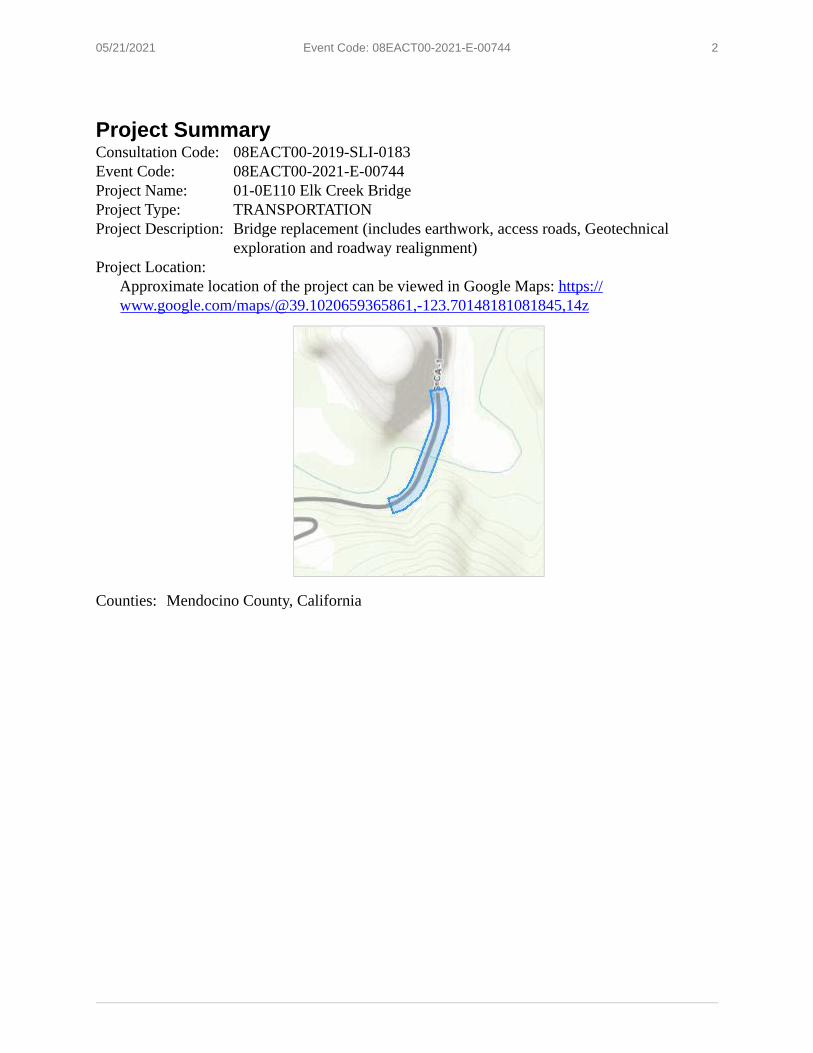
2 05/21/2021 Event Code: 08EACT00-2021-E-00744
Project Summary Consultation Code: 08EACT00-2019-SLI-0183 Event Code: 08EACT00-2021-E-00744 Project Name: 01-0E110 Elk Creek Bridge Project Type: TRANSPORTATION Project Description: Bridge replacement (includes earthwork, access roads, Geotechnical
exploration and roadway realignment) Project Location:
Approximate location of the project can be viewed in Google Maps: https:// www.google.com/maps/@39.1020659365861,-123.70148181081845,14z
Counties: Mendocino County, California

3 05/21/2021 Event Code: 08EACT00-2021-E-00744
Endangered Species Act Species There is a total of 14 threatened, endangered, or candidate species on this species list.
Species on this list should be considered in an effects analysis for your project and could include species that exist in another geographic area. For example, certain fish may appear on the species list because a project could affect downstream species.
IPaC does not display listed species or critical habitats under the sole jurisdiction of NOAA1Fisheries , as USFWS does not have the authority to speak on behalf of NOAA and the
Department of Commerce.
See the "Critical habitats" section below for those critical habitats that lie wholly or partially within your project area under this office's jurisdiction. Please contact the designated FWS office if you have questions.
1. NOAA Fisheries, also known as the National Marine Fisheries Service (NMFS), is an office of the National Oceanic and Atmospheric Administration within the Department of Commerce.
Mammals NAME STATUS
Point Arena Mountain Beaver Aplodontia rufa nigra Endangered No critical habitat has been designated for this species. Species profile: https://ecos.fws.gov/ecp/species/7727
Birds NAME STATUS
Marbled Murrelet Brachyramphus marmoratus Population: U.S.A. (CA, OR, WA) There is final critical habitat for this species. The location of the critical habitat is not available. Species profile: https://ecos.fws.gov/ecp/species/4467
Threatened
Northern Spotted Owl Strix occidentalis caurina There is final critical habitat for this species. The location of the critical habitat is not available. Species profile: https://ecos.fws.gov/ecp/species/1123
Threatened
Western Snowy Plover Charadrius nivosus nivosus Population: Pacific Coast population DPS-U.S.A. (CA, OR, WA), Mexico (within 50 miles of Pacific coast) There is final critical habitat for this species. The location of the critical habitat is not available. Species profile: https://ecos.fws.gov/ecp/species/8035
Threatened
Yellow-billed Cuckoo Coccyzus americanus Population: Western U.S. DPS There is final critical habitat for this species. The location of the critical habitat is not available. Species profile: https://ecos.fws.gov/ecp/species/3911
Threatened

4 05/21/2021 Event Code: 08EACT00-2021-E-00744
Reptiles NAME STATUS
Green Sea Turtle Chelonia mydas Threatened Population: East Pacific DPS No critical habitat has been designated for this species. Species profile: https://ecos.fws.gov/ecp/species/6199
Leatherback Sea Turtle Dermochelys coriacea Endangered There is final critical habitat for this species. The location of the critical habitat is not available. Species profile: https://ecos.fws.gov/ecp/species/1493
Amphibians NAME STATUS
California Red-legged Frog Rana draytonii Threatened There is final critical habitat for this species. The location of the critical habitat is not available. Species profile: https://ecos.fws.gov/ecp/species/2891
Fishes NAME STATUS
Tidewater Goby Eucyclogobius newberryi There is final critical habitat for this species. The location of the critical habitat is not available. Species profile: https://ecos.fws.gov/ecp/species/57
Endangered
Insects NAME STATUS
Behren's Silverspot Butterfly Speyeria zerene behrensii Endangered No critical habitat has been designated for this species. Species profile: https://ecos.fws.gov/ecp/species/900
Lotis Blue Butterfly Lycaeides argyrognomon lotis Endangered There is proposed critical habitat for this species. The location of the critical habitat is not available. Species profile: https://ecos.fws.gov/ecp/species/5174

5 05/21/2021 Event Code: 08EACT00-2021-E-00744
Flowering Plants NAME STATUS
Burke's Goldfields Lasthenia burkei Endangered No critical habitat has been designated for this species. Species profile: https://ecos.fws.gov/ecp/species/4338
Contra Costa Goldfields Lasthenia conjugens Endangered There is final critical habitat for this species. The location of the critical habitat is not available. Species profile: https://ecos.fws.gov/ecp/species/7058
Showy Indian Clover Trifolium amoenum Endangered No critical habitat has been designated for this species. Species profile: https://ecos.fws.gov/ecp/species/6459
Critical habitats THERE ARE NO CRITICAL HABITATS WITHIN YOUR PROJECT AREA UNDER THIS OFFICE'S JURISDICTION.

Selected Elements by Scientific Name California Department of Fish and Wildlife
California Natural Diversity Database
Query Criteria: Quad<span style='color:Red'> IS </span>(Elk (3912326)<span style='color:Red'> OR </span>Albion (3912327)<span style='color:Red'> OR </span>Mallo Pass Creek (3912316)<span style='color:Red'> OR </span>Cold Spring (3912315)<span style='color:Red'> OR </span>Navarro (3912325)<span style='color:Red'> OR </span>Point Arena (3812386)<span style='color:Red'> OR </span>Eureka Hill (3812385))
Elk Creek Bridge Replacement Project (01-0E110) 9 Quad search centered on Mallo Pass Creek (7 quads searched total)
Rare Plant Rank/CDFW
Species Element Code Federal Status State Status Global Rank State Rank SSC or FP Abronia umbellata var. breviflora PDNYC010N4 None None G4G5T2 S2 1B.1
pink sand-verbena
Agrostis blasdalei Blasdale's bent grass
PMPOA04060 None None G2 S2 1B.2
Aplodontia rufa nigra Point Arena mountain beaver
AMAFA01011 Endangered None G5T1 S1 SSC
Arborimus pomo Sonoma tree vole
AMAFF23030 None None G3 S3 SSC
Ascaphus truei Pacific tailed frog
AAABA01010 None None G4 S3S4 SSC
Astragalus agnicidus Humboldt County milk-vetch
PDFAB0F080 None Endangered G2 S2 1B.1
Bombus caliginosus obscure bumble bee
IIHYM24380 None None G4? S1S2
Bombus occidentalis western bumble bee
IIHYM24250 None Candidate Endangered
G2G3 S1
Brachyramphus marmoratus marbled murrelet
ABNNN06010 Threatened Endangered G3 S2
Calileptoneta wapiti Mendocino leptonetid spider
ILARAU6040 None None G1 S1
Calystegia purpurata ssp. saxicola coastal bluff morning-glory
PDCON040D2 None None G4T2T3 S2S3 1B.2
Campanula californica swamp harebell
PDCAM02060 None None G3 S3 1B.2
Carex californica PMCYP032D0 None None G5 S2 2B.2 California sedge
Carex lyngbyei Lyngbye's sedge
PMCYP037Y0 None None G5 S3 2B.2
Carex saliniformis PMCYP03BY0 None None G2 S2 1B.2 deceiving sedge
Castilleja ambigua var. humboldtiensis Humboldt Bay owl's-clover
PDSCR0D402 None None G4T2 S2 1B.2
Castilleja litoralis Oregon coast paintbrush
PDSCR0D012 None None G3 S3 2B.2
Castilleja mendocinensis Mendocino Coast paintbrush
PDSCR0D3N0 None None G2 S2 1B.2
Coastal and Valley Freshwater Marsh Coastal and Valley Freshwater Marsh
CTT52410CA None None G3 S2.1
Government Version -- Dated May, 1 2021 -- Biogeographic Data Branch
Report Printed on Friday, May 28, 2021
Page 1 of 4
Information Expires 11/1/2021

Selected Elements by Scientific Name California Department of Fish and Wildlife
California Natural Diversity Database
Species Coastal Brackish Marsh
Element Code CTT52200CA
Federal Status None
State Status None
Global Rank G2
State Rank S2.1
Rare Plant Rank/CDFWSSC or FP
Coastal Brackish Marsh
Coastal Terrace Prairie CTT41100CA None None G2 S2.1 Coastal Terrace Prairie
Coptis laciniata Oregon goldthread
PDRAN0A020 None None G4? S3? 4.2
Corynorhinus townsendii Townsend's big-eared bat
AMACC08010 None None G4 S2 SSC
Cuscuta pacifica var. papillata Mendocino dodder
PDCUS011A2 None None G5T1 S1 1B.2
Dicamptodon ensatus California giant salamander
AAAAH01020 None None G3 S2S3 SSC
Elanus leucurus ABNKC06010 None None G5 S3S4 FP white-tailed kite
Emys marmorata western pond turtle
ARAAD02030 None None G3G4 S3 SSC
Erigeron supplex supple daisy
PDAST3M3Z0 None None G2 S2 1B.2
Erysimum concinnum bluff wallflower
PDBRA160E3 None None G3 S2 1B.2
Erythronium revolutum coast fawn lily
PMLIL0U0F0 None None G4G5 S3 2B.2
Eucyclogobius newberryi tidewater goby
AFCQN04010 Endangered None G3 S3
Eumetopias jubatus Steller (=northern) sea-lion
AMAJC03010 Delisted None G3 S2
Fritillaria roderickii Roderick's fritillary
PMLIL0V0M0 None Endangered G1Q S1 1B.1
Gilia capitata ssp. pacifica Pacific gilia
PDPLM040B6 None None G5T3 S2 1B.2
Glyceria grandis American manna grass
PMPOA2Y080 None None G5 S3 2B.3
Grand Fir Forest CTT82120CA None None G1 S1.1 Grand Fir Forest
Helminthoglypta arrosa pomoensis Pomo bronze shoulderband
IMGASC2033 None None G2G3T1 S1
Hesperevax sparsiflora var. brevifolia short-leaved evax
PDASTE5011 None None G4T3 S3 1B.2
Hesperocyparis pygmaea pygmy cypress
PGCUP04032 None None G1 S1 1B.2
Hypogymnia schizidiata island tube lichen
NLT0032640 None None G2G3 S2 1B.3
Government Version -- Dated May, 1 2021 -- Biogeographic Data Branch
Report Printed on Friday, May 28, 2021
Page 2 of 4
Information Expires 11/1/2021
Selected Elements by Scientific Name California Department of Fish and Wildlife
California Natural Diversity Database
Rare Plant Rank/CDFW
Species Element Code Federal Status State Status Global Rank State Rank SSC or FP Kopsiopsis hookeri
small groundcone
Lasthenia californica ssp. bakeri Baker's goldfields
Lasthenia californica ssp. macrantha perennial goldfields
Lasthenia conjugens Contra Costa goldfields
Lathyrus palustris marsh pea
Lavinia symmetricus navarroensis Navarro roach
Lilium maritimum coast lily
Mendocino Pygmy Cypress Forest Mendocino Pygmy Cypress Forest
Microseris paludosa marsh microseris
Mitellastra caulescens leafy-stemmed mitrewort
Northern Coastal Bluff Scrub Northern Coastal Bluff Scrub
Northern Coastal Salt Marsh Northern Coastal Salt Marsh
Oenothera wolfii Wolf's evening-primrose
Oncorhynchus gorbuscha pink salmon
Oncorhynchus kisutch pop. 4 coho salmon - central California coast ESU
Oncorhynchus mykiss irideus pop. 16 steelhead - northern California DPS
Pandion haliaetus osprey
Pinus contorta ssp. bolanderi Bolander's beach pine
Piperia candida white-flowered rein orchid
Plebejus idas lotis lotis blue butterfly
Pleuropogon hooverianus North Coast semaphore grass
PDORO01010 None None G4? S1S2 2B.3
PDAST5L0C4 None None G3T1 S1 1B.2
PDAST5L0C5 None None G3T2 S2 1B.2
PDAST5L040 Endangered None G1 S1 1B.1
PDFAB250P0 None None G5 S2 2B.2
AFCJB19023 None None G4T1T2 S2S3 SSC
PMLIL1A0C0 None None G2 S2 1B.1
CTT83161CA None None G2 S2.1
PDAST6E0D0 None None G2 S2 1B.2
PDSAX0N020 None None G5 S4 4.2
CTT31100CA None None G2 S2.2
CTT52110CA None None G3 S3.2
PDONA0C1K0 None None G2 S1 1B.1
AFCHA02010 None None G5 S1
AFCHA02034 Endangered Endangered G5T2T3Q S2
AFCHA0209Q Threatened None G5T2T3Q S2S3
ABNKC01010 None None G5 S4 WL
PGPIN04081 None None G5T2 S2 1B.2
PMORC1X050 None None G3 S3 1B.2
IILEPG5013 Endangered None G5TH SH
PMPOA4Y070 None Threatened G2 S2 1B.1
Government Version -- Dated May, 1 2021 -- Biogeographic Data Branch Page 3 of 4
Report Printed on Friday, May 28, 2021 Information Expires 11/1/2021

Selected Elements by Scientific Name California Department of Fish and Wildlife
California Natural Diversity Database
Rare Plant
Species Element Code Federal Status State Status Global Rank State Rank Rank/CDFWSSC or FP
Potamogeton epihydrus PMPOT03080 None None G5 S2S3 2B.2 Nuttall's ribbon-leaved pondweed
Rana aurora AAABH01021 None None G4 S3 SSC northern red-legged frog
Rana boylii AAABH01050 None Endangered G3 S3 SSC foothill yellow-legged frog
Rana draytonii AAABH01022 Threatened None G2G3 S2S3 SSC California red-legged frog
Rhyacotriton variegatus AAAAJ01020 None None G3G4 S2S3 SSC southern torrent salamander
Rhynchospora alba PMCYP0N010 None None G5 S2 2B.2 white beaked-rush
Sanguisorba officinalis PDROS1L060 None None G5? S2 2B.2 great burnet
Sidalcea calycosa ssp. rhizomata PDMAL11012 None None G5T2 S2 1B.2 Point Reyes checkerbloom
Sidalcea malachroides PDMAL110E0 None None G3 S3 4.2 maple-leaved checkerbloom
Sidalcea malviflora ssp. patula PDMAL110F9 None None G5T2 S2 1B.2 Siskiyou checkerbloom
Sidalcea malviflora ssp. purpurea PDMAL110FL None None G5T1 S1 1B.2 purple-stemmed checkerbloom
Speyeria zerene behrensii IILEPJ6088 Endangered None G5T1 S1 Behren's silverspot butterfly
Sphagnum Bog CTT51110CA None None G3 S1.2 Sphagnum Bog
Taricha rivularis AAAAF02020 None None G2 S2 SSC red-bellied newt
Trifolium buckwestiorum PDFAB402W0 None None G2 S2 1B.1 Santa Cruz clover
Trifolium trichocalyx PDFAB402J0 Endangered Endangered G1 S1 1B.1 Monterey clover
Usnea longissima NLLEC5P420 None None G4 S4 4.2 Methuselah's beard lichen
Record Count: 78
Government Version -- Dated May, 1 2021 -- Biogeographic Data Branch Page 4 of 4
Report Printed on Friday, May 28, 2021 Information Expires 11/1/2021

Inventory of Rare and Endangered Plants of California
CHANGES REVIEW HELP Search: Simple Advanced Search for species and dat GoHOME ABOUT
Search Results
Back Export Results
63 matches found. Click on scientific name for details
Search Criteria: Quad is one of [3912316,3912327,3912326,3912325,3912315,3812385,3812386]
Scientific Name Common Name Family Lifeform Blooming Period Fed List State List Global Rank State Rank CA Rare Plant Rank
General Habitats Micro Habitats Lowest Elevation Highest Elevation CA Endemic Date Added Photo
Search:
CA RARE BLOOMING FED STATE STATE PLANT
▲ SCIENTIFIC NAME COMMON NAME FAMILY LIFEFORM PERIOD LIST LIST RANK RANK
Abronia umbellata var. pink sand-verbena Nyctaginaceae perennial herb Jun-Oct None None S2 1B.1
breviflora
Agrostis blasdalei Blasdale's bent grass Poaceae perennial rhizomatous May-Jul None None S2 1B.2
herb
Angelica lucida sea-watch Apiaceae perennial herb Apr-Sep None None S3 4.2
Arctostaphylos pygmy manzanita Ericaceae perennial evergreen Jan None None S1 1B.2
nummularia ssp. shrub
mendocinoensis
Astragalus agnicidus Humboldt County Fabaceae perennial herb Apr-Sep None CE S2 1B.1
milk-vetch
Calamagrostis bolanderi Bolander's reed Poaceae perennial rhizomatous May-Aug None None S4 4.2
grass herb
Calystegia purpurata ssp. coastal bluff Convolvulaceae perennial herb (Mar)Apr-Sep None None S2S3 1B.2
saxicola morning-glory
Campanula californica swamp harebell Campanulaceae perennial rhizomatous Jun-Oct None None S3 1B.2
herb
Carex californica California sedge Cyperaceae perennial rhizomatous May-Aug None None S2 2B.2
herb
Carex lyngbyei Lyngbye's sedge Cyperaceae perennial rhizomatous Apr-Aug None None S3 2B.2
herb
Carex saliniformis deceiving sedge Cyperaceae perennial rhizomatous Jun(Jul) None None S2 1B.2
herb
Castilleja ambigua var. Humboldt Bay owl's- Orobanchaceae annual herb Apr-Aug None None S2 1B.2
humboldtiensis clover (hemiparasitic)
Castilleja litoralis Oregon coast Orobanchaceae perennial herb Jun None None S3 2B.2
paintbrush (hemiparasitic)
Castilleja mendocinensis Mendocino Coast Orobanchaceae perennial herb Apr-Aug None None S2 1B.2
paintbrush (hemiparasitic)
Ceanothus gloriosus var. glory brush Rhamnaceae perennial evergreen Mar-Jun(Aug) None None S4 4.3exaltatus shrub

Ceanothus gloriosus var. Point Reyes Rhamnaceae perennial evergreen Mar-May None None S4 4.3 CA RARE gloriosus ceanothus shrub BLOOMING FED STATE STATE PLANT ▲ SCIENTIFIC NAME COMMON NAME FAMILY LIFEFORM PERIOD LIST LIST RANK RANK Chrysosplenium Pacific golden Saxifragaceae perennial herb Feb-Jun None None S3 4.3
glechomifolium saxifrage
Coptis laciniata Oregon goldthread Ranunculaceae perennial rhizomatous
herb
(Feb)Mar-May(Sep-Nov)
None None S3? 4.2
Cordylanthus tenuis ssp. brunneus
serpentine bird's-beak
Orobanchaceae annual herb
(hemiparasitic) Jul-Aug None None S3 4.3
Cuscuta pacifica var. papillata
Mendocino dodder Convolvulaceae annual vine (parasitic) (Jun)Jul-Oct None None S1 1B.2
Cypripedium montanum mountain lady's-slipper
Orchidaceae perennial rhizomatous
herb
Mar-Aug None None S4 4.2
Erigeron supplex supple daisy Asteraceae perennial herb May-Jul None None S2 1B.2
Erysimum concinnum bluff wallflower Brassicaceae annual/perennial herb Feb-Jul None None S2 1B.2
Erythronium revolutum coast fawn lily Liliaceae perennial bulbiferous
herb
Mar-Jul(Aug) None None S3 2B.2
Fritillaria roderickii Roderick's fritillary Liliaceae perennial bulbiferous
herb
Mar-May None CE S1 1B.1
Gilia capitata ssp. pacifica Pacific gilia Polemoniaceae annual herb Apr-Aug None None S2 1B.2
Glehnia littoralis ssp. leiocarpa
American glehnia Apiaceae perennial herb May-Aug None None S2S3 4.2
Glyceria grandis American manna
grass
Poaceae perennial rhizomatous
herb
Jun-Aug None None S3 2B.3
Hesperevax sparsiflora var. brevifolia
short-leaved evax Asteraceae annual herb Mar-Jun None None S3 1B.2
Hesperocyparis pygmaea pygmy cypress Cupressaceae perennial evergreen tree None None S1 1B.2
Hosackia gracilis harlequin lotus Fabaceae perennial rhizomatous
herb
Mar-Jul None None S3 4.2
Hypogymnia schizidiata island rock lichen Parmeliaceae foliose lichen None None S2 1B.3
Kopsiopsis hookeri small groundcone Orobanchaceae perennial rhizomatous
herb (parasitic) Apr-Aug None None S1S2 2B.3
Lasthenia californica ssp. bakeri
Baker's goldfields Asteraceae perennial herb Apr-Oct None None S1 1B.2
Lasthenia californica ssp. macrantha
perennial goldfields Asteraceae perennial herb Jan-Nov None None S2 1B.2
Lasthenia conjugens Contra Costa
goldfields
Asteraceae annual herb Mar-Jun FE None S1 1B.1
Lathyrus palustris marsh pea Fabaceae perennial herb Mar-Aug None None S2 2B.2
Leptosiphon acicularis bristly leptosiphon Polemoniaceae annual herb Apr-Jul None None S4? 4.2
Lilium maritimum coast lily Liliaceae perennial bulbiferous
herb
May-Aug None None S2 1B.1
Lilium rubescens redwood lily Liliaceae perennial bulbiferous
herb
Apr-Aug(Sep) None None S3 4.2
Lycopodium clavatum running-pine Lycopodiaceae perennial rhizomatous
h b
Jun-Aug(Sep) None None S3 4.1

S
herb CA RARE
Microseris paludosa marsh microseris Asteraceae perennial herb BLOOMINGApr-Jun(Jul) FEDNone STATENone TATES2 PLANT1B.2 ▲ SCIENTIFIC NAME COMMON NAME FAMILY LIFEFORM PERIOD LIST LIST RANK RANK Mitellastra caulescens leafy-stemmed Saxifragaceae perennial rhizomatous (Mar)Apr-Oct None None S4 4.2
mitrewort herb
Oenothera wolfii Wolf's evening-primrose
Onagraceae perennial herb May-Oct None None S1 1B.1
Perideridia gairdneri ssp. gairdneri
Gairdner's yampah Apiaceae perennial herb Jun-Oct None None S3S4 4.2
Pinus contorta ssp. bolanderi
Bolander's beach
pine
Pinaceae perennial evergreen tree None None S2 1B.2
Piperia candida white-flowered rein
orchid
Orchidaceae perennial herb (Mar)May-Sep None None S3 1B.2
Pityopus californicus California pinefoot Ericaceae perennial herb
(achlorophyllous) (Mar-Apr)May-Aug
None None S4 4.2
Pleuropogon hooverianus North Coast semaphore grass
Poaceae perennial rhizomatous
herb
Apr-Jun None CT S2 1B.1
Pleuropogon refractus nodding semaphore
grass
Poaceae perennial rhizomatous
herb
(Mar)Apr-Aug None None S4 4.2
Potamogeton epihydrus Nuttall's ribbon-leaved pondweed
Potamogetonaceae perennial rhizomatous
herb (aquatic) (Jun)Jul-Sep None None S2S3 2B.2
Rhynchospora alba white beaked-rush Cyperaceae perennial rhizomatous
herb
Jun-Aug None None S2 2B.2
Sanguisorba officinalis great burnet Rosaceae perennial rhizomatous
herb
Jul-Oct None None S2 2B.2
Sidalcea calycosa ssp. rhizomata
Point Reyes
checkerbloom
Malvaceae perennial rhizomatous
herb
Apr-Sep None None S2 1B.2
Sidalcea malachroides maple-leaved
checkerbloom
Malvaceae perennial herb (Mar)Apr-Aug None None S3 4.2
Sidalcea malviflora ssp. patula
Siskiyou
checkerbloom
Malvaceae perennial rhizomatous
herb
May-Aug None None S2 1B.2
Sidalcea malviflora ssp. purpurea
purple-stemmed
checkerbloom
Malvaceae perennial rhizomatous
herb
May-Jun None None S1 1B.2
Streptanthus glandulosus
ssp. hoffmanii Hoffman's bristly
jewelflower Brassicaceae annual herb Mar-Jul None None S2 1B.3
Sulcaria spiralifera twisted horsehair lichen
Parmeliaceae fruticose lichen
(epiphytic) None None S1S2 1B.2
Trifolium buckwestiorum Santa Cruz clover Fabaceae annual herb Apr-Oct None None S2 1B.1
Trifolium trichocalyx Monterey clover Fabaceae annual herb Apr-Jun FE CE S1 1B.1
Usnea longissima Methuselah's beard
lichen
Parmeliaceae fruticose lichen
(epiphytic) None None S4 4.2
Veratrum fimbriatum fringed false-hellebore
Melanthiaceae perennial herb Jul-Sep None None S3 4.3
Showing 1 to 63 of 63 entries
CONTACT US ABOUT THIS WEBSITE ABOUT CNPS CONTRIBUTORS

This page intentionally left blank.
Elk Creek Bridge Replacement Project Initial Study with Proposed Mitigated Negative Declaration / Environmental Assessment

Appendix C. Avoidance, Minimization and/or Mitigation Summary
Elk Creek Bridge Replacement Project Initial Study with Proposed Mitigated Negative Declaration / Environmental Assessment
D-1

This page intentionally left blank.
Elk Creek Bridge Replacement Project Initial Study with Proposed Mitigated Negative Declaration / Environmental Assessment
D-2

The avoidance, minimization and/or mitigation measures that would be implemented for the proposed project are provided in Section 1.6. The project’s Mitigation Measure, BR-1, is provided below.
• The proposed project would have a “Less than Significant Effect with Mitigation Incorporated” to Threatened and Endangered Species, specifically Central California Coast Salmon Evolutionarily Significant Unit of coho salmon and North Coast Distinct Population Segment of Steelhead, with the implementation of the following mitigation measure:
A root wad revetment would be constructed along 100-140 feet of the north bank of Elk Creek at the bridge site to mitigate for direct and indirect impacts to special status fish and their habitats resulting from the installation of the clear water diversions, fish relocation efforts, and construction operations required to replace the Elk Creek Bridge. The revetment would be built using bio-engineered Rock Slope Protection using large rock, backfilled with soil and planted with willows to fix 10-20 conifer root wads (redwood, Douglas-fir, or potentially cypress) to provide salmonid habitat and protect the north abutment of the bridge, similar to what is shown in Appendix E of this document. The final design of the bio-engineered revetment would be developed in conjunction with the California Department of Fish and Wildlife and approved by them as part of the project permitting process. The revetment would be installed at the site following the installation of the new bridge and the removal of the temporary bridge.
Elk Creek Bridge Replacement Project Initial Study with Proposed Mitigated Negative Declaration / Environmental Assessment
D-3

This page intentionally left blank.
Elk Creek Bridge Replacement Project Initial Study with Proposed Mitigated Negative Declaration / Environmental Assessment
D-4

Appendix D. List of Technical Studies
Elk Creek Bridge Replacement Project Initial Study with Proposed Mitigated Negative Declaration / Environmental Assessment
D-1

This page intentionally left blank.
Elk Creek Bridge Replacement Project Initial Study with Proposed Mitigated Negative Declaration / Environmental Assessment
D-2

The following technical studies were used in preparation of this Elk Creek Bridge Replacement Environmental Assessment and Initial Study Mitigated Negative Declaration.
• Air Quality and Noise Analysis Memorandum – November 2019, Greenhouse Gas Update June 2021
• Community Impact Assessment Memorandum – August 2019
• Floodplain Evaluation Report Summary – August 2018
• Historic Property Survey Report – June 2018
• Initial Site Assessment Memorandum – October 2014
• Natural Environment Study – June 2021
• Paleontological Identification Report/Paleontological Evaluation Report – November 2019
• Preliminary Hydrologic Report – December 2017
• Structure Preliminary Geotechnical Report – November 2018
• Transportation Management Plan – December 2017
• Visual Impact Assessment – October 2018
• Water Quality Assessment Report – November 2019
Elk Creek Bridge Replacement Project Initial Study with Proposed Mitigated Negative Declaration / Environmental Assessment
D-3

This page intentionally left blank.
Elk Creek Bridge Replacement Project Initial Study with Proposed Mitigated Negative Declaration / Environmental Assessment
D-4

Appendix E. Layouts and Construction Details
Elk Creek Bridge Replacement Project Initial Study with Proposed Mitigated Negative Declaration / Environmental Assessment
E-1

This page intentionally left blank.
Elk Creek Bridge Replacement Project Initial Study with Proposed Mitigated Negative Declaration / Environmental Assessment
E-2

X
X
X
X
X
0
"'z"' 1/1
"'I-<0
0. X
"' "'1/1z "'u ...J
0 z z ~ I-<g; 1/1
"' "' 0:
...J <>0 0: a. a. < I-:,:
"' vi 0:
"' > 0 z"' vi "' 0
1/1z <g; ...J <u
0:
"' "'<z <:::0 z ~ 1/1
"'0
I-z ;': ...J :::, 1/1z 0 u
0 0 Ct: z 0 0 u z w Ct: < u
INDEX OF PLANS ST ATE OF CALIFORNIA
SHEET No.
DEPARTMENT OF TRANSPORTATION
X X X X X X X X X X X
DESCRIPTION
TITLE AND LOCATION MAP PROJECT CONTROL TYPICAL CROSS SECTIONS LAYOUTS PROFILE SUPERELEVATION DIAGRAM CONSTRUCTION DETAILS CONSTRUCTION AREA SIGNS CONTOUR GRADING STAGE CONSTRUCTION PLAN SUMMARY OF QUANTITIES
PROJECT
AT
PLANS STATE
FOR CONSTRUCTION HIGHWAY
IN ELK
MENDOCINO COUNTY CREEK BRIDGE #10-120
X EROSION CONTROL LEGEND, PLANS, AND OUANTITES ELECTRICAL PLANS
TO BE SUPPLEMENTED BY STANDARD PLANS AND REVISED STANDARD PLANS DATED 2018 X xx-xx REVISED STANDARD PLANS
THE STANDARD PLANS LIST APPLICABLE TO THIS CONTRACT IS INCLUDED IN THE NOTICE TO BIDDERS AND SPECIAL PROVISIONS BOOK.
_ 10 Manchester
ROUTE 1
Be in Work PM 30. 7
BEGIN CONSTRUCTION PM 31.2
THE CONTRACTOR SHALL POSSESS THE CLASS (OR CLASSES) OF LICENSE AS SPECIFIED IN THE "NOTICE TO BIDDERS."
END CONSTRUCTION PM 31.4
PACIFIC OCEAN
Be in Work PM 32.4
NO SCALE
ON
\ /j
(.,,,.. i_
Dist COUNTY ROUTE POST MILES SHEET TOTAL TOTAL PROJECT No. SHEETS
01 MEN 001 31.35
MODOC
•·lidl,ans•
INYO
SAN BERNARDINO
LOCATION MAP
ELK
//I \ \ \.,
\
PROJECT ENGINEER DATE REGISTERED CIVIL ENGINEER
PLANS APPROVAL DA TE THE STATE OF CALIFORNIA OR ITS OFFICERS OR AGENTS SHALL NOT BE RESPONSIBLE FOR THE ACCURACY OR C{)l,IPLETENESS OF SCANNED COPIES OF THIS PLAN SHEET.
AA II 11
Oo Wc,J I- I-I- 1-0 o --'...J"-a.
~D-0-KK_E_N_E_N-Gl-N-EE_R_IN-G------------~~~ 110 BLUE RAVINE ROAD o ,-SUITE 200 FOLSOM, CA 95630
CONTRACT No. PROJECT ID
01-0E1101 0113000125
0 0
I 0 0
I
0 0
BORDER LAST REVISED 8/1/2016 CAL TRANS WEB SITE JS: HTTP//WWW.DOT.CA.GOV/ RELATIVE BORDER SCALE 0 IS IN INCHES
3 USERNAME => Saechao DGN FILE => J:\2381_Caltrans_03-A2392_ T016_Elk_Creek_BR\5 1,b-\~!JooPA'1~1 dfr,ROJECT NUMBER & PHASE 0113000125

Cl >- w a:, ~ Cl > w w V) a: ;: w w f-a: «
Cl
X
I >- >-Oa:,w a:, >-o
Cl«w...Jz w :::, t.'.l "' u- u...JV) w «w I uo u
X a: 0 V)
>a: w 0.. :::, V)
...J « z ~ f-u z :::, LL
f-z « f-...J :::, V) z 0 u
:z Q
X I-c:t I-a: C) a.. V):z c:ta: I-
'-'-C)
I-z Lu :::::i;;I-a: c:t a.. Lu Cl
c:t • :z
ia: 0 '-'-
X ...J c:t u '-'-C)
Lu •I- ' c:t I-V)
BORDER
Dis-t COUNTY ROUTE POST MILES SHEET TOTAL TOTAL PROJECT No. SHEETS
NOTES Men 001 31 .35 X
1. DIMENSIONS OF THE PAVEMENT STRUCTURES (STRUCTURAL SECTIONS) ARE SUBJECT TO TOLERANCES SPECIFIED IN THE STANDARD SPECIFICATIONS.
2 . SUPERELEVATIONS ARE SHOWN ON THE SUPERELEVATION DIAGRAMS.
ABBREV IAT IONS: SR= SUPERELEVATION RATE GP! = GEOSYNTHETIC
PAVEMENT INTERLAYER
DESIGN DESIGNATION MEN 001
31 .2/31 .4
ADT (2018) 1,800 ADT (2064) 2,050 DHV 358
R/W
69'
PROPOSED BR IOGE
PAVEMENT CLIMATE REGION
NORTH COAST
4 7'
"A" LINE
ETW ETW 1' 6' 2' 6' 12' 12' 6' 2
R/W
57'
1--~---~---~-----~-~-----1
REGISTERED CIVIL ENGINEER DAT
PLANS APPROVAL DATE
THE STATE OF CALIFORNIA OR ITS OFFICERS OR AGENTS SHALL NOT BE RESPONSIBLE FOR THE ACCURACY OR COVPLETENESS OF SCANNED COPIES OF THIS PLAN SHEET.
DOKKEN ENGINEERING I 10 BLUE RAVINE ROAD SUITE 200 FOLSOM, CA 95630
ESAL20 2,423,900 OG ---------------------------------------------·__:_____:__: ----: __ : ----: - . --------------------------------- OG
D 55% T 6% V 60 mph TI 20 8.0
R/W Va,
EMBANKMENT
GCi /
//
/
VEGETATION CONTROL(MINOR Cone)
MIDWEST GUARDRAIL SYSTEM
HP EP ETWVa, Va, 12' "A" LINE
12' ETW 1 EP 4 , HP Va,
1.2'- 0.50'- 2'-6' 4' 14'
"A" 12+72.63 TO "A" 1 7+15.07
R/W ExistExist EP ETW
Va, Va, Va,
"A" 1 7+15.07 TO "A" 18+55.07
"A" LINE
R/W Va,
EMBANKMENT
VEGETATION CONTROL(MINOR Cone)
MIDWEST GUARDRAIL
ExistETW
12' ETW EP HP CP
Va, Var Va,
VEGETATION CONTROL(MINOR Cone) "A" 11+79.19 "A" 12+72.63
MIDWEST GUARDRAIL SYSTEM
LAST REVISED 7/2/2010 USERNAME =>Saechao RELATIVE BORDER SCALE DGN FILE => J•\2381_Cal-trans_03-A2392_TQl6_Elk_Creek_BR\511\0113000125ca01. gn IS IN INCHES
0 2 3
HP EP ETWVa, Va, 12' "A" LINE
12' ETW EP 4 , HP
V , Va, R/W
1 .2'- 0.50'-4' 14'
1 '-6'
"A" 18+55.07 TO "A" 21 +56.88
R/WVa,
UNIT 0312
TYPICAL CROSS NO SCALE
PROJECT NUMBER & PHASE
SECTIONS X-1
0113000125
0~ N"-0
"'"'' ...NN'"' N •-N
""II 11 C, C, w w,_ ,_,_ ,_Oo ---'---' "- "-W w ~~ C, ,_
0 0
I 0 0
I
0 0

Cl >- w CD l/l
Cl > w w l/l 0:
> w w >-0: <I:
Cl
X
I >- >-Cleo w CD >- Cl
Cl<w ...Jz w :::, t.'.l "' u- u ...Jl/l w <l'.W I UCI u
X 0: 0 l/l
> 0: w 0.. :::,t/1
...J <I: z ~ >-u z :::, LL
>-z <I: >-...J :::, t/1z 0 u
;;z; ~
X I-<I-c::: 0 a.. V,;;z;<c::: I-
'-'-0 I-;;z; Lu :::I! I-c:::<a.. Luc:::,
~ .,
;;z;
Ic:::0 '-'-
X ...J<u '-'-0 Lu •I- '<I-V,
BORDER
NOTES CURVE DATA No. ® R D,. T1. FOR ACCURATE RIGHT OF WAY DATA, CONTACT
546' 14° 03' 36" 67 .33'1 L
133.99'RIGHT OF WAY ENGINEERING AT THE DISTRICT OFFICE.
' '· L=84.64' S 77° 09'08" E
"A" 10+84.64
"A" 12+00.00,
ANGLE POINT
"A" 12+72.63 PCC END COLD PLANE AC Pvmt Beg STRUCTURAL SECTION E
"A" 13+90.92, 14. PLACE AC OSD
"A" 13+38.63, 19 . 69' Lt BEG Temp HV FENCE
2 256' 12° 04' 24" 27 .1 O' 54.00' 3 340' 55° 42' 44" 179.69' 330.60' 4 400' 27° 33' 02" 98.07' 192.34'
550' 1 8° 28' 32"5 89.45'~~-~----~------~----~....,,....__,..,o-r-,..,,...._ 76 70. 80' Lt
"A" 11+79.19 Beg PAVING CONFORM Beg COLD PLANE AC Pvmt
12+18.63 PCC
2
"A" 12+72.70 12.50' Lt END PAVING CONFORM Beg HMA DIKE (TYPE A)
"A" 18+19.19 89.01' Lt BEG Temp HV FENCE
"A" 1 7+58.62 87 .08' Lt END Temp HV FENCE
"A" 17+15.07 18.00' Lt Beg CONCRETE BARRIER (TYPE 60MD)
"A" 17+32.54 61.90' Lt END WATER QUALITYINFILTRATION FEATURE
"A" 17+15.07 26.00' Lt END TRANSITION RAILING (TYPE WB-31)
"A" 13+02.68 14.00' Lt ANGLE POINT "A" 16+90.07 26.00' Lt
Beg TRANSITION RAILING (TYPE WB-31) END MGS (8' STEEL POST)
"A" 13+34.3314 .00'Lt CRASH CUSHION Beg MGS (8' STEEL PO L ) (A )~'AY 'U14')
A" 13+60 EMOVE E-c
OVE :Ellfi ·· DR ».,:/·
_.'?··
Beg WATER QUALITYINFILTRATION FEATURE
"A" 18+72.14 72.29'Lt END WATER QUALITYINFILTRATION FEATURE
"A" 18+55.07 26.00' Lt Beg TRANSITION RAILING (TYPE WB-31)
"A" 18+80.07 26.00' Lt END TRANSITION RAILING (TYPE WB-31) Beg MGS (8' STEEL POST)
"A" 19+64. 54 BC
. 111 "A" 18+80.07 18 . 00' Ri END TRANSITION RAIL!
(TYPE WB-31)
"A" 21+01.88 14.00' Lt ANGLE POINT
"A" 21+51.00 25.11' Lt END Temp HV FENCE "A" 21 +56.88 END STRUCTURAL SECTION Beg PAVING CONFORM Beg COLD PLANE AC Pvmt
"A" 21 +96.88 END PAVING CONFORM END COLD PLANE AC Pvmt
'A" 22+37.94 BC
\~A" 21 +56.88 EC'(-~------
Dist COUNTY ROUTE POST MILES SHEET TOTAL TOTAL PROJECT No. SHEETS
Men 001 31 .35
REGISTERED CIVIL ENGINEER DAT
PLANS APPROVAL DATE
THE STATE OF CALIFORNIA OR ITS OFFICERS OIi AGENTS SHAU NOT BE RESPONSIBLE FOIi THE ACCURACY OIi COAIPLETENESS OF SCANNEO COPIES OF THIS PLAN SHEET.
DOKKEN ENGINEERING I 10 BLUE RAVINE ROAD SUITE 200 FOLSOM, CA 95630
24+15.29 EC
E
X
"A" 21+57.19 24.73' Rt END Temp HV FENCE
20+99.06 14.88' Rt ANGLE POINT
"A" 20+80.85 27.66' Rt ANGLE POINT
Veg Ctrl AITS
29.05' Rt
1 7 .49' Rt
"A" 14+39.41, 14.00' Lt ANGLE POINT
"A" 14+94.73 15.44' Lt Beg REMOVE FENCE
Veg Ctrl
BURIED POST END ANCHOR
Beg MGS (8' STEEL POST "A" 18+46.52, 71 . 19' Rt BEG Temp HV FENCE
"A" 19+55.86 18.28' Rt END MGS (8' STEEL POST)
LAST REVISED 7/2/2010
"A" 15+17 . 78 16.60'Lt END HMA DIKE (TYPE A)
"A" 15+14.76, 16.98'Rt BEG Temp HV FENCE
"A" 16+03.06 23.14' Rt Beg MGS 8 STEEL POST
"A" 16+58.08 16.77' Lt END REMOVE FENCE
L=361 . 31' N 21 °0'8" E
"A" 16+90.07, 1 8.00' Rt END MGS (8' STEEL POST) Beg TRANSITION RAILING (TYPE WB-31)
"A" 17+54.59 49.38' Rt END Temp HV FENCE
"A" 17+15.07 18.00' Rt END TRANSITION RAILING (TYPE WB-31)
"A" 1 7+15.07 BB
USERNAME =>Saechao RELATIVE BORDER SCALE 0 DGN FILE => J•\2381_Caltrans_Q3-A2392_TQl6_Elk_Creek_BR\511\0113000125ea01. gn IS IN INCHES
I "A" 18+55.07 18.00' Rt Beg TRANSITION RAILING (TYPE WB-31)
"A" 18+55.07 EB
"A" 18+55.07 1 8.00' Lt END CONCRETE BARRIER (TYPE 60MD)
2 3 UNIT 0312
LAYOUT SCALE: 1"=50'
L-1 PROJECT NUMBER & PHASE 0113000125
0 N 0 N ..... N N ..... N
""II 11
Co L,.J L,.J............Oo ..J ..J 0.. 0..
L,.J L,.J
~~ 0 ...
0 0
I 0 0
I
0 0

X
X
X
X
Cl >- w CD Ill
Cl > w w Ill 0:
> w w >-0: <I:
Cl
I >- >-Cleo w CD >- Cl
Cl<w ...Jz w :::, t.'.l "' u- u ...JIil w <l'.W I UCI u
0: 0 Ill
> 0: w 0.. :::, t/1
...J <I: z ~ >-u z :::, LL
,____, . ■ •••• ■• ■• ■• ■ •••• ■• ■• ■ •••• ■• ■ .. ■• ■ .... ■ •••• ■• ■ ■ ■• ■ •••• ■ ••• ■ •••• ■• ■• ■ ■ ■ •••• ■• ■• ■ •••• ■• ■ .. ■• ■ ■ ... ■ •••• ■• ■ ■ ■• ■ •••• ■ •• ■ ■ •••• ■• ■• ■• ■ •••• ■• ■• ■ ■ ••• ■• ■ .. ■• ■ .... ■ •••• ■• ■• ■• ■ •••••••• ■ •••• ■• ■• ■ ■ ■ •••• ■•
,____, , ■ ,•'• ■ , ■ I ■ , ■ •'•, ■ ,•, ■ , ■ '• ■ , ■ "' ■ , ■ ,"-, ■ ,•'• ■ , ■ • ■ , ■ •'•, ■ ,•, ■ ,•'• ■ , ■ I ■■■ •'•, ■ ,•, ■ , ■ '• ■ , ■ "' ■ , ■■ "-, ■ ,•'• ■ , ■ • ■ , ■ •'•, ■ ,• ■■ ,•'• ■ , ■ I ■ , ■ •'•, ■ ,•, ■■■ '• ■ , ■ "' ■ , ■ ,"-, ■ ,•'• ■ , ■ • ■ , ■ •'•,,,•, ■ ,•'• ■ , ■ I ■■■ •'•, ■ ,
,_____,, • ■ • ·=· ■ • ■ ; ■ • ■ ·=· . ■ • ~ . ■ • ■ : , ■ • ■ -: ■ • ■ • :- • ■ • - : • ■ • ■ ~ ■ • ■ ·=· . ■ • ;. • ■ • ·=· ■ •• ; ••• ·=· ••• ~ •••• =· ••• -: •••• :- ••• -: •••• ~ ••• ·=· ••• ;. ••• ·=· ••• ; ••• ·=· ••• ~ •••• =· ••• -: •••• :- ••• ·=•••• ; ••• ·=· ••• ;. ••• ·=· ••• ; ••• ·=· • • • • ••• =· ••• -: •••• :- •••
60o-----; •............................................................................................................................................................................................................. .
,____, ...................................................................................................................................................................................................................
50 ------; • • • • • • • • ••• • • • I • • • ••• • • • • • • • • •• • • • .. • • • • .. • • • •• • • • • • • • • ••• • • • • • • • ••• • • • I • • • ••• • • • • • • • • •• • • • .. • • • • .. • • • •• • • • • • • • • ••• • • • • • • • ••• • • • I • • • ••• • • • • • • • • •• • • • .. • • • • .. • • • •• • • • • • • • • ••• • • • • • • • ••• • • • I • • • ••• • • • • • • • • •• • • • .. • • • •
0-----; • • • • ~ • • • •=• • • • I • • • • :. • • • ~ • • • • :. • • • -: • • • • :- • • • .: • • • • ~ • • • .: • • • • ~ • • • •=• • • • I • • • • :. • • • ~ • • • • :. • • • -: • • • • :- • • • .: • • • • ~ • • • .: • • • • ~ • • • •=• • • • I • • • • :. • • • ~ • • • • :. • • • -: • • • • :- • • • .: • • • • ~ • • • .: • • • • ~ • • • •=• • • • I • • • • :. • • • ~ • • • • :. • • • -: • • • •
40
30
::::::::::::::::::::::::::::::::::::::::::::::::::::::::::::::::::::::::::::::::::::::::::::::::::::::::::::::::::::::::::::::::::::::::::::::::::::::::::::::::::::::::::::::J;::; :::::::::::::::::::::···
. §; "r--- . ~ - CD :"! · W :if ~... ,.... ·.· ... ' .. o
•••• ' •••• , •••• ' •••• ,•••• •· ••• ,•••• , ••• ·> ••• ; . -ro '.~...;.... :· .. ·:· ... : ... ·:· ... !· .. ·:· ... ~ :::::: :::r: ::i::: :{)ff~ -> -(I)
w
>-z <I: >-...J :::,Ill z 0 u
;;z; ~ I-
:=2=0=:.... ;. ··.;. ···; ···.;. ···;···;···,. ··., ···,.I ··;···.;.·······•.. • · •·.· •.• ···;···.;.···,.··.,···;· ·., · ··.;. ·r.;.···;···.;.···,~J:Jff~,U~oR,~~c···.;. ···;···.;. ···
_ _ ,___10----1 i I i l ]~,UY i ii i ] ; i i Li I ]\~j_cr6~01N%f"'"" waTER i ····: ··: :j:···: ····:· ···'. ··: J :: ·'. ····: ····: ··: :!::··:· ···:····:· ·: l :··:· ···'. ····:· ·::!::··: ····: ····: ·::i:: ··: ····:· ·:::::::1:··'. ····:· ···'. ·:::~:···: ····: ····:· ··:~::: ·:· ···: ····:· ··:J; :: ::: ··· <,_
er: 0 a.. V,;;z;<er: 0-----; • • • • ~ • • • •=• • • • I • • • • :. • • • ~ • • • • :. • • • -: • • • • :- • • • .: • • • • ~ • • • .: • • • • ~ • • • •=• • • • I • • • • :. • • • ~ • • • • :. • • • -: • • • • :- • • • .: • • • • ~ • • • .: • • • • ~ • • • •=• • • • I • • • • :. • • • ~ • • • • :. • • • -: • • • • :- • • • .: • • • • ~ • • • .: • • • • ~ • • • •=• • • • I • • • • :. • • • ~ • • • • :. • • •
I-
'-'-0 ,_ ;;z; Lu o-----; ••·· ···································.. ······················································.. ······················································.. ················································· :::I! I-er:<a.. Luc:::, ,____, .... . ........................................................................................................................................................................................................
~ .,
;;z;
Ier:0 '-'-...J<u '-'-0 STATION Lu • IExe,_ '<I- CYV, IEmbl
....•....•....•....•.... ,1-------t
........................ ,,____---,
DisT I COUNTY I ROUTE
1 I Men I 001 I POST MILES
TOTAL PROJECT
I 31 .35
ISHEET TOTAL No. SHEETS
I X
~
---- \\otEss,0 REGISTERED CIVIL ENGINEER DATE ;~~~4"'"' (
it \l_P_L_A_N_S_A_P_P_R_O_V_A_L_D_A_T_E______ 11\ iS:0 · I E >-----1"-TH._'E_S-TA_T,_"E_OF_C:_"A_l_/Fi_OR._W._~A-Q_I/I_IT.-"S-0Fi_"F_I_C:_"£11_"S_,\ .c,c Exp. --- *
OR AGENTS SHAU NOT BE RESPONSIBLE FOR s,, ,~ THE ACCURACY OR COAIPLETENESS OF SCANNEO 4', o, CAL 1,r#.
•••• , ••••••••• , •••• •· ••• ,t-----i:C::.:t:1::l":::_~E'._:S:.._:::OF:..._:T,::_H.'..:IS:_:PL'.:_'.A:N:....::SH.'.'.'.ie.'..'.:"£_'.T.:_.-------~::::::::;:;:;:::::::____J DOKKEN ENGINEERING I 10 BLUE RAVINE ROAD SUITE 200 FOLSOM, CA 95630•.•. ;. ••. ·=· •.. ; •.• ·=· .•. '--~-----+--~ - ~ - - --~ - - - --'--,--~ - - - - --~--_,
60. .................................................................................... ,,____,
f----
........................................................................................... ,,____,
30........................................................................................... ,,____,
f----
• • • •~ • • • •=• • • • ~ ••••=••••I••••=••••~••••=•••• O:• • ••:- • • • •=• • • •~ • • • •=• • • • ~••••=••••I••••=••• • t---_,
20.......................................................................................... ,____,
f----
........................................................................................... .____,
· · · · · · · · · · · · · · · · · 10····•·········•····l····•·········•····l· ··· .. ····.. ·········r·········•·········i ·········t------,. . . .~- .. :.... :. . . .-~.. . . . .. +. . . . .-~5 . . f----
• • • •~ • • • •=• • • • ~ ••••=••••I••••=••••~••••=•••• O:• • ••:- • • • •=• • • •~ • • • •=• • • • ~••••=••••I••••=••• • t---_,
.......................................................................................... ,____, 0~ NO.
f------ 2 0 ..... "' NN ........................................................................................... ,____, ~ ~
:::i:: .f! :R:():f :1.~ E i::: -N
""II 11 • • 0st:;AL:(: . -~o r-.i:.z. :i:'':~~o:': ~ §
>- >-::::::::::: :::::::::: :::::::::: :::::::::: ::::::::::::v:er:+:: 1?~s:~ ::: ::: :::::::::: :::t-----1 ~ ~
-,-- ·P 1 ·-: ··:·
"'"' f------ ~ ~
TOTAL
0 >-
0 0
I 0 0
I
0 0
BORDER LAST REVISED 7/2/2010 I USERNAME =>Saechao I RELATIVE BORDER SCALE DGN FILE > J•\2381 Caltrans 03-A2392 TOl6 Elk Creek BR\511\0113000125fb01.~gn IS IN INCHES
0 I
1 I
2 I
3 I I UNIT 0312 I PROJECT NUMBER & PHASE 0113000125

X
X
X
X
Cl >- w CD l/l
Cl > w w l/l 0:
> w w >-0: <I:
Cl
I >-Ci CD >-w CD >-o<w Cl ...Jz w :::, t.'.l "' u- u ...Jl/l w <l'.W I UCI U
0: 0 l/l
> 0: w 0.. :::,t/1
...J <I: z 0 >-u z :::, LL
>-z <I: >-...J :::, t/1z 0 u
~ ,-<,-er: ~ V,z:<er: I-
'-'-0 1-z: Lu :::I!,-er:<a. Luc:::,
~ 1· ~ '-'-...J <u '-'-0
~*
10%
5%
0%
-5%
-10%
BORDER LAST REVISED 7/2/2010
... ~ .... -:---:--
' -=--.... :.... -:-
-:--
' -=---=---:-
-:--
' ···::::··
-=---:-
-:--
' ····i····
-1---1---1--
····1····
-1---1--
-1--·,·
-1--··••I••··
-1---1--
-•--··••I••··
•••• i••••
··••:••··
Dis-t-1 COUNTY I ROUTE
1 I Men I 001 ..............., ........., ......... , .................. ,................, ........., ................. ,........................., ........., ......... , .................. ,.........................., ......... ,......... ,.... ,_____,
I POST MILES TOTAL PROJECT
I 31 .35 ISHEET TOTAL
No. SHEETS
I X
~
---- ~orEss,0 REGISTERED CIVIL ENGINEER DATE ;~~~4"'"' (
.......................................................... ,,,-____, il \l_P_L_A_N_S_A_P_P_R_O_V_A_L_D_A_T_E______,,\ iS:0 · I E ,_____,1-TH._'E_S-TA_T,_"E_OF_C:_"A_l_/Fi_OR._W._~A-Q_I/I_IT.-"S-0Fi_"F_I_C:_"£11_"S_,\ .c,c Exp. --- *
OR AGENTS SHAU NOT BE RESPONSIBLE FOR s-,, ,~THE ACCURACY OR COAIPLETENESS OF SCANNEO 4', o, CAL 1,r#.
••• , •••• •· ••• , •••• , ••••••••• , ••••••••• , ••••••••• , •••• •· ••• t-----i:C::.:ti::l":::_~E'...:S:.._:::OF:..._:T,::_H.'..:IS:_:PL'.:_'.A:N:....::SH.'.'.'.ie.'..'.:"£_'.T.:_.-------~::::::::;:;:;:::::::____J DOKKEN ENGINEERING I 10 BLUE RAVINE ROAD SUITE 200 FOLSOM, CA 95630
■ • ■ .: ■ • ■ • :- • ■ • ■: • ■ • ■ ~ ■ • ■ .: • • ■ • ~ • ■ • •: • ■ • ■ I ■ ■ ■ • • ■ • ~ • ■ • ■ =· ■ • ■ .: ■ • ■ ■ :- • ■ • -: • ■ • ■ ~ ■ • ■ ·= ■ • ■ • ~ ■ ■ • ■ ■ • ■ I ■ • ■ • :■ • ■ • ~ • ■ ■ ■ ■ • ■ .: ■ • ■ • :- • ■ • ■: • ■ • ■ ~ ■ • ■ .: • • • • ~ • ■ • •: • ■ • ■ I ■ ■ ■ • • •-: • • • .;. • • •-: • • • • :- • • • .: • • • • ~ • • • .;. • • • ~ •••.;.•••I•••.;.•••,__~----+--~------~-----'--,--~------~--_,--:- -=-- --t-- -t---
--:-
' --=-
·r---
:t::· _ t ____ ,_
• ■ • ■ :. ■ • ■ .. ■ • ■ • ;. • ■ ••, • ■ • ■ ~ ■ • ■ ., ■ • ■ • ~ ■ ■ • ■'. ■ • ■
--:- -:--
--:- ·r- --r-- ·r---
: :;:· ""f"" :t::· __ L _ l _ _ _ t _ _ _ t ____ ,_
• ■ • ■ :. ■ • ■ .. ■ • ■ • :. • ■ •••• ■ • ■ ~ ■ • ■ •• ■ • ■ • ~ ■ ■ • ■ •• ■ • ■ - - :. - =- - - - ~ - - - ~ - ---:- -:--
--1- ---=-- --:- -:---1- --1-- -.-
:r ---=--_ J _ - - J_ -
·-:- -:---:--
' _:__
......... ~ ......... ~ ..........: ..........:... . - ~ - - -: - -: -
-1- --1-- -.- --:- --,- -:--
:r ---=-- :r =
_J_ __J__ __:_ _: __ ......... ; ......... ; ..........: ..........: ... . - ~ - - - ~ - - - -= - -= - -- ~ - - -: - -: -
--:- -:--·-:- -:----:-
' __ :_
-:--
' _:__
.... :......... :... . --:- -:-
--:- -:--
: : __ :_ _:__ .... :......... :... . --=- -=----:- -:-
--:- ---=-- - --t-- -t---
--:-
' - - :_
---r-
:::f:-___ :_ _
-r---
:t::-_t ____ •_
. ... :.......... :. . . . .. . . . . ~ ......... ~ ........ . --:-
--:- ---r- - --r-- -r---
: :::;:- - --r-- :t::-- - :_ - - - :_ - - - - t - - - t - - - -·-.... :.......... :. . . . .. . . . . ~ ......... ~ ........ . - - =- - - - :. - - - - ~ - - - ~ - ---:-
--1- ---;- --:- -:-- --:- ---c- - --,----:- -:-- --:- ---.-
-1- -:--- -, --:- :::,: :r : : _J _ _:_ __ :_
. ....... : ~ : ...... : : ~ : ....... : :; : ........ :; : ........ : :; : ............................ ,.......................................... . ---c- - --,-----.-
-1- --1- -.- --:- --,- -:--- -, --:- :::,::r --r :r = = _J_ __:_ _:_ __ :_ --•----·--.. ........... ; .............. ; .............: ..............: ............ :............................. ,.......................................... . - ~ - - - ~ - - -= - -= - - -=- - - • - - - - •- -- ~ - - -: - -: - - -: -
---.---:- -r- --r-- -r--- -1- --1-- -.- --:- --,- -:-- --:- -:-- --:- ---r- - --r-- -r--- -1- --1- -.- --:- --,- -:--- -, --:- :::,: : :;:- --r-- :t::- :r ---=-- --.- · = = = :::;:- ---r-- :t::- :r --r --.- = =
• .. : : ;: .. • .. ~ .. • .. : ~ : .. • ..•• .. : : ~ : : : :: : : : : ~ : : : ::: .. • .. .. • .. ••.. • .. : 1: ...... •• .. : : ~ : : : : ~ : : ~ ~~ ~ : : : ~ : : .. :i : : .. • •.. : :;: .. •.. I ...... : ;: : .. • • .. : : ;: .. • .. ~ .. : : : ~ : .. • ..• • : : : ~ : : .. •• .. • .. : ~ : : : : : : .. • • .. • .. • • .. • .. • ~ • ...... •• .. • .. ~ • • .. • "- • .. : :~ : .. • .. • .. • .. •! .. • • • • • .. • .. :• .. • .. I ...... • • .. • .. • • • .. • .. I• .. • .. ~ .. • .... lo • .. • ..• • • • .. • .. • .. •• .. • .. •
.. J ....... :i::::< J =i+o:.,:_=Ei f :::<:: ====·====!====·====!====:====:====:====:==== == 1= =1=· == 1= ... ,. ···•·· ·•·· =i= ···· =:====1====:== =i==== :21: +i 5.j s====:==== ::::!::::(:::1==1l;JJ;~t3 =i====l:=1===i::: :::}:::i:::}:::n::??t?[:::}::: :::: :::: :::: ···.·:::;: :::;:: :;::: :;: ::;: :c20+tt? = :::: ::: { ~~t=~!~t \ ····<~:: :::::: : : : :;: : : : ~: : : : ~ : : - ·. : - : :: : : : t: : : ::: : : : : : : ::: :~:.b:¼ :~:~::r~::::~ :::::: ::::~ :. =. =.i,=. =. =. =. • .. • .. ;... • .. I ....... ; .. • .. • • .. • .. i• .. • .. -: .. • .... ~ • .. • ..: • • • .. t .. • ...;.. • .. • t .. .. • .. ;... • • .. • ... ;.. • .. • i • ...... :... • .. i • • .. •: • .. • ..; • .. • .. ~ .. • ...;.. • • • • .. • .. j• • • .. I .... .. . ; .. • .. • -: • .. • .. I• .. • .. -: .. • .... I- • .. • ..: • • • .. ~ .. • ... ; .. • .. •
=='. ::: ===:: =='.i }J~E:; 191_1=/ f ;; ······ =1: .. ::. . ... =::: ··, · · · · · ··· · ·· · ===T ==i= ===:= ====:= ==T ===:= ==T ===:= ==· ====> T == => =i= · .. =s:q%: =Rt =:rff ==· ====:= =1°:=E~i~t =>==:= ===i= ===i ====:= ===i =<= ===
··•· ;;: ::i:;=1=:3+=,J 16=:: :i: ::c ... :::: TT:tTJvD :: ::::! : :?·:°r Rt: A=~t LJ/P:! :: : :: : fNKJ::J:::::: :: :=i=: :: :·1·1:" COf'JF:O~M.::, .. :::: ... ,.::T ..... ::T: ...... .
i ; 1 j~m~t i ijjtt~"1 i Utt i IJ.,w;:i11r~t1so I i 1,~f::t~Hl 1HHHH!,e 1u;;;:r ;·•·•':.•. :=.•=.•=.:'··•·•= ;=•=.•=.:',.•·•=.•= ; ====:====:===:;== r! :Jrt2!l0G{:: < ::;:· ... :::= ··,· ·, ::T ... ,.. T:· ..... < .. ,.... :::= ··,· ···, ...... , .. ,. . .. :. . .. , ..
. . . ---------- --,- ---.-- - --r--- ·- - -· - - - - ·- - - - - J - - J - - 1- - - - :- - - - :- - - - - ~ - -
: : : ::: : : : :: : : =1- ::: ::: : : :: : : : ::: : : : i ::: ::: : : : : : : ::: : : : 1::: ::: : : : :: : : :: : : : :j: :: :: : : : ::: : : : : : : : :j:::::::: ::: : : : : : : : : j:::: :: : : :: : : : ::: : : : ( ::: ::: : : : : : : : ::: : : : i ::: ::: : : : : : : : ::: : : : 1= :: :: : : : ::: : : :: : : : :j:::::::: ::: : : : : : : : :i:::::::: ::: ::::: :::f, ::: ::: :::[::: ::: :::····•· ·······11=·· ·· ··::::: · ··· ··:r :=··· · ·· · ·· ··· ··:r····· ·::;:: ·::··: ~:·::::···•· ··::··: ~=· ·· ··· · ·•· ·· ·· ··==1==· ··:::;: · · ·· ·===$ ==· ··· ··:;::: ··· · ==r =· ··· ··::: ·· ··· · ==~0=·:: ··: :: : ·:::: ==r:::: ····•· ·==: ===;2: =·····: :!: ·····:::1:···· ·::::::···· ··· : •: - ~ : : : ! : - - -. - : :• - : : : •: - ~ : : : ! : : :• - - - =- - - - ~ - - - - ~ - -. . .--,- ---.-- - --r--- ·- - J - - J - - 1- - : - - - :- - - - - ~ - -
--•----·-- -1-- --:- ---:-- - --t--... • .. •• .. • .. "' .. • .. • lo • .. • ... • .. • .. • .. • .. •• .. • .. • • .... • ... • .. • .. .. • .. • ... • .. • • • ...... •• .. • .. ~ .. • .. • .. • .. • ... • .. • ...... • .. •• .. • .. • • • .. • ... • .. • .. • ...... • ... • .. • "' • .. • .. •• .. • .. "' .. • .... lo • .. • ... • • • .. • .. • .. •• .. • .. • • .... • ... • .. • • I .. • .. • ... • .. • • • ...... •• .. • .. ~ • • .. • .. • .. • ... • .. • ...... • .. •• .. • • • • • .. • ... • .. • .. • ...... • I.. • .. • "' • .. • .. :• .. • .. "' .. • .... :"' • .. • ... • • • .. ~ .. • .. •• .. • .. •
·;--- ~ : :
·•·· :::···•· ::;:: ::· :::: ::::· ·•·· ::· ··•· ==:====:== ·•· ··•· ··•·;;;;: ··•·:::::: ·•·· ;;;;:·•· ::::: ·•·· :::···•· :::: ::· :::: ::::· ·•·::::· ··•· ::::::·:·· ·•· J ··•TT··•·\[·•·· : ! : - - -. - : :• - : : : •: - ~ : : : ! : : :• - - - =- - - - ~ - - - - ~ - -. . .--,- ---.-- - --r--- J - - J - - 1- - - - :- - - - :- - - - - ~ - -
............. ~ .. . .. . .. . .. . ... . .. . .. ... . .. .. .. . .. . ... .. . .. .. .. . .. .. ... ::: : .. : ~ : : : : :: .. : : ~ : : .. : ~ : .. : :: : .. : : ~ : : .. :: : : .. : ~ : .. : ::: .. ::::::::: :.. : ~ : .. : : :: .. : : ~ : : : : ~ : .. : :: : : : : ~ : : .. :: : : .. : ~ : : : ::: .. : : : : : .. ::: : .. : ~ : : : : :: .. : : ~ : ... : ~ : .. : :: : .. : : ~ : : .. :: : : : : ~ : .. : ::: .. : : : : : : ::: :.. : ~ : .. ::~: .. : : ~ : :::~ :.. : :: : :::~ ::.. :: : : ...
---- - -- ------ -- ----• ■ • ■ i. ■ • ■ .: ■ • ■ • ~ • ■ • -: • ■ • ■ ~ ■ • ■ ·= ■ • ■ •. . .' -.-- --,--
- - ·- - ... - - - ~ - -. . . - - ·- - ~ - - - ~ - -. . .- - ,- - .. - - - ~ - -- - i- : ~ : : : t : : ::!: :t: ::t::
··::t···.. ···:t:······::t::······· . . .. -.-- --,--- - ·- - '- - - - ~ - -. . .
- i - - - -. - - - ,- - -. - - - ; - - ; - - • - - - - •- - - - -. - : : : ~ - - - - ' - - - r - - - - i - - - -. - - ,- - -. - - - ; - - - - ; - - , - - - - :- : :!: ---. -:::!: ~ ::! :: : ! : : :• - : : : •: : ! : : :• - - - =- - - - ~ - - - - ~ - -
- - - - - - - - - - - - -· - - - - - - - - - - - - - - - - - - - - - - -· - - - - - - - - - - - - - - - - - - - - - -· - - - - - - - - - - - 1_ - - - - - :- - - - - :. - - - -· - - - - ~ - - - - - - -.. •.. •:.. •.. :~ :...... :... ::( :.. •:- •.. :f .. •d .. • .. \ : .. • ~ • .. : / .. • .. I ...... \ : .. • -: • .. : } .. • .. -: .. : : : ~ : .. • ..: • : : : ~ : : ... : .. • .. • .. • .. • : .. • .. : ~ : ...... :... : : ( • .. • :- • .. : f .. •d .. • .. \ : • • ~ • .. : / .. • .. I ...... -1 .. • .. • -: • .. • .. :• .. • .. -: .. • .... ~ • .. • ..: • • • .. ~ .. • ... : .. • .. •
:~: ::~:: -.- :::: --,- :::: -, :::: :::: :::: :::t: -::t:: :~: ::~: -.- :::: --,- :::---, :::: :::•: -~:: : ~ : : : j : : : :j : -i- - -i- -i- - -i- : : : ~ : : : : t : : : ~ : : : j : : :j : -i- - -i-:L ::L: :t :!: : ::!: :!: : ::!: :::t: :::t:: :L ::L :t :;: _ : :!: ::::::::: :
............ : j : .......... : : j : : ........ : :; : ............ :; : ......... : :; : ............ :;: ......... : : ;: ......... : : : t : ....... : : : t : : .. .. .. . .. . .. .......... : j : .......... : : j : ......... : :; : ............ :; : ........ : :; : .. : : : : : : ::: : ...................................................................... . . . . . . . . . . . . . . .- ~ - - - -. - - - -. - . . . . - - - .- - - - - ' - - - ~ - - - -. - - -. - . . - -' - - - -' - - - -· - -· - - - -· - - ·- - - - ·- - - - '- - - - - ~ - - - -' - - - -' - - -· - -· - - - -· -. . . . . . . . . . . . . .
10%
5%
0%
-5%
-10%
0~ NO.- - ·- - ~ - - - ~ - -. . .- - •- - .. - - - ~ - -
- - i- : ~ : : : t : : : ~ : : : ~ : : - .- : :: : - - ; - :: : : - ; : :: : : :: : : : :: : : : t : - : : t : : : ~ : : : ~ : - .- : :: : - - ; - :: : - - - ; : :: : : ~ : : : j : : : :j : -i- - -i- -i- - -i- : : : ~ : : : : t : : : ~ : : : j : : :j : -i- - -i-
:::•: t-----1 ~ -
- - i- : ~ - : : ~ : -. . ::;: ........ :~ :...... ::~ ::...... .
. . .. -.-- --,--- - ·- - '- - - - ~ - -. . . - - ·- - ~ - - - ~ - -. . .- - •- - .. - - - ~ - -- - i- : ~ : : : t : :
.. : :!: ... ~ ... :t:...... ::t : : ...... . . . .- - •- - .. - - - ~ - -. . . - - •- - .- - - - r - -. . .. -.-- --,--- - ·- - '- - - - ~ - -. . .:::: ---.- :t: ::t:: - - i- : ~ : : : t : : .... :• ......... :- ......... ~ ........ .
: ~: ::~:- :f -i-- --i- -i-- --i- :::~- :::~:- :L __ L :::: _:_ __:_ --•----·--............ :~ :.......... ::r :........ ::;: ............ I :....... :I ............ :E : ........ ::;: ......... :::~ : ....... : :: ~ : : .. .. .. . .. . .. .......... : ~ : .......... ::( ......... :t ............ t ....... :J.. ::::::::: :..................................................................... . . . . . . . . . . . . . . .- ~ - - - -. - - - -. - . . . . - - - .- - - - - ' - - - ~ - - - -. - - -. - . .
- -' - - - -' - - - -· - -· - - - -· - - ·- - - - ·- - - - '- - - - - ~ - - - -' - - - -' - - -· - -· - - - -· -. . . . . . . . . . . . . . : ~ : : : ~ : : - .- : :: : - - ; - :: : : - ; : :: : : :: : : : :: : : : t : - : : t : : : ~ : : : ~ : - .- : :: : - - ; - :: : - - - ; : :: : :::•: : ~ : : : j : : : :j : -i- - -i- -i- - -i- : : : ~ : : : : t : : : ~ : : : j : : :j : -i- - -i-.. ·...... ·.. ~ i~ .......... ~ ~ r: .. ·.. ·.. ~ r.. ·.. ·.. ·.. ::: :.. ···.. :t .. ·.. ·...... ::: :.. ···.. :::: .. ·.. ~ .. ~ ~ ~ i: .. ·.... ~ ~ H~: ...... ·.. · .. ·...... ·.. ~ ~ ~ .......... ::r·.. ·.. ·.. ~ r.. :::::: t::::::: t::::::: ::: :::::::::: ::::::::~: .. ·.... :::~::: ::: :::::::::: ::· T ::;:: ... T .. ,. t ., :I t j ..... ::t \/ T :J:::(::::1:1::su=pe=a:E:1.felv)(t1:0N l:: D1IAGIR!AN(
........ =i= ...... ==!: =.. , .. =:!: ....... t ...... :t ....... t ...... ::i: ... c. =) =.. -·· ===i ==. ... . . . ===::: ===1=== ::: ===r===i ===r==H===r===: ===t ===: == ::fbAG~/ =+ ,,=J~b=,i ===::: ===i ===::: ===i= ==t === . ===. = .,. == SE:"'.":1
------ -------
I USERNAME =>Saechao I RELATIVE BORDER SCALE 0 I
1 I
2 I
3 I I UNIT 0312 I PROJECT NUMBER & PHASE 0113000125
DGN FILE => J•\2381_Coltrans_Q3-A2392_TOl6_Elk_Creek_BR\511\0113000125fc01.1gn IS IN INCHES
..... "' NN
t----,~~-N
""II 11
Co """" I- I-I- l-
t----10 0 ...J ...J 0. 0.
""""t-----1~ ~ 0 l-
o 0
I 0 0
I
0 0

X
X
X
X
>-"' 0 w V)
> w c,::
I >-Oa:,w >-o «w ...Jz :::, t.'.l u-...JV) «w uo
c,:: 0 V)
>c,:: w 0.. :::, V)
...J « z ~ f-u z :::, LL
f-z « f-...J :::, V) z 0 u
:z Q I-c:t I-a: C)Q.V):z c:ta: I-
'-'-C)
I-z Lu :::::i;;I-a: c:t Q. Lu Cl
c:t :za: 0 '-'-...J c:t u '-'-C)
Lu I-c:t I-V)
•
0 w V)
> w c,::
w f-« 0
>-"' 0 w"'u w I u
i•' BORDER LAST REVISED 7/2/2010
EXISTING STRUCTURAL SECTION 0.20' HMA (TYPE A)
0.20' COLD PLANE AC PAVEMENT
GEOSYNTHETIC PAVEMENT INTERLAYER
SAWCUT (Exist ETW)
I I I I I I
_ _J
2' 2'
0.20'
HMA (TYPE A)
AB (CLASS 2)
PROPOSED STRUCTURAL SECTION
Dis-t- COUNTY ROUTE POST MILES SHEET TOTAL TOTAL PROJECT No. SHEETS
Men 001 31 .35
REGISTERED CIVIL ENGINEER DAT
PLANS APPROVAL DATE
THE STATE OF CALIFORNIA OR ITS OFFICERS OR AGENTS SHALL NOT BE RESPONSIBLE FOR THE ACCURACY OR COVPLETENESS OF SCANNED COPIES OF THIS PLAN SHEET.
DOKKEN ENGINEERING I 10 BLUE RAVINE ROAD SUITE 200 FOLSOM, CA 95630
X
GEOSYNTHETIC PAVEMENT INTERLAYER DETAIL
HP
I-....--c,,--._:;_--::::::::r-=-=-::::I:=---==:::=o:::==:::=------------- I------
CP PROPOSED STRUCTURAL SECTION
OG \
- - -- --~- - - -
Var +2' + 4'
DESIGN POLLUTION PREVENT ATION INFILTRATION AREAS
CONSTRUCTION DETAILS NO SCALE
C-1 USERNAME =>Saechao RELATIVE BORDER SCALE DGN FILE => J•\2381_Cal-t-rans_Q3-A2392_TQl6_Elk_Creek_BR\511\0113000125ga01. gn IS IN INCHES
0 2 3 UNIT 0312 PROJECT NUMBER & PHASE 0113000125
0~"'"-0
"'"' '"' NN'"' "' -- "' ""II 11 C, C, w w,_ ,_,_ ,_Oo ---'---' "- "-W w ~~ C, ,_
0 0
I 0 0
I
0 0

0 >- w (I) V)
0 > w w V) 0::
> w w >-0:: <I
0
X
I >- >-Oro w (I)
>-o 0<lw ...Jz w :::, t.'.l "' u- u ...J Vl w <IW I uo u
X 0:: 0 V)
> 0:: w 0.. :::, V)
...J <I z ~ >-u z :::, LL
>-z <I >-...J :::, V) z 0 u
:z Q
X I-c:t I-a: C)a.. V):z c:ta: I-
'-'-C)
I-z '-'-' :::::i;;I-a: c:t a.. '-'-' Cl
c:t • :z ia: 0 '-'-
X ...J c:t u '-'-C)
'-'-' •I- ' c:t I-V)
BORDER
Disi' COUNTY ROUTE POST MILES SHEET TOTAL TOTAL PROJECT No. SHEETS
NOTES: 1, EXCAVATE AND STOCKPILE SELECTED MATERIAL (NATIVE MATERIAL) FROM LIMITS OF EXCAVATION FOR PLACEMENT OF ROOTWAD REVETMENT. 2. USE MIX OF SELECT MATERIAL AND RSP FOR BACKFILL BEHIND ROOTWAD REVETMENT. 3. COVER TOP OF BACKFILL WITH 8 INCHES OF AMENDED SELECT MATERIAL (MIX OF 20¼ COMPOST AND 80¼ SELECT MATERIAL) 4. FILL HOLE APPROXIMATELY 2/3 FULL WITH EPOXY AND INSERT CABLE INTO HOLE UNTIL IT REACHES BOTTOM. 5. CUT NOTCHES AT THE LOCATION WHERE THE LOG SPUR WITH ROOTWAD OVERLAPS THE FOOTER AND HEADER LOGS TO ENSURE A STABLE JOINT. 6. PLACE WILLOW CUTTING INTO COMPOST SOCKS IN CONJUNCTION WITH THE BACK FILLING OF ROOTWAD REVETMENT. SEE DETAIL SHEET C-3
COUNTERSINK AND ENSURE NO PART OF BAR STICKS UP PAST SURFACE PLANE
NOTCH AND SECURE HEADER LOGS WITH
OG/FG OF THEADED REINFORCING STREAM CHANNEL BAR STAKE, Typ
~~ ~ ~-
., ' ______... ·.. ..~ .. .. .TER LOGS IN_________...---BACKGROUND ~----==--::::s,,Q
LIMITS OF EXCAVATION (SEE NOTE 1)
EMBED 1/3 TO 1/2 THE UPSTREAM LENGTH OF THE HEADER LOG INTO EXISTING EMBANKMENT AND BACKFILL
LIMITSOF LIMITSOF EROS ION EROS I ONCONTROL CONTROLTYPE 1 TYPE 2
RECP (NETTING)KEY TRENCH
HP
4'
SECURE HEADER AND FOOTER LOGS TO LOG SPURS WITH ROOT WADS (SEE NOTE 5)
STEEL CABLE IN DRILLED HOLElTyp(SEE NOTES 4
ACCESS ROAD/EXISTING BANK
ROOTWAD
EROSION CONTROL (TYPE 2)
CONFORM MATCH OGOR 2:1 MAX
BACKFILL BEHIND HEADER AND FOOTER LOGS WITH LOG SPUR WITH ROOTWAD BACKFILL (SEE NOTE 2) TREAT WITH EROSIO
. .... . . . . ... . 'c:-~nA
STONE, Typ UNDERCUT BANK/ VOID
REVETMENT
COVER TOP 8" WI TH AMENDEDSELECTED MATERIAL.
PLANT ( GROUP H) ,WILLOW CUTT! NG .( SEE NOTE 6)
( SEE NOTE 3)
EXISTING BRIDGE DRIP LINE
WILLOW CUTTINGS. (SEE NOTE 6)
COVERED RSP UPSTREAM OF BRIDGE DRIP LINE WITH AMENDED SELECT MATERIAL (SEE NOTE 3)
" : .. . .... ·
l_
Men 001 31 .35
REGISTERED CIVIL ENGINEER DAT
PLANS APPROVAL DATE
THE STATE OF CALIFORNIA OR ITS OFFICERS OR AGENTS SHALL NOT BE RESPONSIBLE FOR THE ACCURACY OR COVPLETENESS OF SCANNED COPIES OF THIS PLAN SHEET.
DOKKEN ENGINEERING I 10 BLUE RAVINE ROAD SUITE 200 FOLSOM, CA 95630
/
FOR RSP PLACEMENT UNDER BRIDGE SEE DETAILS AND LAYOUT SHEETS
,· . . . .· . . . ·. . . . . . . . . ..
~~-c: i /~ .- ... J
EMBED DOWNSTREAM END 1/3-1/2THE LENGTH OF THE HEADER -- ~RSP KEY LI MI TS. LOG INTO RSP KEY PLACEMENT. RSP IN FRONT AND BACK OF HEADER LOG NOT SHOWN
LOG SPUR WITH ROOTWAD BACKFILL
BACKFILL SELECT MATERIAL-COMPACT TO 95¼
LIMITS OF EXCAVATION
FILL VOIDS WITHECTED MA TERI AL
HEADER L~OG,Typ LOG SPUR WI THROOTWAD, Typ
LAST REVISED 7/2/2010
EMBED ROOTWAD INTONATIVE MATERIAL
BACKFILL WITH LOG SPUR WITHROOTWAD BACKFILL, Typ-----~
FOOTER LOG, Typ
ROOTWAD REVETMENT USERNAME =>Saechao RELATIVE BORDER SCALE DGN FILE => J•\2381_Cali'rans_Q3-A2392_TQl6_Elk_Creek_BR\511\0113000125ga02. gn IS IN INCHES
ID ANCHOR STONE, Typ
0 2 3
-;_,- ROOTWAD REVETMENT
EMBED ROOTWAD INTO NATIVEMATERIAL AND BACKFILL TO FG
UNIT 0312
CONSTRUCTION DETAILS NO SCALE
C-2 PROJECT NUMBER & PHASE 0113000125
X
0~"'"-0"',-.'"' NN'"' "' -- "' ""II 11 C, C, w w,_ ,_,_ ,_Oo ---'---' "- "-W w ~~ C, ,_
0 0
I 0 0
I
0 0

X
X
X
X
Cl >- w "' ~ Cl > w w V) a: ;: w w f-a: «
Cl
I >- >-Oa:,w "' >- Cl Cl«w
...Jz w :::, t.'.l "' u- u ...JV) w «w I uo u
a: 0 V)
>a: w 0.. :::, V)
...J « z ~ f-u z :::, LL
f-z « f-...J :::, V) z 0 u
:z Q I-c:t I-a: C)a.. V):z c:ta: I-
'-'-C)
I-z '-'-' :::::i;;I-a: c:t a.. '-'-' Cl
c:t • :z ia: 0 '-'-...J c:t u '-'-C)
'-'-' •I- ' c:t I-V)
LOG SPUR WITH ROOTWAD EMBEDDED INTO STREAM BANK
NOTCH AND SECURE FOOTER/HEADER LOGS SPURS WITH THEADED REINFORCING BAR SECURE TOP AND BOTTOM WITH NUTS AND (SEE NOTE 5, SHEET C-2)
COUNTERSINK SO THAT NO PART OF---~ REINFORCING BAR STAKES PROTRUDES BEYOND TOP OF HEADER LOG
HEADER LOG, Typ
Ml LLER CREEK FLOW DIRECTION~
EXPOSED ROOTWAD OF LOG SPUR
\ \
\_ -- --LI Ml TS OF STREAM BED____;( -- -- --EXCAVATION FOR SUBSURFACE PORTION OF ROOTWAD
---------------PLAN
FOOTER LOG, Typ
HEADER LOG, Typ
ANCHOR STONE, Typ
SECURE LOG SPUR WITH ROOTWAD TO ANCHOR STONES WI TH % STEEL CABLE INTO 10" DEEP HOLE WITH EPOXY (SEE NOTE 4, SHEET C-2)
WILLOW CUTTING IN COMPOST SOCK (SEE NOTE 6, SHEET C-2, SEE PLANTING PLANS)
COVER TOP OF RSP WI TH 8" Min AMENDEDSELECTED MATERIAL (SEE NOTE 3, SHEET C-2)
LIMITS OF EXCAVATION
EXTEND CUTT! NG 3-5" EXISTING SOIL
COMPOST SOCK FILLED WITH AMENDED SELECTED MATERIAL TO ENCASE WILLOW CUTT! NGS, KEEP MOIST
WILLOW CUTTING
FOOTER LOG, TyPINSTALL PARTIALLY BELOW STREAM BED FINISHED GRADE
PLACEMENT
Dis-t- COUNTY ROUTE POST MILES SHEET TOTAL TOTAL PROJECT No. SHEETS
Men 001 31 .35
REGISTERED CIVIL ENGINEER DAT
PLANS APPROVAL DATE
THE STATE OF CALIFORNIA OR ITS OFFICERS OR AGENTS SHALL NOT BE RESPONSIBLE FOR THE ACCURACY OR COVPLETENESS OF SCANNED COPIES OF THIS PLAN SHEET.
DOKKEN ENGINEERING I 10 BLUE RAVINE ROAD SUITE 200 FOLSOM, CA 95630
HEADER LOG, Typ
LOG SPUR WITH ROOTWAD, Typ
STEEL CABLE, Typ
UNDERCUT BANK/VOID
BED FG STONE, Typ
X
LOG SPUR WITH ROOTWAD CONNECTIONS FG COVER TOP OF RSP WI TH 8" MinAMENDED SELECTED MATERIAL(SEE NOTE 3, SHEET C-2)WEDGE IN A CONTINUOUS ROW OF RSP THAT IS SUFFICIENT
TO SPAN GAP BETWEEN HEADER AND FOOTER LOGS TO HOLD BACKBACKFILL AND MAINTAIN VOID CREATED BETWEN HEADER LOG ANDFG OF STREAM BED
0 0 0 0 0 0
0 0 0 0 0
, • oO O O o : • 0 • • 00. ~ ? 0 • 0 0.
o o· o o
0 0oa-~~-o O 0 0 0
LIMITS OF EXCAVATION
BACKFIL WITH LOG SPUR WITH ROOT WAD BACKFILL
COVER TOP 8" WI THAMENDED SELECTED MATERIAL(SEE NOTE 3, SHEET C-2)
HEADER LOG, Typ
rFG OF STREAM BED
~~~~~ "":W' -
FOOTER LOG, Typ
UNDERCUT BANK/VOID
INSTALL PARTIALLY BELOW STREAM BED FG
UNDERCUT BANK
LI MI TS
I SECURE FOOTER/HEADER LOGS TO WITH THEADED REINFORCING BAR BOTTOM WITH NUTS AND WASHERS
LOG SPURS STAKES,SECURE TOP AND (SEE NOTE 5, SHEET C-2)
COUNTERSINK SO THAT NO PART OF REINFORCING BAR STAKES PROTRUDES BEYOND TOP OF HEADER LOG
I 93 DEGREES
I ~~~===---=-~=--_-I-,_r:__---=--===---___.~L__-=--=:::'(~~~l - ----- ---.,-------/-__
LOG SPUR WITH EMBEDDED INTO
BACKFIL WITH LOG SPUR WITH ROOT WAD BACKFILL
FOOTER LOG, Typ,--~INSTALL PARTIALLY BELOW STREAM BED FG
8' -1 0' LOG SPUR WITH ROOTWAD EMBEDMENT
p,Po
o po~O~oo,--...---ro"'~"'~"'' -
LOG SPUR WITH ROOTWAD
STREAM BED FG
~~~~~~===::::::::~~'P!>~ ~,q,- -
UNDERCUT BANK/VOID
ANCHOR STONE, Typ ~--SECURE LOG SPUR WITH
ROOTWAD TO ANCHOR STONES WI TH % STEEL CABLE INTO 1O" DEEP HOLE ( SEE NOTE 4, SHEET C-2)
EXCAVATE STREAM BED TO ACCOMODATE SUBSURFACE PORTION OF ROOTWAD, BACKFILL WITH NATIVE STEAM BED MATERIAL TO FG
CONSTRUCTION DETAILS NO SCALE
C-3 BORDER LAST REVISED 7/2/2010 USERNAME =>Saechao RELATIVE BORDER SCALE
DGN FILE => J•\2381_Cal-t-rans_Q3-A2392_TQl6_Elk_Creek_BR\511\0113000125ga03. gn IS IN INCHES 0 2 3 UNIT 0312 PROJECT NUMBER & PHASE 0113000125
0~ NO. 0
"'"' '"' NN'"' "' -- "' ""II 11 C, C, w w,_ ,_,_ ,_Oo -' -' Cl. Cl.
Ww ~~ C, ,_
0 0
I 0 0
I
0 0

Cl >- w CD l/l
Cl > w w l/l 0:
> w w >-0: <I:
Cl
X
I >- >-Cleo w CD >- Cl
Cl<w ...Jz w :::, t.'.l "' u- u ...Jl/l w <l'.W I UCI u
X 0: 0 l/l
> 0: w 0.. :::,t/1
...J <I: z ~ >-u z :::, LL
>-z <I:
··., -....... :: :··_-~'- _·_ ~ -- ..-. :;:.
>-...J :::, t/1z 0 u
;;z; ~
X I-<I-er: 0 a.. V,;;z;<er: I-
'-'-0 I-;;z; Lu :::I! I-er:<a.. Luc:::,
~ .,
;;z;
Ier:0 '-'-
X ...J<u '-'-0 Lu •I- '<I-V,
BORDER LAST REVISED 7/2/2010 USERNAME =>Saechao RELATIVE BORDER SCALE DGN FILE => J•\2381_Cal-trans_Q3-A2392_TQl6_Elk_Creek_BR\511\0113000125ha01. gn IS IN INCHES
0 2 3 UNIT 0312
Dis-t COUNTY ROUTE POST MILES SHEET TOTAL TOTAL PROJECT No. SHEETS
Men 001 31 .35
REGISTERED CIVIL ENGINEER DAT
PLANS APPROVAL DATE
THE STATE OF CALIFORNIA OR ITS OFFICERS OIi AGENTS SHAU NOT BE RESPONSIBLE FOIi THE ACCURACY OIi COAIPLETENESS OF SCANNEO COPIES OF THIS PLAN SHEET.
DOKKEN ENGINEERING I 10 BLUE RAVINE ROAD SUITE 200 FOLSOM, CA 95630
CONTOUR GRADING SCALE: 1"=50'
G-1
PROJECT NUMBER & PHASE 0113000125
X
0~ NO. 0NO'-N NV ..... "' N"-N
""II 11
Co "'"' ........ ........Oo .J .J 0. 0.
"'"' ~~ 0 ....
zO 20 !!! I
i:;O "'0 ~ I
':lo~o

X
X
X
X
Cl >- w a:, V>
Cl > w w Vl Ct:
> w w f-a: «
Cl
I >- >-Oa:,w a:, >- Cl
Cl«w ...Jz w :::, t.'.l "' u- u ...J Vl w «w I uo u
a: 0 V>
>a: w 0.. :::, t/1
...J « z ~ f-u z :::, LL
f-z « f-...J :::, V> z 0 u
:z Q I-c:t I-a: C)Q.V):z c:ta: I-
'-'-C)
I-z Lu :::::i;;I-a: c:t Q. Lu Cl
c:t • :z ia: 0 '-'-...J c:t u '-'-C)
Lu •I- ' c:t I-V)
BORDER
NOTES: EXACT SIGN LOCATIONS TO BE DETERMINED BY THE ENGINEER.
STATIONARY MOUNTED CONSTRUCTION AREA SIGNS
- 'To Manchester
LAST REVISED 7/2/2010
SIGNSIGN 0 PANEL SIZE SIGN MESSAGEDESIGNATIONNo.
A C40 (CA) 72" X 36" TRAFFIC FINES DOUBLED IN CONSTRUCTION ZONE
B W20-1 36" X 36" ROAD WORK AHEAD
C G20-2 36" X 18" END ROAD WORK
W11-1 36" X 36" BICYCLE SYMBOL D
R4-11 24" X 30" BICYCLES MAY USE FULL LANE
PACIFIC OCEAN
ROUTE 1
~ r--c:i rr, rr, ::;; ::;; CL CL
ELK CREEK BRIDGE BRIDGE NO. 10 120
N
rr,
::;; CL
USERNAME =>Saechao RELATIVE BORDER SCALE DGN FILE => J•\2381_Caltrans_Q3-A2392_TQl6_Elk_Creek_BR\511\01130001251a01. gn IS IN INCHES
0 2 3
NUMBER OF POSTS AND SIZE
2 - 6"x6"
1 - 4"x6"
1 - 4"x4"
1 - 6"x6"
UNIT 0312
NO. OF
SIGNS
2
2
2
2
\ /j
(.,,,.. i_ ELK
Dist COUNTY ROUTE POST MILES SHEET TOTAL TOTAL PROJECT No. SHEETS
Men 001 31 .35
REGISTERED CIVIL ENGINEER DAT
PLANS APPROVAL DATE
THE STATE OF CALIFORNIA OR ITS OFFICERS OR AGENTS SHALL NOT BE RESPONSIBLE FOR THE ACCURACY OR COVPLETENESS OF SCANNED COPIES OF THIS PLAN SHEET.
DOKKEN ENGINEERING I 10 BLUE RAVINE ROAD SUITE 200 FOLSOM, CA 95630
//I \ \ \.,
\
X
CONSTRUCTION AREA SIGNS NO SCALE
CS-1 PROJECT NUMBER & PHASE 0113000125
0~N"-0N--.._o Nr:i'"' N •-N
""II 11 C, C, w w,_ ,_,_ ,_Oo ---'---' "- "-W w ~~ C, ,_
0 0
I 0 0
I
0 0

X
X
X
X
0 >- w (I) V)
0 > w w V) 0::
> w w >-0:: <I
0
I >- >-Oro w (I)
>-o 0<lw ...Jz w :::, t.'.l "' u- u ...J Vl w <IW I uo u
0:: 0 V)
> 0:: w 0.. :::, V)
...J <I z ~ >-u z :::, LL
>-z <I >-...J :::, V) z 0 u
;;z; ~ I-<I-er: 0 a.. V,;;z;<er: I-
'-'-0 I-;;z; Lu :::I! I-er:<a.. Luc:::,
~ .,
;;z;
Ier:0 '-'-...J<u '-'-0 Lu •I-<
~\ \ \
\ \ \
\
NOTES:
1. FOR ACCURATE RIGHT OF WAY DATA, CONTACT RIGHT OF WAY ENGINEERING AT THE DISTRICT OFFICE.
2. INDEX NOTES DO NOT REPRESENT AN ORDER OF WORK AS INDICATED.
3. CONTRACTOR SHALL PROVIDE TEMPORARY PUBLIC ACCESS TO DRIVEWAYS AND ROADWAY CONNECTIONS THROUGH WORK AT ALL TIMES.
4. TEMPORARY RAILING (TYPE K) END TAPERS SHALL BE 10:1 OR FLATTER.
t \ \
\ \ \
\ ~ ~ .. ,., .. ....
"A" LINE
7.5' 8.5'
---- . _. ____ . ---
ALTERNATIVE TEMPORARYCRASH CUSHION
"A" 15+43.05 11' Rt Beg TEMPORARYRArLING (TYPE K)
SECTION A-A
"S" 10+84 .22 PCC WORK THIS STAGE - PLACE CONSTRUCTION AREA SIGNS "S" 11+51.14 EC - REMOVE NORTHBOUND MBGR - PLACE TEMPORARY RAILING (TYPE K) S21 °0'7. 73"W
WORK AREA 22.5'
ETWES 10'
Tl
- CONSTRUCT TEMPORARY BRIDGE "S" 12+91 . 14 BC - CONSTRUCT TEMPORARY ROADWAY APPROACHES "S" 13+56. 39
LEGEND:
DIRECTION OF TRAFFIC
TEMPORARY RAILING (TYPE K)
ALTERNATIVE TEMPORARY CRASH CUSHION
TEMPORARY PAVEMENT MARKING (PAINT)
'I
TEMPORARY BRIDGE
•
Exist CL Ii i i
CONSTRUCTION THIS STAGE
TEMPORARY HMA PAVEMENT
TYPE III BARR ICADE
CHANNELIZER
Exist EP WORK AREA
ES "S" LINE i
1O'
ES ETW HP
2' 2'
OG I 2=1 ~ - == == ! =_---/-,$~==~=2=1/.====2=1/.===..=5;:::;%,
//
/- -TEMPORARYRAILING (TYPE K)
SECTION B-B
ALTERNATIVE TEMPORARYCRASH CUSHION
"A" 19+91.09 14' Rt END TEMPORARYRAILING (TYPE K)
No.®
2 3 4
- -------
R 257' 156' 156' 257'
Dis-t COUNTY ROUTE POST MILES SHEET TOTAL TOTAL PROJECT No. SHEETS
Men 001 31 .35
REGISTERED CIVIL ENGINEER DAT
PLANS APPROVAL DATE
THE STATE OF CALIFORNIA OR ITS OFFICERS OIi AGENTS SHAU NOT BE RESPONSIBLE FOIi THE ACCURACY OIi COAIPLETENESS OF SCANNEO COPIES OF THIS PLAN SHEET•
DOKKEN ENGINEERING I 10 BLUE RAVINE ROAD SUITE 200 FOLSOM, CA 95630
---------
CURVE DATA
18° 46' 37" -24° 34' 42" -23° 57' 47" 15° 1O' 1O"
STAGE 1
T 42.49' 33.98' 33.11' 34.22'
X
L 84.22' 66.92' 65.25' 68.04'
ST AGE CONSTRUCTIONPLAN
SCALE: 1" = 50'
SC-1' I-V, APPROVED FOR STAGE CONSTRUCT/ON AND TRAFFIC HANDLING WORK ONLY
BORDER LAST REVISED 7/2/2010 USERNAME =>Saechao RELATIVE BORDER SCALE DGN FILE => J•\2381_Cal-trans_Q3-A2392_TQl6_Elk_Creek_BR\511\0113000125ma01. gn IS IN INCHES
0 2 3 UNIT 0312 PROJECT NUMBER & PHASE 0113000125
0~ NO. 0 NN,o N"" ..... "' N"-N
""II 11
Co "'"' ........ .... ....Oo .J .J 0. 0.
"'"' ~~ 0 ....
0 0
I 0 0
I
0 0

X
X
X
X
Dis-t COUNTY ROUTE POST MILES SHEET TOTAL TOTAL PROJECT No. SHEETS
NOTES: Men 001 31 .35 X
Cl >- w CD l/l
Cl > w w l/l 0:
> w w >-0: <I:
Cl
I >- >-Cleo w CD >- Cl
Cl<w ...Jz w :::, t.'.l "' u- u ...Jl/l w <l'.W I UCI u
0: 0 l/l
> 0: w 0.. :::,t/1
...J <I: z ~ >-u z :::, LL
>-z <I: >-...J :::, t/1z 0 u
;;z;0 I-<I-er: 0 a.. V,;;z;<er: I-
'-'-0 I-;;z; Lu :::I! I-er:<a.. Luc:::,
~ .,
;;z;
Ier: 0 '-'-...J<u '-'-0 Lu •I- '<I-V,
1. FOR ACCURATE RIGHT OF WAY DATA, CONTACT RIGHT OF WAY ENGINEERING AT THE DISTRICT OFFICE.
\ \
\ \ \
\ "A" 10+25.66 11 .2' Rt BEGIN TEMPORARYHMA PAVEMENT
PROPOSED BRIDGE
Exist BRIDGE _J
R10-6 (STOP HERE ON RED)
ALTERNATIVE TEMPORARYCRASH CUSHION
"A" 11+34.36 10.4' Rt Beg TEMPORARYRAfLING (TYPE K)
LIMIT LINE ALTERNATIVE TEMPORARYCRASH CUSHION
"A" 11 +71 .00 9' Lt Beg TEMPORARYRAfLING (TYPE K)"A" 11 +73.61 10.6' Rt END TEMPORARYRAILING (TYPE K)
ALTERNATIVE TEMPORARYCRASH CUSHION
TYPE III BARRICADE (2)
~--
2%---
--------WORK THIS STAGE - SET TRAFFIC CONTROL SYSTEM - CONSTRUCT TEMPORARY HMA PAVEMENT
ALTERNATIVE TEMPORARYCRASH CUSH ION
"S" 11+14.00 12' Rt BEGIN TEMPORARYRAILING (TYPE K)
WORK AREA
"A" LINE
- RELOCATE AND PLACE TEMPORARY RAILING (TYPE K) - DETOUR TRAFFIC - REMOVE EXISTING BRIDGE - CONSTRUCT NEW BRIDGE
"S" 11 +56.06 BB BEGIN TEMPORARYBRIDGE
- CONSTRUCT STRUCTURAL SECTION WITHIN THE LIMITS OF WORKEXCEPT FINAL LIFT OF HMA
- CONSTRUCT MIDWEST GUARDRAIL SYSTEM WITHIN THE LIMITS OF WORK
2%-
SECTION B-B
LINE "S" 12+92. 10 EB BEGIN TEMPORARYBRIDGE
4'
22.5'
10'
2%---
TEMPORARYRAILING (TYPE K)
TEMPORARY BRIDGE
SECTION A-A
ALTERNATIVE TEMPORARYCRASH CUSH ION 13+89. 7 9' Rt
END TEMPORARYRAILING (TYPE K)
TYPE III BARRICADE (2)
APPROVED FOR STAGE CONSTRUCT/ON AND TRAFFIC HANDLING WORK ONLY BORDER LAST REVISED 7/2/2010 USERNAME =>Saechao RELATIVE BORDER SCALE
DGN FILE => J•\2381_Cal-trans_Q3-A2392_TQl6_Elk_Creek_BR\511\0113000125ma02. gn IS IN INCHES 0 2 3
~ WORK AREA
UNIT 0312
REGISTERED CIVIL ENGINEER
PLANS APPROVAL DATE
THE STATE OF CALIFORNIA OR ITS OFFICERS OIi AGENTS SHAU NOT BE RESPONSIBLE FOIi THE ACCURACY OIi COAIPLETENESS OF SCANNEO COPIES OF THIS PLAN SHEET.
DOKKEN ENGINEERING I 10 BLUE RAVINE ROAD SUITE 200 FOLSOM, CA 95630
Exist CL I
ES "S" LINE ii 1O'
SECTION C-C
"A" 22+62.00 9' Lt END TEMPORARYRAILING (TYPE K)
ALTERNATIVE TEMPORARYCRASH CUSHION
ON RED)
ES ETW
-- ----- -----
.J3£!i- ------LIMIT LINE---. ----
ALTERNATIVE TEMPORARYCRASH CUSHION
"A" 22+55.37 11.5' Rt END TEMPORARYRAILING (TYPE K)
"A" 22+43.9 11 .1' Rt END TEMPORARYHMA PAVEMENT
"A" 22+15.03 12. 7' Rt Beg TEMPORARYRAfLING (TYPE K)ALTERNATIVE TEMPORARYCRASH CUSHION
... --0w
STAGE 2
----...:::
STAGE CONSTRUCTION PLAN
SCALE: 1" = 50'
SC-2 PROJECT NUMBER & PHASE 0113000125
~ 0. ,,, 0 ,,,
'"'(\J -- (\J
""II 11
Co L,.J L,.J............Oo ..J ..J 0. 0.
L,.J L,.J
~~ 0 ...
zO 20 !!! I
i:;O "'0 ~ I
':lo~o

X
X
X
X
Cl >- w a:, V>
Cl > w w Vl Ct:
> w a:
I >-Oa:,w >- Cl «w ...Jz :::, t.'.l u-...J Vl «w uo
a: 0 V>
>a: w 0.. :::, t/1
...J « z ~ f-u z :::, LL
f-z « f-...J :::, V> z 0 u
:z Q I-c:t I-a: C)a.. V):z c:ta: I-
'-'-C)
I-z Lu :::::i;;I-a: c:t a.. Lu Cl
c:t :za: 0 '-'-...J c:t u '-'-C)
Lu I-c:t
•
w f-« Cl
>-a:,
Cl w"'u w I u
i•
NOTES: 1. FOR ACCURATE RIGHT OF WAY DATA, CONTACT
RIGHT OF WAY ENGINEERING AT THE DISTRICT OFFICE.
~\ \ \
\ \ \
\
WORK THIS STAGE
ON RED)
LIMIT LINE
ALTERNATIVE TEMPORARYCRASH CUSHION
"A" 11 +33.51 13.4' Lt Beg TEMPORARYRAILING (TYPE K)
ALTERNATIVE TEMPORARYCRASH CUSHION
"A" 11 +1 2.00 8' Rt Beg TEMPORARYRAILING (TYPE K)
"A" 11 +74.52 13.3' Lt END TEMPORARYRAILING (TYPE K)
---ALTERNATIVE TEMPORARYCRASH CUSHION
- RESET TRAFFIC CONTROL SYSTEM - RELOCATE AND PLACE TEMPORARY RAILING (TYPE K) - REMOVE TEMPORARY BRIDGE - REMOVE TEMPORARY ROAD AND PLACE FILL AND RSP FOR NB APPROACHES - CONSTRUCT STRUCTURAL SECTION WITHIN THE LIMITS OF WORK EXCEPT FINAL LIFT OF HMA - CONSTRUCT MIDWEST GUARDRAIL SYSTEM WITHIN THE LIMITS OF WORK
r ------- ----- -------
ALTERNATIVE TEMPORARYCRASH CUSH[ON
"A" 22+54.67 11 .8' Lt END TEMPORARYRAILING (TYPE K)
"A" 22+15.02 11 .6' Lt Beg TEMPORARYRAILING (TYPE K)
ALTERNATIVE TEMPORARYCRASH CUSH ION
--------- ,,,,,,,,
"-.... ------c-_:_ - - - - -
' I-V) APPROVED FOR STAG£ CONSTRUCT/ON AND TRAFFIC HANDLING WORK ONLY
BORDER LAST REVISED 7/2/2010 USERNAME =>Saechao RELATIVE BORDER SCALE DGN FILE => J•\2381_Cal-trans_Q3-A2392_TQl6_Elk_Creek_BR\511\0113000125ma03. gn IS IN INCHES
0 2 3 UNIT 0312
Dis-t COUNTY ROUTE POST MILES SHEET TOTAL TOTAL PROJECT No. SHEETS
Men 001 31 .35
REGISTERED CIVIL ENGINEER DAT
PLANS APPROVAL DATE
THE STATE OF CALIFORNIA OR ITS OFFICERS OR AGENTS SHALL NOT BE RESPONSIBLE FOR THE ACCURACY OR COVPLETENESS OF SCANNED COPIES OF THIS PLAN SHEET.
DOKKEN ENGINEERING I 10 BLUE RAVINE ROAD SUITE 200 FOLSOM, CA 95630
R10-6 (STOP HERE ON RED)
LIMIT LINE
R/W ~------------··· - - """R/W--------
ALTERNATIVE TEMPORARYCRASH CUSH ION
"A" 22+52.00 8' Rt END TEMPORARYRAILING (TYPE K)
STAGE 3
STAGE CONSTRUCTIONPLAN
SCALE: 1" = 50'
SC-3 PROJECT NUMBER & PHASE 0113000125
X
0~N"-0N,.--.._ o Nr:i'"' N •-N
""II 11 C, C, w w,_ ,_,_ ,_Oo --'--' "- "-W w ~~ C, ,_
0 0
I 0 0
I
0 0

0 >- w CD l/l
0 > w w l/l 0:
> w w >-0: <I:
D
X
I >- >-OCD w CD >- 0 0<w ...Jz w :::, t.'.l "' u- u ...Jl/l w <l'.W I UD u
X 0: 0 l/l
> 0: w 0.. :::,t/1
...J <I: z ~ >-u z :::, LL
>-z <I: >-...J :::, t/1z 0 u
;;z; ~
X I-<I-c::: 0 a.. V,;;z;<c::: I-
'-'-0 I-;;z; Lu :::I! I-c:::<a.. Luc:::,
~ .,
;;z;
Ic:::0 '-'-
X ...J<u '-'-0 Lu •I- '<I-V,
BORDER
~\
NOTES: 1. FOR ACCURATE RIGHT OF WAY DATA, CONTACT
RIGHT OF WAY ENGINEERING AT THE DISTRICT OFFICE.
\••
t \ \
\ \ \\
\ \
\ \ \
\ \ \
\
WORK THIS STAGE - REMOVE TEMPORARY RAILING (TYPE K) - CONSTRUCT FINAL LIFT OF HMA - COMPLETE SIGNING AND STRIPING - COMPLETE LANDSCAPE AND TEMPORARY IRRIGATION - COMPLETE PERMANENT EROSION CONTROL
APPROVED FOR STAG£ CONSTRUCT/ON AND TRAFFIC HANDLING WORK ONLY
LAST REVISED 7/2/2010 USERNAME =>Saechao RELATIVE BORDER SCALE DGN FILE => J•\2381_Cal-trans_Q3-A2392_TQl6_Elk_Creek_BR\511\0113000125ma04. gn IS IN INCHES
0 2 3 UNIT 0312
Dis-t COUNTY ROUTE POST MILES SHEET TOTAL TOTAL PROJECT No. SHEETS
Men 001 31 .35
REGISTERED CIVIL ENGINEER DAT
PLANS APPROVAL DATE
THE STATE OF CALIFORNIA OR ITS OFFICERS OIi AGENTS SHAU NOT BE RESPONSIBLE FOIi THE ACCURACY OIi COAIPLETENESS OF SCANNEO COPIES OF THIS PLAN SHEET.
DOKKEN ENGINEERING I 10 BLUE RAVINE ROAD SUITE 200 FOLSOM, CA 95630
STAGE 4
STAGE CONSTRUCTIONPLAN
SCALE: 1" = 50'
SC-4
PROJECT NUMBER & PHASE 0113000125
X
0~ NO. 0 N"1,o N"" ..... "' N"-N
""II 11
Co "'"'............Oo .J .J 0. 0.
"'"' ~~ 0 ...
0 0
I 0 0
I
0 0

Cl >- w "' V>-Cl > w w V> a:-> w w f-a: «
Cl
X
I >- >-Oa:,w "' >- Cl Cl«w
...Jz w :::, t.'.l "' u- u ...J Vl w «w I uo u
X a: 0 V>
>a: w 0.. :::, t/1
...J « z ~ f-u z :::, LL
f-z « f-...J :::, V> z 0 u
:z Q
X I-c:t I-a: C)Q.V):z c:ta: I-
'-'-C)
I-z Lu :::::i;;I-a: c:t Q. Lu Cl
I
c:t •- i:za: 0 '-'--
X ...J c:t u '-'-C)
Lu •I- ' c:t I-V)
BORDER LAST REVISED 7/2/2010
ROADWAY QUANTITIES •
z 0-I- I-< ....J > 3: < < 0 :::c:
STAGE u 0::: Q. X 0::: l/l w 0 <
ID ->- X< < I- :::::!:w3: 0:::C) 0 I- Q.< Q. o;'.:0 :::::!: :::c:-0::: -CY CY TON
1 43 832 70.0 2 10.2 3 801
SUBTOTAL 844 832 80.2
* SEE ROADWAY QUANTITIES FOR PROJECT TOTALS
I USERNAME =>Saechao I RELATIVE BORDER SCALE DGN FILE => J•\2381_Cal-t-rans_Q3-A2392_TQl6_Elk_Creek_BR\511\0113000125mc01.1gn IS IN INCHES
0 I
BARRICADE-RAILING-TEMPORARY
ALTERNATIVE TEMPORARYTYPE 111STAGE TEMPORARY RAILINGBARRICADECRASH CUSHION (TYPE K) EA EA LF
1 2 320 2 8 4 1420 3 6 1160
TOTAL 16 4 2900
CRASH
Dis-t- I COUNTY I ROUTE I POST MILES ISHEETI TOTAL TOTAL PROJECT No. SHEETS
1 I Men I 001 I 31 .35 I I X
~
--- \\otEss,0 REGISTERED CIVIL ENGINEER DATE ;~~~4"'"' (
it \l-PL_A_N_S-AP_P_R_O-VA_L_D_A-TE-----u\i~o.IE
THE STATE OF CALIFORNIA OR ITS OFFICERS -I< Exp. -- * OR AGENTS SHALL NOT BE RESPONSIBLE FOR J'~ ,,. THE ACCURACY OR COVPLETENESS OF SCANNED 4~ or CAL,,<#.COPIES OF THIS PLAN SHEET.
DOKKEN ENGINEERING I 10 BLUE RAVINE ROAD SUITE 200 FOLSOM, CA 95630
CUSHION
REMARKS
STAGE CONSTRUCTION QUANTITIES
, I
2 I
3 I I UNIT 0312
NO SCALE
SCQ-1
I PROJECT NUMBER & PHASE 0113000125
0
"'0
"' ' "' "' ' "' ""II 11 Oc, w w,_ ,_,_ ,_Oo ---'---' n_ n_
Ww ~~ 0 ,_ -0 0
I 0 0
I
0 0

X
X
X
X
>-CD
D w Vl
> w 0::
D w Vl
> w 0::
w >-<I: D
I >-0 CD >-w CD >-o<w D ...Jz w :::, t.'.l "' u- u ...JV) w <l'.W I UD U
0:: 0 Vl
> 0:: w 0.. :::,Vl
...J <I: z 0 >-u z :::, LL
>-z <I: >-...J :::, Vl z 0 u
~ ,-<l-o:: ~ V,z:<er: I-
'-'-0 1-z: Lu :::I! l-o::<a. Luc:::,
~ 1· ~ '-'-...J <u '-'-0
NOTES:
1. FOR ACCURATE RIGHT OF WAY DATA1- CONTACT RIGHT OF WAY ENGINEERING AT THc DISTRICT OFFICE.
~\ \ \
\ \ \
\
10.2' Rt "A" Beg TAPER CONFORM
12.0' Rt, "A" END TAPER
\ \
\
i\ \\
\ \
"
\ \
\
" '-.
12+72.5
12+72.5
' '-
12+72.5
13+3.0
~ ---- ----
"A" 17+15.07 Beg TRAFFIC STRIPE TAPE
------- --~-- -R/W
"A" 18+55.07 END TRAFFIC STRIPE TAPE
10.9' Rt "A" 21 +56.8 END TAPER CONFORM
12.0' Rt "A" 21+01.9 Beg TAPER
~------
._ .._._.._...,.........
-------------~ •"•" ~ - - .: • -••::•• -=...,.:-.;: -. • .. • I •
---- --- ....- - ---n--12.0' Rt "A" Beg TAPER
O' Rt, "A" 21+56.8 CONFORM
10.7' Rt, "A" END TAPER CONFORM
Dis-t COUNTY ROUTE POST MILES SHEET TOTAL TOTAL PROJECT No. SHEETS
Men 001 31 .35
REGISTERED CIVIL ENGINEER DAT
PLANS APPROVAL DATE
THE STATE OF CALIFORNIA OR ITS OFFICERS OIi AGENTS SHAU NOT BE RESPONSIBLE FOIi THE ACCURACY OIi COAIPLETENESS OF SCANNEO COPIES OF THIS PLAN SHEET.
DOKKEN ENGINEERING I 10 BLUE RAVINE ROAD SUITE 200 FOLSOM, CA 95630
PAVEMENT DELINEATION SCALE: 1" = 50'
PD-1
X
0~ NO. 0N<D,o N"" ..... "' N"-N
""II 11
Co "'"'...... ..Oo .J .J 0. 0.
"'"' ~~ 0 ..
0 0
I 0 0
I ~* APPROVED FOR PAVEMENT DELINEATION WORK ONLY
BORDER LAST REVISED 7/2/2010 USERNAME =>Saechao RELATIVE BORDER SCALE DGN FILE => J•\2381_Cal-trans_Q3-A2392_TQl6_Elk_Creek_BR\511\0113000125na01. gn IS IN INCHES
0 2 3 UNIT 0312 PROJECT NUMBER & PHASE 0113000125
0 0

Dis-t-1 COUNTY I ROUTE I POST MILES ISHEETI TOTAL
TOTAL PROJECT No. SHEETS
1 I Men I 001 I 31 .35 I I X
~
X
--- \\otEss,0REGISTERED CIVIL ENGINEER
DATE;~"'"' (
I! '\EARTHWORK QUANTITIES - 'Z
ROADWAY QUANTITIES REMOVAL QUANTITIES PLANS APPROVAL DATE \;S,E THE STATE OF CALIFORNIA OR ITS OFFICERS -I< Exp. -- * OR AGENTS SHALL NOT BE RESPONSIBLE FOR J'~ ,,.- - THE ACCURACY OR COVPLETENESS OF SCANNED ..~ or CAL,,<#.- z z COPIES OF THIS PLAN SHEET.
<C - ~- DOKKEN ENGINEERINGI- w ...J I 10 BLUE RAVINE ROADw ...JI- z I-I- <CZ a.. 0 z <C SUITE 200Cl >- ->- w I- <C IW - LI.I z a:: FOLSOM, CA 95630
"' ~ c.:> a.. ::ii I- I- ::E 0 w...J -Cl > <C LI.I l/lW X <C :,.: - I-w w a:: <C> > 3: z I- <C LI.IV) a: I -w ;: a.. c.:> <C ::E :,.: <C 0 <C <C ::ii uw LOCATION u cow f- l/l c.:> wa.. - a:: > z a: <I <C <C z 1-0 X a:: ::E <C w LI.ICl LOCATION <CW 0 LI.I 0 LI.I u ...J LOCATION LL.-X<C N ...JI- II- co X co- a.. w ...J >- >- LI.I <C w
::Ew V) a:: W<C <C I- <C I- > a.. VlW OU UI 3: a:: 3: I - 0
I->- <C l/l ...JZ <Ca.. 0 0 0 u ::J ::ii 01- ...J <C 00 ...JV) <C a.. <C I- V) LI.I I- UCO uu a.. <C 0 ::E 0 - z a::a:: - a:: 0 ::J
FROM TO TON CY SQYD LF FROM TO LFFROM TO CY CY CY CY CY"A" 11+79.13 "A" 1 7+1 5.07 481.0 253.8 238.3 234.9 "A" 11+79.33 "A" 17+10.07 435 320 818 160 "A" 11 +79.13 "A" 17+15.07 160
"A" 18+55.05 "A" 21 +96.88 397 .8 188.9 103. 7 "A" 1 8+55.05 "A" 21 +96.88 175"A" 1 8+60.07 "A" 21 .56.88 172 241 1372 55 16SUBTOTAL 878.8 442. 7 342 234.9 SUBTOTAL 607 241 1692 873 1 76 TOTAL 335 FROM STAGE CONSTRUCTION 80.2 FROM STAGE CONSTRUCTION 844 832TOTAL 959.0 442. 7 342 234.9 TOTAL 1451 1078 1692 877 1 76
I >- >-Oa:,w "' >- Cl Cl«w...Jz w
:::, t.'.l "' u- u...JV) w <IW I uo u
X a: GUARDRAIL QUANTITIES0 V)
>a: w 0.. :::, V)
...J AL TENATIVE VEGETATION MIDWEST TRANSITION<I BURIED POST TREATEDz ~ STATION IN-LINE CONTROL (MINOR GUARDRAIL REMOVE GUARDRAIL RAILING END ANCHOR WOOD WASTEf-u TERMINAL SYSTEM CONCRETE) SYSTEM (TYPE WB-31)z :::, LL
f-z <I f-...J :::,
FROM TO EA SQYD LF LF EA EA LBV) z 0 u "A" "A"16+58.61 Lt 17+23.33 Lt 66
:z "A" 16+44.27 Rt "A" 17+27.49 Rt 86Q X I-
c:t "A" 18+43.70 Lt "A" 17+08.65 Lt 66I-a: C)a.. "A" 18+47.03 Rt "A" 17+12.28 Rt 66V):z c:ta: I-
"A" 12+72. 70 Lt "A" 17+15.07 Lt 1 91 343 1 1035
'-'- "A" 15+97 .22 Rt "A" 17+15.07 Rt 115 87 1 1 1325C)
I-z "A" 18+55.07 Lt "A" 20+47.47 Lt 1 104 140 1 1033Lu :::::i;; 0~I- "'"-a: "A" 18+55.07 Rt "A" 19+80.17 Rt 1 79 76 1 1035 0 c:t "'0 a.. ,o Lu "' -TOTAL 3 389 646 284 4 1 4428 "'"' Cl ,-
"' -- "" I ""II 11
X
c:t • C, C,- i w w
:z ,_ ,_,_ ,_a: Oo0 ---'---' '-'- SUMMARY OF QUANTITIES "- "-- Ww...J c:t ,_ ~ ... -u C, ,_
NO SCALE -'-'- 0 C) 0 Lu
I• 0I- ' Q-1c:t 0 I- I V) 0
0
BORDER LAST REVISED 7/2/2010 I USERNAME =>untitled ~' RELATIVE BORDER SCALE 0 , 2 3
I UNIT 0312 I PROJECT NUMBER & PHASE 0113000125DGN FILE => J1\2381_Coltrons_Q3-A2392_TQl6_Elk_Creek_BR\511\0113000125po01. gn IS IN INCHES I I I I
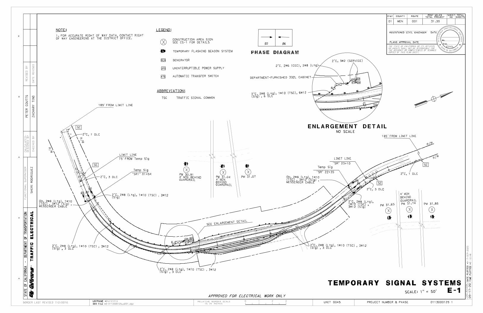
X
X
X
X
>-m 0 w VJ
> w w f-er <r
0
(/) ~ I- zI-::::, I-0 u >-
0:: 0:: <( w I I- u w <( a.. N
I >- >-Om mw f-
0<( _J w :::J
.,,, u u _J w <( I u u
ct: N 0 w:'2 ::::, > ~ ct: w 0:: (l_ 0 :::J 0VJ 0:: _J <( 0::z w:=: I f- (/) u z :::J LL
:z ..I 0 C;:: <( (.)I-0::: a:0 a.. I-V,:z (.)<( 0::: wI- ..I LL. w0 I-
(.):z w ::::::E ILI-0::: IL<(a.. Cw C, a:
I-
<( ®
z i0::: 0 LL.:::;<('--' LL. 0 w ©I- llt<(I-V,
BORDER
NOTE: 1. FOR ACCURATE RIGHT OF WAY DATA, CONTACT RIGHT OF WAY ENGINEERING AT THE DISTRICT OFFICE.
\ \
\
'C,
\~
\
185' FROM LIMIT LINE
1 DLC
LIMIT LINE 75' FROM Temp Sig
Temp Sig "SR1" 01 +54
LEGEND:
CONSTRUCTION AREA SIGN SEE CS-1 FOR DETAILS
TEMPORARY FLASHING BEACON SYSTEM
GENERATOR
UNINTERRUPTIBLE POWER SUPPLY
AUTOMATIC TRANSFER SWITCH
ABBREVIATION:
TSC TRAFFIC SIGNAL COMMON
--~ @ PM 30.91 4' MIN BEHIND GUARDRAIL
--~ @ PM 31 .04 4' MIN BEHIND GUARDRAIL
--~ @
------. -PHASE DIAGRAM
2"C, 3#2 (SERVICE) 2"C, 2#6 (CEC), 2#8 (L tg
2"C 2#8 (Ltg), 1#10 (TSC), 6#12 (Sig) , 6 DLC-
ENLARGEMENT NO SCALE
LIMIT LINE
"SR" 23+10 Temp Sig
"SR" 22+35 PM 31 .07 OH.t 2#8 (Ltg), 1#10
(T:::,C) , 3#12 1Sig) ----MESSENGER CABLE '
DETAIL
Dis-t- COUNTY ROUTE
01 MEN 001
POST MILESTOTAL PROJECT
31.35
REGISTERED CIVIL ENGINEER
PLANS APPROVAL DATE TH£ STATE OF CALIFORNIA OR ITS OFFICERS OR AGENTS SHALL NOT BE RESPONSIBLE FOR THE ACCURACY OR COMPLETENESS OF SCANNED COPIES OF THIS PLAN SHEET.
185' FROM LIMIT LINE
(Ltg), 1#10 (TSC), 3#12 / /~~ 4' MIN
BEHIND GUARDRAIL PM 31 .74
OH.t 2#8 (Ltg)( 1#10 (T:::,C) 3#12 Sig)MESSE~GER CABLE '
2("9,)2#8 (Ltg), 1#10 (TSC), 3#12 Sig , 3 DLC
LAST REVISED 7/2/2010 USERNAME => s 151 21 3 DGN FILE => 01130001 25uo001 . dgn
-~ --------- ~ -----r----::::..=:_----- -:EE ENLARGEMENT DET All
2"C 2#8 (Sig) , 3
APPROVED FOR ELECTRICAL WORK ONLY RELAT IVE BORDER SCALE
IS I N INCHES
-- 2"C, 2#8 (Ltg),1#10 (TSC) ,3#12 (Sig)
2("9,)2#8 (Ltg), 1#10 (TSC), 3#12 Sig , 3 DLC-
TEMPORARY
PM 31 .65
0 @ PM 31 .85
@ ;l- ;l- oil-
SIGNAL SYSTEMS SCALE: 1" = 50' E -1
UNIT 0045 PROJECT NUMBER & PHASE 0113000125 1
00
"" 0
A II
0 w,-,-0 ...J a. w ::>;:
0 N
I e-
l m 0

X
X
X
X
>-OJ
0 w VJ
> w w I--er <r
V) I-I-::J 0 u 0::: w I-w 0...
er 0 VJ
> er w (l_ :::i V)
_J <[ z 0 1-u z :::i LL
z: 0;:::<C I-0::: 0 a... Vl z: <C 0::: I-LL 0 I-z: 1..1.J ::::::E I-0::: <C a... 1..1.J c:,
<C z 0:::0 LL::;<C u LL 0 1..1.J I-<C I-Vl
0
C) z I-
>-0::: <( I u <( N
N w ::J C)
0::: 0 0 0:::
0::: w I V)
...J <( u-a: I-u LL.I ...J LL.I u-LL LL <(a: I-
©
i©e
BORDER
NOTES:
1. t~~tA~~ET[~~~R~~ANRf!L~~~TA1R~so~H~o~BG~og~TfONSTRAFFIC LANE.
2. WOOD POSTS MUST HAVE THE BREAKAWAY FEATURE SHOWN FORA ROADSIDE SIGN.
3. FOR DETAILS NOT SHOWN, SEE REVISED STANDARD PLAN RSPES-18B.
4. TEMPORARY TRAFFIC SIGNAL WOOD POLES MAY BE GUYED IFNEEDED
LAST REV ISED 7/2/2010
2" YELLOW REFLECTIVE
SHEETING
REFLECTIVE MARKING FOR WOOD POLE
USERNAME => s 151 21 3 DGN FILE => 01130001 25ub001 . dgn
ETW
2' Min
□□ □ □□ □□dotJ□□ □□ □ □□ □□ □ □□ □□q□p□□ □□ □ □□
0 12" SOLAR POWERED --- FLASHING BEACON UNIT
WOOD POST OR POLE
TEMPORARY FLASHING BEACON
RELATIVE BORDER SCALE IS I N INCHES
3 SECTIONSIGNAL HEAD----_
MESSENGER WIRES AND OVERHEAD CONDUCTORS
Dis-t- COUNTY ROUTE POST MILESTOTAL PROJECT
01 MEN 001 31.35
REGISTERED CIVIL ENGINEER
PLANS APPROVAL DATE TH£ STA TE OF CALIFORNIA OR ITS OFFICERS OR AC£NTS SHALL NOT 8£ RESPONSIBLE FOR THE ACCURACY OR COMPLETENESS OF SCANNED COPIES OF THIS PLAN SHEET.
Temp WOOD POLE
LUMINAIRE \ ENTRANCE FITTING
3 SECTION ---- SIGNAL HEAD
FG~
3 SECTION ---- SIGNAL HEAD
TEMPORARY TRAFFIC SIGNAL
ELECTRICAL SYSTEMS
NO SCALE
UNIT 0045 PROJECT NUMBER & PHASE
DETAILS ED-1
0113000125 1
A II
0
"'I-I-0 _J Q.
"' "';: 0 N
I e-
l m 0

0 >- w OJ :I; 0 > w w VJ [t:
;: w w I-[t: <[
0
X V) C)I- z I-::J I-0 u >-
0::: 0::: <( w I I- u w <( 0... N
I >- >-Om OJw1-o 0<rw w_jz "':::Jc, uu-_J VJ w <CW I uo u
X
ct: 0 NVJ- w > ::J ct: C)w -(l_ 0::::::) 0V) 0 _J 0::: <[ -z 0 0:::- w I- Iu V)z :::) LL
z: 0
X ;:::<C ...JI- <(0::: 0 u CL -Vl a:z: I-<C 0::: uI- LL.I LL. ...J 0 LL.I I- uz: 1..1.J -::::::E LLI-0::: LL <C <(CL a:1..1.J c:, I-
I
<C ©
z i0:::0 LL.
X ::;<C u LL. 0 1..1.J ©I- e<C I-Vl
BORDER
LEGEND: (THIS SHEET ONLY)
W CONT ACTOR (LIGHTING)
'\l AUTO-TEST SWITCH
0 TYPE V PEU
LAST REVISED 7/2/2010 I
USERNAME => s 151 21 3 DGN FILE > 01130001 25ub002 . dgn
0 0 0 ~ TYPE ~ TYPE '----LIMIT LINE
LIMIT LINE DETECTOR TYPICAL DETAIL
LOOPS
I RELATIVE BORDER SCALE
IS IN INCHES 0 I
1 I
2 I
3-POLE ATS RATED @ 100 A 120/240 V, 1(JJ, 3-WIRE
3 I
I
)- .2\ 2P-100 A J MAIN
30 A
20 A
Dis-t- COUNTY I
01 MEN I 001 1 31.35 1 1 -~•a: ;s
REGISTERED CIVIL ENGINEER DATE ~t;_
1~~0-1~1)PLANS APPROVAL DATE t------------------.1{1. Exp. __ >} -
TH£ STAT£ OF CALIFORNIA OR ITS OFFICERS CIVIL OR AC£NTS SHALL NOT 8£ RESPONSIBLE FOR ~,,_,~_ THE ACCURACY OR COMPLETENESS OF SCANNED or CAL rfO~ COPIES OF THIS PLAN SHEET. --
15 A
C LIGHTING
~--=2~0_A~-------30 A
SPARE SPARE
TEMPORARY SIGNAL
SERVICE WIRING DIAGRAM TYPE III-AF SERVICE ENCLOSURE
ELECTRICAL SYSTEMS
NO SCALE
UNIT 0045 I
PROJECT NUMBER & PHASE
DETAILS ED-2
0113000125 1
0 N 0 N
' a. w m V1 ~' ,.c- 0
A,-. II 11
C>c::,w"'I- I-I- 1-0 o _J _J a. a. Ww ~~ c::, l-
o N
I e-
l m 0
Copyright © 2022 FDOKUMEN