Cumberland-Horizon-EA-HEROS-Packet-w-Supporting-Docs ...
314
-
Upload
khangminh22 -
Category
Documents
-
view
1 -
download
0
Transcript of Cumberland-Horizon-EA-HEROS-Packet-w-Supporting-Docs ...


U.S. Department of Housing and Urban Development
451 Seventh Street, SW Washington, DC 20410 www.hud.gov espanol.hud.gov
Environmental Assessment
Determinations and Compliance Findings for HUD-assisted Projects
24 CFR Part 58
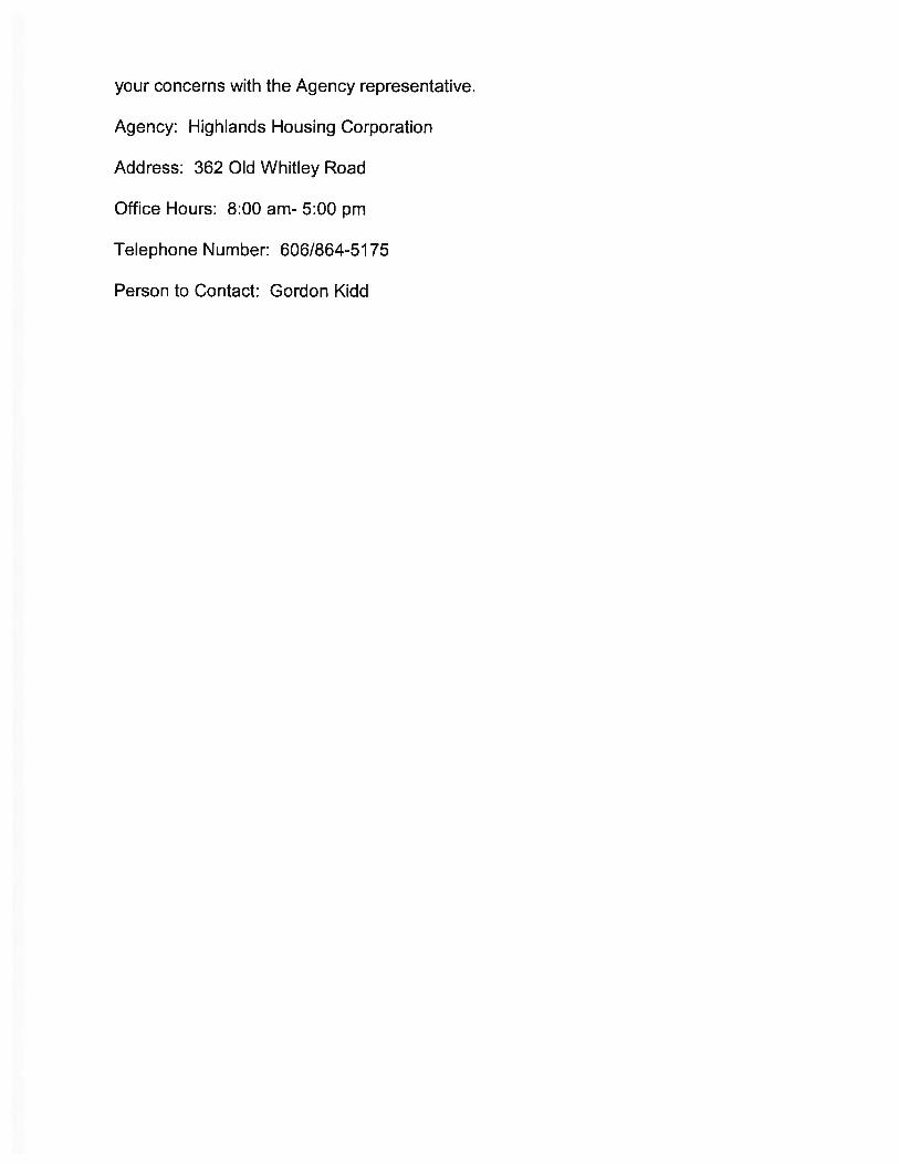
Project Information Project Name: Cumberland-Horizon-Village
HEROS Number:
900000010155132
Responsible Entity (RE): KENTUCKY HOUSING CORPORATION, 1231 Louisville Rd
Frankfort KY, 40601 RE Preparer: Suzie Loveday
State / Local Identifier:
Certifying Officer: Jeremy Ratliff
Grant Recipient (if different than Responsible Entity):
FAHE/KHIC/Highlands Housing Corp
Consultant (if applicable):
Loveday Consulting LLC
Project Location: 70 Worsham Ln, Monticello, KY 42633
Additional Location Information: 70 Worsham Lane, Monticello, Wayne County, KY 42633 (36.838179, -84.862553)
Point of Contact: Gordon Kidd
Point of Contact: Suzie Loveday

Cumberland-Horizon-Village
Monticello, KY 900000010155132
10/13/2020 13:02 Page 2 of 50
Direct Comments to: Kentucky Housing Corporation 1231 Louisville Road Frankfort, Kentucky 40601
Statement of Purpose and Need for the Proposal [40 CFR 1508.9(b)]: Highlands Housing Corporation was approached to be the sponsor for this project by the President of Horizon Adult Healthcare who stated that he had observed that his elderly customers were lacking quality housing with supportive services where they could age in place. He said he had seen many people from the rural communities his company serves wind up in nursing homes when they could live independently with some supportive services. Few rental housing options exist in Monticello, which is centrally located within Wayne County as well as outside the city of Monticello. Monticello serves as the county seat and commercial, financial and employment center within Wayne County. According to the market study completed by Valbridge Property Advisors on August 5, 2019, elderly households lack sufficient quality rental housing in Wayne County. Highlands Housing Corporation is developing this project in response to the need for affordable, quality rental housing for seniors that can also be combined with supportive services as Horizon Adult Healthcare has a facility located immediately adjacent to the project site and could be easily accessed by residents of the Cumberland Horizon Village project.
Existing Conditions and Trends [24 CFR 58.40(a)]: Wayne County, Kentucky is located in the south-central section of Kentucky along the state border with Tennessee. Created in 1800 from parts of Pulaski and Cumberland Counties, it was named in honor of General Anthony Wayne, Revolutionary War hero. Wayne County is located on beautiful Lake Cumberland. Lake Cumberland is a part of the chain of lakes in Kentucky and Tennessee constructed by the Tennessee Valley Authority and the Army Corps of Engineers. It is one of the most beautiful lakes in the country and is home to a high number of houseboats. Its 1,255 miles of shoreline make Lake Cumberland the largest manmade lake in the world in terms of miles of
Description of the Proposed Project [24 CFR 50.12 & 58.32; 40 CFR 1508.25]: FAHE receives HOME Program Income on a rolling basis and is loaning $334,224 to Kentucky Highlands Investment Corporation who is then loaning the funding to the Cumberland Horizon Village Project. The Cumberland Horizon Village Project will be managed by Southern Tier Housing Corporation dba Highlands Housing Corporation, a non-profit located in London, KY who is acting as the project sponsor. The project sponsor is proposing to acquire four properties with a total acreage of 3.83: 70 Worsham, 42 Worsham, 150 Worsham, and a small parcel adjacent to 70 Worsham known as 939 W. Columbia Avenue, for the purpose of constructing 36 senior housing units comprised of 19 one-bedrooms and 17 two-bedrooms. The subject property was in agricultural use until land development in the area started around 1951 with Residential development to the north, east and west of the Property, the area to the south of the Property has remained undeveloped.
Cumberland-Horizon-Village
Monticello, KY 900000010155132
10/13/2020 13:02 Page 3 of 50
shoreline. It is surrounded by scenic rugged mountains. With an average water depth of 90 feet, it is one of the deepest of the lakes in the Tennessee and Cumberland River valleys. Wayne County is considered distressed by the Appalachian Regional Commission which means it ranks the worst 10% in the nation's counties with a low per capita, high poverty rate and high unemployment. According to the American Community Survey 2018 5-year estimate, Wayne County has a significantly lower median household income, $34,039, and a higher poverty rate, 24.6% than the State ($48,392) and (17.9%). According to the U.S. Bureau of Labor Statistics, approximately 6.4% of the county's population is unemployed contrasted with the state average of 4.5% (July 2020). The lack of employment opportunities is problematic for LMI residents of the county. Many are challenged by the increased demand for high-skilled, high-knowledge laborers. For the population 25 and over, only 37.4% are high school graduates and 7.4% have bachelor's degrees or higher (2018 ACS). Training efforts and improved educational opportunities are needed. The subject site is located in the city limits of Wayne, Kentucky and is situated at 70 Worsham Lane, Monticello, Wayne County, KY 42633 (36.838179, -84.862553). Immediately surrounding the subject are vacant land and single-family residential to the west, vacant land and multi-family residential to the north, medical office to the east, and single-family to the south. Ownership of the subject property has changed within the past three years. The property identified by parcel number M1-06-010.00 was purchased by Kentucky Highlands Community on September 20, 2018 for a recorded consideration of $50,000. The remaining three parcels have not transferred in the last three years and are not currently owned by the developer. The subject property is located in the small city of Monticello within the central portion of Wayne County, Kentucky. Wayne County is located in the south-central part of Kentucky. Monticello is located along the Kentucky/Tennessee border approximately 90 miles east of Bowling Green, KY, 80 miles southeast of Elizabethtown, KY and 85 miles southwest of Lexington, KY.
Maps, photographs, and other documentation of project location and description: 01 TOPO Map.pdf 01 Aerial Map.pdf 01 Photos.pdf Determination: Finding of No Significant Impact [24 CFR 58.40(g)(1); 40 CFR 1508.13] The
project will not result in a significant impact on the quality of human environment
Finding of Significant Impact Approval Documents: ERR signature page.pdf

AERIAL LOCATION MAP
Cumberland Horizon Village Project 70 Worsham Lane, Monticello, Wayne County, KY 42633 (36.838179, -84.862553)
Aerial Map

TOPO MAP Cumberland Horizon Village Project
70 Worsham Lane, Monticello, Wayne County, KY 42633 (36.838179, -84.862553)
Project Site

Looking along NW property line from N property corner
looking NE on NE pl at adjacent property looking SE along NE pl at back of adjacent property
March 30, 2020
Cumberland Horizon Village Site
Monticello, KY
FIELD INSPECTOR PHONE: (859)559-0516Dustin Roe / Vision Engineering
REMARKS site pictures 1 of 2
looking along NE pl from E property corner
PROJECT LOCATION: Monticello
REPORT DATE:
looking W at center of property from E property corner
Looking along NE property line from N property corner
PROJECT NAME:

REMARKS site pictures 2 of 2
FIELD INSPECTOR Dustin Roe / Vision Engineering PHONE: (859)559-0516
looking along NW pl from W property corner looking E across property from center of property
looking along SW pl from S property corner looking along SW pl from W property corner
Monticello, KY
looking along SE pl from E property corner looking along SE property line from S property corner
REPORT DATE: March 30, 2020 PROJECT NAME:
PROJECT LOCATION: Cumberland Horizon Village Site Monticello

Cumberland-Horizon-Village
Monticello, KY 900000010155132
10/13/2020 13:02 Page 4 of 50
7015.15 certified by Certifying Officer on:
7015.16 certified by Authorizing Officer on:
Funding Information
Estimated Total HUD Funded, Assisted or Insured Amount:
$334,224.00
Estimated Total Project Cost [24 CFR 58.2 (a) (5)]:
$6,467,864.00
Compliance with 24 CFR §50.4, §58.5 and §58.6 Laws and Authorities
Compliance Factors: Statutes, Executive Orders, and Regulations listed at 24 CFR §50.4, §58.5, and §58.6
Are formal compliance steps
or mitigation required?
Compliance determination (See Appendix A for source
determinations)
STATUTES, EXECUTIVE ORDERS, AND REGULATIONS LISTED AT 24 CFR §50.4 & § 58.6 Airport Hazards Clear Zones and Accident Potential Zones; 24 CFR Part 51 Subpart D
Yes No The project site is not within 15,000 feet of a military airport or 2,500 feet of a civilian airport. The project is in compliance with Airport Hazards requirements. The closest airport is the Wayne County airport which is located 4,638.48 feet north of the project site. This airport is located outside of the 2,500-foot threshold. The project is in compliance with Airport Hazards requirements.
Grant / Project Identification Number
HUD Program Program Name
Program Income Community Planning and Development (CPD) HOME Program

Cumberland-Horizon-Village
Monticello, KY 900000010155132
10/13/2020 13:02 Page 5 of 50
Coastal Barrier Resources Act Coastal Barrier Resources Act, as amended by the Coastal Barrier Improvement Act of 1990 [16 USC 3501]
Yes No This project is located in a state that does not contain CBRS units. Therefore, this project is in compliance with the Coastal Barrier Resources Act.
Flood Insurance Flood Disaster Protection Act of 1973 and National Flood Insurance Reform Act of 1994 [42 USC 4001-4128 and 42 USC 5154a]
Yes No The structure or insurable property is not located in a FEMA-designated Special Flood Hazard Area. While flood insurance may not be mandatory in this instance, HUD recommends that all insurable structures maintain flood insurance under the National Flood Insurance Program (NFIP). The project is in compliance with flood insurance requirements. The attached FIRMette map for the project site demonstrates that it is in an area of minimal flood hazard (Panel #21231C01810C, eff. 9/2/2009).
STATUTES, EXECUTIVE ORDERS, AND REGULATIONS LISTED AT 24 CFR §50.4 & § 58.5 Air Quality Clean Air Act, as amended, particularly section 176(c) & (d); 40 CFR Parts 6, 51, 93
Yes No The project's county or air quality management district is in attainment status for all criteria pollutants. The project is in compliance with the Clean Air Act. The project's county or air quality management district is in attainment status for all criteria pollutants. Wayne county is not in non-attainment or maintenance status for any criteria pollutants. See EPA's greenbook county list, found at: https://www3.epa.gov/airquality/greenbook/ancl.html#KY.
Coastal Zone Management Act Coastal Zone Management Act, sections 307(c) & (d)
Yes No This project is located in a state that does not participate in the Coastal Zone Management Program. Therefore, this project is in compliance with the Coastal Zone Management Act.
Contamination and Toxic Substances 24 CFR 50.3(i) & 58.5(i)(2)]
Yes No Site contamination was evaluated as follows: ASTM Phase I ESA. On-site or nearby toxic, hazardous, or radioactive substances that could affect the health and safety of project occupants or conflict with the intended use of the property were not found. The project is

Cumberland-Horizon-Village
Monticello, KY 900000010155132
10/13/2020 13:02 Page 6 of 50
in compliance with contamination and toxic substances requirements.
Endangered Species Act Endangered Species Act of 1973, particularly section 7; 50 CFR Part 402
Yes No This project will have No Effect on listed species because there are no listed species or designated critical habitats in the action area. This project is in compliance with the Endangered Species Act. See attached letter dated August 31, 2020 and stamped October 2, 2020 by the Kentucky Field Office for the US Fish and Wildlife Service stating that ''significant impacts to federally-listed species are not likely to result from this project as currently proposed.''
Explosive and Flammable Hazards Above-Ground Tanks)[24 CFR Part 51 Subpart C
Yes No There is a current or planned stationary aboveground storage container of concern within 1 mile of the project site. The Separation Distance from the project is acceptable. The project is in compliance with explosive and flammable hazard requirements. A survey of Google Earth Pro aerial photo maps found that there are multiple propane tanks within a 1-mile radius of the project site with capacities that range from 1,000 to 18,000 gallons. Per the completed HUD Acceptable Separation Distance Calculator, all are outside of the acceptable separation distance thresholds. See attached maps and calculations.
Farmlands Protection Farmland Protection Policy Act of 1981, particularly sections 1504(b) and 1541; 7 CFR Part 658
Yes No This project does not include any activities that could potentially convert agricultural land to a non-agricultural use. The project is in compliance with the Farmland Protection Policy Act. This project does not include any activities that could potentially convert agricultural land to a non-agricultural use as the site is in a previously developed urban letter. See letter from USDA Soil Scientist confirming that although the site is comprised of prime farmland, the property has already been

Cumberland-Horizon-Village
Monticello, KY 900000010155132
10/13/2020 13:02 Page 7 of 50
converted and removed from agriculture production.
Floodplain Management Executive Order 11988, particularly section 2(a); 24 CFR Part 55
Yes No This project does not occur in a floodplain. The project is in compliance with Executive Order 11988. The attached FIRMette map for the project site demonstrates that it is in an area of minimal flood hazard (Panel #21231C01810C, eff. 9/2/2009). The project is in compliance with floodplain management requirements.
Historic Preservation National Historic Preservation Act of 1966, particularly sections 106 and 110; 36 CFR Part 800
Yes No Based on Section 106 consultation there are No Historic Properties Affected because there are no historic properties present. The project is in compliance with Section 106. Tribal consultation was initiated with the Cherokee Indians on September 9, 2020 using a letter sent via email inviting the Eastern Band of Cherokee Indians to be a consulting party on the Section 106 review for the project. The tribe did not respond within the 30-day threshold specified by HUD CPD Notice 12-006. A September 10, 2020 letter from the Kentucky Heritage Council (SHPO) finds " Our review indicates that the proposed project will not impact any properties or sites that are listed in or eligible for the National Register of Historic Places. The proposed project should not require an archaeological survey or cultural historic survey." Therefore, Section 106 requirements have been fulfilled.
Noise Abatement and Control Noise Control Act of 1972, as amended by the Quiet Communities Act of 1978; 24 CFR Part 51 Subpart B
Yes No A Noise Assessment was conducted. The noise level was acceptable: 61.0 db. See noise analysis. The project is in compliance with HUD's Noise regulation. Major Noise Source, Road or Highway: The project site is located 148 feet from Highway 92 which has a total AADT of 5,970 for 2011 (highest level over 10-year period). The % for Single Truck volume as a percentage of AADT is 6.12%. 5,970 x 6.12% = 365

Cumberland-Horizon-Village
Monticello, KY 900000010155132
10/13/2020 13:02 Page 8 of 50
(medium trucks). The % of Combo truck volume is 1.478%. 5,970 x 1.478% = 88 (heavy trucks). 5,970 -365 - 88 = 5,517 (cars). See attached report from KYTC. Standard assumption of night volume of 15% was used. The average speed is 35 MPH. The average road grade of the segment of Highway 92, approximately 1,000 feet either side of a perpendicular line between the project site and the highway, must also be determined and entered in the appropriate field for Heavy Trucks. 1,000 feet west elevation is 949. 1,000 feet east elevation is 931. The difference is 18. 18/2000 feet = .9%. The project site is also located 25 feet from Worsham Lane which has a total AADT of 1,200 for 2011 (highest volume over 10-year period with no truck volume). Standard assumption of night volume of 15% was used. The average speed is 35 MPH. The stop sign is 136 feet from the site. The HUD DNL Calculator was used which included the railroad noise information. A total of 61 decibels was calculated. Refer to the attached National Transportation Noise Map and Kentucky Department of Transportation Maps. Railroad: The project site is located 22.68 miles from an active railroad. Because the distance is greater than 3,000 feet, no further action is required. See map from the Federal Rail Administration showing the location of the active railroad and the distance from the site to the railroad. Airport: Per the attached map, there is 1 FAA regulated civil airport located within 15 miles of the project site. However, according to the attached report and small airport worksheet, the project site will not be noise impacted by an airport. The project site is not located within 2,500 feet of a civilian airport. See attached map. The closest airport is the Wayne County Airport,
Cumberland-Horizon-Village
Monticello, KY 900000010155132
10/13/2020 13:02 Page 9 of 50
located 4,638 feet from the project site. The project is in compliance with HUD's Noise regulation.
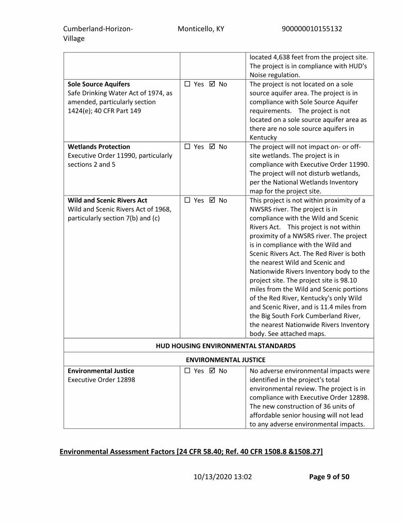
Sole Source Aquifers Safe Drinking Water Act of 1974, as amended, particularly section 1424(e); 40 CFR Part 149
Yes No The project is not located on a sole source aquifer area. The project is in compliance with Sole Source Aquifer requirements. The project is not located on a sole source aquifer area as there are no sole source aquifers in Kentucky
Wetlands Protection Executive Order 11990, particularly sections 2 and 5
Yes No The project will not impact on- or off-site wetlands. The project is in compliance with Executive Order 11990. The project will not disturb wetlands, per the National Wetlands Inventory map for the project site.
Wild and Scenic Rivers Act Wild and Scenic Rivers Act of 1968, particularly section 7(b) and (c)
Yes No This project is not within proximity of a NWSRS river. The project is in compliance with the Wild and Scenic Rivers Act. This project is not within proximity of a NWSRS river. The project is in compliance with the Wild and Scenic Rivers Act. The Red River is both the nearest Wild and Scenic and Nationwide Rivers Inventory body to the project site. The project site is 98.10 miles from the Wild and Scenic portions of the Red River, Kentucky's only Wild and Scenic River, and is 11.4 miles from the Big South Fork Cumberland River, the nearest Nationwide Rivers Inventory body. See attached maps.
HUD HOUSING ENVIRONMENTAL STANDARDS
ENVIRONMENTAL JUSTICE Environmental Justice Executive Order 12898
Yes No No adverse environmental impacts were identified in the project's total environmental review. The project is in compliance with Executive Order 12898. The new construction of 36 units of affordable senior housing will not lead to any adverse environmental impacts.
Environmental Assessment Factors [24 CFR 58.40; Ref. 40 CFR 1508.8 &1508.27]

Cumberland-Horizon-Village
Monticello, KY 900000010155132
10/13/2020 13:02 Page 10 of 50
Impact Codes: An impact code from the following list has been used to make the determination of impact for each factor. (1) Minor beneficial impact (2) No impact anticipated (3) Minor Adverse Impact – May require mitigation (4) Significant or potentially significant impact requiring avoidance or modification which may require an Environmental Impact Statement.
Environmental Assessment Factor
Impact Code
Impact Evaluation Mitigation
LAND DEVELOPMENT Conformance with Plans / Compatible Land Use and Zoning / Scale and Urban Design
1 The City of Monticello does not have a comprehensive plan or zoning. Loveday Consulting, LLC consulted with Gordon Kidd, President of Highlands Housing Corporation on September 23, 2020 regarding the proposed project and the existence of comprehensive plans and zoning regulations in the city. The project will be beneficial in that it is improving the urban design of Monticello through the redevelopment of a mostly empty lot for new construction of affordable senior housing. Monticello is a rural area in the Appalachian Mountains. A project of this size and this nature will not have a large urban impact on this site. Level land of this size is difficult to find in Monticello.
Soil Suitability / Slope/ Erosion / Drainage and Storm Water Runoff
2 Design of the project and construction methods employed will work to ensure that the project does not negatively affect slope or erosion of the surrounding neighborhood. The proposed

Cumberland-Horizon-Village
Monticello, KY 900000010155132
10/13/2020 13:02 Page 11 of 50
Environmental Assessment Factor
Impact Code
Impact Evaluation Mitigation
LAND DEVELOPMENT project will not create or contribute runoff water that would exceed the capacity of existing or planned storm water drainage systems or provide substantial additional sources of polluted runoff.
Hazards and Nuisances including Site Safety and Site-Generated Noise
2 This project involves new construction, therefore, there is no opportunity for lead-based paint or asbestos to be encountered. However, there is one trailer that appears to be constructed in the 1970's. Gordon Kidd, President of Highlands Housing Corporation, spoke with the owner of the trailer on September 28, 2020 and confirmed that no asbestos was present as the trailer had been remodeled. There are no above ground storage tanks within the vicinity of the project that are within the Acceptable Separation Distance threshold requirement, and there are no EPA-monitored facilities within a 3,000-foot radius of the project site that could be sources of pollution. Furthermore, noise impact from the proposed use will be limited to construction activity to complete the proposed project.
Energy Consumption/Energy Efficiency
2 The state of Kentucky requires developments to meet the KY Residential Building Code and encourages the use of Green
Cumberland-Horizon-Village
Monticello, KY 900000010155132
10/13/2020 13:02 Page 12 of 50
Environmental Assessment Factor
Impact Code
Impact Evaluation Mitigation
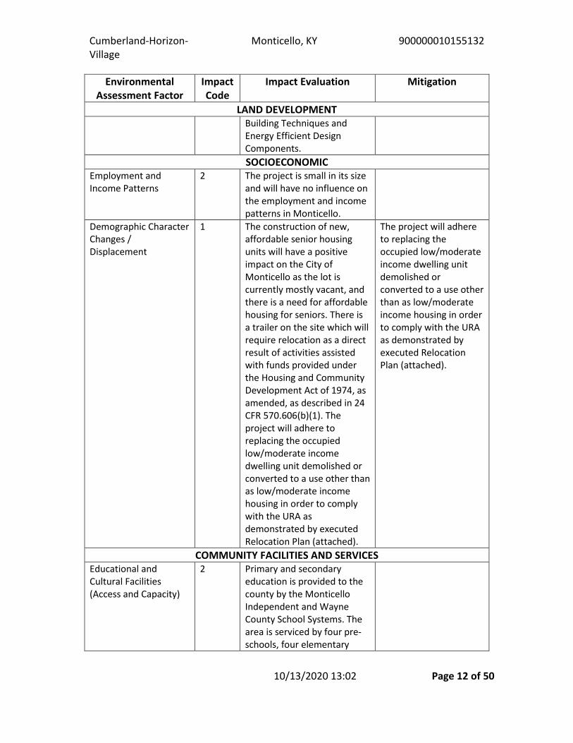
LAND DEVELOPMENT Building Techniques and Energy Efficient Design Components. SOCIOECONOMIC
Employment and Income Patterns
2 The project is small in its size and will have no influence on the employment and income patterns in Monticello.
Demographic Character Changes / Displacement
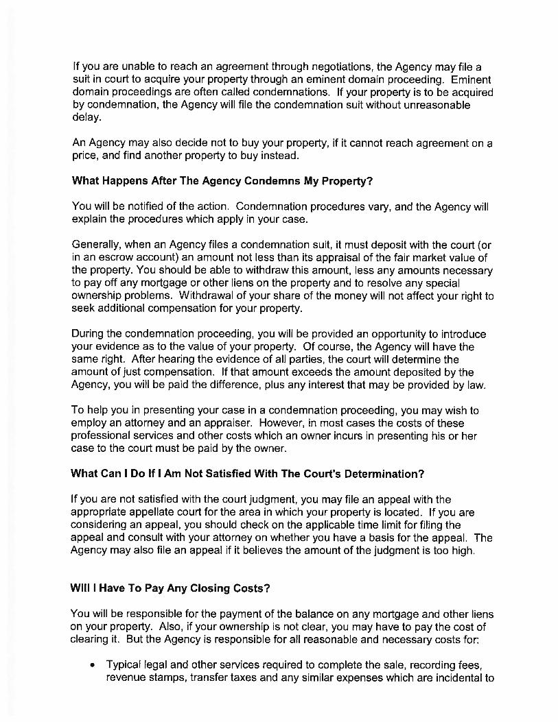
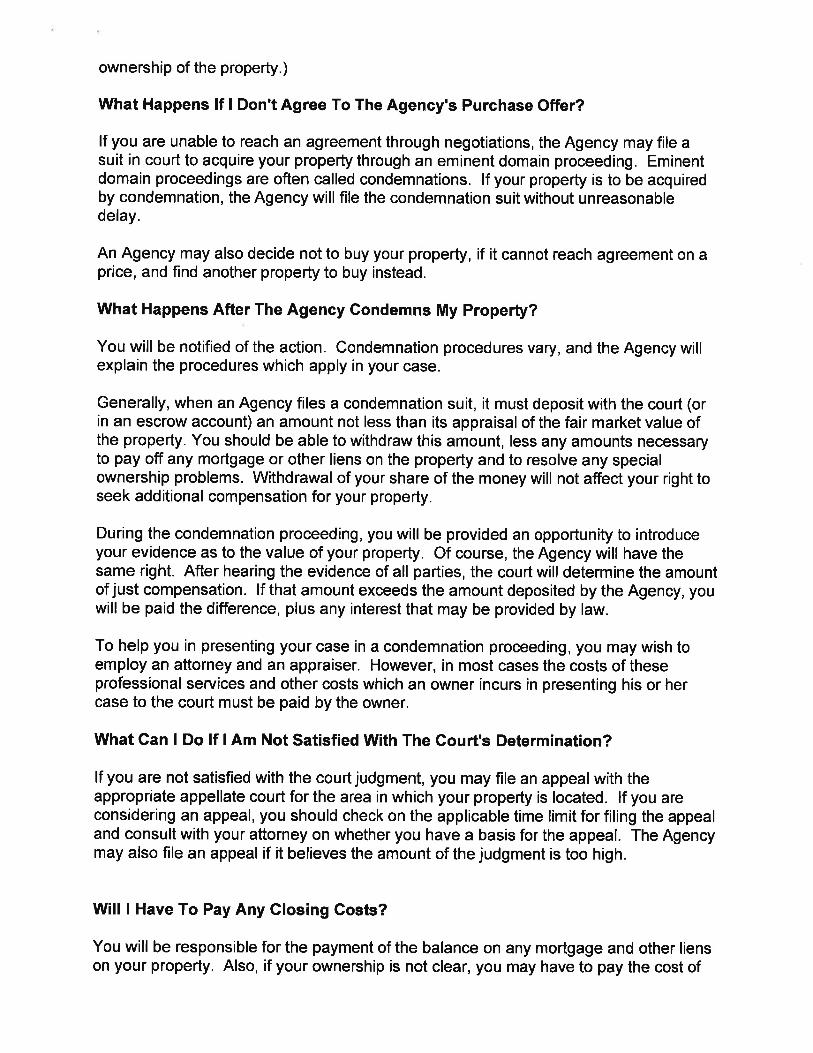
1 The construction of new, affordable senior housing units will have a positive impact on the City of Monticello as the lot is currently mostly vacant, and there is a need for affordable housing for seniors. There is a trailer on the site which will require relocation as a direct result of activities assisted with funds provided under the Housing and Community Development Act of 1974, as amended, as described in 24 CFR 570.606(b)(1). The project will adhere to replacing the occupied low/moderate income dwelling unit demolished or converted to a use other than as low/moderate income housing in order to comply with the URA as demonstrated by executed Relocation Plan (attached).
The project will adhere to replacing the occupied low/moderate income dwelling unit demolished or converted to a use other than as low/moderate income housing in order to comply with the URA as demonstrated by executed Relocation Plan (attached).
COMMUNITY FACILITIES AND SERVICES Educational and Cultural Facilities (Access and Capacity)
2 Primary and secondary education is provided to the county by the Monticello Independent and Wayne County School Systems. The area is serviced by four pre-schools, four elementary
Cumberland-Horizon-Village
Monticello, KY 900000010155132
10/13/2020 13:02 Page 13 of 50
Environmental Assessment Factor
Impact Code
Impact Evaluation Mitigation
LAND DEVELOPMENT schools (grades K-6th), two junior high schools (grades 7th-8th), and two high schools. The project scope is contained and small in nature and will not negatively impact educational facilities. Cultural facilities that Wayne County has to offer include the Civil War sites, historic downtown, historic homes and a museum.
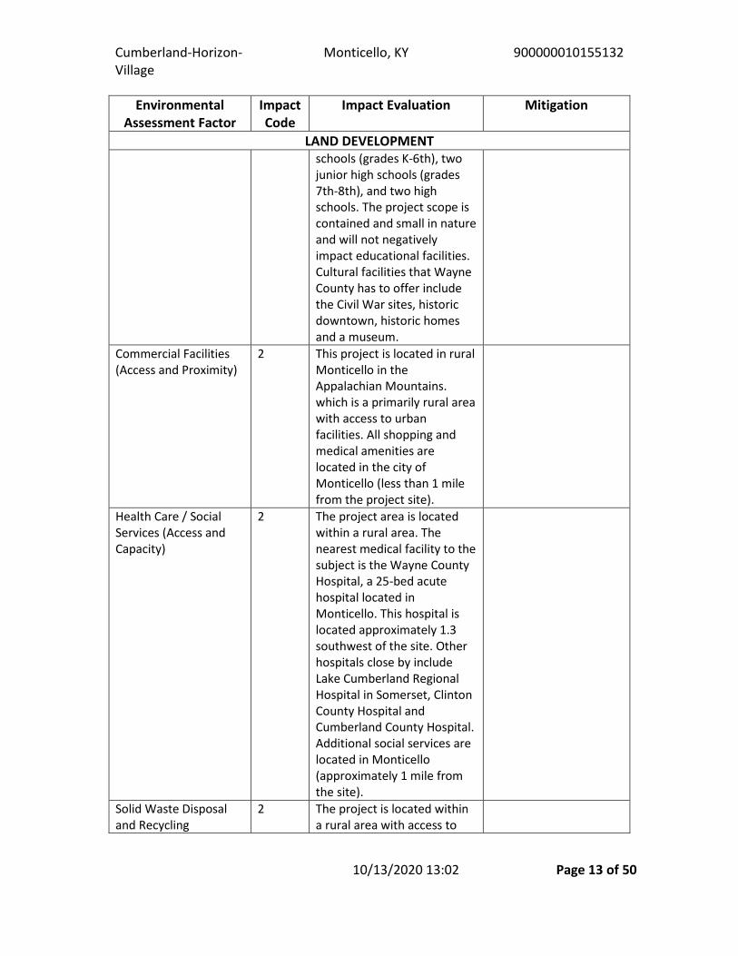
Commercial Facilities (Access and Proximity)
2 This project is located in rural Monticello in the Appalachian Mountains. which is a primarily rural area with access to urban facilities. All shopping and medical amenities are located in the city of Monticello (less than 1 mile from the project site).
Health Care / Social Services (Access and Capacity)
2 The project area is located within a rural area. The nearest medical facility to the subject is the Wayne County Hospital, a 25-bed acute hospital located in Monticello. This hospital is located approximately 1.3 southwest of the site. Other hospitals close by include Lake Cumberland Regional Hospital in Somerset, Clinton County Hospital and Cumberland County Hospital. Additional social services are located in Monticello (approximately 1 mile from the site).
Solid Waste Disposal and Recycling
2 The project is located within a rural area with access to

Cumberland-Horizon-Village
Monticello, KY 900000010155132
10/13/2020 13:02 Page 14 of 50
Environmental Assessment Factor
Impact Code
Impact Evaluation Mitigation
LAND DEVELOPMENT (Feasibility and Capacity)
adequate solid waste services provided by the Monticello Utility Commission.
Waste Water and Sanitary Sewers (Feasibility and Capacity)
2 The proposed project will not create or contribute runoff water that would exceed the capacity of existing or planned storm water drainage systems or provide substantial sources of polluted runoff. Sewer system is provided by the Monticello Utility Commission.
Water Supply (Feasibility and Capacity)
2 The project is located within a rural area with access to adequate municipal water supply supplied by Monticello Utility Commission.
Public Safety - Police, Fire and Emergency Medical
2 The project is located within a rural area with access to adequate municipal policing services, fire services, and emergency services located in the city limits of Monticello (less than 1 mile from the project site).
Parks, Open Space and Recreation (Access and Capacity)
2 Because Wayne County is rural, there are many open space opportunities such as Lake Cumberland, Mill Springs Park, Monticello Country Club, and the 86-acre Monticello-Wayne County Memorial Park. Wayne County offers its residents lots of outdoor recreational activities such as well-maintained historical sites, trails, hunting, hiking, canoeing, kayaking, camping,

Cumberland-Horizon-Village
Monticello, KY 900000010155132
10/13/2020 13:02 Page 15 of 50
Environmental Assessment Factor
Impact Code
Impact Evaluation Mitigation
LAND DEVELOPMENT golf, and state parks. The Wayne County Senior Citizens Center offers special programming such as transportation, telephone reassurance, friendly visiting, counseling, adult education, escort, health screening, benefits counseling, and, long-term care ombudsman, as well as regularly scheduled recreational activities including arts and craft classes, exercise, cards, bingo, bus trips, movies, and billiards, at no cost to the participants. This project will have no effect on access and capacity for Parks, Open Space and Recreation.
Transportation and Accessibility (Access and Capacity)
2 Monticello is served by SR 90, which connects to US 27 approximately 15 miles to the northeast in Burnside, and SR 92, which travels southeast through Monticello. The Cumberland Parkway is the closest east / west multi-lane highway and is located approximately 20 miles north of Monticello. The Monticello-Wayne County Airport is located off Highway 1275 and maintains 4,000 feet of paved runway. The nearest international airport is the Blue Grass Airport located in Lexington, KY. The Wayne County Senior Citizens Center offers special programming such as transportation at no cost to

Cumberland-Horizon-Village
Monticello, KY 900000010155132
10/13/2020 13:02 Page 16 of 50
Environmental Assessment Factor
Impact Code
Impact Evaluation Mitigation
LAND DEVELOPMENT the participants. This project will have no effect on transportation and accessibility.
NATURAL FEATURES Unique Natural Features /Water Resources
2 There are no unique agricultural lands present on the project site, but Wayne County is bordered by Tennessee and Lake Cumberland. Part of the chain of lakes in Kentucky and Tennessee created by the Tennessee Valley Authority and the Army Corps of Engineers, Lake Cumberland makes the county a destination for recreation and tourism. The project will have no impact on water resources or unique natural features.
Vegetation / Wildlife (Introduction, Modification, Removal, Disruption, etc.)
2 There is no unique vegetation or wildlife on the site, and there were no obvious areas of stressed vegetation or wildlife observed on-site.
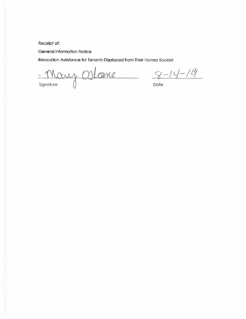
Other Factors None Supporting documentation Relocation Plan with exhibits.pdf 12 Clearinghouse KY202008121017.pdf 12 Consultation with KHIC - Cumberland Horizon Village Project.pdf Additional Studies Performed: None
Field Inspection [Optional]: Date and completed by:
Gordon Kidd 9/25/2020 12:00:00 AM


Exhibit
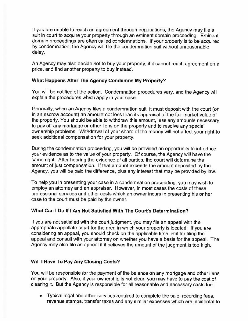
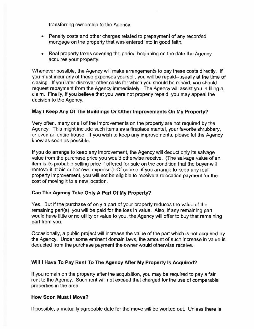
Guide Form Notice to Settlers
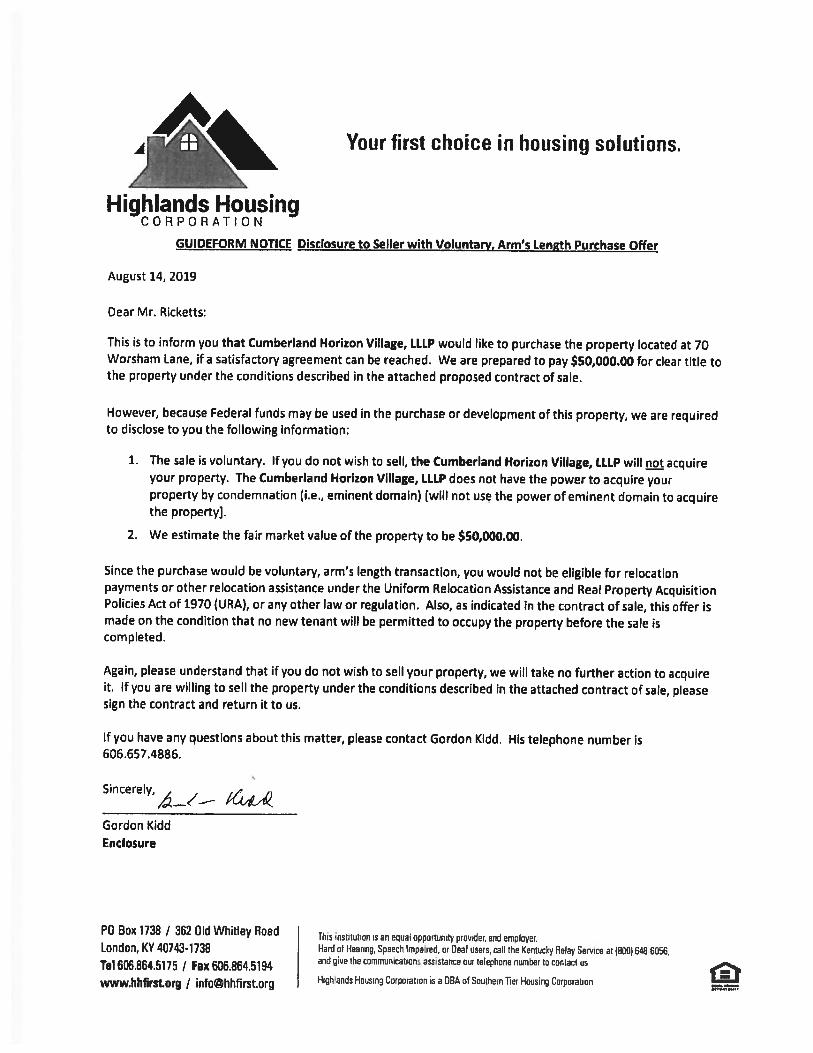


Exhibit
General Information Notice


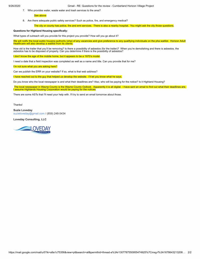
9/26/2020 Gmail - RE: Questions for the review - Cumberland Horizon Village Project
https://mail.google.com/mail/u/0?ik=a9a1c75356&view=pt&search=all&permthid=thread-a%3Ar1307787550955474925%7Cmsg-f%3A1678643213208… 1/2
Suzie Loveday <[email protected]>
RE: Questions for the review - Cumberland Horizon Village Project1 message
Gordon Kidd <[email protected]> Wed, Sep 23, 2020 at 12:35 PMTo: Suzie Loveday <[email protected]>
Suzie:
The office staff of City of Monticello is pretty small. The mayor is Tracie Sexton. I have called the office before and there is a man that I have talked tothat is very knowledgeable. I’m not sure what his position is, but he usually answers the phone. The office number is: 606.348.5719. I will try to answeryour questions below.
Gordon Kidd
President and CEO
Highlands Housing Corporation
Direct Dial: 606.657.4886
Email: [email protected]
From: Suzie Loveday <[email protected]> Sent: Tuesday, September 22, 2020 5:05 PMTo: Gordon Kidd <[email protected]>Cc: Tina Cain <[email protected]>Subject: Questions for the review - Cumberland Horizon Village Project
Hi Gordon,
I need to ask someone with the City of Monticello about the following items. Do you know who would be good to reach out to?
Also, if you know the answers to these, please feel free to respond as well!
Thanks!
Questions for KHIC/City of Monticello regarding the Cumberland Horizon Village Project:
1. Does the city of Monticello and/or Wayne County have any comprehensive or neighborhood plans? If so, is this project in conformance withthe plan(s)?
No planning and zoning
2. Does the city of Monticello and/or Wayne County have zoning? If so, is this project in compliance with the local zoning?
No planning and zoning
3. How does this project impact the urban design of the City?
I would think this project would enhance the neighborhood. It will be replacing an older, run down mobile home and should have anattractive design and physical layout.
4. Are there any local regulations requiring energy conservation when a project involves new construction?
None known.
5. Does the city of Monticello and/or Wayne County require new developments to meet the KY Residential Building Code?
None known.
6. Are the Water, Sewer and Trash services capable of servicing this project?
The Monticello Utility Commission handles water, sewer and trash in the area. Their number is 348.8473.
9/26/2020 Gmail - RE: Questions for the review - Cumberland Horizon Village Project
https://mail.google.com/mail/u/0?ik=a9a1c75356&view=pt&search=all&permthid=thread-a%3Ar1307787550955474925%7Cmsg-f%3A1678643213208… 2/2
7. Who provides water, waste water and trash services to the area?
See above
8. Are there adequate public safety services? Such as police, fire, and emergency medical?
The city or county has police, fire and emt services. There is also a nearby hospital. You might ask the city those questions.
Questions for Highland Housing specifically:
What types of outreach will you provide for this project you provide? How will you go about it?
We will notify the local public housing authority (pha) of any vacancies and give preference to any qualifying individuals on the pha waitlist. Horizon AdultHealthcare will also develop a waitlist from its clients.
How old is the trailer that you’ll be removing? Is there a possibility of asbestos (for the trailer)? When you’re demolishing and there is asbestos, theasbestos has to be disposed of properly. Can you determine if there is the possibility of asbestos?
I don’t know the age of the mobile home, but it appears to be a 1970’s model.
I need a date that a field inspection was completed as well as a name and title. Can you provide that for me?
I’m not sure what you are asking here?
Can we publish the ERR on your website? If so, what is that web address?
I have reached out to the guy that helped us develop the website. I’ll let you know what he says.
Do you know who the local newspaper is and what their deadlines are? Also, who will be paying for the notice? Is it Highland Housing?
The local newspaper in Wayne County is the Wayne County Outlook. Apparently it is all digital. I have sent an email to find out what their deadlines are. I assume Highlands Housing Corporation would be paying for the notices.
There are some ASTs that I'll need your help with. I'll try to send an email tomorrow about those.
Thanks!
Suzie Loveday [email protected] / (859) 248-5434
Loveday Consulting, LLC

DEPARTMENT FOR LOCAL GOVERNMENT OFFICE OF THE GOVERNOR 100 AIRPORT ROAD, 3rd FLOOR
FRANKFORT, KENTUCKY 40601-8204 PHONE (502) 573-2382 FAX (502) 573-2939
TOLL FREE (800) 346-5606/ TDD:711 WWW.kydlgweb.ky.gov
An Equal Opportunity Employer M/F/D
ANDY BESHEAR GOVERNOR
DENNIS KEENE COMMISSIONER
August 20, 2020 Mr. Gordon Kidd Highlands Housing 362 Old Whitley Road London, KY 40744
RE: Cumberland Horizon Village SAI# KY202008121017
CFDA# 14.239
Dear Mr. Kidd: The Kentucky State e-Clearinghouse is the official designated Single Point of Contact (SPOC) for the Commonwealth pursuant to Presidential Executive Order 12372, and supported by Kentucky Statutes KRS 45.031. The primary function of the SPOC is to streamline the review aforementioned process for the applicant and the funding agency. This process helps in vocalizing the statutory and regulatory requirements. Information in the form of comments, if any, will be attached to this correspondence. This proposal has been reviewed by the appropriate state agencies in the e-Clearinghouse for conflicts with state or local plans, goals and objectives. After receiving this letter, you should make it available to the funding agency and continue with the funding agencies application process. This e-clearinghouse SPOC letter signifies only that the project has followed the state reviewing requirements, and is neither a commitment of funds from this agency or any other state or federal agency. Please remember if any federal reviews are required the applicant must follow through with those federal agencies. The results of this review are valid for one year from the date of this letter. If the project is not submitted to the funding agency or not approved within one year after the completion of this review, the applicant can request an extension by email to [email protected]. If the project changes in any way after the review, the applicant must reapply through the eclearinghouse for a new review. There are no exceptions. If you have any questions regarding this letter or the review process please contact the e-Clearinghouse office at 502-573-2382, ext. 274. Sincerely,
Lee Nalley, SPOC
Kentucky State Clearinghouse Attachment

Department for Environmental Protection Louanna Aldridge This review is based upon the information that was provided by the applicant through the Clearinghouse for this project. An endorsement of this project does not satisfy, or imply, the acceptance or issuance of any permits, certifications, or approvals that may be required from this agency under Kentucky Revised Statutes or Kentucky Administrative Regulations. Such endorsement means this agency has found no major concerns from the review of the proposed project as presented other than those stated as conditions or comments. Kentucky Division for Air Quality Regulation 401 KAR 63:010 Fugitive Emissions states that no person shall cause, suffer, or allow any material to be handled, processed, transported, or stored without taking reasonable precaution to prevent particulate matter from becoming airborne. Additional requirements include the covering of open bodied trucks, operating outside the work area transporting materials likely to become airborne, and that no one shall allow earth or other material being transported by truck or earth moving equipment to be deposited onto a paved street or roadway. Please note the http://air.ky.gov/SiteCollectionDocuments/Fugitive%20Dust%20Fact%20Sheet.pdf Kentucky Division for Air Quality Regulation 401 KAR 63:005 states that open burning is prohibited. Open Burning is defined as the burning of any matter in such a manner that the products of combustion resulting from the burning are emitted directly into the atmosphere without passing through a stack or chimney. However, open burning may be utilized for the expressed purposes listed on the http://air.ky.gov/Pages/OpenBurning.aspx. All solid waste generated by this project must be disposed at a permitted facility. If underground storage tanks are encountered, they must be properly addressed. If asbestos, lead paint, and/or other contaminants are encountered during this project, they must be properly addressed. If the proposed project site is in a designated flood hazard area, application must be made to the Division of Water for a floodplain construction permit. Permission, or exemption, depends upon design and the exact site. Utility line projects that cross a stream will require a Section 404 permit from the US Army Corps of Engineers and a 401 Water Quality Certification from DOW. If the construction area disturbed is equal to or greater than 1 acre, the applicant will need to apply for a Kentucky Pollutant Discharge Elimination System (KPDES) stormwater discharge permit from the Division of Water. Best Management Practices (BMPs) should be utilized to control storm water runoff and sediment damage to water quality and aquatic habitat. For technical assistance on the kinds of BMPs most appropriate for housing and related construction, please contact the local Soil and Water Conservation District or the Division of Conservation. If an existing water server is to be utilized for new water tap-ons (rehabilitations, new constructions), ascertain the capacity and operating condition of the originating water treatment plant and of the server (if different) in comparison to the water needs of the proposed housing. DOW cannot permit connections to water servers under tap-on bans, Agreed Orders, or Court Orders. DOW may not give approval to connections to water systems operating near, at, or over capacity. If a new water source is to be utilized, ascertain the source's (stream's or well's) low flow ability to serve the proposed project. Prior approval from DOW is required for water withdrawals of over 10,000 gallons per day and for all public drinking water. Final plans and specifications are subject to review by DOW. If an existing wastewater server is to be utilized for new wastewater tap-ons (rehabilitations, new construction), ascertain the capacity and operating conditions of the receiving wastewater treatment facility (wastewater treatment plant or package sewage treatment plant) and of the server (if different) in comparison to the wastewater needs of the proposed housing. DOW cannot permit connections to wastewater servers under tap-on bans, Agreed Orders, or Court Orders. DOW may not give approval to connections to wastewater systems at or over hydraulic
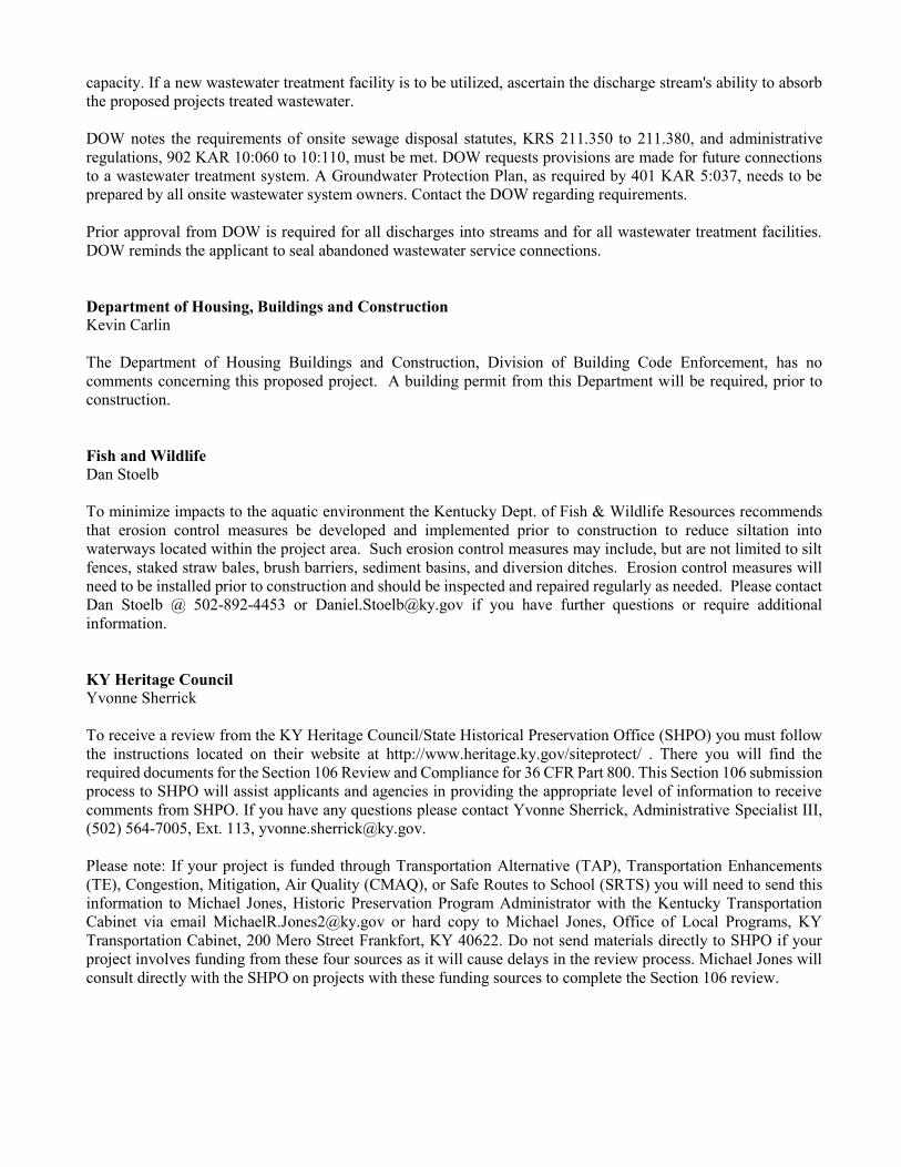
capacity. If a new wastewater treatment facility is to be utilized, ascertain the discharge stream's ability to absorb the proposed projects treated wastewater. DOW notes the requirements of onsite sewage disposal statutes, KRS 211.350 to 211.380, and administrative regulations, 902 KAR 10:060 to 10:110, must be met. DOW requests provisions are made for future connections to a wastewater treatment system. A Groundwater Protection Plan, as required by 401 KAR 5:037, needs to be prepared by all onsite wastewater system owners. Contact the DOW regarding requirements. Prior approval from DOW is required for all discharges into streams and for all wastewater treatment facilities. DOW reminds the applicant to seal abandoned wastewater service connections. Department of Housing, Buildings and Construction Kevin Carlin The Department of Housing Buildings and Construction, Division of Building Code Enforcement, has no comments concerning this proposed project. A building permit from this Department will be required, prior to construction. Fish and Wildlife Dan Stoelb To minimize impacts to the aquatic environment the Kentucky Dept. of Fish & Wildlife Resources recommends that erosion control measures be developed and implemented prior to construction to reduce siltation into waterways located within the project area. Such erosion control measures may include, but are not limited to silt fences, staked straw bales, brush barriers, sediment basins, and diversion ditches. Erosion control measures will need to be installed prior to construction and should be inspected and repaired regularly as needed. Please contact Dan Stoelb @ 502-892-4453 or [email protected] if you have further questions or require additional information. KY Heritage Council Yvonne Sherrick To receive a review from the KY Heritage Council/State Historical Preservation Office (SHPO) you must follow the instructions located on their website at http://www.heritage.ky.gov/siteprotect/ . There you will find the required documents for the Section 106 Review and Compliance for 36 CFR Part 800. This Section 106 submission process to SHPO will assist applicants and agencies in providing the appropriate level of information to receive comments from SHPO. If you have any questions please contact Yvonne Sherrick, Administrative Specialist III, (502) 564-7005, Ext. 113, [email protected]. Please note: If your project is funded through Transportation Alternative (TAP), Transportation Enhancements (TE), Congestion, Mitigation, Air Quality (CMAQ), or Safe Routes to School (SRTS) you will need to send this information to Michael Jones, Historic Preservation Program Administrator with the Kentucky Transportation Cabinet via email [email protected] or hard copy to Michael Jones, Office of Local Programs, KY Transportation Cabinet, 200 Mero Street Frankfort, KY 40622. Do not send materials directly to SHPO if your project involves funding from these four sources as it will cause delays in the review process. Michael Jones will consult directly with the SHPO on projects with these funding sources to complete the Section 106 review.

KYTC-Department of Highways Jeff Dick (D 8) If any work is performed on KYTC Right of Way, please contact Adam Dixon about obtaining an encroachment permit. Adam can be contacted at 606-677-3508. Lake Cumberland ADD Karen Burchett This project aligns with the LCADD Comprehensive Economic Development Strategy. LCADD endorses this project as proposed. Lake Cumberland ADD Neal Cundiff This project aligns with the LCADD Comprehensive Economic Development Strategy. LCADD endorses this project as proposed. Lake Cumberland Area Development District Waylon Wright Endorsed as proposed.

Cumberland-Horizon-Village
Monticello, KY 900000010155132
10/13/2020 13:02 Page 17 of 50
01 Photos.pdf List of Sources, Agencies and Persons Consulted [40 CFR 1508.9(b)]: Kentucky Heritage Council; Eastern Band of Cherokee Indians; Gordon Kidd, President of Highlands Housing Corp; Jennifer Garland, Kentucky Field Supervisor, US Fish and Wildlife Service; US Fish and Wildlife Service National Wetlands Inventory; FEMA Flood Map Service Center; National Wild and Scenic Rivers System; Nationwide Rivers Inventory; EPA Sole Source Aquifers for Drinking Water Interactive Map; USDA Web Soil Survey; Federal Aviation Administration Airport Master Record; EPA Greenbook; EPA NEPAssist Tool; EPA ECHO Report; EPA PCS-ICIS Facility Report; Google Earth Pro; Google Maps, and Kentucky Clearinghouse.
List of Permits Obtained: All required building permits will be obtained prior to construction.
Public Outreach [24 CFR 58.43]: The public was notified about the Combined Notice of Finding of No Significant Impact (FONSI) and Notice of Intent to Request Release of Funds (NOIRROF) via publication of a classified advertisement in the Commonwealth Journal (Somerset) on October 16, 2020. Public comment will be accepted for 15 days following the publication of the Wayne County Outlook classified ad with the public comment period ending November 2, 2020. The Environmental Review Record (ERR) for this project will be made available for public review during the comment period via a physical copy at the office of Highlands Housing Corporation County at 110 Stardust Avenue, Monticello, KY 42633. The physical copy will be available for public examination and copying, upon request, between the hours of 9A.M. and 4 P.M. An electronic version was posted on Highlands Housing Corporation's website at www.hhfirst.org.
Cumulative Impact Analysis [24 CFR 58.32]: There are no mitigating environmental factors resulting from the proposed project. The property is located in a low to moderate-income neighborhood and has good access to commercial amenities, institutional uses, healthcare, and employment centers. Overall, it is considered well-suited to affordable housing residential development.
Alternatives [24 CFR 58.40(e); 40 CFR 1508.9] 1. No action - leave the area as it is with no corrective action. It is likely that the property would remain vacant with minimal use without this project. Furthermore,

Cumberland-Horizon-Village
Monticello, KY 900000010155132
10/13/2020 13:02 Page 18 of 50
the city of Monticello needs affordable, quality senior housing. 2. Acquire a different piece of property - the location is ideal for the project as this is a centrally located flat piece of vacant land in a primarily rural area where adequate housing is a need for the community. 3. Proceed with Project. This is the best use of the project site.
No Action Alternative [24 CFR 58.40(e)] To "Do nothing" alternative is unacceptable is unacceptable as there is a critical need for affordable senior housing in Monticello. The move to an alternate site is also unacceptable as there is not a significant amount of flat land suitable for the construction of 36 units.
Summary of Findings and Conclusions: There are no mitigating environmental factors resulting from the proposed project, which is in compliance with all related laws and authorities. The project site is not located in a floodplain or a wetland. There are no historical preservation concerns. The site is not located close to a Wild and Scenic River or Nationwide Rivers Inventory body. There are no sole source aquifers in Kentucky. The site will not impact endangered species. The land is not comprised of Prime Farmland or Farmland of Statewide Importance. Although there were noise generators, the dnl of 61 is well within the acceptable range. There are no explosive or flammable hazards such as above ground storage tanks within one mile of the project site that are within the acceptable separation distance required by HUD. Wayne County's air quality is in compliance with federal standards. There is no evidence of contamination or toxic substances that would pose a threat. There are no airport hazards in proximity to the project site. Although there will be one household that requires displacement, this household will be offered space in the new development or will receive relocation benefits.
Mitigation Measures and Conditions [CFR 1505.2(c)]: Summarized below are all mitigation measures adopted by the Responsible Entity to reduce, avoid or eliminate adverse environmental impacts and to avoid non-compliance or non-conformance with the above-listed authorities and factors. These measures/conditions must be incorporated into project contracts, development agreements and other relevant documents. The staff responsible for implementing and monitoring mitigation measures should be clearly identified in the mitigation plan.
Law, Authority, or Factor
Mitigation Measure or Condition Comments on Completed Measures
Complete
Demographic Character Changes / Displacement
The project will adhere to replacing the occupied low/moderate income dwelling unit demolished or converted to a use other than as low/moderate
N/A

Cumberland-Horizon-Village
Monticello, KY 900000010155132
10/13/2020 13:02 Page 19 of 50
income housing in order to comply with the URA as demonstrated by executed Relocation Plan (attached).
Permits, reviews and approvals
All required building permits will be obtained prior to construction. N/A
Mitigation Plan Permits and local, State and Federal regulations as required during the construction will be enforced and followed. Construction activities will be monitored to ensure safety. Highlands Housing Corp will adhere to replacing all occupied and vacant occupiable low/moderate income dwelling units demolished or converted to a use other than as low/moderate income housing in order to comply with the URA as demonstrated by the Relocation Plan. The creation of 36 new affordable housing units for rent to senior households will have no effect on the demographic characteristics of the City of Monticello due to the small size of the project
Supporting documentation on completed measures

Cumberland-Horizon-Village
Monticello, KY 900000010155132
10/13/2020 13:02 Page 20 of 50
APPENDIX A: Related Federal Laws and Authorities Airport Hazards
General policy Legislation Regulation It is HUD’s policy to apply standards to prevent incompatible development around civil airports and military airfields.
24 CFR Part 51 Subpart D
1. To ensure compatible land use development, you must determine your site’s proximity to civil and military airports. Is your project within 15,000 feet of a military airport or 2,500 feet of a civilian airport?
No
Based on the response, the review is in compliance with this section. Document and upload the map showing that the site is not within the applicable distances to a military or civilian airport below
Yes
Screen Summary Compliance Determination The project site is not within 15,000 feet of a military airport or 2,500 feet of a civilian airport. The project is in compliance with Airport Hazards requirements. The closest airport is the Wayne County airport which is located 4,638.48 feet north of the project site. This airport is located outside of the 2,500-foot threshold. The project is in compliance with Airport Hazards requirements.
Supporting documentation 02 Airport Transportation Map.pdf Are formal compliance steps or mitigation required?
Yes
No

Cumberland Horizon Village Project 70 Worsham Lane, Monticello, Wayne County, KY 42633 (36.838179, -84.862553)
Project Site
Airport Radius Map
The site is NOT located within 15 miles of a military airfield. Kentucky has only two military airports: Godman Army Airfield, located over 100 miles away at Fort Knox and the Campbell Army Airfield, located over 200 miles away at Fort Campbell.
Wayne County Airport (Public) – located 4,638.48 feet north of the site

Cumberland Horizon Village Project 70 Worsham Lane, Monticello, Wayne County, KY 42633 (36.838179, -84.862553)
Distance to the Wayne County Airport

Cumberland-Horizon-Village
Monticello, KY 900000010155132
10/13/2020 13:02 Page 21 of 50
Coastal Barrier Resources General requirements Legislation Regulation
HUD financial assistance may not be used for most activities in units of the Coastal Barrier Resources System (CBRS). See 16 USC 3504 for limitations on federal expenditures affecting the CBRS.
Coastal Barrier Resources Act (CBRA) of 1982, as amended by the Coastal Barrier Improvement Act of 1990 (16 USC 3501)
This project is located in a state that does not contain CBRA units. Therefore, this project is in compliance with the Coastal Barrier Resources Act. Compliance Determination This project is located in a state that does not contain CBRS units. Therefore, this project is in compliance with the Coastal Barrier Resources Act.
Supporting documentation Are formal compliance steps or mitigation required?
Yes
No

Cumberland-Horizon-Village
Monticello, KY 900000010155132
10/13/2020 13:02 Page 22 of 50
Flood Insurance General requirements Legislation Regulation
Certain types of federal financial assistance may not be used in floodplains unless the community participates in National Flood Insurance Program and flood insurance is both obtained and maintained.
Flood Disaster Protection Act of 1973 as amended (42 USC 4001-4128)
24 CFR 50.4(b)(1) and 24 CFR 58.6(a) and (b); 24 CFR 55.1(b).
1. Does this project involve financial assistance for construction, rehabilitation, or acquisition of a mobile home, building, or insurable personal property?
No. This project does not require flood insurance or is excepted from flood insurance.
Yes
2. Upload a FEMA/FIRM map showing the site here:
The Federal Emergency Management Agency (FEMA) designates floodplains. The FEMA Map Service Center provides this information in the form of FEMA Flood Insurance Rate Maps (FIRMs). For projects in areas not mapped by FEMA, use the best available information to determine floodplain information. Include documentation, including a discussion of why this is the best available information for the site. Provide FEMA/FIRM floodplain zone designation, panel number, and date within your documentation.
Is the structure, part of the structure, or insurable property located in a FEMA-designated Special Flood Hazard Area? No
Based on the response, the review is in compliance with this section.
Yes
Screen Summary Compliance Determination
03 Floodplain Map.pdf

Cumberland-Horizon-Village
Monticello, KY 900000010155132
10/13/2020 13:02 Page 23 of 50
The structure or insurable property is not located in a FEMA-designated Special Flood Hazard Area. While flood insurance may not be mandatory in this instance, HUD recommends that all insurable structures maintain flood insurance under the National Flood Insurance Program (NFIP). The project is in compliance with flood insurance requirements. The attached FIRMette map for the project site demonstrates that it is in an area of minimal flood hazard (Panel #21231C01810C, eff. 9/2/2009).
Supporting documentation Are formal compliance steps or mitigation required?
Yes
No

USGS The National Map: Orthoimagery. Data refreshed April 2020
National Flood Hazard Layer FIRMette
0 500 1,000 1,500 2,000250Feet
Ü
SEE FIS REPORT FOR DETAILED LEGEND AND INDEX MAP FOR FIRM PANEL LAYOUT
SPECIAL FLOODHAZARD AREAS
Without Base Flood Elevation (BFE)Zone A, V, A99
With BFE or DepthZone AE, AO, AH, VE, AR
Regulatory Floodway
0.2% Annual Chance Flood Hazard, Areasof 1% annual chance flood with averagedepth less than one foot or with drainageareas of less than one square mileZone X
Future Conditions 1% AnnualChance Flood HazardZone X
Area with Reduced Flood Risk due toLevee. See Notes.Zone X
Area with Flood Risk due to LeveeZone D
NO SCREENArea of Minimal Flood HazardZone X
Area of Undetermined Flood HazardZone D
Channel, Culvert, or Storm Sewer
Levee, Dike, or Floodwall
Cross Sections with 1% Annual Chance17.5 Water Surface Elevation
Coastal Transect
Coastal Transect BaselineProfile BaselineHydrographic Feature
Base Flood Elevation Line (BFE)
Effective LOMRs
Limit of StudyJurisdiction Boundary
Digital Data Available
No Digital Data Available
Unmapped
This map complies with FEMA's standards for the use ofdigital flood maps if it is not void as described below.The basemap shown complies with FEMA's basemapaccuracy standards
The flood hazard information is derived directly from theauthoritative NFHL web services provided by FEMA. This mapwas exported on 8/27/2020 at 3:29 PM and does notreflect changes or amendments subsequent to this date andtime. The NFHL and effective information may change orbecome superseded by new data over time.
This map image is void if the one or more of the following mapelements do not appear: basemap imagery, flood zone labels,legend, scale bar, map creation date, community identifiers,FIRM panel number, and FIRM effective date. Map images forunmapped and unmodernized areas cannot be used forregulatory purposes.
Legend
OTHER AREAS OFFLOOD HAZARD
OTHER AREAS
GENERALSTRUCTURES
OTHERFEATURES
MAP PANELS
8
B20.2
The pin displayed on the map is an approximatepoint selected by the user and does not representan authoritative property location.
1:6,000
84°52'4"W 36°50'32"N
84°51'26"W 36°50'3"N

Cumberland-Horizon-Village
Monticello, KY 900000010155132
10/13/2020 13:02 Page 24 of 50
Air Quality General requirements Legislation Regulation The Clean Air Act is administered by the U.S. Environmental Protection Agency (EPA), which sets national standards on ambient pollutants. In addition, the Clean Air Act is administered by States, which must develop State Implementation Plans (SIPs) to regulate their state air quality. Projects funded by HUD must demonstrate that they conform to the appropriate SIP.
Clean Air Act (42 USC 7401 et seq.) as amended particularly Section 176(c) and (d) (42 USC 7506(c) and (d))
40 CFR Parts 6, 51 and 93
1. Does your project include new construction or conversion of land use facilitating the development of public, commercial, or industrial facilities OR five or more dwelling units? Yes
No Air Quality Attainment Status of Project’s County or Air Quality Management District 2. Is your project’s air quality management district or county in non-attainment or maintenance status for any criteria pollutants? No, project’s county or air quality management district is in attainment status for
all criteria pollutants.
Yes, project’s management district or county is in non-attainment or maintenance status for the following criteria pollutants (check all that apply):
Screen Summary Compliance Determination The project's county or air quality management district is in attainment status for all criteria pollutants. The project is in compliance with the Clean Air Act. The project's county or air quality management district is in attainment status for all criteria pollutants. Wayne county is not in non-attainment or maintenance status for any
Cumberland-Horizon-Village
Monticello, KY 900000010155132
10/13/2020 13:02 Page 25 of 50
criteria pollutants. See EPA's greenbook county list, found at: https://www3.epa.gov/airquality/greenbook/ancl.html#KY.
Supporting documentation Are formal compliance steps or mitigation required?
Yes
No

Cumberland-Horizon-Village
Monticello, KY 900000010155132
10/13/2020 13:02 Page 26 of 50
Coastal Zone Management Act General requirements Legislation Regulation
Federal assistance to applicant agencies for activities affecting any coastal use or resource is granted only when such activities are consistent with federally approved State Coastal Zone Management Act Plans.
Coastal Zone Management Act (16 USC 1451-1464), particularly section 307(c) and (d) (16 USC 1456(c) and (d))
15 CFR Part 930
This project is located in a state that does not participate in the Coastal Zone Management Program. Therefore, this project is in compliance with the Coastal Zone Management Act. Screen Summary Compliance Determination This project is located in a state that does not participate in the Coastal Zone Management Program. Therefore, this project is in compliance with the Coastal Zone Management Act.
Supporting documentation Are formal compliance steps or mitigation required?
Yes
No

Cumberland-Horizon-Village
Monticello, KY 900000010155132
10/13/2020 13:02 Page 27 of 50
Contamination and Toxic Substances General requirements Legislation Regulations
It is HUD policy that all properties that are being proposed for use in HUD programs be free of hazardous materials, contamination, toxic chemicals and gases, and radioactive substances, where a hazard could affect the health and safety of the occupants or conflict with the intended utilization of the property.
24 CFR 58.5(i)(2) 24 CFR 50.3(i)
1. How was site contamination evaluated? Select all that apply. Document and upload documentation and reports and evaluation explanation of site contamination below. American Society for Testing and Materials (ASTM) Phase I Environmental Site
Assessment (ESA) ASTM Phase II ESA Remediation or clean-up plan ASTM Vapor Encroachment Screening None of the Above
2. Were any on-site or nearby toxic, hazardous, or radioactive substances found that could affect the health and safety of project occupants or conflict with the intended use of the property? (Were any recognized environmental conditions or RECs identified in a Phase I ESA and confirmed in a Phase II ESA?) No
Explain: Per the Phase 1 completed by Vision Engineering on March 31, 2020, there were no findings of significance associated with the subject property relative to ASTM E-1527-13.
Based on the response, the review is in compliance with this section.
Yes
Screen Summary Compliance Determination

Cumberland-Horizon-Village
Monticello, KY 900000010155132
10/13/2020 13:02 Page 28 of 50
Site contamination was evaluated as follows: ASTM Phase I ESA. On-site or nearby toxic, hazardous, or radioactive substances that could affect the health and safety of project occupants or conflict with the intended use of the property were not found. The project is in compliance with contamination and toxic substances requirements.
Supporting documentation 06 Cumberland Horizon Village Phase 1.pdf Are formal compliance steps or mitigation required?
Yes
No

[TYPE THE COMPANY NAME]
128 E Reynolds Road, Ste 150
Lexington, Kentucky 40517
Ph: 859-559-0516
Phase 1 Environmental Site
Assessment For:
Proposed Development
Cumberland Horizon Village
939 W. Columbia Ave.
42 Worsham Ln.
70 Worsham Ln.
Monticello, KY
Prepared For:
Southern Tier Housing Corporation
dba Highlands Housing Corporation
Attn: Gordon Kidd
March 31, 2020

128 E. Reynolds Road, Ste 150
Lexington, Kentucky 40517
Ph: 859-559-0516
Fax: 859-523-0095
March 31, 2020
Gordon Kidd
Southern Tier Housing Corporation
dba Highlands Housing Corporation
362 Old Whitley Road
London, KY 40743
Re: Phase 1 Environmental Site Assessment
Cumberland Horizon Village
Monticello, Kentucky
Mr. Kidd,
Thank you for selecting Vision Engineering, LLC to provide this Phase 1 Environmental Site Assessment.
We have completed the Phase 1 Environmental Site Assessment for the above referenced property in
compliance with ASTM E 1527-13. The attached report of our assessment contains the primary findings of
the record searches, our site visit and a summary of State and Federal Database searches, more detailed search
information is on file if needed to be referenced.
We have identified no recognized environmental conditions associated with the subject property that warrant
further investigation. If you have any questions regarding our work or if we may be of further assistance,
please call.
Thank you,
Vision Engineering, LLC
Jihad Hallany, P.E.
Vision Engineering

Table of Contents
Section
Page
Title Page........................................................................................................................ i
Cover Letter................................................................................................................... ii
Table of Contents........................................................................................................... iii
1. Introduction........................................................................................................... 1
1.1. Limitation and Exceptions............................................................................... 1
1.2. Reliance........................................................................................................... 1
1.3. User Provided Information.............................................................................. 2
2. General Site Description....................................................................................... 2
2.1. Location and Current Land Use...................................................................... 2
2.2. Utilities............................................................................................................ 2
2.3. Topography, Drainage.................................................................................... 2
2.4. Geology......................................................................................................... 2
3. Site History............................................................................................................ 3
3.1. Review of Prior Land Use............................................................................ 3
3.2. Interview(s)................................................................................................... 3
4. Environmental Records Review........................................................................ 3
4.1. Federal and State Databases......................................................................... 3
5. Summary of Site Reconnaissance....................................................................... 4
6. Findings / Opinions............................................................................................... 4
7. Conclusions............................................................................................................. 5
8. Deviations............................................................................................................... 5
Certification............................................................................................................ 5
Appendices
Appendix I Physical Setting Map - 7 1/2 Minute Topographic Quadrangle (2013)
Aerial Photographs (2018, 2012, 2008, 1997, 1993, 1985, 1982, 1975,
1951)
Appendix II State and Federal Database Reports (EDR Radius Report)
Appendix III Site Visit Photograph Summary

1
Appendix IV City Directory
Appendix V Kentucky Geologic Survey Karst Potential Map
Appendix VI Wayne County PVA Data
1
Phase 1 Environmental Site Assessment
939 W. Columbia Ave., 42 Worsham Ln. & 70 Worsham Ln.
Monticello, Kentucky
1. Introduction
Vision Engineering, LLC has completed a Phase 1 Environmental Site Assessment (ESA) for the
properties known as 939 W. Columbia Ave (portion), 42 Worsham Ln. and 70 Worsham Ln.,
Monticello Kentucky (Approximately 3.0 acres). This assessment has been performed in
conformance with ASTM E 1527-13 (Standard Practice for Environmental Site Assessments:
Phase 1 Environmental Site Assessment Process) and with professional judgment.
Our services have included visual reconnaissance of the subject property and of the surrounding
area, review of published historic, geologic and cartographic literature pertinent to the area, review
of local, state and federal environmental databases and agency files concerning the environmentally
sensitive activities and conditions in the area, and discussions with individual(s) familiar with the
area.
1.1. Limitations and Exceptions
A description of each entity studied, and associated findings are summarized in this report. Our
work is based upon professional judgment and reasonable ascertainable information that is publicly
available to us. Activities or incidents occurring on site after completion of our site reconnaissance
are beyond the scope of the assessment. Identification of buried environmental conditions and those
covered by building materials or otherwise obscured is also beyond the scope of this assessment.
The purpose of this Phase 1 ESA has been to provide "all appropriate inquiry" into present and
historic land uses on the subject property in an effort to identify "recognized environmental
conditions" as described in ASTM E 1527-13. Additional services are listed in ASTM E 1527-13 as
"non-scope considerations." All non-scope considerations are beyond the scope of this study. Some
examples of non-scope considerations are:
• Evaluation of air quality, including mold and radon.
• Sampling and testing of surface water at the site or adjacent sites.
• Installation of monitoring wells for evaluating potentially contaminated groundwater.
• Performance of borings, excavations, ect..., to detect hazardous substances.
• Performance of property line and topographic surveys.
• Reconnaissance of wetlands, historic and archeological concerns or endangered species.
• Reconnaissance, sampling and analysis to detect asbestos containing materials.
• Reconnaissance for, or sampling and analysis to detect lead in soils or any other media.
1.2. Reliance
This report has been prepared so that Southern Tier Housing Corporation dba Highlands Housing
Corporation may rely on its contents. Vision Engineering, LLC's obligations and liabilities are
2
limited to these clients and to others who are approved in writing to Vision Engineering, LLC as
authorized users of this report. These obligations and liabilities do not extend to and are not for the
benefit of any other person or entity.
1.3. User Provided Information
Vision Engineering, LLC searched for recorded documents with Commonwealth of Kentucky,
Division of Environmental Program Support Department for Environmental Protection
Open Records and an EDR Record Search relating to environmental liens and activity and use
limitations associated with the subject property. We found no evidence of environmental liens and
there were no activity and use limitations recorded that affect the opinion of the environmental
professional.
The user reported no specialized knowledge of commonly known information about the property
that would affect the opinion of the environmental professional. The user also acknowledges there
is no reduction in the value of the property due to environmental issues. In addition, the user
reported no obvious indicators that point to the presence or likely presence of contamination at the
property.
2. General Site Description
2.1. Limitations and Exceptions
The subject property consists of an undeveloped portion of a commercial lot, a vacant field and a
residential lot on which a mobile home is located, jointly containing approximately 3.0 acres. It is
recorded with the Wayne County Property Valuation Administration as Parcel Numbers: M1-06-
008.00 (939 W. Columbia Ave), M1-06-009.00 (42 Worsham Ln.) and M1-06-10.00 (70 Worsham
Ln.).
2.2. Utilities
Public utilities are available to the subject properties, and provided by the following:
Water, Sanitary Sewer, Storm Sewer and Household Trash Collection
Monticello Utility Commission
1040 North Main
Monticello, KY 42633
606.348.8473
Electric
South Kentucky RECC
780 North Main
Monticello, KY 42633
606.348.6771
Telecommunications
CTS Media Group
49 Hardwood Dr.

3
Monticello, KY 42633
606.348.8416
Monticello, KY City Government
120 South Main
Monticello, KY 42633
606.348.0167
2.3. Topography, Drainage
The United States Geological Survey (USGS), 7 1/2-minute topographic map was reviewed
for this site. The Monticello, Kentucky quadrangle was prepared in 2013 and depicts
topography that is consistent with our visual reconnaissance of the subject property. A
representative portion of the map is included in this report for physical setting illustration
(see Appendix I).
The topography of the area is very gently rolling. The subject property is situated near the
intersection of Columbia Ave. and Worsham Ln. within the City of Monticello, KY.
2.4. Geology
Underlying geology in the area as depicted on the Geologic map of the Monticello
Quadrangle, Wayne County, Kentucky, as studied by the Kentucky Geological Survey in
1976. The underlying strata consist mostly of Meramecian Series of the Mississippian
System of Paleozoic Era rock. There are no oil or gas well near the site. According to the
Kentucky Geologic Survey, there potential karst features within 500 feet of the site.
Soils within the site area are described generally by the USDA Soil Conservation Service
as:
Type 1
Soil Component Name: Decatur
Soil Surface Texture: Silt Loam
Hydrologic Group: Class B-Moderate infiltration rates
Type 2
Soil Component Name: Bewleyville
Soil Surface Texture: Silt Loam
Hydrologic Group: Class B-Moderate infiltration rates
3. Site History
3.1. Review of Prior Land Use
4
Previous ownership and uses of the property were identified through aerial photographs
(1951, 1975, 1982, 1985, 1993, 1997, 2008, 2012 and 2016), topographic maps, deeds,
PVA records, personal knowledge and interviews with people familiar with the property.
No fire insurance maps, city directories or agency files were available for this site.
Information collected from the sources mentioned above is summarized below.
The subject property was in agricultural use until land development in the area started
around 1951 with Residential development to the north, east and west of the Property, the
area to the south of the Property has remained undeveloped. Review of Aerial photographs
indicate that the land was developed into its current state after 1997.
4. Environmental Records Review
4.1. Federal and State Databases
This assessment has included the review of federal, state and local records, if any, of
environmentally sensitive incidents and activities in the area. Federal and state databases
were accessed through a commercial database retrieval company. The database report is
presented as Appendix II.
Federal and state database records reviewed include the National Priorities List (NPL), the
Comprehensive Environmental Response Compensation and Liability Information System
(CERCLIS), Resource Conservation and Recovery Act (RCRA) facilities, Emergency
Response Notification System (ERNS) files, and others referenced in ASTM standards. A
complete list of databases that were accessed by Environmental Data Resources (EDR) is
available in the database report (Appendix II).
These databases are publicly available and can be used to identify a facility engaged in the
generation, storage, treatment, transportation, or disposal of hazardous materials if records
exist. In addition, facilities that are under litigation, have been fined, or have been ordered
to perform corrective action with respect to hazardous material handling can be identified.
The target property was not listed in any of the databases searched. None of the properties
listed were considered for file review because of their distance from the subject property
and local topography.
5. Summary of Site Reconnaissance
Vision Engineering LLC (Dustin Roe) conducted reconnaissance of the subject property
and the surrounding area on March 30, 2020. Mr. Roe walked around the entire perimeter
while crossing the property in several locations. Mr. Roe then walked to adjacent properties
to observe and photograph the area and verify topography and drainage patterns depicted
on the topographic map (see Appendix I).

5
The site was consistent with its current use description as a vacant /
undeveloped/residential property. No abandoned / junk vehicles or equipment or piles of
trash / illegal dumping was observed on the property, on a portion of the northeast side of
the property contains an asphalt parking lot with the remaining property containing trees /
brush and grass.
There was no significant petroleum staining on the property. None of the items listed in
Section 9.4.2 of ASTM E 1527-13, such as underground fuel tanks, sumps, drums, lagoons,
etc., were observed on site. We observed no indication that any of the subject property was
used for the disposal of hazardous materials, hazardous wastes or petroleum products. No
adjacent properties appear to have the ability to affect the subject property from activities
on those sites.
Interviews with local residents familiar with the properties indicate there is the possibility
that a septic tank previously utilized by the mobile home located on 42 Worsham Ln. could
still be in place. Visual reconnaissance could not confirm or refute this possibility.
6. Findings / Opinions
6.1. There were no findings of significance associated with the subject property relative
to ASTM E-1527-13.
No further investigation is warranted.
7. Conclusions
We have performed a Phase I Environmental Site Assessment in conformance with the
scope and limitations of ASTM Practice E 1527-13 for the property known as 939 West
Columbia Ave., 42 Worsham Ln (Approximately 3.0 Acres), Monticello, Kentucky. Any
exceptions to, or deletions from, this practice are described in Section 8 of this report. This
assessment has revealed no evidence of recognized environmental conditions in connection
with the property.
No further investigation is warranted.
8. Deviations
8.1. Data Gaps --- There are no data gaps in this report.
Certification

6
I declare that, to the best of my professional knowledge and belief, I meet the definition of
Environmental professional as defined in 312.10 of 40 CFR 312" and I have the specific
qualifications based on education, training, and experience to assess a property of the
nature, history, and setting of the subject property. I have developed and performed the all
appropriate inquiries in conformance with the standards and practices set forth in 40 CFR
Part 312.
Vision Engineering LLC
Jihad Hallany, P.E.
NOTE ON ADDRESSES:
At the time of data requisition from EDR, the address of 70 Worsham Lane was listed by Wayne
County PVA records as “Worsham Lane Lots” with no numerical E911 address provided (see
Appendix VI).
The area covered by the data contained in this Phase 1 Environmental Site Assessment does include
the area known as 70 Worsham Lane (see Detail Map – 6025084.2S at Appendix II for coverage
area).

Appendix I
Physical Setting Map - 7 1/2 Minute Topographic Quadrangle (2013)
Aerial Photographs (2016, 2012, 2008, 1997, 1993, 1985, 1982, 1975, 1951)

EDR Historical Topo Map Report
Inquiry Number:
6 Armstrong Road, 4th floor Shelton, CT 06484Toll Free: 800.352.0050 www.edrnet.com
with QuadMatch™
939 Columbia 42 Worsham
42 Worsham Lane
Monticello, KY 42633
March 27, 2020
6025084.4

EDR Historical Topo Map Report
EDR Inquiry #
Search Results:
P.O.# Project:
Maps Provided:
Disclaimer - Copyright and Trademark Notice
EDR and its logos (including Sanborn and Sanborn Map) are trademarks of Environmental Data Resources, Inc. or its affiliates. All other trademarks used herein are the property of their respective owners.
page-
Coordinates:
Latitude: Longitude: UTM Zone: UTM X Meters: UTM Y Meters: Elevation:
Contact:
Site Name: Client Name:
2013
1977, 1978
1953
1914
1911
03/27/20
939 Columbia 42 Worsham Vision Engineering42 Worsham Lane 128 E Reynolds Rd, Ste 150Monticello, KY 42633 Lexington, KY 40517
6025084.4 Rich Newton
EDR Topographic Map Library has been searched by EDR and maps covering the target property location as provided byVision Engineering were identified for the years listed below. EDR’s Historical Topo Map Report is designed to assistprofessionals in evaluating potential liability on a target property resulting from past activities. EDRs Historical Topo MapReport includes a search of a collection of public and private color historical topographic maps, dating back to the late1800s.
NA 36.838017 36° 50' 17" North
Kentucky Housing Corp -84.862622 -84° 51' 45" WestZone 16 North690590.684079035.26938.00' above sea level
This Report contains certain information obtained from a variety of public and other sources reasonably available to Environmental Data Resources, Inc. It cannotbe concluded from this Report that coverage information for the target and surrounding properties does not exist from other sources. NO WARRANTYEXPRESSED OR IMPLIED, IS MADE WHATSOEVER IN CONNECTION WITH THIS REPORT. ENVIRONMENTAL DATA RESOURCES, INC. SPECIFICALLYDISCLAIMS THE MAKING OF ANY SUCH WARRANTIES, INCLUDING WITHOUT LIMITATION, MERCHANTABILITY OR FITNESS FOR A PARTICULAR USEOR PURPOSE. ALL RISK IS ASSUMED BY THE USER. IN NO EVENT SHALL ENVIRONMENTAL DATA RESOURCES, INC. BE LIABLE TO ANYONE,WHETHER ARISING OUT OF ERRORS OR OMISSIONS, NEGLIGENCE, ACCIDENT OR ANY OTHER CAUSE, FOR ANY LOSS OF DAMAGE, INCLUDING,WITHOUT LIMITATION, SPECIAL, INCIDENTAL, CONSEQUENTIAL, OR EXEMPLARY DAMAGES. ANY LIABILITY ON THE PART OF ENVIRONMENTALDATA RESOURCES, INC. IS STRICTLY LIMITED TO A REFUND OF THE AMOUNT PAID FOR THIS REPORT. Purchaser accepts this Report "AS IS". Anyanalyses, estimates, ratings, environmental risk levels or risk codes provided in this Report are provided for illustrative purposes only, and are not intended toprovide, nor should they be interpreted as providing any facts regarding, or prediction or forecast of, any environmental risk for any property. Only a Phase IEnvironmental Site Assessment performed by an environmental professional can provide information regarding the environmental risk for any property.Additionally, the information provided in this Report is not to be construed as legal advice.Copyright 2020 by Environmental Data Resources, Inc. All rights reserved. Reproduction in any media or format, in whole or in part, of any report or map ofEnvironmental Data Resources, Inc., or its affiliates, is prohibited without prior written permission.
6025084 4 2

page
Topo Sheet KeyThis EDR Topo Map Report is based upon the following USGS topographic map sheets.
-
2013 Source Sheets
2013Monticello
7.5-minute, 240002013Parnell
7.5-minute, 24000
1977, 1978 Source Sheets
1977Monticello
7.5-minute, 24000Aerial Photo Revised 1975
1978Parnell
7.5-minute, 24000Aerial Photo Revised 1975
1953 Source Sheets
1953Parnell
7.5-minute, 24000Aerial Photo Revised 1951
1953Monticello
7.5-minute, 24000Aerial Photo Revised 1951
1914 Source Sheets
1914Monticello
15-minute, 62500
6025084 4 3
page
Topo Sheet KeyThis EDR Topo Map Report is based upon the following USGS topographic map sheets.
-
1911 Source Sheets
1911Monticello
15-minute, 62500
6025084 4 4

Historical Topo Map
page
SITE NAME: ADDRESS:
CLIENT:
This report includes information from the following map sheet(s).
-
EW
SW S SE
NW N NE
2013
0 Miles 0.25 0.5 1 1.5
939 Columbia 42 Worsham42 Worsham LaneMonticello, KY 42633Vision Engineering
TP, Monticello, 2013, 7.5-minuteSW, Parnell, 2013, 7.5-minute
6025084 4 5
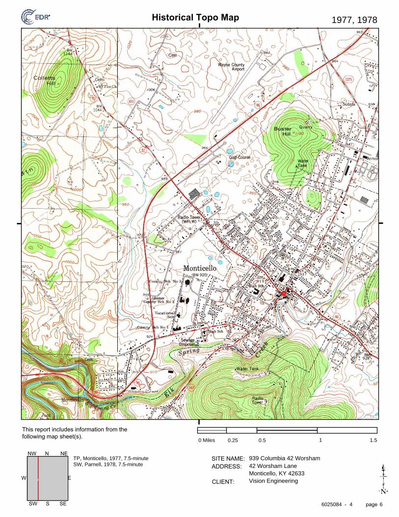
Historical Topo Map
page
SITE NAME: ADDRESS:
CLIENT:
This report includes information from the following map sheet(s).
-
EW
SW S SE
NW N NE
1977, 1978
0 Miles 0.25 0.5 1 1.5
939 Columbia 42 Worsham42 Worsham LaneMonticello, KY 42633Vision Engineering
TP, Monticello, 1977, 7.5-minuteSW, Parnell, 1978, 7.5-minute
6025084 4 6

Historical Topo Map
page
SITE NAME: ADDRESS:
CLIENT:
This report includes information from the following map sheet(s).
-
EW
SW S SE
NW N NE
1953
0 Miles 0.25 0.5 1 1.5
939 Columbia 42 Worsham42 Worsham LaneMonticello, KY 42633Vision Engineering
TP, Monticello, 1953, 7.5-minuteSW, Parnell, 1953, 7.5-minute
6025084 4 7

Historical Topo Map
page
SITE NAME: ADDRESS:
CLIENT:
This report includes information from the following map sheet(s).
-
EW
SW S SE
NW N NE
1914
0 Miles 0.25 0.5 1 1.5
939 Columbia 42 Worsham42 Worsham LaneMonticello, KY 42633Vision Engineering
TP, Monticello, 1914, 15-minute
6025084 4 8
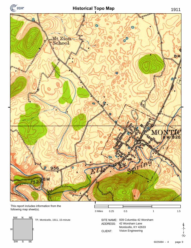
Historical Topo Map
page
SITE NAME: ADDRESS:
CLIENT:
This report includes information from the following map sheet(s).
-
EW
SW S SE
NW N NE
1911
0 Miles 0.25 0.5 1 1.5
939 Columbia 42 Worsham42 Worsham LaneMonticello, KY 42633Vision Engineering
TP, Monticello, 1911, 15-minute
6025084 4 9
The EDR Aerial Photo Decade Package
939 Columbia 42 Worsham
42 Worsham Lane
Monticello, KY 42633
Inquiry Number:
March 27, 2020
6025084.8
6 Armstrong Road, 4th floorShelton, CT 06484Toll Free: 800.352.0050www.edrnet.com

2016 1"=500' Flight Year: 2016 USDA/NAIP
2012 1"=500' Flight Year: 2012 USDA/NAIP
2008 1"=500' Flight Year: 2008 USDA/NAIP
1997 1"=500' Acquisition Date: March 11, 1997 USGS/DOQQ
1993 1"=750' Flight Date: April 12, 1993 USGS
1985 1"=500' Flight Date: April 09, 1985 USDA
1982 1"=1000' Flight Date: April 23, 1982 USGS
1975 1"=500' Flight Date: April 22, 1975 USGS
1951 1"=500' Flight Date: May 15, 1951 USGS
EDR Aerial Photo Decade Package 03/27/20
939 Columbia 42 Worsham
Site Name: Client Name:
Vision Engineering42 Worsham Lane 128 E Reynolds Rd, Ste 150Monticello, KY 42633 Lexington, KY 40517EDR Inquiry # 6025084.8 Contact: Rich Newton
Environmental Data Resources, Inc. (EDR) Aerial Photo Decade Package is a screening tool designed to assistenvironmental professionals in evaluating potential liability on a target property resulting from past activities. EDR’sprofessional researchers provide digitally reproduced historical aerial photographs, and when available, provide one photoper decade.
Search Results:
Year Scale Details Source
When delivered electronically by EDR, the aerial photo images included with this report are for ONE TIME USEONLY. Further reproduction of these aerial photo images is prohibited without permission from EDR. For moreinformation contact your EDR Account Executive.
Disclaimer - Copyright and Trademark NoticeThis Report contains certain information obtained from a variety of public and other sources reasonably available to Environmental Data Resources, Inc. It cannotbe concluded from this Report that coverage information for the target and surrounding properties does not exist from other sources. NO WARRANTYEXPRESSED OR IMPLIED, IS MADE WHATSOEVER IN CONNECTION WITH THIS REPORT. ENVIRONMENTAL DATA RESOURCES, INC. SPECIFICALLYDISCLAIMS THE MAKING OF ANY SUCH WARRANTIES, INCLUDING WITHOUT LIMITATION, MERCHANTABILITY OR FITNESS FOR A PARTICULAR USEOR PURPOSE. ALL RISK IS ASSUMED BY THE USER. IN NO EVENT SHALL ENVIRONMENTAL DATA RESOURCES, INC. BE LIABLE TO ANYONE,WHETHER ARISING OUT OF ERRORS OR OMISSIONS, NEGLIGENCE, ACCIDENT OR ANY OTHER CAUSE, FOR ANY LOSS OF DAMAGE, INCLUDING,WITHOUT LIMITATION, SPECIAL, INCIDENTAL, CONSEQUENTIAL, OR EXEMPLARY DAMAGES. ANY LIABILITY ON THE PART OF ENVIRONMENTALDATA RESOURCES, INC. IS STRICTLY LIMITED TO A REFUND OF THE AMOUNT PAID FOR THIS REPORT. Purchaser accepts this Report "AS IS". Anyanalyses, estimates, ratings, environmental risk levels or risk codes provided in this Report are provided for illustrative purposes only, and are not intended toprovide, nor should they be interpreted as providing any facts regarding, or prediction or forecast of, any environmental risk for any property. Only a Phase IEnvironmental Site Assessment performed by an environmental professional can provide information regarding the environmental risk for any property.Additionally, the information provided in this Report is not to be construed as legal advice.
Copyright 2020 by Environmental Data Resources, Inc. All rights reserved. Reproduction in any media or format, in whole or in part, of any report or map ofEnvironmental Data Resources, Inc., or its affiliates, is prohibited without prior written permission.
EDR and its logos (including Sanborn and Sanborn Map) are trademarks of Environmental Data Resources, Inc. or its affiliates. All other trademarks used herein arethe property of their respective owners.
6025084 8- page 2
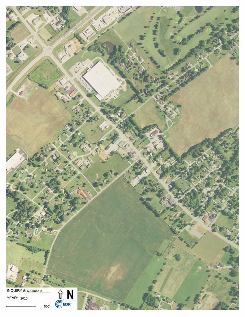
6025084.8
2016
= 500'
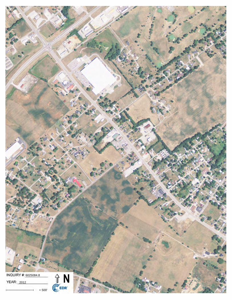
6025084.8
2012
= 500'

6025084.8
2008
= 500'

6025084.8
1997
= 500'

6025084.8
1993
= 750'
Subject boundary not shown because it exceeds image extent or image is not georeferenced.

6025084.8
1985
= 500'

6025084.8
1982
= 1000'
Subject boundary not shown because it exceeds image extent or image is not georeferenced.

6025084.8
1975
= 500'
Subject boundary not shown because it exceeds image extent or image is not georeferenced.

6025084.8
1951
= 500'
Subject boundary not shown because it exceeds image extent or image is not georeferenced.

Appendix II
State and Federal Database Reports (EDR Radius Report)

FORM-LBC-CCA
®kcehCoeG htiw tropeR ™paM suidaR RDE ehT
6 Armstrong Road, 4th floorShelton, CT 06484Toll Free: 800.352.0050www.edrnet.com
939 Columbia 42 Worsham42 Worsham LaneMonticello, KY 42633
Inquiry Number: 6025084.2sMarch 27, 2020

SECTION PAGE
Executive Summary ES1
Overview Map 2
Detail Map 3
Map Findings Summary 4
Map Findings 8
Orphan Summary 30
Government Records Searched/Data Currency Tracking GR-1
GEOCHECK ADDENDUM
Physical Setting Source Addendum A-1
Physical Setting Source Summary A-2
Physical Setting SSURGO Soil Map A-5
Physical Setting Source Map A-10
Physical Setting Source Map Findings A-12
Physical Setting Source Records Searched PSGR-1
TC6025084.2s Page 1
Thank you for your business.Please contact EDR at 1-800-352-0050
with any questions or comments.
Disclaimer - Copyright and Trademark Notice
This Report contains certain information obtained from a variety of public and other sources reasonably available to Environmental DataResources, Inc. It cannot be concluded from this Report that coverage information for the target and surrounding properties does not exist fromother sources. NO WARRANTY EXPRESSED OR IMPLIED, IS MADE WHATSOEVER IN CONNECTION WITH THIS REPORT. ENVIRONMENTALDATA RESOURCES, INC. SPECIFICALLY DISCLAIMS THE MAKING OF ANY SUCH WARRANTIES, INCLUDING WITHOUT LIMITATION,MERCHANTABILITY OR FITNESS FOR A PARTICULAR USE OR PURPOSE. ALL RISK IS ASSUMED BY THE USER. IN NO EVENT SHALLENVIRONMENTAL DATA RESOURCES, INC. BE LIABLE TO ANYONE, WHETHER ARISING OUT OF ERRORS OR OMISSIONS, NEGLIGENCE,ACCIDENT OR ANY OTHER CAUSE, FOR ANY LOSS OF DAMAGE, INCLUDING, WITHOUT LIMITATION, SPECIAL, INCIDENTAL,CONSEQUENTIAL, OR EXEMPLARY DAMAGES. ANY LIABILITY ON THE PART OF ENVIRONMENTAL DATA RESOURCES, INC. IS STRICTLYLIMITED TO A REFUND OF THE AMOUNT PAID FOR THIS REPORT. Purchaser accepts this Report "AS IS". Any analyses, estimates, ratings,environmental risk levels or risk codes provided in this Report are provided for illustrative purposes only, and are not intended to provide, norshould they be interpreted as providing any facts regarding, or prediction or forecast of, any environmental risk for any property. Only a Phase IEnvironmental Site Assessment performed by an environmental professional can provide information regarding the environmental risk for anyproperty. Additionally, the information provided in this Report is not to be construed as legal advice.
Copyright 2020 by Environmental Data Resources, Inc. All rights reserved. Reproduction in any media or format, in wholeor in part, of any report or map of Environmental Data Resources, Inc., or its affiliates, is prohibited without prior written permission.
EDR and its logos (including Sanborn and Sanborn Map) are trademarks of Environmental Data Resources, Inc. or its affiliates. All othertrademarks used herein are the property of their respective owners.
TABLE OF CONTENTS

EXECUTIVE SUMMARY
TC6025084.2s EXECUTIVE SUMMARY 1
A search of available environmental records was conducted by Environmental Data Resources, Inc (EDR).The report was designed to assist parties seeking to meet the search requirements of EPA’s Standardsand Practices for All Appropriate Inquiries (40 CFR Part 312), the ASTM Standard Practice forEnvironmental Site Assessments (E 1527-13), the ASTM Standard Practice for Environmental SiteAssessments for Forestland or Rural Property (E 2247-16), the ASTM Standard Practice for LimitedEnvironmental Due Diligence: Transaction Screen Process (E 1528-14) or custom requirements developedfor the evaluation of environmental risk associated with a parcel of real estate.
TARGET PROPERTY INFORMATION
ADDRESS
42 WORSHAM LANEMONTICELLO, KY 42633
COORDINATES
36.8380170 - 36˚ 50’ 16.86’’Latitude (North): 84.8626220 - 84˚ 51’ 45.43’’Longitude (West): Zone 16Universal Tranverse Mercator: 690595.3UTM X (Meters): 4078832.5UTM Y (Meters): 938 ft. above sea levelElevation:
USGS TOPOGRAPHIC MAP ASSOCIATED WITH TARGET PROPERTY
5939107 MONTICELLO, KYTarget Property Map:2013Version Date:
5939111 PARNELL, KYSouthwest Map:2013Version Date:
AERIAL PHOTOGRAPHY IN THIS REPORT
20140615Portions of Photo from:USDASource:

6025084.2s Page 2
7 WINTERWOOD PROPERTY 120 SURREY HILL ROAD KY SHWS, KY CDL Higher 2690, 0.509, NW
6 CATRON PROPERTY 233 FAIR STREET KY SHWS, KY CDL Higher 2523, 0.478, East
B5 BELDEN WIRE & CABLE 1211 W COLUMBIA AVEN PA MANIFEST Higher 1213, 0.230, NNW
B4 BELDEN WIRE & CABLE 1200 WEST COLUMBIA A RCRA NonGen / NLR Higher 1208, 0.229, NNW
A3 WAYNE SANITATION TRA SIDWELL ST KY SWF/LF Higher 565, 0.107, ENE
A2 WAYNE TRANSFER STATI SIDWELL STREET KY HIST LF Higher 565, 0.107, ENE
1 WAYNE COUNTY TRANSFE SIDWELL ST FINDS, ECHO Higher 2, 0.000,
MAPPED SITES SUMMARY
Target Property Address:42 WORSHAM LANEMONTICELLO, KY 42633
Click on Map ID to see full detail.
MAP RELATIVE DIST (ft. & mi.)ID DATABASE ACRONYMS ELEVATION DIRECTIONSITE NAME ADDRESS

EXECUTIVE SUMMARY
TC6025084.2s EXECUTIVE SUMMARY 3
TARGET PROPERTY SEARCH RESULTS
The target property was not listed in any of the databases searched by EDR.
DATABASES WITH NO MAPPED SITES
No mapped sites were found in EDR’s search of available ("reasonably ascertainable ") governmentrecords either on the target property or within the search radius around the target property for thefollowing databases:
STANDARD ENVIRONMENTAL RECORDS
Federal NPL site list
NPL National Priority ListProposed NPL Proposed National Priority List SitesNPL LIENS Federal Superfund Liens
Federal Delisted NPL site list
Delisted NPL National Priority List Deletions
Federal CERCLIS list
FEDERAL FACILITY Federal Facility Site Information listingSEMS Superfund Enterprise Management System
Federal CERCLIS NFRAP site list
SEMS-ARCHIVE Superfund Enterprise Management System Archive
Federal RCRA CORRACTS facilities list
CORRACTS Corrective Action Report
Federal RCRA non-CORRACTS TSD facilities list
RCRA-TSDF RCRA - Treatment, Storage and Disposal
Federal RCRA generators list
RCRA-LQG RCRA - Large Quantity GeneratorsRCRA-SQG RCRA - Small Quantity GeneratorsRCRA-VSQG RCRA - Very Small Quantity Generators (Formerly Conditionally Exempt Small Quantity Generators)
Federal institutional controls / engineering controls registries
LUCIS Land Use Control Information System

EXECUTIVE SUMMARY
TC6025084.2s EXECUTIVE SUMMARY 4
US ENG CONTROLS Engineering Controls Sites ListUS INST CONTROL Sites with Institutional Controls
Federal ERNS list
ERNS Emergency Response Notification System
State and tribal leaking storage tank lists
KY PSTEAF Facility Ranking ListINDIAN LUST Leaking Underground Storage Tanks on Indian LandKY SB193 SB193 Branch Site Inventory List
State and tribal registered storage tank lists
FEMA UST Underground Storage Tank ListingKY UST Underground Storage Tank DatabaseKY AST Above Ground Storage TanksINDIAN UST Underground Storage Tanks on Indian Land
State and tribal institutional control / engineering control registries
KY ENG CONTROLS Engineering Controls Site ListingKY INST CONTROL State Superfund Database
State and tribal voluntary cleanup sites
KY VCP Voluntary Cleanup Program SitesINDIAN VCP Voluntary Cleanup Priority Listing
State and tribal Brownfields sites
KY BROWNFIELDS Kentucky Brownfield Inventory
ADDITIONAL ENVIRONMENTAL RECORDS
Local Brownfield lists
US BROWNFIELDS A Listing of Brownfields Sites
Local Lists of Landfill / Solid Waste Disposal Sites
KY SWRCY Recycling FacilitiesINDIAN ODI Report on the Status of Open Dumps on Indian LandsDEBRIS REGION 9 Torres Martinez Reservation Illegal Dump Site LocationsODI Open Dump InventoryIHS OPEN DUMPS Open Dumps on Indian Land
Local Lists of Hazardous waste / Contaminated Sites
US HIST CDL Delisted National Clandestine Laboratory RegisterUS CDL National Clandestine Laboratory Register
Local Land Records
LIENS 2 CERCLA Lien Information

EXECUTIVE SUMMARY
TC6025084.2s EXECUTIVE SUMMARY 5
Records of Emergency Release Reports
HMIRS Hazardous Materials Information Reporting SystemKY SPILLS State spills
Other Ascertainable Records
FUDS Formerly Used Defense SitesDOD Department of Defense SitesSCRD DRYCLEANERS State Coalition for Remediation of Drycleaners ListingUS FIN ASSUR Financial Assurance InformationEPA WATCH LIST EPA WATCH LIST2020 COR ACTION 2020 Corrective Action Program ListTSCA Toxic Substances Control ActTRIS Toxic Chemical Release Inventory SystemSSTS Section 7 Tracking SystemsROD Records Of DecisionRMP Risk Management PlansRAATS RCRA Administrative Action Tracking SystemPRP Potentially Responsible PartiesPADS PCB Activity Database SystemICIS Integrated Compliance Information SystemFTTS FIFRA/ TSCA Tracking System - FIFRA (Federal Insecticide, Fungicide, & Rodenticide Act)/TSCA (Toxic Substances Control Act)MLTS Material Licensing Tracking SystemCOAL ASH DOE Steam-Electric Plant Operation DataCOAL ASH EPA Coal Combustion Residues Surface Impoundments ListPCB TRANSFORMER PCB Transformer Registration DatabaseRADINFO Radiation Information DatabaseHIST FTTS FIFRA/TSCA Tracking System Administrative Case ListingDOT OPS Incident and Accident DataCONSENT Superfund (CERCLA) Consent DecreesINDIAN RESERV Indian ReservationsFUSRAP Formerly Utilized Sites Remedial Action ProgramUMTRA Uranium Mill Tailings SitesLEAD SMELTERS Lead Smelter SitesUS AIRS Aerometric Information Retrieval System Facility SubsystemUS MINES Mines Master Index FileABANDONED MINES Abandoned MinesDOCKET HWC Hazardous Waste Compliance Docket ListingUXO Unexploded Ordnance SitesFUELS PROGRAM EPA Fuels Program Registered ListingKY AIRS Permitted Airs Facility ListingKY ASBESTOS Asbestos Notification ListingKY COAL ASH Coal Ash Disposal SitesKY DRYCLEANERS Drycleaner ListingKY Financial Assurance Financial Assurance Information ListingKY LEAD Environmental Lead Program Report Tracking DatabaseKY NPDES Permitted Facility ListingKY UIC UIC InformationMINES MRDS Mineral Resources Data System
EDR HIGH RISK HISTORICAL RECORDS
EDR Exclusive Records
EDR MGP EDR Proprietary Manufactured Gas Plants
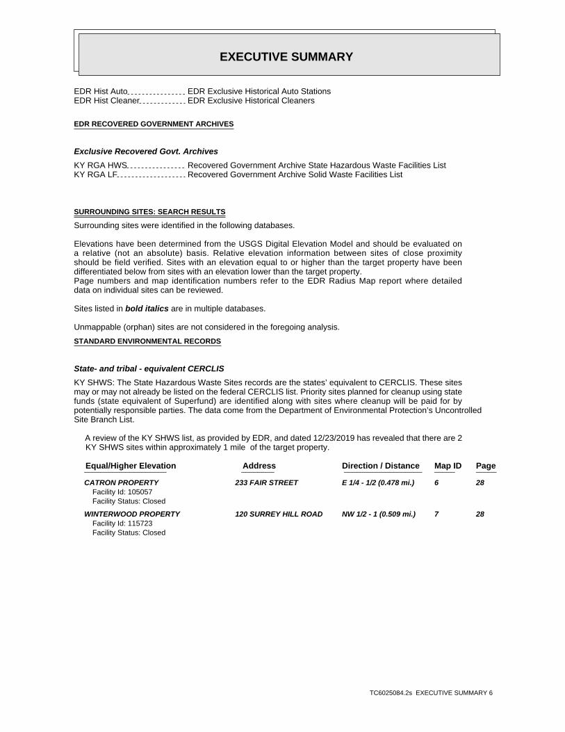
EXECUTIVE SUMMARY
TC6025084.2s EXECUTIVE SUMMARY 6
EDR Hist Auto EDR Exclusive Historical Auto StationsEDR Hist Cleaner EDR Exclusive Historical Cleaners
EDR RECOVERED GOVERNMENT ARCHIVES
Exclusive Recovered Govt. Archives
KY RGA HWS Recovered Government Archive State Hazardous Waste Facilities ListKY RGA LF Recovered Government Archive Solid Waste Facilities List
SURROUNDING SITES: SEARCH RESULTS
Surrounding sites were identified in the following databases.
Elevations have been determined from the USGS Digital Elevation Model and should be evaluated ona relative (not an absolute) basis. Relative elevation information between sites of close proximityshould be field verified. Sites with an elevation equal to or higher than the target property have beendifferentiated below from sites with an elevation lower than the target property.Page numbers and map identification numbers refer to the EDR Radius Map report where detaileddata on individual sites can be reviewed.
Sites listed in bold italics are in multiple databases.
Unmappable (orphan) sites are not considered in the foregoing analysis.
STANDARD ENVIRONMENTAL RECORDS
State- and tribal - equivalent CERCLIS
KY SHWS: The State Hazardous Waste Sites records are the states’ equivalent to CERCLIS. These sitesmay or may not already be listed on the federal CERCLIS list. Priority sites planned for cleanup using statefunds (state equivalent of Superfund) are identified along with sites where cleanup will be paid for bypotentially responsible parties. The data come from the Department of Environmental Protection’s UncontrolledSite Branch List.
A review of the KY SHWS list, as provided by EDR, and dated 12/23/2019 has revealed that there are 2 KY SHWS sites within approximately 1 mile of the target property.
PageMap IDDirection / Distance Address Equal/Higher Elevation ____________________ ________ ___________________ _____ _____
CATRON PROPERTY 233 FAIR STREET E 1/4 - 1/2 (0.478 mi.) 6 28Facility Id: 105057Facility Status: Closed
WINTERWOOD PROPERTY 120 SURREY HILL ROAD NW 1/2 - 1 (0.509 mi.) 7 28Facility Id: 115723Facility Status: Closed

EXECUTIVE SUMMARY
TC6025084.2s EXECUTIVE SUMMARY 7
State and tribal landfill and/or solid waste disposal site lists
KY SWF/LF: The Solid Waste Facilities/Landfill Sites records typically contain an inventory of solidwaste disposal facilities or landfills in a particular state. The data come from the Department ofEnvironmental Protection’s List of All Active Contained & Residential Landfills/List of All Transfer Stations.
A review of the KY SWF/LF list, as provided by EDR, and dated 11/26/2019 has revealed that there is 1 KY SWF/LF site within approximately 0.5 miles of the target property.
PageMap IDDirection / Distance Address Equal/Higher Elevation ____________________ ________ ___________________ _____ _____
WAYNE SANITATION TRA SIDWELL ST ENE 0 - 1/8 (0.107 mi.) A3 9Status: TerminatedFacility Id: 40135
ADDITIONAL ENVIRONMENTAL RECORDS
Local Lists of Landfill / Solid Waste Disposal Sites
KY HIST LF: This solid waste facility listing contains detail information that is not included in thelandfill listing. A listing with detail information is no longer available by the Department of EnvironmentalProtection.
A review of the KY HIST LF list, as provided by EDR, and dated 05/01/2003 has revealed that there is 1 KY HIST LF site within approximately 0.5 miles of the target property.
PageMap IDDirection / Distance Address Equal/Higher Elevation ____________________ ________ ___________________ _____ _____
WAYNE TRANSFER STATI SIDWELL STREET ENE 0 - 1/8 (0.107 mi.) A2 8Activity Status: APPLICATION APPROVEDActivity Status: ACTIVITY APPROVEDStatus: APPLICATION APPROVEDFacility Id: 116-00006
Other Ascertainable Records
RCRA NonGen / NLR: RCRAInfo is EPA’s comprehensive information system, providing access to data supportingthe Resource Conservation and Recovery Act (RCRA) of 1976 and the Hazardous and Solid Waste Amendments (HSWA)of 1984. The database includes selective information on sites which generate, transport, store, treat and/ordispose of hazardous waste as defined by the Resource Conservation and Recovery Act (RCRA). Non-Generators donot presently generate hazardous waste.
A review of the RCRA NonGen / NLR list, as provided by EDR, and dated 12/16/2019 has revealed that there is 1 RCRA NonGen / NLR site within approximately 0.25 miles of the target property.
PageMap IDDirection / Distance Address Equal/Higher Elevation ____________________ ________ ___________________ _____ _____
BELDEN WIRE & CABLE 1200 WEST COLUMBIA A NNW 1/8 - 1/4 (0.229 mi.) B4 10EPA ID:: KYD062973631
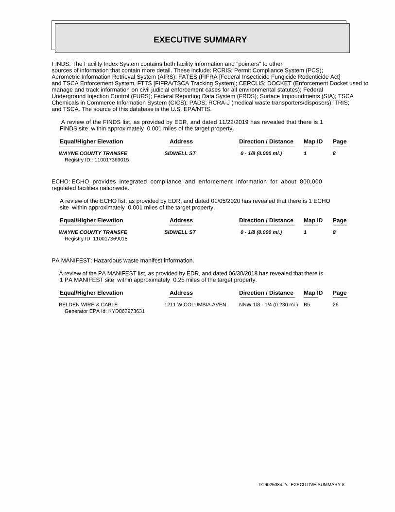
EXECUTIVE SUMMARY
TC6025084.2s EXECUTIVE SUMMARY 8
FINDS: The Facility Index System contains both facility information and "pointers" to othersources of information that contain more detail. These include: RCRIS; Permit Compliance System (PCS);Aerometric Information Retrieval System (AIRS); FATES (FIFRA [Federal Insecticide Fungicide Rodenticide Act]and TSCA Enforcement System, FTTS [FIFRA/TSCA Tracking System]; CERCLIS; DOCKET (Enforcement Docket used tomanage and track information on civil judicial enforcement cases for all environmental statutes); FederalUnderground Injection Control (FURS); Federal Reporting Data System (FRDS); Surface Impoundments (SIA); TSCAChemicals in Commerce Information System (CICS); PADS; RCRA-J (medical waste transporters/disposers); TRIS;and TSCA. The source of this database is the U.S. EPA/NTIS.
A review of the FINDS list, as provided by EDR, and dated 11/22/2019 has revealed that there is 1 FINDS site within approximately 0.001 miles of the target property.
PageMap IDDirection / Distance Address Equal/Higher Elevation ____________________ ________ ___________________ _____ _____
WAYNE COUNTY TRANSFE SIDWELL ST 0 - 1/8 (0.000 mi.) 1 8Registry ID:: 110017369015
ECHO: ECHO provides integrated compliance and enforcement information for about 800,000regulated facilities nationwide.
A review of the ECHO list, as provided by EDR, and dated 01/05/2020 has revealed that there is 1 ECHO site within approximately 0.001 miles of the target property.
PageMap IDDirection / Distance Address Equal/Higher Elevation ____________________ ________ ___________________ _____ _____
WAYNE COUNTY TRANSFE SIDWELL ST 0 - 1/8 (0.000 mi.) 1 8Registry ID: 110017369015
PA MANIFEST: Hazardous waste manifest information.
A review of the PA MANIFEST list, as provided by EDR, and dated 06/30/2018 has revealed that there is 1 PA MANIFEST site within approximately 0.25 miles of the target property.
PageMap IDDirection / Distance Address Equal/Higher Elevation ____________________ ________ ___________________ _____ _____
BELDEN WIRE & CABLE 1211 W COLUMBIA AVEN NNW 1/8 - 1/4 (0.230 mi.) B5 26Generator EPA Id: KYD062973631

EXECUTIVE SUMMARY
TC6025084.2s EXECUTIVE SUMMARY 9
There were no unmapped sites in this report.

EDR Inc.EDR Inc.EDR Inc.EDR Inc.EDR Inc.EDR Inc.EDR Inc.EDR Inc.EDR Inc.EDR Inc.EDR Inc.EDR Inc.EDR Inc.EDR Inc.EDR Inc.EDR Inc.EDR Inc.EDR Inc.EDR Inc.EDR Inc.EDR Inc.EDR Inc.EDR Inc.EDR Inc.EDR Inc.EDR Inc.EDR Inc.EDR Inc.EDR Inc.EDR Inc.EDR Inc.EDR Inc.EDR Inc.EDR Inc.EDR Inc.EDR Inc.EDR Inc.EDR Inc.EDR Inc.EDR Inc.
10
40
10
80
1 0 4
10
40
96
0
9 6 0
9 6 0
1 0 0 0
0
1 0 0 0
1 0
0 0
92
0
96
0
96
0
9 6 0
20
9 2 0
96
0
10
009 6 0
1 16 0
1 1 2 0
10
00
10 0 0
10 0 0
960
91 000
1 0 8 010 8 0
9 6 0
1 0 4 0
10
4 0
960
96
0
10
40
10
00
1 0 0 0
1 0 0 0
96
0
9 60
96 0
920
92
0
9 2 0
96
0
960
920
9 6 09 20
920
920
9 60
92
0
920
92
0
9 2 0
9 2 0
9 20
92 0
8 4 08 8 0
8 80
88
0
8 8 0
9 2 0
9 20
9 2 0
9 20
92
0
9 2 0
9 2 0
9 6 0
9
6 0
9 6 0
9 6 0
96
09 6
0
960
01 0 4 01
0
0 0

EDR Inc.EDR Inc.EDR Inc.EDR Inc.EDR Inc.EDR Inc.EDR Inc.EDR Inc.EDR Inc.EDR Inc.EDR Inc.EDR Inc.EDR Inc.EDR Inc.EDR Inc.EDR Inc.EDR Inc.EDR Inc.EDR Inc.EDR Inc.EDR Inc.EDR Inc.EDR Inc.EDR Inc.EDR Inc.EDR Inc.EDR Inc.EDR Inc.EDR Inc.EDR Inc.EDR Inc.EDR Inc.EDR Inc.EDR Inc.EDR Inc.EDR Inc.EDR Inc.EDR Inc.EDR Inc.EDR Inc.
9
960
960
920
920
920

MAP FINDINGS SUMMARY
SearchTargetDistance Total
Database Property(Miles) < 1/8 1/8 - 1/4 1/4 - 1/2 1/2 - 1 > 1 Plotted
STANDARD ENVIRONMENTAL RECORDS
Federal NPL site list
0 NR 0 0 0 0 1.000NPL 0 NR 0 0 0 0 1.000Proposed NPL 0 NR 0 0 0 0 1.000NPL LIENS
Federal Delisted NPL site list
0 NR 0 0 0 0 1.000Delisted NPL
Federal CERCLIS list
0 NR NR 0 0 0 0.500FEDERAL FACILITY 0 NR NR 0 0 0 0.500SEMS
Federal CERCLIS NFRAP site list
0 NR NR 0 0 0 0.500SEMS-ARCHIVE
Federal RCRA CORRACTS facilities list
0 NR 0 0 0 0 1.000CORRACTS
Federal RCRA non-CORRACTS TSD facilities list
0 NR NR 0 0 0 0.500RCRA-TSDF
Federal RCRA generators list
0 NR NR NR 0 0 0.250RCRA-LQG 0 NR NR NR 0 0 0.250RCRA-SQG 0 NR NR NR 0 0 0.250RCRA-VSQG
Federal institutional controls /engineering controls registries
0 NR NR 0 0 0 0.500LUCIS 0 NR NR 0 0 0 0.500US ENG CONTROLS 0 NR NR 0 0 0 0.500US INST CONTROL
Federal ERNS list
0 NR NR NR NR 0 0.001ERNS
State- and tribal - equivalent CERCLIS
2 NR 1 1 0 0 1.000KY SHWS
State and tribal landfill and/orsolid waste disposal site lists
1 NR NR 0 0 1 0.500KY SWF/LF
State and tribal leaking storage tank lists
0 NR NR 0 0 0 0.500KY PSTEAF 0 NR NR 0 0 0 0.500INDIAN LUST 0 NR NR 0 0 0 0.500KY SB193
State and tribal registered storage tank lists
0 NR NR NR 0 0 0.250FEMA UST
TC6025084.2s Page 4

MAP FINDINGS SUMMARY
SearchTargetDistance Total
Database Property(Miles) < 1/8 1/8 - 1/4 1/4 - 1/2 1/2 - 1 > 1 Plotted
0 NR NR NR 0 0 0.250KY UST 0 NR NR NR 0 0 0.250KY AST 0 NR NR NR 0 0 0.250INDIAN UST
State and tribal institutionalcontrol / engineering control registries
0 NR NR 0 0 0 0.500KY ENG CONTROLS 0 NR NR 0 0 0 0.500KY INST CONTROL
State and tribal voluntary cleanup sites
0 NR NR 0 0 0 0.500KY VCP 0 NR NR 0 0 0 0.500INDIAN VCP
State and tribal Brownfields sites
0 NR NR 0 0 0 0.500KY BROWNFIELDS
ADDITIONAL ENVIRONMENTAL RECORDS
Local Brownfield lists
0 NR NR 0 0 0 0.500US BROWNFIELDS
Local Lists of Landfill / SolidWaste Disposal Sites
0 NR NR 0 0 0 0.500KY SWRCY 1 NR NR 0 0 1 0.500KY HIST LF 0 NR NR 0 0 0 0.500INDIAN ODI 0 NR NR 0 0 0 0.500DEBRIS REGION 9 0 NR NR 0 0 0 0.500ODI 0 NR NR 0 0 0 0.500IHS OPEN DUMPS
Local Lists of Hazardous waste /Contaminated Sites
0 NR NR NR NR 0 0.001US HIST CDL 0 NR NR NR NR 0 0.001KY CDL 0 NR NR NR NR 0 0.001US CDL
Local Land Records
0 NR NR NR NR 0 0.001LIENS 2
Records of Emergency Release Reports
0 NR NR NR NR 0 0.001HMIRS 0 NR NR NR NR 0 0.001KY SPILLS
Other Ascertainable Records
1 NR NR NR 1 0 0.250RCRA NonGen / NLR 0 NR 0 0 0 0 1.000FUDS 0 NR 0 0 0 0 1.000DOD 0 NR NR 0 0 0 0.500SCRD DRYCLEANERS 0 NR NR NR NR 0 0.001US FIN ASSUR 0 NR NR NR NR 0 0.001EPA WATCH LIST
TC6025084.2s Page 5
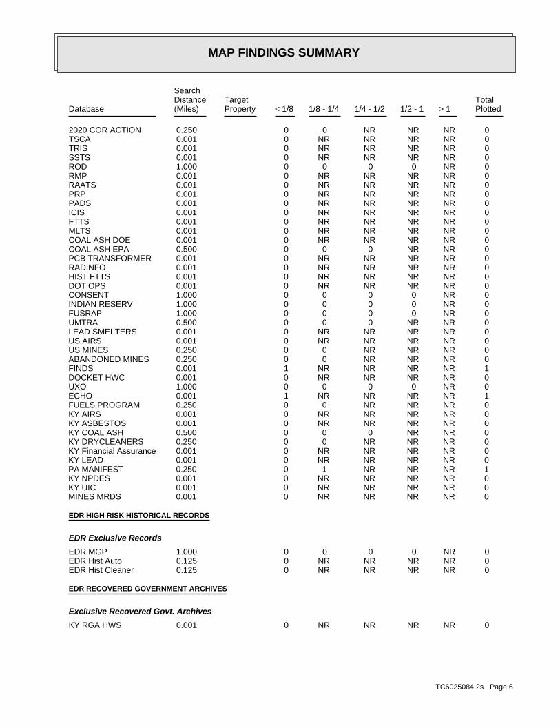
MAP FINDINGS SUMMARY
SearchTargetDistance Total
Database Property(Miles) < 1/8 1/8 - 1/4 1/4 - 1/2 1/2 - 1 > 1 Plotted
0 NR NR NR 0 0 0.2502020 COR ACTION 0 NR NR NR NR 0 0.001TSCA 0 NR NR NR NR 0 0.001TRIS 0 NR NR NR NR 0 0.001SSTS 0 NR 0 0 0 0 1.000ROD 0 NR NR NR NR 0 0.001RMP 0 NR NR NR NR 0 0.001RAATS 0 NR NR NR NR 0 0.001PRP 0 NR NR NR NR 0 0.001PADS 0 NR NR NR NR 0 0.001ICIS 0 NR NR NR NR 0 0.001FTTS 0 NR NR NR NR 0 0.001MLTS 0 NR NR NR NR 0 0.001COAL ASH DOE 0 NR NR 0 0 0 0.500COAL ASH EPA 0 NR NR NR NR 0 0.001PCB TRANSFORMER 0 NR NR NR NR 0 0.001RADINFO 0 NR NR NR NR 0 0.001HIST FTTS 0 NR NR NR NR 0 0.001DOT OPS 0 NR 0 0 0 0 1.000CONSENT 0 NR 0 0 0 0 1.000INDIAN RESERV 0 NR 0 0 0 0 1.000FUSRAP 0 NR NR 0 0 0 0.500UMTRA 0 NR NR NR NR 0 0.001LEAD SMELTERS 0 NR NR NR NR 0 0.001US AIRS 0 NR NR NR 0 0 0.250US MINES 0 NR NR NR 0 0 0.250ABANDONED MINES 1 NR NR NR NR 1 0.001FINDS 0 NR NR NR NR 0 0.001DOCKET HWC 0 NR 0 0 0 0 1.000UXO 1 NR NR NR NR 1 0.001ECHO 0 NR NR NR 0 0 0.250FUELS PROGRAM 0 NR NR NR NR 0 0.001KY AIRS 0 NR NR NR NR 0 0.001KY ASBESTOS 0 NR NR 0 0 0 0.500KY COAL ASH 0 NR NR NR 0 0 0.250KY DRYCLEANERS 0 NR NR NR NR 0 0.001KY Financial Assurance 0 NR NR NR NR 0 0.001KY LEAD 1 NR NR NR 1 0 0.250PA MANIFEST 0 NR NR NR NR 0 0.001KY NPDES 0 NR NR NR NR 0 0.001KY UIC 0 NR NR NR NR 0 0.001MINES MRDS
EDR HIGH RISK HISTORICAL RECORDS
EDR Exclusive Records
0 NR 0 0 0 0 1.000EDR MGP 0 NR NR NR NR 0 0.125EDR Hist Auto 0 NR NR NR NR 0 0.125EDR Hist Cleaner
EDR RECOVERED GOVERNMENT ARCHIVES
Exclusive Recovered Govt. Archives
0 NR NR NR NR 0 0.001KY RGA HWS
TC6025084.2s Page 6
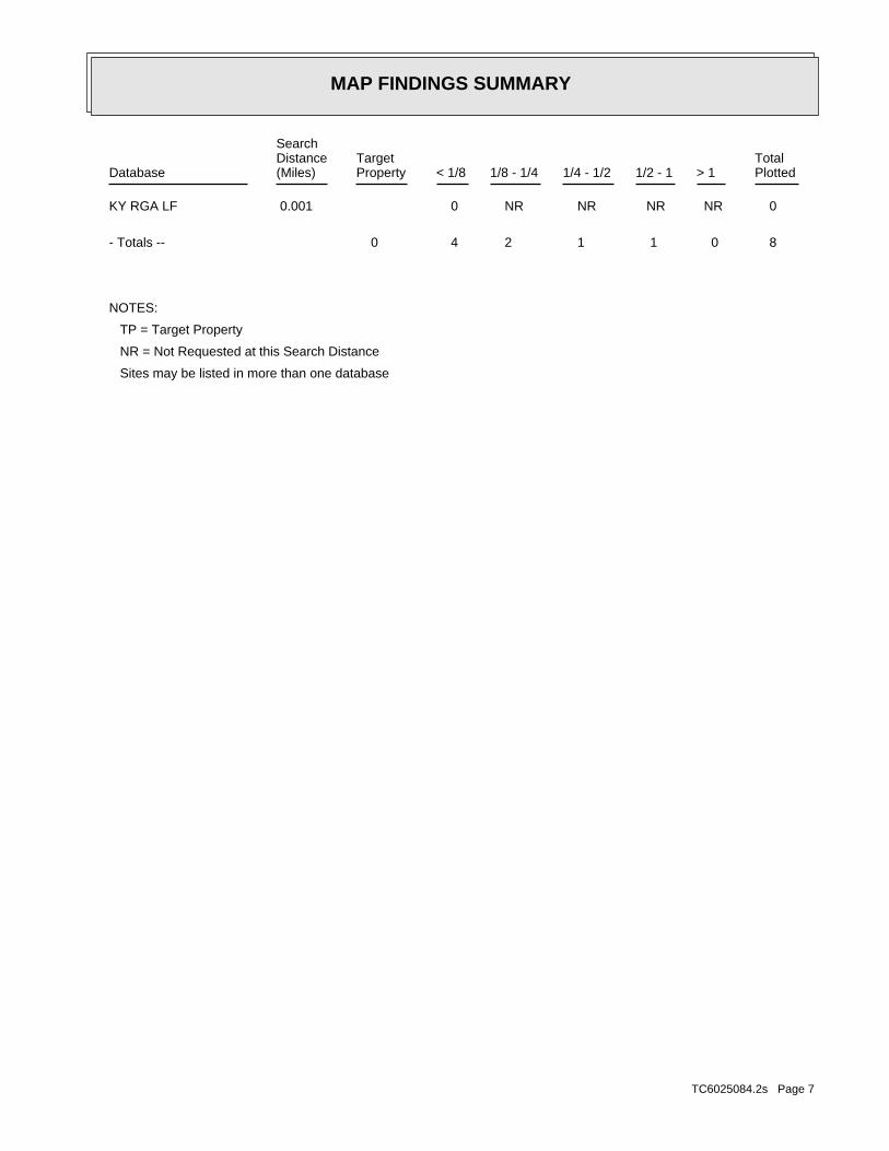
MAP FINDINGS SUMMARY
SearchTargetDistance Total
Database Property(Miles) < 1/8 1/8 - 1/4 1/4 - 1/2 1/2 - 1 > 1 Plotted
0 NR NR NR NR 0 0.001KY RGA LF
8 0 1 1 2 4 0- Totals --
NOTES:
TP = Target Property
NR = Not Requested at this Search Distance
Sites may be listed in more than one database
TC6025084.2s Page 7

MAP FINDINGSMap IDDirection
EDR ID NumberDistanceEPA ID NumberDatabase(s)SiteElevation
WAYNE COUNTY, KY 42633City,State,Zip: SIDWELL STAddress: WAYNE COUNTY TRANSFER STATIONName: http://echo.epa.gov/detailed-facility-report?fid=110017369015DFR URL: 110017369015Registry ID: 1018304102Envid:
ECHO:
additional FINDS: detail in the EDR Site Report.Click this hyperlink while viewing on your computer to access
discharge does not adversely affect water quality.requirements, and include other provisions to ensure that thelimits on what can be discharged, impose monitoring and reportingStates are required to obtain a permit. The permit will likely containdischarge pollutants from any point source into waters of the Unitedissued under the Clean Water Act. Under NPDES, all facilities thatthe Compliance Information System (ICIS) tracks surface water permitsUS National Pollutant Discharge Elimination System (NPDES) module of
Environmental Interest/Information System:
registry_id=110017369015 http://ofmpub.epa.gov/enviro/fii_query_detail.disp_program_facility?p_Facility URL: 110017369015Registry ID:
FINDS:
2 ft.0.000 mi.
Relative:Higher
Actual:945 ft.
< 1/8 WAYNE COUNTY, KY 42633ECHOSIDWELL ST N/A
1 FINDSWAYNE COUNTY TRANSFER STATION 1018304102
Not reportedOwner Address2: RR 3 BOX 133 J 4 1Owner Address1: WAYNE SANITATION INCOwner: TRANSFER STATIONFacility Type: APPLICATION APPROVEDStatus: Not reportedFacility Address 2: 116-00006Facility ID:
(606)348-9913Contact Phone: CARRENDERContact Last Name: MIKEContact First Name: APPLICATION APPROVEDActivity Status: RECYCLING CENTERActivity Type: ( ) -Owner Phone: MONTICELLO, KY 42633-9803Owner City,St,Zip: Not reportedOwner Address2: RR 3 BOX 133 J 4 1Owner Address1: WAYNE SANITATION INCOwner: TRANSFER STATIONFacility Type: APPLICATION APPROVEDStatus: Not reportedFacility Address 2: 116-00006Facility ID:
HIST LF:
565 ft. Site 1 of 2 in cluster A0.107 mi.
Relative:Higher
Actual:948 ft.
< 1/8 MONTICELLO, KY 42633ENE SIDWELL STREET N/AA2 KY HIST LFWAYNE TRANSFER STATION S103594158
TC6025084.2s Page 8

MAP FINDINGSMap IDDirection
EDR ID NumberDistanceEPA ID NumberDatabase(s)SiteElevation
(606)348-9913Contact Phone: CARRENDERContact Last Name: MIKEContact First Name: ACTIVITY APPROVEDActivity Status: TRANSFER STATIONActivity Type: (606)864-4391Owner Phone: CORBIN, KY 40702-Owner City,St,Zip: Not reportedOwner Address2: P O BOX 1364Owner Address1: UNITED WASTE SYSTEMS OF KENTUCKY INCOwner: TRANSFER STATIONFacility Type: APPLICATION APPROVEDStatus: Not reportedFacility Address 2: 116-00006Facility ID:
(606)348-9913Contact Phone: CARRENDERContact Last Name: MIKEContact First Name: APPLICATION APPROVEDActivity Status: RECYCLING CENTERActivity Type: (606)864-4391Owner Phone: CORBIN, KY 40702-Owner City,St,Zip: Not reportedOwner Address2: P O BOX 1364Owner Address1: UNITED WASTE SYSTEMS OF KENTUCKY INCOwner: TRANSFER STATIONFacility Type: APPLICATION APPROVEDStatus: Not reportedFacility Address 2: 116-00006Facility ID:
(606)348-9913Contact Phone: CARRENDERContact Last Name: MIKEContact First Name: ACTIVITY APPROVEDActivity Status: TRANSFER STATIONActivity Type: ( ) -Owner Phone: MONTICELLO, KY 42633-9803Owner City,St,Zip:
WAYNE TRANSFER STATION (Continued) S103594158
-84.86033000Longitude: 36.83889000Latitude: Commercial Recycling Center-SW-RPBRFacility Type: 20279Rel Entity ID: Wayne Sanitation Transfer Station - Sidwell StAI Name: 11600006-2SI Designation: ACTV0000000001SI ID: 11600006-2Permit Number: TerminatedStatus: 40135Facility ID: MONTICELLO (WAYNE), KY 42633City,State,Zip: SIDWELL STAddress: WAYNE SANITATION TRANSFER STATION - SIDWELL STName:
LF:
565 ft. Site 2 of 2 in cluster A0.107 mi.
Relative:Higher
Actual:948 ft.
< 1/8 MONTICELLO (WAYNE), KY 42633ENE SIDWELL ST N/AA3 KY SWF/LFWAYNE SANITATION TRANSFER STATION - SIDWELL ST S107603192
TC6025084.2s Page 9

MAP FINDINGSMap IDDirection
EDR ID NumberDistanceEPA ID NumberDatabase(s)SiteElevation
Mr. David CoomerLast Inspector: 06/24/2008Date Last Site Insp.: SW: Transfer Station Solid Waste-TerminatedSI Description: ORelated Entity Type: 40740Related Entity Zip: KYRelated Entity State: LilyRelated Entity Municipality: PO Box 808Related Entity Address2: 3612 E KY 552Related Entity Address1: Waste Connections of Kentucky IncRelated Entity Name: 10/11/2011Permit expired date: MONTICELLO (WAYNE), KY 42633Permittee city/state/zip: -84.86033000Longitude: 36.83889000Latitude: Transfer Station Solid Waste-SW-RPBRFacility Type: 20279Rel Entity ID: Wayne Sanitation Transfer Station - Sidwell StAI Name: Transfer Station Solid WaSI Designation: ACTV0000000002SI ID: 116-00006Permit Number: TerminatedStatus: 40135Facility ID: MONTICELLO (WAYNE), KY 42633City,State,Zip: SIDWELL STAddress: WAYNE SANITATION TRANSFER STATION - SIDWELL STName:
Mr. David CoomerLast Inspector: 06/24/2008Date Last Site Insp.: RECYCLING CENTER-TerminatedSI Description: ORelated Entity Type: 40740Related Entity Zip: KYRelated Entity State: LilyRelated Entity Municipality: PO Box 808Related Entity Address2: 3612 E KY 552Related Entity Address1: Waste Connections of Kentucky IncRelated Entity Name: Not reportedPermit expired date: MONTICELLO (WAYNE), KY 42633Permittee city/state/zip:
WAYNE SANITATION TRANSFER STATION - SIDWELL ST (Continued) S107603192
978-514-0113Contact telephone: USContact country: RICHMOND, IN 47374 US HWY 27 SOUTHContact address: DEREK WAGNERContact: MONTICELLO, KY 42633 W. COLUMBIA AVENUEMailing address: KYD062973631EPA ID: MONTICELLO, KY 42633 1200 WEST COLUMBIA AVENUEFacility address: BELDEN WIRE & CABLEFacility name: 2018-04-11 00:00:00.0Date form received by agency:
RCRA NonGen / NLR:
1208 ft. Site 1 of 2 in cluster B0.229 mi.
Relative:Higher
Actual:944 ft.
1/8-1/4 MONTICELLO, KY 42633NNW 1200 WEST COLUMBIA AVENUE KYD062973631B4 RCRA NonGen / NLRBELDEN WIRE & CABLE 1000186549
TC6025084.2s Page 10

MAP FINDINGSMap IDDirection
EDR ID NumberDistanceEPA ID NumberDatabase(s)SiteElevation
2017-07-07 00:00:00.0Date form received by agency:
Large Quantity GeneratorClassification: BELDEN WIRE & CABLESite name: 2018-02-05 00:00:00.0Date form received by agency:
Historical Generators:
NoUsed oil transporter: NoUsed oil transfer facility: NoUsed oil Specification marketer: NoUsed oil fuel marketer to burner: NoUser oil refiner: NoUsed oil processor: NoUsed oil fuel burner: NoFurnace exemption: NoOn-site burner exemption: NoUnderground injection activity: NoTreater, storer or disposer of HW: NoTransporter of hazardous waste: NoRecycler of hazardous waste: NoMixed waste (haz. and radioactive): NoU.S. importer of hazardous waste:
Handler Activities Summary:
Not reportedOwner/Op end date: Not reportedOwner/Op start date: OwnerOwner/Operator Type: PrivateLegal status: Not reportedOwner/operator extension: Not reportedOwner/operator fax: Not reportedOwner/operator email: 314-854-8000Owner/operator telephone: USOwner/operator country: ST. LOUIS, MO 63105 NORTH BRENTWOOD BLV 15TH FLOOROwner/operator address: BELDEN, INC.Owner/operator name:
Not reportedOwner/Op end date: 2003-07-08 00:00:00.Owner/Op start date: OperatorOwner/Operator Type: PrivateLegal status: Not reportedOwner/operator extension: Not reportedOwner/operator fax: Not reportedOwner/operator email: Not reportedOwner/operator telephone: Not reportedOwner/operator country: Not reported Not reportedOwner/operator address: UNKNOWNOwner/operator name:
Owner/Operator Summary:
Handler: Non-Generators do not presently generate hazardous wasteDescription: Non-GeneratorClassification: PrivateLand type: 04EPA Region: Not reportedContact email:
BELDEN WIRE & CABLE (Continued) 1000186549
TC6025084.2s Page 11
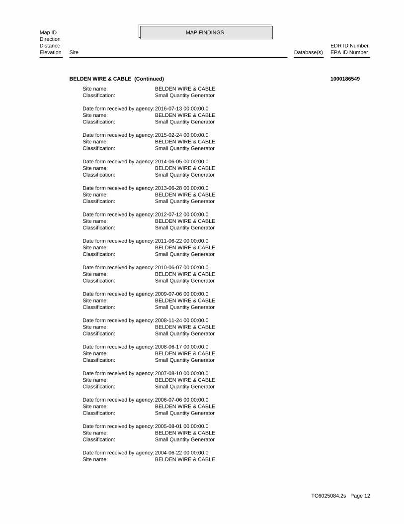
MAP FINDINGSMap IDDirection
EDR ID NumberDistanceEPA ID NumberDatabase(s)SiteElevation
BELDEN WIRE & CABLESite name: 2004-06-22 00:00:00.0Date form received by agency:
Small Quantity GeneratorClassification: BELDEN WIRE & CABLESite name: 2005-08-01 00:00:00.0Date form received by agency:
Small Quantity GeneratorClassification: BELDEN WIRE & CABLESite name: 2006-07-06 00:00:00.0Date form received by agency:
Small Quantity GeneratorClassification: BELDEN WIRE & CABLESite name: 2007-08-10 00:00:00.0Date form received by agency:
Small Quantity GeneratorClassification: BELDEN WIRE & CABLESite name: 2008-06-17 00:00:00.0Date form received by agency:
Small Quantity GeneratorClassification: BELDEN WIRE & CABLESite name: 2008-11-24 00:00:00.0Date form received by agency:
Small Quantity GeneratorClassification: BELDEN WIRE & CABLESite name: 2009-07-06 00:00:00.0Date form received by agency:
Small Quantity GeneratorClassification: BELDEN WIRE & CABLESite name: 2010-06-07 00:00:00.0Date form received by agency:
Small Quantity GeneratorClassification: BELDEN WIRE & CABLESite name: 2011-06-22 00:00:00.0Date form received by agency:
Small Quantity GeneratorClassification: BELDEN WIRE & CABLESite name: 2012-07-12 00:00:00.0Date form received by agency:
Small Quantity GeneratorClassification: BELDEN WIRE & CABLESite name: 2013-06-28 00:00:00.0Date form received by agency:
Small Quantity GeneratorClassification: BELDEN WIRE & CABLESite name: 2014-06-05 00:00:00.0Date form received by agency:
Small Quantity GeneratorClassification: BELDEN WIRE & CABLESite name: 2015-02-24 00:00:00.0Date form received by agency:
Small Quantity GeneratorClassification: BELDEN WIRE & CABLESite name: 2016-07-13 00:00:00.0Date form received by agency:
Small Quantity GeneratorClassification: BELDEN WIRE & CABLESite name:
BELDEN WIRE & CABLE (Continued) 1000186549
TC6025084.2s Page 12
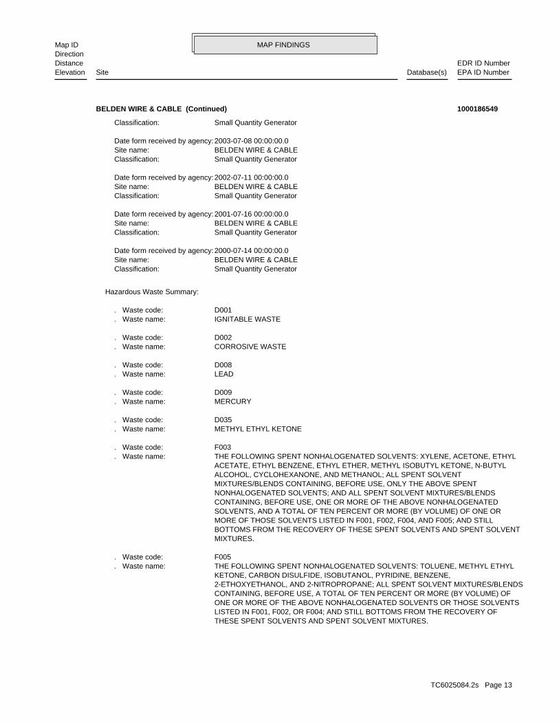
MAP FINDINGSMap IDDirection
EDR ID NumberDistanceEPA ID NumberDatabase(s)SiteElevation
THESE SPENT SOLVENTS AND SPENT SOLVENT MIXTURES. LISTED IN F001, F002, OR F004; AND STILL BOTTOMS FROM THE RECOVERY OF ONE OR MORE OF THE ABOVE NONHALOGENATED SOLVENTS OR THOSE SOLVENTS CONTAINING, BEFORE USE, A TOTAL OF TEN PERCENT OR MORE (BY VOLUME) OF 2-ETHOXYETHANOL, AND 2-NITROPROPANE; ALL SPENT SOLVENT MIXTURES/BLENDS KETONE, CARBON DISULFIDE, ISOBUTANOL, PYRIDINE, BENZENE, THE FOLLOWING SPENT NONHALOGENATED SOLVENTS: TOLUENE, METHYL ETHYL. Waste name: F005. Waste code:
MIXTURES. BOTTOMS FROM THE RECOVERY OF THESE SPENT SOLVENTS AND SPENT SOLVENT MORE OF THOSE SOLVENTS LISTED IN F001, F002, F004, AND F005; AND STILL SOLVENTS, AND A TOTAL OF TEN PERCENT OR MORE (BY VOLUME) OF ONE OR CONTAINING, BEFORE USE, ONE OR MORE OF THE ABOVE NONHALOGENATED NONHALOGENATED SOLVENTS; AND ALL SPENT SOLVENT MIXTURES/BLENDS MIXTURES/BLENDS CONTAINING, BEFORE USE, ONLY THE ABOVE SPENT ALCOHOL, CYCLOHEXANONE, AND METHANOL; ALL SPENT SOLVENT ACETATE, ETHYL BENZENE, ETHYL ETHER, METHYL ISOBUTYL KETONE, N-BUTYL THE FOLLOWING SPENT NONHALOGENATED SOLVENTS: XYLENE, ACETONE, ETHYL. Waste name: F003. Waste code:
METHYL ETHYL KETONE. Waste name: D035. Waste code:
MERCURY. Waste name: D009. Waste code:
LEAD. Waste name: D008. Waste code:
CORROSIVE WASTE. Waste name: D002. Waste code:
IGNITABLE WASTE. Waste name: D001. Waste code:
Hazardous Waste Summary:
Small Quantity GeneratorClassification: BELDEN WIRE & CABLESite name: 2000-07-14 00:00:00.0Date form received by agency:
Small Quantity GeneratorClassification: BELDEN WIRE & CABLESite name: 2001-07-16 00:00:00.0Date form received by agency:
Small Quantity GeneratorClassification: BELDEN WIRE & CABLESite name: 2002-07-11 00:00:00.0Date form received by agency:
Small Quantity GeneratorClassification: BELDEN WIRE & CABLESite name: 2003-07-08 00:00:00.0Date form received by agency:
Small Quantity GeneratorClassification:
BELDEN WIRE & CABLE (Continued) 1000186549
TC6025084.2s Page 13

MAP FINDINGSMap IDDirection
EDR ID NumberDistanceEPA ID NumberDatabase(s)SiteElevation
Not reported Paid penalty amount: Not reported Final penalty amount: Not reported Proposed penalty amount: State Enforcement lead agency: Not reported Enf. disp. status date: Not reported Enf. disposition status: 2010-12-16 00:00:00.0 Enforcement action date: COMPLIANCE EVALUATION INSPECTION ON-SITE Enforcement action: StateViolation lead agency: 2011-01-12 00:00:00.0Date achieved compliance: 2010-12-16 00:00:00.0Date violation determined: Generators - Pre-transportArea of violation: Not reportedRegulation violated:
Not reported Paid penalty amount: Not reported Final penalty amount: Not reported Proposed penalty amount: State Enforcement lead agency: Not reported Enf. disp. status date: Not reported Enf. disposition status: 2010-12-16 00:00:00.0 Enforcement action date: COMPLIANCE SCHEDULE EVALUATION Enforcement action: StateViolation lead agency: 2011-01-12 00:00:00.0Date achieved compliance: 2010-12-16 00:00:00.0Date violation determined: TSD IS-Container Use and ManagementArea of violation: Not reportedRegulation violated:
Not reported Paid penalty amount: Not reported Final penalty amount: Not reported Proposed penalty amount: State Enforcement lead agency: Not reported Enf. disp. status date: Not reported Enf. disposition status: 2010-12-16 00:00:00.0 Enforcement action date: COMPLIANCE SCHEDULE EVALUATION Enforcement action: StateViolation lead agency: 2011-01-12 00:00:00.0Date achieved compliance: 2010-12-16 00:00:00.0Date violation determined: Generators - Pre-transportArea of violation: Not reportedRegulation violated:
Not reported Paid penalty amount: Not reported Final penalty amount: Not reported Proposed penalty amount: State Enforcement lead agency: Not reported Enf. disp. status date: Not reported Enf. disposition status: 2010-12-16 00:00:00.0 Enforcement action date: COMPLIANCE EVALUATION INSPECTION ON-SITE Enforcement action: StateViolation lead agency: 2011-01-12 00:00:00.0Date achieved compliance: 2010-12-16 00:00:00.0Date violation determined: TSD IS-Container Use and ManagementArea of violation: Not reportedRegulation violated:
Facility Has Received Notices of Violations:
BELDEN WIRE & CABLE (Continued) 1000186549
TC6025084.2s Page 14

MAP FINDINGSMap IDDirection
EDR ID NumberDistanceEPA ID NumberDatabase(s)SiteElevation
Not reportedRegulation violated:
Not reported Paid penalty amount: Not reported Final penalty amount: Not reported Proposed penalty amount: State Enforcement lead agency: Not reported Enf. disp. status date: Not reported Enf. disposition status: 2009-07-22 00:00:00.0 Enforcement action date: COMPLIANCE EVALUATION INSPECTION ON-SITE Enforcement action: StateViolation lead agency: 2009-08-19 00:00:00.0Date achieved compliance: 2009-07-22 00:00:00.0Date violation determined: Generators - Pre-transportArea of violation: Not reportedRegulation violated:
Not reported Paid penalty amount: Not reported Final penalty amount: Not reported Proposed penalty amount: State Enforcement lead agency: Not reported Enf. disp. status date: Not reported Enf. disposition status: 2009-07-22 00:00:00.0 Enforcement action date: COMPLIANCE SCHEDULE EVALUATION Enforcement action: StateViolation lead agency: 2009-08-19 00:00:00.0Date achieved compliance: 2009-07-22 00:00:00.0Date violation determined: State Statute or RegulationArea of violation: Not reportedRegulation violated:
Not reported Paid penalty amount: Not reported Final penalty amount: Not reported Proposed penalty amount: State Enforcement lead agency: Not reported Enf. disp. status date: Not reported Enf. disposition status: 2009-07-22 00:00:00.0 Enforcement action date: COMPLIANCE SCHEDULE EVALUATION Enforcement action: StateViolation lead agency: 2009-08-19 00:00:00.0Date achieved compliance: 2009-07-22 00:00:00.0Date violation determined: TSD IS-Preparedness and PreventionArea of violation: Not reportedRegulation violated:
Not reported Paid penalty amount: Not reported Final penalty amount: Not reported Proposed penalty amount: State Enforcement lead agency: Not reported Enf. disp. status date: Not reported Enf. disposition status: 2009-07-22 00:00:00.0 Enforcement action date: COMPLIANCE SCHEDULE EVALUATION Enforcement action: StateViolation lead agency: 2009-08-19 00:00:00.0Date achieved compliance: 2009-07-22 00:00:00.0Date violation determined: Generators - Pre-transportArea of violation: Not reportedRegulation violated:
BELDEN WIRE & CABLE (Continued) 1000186549
TC6025084.2s Page 15

MAP FINDINGSMap IDDirection
EDR ID NumberDistanceEPA ID NumberDatabase(s)SiteElevation
Generators - Records/ReportingArea of violation: SR - 32:010Regulation violated:
Not reported Paid penalty amount: Not reported Final penalty amount: Not reported Proposed penalty amount: State Enforcement lead agency: Not reported Enf. disp. status date: Not reported Enf. disposition status: 1994-04-22 00:00:00.0 Enforcement action date: COMPLIANCE EVALUATION INSPECTION ON-SITE Enforcement action: StateViolation lead agency: 1994-12-16 00:00:00.0Date achieved compliance: 1994-03-29 00:00:00.0Date violation determined: Generators - Pre-transportArea of violation: SR - 32:030Regulation violated:
Not reported Paid penalty amount: Not reported Final penalty amount: Not reported Proposed penalty amount: State Enforcement lead agency: Not reported Enf. disp. status date: Not reported Enf. disposition status: 1994-04-22 00:00:00.0 Enforcement action date: COMPLIANCE SCHEDULE EVALUATION Enforcement action: StateViolation lead agency: 1994-08-16 00:00:00.0Date achieved compliance: 1994-03-29 00:00:00.0Date violation determined: Generators - Records/ReportingArea of violation: SR - 32:010Regulation violated:
Not reported Paid penalty amount: Not reported Final penalty amount: Not reported Proposed penalty amount: State Enforcement lead agency: Not reported Enf. disp. status date: Not reported Enf. disposition status: 2009-07-22 00:00:00.0 Enforcement action date: COMPLIANCE EVALUATION INSPECTION ON-SITE Enforcement action: StateViolation lead agency: 2009-08-19 00:00:00.0Date achieved compliance: 2009-07-22 00:00:00.0Date violation determined: TSD IS-Preparedness and PreventionArea of violation: Not reportedRegulation violated:
Not reported Paid penalty amount: Not reported Final penalty amount: Not reported Proposed penalty amount: State Enforcement lead agency: Not reported Enf. disp. status date: Not reported Enf. disposition status: 2009-07-22 00:00:00.0 Enforcement action date: COMPLIANCE EVALUATION INSPECTION ON-SITE Enforcement action: StateViolation lead agency: 2009-08-19 00:00:00.0Date achieved compliance: 2009-07-22 00:00:00.0Date violation determined: State Statute or RegulationArea of violation:
BELDEN WIRE & CABLE (Continued) 1000186549
TC6025084.2s Page 16

MAP FINDINGSMap IDDirection
EDR ID NumberDistanceEPA ID NumberDatabase(s)SiteElevation
1994-03-29 00:00:00.0Date violation determined: Generators - Pre-transportArea of violation: SR - 32:030Regulation violated:
Not reported Paid penalty amount: Not reported Final penalty amount: Not reported Proposed penalty amount: State Enforcement lead agency: Not reported Enf. disp. status date: Not reported Enf. disposition status: 1994-04-22 00:00:00.0 Enforcement action date: COMPLIANCE SCHEDULE EVALUATION Enforcement action: StateViolation lead agency: 1994-12-16 00:00:00.0Date achieved compliance: 1994-03-29 00:00:00.0Date violation determined: Generators - Pre-transportArea of violation: SR - 32:030Regulation violated:
Not reported Paid penalty amount: Not reported Final penalty amount: Not reported Proposed penalty amount: State Enforcement lead agency: Not reported Enf. disp. status date: Not reported Enf. disposition status: 1994-06-13 00:00:00.0 Enforcement action date: COMPLIANCE EVALUATION INSPECTION ON-SITE Enforcement action: StateViolation lead agency: 1994-12-16 00:00:00.0Date achieved compliance: 1994-03-29 00:00:00.0Date violation determined: Generators - Pre-transportArea of violation: SR - 32:030Regulation violated:
Not reported Paid penalty amount: Not reported Final penalty amount: Not reported Proposed penalty amount: State Enforcement lead agency: Not reported Enf. disp. status date: Not reported Enf. disposition status: 1994-04-22 00:00:00.0 Enforcement action date: COMPLIANCE EVALUATION INSPECTION ON-SITE Enforcement action: StateViolation lead agency: 1994-08-16 00:00:00.0Date achieved compliance: 1994-03-29 00:00:00.0Date violation determined: Generators - Records/ReportingArea of violation: SR - 32:010Regulation violated:
Not reported Paid penalty amount: Not reported Final penalty amount: Not reported Proposed penalty amount: State Enforcement lead agency: Not reported Enf. disp. status date: Not reported Enf. disposition status: 1994-06-13 00:00:00.0 Enforcement action date: COMPLIANCE EVALUATION INSPECTION ON-SITE Enforcement action: StateViolation lead agency: 1994-08-16 00:00:00.0Date achieved compliance: 1994-03-29 00:00:00.0Date violation determined:
BELDEN WIRE & CABLE (Continued) 1000186549
TC6025084.2s Page 17

MAP FINDINGSMap IDDirection
EDR ID NumberDistanceEPA ID NumberDatabase(s)SiteElevation
1992-06-26 00:00:00.0Date achieved compliance: 1992-06-22 00:00:00.0Date violation determined: Generators - Pre-transportArea of violation: SR - 35:030, sec 4Regulation violated:
Not reported Paid penalty amount: Not reported Final penalty amount: Not reported Proposed penalty amount: State Enforcement lead agency: Not reported Enf. disp. status date: Not reported Enf. disposition status: 1992-07-06 00:00:00.0 Enforcement action date: COMPLIANCE SCHEDULE EVALUATION Enforcement action: StateViolation lead agency: 1992-07-10 00:00:00.0Date achieved compliance: 1992-06-22 00:00:00.0Date violation determined: LDR - GeneralArea of violation: SR - 37:010, sec 7Regulation violated:
Not reported Paid penalty amount: Not reported Final penalty amount: Not reported Proposed penalty amount: State Enforcement lead agency: Not reported Enf. disp. status date: Not reported Enf. disposition status: 1992-07-06 00:00:00.0 Enforcement action date: COMPLIANCE EVALUATION INSPECTION ON-SITE Enforcement action: StateViolation lead agency: 1992-06-26 00:00:00.0Date achieved compliance: 1992-06-22 00:00:00.0Date violation determined: Generators - Pre-transportArea of violation: SR - 35:030, sec 4Regulation violated:
Not reported Paid penalty amount: Not reported Final penalty amount: Not reported Proposed penalty amount: State Enforcement lead agency: Not reported Enf. disp. status date: Not reported Enf. disposition status: 1994-06-13 00:00:00.0 Enforcement action date: COMPLIANCE SCHEDULE EVALUATION Enforcement action: StateViolation lead agency: 1994-08-16 00:00:00.0Date achieved compliance: 1994-03-29 00:00:00.0Date violation determined: Generators - Records/ReportingArea of violation: SR - 32:010Regulation violated:
Not reported Paid penalty amount: Not reported Final penalty amount: Not reported Proposed penalty amount: State Enforcement lead agency: Not reported Enf. disp. status date: Not reported Enf. disposition status: 1994-06-13 00:00:00.0 Enforcement action date: COMPLIANCE SCHEDULE EVALUATION Enforcement action: StateViolation lead agency: 1994-12-16 00:00:00.0Date achieved compliance:
BELDEN WIRE & CABLE (Continued) 1000186549
TC6025084.2s Page 18

MAP FINDINGSMap IDDirection
EDR ID NumberDistanceEPA ID NumberDatabase(s)SiteElevation
StateViolation lead agency: 1992-06-22 00:00:00.0Date achieved compliance: 1992-06-22 00:00:00.0Date violation determined: Generators - Pre-transportArea of violation: SR - 35:040, sec 3Regulation violated:
Not reported Paid penalty amount: Not reported Final penalty amount: Not reported Proposed penalty amount: State Enforcement lead agency: Not reported Enf. disp. status date: Not reported Enf. disposition status: 1992-07-06 00:00:00.0 Enforcement action date: COMPLIANCE EVALUATION INSPECTION ON-SITE Enforcement action: StateViolation lead agency: 1992-07-07 00:00:00.0Date achieved compliance: 1992-06-22 00:00:00.0Date violation determined: Generators - Records/ReportingArea of violation: SR - 32:010, sec 3Regulation violated:
Not reported Paid penalty amount: Not reported Final penalty amount: Not reported Proposed penalty amount: State Enforcement lead agency: Not reported Enf. disp. status date: Not reported Enf. disposition status: 1992-07-06 00:00:00.0 Enforcement action date: COMPLIANCE EVALUATION INSPECTION ON-SITE Enforcement action: StateViolation lead agency: 1992-07-16 00:00:00.0Date achieved compliance: 1992-06-22 00:00:00.0Date violation determined: Generators - Pre-transportArea of violation: SR - 35:040, sec 4Regulation violated:
Not reported Paid penalty amount: Not reported Final penalty amount: Not reported Proposed penalty amount: State Enforcement lead agency: Not reported Enf. disp. status date: Not reported Enf. disposition status: 1992-07-06 00:00:00.0 Enforcement action date: COMPLIANCE SCHEDULE EVALUATION Enforcement action: StateViolation lead agency: 1992-07-16 00:00:00.0Date achieved compliance: 1992-06-22 00:00:00.0Date violation determined: Generators - Pre-transportArea of violation: SR - 35:030, sec 7Regulation violated:
Not reported Paid penalty amount: Not reported Final penalty amount: Not reported Proposed penalty amount: State Enforcement lead agency: Not reported Enf. disp. status date: Not reported Enf. disposition status: 1992-07-06 00:00:00.0 Enforcement action date: COMPLIANCE SCHEDULE EVALUATION Enforcement action: StateViolation lead agency:
BELDEN WIRE & CABLE (Continued) 1000186549
TC6025084.2s Page 19

MAP FINDINGSMap IDDirection
EDR ID NumberDistanceEPA ID NumberDatabase(s)SiteElevation
COMPLIANCE EVALUATION INSPECTION ON-SITE Enforcement action: StateViolation lead agency: 1992-06-26 00:00:00.0Date achieved compliance: 1992-06-22 00:00:00.0Date violation determined: Generators - Pre-transportArea of violation: SR - 35:180, sec 5Regulation violated:
Not reported Paid penalty amount: Not reported Final penalty amount: Not reported Proposed penalty amount: State Enforcement lead agency: Not reported Enf. disp. status date: Not reported Enf. disposition status: 1992-07-06 00:00:00.0 Enforcement action date: COMPLIANCE EVALUATION INSPECTION ON-SITE Enforcement action: StateViolation lead agency: 1992-07-16 00:00:00.0Date achieved compliance: 1992-06-22 00:00:00.0Date violation determined: Generators - GeneralArea of violation: SR - 32:040, sec 2Regulation violated:
Not reported Paid penalty amount: Not reported Final penalty amount: Not reported Proposed penalty amount: State Enforcement lead agency: Not reported Enf. disp. status date: Not reported Enf. disposition status: 1992-07-06 00:00:00.0 Enforcement action date: COMPLIANCE SCHEDULE EVALUATION Enforcement action: StateViolation lead agency: 1992-07-16 00:00:00.0Date achieved compliance: 1992-06-22 00:00:00.0Date violation determined: Generators - Pre-transportArea of violation: SR - 35:040, sec 4Regulation violated:
Not reported Paid penalty amount: Not reported Final penalty amount: Not reported Proposed penalty amount: State Enforcement lead agency: Not reported Enf. disp. status date: Not reported Enf. disposition status: 1992-07-06 00:00:00.0 Enforcement action date: COMPLIANCE EVALUATION INSPECTION ON-SITE Enforcement action: StateViolation lead agency: 1992-07-10 00:00:00.0Date achieved compliance: 1992-06-22 00:00:00.0Date violation determined: LDR - GeneralArea of violation: SR - 37:010, sec 7Regulation violated:
Not reported Paid penalty amount: Not reported Final penalty amount: Not reported Proposed penalty amount: State Enforcement lead agency: Not reported Enf. disp. status date: Not reported Enf. disposition status: 1992-07-06 00:00:00.0 Enforcement action date: COMPLIANCE EVALUATION INSPECTION ON-SITE Enforcement action:
BELDEN WIRE & CABLE (Continued) 1000186549
TC6025084.2s Page 20

MAP FINDINGSMap IDDirection
EDR ID NumberDistanceEPA ID NumberDatabase(s)SiteElevation
1992-07-06 00:00:00.0 Enforcement action date: COMPLIANCE EVALUATION INSPECTION ON-SITE Enforcement action: StateViolation lead agency: 1992-06-22 00:00:00.0Date achieved compliance: 1992-06-22 00:00:00.0Date violation determined: Generators - ManifestArea of violation: SR - 32:100Regulation violated:
Not reported Paid penalty amount: Not reported Final penalty amount: Not reported Proposed penalty amount: State Enforcement lead agency: Not reported Enf. disp. status date: Not reported Enf. disposition status: 1992-07-06 00:00:00.0 Enforcement action date: COMPLIANCE SCHEDULE EVALUATION Enforcement action: StateViolation lead agency: 1992-06-26 00:00:00.0Date achieved compliance: 1992-06-22 00:00:00.0Date violation determined: Generators - Pre-transportArea of violation: SR - 35:180, sec 5Regulation violated:
Not reported Paid penalty amount: Not reported Final penalty amount: Not reported Proposed penalty amount: State Enforcement lead agency: Not reported Enf. disp. status date: Not reported Enf. disposition status: 1992-07-06 00:00:00.0 Enforcement action date: COMPLIANCE SCHEDULE EVALUATION Enforcement action: StateViolation lead agency: 1992-07-16 00:00:00.0Date achieved compliance: 1992-06-22 00:00:00.0Date violation determined: Generators - GeneralArea of violation: SR - 32:040, sec 2Regulation violated:
Not reported Paid penalty amount: Not reported Final penalty amount: Not reported Proposed penalty amount: State Enforcement lead agency: Not reported Enf. disp. status date: Not reported Enf. disposition status: 1992-07-06 00:00:00.0 Enforcement action date: COMPLIANCE SCHEDULE EVALUATION Enforcement action: StateViolation lead agency: 1992-07-07 00:00:00.0Date achieved compliance: 1992-06-22 00:00:00.0Date violation determined: Generators - Records/ReportingArea of violation: SR - 32:010, sec 3Regulation violated:
Not reported Paid penalty amount: Not reported Final penalty amount: Not reported Proposed penalty amount: State Enforcement lead agency: Not reported Enf. disp. status date: Not reported Enf. disposition status: 1992-07-06 00:00:00.0 Enforcement action date:
BELDEN WIRE & CABLE (Continued) 1000186549
TC6025084.2s Page 21

MAP FINDINGSMap IDDirection
EDR ID NumberDistanceEPA ID NumberDatabase(s)SiteElevation
StateEvaluation lead agency: 2009-08-19 00:00:00.0Date achieved compliance: State Statute or RegulationArea of violation: WRITTEN INFORMALEvaluation: 2009-08-19 00:00:00.0Evaluation date:
StateEvaluation lead agency: 2009-08-19 00:00:00.0Date achieved compliance: Generators - Pre-transportArea of violation: WRITTEN INFORMALEvaluation: 2009-08-19 00:00:00.0Evaluation date:
StateEvaluation lead agency: 2011-01-12 00:00:00.0Date achieved compliance: Generators - Pre-transportArea of violation: WRITTEN INFORMALEvaluation: 2010-12-16 00:00:00.0Evaluation date:
StateEvaluation lead agency: 2011-01-12 00:00:00.0Date achieved compliance: TSD IS-Container Use and ManagementArea of violation: WRITTEN INFORMALEvaluation: 2010-12-16 00:00:00.0Evaluation date:
StateEvaluation lead agency: 2011-01-12 00:00:00.0Date achieved compliance: TSD IS-Container Use and ManagementArea of violation: WRITTEN INFORMALEvaluation: 2011-01-12 00:00:00.0Evaluation date:
StateEvaluation lead agency: 2011-01-12 00:00:00.0Date achieved compliance: Generators - Pre-transportArea of violation: WRITTEN INFORMALEvaluation: 2011-01-12 00:00:00.0Evaluation date:
Evaluation Action Summary:
Not reported Paid penalty amount: Not reported Final penalty amount: Not reported Proposed penalty amount: State Enforcement lead agency: Not reported Enf. disp. status date: Not reported Enf. disposition status: 1992-07-06 00:00:00.0 Enforcement action date: COMPLIANCE EVALUATION INSPECTION ON-SITE Enforcement action: StateViolation lead agency: 1992-07-16 00:00:00.0Date achieved compliance: 1992-06-22 00:00:00.0Date violation determined: Generators - Pre-transportArea of violation: SR - 35:030, sec 7Regulation violated:
Not reported Paid penalty amount: Not reported Final penalty amount: Not reported Proposed penalty amount: State Enforcement lead agency: Not reported Enf. disp. status date: Not reported Enf. disposition status:
BELDEN WIRE & CABLE (Continued) 1000186549
TC6025084.2s Page 22
MAP FINDINGSMap IDDirection
EDR ID NumberDistanceEPA ID NumberDatabase(s)SiteElevation
Generators - Records/ReportingArea of violation: WRITTEN INFORMALEvaluation: 1994-06-13 00:00:00.0Evaluation date:
StateEvaluation lead agency: 1994-08-16 00:00:00.0Date achieved compliance: Generators - Records/ReportingArea of violation: VERBAL INFORMALEvaluation: 1994-06-13 00:00:00.0Evaluation date:
StateEvaluation lead agency: 1994-08-16 00:00:00.0Date achieved compliance: Generators - Records/ReportingArea of violation: WRITTEN INFORMALEvaluation: 1994-09-22 00:00:00.0Evaluation date:
StateEvaluation lead agency: 1994-08-16 00:00:00.0Date achieved compliance: Generators - Records/ReportingArea of violation: VERBAL INFORMALEvaluation: 1994-09-22 00:00:00.0Evaluation date:
StateEvaluation lead agency: 1994-12-16 00:00:00.0Date achieved compliance: Generators - Pre-transportArea of violation: VERBAL INFORMALEvaluation: 1994-12-16 00:00:00.0Evaluation date:
StateEvaluation lead agency: 1994-12-16 00:00:00.0Date achieved compliance: Generators - Pre-transportArea of violation: WRITTEN INFORMALEvaluation: 1994-12-16 00:00:00.0Evaluation date:
StateEvaluation lead agency: 2009-08-19 00:00:00.0Date achieved compliance: Generators - Pre-transportArea of violation: WRITTEN INFORMALEvaluation: 2009-07-22 00:00:00.0Evaluation date:
StateEvaluation lead agency: 2009-08-19 00:00:00.0Date achieved compliance: TSD IS-Preparedness and PreventionArea of violation: WRITTEN INFORMALEvaluation: 2009-07-22 00:00:00.0Evaluation date:
StateEvaluation lead agency: 2009-08-19 00:00:00.0Date achieved compliance: State Statute or RegulationArea of violation: WRITTEN INFORMALEvaluation: 2009-07-22 00:00:00.0Evaluation date:
StateEvaluation lead agency: 2009-08-19 00:00:00.0Date achieved compliance: TSD IS-Preparedness and PreventionArea of violation: WRITTEN INFORMALEvaluation: 2009-08-19 00:00:00.0Evaluation date:
BELDEN WIRE & CABLE (Continued) 1000186549
TC6025084.2s Page 23

MAP FINDINGSMap IDDirection
EDR ID NumberDistanceEPA ID NumberDatabase(s)SiteElevation
StateEvaluation lead agency: 1992-07-07 00:00:00.0Date achieved compliance: Generators - Records/ReportingArea of violation: WRITTEN INFORMALEvaluation: 1992-07-30 00:00:00.0Evaluation date:
StateEvaluation lead agency: 1992-07-16 00:00:00.0Date achieved compliance: Generators - GeneralArea of violation: WRITTEN INFORMALEvaluation: 1992-07-30 00:00:00.0Evaluation date:
StateEvaluation lead agency: 1992-06-26 00:00:00.0Date achieved compliance: Generators - Pre-transportArea of violation: WRITTEN INFORMALEvaluation: 1992-07-30 00:00:00.0Evaluation date:
StateEvaluation lead agency: 1994-08-16 00:00:00.0Date achieved compliance: Generators - Records/ReportingArea of violation: WRITTEN INFORMALEvaluation: 1994-03-29 00:00:00.0Evaluation date:
StateEvaluation lead agency: 1994-12-16 00:00:00.0Date achieved compliance: Generators - Pre-transportArea of violation: WRITTEN INFORMALEvaluation: 1994-03-29 00:00:00.0Evaluation date:
StateEvaluation lead agency: 1994-08-16 00:00:00.0Date achieved compliance: Generators - Records/ReportingArea of violation: VERBAL INFORMALEvaluation: 1994-03-29 00:00:00.0Evaluation date:
StateEvaluation lead agency: 1994-12-16 00:00:00.0Date achieved compliance: Generators - Pre-transportArea of violation: VERBAL INFORMALEvaluation: 1994-03-29 00:00:00.0Evaluation date:
StateEvaluation lead agency: 1994-12-16 00:00:00.0Date achieved compliance: Generators - Pre-transportArea of violation: VERBAL INFORMALEvaluation: 1994-06-13 00:00:00.0Evaluation date:
StateEvaluation lead agency: 1994-12-16 00:00:00.0Date achieved compliance: Generators - Pre-transportArea of violation: WRITTEN INFORMALEvaluation: 1994-06-13 00:00:00.0Evaluation date:
StateEvaluation lead agency: 1994-08-16 00:00:00.0Date achieved compliance:
BELDEN WIRE & CABLE (Continued) 1000186549
TC6025084.2s Page 24
MAP FINDINGSMap IDDirection
EDR ID NumberDistanceEPA ID NumberDatabase(s)SiteElevation
StateEvaluation lead agency: 1992-07-16 00:00:00.0Date achieved compliance: Generators - Pre-transportArea of violation: WRITTEN INFORMALEvaluation: 1992-06-22 00:00:00.0Evaluation date:
StateEvaluation lead agency: 1992-07-10 00:00:00.0Date achieved compliance: LDR - GeneralArea of violation: WRITTEN INFORMALEvaluation: 1992-06-22 00:00:00.0Evaluation date:
StateEvaluation lead agency: 1992-06-22 00:00:00.0Date achieved compliance: Generators - Pre-transportArea of violation: WRITTEN INFORMALEvaluation: 1992-06-22 00:00:00.0Evaluation date:
StateEvaluation lead agency: 1992-06-26 00:00:00.0Date achieved compliance: Generators - Pre-transportArea of violation: WRITTEN INFORMALEvaluation: 1992-06-22 00:00:00.0Evaluation date:
StateEvaluation lead agency: 1992-06-22 00:00:00.0Date achieved compliance: Generators - ManifestArea of violation: WRITTEN INFORMALEvaluation: 1992-06-22 00:00:00.0Evaluation date:
StateEvaluation lead agency: 1992-07-07 00:00:00.0Date achieved compliance: Generators - Records/ReportingArea of violation: WRITTEN INFORMALEvaluation: 1992-06-22 00:00:00.0Evaluation date:
StateEvaluation lead agency: 1992-07-16 00:00:00.0Date achieved compliance: Generators - GeneralArea of violation: WRITTEN INFORMALEvaluation: 1992-06-22 00:00:00.0Evaluation date:
StateEvaluation lead agency: 1992-07-10 00:00:00.0Date achieved compliance: LDR - GeneralArea of violation: WRITTEN INFORMALEvaluation: 1992-07-30 00:00:00.0Evaluation date:
StateEvaluation lead agency: 1992-07-16 00:00:00.0Date achieved compliance: Generators - Pre-transportArea of violation: WRITTEN INFORMALEvaluation: 1992-07-30 00:00:00.0Evaluation date:
BELDEN WIRE & CABLE (Continued) 1000186549
TC6025084.2s Page 25

MAP FINDINGSMap IDDirection
EDR ID NumberDistanceEPA ID NumberDatabase(s)SiteElevation
Not reportedTSP EPA Id: Not reportedHandling Code: PoundsUnit: 50Waste Quantity: Metal drums, barrels, kegsContainer Type: 1Container Number: U151Waste Number: 1Line Number: 1Page Number: Not reportedFacility Telephone: PATSD Facility State: ALLENTOWNTSD Facility City: 2591 MITCHELL AVENUETSD Facility Address: AERC COM INC ADVANCED ENVIRONMENTAL RECYCLINGTSD Facility Name: Not reportedTSD Date: PAD987367216TSD EPA Id: NULLContact Phone: Not reportedContact Name: Not reportedMailing City,St,Zip: Not reportedMailing Address: 08/04/2009Generator Date: KYD062973631Generator EPA Id: TSD CopyManifest Type: 001768371SKSManifest Number: 2009Year:
Not reportedDate TSP Sig: Not reportedTSP EPA Id: Not reportedHandling Code: PoundsUnit: 50Waste Quantity: Metal drums, barrels, kegsContainer Type: 1Container Number: D009Waste Number: 1Line Number: 1Page Number: Not reportedFacility Telephone: PATSD Facility State: ALLENTOWNTSD Facility City: 2591 MITCHELL AVENUETSD Facility Address: AERC COM INC ADVANCED ENVIRONMENTAL RECYCLINGTSD Facility Name: Not reportedTSD Date: PAD987367216TSD EPA Id: NULLContact Phone: Not reportedContact Name: Not reportedMailing City,St,Zip: Not reportedMailing Address: 08/04/2009Generator Date: KYD062973631Generator EPA Id: TSD CopyManifest Type: 001768371SKSManifest Number: 2009Year:
Manifest Details:
1213 ft. Site 2 of 2 in cluster B0.230 mi.
Relative:Higher
Actual:942 ft.
1/8-1/4 MONTICELLO, KY 42633NNW 1211 W COLUMBIA AVENUE N/AB5 PA MANIFESTBELDEN WIRE & CABLE S111430168
TC6025084.2s Page 26
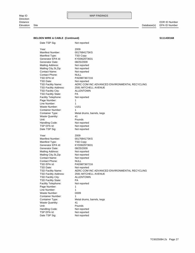
MAP FINDINGSMap IDDirection
EDR ID NumberDistanceEPA ID NumberDatabase(s)SiteElevation
Not reportedDate TSP Sig: Not reportedTSP EPA Id: Not reportedHandling Code: PoundsUnit: 41Waste Quantity: Metal drums, barrels, kegsContainer Type: 1Container Number: D009Waste Number: 1Line Number: 1Page Number: Not reportedFacility Telephone: PATSD Facility State: ALLENTOWNTSD Facility City: 2591 MITCHELL AVENUETSD Facility Address: AERC COM INC ADVANCED ENVIRONMENTAL RECYCLINGTSD Facility Name: Not reportedTSD Date: PAD987367216TSD EPA Id: NULLContact Phone: Not reportedContact Name: Not reportedMailing City,St,Zip: Not reportedMailing Address: 08/25/2009Generator Date: KYD062973631Generator EPA Id: TSD CopyManifest Type: 001768417SKSManifest Number: 2009Year:
Not reportedDate TSP Sig: Not reportedTSP EPA Id: Not reportedHandling Code: PoundsUnit: 41Waste Quantity: Metal drums, barrels, kegsContainer Type: 1Container Number: U151Waste Number: 1Line Number: 1Page Number: Not reportedFacility Telephone: PATSD Facility State: ALLENTOWNTSD Facility City: 2591 MITCHELL AVENUETSD Facility Address: AERC COM INC ADVANCED ENVIRONMENTAL RECYCLINGTSD Facility Name: Not reportedTSD Date: PAD987367216TSD EPA Id: NULLContact Phone: Not reportedContact Name: Not reportedMailing City,St,Zip: Not reportedMailing Address: 08/25/2009Generator Date: KYD062973631Generator EPA Id: TSD CopyManifest Type: 001768417SKSManifest Number: 2009Year:
Not reportedDate TSP Sig:
BELDEN WIRE & CABLE (Continued) S111430168
TC6025084.2s Page 27

MAP FINDINGSMap IDDirection
EDR ID NumberDistanceEPA ID NumberDatabase(s)SiteElevation
-84.85Longitude: 36.84Latitude: 08/03/2009Closure Date: Option C RestoredClosure Option: State SuperfundRegulatory Description: 233 Fair Street Meth Lab (Closed 8/3/09)Description: Meth LabDesignation: 105057Agency Interest Id Number: AAZZ0001Facility Group: ClosedSite Status: MONTICELLO (WAYNE), KY 42633City,State,Zip: Not reportedAddress 2: 233 FAIR STREETAddress: CATRON PROPERTYName:
CDL:
Meth LabSide SG: Option C RestoredClosure Option: State SuperfundRegulatory Desc: Monticello (Wayne), KY 42633Subject Item City,St,Zip: Not reportedSubject Item Address2: 233 Fair StSubject Item Address: 36.83784Sub Item Latitude: -84.852417Sub Item Longitude: WayneSubject Item County: 36.837840Latitude: -84.852417Longitude: 08/03/2009Closure Date: 233 Fair Street Meth Lab (Closed 8/3/09)Description: ClosedStatus: 105057Facility Id: MONTICELLO (WAYNE), KY 42633City,State,Zip: 233 FAIR STREETAddress: CATRON PROPERTYName:
SHWS:
2523 ft.0.478 mi.
Relative:Higher
Actual:943 ft.
1/4-1/2 MONTICELLO (WAYNE), KY 42633East KY CDL233 FAIR STREET N/A6 KY SHWSCATRON PROPERTY S109943874
WayneSubject Item County: 36.843060Latitude: -84.869530Longitude: 07/13/2012Closure Date: 120 Surrey Hill Road, Apt 7 Meth Lab (Closed 7/13/2012)Description: ClosedStatus: 115723Facility Id: MONTICELLO (WAYNE), KY 42633City,State,Zip: 120 SURREY HILL ROAD, APT 7Address: WINTERWOOD PROPERTYName:
SHWS:
2690 ft.0.509 mi.
Relative:Higher
Actual:976 ft.
1/2-1 MONTICELLO (WAYNE), KY 42633NW KY CDL120 SURREY HILL ROAD, APT 7 N/A7 KY SHWSWINTERWOOD PROPERTY S112163939
TC6025084.2s Page 28
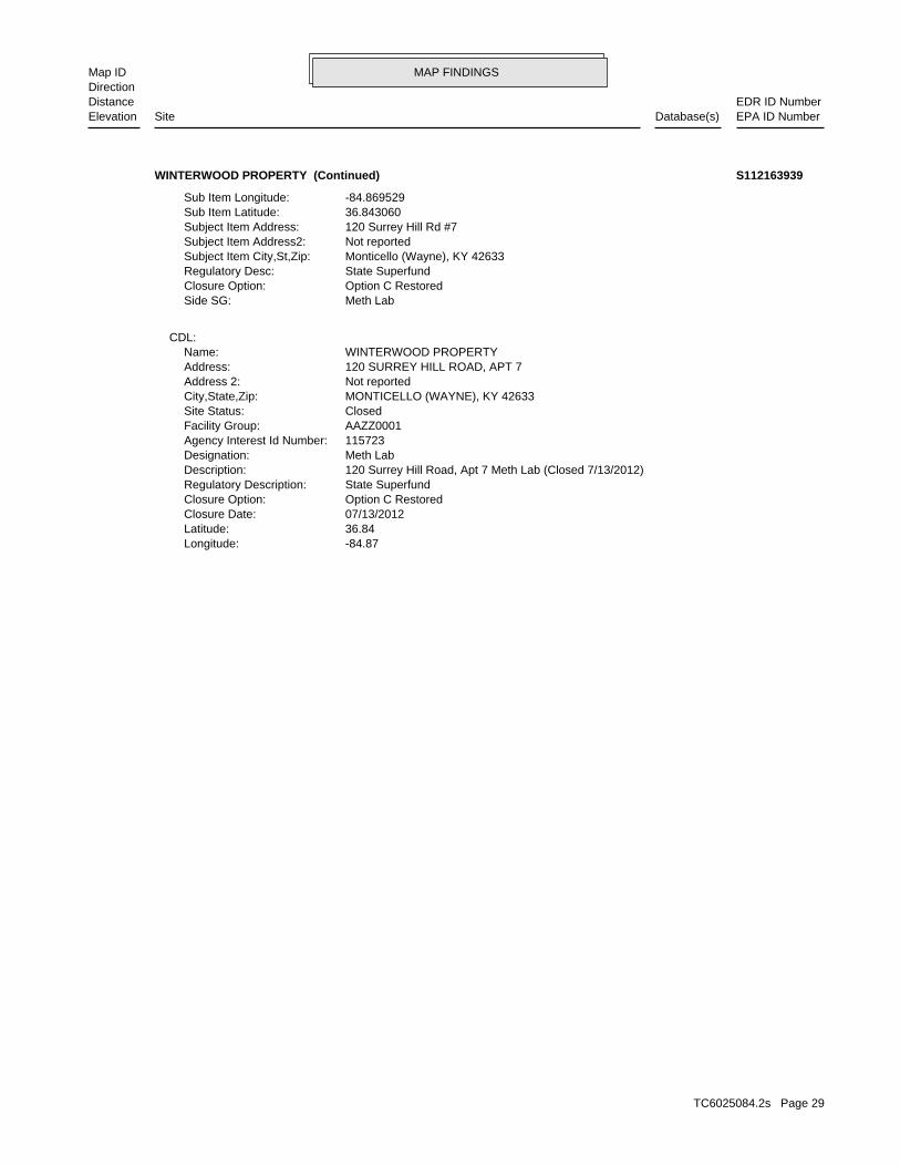
MAP FINDINGSMap IDDirection
EDR ID NumberDistanceEPA ID NumberDatabase(s)SiteElevation
-84.87Longitude: 36.84Latitude: 07/13/2012Closure Date: Option C RestoredClosure Option: State SuperfundRegulatory Description: 120 Surrey Hill Road, Apt 7 Meth Lab (Closed 7/13/2012)Description: Meth LabDesignation: 115723Agency Interest Id Number: AAZZ0001Facility Group: ClosedSite Status: MONTICELLO (WAYNE), KY 42633City,State,Zip: Not reportedAddress 2: 120 SURREY HILL ROAD, APT 7Address: WINTERWOOD PROPERTYName:
CDL:
Meth LabSide SG: Option C RestoredClosure Option: State SuperfundRegulatory Desc: Monticello (Wayne), KY 42633Subject Item City,St,Zip: Not reportedSubject Item Address2: 120 Surrey Hill Rd #7Subject Item Address: 36.843060Sub Item Latitude: -84.869529Sub Item Longitude:
WINTERWOOD PROPERTY (Continued) S112163939
TC6025084.2s Page 29

ORPHAN SUMMARY
City EDR ID Site Name Site Address Zip Database(s)
Count: 0 records.
NO SITES FOUND
TC6025084.2s Page 30
To maintain currency of the following federal and state databases, EDR contacts the appropriate governmental agencyon a monthly or quarterly basis, as required.
Number of Days to Update: Provides confirmation that EDR is reporting records that have been updated within 90 daysfrom the date the government agency made the information available to the public.
STANDARD ENVIRONMENTAL RECORDS
Federal NPL site list
NPL: National Priority ListNational Priorities List (Superfund). The NPL is a subset of CERCLIS and identifies over 1,200 sites for prioritycleanup under the Superfund Program. NPL sites may encompass relatively large areas. As such, EDR provides polygoncoverage for over 1,000 NPL site boundaries produced by EPA’s Environmental Photographic Interpretation Center(EPIC) and regional EPA offices.
Date of Government Version: 01/30/2020Date Data Arrived at EDR: 02/05/2020Date Made Active in Reports: 02/14/2020Number of Days to Update: 9
Source: EPATelephone: N/ALast EDR Contact: 03/04/2020Next Scheduled EDR Contact: 04/13/2020Data Release Frequency: Quarterly
NPL Site Boundaries
Sources:
EPA’s Environmental Photographic Interpretation Center (EPIC)Telephone: 202-564-7333
EPA Region 1 EPA Region 6Telephone 617-918-1143 Telephone: 214-655-6659
EPA Region 3 EPA Region 7Telephone 215-814-5418 Telephone: 913-551-7247
EPA Region 4 EPA Region 8Telephone 404-562-8033 Telephone: 303-312-6774
EPA Region 5 EPA Region 9Telephone 312-886-6686 Telephone: 415-947-4246
EPA Region 10Telephone 206-553-8665
Proposed NPL: Proposed National Priority List SitesA site that has been proposed for listing on the National Priorities List through the issuance of a proposed rulein the Federal Register. EPA then accepts public comments on the site, responds to the comments, and places onthe NPL those sites that continue to meet the requirements for listing.
Date of Government Version: 01/30/2020Date Data Arrived at EDR: 02/05/2020Date Made Active in Reports: 02/14/2020Number of Days to Update: 9
Source: EPATelephone: N/ALast EDR Contact: 03/04/2020Next Scheduled EDR Contact: 04/13/2020Data Release Frequency: Quarterly
NPL LIENS: Federal Superfund LiensFederal Superfund Liens. Under the authority granted the USEPA by CERCLA of 1980, the USEPA has the authorityto file liens against real property in order to recover remedial action expenditures or when the property ownerreceived notification of potential liability. USEPA compiles a listing of filed notices of Superfund Liens.
TC6025084.2s Page GR-1
GOVERNMENT RECORDS SEARCHED / DATA CURRENCY TRACKING

Date of Government Version: 10/15/1991Date Data Arrived at EDR: 02/02/1994Date Made Active in Reports: 03/30/1994Number of Days to Update: 56
Source: EPATelephone: 202-564-4267Last EDR Contact: 08/15/2011Next Scheduled EDR Contact: 11/28/2011Data Release Frequency: No Update Planned
Federal Delisted NPL site list
Delisted NPL: National Priority List DeletionsThe National Oil and Hazardous Substances Pollution Contingency Plan (NCP) establishes the criteria that theEPA uses to delete sites from the NPL. In accordance with 40 CFR 300.425.(e), sites may be deleted from theNPL where no further response is appropriate.
Date of Government Version: 01/30/2020Date Data Arrived at EDR: 02/05/2020Date Made Active in Reports: 02/14/2020Number of Days to Update: 9
Source: EPATelephone: N/ALast EDR Contact: 03/04/2020Next Scheduled EDR Contact: 04/13/2020Data Release Frequency: Quarterly
Federal CERCLIS list
FEDERAL FACILITY: Federal Facility Site Information listingA listing of National Priority List (NPL) and Base Realignment and Closure (BRAC) sites found in the ComprehensiveEnvironmental Response, Compensation and Liability Information System (CERCLIS) Database where EPA Federal FacilitiesRestoration and Reuse Office is involved in cleanup activities.
Date of Government Version: 04/03/2019Date Data Arrived at EDR: 04/05/2019Date Made Active in Reports: 05/14/2019Number of Days to Update: 39
Source: Environmental Protection AgencyTelephone: 703-603-8704Last EDR Contact: 01/03/2020Next Scheduled EDR Contact: 04/13/2020Data Release Frequency: Varies
SEMS: Superfund Enterprise Management SystemSEMS (Superfund Enterprise Management System) tracks hazardous waste sites, potentially hazardous waste sites,and remedial activities performed in support of EPA’s Superfund Program across the United States. The list wasformerly know as CERCLIS, renamed to SEMS by the EPA in 2015. The list contains data on potentially hazardouswaste sites that have been reported to the USEPA by states, municipalities, private companies and private persons,pursuant to Section 103 of the Comprehensive Environmental Response, Compensation, and Liability Act (CERCLA).This dataset also contains sites which are either proposed to or on the National Priorities List (NPL) and thesites which are in the screening and assessment phase for possible inclusion on the NPL.
Date of Government Version: 01/30/2020Date Data Arrived at EDR: 02/05/2020Date Made Active in Reports: 02/14/2020Number of Days to Update: 9
Source: EPATelephone: 800-424-9346Last EDR Contact: 02/05/2020Next Scheduled EDR Contact: 04/27/2020Data Release Frequency: Quarterly
Federal CERCLIS NFRAP site list
SEMS-ARCHIVE: Superfund Enterprise Management System Archive
TC6025084.2s Page GR-2
GOVERNMENT RECORDS SEARCHED / DATA CURRENCY TRACKING

SEMS-ARCHIVE (Superfund Enterprise Management System Archive) tracks sites that have no further interest underthe Federal Superfund Program based on available information. The list was formerly known as the CERCLIS-NFRAP,renamed to SEMS ARCHIVE by the EPA in 2015. EPA may perform a minimal level of assessment work at a site whileit is archived if site conditions change and/or new information becomes available. Archived sites have been removedand archived from the inventory of SEMS sites. Archived status indicates that, to the best of EPA’s knowledge,assessment at a site has been completed and that EPA has determined no further steps will be taken to list thesite on the National Priorities List (NPL), unless information indicates this decision was not appropriate orother considerations require a recommendation for listing at a later time. The decision does not necessarily meanthat there is no hazard associated with a given site; it only means that. based upon available information, thelocation is not judged to be potential NPL site.
Date of Government Version: 01/30/2020Date Data Arrived at EDR: 02/05/2020Date Made Active in Reports: 02/14/2020Number of Days to Update: 9
Source: EPATelephone: 800-424-9346Last EDR Contact: 03/04/2020Next Scheduled EDR Contact: 04/27/2020Data Release Frequency: Quarterly
Federal RCRA CORRACTS facilities list
CORRACTS: Corrective Action ReportCORRACTS identifies hazardous waste handlers with RCRA corrective action activity.
Date of Government Version: 12/16/2019Date Data Arrived at EDR: 12/16/2019Date Made Active in Reports: 12/20/2019Number of Days to Update: 4
Source: EPATelephone: 800-424-9346Last EDR Contact: 03/25/2020Next Scheduled EDR Contact: 07/06/2020Data Release Frequency: Quarterly
Federal RCRA non-CORRACTS TSD facilities list
RCRA-TSDF: RCRA - Treatment, Storage and DisposalRCRAInfo is EPA’s comprehensive information system, providing access to data supporting the Resource Conservationand Recovery Act (RCRA) of 1976 and the Hazardous and Solid Waste Amendments (HSWA) of 1984. The databaseincludes selective information on sites which generate, transport, store, treat and/or dispose of hazardous wasteas defined by the Resource Conservation and Recovery Act (RCRA). Transporters are individuals or entities thatmove hazardous waste from the generator offsite to a facility that can recycle, treat, store, or dispose of thewaste. TSDFs treat, store, or dispose of the waste.
Date of Government Version: 12/16/2019Date Data Arrived at EDR: 12/16/2019Date Made Active in Reports: 12/20/2019Number of Days to Update: 4
Source: Environmental Protection AgencyTelephone: (404) 562-8651Last EDR Contact: 03/25/2020Next Scheduled EDR Contact: 07/06/2020Data Release Frequency: Quarterly
Federal RCRA generators list
RCRA-LQG: RCRA - Large Quantity GeneratorsRCRAInfo is EPA’s comprehensive information system, providing access to data supporting the Resource Conservationand Recovery Act (RCRA) of 1976 and the Hazardous and Solid Waste Amendments (HSWA) of 1984. The databaseincludes selective information on sites which generate, transport, store, treat and/or dispose of hazardous wasteas defined by the Resource Conservation and Recovery Act (RCRA). Large quantity generators (LQGs) generateover 1,000 kilograms (kg) of hazardous waste, or over 1 kg of acutely hazardous waste per month.
Date of Government Version: 12/16/2019Date Data Arrived at EDR: 12/16/2019Date Made Active in Reports: 12/20/2019Number of Days to Update: 4
Source: Environmental Protection AgencyTelephone: (404) 562-8651Last EDR Contact: 03/25/2020Next Scheduled EDR Contact: 07/06/2020Data Release Frequency: Quarterly
TC6025084.2s Page GR-3
GOVERNMENT RECORDS SEARCHED / DATA CURRENCY TRACKING

RCRA-SQG: RCRA - Small Quantity GeneratorsRCRAInfo is EPA’s comprehensive information system, providing access to data supporting the Resource Conservationand Recovery Act (RCRA) of 1976 and the Hazardous and Solid Waste Amendments (HSWA) of 1984. The databaseincludes selective information on sites which generate, transport, store, treat and/or dispose of hazardous wasteas defined by the Resource Conservation and Recovery Act (RCRA). Small quantity generators (SQGs) generatebetween 100 kg and 1,000 kg of hazardous waste per month.
Date of Government Version: 12/16/2019Date Data Arrived at EDR: 12/16/2019Date Made Active in Reports: 12/20/2019Number of Days to Update: 4
Source: Environmental Protection AgencyTelephone: (404) 562-8651Last EDR Contact: 03/25/2020Next Scheduled EDR Contact: 07/06/2020Data Release Frequency: Quarterly
RCRA-VSQG: RCRA - Very Small Quantity Generators (Formerly Conditionally Exempt Small Quantity Generators)RCRAInfo is EPA’s comprehensive information system, providing access to data supporting the Resource Conservationand Recovery Act (RCRA) of 1976 and the Hazardous and Solid Waste Amendments (HSWA) of 1984. The databaseincludes selective information on sites which generate, transport, store, treat and/or dispose of hazardous wasteas defined by the Resource Conservation and Recovery Act (RCRA). Very small quantity generators (VSQGs) generateless than 100 kg of hazardous waste, or less than 1 kg of acutely hazardous waste per month.
Date of Government Version: 12/16/2019Date Data Arrived at EDR: 12/16/2019Date Made Active in Reports: 12/20/2019Number of Days to Update: 4
Source: Environmental Protection AgencyTelephone: (404) 562-8651Last EDR Contact: 03/25/2020Next Scheduled EDR Contact: 07/06/2020Data Release Frequency: Quarterly
Federal institutional controls / engineering controls registries
LUCIS: Land Use Control Information SystemLUCIS contains records of land use control information pertaining to the former Navy Base Realignment and Closureproperties.
Date of Government Version: 11/04/2019Date Data Arrived at EDR: 11/13/2019Date Made Active in Reports: 01/28/2020Number of Days to Update: 76
Source: Department of the NavyTelephone: 843-820-7326Last EDR Contact: 02/10/2020Next Scheduled EDR Contact: 05/25/2020Data Release Frequency: Varies
US ENG CONTROLS: Engineering Controls Sites ListA listing of sites with engineering controls in place. Engineering controls include various forms of caps, buildingfoundations, liners, and treatment methods to create pathway elimination for regulated substances to enter environmentalmedia or effect human health.
Date of Government Version: 11/22/2019Date Data Arrived at EDR: 11/22/2019Date Made Active in Reports: 01/28/2020Number of Days to Update: 67
Source: Environmental Protection AgencyTelephone: 703-603-0695Last EDR Contact: 02/20/2020Next Scheduled EDR Contact: 06/08/2020Data Release Frequency: Varies
US INST CONTROL: Sites with Institutional ControlsA listing of sites with institutional controls in place. Institutional controls include administrative measures,such as groundwater use restrictions, construction restrictions, property use restrictions, and post remediationcare requirements intended to prevent exposure to contaminants remaining on site. Deed restrictions are generallyrequired as part of the institutional controls.
Date of Government Version: 11/22/2019Date Data Arrived at EDR: 11/22/2019Date Made Active in Reports: 01/28/2020Number of Days to Update: 67
Source: Environmental Protection AgencyTelephone: 703-603-0695Last EDR Contact: 02/20/2020Next Scheduled EDR Contact: 06/08/2020Data Release Frequency: Varies
TC6025084.2s Page GR-4
GOVERNMENT RECORDS SEARCHED / DATA CURRENCY TRACKING

Federal ERNS list
ERNS: Emergency Response Notification SystemEmergency Response Notification System. ERNS records and stores information on reported releases of oil and hazardoussubstances.
Date of Government Version: 12/16/2019Date Data Arrived at EDR: 12/19/2019Date Made Active in Reports: 03/06/2020Number of Days to Update: 78
Source: National Response Center, United States Coast GuardTelephone: 202-267-2180Last EDR Contact: 03/24/2020Next Scheduled EDR Contact: 07/06/2020Data Release Frequency: Quarterly
State- and tribal - equivalent CERCLIS
SHWS: State Leads ListState Hazardous Waste Sites. State hazardous waste site records are the states’ equivalent to CERCLIS. These sitesmay or may not already be listed on the federal CERCLIS list. Priority sites planned for cleanup using state funds(state equivalent of Superfund) are identified along with sites where cleanup will be paid for by potentiallyresponsible parties. Available information varies by state.
Date of Government Version: 12/23/2019Date Data Arrived at EDR: 01/02/2020Date Made Active in Reports: 02/25/2020Number of Days to Update: 54
Source: Department of Environmental ProtectionTelephone: 502-564-6716Last EDR Contact: 11/21/2019Next Scheduled EDR Contact: 03/09/2020Data Release Frequency: Quarterly
State and tribal landfill and/or solid waste disposal site lists
SWF/LF: Solid Waste Facilities ListSolid Waste Facilities/Landfill Sites. SWF/LF type records typically contain an inventory of solid waste disposalfacilities or landfills in a particular state. Depending on the state, these may be active or inactive facilitiesor open dumps that failed to meet RCRA Subtitle D Section 4004 criteria for solid waste landfills or disposalsites.
Date of Government Version: 11/26/2019Date Data Arrived at EDR: 12/03/2019Date Made Active in Reports: 02/10/2020Number of Days to Update: 69
Source: Department of Environmental ProtectionTelephone: 502-564-6716Last EDR Contact: 01/27/2020Next Scheduled EDR Contact: 05/11/2020Data Release Frequency: Semi-Annually
State and tribal leaking storage tank lists
PSTEAF: Facility Ranking ListThe Underground Storage Tank Branch (USTB) has ranked all PSTEAF reimbursable facilities requiring correctiveaction, in accordance with 401 KAR 42:290. Directive letters will be issued on the basis of facility ranking andavailable PSTEAF funding in sequential order as ranked. For example, Rank 2 facilities will be issued directivesbefore Rank 3 facilities.
Date of Government Version: 01/01/2020Date Data Arrived at EDR: 01/08/2020Date Made Active in Reports: 03/13/2020Number of Days to Update: 65
Source: Department of Environmental ProtectionTelephone: 502-564-5981Last EDR Contact: 01/08/2020Next Scheduled EDR Contact: 04/20/2020Data Release Frequency: Quarterly
INDIAN LUST R1: Leaking Underground Storage Tanks on Indian LandA listing of leaking underground storage tank locations on Indian Land.
Date of Government Version: 10/01/2019Date Data Arrived at EDR: 12/04/2019Date Made Active in Reports: 02/10/2020Number of Days to Update: 68
Source: EPA Region 1Telephone: 617-918-1313Last EDR Contact: 01/24/2020Next Scheduled EDR Contact: 05/04/2020Data Release Frequency: Varies
TC6025084.2s Page GR-5
GOVERNMENT RECORDS SEARCHED / DATA CURRENCY TRACKING
INDIAN LUST R6: Leaking Underground Storage Tanks on Indian LandLUSTs on Indian land in New Mexico and Oklahoma.
Date of Government Version: 10/02/2019Date Data Arrived at EDR: 12/04/2019Date Made Active in Reports: 02/10/2020Number of Days to Update: 68
Source: EPA Region 6Telephone: 214-665-6597Last EDR Contact: 01/24/2020Next Scheduled EDR Contact: 05/04/2020Data Release Frequency: Varies
INDIAN LUST R5: Leaking Underground Storage Tanks on Indian LandLeaking underground storage tanks located on Indian Land in Michigan, Minnesota and Wisconsin.
Date of Government Version: 10/01/2019Date Data Arrived at EDR: 12/04/2019Date Made Active in Reports: 02/10/2020Number of Days to Update: 68
Source: EPA, Region 5Telephone: 312-886-7439Last EDR Contact: 01/24/2020Next Scheduled EDR Contact: 05/04/2020Data Release Frequency: Varies
INDIAN LUST R7: Leaking Underground Storage Tanks on Indian LandLUSTs on Indian land in Iowa, Kansas, and Nebraska
Date of Government Version: 10/15/2019Date Data Arrived at EDR: 12/17/2019Date Made Active in Reports: 02/10/2020Number of Days to Update: 55
Source: EPA Region 7Telephone: 913-551-7003Last EDR Contact: 12/16/2019Next Scheduled EDR Contact: 05/04/2020Data Release Frequency: Varies
INDIAN LUST R10: Leaking Underground Storage Tanks on Indian LandLUSTs on Indian land in Alaska, Idaho, Oregon and Washington.
Date of Government Version: 10/11/2019Date Data Arrived at EDR: 12/04/2019Date Made Active in Reports: 02/10/2020Number of Days to Update: 68
Source: EPA Region 10Telephone: 206-553-2857Last EDR Contact: 01/24/2020Next Scheduled EDR Contact: 05/04/2020Data Release Frequency: Varies
INDIAN LUST R8: Leaking Underground Storage Tanks on Indian LandLUSTs on Indian land in Colorado, Montana, North Dakota, South Dakota, Utah and Wyoming.
Date of Government Version: 10/03/2019Date Data Arrived at EDR: 12/04/2019Date Made Active in Reports: 02/14/2020Number of Days to Update: 72
Source: EPA Region 8Telephone: 303-312-6271Last EDR Contact: 01/24/2020Next Scheduled EDR Contact: 05/04/2020Data Release Frequency: Varies
INDIAN LUST R4: Leaking Underground Storage Tanks on Indian LandLUSTs on Indian land in Florida, Mississippi and North Carolina.
Date of Government Version: 10/10/2019Date Data Arrived at EDR: 12/05/2019Date Made Active in Reports: 02/10/2020Number of Days to Update: 67
Source: EPA Region 4Telephone: 404-562-8677Last EDR Contact: 01/24/2020Next Scheduled EDR Contact: 05/04/2020Data Release Frequency: Varies
INDIAN LUST R9: Leaking Underground Storage Tanks on Indian LandLUSTs on Indian land in Arizona, California, New Mexico and Nevada
Date of Government Version: 10/04/2019Date Data Arrived at EDR: 12/04/2019Date Made Active in Reports: 02/27/2020Number of Days to Update: 85
Source: Environmental Protection AgencyTelephone: 415-972-3372Last EDR Contact: 01/24/2020Next Scheduled EDR Contact: 05/04/2020Data Release Frequency: Varies
TC6025084.2s Page GR-6
GOVERNMENT RECORDS SEARCHED / DATA CURRENCY TRACKING
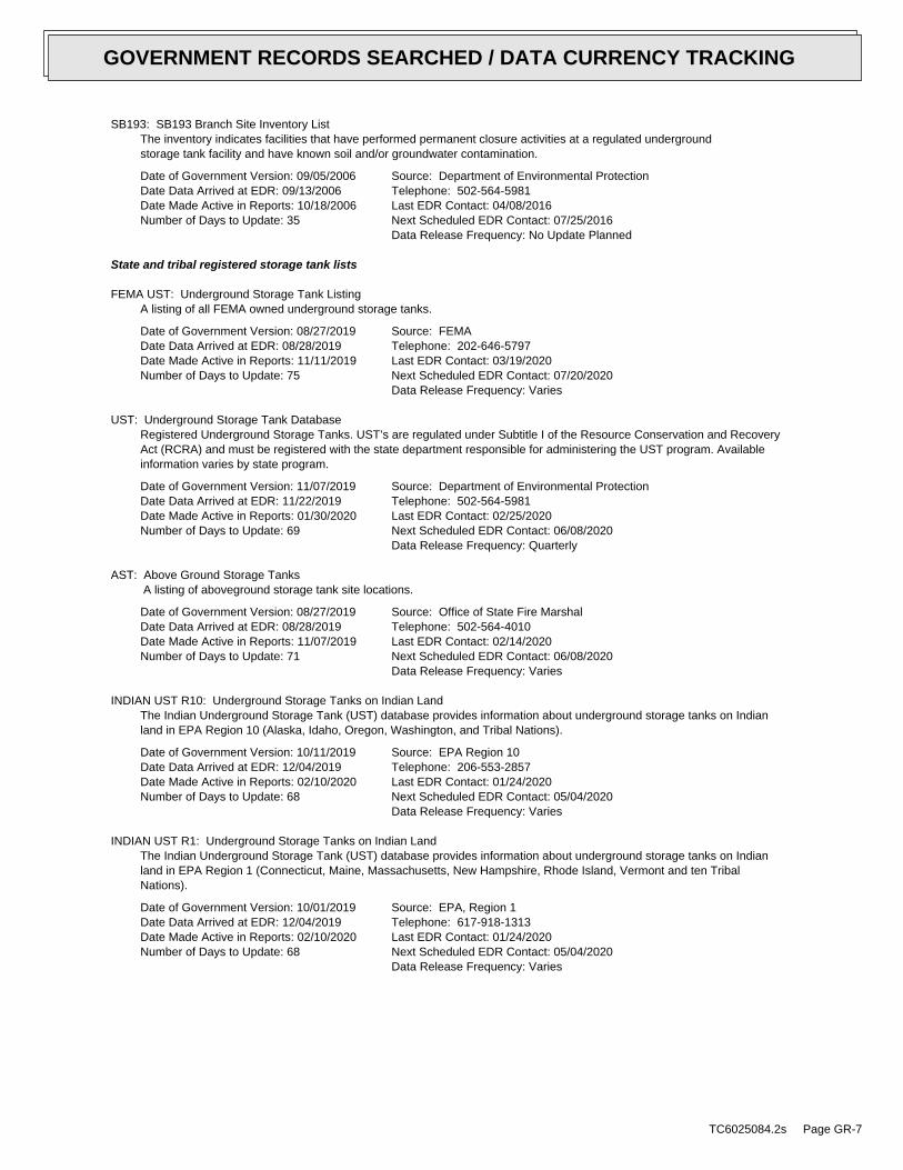
SB193: SB193 Branch Site Inventory ListThe inventory indicates facilities that have performed permanent closure activities at a regulated undergroundstorage tank facility and have known soil and/or groundwater contamination.
Date of Government Version: 09/05/2006Date Data Arrived at EDR: 09/13/2006Date Made Active in Reports: 10/18/2006Number of Days to Update: 35
Source: Department of Environmental ProtectionTelephone: 502-564-5981Last EDR Contact: 04/08/2016Next Scheduled EDR Contact: 07/25/2016Data Release Frequency: No Update Planned
State and tribal registered storage tank lists
FEMA UST: Underground Storage Tank ListingA listing of all FEMA owned underground storage tanks.
Date of Government Version: 08/27/2019Date Data Arrived at EDR: 08/28/2019Date Made Active in Reports: 11/11/2019Number of Days to Update: 75
Source: FEMATelephone: 202-646-5797Last EDR Contact: 03/19/2020Next Scheduled EDR Contact: 07/20/2020Data Release Frequency: Varies
UST: Underground Storage Tank DatabaseRegistered Underground Storage Tanks. UST’s are regulated under Subtitle I of the Resource Conservation and RecoveryAct (RCRA) and must be registered with the state department responsible for administering the UST program. Availableinformation varies by state program.
Date of Government Version: 11/07/2019Date Data Arrived at EDR: 11/22/2019Date Made Active in Reports: 01/30/2020Number of Days to Update: 69
Source: Department of Environmental ProtectionTelephone: 502-564-5981Last EDR Contact: 02/25/2020Next Scheduled EDR Contact: 06/08/2020Data Release Frequency: Quarterly
AST: Above Ground Storage TanksA listing of aboveground storage tank site locations.
Date of Government Version: 08/27/2019Date Data Arrived at EDR: 08/28/2019Date Made Active in Reports: 11/07/2019Number of Days to Update: 71
Source: Office of State Fire MarshalTelephone: 502-564-4010Last EDR Contact: 02/14/2020Next Scheduled EDR Contact: 06/08/2020Data Release Frequency: Varies
INDIAN UST R10: Underground Storage Tanks on Indian LandThe Indian Underground Storage Tank (UST) database provides information about underground storage tanks on Indianland in EPA Region 10 (Alaska, Idaho, Oregon, Washington, and Tribal Nations).
Date of Government Version: 10/11/2019Date Data Arrived at EDR: 12/04/2019Date Made Active in Reports: 02/10/2020Number of Days to Update: 68
Source: EPA Region 10Telephone: 206-553-2857Last EDR Contact: 01/24/2020Next Scheduled EDR Contact: 05/04/2020Data Release Frequency: Varies
INDIAN UST R1: Underground Storage Tanks on Indian LandThe Indian Underground Storage Tank (UST) database provides information about underground storage tanks on Indianland in EPA Region 1 (Connecticut, Maine, Massachusetts, New Hampshire, Rhode Island, Vermont and ten TribalNations).
Date of Government Version: 10/01/2019Date Data Arrived at EDR: 12/04/2019Date Made Active in Reports: 02/10/2020Number of Days to Update: 68
Source: EPA, Region 1Telephone: 617-918-1313Last EDR Contact: 01/24/2020Next Scheduled EDR Contact: 05/04/2020Data Release Frequency: Varies
TC6025084.2s Page GR-7
GOVERNMENT RECORDS SEARCHED / DATA CURRENCY TRACKING

INDIAN UST R4: Underground Storage Tanks on Indian LandThe Indian Underground Storage Tank (UST) database provides information about underground storage tanks on Indianland in EPA Region 4 (Alabama, Florida, Georgia, Kentucky, Mississippi, North Carolina, South Carolina, Tennesseeand Tribal Nations)
Date of Government Version: 10/10/2019Date Data Arrived at EDR: 12/05/2019Date Made Active in Reports: 02/10/2020Number of Days to Update: 67
Source: EPA Region 4Telephone: 404-562-9424Last EDR Contact: 01/24/2020Next Scheduled EDR Contact: 05/04/2020Data Release Frequency: Varies
INDIAN UST R5: Underground Storage Tanks on Indian LandThe Indian Underground Storage Tank (UST) database provides information about underground storage tanks on Indianland in EPA Region 5 (Michigan, Minnesota and Wisconsin and Tribal Nations).
Date of Government Version: 10/01/2019Date Data Arrived at EDR: 12/04/2019Date Made Active in Reports: 02/10/2020Number of Days to Update: 68
Source: EPA Region 5Telephone: 312-886-6136Last EDR Contact: 01/24/2020Next Scheduled EDR Contact: 05/04/2020Data Release Frequency: Varies
INDIAN UST R6: Underground Storage Tanks on Indian LandThe Indian Underground Storage Tank (UST) database provides information about underground storage tanks on Indianland in EPA Region 6 (Louisiana, Arkansas, Oklahoma, New Mexico, Texas and 65 Tribes).
Date of Government Version: 10/02/2019Date Data Arrived at EDR: 12/04/2019Date Made Active in Reports: 02/10/2020Number of Days to Update: 68
Source: EPA Region 6Telephone: 214-665-7591Last EDR Contact: 01/24/2020Next Scheduled EDR Contact: 05/04/2020Data Release Frequency: Varies
INDIAN UST R7: Underground Storage Tanks on Indian LandThe Indian Underground Storage Tank (UST) database provides information about underground storage tanks on Indianland in EPA Region 7 (Iowa, Kansas, Missouri, Nebraska, and 9 Tribal Nations).
Date of Government Version: 10/11/2019Date Data Arrived at EDR: 12/04/2019Date Made Active in Reports: 02/10/2020Number of Days to Update: 68
Source: EPA Region 7Telephone: 913-551-7003Last EDR Contact: 01/24/2020Next Scheduled EDR Contact: 05/04/2020Data Release Frequency: Varies
INDIAN UST R8: Underground Storage Tanks on Indian LandThe Indian Underground Storage Tank (UST) database provides information about underground storage tanks on Indianland in EPA Region 8 (Colorado, Montana, North Dakota, South Dakota, Utah, Wyoming and 27 Tribal Nations).
Date of Government Version: 10/03/2019Date Data Arrived at EDR: 12/04/2019Date Made Active in Reports: 02/14/2020Number of Days to Update: 72
Source: EPA Region 8Telephone: 303-312-6137Last EDR Contact: 01/24/2020Next Scheduled EDR Contact: 05/04/2020Data Release Frequency: Varies
INDIAN UST R9: Underground Storage Tanks on Indian LandThe Indian Underground Storage Tank (UST) database provides information about underground storage tanks on Indianland in EPA Region 9 (Arizona, California, Hawaii, Nevada, the Pacific Islands, and Tribal Nations).
Date of Government Version: 10/04/2019Date Data Arrived at EDR: 12/04/2019Date Made Active in Reports: 02/27/2020Number of Days to Update: 85
Source: EPA Region 9Telephone: 415-972-3368Last EDR Contact: 01/24/2020Next Scheduled EDR Contact: 05/04/2020Data Release Frequency: Varies
TC6025084.2s Page GR-8
GOVERNMENT RECORDS SEARCHED / DATA CURRENCY TRACKING

State and tribal institutional control / engineering control registries
ENG CONTROLS: Engineering Controls Site ListingA listing of sites that use engineering controls.
Date of Government Version: 12/23/2019Date Data Arrived at EDR: 01/02/2020Date Made Active in Reports: 02/25/2020Number of Days to Update: 54
Source: Department of Environmental ProtectionTelephone: 502-564-6716Last EDR Contact: 02/24/2020Next Scheduled EDR Contact: 06/08/2020Data Release Frequency: Varies
INST CONTROL: State Superfund DatabaseA list of closed sites in the State Superfund Database. Institutional controls would be in place at any site thatuses Contained or Managed as a Closure Option.
Date of Government Version: 12/23/2019Date Data Arrived at EDR: 01/02/2020Date Made Active in Reports: 02/25/2020Number of Days to Update: 54
Source: Department of Environmental ProtectionTelephone: 502-564-6716Last EDR Contact: 02/24/2020Next Scheduled EDR Contact: 06/08/2020Data Release Frequency: Varies
State and tribal voluntary cleanup sites
INDIAN VCP R7: Voluntary Cleanup Priority LisitngA listing of voluntary cleanup priority sites located on Indian Land located in Region 7.
Date of Government Version: 03/20/2008Date Data Arrived at EDR: 04/22/2008Date Made Active in Reports: 05/19/2008Number of Days to Update: 27
Source: EPA, Region 7Telephone: 913-551-7365Last EDR Contact: 04/20/2009Next Scheduled EDR Contact: 07/20/2009Data Release Frequency: Varies
VCP: Voluntary Cleanup Program SitesSites that have been accepted into the Voluntary Cleanup Program or have submitted an application.
Date of Government Version: 12/23/2019Date Data Arrived at EDR: 01/02/2020Date Made Active in Reports: 02/25/2020Number of Days to Update: 54
Source: Department of Environmental ProtectionTelephone: 502-564-6716Last EDR Contact: 03/20/2020Next Scheduled EDR Contact: 07/13/2020Data Release Frequency: Varies
INDIAN VCP R1: Voluntary Cleanup Priority ListingA listing of voluntary cleanup priority sites located on Indian Land located in Region 1.
Date of Government Version: 07/27/2015Date Data Arrived at EDR: 09/29/2015Date Made Active in Reports: 02/18/2016Number of Days to Update: 142
Source: EPA, Region 1Telephone: 617-918-1102Last EDR Contact: 03/18/2020Next Scheduled EDR Contact: 07/06/2020Data Release Frequency: Varies
State and tribal Brownfields sites
BROWNFIELDS: Kentucky Brownfield InventoryThe Kentucky Brownfield Program has created an inventory of brownfield sites in order to market the propertiesto those interested in brownfield redevelopment. The Kentucky Brownfield Program is working to promote the redevelopmentof these sites by helping to remove barriers that prevent reuse, providing useful information to communities,developers and the public and encouraging a climate that fosters redevelopment of contaminated sites.
Date of Government Version: 09/30/2019Date Data Arrived at EDR: 11/07/2019Date Made Active in Reports: 01/15/2020Number of Days to Update: 69
Source: Division of Compliance AssistanceTelephone: 502-564-0323Last EDR Contact: 01/12/2020Next Scheduled EDR Contact: 04/26/2020Data Release Frequency: Varies
TC6025084.2s Page GR-9
GOVERNMENT RECORDS SEARCHED / DATA CURRENCY TRACKING
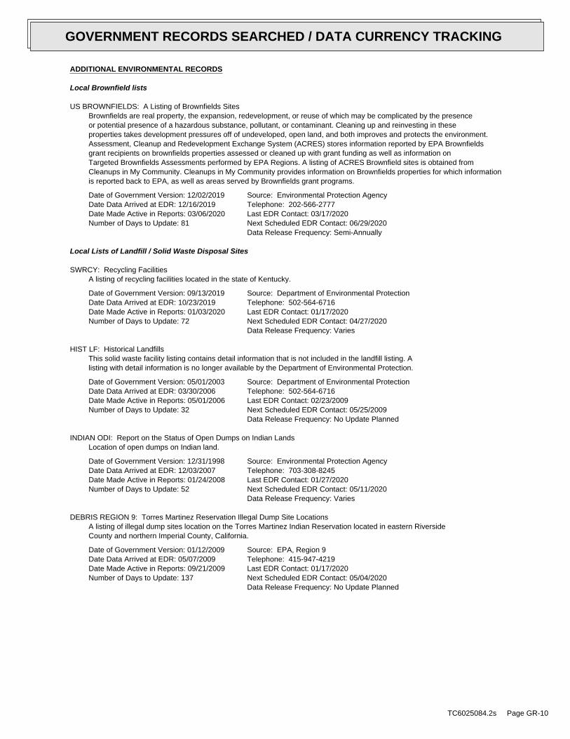
ADDITIONAL ENVIRONMENTAL RECORDS
Local Brownfield lists
US BROWNFIELDS: A Listing of Brownfields SitesBrownfields are real property, the expansion, redevelopment, or reuse of which may be complicated by the presenceor potential presence of a hazardous substance, pollutant, or contaminant. Cleaning up and reinvesting in theseproperties takes development pressures off of undeveloped, open land, and both improves and protects the environment.Assessment, Cleanup and Redevelopment Exchange System (ACRES) stores information reported by EPA Brownfieldsgrant recipients on brownfields properties assessed or cleaned up with grant funding as well as information onTargeted Brownfields Assessments performed by EPA Regions. A listing of ACRES Brownfield sites is obtained fromCleanups in My Community. Cleanups in My Community provides information on Brownfields properties for which informationis reported back to EPA, as well as areas served by Brownfields grant programs.
Date of Government Version: 12/02/2019Date Data Arrived at EDR: 12/16/2019Date Made Active in Reports: 03/06/2020Number of Days to Update: 81
Source: Environmental Protection AgencyTelephone: 202-566-2777Last EDR Contact: 03/17/2020Next Scheduled EDR Contact: 06/29/2020Data Release Frequency: Semi-Annually
Local Lists of Landfill / Solid Waste Disposal Sites
SWRCY: Recycling FacilitiesA listing of recycling facilities located in the state of Kentucky.
Date of Government Version: 09/13/2019Date Data Arrived at EDR: 10/23/2019Date Made Active in Reports: 01/03/2020Number of Days to Update: 72
Source: Department of Environmental ProtectionTelephone: 502-564-6716Last EDR Contact: 01/17/2020Next Scheduled EDR Contact: 04/27/2020Data Release Frequency: Varies
HIST LF: Historical LandfillsThis solid waste facility listing contains detail information that is not included in the landfill listing. Alisting with detail information is no longer available by the Department of Environmental Protection.
Date of Government Version: 05/01/2003Date Data Arrived at EDR: 03/30/2006Date Made Active in Reports: 05/01/2006Number of Days to Update: 32
Source: Department of Environmental ProtectionTelephone: 502-564-6716Last EDR Contact: 02/23/2009Next Scheduled EDR Contact: 05/25/2009Data Release Frequency: No Update Planned
INDIAN ODI: Report on the Status of Open Dumps on Indian LandsLocation of open dumps on Indian land.
Date of Government Version: 12/31/1998Date Data Arrived at EDR: 12/03/2007Date Made Active in Reports: 01/24/2008Number of Days to Update: 52
Source: Environmental Protection AgencyTelephone: 703-308-8245Last EDR Contact: 01/27/2020Next Scheduled EDR Contact: 05/11/2020Data Release Frequency: Varies
DEBRIS REGION 9: Torres Martinez Reservation Illegal Dump Site LocationsA listing of illegal dump sites location on the Torres Martinez Indian Reservation located in eastern RiversideCounty and northern Imperial County, California.
Date of Government Version: 01/12/2009Date Data Arrived at EDR: 05/07/2009Date Made Active in Reports: 09/21/2009Number of Days to Update: 137
Source: EPA, Region 9Telephone: 415-947-4219Last EDR Contact: 01/17/2020Next Scheduled EDR Contact: 05/04/2020Data Release Frequency: No Update Planned
TC6025084.2s Page GR-10
GOVERNMENT RECORDS SEARCHED / DATA CURRENCY TRACKING

ODI: Open Dump InventoryAn open dump is defined as a disposal facility that does not comply with one or more of the Part 257 or Part 258Subtitle D Criteria.
Date of Government Version: 06/30/1985Date Data Arrived at EDR: 08/09/2004Date Made Active in Reports: 09/17/2004Number of Days to Update: 39
Source: Environmental Protection AgencyTelephone: 800-424-9346Last EDR Contact: 06/09/2004Next Scheduled EDR Contact: N/AData Release Frequency: No Update Planned
IHS OPEN DUMPS: Open Dumps on Indian LandA listing of all open dumps located on Indian Land in the United States.
Date of Government Version: 04/01/2014Date Data Arrived at EDR: 08/06/2014Date Made Active in Reports: 01/29/2015Number of Days to Update: 176
Source: Department of Health & Human Serivces, Indian Health ServiceTelephone: 301-443-1452Last EDR Contact: 01/31/2020Next Scheduled EDR Contact: 05/11/2020Data Release Frequency: Varies
Local Lists of Hazardous waste / Contaminated Sites
US HIST CDL: National Clandestine Laboratory RegisterA listing of clandestine drug lab locations that have been removed from the DEAs National Clandestine LaboratoryRegister.
Date of Government Version: 06/11/2019Date Data Arrived at EDR: 06/13/2019Date Made Active in Reports: 09/03/2019Number of Days to Update: 82
Source: Drug Enforcement AdministrationTelephone: 202-307-1000Last EDR Contact: 02/21/2020Next Scheduled EDR Contact: 06/08/2020Data Release Frequency: No Update Planned
CDL: Clandestine Drub Lab Location ListingClandestine drug lab site locations.
Date of Government Version: 12/23/2019Date Data Arrived at EDR: 01/02/2020Date Made Active in Reports: 02/26/2020Number of Days to Update: 55
Source: Department of Environmental ProtectionTelephone: 502-564-6716Last EDR Contact: 02/24/2020Next Scheduled EDR Contact: 06/08/2020Data Release Frequency: Varies
US CDL: Clandestine Drug LabsA listing of clandestine drug lab locations. The U.S. Department of Justice ("the Department") provides thisweb site as a public service. It contains addresses of some locations where law enforcement agencies reportedthey found chemicals or other items that indicated the presence of either clandestine drug laboratories or dumpsites.In most cases, the source of the entries is not the Department, and the Department has not verified the entryand does not guarantee its accuracy. Members of the public must verify the accuracy of all entries by, for example,contacting local law enforcement and local health departments.
Date of Government Version: 06/11/2019Date Data Arrived at EDR: 06/13/2019Date Made Active in Reports: 09/03/2019Number of Days to Update: 82
Source: Drug Enforcement AdministrationTelephone: 202-307-1000Last EDR Contact: 02/21/2020Next Scheduled EDR Contact: 06/08/2020Data Release Frequency: Quarterly
Local Land Records
LIENS 2: CERCLA Lien InformationA Federal CERCLA (’Superfund’) lien can exist by operation of law at any site or property at which EPA has spentSuperfund monies. These monies are spent to investigate and address releases and threatened releases of contamination.CERCLIS provides information as to the identity of these sites and properties.
TC6025084.2s Page GR-11
GOVERNMENT RECORDS SEARCHED / DATA CURRENCY TRACKING

Date of Government Version: 01/30/2020Date Data Arrived at EDR: 02/05/2020Date Made Active in Reports: 02/14/2020Number of Days to Update: 9
Source: Environmental Protection AgencyTelephone: 202-564-6023Last EDR Contact: 03/05/2020Next Scheduled EDR Contact: 04/13/2020Data Release Frequency: Semi-Annually
Records of Emergency Release Reports
HMIRS: Hazardous Materials Information Reporting SystemHazardous Materials Incident Report System. HMIRS contains hazardous material spill incidents reported to DOT.
Date of Government Version: 12/05/2019Date Data Arrived at EDR: 12/06/2019Date Made Active in Reports: 02/14/2020Number of Days to Update: 70
Source: U.S. Department of TransportationTelephone: 202-366-4555Last EDR Contact: 03/24/2020Next Scheduled EDR Contact: 04/06/2020Data Release Frequency: Quarterly
SPILLS: State spillsA listing of spill and/or release related incidents.
Date of Government Version: 11/06/2019Date Data Arrived at EDR: 11/07/2019Date Made Active in Reports: 01/15/2020Number of Days to Update: 69
Source: DEP, Emergency ResponseTelephone: 502-564-2380Last EDR Contact: 01/13/2020Next Scheduled EDR Contact: 04/27/2020Data Release Frequency: Varies
Other Ascertainable Records
RCRA NonGen / NLR: RCRA - Non Generators / No Longer RegulatedRCRAInfo is EPA’s comprehensive information system, providing access to data supporting the Resource Conservationand Recovery Act (RCRA) of 1976 and the Hazardous and Solid Waste Amendments (HSWA) of 1984. The databaseincludes selective information on sites which generate, transport, store, treat and/or dispose of hazardous wasteas defined by the Resource Conservation and Recovery Act (RCRA). Non-Generators do not presently generate hazardouswaste.
Date of Government Version: 12/16/2019Date Data Arrived at EDR: 12/16/2019Date Made Active in Reports: 12/20/2019Number of Days to Update: 4
Source: Environmental Protection AgencyTelephone: (404) 562-8651Last EDR Contact: 03/25/2020Next Scheduled EDR Contact: 07/06/2020Data Release Frequency: Quarterly
FUDS: Formerly Used Defense SitesThe listing includes locations of Formerly Used Defense Sites properties where the US Army Corps of Engineersis actively working or will take necessary cleanup actions.
Date of Government Version: 11/12/2019Date Data Arrived at EDR: 11/19/2019Date Made Active in Reports: 01/28/2020Number of Days to Update: 70
Source: U.S. Army Corps of EngineersTelephone: 202-528-4285Last EDR Contact: 02/19/2020Next Scheduled EDR Contact: 06/01/2020Data Release Frequency: Varies
DOD: Department of Defense SitesThis data set consists of federally owned or administered lands, administered by the Department of Defense, thathave any area equal to or greater than 640 acres of the United States, Puerto Rico, and the U.S. Virgin Islands.
Date of Government Version: 12/31/2005Date Data Arrived at EDR: 11/10/2006Date Made Active in Reports: 01/11/2007Number of Days to Update: 62
Source: USGSTelephone: 888-275-8747Last EDR Contact: 01/10/2020Next Scheduled EDR Contact: 04/20/2020Data Release Frequency: Semi-Annually
TC6025084.2s Page GR-12
GOVERNMENT RECORDS SEARCHED / DATA CURRENCY TRACKING
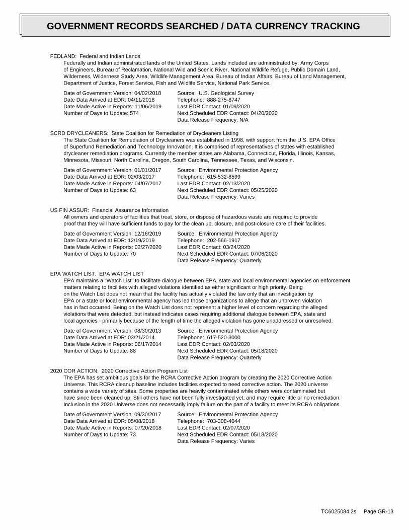
FEDLAND: Federal and Indian LandsFederally and Indian administrated lands of the United States. Lands included are administrated by: Army Corpsof Engineers, Bureau of Reclamation, National Wild and Scenic River, National Wildlife Refuge, Public Domain Land,Wilderness, Wilderness Study Area, Wildlife Management Area, Bureau of Indian Affairs, Bureau of Land Management,Department of Justice, Forest Service, Fish and Wildlife Service, National Park Service.
Date of Government Version: 04/02/2018Date Data Arrived at EDR: 04/11/2018Date Made Active in Reports: 11/06/2019Number of Days to Update: 574
Source: U.S. Geological SurveyTelephone: 888-275-8747Last EDR Contact: 01/09/2020Next Scheduled EDR Contact: 04/20/2020Data Release Frequency: N/A
SCRD DRYCLEANERS: State Coalition for Remediation of Drycleaners ListingThe State Coalition for Remediation of Drycleaners was established in 1998, with support from the U.S. EPA Officeof Superfund Remediation and Technology Innovation. It is comprised of representatives of states with establisheddrycleaner remediation programs. Currently the member states are Alabama, Connecticut, Florida, Illinois, Kansas,Minnesota, Missouri, North Carolina, Oregon, South Carolina, Tennessee, Texas, and Wisconsin.
Date of Government Version: 01/01/2017Date Data Arrived at EDR: 02/03/2017Date Made Active in Reports: 04/07/2017Number of Days to Update: 63
Source: Environmental Protection AgencyTelephone: 615-532-8599Last EDR Contact: 02/13/2020Next Scheduled EDR Contact: 05/25/2020Data Release Frequency: Varies
US FIN ASSUR: Financial Assurance InformationAll owners and operators of facilities that treat, store, or dispose of hazardous waste are required to provideproof that they will have sufficient funds to pay for the clean up, closure, and post-closure care of their facilities.
Date of Government Version: 12/16/2019Date Data Arrived at EDR: 12/19/2019Date Made Active in Reports: 02/27/2020Number of Days to Update: 70
Source: Environmental Protection AgencyTelephone: 202-566-1917Last EDR Contact: 03/24/2020Next Scheduled EDR Contact: 07/06/2020Data Release Frequency: Quarterly
EPA WATCH LIST: EPA WATCH LISTEPA maintains a "Watch List" to facilitate dialogue between EPA, state and local environmental agencies on enforcementmatters relating to facilities with alleged violations identified as either significant or high priority. Beingon the Watch List does not mean that the facility has actually violated the law only that an investigation byEPA or a state or local environmental agency has led those organizations to allege that an unproven violationhas in fact occurred. Being on the Watch List does not represent a higher level of concern regarding the allegedviolations that were detected, but instead indicates cases requiring additional dialogue between EPA, state andlocal agencies - primarily because of the length of time the alleged violation has gone unaddressed or unresolved.
Date of Government Version: 08/30/2013Date Data Arrived at EDR: 03/21/2014Date Made Active in Reports: 06/17/2014Number of Days to Update: 88
Source: Environmental Protection AgencyTelephone: 617-520-3000Last EDR Contact: 02/03/2020Next Scheduled EDR Contact: 05/18/2020Data Release Frequency: Quarterly
2020 COR ACTION: 2020 Corrective Action Program ListThe EPA has set ambitious goals for the RCRA Corrective Action program by creating the 2020 Corrective ActionUniverse. This RCRA cleanup baseline includes facilities expected to need corrective action. The 2020 universecontains a wide variety of sites. Some properties are heavily contaminated while others were contaminated buthave since been cleaned up. Still others have not been fully investigated yet, and may require little or no remediation.Inclusion in the 2020 Universe does not necessarily imply failure on the part of a facility to meet its RCRA obligations.
Date of Government Version: 09/30/2017Date Data Arrived at EDR: 05/08/2018Date Made Active in Reports: 07/20/2018Number of Days to Update: 73
Source: Environmental Protection AgencyTelephone: 703-308-4044Last EDR Contact: 02/07/2020Next Scheduled EDR Contact: 05/18/2020Data Release Frequency: Varies
TC6025084.2s Page GR-13
GOVERNMENT RECORDS SEARCHED / DATA CURRENCY TRACKING

TSCA: Toxic Substances Control ActToxic Substances Control Act. TSCA identifies manufacturers and importers of chemical substances included on theTSCA Chemical Substance Inventory list. It includes data on the production volume of these substances by plantsite.
Date of Government Version: 12/31/2016Date Data Arrived at EDR: 06/21/2017Date Made Active in Reports: 01/05/2018Number of Days to Update: 198
Source: EPATelephone: 202-260-5521Last EDR Contact: 03/20/2020Next Scheduled EDR Contact: 06/29/2020Data Release Frequency: Every 4 Years
TRIS: Toxic Chemical Release Inventory SystemToxic Release Inventory System. TRIS identifies facilities which release toxic chemicals to the air, water andland in reportable quantities under SARA Title III Section 313.
Date of Government Version: 12/31/2017Date Data Arrived at EDR: 11/16/2018Date Made Active in Reports: 11/21/2019Number of Days to Update: 370
Source: EPATelephone: 202-566-0250Last EDR Contact: 02/05/2020Next Scheduled EDR Contact: 06/01/2020Data Release Frequency: Annually
SSTS: Section 7 Tracking SystemsSection 7 of the Federal Insecticide, Fungicide and Rodenticide Act, as amended (92 Stat. 829) requires allregistered pesticide-producing establishments to submit a report to the Environmental Protection Agency by March1st each year. Each establishment must report the types and amounts of pesticides, active ingredients and devicesbeing produced, and those having been produced and sold or distributed in the past year.
Date of Government Version: 05/01/2019Date Data Arrived at EDR: 10/23/2019Date Made Active in Reports: 01/15/2020Number of Days to Update: 84
Source: EPATelephone: 202-564-4203Last EDR Contact: 01/24/2020Next Scheduled EDR Contact: 05/04/2020Data Release Frequency: Annually
ROD: Records Of DecisionRecord of Decision. ROD documents mandate a permanent remedy at an NPL (Superfund) site containing technicaland health information to aid in the cleanup.
Date of Government Version: 01/30/2020Date Data Arrived at EDR: 02/05/2020Date Made Active in Reports: 02/14/2020Number of Days to Update: 9
Source: EPATelephone: 703-416-0223Last EDR Contact: 03/04/2020Next Scheduled EDR Contact: 06/15/2020Data Release Frequency: Annually
RMP: Risk Management Plans
TC6025084.2s Page GR-14
GOVERNMENT RECORDS SEARCHED / DATA CURRENCY TRACKING
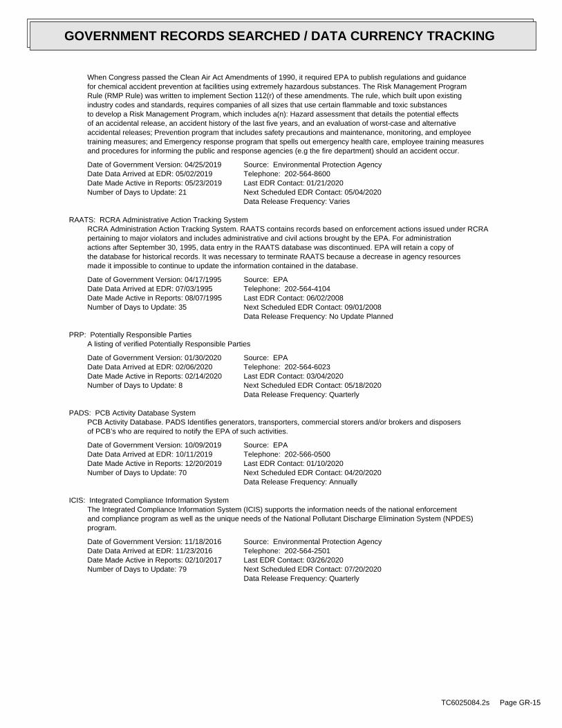
When Congress passed the Clean Air Act Amendments of 1990, it required EPA to publish regulations and guidancefor chemical accident prevention at facilities using extremely hazardous substances. The Risk Management ProgramRule (RMP Rule) was written to implement Section 112(r) of these amendments. The rule, which built upon existingindustry codes and standards, requires companies of all sizes that use certain flammable and toxic substancesto develop a Risk Management Program, which includes a(n): Hazard assessment that details the potential effectsof an accidental release, an accident history of the last five years, and an evaluation of worst-case and alternativeaccidental releases; Prevention program that includes safety precautions and maintenance, monitoring, and employeetraining measures; and Emergency response program that spells out emergency health care, employee training measuresand procedures for informing the public and response agencies (e.g the fire department) should an accident occur.
Date of Government Version: 04/25/2019Date Data Arrived at EDR: 05/02/2019Date Made Active in Reports: 05/23/2019Number of Days to Update: 21
Source: Environmental Protection AgencyTelephone: 202-564-8600Last EDR Contact: 01/21/2020Next Scheduled EDR Contact: 05/04/2020Data Release Frequency: Varies
RAATS: RCRA Administrative Action Tracking SystemRCRA Administration Action Tracking System. RAATS contains records based on enforcement actions issued under RCRApertaining to major violators and includes administrative and civil actions brought by the EPA. For administrationactions after September 30, 1995, data entry in the RAATS database was discontinued. EPA will retain a copy ofthe database for historical records. It was necessary to terminate RAATS because a decrease in agency resourcesmade it impossible to continue to update the information contained in the database.
Date of Government Version: 04/17/1995Date Data Arrived at EDR: 07/03/1995Date Made Active in Reports: 08/07/1995Number of Days to Update: 35
Source: EPATelephone: 202-564-4104Last EDR Contact: 06/02/2008Next Scheduled EDR Contact: 09/01/2008Data Release Frequency: No Update Planned
PRP: Potentially Responsible PartiesA listing of verified Potentially Responsible Parties
Date of Government Version: 01/30/2020Date Data Arrived at EDR: 02/06/2020Date Made Active in Reports: 02/14/2020Number of Days to Update: 8
Source: EPATelephone: 202-564-6023Last EDR Contact: 03/04/2020Next Scheduled EDR Contact: 05/18/2020Data Release Frequency: Quarterly
PADS: PCB Activity Database SystemPCB Activity Database. PADS Identifies generators, transporters, commercial storers and/or brokers and disposersof PCB’s who are required to notify the EPA of such activities.
Date of Government Version: 10/09/2019Date Data Arrived at EDR: 10/11/2019Date Made Active in Reports: 12/20/2019Number of Days to Update: 70
Source: EPATelephone: 202-566-0500Last EDR Contact: 01/10/2020Next Scheduled EDR Contact: 04/20/2020Data Release Frequency: Annually
ICIS: Integrated Compliance Information SystemThe Integrated Compliance Information System (ICIS) supports the information needs of the national enforcementand compliance program as well as the unique needs of the National Pollutant Discharge Elimination System (NPDES)program.
Date of Government Version: 11/18/2016Date Data Arrived at EDR: 11/23/2016Date Made Active in Reports: 02/10/2017Number of Days to Update: 79
Source: Environmental Protection AgencyTelephone: 202-564-2501Last EDR Contact: 03/26/2020Next Scheduled EDR Contact: 07/20/2020Data Release Frequency: Quarterly
TC6025084.2s Page GR-15
GOVERNMENT RECORDS SEARCHED / DATA CURRENCY TRACKING

FTTS: FIFRA/ TSCA Tracking System - FIFRA (Federal Insecticide, Fungicide, & Rodenticide Act)/TSCA (Toxic Substances Control Act)FTTS tracks administrative cases and pesticide enforcement actions and compliance activities related to FIFRA,TSCA and EPCRA (Emergency Planning and Community Right-to-Know Act). To maintain currency, EDR contacts theAgency on a quarterly basis.
Date of Government Version: 04/09/2009Date Data Arrived at EDR: 04/16/2009Date Made Active in Reports: 05/11/2009Number of Days to Update: 25
Source: EPA/Office of Prevention, Pesticides and Toxic SubstancesTelephone: 202-566-1667Last EDR Contact: 08/18/2017Next Scheduled EDR Contact: 12/04/2017Data Release Frequency: No Update Planned
FTTS INSP: FIFRA/ TSCA Tracking System - FIFRA (Federal Insecticide, Fungicide, & Rodenticide Act)/TSCA (Toxic Substances Control Act)A listing of FIFRA/TSCA Tracking System (FTTS) inspections and enforcements.
Date of Government Version: 04/09/2009Date Data Arrived at EDR: 04/16/2009Date Made Active in Reports: 05/11/2009Number of Days to Update: 25
Source: EPATelephone: 202-566-1667Last EDR Contact: 08/18/2017Next Scheduled EDR Contact: 12/04/2017Data Release Frequency: No Update Planned
MLTS: Material Licensing Tracking SystemMLTS is maintained by the Nuclear Regulatory Commission and contains a list of approximately 8,100 sites whichpossess or use radioactive materials and which are subject to NRC licensing requirements. To maintain currency,EDR contacts the Agency on a quarterly basis.
Date of Government Version: 10/25/2019Date Data Arrived at EDR: 10/25/2019Date Made Active in Reports: 01/15/2020Number of Days to Update: 82
Source: Nuclear Regulatory CommissionTelephone: 301-415-7169Last EDR Contact: 01/21/2020Next Scheduled EDR Contact: 05/04/2020Data Release Frequency: Quarterly
COAL ASH DOE: Steam-Electric Plant Operation DataA listing of power plants that store ash in surface ponds.
Date of Government Version: 12/31/2018Date Data Arrived at EDR: 12/04/2019Date Made Active in Reports: 01/15/2020Number of Days to Update: 42
Source: Department of EnergyTelephone: 202-586-8719Last EDR Contact: 03/06/2020Next Scheduled EDR Contact: 06/15/2020Data Release Frequency: Varies
COAL ASH EPA: Coal Combustion Residues Surface Impoundments ListA listing of coal combustion residues surface impoundments with high hazard potential ratings.
Date of Government Version: 01/12/2017Date Data Arrived at EDR: 03/05/2019Date Made Active in Reports: 11/11/2019Number of Days to Update: 251
Source: Environmental Protection AgencyTelephone: N/ALast EDR Contact: 02/27/2020Next Scheduled EDR Contact: 06/15/2020Data Release Frequency: Varies
PCB TRANSFORMER: PCB Transformer Registration DatabaseThe database of PCB transformer registrations that includes all PCB registration submittals.
Date of Government Version: 09/13/2019Date Data Arrived at EDR: 11/06/2019Date Made Active in Reports: 02/10/2020Number of Days to Update: 96
Source: Environmental Protection AgencyTelephone: 202-566-0517Last EDR Contact: 02/07/2020Next Scheduled EDR Contact: 05/18/2020Data Release Frequency: Varies
RADINFO: Radiation Information DatabaseThe Radiation Information Database (RADINFO) contains information about facilities that are regulated by U.S.Environmental Protection Agency (EPA) regulations for radiation and radioactivity.
TC6025084.2s Page GR-16
GOVERNMENT RECORDS SEARCHED / DATA CURRENCY TRACKING

Date of Government Version: 07/01/2019Date Data Arrived at EDR: 07/01/2019Date Made Active in Reports: 09/23/2019Number of Days to Update: 84
Source: Environmental Protection AgencyTelephone: 202-343-9775Last EDR Contact: 12/20/2019Next Scheduled EDR Contact: 04/13/2020Data Release Frequency: Quarterly
HIST FTTS: FIFRA/TSCA Tracking System Administrative Case ListingA complete administrative case listing from the FIFRA/TSCA Tracking System (FTTS) for all ten EPA regions. Theinformation was obtained from the National Compliance Database (NCDB). NCDB supports the implementation of FIFRA(Federal Insecticide, Fungicide, and Rodenticide Act) and TSCA (Toxic Substances Control Act). Some EPA regionsare now closing out records. Because of that, and the fact that some EPA regions are not providing EPA Headquarterswith updated records, it was decided to create a HIST FTTS database. It included records that may not be includedin the newer FTTS database updates. This database is no longer updated.
Date of Government Version: 10/19/2006Date Data Arrived at EDR: 03/01/2007Date Made Active in Reports: 04/10/2007Number of Days to Update: 40
Source: Environmental Protection AgencyTelephone: 202-564-2501Last EDR Contact: 12/17/2007Next Scheduled EDR Contact: 03/17/2008Data Release Frequency: No Update Planned
HIST FTTS INSP: FIFRA/TSCA Tracking System Inspection & Enforcement Case ListingA complete inspection and enforcement case listing from the FIFRA/TSCA Tracking System (FTTS) for all ten EPAregions. The information was obtained from the National Compliance Database (NCDB). NCDB supports the implementationof FIFRA (Federal Insecticide, Fungicide, and Rodenticide Act) and TSCA (Toxic Substances Control Act). SomeEPA regions are now closing out records. Because of that, and the fact that some EPA regions are not providingEPA Headquarters with updated records, it was decided to create a HIST FTTS database. It included records thatmay not be included in the newer FTTS database updates. This database is no longer updated.
Date of Government Version: 10/19/2006Date Data Arrived at EDR: 03/01/2007Date Made Active in Reports: 04/10/2007Number of Days to Update: 40
Source: Environmental Protection AgencyTelephone: 202-564-2501Last EDR Contact: 12/17/2008Next Scheduled EDR Contact: 03/17/2008Data Release Frequency: No Update Planned
DOT OPS: Incident and Accident DataDepartment of Transporation, Office of Pipeline Safety Incident and Accident data.
Date of Government Version: 10/01/2019Date Data Arrived at EDR: 10/29/2019Date Made Active in Reports: 01/15/2020Number of Days to Update: 78
Source: Department of Transporation, Office of Pipeline SafetyTelephone: 202-366-4595Last EDR Contact: 01/28/2020Next Scheduled EDR Contact: 05/11/2020Data Release Frequency: Quarterly
CONSENT: Superfund (CERCLA) Consent DecreesMajor legal settlements that establish responsibility and standards for cleanup at NPL (Superfund) sites. Releasedperiodically by United States District Courts after settlement by parties to litigation matters.
Date of Government Version: 12/31/2019Date Data Arrived at EDR: 01/17/2020Date Made Active in Reports: 03/06/2020Number of Days to Update: 49
Source: Department of Justice, Consent Decree LibraryTelephone: VariesLast EDR Contact: 03/26/2020Next Scheduled EDR Contact: 07/20/2020Data Release Frequency: Varies
BRS: Biennial Reporting SystemThe Biennial Reporting System is a national system administered by the EPA that collects data on the generationand management of hazardous waste. BRS captures detailed data from two groups: Large Quantity Generators (LQG)and Treatment, Storage, and Disposal Facilities.
Date of Government Version: 12/31/2015Date Data Arrived at EDR: 02/22/2017Date Made Active in Reports: 09/28/2017Number of Days to Update: 218
Source: EPA/NTISTelephone: 800-424-9346Last EDR Contact: 03/25/2020Next Scheduled EDR Contact: 07/06/2020Data Release Frequency: Biennially
TC6025084.2s Page GR-17
GOVERNMENT RECORDS SEARCHED / DATA CURRENCY TRACKING

INDIAN RESERV: Indian ReservationsThis map layer portrays Indian administered lands of the United States that have any area equal to or greaterthan 640 acres.
Date of Government Version: 12/31/2014Date Data Arrived at EDR: 07/14/2015Date Made Active in Reports: 01/10/2017Number of Days to Update: 546
Source: USGSTelephone: 202-208-3710Last EDR Contact: 01/07/2020Next Scheduled EDR Contact: 04/20/2020Data Release Frequency: Semi-Annually
FUSRAP: Formerly Utilized Sites Remedial Action ProgramDOE established the Formerly Utilized Sites Remedial Action Program (FUSRAP) in 1974 to remediate sites whereradioactive contamination remained from Manhattan Project and early U.S. Atomic Energy Commission (AEC) operations.
Date of Government Version: 08/08/2017Date Data Arrived at EDR: 09/11/2018Date Made Active in Reports: 09/14/2018Number of Days to Update: 3
Source: Department of EnergyTelephone: 202-586-3559Last EDR Contact: 01/31/2020Next Scheduled EDR Contact: 05/18/2020Data Release Frequency: Varies
UMTRA: Uranium Mill Tailings SitesUranium ore was mined by private companies for federal government use in national defense programs. When the millsshut down, large piles of the sand-like material (mill tailings) remain after uranium has been extracted fromthe ore. Levels of human exposure to radioactive materials from the piles are low; however, in some cases tailingswere used as construction materials before the potential health hazards of the tailings were recognized.
Date of Government Version: 08/30/2019Date Data Arrived at EDR: 11/15/2019Date Made Active in Reports: 01/28/2020Number of Days to Update: 74
Source: Department of EnergyTelephone: 505-845-0011Last EDR Contact: 02/21/2020Next Scheduled EDR Contact: 06/01/2020Data Release Frequency: Varies
LEAD SMELTER 1: Lead Smelter SitesA listing of former lead smelter site locations.
Date of Government Version: 01/30/2020Date Data Arrived at EDR: 02/05/2020Date Made Active in Reports: 02/14/2020Number of Days to Update: 9
Source: Environmental Protection AgencyTelephone: 703-603-8787Last EDR Contact: 03/04/2020Next Scheduled EDR Contact: 04/13/2020Data Release Frequency: Varies
LEAD SMELTER 2: Lead Smelter SitesA list of several hundred sites in the U.S. where secondary lead smelting was done from 1931and 1964. These sitesmay pose a threat to public health through ingestion or inhalation of contaminated soil or dust
Date of Government Version: 04/05/2001Date Data Arrived at EDR: 10/27/2010Date Made Active in Reports: 12/02/2010Number of Days to Update: 36
Source: American Journal of Public HealthTelephone: 703-305-6451Last EDR Contact: 12/02/2009Next Scheduled EDR Contact: N/AData Release Frequency: No Update Planned
US AIRS (AFS): Aerometric Information Retrieval System Facility Subsystem (AFS)The database is a sub-system of Aerometric Information Retrieval System (AIRS). AFS contains compliance dataon air pollution point sources regulated by the U.S. EPA and/or state and local air regulatory agencies. Thisinformation comes from source reports by various stationary sources of air pollution, such as electric power plants,steel mills, factories, and universities, and provides information about the air pollutants they produce. Action,air program, air program pollutant, and general level plant data. It is used to track emissions and compliancedata from industrial plants.
TC6025084.2s Page GR-18
GOVERNMENT RECORDS SEARCHED / DATA CURRENCY TRACKING
Date of Government Version: 10/12/2016Date Data Arrived at EDR: 10/26/2016Date Made Active in Reports: 02/03/2017Number of Days to Update: 100
Source: EPATelephone: 202-564-2496Last EDR Contact: 09/26/2017Next Scheduled EDR Contact: 01/08/2018Data Release Frequency: Annually
US AIRS MINOR: Air Facility System DataA listing of minor source facilities.
Date of Government Version: 10/12/2016Date Data Arrived at EDR: 10/26/2016Date Made Active in Reports: 02/03/2017Number of Days to Update: 100
Source: EPATelephone: 202-564-2496Last EDR Contact: 09/26/2017Next Scheduled EDR Contact: 01/08/2018Data Release Frequency: Annually
MINES VIOLATIONS: MSHA Violation Assessment DataMines violation and assessment information. Department of Labor, Mine Safety & Health Administration.
Date of Government Version: 12/03/2019Date Data Arrived at EDR: 12/03/2019Date Made Active in Reports: 01/28/2020Number of Days to Update: 56
Source: DOL, Mine Safety & Health AdmiTelephone: 202-693-9424Last EDR Contact: 03/02/2020Next Scheduled EDR Contact: 06/15/2020Data Release Frequency: Quarterly
US MINES: Mines Master Index FileContains all mine identification numbers issued for mines active or opened since 1971. The data also includesviolation information.
Date of Government Version: 11/06/2019Date Data Arrived at EDR: 11/25/2019Date Made Active in Reports: 01/28/2020Number of Days to Update: 64
Source: Department of Labor, Mine Safety and Health AdministrationTelephone: 303-231-5959Last EDR Contact: 02/25/2020Next Scheduled EDR Contact: 06/08/2020Data Release Frequency: Semi-Annually
US MINES 2: Ferrous and Nonferrous Metal Mines Database ListingThis map layer includes ferrous (ferrous metal mines are facilities that extract ferrous metals, such as ironore or molybdenum) and nonferrous (Nonferrous metal mines are facilities that extract nonferrous metals, suchas gold, silver, copper, zinc, and lead) metal mines in the United States.
Date of Government Version: 12/05/2005Date Data Arrived at EDR: 02/29/2008Date Made Active in Reports: 04/18/2008Number of Days to Update: 49
Source: USGSTelephone: 703-648-7709Last EDR Contact: 02/28/2020Next Scheduled EDR Contact: 06/08/2020Data Release Frequency: Varies
US MINES 3: Active Mines & Mineral Plants Database ListingActive Mines and Mineral Processing Plant operations for commodities monitored by the Minerals Information Teamof the USGS.
Date of Government Version: 04/14/2011Date Data Arrived at EDR: 06/08/2011Date Made Active in Reports: 09/13/2011Number of Days to Update: 97
Source: USGSTelephone: 703-648-7709Last EDR Contact: 02/28/2020Next Scheduled EDR Contact: 06/08/2020Data Release Frequency: Varies
ABANDONED MINES: Abandoned MinesAn inventory of land and water impacted by past mining (primarily coal mining) is maintained by OSMRE to provideinformation needed to implement the Surface Mining Control and Reclamation Act of 1977 (SMCRA). The inventorycontains information on the location, type, and extent of AML impacts, as well as, information on the cost associatedwith the reclamation of those problems. The inventory is based upon field surveys by State, Tribal, and OSMREprogram officials. It is dynamic to the extent that it is modified as new problems are identified and existingproblems are reclaimed.
TC6025084.2s Page GR-19
GOVERNMENT RECORDS SEARCHED / DATA CURRENCY TRACKING

Date of Government Version: 12/09/2019Date Data Arrived at EDR: 12/11/2019Date Made Active in Reports: 02/27/2020Number of Days to Update: 78
Source: Department of InteriorTelephone: 202-208-2609Last EDR Contact: 03/05/2020Next Scheduled EDR Contact: 06/22/2020Data Release Frequency: Quarterly
FINDS: Facility Index System/Facility Registry SystemFacility Index System. FINDS contains both facility information and ’pointers’ to other sources that contain moredetail. EDR includes the following FINDS databases in this report: PCS (Permit Compliance System), AIRS (AerometricInformation Retrieval System), DOCKET (Enforcement Docket used to manage and track information on civil judicialenforcement cases for all environmental statutes), FURS (Federal Underground Injection Control), C-DOCKET (CriminalDocket System used to track criminal enforcement actions for all environmental statutes), FFIS (Federal FacilitiesInformation System), STATE (State Environmental Laws and Statutes), and PADS (PCB Activity Data System).
Date of Government Version: 11/22/2019Date Data Arrived at EDR: 12/04/2019Date Made Active in Reports: 03/02/2020Number of Days to Update: 89
Source: EPATelephone: (404) 562-9900Last EDR Contact: 03/03/2020Next Scheduled EDR Contact: 06/15/2020Data Release Frequency: Quarterly
UXO: Unexploded Ordnance SitesA listing of unexploded ordnance site locations
Date of Government Version: 12/31/2017Date Data Arrived at EDR: 01/17/2019Date Made Active in Reports: 04/01/2019Number of Days to Update: 74
Source: Department of DefenseTelephone: 703-704-1564Last EDR Contact: 01/13/2020Next Scheduled EDR Contact: 04/27/2020Data Release Frequency: Varies
DOCKET HWC: Hazardous Waste Compliance Docket ListingA complete list of the Federal Agency Hazardous Waste Compliance Docket Facilities.
Date of Government Version: 05/31/2018Date Data Arrived at EDR: 07/26/2018Date Made Active in Reports: 10/05/2018Number of Days to Update: 71
Source: Environmental Protection AgencyTelephone: 202-564-0527Last EDR Contact: 02/21/2020Next Scheduled EDR Contact: 06/08/2020Data Release Frequency: Varies
ECHO: Enforcement & Compliance History InformationECHO provides integrated compliance and enforcement information for about 800,000 regulated facilities nationwide.
Date of Government Version: 01/05/2020Date Data Arrived at EDR: 01/07/2020Date Made Active in Reports: 03/06/2020Number of Days to Update: 59
Source: Environmental Protection AgencyTelephone: 202-564-2280Last EDR Contact: 01/07/2020Next Scheduled EDR Contact: 04/20/2020Data Release Frequency: Quarterly
FUELS PROGRAM: EPA Fuels Program Registered ListingThis listing includes facilities that are registered under the Part 80 (Code of Federal Regulations) EPA FuelsPrograms. All companies now are required to submit new and updated registrations.
Date of Government Version: 11/18/2019Date Data Arrived at EDR: 11/19/2019Date Made Active in Reports: 01/28/2020Number of Days to Update: 70
Source: EPATelephone: 800-385-6164Last EDR Contact: 02/19/2020Next Scheduled EDR Contact: 06/01/2020Data Release Frequency: Quarterly
AIRS: Permitted Airs Facility ListingA listing of permitted Airs facilities.
TC6025084.2s Page GR-20
GOVERNMENT RECORDS SEARCHED / DATA CURRENCY TRACKING

Date of Government Version: 11/26/2019Date Data Arrived at EDR: 11/27/2019Date Made Active in Reports: 02/04/2020Number of Days to Update: 69
Source: Department of Environmental ProtectionTelephone: 502-573-3382Last EDR Contact: 01/27/2020Next Scheduled EDR Contact: 05/11/2020Data Release Frequency: Semi-Annually
ASBESTOS: Asbestos Notification ListingAsbestos sites
Date of Government Version: 12/27/2019Date Data Arrived at EDR: 01/02/2020Date Made Active in Reports: 03/18/2020Number of Days to Update: 76
Source: Department of Environmental ProtectionTelephone: 502-782-6780Last EDR Contact: 03/02/2020Next Scheduled EDR Contact: 06/15/2020Data Release Frequency: Varies
COAL ASH: Coal Ash Disposal SitesA listing of coal ash pond site locations.
Date of Government Version: 02/27/2019Date Data Arrived at EDR: 02/28/2019Date Made Active in Reports: 05/03/2019Number of Days to Update: 64
Source: Department of Environmental ProtectionTelephone: 502-564-6716Last EDR Contact: 01/27/2020Next Scheduled EDR Contact: 05/11/2020Data Release Frequency: No Update Planned
DRYCLEANERS: Drycleaner ListingA listing of drycleaner facility locations.
Date of Government Version: 11/26/2019Date Data Arrived at EDR: 11/27/2019Date Made Active in Reports: 02/04/2020Number of Days to Update: 69
Source: Department of Environmental ProtectionTelephone: 502-573-3382Last EDR Contact: 01/27/2020Next Scheduled EDR Contact: 05/11/2020Data Release Frequency: Semi-Annually
Financial Assurance 1: Financial Assurance Information ListingA listing of financial assurance information.
Date of Government Version: 11/27/2019Date Data Arrived at EDR: 12/03/2019Date Made Active in Reports: 02/10/2020Number of Days to Update: 69
Source: Department of Environmental ProtectionTelephone: 502-564-6716Last EDR Contact: 01/27/2020Next Scheduled EDR Contact: 05/11/2020Data Release Frequency: Varies
Financial Assurance 2: Financial Assurance Information ListingFinancial Assurance information for underground storage tank facilities. Financial assurance is intended to ensurethat resources are available to pay for the cost of closure, post-closure care, and corrective measures if theowner or operator of a regulated facility is unable or unwilling to pay.
Date of Government Version: 05/14/2014Date Data Arrived at EDR: 06/06/2014Date Made Active in Reports: 06/24/2014Number of Days to Update: 18
Source: Department of Environmental ProtectionTelephone: 502-564-5981Last EDR Contact: 01/27/2020Next Scheduled EDR Contact: 05/11/2020Data Release Frequency: Varies
Financial Assurance 3: Financial Assurance Information ListingA listing of financial assurance information for solid waste facilities. Financial assurance is intended to ensurethat resources are available to pay for the cost of closure, post-closure care, and corrective measures if theowner or operator of a regulated facility is unable or unwilling to pay.
Date of Government Version: 12/02/2019Date Data Arrived at EDR: 12/03/2019Date Made Active in Reports: 02/10/2020Number of Days to Update: 69
Source: Department of Environmental ProtectionTelephone: 502-564-6716Last EDR Contact: 01/27/2020Next Scheduled EDR Contact: 05/11/2020Data Release Frequency: Varies
TC6025084.2s Page GR-21
GOVERNMENT RECORDS SEARCHED / DATA CURRENCY TRACKING
LEAD: Environmental Lead Program Report Tracking DatabaseLead Report Tracking Database
Date of Government Version: 01/27/2017Date Data Arrived at EDR: 02/02/2017Date Made Active in Reports: 08/21/2017Number of Days to Update: 200
Source: Department of Public HealthTelephone: 502-564-4537Last EDR Contact: 02/03/2020Next Scheduled EDR Contact: 05/18/2020Data Release Frequency: Varies
NPDES: Permitted Facility ListingA listing of permitted wastewater facilities.
Date of Government Version: 12/03/2019Date Data Arrived at EDR: 12/03/2019Date Made Active in Reports: 02/10/2020Number of Days to Update: 69
Source: Department of Environmental ProtectionTelephone: 502-564-3410Last EDR Contact: 02/03/2020Next Scheduled EDR Contact: 05/18/2020Data Release Frequency: Semi-Annually
UIC: UIC InformationA listing of wells identified as underground injection wells, in the Kentucky Oil & Gas Wells data base.
Date of Government Version: 12/04/2019Date Data Arrived at EDR: 01/14/2020Date Made Active in Reports: 03/13/2020Number of Days to Update: 59
Source: Kentucky Geological SurveyTelephone: 859-323-0544Last EDR Contact: 01/14/2020Next Scheduled EDR Contact: 04/27/2020Data Release Frequency: Quarterly
MINES MRDS: Mineral Resources Data SystemMineral Resources Data System
Date of Government Version: 04/06/2018Date Data Arrived at EDR: 10/21/2019Date Made Active in Reports: 10/24/2019Number of Days to Update: 3
Source: USGSTelephone: 703-648-6533Last EDR Contact: 02/28/2020Next Scheduled EDR Contact: 06/08/2020Data Release Frequency: Varies
EDR HIGH RISK HISTORICAL RECORDS
EDR Exclusive Records
EDR MGP: EDR Proprietary Manufactured Gas PlantsThe EDR Proprietary Manufactured Gas Plant Database includes records of coal gas plants (manufactured gas plants)compiled by EDR’s researchers. Manufactured gas sites were used in the United States from the 1800’s to 1950’sto produce a gas that could be distributed and used as fuel. These plants used whale oil, rosin, coal, or a mixtureof coal, oil, and water that also produced a significant amount of waste. Many of the byproducts of the gas production,such as coal tar (oily waste containing volatile and non-volatile chemicals), sludges, oils and other compoundsare potentially hazardous to human health and the environment. The byproduct from this process was frequentlydisposed of directly at the plant site and can remain or spread slowly, serving as a continuous source of soiland groundwater contamination.
Date of Government Version: N/ADate Data Arrived at EDR: N/ADate Made Active in Reports: N/ANumber of Days to Update: N/A
Source: EDR, Inc.Telephone: N/ALast EDR Contact: N/ANext Scheduled EDR Contact: N/AData Release Frequency: No Update Planned
EDR Hist Auto: EDR Exclusive Historical Auto StationsEDR has searched selected national collections of business directories and has collected listings of potentialgas station/filling station/service station sites that were available to EDR researchers. EDR’s review was limitedto those categories of sources that might, in EDR’s opinion, include gas station/filling station/service stationestablishments. The categories reviewed included, but were not limited to gas, gas station, gasoline station,filling station, auto, automobile repair, auto service station, service station, etc. This database falls withina category of information EDR classifies as "High Risk Historical Records", or HRHR. EDR’s HRHR effort presentsunique and sometimes proprietary data about past sites and operations that typically create environmental concerns,but may not show up in current government records searches.
TC6025084.2s Page GR-22
GOVERNMENT RECORDS SEARCHED / DATA CURRENCY TRACKING

Date of Government Version: N/ADate Data Arrived at EDR: N/ADate Made Active in Reports: N/ANumber of Days to Update: N/A
Source: EDR, Inc.Telephone: N/ALast EDR Contact: N/ANext Scheduled EDR Contact: N/AData Release Frequency: Varies
EDR Hist Cleaner: EDR Exclusive Historical CleanersEDR has searched selected national collections of business directories and has collected listings of potentialdry cleaner sites that were available to EDR researchers. EDR’s review was limited to those categories of sourcesthat might, in EDR’s opinion, include dry cleaning establishments. The categories reviewed included, but werenot limited to dry cleaners, cleaners, laundry, laundromat, cleaning/laundry, wash & dry etc. This database fallswithin a category of information EDR classifies as "High Risk Historical Records", or HRHR. EDR’s HRHR effortpresents unique and sometimes proprietary data about past sites and operations that typically create environmentalconcerns, but may not show up in current government records searches.
Date of Government Version: N/ADate Data Arrived at EDR: N/ADate Made Active in Reports: N/ANumber of Days to Update: N/A
Source: EDR, Inc.Telephone: N/ALast EDR Contact: N/ANext Scheduled EDR Contact: N/AData Release Frequency: Varies
EDR RECOVERED GOVERNMENT ARCHIVES
Exclusive Recovered Govt. Archives
RGA HWS: Recovered Government Archive State Hazardous Waste Facilities ListThe EDR Recovered Government Archive State Hazardous Waste database provides a list of SHWS incidents derivedfrom historical databases and includes many records that no longer appear in current government lists.
Date of Government Version: N/ADate Data Arrived at EDR: 07/01/2013Date Made Active in Reports: 01/03/2014Number of Days to Update: 186
Source: Department of Environmental ProtectionTelephone: N/ALast EDR Contact: 06/01/2012Next Scheduled EDR Contact: N/AData Release Frequency: Varies
RGA LF: Recovered Government Archive Solid Waste Facilities ListThe EDR Recovered Government Archive Landfill database provides a list of landfills derived from historical databasesand includes many records that no longer appear in current government lists.
Date of Government Version: N/ADate Data Arrived at EDR: 07/01/2013Date Made Active in Reports: 01/15/2014Number of Days to Update: 198
Source: Department of Environmental ProtectionTelephone: N/ALast EDR Contact: 06/01/2012Next Scheduled EDR Contact: N/AData Release Frequency: Varies
OTHER DATABASE(S)
Depending on the geographic area covered by this report, the data provided in these specialty databases may or may not becomplete. For example, the existence of wetlands information data in a specific report does not mean that all wetlands in thearea covered by the report are included. Moreover, the absence of any reported wetlands information does not necessarilymean that wetlands do not exist in the area covered by the report.
CT MANIFEST: Hazardous Waste Manifest DataFacility and manifest data. Manifest is a document that lists and tracks hazardous waste from the generator throughtransporters to a tsd facility.
Date of Government Version: 01/30/2020Date Data Arrived at EDR: 01/30/2020Date Made Active in Reports: 03/09/2020Number of Days to Update: 39
Source: Department of Energy & Environmental ProtectionTelephone: 860-424-3375Last EDR Contact: 01/30/2020Next Scheduled EDR Contact: 05/25/2020Data Release Frequency: No Update Planned
TC6025084.2s Page GR-23
GOVERNMENT RECORDS SEARCHED / DATA CURRENCY TRACKING

NJ MANIFEST: Manifest InformationHazardous waste manifest information.
Date of Government Version: 12/31/2018Date Data Arrived at EDR: 04/10/2019Date Made Active in Reports: 05/16/2019Number of Days to Update: 36
Source: Department of Environmental ProtectionTelephone: N/ALast EDR Contact: 01/06/2020Next Scheduled EDR Contact: 04/20/2020Data Release Frequency: Annually
NY MANIFEST: Facility and Manifest DataManifest is a document that lists and tracks hazardous waste from the generator through transporters to a TSDfacility.
Date of Government Version: 01/01/2019Date Data Arrived at EDR: 05/01/2019Date Made Active in Reports: 06/21/2019Number of Days to Update: 51
Source: Department of Environmental ConservationTelephone: 518-402-8651Last EDR Contact: 01/31/2020Next Scheduled EDR Contact: 05/11/2020Data Release Frequency: Quarterly
PA MANIFEST: Manifest InformationHazardous waste manifest information.
Date of Government Version: 06/30/2018Date Data Arrived at EDR: 07/19/2019Date Made Active in Reports: 09/10/2019Number of Days to Update: 53
Source: Department of Environmental ProtectionTelephone: 717-783-8990Last EDR Contact: 01/14/2020Next Scheduled EDR Contact: 04/07/2020Data Release Frequency: Annually
RI MANIFEST: Manifest informationHazardous waste manifest information
Date of Government Version: 12/31/2018Date Data Arrived at EDR: 10/02/2019Date Made Active in Reports: 12/10/2019Number of Days to Update: 69
Source: Department of Environmental ManagementTelephone: 401-222-2797Last EDR Contact: 02/18/2020Next Scheduled EDR Contact: 06/01/2020Data Release Frequency: Annually
WI MANIFEST: Manifest InformationHazardous waste manifest information.
Date of Government Version: 05/31/2018Date Data Arrived at EDR: 06/19/2019Date Made Active in Reports: 09/03/2019Number of Days to Update: 76
Source: Department of Natural ResourcesTelephone: N/ALast EDR Contact: 03/09/2020Next Scheduled EDR Contact: 06/22/2020Data Release Frequency: Annually
Oil/Gas PipelinesSource: Endeavor Business MediaPetroleum Bundle (Crude Oil, Refined Products, Petrochemicals, Gas Liquids (LPG/NGL), and SpecialtyGases (Miscellaneous)) N = Natural Gas Bundle (Natural Gas, Gas Liquids (LPG/NGL), and Specialty Gases(Miscellaneous)). This map includes information copyrighted by Endeavor Business Media. This informationis provided on a best effort basis and Endeavor Business Media does not guarantee its accuracy nor warrant itsfitness for any particular purpose. Such information has been reprinted with the permission of Endeavor BusinessMedia.
Electric Power Transmission Line DataSource: Endeavor Business MediaThis map includes information copyrighted by Endeavor Business Media. This information is provided on a besteffort basis and Endeavor Business Media does not guarantee its accuracy nor warrant its fitness for anyparticular purpose. Such information has been reprinted with the permission of Endeavor Business Media.
Sensitive Receptors: There are individuals deemed sensitive receptors due to their fragile immune systems and special sensitivityto environmental discharges. These sensitive receptors typically include the elderly, the sick, and children. While the location of allsensitive receptors cannot be determined, EDR indicates those buildings and facilities - schools, daycares, hospitals, medical centers,and nursing homes - where individuals who are sensitive receptors are likely to be located.
TC6025084.2s Page GR-24
GOVERNMENT RECORDS SEARCHED / DATA CURRENCY TRACKING

AHA Hospitals:Source: American Hospital Association, Inc.Telephone: 312-280-5991The database includes a listing of hospitals based on the American Hospital Association’s annual survey of hospitals.
Medical Centers: Provider of Services ListingSource: Centers for Medicare & Medicaid ServicesTelephone: 410-786-3000A listing of hospitals with Medicare provider number, produced by Centers of Medicare & Medicaid Services,a federal agency within the U.S. Department of Health and Human Services.
Nursing HomesSource: National Institutes of HealthTelephone: 301-594-6248Information on Medicare and Medicaid certified nursing homes in the United States.
Public SchoolsSource: National Center for Education StatisticsTelephone: 202-502-7300The National Center for Education Statistics’ primary database on elementaryand secondary public education in the United States. It is a comprehensive, annual, national statisticaldatabase of all public elementary and secondary schools and school districts, which contains data that arecomparable across all states.
Private SchoolsSource: National Center for Education StatisticsTelephone: 202-502-7300The National Center for Education Statistics’ primary database on private school locations in the United States.
Daycare Centers: Certified Child Care HomesSource: Cabinet for Families & ChildrenTelephone: 502-564-7130
Flood Zone Data: This data was obtained from the Federal Emergency Management Agency (FEMA). It depicts 100-year and500-year flood zones as defined by FEMA. It includes the National Flood Hazard Layer (NFHL) which incorporates FloodInsurance Rate Map (FIRM) data and Q3 data from FEMA in areas not covered by NFHL.
Source: FEMATelephone: 877-336-2627Date of Government Version: 2003, 2015
NWI: National Wetlands Inventory. This data, available in select counties across the country, was obtained by EDRin 2002, 2005 and 2010 from the U.S. Fish and Wildlife Service.
State Wetlands Data: Wetland InventorySource: Environmental & Public Protection CabinetTelephone: 502-564-6736
Current USGS 7.5 Minute Topographic MapSource: U.S. Geological Survey
STREET AND ADDRESS INFORMATION
© 2015 TomTom North America, Inc. All rights reserved. This material is proprietary and the subject of copyright protectionand other intellectual property rights owned by or licensed to Tele Atlas North America, Inc. The use of this material is subjectto the terms of a license agreement. You will be held liable for any unauthorized copying or disclosure of this material.
TC6025084.2s Page GR-25
GOVERNMENT RECORDS SEARCHED / DATA CURRENCY TRACKING
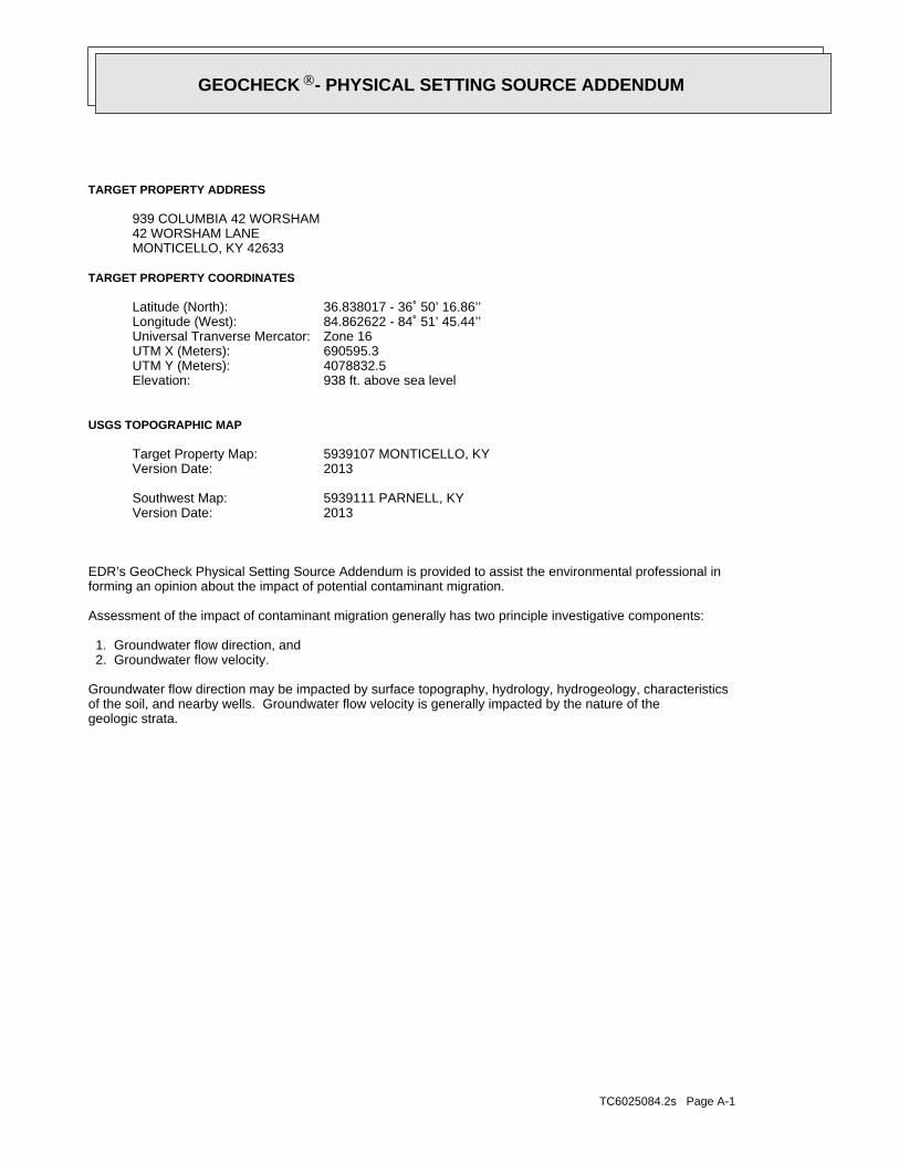
TC6025084.2s Page A-1
geologic strata.of the soil, and nearby wells. Groundwater flow velocity is generally impacted by the nature of theGroundwater flow direction may be impacted by surface topography, hydrology, hydrogeology, characteristics
2. Groundwater flow velocity. 1. Groundwater flow direction, and
Assessment of the impact of contaminant migration generally has two principle investigative components:
forming an opinion about the impact of potential contaminant migration.EDR’s GeoCheck Physical Setting Source Addendum is provided to assist the environmental professional in
2013Version Date:5939111 PARNELL, KYSouthwest Map:
2013Version Date:5939107 MONTICELLO, KYTarget Property Map:
USGS TOPOGRAPHIC MAP
938 ft. above sea levelElevation:4078832.5UTM Y (Meters): 690595.3UTM X (Meters): Zone 16Universal Tranverse Mercator: 84.862622 - 84˚ 51’ 45.44’’Longitude (West): 36.838017 - 36˚ 50’ 16.86’’Latitude (North):
TARGET PROPERTY COORDINATES
MONTICELLO, KY 4263342 WORSHAM LANE939 COLUMBIA 42 WORSHAM
TARGET PROPERTY ADDRESS
®GEOCHECK - PHYSICAL SETTING SOURCE ADDENDUM®

TC6025084.2s Page A-2
should be field verified.on a relative (not an absolute) basis. Relative elevation information between sites of close proximitySource: Topography has been determined from the USGS 7.5’ Digital Elevation Model and should be evaluated
SURROUNDING TOPOGRAPHY: ELEVATION PROFILES
Ele
vatio
n (f
t)E
leva
tion
(ft)
TP
TP0 1/2 1 Miles
✩Target Property Elevation: 938 ft.
North South
West East
886
897
902
912
916
914
915
920
935
938
957
961946
944
971948
954
980
971996
946
938
944
944 923 911
920
937
938
943
940
940
941
943
942 930
962
962
General SEGeneral Topographic Gradient:TARGET PROPERTY TOPOGRAPHY
should contamination exist on the target property, what downgradient sites might be impacted.assist the environmental professional in forming an opinion about the impact of nearby contaminated properties or,Surface topography may be indicative of the direction of surficial groundwater flow. This information can be used toTOPOGRAPHIC INFORMATION
collected on nearby properties, and regional groundwater flow information (from deep aquifers).sources of information, such as surface topographic information, hydrologic information, hydrogeologic datausing site-specific well data. If such data is not reasonably ascertainable, it may be necessary to rely on otherGroundwater flow direction for a particular site is best determined by a qualified environmental professionalGROUNDWATER FLOW DIRECTION INFORMATION
®GEOCHECK - PHYSICAL SETTING SOURCE SUMMARY®
TC6025084.2s Page A-3
Not Reported
GENERAL DIRECTIONLOCATIONGROUNDWATER FLOWFROM TPMAP ID
hydrogeologically, and the depth to water table.authorities at select sites and has extracted the date of the report, groundwater flow direction as determinedflow at specific points. EDR has reviewed reports submitted by environmental professionals to regulatoryEDR has developed the AQUIFLOW Information System to provide data on the general direction of groundwater
AQUIFLOW®
Search Radius: 1.000 Mile.
contamination exist on the target property, what downgradient sites might be impacted.environmental professional in forming an opinion about the impact of nearby contaminated properties or, shouldof groundwater flow direction in the immediate area. Such hydrogeologic information can be used to assist theHydrogeologic information obtained by installation of wells on a specific site can often be an indicatorHYDROGEOLOGIC INFORMATION
YES - refer to the Overview Map and Detail MapMONTICELLO
NATIONAL WETLAND INVENTORYNWI ElectronicData CoverageNWI Quad at Target Property
FEMA FIRM Flood data21231C0160C
Additional Panels in search area: FEMA Source Type
FEMA FIRM Flood data21231C0180C
Flood Plain Panel at Target Property FEMA Source Type
FEMA FLOOD ZONE
and bodies of water).Refer to the Physical Setting Source Map following this summary for hydrologic information (major waterways
contamination exist on the target property, what downgradient sites might be impacted.the environmental professional in forming an opinion about the impact of nearby contaminated properties or, shouldSurface water can act as a hydrologic barrier to groundwater flow. Such hydrologic information can be used to assistHYDROLOGIC INFORMATION
®GEOCHECK - PHYSICAL SETTING SOURCE SUMMARY®

TC6025084.2s Page A-4
Map, USGS Digital Data Series DDS - 11 (1994).of the Conterminous U.S. at 1:2,500,000 Scale - a digital representation of the 1974 P.B. King and H.M. BeikmanGeologic Age and Rock Stratigraphic Unit Source: P.G. Schruben, R.E. Arndt and W.J. Bawiec, Geology
ROCK STRATIGRAPHIC UNIT GEOLOGIC AGE IDENTIFICATION
Stratified SequenceCategory:PaleozoicEra:MississippianSystem:Meramecian SeriesSeries:M2Code: (decoded above as Era, System & Series)
at which contaminant migration may be occurring.Geologic information can be used by the environmental professional in forming an opinion about the relative speedGEOLOGIC INFORMATION IN GENERAL AREA OF TARGET PROPERTY
move more quickly through sandy-gravelly types of soils than silty-clayey types of soils.characteristics data collected on nearby properties and regional soil information. In general, contaminant plumesto rely on other sources of information, including geologic age identification, rock stratigraphic unit and soilusing site specific geologic and soil strata data. If such data are not reasonably ascertainable, it may be necessaryGroundwater flow velocity information for a particular site is best determined by a qualified environmental professionalGROUNDWATER FLOW VELOCITY INFORMATION
®GEOCHECK - PHYSICAL SETTING SOURCE SUMMARY®

EDR Inc.EDR Inc.EDR Inc.EDR Inc.EDR Inc.EDR Inc.EDR Inc.EDR Inc.EDR Inc.EDR Inc.EDR Inc.EDR Inc.EDR Inc.EDR Inc.EDR Inc.EDR Inc.EDR Inc.EDR Inc.EDR Inc.EDR Inc.EDR Inc.EDR Inc.EDR Inc.EDR Inc.EDR Inc.EDR Inc.EDR Inc.EDR Inc.EDR Inc.EDR Inc.EDR Inc.EDR Inc.EDR Inc.EDR Inc.EDR Inc.EDR Inc.EDR Inc.EDR Inc.EDR Inc.EDR Inc.
2
1
4
23 4
322
3
2
2
1
5
0 1/16 1/8 1/4 Miles

TC6025084.2s Page A-6
4.5Max: 6 Min:
Min: 4.23Max: 14.11
50%), silt.limit less thanClays (liquidSOILS, Silts andFINE-GRAINED
Soils.200), Siltypassing No.than 35 pct.Materials (moreSilt-Clayclay79 inches14 inches 3
4.5Max: 6 Min:
Min: 4.23Max: 14.11
50%), silt.limit less thanClays (liquidSOILS, Silts andFINE-GRAINED
Soils.200), Siltypassing No.than 35 pct.Materials (moreSilt-Claysilty clay loam14 inches 5 inches 2
4.5Max: 6 Min:
Min: 4.23Max: 14.11
50%), silt.limit less thanClays (liquidSOILS, Silts andFINE-GRAINED
Soils.200), Siltypassing No.than 35 pct.Materials (moreSilt-Claysilt loam 5 inches 0 inches 1
Soil Layer Information
Boundary Classification Saturatedhydraulicconductivitymicro m/sec
Layer Upper Lower Soil Texture Class AASHTO Group Unified Soil Soil Reaction(pH)
> 0 inchesDepth to Watertable Min:
> 0 inchesDepth to Bedrock Min:
HighCorrosion Potential - Uncoated Steel:
Hydric Status: Not hydric
Well drainedSoil Drainage Class:
textures.moderately well and well drained soils with moderately coarseClass B - Moderate infiltration rates. Deep and moderately deep,Hydrologic Group:
silt loamSoil Surface Texture:
DecaturSoil Component Name:
Soil Map ID: 1
in a landscape. The following information is based on Soil Conservation Service SSURGO data.for privately owned lands in the United States. A soil map in a soil survey is a representation of soil patternsSurvey (NCSS) and is responsible for collecting, storing, maintaining and distributing soil survey informationThe U.S. Department of Agriculture’s (USDA) Soil Conservation Service (SCS) leads the National Cooperative Soil
DOMINANT SOIL COMPOSITION IN GENERAL AREA OF TARGET PROPERTY
®GEOCHECK - PHYSICAL SETTING SOURCE SUMMARY®

TC6025084.2s Page A-7
Well drainedSoil Drainage Class:
textures.moderately well and well drained soils with moderately coarseClass B - Moderate infiltration rates. Deep and moderately deep,Hydrologic Group:
silt loamSoil Surface Texture:
FrederickSoil Component Name:
Soil Map ID: 3
Min: 4.5Max: 5.5
Min: 4.23Max: 14.11
more), Fat Clay.limit 50% orClays (liquidSOILS, Silts andFINE-GRAINED
Soils.200), Siltypassing No.than 35 pct.Materials (moreSilt-Clayclay61 inches37 inches 3
Min: 4.5Max: 5.5
Min: 4.23Max: 14.11
more), Fat Clay.limit 50% orClays (liquidSOILS, Silts andFINE-GRAINED
Soils.200), Siltypassing No.than 35 pct.Materials (moreSilt-Claysilty clay loam37 inches16 inches 2
Min: 4.5Max: 5.5
Min: 4.23Max: 14.11
more), Fat Clay.limit 50% orClays (liquidSOILS, Silts andFINE-GRAINED
Soils.200), Siltypassing No.than 35 pct.Materials (moreSilt-Claysilt loam16 inches 0 inches 1
Soil Layer Information
Boundary Classification Saturatedhydraulicconductivitymicro m/sec
Layer Upper Lower Soil Texture Class AASHTO Group Unified Soil Soil Reaction(pH)
> 0 inchesDepth to Watertable Min:
> 0 inchesDepth to Bedrock Min:
ModerateCorrosion Potential - Uncoated Steel:
Hydric Status: Not hydric
Well drainedSoil Drainage Class:
textures.moderately well and well drained soils with moderately coarseClass B - Moderate infiltration rates. Deep and moderately deep,Hydrologic Group:
silt loamSoil Surface Texture:
BewleyvilleSoil Component Name:
Soil Map ID: 2
®GEOCHECK - PHYSICAL SETTING SOURCE SUMMARY®
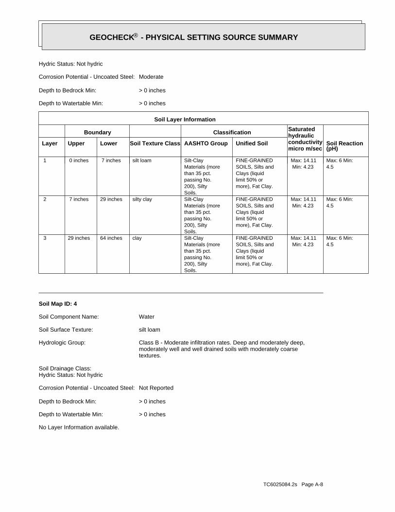
TC6025084.2s Page A-8
No Layer Information available.
> 0 inchesDepth to Watertable Min:
> 0 inchesDepth to Bedrock Min:
Not ReportedCorrosion Potential - Uncoated Steel:
Hydric Status: Not hydricSoil Drainage Class:
textures.moderately well and well drained soils with moderately coarseClass B - Moderate infiltration rates. Deep and moderately deep,Hydrologic Group:
silt loamSoil Surface Texture:
WaterSoil Component Name:
Soil Map ID: 4
4.5Max: 6 Min:
Min: 4.23Max: 14.11
more), Fat Clay.limit 50% orClays (liquidSOILS, Silts andFINE-GRAINED
Soils.200), Siltypassing No.than 35 pct.Materials (moreSilt-Clayclay64 inches29 inches 3
4.5Max: 6 Min:
Min: 4.23Max: 14.11
more), Fat Clay.limit 50% orClays (liquidSOILS, Silts andFINE-GRAINED
Soils.200), Siltypassing No.than 35 pct.Materials (moreSilt-Claysilty clay29 inches 7 inches 2
4.5Max: 6 Min:
Min: 4.23Max: 14.11
more), Fat Clay.limit 50% orClays (liquidSOILS, Silts andFINE-GRAINED
Soils.200), Siltypassing No.than 35 pct.Materials (moreSilt-Claysilt loam 7 inches 0 inches 1
Soil Layer Information
Boundary Classification Saturatedhydraulicconductivitymicro m/sec
Layer Upper Lower Soil Texture Class AASHTO Group Unified Soil Soil Reaction(pH)
> 0 inchesDepth to Watertable Min:
> 0 inchesDepth to Bedrock Min:
ModerateCorrosion Potential - Uncoated Steel:
Hydric Status: Not hydric
®GEOCHECK - PHYSICAL SETTING SOURCE SUMMARY®

TC6025084.2s Page A-9
opinion about the impact of contaminant migration on nearby drinking water wells.professional in assessing sources that may impact ground water flow direction, and in forming anEDR Local/Regional Water Agency records provide water well information to assist the environmental
LOCAL / REGIONAL WATER AGENCY RECORDS
Min: 5.6Max: 7.8
Min: 4.23Max: 14.11
50%), Lean Claylimit less thanClays (liquidSOILS, Silts andFINE-GRAINED
Soils.200), Siltypassing No.than 35 pct.Materials (moreSilt-Claysilty clay loam59 inches20 inches 3
Min: 5.6Max: 7.8
Min: 4.23Max: 14.11
50%), Lean Claylimit less thanClays (liquidSOILS, Silts andFINE-GRAINED
Soils.200), Siltypassing No.than 35 pct.Materials (moreSilt-Claysilt loam20 inches 7 inches 2
Min: 5.6Max: 7.8
Min: 4.23Max: 14.11
50%), Lean Claylimit less thanClays (liquidSOILS, Silts andFINE-GRAINED
Soils.200), Siltypassing No.than 35 pct.Materials (moreSilt-Claysilt loam 7 inches 0 inches 1
Soil Layer Information
Boundary Classification Saturatedhydraulicconductivitymicro m/sec
Layer Upper Lower Soil Texture Class AASHTO Group Unified Soil Soil Reaction(pH)
> 15 inchesDepth to Watertable Min:
> 0 inchesDepth to Bedrock Min:
HighCorrosion Potential - Uncoated Steel:
Hydric Status: Partially hydric
Poorly drainedSoil Drainage Class:
water table, or are shallow to an impervious layer.Class D - Very slow infiltration rates. Soils are clayey, have a highHydrologic Group:
silt loamSoil Surface Texture:
MelvinSoil Component Name:
Soil Map ID: 5
®GEOCHECK - PHYSICAL SETTING SOURCE SUMMARY®

TC6025084.2s Page A-10
1/2 - 1 Mile SEKY6000000053185 171/2 - 1 Mile ESEKY6000000058635 161/2 - 1 Mile SSEKY6000000068267 C141/2 - 1 Mile SSEKY6000000068268 C131/2 - 1 Mile SSEKY6000000068247 C121/2 - 1 Mile SSEKY6000000068266 C111/2 - 1 Mile WestKY6000000058613 101/2 - 1 Mile NEKY6000000013758 91/2 - 1 Mile SouthKY6000000037011 A81/2 - 1 Mile SouthKY6000000037010 A71/2 - 1 Mile ESEKY6000000048348 B61/2 - 1 Mile ESEKY6000000049237 B51/2 - 1 Mile SouthKY6000000037012 A31/2 - 1 Mile SouthKY6000000037013 A20 - 1/8 Mile WSWKY6000000058610 1
STATE DATABASE WELL INFORMATION
LOCATIONFROM TPWELL IDMAP ID
Note: PWS System location is not always the same as well location.
1/2 - 1 Mile SEKY1162154 15
FEDERAL FRDS PUBLIC WATER SUPPLY SYSTEM INFORMATION
LOCATIONFROM TPWELL IDMAP ID
1/2 - 1 Mile ESEUSGS40000377658 B4
FEDERAL USGS WELL INFORMATION
LOCATIONFROM TPWELL IDMAP ID
1.000State DatabaseNearest PWS within 1 mileFederal FRDS PWS1.000Federal USGS
WELL SEARCH DISTANCE INFORMATION
SEARCH DISTANCE (miles)DATABASE
®GEOCHECK - PHYSICAL SETTING SOURCE SUMMARY®
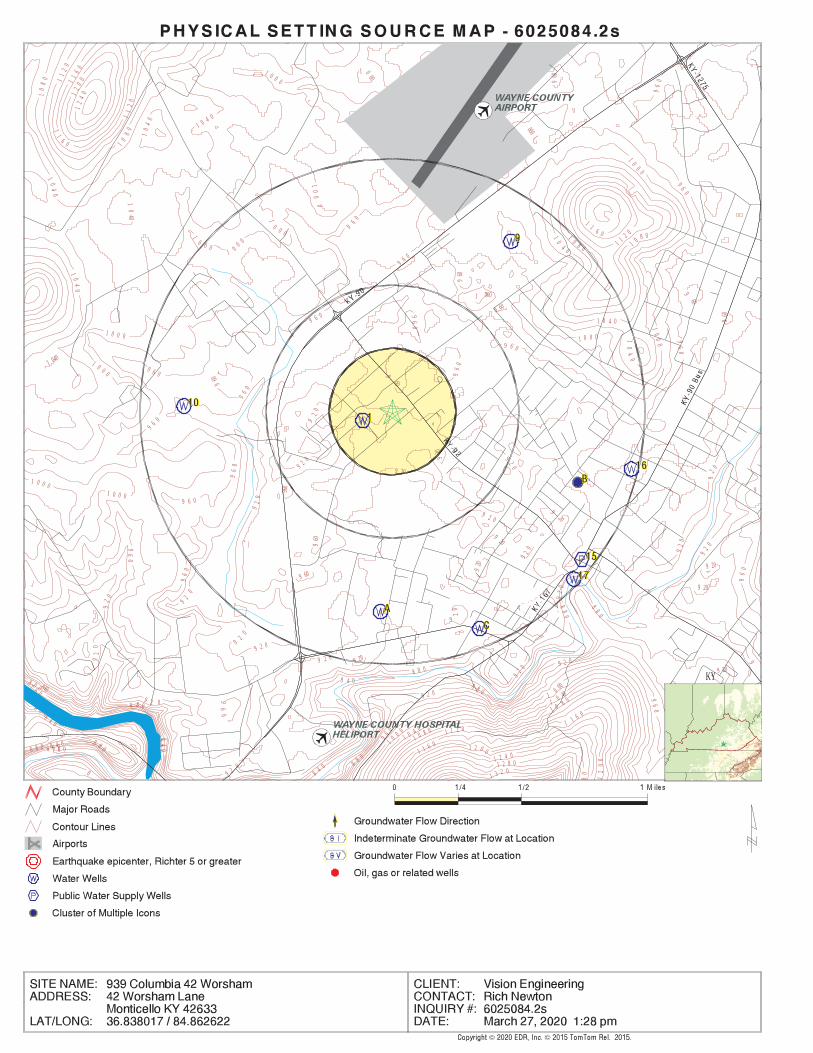
EDR Inc.EDR Inc.EDR Inc.EDR Inc.EDR Inc.EDR Inc.EDR Inc.EDR Inc.EDR Inc.EDR Inc.EDR Inc.EDR Inc.EDR Inc.EDR Inc.EDR Inc.EDR Inc.EDR Inc.EDR Inc.EDR Inc.EDR Inc.EDR Inc.EDR Inc.EDR Inc.EDR Inc.EDR Inc.EDR Inc.EDR Inc.EDR Inc.EDR Inc.EDR Inc.EDR Inc.EDR Inc.EDR Inc.EDR Inc.EDR Inc.EDR Inc.EDR Inc.EDR Inc.EDR Inc.EDR Inc.
12
401
20
011
60
11
6 01
04
011
20
11
20
10
80
10
80
10
40
1 0 4 0
10
40
1 040
960
10
40
9 6 0
9 6 0
1 0 0 0
1 0 0 0
1 0 0 0
1 0 0 0
1
0 0 0
92
0
96
0
96
0
9 6 0
8 8 0
92
0
92
0
9 2 08 8 0
840
84
0
8 0 0
80
0
8
7 6 0
7 6 08 0 0
8 0 0
8 4 0
8 4 0
8 8 0
1 000 9
60
10
00
96
0
1000
96
0
9 6 0
1 16 0
1 1 2 0
1 0 0 0
10
00
1
0 0 0
1 0 0 0
960
960
1 000
1 0 8 010 8 0
9 60
1 0 4 0
10
4 0
9609
60
10
40
10
00
1 00 0
1 0 0 0
96
0
960
96
0
920
92
0
9 2 0
96
0
960
920
960 9
20
92
0
920 9 20
9 60
9 20
92
0
9
20
92
0
9 2 09
20
9 20
9 20
92 0
96
0
8 4 0
8 4 0 8 8 0
8 8 0
8 80
88
0
8 8 0
9 20
9 2 0
9 20
9 2 0
9 20
92
0
92
0
92
0
9
92
0
9 2 0
9 2 0
1 3 2 0
80
1 2 8 01 2 4 0
12
00
1 2 0 0
1 1 6 0
1 1 6 0
9 6 0
9
6 0
9 6 0
9 6 0
96
09 6
0
96
0
9
96
0
9 6 0
96
0
96 0 1 1 2 0
1 0 8 0
1 0 8 0
1 0 40
1 0 4 0
10 00
1 0 0 0
KY

TC6025084.2s Page A-12
Not ReportedWell Hole Depth Units: Not ReportedWell Hole Depth: Not ReportedWell Depth Units: Not ReportedWell Depth: Not ReportedConstruction Date: Not ReportedAquifer Type: St. Louis LimestoneFormation Type: Not ReportedAquifer: Not ReportedContrib Drainage Area Unts: Not ReportedContrib Drainage Area: Not ReportedDrainage Area Units: Not ReportedDrainage Area: 05130103HUC: Not ReportedDescription: WellType: J20D0011Monitor Location: USGS Kentucky Water Science CenterOrganization Name: USGS-KYOrganization ID:
B4ESE1/2 - 1 MileLower
USGS40000377658FED USGS
KY6000000037012Site id:20-MAY-05Enddate:Industrial - GeneralUsage:900Surfaceele:WType:Mississippian PlateauPhysiograp:MonticelloQuadname:WayneCounty:-84.863333Longdecima:36.826667Latdecimal:Not ReportedAltid:62955Akgwa:37011Fid:
A3South1/2 - 1 MileLower
KY6000000037012KY WELLS
KY6000000037013Site id:20-MAY-05Enddate:Industrial - GeneralUsage:900Surfaceele:WType:Mississippian PlateauPhysiograp:MonticelloQuadname:WayneCounty:-84.863333Longdecima:36.826667Latdecimal:Not ReportedAltid:62956Akgwa:37012Fid:
A2South1/2 - 1 MileLower
KY6000000037013KY WELLS
KY6000000058610Site id:01-JAN-61Enddate:Domestic - Single HouseholdUsage:0Surfaceele:WType:Not ReportedPhysiograp:MonticelloQuadname:WayneCounty:-84.864722Longdecima:36.8375Latdecimal:Not ReportedAltid:60003857Akgwa:58609Fid:
1WSW0 - 1/8 MileHigher
KY6000000058610KY WELLS
Map IDDirectionDistanceElevation EDR ID NumberDatabase
®GEOCHECK - PHYSICAL SETTING SOURCE MAP FINDINGS®

TC6025084.2s Page A-13
KY6000000037011Site id:20-MAY-05Enddate:Industrial - GeneralUsage:900Surfaceele:WType:Mississippian PlateauPhysiograp:MonticelloQuadname:WayneCounty:-84.86361111Longdecima:36.82638889Latdecimal:Not ReportedAltid:62954Akgwa:37010Fid:
A8South1/2 - 1 MileLower
KY6000000037011KY WELLS
KY6000000037010Site id:20-MAY-05Enddate:InjectionUsage:900Surfaceele:WType:Mississippian PlateauPhysiograp:MonticelloQuadname:WayneCounty:-84.863611Longdecima:36.826389Latdecimal:Not ReportedAltid:62953Akgwa:37009Fid:
A7South1/2 - 1 MileLower
KY6000000037010KY WELLS
KY6000000048348Site id:Not ReportedEnddate:Domestic - Single HouseholdUsage:0Surfaceele:WType:Eastern Coal FieldPhysiograp:MonticelloQuadname:WayneCounty:-84.849388Longdecima:36.833961Latdecimal:Not ReportedAltid:40002924Akgwa:48347Fid:
B6ESE1/2 - 1 MileLower
KY6000000048348KY WELLS
KY6000000049237Site id:Not ReportedEnddate:UNKNOWNUsage:0Surfaceele:WType:Eastern Coal FieldPhysiograp:MonticelloQuadname:WayneCounty:-84.849389Longdecima:36.833959Latdecimal:365002084505801Altid:40003830Akgwa:49236Fid:
B5ESE1/2 - 1 MileLower
KY6000000049237KY WELLS
Map IDDirectionDistanceElevation EDR ID NumberDatabase
®GEOCHECK - PHYSICAL SETTING SOURCE MAP FINDINGS®

TC6025084.2s Page A-14
KY6000000068247Site id:17-JAN-95Enddate:Monitoring Well - Ambient MonitoringUsage:
915Surfaceele:MType:Mississippian PlateauPhysiograp:MonticelloQuadname:WayneCounty:-84.85638889Longdecima:36.82555556Latdecimal:Not ReportedAltid:80016126Akgwa:68246Fid:
C12SSE1/2 - 1 MileLower
KY6000000068247KY WELLS
KY6000000068266Site id:17-JAN-95Enddate:Monitoring Well - Ambient MonitoringUsage:
915Surfaceele:MType:Mississippian PlateauPhysiograp:MonticelloQuadname:WayneCounty:-84.85638889Longdecima:36.82555556Latdecimal:Not ReportedAltid:80016148Akgwa:68265Fid:
C11SSE1/2 - 1 MileLower
KY6000000068266KY WELLS
KY6000000058613Site id:Not ReportedEnddate:Domestic - Single HouseholdUsage:0Surfaceele:WType:Not ReportedPhysiograp:ParnellQuadname:WayneCounty:-84.8775Longdecima:36.838333Latdecimal:Not ReportedAltid:60003860Akgwa:58612Fid:
10West1/2 - 1 MileHigher
KY6000000058613KY WELLS
KY6000000013758Site id:17-NOV-91Enddate:Agriculture - IrrigationUsage:970Surfaceele:WType:Mississippian PlateauPhysiograp:MonticelloQuadname:WayneCounty:-84.85416667Longdecima:36.84777778Latdecimal:Not ReportedAltid:19927Akgwa:13757Fid:
9NE1/2 - 1 MileHigher
KY6000000013758KY WELLS
Map IDDirectionDistanceElevation EDR ID NumberDatabase
®GEOCHECK - PHYSICAL SETTING SOURCE MAP FINDINGS®
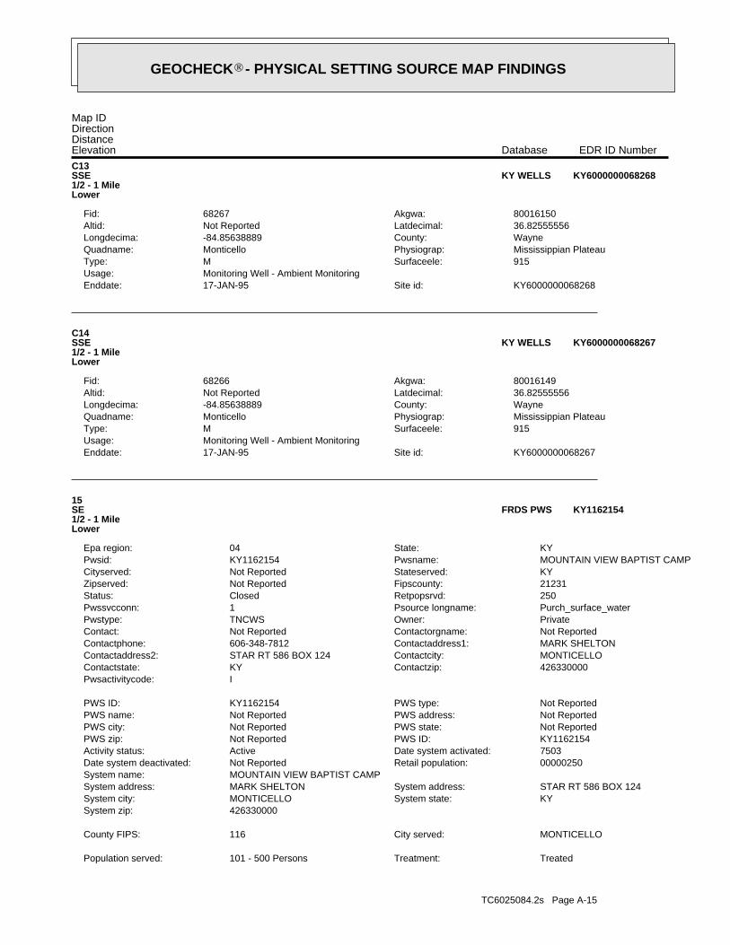
TC6025084.2s Page A-15
TreatedTreatment: 101 - 500 PersonsPopulation served:
MONTICELLOCity served: 116County FIPS:
426330000System zip: KYSystem state: MONTICELLOSystem city: STAR RT 586 BOX 124System address: MARK SHELTONSystem address:
MOUNTAIN VIEW BAPTIST CAMPSystem name: 00000250Retail population: Not ReportedDate system deactivated: 7503Date system activated: ActiveActivity status: KY1162154PWS ID: Not ReportedPWS zip: Not ReportedPWS state: Not ReportedPWS city: Not ReportedPWS address: Not ReportedPWS name: Not ReportedPWS type: KY1162154PWS ID:
IPwsactivitycode: 426330000Contactzip: KYContactstate: MONTICELLOContactcity: STAR RT 586 BOX 124Contactaddress2: MARK SHELTONContactaddress1: 606-348-7812Contactphone: Not ReportedContactorgname: Not ReportedContact: PrivateOwner: TNCWSPwstype: Purch_surface_waterPsource longname: 1Pwssvcconn: 250Retpopsrvd: ClosedStatus: 21231Fipscounty: Not ReportedZipserved: KYStateserved: Not ReportedCityserved: MOUNTAIN VIEW BAPTIST CAMPPwsname: KY1162154Pwsid: KYState: 04Epa region:
15SE1/2 - 1 MileLower
KY1162154FRDS PWS
KY6000000068267Site id:17-JAN-95Enddate:Monitoring Well - Ambient MonitoringUsage:
915Surfaceele:MType:Mississippian PlateauPhysiograp:MonticelloQuadname:WayneCounty:-84.85638889Longdecima:36.82555556Latdecimal:Not ReportedAltid:80016149Akgwa:68266Fid:
C14SSE1/2 - 1 MileLower
KY6000000068267KY WELLS
KY6000000068268Site id:17-JAN-95Enddate:Monitoring Well - Ambient MonitoringUsage:
915Surfaceele:MType:Mississippian PlateauPhysiograp:MonticelloQuadname:WayneCounty:-84.85638889Longdecima:36.82555556Latdecimal:Not ReportedAltid:80016150Akgwa:68267Fid:
C13SSE1/2 - 1 MileLower
KY6000000068268KY WELLS
Map IDDirectionDistanceElevation EDR ID NumberDatabase
®GEOCHECK - PHYSICAL SETTING SOURCE MAP FINDINGS®

TC6025084.2s Page A-16
KY6000000053185Site id:Not ReportedEnddate:Not ReportedUsage:0Surfaceele:WType:Eastern Coal FieldPhysiograp:MonticelloQuadname:WayneCounty:-84.849668Longdecima:36.828404Latdecimal:364942084505901Altid:40008093Akgwa:53184Fid:
17SE1/2 - 1 MileLower
KY6000000053185KY WELLS
KY6000000058635Site id:01-JAN-65Enddate:Domestic - Single HouseholdUsage:0Surfaceele:WType:Not ReportedPhysiograp:MonticelloQuadname:WayneCounty:-84.845556Longdecima:36.834722Latdecimal:Not ReportedAltid:60003882Akgwa:58634Fid:
16ESE1/2 - 1 MileLower
KY6000000058635KY WELLS
0845521Longitude: 364226Latitude:
0845057Longitude: 364946Latitude:
®GEOCHECK - PHYSICAL SETTING SOURCE MAP FINDINGS®

TC6025084.2s Page A-17
Not ReportedNot ReportedNot ReportedNot ReportedBasementNot ReportedNot ReportedNot ReportedNot ReportedLiving Area - 2nd Floor0%0%100%1.700 pCi/LLiving Area - 1st Floor
% >20 pCi/L% 4-20 pCi/L% <4 pCi/LAverage ActivityArea
Number of sites tested: 1
Federal Area Radon Information for Zip Code: 42633
: Zone 3 indoor average level < 2 pCi/L. : Zone 2 indoor average level >= 2 pCi/L and <= 4 pCi/L. Note: Zone 1 indoor average level > 4 pCi/L.
Federal EPA Radon Zone for WAYNE County: 2
9.105/8/20034263310.504/26/20034263319.404/17/2003426331.802/26/20034263329.302/26/2003426335.302/18/2003426331.302/8/2003426330.501/28/20034263311.309/1/2002426332.108/1/20024263313.2011/7/20054263317.9011/7/20054263327.7010/7/20054263314.203/8/20054263335.8010/12/20044263311.203/9/2004426330.001/26/20044263333.1011/30/20034263310.6010/22/20034263313.5010/9/200342633
____________________Test ResultTest DateZip
Radon Test Results
State Database: KY Radon
AREA RADON INFORMATION
GEOCHECK - PHYSICAL SETTING SOURCE MAP FINDINGSRADON
®

TOPOGRAPHIC INFORMATION
USGS 7.5’ Digital Elevation Model (DEM)Source: United States Geologic SurveyEDR acquired the USGS 7.5’ Digital Elevation Model in 2002 and updated it in 2006. The 7.5 minute DEM correspondsto the USGS 1:24,000- and 1:25,000-scale topographic quadrangle maps. The DEM provides elevation datawith consistent elevation units and projection.
Current USGS 7.5 Minute Topographic MapSource: U.S. Geological Survey
HYDROLOGIC INFORMATION
Flood Zone Data: This data was obtained from the Federal Emergency Management Agency (FEMA). It depicts 100-year and500-year flood zones as defined by FEMA. It includes the National Flood Hazard Layer (NFHL) which incorporates FloodInsurance Rate Map (FIRM) data and Q3 data from FEMA in areas not covered by NFHL.
Source: FEMATelephone: 877-336-2627Date of Government Version: 2003, 2015
NWI: National Wetlands Inventory. This data, available in select counties across the country, was obtained by EDRin 2002, 2005 and 2010 from the U.S. Fish and Wildlife Service.
State Wetlands Data: Wetland InventorySource: Environmental & Public Protection CabinetTelephone: 502-564-6736
HYDROGEOLOGIC INFORMATION
AQUIFLOW Information SystemR
Source: EDR proprietary database of groundwater flow informationEDR has developed the AQUIFLOW Information System (AIS) to provide data on the general direction of groundwater
flow at specific points. EDR has reviewed reports submitted to regulatory authorities at select sites and hasextracted the date of the report, hydrogeologically determined groundwater flow direction and depth to water tableinformation.
GEOLOGIC INFORMATION
Geologic Age and Rock Stratigraphic UnitSource: P.G. Schruben, R.E. Arndt and W.J. Bawiec, Geology of the Conterminous U.S. at 1:2,500,000 Scale - A digitalrepresentation of the 1974 P.B. King and H.M. Beikman Map, USGS Digital Data Series DDS - 11 (1994).
STATSGO: State Soil Geographic DatabaseSource: Department of Agriculture, Natural Resources Conservation Service (NRCS)The U.S. Department of Agriculture’s (USDA) Natural Resources Conservation Service (NRCS) leads the nationalConservation Soil Survey (NCSS) and is responsible for collecting, storing, maintaining and distributing soilsurvey information for privately owned lands in the United States. A soil map in a soil survey is a representationof soil patterns in a landscape. Soil maps for STATSGO are compiled by generalizing more detailed (SSURGO)soil survey maps.
SSURGO: Soil Survey Geographic DatabaseSource: Department of Agriculture, Natural Resources Conservation Service (NRCS)Telephone: 800-672-5559SSURGO is the most detailed level of mapping done by the Natural Resources Conservation Service, mappingscales generally range from 1:12,000 to 1:63,360. Field mapping methods using national standards are used toconstruct the soil maps in the Soil Survey Geographic (SSURGO) database. SSURGO digitizing duplicates theoriginal soil survey maps. This level of mapping is designed for use by landowners, townships and countynatural resource planning and management.
TC6025084.2s Page PSGR-1
PHYSICAL SETTING SOURCE RECORDS SEARCHED

LOCAL / REGIONAL WATER AGENCY RECORDS
FEDERAL WATER WELLS
PWS: Public Water SystemsSource: EPA/Office of Drinking WaterTelephone: 202-564-3750Public Water System data from the Federal Reporting Data System. A PWS is any water system which provides water to at
least 25 people for at least 60 days annually. PWSs provide water from wells, rivers and other sources.
PWS ENF: Public Water Systems Violation and Enforcement DataSource: EPA/Office of Drinking WaterTelephone: 202-564-3750Violation and Enforcement data for Public Water Systems from the Safe Drinking Water Information System (SDWIS) after
August 1995. Prior to August 1995, the data came from the Federal Reporting Data System (FRDS).
USGS Water Wells: USGS National Water Inventory System (NWIS)This database contains descriptive information on sites where the USGS collects or has collected data on surfacewater and/or groundwater. The groundwater data includes information on wells, springs, and other sources of groundwater.
STATE RECORDS
Kentucky Water Well Records DatabaseSource: Kentucky Geological SurveyTelephone: 859-257-5500Water Wells in Kentucky. Data from the Kentucky Ground Water Data Repository.
OTHER STATE DATABASE INFORMATION
Oil and Gas Well LocationsSource: Kentucky Geological SurveyTelephone: 859-257-5500Oil and gas well locations in the state of Kentucky
RADON
State Database: KY Radon Source: Department of Public HealthTelephone: 502-564-4856Radon Test Results
Area Radon InformationSource: USGSTelephone: 703-356-4020The National Radon Database has been developed by the U.S. Environmental Protection Agency(USEPA) and is a compilation of the EPA/State Residential Radon Survey and the National Residential Radon Survey.The study covers the years 1986 - 1992. Where necessary data has been supplemented by information collected atprivate sources such as universities and research institutions.
EPA Radon ZonesSource: EPATelephone: 703-356-4020Sections 307 & 309 of IRAA directed EPA to list and identify areas of U.S. with the potential for elevated indoorradon levels.
OTHER
Airport Landing Facilities: Private and public use landing facilitiesSource: Federal Aviation Administration, 800-457-6656
Epicenters: World earthquake epicenters, Richter 5 or greaterSource: Department of Commerce, National Oceanic and Atmospheric Administration
Earthquake Fault Lines: The fault lines displayed on EDR’s Topographic map are digitized quaternary faultlines, preparedin 1975 by the United State Geological Survey
TC6025084.2s Page PSGR-2
PHYSICAL SETTING SOURCE RECORDS SEARCHED

STREET AND ADDRESS INFORMATION
© 2015 TomTom North America, Inc. All rights reserved. This material is proprietary and the subject of copyright protectionand other intellectual property rights owned by or licensed to Tele Atlas North America, Inc. The use of this material is subjectto the terms of a license agreement. You will be held liable for any unauthorized copying or disclosure of this material.
TC6025084.2s Page PSGR-3
PHYSICAL SETTING SOURCE RECORDS SEARCHED

1
From: Robinson, Jeff (EEC) <[email protected]>
Sent: Monday, March 30, 2020 9:43 AM
Cc: '[email protected]'
Subject: FW: Request for an file search for 939 West Columbia Ave. & 42WorshamLn.,
Monticello, KY
Attachments: Capture.png
Rich,
The Department for Environmental Protection (DEP) has conducted a records search on the address/location/name
listed on your request. Upon completion of the search performed, DEP has identified no records associated with the
information provided. I have attached a snapshot of the property with this email. If I can provide any further assistance
on this request, please contact me.
Best Regards,
Jeff Robinson
Public Records Management Section
Division of Environmental Program Support Department for Environmental Protection
300 Sower Blvd
From: [email protected] [mailto:[email protected]]
Sent: Friday, March 27, 2020 4:57 PM
To: EEC KORA <[email protected]>
Cc: Robinson, Jeff (EEC) <[email protected]>
Subject: FW: Request for an file search for 939 West Columbia Ave. & 42Worsham Ln., Monticello, KY
Please see below. Thanks,
From: [email protected]
Sent: Friday, March 27, 2020 4:37 PM

2
To: 'Rich Newton' <[email protected]>
Subject: FW: Request for an file search for 939 West Columbia Ave. & 42Worsham Ln., Monticello, KY
From: Robinson, Jeff (EEC) <[email protected]>
Sent: Friday, March 27, 2020 1:41 PM
Subject: RE: Request for an file search for 939 West Columbia Ave. & 42Worsham Ln., Monticello, KY
Odus,
I am no longer allowed to fill requests sent directly to me. Please send this request to [email protected]. I will be glad to
fill your request, just include my name.
Thank you,
Jeff Robinson Public Records Management Section Division of Environmental Program Support Department for Environmental Protection 300 Sower Blvd [email protected]
From: [email protected] [mailto:[email protected]]
Sent: Friday, March 27, 2020 1:34 PM
To: Robinson, Jeff (EEC) <[email protected]>
Cc: 'Rich Newton' <[email protected]>
Subject: RE: Request for an file search for 939 West Columbia Ave. & 42 Worsham Ln., Monticello, KY
For a Phase I Environmental Site Assessment I would like to request a file search for any;
• UST’s • Spills • Leaks • Air Quality Environmental Complaints • Hazardous Waste • Super Fund • Landfills • Dumps • KPDES Permits and No Discharge Permits • Environmental Complaints
for the sites and neighboring faculties at 939 West Columbia Ave. and 42 Worsham Ln. in Monticello, KY. Is at coordinates: 36°50’16.86” / -84°51’45.44” Thank you Odus Baker Vision Engineering, LLC 859.559.0516 desk


Appendix III
Site Visit Photograph Summary

Looking along NW property line from N property corner
looking NE on NE pl at adjacent property looking SE along NE pl at back of adjacent property
March 30, 2020
Cumberland Horizon Village Site
Monticello, KY
FIELD INSPECTOR PHONE: (859)559-0516Dustin Roe / Vision Engineering
REMARKS site pictures 1 of 2
looking along NE pl from E property corner
PROJECT LOCATION: Monticello
REPORT DATE:
looking W at center of property from E property corner
Looking along NE property line from N property corner
PROJECT NAME:
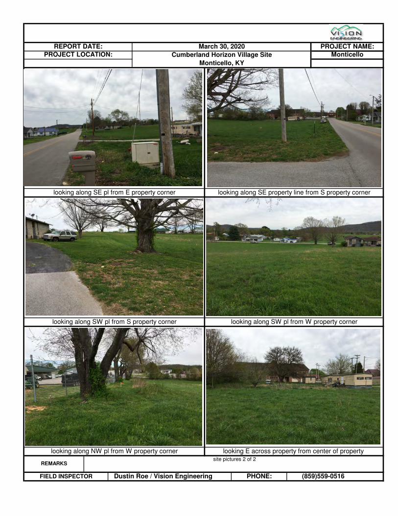
REMARKS site pictures 2 of 2
FIELD INSPECTOR Dustin Roe / Vision Engineering PHONE: (859)559-0516
looking along NW pl from W property corner looking E across property from center of property
looking along SW pl from S property corner looking along SW pl from W property corner
Monticello, KY
looking along SE pl from E property corner looking along SE property line from S property corner
REPORT DATE: March 30, 2020 PROJECT NAME:
PROJECT LOCATION: Cumberland Horizon Village Site Monticello

Appendix IV
City Directory

939 Columbia 42 Worsham
42 Worsham LaneMonticello, KY 42633
Inquiry Number: 6025084.5March 30, 2020
The EDR-City Directory Image Report
6 Armstrong RoadShelton, CT 06484800.352.0050www.edrnet.comEnvironmental Data Resources IncEnvironmental Data Resources IncEnvironmental Data Resources IncEnvironmental Data Resources Inc

TABLE OF CONTENTS
SECTION
Executive Summary
Findings
City Directory Images
Thank you for your business. Please contact EDR at 1-800-352-0050
with any questions or comments.
Disclaimer - Copyright and Trademark Notice
This Report contains certain information obtained from a variety of public and other sources reasonably available to Environmental Data Resources, Inc. It cannot be concluded from this Report that coverage information for the target and surrounding properties does not exist from other sources. NO WARRANTY EXPRESSED OR IMPLIED, IS MADE WHATSOEVER IN CONNECTION WITH THIS REPORT. ENVIRONMENTAL DATA RESOURCES, INC. SPECIFICALLY DISCLAIMS THE MAKING OF ANY SUCH WARRANTIES, INCLUDING WITHOUT LIMITATION, MERCHANTABILITY OR FITNESS FOR A PARTICULAR USE OR PURPOSE. ALL RISK IS ASSUMED BY THE USER. IN NO EVENT SHALL ENVIRONMENTAL DATA RESOURCES, INC. BE LIABLE TO ANYONE, WHETHER ARISING OUT OF ERRORS OR OMISSIONS, NEGLIGENCE, ACCIDENT OR ANY OTHER CAUSE, FOR ANY LOSS OR DAMAGE, INCLUDING, WITHOUT LIMITATION, SPECIAL, INCIDENTAL, CONSEQUENTIAL, OR EXEMPLARY DAMAGES. ANY LIABILITY ON THE PART OF ENVIRONMENTAL DATA RESOURCES, INC. IS STRICTLY LIMITED TO A REFUND OF THE AMOUNT PAID FOR THIS REPORT. Purchaser accepts this Report "AS IS". Any analyses, estimates, ratings, environmental risk levels or risk codes provided in this Report are provided for illustrative purposes only, and are not intended to provide, nor should they be interpreted as providing any facts regarding, or prediction orforecast of, any environmental risk for any property. Only a Phase I Environmental Site Assessment performed by an environmental professional can provide information regarding the environmental risk for any property. Additionally, the information provided in this Report is not to be construed as legal advice.
Copyright 2020 by Environmental Data Resources, Inc. All rights reserved. Reproduction in any media or format, in whole or in part, of any report or map of Environmental Data Resources, Inc. or its affiliates is prohibited without prior written permission.
EDR and its logos (including Sanborn and Sanborn Map) are trademarks of Environmental Data Resources, Inc. or its affiliates. All other trademarks used herein are the property of their respective owners.

EXECUTIVE SUMMARY
DESCRIPTION
Environmental Data Resources, Inc.’s (EDR) City Directory Report is a screening tool designed to assist environmental professionals in evaluating potential liability on a target property resulting from past activities. EDR’s City Directory Report includes a search of available city directory data at 5 year intervals.
RECORD SOURCES
EDR's Digital Archive combines historical directory listings from sources such as Cole Information and Dun & Bradstreet. These standard sources of property information complement and enhance each other to provide a more comprehensive report.
EDR is licensed to reproduce certain City Directory works by the copyright holders of those works. The purchaser of this EDR City Directory Report may include it in report(s) delivered to a customer. Reproduction of City Directories without permission of the publisher or licensed vendor may be a violation of copyright.
RESEARCH SUMMARY
The following research sources were consulted in the preparation of this report. A check mark indicates where information was identified in the source and provided in this report.
Year Target Street Cross Street Source
2017 EDR Digital Archive
2014 EDR Digital Archive
2010 EDR Digital Archive
2005 EDR Digital Archive
2000 EDR Digital Archive
1995 EDR Digital Archive
1992 EDR Digital Archive
6025084- 5 Page 1

FINDINGS
TARGET PROPERTY STREET
42 Worsham LaneMonticello, KY 42633
Year CD Image Source
WORSHAM LN
2017 pg A4 EDR Digital Archive
2014 pg A7 EDR Digital Archive
2010 pg A10 EDR Digital Archive
2005 pg A13 EDR Digital Archive
2000 pg A16 EDR Digital Archive
1992 - EDR Digital Archive Target and Adjoining not listed in Source
WORSHAM PL
2005 pg A14 EDR Digital Archive
2000 pg A17 EDR Digital Archive
1995 pg A20 EDR Digital Archive
6025084- 5 Page 2

FINDINGS
CROSS STREETS
Year CD Image Source
W COLUMBIA AVE
2017 pg. A2 EDR Digital Archive
2014 pg. A5 EDR Digital Archive
2010 pg. A8 EDR Digital Archive
2005 pg. A11 EDR Digital Archive
2000 pg. A15 EDR Digital Archive
1995 pg. A18 EDR Digital Archive
1992 pg. A21 EDR Digital Archive
6025084- 5 Page 3

City Directory Images

-
W COLUMBIA AVE
EDR Digital Archive
6025084.5 Page: A2
SourceTarget Street Cross Street
2017
30 WAYNE CO CHILD SUPP PROGRAM31 SIMMONS & PHARIS
THOMAS G SIMMONS ATTY AT LAWWAYNE CO CHILD SUPP PROGRAM
40 VROOMAN, ALAN43 GORDON T GERMAIN ATTY104 SIMMONS & PHARIS
THOMAS G SIMMONS ATTY125 COUNTY OF WAYNE
WAYNE COUNTY JUDICIAL DEVELOPMENT147 FLOYD, WILLIAM E154 BRYANT, HAZEL168 IRWIN, BONNIE E218 GREGORY D LATHAM SR CPA CPA234 PHILLIPS, KRISTEN256 FOSTER, ROBERT L270 WATSON, VICKIE282 ROMERO, LCELSY290 JENKINS, BOBBY300 ALVAREZ, LORENZO
DIAZ, FRANCISCODIAZ, JAMIE
318 STRINGERS EQUIPMENT REPAIR330 DAVIS, JOHNNY K346 SWART, BILLY349 HERNANDEZ, KIMBERLY356 SEXTON, WHITNEY390 SELVIDGE, WILLIAM T428 BERTRAM, RACHEL L440 YORK, FRANK M450 LONE OAK FARM HOUSE STORE
OWENS, JESSIE468 KING, ROBERT L486 JONES, CHRISTAL610 R & L CONTRACTING INC
SOUTH KENTUCKY RECC615 SOUTH KENTUCKY RECC646 BACK, BOBBY E694 WHITAKER, ANGIE751 COOMER, DON B754 BROWN, EVEA765 FRYE, THURSTON774 ELLIS, AVERY S792 BRUMLEY, ANTHONY819 WAYNE ENGINEERING & ASSOCIATES LLC836 YANCEY, DONALD R865 THE HOPE CENTER875 WHOS CALLING887 STEARNS, CURTIS M900 BREWER, BYRON O

(Cont'd)
-
W COLUMBIA AVE
EDR Digital Archive
6025084.5 Page: A3
SourceTarget Street Cross Street
2017
900 VICENTE, SAUQEO916 THE HOPE CENTER927 JIMS SEAMLESS GUTTERING984 MORGAN, JOHNNY R1022 AMERICAN HEALTH MANAGEMENT
HORIZON ADULT HEALTH CARE1025 BATES, JANET P1032 WASHAM, RAY O1177 HOPPER, RYAN K1199 HOPPER, FRANK A1225 INTRUST HEALTHCARE
THE CHURCH OF JESUS CHRIST OF LATTERWAYNE COUNTY HOSPITAL CLINIC
1251 SILVERS HOMETOWN PHARAMCY

-
WORSHAM LN
EDR Digital Archive
6025084.5 Page: A4
SourceTarget Street Cross Street
2017
17 BURDINE, DANIEL25 HANCOCK, KESLEY55 UPCHURCH, CHARLES B77 DISHMAN, LONNIE R150 WFLW AM 1360220 DISHMAN PERSONAL CARE HOME274 LEADY, DANIEL J330 DOBBS, SHERMAN K517 NORRIS, WILLIAM E540 RICHARDSON, JAMES L590 BERTRAM, DAVID A785 DAVIS, CLYDE

-
W COLUMBIA AVE
EDR Digital Archive
6025084.5 Page: A5
SourceTarget Street Cross Street
2014
31 COUNTY ATTORNEYSIMMONS & PHARISSIMMONS THOMAS G DGN ATTYWAYNE CO CHILD SUPP PROGRAM
40 VROOMAN, ALAN43 GERMAIN GORDON T DGN ATTY75 WAYNE COUNTY SENIOR CITZENS CENTER125 COUNTY OF WAYNE
WAYNE COUNTY JUDICIAL DEVELOPMENT136 CRABTREE, FAYE147 FLOYD, TIMOTHY W154 BRYANT, HAZEL168 OCCUPANT UNKNOWN,196 RICH, WALTER209 IRWIN, WOODY S218 LATHAM GREGORY E SR CPA234 RAGAN, GEORGIA M245 OCCUPANT UNKNOWN,256 FOSTER, ROBERT L282 ROMERO, LCELSY284 OCCUPANT UNKNOWN,290 RICHARDSON, LONNIE E300 ALVAREZ, LORENZO
DIAZ, ANDRES311 SELVIDGE, LEATRICE C318 STRINGERS EQUIPMENT REPAIR325 STUMP, MARY330 DAVIS, JOHNNY K346 OCCUPANT UNKNOWN,349 HERNANDEZ, KIMBERLY356 OCCUPANT UNKNOWN,390 OCCUPANT UNKNOWN,410 HUFFAKER ANGUS FARMS440 YORK, FRANK M449 OCCUPANT UNKNOWN,450 LONE OAK FARM HOUSE STORE
OWENS, JESSIE468 KING, ROBERT L485 BERTRAM, NORMA C486 JONES, CHRISTAL500 STEPHENSON, GARY556 OCCUPANT UNKNOWN,605 OCCUPANT UNKNOWN,646 BACK, BOBBY E694 RUSSELL, FAYE709 CORDER, FREDDA B751 OCCUPANT UNKNOWN,765 FRYE, THURSTON774 ELLIS, AVERY S792 BRUMLEY, ANTHONY
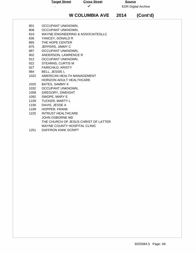
(Cont'd)
-
W COLUMBIA AVE
EDR Digital Archive
6025084.5 Page: A6
SourceTarget Street Cross Street
2014
801 OCCUPANT UNKNOWN,808 OCCUPANT UNKNOWN,819 WAYNE ENGINEERING & ASSOCIATESLLC836 YANCEY, DONALD R865 THE HOPE CENTER875 JEFFERS, JIMMY C887 OCCUPANT UNKNOWN,902 ANDERSON, LAWRENCE R912 OCCUPANT UNKNOWN,922 STEARNS, CURTIS M927 FAIRCHILD, KRISTY984 BELL, JESSIE L1022 AMERICAN HEALTH MANAGEMENT
HORIZON ADULT HEALTHCARE1025 BATES, SAMMY K1032 OCCUPANT UNKNOWN,1058 GREGORY, DWEIGHT1092 SWOPE, MARY E1109 TUCKER, MARTY L1156 DAVIS, JESSE A1199 HOPPER, FRANK1225 INTRUST HEALTHCARE
JOHN OSBORNE MDTHE CHURCH OF JESUS CHRIST OF LATTERWAYNE COUNTY HOSPITAL CLINIC
1251 DAFFRON KWIK SCRIPT

-
WORSHAM LN
EDR Digital Archive
6025084.5 Page: A7
SourceTarget Street Cross Street
2014
17 DENNEY, NICKEY W25 HANCOCK, TRACY J42 MEREDITH, JEFFREY55 UPCHURCH, CHARLES B77 OCCUPANT UNKNOWN,101 RUSSELL, PHYLLIS102 SLOAN, AMANDA106 WITT, JANET115 JENKINS, SAM136 MAYS, MICHAEL J143 SWEET, LILLIE150 WFLW AM 1360
WKYM 101 7 FM220 DISHMAN PERSONAL CARE HOME
LEDBETTER, JACK274 HARRINGTON, RANDY P330 DOBBS, SHERMAN K517 NORRIS, WILLIAM E540 RICHARDSON, JAMES L555 UPCHURCH, GLENNA590 BERTRAM, DAVID A785 DAVIS, CLYDE

-
W COLUMBIA AVE
EDR Digital Archive
6025084.5 Page: A8
SourceTarget Street Cross Street
2010
30 WAYNE CO CHILD SUPPORT PROGRAM31 SIMMONS THOMAS43 GERMAIN LAW OFFICE55 COFFEE ON THE CORNER100 PRETRIAL SVC OFC
WAYNE COUNTY CIRCUIT COURT CLK136 JENKINS, FELICIA147 FLOYD, WILLIAM E154 BRYANT, HAZEL182 FERRELL, JOHN196 RICH, WALTER209 IRWIN, WOODY S218 BATES, JOHNNY
FOSTER, JOHNNYHICKMAN, BRIANLATHAM SR GREGORY D CPALATHAM, GREGORY E
234 RAGAN, GEORGIA M256 FOSTER, DARRELL W270 COLIN, YIRA284 SALDIVAZ, RODRIGUEZ290 RAHM, PHILLIP
RUIZ, ROBERTO A300 ORTIZ, CARLOS M318 STRINGERS EQUIPMENT REPAIR325 STUMP, MARY349 WOMBLES, AMBER O356 HILL, DAVID401 MCGILL, JOSH410 HUFFAKER ANGUS FARMS428 SELVIDGE, EVERETT G440 YORK, FRANK M450 ADAMS, ERIC D
OWENS, LEONARD EWARREN, MARK A
468 KING, ROBERT L485 BERTRAM, NORMA C486 JONES, CHRISTAL500 STEPHENSON, VELA M556 SOUTHWOOD, RAY605 WAYNE COUNTY STOCKYARDS INC610 R & L CONTRACTING INC646 BACK, BOBBY E694 RUSSELL, BRUCE709 GONZALEZ, GLORIA735 ADANTA GROUP CLINICAL SVC751 COOMER, DON B765 FRYE, THURSTON792 HILL, MARY801 ANDERSON, LAWRENCE R

(Cont'd)
-
W COLUMBIA AVE
EDR Digital Archive
6025084.5 Page: A9
SourceTarget Street Cross Street
2010
808 COOMER, M836 YANCEY, DONALD R875 HILL, HOLLY887 STEARNS, CURTIS M900 STRUNK, STELLA912 HILL, RICKY927 CAMACHO, ESMERALDA
DANIELS, SHIRLEYJIMS SEAMLESS GUTTERING
939 HORIZON ADULT HEALTHCARE CTR975 D P SPECIAL TEES LLC984 EAGLETON, HOWARD991 BELLS CARPET CTR1000 ALLEY, OLA1032 WASHAM, RAY O1083 DAVIS MUSIC & WESTERN WEAR1156 DAVIS, JESSE A1199 HOPPER, ALLAN K1200 BELDEN1225 3001 COOL CUTZ & STYLE FAMILY1251 WAYNE KWIKSCRIPT INC1279 ACTION MOTOR SPORTS

-
WORSHAM LN
EDR Digital Archive
6025084.5 Page: A10
SourceTarget Street Cross Street
2010
17 CHRISTIAN, KELLY55 UPCHURCH, CHARLES B77 DISHMAN, POWELL C101 RUSSELL, PHYLLIS102 SLOAN, AMANDA106 WITT, JANET112 GOAD, SHEILA D115 JENKINS, SAM126 FERRELL, SHANDRA136 CARRENDER, DION143 SWEET, LILLIE145 BURDINE, REBECCA200 DISHMAN, PHILLIPS220 LEDBETTER, JACK330 DOBBS, SHERMAN K517 NORRIS, ED Y540 RICHARDSON, JAMES L590 BERTRAM, DAVID A716 POWELL, RUTH785 DAVIS, CLYDE

-
W COLUMBIA AVE
EDR Digital Archive
6025084.5 Page: A11
SourceTarget Street Cross Street
2005
104 LAW OFFICE OF CHARLIE PHARISSIMMONS THOMAS G ATTORNEY
107 WAYNE COUNTY CHILD SUPPORT110 GERMAIN GORDON T111 MARTINEZ, JUAN136 CRABTREE, PATSY140 FLOYD, WILLIAM E209 IRWIN, WOODY S215 RAINBOW WORLD CHILD CARE CENTER217 EDWARDS, KENNETH218 BAKER, JAMES R
COYLE, MOLLYDANIELS, SUSIEDOSS, THOMASELLER, CHARLOTTEFOSTER, JOHNNYGONZALES, RUBINGREGORY, BHARRIS, TAMMYHICKMAN, BRIANJONES, TERRYLATHAM, GREGORYLYONS, RICHARDUPCHURCH, JUSTIN S
223 RAGAN, GEORGIA M225 ELAM, BOBBY G235 HERNANDEZ, ZAIDA237 RODRIGUEZ, VLADIMIR243 CAMACHO, JERZON301 STRINGER EQUIPMENT REPAIR305 RODRIGUEZ, EDGARDO307 CABALLERO, HEZIQUIO309 MORROW, LLOYD L325 STUMP, MARY409 SELVIDGE, EVERETT G410 HUFFAKER ANGUS FARMS411 YORK, FRANK M413 FRAME, RUSSELL
GREENWOOD, WILLIAM LMRDUTT, KENNETH GSHEARER, E
419 KING, ROBERT L423 STEPHENSON, VELA P424 BERTRAM, BOBBY F501 GUFFEY, SAMMY J509 SOUTHWOOD, RAY609 MCCUTCHEN, JOYCE A613 BACK, BOBBY E705 KEETON, LIBBY A710 ABBOTT, LEE G

(Cont'd)
-
W COLUMBIA AVE
EDR Digital Archive
6025084.5 Page: A12
SourceTarget Street Cross Street
2005
802 ADANTA GROP BHVRL HEALTH SERVICESADANTA TENCO
805 RUSSELL, BRIAN806 FRYE, THURSTON807 DECKER, DONALD K901 HILL, MARY902 ANDERSON, LAWRENCE R915 BLEVINS, DOUG D922 STEARNS, CURTIS927 STRUNK, STELLA
WELCH, CHRISTOPHER R929 HILL, RICKY

-
WORSHAM LN
EDR Digital Archive
6025084.5 Page: A13
SourceTarget Street Cross Street
2005
25 WILLIAMS, PAUL55 UPCHURCH, CHARLES77 DISHMAN, JAY106 BROWN, L E107 STRINGER, BETTY J126 FERRELL, SHANDRA136 MAYS, MICHAEL J143 SWEET, LILLIE150 WKYM 101 7 FM200 DISHMAN, PHILLIPS220 DISHMAN PERSONAL CARE HOME517 NORRIS, ED540 JAMES RICHARDSON
RICHARDSON, JAMES L590 BERTRAM, DAVID A676 U HAUL CO785 DAVIS, CLYDE

-
WORSHAM PL
EDR Digital Archive
6025084.5 Page: A14
SourceTarget Street Cross Street
2005
103 STOKES, WILLIAM T104 MOORE, ROBIN105 ATKINSON, ORVAL106 DEAN, DAVID108 POORE, BERTIE C109 HARDWICK, MARLA111 NICELY, TRICIA L112 GOAD, SHELIA114 FOSTER, PAMALA117 HOOVER, GERUS118 FOSTER, THOMAS121 ALLEY, STEVEN122 GUFFEY, CHAD
SMITH, DEBORAH123 KEATON, SANDRA B125 COOPER, JOANN126 BRYANT, TERRY128 FLOYD, IMOGENE130 MCCLELLAN, LARRY D136 JONES, KATHERINE140 SLAGLE, BONNIE C142 BROWN, EMMA M144 BARBER, DOTTIE L

-
W COLUMBIA AVE
EDR Digital Archive
6025084.5 Page: A15
SourceTarget Street Cross Street
2000
100 TAYLOR, FLOSSIE104 SIMMONS THOMAS G ATTORNEY107 SIGNS SAY IT ALL110 ESTES CHARLES CPA119 SLAGLE, KATY140 BENTLEY, CHARLES215 SIMMONS JOHN WOODROW MD PSC217 EDWARDS, MARY218 TURNER, SHAWN223 RAGAN, GEORGE M225 ELAM, BOBBY234 MONTICELLO CITY OF FIRE DEPARTMENT
STREET DEPARTMENT235 DANIELS, LISA236 CUMBERLAND LAKE COMMUNICATIONS237 TURPIN, HARRY
WALKER, EDWARD238 FAMILY HAIR DESIGNS301 STRINGERS EQUIPMENT REPAIR307 HILL, JERRY308 CLARK, MAE311 SELVIDGE, WILLIAM T409 SELVIDGE, EVERETT410 HUFFAKER, LEXIE R411 YORK, FRANK419 KING, ROBERT421 ATKINSON, CAROLYN B423 STEPHENSON, VELA424 BERTRAM, NORMA S509 SOUTHWOOD, RAY600 WAYNE COUNTY STOCKYARDS INCORPORATED609 JOYCE'S TOTAL LOOK613 BACK, BOBBY E615 ELECTRIC PLANT BOARD
MONTICELLO CITY OF ELECTRIC PLANT BOARD616 VILLAGE MART II710 ABBOTT, BARNETT802 ADANTA GROUP BEHAVIORAL HEALTH SERVICES805 LOVELL, CRYSTAL N806 FRYE, THURSTO807 DECKER, DORSIE906 POWELL, EARL909 SIMPSON, WALLACE921 SMITH, GILBERT R922 STEARNS, CURTIS924 DEWITT, LAUREL927 HOLLARS, JIM
JIM SEAMLESS GUTTERING

-
WORSHAM LN
EDR Digital Archive
6025084.5 Page: A16
SourceTarget Street Cross Street
2000
77 DISHMAN, DALLAS106 BROWN, L E274 PENTICUFF, B676 TIMBERLAND POWER EQUIPMENT & RENTAL INCORPORATED678 CUMBERLAND TREE EXPERTS INCORPORATED

-
WORSHAM PL
EDR Digital Archive
6025084.5 Page: A17
SourceTarget Street Cross Street
2000
105 DENNEY, BILLY110 DODD, RICHARD119 BARNETT, OLEN122 DANIEL, P A125 WRAY, MARY E129 UPCHURCH, RALPH131 WINCHESTER, WILLIAM O132 BARNETT, PEARL136 MAYS, MICHAEL143 STEWART, ANN150 WFLW AM 1360
WFLW AM 1360 WEATHER FROM WFLW & WKYMWFLW AM 1360 WFLW & WKYM FAX LNWKYM 101 7 FM

-
W COLUMBIA AVE
EDR Digital Archive
6025084.5 Page: A18
SourceTarget Street Cross Street
1995
110 BERTRAM & BERTRAME GORDON BERTRAM JRTHOMAS G SIMMONS
115 AGEE, JACKIE134 CARRENDER, CLAUDE138 JENKINS, COLLEEN140 BENTLEY, CHARLES149 TOLLIVER, JAMES207 ROBERTS, DAVID209 OCCUPANT UNKNOWNN215 MONTICELLO CLINIC217 OCCUPANT UNKNOWNN223 RAGAN, GEORGE M225 ELAM, BOBBY233 GOVER, SAM B234 MONTICELLO FIRE DEPT235 OCCUPANT UNKNOWNN237 OCCUPANT UNKNOWNN238 MODERNE SALON301 STRINGERS EQUIPMENT REPAIR302 CUMBERLAND SECURITY SYSTEMS305 BAKER, JEFFREY K306 OCCUPANT UNKNOWNN307 OCCUPANT UNKNOWNN308 CLARK, MAE311 SELVIDGE, WILLIAM T JR401 MORGAN, STEVE U409 SELVIDGE, EVERETT410 HUFFAKER, ERNEST411 YORK, FRANK413 KING, ROBERT418 OUR OUTLET STORE419 KING, GENE421 DECKER, ALISHA423 STEPHENSON, VELA424 BERTRAM, ROY E501 OCCUPANT UNKNOWNN509 SOUTHWOOD, RAY600 WAYNE COUNTY STOCKYARDS INC609 JOYCES TOTAL LOOK
OCCUPANT UNKNOWNN613 BACK, BOBBY E615 MONTICELLO ELECTRIC PLANT BRD702 OCCUPANT UNKNOWNN704 HALE, NANCY706 OCCUPANT UNKNOWNN
TRANSMISSION EXCHANGE710 ABBOTT, BARNETT802 ADANTA GROUP804 COOMER, CARL V
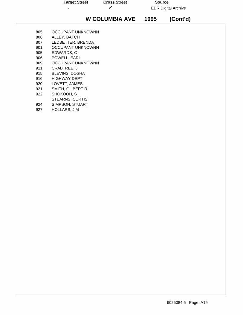
(Cont'd)
-
W COLUMBIA AVE
EDR Digital Archive
6025084.5 Page: A19
SourceTarget Street Cross Street
1995
805 OCCUPANT UNKNOWNN806 ALLEY, BATCH807 LEDBETTER, BRENDA901 OCCUPANT UNKNOWNN905 EDWARDS, C906 POWELL, EARL909 OCCUPANT UNKNOWNN911 CRABTREE, J915 BLEVINS, DOSHA916 HIGHWAY DEPT920 LOVETT, JAMES921 SMITH, GILBERT R922 SHOKOOH, S
STEARNS, CURTIS924 SIMPSON, STUART927 HOLLARS, JIM

-
WORSHAM PL
EDR Digital Archive
6025084.5 Page: A20
SourceTarget Street Cross Street
1995
111 HANCOCK, ARLENE112 BETTREM, SHERRY115 SMEDLEY, BRENDA S119 BARNETT, OLEN125 DENNEY, VICKY129 UPCHURCH, RALPH133 JUSTUS, JAMES W136 NORRIS, ED145 COFFEY, KATHRYN

-
W COLUMBIA AVE
EDR Digital Archive
6025084.5 Page: A21
SourceTarget Street Cross Street
1992
140 BENTLEY, CHARLES207 ROBERTS, DAVID208 BURKE, RICK223 RAGAN, GEORGE M224 SLAGLE, FLOYD225 ELAM, BOBBY233 GOVER, SAM B237 SEXTON, EARL305 PERKINS, MACK306 ELLER, C308 CLARK, MAE311 SELVIDGE, WILLIAM T JR409 SELVIDGE, EVERETT410 HUFFAKER, ERNEST411 YORK, FRANK413 UPCHURCH, TERRI419 KING, GENE421 ATKINSON, HENRY423 STEPHENSON, VELA501 CROUCH, FRONIA509 SOUTHWOOD, RAY609 MCCLAIN, RONNIE E613 BACK, BOBBY E700 FRANKLIN, MILFORD704 WILLS, AUDELL706 BAKER, JOHNNY710 ABBOTT, BARNETT804 COOMER, CARL V806 ALLEY, BATCH807 LEDBETTER, BRENDA906 POWELL, EARL911 CRABTREE, J915 BLEVINS, DOSHA920 LOVETT, JAMES921 SMITH, GILBERT R922 STEARNS, CURTIS924 SIMPSON, STUART2184 BRITT, JEAN13412 CARRENDER, CLAUDE

Appendix V
Kentucky Geologic Survey Karst Potential Map


Appendix VI
Wayne County PVA Data
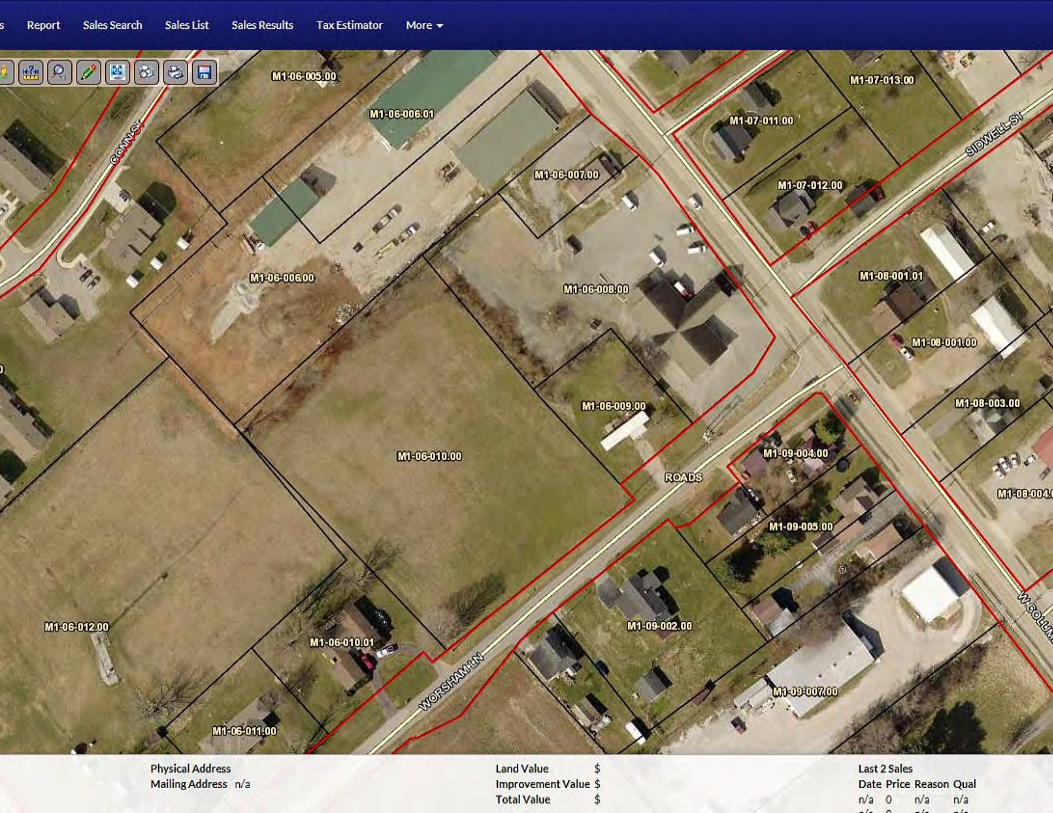
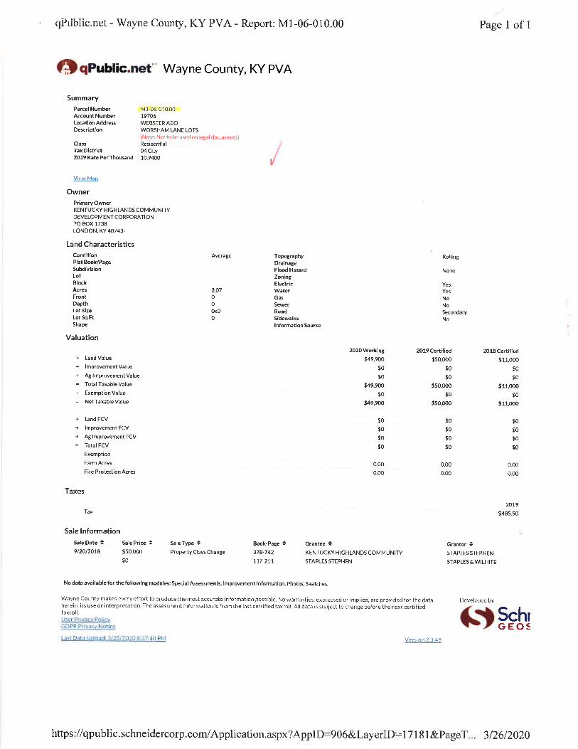


Cumberland-Horizon-Village
Monticello, KY 900000010155132
10/13/2020 13:02 Page 29 of 50
Endangered Species General requirements ESA Legislation Regulations
Section 7 of the Endangered Species Act (ESA) mandates that federal agencies ensure that actions that they authorize, fund, or carry out shall not jeopardize the continued existence of federally listed plants and animals or result in the adverse modification or destruction of designated critical habitat. Where their actions may affect resources protected by the ESA, agencies must consult with the Fish and Wildlife Service and/or the National Marine Fisheries Service (“FWS” and “NMFS” or “the Services”).
The Endangered Species Act of 1973 (16 U.S.C. 1531 et seq.); particularly section 7 (16 USC 1536).
50 CFR Part 402
1. Does the project involve any activities that have the potential to affect specifies or habitats?
No, the project will have No Effect due to the nature of the activities involved in the project.
No, the project will have No Effect based on a letter of understanding, memorandum of agreement, programmatic agreement, or checklist provided by local HUD office
Yes, the activities involved in the project have the potential to affect species
and/or habitats. 2. Are federally listed species or designated critical habitats present in the action area? No, the project will have No Effect due to the absence of federally listed species
and designated critical habitat
Based on the response, the review is in compliance with this section. Document and upload all documents used to make your determination below. Documentation may include letters from the Services, species lists from the Services’ websites, surveys or other documents and analysis showing that there are no species in the action area.
Yes, there are federally listed species or designated critical habitats present in the
action area.

Cumberland-Horizon-Village
Monticello, KY 900000010155132
10/13/2020 13:02 Page 30 of 50
Screen Summary Compliance Determination This project will have No Effect on listed species because there are no listed species or designated critical habitats in the action area. This project is in compliance with the Endangered Species Act. See attached letter dated August 31, 2020 and stamped October 2, 2020 by the Kentucky Field Office for the US Fish and Wildlife Service stating that ''significant impacts to federally-listed species are not likely to result from this project as currently proposed.''
Supporting documentation 05 FWS signed.pdf Are formal compliance steps or mitigation required?
Yes
No

Loveday Consulting, LLC ҉ 859-248-5434 ҉ [email protected]
August 31, 2020
Mr. Virgil Lee Andrews US Fish and Wildlife Service 330 W. Broadway Street, RM 265 Frankfort, KY 40601
RE: Cumberland Horizon Village 70 Worsham Lane, Monticello, Wayne County, KY 42633 (36.838179, -84.862553). Consultation Code: 04EK1000-2020-SLI-1726
Dear Mr. Andrews,
Southern Tier Housing Corporation dba Highlands Housing Corporation, a non-profit located in London, KY is proposing to acquire four properties with a total acreage of 3.83: 70 Worsham, 42 Worsham, 150 Worsham, and a small parcel adjacent to 70 Worsham known as 939 W. Columbia Avenue, for the purpose of constructing 36 senior housing units comprised of 19 one-bedrooms and 17 two-bedrooms. There is a sink hole on the 70 Worsham Ave property. The lot at 42 Worsham has a trailer that will be demolished and two trees that will need to be cut down. There are 6 Cherry trees on 70 Worsham that may also need to be cut down. The subject property was in agricultural use until land development in the area started around 1951 with Residential development to the north, east and west of the Property, the area to the south of the Property has remained undeveloped. Review of aerial photographs indicate that the land was developed into its current state after 1997.
See attached species list for potential or known endangered species in Wayne County. The list includes various bats and clams which should not be impacted due to the location of the project.
On behalf of Highlands Housing Corporation, I would like to request your concurrence of no effect on threatened or endangered species. Should you have any concerns regarding the impact of this project on either endangered species or habitats, please advise on required measures or precautions to be taken. An aerial map, site survey, and photos are attached for your review. If you have any questions or need additional material, please contact me at 859-248-5434 or [email protected]. Thank you for your assistance.
Sincerely,
Suzie Loveday Consultant
Enclosures
���For
JENNIFER GARLAND Digitally signed by JENNIFER GARLAND Date: 2020.10.02 09:50:26 -04'00'

Cumberland-Horizon-Village
Monticello, KY 900000010155132
10/13/2020 13:02 Page 31 of 50
Explosive and Flammable Hazards General requirements Legislation Regulation
HUD-assisted projects must meet Acceptable Separation Distance (ASD) requirements to protect them from explosive and flammable hazards.
N/A 24 CFR Part 51 Subpart C
1. Is the proposed HUD-assisted project itself the development of a hazardous facility (a facility that mainly stores, handles or processes flammable or combustible chemicals such as bulk fuel storage facilities and refineries)? No
Yes 2. Does this project include any of the following activities: development, construction, rehabilitation that will increase residential densities, or conversion?
No
Yes
3. Within 1 mile of the project site, are there any current or planned stationary aboveground storage containers that are covered by 24 CFR 51C? Containers that are NOT covered under the regulation include:
• Containers 100 gallons or less in capacity, containing common liquid industrial fuels OR
• Containers of liquified petroleum gas (LPG) or propane with a water volume capacity of 1,000 gallons or less that meet the requirements of the 2017 or later version of National Fire Protection Association (NFPA) Code 58. If all containers within the search area fit the above criteria, answer “No.” For any other type of aboveground storage container within the search area that holds one of the flammable or explosive materials listed in Appendix I of 24 CFR part 51 subpart C, answer “Yes.”
No
Yes

Cumberland-Horizon-Village
Monticello, KY 900000010155132
10/13/2020 13:02 Page 32 of 50
4. Based on the analysis, is the proposed HUD-assisted project located at or beyond the required separation distance from all covered tanks? Yes
Based on the response, the review is in compliance with this section.
No
Screen Summary Compliance Determination There is a current or planned stationary aboveground storage container of concern within 1 mile of the project site. The Separation Distance from the project is acceptable. The project is in compliance with explosive and flammable hazard requirements. A survey of Google Earth Pro aerial photo maps found that there are multiple propane tanks within a 1-mile radius of the project site with capacities that range from 1,000 to 18,000 gallons. Per the completed HUD Acceptable Separation Distance Calculator, all are outside of the acceptable separation distance thresholds. See attached maps and calculations.
Supporting documentation 06 ASD Tool - 18000 gallons.pdf 06 ASD Tool - 1000 gallons.pdf 06 Above Ground Storage Tanks - Cumberland Valley Horizon Project.pdf 06 Above Ground Storage Tanks Map.pdf Are formal compliance steps or mitigation required?
Yes
No

CUMBERLAND HORIZON VILLAGE PROJECT 70 Worsham Lane, Monticello, Wayne County, KY 42633 (36.838179, -84.862553)
The closest tank is the 18,000 gallon propane tank. It is located more than 1,600 feet from the project site. All other tanks are 1,000 gallons or less. See screenshot of distance below.

CUMBERLAND HORIZON VILLAGE PROJECT 70 Worsham Lane, Monticello, Wayne County, KY 42633 (36.838179, -84.862553)

9/26/2020 Gmail - FW: Above Ground Storage Tanks - Cumberland Valley Horizon Project
https://mail.google.com/mail/u/0?ik=a9a1c75356&view=pt&search=all&permthid=thread-a%3Ar2252550283384864121%7Cmsg-f%3A1678833541212… 1/4
Suzie Loveday <[email protected]>
FW: Above Ground Storage Tanks - Cumberland Valley Horizon Project1 message
Tiffany Boston <[email protected]> Fri, Sep 25, 2020 at 3:00 PMTo: Suzie Loveday <[email protected]>Cc: Gordon Kidd <[email protected]>
Tiffany Boston
Housing Specialist
Highlands Housing Corporation
Phone: 606.278.2508
Email: [email protected]
From: Gordon Kidd <[email protected]> Sent: Friday, September 25, 2020 3:00 PMTo: Tiffany Boston <[email protected]>Subject: RE: Above Ground Storage Tanks - Cumberland Valley Horizon Project
Tiffany:
Thanks for doing this. Did you send this to Suzie? If not, please send to her and copy me on it.
Thanks,
Gordon Kidd
President and CEO
Highlands Housing Corporation
Direct Dial: 606.657.4886
Email: [email protected]
From: Tiffany Boston <[email protected]> Sent: Friday, September 25, 2020 2:53 PMTo: Gordon Kidd <[email protected]>Subject: RE: Above Ground Storage Tanks - Cumberland Valley Horizon Project

9/26/2020 Gmail - FW: Above Ground Storage Tanks - Cumberland Valley Horizon Project
https://mail.google.com/mail/u/0?ik=a9a1c75356&view=pt&search=all&permthid=thread-a%3Ar2252550283384864121%7Cmsg-f%3A1678833541212… 2/4
Gordon,
I went to Holston Gas today and got the info for all the propane tanks that were on the list. All except Bertram Oil and I had to call and talk to them.
1. WC Jail – 4 tanks @ 1,000 gallon each2. Water Tanks N/A3. Bertram Oil – I called and spoke to someone there and the tanks they have on site are empty used tanks that are just sitting there until they find a
new home.4. Grain Silo N/A5. Cobb – 3 tanks @ 1,000 gallons each6. Cobb – 1 large tank @ 18,000 gallons7. Wayne County High School – 1 Large tank @ 18,000 gallons8. Monticello Independent School – 3 tanks @ 1,000 gallons each but only 1 is being used, the other 2 remain empty9. Wayne County Schools – 6 tanks @ 1,000 gallons each
10. Wayne County (Old Courthouse) 4 tanks @ 1,000 gallons each
Hopefully this helps.
Tiffany Boston
Housing Specialist
Highlands Housing Corporation
Phone: 606.278.2508
Email: [email protected]
From: Gordon Kidd <[email protected]> Sent: Thursday, September 24, 2020 4:52 PMTo: Tiffany Boston <[email protected]>Subject: FW: Above Ground Storage Tanks - Cumberland Valley Horizon Project
Tiffany:
Could you do a project for me? Suzie is working on an ERR for our Cumberland Horizon Village project. She has noted several above ground storagetanks and most of them are apparently propane tanks. Could you drive around the sites on the attachment and find out how large the tanks are? Youmight be able to start with Bertram Oil and ask them how large their propane tank is and then visit or “drive by” the remaining sites. (You may know howlarge the tanks are and not have to do that.)
If you have any questions about what Suzie is needing, please call her directly.
Thanks,
Gordon Kidd
President and CEO
Highlands Housing Corporation

9/26/2020 Gmail - FW: Above Ground Storage Tanks - Cumberland Valley Horizon Project
https://mail.google.com/mail/u/0?ik=a9a1c75356&view=pt&search=all&permthid=thread-a%3Ar2252550283384864121%7Cmsg-f%3A1678833541212… 3/4
Direct Dial: 606.657.4886
Email: [email protected]
From: Suzie Loveday <[email protected]> Sent: Wednesday, September 23, 2020 4:15 PMTo: Gordon Kidd <[email protected]>Subject: Above Ground Storage Tanks - Cumberland Valley Horizon Project
Hi Gordon,
Can you help me with these Aboveground Storage Tanks?
It looks like they are ALL Propane tanks, which makes this relatively easy.
I've put together a chart. There are 10 total, but one is the city's water tanks, and one is a grain silo. You can disregard those 2.
The rest are spread out across the one mile radius. I've attached the map.
Here is the chart:
# on map Company Name Type of tank Question
1 Wayne County Jail 4 small propane tanks Size of largest tank?
2 City of Monticello Water Tanks confirmed previously - C. Hutchison project
3 Bertram Oil Distribution Propane Tanks Size of largest tank?
4 Grain Silo N/A N/A
5 Cobb-Vantress Production 3 propane tanks Size of largest tank?
6 Cobb-Vantress Production 1 large tank What size is it?
7 Wayne County High School 1 propane tank What size?
8 Monticello Independent Schools 3 small propane tanks What sizes?
9 Wayne County Schools 6 propane tanks What sizes?
10 Wayne County 4 Propane Tanks What sizes?
So here are the guidelines with propane tanks:
1. If the tank size is under 100 gallons, we don't have to do anything.
2. We can exclude any that are 1,000 gallons or less IF we can confirm that they comply with NFPA 58 2017 Edition.
3. The easiest answer is to find out the sizes of the largest tank for each location.

9/26/2020 Gmail - FW: Above Ground Storage Tanks - Cumberland Valley Horizon Project
https://mail.google.com/mail/u/0?ik=a9a1c75356&view=pt&search=all&permthid=thread-a%3Ar2252550283384864121%7Cmsg-f%3A1678833541212… 4/4
Is there any way you can do that for me? Can you tell the size by looking at them? Or maybe it's written on them? The hardest one to find out will be theones for the county because they're behind a fence. Otherwise, I think someone could drive around, take pics of each one, and figure out what the sizesare. Thoughts?
I've called people before about their tank sizes, and the response isn't always positive... So if we can do it without calling, I think that would be easiest.
Thanks!!!!
Suzie Loveday [email protected] / (859) 248-5434
Loveday Consulting, LLC

9/26/2020 Acceptable Separation Distance (ASD) Electronic Assessment Tool - HUD Exchange
https://www.hudexchange.info/programs/environmental-review/asd-calculator/ 1/1
Home (/) > Programs (/programs/) > Environmental Review (/programs/environmental-review/) > ASDCalculator
Acceptable Separation Distance(ASD) Electronic Assessment ToolThe Environmental Planning Division (EPD) has developed an electronic-based assessment tool that calculatesthe Acceptable Separation Distance (ASD) from stationary hazards. The ASD is the distance from above groundstationary containerized hazards of an explosive or �re prone nature, to where a HUD assisted project can belocated. The ASD is consistent with the Department's standards of blast overpressure (0.5 psi-buildings) andthermal radiation (450 BTU/ft - hr - people and 10,000 BTU/ft - hr - buildings). Calculation of the ASD is the�rst step to assess site suitability for proposed HUD-assisted projects near stationary hazards. Additionalguidance on ASDs is available in the Department's guidebook "Siting of HUD- Assisted Projects NearHazardous Facilities" and the regulation 24 CFR Part 51, Subpart C, Sitting of HUD-Assisted Projects NearHazardous Operations Handling Conventional Fuels or Chemicals of an Explosive or Flammable Nature.
Note: Tool tips, containing �eld speci�c information, have been added in this tool and may be accessed byhovering over the ASD result �elds with the mouse.
Acceptable Separation Distance Assessment ToolIs the container above ground? Yes: No:
Is the container under pressure? Yes: No:
Does the container hold a cryogenic liqui�ed gas? Yes: No:
Is the container diked? Yes: No:
What is the volume (gal) of the container? 18000
What is the Diked Area Length (ft)?
What is the Diked Area Width (ft)?
Calculate Acceptable Separation Distance
Diked Area (sqft)
ASD for Blast Over Pressure (ASDBOP) 569.50
ASD for Thermal Radiation for People (ASDPPU) 922.03
ASD for Thermal Radiation for Buildings (ASDBPU) 191.30
ASD for Thermal Radiation for People (ASDPNPD)
ASD for Thermal Radiation for Buildings (ASDBNPD)
For mitigation options, please click on the following link: Mitigation Options (/resource/3846/acceptable-separation-distance-asd-hazard-mitigation-options/)
2 2
Providing Feedback & CorrectionsAfter using the ASD Assessment Tool following the directions in this User Guide, users are encouraged toprovide feedback on how the ASD Assessment Tool may be improved. Users are also encouraged to sendcomments or corrections for the improvement of the tool.
Please send comments or other input using the Contact Us (https://www.hudexchange.info/contact-us/)form.
Related InformationASD User Guide (/resource/3839/acceptable-separation-distance-asd-assessment-tool-user-guide/)ASD Flow Chart (/resource/3840/acceptable-separation-distance-asd-�owchart/)
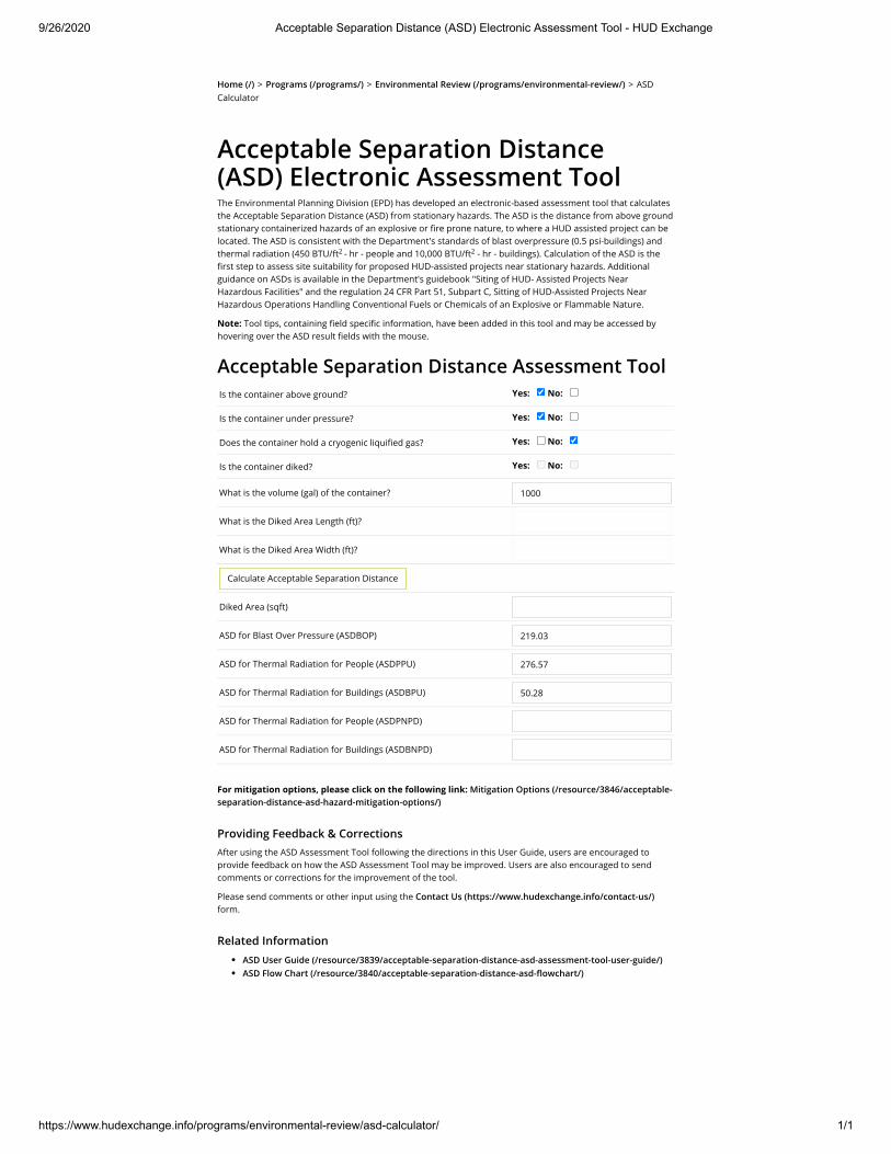
9/26/2020 Acceptable Separation Distance (ASD) Electronic Assessment Tool - HUD Exchange
https://www.hudexchange.info/programs/environmental-review/asd-calculator/ 1/1
Home (/) > Programs (/programs/) > Environmental Review (/programs/environmental-review/) > ASDCalculator
Acceptable Separation Distance(ASD) Electronic Assessment ToolThe Environmental Planning Division (EPD) has developed an electronic-based assessment tool that calculatesthe Acceptable Separation Distance (ASD) from stationary hazards. The ASD is the distance from above groundstationary containerized hazards of an explosive or �re prone nature, to where a HUD assisted project can belocated. The ASD is consistent with the Department's standards of blast overpressure (0.5 psi-buildings) andthermal radiation (450 BTU/ft - hr - people and 10,000 BTU/ft - hr - buildings). Calculation of the ASD is the�rst step to assess site suitability for proposed HUD-assisted projects near stationary hazards. Additionalguidance on ASDs is available in the Department's guidebook "Siting of HUD- Assisted Projects NearHazardous Facilities" and the regulation 24 CFR Part 51, Subpart C, Sitting of HUD-Assisted Projects NearHazardous Operations Handling Conventional Fuels or Chemicals of an Explosive or Flammable Nature.
Note: Tool tips, containing �eld speci�c information, have been added in this tool and may be accessed byhovering over the ASD result �elds with the mouse.
Acceptable Separation Distance Assessment ToolIs the container above ground? Yes: No:
Is the container under pressure? Yes: No:
Does the container hold a cryogenic liqui�ed gas? Yes: No:
Is the container diked? Yes: No:
What is the volume (gal) of the container? 1000
What is the Diked Area Length (ft)?
What is the Diked Area Width (ft)?
Calculate Acceptable Separation Distance
Diked Area (sqft)
ASD for Blast Over Pressure (ASDBOP) 219.03
ASD for Thermal Radiation for People (ASDPPU) 276.57
ASD for Thermal Radiation for Buildings (ASDBPU) 50.28
ASD for Thermal Radiation for People (ASDPNPD)
ASD for Thermal Radiation for Buildings (ASDBNPD)
For mitigation options, please click on the following link: Mitigation Options (/resource/3846/acceptable-separation-distance-asd-hazard-mitigation-options/)
2 2
Providing Feedback & CorrectionsAfter using the ASD Assessment Tool following the directions in this User Guide, users are encouraged toprovide feedback on how the ASD Assessment Tool may be improved. Users are also encouraged to sendcomments or corrections for the improvement of the tool.
Please send comments or other input using the Contact Us (https://www.hudexchange.info/contact-us/)form.
Related InformationASD User Guide (/resource/3839/acceptable-separation-distance-asd-assessment-tool-user-guide/)ASD Flow Chart (/resource/3840/acceptable-separation-distance-asd-�owchart/)
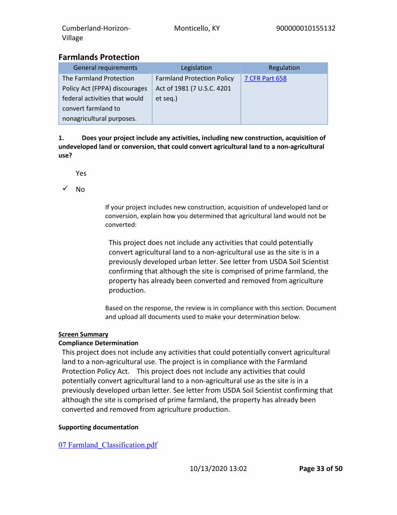
Cumberland-Horizon-Village
Monticello, KY 900000010155132
10/13/2020 13:02 Page 33 of 50
Farmlands Protection General requirements Legislation Regulation
The Farmland Protection Policy Act (FPPA) discourages federal activities that would convert farmland to nonagricultural purposes.
Farmland Protection Policy Act of 1981 (7 U.S.C. 4201 et seq.)
7 CFR Part 658
1. Does your project include any activities, including new construction, acquisition of undeveloped land or conversion, that could convert agricultural land to a non-agricultural use?
Yes
No
If your project includes new construction, acquisition of undeveloped land or conversion, explain how you determined that agricultural land would not be converted: This project does not include any activities that could potentially convert agricultural land to a non-agricultural use as the site is in a previously developed urban letter. See letter from USDA Soil Scientist confirming that although the site is comprised of prime farmland, the property has already been converted and removed from agriculture production.
Based on the response, the review is in compliance with this section. Document and upload all documents used to make your determination below.
Screen Summary Compliance Determination This project does not include any activities that could potentially convert agricultural land to a non-agricultural use. The project is in compliance with the Farmland Protection Policy Act. This project does not include any activities that could potentially convert agricultural land to a non-agricultural use as the site is in a previously developed urban letter. See letter from USDA Soil Scientist confirming that although the site is comprised of prime farmland, the property has already been converted and removed from agriculture production.
Supporting documentation 07 Farmland_Classification.pdf

Cumberland-Horizon-Village
Monticello, KY 900000010155132
10/13/2020 13:02 Page 34 of 50
07 Farmland Letter.pdf Are formal compliance steps or mitigation required?
Yes
No

Natural Resources Conservation Service USDA Service Center 3100 Alvey Park Drive W Owensboro, KY 42303 _________________________________________________________________________________________________________
September 14, 2020
Suzie Loveday Loveday Consulting, LLC
RE: Cumberland Horizon Village
Dear Ms. Loveday:
In response to your request from 8/31/2020 regarding the above referenced project in Wayne County, Kentucky, the Natural Resources Conservation Service (NRCS) has no congressional authority for conducting Environmental Assessments (EA).
NRCS is mandated to provide information on the soils and/or impact to farmland according to the Farmland Protection Policy Act (P.L. 97-98) for projects that will be utilizing federal funding.
Based on the information contained in your request, the area of inquiry is located within what would be considered a PREVIOUSLY DEVELOPED URBAN AREA. This being the case, then there is no need to complete an AD-1006 form. With the site having previously been manipulated with infrastructure (such as roads, water/sewer, electrical) and thus removed from agricultural production, conversion has already taken place and any prime, unique, or farmland of local or statewide importance would no longer exist.
If we may be of additional assistance, please do not hesitate to contact us.
Sincerely,
Perri Pedley Soil Scientist [email protected]

Farmland Classification—Wayne County, Kentucky(Cumberland Horizon Village)
Natural ResourcesConservation Service
Web Soil SurveyNational Cooperative Soil Survey
8/31/2020Page 1 of 5
4078
950
4078
980
4079
010
4079
040
4079
070
4079
100
4078
950
4078
980
4079
010
4079
040
4079
070
4079
100
4079
130
690460 690490 690520 690550 690580 690610 690640 690670 690700 690730
690460 690490 690520 690550 690580 690610 690640 690670 690700 690730
36° 50' 20'' N84
° 5
1' 5
1'' W
36° 50' 20'' N
84° 5
1' 3
9'' W
36° 50' 13'' N
84° 5
1' 5
1'' W
36° 50' 13'' N
84° 5
1' 3
9'' W
N
Map projection: Web Mercator Corner coordinates: WGS84 Edge tics: UTM Zone 16N WGS840 50 100 200 300
Feet0 15 30 60 90
MetersMap Scale: 1:1,330 if printed on A landscape (11" x 8.5") sheet.
Soil Map may not be valid at this scale.

MAP LEGENDArea of Interest (AOI)
Area of Interest (AOI)
SoilsSoil Rating Polygons
Not prime farmland
All areas are prime farmlandPrime farmland if drained
Prime farmland if protected from flooding or not frequently flooded during the growing seasonPrime farmland if irrigated
Prime farmland if drained and either protected from flooding or not frequently flooded during the growing seasonPrime farmland if irrigated and drainedPrime farmland if irrigated and either protected from flooding or not frequently flooded during the growing season
Prime farmland if subsoiled, completely removing the root inhibiting soil layerPrime farmland if irrigated and the product of I (soil erodibility) x C (climate factor) does not exceed 60Prime farmland if irrigated and reclaimed of excess salts and sodiumFarmland of statewide importanceFarmland of statewide importance, if drainedFarmland of statewide importance, if protected from flooding or not frequently flooded during the growing seasonFarmland of statewide importance, if irrigated
Farmland of statewide importance, if drained and either protected from flooding or not frequently flooded during the growing seasonFarmland of statewide importance, if irrigated and drainedFarmland of statewide importance, if irrigated and either protected from flooding or not frequently flooded during the growing seasonFarmland of statewide importance, if subsoiled, completely removing the root inhibiting soil layerFarmland of statewide importance, if irrigated and the product of I (soil erodibility) x C (climate factor) does not exceed 60
Farmland of statewide importance, if irrigated and reclaimed of excess salts and sodiumFarmland of statewide importance, if drained or either protected from flooding or not frequently flooded during the growing seasonFarmland of statewide importance, if warm enough, and either drained or either protected from flooding or not frequently flooded during the growing seasonFarmland of statewide importance, if warm enoughFarmland of statewide importance, if thawedFarmland of local importanceFarmland of local importance, if irrigated
Farmland of unique importanceNot rated or not available
Soil Rating LinesNot prime farmland
All areas are prime farmlandPrime farmland if drainedPrime farmland if protected from flooding or not frequently flooded during the growing seasonPrime farmland if irrigatedPrime farmland if drained and either protected from flooding or not frequently flooded during the growing seasonPrime farmland if irrigated and drainedPrime farmland if irrigated and either protected from flooding or not frequently flooded during the growing season
Farmland Classification—Wayne County, Kentucky(Cumberland Horizon Village)
Natural ResourcesConservation Service
Web Soil SurveyNational Cooperative Soil Survey
8/31/2020Page 2 of 5

Prime farmland if subsoiled, completely removing the root inhibiting soil layerPrime farmland if irrigated and the product of I (soil erodibility) x C (climate factor) does not exceed 60Prime farmland if irrigated and reclaimed of excess salts and sodiumFarmland of statewide importanceFarmland of statewide importance, if drainedFarmland of statewide importance, if protected from flooding or not frequently flooded during the growing seasonFarmland of statewide importance, if irrigated
Farmland of statewide importance, if drained and either protected from flooding or not frequently flooded during the growing seasonFarmland of statewide importance, if irrigated and drainedFarmland of statewide importance, if irrigated and either protected from flooding or not frequently flooded during the growing seasonFarmland of statewide importance, if subsoiled, completely removing the root inhibiting soil layerFarmland of statewide importance, if irrigated and the product of I (soil erodibility) x C (climate factor) does not exceed 60
Farmland of statewide importance, if irrigated and reclaimed of excess salts and sodiumFarmland of statewide importance, if drained or either protected from flooding or not frequently flooded during the growing seasonFarmland of statewide importance, if warm enough, and either drained or either protected from flooding or not frequently flooded during the growing seasonFarmland of statewide importance, if warm enoughFarmland of statewide importance, if thawedFarmland of local importanceFarmland of local importance, if irrigated
Farmland of unique importanceNot rated or not available
Soil Rating PointsNot prime farmland
All areas are prime farmlandPrime farmland if drained
Prime farmland if protected from flooding or not frequently flooded during the growing seasonPrime farmland if irrigated
Prime farmland if drained and either protected from flooding or not frequently flooded during the growing seasonPrime farmland if irrigated and drainedPrime farmland if irrigated and either protected from flooding or not frequently flooded during the growing season
Prime farmland if subsoiled, completely removing the root inhibiting soil layerPrime farmland if irrigated and the product of I (soil erodibility) x C (climate factor) does not exceed 60Prime farmland if irrigated and reclaimed of excess salts and sodiumFarmland of statewide importanceFarmland of statewide importance, if drainedFarmland of statewide importance, if protected from flooding or not frequently flooded during the growing seasonFarmland of statewide importance, if irrigated
Farmland Classification—Wayne County, Kentucky(Cumberland Horizon Village)
Natural ResourcesConservation Service
Web Soil SurveyNational Cooperative Soil Survey
8/31/2020Page 3 of 5

Farmland of statewide importance, if drained and either protected from flooding or not frequently flooded during the growing seasonFarmland of statewide importance, if irrigated and drainedFarmland of statewide importance, if irrigated and either protected from flooding or not frequently flooded during the growing seasonFarmland of statewide importance, if subsoiled, completely removing the root inhibiting soil layerFarmland of statewide importance, if irrigated and the product of I (soil erodibility) x C (climate factor) does not exceed 60
Farmland of statewide importance, if irrigated and reclaimed of excess salts and sodiumFarmland of statewide importance, if drained or either protected from flooding or not frequently flooded during the growing seasonFarmland of statewide importance, if warm enough, and either drained or either protected from flooding or not frequently flooded during the growing seasonFarmland of statewide importance, if warm enoughFarmland of statewide importance, if thawedFarmland of local importanceFarmland of local importance, if irrigated
Farmland of unique importanceNot rated or not available
Water FeaturesStreams and Canals
TransportationRails
Interstate Highways
US Routes
Major Roads
Local Roads
BackgroundAerial Photography
The soil surveys that comprise your AOI were mapped at 1:20,000.
Warning: Soil Map may not be valid at this scale.
Enlargement of maps beyond the scale of mapping can cause misunderstanding of the detail of mapping and accuracy of soil line placement. The maps do not show the small areas of contrasting soils that could have been shown at a more detailed scale.
Please rely on the bar scale on each map sheet for map measurements.
Source of Map: Natural Resources Conservation ServiceWeb Soil Survey URL: Coordinate System: Web Mercator (EPSG:3857)
Maps from the Web Soil Survey are based on the Web Mercator projection, which preserves direction and shape but distorts distance and area. A projection that preserves area, such as the Albers equal-area conic projection, should be used if more accurate calculations of distance or area are required.
This product is generated from the USDA-NRCS certified data as of the version date(s) listed below.
Soil Survey Area: Wayne County, KentuckySurvey Area Data: Version 17, May 28, 2020
Soil map units are labeled (as space allows) for map scales 1:50,000 or larger.
Date(s) aerial images were photographed: Dec 31, 2009—Oct 25, 2016
The orthophoto or other base map on which the soil lines were compiled and digitized probably differs from the background imagery displayed on these maps. As a result, some minor shifting of map unit boundaries may be evident.
Farmland Classification—Wayne County, Kentucky(Cumberland Horizon Village)
Natural ResourcesConservation Service
Web Soil SurveyNational Cooperative Soil Survey
8/31/2020Page 4 of 5

Farmland Classification
Map unit symbol Map unit name Rating Acres in AOI Percent of AOI
BwB Bewleyville silt loam, 2 to 6 percent slopes
All areas are prime farmland
0.6 15.9%
DeC Decatur silt loam, 6 to 12 percent slopes
Farmland of statewide importance
3.4 84.1%
Totals for Area of Interest 4.0 100.0%
Description
Farmland classification identifies map units as prime farmland, farmland of statewide importance, farmland of local importance, or unique farmland. It identifies the location and extent of the soils that are best suited to food, feed, fiber, forage, and oilseed crops. NRCS policy and procedures on prime and unique farmlands are published in the "Federal Register," Vol. 43, No. 21, January 31, 1978.
Rating Options
Aggregation Method: No Aggregation Necessary
Tie-break Rule: Lower
Farmland Classification—Wayne County, Kentucky Cumberland Horizon Village
Natural ResourcesConservation Service
Web Soil SurveyNational Cooperative Soil Survey
8/31/2020Page 5 of 5

Cumberland-Horizon-Village
Monticello, KY 900000010155132
10/13/2020 13:02 Page 35 of 50
Floodplain Management General Requirements Legislation Regulation Executive Order 11988, Floodplain Management, requires federal activities to avoid impacts to floodplains and to avoid direct and indirect support of floodplain development to the extent practicable.
Executive Order 11988 24 CFR 55
1. Do any of the following exemptions apply? Select the applicable citation? [only one selection possible]
55.12(c)(3) 55.12(c)(4) 55.12(c)(5) 55.12(c)(6) 55.12(c)(7) 55.12(c)(8) 55.12(c)(9) 55.12(c)(10) 55.12(c)(11) None of the above
2. Upload a FEMA/FIRM map showing the site here:
03 Floodplain Map.pdf The Federal Emergency Management Agency (FEMA) designates floodplains. The FEMA Map Service Center provides this information in the form of FEMA Flood Insurance Rate Maps (FIRMs). For projects in areas not mapped by FEMA, use the best available information to determine floodplain information. Include documentation, including a discussion of why this is the best available information for the site. Does your project occur in a floodplain?
Based on the response, the review is in compliance with this section.
Yes
No

Cumberland-Horizon-Village
Monticello, KY 900000010155132
10/13/2020 13:02 Page 36 of 50
Screen Summary Compliance Determination This project does not occur in a floodplain. The project is in compliance with Executive Order 11988. The attached FIRMette map for the project site demonstrates that it is in an area of minimal flood hazard (Panel #21231C01810C, eff. 9/2/2009). The project is in compliance with floodplain management requirements.
Supporting documentation Are formal compliance steps or mitigation required?
Yes
No
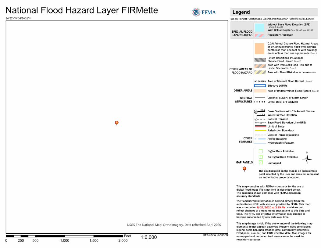
USGS The National Map: Orthoimagery. Data refreshed April 2020
National Flood Hazard Layer FIRMette
0 500 1,000 1,500 2,000250Feet
Ü
SEE FIS REPORT FOR DETAILED LEGEND AND INDEX MAP FOR FIRM PANEL LAYOUT
SPECIAL FLOODHAZARD AREAS
Without Base Flood Elevation (BFE)Zone A, V, A99
With BFE or DepthZone AE, AO, AH, VE, AR
Regulatory Floodway
0.2% Annual Chance Flood Hazard, Areasof 1% annual chance flood with averagedepth less than one foot or with drainageareas of less than one square mileZone X
Future Conditions 1% AnnualChance Flood HazardZone X
Area with Reduced Flood Risk due toLevee. See Notes.Zone X
Area with Flood Risk due to LeveeZone D
NO SCREENArea of Minimal Flood HazardZone X
Area of Undetermined Flood HazardZone D
Channel, Culvert, or Storm Sewer
Levee, Dike, or Floodwall
Cross Sections with 1% Annual Chance17.5 Water Surface Elevation
Coastal Transect
Coastal Transect BaselineProfile BaselineHydrographic Feature
Base Flood Elevation Line (BFE)
Effective LOMRs
Limit of StudyJurisdiction Boundary
Digital Data Available
No Digital Data Available
Unmapped
This map complies with FEMA's standards for the use ofdigital flood maps if it is not void as described below.The basemap shown complies with FEMA's basemapaccuracy standards
The flood hazard information is derived directly from theauthoritative NFHL web services provided by FEMA. This mapwas exported on 8/27/2020 at 3:29 PM and does notreflect changes or amendments subsequent to this date andtime. The NFHL and effective information may change orbecome superseded by new data over time.
This map image is void if the one or more of the following mapelements do not appear: basemap imagery, flood zone labels,legend, scale bar, map creation date, community identifiers,FIRM panel number, and FIRM effective date. Map images forunmapped and unmodernized areas cannot be used forregulatory purposes.
Legend
OTHER AREAS OFFLOOD HAZARD
OTHER AREAS
GENERALSTRUCTURES
OTHERFEATURES
MAP PANELS
8
B20.2
The pin displayed on the map is an approximatepoint selected by the user and does not representan authoritative property location.
1:6,000
84°52'4"W 36°50'32"N
84°51'26"W 36°50'3"N

Cumberland-Horizon-Village
Monticello, KY 900000010155132
10/13/2020 13:02 Page 37 of 50
Historic Preservation General requirements Legislation Regulation Regulations under Section 106 of the National Historic Preservation Act (NHPA) require a consultative process to identify historic properties, assess project impacts on them, and avoid, minimize, or mitigate adverse effects
Section 106 of the National Historic Preservation Act (16 U.S.C. 470f)
36 CFR 800 “Protection of Historic Properties” http://www.access.gpo.gov/nara/cfr/waisidx_10/36cfr800_10.html
Threshold Is Section 106 review required for your project?
No, because the project consists solely of activities listed as exempt in a Programmatic Agreement (PA ). (See the PA Database to find applicable PAs.) No, because the project consists solely of activities included in a No Potential to Cause Effects memo or other determination [36 CFR 800.3(a)(1)].
Yes, because the project includes activities with potential to cause effects (direct or indirect).
Step 1 – Initiate Consultation Select all consulting parties below (check all that apply): State Historic Preservation Offer (SHPO) Completed
Indian Tribes, including Tribal Historic Preservation Officers (THPOs) or Native
Hawaiian Organizations (NHOs)
Eastern Band of Cherokee Indians Response Period Elapsed

Cumberland-Horizon-Village
Monticello, KY 900000010155132
10/13/2020 13:02 Page 38 of 50
Other Consulting Parties
Describe the process of selecting consulting parties and initiating consultation here: Tribal consultation was initiated with the Cherokee Indians on September 9, 2020 using a letter sent via email inviting the Eastern Band of Cherokee Indians to be a consulting party on the Section 106 review for the project. The tribe did not respond within the 30-day threshold specified by HUD CPD Notice 12-006. A September 10, 2020 letter from the Kentucky Heritage Council (SHPO) finds " Our review indicates that the proposed project will not impact any properties or sites that are listed in or eligible for the National Register of Historic Places. The proposed project should not require an archaeological survey or cultural historic survey." Therefore, Section 106 requirements have been fulfilled.
Document and upload all correspondence, notices and notes (including comments and objections received below). Step 2 – Identify and Evaluate Historic Properties
1. Define the Area of Potential Effect (APE), either by entering the address(es) or uploading a map depicting the APE below: 70 Worsham Lane, Monticello, Wayne County, KY 42633 (36.838179, -84.862553)
In the chart below, list historic properties identified and evaluated in the APE. Every historic property that may be affected by the project should be included in the chart.
Upload the documentation (survey forms, Register nominations, concurrence(s) and/or objection(s), notes, and photos) that justify your National Register Status determination below.
Address / Location
/ District National Register
Status SHPO Concurrence Sensitive
Information
Additional Notes:
2. Was a survey of historic buildings and/or archeological sites done as part of the

Cumberland-Horizon-Village
Monticello, KY 900000010155132
10/13/2020 13:02 Page 39 of 50
project?
Yes
No
Step 3 –Assess Effects of the Project on Historic Properties Only properties that are listed on or eligible for the National Register of Historic Places receive further consideration under Section 106. Assess the effect(s) of the project by applying the Criteria of Adverse Effect. (36 CFR 800.5)] Consider direct and indirect effects as applicable as per guidance on direct and indirect effects. Choose one of the findings below - No Historic Properties Affected, No Adverse Effect, or Adverse Effect; and seek concurrence from consulting parties. No Historic Properties Affected
Based on the response, the review is in compliance with this section. Document and upload concurrence(s) or objection(s) below. Document reason for finding:
No Adverse Effect
Adverse Effect
Screen Summary Compliance Determination Based on Section 106 consultation there are No Historic Properties Affected because there are no historic properties present. The project is in compliance with Section 106. Tribal consultation was initiated with the Cherokee Indians on September 9, 2020 using a letter sent via email inviting the Eastern Band of Cherokee Indians to be a consulting party on the Section 106 review for the project. The tribe did not respond within the 30-day threshold specified by HUD CPD Notice 12-006. A September 10, 2020 letter from the Kentucky Heritage Council (SHPO) finds " Our review indicates
No historic properties present.
Historic properties present, but project will have no effect upon them.

Cumberland-Horizon-Village
Monticello, KY 900000010155132
10/13/2020 13:02 Page 40 of 50
that the proposed project will not impact any properties or sites that are listed in or eligible for the National Register of Historic Places. The proposed project should not require an archaeological survey or cultural historic survey." Therefore, Section 106 requirements have been fulfilled.
Supporting documentation 08 Tribal Appendix A.pdf 08 Tribal Consultation.pdf 08 Email Invitation to be a consulting party.pdf 08 Tribal Memo.pdf 08 SHPO Letter.pdf Are formal compliance steps or mitigation required?
Yes
No

TOURISM, ARTS AND HERITAGE CABINET KENTUCKY HERITAGE COUNCIL
THE STATE HISTORIC PRESERVATION OFFICE 410 HIGH STREET
FRANKFORT, KENTUCKY 40601
(502) 564-7005 www.heritage.ky.gov
An Equal Opportunity Employer M/F/D
ANDY BESHEAR GOVERNOR
MICHAEL E. BERRY SECRETARY
CRAIG A. POTTS EXECUTIVE DIRECTOR &
STATE HISTORIC PRESERVATION OFFICER
JACQUELINE COLEMAN LT. GOVERNOR
September 10, 2020
Suzie Loveday Loveday Consulting LLC 3097 Many Oaks Pk. Lexington, KY 40509 Re: Cumberland Horizon Village, Monticello, Wayne Co., KY Dear Ms. Loveday: Our review indicates that the proposed project will not impact any properties or sites that are listed in or eligible for the National Register of Historic Places. The proposed project should not require an archaeological survey or cultural historic survey. In the event that human remains are encountered during project activities, all work should be immediately stopped in the area. The area should be cordoned off, and in accordance with KRS 72.020 the county coroner and local law enforcement must be contacted immediately. Upon confirmation that the human remains are not of forensic interest, the unanticipated discovery must be reported to the Kentucky Heritage Council.
Should the project plans change, or should additional information become available regarding cultural resources or citizens’ concerns regarding impacts to cultural resources, please submit that information to our office as additional consultation may be warranted. Should you have any questions, feel free to contact Nick Laracuente of my staff at [email protected].
Sincerely,
Craig A. Potts, Executive Director and State Historic Preservation Officer
CP:nrl KHC #59230

www.lovedayconsulting.com ҉ 859-248-5434 ҉ [email protected]
MEMORANDUM
TO: Environmental Review File FROM: Suzie Loveday, Consultant and Environmental Review Preparer SUBJECT: Tribal response to Section 106 Consultation Letter DATE: October 9, 2020 On September 9, 2020, I sent a letter via email inviting the Eastern Band of Cherokee Indians to be a consulting party on the Section 106 review for the new construction by Highland Housing, Inc. of thirty-six (36) multifamily housing units on 3.83 acres of land known as the “Cumberland Horizon Village Project" located at 70 Worsham Lane, Monticello, Wayne County, KY 42633 (36.838179, -84.862553). The tribe did not respond within the 30-day threshold specified by HUD CPD Notice 12-006

9/22/2020 Gmail - Invitation to be a consulting party at 70 Worsham Lane, Monticello, KY 42633
https://mail.google.com/mail/u/0?ik=a9a1c75356&view=pt&search=all&permthid=thread-a%3Ar-3385858928463498366%7Cmsg-a%3Ar-3384206445… 1/1
Suzie Loveday <[email protected]>
Invitation to be a consulting party at 70 Worsham Lane, Monticello, KY 426331 message
Suzie Loveday <[email protected]> Wed, Sep 9, 2020 at 8:46 PMTo: [email protected]: Tina Cain <[email protected]>, Gordon Kidd <[email protected]>, Jonathan Coulter <[email protected]>, [email protected]
Dear Principal Chief Sneed,
For your consideration, please see the attached letter inviting the Eastern Band of Cherokee Indians to be a consulting party on the historic review for theacquisition of four properties with a total acreage of 3.83: 70 Worsham, 42 Worsham, 150 Worsham, and a small parcel adjacent to 70 Worsham knownas 939 W. Columbia Avenue, for the purpose of constructing 36 senior housing units comprised of 19 one-bedrooms and 17 two-bedrooms.
Thanks so much! Suzie Loveday [email protected] / (859) 248-5434
Loveday Consulting, LLC
Tribal Consultation.pdf10134K

Loveday Consulting, LLC ҉ 859-248-5434 ҉ [email protected]
September 9, 2020 Richard Sneed, Principal Chief Eastern Band of Cherokee Indians PO Box 455 Cherokee, NC 28719 Via email to [email protected] RE: Cumberland Horizon Village Project located at 70 Worsham Lane, Monticello, Wayne County,
KY 42633 (36.838179, -84.862553) Dear Principal Chief Sneed, Kentucky Housing Corporation (KHC) is considering funding the project listed above with HOME Investment Partnerships funds from the U.S. Department of Housing and Urban Development (HUD). Under HUD regulation 24 CFR 58.4, the Kentucky Housing Corporation has assumed HUD’s environmental review responsibilities for the project, including tribal consultation related to historic properties. Historic properties include archeological sites, burial grounds, sacred landscapes or features, ceremonial areas, traditional cultural places and landscapes, plant and animal communities, and buildings and structures with significant tribal association. On behalf of Kentucky Housing Corporation, I am conducting a review of this project to comply with Section 106 of the National Historic Preservation Act and its implementing regulations 36 CFR Part 800. We would like to invite you to be a consulting party in this review to help identify historic properties in the project area that may have religious and cultural significance to your tribe, and if such properties exist, to help assess how the project might affect them. If the project might have an adverse effect, we would like to discuss possible ways to avoid, minimize or mitigate potential adverse effects. Enclosed is a map that shows the project area. Highlands Housing Corporation, a non-profit located in London, KY is proposing to acquire four properties with a total acreage of 3.83: 70 Worsham, 42 Worsham, 150 Worsham, and a small parcel adjacent to 70 Worsham known as 939 W. Columbia Avenue, for the purpose of constructing 36 senior housing units comprised of 19 one-bedrooms and 17 two-bedrooms. There is a sink hole on the 70 Worsham Ave property. The lot at 42 Worsham has a trailer that will be demolished and two trees that will need to be cut down. There are 6 Cherry trees on 70 Worsham that may also need to be cut down. The subject property was in agricultural use until land development in the area started around 1951 with Residential development to the north, east and west of the Property, the area to the south of the Property has remained undeveloped. Review of aerial photographs indicate that the land was developed into its current state after 1997. There are no other disturbances known. See attached aerial map which shows the layout of the site and the aerial view. More information on the Section 106 review process is available at http://www.comcon.org/sites/default/files/historic_preservation/ and HUD’s process for tribal consultation under Section 106 is described in a Notice available at http://portal.hud.gov/hudportal/HUD?src=/program_offices/comm_planning/environment/atec.

Loveday Consulting, LLC ҉ 859-248-5434 ҉ [email protected]
To meet project timeframes, if you would like to be a consulting party on this project, can you please let us know of your interest within 30 days? If you have any initial concerns with impacts of the project on religious or cultural properties, can you please note them in your response? If you do not wish to consult on this project, can you please inform us? We value your assistance and look forward to consulting further if there are historic properties of religious and cultural significance to your tribe that may be affected by this project. Sincerely,
Suzie Loveday Consultant Enclosures CC: Jonathan Coulter, KHC

AERIAL LOCATION MAP
Cumberland Horizon Village Project 70 Worsham Lane, Monticello, Wayne County, KY 42633 (36.838179, -84.862553)
Aerial Map

Looking along NW property line from N property corner
looking NE on NE pl at adjacent property looking SE along NE pl at back of adjacent property
March 30, 2020
Cumberland Horizon Village Site
Monticello, KY
FIELD INSPECTOR PHONE: (859)559-0516Dustin Roe / Vision Engineering
REMARKS site pictures 1 of 2
looking along NE pl from E property corner
PROJECT LOCATION: Monticello
REPORT DATE:
looking W at center of property from E property corner
Looking along NE property line from N property corner
PROJECT NAME:

REMARKS site pictures 2 of 2
FIELD INSPECTOR Dustin Roe / Vision Engineering PHONE: (859)559-0516
looking along NW pl from W property corner looking E across property from center of property
looking along SW pl from S property corner looking along SW pl from W property corner
Monticello, KY
looking along SE pl from E property corner looking along SE property line from S property corner
REPORT DATE: March 30, 2020 PROJECT NAME:
PROJECT LOCATION: Cumberland Horizon Village Site Monticello

15
Appendix A
When To Consult With Tribes Under Section 106
Section 106 requires consultation with federally-recognized Indian tribes when a project may affect a historic property of religious and cultural significance to the tribe. Historic properties of religious and cultural significance include: archeological sites, burial grounds, sacred landscapes or features, ceremonial areas, traditional cultural places, traditional cultural landscapes, plant and animal communities, and buildings and structures with significant tribal association. The types of activities that may affect historic properties of religious and cultural significance include: ground disturbance (digging), new construction in undeveloped natural areas, introduction of incongruent visual, audible, or atmospheric changes, work on a building with significant tribal association, and transfer, lease or sale of properties of the types listed above. If a project includes any of the types of activities below, invite tribes to consult:
significant ground disturbance (digging)
Examples: new sewer lines, utility lines (above and below ground), foundations, footings, grading, access roads
new construction in undeveloped natural areas
Examples: industrial-scale energy facilities, transmission lines, pipelines, or new recreational facilities, in undeveloped natural areas like mountaintops, canyons, islands, forests, native grasslands, etc., and housing, commercial, and industrial facilities in such areas
incongruent visual changes
Examples: construction of a focal point that is out of character with the surrounding natural area, impairment of the vista or viewshed from an observation point in the natural landscape, or impairment of the recognized historic scenic qualities of an area
incongruent audible changes
Examples: increase in noise levels above an acceptable standard in areas known for their quiet, contemplative experience
incongruent atmospheric changes Examples: introduction of lights that create skyglow in an area with a dark night sky work on a building with significant tribal association
Examples: rehabilitation, demolition or removal of a surviving ancient tribal structure or village, or a building or structure that there is reason to believe was the location of a significant tribal event, home of an important person, or that served as a tribal school or community hall
transfer, lease or sale of a historic property of religious and cultural significance
Example: transfer, lease or sale of properties that contain archeological sites, burial grounds, sacred landscapes or features, ceremonial areas, plant and animal communities, or buildings and structures with significant tribal association
None of the above apply ______________________________________________ ________________________ _______________ Project Reviewed By Date
Suzie
Typewriter
x
Suzie
Typewriter
Cumberland Horizon Village
Suzie
Typewriter
Suzie Loveday
Suzie
Typewriter
09/09/2020

Cumberland-Horizon-Village
Monticello, KY 900000010155132
10/13/2020 13:02 Page 41 of 50
Noise Abatement and Control General requirements Legislation Regulation
HUD’s noise regulations protect residential properties from excessive noise exposure. HUD encourages mitigation as appropriate.
Noise Control Act of 1972 General Services Administration Federal Management Circular 75-2: “Compatible Land Uses at Federal Airfields”
Title 24 CFR 51 Subpart B
1. What activities does your project involve? Check all that apply: New construction for residential use
NOTE: HUD assistance to new construction projects is generally prohibited if they are located in an Unacceptable zone, and HUD discourages assistance for new construction projects in Normally Unacceptable zones. See 24 CFR 51.101(a)(3) for further details.
Rehabilitation of an existing residential property
A research demonstration project which does not result in new construction or
reconstruction
An interstate land sales registration
Any timely emergency assistance under disaster assistance provision or appropriations which are provided to save lives, protect property, protect public health and safety, remove debris and wreckage, or assistance that has the effect of restoring facilities substantially as they existed prior to the disaster
None of the above
4. Complete the Preliminary Screening to identify potential noise generators in the vicinity (1000’ from a major road, 3000’ from a railroad, or 15 miles from an airport). Indicate the findings of the Preliminary Screening below:
There are no noise generators found within the threshold distances above.
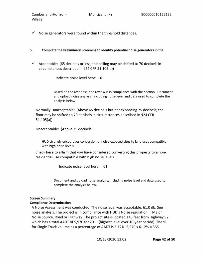
Cumberland-Horizon-Village
Monticello, KY 900000010155132
10/13/2020 13:02 Page 42 of 50
Noise generators were found within the threshold distances.
5. Complete the Preliminary Screening to identify potential noise generators in the Acceptable: (65 decibels or less; the ceiling may be shifted to 70 decibels in
circumstances described in §24 CFR 51.105(a))
Indicate noise level here:
61
Based on the response, the review is in compliance with this section. Document and upload noise analysis, including noise level and data used to complete the analysis below.
Normally Unacceptable: (Above 65 decibels but not exceeding 75 decibels; the
floor may be shifted to 70 decibels in circumstances described in §24 CFR 51.105(a))
Unacceptable: (Above 75 decibels)
HUD strongly encourages conversion of noise-exposed sites to land uses compatible with high noise levels.
Indicate noise level here:
61
Document and upload noise analysis, including noise level and data used to complete the analysis below.
Screen Summary Compliance Determination A Noise Assessment was conducted. The noise level was acceptable: 61.0 db. See noise analysis. The project is in compliance with HUD's Noise regulation. Major Noise Source, Road or Highway: The project site is located 148 feet from Highway 92 which has a total AADT of 5,970 for 2011 (highest level over 10-year period). The % for Single Truck volume as a percentage of AADT is 6.12%. 5,970 x 6.12% = 365
Check here to affirm that you have considered converting this property to a non-residential use compatible with high noise levels.

Cumberland-Horizon-Village
Monticello, KY 900000010155132
10/13/2020 13:02 Page 43 of 50
(medium trucks). The % of Combo truck volume is 1.478%. 5,970 x 1.478% = 88 (heavy trucks). 5,970 -365 - 88 = 5,517 (cars). See attached report from KYTC. Standard assumption of night volume of 15% was used. The average speed is 35 MPH. The average road grade of the segment of Highway 92, approximately 1,000 feet either side of a perpendicular line between the project site and the highway, must also be determined and entered in the appropriate field for Heavy Trucks. 1,000 feet west elevation is 949. 1,000 feet east elevation is 931. The difference is 18. 18/2000 feet = .9%. The project site is also located 25 feet from Worsham Lane which has a total AADT of 1,200 for 2011 (highest volume over 10-year period with no truck volume). Standard assumption of night volume of 15% was used. The average speed is 35 MPH. The stop sign is 136 feet from the site. The HUD DNL Calculator was used which included the railroad noise information. A total of 61 decibels was calculated. Refer to the attached National Transportation Noise Map and Kentucky Department of Transportation Maps. Railroad: The project site is located 22.68 miles from an active railroad. Because the distance is greater than 3,000 feet, no further action is required. See map from the Federal Rail Administration showing the location of the active railroad and the distance from the site to the railroad. Airport: Per the attached map, there is 1 FAA regulated civil airport located within 15 miles of the project site. However, according to the attached report and small airport worksheet, the project site will not be noise impacted by an airport. The project site is not located within 2,500 feet of a civilian airport. See attached map. The closest airport is the Wayne County Airport, located 4,638 feet from the project site. The project is in compliance with HUD's Noise regulation.
Supporting documentation 10 Airport - Wayne County 5010 Report.pdf 10 Airport - Wayne County Worksheet.pdf 10 Airport Transportation Map.pdf 10 Noise - Railroad FRA Map.pdf 10 Noise - Roadway KYTC Traffic Count Worsham Lane.pdf 10 Noise - Roadway KYTC Traffic Count Hwy 92.pdf 10 Noise - Roadway Traffic Count Map.pdf 10 Noise - Roadway elevation west of site.pdf 10 Noise - Roadway elevation east of site.pdf 10 Noise - Roadway elevation of site.pdf 10 Noise - Roadway 1000 radius Map.pdf 10 DNL Calculator - HUD Exchange.pdf 10 National Transportation Noise Map.pdf Are formal compliance steps or mitigation required?

Cumberland-Horizon-Village
Monticello, KY 900000010155132
10/13/2020 13:02 Page 44 of 50
Yes
No

9/26/2020 National Transportation Noise Map
https://maps.bts.dot.gov/arcgis/apps/webappviewer/index.html?id=a303ff5924c9474790464cc0e9d5c9fb 1/1
1mi 36.879 -84.915 Degrees
+–
National Transportation Noise Map Road and Aviation Noise in the United States USDOT OSAV Source Data
All Rights Reserved
Legend
US road and aviation noise
CONUS Road and Aviation Noise - Decibels
35 - 40
40.01 - 45
45.01 - 50
50.01 - 55
55.01 - 60
60.01 - 65
65.01 - 70
70.01 - 75
75.01 - 80
80.01 - 85
85.01 - 90
90.01 - 95
Hawaii_road_and_aviation_noise
Hawaii Road and Aviation Noise
35 - 40
40.01 - 45
45.01 - 50
50.01 - 55
55.01 - 60
60.01 - 65
65.01 - 70
70.01 - 75
75.01 - 80
80.01 - 85
85.01 - 90
90.01 - 95
Alaska road and aviation noise
-84.862553, 36.838179
Show search results for -84.862553, …
Search result
Longitude, Latitude-84.862553, 36.838179
Did you mean?36.838179, -84.862553
Show more results
Zoom to

9/26/2020 DNL Calculator - HUD Exchange
https://www.hudexchange.info/programs/environmental-review/dnl-calculator/ 1/2
Home (/) > Programs (/programs/) > Environmental Review (/programs/environmental-review/) > DNLCalculator
DNL CalculatorThe Day/Night Noise Level Calculator is an electronic assessment tool that calculates the Day/Night NoiseLevel (DNL) from roadway and railway tra�c. For more information on using the DNL calculator, view theDay/Night Noise Level Calculator Electronic Assessment Tool Overview (/programs/environmental-review/daynight-noise-level-electronic-assessment-tool/).
GuidelinesTo display the Road and/or Rail DNL calculator(s), click on the "Add Road Source" and/or "Add RailSource" button(s) below.All Road and Rail input values must be positive non-decimal numbers.All Road and/or Rail DNL value(s) must be calculated separately before calculating the Site DNL.All checkboxes that apply must be checked for vehicles and trains in the tables' headers.Note #1: Tooltips, containing �eld speci�c information, have been added in this tool and may beaccessed by hovering over all the respective data �elds (site identi�cation, roadway and railwayassessment, DNL calculation results, roadway and railway input variables) with the mouse.Note #2: DNL Calculator assumes roadway data is always entered.
DNL Calculator
Site ID Cumberland Horizon Village
Record Date 09/26/2020
User's Name S. Loveday
Road # 1 Name: Highway 92
Road #1
Vehicle Type Cars Medium Trucks Heavy Trucks
E�ective Distance 148 148 148
Distance to Stop Sign 0 0 0
Average Speed 45 45 45
Average Daily Trips (ADT) 5517 365 88
Night Fraction of ADT 15 15 15
Road Gradient (%) 1
Vehicle DNL 56 45 56
Calculate Road #1 DNL 59 Reset
Road # 2 Name: Worsham Lane
Road #2
Vehicle Type Cars Medium Trucks Heavy Trucks
E�ective Distance 25
Distance to Stop Sign 136
Average Speed
35

9/26/2020 DNL Calculator - HUD Exchange
https://www.hudexchange.info/programs/environmental-review/dnl-calculator/ 2/2
Average Daily Trips (ADT) 1200
Night Fraction of ADT 15
Road Gradient (%)
Vehicle DNL 54 0 0
Calculate Road #2 DNL 54 Reset
Add Road Source Add Rail Source
Airport Noise Level
Loud Impulse Sounds? Yes No
Combined DNL for allRoad and Rail sources
61
Combined DNL including Airport N/A
Site DNL with Loud Impulse Sound
Calculate Reset
Mitigation OptionsIf your site DNL is in Excess of 65 decibels, your options are:
No Action Alternative: Cancel the project at this locationOther Reasonable Alternatives: Choose an alternate siteMitigation
Contact your Field or Regional Environmental O�cer (/programs/environmental-review/hud-environmental-sta�-contacts/)Increase mitigation in the building walls (only e�ective if no outdoor, noise sensitive areas)Recon�gure the site plan to increase the distance between the noise source and noise-sensitiveusesIncorporate natural or man-made barriers. See The Noise Guidebook (/resource/313/hud-noise-guidebook/)Construct noise barrier. See the Barrier Performance Module (/programs/environmental-review/bpm-calculator/)
Tools and GuidanceDay/Night Noise Level Assessment Tool User Guide (/resource/3822/day-night-noise-level-assessment-tool-user-guide/)
Day/Night Noise Level Assessment Tool Flowcharts (/resource/3823/day-night-noise-level-assessment-tool-�owcharts/)
CUMBERLAND HORIZON VILLAGE PROJECT 70 Worsham Lane, Monticello, Wayne County, KY 42633 (36.838179, -84.862553)
Project Site
Roadway Radius Map
Highway 92 and Worsham Lane are the only roadways with a traffic count that are located within 1,000 feet of the site.
Highway 92-located 148 feet from the site
Worsham Lane -located 25 feet from the site

CUMBERLAND HORIZON VILLAGE PROJECT 70 Worsham Lane, Monticello, Wayne County, KY 42633 (36.838179, -84.862553)

CUMBERLAND HORIZON VILLAGE PROJECT 70 Worsham Lane, Monticello, Wayne County, KY 42633 (36.838179, -84.862553)


9/26/2020 Traffic Counts
https://maps.kytc.ky.gov/trafficcounts/ 1/1
Esri Community Maps Contrib
-84.862 36.837 Degrees
+–
300ft300ft300ft300ft300ft
꤆
Traffic Counts
-84.862553, 36.838179
Show search results for -84.86…
Click to restore the map extent and layersvisibility where you left off.
App State

9/26/2020 KYTC Traffic Count Reporting System
datamart.business.transportation.ky.gov/EDSB_SOLUTIONS/CTS/StationDetail.aspx?STATION=116A50&TF_NE_ID=42999429 1/1
Station Details:Sta ID: 116A50Sta Type: Full CoverageMap: MapItDistrict: 8County: WayneRoute: 116-CS-1125 -000Route Desc: WORSHAM LN
Begin MP: 0Begin Desc: KY 90End Mp: 0.8590End Desc: KY 92Impact Year: Year Added:
Newest Count:AADT: 1140Year: 2017% Single: % Combo: K Factor: 17.20D Factor: 56
Year AADT2020 2019 2018 2017 11402016 2015 2014 11152013 2012 2011 1200
Year AADT2010 2009 2008 12102007 2006 2005 11802004 2003 2002 8662001
Year AADT2000 1999 1998 7291997 1996 1995 6721994 1993 1992 1991
Historical Traffic Volume Summary
Definitions:Sta. ID - Three digit county number + station numberMP - milepointImpact Year – year of significant change to traffic pattern within station segmentAADT – Annual Average Daily Traffic – the annualized average 24-hour volume of vehicles on a segment of roadway% Single – single unit truck volume as a percentage of the AADT% Combo – combination truck volume as a percentage of the AADTK Factor – peak hour volume as a percentage of the AADTD Factor – percentage of peak hour volume flowing in the peak direction

9/26/2020 https://fragis.fra.dot.gov/FRA-PopupViewer/index.html
https://fragis.fra.dot.gov/FRA-PopupViewer/index.html 1/1Esri, HERE, NPS Powered by Esri
-84.862553, 36.838179
Unit
Miles
Mode
Auto
Distance
22.68 mi
New Measurement
3 km3 km3 km3 km
2 mi2 mi2 mi2 mi
-84.862553 36.838179
Show more results
Search result
Zoom to
U.S. Department of Transportation
FRA - Crossing Viewer

Cumberland Horizon Village Project 70 Worsham Lane, Monticello, Wayne County, KY 42633 (36.838179, -84.862553)
Project Site
Airport Radius Map
The site is NOT located within 15 miles of a military airfield. Kentucky has only two military airports: Godman Army Airfield, located over 100 miles away at Fort Knox and the Campbell Army Airfield, located over 200 miles away at Fort Campbell.
Wayne County Airport (Public) – located 4,638.48 feet north of the site

Cumberland Horizon Village Project 70 Worsham Lane, Monticello, Wayne County, KY 42633 (36.838179, -84.862553)
Distance to the Wayne County Airport

R-7 March 2018
Airport Noise Worksheet
Use this worksheet to identify information needed to evaluate a site’s exposure to aircraft noise.
Name and Location of Project: 70 Worsham Lane, Monticello, Wayne County, KY 42633 (36.838179, -84.862553) Name of Airport: Wayne County Airport Person completing worksheet: Suzie Loveday, Consultant Date: September 22, 2020 1. Determine if the proposed site/project is within 15 miles of a civil or military airport.
No. Attach a scaled map identifying the location of the proposed project site and the location of any airports. Further use of this worksheet is not required. Yes. Attach a scaled map identifying the location of the proposed project site and the location of any airports. Continue.
2. Determine the number of operations at the airport by:
Go to: http://www.gcr1.com/5010web/advancedsearch.cfm Find your airport using the Search function Open the report under “Print 5010” Complete section 3 below by using Operations data found in the report (see yellow arrow
in the example below)
3. Determine if the annual number of operations for air carriers (#100), air taxis (#102), military (#105), and general aviation (#103 plus #104) exceeds the thresholds provided below.
#100 Annual air carrier operations __0 _. Is this 9,000 or more? Yes __ No X #102 Annual air taxi operations _760_. Is this 18,000 or more? Yes __ No X #105 Annual military operations _180_. Is this 18,000 or more? Yes __ No X #103+#104 Annual general aviation operations 7,700 _. Is this 72,000 or more? Yes __ No X
4. If you answer “No” on each of the questions above, it is assumed the noise attributed to the
airplanes will not extend beyond the boundaries of the airport. Maintain the documentation

R-7 March 2018
in your Environmental Review Record (ERR). You are finished with the evaluation of airport noise for this airport.
If you have marked any question in #3 with “Yes,” continue to 5.
5. Contact the airport manager, (see blue arrow above) and ask them if the airport has noise
contour maps. Are contour maps available?
Yes. Locate your project on the noise contour map. If there are no roads or railroads that are being considered for noise, utilize the information from the contour map to determine if the site is acceptable. If roads or railroads are being considered, input the information obtained from the airport noise contours, along with the road and railroad information, into HUD online noise calculation tool at http://www.hud.gov/offices/cpd/environment/dnlcalculator.cfm. No. Construct the approximate DNL contours by using the guidance on page 52 and 53 of the HUD Noise Guidebook. You will need to obtain the following information from the airport:
(a) The number of nighttime jet operations (10pm to 7 am). (b) The number of daytime jet operations (7 am to 10 pm). (c) The flight paths of the major runways. (d) Any available information about expected changes in airport traffic (e.g., will the
number of operations increase or decrease in the next 10 to 15 years?).
Contact your HUD Environmental Officer if you need assistance.

U.S. DEPARTMENT OF TRANSPORTATIONFEDERAL AVIATION ADMINISTRATION AIRPORT MASTER RECORD
PRINT DATE:AFD EFF
04/26/202004/23/2020
FORM APPROVED OMB 2120-0015
> 1 ASSOC CITY: MONTICELLO 4 STATE: KY LOC ID: EKQ FAA SITE NR: 07284.01*A > 2 AIRPORT NAME: WAYNE COUNTY 5 COUNTY: WAYNE, KY 3 CBD TO AIRPORT (NM): 2 N 6 REGION/ADO: ASO /MEM 7 SECT AERO CHT: CINCINNATI
GENERAL SERVICES BASED AIRCRAFT 10 OWNERSHIP: PUBLIC > 70 FUEL: 100LL A+ 90 SINGLE ENG: 8 > 11 OWNER: WAYNE CO ARPT BOARD 91 MULTI ENG: 0 > 12 ADDRESS: P.O. BOX 439 > 71 AIRFRAME RPRS: MAJOR 92 JET: 0
MONTICELLO, KY 42633 > 72 PWR PLANT RPRS: MAJOR TOTAL: 8 > 13 PHONE NR: 606-348-4241 > 73 BOTTLE OXYGEN: NONE > 14 MANAGER: JERRY HAMPTON > 74 BULK OXYGEN: NONE 93 HELICOPTERS: 1 > 15 ADDRESS: 519 AIRPORT ROAD 75 TSNT STORAGE: HGR TIE 94 GLIDERS: 0
MONTICELLO, KY 42633 76 OTHER SERVICES: AMB 95 MILITARY: 0 > 16 PHONE NR: (661) 205-6415 96 ULTRA-LIGHT: 0 > 17 ATTENDANCE SCHEDULE:
MONTHS DAYS HOURSALL SUN UNATNDDALL MON-SAT 0830-1730
FACILITIES OPERATIONS> 80 ARPT BCN: CG 100 AIR CARRIER: 0> 81 ARPT LGT SKED: SEE RMK 102 AIR TAXI: 760 BCN LGT SKED: SS-SR 103 G A LOCAL: 2,900
18 AIRPORT USE: PUBLIC > 82 UNICOM: 122.800 104 G A ITNRNT: 4,800 19 ARPT LAT: 36-51-19N ESTIMATED > 83 WIND INDICATOR: YES-L 105 MILITARY: 180 20 ARPT LONG: 84-51-22.1W 84 SEGMENTED CIRCLE: YES TOTAL: 8,640 21 ARPT ELEV: 962.6 SURVEYED 85 CONTROL TWR: NO 22 ACREAGE: 121 86 FSS: LOUISVILLE > 23 RIGHT TRAFFIC: NO 87 FSS ON ARPT: NO OPERATIONS FOR 12 > 24 NON-COMM LANDING: NO 88 FSS PHONE NR: MONTHS ENDING 05/08/2018 25 NPIAS/FED AGREEMENTS: NGY 89 TOLL FREE NR: 1-800-WX-BRIEF > 26 FAR 139 INDEX: /
RUNWAY DATA > 30 RUNWAY IDENT: 03/21 > 31 LENGTH: 4,000 > 32 WIDTH: 75 > 33 SURF TYPE-COND: ASPH-G > 34 SURF TREATMENT: 35 GROSS WT: S 12.5 36 (IN THSDS) D 37 2D 38 2D/2DS > 39 PCN: ////
LIGHTING/APCH AIDS > 40 EDGE INTENSITY: MED > 42 RWY MARK TYPE-COND: NPI- G / NPI- G > 43 VGSI: P4L / P4L 44 THR CROSSING HGT: 40 / 40 45 VISUAL GLIDE ANGLE: 3.00 / 3.00 > 46 CNTRLN-TDZ: - / - > 47 RVR-RVV: - / - > 48 REIL: Y / Y > 49 APCH LIGHTS: /
OBSTRUCTION DATA 50 FAR 77 CATEGORY: A(NP) / A(NP) > 51 DISPLACED THR: / > 52 CTLG OBSTN: FENCE / TREE > 53 OBSTN MARKED/LGTD: / > 54 HGT ABOVE RWY END: 23 / 119 > 55 DIST FROM RWY END: 201 / 1,971 > 56 CNTRLN OFFSET: 250L / 477R 57 OBSTN CLNC SLOPE: 0:1 / 14:1 58 CLOSE-IN OBSTN: Y / N
DECLARED DISTANCES > 60 TAKE OFF RUN AVBL (TORA): / > 61 TAKE OFF DIST AVBL (TODA): / > 62 ACLT STOP DIST AVBL (ASDA): / > 63 LNDG DIST AVBL (LDA): /
(>) ARPT MGR PLEASE ADVISE FSS IN ITEM 86 WHEN CHANGES OCCUR TO ITEMS PRECEDED BY >
> 110 REMARKS:
A 013 WAYNE CO. JUDGE EXECUTIVE / NANCY ALLEN AIRPORT BOARD SEC. (606-348-4241)
A 058 RWY 03 FENCE - 249.5 FT LEFT RUNNING PARALLEL RWY CL.
A 070 FUEL AVBL 24/7 WITH CC.
A 081 ACTVT REIL RWY 21; PAPI RWY 03/21; MIRL RWY 03/21 PRESET LOW INTST. TO INCR INTST ACTVT - CTAF.
A 110-001 FOR CD CTC INDIANAPOLIS ARTCC AT 317-247-2411.
111 INSPECTOR: ( S ) 112 LAST INSP: 05/08/2018 113 LAST INFO REQ:
FAA FORM 5010-1 (06/2003) SUPERSEDES PREVIOUS EDITION
Cumberland-Horizon-Village
Monticello, KY 900000010155132
10/13/2020 13:02 Page 45 of 50
Sole Source Aquifers General requirements Legislation Regulation
The Safe Drinking Water Act of 1974 protects drinking water systems which are the sole or principal drinking water source for an area and which, if contaminated, would create a significant hazard to public health.
Safe Drinking Water Act of 1974 (42 U.S.C. 201, 300f et seq., and 21 U.S.C. 349)
40 CFR Part 149
1. Does the project consist solely of acquisition, leasing, or rehabilitation of an existing building(s)?
Yes
No
2. Is the project located on a sole source aquifer (SSA)?
A sole source aquifer is defined as an aquifer that supplies at least 50 percent of the drinking water consumed in the area overlying the aquifer. This includes streamflow source areas, which are upstream areas of losing streams that flow into the recharge area. No
Based on the response, the review is in compliance with this section. Document and upload documentation used to make your determination, such as a map of your project (or jurisdiction, if appropriate) in relation to the nearest SSA and its source area, below.
Yes
Screen Summary Compliance Determination The project is not located on a sole source aquifer area. The project is in compliance with Sole Source Aquifer requirements. The project is not located on a sole source aquifer area as there are no sole source aquifers in Kentucky

Cumberland-Horizon-Village
Monticello, KY 900000010155132
10/13/2020 13:02 Page 46 of 50
Supporting documentation 09 Sole Source KY Map.pdf Are formal compliance steps or mitigation required?
Yes
No

ArcGIS Web Map
Sources: Esri, HERE, Garmin, USGS, Intermap, INCREMENT P, NRCan,Esri Japan, METI, Esri China (Hong Kong), Esri Korea, Esri (Thailand),
Sole_Source_Aquifers
9/2/2019, 1:28:38 PM0 160 32080 mi
0 250 500125 km
1:9,244,649
Esri, HERE, Garmin, NGA, USGS, NPS | US EPA Office of Water | Map Service and data: US EPA Office of Environmental Information (OEI). Data: US Census Bureau | Web AppBuilder for ArcGIS
Jeremy Fink
Typewriter
There are no sole source aquifers in Kentucky.
Cumberland-Horizon-Village
Monticello, KY 900000010155132
10/13/2020 13:02 Page 47 of 50
Wetlands Protection General requirements Legislation Regulation
Executive Order 11990 discourages direct or indirect support of new construction impacting wetlands wherever there is a practicable alternative. The Fish and Wildlife Service’s National Wetlands Inventory can be used as a primary screening tool, but observed or known wetlands not indicated on NWI maps must also be processed Off-site impacts that result in draining, impounding, or destroying wetlands must also be processed.
Executive Order 11990
24 CFR 55.20 can be used for general guidance regarding the 8 Step Process.
1. Does this project involve new construction as defined in Executive Order 11990, expansion of a building’s footprint, or ground disturbance? The term "new construction" shall include draining, dredging, channelizing, filling, diking, impounding, and related activities and any structures or facilities begun or authorized after the effective date of the Order
No
Yes
2. Will the new construction or other ground disturbance impact an on- or off-site wetland? The term "wetlands" means those areas that are inundated by surface or ground water with a frequency sufficient to support, and under normal circumstances does or would support, a prevalence of vegetative or aquatic life that requires saturated or seasonally saturated soil conditions for growth and reproduction. Wetlands generally include swamps, marshes, bogs, and similar areas such as sloughs, potholes, wet meadows, river overflows, mud flats, and natural ponds. "Wetlands under E.O. 11990 include isolated and non-jurisdictional wetlands." No, a wetland will not be impacted in terms of E.O. 11990’s definition of new
construction.
Based on the response, the review is in compliance with this section. Document and upload a map or any other relevant documentation below which explains your determination
Yes, there is a wetland that be impacted in terms of E.O. 11990’s definition of new
construction. Screen Summary
Cumberland-Horizon-Village
Monticello, KY 900000010155132
10/13/2020 13:02 Page 48 of 50
Compliance Determination The project will not impact on- or off-site wetlands. The project is in compliance with Executive Order 11990. The project will not disturb wetlands, per the National Wetlands Inventory map for the project site.
Supporting documentation 09 Wetlands Map.pdf Are formal compliance steps or mitigation required?
Yes
No
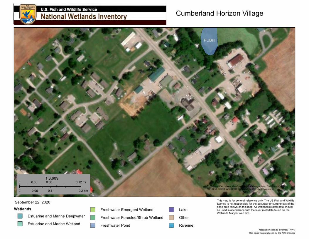
Cumberland Horizon Village
Source: Esri, Maxar, GeoEye, Earthstar Geographics, CNES/Airbus DS,USDA, USGS, AeroGRID, IGN, and the GIS User Community
Wetlands
Estuarine and Marine Deepwater
Estuarine and Marine Wetland
Freshwater Emergent Wetland
Freshwater Forested/Shrub Wetland
Freshwater Pond
Lake
Other
Riverine
September 22, 2020
0 0.06 0.120.03 mi
0 0.1 0.20.05 km
1:3,609
This page was produced by the NWI mapperNational Wetlands Inventory (NWI)
This map is for general reference only. The US Fish and Wildlife Service is not responsible for the accuracy or currentness of the base data shown on this map. All wetlands related data should be used in accordance with the layer metadata found on the Wetlands Mapper web site.
Suzie
Typewriter
X Project Site

Cumberland-Horizon-Village
Monticello, KY 900000010155132
10/13/2020 13:02 Page 49 of 50
Wild and Scenic Rivers Act General requirements Legislation Regulation
The Wild and Scenic Rivers Act provides federal protection for certain free-flowing, wild, scenic and recreational rivers designated as components or potential components of the National Wild and Scenic Rivers System (NWSRS) from the effects of construction or development.
The Wild and Scenic Rivers Act (16 U.S.C. 1271-1287), particularly section 7(b) and (c) (16 U.S.C. 1278(b) and (c))
36 CFR Part 297
1. Is your project within proximity of a NWSRS river? No
Yes, the project is in proximity of a Designated Wild and Scenic River or Study Wild and Scenic River.
Yes, the project is in proximity of a Nationwide Rivers Inventory (NRI) River. Screen Summary Compliance Determination This project is not within proximity of a NWSRS river. The project is in compliance with the Wild and Scenic Rivers Act. This project is not within proximity of a NWSRS river. The project is in compliance with the Wild and Scenic Rivers Act. The Red River is both the nearest Wild and Scenic and Nationwide Rivers Inventory body to the project site. The project site is 98.10 miles from the Wild and Scenic portions of the Red River, Kentucky's only Wild and Scenic River, and is 11.4 miles from the Big South Fork Cumberland River, the nearest Nationwide Rivers Inventory body. See attached maps.
Supporting documentation 09 Distance to Nationwide River.pdf 09 Distance to Red River.pdf 09 Wild Rivers - Red River in Kentucky.pdf Are formal compliance steps or mitigation required?
Yes
No

7/25/2020 Red River, Kentucky
https://www.rivers.gov/rivers/red.php 1/2
+ View larger map
Legend
+–
Choose A State Go
Choose A River Go
RED RIVER, KENTUCKY
RELATED LINKS
Red River (U.S. Forest Service)
Red River Gorge Geological Area(U.S. Forest Service)
Managing Agency:
U.S. Forest Service, Daniel Boone National Forest
Designated Reach:
December 2, 1993. From the Highway 746 Bridge to the confluence with the SchoolHouse Branch.
Classification/Mileage:
Wild — 9.1 miles; Recreational — 10.3 miles; Total — 19.4 miles.
Rivers of the Southeast define diversity, frombayous and rivers pushed by the tides to clearmountain streams with world-class whitewater.
NATIONAL SYSTEM MANAGEMENT RESOURCES PUBLICATIONS CONTACT US 50 YEARS SITE INDEX
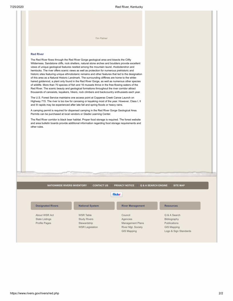
7/25/2020 Red River, Kentucky
https://www.rivers.gov/rivers/red.php 2/2
Red River
The Red River flows through the Red River Gorge geological area and bisects the CliftyWilderness. Sandstone cliffs, rock shelters, natural stone arches and boulders provide excellentviews of unique geological features nestled among the mountain laurel, rhododendron andhemlocks. The river offers scenic views as well as protection for numerous prehistoric andhistoric sites featuring unique ethnobotanic remains and other features that led to the designationof this area as a Natural Historic Landmark. The surrounding clifflines are home to the white-haired goldenrod, a plant only found in the Red River Gorge, as well as numerous other speciesof wildlife. More than 70 species of fish and 16 mussels thrive in the free-flowing waters of theRed River. The scenic beauty and geological formations throughout the river corridor attractthousands of canoeists, kayakers, hikers, rock climbers and backcountry enthusiasts each year.
The U.S. Forest Service maintains one access point at Copperas Creek Canoe Launch onHighway 715. The river is too low for canoeing or kayaking most of the year. However, Class I, IIand III rapids may be experienced after late fall and spring floods or heavy rains.
A camping permit is required for dispersed camping in the Red River Gorge Geological Area.Permits can be purchased at local vendors or Gladie Learning Center.
The Red River corridor is black bear habitat. Proper food storage is required. The forest websiteand area bulletin boards provide additional information regarding food storage requirements andother rules.
Designated Rivers
About WSR ActState ListingsProfile Pages
National System
WSR TableStudy RiversStewardshipWSR Legislation
River Management
CouncilAgenciesManagement PlansRiver Mgt. SocietyGIS Mapping
Resources
Q & A SearchBibliographyPublicationsGIS MappingLogo & Sign Standards
NATIONWIDE RIVERS INVENTORY CONTACT US PRIVACY NOTICE Q & A SEARCH ENGINE SITE MAP
Tim Palmer


9/26/2020 ArcGIS - Nationwide Rivers Inventory Official
https://www.arcgis.com/home/webmap/viewer.html?useExisting=1&layers=105a104d5a3043b0ba2a25e31ecf3ff1 1/1
About Content Legend
Contents
. Trust Center . Legal . Contact Esri . Report Abuse .
Nationwide Rivers Inventory Official
Topographic
Esri, NASA, NGA, USGS | Esri, HERE, Garmin, SafeGraph, METI/NASA, USG
+
−
0 1 2mi
Details Basemap Print Measure -84.862553, 36.838179
Nationwide Rivers Inventory OfficialArcGIS
Find area, length, or location
| Miles
Measurement Result
11.4 Miles

Cumberland-Horizon-Village
Monticello, KY 900000010155132
10/13/2020 13:02 Page 50 of 50
Environmental Justice
General requirements Legislation Regulation Determine if the project creates adverse environmental impacts upon a low-income or minority community. If it does, engage the community in meaningful participation about mitigating the impacts or move the project.
Executive Order 12898
HUD strongly encourages starting the Environmental Justice analysis only after all other laws and authorities, including Environmental Assessment factors if necessary, have been completed. 1. Were any adverse environmental impacts identified in any other compliance review portion of this project’s total environmental review?
Yes
No
Based on the response, the review is in compliance with this section. Screen Summary Compliance Determination No adverse environmental impacts were identified in the project's total environmental review. The project is in compliance with Executive Order 12898. The new construction of 36 units of affordable senior housing will not lead to any adverse environmental impacts.
Supporting documentation Are formal compliance steps or mitigation required?
Yes
No