Elem Indian Colony Archaeological Monitoring of EPA Mine Waste Removal
162
John Parker PO Box 1353 Lucerne, CA 95458 (707) 274-2233 d [email protected] ARCHAEOLOGICAL MONITORING OF EPA MINE WASTE REMOVAL AT THE ELEM INDIAN COLONY ARCHAEOLOGICAL SITES CA-LAK-76, 82, 2044 Prepared at the request of the Environmental Protection Agency For the Elem Tribal Council 13300 HWY 20, Suite E Clearlake Oaks, CA 95423 and the Bureau of Indian Affairs Pacific Region 2800 Cottage Way, Suite W-2619 Sacramento, CA 95825 Prepared by: John Parker PhD, RPA April 21, 2008 ARPA Permit # BIA/PRO-06-04-J54 (577)
Transcript of Elem Indian Colony Archaeological Monitoring of EPA Mine Waste Removal

John Parker PO Box 1353
Lucerne, CA 95458 (707) 274-2233
ARCHAEOLOGICAL MONITORING OF
EPA MINE WASTE REMOVAL AT THE
ELEM INDIAN COLONY
ARCHAEOLOGICAL SITES CA-LAK-76, 82, 2044
Prepared at the request of the Environmental Protection Agency
For the Elem Tribal Council
13300 HWY 20, Suite E Clearlake Oaks, CA 95423
and the Bureau of Indian Affairs
Pacific Region 2800 Cottage Way, Suite W-2619
Sacramento, CA 95825
Prepared by: John Parker PhD, RPA
April 21, 2008
ARPA Permit # BIA/PRO-06-04-J54 (577)

John Parker Page 1 10/22/2013
CONTENTS
ACKNOWLEDGEMENTS ........................................................................3
SUMMARY .............................................................................................5
INTRODUCTION AND BACKGROUND ....................................................7 Project Location..............................................................................7 Environment / Paleo-Environment .................................................8 Prehistoric Background ..................................................................9 Ethnography ................................................................................12 Historic Background.....................................................................16 Previous Archaeological Studies....................................................23 Resource Significance...................................................................24 Project and Impacts......................................................................25 Impacts That Occurred Before Parker & Assoc. Arrival..................27 Legal Framework ..........................................................................31
SEQUENCE OF EVENTS......................................................................35 Prior to Parker & Assoc. Involvement ............................................35 Parker & Assoc. Fieldwork ............................................................36 Lab Work......................................................................................40 Analysis and Report Preparation...................................................40
ARCHAEOLOGICAL MONITORING METHODS .....................................40 Recording Site Boundaries............................................................40 Review of Project Designs..............................................................41 Use of Tribal Monitors ..................................................................41 Monitoring Process .......................................................................42 Lab Methods.................................................................................43 Analysis .......................................................................................43 Theoretical Framework for Analysis ..............................................44 Special Considerations for Maps and Graphs................................44 Lithic Technology Analysis............................................................45 Diagnostic Artifacts, Obsidian Hydration, and
Calculating Actual Years B.P...................................................46
LAK-76 PREHISTORIC ARTIFACT DESCRIPTIONS ...............................49 Points...........................................................................................49 Knives ..........................................................................................53 Flake Tools ...................................................................................57 Cores............................................................................................59 Cobble Tools.................................................................................61 Ground Stone...............................................................................63 Shell and Bone .............................................................................65 Personal Adornment .....................................................................66
PREHISTORIC INTERPRETATION.........................................................68 Points...........................................................................................68 Knives ..........................................................................................71 Flake Tools ...................................................................................72 Cobble Tools.................................................................................72 Ground Stone...............................................................................72 Shell.............................................................................................73

John Parker Page 2 10/22/2013
Period of Use ................................................................................73
LAK-76 HISTORIC ARTIFACT DESCRIPTIONS......................................74 EuroAmerican Ceramics ...............................................................74 EuroAmerican Glass.....................................................................77 EuroAmerican Metal.....................................................................84 Asian Ceramics ............................................................................89
HISTORIC FEATURES..........................................................................93 Feature 1......................................................................................95 Feature 2......................................................................................98 Feature 3....................................................................................104 Feature 4....................................................................................107 Feature 5....................................................................................111 Feature 6....................................................................................117 Feature 7....................................................................................124 Feature 8....................................................................................127 Historic Feature Interpretation ...................................................129
LAK-82 ANALYSIS..............................................................................131
LAK-2044 ARTIFACTS........................................................................141
RESOURCE DAMAGE THAT OCCURRED DURING MONITORING ......143 Unmitigated Cultural Resource Damage Between August 22nd
and October 4th, 2006 ...........................................................151
ADMINISTRATIVE CONCLUSIONS AND RECOMMENDATIONS ..........152
BIBLIOGRAPHY .................................................................................154
EXCAVATION PROTOCOL..................................................................162
Copies for scientific review may also contain the artifact catalog and laboratory analysis results.

ACKNOWLEDGEMENTS
This report, and the accompanying archaeological studies are dedicated to the hard work of the many individuals who made them possible.
For their commitment to the preservation of their cultural heritage, the members of the combined Southeastern Pomo communities of Elem, Kamdot, and Koi are to be commended. They made the greatest sacrifice. Not only were they displaced from their homes during the mine waste cleanup project, but they suffered through the knowledge that those homes, traditional cultural materials, and many memories would be destroyed in the process.
Batsulwin Brown looks on as James Wright and Dave
Burroughs run the wet-screens.
Ruben Brown recovers soil samples from a
historic feature.
In particular, the author wishes to recognize the hard work of Batsulwin Brown, Ruben Brown, Elton Wright, Jim Brown III, Sandy Thomas, Dave Burroughs, Lemont Brown and James Wright. Even in the face of personal hardships and family crisis, they came through for their community. Tribal Chairman Raymond Brown and Environmental Coordinator Ray Brown Jr. were also helpful in trying to smooth out the technical bumps that were encountered during the process.
John Parker Page 3 10/22/2013

Many agency officials should be commended. These individuals did their best to try to bring some sense to a terrific beaurocratic mess:
Dan Hall and Jennifer Thomas (Bureau of Indian Affairs), John Eddins (Advisory Council on Historic Preservation) John Kennedy (Environmental Protection Agency), Dwight Dutschke (State Office of Historic Preservation)
Back at the lab, a dedicated group of researchers (Judy Westcott, JoAnne Heaney, Diana Minnix, and Don Martin) spent hours sorting through tiny items dropped by people from the past. Their attention to detail is now bringing the history of those people to life.
John Parker Page 4 10/22/2013
And finally, my wife Cheyanne is to be commended. She kept the home office running, made many 14-hour trips between the office and the field, and braved the 110-degree heat to clean and organize the collection.
Although much was destroyed, the information that we were able to gather is due to the hard work and commitment of those listed above.
No earthmoving machine could escape the watchful eyes of
Sandy Thomas.
Lab crew at work (clockwise from upper left, Cheyanne Parker, Don Martin, JoAnn Heaney, Diana Minnix, and Judy Westcott)

John Parker Page 5 10/22/2013
SUMMARY
On August 4th 2006, CH2M HILL (on behalf of the Elem Tribe and the EPA) retained Parker & Associates to conduct archaeological monitoring of mine waste removal on the Elem Indian Colony Reservation. This work was conducted in an effort to document and recover historic and prehistoric cultural materials that may be disturbed by mechanical excavation activities associated with the mine waste cleanup operation.
This work was completed in an effort to partly fulfill the requirements of the National Historic Preservation Act (36 CFR Part 800) as required by the Comprehensive Environmental Response, Compensation, and Liability Act (CERCLA 40 CFR 300.415 j). See page 30 for legal framework.
The current study was designed to protect existing cultural resources where possible and recover important cultural information from those areas where resources could not be protected. This monitoring program had the following objectives:
1. Document, where possible, the amount of resource disturbance that occurred prior to the EPA retaining a qualified cultural resource professional.
2. Develop and carry out a plan to preserve the remaining cultural resources.
3. Monitor all remaining ground disturbance activities and conduct data recovery work in areas where cultural resources will be impacted.
4. Determine the range of cultural activities that occurred at the sites.
5. Determine site placement in the regional settlement system.
6. Reconstruct internal site structure where possible.
7. Attempt an outline of human/environment interaction.
This report describes all cultural resource activities and analysis that took place as part of the monitoring program. This work included:
1. A surface inspection of the project area with reference to the proposed excavation and construction plan (Parker 2007a).
2. Monitoring of excavation and construction work that took place after August 4th, 2006.
3. Mapping and collection of significant cultural materials.
John Parker Page 6 10/22/2013
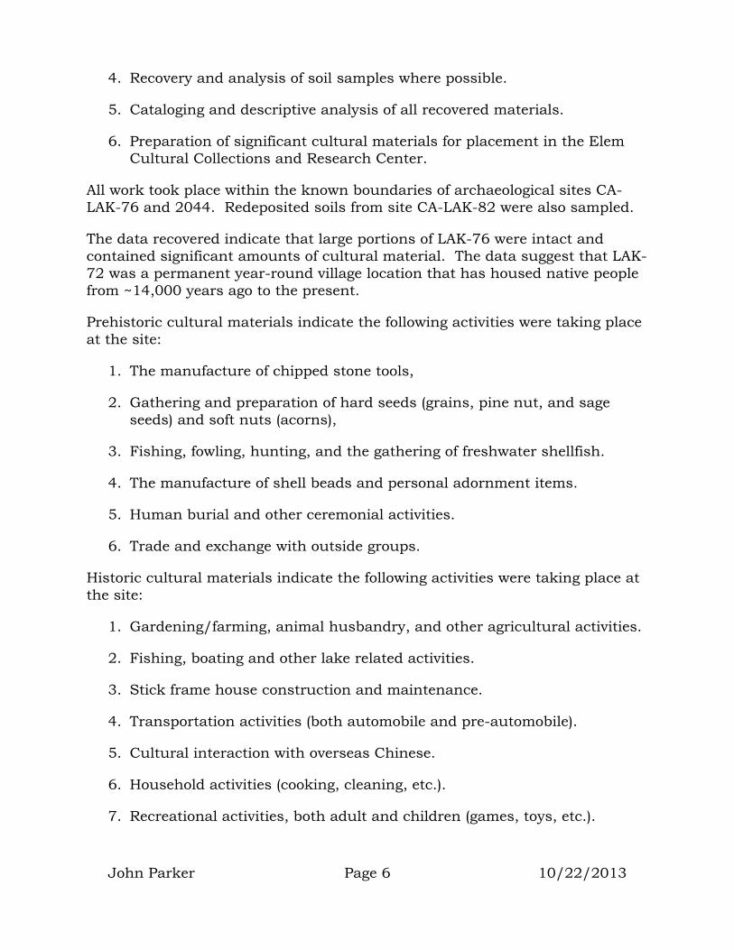
4. Recovery and analysis of soil samples where possible.
5. Cataloging and descriptive analysis of all recovered materials.
6. Preparation of significant cultural materials for placement in the Elem Cultural Collections and Research Center.
All work took place within the known boundaries of archaeological sites CA-LAK-76 and 2044. Redeposited soils from site CA-LAK-82 were also sampled.
The data recovered indicate that large portions of LAK-76 were intact and contained significant amounts of cultural material. The data suggest that LAK-72 was a permanent year-round village location that has housed native people from ~14,000 years ago to the present.
Prehistoric cultural materials indicate the following activities were taking place at the site:
1. The manufacture of chipped stone tools,
2. Gathering and preparation of hard seeds (grains, pine nut, and sage seeds) and soft nuts (acorns),
3. Fishing, fowling, hunting, and the gathering of freshwater shellfish.
4. The manufacture of shell beads and personal adornment items.
5. Human burial and other ceremonial activities.
6. Trade and exchange with outside groups.
Historic cultural materials indicate the following activities were taking place at the site:
1. Gardening/farming, animal husbandry, and other agricultural activities.
2. Fishing, boating and other lake related activities.
3. Stick frame house construction and maintenance.
4. Transportation activities (both automobile and pre-automobile).
5. Cultural interaction with overseas Chinese.
6. Household activities (cooking, cleaning, etc.).
7. Recreational activities, both adult and children (games, toys, etc.).
8. Ceremonial activities (traditional).
INTRODUCTION AND BACKGROUND
The fieldwork carried out as part of this study was directed by John Parker. Dr. Parker holds a Ph.D. in Archaeology, and is a Registered Professional Archaeologist. Assisting in the field were Cheyanne Parker (Archaeological Field Technician) and Tribal representatives Batsulwin Brown, Ruben Brown, Sandy Thomas, Dave Burroughs, Elton Wright, Lemont Brown and James Wright.
Additional archaeologists hired by CH2M HILL included John Holson and Kevin Bartoy of Pacific Legacy.
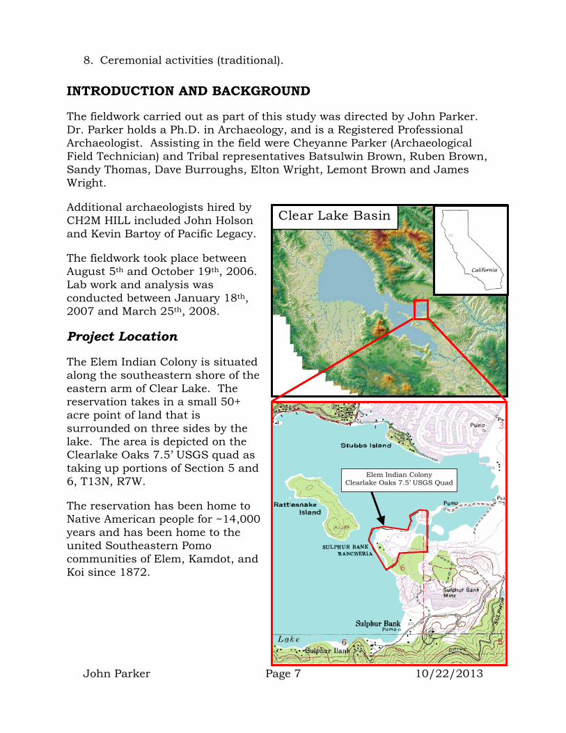
John Parker Page 7 10/22/2013
Clear Lake Basin
Elem Indian Colony Clearlake Oaks 7.5’ USGS Quad
The fieldwork took place between August 5th and October 19th, 2006. Lab work and analysis was conducted between January 18th, 2007 and March 25th, 2008.
Project Location
The Elem Indian Colony is situated along the southeastern shore of the eastern arm of Clear Lake. The reservation takes in a small 50+ acre point of land that is surrounded on three sides by the lake. The area is depicted on the Clearlake Oaks 7.5’ USGS quad as taking up portions of Section 5 and 6, T13N, R7W.
The reservation has been home to Native American people for ~14,000 years and has been home to the united Southeastern Pomo communities of Elem, Kamdot, and Koi since 1872.
Environment / Paleo-environment
The Clear Lake Basin and Clear Lake have been in existence for at least 400,000 years (Sims 1976). The boundaries of the basin are created by uplifted portions of the Franciscan Formation; a group of rocks created from marine sediments dating between 100 and 150 million years old. Many of these Franciscan rocks were of economic importance to the prehistoric inhabitants of the basin (e.g. chert for stone tool making, steatite and magnesite for ornamental uses) (Basgall 1979, Parker 1975).
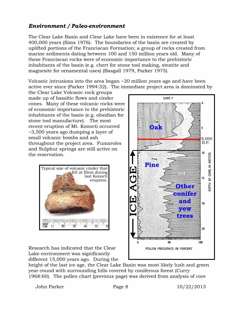
Volcanic intrusions into the area began ~20 million years ago and have been active ever since (Parker 1994:32). The immediate project area is dominated by the Clear Lake Volcanic rock groups made up of basaltic flows and cinder cones. Many of these volcanic rocks were of economic importance to the prehistoric inhabitants of the basin (e.g. obsidian for stone tool manufacture). The most recent eruption of Mt. Konocti occurred ~3,500 years ago dumping a layer of small volcanic bombs and ash throughout the project area. Fumaroles and Sulphur springs are still active on the reservation.
John Parker Page 8 10/22/2013
Research has indicated that the Clear Lake environment was significantly different 15,000 years ago. During the height of the last ice age, the Clear Lake Basin was most likely lush and green year-round with surrounding hills covered by coniferous forest (Curry 1968:60). The pollen chart (previous page) was derived from analysis of core
~8,000 B.P.
Oak
Other conifer
and yew trees
Pine Typical size of volcanic cinder that
fell at Elem during last Konocti
eruption.

samples of Clear Lake sediment. It shows the change from pine forests to oak forests at the end of the Ice Age (Sims et.al. 1981). Previous archeological evidence suggests that people first entered the Lake Basin sometime between 12,000 and 14,000 B.P. (before present) during end of the last Ice Age (Parker 1994).
At the end of the ice age, a period of global warming caused major changes in the distribution of plant and animal species (and presumably humans). Known as the Altithermal by climatologists, this period lasted from ~8,000 to 4,000 B.P. (Heusser 1966, Baumhoff and Heizer 1965, Richmond 1965, Meighan 1965). During this period, the Lake Basin was hotter and dryer than today. The Basin would not have supported lush green vegetation or coniferous forests. It is likely that grasses, low chaparral vegetation and oaks dominated the area.
At the end of the Altithermal (~4,000 B.P.), weather patterns became more like those we experience today; short wet winters followed by long springs and hot dry summers. These weather patterns gave rise to the oak-grassland environment we see around the lake today. Archaeological and ethnographic research has indicated that prehistoric settlement patterns, human resource procurement strategies, and population were closely tied to these environmental changes.
Prehistoric Background
During a 20-year archaeological study of Lake County prehistoric sites, the author discovered that the earliest sites are dated in excess of 11,000 years and indicate that a wave of Paleo-Indian people (most likely Hokan speakers) entered the Clear Lake Basin by way of the Cache Creek drainage from California’s Central Valley (Parker 1994:198). Evidence of these early Hokan speaking people can be found in the eastern and southern arms of Clear Lake.
Paleo-Indian Period (12,000 to 8,000 B.P.)
These early Hokan speaking people left behind distinctive styles of tools, known as Paleo-Indian artifacts. Paleo-Indian artifacts discovered in the area by Chester C. Post were brought to the attention of the archaeological profession in 1938. Locally, the group or pattern of artifacts left by these early people is referred to as the Post Pattern (Fredrickson 1973:185). M.R. Harrington’s excavations of the Borax Lake site in 1942 (Harrington 1948) and the re-analysis of his materials by Meighan and Haynes (1970) have confirmed their antiquity.
These materials consist of fluted and concave base Clovis and Folsom style points known to have been produced
Clovis style point from Borax Lake
John Parker Page 9 10/22/2013

between 9,000 and 12,000 B.P. The Borax Lake site exists in the southern portion of the Elem community’s traditional territory (1 mile south of the project area). It has since been purchased for preservation by the Archaeological Conservancy, and is listed as a National Historic Landmark.
Lower Archaic Period (8,000 – 6,000 B.P.)
At the end of the last Ice Age, these early Hokan speaking people settled permanently in the eastern and southern arms of Clear Lake creating the early Southeastern Pomo culture. The tools of this culture are referred to as the Borax Lake Pattern as defined by Fredrickson (1973:129) and others. These tools include large concave based and square stemmed points along with milling equipment (mano and metate). The milling stones suggest a shift from generalized resource gathering to more specific resource collection, as people seek out and collect grains and other hard seeds that must be processed before eating. Throughout this period, a small and stable population inhabited the Clearlake Oaks and Anderson Marsh areas of Clear Lake (southern and eastern arms of the lake). There is no evidence of permanent human use of other areas in the Clear Lake Basin (Parker 1994:200-207). Artifacts suggest a generalized local hunting and collecting economy. There is no evidence of trade or exchange with outside areas. Figures are taken from Moratto (1984).
Middle Archaic Period (6,000 – 3,500 B.P.)
This period was represented at Rattlesnake Island by materials recovered by Harrington (1948) and identified as the Houx Aspect as defined by Fredrickson (1973:129) following their discovery at the Houx Ranch just south of the Town of Lower Lake. The addition of the mortar and pestle to the prehistoric tool-kit indicate that soft nuts (acorns) were being gathered and processed. In addition, a small lozenge-shaped dart point shows up (presumably an indication that the dart and atlatl throwing stick were in use). These changes
John Parker Page 10 10/22/2013

in technology suggest that over-population had put stress on the easily gathered resources, requiring the addition of new food resources to the economy. During this period, population growth in the Southeastern Pomo area was dramatic and expansion of people out of this area occurred until the entire Clear Lake shoreline was settled. Large permanent villages were in use around the lakeshore from ~6,000 B.P. to the historic period (Parker 1994:208). As population growth continued (by 5,000 B.P.), Clear Lake people were also making use of upland resource areas. Archaeological evidence indicating the establishment of group territorial boundaries can be seen at sites in the Clearlake Oaks and Anderson Marsh arms of the lake. The first shell beads appear during this period, as do exotic trade items. These items suggest the beginning of a money economy and support the concept of well-established village or community territorial boundaries.
Upper Archaic Period (3,500 – 1,000 B.P.)
This period was also represented at Rattlesnake Island by materials recovered
by Harrington (1948). The Elem community was clearly established by this time with the Political and Religious center located on Rattlesnake Island and adjacent mainland. Other major village sites around the Clear Lake shoreline did not change from 3,500 B.P. to the time of European arrival. Each major community was separated from the next by a fixed shoreline distance of about 12km (Parker 1994:213). It appears that the ~3,500 B.P. eruption of Mt. Konocti coupled with population growth during the previous period triggered significant population movement from Clear Lake westward into the surrounding Sonoma and Mendocino County areas (Parker 1994:279). This is corroborated by independent archaeological and historical linguistic studies that indicate the development of Pomo dialects and language in these areas (Whistler 1980).
John Parker Page 11 10/22/2013
The mano and metate were gradually phased out as the acorn became more important as a dietary staple. The shell-bead money economy was in full swing and clamshell was being imported from the coast and manufactured into beads along the shores of Clear Lake (Parker 1980).
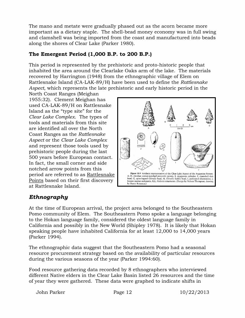
The Emergent Period (1,000 B.P. to 200 B.P.)
This period is represented by the prehistoric and proto-historic people that inhabited the area around the Clearlake Oaks arm of the lake. The materials recovered by Harrington (1948) from the ethnographic village of Elem on Rattlesnake Island (CA-LAK-89/H) have been used to define the Rattlesnake Aspect, which represents the late prehistoric and early historic period in the North Coast Ranges (Meighan 1955:32). Clement Meighan has used CA-LAK-89/H on Rattlesnake Island as the “type site” for the Clear Lake Complex. The types of tools and materials from this site are identified all over the North Coast Ranges as the Rattlesnake Aspect or the Clear Lake Complex and represent those tools used by prehistoric people during the last 500 years before European contact. In fact, the small corner and side notched arrow points from this period are referred to as Rattlesnake Points based on their first discovery at Rattlesnake Island.
Ethnography
At the time of European arrival, the project area belonged to the Southeastern Pomo community of Elem. The Southeastern Pomo spoke a language belonging to the Hokan language family, considered the oldest language family in California and possibly in the New World (Shipley 1978). It is likely that Hokan speaking people have inhabited California for at least 12,000 to 14,000 years (Parker 1994).
The ethnographic data suggest that the Southeastern Pomo had a seasonal resource procurement strategy based on the availability of particular resources during the various seasons of the year (Parker 1994:60).
Food resource gathering data recorded by 8 ethnographers who interviewed different Native elders in the Clear Lake Basin listed 26 resources and the time of year they were gathered. These data were graphed to indicate shifts in
John Parker Page 12 10/22/2013

resource gathering that may have required movement between upland and lakeshore settlements during the course of the year (Parker 1994:66).
Fall would have seen groups of Elem people moving to the oak forests for the annual acorn-gathering season. In 1888, an early visitor to Clear Lake commented that the valleys were filled with large acorn-bearing oaks evenly spaced “as if set out by a skillful landscape gardener” (Becker 1888 as listed in Kniffen 1939:355). The Clear Lake Pomo were those gardeners who tended the oaks every fall. Fish would have been taken year-round, migratory ducks in the winter, and trips to the coast for shellfish would have taken place in the spring to take advantage of seasonal low tides.
This seasonal availability of resources required a settlement system that flexed with the seasons. Among the Southeastern Pomo, even the names of villages and camps reflected the resource that was available at that location. Their moon-based calendar described the times of year by specifying the resource they would be gathering at that time of the year (e.g. “the moon after this we will be camping and gathering acorns”). Much of the year, a community of people remained in a central village, however, a family would indicate that they
had a house in at least three places:
Ethnographic indication of upland resource use
Ethnographic indication of lakeshore resource use
John Parker Page 13 10/22/2013

Southeastern Pomo tribal areas
Kniffen’s map drawn in 1919 showing Elem territory and project location
1. A substantial winter house in the main village that was lived in during the winter and provided a headquarters during the summer while trips were made to other resource areas.
2. A spring house in a settlement near a stream or lake where spring fishing took place.
3. A hut in a mountain camp where families from the village moved in the fall to gather acorns (Loeb 1926).
The Elem Community (1500-1900)
The Elem Native American community has been recognized by early explorers, linguists, and ethnographers for 150 years. There is evidence that Russians from Fort Ross and Salvadore Vallejo visited Clear Lake in the 1820’s and 30’s. There is also an account of Hudson’s Bay Company trappers passing through the area in 1832-33 (Work 1945).
The first published mention of the Southeastern Pomo village of Elem (?lem) seems to have been by Gibbs (1853:109). Gibbs accompanied Colonel Redick
Elem Village (1870-80) taken by R.E. Wood (Bancroft Library Collection)
John Parker Page 14 10/22/2013

John Parker Page 15 10/22/2013
McKee (United States Indian Agent) through northwestern California during the summer and fall of 1851. During this expedition, the chief of the How-ku-ma tribe (Southeastern Pomo village of Elem) participated in treaty negotiations with McKee. In 1871 and 1872, Stephen Powers traveled through California and studied the Native cultures. He visited Clear Lake and wrote about the Makh’el-chel (Southeastern Pomo) (Powers 1877:214).
True anthropological studies of the Southeastern Pomo and the Elem community began with the fieldwork of Barrett during 1903, 1904, and 1906 funded by Phoebe Hearst (Barrett 1908:7). His work and that of Kroeber (1925), Gifford (1923, 1926), Kniffen (1939), Stewart (1943) and others have given us rare insight into the political, religious, and daily lifeways of this historic and prehistoric community.
Ethnographic and historical records discuss the original location of the village of Elem:
“e’lem on the southern slope of Rattlesnake or Sulphur Bank Island at the eastern end of East Lake. This is a low island, covering about thirty-five acres, with its northern slope well wooded and its southern entirely open. This village was formerly the largest in the Southeastern dialectic area and was only abandoned about thirty-five or forty years ago, when its inhabitants removed to the adjacent mainland, where they now live.” (Barrett 1908:208)
“Rattlesnake island, on which was located the village of Elem, was communal property, and any villager might help himself to the acorns or other products of the island; not so the mainland, however, which to the north, east, and south was claimed by Elem, but was not communal property. It was divided into nearly ninety named tracts, owned by the various families of Elem.” (Gifford 1923:81)
Whether the original Village of Elem began on the Island and then expanded to the mainland, or began on the mainland and then expanded to the adjacent Island is currently unknown. However, at the time of European arrival, the Island village of Elem was the political center of the Elem territory. The mainland settlement was recorded by Gifford (1923) as the ethnographic village of Xunadai. At the time of his research, it was believed that Xunadai was the overflow village for the Elem political center located on Rattlesnake Island. In 1872, the entire community of Elem was joined by the communities of Koi and Kamdot and moved to the mainland village location (Gifford 1923).
Although the cultural deposits on the mainland likely contain evidence of these prehistoric cultural changes, equally important are the historic deposits that

represent the combined Southeastern Pomo communities from 1872 to the present.
Historical Background
Vallejo’s Land
During its colonial period, Spain took control of California. As a citizen of Spain, Mariano Guadalupe Vallejo was born in Monterey in 1808. Following Mexico’s Independence from Spain in 1822, Vallejo served as the Commander of the Northern Mexican Frontier. The Mexican government granted Vallejo a 66,000-acre rancho that included much of Sonoma, Napa and Lake Counties. In 1834, he was Commandant of the San Francisco Presidio and was told to move his garrison to Sonoma. Mariano and his brother Captain Salvador Vallejo moved their families to his rancho where they befriended the Suisun Indians who helped them build La Casa Grande. Salvador and Mariano Vallejo founded the Town of Sonoma and ranched the surrounding acres. Mariano and Salvador married sisters, 2 of the 13 children of Maria Ignacia Carrillo.
Salvador Vallejo (Bancroft Library Collection)
Between 1835 and 1846, the Vallejo brothers sent more than 100 military expeditions from Sonoma into the Indian country of Northern California to subdue the Wappo, Cainamero, and Satiyomi Indians.
Some of these expeditions were led by Mariano, some led by Salvador, and some lead by Francisco Solano who’s real name was Sem-Yito as he was chief of the Suisune Indians (Calif. Dept. of Parks and Rec. 1986).
In 1843, Salvador Vallejo led a contingent of 80 citizens and 80 servant Indians into Lake County for the purpose of rounding up Indians (Heizer 1973:67). According to the narrative of the expedition provided by Juan Bojorges (a participant), the group met with the people of Koi on Indian Island near Lower Lake and traded beads and “civilities”. The chief of this village came with them as an interpreter.
“After a day’s travel the expedition arrived in front of another island (most likely Rattlesnake Island, location of the Village of Elem) where Vallejo commanded the Chief of the rancheria to say
John Parker Page 16 10/22/2013
John Parker Page 17 10/22/2013
as before that they must not be frightened as no one was going to harm them. At this rancheria there were no civilities exchanged on either side.” “They set out the next day at eight o’clock in the morning keeping always to the shore of the lake, and arrived after a day’s travel in front of another island (most likely Paradise Cove across from Buckingham Island, location of the village of Kamdot), where we did not speak with anyone because there was so much water between us that our voices could not be heard by them.” “On the following day we marched on from eight in the morning to five in the afternoon. That day we did not speak with any Indians, from that rancheria to the one on the following day about ten in the morning. But here we found ourselves in difficulties, as our interpreter did not understand the dialect these Indians spoke (being Eastern Pomo rather than Southeastern Pomo). Seeing this, Capt. Vallejo ordered that we march back again to the previous island (Buckingham Island and the village of Kamdot) where we left a rear-guard before which we camped.” “On the following day Capt. Vallejo commanded the interpreter to speak with the chief of this rancheria.” “They embarked in one of the many tule rafts that there were about the shore. The interpreter was to tell the chief of the rancheria from Capt. Vallejo that he wanted to see and talk with him. After about an hour, 30 or more rafts with an Indian in each came, and among them the chief, who came to carry the men of the expedition to the island....” “Vallejo went on to propose to take them to Sonoma to see the place, offering them blankets and whatever he could give them, but the Indians refused. Then Ramon Carillo (Vallejo’s brother-in-law) told Vallejo to shut them up in a temescal (dance house). At the order given, a little more than half the Indians entered the temescal. The chief of the rancheria came unarmed to Carillo to ask that the others might enter. The Indian auxiliaries at that time shut the door of the temescal, Carillo lancing the chief in the stomach and killing him at once. Then the other Indians took to the water, the auxiliaries following them in two of the rafts killing with blows those defenseless ones who tried to escape by swimming. Then the expedition fired on them, killing some and wounding others. At this time the auxiliaries who were guarding the entrance to the temescal, made four or five breaches and set fire to the grass there was on the floor. Then the interpreter told them if they would come out nothing would be done to them, but

John Parker Page 18 10/22/2013
those who were inside said they would rather die by burning than be taken by the soldiers; and their bodies were heard crackling from outside as they burned.” (Heizer 1973:67) (bracketed comments added).
Bojorges account goes on to say that Vallejo and his men were chased out of the Clear Lake Basin by a contingent of warriors from Elem.
California Statehood
In June of 1846, a group of men commanded by John C. Fremont rode into Vallejo’s Casa Grande home in Sonoma to declare California’s independence from Mexico (the Bear Flag Revolt). After several hours of visiting and negotiations it was decided that Mariano and Salvador Vallejo would be taken as prisoners to Sutter’s Fort. Twenty-three days later Commodore John Drake took down the Bear Flag and raised the American Flag in Sonoma taking possession of California for the United States.
Indian Treaties
In 1850, President Millard Fillmore appointed three commissioners to travel to California “to learn what would satisfy the natives and to make treaties with them” (Heizer et.al. 1971:68). One of these commissioners, Col. Redick McKee met with Native American representatives in Lake County in 1851 and entered into a treaty that promised the Clear Lake Basin would be set aside for “their sole occupancy and use forever” in exchange for their agreement to “recognize the United States as sole sovereign of all the land occupied by them ceded by Mexico, placed themselves under the protection of the United States, and agreed to keep the peace.” They were also promised measures to improve their condition through the providing of schoolteachers, farmers, blacksmiths, farm animals, and implements (Heizer et.al. 1971:69).
The treaty meeting and signing ceremony included the chief of the How-ku-ma tribe (Southeastern Pomo). George Gibb wrote a journal of the expedition in which he states that the Village of Elem of Rattlesnake Island was a signatory to Treaty “O” (Gibbs 1853).
The California Legislature reacted strongly against the 18 Federal Treaties. Senate and assembly committees established to look into the matter concluded that if these lands were set aside, the “enterprising (white) population” residing on them would be “deprived of all their improvements discoveries, and hard-earned acquisitions.” The committee also indicated that the reservations would,

John Parker Page 19 10/22/2013
“have a most deleterious effect upon the general prosperity of the whole State. The taxable property which would be swept from the State would be immense, which would bring on a corresponding increase of taxation upon other portions of the State.”
The committee’s resolution to the U.S. Congress and President not only urged “that our Senators in Congress… use all proper means to prevent Congress from confirming the Indian reservations”… but asked for a “rigid inquiry into the conduct of the several Indian agents in California, as, in the opinion of the legislature, high-handed and unprecedented frauds have been perpetrated by them against the General Government and the citizens of California.” (Calif. 1852:202-205)
In 1852, the U.S. Senate rejected the treaties secretly and made them classified documents for 50 years (Heizer et.al. 1971:76).
Chinese Pioneers and Sulphur Bank Mine (1850-1900)
The California gold discovery in 1849 brought people from all over the world. One of the most populous of the immigrants were the Chinese. Between 1856 and 1866, 5,000-6,000 Chinese pioneers were arriving each year in San Francisco. In 1867, the Pacific Mail Steamship Company began regular runs between Hong Kong and San Francisco with an all-Chinese crew. In 1868, the Burlingame Treaty opened immigration between the U.S. and China. By 1890, 10% of all Californians were Chinese (Armentrout-Ma 1979).
Between 1850 and 1880, China was the 3rd largest foreign market for goods in and out of San Francisco. Chinese pioneers built much of California’s infrastructure from railroads to water projects.
Due to historical discrimination, most of the accomplishments of the Chinese in the Clear Lake Basin are unknown. However, it is known that Chinese laborers worked at the Sulphur Bank Mine, located immediately adjacent to the current project area. This mine began producing sulphur in 1865 and in 4 years produced 2,000,000 pounds. In 1873, it was reopened as a quicksilver mine and produced 92,400 flasks (Slocum, Bowan and Co. 1881). The mine employed more than 1,000 people, 600 of which were Chinese. The Sulphur Bank Mine is listed as a California Historical Landmark (#428).

John Parker Page 20 10/22/2013
1870’s Ghost Dance Religion
One reaction to the push of European settlers into Native American traditional lands was initiated by Wodziwob, a Northern Paiute Indian from Nevada. In the 1860’s, Wodziwob had visions of another world where he was told an Indian renaissance was at hand. He called his movement the Ghost Dance and it involved giving up all material ties to the White man, the construction of a traditional dance house and several days of dance and ceremony. As the movement spread, it evolved and changed. The Earth Lodge religion and Big Head religion are offshoots (DuBois 1939, Meighan and Riddell 1972).
As European settlers began populating Lake County, between 1866 and 1872 the land under cultivation in the Lake Basin increased from 4,500 to 13,652 acres. During this time 90,614 acres had been enclosed with fences (Halpern 1988:26). The Southeastern Pomo found themselves more and more restricted from their traditional gathering and hunting areas. Word of the Ghost Dance religion came to the Southeastern Pomo from the Patwin. The indication was that the world was going to come to an end and that a very big and deep dance house should be built to stay in during that time. Elem was chosen to be one of the centers for the Ghost Dance (Dubois 1939).
In 1872, the Ghost Dance (?abqo) was held at Elem. No white man’s things were to be used during the ceremony. Thomas Johnson (father from Elem and Mother from Koi) was 12 or 13 years old at the time and he remembers that:
“we left everything we had at Koi Island (Indian Island near Anderson Marsh), including a little dog belonging to me. When we started for Sulphur Bank by canoe, my mother threw half a sack full of white mans glass beads into the water… At Sulphur Bank we listened to preaching about the end of the world.” (Halpern 1988:28)
Halpern notes that “The most outstanding result of this event was the amalgamation of the three island villages into the one rancheria” at Elem. The Kamdot people never returned to their island. Only a few Koi people returned to the Lower Lake area, but not to Indian Island. Elem has been the ceremonial center for all Southeastern Pomo since 1872.

The Elem community continues to hold Big Head ceremonies on a regular basis (which the author has attended) and full Ghost Dance ceremonies are still called every few years (non-Indians are not allowed).
Elem Village (1906) Grace Nicholson Photo (Huntington Library Collection)
United States Government Indian Policy Changes between 1930 and 1950
In the 1930’s, a series of laws were passed to change Federal Indian policy. One of these laws (Indian Reorganization Act of 1934) authorized the Secretary of the Interior to acquire interest in lands, water rights, or surface rights of lands either on or off the reservations for the purpose of providing land for the Indians (Murphy 1996). This law also provided the machinery to allow Indian Tribes the ability for self-government, both politically and economically. As Native American groups learned about the new laws, many worked to regain lands that had been lost or taken illegally (United States 1994). These laws led to many land claims cases throughout the U.S. and established the government’s policy to allow Native American communities on Federal Trust land to govern themselves.
In the 1940’s, a 180-degree turnaround in Federal Indian policy occurred. The change was to a policy of terminating federal trust status of Indian land with the long-term goal being the assimilation of Native American people into “white society”. By 1953, House Concurrent Resolution 108 declared as congressional policy the termination of federal control and supervision over Native American tribes.
In 1939, U.S. District Court Case #4068L was initiated to settle the ownership question of the Elem Reservation. It is unknown whether this case was
John Parker Page 21 10/22/2013

initiated as a result of knowledge of the Indian Reorganization Act of 1934. It is also not known if this case was initiated on behalf of a member of the Elem community or on behalf of one or more nearby landowners.
WWII intervened and the case did not go to trial until 1947 (after the change in Federal Indian policy). During the non-jury trial, attorneys representing the “plaintiff” (the United States of America) presented their arguments concerning the federal trust status of the land, which by then would have been clouded by the new “anti-trust” Federal policy. It is assumed that attorneys for the “defendants” (a long list of adjacent landowners) also presented their arguments concerning the land holdings of their clients.
The final judgment was entered in 1949 (well after the U.S. Indian Policy changes). In the end, the Northern Division of the United States District Court for the Northern District of California limited the size of the Elem Reservation to its current 50 acres.
American Citizen’s Disillusionment with their Government (1960-1980)
Spawned by the lies propagated during the Vietnam War, the U.S. population’s dissolution with the honesty of its government reached a peak during the 1960’s and early 1970’s. Popular movements calling into question the government’s actions sprang up all across the U.S. This period corresponded with the 100-year anniversary of many of the broken treaties and other atrocities perpetrated on the Native American community by the U.S. Government. The Native American community saw an opportunity to educate the disillusioned masses about the broken treaties of the 1800’s. This prompted several peaceful demonstrations including the Trail of Broken Treaties march and the taking of Alcatraz Island (Means 1995:222, 105-106). The Elem community became part of this movement by joining the Alcatraz Island demonstration in 1964 and by reclaiming Rattlesnake Island that had been illegally taken from the tribe by the 1947 court decision.
1970 structure built during the occupation of Rattlesnake Island (Parker 1978)
John Parker Page 22 10/22/2013

Previous Archaeological Studies
Records of only two archaeological evaluations conducted on the Elem Indian Colony property could be found at the California Historical Resource Inventory System office. These were conducted in 1975 and 1988 of the eastern and northern portions of the property. Three prehistoric sites and 4 archaeologically sensitive areas were recorded during these studies. The largest of these was site CA-LAK-76, recorded as extending northward from Pomo Street to the lakeshore and westward to the end of the 1975 study area at a point where Elem Drive intersects Pomo Street. Other sites recorded within the reservation include LAK-82 (on Buckeye Island), LAK-1615 (located just north of the present cemetery), and LAK-15 (located along the access road east of the reservation) (Fredrickson 1975, Thompson 1988). LAK-1615 may actually be the eastern-most extension of LAK-76.
Map based on worldwide metric grid system (UTM). Meters
Clear Lake Clear Lake
Clear Lake
CA-LAK-76/H
CA-LAK-76/H CA-LAK-76/H
CA-LAK-2047H
Rock wall
Rock wall
CA-LAK-2045/H
CA-LAK-2046
CA-LAK-2044H
John Parker Page 23 10/22/2013

John Parker Page 24 10/22/2013
When Parker & Assoc. became involved in the current project, the first activity that took place was to conduct an inventory of archaeological resources on the whole reservation (Parker 2007a). This study revisited and updated the records of the sites recorded by Fredrickson and Thompson (LAK-72/H). In addition, this new field inventory discovered and recorded three additional historic archaeological sites (LAK-2044H, 2045/H, and 2047H) and a new prehistoric site (LAK-2046).
Resource Significance
For the purpose of Federal undertakings, the significance of a cultural resource is determined by its eligibility for inclusion on the National Register of Historic Places. To be eligible for the National Register, a historic or prehistoric site must meet one or more of the 4 criteria established by the Department of the Interior (National Park Service 1991:3). Those criteria require that the property:
A. Be associated with events that have made a significant contribution to the broad patterns of our history; or
B. Be associated with the lives of persons significant in our past; or
C. Embody the distinctive characteristics of a type, period, or method of construction, or that represent the work of a master, or that represent a significant and distinguishable entity whose components may lack individual distinction; or
D. Has yielded or be likely to yield information important in prehistory or history (36 CFR part 60.6).
As long as the resource has retained its integrity, it is likely that an archaeological site will meet the criteria “D” requirement.
The adjacent Rattlesnake Island and the archaeological sites it contains have been determined eligible for inclusion on the National Register of Historic Places (State of California 2006). Based on the direct relationship between the Island and mainland cultural sites, it can be assumed that intact cultural resources existing on the mainland will also be eligible for National Register listing and therefore considered “significant” archaeological sites.
Even without the tie to the significant Rattlesnake Island sites, most of the mainland Elem community historic and prehistoric sites have retained their integrity (indicating that they meet criteria “D” above). In addition, information presented in the Prehistoric, Ethnographic, and Historic background sections tie the Elem community and the cultural sites on their land to several major historically significant people and events that have “contributed to the broad
John Parker Page 25 10/22/2013
patterns of our history“ (criteria A above). Elem archaeological sites contain a wealth of information concerning this community’s involvement in history, whether it be California’s early Mexican Rancho period, the Chinese immigrant period, the Ghost Dance period, or the more recent 1960’s rebellious period.
In discussing the significance of the resources he discovered on the reservation in 1975, Dr. Fredrickson indicates:
“In the opinion of the author, the mainland archeological site (LAK-76), the Buckeye Island archaeological site (LAK-82), and possibly the modern roundhouse are significant enough to warrant their inclusion on the National Register of Historic Places… The author is of the opinion that the entire Elem community area, including the past community location of Rattlesnake Island, is worthy of nomination and elevation to the National Register of Historic Places as a historic and archaeological district.” (Fredrickson 1975:15)
In addition, the adjacent Sulphur Bank Mine is considered a significant historic resource and has been designated a California Historical Landmark (State of California 1976:114). Of the ~1,000 laborers at the mine, ~600 were Chinese immigrants. The historical deposits at Elem contain evidence of Chinese interaction with the Elem community. Taken as a whole, the Elem cultural sites document cultural use of this area throughout the past 8,000 years, and possibly earlier (Smith 1942, Fredrickson 1975, Thompson 1988, Parker 1994).
Project and Impacts
Background
In the 1970’s, the need to construct roads and housing infrastructure on the reservation prompted the Bureau of Indian Affairs (BIA) to bring in fill soil to raise certain areas of the reservation above Clear Lake’s 100-year flood level. This fill soil was obtained from the adjacent Sulphur Bank Mine and consisted of old mine tailings. The roads and houses were built atop these tailings. In the 1990’s, soil samples revealed that the mine tailings contained arsenic, mercury and many other toxic materials.
The Environmental Protection Agency’s (EPA) proposed project was designed to remove these contaminated fill soils and replace them with clean fill. New roads and houses were then to be constructed on the clean fill in place of the old ones.
When excavation ended October 19th 2006, approximately 305,600 square feet of surface area within the reservation had been excavated. This work was conducted in two phases. The first phase (Phase 1A) involved demolition of the

John Parker Page 26 10/22/2013
houses and removing the contaminated soils from the house pad areas. This was completed between June 1st and July 30th 2006, without the benefit of a cultural resource inventory, memorandum of agreement for the treatment of cultural resources, or a qualified archaeologist. The second phase (Phase 1B) involved removing the roads and road fill. This began August 21st and ended October 19th 2006 with monitoring by Parker & Assoc. Archaeology.
Lack of Cultural Resource Evaluation and Planning
Although it was requested by Tribal representatives (Brown 2000), no cultural resource evaluation was conducted of the reservation property prior to the project. This failure meant that the EPA was unaware that significant cultural resources existed immediately beneath the contaminated mine tailings. Due to this lack of information, plans for the removal of fill soils did not consider how to best protect the immediately underlying cultural soils. Neither the EPA nor their subcontractors had a plan for how to preserve and protect these resources once they were encountered during the excavation process. Though at least 4 years of pre-project planning had taken place, when work at the reservation started, no archaeologist had been retained to review plans, consult with the design engineers, mitigate or monitor the proposed work.
At the request of the Elem Community, the EPA’s subcontractors were required to hire Tribal monitors to watch the excavation as it progressed. Though many of these monitors were concerned about their cultural heritage, none had background or training in federal cultural resource protection laws. None of the Tribal monitors met the National Historic Preservation Act [NHPA] standards required for employees or contractors responsible for dealing with historical resources (NHPA Section 112a).
This lack of pre-project planning for cultural resources caused massive destruction of cultural soils prior to Parker & Assoc. arrival on site (see pg. 27). By the time Parker & Associates were called in, the subcontractor’s clock was already running, allowing no time for data recovery in most areas that were scheduled for destruction. Both the soil removal process (see below) and the fact that project designs (street elevations, water and storm drain alignments) were already locked in place, prevented Parker & Associates from making many of the design changes necessary to preserve and protect underlying cultural soils.
Soil Removal Process
In most cases, the process of removing the contaminated soils involved the use of large track-driven excavators with toothed buckets. The teeth bit into the soil and the operator moved the bucket back and up to remove the contaminated soils. These soils were immediately dumped into a large truck and hauled to the mine dumpsite.

Once the excavation bucket reached the interface between the contaminated soil and historic or prehistoric cultural soils, the teeth of the bucket raked into the underlying (clean) native soil effectively creating furrows that filled with contaminated soils from above. A CH2M HILL employee, using a portable XRF meter, would periodically measure the level of contamination on the newly exposed ground surface and direct the excavator to dig deeper to remove the newly deposited “contaminated” soils. This process of “pushing” the contaminated material into the underlying (clean) soil often resulted in the removal of the top 30 to 60cm of the clean underlying soils before the XRF reading was satisfactory to the CH2M HILL staff. Throughout most of the project area, these underlying soils were archaeological site soils containing an abundance of historic and prehistoric cultural materials.
Even when the excavator attempted to carefully flatten and drag the base of the bucket across the surface of the clean underlying native soil, contaminated fill sticking to the backside of the bucket was often smeared on the clean soil surface resulting in high contamination readings by the XRF instruments.
Other Impacts
The project also included the replacement of the water main, the addition of a storm-drain system, and replacement of sewer laterals. However, these impacts will be covered in separate reports.
Impacts That Occurred Before Parker & Assoc. Arrival
Before Parker & Assoc. arrived at the project location, the EPA had already completed the Phase 1A portion of the project. This involved demolition of existing homes and the removal of mine tailings that had been used as fill under those homes. In addition to excavating 30-60cm into underlying cultural soils, in some instances these excavations went as deep as 8 to 10 feet into intact cultural soils. Other damages to historic resources included the use of a bulldozer to clear surface vegetation for the placement of silt fences and the driving of track driven and tire driven trucks and equipment over unprotected cultural soils.
On August 8th, 2006, Parker & Assoc. took photographs and measurements of the open excavations and graded areas that were still visible from the Phase 1a
John Parker Page 27 10/22/2013
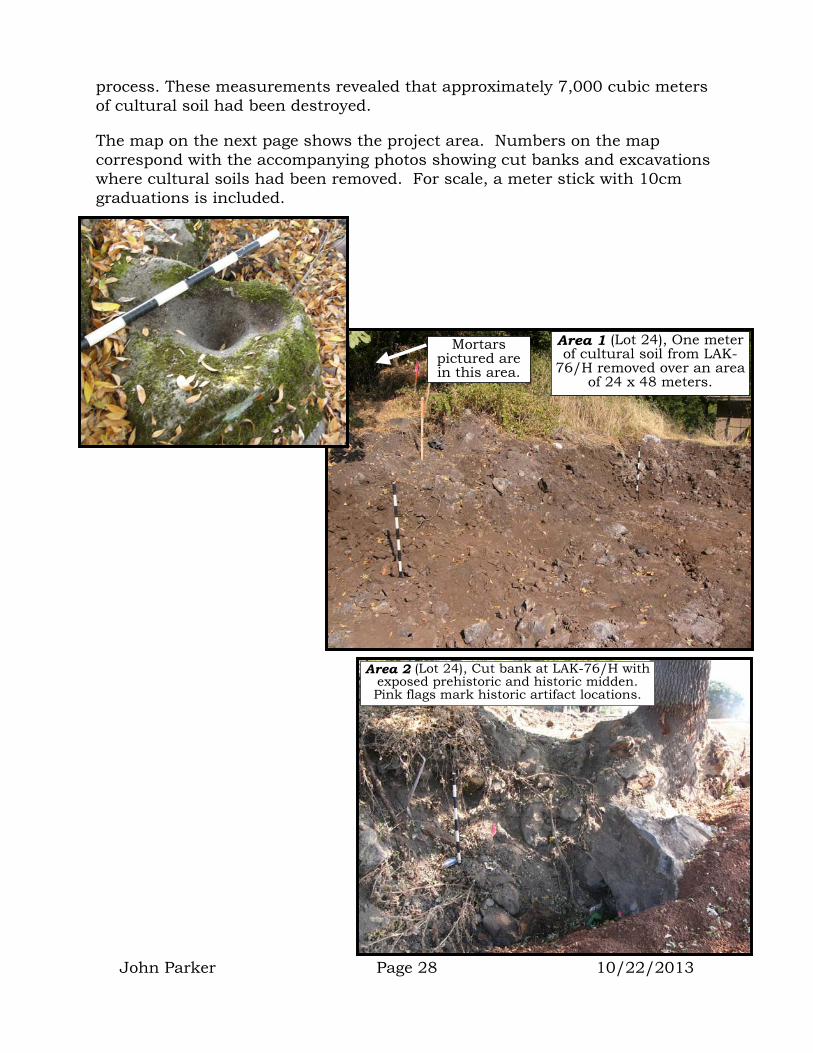
process. These measurements revealed that approximately 7,000 cubic meters of cultural soil had been destroyed.
The map on the next page shows the project area. Numbers on the map correspond with the accompanying photos showing cut banks and excavations where cultural soils had been removed. For scale, a meter stick with 10cm graduations is included.
John Parker Page 28 10/22/2013
Area 1 (Lot 24), One meter of cultural soil from LAK-
76/H removed over an area of 24 x 48 meters.
Mortars pictured are in this area.
Area 2 (Lot 24), Cut bank at LAK-76/H with exposed prehistoric and historic midden. Pink flags mark historic artifact locations.

Approximate boundaries of archaeological site CA-LAK-76/H
Area 6
Area 2
Area 1
Area 3
Area 4
Area 5
Areas of unmitigated grading and excavation within cultural site soils that occurred before 8-5-06.
Area 3 (Lots 26, 27), graded area through LAK-76/H with exposed prehistoric midden. Site disturbance is 12 x 59.2 meters x 1 meter deep. Orange flags mark artifact locations.
John Parker Page 29 10/22/2013

Area 6 (Lot 31), graded road through LAK-76/H with exposed prehistoric midden. Area of deep disturbance is 9.6 x 80 meters x ½ meter deep. Graded silt fence along both sides damaged an area 4.8 x 160 meters x 10-20cm deep.
Area 4 (Lot 29), Cut bank at LAK-76/H with exposed prehistoric and historic midden. Area of disturbance is 16 x 22 meters x 2
meters deep. Pink flag marks Chinese artifact location.
Area 5 (silt fence along Lot 28 road), graded area across LAK-76/H with exposed prehistoric midden. Area of disturbance is 4.8 x 140
meters x 10-20cm deep. Orange flags mark artifact locations.
John Parker Page 30 10/22/2013
John Parker Page 31 10/22/2013
Legal Framework
CERCLA Law
Although the Elem Mine Waste Cleanup project was considered a “Non-Time-Critical Removal Action” (CH2M HILL 2006), its funding came from the United States Legislature under the Comprehensive Environmental Response, Compensation, and Liability Act Fund (CERCLA 40 CFR 300). Therefore the CERCLA legal framework is used for this project.
In CERCLA, the definition of “environment” includes “land surface or subsurface strata” (40 CFR 300.5). It is assumed that this includes archaeological and historical resources on or within those strata.
In CERCLA, the definition of “natural resources” includes “…resources belonging to, managed by, held in trust by, appertaining to, or otherwise controlled by the United States, any state or local government, any Indian tribe, or any member of an Indian tribe.” (40 CFR 300.5). As cultural resources (historic and prehistoric sites) are one of the resources managed by and held in trust by the United States (see National Environmental Policy Act and National Historic Preservation Act below), these resources fall within the definition of “natural resources” under CERCLA law.
Under the CERCLA “Documentation and cost recovery” section (40 CFR 300.160), the lead agency (EPA in this case) “shall complete and maintain documentation to support…impacts and potential impacts to the public health and welfare and the environment.”
“The lead agency shall make available to the trustees of the affected natural resources (the BIA in this case) information and documentation that can assist the trustees in the determination of actual and potential natural resource injuries.” (40 CFR 300.160, 3)
Under “Federal agency participation” (40 CFR 300.170), CERCLA stipulates that some federal agencies “have duties established by statute, executive order, or Presidential directive which may apply to federal response actions…”
“Some of these agencies also have duties relating to the restoration, rehabilitation, replacement, or acquisition of equivalent natural resources injured or lost…”
Under “Federal agencies: additional responsibilities and assistance” (40 CFR 300.175), the EPA may call upon the Bureau of Land Management to provide them with information concerning archaeology; the National Park Service to provide archaeological and historical expertise in protection, preservation, evaluation, impact mitigation, and restoration of cultural resources; and the
John Parker Page 32 10/22/2013
Bureau of Indian Affairs for coordination of activities affecting Indian lands (40 CFR 300.175, b, 9, iv, viii, x).
CERCLA contains several sections that pertain to the proper inventory and protection of cultural resources during and after a spill and/or waste removal action. The primary applicable section stipulates:
“Fund-Financed removal actions under CERCLA… shall, to the extent practicable considering the exigencies of the situation, attain applicable or relevant and appropriate requirements (ARARs) under federal environmental or state environmental or facility siting laws.” (CERCLA 40 CFR 300.415j)
As this project was to take place on Federal Trust Land, only the Federal environmental and facility siting laws apply. These laws include the National Environmental Policy Act (NEPA 40 CFR 1508) and the National Historic Preservation Act (NHPA 36 CFR 800).
CERCLA law indicates, “waivers (from these laws) may be used for removal actions” only in cases where the project:
1. is an interim measure that will become part of a total remediation action that will attain the proper permits, or
2. compliance with ARARs will result in greater risk to human health or the environment, or
3. compliance with ARARs is impracticable from an engineering perspective, or
4. an alternative to the ARARs will attain the standard of performance equivalent to that which would be attained by following the ARARs, or
5. complying with the ARARs will unnecessarily use up funds at this site that will be taken away from the need to respond to other sites that present a threat to human health and the environment (CERCLA 300-430f 1 ii C).
As none of the above listed points apply to the Elem Removal Action, no waiver of the requirements of the National Environmental Policy Act (NEPA) or the National Historic Preservation Act (NHPA) was possible.
National Environmental Policy Act (NEPA)
Under the NEPA, the definition of “environment” includes “the natural and physical environment and the relationship of people with that environment.” (40 CFR 1508.14). In discussing how a federal undertaking might adversely affect the environment, NEPA stipulates that when making an environmental assessment (AE) the agency (EPA) must take into account:
John Parker Page 33 10/22/2013
“The degree to which the action may adversely affect … structures or objects listed in the National Register of Historic Places or may cause loss or destruction of significant scientific, cultural, or historical resources.” (40 CFR 1508.27, 8)
National Historic Preservation Act (NHPA)
The NHPA (36 CFR 800) as amended by Executive Order 11593 requires that before ANY undertaking on federally owned or federal trust lands occurs, the responsible agency (EPA) must complete the Section 106 Process which states:
“In consultation with the SHPO/THPO (State Historic Preservation Officer and/or Tribal Historic Preservation Officer1)
1. Determine and document the area of potential effects, including any data concerning possible historic properties not yet identified;
2. Review existing information on historic properties within the area of potential effects;
3. Seek information from consulting parties and other individuals and organizations likely to have knowledge of, or concerns with historic properties in the area, and identify issues relating to the undertaking’s potential effects on historic properties; and
4. Gather information from any Indian tribe identified pursuant to Sec. 800.3 (f) to assist in identifying properties which may be of religious and cultural significance to them and may be eligible for the National Register (National Register of Historic Places)…”(36 CFR 800.4a).
The “agency official shall take the steps necessary to identify historic properties within the area of potential effects.” (36 CFR 800.4b)
In consultation with the SHPO/THPO, “the agency official shall apply the National Register criteria (36 CFR part 63) to properties identified within the area of potential effects that have not been previously evaluated for National Register eligibility.” (36 CFR 800.4c)
If the agency official finds that there are historic properties which will be effected by the undertaking or the SHPO/THPO or the Council (Advisory Council on Historic Preservation ACHP) objects to the agency official’s finding…the agency official shall notify all consulting parties and invite their
1 At the time of this project, the Elem Indian Colony had not applied for, nor received the authorization to establish a Tribal Historic Preservation Officer (THPO). This means that any Section 106 consultation must include the State Historic Preservation Officer (SHPO).

John Parker Page 34 10/22/2013
views on the effects and assess adverse effects if any in accordance with Sec. 800.5.” (36 CFR 800.4d)
“An adverse effect is found when an undertaking may alter, directly or indirectly, any of the characteristics of a historic property that qualify the property for inclusion in the National Register in a manner that would diminish the integrity of the property’s location, design, setting, materials, workmanship, feeling, or association.” (36 CFR 800.5 a, 1)
The agency official shall consult with the SHPO/THPO, Advisory Council on Historic Preservation, and other consulting parties “to develop alternatives or modifications to the undertaking that could avoid, minimize, or mitigate adverse effects on historic properties.” (36 CFR 800.6 a)
“If the agency official and the SHPO/THPO agree on how the adverse effects will be resolved, they shall execute a memorandum of agreement.” This agreement must be submitted to the Advisory Council prior to approving the undertaking. (36 CFR 800.6 b, 1, iv)
After a review of all documentation and information concerning the EPA’s Elem Indian Colony Mine Waste Removal Project, the Office of Federal Agency Programs within the Advisory Council on Historic Preservation determined that:
“EPA did not initiate a formal Section 106 consultation as required by the National Historic Preservation Act (NHPA) for all undertakings that have the potential to effect historic properties.” “In the Case of the Elem Colony CERCLA cleanup, a location-specific requirement that should have been adhered to was the NHPA.” “Regrettably, EPA’s reluctance to follow the procedures set forth in our regulations to comply with Section 106 resulted in confusion and disagreements…regarding the appropriate measures to effectively identify and evaluate historic properties and to consider measures to avoid, minimize, or mitigate potential adverse effects.” (Klima 2007)

John Parker Page 35 10/22/2013
SEQUENCE OF EVENTS
Prior to Parker & Assoc. Involvement
Prior to 6-1-06 An agreement between the EPA and the Elem Tribe was entered into stipulating that trained Elem cultural monitors would “identify and protect any artifacts that might inadvertently be discovered”2 and that the “EPA agreed to bring in an archaeologist if significant artifacts or remains were inadvertently discovered.” (Takata 2007)
6-1-06 Mine waste removal excavation begins without the benefit of a cultural resource evaluation, mitigation plan, memorandum of agreement, or on-site archaeologist as required by the NHPA.
6-2-06 Significant archaeological materials come to light as soon as excavations begin (B. Brown 2007). No archaeologist was brought in as specified in EPA agreement with the Tribe.
7-11-06 Significant artifacts discovered, bagged and tagged by Tribal monitors. No archaeologist was brought in as specified in EPA agreement with the Tribe.
7-19-06 Significant artifacts recovered, bagged and tagged by Tribal monitors. No archaeologist was brought in as specified in EPA agreement with the Tribe.
7-20-06 Significant artifacts recovered, bagged and tagged by Tribal monitors. No archaeologist was brought in as specified in EPA agreement with the Tribe.
7-25-06 Significant artifacts recovered, bagged and tagged by Tribal monitors. No archaeologist was brought in as specified in EPA agreement with the Tribe.
7-26-06 Parker & Assoc. received a call from the Tribe indicating that bones had been found during the EPA removal process and asking what should be done. Parker & Assoc. advised that the project archaeologist should identify the bones and follow procedures outlined in the project memorandum of agreement concerning cultural resources. Parker & Assoc. were told that there was no project archaeologist or memorandum of agreement.
2 Although many of the Elem cultural monitors have extensive archaeological field experience, it should be noted that none of them meet the Secretary of the Interior Standards as Professionals under History or Archaeology.

John Parker Page 36 10/22/2013
7-28-06 Parker & Assoc. was notified that the Tribe requested the EPA to contract with an archaeologist approved by the tribe to take care of the problem. Parker & Assoc. was asked by Tribal members to put together a preliminary proposal.
8-1-06 John Holson (Pacific Legacy archaeologist) visited the site and developed a memo for the EPA and the Tribe listing the actions that need to take place in order to bring the project into compliance with Section 106 of the National Historic Preservation Act (Holson 2006).
8-4-06 Upon arrival, Parker & Assoc. conferred with representatives from the EPA, CH2M HILL, the BIA and the Tribe concerning what had taken place and what project plans were still to be implemented. Inspections were made of areas waiting for new fill and Parker & Assoc. indicated that fill could take place in those areas once exposed artifacts had been mapped and collected.
Parker & Assoc. Fieldwork
8-5-06 Parker & Assoc. measured and photographed open areas that had been excavated prior to our arrival.
8-9-06 In a second group meeting with representatives from EPA, BIA, CH2M HILL and Tribe, Parker & Assoc. was told by the EPA that they were exempt from the NHPA Section 106 process.
8-10-06 In a conference with Dwight Dutschke (SHPO), Parker & Assoc. was told that a court case may exist that appeared to exempt the EPA from the National Environmental Policy Act (NEPA), but not from the Section 106 Process of the National Historic Preservation Act (NHPA).
8-10 through 8-19-06 Parker & Assoc. prepared a formal monitoring proposal, project paperwork, preconstruction medical exam, completed HAZMAT training, and conducted a Phase I archaeological reconnaissance of the Area of Potential Effects. We also developed an Excavation Protocol (see attached) to be followed by all subcontractors as a way of insuring that accidental damage would not occur to cultural resources. This protocol was approved by the Elem Tribal Council and agreed to by all parties. To prevent erosion of cultural soils by water trucks, Parker & Assoc. asked for the application of geotextile material and fill soil along the road leading to the lakeshore water pump location. This didn’t take place for a month (see 9-14-06). During that time truck tires created a hole in the cultural soil 5 meters in diameter and 30cm deep.
8-21-06 Parker & Assoc. completed safety training and walked the project area with the incoming subcontractors. To determine where buried

John Parker Page 37 10/22/2013
cultural soils existed, Parker & Assoc. reviewed core samples and directed backhoe pot-holing in areas scheduled for an underground storm drain.
8-22-06 Parker & Assoc. began project monitoring and coordination of Tribal monitors.
8-23-06 First breach of the excavation protocol occurred as excavation was taking place without an archaeological monitor (unknown amount of disturbance). Tribal monitor had been stung by bee and sought medication. Excavation continued without monitor (60cm into cultural soil). Parker & Assoc. developed a mitigation/data recovery plan for the proposed Storm Drain excavation.
8-24-06 Second breach of the excavation protocol occurred as excavation was taking place without an archaeological monitor (unknown amount of disturbance). When Parker & Assoc. approached the offending CH2MHILL contractor, we were told that they had no intention of complying. Rather than the CH2M HILL contractor being written up for the infraction, a Tribal monitor was written up. To comply with BIA and Archaeological Resource Protection Act (ARPA) requirements, Parker & Assoc. requested a letter from the Tribal Chairman granting permission to work on the reservation and to be able to recover NAGPRA3 related materials if encountered. The monitoring plan was amended to include a BIA notification procedure and NAGPRA section. CH2M HILL tie up Tribal monitors with paperwork, preventing their work in the field.
8-28-06 Two Tribal monitors discovered human bone in fill soil brought from nearby archaeological site CA-LAK-82. Sheriff Coroner and BIA archaeologist called concerning human remains. Sheriff gave Parker & Assoc. custody of the material and assigned case# 060828032.
8-29-06 Third breach of the excavation protocol occurred as CH2M HILL contractors ignore Parker & Assoc. demands to stop excavation when cultural soils are encountered (unknown amount of disturbance). Excavation was removing mine waste and all underlying cultural soils as well. CH2M HILL tie up Tribal monitors by sending them for doctor exams, preventing their work in the field. Encountering a lack of cooperation and outright defiance of the
3 Native American Graves Protection and Repatriation Act

Excavation Protocol and archaeological preservation directives by both the EPA and CH2M HILL, Parker & Assoc. decides to walk away from the project. Calls were made to Tribal Chairman Raymond Brown and EPA’s John Kennedy to announce the decision.
8-30-06 Fourth breach of the excavation protocol occurs as CH2M HILL contractors ignore Parker & Assoc. demands to stop excavation when cultural soils are encountered. 1906 historic features damaged as excavator digs below 1906 ground surface (unknown amount of disturbance). Though completely powerless to prevent the destruction, Parker & Assoc. decides to remain on the project. This decision was due to a personal concern for the Elem Community and commitment to the preservation of Elem’s cultural heritage.
9-4-06 Parker & Assoc. finalized ARPA permit, BIA letters, curation agreement, Tribal permission letter, and letter to BIA concerning the discovery of human remains.
9-6-06 CH2M HILL fires the best Tribal monitor. Parker & Assoc. forced to add this monitor as a subcontractor to keep the monitor in the field. Additional human remains discovered in same area as previous items.
9-9-06 Fifth breach of the excavation protocol occurs as CH2M HILL contractors rip and grade off 50cm of pre-1906 historic site soil over an area 16 X 80 meters. The work unearths and breaks a mortar and destroys 6 historic archaeological features representing the remains of pre-1906 reservation structures (see pg. 93). No systematic data recovery was allowed prior to the destruction.
9-11-06 Sixth breach of the excavation protocol occurs as CH2M HILL contractor ignores Parker & Assoc. directive and grades through prehistoric site area exposing pestle and other artifacts (unknown amount of disturbance).
9-14-06 Geotextile material and fill finally placed along water truck road to protect cultural soils from truck traffic, but not until ~6 cubic meters of cultural soil had already been destroyed (see 8-10 through 8-19-06).
Broken pestle unearthed by grader during protocol breach.
9-16-06 Seventh breach of the excavation protocol occurs as CH2M HILL contractor ignores Parker & Assoc. directive and grades on Lots 1A and 1B to a depth of 50cm.
John Parker Page 38 10/22/2013

John Parker Page 39 10/22/2013
9-18-06 Eighth breach of the excavation protocol occurs as CH2M HILL contractor ignores a “no excavation” demand to protect native soils in front of Lot 2. This breach destroyed cultural soils to a depth of 60cm over an area of 24 X 14.4 meters
9-19-06 Ninth breach of the excavation protocol occurs as CH2M HILL contractor excavates to a depth of 60cm into intact cultural soils beneath the mine waste in front of Lot 30.
9-22-06 Tenth breach of the excavation protocol occurs as CH2M HILL contractors graded beneath mine waste into cultural soils along the Lot 28 water truck road. This grading destroyed cultural soils to a depth of 30cm over an area 48 X 3 meters.
9-26-06 Eleventh breach of the excavation protocol occurs as CH2M HILL contractors miss-align the storm drain trench and excavate outside the area where data recovery excavations had taken place to mitigate the impact of the trench (unknown amount of disturbance).
10-1-06 Parker & Assoc. return to Morro Bay lab to begin processing collected materials while Tribal monitors watch the last few days of excavation work.
10-2-06 Twelfth breach of the excavation protocol occurs as CH2M HILL contractor decides to excavate a “soft spot” in front of Lot 27 without a Tribal monitor. No mitigation was conducted and the excavation destroyed intact cultural soils to a depth of 60cm over a 4.5-meter diameter area. Parker & Assoc. immediately called to report the breach to the BIA and the Advisory Council. Calls were also made to the EPA and Elem Tribal Chairman.
10-3-06 The EPA field coordinator called Parker & Assoc. to express anger that calls had been made to agency officials concerning the protocol breach of 10-2.
10-4-06 Thirteenth breach of the excavation protocol occurs as CH2M HILL contractors again excavate without the benefit of a Tribal monitor and encounter bones. Parker & Assoc. received a call from EPA headquarters indicating that communication about protocol breaches should be made with the EPA field representative. Parker & Assoc. explained to EPA headquarters that the EPA field representative was not open to such communication.
10-19-06 Final day of field excavation.

Lab Work
1-18-07 Lab work begins on recovered materials.
Analysis and Report Preparation
12-3-07 Analysis and report preparation begins on recovered materials.
ARCHAEOLOGICAL MONITORING METHODS
Recording Site Boundaries
Parker & Assoc. first job was to conduct an inventory of the reservation to locate and map the observed surface boundaries of historic and prehistoric cultural resources (see pg. 23).
In this part of the Clear Lake Basin, prehistoric archaeological sites can be easily identified based on surface scatters of obsidian flakes. Although ground stone artifacts, dietary bone and shell are also good evidence of prehistoric sites, obsidian was an important stone tool manufacturing material throughout the prehistory of California. Obsidian is not native to the Elem reservation, the nearest natural obsidian flow exists at Borax Lake (~1 mile south of the project area). This means that any obsidian found at the reservation had been brought from an obsidian flow and dropped. The importance of Borax Lake obsidian to the economy of the Elem community will be made obvious throughout this report. However, for now it is enough to indicate its importance in determining prehistoric site boundaries.
Historic glass and ceramics found beneath mine waste.
Historic brick feature found beneath mine waste.
Historic archaeological site boundaries were determined by surface scatters of metal, glass, ceramics, and saw-cut bone.
The historic and prehistoric site data were transferred to an aerial photo of the reservation and ultimately to a set of design drawings for the project.
Review of Project Designs
A review of project designs vis-à-vis known archaeological site boundaries provided the basis for determining project activities that would need to be monitored versus those areas where project excavation could take place with little chance of damaging cultural resources.
John Parker Page 40 10/22/2013
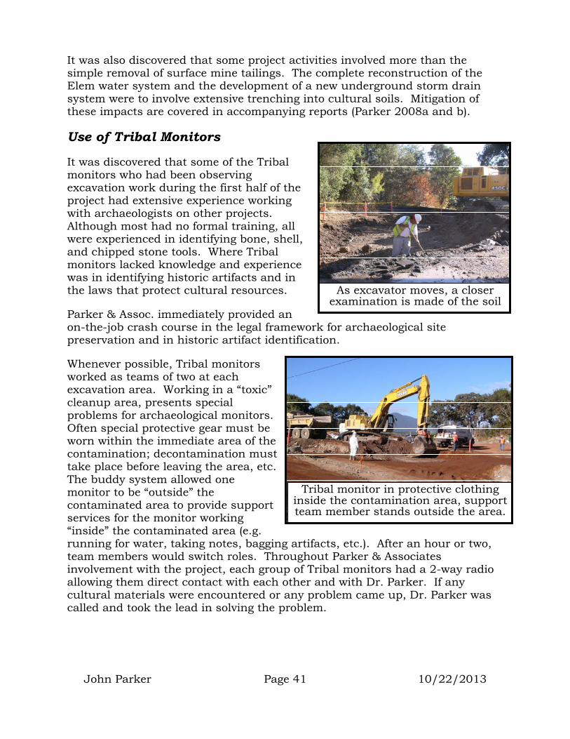
It was also discovered that some project activities involved more than the simple removal of surface mine tailings. The complete reconstruction of the Elem water system and the development of a new underground storm drain system were to involve extensive trenching into cultural soils. Mitigation of these impacts are covered in accompanying reports (Parker 2008a and b).
Use of Tribal Monitors
John Parker Page 41 10/22/2013
It was discovered that some of the Tribal monitors who had been observing excavation work during the first half of the project had extensive experience working with archaeologists on other projects. Although most had no formal training, all were experienced in identifying bone, shell, and chipped stone tools. Where Tribal monitors lacked knowledge and experience was in identifying historic artifacts and in the laws that protect cultural resources.
Parker & Assoc. immediately provided an on-the-job crash course in the legal framework for archaeological site preservation and in historic artifact identification.
As excavator moves, a closer examination is made of the soil
Whenever possible, Tribal monitors worked as teams of two at each excavation area. Working in a “toxic” cleanup area, presents special problems for archaeological monitors. Often special protective gear must be worn within the immediate area of the contamination; decontamination must take place before leaving the area, etc. The buddy system allowed one monitor to be “outside” the contaminated area to provide support services for the monitor working “inside” the contaminated area (e.g. running for water, taking notes, bagging artifacts, etc.). After an hour or two, team members would switch roles. Throughout Parker & Associates involvement with the project, each group of Tribal monitors had a 2-way radio allowing them direct contact with each other and with Dr. Parker. If any cultural materials were encountered or any problem came up, Dr. Parker was called and took the lead in solving the problem.
Tribal monitor in protective clothing inside the contamination area, support team member stands outside the area.

John Parker Page 42 10/22/2013
Monitoring Process
Throughout Parker & Assoc. involvement with the project, an attempt was made to have either an archaeologist or team of trained Tribal monitors at every location where a piece of heavy equipment was excavating within the boundaries of the recorded archaeological sites. This was often made difficult as EPA contractors were accustom to being able to pull Tribal monitors away from their monitoring duties to perform other tasks (such as gate security, traffic control, safety go-fers, equipment cleaners, etc.). Parker & Assoc. was constantly fighting with CH2M HILL subcontractors to maintain the necessary number of Tribal monitors for archaeological work (see 8-24, 8-29, and 9-6 dates listed on pg. 37 and 38).
Tribal monitor standing adjacent to excavator watching ground
Each monitor stood immediately adjacent to the heavy equipment and watched the soil surface during each pass of the excavation bucket or grader blade. As the excavator moved to a new location or turned to dump the bucket of soil, the monitor examined the floor and walls of the excavated area more closely. In most cases, cultural materials disturbed by the excavation work had to be quickly retrieved and bagged as coming from a general location. When time allowed, locations of cultural material were marked with pin flags and plotted with the aid of a Magellan Meridian Platinum GPS unit.
GPS unit used to plot artifact locations
If special historic features were encountered, and time allowed, volume controlled 5-gal bucket soil samples and 2,000cc soil samples were recovered.
Wet-screen station
Bags of cultural materials were taken to the wet-screen station where they were screened through 1/8” or ¼” mesh to clean off residual soils and air-dried. The remaining material was rebagged and labeled for transport to the lab.
Lab Methods
Each bag of material was sorted to remove extraneous rock, roots and other non-cultural material. The remaining cultural material was “detail” sorted into

major categories (e.g. shell, bone, stone, ceramic, glass, etc.) and sub-categories (e.g. species of shell, stone tool type, type of ceramic, etc.). All sorting was done with the aid of a 3 diopter lighted magnifying lens.
All sorted materials and non-cultural materials were double-checked by the author for accuracy before being quantified and entered into the computer database.
Analysis
Each category of cultural material from each bag was weighed to the nearest 100th of a gram using a Sartorius U 4100 S scale. The information from each item or group of similar items was entered into a computer with the aid of the MINARK database program. There were a total of 755 catalog entries representing several thousand individual cultural items from three recorded historic and prehistoric sites. All major artifacts were either permanently tagged or painted with their catalog number. Image scans were conducted for use in this report.
Statistical analysis was conducted on the cataloged cultural material using the NCSS statistics program.
Following analysis, all cultural material with the exception of finished artifacts was returned to the ground at the wet-screen station. Finished artifacts will be accessioned into the Elem Cultural Collections and Research Center.
Theoretical Framework for Analysis
The author is a processual archaeologist and the primary theoretical frameworks used to analyze and interpret patterns in the data will include the concept of "constrained exploratory data analysis" (Carr 1985, 1987; Read 1985, 1987), the "least cost" model of subsistence economics (Earle 1980; Green 1980), the concept of "Remnant Settlement Patterns" (Dewar and McBride 1992), and ethnographic analogy (Steward 1977).
Raymond Brown II assists in returning sorted, non-artifact material to the site.
The present study seeks to understand broad historical changes that have occurred during the course of prehistoric and historic habitation at the Elem Reservation location. To this end, the theories and models listed above will be called upon to assist in understanding the archaeological data.
John Parker Page 43 10/22/2013

John Parker Page 44 10/22/2013
In an ideal world, an abandon historic or prehistoric settlement would remain untouched until the archaeologist arrives to study it. In the real world, ancient sites are disturbed by rodent activity, erosion, and soil deposition, both during their use and after their abandonment. In addition, a host of human activities (both ancient and current) take place that change the relationships between the artifacts and features of a site.
For the current study, it will be assumed that the location of an artifact on or in the ground was a function either of its use, or the pattern of discard created by the people who were using it. As several thousand years of human activity in the area have been documented, an artifact’s location should not only provide information important in reconstructing patterns of land use, but also in seeing how land use may have changed over the course of time.
In addition, the form of an artifact often allows a determination of its function (e.g. projectile points suggest that hunting was taking place), thereby providing a basic outline of cultural activities.
Special Considerations for Maps and Graphs
Several location density maps are presented in this report. These maps display the reservation area and include shaded contours that depict the density of certain types of artifact (e.g. Chinese ceramics, projectile points, etc.). The darker the contour, the higher the density of that artifact type in that part of the reservation. These maps are designed as a way of distinguishing areas where particular activities were taking place during a particular time period. Artifact density contours on the maps were generated by the Surfer computer analysis and graphics program using the Natural Neighbor interpolation algorithm (Sibson 1981).
It is important to remember that not all areas of the reservation were equally sampled. Large portions of the reservation were not within the project area of impact. In those areas where cultural materials were not in danger, no collection occurred. Elsewhere, cultural materials were excavated and destroyed before any archaeological collection could take place. Therefore, “empty” areas on the density maps may not indicate a lack of resources; they may only indicate that collection didn’t take place in those areas.
In a few areas, it was possible to obtain volume-controlled samples of cultural soils. In these areas, graphs of those materials depict weights or counts of material within that amount of soil. Either a standard 5-gallon bucket was used for the sample volume (soil filled to the rim), or a graduated bowl was used (the actual cubic centimeter volume is listed). These graphs are meant to be compared with other similar volume controlled samples that may have been obtained in the past, or may be obtained in the future from sites within or outside the reservation.
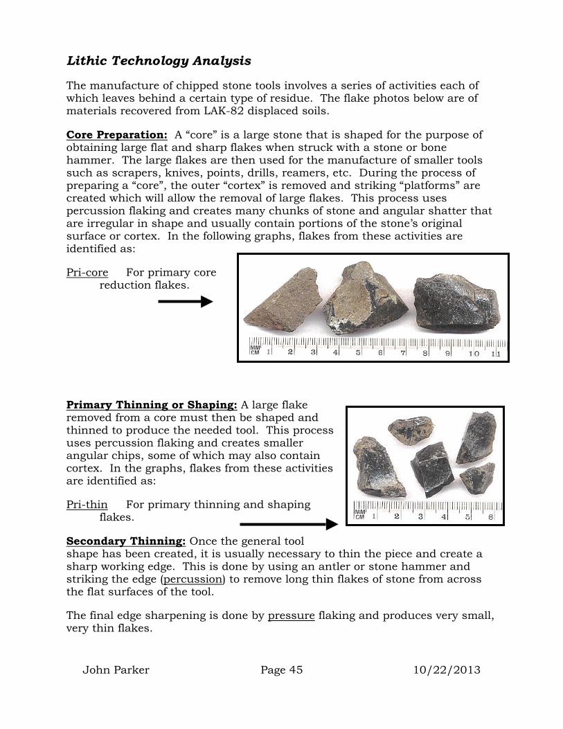
Lithic Technology Analysis
The manufacture of chipped stone tools involves a series of activities each of which leaves behind a certain type of residue. The flake photos below are of materials recovered from LAK-82 displaced soils.
Core Preparation: A “core” is a large stone that is shaped for the purpose of obtaining large flat and sharp flakes when struck with a stone or bone hammer. The large flakes are then used for the manufacture of smaller tools such as scrapers, knives, points, drills, reamers, etc. During the process of preparing a “core”, the outer “cortex” is removed and striking “platforms” are created which will allow the removal of large flakes. This process uses percussion flaking and creates many chunks of stone and angular shatter that are irregular in shape and usually contain portions of the stone’s original surface or cortex. In the following graphs, flakes from these activities are identified as:
Pri-core For primary core reduction flakes.
John Parker Page 45 10/22/2013
Primary Thinning or Shaping: A large flake removed from a core must then be shaped and thinned to produce the needed tool. This process uses percussion flaking and creates smaller angular chips, some of which may also contain cortex. In the graphs, flakes from these activities are identified as:
Pri-thin For primary thinning and shaping flakes.
Secondary Thinning: Once the general tool shape has been created, it is usually necessary to thin the piece and create a sharp working edge. This is done by using an antler or stone hammer and striking the edge (percussion) to remove long thin flakes of stone from across the flat surfaces of the tool.
The final edge sharpening is done by pressure flaking and produces very small, very thin flakes.

In the graphs, flakes from these activities are identified as:
Percussion flakes Sec-thin For secondary thinning, the final touches to thin and sharpen the finished tool.
Pressure flakes
If all activities are taking place at one spot, then the remains of all activities should be present. If one or more of these activities are taking place somewhere else, then those materials should be missing from the collected sample.
Diagnostic Artifacts, Obsidian Hydration, and Calculating Actual Years B.P.
Throughout this report, many artifacts will be discussed. Some of these are considered “diagnostic artifacts”. A diagnostic artifact is one that can be tied to a particular time period or is “diagnostic” of that time period (e.g. it was made almost exclusively during one time period). If a diagnostic artifact is found, one can consider that the site it came from was in use during the time period represented by the artifact.
John Parker Page 46 10/22/2013

Diagnostic Artifacts
In the Clear Lake basin, the artifact types listed in the next graph and table have been considered to be diagnostic of specific time periods or a range of time. These data were developed by combining the work of White (1984), White and King (1993), Jones and Hayes (1993), Kaufman (1980), and McCarthy and Orlins (1991). As most studies in the Lake Basin utilize obsidian hydration to order diagnostics, these types are listed here with their average period of use indicated in Napa obsidian micron readings. Actual years B.P. (before present) are listed in the table on the next page.
Points and Knives
Bead and Bead Tools
Hopper mortar
Bowl mortar Mano and
metate
Olivella split bead
Macoma disk bead Chert bead drill Saxidomus disk bead
Fluted point and crescent
Borax Lake wide-stem
Mostin Mendocino stemmed
Houx stemmed
Serrated excelsior Serrated leaf Small and
large excelsior
Houx flat-stem
Rattlesnake corner-notched
Seed Processing Tools
John Parker Page 47 10/22/2013
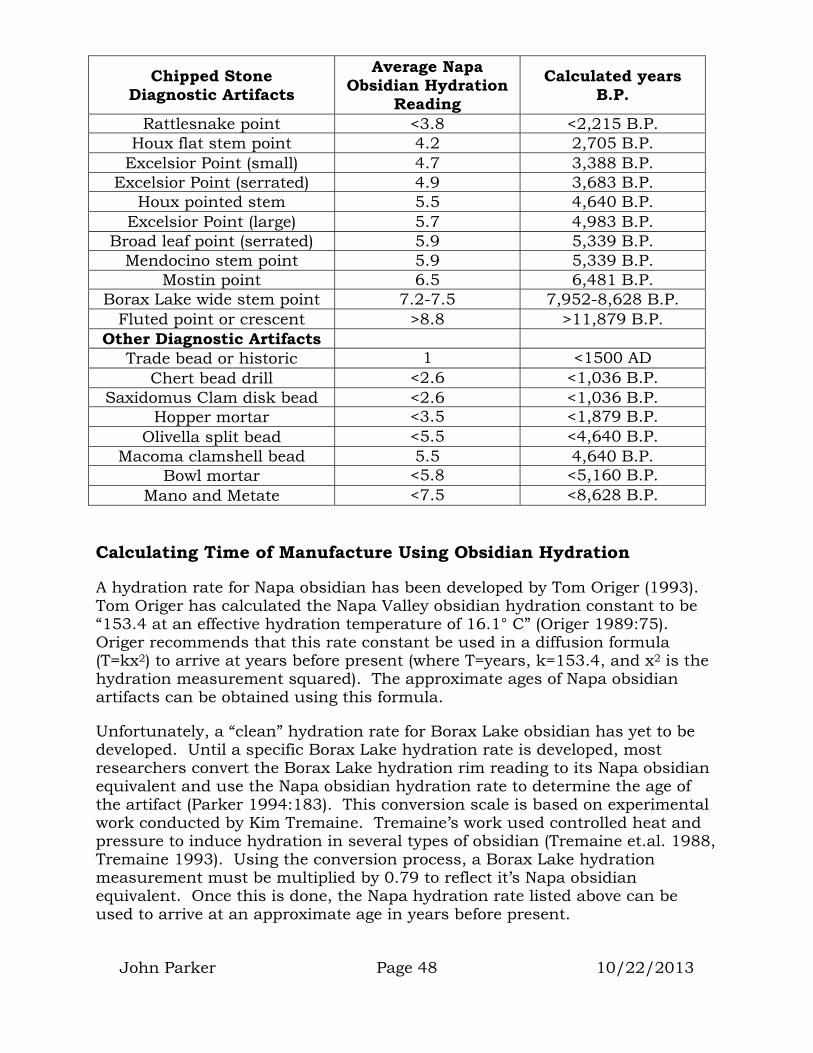
Chipped Stone Diagnostic Artifacts
Average Napa Obsidian Hydration
Reading Calculated years
B.P.
Rattlesnake point <3.8 <2,215 B.P. Houx flat stem point 4.2 2,705 B.P.
Excelsior Point (small) 4.7 3,388 B.P. Excelsior Point (serrated) 4.9 3,683 B.P.
Houx pointed stem 5.5 4,640 B.P. Excelsior Point (large) 5.7 4,983 B.P.
Broad leaf point (serrated) 5.9 5,339 B.P. Mendocino stem point 5.9 5,339 B.P.
Mostin point 6.5 6,481 B.P. Borax Lake wide stem point 7.2-7.5 7,952-8,628 B.P.
Fluted point or crescent >8.8 >11,879 B.P. Other Diagnostic Artifacts
Trade bead or historic 1 <1500 AD Chert bead drill <2.6 <1,036 B.P.
Saxidomus Clam disk bead <2.6 <1,036 B.P. Hopper mortar <3.5 <1,879 B.P.
Olivella split bead <5.5 <4,640 B.P. Macoma clamshell bead 5.5 4,640 B.P.
Bowl mortar <5.8 <5,160 B.P. Mano and Metate <7.5 <8,628 B.P.
Calculating Time of Manufacture Using Obsidian Hydration
A hydration rate for Napa obsidian has been developed by Tom Origer (1993). Tom Origer has calculated the Napa Valley obsidian hydration constant to be “153.4 at an effective hydration temperature of 16.1° C” (Origer 1989:75). Origer recommends that this rate constant be used in a diffusion formula (T=kx2) to arrive at years before present (where T=years, k=153.4, and x2 is the hydration measurement squared). The approximate ages of Napa obsidian artifacts can be obtained using this formula.
Unfortunately, a “clean” hydration rate for Borax Lake obsidian has yet to be developed. Until a specific Borax Lake hydration rate is developed, most researchers convert the Borax Lake hydration rim reading to its Napa obsidian equivalent and use the Napa obsidian hydration rate to determine the age of the artifact (Parker 1994:183). This conversion scale is based on experimental work conducted by Kim Tremaine. Tremaine’s work used controlled heat and pressure to induce hydration in several types of obsidian (Tremaine et.al. 1988, Tremaine 1993). Using the conversion process, a Borax Lake hydration measurement must be multiplied by 0.79 to reflect it’s Napa obsidian equivalent. Once this is done, the Napa hydration rate listed above can be used to arrive at an approximate age in years before present.
John Parker Page 48 10/22/2013

John Parker Page 49 10/22/2013
LAK-76 PREHISTORIC ARTIFACT DESCRIPTIONS
Prehistoric artifacts were grouped into the major categories of chipped stone, ground stone, bone, and shell. Within each major group, artifacts were further sorted into categories based on general form. For instance, the chipped stone category included points, knives, flake tools, etc. Within these major form categories, items were further sorted into styles. For instance, the flake tool form included scrapers, gravers, spoke-shaves, etc.
Points (32)
The contour map of overall Point distribution based on location closely followed the visible surface boundary of LAK-76 (see pg. 23). The dark contour suggests that points are evenly distributed across the whole site area. Though data are not available for many areas, it can be safely assumed that the distribution outlined in gray extends to the lakeshore. Points were also found just south of the dance house suggesting recent stone tool manufacture by Elem residents.
POINT DISTRIBUTION MAP + data points
Map based on worldwide metric grid system (UTM). Meters
Clear Lake
Clear Lake Clear Lake
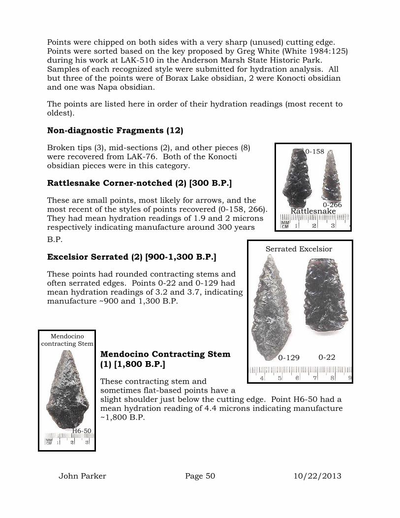
John Parker Page 50 10/22/2013
Points were chipped on both sides with a very sharp (unused) cutting edge. Points were sorted based on the key proposed by Greg White (White 1984:125) during his work at LAK-510 in the Anderson Marsh State Historic Park. Samples of each recognized style were submitted for hydration analysis. All but three of the points were of Borax Lake obsidian, 2 were Konocti obsidian and one was Napa obsidian.
The points are listed here in order of their hydration readings (most recent to oldest).
Non-diagnostic Fragments (12)
Broken tips (3), mid-sections (2), and other pieces (8) were recovered from LAK-76. Both of the Konocti obsidian pieces were in this category.
Rattlesnake Corner-notched (2) [300 B.P.]
These are small points, most likely for arrows, and the most recent of the styles of points recovered (0-158, 266). They had mean hydration readings of 1.9 and 2 microns respectively indicating manufacture around 300 years B.P.
Excelsior Serrated (2) [900-1,300 B.P.]
These points had rounded contracting stems and often serrated edges. Points 0-22 and 0-129 had mean hydration readings of 3.2 and 3.7, indicating manufacture ~900 and 1,300 B.P.
Mendocino Contracting Stem (1) [1,800 B.P.]
These contracting stem and sometimes flat-based points have a slight shoulder just below the cutting edge. Point H6-50 had a mean hydration reading of 4.4 microns indicating manufacture ~1,800 B.P.
0-158
0-266 Rattlesnake
Serrated Excelsior
0-129 0-22
H6-50
Mendocino contracting Stem

John Parker Page 51 10/22/2013
Willow Leaf (2) [2,000-2,300 B.P.]
These are often thick knife-like points (0-26, 227). Point 0-26 had a hydration mean of 4.9 and 0-227 had a hydration mean of 4.6 indicating manufacture ~2,300 and 2,000 years B.P.
Houx Serrated (5) [2,500/2,800/2,900 B.P.]
These long contracting-stem points are often serrated and sometimes have ears or tangs at the shoulder. Point 0-151 had a mean hydration reading of 5.2 microns indicating manufacture ~2,500 B.P. Item 0-112 had two bands suggesting the reuse of an older tool. One band was 8.7 microns indicating manufacture ~7,200 B.P. and one was 5.5 microns indicating secondary use ~2,900 B.P. Item 0-237 had a reading of 5.4 indicating manufacture ~2,800 B.P.
Flat Base (1) [2,700 B.P.]
The base of this point was squared off by pressure flaking to create a thin, flat base. Its hydration reading was 5.4 microns
indicating manufacture ~2,700 B.P.
Unidentifiable Style (1) [3,900 B.P.]
Point 0-175 resembled a Mendocino side-notched point and had a single hydration rim of 6.4 microns indicating manufacture ~3,900 B.P.
0-2270-26
Willow Leaf
0-381
Flat Base
0-175
Houx Serrated 0-151
0-237 0-112

John Parker Page 52 10/22/2013
Concave Base (1) [4,600 B.P.]
This long point (0-392) had a shallow concave base and a mean hydration reading of 7 microns indicating manufacture ~4,600 B.P.
Borax Lake Notched Widestem (1) [4,700 B.P.]
When discovered, it was thought that this would be the oldest point recovered during the project. The 7 micron reading from this point suggests manufacture ~4,700 B.P.
Flat-Base Dart (1) [5,100 B.P.]
This point resembled the small excelsior style dart point described by many researchers, however the base is flattened and thinned. The thin base profile more closely resembles a Mostin point. The hydration reading also resembles a Mostin point with a mean micron reading of 7.3 indicating
manufacture ~5,100 B.P.
Mendocino Corner-notched (1) [7,000 B.P.]
These flat-based square and expending-stemmed points (0-309) sometimes have pronounced corner notches but often don’t. This one had a hydration mean of 8.6 microns indicating manufacture around 7,000 B.P.
Mendocino Side-notched (1) [14,200 B.P.]
Point 0-107 appears to have been serrated, side notched, and may be the result of several periods of use and reuse. Three hydration bands were observed on this specimen.
Concave base
0-392
0-111
Borax Lake Wide-stem
0-309
Mendocino Corner-notched
0-107
Mendocino Side-notched
Flat basedart
0-297

John Parker Page 53 10/22/2013
The widest rim had a mean of 12.2 microns indicating original manufacture around 14,200 B.P. The next rim had a mean of 8.2 microns indicating additional work around 6,400 B.P. The smallest rim had a reading of 4.6 microns indicating further work around 2,000 B.P. Other serrated point forms (see Houx Serrated listed above) are in the 2,000-year range.
Flat-base Widestem (1) [14,200 B.P.]
This point (0-108) was a barely-worked flake that resembled a Borax Lake widestem. It had a single hydration band with a mean of 12.2 microns
0-108
Widestem
indicating manufacture around 14,200 B.P.
Knives (109)
KNIFE DISTRIBUTION MAP+ data points
Map based on worldwide metric grid system (UTM). Meters
Clear Lake
Clear Lake Clear Lake

John Parker Page 54 10/22/2013
The contour map of overall knife distribution based on location closely follows the visible surface boundary of LAK-76 (see pg. 23). Though data are not available for many areas, it can be safely assumed that the distribution outlined in gray extends to the lakeshore. The denser (darker) contours may indicate special activity areas or they may represent increases in knife discovery due to EPA excavation work. Knives were also found just southeast of the dance house as well as on Lot 17. It is likely that both locations represent recent stone tool manufacture by Elem residents.
Knives were chipped on both sides and had dulled (used) cutting edges. These items were divided into 5 main categories based on physical attributes. The primary difference between a knife and a point was the freshness or sharpness of the cutting edge. It was assumed that knife-edges would have been used repeatedly for a cutting, scraping, or sawing activity. This activity would have dulled the cutting edge. The sharp edge of a point would not have been used for cutting or scraping in an effort to maintain its sharpness for a hunting event.
Long Thin Knives (28) [1,100/1,800/3,900/6,900/7,400 B.P.]
The most numerous of knives were the long thin knives. Most of these were of Borax Lake obsidian (25) although some were of Konocti obsidian (3). Specimens 0-31 and 0-73 had hydration rims of 4.3 microns indicating manufacture ~1,800 B.P. Item 0-293 had two rims suggesting the reuse of an existing tool. The oldest rim was 8.8 microns (~7,400 B.P.) and the more recent 6.4 microns (3,900 B.P.). Item 0-27 and 0-350 (not pictured) had readings of 3.5 and 8.5 microns indicating ages of 1,200 and 6,900 B.P. The constricted end of 0-73 may indicate use as a reamer.
Broad Knives (27) [1,200/2,300/2,600/3,400/3,900/5,600 B.P.]
Thin and broad, all but one of these knives were of Borax Lake obsidian. One was of basalt. Item 0-10 had a hydration mean of 7.7 microns indicating manufacture ~5,600 B.P. Item 0-42 had a 6 micron reading indicating manufacture ~3,400 B.P. Item 0-143 had two hydration bands; one of 6.4 microns suggesting manufacture ~3,900 B.P. and one of 5 microns suggesting reuse ~2,300 B.P. Item 0-150 had a mean of 3.6 microns indicating manufacture ~1,200 B.P. Item 0-152 had a mean of 5.2 indicating
0-31 0-293 0-73
Long Thin Knives
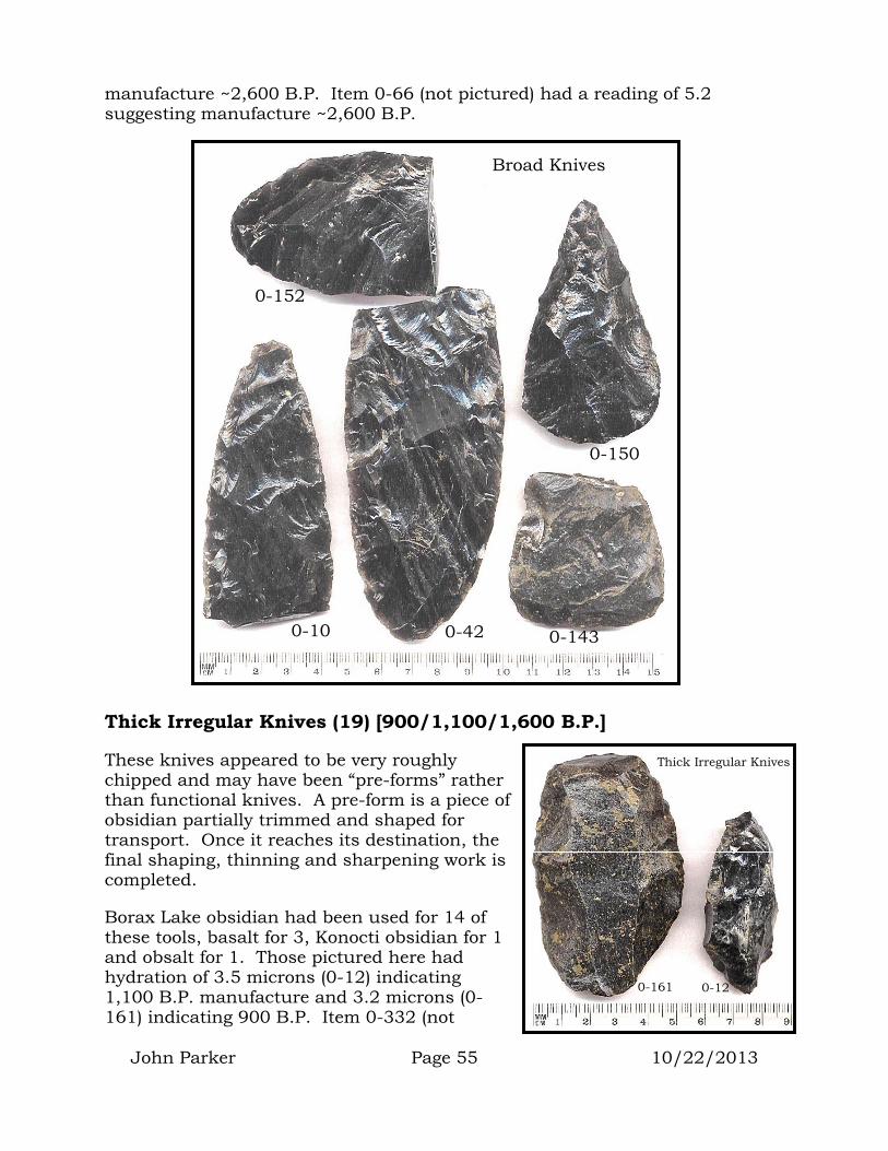
John Parker Page 55 10/22/2013
manufacture ~2,600 B.P. Item 0-66 (not pictured) had a reading of 5.2 suggesting manufacture ~2,600 B.P.
Thick Irregular Knives (19) [900/1,100/1,600 B.P.]
These knives appeared to be very roughly chipped and may have been “pre-forms” rather than functional knives. A pre-form is a piece of obsidian partially trimmed and shaped for transport. Once it reaches its destination, the final shaping, thinning and sharpening work is completed.
Borax Lake obsidian had been used for 14 of these tools, basalt for 3, Konocti obsidian for 1 and obsalt for 1. Those pictured here had hydration of 3.5 microns (0-12) indicating 1,100 B.P. manufacture and 3.2 microns (0-161) indicating 900 B.P. Item 0-332 (not
0-152
0-150
0-143 0-42 0-10
Broad Knives
Thick Irregular Knives
0-161 0-12

John Parker Page 56 10/22/2013
pictured) had a reading of 4.1 indicating an age of 1,600 B.P.
Keeled Knives (6) [95/6,700/7,900/10,500 B.P.]
Keeled knives were roughly triangular in cross-section, resembling a ship’s keel. Their use is unknown, however the three distinct cutting edges may have been important for drilling or reaming. White (1984:228) lists them as “expended” or used knives. Five of these knives were of Borax Lake obsidian and 2 were of basalt. Item 0-126 had a reading of 1 micron (95 B.P.). Item 0-371 had a reading of 8.4 microns (6,700 B.P.). Item 0-354 had a rim of 9.1 microns, indicating manufacture ~7,900 B.P. Item 0-347 had a reading of 10.5 microns (10,500 B.P.).
Non-Diagnostic Fragments (27) [2,800 B.P.]
These end or mid-section fragments were too small to allow classification. All but one were of Borax Lake obsidian. One was basalt. The one pictured had a hydration rim of 5.4 microns indicating manufacture ~2,800 B.P.
0-126 0-347 0-354 0-371
Keeled Knives
Non-diagnostic knife
0-338

John Parker Page 57 10/22/2013
Flake Tools (72)
The contour map of overall flake tool distribution closely follows the visible surface boundary of LAK-76 (see pg. 23). Though data are not available for many areas, it can be safely assumed that the distribution outlined in gray extends to the lakeshore. The denser (darker) contours may indicate special activity areas or they may represent increases in flake tool discovery due to EPA excavation work. Flake tools were also found just southeast of the dance house as well as on Lot 17. It is likely that both locations represent recent stone tool manufacture by Elem residents.
Flake tools are chipped stone flakes that were casually used for cutting, scraping, drilling or engraving with little or no secondary shaping or sharpening. Most flake tools have no distinct shape other than a straight or pointed cutting edge. Due to this lack of distinct shape, few were purposefully picked up or plotted by the Tribal monitors during the excavation process.
FLAKE TOOL DISTRIBUTION MAP
+ data points Map based on worldwide metric grid system (UTM). Meters
Clear Lake
Clear Lake Clear Lake
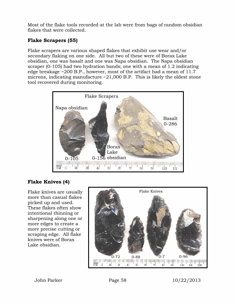
John Parker Page 58 10/22/2013
Most of the flake tools recorded at the lab were from bags of random obsidian flakes that were collected.
Flake Scrapers (55)
Flake scrapers are various shaped flakes that exhibit use wear and/or secondary flaking on one side. All but two of these were of Borax Lake obsidian, one was basalt and one was Napa obsidian. The Napa obsidian scraper (0-105) had two hydration bands; one with a mean of 1.2 indicating edge breakage ~200 B.P., however, most of the artifact had a mean of 11.7 microns, indicating manufacture ~21,000 B.P. This is likely the oldest stone tool recovered during monitoring.
Flake Knives (4)
Flake knives are usually more than casual flakes picked up and used. These flakes often show intentional thinning or sharpening along one or more edges to create a more precise cutting or scraping edge. All flake knives were of Borax Lake obsidian.
Borax Lake obsidian
Napa obsidian
Basalt 0-286
Flake Scrapers
0-105 0-156
0-72 0-88 0-7 0-96
Flake Knives

John Parker Page 59 10/22/2013
Special Flake Tools (6)
Casual flakes can be used as drills, engravers, and spoke-shaves (for shaving the bark off basketry sticks or arrow shafts). The materials collected had 4 examples of gravers, one spoke-shave, and one drill. All were of Borax Lake obsidian.
Flake Blades (6)
Flake blades are unretouched flakes with a length more than twice their width. For most chipped stone tools, the longer and thinner the initial flake of stone, the better and sharper the finished tool. The shape of that initial flake is dictated by the shape of the core of rock from which it is obtained and the method by which it is removed from that core. During the manufacturing process, a core can be casually hit on any flat surface (platform) to remove usable flakes of stone. However, to obtain the longest and thinnest flakes, the core must be prepared and shaped to allow their removal (see next section). This process requires extensive knowledge and experience in stone tool manufacture. The resulting flakes are long, straight, and very thin. In sorting through the randomly collected chipped stone, 5 Borax Lake obsidian and one basalt flake blade were found.
Cores (27)
Cores are described on pg. 45.
As with flake tools, few cores were purposefully picked up or plotted by the Tribal monitors during the excavation process. Most of the cores recorded at the lab were from bags of random obsidian flakes that were collected.
Angular Cores (23)
These made up the majority of cores recovered. These were multi-platform cores where flakes were removed from whatever face happened to be convenient or showed the most promise in the flake removal process. All were Borax Lake obsidian but two (basalt).
0-83
graver Spoke-shave
0-63
0-81
Flake Blades

John Parker Page 60 10/22/2013
Single-Platform Core (1)
This spent Borax Lake obsidian core was short and all flakes had been struck from a single platform (0-299).
Large Flake (3)
Any flake at least 5cm long or wide is considered a large flake. These flakes are large enough to have been further manufactured into most of the points, knives, flake tools, and other chipped stone implements found at the site.
Angular Cores
0-361
0-380
Single-Platform Core
0-299
Large Flakes
0-80

John Parker Page 61 10/22/2013
The core distribution map closely follows the visible surface boundary of LAK-76 (see pg. 23). The dark contour suggests that cores are evenly distributed across the LAK-76 site area. Though data are not available for many areas, it can be safely assumed that the distribution outlined in gray extends to the lakeshore. Outside the LAK-76 boundary were two cores on Lot 8. These may indicate a special activity related to residential use of this area.
Cobble Tools (7)
Cobble tools are stones and pebbles that are casually used for various purposes such as hammer stones, chopping stones, abrading stones, anvils, heating stones for basketry cooking or underground baking, etc. As with cores and flake tools, cobble tools were not readily recognized by Tribal monitors and few were plotted during the monitoring process. It is likely that many more cobble tools existed.
CORE DISTRIBUTION MAP + data points
Map based on worldwide metric grid system (UTM). Meters
Clear Lake
Clear Lake Clear Lake

John Parker Page 62 10/22/2013
Six cobble hammer stones were recovered during the monitoring process (5 basalt and 1 sandstone). Shapes included cigar-shaped (0-9) globular shaped (0-94), and spatula shaped (0-379. The cigar-shaped stone had evidence of battering on the end and the globular stone had battering around the circumference.
One large sandstone anvil was recovered (0-385). The black and white sections of the measuring stick in the photo represent 10cm intervals.
Globular Hammer Stone
0-94
Cigar-shaped Hammer Stone
0-9
0-385 Anvil Stone
Spatula hammer stone battering
0-379

John Parker Page 63 10/22/2013
Ground Stone (12)
Ground stone artifacts included a mortar, pestles, manos (hand stones), and an unidentifiable piece. Though only a small sample was recovered, the distribution of these items generally followed the surface site outline listed on pg. 23. It should be assumed that this distribution extends to the lakeshore. Two deviations from the site boundary were noted. One shaped mano was discovered under an oak tree on Lot 16 and a flat-end pestle was discovered under mine waste just south of the dance house area.
Shaped Manos (4)
Four shaped manos (3 sandstone and 1 basalt) were recovered (0-159, 386, and 387).
GROUND STONE DISTRIBUTION MAP
+ data points Map based on worldwide metric grid system (UTM). Meters
Clear Lake
Clear Lake Clear Lake

0-386
Shaped manos
0-358 0-159 0-387
Unshaped mano
John Parker Page 64 10/22/2013
Cobble Manos (1)
One sandstone cobble mano (unshaped) was recovered (0-358).
Pestle, Flat-end (3)
Two basalt (0-97, 378) and one sandstone flat-end pestles were recovered. One was dislodged by a road grader violating the excavation protocol along the eastern-most road after mine waste had already been removed (0-191).
Pestle, Round-end (1)
One sandstone round-end pestle was recovered (0-98).
Bowl Mortar (1)
One sandstone mortar (0-389) was hit and broken by road grading equipment violating the excavation protocol along the western-most road after mine waste had already been removed from the area.
Flat-end Pestles Round-end
0-98 0-191 0-97
0-378
0-389 Bowl Mortar
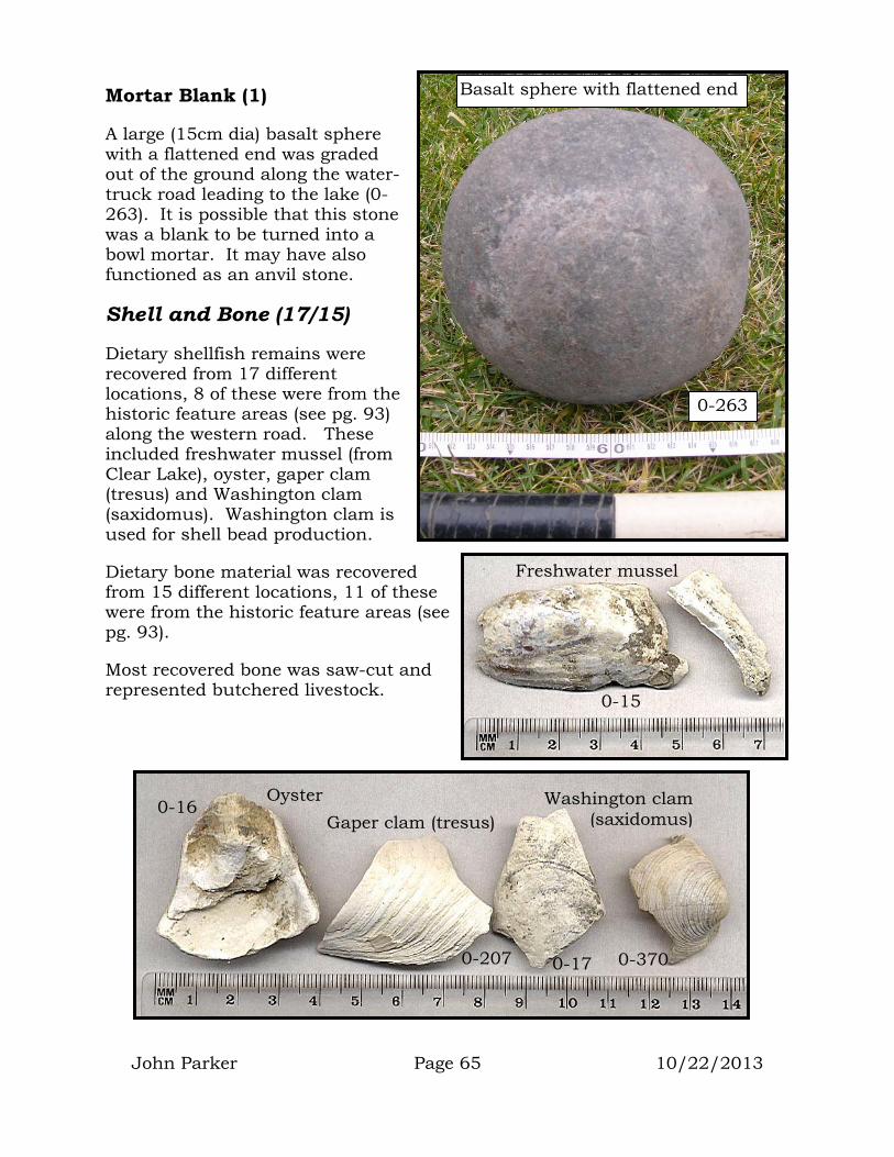
John Parker Page 65 10/22/2013
Mortar Blank (1)
A large (15cm dia) basalt sphere with a flattened end was graded out of the ground along the water-truck road leading to the lake (0-263). It is possible that this stone was a blank to be turned into a bowl mortar. It may have also functioned as an anvil stone.
Shell and Bone (17/15)
Dietary shellfish remains were recovered from 17 different locations, 8 of these were from the historic feature areas (see pg. 93) along the western road. These included freshwater mussel (from Clear Lake), oyster, gaper clam (tresus) and Washington clam (saxidomus). Washington clam is used for shell bead production.
Dietary bone material was recovered from 15 different locations, 11 of these were from the historic feature areas (see pg. 93).
Most recovered bone was saw-cut and represented butchered livestock.
Basalt sphere with flattened end
0-263
0-15
Freshwater mussel
Washington clam(saxidomus
0-207
)Gaper clam (tresus) Oyster
0-17
0-16
0-370
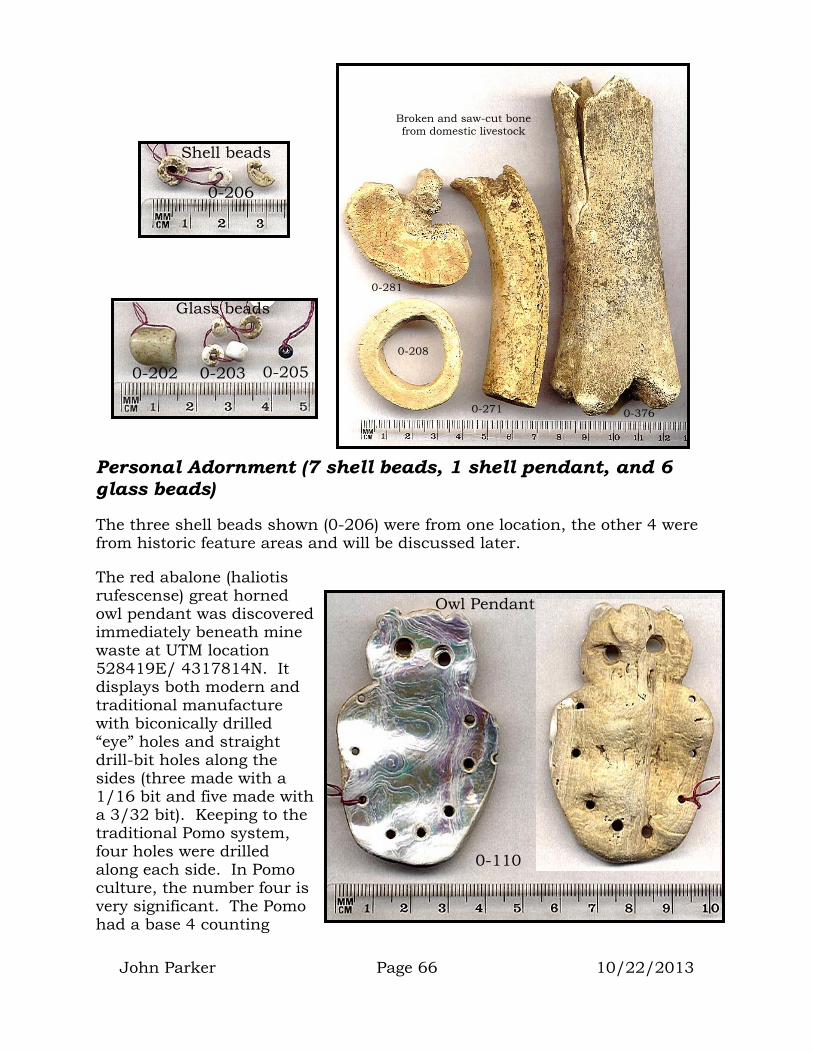
John Parker Page 66 10/22/2013
Personal Adornment (7 shell beads, 1 shell pendant, and 6 glass beads)
The three shell beads shown (0-206) were from one location, the other 4 were from historic feature areas and will be discussed later.
The red abalone (haliotis rufescense) great horned owl pendant was discovered immediately beneath mine waste at UTM location 528419E/ 4317814N. It displays both modern and traditional manufacture with biconically drilled “eye” holes and straight drill-bit holes along the sides (three made with a 1/16 bit and five made with a 3/32 bit). Keeping to the traditional Pomo system, four holes were drilled along each side. In Pomo culture, the number four is very significant. The Pomo had a base 4 counting
Owl Pendant
0-110
Broken and saw-cut bone from domestic livestock
0-376 0-271
0-281
0-208
Shell beads
0-206
Glass beads
0-202 0-203 0-205

John Parker Page 67 10/22/2013
system and considered sacred the four directions, the four seasons, and the four earthly states (fire, water, earth and sky).
All ceremonial dances are conducted in sets of four and the dance house has either four roof support poles or two sets of four.
Mission period glass beads (0-202, 203, and 205) were recovered by Tribal monitors from the cemetery area following a burial that occurred during the project. It appears that excavation work for the new grave encountered items that had been left at a previous gravesite. The large barrel and smaller white and black-glass cane beads were manufactured in Italy in the 1700’s and brought to California by Spanish missionaries. Many of the unearthed glass beads were pressed into the wet concrete covering the new grave.
The Elem cemetery has been in use for more than 100 years as is evidenced by this 1906 photo. Most of the individual fenced plots in the photo show a flagpole that once displayed the family’s traditional flag. In areas where fencing is no longer standing, it is often possible to locate past graves by looking for piles of rock. While digging a grave in the rocky soil, heavy rocks are piled next to the hole. Once the burial is complete, this pile of heavy rocks often remains (even if the fencing is lost).
Photo of Elem cemetery taken by Grace Nicholson in 1906. Buckeye Island (LAK-82) is the low hill in the distance. A rock
wall and path lead across the marshland to the island. (photo courtesy of the Huntington Library)

John Parker Page 68 10/22/2013
PREHISTORIC INTERPRETATION
In almost all cases, prehistoric artifact locations followed the general surface boundaries defined for CA-LAK-76. In a few areas, chipped and ground stone artifacts were discovered outside this boundary. In most of these areas (e.g. adjacent to the current dance house), traditional cultural practices are conducted that likely include traditional tool manufacture as well as the use of traditional tools for the manufacture of other cultural items.
Points
A wide range of point styles was recovered throughout the project area. These points fell in three major size categories that most likely represent different hunting technologies. Taken together, these points indicate that the hunting of terrestrial mammals was a significant activity at LAK-76 throughout its history.
Thrusting Spears (14,000 to 900 B.P.)
The largest points were most likely the tips of long thrusting spears. Hydration data suggest that these types of spears were in use from 14,000 B.P. through 900 B.P.
Throughout this extensive period of time, changes in form and style are evident. A range of different base and notch styles can be found until about 4,000 B.P. These included square bases, concave bases, notched bases, and side notching. None of these styles included serrated edges.
Beginning about 4,000 B.P. serrated edges are found among many point styles and most point bases are rounded or contracting in shape.
Dart and Atlatl (5,000 B.P. and later)
As with most changes in technology, the addition of a new technology adds to, rather than replaces, a previous technology. The small thin-based dart point (pg. 52) with a hydration date of 5,100 B.P. most likely tipped a short spear or dart. This short spear or dart would have been launched at the prey with the help of a throwing stick (atlatl). This new hunting technology did not replace the thrusting spear, but was used alongside it. Point sizes indicate that both technologies were likely in use from 5,000 B.P. till the time of European arrival.
Bow and Arrow (300 B.P. and later)
The small points used to tip arrows are evidence of the most recent hunting technology. The arrow points recovered had hydration dates of 300 B.P.

John Parker Page 69 10/22/2013
Many people assume that the development and use of new technologies provide a population with additional food resources or make resource procurement easier. Mark Cohen and others are more inclined to view the introduction of new technologies as a “means of approximating as closely as possible the old status quo in the face of our ever-increasing numbers.” (Cohen 1977:285)
The graph presented here is derived from a 20-year research project in the Clear Lake Basin (Parker 1994) and uses the amount of inhabited site area to retrodict changes in population within the Lake Basin over time. A few critical natural and cultural milestones have been added. The graph shows three major periods of increase in inhabited site area (and presumably population). The first is between 7,000 and 6,000 B.P.; the second is between 5,000 and 4,000 B.P.; and the third begins about 3,000 B.P. and continues until European arrival.
A slight decline in inhabited site area (and presumably population) is seen between 6,000 and 5,000 B.P. and a much sharper decline is seen between 4,000 and 3,000 B.P.
The introduction of the new dart and atlatl hunting technology around 5,000 B.P. may have enabled the existing culture to maintain stable meat supplies in the face of population growth that occurred at that time.
The decline in population around 3,500 B.P. corresponds with the most recent eruption of Mt. Konocti. This very explosive eruption bombarded much of the southern and eastern portion of the Lake Basin with molten volcanic bombs
PREDICTED POPULATION CHANGE
0
50000
100000
150000
200000
250000
300000
350000
400000
1000 2000 3000 4000 5000 6000 7000 8000 9000 10000
Years Before Present
Inha
bite
d Si
te A
rea
(sq.
met
ers)
Use of the atlatl andmortar and pestle begins
Eruption of Mt. Konocti
Settlements established throughout Clear Lake shoreline
Human settlements confined to eastern and
southern ends of Clear Lake
Mano/metate use starts

John Parker Page 70 10/22/2013
and ash. It made such an impression that stories of the event have been passed down in native Lake Miwok language and still exist today. It is assumed that many people would have been killed and that even more would have been inclined to move out of the area. This movement of people appears to have dropped the population back to the level it had been 1,000 years earlier (~4,500 B.P.). The movement of the Pomo language out of the Clear Lake Basin at this time is seen in the linguistic record of Sonoma and Mendocino Counties (Whistler 1980). It is also found in the archaeological record of these counties where the addition of Clear Lake cultural traits show up in sites beginning at this time.
By 2,500 B.P. the population had regained its former rate of growth and this is when Houx serrated point styles show up in the cultural record.
Based on the amount of site area inhabited, it appears that population growth continued unabated until the arrival of Europeans. It is likely that this growth triggered the development and use of the bow and arrow as a way of maintaining a stable supply of meat in the face of ever increasing population numbers.
Though the sample is VERY small, this graph of point hydration means suggests a major increase in the number of points in the 2,000 to 4,000 B.P. time period (5 and 6 micron range) as well as a possible increase in the 6,400 to 7,000 B.P. period (9 micron range). An examination of the site area graph (previous page) suggests a declining population following Konocti’s eruption. The stresses this event had on food resources may have required an intensification of hunting, which would explain the increase in points during this period.
Point Hydration Means
0
2
0
2
4
5
2
1
3
0 0 0
2
0
1
2
3
4
5
6
1 2 3 4 5 6 7 8 9 10 11 12 13
Hydration Microns
Cou
nt

John Parker Page 71 10/22/2013
Knives
Chipped stone knives can serve a wide range of functions, however, they are most widely noted for their use in butchering, meat and hide preparation. Due to this primary use, stone knives are always found in sites that include stone points. It is important to note that not all animals that require butchering and hide preparation are obtained through hunting with spear, dart, or bow. It takes much less energy and is far easier to trap and snare most small mammals. Therefore, butchering tools can be found in sites where there is no evidence of hunting.
Four major styles of stone knives were recovered during the monitoring program. An examination of the hydration readings for these items indicates that these styles were not all popular during the same time period.
Thick Irregular Knives
The thick irregular knives appear to have been manufactured between 1,000 and 1,500 B.P. (4-5 microns). Though their function is unknown, it is possible that these items were not knives, but rather rough “preforms” obtained from and shaped at the Borax Lake obsidian flow. Such preforms may have been used as items of exchange in the regional trade system.
Broad Flat Knives
The broad and flat knives were manufactured primarily between 2,000 and 4,000 B.P. (5-6 microns). A similar increase in the number of points was also found during this period (see previous page).
Keeled Knives
Though their use is unknown, these knives with a triangular cross section appear to be most popular prior to 7,000 B.P. (9+ microns).
Long Thin Knives
Though there might have been a slight increase in their use at 7,000 and 4,000 B.P. (9 and 5 microns), these knives appeared to be in use through all time periods.
1 2 3 4 5 6 7 8 9 1 0 1 1
0
1
2
3
Cou
nt
H yd ra t ion M ic ron s
K n ife H y d ra t io n M ean s
K ee ledT h ick ir r
L o n g T h inB ro a d
K ee led T h ick ir r L on g T h in B roa d

John Parker Page 72 10/22/2013
10BFlake Tools
The flake tools recovered indicate that drilling, reaming, cutting, and shaft scraping were all taking place at LAK-76. The small number of recovered flake tools prevented any meaningful analysis of the period of use represented by the various types of tools.
11BCobble Tools
Six hammer stones and an anvil stone were recovered. Although it is impossible to determine their actual use, all hammer stones were of a quality and consistency that would have made them useful in the manufacture of chipped stone tools.
12BGround Stone
52BMilling Stones
Five manos were recovered indicating widespread use of the mano and metate across LAK-76. These tools are used to crack and grind hard seeds such as sage seeds, grains (grass seeds), and pine nuts. Although there is no way of determining the age of these tools, archaeological work throughout California has discovered that the addition of the mano and metate to the food processing tool kit occurred at the start of the last global warming period (~8,000 B.P.).
53BMortar and Pestle
Four pestles, one bowl mortar and one possible mortar blank were recovered during the monitoring process. These items indicate the processing of soft nuts (such as acorn and buckeye). Although there is no way of determining the age of these tools, archaeological work throughout California has discovered that the addition of the mortar and pestle to the food processing tool kit occurred about 5,000 B.P. In some parts of California the heavy reliance on soft nuts gradually overcame the use of hard seeds and the use of the mano and metate were gradually phased out. In other areas, both technologies were used side-by-side until the arrival of Europeans.
Both milling and pounding technologies require the harvesting of seeds and nuts that become available in the fall (September/October). The existence of these tools indicates that LAK-76 was most likely inhabited during the fall months.

John Parker Page 73 10/22/2013
Shell
Both lake mussel (locally available) and coastal oyster and clamshells were recovered during the monitoring process. It is likely that freshwater mussel along with Clear Lake fish formed a major part of the prehistoric diet. Although the coastal oyster recovered was an east coast species that didn’t become part of the local diet until after European arrival, it is possible that coastal shellfish were eaten by the prehistoric people of LAK-76. Unfortunately, the distance to the coast would have made it difficult to transport these resources quickly enough to prevent their spoilage. It is more likely that the coastal clamshell found at LAK-76 was a byproduct of the manufacture of shell beads.
There is ample ethnographic and archaeological evidence of shell bead manufacture within the Clear Lake Basin (Parker 1980). Clamshell beads (used as money during prehistory) were also recovered during the monitoring process. Even today, residents of Elem travel to the coast during the spring low tides to collect edible seaweed, surf fish, and clams. Although not useful as money today, shell beads are still manufactured by Elem residents for personal adornment and to be worn during special ceremonies.
The existence of coastal clamshell suggests that prehistoric Elem residents either traded with coastal people, or traveled to the coast during the spring (the season of the lowest tides).
Period of Use
Hydration readings on two points suggest dates of manufacture and use as early as 14,000 B.P. (12+ microns). One Napa obsidian tool had a hydration mean of 11.7 microns suggesting an age of 21,000 B.P. Hydration readings on the rest of the artifacts indicate continuous use until and during the time of European contact. As was noted with Points (see above), the manufacture of chipped stone artifacts appears to have seen an increase around 7,000 B.P. (9 microns) and again between 1,500 and 4,500 B.P. (4-6 microns).
All Chipped Stone Hydration
0123456789
10
1 2 3 4 5 6 7 8 9 10 11 12 13
Microns
Cou
nt
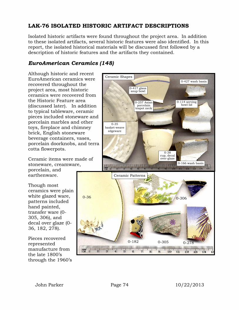
John Parker Page 74 10/22/2013
LAK-76 ISOLATED HISTORIC ARTIFACT DESCRIPTIONS
Isolated historic artifacts were found throughout the project area. In addition to these isolated artifacts, several historic features were also identified. In this report, the isolated historical materials will be discussed first followed by a description of historic features and the artifacts they contained.
EuroAmerican Ceramics (148)
Although historic and recent EuroAmerican ceramics were recovered throughout the project area, most historic ceramics were recovered from the Historic Feature area (discussed later). In addition to typical tableware, ceramic pieces included stoneware and porcelain marbles and other toys, fireplace and chimney brick, English stoneware beverage containers, vases, porcelain doorknobs, and terra cotta flowerpots.
Ceramic items were made of stoneware, creamware, porcelain, and earthenware.
Though most ceramics were plain white glazed ware, patterns included hand painted, transfer ware (0-305, 306), and decal over glaze (0-36, 182, 278).
Pieces recovered represented manufacture from the late 1800’s through the 1960’s
0-35 basket-weave
edgeware
0-417 glass soup bowl
0-427 wash basin
0-166 wash basin
0-38 cup, decal over-glaze
0-114 serving bowl lid
0-257 Asian porcelain
teapot neck
Ceramic Shapes
0-305
Ceramic Patterns
0-306
0-278 0-182
0-36

John Parker Page 75 10/22/2013
A few pieces with maker’s marks were recovered. Those at right include Thomas Furnival & Sons (0-199) manufactured between 1818 and 1890, Johnson Brothers (0-415) manufactured between 1883 and 1913, Gibson Overseas (0-307) manufactured after 1979, and an unidentifiable “Kingsbury” mark (Godden 1991).
The “O.P. Co.” mark of the Onondaga Pottery Company was found on one piece (0-172).
W.H. Farrar opened a ceramic business in Geddes New York in 1841. He made salt-glazed stoneware, utilitarian pots, jars, and bowls known as Rockingham ware. In 1868, Farrar and three partners established the Empire Pottery Company in Syracuse. In 1871, 16 businessmen formed a partnership and purchased Empire Pottery renaming the operation the Onondaga Pottery Company (O.P.Co.) after the region’s Native Iroquois Tribe (see historical drawing of plant). In 1888, James Pass developed America’s first truly vitreous china. His new ware won the medal for translucent china at the Chicago Exposition in 1893 and in 1895 the words “Syracuse China” were added to the makers mark. In 1966, O.P. Co. changed its name to Syracuse China. In 1971, it became the Syracuse China Corp. and in 1978 merged with the Canadian Pacific Investments Co. Syracuse China bought the Mayer China
1818-90
0-307 0-415 0-199 0-308
?
1979+ 1883-1913
Makers Marks
0-320 0-172
1895-1966
0-201
Unknown mark

John Parker Page 76 10/22/2013
Company in 1984 and Shenango Pottery in 1988. In 1989, Canadian Pacific put Syracuse China up for sale and it was bought by the Susquehanna-Pfaltzgraff Company. In 1995, Syracuse China was bought by Libbey Inc. and still manufactures Syracuse China (Syracusethenandnow.org, 2007).
Other Ceramic Items
Toys are not the first thing that comes to mind when discussing ceramics, however, two ceramic marbles and the nose of a ceramic animal vase or statue were recovered. One marble was white glazed stoneware (0-238) and was likely manufactured between 1884 and 1930 (Webb 1994:19). The other marble was porcelain (0-289) and was most likely manufactured in Germany or England between 1880 and 1914 (Webb 1994:20). The cat or dog nose appeared to be plaster or low-fired creamware that had been poured into a mold.
Porcelain doorknobs were recovered (0-165) and suggest late 1800’s house construction.
One bead was recovered that appeared to be ceramic (0-310).
Ceramic Density Maps
The map on the next page shows the density of all isolated ceramics recovered during project monitoring. This includes both historic and modern ceramic items. It indicates several areas of increased density. The highest density was in the northeastern portion of the property (near the road that leads to a recently used community dump). Other dense ceramic areas include the north-central area (lots 2, 30 and 31) and western area, which was the location of the late 1800’s village of Elem.
Although many areas of the reservation were not within the project-monitoring zone, it is assumed that the distribution extends to the lakeshore.
0-183 0-289 0-238
0-165
0-310
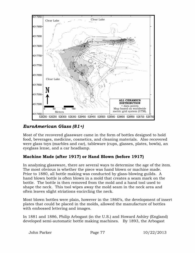
ALL CERAMICS DISTRIBUTION
+ data points Map based on worldwide metric grid system (UTM). Meters
Clear Lake
Clear Lake Clear Lake
John Parker Page 77 10/22/2013
EuroAmerican Glass (81+)
Most of the recovered glassware came in the form of bottles designed to hold food, beverages, medicine, cosmetics, and cleaning materials. Also recovered were glass toys (marbles and car), tableware (cups, glasses, plates, bowls), an eyeglass lense, and a car headlamp.
Machine Made (after 1917) or Hand Blown (before 1917)
In analyzing glassware, there are several ways to determine the age of the item. The most obvious is whether the piece was hand blown or machine made. Prior to 1880, all bottle making was conducted by glass-blowing guilds. A hand blown bottle is often blown in a mold that creates a seam mark on the bottle. The bottle is then removed from the mold and a hand tool used to shape the neck. This tool wipes away the mold seam in the neck area and often leaves slight striations encircling the neck.
Most blown bottles were plain, however in the 1860’s, the development of insert plates that could be placed in the molds, allowed the manufacture of bottles with embossed lettering and images.
In 1881 and 1886, Philip Arbogast (in the U.S.) and Howard Ashley (England) developed semi-automatic bottle making machines. By 1893, the Arbogast

John Parker Page 78 10/22/2013
machine was being used for petroleum jelly jars and fruit jars. By 1903-04, Michael Owens had designed a fully automatic bottle making machine and by 1909, advances in the machine allowed the production of prescription bottles. By 1917, 90 to 95% of all glass containers were made by either semi or fully automatic machine (Davis 1970, Miller and Sullivan 1981, Kendrick 1971).
Both the body and the neck of a machine-made bottle are made in molds. These molds will create seam marks that extend up and across both the body and the neck area.
Glass Color and Maker’s Marks
Glass color and maker’s marks can also assist in determining the age of glassware. The natural iron in glass mixtures turn the glass an aqua blue color. Beginning about 1880, magnesium (imported from Germany) was added to the glass mixture to bleach out the color making a clear glass. Though initially clear, exposure to ultraviolet sunlight turns the magnesium a light purple color. During WWI (about 1914), imports from Germany were cut off and American bottle makers were no longer able to obtain magnesium. They substituted selenium in the glass mixture. Though initially clear, exposure to sunlight turns the selenium a pale wheat or honey yellow color. Selenium was used between 1914 and 1930 (Kendrick 1971).
Neck and Closure Styles
Cork stoppers, Hutchinson Spring Stoppers, and the Lightening bottle stopper were all in use on hand-blown bottles. The crown cap was invented in 1892 and can be found on both hand blown and machine-made bottles.

John Parker Page 79 10/22/2013
Alcohol Bottles (32)
The brown-glass bottle fragments at right once held brandy (0-164), whiskey (0-193, 377) and beer (0-222). The base of one bottle has the “M G W” mark that suggests it was manufactured sometime around 1889 by the Middletown Glass Works (Toulouse 1971:362).
The purple-glass base and neck below represent hand-blown liquor flasks. The screw-cap neck (0-1) is most likely from a Philadelphia Screw Top Flask. The base is from a Cummings’ Picnic Flask (Putnam 1965).
Other hand-blown liquor bottles included wine bottles. Two olive green glass, turn-mold bases represent clarets or Bordeaux wine bottles (0-407, 424).
Pieces of 10 blown wine bottles, 7 blown liquor bottles, 5 blown beer bottles, and 2 unidentifiable blown alcohol bottles were recovered.
Machine-made alcohol bottles included 2 liquor, 1 wine, 2 beer, and 3 unidentifiable.
Applied neck beer bottle
Applied neck brandy finish
0-169
0-222
0-193 0-377
0-164
Hand Blown alcohol bottles
Hand blown liquor flasks (purple glass)
0-1 0-216
Hand blown turn-mold wine bottle
bases
0-424 0-407

John Parker Page 80 10/22/2013
Canning Jars (9)
Canning jars were well represented by 6 jar fragments and 3 lids. The three pieces pictured here include the wall of a “Kerr Self-Sealing” mason jar (0-218) manufactured between 1915 and 1950 (Toulouse 1971:306). Also included is an unidentifiable olive green canning jar fragment with “…CO…” embossed on the wall (0-220).
The circular milk-glass piece (0-192) is an insert for a Mason canning jar lid. John Landis Mason patented the screw-top canning jar in 1858. The glass insert for the screw-top was invented by Louis Boyd in 1869 as a way to better seal the screw-top canning jars. This piece is embossed “MASON JARS” and was most likely manufactured around 1900 (Toulouse 1971:345).
Medicine/cosmetic Bottles (17)
Medicine bottles were well represented by hand blown patent remedies (3) and medicines (2) as well as a machine made patent remedy, a Bayer pill bottle, and 5 unidentifiable medicine bottles.
Pictured are 4 patent remedies including a machine
made, honey yellow castor oil bottle manufactured between 1914 and 1930 (0-198), and three hand blown patent remedies (0-47, 197, and 340) made between 1860 and 1917.
Pictured at left are two machine made bottles. On the left is a “The Bayer Company Inc.” bottle with an Owens
Canning Jar Pieces
0-192 0-220 0-218
Machine made medicine and cosmetic bottles
0-410
0-162
Hand blown spool-neck
patent medicine
Hand blown Perry-Davis neck patent medicine
0-197 0-340 0-47 0-198
Hand blown patent remedy
Machine-made, honey yellow
castor oil bottle

John Parker Page 81 10/22/2013
Illinois maker mark on the base indicating manufacture between 1929 and 1954 (Toulouse 1971:403). On the right is the base of a coldcream jar (0-410).
Misc. Bottles
A “Nesbitt” soda and “Clorox” bottle were recovered. The Nesbitt bottle is most likely from the 1940’s-50’s. After 14 years of providing soda fountains with its orange syrup, Nesbitt began bottling its soda and soon had bottling franchises all over the U.S. It soon surpassed Orange Crush as the #1 selling orange soda. In the 1960’s Coca Cola’s “Fanta” took over the #1 spot in orange soda sales. In 1972, Nesbitt was sold to the Clorox Company (Grace 2006, Scott 2008).
Machine-made soda
Clorox bottle Misc. Bottles
0-261 0-274
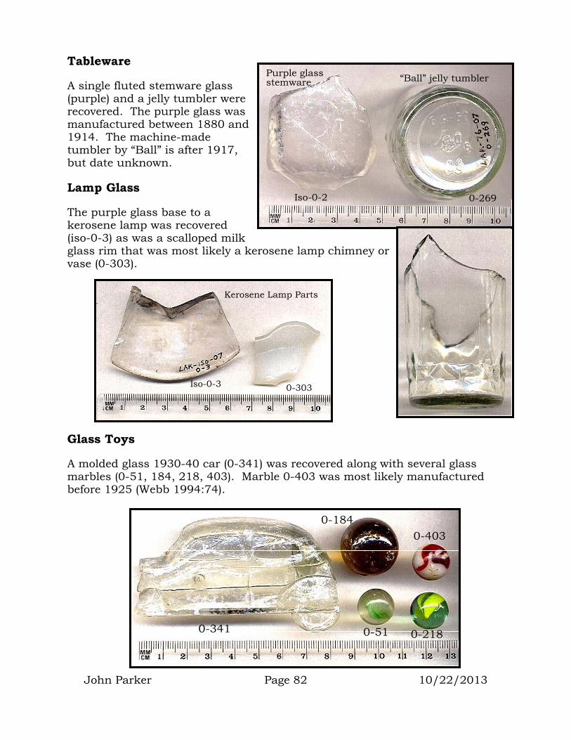
John Parker Page 82 10/22/2013
Tableware
A single fluted stemware glass (purple) and a jelly tumbler were recovered. The purple glass was manufactured between 1880 and 1914. The machine-made tumbler by “Ball” is after 1917, but date unknown.
Lamp Glass
The purple glass base to a kerosene lamp was recovered (iso-0-3) as was a scalloped milk glass rim that was most likely a kerosene lamp chimney or vase (0-303).
Glass Toys
A molded glass 1930-40 car (0-341) was recovered along with several glass marbles (0-51, 184, 218, 403). Marble 0-403 was most likely manufactured before 1925 (Webb 1994:74).
Iso-0-2 0-269
Purple glass stemware “Ball” jelly tumbler
0-303 Iso-0-3
Kerosene Lamp Parts
0-403 0-184
0-51 0-218 0-341

John Parker Page 83 10/22/2013
Glass Density Maps
The map below shows the density of all glass materials, representing all historic and recent periods found during the monitoring program. This map indicates that glass was found in generally the same pattern as other historic and prehistoric cultural materials. With few exceptions, most cultural material, including glass, was found within 100 meters of the lakeshore. Easy access to water would have prompted community members to live and conduct most of their activities as close to the lakeshore as possible. As the Elem community had no running water until the late 1960’s, this need to live and work close to the lakeshore controlled patterns of discard not only during prehistory, but also throughout most of the historic period.
A small isolated area of glass discard can be seen near the entrance road to the reservation. This historic trash feature will be discussed later along with other historic features.
ALL GLASS DISTRIBUTION + data points
Map based on worldwide metric grid system (UTM). Meters
Clear Lake
Clear Lake Clear Lake

John Parker Page 84 10/22/2013
The density map on this page shows the distribution of only those glass pieces that were manufactured before 1900. It clearly outlines that part of the reservation that was in use prior to 1900. Individual historic features were identified within this area and will be discussed later.
EuroAmerican Metal
The third type of historic material recovered during the monitoring process were metal objects. Many of these (see stove and saw) were too large to recover or were not in danger of destruction due to project activities. Metal objects consisted of tools (e.g. saws, axe heads, files), farm and livestock items (e.g. horse tack, cultivating tools, etc.), construction and cabinet hardware (e.g. screws, nails, straps, fittings, door latches, door knobs, boat parts, etc.), hunting items (shell casings), musical instruments, (harmonica parts), personal adornment (jewelry), and food related items (e.g. jar lids, cans, food wrapping, etc.).
PRE-1900 GLASS DISTRIBUTION
+ data points Map based on worldwide metric grid system (UTM). Meters
Clear Lake
Clear Lake Clear Lake
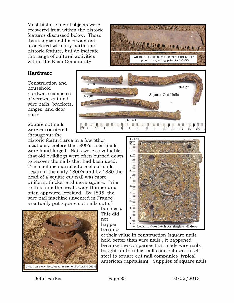
John Parker Page 85 10/22/2013
Most historic metal objects were recovered from within the historic features discussed below. Those items presented here were not associated with any particular historic feature, but do indicate the range of cultural activities within the Elem Community.
Hardware
Construction and household hardware consisted of screws, cut and wire nails, brackets, hinges, and door parts.
Square cut nails were encountered throughout the historic feature area in a few other locations. Before the 1800’s, most nails were hand forged. Nails were so valuable that old buildings were often burned down to recover the nails that had been used. The machine manufacture of cut nails began in the early 1800’s and by 1830 the head of a square cut nail was more uniform, thicker and more square. Prior to this time the heads were thinner and often appeared lopsided. By 1895, the wire nail machine (invented in France) eventually put square cut nails out of
business. This did not happen because of their value in construction (square nails hold better than wire nails), it happened because the companies that made wire nails bought up the steel mills and refused to sell steel to square cut nail companies (typical American capitalism). Supplies of square nails
Two-man “buck” saw discovered on Lot 17 exposed by grading prior to 8-5-06
Cast iron stove discovered at east end of LAK-2047H
0-423
0-298 Square Cut Nails
0-46
0-343
Locking door latch for single-wall door
0-171
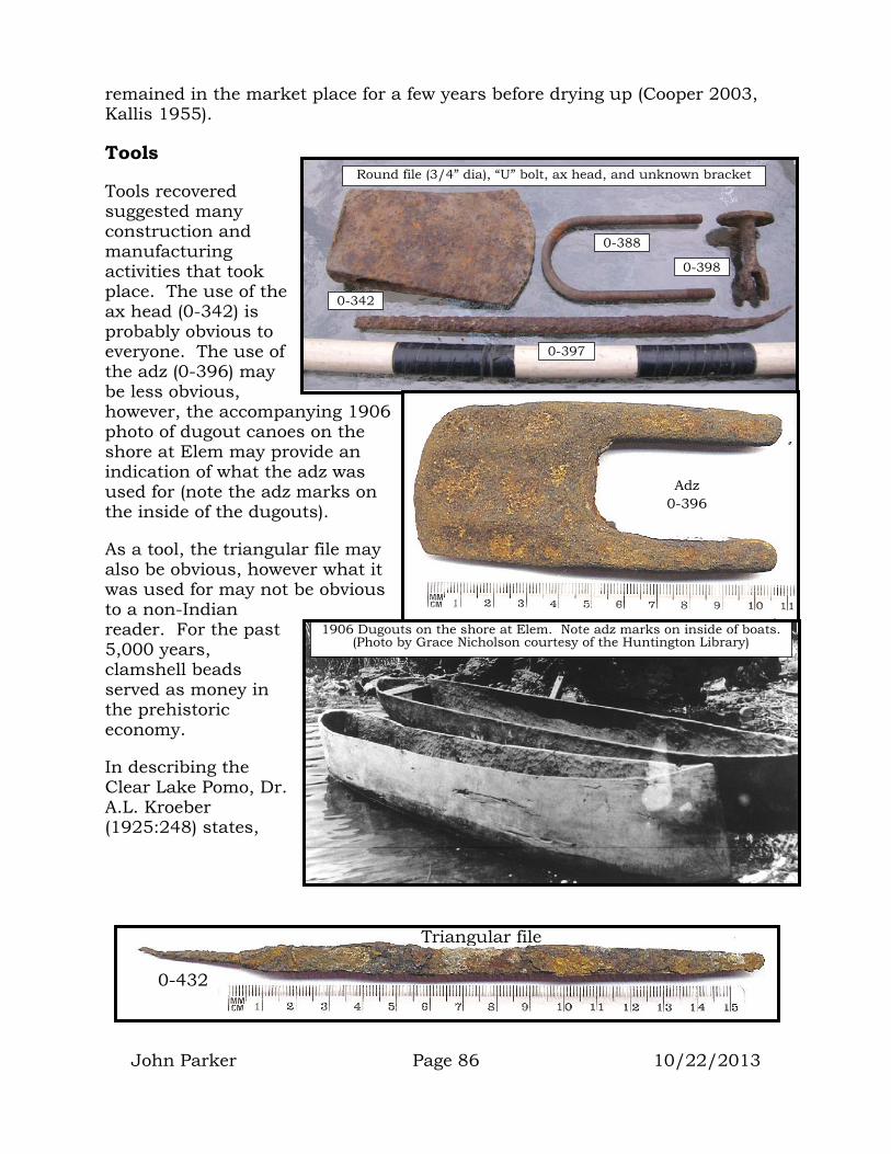
John Parker Page 86 10/22/2013
remained in the market place for a few years before drying up (Cooper 2003, Kallis 1955).
Tools
Tools recovered suggested many construction and manufacturing activities that took place. The use of the ax head (0-342) is probably obvious to everyone. The use of the adz (0-396) may be less obvious, however, the accompanying 1906 photo of dugout canoes on the shore at Elem may provide an indication of what the adz was used for (note the adz marks on the inside of the dugouts).
As a tool, the triangular file may also be obvious, however what it was used for may not be obvious to a non-Indian reader. For the past 5,000 years, clamshell beads served as money in the prehistoric economy.
In describing the Clear Lake Pomo, Dr. A.L. Kroeber (1925:248) states,
0-397
0-398
0-388
0-342
Round file (3/4” dia), “U” bolt, ax head, and unknown bracket
Adz 0-396
1906 Dugouts on the shore at Elem. Note adz marks on inside of boats. (Photo by Grace Nicholson courtesy of the Huntington Library)
Triangular file
0-432
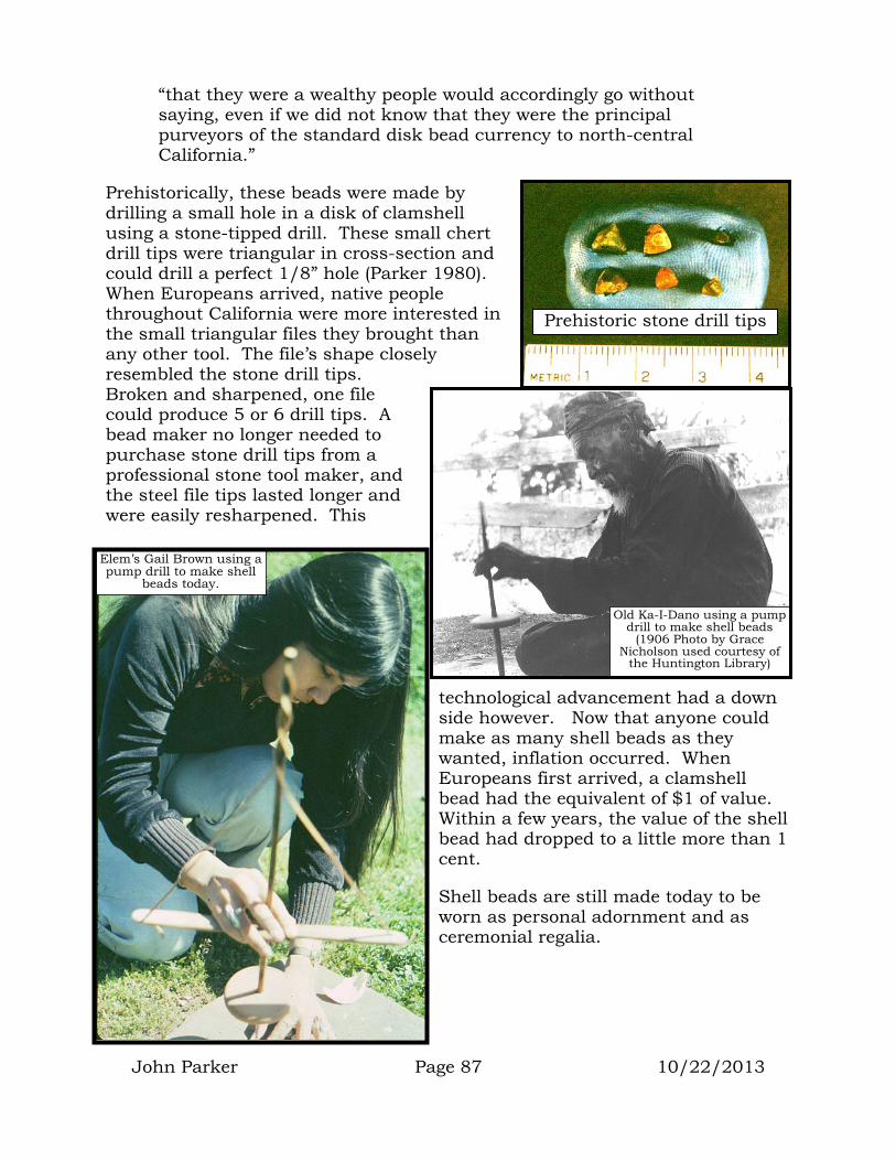
John Parker Page 87 10/22/2013
“that they were a wealthy people would accordingly go without saying, even if we did not know that they were the principal purveyors of the standard disk bead currency to north-central California.”
Prehistorically, these beads were made by drilling a small hole in a disk of clamshell using a stone-tipped drill. These small chert drill tips were triangular in cross-section and could drill a perfect 1/8” hole (Parker 1980). When Europeans arrived, native people throughout California were more interested in the small triangular files they brought than any other tool. The file’s shape closely resembled the stone drill tips. Broken and sharpened, one file could produce 5 or 6 drill tips. A bead maker no longer needed to purchase stone drill tips from a professional stone tool maker, and the steel file tips lasted longer and were easily resharpened. This
technological advancement had a down side however. Now that anyone could make as many shell beads as they wanted, inflation occurred. When Europeans first arrived, a clamshell bead had the equivalent of $1 of value. Within a few years, the value of the shell bead had dropped to a little more than 1 cent.
Shell beads are still made today to be worn as personal adornment and as ceremonial regalia.
Prehistoric stone drill tips
Old Ka-I-Dano using a pump drill to make shell beads
(1906 Photo by Grace Nicholson used courtesy of
the Huntington Library)
Elem’s Gail Brown using a pump drill to make shell
beads today.

John Parker Page 88 10/22/2013
Farm and Livestock Items
Horseshoes, buckles, strap holders, pieces of hoes and parts of horse-drawn rakes were recovered. These items indicate that farming, livestock and equine activities were occurring at Elem. One historical photo shows a family in a horse-drawn buggy entering the community.
Background research by Dr. Adrian Praetzellis discovered the earliest mapped reference to the Elem Community and Rattlesnake Island by E.D. Richardson of the U.S. Government’s General Land Office. His notes call the island “Indian Island” and indicate 5 “Indian dwellings” on the island. In 1868, I.N. Chapman was the first Deputy Surveyor to survey the island. In his commentary he notes:
“There is an Indian village of some dozen huts along the southern shore. These Indians keep some horses on the island; they also cultivate a garden spot of a few acres (U.S. BLM 1868:4).”
0-1 0-365
Horse-drawn buggy entering Elem Village (1906 Photo by Grace Nicholson used courtesy of the
Huntington Library)
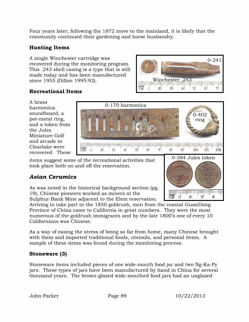
John Parker Page 89 10/22/2013
Four years later, following the 1872 move to the mainland, it is likely that the community continued their gardening and horse husbandry.
Hunting Items
A single Winchester cartridge was recovered during the monitoring program. This .243 shell casing is a type that is still made today and has been manufactured since 1955 (Dillon 1995:92).
Recreational Items
A brass harmonica soundboard, a pot-metal ring, and a token from the Jules Miniature Golf and arcade in Clearlake were recovered. These items suggest some of the recreational activities that took place both on and off the reservation.
Asian Ceramics
As was noted in the historical background section (pg. 19), Chinese pioneers worked as miners at the Sulphur Bank Mine adjacent to the Elem reservation. Arriving to take part in the 1850 goldrush, men from the coastal GuanDong Province of China came to California in great numbers. They were the most numerous of the goldrush immigrants and by the late 1800’s one of every 10 Californians was Chinese.
As a way of easing the stress of being so far from home, many Chinese brought with them and imported traditional foods, utensils, and personal items. A sample of these items was found during the monitoring process.
Stoneware (3)
Stoneware items included pieces of one wide-mouth food jar and two Ng-Ka-Py jars. These types of jars have been manufactured by hand in China for several thousand years. The brown-glazed wide-mouthed food jars had an unglazed
0-241
Winchester .243
0-170 harmonica
0-402 ring
0-384 Jules token

John Parker Page 90 10/22/2013
stoneware lid that was cemented in place with clay or plaster. These jars held various food items such as tofu or salted duck eggs.
Ng-Ka-Py was a 90 proof Chinese liquor that can still be purchased today and comes in a brown-glazed pot with a flared pouring mouth. It is sealed with a wooden stopper.
Porcelain (14)
Several styles of Chinese porcelain were recovered during the monitoring process. The most numerous represented two styles of dinnerware known as Bamboo (5) and Four Seasons (3).
Bamboo ware was the least expensive of the Chinese porcelain and consisted of a light gray/blue glaze with hand-painted stylistic darker gray/blue designs.
Iso-0-4
Chinese food jar Ng-Ka-Py jar
0-95
Whole Ng-Ka-Py jars from historic San Luis Obispo Collection
Whole wide-mouth food jar and lid from historic San Luis Obispo Collection
Bamboo ware rice bowls
0-153 0-167
Bamboo ware rice bowls from historic San Luis Obispo Collection
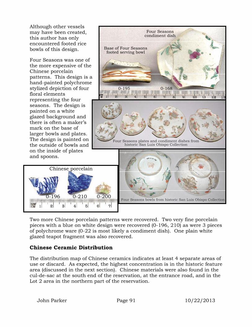
John Parker Page 91 10/22/2013
Although other vessels may have been created, this author has only encountered footed rice bowls of this design.
Four Seasons was one of the more expensive of the Chinese porcelain patterns. This design is a hand-painted polychrome stylized depiction of four floral elements representing the four seasons. The design is painted on a white glazed background and there is often a maker’s mark on the base of larger bowls and plates. The design is painted on the outside of bowls and on the inside of plates and spoons.
Two more Chinese porcelain patterns were recovered. Two very fine porcelain pieces with a blue on white design were recovered (0-196, 210) as were 3 pieces of polychrome ware (0-22 is most likely a condiment dish). One plain white glazed teapot fragment was also recovered.
Chinese Ceramic Distribution
The distribution map of Chinese ceramics indicates at least 4 separate areas of use or discard. As expected, the highest concentration is in the historic feature area (discussed in the next section). Chinese materials were also found in the cul-de-sac at the south end of the reservation, at the entrance road, and in the Lot 2 area in the northern part of the reservation.
Four Seasons bowls from historic San Luis Obispo Collection 0-196 0-210 0-200
Chinese porcelain
Four Seasons plates and condiment dishes from historic San Luis Obispo Collection
Four Seasons condiment dish
Base of Four Seasons footed serving bowl
0-195 0-168

John Parker Page 92 10/22/2013
It is possible that the Chinese materials arrived at the reservation through trade with the miners working and living at the adjacent Sulphur Bank Mine. It is more likely that these materials came to Elem along with some of the Chinese miners who moved to the reservation to live with Elem families. It would be expected that Chinese miners would feel closer to the people of the Elem community than to their “white” fellow miners. During the late 1800’s, Chinese pioneers experienced widespread discrimination at the hands of California’s “white” immigrants. The “white” prejudice against the Chinese probably came from two areas of perception:
1. In the view of Caucasian immigrants, the Chinese had a funny language, wore strange clothes, ate different foods, and celebrated their holidays by making lots of noise with firecrackers, drums and cymbals.
2. California was experiencing a high unemployment rate following the goldrush. The rush had swelled the numbers of men in the state but had not increased the number of jobs. White men needed someone to blame for their situation. It was easy to blame the Chinese.
Clear Lake
Clear Lake Clear Lake
CHINESE CERAMICS DISTRIBUTION
+ data points Map based on worldwide metric grid system (UTM). Meters

John Parker Page 93 10/22/2013
HISTORIC FEATURES
Along the western road of the reservation were encountered several well-defined historic features. These areas of historic material first came to light as mine waste removal took place beneath this road and its shoulder. By lining up the background hills on historic photos with those same hills as they exist today, we were able to determine the approximate location of the photographer and thus the historic structures depicted in those photos. This analysis indicated that the features encountered corresponded with historic structures that made up the village of Elem at the turn of the century (1900).
Looking north at Elem Village as it looked in 1906 (Grace Nicholson Photo used courtesy of the Huntington Library)
Elem Village location as it looked during removal action on August 26, 2006 (pink flags mark historic feature areas)

Elem Village looking west as it looked in 1906 (Grace Nicholson Photo used courtesy of the Huntington Library)
West looking view of Elem Village area as it looked on August 20, 2006
Looking east at Elem Village from the lake as it looked in 1906 (Grace Nicholson Photo used courtesy of the Huntington Library)
John Parker Page 94 10/22/2013

John Parker Page 95 10/22/2013
Feature 1
On August 24th, mine waste excavation beneath the western road encountered historical artifacts at the intersection of Pomo Street and the road that leads to the cul-de-sac. The feature consisted of black soil covering an area ~3 meters in diameter located at UTM coordinate 528446E/4317584N. The feature area was flagged and its boundary spray-painted to keep construction workers and equipment out.
The mine waste had been removed and it was anticipated that the feature would be protected and preserved by the placement of clean fill and road construction. With the understanding that the
HISTORIC FEATURE LOCATIONS
Map based on worldwide metric grid system (UTM). Meters
Clear Lake
1
7
6 5
4
3 2
8
Clear Lake Clear Lake
Feature 1 location

John Parker Page 96 10/22/2013
feature would be protected, only two small soil samples were recovered and processed. One 5-gal bucket sample was recovered and processed through ¼” mesh. In addition a 2,000cc sample was recovered and screened through 1/8” mesh. No attempt was made to determine the depth of the Feature 1 deposit.
A graph of all material recovered from the 5-gallon sample (top graph) indicates that “EuroAmerican other” (metal, leather, building material, etc.) made up most of the sample by weight. This was followed by EuroAmerican glass, EuroAmerican ceramics, stone tool manufacturing debitage, organic material, Asian ceramics, buttons, and bone.
The 2,000cc sample processed through the 1/8” screen had a slightly different breakdown with Euroamerican glass having the highest weight.
Glass
Glass items included three olive green fragments of wine bottles, three brown glass fragments of beer bottles and one unidentifiable bottle fragment.
EuroAmerican Ceramics
Ceramics included fragments of three cups, one wash basin, and two unknown items.
Lemont Brown removes 2,000cc sample from Feature 1 (5-gal bucket sample sits in foreground).
Note darker soil making up Feature 1.

H1-20 H1-21 H1-22
Hand-blown, two-piece mold bottles
wine beer
Alcohol flask or patent medicine
John Parker Page 97 10/22/2013
Asian Ceramics
One piece of a Bamboo ware rice bowl was recovered.
Other Materials
A single “prosser” button was recovered. It was a plain, 4-hole, sew-through type with a 16-line size.
In addition to manufactured items, a small amount of organic material was recovered. These included some unidentifiable shell, mammal bone, charcoal, and black walnuts. The amount of these materials was too small to allow any meaningful analysis.
H1-12
Bamboo ware rice
bowl
H1-19
H1-8
H1-11
H1-10
H1-8
Stoneware cup/mug fragments
Creamware
H1-24
Black walnuts
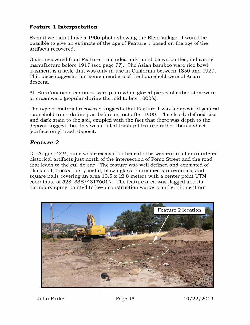
John Parker Page 98 10/22/2013
Th
The type of material recovered suggests that Feature 1 was a deposit of general household trash dating just before or just after 1900. The clearly defined size and dark stain to the soil, coupled with the fact that there was depth to the deposit suggest that this was a filled trash-pit feature rather than a sheet (surface only) trash deposit.
Feature 2
On August 24th, mine waste excavation beneath the western road encountered historical artifacts just north of the intersection of Pomo Street and the road that leads to the cul-de-sac. The feature was well defined and consisted of black soil, bricks, rusty metal, blown glass, Euroamerican ceramics, and square nails covering an area 10.5 x 12.8 meters with a center point UTM coordinate of 528433E/4317601N. The feature area was flagged and its boundary spray-painted to keep construction workers and equipment out.
Feature 1 Interpretation
Even if we didn’t have a 1906 photo showing the Elem Village, it would be possible to give an estimate of the age of Feature 1 based on the age of the artifacts recovered.
Glass recovered from Feature 1 included only hand-blown bottles, indicating manufacture before 1917 (see page 77). The Asian bamboo ware rice bowl fragment is a style that was only in use in California between 1850 and 1920.
is piece suggests that some members of the household were of Asian descent.
All EuroAmerican ceramics were plain white glazed pieces of either stoneware or creamware (popular during the mid to late 1800’s).
Feature 2 location

John Parker Page 99 10/22/2013
The mine waste had been removed and it was anticipated that the feature would be protected and preserved beneath the clean fill brought in for road construction. With the understanding that the feature would be protected, only a single 5-gallon bucket sample (for ¼” processing) and a 2,000cc sample (for 1/8” processing) were obtained from the feature. In addition, any diagnostic artifacts exposed on the surface of the feature were collected and processed.
Graphs of the Feature 2 samples indicate that Euroamerican glass was the most abundant of the artifacts by weight, followed by Euroamerican other (metal, leather, building material, etc.) and Euroamerican ceramics. Also recovered were obsidian stone tool manufacturing material (debitage), Asian ceramics, points, bone, and organic material.
EuroAmerican Ceramics
Euroamerican ceramics were made of both stoneware and creamware and included pieces of at least 4 main-course plates, one saucer, one soup bowl, and one pitcher.
Two makers marks were recovered. One was a piece manufactured by James Edwards & Son between 1851 and 1882 (H2-66). The other was manufactured by John Maddock & Sons sometime around 1896. Both potters operated out of Burslem England (Godden 1991:230,406). The reader must remember that the date of a maker’s mark does not provide the age of the historic feature. Plates and bowls can be owned and used for many years before breakage causes them to be discarded. The age of a maker’s mark can be used to indicate that the historic feature can’t be older than the age of the
Makers Marks 1892+
1851- 1882
H2-66 H2-67

John Parker Page 100 10/22/2013
mark.
Most Euroamerican ceramics were plain white glazed (H2-10), however, both transfer-ware (H2-41) and hand painted styles (H2-45) were recovered.
Asian Ceramics
Asian porcelain included pieces of 4 bamboo rice bowls, one serving bowl and a teapot lid. One stoneware food jar or spouted jar fragment was recovered. Spouted jars contained liquids such as soy sauce, peanut oil, wine, etc.
EuroAmerican plates and bowl
H2-40 H2-41
H2-45
Spouted jar from historic San Luis
Obispo Collection
H2-11
Fancy hand-painted serving bowl
Food or Spouted
Jar
Tea Pot Lid
H2-9 H2-47
H2-10
Bamboo ware rice bowls
H2-39
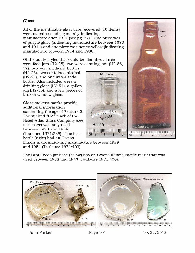
John Parker Page 101 10/22/2013
Glass
All of the identifiable glassware recovered (10 items) were machine made, generally indicating manufacture after 1917 (see pg. 77). One piece was of purple glass (indicating manufacture between 1880 and 1914) and one piece was honey yellow (indicating manufacture between 1914 and 1930).
Of the bottle styles that could be identified, three were food jars (H2-25), two were canning jars (H2-56, 57), two were medicine bottles (H2-26), two contained alcohol (H2-21), and one was a soda bottle. Also included were a drinking glass (H2-54), a gallon jug (H2-55), and a few pieces of broken window glass.
Glass maker’s marks provide additional information concerning the age of Feature 2. The stylized “HA” mark of the Hazel-Atlas Glass Company (see next page) was only used between 1920 and 1964 (Toulouse 1971:239). The beer bottle (right) had an Owens Illinois mark indicating manufacture between 1929 and 1954 (Toulouse 1971:403).
The Best Foods jar base (below) has an Owens Illinois Pacific mark that was used between 1932 and 1943 (Toulouse 1971:406).
H2-26
Medicine
H2-21
Beer
Mason Canning Jar bases
H2-56 H2-57
Best Foods Gallon Jug
H2-55 H2-25
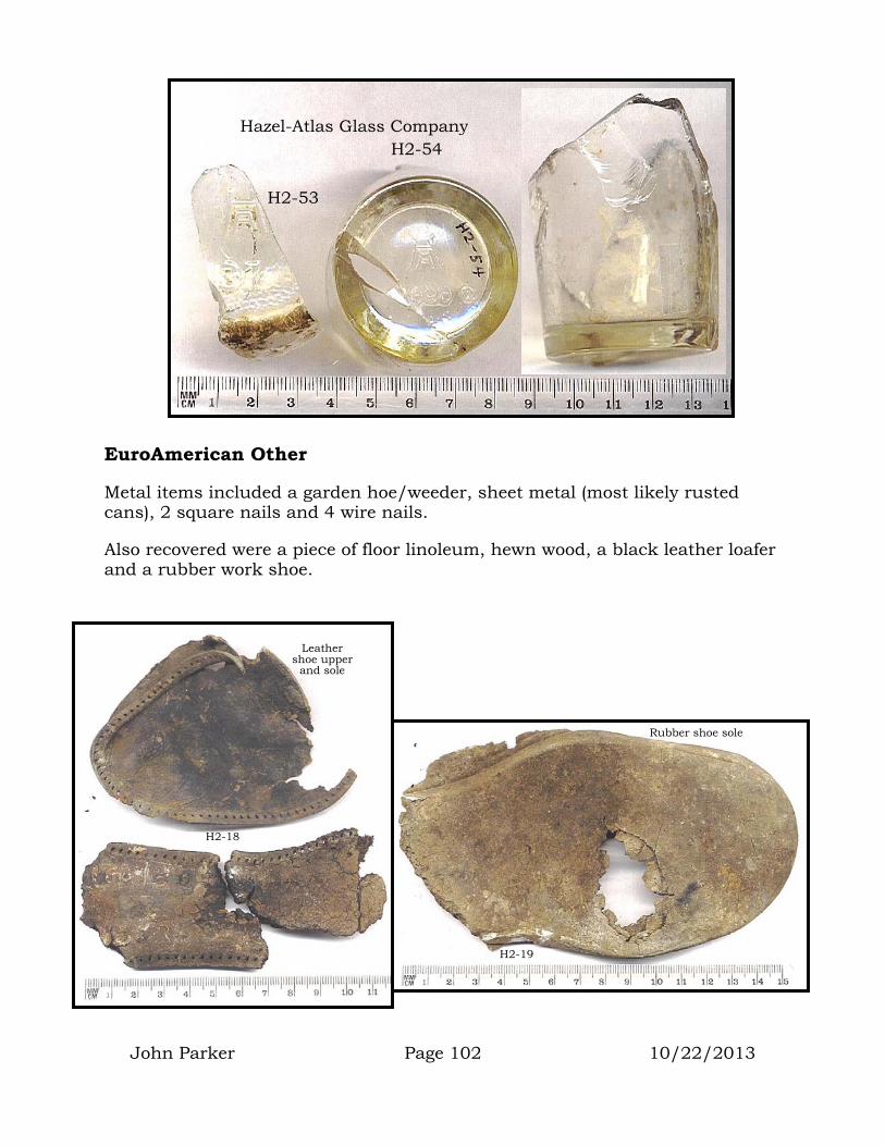
H2-54
H2-53
Hazel-Atlas Glass Company
John Parker Page 102 10/22/2013
EuroAmerican Other
Metal items included a garden hoe/weeder, sheet metal (most likely rusted cans), 2 square nails and 4 wire nails.
Also recovered were a piece of floor linoleum, hewn wood, a black leather loafer and a rubber work shoe.
Rubber shoe sole
H2-19
Leather shoe upper
and sole
H2-18
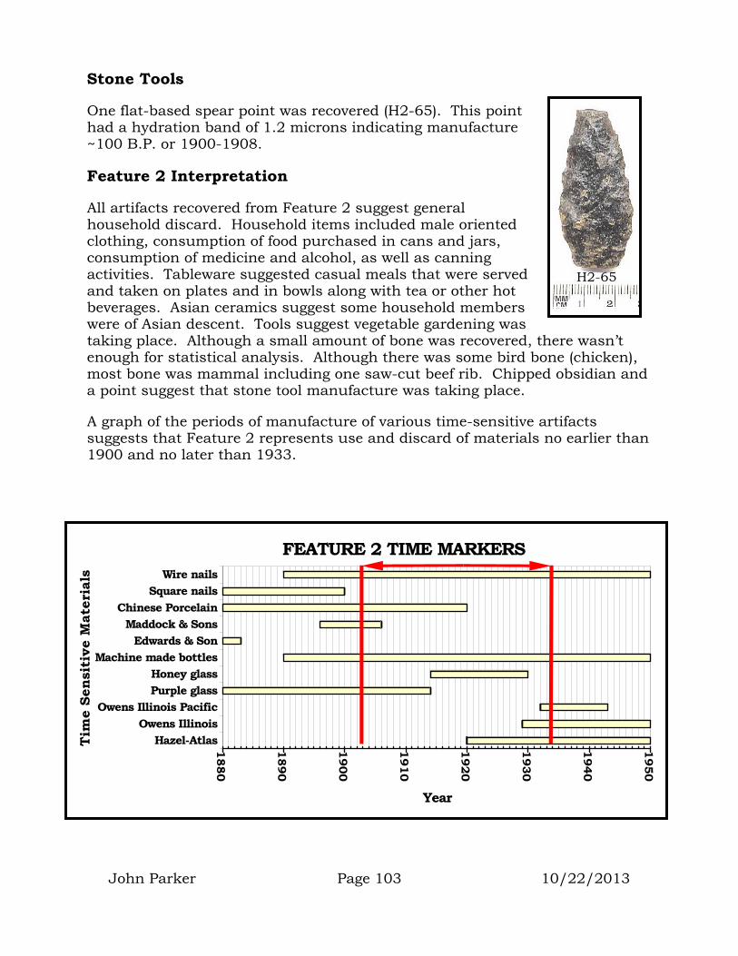
John Parker Page 103 10/22/2013
Stone Tools
One flat-based spear point was recovered (H2-65). This point had a hydration band of 1.2 microns indicating manufacture ~100 B.P. or 1900-1908.
Feature 2 Interpretation
All artifacts recovered from Feature 2 suggest general household discard. Household items included male oriented clothing, consumption of food purchased in cans and jars, consumption of medicine and alcohol, as well as canning activities. Tableware suggested casual meals that were served and taken on plates and in bowls along with tea or other hot beverages. Asian ceramics suggest some household members were of Asian descent. Tools suggest vegetable gardening was taking place. Although a small amount of bone was recovered, there wasn’t enough for statistical analysis. Although there was some bird bone (chicken), most bone was mammal including one saw-cut beef rib. Chipped obsidian and a point suggest that stone tool manufacture was taking place.
A graph of the periods of manufacture of various time-sensitive artifacts suggests that Feature 2 represents use and discard of materials no earlier than 1900 and no later than 1933.
H2-65
1880
1890
1900
1910
1920
1930
1940
1950
Year
Hazel-AtlasOwens Illinois
Owens Illinois PacificPurple glassHoney glass
Machine made bottlesEdwards & Son
Maddock & SonsChinese Porcelain
Square nailsWire nails
Tim
e Se
nsit
ive
Mat
eria
ls
FEATURE 2 TIME MARKERS

Feature 3
On August 24th, mine waste excavation beneath the western road encountered historical artifacts further north of the intersection of Pomo Street and the road that leads to the cul-de-sac. The feature was well defined and consisted of bricks, blown glass, Euroamerican ceramics, and square nails covering an area 9.6 x 16 meters with a center point UTM coordinate of 528422E/4317618N. The feature area was flagged and its boundary spray-painted to keep construction workers and equipment out.
Feature 3 location
John Parker Page 104 10/22/2013
The mine waste had been removed and it was anticipated that the feature would be protected and preserved beneath clean fill and road construction. With the understanding that the feature would be protected, only a single 5-gallon bucket sample (for ¼” processing) and a 2,000cc sample (for 1/8” processing) were obtained from the feature. In addition, any diagnostic artifacts exposed on the surface of the feature were collected and processed.
Graphs of the Feature 3 samples (next page) indicate that Euroamerican glass was the most abundant of the artifacts by weight. The next most abundant material was Asian ceramics followed by Euroamerican other (metal, leather, building material, etc.) and Euroamerican ceramics. Also recovered were obsidian stone tool manufacturing material (debitage), bone, and organic material.
Purple glass
stemware Turn-mold, bubble-base champaign
bottle
H3-5 H3-24

John Parker Page 105 10/22/2013
Glass
Bottle fragments recovered included one hand-blown, turn-mold, bubble-base champaign and four unidentifiable bottles. Other glass items included a glass saucer and a purple stemware glass (may be base to stemware glass on pg. 82).
Asian Ceramics
Pieces of two bamboo ware rice bowls were recovered as was a piece of a food or spouted jar and a piece of a Ng-Ka-Py jar.
EuroAmerican Ceramics
All Euroamerican ceramics were either stoneware or creamware. Pieces of two main course plates, two cups, and four unidentifiable items were recovered. All were plain white glazed except one with a gold rim band.
EuroAmerican Other
Other manufactured goods included sheet metal (most likely rusted cans), unidentifiable nails, and a shell button (H3-3). The button was a two-hole, sew-through that was 36-line in size.
H3-16
Bamboo ware rice bowls
H3-18
Ng-Ka-Py base
Food jar frag.
H3-17
H3-3

John Parker Page 106 10/22/2013
Organic Material
A black walnut shell, a small amount of fish bone and a piece of mammal bone were recovered. There was not enough bone to enable any meaningful analysis.
Feature 3 Interpretation
Feature 3 contained relatively more Asian ceramics than Features 1 and 2. This suggests that some members of the household were of Asian descent. There were also fewer bottles and pieces of EuroAmerican ceramics than the previous features. All glass suggested manufacture before 1914. Asian ceramics indicate use between 1850 and 1920.
It is likely that Feature 3 is a deposit of household discards that were in use between 1880 and 1914.
Flat, polished sandstone slab
H3-1
Ground Stone
A single flat, polished sandstone slab was recovered that appeared to be an abrading stone for knife sharpening or shell bead grinding.

John Parker Page 107 10/22/2013
Feature 4
On August 25th, mine waste excavation beneath the western road encountered historical artifacts between lots 12 and 13. The feature was well defined and contained blown glass, Euroamerican ceramics, burned ash and rusty metal covering an area 10.5 meters in diameter with a center point UTM coordinate of 528403E/4317650N. The feature area was flagged and its boundary spray-painted to keep construction workers and equipment out.
The mine waste had been removed and it was anticipated that the feature would be protected and preserved beneath the clean fill and road construction. With the understanding that the feature would be protected, only a 5-gallon bucket sample (for ¼” processing) and a 2,000cc sample (for 1/8” processing) were obtained from the feature. In addition, any diagnostic artifacts exposed on the surface of the feature were collected and processed.
Graphs of material recovered in the 5-gallon volume controlled sample indicate that EuroAmerican manufactured material dominated with glass, stone tool manufacturing, dietary shell, ceramics, and bone filling out the rest. The 1/8” screened sample recovered more dietary bone than anything else, but manufactured material was a close second with glass, chipped stone, and dietary shell also recovered.
EuroAmerican Other
This manufactured material included square nails (3), sheet metal, a horseshoe, brass boat hardware, steel washer, leather, and a percussion cap (H4-12).
H4-12
Percussion cap

John Parker Page 108 10/22/2013
H4-2
H4-3
Brass boat bracket
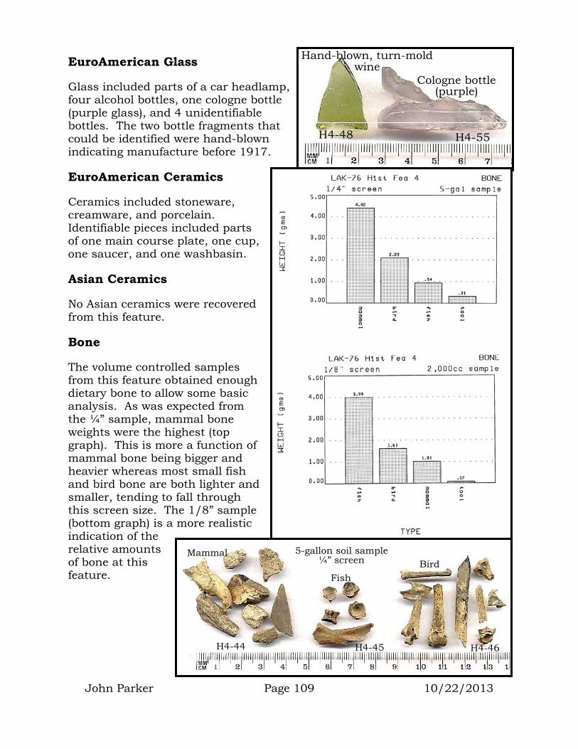
John Parker Page 109 10/22/2013
EuroAmerican Glass
Glass included parts of a car headlamp, four alcohol bottles, one cologne bottle (purple glass), and 4 unidentifiable bottles. The two bottle fragments that could be identified were hand-blown indicating manufacture before 1917.
EuroAmerican Ceramics
Ceramics included stoneware, creamware, and porcelain. Identifiable pieces included parts of one main course plate, one cup, one saucer, and one washbasin.
Asian Ceramics
No Asian ceramics were recovered from this feature.
Bone
The volume controlled samples from this feature obtained enough dietary bone to allow some basic analysis. As was expected from the ¼” sample, mammal bone weights were the highest (top graph). This is more a function of mammal bone being bigger and heavier whereas most small fish and bird bone are both lighter and smaller, tending to fall through this screen size. The 1/8” sample (bottom graph) is a more realistic indication of the relative amounts of bone at this feature.
Hand-blown, turn-mold wine
Cologne bottle (purple)
H4-55 H4-48
Fish
H4-46 H4-45
Bird Mammal
H4-44
5-gallon soil sample ¼” screen
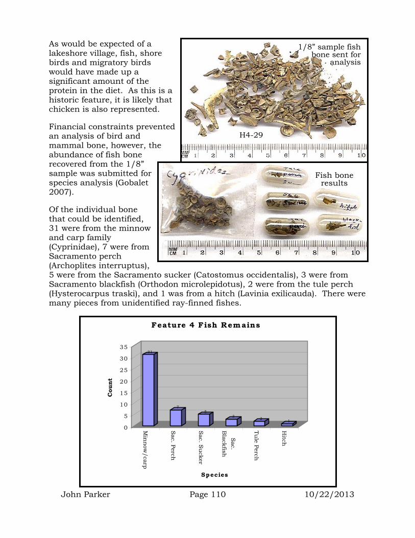
John Parker Page 110 10/22/2013
As would be expected of a lakeshore village, fish, shore birds and migratory birds would have made up a significant amount of the protein in the diet. As this is a historic feature, it is likely that chicken is also represented.
Financial constraints prevented an analysis of bird and mammal bone, however, the abundance of fish bone recovered from the 1/8” sample was submitted for species analysis (Gobalet 2007).
Of the individual bone that could be identified, 31 were from the minnow and carp family (Cyprinidae), 7 were from Sacramento perch (Archoplites interruptus), 5 were from the Sacramento sucker (Catostomus occidentalis), 3 were from Sacramento blackfish (Orthodon microlepidotus), 2 were from the tule perch (Hysterocarpus traski), and 1 was from a hitch (Lavinia exilicauda). There were many pieces from unidentified ray-finned fishes.
H4-29
1/8” sample fish bone sent for
analysis
Fish bone results
31
75
3 2 1
0
5
10
15
20
25
30
35
Cou
nt
Min
now
/carp
Sac. Perch
Sac. S
ucker
Sac.
Blackfish
Tule Perch
Hitch
Species
Feature 4 Fish Remains

John Parker Page 111 10/22/2013
Shell
A significant amount of shellfish remains were recovered from the 2,000cc soil sample. These remains were dominated by gaper clam (tresus), lake mussel, and Washington clam (saxidomus). The lake mussel would have represented a food resource, however, the coastal shell (tresus and saxidomus) would have been used for shell bead manufacture. In addition to the shell, rounded and partly drilled (broken) bead blanks were recovered in the soil sample. This suggests that shell bead manufacture and use was still very strong during the late 1800’s and early 1900’s. A single milk-glass Spanish trade bead was also recovered.
Feature 4 Interpretation
Feature 4 materials appear to represent discarded household materials. Hand-blown glass suggests that this feature represents discard before 1917. The existence of boat hardware and abundance of fish bone suggest that this household included a fisherman and that a substantial amount of the household diet came from fish. The abundance of shell bead manufacturing material indicates the presence of a traditional person who was very-much a part of the shell-bead money economy. The general lack of Asian ceramics suggests that this household didn’t have members of Asian descent.
If the percussion cap (pg. 107) represents firearms activity, then it would have been for a gun manufactured prior to 1870. By 1846, the pin-fire metal cartridge was developed and used widely in Europe between 1846 and 1870. By 1870, most firearms in California used rim fire or centerfire cartridges, bringing an end to percussion cap firearms (Dillon 1995:42).
Feature 5
On September 3rd, mine waste excavation beneath the western road encountered historical artifacts in front of Lot 13. The feature was well defined and contained glass, ceramics, metal objects, regular brick and firebrick. The feature covered an area 16 meters NS by 20 meters EW with a center point UTM coordinate of 528386E/4317657N. The feature area was flagged and its boundary spray-painted to keep construction workers and equipment out.
Shell bead blanks
H4-27 H4-35

John Parker Page 112 10/22/2013
The mine waste had been removed and it was anticipated that the feature would be protected and preserved beneath the clean fill and road construction. With the understanding that the feature would be protected, no soil samples were recovered or processed from the feature. A few artifacts exposed on the
Metal Artifacts (16)
Most metal artifacts recovered represented outdoor farming and hardware activities. Wire nails (5), square nails (1), a fence staple, washer, and angle bracket were recovered indicating general construction. Two horseshoes (H5-45), a strap buckle (H5-50) and the blade from a horsedrawn tilling rake (H5-47) suggest agricultural activities. An ax head (H5-44) suggests the preparation of heating and stovewood. A toy truck (H5-28) and wheat penny (H5-23) indicate personal and recreational items.
surface of the feature were collected and processed.
Feature 5 location
H5-23
H5-28

John Parker Page 113 10/22/2013
H5-47 tilling
hardware

John Parker Page 114 10/22/2013
H5-50
H5-45
H5-44

John Parker Page 115 10/22/2013
Glass Artifacts (21)
Glass bottles included fragments of a canning jar, cold cream jar, medicine (H5-9), soda (Pepsi), a large hand-blown carboy (H5-20) and several unidentified clear, brown, lime green, aqua green, and one of purple glass.
Both machine made and hand blown bottles were recovered indicating use as early as 1914 and as late as 1960. Glass containers indicated household activities including canning, general food and beverage consumption, medicine, and hygene. The carboy suggests water transport. These types of jugs and bottles are expected due to the fact that the reservation had no running water until the 1970’s.
EuroAmerican Ceramics (14)
Tableware included stoneware and creamware main course plates (2), saucers (2), and at least 8 unidentifiable pieces. One porcelain toy sugar bowl lid was recovered (H5-33) indicating children’s recreational activities.
Ceramics included a fire brick embossed with “HEATHERY KNOWE/PATENT/GLASGOW”. This brick was manufactured near the village of Heathery Knowe, Scotland. Rawyards Brickworks, Glenboig Brickworks, and Drombathie Brickworks are listed in the area, however, we were unable to determine which company made the brick or when it was manufactured.
H5-43
H5-32
H5-37
H5-36
H5-33
H5-10
H5-9
H5-20
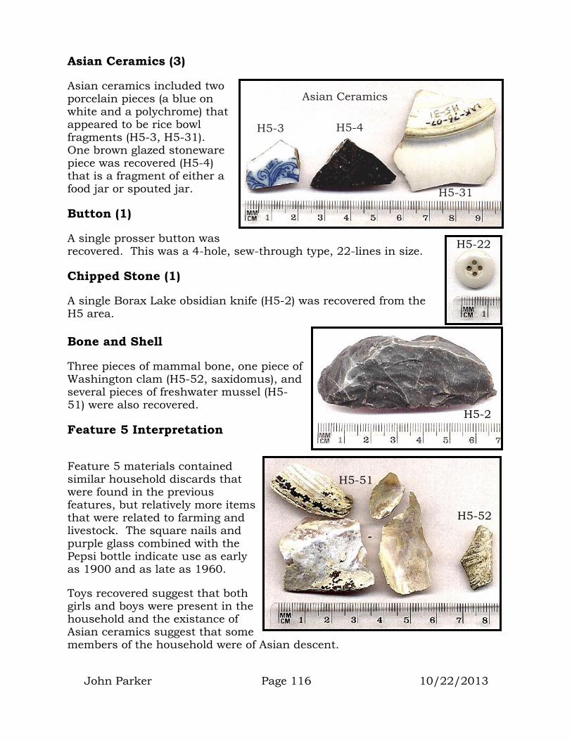
John Parker Page 116 10/22/2013
Asian Ceramics (3)
Asian ceramics included two porcelain pieces (a blue on white and a polychrome) that appeared to be rice bowl fragments (H5-3, H5-31). One brown glazed stoneware piece was recovered (H5-4) that is a fragment of either a food jar or spouted jar.
Button (1)
A single prosser button was recovered. This was a 4-hole, sew-through type, 22-lines in size.
Chipped Stone (1)
A single Borax Lake obsidian knife (H5-2) was recovered from the H5 area.
Bone and Shell
Three pieces of mammal bone, one piece of Washington clam (H5-52, saxidomus), and several pieces of freshwater mussel (H5-51) were also recovered.
Feature 5 Interpretation
Feature 5 materials contained similar household discards that were found in the previous features, but relatively more items that were related to farming and livestock. The square nails and purple glass combined with the Pepsi bottle indicate use as early as 1900 and as late as 1960.
Toys recovered suggest that both girls and boys were present in the household and the existance of Asian ceramics suggest that some members of the household were of Asian descent.
H5-3
H5-31
H5-4
Asian Ceramics
H5-22
H5-2
H5-51
H5-52
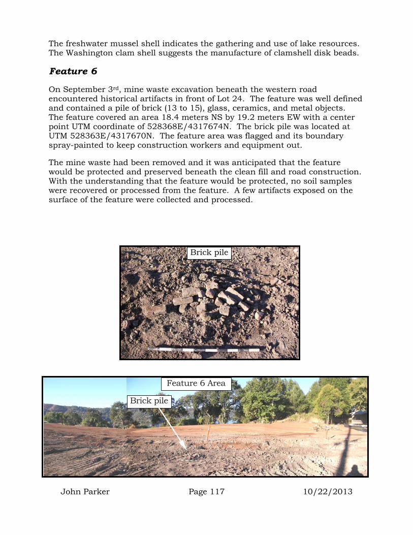
John Parker Page 117 10/22/2013
The freshwater mussel shell indicates the gathering and use of lake resources. The Washington clam shell suggests the manufacture of clamshell disk beads.
Feature 6
On September 3rd, mine waste excavation beneath the western road encountered historical artifacts in front of Lot 24. The feature was well defined and contained a pile of brick (13 to 15), glass, ceramics, and metal objects. The feature covered an area 18.4 meters NS by 19.2 meters EW with a center point UTM coordinate of 528368E/4317674N. The brick pile was located at UTM 528363E/4317670N. The feature area was flagged and its boundary spray-painted to keep construction workers and equipment out.
The mine waste had been removed and it was anticipated that the feature would be protected and preserved beneath the clean fill and road construction. With the understanding that the feature would be protected, no soil samples were recovered or processed from the feature. A few artifacts exposed on the surface of the feature were collected and processed.
Brick pile
Feature 6 Area
Brick pile

John Parker Page 118 10/22/2013
Examination of the historical photos on pages 93 and 94 indicate that most of the 1906 structures had mortared brick and rock fireplaces and chimneys. It is likely that the small pile of brick disturbed by the waste removal excavator represented the remains of one of these brick fireplaces.
Metal Artifacts (9)
Recovered from Feature 6 were three horseshoes (H6-2, 65), two stove parts (H6-3, 4), a boat bracket (H6-6 identical to the bracket from Fea. 4), car spring, square nails, and a kerosene lamp burner (H6-59). The adjustment handle on the burner was stamped “W&S, 1886, DAUNTLESS”. These
marks indicate that the burner was manufactured by the Wallace & Sons Company of Ansonia Conn.
H6-2
H6-65 H6-59
Stove Parts
H6-4
H6-3
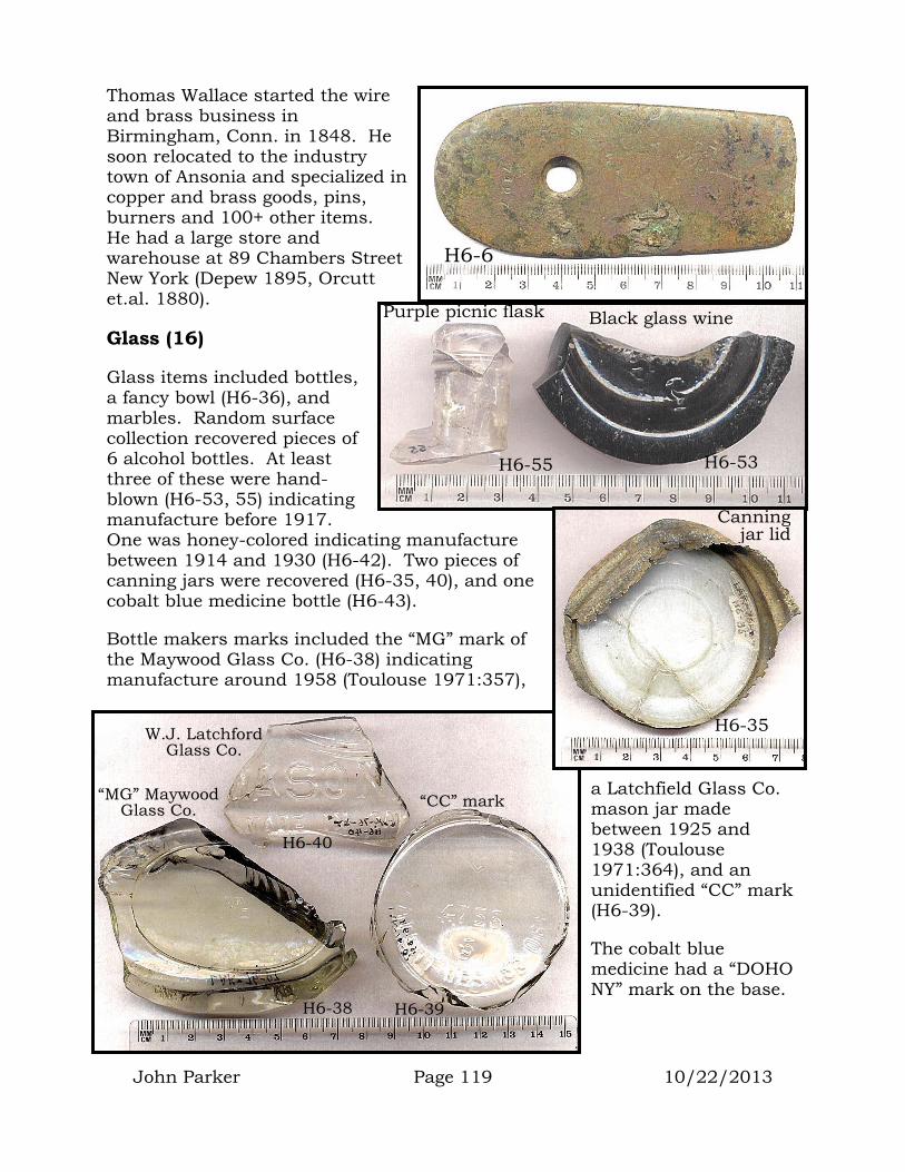
John Parker Page 119 10/22/2013
Thomas Wallace started the wire and brass business in Birmingham, Conn. in 1848. He soon relocated to the industry town of Ansonia and specialized in copper and brass goods, pins, burners and 100+ other items. He had a large store and warehouse at 89 Chambers Street New York (Depew 1895, Orcutt et.al. 1880).
Glass (16)
Glass items included bottles, a fancy bowl (H6-36), and marbles. Random surface collection recovered pieces of 6 alcohol bottles. At least three of these were hand-blown (H6-53, 55) indicating manufacture before 1917. One was honey-colored indicating manufacture between 1914 and 1930 (H6-42). Two pieces of canning jars were recovered (H6-35, 40), and one cobalt blue medicine bottle (H6-43).
Bottle makers marks included the “MG” mark of the Maywood Glass Co. (H6-38) indicating manufacture around 1958 (Toulouse 1971:357),
a Latchfield Glass Co. mason jar made between 1925 and 1938 (Toulouse 1971:364), and an unidentified “CC” mark (H6-39).
The cobalt blue medicine had a “DOHO NY” mark on the base.
H6-6
Black glass wine Purple picnic flask
H6-53 H6-55
Canningj
“CC” mark “MG” Maywood Glass Co.
W.J. Latchford Glass Co.
H6-40
H6-38 H6-39
ar lid
H6-35
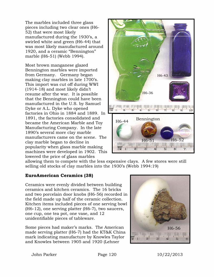
John Parker Page 120 10/22/2013
The marbles included three glass pieces including two clear ones (H6-52) that were most likely manufactured during the 1930’s, a swirled white and green (H6-44) that was most likely manufactured around 1920, and a ceramic “Bennington” marble (H6-51) (Webb 1994).
Most brown manganese glazed Bennington marbles were imported from Germany. Germany began making clay marbles in late 1700’s. This import was cut off during WWI (1914-18) and most likely didn’t resume after the war. It is possible that the Bennington could have been manufactured in the U.S. by Samuel Dyke or A.L. Dyke who opened factories in Ohio in 1884 and 1889. In 1891, the factories consolidated and became the American Marble and Toy Manufacturing Company. In the late 1890’s several more clay marble manufacturers came on the scene. The clay marble began to decline in popularity when glass marble making machines were developed in 1902. This lowered the price of glass marbles allowing them to compete with the less expensive clays. A few stores were still selling old stocks of clay marbles into the 1930’s (Webb 1994:19)
EuroAmerican Ceramics (38)
Ceramics were evenly divided between building ceramics and kitchen ceramics. The 16 bricks and two porcelain door knobs (H6-56) recorded in the field made up half of the ceramic collection. Kitchen items included pieces of one serving bowl (H6-12), one serving platter (H6-7), two saucers, one cup, one tea pot, one vase, and 12 unidentifiable pieces of tableware.
Some pieces had maker’s marks. The American made serving platter (H6-7) had the KT&K China mark indicating manufacture by Knowles Taylor and Knowles between 1905 and 1920 (Lehner
H6-36
H6-43
Bennington
H6-51
H6-44
H6-52
H6-56
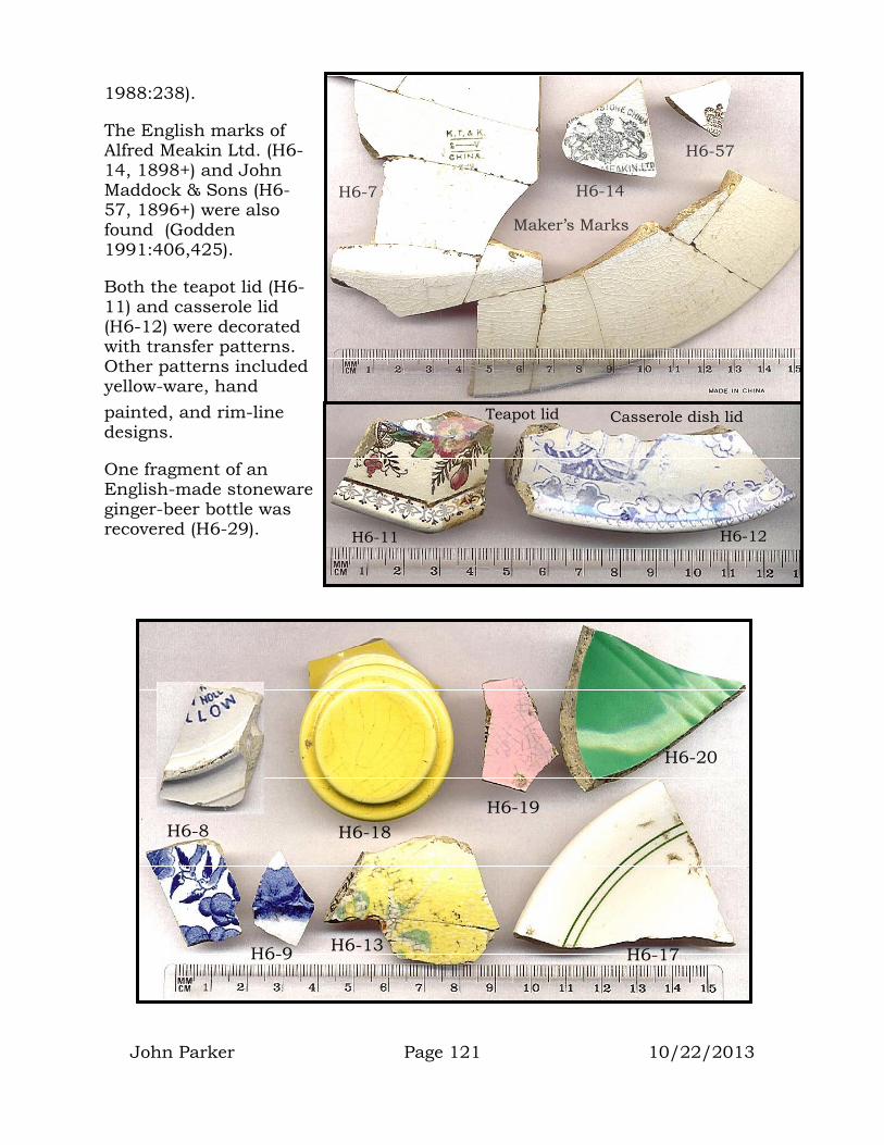
John Parker Page 121 10/22/2013
1988:238).
The English marks of Alfred Meakin Ltd. (H6-14, 1898+) and John Maddock & Sons (H6-57, 1896+) were also found (Godden 1991:406,425).
Both the teapot lid (H6-11) and casserole lid (H6-12) were decorated with transfer patterns. Other patterns included yellow-ware, hand painted, and rim-line designs.
One fragment of an English-made stoneware ginger-beer bottle was recovered (H6-29).
H6-57
H6-14 H6-7
Maker’s Marks
Teapot lid Casserole dish lid
H6-12 H6-11
H6-9
H6-20
H6-19 H6-8 H6-18
H6-13 H6-17

John Parker Page 122 10/22/2013
Buttons (2)
Two prosser buttons were recovered. Both were sew-through 4-hole types. One was 19-lines (H6-45) and one 17-lines (H6-58) in size.
Asian Ceramics (9)
Randomly gathered from the surface of Feature 6 were
pieces of three bamboo ware rice bowls (H6-25, 47,60), one blue-on-white rice bowl (H6-28), and the piece of a blue-on-white teapot with a picture of a person apparently plowing or pushing a cart (H6-26).
Other tableware included one piece of a Four-Seasons serving bowl (H6-24) and an unknown polychrome porcelain piece (H6-46).
Other Asian ceramics included the broken base of a Ng-Ka-Py jar (H6-27) and part of a bisque doll’s head with the impressed word “Japan” (H6-61). These porcelain dolls were manufactured in Japan between 1924 and 1927 (Coleman 1986:565).
Bone and Shell
A few pieces of mammal bone and bird bone (most likely chicken) were recovered. Also recovered were pieces of Washington clamshell (saxidomus).
Washington clam was used in bead manufacture, and a single clam disk bead was also recovered (H6-64).
H6-29
H6-45 H6-58
H6-28 H6-26
H6-60
H6-47
H6-25
H6-46 H6-24
H6-61 H6-27
H6-64
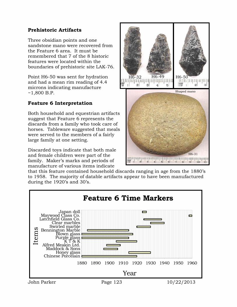
John Parker Page 123 10/22/2013
Prehistoric Artifacts
Three obsidian points and one sandstone mano were recovered from the Feature 6 area. It must be remembered that 7 of the 8 historic features were located within the boundaries of prehistoric site LAK-76.
Point H6-50 was sent for hydration and had a mean rim reading of 4.4 microns indicating manufacture ~1,800 B.P.
Feature 6 Interpretation
Both household and equestrian artifacts suggest that Feature 6 represents the discards from a family who took care of horses. Tableware suggested that meals were served to the members of a fairly large family at one setting.
Discarded toys indicate that both male and female children were part of the family. Maker’s marks and periods of manufacture of various items indicate that this feature contained household discards ranging in age from the 1880’s to 1958. The majority of datable artifacts appear to have been manufactured during the 1920’s and 30’s.
H6-32 H6-49 H6-50
Shaped mano
H6-31
1880 1890 1900 1910 1920 1930 1940 1950 1960
Year
Chinese PorcelainHoney glass
Maddock & SonsAlfred Meakin Ltd.
K T & KPurple glassBlown glass
Bennington MarbleSwirled marbleClear marbles
Latchfield Glass Co.Maywood Class Co.
Japan doll
Item
s
Feature 6 Time Markers

John Parker Page 124 10/22/2013
Feature 7
Beginning on September 3rd, mine waste excavation beneath the western road encountered historical artifacts in front of Lots 26, 27 and 28. This was not initially identified as a well-defined feature because mine waste removal in the area took place piece-meal over several days and from several different directions. Individual historic artifacts were encountered, plotted, and recovered during these various waste removal episodes. Once all mine waste had been removed, we realized that a defined historic feature had been exposed. The feature contained glass, ceramics, shell, bone, and metal objects. The feature covered an area 38 meters NS by 11 meters EW with a center point UTM coordinate of 528353E/4317709N.
The mine waste had been removed and it was anticipated that the feature would be protected and preserved beneath the clean fill and road construction. With the understanding that the feature would be protected, no soil samples were recovered or processed from the feature. A few artifacts exposed on the surface of the feature were collected and processed.
These photos show Feature 7 as fill was being deposited over the surface. Pink flags and spray paint mark artifact locations.
Glass Artifacts (11)
Four hand-blown bottle fragments were found (pre-1917). Two of these were most likely wine bottles, one was a two-piece-mold beer bottle, and one most likely a soda. Three honey
Looking southwest across Feature 7 area
Looking northeast across Feature 7 area

John Parker Page 125 10/22/2013
colored glass bottles were recovered (1914-1930). One of these was a canning jar, one a preserve jar (H7-18), and one unidentifiable. One cobalt blue Vick’s Vaporub bottle was recovered, as was a possible kerosene lampshade.
The preserve jar has the stylized “HA” on the base indicating manufacture by the Hazel Glass Company sometime between 1920 and 1964 (Toulouse 1971:239). The honey color of the bottle indicates that it was made between 1914 and 1930.
EuroAmerican Ceramics (9)
All ceramics pieces represented tableware. Pieces of two cups, one saucer, and one main course plate were recovered along with several unidentified pieces. Ceramic items were made of both Stoneware (5) and creamware (6). One piece had a Taylor Smith & Taylor “VERONA” maker’s mark indicating
H7-24
H7-25
Vick’s Vaporub
Hand-blown beverage bottle
H7-18
H7-27
Taylor, Smith & Taylor mark

John Parker Page 126 10/22/2013
manufacture sometime between 1900 and 1920 (Lehner 1988:461).
Metal (4)
Metal artifacts included an enamelware pot (H7-3) and a fork or spoon handle (H7-4) with “FRAZIL SILVER” stamped on the back. Although the “Frazil Silver” mark could not be found, the pattern is known as “Tipped” and was first sold by Rogers Bros. in 1847 (Rainwater et.al. 1968:442).
Feature 7 Interpretation
The Feature 7 area was not as clearly defined as the previous features. It did not include a darker stained soil and artifacts were scattered and much
H7-3
H7-4
1880
1890
1900
1910
1920
1930
1940
1950
Year
Taylor Smith & Taylor
Selinium glass
Blown glass
Item
s
Feature 7 Time Markers

John Parker Page 127 10/22/2013
sparser. It is likely that Feature 7 represents a surface deposit of discards often called a sheet trash deposit.
Maker’s marks and other period indicators suggest that Feature 7 materials were discarded between 1880 and 1930.
Feature 8
Beginning on September 20th, mine waste excavation was being conducted along the southeast edge of Pomo Street, just south of the entrance road intersection across from Lot 9. A small historic trash deposit was discovered around the base of a telephone pole at this location. Though most of this deposit was left undisturbed, the edge was damaged and several artifacts exposed. A
sample of artifacts were recovered, some because of their potential to provide a time period for the deposit, and some because of their cultural significance to members of the Tribe.
The feature contained glass, ceramics, shell, bone, wood and metal objects. The feature covered an area 6 meters NS by 6 meters EW with a center point UTM coordinate of 528556E/4317676N.
With the understanding that the feature would be protected, no soil samples were recovered or processed from the feature.
Glass Artifacts (8)
All glass bottles appeared to be machine made, indicating manufacture after 1917. No
Looking west at Feature 8 as Batsulwin Brown examines artifacts.
Looking east at Feature 8 (note meter stick).
0-314

John Parker Page 128 10/22/2013
selenium glass bottles were observed, suggesting that all were manufactured after 1930. Some had the names of present-day companies embossed on them (e.g. Avon, Clairol, Pepsi). The bottles included 5 clear glass items (one “Clairol” hair dye bottle 0-311, one medical vial 0-314, one large handled jug 0-316, one Pepsi bottle 0-317, and one unidentified), two unidentified olive green glass bottle fragments, and one milk-glass Avon coldcream jar (0-313).
All glass items suggest general household discard.
Ceramics (4)
Pieces of one saucer, one plate, one pot (see 0-320 on pg. 75), and one mug were recovered. All ceramics suggest general household discard.
Metal (1)
A single car oil dipstick was recovered (0-322).
Organic (4)
The fragments of two bamboo whistles (0-323), one bamboo clapper stick (0-324), and an elderberry clapper stick (0-325) were recovered from the feature. The elderberry clapper had a green duck-tape handle that had been carved into a diamond pattern.
0-311
Hair dye bottle
0-325 as discovered in the field
0-323
Bamboo whistles
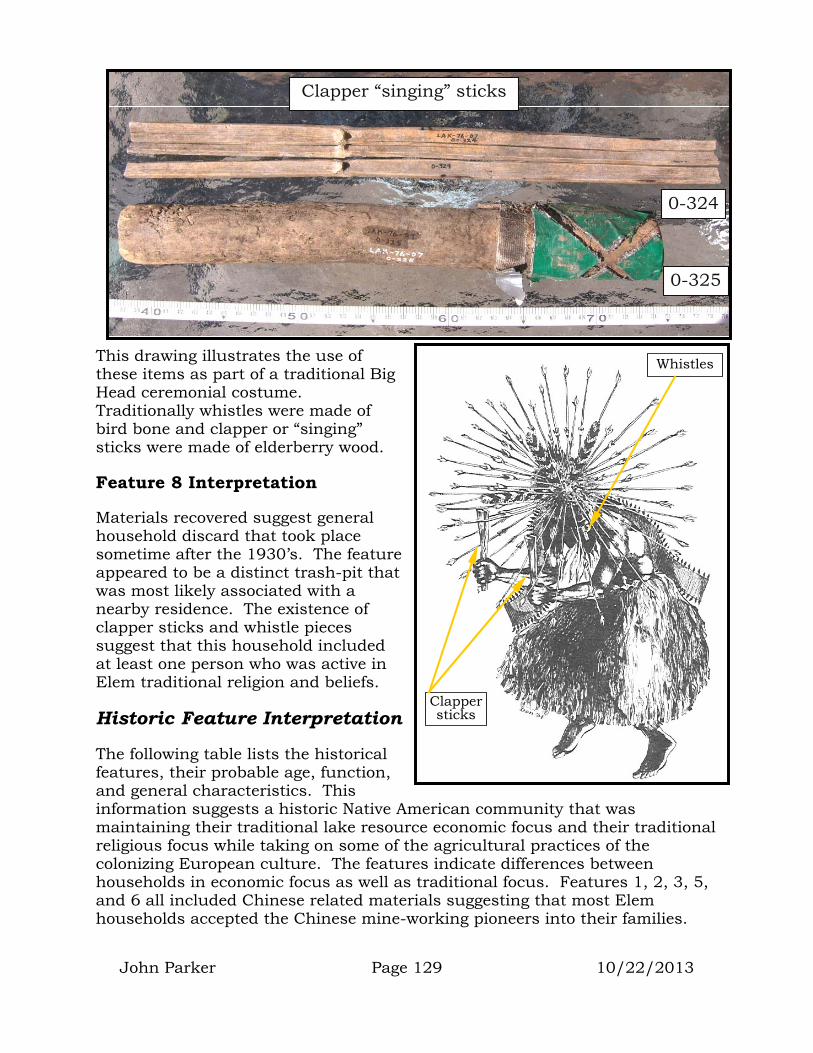
John Parker Page 129 10/22/2013
This drawing illustrates the use of these items as part of a traditional Big Head ceremonial costume. Traditionally whistles were made of bird bone and clapper or “singing” sticks were made of elderberry wood.
Feature 8 Interpretation
Materials recovered suggest general household discard that took place sometime after the 1930’s. The feature appeared to be a distinct trash-pit that was most likely associated with a nearby residence. The existence of clapper sticks and whistle pieces suggest that this household included at least one person who was active in Elem traditional religion and beliefs.
Historic Feature Interpretation
The following table lists the historical features, their probable age, function, and general characteristics. This information suggests a historic Native American community that was maintaining their traditional lake resource economic focus and their traditional religious focus while taking on some of the agricultural practices of the colonizing European culture. The features indicate differences between households in economic focus as well as traditional focus. Features 1, 2, 3, 5, and 6 all included Chinese related materials suggesting that most Elem households accepted the Chinese mine-working pioneers into their families.
0-325
Clapper “singing” sticks
0-324
Whistles
Clapper sticks

John Parker Page 130 10/22/2013
The features indicate that different households specialized in different economic activities; Feature 4 had an abundance of fishing related material where Features 5 and 6 had more agricultural related material. Some features (particularly Feature 4 but also 5, 6, and 8) had more “traditional” cultural items suggesting that older or more traditional individuals lived in these households. Children’s items used by both girls and boys were found in two of the features (5 and 6). A striving to be self-sufficient and not tied to the market economy introduced by the colonizing Europeans was evident by the existence of canning jars in most of the features (2, 5, 6, 7).
It is likely that these historic features contained information that could have been used to define specific families and the economic and cultural differences each family brought to the community as a whole. The study of these features
Fea.
Date Type of Deposit
Representing Tradi-tional
Use of Lake
Resources
Children Home Canning
Chinese Material
1 Pre 1917
Trash Pit
General Household
Refuse
? ? ? ? Yes
2 1903-1934
House Fea.
General Household
Refuse
Stone Tool
Making
? ? Yes Yes
3 Pre 1917
House Fea.
General Household
Refuse
? Fish bone ? ? Yes Many
4 Pre 1917
House Fea.
Fisherman Household
Refuse
Shell Bead
Making
Boat parts, fish bone and shell
? ? ?
5 1900 -
1960
House Fea.
Agricultural Household
Refuse
Shell Bead
Making
Shell
♀ ♂ Yes Yes
6 1880 -
1958
House Fea.
General Household
Refuse
Shell Bead
Making
Boat parts ♀ ♂ Yes Yes
7 1880 -
1930
Sheet Deposit
General Household
Refuse
? ? ? Yes Yes
8 Post 1930
Trash Pit
General Household
Refuse
Whistle Clapper Making
? ? ? ?

John Parker Page 131 10/22/2013
could have provided documentation of the rate of acculturation that was occurring in the community following European colonization of the area. A study of the Chinese materials contained in these features could have provided a timetable for the arrival of Chinese pioneers in Lake County as well as an indication of what part of China they came from. The Chinese materials could have indicated their cultural status in the community and when and if they were forced to return to China following passage of the 1888 Scott Act (any Chinese who returned to China could not return to the U.S.) or the 1892 Geary Act (all Chinese in the U.S. must carry certificates of residence).
LAK-82 ANALYSIS
As mine waste removal progressed, in some areas it was discovered that prehistoric cultural soils lay atop the mine-waste that had been brought in as fill for the existing roads and homes. When asked about the origin of this cultural soil, most Elem community members agreed that it had been brought from Buckeye Island. Apparently, the top of the island was leveled for a house. The soils from this work were used to build a causeway from the island to the mainland and used as fill for a driveway on Lot 19 and along the northern edge of the street in front of Lots 2, 3, 4, and 5.
Buckeye Island is a low hill that sits on the northern edge of the Elem reservation. It is the location of archaeological site LAK-82. At low lake levels, dry-land connects the island with the mainland. During normal or high lake levels, it is possible to get to the island by way of a rock and dirt causeway that crosses the shallow marsh area between the Island and mainland.
Buckeye Island Rock wall, leading out to the island (later turned
into a causeway).
1906 photo taken from the Elem cemetery (Photo by Grace Nicholson, courtesy of the Hunting Library)
Buckeye Island
Causeway
LAK-82

John Parker Page 132 10/22/2013
As the cultural soils lay atop the mine waste, it was apparent that this soil had been imported after 1970 (when the existing mine waste was deposited).
The first evidence of the LAK-82 soil was discovered during the mine waste removal work at the cul-de-sac. The soils made up the driveway that led from the paved road to Cecil Brown’s house on Lot 19. The dark cultural soil was loaded with obsidian and chipped stone tools. It was decided that two soil samples should be obtained from the area. One 5-gal. bucket
sample was recovered and screened through ¼” mesh. In addition, one 2,000cc sample was obtained and screened through 1/8” mesh to look for micro-constituents.
Soil samples indicate that most of the material from LAK-82 was prehistoric with chipped stone (debitage) dominating the collection. Chipped stone tools and dietary shell made up most of the rest of the collection.
LAK-82 soils
Human remains

John Parker Page 133 10/22/2013
Chipped Stone
An analysis of stone tool manufacturing waste indicated that most of the flakes recovered were secondary thinning flakes. Very few core flakes and very few primary thinning (shaping) flakes were obtained. In addition, more then ¾ of the recovered flakes were pressure flakes. This indicates that only the last stages of stone tool manufacture were taking place at this site. The early stages of core preparation and initial flake removal were taking place somewhere else, as was most of the early tool shaping work. Pressure flakes and secondary thinning flakes suggest final shaping and sharpening or tool maintenance.
Points (13)
All but one of the points were of Borax Lake obsidian. One (0-26) was of Napa obsidian.
The points with the largest hydration bands1 were long lanceolate forms with contracting stems that were lightly shouldered (0-6, 36, 19). Point 0-36 appears to be serrated, however, it is possible that these serrations were added more recently. Other points of this period were not serrated. Hydration conversion places these points in the 7,400 to 8,800 B.P. time period.
Excelsior Serrated points (0-35, 26) were long with rounded contracting stems and often serrations. Hydration measurements place these points in the 2,500-3,800 B.P. time range.
A single Long Houx Stemmed point (0-7) was recovered with a hydration rim that suggests it was manufactured ~2,200 B.P.
1 In photos, numbers in square brackets [ ] indicate the mean hydration measurement in microns.

John Parker Page 134 10/22/2013
The long and short Willow Leaf points (0-27, 9) had hydration rims that suggest manufacture between 1,300 and 1,900 B.P.
Cores (1)
A single core (0-11) was recovered. It had a 5.8 micron hydration band indicating use ~3,200 B.P.
Knives (26)
Knives fell into the same general categories as has
been outlined on pages 54-56.
The oldest knives (0-3d and 28) had hydration readings indicating they were probably manufactured around 7,200 B.P.
The next oldest knives (0-3b, 3c, 1a) were most likely manufactured ~5,000 B.P. The youngest knives (0-2a and S-5) had hydration readings indicating manufacture ~2,400 B.P.
0-35 [5.2] 0-7 [4.8] 0-9 [4.5] 0-27 [3.7]
0-26 [5] Napa Obsidian
0-6 [8.8] 0-36 [9] 0-19 [9.6]
0-11 [5.8]
Core
0-3d [8.7]
Knives
Keeled
0-28 [8.7]

John Parker Page 135 10/22/2013
Drill (1)
A single pointed knife with a triangular cross-section was recovered (0-37). These items are often classified as drills or reamers. Unfortunately, this piece had an unreadable diffused hydration band, indicating weathering. It is likely that this piece spent some time being tumbled by the waters along the Clear Lake shoreline.
Flake Tools (9)
Several flake scrapers were recovered from the LAK-82 soil. Three pictured at right would be categorized as “Flake Serrate” tools (White 1984:204). These tools were all made of thin primary flakes with at least one edge serrated. White has obtained hydration rim values on these tools in the 4.6 to 5.8 micron range, suggesting manufacture ~2,000 to 3,000 B.P.
The flake scraper in the lower-left is a thick piece with one end rounded and worked as a cutting or scraping edge.
When graphed, hydration readings from all the LAK-82 artifacts indicate almost continuous use of Buckeye Island from 9,000 B.P. to 1,500 B.P. A bi-modal distribution was found with a cluster of rim values in the 4 through 6-micron range and a second cluster in the 8 through 9-micron range. These suggest a
0-2a [5.1]
S-5 [5.2]
Knives
0-3b [7.2] 0-3c [7.3]
Knives
0-1a [7.2]
0-37
Drill
Flake Tools
0-10
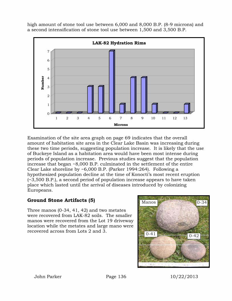
John Parker Page 136 10/22/2013
high amount of stone tool use between 6,000 and 8,000 B.P. (8-9 microns) and a second intensification of stone tool use between 1,500 and 3,500 B.P.
Examination of the site area graph on page 69 indicates that the overall amount of habitation site area in the Clear Lake Basin was increasing during these two time periods, suggesting population increase. It is likely that the use of Buckeye Island as a habitation area would have been most intense during periods of population increase. Previous studies suggest that the population increase that began ~8,000 B.P. culminated in the settlement of the entire Clear Lake shoreline by ~6,000 B.P. (Parker 1994:264). Following a hypothesized population decline at the time of Konocti’s most recent eruption (~3,500 B.P.), a second period of population increase appears to have taken place which lasted until the arrival of diseases introduced by colonizing Europeans.
Ground Stone Artifacts (5)
Three manos (0-34, 41, 42) and two metates were recovered from LAK-82 soils. The smaller manos were recovered from the Lot 19 driveway location while the metates and large mano were recovered across from Lots 2 and 3.
0
1
2
3
4
5
6
7
Num
ber
1 2 3 4 5 6 7 8 9 10 11 12 13
Microns
LAK-82 Hydration Rims
Manos 0-34
0-41 0-42

John Parker Page 137 10/22/2013
Bone
Mammal bone dominated the 2,000cc sample by weight. However, this difference in weight does not mean that mammals provided more meat protein than birds or fish. It should be remembered that for the same weight in edible meat, mammal bone is much heavier than either fish or bird bone.
Shell
The second most abundant material by weight from the 2,000cc sample was dietary shell. All was freshwater mussel indigenous to Clear Lake. Other shell pieces collected during the monitoring included the pictured piece of red abalone.
0-57 Lake mussel
0-56 Abalone
Metate
Metate location
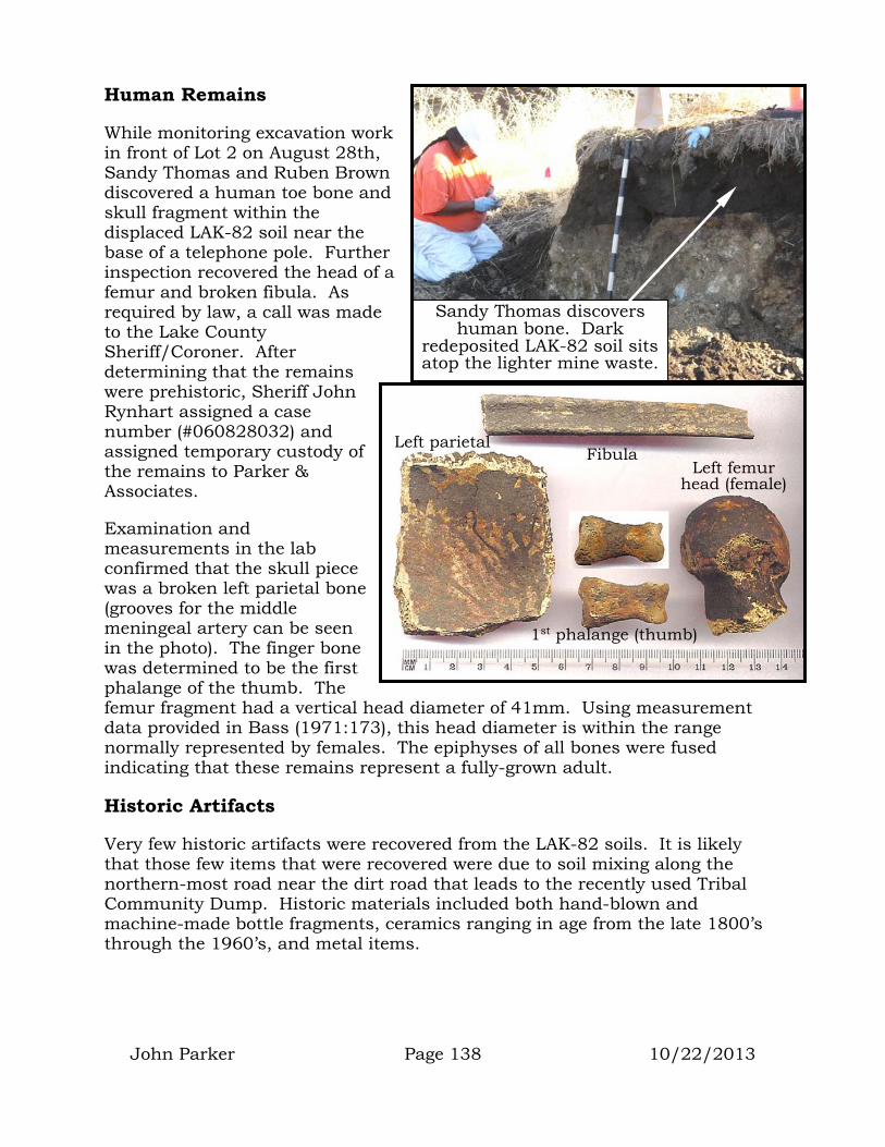
John Parker Page 138 10/22/2013
Human Remains
While monitoring excavation work in front of Lot 2 on August 28th, Sandy Thomas and Ruben Brown discovered a human toe bone and skull fragment within the displaced LAK-82 soil near the base of a telephone pole. Further inspection recovered the head of a femur and broken fibula. As required by law, a call was made to the Lake County Sheriff/Coroner. After determining that the remains were prehistoric, Sheriff John Rynhart assigned a case number (#060828032) and assigned temporary custody of the remains to Parker & Associates.
Examination and measurements in the lab confirmed that the skull piece was a broken left parietal bone (grooves for the middle meningeal artery can be seen in the photo). The finger bone was determined to be the first phalange of the thumb. The femur fragment had a vertical head diameter of 41mm. Using measurement data provided in Bass (1971:173), this head diameter is within the range normally represented by females. The epiphyses of all bones were fused indicating that these remains represent a fully-grown adult.
Historic Artifacts
Very few historic artifacts were recovered from the LAK-82 soils. It is likely that those few items that were recovered were due to soil mixing along the northern-most road near the dirt road that leads to the recently used Tribal Community Dump. Historic materials included both hand-blown and machine-made bottle fragments, ceramics ranging in age from the late 1800’s through the 1960’s, and metal items.
Sandy Thomas discovers human bone. Dark
redeposited LAK-82 soil sits atop the lighter mine waste.
Left parietal Left femur
head (female)
1st phalange (thumb)
Fibula

John Parker Page 139 10/22/2013
Noteworthy ceramic items included the wall of an English stoneware ginger-beer bottle (0-48) and blue-willow ware bowl fragment (0-49). Item 0-40 appears to be a Chinese porcelain teacup with raised dragon design around the side.
Item 0-32 is a porcelain doorknob popular during the late 1800’s and early 1900’s.
Glassware included the rim of a hand-blown wine bottle (0-46) as well as a machine-made cologne bottle (0-31. Metal items included the broken butt of a crosscut handsaw
0-53
0-31
0-46
0-54
0-48
0-40
0-51 0-52
0-49
0-50
0-32

John Parker Page 140 10/22/2013
(0-53) and a stainless-steel fork with a “W” monogrammed on the handle (0-54).
LAK-82 Soils Interpretation
Even though the LAK-82 soils on the mainland had been displaced and no longer retained their stratigraphic or locational integrity, the materials they contained were still able to provide some indication of activities that took place as well as periods of use.
Based on the small sample, it appears that the primary stages of chipped stone tool manufacture (core preparation, flake removal, and initial tool shaping) were taking place off-site. It appears that only secondary tool thinning and edge sharpening were taking place at LAK-82.
Due to the high cost of transporting material to an island and the great amount of stone needed for the initial stages of chipped stone tool manufacture, it would be expected that much of this activity would take place on the mainland; with only finished or mostly finished tools being transported to the island.
Hydration readings on obsidian points and knives indicate human use of Buckeye Island from 1,300 to 8,800 B.P.
Two periods of intensive chipped stone tool use are indicated by peaks in the hydration graph between 4 and 6 microns (1,500 to 3,500 B.P.) and between 8 and 9 microns (6,000 to 8,000 B.P.). Both of these periods of increased stone tool use correspond with hypothesized periods of population increase in the Clear Lake Basin (Parker 1994:264), see graph on page 69.
In addition to hunting activities (represented by spear points), artifacts recovered included manos and metates indicating the processing of grains and other hard seeds (sage). Bird and fish bone were recovered suggesting fishing and fowling. Special serrated flake tools were prominent in the collection and may suggest an island-specific activity.
Human remains indicate that mortuary activities were taking place at Buckeye Island.

John Parker Page 141 10/22/2013
LAK-2044 ARTIFACTS
The original size of LAK-2044 is not known due to the fact that mine waste removal had destroyed the western portion of this site prior to Parker & Assoc. arrival. The site consisted of a surface and subsurface deposit of historic hand-blown glass, cast iron stove parts, horseshoe, EuroAmerican ceramics, Washington clamshell and abalone shell. The site measured ~12 meters by 7.2 meters.
As the remaining portion of the site was outside of the project work area, it was understood that no further disturbance would occur to the resource. Therefore no soil samples were collected. Only a few surface artifacts were recovered to provide an archival sample of what the site contains.
The bottlenecks in the next photo represent items that were most likely manufactured between 1880 and 1910. Bottle 0-1 is from a beer bottle that was sealed with a Lightening stopper (see pg. 78). Rust from the stopper wire can still be seen around the base of the bottle’s applied finish. Bottle 0-2 is a brandy bottle that was sealed with a plain cork. The very large horseshoe was likely worn by a large draft horse (Morgan or Clydesdale).
LAK-2044H
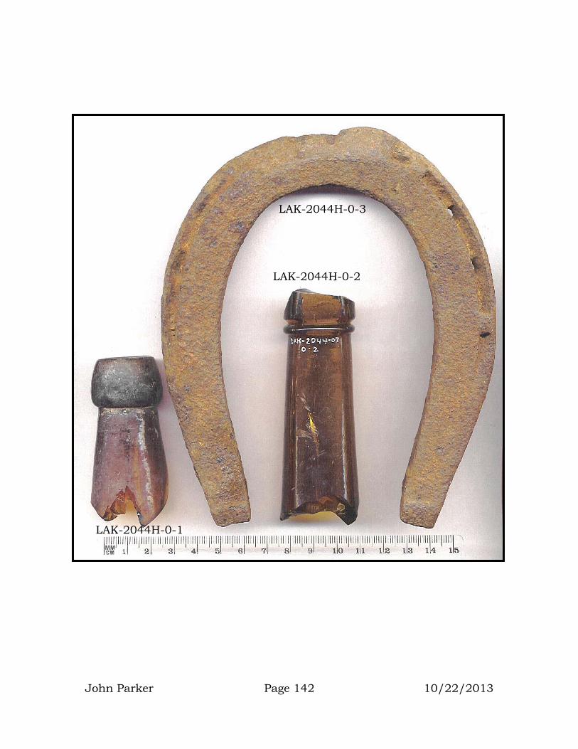
LAK-2044H-0-3
LAK-2044H-0-1
LAK-2044H-0-2
John Parker Page 142 10/22/2013
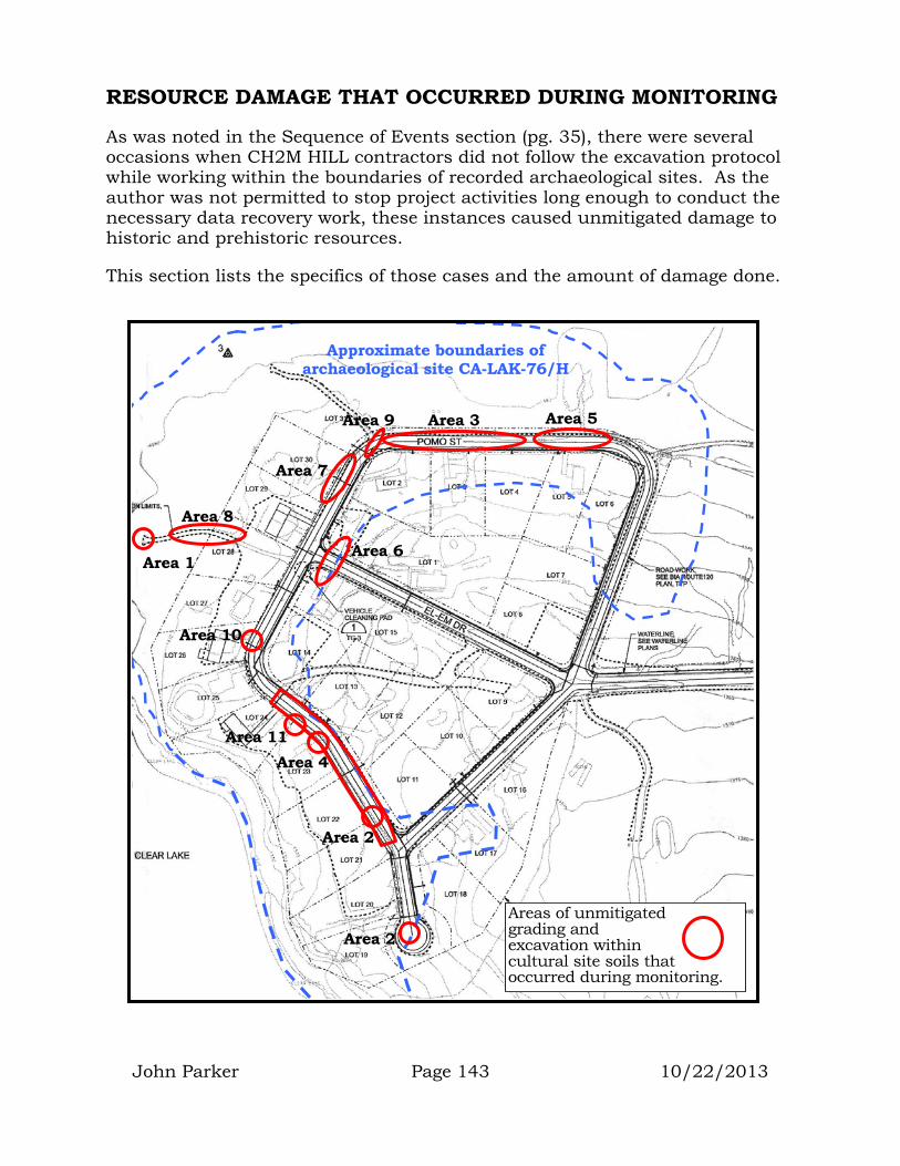
John Parker Page 143 10/22/2013
RESOURCE DAMAGE THAT OCCURRED DURING MONITORING
As was noted in the Sequence of Events section (pg. 35), there were several occasions when CH2M HILL contractors did not follow the excavation protocol while working within the boundaries of recorded archaeological sites. As the author was not permitted to stop project activities long enough to conduct the necessary data recovery work, these instances caused unmitigated damage to historic and prehistoric resources.
This section lists the specifics of those cases and the amount of damage done.
Approximate boundaries of archaeological site CA-LAK-76/H
Area 6
Area 2
Area 1
Area 3
Area 4
Area 5
Areas of unmitigated grading and excavation within cultural site soils that occurred during monitoring.
Area 2
Area 7
Area 8
Area 9
Area 10
Area 11
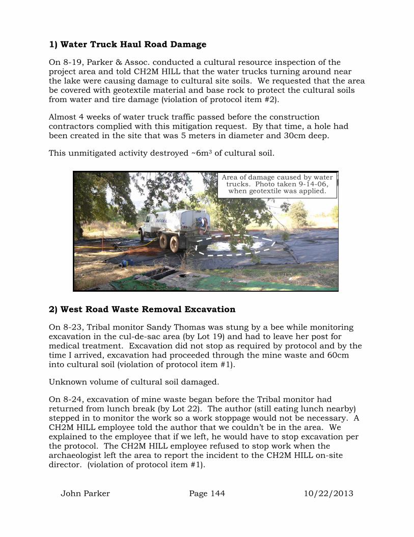
John Parker Page 144 10/22/2013
1) Water Truck Haul Road Damage
On 8-19, Parker & Assoc. conducted a cultural resource inspection of the project area and told CH2M HILL that the water trucks turning around near the lake were causing damage to cultural site soils. We requested that the area be covered with geotextile material and base rock to protect the cultural soils from water and tire damage (violation of protocol item #2).
Almost 4 weeks of water truck traffic passed before the construction contractors complied with this mitigation request. By that time, a hole had been created in the site that was 5 meters in diameter and 30cm deep.
This unmitigated activity destroyed ~6m3 of cultural soil.
2) West Road Waste Removal Excavation
On 8-23, Tribal monitor Sandy Thomas was stung by a bee while monitoring excavation in the cul-de-sac area (by Lot 19) and had to leave her post for medical treatment. Excavation did not stop as required by protocol and by the time I arrived, excavation had proceeded through the mine waste and 60cm into cultural soil (violation of protocol item #1).
Unknown volume of cultural soil damaged.
On 8-24, excavation of mine waste began before the Tribal monitor had returned from lunch break (by Lot 22). The author (still eating lunch nearby) stepped in to monitor the work so a work stoppage would not be necessary. A CH2M HILL employee told the author that we couldn’t be in the area. We explained to the employee that if we left, he would have to stop excavation per the protocol. The CH2M HILL employee refused to stop work when the archaeologist left the area to report the incident to the CH2M HILL on-site director. (violation of protocol item #1).
Area of damage caused by water trucks. Photo taken 9-14-06, when geotextile was applied.

John Parker Page 145 10/22/2013
Unknown volume of cultural soil damaged.
3) North Road Waste Removal Excavation
On 8-29, the author was monitoring mine waste removal in front of Lots 2, 3, and 4. He directed the contractors to stop digging when cultural soils were encountered below the mine waste. His directions were not followed and excavation removed both mine waste and all underlying cultural soils (violation of protocol item #7).
Unknown volume of cultural soil damaged.
4) Historic Feature Area Grading (west road)
On 8-30, mine waste removal in front of Lot 23 excavates below the mine waste layer and at least 30cm into cultural soil below the original 1906 ground surface. CH2M HILL employees admit that they were not taking chemical measurements but using visual cues only to determine the depth of the contaminated soil. Their later measurements indicated that this pre-1906 cultural soil had no contamination (violation of protocol item #7).
Unknown volume of cultural soil damaged.
On 9-1, the author had a field inspection and meeting with Mr. Emami (BIA Highway Construction Engineer) to discuss the treatment of the sensitive historical features along the western road. Mr. Emami expressed his concern that adequate compaction be obtained. The author explained that if it became necessary to disturb the historic features, then a data recovery program would need to take place before the damage was done. After more than an hour of discussion, an agreement was made to place a thin layer of fine-grained fill over the historic features, then a layer of geotextile material that would bridge the voids, allowing the proper compaction of road fill. It was agreed that this treatment would satisfy Mr. Emami’s concerns for road compaction and also protect the underlying historical features (see page 93-129).
On 9-9, under the direction of the EPA and CH2M HILL, a road grader ripped and scraped through the historic features, destroying an area 16 meters wide
Drawing showing agreed upon plan for protecting historic features (from field notes made during 9-1-06 meeting with Mr. Emami).

John Parker Page 146 10/22/2013
by 80 meters long to a depth of 50cm. Six of the eight pre-1906 historic features were destroyed along with an unknown amount of prehistoric cultural soil. A buried mortar was broken and then unearthed by the activity (violation of protocol items #5 and #7).
At least 640m3 of cultural soil was destroyed.
PHOTO DOCUMENTATION OF THE DESTRUCTION OF HISTORIC FEATURES 1, 2, 3, 4, 5, AND 6
Photo taken 9-14-06 showing extent of the grading that destroyed historic features.
Photo taken 9-14-06 looking south across graded area (meter stick in foreground).
8-26-06 photo showing historic features and 1906 ground surface.
Elem Village as it looked in 1906 (used courtesy of the Huntington Library)
Close-up of meter stick shows obsidian artifacts on ground.
Photo taken 9-14-06 of eastern edge of graded areashowing depth of cut below ground surface.

John Parker Page 147 10/22/2013
5) North Road Area Grading
On 9-9, John Holson and Kevin Bartoy of Pacific Legacy excavated through and destroyed cultural soils in an area that was not scheduled for grading (violation of protocol items #5 and #7).
Approximately 0.6m3 of cultural soil was needlessly destroyed.
On 9-11, CH2M HILL’s grader operator asked Parker & Assoc. if he could grade through archaeological site soils along the northern road to level the surface for the fill trucks. Due to the cultural soils present, we indicated that grading through this area could not be done (see Protocol #2 and #3). Within 20 minutes, the road grader was cutting through the
area, damaging cultural soils and unearthing a pestle (violation of protocol items #1, #2, and #3).
Unknown volume of cultural soil damaged.
6) Grading on Lots 1A and 1B
On 9-16, the author gave instructions to a CH2M HILL subcontractor not to disturb cultural soils north of the telephone pole and oak tree at the north end of Elem Drive in the areas of Lots 1A and 1B. These instructions were ignored and the subcontractor used a dozer to cut into the bank ~50cm deep on both sides of the road (violation of protocol items #2 and #7).
Unknown volume of cultural soil damaged.
North road grading through cultural soils.

John Parker Page 148 10/22/2013
7) Grading Between Lots 2 and 30
On 9-19, the big excavator returned to an area where mine waste had already been removed and proceeded to excavate into cultural soil to a depth of 60cm across an area 24 meters long by 14.4 meters wide. No data recovery work was allowed prior to this disturbance (violation of protocol items #2, #5, and #7).
Approximately 207m3 of cultural soil was needlessly destroyed.
In an effort to salvage a small amount of information from the damaged area, the author told the CH2M HILL contractors to place the cultural soils on top of clean fill that had already been deposited on Lot 1B. The plan was to have the wet-screening crew dry-screen through the soils to recover any artifacts before the soils were taken to the Sulphur Bank Mine waste deposit area. On 9-22, Richard Sugarek (EPA Project Director) spotted the pile of cultural soil and had it hauled to the mine waste disposal area before any screening could take place.
Lot 30 area grading, Tribal monitor checks for artifacts and human remains.
Lot 30 area, meter stick indicates depth of grading below contaminated soil layer.
Contaminated soil
Clean cultural soils
Sandy Thomas and James Wright direct the placement of cultural soil from the Lot 30 area.
To be screened for artifacts.
Cultural soil from Lot 30 area grading hauled to contaminated soil dump before
archaeological screening could occur.

John Parker Page 149 10/22/2013
Lot 28 Water Truck Road Grading
On 9-22, grading to remove a layer of mine waste from the water truck road on Lot 28 was conducted. In anticipation of this work, a data recovery unit was excavated through the mine waste and into the cultural deposit to a depth of 40cm (see accompanying report). The size and depth of the data recovery excavation unit was based on core samples of
soil from various locations along the road. These samples indicated a fairly shallow depth for the mine waste. It was therefore determined that removing the waste would require relatively shallow grading. The 1 x 2 meter archaeological unit was excavated to a depth of 40cm and recovered ~0.6m3 of cultural soil. Sidewall profiles of the unit indicated mine waste to a depth of 5 to 15cm.
Grading was then done to remove the mine waste. However, once the mine waste was removed, grading continued, removing an additional 20 to 30cm of clean cultural soil.
This took place over an area 48 meters long and 3 meters wide destroying ~43.2m3 of cultural soil. Although data recovery can be conducted as a way of mitigating damage to archaeological resources as part of the Section 106 process, it is usually required that a “statistically valid” sample be recovered from the area to be disturbed prior to the damage occurring. In order for a sample to be statistically valid, it must be large enough to gather information on most of the cultural activities and time periods represented by the materials in the area to be disturbed. The size of this sample is directly related to the content of the archaeological site. A site that contains materials from only a single cultural activity (such as stone tool
Wall profile of data recovery unit in Road 28 showing depth of mine waste.
Grader removing mine waste and cultural soil along the Lot 28 road.
Wall of graded area showing depth of mine waste and damage to cultural soil.
Cultural soil
Layer of mine waste

John Parker Page 150 10/22/2013
making) may be adequately mitigated by the recovery and analysis of a 1% sample of the proposed area of impact. A site which contains materials representing several activities such as stone tool making, ceremonial activity, food processing, house construction, as well as several time periods may require an 8% to 10% sample to adequately characterize all the various activities.
In the case of Road 28, the data recovery unit retrieved a 1.38% sample of the area disturbed by the grading. LAK-76 is known to have been a major village site that included the full range of village activities (stone tool manufacturing, house construction, fishing, hunting, fowling, grain, nut and vegetable gathering and processing, ceremonial activities, mortuary activities, etc.). In addition, based on hydration readings from surface artifacts, LAK-76 has been used almost continuously from the recent past to as early as 14,000 B.P. Due to this long list of cultural activities and long time depth, it is unrealistic to expect that a data recovery sample size of less than 10% would be considered “statistically valid”.
Considering that a 1.38m3 data recovery sample was obtained, this work would have mitigated the damage to 13.8m3 of cultural site soil. This means that 29.4m3 of damage occurred to this part of the site without any mitigation (violation of protocol items #5 and #7).
Storm Drain Trench Misalignment
On 9-26, excavation of the storm drain trench damaged intact portions of LAK-76. The impacts of the storm drain trench were mitigated through a data recovery program designed to recover a statistically valid sample of the area to be disturbed. This mitigation plan called for the excavation of 7 data recovery units within the alignment of the trench. Project surveyors provided the alignment for the placement of the archaeological units. When the storm drain trenching was conducted, the trench was not on the same alignment as that provided for the archaeological work, thereby destroying a
Large prehistoric artifacts were disturbed and destroyed during the grading.
Storm drain trench showing edge of data recovery unit that extends into sidewall.

John Parker Page 151 10/22/2013
portion of the site that had not been mitigated (violation of protocol items #5 and #7).
Unknown volume of cultural soil damaged.
Lot 26 Soft Spot Grading (no photos obtained)
On 10-2, a Tribal monitor called to report that excavation was taking place within undisturbed cultural soils in front of Lot 26. This work was apparently done to remove a “soft spot” that had occurred due to over-watering by the water trucks. Based on reports from John Holson and Sandy Thomas, the hole was 5 meters by 6 meters and 1 meter deep (violation of protocol items #5 and #7).
Sandy said that the soils removed contained historic glass, metal and clamshell.
Approximately 30m3 of cultural soil was destroyed with no mitigation.
Lot 23 Water Line Trenching
On 10-4, excavation for a water line connection was conducted within cultural site soil without the benefit of an archaeological monitor (violation of protocol items #1, #5 and #7). Bones were encountered.
Unknown volume of cultural soil damaged.
Unmitigated Cultural Resource Damage Between August 22nd and October 4th, 2006
Based on the above listed violations of the excavation protocol, a minimum of 913m3 of cultural soil was destroyed with no mitigation during the Phase 1b portion of the cleanup project.
Trench in front of Lot 23, flag marks location of bone.

John Parker Page 152 10/22/2013
ADMINISTRATIVE CONCLUSIONS AND RECOMMENDATIONS
As indicated earlier (pg. 31), CERCLA law requires:
“During all phases of response, the lead agency (EPA) shall complete and maintain documentation to support all actions taken…and to form the basis for cost recovery. Including “impacts and potential impacts to the public health and welfare and the environment.” (40 CFR 300.160 a1) In addition; “The lead agency shall make available to the trustees of the affected natural resources (BIA) information and documentation that can assist the trustees in the determination of actual and potential natural resource injuries.” (40 CFR 300.160, 3) (bracketed comments added)
CERCLA also indicates that federal agencies such as the EPA, BIA, BLM, and NPS “have duties relating to the restoration, rehabilitation, replacement, or acquisition of equivalent natural resources injured or lost as a result of such discard or release (and it is assumed, cleanup efforts) (40 CFR 300.170 and 175).
Although the majority of this report contains the scientific results of archaeological monitoring during the Phase 1b portion of the EPA cleanup project, part of this report provides the documentation necessary to satisfy the CERCLA requirements listed above.
It has been determined that the combined actions of the 1970 BIA contaminated fill placement and the 2006 EPA cleanup have destroyed ~8,000m3 of intact historic and prehistoric cultural site soils. It has also been determined that these resources are likely eligible for inclusion on the National Register of Historic Resources.
This loss of past cultural information and knowledge is felt by the scientific community and the public as a whole; however, it is a particularly egregious loss to the combined Southeastern Pomo communities of Elem, Kamdot, and Koi. The cultural soils destroyed contained a record of their historic and prehistoric past from the time of their first arrival in the area through the recent period of European colonization. With no written accounts of their 20,000 years of cultural, technological and economic history, the loss of these cultural soils amounts to the total (irretrievable) loss of a major portion of their community’s history.
Though it is impossible to bring that destroyed part of their history back, it is possible to protect and save parts of their cultural past that still exist.
Whenever a “taking” occurs because it was impossible to preserve a critical resource, it is standard practice to acquire equivalent resources for

John Parker Page 153 10/22/2013
preservation purposes in an effort to “replace” those lost during the “taking” process.
In an effort to partly reimburse the Southeastern Pomo community and general public for the damage done to these critical resources, it would be entirely appropriate for the BIA and EPA to purchase for preservation, cultural resources of equal value and concern to the community.
Immediately adjacent to the existing Elem reservation is an undeveloped island that contains several historic and prehistoric sites of equal historic value to those destroyed on the mainland. These sites have been determined eligible for inclusion on the National Register of Historic Places (State of California 2006). Rattlesnake Island is currently for sale at a reasonable price considering the value of the damaged mainland resources. In addition, the resources on the island are in imminent danger of damage or destruction by the proposed activities of the current owner (Lake County Planning 2008).
It is hoped that both the BIA and EPA have learned from the cultural resource failings of this project and that future proposed construction and hazardous waste cleanup efforts would follow the requirements of the National Historic Preservation Act. Trees can grow back, species can repopulate, but once destroyed, the traces left in the ground by past human activity can never be recreated.

John Parker Page 154 10/22/2013
BIBLIOGRAPHY Armentrout-Ma, C. Eve
1979 Chinese and the Golden Gate National Recreation Area 1849-1949: Guests of Choice, Guests of Necessity, Unpublished paper on file with the San Luis Obispo County Historical Society.
Barrett, S.A. 1908 The Ethnogeography of the Pomo and Neighboring Indians, University of California Publications in American Archeology and Ethnology, 6:1 Berkeley, Calif.
Basgall, Mark 1979 To Trade or Not To trade: A Pomo Example, in Journal of California and Great Basin Anthropology, 1:1, Malki Museum, Inc.
Bass, William M. 1971 Human Osteology: A Laboratory and Field Manual, Missouri Archaeological Society Special Publications
Baumhoff Martin A. and Robert Heizer 1965 Postglacial Climate and Archaeology in the Desert West, in The Quaternary of the U.S., Princeton University Press.
Brown, Batsulwin 2007 Review of EPA Superfund’s Destruction of Southeastern Elem Pomo Cultural Sites, in Society for California Archaeology Newsletter, Vol. 41, #4
Brown, Jim III 2000 Phase I Cultural Resources Evaluation of Elem Prehistoric and Historic Lands, 11-8-2000 Letter to Ellen Manges, EPA project manager from Elem Tribal Chairman.
California Department of Parks and Recreation 1986 Sonoma State Historical Park General Plan, Dept. of Parks and Recreation, Sacramento.
California, State of 1852 Senate Journal, Sacramento
Carr, Christopher 1985 Getting Into Data: Philosophy and Tactics for the Analysis of Complex Data Structures, in For Concordance in Archaeological Analysis: Bridging Data Structure, Quantitative Technique, and Theory, C. Carr Editor, Westport Publishers, University of Arkansas. 1987 Removing Discordance From Quantitative Analysis, in Quantitative Research in Archaeology, M.S. Aldenderfer Editor, Sage Publications.

John Parker Page 155 10/22/2013
CH2M HILL 2006 Sulphur Bank Mercury Mine – Elem Indian Colony Non-Time-Critical Removal Action, Final Design Plans, Vol. III, Plans on file with the EPA.
Cohen, M.N. 1977 The Food Crisis in Prehistory, Yale University Press
Coleman, Evelyn J., Dorothy S. and Elizabeth A. 1986 The Collector’s Encyclopedia of Dolls, Vol. 2, Crown Publisher’s, Inc. New York
Cooper, Molly L. 2003 An Archaeological Analysis of Nail Artifacts Recovered from A’asu, American Samoa, in Undergraduate Journal of Science, Texas A&M University, College Station, TX.
Curry, Robert R. 1968 Quaternary Climatic and Glacial History of the Sierra Nevada, California, Dissertation prepared for Department of Geology, University of California, Berkeley.
Davis, Pearce 1970 The Development of the American Glass Industry, Russell and Russell Publishers New York, NY
Depew, Chauncey 1895 1795-1895 One Hundred Years of American Commerce, D.O. Haynes & Co., NY.
Dewar and McBride 1992 Remnant Settlement Patterns, in Space, Time, and Archaeological Landscapes, Edited by Jacquelina Rossignol and LuAnn Wandsnider, Plenum Press, NY.
Dillon, Brian D. 1995 Timberland Historical Archaeology Notes, CDF Archaeological Reports, No. 16, California Dept. of Forestry and Fire Protection
Dubois, Cora A. 1939 The 1870 Ghost Dance, University of California Publications: Anthropological Records, #3 Berkeley, CA
Earle, Timothy K. 1980 Why Do Human Populations Change Their Subsistence Patterns?, in Modeling Change in Prehistoric Subsistence Economies, Timothy K. Earle and Andrew L Christenson Editors, Academic Press, New York.
Fredrickson, David A. 1973 Early Cultures of the North Coast Ranges, Doctoral Dissertation, Department of Anthropology, University of California, Davis 1975 An archaeological Survey of Proposed Development Areas at El-em Indian Colony, Unpublished report on file at the Anthropological Studies Center, Sonoma State University Academic Foundation, Inc.

John Parker Page 156 10/22/2013
Gibbs, George 1853 Journal of the Expedition of Colonel Redick M’Kee, United States Indian Agent, through North-Western California, in Historical and Statistical Information Respecting the History, Condition, and Prospects of the Indian Tribes of the United States, Schoolcraft, Philadelphia
Gifford, E.W. 1923 Pomo Lands on Clear Lake, in Phoebe Apperson Hearst Memorial Volume, University of California Publications in American Archeology and Ethnology, Vol. 20, 77-92, Berkeley, Calif. 1926 Clear Lake Pomo Society, University of California Publications in American Archeology and Ethnology, 18:2, Berkeley, Calif.
Gobalet, Kenneth 2007 Analysis of Fish Bone from Elem Indian Colony, Unpublished report on file with Parker & Associates Archaeology, Cayucos, CA
Godden, Geoffrey A. 1991 Encyclopaedia of British Pottery and Porcelain Marks Barrie & Jenkins, London.
Grace, Roger 2006 Nesbitt’s Orange Soda: Bright Star Went Black, Now Twinkles Dimly, Metropolitan News-Enterprise
Green, Stanton 1980 Broadening Least-Cost Models for Expanding Agricultural Systems, in Modeling Change in Prehistoric Subsistence Economies, Timothy K. Earle and Andrew L Christenson Editors, Academic Press, New York.
Halpern, Abraham M. 1988 Southeastern Pomo Ceremonials, Anthropological Records, Vol. 29, University of California Press, Berkeley, Calif.
Harrington, Mark Raymond 1948 An Ancient Site at Borax Lake, California, Southwest Museum Papers, #16, Highland Park, Los Angeles.
Heizer, Robert F. 1973 Collected Documents on the Causes and Events in the Bloody Island Massacre of 1850, University of California Archaeological Research Facility.
Heizer, Robert F. and Alan F. Almquist 1971 The Other Californians; Prejudice and Discrimination Under Spain, Mexico, and the United States to 1920, University of California Press, Berkeley, CA.
Heusser, Calvin J. 1966 Pleistocene Climatic Variations in the Western U.S., in Pleistocene and Post Pleistocene Climatic Variations in the Pacific Area, Bishop Museum Press, Honolulu, HI.

John Parker Page 157 10/22/2013
Holson, John 2006 Cultural Resource Recommendations Regarding Elem Rancheria Remediation, Memorandum to the Elem Tribe and EPA dated 8-2-2006
Jones, Terry L. and John F. Hayes 1993 Problems and Prospects in Sonoma County Archaeology, In There Grows a Green Tree: Papers in Honor of David A. Fredrickson, Center for Archaeological Research at Davis, Publication 11, Davis, CA.
Kallis, Rurik 1955 How old is That House, in Journal of San Diego History, San Diego Historical Society Quarterly, Vol. 1 No. 2
Kaufman, Thomas 1980 Early Prehistory of the Clear Lake Area, Lake County, Calif., Doctoral Dissertation, Archaeological Program, UCLA
Kendrick, Grace 1971 The Antique Bottle Collector, Harcourt Brace Jovanovich, New York, NY
Klima, Don 2007 Letter to EPA’s Director, Superfund Division (Keith Takata) concerning the Elem Indian Colony Mine Waste Removal Action, Office of Federal Agency Programs, Advisory Council on Historic Preservation, Washington D.C.
Kniffen, Fred B. 1939 Pomo Geography, University of California Publications in American Archaeology and Ethnography, 36:6, Berkeley Calif.
Kroeber, A.L. 1925 Handbook of the Indians of California, bulletin 78 of the Bureau of American Ethnology, Reprinted by Calif. Book Co., Berkeley, Calif.
Lake County 2008 Personal communication with Lake County Planning Department staff.
Lehner, Lois 1988 U.S. Marks on Pottery, Porcelain & Clay, Collector Books, Paducah, KY.
Loeb, E.M. 1926 Pomo Folkways, University of California Publications in American Archaeology and Ethnography, 19:2, Berkeley Calif.
McCarthy, Helen and Robert I. Orlins 1991 Intensive Cultural Resources Survey and Evaluation: Cache Creek, Lake County, Army Corps of Engineers, Sacramento, CA
Means, Russell 1995 Where White Men Fear to Tread, St. Martin’s Press, New York
John Parker Page 158 10/22/2013
Meighan, Clement W. 1955 Archaeology of the North Coast Ranges, California, University of California Archaeological Survey, Report #30, Berkeley, CA. 1965 Pacific Coast Archaeology, in The Quaternary of the U.S., Princeton University Press.
Meighan, C.W. and C.V. Haynes 1970 The Borax Lake Site Revisited, Science 167(3922).
Meighan Clement W. and Frances A. Riddell 1972 The Maru Cult of the Pomo Indians: A California Ghost Dance Survival, Southwest Museum Papers, No. 23, Los Angeles, CA.
Miller, George L. and Catherine Sullivan 1981 Machine-Made Containers and the End of Production for Mouth-Blown Bottles, Research Bulliten No. 171, Canadian Parks Dept., Ottawa Ont.
Moratto, Michael J. 1984 California Archaeology, Academic Press Inc. Orlando, FL.
Murphy, M. Maureen 1996 96-412: Indian Trust Land Acquisition, National Council for Science and the Environment, Washington D.C.
National Park Service 1991 Guidelines for Completing National Register of Historic Places Forms, National Register Bulletin 16, Washington, D.C.
Orcutt, Samuel and Ambrose Beardsley 1880 History of the Old Town of Derby, Conn., Press of Springfield.
Origer, Thomas 1989 Hydration Analysis of Obsidian Flakes Produced by Ishi during the Historic Period, in Current Directions in California Obsidian Studies, Edited by Richard Hughes, Contributions of the University of California Archaeological Research Facility, #48, Berkeley, CA. 1993 Personal Communication concerning Napa obsidian hydration rate. Director, Obsidian Hydration Laboratory, Sonoma State University.
Parker, John 1975 The Norris Trail and its Relationship to the Archaeology of Lake and Mendocino Counties, Unpublished report on file with the Sonoma State University Anthropological Studies Center. 1980 Clam Disk Bead Manufacture and a Related Micro-tool Industry: Evidence for Craft Specialization from Lake County, Calif., Research paper presented at the Society for California Archaeology Annual Meetings. 1994 Dots on a Map: Using Cultural Resource Management Data to Reconstruct Prehistoric Settlement Patterns in the Clear Lake Basin, California, Doctoral Dissertation prepared for The Archaeology

John Parker Page 159 10/22/2013
Program, UCLA, Published by UMI, Ann Arbor, MI. 2007a Cultural Resource Inspection of the Elem Indian Colony, Unpublished report on file with the Sonoma State University Anthropological Studies Center. 2008a Cultural Resource Mitigation of the Elem Storm Drain Project, Unpublished report on file with the Sonoma State University Anthropological Studies Center. 2008b Cultural Resource Mitigation of the Elem Water Main and Lot 28 Waste Removal, Unpublished report on file with the Sonoma State University Anthropological Studies Center.
Powers, Stephen 1877 Contributions to North American Ethnology, Vol. III, Department of the Interior, U.S. Geographical and Geological Survey of the Rocky Mountain Region.
Putnam, H.E. 1965 Bottle Identification, self-puiblished, Duarte, California.
Rainwater, Dorothy T., and H. Ivan Rainwater 1968 American Silverplate, Thomas Nelson Inc., Nashville and Everybodys Press, Hanover, PA
Read, Dwight W. 1985 The Substance of Archaeological Analysis and the Mold of Statistical Method: Enlightenment out of Discordance, in For Concordance in Archaeological Analysis: Bridging Data Structure, Quantitative Technique, and Theory, C. Carr Editor, Westport Publishers, University of Arkansas. 1987 Archaeological Theory and Statistical Method: Discordance, Resolution, and New Directions, in Quantitative Research in Archaeology, M.S. Aldenderfer Editor, Sage Publications.
Richmond, Gerald C. 1965 Glaciation of the Rocky Mountains, in The Quaternary of the U.S., Princeton University Press.
Scott, Tom 2008 Online publication by grandson of B.R. Murphy, Nesbitt Operations Manager and President 1933-36.
Shipley, William F. 1978 Native Languages of California, in Handbook of North American Indians, Vol. 8, California, Smithsonian Institute, Washington D.C.
Sibson, R. 1981 A Brief Description of Natural Neighbor Interpolation, in Interpreting Multivariate Data, V. Barnett editor, John Wiley and Sons, Inc., New York
John Parker Page 160 10/22/2013
Sims, John D. 1976 Personal Communication, USGS Scientist researching cores of Clear Lake sediment.
Sims, John D., David P. Adam and Michael J. Rymer 1981 Lake Pleistocene Stratigraphy and Palynology of Clear Lake, U.S. Geological Survey Professional Paper 1141.
Slocum, Bowan, and Co 1881 History of Napa and Lake Counties, California, Slocum, Bowan, and Co. Publishers, San Francisco.
Smith, Gerald A. 1942 A Study of the Archaeology of Borax Lake Region, unpublished paper presented to the University of Southern California Research in Anthropology.
State of California 1976 California Inventory of Historic Resources, Department of Parks & Recreation, Sacramento, California. 2006 California Historical Resources Commission resolution concerning the Rattlesnake Island National Register Nomination.
Steward, Jullian 1977 Evolution and Ecology, Edited by Jane Steward and Robert Murphy, University of Illinois Press.
Stewart, Omer C. 1943 Notes on Pomo Ethnography, University of California Publications in American Archeology and Ethnology, 19:2, Berkeley, Calif.
Takata, Kieth 2007 Letter to John Eddins (Advisory Council on Historic Preservation) from Keith Takata (EPA Director, Superfund Division) dated 3-13-2007
Thompson, Nelson B. 1988 An Archaeological Survey for a Proposed Bingo Enterprise at the Elem Indian Colony, Unpublished report on file at the Anthropological Studies Center, Sonoma State University Academic Foundation, Inc.
Toulouse Julian Harrison 1971 Bottle Makers and Their Marks, Thomas Nelson Inc., New York
Tremaine, Kim 1993 Temporal Ordering of Artifact Obsidians: Relative Dating Enhanced Through the Use of Accelerated Hydration Experiments, In There Grows a Green Tree: Papers in Honor of David A. Fredrickson, Center for Archaeological Research at Davis, Publication 11, Davis, CA.
Tremaine, Kim and David A. Fredrickson 1988 Induced Obsidian Hydration Experiments: An Investigation in

John Parker Page 161 10/22/2013
Relative Dating, Unpublished paper presented at the Conference of Materials Research Society, Reno, NV.
United States Bureau of Land Management, General Land Office 1868 Transcript of the Field Notes of the Survey of Three Islands in Clear Lake, by I.N. Chapman deputy surveyor.
United States Government 1994 Report Under the International Covenant on Civil and Political Rights, Washington D.C.
Webb, Dennis 1994 Greenberg’s Guide to Marbles, Greenberg Books, Waukesha, WI.
Whistler, Kenneth 1980 Pomo Prehistory: A Case for Archaeological Linguistics, Unpublished report on file at the Anthropological Studies Center, Sonoma State University, Rohnert Park, CA.
White, Greg 1984 The Archaeology of LAK-510, Near Lower Lake, Lake County, California, Unpublished report on file at the Anthropological Studies Center, Sonoma State University Academic Foundation, Inc.
White, Greg and Ronald F.King 1993 The Mostin Site Revisited, In There Grows a Green Tree: Papers in Honor of David A. Fredrickson, Center for Archaeological Research at Davis, Publication 11, Davis, CA.
Work, John 1945 Fur Brigade to the Bonaventura: John Work’s California Expedition. 1832-1833 for the Hudson’s Bay Company, California Historical Society, San Francisco