Differential divergence in autosomes and sex chromosomes is ...
Upload
independentCategory
view
1download
0
Quaternary Science Reviews, Vol. 15, pp. 77-90, 1996. ~ Pergamon Copyright © 1996 Elsevier Science Ltd.
Printed in Great Britain. All rights reserved. 0277-3791/96 $32.00
0277-3791(95)00090-9
POSTGLACIAL EMERGENCE OF WESTERN FRANZ JOSEF LAND, RUSSIA, AND RETREAT OF THE BARENTS SEA ICE SHEET
S. L. FORMAN,* D. LUBINSKI,? G. H. MILLER,? G. G. MATISHOV,~ S. KORSUN,$ J. SNYDER,* F. HERLIHY,* R. WEIHE* and V. MYSLIVETS§
*Byrd Polar Research Center, The Ohio State University, 1090 Carmack Road, Columbus, OH 43210-1002, USA .
tInstitute of Arctic and Alpine Research and Department of Geological Sciences, University of Colorado, Boulder, CO 80309-450, U.SA.
SMurmansk Marine Biological Institute, 17 Vladimirskaya Street, Murmansk 183023, Russia §Moscow State University, Faculty of Geography, Moscow 119899, Russia
Abstract -- Uncertainty remains on the timing and extent of Late Weichselian glaciers over the Q S R Barents and Kara sea shelves. Franz Josef Land, Russia, is a critical area for deciphering the record of glacier fluctuations and postglacial relative sea-level change. Coastal forelands on the archipelago are covered by a well-preserved raised-beach sequence containing abundant and pristine driftwood, whalebone, and shell. ~4C dating of these materials provides site-specific emergence records for the archipelago, and some of the oldest ages on deglaciation of 10,400 BP. Three apparent still-stands in emergence are inferred from morphology of the raised-beach sequence and ~4C dating between 9900 and 6200 BP, and at ca. 5500 BP and 3500 BP. The earliest sea-level arrest, after formation of the marine limit, reflects a balance between glacio-isostasy and eustasy, concomitant with the final phase of global sea-level rise. The latter two sea level arrests during the middle- to late-Holocene are less pronounced and may indicate increased height of the ocean surface with greater storminess and extended open-water conditions. Raised beaches at 1-2 m a.s.l, and J4C dated at 1000 to 2000 BP give contemporary emergence rates of 1 to 2 mm/year. The low current rates of emergence on Franz Josef Land are similar to areas in Fennoscandinavia that sustained modest Late-Weichselian glacier loads (<1500 m), within a few 100s of km of the inferred ice sheet margin. The pattern of postglacial emergence and strandline tilts indicates that past glacier loads were greater over the adjacent Barents Sea, than Franz Josef Land. Marine and terrestrial records from Franz Josef Land place retreat of glaciers from coastal areas by 10,400 BP, whereas the adjacent Franz Victoria Trough was deglaciated by 13,000 BP. Retreat of the Barents Sea Ice Sheet was probably underway by 13,500 BP, coincident with rising global sea-level and elevated summer insolation. We infer that iceberg calving through the deep troughs bordering the Barents Sea, particularly with rapidly rising sea level ca. 12,000 BP was an important process controlling the demise of the Barents Sea Ice Sheet. Copyright © 1996 Elsevier Science Ltd
INTRODUCTION Barents and Kara seas that was equivalent to at least 10
m of g lobal sea level , potent ia l ly the largest sea- level Knowledge of the dis t r ibut ion of g lac ier loads and ' reservoir ' in the Russian arctic during the last glaciation
retreat patterns for late Pleistocene ice sheets bordering (Lambeck et al., 1990; Tushingham and Pelt ier, 1991; the Arc t ic Ocean are cr i t ical for cons t ra in ing ice-age Peltier, 1994). Although there are limited data, the Arctic paleotopography (Lambeck et al., 1990; Peltier, 1994). Ocean margin of the Barents Sea Ice Sheet is placed at There is cons iderab le d i sagreement on the extent and the continental shelf break, consistent with the inferred t i m i n g o f la te Q u a t e r n a r y ice shee t s o v e r n o r t h e r n limit of the western terminus (Vorren et al., 1988a). The Eurasia, ranging from isolated ice caps on arctic archipel- southern limit of the Barents Sea Ice Sheet on the coastal agos (Velichko et al., 1984) to a cont iguous ice sheet plain of Russia is supposedly well constrained by a con- cover ing the cont inenta l shelves of the Russ ian arctic t i g u o u s s e q u e n c e o f m o r a i n e s and p r o g l a c i a t l ake (Grosswald, 1988). These disparate ice-sheet reconstruc- deposits (Grosswald, 1993). However, a reevaluation of tions reflect the paucity of verified field observations and th is s e q u e n c e cas t s d o u b t on the g e n e s i s and La te age control on glacial and deglacial deposi ts and land- Weichselian age assignment for these deposits, and thus
forms, there is uncer ta in ty on the southern extent of the last Mos t r e cons t ruc t i ons infer i ce - shee t c o v e r of the E u r a s i a n ice shee t ( A s t a k h o v , 1992; S v e n d s e n and
77

78 Quaternary Science Reviews: Volume 15
Mangerud, pers. commun. , 1994). Many reconstructions on the forelands of Bell, Northbrook, George, Etheridge, for the last glacial maximum of the Barents and Kara Hooker, Scott Keltie, Nansen, and Koettlitz islands (Fig. seas place the greatest thickness of the ice sheet over 2). Analysis of the four new relative sea-level records for N o v a y a Z e m l y a with ou t f low that d a m m e d r iver Franz Josef Land provides additional insight into the drainages on the Russian mainland (Grosswald, 1988; geometry and demise of the Barents Sea ice sheet. Tushingham and Peltier, 199l; Elverh¢i et al . , 1993;
Grosswald, 1993). An important criterion for placing an MEASUREMENT AND RADIOCARBON DATING ice-sheet divide over Novaya Zemlya is the observation OF RELATIVE SEA LEVEL of raised-beach deposits over 100 m a.s.l. (Gr~nlie, 1924; Zagorskaya, 1959; Kovaleva, 1974; Grosswald, 1988). In this study the high-tide swash mark is the datum However, a recent reevaluation of the raised-marine (meters above sea level; m a.s.l.) for measuring the alti- record on Novaya Zemlya indicates that the postglacial tude of raised beaches. The tidal range along the British marine limit is <20 m a.s.1, and that higher raised beaches Channel is modest at approximately 0.5 m (Denisov et are from a pre-Late Weichselian glacio-isostatic loading al . , 1993). Storm-beach gravels and sea-ice-pushed event, >28,000 BP (Forman e ta l . , 1995)(Fig. 1). ridges presently extend to 2-3 m a.s.1. The altitude of
Many marine geological studies concur that the raised beaches and included driftage was determined with Barents Sea was covered by a marine-based ice sheet a Leitz digital altimeter with an analytical precision of during the Late Weichselian (Solheim et a l . , 1990; +0.1 m. Often two or three altimeters were used in tan- Elverh¢i et al. , 1990; Gataullin et al. , 1993). Despite dem and multiple readings were recorded for a landform, some uncertainty on the ice-sheet geometry, there is clear usually agreeing within ±1 m. The maximum estimated evidence for the expansion of outlet glaciers on western error in assessing altitude, including variable relief of a and northern Spitsbergen, concomitant with the growth of raised-marine landform, is ±2 m. the Barents Sea ice sheet (Forman, 1989; Lehman and Flotsam on the modern beaches and driftwood on the Forman, 1992; Mangerud et al., 1992; Svendsen et al., raised beaches are ubiquitous and well preserved on 1992). Deglaciation of the western margin of the Barents Franz Josef Land, reflecting proximity to the driftage- Sea ice sheet occurred in at least two steps at ca. 13,000 rich Trans Polar Drift Current (H~iggblom, 1982). Most BP and 10,500 BE Fjords were completely deglaciated driftage retrieved for ~4C dating was partially buried in by 9500 BP (Forman, 1989; Lehman and Forman, 1992). ra ised-beach gravels , minimizing the possibil i ty of
Previous studies on Svalbard have identified maxi- reworking with regression. Driftwood was collected pref- mum postglacial emergence on Kong Karls Land and erentially from the raised-beach sequence because of its eastern Svalbard (Salvigsen, 1981; Forman, 1990; suitability for ~4C dating. The outer rings of driftwood Ing61fsson et al . , in p re s s ) . Recent investigations of logs were sampled to obtain ]4C ages in close association raised strandlines on Franz Josef Land and Novaya with the sea level depositional event (Table 1). Zemlya further constrain the maximum area of isostatic Whalebone is well preserved and common on Franz recovery to the Barents Sea shelf (Forman et al., 1995). Josef Land, as on Svalbard, and is a reliable material for Large scale glacial-tectonism of sediments on Kongs¢ya, eastern Svalbard, indicates ice sheet flow from the east, off the Barents Sea (Ing61fsson et al., in press) . /6oo~ / ~ ..... ~ ~__~ j
Quaternary environments of Franz Josef Land have Franz Josef .... / ~ ' ~ . . . . ~ ( received limited study since the discovery of the archi . . . . . Lane ~ 7 ~ ~o i ~_~
8~ °" ~o ° ":,~-~ ,'c. ao " ~'-~ pelago by Austrian explorers in August, 1873 (Horn, ~\o . ~ :~),l / ~ / - . L 1930; p. 12). Initial insights on the glacial history of I x ~ ' %~ ~ / ~ ' ~ , 1~; ........ ,~II /' ~ ~ - Franz Josef Land are derived from field studies initiated . ~;~°~H,('~"--2sl I. I ~'.~ ~ ~/ Kar~ s e a - - by V. Dibner in 1953, 1956 and 1957 (V. Dibner, pers . s , ~ / Y / { ~ 3 6 J I i ] I ~ / ~ ~ . . . . c o m m u n . , 1994; Dibner , 1965; Grosswa ld , 1973). Q . . f . ~ / / ~ ) I.t l / ~ v ~ .... -~ / . Although these early studies were completed before full "~. ~ ¢ ' ; / ~- ~ 1 ] ! I ~ / "k~ " ~ . / / ~o ~ / .~ '~ . . . . . B a r n . . . .
availability of '4C dating and before the advent of ice- '. ~ ( - ( ~ ' ~ \ ~ C / / / S e a # . . ~ '~'-~'~o ~ - ~ sheet modeling, the results were critical for constraining " ~ ' ~ t~ ~ 5. ~/ / / .: ~
"'.-' ~ ~ "~. ~ ~ ~ \ / . " Novaya / f
the first generation of global ice-sheet reconstructions ~ " ~ . " S v ~ ' b a r d (a ~ ...... L ~/ (Denton and Hughes, 1981). Only in the last three years ~--:.." ,o ..... ~ ' : / / C ) ( with renewed access to Franz Josef Land are needed data ~o~ .. ~ w
75° , - / " emerging to constrain the extent and timing of glaciations ,~,6 . . y in northern Eurasia (Glazovskiy et al., 1992; N~islund et \ ~ , . . . . ~ ~-~/
~ ~ . . ~ . . k C " ~ ' . - ' ~ ~ ~ . ~ Russia al., 1994; Forman et al., 1995). ~ .~o . ~ a j ~ ~ _ . . . . ~ - ~ 5
This contribution presents new observations and ~4C ..~o'/.7~"~(~'~::~':".,.~n.~. )11 I
raised-marine sequences adjacent to British Channel on / ~/ ',~-, ......... ~ ; ~
Franz Josef Land, Russia (Fig. 2). Field studies in August FIG. 1. Barents and Kara Seas with inferred pattern of emer- 1991, 1993 and ] 994 specifically focussed on distin- gence since 5000 BP (from Forman et al., 1995) and location of guishing the pattern of emergence and deglacial history study area on Franz Josef Land, Russia.

S.L. Forman et al.: Postglacial Emergence of Western Franz Josef Land, Russia 79
TABLE 1. ~4C ages on driftwood, shell, and whalebone from raised-marine deposits adjacent to British Channel, Franz Josef Land, Russia
Material and Provenance Sample and shoreline Laboratory ~4C age b~3C Laboratory altitude (m a.s.l.) or reservoir corrected numbe¢
age I (BP)
Bell Island: Marine Limit 49 + 1 m a.s.I. 1.5 m long log on raised beach above storm limit 3 1050_+95 -25.6 GX-19476 1.5 m long log imbedded into raised beach 6 2205_+100 -24.6 GX-19570 Whale vertebrae on raised beach 9 2800+851 - 16.7 GX- 19471G Whale skull fragment on raised beach 13 3905+_90 ~ - 16.5 GX- 19472G 3 m long whale jawbone on raised spit 16 4255+_90 ~ - 16.7 GX- 19473G Whale skull fragment on raised beach 23 5465_+90 ~ -16.9 GX-19474G Driftwood at marine escarpment base 27 6045_+125 -22.2 GX-19475 Driftwood imbedded into raised beach 45 9705_+105 -24.5 GX-17208 2 m long whale rib imbedded into raised beach 47 9220-+120 - 17. I GX- 17209G Northbrook Island: Marine Limit 43 +_ 2 m a.s.I. 1.5 m long whale rib buried in raised beach 3 1425+_80 L -16.6 GX-19483G Whale vertebrae disc imbedded in raised beach 8 2405+105 ~ -16.5 GX-19484G 4 m long log on raised beach 13 3950_+110 -24.3 GX-19485 1.2 m long log on descending raised beach 18 4380-+90 -24.6 GX-19486 1 m long log on raised beach 22 4435_+70 -25.0 AA-15679 1 m long log on raised beach 30 6300-+65 -26.2 AA- 16586 Whale vertebrae on raised beach 33 (36) 9220_+165 t -18.0 GX-19487G Southeastern George Island: Marine Limit 38 _+ 2 m a.s.1. 0.5 m long log on raised beach above storm limit 4 1340+80 -26.1 GX-19477 2.5 m long log on raised beach 7 2180+80 -25.3 GX- 19478 3 m long log in swale on raised beach 9 2480_+100 -23.2 GX-19479 5 m long log on descending raised beach 15 3860+90 -24.5 GX-19780 I m long tree root-plate fragment on raised beach 18 4565-+115 -24.5 GX- 1948 I 3 m long log on descending raised beach 20 4785-+95 -24.4 GX-19482 Paired M. truncata from glacial-marine silt 8 (>20) 5035_+70 ] 02 AA-12482 Hooker(H) and Scott Keltie, (S) Islands: Marine Limit 36 + 2 m a.s.1. Tree stump buried in beach gravels(H) 0.5 >38,000 -25.8 GX-17201 0.5 m long log on raised beach(H) 1 775-+65 -24.7 GX-17200 Paired M. truncata from glacial-marine silt(H) 1 8325+100 ~ 1.8 GX- 17265 0.5 m long log on raised beach(H) 2 1100-+80 -23.8 GX- 17199 Driftwood, on low raised beach(S) 5 2215-+ 125 -24.6 GX- 17187 Driftwood, raised beach(S) 8 2970-+145 -23.0 GX- 17188 0.5 m long log wedged into raised beach (H) 9 2655+75 -26.2 AA-16587 Driftwood, raised beach(S) 12 4485_+75 -25.0 GX- 1719 I Driftwood, raised beach(S) 16 4640+75 -21.5 GX- 17189 Driftwood, raised beach(S) 26 6590-+85 -24.4 GX- 17190 Whale vertebrae disc imbedded in raised beach(H) 26 6555-+95 ~ - 17.4 GX- 17558G 1.5 m long log on descending raised beach(H) 29 7245+100 -25.6 GX- 17556 1 + m long log buried in raised beach gravels(H) 30 8715-+100 -25.0 GX- 17198 Whale vertebrae on raised beach(H) 32 7560+_295 ~ - 19.3 GX- 17557G Whale vertebrae on raised beach(H) 33 9415-+ 125 t - 17.8 G X- 17197G
9620-+230 - 13. I GX- 17197A 4 Paired M. truncata from marine sand 30 (36) 10290_+115 t -0.3 GX-17266 Paired M. truncata from marine sand 32 (36) 9995+_85 ] 02 AA-8566 Paired M. truncata from marine sand 34 (36) 9645_+80 ~ 02 AA-8567 Koettlitz (K) and Nansen (N) Islands: Marine L imi t29 -+2 m a.s.l. Driftwood, raised beach(K) 5 1500:t:60 -22.0 GX- 17195 Driftwood, raised beach(K) 7 2410-+70 -24.7 GX- 17194 Driftwood, raised beach(K) 10 2980-+125 -24.3 GX- 17193 1.5 m long log from raised beach(K) 16 4235-+75 - GX-17192 Paired M. truncata from sublittoral sand(K) 26 (29) 9920-+110 ~ 1.1 GX-17267 Paired H. arctica from littoral gravel and sand(K) 25 (26) 6190_+60 t 02 AA-7902 0.5 m long log on raised beach(N) 27 10360-+115 -24.0 GX- 17196 Etheridge Island: Highest raised beach 28 -+ 1 m a.s.1. 2+ m long log on descending raised beach 4 1075_+65 -25.3 GX-17559 1.5 m long log behind berm of raised beach 16 4215-+80 -25.3 GX- 17202 1 + m long log behind berm of raised beach 21 5000_+80 -22.8 GX- 17203 1 m long log on descending raised beach 23 4890_+80 -22.3 GX-17204
1. 440 years has been subtracted from these ages to compensate for the radiocarbon oceanic reservoir effect (Olsson, 1980). 2. A bt~C value of 0 was assumed for marine carbonate analyzed by the National AMS facility at the University of Arizona. 3. The gelatin extract for all whalebones, composed of mostly collagen, was dated. 4. Radiocarbon age on the apatite extract.

80 Quaternary Science Reviews: Volume 15
dating past sea levels (Salvigsen, 1981; Forman, 1990). uplift usually exceed the rate of global sea-level rise, Samples for ~4C dating were usually retrieved from the resulting in a geomorphic sequence of raised beaches. largest whale skull, jaw bone, rib bone, or vertebrae Determining the spatial variation in emergence provides buried in raised-beach gravels, significantly reducing the insights into the distribution of glacier loads during the chance for reworking. The collagen-dominated gelatin last glaciation. extract was isolated from each whalebone for '4C dating. Relatively brief (100s to 1000s of years) stillstands or The apatite fraction (GX-17197A), from one of the older modest (<4 m) transgressive and regressive events are whalebones from Hooker Island, was also isolated and common during postglacial emergence, particularly in yielded a nearly identical age as that from the collagen areas that did not sustain the maximum ice-sheet load fraction, providing added confidence on the chronology (e.g. Hafsten, 1983; Svendsen and Mangerud, 1987; f rom whalebones (Table 1). To compensa te for the Forman, 1990). Transgressive and regressive events dur- marine 14C-reservoir effect, 440 years was subtracted ing postglacial emergence may be represented by mor- from all ]4C ages on whalebone and shell. This reservoir phologic changes in a raised-beach sequence. In particu- correction is derived from ~4C ages on pre-bomb shells lar, a decrease in the rate of emergence may be recorded from Nordic seas (Olsson, 1980). as either a constructional or an erosional event in the
raised-beach sequence, as a function of the availability of
T I l E RELATIVE SEA LEVEL RECORD sediment and wave energy. The focus of this study was to determine the course of
Although approximately 85% of the Franz Josef Land postglacial relative sea-level on numerous raised fore- archipelago is covered by glaciers, all islands visited lands adjacent to the British Channel. Observations and have low elevation (<100 m a.s.1.) forelands veneered by 14C ages are incorporated from adjacent forelands, usual- raised-marine and glacial deposits. Most sounds and ly within 10 kin, parallel with the regional isobase trend, fjords in the archipelago north of 81 ° N are usually coy- and with the same marine limit to provide the most corn- ered by sea ice year round (Denisov et al., 1993). plete relative sea-level record for a locality. This combi- However, during the summer, sea-ice coverage in the nation of data, particularly for Hooker and Scott Keltie southern British Channel and surrounding fjords is vari- islands, is supported by nearly identical ~4C ages on drift- able possibly resulting in many weeks of relatively open- age from 8-9 m a.s.1, and from 26 m a.s.l, for the differ- water conditions (Denisov et al., 1993). ent islands (Table 1).
Postglacial emergence before 6000 BP reflects primar-
ily two competing processes: rapid rise in global sea- Hooker and ScottKeltie Islands level (Fairbanks, 1989), and regional glacio-isostatic uplift (Andrews, 1970). In areas covered by >1000 m One of the broadest forelands in the archipelago is thick ice sheets during the last glaciation, the rate of on Hooker Island, rising to approximately 100 m a.s.l.,
in the fore of Jackson Ice Cap (Fig. 3). A SPOT satellite image shows the inland limit of littoral deposi t ion on Hooker and Scott Keltie islands as a distinct lighter-
I E toned surface that fills river drainages (Fig. 3). This 5c marine-limit depositional feature is composed of fluvially
dissected, sandy to gravelly, shal low-water marine- infill. Paired valves of Mya truncata, with periostracum
81~N and siphon, collected from the lower part of the marine- infill, yielded '4C ages of 10,290 + 115 BP (GX-17266), 9995 + 85 BP (AA-8566), and 9645 + 80 BP (AA-8567). The marine l imit at 36 _+ 2 m a.s.l, on interf luves is recognized as the boundary between washed, rounded g rave l s and an unsor ted g lac ia l dr i f t (Fig. 4). A whalebone from 33 m a.s.1, on a regressional strand immediately below the marine limit yielded the '4C age of 9415 _+ 125 BP (GX-17197G) , provid ing a
8°° minimum age for the initial fall in postglacial sea level (Fig. 5).
No.hbrook A ~Ethefidg; Oo o B~,, On Hooker Island a broad constructional marine
4~ ~ , ~ terrace commonly occurs approximately 6 m below the 6 k'm 3b marine limit. Driftwood embedded near the crest of this
44°E 52°E terrace at 29 m a.s.1, gave ~4C ages of 8715 _ 100 BP [ I r , I
(GX-17198) and 7245 _+ 100 BP (GX-17556) indicating FIG. 2. Forelands adjacent to the British Channel, Franz Josef that relative sea-level was stable during this interval. A Land, Russia, and inferred pattern of emergence since 5000 BP.
1-3 m high escarpment at 26 m a.s.1, has been cut into A-A' is the projection line for elevation of marine limit, 9000 BP and 5000 BP raised beach surface shown in Fig. 10. Shaded regressional beach gravels. A ~4C age of 6555 + 95 BP
area denotes coverage by snow and ice. (GX- 17558G) on a whalebone approximately 100 m
S.L. Forman et al.: Postglacial Emergence of Western Franz Josef Land, Russia 81
I " 52°30 , E
S ~ : o t t Keltic Island
_ 80°20'N
valley infitl
Yuri G l a c i e r
80°1Fig.5'N 4 ' " ' : ~ " " "~'~ " Glacier ~ V :~"
valley infill ~ r
escarpment
0 5 km I I L L I I
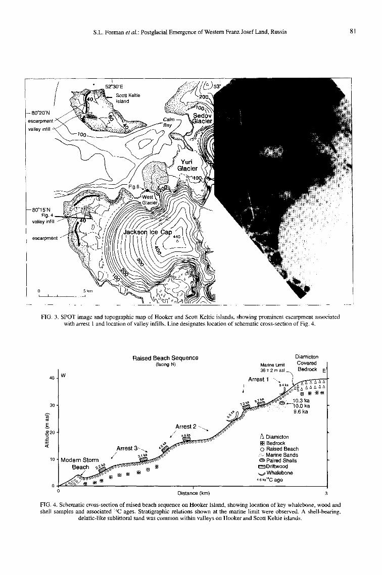
FIG. 3. SPOT image and topographic map of Hooker and Scott Keltic islands, showing prominent escarpment associated with arrest 1 and location of valley infills. Line designates location of schematic cross-section of Fig. 4.
Raised Beach Sequence Diamicton (facing N) Marine Limit Covered
36 +- 2 m asl Bedrock E
4o. W Arrest 1 -.~ ~ - ' E ' F E
_.~J: °° [] • ~
,~ ~.~,* ~ o : ~ 10.3 ka 3o ~ ' ~ " ~"- l&b ka
~_~ f l [ o~- 9.6 ka
E.. Arrest 2 -.. z¢ °
, ' /x Diamicton ~,,, .,z.o..6.6-o--~o . . . . . [ ] Bedrock
Arrest 3-- . . ~~.~(oo °" O Raised Beach , / ~ ~ ~ ~: Marine Sands
10 Modern Storm _._..~E&~6~ooooo~ ~ Paired Shells ~}Ddftwood Beach oooc-- []
Whalebone 0 ° ° ° / [] [] [] 4.6ka"C age
i
0 Distance (km)
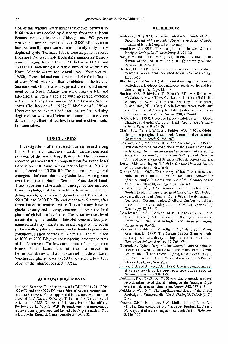
FIG. 4. Schematic cross-section of raised beach sequence on Hooker Island, showing location of key whalebone, wood and shell samples and associated 14C ages. Stratigraphic relations shown at the marine limit were observed. A shell-bearing,
delatic-like sublittoral sand was common within valleys on Hooker and Scott Keltic islands.

82 Quaternary Science Reviews: Volume 15
Hooker and Scott Keltie islands seaward of the escarpment provides a minimum limiting age on escarpment formation. Well preserved and narrow
40 (<100 m wide) regressional strandlines occur below the Marine Limit 36 + 2 m asl escarpment. However, there is a noticeable broadening in
s ~ f l ~ the regressional sequence at 17 __. 2 m a.s.1, and 8 -+ 2 m Arm "", a.s.l., demarcated by 100-200 m wide constructional
30 "~ _~- " raised beaches. 14C ages on driftwood from these broader u~ raised beaches place accretion of terraces at ca. 5500 BP
E.E ' • Driftwood and 3000 to 3500 BP (Fig. 5). ' u Whalebone On adjacent Scott Kel t ie Island, 7 km north o f Hooker -o e 20 Arrest 2 (?) . . - '9 ,, Shell
~. ~ Island, there is a pronounced 2-3 m high escarpment < ~ eroded into a washed marine-limit surface on Scott Keltie
10 Arrest 3 (?) ,' Island. This escarpment, highlighted by late-lying snow- / 11-"
banks, is most evident on Scott Keltie Island and in places on Hooker Island (Fig. 3). Driftwood from the
0 . . . . . . . . . . . . . . . base of the scarp at 26 m a.s.1, yielded a 14C age of 6590 0 5 10 15 _+ 85 BP (GX-17190) providing a minimum estimate on
formation of the scarp and similar to an age for the same
Etheridge Island geomorphic feature on Hooker Island. The lowest raised beaches (1 to 2 m a.s.1.) on Hooker
Island, at the head of Calm Bay (Fig. 3), are protected 30 Highest Raised Beach 28 ± 2 masl from storm waves that form 2-3 m high storm beaches
f - - - on the outer coast of the island. Partially buried logs from / , raised surfaces at 1 and 2 m a.s.l, yield 14C ages of 775 _+ =,
~" iI 65 BP (GX-17200) and 1100 _+ 80 BP (GX-17199) indi- ' cating that emergence is not complete. Surprisingly, a log
Arrest 2(?)I buried at 0.5 m a.s.1, gave the ~4C age of >38,000 BP 15 ~ s , (GX-17201), the only evidence for open water conditions
"O before the Late Weichselian.
A raised glacial-marine silt occurs beneath a Little Ice Arrest 3(7!,, Age or Neoglacial diamicton and within 0.5 km of the
~ r " - " present margin of West Glacier. (Fig. 6). This glacial- 0 l'"i . . . . . . . . . . mar ines i l t con ta insap le thorao f in s i t u , robust, and
. . . . paired Mya truncata molluscs that yielded the ~4C age of 0 5 10 15 8325 + 100 BP (GX-17265). This sequence indicates that
Radiocarbon Years B.P. (x l 03) outlet glaciers on Hooker Island were either at or behind their present margins by the early Holocene, with falling
FIG. 5. Height-age relation for raised beaches of Hooker and Scott Keltie islands and Etheridge Island, Franz Josef Land, relative sea-level.
Russia.
W Facing N unit description
3 m Diamicton ~ w/erratic / ~ E shells (Little Ice Age?) / ~ / ~ ~ silty s a n d ~ 1 ~ _ ~ - ~ ~ , ~ /~ /~ /~ /~ / ~ w/abundant _ ~ ' v - k 3 1 1 1 ~ ' ~ _ _ ~ ~ _ ~ _ _ _ _ ~ _ ~ _ ~ p a i r e d ~ - - ~ ~ ~ ' ~ ~ M. truncate ~- - , , - - 8325 ± 100 Diamicton ~ - - - ~ L ~ J I W J ~ - ~ - - ~ I F I ~ L l J / - - ~ - ~ _ ~ " ~ B • P- -- _ - _ u n d e r l a i n z~ z3 /x ~ A. /x z~ A £x A ~, ,,~ ~ = ~ z ~ = ~ k ~ . ~ J G X - 1 7 2 6 5 )
r , z~ z~ ~ zx A ~ z~ z~ ~ z~ zx A zx /x zx w/pods of z~ z~ A zx ~ zx z~ z~ zx z~ zx zx ~ zx zx zx zx zx z~
- 100m t I
FIG. 6. West Glacier section showing deglacial glacial-marine sediments with abundant in situ Mya truncata shells capped by presumed Little Ice Age diamicton. 14C age on shells indicate that glaciers were at or behind present limits by the early
Holocene.

S.L. Forman et al.: Postglacial Emergence of Western Franz Josef Land, Russia 83
EtheHdge Island broadening in the regressional sequence, demarcated by 100-200 m wide constructional raised beach, that crests
Etheridge Island, 15 km south of Hooker Island, is a at 29-26 m asl. Paired valves of Hiatella arctica from lit-
small island completely covered by raised beaches up to toral sands at 25 m a.s.l, within this broad terrace yielded
its maximum elevation of 28 m a.s.l. There is a distinct absence of driftage on the upper 3 m of the island, possi- the 14C age of 6190 _+ 60 BP (AA-7902) indicating either bly reflecting the removal by sea-ice, when the island ini- a slow rate of emergence for the early Holocene, or near tially emerged from the sea. Similar to Hooker and Scott reoccupation of the marine limit later in the emergence
cycle. Raised beaches below 20 m a.sJ. are characterized Keltie islands, there are noticeable erosional and con- structional landforms in the regressional raised-beach by narrow berms, with extensive ice-pushed ridges and
more abundant sea- ice-melt-ket t les below 8 m a.s.l. sequence. A discontinuous hut prominent constructional
There is a prominent escarpment cut into raised-beach marine terrace is observed at 16 + 1 m a.s.1. A z4C age on
gravels at 12 _+ 1 m a.s.1, with an inferred age of ca. 3500 a partially buried 2 m long log from the crest of this ter-
BP, based on the pattern of emergence (Fig. 8). race places sea level regression from this surface at ca. 4215 +_ 80 BP (GX-17202). Lower in the regressional sequence there is a prominent escarpment at 9 _+ 1 m a.s.1. Bell Island that formed ca. 3500 BP (Fig. 5). Modern flotsam occurs up to 3 m a.s.l, on this exposed island. The highest marine terrace on the archipelago is iden-
tified at 49 + 2 m a.s.1, inset against a steep bedrock slope
Koettlitz and Nansen Islands on southeastern Bell Island (Fig. 2). ~4C ages of 9220 _+ 120 BP (GX-I7209G) and 9705 +_ 105 BP (GX-17208)
There is a well-preserved raised beach sequence on on whalebone and driftwood imbedded in regressional glacier-free areas on the northwestern coasts of Koettlitz gravels at 47 + 2 and 45 +_ 2 m a.s.l., respectively provide and Nansen islands (Fig. 2). The time series of emer- minimum limiting ages on emergence (Fig. 8). Below the gence for these two islands are combined because of the marine limit there are a series of steeply-inclined marine similari ty in marine- l imit morpho logy and elevation terraces, covered by eolian sand. (Figs 7 and 8). A washing limit at 29 _+ 2 m a.s.1, eroded On southwestern Bell Island a gently sloping foreland, into glacial drift delimits the maximum level of marine covered by raised beaches to approximately 30 m a.s.l., incursion. Driftwood partially embedded in beach grav- provides an optimal setting for resolving the time series els, 1-2 m below the marine limit, yielded the ~4C age of for emergence. A striking geomorphic feature is a 2-5 m 10,360 _+ 115 BP (GX-17196) providing a close con- high escarpment at approximately 26 m a.s.l., eroded into straining age on initial marine inundation. A ~4C age of beach gravels and bedrock . A ~4C age on dr i f twood 9920 + l l 0 BP (GX-17267) on paired valves o f Mya deposited against the escarpment places the erosional truncata from sublittoral sands at 25 m a.s.1, within the event before 6000 BP. Another discontinuity in emer- valley fill provides another minimum limiting age on gence is represented by a raised accretionary spit at 16 + postglacial regression (Fig. 8). 2 m a.s.l., which may signify an arrest in the fall of rela-
On Nansen Island, immediately seaward of the wash- tive sea level. A ~4C age on a whale jawbone from the ing limit and within river valleys there is a noticeable cusp of this raised spit places its construction at ca. 4300
Raised Beach Sequence Diamicton (facing N) Marine Limit Covered
29 .+ 2 m asl Bedrock
W Arrest 1 ~
%o?00- o0
IE 20 o °°° Arrest 3 X ~-~-,.
/ ~ ~ ~6~ m Diamicton ~ o ° m Bedrock
J Modern Storm ~ ~ oo• O Raised Beach 10 / Beach ~ ~ . . , ~ w Madne Sands
~ ~ o ~ ~ ~ Paired Shells
4.6 ka"C age
0 / °-'~°°°°°/=° ~ " ~ 0 i
Distance (km) 2
FIG. 7. Schematic cross-section of raised beach sequence on Nansen and Koettlitz islands, showing location of wood and shell samples and associated ]4C ages. Stratigraphic relations shown at the marine limit were observed. A shell-bearing
sublittoral sand was common within valleys on Nansen Island.

84 Quaternary Science Reviews: Volume 15
Bell Island Southeastern George Island
50 ~ Marine Limit 49 + 2 m asl On southeastern George Island the highest recognized Arrest 1 (?) ~ = / ' - ' - - ~ ? ra i sed-beach deposi t at 23 m a.s.l., occurs on Cape
,," Forbes, a small raised foreland below a glacier-covered 40 q , plateau (Fig. 2). The upper level of marine incursion is
,' identified by a broad (100 to 400 m wide) constructional --~" " terrace. Driftwood from a regressional surface at 20 _+ 1 t~ 30 j Arrest 2 (?) , ' " "2 m a.s.1, provides a minimum age of 4785 + 95 BP (GX- E ~ ' " • "-" / • Driftwood 19482) on the highest recognized raised beach. Paired ~ 2 0 D Whalebone valves of Hiatella arctica from laminated silt and sand at
~. approximately 5 m a.s.l, yielded an age of 5035 ___ 70 BP < Arrest 3 (?) . (AA-12482), providing another minimum limiting age on
1 0 ~ . deglaciation (Fig. 9).
On the steep headlands of southeastern George Island is a wel l -preserved sequence o f raised beaches. The
O , J , i , i
0 2 4 6 8 10 12 highest identified marine limit extends to 38 _+ 2 m a.s.1. in the outer part of Peary Bay and is demarcated by a broad constructional terrace inset into a narrow valley.
Koettlitz and Nansen Islands The marine limit apparently descends up bay to 21 m a.s.l., within 1 to 2 km of the present glacier, although
Marine Limit 29 +_ 2 m asl 30
Arrest 1,,z~ 2x ? . Southeastern George Island
E 20 ." • Driftwood a) • zx Shell 4 0 Marine Limit 38 + 2 m asl
"13 Arrest 3 (?) ,,'
< lo / , - 30 "
/ E
~= 20 • Driftwood 0 , , '= ~ Shell
0 2 4 6 8 10 12 < Radiocarbon Years B.P. (xl 03) 10
FIG. 8. Height-age relation for raised beaches of Nansen and . . Koettlitz islands and Bell Island, Franz Josef Land, Russia. 0 ,
0 2 4 6 8
BP. On Bell Is land, 100 m behind the modern storm beach, is the lowest identified raised-beach surface at 1 m Northbrook Island a.s.1. Driftwood imbedded into this raised surface yielded the age of 1050 _+ 95 BP (GX-19476), indicating that 50 emergence is not complete (Fig. 8). Marine Limit 42 + 2 m asl
._, 40 ..... 9 Northbrook Is land ~ .. .......... ~ "
Arrest 1 E 30 / ' "
On Cape Lagerny, a small glacier-free foreland on the ~" northern tip o f Northbrook Island (Fig. 2), the marine "o - m
limit is identified at 42 -+ 2 m a.s.1, as a wave-washed sur- ~ 20 • Driftwood face. The ra ised-beach sequence between the marine < o Whalebone
limit and approximately 34 m a.s.1, is obscured by fluvial 10 Arrest 3(9) erosion and cryoturbation. A 14C age of 9220 _+ 120 BP (GX-I9487G) on a whalebone from 33 m a.s.1, provides 0 " ' ;~ , . . . . . . . . . . a minimum constraining age on marine incursion. There 0 2 4 6 8 10 12 is a series of discrete regressional strandlines below 33 m a.s.l., with a noticeable broadening of the raised beaches Radiocarbon Years B.P. (x 103) between 12 and 15 m a.s.l., which dates to 3500 to 4100 FIG. 9. Height-age relation for raised beaches of Northbrook BP (Fig. 9). Numerous sea-ice-pushed-ridges character- Island and Southeastern George Island, Franz Josef Land, ize the lower 8 m of the terrace sequence. Russia.

S.L. Forman et al.: Postglacial Emergence of Western Franz Josef Land, Russia 85
solifluction on the adjacent slopes may have obscured maximum isostatic rebound is poorly constrained; one higher raised beaches. Assuming synchroneity with the possible minimum representation is shown in Fig. 1. 21 m a.s.1, water plain on Cape Forbes a minimum There is an absence of boulder-dominated beaches at deglacial age of ca. 5000 BP is inferred for the inner part the marine limit, though boulder beaches are common of Peary Bay. lower in the regressional sequence and at the present
shoreline. The highest level of marine incursion is
DEGLACIAL RELATIVE SEA-LEVEL HISTORY commonly demarcated by a discrete washing limit erod- ed into glacial drift, and in many valleys, particularly on
Radiocarbon ages on in situ molluscs and one piece of Hooker Island, is coincident with a sandy-gravelly driftwood place deglacial invasion of the sea along marine-infil l (Figs 4 and 7). There is a noticeable British Channel at 10,400 BP. A number of lac ages paucity of driftwood and whalebone associated with the between 9200 and 9700 BP on driftwood and whalebone, marine-limit surface. Only one whalebone from Hooker <10 m below the marine limit, clearly show that fore- Island and one piece of driftwood from Koettlitz Island lands adjacent to British Channel were deglaciated by the were retrieved after surveying numerous marine-limit early Holocene. A raised glaciomarine sediment within landforms adjacent to British Channel. The lack of 0.5 km of a present glacier margin on Hooker Island was boulder-dominated beaches and paucity of driftage at deposited about 8300 BP indicating that outlet glaciers the marine limit may indicate a more permanent coastal were at or behind the present limit during the early sea-ice coverage that would dampen waves and restrict Holocene. the flux of flotsam during initial emergence (H~iggblom,
The pattern of postglacial emergence indicates that 1982). past-glacier loads were greater over the adjacent Barents There is an arrest in emergence soon after formation Sea than Franz Josef Land. The maximum recorded of the marine limit along British Channel (Table 2). A glacio-isostatic compensation for Franz Josef Land is on prominent and traceable sea-level discontinuity occurs <6 Bell Island, with a marine limit of 49 _+ 2 m a.s.l., formed m below the marine limit on Hooker (Fig. 4), Scott ca. 10,000 BP. The marine limit and 9000 BP raised- Keltie, and Koettlitz islands (Fig. 7) either as an escarp- beach surfaces adjacent to British Channel ascend south- ment eroded into marine-limit deposits and/or a broad ward at 0.3 m/km, toward the Barents Sea (Fig. 10). A constructional-marine terrace. On Hooker Island, drift- maximum in postglacial rebound over eastern Svalbard wood embedded in a broad constructional terrace, crest- indicates also substantial ice-sheet loading over the ing at 29 m a.s.l., yielded 14C ages of 8715 +_ 100 BP and Barents Sea (Salvigsen, 1981; Forman, 1990; Forman et 7245 _+ 100 BP indicating little change in sea level during al., 1995). Observations of a low (<20 m a.s.l.) and this interval. ~4C ages of 6590 +_ 85 BP and 6555 _+ 95 BP young (<6000 BP) postglacial marine limit on Novaya on driftwood and whalebone near the base of a scarp at Zemlya further confines the area of maximum glacio-iso- 26 m a.s.1, respectively on Scott Keltie and Hooker static compensation to the Barents Sea (Forman et al., islands provide a minimum constraining age on this 1995). However, the southern extension of this zone of arrest in sea level. On Koettlitz and Nansen islands a cor-
relative sea level event is inferred from a broad raised- beach at 29 to 26 m a.s.1. ~4C ages on included shells place construction of this beach sometime between 9920 _+ 110 and 6190 _+ 60 BP. The lack of stratigraphic evi-
a~ o dence for multiple rises and falls in sea level, and the ~ o .~ breadth of the terraces with similar 14C ages attest to an
__. ID ¢ - ,-- ~ apparent arrest in emergence, rather than a transgression,
m i71 o • spanning potentially 9900 to 6200 BP on western Franz ~ - m J ~ ~ Josef Land. The timing of this arrest (1) is similar to a
O 2 ~ - \1 N . m (.9 o ~ ,.. transgressive event inferred on Alexandra Land that is
~. - " , , E "1- Ma~- "~ ~ associated with formation of the marine limit between ca. \ ~ , . '~.~se O~ ,...t ~ _ _ . . . . . ~ ~ o ~ 8800 and 6800 BP (Naslund e, al., 1994).
E o! ~ ~ _ ~ X ~ ~ Two additional arrests (2 and 3) in relative sea level ¢~ ~ ~ - I are inferred from changes in the raised-beach morpholo-
-o --, ~ gy lower in the regressional sequence (Figs 4 and 7;
" .~ T< Table 2). Landforms that demarcate these sea-level dis-
continuities are less prominent and less traceable than features associated with the earlier arrest 1. The lower
o inferred arrests in sea level are most evident on Hooker 0 4'0 80 120 Island as prominent, broad (100 m wide), constructional
Distance along A-A' Line (km) on Fig. 2 raised beaches between 18 and 16 m a.s.l, and 10 and 8 m a.s.l., respectively dated at ca. 5500 and 3500 BP (Table
FIG. 10. Tilt of the marine limit, 9000 BP and 5000 BP raised beach surface. Notice the consistent uptilt toward the southwest, 2). Correlative sea-level events have been identified on into the Barents Sea, the area of maximum ice sheet load. See other forelands adjacent to British Channel as either
Fig. 2 for location of A-A' line. broad constructional terraces or escarpments, reflecting

86 Quaternary Science Reviews: Volume 15
TABLE 2. Elevation and approximate age of marine limit and inferred postglacial relative sea-level arrests on west Franz Josef Land, Russia
Marine Limit Arrest 1 Arrest 2 Arrest 3 Island Foreland
Elevation Age (ka) Elevation Age (ka) Elevation Age (ka) Elevation Age (ka) (m a.s.1.) (m a.s.1.) (m a.s.1.) (m a.s.l.)
Hooker/Scott Keltie 36+2 >__10.3 36-26 10.0-6.6 18-16 6.6--4.6 11-8 4.5-2.2 Bell 49_+2 >-- 9.7 12-8 3.9-2.8 Etheridge 18-16 6.0-5.0 10-5 4.2-1.1 Koettlitz/Nansen 29_+2 _>10.4 29-22 9.9-6.2 14-12 4.2-3.0 Northbrook 42_+2 _> 9.2 32-30 9.2-6.3 14-9 4.0-2.4 George 38_+2 > 6.0
the varying balance between wave energy, and sediment matic conditions, indicated by the presence of reindeer on supply on an emerging coastline (Table 2). 14C ages on Alexandra Island, Franz Josef Land, between ca. 2200 driftage support field interpretations for the occurrence of and 3900 BP (Zale et al., 1994). This apparent arrest in arrest 3, but is inconclusive for arrest 2 (Figs 4 and 7; sea level during regression may reflect increased height Table 2). The available chronologic control indicates that of the ocean surface with greater storminess and extend- arrest 3 at ca. 3500 BP may span _>1000 years, whereas ed open-water conditions. arrest 2 at ca. 5500 BP occurred in <500 years. There is evidence that emergence is not complete on
The three inferred arrests in relative sea-level (Table Franz Josef Land. Driftwood 1-2 m above the storm- 2) reflect a variety of non-steric sea level processes. The beach limit yielded ~4C ages between 775 and 1500 BP earliest arrest (1) between 9900 and 6200 BP signifies a (Table 1). In a protected part of Calm Bay on Hooker balance between glacio- isostasy and eustasy, concomi- Island, shielded from storm waves, raised beaches occur tant with the final phase of global sea- level rise at 1 and 2 m a.s.l, and date to 775 _+ 65 and 1100 + 80 BP (Fairbanks, 1989). The inferred timing of this arrest is 14C ages on the lowest raised beaches indicate apparent broadly coincident with 1-3°C warmer summer sea-sur- emergence rates for the past 1000 to 2000 BP of approxi- face temperatures for Svalbard (Salvigsen et al. , 1992) mately 1 to 2 mm/year. Low (<2 mm/year) modern rates and the northern Norwegian-Greenland Sea (Koq and of emergence in Fennoscandinavia (Emery and Aubrey, Jansen, 1994; Jones, 1994). The coverage of sea ice was 1985), similar to rates during the last millennium on probably reduced during this warmer interval, extending Franz Josef Land, are characteristic of areas that sus- the open water season, and increasing exposure of the tained modest Late Weichselian glacier loads (<1500 m) coast to wave energy (H~iggblom, 1982; Koq et a l . , within a few 100s of km of the inferred ice sheet margin 1993). Warmer summer sea-surface conditions in the (Fjeldskaar, 1994). Barents Sea may be associated with an increase in
cyclonic activity and storm generated waves that could DISCUSSION: THE DEGLACIAL I-IEMICYCLE IN either erode or accrete the coastline dependent on local THE BARENTS SEA sediment supply (cf. Fletcher et al., 1993). A prominent escarpment and depositional landforms associated with The pattern of postglacial emergence and strandline the earliest arrest (1) may reflect the combined effects of tilts on Svalbard and Franz Josef Land places the maxi- rising global sea-level and increased ocean height with mum ice sheet load over the Barents Sea. Many models greater storminess, infer ice-sheet thickness of at least 2000-2500 m for the
Although apparently younger than arrest 1 on Franz area of max imum emergence in the Barents Sea Josef Land, a similar prominent middle Holocene (6500 (Grosswald, 1988; Tushingham and Peltier, 1991; to 5000 BP) transgression has been identified on emerg- Elverh¢i et al . , 1993; Peltier, 1994; Lambeck, 1995). ing coastlines of Fennoscandia (Haftsen, 1983) and Sediment records spanning the last deglacial hemicycle Svalbard (Forman, 1990). These postglacial sea-level from the adjacent Franz Victoria Trough document a oscillations may reflect back migration of mantle materi- Barents Sea ice sheet grounded in water depths of at least al from a glacio-isostatically created forebulge (Clark et 500 m (Polyak and Solheim, 1994; Lubinski et al . , in al. , 1978), and hydroisostatic adjustments with eustatic p r e s s ) . Iceberg-scour traces identified at 300-700 m sea level rise (Peltier et al., 1978; Lambeck, 1993). The water depths on the Yermak Plateau attest to a 1000+ m arrest 1 may reflect partially crustal up-warping from thick, calving ice sheet margin terminating in the Franz back migration of displaced mantle material. Victoria and/or the Svayataya Anna troughs during the
It is improbable that the middle- and late-Holocene last glaciation (Vogt et al . , 1994). Marine and glacial relative sea-level record on Franz Josef Land gauge geologic evidence support the presence of a considerable changes in eustatic sea level, because isostasy exceeds volume of the Barents Sea ice sheet drained by calving eustasy with stabilization of global sea-level, ca. 6000 BP ice streams, grounded in the nearby deep troughs border- (Fairbanks, 1989). The latest apparent arrest in sea level ing the Arctic Ocean. at ca. 3500 BP may be associated with ameliorated cli- Sea level has a fundamental control on the present

S.L. Forman et al.: Postglacial Emergence of Western Franz Josef Land, Russia 87
style of glaciation in the northern Barents Sea. Up to 30% sedimentation starting by ca. 10,000 BP in the adjacent of the volume of Nordaustlandet ice cap is below sea Cambridge Strait is consistent with terrestrial deglacial level , rest ing on water saturated marine sediments ages (Polyak and Solheim, 1994). A similar deglacial age (Dowdeswell and Drewry, 1989). The southern extent of of 10,300 BP is also inferred for coastal areas of Edgecya this ice cap maybe limited by the destabilizing effect of near the center of the hypothesized ice sheet (Landvik et saturated bed conditions below sea level that facilitates al . , 1992). Marine and terrestrial records from Franz periodic surges (Dowdeswell, 1986). Ice shelves present- Josef Land indicate retreat of glaciers from coastal areas ly abound in nearshore areas on Franz Josef Land where by at least 10,400 BP, whereas the adjacent Franz g lac ie r s t e rmina te in wa te r depths of >200 m Victoria Troughwasdeglaciatedby 13,000BE (Dowdeswell et al . , 1994). Water depths increase sub- We infer that iceberg calving through the deep troughs stantially to >500 m in the troughs bordering the Barents bordering the Barents Sea was an important process con- Sea, including British Channel in Franz Josef Land trolling the demise of the Barents Sea ice sheet. A possi- (Matishov et al. , 1995), providing a 'sea-level sensitive ble increase in the flux of icebergs at ca. 13,000 BP, rep- a rea ' near the margin of the Barents Sea ice sheet resenting deglaciation of northern troughs, and at ca. (Hughes, 1987). 10,400 BP reflecting a later retreat of glaciers (or ice cap)
Modelling of the spatial and temporal variation in on Franz Josef Land could be recorded as ~80 minima in glacio-isostasy in northern Eurasia places a relatively sta- planktonic foraminifera and an increase in ice-rafted tionary zone of zero uplift close to the maximum limit of detritus (IRD) in Arctic Ocean sediments. Cores from the the ice sheet (Fjeldskaar, 1994). This inferred rheological Arctic Ocean reveal a prominent 5180 minima sometime response during the last deglaciation underscores the sen- between 15,700 and 13,500 BP, and heavier ~80 values sitivity of the ice sheet margin to eustatic rise in sea level, between 13,000 and 10,000 BP (Jones and Keigwin, rather than isostatic effects (Jones and Keigwin, 1988). 1988; Stein et al., 1994). It is unclear what events the iso- We suspect that eustatic sea-level rise of approximately topic minima in Arctic Ocean cores record and have been 40 m between 13,500 and 10,500 BP (Fairbanks, 1989) attributed to Greenland ice-sheet discharge (Nam et al., promoted deglaciation by destabilizing grounded ice 1995), renewed fresh water contr ibut ions from the streams in troughs and channels. Two inferred periods of Siberian rivers (Stein et al., 1994; Forman et al., 1995) or rapid global sea-level rise of >10 m in <300 years, cen- a direct deglacial signal from the Barents Sea ice sheet tered at 12,000 and 10,000 BP (Blanchon and Shaw, (Jones and Keigwin, 1988). 1995) may have set the pace for the two-step deglaciation Sediment records west of Svalbard in Fram Strait of the Barents Sea ice sheet (Lehman and Forman, 1992; show two distinct peaks in IRD during the last 26,000 BP Polyak et al., 1995). The marine-based Barents Sea ice that coincide with increased flux of detrital organic mat- sheet may have initially retreated with rising global sea- ter, presumably from Svalbard (Hebbeln, 1992). It is level about 13,500 BP. A subsequent rapid rise in sea unclear if these IRD events monitor changes in the level at 12,000 BP (Blanchon and Shaw, 1995) may have Barents Sea ice sheet because the lack of lithologic data accelera ted discharge of ice s t reams through shelf preclude unequivocal assessment of iceberg source. troughs leading to final draw down of the 2000+ m thick Chronologic correlation of IRD events to other records in northerly ice-dome, the Barents Sea is confounded by imprecise age estimates
Coincident with rising global sea-level radiation based on correlation to the deep-sea 6180 time scale, receipts at the top of the atmosphere for 80 ° N exceeded placing the latest IRD event between 10,000 and 20,000 present values by 15,000 BP (Berger and Loutre, 1991). BE Other IRD records spanning the last deglacial cycle Insolation peaked at 10,000 BP; this peak was the great- from the northern Norwegian Sea show a dominance of est insolation anomaly for any latitude and time during clastics and quartz, indicative of rock types on Svalbard the past 100,000 years (cf. Bradley, 1990). Orhitally and in the Barents Sea, but the IRD chronology is inade- induced radiation changes are particularly significant for quate to relate confidently to other records (Bischof, glacier mass-balance in the Arctic with full daylight in 1994). the summer (Bradley, 1990). We contend that rising inso- There is clear evidence of numerous oscillations in lation after ca. 15,000 BP to levels exceeding current sea-surface temperatures in the North Atlantic between receipts contributed to the demise of the Barents Sea ice 15,000 and 10,000 BP linked to variable contributions of sheet by enhancing surface ablation (Koq and Jansen, warm Atlantic waters, and meltwater and icebergs from 1994). surrounding ice sheets (Keigwin et al. , 1991; Lehman
The initiation of glacial-marine sedimentation over a and Keigwin, 1992; Sarnthein et al., 1992). Sea-surface glacial diamicton in Franz Victoria Trough at 13,000 BP warming in the North Atlantic Ocean, as early as 13,500 is the earliest definitive deglacial signature at the north- BE may not have propagated fully into the Barents Sea to ern portion of the Barents Sea ice sheet (Polyak and melt ice sheets (Hald et al., 1989). Diatom records show Solheim, 1994; Lubinski et al., in press) . Glacial-marine permanent sea ice persisting over much of the Norwegian environments are inferred to persist until ca. 10,000 BE Sea, until after the Younger Dryas (Ko~ et al . , 1993). when sedimentat ion similar to present commenced . Initial penetration of North Atlantic waters at ca. 13,400 Radiocarbon ages on in situ shells and driftwood from BP with summer sea-surface temperatures 50% cooler the forelands adjacent to the British Channel reveal that than today (at 7°C) is inferred in a narrow corridor along this trough was deglaciated by 10,400 BE Glaciomarine coastal Norway (Koq et al., 1993). The northern exten-
88 Quaternary Science Reviews: Volume 15
sion of this warmer water moat is unknown, particularly R E F E R E N C E S if this water was cooled by discharge from the adjacent
Andrews, J.T. (1970). A Geomorphological Study of Post- Fennoscandinavia ice sheet. Although rare, 14C ages on Glacial Uplift with Particular Reference to Arctic Canada.
whalebone from Svalbard as old as 13,000 BP indicate at Institute of British Geographers, London. least seasonally open waters intermittently early in the Astakhov, V. (1992). The last glaciation in west Siberia. deglacial cycle (Forman, 1990). Coastal pollen records Sveriges Geologiska Undersckning, 81, 21-30. from north Norway imply fluctuating summer air temper- Berger, A. and Loutre, M.F. (1991). Insolation values for the atures, ranging from 2°C to 11°C between 11,500 and climate of the last 10 million years. Quaternary Science 13,000 BP indicating a variable import of warmth by Reviews, 10,297-318.
Bischof, J.F. (1994). The decay of the Barents ice sheet as docu- North Atlantic waters for coastal areas (Vorren et al., mented in nordic seas ice-rafted debris. Marine Geology, 1988b). Terrestrial and marine records belie the influence 117, 35-55. of warm North Atlantic influx for ablation of the Barents Blanchon, P. and Shaw, J. (1995). Reef drowning during the last Sea ice sheet. On the contrary, periodic northward move- deglaciation: Evidence for catatrophic sea-level rise and ice- ment of the North Atlantic Current during the full- and sheet collapse. Geology, 23, 4-8.
Boulton, G.S., Baldwin, C.T., Peacock, J.D., yon Brunn, V., late-glacial is often associated with increased cyclonic McCabe, A.M., Miller, G., Jarvis, J., Horsefield, B., activity that may have nourished the Barents Sea ice Worsley, P. , Eyles, N., Chroston, P.N., Day, T.E., Gibbard, sheet (Bou l ton et al., 1982; Hebbe ln et al., 1994). P. and Hare, P.E. (1982). Glacio-isostatic facies model and However, we believe that additional accumulation during amino acid stratigraphy for late Quaternary events in deglaciat ion was insufficient to counter the ice sheet Spitsbergen and the Arctic. Nature, 298,437-441.
Bradley, R.S. (1990). Holocene Paleoclimatology of the Queen destabilizing effects of sea-level rise and positive-insola- Elizabeth Islands. Canadian High Arctic. Quaternary tion anomalies. Science Revien,s, 9,365-384.
Clark, J.A., Farrell, W.E. and Peltier, W.R. (1978). Global changes in postglacial sea level: A numerical calculation.
C O N C L U S I O N S Quaternary Research, 9,265-287. Denisov, V.V., Matishov, D.G. and Sokolov, V.T. (1993).
Inves t iga t ions o f the ra i sed-mar ine record a long Hydrometeorological conditions of the Franz Josef Land British Channel, Franz Josef Land, indicated deglacial archipelago. In: Environment and Ecosystems of the Franz invasion of the sea at least 10,400 BP. The maximum Josef Land Archipelago and Shelf, 262 pp. Kola Science
Center of the Academy of Sciences of Russia, Apatity, Russia. recorded glacio-isostatic compensation for Franz Josef Denton, G.H. and Hughes, T. (1981). The Last Great Ice Sheets.
Land is on Bell Island, with a marine limit of 49 + 2 m Wiley Interscience, New York. a.s.l., formed ca. 10,000 BP. The pattern of postglacial Dibner, V.D. (1965). The history of late Pleistocene and emergence indicates that past-glacier loads were greater Holocene sedimentation in Franz Josef Land. Transactions over the adjacent Barents Sea than Franz Josef Land. of the Scientific Research Institute of the Geology of the Three apparent still-stands in emergence are inferred Arctic, 143,300-318, Leningrad (in Russian). from morphology of the raised-beach sequence and ~4C Dowdeswell, J.A. (1986). Drainage-basin characteristics of
Nordaustlandet ice caps. Journal of Glaciology, 32, 31-38. dating sometime between 9900 and 6200 BP, and at ca. Dowdeswell, J.A. and Drewry, D.J. (1989). The dynamics of 5500 BP and 3500 BP. The earliest sea-level arrest, after Austfonna, Nordaustlandet, Svalbard: Surface velocities, formation of the marine limit, reflects a balance between mass balance and subglacial meltwater. Journal of glacio-isostasy and eustasy, concomitant with the final Glaciology, 12, 37-45. phase of global sea-level rise. The latter two sea-level Dowdeswell, J.A., Gorman, M.R., Glazovskiy, A.F. and
Macheret, Y.Y. (1994). Evidence for floating ice shelves in arrests during the middle-to late-Holocene are less pro- Franz Josef Land. Russian high Arctic. Arctic and Alpine nounced and may indicate increased height of the ocean Research, 26, 86-92. surface with greater storminess and extended open-water Elverh0i, A., Fjeldskaar, W., Solheim, A., Nyland-Berg, M. and conditions. Raised beaches at 1-2 m a.s.1, and ~4C dated Russwtirm, L. (1993). The Barents Sea Ice Sheet-A model
of its growth and decay during the last ice maximum. at 1000 to 2000 BP give contemporary emergence rates Quaternary Science Reviews, 12,863-874.
of 1 to 2 ram/year. The low current rates of emergence on Elverh0i, A., Nyland-Berg, M., Russwtirm, L. and Solheim, A. F r a n z J o s e f L a n d are s imi l a r to a reas in (1990). Late Weichselian ice recession in the central Barents F e n n o s c a n d i n a v i a tha t s u s t a i n e d m o d e s t La te - Sea. In: Bleil, U. and Thiede, J. (eds), GeologicaIHistory of Weichselian glacier loads (<1500 m), within a few 100s the Polar Oceans: Arctic Versus Antarctic, pp. 289-307. of km of the inferred ice sheet margin. Kluwer Academic, New York.
Emery, K.O. and Aubrey, D.G. (1985). Glacial rebound and rel- ative sea levels in Europe from tide-gauge records. Tectonophysics, 120,239-255.
A C K N O W L E D G E M E N T S Fairbanks, R.G. (1989). A 17,000 year glacio-eustatic sea-level record: influence of glacial melting on the Younger Dryas
National Science Foundation awards DPP-9001471, OPP- event and deep-ocean circulation. Nature, 342,637-642. 9222972 and OPP-9223493 and Office of Naval Research con- Fjeldskaar, W. (1994). The amplitude and decay of the glacial tract N00014-92-M-0170 supported this research. We thank the forebulge in Fennoscandia. Norsk Geologisk Tidsskrift, 74, crew of R/V Dalnie Zelentsy, T. Jull at the University of 2-8. Arizona for AMS ~4C ages and J. Nagy for drafting efforts. Fletcher, C.H.I., Fairbridge, R.W., Moller, J.J. and Long, A.J. Reviews by L. Polyak, W.R. Farrand, and two anonymous (1993). Emergence of the Varanger Peninsula, Arctic reviewers are appreciated and helped clarify presentation. This Norway, and climate changes since deglaciation. Holocene, is Byrd Polar Research Center contribution #C-950. 3, 11 6-127.

S.L. Forman et aI.: Postglacial Emergence of Western Franz Josef Land, Russia 89
Forrnan, S.L. (1989). Late Weichselian glaciation and deglacia- meltwater discharge, North Atlantic deep circulation, and tion of the Forlandsund area, western Spitsbergen. Svalbard. abrupt climate change. Journal of Geophysical Research, Boreas, 18, 51-61. 96, 16811-16826.
Forman, S.L. (1990). Post-glacial relative sea-level history of Koq, N., Jansen, E. and Haf l idason, H. (19931. northwestern Spitsbergen. Svalbard. Bulletin of Geological Paleoceanographic reconstructions of surface ocean condi- Society of America, 102, 1580-1590. tions in the Greenland, Iceland and Norwegian Seas through
Forman, S.L., Lubinski, D., Miller, G.H., Snyder, J., Matishov, the last 14 ka based on diatoms. Quaternary Science G., Korsun, S. and Myslivets, V. (1995). Post-glacial emer- Reviews, 12, 115-140. gence and distribution of Late Weichselian ice sheet loads in Koq, N. and Jansen, E. (1994). Response of the high-latitude the northern Barents and Kara seas Russia. Geology, 23, North Atlantic to orbital climate forcing: evidence from 113-116. Nordic seas. Geology, 22, 523-526.
Gataullin, V., Polyak, L., Epstein, O. and Romanyuk, B. (19931. Kovaleva, G.A., 1974, Modern movement of Admiral ty Glacigenic deposits of the Central Deep: a key to the late Peninsula (northern island of Novaya Zemlya) . In: Quaternary evolution of the eastern Barents Sea. Boreas, 22, Geotectonic Condition for the Search for Resources on the 47-58. Shelf of the Arctic Ocean, pp. 87-93. Scientific Research
Glazovskiy , A.N., N~islund, J.-O. and Zale, R. (19921. Institute for the Geology of the Arctic, Leningrad (in Deglaciation and shoreline displacement of Alexandra Land, Russian). Franz Josef Land. Geografiska Annaler, 74A, 283-293. Lambeck, K. (19931. Glacial rebound and sea-level change: an
Grosswald, M.G. (19731. Glaciers ofFranz JosefLand. Nauka, example of a relationship between mantle and surface Moscow. processes. Tectonophysics, 223, 35-51.
Grosswald, M.G. (1988). An Antarctic-style ice sheet in the Lambeck, K. (1995). Constraints on the Late Weichselian Ice Northern Hemisphere toward a new global glacial theory. Sheet over the Barents Sea from observations of raised Polar Geography and Geology, 12, 239-267. shorelines. Quaternary Science Reviews, 14, 1-16.
Grosswald, M.G. (19931. Extent and melting history of the Late Lambeck, K., Johnston, P. and Nakada, M. (19901. Holocene Weichselian ice sheet, the Barents-Kara continental margin, glacial rebound and sea-level change in NW Europe. In: Peltier, W.R. (ed.), Ice in the Climate System, pp. 1-20. Geophysical Journal International, 103, 451-468. Springer, New York. Landvik, J.Y., Hansen, A., Kelly, M., Salvigsen, O., Slettemark,
Gronlie, O.T. (1924). Contributions to the Quaternary Geology 0. and Stubrup, O.P. (1992). The last deglaciation and of Novava Zemlya, Report of the Scientific Results of the glacimarine/marine sedimentation on Barents0ya and 1921 Norwegian Expedition to Novaya Zemlya, 367 pp. Edgecya, eastern Svalbard. LUNDQUA Report, 35, 61-84, Oslo, Norway. Lund, Sweden.
Hafsten, U. (19831. Shore-level changes in south Norway dur- Lehman, S.J. and Forman, S.L. (19921. Late Weichselian glaci- ing the last 13,000 years traced by biostratigraphical meth- er retreat in Kongsfjorden, west Spitsbergen. Svalbard. ods and radiometric dating. Norsk Geografiska Tidsskrifi, Quaternary Research, 37, 139-154. 37, 63-79. Lehman, S.J. and Keigwin, L. (1992). Sudden changes in North
Hiiggblom, A. (1982). Driftwood in Svalbard as an indicator of Atlantic circulation during the last deglaciation. Nature. 356, sea ice conditions. Geografiska Annaler, 64A, 81-94. 757-762.
Hafsten, U. (1983). Shore-level changes in south Norway dur- Lubinski, D.J., Korsun, S. Polyak, L. Forman, S.L., Lehman, ing the last 13,000 years traced by biostratigraphical meth- S.J., Herlihy, F.A. and Miller, in pressand Miller, G.H. (in ods and radiometric dating. Norsk Geografiska tidsskrift, 37, press). The last deglaciation of the Franz Victoria Trough, 63-79. northern Barents Sea, from piston core evidence. Boreas.
Hald, M., Danielsen, T.K. and Lorentzen, S. (1989). Late Mangerud, J., Bolstad, M., Elgersma, A., Helliksen, D., Pleistocene and Holocene benthic foraminiferal distribution Landvik, J.Y., LOnne, I., Lycke, A.K.. Salvigsen, O., Sandahl, in the southwestern Barents Sea: paleoenvironmental impli- T. and Svendsen, J.l. (1992). The Last Glacial Maximum on cations. Boreas, 18, 367-388. western Svalbard. Quaternao" Research, 38, 1-31.
Hebbeln, D. (1992). Weichselian glacial history of the Svalbard Matishov, G., Cherkis, N., Vermillion, M.S. and Forman, S.L. area: correlating the marine and terrestrial records. Boreas, (19951 Bathymetry of the Franz Josef Land Region, north- 21,295-304. east Barents Sea, Russia. Geological Society c~fAmerica
Hebbeln, D., Dokken, T., Andersen, E.S., Hald, M. and Map and ChartSeries, MCH080. Elverh~i, A. (1994). Moisture supply for northern ice-sheet Nam, S.-I., Stein, R., Grobe, H. and Hubberten, H. (1995). Late growth during the last glacial maximum. Nature, 370, Quaternary glacial-interglacial changes in sediment compo- 357-360. sition at the East Greenland continental margin and their
Horn, G. (1930). Franz Josef Land Natural History, Discovery, paleoceanographic implications. Marine Geology, 122, Exploration, and Hunting Skrifter om Svalbard og lslhavet, 243-262. Nr. 29, Det Kongelige-Departementfor handel, ~jcfart, N~islund, J.-O., Zale, R. and Glazovskiy, A. (1994). The mid industri, HCmdverk og Fiskeri, 54 pp., Oslo (in English). Holocene transgression on Alexandra Land, Franz Josef
Hughes, T.J. (1987). Ice dynamics and deglaciation models when Land, Russia. Geografiska Annaler, 76(A), 97-1(11. ice sheets collapsed. In: Ruddiman, W.E and Wright, H.E., Jr Olsson, l. (1980). Content of 14C in marine mammals from (eds), North America and Adjacent Oceans During the Last northern Europe. Radiocarbon, 22, 662-675. Deglaciation, pp. 182-220. Geological Society of America. Peltier, W.R., (19941. Ice Age Paleotopography. Science. 265, Geology of North America, v. K3, Boulder, Colorado. 195-201.
Ing61fsson, O. Rognvaldsson, E, Bergsten, H., Hedenas, L., Peltier, W.R., Farrell, W.E. and Clark, J.A. (1978). Glacial Lemdahl, G., Lirio, J.M. and Sejrup, H.P. (in press). Late isostasy and relative sea level: a global finete element Quaternary glacial and environmental history of Kongsoya, model. Tectonophysics, 50, 81-110. Svalbard. Polar Research, 14. Polyak, L. and Solheim, A. (1994). Late- and post-glacial envi-
Jones, G.A. (1994). Holocene climate and deep ocean circula- ronments in the northern Barents Sea west of Franz Josef tion changes: Evidence from accelerator mass spectrometer Land. Polar Research, 13, 197-207. radiocarbon dated Argentina Basin (SW Atlantic) mud- Polyak, L., Lehman, S.J., Gataullin, V. and Jull, A.J.T. (1995). waves. Paleoceanography, 9, 1001-1016. Two-step deglaciation of the southeastern Barents Sea.
Jones, G.A. and Keigwin, L.D. (1988). Evidence from Fram Geology, 23, 567-571. Strait (78°N)for early deglaciation. Nature, 336, 56-59. Salvigsen, O. (1981). Radiocarbon dated raised beaches in
Keigwin, I~.D., Jones, G.A. and Lehman, S.J. (19911. Deglacial Kong Karls Land, Svalbard and their consequences for the
90 Quaternary Science Reviews: Volume 15
glacial history of the Barents Sea area. Geografiska Annaler, Holocene sea-level history for a cross-section of western 63A, 283-292. Norway. Journal of Quaternary Science, 2, 113-132.
Salvigsen, O., Forman, S.L. and Miller, G.H. (1992). The Tushingham, A.M. and Peltier, W.R. (1991). ICE-3G: A new occurrence of extraliminal thermophilous molluscs on model of late Pleistocene deglaciation based upon geophysi- Svalbard during the Holocene and paleoclimatic implica- cal predictions of post-glacial sea level change. Journal of tions. Polar Research, 11, 1-10. Geophysical Research, 96, 4497-4523.
Sarnthein, M., Jansen, E., Arnold, M., t, J.C., Erlenkeuser, H., Velichko, A.A., Isayeva, L.L., Makeyev, V.M., Matishov, G.G. Flatoy, A., Veum, T., Vogelsand, E. and Weinelt, M.S. and Faustova, M.A. (1984). Late Pleistocene glaciation of (1992). ~O Time-slice reconstruction of meltwater anom- the Arctic shelf and reconstiuction of Eurasian ice sheets. In: alies at termination 1 in the North Atlantic Between 50 and Velichko, A.A. (ed.), Late Quaternary Environments of the 80 ° N. In: Bard, E. and Broecker, W.S. (eds), The Last Soviet Union, pp. 35-41, University of Minnesota Press, Deglaciation: Absolute and Radiocarbon Chronologies, pp. Minneapolis. 184-200. Springer, Berlin. Vogt, ER., Crane, K. and Sundvor, E. (1994). Deep Pleistocene
Solheim, A., Russwurm, L., Elverh¢i, A. and Nyland-Berg, M. iceberg plowmarks on the Yermak Plateau: sidescan and 3.5 (1990). Glacial flutes, a direct evidence for grounded glacier kHz evidence for thick calving ice fronts and a possible ice in the northern Barents Sea: Implications for the pattern marine ice sheet in the Arctic Ocean. Geolog); 22, 403-406. of deglac ia t ion and lat g lac ia l sedimentat ion. In: Vorren, T.O., Hald, M. and Lebesbye, E. (1988). Late Cenozoic Dowdeswell, J.A. and Scourse, J.B. (eds), Glaciomarine Environments in the Barents Sea. Paleoceanography, 3, Environments: Processes and Sediments, pp. 253-268. 601-612. Geological Society Special Publication no. 53, London. Vorren, T.O., Vorren, K.-D., Alto, T., Gulliksen, S. and Lovlie,
Stein, R., Nam, S.-I., Schubert, C., Vogt, C., Ffitterer, D. and R. (1988b). The last deglaciation 20,000 to 11,000 BP on Heinemeier, J. (1994). The last deglaciation event in the AndCya, Northern Norway. Boreas, 17, 41-77. eastern central Arctic Ocean. Science, 264, 692-696. Zagorskaya, H.G. (1959). Novaya Zemlya. In: Quaternary
Svendsen, J.I., Mangernd, J.M., Elverh¢i, A., Solheim, A. and Geology of the Soviet Arctic, pp. 20-36. Nauka, Moscow (in Schuttenhelm, R.T.E. (1992). The Late Weichselian glacial Russian). maximum on western Spitsbergen inferred from offshore Zale , R., Glazovskiy , A. and N~islund, J.-O. (1994). sediment cores. Marine Geology, 104, 1-17. Radiocarbon dating the extinct caribou on Franz Josef Land.
Svendsen, J.I. and Mangerud, J. (1987). Late Weichselian and Boreas, 23, 254-258.
Copyright © 2022 FDOKUMEN