Ecosystem Services and Risk Analysis on MPA of Raja Ampat, Papua, Indonesia
72
Ecosystem Services and Risk Analysis on MPA of Raja Ampat, Papua, Indonesia. by Ario Wicaksono 249913 B.Sc, Saint Cloud State University, 2006 A THESIS SUBMITTED TO COMPLETE THE REQUIREMENTS FOR THE DEGREE OF Master of Science in Faculty of Agricultural Science (Environmental Management) Ecology Centre Christian Albrecht University Kiel Germany Summer Semester 2010
Transcript of Ecosystem Services and Risk Analysis on MPA of Raja Ampat, Papua, Indonesia

Ecosystem Services and Risk Analysis on MPA of Raja Ampat, Papua,
Indonesia.
by
Ario Wicaksono
249913
B.Sc, Saint Cloud State University, 2006
A THESIS SUBMITTED TO COMPLETE THE REQUIREMENTS
FOR THE DEGREE OF Master of Science
in
Faculty of Agricultural Science
(Environmental Management)
Ecology Centre
Christian Albrecht University
Kiel Germany
Summer Semester 2010

____________________________________________________________________ Ecosystem Services and Risk Analysis in MPA Raja Ampat i
Abstract
Ecosystem resilience is observed to identify both strong and weak
components of an ecosystem. When found vulnerable to many natural and or
anthropogenic threats, it is important for ecosystem managers to develop plan to
avoid, mitigate, and minimize the potential risk. This study attempts to deliver
risk analysis on a defined MPA of Raja Ampat, Papua, Indonesia. In doing so, this
study employs methods of Ecosystem Based Management (EBM) and of
Ecosystem Analysis (DPSIR) to describe linkages between the economic
valuation of ecosystem services and potential tsunami risk. Driven by its natural
biodiversity and species richness above and under water as well as on terrestrial
ground, the areas are being conserved sustainably through integration of
ecosystem, social and economical approach similar to Integrated Coastal Zone
Management (ICZM). On a side note, community development, however, lags
behind the actual development of the MPA.
Keyword; Raja Ampat, Papua, ecosystem services, fisheries, coral reefs,
resilience, tsunami, mitigation plan, BNPB, disaster, relief fund, forest, coastal
management, EBM, DPSIR, sustainable, risk analysis, mangroves.

_____________________________________________________________________ Ecosystem Services and Risk Analysis in MPA Raja Ampat ii
Table of contents
Abstract..............................................………………………………………………i
Table of Contents….……………………………………………………………………ii
List of Tables........................................................................................iii
List of Figures……………………………………………………………………………iv
Acknowledgments...............................................................................vi
1 Introduction…………………………………………………………………………………. …1
1.1 Problem Statement…… …..……………………………………….……………… 1
1.2 Research Objectives…….. ………………………………………………………… 3
1.3 Thesis Outline ..………..…...………………………………………………………. 5
2 Background and Literature Review………………………………………………6
2 Raja Ampat, Papua, Indonesia……………………………………. ………………….6
2.1 Physical landscape…………………………………………………………………….6
2.2 Geology……………………………………………………………………………………7
2.3 Vegetation………………………………………………………………………………11
2.3.1 Highland submontane forest…….…………………………………12
2.3.2 Lowland and hill rain forest on dry land……………………….14
2.3.3 Hill forest on acid volcanics and metamorphics…………….15
2.3.4 Lowland forest on ultrabasics………………………………………17
2.3.5 Mangroves………………………………………………………………...18
2.4 Social and Economic Policy……………………….…………………………….19
3 Methods in MPA Management…….………………………………………………23
3.1. Ecosystem Services…………………………………………….…………………..23
3.1.1 Drivers……………………………………………………………………….27
3.1.2 Pressure…………………………………………………………………….28
3.1.3 States………………………………………………………………………..29
3.1.4 Impact………….…………………………………………………………..30
3.1.5 Responses………………………………………………………………….31
3.1.6 Fisheries……………………………………………………………………33

_____________________________________________________________________ Ecosystem Services and Risk Analysis in MPA Raja Ampat iii
3.1.7 Environmental and economic………………………………………34
3.2 Risk Assessment (EBM) model……………..…………………………………36
4 Risk Analysis on Raja Ampat……………………………………………..……….38
4.1 Threats definition and identification…………..…………………………….38
4.1.1 Definition of natural disaster and Impacts…………..………..38
4.1.2 Natural disasters influence factors……..………………………..39
4.1.2.1 Hazard………………………………………………………….40
4.1.2.2 Elements at risk………………………………………….…40
4.2 Risk Management Strategies on Natural Disaster………………..…….41
4.2.1 Risk Control Techniques………………………………………….….44
4.3 Tsunami …………………….………………………………………………………….45
4.3.1 Tsunami Causes…………………………………………………………45
4.3.1.1 Earthquake generates tsunami……………………..…46
4.3.1.2 Volcanic eruption generates Tsunami……………...47
4.3.1.3 Landslides generates Tsunami………………………..47
4.3.2 Tsunami Protection……………………………………………………48
4.3.2.1 Tsunami Warning System………………………………48
4.4 Bathymetry…………………………………………………………………………….51
4.4.1 Fisheries………………………………………………………………….. 52
4.4.2 Mangroves……………………………………………………………….. 53
4.4.3 Coral reefs…………………………………………………………………54
4.5 Coastal management……………………………………………………………….57
4.5.1 Policy and Regulation on Disaster Management…………….57
4.6 Problems with Reliance on Aid for Natural Disaster Relief………….59
5 Conclusion……………………………………………. ………………….………………..…61
5.1 Landscape and population……………..………………………………………..61
5.2 Strength, weaknesses, future research………………….…………………..61
5.3 Recommendation on Management and Policies…………………………62
Bibliography……………………………………………………………………………..63

_____________________________________________________________________ Ecosystem Services and Risk Analysis in MPA Raja Ampat iv
Tables and Figures
Table List Page
Table 1. Category of geological forms................................................................ 11
Table 2. Mangrove Distribution ....................................................................... 18
Table 3. Mangrove Carbon Capacity................................................................. 19
Table 4. MPA Contributions……....................................................................... 24
Table 5. Types of Ecosystem Services............................................................... 25
Table 6. Economic Valuation of Ecosystem Services ...................................... 26
Table 7. Classification of extreme events......................................................... 40
Table 8. Exposed area of land use.................................................................... 52
Figure List Page
Figure 1. Area of study….… ................................................................................. 1
Figure 2. Conceptual Eco-Analysis Framework ................................................ 4
Figure 3. Waigeo map………………....................................................................... 8
Figure 4. Misool map……………………………......................................................... 9
Figure 5. Kofiau map.......................................................................................... 9
Figure 6. Salawati and Batanta map………………............................................... 10
Figure 7. Vegetation on Batanta and Salawati ................................................. 12
Figure 8. Gunung Nok………………………............................................................ 13
Figure 9. Submontane Forest on Karst ……...................................................... 14
Figure 10. Intsia tree………………….................................................................... 15
Figure 11. Vegetation on Waigeo …………………................................................. 15
Figure 12. Canyon of Oribiai River.................................................................... 16
Figure 13. Mass civil gathering in Jayapura .................................................... 20
Figure 14. Mass civil gathering in Jayapura..................................................... 20
Figure 15. DPSIR Framework……………............................................................ 27
Figure 16. Merbau Log…………………………........................................................ 35
Figure 17. Costanoa Scheme….......................................................................... 37
Figure 18. Resilience Scheme….…………............................................................ 27
Figure 19. Natural Disaster Scheme …..…........................................................ 39
Figure 20. Natural Disaster Risk Management................................................ 37
Figure 21. Mitigation and Finance plans.......................................................... 43
Figure 22. Tsunami Cause……..…………............................................................ 46

_____________________________________________________________________ Ecosystem Services and Risk Analysis in MPA Raja Ampat v
Figure 23. Tsunamimeter DART….. …..…........................................................ 48
Figure 24. Seawalls………………………………...... ................................................ 49
Figure 25. Tsunami Wall Protection in Japan ................................................ 50
Figure 26. Elevation Map of Raja Ampat......................................................... 51
Figure 27. Fisheries Catchments Area...…........................................................ 53
Figure 28. Mangroves on Misool ……………………............................................. 54
Figure 29. Costanoa Scheme….......................................................................... 37
Figure 30. Batanta and Salawati Reef Coverage.............................................. 55
Figure 31. Waigeo Reef Coverage…. …..…........................................................ 56
Figure 32. Misool Reef Coverage…………………................................................. 56
Figure 33. Modified ICZM Scheme................................................................... 57
Figure 34. ICZM approach….….…………............................................................ 59

_____________________________________________________________________ Ecosystem Services and Risk Analysis in MPA Raja Ampat vi
Acknowledgments
I would first like to thank my supervisor, Dr. Hans-Rudolf Bork and Dr.
Klaus Dierssen who have offered continuous support and guidance in
developing this master work. Secondly, I would like to extend thanks to my
Master Program Coordinator, Dr. Wilhelm Windhorst who provided much
valuable advice on internship opportunities and networking. Also, special
thanks go to my Papuan brother of arms, Christano Ken Mambay of Serui,
who first inspired and shed so many insights on social injustice and overview
on undeveloped Raja Ampat fisheries and reefs. And finally many thanks are
owed to my sisters, Kristina Setyowati and Dian Ray who have helped funding
this small research. Even so, their words of encouragement have certainly
preserved my focus, ample motivation and good spirit in times of difficulties.
“I refuse to be dismayed, disengaged, disgruntled, or distracted.
Neither will I look back, stand back, fall back, or sit back. I do not need
applause, flattery, adulation, prestige, stature, or veneration. I do not have
time for business as usual, mediocre standards, small thinking, outdated
methods, normal expectations, average results, ordinary ideas, petty
disputes, or low vision. I will not give up, give in, bail out, lie down, turn
over, quit or surrender”
(Yogyakarta, November 2010)

_____________________________________________________________________ Ecosystem Services and Risk Analysis in MPA Raja Ampat - 1 -
1 Introduction
“To many people around the world, fish and fisheries resources mean food,
income, livelihood and culture” (Bailey, 2004).
1.1 Problem Statement
Ecosystem resilience is often observed to identify both strong and weak
components of an ecosystem. In order to maintain key functions and
processes in the face of stresses or pressures, resilient is shown either by
resisting or adapting to change (McLeod & Salm, 2008). When found
vulnerable to many natural and or anthropogenic threats, it is important for
ecosystem managers to develop plan to avoid, mitigate, and minimize the
potential risk. Observing on Marine Protected Area (MPA) Raja Ampat, Papua
Indonesia, there found not just breathtaking coastal lines and coral reefs,
outstanding biodiversity, high abundant fisheries and marine organisms, but
also complex ecological, economical and social problems. Problems described
in this thesis:
a. Unsustainable resource management practices
b. Potential natural risk and threats in Raja Ampat
c. High reliance on international aid in handling disaster relief
d. Cultural awareness on contingency measures
Figure 1. Area of study Raja Ampat, Papua, Indonesia.

_____________________________________________________________________ Ecosystem Services and Risk Analysis in MPA Raja Ampat - 2 -
Off the shore of Raja Ampat Islands, fisheries and other marine
resources are being exploited at an alarming rate using unsustainable
measures (Bailey, 2007). Depleting fish stocks, destructive fishing methods,
damaged mangrove forests, stagnant economies, and nutrition shortages in
the developing countries are evidence of the impacts of non-sustainable
resources management practices. Bailey wrote that due to economic issues
such as poverty and a high social cost, many developing countries encounter
pressure to over-exploit their fisheries resources in order to meet short-term
domestic demand while also competing in international market (Bailey,
2007).
Given that such unsustainable strategies not only further reduce fish
stocks, one can note that they also have significant socio-economic
ramifications on a medium to a long period of time. Conventionally,
traditional methods of marine resource management have often focused only
on the short term benefits. This calls for a need on alternative resource
management schemes which incorporate socio-economic, political, and
ecological factors into decision making (Bailey, 2007). The so called
ecosystem-based management (EBM) is such a scheme, pitching in a great
potential to address various and complex issues of resource management in
the developing world (Clarke & Jupiter, 2010).
In addition to the anthropological pressures, risk of natural disaster
such as earthquake and tsunami nevertheless remain significant to Raja
Ampat. This is principally due to the geological landscape of the area which
lies on the tip of Australian plate. To this particular risk, such risk assessment
can be useful in formulating an effective contingency plan and management.
Furthermore, learning from the previous tsunami in Aceh in 2004 and most
current on Mentawai Island on October 2010, contingency measures should
be effectively implemented within the corridors of Integrated Coastal Zone
Management (ICZM) through EBM framework.
Raja Ampat was initially selected as a candidate area of marine studies
by the David and Lucille Packard Foundation which also fund numbers of

_____________________________________________________________________ Ecosystem Services and Risk Analysis in MPA Raja Ampat - 3 -
community based marine projects in Asian region (Bailey, 2007). Having a
healthy environment and high biodiversity, new governmental organization
and prospective plans for long term economic development make Raja Ampat
ideal example of sustainable managed area. More so, the local government of
Raja Ampat is looking to find management recommendations that can show
the trade offs between the short term costs of a conservation fisheries plan and
the long term economic advantages the area provides for its (Bailey, 2007). In
part of continuous efforts designated toward conservation area throughout
USAID coastal projects since 1999, Raja Ampat has shown positive
development in capacity building involving local stakeholders including
regional government, head of villages, tribal elders, transmigratory fishermen,
private companies, state universities, research institutions and international
NGOs (Bailey, 2007).
1.2 Research Objectives
This research is based on previous studies completed on site involving
stakeholders particularly of a consortium from non-governmental
organizations Conservation Inter-national (CI), The Nature Conservancy
(TNC), and World Wildlife Fund (WWF).
In specific, baseline data and main literature are compiled from Rapid
Assessment Program (RAP), Economic Analysis of of Unregulated and Illegal
Fishing in Raja Ampat, and Vegetations of The Raja Ampat. While most of
studies focus on biodiversity, eco-tourism, fisheries, and economies, this
thesis aims to develop better understanding of the natural and anthropogenic
threats on the area covered on the geographic region of Raja Ampat
systematically based on the EBM and Ecosystem Analysis models (DPSIR).
In this thesis, I answer the following two questions: what are the main
ecosystem services and how are they being protected from natural threats and
anthropogenic pressures. The main objectives of this study are:
1 Describe the value of main ecosystem provisioning services in order to
set priorities in developing zones of risk through classifying land uses
and ecosystems services (fisheries, mangroves, reefs, tourism,).

_____________________________________________________________________ Ecosystem Services and Risk Analysis in MPA Raja Ampat - 4 -
2 Describe the relationships of Raja Ampat ecosystem analysis using
EBM and DPSIR framework.
3 Assessing the magnitude of risk, identifying location and distribution
of exposed area based on topographical conditions and elevation level.
Methods of this research range from spatial data review and analysis,
ecosystem provisioning mapping, bathymetry and landscape analysis. Data
will be generated through literature reviews; stakeholder interviews, national
and scientific database, remote sensing data. Expected output of this study
are risk analysis map, mitigation plan, supplemental data and informational
poster presentation that can be used to support decision on policy making
processes, best management practices, community development projects and
further scientific research.
Figure 2. Conceptual framework to assess ecosystem services (Burkhard et al,
2009)
In principle, this study adopted ecosystem valuation methodology
proposed by Burkhard et al., which emphasizes the usage of spatial data
corresponding to ecosystem services in order to generate their valuation
matrixes which are inherently critical to expert judgment, and integrate them
with the other types of data to produce informative GIS maps. As shown on

_____________________________________________________________________ Ecosystem Services and Risk Analysis in MPA Raja Ampat - 5 -
the image above, this study attempts to carry out systematic tasks of
developing integrated types of data string (Burkhard et al., 2009)
1.3 Thesis Outline
To contribute to the overall objectives of the Risk Analysis on Raja
Ampat, this thesis is structured into five chapters. The first chapter states the
background, objectives and outlines of the manuscript. Chapter 2 introduces
the reader to the area of Raja Ampat regency, describing the spatial data on
landuses, seascape, abiotic and biotic information on physical landscape
structure, geology, and vegetation, social and economical highlights of the
area.
Chapter 3 provides the types of ecosystem services and causal analysis
on ecosystem components through DPSIR and EBM modeling approach. This
chapter illustrates the methods of ecosystem valuation work which is
important in developing priorities in assessing risk on the ecosystem. Here
data collected from literature review are used to create baseline map.
Chapter 4 discusses further the process of Risk Assessment by
identifying threats, enforce zoning, and develop effective mitigation plan.
Alternatives encountering disaster relief fund is explained. Characteristics of
tsunami and bathymetrical zoning map then are described. Sub topics on
preventive actions and measures on coastal area which actually help construct
a bigger picture on the protection of ecosystem and its services are revealed.
The shared responsibility in managing quality landscape on Raja Ampat then
is further addressed.
The final chapter serves to summarize the two component studies
elaborated on this thesis; ecosystem services and risk assessment. This
chapter discusses how thesis results can be used by local government and
other researchers. The strengths and weaknesses of the approaches used here,
future research, and recommendation on management and policies, are
discussed.

_____________________________________________________________________ Ecosystem Services and Risk Analysis in MPA Raja Ampat - 6 -
2 Background and Literature Review
“In their boats, continued to bring us abundance of excellent fish; also
turtles, which my Mahometans would not eat; but they ate the eggs. The
natives had a way of stuffing the guts of the turtle, with the yolks of its eggs.
So filled, they rolled it up in a spiral form, and roasted it, or rather dried it
over a slow fire; it proved then a long sausage”
Forrest (1969)
2 Raja Ampat, Papua, Indonesia
2. 1 Physical landscape
The province of Papua is the most easterly of Indonesia's 33 provinces.
To the east, it shares border with Papua New Guinea. The island is
characterized by a marked dry and wet season as in entire tropical area of the
country (Bailey, 2007). The dry season typically lasts from April to October
and is mainly influenced by wind currents coming from the north of Australia,
while the wet season, resulting from mainland Asia and Pacific Ocean
currents, falls between November and March (Bailey, 2007).
In terms of precipitation, there is little climate data for the area, but in
general we can expect that rainfall falls off further away from the Papuan
mainland. In this respect, Batanta and Salawati will be wetter than the other
islands. Mainland rainfall is recorded at 1.5–3.0 m.y−1, while a station on
Saunek (Waigeo) recorded 1.5 m.y−1. Mainland sites have 1 dry month (mean
< 0.1 m), while Waigeo has 2–4. The wettest months being noted are April to
September (Webb, 2005).
The Raja Ampat Islands are situated between 0º20’ N and 2º15’ S and
129º35’ E and 131º20’ E. The open area extends to more than 43,000 km² or 4
million hectares (Maria et al. 2007) while the area of study covers only 6974
hectares. Raja Ampat which literally means four kings includes four large
islands of Batanta, Waigeo, Salawati, Misool and numbers of smaller islands
around them with strings of Gag, Kofiau and Bambu Island in the west and
Sayang island to the north (Bailey, 2007).

_____________________________________________________________________ Ecosystem Services and Risk Analysis in MPA Raja Ampat - 7 -
Historically, as early as 19th century, Berry and Siswanto noted there
found Kawe tribe of Raja Ampat who made living from fisheries and other sea
resources on the area which then known as “Netherlands New Guinea” as the
Dutch held strong influence on most economic and political authorities
(Palomares et al, 2007). Some hundreds of kilometers northwest of Raja
Ampat, on Moluccan waters, the Dutch had established a massive port mainly
for trade and export on various commodities. It is noted that in 1700, trade
was made with the Chinese on fish fry, sharkfins, sea priapus, crabs, tripam
and certain beans (Webb, 2005).
In 2007, local regency of Sorong, Papua, declared several sites of
Marine Protected Areas (MPA) covering around 650,000 hectares of coastal
areas on Raja Ampat (Bailey, 2007). Driven by its natural biodiversity above
and under sea waters as well as on terrestrial ground, the areas are being
managed sustainably through integration of ecosystem, social and economical
approach similar to one of Integrated Coastal Zone Management (ICZM).
However, the regency chose to adhere to a more empirical method as found in
Ecosystem-Based Management (EBM) (Bailey, 2007). Surrounded by natural
resources ranging from oil and gas to fish, the area attracts many non
permanent settlers from other island. In 2008 survey, there are 50,000
inhabitants living on the shorelines of Raja Ampat (Palomares et al, 2007).
This creates pressures on the environment as well as on the population. In
addition to that, the geological area of Raja Ampat lies right on the tip of
Australian plate makes it vulnerable to earthquake or tsunami.
2.2 Geology
Waigeo and Batanta lies on the Tosen micro-plate (originates from
Pacific), which also holds Halmahera island (Webb, 2005). Recent
reconstruction model of Robert Hall’s group (Royal Holloway) showed that
the Tosen block is developed as a mid-ocean archipelago, which then was
remote from any mainland at 50 million years. Over time, it then begun to
shift to its current position from the east-north-east, then due east within the
same period as the main Papuan plates moved in from south (Webb, 2005).

_____________________________________________________________________ Ecosystem Services and Risk Analysis in MPA Raja Ampat - 8 -
In the event when the Pacific plates slided over the fairly stable
Australian plates, it caused the formation of deep underwater troughs. At 10
million years, Waigeo is believed to be where the town of Biak now is,
assuming its present position in the last 2 million years (Palomares et al,
2007). This recent arrival suggest the high number of prevalent fauna found
on Batanta and Waigeo (such as the Waigeo maleo, and the red and Wilson’s
birds-or-paradise), and possibly the absence of cassowaries from Waigeo
though it is close to the mainland (Webb, 2005).
Figure 3. Waigeo geology layer
Examples of predominant tertiary oceanic basaltic rocks are Waigeo
and Batanta overlaid with the tertiary Waigeo and Dajang limestones (Webb,
2005). Studies have long suggested that the rapid movement of plates has led
to a great variety of surface rocks. The volcanics are characterized as “basic to
intermediate tuffs, agglomerates, lavas and dykes of the Tertiary Dore Home
and Batanta” formations (Webb, 2005). This occurred with trapped slivers of
other exotic rocks in the fault zones, metamorphosed to a greater or lesser
extent (Webb, 2005). Ultrabasic rocks are also present, adding to the variety
of substrates. The ultrabasics hold significant amount of nickel deposits which
has called on exploration plan to mine the Goisthmus. Consequently, the
tailings from such mining activity would devastate the ecology of the shallow
Menyalibit bay (Webb, 2005).

_____________________________________________________________________ Ecosystem Services and Risk Analysis in MPA Raja Ampat - 9 -
On Waigeo, the three major landforms are SKS, APR and BMI (Webb,
2005). By definition, SKS is areas of sharp ridge and valleys on weathered
volcanic rocks BMI is similar to SKS in physiognomy, over ultrabasic rocks.
APR is a land system of steep tooth-shaped karst towers, practically
inaccessible to climb (Webb, 2005).
Figure 4. Misool geology layer
Meanwhile, Misool and Salawati are part of the main Kemun block of
the Bird’s Head (an Australian plate) which became less uplifted. The
mountains of northern Salawati are Tertiary volcanic in origin, with areas of
uplifted Jurassics and stone (Webb, 2005).. To the south are recently uplifted
plains of Quaternary sediments (mudstones). The hills of southern Misool are
classified by RePPProt as acid silicaceous metamorphics and Jurassic acid
sedimetary rocks. It also contains large areas of the extremely inaccessible
APR landform, hence, little explored nature of its interior (Webb, 2005).
.
Figure 5. Kofiau geology layer

_____________________________________________________________________ Ecosystem Services and Risk Analysis in MPA Raja Ampat - 10 -
Webb noted, particularly in the north of Misool, the limestone uplands
are predominantly Jurassic, while the low northern rim are recently-uplifted
(Quaternary) reefs. Kofiau is also primarily of these same recently raised reefs
with a few hills of Tertiary volcanic (Webb, 2005).
Figure 6. Salawati and Batanta geology layer
Salawati has low hills and valleys in the north on a mixture of geologies,
and flat plains in the south (Webb, 2005). The plains which overlay oil and gas
deposits as well as gas flares mark the extensive petroleum industry being
developed on the island. Batanta is generally of SKS and MAR; another less
towering limestone rock formation. Both compositions contribute to the deep
bays on the north coast of Batanta (Webb, 2005).

_____________________________________________________________________ Ecosystem Services and Risk Analysis in MPA Raja Ampat - 11 -
Table 1: Categories of forms common in the survey area, by area in the three
major island groups (ha);from RePPProT (1986).
2.3 Vegetation
The general vegetative observations on the study area remarks some
form of New Guinea lowland forest (Webb, 2005). Some of these subdivisions
(between submontane, upland, lowland and alluvial forest on the same
substrate) do not take place at well defined floristic boundaries suggesting
that forest composition does turn over between the lowlands and uplands. The
turnover of species between substrates can be more profound, especially
between karst and volcanic soils (Webb, 2005).
As shown below, the problem with mapping vegetation from GIS and
remote sensing (RS) data, some classes observed are not easy to detect in RS
layers, thus variations in RS layers is difficult to interpret given extensive field
observations (Webb, 2005).

_____________________________________________________________________ Ecosystem Services and Risk Analysis in MPA Raja Ampat - 12 -
Figure 7 : Vegetation cover on Batanta and Salawati (Webb, 2005)
2.3.1 Highland Submontane forest
Though no areas of the Raja Ampat are situated on elevation higher
than 1,000 m, the proximity of their mountains to the ocean (the
‘Masenehebung effect’), means that pseudo-montane vegetation merges at
lower elevations than would be found inland (Webb, 2005). The character of
the vegetation at 700 m, and the descriptions of the top of Gunung Nok by van
Royen (1960), indicate submontane type vegetation. The sub-montanezones,
being relatively species-poor, are likely to have the highest proportions of
endemic and new species (Webb, 2005).

_____________________________________________________________________ Ecosystem Services and Risk Analysis in MPA Raja Ampat - 13 -
Figure 8. Gunung Nok (Webb, 2005)
Webb observed that the woody species on top of the Gunung Nok are
Evodiasp., Rhodomyrtus trineura, Drimys piperita, Elaeocarpus sp.,
Rhododendron cornu-bovis (a newspecies), Melastoma sp. and Rapanea sp.
The moderately large area of high elevation forest on Mt. Danai is of a strong
montane character, although on the ridges, there may be obvious inter-
digitation of lower forest types in the valleys and coves with sub-montane
forest (Webb, 2005).
In Batanta, the main character of the forest at 700 m sitting on karst
structure is categorically sub-montane (Webb, 2005). There are bounds of
ferns and signs of nearly complete turnover of understory plants from farther
down. At a distanced observation on the island, a semi permanent cloud belt
had its base (Webb, 2005). High tolerant in extreme climate condition, an
indicator species of karst such as palm (Gulubia costata), is visible all the way
up to the top of the Batanta mountains (Webb, 2005).

_____________________________________________________________________ Ecosystem Services and Risk Analysis in MPA Raja Ampat - 14 -
Figure 9. Submontane forest on karst (Webb, 2005)
Studies of geological layers on Batanta above 700 m suggest
composition of limestone and volcanic soils. Mainly due to humidity, potential
forest fire is not significant in posing disturbance to the dynamics of the
vegetation at this elevation (Webb, 2005)
2.3.2 Lowland and hill rain forest on dry land
Lowland forest in New Guinea generally reflects Malesian in character,
though less dominated by dipterocarps farther west (Webb, 2005). The
dominant genera include: Pometia, Intsia, Terminalia, Vatica, Dillenia,
Anisoptera, Cryptocarya, Syzygium, Ficus, Celter, Semecarpus,
Koordersiodendron, Sapotacea. Some smaller species of tree originates from
the genera Diospyros, Myristica, Calophyllum (Webb, 2005).
Based on elevation zone (above and below 300 m), and by substrate
(volcanic, limestone and sandstone), trees develop smaller as elevation
increases while ridge/valley becomes more pronounced (Webb, 2005).
Fagaceae and Lauraceae and Elaeocarpusalso dominates at higher
elevations while Terminalia is less dominant. Webb suggests that moisture
plays a greater role in species turnover between sites than substratechemistry
(ultrabasic rocks excepted). In general, forests at higher elevations and farther
inland are moister than on the coast (Webb, 2005).

_____________________________________________________________________ Ecosystem Services and Risk Analysis in MPA Raja Ampat - 15 -
2.3.3 Hill forest on acid volcanics and metamorphics
Above 300 m on Gunung Nok, and on Gunung Danai, indicator species
appears to be Nageia wallichiana (syn. = Podocarpus wallichianus). The
forest is still of tall stature (ca. 30 m asl) on the ridges up to ca. 500 m asl
(Webb, 2005). On Gn. Danai, Hopea trees found at 400 m, along with figs and
Elaeocarpus. At 350 m on Batanta mountain, on the picture below, a large
Intsia trees had escaped the chainsaw (Webb, 2005).
Figure 10. Intsia tree (Webb, 2005)
The composition of forests here are not different from those on
volcanics and acid metamorphics at lower elevations (Webb, 2005).
Figure 11. Vegatation cover on Waigeo (Webb, 2005)

_____________________________________________________________________ Ecosystem Services and Risk Analysis in MPA Raja Ampat - 16 -
The map above, describes the largest lowland vegetation on Waigeo.
Sites characteristics of soils are well weathered while the forest developed
toward succession. These areas have been extensively logged (Webb, 2005).
The dominant species are: Exocarpus latifolius (Santalaceae) and Nageia
wallichiana (Podocarpaceae) (Webb, 2005). Examples of species and genera
on these weathered soils include: Intsia bijuga, Koorderiodendron
pinnatum,Pometia pinnata, Terminalia cf. copelandii, Celtis, Ficus,
Dysoxylum, Myristica, Alstonia scholaris,Gastonia serratifolia, Morinda
citrifolia and Trema cannabina (Takeuchi, 2003). There are also Vatica
ressak, Endospermum, Calophyllum, Pternandra, Prunus, Flindersia, and
several Lauraceae spp (Webb, 2005). Interestingly, trails of Aquilaria species
(‘gaharu’) are quite abundant as well. Yet, down in the basin of the Orobiai
River, a second forest type is dominated by Agathis labillardieri, with a peaty,
mossy understory soil structure. Evidently, this type occurs on the hardest
volcanic rocks that are weather-resistant and frequently found by the river
banks. Also, Cerbera odallum, Maniltoa and Syzygium were common (Webb,
2005).
On Misool, lowland forest on limestone and karst often provides
excellent view while its species composition vary extensively between karst
islands, shallow soil raised bench and limestone valleys. On karst island, a
profound xerophytic vegetation is largely found, shown by the striking
emergent palm (Gulubia costata). Other common species on these islets
include Pandanus spp., Exocarpus latifolius, Ficus spp., Nepenthes sp., a
Sapotaceae sp., Aglaia sp., Hopea sp. (the first record of a Hopea on Misool),
and Glocidion sp as shown on the picture below (Webb, 2005).
Figure 12. Orobioi River (Webb, 2005)

_____________________________________________________________________ Ecosystem Services and Risk Analysis in MPA Raja Ampat - 17 -
On surface soil, with ample development of a rich, dark-brown soil, the
forest tends to acomposition similar to that of lowland forest on volcanics.
Intsia and Pometia pinnata still dominate the area. Because of the high
capability of limestone to absorb water, the forests on most of the limestone
substrates are frequently drought-stressed (Webb, 2005). During the dry
times of year, natural fires would always occur shown through signs of
burning on limestones (e.g, north side of Orobiai canyon). Fires became more
frequent now due to active fire-setting and clear cutting land as logging
activity continues (Webb, 2005).
2.3.4 Lowland forest on ultrabasics
At circa 300 m on the G isthmus, plots of forest are seen in the valleys
and coves while on the ridges were open scrubland (Webb, 2005). Trees were
thick and short dominated by Calophyllum and Dillenia species. Close to
Waifoi village on lower elevation, a taller forest transpires dominated by two
species of Dillenia. Grassland, scrubland, open ground or better known as
‘ultrabasic scrubland’ of Waigeo and Kawe. Covered on orange bare soil,
patches of (nickel-rich) metallic pebbles were found on these grounds.
Examples of shrub species include: Ploiarium sessile, Gymnostoma
rumphianum, Ixonanthes reticulata, Decaspermum bracteatum and Myrsine
rawacensis (Webb, 2005).
Areas of savanna are found along the Kasim and Waitama rivers in
Misool, and were generally characterized by Melaleuca leucadendron,
Eucalyptus cf. papuana, Baeckea frutescens, Decaspermumbracteatum,
Melastoma malabathricum. The grasses are Ischaemum barbatum,
Rynchosporumrubra and Imperata conferta (Webb, 2005). These savannas
are comparable in composition to those on the mainland, at Bomberai.
However, some plots of the open land on the Landsat are forest transformed
to garden. Trails of slash-and-burn gardens were obvious on several villages.
These gardens are planted with bananas, root crops (Ipomea,
Dioscorea,Manihot and various Araceae species), chilli peppers, and tree
crops (Webb, 2005).

_____________________________________________________________________ Ecosystem Services and Risk Analysis in MPA Raja Ampat - 18 -
2.3.5 Mangroves
The table below shows mangroves distribution on Raja Ampat mainly
found on freshwater swamps and sago swamps.
Table 2. Mangrove distribution area in Raja Ampat area (Webb, 2005)
On the emerging ecosystems between mangroves and alluvial forest,
there are well-developed swamps, mainly dominated by sago palms
(Metroxylon sagu) (Webb, 2005). The dominance of sago is a result of active
agricultural management by local people, as sago has long formed the main
source for starch. Sago palms were also planted in ‘sub-optimal’ habitats, for
example on a strip behind the mangroves on Kofiau. Off the riverbanks, other
striking, spiny species of Osmoxylon (Araliaceae) is also found (Webb, 2005).
Mumby et al noted that mangroves, reefs, and fisheries have a
synergistic relationship, based on their connectivity (Mumby et al. 2004).
Coral reefs act as buffer to ocean currents and waves creating a well sheltered
habitat for mangroves and seagrasses. On the other side, mangroves and
seagrasses filter freshwater discharge from land, trap silt, heavy metals, and
nutrient rich run-off. Functions as sediment stabilizer, they maintain the
water quality necessary for growth of coral reef and fish communities.
Also, mangroves and seagrasses support the biomass of coral reef fish
species through the provision of food and nutrients (Mumby et al, 2004).
Table () shows the capacity of mangrove habitat in storing carbon. Mcleod et
al suggest that the larger the area of mangrove coverage on Raja Ampat, the
higher the carbon capacity. This biological pattern, consequently, is critical for

_____________________________________________________________________ Ecosystem Services and Risk Analysis in MPA Raja Ampat - 19 -
MPA managers in securing pathways of connectivity among the existing
habitats in order to enhance resilience and fisheries (McLeod & Salm, 2008)
Table 3. Mangrove Carbon Capacity (Mcleod et al, 2009)
However, overall, Raja Ampat lacks sediment-producing rivers that
generate wide, productive mangrove zone. Signs of mangrove forests formed
on some of the larger rivers (Gam, Kasim on Misool, and Kabilol onWaigeo)
are apparent through findings on succession of Rhizophora mucronata,
Ceriops tagal, Bruguiera gymnorrhiza (Webb, 2005). Distribution of
mangroves is mainly visible through Landsat images throughout the islands
covering sporadically on shorelines and terrestrial landscape (Webb, 2005).
Beach forests that are developed on sand and coral rubbles at 5–10 m
back from the shore are dominated by groups of plants including Calophyllum
inophyllum, Hibiscus tileaceus, Pandanus tectorius, Terminalia catappa,
Thespesia populnea, Colubrina asiatica, Pongamia pinnata, Ximenia
americana. These species are found widespread throughout Melanesia and
the Pacific islands, as their seeds being widely dispersed through sea (Webb,
2005).
2.4 Social and Economic Policy
Raja Ampat is administered under the governance of Sorong Regency
divided into five district; Salawati, Samate, Misool, South Waigeo and North
Waigeo (Palomares et al., 2007). There are little less than 50,000 residents

_____________________________________________________________________ Ecosystem Services and Risk Analysis in MPA Raja Ampat - 20 -
(17,517 families) live in 89 villages. Population density is estimated at 7 people
per km². Most of these inhabitants are of Papuan origin while migrant
communities from other island such as Bugis, Makassar, Ambon and Menado
add more diversity on Misool (Bailey, 2007). More than 90 % of the
population engages on fishing and exploiting other marine resources such as
sea cucumbers (holothurians) (Palomares et al, 2007).
Kusuma-Atmadja and Purwaka 1996; Tomascik et al. 1997 long have
addressed the issue of conflicting economic development and conservation
goals in the marine coastal sector (Bailey, 2007). With over 17,000 islands
throughout Indonesia, different resource management is essential in marine
sector. Dohar and Anggraeni (2007), estimate that as much as 70% of the
population engages in fisheries. Specifically in Raja Ampat, Indonesia is
dealing with destruction of coral reefs, and depletion of fish stocks, mainly
sharks, tuna, and reef-associated marine organisme (Tomascik et al. 1997).
Referring to United Nations on Millennium Development Goals (MDG)
(UN, 2001), targets of development set for 2015 in West Papua province:
1. Eradicate extreme poverty and hunger
2. Universal primary Education
3. Promote gender equality and empower women
4. Reduce child mortality rate
5. Improve maternal health
6. Combat HIV/AIDS, malaria and other diseases
7. Ensure environmental sustainability
8. Develop a global partnership for development
However, the government focuses on two social issues related to education
and health (Cook, 2010). This becomes apparent since the majority of
Indonesian population perceives Papua as areas of rich natural and mineral
resources while their human capacity remains underdeveloped. Ministry of
Works noted that only 34 percent of Papuans have access to clean water and
sanitation, lower than the national average of 47,6 percent. The problems with

_____________________________________________________________________ Ecosystem Services and Risk Analysis in MPA Raja Ampat - 21 -
slow development in the area are due to poor infrastructure and management,
as well as its remote geographical location (Cook, 2010).
Cook’s studies on investment, development and governance in Papua
remark several points of key challenges (Cook, 2010):
1. Economic Development
a. Unaccountable and transparent monitoring system between
external investment projects in mining and agriculture.
b. Low recognition and participation from local communities
acting as key stakeholders in the decision-making process.
2. Health
a. Lack of capital investment in the water and sanitation system in
Papua to increase levels of access and quality.
b. High number of HIV/AIDS (1.03 %) in compare to national
distribution (0.17%) reflected across its community.
3. Education
a. Lowest adult literacy on national scale. Access to quality
education is prevented due to lack of transparency in
distributing 20% of national budget funds.
b. Lack of tracking on disbursing funds in order to avoid
misallocation of funds on capital projects.
4. Governance
a. Lack of communication and participation between stakeholders
in order to create conducive environment and reduce escalation
social conflicts.
b. Limited access to National Human Rights Commission that
investigates and reports all the human rights concerns in Papua.

_____________________________________________________________________ Ecosystem Services and Risk Analysis in MPA Raja Ampat - 22 -
Figure 13. Mass civil gathering in Jayapura, July 2010 (Cook, 2010)
Figure 14. Mass civil gathering in Jayapura, July 2010 (Cook, 2010)

_____________________________________________________________________ Ecosystem Services and Risk Analysis in MPA Raja Ampat - 23 -
3 Methods in MPA Management
“With well over one third of the world population living near the coast, and a
larger percentage relying on it in some way, many of the world’s inhabitants
benefit from the services of the marine environment — from providing
resources to supporting multibillion dollar seafood and coastal tourism
industries to the natural sequestration of carbon, to name a few. People,
companies, and societies rely on these services — for raw material inputs,
production processes, and climate stability, for example”
(Forest Trends and the Katoomba Group, 2010)
3.1 Ecosystem Services.
This following chapter discusses the economic value of ecosystem
functions that provides many types of services. More importantly, this study
also analyses the relationships of ecosystem factors within DPSIR framework.
As defined by Kelleher, marine protected areas (MPA) are any area of
intertidal or subtidal terrain, together with its overlying water and associated
fauna, flora, historical and cultural features, which has been reserved by law
or other effective means to protect part or all of the enclosed environment
(Kelleher, 1999). The MPA can be established publicly through initiatives of
certain government or private organizations using financially self-sustaining
means (Clarke & Jupiter, 2010). Marine Ecosystem Services (MARES) iterates
that the so-called payment for ecosystem services can be an alternative in
funding MPA programs such as conservation and capacity building (MARES
2010). Essentially, the design of MPA allows limited use and access of a

_____________________________________________________________________ Ecosystem Services and Risk Analysis in MPA Raja Ampat - 24 -
marine environment. This strategy would lead the environment to prosper
and become a product for ecotourism, education or research (IUCN, 2008).
In terms of natural resources management, MPA provides and deliver
various goods and services that are needed by the local communities and
economies from food security to recreational benefits (Mumby et al. 2004).
While also supporting social and economic development, effective protection
on MPA helps maintain ecosystem health and productivity (Palomares et al.,
2007). Furthermore, MPA preserve essential genetic variation that leads in
sustaining evolutionary processes of key species (IUCN, 2008). Coral reefs
index and marine biodiversity are used as indicators in profiling resilience of
Raja Ampat ecosystem as it responds to natural disturbances and human use
such as diving (IUCN, 2008).
Table 4 below summarizes the significant key contributions of well
functioning MPA.
No. MPA contribution
1 Conserving biological diversity and associated ecosystems
2 Protecting critical spawning and nursery habitats
3 Protecting sites with minimal direct human impact to help them recover
from stresses and disturbances
4 Protecting settlement and growth areas for marine species and spillover
benefits to adjacent areas
5 Nature-based recreation and tourism
6 Providing undisturbed control for reference sites that serve as baselines
for scientific research and for designing and evaluating other areas
7 Sharing costs and benefits among local communities, private sector,
regional and national governments and other stakeholders
8 Reducing poverty and increasing the quality of life of surrounding
communities
9 Focal points for educating the public about ecosystems and human
impacts upon them
Table 4. MPA contributions (IUCN, 2008)

_____________________________________________________________________ Ecosystem Services and Risk Analysis in MPA Raja Ampat - 25 -
Kristensen states that aquatic environment such as MPA however are
not without problems (Kristensen, 2004). This can be observed through
patterns on ecological processes. The Global International Waters Assessment
(GIWA) uses causal chain analyses in identifying root causes pertaining to
problems below (Kristensen, 2004):
1. Freshwater shortages
• Modification of stream flow – Pollution of existing supplies –
Changes in the water table
2. Pollution
• Microbiological – Eutrophication – Chemical – Suspended solids –
Solid wastes – Thermal- Radio nuclide – Spill
3. Habitat and community modification
• Loss of ecosystems – Modification of ecosystems or ecotones
including community structure and/or species composition
4. Unsustainable exploitation of fisheries and other living resources
• Over-exploitation – Excessive by-catch and discards – Destructive
fishing practices – Decreased viability of stock through pollution
and disease – Impact on biological and genetic diversity
5. Global Change
• Changes in hydrological cycle – Sea level change – Increased UV-b
radiation as a result of ozone depletion – Changes in ocean CO2
source/sink function
Table 5 describes types of available ecosystem services on Raja Ampat.
Table 5. Ecosystem Services (Mares, 2010)
_____________________________________________________________________ Ecosystem Services and Risk Analysis in MPA Raja Ampat - 26 -
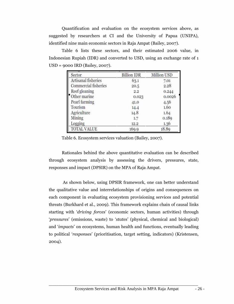
Quantification and evaluation on the ecosystem services above, as
suggested by researchers at CI and the University of Papua (UNIPA),
identified nine main economic sectors in Raja Ampat (Bailey, 2007).
Table 6 lists these sectors, and their estimated 2006 value, in
Indonesian Rupiah (IDR) and converted to USD, using an exchange rate of 1
USD = 9000 IRD (Bailey, 2007).
Table 6. Ecosystem services valuation (Bailey, 2007).
Rationales behind the above quantitative evaluation can be described
through ecosystem analysis by assessing the drivers, pressures, state,
responses and impact (DPSIR) on the MPA of Raja Ampat.
As shown below, using DPSIR framework, one can better understand
the qualitative value and interrelationships of origins and consequences on
each component in evaluating ecosystem provisioning services and potential
threats (Burkhard et al., 2009). This framework explains chain of causal links
starting with ‘driving forces’ (economic sectors, human activities) through
‘pressures’ (emissions, waste) to ‘states’ (physical, chemical and biological)
and ‘impacts’ on ecosystems, human health and functions, eventually leading
to political ‘responses’ (prioritisation, target setting, indicators) (Kristensen,
2004).

_____________________________________________________________________ Ecosystem Services and Risk Analysis in MPA Raja Ampat - 27 -
Figure 15. DPSIR Framework (Kristensen, 2004)
3.1.1 Drivers
Here, driving force is described as a need. This covers basic individual
needs living in the area of Raja Ampat including; food, water and shelter.
Secondary needs like mobility, entertainment and culture are often found
within communal context in church, rituals, and tribal ceremonies. For
example, fishing quota, boundaries, and activities are being socialized and
organized on certain calendar year at church service in Waigeo (Bailey, 2007).
In industrial sector, such driving force could be the need to make profit
at low cost. Meanwhile, at national level, oriented to the Millenium
Development Goals, the government feels the need to keep unemployment
levels low. On microeconomic point of view, production or consumption
processes in Raja Ampat contribute to the local bioregionalism sector
including fisheries, agriculture, energy, industry, transport, households
(Bailey, 2007).
Table below summarizes drivers on Raja Ampat. Note that relevance
values on the right graph are being calculated in terms of population and
production or consumption output.

_____________________________________________________________________ Ecosystem Services and Risk Analysis in MPA Raja Ampat - 28 -
3.1.2 Pressure
Driving forces can lead to human activities such as food production,
mining, and exploitation of raw material such as logging and pearl farms.
Three main types of pressures observed in Raja Ampat are(McLeod & Salm,
2008):
• Overexploitation of fisheries (illegal, unreported, and unregulated) and
marine resources
• Changes in land use to mining, aquaculture, commercial and
residential area.
• Emissions such as cyanide from destructive fishing, mining
overburden, water and soil pollutants.
Consequently, these activities create pressures on the environment as
described on the table and graph below.
Pressure Relevance
(0-5)
Exploitation of resources 4
Emissions 2
Production of waste 1
Radiation 1
Hazards (risk) 2
Drivers Relevance (0-5)
Population growth 5
Fisheries 4
Aquaculture 2
Agriculture 2
Energy use 3
Industry 3
Land use 2
Marine tourism 4
Transport 0

_____________________________________________________________________ Ecosystem Services and Risk Analysis in MPA Raja Ampat - 29 -
3.1.3 States
Pressures exerted to the open environment does affect directly toward
the quality of environmental compartments (air, water, soil) (McLeod & Salm,
2008). Monitoring data on environmental quality on the area however, are
limited in coverage and being evaluated on qualitative terms. The rationale for
air, water and soil quality is based on the development of industrial and
residential sector and natural factor such as geology and climate on the
vicinity of Raja Ampat (McKenna et al., 2002).
The graph below describes the state of the environment which reflects
to the combination of physical, chemical and biological conditions on the
MPA. Qualitative assessment therefore is calculated based on the
anthropogenic effect and natural causes whereas 0 is of defined as low human
influence and 5 having the most disturbance. Fisheries in this case contribute
to the negative effect on marine ecosystems in forms of habitat destruction,
coral bleaching, water pollution, hazardous substance (Bailey, 2007). Reef
Condition Index (RCI) shows distribution on the quality of coral reef on 109
sites surveyed by Conservancy International (CI) in 2004 (table) (McKenna et
al., 2002).
In terms of human health issues, endemic diseases such malaria and
dengue are often found prevalent in the community at all season. Poor health
behavior and lack of sanitation are believed to cause typhus, diarrhea, and
malnutrition (Clarke & Jupiter, 2010)..
States Quality (0-5)
Water quality (coastal zones) 4.3
Air quality (regional) 4.8
Soil quality (lowland, hills, highland) 4,4
Vegetation 4.5
Human health 3
Biodiversity (marine organisms) 4.2

_____________________________________________________________________ Ecosystem Services and Risk Analysis in MPA Raja Ampat - 30 -
3.1.4 Impact
Impacts on the environment derived from the current states are crucial
to the sustainability of marine ecosystem in the area. However, human
development in terms of human health can not and should not be overlooked
by other economic parameters such as GDP and income per capita. This
shows that in reality however, many schools and health clinics (puskesmas) in
Raja Ampat, are functioning with limited supplies and a small number of
skilled workers (The Nature Conservancy 2004). Only less than thirty percent
of house-holds in Raja Ampat have running fresh water (McKenna et al.,
2002).
Two major health issues in the area include HIV/AIDS and malaria.
Regarding malaria, villagers tend to treat themselves mostly with
natural/traditional medicines, with some malaria patients heading into
Sorong for treatment (Bailey, 2007). The risk of malaria in this area is one of
the highest in the world, and this may be a barrier to the tourism industry.
Other health issues include diarrhea, skin issues, throat infections, and
bronchitis. Bronchitis affects not only the adult population (most of who
smoke) but also children. Many women and children are sick due to improper
kitchen/cooking equipment. Most homes do not have exhaust systems,
resulting in fumes polluting the air for those inside. Furthermore, as access to
fresh water is limited, food preparation may not be sanitary.

_____________________________________________________________________ Ecosystem Services and Risk Analysis in MPA Raja Ampat - 31 -
The head of the Raja Ampat regency, Bupati, is clearly under pressure
in increasing the minimum standard of living of Raja Ampat citizens through
economic development while also conserving the terrestrial and marine
biodiversity in the area (Bailey, 2007). Other potential development for the
Raja Ampat regency include more pearl farms, grouper mariculture project,
expanses in marine tourism, and mining. Satria et al. (2006) believes that
given adequate institutional structure, pearl farms can contribute significantly
to a community's livelihood (McKenna et al., 2002).
3.1.5 Responses
Responses by policy makers toward the development in Raja Ampat do
not come systematically, as influenced by Papua's continued fight for
independence and the traditional marine rights regime within the regency that
could prevent such institutional agreements (Cook, 2010). On top of that,
most of the high potential sites for pearl farming have already been exploited,
and thus the scale for increases in this sector may be limited (Cook, 2010).
The potential for quick mining revenues appears to be of high interest
to the Papuan government (Cook, 2010). The greater part of forest in Raja
Ampat is protected through Indonesian policy that specifically state forest
should be off bounds to mineral extraction. In light of Papua's regional
autonomy, however, the provincial government claims that the province
should be permitted to award mining concessions, and test mining is currently
underway on the north coast of Waigeo Island (Cook, 2010). Further
development options take into the account of logging and agriculture (Bailey,
2007).
Since 1999, decentralization plan has been implemented throughout
the country which then literally delegating more power to lower authorities at
regency (Bailey, 2007). One of the major reasons for this shift is to reduce the
political uprisings from some provinces seeking independence (Bailey, 2007).
Nevertheless, many assume that local authorities will have a more precise plan
of the needs of their communities and thus can manage resources more

_____________________________________________________________________ Ecosystem Services and Risk Analysis in MPA Raja Ampat - 32 -
efficiently provided such effective management and methods are in practice
(Bailey, 2007).
Satria and Matsuda (2004) state that centralized fisheries management
in Indonesia has lead to resource depletion (Bailey, 2007). This rationale is
based on the general cashflow of regional economic activity which is mainly
drawn out from the local businesses to the capital; Jakarta. This is the
common understanding that the people of Raja Ampat have lived by in the last
thirty years. Changing the mindset to empower the people however remains
difficult while Raja Ampat lack human resources as it battles with poverty and
illiteracy. Also, the dispersed population and large regency area implies that
fisheries management can be challenging to monitor (Clarke & Jupiter, 2010).
Raja Ampat became autonomous regency in 2003. Before then marine
sources surrounding the island were administered under Sorong regency on
mainland Papua. Thus it excludes artisanal fishing which occurs within the
provincial jurisdiction over coastal and marine resources; up to 12 miles from
the coastline (Bailey, 2007). The shift of power to new regency located in
Waisai, the capital of Raja Ampat, on the island of Waigeo, leads to increased
monitoring of marine resources as well as managing concern for the social and
economical needs of the inhabitants (Bailey, 2007).
With more decision making power, Raja Ampat officials seek initiatives
in developing the area with focuses on the fisheries sector (The Nature
Conservancy 2003). This means that the newly created Raja Ampat Fisheries
Bureau will implement increased management, monitoring, and enforcement
for fisheries development to proceed in sustainable path (Bailey, 2007). The
regency government is then responsible for generating its own revenues, and
providing social services for its citizens (The Nature Conservancy 2004).
MARES recognizes the common practices of natural resources in Raja Ampat
are carried in accordance to local customs or laws (MARES 2010). For
example, the indigenous Kawe people living on the area are approached with
the help of an anthropologist to assist Cendana Indopearls, a subsidiary of

_____________________________________________________________________ Ecosystem Services and Risk Analysis in MPA Raja Ampat - 33 -
Atlas South Sea Pearl Ltd, in negotiating contracts on oyster pearl farm. This
self-organized deal between the company and the local Kawe community
demonstrates new educational opportunities and sustainable economic
activity on Raja Ampat waters (MARES 2010).
Noting that the population is growing at 3% per year, the Papuan
government is promoting fisheries and aquaculture as they believe more
people will bring about more aid and more autonomy (Cook, 2010). Ironically
on health issues, the regency government refuses to issuing contraceptives to
the population. Sexual education and family planning are almost unheard of
in Raja Ampat (Bailey, 2007).
3.1.6 Fisheries
Although the original inhabitants of Papua lived in the inner island,
today all villages in the Raja Ampat regency are situated on coastal (The
Nature Conservancy 2004). As such, fish provide the main protein source for
villagers, although many families keep chicken, cattle, and goats as well
(Bailey, 2007). Severin writes “to protect over-exploitation of fishing there
were government regulations about the method of fishing, the size of the
catches and so forth. But a briefcase full of cash was more powerful than any
regulation ordained by distant Jakarta." (Severin 1997).
While fisheries are the highest contributing sector, pearl farming has
been increasing in value throughout the regency (Bailey, 2007). An estimated
1,200 species of fish are present in Raja Ampat (McKenna et al., 2002). The
main target species in the area include wrasse (family Labridae), grouper
(family Serranidae), snapper (family Lutjanidae), fusilier (family
Caesionidae), parrotfish (family Scaridae), yellow tuna (Thunnus albacares),
and surgeonfish (family Acanthuridae), as well as various shellfish and sea
cucumbers (family Holothuriidae) (McKenna et al., 2002).
Although this area is considered the world's most biodiverse oceanic
habitat, researchers also admit it one of the most threatened, due to
population and poverty pressures faced by the communities that depend on its
resources (McKenna et al., 2002).

_____________________________________________________________________ Ecosystem Services and Risk Analysis in MPA Raja Ampat - 34 -
As indicated above, Bailey suggests that capture fisheries include both
commercial (more than 12 miles off the coastline) and artisanal (within 12
miles of the coastline) (Bailey, 2007). Halim and Mous (2006) estimated from
household surveys that nearly 7 out of 10 of fishing boats in Raja Ampat had
no-motor (Bailey, 2007). Types of gear used for both artisanal and commercial
fisheries, including handline, dip net, gill net, lift net, purse seine, spear and
harpoon, permanent traps, also destructive methods such as cyanide and fish
bombs. Trawling is also illegal in Raja Ampat (Bailey, 2007).
3.1.7 Environmental and economic
Webb claims that the main environmental issues with mining include
sedimentation and toxic deposits to the water (Webb, 2005). Mayalibit is an
extreme case, as there is a limited amount of water exchange in the south with
the Dampier. Sedimentation as a result of mining would surely build up in the
bay and choke the ecosystem. All villages in Raja Ampat are coastal and
therefore sedimentation, due to runoff from adjacent hilly areas, will most
surely be felt at the village level (McKenna et al., 2002). The fringing reefs
along Waigeo would be heavily impacted by changes in sedimentation and
turbidity. However current regimes, depths, and oxygen levels for each
anticipated site will have to be studied in order to predict such effects (Webb,
2005). Gag is a secluded island on the western side of Raja Ampat. Again, as
indicated above, dominant currents flow from east to west through this area,
and the ocean is quite deep (Webb, 2005).
Webb suggests also that the effects from mining on Gag will be
minimized due to high dispersion and dilution of sediment and toxins. In
order to mine, large plots of land must be cleared (Webb, 2005). This has two
main outcomes on the other economic sectors:
1. Increase in revenues from logging, as the current proposal
suggests that the area cleared will be ‘logged’, and thus generate
income
2. Loss of ecosystem services (ES) as a result of lost forest land.
Data on the percent forest cover will be needed in potential sites
to estimate how much loss of ES will occur, and to estimate

_____________________________________________________________________ Ecosystem Services and Risk Analysis in MPA Raja Ampat - 35 -
revenues from logging. Some studies have suggested that mining
activities increase illegal logging potential due to increased road
access by illegal loggers to remote forest areas. The majority of
mining activity would be focused in areas close to the coast. This
is beneficial with respect to not increasing the amount of illegal
logging.
A research done by Environmental Investigation Agency (EIA) reveals
that illegal logging activity remains a serious threat on Papua provinces (EIA,
2010). The primary target of logging is merbau. This valuable dark hardwood
is largely used on flooring, decking, outdoor furniture, doors and windows
frame. Papuan merbau is being sold between $250 and $300 per cubic meter
(EIA, 2010). It then is transported to processing hubs in Surabaya, East Java
and Makassar, South Sulawesi. The majority of smuggling cases related to raw
timber falls on international market in China, India, USA, Australia and the
European Union (EIA, 2010). Export data shows that merbau accounted to
192,000 cubic meters in 2008. The Indonesian Ministry of Forestry however,
has started to include merbau on Appendix III of the Convention on
International Trade in Endangered Species (CITES) which makes countries to
seize shipments of illegal Indonesian merbau (EIA, 2010)
Figure 16. Logs of merbau being shipped out of Raja Ampat, West Papua in
April 2003 (EIA, 2010)

_____________________________________________________________________ Ecosystem Services and Risk Analysis in MPA Raja Ampat - 36 -
3.2 Risk Assessment (EBM) model
Ecosystem-based management (EBM) is extensively used term in
resource management, but it is not well defined nor or understood (Bailey,
2007). The basic concept of marine EBM emphasizes on fisheries
management taking into account all complexities of an ecosystem: including
the biology and ecology, as well as the human dynamics such as socio-
economic and political factors (Bailey, 2007). This concepts extends that EBM
can involve short term costs in order to attain longer term benefits (Bailey,
2007).
Bailey further asserts that EBM, an adaptive measures, must be able to
evolve as information, ideas, models, and tools are continuously integrated to
the repertoire of management approaches. In this regard, EBM is considered a
particularly flexible tool for ecosystem managers (Bailey, 2007).
Wildlife Conservation Society (WCS) remarks the following approach in EBM
general principles (Kristensen, 2004):
1. Use ecological boundaries for management rather than administrative
or political boundaries
2. Focuses on ecosystem integrity and resilience as primary goals in order
to sustain ecosystem services
3. Recognizes people are part of the ecosystem and that achieving
management objectives requires changing human use and activities
4. Maintain flexibility on management approach that reacts to the
responses of ecological and human systems to interventions
As illustrated on the figure below, systematic steps of EBM model
reiterate the significance of comprehensive understanding of ecosystem,
integrate people on decision making, adaptive to changes, and well founded
on legal structure (Kristensen, 2004). This Castanoa Framework allows
managers to effectively implement coastal management programs.

_____________________________________________________________________ Ecosystem Services and Risk Analysis in MPA Raja Ampat - 37 -
Figure 17. Experience-based Costanoa Framework of EBM (Kristensen,
2004).
Relevant to adaptive EBM model, MPA of Raja Ampat follows pattern
of ecosystem resilience below (McLeod & Salm, 2008). This pattern depends
on several factors including:
1. Effective management
2. Risk spreading through inclusion of replicates of representative habitat
3. Full protection of critical areas serving as reliable sources of seed for
replenishment/preserve ecological function
4. Maintenance of biological and ecological connectivity among and
between marine habitats
Figure 18. Resilience pattern of Raja Ampat (McLeod & Salm, 2008)
In doing so, managers thus need to develop classification on habitat
types and major zones based on biodiversity, condition, level of threat,
resilience and ecosystem services. In practice, protection should aim at least
30% of the complete habitat type such as offshore reefs, midshelf reefs (patch
and fringing reefs), inshore reefs and mangroves (McLeod & Salm, 2008).

_____________________________________________________________________ Ecosystem Services and Risk Analysis in MPA Raja Ampat - 38 -
4 Risk Analysis on Raja Ampat
This chapter synthesizes potential area of risk on Raja Ampat.
Stemmed from ecosystem analysis and EBM framework, it is possible to
develop risk analysis using techniques in GIS to display distribution of
ecosystem services and area of immediate exposure to certain threats;
tsunami. Baseline data of coral reefs bathymetry, geology, vegetation, land
use, and satellite images are essential in digitizing and overlaying processes.
4.1 Threats definition and identification
Apart from the anthropogenic driven catastrophes (e.g oil spill, water
pollution, coral destruction, floods, and illegal logging) this chapter focuses on
potential natural disaster related to earthquake and tsunami. As attention and
capital investment are being channeled toward the protection of ecosystem
integrity and human development, there needs to be validation on the actual
subject of protection against disaster.
4.1.1 Definition of natural disaster and Impacts
A natural disaster event is defined as the impact of an extreme natural
experience on an open vulnerable society (BNPB, 2010). If impacts exceed on
the capacity of certain region and therefore require interregional or
international help, a large disaster is assumed to have occurred .
The criteria that can be used to determine a large disaster includes
(Smith 1996:29): more than 100 casualties or economic damage in excess of 1
% gross national product (GNP) or more than 1 % of the impacted population
is harmed. The disaster occurred can pose strong impact to four sectors:
1. Economic Cost
This can be grouped into three main areas:
• direct losses such as loss of capital stock as disaster prevent flow
of capital into market
• indirect loss as economic function is interrupted due to damaged
physical infrastructures; roads, building, power plants, water
treatment, etc.

_____________________________________________________________________ Ecosystem Services and Risk Analysis in MPA Raja Ampat - 39 -
• macroeconomic impacts as government reallocates national
budget (GDP) on rehabilitation and relief processes
2. Collateral Impact
Such disaster may have cause serious damage on physical structures
related to public service; buildings, markets, firms, schools and
governmental office. The devastated assets can stop the social function
during the process relief.
3. Humanitarian Effect
Disaster can cause fatalities and psychological trauma after the
unexpected event. To date, this is the most severe impact on humanity
as it can not be measured in terms of monetary values.
4. Ecological Effect
Disaster causes environmental damage on open ecosystems such as
biological habitat, watersheds, agricultural land, coral reefs, and
mangrove forest. Damage is usually measured by the change in quality
of non-use values.
Figure 19. Natural disaster risk scheme(Lass et al. 1998:9)
4.1.2 Natural disasters influence factors
Risk on natural disaster can be defined into three factors in order to
understand the degree of vulnerability in certain area. Those three factors are:
hazard, elements at risk and vulnerability (Mechler, 2004). These components

_____________________________________________________________________ Ecosystem Services and Risk Analysis in MPA Raja Ampat - 40 -
are the dominant factors to determine the risk. Hazard is used to determine
the probability and elements at risk and Vulnerability can be used to
determine losses. By using these parameters we can formulate risk into a
function:
Risk = probability (hazard) * losses (vulnerability, elements at risk)
4.1.2.1 Hazard
Natural disasters can be defined according to the underlying hazard.
Table 7 lists the different kinds of disasters events (Mechler, 2004).
Sudden-onset events Slow-onset events
Extreme geotectonic events :
earthquakes, seaquakes, volcanic
eruptions, slow mass movements
Drought causing
famines.
Desertification
Extreme climatic conditions: floods
triggered by extreme precipitation,
storms and extreme precipitation
triggered by atmospheric low pressure
conditions: Gales in moderate
latitudes and cyclones in tropics
(hurricanes and typhoons), hail, cold
spell and heat waves.
Table 7. Classification of extreme events (Mechler, 2004)
Most of sudden-on events occurred are of natural causes which are
hard to predict. Slow onset events are more predictable and preventable since
this type of hazard is a result of bottleneck issue on distribution or
mismanagement of resources on the affected region. Due to that reason
sometimes slow-onset events are treated differently from sudden-onset events
(Mechler, 2004).
4.1.2.2 Elements at risk
The second factor is more related to humans, buildings structures,
infrastructure (e.g. water and seer facilities, roads and bridges) or agricultural
assets in harm’s way which can be impacted in case of a disaster event (ADPC

_____________________________________________________________________ Ecosystem Services and Risk Analysis in MPA Raja Ampat - 41 -
200a:2). Though details information on elements risk, especially about types,
values, usage or spatial distribution are important, however, there are
difficulties and differences of examined elements and details of these elements
sometimes do not exist (Burby 1991: 137) but inventory of these elements risk
should be exposed to determine the losses caused by disaster.
4.2 Risk Management Strategies on Natural Disaster
Risk management is defined as the systematic application of
management policies, procedures and practices to the tasks of identifying,
analysing, assessing, treating and monitoring risk. For any organization,
whether a large corporation, a government agency, or a family farm, risk
management is or should be an integral part of good management. It is a
continuous, adaptive process that needs to be integrated into all relevant
aspects of the decision making procedures of the organization (Mechler,
2004)
There are three different phases in natural disaster management: pre-
disaster phase, disaster phase and post-disaster phase. In pre-disaster phase,
action undertaken is mostly based on risk identification and assessment, risk
reduction and risk financing (Mechler, 2004). Disaster phase focuses on
rescue and relief efforts, humanitarian assistance, temporary shelter, and
clean up (Gautama, 2008). The post-disaster phase initiate processes on
reconstruction and rehabilitation of the region (redevelop vital
infrastructures, revitalise logistic goods, initiate economic and market
recovery, etc). Reconstruction efforts should be combined with mitigation risk
assessment, in order to reduce cost of development on disaster affected area
(Mechler, 2004).
There are new paradigms on natural disaster management today.
Traditional natural disaster management emphasizes on post-disaster phase.
Government put more efforts on reconstruction and rehabilitation of disaster
affected area. In doing so, government has to reallocate its national budget to
finance all of aforementioned phases. Given that international donor
assistance and loans on disasters can not be fixed at some value, then

_____________________________________________________________________ Ecosystem Services and Risk Analysis in MPA Raja Ampat - 42 -
approach on disaster management should be focusing on increasing one’s self-
reliance (Mechler, 2004).
There is growing interest in making more use of risk financing
mechanisms in risk management. Risk financing by governments by means of
e.g. insurance especially for developing countries has only lately moved to a
more prominent place and is seen as a partial alternative to risk assumption
and ex-post loss financing (Mechler, 2004).
There are four sequential procedures that should be taken to tackle
risk management problem as illustrated below (Mechler, 2004). First, there
should be some assessment and measures on possible risk in particular
region, try to survey the possible cause, e.g. geology or geomorphology
condition in a particular area. Second, there should be analysis on potential
impacts caused by the natural disaster. Third there should be contingency
plan and alternative plan to solve the possible risk effectively. Fourth is
economic analysis on contingency plan (Mechler, 2004).
Figure 20. Natural disaster risk management step (Mechler, 2004).
Potential impact assessment
Design contingency plan
Economic analysis on designed risk management plan
Potential Risk Identification
Mitigation
Risk Financing

_____________________________________________________________________ Ecosystem Services and Risk Analysis in MPA Raja Ampat - 43 -
First step to be done in risk management of natural disaster is
assessing the potential risk (Mechler, 2004). There are three main factors that
should be assessed in the first step; hazard, elements at risk, and vulnerability.
Assessment of hazard range from mapping of frequent hazard occurred in the
area to modelling few scenarios based on the available and current data.
Vulnerability assessment can be done by evaluating the infrastructure that
might be struck by the hazard. Estimation of loss provides great advice for risk
manager to develop better planning (Mechler, 2004).
Designing contingency plan is part of mitigation which has the
purpose to reducing potential risk that can happen in result to the exposed
hazard (Mechler, 2004). There are two possible approach can be used to
reduce risk in one particular area of MPA. First is by preventing people from
living in one particular area and close the area for full preservation or partial
conservation purposes. For one particular hazard, such as tsunami, installing
early warning system can be considered also as a mitigation method (Mechler,
2004).
The last step of risk management is economic analysis on designed
risk management plan; this is related to risk financing sector. In risk
financing, there is a systematic arrangement of funding. Hence, in the event of
unexpected disaster, there would be enough funds already allocated to initiate
relief projects. The dominant instrument used in risk financing is insurance
and reinsurance. Mitigation and risk financing should be perceived as one
package, since the plan for risk management relates to impact, solution and
evaluation. Mitigation reduces the physical vulnerability while risk financing
reduce the financial vulnerability (Mechler, 2004). This scheme is shown on
the diagram below.
Figure 21. Mitigation and Financial Instrument (Mechler, 2004).

_____________________________________________________________________ Ecosystem Services and Risk Analysis in MPA Raja Ampat - 44 -
4.2.1 Risk Control Techniques
Common methods in Risk Management often focus on two main
paths; taking measures to minimize potential losses and accepting the
probable exposure and compensate actual losses. Method that used to reduce
the probability and consequences of accidental losses are called Risk Control
(Mechler, 2004).
In principle, selecting the apparent best risk management should be
examined best on four criteria: technical feasibility, financial constraints, legal
requirements, and humanitarian considerations. Mechler notes five risk
control strategies including (Mechler, 2004):
Exposure Avoidance, the best way to reduce exposure is to stop the
activities with risk. The objective is to reduce the probability of risk to zero. In
the context of fisheries in MPA, such no-take zone in Raja Ampat provides
good example of reducing risk particularly in destructive fishing practices.
Loss Prevention, this technique focuses on reducing the loss rate of
recurrence and not the severity. Reducing risky activities will decrease the
probability of potential loss. Conservation measures implemented on Raja
Ampat regulates visitors and fishers to gain access to the MPA.
Loss Reduction, this strategy emphasizes on the severity of impact
should loss prevention fails. No known implementation of this type existing
on Raja Ampat, thus principles of self-organization, replenishment, succession
and resilience play greater role in reducing the degree of impact or
disturbances.
Segregation of Exposures, this technique comes after loss reduction,
with two directive options: segregate supplies, service delivery on
management operations or to a number of locations. Distribution of exposures
on Raja Ampat remains sporadic and mainly accumulates on fringing coral
reefs which certainly requires large scale of monitoring program.
Contractual Transfer, this option allows transfer some or all function
to a contractor who accepts the risk exposure. This is not an option for a
municipality for the majority of its mandated functions. Local wisdom of Raja
Ampat, however, recollects sense of belonging to the community and natural
landscape. This means that responsibility and activities are held within the

_____________________________________________________________________ Ecosystem Services and Risk Analysis in MPA Raja Ampat - 45 -
local communities, regional administrations, private sectors, and non-
governmental organizations.
4.3 Tsunami
The word tsunami (pronounced tsoo-nah-mee) means “harbor wave” in
Japanese. Some people call tsunamis “tidal waves”, but this definition is
inaccurate. Tsunamis are not related to tides but technically defined more as
series of waves or wave trains, usually caused by earthquakes (Dahuri, 2001).
The height of the tide at the time tsunami reaches inland has some
effect on the scale of damage (Brune et al., 2010). Another name for tsunamis
is “seismic waves.” This term is not quite accurate either since earthquakes are
not the only drivers of tidal waves. It is also possible that tsunami is moved by
landslide, volcanic eruption and meteorite impact (Brune et al., 2010).
4.3.1 Tsunami Causes
The larger the disturbance imposed on the water, the larger the scale
of tsunami impacts will be. Sometimes tsunami waves reaches up to 120 ft. As
the wavelength shortens, the height increases when the wave enters shallow
water. The strength of the disturbance, the distance, the wave travels and the
shape of the coastline combined determine the tsunami's height and
ultimately its level of destructiveness (Brune et al., 2010). Notably, tsunamis
can be generated when the sea floor abruptly deforms and vertically displaces
the overlying water (Gautam, 2008). In deep water tsunami forms long,
shallow waves, which mean they do not lose initial force. These waves can
travel over vast distance until they are slowed by forms of resistance from the
sea floor near shore (Gautam, 2008).

_____________________________________________________________________ Ecosystem Services and Risk Analysis in MPA Raja Ampat - 46 -
Figure 22. Tsunami causes (Mechler, 2004).
4.3.1.1 Earthquake generates tsunami
By far, the most destructive tsunamis are generated from large, shallow
earthquakes with an epicenter or fault line near or on the ocean floor
(Gautama, 2008). These usually occur in regions of the earth characterized by
tectonic subduction along tectonic plate boundaries. The high seismicity of
such regions is caused by the collision of tectonic plates. When these plates
move passing each other, they cause large earthquakes, which tilt, offset, or
displace large areas of the ocean floor from a few kilometers to as much as a
1,000 km or more (Brune et al., 2010). The sudden vertical displacements
over such large areas, disturb the ocean's surface, displace water, and generate
destructive tsunami waves (Gautam, 2008).
Travelling over long distance, the Great 1960 Chilean tsunami was
generated by a magnitude 8.3 earthquake with a rupture zone of over 1,000
km. Its waves were destructive not only in Chile, but also as far away as
Hawaii, Japan and elsewhere in the Pacific. It should be noted that not all
earthquakes generate tsunamis however. Typically, it takes an earthquake
with a magnitude exceeding 7.5 Richter to produce a strong and destructive
tsunami (Brune et al., 2010).

_____________________________________________________________________ Ecosystem Services and Risk Analysis in MPA Raja Ampat - 47 -
4.3.1.2 Volcanic eruption generates Tsunami
Although relatively infrequent, violent volcanic eruptions represent
also impulsive disturbances, which can displace a great volume of water and
generate extremely destructive tsunami waves on the immediate point of
source (Katili, 1975). In this respect, waves may be generated by the sudden
displacement of water caused by a volcanic explosion, by a volcano's slope
failure, or more likely by explosion, collapse or engulfment of volcanic magma
chambers. One of the largest and most destructive tsunamis ever recorded was
generated in August 26, 1883 after the explosion of an active volcano,
Krakatau, in Indonesia. History records the eruption generated waves that
reached 135 feet, destroyed coastal towns and villages along the Sunda Strait
on both islands of Java and Sumatra, killing 36, 417 people (Katili, 1975).
4.3.1.3Landslides generates Tsunami
Less frequently, tsunami waves can be generated from displacements of
water resulting from rockfalls, icefalls and sudden submarine landslides or
slumps. Unstable and sudden failure of submarine slopes triggered by the
ground motions of a strong earthquake are of potential causes for landslide
generated tsunami (Katili, 1975). In the 1980's, earth movement and
construction work on airport along the coast of Southern France triggered an
underwater landslide, which generated destructive tsunami waves on the
harbor of Thebes (Katili, 1975).
Close to Raja Ampat, many scientists believe that the 1998 tsunami,
which killed thousands of people and destroyed coastal villages along the
northern coast of Papua-New Guinea, was generated by a large underwater
slump of sediments, triggered by an earthquake (Brune et al., 2010). In
general, the energy of tsunami waves generated from landslides or rock falls is
rapidly dissipated as they travel away from the source and across the ocean, or
within an enclosed or semi-enclosed body of water - such as a lake or a fjord.
However, it should be noted, that the largest tsunami wave ever observed
anywhere in the world was caused by a rock fall in Lituya Bay, Alaska on July
9, 1958 (Katili, 1975).

_____________________________________________________________________ Ecosystem Services and Risk Analysis in MPA Raja Ampat - 48 -
Triggered by an earthquake along the Fairweather fault, an
approximately 40 million cubic meter rock fall at the head of the bay
generated a wave, which reached incredible height of 520-meter wave (1,720
feet) on the opposite side of the inlet (Katili, 1975). An initial wave of 180
meters (600 feet) raced at about 160 kilometers per hour (100 mph) toward
the bay debarking trees along its path. However, tsunami energy and height
diminished rapidly away from the source area and once reaches to the ocean it
could not be recorded by tide gauge stations (Katili, 1975).
4.3.2 Tsunami Protection
4.3.2.1 Tsunami Warning System
On the aftermath of tsunami on 26 December 2004, people realize that it
is very important to learn more about tsunami and how to deal with tsunami
(Samek et al., 2004). In 1995, the US National Oceanic and Atmospheric
Administration (NOAA) began to do research about the Deep-ocean
Assessment and Reporting of Tsunamis (DART) system. By 2001 an array of
six stations had been deployed in the Pacific Ocean.
Figure 23. Tsunamimeter (DART)
DART operates by using pressure gauge anchored to the seafloor.
When tremors felt on seabed exerting energy and create pressure change, the
sea-floor gauge sends signals to a surface buoy that transmits data to satellite.
Computational models and analyses are then processed on terrestrial stations
which then can quickly recommend such warning (Brune et al., 2010).

_____________________________________________________________________ Ecosystem Services and Risk Analysis in MPA Raja Ampat - 49 -
Warning system should be communicated intensively as failure in
effective communication is believed to have caused confusion and delays in
evacuation. This was the case in Mentawai on October 2010 (BNPB, 2010). As
part of the procedure, a tsunami warning was cancelled as soon as potential
threat became inactive. Oblivious to the actual condition, tsunami waves
swept most of the south west of Mentawai islands within minutes. It is clear
nevertheless, that tsunami warning system can only avoid casualties, not on
physical property and open environment (Brune et al., 2010).
4.3.2.2 Tsunami Wall Protection
Figure 25. Seawalls on Raja Ampat (Ministry of Public Works, 2010)
At a number of beaches, low seawalls were in place, presumably to
protect against high perigean tides (spring tides which occur soon after the
moon passes her perigee) and storm waves. Most of these walls were not
damaged by the tsunami and despite the fact that the walls were overtopped
by much higher tsunami waves; structures landward of the walls were
somehow protected (Kaistrenko, 2001).
In Patong Beach, the most populous beach on Phuket Island where low
seawall is stretched across on beach and steep offshore contour caused the
leading crests of the tsunami to break away as it nears to shore. The low
seawall deflected much of the momentum of the waves reducing the forces
toward the land (Kaistrenko, 2001).. Eventhough it reached to more than half
a kilometre inland flooding to dense districts, the loss of life was very low.

_____________________________________________________________________ Ecosystem Services and Risk Analysis in MPA Raja Ampat - 50 -
Figure 26. Tsunami Wall Protection in Japan
There is no way to stop a tsunami once set in motion, but there are
ways to avoid getting killed by one. The Japanese government, for example,
has invested billions in coastal defences against tsunamis -- for example,
building concrete sea walls to blunt the impact of the waves and gates to
protect harbours (Kaistrenko, 2001).
Despite the rarity of tsunami, the degree of severity and extreme
consequences influence the design of civil engineering structures in tsunami-
prone regions. In Japan, efforts are under way, at great cost and expense, to
ensure that ports are tsunami-proof and that populations living near the sea
are protected through appropriate construction and alerted through warning
systems (Kaistrenko, 2001).
For example, on Okushiri Island, a 4.5 meters high seawall was built to
protect the Aonae peninsula. However, this wall was overtopped by a tsunami
in 1993 resulting in more than 185 people were killed. The wall then is rebuilt
leaving debates as it obstructs view of the sea and was extremely expensive.
Today, nations on the vicinity of Indian Ocean are to decide whether to allow
rebuilding on the coast, which type of coastal structures in order to minimize
losses in future tsunamis (Kaistrenko, 2001).

_____________________________________________________________________ Ecosystem Services and Risk Analysis in MPA Raja Ampat - 51 -
4.4 Bathymetry
Based on the satellite image of Raja Ampat, secondary data on
vegetation, geology and coral reefs, bathymetric map then is created.
Elevation data calculated from the surface to bottom is taken from previous
literature review below. Following to digitizing and overlays of spatial data is
spatial analysis on each of four island; Misool, Salawati, Waigeo, Batanta and
Kofiau.
Figure 27. Elevation map of Raja Ampat
In hypothetical tsunami threat, focus is set on the existing ecosystem
services particularly through fisheries, mangroves, coral reefs. Through base
line data revealing spatial distribution of coral reefs and mangroves, one can
calculate the exposed area of land use on Raja Ampat; 941 hectares.

_____________________________________________________________________ Ecosystem Services and Risk Analysis in MPA Raja Ampat - 52 -
No Landuse Area (ha)
1. Alluvium and flat plains 380
2. Forest on ultrabasics 30
3. Hill forest on limestone 20
4. Hill forest on volcanics 51
5. Lowland forest on limestone 190
6 Lowland forest on sandtone 51
7 Lowland forest on volcanics 192
8 Mangrove 5
9 Open scrub on ultrabasics 8
10 Savanna and grassland 9
11 Submontane forest on limestone 2
12 Submontane forest on volcanics 3
Sum 941
Table 8. Exposed area of landuse
4.4.1 Fisheries
Figure () below shows the distribution and area of coverage on fisheries
of 6000 hectares. With artisanal fisheries currently valued at US$7 million
(Bailey 2004), it seems evident that ensuring sustainable yields through time
should be a priority for the government, not to mention conserving ecosystem
services through time.
Apart from potential loss of fish resources from tsunami, Bailey
stretches that if the present-day situation continues, with no monitoring and
enforcement by the government, the use of explosives and cyanide in Raja
Ampat may lead to a decline in snapper and grouper populations and catches
over time (Bailey 2004).

_____________________________________________________________________ Ecosystem Services and Risk Analysis in MPA Raja Ampat - 53 -
Figure 28. Fisheries catchments area
4.4.2 Mangroves
A group of palm trees along not only adds aesthetic value but also can
strengthen coastal protection in patches of residential area (Anwar et al.,
2001). This area plays an important role as a catchment area but is facing
severe deforestation. There are some useful plants to reduce erosion and
landslides in tropical areas such as: Bambusa sp, Aleurites moluccana,
Homalium tomentosum, Melia azedarach, Acacia villosa, Eucalyptus alba,
Leucaena leucocephala, Swietenia macrophylla, Tectona grandis (Karnawati,
2001).
The abundance of mangrove vegetation reflected here are significant
only on Misool Island. Mangrove roots help to minimize coastal erosion as it
reduces wave energy by lowering the height of waves. Essentially, they are

_____________________________________________________________________ Ecosystem Services and Risk Analysis in MPA Raja Ampat - 54 -
effective at dissipating wave energy and reducing flow velocity (Dahuri, 2001).
In addition, they can also be planted in front of groins and seawalls.
Figure 29. Mangroves on Misool
4.4.3 Coral reefs
Coral reefs, mangroves and seagrass beds are naturally dynamic and
adaptive ecosystems (Salm & Mcleod, 2008). In Melanesia they are impacted
by seasonal monsoon winds and rainfall as well as episodic storms, flooding,
tsunamis, earthquakes, volcanic eruptions and increasingly by such climate
impacts as coral bleaching. These systems experience continuous disturbance
and change which helps form their extent and structure. The ability of these
systems to absorb, resist or recover from such disturbances or to adapt to
change while continuing to maintain essential functions and processes is the
essence of ecological resilience (Salm & Mcleod, 2008).
Protection to coral reefs is without doubt the main subject of MPA on Raja
Ampat (CI, 2008). According to Mckenna et al., biodiversity of marine
organisms are composed of;
• Corals; 456 species of hard corals were found accounted to more than
half of the world’s total.
• Molluscs; high diversity with 699 species recorded
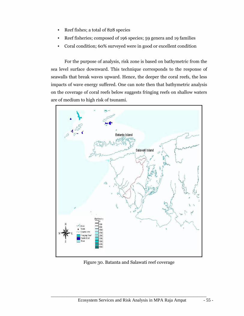
_____________________________________________________________________ Ecosystem Services and Risk Analysis in MPA Raja Ampat - 55 -
• Reef fishes; a total of 828 species
• Reef fisheries; composed of 196 species; 59 genera and 19 families
• Coral condition; 60% surveyed were in good or excellent condition
For the purpose of analysis, risk zone is based on bathymetric from the
sea level surface downward. This technique corresponds to the response of
seawalls that break waves upward. Hence, the deeper the coral reefs, the less
impacts of wave energy suffered. One can note then that bathymetric analysis
on the coverage of coral reefs below suggests fringing reefs on shallow waters
are of medium to high risk of tsunami.
Figure 30. Batanta and Salawati reef coverage

_____________________________________________________________________ Ecosystem Services and Risk Analysis in MPA Raja Ampat - 56 -
Figure 31. Waigeo reef coverage
Figure 32. Misool reef coverage

_____________________________________________________________________ Ecosystem Services and Risk Analysis in MPA Raja Ampat - 57 -
4.5 Coastal management
The establishment of Ministry of Marine Affairs and Fisheries (DKP) in
1999 by Indonesian government was realized to develop and to integrate
coastal management into national development plan (Patlis et al., 2001). The
DKP shares roles and tasks with the regional authorities to implement
numbers of laws and regulations.
In principal, according to Act number 22/1999, the role of central
government, represented by DKP, is to develop guidelines and policies rather
than directly control and manage activities on local scale. Thus, the voluntary
scheme of actionable plans and implementation lies with the regional
administration as shown on the figure 5 below.
Figure 33. Modified ICZM scheme (Patlis et al., 2001).
In a scientific study assessing the impact of Tsunami, Sonak et al
(2008) suggest the conceptual model of contingency plan within the
Integrated Coastal Zone Management (ICZM) (Patlis et al., 2001). Disaster
Management concepts and practices may be carried in parallel to the routine
coastal zone protection program while both aim to protect marine
ecosystems, habitat, natural resources and human lives.
4.5.1Policy and Regulation on Disaster Management
Through the publication of the Act Number 24/2007 on Disaster
Management, a new and permanent institution named National Agency for
Disaster Management (BNPB) was created (BNPB, 2010). This Agency
replaced a former organization named Coordinating Body for Disaster

_____________________________________________________________________ Ecosystem Services and Risk Analysis in MPA Raja Ampat - 58 -
Management (Bakornas). The main task of Bakornas is forming an adhoc
committee to coordinate first aid after a hazard. After certain a time, the
committee will be closed (BNPB, 2010).
At the moment, BNPB is responsible for hazard management (before,
during and after the occurrence). BNPB also has the responsibility of
rehabilitation and reconstruction (Article 57) (BNPB, 2010). Some
rehabilitation as mentioned in Article 58 [1] is done through activities such as:
improvement of the environment of the disaster area, improvement of public
infrastructure and facilities, delivery of community housing repair assistance,
psychosocial recovery, health services, conflict reconciliation and resolution,
cultural, socio-economic recovery, restoration of security and order, recovery
of government function, and recovery of function of public services (BNPB,
2010).
Reconstruction activities as mentioned in Article 59 [1] are done
through improved development activities, which are comprised of: rebuilding
of infrastructure and facilities, rebuilding of community social facilities,
reviving of community social cultural life, application of proper design and
engineering and use of better and disaster resistant tools, participation and
role of community-based institutions and organizations, the business world,
and community, improvement of social, economic, and cultural conditions,
improvement of the function of public services, and improvement of primary
services in the community (BNPB, 2010).

_____________________________________________________________________ Ecosystem Services and Risk Analysis in MPA Raja Ampat - 59 -
Figure 34. ICZM approach on contingency measures
4.6 Problems with Reliance on Aid for Natural Disaster Relief
The funding for relief program (post disaster) is likely received through
international NGOs or donors. In 1992, during earth summit held in Rio, there
was an agreement that there would be 0.7 % funds reserved from donor
countries from their total GNP for relief aid. However, in fact, in 1997 there
was only 0.22 % of fund being made reserved (IFRC 1999:102).
This shows uncertainty problems in relying on donor’s aid for disaster
relief. The first problem is funding given by the donors usually is used to
return the condition into pre disaster state. Evidently, modern management
still can not pay back the debt through risk management budget plan. Thus,
investing some of the funding into risk measurement can potentially reduce
the cost of rebuilding and reconstructing after the disaster. For example:
China prepared 3.15 billion US$ for the last 40 years for flood control and
successfully reduced the cost of loss of 12 billion US$ (IFRC 1999:110). There
should be better management on funding; it should not only focus on relief
program but also put more emphasize on pre disaster management plan.

_____________________________________________________________________ Ecosystem Services and Risk Analysis in MPA Raja Ampat - 60 -
The second problem is that the funding given by the donors are usually
considered as loans so at the end of post-disaster phase, the government has
an obligation to pay back the loans with the incurring interest rate, implying
to economic burden in the future (Bugl, 2005). Overtime, international loans
can not be overlooked when inflation rate goes up and central bank started to
take on unlimited debt, then scarce resources may have to be diverted to debt
service as tax increases (Peffekoven 1992:529-534). Due to this problem
World Bank and IMF established new organization called HIPC (Highly
Indebted Poor Countries), there have been already 22 countries received
numbers of debt relief.

_____________________________________________________________________ Ecosystem Services and Risk Analysis in MPA Raja Ampat - 61 -
5 Conclusion
5.1 Landscape and population
The idea of protecting the landscape or the environment means that it
also protects the health and safety of the people living on the islands.
However, that is not the case in Raja Ampat. Here, the author notes that
public attentions both in financial and administrative resources are allocated
mostly on maintaining ecosystem to produce economic goods and services. In
short, human and social development lags behind the pace of ecological
targets (Cook, 2010).
Encountering anthropogenic threats through destructive fishing,
pollution, sedimentation, and overexploitation of marine resources, one can
argue that these activities can be mitigated through effective enforcement on
related environmental regulations. However, a natural threat such as tsunami
underlines the importance of pre-disaster education and awareness of risk and
evacuation plans (BNPB, 2010).
5.2 Strength, weaknesses, future research
Understanding the economic value of ecosystem services essential to
the MPA of Raja Ampat which consists not just provisioning fisheries but also
cultural and most importantly the comprehensive integrity, can drive local
stakeholders to seriously take part on the decision making processes related to
spatial planning and use of resources. Maps of reefs revealed most of the
scenic underwater sights which can be used to promote and continuously
protect outstanding biodiversity in which Raja Ampat is known of.
The natural resilience of marine ecosystems and species populations in
Raja Ampat are being harmed by human activities such as deforestation,
mining, habitat encroachment, over-fishing, pollution, and destructive
practices. On the positive part, many areas here are relatively undeveloped
leaving the natural systems and species populations retain their resilience. On
the negative side, development on seascape will continue causing degradation
and loss of marine ecosystems, such as the smothering of coral reefs with silt
(McLeod & Salm, 2008).
_____________________________________________________________________ Ecosystem Services and Risk Analysis in MPA Raja Ampat - 62 -
Due to unavailable data on current residential area and topographical
contour of the area, this study can not reveal immediate risk of zone on
terrestrial landscape. Thus, there is an opportunity to map out the villages that
are situated along the coast line within 0-15 m range of elevation above sea
level.
5.3 Recommendation on Management and Policies
Integrated Coastal Zone Management (ICZM) is adaptive type of
management that responds to environmental changes due to human activity
or natural cause. Design for coastal protection in Raja Ampat may include the
rehabilitation of mangroves which can better support the ecological functions
in maintaining marine species richness. It should be noted that social pillar of
ICZM, in this regard the local community which inherently is the subject of
coastal protection, can not be separated from future marine spatial planning
and development.
• Enforce fishing license and practices effectively along with education and
socialization of game theory which provides idea of fish population on the
area of catchments.
• Engage local stakeholders for social dialogue and public hearing to ensure
active participation of each member of the local community.
• Reviews boundaries of existing wildlife reserves to best justify cross section
of various ecosystems and ecotones on the area.
• Implement long term environmental monitoring program
• Continuous effort on pre disaster management program is vital and
necessary. Mitigation plan should be actively communicated.
• Consider re-financing fund allocated specifically for disaster on regional
level.

_____________________________________________________________________ Ecosystem Services and Risk Analysis in MPA Raja Ampat - 63 -
Bibliography
Anwar, C., Gunawan, H. (2006): Peranan Ekologis dan Sosial Ekonomis Hutan Mangrove Dalam Mendukung Pembangunan Wilayah Pesisir, Seminar Konservasi Dan Rehabilitasi Sumberdaya Hutan; Padang, 20 September 2006, unpublished Bailey, M. (2007) Economic Analysis of Unregulated and Illegal Fishing in Raja Ampat Indonesia. Bakornas PBP (2001) Policy and Institutional arrangement for disaster management in Indonesia. BRR (2005) Aceh and Nias one year after the tsunami: executive summary report. Brune S., Babeyko, A.Y., Gaedicke, C., Ladage, S. (2010): Hazard Assessment of Underwater Landslide-Generated Tsunamis: A Case Study In The Padang Region, Indonesia, Natural Hazards (2010) 53, pp. 205 – 218; Springer Science and Business Media B.V. Bugl, W. (2005) Earthquake risk management policy in Indonesia: Asuransi Maipark, Indonesia, p. 399 – 408. Insurance Information Institute (III) (2005) Asian earthquake and Tsunami An insurance perspective. Clark, J.R. (1996): Coastal Zone Management Handbook; CRC lewis publisher, Florida science Ltd, Great Britain Clarke P and Jupiter S (2010) Principles and Practice of Ecosystem-Based Management: A Guide for Conservation Practitioners in the Tropical Western Pacific. Wildlife Conservation Society. Suva, Fiji. Cook, A.D.B. (2010). Investing in Papua: The Dual Challenges of Governances and Development. Centre for Non-Traditional Security Studies. NTS Perspectives, No 2, 2010. Dahuri, R. (2001): Pre-and Post-Tsunami Coastal Planning and Land-use Policies and Issues In Indonesia, Proceedings of The Workshop on Coastal Area Planning and Management in Asian Tsunami-Affected Countries; Bangkok, 27 – 29 September 2006, Food and Agriculture Organization of The United Nations DAVIES, J.L. (1972): Geographical Variation in Coastal Development; Cox and Wyman Ltd.,London Forest Trends and The Katoomba Group. (2010). Payments for Ecosystem Services:Getting Started in Marine and Coastal Ecosystems: A Primer. Forest Trends and The Katoomba Group Gautam, A. (2008): Earthquake – A natural disaster; APH Publishing Corporation, New Delhi

_____________________________________________________________________ Ecosystem Services and Risk Analysis in MPA Raja Ampat - 64 -
Gordon, J. (2005) Risk assessment and management in local government emergency planning: Institute for Catastrophic Loss Reduction. IUCN World Commission on Protected Areas (IUCN-WCPA) (2008). EstablishingMarine Protected Area Networks—Making It Happen. Washington, D.C.: IUCN-WCPA, National Oceanic and Atmospheric Administration and The Nature Conservancy. 118 p. Kaistrenko, V.,Klyachko, M., Nudner, I., & Pelinovsky, E., (2001) A new paradigm of tsunami safety solution: Institute of Marine and Geophysics, Yuzhno-Sakhalinsk, Russia, p. 303 – 313 Karnawati, D. (2001): Kondisi Lahan Rawan Longsor dan Upaya Penanggulangannya, Seminar Regional Lingkungan: Kajian Penataan Lingkungan Daerah Pasca Bencana Alam; Fakultas Teknik Universitas Muhammadiyah, Purworejo Katili, J.A. (1975) : Volcanism and Plate Tectonics in The Indonesian Island Arc, Tectonophysics 26 (1975), pp. 165 – 188; Elsevier Scientific Company, Amsterdam Kristensen, P. (2004). The DPSIR Framework. National Environmental Research Institute, Denmark. McLeod, E., Salm R., Green, A., Almany, J. (2009). Designing marine protected area networks to address the impacts of climate change. Frontiers in Ecology and the Environment. McKenna, S.A., G.R. Allen, and S. Suryadi (eds). 2002. A Marine Rapid Assessment of the Raja Ampat Islands, Papua Province, Indonesia. RAP Bulletin of Biological Assessment 22. Conservation International, Washingtong, DC Mechler R. & International Institute for Applied Systems Analysis (IIASA) (2005) Financing disaster risks in developing and emerging economy countries: Verlag Versicherungwirtschaft GmbH, Karlsruhe, p. 105 – 148. Mechler, R. (2004) Natural disaster risk management and financing disaster losses in developing countries: Verlag Versicherungwirtschaft GmbH, Karlsruhe, p.1-109 MINISTRY OF MARINE AFFAIR AND FISHERIES (2004): Coastal and Marine Management Project in Padang; report, unpublished MINISTRY OF PUBLIC WORKS (2006): Hazard Mitigation Project in Padang; report, Bina Lingkungan Lestari Patlis, J.M., Dahuri, R., Knight, M., Tulungen, H. (2001): Integrated Coastal Management in A Decentralized Indonesia: How It Can Work, Pesisir & Lautan magazine volume 4, No.1, 2001.

_____________________________________________________________________ Ecosystem Services and Risk Analysis in MPA Raja Ampat - 65 -
Palomares, M.L.D., J.J. Heymans and D. Pauly. (2007). Historical Ecology of the Raja Ampat Archipelago, Papua Province, Indonesia. History and Philosophy of the Life Sciences 29: 33-56. Salm, R. Mcleod, E. (2008): Climate Change Impacts on Ecosystem Resilience and MPA Management in Melanesia; The Nature Conservancy. The Bishop Museum Technical Report (2008). Samek, H. JAY., Skole, L. David., and Chomentowski, W. (2004): Assessment of Impact of the December 26, 2004 Tsunami in Aceh Province Indonesia, Center for Global Change and Earth Observations. Sonak, S., Pangam, P., Giriyan, A. (2008): Green Reconstruction of The Tsunami-Affected Areas in India Using The Integrated Coastal Zone Management Concept, Journal of Environmental Management 89 (2008) 14–23; Elsevier Earth System Science 9 (2009), pp. 1509–1528; Copernicus Publications TAUSSIK, J. (2007): The Opportunities of Spatial Planning For Integrated Coastal Management. THE ACT NUMBER 24/2007 about Disaster management in Indonesia Tobin, G.A., Montz, B.E. (1997): Natural hazards: explanation and integration; The Guilford Publication, New York Van Bemmelen, R.W. (1949): The Geology of Indonesia Vol.1A; Government printing office, The Hague Webb, C.O. (2005): VEGETATION OF THE RAJA AMPAT ISLANDS, PAPUA, INDONESIA. The Nature Conservancy. A report to the Nature Conservancy (2005).