Ecological Management Plan – Peka Peka to Ōtaki Project
254
Ecological Management Plan – Peka Peka to Ōtaki Project FCCL-EV-MPN-0009 FINAL C – September 2017
-
Upload
khangminh22 -
Category
Documents
-
view
1 -
download
0
Transcript of Ecological Management Plan – Peka Peka to Ōtaki Project

Ecological Management
Plan – Peka Peka to
Ōtaki Project
FCCL-EV-MPN-0009
FINAL C – September 2017

FCCL-EV-MPN-0009
ii
Contents
Authorisation and Revision Record .................................................................................. vi
Certification Record ......................................................................................................... vi
Consent Compliance Framework .................................................................................... vii
1 Introduction ............................................................................................................... 1
1.1 Project background ....................................................................................................... 1
1.2 EMP purpose ................................................................................................................. 2
1.3 EMP scope .................................................................................................................... 2
1.4 Site Specific Environmental Management Plans ............................................................. 4
1.5 Consultation ................................................................................................................. 4
1.5.1 Ngā Hapū o Ōtaki ................................................................................................................ 4
1.5.2 Kāpiti Coast District Council ................................................................................................ 4
1.6 Document structure ...................................................................................................... 5
2 Ecological values and effects ...................................................................................... 6
2.1 Ecological context and values ........................................................................................ 6
2.2 Adverse ecological effects ............................................................................................. 7
3 Ecological mitigation strategy and framework ............................................................ 8
3.1 General approach and guiding principles ....................................................................... 8
3.2 Effects avoidance .......................................................................................................... 9
3.3 Effects minimisation .................................................................................................... 10
3.4 Rehabilitation and restoration (remedy) ...................................................................... 10
3.5 Effects mitigation ........................................................................................................ 10
3.6 Compensation for residual effects ............................................................................... 11
4 Terrestrial ecology effects management and monitoring .......................................... 12
4.1 Introduction ................................................................................................................ 12
4.2 Minimising adverse effects .......................................................................................... 12
FCCL-EV-MPN-0009
iii
4.2.1 Minimising direct effects on valued vegetation and habitats for ecologically significant
species in or close to the project footprint ................................................................................... 12
4.2.2 Minimising indirect effects on valued vegetation and habitats for ecologically significant
species 13
4.2.3 Minimising effects on ecologically significant species ...................................................... 14
4.2.4 Salvage of habitat elements .............................................................................................. 17
4.2.5 Pipit survey ........................................................................................................................ 17
4.3 Mitigation for terrestrial habitat loss ........................................................................... 17
4.3.1 Terrestrial mitigation work ............................................................................................... 17
4.3.2 Procedure for addressing any additional terrestrial habitat loss effects ......................... 18
4.3.3 Landscape and visual mitigation planting ......................................................................... 18
5 Wetland ecology effects management and monitoring ............................................. 19
5.1 Introduction ................................................................................................................ 19
5.2 Minimising adverse effects .......................................................................................... 19
5.2.1 Management of the hydrology of the restored parts of the Ōtaki Railway Wetland ...... 19
5.2.2 Ground water at Mary Crest and the existing ecological site ........................................... 20
5.3 Wetland rehabilitation and restoration ........................................................................ 20
5.4 Mitigation for wetland habitat loss .............................................................................. 21
5.4.1 Like for like mitigation at Kennedy Wetland ..................................................................... 21
5.4.2 Like for like mitigation at Mary Crest ................................................................................ 21
5.5 Compensation for wetland habitat loss ........................................................................ 22
5.6 Post construction wetland monitoring ......................................................................... 22
5.6.1 Wetland maintenance and monitoring ............................................................................. 22
5.6.2 Procedure for addressing any additional wetland habitat loss effects ............................ 23
6 Freshwater ecology effects management and monitoring ......................................... 25
6.1 Introduction ................................................................................................................ 25
6.2 Minimising adverse effects .......................................................................................... 25
6.2.1 Minimising adverse effects on dotterels .......................................................................... 25
FCCL-EV-MPN-0009
iv
6.2.2 Minimising adverse effects on streams ............................................................................ 26
6.2.3 Protection of migrating fish during construction .............................................................. 26
6.2.4 Minimise effects of temporary and permanent culverts, diversions and causeways ...... 27
6.2.5 Sediment and contaminant management during construction ....................................... 30
6.2.6 Provision for fish passage in new culverts ........................................................................ 30
6.2.7 Fish rescue and relocation ................................................................................................ 32
6.2.8 Mudfish survey and management .................................................................................... 33
6.3 Rehabilitation and restoration ..................................................................................... 33
6.3.1 Restoration of dotterel breeding habitat .......................................................................... 33
6.4 Effects mitigation ........................................................................................................ 33
6.4.1 Diversion channel design .................................................................................................. 33
6.5 Stream ecological compensation ................................................................................. 34
6.6 Stream monitoring and response ................................................................................. 34
6.6.1 Monitoring sites ................................................................................................................ 34
6.6.2 Pre-construction monitoring ............................................................................................. 36
6.6.3 Construction phase routine monitoring ........................................................................... 36
6.6.4 Construction phase event based monitoring .................................................................... 38
6.6.5 Post construction monitoring ........................................................................................... 42
7 Ongoing protection of ecological mitigation areas .................................................... 44
8 Reporting ................................................................................................................. 45
9 References ............................................................................................................... 46
Appendix A: Out of Designation ecological mitigation plans ........................................ 48
Appendix B: Baseline Turbidity assessment report ...................................................... 49
Appendix C: Ecology Layout Plans (17 sheets) ............................................................. 50
Appendix D: Schedule of fish migration and passage requirements ............................. 51
Appendix E: Schedule of stream impacts .................................................................... 52
Appendix F: Fish rescue schedule ............................................................................... 53

FCCL-EV-MPN-0009
v
Appendix G: Ecological accounting for stream loss ...................................................... 54

FCCL-EV-MPN-0009
vii
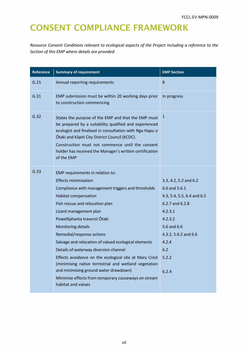
CONSENT COMPLIANCE FRAMEWORK
Resource Consent Conditions relevant to ecological aspects of the Project including a reference to the
Section of this EMP where details are provided.
Reference Summary of requirement EMP Section
G.15 Annual reporting requirements 8
G.31 EMP submission must be within 20 working days prior
to construction commencing
In progress
G.32 States the purpose of the EMP and that the EMP must
be prepared by a suitability qualified and experienced
ecologist and finalised in consultation with Nga Hapu o
Ōtaki and Kāpiti City District Council (KCDC).
Construction must not commence until the consent
holder has received the Manager’s written certification
of the EMP
1
G.33 EMP requirements in relation to:
Effects minimisation
Compliance with management triggers and thresholds
Habitat compensation
Fish rescue and relocation plan
Lizard management plan
Powelliphanta traversii Ōtaki
Monitoring details
Remedial/response actions
Salvage and relocation of valued ecological elements
Details of waterway diversion channel
Effects avoidance on the ecological site at Mary Crest
(minimising native terrestrial and wetland vegetation
and minimising ground water drawdown)
Minimise effects from temporary causeways on stream
habitat and values
3.3, 4.2, 5.2 and 6.2
6.6 and 5.6.1
4.3, 5.4, 5.5, 6.4 and 6.5
6.2.7 and 6.2.8
4.2.3.1
4.2.3.2
5.6 and 6.6
4.3.2, 5.6.2 and 6.6
4.2.4
6.2
5.2.2
6.2.4
FCCL-EV-MPN-0009
viii
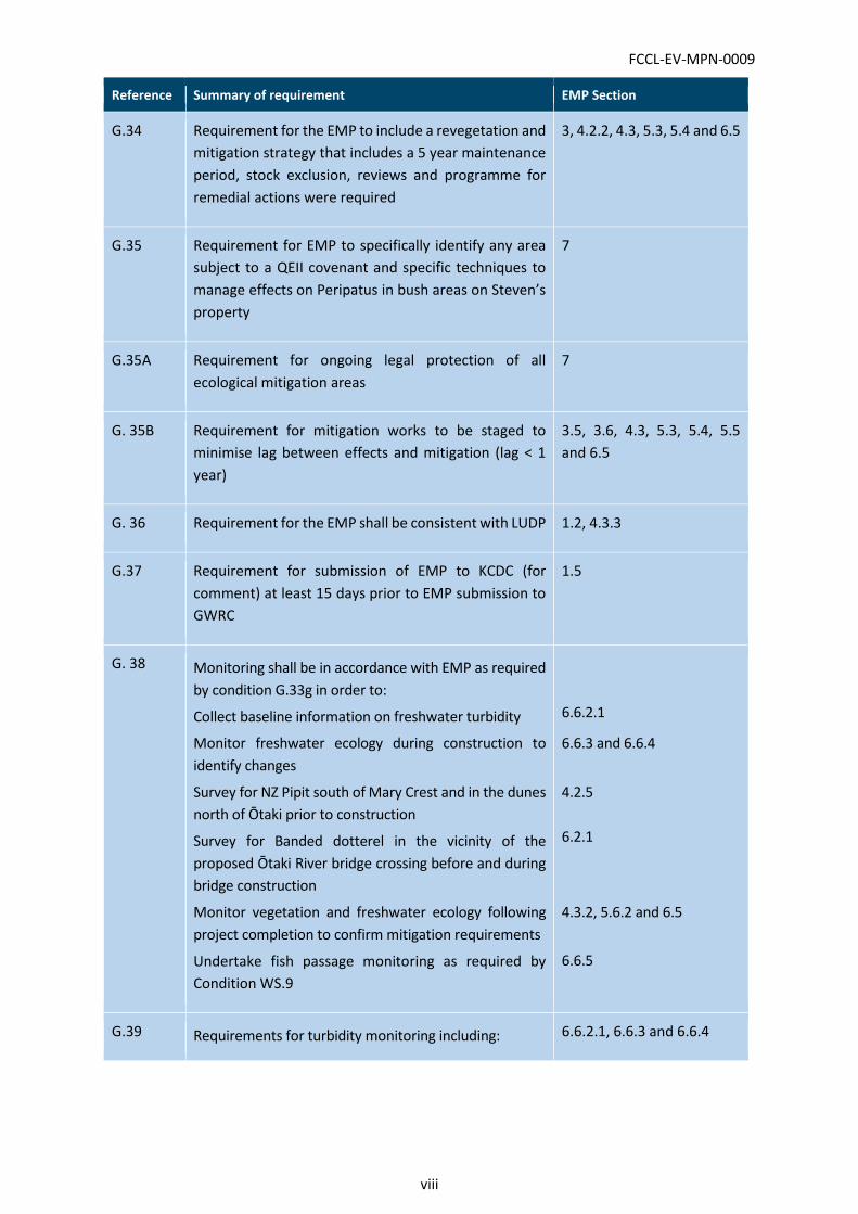
Reference Summary of requirement EMP Section
G.34 Requirement for the EMP to include a revegetation and
mitigation strategy that includes a 5 year maintenance
period, stock exclusion, reviews and programme for
remedial actions were required
3, 4.2.2, 4.3, 5.3, 5.4 and 6.5
G.35 Requirement for EMP to specifically identify any area
subject to a QEII covenant and specific techniques to
manage effects on Peripatus in bush areas on Steven’s
property
7
G.35A Requirement for ongoing legal protection of all
ecological mitigation areas
7
G. 35B Requirement for mitigation works to be staged to
minimise lag between effects and mitigation (lag < 1
year)
3.5, 3.6, 4.3, 5.3, 5.4, 5.5
and 6.5
G. 36 Requirement for the EMP shall be consistent with LUDP 1.2, 4.3.3
G.37 Requirement for submission of EMP to KCDC (for
comment) at least 15 days prior to EMP submission to
GWRC
1.5
G. 38 Monitoring shall be in accordance with EMP as required
by condition G.33g in order to:
Collect baseline information on freshwater turbidity
Monitor freshwater ecology during construction to
identify changes
Survey for NZ Pipit south of Mary Crest and in the dunes
north of Ōtaki prior to construction
Survey for Banded dotterel in the vicinity of the
proposed Ōtaki River bridge crossing before and during
bridge construction
Monitor vegetation and freshwater ecology following
project completion to confirm mitigation requirements
Undertake fish passage monitoring as required by
Condition WS.9
6.6.2.1
6.6.3 and 6.6.4
4.2.5
6.2.1
4.3.2, 5.6.2 and 6.5
6.6.5
G.39 Requirements for turbidity monitoring including: 6.6.2.1, 6.6.3 and 6.6.4
FCCL-EV-MPN-0009
ix
Reference Summary of requirement EMP Section
Pre-construction monitoring
Pre-construction purpose
Turbidity monitoring parameters
Need for a gross exceedance trigger and an elevated
level trigger
Reporting
Quarterly review of trigger levels
G.40 Requirements for mudfish surveys by a suitably qualified
ecologist which include:
Intended survey methodology
Alternative survey methodology
Relocation methodology
Provision of results
Full details of methodology for certification prior to
implementation
6.2.8
G.41 Construction monitoring requirements (in accordance
with the EMP)
Sediment monitoring
Monitoring effects of the construction on waterways
including sediment, oil and grease, aquatic
invertebrates and fish
6.6
G.42 Construction monitoring turbidity trigger response
requirements
6.6.4
G.43 Post-construction monitoring requirements including:
Monitoring of native bush and wetlands
The need for 5-years of post-construction monitoring
Aquatic ecology monitoring including 2 years of
stream/river monitoring of sediment,
macroinvertebrates and fish, fish passage, 5 years of
aquatic invertebrate monitoring in mitigation wetlands
and 5 years of riparian buffer monitoring
5.6.1
6.6.5
FCCL-EV-MPN-0009
x
Reference Summary of requirement EMP Section
G.44 Requirements for all ecological monitoring to be
undertaken by suitably qualified and experienced
ecologists and inspection and reporting requirements
for monitoring results
1.1
8
G.45 Response requirements for exceedance of trigger
levels for any monitoring limit or management trigger
level set in the EMP during or post construction
(exclusive of turbidity)
6.6.5, 6.6.3 and 6.6.4
G.46 Ecological mitigation requirements including:
a) 1.5ha of terrestrial mitigation planting, 1.1ha of
wetland mitigation planting, and swamp forest plantings
at Mary Crest or if unable to be achieved, alternative
options are stated
b) Riparian planting shall be a minimum of 2,601 lineal
metres at least 20 m width either side of the bank
c) Landscape and visual planting shall include approx.
1.77ha at Pareomatangi Reserve; and approx. 38 ha of
native planting landscape treatments
4.3, 5.4 and 5.5
6.5
Refer LUDP
G.46A Banded dotterel compensation requirements, which
includes removal of woody weeds from nesting area
prior to breeding season and during construction
6.3
G. 47 Requirements to ensure terrestrial, wetland, and
riparian habitat reflects similar indigenous ecosystem
types to what is being replaced
4.3, 5.4 and 5.5
WS.3 Diversion design and construction to maintain natural
stream flows and avoid fish passage barriers. Design
shall occur in consultation with an aquatic ecologist
6.4.1
WS.4 Culverts on select watercourses shall be designed to
facilitate fish passage in accordance with GWRC
publication, including specific requirements for
Mangapouri and Mangaone Streams
6.2.6
WS.5 Requirement for verification in writing by an engineer
and aquatic ecologist that the permanent stream
6.2.4.2
FCCL-EV-MPN-0009
xi
Reference Summary of requirement EMP Section
diversions are completed in accordance with the
SSEMP stream diversion plan
WS.6 Requirement that the design of waterways shall
include a specific programme and methodology to
manage migration of native fish and included as part of
the SSEMP
6.2.3
WS.8 The maximum length of reclamation or diversion shall
not exceed 2,750 m
5 and Appendix G
WS.9 Fish passage requirements, including:
Visual inspection of structures and works where fish
passage is required 1 and 4 years after installation
Remedial requirements in the event of fish passage
restriction
Visual inspection requirements
Requirement for inspection report within 1 month of
undertaking inspections by aquatic ecologist and
engineer
Remedial actions must be undertaken within 3 months
of submitting the report
6.6.5
WS.10 During construction the works shall be regularly
inspected and maintained to ensure that fish passage
is not impeded
6.6.3.5
WS.12 Temporary culvert design requirements which includes
Installation 300 mm below stream bed to facilitate fish
passage
6.2.4.1
WS.13 Stream must be reinstated to natural state after
removal of temporary culverts unless otherwise agreed
by the Manager
6.2.4.5
FCCL-EV-MPN-0009
1
1 INTRODUCTION
1.1 Project background
This Ecological Management Plan (EMP) has been developed for the State Highway 1 Peka Peka to
Ōtaki (PP2O) Expressway. Works will occur over a 200 week period from 25 November 2017. The
works will entail construction of a 12km, 4-lane Expressway, consisting of:
1.4M m3 Earthworks
9 km local road
10 No. Bridges, including 330m, Ōtaki River Crossing
Ōtaki Intersection - split
East-West connections – Ōtaki, Te Horo
Grade separation – Taylors Road
1.6 km railway realignment
The works will follow a general programme of enabling works and site establishment, followed by rail
realignment and bridge construction and then road construction.
The key Project parameters are given in Table 1.
Table 1: Contract details
TABLE HEADING
Project Name Peka Peka to Ōtaki Expressway
Nature of project 13 kms of new expressway and 10 new bridges
State Highway Classification SH 1
Commencement 25 November 2016
Project End Date 07 January 2021
Project Manager Craig Pitchford (NZTA)
Principals advisor Ron McFadyen (Opus)
Contractor Fletcher Construction
Contract Manager Andy Goldie (Fletcher)
Councils with Jurisdiction Greater Wellington Regional Council (GWRC)
Kāpiti Coast District Council (KCDC)
FCCL-EV-MPN-0009
2
This EMP is in general accordance with the version submitted with the designation and consent
applications for the Project and has been prepared by Tonkin & Taylor Ltd (T+T) ecologists. Dean Miller
has compiled the plan and written the aquatic ecology components. Terrestrial and wetland
components of the plan have been written by Liz Deakin and Matt Baber.
All of the monitoring set out in this EMP will be undertaken by suitably qualified ecologists.
1.2 EMP purpose
The purpose of this EMP is to outline the approach for ensuring that the adverse effects of the Peka
Peka to Ōtaki Expressway Project (the Project) are avoided, remedied or mitigated and to set out how
Fletcher intends to achieve compliance with the ecology related conditions of Resource Consents
NSP13/01.003 to NSP 13/01/.51.
Resource Consent Condition G.32 sets out the EMP purpose as follows:
1) To detail the ecological management programme that will be implemented to appropriately
manage effects of the Project on the environment during the construction phase and once the
Project is operational;
2) To document the permanent mitigation measures, including the restoration, management and
maintenance of ecological mitigation, as well as the mechanisms for developing relevant
mitigation and restoration plans for terrestrial and freshwater habitat;
3) To ensure that mitigation has been successful by establishing post-construction monitoring
and response procedures; and
4) To ensure that any long-term effects are appropriately managed through monitoring, adaptive
management and implementation of appropriate responses.
Our overarching goal is to achieve a no net loss of biodiversity values affected by the Project and to
therefore align with the Transport Agency’s Ecological Resources Objective E2 (NZTA, 2008). To this
end, we consider it essential to develop a holistic EMP that is cohesive and integrates with the
Construction Environmental Management Plan (CEMP), Site Specific Environmental Management
Plans (SSEMPs), the Landuse and Urban Design Plan (LUDP) and Greenroads (Bronze) certification.
This EMP will form Appendix J to the Construction Environmental Management Plan (CEMP) for the
Project.
1.3 EMP scope
The scope of this EMP is as per the requirements of Resource Consent Conditions which are
summarised as follows:
Conditions G.33 to G.37 that set out the purpose, required content, consultation
requirements and timeframes for document submission and plan implementation.
Conditions G.38 to G.45 that set out the ecological monitoring requirements for the project,
including pre-construction, during construction and post-construction activities.
Conditions G.46 to G.47 that set out the required quantums, locations and timeframes for
ecological mitigation (habitat restoration and compensation works).
FCCL-EV-MPN-0009
3
Conditions WS.1 to WS.14 that address controls and standards for works in watercourses.
A detailed schedule of Resource Consent conditions relevant to ecology is provided as a preface to
this EMP. This schedule includes EMP section references to where in the document the condition is
addressed. Broadly the scope of this EMP includes:
Details of how effects on vegetation, habitats and fauna will be minimised;
Details of the habitat restoration and compensation to be undertaken including a revegetation
and mitigation strategy;
A fish rescue and relocation plan;
A lizard management plan;
Details for dotterel, pipit, mudfish, Powelliphanta traversii surveys and management;
Detail the salvage of elements of any valued habitat of indigenous flora and fauna (including
felled logs) that have been lost as a result of the Project where practicable, including provision
for transfer of elements of the affected habitat to ecological mitigation sites;
Details of the ecological monitoring to be undertaken pre-construction, during construction,
and post-construction;
Details of the remedial/response and maintenance actions proposed;
Details for each new diversion channel if available (otherwise the details are to be provided in
the SSEMPs).
Ecological compensation work outside of the Designation was excluded from the design and
construction contract. This was on the basis that this work is often left to the end of the project and
NZTA wished to ensure the planting would happen early in the project timeline (rather than at the
end), sufficient funding was available and a good result was achieved. Baseline turbidity monitoring
was also undertaken separately for project programming reasons.
The following EMP items have been, or are being addressed by NZTA separately to Fletchers scope,
but are covered by way of summary in the main body of this EMP with detailed reports provided as
appendices:
Condition G.46 (a).(i).(a) – 1.5 ha of edge and interplanting of indigenous forest species. This
was removed from the tender scope and is being addressed by Opus on behalf of NZTA (NTT-
000148). An EMP prepared by Opus and covering Condition G.46 (a).(i).(a) is provided as
Appendix A and includes maps showing planting areas and extents.
Conditions G.46b – Stream mitigation (riparian planting). The bulk of the mitigation riparian
planting (including planting maintenance and monitoring) was removed from the tender
scope and is being addressed by Opus on behalf of NZTA (NTT-000073). An EMP prepared by
Opus and covering consent condition G.46 b) is provided as Appendix A and includes maps
showing planting areas and extents.
Condition G.39 – pre-construction turbidity monitoring: this work has been undertaken by
Opus on behalf of NZTA. A summary report has been provided in Appendix B ‘for information’
but the outcomes of this work have not been used to set the turbidity triggers for the ‘elevated
trigger level’ and ‘gross exceedance trigger’. Section 6.6.4.2 outlines the proposed trigger
levels to be used during construction.

FCCL-EV-MPN-0009
4
The EMP will be finalised in consultation with Ngā Hapū o Ōtaki (NHo Ō) and the Kāpiti Coast District
Council (KCDC). The final draft EMP will be lodged with Greater Wellington Regional Council (GWRC)
for certification at least 20 working days before the commencement of construction.
1.4 Site Specific Environmental Management Plans
Detailed terrestrial, riparian and wetland mitigation and monitoring plans will be set out in the
respective SSEMPs as it is considered appropriate to develop plans based on detailed design, which
is in progress.
This EMP provides the tools and framework from which the SSEMP’s will be developed and we have
signalled throughout the document where further detail will be provided through the SSEMP
process.
Project ecologists will review and have input into all SSEMPs prepared for the Project.
1.5 Consultation
1.5.1 Ngā Hapū o Ōtaki
Ngā Hapū o Ōtaki and NZTA have agreed on a Cultural Mitigation Plan. The Cultural Mitigation Plan
seeks to provide NHoŌ with the ability to exercise Kaitiatanga over its traditional lands in respect of
Expressway design and construction. The Plan requires the establishment of a Kaiarahi. The Kaiarahi
will provide the key point of contact and coordination for NHoŌ involvement in the Project and
provide leadership in respect of cultural inductions, monitoring and ceremonies.
A Kaiarahi will be located in the Fletcher Construction Company (FCC) office to ensure the
consideration of matters of interest to NHoŌ can be expedited promptly. The Kaiarahi will be
involved in the design process, construction supervision and environmental monitoring. The Kaiarahi
will be supported by Kaitaki who provide support in supervision and monitoring activities and
provision of specialist advice.
The Mitigation Plan also requires the preparation and implementation of a Cultural Monitoring Plan.
The Cultural Monitoring Plan will be complimentary to the EMP and where possible will be aligned,
for example in the location of monitoring points. Once the Cultural Monitoring Plan has been
prepared an assessment of the Cultural Monitoring Plan and the EMP will be undertaken to
determine if the EMP requires any amendment.
1.5.2 Kāpiti Coast District Council
The draft EMP is required to be provided to Kāpiti Coast District Council (KCDC). The purpose of this
is to ensure that relevant requirements of the EMP are reflected in the Landscape Urban Design
Plan. This includes such matters as the identification of suitable plant species for rehabilitation
activities, mitigation planting requirements and areas of high ecological value. KCDC reviewed
version B1 of this EMP and feedback and comment has been incorporated as appropriate.

FCCL-EV-MPN-0009
5
1.6 Document structure
This EMP is set out as follows:
Section 1 – Introduction as above.
Section 2 – Ecological values and effects summary.
Section 3 – Ecological mitigation strategy and framework: Our framework for complying with
the Project designation and resource consent conditions and managing terrestrial, wetland
and freshwater ecological effects.
Section 4 – Terrestrial ecology effects management and monitoring.
Section 5 – Wetland ecology effects management and monitoring.
Section 6 – Freshwater ecology effects management and monitoring.
Section 7 – Ongoing protection of ecological mitigation areas.
Section 8 – Reporting requirements and timeframes.
FCCL-EV-MPN-0009
6
2 ECOLOGICAL VALUES AND EFFECTS
2.1 Ecological context and values
Ecological values within and around the designation are described in detail in the documentation
supporting the Environmental Protection Agency (EPA) application for the project and in the evidence
and conferencing documents prepared through the Board of Inquiry (BOI) process. Ecological values
are therefore only summarised here. The locations of important ecological values are shown on the
Ecology Layout Plans (Drawings DG-CE-0801 to 0817) provided as Appendix C.
The expressway alignment passes through a highly modified landscape that is now dominated by
agriculture, and to a lesser extent horticulture, viticulture and urban/suburban land use.
Correspondingly, indigenous habitats and vegetation have been significantly reduced from their
former extent with only 1.7 % of indigenous vegetation cover and 1.3 % of wetlands now remaining.
What does remain is ecologically significant (Table 2) and therefore warrants efforts to both minimise
adverse effects and to appropriately mitigate for effects that cannot be avoided.
Table 2: Area or lineal extent of each broad habitat category and nationally ‘Threatened’ ‘At Risk’ or
legally protected species that are known or likely to be present within each habitat type
Habitat types with significant ecological values within the designation
Associated nationally ‘Threatened’, ‘At Risk’ or legally protected species that are known to be present or likely present
Total ha / km
Farmland/Duneland NZ pipit Approx. 27 ha
Mature native forest and groups of trees
Native lizards, land snails, peripatus 0.39 ha
Braided river bank Banded dotterel Unknown area (surveys required)
Freshwater wetland None known to be present but spotless crake, marsh crake and Australasian bittern could potentially be present
0.8 ha
Waterways Longfin eel, koaro, inanga, red-fin bully, giant kokopu, shortjaw kokopu, torrentfish, lamprey and brown mudfish
2.84 km
FCCL-EV-MPN-0009
7
2.2 Adverse ecological effects
Potential adverse effects associated with the construction and operations of PP2O will primarily occur
through habitat loss associated with vegetation clearance, earthworks and stream culverting and
diversions. Ongoing indirect effects on remaining habitat in close proximity to the preferred alignment
are also expected. Potential effects on ecological values associated with the Project include:
damage to remaining areas of native bush habitat immediately adjacent to the Project
footprint as a result of construction activities;
edge effects due to the loss of bush from the edges of Hautere Bush F, Cottle’s Bush and bush
to south of Te Hapua Road;
potential adverse effects on peripatus through habitat loss and/or edge effects;
potential adverse effects on lizards and the ‘Nationally Critical’ Powelliphanta traversii Ōtakia
(herein Ōtaki Snail) due to habitat loss and edge effects;
disturbance to NZ pipit populations south of Mary Crest and in the dune areas north of Ōtaki;
disturbance to nesting Banded Dotterels in the vicinity of the Ōtaki Bridge crossing;
potential effects on the hydrology of the remaining part of the Ōtaki Railway Wetland;
loss of c.0.5ha of habitat from the Ōtaki Railway Wetland;
adverse effects on aquatic life due to sediment and contaminant discharges to watercourses
during construction;
adverse effects on fish passage during, and as a result of construction activities;
impediment of fish passage by various new culverts installed along the expressway; and
the loss of waterway habitat due to installation of culverts and stream diversions at various
locations along the Project.
FCCL-EV-MPN-0009
8
3 ECOLOGICAL MITIGATION STRATEGY
AND FRAMEWORK
In this section we summarise the general approach to the management of actual and potential
ecological effects associated with the Project.
3.1 General approach and guiding principles
The approach to managing ecological effects was established through the Designation/consent BOI
process and the associated consent level design (prepared by Opus, URS and Holmes Consulting) and
this is reflected in the Designation and Resource Consent conditions.
Opus and NIWA scientists addressed ecological matters and effects management using the mitigation
hierarchy approach as set out in the Standard on Biodiversity Offsets published by the Business and
Biodiversity Offsets Programme (BBOP) in 2012. The BBOP (2012) ecological mitigation hierarchy is
set out in Table 3. The BBOP hierarchy approach does not necessarily follow the RMA requirements
or language around avoiding, remedying or mitigating effects so we have included a column describing
how RMA terminology fits within the hierarchy and in the context of the Project. This is based on the
guidance in the Ecological Impact Assessment Guidelines (EIANZ, 2015).
We purposely avoided the use of the term “offset” as this implies the use of a model and/or “ecological
currency” to measure biodiversity exchanges. The approach for PP2O through the consent was to
apply agreed loss-to-gain ratios based on professional judgement and other project case studies.
This EMP follows the effects mitigation hierarchy framework as detailed in Table 3 and builds on the
consent level EMP to specifically reflect the actual and potential effects associated with the project’s
detailed design. Some or all of the steps in the hierarchy are applicable depending on the nature of
the works and the scale of effects.
The following sections summarise in broad terms how adverse effects of the Project can be further
avoided, minimised, remedied, mitigated or compensated by appropriate management during and
after construction. Examples are provided for clarity.
Detailed information on effects management for terrestrial, wetland and freshwater ecological
effects are provided in Sections 4, 5 and 6 respectively. This includes information on the staging of
mitigation works with respect to Condition G.35B.
All areas subject to rehabilitation, restoration and habitat creation will be subject to 5 years of
maintenance (fencing, stock exclusion and pest/weed control) and long-term legal protection.
FCCL-EV-MPN-0009
9
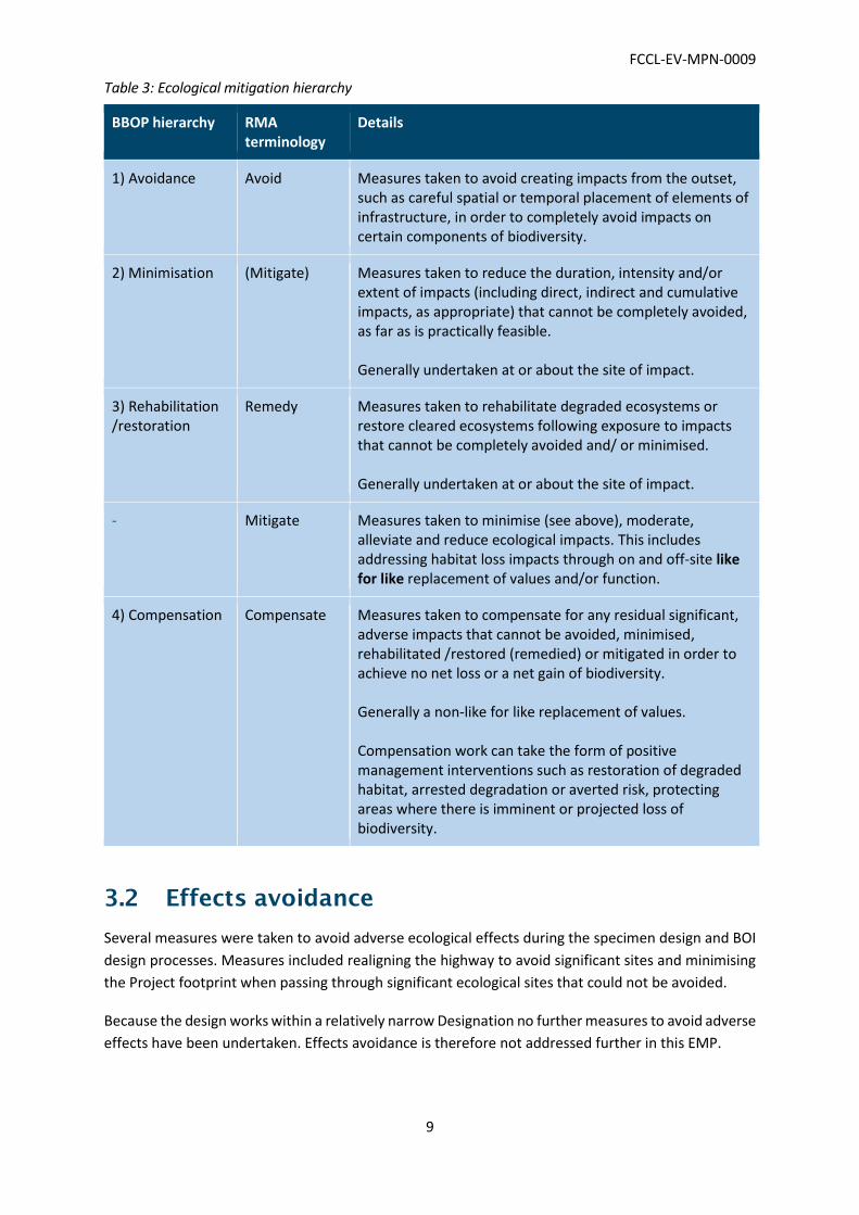
Table 3: Ecological mitigation hierarchy
BBOP hierarchy RMA terminology
Details
1) Avoidance Avoid Measures taken to avoid creating impacts from the outset, such as careful spatial or temporal placement of elements of infrastructure, in order to completely avoid impacts on certain components of biodiversity.
2) Minimisation (Mitigate) Measures taken to reduce the duration, intensity and/or extent of impacts (including direct, indirect and cumulative impacts, as appropriate) that cannot be completely avoided, as far as is practically feasible. Generally undertaken at or about the site of impact.
3) Rehabilitation /restoration
Remedy Measures taken to rehabilitate degraded ecosystems or restore cleared ecosystems following exposure to impacts that cannot be completely avoided and/ or minimised. Generally undertaken at or about the site of impact.
- Mitigate Measures taken to minimise (see above), moderate, alleviate and reduce ecological impacts. This includes addressing habitat loss impacts through on and off-site like for like replacement of values and/or function.
4) Compensation Compensate Measures taken to compensate for any residual significant, adverse impacts that cannot be avoided, minimised, rehabilitated /restored (remedied) or mitigated in order to achieve no net loss or a net gain of biodiversity. Generally a non-like for like replacement of values. Compensation work can take the form of positive management interventions such as restoration of degraded habitat, arrested degradation or averted risk, protecting areas where there is imminent or projected loss of biodiversity.
3.2 Effects avoidance
Several measures were taken to avoid adverse ecological effects during the specimen design and BOI
design processes. Measures included realigning the highway to avoid significant sites and minimising
the Project footprint when passing through significant ecological sites that could not be avoided.
Because the design works within a relatively narrow Designation no further measures to avoid adverse
effects have been undertaken. Effects avoidance is therefore not addressed further in this EMP.

FCCL-EV-MPN-0009
10
3.3 Effects minimisation
The updated design, like the design approved by the BOI, will have potential adverse ecological effects
on forest, wetland and stream/river habitat types and associated species. However, overall, Fletcher’s
design will result in reduced adverse ecological effects. Specifically, Fletchers has achieved a
comparative reduction in total effects on native bush by 0.06 ha and a reduction in direct effects on
stream habitats by around 750 m. This has been achieved by:
Vertically lowering the alignment in several locations, which results in significantly less
earthworks and a reduction in the overall alignment footprint relative to the specimen design;
and
Significantly reducing the quantum of stream diversion that is required.
A range of specific measures to minimise ecological effects are also built into the consent conditions
for the Project (e.g. Condition G.33). These include:
Design and construction methods to minimise loss of ecological values;
Requirements for culverts and diversions to enable fish passage;
Pre-construction surveys and salvaging and relocation operations for nationally ‘At Risk’ or
otherwise ecologically significant values including: NZ pipit (survey only), native lizards, native
fish, a native snail (Powelliphanta traversii Ōtaki) and the velvet worm (Peripatus spp.);
Salvage and redeployment of dead and felled native logs and stumps, which harbour
biodiversity e.g. the velvet worm, and/or will serve to enhance ecological mitigation sites;
Buffer planting and edge protection at forest patches that are subject to some vegetation
removal; and
Pre-construction, construction and post construction monitoring and adaptive management
with respect to construction effects on waterways.
Permits for surveying, salvaging and handling wildlife will be obtained from Ministry for Primary
Industries and the Department of Conservation as required.
3.4 Rehabilitation and restoration (remedy)
The Project includes measures to rehabilitate degraded ecosystems and restore cleared ecosystems
following exposure to impacts that cannot be completely avoided and/or minimised. Examples
include:
Banded dotterel breeding habitat improvement (weed control) upstream of the new Ōtaki
Bridge site.
Reinstatement and rehabilitation of areas of the Ōtaki Railway Wetland following
construction.
3.5 Effects mitigation
Consent conditions include requirements to address residual habitat loss impacts through measures
that replace values and/or function in a like-for-like manner, either on-site (within Designation) or off-
FCCL-EV-MPN-0009
11
site (out of Designation). For the purpose of this EMP we will refer to these measures as like for like
mitigation. Examples include:
The creation of the Kennedy Wetland (on-site) as a like-for-like replacement of values lost at
the Ōtaki Railway Wetland site.
Wetland planting and restoration at Mary Crest (on-site) as a like-for-like replacement of
values lost at the Ōtaki Railway Wetland site.
Edge and inter-planting and fencing of a degraded forest remnant (off-site) to replace values
lost at forest remnants (e.g. Cottle’s Bush and Hautere Bush).
The like-for-like mitigation work needs to be implemented on a staged basis in accordance with
Condition G.35B to minimise the lag time between effects occurring and replacement values being
realised. Timing details are provided as appropriate in Sections 4, 5 and 6.
All mitigation areas will be subject to 5 years of maintenance and long-term legal protection.
3.6 Compensation for residual effects
Ecological compensation is proposed to address the balance of the habitat loss effects (residual
effects) that cannot be avoided, remedied or mitigated. Compensation measures include:
Riparian retirement and restoration to compensate for stream habitat lost due to culverting
and diversion activities. This will mainly be undertaken out of Designation (off-site) but with
some on-site (within Designation).
Planting of swamp forest at Mary Crest to compensate for residual wetland habitat loss.
The compensation work needs to be implemented on a staged basis in accordance with Condition
G.35B to minimise the lag time between effects occurring and replacement values being realised.
Timing details are provided as appropriate in Sections 4, 5 and 6.
All compensation areas will be subject to 5 years of maintenance and long-term legal protection.
FCCL-EV-MPN-0009
12
4 TERRESTRIAL ECOLOGY EFFECTS
MANAGEMENT AND MONITORING
4.1 Introduction
Measures for managing terrestrial ecology effects include minimising effects on habitats and fauna
and like-for-like mitigation to address residual habitat loss.
Condition G.46 a) i) a) requires at least 1.5 ha of edge and inter-planting of indigenous terrestrial
forest species (in and around one of the established remnants identified on Exhibit 10 (attached as
Annexure 2 to the conditions)). This work is being planned and undertaken by Opus on behalf of
NZTA. A separate Management Plan is being prepared by Opus for this work and is included as
Appendix A. Summary information is provided in Section 4.3.
4.2 Minimising adverse effects
4.2.1 Minimising direct effects on valued vegetation and habitats for ecologically significant species in or close to the Project footprint
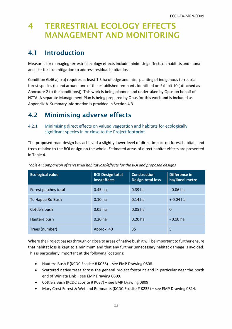
The proposed road design has achieved a slightly lower level of direct impact on forest habitats and
trees relative to the BOI design on the whole. Estimated areas of direct habitat effects are presented
in Table 4.
Table 4: Comparison of terrestrial habitat loss/effects for the BOI and proposed designs
Ecological value BOI Design total loss/effects
Construction Design total loss
Difference in ha/lineal metre
Forest patches total 0.45 ha 0.39 ha - 0.06 ha
Te Hapua Rd Bush 0.10 ha 0.14 ha + 0.04 ha
Cottle’s bush 0.05 ha 0.05 ha 0
Hautere bush 0.30 ha 0.20 ha - 0.10 ha
Trees (number) Approx. 40 35 5
Where the Project passes through or close to areas of native bush it will be important to further ensure
that habitat loss is kept to a minimum and that any further unnecessary habitat damage is avoided.
This is particularly important at the following locations:
Hautere Bush F (KCDC Ecosite # K038) – see EMP Drawing 0808.
Scattered native trees across the general project footprint and in particular near the north
end of Winiata Link – see EMP Drawing 0809.
Cottle’s Bush (KCDC Ecosite # K037) – see EMP Drawing 0809.
Mary Crest Forest & Wetland Remnants (KCDC Ecosite # K235) – see EMP Drawing 0814.
FCCL-EV-MPN-0009
13
Te Hapua Rd Forest (Steven’s Bush) (KCDC Ecosite # K324) – see EMP Drawing 0816.
Ōtaki Railway Wetland (KCDC Ecosite # K134) – see EMP drawing 0803.
The following will be undertaken to further minimise terrestrial habitat loss where possible:
A suitably experienced ecologist will undertake a walkover survey of the alignment prior to
the preparation of SSEMPs and in conjunction with Project landscape architects to identify
specific vegetation and trees near the works footprint that may be possible to retain. A follow
up assessment will be undertaken by an arborist if required.
A suitably experienced ecologist will be onsite during vegetation clearance and the
establishment of a protective fence at or close to the above key locations to ensure that native
vegetation loss and damage is minimised.
4.2.2 Minimising indirect effects on valued vegetation and habitats for ecologically significant species
The removal of vegetation from the edges of areas of bush can result in indirect damage to the
vegetation and habitats that remain; most notably, through edge effects, which include exposure of
vegetation and habitats at the newly created edges to increased wind and sun exposure, temperature
extremes, and desiccation.
To minimise edge effects where mature native trees are removed from the edges of Hautere Bush F
(K038, see EMP Drawing 0809), Cottle’s Bush (K037, see EMP Drawing 0810) and bush to south of Te
Hapua Road (K324, see EMP Drawing 0817), buffer planting will be undertaken along the edge to
provide protection (in accordance with condition G.34a)). Where space is limited this buffer planting
may extend to and on the road embankment.
Buffer planting will include dense plantings of early succession, wind and sun tolerant species that are
present and common within the respective forest patches e.g. ngaio, kanuka, wineberry, Pittosporum
tenuifolium and Coprosma repens. These will be locally eco-sourced to ensure that they are genetically
adapted to the site conditions.
Details of buffer planting specifications, maintenance and monitoring will be provided in the
appropriate SSEMP. Maintenance of planted buffer areas will be undertaken over a period of 5 years
from the time of completion of the planting.
Vegetation cover and composition will be assessed during regular inspection monitoring (every 2
years) by assessing a number of vegetation plot indicators following Clarkson et al. 2003. The following
indicators will be used:
Canopy cover: % cover introduced vs. native canopy cover
Understorey cover: % cover introduced vs. native cover
Total species: % no. introduced spp. vs. native spp.
Overall stress/dieback evaluation
Evaluate any damage by introduced mammalian pests
Evaluate any drought damage
FCCL-EV-MPN-0009
14
Following inspection monitoring visits, adaptive management may be required in the form of weed
management control and infill planting. Based on the extent of weed presence, an appropriate weed
management regime will be employed (e.g. 2-3 times/year). Where any remedial actions are
required, a programme and description of remedial actions shall be provided to the GWRC for
certification. These actions shall be carried out as soon as practicable having regard to weather and
appropriate planting seasons.
At the end of the five year maintenance period, revegetation success of the wetlands will be
assessed. Overall criteria for planting success are an 80 % canopy cover, a self-sustaining structure
and retention of >80% of the planted diversity.
The results of the review shall be provided to GWRC for certification and will identify:
That the revegetation has met the requirements of the EMP; and/or
To identify any remedial actions that need to be carried out.
Where any remedial actions are required, a programme and description of remedial actions shall be
provided to the Manager for certification. These actions shall be carried out as soon as practicable
having regard to weather and appropriate planting seasons.
4.2.3 Minimising effects on ecologically significant species
4.2.3.1 Lizards
A range of methods will be employed to optimise the effectiveness and efficiencies of lizard salvaging
and relocation programmes. In general, all native-dominated forest within the footprint will be
checked for native lizards in warmer months (November to March) and before clearance work is
undertaken. The Project will affect approximately 0.39 ha of suitable habitat that may support lizard
species. This includes Hautere Bush F (K038, see EMP Drawing 0808), Cottle’s Bush (K037, see EMP
Drawing 0809) and bush to south of Te Hapua Road (K324, see EMP Drawing 0814).
Potential adverse effects on habitats will be managed through:
Salvaging (in warmer months) to minimise loss of herpetofauna within the Project footprint;
Habitat enhancement at the designation relocation sites, including deployment of logs and
pest weed control; and
The creation and enhancement of native habitat through terrestrial, wetland and riparian
mitigation plantings.
Skinks that could be potentially present within native vegetation in the Project footprint include the
common skink, spotted skink and brown skink. The common and brown skink are classified as ‘Not
Threatened’ whereas the spotted skink is classified as ‘At Risk”. Skink salvaging will include:
Deployment of reptile shelters (single layered 500mm x 450mm onduline sheets) in suitable
habitat within the Project footprint. Generally, this will be undertaken at least 10 weeks prior
to vegetation clearance/earthworks activities. Based on an initial assessment, we expect to
deploy a total of 100 reptile shelters within approximately 0.39 ha of suitable habitat over the
course of the Project (i.e. approx. 1 shelter/40 m²).
FCCL-EV-MPN-0009
15
Undertake reptile shelter checks three times per week and manual searches to capture skinks
during warmer summer months (November – March) beginning two weeks prior to vegetation
clearance/earthworks activities. Manual searches will include:
o turning over or pulling apart cover objects (e.g. coarse wood debris); and
o raking of leaf litter or ground cover.
Undertake construction (machinery) assisted salvaging during vegetation clearance activities
that may include:
o mulching of low stature non-woody vegetation;
o turning over of large cover objects that cannot be searched manually (e.g., large
decomposing logs); and
o searching epiphytes (on felled trees).
All captured skinks will be placed in a container along with leaf litter and relocated into the
nearest relocation site on the same day of capture.
A silt fence will be established between the remaining vegetation and the Project footprint to
prevent skinks from moving back into the Project footprint. This fence will be linked to the
vegetation protection fence.
Geckos that may be present within the native forest patches include the Ngahere gecko (otherwise
known as the Southern North Island Forest gecko) and the Barking gecko (otherwise known as the
Wellington green gecko), both of which are classified as ‘At Risk’. To capture these species we will
undertake the following activities:
Each site identified as suitable habitat for geckos will be searched on three separate nights
beginning at least three weeks prior to vegetation clearance using standard nocturnal
searching techniques using powerful spotlights. Approximately 30 person hours of searching
per site will be undertaken during warmer summer months (November-March). If geckos are
detected, then an additional 10 person hours searching will be undertaken until no further
geckos are found. If geckos continue to be found, then gecko searching will continue until a
maximum of 150 person hours is undertaken.
All captured geckos will be placed in a container along with leaf litter and transported to the
nearest relocation site (as per Designation Condition requirements) on the same night of
capture.
To minimise mortality and injury to geckos not detected during salvaging operations, felled
trees will be de-limbed and vegetation (‘slash’) will be stockpiled against remaining native
vegetation indefinitely. In time, this will enable geckos to disperse out of stockpiles and into
the adjacent forest. We expect this to significantly reduce potentially adverse effects on
geckos as standard vegetation clearance protocol is to mulch vegetation.
Capture and release of lizards will be undertaken in general accordance with the following
methodologies:
Animals will be placed in ventilated two litre plastic containers for no longer than 4 hours and
will be released in the selected relocation site.
The container will contain vegetation for lizards approximately 30 mm deep and collected
from the point of salvage.
Care will be taken to keep the container at a constant ambient temperature.

FCCL-EV-MPN-0009
16
Lizards will be relocated under or into coarse woody debris within the same patch of bush
(inside the designation) from where they were salvaged and within 2 hours of capture.
The location of each individual released will be GPS recorded.
The number of individuals of each relocated species will be recorded.
Copies of all records will be provided to the DoC, KCDC and GWRC and these will be updated
on a regular basis.
A silt fence will be established between the remaining vegetation and the Project footprint to
prevent skinks from moving back into the Project footprint. This fence will be linked to the
vegetation protection fence.
4.2.3.2 Powelliphanta traversii Ōtaki management
The Project will affect approximately 0.25 ha of suitable habitat that may support Powelliphanta
traversii Ōtaki snails (herein Ōtaki snails), which are classified as ‘Nationally Critical’, the highest threat
category. Potential habitat includes Hautere Bush F (K038, see EMP Drawing 0808) and Cottle’s Bush
(K037, see EMP Drawing 0809). Search effort will include a minimum of 12 person hours across the
two sites. If live snails or snail shells are found within a given site, then, as required by Consent
Condition G.33(f), an Ōtaki snail management plan will be developed for their recovery and relocation.
The search methodology for land snails includes the following:
Traversing the search area systematically to ensure a relatively even coverage. The search
team will form a moving front traversing snail habitat within the area.
Salvaging will involve searching through:
o Leaf litter
o Fallen logs and old tree stumps
o Beneath aboveground tree roots
o Gaps in existing tree trunk bark formation (for young/juveniles)
o Niches at accessible mature tree branch/trunk interface (for young/juveniles)
o Other moist, sheltered habitats/microclimates
4.2.3.3 Peripatus management
Peripatus, also known as velvet worm, inhabit damp, rotting timber, located in shady forests. Rotting
timber will be checked in Steven's bush (to the south of Te Hapua Road (K324, see EMP Drawing
0814)). This location is in close proximity to the Project footprint and peripatus could therefore be
indirectly affected by edge effects associated with the removal of edge vegetation. Effects on
peripatus will be avoided or minimised through salvaging and relocation of peripatus habitat, most
notably decomposing coarse woody debris (logs and stumps), into adjacent vegetation that will
remain outside of the Project footprint. Note that peripatus cannot effectively be surveyed without
destroying habitat (e.g. breaking apart decomposing logs). As such, we consider the most appropriate
means of avoiding or minimising effects to be relocating habitat elements
FCCL-EV-MPN-0009
17
4.2.4 Salvage of habitat elements
Areas where native logs and other habitat elements will be salvaged are shown on the EMP Drawings.
Methods to guide the salvage, storage and relocation of valued habitat elements for indigenous flora
and fauna (including felled logs) will be set out in the respective SSEMPs.
4.2.5 Pipit survey
NZ pipit surveys will be undertaken by a qualified ornithologist south of Mary Crest and in dunes north
of Ōtaki in spring/summer prior to construction by delimiting the relevant habitat and grid-searching
the Project designation. The number of birds seen and site locations will be recorded on GPS.
If any pipits are found, then mowing long grass prior to the breeding season is required (to ensure
birds move away from the area and to minimise the chances of birds nesting occurring in the Project
footprint).
4.3 Mitigation for terrestrial habitat loss
Condition G.46 a) i) a) requires at least 1.5 ha of edge and inter-planting of indigenous terrestrial
forest species (in and around one of the established remnants identified on Exhibit 10 (attached as
Annexure 2 to the conditions). This work is being planned and undertaken by Opus on behalf of
NZTA.
A separate “Terrestrial Mitigation Planting Plan” is being prepared by Opus. Once finalised, the
Terrestrial Mitigation Planting Plan will be provided with a re-issue of the EMP and included as
Appendix A to this EMP.
Summary information is provided below.
4.3.1 Terrestrial mitigation work
Like-for-like mitigation for terrestrial habitat loss is being addressed separately by Opus on behalf of
NZTA. A plan for this work is in preparation and will be provided in Appendix A to this EMP when
available. In summary:
Suitable sites have been identified and comprise five of the established remnants identified
on Exhibit 10 (Annexure 2 to the conditions). This group of bush blocks are adjacent to Ōtaki
Gorge Road and are classified as belonging to the Te Horo Forest Remnants, under the
Greater Wellington Regional Council (GWRC) Key Native Ecosystems (KNE) programme,
which is designed to protect areas that are important for native plants and animals in the
Wellington region. The Te Horo Forest Remnants KNE site comprises five forest remnants
located on alluvial river terraces to the west of the Ōtaki River, and are scheduled as
ecological sites in the Kāpiti Coast District Plan.
The full requirement for 1.5 ha edge and interplanting will be met at this site (over 2 ha of
planting is proposed);
Seeds will be collected and propagated from the remnant so the likely timing for planting
will be the 2018 planting season;

FCCL-EV-MPN-0009
18
Maintenance will be undertaken over a period of 5 years from the time completion of the
planting; and
The site will be protected in perpetuity by a covenant on the land title.
4.3.2 Procedure for addressing any additional terrestrial habitat loss effects
As set out in Table 4, the updated design achieves a slightly lower quantum of direct terrestrial
habitat loss compared to the BOI design (0.06 ha). Should the area of terrestrial habitat loss increase
relative to the BOI design (0.45 ha), then additional mitigation planting shall be undertaken. The
quantum of mitigation shall be at a loss to gain ration of 1:3.3, as per the approximate ratio applied
in condition G.46 a) i) a) (i.e. 1.5 ha of edge and inter-planting to address 0.45 ha of terrestrial
habitat loss).
Updated ecological accounting details for terrestrial effects (and other effects) will be provided
through the SSEMP’s to ensure any balance of effects can be addressed in advance of Project
completion. An audit report covering ecological effects accounting will be prepared and provided to
GWRC at the end of the Project and will outline any additional mitigation work required and the
timeframe for completing this.
4.3.3 Landscape and visual mitigation planting
The landscape and visual planting required by Condition G.46 c) is covered by the LUDP. The LUDP
map set incorporates the ecological mitigation planting work and therefore the overall planting
proposed for the Project.
FCCL-EV-MPN-0009
19
5 WETLAND ECOLOGY EFFECTS
MANAGEMENT AND MONITORING
5.1 Introduction
The only wetland that occurs within the Project footprint is the Ōtaki Railway Wetland. This wetland
is an ecologically important feature that is dominated by raupo marsh with several other native plant
species also common. The entire Ōtaki Railway Wetland will be impacted by construction. Measures
to address effects on the Ōtaki Railway Wetland include reinstatement (rehabilitation and restoration)
of areas of the wetland following construction, condsideration of hydrological changes (Condition
G.33) a) iv)) and addressing residual habitat effects through like for like mitigation and non-like-for-
like compensation.
An ecological site (terrrestrerial) is present at Mary Crest (outside the Designation) but with fringing
and adjacent wet pasture with wetland vegetation features such as patches of raupo, carex and juncus
species within the Designation. Condition G.33k) requires consideration of direct effects on native
vegetation and effects on groundwater drawdown at the Mary Crest ecological site and the fringing
wet pasture habitat.
In terms of addressing Consent Condition G.46 a) i) b) which requires the establishment of a minimum
of 1.1 ha of landscaped and planted wetland habitat. Based on the consent conditions and the BOI
documentation this is on the basis of an approximate total loss of around 0.5 ha of wetland habitat at
the Ōtaki Railway Wetland site and a 2:1 compensation ratio. Wetland mitigation work to address this
requirement will focus on like-for-like habitat creation in Kennedy Wetland (c. 0.2 ha) and also at Mary
Crest (c. 1.7 ha, including both wetland and swamp forest planting). We note the Kennedy Wetland
was 0.4 ha in size in the BOI design.
A suitably qualified ecologist will guide the design of the wetlands, develop appropriate planting plans,
supervise their construction and planting and develop the maintenance and monitoring programme.
5.2 Minimising adverse effects
5.2.1 Management of the hydrology of the restored parts of the Ōtaki Railway Wetland
The rehabilitated and restored parts of the Ōtaki Railway Wetland are shown on EMP Drawing 0803
and comprise an 0.11 ha wetland on the eastern side of the alignment and an 0.19 ha area on the
western side. A stormwater wetland is also shown and will treat road runoff prior to discharge to both
the restored wetlands, which will have an attenuation function. Both the restored wetlands will
continue to receive run-off from their catchments during rain events.
Restored wetlands will be lower than the existing wetland by around 1 m and the bottom lined to
prevent groundwater loss. Low permeability soils will also be used to create an impermeable zone
between the wetlands and the new Expressway embankments to prevent water from the wetland
draining through the more permeable embankment materials. The restored wetland areas are
FCCL-EV-MPN-0009
20
therefore expected to continue to be permanently wet, although water levels may temporarily
fluctuate during rain events.
Water currently exits the wetland via a small surface channel at the southern end of the wetland. Once
the Expressway is constructed, water will exit the southern end of the wetland via a culvert which will
discharge to the constructed Kennedy Wetland (refer EMP Drawing 0803). The culvert will be
positioned to ensure that the hydrological conditions of the restored Ōtaki Railway Wetland area will
be similar to those that exist in the wetland at the present time.
5.2.2 Ground water at Mary Crest and the existing ecological site
The local road and expressway formations are on embankments elevated above the proposed
stormwater, naturally wet ground and the groundwater surface. There will be no connection or outlet
to drainage that is likely to lower the groundwater levels in this area.
The Project avoids the existing ecological site at Mary Crest (K235) which comprises a forest remnant.
The proposal for the in Designation restoration work at Mary Crest is shown on EMP Drawing 0815.
Seeds for the planting programme here will be sourced from the existing remnant and the proposed
planting will link with the remnant and include riparian, swamp forest and low stature wetland
planting units. The overall effect of the Project on the existing ecological site is expected to be positive.
5.3 Wetland rehabilitation and restoration
Condition G.34 a) iii) requires that this EMP cover the revegetation and mitigation strategy for the
restored parts of the Ōtaki Railway Wetland. A detailed plan for the restoration of the Ōtaki Railway
wetland area (and the Kennedy Wetland, see later) is being developed as part of the landscape
detailed design and specification and will be provided in the appropriate SSEMP. The broad scheme
for the site is shown on EMP Drawing 0803.
A total of 0.3 ha of wetland habitat will be rehabilitated and restored as described in Section 5.1.1.
The ecologist will also advise on species selection which is expected to focus on the main species
already present in the Ōtaki Railway Wetland including:
Carex geminate;
Carex virgate;
Carex secta Purei;
Cordyline australis (Cabbage tree);
Eleocharis acuta (Spike rush);
Eleocharis gracilis (Slender spike-sedge);
Isolepis prolifer; and
Typha orientalis (Raupo).
Emergent canopy tree species such as pukatea (Laurelia novae-zealandia) and kahikatea
(Dacrycarpus dacrydioides) will also be considered in the wetland restoration composition.

FCCL-EV-MPN-0009
21
The site is within the works footprint so the rehabilitation and restoration work will occur as part of
construction and with planting completed within 1 year of completion of earthworks, in accordance
with Condition G.35B c).
5.4 Mitigation for wetland habitat loss
5.4.1 Like-for-like mitigation at Kennedy Wetland
The Kennedy Wetland will receive water from outflow of the remnant of the Ōtaki Railway Wetland.
This is expected to provide permanent flow through the Kennedy Wetland and keep this wetland
permanently wet.
A detailed plan for the Kennedy Wetland (wetland creation) will be developed as part of the landscape
detailed design and specification and provided in the appropriate SSEMP. The broad scheme for the
site is shown on EMP Drawing 0803. A total of 0.2 ha of wetland habitat will be created. This forms
part of the 1.1 ha requirement for landscaped and planted indigenous wetland required by Condition
G.46 a) i) b).
The ecologist will also advise on species selection which is expected to focus on the main species
already present in the Ōtaki Railway Wetland including:
Carex geminate;
Carex virgate;
Carex secta (Purei);
Cordyline australis (Cabbage tree);
Eleocharis acuta (Spike rush);
Eleocharis gracilis (Slender spike-sedge);
Isolepis prolifer; and
Typha orientalis (Raupo).
The site is within the works footprint, so the rehabilitation and restoration work will occur as part of
construction and with planting completed within 1 year of completion of earthworks, in accordance
with Condition G.35B c).
5.4.2 Like for like mitigation at Mary Crest
The Mary Crest area presents the greatest opportunity for ecological mitigation on the Project. The
area is adjacent to an existing puketea-kahikatea dominated swamp forest fragment that will be
expanded through wetland mitigation plantings. Small areas within Mary Crest are also suitable for
the recreation of raupo marsh wetland habitat and this will enable like-for-like mitigation for the loss
of raupo-carex habitat within Ōtaki Railway Wetland.
It is proposed to create the new area of wetland adjacent to the Mary Crest bush in an area that is
currently damp pasture. This work will comprise low stature wetland planting, which is considered
like-for-like mitigation, and swamp forest which is considered non like-for-like compensation (and
addressed in the following section).
FCCL-EV-MPN-0009
22
A detailed plan for the Mary Crest wetland planting has been developed for the landscape detailed
design and specification and will also be provided in the appropriate SSEMP. The broad plan is shown
on EMP Drawing 0815. This plan seeks to be consistent with the intent of the Annexure B to the Joint
Statement of Ecological experts dated 28 August 2013 (Condition G.46 a) i) c)) but has been developed
based on a detailed site assessment and existing contour information.
Approximately 0.62 ha of low stature like-for-like wetland planting is proposed which will contribute
to the 1.1 ha wetland mitigation requirement by Condition G.46 a)i)b)). Wetland planting works will
be completed within 1 year of commencement of construction in this area in accordance with
Condition G.35B c).
5.5 Compensation for wetland habitat loss
Non like-for-like compensation planting is proposed for the Mary Crest site in the form of swamp
forest planting. A detailed plan for the Mary Crest wetland planting has been developed for the
landscape detailed design and specification and will also be provided in the appropriate SSEMP. The
broad plan is shown on EMP Drawing 0815. The swamp forest planting work broadly follows the
concept as set out on Annexure B to the Joint Statement of Ecological experts dated 28 August 2013
(Condition G.46 a)i)c)) but has been refined to reflect Fletcher’s design and site conditions and
topography. Approximately 1.1 ha of swamp forest planting is proposed, which contributes to the
overall wetland mitigation planting requirement (1.1 ha).
We note that the Mary Crest plan (EMP Drawing 0815) also includes non-wetland planting including
riparian and terrestrial habitat. These areas are being planted in appropriate locations to optimise the
biodiversity within the site and enhance linkages across multiple habitat types. These planting units
will be managed and monitored as per the other ecological mitigation planting work on the Mary Crest
Site and have been shown as ecological mitigation on Drawing 0815.
Swamp forest wetland compensation planting areas are outside of the works area and will be
completed within 1 year of commencement of the works (Condition G.35B).
5.6 Post construction wetland monitoring
5.6.1 Wetland maintenance and monitoring
All wetland restoration, mitigation and compensation areas will be subject to a five year monitoring
and maintenance programme.
Aquatic ecological conditions will be monitored at the constructed Kennedy Wetland and Mary Crest
wetland areas for five years after completion to ensure that the wetlands achieve a level of aquatic
ecological value equal to that of the impacted wetland.
Aquatic invertebrates are the most practical component of these ecosystems for monitoring, as
invertebrate communities reflect the integrated effects of hydrological conditions, water quality and
habitat suitability. It should be noted that precise relationships linking wetland invertebrate
communities to specific environmental factors are lacking, but invertebrate data from the new
FCCL-EV-MPN-0009
23
wetlands can be used for comparisons with established wetlands in the region (Suren and Sorrell,
2010).
Wetland invertebrate monitoring will comprise annual sample collection using a standardised
method, such as the timed kick-net sampling method in Suren et al. (2011). Sampling will occur in the
existing Ōtaki Railway Wetland and two other control wetlands on at least one occasion prior to
construction to serve as “before” data for later comparison. The two control wetlands will also be
sampled annually for a five year period in conjunction with the restored wetland sampling. Suitable
control wetlands will be identified during the first baseline monitoring round.
Wetland vegetation cover and composition will be assessed during regular inspection monitoring
(every 2 years) by assessing a number of vegetation plot indicators following Clarkson et al. 2003. The
following indicators will be used:
Canopy cover: % cover introduced vs. native canopy cover
Understorey cover: % cover introduced vs. native cover
Total species: % no. introduced spp. vs. native spp.
Overall stress/dieback evaluation
Evaluate any damage by introduced mammalian pests
Evaluate any drought damage
Following inspection monitoring visits, adaptive management may be required in the form of weed
management control and infill planting. Based on the extent of weed presence, an appropriate weed
management regime will be employed (e.g. 2-3 times/year). Where any remedial actions are
required, a programme and description of remedial actions shall be provided to the GWRC for
certification. These actions shall be carried out as soon as practicable having regard to weather and
appropriate planting seasons.
At the end of the five year maintenance period, revegetation success of the wetlands will be assessed.
Overall criteria for planting success are an 80 % canopy cover, a self-sustaining structure and retention
of >80% of the planted diversity. Where any remedial actions are required, a programme and
description of remedial actions shall be provided to the GWRC for certification. These actions shall be
carried out as soon as practicable having regard to weather and appropriate planting seasons.
5.6.2 Procedure for addressing any additional wetland habitat loss effects
As set out in Section 5.1, Fletcher’s design has the same quantum of direct wetland habitat loss
compared to the BOI design (0.5 ha). The quantum of mitigation shall be at a loss to gain ration of
1:2, as per the approximate ratio applied in Condition G.46 a) i) b) (i.e. 1.1 ha of planted indigenous
wetland habitat).
As set out in Sections 5.4 and 5.5, the total quantum of wetland restoration, mitigation and
compensation proposed comes to some 1.9 ha, easily exceeding the minimum required by the
consent.
Updated ecological accounting details for wetland effects (and other effects) will be provided
through the SSEMPs to ensure any balance of effects can be addressed in advance of Project
completion. An audit report covering ecological effects accounting will be prepared and provided to

FCCL-EV-MPN-0009
24
GWRC at the end of the Project and will outline any additional mitigation work required and the
timeframe for completing this.
FCCL-EV-MPN-0009
25
6 FRESHWATER ECOLOGY EFFECTS
MANAGEMENT AND MONITORING
6.1 Introduction
Measures for managing freshwater ecology effects include minimising effects on habitats and fauna,
habitat restoration (e.g. dotterel breeding habitat), like-for-like mitigation (new stream diversions)
and ecological compensation to address residual habitat loss (in and out of Designation riparian
restoration).
Condition G.46 b) requires at least 2601 linear metres of riparian planting as compensation for
stream habitat loss as a result of the Project. The bulk of this riparian is being planned and
undertaken at out of Designation sites by Opus on behalf of NZTA. A separate Management Plan is
being prepared by Opus for this work and will be included as Appendix A. Summary information on
the proposed planting and ecological accounting is provided in Section 6.5.
6.2 Minimising adverse effects
6.2.1 Minimising adverse effects on dotterels
Banded dotterel (Nationally vulnerable) are known to nest on exposed gravel beaches next to the
Ōtaki River. Consent Condition G.38 d) requires that surveys for banded dotterels are undertaken in
the vicinity of the proposed Ōtaki River bridge crossing immediately prior to and during bridge
construction. Nesting habitat enhancement for dotterels is also required at a suitable site upstream
of the proposed bridge and is addressed in Section 6.3.
Approximate timing for the commencement of bridge construction works is December 2017 (site
establishment and clearance), which is within the breeding season for banded dotterel (July to
January).
A banded dotterel management protocol will be set out in the respective SSEMP that shall include
details on but is not limited to:
Protocol for reducing the suitability of banded dotterel nesting habitat in the vicinity of the
construction footprint to minimise the potential for effects on birds (and construction
programme issues);
A pre-construction survey of the works area to be undertaken by a suitably qualified avian
ecologist no earlier than eight working days prior to any works being carried out, to locate
any banded dotterel breeding or nesting sites. If banded dotterel breeding or nesting sites
are found within a 50 metre radius of any construction area, construction activities within
that 50 m radius shall be postponed until such time as all nests are abandoned or the chicks
have fledged;
Surveys to be undertaken during construction to monitor for birds that commence nesting
during this time; and
The protocol for reporting.
FCCL-EV-MPN-0009
26
6.2.2 Minimising adverse effects on streams
Detailed design of the drainage systems for the Project, including cross drainage and stream
diversions, is in progress and is unlikely to be finalised by the time this EMP is submitted for approval.
However, the detailed design work that is currently in progress, will build on the work undertaken for
the tender process and will likely achieve a significant reduction in the total effects on streams relative
to the consented BOI design1. Specifically, Fletcher’s design has achieved a comparative reduction in
total effects on stream habitats of around 750 m by:
Vertically lowering the alignment in several locations resulting in significantly less earthworks
and a reduction in the overall alignment footprint relative to the specimen design; and
Significantly reducing the quantum of stream diversions required.
The implementation of ecological compensation work for stream loss (Consent Condition G.46 b)) has
been excluded from Fletcher’s scope. However, ecological accounting for stream effects and
compensation requirements will be an important component of this EMP to demonstrate that stream
effects are in general accordance with or lower than that contemplated by the resource consents.
More detail on stream effects accounting is provided in Section 6.5. This will be a live process and will
be regularly updated as the Project progresses.
6.2.3 Protection of migrating fish during construction
A range of native fish species have been identified in the streams crossing the Project. In-stream
construction activities have the potential to impede the movement of migratory fish species. There
are two peak migration periods for fish species relevant to the Project:
Upstream migrations of juvenile shortfin and longfin eels, banded kokopu, short-jaw kokopu,
and koaro, and downstream migrations of redfin bullies peak in spring and summer; and
Upstream migrations of redfin bullies and downstream migrations of adult eels, koaro, and
torrentfish peak in autumn during freshes (short-duration, low-magnitude floods).
In addition to these peak periods, there are lower-intensity migrations occurring throughout the year.
The Project crosses both intermittently flowing and permanently flowing streams and the
requirements for managing in-stream works and fish passage will be different for these watercourse
types. In summary:
Intermittent streams – the use of these habitats and fish migration through the Project area
will be constrained to periods when water is present and flow levels are high enough to allow
fish passage. Construction schedules will consider peak migration periods and where possible
in-stream construction activities in intermittent waterways will be undertaken in dry and
drying periods when fish passage is either not possible or is likely to be minimal.
1 NIWA 2013. Peka Peka to North Ōtaki: Aquatic Ecology TR12. For the stream effects comparison we have included
stream loss that has potential ecological effects only for our Design and the Specimen Design. We have not included
culverting or diverting relating to flood conveyance or wetland outlets.

FCCL-EV-MPN-0009
27
Permanent streams – in-stream construction activities that fully impede fish movements or
divert flow will be scheduled as far as practicable during periods outside of the peak migration
periods for the specific species known or likely to be present in any particular watercourse.
Short-term in-stream works that partially impede flow may be undertaken during migration
periods if:
o few migratory native fish are present upstream and downstream of the construction
site; and
o the fish present are collected and relocated as specified in the Fish Rescue Plan
(Section 6.2.7).
The particular requirements for managing construction effects on fish migration will be specific to
each watercourse and the fish species present. A detailed schedule of in-stream works requirements
for streams affected by the Project is included in Appendix E and is based on broad construction
sequencing (in progress). This schedule will be live, updated as necessary and specific requirements
included in the relevant SSEMP.
6.2.4 Minimise effects of temporary and permanent culverts, diversions and causeways
6.2.4.1 Permanent and temporary culverts
All permanent culverts on permanent or intermittent streams will require a specific construction
methodology considering the nature of the habitat and fish species known or likely to be present.
Detailed methods will be developed for and provided in the appropriate SSEMP. General
considerations for permanent fish passage, native fish migration management and fish rescue are
provided in Appendices D and F. Permanent culverts will incorporate fish passage as described in
Section 6.2.6.
The specific methodology developed for construction of culverts on or to convey permanent and
intermittent streams will consider:
All culverts in permanent or intermittent waterbodies shall be constructed either by
installing a diversion around the work area and installing the culvert in the dry channel, or by
constructing the culverts adjacent to the stream and then diverting water in to the culvert
on completion;
A briefing will occur at the outset of construction to contractors by the Project Ecologist;
Culvert installation shall be supervised through the construction phase (and signed-off) by
Project Ecologist;
During construction special attention shall be given to the protection of native fish within
any section of stream being culverted;
Where the existing channel is to be lost or drained as part of culvert installation, fish capture
and transfer will be required prior to water loss as set out in Section 6.2.7; and
At the livening of any culvert turbidity monitoring will be undertaken. If the turbidity level
downstream of the diversion has not returned to levels within 10 % of the upstream of the
culvert within 48 hours of livening then GWRC will be notified and an investigation will be
carried out to address the source of sediment release. The monitoring method (i.e.
FCCL-EV-MPN-0009
28
telemetry or hand-held meters) will be further defined and approval by the Manager GWRC
prior to works.
Where temporary culverts are used, these shall be designed to meet the following criteria (in
accordance with consent condition WS.12):
To pass a 50 % AEP flood event without heading up (as assessed at the time of commencement
of construction);
Culverts will be installed 300 mm below stream bed level in order to provide a continuous
wetted perimeter to facilitate the passage of native fish species; and
The minimum size of any temporary culvert shall be not less than 600 mm in diameter.
6.2.4.2 Permanent diversions
A total of nine permanent stream diversions are proposed along the Project. Most of these are short
in length and comprise minor re-alignments associated with and will occur in conjunction with culvert
works. Longer diversions are proposed for Mangaone Stream, Gear Stream, Jewell Stream, Cavallo
Stream and Edwin Stream. Preliminary details for each diversion are provided in the Schedule of
Stream Works and effects provided in Appendix E. Detailed design for permanent stream diversions is
in progress. In order to manage habitat effects the design will seek to match existing habitat types
upstream. An ecologist will survey the existing stream bed for morphology and habitat characteristics
to inform specific features to be incorporated into the new diversion. Details will be provided in the
relevant SSEMP.
A specific works methodology will be developed for each diversion (or group of diversions for sites
with similar characteristics) to address water quality and fish passage effects during construction. A
general diversion works methodology is as follows. Note there will be different fish rescue
requirements for watercourses where mudfish may be present (see Section 6.2.8):
Build the new stream alignment off line to maintain existing stream quality;
Establish the new stream bed and substrate with space for a hyporheic zone (at least 0.5m
deep);
Create channel depth profile (noting above requirements) to mimic existing stream, in terms
of final water depths, width and therefore velocities and tilt to ensure low flows are
focussed;
Form stream banks as near as possible to the slope and material of the natural bank
condition;
Ensure sufficient meanders are present in longer diversions;
Store and dispose of excavated material so that it does not contaminate either waterway;
Provide clean appropriately sized hard substrates in correct proportions and ensure water
does not fall (as in water fall) such that fish passage is compromised;
Plant the immediate riparian vegetation prior to or as soon after as practicable the re
connection;
Plant out the rest of the flood terrace (especially for stabilisation);
Ensure no rain events are forecast for the time of reconnection;

FCCL-EV-MPN-0009
29
Prior to diversion of water, fish out and transfer eel and all fish caught. Use a holding tank
while diversion to new stream is enacted. Release the fish into the stream either below or
above the new connection, after re-connection;
Trap and release of fish ideally should be in the same day;
Immediately following fish removal break lower connection and then make and redirect
stream in to new diversion;
Search and capture eel and fish on the ebbing water in the diverted reach;
Infill old channel with appropriate clean fill and excavated stream material, ensure diversion
“wall” is water proofed; and
Monitor sediment discharge at the downstream end of the new diversion over the period of
the livening works. Turbidity will be monitored over the duration of the livening works. If the
turbidity level has not returned to within 10 % of the upstream level within 48 hours of the
diversion livening then GWRC will be notified and an investigation will be carried out to
address the source of the sediment release. The monitoring method (i.e. telemetry or hand-
held meters) will be further defined and approval by the Manager GWRC prior to works.
The riparian margins of all stream diversions and any associated sections of disturbed stream will be
planted with native species (refer items 8 and 9 above). Riparian planting will be in general
accordance with the “riparian planting” unit as described in the LUDP for the project. Specific site
details will be provided in the relevant SSEMP.
The ecologist will inspect the completed the diversion and provide written signoff that the diversion
has been completed in accordance with the SSEMP.
6.2.4.3 Temporary diversions
Temporary diversions may be used for the construction of permanent culverts. A specific works
methodology will be developed for each diversion (or group of diversions for sites with similar
characteristics) to address water quality and fish passage effects during construction. A general
diversion works methodology is as follows. Note there will be different fish rescue requirements for
watercourses where mudfish may be present (see Section 6.2.8):
Construct and line the temporary diversion channel or for short term works establish pumps
and piped diversions;
Ensure no rain events are forecast for the time of the works;
Prior to diversion of water, isolate (with stop nets) and fish out the section of the stream to
be de-watered and transfer eel and all fish caught;
Release the fish into the stream either below or above the works area;
Re-divert stream flows at the completion of the works; and
Monitor sediment discharge at the downstream end of the new diversion over the period of
the works. Turbidity will be monitored using hand held meters over the duration of the
livening works. If the turbidity level has not returned to within 10 % of the upstream level
within 48 hours of the diversion livening then GWRC will be notified and an investigation will
be carried out to address the source of the sediment release.
If works are to occur over multiple days then stop nets may need to be re-established and the reach
fished out each morning before works can commence.
FCCL-EV-MPN-0009
30
6.2.4.4 Causeways
Causeways may be used to facilitate the construction of the Ōtaki River Bridge and potentially at the
Ōtaki Railway wetland. The use of a causeway is unlikely exacerbate ecological effects at the Ōtaki
Railway Wetland site, almost all of which will be impacted by construction and with parts
subsequently restored.
The details of any causeway will be provided in the relevant SSEMP in accordance with Condition 25
ac) and will be developed in consultation with an ecologist. Key considerations will be to minimise
the effects of temporary causeways on fish passage, river habitat and water quality (Conditions G.33
a) iii) and G.33 l)).
6.2.4.5 Reinstatement
Unless otherwise agreed in writing with GWRC, upon the completion of any temporary in-stream
works, the stream bed and margins will, as far as practicable, be restored to a state that closely
matches the upstream and downstream riparian and in-stream habitats and visual appearance.
6.2.5 Sediment and contaminant management during construction
During construction, activities on and near stream banks and in channels (including the installation of
culverts, bridges and fords) and stream-channel realignment, may increase fine-sediment and
contaminant input through run-off, bank erosion and bank failure, as well as spills and leakage from
stockpiles and vehicles. In addition to local sediments, potential contaminants include lubricants,
engine oils, fuels, concrete, grout, detergent, paint, solvent, metal, glass and wood debris.
Liquid contaminants that reach streams may be rapidly transported downstream and/or into the
underlying aquifers where removal or neutralisation is difficult or impossible. Construction vehicles in
stream channels and the installation and use of temporary fords will alter natural substrate and
mobilise fine sediment. These potential adverse effects of construction on water quality and in-stream
habitat will need to be prevented or minimised. The Draft Construction Environmental Management
Plan (CEMP) addresses the potential effects of the Expressway construction on waterways in the
Project area.
6.2.6 Provision for fish passage in new culverts
It is assumed that each waterway that crosses the Expressway, and that drains a catchment extending
from the coast to the Tararua foothills, is a migration route for one or more native fish species. The
fact that most of the streams have intermittent reaches at SH1 does not preclude their use by native
fish and culverts will provide for fish passage between upstream tributaries and the coastal plain
during flowing periods. In contrast, several waterways in the Project area are very short, and lack any
connection to upstream tributaries or to the coast and primarily have a flood conveyance purpose and
fish passage is not required.
The Ōtaki River and Waitohu and Mangaone Streams will be crossed with bridges, which will not
create migration barriers.

FCCL-EV-MPN-0009
31
Fish passage will be designed to be suitable for the local suite of migratory fish, under a range of flows.
At least five catchments in the Project area are inhabited by native fish with moderate to low climbing
ability, and fish passage designed for non-climbers or poor climbers will be required at the Expressway
crossing points.
Detailed design of Project culverts is in progress and will be in accordance with Condition WS.4 of the
resource consents and the Principal’s Requirement’s (PR’s). Culvert dimensions, grades, inverts, and
improvements for fish passage (e.g., baffles, aprons, and resting pools) will also be designed in general
accordance with the guidelines developed for New Zealand fish species (Boubée et al. 1999, 2000,
Stevenson & Baker 2009).
A detailed schedule of culverts and fish passage design requirements is included in Appendix D and
will be updated as the design progresses. In general our design approach for fish passage is
summarised as follows:
Fish passage through the box culverts generally comprises nominal embedment below
existing stream bed level with either in-situ gravel bed material allowed to accumulate where
the gradients allow and grouted cobbles where gradients are steeper. For box culverts a
grouted low flow channel will be provided through the aprons and within the culverts such
that during periods of low flow there will be a concentrated depth of flow to facilitate and
enable fish passage.
For circular culverts on intermittent streams where upstream habitat is limited, no specific
fish passage enhancements are needed other than ensuring culvert inverts are installed below
the existing bed level (nominally 150 mm lower);
For circular culverts on permanent and intermittent streams and where favourable habitat is
present upstream, spat ropes will be used within the pipe for fish passage. The ropes extend
onto the inlet and outlet aprons of the culverts and a minimum of three ropes will be installed
in each culvert. The invert level of these culverts is set below the natural bed level of the
watercourse (nominally 150 mm lower) at the inlet and outlet ends. The spat ropes will include
knots at 1 m intervals to provide small velocity checks, assist in creating a wetted margin and
assist in trapping natural bed sediments within the culvert; and
Energy dissipation structures or erosion protection structures at culvert inlets and outlets, will
not impede fish passage as these will be set at or below stream bed level to allow the voids to
infill with deposited stream bed material and natural substrate.
A specific design drawing will be prepared for each culvert where fish passage is required and will be
included in the drainage design report for the Project. Fish passage details will also be included in the
relevant SSEMP.
The fish passage scheme connecting the Kennedy and Ōtaki Railway Wetland to the Mangapouri
Stream for eels includes two outlet structures with vertical drops. The fish passage solution for these
particular potential barriers is in progress but may involve spat ropes/and or internal ramps. Details
will be confirmed in the SSEMP for this site.
Monitoring to ensure that fish passage through Expressway culverts is appropriately provided and
maintained is described in Section 6.6.4.1.
FCCL-EV-MPN-0009
32
6.2.7 Fish rescue and relocation
A Fish Rescue and Relocation Plan is required to guide all work in any permanent or intermittent water
body (including the Ōtaki Railway Wetland) that is to be diverted or reclaimed (including temporary
diversion for culvert placement).
A site specific Fish Rescue and Relocation Plan for the Project is included as a schedule in Appendix F
to this EMP and based on known or likely species presence and habitat types. Broad methodologies
to be used on the Project are detailed as follows. Site specific methodologies will be outlined in the
appropriate SSEMP’s.
Note the specific approach to watercourses potentially supporting mudfish in the following section
and also that fish rescue processes will integrate with the diversion construction process addressed in
Section 6.2.4.2.
The primary methods for capturing fish within wetland areas and stream environments will be netting
with baited nets set overnight, and electric fishing. The general fishing procedure will be as follows.
A stop net will be deployed across the channel at the upstream and downstream ends of the
works area at the commencement of the fish rescue operation to prevent fish from re-
colonising the works areas. Stop nets will likely comprise shade cloth mesh supported by
standards and wire. Stop nets will remain in place until a diversion at any particular site is
livened;
In wetland areas and non-wade-able streams baited fyke nets and gee minnow traps will be
placed throughout the isolated section of water course. The fishing effort (number of nets)
will vary according to the area being fished. Nets will be left over night and cleared the next
morning. If high number of fish are encountered following second night of trapping further
trapping may be required. Subsequent nights netting will be undertaken until the catch rate
is below 50 % of the previous pass or less than 10 individual fish captured;
In wade-able streams the entire length of stream will be electric fished by qualified technicians
with repeat passes undertaken until the catch rate is below 50% of the previous pass or less
than 10 individual fish captured;
A freshwater ecologist will be present on site at the time of dewatering the stream or the
pond environments to ensure that any remaining fish are captured and relocated.
All indigenous fish recovered will be transported and released to the appropriate relocation
site (described in Appendix F);
Appropriate handling methods will be used to minimise stress to the fish. Fish will be held in
covered bins that will be regularly refreshed with stream water and transferred and released
within 1 hour of being caught. Bubblers will be used if necessary to prevent asphyxiation;
Exotic species captured through fish rescue exercises will not be transferred. Any exotic fish
species captured will be euthanized humanely and disposed of appropriately; and
Records of all fish relocated will be kept and provided in the written statement along with
details on monitoring methodology, release location and monitoring dates.

FCCL-EV-MPN-0009
33
6.2.8 Mudfish survey and management
Consent Condition G.40 requires that a mudfish survey is undertaken at potential mudfish habitats
traversed by the Project. Brown mudfish typically inhabit intermittently flowing waterways and
potential habitats for mudfish and survey locations are shown on the EMP drawings.
The general approach to managing mudfish for the Project will comprise a comprehensive survey prior
to construction commencing (and when water is present in potential intermittent habitats) followed
by specific fish rescue and relocation exercise where mudfish presence is confirmed. Where mudfish
are not present, the general fish rescue and relocation procedure will apply.
In terms of the survey and capture methodology, this will be net based using preferentially Gee-
minnow traps in accordance with the national protocol. Minimum survey effort will be 20 Gee minnow
traps per site with fishing occurring over two consecutive nights. Consent Condition G.40 refers to the
use of fyke nets. Fyke nets are generally too large to use effectively in intermittent waterways and will
only be used if habitat is suitable. If appropriate, fine mesh fyke nets with an exclusion chamber will
be deployed.
Mudfish captured in the initial survey and in any specific fish rescue trapping exercise will be released
to alternative and appropriate habitats within the same water body. The cleared site will only be
isolated with stop nets if the particular works in that watercourse are scheduled to occur immediately
following the fishing.
6.3 Rehabilitation and restoration
6.3.1 Restoration of dotterel breeding habitat
Condition G.46A requires that dotterel nesting habitat is enhanced in an area upstream of the Ōtaki
River Bridge prior to bridge construction (scheduled to commence in December 2017). In summary
this work will involve selecting a potentially suitable nesting site(s) and enhancing these areas for
dotterel nesting through the control of woody weeds at that site prior to the dotterel breeding season
(July to January) and during the bridge works. The detail of the proposed habitat enhancement work
will be included in the relevant SSEMP but will include:
Site survey and confirmation of the location and extent of the enhancement area
(September/October 2017);
Preparation of a woody weed/willow control plan for the selected area;
Implementation of the plan leading up to construction commencing in December 2017; and
Monthly monitoring and inspection throughout the bridge construction period.
6.4 Effects mitigation
6.4.1 Diversion channel design
Some like-for-like mitigation will be undertaken to replace stream habitat loss in the form of
constructed stream diversion channels. The detailed design of diversion channels is in progress and
seeks to match existing habitat types upstream as practical. Some general principles are provided in
FCCL-EV-MPN-0009
34
Section 6.2.4 and ecological requirements will be advised to design engineers for each site following
initial (baseline) stream macroinvertebrate and fish surveys.
Full details for each diversion channel will be provided in the relevant SSEMP. Details will address the
requirements of Condition 25 i) and include fish passage methods, fish rescue and relocation, seasonal
migration considerations, stream profile, bed substrates and habitat types and riparian planting.
6.5 Stream ecological compensation
Condition G.46 b) requires at least 2,601 linear metres of riparian planting as compensation for stream
habitat loss as a result of the Project. The bulk of this riparian is being planned and undertaken at out
of Designation sites by Opus on behalf of NZTA. A separate Management Plan is being prepared by
Opus for this work and will be included in Appendix A to this EMP.
This plan aims to achieve the full 2,601 linear metres requirement focussing on riparian retirement,
fencing and restoration planting on Jewell Stream, mostly downstream of the Designation. Full details
are provided in Appendix A.
A detailed breakdown of stream effects for Fletcher’s design and associated compensation
requirements based on the consented compensation ratios is provided in Appendix G. At this point in
the design phase stream effects are less than the BOI design, and therefore the 2,601 lineal meters is
more than adequate to address effects.
Stream ecological effects and compensation accounting will be a live process as the detailed design
develops and construction progresses. Updated ecological accounting details for stream effects (and
other effects) will be provided through the SSEMP’s to ensure any balance of effects can be
addressed in advance of Project completion. An audit report covering ecological effects accounting
will be prepared and provided to GWRC at the end of the Project and will outline any additional
compensation work required and the timeframe for completing this.
6.6 Stream monitoring and response
6.6.1 Monitoring sites
A site inspection was undertaken in July 2017 to identify appropriate monitoring sites and confirm
monitoring methodologies. Access restrictions meant that sites could not be confirmed on the
Waitohu Stream or the upstream side of the Project on Mangaone Stream. Site locations will be
confirmed in a subsequent amendment to this EMP, which will include an update to Table 5 and a
new map in the drawing set showing monitoring locations. Jewell Stream was selected as the
intermittent stream to be included in the monitoring programme.
Site locations are described in Table 5 along with brief comments on monitoring methods.
Coordinates represent the proposed water quality sampling point. Macroinvertebrate, deposited
sediment and fish survey reaches would generally extend upstream from the marked point at sites
upstream of the alignment and downstream from the downstream sites. Coordinates for the exact
survey reaches will be collected during the first survey round.
Table 5: Stream monitoring locations and method summary
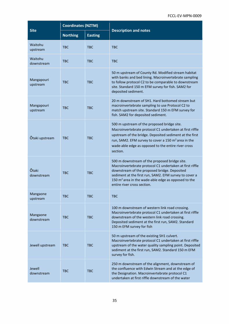
FCCL-EV-MPN-0009
35
Site Coordinates (NZTM)
Description and notes Northing Easting
Waitohu upstream
TBC TBC TBC
Waitohu downstream
TBC TBC TBC
Mangapouri upstream
TBC TBC
50 m upstream of County Rd. Modified stream habitat with banks and bed lining. Macroinvertebrate sampling to follow protocol C2 to be comparable to downstream site. Standard 150 m EFM survey for fish. SAM2 for deposited sediment.
Mangapouri upstream
TBC TBC
20 m downstream of SH1. Hard bottomed stream but macroinvertebrate sampling to use Protocol C2 to match upstream site. Standard 150 m EFM survey for fish. SAM2 for deposited sediment.
Ōtaki upstream TBC TBC
500 m upstream of the proposed bridge site.
Macroinvertebrate protocol C1 undertaken at first riffle
upstream of the bridge. Deposited sediment at the first
run, SAM2. EFM survey to cover a 150 m2 area in the
wade-able edge as opposed to the entire river cross
section.
Ōtaki
downstream TBC TBC
500 m downstream of the proposed bridge site. Macroinvertebrate protocol C1 undertaken at first riffle downstream of the proposed bridge. Deposited sediment at the first run, SAM2. EFM survey to cover a 150 m2 area in the wade-able edge as opposed to the entire river cross section.
Mangaone upstream
TBC TBC TBC
Mangaone downstream
TBC TBC
100 m downstream of western link road crossing. Macroinvertebrate protocol C1 undertaken at first riffle downstream of the western link road crossing. Deposited sediment at the first run, SAM2. Standard 150 m EFM survey for fish
Jewell upstream TBC TBC
50 m upstream of the existing SH1 culvert. Macroinvertebrate protocol C1 undertaken at first riffle upstream of the water quality sampling point. Deposited sediment at the first run, SAM2. Standard 150 m EFM survey for fish.
Jewell downstream
TBC TBC
250 m downstream of the alignment, downstream of the confluence with Edwin Stream and at the edge of the Designation. Macroinvertebrate protocol C1 undertaken at first riffle downstream of the water
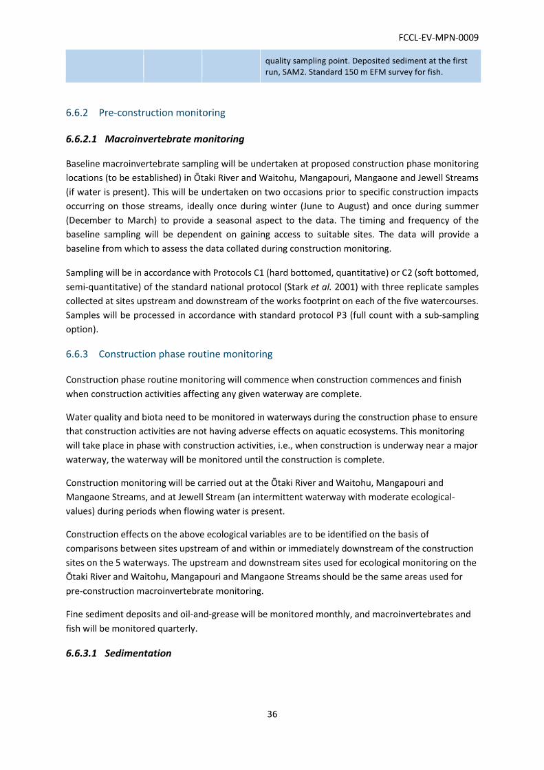
FCCL-EV-MPN-0009
36
quality sampling point. Deposited sediment at the first run, SAM2. Standard 150 m EFM survey for fish.
6.6.2 Pre-construction monitoring
6.6.2.1 Macroinvertebrate monitoring
Baseline macroinvertebrate sampling will be undertaken at proposed construction phase monitoring
locations (to be established) in Ōtaki River and Waitohu, Mangapouri, Mangaone and Jewell Streams
(if water is present). This will be undertaken on two occasions prior to specific construction impacts
occurring on those streams, ideally once during winter (June to August) and once during summer
(December to March) to provide a seasonal aspect to the data. The timing and frequency of the
baseline sampling will be dependent on gaining access to suitable sites. The data will provide a
baseline from which to assess the data collated during construction monitoring.
Sampling will be in accordance with Protocols C1 (hard bottomed, quantitative) or C2 (soft bottomed,
semi-quantitative) of the standard national protocol (Stark et al. 2001) with three replicate samples
collected at sites upstream and downstream of the works footprint on each of the five watercourses.
Samples will be processed in accordance with standard protocol P3 (full count with a sub-sampling
option).
6.6.3 Construction phase routine monitoring
Construction phase routine monitoring will commence when construction commences and finish
when construction activities affecting any given waterway are complete.
Water quality and biota need to be monitored in waterways during the construction phase to ensure
that construction activities are not having adverse effects on aquatic ecosystems. This monitoring
will take place in phase with construction activities, i.e., when construction is underway near a major
waterway, the waterway will be monitored until the construction is complete.
Construction monitoring will be carried out at the Ōtaki River and Waitohu, Mangapouri and
Mangaone Streams, and at Jewell Stream (an intermittent waterway with moderate ecological-
values) during periods when flowing water is present.
Construction effects on the above ecological variables are to be identified on the basis of
comparisons between sites upstream of and within or immediately downstream of the construction
sites on the 5 waterways. The upstream and downstream sites used for ecological monitoring on the
Ōtaki River and Waitohu, Mangapouri and Mangaone Streams should be the same areas used for
pre-construction macroinvertebrate monitoring.
Fine sediment deposits and oil-and-grease will be monitored monthly, and macroinvertebrates and
fish will be monitored quarterly.
6.6.3.1 Sedimentation
FCCL-EV-MPN-0009
37
Fine sediment deposition resulting from construction activities poses a risk to aquatic ecosystems.
Fine sediment deposition can be measured rapidly in the field. Procedures for monitoring fine
sediment deposition and guidelines for interpreting the measurement data have been developed for
New Zealand streams (Clapcott et al. 2011). These procedures and guidelines are for “hard-
bottomed” streams with gravel, cobble, and boulder-dominated beds.
Sedimentation monitoring will follow Sediment Assessment Method 2 – In-stream visual estimate of
% sediment cover (Clapcott et al. 2011) which includes a minimum of 20 estimates over a reach of
run habitat at each site. Our initial site inspection has confirmed this method is appropriate for use
in all five watercourses to be monitored.
This assessment will be completed monthly at sites upstream and downstream of the works on each
monitoring occasion. The trigger level for adverse changes in visual estimates of sediment coverage
will be statistically significant increases in the mean value for each sampled reach, which persists for
three months or more. Exceedances of trigger will result in an assessment of the cause of the effect
including any remedial and/or mitigation measures. The outcomes of the assessment will be
provided in the quarterly report to Council.
6.6.3.2 Oil and grease
Oil and grease from construction equipment can harm aquatic organisms, but they are not detected
by turbidity loggers. Therefore, regular grab sampling and analysis is required.
Standard procedures will be used for oil-and- grease sample collection, and the samples will be
analysed by a certified analytical laboratory.
Where laboratory testing identifies elevated levels at the downstream site compared to upstream a
review of the works in progress will be undertaken to identify the source of the contamination.
Management processes will be modified to prevent a similar occurrence in the future and a report
be prepared for the consent authority outlining the nature of the breach, any immediate actions
taken to limit further discharge, and changes to practices to ensure that such an occurrence does
not happen in the future. The outcomes of the assessment will be provided in the quarterly report to
Council.
6.6.3.3 Macroinvertebrates
Macroinvertebrate monitoring will consist of three replicate samples collected using the Ministry for
the Environment standard protocols for semi-quantitative sampling in hard and soft-bottomed
streams (Protocol C1 and C2; Stark et al. 2001). Invertebrate samples will be processed using the
standard protocols for fixed counts (Protocol P2; Stark et al. 2001).
Exceedances of the following triggers will result in an assessment of the cause of the effect including
any remedial and/or mitigation measures. The outcomes of the assessment will be provided in the
quarterly report to Council:
A decline in the Quantitative Macro-invertebrate Community Index (QMCI) score of 1.5 or
greater from the corresponding upstream monitoring site or baseline monitoring scores; or
FCCL-EV-MPN-0009
38
A decline of greater than 20 % in sensitive invertebrate taxa (in this case taxa with a QMCI
score of ≥ 5) compared to the upstream monitoring site or baseline monitoring scores.
6.6.3.4 Fish
Quarterly fish monitoring as required by Condition G.41 b) will follow the standardised electric fishing
protocol that has been developed for estimating the diversity and relative abundance of fish species
in New Zealand waterways (Joy et al. 2013), aside from at Ōtaki River sites. Ōtaki River fish survey
work will comprise an electric fishing survey of a set 150 m2 wade-able area at matching upstream and
downstream sites.
Exceedances of the following triggers will result in an assessment of the cause of the effect including
any remedial and/or mitigation measures. The outcomes of the assessment will be provided in the
quarterly report to Council:
A difference in species diversity (number of taxa) between matching upstream and
downstream sites; and/or
A 20 % lower abundance of any native species at the downstream site compared to
upstream.
6.6.3.5 In-stream works monitoring
In-stream works areas shall be regularly inspected and maintained in accordance with Consent
Condition WS.10 to ensure that:
The waterway within the culverts remains substantially clear of debris during construction;
Any erosion of the stream banks or bed that is attributable to, and is within 20 m up or
downstream of, the stream works authorised by this consent is remedied as soon as
practicable by the consent holder; and
Fish passage through the structure or any new permanent diversion is not impeded.
These inspections will be added to the Erosion and Sediment Control Plan for these works.
For diversion works, verification shall be provided in writing by an engineer and aquatic ecologist that
the permanent stream diversions have been completed in accordance with the relevant SSEMP stream
diversion plan.
6.6.4 Construction phase event based monitoring
Construction phase event based monitoring will commence when construction commences and
finish when construction activities affecting any given waterway are complete.
This section outlines the monitoring to be undertaken during construction in response to rainfall and
turbidity trigger exceedances. In addition, monitoring and reporting will be triggered In the event of
a failure of an ESC device or storm exceedance of the device design volume, in which case the
procedure outlined in Figure 1 below will be followed in accordance with Condition E.4. The approach
to erosion and sediment control is provided in the Erosion and Sediment Control Plan (ESCP), which
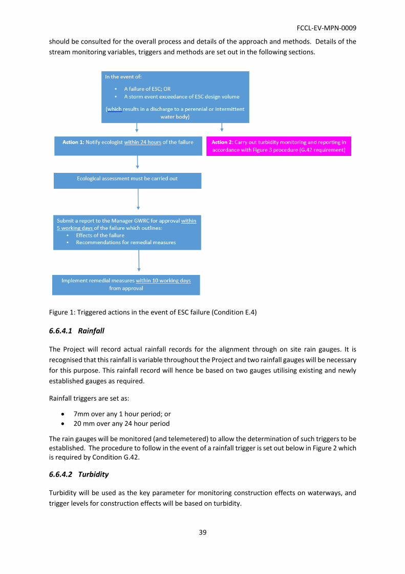
FCCL-EV-MPN-0009
39
should be consulted for the overall process and details of the approach and methods. Details of the
stream monitoring variables, triggers and methods are set out in the following sections.
Figure 1: Triggered actions in the event of ESC failure (Condition E.4)
6.6.4.1 Rainfall
The Project will record actual rainfall records for the alignment through on site rain gauges. It is
recognised that this rainfall is variable throughout the Project and two rainfall gauges will be necessary
for this purpose. This rainfall record will hence be based on two gauges utilising existing and newly
established gauges as required.
Rainfall triggers are set as:
7mm over any 1 hour period; or
20 mm over any 24 hour period
The rain gauges will be monitored (and telemetered) to allow the determination of such triggers to be established. The procedure to follow in the event of a rainfall trigger is set out below in Figure 2 which is required by Condition G.42.
6.6.4.2 Turbidity
Turbidity will be used as the key parameter for monitoring construction effects on waterways, and
trigger levels for construction effects will be based on turbidity.

FCCL-EV-MPN-0009
40
Turbidity monitoring will be carried out immediately following a rainfall trigger exceedance, and/or in
the event of a dirty water discharge to water as per E.4 (Figure 2), and will be repeated at 24 hours
and 48 hours from the trigger. Figure 2 below outlines the full process to be followed in accordance
with G.42.
The monitoring method within each of the five main watercourses (Waitohu, Ōtaki River, Mangaone,
Mangapouri, and the Jewell stream) will be determined prior to the earthworks phase within each of
these catchments. The confirmed monitoring method (i.e. hand-held turbidity or telemetry) will be
submitted to the Manager GWRC for written approval prior to commencement of works, or be
included in the relevant SSEMP for each area.
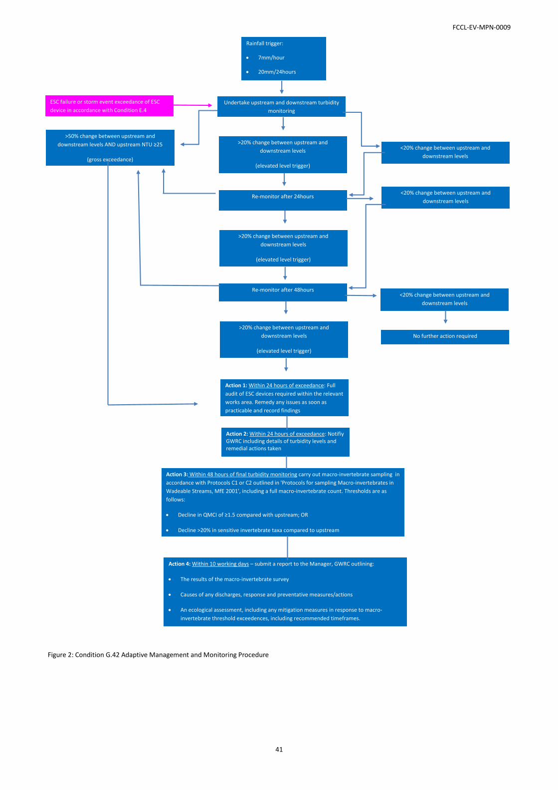
FCCL-EV-MPN-0009
41
Figure 2: Condition G.42 Adaptive Management and Monitoring Procedure
ESC failure or storm event exceedance of ESC
device in accordance with Condition E.4
Rainfall trigger:
7mm/hour
20mm/24hours
Undertake upstream and downstream turbidity
monitoring
>20% change between upstream and
downstream levels
(elevated level trigger)
>50% change between upstream and
downstream levels AND upstream NTU ≥25
(gross exceedance)
(gross exceedance)
Re-monitor after 24hours
<20% change between upstream and
downstream levels
>20% change between upstream and
downstream levels
(elevated level trigger)
<20% change between upstream and
downstream levels
Re-monitor after 48hours
>20% change between upstream and
downstream levels
(elevated level trigger)
Action 1: Within 24 hours of exceedance: Full
audit of ESC devices required within the relevant
works area. Remedy any issues as soon as
practicable and record findings
Action 2: Within 24 hours of exceedance: Notifiy GWRC including details of turbidity levels and remedial actions taken
Action 3: Within 48 hours of final turbidity monitoring carry out macro-invertebrate sampling in
accordance with Protocols C1 or C2 outlined in 'Protocols for sampling Macro-invertebrates in
Wadeable Streams, MfE 2001', including a full macro-invertebrate count. Thresholds are as
follows:
Decline in QMCI of ≥1.5 compared with upstream; OR
Decline >20% in sensitive invertebrate taxa compared to upstream
Action 4: Within 10 working days – submit a report to the Manager, GWRC outlining:
The results of the macro-invertebrate survey
Causes of any discharges, response and preventative measures/actions
An ecological assessment, including any mitigation measures in response to macro-
invertebrate threshold exceedences, including recommended timeframes.
No further action required
<20% change between upstream and
downstream levels
FCCL-EV-MPN-0009
42
6.6.5 Post construction monitoring
Post-construction monitoring shall be undertaken for a two-year period to ensure that water quality,
biotic communities and fish passage are not adversely affected by Expressway operation. Monitoring
of the planted riparian buffers shall be undertaken over a period of 5 years from the time completion
of the mitigation is due, in accordance with Condition G.35B.
6.6.5.1 Stream habitat quality monitoring
The post-construction monitoring will take place at the same five waterways listed above for
construction monitoring, using the same paired sites. The site-pairs will continue to serve as control-
impact sites for identifying Expressway effects. Quarterly monitoring of fine sediment deposits,
aquatic macroinvertebrates and fish will be sufficient for detecting Expressway effects, if any occur.
Data will be analysed following each quarterly monitoring round. The triggers for an assessment of
effects and management responses will be the same as per the during construction monitoring and
will be reported to Council. The two-year period will be followed by a full review to determine whether
remedial measures are needed, or continued monitoring is necessary.
6.6.5.2 Fish passage monitoring
Inspection of fish-passage culverts by an ecologist one and four years after installation is required.
Inadequate culvert maintenance is considered a major cause of fish passage problems. Regular culvert
inspection and maintenance is recommended in virtually all fish passage guidelines (e.g., Boubée et
al. 1999, Stevenson and Baker 2009). The inspections will focus on aspects such as debris and sediment
blockage, and erosion and scouring.
In accordance with Condition WS.9 the monitoring shall be undertaken by an appropriately qualified
and experienced aquatic ecologist and an appropriately qualified and experienced engineer and
include:
A visual inspection of all structures and works (including new permanent diversions) where
fish passage is required, one year after installation; and
A visual inspection of all structures and works (including new permanent diversions) where
fish passage is required, four years after installation.
The visual inspections will determine the following:
That the substrate bed of the water body is being retained within the culverts, pipes and
new stream channels, or appropriate baffle or rock fixtures are in place;
Whether there are any signs of erosion or scour of the stream bed or banks around the
structures/works/depositions;
The condition of the structures/works;
That stream flow velocities are not increased in any areas within the structures/works or
upstream/downstream of the structures/works that could compromise fish passage (e.g.
baffles and rock protection are adequate and in good condition); and
FCCL-EV-MPN-0009
43
Whether there is debris that could block the passage of fish or increase velocities.
If it is found that fish passage may be restricted, inspections and appropriate remedial actions shall be
repeated by the consent holder (for the specific structure/area of works/scour protection where the
restriction occurs) annually until GWRC is satisfied that fish passage is being appropriately provided
for.
A joint report from a suitably qualified and experienced ecologist and a suitably qualified and
experienced engineer will be submitted to GWRC within 1 month of undertaking the inspections
described above. Any measures/works required to address any actual or potential effects on fish
passage will be completed within three months of submitting the report to GWRC.
6.6.5.3 Planted riparian buffer monitoring
The planted riparian buffers included in Fletcher’s scope require biannual maintenance and inspection
for five years after planting. By five years, planted areas should have matured sufficient for canopy
cover to be self-sustaining.
Monitoring will include plantings surveys of plantings for five years to:
Identify any instances of plant mortality and possible causes, particularly pest animal
browse;
Identify weeds that need controlling;
Identify fences that need repairing;
Make recommendations for infill planting (failed specimens will be replanted as necessary to
meet target canopy closure of 80 %); and
Make recommendations for pest animal control if required.
Ongoing management of the riparian plantings will include the following:
Invasive weed control is to be undertaken twice annually during spring and autumn for two
years and once annually in spring thereafter or as required; and
Any plants which failed to establish during Year 1 will be replaced in the planting season of
Year 2 with species which have proven to be successful.

FCCL-EV-MPN-0009
44
7 ONGOING PROTECTION OF
ECOLOGICAL MITIGATION AREAS
Mitigation work is being undertaken both within the designation boundary (e.g. Ōtaki Railway
Wetland, Kennedy Wetland, Mary Crest wetland and swamp forest) and outside of the Designation
boundary (e.g. riparian restoration planting along Jewell Stream).
Areas that will remain inside the designation and under Transport Agency ownership in the long term
do not require any further legal protection (including features that provide for functioning of the
Expressway such as wetlands used for flood attenuation). Those areas of mitigation on land to be
disposed of once the project is complete will be legally protected prior to disposal through a legal
encumbrance such as a covenant on the title. QEII covenants may be used as a long-term protection
tool and this is being pursued for the out of Designation terrestrial mitigation.
The ongoing protection of areas of out of the Designation such as stream ecological mitigation and
compensation is being investigated by NZTA. A report will be provided to GWRC to demonstrate how
permanent protection will be achieved.

FCCL-EV-MPN-0009
45
8 REPORTING
Reporting requirements specific to the activities addressed in this EMP are included throughout the
document as appropriate.
Specific reporting requirements include:
Submission of all monitoring results collected in accordance with this EMP to GWRC on a
quarterly basis;
All activities undertaken in accordance with this EMP will be summarised and presented in an
annual report and submitted to GWRC by 30 June each year;
Updates to the ecological effects accounting for wetland, terrestrial and aquatic ecology will
be provided through the SSEMP’s;
An audit report covering ecological effects accounting (for wetland, terrestrial and aquatic
ecology effects and mitigation/compensation) will be prepared and provided to GWRC at the
end of the Project; and
A report to GWRC detailing the ongoing legal protection of mitigation areas, including areas
within the current Designation but potentially to be disposed by NZTA at the end of the Project
and areas of ecological mitigation outside of the Designation.
FCCL-EV-MPN-0009
46
9 REFERENCES
Baker, C., Stevenson, C. 2009. Fish Passage in the Auckland Region – a synthesis of current research.
NIWA Client Report HAM2009-059.
Boubée, J.; Williams, E.; Richardson, J. 2000. Fish passage guidelines for the Auckland region.
Auckland Regional Council, Technical Publication No. 131.
Boubée, J.; Jowett, I.; Nichols, S.; Williams, E. (1999). Fish passage at culverts – a review with
possible solutions for New Zealand indigenous species. Department of Conservation,
Wellington.
Business and Biodiversity Offsets Programme (BBOP), 2012. Standard on Biodiversity Offsets. BBOP,
Washington, D.C.
Clapcott, J.E.; Death, R.G.; Harding, J.S.; Matthaei, C.D.; Quinn, J.M.; Young, R.G. 2011. Sediment
assessment methods: protocols and guidelines for assessing the effects of deposited fine
sediment on in-stream values. Cawthron Institute, Nelson.
Clarkson, B. R., Sorrell, B. K., Reeves, P. N., Champion, P. D., Partridge, T. R. & Clarkson, B. D. (2003)
Handbook for Monitoring Wetland Condition. Coordinated Monitoring of New Zealand
wetlands. A Ministry for the Environment Sustainable Management Fund Project.
Environmental Institute of Australia and New Zealand, 2015.Ecological Impact Assessment (EcIA):
EIANZ guidelines for use in New Zealand terrestrial and freshwater ecosystems.
Joy, M.; David, B; Lake, M. 2013. New Zealand Freshwater Fish Sampling Protocols. Part 1: Wadeable
Rivers and Streams. Massey University.
Ling, N.; O’Brien, L.K.; Miller, R.; Lake, M. 2013: A revised methodology to survey and monitor New
Zealand mudfish. Department of Conservation, Wellington (unpublished).
NZTA, 2008. State highway environmental plan: improving environmental sustainability and public
health in New Zealand.
OPUS International Consultants Limited, 2016. PP2O Environmental Baseline Monitoring Turbidity,
Status Final. December 2016.
Opus, 2016. PP2O Environmental Baseline Monitoring.
Stark, J.D.; Boothroyd, I.K.J.; Harding, J.S.; Maxted, J.R.; Scarsbrook, M.R., 2001. Protocols for
Sampling Macroinvertebrates in Wadeable Streams. Prepared by the New Zealand
Macroinvertebrate Working Group for the Ministry for the Environment.
Suren, A.M.; Sorrell, B.K. (2010). Aquatic invertebrate communities within New Zealand wetlands:
characterising spatial, temporal, and distribution patterns. Science for Conservation Report
305.

FCCL-EV-MPN-0009
47
Suren, A.M.; Lambert, P.; Sorrell, B.K. (2011).The impact of hydrological restoration on benthic
aquatic invertebrate communities in a New Zealand wetland. Restoration Ecology 19: 747–757.

FCCL-EV-MPN-0009
48
APPENDIX A: OUT OF DESIGNATION
ECOLOGICAL MITIGATION PLANS
Peka Peka to Ōtaki Project
Riparian and Terrestrial Planting - Outside Designation Management Plan Appendix to Ecological Management Plan
Draft

Peka Peka to Ōtaki Project
Riparian and
Terrestrial Planting -
Outside Designation
Management Plan
Appendix to Ecological Management
Plan
© Opus International Consultants Ltd 2017
Opus International Consultants Ltd
Wellington Environmental Office
L10, Majestic Centre, 100 Willis St
PO Box 12 003, Thorndon, Wellington 6144
New Zealand
Telephone: +64 4 471 7000
Facsimile: +64 4 499 3699
Date:
Reference:
Status:
Draft

i
| Opus International Consultants Ltd
Contents
Authorisation and Revision Record ........................................................................... 1
Certification Record ................................................................................................... 1
Consent Compliance Framework ............................................................................... 1
1 Introduction ....................................................................................................... 1 1.1 Project background ........................................................................................................... 1 1.2 MPMP Purpose ................................................................................................................. 1 1.3 MPMP Scope ..................................................................................................................... 2
1.4 Document structure .......................................................................................................... 2
2 Ecological values and effects .............................................................................. 3 2.1 Ecological context and values ........................................................................................... 3 2.2 Effects ................................................................................................................................ 3
3 Ecological mitigation strategy and framework ................................................... 4 3.1 EMP general approach and guiding principles ................................................................. 4
4 Planting and grassing specification .................................................................... 5
4.1 General .............................................................................................................................. 5 4.2 Specifications and Documents .......................................................................................... 5 4.3 Contractor Qualifications .................................................................................................. 5 4.4 Timing of Grassing and Planting ...................................................................................... 6 1.1 Quality of Trees and Plants ............................................................................................... 6
1.2 Weed Control .................................................................................................................... 6 1.3 Topsoil and Compost ........................................................................................................ 7 1.4 Planting Layout ................................................................................................................. 7 1.5 Planting Technique and Fertilizer .................................................................................... 7 1.6 Staking and Ties ................................................................................................................ 8 1.7 Watering ............................................................................................................................ 8 1.8 Grassing ............................................................................................................................ 8 1.9 Monthly Establishment Report ......................................................................................... 8 1.10 Weed and Grass Control ................................................................................................... 9 1.11 Replacement of Plants ...................................................................................................... 9 1.12 Completion and Finishing ................................................................................................. 9 1.13 Grass and Planting Acceptance Criteria ......................................................................... 10
Draft

1
| Opus International Consultants Ltd
Authorisation and Revision Record
Detail Approved By Revision Date
Certification Record
Revision Action Name Position Date Signature
Approved by:
On behalf of GWRC
Draft
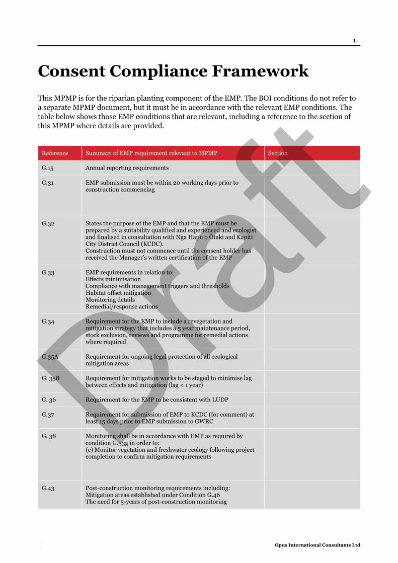
1
| Opus International Consultants Ltd
Consent Compliance Framework
This MPMP is for the riparian planting component of the EMP. The BOI conditions do not refer to
a separate MPMP document, but it must be in accordance with the relevant EMP conditions. The
table below shows those EMP conditions that are relevant, including a reference to the section of
this MPMP where details are provided.
Reference Summary of EMP requirement relevant to MPMP Section
G.15 Annual reporting requirements
G.31 EMP submission must be within 20 working days prior to construction commencing
G.32 States the purpose of the EMP and that the EMP must be prepared by a suitability qualified and experienced and ecologist and finalised in consultation with Nga Hapu o Ōtaki and Kapiti City District Council (KCDC). Construction must not commence until the consent holder has received the Manager’s written certification of the EMP
G.33 EMP requirements in relation to: Effects minimisation Compliance with management triggers and thresholds Habitat offset mitigation Monitoring details Remedial/response actions
G.34 Requirement for the EMP to include a revegetation and mitigation strategy that includes a 5 year maintenance period, stock exclusion, reviews and programme for remedial actions where required
G.35A Requirement for ongoing legal protection of all ecological mitigation areas
G. 35B Requirement for mitigation works to be staged to minimise lag between effects and mitigation (lag < 1 year)
G. 36 Requirement for the EMP to be consistent with LUDP
G.37 Requirement for submission of EMP to KCDC (for comment) at least 15 days prior to EMP submission to GWRC
G. 38 Monitoring shall be in accordance with EMP as required by condition G.33g in order to: (e) Monitor vegetation and freshwater ecology following project completion to confirm mitigation requirements
G.43 Post-construction monitoring requirements including: Mitigation areas established under Condition G.46 The need for 5-years of post-construction monitoring
Draft

2
| Opus International Consultants Ltd
Aquatic ecology monitoring including (iii) 5 years of riparian buffer monitoring
G.44 Requirements for all ecological monitoring to be undertaken by suitably qualified and experienced ecologists and inspection and reporting requirements for monitoring results
G.45 Response requirements for exceedance of trigger levels for any monitoring limit or management trigger level set in the EMP during or post-construction (exclusive of turbidity)
G.46 Ecological mitigation requirements including: b) Riparian planting shall be a minimum of 2,601 lineal metres at least 20 m width either side of the bank
G. 47 Requirements to ensure terrestrial, wetland, and riparian habitat reflects similar indigenous ecosystem types to what is being replaced
Draft
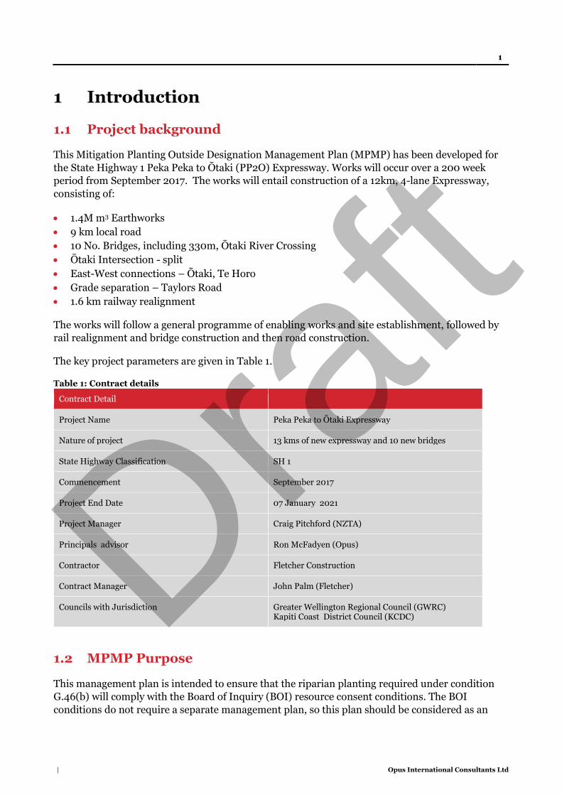
1
| Opus International Consultants Ltd
1 Introduction
1.1 Project background
This Mitigation Planting Outside Designation Management Plan (MPMP) has been developed for
the State Highway 1 Peka Peka to Ōtaki (PP2O) Expressway. Works will occur over a 200 week
period from September 2017. The works will entail construction of a 12km, 4-lane Expressway,
consisting of:
1.4M m3 Earthworks
9 km local road
10 No. Bridges, including 330m, Ōtaki River Crossing
Ōtaki Intersection - split
East-West connections – Ōtaki, Te Horo
Grade separation – Taylors Road
1.6 km railway realignment
The works will follow a general programme of enabling works and site establishment, followed by
rail realignment and bridge construction and then road construction.
The key project parameters are given in Table 1.
Table 1: Contract details
Contract Detail
Project Name Peka Peka to Ōtaki Expressway
Nature of project 13 kms of new expressway and 10 new bridges
State Highway Classification SH 1
Commencement September 2017
Project End Date 07 January 2021
Project Manager Craig Pitchford (NZTA)
Principals advisor Ron McFadyen (Opus)
Contractor Fletcher Construction
Contract Manager John Palm (Fletcher)
Councils with Jurisdiction Greater Wellington Regional Council (GWRC) Kapiti Coast District Council (KCDC)
1.2 MPMP Purpose
This management plan is intended to ensure that the riparian planting required under condition
G.46(b) will comply with the Board of Inquiry (BOI) resource consent conditions. The BOI
conditions do not require a separate management plan, so this plan should be considered as an
Draft
2
| Opus International Consultants Ltd
appendix to—and part of—the overall Ecological Management Plan (EMP) for the purposes of
complying with the conditions. This MPMP has been prepared as a standalone management
document to be certified separately from the main EMP for practical reasons, as the riparian
planting will be done under a separate contract to the main contractor.
The purpose of this MPMP is to set out how [insert contractor name] intends to achieve compliance
with the riparian planting related conditions of Resource Consents [insert reference]
Resource Consent Condition G.46(b) requires:
G46.(b) Riparian planting shall be a minimum of 2601 linear metres of planting to a
minimum of 20m each side of the Water Body, unless agreed otherwise by the
Manager.
Our overarching goal is to achieve a no net loss of biodiversity values affected by the Project and to
therefore align with the Transport Agency’s Ecological Resources Objective E2.
1.3 MPMP Scope
This MPMP forms part of the EMP and addresses the riparian mitigation planting required by
condition G.46(b). The scope of this MPMP is broadly:
Location of works
Species lists, Planting densities and spacings, Plant schedule
Methodology
Maintenance regime
Monitoring
1.3.1 Ngā Hapū o Ōtaki
Ngā Hapū o Ōtaki and NZTA are currently in the final stages of agreeing a Mitigation Plan. The
Mitigation Plan that seeks to provide NHoŌ with the ability to exercise Kaitiatanga over its
traditional lands in respect of Expressway design and construction. The Mitigation Plan also
requires the preparation and implementation of a Cultural Monitoring Plan. The Cultural
Monitoring plan will be complimentary to the EMP and where possible will be aligned, for example
the location of monitoring points. Once the Cultural Monitoring Plan has been prepared an
assessment of the Cultural Monitoring Plan and the EMP (including this MPMP) will be
undertaken to determine if the EMP requires any amendment.
1.3.2 KCDC
As the MPMP is part of the EMP, a draft is required to be provided to KCDC (condition G.37). The
purpose of this is to ensure that relevant requirements of the EMP are reflected in the Landscape
Urban Design Plan. This includes such matters as the identification of suitable plant species for
rehabilitation activities, mitigation planting requirements and areas of high ecological value.
1.4 Document structure
Section 1 – Introduction
Draft

3
| Opus International Consultants Ltd
Section 2 – Ecological values and effects
Section 3 – Ecological mitigation strategy and framework
Section 4 – Planting and grassing specification
2 Ecological values and effects
2.1 Ecological context and values
Ecological values within and around the designation are described in detail in the documentation
supporting the Environmental Protection Agency (EPA) application for the project and in the
evidence and conferencing documents prepared through the Board of Inquiry (BOI) process.
Ecological values are therefore only summarised here. The locations of important ecological values
are shown on the Ecology Layout Plans (Drawings DG-CE-0801 to 0817) provided as Appendix A.
The expressway alignment passes through a highly modified landscape that is now dominated by
agriculture, and to a lesser extent horticulture, viticulture and urban/suburban landuse.
Correspondingly, indigenous habitats and vegetation have been significantly reduced from their
former extent with only 1.7% of indigenous vegetation cover and 1.3% of wetlands now remaining.
What does remain is ecologically significant (
Table 1) and therefore warrants efforts to both minimise adverse effects and to appropriately
mitigate for effects that cannot be avoided.
Table 1: Areal or lineal extent of each broad habitat category and nationally ‘Threatened’ ‘At Risk’ or legally protected species that are known or likely to be present within each habitat type
Habitat types with significant ecological values within the designation
Associated nationally ‘Threatened’, ‘At Risk’ or legally protected species that are known to be present or likely present
Total ha / km
Farmland/Duneland NZ pipit Approx. 27 ha
Mature native forest and groups of trees
Native lizards, land snails, peripatus 0.39 ha
Braided river bank Banded dotterel Unknown area (surveys required)
Freshwater wetland None known to be present but spotless crake, marsh crake and Australasian bittern could potentially be present
0.8 ha
Waterways Longfin eel, kaoro, inanga, red-fin bully, giant kokopu, shortjaw kokopu, torrentfish, lamprey and brown mudfish
2.84 km
2.2 Effects
Potential adverse effects associated with the construction and operations of PP2O will primarily
occur through habitat loss associated with vegetation clearance, earthworks and stream culverting
Draft

4
| Opus International Consultants Ltd
and diversions. Ongoing indirect effects on remaining habitat in close proximity to the preferred
alignment are also expected. Potential effects on ecological values associated with the project
include:
damage to remaining areas of native bush habitat immediately adjacent to the Project footprint
as a result of construction activities;
edge effects due to the loss of bush from the edges of Hautere Bush F, Cottle’s Bush and bush
to south of Te Hapua Road;
potential adverse effects on peripatus through habitat loss and/or edge effects;
potential adverse effects on lizards and the ‘Nationally Critical’ Powelliphanta traversii Ōtakia
(herein Ōtaki Snail) due to habitat loss and edge effects;
disturbance to NZ pipit populations south of Mary Crest and in the dune areas north of Ōtaki;
disturbance to nesting Banded Dotterels in the vicinity of the Ōtaki Bridge crossing;
potential effects on the hydrology of the remaining part of the Ōtaki Railway Wetland;
loss of c.0.5ha of habitat from the Ōtaki Railway Wetland;
adverse effects on aquatic life due to sediment and contaminant discharges to watercourses
during construction;
adverse effects on fish passage during, and as a result of, construction activities;
impediment of fish passage by various new culverts installed along the expressway; and
the loss of waterway habitat due to installation of culverts and stream diversions at various
locations along the Project.
3 Ecological mitigation strategy and framework
3.1 EMP general approach and guiding principles
The general approach to managing ecological effects was established through the Designation/
consent BIO process and the associated consent level design (prepared by Opus, URS and Holmes
Consulting) and this is reflected in the Designation and Resource Consent conditions.
Opus and NIWA scientists addressed ecological matters and effects management using the
mitigation hierarchy approach as set out in the Standard on Biodiversity Offsets published by the
Business and Biodiversity Offsets Programme (BBOP) in 2012. The BBOP (2012) ecological
mitigation hierarchy is set out in Table 3. The EMP follows the same effects mitigation hierarchy
framework and sets out avoidance, minimisation, rehabilitation and limited offset mitigation
measures.
This MPMP is primarily concerned with the new areas of stream riparian planting that are part of
the measures to offset the balance of the habitat loss effects (residual effects) as a result of the
Project.
Table 3: Ecological mitigation hierarchy
Hierarchy Details
1) Avoidance Measures taken to avoid creating impacts from the outset, such as careful spatial or temporal placement of elements of infrastructure, in order to completely avoid impacts on certain components of biodiversity.
Draft

5
| Opus International Consultants Ltd
2) Minimisation Measures taken to reduce the duration, intensity and / or extent of impacts (including direct, indirect and cumulative impacts, as appropriate) that cannot be completely avoided, as far as is practically feasible.
3) Rehabilitation / Restoration
Measures taken to rehabilitate degraded ecosystems or restore cleared ecosystems following exposure to impacts that cannot be completely avoided and/ or minimised.
4) Offset Measures taken to compensate for any residual significant, adverse impacts that cannot be avoided, minimised and / or rehabilitated or restored, in order to achieve no net loss or a net gain of biodiversity. Offsets can take the form of positive management interventions such as restoration of degraded habitat, arrested degradation or averted risk, protecting areas where there is imminent or projected loss of biodiversity.
4 Planting and grassing specification
4.1 General
This section of the Specification relates to the works for the installation and maintenance of the
planting and grassing. This includes, but is not necessarily limited to:
Specifications and Documents
Contractor qualifications
Timing of grassing and planting
Quality of trees and plants
Weed Control
Topsoil and Compost
Planting Layout
Planting Technique and Fertiliser
Staking and Ties
Watering
Grassing
Landscape Maintenance
Monthly Establishment Report
Weed and Grass Control
Replacement of Plants
Completion and Finishing
Grass and Planting Acceptance Criteria
4.2 Specifications and Documents
Works shall comply with the relevant requirements of the standard Specifications together with the
following further provisions in this section:
a. NZS 4404 Methods of testing soils for civil engineering purposes
b. NZS 4454 Composts, soil conditioners and mulchers
4.3 Contractor Qualifications
All planting required shall be undertaken and completed in accordance with accepted practices by a
Landscape Contractor who has current membership of the Landscape Industries Association of
Draft
6
| Opus International Consultants Ltd
New Zealand or Nursery and Garden Industry Association, hold a Level 4 amenity turn or
horticultural qualification and demonstrate relevant experience and knowledge.
4.4 Timing of Grassing and Planting
Work shall only be undertaken when the weather is suitable i.e. mild, dull and moist, and when the
ground is moist and workable. All planting and grassing operations shall be suspended during
periods of severe frosts, drought, water logging or persistent drying winds.
Planting and grassing shall only take place from 1 April to 30 September. If construction delays
occur and planting and grassing is required outside of this season then the Contractor shall seek
advice and instructions from the Engineer before proceeding.
1.1 Quality of Trees and Plants
All trees and plant material shall be first class specimens of nursery stock, true to name and type,
with well-developed and well-shaped trunks or stems and head.
All trees and plants shall be healthy, vigorous and free of disease, injury, parasites or insects and
shall not be pot-bound. They shall be well hardened off to cope with the climatic conditions of the
site. Trees and plants not hardened off with soft growth.
All root masses shall retain their shape and hold together when removed from their containers.
Plants shall be handled with care at all times and lifted by the container. Plants shall be true to
botanical name, quantity and grade, as specified on the Drawings. Plants shall not be substituted
without the Engineers approval.
During transportation of the plants to the site, the Contractor shall ensure that adequate protection
is given to plants. All plants must be kept adequately watered and located in a position where
plants will not be subject to stress.
Plants will be subject to inspection by the Contractor and Engineer. Any plants not meeting
Specification standard will not be accepted. Rejected plants shall be removed from the site within
48 hours and replaced at the Contractor’s expense.
1.2 Weed Control
All areas to be planted and grass areas shall be entirely free of grass, plant pests and nuisance weed
species. If herbicidal eradication is required the Contractor shall notify the Engineer at least one
week prior to all spraying activities.
Details to be advised include: the area to be sprayed, materials to be used, the name of the Spraying
Contractor, and when the areas will be sprayed. A registered Spraying Contractor shall be on site
and controlling the spraying operation at all times. The Spraying Contractor shall be a Registered
Chemical Applicator with current A and B Certificates. Spraying activities shall meet the
requirements of the controlling local authority.
Draft
7
| Opus International Consultants Ltd
Herbicide application general: Apply using protective clothing, in dry, still-air conditions to the
spray Manufacturer’s requirements. The Contractor shall be responsible for reinstating any
damage caused by drift of spray.
1.3 Topsoil and Compost
Imported first class topsoil shall meet NZS 4402 and NZS 4454, be of good quality, free draining,
free of perennial weeds, undecomposed or partly decomposed organic matter and debris and
capable of sustaining the required plant growth.
The imported topsoil shall have a soil pH of between 5.5 and 7.5 and contain less than 5% by dry
weight of solid detritus and debris. The stone content shall be less than 10% by dry weight. The
topsoil shall not contain any object larger in dimension than 20mm.
The clay content shall not exceed 25% by dry weight and have an organic content by dry content of
between 7% and 20%.
All composts shall be pasteurised composted composts free from harmful chemicals, grass and
weed growth complying with the requirements of NZS 4454 “Composts, soil conditioners and
mulches” Living Earth ‘Ultrasoil’ or similar approved is acceptable. The Contractor to supply
samples to the Engineer for approval. Compost not approved prior to delivery to site will not be
accepted.
The Engineer may request soil tests to confirm that the topsoil complies with this Specification.
Testing, by an approved laboratory, shall include pH, phosphorus, extractable cations, cation
exchange capacity, total base saturation plus any recommendations for bringing the topsoil up to
the required standards. Topsoil testing shall be at the Contractor’s expense.
1.4 Planting Layout
The Contractor shall be thoroughly familiar with the drawing requirements and layout. Plants shall
be located and placed at the spacing shown on the planting plans. The Engineer shall inspect the
plant quality and locations once plants have been laid out in position prior to planting. The
Engineer may require minor refinement to the design with adjustments to lines, levels and
groupings of shrubs, groundcover as the planting proceeds.
In areas of block planting, plants shall be spaced so that when established they will completely and
evenly fill the areas indicated, unless otherwise specified. Plants shall be spaced around the
perimeter first to define the extent of the area to be filled by each species. The remaining plants
shall then be used to fill the centre of the area in an informal manner avoiding straight lines and
regular geometric patterns, unless otherwise specified Plant layout is to be confirmed by the
Engineer prior to planting.
1.5 Planting Technique and Fertilizer
Prepare holes for plants in a manner and to dimensions required by the particular specimen. The
planting holes are to be approximately twice the width and one and a half times the depth of the
rootball. Where the plant rootball depth exceeds the depth of the topsoil (400mm), continue down
Draft
8
| Opus International Consultants Ltd
into the subsoil a further 150mm, breaking it up and mixing in the topsoil mix before placing. Base
and sides of the hole are to be well shattered.
Plants are to be thoroughly watered prior to planting. Do not remove container until planting.
Trim damaged roots and score the sides of matted root balls with a sharp instrument. Place plant
with its roots well spread out and hanging downwards, roots should not be bent or distorted in any
way. AGPRO Controlled Release Fertiliser Tablets “Tree and Shrub” grade or approved equivalent
must be applied at the time of planting. Fertiliser tablets must be placed close to but not in contact
with the roots in the bottom of the planting hole. Tablets shall be used at the rate of specified by
the Manufacturer;
Backfill in with the topsoil mix in 150mm layers, compact each layer firmly to a level that will allow
the top of the root ball to finish flush with surrounding ground. Water-in immediately after
planting to the saturation level of surrounding soil.
1.6 Staking and Ties
All trees, shall be staked vertically with two stakes in accordance with the details. Tie trees at 2/3
the height of the main stem leaving enough play for a small amount of natural movement.
All stakes shall be untreated hardwood. Size/length: 50mm x 50mm, length to suit tree/plant size.
Ties shall be 40mm wide black flexible rubber ties, or other such approved material that does not
cause abrasion to the trees. All stakes to be painted black with an approved acrylic paint, to ensure
total coverage.
1.7 Watering
During the planting period it shall be the Contractor’s responsibility to ensure the plants receive
sufficient water to maintain healthy growth.
1.8 Grassing
The turf shall be supplied from an approved supplier with the following qualities:
a. A seed mix appropriate to local environmental conditions and for high intensity public use. The
Contractor is to supply the details of the turf mix to the Engineer for approval prior to ordering
the turf.
b. A consistent depth (approx. 20mm) and width (approx. 450mm) and of consistent length
c. Sufficiently fibrous that it holds together when handled but without excessive thatch
d. Should be grown on a similar soil type to the soil to be used on the lawns
e. Free of broadleaved weeds, pos. annual plants, disease and/or pest activity or scars at the time
of harvesting
1.9 Monthly Establishment Report
An accurate and up to date monthly report, on plant condition and establishment works
undertaken, shall be submitted to the Engineer within five days of the end of each month.
Draft
9
| Opus International Consultants Ltd
Information to be provided in this report shall include the date that works were carried out and any
types of work, as noted in the above clauses, to aid establishment of landscape areas and berms.
Unforeseen damage, for example vandalism, plant losses, shall be reported to the Engineer at the
time of inspection.
Any unreported damage or plant losses will be deemed the responsibility of the Contractor
An example of a typical Monthly Landscape Maintenance Report is included in the Appendix B to
this Specification.
1.10 Weed and Grass Control
For the entire maintenance period all grassed, mulched and planted areas and specimen trees shall
be maintained for the entire area of plantings shall be kept free of nuisance weeds and plant pest
species. For weed control the Contractor may elect to use spray or manual means, as approved by
the Engineer. All weed eradication shall comply with the spraying requirements of this
Specification.
1.11 Replacement of Plants
A specified inspection will be held three weeks prior to the end of the maintenance period to
inspect requirements for replacement plants. All plants deemed by the Engineer as dead, defective
or unhealthy are to be removed and replacements supplied and planted at the Contractor’s
expense, within three weeks from the inspection date.
Throughout the maintenance period replacement planting shall be made during the planting
season immediately following their loss or on discovery. When replacement planting takes place in
the last 2 months of the maintenance period an additional 3 months may apply as determined by
the Engineer to ensure healthy establishment of plants or trees.
Plants damaged by wilful vandalism or lost by theft shall be replaced at the expense of the
Principal. This work shall be at scheduled rates and be confirmed by the Engineer prior to
implementation. Plant loss due to vandalism which has not been reported to the Engineer and
recorded in the ‘Monthly Establishment Report’ shall be assumed to be result of planting
operations and replacement shall be at the Contractor’s cost.
Where it is identified that plant failure is due to the Contractor’s spraying of herbicide replacement
will also be at the Contractor’s expense.
Establishment rate required at the end of the maintenance period:
- 100% for all specimen trees (80L)
- 100% for, PB3 and PB5 plants
All replacement plants shall be to the same grade as originally planted, and be the same species and
position as the removed plant, unless otherwise approved or directed by the Engineer.
Replacement plants and planting shall conform to this Specification.
Draft

10
| Opus International Consultants Ltd
1.12 Completion and Finishing
At completion of the maintenance period, the work shall be left in good condition, the whole site
cleared of rubbish, plastic bags and debris and any damage made good to the satisfaction of the
Engineer.
1.13 Grass and Planting Acceptance Criteria
At the end of the 12 month maintenance period the following minimum standards must be met:
The grass shall be an even vigorous sward of vegetation at a uniform height with a healthy
colour throughout.
The ground surface shall be free from hollows arising from uneven consolidation of the ground
and from stones or similar debris. There shall be no bare area greater than 30mm in diameter
and shall have less than 5% of this area in non-specified grasses and weeds
All planted areas shall be weed free and mulched with the specified mulch to the specified
depths. No perennial grass weeds will be accepted in mulched garden bed areas
Trees and plantings shall be well formed, vigorous and healthy, free of disease and free of dead
growth and dead flowers, upright and planted so that the soil level is the same as was in the
container and without roots exposed.
Trees and plants shall be located as originally specified.
Plant growth shall be trimmed to the extent and height required to ensure vigorous growth.
All tree stakes and ties shall be intact and correctly installed, including paint finish.
If, in the opinion of the Engineer, any tree stakes can be removed at the end of the maintenance
period the Contractor is to allow for the removal of the entire stakes and ties without damaging
the trees, the backfilling of the stake holes with compacted topsoil mix, to be watered in, and
additional mulch as required to meet depth standards.
Draft

Appendix
Draft

Jewell Stream, Te Horo
Riparian Enhancement Plan Rachel Dickinson and James Callan, 76 Derham Road, Te Horo
Draft

© Opus International Consultants Ltd 2017
Prepared By
Opus International Consultants Ltd
Colin Stace Napier Office Senior Rural Consultant Opus House, 6 Ossian Street Private Bag 6019, Napier 4142 New Zealand
Reviewed By Telephone: +64 6 833 5100 Roger MacGibbon Facsimile: +64 6 835 0881 Design Team Leader
Date: April 2017 Reference: 5-c2771.00 Status: Final
Draft

Riparian Enhancement Plan 1
© Opus International Consultants Ltd 2017
Contents
1 Property Details ................................................................................................. 2
2 Purpose of this Plan ........................................................................................... 2
3 Overview ............................................................................................................ 4
4 Fencing Works ................................................................................................... 5
5 Planting Activities .............................................................................................. 6
6 Programme Management ................................................................................... 7
7 Timetable ........................................................................................................... 7
8 Review and Maintenance .................................................................................... 8 Appendix A Plan No. P205 Riparian Enhancement Works, Dickinson &
Callan pty, 76 Derham, Te Horo Appendix B Species List Draf
t
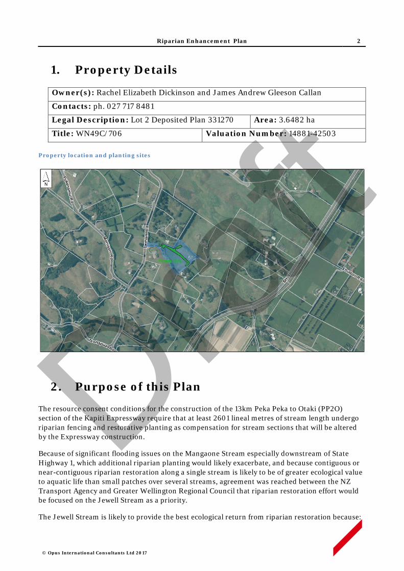
Riparian Enhancement Plan 2
© Opus International Consultants Ltd 2017
1. Property Details
Owner(s): Rachel Elizabeth Dickinson and James Andrew Gleeson Callan
Contacts: ph. 027 717 8481
Legal Description: Lot 2 Deposited Plan 331270 Area: 3.6482 ha
Title: WN49C/706 Valuation Number: 14881-42503 Property location and planting sites
2. Purpose of this Plan
The resource consent conditions for the construction of the 13km Peka Peka to Otaki (PP2O) section of the Kapiti Expressway require that at least 2601 lineal metres of stream length undergo riparian fencing and restorative planting as compensation for stream sections that will be altered by the Expressway construction.
Because of significant flooding issues on the Mangaone Stream especially downstream of State Highway 1, which additional riparian planting would likely exacerbate, and because contiguous or near-contiguous riparian restoration along a single stream is likely to be of greater ecological value to aquatic life than small patches over several streams, agreement was reached between the NZ Transport Agency and Greater Wellington Regional Council that riparian restoration effort would be focused on the Jewell Stream as a priority.
The Jewell Stream is likely to provide the best ecological return from riparian restoration because:
Draft
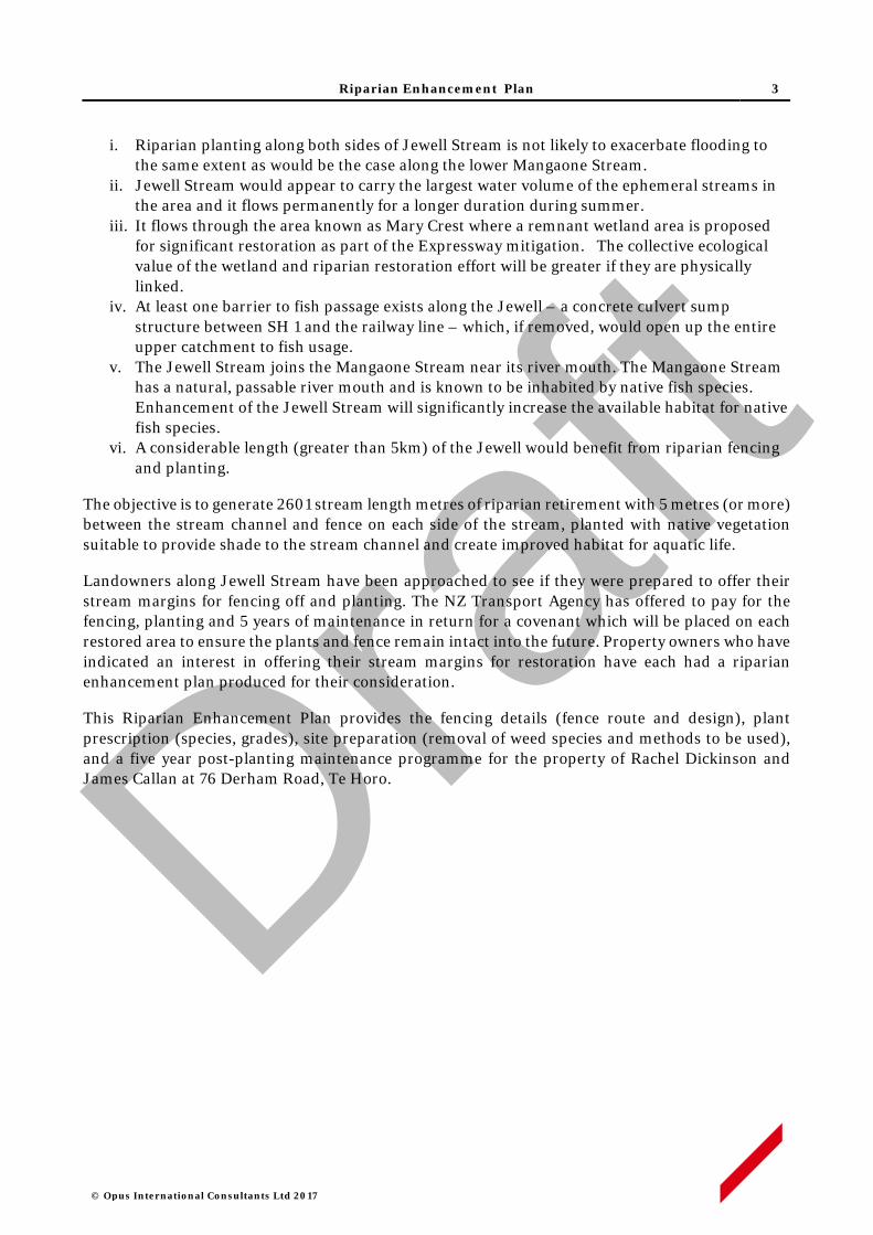
Riparian Enhancement Plan 3
© Opus International Consultants Ltd 2017
i. Riparian planting along both sides of Jewell Stream is not likely to exacerbate flooding to the same extent as would be the case along the lower Mangaone Stream.
ii. Jewell Stream would appear to carry the largest water volume of the ephemeral streams in the area and it flows permanently for a longer duration during summer.
iii. It flows through the area known as Mary Crest where a remnant wetland area is proposed for significant restoration as part of the Expressway mitigation. The collective ecological value of the wetland and riparian restoration effort will be greater if they are physically linked.
iv. At least one barrier to fish passage exists along the Jewell – a concrete culvert sump structure between SH 1 and the railway line – which, if removed, would open up the entire upper catchment to fish usage.
v. The Jewell Stream joins the Mangaone Stream near its river mouth. The Mangaone Stream has a natural, passable river mouth and is known to be inhabited by native fish species. Enhancement of the Jewell Stream will significantly increase the available habitat for native fish species.
vi. A considerable length (greater than 5km) of the Jewell would benefit from riparian fencing and planting.
The objective is to generate 2601 stream length metres of riparian retirement with 5 metres (or more) between the stream channel and fence on each side of the stream, planted with native vegetation suitable to provide shade to the stream channel and create improved habitat for aquatic life.
Landowners along Jewell Stream have been approached to see if they were prepared to offer their stream margins for fencing off and planting. The NZ Transport Agency has offered to pay for the fencing, planting and 5 years of maintenance in return for a covenant which will be placed on each restored area to ensure the plants and fence remain intact into the future. Property owners who have indicated an interest in offering their stream margins for restoration have each had a riparian enhancement plan produced for their consideration.
This Riparian Enhancement Plan provides the fencing details (fence route and design), plant prescription (species, grades), site preparation (removal of weed species and methods to be used), and a five year post-planting maintenance programme for the property of Rachel Dickinson and James Callan at 76 Derham Road, Te Horo.
Draft
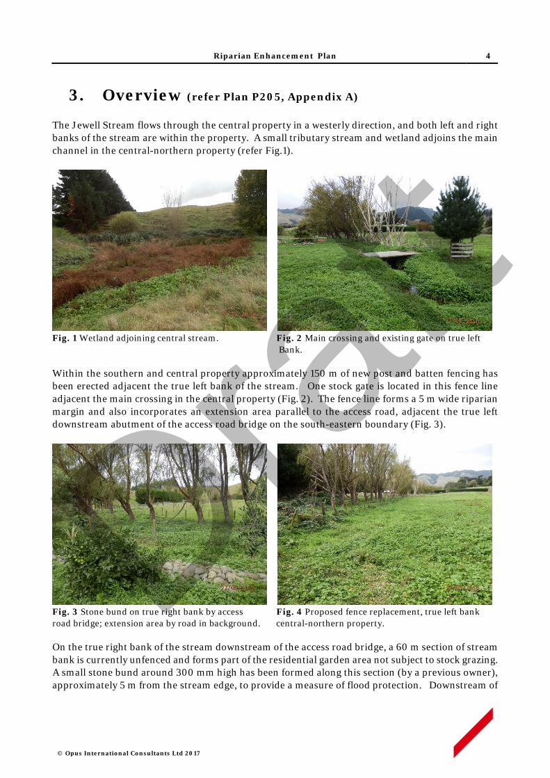
Riparian Enhancement Plan 4
© Opus International Consultants Ltd 2017
3. Overview (refer Plan P205, Appendix A)
The Jewell Stream flows through the central property in a westerly direction, and both left and right banks of the stream are within the property. A small tributary stream and wetland adjoins the main channel in the central-northern property (refer Fig.1).
Fig. 1 Wetland adjoining central stream. Fig. 2 Main crossing and existing gate on true left
Bank. Within the southern and central property approximately 150 m of new post and batten fencing has been erected adjacent the true left bank of the stream. One stock gate is located in this fence line adjacent the main crossing in the central property (Fig. 2). The fence line forms a 5 m wide riparian margin and also incorporates an extension area parallel to the access road, adjacent the true left downstream abutment of the access road bridge on the south-eastern boundary (Fig. 3).
Fig. 3 Stone bund on true right bank by access Fig. 4 Proposed fence replacement, true left bank road bridge; extension area by road in background. central-northern property.
On the true right bank of the stream downstream of the access road bridge, a 60 m section of stream bank is currently unfenced and forms part of the residential garden area not subject to stock grazing. A small stone bund around 300 mm high has been formed along this section (by a previous owner), approximately 5 m from the stream edge, to provide a measure of flood protection. Downstream of
Draft
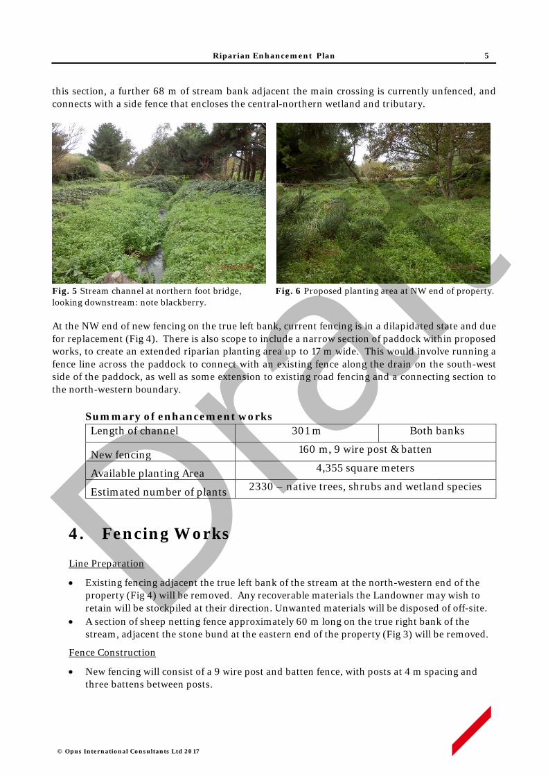
Riparian Enhancement Plan 5
© Opus International Consultants Ltd 2017
this section, a further 68 m of stream bank adjacent the main crossing is currently unfenced, and connects with a side fence that encloses the central-northern wetland and tributary.
Fig. 5 Stream channel at northern foot bridge, Fig. 6 Proposed planting area at NW end of property. looking downstream: note blackberry.
At the NW end of new fencing on the true left bank, current fencing is in a dilapidated state and due for replacement (Fig 4). There is also scope to include a narrow section of paddock within proposed works, to create an extended riparian planting area up to 17 m wide. This would involve running a fence line across the paddock to connect with an existing fence along the drain on the south-west side of the paddock, as well as some extension to existing road fencing and a connecting section to the north-western boundary.
Summary of enhancement works Length of channel 301 m Both banks
New fencing 160 m, 9 wire post & batten
Available planting Area 4,355 square meters
Estimated number of plants 2330 – native trees, shrubs and wetland species
4. Fencing Works
Line Preparation
• Existing fencing adjacent the true left bank of the stream at the north-western end of the property (Fig 4) will be removed. Any recoverable materials the Landowner may wish to retain will be stockpiled at their direction. Unwanted materials will be disposed of off-site.
• A section of sheep netting fence approximately 60 m long on the true right bank of the stream, adjacent the stone bund at the eastern end of the property (Fig 3) will be removed.
Fence Construction
• New fencing will consist of a 9 wire post and batten fence, with posts at 4 m spacing and three battens between posts.
Draft

Riparian Enhancement Plan 6
© Opus International Consultants Ltd 2017
• A pedestrian gate will be installed at the northern end (refer map Section 9), and a stock gate will be installed on the north-east side of the main crossing.
• Inclined stays will not be used on the paddock side of new fences to prevent goat access to planting areas. Angle posts will otherwise be stayed with a breast block, a horizontal stay.
5. Planting Activities
Site Preparation
• Invasive weed control will be applied during the spring and summer preceding planting, to control blackberry and convolvulus in particular.
• For initial control of blackberry, stems will be cut 20 mm above ground level, followed by immediate application of a 3-5 mm layer of Vigilant™ gel on the cut surface. For multi-stemmed plants at least 80 percent of stems, including all main stems, will be treated.
• Suitable organic herbicides such as ‘Green Assassin’ or ‘Weedfree Rapid’ will be used for knock down of herbaceous weeds.
• Before completion of new fencing, the Landowner is encouraged to graze blackberry and rank grass growth in the planting area. This would be a one-off activity and stock should be withdrawn from the site if stream bank treading damage becomes evident.
• Existing willow trees and an alder at the northern end will be retained, dead willow tress (8-10) and a eucalyptus tree will be removed. Windfall on the northern boundary fence will be removed.
Pest Animal Control
• Rabbits are present in low to moderate numbers throughout the property. Given the number and proximity of neighbouring properties there is limited opportunity to apply pest control activities such as poisoning or night shooting. Protective sleeves or repellents will otherwise be used to deter rabbit browsing of new plantings.
Pre-release & Planting
• Planting spots approximately 1 m in diameter will brush cut no more than two weeks before planting.
• Plant spacing will generally be no greater than 1.5 x 1.5 m for most species, while some wetland genera such as Carex and Cyperus will be at closer spacings.
• All plants will be 1 L potted stock, or similar grade, and will be planted in holes slightly larger than the root ball, with any spiralled roots removed. All plant pots or other packaging will be removed off site.
NOTE: a buried cable warning notice is displayed on the existing fence line towards the eastern side of the property, approximately 50 m away from a transformer located by the access road on the eastern boundary. Verification of cable alignment and depth will be required before any subsoil disturbing activity is carried out in the vicinity, and along new fence construction proposed to the west of this area.
Draft

Riparian Enhancement Plan 7
© Opus International Consultants Ltd 2017
• A planting list of species is set out in Appendix B. Plant stock will be sought as eco-sourced material from within the Foxton Ecological District- 31.02.1
• Layout will generally follow the siting indicated in the list. A 5 m corridor adjacent the main bridge site and stock gates (central channel section) will be left unplanted to facilitate controlled stock movement between the adjacent NE and SW paddocks.
Plant Maintenance
• Each plant will be released (control of competing vegetation within an 800-1000mm radius) in in the spring and mid-summer for up to five years.
• Weed control will use brush cutting or similar mechanical means to cut emergent blackberry shoots close to the ground.
• Blackberry shoots will be cut before they exceed 200 mm height; up to three cuts will be required under spring growth conditions, and at least two cuts under late summer /autumn growth conditions.
• Any other resurgent or invasive weeds will also be controlled concurrently, either with slashing / brush cutting or suitable organic herbicides such as Green Assassin or Weedfree Rapid.
• Sites will be monitored for resurgent or invasive weeds during the five year establishment period, and weed control will be applied as required.
6. Programme Management
• All works will be performed by suitably qualified and experienced operators contracted to Opus (on behalf of the NZ Transport Agency) and supervised by experienced Opus staff. Property work areas, including access routes, will be determined in advance of site activity, in consultation with the Landowner.
• The Contractor will give adequate notice of timing for entry to the property, and will comply with Landowner requirements in regard to factors such as stock management, vehicle access and Health and Safety obligations.
• Opus staff will maintain contact with Contractors on a regular basis, including periodic site inspections as works progress.
• Any Landowner concerns that may arise about progress of works or Contractor activity should be communicated to the designated Opus Project Manager at the earliest opportunity. If necessary, a hold-point on works can be applied until matters of concern are resolved.
7. Timetable
7. Activity Timing Responsibility Supervision
Invasive weed control Feb - March 2018 Contractor Opus
Existing fence removal April 2018 Contractor Opus
Construct new fence April 2018 Contractor Opus
Pre-plant spot spray May 2018 Contractor Opus
1 Ecological Regions and Districts of New Zealand (1987) NZ Dept. of Conservation
Draft
Riparian Enhancement Plan 8
© Opus International Consultants Ltd 2017
Planting June 2018 Contractor Opus
Releasing Oct 2018 & Feb2019 Contractor Opus
Releasing Oct 2018 & Feb2020 Contractor Opus
Releasing Oct 2020 & Feb2021 Contractor Opus
Maintenance Oct 2021 & Feb2022 Contractor Opus
Maintenance Oct 2022 & Feb2023 Contractor Opus
Note: this timing indicative, specific dates will be confirmed prior to commencement of works.
8. Review and Update
• The Riparian Enhancement Plan will be monitored and reviewed annually by Opus, in consultation with the Landowner and NZTA. Any major changes will be documented and an amended plan will be submitted to NZTA for approval.
• Any channel management issues arising, which affect stream bank integrity such that establishment of plantings may be threatened, will be addressed on a situation-by-situation basis within the five year establishment period.
Draft

Riparian Enhancement Plan
© Opus International Consultants Ltd 2017
APPENDIX A
Draft
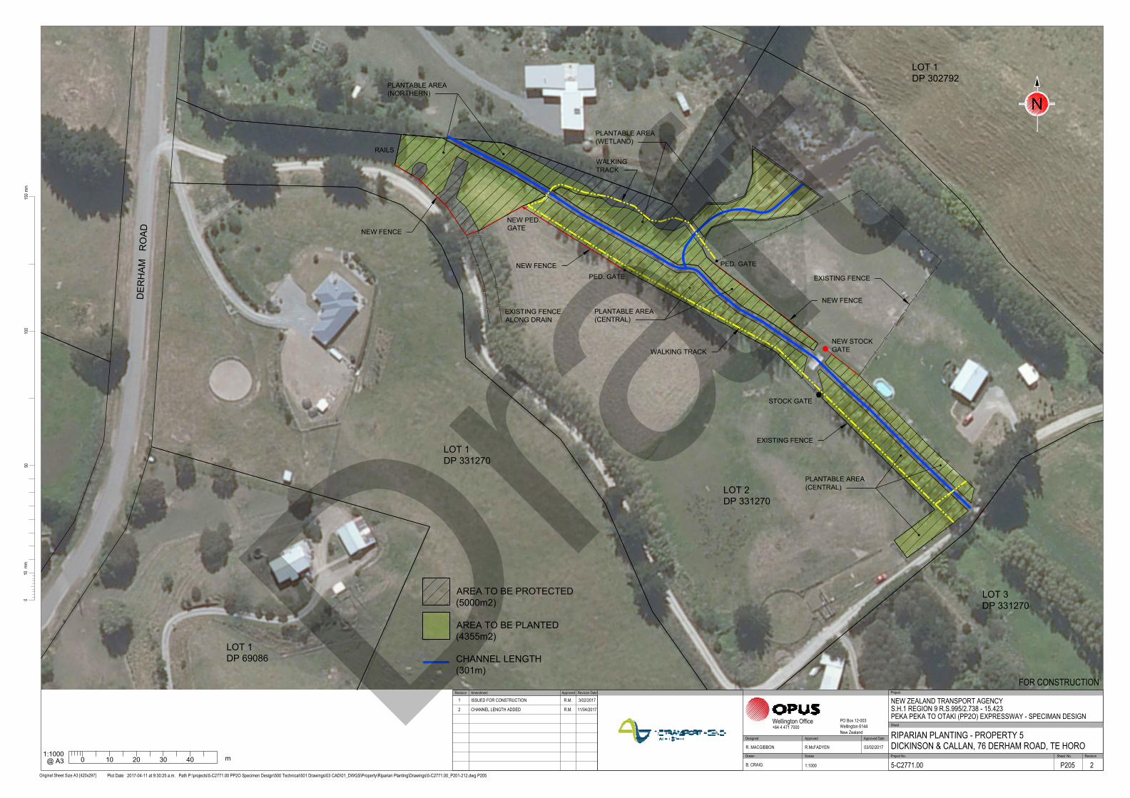
LOT 2
DP 331270
NEW FENCE
PLANTABLE AREA
(CENTRAL)
LOT 1
DP 331270
LOT 3
DP 331270
LOT 1
DP 302792
LOT 1
DP 69086
/
/
/
/
/
/
EXISTING FENCE
ALONG DRAIN
NEW FENCE
NEW FENCE
PLANTABLE AREA
(CENTRAL)
NEW STOCK
GATE
PLANTABLE AREA
(WETLAND)
PLANTABLE AREA
(NORTHERN)
WALKING TRACK
WALKING
TRACK
PED. GATE
STOCK GATE
PED. GATE
NEW PED.
GATE
EXISTING FENCE
EXISTING FENCE
DE
RH
AM
R
OA
D
RAILS
/
/
/
/
/
/
/
/
/
100
5015
0mm
Original Sheet Size A3 [420x297]
10mm
0
Plot Date 2017-04-11 at 9:30:25 a.m. Path P:\projects\5-C2771.00 PP2O Specimen Design\500 Technical\501 Drawings\03 CAD\01_DWGS\Property\Riparian Planting\Drawings\5-C2771.00_P201-212.dwg P205
Scales Project No. Sheet. No.
Project
Sheet
RevisionDrawn
Approved Approved Date
Wellington Office PO Box 12-003Wellington 6144New Zealand
+64 4 471 7000
NEW ZEALAND TRANSPORT AGENCYS.H.1 REGION 9 R.S.995/2.738 - 15.423PEKA PEKA TO OTAKI (PP2O) EXPRESSWAY - SPECIMAN DESIGN
RIPARIAN PLANTING - PROPERTY 5DICKINSON & CALLAN, 76 DERHAM ROAD, TE HORO
FOR CONSTRUCTION
5-C2771.00 P205 2
R. MACGIBBON R.McFADYEN 03/02/2017
B. CRAIG 1:1000
Designed
N
Approved Revision DateRevision Amendment
1 ISSUED FOR CONSTRUCTION R.M. 3/02/2017
2 CHANNEL LENGTH ADDED R.M. 11/04/2017
1:1000
0 10 20 30 40
m
@ A3
AREA TO BE PLANTED
(4355m2)
AREA TO BE PROTECTED
(5000m2)
CHANNEL LENGTH
(301m)Draft

Riparian Enhancement Plan
© Opus International Consultants Ltd 2017
APPENDIX B
Draft
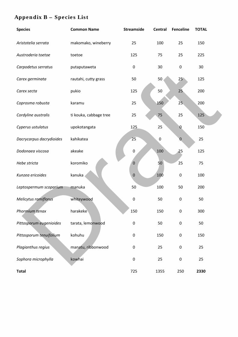
Appendix B – Species List
Species Common Name Streamside Central Fenceline TOTAL
Aristotelia serrata makomako, wineberry 25 100 25 150
Austroderia toetoe toetoe 125 75 25 225
Carpodetus serratus putaputaweta 0 30 0 30
Carex germinata rautahi, cutty grass 50 50 25 125
Carex secta pukio 125 50 25 200
Coprosma robusta karamu 25 150 25 200
Cordyline australis ti kouka, cabbage tree 25 75 25 125
Cyperus ustulatus upokotangata 125 25 0 150
Dacrycarpus dacrydioides kahikatea 25 0 0 25
Dodonaea viscosa akeake 0 100 25 125
Hebe stricta koromiko 0 50 25 75
Kunzea ericoides kanuka 0 100 0 100
Leptospermum scoparium manuka 50 100 50 200
Melicytus ramiflorus whiteywood 0 50 0 50
Phormium tenax harakeke 150 150 0 300
Pittosporum eugenioides tarata, lemonwood 0 50 0 50
Pittosporum tenuifolium kohuhu 0 150 0 150
Plagianthus regius manatu, ribbonwood 0 25 0 25
Sophora microphylla kowhai 0 25 0 25
Total 725 1355 250 2330
Draft

Jewell Stream, Te Horo
Riparian Enhancement Plan Samantha & Wayne Hart, 66 Morrison Road, Te Horo
Draft

© Opus International Consultants Ltd 2017
Prepared By
Opus International Consultants Ltd
Colin Stace Napier Office Senior Rural Consultant Opus House, 6 Ossian Street Private Bag 6019, Napier 4142 New Zealand
Reviewed By Telephone: +64 6 349 6600 Roger MacGibbon Facsimile: +64 6 348 4601 Design Team Leader
Date: April 2017 Reference: 5-c2771.00 Status: Final
Draft

Riparian Enhancement Plan 1
© Opus International Consultants Ltd 2017
Contents
1 Property Details ................................................................................................. 2
2 Purpose of this Plan ........................................................................................... 2
3 Overview ............................................................................................................ 3
4 Fencing Works ................................................................................................... 4
5 Planting Activities .............................................................................................. 4
6 Programme Management ................................................................................... 5
7 Timetable ........................................................................................................... 6
8 Review and Maintenance .................................................................................... 6 Appendix A Plan No. P208 Riparian Enhancement Works, Hart pty, 66
Morrison Rd, Te Horo Appendix B Species List Draf
t
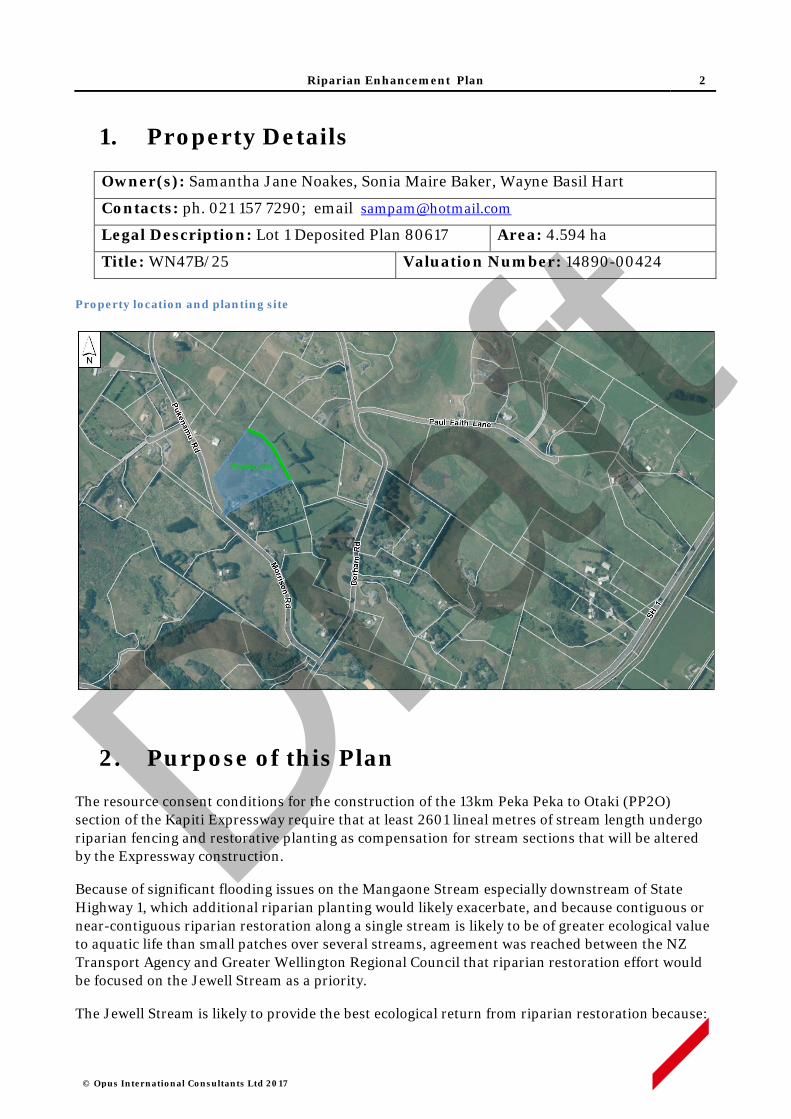
Riparian Enhancement Plan 2
© Opus International Consultants Ltd 2017
1. Property Details
Owner(s): Samantha Jane Noakes, Sonia Maire Baker, Wayne Basil Hart
Contacts: ph. 021 157 7290; email [email protected]
Legal Description: Lot 1 Deposited Plan 80617 Area: 4.594 ha
Title: WN47B/25 Valuation Number: 14890-00424 Property location and planting site
2. Purpose of this Plan
The resource consent conditions for the construction of the 13km Peka Peka to Otaki (PP2O) section of the Kapiti Expressway require that at least 2601 lineal metres of stream length undergo riparian fencing and restorative planting as compensation for stream sections that will be altered by the Expressway construction.
Because of significant flooding issues on the Mangaone Stream especially downstream of State Highway 1, which additional riparian planting would likely exacerbate, and because contiguous or near-contiguous riparian restoration along a single stream is likely to be of greater ecological value to aquatic life than small patches over several streams, agreement was reached between the NZ Transport Agency and Greater Wellington Regional Council that riparian restoration effort would be focused on the Jewell Stream as a priority.
The Jewell Stream is likely to provide the best ecological return from riparian restoration because:
Draft
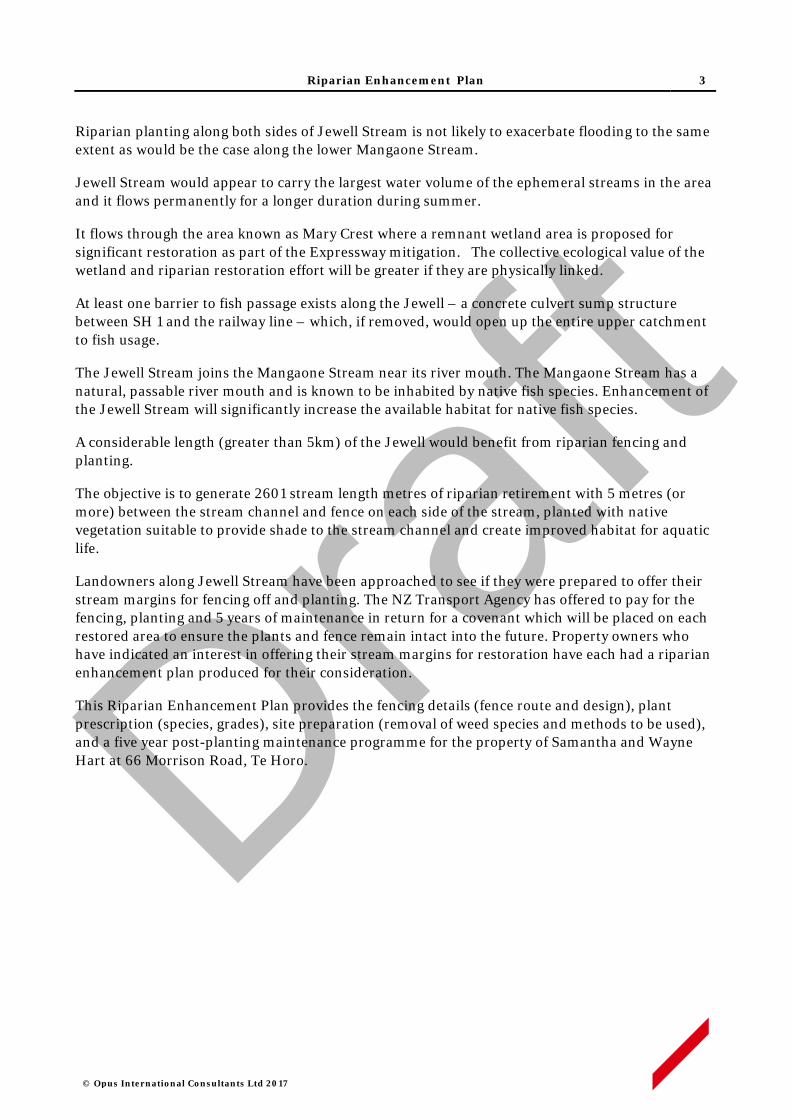
Riparian Enhancement Plan 3
© Opus International Consultants Ltd 2017
Riparian planting along both sides of Jewell Stream is not likely to exacerbate flooding to the same extent as would be the case along the lower Mangaone Stream.
Jewell Stream would appear to carry the largest water volume of the ephemeral streams in the area and it flows permanently for a longer duration during summer.
It flows through the area known as Mary Crest where a remnant wetland area is proposed for significant restoration as part of the Expressway mitigation. The collective ecological value of the wetland and riparian restoration effort will be greater if they are physically linked.
At least one barrier to fish passage exists along the Jewell – a concrete culvert sump structure between SH 1 and the railway line – which, if removed, would open up the entire upper catchment to fish usage.
The Jewell Stream joins the Mangaone Stream near its river mouth. The Mangaone Stream has a natural, passable river mouth and is known to be inhabited by native fish species. Enhancement of the Jewell Stream will significantly increase the available habitat for native fish species.
A considerable length (greater than 5km) of the Jewell would benefit from riparian fencing and planting.
The objective is to generate 2601 stream length metres of riparian retirement with 5 metres (or more) between the stream channel and fence on each side of the stream, planted with native vegetation suitable to provide shade to the stream channel and create improved habitat for aquatic life.
Landowners along Jewell Stream have been approached to see if they were prepared to offer their stream margins for fencing off and planting. The NZ Transport Agency has offered to pay for the fencing, planting and 5 years of maintenance in return for a covenant which will be placed on each restored area to ensure the plants and fence remain intact into the future. Property owners who have indicated an interest in offering their stream margins for restoration have each had a riparian enhancement plan produced for their consideration.
This Riparian Enhancement Plan provides the fencing details (fence route and design), plant prescription (species, grades), site preparation (removal of weed species and methods to be used), and a five year post-planting maintenance programme for the property of Samantha and Wayne Hart at 66 Morrison Road, Te Horo.
Draft
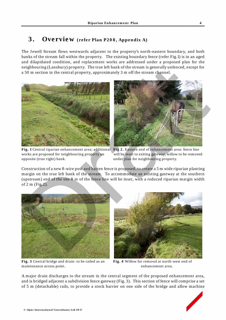
Riparian Enhancement Plan 4
© Opus International Consultants Ltd 2017
3. Overview (refer Plan P208, Appendix A)
The Jewell Stream flows westwards adjacent to the property’s north-eastern boundary, and both banks of the stream fall within the property. The existing boundary fence (refer Fig.1) is in an aged and dilapidated condition, and replacement works are addressed under a proposed plan for the neighbouring (Lansbury) property. The true left bank of the stream is generally unfenced, except for a 50 m section in the central property, approximately 3 m off the stream channel.
Fig. 1 Central riparian enhancement area; additional Fig 2. Eastern end of enhancement area: fence line works are proposed for neighbouring property on will be inset to exiting gateway, willow to be removed opposite (true right) bank. under plan for neighbouring property.
Construction of a new 8-wire post and batten fence is proposed, to create a 5 m wide riparian planting margin on the true left bank of the stream. To accommodate an existing gateway at the southern (upstream) end of the site 8 m of the fence line will be inset, with a reduced riparian margin width of 2 m (Fig.2).
Fig. 3 Central bridge and drain: to be railed as an Fig. 4 Willow for removal at north-west end of maintenance access point. enhancement area.
A major drain discharges to the stream in the central segment of the proposed enhancement area, and is bridged adjacent a subdivision fence gateway (Fig. 3). This section of fence will comprise a set of 5 m (detachable) rails, to provide a stock barrier on one side of the bridge and allow machine
Draft
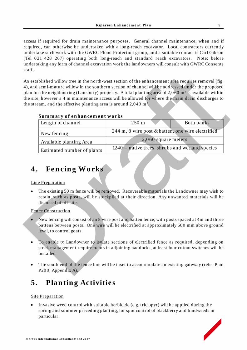
Riparian Enhancement Plan 5
© Opus International Consultants Ltd 2017
access if required for drain maintenance purposes. General channel maintenance, when and if required, can otherwise be undertaken with a long-reach excavator. Local contractors currently undertake such work with the GWRC Flood Protection group, and a suitable contact is Carl Gibson (Tel 021 428 267) operating both long-reach and standard reach excavators. Note: before undertaking any form of channel excavation work the landowners will consult with GWRC Consents staff. An established willow tree in the north-west section of the enhancement area requires removal (fig. 4), and semi-mature willow in the southern section of channel will be addressed under the proposed plan for the neighbouring (Lansbury) property. A total planting area of 2,060 m2 is available within the site, however a 4 m maintenance access will be allowed for where the main drain discharges to the stream, and the effective planting area is around 2,040 m2.
Summary of enhancement works Length of channel 250 m Both banks
New fencing 244 m, 8 wire post & batten, one wire electrified
Available planting Area 2,060 square meters
Estimated number of plants 1240 – native trees, shrubs and wetland species
4. Fencing Works
Line Preparation
• The existing 50 m fence will be removed. Recoverable materials the Landowner may wish to retain, such as posts, will be stockpiled at their direction. Any unwanted materials will be disposed of off-site.
Fence Construction
• New fencing will consist of an 8 wire post and batten fence, with posts spaced at 4m and three battens between posts. One wire will be electrified at approximately 500 mm above ground level, to control goats.
• To enable to Landowner to isolate sections of electrified fence as required, depending on stock management requirements in adjoining paddocks, at least four cutout switches will be installed
• The south end of the fence line will be inset to accommodate an existing gateway (refer Plan P208, Appendix A).
5. Planting Activities
Site Preparation
• Invasive weed control with suitable herbicide (e.g. triclopyr) will be applied during the spring and summer preceding planting, for spot control of blackberry and bindweeds in particular.
Draft

Riparian Enhancement Plan 6
© Opus International Consultants Ltd 2017
• The willow tree in the north-western section of channel will be removed. Removal method will be motor-manual and stumps will be treated with a suitable herbicide (e.g. glyphosate).
Pest Animal Control
• Rabbits are present in low to moderate numbers throughout the property. Given the number and proximity of neighbouring properties there is limited opportunity to apply pest control activities such as poisoning or night shooting. Protective sleeves or repellents will otherwise be used to deter rabbit browsing of new plantings.
Pre-release & Planting
• Planting spots will be sprayed with a suitable herbicide (e.g. glyphosate) at least three weeks prior to planting.
• Plant spacing will generally be no greater than 1.5 x 1.5 m for most species, while some wetland genera such as Carex and Cyperus will be at closer spacings.
• All plants will be 1 L potted stock, or similar grade, and will be planted in holes slightly larger than the root ball, with any spiralled roots removed. All plant pots or other packaging will be removed off site.
• A planting list of species is set out in Appendix B. Plant stock will be sought as eco-sourced material from within the Foxton Ecological District- 31.021 .
• To facilitate periodic channel maintenance access for a long-reach excavator, plantings on the true left bank will largely comprise herbaceous species with a maximum height of 2 m.
• A small number of taller woody will be spread throughout the planting, and may be concentrated on those sections of stream bank directly opposite the proposed inset sections of fence line on the neighbouring property, which provide alternative access points for excavator reach.
Plant Maintenance
• Each plant will be released (control of competing vegetation within an 800-1000mm radius) in the spring and mid-summer, for up to five years.
• Weed control will use carefully directed or shielded low-pressure spray of a suitable herbicide. Operators will hold current GROWSAFE certification, and will use approved methods and equipment to prevent spray drift when applying herbicide.
• Any resurgent or invasive weeds will also be controlled concurrently.
• The site will be monitored for resurgent or invasive weeds during the five year establishment period, and weed control will be applied annually as required.
6. Programme Management
• All works will be performed by suitably qualified and experienced operators contracted to Opus (on behalf of the NZ Transport Agency) and supervised by experienced Opus staff.
1 Ecological Regions and Districts of New Zealand (1987) NZ Dept of Conservation
Draft

Riparian Enhancement Plan 7
© Opus International Consultants Ltd 2017
Property work areas, including access routes, will be determined in advance of site activity, in consultation with the Landowner.
• The Contractor will give adequate notice of timing for entry to the property, and will comply with Landowner requirements in regard to factors such as stock management, vehicle access and Health and Safety obligations.
• Opus staff will maintain contact with Contractors on a regular basis, including periodic site inspections as works progress.
• Any Landowner concerns that may arise about progress of works or Contractor activity should be communicated to the designated Opus Project Manager at the earliest opportunity. If necessary, a hold-point on works can be applied until matters of concern are resolved.
7. Timetable
7. Activity Timing Responsibility Supervision
Invasive weed control Feb - March 2018 Contractor Opus
Willow removal March 2018 Contractor Opus
Existing fence removal April 2018 Contractor Opus
Construct new fence April 2018 Contractor Opus
Pre-plant spot spray May 2018 Contractor Opus
Planting June 2018 Contractor Opus
Releasing Oct 2018 & Feb2019 Contractor Opus
Releasing Oct 2019 & Feb2020 Contractor Opus
Releasing Oct 2020 & Feb2021 Contractor Opus
Maintenance Oct 2021 & Feb2022 Contractor Opus
Maintenance Oct 2022 & Feb2023 Contractor Opus
Note: this timing indicative, specific dates will be confirmed prior to commencement of works.
8. Review and Update
• The Riparian Enhancement Plan will be monitored and reviewed annually by Opus, in consultation with the Landowner and NZTA. Any major changes will be documented and an amended plan will be submitted to NZTA for approval.
• Any channel management issues arising, which affect stream bank integrity such that establishment of plantings may be threatened, will be addressed on a situation-by-situation basis within the five year establishment period.
Draft

Riparian Enhancement Plan
© Opus International Consultants Ltd 2017
APPENDIX A
Draft
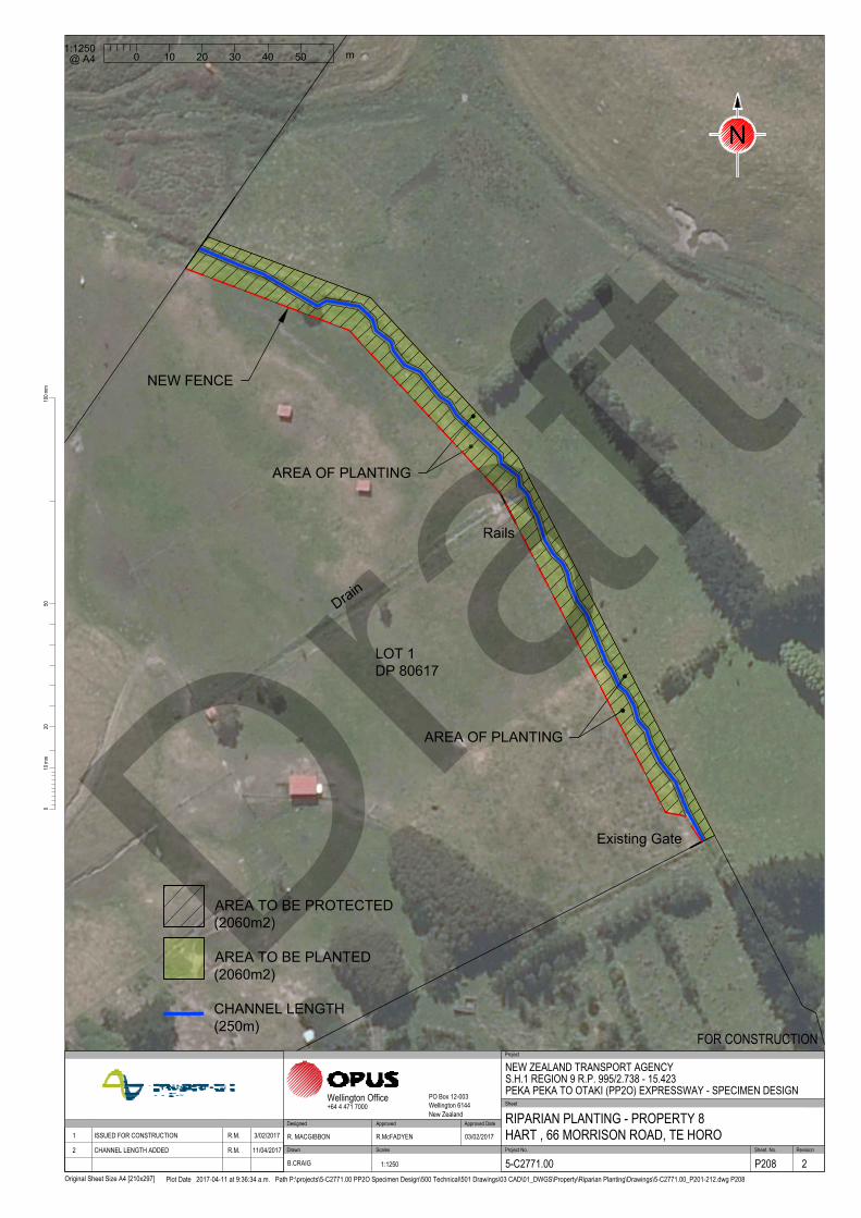
LOT 1
DP 80617
Existing Gate
NEW FENCE
Rails
AREA OF PLANTING
D
r
a
i
n
AREA OF PLANTING
/
/
/
/
/
/
/
/
/
/
/
/
/
/
/
/
/
/
/
/
/
/
/
2010
0mm
100m
m
Original Sheet Size A4 [210x297]
50
Plot Date 2017-04-11 at 9:36:34 a.m. Path P:\projects\5-C2771.00 PP2O Specimen Design\500 Technical\501 Drawings\03 CAD\01_DWGS\Property\Riparian Planting\Drawings\5-C2771.00_P201-212.dwg P208
Scales Project No. Sheet. No.
Project
Sheet
RevisionDrawn
Approved Approved Date
Wellington Office PO Box 12-003Wellington 6144New Zealand
+64 4 471 7000
NEW ZEALAND TRANSPORT AGENCYS.H.1 REGION 9 R.P. 995/2.738 - 15.423PEKA PEKA TO OTAKI (PP2O) EXPRESSWAY - SPECIMEN DESIGN
RIPARIAN PLANTING - PROPERTY 8HART , 66 MORRISON ROAD, TE HORO
FOR CONSTRUCTION
5-C2771.00 P208 2
R. MACGIBBON R.McFADYEN 03/02/2017
B.CRAIG 1:1250
DesignedApproved DateRevision Amendment 1 ISSUED FOR CONSTRUCTION R.M. 3/02/2017
2 CHANNEL LENGTH ADDED R.M. 11/04/2017
0
m
20 4010 30 50
1:1250
@ A4
N
AREA TO BE PLANTED
(2060m2)
AREA TO BE PROTECTED
(2060m2)
CHANNEL LENGTH
(250m)
Draft

Riparian Enhancement Plan
© Opus International Consultants Ltd 2017
APPENDIX B
Draft
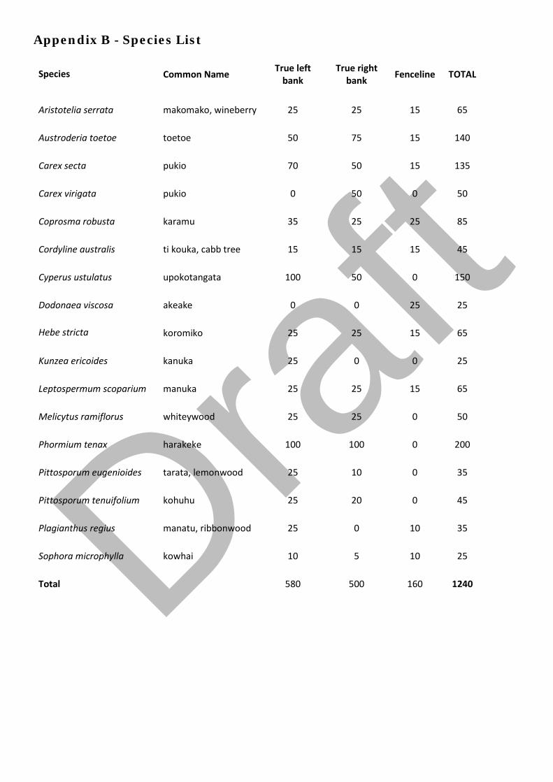
Appendix B - Species List
Species Common Name True left bank
True right bank Fenceline TOTAL
Aristotelia serrata makomako, wineberry 25 25 15 65
Austroderia toetoe toetoe 50 75 15 140
Carex secta pukio 70 50 15 135
Carex virigata pukio 0 50 0 50
Coprosma robusta karamu 35 25 25 85
Cordyline australis ti kouka, cabb tree 15 15 15 45
Cyperus ustulatus upokotangata 100 50 0 150
Dodonaea viscosa akeake 0 0 25 25
Hebe stricta koromiko 25 25 15 65
Kunzea ericoides kanuka 25 0 0 25
Leptospermum scoparium manuka 25 25 15 65
Melicytus ramiflorus whiteywood 25 25 0 50
Phormium tenax harakeke 100 100 0 200
Pittosporum eugenioides tarata, lemonwood 25 10 0 35
Pittosporum tenuifolium kohuhu 25 20 0 45
Plagianthus regius manatu, ribbonwood 25 0 10 35
Sophora microphylla kowhai 10 5 10 25
Total 580 500 160 1240
Draf
t

Jewell Stream, Te Horo
Riparian Enhancement Plan Iris and Peter Bean, 188 Pukenamu Road, Te Horo
Draft

© Opus International Consultants Ltd 2017
Prepared By
Opus International Consultants Ltd
Colin Stace Napier Office Senior Rural Consultant Opus House, 6 Ossian Street Private Bag 6019, Napier 4142 New Zealand
Reviewed By Telephone: +64 6 349 6600 Roger MacGibbon Facsimile: +64 6 348 4601 Design Team Leader
Date: April 2017 Reference: 5-c2771.00 Status: Final
Draft

Riparian Enhancement Plan 1
© Opus International Consultants Ltd 2017
Contents
1. Property Details ................................................................................................. 2
2. Purpose of this Plan ........................................................................................... 2
3. Overview (refer Plan P210, Appendix A) ............................................................ 3
4. Fencing Works ................................................................................................... 5
5. Planting Activities .............................................................................................. 5
6. Programme Management ................................................................................... 6
7. Timetable ........................................................................................................... 7
8. Review and Update ............................................................................................. 7
APPENDIX A .............................................................................................................. 9
APPENDIX B ............................................................................................................ 10
Draft
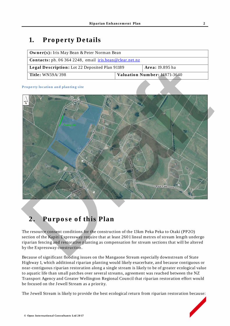
Riparian Enhancement Plan 2
© Opus International Consultants Ltd 2017
1. Property Details
Owner(s): Iris May Bean & Peter Norman Bean
Contacts: ph. 06 364 2248, email [email protected]
Legal Description: Lot 22 Deposited Plan 91189 Area: 19.895 ha
Title: WN59A/398 Valuation Number: 14871-3640
Property location and planting site
2. Purpose of this Plan
The resource consent conditions for the construction of the 13km Peka Peka to Otaki (PP2O) section of the Kapiti Expressway require that at least 2601 lineal metres of stream length undergo riparian fencing and restorative planting as compensation for stream sections that will be altered by the Expressway construction.
Because of significant flooding issues on the Mangaone Stream especially downstream of State Highway 1, which additional riparian planting would likely exacerbate, and because contiguous or near-contiguous riparian restoration along a single stream is likely to be of greater ecological value to aquatic life than small patches over several streams, agreement was reached between the NZ Transport Agency and Greater Wellington Regional Council that riparian restoration effort would be focused on the Jewell Stream as a priority.
The Jewell Stream is likely to provide the best ecological return from riparian restoration because:
Draft

Riparian Enhancement Plan 3
© Opus International Consultants Ltd 2017
i. Riparian planting along both sides of Jewell Stream is not likely to exacerbate flooding to the same extent as would be the case along the lower Mangaone Stream.
ii. Jewell Stream would appear to carry the largest water volume of the ephemeral streams in the area and it flows permanently for a longer duration during summer.
iii. It flows through the area known as Mary Crest where a remnant wetland area is proposed for significant restoration as part of the Expressway mitigation. The collective ecological value of the wetland and riparian restoration effort will be greater if they are physically linked.
iv. At least one barrier to fish passage exists along the Jewell – a concrete culvert sump structure between SH 1 and the railway line – which, if removed, would open up the entire upper catchment to fish usage.
v. The Jewell Stream joins the Mangaone Stream near its river mouth. The Mangaone Stream has a natural, passable river mouth and is known to be inhabited by native fish species. Enhancement of the Jewell Stream will significantly increase the available habitat for native fish species.
vi. A considerable length (greater than 5km) of the Jewell would benefit from riparian fencing and planting.
The objective is to generate 2601 stream length metres of riparian retirement with 5 metres (or more) between the stream channel and fence on each side of the stream, planted with native vegetation suitable to provide shade to the stream channel and create improved habitat for aquatic life.
Landowners along Jewell Stream have been approached to see if they were prepared to offer their stream margins for fencing off and planting. The NZ Transport Agency has offered to pay for the fencing, planting and 5 years of maintenance in return for a covenant which will be placed on each restored area to ensure the plants and fence remain intact into the future. Property owners who have indicated an interest in offering their stream margins for restoration have each had a riparian enhancement plan produced for their consideration.
This Riparian Enhancement Plan provides the fencing details (fence route and design), plant prescription (species, grades), site preparation (removal of weed species and methods to be used), and a five year post-planting maintenance programme for the property of Iris and Peter Bean at 188 Pukenamu Road, Te Horo.
3. Overview (refer Plan P210, Appendix A)
The Jewell Stream flows northwards along the property’s western boundary, largely within the neighbouring property (see figure 1). However at the NW corner of the property the boundary line crosses the stream and runs parallel with it on the true left bank. This corner point in the boundary line is marked by an existing strainer (refer Fig. 1 below). Both left and right banks of the stream are within the property along this section of stream, but the true left bank has a very narrow and insufficient margin for planting, and is also used as access for GWRC channel maintenance operations.
Draft
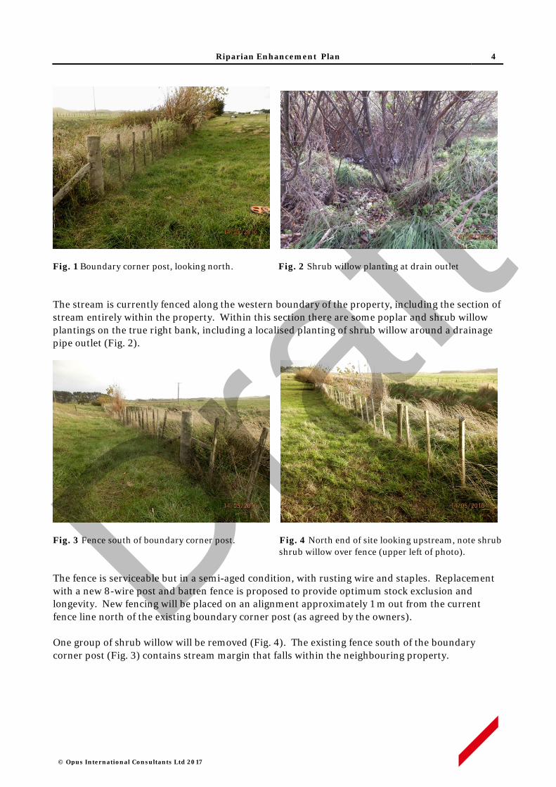
Riparian Enhancement Plan 4
© Opus International Consultants Ltd 2017
Fig. 1 Boundary corner post, looking north. Fig. 2 Shrub willow planting at drain outlet The stream is currently fenced along the western boundary of the property, including the section of stream entirely within the property. Within this section there are some poplar and shrub willow plantings on the true right bank, including a localised planting of shrub willow around a drainage pipe outlet (Fig. 2).
Fig. 3 Fence south of boundary corner post. Fig. 4 North end of site looking upstream, note shrub shrub willow over fence (upper left of photo).
The fence is serviceable but in a semi-aged condition, with rusting wire and staples. Replacement with a new 8-wire post and batten fence is proposed to provide optimum stock exclusion and longevity. New fencing will be placed on an alignment approximately 1 m out from the current fence line north of the existing boundary corner post (as agreed by the owners). One group of shrub willow will be removed (Fig. 4). The existing fence south of the boundary corner post (Fig. 3) contains stream margin that falls within the neighbouring property.
Draft

Riparian Enhancement Plan 5
© Opus International Consultants Ltd 2017
Summary of enhancement works Length of channel 138 m True right bank
New fencing 138 m, 8 wire post & batten with electric outrigger
Available planting Area 665 square meters
Estimated number of plants 380 – native trees, shrubs and wetland species
4. Fencing Works
Line Preparation
• The existing fence will be removed. Any recoverable materials the Landowner may wish to retain, such as posts, will be stockpiled at their direction. Unwanted materials will be disposed of off-site.
Fence Construction
• New fencing will consist of an 8 wire post and batten fence, with the addition of an electric outrigger on the top of the fence to deter cattle from reaching into the planting area.
• Hot-dipped staples will be used to provide extra galvanising for coastal conditions.
• A short (1 m) set of rails will be installed at the boundary corner post.
5. Planting Activities
Site Preparation
• Invasive weed control with suitable herbicide (e.g. triclopyr) will be applied during the spring and summer preceding planting, to control brushweeds and bindweeds in particular.
• Existing poplar plantings and shrub willow at the drain outlet will be retained. Elsewhere, shrub willows growing over the existing fence will be removed by cutting and stumps will be swabbed with glyphosate.
• Rank grass to be spot-sprayed with a suitable herbicide (e.g. glyphosate) in the summer - autumn period preceding planting works.
Pest Animal Control
• Rabbits are present in low to moderate numbers throughout the property. Given the number and proximity of neighbouring properties there is limited opportunity to apply pest control activities such as poisoning or night shooting. Protective sleeves or repellents will otherwise be used to deter rabbit browsing of new plantings.
Pre-release & Planting
Draft

Riparian Enhancement Plan 6
© Opus International Consultants Ltd 2017
• Planting spots will be sprayed with a suitable herbicide (e.g. glyphosate) at least three weeks prior to planting.
• Plant spacing will generally be no greater than 1.5 x 1.5 m for most species, while some wetland genera such as Carex and Cyperus will be at closer spacings.
• All plants will be 1 L potted stock, or similar grade, and will be planted in holes slightly larger than the root ball, with any spiralled roots removed. All plant pots or other packaging will be removed and disposed of off-site.
• A planting list of species is set out in Appendix B. Plant stock will be sought as eco-sourced material from within the Foxton Ecological District- 31.02.1
Plant Maintenance
• Each plant will be released (control of competing vegetation within an 800-1000mm radius) in the spring and mid-summer, for up to five years.
• Weed control will use carefully directed or shielded low-pressure spray of a suitable herbicide. Operators will hold current GROWSAFE certification, and will use approved methods and equipment to prevent spray drift when applying herbicide.
• Any resurgent or invasive weeds will also be controlled concurrently.
• The site will be monitored for resurgent or invasive weeds during the five year establishment period, and weed control will be applied annually as required.
6. Programme Management
• All works will be performed by suitably qualified and experienced operators contracted to Opus (on behalf of the NZ Transport Agency) and supervised by experienced Opus staff. Property work areas, including access routes, will be determined in advance of site activity, in consultation with the Landowner.
• The Contractor will give adequate notice of timing for entry to the property, and will comply with Landowner requirements in regard to factors such as stock management, vehicle access and Health and Safety obligations.
• Opus staff will maintain contact with Contractors on a regular basis, including periodic site inspections as works progress.
• Any Landowner concerns that may arise about progress of works or Contractor activity should be communicated to the designated Opus Project Manager at the earliest opportunity. If necessary, a hold-point on works can be applied until matters of concern are resolved.
1 Ecological Regions and Districts of New Zealand (1987) NZ Dept. of Conservation
Draft
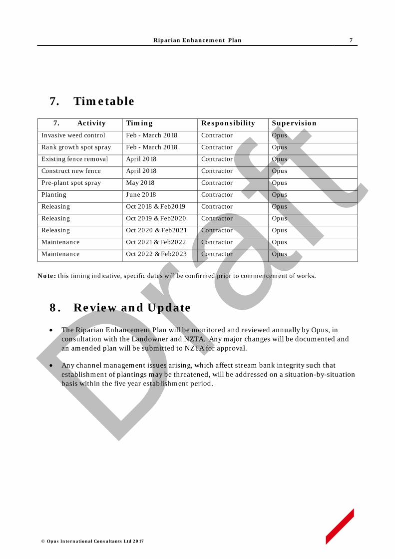
Riparian Enhancement Plan 7
© Opus International Consultants Ltd 2017
7. Timetable
7. Activity Timing Responsibility Supervision
Invasive weed control Feb - March 2018 Contractor Opus
Rank growth spot spray Feb - March 2018 Contractor Opus
Existing fence removal April 2018 Contractor Opus
Construct new fence April 2018 Contractor Opus
Pre-plant spot spray May 2018 Contractor Opus
Planting June 2018 Contractor Opus
Releasing Oct 2018 & Feb2019 Contractor Opus
Releasing Oct 2019 & Feb2020 Contractor Opus
Releasing Oct 2020 & Feb2021 Contractor Opus
Maintenance Oct 2021 & Feb2022 Contractor Opus
Maintenance Oct 2022 & Feb2023 Contractor Opus
Note: this timing indicative, specific dates will be confirmed prior to commencement of works.
8. Review and Update
• The Riparian Enhancement Plan will be monitored and reviewed annually by Opus, in consultation with the Landowner and NZTA. Any major changes will be documented and an amended plan will be submitted to NZTA for approval.
• Any channel management issues arising, which affect stream bank integrity such that establishment of plantings may be threatened, will be addressed on a situation-by-situation basis within the five year establishment period.
Draft

Riparian Enhancement Plan
© Opus International Consultants Ltd 2017
APPENDIX A
Draft
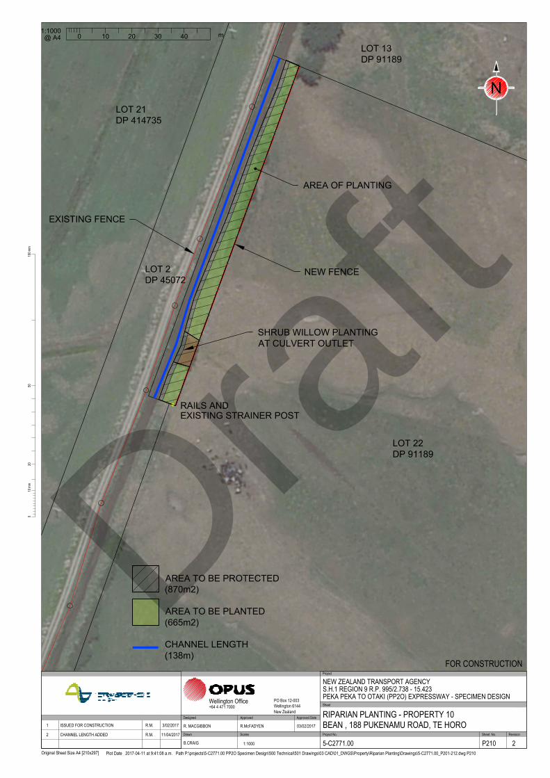
/
/
/
/
/
/
/
/
/
/
/
/
/
/
/
/
/
/
/
/
/
/
/
/
/
/
LOT 22
DP 91189
NEW FENCE
AREA OF PLANTING
LOT 13
DP 91189
LOT 21
DP 414735
LOT 2
DP 45072
RAILS AND
EXISTING STRAINER POST
SHRUB WILLOW PLANTING
AT CULVERT OUTLET
EXISTING FENCE
Approved DateRevision Amendment 1 ISSUED FOR CONSTRUCTION R.M. 3/02/2017
2 CHANNEL LENGTH ADDED R.M. 11/04/2017
1:1000
0 10 20 30 40
m
@ A4
2010
0mm
100m
m
Original Sheet Size A4 [210x297]
50
Plot Date 2017-04-11 at 9:41:08 a.m. Path P:\projects\5-C2771.00 PP2O Specimen Design\500 Technical\501 Drawings\03 CAD\01_DWGS\Property\Riparian Planting\Drawings\5-C2771.00_P201-212.dwg P210
Scales Project No. Sheet. No.
Project
Sheet
RevisionDrawn
Approved Approved Date
Wellington Office PO Box 12-003Wellington 6144New Zealand
+64 4 471 7000
NEW ZEALAND TRANSPORT AGENCYS.H.1 REGION 9 R.P. 995/2.738 - 15.423PEKA PEKA TO OTAKI (PP2O) EXPRESSWAY - SPECIMEN DESIGN
RIPARIAN PLANTING - PROPERTY 10BEAN , 188 PUKENAMU ROAD, TE HORO
FOR CONSTRUCTION
5-C2771.00 P210 2
R. MACGIBBON R.McFADYEN 03/02/2017
B.CRAIG 1:1000
Designed
N
AREA TO BE PLANTED
(665m2)
AREA TO BE PROTECTED
(870m2)
CHANNEL LENGTH
(138m)
Draft

Riparian Enhancement Plan
© Opus International Consultants Ltd 2017
APPENDIX B
Draft

Appendix B – Species List Species Common Name Streamside Central Fenceline TOTAL
Austroderia fulvida kakaho, toetoe 25 25 30 80
Coprosma repens taupata 10 25 15 50
Cordyline australis ti kouka, cabb tree 0 25 0 25
Corynocarpus lavigatus karaka 0 10 0 10
Cyperus ustulatus upokotangata 15 0 0 15
Dodonaea viscosa akeake 0 25 10 35
Leptospermum scoparium manuka 15 25 15 55
Myoporum laetum ngaio 0 15 0 15
Olearia solandri coastal shrub daisy 0 10 15 25
Phormium tenax harakeke 0 50 0 50
Plagianthus regius manatu, ribbonwood 20 0 0 20
Total 85 210 85 380
Draft

Jewell Stream, Te Horo
Riparian Enhancement Plan Suzanne Blumhardt & Peter Hatfield, 86 Derham Road, Te Horo
Draft

© Opus International Consultants Ltd 2017
Prepared By
Opus International Consultants Ltd
Colin Stace Napier Office Senior Rural Consultant Opus House, 6 Ossian Street Private Bag 6019, Napier 4142 New Zealand
Reviewed By Telephone: +64 6 349 6600 Roger MacGibbon Facsimile: +64 6 348 4601 Design Team Leader
Date: April 2017 Reference: 5-c2771.00 Status: Final
Draft

Riparian Enhancement Plan 1
© Opus International Consultants Ltd 2017
Contents
1 Property Details ................................................................................................. 2
2 Purpose of this Plan ........................................................................................... 2
3 Overview ............................................................................................................ 3
4 Fencing Works ................................................................................................... 4
5 Planting Activities .............................................................................................. 4
6 Programme Management ................................................................................... 5
7 Timetable ........................................................................................................... 5
8 Review and Maintenance .................................................................................... 6 Appendix A Plan No. P206 Riparian Enhancement Works, Blumhardt &
Hatfield pty, 86 Derham Rd, Te Horo Appendix B Species List Draf
t
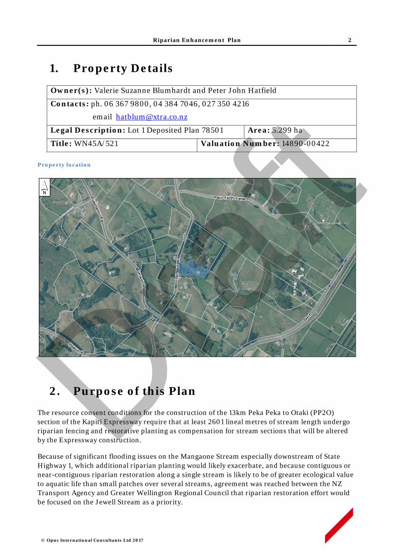
Riparian Enhancement Plan 2
© Opus International Consultants Ltd 2017
1. Property Details
Owner(s): Valerie Suzanne Blumhardt and Peter John Hatfield
Contacts: ph. 06 367 9800, 04 384 7046, 027 350 4216
email [email protected]
Legal Description: Lot 1 Deposited Plan 78501 Area: 5.299 ha
Title: WN45A/521 Valuation Number: 14890-00422 Property location
2. Purpose of this Plan
The resource consent conditions for the construction of the 13km Peka Peka to Otaki (PP2O) section of the Kapiti Expressway require that at least 2601 lineal metres of stream length undergo riparian fencing and restorative planting as compensation for stream sections that will be altered by the Expressway construction.
Because of significant flooding issues on the Mangaone Stream especially downstream of State Highway 1, which additional riparian planting would likely exacerbate, and because contiguous or near-contiguous riparian restoration along a single stream is likely to be of greater ecological value to aquatic life than small patches over several streams, agreement was reached between the NZ Transport Agency and Greater Wellington Regional Council that riparian restoration effort would be focused on the Jewell Stream as a priority.
Draft
Riparian Enhancement Plan 3
© Opus International Consultants Ltd 2017
The Jewell Stream is likely to provide the best ecological return from riparian restoration because:
i. Riparian planting along both sides of Jewell Stream is not likely to exacerbate flooding to the same extent as would be the case along the lower Mangaone Stream.
ii. Jewell Stream would appear to carry the largest water volume of the ephemeral streams in the area and it flows permanently for a longer duration during summer.
iii. It flows through the area known as Mary Crest where a remnant wetland area is proposed for significant restoration as part of the Expressway mitigation. The collective ecological value of the wetland and riparian restoration effort will be greater if they are physically linked.
iv. At least one barrier to fish passage exists along the Jewell – a concrete culvert sump structure between SH 1 and the railway line – which, if removed, would open up the entire upper catchment to fish usage.
v. The Jewell Stream joins the Mangaone Stream near its river mouth. The Mangaone Stream has a natural, passable river mouth and is known to be inhabited by native fish species. Enhancement of the Jewell Stream will significantly increase the available habitat for native fish species.
vi. A considerable length (greater than 5km) of the Jewell would benefit from riparian fencing and planting.
The objective is to generate 2601 stream length metres of riparian retirement with 5 metres (or more) between the stream channel and fence on each side of the stream, planted with native vegetation suitable to provide shade to the stream channel and create improved habitat for aquatic life.
Landowners along Jewell Stream have been approached to see if they were prepared to offer their stream margins for fencing off and planting. The NZ Transport Agency has offered to pay for the fencing, planting and 5 years of maintenance in return for a covenant which will be placed on each restored area to ensure the plants and fence remain intact into the future. Property owners who have indicated an interest in offering their stream margins for restoration have each had a riparian enhancement plan produced for their consideration.
This Riparian Enhancement Plan provides the fencing details (fence route and design), plant prescription (species, grades), site preparation (removal of weed species and methods to be used), and a five year post-planting maintenance programme for the property of Suzanne Blumhardt and Peter Hatfield at 86 Derham Road, Te Horo.
3. Overview (refer Plan P206, Appendix A)
The Jewell Stream flows through the central property in a westerly direction. Both left and right banks of the stream are within the property. The true left bank of the stream throughout the property is managed as a native plant restoration area, while the true left bank is managed as part of an open space area with selected tree plantings and mown grass ground cover. No livestock grazing is carried out on the property and there is no existing stream fencing in place on stream banks.
Draft
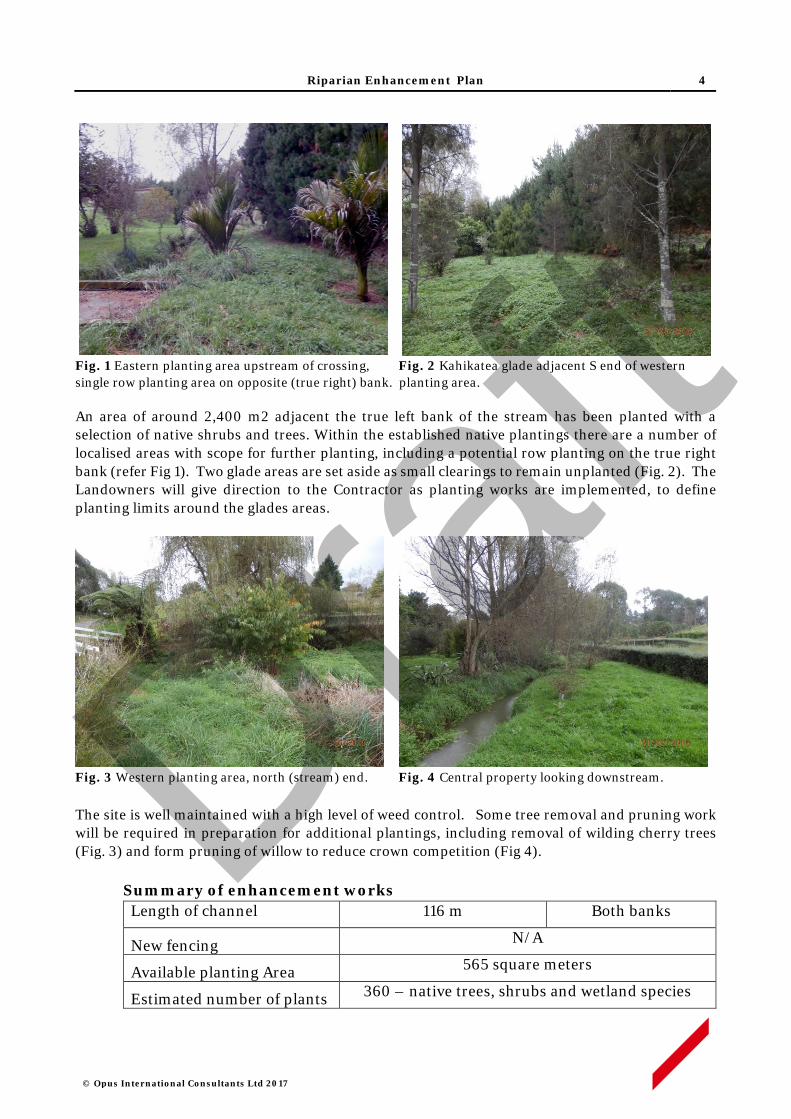
Riparian Enhancement Plan 4
© Opus International Consultants Ltd 2017
Fig. 1 Eastern planting area upstream of crossing, Fig. 2 Kahikatea glade adjacent S end of western single row planting area on opposite (true right) bank. planting area. An area of around 2,400 m2 adjacent the true left bank of the stream has been planted with a selection of native shrubs and trees. Within the established native plantings there are a number of localised areas with scope for further planting, including a potential row planting on the true right bank (refer Fig 1). Two glade areas are set aside as small clearings to remain unplanted (Fig. 2). The Landowners will give direction to the Contractor as planting works are implemented, to define planting limits around the glades areas.
Fig. 3 Western planting area, north (stream) end. Fig. 4 Central property looking downstream. The site is well maintained with a high level of weed control. Some tree removal and pruning work will be required in preparation for additional plantings, including removal of wilding cherry trees (Fig. 3) and form pruning of willow to reduce crown competition (Fig 4).
Summary of enhancement works Length of channel 116 m Both banks
New fencing N/A
Available planting Area 565 square meters
Estimated number of plants 360 – native trees, shrubs and wetland species
Draft

Riparian Enhancement Plan 5
© Opus International Consultants Ltd 2017
4. Fencing Works
No additional fencing works are required.
5. Planting Activities
Site Preparation
• Invasive weed control with suitable herbicide (e.g. triclopyr) will be applied during the summer preceding planting, to control potential spread of blackberry or bindweed from the neighbouring property.
• Existing willows will be retained and have some form pruning (removal of multiple leaders) in some cases.
Pest Animal Control
• Rabbits are present in low to moderate numbers throughout the property. Given the number and proximity of neighbouring properties there is limited opportunity to apply pest control activities such as poisoning or night shooting. Protective sleeves or repellents will otherwise be used to deter rabbit browsing of new plantings.
Pre-release & Planting
• Planting spots will be sprayed with a suitable herbicide (e.g. glyphosate) at least three weeks prior to planting.
• Plant spacing will generally be no greater than 1.5 x 1.5 m for most species, while some wetland genera such as Carex and Cyperus will be at closer spacings.
• All plants will be 1 L potted stock, or similar grade, and will be planted in holes slightly larger than the root ball, with any spiralled roots removed. All plant pots or other packaging will be removed off site.
• A planting list of species is set out in Appendix B. Plant stock will be sought as eco-sourced material from within the Foxton Ecological District- 31.02.1
• Layout will generally follow the siting indicated in the list, with species such as koromiko and akeake used in plantings on the western margin of the site; and species such as cabbage tree, long-leaved lacebark, ribbonwood and kowhai used in row plantings on the true right bank.
Plant Maintenance
• Each plant will be released (control of competing vegetation within an 800-1000mm radius) in the spring and mid-summer, for up to five years.
• Weed control will use carefully directed or shielded low-pressure spray of a suitable herbicide. Operators will hold current GROWSAFE certification, and will use approved methods and equipment to prevent spray drift when applying herbicide.
• Any resurgent or invasive weeds will also be controlled concurrently.
1 Ecological Regions and Districts of New Zealand (1987) NZ Dept. of Conservation
Draft

Riparian Enhancement Plan 6
© Opus International Consultants Ltd 2017
• The site will be monitored for resurgent or invasive weeds during the five year establishment period, and weed control will be applied annually as required.
6. Programme Management
• All works will be performed by suitably qualified and experienced operators contracted to Opus (on behalf of the NZ Transport Agency) and supervised by experienced Opus staff. Property work areas, including access routes, will be determined in advance of site activity, in consultation with the Landowner.
• The Contractor will give adequate notice of timing for entry to the property, and will comply with Landowner requirements in regard to factors such as stock management, vehicle access and Health and Safety obligations.
• Opus staff will maintain contact with Contractors on a regular basis, including periodic site inspections as works progress.
• Any Landowner concerns that may arise about progress of works or Contractor activity should be communicated to the designated Opus Project Manager at the earliest opportunity. If necessary, a hold-point on works can be applied until matters of concern are resolved.
7. Timetable
7. Activity Timing Responsibility Supervision
Invasive weed control Feb - March 2018 Contractor Opus
Pre-plant spot spray May 2018 Contractor Opus
Planting June 2018 Contractor Opus
Releasing Oct 2018 & Feb2019 Contractor Opus
Releasing Oct 2019 & Feb2020 Contractor Opus
Releasing Oct 2020 & Feb2021 Contractor Opus
Maintenance Oct 2021 & Feb2022 Contractor Opus
Maintenance Oct 2022 & Feb2023 Contractor Opus
Note: this timing indicative, specific dates will be confirmed prior to commencement of works.
8. Review and Update
• The Riparian Enhancement Plan will be monitored and reviewed annually by Opus, in consultation with the Landowner and NZTA. Any major changes will be documented and an amended plan will be submitted to NZTA for approval.
• Any channel management issues arising, which affect stream bank integrity such that establishment of plantings may be threatened, will be addressed on a situation-by-situation basis within the five year establishment period.
Draft

Riparian Enhancement Plan
© Opus International Consultants Ltd 2017
APPENDIX A
Draft
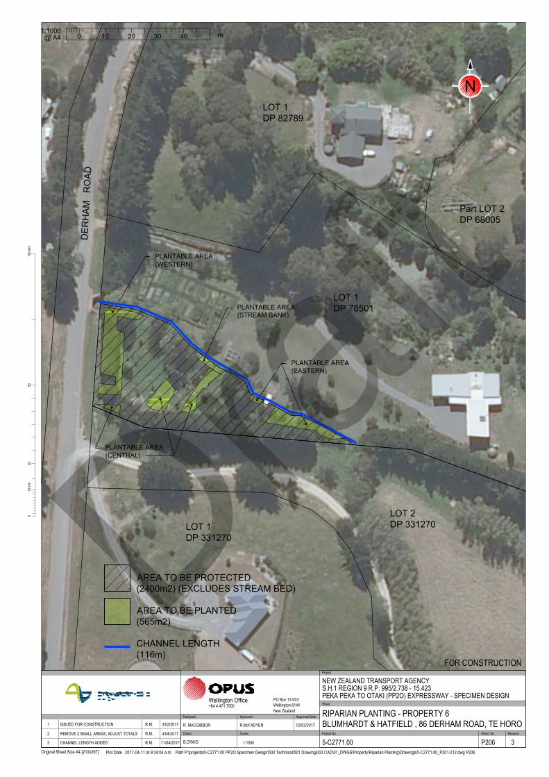
LOT 1
DP 78501
PLANTABLE AREA
(EASTERN)
PLANTABLE AREA
(WESTERN)
PLANTABLE AREA
(STREAM BANK)
PLANTABLE AREA
(CENTRAL)
LOT 1
DP 82789
Part LOT 2
DP 68005
LOT 1
DP 331270
LOT 2
DP 331270
DE
RH
AM
R
OA
D
2010
0mm
100m
m
Original Sheet Size A4 [210x297]
50
Plot Date 2017-04-11 at 9:34:04 a.m. Path P:\projects\5-C2771.00 PP2O Specimen Design\500 Technical\501 Drawings\03 CAD\01_DWGS\Property\Riparian Planting\Drawings\5-C2771.00_P201-212.dwg P206
Scales Project No. Sheet. No.
Project
Sheet
RevisionDrawn
Approved Approved Date
Wellington Office PO Box 12-003Wellington 6144New Zealand
+64 4 471 7000
NEW ZEALAND TRANSPORT AGENCYS.H.1 REGION 9 R.P. 995/2.738 - 15.423PEKA PEKA TO OTAKI (PP2O) EXPRESSWAY - SPECIMEN DESIGN
RIPARIAN PLANTING - PROPERTY 6BLUMHARDT & HATFIELD , 86 DERHAM ROAD, TE HORO
FOR CONSTRUCTION
5-C2771.00 P206 3
R. MACGIBBON R.McFADYEN 03/02/2017
B.CRAIG 1:1000
DesignedApproved DateRevision Amendment 1 ISSUED FOR CONSTRUCTION R.M. 3/02/2017
2 REMOVE 2 SMALL AREAS, ADJUST TOTALS R.M. 4/04/2017
3 CHANNEL LENGTH ADDED R.M. 11/04/2017
1:1000
0 10 20 30 40
m
@ A4
N
AREA TO BE PLANTED
(565m2)
AREA TO BE PROTECTED
(2400m2) (EXCLUDES STREAM BED)
CHANNEL LENGTH
(116m)
Draft

Riparian Enhancement Plan
© Opus International Consultants Ltd 2017
APPENDIX B
Draft
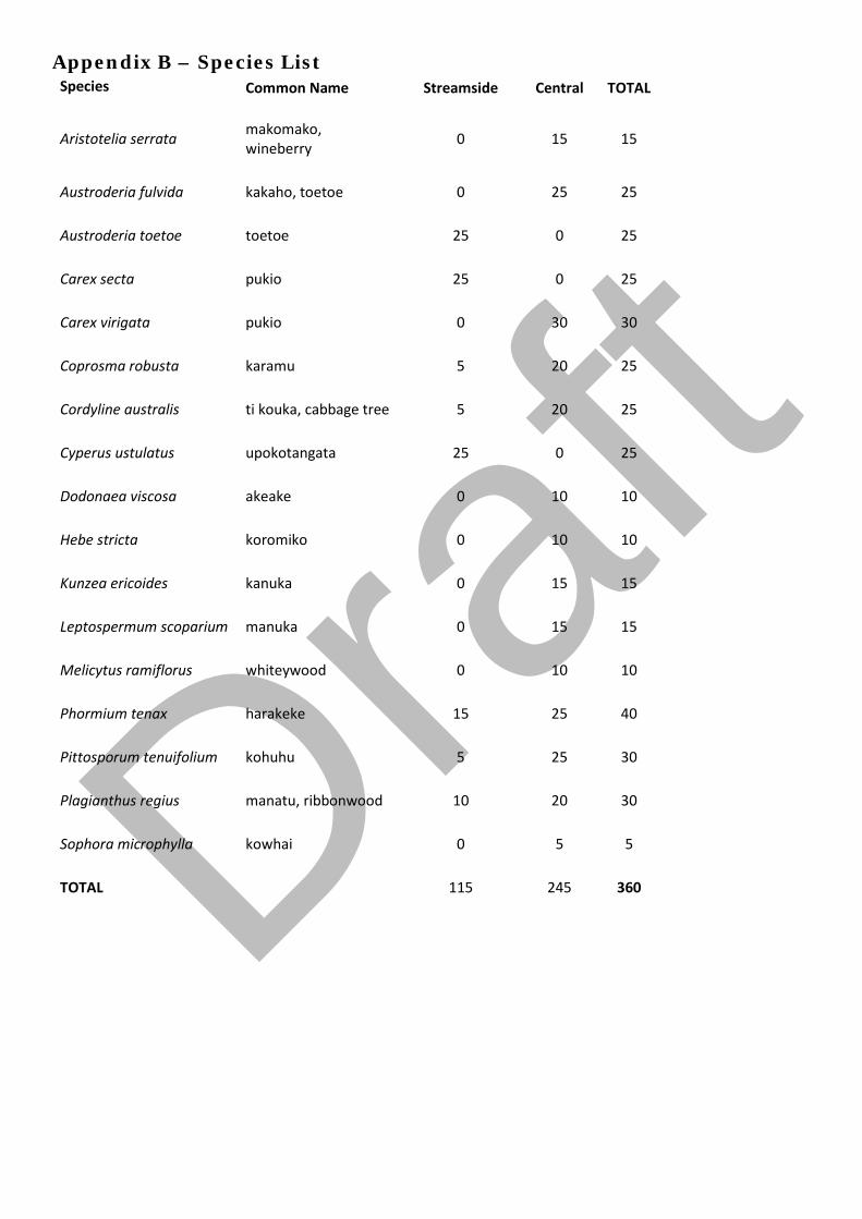
Appendix B – Species List Species Common Name Streamside Central TOTAL
Aristotelia serrata makomako, wineberry 0 15 15
Austroderia fulvida kakaho, toetoe 0 25 25
Austroderia toetoe toetoe 25 0 25
Carex secta pukio 25 0 25
Carex virigata pukio 0 30 30
Coprosma robusta karamu 5 20 25
Cordyline australis ti kouka, cabbage tree 5 20 25
Cyperus ustulatus upokotangata 25 0 25
Dodonaea viscosa akeake 0 10 10
Hebe stricta koromiko 0 10 10
Kunzea ericoides kanuka 0 15 15
Leptospermum scoparium manuka 0 15 15
Melicytus ramiflorus whiteywood 0 10 10
Phormium tenax harakeke 15 25 40
Pittosporum tenuifolium kohuhu 5 25 30
Plagianthus regius manatu, ribbonwood 10 20 30
Sophora microphylla kowhai 0 5 5
TOTAL 115 245 360
Draft

Jewell Stream, Te Horo
Riparian Enhancement Plan Albertus and Sarah de Geest, 193 Pukenamu Road, Te Horo
Draft

© Opus International Consultants Ltd 2017
Prepared By
Opus International Consultants Ltd
Colin Stace Napier Office Senior Rural Consultant Opus House, 6 Ossian Street Private Bag 6019, Napier 4142 New Zealand
Reviewed By Telephone: +64 6 349 6600 Roger MacGibbon Facsimile: +64 6 348 4601 Design Team Leader
Date: April 2017 Reference: 5-c2771.00 Status: Final
Draft

Riparian Enhancement Plan 1
© Opus International Consultants Ltd 2017
Contents
1 Property Details ................................................................................................. 2
2 Purpose of this Plan ........................................................................................... 2
3 Overview ............................................................................................................ 3
4 Fencing Works ................................................................................................... 4
5 Planting Activities .............................................................................................. 4
6 Programme Management ................................................................................... 5
7 Timetable ........................................................................................................... 5
8 Review and Maintenance .................................................................................... 6 Appendix A Plan No. P209 Riparian Enhancement Works, de Geest pty,
193 Pukenamu Rd, Te Horo Appendix B Species List Draf
t
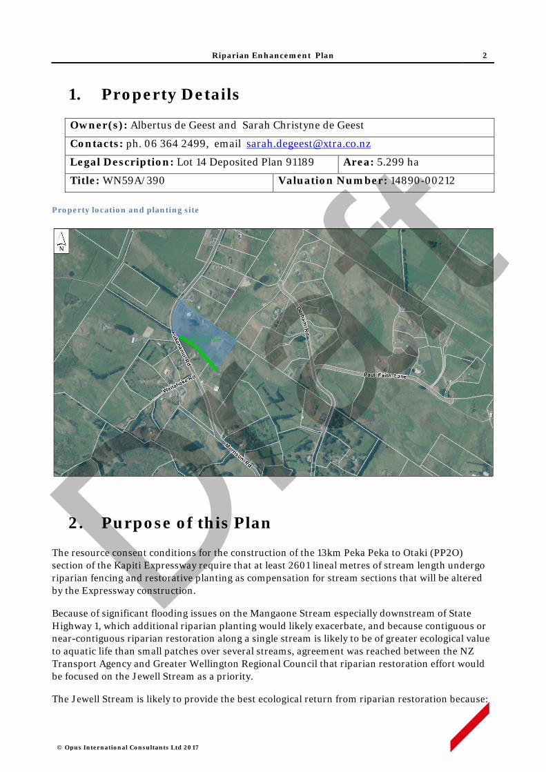
Riparian Enhancement Plan 2
© Opus International Consultants Ltd 2017
1. Property Details
Owner(s): Albertus de Geest and Sarah Christyne de Geest
Contacts: ph. 06 364 2499, email [email protected]
Legal Description: Lot 14 Deposited Plan 91189 Area: 5.299 ha
Title: WN59A/390 Valuation Number: 14890-00212 Property location and planting site
2. Purpose of this Plan
The resource consent conditions for the construction of the 13km Peka Peka to Otaki (PP2O) section of the Kapiti Expressway require that at least 2601 lineal metres of stream length undergo riparian fencing and restorative planting as compensation for stream sections that will be altered by the Expressway construction.
Because of significant flooding issues on the Mangaone Stream especially downstream of State Highway 1, which additional riparian planting would likely exacerbate, and because contiguous or near-contiguous riparian restoration along a single stream is likely to be of greater ecological value to aquatic life than small patches over several streams, agreement was reached between the NZ Transport Agency and Greater Wellington Regional Council that riparian restoration effort would be focused on the Jewell Stream as a priority.
The Jewell Stream is likely to provide the best ecological return from riparian restoration because:
Draft

Riparian Enhancement Plan 3
© Opus International Consultants Ltd 2017
i. Riparian planting along both sides of Jewell Stream is not likely to exacerbate flooding to the same extent as would be the case along the lower Mangaone Stream.
ii. Jewell Stream would appear to carry the largest water volume of the ephemeral streams in the area and it flows permanently for a longer duration during summer.
iii. It flows through the area known as Mary Crest where a remnant wetland area is proposed for significant restoration as part of the Expressway mitigation. The collective ecological value of the wetland and riparian restoration effort will be greater if they are physically linked.
iv. At least one barrier to fish passage exists along the Jewell – a concrete culvert sump structure between SH 1 and the railway line – which, if removed, would open up the entire upper catchment to fish usage.
v. The Jewell Stream joins the Mangaone Stream near its river mouth. The Mangaone Stream has a natural, passable river mouth and is known to be inhabited by native fish species. Enhancement of the Jewell Stream will significantly increase the available habitat for native fish species.
vi. A considerable length (greater than 5km) of the Jewell would benefit from riparian fencing and planting.
The objective is to generate 2601 stream length metres of riparian retirement with 5 metres (or more) between the stream channel and fence on each side of the stream, planted with native vegetation suitable to provide shade to the stream channel and create improved habitat for aquatic life.
Landowners along Jewell Stream have been approached to see if they were prepared to offer their stream margins for fencing off and planting. The NZ Transport Agency has offered to pay for the fencing, planting and 5 years of maintenance in return for a covenant which will be placed on each restored area to ensure the plants and fence remain intact into the future. Property owners who have indicated an interest in offering their stream margins for restoration have each had a riparian enhancement plan produced for their consideration.
This Riparian Enhancement Plan provides the fencing details (fence route and design), plant prescription (species, grades), site preparation (removal of weed species and methods to be used), and a five year post-planting maintenance programme for the property of Albertus and Sarah de Geest at 193 Pukenamu Road, Te Horo.
Draft
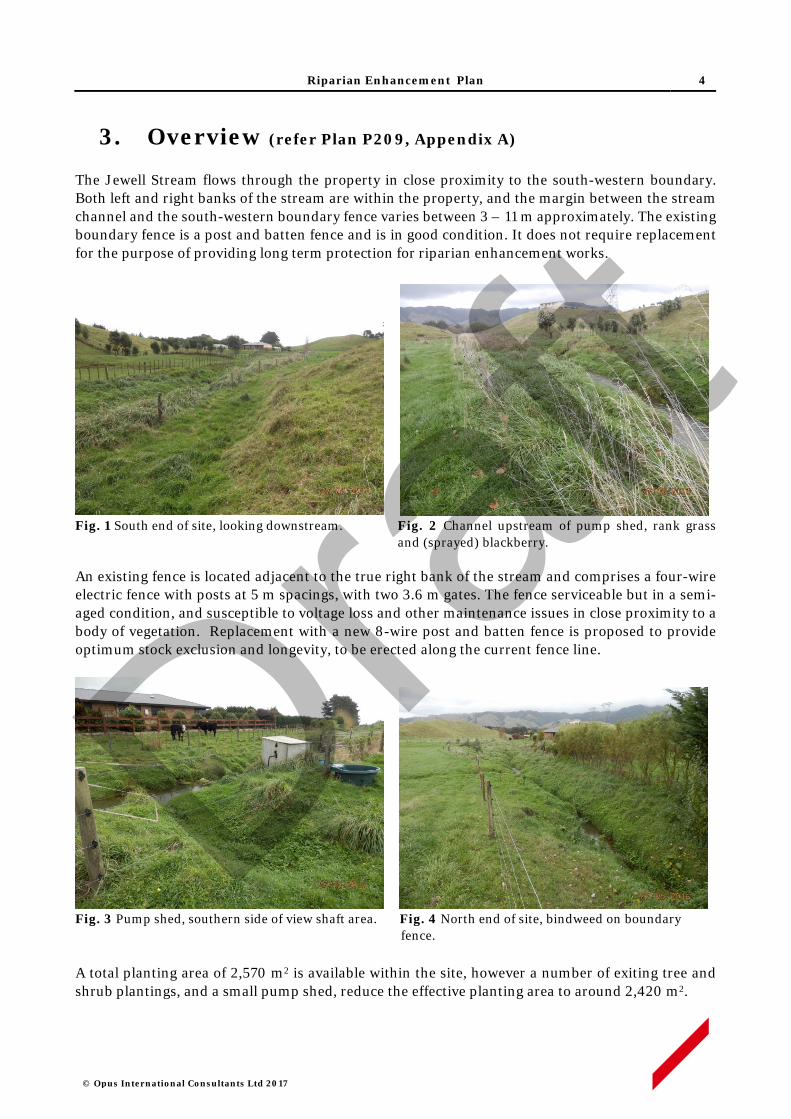
Riparian Enhancement Plan 4
© Opus International Consultants Ltd 2017
3. Overview (refer Plan P209, Appendix A)
The Jewell Stream flows through the property in close proximity to the south-western boundary. Both left and right banks of the stream are within the property, and the margin between the stream channel and the south-western boundary fence varies between 3 – 11 m approximately. The existing boundary fence is a post and batten fence and is in good condition. It does not require replacement for the purpose of providing long term protection for riparian enhancement works.
Fig. 1 South end of site, looking downstream. Fig. 2 Channel upstream of pump shed, rank grass and (sprayed) blackberry. An existing fence is located adjacent to the true right bank of the stream and comprises a four-wire electric fence with posts at 5 m spacings, with two 3.6 m gates. The fence serviceable but in a semi-aged condition, and susceptible to voltage loss and other maintenance issues in close proximity to a body of vegetation. Replacement with a new 8-wire post and batten fence is proposed to provide optimum stock exclusion and longevity, to be erected along the current fence line.
Fig. 3 Pump shed, southern side of view shaft area. Fig. 4 North end of site, bindweed on boundary
fence.
A total planting area of 2,570 m2 is available within the site, however a number of exiting tree and shrub plantings, and a small pump shed, reduce the effective planting area to around 2,420 m2.
Draft
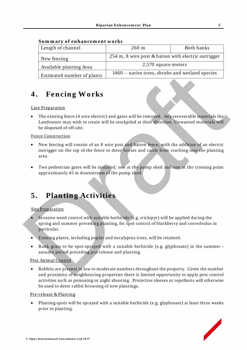
Riparian Enhancement Plan 5
© Opus International Consultants Ltd 2017
Summary of enhancement works Length of channel 260 m Both banks
New fencing 254 m, 8 wire post & batten with electric outrigger
Available planting Area 2,570 square meters
Estimated number of plants 1460 – native trees, shrubs and wetland species
4. Fencing Works
Line Preparation
• The existing fence (4 wire electric) and gates will be removed. Any recoverable materials the Landowner may wish to retain will be stockpiled at their direction. Unwanted materials will be disposed of off-site.
Fence Construction
• New fencing will consist of an 8 wire post and batten fence, with the addition of an electric outrigger on the top of the fence to deter horses and cattle from reaching into the planting area.
• Two pedestrian gates will be installed; one at the pump shed and one at the crossing point approximately 45 m downstream of the pump shed.
5. Planting Activities
Site Preparation
• Invasive weed control with suitable herbicide (e.g. triclopyr) will be applied during the spring and summer preceding planting, for spot control of blackberry and convolvulus in particular.
• Existing plants, including poplar and eucalyptus trees, will be retained.
• Rank grass to be spot-sprayed with a suitable herbicide (e.g. glyphosate) in the summer - autumn period preceding pre-release and planting.
Pest Animal Control
• Rabbits are present in low to moderate numbers throughout the property. Given the number and proximity of neighbouring properties there is limited opportunity to apply pest control activities such as poisoning or night shooting. Protective sleeves or repellents will otherwise be used to deter rabbit browsing of new plantings.
Pre-release & Planting
• Planting spots will be sprayed with a suitable herbicide (e.g. glyphosate) at least three weeks prior to planting.
Draft

Riparian Enhancement Plan 6
© Opus International Consultants Ltd 2017
• Plant spacing will generally be no greater than 1.5 x 1.5 m for most species, while some wetland genera such as Carex and Cyperus will be at closer spacings.
• All plants will be 1 L potted stock, or similar grade, and will be planted in holes slightly larger than the root ball, with any spiralled roots removed. All plant pots or other packaging will be removed off site.
• A planting list of species is set out in Appendix B. Plant stock will be sought as eco-sourced material from within the Foxton Ecological District- 31.02.1
• Layout will generally follow the siting indicated in the list, and a view shaft area of low canopy species will the set out opposite the neighbouring residence. This area will extend from a point adjacent the neighbour’s water tanks, downstream to the crossing point pedestrian gate (refer Plan 209, Appendix A).
Plant Maintenance
• Each plant will be released (control of competing vegetation within an 800-1000mm radius) in the spring and mid-summer, for up to five years.
• Weed control will use carefully directed or shielded low-pressure spray of a suitable herbicide. Operators will hold current GROWSAFE certification, and will use approved methods and equipment to prevent spray drift when applying herbicide.
• Any resurgent or invasive weeds will also be controlled concurrently.
• The site will be monitored for resurgent or invasive weeds during the five year establishment period, and weed control will be applied annually as required.
6. Programme Management
• All works will be performed by suitably qualified and experienced operators contracted to Opus (on behalf of the NZ Transport Agency) and supervised by experienced Opus staff. Property work areas, including access routes, will be determined in advance of site activity, in consultation with the Landowner.
• The Contractor will give adequate notice of timing for entry to the property, and will comply with Landowner requirements in regard to factors such as stock management, vehicle access and Health and Safety obligations.
• Opus staff will maintain contact with Contractors on a regular basis, including periodic site inspections as works progress.
• Any Landowner concerns that may arise about progress of works or Contractor activity should be communicated to the designated Opus Project Manager at the earliest opportunity. If necessary, a hold-point on works can be applied until matters of concern are resolved.
1 Ecological Regions and Districts of New Zealand (1987) NZ Dept. of Conservation
Draft
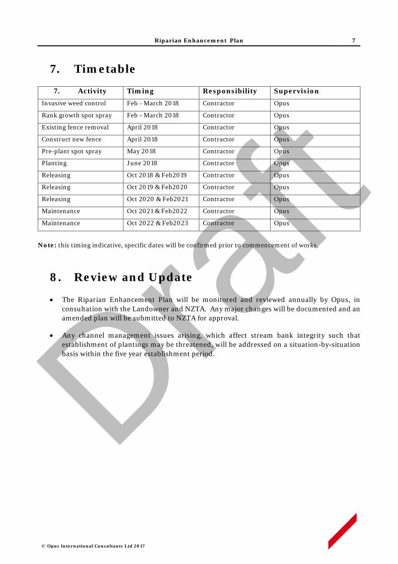
Riparian Enhancement Plan 7
© Opus International Consultants Ltd 2017
7. Timetable
7. Activity Timing Responsibility Supervision
Invasive weed control Feb - March 2018 Contractor Opus
Rank growth spot spray Feb - March 2018 Contractor Opus
Existing fence removal April 2018 Contractor Opus
Construct new fence April 2018 Contractor Opus
Pre-plant spot spray May 2018 Contractor Opus
Planting June 2018 Contractor Opus
Releasing Oct 2018 & Feb2019 Contractor Opus
Releasing Oct 2019 & Feb2020 Contractor Opus
Releasing Oct 2020 & Feb2021 Contractor Opus
Maintenance Oct 2021 & Feb2022 Contractor Opus
Maintenance Oct 2022 & Feb2023 Contractor Opus
Note: this timing indicative, specific dates will be confirmed prior to commencement of works.
8. Review and Update
• The Riparian Enhancement Plan will be monitored and reviewed annually by Opus, in consultation with the Landowner and NZTA. Any major changes will be documented and an amended plan will be submitted to NZTA for approval.
• Any channel management issues arising, which affect stream bank integrity such that establishment of plantings may be threatened, will be addressed on a situation-by-situation basis within the five year establishment period.
Draft

Riparian Enhancement Plan
© Opus International Consultants Ltd 2017
APPENDIX A
Draft

NEW FENCE
LOT 14
DP 91189
Gate
Gate
LOT 2
DP 91189
P
U
K
E
N
A
M
U
R
O
A
D
LOT 4
DP 91189
LOT 1
DP 91189
/
/
/
/
/
/
/
/
/
/
/
/
/
NEW AREA OF PLANTING
(NORTH)
NEW AREA OF PLANTING
(SOUTH)
NEW AREA OF PLANTING
(VIEW SHAFT AREA)
2010
0mm
100m
m
Original Sheet Size A4 [210x297]
50
Plot Date 2017-04-12 at 1:20:24 p.m. Path P:\projects\5-C2771.00 PP2O Specimen Design\500 Technical\501 Drawings\03 CAD\01_DWGS\Property\Riparian Planting\Drawings\5-C2771.00_P201-212.dwg P209
Scales Project No. Sheet. No.
Project
Sheet
RevisionDrawn
Approved Approved Date
Wellington Office PO Box 12-003Wellington 6144New Zealand
+64 4 471 7000
NEW ZEALAND TRANSPORT AGENCYS.H.1 REGION 9 R.P. 995/2.738 - 15.423PEKA PEKA TO OTAKI (PP2O) EXPRESSWAY - SPECIMEN DESIGN
RIPARIAN PLANTING - PROPERTY 9DE GEEST , 193 PUKENAMU ROAD, TE HORO
FOR CONSTRUCTION
5-C2771.00 P209 2
R. MACGIBBON R.McFADYEN 03/02/2017
B.CRAIG 1:1250
DesignedApproved DateRevision Amendment 1 ISSUED FOR CONSTRUCTION R.M. 3/02/2017
2 CHANNEL LENGTH ADDED R.M. 11/04/2017
0
m
20 4010 30 50
1:1250
@ A4
N
AREA TO BE PLANTED
(2540m2)
AREA TO BE PROTECTED
(2540m2)
CHANNEL LENGTH
(260m)
Draft

Riparian Enhancement Plan
© Opus International Consultants Ltd 2017
APPENDIX B
Draft
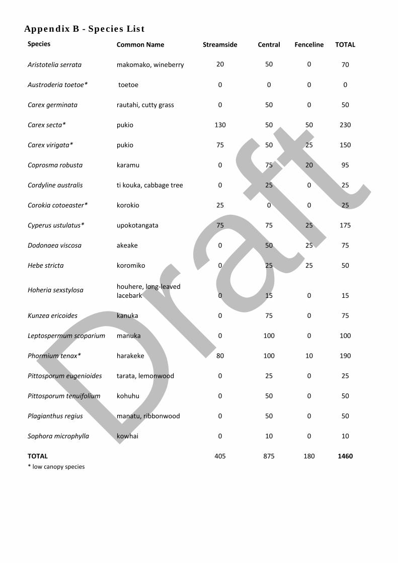
Appendix B - Species List
Species Common Name Streamside Central Fenceline TOTAL
Aristotelia serrata makomako, wineberry 20 50 0 70
Austroderia toetoe* toetoe 0 0 0 0
Carex germinata rautahi, cutty grass 0 50 0 50
Carex secta* pukio 130 50 50 230
Carex virigata* pukio 75 50 25 150
Coprosma robusta karamu 0 75 20 95
Cordyline australis ti kouka, cabbage tree 0 25 0 25
Corokia cotoeaster* korokio 25 0 0 25
Cyperus ustulatus* upokotangata 75 75 25 175
Dodonaea viscosa akeake 0 50 25 75
Hebe stricta koromiko 0 25 25 50
Hoheria sexstylosa houhere, long-leaved lacebark 0 15 0 15
Kunzea ericoides kanuka 0 75 0 75
Leptospermum scoparium manuka 0 100 0 100
Phormium tenax* harakeke 80 100 10 190
Pittosporum eugenioides tarata, lemonwood 0 25 0 25
Pittosporum tenuifolium kohuhu 0 50 0 50
Plagianthus regius manatu, ribbonwood 0 50 0 50
Sophora microphylla kowhai 0 10 0 10
TOTAL 405 875 180 1460 * low canopy species
Draft

Jewell Stream, Te Horo
Riparian Enhancement Plan John Kiernan, 29 Puruaha Road, Te Horo
Draft

© Opus International Consultants Ltd 2017
Prepared By
Opus International Consultants Ltd
Colin Stace Napier Office Senior Rural Consultant Opus House, 6 Ossian Street Private Bag 6019, Napier 4142 New Zealand
Reviewed By Telephone: +64 6 349 6600 Roger MacGibbon Facsimile: +64 6 348 4601 Design Team Leader
Date: April 2017 Reference: 5-c2771.oo Status: Final
Draft

Riparian Enhancement Plan 1
© Opus International Consultants Ltd 2017
Contents
1 Property Details ................................................................................................. 2
2 Purpose of this Plan ........................................................................................... 2
3 Overview ............................................................................................................ 3
4 Fencing Works ................................................................................................... 4
5 Planting Activities .............................................................................................. 4
6 Programme Management ................................................................................... 5
7 Timetable ........................................................................................................... 5
8 Review and Maintenance .................................................................................... 6 Appendix A Plan No. P211 Riparian Enhancement Works, Kiernan pty,
29 Puruaha Rd, Te Horo Appendix B Species List Draf
t
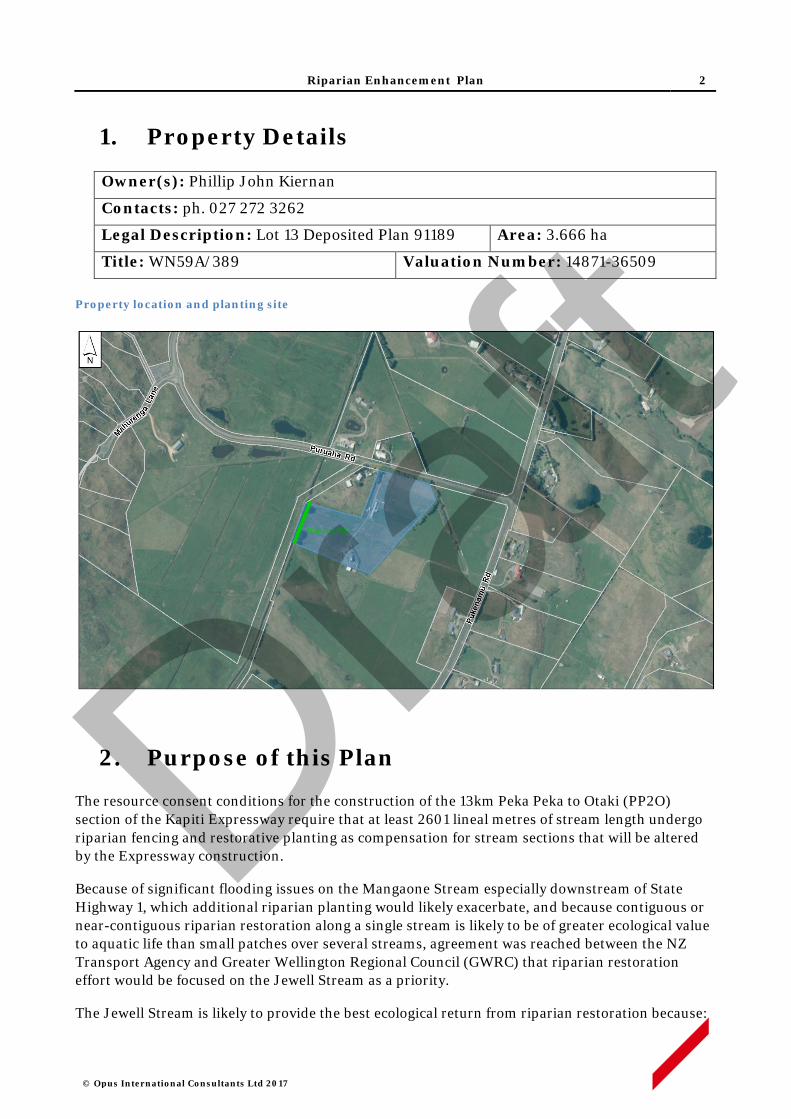
Riparian Enhancement Plan 2
© Opus International Consultants Ltd 2017
1. Property Details
Owner(s): Phillip John Kiernan
Contacts: ph. 027 272 3262
Legal Description: Lot 13 Deposited Plan 91189 Area: 3.666 ha
Title: WN59A/389 Valuation Number: 14871-36509 Property location and planting site
2. Purpose of this Plan
The resource consent conditions for the construction of the 13km Peka Peka to Otaki (PP2O) section of the Kapiti Expressway require that at least 2601 lineal metres of stream length undergo riparian fencing and restorative planting as compensation for stream sections that will be altered by the Expressway construction.
Because of significant flooding issues on the Mangaone Stream especially downstream of State Highway 1, which additional riparian planting would likely exacerbate, and because contiguous or near-contiguous riparian restoration along a single stream is likely to be of greater ecological value to aquatic life than small patches over several streams, agreement was reached between the NZ Transport Agency and Greater Wellington Regional Council (GWRC) that riparian restoration effort would be focused on the Jewell Stream as a priority.
The Jewell Stream is likely to provide the best ecological return from riparian restoration because:
Draft

Riparian Enhancement Plan 3
© Opus International Consultants Ltd 2017
i. Riparian planting along both sides of Jewell Stream is not likely to exacerbate flooding to the same extent as would be the case along the lower Mangaone Stream.
ii. Jewell Stream would appear to carry the largest water volume of the ephemeral streams in the area and it flows permanently for a longer duration during summer.
iii. It flows through the area known as Mary Crest where a remnant wetland area is proposed for significant restoration as part of the Expressway mitigation. The collective ecological value of the wetland and riparian restoration effort will be greater if they are physically linked.
iv. At least one barrier to fish passage exists along the Jewell – a concrete culvert sump structure between SH 1 and the railway line – which, if removed, would open up the entire upper catchment to fish usage.
v. The Jewell Stream joins the Mangaone Stream near its river mouth. The Mangaone Stream has a natural, passable river mouth and is known to be inhabited by native fish species. Enhancement of the Jewell Stream will significantly increase the available habitat for native fish species.
vi. A considerable length (greater than 5km) of the Jewell Stream would benefit from riparian fencing and planting.
The objective is to generate 2601 stream length metres of riparian retirement with 5 metres (or more) between the stream channel and fence on each side of the stream, planted with native vegetation suitable to provide shade to the stream channel and create improved habitat for aquatic life.
Landowners along Jewell Stream have been approached to see if they were prepared to offer their stream margins for fencing off and planting. The NZ Transport Agency has offered to pay for the fencing, planting and 5 years of maintenance in return for a covenant which will be placed on each restored area to ensure the plants and fence remain intact into the future. Property owners who have indicated an interest in offering their stream margins for restoration have each had a riparian enhancement plan produced for their consideration.
This Riparian Enhancement Plan provides the fencing details (fence route and design), plant prescription (species, grades), site preparation (removal of weed species and methods to be used), and a five year post-planting maintenance programme for the property of John Kiernan at 29 Puruaha Road, Te Horo.
Draft
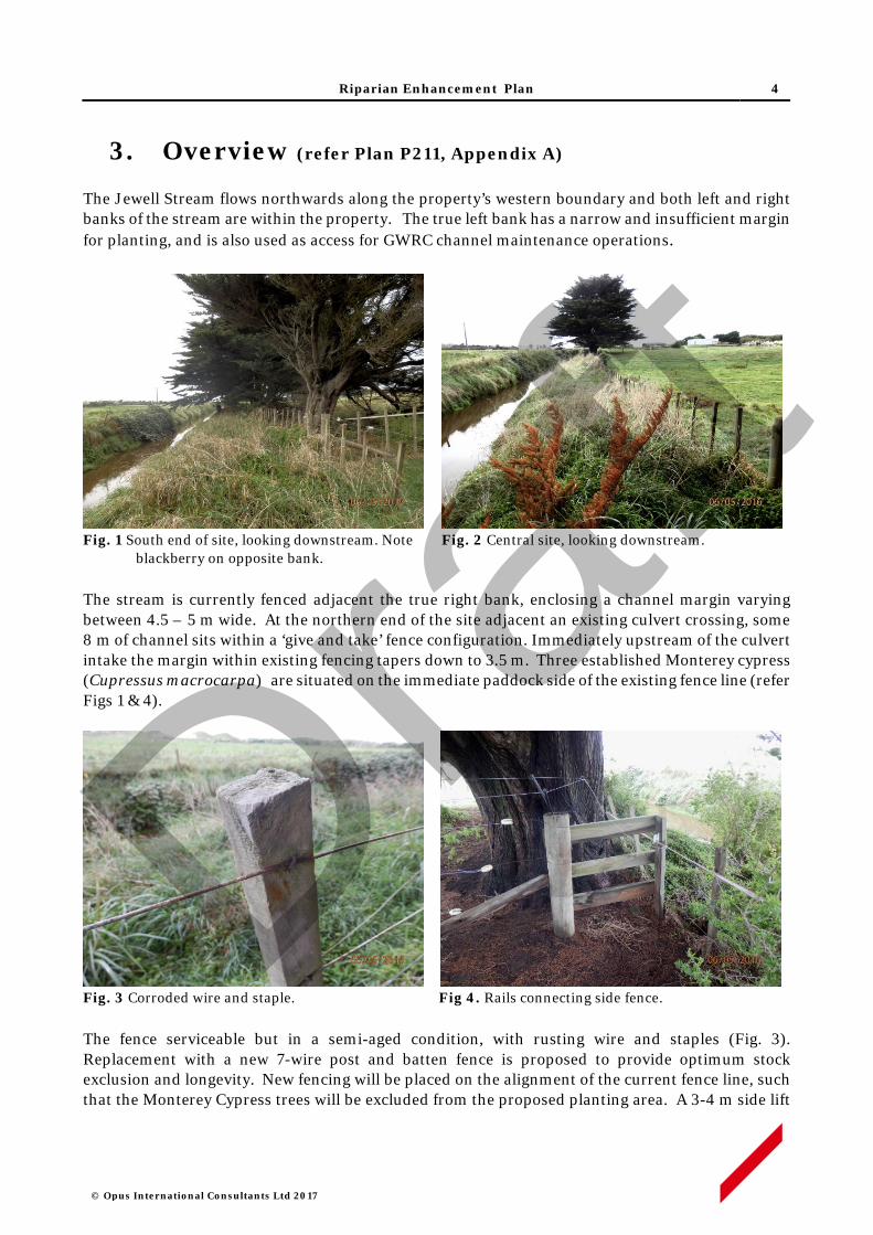
Riparian Enhancement Plan 4
© Opus International Consultants Ltd 2017
3. Overview (refer Plan P211, Appendix A)
The Jewell Stream flows northwards along the property’s western boundary and both left and right banks of the stream are within the property. The true left bank has a narrow and insufficient margin for planting, and is also used as access for GWRC channel maintenance operations.
Fig. 1 South end of site, looking downstream. Note Fig. 2 Central site, looking downstream.
blackberry on opposite bank. The stream is currently fenced adjacent the true right bank, enclosing a channel margin varying between 4.5 – 5 m wide. At the northern end of the site adjacent an existing culvert crossing, some 8 m of channel sits within a ‘give and take’ fence configuration. Immediately upstream of the culvert intake the margin within existing fencing tapers down to 3.5 m. Three established Monterey cypress (Cupressus macrocarpa) are situated on the immediate paddock side of the existing fence line (refer Figs 1 & 4).
Fig. 3 Corroded wire and staple. Fig 4. Rails connecting side fence.
The fence serviceable but in a semi-aged condition, with rusting wire and staples (Fig. 3). Replacement with a new 7-wire post and batten fence is proposed to provide optimum stock exclusion and longevity. New fencing will be placed on the alignment of the current fence line, such that the Monterey Cypress trees will be excluded from the proposed planting area. A 3-4 m side lift
Draft

Riparian Enhancement Plan 5
© Opus International Consultants Ltd 2017
pruning of the cypress trees will be included in site preparation to limit shading of proposed native plantings. The fenced area will connect with the ‘give & take’ fence line on the northern boundary.
Summary of enhancement works Length of channel 104 m True right bank
New fencing 100 m, 7 wire post & batten with electric outrigger
Available planting Area 380 square meters
Estimated number of plants 230 – native trees, shrubs and wetland species
4. Fencing Works
Line Preparation
• The existing fence will be removed. Any recoverable materials the Landowner may wish to retain, such as posts, will be stockpiled at their direction. Unwanted materials will be disposed of off-site.
Fence Construction
• New fencing will consist of a 7 wire post and batten fence, with the addition of an electric outrigger on the top of the fence to deter horses and cattle from reaching into the planting area.
• Hot-dipped staples will be used to provide extra galvanising for coastal conditions.
• Where appropriate, existing structures, such as a set of rails, will be repaired or upgraded as required.
5. Planting Activities
Site Preparation
• Invasive weed control with suitable herbicide (e.g. triclopyr) will be applied during the spring and summer preceding planting, to control brushweeds and bindweeds in particular.
• Adjacent cypress trees will be side pruned.
• Rank grass to be spot-sprayed with a suitable herbicide (e.g. glyphosate) in the summer - autumn period preceding pre-release and planting works.
Pest Animal Control
• Rabbits are present in low to moderate numbers throughout the property. Given the number and proximity of neighbouring properties there is limited opportunity to apply pest control activities such as poisoning or night shooting. Protective sleeves or repellents will otherwise be used to deter rabbit browsing of new plantings.
Pre-release & Planting
Draft

Riparian Enhancement Plan 6
© Opus International Consultants Ltd 2017
• Planting spots will be sprayed with a suitable herbicide (e.g. glyphosate) at least three weeks prior to planting.
• Plant spacing will generally be no greater than 1.5 x 1.5 m for most species, while some wetland genera such as Carex and Cyperus will be at closer spacings.
• All plants will be 1 L potted stock, or similar grade, and will be planted in holes slightly larger than the root ball, with any spiralled roots removed. All plant pots or other packaging will be removed off site.
• A planting list of species is set out in Appendix B. Plant stock will be sought as eco-sourced material from within the Foxton Ecological District- 31.02.1
Plant Maintenance
• Each plant will be released (control of competing vegetation within an 800-1000mm radius) in the spring and mid-summer, for up to five years.
• Weed control will use carefully directed or shielded low-pressure spray of a suitable herbicide. Operators will hold current GROWSAFE certification, and will use approved methods and equipment to prevent spray drift when applying herbicide.
• Any resurgent or invasive weeds will also be controlled concurrently.
• The site will be monitored for resurgent or invasive weeds during the five year establishment period, and weed control will be applied annually as required.
6. Programme Management
• All works will be performed by suitably qualified and experienced operators contracted to Opus (on behalf of the NZ Transport Agency) and supervised by experienced Opus staff. Property work areas, including access routes, will be determined in advance of site activity, in consultation with the Landowner.
• The Contractor will give adequate notice of timing for entry to the property, and will comply with Landowner requirements in regard to factors such as stock management, vehicle access and Health and Safety obligations.
• Opus staff will maintain contact with Contractors on a regular basis, including periodic site inspections as works progress.
• Any Landowner concerns that may arise about progress of works or Contractor activity should be communicated to the designated Opus Project Manager at the earliest opportunity. If necessary, a hold-point on works can be applied until matters of concern are resolved.
7. Timetable
7. Activity Timing Responsibility Supervision
Invasive weed control Feb - March 2018 Contractor Opus
Rank growth spot spray Feb - March 2018 Contractor Opus
1 Ecological Regions and Districts of New Zealand (1987) NZ Dept. of Conservation
Draft
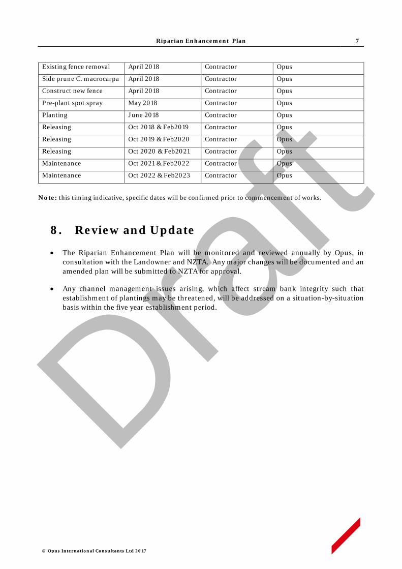
Riparian Enhancement Plan 7
© Opus International Consultants Ltd 2017
Existing fence removal April 2018 Contractor Opus
Side prune C. macrocarpa April 2018 Contractor Opus
Construct new fence April 2018 Contractor Opus
Pre-plant spot spray May 2018 Contractor Opus
Planting June 2018 Contractor Opus
Releasing Oct 2018 & Feb2019 Contractor Opus
Releasing Oct 2019 & Feb2020 Contractor Opus
Releasing Oct 2020 & Feb2021 Contractor Opus
Maintenance Oct 2021 & Feb2022 Contractor Opus
Maintenance Oct 2022 & Feb2023 Contractor Opus
Note: this timing indicative, specific dates will be confirmed prior to commencement of works.
8. Review and Update
• The Riparian Enhancement Plan will be monitored and reviewed annually by Opus, in consultation with the Landowner and NZTA. Any major changes will be documented and an amended plan will be submitted to NZTA for approval.
• Any channel management issues arising, which affect stream bank integrity such that establishment of plantings may be threatened, will be addressed on a situation-by-situation basis within the five year establishment period.
Draft

Riparian Enhancement Plan
© Opus International Consultants Ltd 2017
APPENDIX A
Draft
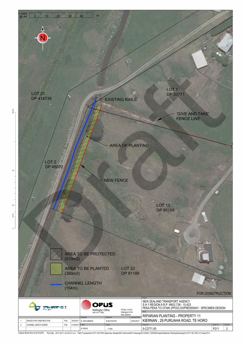
NEW FENCE
LOT 13
DP 91189
AREA OF PLANTING
LOT 1
DP 33771
LOT 2
DP 45072
LOT 21
DP 414735
LOT 22
DP 91189
EXISTING RAILS
'GIVE AND TAKE'
FENCE LINE
/
/
/
/
/
/
/
/
/
2010
0mm
100m
m
Original Sheet Size A4 [210x297]
50
Plot Date 2017-04-11 at 9:43:21 a.m. Path P:\projects\5-C2771.00 PP2O Specimen Design\500 Technical\501 Drawings\03 CAD\01_DWGS\Property\Riparian Planting\Drawings\5-C2771.00_P201-212.dwg P211
Scales Project No. Sheet. No.
Project
Sheet
RevisionDrawn
Approved Approved Date
Wellington Office PO Box 12-003Wellington 6144New Zealand
+64 4 471 7000
NEW ZEALAND TRANSPORT AGENCYS.H.1 REGION 9 R.P. 995/2.738 - 15.423PEKA PEKA TO OTAKI (PP2O) EXPRESSWAY - SPECIMEN DESIGN
RIPARIAN PLANTING - PROPERTY 11KIERNAN , 29 PURUAHA ROAD, TE HORO
FOR CONSTRUCTION
5-C2771.00 P211 2
R. MACGIBBON R.McFADYEN 03/02/2017
B.CRAIG 1:1000
DesignedApproved DateRevision Amendment 1 ISSUED FOR CONSTRUCTION R.M. 3/02/2017
2 CHANNEL LENGTH ADDED R.M. 11/04/2017
1:1000
0 10 20 30 40
m
@ A4
N
AREA TO BE PLANTED
(380m2)
AREA TO BE PROTECTED
(510m2)
CHANNEL LENGTH
(104m)
Draft

Riparian Enhancement Plan
© Opus International Consultants Ltd 2017
APPENDIX B
Draft

Appendix B – Species List
Species Common Name Streamside Central Fenceline TOTAL
Austroderia fulvida toetoe 15 10 15 40
Coprosma repens taupata 15 15 5 35
Corynocarpus lavigatus karaka 0 10 0 10
Cyperus ustulatus upokotangata 20 0 0 20
Dodonaea viscosa akeake 0 10 10 20
Hebe stricta koromiko 0 10 10 20
Leptospermum scoparium manuka 15 10 10 35
Myoporum laetum ngaio 0 10 0 10
Oleria paniculata akiraho 0 10 0 10
Olearia solandri coastal shrub daisy 0 0 15 15
Phormium tenax harakeke 0 15 0 15
Total 65 100 65 230 Draf
t
Jewell Stream, Te Horo
Riparian Enhancement Plan John Lansbury & Sacha Kenny, 103 Derham Road, Te Horo
Draft

© Opus International Consultants Ltd 2017
Prepared By
Opus International Consultants Ltd
Colin Stace Napier Office Senior Rural Consultant Opus House, 6 Ossian Street Private Bag 6019, Napier 4142 New Zealand
Reviewed By Telephone: +64 6 349 6600 Roger MacGibbon Facsimile: +64 6 348 4601 Design Team Leader
Date: April 2017 Reference: 5-c2771.00 Status: Final
Draft

Riparian Enhancement Plan 1
© Opus International Consultants Ltd 2017
Contents
1 Property Details ................................................................................................. 2
2 Purpose of this Plan ........................................................................................... 2
3 Overview ............................................................................................................ 3
4 Fencing Works ................................................................................................... 4
5 Planting Activities .............................................................................................. 4
6 Programme Management ................................................................................... 5
7 Timetable ........................................................................................................... 5
8 Review and Maintenance .................................................................................... 6 Appendix A Plan No. P207 Riparian Enhancement Works, Lansbury
pty, 103 derham Rd, Te Horo Appendix B Species List Draf
t
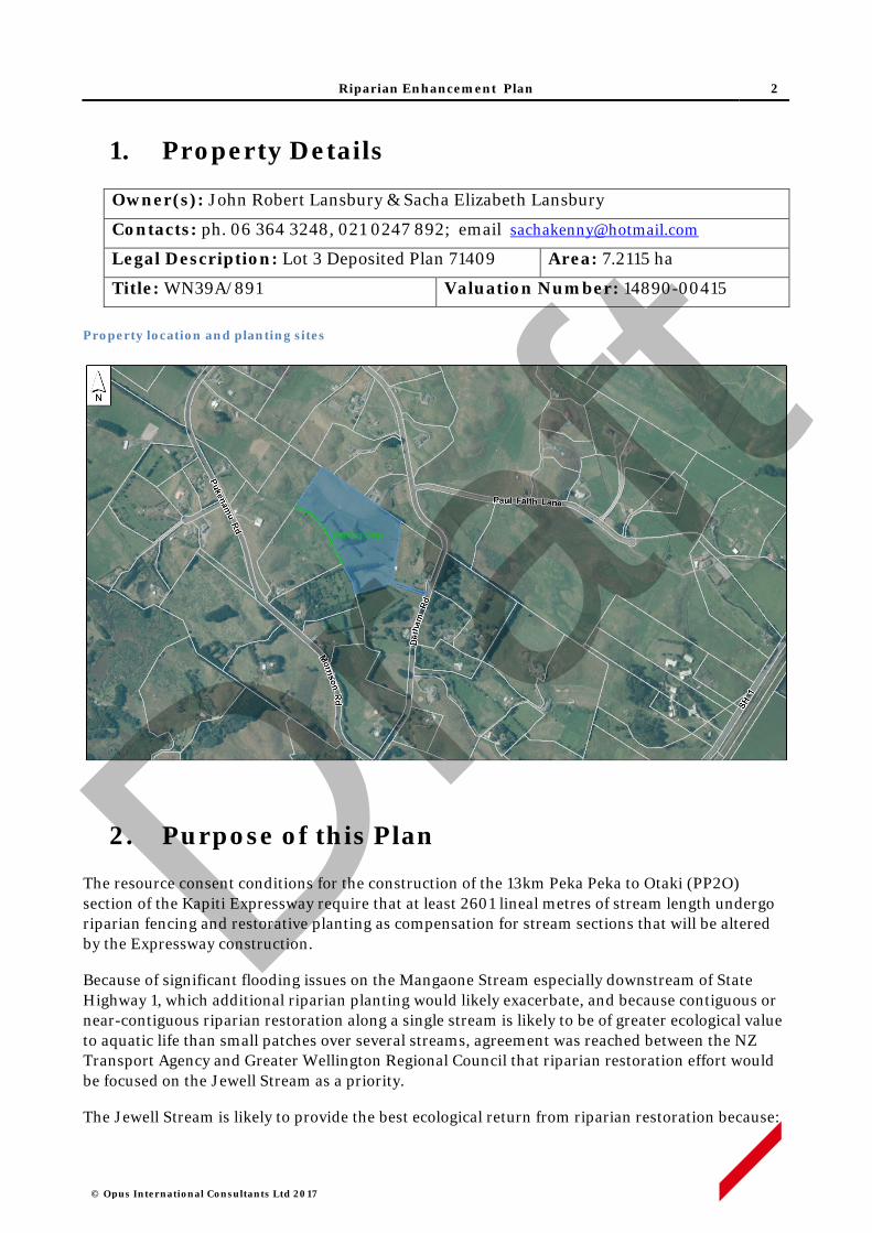
Riparian Enhancement Plan 2
© Opus International Consultants Ltd 2017
1. Property Details
Owner(s): John Robert Lansbury & Sacha Elizabeth Lansbury
Contacts: ph. 06 364 3248, 021 0247 892; email [email protected]
Legal Description: Lot 3 Deposited Plan 71409 Area: 7.2115 ha
Title: WN39A/891 Valuation Number: 14890-00415 Property location and planting sites
2. Purpose of this Plan
The resource consent conditions for the construction of the 13km Peka Peka to Otaki (PP2O) section of the Kapiti Expressway require that at least 2601 lineal metres of stream length undergo riparian fencing and restorative planting as compensation for stream sections that will be altered by the Expressway construction.
Because of significant flooding issues on the Mangaone Stream especially downstream of State Highway 1, which additional riparian planting would likely exacerbate, and because contiguous or near-contiguous riparian restoration along a single stream is likely to be of greater ecological value to aquatic life than small patches over several streams, agreement was reached between the NZ Transport Agency and Greater Wellington Regional Council that riparian restoration effort would be focused on the Jewell Stream as a priority.
The Jewell Stream is likely to provide the best ecological return from riparian restoration because:
Draft

Riparian Enhancement Plan 3
© Opus International Consultants Ltd 2017
i. Riparian planting along both sides of Jewell Stream is not likely to exacerbate flooding to the same extent as would be the case along the lower Mangaone Stream.
ii. Jewell Stream would appear to carry the largest water volume of the ephemeral streams in the area and it flows permanently for a longer duration during summer.
iii. It flows through the area known as Mary Crest where a remnant wetland area is proposed for significant restoration as part of the Expressway mitigation. The collective ecological value of the wetland and riparian restoration effort will be greater if they are physically linked.
iv. At least one barrier to fish passage exists along the Jewell – a concrete culvert sump structure between SH 1 and the railway line – which, if removed, would open up the entire upper catchment to fish usage.
v. The Jewell Stream joins the Mangaone Stream near its river mouth. The Mangaone Stream has a natural, passable river mouth and is known to be inhabited by native fish species. Enhancement of the Jewell Stream will significantly increase the available habitat for native fish species.
vi. A considerable length (greater than 5km) of the Jewell would benefit from riparian fencing and planting.
The objective is to generate 2601 stream length metres of riparian retirement with 5 metres (or more) between the stream channel and fence on each side of the stream, planted with native vegetation suitable to provide shade to the stream channel and create improved habitat for aquatic life.
Landowners along Jewell Stream have been approached to see if they were prepared to offer their stream margins for fencing off and planting. The NZ Transport Agency has offered to pay for the fencing, planting and 5 years of maintenance in return for a covenant which will be placed on each restored area to ensure the plants and fence remain intact into the future. Property owners who have indicated an interest in offering their stream margins for restoration have each had a riparian enhancement plan produced for their consideration.
This Riparian Enhancement Plan provides the fencing details (fence route and design), plant prescription (species, grades), site preparation (removal of weed species and methods to be used), and a five year post-planting maintenance programme for the property of John Lansbury & Sacha Kenny, 103 Derham Road, Te Horo.
Draft
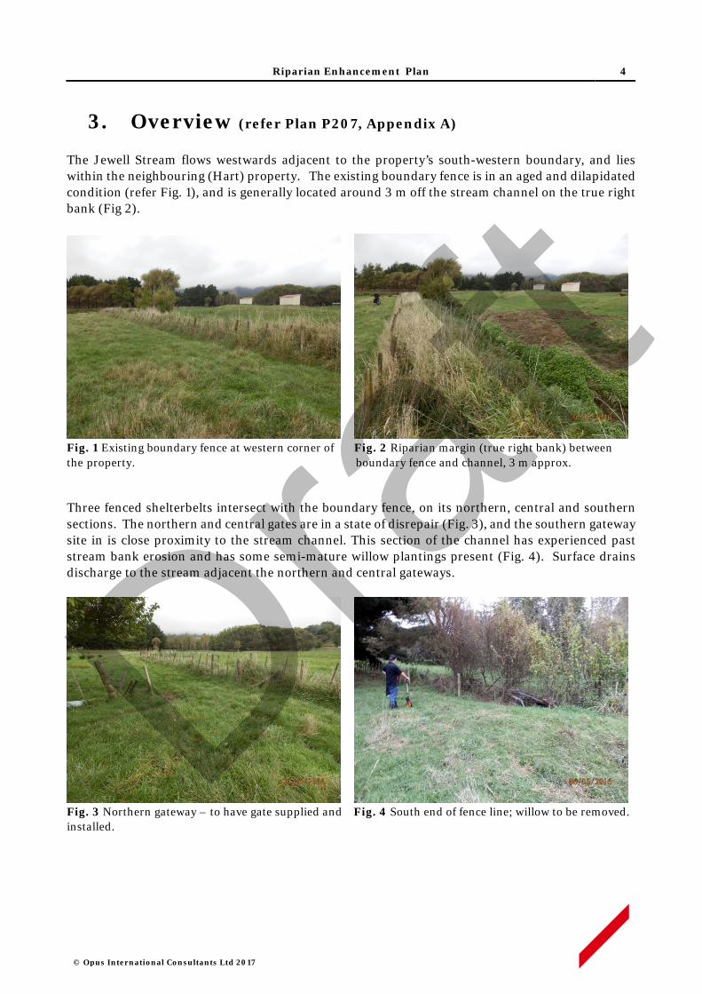
Riparian Enhancement Plan 4
© Opus International Consultants Ltd 2017
3. Overview (refer Plan P207, Appendix A)
The Jewell Stream flows westwards adjacent to the property’s south-western boundary, and lies within the neighbouring (Hart) property. The existing boundary fence is in an aged and dilapidated condition (refer Fig. 1), and is generally located around 3 m off the stream channel on the true right bank (Fig 2).
Fig. 1 Existing boundary fence at western corner of Fig. 2 Riparian margin (true right bank) between the property. boundary fence and channel, 3 m approx.
Three fenced shelterbelts intersect with the boundary fence, on its northern, central and southern sections. The northern and central gates are in a state of disrepair (Fig. 3), and the southern gateway site in is close proximity to the stream channel. This section of the channel has experienced past stream bank erosion and has some semi-mature willow plantings present (Fig. 4). Surface drains discharge to the stream adjacent the northern and central gateways.
Fig. 3 Northern gateway – to have gate supplied and Fig. 4 South end of fence line; willow to be removed. installed.
Draft
Riparian Enhancement Plan 5
© Opus International Consultants Ltd 2017
Replacement with a new 8-wire post and batten fence is proposed to provide optimum stock exclusion and longevity for proposed stream enhancement plantings on the neighbouring property. New fencing will be placed on an alignment approximate 2 m out from the current boundary fence line to provide a minimum planting margin of 5 m on the true right bank of the stream. To accommodate existing gate positions the proposed fence will be inset to the boundary line 8 m either side of gateways. This will avoid additional works that would otherwise be required for shelter tree removal and formation of vehicle access.
Summary of enhancement works Length of channel N/A True right bank
New fencing 277 m, 8 wire post & batten
Available planting Area 445 square meters
Estimated number of plants 210 – native trees, shrubs and wetland species
4. Fencing Works
Line Preparation
• The existing fence will be removed. Any recoverable materials the Landowner may wish to retain, such as posts, will be stockpiled at their direction. Unwanted materials will be disposed of off-site.
• On approximately 90 m of fence line at the western end of the property, spoil from past dredging operations will be bladed to provide a suitable bench for fencing construction,
• Existing troughs will be relocated to the paddock side of the new fence line. Two unused concrete troughs within the proposed fencing area will be removed, to a site of the Landowners choice.
Fence Construction
• New fencing will consist of an 8 wire post and batten fence, with posts spaced at 4m and three battens between posts.
• The fence line will be inset to align with the boundary, 8 m either side of the northern and central gateway, and 8 m to side of the southern gateway (refer Plan P207, Appendix A).
• One new gate will be supplied and mounted at the northern gateway, and one existing gate will be mounted at the central gateway.
• One pedestrian access gate will located in the new fence line.
5. Planting Activities
Site Preparation
• Invasive weed control with suitable herbicide (e.g. triclopyr) will be applied during the spring and summer preceding planting, for spot control blackberry and bindweeds in particular.
Draft

Riparian Enhancement Plan 6
© Opus International Consultants Ltd 2017
• Willow plantings and flood debris adjacent the southern gateway will be removed. Removal method will be motor-manual and stumps will be treated with a suitable herbicide (e.g. glyphosate).
• Rank grass to be spot-sprayed with a suitable herbicide (e.g. glyphosate) in the summer - autumn period preceding pre-release and planting works.
Pest Animal Control
• Rabbits are present in low to moderate numbers throughout the property. Given the number and proximity of neighbouring properties there is limited opportunity to apply pest control activities such as poisoning or night shooting. Protective sleeves or repellents will otherwise be used to deter rabbit browsing of new plantings.
Pre-release & Planting
• Planting spots will be sprayed with a suitable herbicide (e.g. glyphosate) at least three weeks prior to planting.
• Plant spacing will generally be no greater than 1.5 x 1.5 m for most species, while some wetland genera such as Carex and Cyperus will be at closer spacings.
• All plants will be 1 L potted stock, or similar grade, and will be planted in holes slightly larger than the root ball, with any spiralled roots removed. All plant pots or other packaging will be removed off site.
• A planting list of species is set out in Appendix B. Plant stock will be sought as eco-sourced material from within the Foxton Ecological District- 31.02.1
Plant Maintenance
• Each plant will be released (control of competing vegetation within an 800-1000mm radius) in the spring and mid-summer, for up to five years.
• Weed control will use carefully directed or shielded low-pressure spray of a suitable herbicide. Operators will hold current GROWSAFE certification, and will use approved methods and equipment to prevent spray drift when applying herbicide.
• Any resurgent or invasive weeds will also be controlled concurrently.
• The site will be monitored for resurgent or invasive weeds during the five year establishment period, and weed control will be applied annually as required.
6. Programme Management
• All works will be performed by suitably qualified and experienced operators contracted to Opus (on behalf of the NZ Transport Agency) and supervised by experienced Opus staff. Property work areas, including access routes, will be determined in advance of site activity, in consultation with the Landowner.
• The Contractor will give adequate notice of timing for entry to the property, and will comply with Landowner requirements in regard to factors such as stock management, vehicle access and Health and Safety obligations.
1 Ecological Regions and Districts of New Zealand (1987) NZ Dept. of Conservation
Draft
Riparian Enhancement Plan 7
© Opus International Consultants Ltd 2017
• Opus staff will maintain contact with Contractors on a regular basis, including periodic site inspections as works progress.
• Any Landowner concerns that may arise about progress of works or Contractor activity should be communicated to the designated Opus Project Manager at the earliest opportunity. If necessary, a hold-point on works can be applied until matters of concern are resolved.
7. Timetable
7. Activity Timing Responsibility Supervision
Invasive weed control Feb - March 2018 Contractor Opus
Rank growth spot spray Feb - March 2018 Contractor Opus
Willow removal and trough relocations
March 2018 Contractor Opus
Existing fence removal April 2018 Contractor Opus
Construct new fence April 2018 Contractor Opus
Pre-plant spot spray May 2018 Contractor Opus
Planting June 2018 Contractor Opus
Releasing Oct 2018 & Feb2019 Contractor Opus
Releasing Oct 2019 & Feb2020 Contractor Opus
Releasing Oct 2020& Feb2021 Contractor Opus
Maintenance Oct 2021 & Feb2022 Contractor Opus
Maintenance Oct 2022 & Feb2023 Contractor Opus
Note: this timing indicative, specific dates will be confirmed prior to commencement of works.
8. Review and Update
• The Riparian Enhancement Plan will be monitored and reviewed annually by Opus, in consultation with the Landowner and NZTA. Any major changes will be documented and an amended plan will be submitted to NZTA for approval.
• Any channel management issues arising, which affect stream bank integrity such that establishment of plantings may be threatened, will be addressed on a situation-by-situation basis within the five year establishment period. Draf
t

Riparian Enhancement Plan
© Opus International Consultants Ltd 2017
APPENDIX A
Draft
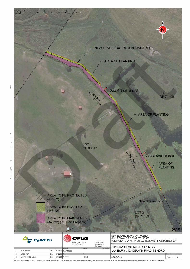
/
/
/
/
/
/
/
/
/
/
/
/
/
/
/
/
/
/
/
/
/
/
NEW FENCE (2m FROM BOUNDARY)
LOT 3
DP 71409
AREA OF PLANTING
Gate & Strainer post
LOT 1
DP 80617
Gate & Strainer post
New Strainer post
8
m
8
m
8
m
8
m
AREA OF PLANTING
AREA OF
PLANTING
LOT 2
DP 71409
2010
0mm
100m
m
Original Sheet Size A4 [210x297]
50
Plot Date 2017-01-26 at 8:46:53 a.m. Path P:\projects\5-C2771.00 PP2O Specimen Design\500 Technical\501 Drawings\03 CAD\01_DWGS\Property\Riparian Planting\Drawings\5-C2771.00_P201-211.dwg P207
Scales Project No. Sheet. No.
Project
Sheet
RevisionDrawn
Approved Approved Date
Wellington Office PO Box 12-003Wellington 6144New Zealand
+64 4 471 7000
NEW ZEALAND TRANSPORT AGENCYS.H.1 REGION 9 R.P. 995/2.738 - 15.423PEKA PEKA TO OTAKI (PP2O) EXPRESSWAY - SPECIMEN DESIGN
RIPARIAN PLANTING - PROPERTY 7LANSBURY , 103 DERHAM ROAD, TE HORO
DRAFT
5-C2771.00 P207 C
R. MACGIBBON
B.CRAIG 1:1250
DesignedApproved DateRevision Amendment A INITIAL DRAFT L.B. 9/08/2016
B AMEND TEXT C.S. 19/12/2016
C ADD AND AMEND AREAS C.S. 26/01/2017
0
m
20 4010 30 50
1:1250
@ A4
N
AREA TO BE PLANTED
(445m2)
AREA TO BE PROTECTED
(445m2)
AREA TO BE MAINTAINED
(840m2) ( pt. Hart Property)
Draft

Riparian Enhancement Plan
© Opus International Consultants Ltd 2017
APPENDIX B
Draft

Appendix B – Species List
Species Common Name Drains Fenceline TOTAL
Austroderia toetoe kakaho, toetoe 0 20 20
Carex secta pukio 5 0 5
Coprosma robusta karamu 0 25 25
Cordyline australis ti kouka, cabbage tree 0 15 15
Cyperus ustulatus upokotangata 5 10 15
Hebe stricta akeake 0 25 25
Kunzea ericoides kanuka 0 15 15
Leptospermum scoparium manuka 0 25 25
Phormium tenax flax 0 25 25
Pittosporum tenuifolium kohuhu 0 20 20
Plagianthus regius manatu, ribbonwood 0 10 10
Sophora microphylla kowhai 0 10 10
Total 10 200 210 Draf
t

Jewell Stream, Te Horo
Riparian Enhancement Plan Tony Whyman, 35 Puraha Road, Te Horo
Draft

© Opus International Consultants Ltd 2017
Prepared By
Opus International Consultants Ltd
Colin Stace Napier Office Senior Rural Consultant Opus House, 6 Ossian Street Private Bag 6019, Napier 4142 New Zealand
Reviewed By Telephone: +64 6 349 6600 Roger MacGibbon Facsimile: +64 6 348 4601 Design Team Leader
Date: April 2017 Reference: 5-c2771.00 Status: Final
Draft

Riparian Enhancement Plan 1
© Opus International Consultants Ltd 2017
Contents
1 Property Details ................................................................................................. 2
2 Purpose of this Plan ........................................................................................... 2
3 Overview ............................................................................................................ 3
4 Fencing Works ................................................................................................... 4
5 Planting Activities .............................................................................................. 4
6 Programme Management ................................................................................... 5
7 Timetable ........................................................................................................... 5
8 Review and Maintenance .................................................................................... 6 Appendix A Plan No. 212 North & Plan No. 212 South, Riparian
Enhancement Works, Whyman pty, 35 Puruaha Rd, Te Horo
Appendix B Species List Draf
t
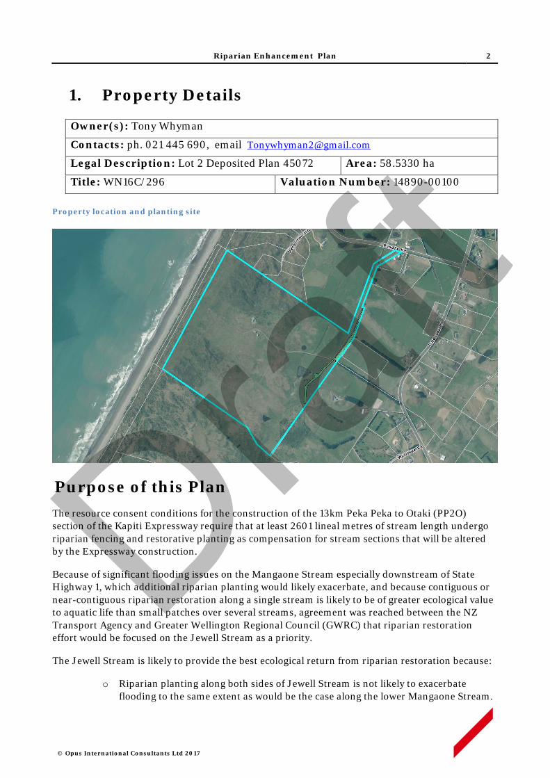
Riparian Enhancement Plan 2
© Opus International Consultants Ltd 2017
1. Property Details
Owner(s): Tony Whyman
Contacts: ph. 021 445 690, email [email protected]
Legal Description: Lot 2 Deposited Plan 45072 Area: 58.5330 ha
Title: WN16C/296 Valuation Number: 14890-00100 Property location and planting site
Purpose of this Plan The resource consent conditions for the construction of the 13km Peka Peka to Otaki (PP2O) section of the Kapiti Expressway require that at least 2601 lineal metres of stream length undergo riparian fencing and restorative planting as compensation for stream sections that will be altered by the Expressway construction.
Because of significant flooding issues on the Mangaone Stream especially downstream of State Highway 1, which additional riparian planting would likely exacerbate, and because contiguous or near-contiguous riparian restoration along a single stream is likely to be of greater ecological value to aquatic life than small patches over several streams, agreement was reached between the NZ Transport Agency and Greater Wellington Regional Council (GWRC) that riparian restoration effort would be focused on the Jewell Stream as a priority.
The Jewell Stream is likely to provide the best ecological return from riparian restoration because:
o Riparian planting along both sides of Jewell Stream is not likely to exacerbate flooding to the same extent as would be the case along the lower Mangaone Stream.
Draft
Riparian Enhancement Plan 3
© Opus International Consultants Ltd 2017
o Jewell Stream would appear to carry the largest water volume of the ephemeral streams in the area and it flows permanently for a longer duration during summer.
o It flows through the area known as Mary Crest where a remnant wetland area is proposed for significant restoration as part of the Expressway mitigation. The collective ecological value of the wetland and riparian restoration effort will be greater if they are physically linked.
o At least one barrier to fish passage exists along the Jewell – a concrete culvert sump structure between SH 1 and the railway line – which, if removed, would open up the entire upper catchment to fish usage.
o The Jewell Stream joins the Mangaone Stream near its river mouth. The Mangaone Stream has a natural, passable river mouth and is known to be inhabited by native fish species. Enhancement of the Jewell Stream will significantly increase the available habitat for native fish species.
o A considerable length (greater than 5km) of the Jewell would benefit from riparian fencing and planting.
The objective is to generate 2601 stream length metres of riparian retirement with 5 metres (or more) between the stream channel and fence on each side of the stream, planted with native vegetation suitable to provide shade to the stream channel and create improved habitat for aquatic life.
Landowners along Jewell Stream have been approached to see if they were prepared to offer their stream margins for fencing off and planting. The NZ Transport Agency has offered to pay for the fencing, planting and 5 years of maintenance in return for a covenant which will be placed on each restored area to ensure the plants and fence remain intact into the future. Property owners who have indicated an interest in offering their stream margins for restoration have each had a riparian enhancement plan produced for their consideration.
This Riparian Enhancement Plan provides the fencing details (fence route and design), plant prescription (species, grades), site preparation (removal of weed species and methods to be used), and a five year post-planting maintenance programme for the property of Tony Whyman at 35 Puruaha Road, Te Horo.
2. Overview (refer Plan 212 North and 212 South, Appendix A)
2.1 Main Channel (North)
The Jewell Stream main channel flows northwards along the property’s eastern boundary, partly within the neighbouring properties adjacent the main access lane (see Fig. 5 below). On the NW margin of the property the boundary line crosses the stream and runs parallel with it on the true right bank. This corner point in the boundary line is marked by an existing strainer (refer Fig. 4). Both left and right banks of the stream are within the property along the southern section of the stream, but the true left bank has a very narrow margin for planting, and is also used as access for GWRC channel maintenance operations. This access extends along the true left bank of the steam, north of the planting site, adjacent to the property access lane (refer Fig. 5 & 6).
Draft
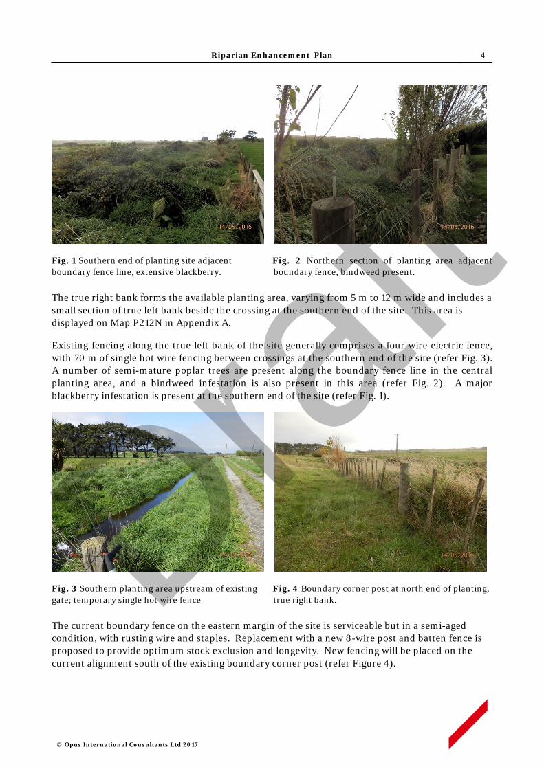
Riparian Enhancement Plan 4
© Opus International Consultants Ltd 2017
Fig. 1 Southern end of planting site adjacent Fig. 2 Northern section of planting area adjacent boundary fence line, extensive blackberry. boundary fence, bindweed present. The true right bank forms the available planting area, varying from 5 m to 12 m wide and includes a small section of true left bank beside the crossing at the southern end of the site. This area is displayed on Map P212N in Appendix A.
Existing fencing along the true left bank of the site generally comprises a four wire electric fence, with 70 m of single hot wire fencing between crossings at the southern end of the site (refer Fig. 3). A number of semi-mature poplar trees are present along the boundary fence line in the central planting area, and a bindweed infestation is also present in this area (refer Fig. 2). A major blackberry infestation is present at the southern end of the site (refer Fig. 1).
Fig. 3 Southern planting area upstream of existing Fig. 4 Boundary corner post at north end of planting, gate; temporary single hot wire fence true right bank.
The current boundary fence on the eastern margin of the site is serviceable but in a semi-aged condition, with rusting wire and staples. Replacement with a new 8-wire post and batten fence is proposed to provide optimum stock exclusion and longevity. New fencing will be placed on the current alignment south of the existing boundary corner post (refer Figure 4).
Draft
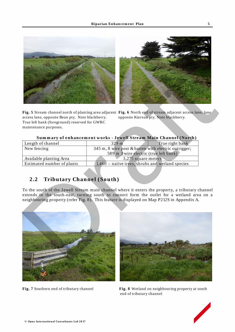
Riparian Enhancement Plan 5
© Opus International Consultants Ltd 2017
Fig. 5 Stream channel north of planting area adjacent Fig. 6 North end of stream adjacent access lane, lane access lane, opposite Bean pty. Note blackberry. opposite Kiernan pty. Note blackberry. True left bank (foreground) reserved for GWRC maintenance purposes.
Summary of enhancement works - Jewell Stream Main Channel (North) Length of channel 329 m True right bank New fencing 345 m, 8 wire post & batten with electric outrigger;
589 m 3 wire electric (true left bank) Available planting Area 3,275 square meters Estimated number of plants 1,460 – native trees, shrubs and wetland species
2.2 Tributary Channel (South) To the south of the Jewell Stream main channel where it enters the property, a tributary channel extends to the south-east, turning south to connect form the outlet for a wetland area on a neighbouring property (refer Fig. 8). This feature is displayed on Map P212S in Appendix A.
Fig. 7 Southern end of tributary channel Fig. 8 Wetland on neighbouring property at south end of tributary channel
Draft

Riparian Enhancement Plan 6
© Opus International Consultants Ltd 2017
The tributary channel is not deeply incised (refer Fig. 7) and has low-lying margins where the water table is close to, or at the surface, in places. The channel connects to an extensive area of wetland, mainly located on a neighbouring property, which is a Schedule A waterbody under the GWRC Proposed Natural Resources Plan 2015 and is identified as the Te Hapua Swamp Complex A.
Summary of enhancement works - Tributary Channel (South) Length of channel 309 m Both banks New fencing 645 m, 8 wire post & batten with electric outrigger; Available planting Area 3,125 square meters Estimated number of plants 2090 – native trees, shrubs and wetland species
3. Fencing Works
Line Preparation
• The existing fences will be removed, along with a 150 m section of defunct of single hot wire fencing on the true right bank of the main channel. Any recoverable materials the landowners may wish to retain, such as posts, will be stockpiled at their direction. Unwanted materials will be disposed of off-site.
Fence Construction
• New fencing will consist of an 8 wire post and batten fence, with the addition of an electric outrigger on the top of the fence to deter cattle from reaching into the planting areas.
• Hot-dipped staples will be used to provide extra galvanising for coastal conditions.
• A short (1 m) set of rails will be installed at the boundary corner post adjacent the main channel, and rails will be installed at the northern and southern ends of the tributary channel fencing.
4. Planting Activities
Site Preparation
• Invasive weed control with suitable herbicide (e.g. triclopyr) will be applied during the spring and summer preceding planting, to control brushweeds and bindweeds in particular.
• Existing poplar plantings and shrub willow at the drain outlet will be retained. Elsewhere, shrub willows growing over the existing fence will be removed by cutting and stumps will be swabbed with glyphosate.
• Rank grass to be spot-sprayed with a suitable herbicide (e.g. glyphosate) in the summer - autumn period preceding planting works.
Pest Animal Control
• Rabbits are present in low to moderate numbers throughout the property. Given the number and proximity of neighbouring properties there is limited opportunity to apply pest
Draft

Riparian Enhancement Plan 7
© Opus International Consultants Ltd 2017
control activities such as poisoning or night shooting. Protective sleeves or repellents will otherwise be used to deter rabbit browsing of new plantings.
Pre-release & Planting
• Planting spots will be sprayed with a suitable herbicide (e.g. glyphosate) at least three weeks prior to planting.
• Plant spacing will generally be no greater than 1.5 x 1.5 m for most species, while some wetland genera such as Carex and Cyperus will be at closer spacings.
• All plants will be 1 L potted stock, or similar grade, and will be planted in holes slightly larger than the root ball, with any spiralled roots removed. All plant pots or other packaging will be removed and disposed of off-site.
• A planting list of species is set out in Appendix B. Plant stock will be sought as eco-sourced material from within the Foxton Ecological District- 31.02.1
Plant Maintenance
• Each plant will be released (control of competing vegetation within an 800-1000mm radius) in the spring and mid-summer, for up to five years.
• Weed control will use carefully directed or shielded low-pressure spray of a suitable herbicide. Operators will hold current GROWSAFE certification, and will use approved methods and equipment to prevent spray drift when applying herbicide.
• Any resurgent or invasive weeds will also be controlled concurrently.
• The site will be monitored for resurgent or invasive weeds during the five year establishment period, and weed control will be applied annually as required.
5. Programme Management
• All works will be performed by suitably qualified and experienced operators contracted to Opus (on behalf of the NZ Transport Agency) and supervised by experienced Opus staff. Property work areas, including access routes, will be determined in advance of site activity, in consultation with the Landowner.
• The Contractor will give adequate notice of timing for entry to the property, and will comply with Landowner requirements in regard to factors such as stock management, vehicle access and Health and Safety obligations.
• Opus staff will maintain contact with Contractors on a regular basis, including periodic site inspections as works progress.
• Any Landowner concerns that may arise about progress of works or Contractor activity should be communicated to the designated Opus Project Manager at the earliest
1 Ecological Regions and Districts of New Zealand (1987) NZ Dept. of Conservation
Draft
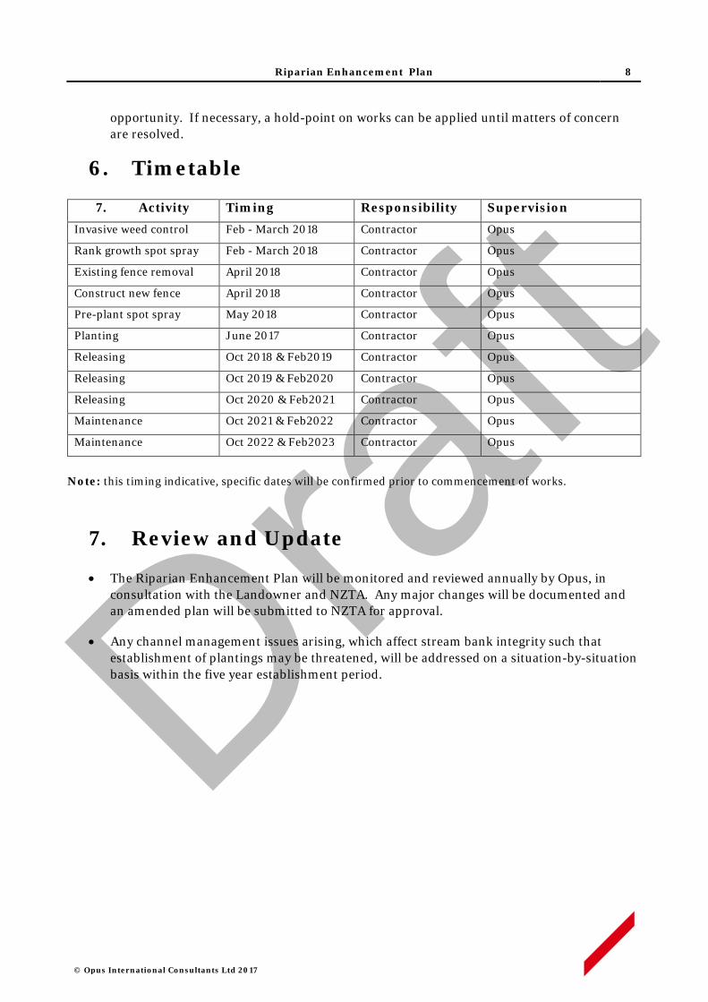
Riparian Enhancement Plan 8
© Opus International Consultants Ltd 2017
opportunity. If necessary, a hold-point on works can be applied until matters of concern are resolved.
6. Timetable
7. Activity Timing Responsibility Supervision
Invasive weed control Feb - March 2018 Contractor Opus
Rank growth spot spray Feb - March 2018 Contractor Opus
Existing fence removal April 2018 Contractor Opus
Construct new fence April 2018 Contractor Opus
Pre-plant spot spray May 2018 Contractor Opus
Planting June 2017 Contractor Opus
Releasing Oct 2018 & Feb2019 Contractor Opus
Releasing Oct 2019 & Feb2020 Contractor Opus
Releasing Oct 2020 & Feb2021 Contractor Opus
Maintenance Oct 2021 & Feb2022 Contractor Opus
Maintenance Oct 2022 & Feb2023 Contractor Opus
Note: this timing indicative, specific dates will be confirmed prior to commencement of works.
7. Review and Update
• The Riparian Enhancement Plan will be monitored and reviewed annually by Opus, in consultation with the Landowner and NZTA. Any major changes will be documented and an amended plan will be submitted to NZTA for approval.
• Any channel management issues arising, which affect stream bank integrity such that establishment of plantings may be threatened, will be addressed on a situation-by-situation basis within the five year establishment period.
Draft

Riparian Enhancement Plan
© Opus International Consultants Ltd 2017
APPENDIX A
Draft
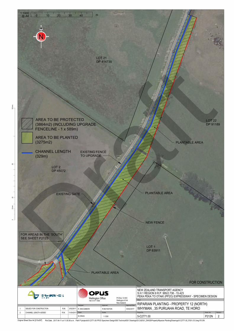
NEW FENCE
PLANTABLE AREA
PLANTABLE AREA
PLANTABLE AREA
EXISTING GATE
EXISTING FENCE
TO UPGRADE
LOT 2
DP 45072
LOT 1
DP 63911
LOT 21
DP 414735
LOT 22
DP 91189
/
/
/
/
/
/
/
/
/
/
/
/
/
/
FOR AREAS IN THE 'SOUTH'
SEE SHEET P212S
2010
0mm
100m
m
Original Sheet Size A4 [210x297]
50
Plot Date 2017-04-11 at 11:00:36 a.m. Path P:\projects\5-C2771.00 PP2O Specimen Design\500 Technical\501 Drawings\03 CAD\01_DWGS\Property\Riparian Planting\Drawings\5-C2771.00_P201-212.dwg P212N
Scales Project No. Sheet. No.
Project
Sheet
RevisionDrawn
Approved Approved Date
Wellington Office PO Box 12-003Wellington 6144New Zealand
+64 4 471 7000
NEW ZEALAND TRANSPORT AGENCYS.H.1 REGION 9 R.P. 995/2.738 - 15.423PEKA PEKA TO OTAKI (PP2O) EXPRESSWAY - SPECIMEN DESIGN
RIPARIAN PLANTING - PROPERTY 12 (NORTH)WHYMAN , 35 PURUAHA ROAD, TE HORO
FOR CONSTRUCTION
5-C2771.00 P212N 2
R. MACGIBBON R.McFADYEN 03/02/2017
B.CRAIG 1:1250
DesignedApproved DateRevision Amendment 1 ISSUED FOR CONSTRUCTION R.M. 3/02/2017
2 CHANNEL LENGTH ADDED R.M. 11/04/2017
1:1000
0 10 20 30 40
m
@ A4
N
AREA TO BE PLANTED
(3275m2)
AREA TO BE PROTECTED
(3864m2) (INCLUDING UPGRADE
FENCELINE - 1 x 589m)
CHANNEL LENGTH
(329m)
Draft
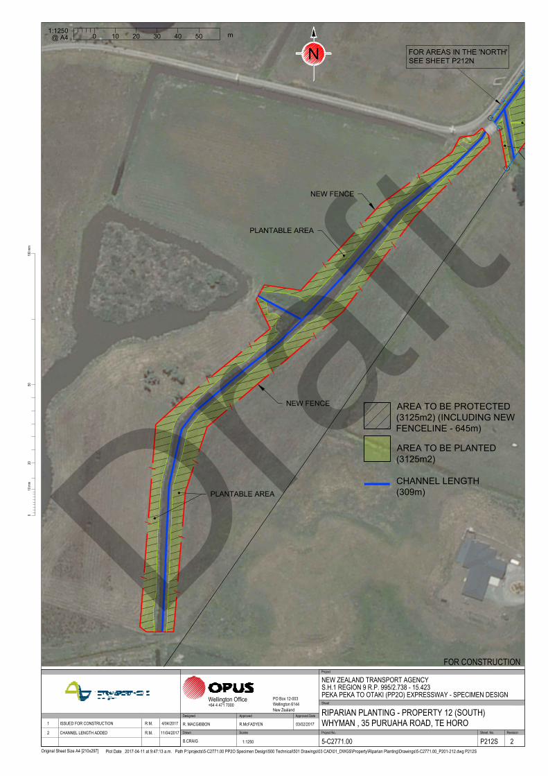
NEW FENCE
NEW FENCE
/
/
/
/
/
/
/
/
/
/
/
/
/
/
/
/
/
PLANTABLE AREA
PLANTABLE AREA
FOR AREAS IN THE 'NORTH'
SEE SHEET P212N
2010
0mm
100m
m
Original Sheet Size A4 [210x297]
50
Plot Date 2017-04-11 at 9:47:13 a.m. Path P:\projects\5-C2771.00 PP2O Specimen Design\500 Technical\501 Drawings\03 CAD\01_DWGS\Property\Riparian Planting\Drawings\5-C2771.00_P201-212.dwg P212S
Scales Project No. Sheet. No.
Project
Sheet
RevisionDrawn
Approved Approved Date
Wellington Office PO Box 12-003Wellington 6144New Zealand
+64 4 471 7000
NEW ZEALAND TRANSPORT AGENCYS.H.1 REGION 9 R.P. 995/2.738 - 15.423PEKA PEKA TO OTAKI (PP2O) EXPRESSWAY - SPECIMEN DESIGN
RIPARIAN PLANTING - PROPERTY 12 (SOUTH)WHYMAN , 35 PURUAHA ROAD, TE HORO
FOR CONSTRUCTION
5-C2771.00 P212S 2
R. MACGIBBON R.McFADYEN 03/02/2017
B.CRAIG 1:1250
DesignedApproved DateRevision Amendment 1 ISSUED FOR CONSTRUCTION R.M. 4/04/2017
2 CHANNEL LENGTH ADDED R.M. 11/04/2017
0
m
20 4010 30 50
1:1250
@ A4
N
AREA TO BE PLANTED
(3125m2)
AREA TO BE PROTECTED
(3125m2) (INCLUDING NEW
FENCELINE - 645m)
CHANNEL LENGTH
(309m)Draft

Riparian Enhancement Plan
© Opus International Consultants Ltd 2017
APPENDIX B
Draft

Appendix B.1 – Species List, Main Channel (North) Species Common Name Streamside Central Fenceline Total
Austroderia toetoe kakaho, toetoe 50 175 50 275
Coprosma repens taupata 25 125 25 175
Coprosma robusta karamu 0 50 0 50
Cordyline australis ti kouka, cabb tree 0 50 0 50
Corynocarpus lavigatus karaka 0 15 0 15
Cyperus ustulatus upokotangata 50 0 0 50
Dodonaea viscosa akeake 0 75 50 125
Hebe stricta koromiko 25 50 15 90
Leptospermum scoparium manuka 50 125 25 200
Myoporum laetum ngaio 0 50 0 50
Oleria paniculata akiraho 0 55 0 55
Olearia solandri coastal shrub daisy 0 50 25 75
Phormium tenax harakeke 0 155 20 175
Plagianthus regius manatu, ribbonwood 25 50 0 75
Total 1460
Draft
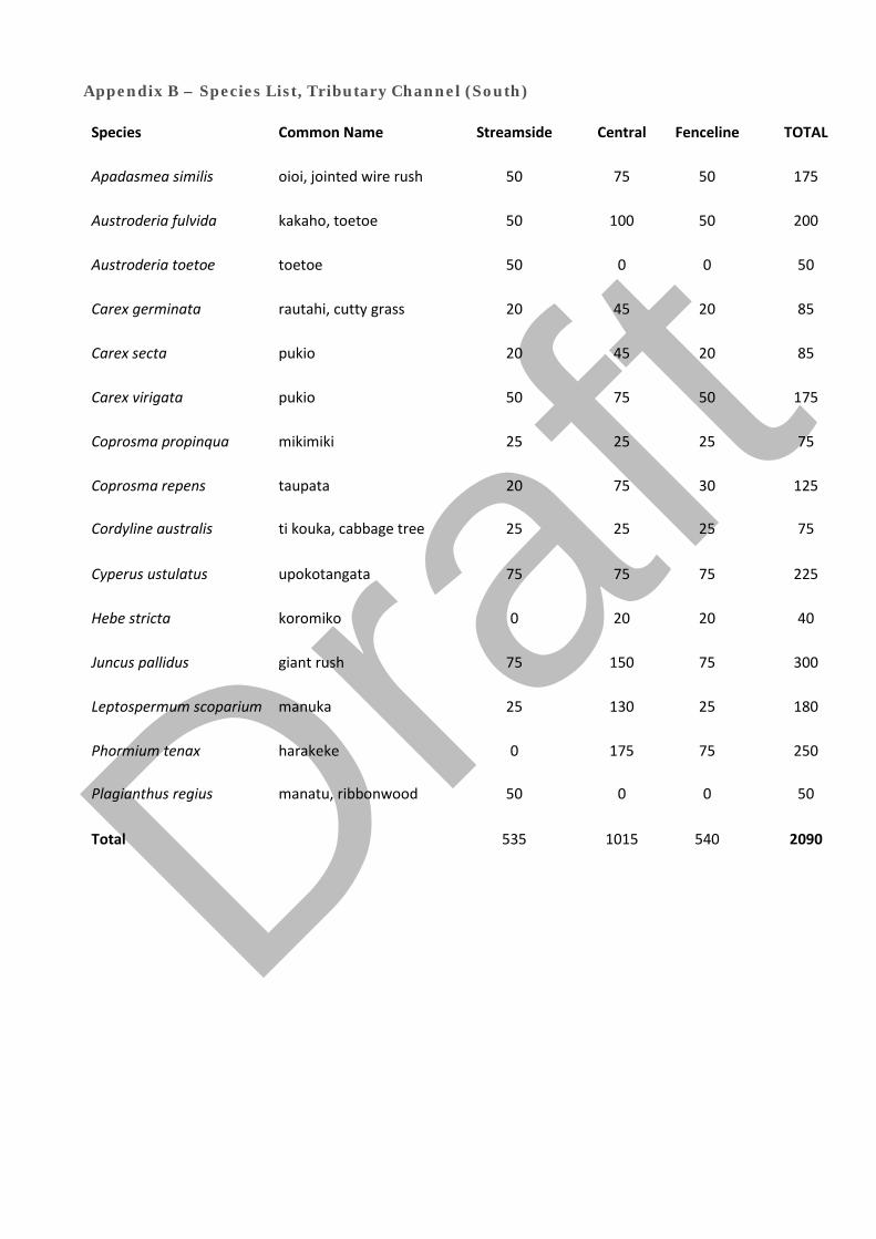
Appendix B – Species List, Tributary Channel (South)
Species Common Name Streamside Central Fenceline TOTAL
Apadasmea similis oioi, jointed wire rush 50 75 50 175
Austroderia fulvida kakaho, toetoe 50 100 50 200
Austroderia toetoe toetoe 50 0 0 50
Carex germinata rautahi, cutty grass 20 45 20 85
Carex secta pukio 20 45 20 85
Carex virigata pukio 50 75 50 175
Coprosma propinqua mikimiki 25 25 25 75
Coprosma repens taupata 20 75 30 125
Cordyline australis ti kouka, cabbage tree 25 25 25 75
Cyperus ustulatus upokotangata 75 75 75 225
Hebe stricta koromiko 0 20 20 40
Juncus pallidus giant rush 75 150 75 300
Leptospermum scoparium manuka 25 130 25 180
Phormium tenax harakeke 0 175 75 250
Plagianthus regius manatu, ribbonwood 50 0 0 50
Total 535 1015 540 2090 Draf
t

Opus International Consultants Ltd L10, Majestic Centre, 100 Willis St PO Box 12 003, Thorndon, Wellington 6144 New Zealand t: +64 4 471 7000 f: +64 4 499 3699 w: www.opus.co.nz
Draft

FCCL-EV-MPN-0009
49
APPENDIX B: BASELINE TURBIDITY
ASSESSMENT REVIEW REPORT

PP20 Environmental Baseline
Monitoring
Turbidity


PP20 Environmental Baseline
Monitoring
Turbidity
© Opus International Consultants Ltd 2017
Prepared by Samwell Warren, Lizzie Fox Opus International Consultants Ltd
Water Resource Scientists Wellington Environmental Office
L10, Majestic Centre, 100 Willis St
PO Box 12 003, Thorndon, Wellington 6144
New Zealand
Reviewed by Jack McConchie Telephone: +64 4 471 7000
Technical Principal, Hydrology and
Geomorphology
Facsimile: +64 4 499 3699
Date: August 2017
Reference: 5-C2771.W7
Status: FINAL
Approved for
Release by
Jack McConchie
Technical Principal, Hydrology and
Geomorphology

PP20 Environmental Base Monitoring - Turbidity i
5-C2771.W7 | August 2017 Opus International Consultants Ltd
Executive Summary
One of the outcomes of the Environmental Protection Authority-governed Board of Inquiry into the Peka
Peka – Otaki Expressway was a requirement to conduct environmental baseline monitoring of turbidity in
four rivers and streams which may be affected by construction activities. Specifically, Resource Consent
Condition G39 requires turbidity monitoring of the Otaki River and the Waitohu, Mangapouri, and
Mangaone Streams for 6 months prior to the start of construction. Condition G39 does not require the
monitoring of flow; however, without such data there is no context for considering the controls and
variability of turbidity.
Despite some initial problems relating to the installation of the four turbidity sensors, they functioned
well; providing approximately 8-months of data at 10-minute intervals. The turbidity data support the
following conclusions:
• Measuring turbidity on a continuous basis is problematic, and issues around obtaining a reliable
turbidity record are well known. Despite the use of ‘industry standard’ sensors, which included an
automatic wiper and anti-fouling mechanism, a range of environmental factors such as debris and
variable water levels, and instrumental issues including calibration, drift, the growth of algae on the
lens, and electronic ‘glitches’ still affected the turbidity records.;
• The aim of the turbidity monitoring required by Condition G39, which did not require the
monitoring of flow, was to assist in the setting of thresholds to control the discharge of sediment
laden water as a result of construction of the PP2O Expressway;
• Continuous measurement of turbidity, to be effective for compliance monitoring, would require
real-time review and potentially alarms. While this is possible, these data will still be subject to the
issues discussed above. This will lead to significant uncertainty regarding the data, and specifically
compliance;
• There is no unique turbidity value at any particular time and place as the actual measurement
depends to a degree on the instrumentation used. Turbidity measurements are a measure of the
scattering of light relative to a formazin standard. Consequently, different turbidity sensors may
output different turbidity values for the same sample. The use of the same type of sensor (i.e. same
model from the same manufacturer) may help to overcome this issue. However, it is best practice
to use the same turbidity sensor unit in either before and after, or upstream-downstream
applications;
• Relative measures of the difference in turbidity between two sites, using the same meter, are more
reliable for identifying ‘change’ than the actual measurements themselves;
• Considerable post-processing of the data is necessary to produce a representative turbidity record;
• Turbidity data are highly variable in time and place. This variability can be moderated by using a
longer term average, but the presence of discrete ‘turbidity events’ i.e. ‘spikes’, real or instrumental,
remains an issue with regard to establishing turbidity thresholds or triggers;
PP20 Environmental Base Monitoring - Turbidity ii
5-C2771.W7 | August 2017 Opus International Consultants Ltd
• As a result of the above issues, there is likely to be considerable uncertainty over whether a
particular trigger or threshold has actually been exceeded;
• The maximum turbidity recorded was about 1200 NTU in the Otaki River. This was during a
relatively small fresh. It is likely that turbidity would increase further during larger flood events;
• The relationship between flow and turbidity was different for each river; and
• In each river there was also a high degree of variability in the relationship between flow and turbidity
during each flood event.
Given the range of problems and issues discussed above, it is recommended that the monitoring of the
effectiveness of erosion and sediment control measures, and compliance with any water quality standards,
be confirmed by:
Monitoring the turbidity (using the same instrument) upstream and downstream (after reasonable mixing)
of any activity in any watercourse receiving runoff from construction activities be undertaken:
• When there is a conspicuous change in colour of the water downstream of the activity; or
• When hourly rainfall exceeds 20mm/hr (i.e. approximately 2.3-year ARI event); or
• When daily rainfall exceeds 70mm (i.e. approximately 2.3-year ARI event).
Should the downstream turbidity be 20% higher than that measured upstream then:
• An investigation of the cause or source of the increased turbidity be undertaken;
• Immediate actions be taken to mitigate any sediment loss from the construction site so that
turbidity drops back to the 20% threshold;
• Management and the sediment control structures be modified to prevent a similar occurrence in
the future; and
• A report be prepared for the consent authority outlining the nature of the breach, any immediate
actions taken to limit the loss of sediment from the site, and changes to future practices to ensure
that such an occurrence does not happen in the future.
PP20 Environmental Base Monitoring - Turbidity iii
5-C2771.W7 | August 2017 Opus International Consultants Ltd
Contents
1 Background ..................................................................................................................................... 1
1.1 Turbidity ...................................................................................................................................................... 2
2 Methodology ................................................................................................................................... 3
2.1 Monitoring locations ............................................................................................................................... 3
2.2 Data collection ........................................................................................................................................... 4
2.3 Sensor setup............................................................................................................................................... 5
2.4 Installation .................................................................................................................................................. 5
3 Results ............................................................................................................................................ 10
3.1 Preliminary data ...................................................................................................................................... 10
3.2 Data issues ................................................................................................................................................ 10
3.3 Turbidity records ..................................................................................................................................... 14
4 Analysis .......................................................................................................................................... 16
4.1 Otaki River at Pukehinau ...................................................................................................................... 17
4.2 Mangaone Stream at Ratanui ............................................................................................................. 18
4.3 Waitohu Stream at Water Supply Intake ......................................................................................... 19
4.4 Mangapouri Stream ............................................................................................................................... 20
4.5 Log-log plots............................................................................................................................................ 20
5 Conclusion ..................................................................................................................................... 22
6 Recommendation .......................................................................................................................... 23
7 References ..................................................................................................................................... 24
Appendix A – Correlations ..................................................................................................................... A1

PP20 Environmental Base Monitoring - Turbidity iv
5-C2771.W7 | August 2017 Opus International Consultants Ltd
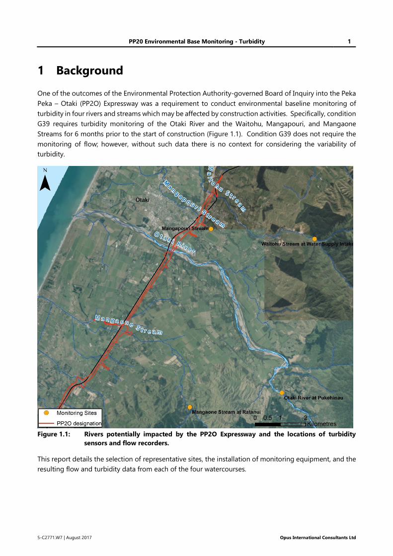
PP20 Environmental Base Monitoring - Turbidity 1
5-C2771.W7 | August 2017 Opus International Consultants Ltd
1 Background
One of the outcomes of the Environmental Protection Authority-governed Board of Inquiry into the Peka
Peka – Otaki (PP2O) Expressway was a requirement to conduct environmental baseline monitoring of
turbidity in four rivers and streams which may be affected by construction activities. Specifically, condition
G39 requires turbidity monitoring of the Otaki River and the Waitohu, Mangapouri, and Mangaone
Streams for 6 months prior to the start of construction (Figure 1.1). Condition G39 does not require the
monitoring of flow; however, without such data there is no context for considering the variability of
turbidity.
Figure 1.1: Rivers potentially impacted by the PP2O Expressway and the locations of turbidity
sensors and flow recorders.
This report details the selection of representative sites, the installation of monitoring equipment, and the
resulting flow and turbidity data from each of the four watercourses.
PP20 Environmental Base Monitoring - Turbidity 2
5-C2771.W7 | August 2017 Opus International Consultants Ltd
1.1 Turbidity
Turbidity, usually measured in Nephelometric Turbidity Units (NTU), defines an optical characteristic of
the water; essentially a relative measure of the scattering of light against a formazin standard. As such,
turbidity is a measure of the scattering of light by suspended particles in the water. Consequently,
turbidity is often used as a surrogate for suspended sediment concentration. This is likely to be the case
regarding the pre-construction monitoring for the PP2O Expressway.
Elevated levels of suspended sediment in rivers and streams may have adverse effects on the aquatic
environment. Since turbidity is easier to measure than suspended sediment concentrations, both
continuously and automatically, and since the two environmental indicators are usually related, a rise in
turbidity is often used as an indication of a rise in suspended sediment.
However, the two indices measure distinctly different, although related, properties of the flow in a river
or stream. This is because turbidity is not just affected by the concentration of particles within the water
column. It is also affected by the characteristics of those particles e.g. their size, shape, colour and texture.
These properties vary as a function of lithology, mineralogy and availability, and so there is no unique
relationship between turbidity and sediment concentration. Predicting and interpreting continuous
sediment records is therefore difficult, as the multitude of variables controlling the sediment load can
produce unique values. That is, there can be different turbidity for the same sediment concentration, and
vice versa.
Changes in land use, particularly that related to land clearance and the alteration of the vegetation cover,
can be a major driver in modifying the sediment load in a river or stream. Vegetation clearance can result
in a greater amount of sediment becoming mobilised during storm events, and potentially entering the
fluvial system via overland flow, including rilling and gullying. Consequently, any potential increase in
sediment load as a result of large scale roading projects is an important environmental concern. This is
likely to be the rationale behind condition G39 which requires turbidity monitoring of the Otaki River and
the Waitohu, Mangapouri, and Mangaone Streams for 6 months prior to the start of construction of the
PP2O Expressway.
While multiple methods are available to measure turbidity, in-situ measurements using optical sensors
are preferred. They can achieve the same, potentially more accurate, results as a sediment-discharge
relationship, while also being easier to deploy over longer sampling periods (Anderson, 2005). The main
disadvantages of using an in situ continuous turbidity data record is the need to calibrate the sensor,
verify the recorded data, and correct for the impact of on-site factors that negatively affect the record.
In-situ sensors can also drift, requiring re-calibration and continual verification (Davies-Colley & Smith,
2001; Hicks, 2009). Careful consideration of a sensor’s deployment, and the ambient environment, are
therefore critical to the acquisition of high quality data.

PP20 Environmental Base Monitoring - Turbidity 3
5-C2771.W7 | August 2017 Opus International Consultants Ltd
2 Methodology
2.1 Monitoring locations
Quasi-continuous turbidity data were collected in the Otaki River and the Waitohu, Mangapouri, and
Mangaone Streams between January and September 2016. The equipment deployed and the dates of
installation and removal of the equipment within each watercourse are detailed in Table 2.1.
Table 2.1: Equipment used and the date of installation and removal.
Sensor Parameter Location Installed Removed Duration
(months)
Greenspan
Pentair TS1000
Turbidity
0-1000NTU
Waitohu Stream at Water
Supply Intake 18-Jan-2016 23-Sep-2016 ~8
Greenspan
Pentair TS1000
Turbidity
0-1000NTU Mangapouri Stream 14-Jan-2016 23-Sep-2016 ~8
INW AquiStar
PT2X Smart
Sensor
Water level
0-5m Mangapouri Stream 14-Jan-2016 23-Sep-2016 ~8
Greenspan
Pentair TS300
Turbidity
0-1000NTU
Mangaone Stream at
Ratanui 14-Jan-2016 11-Aug-2016 ~7
Greenspan
Pentair TS1000
Turbidity
0-1000NTU Otaki River at Pukehinau 03-Feb-2016 23-Sep-2016 ~7
For efficiency and security, and to allow the turbidity data to be related to flow, on three of the rivers the
sensors were co-sited at hydrometric monitoring sites maintained by either the Greater Wellington
Regional Council (i.e. Mangaone and Waitohu) or NIWA (i.e. Otaki). As mentioned, condition G39 does
not require the monitoring of flow. Approval for installing the turbidity monitoring equipment at these
sites was obtained from the appropriate organisation.
No flow monitoring station exists on Mangapouri Stream. It was therefore necessary to find a suitably
representative monitoring site, and to install a water level recorder on this stream (Figure 1.1). Site
selection was based on accessibility, security, and representativeness.
It is noted that all the sites, except for that on Mangapouri Stream, are located a significant distance
upstream of the PP2O Expressway (Table 2.2). However, these sites are considered representative of
baseline conditions in each river because:
• Turbidity is unlikely to change significantly downstream of the various flow monitoring sites. This
is because the suspended sediment concentration, the primary control on turbidity, is unlikely to
reduce downstream given the gradient of the channels and the velocity of flow;
• The variation in turbidity, and the implications of this for establishing appropriate triggers, will be
characteristic for each river;
PP20 Environmental Base Monitoring - Turbidity 4
5-C2771.W7 | August 2017 Opus International Consultants Ltd
• The continuity and security of the turbidity record outweighs any small potential difference in
turbidity downstream, which is likely to be within the measurement error of the sensors;
• The ability to relate turbidity to the flow in a river is also a considerable advantage over any small
potential difference in turbidity downstream;
• Any turbidity record will be affected to some degree by site factors; and
• There is value in any turbidity record being able to be related to, and compared against, that
recorded during other periods by other interested parties.
The choice of the monitoring location therefore has no effect on the validity of the monitoring data, or
its value in assisting to define realistic and representative triggers as required by condition G39.
Table 2.2: Distance of monitoring site upstream of PP2O designation (Figure 1.1).
Location Distance (km)
Waitohu Stream at Water Supply Intake 5.12
Mangapouri Stream 0.50
Mangaone Stream at Ratanui 4.97
Otaki River at Pukehinau 9.30
2.2 Data collection
Condition G39 requires monitoring of turbidity over a period of 6 months prior to the start of construction
of the PP2O Expressway. However, it is critical that the full range of natural variability in turbidity be
measured so that realistic ‘environmental triggers’ can be established. Since turbidity is generally related
to flow, and the monitoring period commenced during summer, i.e. when flows are generally low; it was
recommended that the sensors be deployed for a longer period, increasing the likelihood that conditions
during a wide range of flows, particularly less frequent higher flow events, were monitored.
During monitoring, the largest event recorded in the Otaki River and Mangaone Stream were 39% and
11% respectively of the previous maximum recorded flow at each site (Table 2.3). Despite monitoring
only covering a relatively small range of total flow variability, turbidity during these events exceeded 850
NTU.
Table 2.3: Largest recorded flows, and largest flows recorded over the monitoring period in the
Otaki and Mangaone Rivers.
Location/Stream Maximum recorded
flow (m³/s)
Maximum recorded
flow during
monitoring period
(m³/s)
% of maximum
recorded flow
Otaki River 1540 593 39
Mangaone Stream at Ratanui 33 3.5 11
No flow data exists for Mangapouri Stream, or for Waitohu Stream as Greater Wellington Regional Council
(GWRC) were experiencing problems with their water level recorder over the monitoring period.

PP20 Environmental Base Monitoring - Turbidity 5
5-C2771.W7 | August 2017 Opus International Consultants Ltd
2.3 Sensor setup
Three Greenspan Pentair TS1000 turbidity sensors, and one Greenspan Pentair TS300 turbidity sensor with
an external battery, were supplied by NIWA Instruments Ltd on the 15th December 2015. These sensors
meet strict specifications for accuracy, reliability and minimal drift; and enable on-board datalogging.
Each sensor was calibrated, and programmed to initially scan and record turbidity at 15-min intervals.
Since turbidity can be highly variable, it can be desirable to scan at a faster rate and then ‘smooth’ the
turbidity record during subsequent data processing. However, the relatively remote locations of the
sensors in this study means that battery life was a constraint. A 15-min logging interval therefore reflected
a practical compromise between data frequency and battery efficiency. Following the first maintenance
visit, it was decided that batteries would be sufficient to support data collection at a 10-min resolution
and the programming of the sensors was adjusted accordingly.
To relate turbidity measurements to flow in Mangapouri Stream, a PT2X pressure logger, calibrated on
the 17th December 2015, was also installed to record variation in water level.
2.4 Installation
The sensors were installed in accordance with recommendations found in the Greenspan Pentair TS1000
User Manual. Installation and tethering were designed to prevent any persistent pulling, snagging, or
compression on the sensor or the sensor cable; while making sure that the sensor was stable during
normal operation. Sensors were tethered with chain to avoid tampering and theft, and to mitigate the
risk of vandalism. The risk of vandalism is considered low because of the location of the monitoring sites,
and the restricted public access.
Sensors were positioned such that:
• The sensor window would remain completely submerged, even during low flow conditions;
• Where possible, the sensor was in the thalweg of the channel i.e. the area of deepest and fastest
flow. This ensures even mixing of suspended sediment, and therefore representative turbidity data;
• Sensors were tethered to the upstream side of the various anchoring points to avoid the
entrapment of air bubbles below the sensor. However, the sensors were moved to the downstream
side of the various mounts if the initial data indicated that debris was being caught on the sensor
and was affecting the validity of the turbidity data; and
• Where possible, the sensors were installed in an area of shade to avoid direct sunlight, subsequent
warming, and therefore algae growth on the lens.
On Waitohu Stream the turbidity sensor was mounted on a railway iron driven into the bed of the river;
immediately downstream of the water level recorder at the old Water Supply Intake (Figure 2.1).
On the Otaki River, the sensor was installed on the downstream side of the stage plate. Site access is
secure but difficult, and requires traversing a ladder to access the stage plate at water level. The sensor
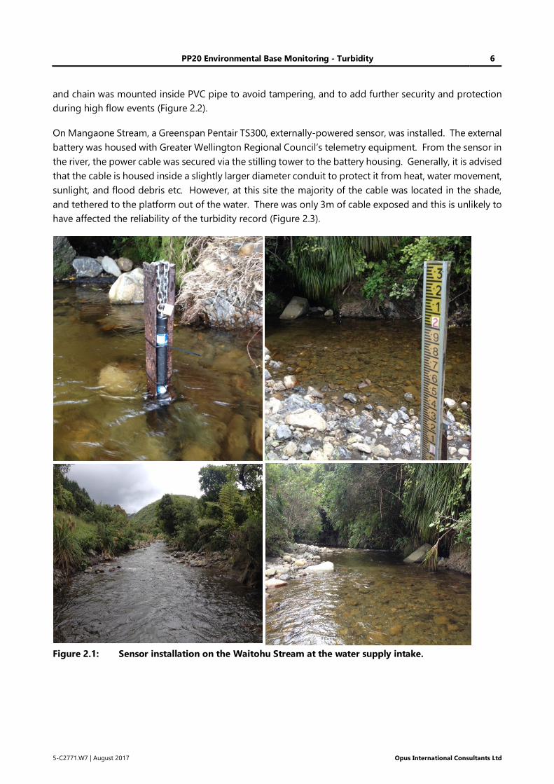
PP20 Environmental Base Monitoring - Turbidity 6
5-C2771.W7 | August 2017 Opus International Consultants Ltd
and chain was mounted inside PVC pipe to avoid tampering, and to add further security and protection
during high flow events (Figure 2.2).
On Mangaone Stream, a Greenspan Pentair TS300, externally-powered sensor, was installed. The external
battery was housed with Greater Wellington Regional Council’s telemetry equipment. From the sensor in
the river, the power cable was secured via the stilling tower to the battery housing. Generally, it is advised
that the cable is housed inside a slightly larger diameter conduit to protect it from heat, water movement,
sunlight, and flood debris etc. However, at this site the majority of the cable was located in the shade,
and tethered to the platform out of the water. There was only 3m of cable exposed and this is unlikely to
have affected the reliability of the turbidity record (Figure 2.3).
Figure 2.1: Sensor installation on the Waitohu Stream at the water supply intake.
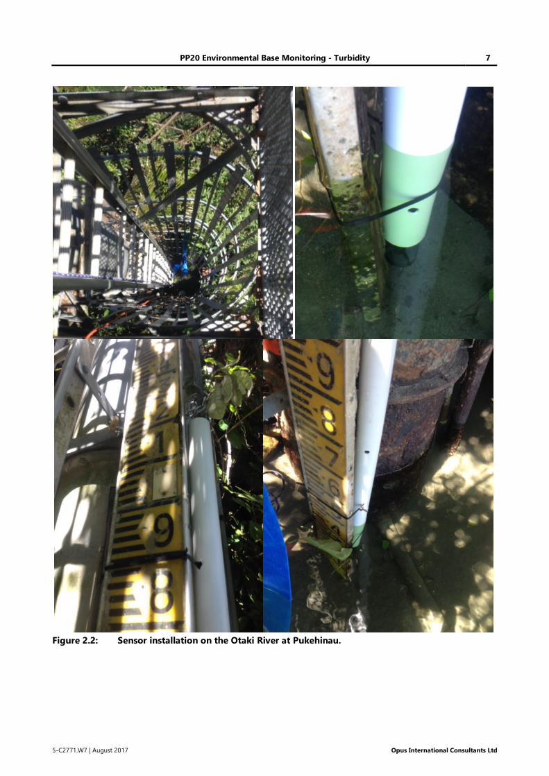
PP20 Environmental Base Monitoring - Turbidity 7
5-C2771.W7 | August 2017 Opus International Consultants Ltd
Figure 2.2: Sensor installation on the Otaki River at Pukehinau.
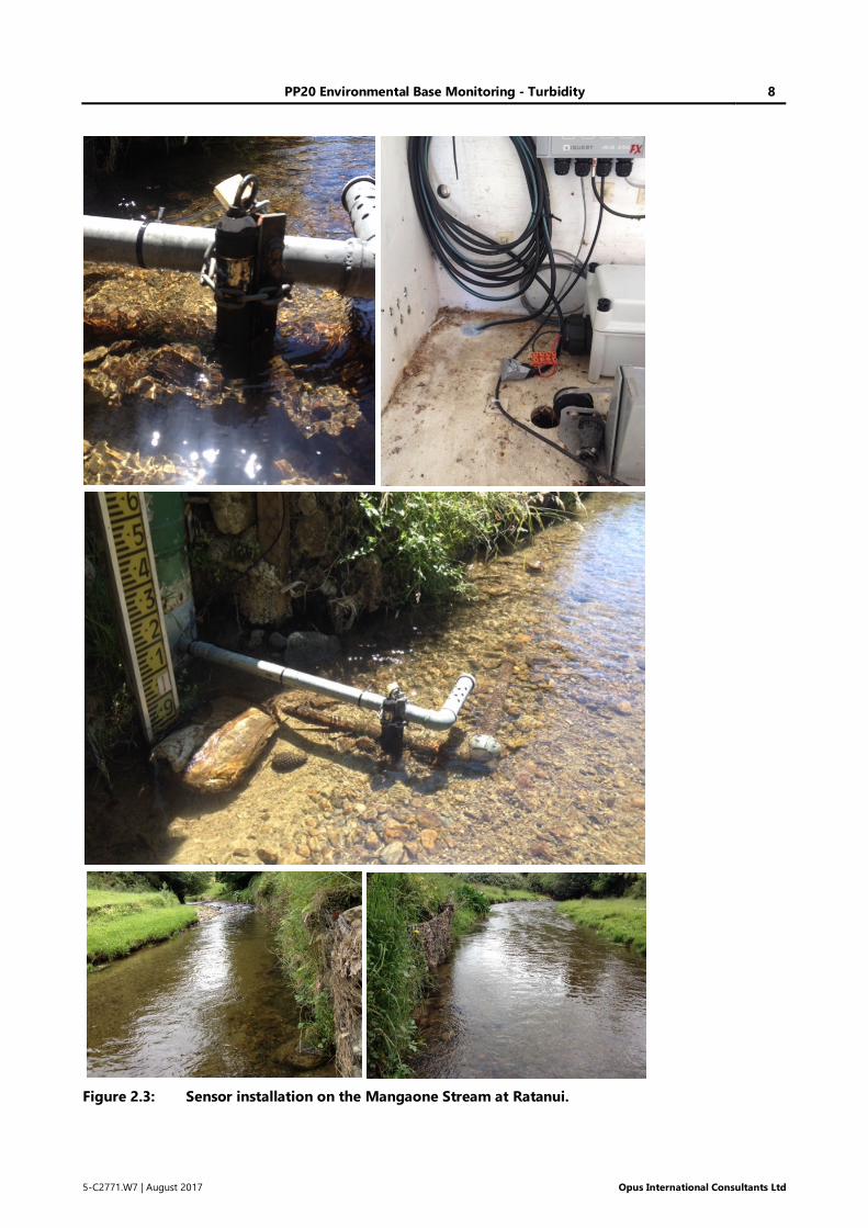
PP20 Environmental Base Monitoring - Turbidity 8
5-C2771.W7 | August 2017 Opus International Consultants Ltd
Figure 2.3: Sensor installation on the Mangaone Stream at Ratanui.
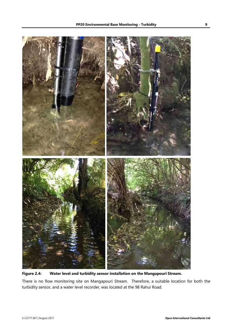
PP20 Environmental Base Monitoring - Turbidity 9
5-C2771.W7 | August 2017 Opus International Consultants Ltd
Figure 2.4: Water level and turbidity sensor installation on the Mangapouri Stream.
There is no flow monitoring site on Mangapouri Stream. Therefore, a suitable location for both the
turbidity sensor, and a water level recorder, was located at the 98 Rahui Road.
PP20 Environmental Base Monitoring - Turbidity 10
5-C2771.W7 | August 2017 Opus International Consultants Ltd
Both the turbidity sensor and vented pressure sensor (i.e. water level recorder) were installed on a
waratah™ standard, driven into the stream bed of the thalweg and anchored to a tree. As discussed in
the INW AquiStar PT2X Smart Sensor User Manual, the water level sensor was installed at a fixed point
below the minimum water level. The sensor remained fixed relative to this datum until monitoring was
completed. The vented cable was tethered to a tree (Figure 2.4).
3 Results
3.1 Preliminary data
The first period of data collection highlighted problems associated with sensor deployment; caused
primarily by the ambient environment, and the low flows over this period.
Monitoring equipment on the Mangapouri Stream was therefore moved upstream to a deeper and more
exposed reach. Monitoring equipment in the Otaki River, and Mangaone and Waitohu Streams was
adjusted to increase the distance between the sensor lens and the stream bed.
3.2 Data issues
Despite being ‘industry standard’ turbidity sensors, the resulting data are still prone to interference from
debris and biofouling, and drift over time. It was therefore necessary to undertake some post-processing
of the data to account for a range of environmental factors. Obvious, erroneous data ‘spikes’, caused by
floating debris or signal ‘glitches’, also had to be removed prior to any analysis.
Data collected in the Otaki River was of sufficiently high quality that no editing of turbidity (beyond
removal of an anomalous ‘turbidity event’) was required.
Turbidity data from Mangaone Stream becomes uncertain when the water level drops during low flow
conditions. Since the sensor needs to be offset from the river bed, in a small stream at low flows the
water level can drop below the sensor window. This leads to errors in the apparent turbidity data. The
shallow nature of Mangaone Stream means that this is unavoidable during certain periods. Despite this,
the turbidity data collected required little editing after the redeployment of the sensor on 23 February
2016.
Greater Wellington Regional Council (GWRC) are currently having significant issues with their flow
recorder on the Waitohu Stream. Over the period of turbidity monitoring, GWRC adjusted the water level
monitoring equipment on three occasions. However, as of this time no changes have been made to the
rating curve used to convert water level to flow. Consequently, the available flow data are currently
erroneous.
As an interim measure, the recorded stage data were ‘ramped’ to provide a more realistic representation
of likely water levels in the stream (Figure 3.1). It is considered that the relative water levels are likely to
be correct, even if the absolute data is in error. Once the stage data were adjusted in this manner, the
peaks in flow corresponded with the peaks in measured turbidity (Figure 3.9).
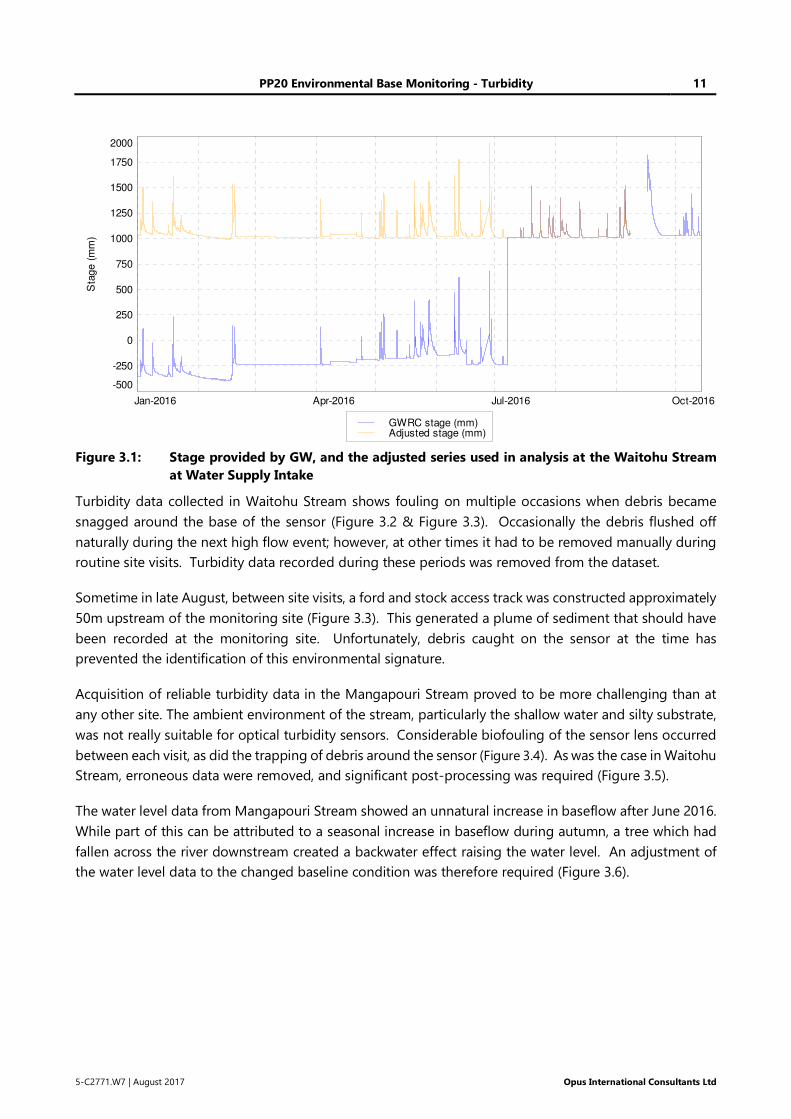
PP20 Environmental Base Monitoring - Turbidity 11
5-C2771.W7 | August 2017 Opus International Consultants Ltd
Figure 3.1: Stage provided by GW, and the adjusted series used in analysis at the Waitohu Stream
at Water Supply Intake
Turbidity data collected in Waitohu Stream shows fouling on multiple occasions when debris became
snagged around the base of the sensor (Figure 3.2 & Figure 3.3). Occasionally the debris flushed off
naturally during the next high flow event; however, at other times it had to be removed manually during
routine site visits. Turbidity data recorded during these periods was removed from the dataset.
Sometime in late August, between site visits, a ford and stock access track was constructed approximately
50m upstream of the monitoring site (Figure 3.3). This generated a plume of sediment that should have
been recorded at the monitoring site. Unfortunately, debris caught on the sensor at the time has
prevented the identification of this environmental signature.
Acquisition of reliable turbidity data in the Mangapouri Stream proved to be more challenging than at
any other site. The ambient environment of the stream, particularly the shallow water and silty substrate,
was not really suitable for optical turbidity sensors. Considerable biofouling of the sensor lens occurred
between each visit, as did the trapping of debris around the sensor (Figure 3.4). As was the case in Waitohu
Stream, erroneous data were removed, and significant post-processing was required (Figure 3.5).
The water level data from Mangapouri Stream showed an unnatural increase in baseflow after June 2016.
While part of this can be attributed to a seasonal increase in baseflow during autumn, a tree which had
fallen across the river downstream created a backwater effect raising the water level. An adjustment of
the water level data to the changed baseline condition was therefore required (Figure 3.6).
Jan-2016 Apr-2016 Jul-2016 Oct-2016
-500
-250
0
250
500
750
1000
1250
1500
1750
2000
Sta
ge (
mm
)
GWRC stage (mm)Adjusted stage (mm)

PP20 Environmental Base Monitoring - Turbidity 12
5-C2771.W7 | August 2017 Opus International Consultants Ltd
Figure 3.2: Fouling of sensor windows caused by the trapping of debris around the base of the
railway iron in the Waitohu Stream.
Figure 3.3: Debris trapped around the base of the turbidity sensor in Waitohu Stream (left) and a
ford constructed approximately 50m upstream of the monitoring site (right).
Feb-2016 Apr-2016 Jun-2016 Aug-2016
0
200
400
600
800
1000
Turb
idity (
NT
U)
Waitohu Stream at Water Supply Intake
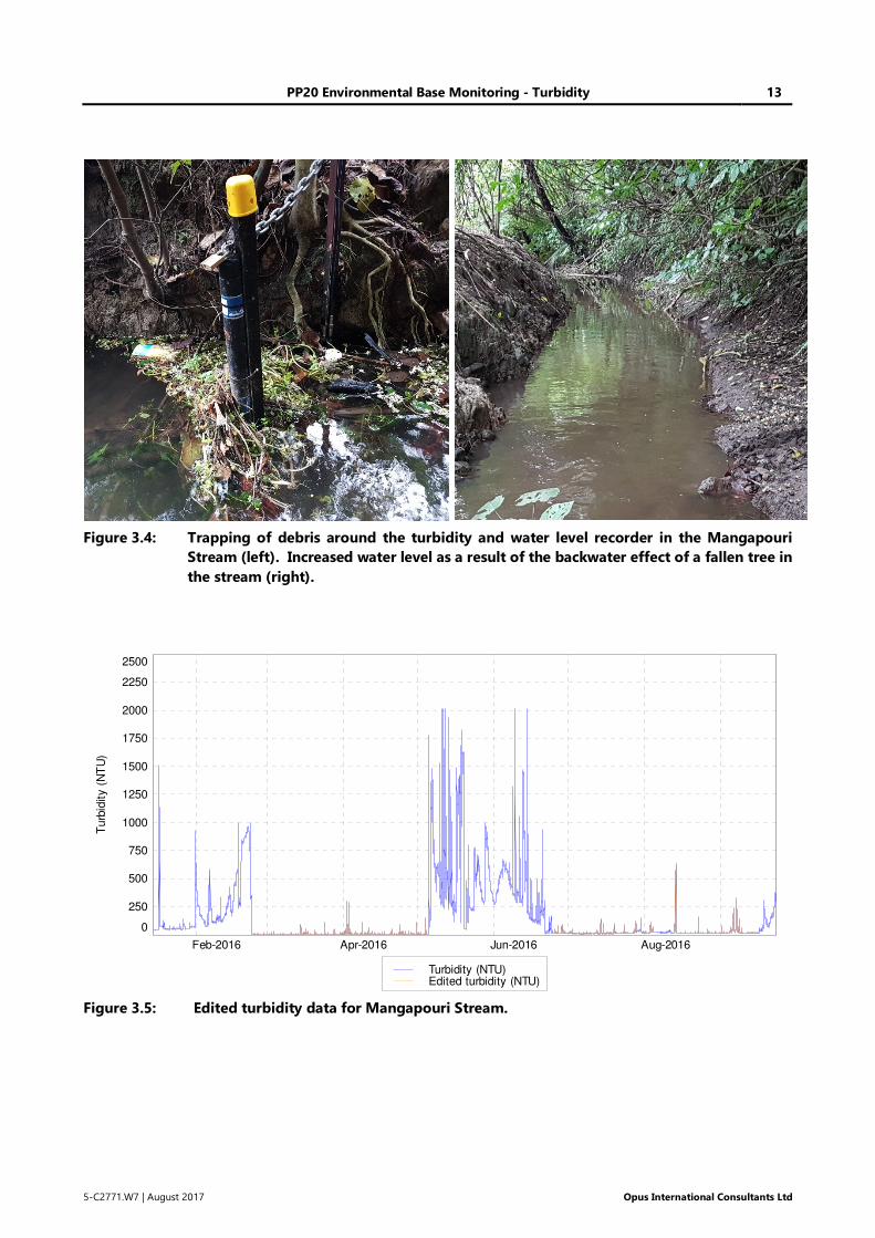
PP20 Environmental Base Monitoring - Turbidity 13
5-C2771.W7 | August 2017 Opus International Consultants Ltd
Figure 3.4: Trapping of debris around the turbidity and water level recorder in the Mangapouri
Stream (left). Increased water level as a result of the backwater effect of a fallen tree in
the stream (right).
Figure 3.5: Edited turbidity data for Mangapouri Stream.
Feb-2016 Apr-2016 Jun-2016 Aug-2016
0
250
500
750
1000
1250
1500
1750
2000
2250
2500
Turb
idity (
NT
U)
Turbidity (NTU)Edited turbidity (NTU)
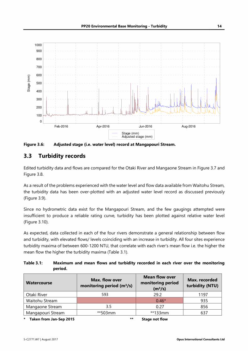
PP20 Environmental Base Monitoring - Turbidity 14
5-C2771.W7 | August 2017 Opus International Consultants Ltd
Figure 3.6: Adjusted stage (i.e. water level) record at Mangapouri Stream.
3.3 Turbidity records
Edited turbidity data and flows are compared for the Otaki River and Mangaone Stream in Figure 3.7 and
Figure 3.8.
As a result of the problems experienced with the water level and flow data available from Waitohu Stream,
the turbidity data has been over-plotted with an adjusted water level record as discussed previously
(Figure 3.9).
Since no hydrometric data exist for the Mangapouri Stream, and the few gaugings attempted were
insufficient to produce a reliable rating curve, turbidity has been plotted against relative water level
(Figure 3.10).
As expected, data collected in each of the four rivers demonstrate a general relationship between flow
and turbidity, with elevated flows/ levels coinciding with an increase in turbidity. All four sites experience
turbidity maxima of between 600-1200 NTU, that correlate with each river’s mean flow i.e. the higher the
mean flow the higher the turbidity maxima (Table 3.1).
Table 3.1: Maximum and mean flows and turbidity recorded in each river over the monitoring
period.
Watercourse Max. flow over
monitoring period (m³/s)
Mean flow over
monitoring period
(m³/s)
Max. recorded
turbidity (NTU)
Otaki River 593 29.2 1197
Waitohu Stream 0.46* 935
Mangaone Stream 3.5 0.27 856
Mangapouri Stream **503mm **133mm 637
* Taken from Jan-Sep 2015 ** Stage not flow
Feb-2016 Apr-2016 Jun-2016 Aug-2016
0
100
200
300
400
500
600
700
800
900
1000
Sta
ge (
mm
)
Stage (mm)Adjusted stage (mm)
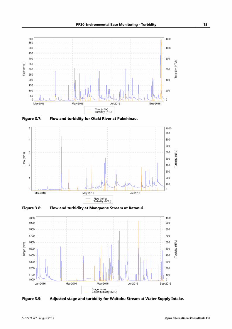
PP20 Environmental Base Monitoring - Turbidity 15
5-C2771.W7 | August 2017 Opus International Consultants Ltd
Figure 3.7: Flow and turbidity for Otaki River at Pukehinau.
Figure 3.8: Flow and turbidity at Mangaone Stream at Ratanui.
Figure 3.9: Adjusted stage and turbidity for Waitohu Stream at Water Supply Intake.
Mar-2016 May-2016 Jul-2016 Sep-2016
0
50
100
150
200
250
300
350
400
450
500
550
600
0
200
400
600
800
1000
1200
Flo
w (
m³/
s)
Turb
idity
(N
TU
)
Flow (m³/s)Turbidity (NTU)
Mar-2016 May-2016 Jul-2016
0
1
2
3
4
5
0
100
200
300
400
500
600
700
800
900
1000
Flo
w (
m³/
s)
Turb
idity
(N
TU
)
Flow (m³/s)Turbidity (NTU)
Jan-2016 Mar-2016 May-2016 Jul-2016 Sep-2016
1000
1100
1200
1300
1400
1500
1600
1700
1800
1900
2000
0
100
200
300
400
500
600
700
800
900
1000
Sta
ge
(m
m)
Turb
idit
y (
NT
U)
Stage (mm)Edited turbidity (NTU)
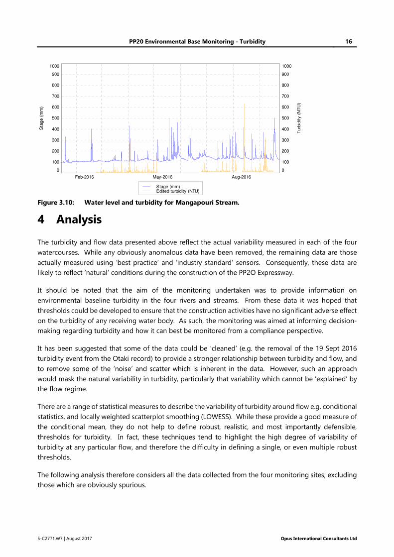
PP20 Environmental Base Monitoring - Turbidity 16
5-C2771.W7 | August 2017 Opus International Consultants Ltd
Figure 3.10: Water level and turbidity for Mangapouri Stream.
4 Analysis
The turbidity and flow data presented above reflect the actual variability measured in each of the four
watercourses. While any obviously anomalous data have been removed, the remaining data are those
actually measured using ‘best practice’ and ‘industry standard’ sensors. Consequently, these data are
likely to reflect ‘natural’ conditions during the construction of the PP2O Expressway.
It should be noted that the aim of the monitoring undertaken was to provide information on
environmental baseline turbidity in the four rivers and streams. From these data it was hoped that
thresholds could be developed to ensure that the construction activities have no significant adverse effect
on the turbidity of any receiving water body. As such, the monitoring was aimed at informing decision-
making regarding turbidity and how it can best be monitored from a compliance perspective.
It has been suggested that some of the data could be ‘cleaned’ (e.g. the removal of the 19 Sept 2016
turbidity event from the Otaki record) to provide a stronger relationship between turbidity and flow, and
to remove some of the ‘noise’ and scatter which is inherent in the data. However, such an approach
would mask the natural variability in turbidity, particularly that variability which cannot be ‘explained’ by
the flow regime.
There are a range of statistical measures to describe the variability of turbidity around flow e.g. conditional
statistics, and locally weighted scatterplot smoothing (LOWESS). While these provide a good measure of
the conditional mean, they do not help to define robust, realistic, and most importantly defensible,
thresholds for turbidity. In fact, these techniques tend to highlight the high degree of variability of
turbidity at any particular flow, and therefore the difficulty in defining a single, or even multiple robust
thresholds.
The following analysis therefore considers all the data collected from the four monitoring sites; excluding
those which are obviously spurious.
Feb-2016 May-2016 Aug-2016
0
100
200
300
400
500
600
700
800
900
1000
0
100
200
300
400
500
600
700
800
900
1000
Sta
ge
(m
m)
Turb
idit
y (
NT
U)
Stage (mm)Edited turbidity (NTU)

PP20 Environmental Base Monitoring - Turbidity 17
5-C2771.W7 | August 2017 Opus International Consultants Ltd
Correlation coefficients were derived using the 10-min data to quantify any relationship between flow
and turbidity in each catchment. However, the highly variable nature of turbidity meant that no
statistically significant relationships were found. In an attempt to minimise the effect of the natural scatter
inherent in the turbidity data, correlations were therefore obtained over a range of different temporal
resolutions. These correlations can be found in Appendix A.
4.1 Otaki River at Pukehinau
Turbidity and flow data recorded at a 10-minute resolution in the Otaki River at Pukehinau were
correlated. This highlighted an event on 19 September 2016 when a major turbidity event occurred, the
largest recorded over the 8-months of monitoring, even though flows were receding (Figure 4.1). A
detailed review of this ‘peak in turbidity’ suggests that the data are correct, and that turbidity did actually
increase significantly over this period. This event was therefore likely entirely ‘natural’ and reflects the
variability in turbidity within a largely natural catchment. This turbidity event, however, reduces the
strength of any correlation. Removal of this event in turbidity increases the strength of the correlation
from 0.3 to 0.65; however, its removal is difficult to justify except for a statistical purpose (Figure 4.2).
Figure 4.1: A peak in turbidity during recession of flow in the Otaki River at Pukehinau.
Additional correlations were undertaken using data averaged over 3, 6 and 24-hours. As the duration of
the averaging increases so too does the strength of the relationship between average flow and average
turbidity (Table 4.1). Averaging both data sets over 24 hours produces the strongest apparent relationship
(i.e. r² of 0.91).
15-Sep-2016 17-Sep-2016 19-Sep-2016 21-Sep-2016
0
100
200
300
400
500
600
700
800
900
1000
1100
1200
0
100
200
300
400
500
600
700
800
900
1000
1100
1200
Flo
w (m
³/s)
Turb
idity (N
TU
)
Flow (m³/s)Turbidity (NTU)
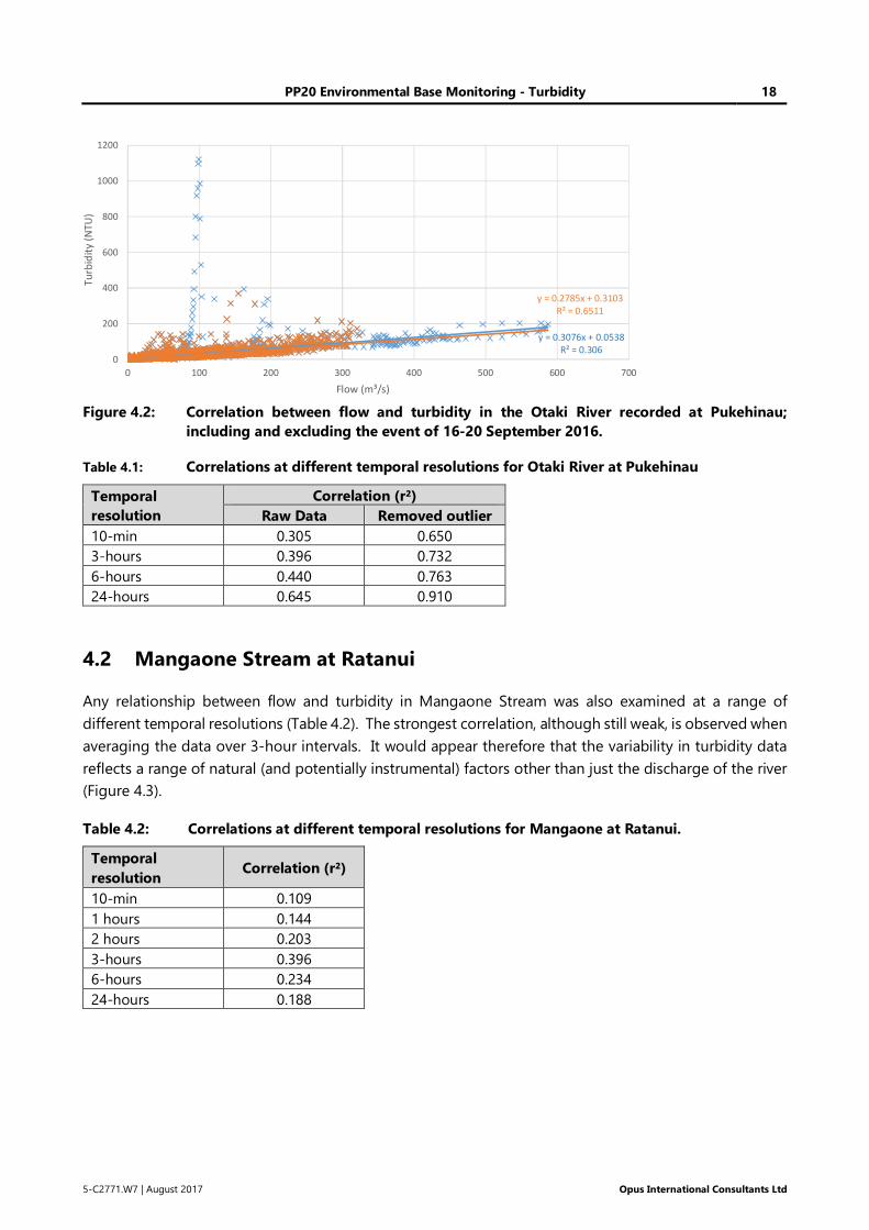
PP20 Environmental Base Monitoring - Turbidity 18
5-C2771.W7 | August 2017 Opus International Consultants Ltd
Figure 4.2: Correlation between flow and turbidity in the Otaki River recorded at Pukehinau;
including and excluding the event of 16-20 September 2016.
Table 4.1: Correlations at different temporal resolutions for Otaki River at Pukehinau
Temporal
resolution
Correlation (r²)
Raw Data Removed outlier
10-min 0.305 0.650
3-hours 0.396 0.732
6-hours 0.440 0.763
24-hours 0.645 0.910
4.2 Mangaone Stream at Ratanui
Any relationship between flow and turbidity in Mangaone Stream was also examined at a range of
different temporal resolutions (Table 4.2). The strongest correlation, although still weak, is observed when
averaging the data over 3-hour intervals. It would appear therefore that the variability in turbidity data
reflects a range of natural (and potentially instrumental) factors other than just the discharge of the river
(Figure 4.3).
Table 4.2: Correlations at different temporal resolutions for Mangaone at Ratanui.
Temporal
resolution Correlation (r²)
10-min 0.109
1 hours 0.144
2 hours 0.203
3-hours 0.396
6-hours 0.234
24-hours 0.188
y = 0.3076x + 0.0538
R² = 0.306
y = 0.2785x + 0.3103
R² = 0.6511
0
200
400
600
800
1000
1200
0 100 200 300 400 500 600 700
Tu
rbid
ity
(N
TU
)
Flow (m³/s)
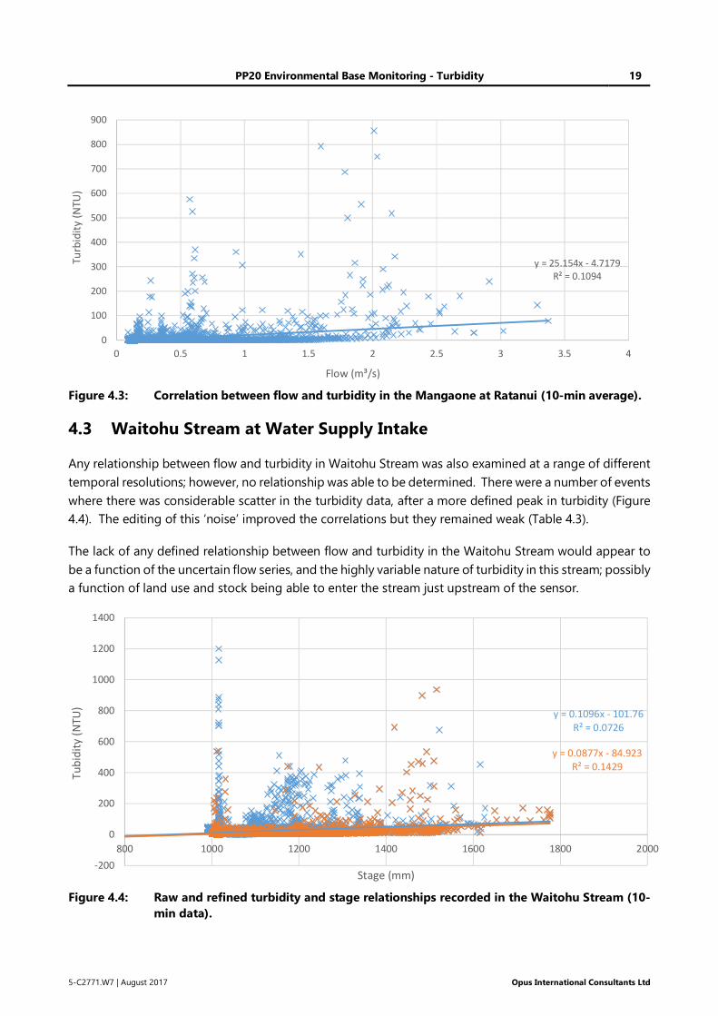
PP20 Environmental Base Monitoring - Turbidity 19
5-C2771.W7 | August 2017 Opus International Consultants Ltd
Figure 4.3: Correlation between flow and turbidity in the Mangaone at Ratanui (10-min average).
4.3 Waitohu Stream at Water Supply Intake
Any relationship between flow and turbidity in Waitohu Stream was also examined at a range of different
temporal resolutions; however, no relationship was able to be determined. There were a number of events
where there was considerable scatter in the turbidity data, after a more defined peak in turbidity (Figure
4.4). The editing of this ‘noise’ improved the correlations but they remained weak (Table 4.3).
The lack of any defined relationship between flow and turbidity in the Waitohu Stream would appear to
be a function of the uncertain flow series, and the highly variable nature of turbidity in this stream; possibly
a function of land use and stock being able to enter the stream just upstream of the sensor.
Figure 4.4: Raw and refined turbidity and stage relationships recorded in the Waitohu Stream (10-
min data).
y = 25.154x - 4.7179
R² = 0.1094
0
100
200
300
400
500
600
700
800
900
0 0.5 1 1.5 2 2.5 3 3.5 4
Tu
rbid
ity
(NT
U)
Flow (m³/s)
y = 0.1096x - 101.76
R² = 0.0726
y = 0.0877x - 84.923
R² = 0.1429
-200
0
200
400
600
800
1000
1200
1400
800 1000 1200 1400 1600 1800 2000
Tu
bid
ity
(NT
U)
Stage (mm)
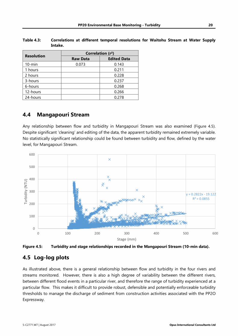
PP20 Environmental Base Monitoring - Turbidity 20
5-C2771.W7 | August 2017 Opus International Consultants Ltd
Table 4.3: Correlations at different temporal resolutions for Waitohu Stream at Water Supply
Intake.
Resolution Correlation (r²)
Raw Data Edited Data
10-min 0.073 0.143
1 hours 0.211
2 hours 0.228
3-hours 0.237
6-hours 0.268
12-hours 0.266
24-hours 0.278
4.4 Mangapouri Stream
Any relationship between flow and turbidity in Mangapouri Stream was also examined (Figure 4.5).
Despite significant ‘cleaning’ and editing of the data, the apparent turbidity remained extremely variable.
No statistically significant relationship could be found between turbidity and flow, defined by the water
level, for Mangapouri Stream.
Figure 4.5: Turbidity and stage relationships recorded in the Mangapouri Stream (10-min data).
4.5 Log-log plots
As illustrated above, there is a general relationship between flow and turbidity in the four rivers and
streams monitored. However, there is also a high degree of variability between the different rivers,
between different flood events in a particular river, and therefore the range of turbidity experienced at a
particular flow. This makes it difficult to provide robust, defensible and potentially enforceable turbidity
thresholds to manage the discharge of sediment from construction activities associated with the PP2O
Expressway.
y = 0.2822x - 19.122
R² = 0.0855
0
100
200
300
400
500
600
0 100 200 300 400 500 600
Tu
rbid
ity
(N
TU
)
Stage (mm)
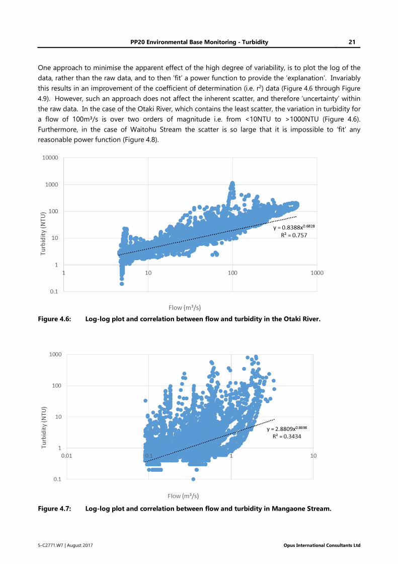
PP20 Environmental Base Monitoring - Turbidity 21
5-C2771.W7 | August 2017 Opus International Consultants Ltd
One approach to minimise the apparent effect of the high degree of variability, is to plot the log of the
data, rather than the raw data, and to then ‘fit’ a power function to provide the ‘explanation’. Invariably
this results in an improvement of the coefficient of determination (i.e. r2) data (Figure 4.6 through Figure
4.9). However, such an approach does not affect the inherent scatter, and therefore ‘uncertainty’ within
the raw data. In the case of the Otaki River, which contains the least scatter, the variation in turbidity for
a flow of 100m³/s is over two orders of magnitude i.e. from <10NTU to >1000NTU (Figure 4.6).
Furthermore, in the case of Waitohu Stream the scatter is so large that it is impossible to ‘fit’ any
reasonable power function (Figure 4.8).
Figure 4.6: Log-log plot and correlation between flow and turbidity in the Otaki River.
Figure 4.7: Log-log plot and correlation between flow and turbidity in Mangaone Stream.
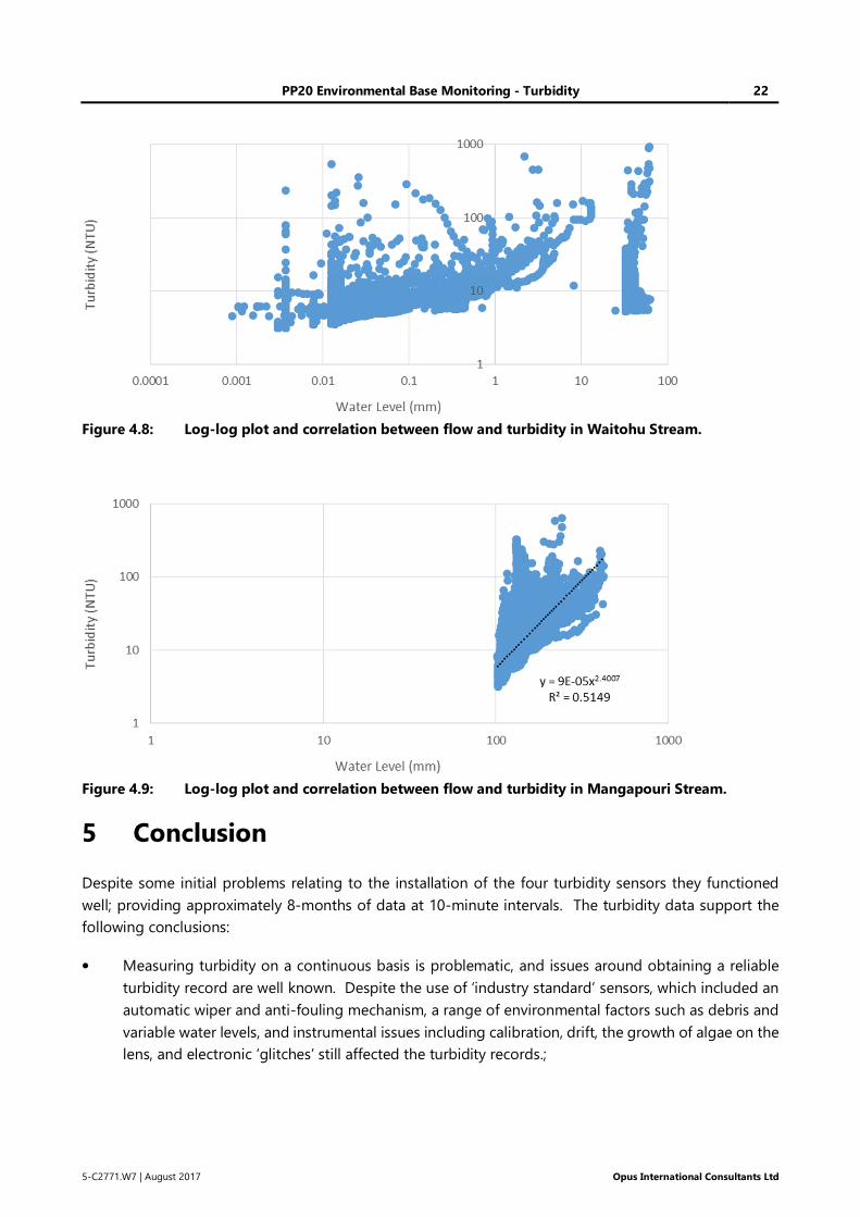
PP20 Environmental Base Monitoring - Turbidity 22
5-C2771.W7 | August 2017 Opus International Consultants Ltd
Figure 4.8: Log-log plot and correlation between flow and turbidity in Waitohu Stream.
Figure 4.9: Log-log plot and correlation between flow and turbidity in Mangapouri Stream.
5 Conclusion
Despite some initial problems relating to the installation of the four turbidity sensors they functioned
well; providing approximately 8-months of data at 10-minute intervals. The turbidity data support the
following conclusions:
• Measuring turbidity on a continuous basis is problematic, and issues around obtaining a reliable
turbidity record are well known. Despite the use of ‘industry standard’ sensors, which included an
automatic wiper and anti-fouling mechanism, a range of environmental factors such as debris and
variable water levels, and instrumental issues including calibration, drift, the growth of algae on the
lens, and electronic ‘glitches’ still affected the turbidity records.;
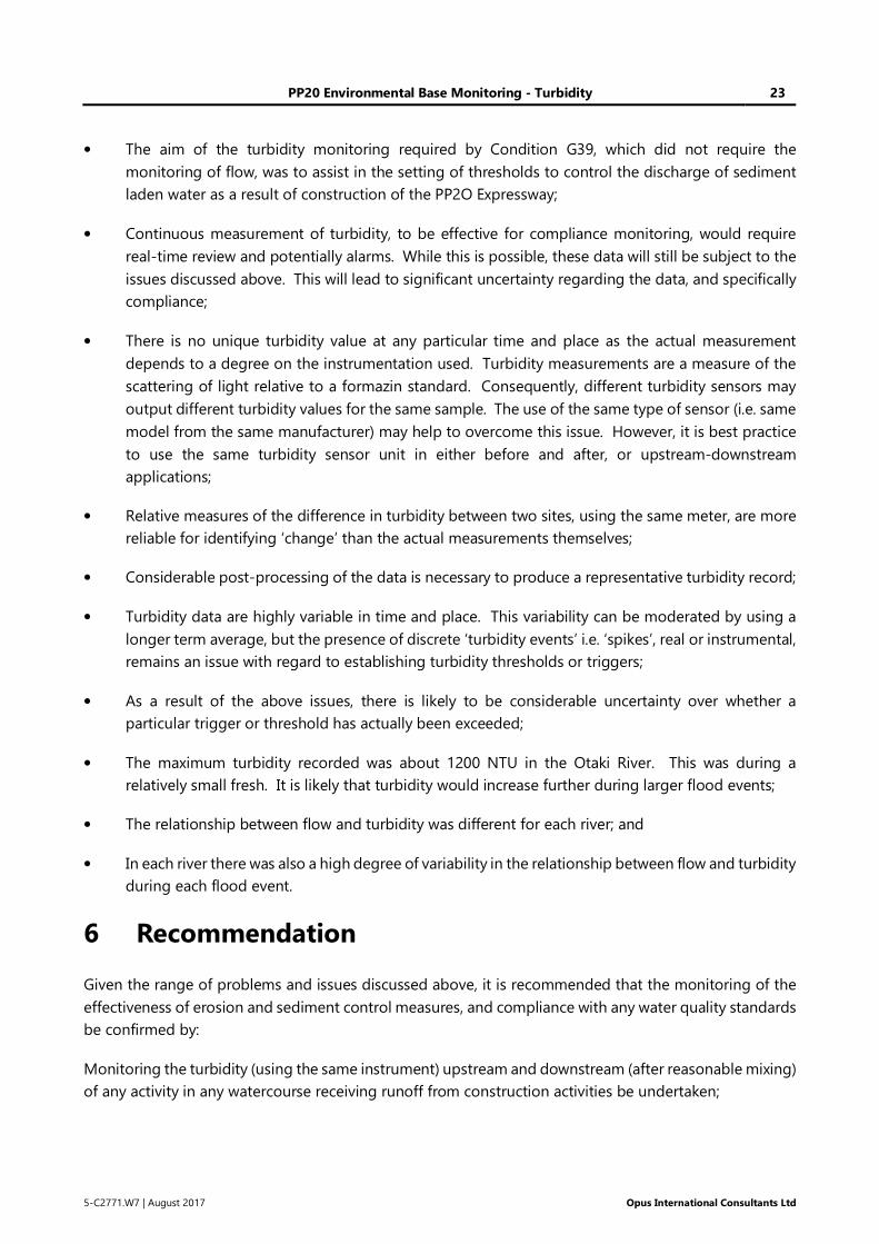
PP20 Environmental Base Monitoring - Turbidity 23
5-C2771.W7 | August 2017 Opus International Consultants Ltd
• The aim of the turbidity monitoring required by Condition G39, which did not require the
monitoring of flow, was to assist in the setting of thresholds to control the discharge of sediment
laden water as a result of construction of the PP2O Expressway;
• Continuous measurement of turbidity, to be effective for compliance monitoring, would require
real-time review and potentially alarms. While this is possible, these data will still be subject to the
issues discussed above. This will lead to significant uncertainty regarding the data, and specifically
compliance;
• There is no unique turbidity value at any particular time and place as the actual measurement
depends to a degree on the instrumentation used. Turbidity measurements are a measure of the
scattering of light relative to a formazin standard. Consequently, different turbidity sensors may
output different turbidity values for the same sample. The use of the same type of sensor (i.e. same
model from the same manufacturer) may help to overcome this issue. However, it is best practice
to use the same turbidity sensor unit in either before and after, or upstream-downstream
applications;
• Relative measures of the difference in turbidity between two sites, using the same meter, are more
reliable for identifying ‘change’ than the actual measurements themselves;
• Considerable post-processing of the data is necessary to produce a representative turbidity record;
• Turbidity data are highly variable in time and place. This variability can be moderated by using a
longer term average, but the presence of discrete ‘turbidity events’ i.e. ‘spikes’, real or instrumental,
remains an issue with regard to establishing turbidity thresholds or triggers;
• As a result of the above issues, there is likely to be considerable uncertainty over whether a
particular trigger or threshold has actually been exceeded;
• The maximum turbidity recorded was about 1200 NTU in the Otaki River. This was during a
relatively small fresh. It is likely that turbidity would increase further during larger flood events;
• The relationship between flow and turbidity was different for each river; and
• In each river there was also a high degree of variability in the relationship between flow and turbidity
during each flood event.
6 Recommendation
Given the range of problems and issues discussed above, it is recommended that the monitoring of the
effectiveness of erosion and sediment control measures, and compliance with any water quality standards
be confirmed by:
Monitoring the turbidity (using the same instrument) upstream and downstream (after reasonable mixing)
of any activity in any watercourse receiving runoff from construction activities be undertaken;
PP20 Environmental Base Monitoring - Turbidity 24
5-C2771.W7 | August 2017 Opus International Consultants Ltd
• When there is a conspicuous change in colour of the water downstream of the activity; or
• When hourly rainfall exceeds 20mm/hr (i.e. approximately 2.3-year ARI event); or
• When daily rainfall exceeds 70mm (i.e. approximately 2.3-year ARI event).
Should the downstream turbidity be 20% higher than that measured upstream then:
• An investigation of the cause or source of the increased turbidity be undertaken;
• Immediate actions be taken to mitigate any sediment loss from the construction site so that
turbidity drops back to the 20% threshold;
• Management and the sediment control structures be modified to prevent a similar occurrence in
the future; and
• A report be prepared for the consent authority outlining the nature of the breach, any immediate
actions taken to limit the loss of sediment from the site, and changes to future practices to ensure
that such an occurrence does not happen in the future.
7 References
Anderson, C. W. (2005). Turbidity 6.7. In USGS National Field Manual for the Collection of Water-Quality
Data. U S Geological Survey.
Davies-Colley, R.J., Smith, D.G. (2001). Turbidity, suspended sediment and water clarity: A review. Journal
of the American Water Resources Association, 37(9), 1085-1101.
Hicks, D.M. (1990). Suspended sediment yields from pasture and exotic forest basins. In: Abstracts, New
Zealand Hydrological Society 1990 Symposium, Taupo, November 20-23.

A-1
5-C2771.W7 | August 2017 Opus International Consultants Ltd
Appendix A – Correlations

A-2
5-C2771.W7 | August 2017 Opus International Consultants Ltd
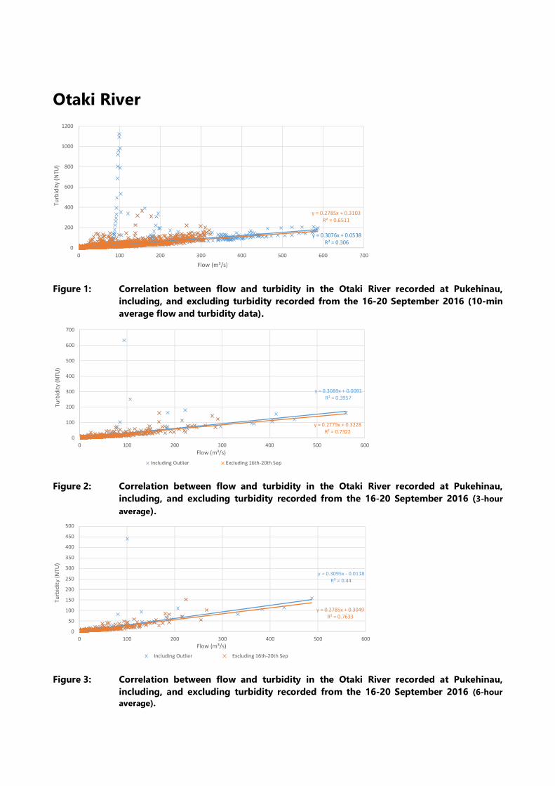
Otaki River
Figure 1: Correlation between flow and turbidity in the Otaki River recorded at Pukehinau,
including, and excluding turbidity recorded from the 16-20 September 2016 (10-min
average flow and turbidity data).
Figure 2: Correlation between flow and turbidity in the Otaki River recorded at Pukehinau,
including, and excluding turbidity recorded from the 16-20 September 2016 (3-hour
average).
Figure 3: Correlation between flow and turbidity in the Otaki River recorded at Pukehinau,
including, and excluding turbidity recorded from the 16-20 September 2016 (6-hour
average).
y = 0.3076x + 0.0538
R² = 0.306
y = 0.2785x + 0.3103
R² = 0.6511
0
200
400
600
800
1000
1200
0 100 200 300 400 500 600 700
Tu
rbid
ity
(N
TU
)
Flow (m³/s)
y = 0.3089x + 0.0091
R² = 0.3957
y = 0.2779x + 0.3228
R² = 0.73220
100
200
300
400
500
600
700
0 100 200 300 400 500 600
Tu
rbid
ity
(N
TU
)
Flow (m³/s)
Including Outlier Excluding 16th-20th Sep
y = 0.3095x - 0.0118
R² = 0.44
y = 0.2785x + 0.3049
R² = 0.7633
0
50
100
150
200
250
300
350
400
450
500
0 100 200 300 400 500 600
Tu
rbid
ity
(NT
U)
Flow (m³/s)
Including Outlier Excluding 16th-20th Sep
Figure 4: Correlation between flow and turbidity in the Otaki River recorded at Pukehinau,
including, and excluding turbidity recorded from the 16-20 September 2016 (24-hour
average).
y = 0.306x - 0.0013
R² = 0.6454
y = 0.2824x + 0.2125
R² = 0.9101
0
200
400
600
800
1000
1200
0 100 200 300 400 500 600 700
Tu
rbid
ity
(N
TU
)
Flow (m³/s)
Including Outlier Excluding 16th-20th Sep
Mangaone Stream at Ratanui
Figure 5: Correlation between flow and turbidity in the Mangaone Stream at Ratanui (10-min
average).
Figure 6: Correlation between flow and turbidity in the Mangaone Stream at Ratanui (1 hour
average).
Figure 7: Correlation between flow and turbidity in the Mangaone Stream at Ratanui (2 hour
average).
y = 25.154x - 4.7179
R² = 0.1094
0
100
200
300
400
500
600
700
800
900
0 0.5 1 1.5 2 2.5 3 3.5 4
Tu
rbid
ity
(NT
U)
Flow (m³/s)
y = 22.075x - 4.3287
R² = 0.1438
0
100
200
300
400
500
0 0.5 1 1.5 2 2.5 3 3.5
Tu
rbid
ity
(N
TU
)
Flow (m³/s)
y = 21.763x - 4.2771
R² = 0.2033
0
50
100
150
200
250
300
0 0.5 1 1.5 2 2.5 3
Tu
rbid
ity
(N
TU
)
Flow (m³/s)
Figure 8: Correlation between flow and turbidity in the Mangaone Stream at Ratanui (3-hour
average).
Figure 9: Correlation between flow and turbidity in the Mangaone Stream at Ratanui (6-hour
average).
Figure 10: Correlation between flow and turbidity in the Mangaone Stream at Ratanui (24-hour
average flow).
y = 0.3089x + 0.0091
R² = 0.3957
0
50
100
150
200
250
300
350
0 0.5 1 1.5 2 2.5 3
Turb
idit
y (
NT
U)
Flow (m³/s)
y = 20.062x - 3.841
R² = 0.2343
0
50
100
150
200
250
0 0.5 1 1.5 2 2.5
Tu
rbid
ity
(N
TU
)
Flow (m³/s)
y = 11.092x - 1.134
R² = 0.1876
0
10
20
30
40
50
60
0 0.2 0.4 0.6 0.8 1 1.2 1.4 1.6
Tu
rbid
ity
(N
TU
)
Flow (m³/s)
Waitohu Stream at Water Supply Intake
Figure 11: Raw and refined turbidity and stage relationships recorded in the Waitohu Stream (10-
min data).
Figure 12: Correlation between stage and turbidity in the Waitohu Stream (1-hour average).
Figure 13: Correlation between stage and turbidity in the Waitohu Stream (2-hour average).
y = 0.1096x - 101.76
R² = 0.0726
y = 0.0877x - 84.923
R² = 0.1429
-200
0
200
400
600
800
1000
1200
1400
800 1000 1200 1400 1600 1800 2000
Tu
bid
ity
(NT
U)
Stage (mm)
y = 0.0945x - 91.903
R² = 0.2107
0
100
200
300
400
500
600
700
800 1000 1200 1400 1600 1800 2000
Tu
bid
ity
(NT
U)
Stage (mm)
y = 0.0915x - 88.795
R² = 0.2282
0
50
100
150
200
250
300
350
400
450
800 900 1000 1100 1200 1300 1400 1500 1600 1700 1800
Tu
bid
ity
(N
TU
)
Stage (mm)
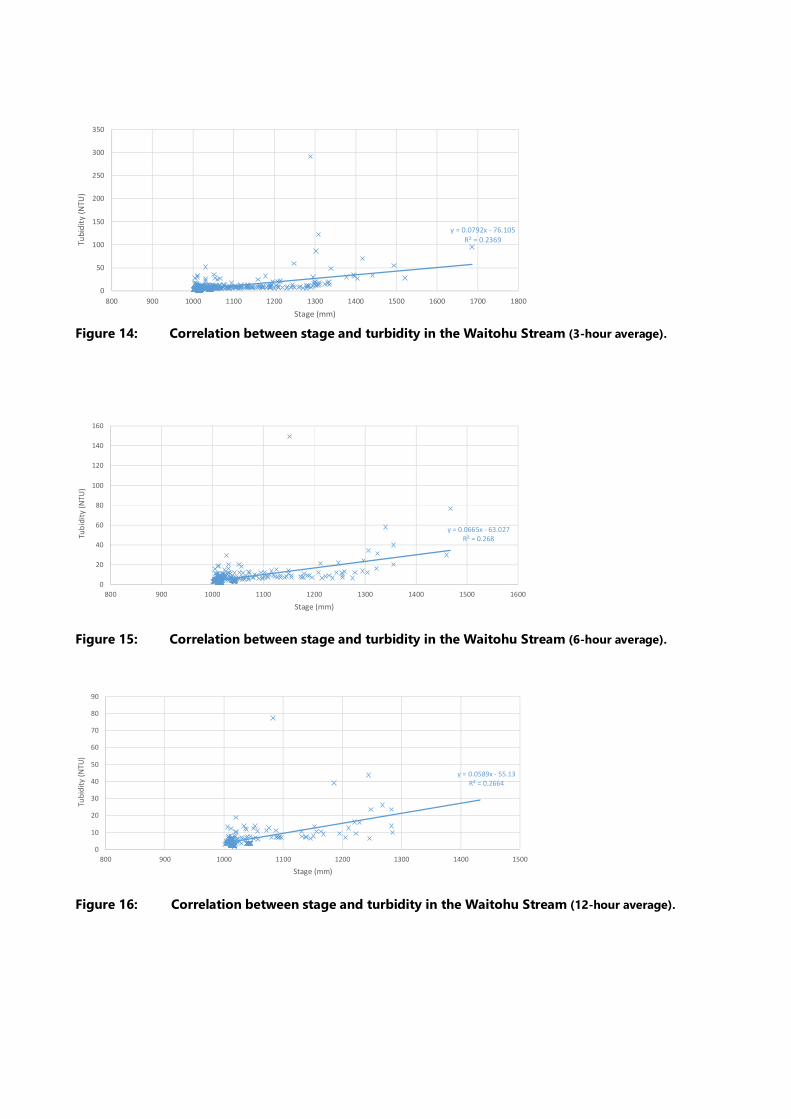
Figure 14: Correlation between stage and turbidity in the Waitohu Stream (3-hour average).
Figure 15: Correlation between stage and turbidity in the Waitohu Stream (6-hour average).
Figure 16: Correlation between stage and turbidity in the Waitohu Stream (12-hour average).
y = 0.0792x - 76.105
R² = 0.2369
0
50
100
150
200
250
300
350
800 900 1000 1100 1200 1300 1400 1500 1600 1700 1800
Tu
bid
ity
(NT
U)
Stage (mm)
y = 0.0665x - 63.027
R² = 0.268
0
20
40
60
80
100
120
140
160
800 900 1000 1100 1200 1300 1400 1500 1600
Tub
idit
y (N
TU
)
Stage (mm)
y = 0.0589x - 55.13
R² = 0.2664
0
10
20
30
40
50
60
70
80
90
800 900 1000 1100 1200 1300 1400 1500
Tub
idit
y (
NT
U)
Stage (mm)
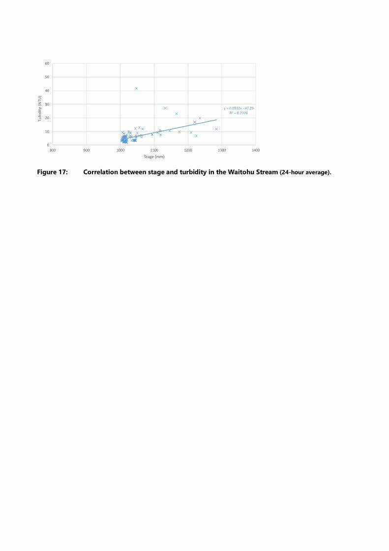
Figure 17: Correlation between stage and turbidity in the Waitohu Stream (24-hour average).
y = 0.0512x - 47.25
R² = 0.2776
0
10
20
30
40
50
60
800 900 1000 1100 1200 1300 1400
Tu
bid
ity
(N
TU
)
Stage (mm)

Opus International Consultants Ltd
L10, Majestic Centre, 100 Willis St
PO Box 12 003, Thorndon, Wellington 6144
New Zealand
t: +64 4 471 7000
f: +64 4 499 3699
w: www.opus.co.nz

FCCL-EV-MPN-0009
50
APPENDIX C: ECOLOGY LAYOUT PLANS (17
SHEETS)

1.680 - START OF ALIGNMENT
700600500400300200100
TAYLORS ROAD
GREENWOOD STREAM
TAYLORS ROAD
EXISTING STATE HIGHWAY 1
N
MATCHLINE - REFERSHEET 2
< < < < < < <
SDMH-1 B
<
<<<<<<<<<<<<<<<<<<<<<<<
<<<<<<<<<<<<<<<<<<<<<<<<<<<<<<<<
< < < < < < < < < < <<
<
EXISTING CULVERT No.108SIZE: 1.5m DIA
HD-1A
HD-2A
HD-2B
<
<< < < < < < <
<<<<<<<<<<<<<<<<<<<<<<<<<
<<
<<
<
<<
HD-69A HD-69B
< < < < < < <GREENWOOD STREAM
DIVERSION
TIE IN WITH EXISTING ROADDRAINAGE SYSTEM
PROPOSED GREENWOOD BASIN(TREATMENT & ATTENUATION)
CULVERT No.1SIZE: 3.5m x 2m (WxD)IL US = 22.7IL DS = 22.4
ORIGINAL SIZE A3 : DO NOT SCALE IF IN DOUBT ASK
Docu
ment
No.
Save Date:
No. AppdRevision By Chk Date
Scale (A1)
Drg Check
Dsg Verifier
Drawn
DesignConstruction
Date
Approved For Subject:
Drawing No.
Discipline
Rev.
* Refer to Original Hardcopy for Signature
Title:
18 May 2017 10:30 AM
R:\30
DD -
DESI
GN D
EVEL
OPME
NT G
ENER
AL\09
CAD
\DRA
WIN
GS\C
E\DG
-CE-
0801
-081
8.DW
G
Scale (A3)
18 May 2017 10:30 AM
R:\30
DD -
DESI
GN D
EVEL
OPME
NT G
ENER
AL\09
CAD
\DRA
WIN
GS\C
E\DG
-CE-
0801
-081
8.DW
G
ORIGINAL IN COLOUR
ECOLOGYLAYOUT PLANSHEET 1 OF18
. .
S.Halliday 10.05.17. .
. .
.
.
1 : 2000
00 . SJH . . 10.05.17 PP2O-DR-CE-0801
CIVIL
CONCEPT DESIGN
NOT FOR CONSTRUCTION
ECOLOGY LEGEND:
NATIVE TREE LOG SALVAGE
PERIPATUS MANAGEMENT WETLAND ECOLOGY REQUIREMENTS:
POWELLIPHANTA TRAVERSI
OTAKI SURVEY
WATER QUALITY AND STREAM
ECOLOGY MONITORING
MUDFISH SURVEY (AND
RELOCATION IF FOUND)
FISH PASSAGE
FISH SALVAGE/ RELOCATION
LIZARD SURVEYS, SALVAGING
AND MONITORING
STREAM ECOLOGY
REQUIREMENTS:
TERRESTRIAL ECOLOGY
REQUIREMENTS:
BIRD SURVEY
PIPIT SURVEY
BANDED DOTTEREL SURVEY
MACROINVERTEBRATE MONITORING
ECOLOGICAL PLANTING:
RIPARIAN MITIGATION PLANTING
TERRESTRIAL BUFFER
PLANTING
SWAMP FOREST MITIGATION
BUFFER PLANTING
STORMWATER WETLAND/POND
EXISTING STREAMS
DESIGNATION
EXISTING CULVERTS
LEGEND:
RAILWAY DESIGNATION
PROPOSED CULVERTS
PROPOSED STREAMS DIVERSIONS
LOW STATURE WETLAND
MITIGATION PLANTING
WETLAND MITIGATION PLANTING
1 2 3 45 6 7 8 9 10 11 12 13 14 15 16 17 18
KEY PLAN
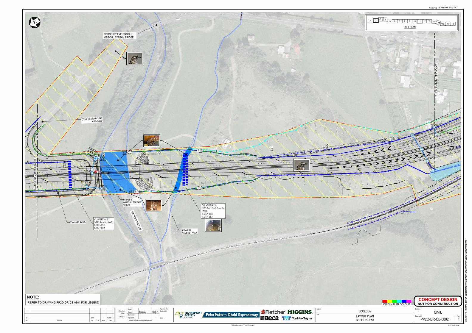
1400
1300
120011001000900800700
TAYLORS ROAD
ŌTAKI SOUTHBOUNDOFF-RAMP
WAITOHU STREAM
BRIDGE 1WAITOHU STREAMBRIDGE
NORTH ISLAND MAIN TRUNK RAILWAY
CULVERTACCESS TRACK
NMA
TCHL
INE
- REF
ERSH
EET
1MATCHLINE - REFER
SHEET 3
< < < < < < <<<<<<<
<<<<<<<<<<<<<<<<<<<<<<<<
SDMH-4B
<
<
< < < < < < <
< < < < <
< < < < < < < <
< < < < < < < < < < <
< < < < < < <<
SDMH-4C
<< < < < < < < < < < < <<
<< < < <
< << < < < <
<<<
<
<<<<<<<<<<<<<<<<<<<<<<MH-3B
<<<<<<<<<
SDMH-63B
<<<<<<
<<
<<
<
<<<<<<<<<<<<
HD-64A
HD-64B
HD-63A
HD-4AHD-3A
DCP-3C HP
<<
<<
<<
<<
<<<<<<<<<<
<<<<<<<<<<
<
CULVERT No.2SIZE: 5m x 2m (WxD)IL US = 25.5IL DS = 25.1
BRIDGE 202 EXISTING SH1WAITOHU STREAM BRIDGE
CULVERT No.3SIZE: 3m x 3m & 5m x 2m(WxD)IL US = 23.5IL DS = 23.1
18 May 2017 10:31 AM
R:\30
DD -
DESI
GN D
EVEL
OPME
NT G
ENER
AL\09
CAD
\DRA
WIN
GS\C
E\DG
-CE-
0801
-081
8.DW
G
ORIGINAL SIZE A3 : DO NOT SCALE IF IN DOUBT ASK
Docu
ment
No.
Save Date:
No. AppdRevision By Chk Date
Scale (A1)
Drg Check
Dsg Verifier
Drawn
DesignConstruction
Date
Approved For Subject:
Drawing No.
Discipline
Rev.
* Refer to Original Hardcopy for Signature
Title:
18 May 2017 10:31 AM
R:\30
DD -
DESI
GN D
EVEL
OPME
NT G
ENER
AL\09
CAD
\DRA
WIN
GS\C
E\DG
-CE-
0801
-081
8.DW
G
Scale (A3)
ORIGINAL IN COLOUR
ECOLOGYLAYOUT PLANSHEET 2 OF18
. .
S.Halliday 10.05.17. .
. .
.
.
1 : 2000
00 . SJH . . 10.05.17 PP2O-DR-CE-0802
CIVIL
CONCEPT DESIGN
NOT FOR CONSTRUCTION
NOTE:
REFER TO DRAWING PP2O-DR-CE-0801 FOR LEGEND
1 2 3 45 6 7 8 9 10 11 12 13 14 15 16 17 18
KEY PLAN
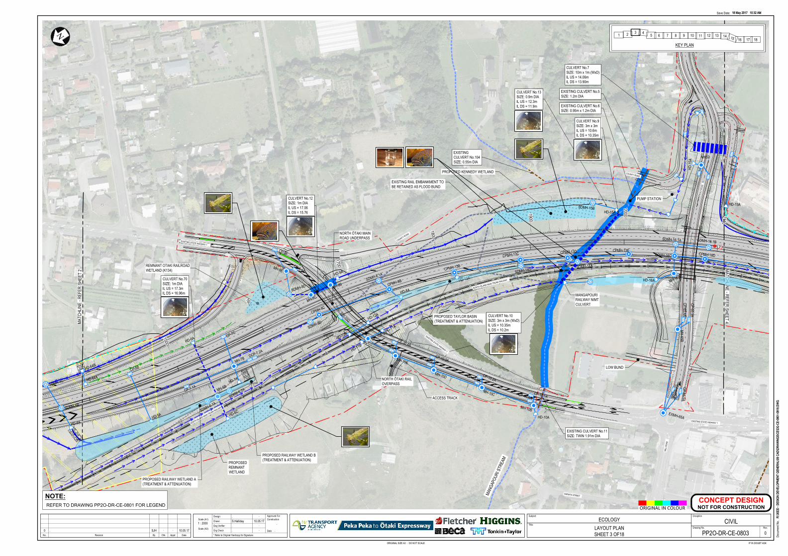
SF5
SF5
SF5
SF5
2100
20001900
1800
1700
1600
1500
1400
ACCESS TRACK
MANGAPOURIRAILWAY NIMTCULVERT
MANG
APOU
RI S
TREA
M
NORTH ŌTAKI MAINROAD UNDERPASS
NORTH ŌTAKI RAILOVERPASS
COUNTY ROAD
HARIATA STREET
MILL
ROA
D
EXISTING STATE HIGHWAY 1
RAHU
I ROA
D
EXISTING STATE HIGHWAY 1
NORTH ISLAND MAIN TRUNK RAILWAY
NORTH ISLAND MAIN TRUNK RAILWAY
COUNTY ROAD
RAHU
I ROA
D
EXISTING STATE HIGHWAY 1
N
MATC
HLIN
E - R
EFER
SHEE
T 2 MATCHLINE - REFER
SHEET 4
REMNANT OTAKI RAILROADWETLAND (K134)
<<<<<<<<
<
SDMH-4B
<
<
SDMH-6.1A
SDMH-6.2A
SDMH-14D
SDMH-15B
SDMH-14A
<<<<
<
< < < < < < <<
<<
<<
<<
<<
<<
<
SDMH-4C
<<
<<<<<<<<<<<<
< < < < < <
<<
<<<<<<<<<<<
<<
<<
<<
<<
<<
<<<<<<<<
<
<<
<<<
<<
<<
<<<<<<<<<<<<<<<
<
<<<<<<<<<<<
MH-6B
MH-7B
MH-10F
MH-9E
MH52
MH-65B
MH-9B
MH-9C
EXMH-65A
MH-10B
SDMH-9DSDMH-8.1A
CPMH-13B
CPMH-13C CPMH-13D CPMH-13E
SDMH-16.1A
CPMH-16D
SDMH-16.1B
MH-16B
CULVERT No.13SIZE: 0.9m DIAIL US = 12.3mIL DS = 11.9m
CULVERT No.7SIZE: 10m x 1m (WxD)IL US = 14.06mIL DS = 13.90m
EXISTINGCULVERT No.104SIZE: 0.55m DIA
EXISTING CULVERT No.6SIZE: 0.95m x 1.2m DIA
EXISTING CULVERT No.5SIZE: 1.2m DIA
EXISTING CULVERT No.11SIZE: TWIN 1.91m DIA
HD-5A HD-6C
HD-6A
HD-13AHD-9A
HD-15A
HD-12B
HD-12A
HD-11B
HD-11A
HD-7A
HD-10A
HD-8A
HD-16A
<<<<
HD-64A
HD-64B
CULVERT No.10SIZE: 3m x 3m (WxD)IL US = 10.35mIL DS = 10.2m
HD-4A
SDMH-8D
HD-1
5A
< < <
<<
<<
<<
<<
MH-10E
MH-10D
MH-10C
CPMH-8C
CPMH-8B
CP-7.1A
CP-7C
CP-10.4A
CP-10.3A
CP-10.2A
CP-65.3A
CP-65.1ACP-65.2A
CP-9.1A
CP-65.4A
CP-5B
CP-10.1A
CP-9F
DCP-7.2A
CP-10.8A
CP-10.7A
CP-10.6A
CP-10.5A
CP-10G
HD-15A
CULVERT No.9SIZE: 3m x 3mIL US = 10.6mIL DS = 10.35m
LP
CPMH-16C
<<
<<
<<
<<
<<
<<
<<
<<
<<
<<
<<
<<
<<
<<
<<
<
<
<<
<<
<<
<<
<<
<<
<<
<
<<<<<<<<<<
PROPOSED RAILWAY WETLAND B(TREATMENT & ATTENUATION)
PROPOSED KENNEDY WETLAND
EXISTING RAIL EMBANKMENT TOBE RETAINED AS FLOOD BUND
LOW BUND
PUMP STATION
CULVERT No.70SIZE: 1m DIAIL US = 17.3mIL DS = 16.96m
PROPOSED RAILWAY WETLAND A(TREATMENT & ATTENUATION)
PROPOSEDREMNANTWETLAND
CULVERT No.12SIZE: 1m DIAIL US = 17.06IL DS = 15.76
PROPOSED TAYLOR BASIN(TREATMENT & ATTENUATION)
18 May 2017 10:32 AM
R:\30
DD -
DESI
GN D
EVEL
OPME
NT G
ENER
AL\09
CAD
\DRA
WIN
GS\C
E\DG
-CE-
0801
-081
8.DW
G
ORIGINAL SIZE A3 : DO NOT SCALE IF IN DOUBT ASK
Docu
ment
No.
Save Date:
No. AppdRevision By Chk Date
Scale (A1)
Drg Check
Dsg Verifier
Drawn
DesignConstruction
Date
Approved For Subject:
Drawing No.
Discipline
Rev.
* Refer to Original Hardcopy for Signature
Title:
18 May 2017 10:32 AM
R:\30
DD -
DESI
GN D
EVEL
OPME
NT G
ENER
AL\09
CAD
\DRA
WIN
GS\C
E\DG
-CE-
0801
-081
8.DW
G
Scale (A3)
ORIGINAL IN COLOUR
ECOLOGYLAYOUT PLANSHEET 3 OF18
. .
S.Halliday 10.05.17. .
. .
.
.
1 : 2000
00 . SJH . . 10.05.17 PP2O-DR-CE-0803
CIVIL
CONCEPT DESIGN
NOT FOR CONSTRUCTION
NOTE:
REFER TO DRAWING PP2O-DR-CE-0801 FOR LEGEND
1 2 3 45 6 7 8 9 10 11 12 13 14 15 16 17 18
KEY PLAN
2800
2700
2600
2500
2400
2300
2200
2100
PROPOSED RACECOURSE BASIN(TREATMENT & ATTENUATION)
RACECOURSE STREAM
MILL
ROA
D
EXISTING STATE HIGHWAY 1
ARTHUR STREET
RAHU
I ROA
D
EXISTING STATE HIGHWAY 1
NORTH ISLAND MAIN TRUNK RAILWAY
NORTH ISLAND MAIN TRUNK RAILWAY
NORTH ISLAND MAIN TRUNK RAILWAY
N
MATC
HLIN
E - R
EFER
SHEE
T 3
MATCHLINE - REFERSHEET 5
< < < < < < < < < << < < < < < < < < < < <
<<<<<<<<<<<<
<<<<<<<<<<<<<<<<<<<<<<<
<<<<<<<<<<<<<<<<< <<<<<<<<<<<<<<<
<<<<
<
<<
MH52
MH-65B
EXMH-65A
SDMH-16.1A
CPMH-16D
SDMH-16.1B
MH-16B
CULVERT No.14SIZE: 1.35 DIASEE NOTE 1IL US = 11.3mIL DS = 11.1m
CULVERT No. 15aSIZE: 1.05 DIAIL US = 13.75mIL DS = 13.5m
EXISTING CULVERTNo.15SIZE: 0.9 DIA
CULVERT No. 15bSIZE: 1.05 DIAIL US = 13.6mIL DS = 13.4m
CPMH-16E
CPMH-16F
SDMH-17B
SDMH-19B
HD-17A
HD-19A
HD-1
5A
<<
<<
<<
<<
CP-65.3ACP-65.1A
CP-65.2ACP-65.4A
HD-15A
LP
HP
CPMH-16C
<<<<<<<<<<<<
< < < < < < < < < < < < < < < <
< < < < < < < < < < < < < < < <
<<<<
<<<<<<<<<
<<
<<<<<<<<<<<<<<<<<<<<<<<<<RACECOURSE
STREAM DIVERSION
18 May 2017 10:32 AM
R:\30
DD -
DESI
GN D
EVEL
OPME
NT G
ENER
AL\09
CAD
\DRA
WIN
GS\C
E\DG
-CE-
0801
-081
8.DW
G
ORIGINAL SIZE A3 : DO NOT SCALE IF IN DOUBT ASK
Docu
ment
No.
Save Date:
No. AppdRevision By Chk Date
Scale (A1)
Drg Check
Dsg Verifier
Drawn
DesignConstruction
Date
Approved For Subject:
Drawing No.
Discipline
Rev.
* Refer to Original Hardcopy for Signature
Title:
18 May 2017 10:32 AM
R:\30
DD -
DESI
GN D
EVEL
OPME
NT G
ENER
AL\09
CAD
\DRA
WIN
GS\C
E\DG
-CE-
0801
-081
8.DW
G
Scale (A3)
ORIGINAL IN COLOUR
ECOLOGYLAYOUT PLANSHEET 4 OF18
. .
S.Halliday 10.05.17. .
. .
.
.
1 : 2000
00 . SJH . . 10.05.17 PP2O-DR-CE-0804
CIVIL
CONCEPT DESIGN
NOT FOR CONSTRUCTION
NOTE:
REFER TO DRAWING PP2O-DR-CE-0801 FOR LEGEND
1 2 3 45 6 7 8 9 10 11 12 13 14 15 16 17 18
KEY PLAN
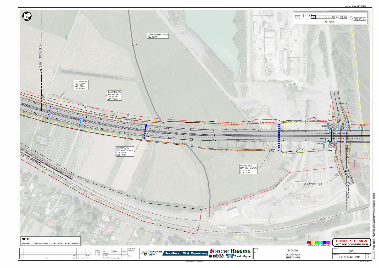
3500
3400
3300
3200
3100
3000
2900
2800
QUARRY ACCESS ROAD
STRESSCRETE PLANT
WINSTONES AGGREGATES
NORTH ISLAND MAIN TRUNK RAILWAY
N
MATC
HLIN
E - R
EFER
SHEE
T 4
MATCHLINE - REFERSHEET 6
<<<<<<<<<<<<<<<<<<<<<<<<<<<<<<<
<<<<<<<<<<<<<<<<<<<<<<<<<<
<<<<<<<<<<<<<
<<<<<<<<<<<<<<<<<< <<<<<<<<
<<<<<<<
MH-22B
MH-21B
CULVERT No. 15cSIZE: 1.05 DIAIL US = 13.6mIL DS = 13.4m
CULVERT No.18SIZE: 3.5m x 3m (WxD)IL US = 11.7mIL DS = 11.4m
EXISTING CULVERT No.105SIZE: 0.6 DIA
CULVERT No.15eSIZE: 3mx 2.75m (WxD)IL US = 11.9mIL DS = 11.7m
CULVERT No. 15dSIZE: 1.05 DIAIL US = 13.6mIL DS = 13.2m
SDMH-19B
SDMH-20B
HD-20A
HD-21A
HD-22A HD-23A
MH-23B
DCP-23C
DCP-23.1A
LP
<<
<<
<<
<<
<<
<<
18 May 2017 10:33 AM
R:\30
DD -
DESI
GN D
EVEL
OPME
NT G
ENER
AL\09
CAD
\DRA
WIN
GS\C
E\DG
-CE-
0801
-081
8.DW
G
ORIGINAL SIZE A3 : DO NOT SCALE IF IN DOUBT ASK
Docu
ment
No.
Save Date:
No. AppdRevision By Chk Date
Scale (A1)
Drg Check
Dsg Verifier
Drawn
DesignConstruction
Date
Approved For Subject:
Drawing No.
Discipline
Rev.
* Refer to Original Hardcopy for Signature
Title:
18 May 2017 10:33 AM
R:\30
DD -
DESI
GN D
EVEL
OPME
NT G
ENER
AL\09
CAD
\DRA
WIN
GS\C
E\DG
-CE-
0801
-081
8.DW
G
Scale (A3)
ORIGINAL IN COLOUR
ECOLOGYLAYOUT PLANSHEET 5 OF18
. .
S.Halliday 10.05.17. .
. .
.
.
1 : 2000
00 . SJH . . 10.05.17 PP2O-DR-CE-0805
CIVIL
CONCEPT DESIGN
NOT FOR CONSTRUCTION
NOTE:
REFER TO DRAWING PP2O-DR-CE-0801 FOR LEGEND
1 2 3 45 6 7 8 9 10 11 12 13 14 15 16 17 18
KEY PLAN
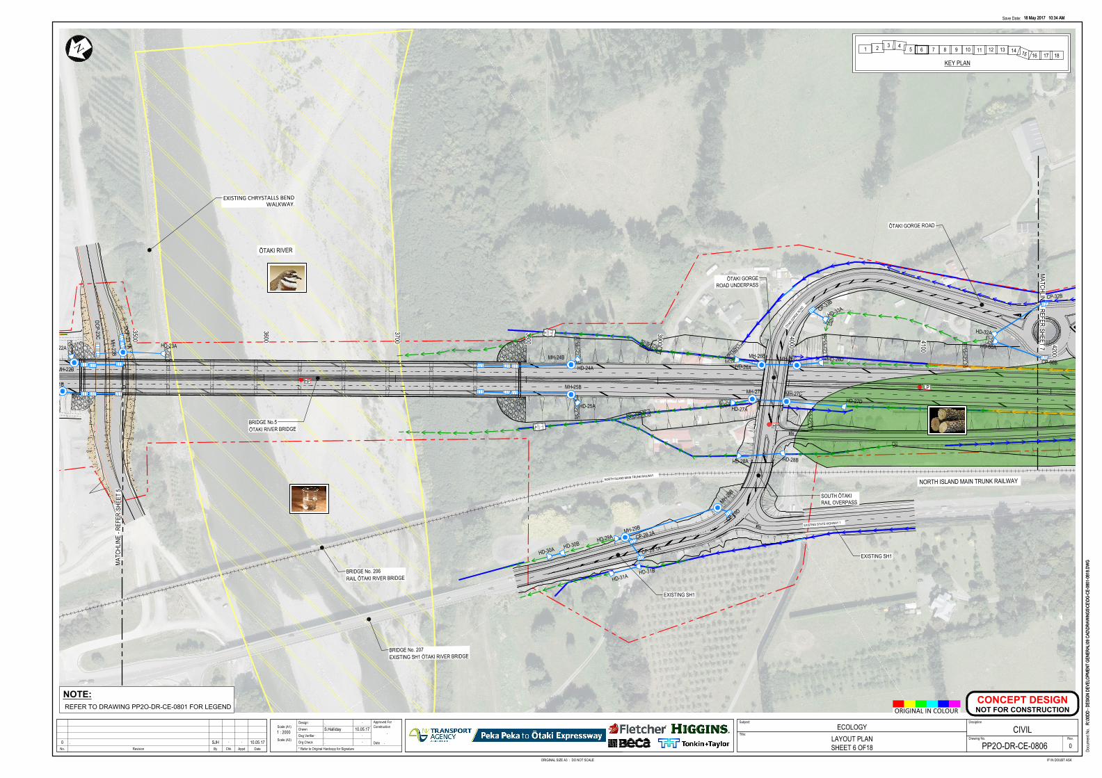
STOP
STOP
STOP
STOP
4200
4100
4000
3900
3800
3700
3600
3500
EXISTING SH1
EXISTING SH1
ŌTAKI GORGE ROAD
EXISTING CHRYSTALLS BENDWALKWAY.
ŌTAKI RIVER
BRIDGE No.5ŌTAKI RIVER BRIDGE
ŌTAKI GORGEROAD UNDERPASS
SOUTH ŌTAKIRAIL OVERPASS
NORTH ISLAND MAIN TRUNK RAILWAYNORTH ISLAND MAIN TRUNK RAILWAY
EXISTING STATE HIGHWAY 1
ŌTAKI
GORGE ROAD
BRIDGE No. 206RAIL ŌTAKI RIVER BRIDGE
BRIDGE No. 207EXISTING SH1 ŌTAKI RIVER BRIDGE
NN
MATC
HLIN
E - R
EFER
SHEE
T 5
MATCHLINE - REFERSHEET 7
<<
<<
< < < < < < < < <
< < < < < <
<<<<
<<
<
< < < < < < < <<
<< < < <
< < < < < < < < < < < < <
< < < < < < << < < < < <
< < < < < < < < < < < < < < < < < < < < < <
< < < < < < <
< < < < < < < < <
<
< << < <
<<<<<<<<
< <<
<<
< < < < < < < < <
< < < < < << < <
< < < < < < < < < < < < <
MH-22B
MH-21B MH-25B
MH-24B
MH-27B
MH-26B MH-26C
MH-27CHD-27D
HD-26DHD-26A
HD-27A
HD-28B
HD-31A
HD-30BHD-30A
HD-22A HD-23A
HD-24A
HD-25A
HD-31B
HD-29A
HD-28A
HD-33A
HD-32A
MH-23B < < < < < < < < <HD-66A
CP-29.2A
CP-29.1A
CP-33BCP-32B
CP-66B
DCP-23C
DCP-23.1A
MH-29B
MH-29B
CP-29D
HP
HP
LP
18 May 2017 10:34 AM
R:\30
DD -
DESI
GN D
EVEL
OPME
NT G
ENER
AL\09
CAD
\DRA
WIN
GS\C
E\DG
-CE-
0801
-081
8.DW
G
ORIGINAL SIZE A3 : DO NOT SCALE IF IN DOUBT ASK
Docu
ment
No.
Save Date:
No. AppdRevision By Chk Date
Scale (A1)
Drg Check
Dsg Verifier
Drawn
DesignConstruction
Date
Approved For Subject:
Drawing No.
Discipline
Rev.
* Refer to Original Hardcopy for Signature
Title:
18 May 2017 10:34 AM
R:\30
DD -
DESI
GN D
EVEL
OPME
NT G
ENER
AL\09
CAD
\DRA
WIN
GS\C
E\DG
-CE-
0801
-081
8.DW
G
Scale (A3)
ORIGINAL IN COLOUR
ECOLOGYLAYOUT PLANSHEET 6 OF18
. .
S.Halliday 10.05.17. .
. .
.
.
1 : 2000
00 . SJH . . 10.05.17 PP2O-DR-CE-0806
CIVIL
CONCEPT DESIGN
NOT FOR CONSTRUCTION
NOTE:
REFER TO DRAWING PP2O-DR-CE-0801 FOR LEGEND
1 2 3 45 6 7 8 9 10 11 12 13 14 15 16 17 18
KEY PLAN
4900
4800
4700
4600
4500
4400
4300
4200
ŌTAKI NORTHBOUNDOFF-RAMP
ŌTAKI SOUTHBOUNDON-RAMP
NATIVE TREESNORTH ISLAND MAIN TRUNK RAILWAY
ŌTAKI
GORGE ROAD
ADDINGTON ROAD
EXISTING STATE HIGHWAY 1
EXISTING STATE HIGHWAY 1
NORTH ISLAND MAIN TRUNK RAILWAY
OLD HAUTERE ROAD LINKOLD HAUTERE ROAD LINK
EXISTING STATE HIGHWAY 1
NORTH ISLAND MAIN TRUNK RAILWAY
N N
MATC
HLIN
E - R
EFER
SHEE
T 6
MATCHLINE - REFERSHEET 8
< < < < < < <
< < < < < < < < < < <
< < < < < < < < < < < < < < < < < < < < < < < < < < <
< < < < < < < < < < < < < < < < < <
< < < < < < < < < < < < < < < < < < < < < < < < < < <
< < < < < < < < < < < < < < < < < < < < < < <<<<<<<<<<<
SDMH-37B
<<
<<
SDMH-36B
<<
<
<<
<<
<
< < < < < < < <<
<<
<<
<
<<
<<
HD-35B
HD-35A
HD-36A
HD-37A
HD-34B
HD-34A
<
<< < < < < < < < < < < < < < < < < < < < < < < < < < < < < < < < < < < < < < < < < < < < < < < < < <
< < < < < < < < < < < < < < < < < < < < < < < < < < < < < < < < < < < << < < < < < < < < < < < < < < < < < <
CP-32B
CP-66B
18 May 2017 10:35 AM
R:\30
DD -
DESI
GN D
EVEL
OPME
NT G
ENER
AL\09
CAD
\DRA
WIN
GS\C
E\DG
-CE-
0801
-081
8.DW
G
ORIGINAL SIZE A3 : DO NOT SCALE IF IN DOUBT ASK
Docu
ment
No.
Save Date:
No. AppdRevision By Chk Date
Scale (A1)
Drg Check
Dsg Verifier
Drawn
DesignConstruction
Date
Approved For Subject:
Drawing No.
Discipline
Rev.
* Refer to Original Hardcopy for Signature
Title:
18 May 2017 10:35 AM
R:\30
DD -
DESI
GN D
EVEL
OPME
NT G
ENER
AL\09
CAD
\DRA
WIN
GS\C
E\DG
-CE-
0801
-081
8.DW
G
Scale (A3)
ORIGINAL IN COLOUR
ECOLOGYLAYOUT PLANSHEET 7 OF18
. .
S.Halliday 10.05.17. .
. .
.
.
1 : 2000
00 . SJH . . 10.05.17 PP2O-DR-CE-0807
CIVIL
CONCEPT DESIGN
NOT FOR CONSTRUCTION
NOTE:
REFER TO DRAWING PP2O-DR-CE-0801 FOR LEGEND
1 2 3 45 6 7 8 9 10 11 12 13 14 15 16 17 18
KEY PLAN
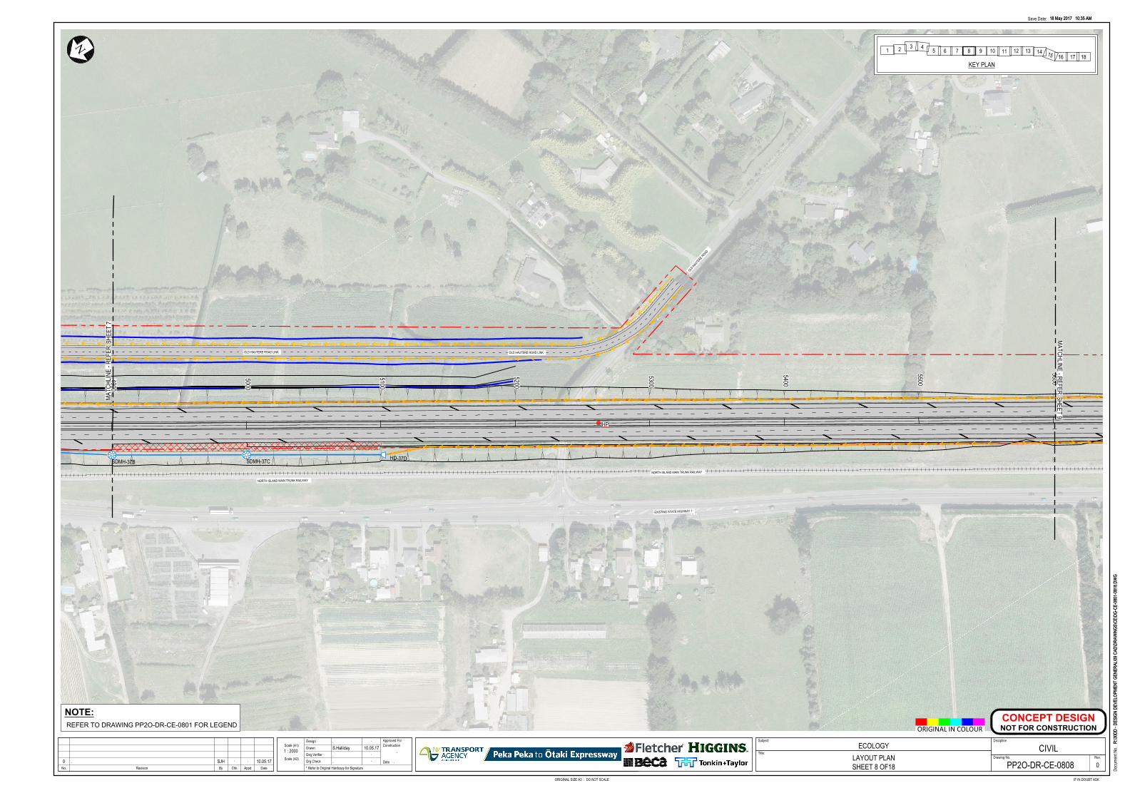
5600
5500
5400
5300
5200
5100
5000
4900
OLD HAUTE
RE ROAD
NORTH ISLAND MAIN TRUNK RAILWAY
OLD HAUTERE ROAD LINK
NORTH ISLAND MAIN TRUNK RAILWAY
EXISTING STATE HIGHWAY 1
OLD HAUTERE ROAD LINK
NN
MATC
HLIN
E - R
EFER
SHEE
T 7
MATCHLINE - REFERSHEET 9
< < < < < < < < < < < < < < < < < < < < < < < < < < < < < < < < < < < < < < < < < < < < < < < < < < < < < < < < < <
< < < < < < < < < < < < < < < < < < < < < < < < < < < < < < < < < < < < < <
<<<<<<<
<<<<<<
SDMH-37B SDMH-37C HD-37D
< < < < < < < < < < < < < < < < < < < < < < < < < < < < < < < < < < <<
<
<<
< < < < < < < < < < < < < < < < < < < < < < < < < < < < < < < < < < <<
<<
<<
HP
18 May 2017 10:35 AM
R:\30
DD -
DESI
GN D
EVEL
OPME
NT G
ENER
AL\09
CAD
\DRA
WIN
GS\C
E\DG
-CE-
0801
-081
8.DW
G
ORIGINAL SIZE A3 : DO NOT SCALE IF IN DOUBT ASK
Docu
ment
No.
Save Date:
No. AppdRevision By Chk Date
Scale (A1)
Drg Check
Dsg Verifier
Drawn
DesignConstruction
Date
Approved For Subject:
Drawing No.
Discipline
Rev.
* Refer to Original Hardcopy for Signature
Title:
18 May 2017 10:35 AM
R:\30
DD -
DESI
GN D
EVEL
OPME
NT G
ENER
AL\09
CAD
\DRA
WIN
GS\C
E\DG
-CE-
0801
-081
8.DW
G
Scale (A3)
ORIGINAL IN COLOUR
ECOLOGYLAYOUT PLANSHEET 8 OF18
. .
S.Halliday 10.05.17. .
. .
.
.
1 : 2000
00 . SJH . . 10.05.17 PP2O-DR-CE-0808
CIVIL
CONCEPT DESIGN
NOT FOR CONSTRUCTION
NOTE:
REFER TO DRAWING PP2O-DR-CE-0801 FOR LEGEND
1 2 3 45 6 7 8 9 10 11 12 13 14 15 16 17 18
KEY PLAN
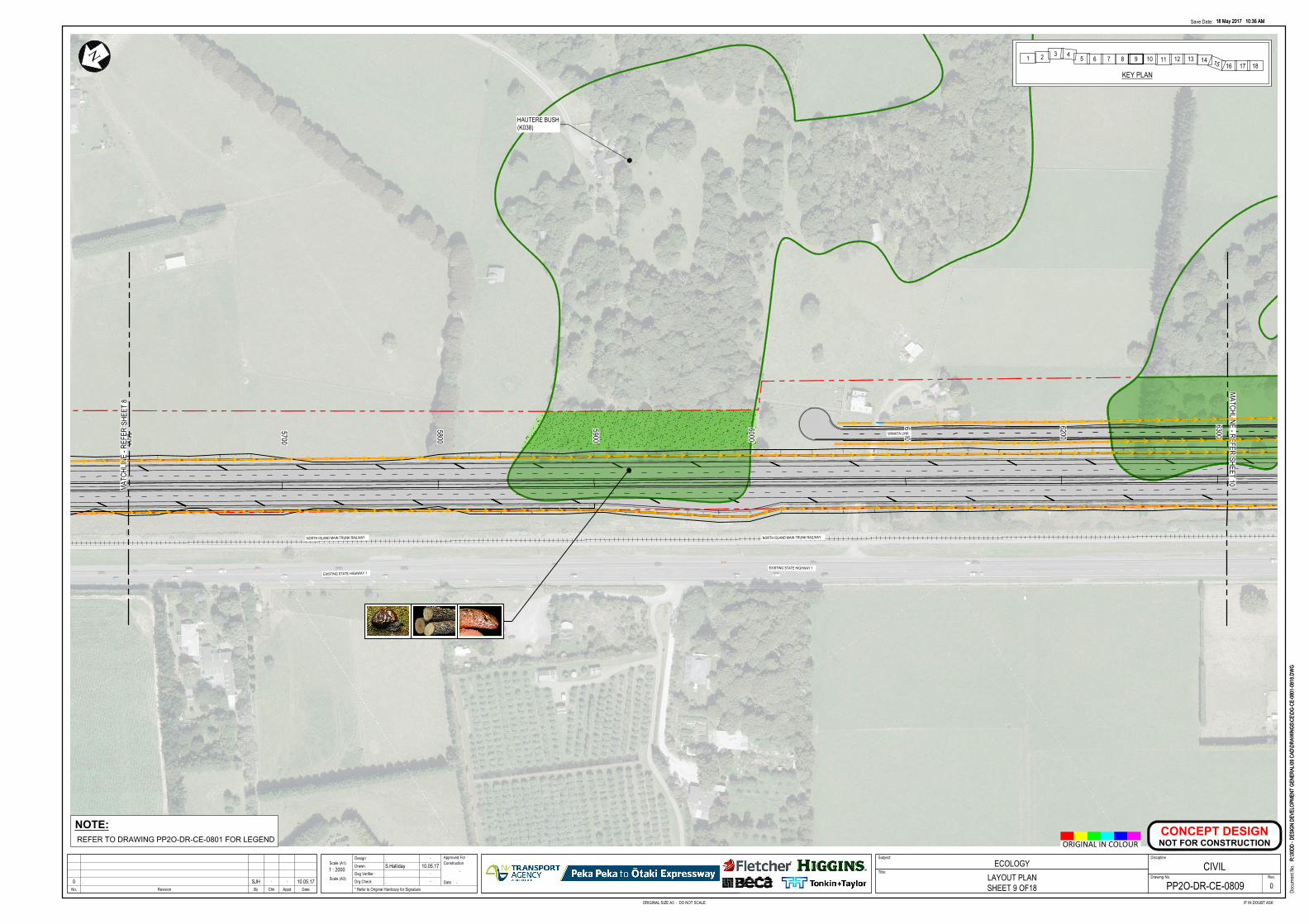
6300
6200
6100
6000
5900
5800
5700
5600
EXISTING STATE HIGHWAY 1
NORTH ISLAND MAIN TRUNK RAILWAY
WINIATA LINK
EXISTING STATE HIGHWAY 1
NORTH ISLAND MAIN TRUNK RAILWAY
N N
MATC
HLIN
E - R
EFER
SHEE
T 8
MATCHLINE - REFERSHEET 10
<<<<<<<<<<<<<<<<<<<<<<<<<<<<<<<<<<<<<<<<<<<<<<<<<<<<<<<<<<<<<<<<
<<<<<<<<<<<<<<<<<<<<<<<<<<<<<<<<<<<<<<<<<<<<<<<<<<<<<<<<<<<<<<<<
<<<<<<<<<<<<<<<<<<<<<<<<
< <<<<<<<<<<<<<<<<<<<<<
18 May 2017 10:36 AM
R:\30
DD -
DESI
GN D
EVEL
OPME
NT G
ENER
AL\09
CAD
\DRA
WIN
GS\C
E\DG
-CE-
0801
-081
8.DW
G
ORIGINAL SIZE A3 : DO NOT SCALE IF IN DOUBT ASK
Docu
ment
No.
Save Date:
No. AppdRevision By Chk Date
Scale (A1)
Drg Check
Dsg Verifier
Drawn
DesignConstruction
Date
Approved For Subject:
Drawing No.
Discipline
Rev.
* Refer to Original Hardcopy for Signature
Title:
18 May 2017 10:36 AM
R:\30
DD -
DESI
GN D
EVEL
OPME
NT G
ENER
AL\09
CAD
\DRA
WIN
GS\C
E\DG
-CE-
0801
-081
8.DW
G
Scale (A3)
ORIGINAL IN COLOUR
ECOLOGYLAYOUT PLANSHEET 9 OF18
. .
S.Halliday 10.05.17. .
. .
.
.
1 : 2000
00 . SJH . . 10.05.17 PP2O-DR-CE-0809
CIVIL
CONCEPT DESIGN
NOT FOR CONSTRUCTION
HAUTERE BUSH(K038)
NOTE:
REFER TO DRAWING PP2O-DR-CE-0801 FOR LEGEND
1 2 3 45 6 7 8 9 10 11 12 13 14 15 16 17 18
KEY PLAN
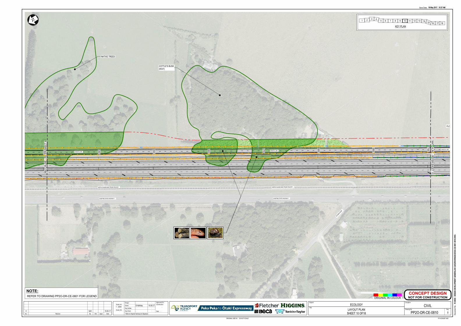
7000
6900
6800
6700
6600
6500
6400
6300
COTTLE'S BUSH(K037)
WINIATA LINKWINIATA LINK
EXISTING STATE HIGHWAY 1
TE W
AKA ROAD
NORTH ISLAND MAIN TRUNK RAILWAY
WINIATA LINK
EXISTING STATE HIGHWAY 1
NORTH ISLAND MAIN TRUNK RAILWAY
N
MATC
HLIN
E - R
EFER
SHEE
T 9 MATCHLINE - REFER
SHEET 11
<<<<<<<<<<<<<<<<<<<<<<<<<<<<<<<<<<<<<<<<<<<<<<<<<<<<<
<<<<<<<<<<<<<<<<<<<<<<<<<<<<<<<<<<<<<<<<<<<<<<<<<<<<<
<<<<<<<<<<<<<<<<<<<
<<<<<<<<<<<<<<<<<<<<<<<<<<<<<<<<<<<<<<<<<<<<<<<<<<<<<<<<<
<<<<<<<<<<<<<<<<< <<<<<<<<<<<<<<<<< <<<<<<<<<
<<<<<<<<<<<<
<<<<<<<<<<<
<<<<<<<
FLOOD BUND
18 May 2017 10:37 AM
R:\30
DD -
DESI
GN D
EVEL
OPME
NT G
ENER
AL\09
CAD
\DRA
WIN
GS\C
E\DG
-CE-
0801
-081
8.DW
G
ORIGINAL SIZE A3 : DO NOT SCALE IF IN DOUBT ASK
Docu
ment
No.
Save Date:
No. AppdRevision By Chk Date
Scale (A1)
Drg Check
Dsg Verifier
Drawn
DesignConstruction
Date
Approved For Subject:
Drawing No.
Discipline
Rev.
* Refer to Original Hardcopy for Signature
Title:
18 May 2017 10:37 AM
R:\30
DD -
DESI
GN D
EVEL
OPME
NT G
ENER
AL\09
CAD
\DRA
WIN
GS\C
E\DG
-CE-
0801
-081
8.DW
G
Scale (A3)
ORIGINAL IN COLOUR
ECOLOGYLAYOUT PLAN
SHEET 10 OF18
. .
S.Halliday 10.05.17. .
. .
.
.
1 : 2000
00 . SJH . . 10.05.17 PP2O-DR-CE-0810
CIVIL
CONCEPT DESIGN
NOT FOR CONSTRUCTION
NATIVE TREES
NOTE:
REFER TO DRAWING PP2O-DR-CE-0801 FOR LEGEND
1 2 3 45 6 7 8 9 10 11 12 13 14 15 16 17 18
KEY PLAN
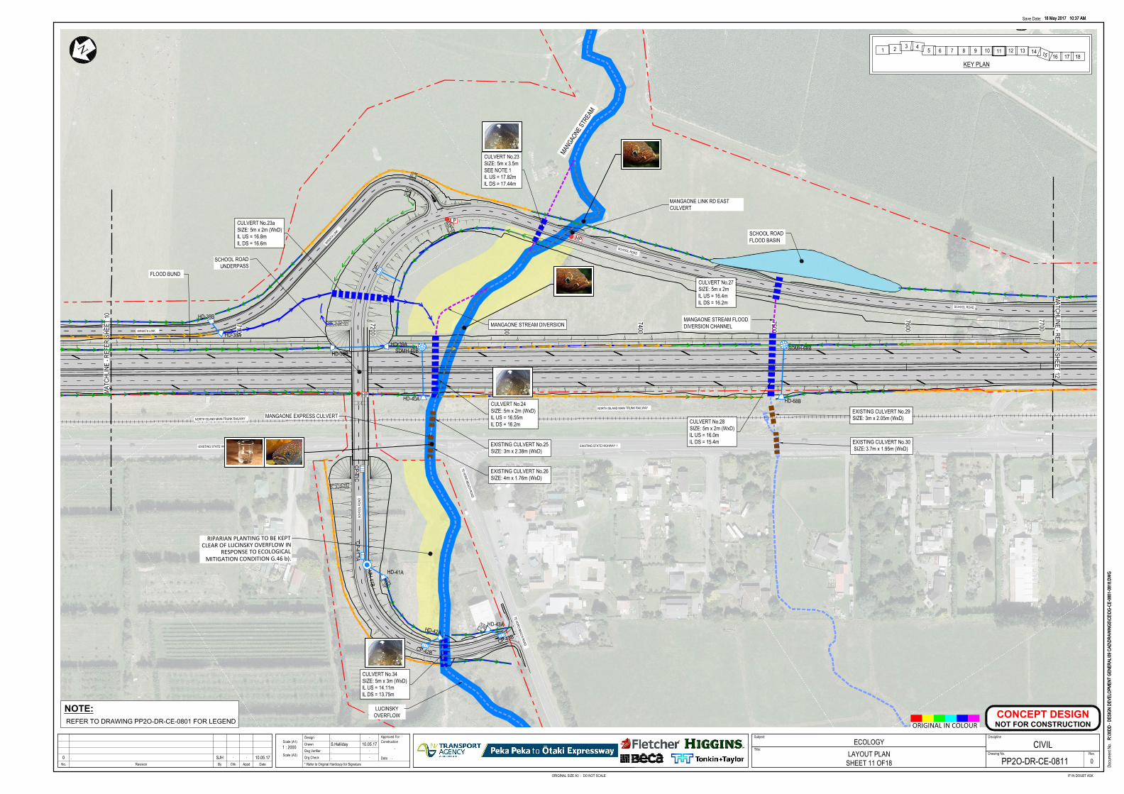
7700
7600
7500
7400
7300
7200
7100
7000
RIPARIAN PLANTING TO BE KEPTCLEAR OF LUCINSKY OVERFLOW IN
RESPONSE TO ECOLOGICALMITIGATION CONDITION G.46 b).
MANGAONE EXPRESS CULVERT
MANGAONE LINK RD EASTCULVERT
SCHOOL ROADUNDERPASS
MANGAO
NE ST
REAM
TE HORO BEACH ROAD
WINIATA LINK
SCHOOL ROAD
SCHOOL ROAD
NORTH ISLAND MAIN TRUNK RAILWAY
EXISTING STATE HIGHWAY 1
NORTH ISLAND MAIN TRUNK RAILWAY
TE HORO BEACH ROAD
SCHO
OL R
OAD
EXISTING STATE HIGHWAY 1
WINIATA LIN
K
N
MATC
HLIN
E - R
EFER
SHEE
T 10
MATCHLINE - REFERSHEET 12
<<<<<<<<<
<<
<<
<
<<
<<<
<<<<
<
<<<
< < < < < < <
<<<<<<<
<<
<<<<
<
<<
<<
<<
<<
<<
<
<<<<<<<<<<<<<<<<<<< < < < < < < < < < < < < <
< < < < < < < < < < < <<<<<<<<<<<<<<<<<< <<
<<<<<<<<<<<<<<<<<<<<<<<
<<<<<<<<< < <<
<<
<
<<
<<
<<
<<
<<
<
<<<
< < <
<<<<<<<<<
< < < < < < < < <
< < < < < < <
<<<<<<<<<<<<<<<<<< < < < < < < < <
< <
<<
<
<<
<<
<<
<
<
SDMH-40B
CULVERT No.23aSIZE: 5m x 2m (WxD)IL US = 16.8mIL DS = 16.6m
CULVERT No.24SIZE: 5m x 2m (WxD)IL US = 16.55mIL DS = 16.2m
CULVERT No.23SIZE: 5m x 3.5mSEE NOTE 1IL US = 17.82mIL DS = 17.44m
CULVERT No.28SIZE: 5m x 2m (WxD)IL US = 16.0mIL DS = 15.4m
CULVERT No.34SIZE: 5m x 3m (WxD)IL US = 14.11mIL DS = 13.75m
EXISTING CULVERT No.25SIZE: 3m x 2.38m (WxD)
EXISTING CULVERT No.26SIZE: 4m x 1.76m (WxD)
EXISTING CULVERT No.29SIZE: 3m x 2.05m (WxD)
EXISTING CULVERT No.30SIZE:3.7m x 1.95m (WxD)
HD-39B
HD-38B
HD-38A
HD-41A
HD-39A
HD-43A
FLOOD BUND
HD-40A
HD-42A
SDMH-68B
HD-68B
CULVERT No.27SIZE: 5m x 2mIL US = 16.4mIL DS = 16.2m
CP-41C
CP-43B
CP-
CP-42B
CP-41.1A
MH-41B
HP
LP
HP
MANGAONE STREAM DIVERSION
SCHOOL ROADFLOOD BASIN
MANGAONE STREAM FLOODDIVERSION CHANNEL
LUCINSKYOVERFLOW
18 May 2017 10:37 AM
R:\30
DD -
DESI
GN D
EVEL
OPME
NT G
ENER
AL\09
CAD
\DRA
WIN
GS\C
E\DG
-CE-
0801
-081
8.DW
G
ORIGINAL SIZE A3 : DO NOT SCALE IF IN DOUBT ASK
Docu
ment
No.
Save Date:
No. AppdRevision By Chk Date
Scale (A1)
Drg Check
Dsg Verifier
Drawn
DesignConstruction
Date
Approved For Subject:
Drawing No.
Discipline
Rev.
* Refer to Original Hardcopy for Signature
Title:
18 May 2017 10:37 AM
R:\30
DD -
DESI
GN D
EVEL
OPME
NT G
ENER
AL\09
CAD
\DRA
WIN
GS\C
E\DG
-CE-
0801
-081
8.DW
G
Scale (A3)
ORIGINAL IN COLOUR
ECOLOGYLAYOUT PLAN
SHEET 11 OF18
. .
S.Halliday 10.05.17. .
. .
.
.
1 : 2000
00 . SJH . . 10.05.17 PP2O-DR-CE-0811
CIVIL
CONCEPT DESIGN
NOT FOR CONSTRUCTION
NOTE:
REFER TO DRAWING PP2O-DR-CE-0801 FOR LEGEND
1 2 3 45 6 7 8 9 10 11 12 13 14 15 16 17 18
KEY PLAN
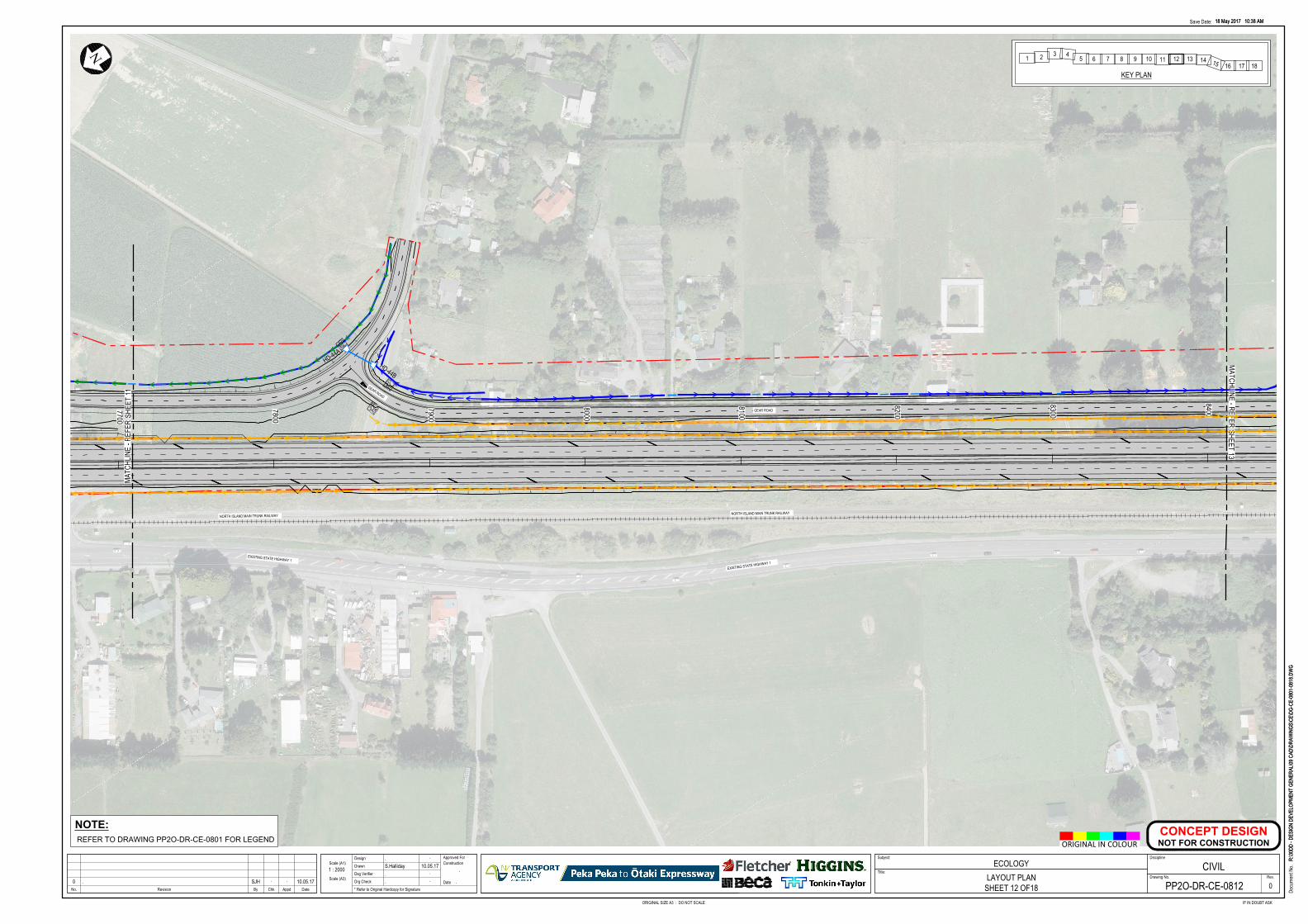
8400
8300
8200
8100
8000
7900
7800
7700
EXISTING STATE HIGHWAY 1
NORTH ISLAND MAIN TRUNK RAILWAY
GEAR ROAD
GEAR ROAD
EXISTING STATE HIGHWAY 1
NORTH ISLAND MAIN TRUNK RAILWAY
NN
MATC
HLIN
E - R
EFER
SHEE
T 11
MATCHLINE - REFERSHEET 13
<<
< < < <
< < < < < < < < < < < < < < <
< < < < < < < < < < < < < <
<<<<<<<<<<<<
<<<<<<<<<<<<<<<<<<<<<<<<<<<<<<<<<<<<<<<<<<<<<<<<<<<
<<<<<<<<<<<<<<<<<<<<<<<<<<<<<<<<<<<<<<<<<<<<<<<<<
<<<<<<<<<<<<<<<<<<<<<<<<<<<<<<<<<<<<<<<<<<<<<<<<<
<<
<<<<<<< < <<< <<<<<< <<<<<<<< < < < < < < < < < < < <<
<<
<<
<<
HD-44A
HD-44B
18 May 2017 10:38 AM
R:\30
DD -
DESI
GN D
EVEL
OPME
NT G
ENER
AL\09
CAD
\DRA
WIN
GS\C
E\DG
-CE-
0801
-081
8.DW
G
ORIGINAL SIZE A3 : DO NOT SCALE IF IN DOUBT ASK
Docu
ment
No.
Save Date:
No. AppdRevision By Chk Date
Scale (A1)
Drg Check
Dsg Verifier
Drawn
DesignConstruction
Date
Approved For Subject:
Drawing No.
Discipline
Rev.
* Refer to Original Hardcopy for Signature
Title:
18 May 2017 10:38 AM
R:\30
DD -
DESI
GN D
EVEL
OPME
NT G
ENER
AL\09
CAD
\DRA
WIN
GS\C
E\DG
-CE-
0801
-081
8.DW
G
Scale (A3)
ORIGINAL IN COLOUR
ECOLOGYLAYOUT PLAN
SHEET 12 OF18
. .
S.Halliday 10.05.17. .
. .
.
.
1 : 2000
00 . SJH . . 10.05.17 PP2O-DR-CE-0812
CIVIL
CONCEPT DESIGN
NOT FOR CONSTRUCTION
NOTE:
REFER TO DRAWING PP2O-DR-CE-0801 FOR LEGEND
1 2 3 45 6 7 8 9 10 11 12 13 14 15 16 17 18
KEY PLAN
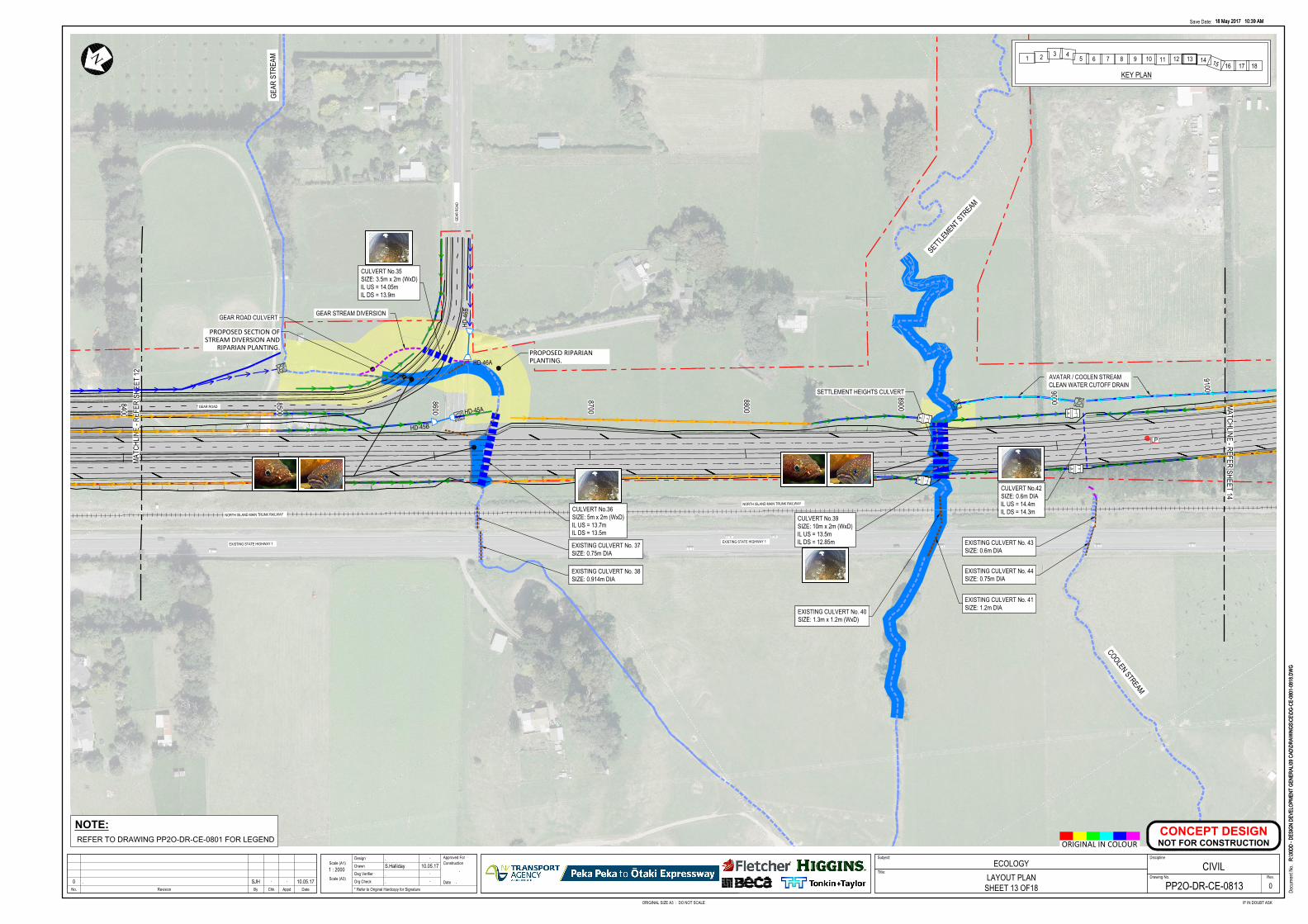
910090008900
8800
8700
8600
8500
8400
PROPOSED RIPARIANPLANTING.
GEAR ROAD CULVERT
SETTLEMENT HEIGHTS CULVERT
PROPOSED SECTION OFSTREAM DIVERSION AND
RIPARIAN PLANTING.
COOLEN STREAM
SETTLE
MENT STR
EAM
GEAR
STR
EAM
GEAR
ROA
D
EXISTING STATE HIGHWAY 1
NORTH ISLAND MAIN TRUNK RAILWAY
GEAR ROAD
NORTH ISLAND MAIN TRUNK RAILWAY
EXISTING STATE HIGHWAY 1
N
MATC
HLIN
E - R
EFER
SHEE
T 12
MATCHLINE - REFERSHEET 14
EXISTING CULVERT No. 37SIZE: 0.75m DIA
< < < < < <
<<<<<<<<<<<
<<<<<<<<<<<<<<<<<<<<<< <<<<<<<<<<<<<<<<
<<<<<<<<<<<<<<<<<<<<<<<<<<<<<
< < < < <
< < < < <
<<<<<<
<<<<<<
<<
<<
<
<<<<<
<<<<<<<<<<<<<<
<<<<<<<
<<<<<<<
< < < < <
< < < < <
<<<<<<<<
< < < < < < < < < <
EXISTING CULVERT No. 38SIZE: 0.914m DIA
<<
<<
<
EXISTING CULVERT No. 40SIZE: 1.3m x 1.2m (WxD)
EXISTING CULVERT No. 41SIZE: 1.2m DIA
EXISTING CULVERT No. 43SIZE: 0.6m DIA
EXISTING CULVERT No. 44SIZE: 0.75m DIA
CULVERT No.35SIZE: 3.5m x 2m (WxD)IL US = 14.05mIL DS = 13.9m
CULVERT No.36SIZE: 5m x 2m (WxD)IL US = 13.7mIL DS = 13.5m
CULVERT No.42SIZE: 0.6m DIAIL US = 14.4mIL DS = 14.3m
CULVERT No.39SIZE: 10m x 2m (WxD)IL US = 13.5mIL DS = 12.85m
HD-45B
HD-45A
HD-46A
HD-4
6B
LP
GEAR STREAM DIVERSION
AVATAR / COOLEN STREAMCLEAN WATER CUTOFF DRAIN
18 May 2017 10:39 AM
R:\30
DD -
DESI
GN D
EVEL
OPME
NT G
ENER
AL\09
CAD
\DRA
WIN
GS\C
E\DG
-CE-
0801
-081
8.DW
G
ORIGINAL SIZE A3 : DO NOT SCALE IF IN DOUBT ASK
Docu
ment
No.
Save Date:
No. AppdRevision By Chk Date
Scale (A1)
Drg Check
Dsg Verifier
Drawn
DesignConstruction
Date
Approved For Subject:
Drawing No.
Discipline
Rev.
* Refer to Original Hardcopy for Signature
Title:
18 May 2017 10:39 AM
R:\30
DD -
DESI
GN D
EVEL
OPME
NT G
ENER
AL\09
CAD
\DRA
WIN
GS\C
E\DG
-CE-
0801
-081
8.DW
G
Scale (A3)
ORIGINAL IN COLOUR
ECOLOGYLAYOUT PLAN
SHEET 13 OF18
. .
S.Halliday 10.05.17. .
. .
.
.
1 : 2000
00 . SJH . . 10.05.17 PP2O-DR-CE-0813
CIVIL
CONCEPT DESIGN
NOT FOR CONSTRUCTION
NOTE:
REFER TO DRAWING PP2O-DR-CE-0801 FOR LEGEND
1 2 3 45 6 7 8 9 10 11 12 13 14 15 16 17 18
KEY PLAN
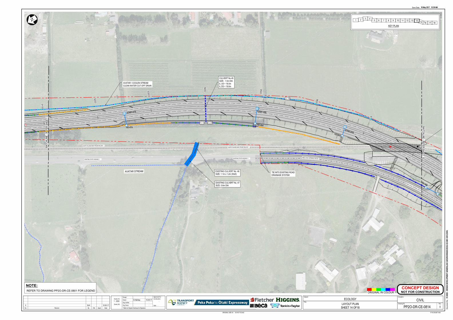
9800
9700
9600
9500
94009300
9200
9100
AVATAR STREAM
NEW LOCAL ARTERIAL ROUTEEXISTING STATE HIGHWAY 1
NORTH ISLAND MAIN TRUNK RAILWAY
EXISTING STATE HIGHWAY 1
NORTH ISLAND MAIN TRUNK RAILWAY
NEW LOCAL ARTERIAL ROUTE
N
MATC
HLIN
E - R
EFER
SHEE
T 13
MATCHLINE - REFERSHEET 15
<
SDMH-48BSDMH-47B< < < < < < < <
< < < < < < < < < < < < < < < < < < < < < < < < < < < < < << < < < < < < < < < < < < < < < < < < < < <
< < < < < < < < < < < < <
<<
<<
<<<<
<<
<<
<<
<<
<<<<
< < < < < < < < < < < < < <
< < < < < < < < < < < <
< <
< <
<<<<
< < < < < <
< < < <
< < < <
< < < < < < < < < < < < < < < < < < < < < < < < < < < <
EXISTING CULVERT No. 46SIZE: 1.1m x 1.2m (WxD)
EXISTING CULVERT No. 47SIZE: 0.6m DIA
CULVERT No.45SIZE: 1.5m DIAIL US = 18.0mIL DS = 16.6m
HD-49B
HD-49A
HD-47AHD-48A
SDMH-66BHD-66A
LP
HP
AVATAR / COOLEN STREAMCLEAN WATER CUT-OFF DRAIN
TIE INTO EXISTING ROADDRAINAGE SYSTEM
18 May 2017 10:39 AM
R:\30
DD -
DESI
GN D
EVEL
OPME
NT G
ENER
AL\09
CAD
\DRA
WIN
GS\C
E\DG
-CE-
0801
-081
8.DW
G
ORIGINAL SIZE A3 : DO NOT SCALE IF IN DOUBT ASK
Docu
ment
No.
Save Date:
No. AppdRevision By Chk Date
Scale (A1)
Drg Check
Dsg Verifier
Drawn
DesignConstruction
Date
Approved For Subject:
Drawing No.
Discipline
Rev.
* Refer to Original Hardcopy for Signature
Title:
18 May 2017 10:39 AM
R:\30
DD -
DESI
GN D
EVEL
OPME
NT G
ENER
AL\09
CAD
\DRA
WIN
GS\C
E\DG
-CE-
0801
-081
8.DW
G
Scale (A3)
ORIGINAL IN COLOUR
ECOLOGYLAYOUT PLAN
SHEET 14 OF18
. .
S.Halliday 10.05.17. .
. .
.
.
1 : 2000
00 . SJH . . 10.05.17 PP2O-DR-CE-0814
CIVIL
CONCEPT DESIGN
NOT FOR CONSTRUCTION
NOTE:
REFER TO DRAWING PP2O-DR-CE-0801 FOR LEGEND
1 2 3 45 6 7 8 9 10 11 12 13 14 15 16 17 18
KEY PLAN
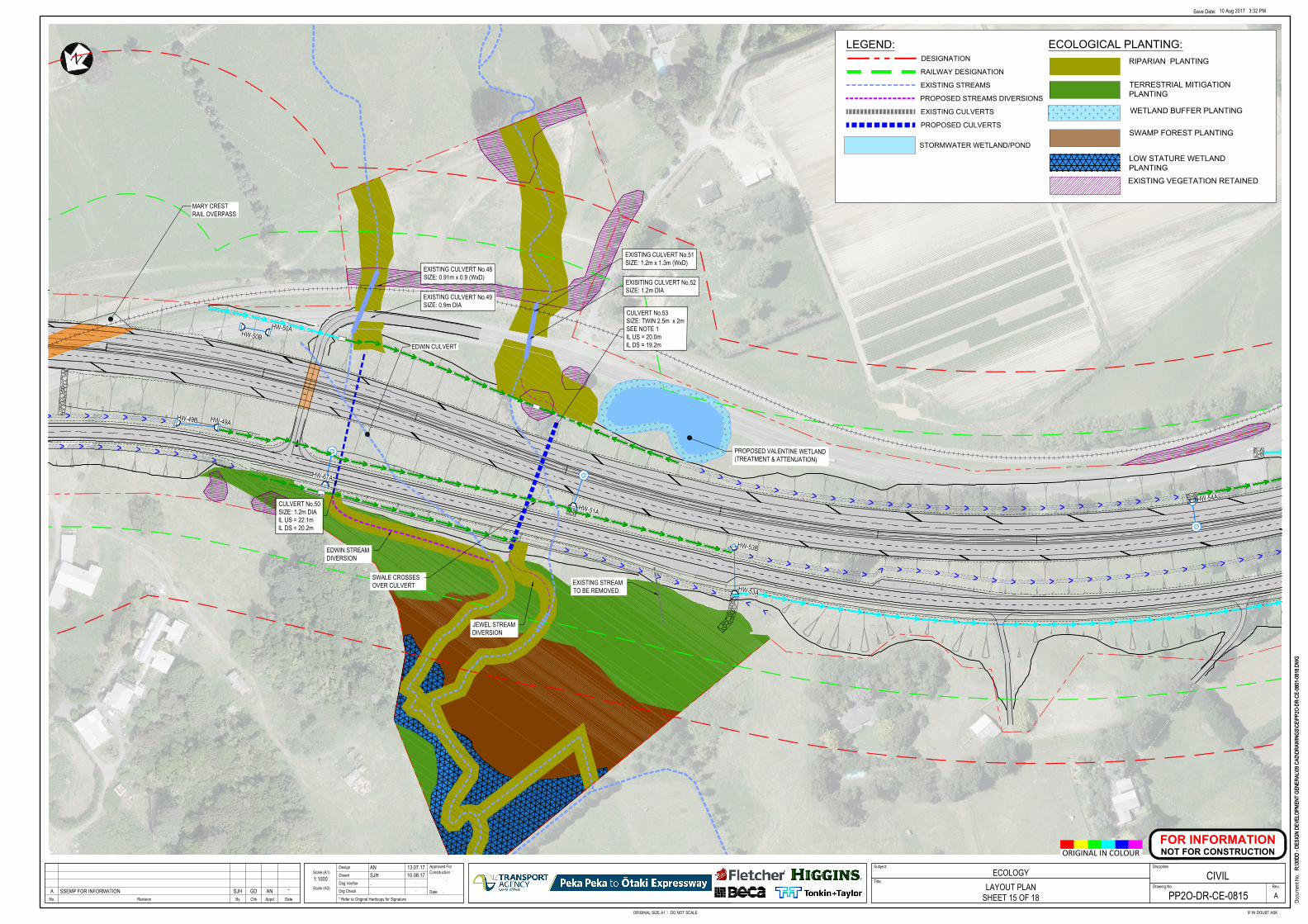
N
MARY CRESTRAIL OVERPASS
<<
< <
<<<<<<
<<<<<<<
<<<<<<<<<<<<<<<<<<<<<<
<<<<<<<<<<<<<<<<<<<<<<<<<<<<<<<<<<<<<<<
<<<<<<<<<
<<<<<<<<<<
<<<
<<<<<<<<<<<<<<<<<<<<<<
<<<<<<<<<<<<<<<<<<<<<<
<<<<<<<<<<<<<<<<<<<<<<
<<<<<<<<<<<<<<<<<<<<<<<<< <<< <<< <<< <<<
<< << << << <<
<<<<<<<<<<<<<<<<<<<<<<<<<
<< << << << <<<<<<<<<<<<<<<<<<<<<<<<<<<<<<<<<<<<<<<<<<<<<<<<<<<<<<<<<<<<<<<
<<<<<<<<<<<<<
<<<<<<<<<<<<<
<<<<<<<<<<<<<
<<<<<<<<<<
<<<<<<<<<<
<<<<<<<<<<
<<<<<<<<<<<<<<<<<<<<<<
<<<<<<
<<<<<<<<<<
<
<< < < < <
<<<<<<<<<<<<<<<<<<<<<<<<<<<<<<< <<<<<<<<<<<<<<<<<<<<
<< < < < <
<< < < < <
<< < < < <
<< < < < <
<<<<<<<<<<<<<<
<<<<<<<<<<
<<<<<<<<<<
<<<<<<<<<<<<<<<<
<<<<<<
<<<<<<
<<<<<<
HW-50BHW-50A
HW-49B HW-49A
HW-67A
HW-51A
HW-53A
HW-53B
HW-54A
EDWIN STREAMDIVERSION
JEWEL STREAMDIVERSION
CULVERT No.50SIZE: 1.2m DIAIL US = 22.1mIL DS = 20.2m
EXISTING CULVERT No.49SIZE: 0.9m DIA
EXISITING CULVERT No.52SIZE: 1.2m DIA
EXISTING CULVERT No.51SIZE: 1.2m x 1.3m (WxD)
EXISTING CULVERT No.48SIZE: 0.91m x 0.9 (WxD)
CULVERT No.53SIZE: TWIN 2.5m x 2mSEE NOTE 1IL US = 20.0mIL DS = 19.2m
SWALE CROSSESOVER CULVERT EXISTING STREAM
TO BE REMOVED
PROPOSED VALENTINE WETLAND(TREATMENT & ATTENUATION)
EDWIN CULVERT
R:\30
DD -
DESI
GN D
EVEL
OPME
NT G
ENER
AL\09
CAD
\DRA
WIN
GS\C
E\PP
2O-D
R-CE
-080
1-08
18.D
WG
ORIGINAL SIZE A1 : DO NOT SCALE IF IN DOUBT ASK
Docu
ment
No.
Save Date:
No. AppdRevision By Chk Date
Scale (A1)
Drg Check
Dsg Verifier
Drawn
DesignConstruction
Date
Approved For Subject:
Drawing No.
Discipline
Rev.
* Refer to Original Hardcopy for Signature
Title:
10 Aug 2017 3:32 PM
R:\30
DD -
DESI
GN D
EVEL
OPME
NT G
ENER
AL\09
CAD
\DRA
WIN
GS\C
E\PP
2O-D
R-CE
-080
1-08
18.D
WG
Scale (A3)
ORIGINAL IN COLOUR
ECOLOGYLAYOUT PLAN
SHEET 15 OF 18
AN 13.07.17SJH 10.08.17. .. .
.
.
1:1000
AA SSEMP FOR INFORMATION SJH GD AN -PP2O-DR-CE-0815
CIVIL
FOR INFORMATION
NOT FOR CONSTRUCTION
ECOLOGICAL PLANTING:
RIPARIAN PLANTING
TERRESTRIAL MITIGATION
PLANTING
SWAMP FOREST PLANTING
LOW STATURE WETLAND
PLANTING
WETLAND BUFFER PLANTING
EXISTING VEGETATION RETAINED
STORMWATER WETLAND/POND
EXISTING STREAMS
DESIGNATION
EXISTING CULVERTS
LEGEND:
RAILWAY DESIGNATION
PROPOSED CULVERTS
PROPOSED STREAMS DIVERSIONS
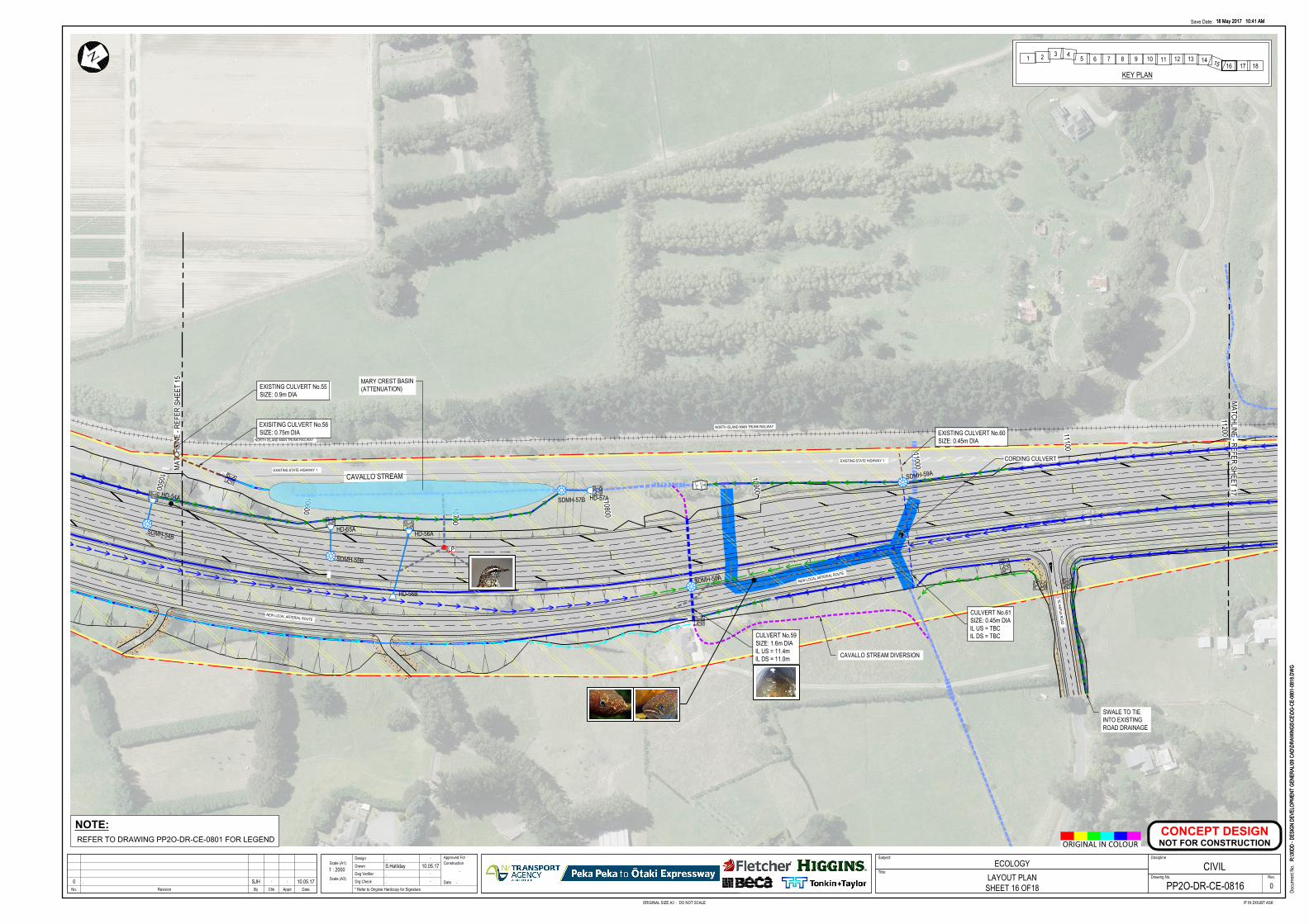
112001110011000
10900
10800
10700
10600
10500
CORDING CULVERT
CAVALLO STREAM
TE HAPUA ROAD
EXISTING STATE HIGHWAY 1
NORTH ISLAND MAIN TRUNK RAILWAY
NEW LOCAL ARTERIAL ROUTE
NORTH ISLAND MAIN TRUNK RAILWAY
NEW LOCAL ARTERIAL ROUTE
EXISTING STATE HIGHWAY 1
NN
MATC
HLIN
E - R
EFER
SHEE
T 15
MATCHLINE - REFERSHEET 17
SDMH-54B
SDMH-55B
<<<<<<<<<<<<<<<<<<<<<
< < < < < < < < < < < < < <
< < < < < < < < < < < < < <
< < < < < < < < < < <
< < < < < <
<<<<<<<<<<<<<<<<<<<<<
< < < < <
<<
<<
<<
<
< < <
SDMH-59A
< < < < < < < < < <<
SDMH-57B
<<<<<
<<<<<<<<<<<<<<<<<<<<<<<<<<<<<<<
<< < < < < < < < < < < < < < < < <
<
< < < < < <
<<<<<<<<<
SDMH-58A
EXISTING CULVERT No.55SIZE: 0.9m DIA
EXISITING CULVERT No.56SIZE: 0.75m DIA
CULVERT No.59SIZE: 1.6m DIAIL US = 11.4mIL DS = 11.0m
CULVERT No.61SIZE: 0.45m DIAIL US = TBCIL DS = TBC
EXISTING CULVERT No.60SIZE: 0.45m DIA
HD-57AHD-54A
HD-55AHD-56A
HD-56B
LP
CAVALLO STREAM DIVERSION
MARY CREST BASIN(ATTENUATION)
SWALE TO TIEINTO EXISTINGROAD DRAINAGE
18 May 2017 10:41 AM
R:\30
DD -
DESI
GN D
EVEL
OPME
NT G
ENER
AL\09
CAD
\DRA
WIN
GS\C
E\DG
-CE-
0801
-081
8.DW
G
ORIGINAL SIZE A3 : DO NOT SCALE IF IN DOUBT ASK
Docu
ment
No.
Save Date:
No. AppdRevision By Chk Date
Scale (A1)
Drg Check
Dsg Verifier
Drawn
DesignConstruction
Date
Approved For Subject:
Drawing No.
Discipline
Rev.
* Refer to Original Hardcopy for Signature
Title:
18 May 2017 10:41 AM
R:\30
DD -
DESI
GN D
EVEL
OPME
NT G
ENER
AL\09
CAD
\DRA
WIN
GS\C
E\DG
-CE-
0801
-081
8.DW
G
Scale (A3)
ORIGINAL IN COLOUR
ECOLOGYLAYOUT PLAN
SHEET 16 OF18
. .
S.Halliday 10.05.17. .
. .
.
.
1 : 2000
00 . SJH . . 10.05.17 PP2O-DR-CE-0816
CIVIL
CONCEPT DESIGN
NOT FOR CONSTRUCTION
NOTE:
REFER TO DRAWING PP2O-DR-CE-0801 FOR LEGEND
1 2 3 45 6 7 8 9 10 11 12 13 14 15 16 17 18
KEY PLAN
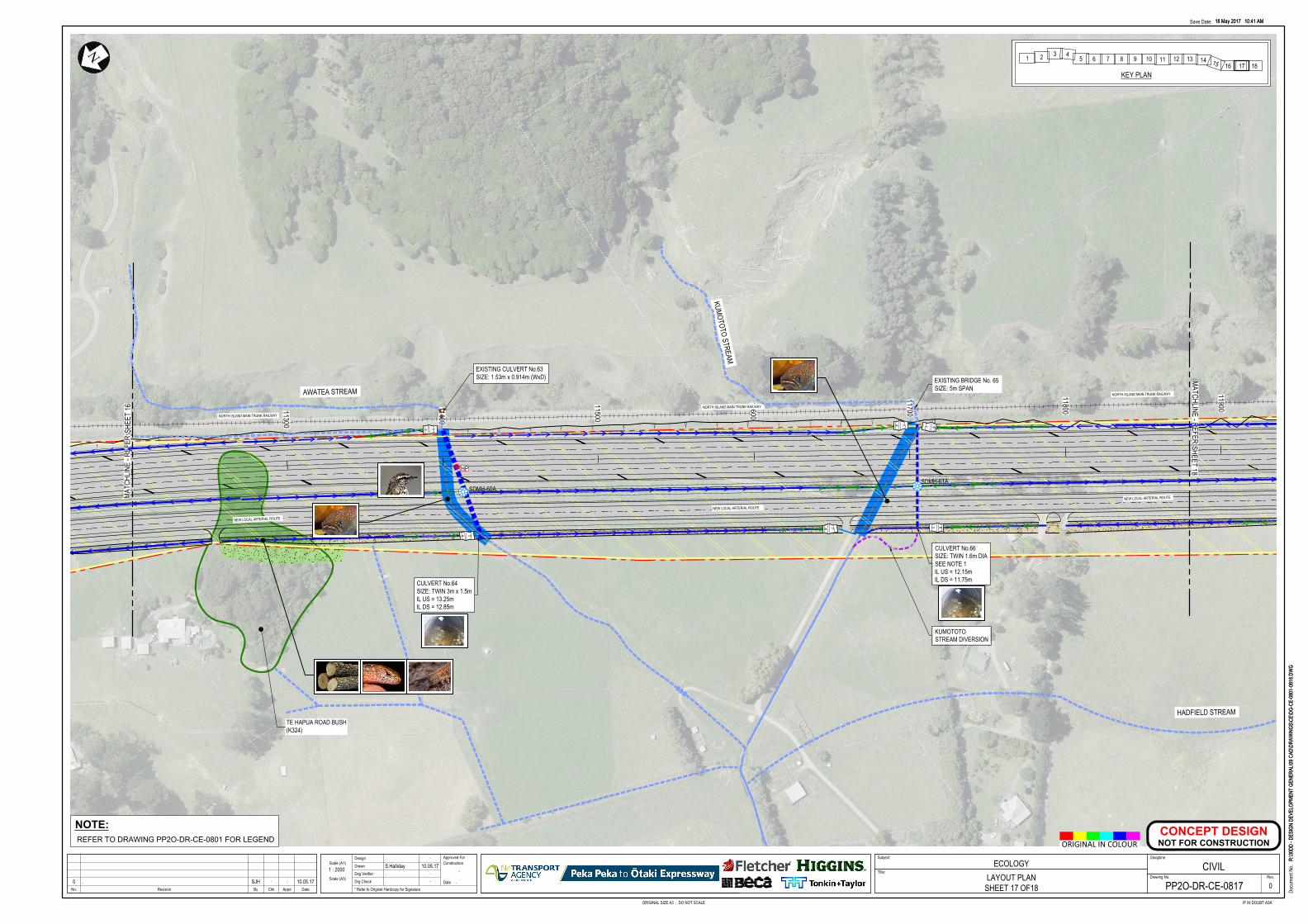
11900
11800
11700
11600
11500
11400
1130011200
TE HAPUA ROAD BUSH(K324)
HADFIELD STREAM
KUMOTOTO STREAM
AWATEA STREAM
NORTH ISLAND MAIN TRUNK RAILWAY
NEW LOCAL ARTERIAL ROUTE
NEW LOCAL ARTERIAL ROUTE
NORTH ISLAND MAIN TRUNK RAILWAY
NEW LOCAL ARTERIAL ROUTE
NORTH ISLAND MAIN TRUNK RAILWAY
N N
MATC
HLIN
E - R
EFER
SHEE
T 16
MATCHLINE - REFERSHEET 18
< < < < < < < < <
< < < < < < < < <<<<<<<<
<<<<<<SDMH-60A
<<<<<<<<<<<<<<<<<<<<
<<<<<<<<<<<<<<<<<<< < < < < < < < < < < <
< < < < < < < < <
<<<<<<<<<<<<<<<
<<<<<<<<<<<<<<<<<<<<<<<<
< < < < < < < <
<<<<
<<< <<<<<
<<<<< < < <
< < < < < <
< < < < < <
< <<<<<<<
SDMH-61A
CULVERT No.64SIZE: TWIN 3m x 1.5mIL US = 13.25mIL DS = 12.85m
CULVERT No.66SIZE: TWIN 1.6m DIASEE NOTE 1IL US = 12.15mIL DS = 11.75m
EXISTING CULVERT No.63SIZE: 1.53m x 0.914m (WxD)
HP
KUMOTOTOSTREAM DIVERSION
EXISTING BRIDGE No. 65SIZE: 5m SPAN
18 May 2017 10:41 AM
R:\30
DD -
DESI
GN D
EVEL
OPME
NT G
ENER
AL\09
CAD
\DRA
WIN
GS\C
E\DG
-CE-
0801
-081
8.DW
G
ORIGINAL SIZE A3 : DO NOT SCALE IF IN DOUBT ASK
Docu
ment
No.
Save Date:
No. AppdRevision By Chk Date
Scale (A1)
Drg Check
Dsg Verifier
Drawn
DesignConstruction
Date
Approved For Subject:
Drawing No.
Discipline
Rev.
* Refer to Original Hardcopy for Signature
Title:
18 May 2017 10:41 AM
R:\30
DD -
DESI
GN D
EVEL
OPME
NT G
ENER
AL\09
CAD
\DRA
WIN
GS\C
E\DG
-CE-
0801
-081
8.DW
G
Scale (A3)
ORIGINAL IN COLOUR
ECOLOGYLAYOUT PLAN
SHEET 17 OF18
. .
S.Halliday 10.05.17. .
. .
.
.
1 : 2000
00 . SJH . . 10.05.17 PP2O-DR-CE-0817
CIVIL
CONCEPT DESIGN
NOT FOR CONSTRUCTION
NOTE:
REFER TO DRAWING PP2O-DR-CE-0801 FOR LEGEND
1 2 3 45 6 7 8 9 10 11 12 13 14 15 16 17 18
KEY PLAN
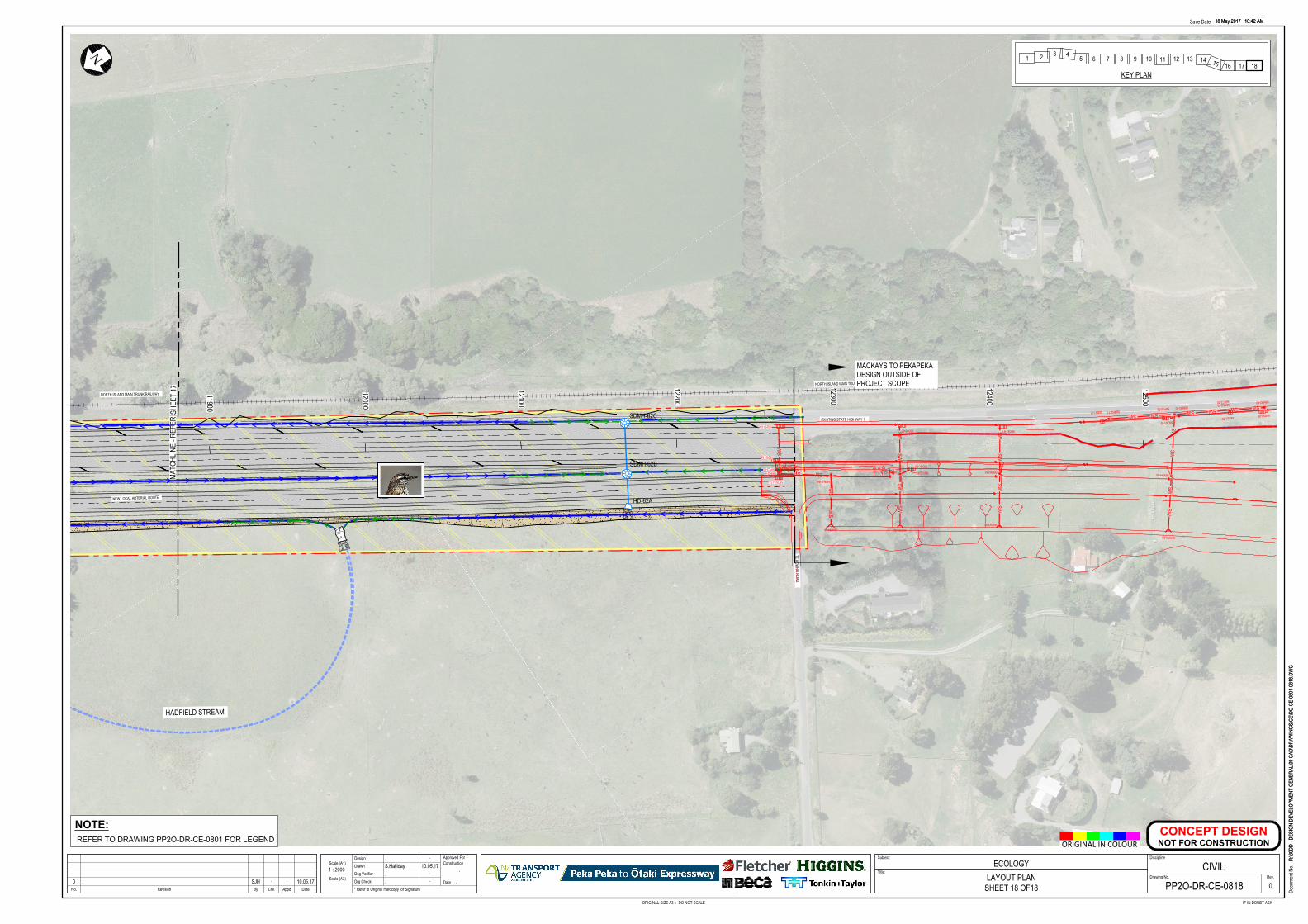
12500
12400
12300
12200
12100
12000
11900
HADFIELD STREAM
TE KOWHAI ROAD
EXISTING STATE HIGHWAY 1
NORTH ISLAND MAIN TRUNK RAILWAY
NEW LOCAL ARTERIAL ROUTE
NORTH ISLAND MAIN TRUNK RAILWAY
N
MATC
HLIN
E - R
EFER
SHEE
T 17
SDMH-62B
< < < < < < < < < < < < < < < < < <
< < < < < < < < < < < < < < < < < < < < < < < <
< < < < < < < < <
<<<<<<<<<<<<<<<<<<<<<<<< < < < < < < < <
< < < < <
<<<<<
<<<<< < < < < < < < < <
< < < < < <
SDMH-62C
SWSW
SWSW
56DS1-60
56MH4-60
56HW5-60
SWSW
SWSW
56DS1-61
56MH2-61
56HW3-61
SWSW
SWSW
56DS1-62
56MH2-62
56HW3-62
56DS1-63
56PC2-63
SW
SWSW
SWSW
56MH3-64
56HW4-64
56PC2-65
56DS1-65
56DS1-L37
56MH2-64
SWSWSWSW
56MH2-6056MH3-60
56DS1-52
56PC2-52
56DS1-64
56PC2-7056PC3-70
56SS1-70SWSW
56MH2-7156SS1-71
HD-62A
MACKAYS TO PEKAPEKADESIGN OUTSIDE OFPROJECT SCOPE
18 May 2017 10:42 AM
R:\30
DD -
DESI
GN D
EVEL
OPME
NT G
ENER
AL\09
CAD
\DRA
WIN
GS\C
E\DG
-CE-
0801
-081
8.DW
G
ORIGINAL SIZE A3 : DO NOT SCALE IF IN DOUBT ASK
Docu
ment
No.
Save Date:
No. AppdRevision By Chk Date
Scale (A1)
Drg Check
Dsg Verifier
Drawn
DesignConstruction
Date
Approved For Subject:
Drawing No.
Discipline
Rev.
* Refer to Original Hardcopy for Signature
Title:
18 May 2017 10:42 AM
R:\30
DD -
DESI
GN D
EVEL
OPME
NT G
ENER
AL\09
CAD
\DRA
WIN
GS\C
E\DG
-CE-
0801
-081
8.DW
G
Scale (A3)
ORIGINAL IN COLOUR
ECOLOGYLAYOUT PLAN
SHEET 18 OF18
. .
S.Halliday 10.05.17. .
. .
.
.
1 : 2000
00 . SJH . . 10.05.17 PP2O-DR-CE-0818
CIVIL
CONCEPT DESIGN
NOT FOR CONSTRUCTION
NOTE:
REFER TO DRAWING PP2O-DR-CE-0801 FOR LEGEND
1 2 3 45 6 7 8 9 10 11 12 13 14 15 16 17 18
KEY PLAN

FCCL-EV-MPN-0009
51
APPENDIX D: SCHEDULE OF FISH
MIGRATION AND PASSAGE REQUIREMENTS
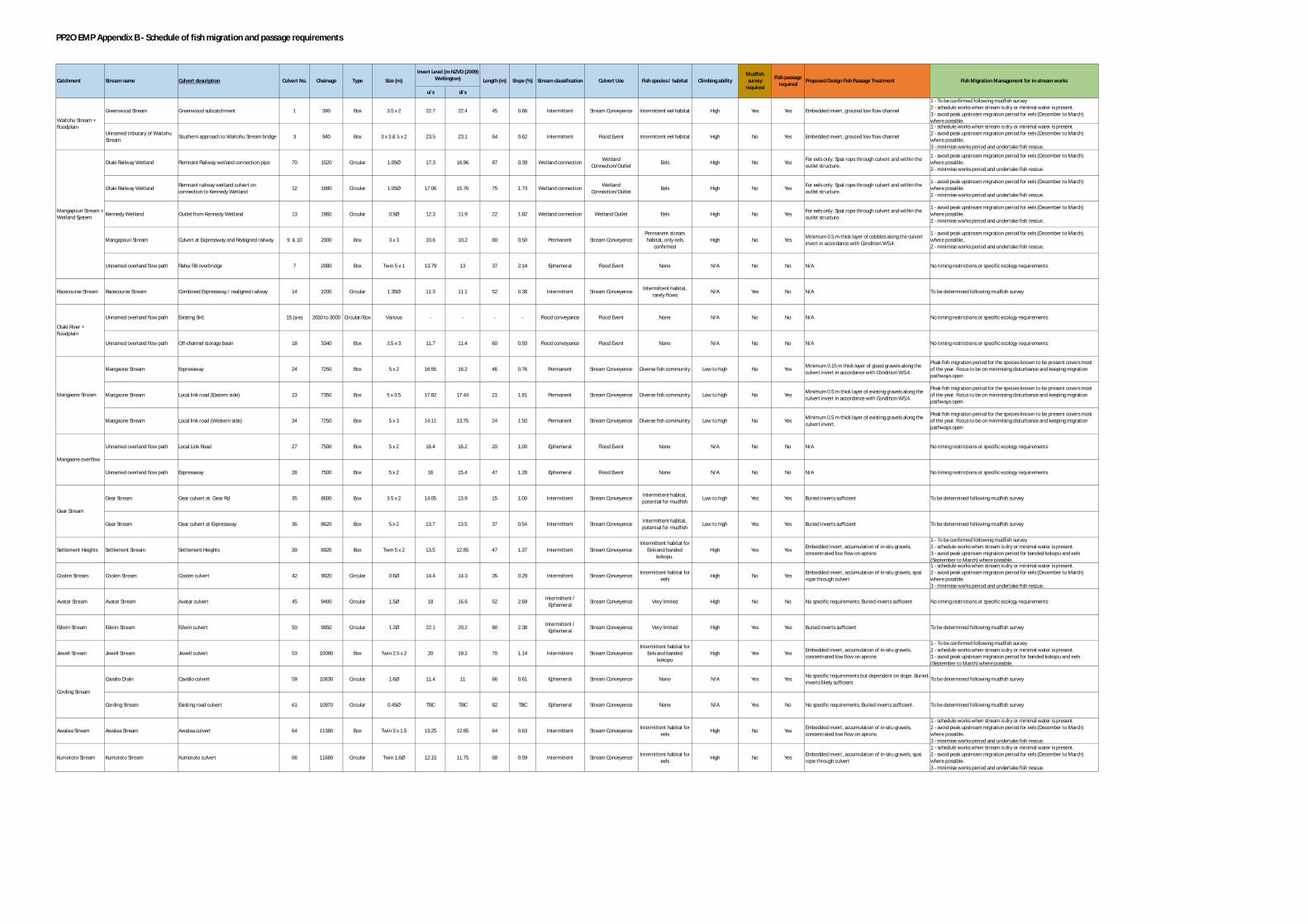
PP2O EMP Appendix B - Schedule of fish migration and passage requirements
u/s d/s
Greenwood Stream Greenwood subcatchment 1 390 Box 3.5 x 2 22.7 22.4 45 0.66 Intermittent Stream Conveyence Intermittent eel habitat High Yes Yes Embedded invert, grouted low flow channel
1 - To be confirmed following mudfish survey2 - schedule works when stream is dry or minimal water is present.3 - avoid peak upstream migration period for eels (December to March)where possible.
Unnamed tributary of WaitohuStream
Southern approach to Waitohu Stream bridge 3 940 Box 3 x 3 & 5 x 2 23.5 23.1 64 0.62 Intermittent Flood Event Intermittent eel habitat High No Yes Embedded invert, grouted low flow channel
1 - schedule works when stream is dry or minimal water is present.2 - avoid peak upstream migration period for eels (December to March)where possible.3 - minimise works period and undertake fish rescue.
Otaki Railway Wetland Remnant Railway wetland connection pipe 70 1520 Circular 1.05Ø 17.3 16.96 87 0.39 Wetland connection WetlandConnection/Outlet
Eels High No Yes For eels only. Spat rope through culvert and within theoutlet structure.
1 - avoid peak upstream migration period for eels (December to March)where possible.2 - minimise works period and undertake fish rescue.
Otaki Railway Wetland Remnant railway wetland culvert onconnection to Kennedy Wetland
12 1680 Circular 1.05Ø 17.06 15.76 75 1.73 Wetland connection WetlandConnection/Outlet
Eels High No Yes For eels only. Spat rope through culvert and within theoutlet structure.
1 - avoid peak upstream migration period for eels (December to March)where possible.2 - minimise works period and undertake fish rescue.
Kennedy Wetland Outlet from Kennedy Wetland 13 1960 Circular 0.9Ø 12.3 11.9 22 1.82 Wetland connection Wetland Outlet Eels High No Yes For eels only. Spat rope through culvert and within theoutlet structure.
1 - avoid peak upstream migration period for eels (December to March)where possible.2 - minimise works period and undertake fish rescue.
Mangapouri Stream Culvert at Expressway and Realigned railway 9 & 10 2000 Box 3 x 3 10.6 10.2 80 0.50 Permanent Stream ConveyencePermanent streamhabitat, only eels
confirmedHigh No Yes Minimum 0.5 m thick layer of cobbles along the culvert
invert in accordance with Condition WS.4.
1 - avoid peak upstream migration period for eels (December to March)where possible.2 - minimise works period and undertake fish rescue.
Unnamed overland flow path Rahui Rd overbridge 7 2080 Box Twin 5 x 1 13.79 13 37 2.14 Ephemeral Flood Event None N/A No No N/A No timing restrictions or specific ecology requirements
Racecourse Stream Racecourse Stream Combined Expressway / realigned railway 14 2200 Circular 1.35Ø 11.3 11.1 52 0.38 Intermittent Stream Conveyence Intermittent habitat,rarely flows
N/A Yes No N/A To be determined following mudfish survey
Unnamed overland flow path Existing SH1 15 (a-e) 2650 to 3000 Circular/Box Various - - - - Flood conveyance Flood Event None N/A No No N/A No timing restrictions or specific ecology requirements
Unnamed overland flow path Off-channel storage basin 18 3340 Box 3.5 x 3 11.7 11.4 60 0.50 Flood conveyance Flood Event None N/A No No N/A No timing restrictions or specific ecology requirements
Mangaone Stream Expressway 24 7250 Box 5 x 2 16.55 16.2 46 0.76 Permanent Stream Conveyence Diverse fish community Low to high No Yes Minimum 0.15 m thick layer of glued gravels along theculvert invert in accordance with Condition WS.4.
Peak fish migration period for the species known to be present covers mostof the year. Focus to be on minimising disturbance and keeping migrationpathways open
Mangaone Stream Local link road (Eastern side) 23 7350 Box 5 x 3.5 17.82 17.44 21 1.81 Permanent Stream Conveyence Diverse fish community Low to high No Yes Minimum 0.5 m thick layer of existing gravels along theculvert invert in accordance with Condition WS.4.
Peak fish migration period for the species known to be present covers mostof the year. Focus to be on minimising disturbance and keeping migrationpathways open
Mangaone Stream Local link road (Western side) 34 7250 Box 5 x 3 14.11 13.75 24 1.50 Permanent Stream Conveyence Diverse fish community Low to high No Yes Minimum 0.5 m thick layer of existing gravels along theculvert invert.
Peak fish migration period for the species known to be present covers mostof the year. Focus to be on minimising disturbance and keeping migrationpathways open
Unnamed overland flow path Local Link Road 27 7500 Box 5 x 2 16.4 16.2 20 1.00 Ephemeral Flood Event None N/A No No N/A No timing restrictions or specific ecology requirements
Unnamed overland flow path Expressway 28 7500 Box 5 x 2 16 15.4 47 1.28 Ephemeral Flood Event None N/A No No N/A No timing restrictions or specific ecology requirements
Gear Stream Gear culvert at Gear Rd 35 8600 Box 3.5 x 2 14.05 13.9 15 1.00 Intermittent Stream Conveyence Intermittent habitat,potential for mudfish
Low to high Yes Yes Buried inverts sufficient To be determined following mudfish survey
Gear Stream Gear culvert at Expressway 36 8620 Box 5 x 2 13.7 13.5 37 0.54 Intermittent Stream Conveyence Intermittent habitat,potential for mudfish
Low to high Yes Yes Buried inverts sufficient To be determined following mudfish survey
Settlement Heights Settlement Stream Settlement Heights 39 8920 Box Twin 5 x 2 13.5 12.85 47 1.37 Intermittent Stream ConveyenceIntermittent habitat for
Eels and bandedkokopu.
High Yes Yes Embedded invert, accumulation of in-situ gravels,concentrated low flow on aprons
1 - To be confirmed following mudfish survey2 - schedule works when stream is dry or minimal water is present.3 - avoid peak upstream migration period for banded kokopu and eels(September to March) where possible.
Coolen Stream Coolen Stream Coolen culvert 42 9020 Circular 0.6Ø 14.4 14.3 35 0.29 Intermittent Stream Conveyence Intermittent habitat foreels
High No Yes Embedded invert, accumulation of in-situ gravels, spatrope through culvert
1 - schedule works when stream is dry or minimal water is present.2 - avoid peak upstream migration period for eels (December to March)where possible.3 - minimise works period and undertake fish rescue.
Avatar Stream Avatar Stream Avatar culvert 45 9400 Circular 1.5Ø 18 16.6 52 2.69 Intermittent /Ephemeral
Stream Conveyence Very limited High No No No specific requirements. Buried inverts sufficient No timing restrictions or specific ecology requirements
Edwin Stream Edwin Stream Edwin culvert 50 9950 Circular 1.2Ø 22.1 20.2 80 2.38 Intermittent /Ephemeral
Stream Conveyence Very limited High Yes Yes Buried inverts sufficient To be determined following mudfish survey
Jewell Stream Jewell Stream Jewell culvert 53 10080 Box Twin 2.5 x 2 20 19.2 70 1.14 Intermittent Stream ConveyenceIntermittent habitat for
Eels and bandedkokopu
High Yes Yes Embedded invert, accumulation of in-situ gravels,concentrated low flow on aprons
1 - To be confirmed following mudfish survey2 - schedule works when stream is dry or minimal water is present.3 - avoid peak upstream migration period for banded kokopu and eels(September to March) where possible.
Cavallo Drain Cavallo culvert 59 10830 Circular 1.6Ø 11.4 11 66 0.61 Ephemeral Stream Conveyence None N/A Yes Yes No specific requirements but dependent on slope. Buriedinverts likely sufficient.
To be determined following mudfish survey
Cording Stream Existing road culvert 61 10970 Circular 0.45Ø TBC TBC 82 TBC Ephemeral Stream Conveyence None N/A Yes No No specific requirements. Buried inverts sufficient. To be determined following mudfish survey
Awatea Stream Awatea Stream Awatea culvert 64 11380 Box Twin 3 x 1.5 13.25 12.85 64 0.63 Intermittent Stream Conveyence Intermittent habitat foreels
High No Yes Embedded invert, accumulation of in-situ gravels,concentrated low flow on aprons
1 - schedule works when stream is dry or minimal water is present.2 - avoid peak upstream migration period for eels (December to March)where possible.3 - minimise works period and undertake fish rescue.
Kumototo Stream Kumototo Stream Kumototo culvert 66 11680 Circular Twin 1.6Ø 12.15 11.75 68 0.59 Intermittent Stream Conveyence Intermittent habitat foreels
High No Yes Embedded invert, accumulation of in-situ gravels, spatrope through culvert
1 - schedule works when stream is dry or minimal water is present.2 - avoid peak upstream migration period for eels (December to March)where possible.3 - minimise works period and undertake fish rescue.
Mangaone Stream
Proposed Design Fish Passage TreatmentCulvert Use
Otaki River +floodplain
Fish Migration Management for in-stream worksFish passagerequired
Climbing abilityFish species / habitat
Mangapouri Stream +Wetland System
Cording Stream
Mudfishsurvey
requiredStream classificationStream name
Invert Level (m NZVD (2009)Wellington) Length (m) Slope (%)Culvert No. Chainage Type Size (m)Culvert description
Gear Stream
Catchment
Waitohu Stream +floodplain
Mangaone overflow

FCCL-EV-MPN-0009
52
APPENDIX E: SCHEDULE OF STREAM
IMPACTS
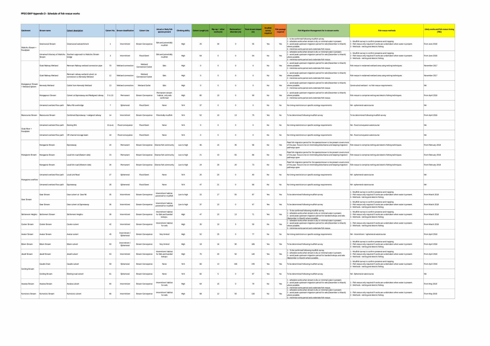
PP2O EMP Appendix D - Schedule of fish rescue works
Greenwood Stream Greenwood subcatchment 1 Intermittent Stream Conveyence Eels and potentiallymudfish High 25 30 0 55 Yes Yes
1 - to be confirmed following mudfish survey.2 - schedule works when stream is dry or minimal water is present.3 - avoid peak upstream migration period for eels (December to March)where possible.4 - minimise works period and undertake fish rescue.
1 - Mudfish survey to confirm presence and trapping.2 - Fish rescue only required if works are undertaken when water is present.3 - Methods - netting and electric fishing
From June 2018
Unnamed tributary of WaitohuStream
Southern approach to Waitohu Streambridge 3 Intermittent Flood Event Eels and potentially
mudfish High 64 0 0 64 No Yes
1 - schedule works when stream is dry or minimal water is present.2 - avoid peak upstream migration period for eels (December to March)where possible.3 - minimise works period and undertake fish rescue.
1 - Mudfish survey to confirm presence and trapping.2 - Fish rescue only required if works are undertaken when water is present.3 - Methods - netting and electric fishing
From June 2018
Otaki Railway Wetland Remnant Railway wetland connection pipe 70 Wetland connection WetlandConnection/Outlet Eels High 0 0 0 0 No Yes
1 - avoid peak upstream migration period for eels (December to March)where possible.2 - minimise works period and undertake fish rescue.
Fish rescue in reclaimed wetland area using netting techniques. November 2017
Otaki Railway Wetland Remnant railway wetland culvert onconnection to Kennedy Wetland 12 Wetland connection Wetland
Connection/Outlet Eels High 0 0 0 0 No Yes1 - avoid peak upstream migration period for eels (December to March)where possible.2 - minimise works period and undertake fish rescue.
Fish rescue in reclaimed wetland area using netting techniques. November 2017
Kennedy Wetland Outlet from Kennedy Wetland 13 Wetland connection Wetland Outlet Eels High 0 0 0 0 No Yes1 - avoid peak upstream migration period for eels (December to March)where possible.2 - minimise works period and undertake fish rescue.
Constructed wetland - no fish rescue requirements. NA
Mangapouri Stream Culvert at Expressway and Realigned railway 9 & 10 Permanent Stream ConveyencePermanent streamhabitat, only eels
confirmedHigh 80 10 0 90 No Yes
1 - avoid peak upstream migration period for eels (December to March)where possible.2 - minimise works period and undertake fish rescue.
Fish rescue to comprise netting and electric fishing techniques. From April 2018
Unnamed overland flow path Rahui Rd overbridge 7 Ephemeral Flood Event None N/A 37 0 0 0 No No No timing restrictions or specific ecology requirements NA - ephemeral watercourse NA
Racecourse Stream Racecourse Stream Combined Expressway / realigned railway 14 Intermittent Stream Conveyence Potentially mudfish N/A 52 10 13 75 Yes No To be determined following mudfish survey To be determined following mudfish survey From April 2018
Unnamed overland flow path Existing SH1 15 (a-e) Flood conveyance Flood Event None N/A 0 0 0 0 No No No timing restrictions or specific ecology requirements NA - flood conveyance watercourse NA
Unnamed overland flow path Off-channel storage basin 18 Flood conveyance Flood Event None N/A 0 0 0 0 No No No timing restrictions or specific ecology requirements NA - flood conveyance watercourse NA
Mangaone Stream Expressway 24 Permanent Stream Conveyence Diverse fish community Low to high 46 15 35 96 No YesPeak fish migration period for the species known to be present covers mostof the year. Focus to be on minimising disturbance and keeping migrationpathways open
Fish rescue to comprise netting and electric fishing techniques. From February 2018
Mangaone Stream Local link road (Eastern side) 23 Permanent Stream Conveyence Diverse fish community Low to high 21 10 55 86 No YesPeak fish migration period for the species known to be present covers mostof the year. Focus to be on minimising disturbance and keeping migrationpathways open
Fish rescue to comprise netting and electric fishing techniques. From February 2018
Mangaone Stream Local link road (Western side) 34 Permanent Stream Conveyence Diverse fish community Low to high 24 29 20 73 No YesPeak fish migration period for the species known to be present covers mostof the year. Focus to be on minimising disturbance and keeping migrationpathways open
Fish rescue to comprise netting and electric fishing techniques. From February 2018
Unnamed overland flow path Local Link Road 27 Ephemeral Flood Event None N/A 20 20 0 40 No No No timing restrictions or specific ecology requirements NA - ephemeral watercourse NA
Unnamed overland flow path Expressway 28 Ephemeral Flood Event None N/A 47 21 0 68 No No No timing restrictions or specific ecology requirements NA - ephemeral watercourse NA
Gear Stream Gear culvert at Gear Rd 35 Intermittent Stream Conveyence Intermittent habitat,potential for mudfish Low to high 15 17 55 87 Yes Yes To be determined following mudfish survey
1 - Mudfish survey to confirm presence and trapping.2 - Fish rescue only required if works are undertaken when water is present.3 - Methods - netting and electric fishing
From March 2018
Gear Stream Gear culvert at Expressway 36 Intermittent Stream Conveyence Intermittent habitat,potential for mudfish Low to high 37 10 0 47 Yes Yes To be determined following mudfish survey
1 - Mudfish survey to confirm presence and trapping.2 - Fish rescue only required if works are undertaken when water is present.3 - Methods - netting and electric fishing
From March 2018
Settlement Heights Settlement Stream Settlement Heights 39 Intermittent Stream ConveyenceIntermittent habitatfor Eels and banded
kokopu.High 47 10 13 71 Yes Yes
1 - To be confirmed following mudfish survey2 - schedule works when stream is dry or minimal water is present.3 - avoid peak upstream migration period for banded kokopu and eels(September to March) where possible.
1 - Mudfish survey to confirm presence and trapping.2 - Fish rescue only required if works are undertaken when water is present.3 - Methods - netting and electric fishing
From March 2018
Coolen Stream Coolen Stream Coolen culvert 42 Intermittent Stream Conveyence Intermittent habitatfor eels High 35 10 5 50 No Yes
1 - schedule works when stream is dry or minimal water is present.2 - avoid peak upstream migration period for eels (December to March)where possible.3 - minimise works period and undertake fish rescue.
1 - Fish rescue only required if works are undertaken when water is present.2 - Methods - netting and electric fishing From March 2018
Avatar Stream Avatar Stream Avatar culvert 45 Intermittent /Ephemeral Stream Conveyence Very limited High 52 25 0 77 No No No timing restrictions or specific ecology requirements NA - Intermittent / ephemeral watercourse From April 2018
Edwin Stream Edwin Stream Edwin culvert 50 Intermittent /Ephemeral Stream Conveyence Very limited High 18 16 90 186 Yes Yes To be determined following mudfish survey
1 - Mudfish survey to confirm presence and trapping.2 - Fish rescue only required if works are undertaken when water is present.3 - Methods - netting and electric fishing
From April 2018
Jewell Stream Jewell Stream Jewell culvert 53 Intermittent Stream ConveyenceIntermittent habitatfor Eels and banded
kokopuHigh 70 20 50 140 Yes Yes
1 - To be confirmed following mudfish survey2 - schedule works when stream is dry or minimal water is present.3 - avoid peak upstream migration period for banded kokopu and eels(September to March) where possible.
1 - Mudfish survey to confirm presence and trapping.2 - Fish rescue only required if works are undertaken when water is present.3 - Methods - netting and electric fishing
From April 2018
Cavallo Drain Cavallo culvert 59 Ephemeral Stream Conveyence None N/A 66 14 165 245 Yes Yes To be determined following mudfish survey1 - Mudfish survey to confirm presence and trapping.2 - Fish rescue only required if works are undertaken when water is present.3 - Methods - netting and electric fishing
From April 2018
Cording Stream Existing road culvert 61 Ephemeral Stream Conveyence None N/A 82 5 0 87 Yes No To be determined following mudfish survey NA - Ephemeral watercourse NA
Awatea Stream Awatea Stream Awatea culvert 64 Intermittent Stream Conveyence Intermittent habitatfor eels High 64 15 0 79 No Yes
1 - schedule works when stream is dry or minimal water is present.2 - avoid peak upstream migration period for eels (December to March)where possible.3 - minimise works period and undertake fish rescue.
1 - Fish rescue only required if works are undertaken when water is present.2 - Methods - netting and electric fishing From May 2018
Kumototo Stream Kumototo Stream Kumototo culvert 66 Intermittent Stream Conveyence Intermittent habitatfor eels High 68 12 50 130 No Yes
1 - schedule works when stream is dry or minimal water is present.2 - avoid peak upstream migration period for eels (December to March)where possible.3 - minimise works period and undertake fish rescue.
1 - Fish rescue only required if works are undertaken when water is present.2 - Methods - netting and electric fishing From May 2018
Fish Migration Management for in-stream worksRip rap / otherworks (m)Stream classification Culvert UseCatchment Stream name Culvert description Culvert No.
Cording Stream
Culvert Length (m) Total stream impact(m) Fish rescue methods Likely works and fish rescue timing
(TBC)
Waitohu Stream +floodplain
Mangapouri Stream+ Wetland System
Otaki River +floodplain
Mangaone Stream
Mangaone overflow
Gear Stream
Actual or likely fishspecies present Climbing ability
Mudfishsurvey
required
Fish passagerequired
Reclamation /diversion (m)

FCCL-EV-MPN-0009
53
APPENDIX F: FISH RESCUE SCHEDULE

PP2O EMP Appendix D - Schedule of fish rescue works
Greenwood Stream Greenwood subcatchment 1 Intermittent Stream Conveyence Eels and potentiallymudfish High 25 30 0 55 Yes Yes
1 - to be confirmed following mudfish survey.2 - schedule works when stream is dry or minimal water is present.3 - avoid peak upstream migration period for eels (December to March)where possible.4 - minimise works period and undertake fish rescue.
1 - Mudfish survey to confirm presence and trapping.2 - Fish rescue only required if works are undertaken when water is present.3 - Methods - netting and electric fishing
From June 2018
Unnamed tributary of WaitohuStream
Southern approach to Waitohu Streambridge 3 Intermittent Flood Event Eels and potentially
mudfish High 64 0 0 64 No Yes
1 - schedule works when stream is dry or minimal water is present.2 - avoid peak upstream migration period for eels (December to March)where possible.3 - minimise works period and undertake fish rescue.
1 - Mudfish survey to confirm presence and trapping.2 - Fish rescue only required if works are undertaken when water is present.3 - Methods - netting and electric fishing
From June 2018
Otaki Railway Wetland Remnant Railway wetland connection pipe 70 Wetland connection WetlandConnection/Outlet Eels High 0 0 0 0 No Yes
1 - avoid peak upstream migration period for eels (December to March)where possible.2 - minimise works period and undertake fish rescue.
Fish rescue in reclaimed wetland area using netting techniques. November 2017
Otaki Railway Wetland Remnant railway wetland culvert onconnection to Kennedy Wetland 12 Wetland connection Wetland
Connection/Outlet Eels High 0 0 0 0 No Yes1 - avoid peak upstream migration period for eels (December to March)where possible.2 - minimise works period and undertake fish rescue.
Fish rescue in reclaimed wetland area using netting techniques. November 2017
Kennedy Wetland Outlet from Kennedy Wetland 13 Wetland connection Wetland Outlet Eels High 0 0 0 0 No Yes1 - avoid peak upstream migration period for eels (December to March)where possible.2 - minimise works period and undertake fish rescue.
Constructed wetland - no fish rescue requirements. NA
Mangapouri Stream Culvert at Expressway and Realigned railway 9 & 10 Permanent Stream ConveyencePermanent streamhabitat, only eels
confirmedHigh 80 10 0 90 No Yes
1 - avoid peak upstream migration period for eels (December to March)where possible.2 - minimise works period and undertake fish rescue.
Fish rescue to comprise netting and electric fishing techniques. From April 2018
Unnamed overland flow path Rahui Rd overbridge 7 Ephemeral Flood Event None N/A 37 0 0 0 No No No timing restrictions or specific ecology requirements NA - ephemeral watercourse NA
Racecourse Stream Racecourse Stream Combined Expressway / realigned railway 14 Intermittent Stream Conveyence Potentially mudfish N/A 52 10 13 75 Yes No To be determined following mudfish survey To be determined following mudfish survey From April 2018
Unnamed overland flow path Existing SH1 15 (a-e) Flood conveyance Flood Event None N/A 0 0 0 0 No No No timing restrictions or specific ecology requirements NA - flood conveyance watercourse NA
Unnamed overland flow path Off-channel storage basin 18 Flood conveyance Flood Event None N/A 0 0 0 0 No No No timing restrictions or specific ecology requirements NA - flood conveyance watercourse NA
Mangaone Stream Expressway 24 Permanent Stream Conveyence Diverse fish community Low to high 46 15 35 96 No YesPeak fish migration period for the species known to be present covers mostof the year. Focus to be on minimising disturbance and keeping migrationpathways open
Fish rescue to comprise netting and electric fishing techniques. From February 2018
Mangaone Stream Local link road (Eastern side) 23 Permanent Stream Conveyence Diverse fish community Low to high 21 10 55 86 No YesPeak fish migration period for the species known to be present covers mostof the year. Focus to be on minimising disturbance and keeping migrationpathways open
Fish rescue to comprise netting and electric fishing techniques. From February 2018
Mangaone Stream Local link road (Western side) 34 Permanent Stream Conveyence Diverse fish community Low to high 24 29 20 73 No YesPeak fish migration period for the species known to be present covers mostof the year. Focus to be on minimising disturbance and keeping migrationpathways open
Fish rescue to comprise netting and electric fishing techniques. From February 2018
Unnamed overland flow path Local Link Road 27 Ephemeral Flood Event None N/A 20 20 0 40 No No No timing restrictions or specific ecology requirements NA - ephemeral watercourse NA
Unnamed overland flow path Expressway 28 Ephemeral Flood Event None N/A 47 21 0 68 No No No timing restrictions or specific ecology requirements NA - ephemeral watercourse NA
Gear Stream Gear culvert at Gear Rd 35 Intermittent Stream Conveyence Intermittent habitat,potential for mudfish Low to high 15 17 55 87 Yes Yes To be determined following mudfish survey
1 - Mudfish survey to confirm presence and trapping.2 - Fish rescue only required if works are undertaken when water is present.3 - Methods - netting and electric fishing
From March 2018
Gear Stream Gear culvert at Expressway 36 Intermittent Stream Conveyence Intermittent habitat,potential for mudfish Low to high 37 10 0 47 Yes Yes To be determined following mudfish survey
1 - Mudfish survey to confirm presence and trapping.2 - Fish rescue only required if works are undertaken when water is present.3 - Methods - netting and electric fishing
From March 2018
Settlement Heights Settlement Stream Settlement Heights 39 Intermittent Stream ConveyenceIntermittent habitatfor Eels and banded
kokopu.High 47 10 13 71 Yes Yes
1 - To be confirmed following mudfish survey2 - schedule works when stream is dry or minimal water is present.3 - avoid peak upstream migration period for banded kokopu and eels(September to March) where possible.
1 - Mudfish survey to confirm presence and trapping.2 - Fish rescue only required if works are undertaken when water is present.3 - Methods - netting and electric fishing
From March 2018
Coolen Stream Coolen Stream Coolen culvert 42 Intermittent Stream Conveyence Intermittent habitatfor eels High 35 10 5 50 No Yes
1 - schedule works when stream is dry or minimal water is present.2 - avoid peak upstream migration period for eels (December to March)where possible.3 - minimise works period and undertake fish rescue.
1 - Fish rescue only required if works are undertaken when water is present.2 - Methods - netting and electric fishing From March 2018
Avatar Stream Avatar Stream Avatar culvert 45 Intermittent /Ephemeral Stream Conveyence Very limited High 52 25 0 77 No No No timing restrictions or specific ecology requirements NA - Intermittent / ephemeral watercourse From April 2018
Edwin Stream Edwin Stream Edwin culvert 50 Intermittent /Ephemeral Stream Conveyence Very limited High 18 16 90 186 Yes Yes To be determined following mudfish survey
1 - Mudfish survey to confirm presence and trapping.2 - Fish rescue only required if works are undertaken when water is present.3 - Methods - netting and electric fishing
From April 2018
Jewell Stream Jewell Stream Jewell culvert 53 Intermittent Stream ConveyenceIntermittent habitatfor Eels and banded
kokopuHigh 70 20 50 140 Yes Yes
1 - To be confirmed following mudfish survey2 - schedule works when stream is dry or minimal water is present.3 - avoid peak upstream migration period for banded kokopu and eels(September to March) where possible.
1 - Mudfish survey to confirm presence and trapping.2 - Fish rescue only required if works are undertaken when water is present.3 - Methods - netting and electric fishing
From April 2018
Cavallo Drain Cavallo culvert 59 Ephemeral Stream Conveyence None N/A 66 14 165 245 Yes Yes To be determined following mudfish survey1 - Mudfish survey to confirm presence and trapping.2 - Fish rescue only required if works are undertaken when water is present.3 - Methods - netting and electric fishing
From April 2018
Cording Stream Existing road culvert 61 Ephemeral Stream Conveyence None N/A 82 5 0 87 Yes No To be determined following mudfish survey NA - Ephemeral watercourse NA
Awatea Stream Awatea Stream Awatea culvert 64 Intermittent Stream Conveyence Intermittent habitatfor eels High 64 15 0 79 No Yes
1 - schedule works when stream is dry or minimal water is present.2 - avoid peak upstream migration period for eels (December to March)where possible.3 - minimise works period and undertake fish rescue.
1 - Fish rescue only required if works are undertaken when water is present.2 - Methods - netting and electric fishing From May 2018
Kumototo Stream Kumototo Stream Kumototo culvert 66 Intermittent Stream Conveyence Intermittent habitatfor eels High 68 12 50 130 No Yes
1 - schedule works when stream is dry or minimal water is present.2 - avoid peak upstream migration period for eels (December to March)where possible.3 - minimise works period and undertake fish rescue.
1 - Fish rescue only required if works are undertaken when water is present.2 - Methods - netting and electric fishing From May 2018
Fish Migration Management for in-stream worksRip rap / otherworks (m)Stream classification Culvert UseCatchment Stream name Culvert description Culvert No.
Cording Stream
Culvert Length (m) Total stream impact(m) Fish rescue methods Likely works and fish rescue timing
(TBC)
Waitohu Stream +floodplain
Mangapouri Stream+ Wetland System
Otaki River +floodplain
Mangaone Stream
Mangaone overflow
Gear Stream
Actual or likely fishspecies present Climbing ability
Mudfishsurvey
required
Fish passagerequired
Reclamation /diversion (m)

FCCL-EV-MPN-0009
54
APPENDIX G: ECOLOGICAL ACCOUNTING
FOR STREAM LOSS
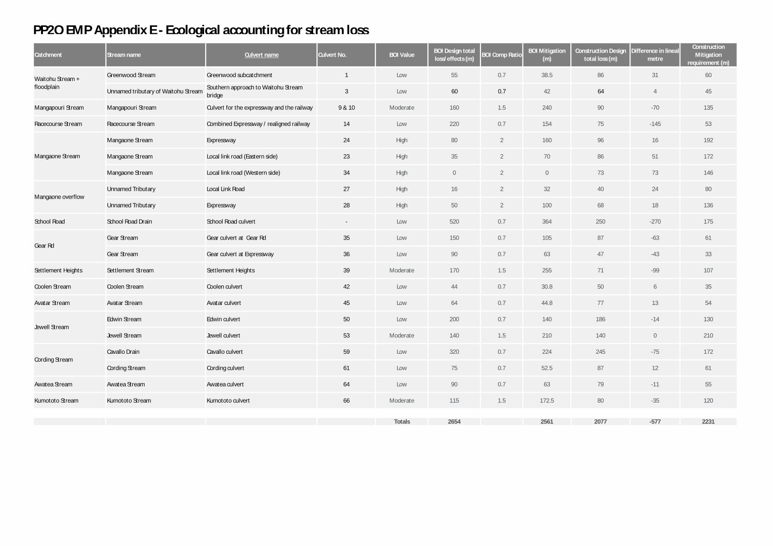
PP2O EMP Appendix E - Ecological accounting for stream loss
Catchment Stream name Culvert name Culvert No. BOI ValueBOI Design totalloss/effects (m)
BOI Comp RatioBOI Mitigation
(m)Construction Design
total loss (m)Difference in lineal
metre
ConstructionMitigation
requirement (m)
Greenwood Stream Greenwood subcatchment 1 Low 55 0.7 38.5 86 31 60
Unnamed tributary of Waitohu StreamSouthern approach to Waitohu Streambridge
3 Low 60 0.7 42 64 4 45
Mangapouri Stream Mangapouri Stream Culvert for the expressway and the railway 9 & 10 Moderate 160 1.5 240 90 -70 135
Racecourse Stream Racecourse Stream Combined Expressway / realigned railway 14 Low 220 0.7 154 75 -145 53
Mangaone Stream Expressway 24 High 80 2 160 96 16 192
Mangaone Stream Local link road (Eastern side) 23 High 35 2 70 86 51 172
Mangaone Stream Local link road (Western side) 34 High 0 2 0 73 73 146
Unnamed Tributary Local Link Road 27 High 16 2 32 40 24 80
Unnamed Tributary Expressway 28 High 50 2 100 68 18 136
School Road School Road Drain School Road culvert - Low 520 0.7 364 250 -270 175
Gear Stream Gear culvert at Gear Rd 35 Low 150 0.7 105 87 -63 61
Gear Stream Gear culvert at Expressway 36 Low 90 0.7 63 47 -43 33
Settlement Heights Settlement Stream Settlement Heights 39 Moderate 170 1.5 255 71 -99 107
Coolen Stream Coolen Stream Coolen culvert 42 Low 44 0.7 30.8 50 6 35
Avatar Stream Avatar Stream Avatar culvert 45 Low 64 0.7 44.8 77 13 54
Edwin Stream Edwin culvert 50 Low 200 0.7 140 186 -14 130
Jewell Stream Jewell culvert 53 Moderate 140 1.5 210 140 0 210
Cavallo Drain Cavallo culvert 59 Low 320 0.7 224 245 -75 172
Cording Stream Cording culvert 61 Low 75 0.7 52.5 87 12 61
Awatea Stream Awatea Stream Awatea culvert 64 Low 90 0.7 63 79 -11 55
Kumototo Stream Kumototo Stream Kumototo culvert 66 Moderate 115 1.5 172.5 80 -35 120
Totals 2654 2561 2077 -577 2231
Mangaone overflow
Gear Rd
Jewell Stream
Cording Stream
Waitohu Stream +floodplain
Mangaone Stream