Ecological Assessment of Current and Past Land Uses in Bursa
13
Digital Proceeding Of THE ICOEST’2013 - , Cappadocia C.Ozdemir, S. Şahinkaya, E. Kalıpcı, M.K. Oden (editors) Nevsehir, Turkey, June 18 – 21, 2013 Ecological Assessment of Current and Past Land Uses in Bursa Ufuk Fatih Küçükali* 1 1, Assist. Prof. Dr., Department of Architecture, Istanbul Aydin University, TURKEY. (E-mail: [email protected]) Abstract In Turkey, it is observed that there is an overgrowth of population, resolutions on land usage have deteriorating effects on natural ecological balance and consequently environmental problems reached threatening levels for all life forms. It is important to remove the impacts of urbanization, which consume irreplaceable natural resources, through planning methods and techniques. Examination of the current land usage of Bursa Nilüfer Creek Başköy – Kestel Section and its subbasins reveal that location organization was radically changed due to industrialization, and functional areas such as settlements and industrial areas, located on first class agricultural lands and on rock formation with geologically high permeability, create pollutions on the natural resources forming the basin, over acceptable parameters of international standards, as a result of governmental decisions.In this context, it is seen that Bursa Nilüfer Çayı Başköy - Kestel section and its subbasins have been facing an intense urbanization for approximately twenty years and a great pollution pressure due to wrong land uses. Therefore, the pollution seen in the research area was considered with a 20-year period and findings were evaluated, assessment were made to see the type and dimension of ecological risks according to international parameters. In this context, it was aimed to establish what kind of environmental problems are caused by the changes in land usage at the research area, and the significance of ecological analysis, to emphasize the importance of planning in the paper. Keywords: Basin, Ecological Planning, Ecological Risk, Land Use 1. Introduction Social – economical decisions made by the Turkish governments since 1950s for the purpose of development reflect upon the physical space and zoning decisions are made within this framework. The fact that area planning concept has not been addressed with necessary content and technique so far in our country and environmental arrangement and zoning plans gains without analyzing on a parametrical scale the ecological sensitivity and potentials of natural resources related to all areas across the country and harmony or lack of harmony of their social – economical functions give rise to environmental problems with various contents in water catchment basins that have important natural resource features and high agricultural potential such as Bursa Plain, Adana Plain, Adapazarı Plain, Konya Plai n, South Eastern Anatolia Basin. Land utilization decisions included in the zoning plans managing the urbanization phenomenon inside the water catchment basins of the areas conflict with the factors such as geological structure, morphological features, climate, and soil characteristics of basins [1]. Special phenomenon caused by the urbanization directed by the planning decisions made in connection with the social-economical phenomenon of the country and area have been addressed as breaking points and assessments have been conducted. While revealing the
Transcript of Ecological Assessment of Current and Past Land Uses in Bursa

Digital Proceeding Of THE ICOEST’2013 - , Cappadocia
C.Ozdemir, S. Şahinkaya, E. Kalıpcı, M.K. Oden (editors)
Nevsehir, Turkey, June 18 – 21, 2013
Ecological Assessment of Current and Past Land Uses in Bursa
Ufuk Fatih Küçükali*1
1, Assist. Prof. Dr., Department of Architecture, Istanbul Aydin University, TURKEY.
(E-mail: [email protected])
Abstract
In Turkey, it is observed that there is an overgrowth of population, resolutions on land usage have deteriorating effects on
natural ecological balance and consequently environmental problems reached threatening levels for all life forms. It is
important to remove the impacts of urbanization, which consume irreplaceable natural resources, through planning methods
and techniques. Examination of the current land usage of Bursa Nilüfer Creek Başköy – Kestel Section and its subbasins
reveal that location organization was radically changed due to industrialization, and functional areas such as settlements and
industrial areas, located on first class agricultural lands and on rock formation with geologically high permeability, create
pollutions on the natural resources forming the basin, over acceptable parameters of international standards, as a result of
governmental decisions.In this context, it is seen that Bursa Nilüfer Çayı Başköy - Kestel section and its subbasins have been
facing an intense urbanization for approximately twenty years and a great pollution pressure due to wrong land uses.
Therefore, the pollution seen in the research area was considered with a 20-year period and findings were evaluated,
assessment were made to see the type and dimension of ecological risks according to international parameters. In this context,
it was aimed to establish what kind of environmental problems are caused by the changes in land usage at the research area,
and the significance of ecological analysis, to emphasize the importance of planning in the paper.
Keywords: Basin, Ecological Planning, Ecological Risk, Land Use
1. Introduction
Social – economical decisions made by the Turkish governments since 1950s for the
purpose of development reflect upon the physical space and zoning decisions are made within
this framework. The fact that area planning concept has not been addressed with necessary
content and technique so far in our country and environmental arrangement and zoning plans
gains without analyzing on a parametrical scale the ecological sensitivity and potentials of
natural resources related to all areas across the country and harmony or lack of harmony of
their social – economical functions give rise to environmental problems with various contents
in water catchment basins that have important natural resource features and high agricultural
potential such as Bursa Plain, Adana Plain, Adapazarı Plain, Konya Plain, South Eastern
Anatolia Basin. Land utilization decisions included in the zoning plans managing the
urbanization phenomenon inside the water catchment basins of the areas conflict with the
factors such as geological structure, morphological features, climate, and soil characteristics
of basins [1].
Special phenomenon caused by the urbanization directed by the planning decisions
made in connection with the social-economical phenomenon of the country and area have
been addressed as breaking points and assessments have been conducted. While revealing the

644
change that has occurred in the land use by taking advantage of the Landsat and Ikonos
satellite footage, and the reason why years 1989 – 1999 – 2009 have been chosen as breaking
points is the fact that industry has started to pick locations in Bursa plain as a result of
industrial incentives offered within framework of autonomous decisions made by the
governments from political and social – economical point of view for development purposes
and amendments that have been made in the zoning plans (Figure 1).
In 2009, The Establisment of Bursa LeatherIndustrial Zone
Opening of the Eastern and WesternWastewaterTreatmentPlant in Bursa
In 1998, Bursa2020
EnvironmentalDesignStrategy
Plan - 1/100.000
The Revision of Bursa MasterPlan in 1990
1985 Development
Plan
In 1989 the Highest SO2 and PM Measurement
Bursa Thermal Power PlantOpened in 1992
Economic Crisisof 2001 in Turkey - The Establishmentof NiluferIndustrial Zone
In 2004, The Establisment of Kestel IndustrialZone
Tanneries Movedto LeatherIndustrial Zone in 2008
1989 1999 2009
Figure 1. Breaking points that have shaped the land use of Bursa over the years
1.1 Research area boundaries
Borders of study area is composed of Başköy - Kestel section and lower catchment
basins within catchment basin of Nilüfer Stream (stems form south of the Mount Uludağ and
joining Susurluk Stream in Karacabey Plain and then reaches the Marmara Sea ) which is
1.288,96 square kilometers large and flows through province of Bursa (northern latitudes of
28°10’ and 30°00’ and eastern latitudes of 40°40’ and 39°35' ) (Figure 2.).
Decisive factors as to why Başköy – Kestel section of Bursa Nilüfer Stream and
lower catchment basins have been selected as study area: Destructions caused by
urbanization in Bursa metropolitan area, rapid migration movements and increased
population, industry and trade functions on the environment have reached a level that is
visible, excess in bearing capacity of the natural resources as a result of those areas where no
settlement is to be allowed (agricultural fields, drinking water catchment basins and forest
645
areas as well as objectionable areas in geological terms etc.), inversion related pollution
observed due to air pollution which is predominantly caused by heating and transportation and
being a metropolis where social-economical problems are densely experienced due to
foregoing processes [2].
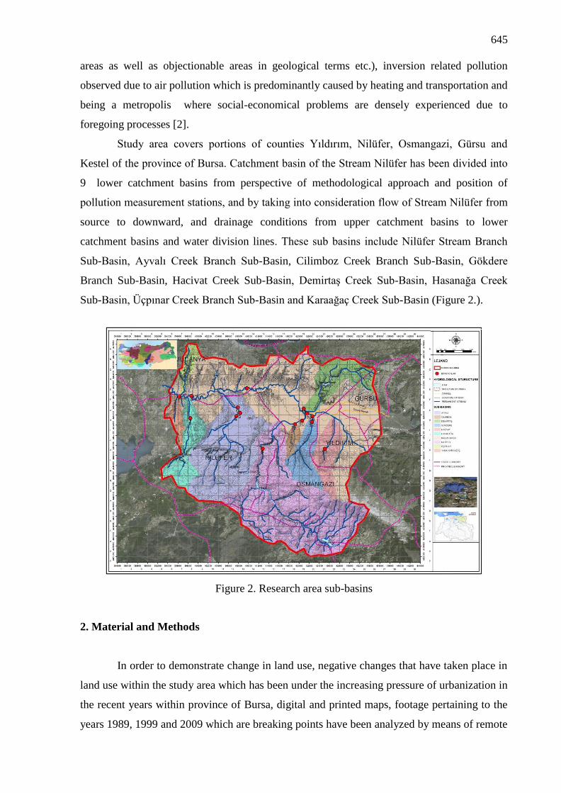
Study area covers portions of counties Yıldırım, Nilüfer, Osmangazi, Gürsu and
Kestel of the province of Bursa. Catchment basin of the Stream Nilüfer has been divided into
9 lower catchment basins from perspective of methodological approach and position of
pollution measurement stations, and by taking into consideration flow of Stream Nilüfer from
source to downward, and drainage conditions from upper catchment basins to lower
catchment basins and water division lines. These sub basins include Nilüfer Stream Branch
Sub-Basin, Ayvalı Creek Branch Sub-Basin, Cilimboz Creek Branch Sub-Basin, Gökdere
Branch Sub-Basin, Hacivat Creek Sub-Basin, Demirtaş Creek Sub-Basin, Hasanağa Creek
Sub-Basin, Üçpınar Creek Branch Sub-Basin and Karaağaç Creek Sub-Basin (Figure 2.).
Figure 2. Research area sub-basins
2. Material and Methods
In order to demonstrate change in land use, negative changes that have taken place in
land use within the study area which has been under the increasing pressure of urbanization in
the recent years within province of Bursa, digital and printed maps, footage pertaining to the
years 1989, 1999 and 2009 which are breaking points have been analyzed by means of remote

646
sensing and GIS techniques (Figure 3). Accordingly, change that has taken place over land
use in 20 years between 1989 and 2009 has occurred in the form of a decrease in fertile
agricultural fields by 32,22 km², a decrease in forest areas by 14,07 km², an increase in
settlement areas by 29,92 km² and an increase in industrial areas by 14,06 km².
When looking into increase of industrial and housing areas in terms of land area
based on photographs taken from study area and nearby areas, it is seen that a rapid
urbanization process has taken place from 1989 to present day, and it is estimated that such
trend will continue according to 2020 Bursa Environmental Plan with the scale of 1/100.000
and Master Plan with scale of 1/25.000 at the same pace.
When laying down changes in terms of land use that have taken place in the years of
1989-1999-2009 within the catchment basin; changes taking place in the settlement,
agriculture, forest, industry and trade fields have been assessed in 9 sub-basins and the entire
study area. Changes in the other land use have been excluded from assessment since there has
been no significant change in the range of years 1989-1999-2009.
Land Use in 1989 Land Use in 1999 Land Use in 2009
Change Change
• Agricultural areas
• Forest areas
• Settlement areas
• Industrial areas
• Water quality monitoring stations
• Industrial activity area, the number of
businesses and wastewater discharges
• A variety of changes in the function
Figure 3. Changes in land use in the years 1989 – 1999 – 2009
2.1 Changes that took place in land use
When looking into percentage ratios within the other land use during the year 1989
(Figure 4); it is seen that the forest areas have the highest ratio in the study area with 54 %,
which covers an area that is 683,32 km² large. When assessing the distribution of forest areas
in terms of sub-basins, the greatest portion of forest areas seem to be located in Nilüfer

647
Branch Sub-Basin with a land area of 328,72 km², followed by Ayvalı Branch Sub-Basin with
a land area of 107,24 km². The reason why forest area ratio is high in Nilüfer Branch Sub-
Basin is natural structure and plans connected with the social-economical policies. From
natural structure perspective, high forest area ratio can be attributed to the fact that Nilüfer
Branch Sub-Basin that is located in the south of study area contains southern hills of the
Mountain Uludağ and geomorphologic structure presents a climate and soil characteristics
conducive to development of forests. Likewise, since inclination degrees are more than 40
degree in general, land uses such as agriculture, settlement are not observed in this sub-basin.
Just like Nilüfer Branch Sub-Basin that has brown forest soil, Ayvalı Branch Sub-Basing has
similar characteristics. When looking from plan point of view, depending on social-
economical policies and natural structure, a forest area decision has been generated for Nilüfer
Branch Sub-Basin in the Bursa Environmental Plan with the scale of 1/100.000 at the upper
scale. In the lower scale, no master plan has been drawn up which would cover the sub-basin,
and from planning point of view, priority has been given to Bursa city center and Central
Planning Area where Bursa Plain is located and Eastern-Western Planning Areas and adjacent
areas.
In 1989, within the study area, agricultural fields with the ratio of 39% have the
second largest use and cover a 493,46 km² large area. When assessing the distribution of the
agricultural fields in respect of sub-basins, Ayvalı Branch Sub-basin has the largest area with
84,99 km. The reason why this ratio is high in Ayvalı Branch Sub-Basin is natural structure
and plans connected with the social-economical policies. From natural structure perspective,
high forest area ratio can be attributed to the fact that Ayvalı Branch Sub-Basin that is located
in the south and south east of study area contains geomorphologic structure created by the
Ayvalık creek that assures drainage of surface water in this sub-basin and presents a climate
and soil characteristics conducive to agricultural activities.
Table 1. Land areas of land use within the study area in the year 1989

648
Figure 4. Percentage ratio of land use within the study area in the year 1989
Likewise, it is observed that agricultural activities are densely conducted in this sub-
basin since inclination values are no higher than 0-5 degree except for the southern parts of
the sub-basin. In terms of soil capability classes, agricultural activities are carried out on the
1st and 2nd class soils within Ayvalı Branch Sub-Basin that has alluvial soil and rendzina
soil. When looking from plan point of view, depending on social-economical policies and
natural structure, an agricultural area decision has been generated for Ayvalı Branch Sub-
Basin in the Bursa Environmental Plan with the scale of 1/100.000 at the upper scale. In the
lower scale, however, according to Western Planning Area Master Plan which is the master
plan covering the northern parts of the sub-basin, decisions complying with the agricultural
activities have been generated in this sub-basin.
In 1989, settlement areas cover a 82,16 km² large area in the study area, when
conducting an assessment from sub-basin perspective, it is seen that there are village
settlements to the south of Bursa Plain which is the city settlement and among agricultural
fields and forest areas, which have spread all over the study area . From sub-basin point of
view, there are dense settlements in the north portions of Cilimboz Branch, Gökdere Branch
and Hacivat Branch Sub-Basins and in the eastern portions of Ayvalı Branch Sub-Basin.
Natural structure and plans have played a role in selection of location for settlements in these
areas. From natural structure perspective, in connection with morphologic structure, Bursa
Plain that has a flat or nearly flat structure is used as settlement and housing area due to its
proximity to transportation routes, and location of industrial and commercial operations
nearby and all functions thereof nearby this area. However, when looking into geological
structure of study area, a large portion of Bursa Plain is located on the lands which are under
risk of liquefaction. Settlement and housing areas that are located in these areas are under risk.
When looking from perspective of plans, due to rapid population increase, although plans
have been made based on estimation that 190.000 houses will be required between 1990 and
649
2000, in practice, amendment to zoning regulations and shanty and unplanned settlements
have paved the way for a rapid increase of settlements in the study area. These settlement
areas that have come into being before infrastructure has been completed have discharged
their domestic dumping and waste waters into Nilüfer Stream or underground waters by
means of wells.
In 1989, industry areas cover a portion of study area that is 8,48 km² large and trade
areas cover a portion that is 3,02 km² large. It is known that social-economical policies are
decisive in terms of criteria for selection locations of Organized Industrial Zones rather than
natural structure characteristics. Apart from Organized Industrial Zones, industrial
establishments located within the city in a scattered manner discharge their wastes into
Nilüfer Stream or underground with no treatment activity [3]; [4]. In Bursa, trade
establishments have selected their places along the important routes of accession and
continued its development accordingly.
When looking into percentage ratios within the other land use during the year 1999
(Figure 5); it is seen that the forest areas have the highest ratio in the study area with 53 %,
which covers an area that is 678.16 km² large. When assessing the distribution of forest areas
in terms of sub-basins, the greatest portion of forest areas seem to be located in Nilüfer
Branch Sub-Basin with a land area of 328.19 km², followed by Ayvalı Branch Sub-Basin with
a land area of 106.92 km². The reason why forest area ratio is high in Nilüfer Branch Sub-
Basin is natural structure and plans connected with the social-economical policies in a
somewhat similar manner to that in 1989. In 1999, within the study area, agricultural fields
with the ratio of 39% have the second largest use and cover a 483.51 km² large area. When
assessing the distribution of the agricultural fields in respect of sub-basins, Ayvalı Branch
Sub-basin has the largest area with 82.05 km². The reason why forest area ratio is high in
Ayvalı Branch Sub-Basin is natural structure and plans connected with the social-economical
policies in a somewhat similar manner to that in 1989.
In 1999, settlement areas cover a 97.13 km² large area in the study area, when
conducting an assessment from sub-basin perspective, it is seen that there are village
settlements to the south of Bursa Plain which is the city settlement and among agricultural
fields and forest areas, which have spread all over the study area. From sub-basin point of
view, there are dense settlements in the north portions of Cilimboz Branch, Gökdere Branch
and Hacivat Branch Sub-Basins and in the eastern portions of Ayvalı Branch Sub-Basin.
Natural structure and plans have played a role in selection of location for settlements in these
areas. When looking from perspective of plans, due to rapid population increase, although
plans have been made based on estimation that 550,000 houses will be required between 2000

650
and 2020, in practice, amendment to zoning regulations and shanty and unplanned
settlements paved the way for a rapid increase of settlements in the study area. Settlement
areas of the city center with completed infrastructure do not discharge their domestic
dumping and waste waters into Nilüfer Stream or underground waters by means of wells,
rather, convey the same to BUSKİ collectors [5]; [6]. Besides, although there are settlements
which still discharge their waste waters into Nilüfer Stream, it is known that especially rural
settlements discharge their waste waters into Nilüfer Stream and underground waters due to
lack of infrastructure and control.
In 1999, industry areas cover a portion of study area that is 17.03 km² large and trade
areas cover a portion that is 3.17 km² large. Despite the fact that industrial establishments that
used to be located in the city center in a scattered manner have moved to Organized Industrial
Zones and treatment plants are operated at these OIZs, based on the water quality
observations conducted in Nilüfer Stream branches, pollutions have increased in terms of 11
parameters (pH, temperature, dissolved oxygen, biological oxygen requirement, chemical
oxygen requirement, iron, copper, cadmium, zinc, lead, chrome) and water quality of Nilüfer
Stream has dropped [7]; [8]. This is attributable to failure to operate the treatment plants at
full capacity and as is required and illegal discharges [9]. In Bursa, trade establishments have
selected their places along the important routes of accession and continued its development
accordingly.
Table 2. Land areas of land use within the sub-basins of study area in the year 1999

651
Figure 5. Percentage ratio of land use within the study area in the year 1989
Based on the maps drawn up about the entire city and surrounding areas by using
Landsat and Ikonos satellite data pertaining to years 1989, 1999, 2009 it has been detected
that industrial and settlement areas are predominantly located along the roads connecting
Bursa to Ankara, Izmir, Istanbul and Mudanya where agricultural potential is high.
When looking into change in land use in the years 1989-1999-2009, it is observed that
extreme changes took place in the years 1989-1999-2009, chosen as breaking points, and
social-economical policies are influential apart from the natural structure.
Table 3. Land uses within the study area in the years 1989-1999-2009
Table 4. Percentage change of the land uses on the study area within the years 1989-1999-
2009 (prepared based on 1987 Landsat, 1999 Landsat and 2009 İkonos satellite footage .)
652
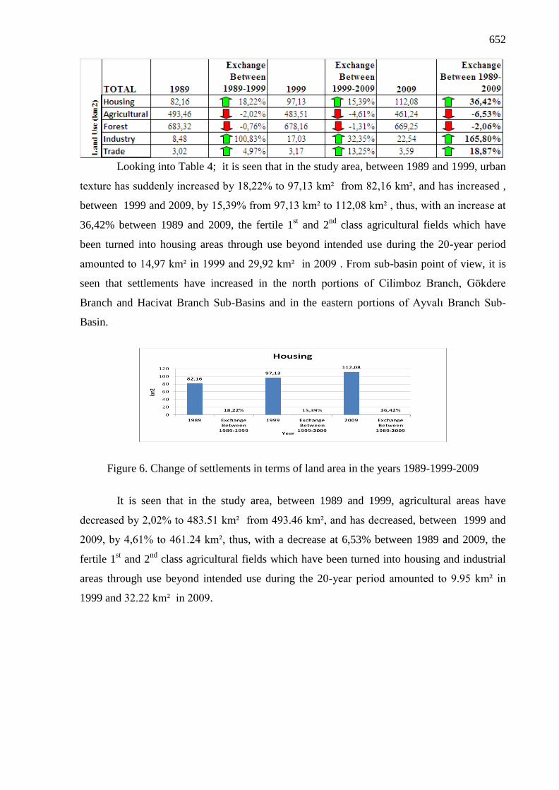
Looking into Table 4; it is seen that in the study area, between 1989 and 1999, urban
texture has suddenly increased by 18,22% to 97,13 km² from 82,16 km², and has increased ,
between 1999 and 2009, by 15,39% from 97,13 km² to 112,08 km² , thus, with an increase at
36,42% between 1989 and 2009, the fertile 1st and 2
nd class agricultural fields which have
been turned into housing areas through use beyond intended use during the 20-year period
amounted to 14,97 km² in 1999 and 29,92 km² in 2009 . From sub-basin point of view, it is
seen that settlements have increased in the north portions of Cilimboz Branch, Gökdere
Branch and Hacivat Branch Sub-Basins and in the eastern portions of Ayvalı Branch Sub-
Basin.
Figure 6. Change of settlements in terms of land area in the years 1989-1999-2009
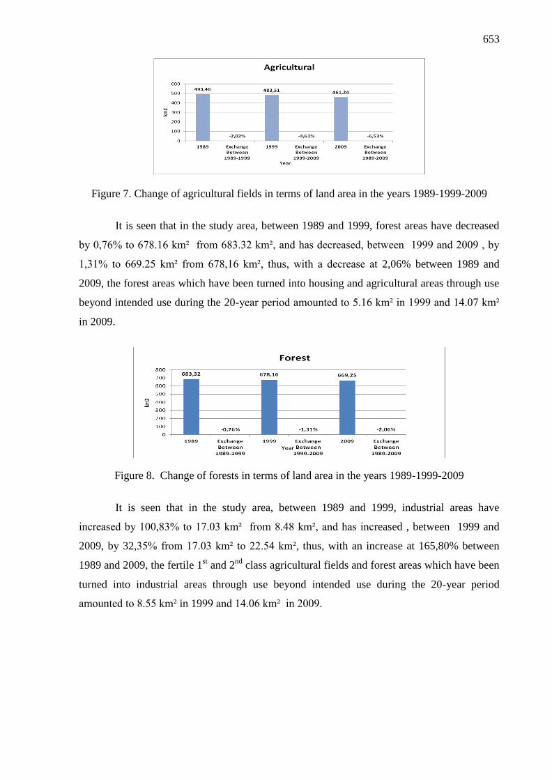
It is seen that in the study area, between 1989 and 1999, agricultural areas have
decreased by 2,02% to 483.51 km² from 493.46 km², and has decreased, between 1999 and
2009, by 4,61% to 461.24 km², thus, with a decrease at 6,53% between 1989 and 2009, the
fertile 1st and 2
nd class agricultural fields which have been turned into housing and industrial
areas through use beyond intended use during the 20-year period amounted to 9.95 km² in
1999 and 32.22 km² in 2009.
653
Figure 7. Change of agricultural fields in terms of land area in the years 1989-1999-2009
It is seen that in the study area, between 1989 and 1999, forest areas have decreased
by 0,76% to 678.16 km² from 683.32 km², and has decreased, between 1999 and 2009 , by
1,31% to 669.25 km² from 678,16 km², thus, with a decrease at 2,06% between 1989 and
2009, the forest areas which have been turned into housing and agricultural areas through use
beyond intended use during the 20-year period amounted to 5.16 km² in 1999 and 14.07 km²
in 2009.
Figure 8. Change of forests in terms of land area in the years 1989-1999-2009
It is seen that in the study area, between 1989 and 1999, industrial areas have
increased by 100,83% to 17.03 km² from 8.48 km², and has increased , between 1999 and
2009, by 32,35% from 17.03 km² to 22.54 km², thus, with an increase at 165,80% between
1989 and 2009, the fertile 1st and 2
nd class agricultural fields and forest areas which have been
turned into industrial areas through use beyond intended use during the 20-year period
amounted to 8.55 km² in 1999 and 14.06 km² in 2009.

654
Figure 9. Change of industrial areas in terms of land area in the years 1989-1999-2009
Figure 10. Change of trade areas in terms of land area in the years 1989-1999-2009
It is seen that in the study area, between 1989 and 1999, trade areas have increased by
4,97% to 3.17 km² from 3.02 km², and has increased, between 1999 and 2009, by 13,25%
from 3.17 km² to 3.59 km², thus, with an increase at 18,87% between 1989 and 2009, the
areas which have been turned into trade areas through use beyond intended use during the 20-
year period amounted to 0.15 km² in 1999 and 0.57 km² in 2009.
3. Results and Discussion
When assessing the relationship between current pollutions taking place depending on
change in the land use during the 20-year period and these decisions of change and planning;
it is observed that zoning plans which shape land use within study area and have been drawn
up for planning areas within “Bursa Metropolitan Area” and current land uses do not match
one another. This shows importance of pollutions caused by the illegal unplanned land uses as
well as pollutions depending on the change in the land use guided by legal planning decisions.
Ecological risks appear depending on the zoning plans and plan notes supporting the increase
of housing and industry areas over the land use, especially on the study area. Natural
thresholds are exceeded and natural resources are devastated in line with these processes
giving rise to loss of agricultural areas and forest areas.

655
4. Conclusion
Ecological Planning and catchment basing planning related to the same is a planning
approach, at a scale above the space planning, which lays down principles of conserving
biological and ecological characteristics of the natural resources and assuring balance of
conservation – utilization, ensure that resources are managed wisely, and the issues are
addressed within integrity. If planning is directed by implementing projects of reviewing and
gentrification of those land uses which are not ecologically appropriate in the settlement areas
according to “Ecological Planning” containing an original systematic and by thinking together
with Ecological Master Plan which guides land uses in those rural areas which are not
inhabited yet, it is obvious that natural resources of our country and water catchment basins
will be rendered sustainable.
References
[1] U.F. Küçükali and S. Atabay, 2012. Pollution and Risk Analysis for Başköy – Kestel
Section and Sub-basins or Bursa Nilüfer Creek, SİGMA (Journal of Engineering and
Natural Sciences), Yildiz Technical University, İstanbul, Turkey.
[2] U.F. Küçükali, 2012. Pollution and risk analysis for Başköy – Kestel section and sub-
basins or Bursa Nilüfer Creek, Ph D Thesis, Yildiz Technical University, İstanbul,
Turkey.
[3] Y. Dedeoğlu, 2000. Pollutant resources of surface waters in Bursa and determination of
pollutional load of Nilufer Stream together with recomended solutions, Master of
Thesis in Science and Technology Instıtute of Uludag University, Bursa, Turkey.
[4] A. Küçükkballı, 2003. Determination of water quality in Nilüfer Stream Basin and
investigation of some parameters with QUAL 2E model, Master of Thesis in Science
and Technology Institute of Uludağ University, Bursa, Turkey.
[5] Bogazici University and Republic of Turkey Ministry of Environment, 1992. Examination
of water pollution and quality determination basins project: Susurluk Basin, Bogazici
University, Institute of Environmental Sciences, Istanbul, Turkey.
[6] A.G. Kaynak, 2002. Wastewaters originating from Bursa city center; their treatment and
effects on Nilüfer Stream, Master of Thesis in Science and Technology Institute of
Uludağ University, Bursa, Turkey.
[7] Bursa Metropolitan Municipality, 2002b. Bursa water resources and current quality,
Environment technical report no:37, Bursa, Turkey.
[8] DSİ, 2000. Susurluk River Basin Water Quality Management, Report: DSİ / 1998 – 1999,
State Hydraulics Works, Ankara, Turkey.
[9] G.E. Üstün, 2006. The Reuseability investigation of wastewater from Bursa Organized
Industrial District (BOID) treatment plant effluent, PhD Thesis, Department of
Environmental Engineering, Uludağ University, Bursa, Turkey.