East Bay Regional Park District Resolution
263
•' ' ' •. -,' ... '•••.•' -•,.-.• ...>•. .. . .- -. ••; - ': ; : v ':: ' : IIMilli ' ''''': ':' East Bay Regional Park District . • '•> ,-v.V '' .:' '. •-• .if - '-.' • "• • • ' '" • v X MASTER PLAN . •. .... , ..-,-. . ., .. . ;.v : ., Compiled by District Manager by Order of Board of Directors 1940 --. " -'; . . .->.. ; m : .:• -, .
-
Upload
khangminh22 -
Category
Documents
-
view
7 -
download
0
Transcript of East Bay Regional Park District Resolution

.
•' '
'
•.-,'
'' ...
'•••.•'.
-•,.-.• ...>•. ''• .. . .- -. ••; -
':;
:
v'::
'
: IIMilli '
''''': ':'
East Bay Regional Park District•-
.• '•>,-v.V
'' .:' '. •-• .if -'-.'
•.
"• • • ' '"•
v X MASTER PLAN.
• •..
.... . , ..-,-. ..,
. ... .
;.v:
.,
Compiled by District Manager
by Order of
Board of Directors
1940--. "-';
.. .->..
.
; m : .:•-,
.


LEGEND
*—rrK-^h*.
•^—sr3'
%/fcfl
s¥-P»
» ;kf x''^^^"V
v ' 3a& jtf&5WSW
J*fe
---x- .
i.t?'®*'-
_t^tt hEP IT
^tf. 7/C: * . t^s-/V_


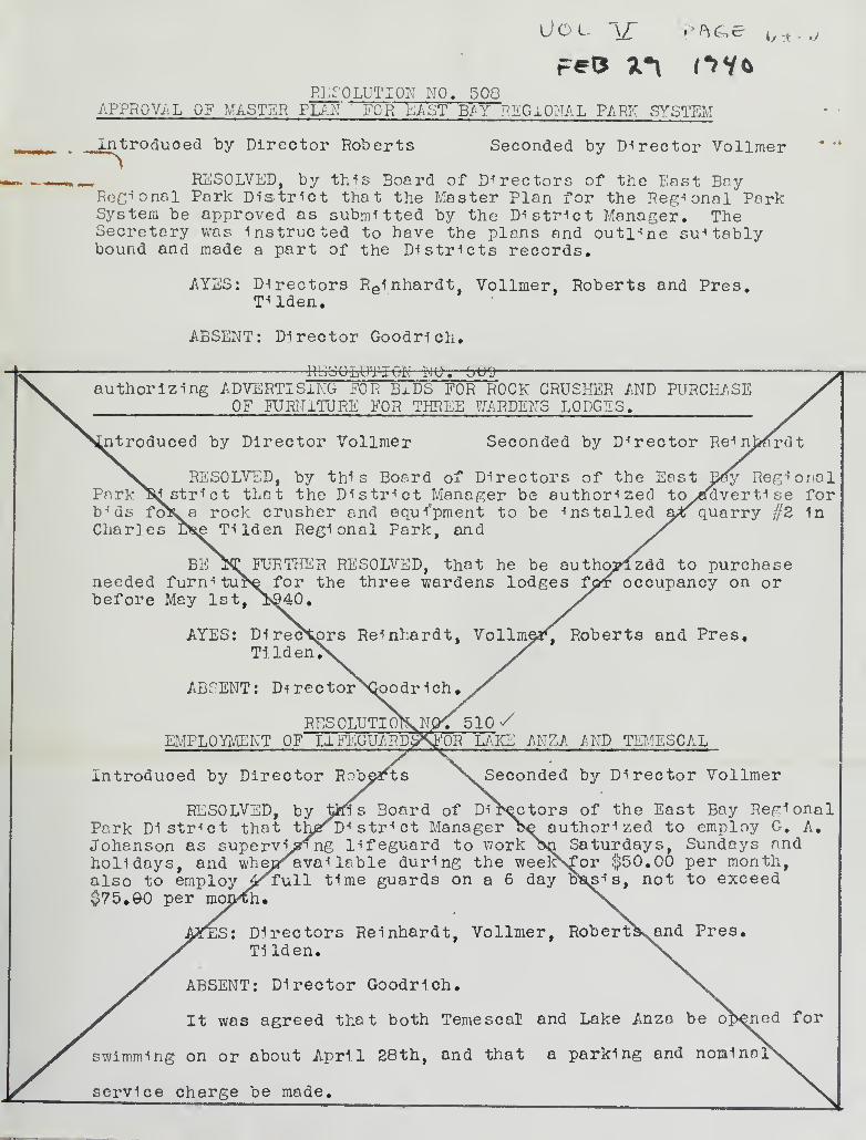
Vol \£ ?hG>e m.j
RESOLUTION NO. 508APPROVAL OF MASTER PLAN ' FOR LAST BAY REGIONAL PARK SYSTEM
J^troduoed by Director Roberts Seconded by Director Vollmer
RESOLVED, by this Board of Directors of the East BoyRegional Park District that the Master Plan for the Regional ParkSystem be approved as submitted by the District Manager. TheSecretary was instructed to have the plans and outline suitablybound and made a part of the Districts records.
AYES: Directors Re1nhardt, Vollmer, Roberts and Pres.T^lden.
ABSENT: Director Goodrich.
RESOLUTION UU. toU9
authorizing ADVERTISING FOR BIDS FOR ROCK CRUSHER AND PURCHASEOF FURNITURE FOR THREE WARDENS LODGES.
jitroduoed by Director Vollmer Seconded by Director Reinberdt
RESOLVED, by this Board of Directors of the East Dfiy RegionalPark ^Sd strict that the District Manager be authorized toycfdverti se forbids foKa rock crusher and equipment to be installed a>*f quarry //2 1nCharles D^e TUden Regional Park, and
BE Iff FURTHER RESOLVED, that he be autho?lzdd to purchaseneeded furn^ ture for the three wardens lodges fpr occupancy on orbefore May 1st, j>£40.
AYES: Directors Reinhardt, Vollm^a^ Roberts and Pres,Ti Id en
v
ABSENT: Di rectorXk>odr 1ch #
RES OLUTIoKNP< 5 10 SEMPLOYMENT OF L1FEGUARDS><F0R LAKE ANZA AND TEMESCAL
introduced by Director Roberts Seconded by Director Vollmer
RESOLVED, by tins Board of Directors of the East Bay RegionalPark District that thjarDi stri ct Manager Be authorized to employ G. A.Johanson as supervising lifeguard to work an Saturdays, Sundays andholidays, and whepraval lable during the weekNfor $50.00 per month,also to employ 4^rull time guards on a 6 day b\sis, not to exceed$75.90 per mojp^h #
IS: Directors Reinhardt, Vollmer, Roberts^and Pres.Tilden.
ABSENT: Director Goodrich.
It was agreed that both Temescal and Lake Anza be opened for
swimming on or about April 28th, and that a parking and nonina:
service charge be made.


Digitized by the Internet Archive
in 2012 with funding from
East Bay Regional Park District
http://www.archive.org/details/eastbayregionalp24dist

X?
•f-Lfoter M.VfttL— DroT. Mqc
TH.f- National. PP^k: \3e*2vrcF-
19H-0
COV^eiKq V3U6VPYO, fcUlLOlNqO, GO^Ov.3, TPftlUO,
PHOTOqe^PK^ MP*Pv5. AMD CKA^TO


THOMGVS J. GOfrpeTCS ~ v5ecetrTO.£YL.e^OY a. qOOOQtCH
eL£)f-^T M. VPttL- OUSTCrCT MRNRq^eCftLPH HOYT - ATTOGHPY
JOHM MCLRCe-N' - PPi>Q\d COKv5UL.TP>MTrtOWftCO e HCMtKH-PPi-Si^ £>OTP*NI«5~T
q^-O^qpTT-f- MORTON - PiCCOUKTPiNT
ARTHUR fe>. HYPf ~]^P)MDv5CQP^ RCCH'T


"Regional 'Tarks
^Playgrounds
v:
^rr
,^U|
1
• :1 '^^"3»C'
i
V ~Cni "-1»-
r "V
At4W-i/*I*<*
*/' * «n . v
1$^T
i
Z'f^'T^J***K "v
v*" l «^i
SfeSSJf mi%
A' WC^"I /T^'ff
—
w
l3K
- J^


n>;
CANYON
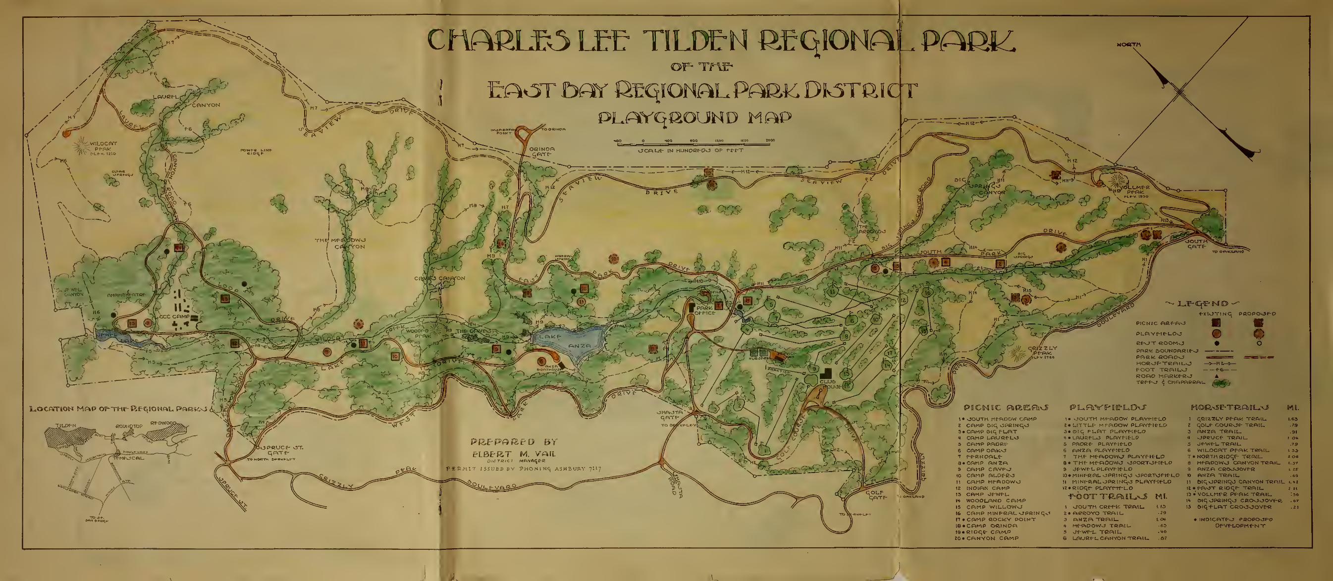
Cn^ftLB3 LEE TILDEM GEqiONA^ PAGS^OF- TMlr
ErAonr ftflnr ikeqionalpark DKsra iejr
WLOCRT
,-,.*JYDN *
Location Mftp of-THf^Bf^iONfu* parko \J$p y ff^^=
*-X IvJ T I N q PftOPOJPO
picnic ft«^p»o mo o• o
PfiftK DOUNOftClf-JPARk". fiOADO <^ra=S5E: ^ibmmHORvJf-TGFllLO —3— HZ^-3—FOOT TfiRILO -f©
ROftO MAGtdf-RO ATCPPO- ^ CHAPARRAL J*t0tj
PLAYPl^LOO
1 • JOUTH Mf-fiDOW CPlKPZ CAMP Oiq OPClNqO3« CAMP &iq PLAT4 CftMP LAUGf-LO5 CAMP PADRf-6 CAMP OAK.v3
9 •CAMP P.NZA9 CAMP CRVfJ10 CAMP ALOE-CO11 CAMP MfftDOWO12 INDIAN CAMP13 CAMP Jf-Wf-L.
1H- WOO0LAN0 CfiMP15 CAMP WILLOWO16 CAMP MINERAL OPRINqv*IT • CAMP GOCldY POINT16«CAMP OftlNOA19»GlDqe- CftM.PZ0» CANYON CAMP
!• OOUTH Mf-PiOOW PUAYf-ICLO2«LITTLf- MFPiOOW PUAYfItLO3«OIC PLAT PLAYf-tE"LOt • LflUftFLJ PLAYH^LD5 PAOCf- PLAY^[f-LO6 ANZA PLAYflfLOT THf Mf-AOOWs-T PLAYPltLOSiTHf-Mf-AOOWO OPORTOf-IE-L09 J-f-Wf-LPLAYT-lt-LD10* MlNf-RAL OPRINqO \5PO£TOf-If-LC> O ANZA TGAIL11 MtNlrRALOPGtNqO PLAYPlfLD U btqOPCINqO CANYON TRRILiz»e,[oqr- PLAYf-rf-L.o ii « f-AOT Rioqe- tcail
-F-OOTT TftflMUvS Ml. ,3 ; VOLLM^G «*«« TG« ,L-•*^w u ^run^v^ » (lf oiqopaiNqo ceoooove-c1 OOUTH CGef-fc. TGAIL- 113 15 ©iq-f-LAT CBOOOOVE*2» ACeOYO TRAIL, ^9
3 ftWZA TQf=UI_ LOW • INOICATfvJ <>GOPO>JF-0* Mf^OOW-J TRAIL. 63 Of-Vf-LOPM^tslT5 Jf-Wf-L TCAIL "+©
6 LAUGfL CANYON TflAIL -67
1 qClZZLY Pf~P\U TGAIL,t qOLf- COUB^f- TRAIL3 ANZA TftAIL.4 OPCUCf TRAIL,3 Jf-Wf-LTBAIU6 W1LOCAT PPAK TRAIL7 • NORTH RtOqf- TCAIL.3 MPA0OWO CANYON TRAIL.9 ANZA CaOJJOVf-R
*MIF MOON BAY
"* K,
EAST BAY 9EG10WALPARK DISTRICT
ladeg)
THE VJ&TUI£AL PM^VX
i- ITA A',
^ti\ise>\.\To
GatvSs viv\.vtv
vC»WO^
J fc
SAtpV
CIS**-*©** VNSV*., ,
TOT
"v.w</x .*«
^^
,k B'/iW.
3*fJ
»ts^V4\WO CM1 C^HyoH
,*-*c
MOO
<ll F*
"^
; v vGottg
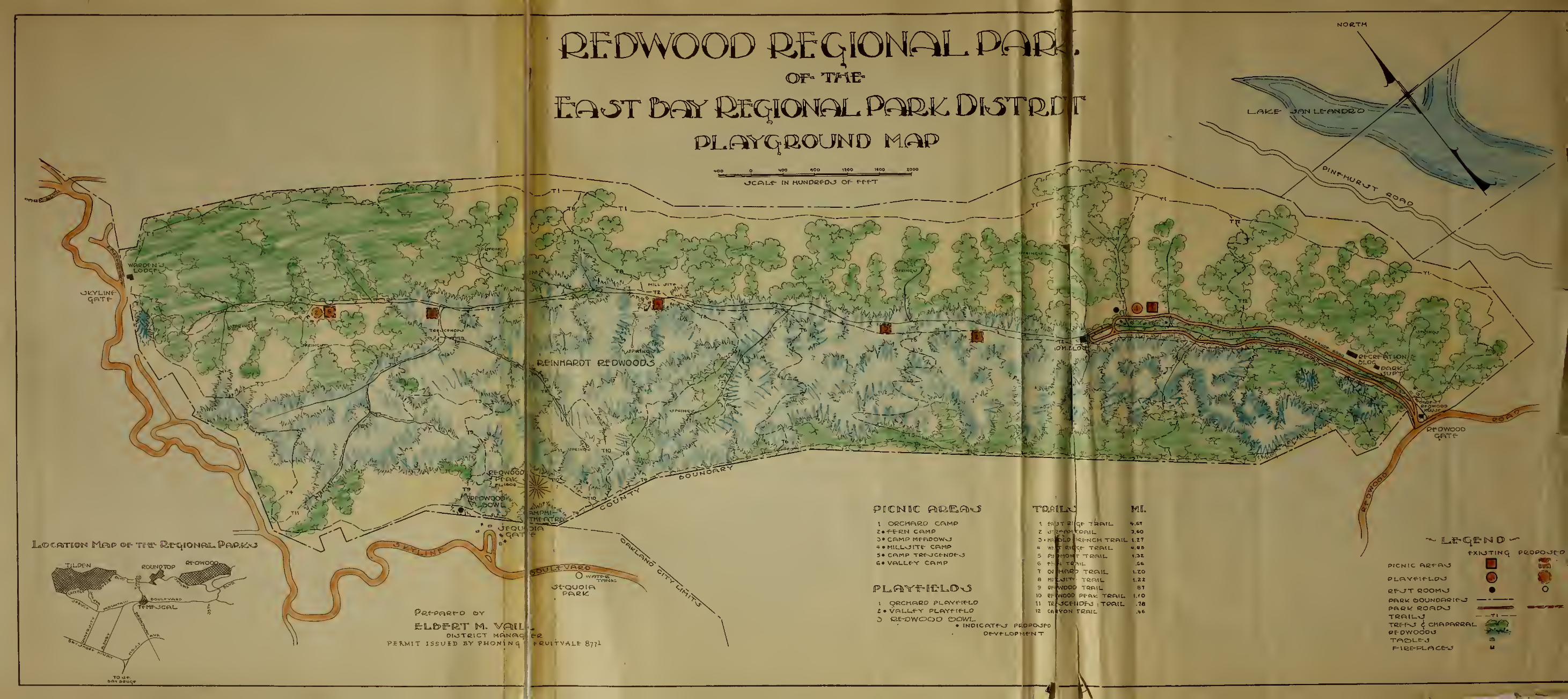
OCDWOOD fttqiON^LPAaOF=Tnt
ocftu-e- tN HUNoaeoj of- F-f-F-T
W> >>f-
\"ps\^^SscUn
SrtrT
//> C". .
'
-AA-
^yv*f af
fe ,--" ^ ^u, --^" -.:1 fcN
PICNIC FDIE.iEP&'.J
I OCChRfiC CAMP2»-f-E-RN CBMP3» CAMP MfFlOOWO4» MIULOITE- CftMP5« CfftMP TBfJCeNS» VP.t-Lf-Y CftMP
PLBYf-lfiLO^S\ QCCMP1CD Pl-P\V«^[*-LO
£ • VftLL.f-Y PLfVf^tf-UD
3 (3E-DWOOO DOW-• INOICPiTfvJ pc.oPCK5f-o
OE-vruoprlfNT

T T T T-TW-r TTT T TT .T . T.TiJ.
AN- HISTOID
&yeJ$l, U-^D-P- Wat/ova/2brk £Z,r/rz -Jigi, &b~i. 2>,Ws:i* -Huiaa^ /93(,
|t s
-
©<^
fc

OY


ANNUAL REPORTof
THE EAST BAY REGIONAL PARK DISTRICT
submitted by
ELBERT M. VAIL
District Manager
To the Honorable
Board of Directors:
I have the privilege of submitting the annual report
on the affairs of the District for the fiscal year ending
June 30, 1939.
GIFTS
I wish to acknowledge the following:
The helpful advice and personal services rendered the
Parks by the members of the Board.
The splendid gift from President Charles Lee Tilden
of six much needed Mack and Kleiber trucks. These are being
used in the parks to haul rock, soil, water and road material.
The North Oakland Kiwanis Club for their contribution
of $1000.00 for materials toward the construction of $12,000
stone recreation hut built by the W.P.A. for the use of all
girls in the community. 3ert Massey and his able Kiwanis
Committee did a fine job in overlooking the construction
and financing of the building.

TH : JH J A E
10
T0IHT8ia 2HA? JAM0IO3H YA3 T81,
YCf Jbsd-tiincfjja
JIAV .M T83SJ3
isrgaasM toiiiaid
©IcfBTonoH ©rid" oT
isictosita xo JbiJsoS
*roq9T IsurtriB edt gni&iimduQ So &gs£lvtiq ertt svsif I
•gnlbae ussy Xaoaxi vd$ iol froxTJ-aiCI 9rfJ 10 asxBiiB arid- no
• S^X 1 01 arrx/L
erao
:gnxwoXXoi arfJ agfcaXwonx'oB ctf rfaxw I
sif^ £)9i9Jbnsi a9oiVT98 lBnoaT9q Jdhb ©oivJbs lulqled 9rfT
•x>iboS ed* 10 Busdmem gdtf \d a::
rtfjXxT 99J 39lTsrfD tfnabx89^ moil Jix^ blbnslqs 9rfT
Saiscf tsfl 989rfT -."out* i9cfX9Xa JbriB £«bM Jb9ib99n donna xxa 10
: i9j-6m x>bot bns t9Jbw «Xioa t :£ooT XuBif 0* aaliBq 9dtf nx bssu
fJucTxTifrToo ii9££* rrol cfi/XO 3xxtbwx2 .bnBlstsO dd-roJi 9dT
0<SX$ 10 noxd-oirrJanoo ed& MbwoJ alBXTSten: troi OO.OOOXf 10
XXb 10 980 od& to 1 ,A«3*W 9£f* y;d" JXiucf dr/rf noi*B9T09T 9nod-8
axnswxX aids axrf Jbxis YeaasLI drag •ytlnmuaoQ sdt nx aXiig
noicfoirctfanoo niaicoXT9vo nx dot anxx b JbxJb eettis.
•gnxJbXii/d 9dt 10 ^nionsnxi bns
Annual Reportsubmitted byElbert M. VailPage 2.
The U. 8. Forestry Department, who gave 26,000 pine
trees to the District.
St. Mary's College, who gave many valuable shrubs to
the Parks.
John McLaren, Professor Howard McMinn and Edgar Sanborn
for their invaluable expert advice rendered in developing the
Parks.
The City of Berkeley for donation of flowering cherry
trees, and the City of Piedmont for their gift of redbuds
and flowers.
The Tilden Park Baa's Golf Club, Women's Golf Club,
and the Golden Gate Cricket Club for their work in stimulating
their respective sports.
The untiring efforts of the half dozen members of the
park staff, through whose work the parks have been made of
use to this community.
THE REGIONAL PARK SYSTEM
With the recent acquisition of Redwood Valley, the
Regional Parks now form a chain of woodland parks adjoining
and belonging to the cities of Albany, Berkeley, Emeryville,
Oakland, Piedmont, Alameda, and San Leandro, which comprise
the East Bay Regional Park District. They include vast open
spaces, covered by beautiful and typical California flora,
magnificent mountain peaks to climb, hidden valleys for
camping and picnicking, streams and lakes that lure the
sportsman. These are but a few of the charms of the natural

•S 9gs1
9iixc 000«oS sra-g on"wt tfrsutfTJsqsa Y^Jagxc^ ,8 .U erfT
• JoJfcTfreiCI 9dt ot 8991*
ot acfx/xda sldBi/lBv Y^sm 9vsg oriwt 9g9lIoD 3*ytbM «t8
• 8^X6^1 9£f*
nxodnsS xsgJE>3 boz nnxJaoM oxbwoE xoa89iox1 «n9iBJoM nxfoT»
9£fd- gnxqol9V9.5 nx 69i9£>ri9x 9oiv£>B Jx9qx9 9lcrBulBvnx xiextt toi
.eixjs*!
YTT9rfo gaii 9woIi io ao it-snob toi \9l9^T9S xo -%ti$ wfT
ajb/jcfi)9x io J1X3 TX9n"d- toi d-nocti^x^ io Y*iO end- Jbrts ,a99x*
• 8X9woX"i jbrts
«di/IO lloO a»n9moW t cfx/IO 1I0O rs^ n8.bfxT 9flT
Sni^Iumid-s nx tfxow tied* toi cfxrXD freioxxO s&sQ nebloQ Qdt
. ^Jioqs 9vxd"09q39x xx9rf*
sxf* io sx9cfiT[9in nssoJb ilBrf 9rf* io afrxoile gnxxxd-nxr 9xiT
io 9i>Bffi n99cf 9vsrf a:tfiBq edt 2Jtow 98orfw rf^x/oxxft ,iij3 Js atxsq
•Y^inx/fnmoo axitt ot osu
MgT3Y3 2fiAq JAKO T HT
sdt t Y9llBV 6oowx)9H io noxfriaxx/pos frxdoex srit xttxW
gnxniofcoB aixeq JbnsIJboow io irxBffo b mxoi won aafaaS Isnoig9#
t 9lIiVYX9arS ^9^8^93 t YnscTIA io 89xJxo srfj- o$ gni§nol9cf Jbrxs
gaixqmoo ifoxrit «0TJbfiB9j ns8 bass, tSD9msfA , ;tnonii>9x<I <Jbnsl2LB0
O9Q0 Jasv 9bi/Ionx Y^rfT .d-oxiJaxC XrsS. Lsnoi-geK ysS d-asS 9a"*
«stoIi BinxoixlBO XBOxqY* bas Ii/iitasocf y<* Jb9X9voo t 39o.eqa
tot 3Y9IIBV ii9ooxrf <dxii£o ot sXssq nistcwom tasotlicrgGm
edt 9XX/I tsdi a9isl Jbns sais©T*a «sni2[oinoiq oris gnxqmBO
iBXird-Bft Sdt 10 3fl!XB£fO 9£f* 10 W9I B *XJtf 9XB 989ffT .OBfliad-T0q8
Annual Reportsubmitted byElbert M. VailPage 3,
Parks, which have been conserved by your foresight for the
people of today as well as tomorrow.
This great Regional Park System, approximating lJ-000
acres, is now providing a diversity of outdoor activities,
including flycasting, fishing, golf, baseball, hiking,
horseback riding, camping, picnicking, boating, and swimming,
A check on the number of persons using the Park System indi-
cates that all park visiting records have been broken. Young
as well as old, in ever increasing numbers, are seeking the
recrestion which contributes to their joy in living and will
sustain them throughout their lives.
Through the recently acquired Redwood Regional Park,
adjoining Oakland, another corner of wild California has been
restored to its original owners - the people. John McLaren,
builder of Golden Gate Park, has declared this park to be the
"most beautiful natural park anywhere around San Francisco
Bay". It will be kept always just as it is, a wildwood park -
protected from encroachment of automobiles. On the other
hand, Tilden Park, in the Berkeley Hills has many miles of
completed park drives, as well as many recreational facilities.
The first two years of the existence of the Regional
Park District was devoted primarily to the construction of
paved parkways, stone bridges, sanitary, water, power, and
gas facilities, and a golf course, while the past year has
been notable for the following accomplishments:

txoq9H l&urmk\<S bettimcfus
IxbV ,M trgrflS
9d& toI drfgiasTol tuoy y^ £>svT©anoo rt99cf 9vbo* rfoxriw t aiT6S[
•woxiomot ajB Haw as YBfiot lo 9lqo9q
0C0-4 gnxtBmxxoxqqB «m9rf-ax8 a'TB^ lBfioxg9H tsei-g 8xrIT
^aaitivitas tooMuo lo YtiaT9vI£) b gnxoxvcTq won sit a9T0B
tgnx:fxrf t IlBcf98Bcf tllog ^s 1"** 3 *"* *snxt8B0Yll gnxbx/Iorxx
, .aimmxwa Jbue %-gni±Qod «§nx2lox£ioxq «§nxqrii8Q t§niJbiT ioscfaaioxf
-xJbnx raa^SYS ^tbI 9dd- snxaxr sno3T9q lo T9cfmun edf no ^osrfo A
gniroY .n92ioid' fi99cr 9vsrf Bbioosi gnxtxaxv afxaq Lis terft 39tB0
exit gnia{993 9tb t ai9dmim ^nlQEQioai T9V9 ax ,Mo as IXsw as
XIjcw Jbns 3nivil ax yo£ TX9rft ot aQiudli^aoo iloxrfw aoltss-ioei
89vxl Tl9il* txjodgi/oxrft msdt nlB tax/8
TBS IBHOX? f)9XXJJpOB Y«C^n909T 9£ft rf§JJOTrfT
n99cf aBif bxatoIxIsO Jblxw lo tshtoo Terftonstba&HsO 'galniotbs
t n9TBJoM nrfol. # 9lqo9q 9dt - aTanwo Isnxgxxo atx ot bezo^ssi
9fft 9cf ot afxsq aidt b9TBlo9Jb aBri ,21x63 9to8 aeJbloO lo T9jbliucf
ooaionBT*? a&B bauoiA 3' is liisq isrutsn lull.'
- tfxsq x>oow£Ixw b «ax *x aB : -"ybwIb *qsi s tl ."
a9xfto 9rft no .a9lx ;s to tn xl -D9to9tot!:q
lo 39lxra Y^sm SBif allxH Y9l92iT39 Qd: ^tbS n9blxT « oasrl
,89ltxIioBX iBfioxtBexoeT y^sh; as Hew aa , asvixi) atxsc Iqcioo
lBnOX§9H 9Xft 10 90n9t3XX9 9dt 10 3XB9Y owt ?t3XXl sxtT
lo noxtoi/rtanoo edt ot Y^xxBflixxq Ji>9tov9t isSt
i>nst T9woq t T9tBw t YTsfrxns3 t aergbtid 9fiot3
t 8YBW2lTBq i)9vaq
3BX TB9Y taBq 9£ft 9lxrfw «93TJJOO IIOg S JbflB <39XtXlX0Bl 3S£
tn9milaxIqi7rooos gnxwollol sd& xol sldBton fi99d

Annual Reportsubmitted by-
Elbe rt M. Vail,Page 4.
22 MAJOR PROJECTS
1. A stone administration building, which houses the
District offices was built at Lake Temescal Regional Park,
at a cost to the District of $11,1+07.2^. It represents a
saving to the District of 1S# over former rentals. Its
value to the public in supplying dressing rooms, club room,
and boat house, is best illustrated by the fact that 60,000
persons used it during the month of May. Swimming facili-
ties are rendered without charge. No other community renders
such a service.
2. A sand beach, 300 yards long and 30 yards wide was
built on the shores of Lake Temescal. This was covered with
lJ-000 tons of Monterey sand, and has been enjoyed by thousands
of children and their parents.
3. The construction of Lake Anza in Tilden Regional
Park, holding 150,000,000 gallons, was built at a cost to the
District of 133, 69^.87. It has thus far saved the District
$10,000.00 in water bills - a saving of over 33 percent on
the investment. Moreover, the Lake is a beauty spot which
may serve as a magnificent aquatic center in the future.
^. An artistic stone administration building has been
completed in Tilden Regional Park. It has been constructed
according to a plan which makes possible an additional re-
creation hall and offices for administrative purposes.
5» The building in Redwood Regional Park has been
remodeled to provide living quarters for the custodian, a

<XxbV .11 tiecfXS.4 &%s<l
9rit assx/ori rfoxxlw ^gnxolxucf noxftsiJaxn noJa A .1
,2^5$ IsnoxgaH lB039m9T 92tsJ to jfXxi/cf asw aeoillo Joxstfaxd
B 8d-n989Tq9I JI .4S.Y04* t XX$ XO toil* idt O* J-300 B *B
aj-I .ale ^n9T T9mTol T9V0 ^81 lo JoxxJaxG 9ifJ oJ gnivsa
t mooi dx/Xo ,araooT 3fiisa9Tb gnxYXqqus iii: oilcfx/q 9x1* oJ 9uXbv
000 t 0o Jarl* Jobi srfj yd bs&siiBuILl Jaacf ax ,981/011 Jsocf one
-xXxobi ^xw8 ,Y3JM xo rfJnorc 9ri^ gnxiuJb Jx beau ano8T9q
aT9-bi191 Y^a^^OO T8ff*0 - ISlfO $U0d$I7( J&9T9i)fT91 9TB QQlt
.901VT98 B XfOX/8
3BW 9i>xw aJbiBY 0£ 6nB §noX 8JbxBY 0C£ <rfOB9cf ones A ,S
rfd-iw £>8T9Voo asw axriT # Xsoa<Ha9T 92IBJ xo ag'iorla grfJ no d-Xxutf
ax>nssi/orld- \d £>9Y0 \,aa n99cf asrl Jbrif- 8 yeiadTioM xo anotf 0004
• 8^fl9iBq ii$d& one n9ToXxrfo 10
XBnoxggH n9JbXxT nx ssnA 9.2fpJ 10 noxJorrtfanoo ecif .£
9rft 0* J800 b frs JXxncf asw t 3noXX.e^ 0C r 0£X •snxbXorf t i'xBS
toxttJ-axQ ed& Jb9VB3 tbi ax/rtt 3Brf tl . . £d«££l to JoxTd-axd
no d-nooxgq ££ rero lo gniTBt £ - eXXxcf i9t£W nx 00.000, 0X|
rfoxdw j-oqa xtussd a ax ei£j etii <T9V09*oM . J-n9rat88vnx 3£i&
• 9Tx/Jxri 9dt nx T9d-n90 oxtsxxpB ;rn90xixn§Bm b as 9vx9a ^sm
n99d* aBri jgnxoXxi/d noxJBTiraxnxmnB 9no.ta oxJaxd-TB nA .4*
09d-oxrTvtanoo n99cf asrf tfl .XtsI Xfinoxg9H asMiT nx o9d"9Xqraoo
-9T XBnoxtxJbJbB ns ©Xdxaaoq 392f£m rfoxriw nsXq B oJ gnxorroooB
• 898oqTJuq evt&artainiinbs toi 89oixxo oris Ilsd noxJ\89TO
n99d* asfi iItbS Xanoxggfl booubsH nx gnxoXincf 9riT $
b t nexootauo 9d$ -cox aisfiBvp gnxvxX 9i>xvoTq ot o9X9oom9T

Annual Reportsubmitted byElbert M. Vail,Page 5.
recreation hall, and administrative offices.
6. The North Oakland Kiwanis Club Girls 1 Hut has been
built of native stone. It has a large kitohen, dressing
rooms, and an entertainment hall with a huge fireplace, so
that it can be used the entire year. The use to which this
clubhouse has already been put by the girls of the community
should be most gratifying to the donors, the North Oakland
Kiwanis Club, who contributed $1000.00 for materials, while
the W.P.A. furnished the labor.
7. A nursery has been completed, housing 52>>000 pines
and redwoods, ready for planting this fall, together with
numerous varieties of trees and shrubs donated to the Park
District.
g. 10,000 Redwood trees and 25,000 Pine trees and
a great many shrubs were planted.
9. Ten artistic rest lodges-, built of native rock,
have been erected at the various picnic and camp sites.
133)^35 persons used these facilities during the year.
10. A garage and repair shop was built in Tilden Park.
11. The old building at the entrance of Temescal was
removed and a house for the Park ^Superintendent was con-
structed from its lumber.
12. A cricket and general sports field was leveled and
turfed near the C.C.C. Camp. It was used extensively for
the World's Fair Championship games.

yd" b^ «ira
.890X210 9VXJBS J8XflXM.bB i>flB jIlBIi noid-6 31091
nsaoT asri tuE * aXTXD cfuXQ ainswxS - ?0 rid-
gnxaseTl) <aado&iiL >si b aBd *J .encJa tlxucf
oa t 90Blq9trxx agjjrl b xttxw XXbxI d-n9fnflXB;frT9;ffl9 oe bite ,amooT
aiffj' XlOXlfw O* 93U 9dT .TB9Y 9SX;frfl9 9lU Jb9&X/ SCf iiBO tx d-BiI*
Xttnumxco adt io 8X1x3 9ri;t yd" tfuq as9cf y-&sQ~Xb 8jsd 9axjorfcfx/lQ
ba&lXsQ ifJioK ad* t 3Tonof> adt oJ gnxylx j-bt:§ Jaom acf bluoda
.rfwtalBiT9*sm xol 00.000X$ batudtitnco odit ,cfuX0 axnswiS
.tocTsX ad& bedaiarul .A.*!.? siftf
aanxq OOC t S^ gnxax/orf <batalqmoo n99cf sbiI xraaiun A .Y
xifrxw TsrfJ^od" «XXb1 axxij- gnxcfraBXq *ol YX>sea: <3Jboow.b9T brus
•3<3 9d^ o* bat acfinxla Jboe 399:rd- lo 89jM-9Xtbv auoiamva
•JoXTtfaxG
bn& aesrt eat^. OOO t c?S JbrtB asait JboowX)9H 000,01 .
.DOjfrrtsXq 9i aw acfxrrria \nsm ^B9ig b
«iooi 9vxdBfi to tltvd t *&gboI tear oxJaxd-xs noT .£
.••iia qoiso i)iis oxtfoxq eucirsv edt $s ba$oa?9 aaaci avsd
9X ad& galiub aaitilio&l aaaxtt baau anoaisq ^S^B^X
.iTB^ xi9i)XJcT fix tLJtud 8bw qoxfa nisqsi bas &gsi$-g A .OX
3bw XBoa9rasT xo 90Xibt? *x/cf &Xo 9XfT .XX
-nco as*: tttabnatnii? tit rrox 984/od b Jbns &3vom9i
.TsdVnx/X ad-x moTi x^Joxrrtfa
fins &9X9V9X 3Bw 6X9x1 ad-roqs Xbi9XI9^ bn& ie^olio A .SX
lot YX9vian9d-x9 baau sbw jfl ... 9rfj- ts9xt bsliut
.aefDBg qxxianoxqinsxfO ilsl a'x^XrroW sd$

Annual Reportsubmitted byElbert M. Vail,Page 6.
13. The construction and turfing of a recreation field
Jj-OO x 1«X) at Lake Anza for all kinds of sports was completed.
Ik. A play field wasleveled and turfed at Camp Padre,
15« The hole between Broadway and Temescal Dam was
filled with 39 » 000 cubic yards of dirt, which makes a splendid
recreation ground, where the schoolboys are playing baseball.
l6. There have been erected 28 fireplaces for outdoor
camps; 35O picnic tables; 12 rustic bridges and 60 rustic
benches.
17 • Rock monuments have been built giving locations and
directions to places of interest.
IS. Lake Temescal Regional Park has been landscaped.
19. Six major springs have been developed in Tilden
Regional Park, and five in Redwood Regional Park, to augment
the water supply.
20. Water and sewerage systems to meet present needs
have been installed.
21. Over 20 miles of scenic drives have been constructed.
22. Many miles of hiking and bridal trails have been
built
.
These improvements are outstanding because of their
permanent construction. None could have been undertaken
had it not been for the Federal Grants from the Works Progress
Administration; Public Works Administration; Civilian Conser-
vation Corps, and the generosity of the Kiwanis Club.
,XxbV .M JtsC
;"9xx noitsQ'iosT jb xo shxiti/J Jbna noxJoxrxJanoo 9dT ȣX
, 9d-9lqraoo ajsw ad-roqa xo axjflii XXb ioi ssnA 92tsJ .tr
•9t£s3 qmaO ta i>9iTi/* ons x>9Xe Isxx YBXq A .^X
asw flisQ Ibob ms x&vtbAQ?Q. ireswJM sXofi 9dT .£X
oxf>n9Xqa a asisra doxrfw f teiJb 10 ajbTB^ oxcfi/o 00 iJxw £9XIxi
, LJ3Cf98Bcf gnxY-sXq bib ayocfXoo.Hoa srffr siedirK braicz:-g aoiiseioei
rzoobtno tox asoslqeaxi SS Jb©oC9T9 ri99cf 9VBrf 8T9xlT cU
oxtfaxra Oo rjns 89§.dxtci oxJaxn SX ;89i
• 89£fOIi9Cf
ba& Baoi&BooI gnxvxg JXxxrcf n99cf svjsrf ej-nsrai/nom :*ooK .^X
. a9T9*nx xo asosXq oJ anoid"09TX£)
•£ 1 XarroxgaH XjsoaerasT 92feJ .
naoXiT fix JteqoXsvao n99cf I xtcqa rcoQBra xx8 «£X
&ti9argu& ot t^isS: XBfiox:§9H £)00wJb9H at 9txi one ^tbI XsnoxgBH
^Xgqxra retsw
aJb99n £n989sq J99m o* ai:i9c}-8Ya 95B19W98 Jbrus xatfsW OS
•Jb9XXB*3fiX fl99Cf 9VJ3fi
•bs&oitttsnoQ need 9varf asvxiJb oingoa xo aaXxm OS ievO »XS
n99cf svierf slta** leftistf bns gnx^xrf xo ssXira y«6M ,SS
.tXxi/d"
itQdt xo 9GxJB09cf ^niJbns tarfuo stb Bfaetiiovt aasiiT
n9^j3^T9i)nx/ n99Cf oTsri Mxroo gnoH • iioxd'or/TJtanoo d ::9q
BBQ-r-goT'l aiToVT arfJ mortx atxisiO XB1909I 9£ft toi riggc* Jon frx JbBrf
-I98no0 fiBxXiviG ;nox tsrtalatmbk ai; .-a^+axnxmoA
•cfi/XO axxiBwXii 9d$ xo ^tfxaoio »dt bus,
noitev

Annual Reportsubmitted byElbert M. Vail,Page 7.
USE BY THE PEOPLE
The use to which these Regional Parks have been put
for the last year shows that this park activity is most
welcome. Those who have taken advantage of the free picnic
and camp grounds and swimming beaches in the Regional Parks
are enthusiastic in their appreciation of the facilitiesl
provided for their use.
The Sierra Club, Contra Costa Hills Club, Berkeley
Hiking Club, and Alpine Hiking Club have shown their active
interest in these natural parks by planting Redwood trees
and developing many springs in the hills.
The riding academies that have sprung up adjacent to
the Parks since their opening proves, without question, the
service that we are giving to hundreds of persons who enjoy
and profit by the sport of riding horses.7
Some 59,000 golf enthusiasts have used Tilden Golf
Course in the past year, ^n increase of 100 percent over
the previous year.
The gross revenue from golffees and concession was #35 > 67^-^5
The cost of operation andmaintenance was 2^.706.15
#10,963.30
This was largely due to the District's having developed its
own water supply. It is interesting to note that due to
the fine climate in Tilden Park, situated just over the
ridge from the University of California, many golfers prefer
it to the courses on the Peninsula.

Ycf be&timdua87 .U JX9C
&HQ3<£ SET Yg 38U
Sua fr99d Qvjsri aixBSC IsnoxgsH 989rf^ rfoMw o* 98if 9£fT
tfeom ax yJxvxj'OS XT8q aid^ cterifr awoxla xsay JaaX 9j2;J- toi
oxnoxq aasi 9rit 10 sgsd-ftsviis n92Le^ svsd orfw 9aorfT .actooXaw
8^x6*5 XBffox^H 9rf* nx aarfoBecf : iva bos sbnsjoi'g qniso
89x*xXiosi 9ffj- lo noi*sxo9TqqB Txarffr nx oxJafixajLaftfng 9XB
,98xr Tigris toi Jb9f)xvoiq
Y9lB^T9e ( dx/I0 sXXxH jsd-aoD sttncQ <cfi/X0 bt*9x8 9rfT
9vxd"Oj8 TX9£tt nworfa avBjd cTuXQ gnxatxH 9nxqXA fcas t cTx/X0 grxlilxR
^ozt boovbsR gnitciBlq ycf aafxsq L&rjjtaa eaedt nx taaisiai
• aXXxrf Qdt nx a 3 Ynsm gnxqoXevgJb 6ns
od" JnaoBfcJbB .rxqa 9VB£f tori J aaxmaSBo 1 ariT
9dd" t noxd"89up j-jjori;frxw «39V0Tq sjnxnsqo rtedi 9onxa 321x8*3 9ffJ
Yo£n9 orfw afloat sq 10 absmbnud otf gnxvxg 9XB 9w ifsrfJ 90XVT98
,898Torf -gnibiT 10 tioqs sdt x<S ttlo:
1X0O neMxT Jbsau ev&d ataBxeuri^ns 1X0£ -
fP<? ©mo3
isvo tneoTsq OOX 10 93B9ionx as ,tssy *8Bq 9£ftf ni aaix/oO
•X69Y ax/oxvsTq ait*
iXog mOTI 9Xm9V9T 880T§ 9rfT
^•^T^tSC^ 3^^ noxaaaonoo Ans a©9i
bas noxlSTaqo lo itaoo snT^X.dOT.^S 3BW 90flR
afrx Jb9qoX9V9Jb 3nxv8£f a^oxTtaxQ 9£fJ o& auJb yia^TsX a-w a
od* 9uJb frBxf* stfon ot gxtxd'a .- v ••_ .
-
edt T9vo fraufc Jb9l5Utfia ,3fxs4 °>di
T9l9Tq 3191X03 xa&m «BinToixXBO 10 rtJ sxf* uoii er-Jbit
BXi/anxna'i Qdt no aaeix/oc 0* Jx

Annual Reportsubmitted byElbert M. Vail.Page g.
Educational institutions, such as State Teachers'
College of Nebraska, Transylvania College of Lexington,
Kentucky, Oregon State, and the State Teachers' College of
New York, and many others, have routed their student tours
with several days stop-over, where camping facilities were
afforded them, in Tilden Regional Park,
FINANCSS
Seldom, if ever, has such a pretentious park program of
purchase, operation, and development been achieved at such
small expense to any community.
In acquiring land for park purposes, developing the
parks and servicing them, the Park District has operated
within the five cent tax on a #100 valuation set by law. This
amounts to around $200,000; of this $125,000 was paid to the
Utility District for the purchase of lands, the balance of
$75>°00 was spent for buildings, roads, lands, and all kinds
of improvements. Briefly, 3i cents of the 5 cent tax goes
for land and \\ cent goes for improvements, salaries, and
maintenance of the entire *K)00 acre Regional Park System,
Besides the tax levy, the park derives revenue from the Golf
Course, boating and food concessions.

yioqayi iBimttAyd" bet&tmdua
.I2bV ,M tearfXS.8 ©ga*!
1 T9£fo39T s±Bt& as dox/a tanoxtfx/JiJani I&noitsoubS.
^notgaixed io ©^©XXoO BinBvXyarisTT <B2f8BTd9W io 8»9lJ
io ©§9llo0 'aisxfoesT 9tefr8 ©n't £rxa ^Jad-S ho^stO ,yiajjfrne2
aTX/o* *ns£>uts TJt9rf* bs&sso? QYBd t aiedto xnain £»xis t iToY w©P!
©I9w a9i*iXiOBi gniqinBO 9i©ifw ,T9Vo-qota aysb Xbt9V98 rtfxw
.iTS<i JLsflcxgsH i P «1 ,aftjf* I)9&toiib
MOio msT^OTq iraq ax/oii-n9d-9Tq s n'oua a.sii
t T9V9 iX t raooX93
£foua Jb x>9V9iif0B ri9©d tns veJb bos <rroitfBT9qo1 90s n'o!rirq
• Y^xniniiii'ioo t£hb o* ©an 9qx 9 XXBma
sri* 3nxqoX©v9i) t a©8oqTJuq x"iBq toi JbnsX gfiisix/poB nl
be o serf tfoitcd-aia attest 9rf;f ,raedtf ?;nxoivi9a boa aiTBq
axa'T .wb! yd J98 j .-±bv 001$ b no xb* trr90 9Vii 9rf* niritfiw
9xf* o$ bisq 8bw 000 «c?SX| axxfJ io ;000 t 00S$ Jbru/oiB o* atttuotvs
io aoriBlBcf ©ri* t ao/i8X io ©aBxfoix/q ©ifJ iol JoistsiC YfrxXxi-U
aJbnxi XXjb Jbas «a.bn3X <aJbsost agnxJbXix/d toi tfnsqe asw 000,^$
39og xst tfn©o ^ 3d& lo al £ ^fieittS .aj-nsmgvoicjmx io
oris t a9xxslBa t a^rx9ra9V0Tqmi tci a Jn90 £x jbns Jbnsl toi
.mojfaya i^aS *n:a6 'drrs ©rid- lo 90fisii9d-nxBra
iXoO ed& moTi 9uri9V9T aovxT©6 i%B<? 9dJ ,YV©X rst ©rfi 896X899
.8rroia89onoo ftool has snitfaod ,98tx/o0

Annual Reportsubmitted byElbert M. VailPage 9.
FINANCIAL STATEMENT EXCLUSIVE OF FEDERAL GRANTS
OUTLAY
Paid Utility Districtfor land $125,000.00
Capital OutlayImprovements, roads,buildings $17,339*62Temescal RecreationBuilding 11.23^.10Reservoir 38.252.29 66,gg6.01
Operat ion and Maintenance 53.6^4.4-g
Total Expenditures $2^5,530.^9
INCOME
Taxes $202, 26?. S3Golf 35,67^5Other 8ources 3.770.33 2^1, 70S. 6l
There is no bonded indebtedness or interest on bond pay-
ments to meet, and the District finances are in excellent
condition according to the auditor's report for the fiscal
year just ended.
WORK PROJECTS
A comprehensive plan of developing the Regional Park
System has been worked out, and in accordance with the plan,
subject to your approval, the District will apply its
limited resources over and above operating requirements to
the necessary construction and improvement of park and re-
creational facilities. In this the W.P.A. and C.C.C. will
aid materially.
'.: ,/.;_... w '7I8UJ0Xa TH3M3TAT8 J|IDHAKI1
YAJTUQ
Jox-itexa yJxIxifU to?O0.0OO t ^SI| fcfisl 101
XsituQ iBtfxqsOosoi < atfnstfgvoiqfiil
.£££,111 e-gaiblludnotteoiosR Lgo&stae?
OI.^S.II -gnibltiMIO.£&S«dd iS^S :
iIqvtsbsZ
B-i1.-*^.^ soixene j-nijsM Jbas nox d-BT9qO
.O^tC^S# Qoiuix£n9qx3 XbJoT
gMOOMI
S| 39XST1I0O
I^.S0Y t X4lS t£.C\X t J ssoTi/oe i9ri#0
-YBq bnocf no t39T9irrJt to aeenJbetcfsijni b9bncd on 82 9i9iiT
tnsll9029 nx 9is 39on«?nxi Joxid-8x(I 9rfit fcns ,;fr&9m od" ed"n9ra
Xeoaxi sxiJ toi tfToqgi a'tcod'xJbxr.s exfj od" ^nxJbTooos noxtx&aoo
.i)9Jb£I9 $8U'l 1
8T01i :iHOW
2iXS3 iBHOXgeH 9ffCf- Ol9V9Jb 10 flBlq 9VX3n9ff9iqfff00 A
,xislq 9xft fttxw 90fisJbi rrx Jdhb « ;?x/o Jbs2teow n99d 8Bd 1
afrx ylqqjs Xliw JoxstfsxG sri* ,IavoTgqB ixjoy oJ Josfcdx/a
oJ ad-n9ra9ixxrp9rr 3nxJ6i9qo 9voa i9vc aeoisjoBS? bet1mil
-91 x>riB iTBq 10 Jn9ra9voTqmx .brie noxtoxntenoo YiB88909fi
lit* .0.0.0 baa .A.^.W edt aldt 111 .89xJxIxobi lBnox*B9io
.YXlBii9*Bm t

Annual Reportsubmitted byElbert M. VailPage 10.
W. P. A .
The W. P. A. has agreed to expend" •#53 i*->397 in labor on the
following:
1« Grading and surfacing park drives and trails
2. Landscape and plant trees, shrubs, and flowers
3» Construct club houses, comfort stations, etc.
ty. Install septic tanks - disposal plants
5« Construct nursery - plant the same
6. Reforest areas where planned
7. Install water lines, storage tanks - sprinkler systems
(g. Construct amphitheatre and appurtenances
9. Prepare playgrounds - recreation areas
10. Construct camp - picnic grounds
11. Construct tables, benches, fireplaces
C. 0, .
The C. C. C. has agreed to have a camp of 200 men stationed in
Tilden Park to do ^he following work:J
1. Const ruct 6 Comfort Stations
(2. Build an Administration Building at Redwood Regional
Park.
3. Develop Picnic and Campgrounds.
k. Develop Springs
( 5» Build five concrete storage tanks and install pipe
lines.
6. Construct horse and foot trails.
7. Plant Redwoods and Pines.
&, Eradicate undesirable growth.
9« Construct roads (& miles)
10. Sewage disposal.

XxbV .M ta9cfX3
•A • <* ,W
Qd$ no TocteX nx YC^*^ r- ad »A .** ,W 9£fT
:£fixwoXXoi
aXxBTd" Jbxis aevtib tfraq gnxQaisx/8 fine gniJbjssiD *X
biswcXI x>ns «adxnrrfataa^r.^ ^njslq JbnB 9qB03£f[Bj ,S
•0*9 t anoi*a*a droxmoo t aaauod dx/Xo tfoircJanoO • £
atfrtsXq XB3oqax.5 - aHii&t oiJqea XXbJs/tI ,4
9OTJS8 9Xtt jfX13Xq - Y^QS^^n JfOITTJt •£
£•< STSflw 8JS 9TB J"89T0I9H .£
am9d-3Ye isXtfc.: ^Inst ^gaiota , 89nxX t9*bw XXBfranl *y
aeorif$n.e$?!jqq& bns aitssdtidqms tourtatioQ • &
3B9TB noid"B9T09T - abctuoTgiBlq QT&qQlH. # £
aJDiuroTg oiiiaJ io ^oirnt-snoC ,0X
890BXq9tctl «e9n'on:9cft a9lcfB* JoxntancQ .XX
. .0 .0
rxx Jb9f:oi.t6d-a rr9m 00S io qmao '.d o* 099TgB asxl .0 .0 .0 9XfT
:iiow ;§nxwoXXoi 9cl;f oJb 0* axs'-I nsMiT
anoxtBtS taoimoO d JoLTCtanoQ ,X
XBnoxg9H boovrbeH *b gnUbXii/S noi*B*j , 8inx:rJbA nB bliuS. ,9
.axe**
. abruroTaqinBO r?ns oxrrcx^ qoX9V9Q .£
argntiqS qolevad •41
9qxq XXBfrarrx boa aXcmt ergsicis 9£9Sonoo evxi bltxM .c!
• 39fIXX
• aXxBid- frcoi f>rt8 93*0x1 towLfenoO .d
.89ni5 f>ns 8JboowJb9H JrxsXS .Y
• Q'J-WOTg 9XcfBTX89Jbflt/ dtaoxJbBsa •&
(aaX; ) aixsos JoxrEJ-anoO •£
• XBeoqaiJb 9§bw98 #0X

Annual Reportsubmitted byElbert M. VailPage 11.
Besides having rendered many recreational services to
the community, the Regional Parks have given a place of em-
ployment for the boys of the C. C. 0, Camps, as well as to
those citizens who have been in need of work. Park work is
ideal for hand labor, as the planting cannot be accomplished
by machinery.
The plan for the development of fire prevention and
suppression facilities in the parks has been proved of ines-
timable value in conserving the parks. There have been two
major fires, but these were quickly brought under control by
quick action of the park employees.
It is recommended that a 200 foot strip on either side
of Grizzly Peak and Skyline Boulevards, also along the Tunnel
and Redwood Roads, be dedicated and planted by the cities of
Oakland and Berkeley as parkways. The object of this recom-
mendation is to provide a series of Park Drives connecting
the Regional Parks, similar in effect to the drives connecting
parks in many American cities.
The regional parks are for all the people without dis-
tinction, with equal rights and privileges for everyone. Not
only do the Regional Parks serve as a means of promoting the
health, welfare, and happiness of its people, but also, they
have made this community attractive and comfortable as a
place for work as well as a more pleasant place in which to
live. As Attorney Earl Warren has well said, "Every cent
of the taxpayers 1 money spent for recreation services save
the State a dollar in crime correction^.

*ioq9H laisnaA
I1b7 .U *t9dX3IX 9§fl1
o* asoivrea lBxioi*i*9T09:c 9T s^^^s^ ssJbiasS
-1H9 10 908lq b xxevig 9V3ri b^ibS Ibxt- Grid- «Y*inxjflWK>o 9x1*
o* ajs XX aw a& ,aqmB0 .0 .0 .0 9x1* io e^ocf 9x1* *oi *xi9orYoIq
ax iiow ItbS ,iTow io J&99H sxl oxlw an9si*io gaoxl*
X)9xi8xIqntoooa 9cf *onxiso gnx*xislq 9xi* as % iodsl bn&d toi XB9l)i
YTsniriOBm ycf
Jb/ie noi*n9T9Tq 9tii to ;Iov9.d 9x1* toi nslq 9xiT
-aenx io Jbovoiq n99cf ssd a^isq 9x1* nx Beit. t noiaagTcqua
ow* n99cf 9vsxi 9T9X1T . aafxeq 911* gnxvT9axioo nx 9x/Ibv 9ldsffri*
yd IoT*noo tQbnis td'gucid Y-^o-t^P 9iaw 9esxi* *xjcf t 39TXi to(,boi
.399XoXqrf'9 iTsq 9x1* io noi*08 ioix/p
gJbia T9xl*i9 no qiT*8 *ooi 00S b *bx:'* i>9fcn9ffifnco9T ax *I
X9nxtx/T 9x1* ^xioXb oala ^JbiBVsXuoS QniLytiB baB 189*1 y^ssxtO io
io 89i*xo 9x1* ycT £>9*nBlq &xib bstsoibsb 9cf t ax>BoH 6oow69H Jbns
-010091 axrf* io *09|;cfo 9xIT . BxBwiTsq as xele^zsE Jbns JbxxsXlsO
gxix*09xrnoo 89\*XTa iTBl io a9ii9a b 9JbivoTq o* ex noi*eJbfl9ay
gnx*09nnoo agviTJb 9x1* o* *09ii9 xxx iBXxrais , ans? lBnox-§9H 9x1*
# 89i*io oBoii9iTiA \d3Gi xii aixsq
-axJb *xroxl*xw 9lqo9q 9x1* XXa toi 9tb arfTBq lBnoxs9*i axlT
*oH .9H0YI9V9 toi a9^9lxviTq bxis 8*£fsxT XBjjp9 xl*iw t nox*onx*
.* gnx *omoTq lo axis 9m b bb 9VT98 aiTsI LactQl-gsH 9x1* oJb x^- 1*®
Y9Xl* t 08lB *ucf t 9lqo9q a*x lo aagniqqBx! oxis <9tbiI9W t ri*lB9xi
b as 9XcfB*Toifnoo oris 9vx*obt**b \tinwutico 8ixl* Qb&m 9VBXt
o* xioixiw nt 90BXq */i8aB9Xq 9Tom b as XXaw 88 afaow toi 9asXq
*H90 YT9V3 M «f>XBa XX 9w 8bx1 n9TTBW Itb2 xeniottk aA • gvxl
9VB8 390XVT98 nox*s3T09T toi *n9qa y9nom • 8T9\;sqxB* 9Xl* IO
•B XI0X*08T100 9fl7XIO £U TSlIOO B 9*B*8 9X1*

Annual Reportsubmitted byElbert M. VailPage 12.
The Regional Parks have rendered particular service to
the character building organizations, such as the Girl Scouts,
Campfire Girls, Girl Reserves, and Boy Scouts.
By contributing to the happiness, health, and greater
joy of living, the Regional Park program is adding immeasur-
ably to the already numerous advantages of the seven cities
that comprise the East Bay Regional Park District.
***********************
* * *
*

IxjbV .M tesdia.SI 9%ss1
o$ 90iVT9a TBluolti&q Jb9T9Jbfl9Tr ev&d aXiB^ l&ctot-gsft 9XfT
3 ItxO srffr as rioua x BnoiteslnB-gro gnxJblixrcT letoBtado sdt
x/008 yo9 bus t a9vi©89fl IixS t alTiO 9ixiqflL60
istSSI's *>a& tdtlBBti ^aaealqqBd ©xl d- od- gnx d-utfXTtaoo ^3
-Tiraj3 9mrai -gnibbB ax rasigoTq alxs^ iBttoi-gsR stit «gnxvxl io yot
agifrio n9V9a ©rid" io eggjsd-fisvJ&s BuoiBmun xbBBiLs ©rid- od" Ylcte
.toli&BlQ. ixs? lBfiois9H y-82 *s.s3 &d$ 98iTqraoo d-Bxld"
*****************
* * * *
* *

P<PtQk^ D)rv3T«lCT
hlOTOeY PlNP Qf-NPeALQPVf-UOPKt-HT OUTLINE-

y5fn
z
< ea: =i
. <
z 02
ou
<OuJ
z<<
<
to aW 5a S3
inw
S3
a
\F> 65UJ , >ft in Sp Q o
Q:
l i8 go gOr feQ. "J
Or 9
IcrQOCD
i
u o
o1LUo
o0:1—
Zo
_)O
o
soyLU
uJ
5IDQT
mUJ
<H > u u V z rfl >
I ? o in id or uz
a UJ oen N
<J < !<
UJre R UJ
Or $ bJu
U_ £uJ u (T)
w=5h-
Ixl ~11,1
>ft >
If)
in H<1 VJ
a '<
X<
? < Zn UJ 'I
P Or1-
< z <rUJ O h 1
LIT h rvu <r i >
UJ Qi UJLT a
o
5 a
Is
a <h z> O
O oU DC< <J
u
.0
tf O _J
<Orto z
i= 2p
\-
N z
Q25
QZ<
<
(0O3
>-I
Q.
a.
1 ^ ^u £ i0


X: ,Of HSK)RT
BAST *AY SBOXOHA! MB DISTRICTCalifornia
tSvULCPSSlST OUTLIJK
A, General
1. PAHK AOEBCY
The Bast Bay Regional >ark district comprising the citiesof Oakland* Berkeley, Albany, Piedmont, Eateryville, Alamedaand San Leandro, was established in 1935 &y &n overwhelmingvote of the people of these cities.
California Legislative ^ct Kumber 1114 reads:"An act providing for the incorporation, government,and management of regional park districts includingtherein city and county territory, for the purposeof acquiring, iaprovin , id mintaining parks,playgrounds. Beaches, parkways, scenic drives,boulevards and other facilities for public recrea-tion; providing for the mnageaient and governmentof such districts; authorising such districts toincur bonded indebtedness and to levy and collecttaxes to pay the principal and interest on bondsand for carrying out the purposes of this act; andproviding for the powers of such districts.
The Hegional Park 1 is trie t is controlled by five direc-tors who are elected for a period of four years, the Birec-tors who took office Jcrnuary 1, 1935 & rJ(* w**e still serve onthe Board are: Major Charles L«e Tiiden, * resident; I-eroyR. Goodrich, Vice President; Thomas I, Roberts, Secretary;Dr. Aurelia Henry Keinhardt, and August Volliaer.
The administrative and executive functions are vested inthe District Manager «,ho is Klbert &• Vail. He carries outtoe policies determined by the Director* • Under the Dis-trict Manager are the technical staff of loyees includingLandscape Architect, ,:ineer, propagators, recreationalsupervisors, gardeners, and others who supervise the variousfunctions of design, construction and maintenance.
revisions for continuing policy of aduinistrati onand development are insured by the Baa&i of Xirectors asthey are elected on alternate four year terns.
2. MR ,3
There are at the present time four Regional arks total-ing approximately 4000 acres. Three of these parks are
-1-

.
.
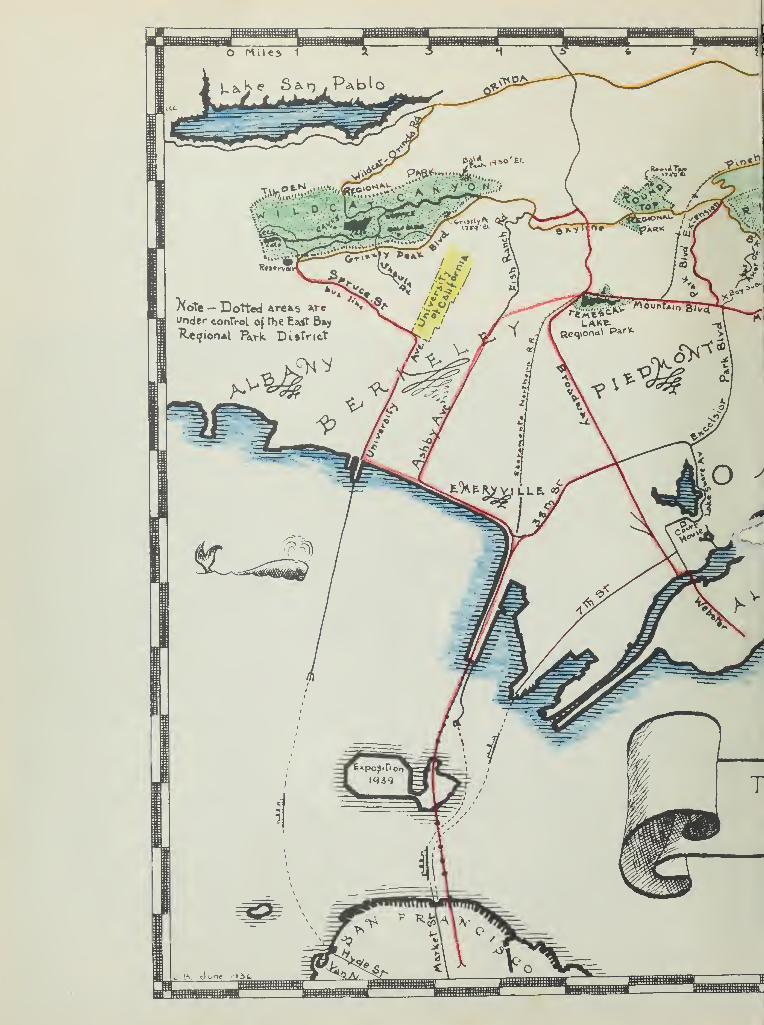
connected by scenic drives, they art \Les Lee Tilden Vark,approximately 2000 acres; Koundtop Regional Park, 223 acres,and Redwood regional Park, approximately 1700 acres. Thefourth park. Lake Temescal Regional iaark, consisting of ap-proximately $Q acres is ideally located in the center of thepark system and Ml the Administration headquarters.
The ultiraate plan is to acquire a total of some 10,000acres of continuous natural park lands bordering the citiesof the Me trie t. The value of the natural park lands forrecreation uses iu greatly augmented because of the exist-ence of lar e units of completed and contemplated scenicand recreational areas,
nature has placed within easy reach of the fast growingSan Francisco Bay >n this continuous border of seeniewooded land which possess a very high x*ecreational value.The great variety of hill, valley, forest and plains and theeasy accessibility to all parts of the suburban areas hasbrought to the fortunate people of the r&neisco Baycities the continuous opportunity for the enjoyment of thegreat outdoors under the mmt favorable conditions.
The tremendous use to which the parks have already beenput by the public since its opening in 193? shows the extentit will be used v«hen the recreational facilities are further
eloped.
3. HI3TC
th i oky, nsetuMsm MvLY. SAXJ 1035- They are a p*rt of the old Spanish
land grants - i iancho X>el obrante; iaocho Be la orenao;Los ?alo» Colorados, and Baneho Be San Antonio.
The Spanish period of California history has te&n endowedwith a definite rosmnce and glamour by legend and story. 1v«bthe music un& charm of place and family name has assumed anew importance and value as Has has diamed the reality ofthe past. However, the period is not gone forerer, for therestill remain at least three of the adobe homes within crclose to the Ei~»st Bay Regional Park Boundaries as shown onthe Master >lan. "Fhese include some sturdy structures in agood state of preservation and others in picturesque ruins,the romantic structures are located on the accompanyinghistorical map.
Three ranches provided the livelihood for the threeearliest settlers in ledwood Regional - Ark. They i&ere theGimes, the '.lamed!*?e, and the Bridges. oh raised threegenerations in this Valley.
The oldest wooden structure on the eastern side of :>an
nciaco Bay still stands at the entrance of RedwoodRegional Park and it Is sell preserved because it was builtfrom the Redwood lumber sillied on t ^ite in i860.
*»8—

•

In 1772 the early Spanish explorer Pages, accompanied byJuan Crespi, 12 soldiers and Indian guides* camped in what isnow Charles X*ee Tilden regional ftej&a Motes «ere made bythis explorer on the great stands of Oaks, and Father Crespicommented on the many deer, bear and other game which aboundin the hills.
The following interesting item appears in Crespi' s diarydescribing what the panish saw within what is now TildenAegional Park:
w In t«o leagues we left the plain and enteredsosse hills, and descended by them to a des?arroyo whose ford had to be fixed on accountof its steepness. It had plenty of water andon its fo&nka we found a gcod villus ofheathens, r%ry fair mn& hv&r&e&i wno did notknow what to do, they *ere so happy to see us... They gave us many cacomltes, amoles andtwo dead geese, dried and stuffed with grass*to use as decoys in hunting others....
This is the first written account of the Indians inhabit-ing th© Berkeley and Oakland Hills and it is interesting tonote that where the CCC Camp no« stands many Indian relicswere recovered from the Indian i/'ounds by the CCC boys.
ortly after a second expedition, headed by De Amitraversed the same lands and he tells of having climbed thehighest peak, which is now Volitaer ieak, from shioh theyviewed two conical shaped mountains, one to the rear and oneto the front, which were &ount JDi&blo (from which all thesurreys In the "t:*te of California originate) and the otherI ount Tamalpais,
Appropriate historical and ethnological markers are beingerected within the park areas to perpetuate this earlyhistory. The Lake situated in the center of Tilden Parkh.s been named after the Kxplorer Dt Vnza who traversed thisterritory in 1776 •
Following the early Spanish settlers came the gold seekers.The rapid growth of ' .-..-nclsco la I849 made a great demandupon lumber for houses, it was in ledwood itegional Park thatthe Princess 11X1 was built which supplied the first lumberfor the houses in Can ?r?*,neisco. This beautiful 20 squareBile virgin redwood forest »as denuded. Fortunately, fro®the roots of these eldest living things, the Sequoia Sempsr-virens has sprung - a second growth of redwoods which haveattained a height of 100 to 150 feet in the east $0 years.
a feature of this canyon is ft chain of sylvan meadowslyinc at the foot of a glorious sweep of hillside, wateredby natural springs ana accentuated by a stretch of fivemiles of those magnificent 'ledwood Crowes*

4. SKGIOKAI FACTORS
?E HAS* OF B I .
It has seen dedicated as a sanctuary. "^any deer, rac-coons* ©poseums, mountain lions, badgers, coyotes, somefox, wildcats* rabbits and m&ny other animals are seen,
xle the quail, owl, duck, hawk, thrush, warbler wren*finch, and smay others are found.
Many interesting geological features are apparent atrious points and if« visited by students almost daily
from the schools and the universities. Betany classesalso visit the park to study the native plants in theirnative habitat, in fact there is one canyon within theproposed ^TffJenal rkg that is said to have m.ore varietiesof native shruos &n& trees than &ny other one spot in the
t . fce.
5. mTil include two good sised
lakes which afford boating, swia&aing and fishing, also achampionship golf course, several athletic fields, ^n^i. b
numerous picnic grounds, camp sites, scenic drives andhiking and horseback trails.
The largest number ol" users probably constitute thefamily groups that gather to spend the day in the >ark withtheir picnic baskets. Acre lawned areas and shade are neededfor these groups. duiiica&l diversified play areas musthe provided to meet the popular demand of the young people.
In addition to these thousands are found where ever facil-ities are available, a great number of hikers, horsebackriders, cyclists, golfers, aslasers, fishermen, etc.
AEDXTXC .veuld enlarge the scopeof activities over those no*- available. l"h® space and facil-ities for increased activities should be provided within theintensive use area as shown on the Master hian.
6. %* t&mTM reservation of typical
cape, the natural hark values, and the pro-tection of the flers and fauna which are so commonly destroyedby the sdVi f civilisation.
Charles Lee Tilde/ - rk is an extensive valleyone Mile wide and 4 niles long, thro-. btich runs a lovelystream studded #iih oaks, and frith numerous eucalyptus grovesand wide open spaces. This valley is particularly suited tointensive recreation use© which can he achieved withoutdestroying any of its prisutive California landscape. The
MM


opposite is true of the Redwood regional Park, which isdensely covered #ith typical California trees, shrubs andflowers* It contains five miles of densely wooded edwoodsinterspersed with, a great variety of native shrubs andtrees. This primitive California landscape cannot be devel-oped for internal** ^recreational use without being spoiled.Consequently, ^ii is to be left in its native state, openonly to hikers and horseback riders.
Grass Valley is much more open, as its name suggests,and offers a wide of possibilities to those who seekoutdoor recreation through the realm of etiva sports. Itis as large as Tilden or ledwood ftegioaal rarks.
the patronage of the -arks tht are now open is verygreat and already reached, in %hn short p riod of two years,a point far in excess of its present facilities. The crowdsare so inrge that t&t* co«modated comfortably,
B. General JDewclopmcnt
Attached hereto and m<* a. part of this Master Plan arethe oral Ssvsliinssnt out" for Charles Lee Tilden
Vernal i , 'dglon&l rajk, 'lound Top RegionalPark and Lake Te&sso&l Regional Park.
C. Fire Cpntro*
Attached hereto and *»ade a part of this K&ster ilan is*ftC 0^.;ne
i
ra|. Firs i;lat| submitted by the Istissml Park Serviceas of Karch, 193&» prepared by talker B. Tilley.
B. Proposed £y& rteserratloqs
Attached hereto ;aade a part of laster Plan is theieport on Proposed ftsJfc Reservations for the £ast Bay cities,California, prep^rtd by Olmsted Brothers, Landscape Architectsand Ansel F. Hall, Rational Parle Service.
2. Circulation
*• The Approach Roaft leading directly into the Parks isGrizaly Peak Boulevard tad Skyline Boulevard. « are onecontinuous scenic drive that skirts the entire southern ^boundary of Tildes ,k; rnns through Hound Top
;ional Park sat borders the outhern boundary of ledwoodRegional Park. ?! is a sixty-foot paved roadand is xonintained jointly by the city of Berkeley and thecity of Oakland.
ElttWl .re underway to have the entire Boulevard plantedisith trees and shrubs for a of 40$ foet.
and iialntenanee - Kxistin, i ds.... 1J? milesds ^Q idles
Tot^O. 2*> Miles


It is recommended that dirt and water bound roads willbe paved eventually with oil macadam or road mix,
c . tunately a fine deposit of blue rock lies in TildenRegional Park which can readily supply all roads withcrushed rock needed for the oil macadam mix. Approximately17*645 tons of rock will be needed to surface the roads.k% J2.<"?5 per ten (the price paid) the cost would be$39,701,25 for the rook,
it Is r*9tss***4UN that a J&w crusher, revolving screen,conveyor and a bunker be Installed as soon M possible, ata cost not to ftJUM . y so doin& «e can ;et acredit of $2» 25 a ton a© sponsor's contribution, tcards the... sister project. tk&M would permit them to supply
fund for the oil, labor and machinery to install the pavedroads.
fhe .,ig dep&rtuient of Berkeley has submitted thefollowing analysis wsnto costs for egion&lPari .
Approx. ts Costs Costs for 20Ulleg per year *iles {>er Year utiles per Year
Maintain Oil«•••••• $n5*G3 ;o.oo I 9,goo.0O
Clean, , &n«
Main tala 33i tdie s
ge 130,00 150.00 3,000.00
Heiaove 'hiuiu-
slides. etc. m,W %IQ*<}Q. ... *.OQ0tQQ
tals.. $445.00 .00 16,000.00
SmuamMamrk ro^ds should be better maintained than city streets,
and being new, will cc^t son I '.nt&ir than old, cc tedstreets, due to sett... llXs, 1 t .
itches and <amllW\§* Will need cor.ata.it winter patrol,especially during and after rains,
idslides should be matched day and night Ifi vet weather,and BsJTftgaacdsd as needed,
ils aav be needed to hold landslides, (One appears to beneeded no*.),
All drainage ditch 14 be cleaned "before the rains.•rs to paviBf shoals, be :a&de before the rains - estimated
cost being §1,000.00.
MM


A power shovel and extra trucica rsay oe needed In cnse ofexcessive landslides.
m road maintenance, drainage, landslides, and better-ments {new paving, walla, new culverts, etc.) au . est asfollows:
crew of five K%n for full tias employment, 300 days peryear, as follows:
%&&&*• %&*&&.,.&£. ^asr,
1 working 5*9$1 ^or&ing Truck 1 river 5«463 laborers 15.20 A15Jftfotal X«ahcr per day. ........... #27 • 04
1 - 1-1/2 To $ Truck. $ 5. 201-1 L« swsx oil«r i t 2Q
I a r day. , . 6.40
Total Laser sad -.;> m Kt d&y ........ .
Su^rsated "york Program and -Jugaaary;
Maintain 043 -"acada?'*
6 months - 150 day§ !?. 04. §-4 ,0^6 • 00Truck it uiler l£0 days .40 960.00Materials 1#> days ,2^.00. . j.yfO.QQ
vb,?66. 00CI, .iads, maintain ditches and Asalaafi*:4 months - 100 days ,«j4. .....12,704.00Truck 1 day © 520 . 00
$3,224.00Settenaents, etc.:
2 months - 5$ days laoor • 4... 11,352.00Truck and Ciler J>0 &?ys $4.43 ^20.00
11,672.00
ote: Materials for Bait illaauta not inabove aiaanaxy* i road roller may beranted for special work as needed.
Percentage check of Cil Xa#*ft taas
30% - Labor M, 383. 0010£ - Equipment ^76. 60
rjr J^tfplwM.f'MtffF'unf^tu . .i2^4a1GQ5& - Total .TfU,766.00
«7—

MINIMUM PERSONNEL
ADMINISTRATION:
District ItenagerSecretaryAccountant
GOLF COURSE:
SuperintendentGreens Keeper7 Laborers
TILDEN PARE:
SuperintendentWardenNurseryman2 Gardners3 LaborersTractor OperatorTruck Driver
TiOEsaU FAMtl
WardenLaborer
TECHNICAL STAFF:
Landscape ArchitectEngineerChief Mechanic
RECREATION AUPERVlSORSj
4 Life guards3 Supervisors
REDWOOD PARK:
SuperintendentWarden2 Laborers
R00NDT0P PARK:
Warden
The minimum maintenance costs as set forth 1n the Olmsted*Hall report gives tiie follow* ng figures :-
1. Board of Control, minor expenses $8,000.00
2. Sedretary, Stenographer, clerk, suppliesetc. 10,000.00
3. Superintendent and6 foremen
24 laborers4 oars5 trucks 64,000.00
4 # Rangers and fire wardens 12,000.00
5. Roads, buildings, fences, water,electricity, planting 40. 000+00
128,000.00
ittAT
VMhrsMvi •-•
UTC ...
«• ,;?j;•'.-: „'•
total i fja 8B atsee e I Ml
M*0*qX9 TOixta fIe*rJfloO lo i : ••.:•
.
.
<<3SIf

ESTIMATED YEARLY RECEIPTS AND EXPENDITURES
INCOME:
Tax receipts
Concessions
$200,000.00
25.000.00 |225,000.00
EXPENDITURES
:
Board of Directors
Land Purchase
Capital Outlay-
Mai ntenance & OpBBation
Salaries
3,000.00
125,000.00
25,000.00
17,000,007
54.900.00 $B25 f 000.00
Thousands of dollars be saved yearly by thecapital outlay for water storage, rock plant andother Investments to utilize the natural resourceswithm the parks.

.
#q
,
r.


#;

zooo n^cQ-po
OflNq PfVfLOPPD PlO PlKINTPMOIVf PUAY ARPft


!fc*$* ^V?*.*?'
r*«
a 4»
S*f n
&^
">-*. .>
aW #6IgS f ??'J *6*• ---'^Sr* d
Ri-.nJ -Pt^i' jT,^kt.S
^flU'^vIJ>
•**' ^v%31 1 s& ij
Rfci^J^r **
^m^^fffe£3fc


CHARLES LEE TILDEN REGIONAL PARK
EAST BAY REGIONAL PARK DISTRICT
(Master Plan Revised March 1, 1939)
I. BRIEF HISTORY AUD DESCRIPTION:
Charles Lee Tilden Park lies just back of the first row ofhills at the east boundary of Berkeley. It contains 1910acres and includes the entire upper end of the Valley.
As early as 1915, the need for more space for outdoor re-creation in the East Bay Cities led to the suggestion foracquisition of the valley and other lands of the East BayWater District for park purpose, in 1^29 a citizens com-mittee obtained from Olmsted Brothers, landscape architects,an illustrated report with recommendations for acquiringcertain portions of the water lands including WildcatCanyon area.
A preliminary report was issued also in 1936 by the NationalPark Service again recommending the acquisition of the areaamong others.
On June 4, 1936, the newly created -^asy Bay Regional ParkDistrict purchased from the East Bay Municipal UtilityDistrict 1910 acres in the upper or s outhern half of wild-cat Canyon, containing the choisest part of the valley forrecreational purposes.
Present access to the area is provided at five points onthe west, one on the east, and one at the north, seven inall.
The park contains four distinct types of cover.
(1) Grass covered slopes and rounding hills, in the north-erly and easterly part of the canyon.
(2) Native forest cover, principally live oak, in thewesterly part and in the protected areas, with a scatteringof willow, alder and laurel along the creeks.
(3) Plantations of eucalyptus of several species form densegroves covering nearly £ of the area. Planted primarilyfor commercial purposes, they form the keynote of the areaand provide excellent picnic areas.
(4) Chapparal covers a smaller portion of the area, espec-ially along the westerly boundaries . During winter andspring Wildcat Creek and a few small tributaries flowthrough the area and at times produce interesting falls andcataracts along the valley. The chapparal growth is largely
of Baccharis and Poison Oak, with smaller areas of CreekDogwood, Elderoerry, Cascara, Wild Currant and Snowberry.

2HA1 JAKOIOCfl HSCLIIT S IHAHD
T0IHT3IG. ,iii A9: J [ YASTcAE
(eSei t X ifOIBM X>9SiV9H XI3l<I 19*33M)
IT<IIH08Sa aHA YHOT8IH 'iSIHE .1
lo vvoi *3ixl edj lo rioad *exr£, 89xX JLibI aoxUxT saj 3 9XiaiPOXSX anxa*aoo *I .-^aXeiiga lo yt&biUjQiS *B39 oil* *a aXXxxl
.^aXXeV 9il* lo 6na laqqxx eiiins 9rf* ss^x/Xoni ^na seioe
-91 ICOMJJO lOl 903q2 9101B 10 1 L99H 9ll* , SXSX 38 T£Xl8910I nox*393ax/a 9ii* o* bei 39x*x0 \bB. tasia. srli" nx aox*89ioXaS JsaS 9ii* lo siinaX x9ii*o xuia ^aXXav 9ii* lo aox*xaxjjpoa-xaco -H9sx*xo a 68<?X ni . 93oqiaq aliaq. 10I *oxi*ai<I isfj
t 3*05*xxioxa 9qaoeJaaaX «ei9xl*oi£ £9*3111X0 moil Jb9nxa^do Qetlltagaiiixrpoa 10I BixoifralaeiHBQOt'X rt*lw *ioq9i i>9*ai*3irXXx as
ifaoDXij* s^Xfii/XonX a&asX i9*aw 9ii* lo saox*ioq nxa*i90• a9ia no^aO
Xsncx*stf oil* id dsex ni oeXa J39I/33X saw Jioq^i xisaxmxXaiq AB9ia 9rIJ xo aox*x3xx/poa 9ii* 3xul)ix9iiUnoosi nxB^a 90X7ioS iia!
. 3i©xi*o gaoma
M*a? Xb 8 ^aS ^sa^ &9*89io ^Xw9it 911* «dSSX ,£ sai/Ti aO\*xXx*U Xsqxoxax/M ^sfi *bb2 9il* moil D938il©ix/q *oxi*3X(I
-Mi»< xo IX ail ni9xi*xro 8 io i^qqu 9x1* nx 39ios OXSX *oxi/3x(Iio$ ^9lXav 9il* lo *iaq *ds9Bioxlo 9x1* saxaxs*aoo «aoT£naD tao
• a 9 ao qiirq Xaficx*89i0 9i
rxo a*axoq 97xx *a i)9.DX70iq ax aaia 9x1* o* 33900a tnoasiZax n9v93 «xl*ion orit *a 9ao baa ,*sa9 9x1* xxo 9no t *39w sxlJ"
.lia
.10 700 xo 3©q^* *oxix*bxJc>. ixrol aaXaJnoo iiaq edl
-riJioii 9ii* ax t sXXxrl saxMx/oi bns 39qoXs f>9ie7oo bsbiO (X).no^nao 9il* lo jiaq ^Xi9J3aa bus y,Lie
&di ax t2lao 9viX "^XXaqxoaxiq t i9voo *89iol evit&A (S)
3axi9d-d"8oa a xlxxw tsaaia x>9J09toiq sxlJ ax xbxia $iaq ^Ii9j39w
.3Jlb9io sri* saoXa XsiaaX baa iebia t woXXxvv lo
93a9J6 fliTiol 89X09q8 Xai9v©3 1c sutq^JL801/9 lo aaox J3 J^iaXI (
^liiamxiq b9foal*l .a&ia 9x1* lo -£ ^Xia9a gaxi9voo 3970138918 9rid- lo o*oa\9i 3x1* xoiol ^9x1* ,a93oqix/q Xsxoi©ramor 10I
.33918 OXaOXq *a9XX90X9 9i)X70lq .
-09qs9 t 89ia Lil* '10 aox*ioq leXXenas a 319700 XaiaqqaxlO (^)ia i9*aiw •gai.itfd •ssiiabmsod \Li3iae^ srl* ^noXa %L1woXl 3 9Xia*x/diij XXams wet a Jjna 2L991O *aoxJXx i . xqe
x>aa sXXal ^ax*39i9*ax 9ox/i)o^ x* *a ona 89ia sxl* li^x/oul*
XLe^iaL ax il*woia Xaiaqqaito : .^9XXa7 9x1* ^aoXa s*osia*ao3I991O lo 38918 leXXams xl*xvv t 3i80 ao3Xo ci bna sxia^looaa lo
.^ii9dwoa3 xina *aaiixrO aXlw caiaoa80 t \ii&^iebLiL .jjoowsoCE
The natural character of unspoiled areas should be preservedwhere now existing, chiefly in the more inaccessible ravinesor steep slopes least suitable for general recreation.
The largest central area has been developed as a golf coursewith its field house. Smaller areas are being made access-ible for camping and picnicking along several miles of localpark roads now existing or under construction, and seferalof the other usable areas have been de dieated for specificactive recreational uses. The present administration center,at the old 3runo house, is well located for centralizedcontrol as most of the roads radiate from that point.
One foor trail 1^ miles follows Wildcat Canyon Creek from theMeadows near the CCC camp to the crossing of Wildcat Roadnear the center.
Several private stables exist near the Park and horsebackriding through + he area is a growing popular recreation. APolo field has been proposed, though: the area does not seemwell adapted for such recreational use.
Ample water is available from the Metropolitan "Water System.
Few areas even lar>je enough for soft ball games or other out-door sports exist in the entire park, but three such areashave been expanded for field games.
II. RECOMMENDATIONS OF THE NATIONAL PARE SERVICE AS TO GENERALDEVELOPEMENT POLICIES.
In the park area known as Charles Lee Tilden Regional Parkthe citizens of the East 3ay Regional own an area of outstand-ing value for its scenic qualities, topographic interest,geologic and historic values. Since the acquisition of thisarea, there have gradually developed two different ideas asto policies that should be carried out in the future devel-opement, and use of these public grounds. One group entertainsthe idea that the park should be developed as a metropolitancity park ana that developements with roads, playgrounds, picnicareas, recreational fields, special camping areas, educationalauxiliaries, etc., should ce carried forward intensively.To follow out this idea means construction of numerous roads,many trails, the installation of intensive water and sewagefacilities, construction of various buildings, playgrounds,and such similar developement
.
The second group of people have entertained the idea that thisscenic property, which has been little spoiled by human in-trusions ana development should be maintained as a natural-istic park, made accessible to the people by a minimum of goodroads, but roads which will provide reasonable access to thedifferent portions of the land. This group holds that theintrinsic values of the area would be definitely damaged byintensive city park developements and that the area is of farmore value at the present time and will have increasing valuein the future if it be kept, as nearly as may be possible, ina naturalistic condition.
-2-
f>9vi9seiq ed Mx/oxie aseis oelxoqsnir lo i9*oaiaiio Lamj rIT
S9nxvai 9ldiaa9oo, anlJelx* won eieifw
.noite9io9i Xsignsg, sXdaJ. •;. sag .0
SB1SJOQ Ho& 8 30 JE>9qol9V9f>'n98d 3&rl Bi J893ial ©J
-33900a eban ^nieti ana aasia loXXsmS kOBjbqJ! £19X1 six xfJJ
Xeool 1c 89lifli Iai979s anola snxioxnoxq baa &nxqi03o not 9ldx19193 baa t noi Jotfilanoo i9ijnx; 10 gnxJsix© won sbaon Anaq
ollloeqe not b&taolb ab as$6 e is 9ldaan laxito erij lo«i&i"n90 ncx'ijiJBxnxm.Da frn©B9*q axiT .8 981/ XanoxJa9io9i evxJoa
i ,98iJ0xi Cixwi8 i>Io 9iiJ ta*i isrlJ" a 'i 3 fix- i# lo Isom as Xoiinoo
9x1 J rao*il i9©i0 no^naD taoolx. :iol sella |X Hani noot 9n0i>a aisao s oi qxnso 000 ©xi* nasi?, swo
.I£^ii9; T39iT
aeatfaaioxi one Xib? 9il J isau Jalxa agidsJs I xq Iai9v^A .noitaoio&'i %al 3X Beta 9 jondi in
XH998 ^Oj:i 390 B91B 9xiJ ,X>930q0lq fi©9d. 9BJJ ,j-a910 91 Xi©d8 '!<_ 1I9W
.me t.3^2 ib ubJ"xIo< >il 9lcJaIxava ax i©Jbw elqxaA
-IXJO '191: 8B©1ona xioxrs eendt ixrd ,^-xac 9ix^n9 9xiJ nx J3XX9 8J1003 100.D
.39ma8 Mall iol lD90ii8qx9 n9©d 9vaxl
IA I .II
^•xal Iancxs9H n9JblxT 991 a9liaxi0 aa m'toai. aana Anat odt nliUO 10 B9TB nB a B£ JBSlL 9Xlj lo 8H9SXJX0 9XiJ"
,j oxriqa*raaqoJ ,89l;rxXi. .1903 six *i .
si noxix3XjjpcB erfi 9onx2 .asxxXav oxioJaxxi bna oigolc8B 3B9M irx-i9llxr) owi o©qol9V9£> \iiassban^ evaxi situit ,asia-I9V90 Bdt 111 JxJO 09X116 9d bLiJOda 1 BlfJ 3 9X0. 0*
ilai"i9;fn9 qxro'i .ujoig OlXdX lo 3axr bma t tnaa5iS.oq.ont 9m b aa oeqc sd JbJ
f sq adt JsxiJ aebi 9
. ".xmnoir-j^slq <abaon dtJn atai- .0 tax.. Jhuig >;:
CanoxtsojjD9 t* gn , , ^xl IanoiJB9io9i «sb9ib• XJ-9Tl8ad?nx bnawnot £>9xiiao so ol^oiia «.o^9 , aoxiBlIxxxxB
,ax)aoi sxrc; lo noxJoxnta 3©jbx sxxll j-jjo wollcl
t aJfru/O'. 10 naxioxrijai, silXIxoalJ,, j
ri.3li..,!i3 rlona 6na
2lxl,T 39 fix &.: x.c'J"i9i-n9 9v=sri 9lq>.
-nl namx/ri ^^ •& t^^i W-Xaix/ten a aa i>9n xetnlaiii 9d , anoxax/iJ
ooos lb niuralnxixi a \ oJ 9Xdx839ooa 90axo , ai
erit t 00a 9lda;f,,aso'i sLxvciq LS.i*t AioxrIw tbaon tssnt sb6i
adi jbxIJ sx)Ioxl
\ti be%Bia*b xLetiait:.- aavlav ciaaintnal lo ai asna adt it dqoLeveb i -xc e'/xsj.ieJ-iix
sulav £ 9V8Xi XIxix , 9ldlaac a ^Xl t i"q9A 9d fx 1
'.XJ-XDHOO OXjSXlPI^TB^ B

The national park Service favors the ideas of this secondgroup for a number of reasons. Comparatively few cities havethe unusual opportunity of maintaining, at their boundaries'lines, a beautiful and rugged piece of soenic property suchas is this park. As the populations of the i£ast Bay citiesincrease and eventually more or less encircle this area, thepossession of such undeveloped seenery will become increasinglyimportant.
Present trends in city park developments are quite definitelytoward preservation, or even establishment, of naturalisticareas through judicious planting of native trees and shrubs,rather than toward development of the old-fashioned type ofcity park. In present cities, playgrounds established atstrategic points, close to the residential areas, are highlyimportant. Many old-styled city parks ar. being concertedinto such playgrounds. At the opposite extreme, modern citiesare using their best efforts to imitate nature in such parksas they may possess in the belief, and certainty, that thevalues to be attained in recreation of extremely simple-typeparks within quiet areas of naturalistic scenery is of great-est value to the general public and is most appreciated bycitizens. To clarify this statement, a few examples may becited. At Portland, Oregor , the old city park which is verynear the center of the city of rugged terrain, is far moreprimitive in its appearance today than it was thirty yearsago. The city has removed many evidences of misuse of thepark's primeval landscape. For example, the zoo is gone,public band stands are removed, concessionaries stands areeliminated arl roadways formerly used by horse and buggy havereverted to foot path use, rather than being widened and"improved". In one section of this park Portland has builtup tennis courts and an outdoor theatre, beside an interna-tional rose test garden. Because of its location in thecenter of a residential area, the tennis courts have largeuse and the theater is important. On the whole, the usage andpresent trends within the park are very definitely towardsimplicity and reyention of the values of native landscape.
At the city of Tacoma, the Point Defiance Park uses a com-paratively small portion of its famous area for intensivepublic development. The remainder of the large park is keptin primeval condition and every effort is being made to soconserve these values. The City of Seattle has a naturalistic$*rJt, not so far from its center, which they are jealouslypreserving and which is greatly appreciated by its population.Vancouver, !•**•, is in a similar category. At Spokane theold-fashioned type of city (Manito) park has practicallyceased to function so far as residents of the city are con-cerned, except for its growing use as children's playgroundarea. Its greatest use occurs upon Sundays when the ruralpopulation gathers there for a change of scene, v*hile thecitizens of the city drive out to the edge of the twwn and
-3-

oxtoosa sXxLt lo 3a©X>X exit biovb! ©oxviQci jti£$ Iza-liavi ©x*T
vad sQitio wsl YX^viJ^iBqxnoO » >% ^o isdxni/xi 3 101 qx/oig1 aexiBonx/od ixsxif *b , ^alaiatsM ^Jxnv/jioqqo I sxtt
xa ^Jiaqoiq oXxxsoa lo ©09x aJTi baa iBl a , aenXIssi^io \aE xasa arid BfioJtf .
•
, fcrf* si 3Bsxft t
ssiB BiifJ eXoiXoxx© aa©I 10 e.iom ^Xlairi'aeve ona ©3b©ioxjX,310X1 ,.©d s£ll4 1£19JI9©B 305
aafrtoi
l9jXixXl90 eJXirp sis sj tXev-©6 ;iisq ^Xe nx aJba©it ta©e0X^31 H9V© 10 , U0i3"fl7'i©3 31^ Affl
.acfxriri- sesid" ©vXJaxi lo axtxJnalq 3XfoXoixn/(, (gjvoufi aasialo 9q-£* i>9iioxi{3 *rfi" lo tnsxaqo,' fa?
IB £»9li8XldBJ-3 9 aba UO XL 7fi .." >X*X8 i : ctl .ilaq ^io^Xxf^Xxl ©IB «3B91B XBXtil9X)X391 &£# oJ 630 Xc ,3JXIXuq OXgatslJa
b&tiQlaoo ^JXo i)9l^3-JIo t£hbM .taai cqrax
XJxo rnsjjoxnt©m9ifrxo ijj ©lit ?A . BfixftfOia^sX j rfox/e oJaX
a^iiaq xiolts nx 9ix/t3n bj-sj-xmx ot atiolls Jssd ji/ ©ib©r[J Jaxft txtxiasieo baa ,l©X!sd exit nx e3 93aoq y rf# ss
aq^-eXqmie \Xeaei£x8 lo ncUssioei nx xjtsnxs^la ©d o# agxriavtB9l^ 10 c:X ^191X803 OX *3 XlBIXfJ"8£I lo 3B913 j-©ljjp IltixlJXW SiliJq
fcsjaXooiqqB Jacm ax baa oiXrixrc lBiaxt©§ stit oJ ©i/Xsv *39©d ^BlU B9lqffiBX9 vVSl B , *X19;D9JSJ8 BJ vlXlBlO OT .3XI©SXlX0
\ji©v ax ritxrfw iiaq \t xo oXc sxtt ,1102,910 , onaXJio*! fA .LsJXo9ioxa ial ex
tnXBii9;J" bosgiri ^0 ijfrXe 10 leJrxoo ©xU
eia9^ ^itiXxiJ asw XX azdi xabo* ©cnsissqqB sJx nX ©yXJXmxiq.exit lo 9atnlm lo e9on9x>Xv9 -^cis^ fiovomsi sari y**© 9j*T .o§s
, ©nog aX 00s ed$ .©Iqmaxs 10I .©qaoeXmal XBV9xnXiq s'xiaq9ia zbaata a 9 XiBXtoi a aeoxioo t bevcsaet 9is aoiiaa d ©XX:
vbxI Tj3gJ/d bos ©eiorl ^d Xiobjx ^Xismiol 8\;bv/l XjetBrrxfrsiX©
»9xi9oXw gxiXsd aarit i©xiJ-Bi , asx* xftsq Jool 0^ xjqj'isv&itliud sad baaltio^ 3iisq axxft lo xiexifo93 eno xxl .''jbevoiqoiX'1
-bxxisJxix hb eblaoti e ©iJ"B9xiJ" toobtuo aa boa aJixrco aXxin©^ qxr
exf* Lit noxtBtoX s^X lo ©ax«Boefi .119 01B3 ?aefr 9301 XsnoiJ"e%ia . d 8i"ii/oo aXxmsJ 9x1^ ,B9is XBXi"n9 6i lo i9i£t©o
b 9§B3ii tiki , ©Xoxlw 3ri^ nO • Jri£tioqxiix Bl i©tB9x{J ©rij Jbxio ©sxr
J&iswoi" v,X9d-XnXxax) ^i9v sib iisq arfJ axxitXw ebasit irtsasiq• 9qBOaoxiBX svxJbxi lo 3©j/Xbv bdt lo aoXtxisx©i baa ^tJcoxXqiaXG
-moo ^OiiBXlsCI JxiXoS; ©xi^ ,BmooBfX lo yxo &dt t&©TXanBifti 10 1 B©iB 3j;o£Qb1 b 3 xxoXJioq XXbx;. .sq
i"q©3i sX ikiB' edi lo i9x5axBi..9i wll .Jn> &vex) ..
08 ot BvOBxa -^ai&c pi tioll© \i9vo jjxib noXd'X^xoo 1bv9x2j.
t3xXs.i|^"Bxi b earl 9Xd"^, .89i/Xbv saexli- eviBBXios
tjX3jjcIB9(, 9ib xpdi dolaw t isJxi90 sJX aicil ib! oa ioa ,Jli*jf
oxJBXxrqoq aJX \6 betsioQ 4! qm ^Xi«0«a ax xioxxl gaxvisaaiq©xtt 9xxa3ioqS ik .\10r39JBO isXx xxX sX t
* v";; , isyx/oonBV^XlBOX^OBiq bbxI ^IiBq (ojIm ^JXo lo 9q- ioXx(3b1-x)Xo
-noo eia \;JXc 3txIS0i.391 3B isl OS xxoXJ"oxix/l ot betx>nx/oi^Biq a'aeixjlxxlo 3B 9exj gnXwoig atX 10I J , beatsIb- ;iw eXBdMarE noqx/ aixr&oo :--a;/ ^89*391^ a?i .eaiB9XU eii xsoa lo ajxiBxio a 10I sigrfJ sisxiXsg noXi'B.baa ami sxIJ lo B^£>e evx i lo - xo

enjoy the naturalistic features of their Indian Canyonpark and numerous parkways , including the Seven Mile Statepark. These examples carry irrefutable evidence that naturalconditions in park lands are of far more value today thanany other type of park development, v.ith the exception ofplayground areas in population centers.
In the Charles Lee Tilden Park areas there is an opportunityfor a sensible compromise between the ideas of the two groups.South of the Orinda Road which crosses near the center of thepark considerable development, including a golf course, hasalready been made, which, in some measure, destroys the naturalvalues of that section of the park. It is entirely possibleto permit further development within this portion of the park,along the lines of the old-fashioned city park developments.The National Park Service feels that, by holding the ''city
park" developments within the southern section of the parkand definitely excluding such development from the northernportion, the greatest need of the greatest number of peoplewill be quite definitely served.
With these factors in mind, the Park Service wished to stronglyrecommend against many proposals which have been put forwardfor developments in northern part of Charles Lee Tilden Park.Developed picnic areas should be kept to a minimum in number,but of as large size as may be possible adjacent to roadwaysnow existing, ihere exist ample roads to make the area rea-sonably accessible to people who wish to enjoy the area in asimple and natural manner, hence any new road constructionshould be most carefully scrutinized before recommendation.It is doubtless desirable to make provision for one largeplayfield where young or older people may enjoy various gamesin the simplicity which is so valuable for recreative purposes.At The Meadows it is felt that merely grading the area to per-mit of games and planting of grass, is all that is necessary,
.
with the possible exception of sanitauy facilities. It wouldbe a mistake to permit this field to be developed with lockers,showers, field house, grand stands or other appurtenancesassociated with commercial or scholastic athletics.
The construction of buildings of any kind, not absolutelynecessary for the sanitation and health of the visiting public,should be prohibited. Commercialism in any of its de-vious forms should be kept out of the park. Encouragementshould be given to activities such as walking, horsebackriding, and the simple games as opposed to mechanical devices,indluding mechanical transportation.
The Park Service wishes to make clear to the citizens of theEast Bay cities that it is no easy thing to preserve an areain a semblance of its natural and primitive state and constantpressure will be brought to bear from numerous and variedgroups, many of them with highly legitimate and praiseworthyends in mind, and it requires great mental stamina to holdout against these pressures. To prohibit extraneous en-croachments within the naturalistic portion of the park
-4-

noTpxsO usi iQdi lo seiirtssl bitfeXXa*xr#ax* Qiit \cI aevQc exlj- %a±buLoai
t b^bwJ- ommx toa iLis'-i
Btsifka MxbJfctre eltfBJi/lsnx \iibo as: ifJfefSS
xxarii-
^b-Do* eul&v 'liibnoolo Lie l7q^o:ze ti.i
tJnsmqol 1
.. iaq lo'eq^ v,na• aottBiifqp^ xii Basis oixoois^siq
Y,.txxxxj;rio. go ns si sisxi* £S9ib ^ibI n&iili? ©9l aalnsxiO exit alie'vttQd QelipQiqmoQ t
19JH9D 'Jiij* -lir- to r£3
, 9siuoo 1iIo& a §xtifii/ioni , tnamqolevei) 9ld3i96i3£[oo >lisqsrit svoitaei) .Bursa ai , xioixiw , 9£>bid nasd ^JbaeiXa
sld i a so q ^1 3 ai tl ,3ii3q siftr
io xxciioss fraxfJ 'to senjisq arfj lo noiliv' tdt xii: £9V9l> ierfj*xiJ'i' i ot. 3fn3ffigolo79j) iisc v,tio fide Eo sift lo asxxil exit g,noIa
Y,tior sxit sxiXMoxi \d t*tsttt aleel soivisi. its ! Xsiioifakl exiT
2liJ .0 noitosa xxigxfJiioa t xiJ" nxxititf stxxsxflqai
XJ19J £0X9*9 j-lxdsj! .. r.ils .0
$X<J i9dffl£fn t -IS arfj- lo x>9sxi . :t .aoiitoq;
»'] b stixrp sd II xw
noita ot bertaiw 90ivi9c jLib^I 9nt t bnlm ai aiotesl ossrlt r
'io 1 frj Tjaeifl tani.B;-.- oxxexiiirioosi' larfD lo ti: Fioa n lolevt&b
ledflL ot tqs; • Dsqolavaa;a^awfiaoi o3" frxieoafciwi 9idie.c- ©5**1-391 3913 9XiJ" S^ism oJ 8f>B0'3 B t3X:98 ill as ^ofca© ot rfs±w oxfft slqcsq ot eldia
noltor/itsi Ha \lib sonexi ,i9axiaxa Xaixftaxx ba& sict xioitaMafflmco9i siblsd ossin e ^fXifttfl . d Slu-
s:L;10I ncinivoi 3ldBii39x> BB9l#cfj3rel> si tl
9xoa& Bi/oXia* i£0(,,ss Y®o ©loose isMc 10 gai/ey, ©nexlw £19./
pei 1 YtxoilqxaiB 6
9q bJ 3&1B ; ix ambsr.'aeosn 3i J"Bd.t LIb si , Baais lo %aitii 5iq fins &c- ii/ii
fclxrow ^1 .3©x.tiIiCiVi ^sEstiriis lo xioxtqooxs "'aJ.rii^sc sdJ rC^Xw
35L00I rfjiw eiia aT>onaa9t c
i 10 sonata oxu fiXsXl t ei9woj.BQtfstdtB oita doe 10 ;
'atx/I. e croi^ox^i^::
.cv 9xit lo dfr£s9ff ba& xtoitBtinaa eiit 10I %*
-95 s^i as iti maiXsioi&raiiioO .i)6Jidii:ioiq sd ;
irr mrobfiS .iiaq erlj- fqei 9d Bloori. ,Jt?
3to'0de3'T< s xloxra eeiJlyitos oj9o1t9i) Ibox 03 0* £
ilJa^ioqaaaist Xaojti luLbai
edt t iselo 9^aai (
a9i£ iidt ^83& on ex si ta x^io %afBJarroo bn.B etafs svxtimiiq ficta Lbiijibh cii io •oasld nx
b' 3 8i/oi9xiu/n moil iB9d ot ^xi^jo'ig 9d aLXins iq^ri#T0W9Si»iq bOB eiBmiii^- i ^Irigixl xlJx* msxit lo •v^dws ,eqx
Moxf 0* anixnaJs XaJTi ie^ 39iixrp9i ti dhb , oxxic-j nx aoa9-a© 8X/0 9XlBltX9 jIo OT •*91XT8e9 ,lq 939iIJ tBalM&B SUOJilBr aOli'll XX/XBXI 9xlJ XlXXf JXw B tfieffillOSOlO
1«

means that even the most ini-ocent appearing proposals shouldbe definitely turned down at the beginning.
The National Park Service in its temporary work within thearea is interested in carrying forward CCC projects which willbest prepare this area for use of the people: with protectionof the inherent natural values of the properly and withoutimpairing the increasing values such a fine natural parkwill have for later generations. The service has held tothese ideals within the area north of Orinda Road. It hasrecommended against certain developments within the areasouth of this road, even though this area was outside itsassigned sphere of activity, and the Service could not beheld responsible for work therein.
In submitting the above recommendations the unquestionedright of the East Bay people to carry forward any sort ofdevelopment which they may favor, is recognized.
III. CIRCULATION
A. EXISTING
1. Road system
General
The road system consists of Grizzly Peak Boulevard along thesoutherly and a portion of the westerly borders of the park.Wildcat Road along the northerly half of the westerly bound-ary of the park ofiice, the Orinda Road crossing the centerof the parK north and east from the park office, toward Orindaa connecting road east of the gold course from the southboundary to the Park Office, a loop road built by CCC and WPAin the northerly half of the valley to and around the CCfc campand the adjacent reereation areas, and a road running westerlyand southerly from the Park Office to the golf clubhouse andto Grizzly Peak Boulevard and to Shasta Road.
a. Route #1 - Grizzly peak Boulevard along the crest of the3erkeley hills forms the park boundary (except around GrizzlyPeak) from the south gate to the Oakland Berkeley City Bound-ary a distance of two miles. Its oiled gravel surface aver-ages 24' wide. From it access to the park lands is providedat the South Gate, at Little Grizzly Gate, the Oakland-Berkeleyboundary, at the Shasta Road Gate and at the Spruce StreetGate.
b. Route #2 - Spruce Street . (Sometimes known as »»agner Road. J
Lies in extension of Spruce Street, Berkeley. From the Summitreservoir it winds in a southeasterly direction 2 miles to thePark Office on Wildcat Creek. Surface oil bound macadam 20'to 24' wide. The entire road is on very slight grades as itfollows an old railroad grade. From this road along the parkthere are very few points where one can enter the park withoutascending or descending steep slopes, so far a park road itsvalue is necessarily limited. At the administrative center a
-5-

Mx/ofls elBaoqo:' Jscm 9dt n&ve tsii Bin
i
£xw rfg : a{,oiq
101 ,' 101 B91BJ. :X^V iSII/JsiS j-££919.:: XO2liBg Ibix/ibis enil s 3 9sj1bv anxassioixx edt gaiiis
oi ,L> sxf aeiri L iol svarf IIS£.i .Jason 3f>niiO lo fftion ssi &xiJ
s$t bis axrij" ri ixxf* xo iCtif
s^jtvis . ;<b to ai<l9fi
.
.ijsainsL .; rfj- xl: :.qoIc.
iUOHIO .III
• A
Jisyalx/ofi ;i Issx'X-
.ii. •
: oiod ^lisJ-eew sxld" Xo noXJiot. tliedJ-iaairocf 1 T£li9riJio,
it; 8rf# gnxasoio i aixiO axii t soxixo litec erij „o tjib
fj in oi i cl J ion :<iisq
moil i salt;- 3 bJlXird &B01 qOOl B t 90X1XC
QBO[isj3sw vni.a &«i£ noxja9i©9i far
lo tics 84$ oJ 801*2'. %t%*ih
ib xViav9lxfo£ Aa&Z gO oj
ortt lo 3-3»i..
io la jy£3?9.. ee ci vis i-£tj4lssi;iC Mireia ^isiiajjoc' niiaq 97Tj saiol srrla^TBiiga
9*3§ •:.S9<I
•19V: ttl .
•
V/*3oejoxrc Jx aw**?[sirte sitt t
8ia0 £lssxi£ 9.1 ts ,e.
t98ii"3 90Lfiq2 ertj ?s sia-Q J a , viaoixxroci
,8i
50H 19££2;B»s 3B XXWO iaiJ9fD08i J 1 I 6 8 OXJlqS - Z% !
uiiunxf'- .Y8i9.:4i9c r t©9i*2 so^'Tco x"o IV ''~aFb v,Ii ti ixc
'OS ffiBX>S: 3Q±1J.B t{19V aC 3X 1)301 »iJC*U« . »J&J
x saola Jbe -tg osoilxai Mo xxb 3#oIloxi 18 li. 9ixo ixxxoq wax .
stx aq a lei o
3 19" itBiXtXiHXUi BriS ik All \l£1B'd'. 3X 9X1

new cutoff has been built to keep the road back near thebase of the hills to leave the administration center inbetter shape for development , and to obliterate as far aspossible the great scars that have been made at the narrowestpoint in the canyon.
d. Route #3 - Upper Wildcat Road . Extending 1^- miles from thesouth boundary to the Park Office was built by WPA labor, thisroad is more parklike in character and affords access toseveral park areas. It is extremely severe in lines andfairly steep but can eventually be revised to fit more closelyin the park plan.
This road is surfaced with water-bound macadam and averages20' or more in width.
e. Route #4 - Club House Road . From two points on Grizzlypeak .boulevard to the goli' club and to the Park headquartersbuilt by WPA, has an oilbound macadam surface 24' wide,grades fairly steep, length 14- miles.
f
.
Route fb - Orinda Road . From the Park Office easterlyacross the canyon, then northerly and easterly across theSan Pablo Ridge, I£ miles in the park. Similar to Route #2,it now has many bac1 scars where material is still beingexcavated for use elsewhere.
G. Route #6 -San Pablo Ridge Truck Trail . Was built bythe San Paolo Dam CCC Camp, as a fire patrol road. \ milelines in park property.
h. Route #7 - Oak Canyon Road . An eld road on 12 to 14^grade"! is\ow used as entrance to the CCC Camp. Length0.4 mile, width 14', surface and gravel. Upper portion,steepest, is through private lands and is being relocatedto fit new subdivision plan.
j. Route g-8 - Curran Ranch Entrance Road . Built by WPA 1 milelong from rout* f'd to the Meadows; width 30 ' , grade 10> for1200 feet, surlaced with oil-bound macadam. Sta. 19 to 31.Not located as planned by CCC.
k. Route ^9 - North wildcat Road . From Route fl and ^8 at theMeadows northward down the valley past the CCC Camp to the Northend of the park and teyond is an old road. This portionone mile long, 12 to 18 ' wide partly gravelled and oiled, .
is being improved by CCC, crosses creek on a 7 x 8 culvertconstructed by CCC. Grades very slight. North end can berelocated on higher level to be further from the lake.
i. Route yip - Laurel Canyon Loop Road . 1^ miles longfrom Routes #7, #3, and #9 upon the slopes east of thecreek, to open up various recreation areas, built by CCC
-6-

edt I89n iostf baot erfj qeaa cJ II- :99d 33ii xlaJnoai lataeo noiJsiiciiixxrLJS QiiJ ev39i ot alLid suit lo 9asd
83 iel as s;: kQ, , tjgff /-9X) iol oqsria ieJj9wonan 3aj Js a i eld
.130 &xi.t ai Jnioq
moil 391. I9*xa « baoSl tB- i9qqtl - S^ BtuoR .b,t , io> ^d ill 9oxilO
":dt ot \iBbmsQd dt
ot asaot co$1b Ms i9losisxio hi ftateXaliBq eiaxs si bsoij>fl. .tX 919V93 \i II .3*91* .f93
sol; l'i ot ;nsv9 nso fcafd q99j: \Lt.Slq ^i*18Q_ ill* ax
893B19vb ons niBOBOsm J!>nxfod-i9jsw Dslix/i ai ijaoi sixil
•d
i
m io 'OS
^XSSXlO f Ola i^&aofl 9 3JJ0H '^niO - ^ 9!frjJ0Ji .9iBt'tsugbsed tiiB'-i vdt ot baa oulo U.03 eat of fittdvalxrot
f 9i>xw '£S ooslma xobAboboi oax/odXio a& sari ,AC-.. x/d
-9lxm ii dt^nsl ,g99J3 xLiibIl &eb>.
Xli&tzse 9oxxl iiioi'i . oBofl abai'iO - c-ft oifnofl ,19rii eaosea ili9?aae jus ^X^rttaon noli* ,xio\;;i3 9rU ssoioa9tx/oH OJ ibIj. isq 9riJ ax aoXixn -g;X 1 9gi)iH iSc:
§ni9d Hi jb si Lai rist&m aiarX.v bibos bad ^nsm esri won Ji.919:1^9819 980 iol O9JBVS0X9
^d JXx;j-d Bflft ^liaiT 3tftxr ,' 1JI °j dg;
L l;£^ " ^ 9frx/oH .0si . £301 1
' 111 "3 SB , qxnsU UUQ mad 6*1 dal asS axIJ-
.Y,Ji9qoiq &x*q nx asniX
;>1 oi dl no X>soi hi oA . oaoH nc Y^nsO .2UQ - V^ six/oil .il
xltsii • qi edt ot sonaitab as 8&&u woaal . 9i»Bia,noXJioq 'i .Itvsig baa eoalius «'M fiJ"ii ,eiim £.0
ooXai &n i9d bx 6ttB efinsl 9isviiq li^xfoirif ax t jsoqosfa.nslq noi8X7X^di/a w9jli Jx'i 0*
\6 tlitsfi . bsoH 90ftsiJn^. fionsg naiiuO - 8t> 9j-iio3i .(,
10I c;^I 9i>sig t' oe~"nJi)x.'«r ;swoX)B9L 9.dJ oJ is^ •Jj/01 moil a^ol,i mbjObjh xJnx/oc-Xio xifiw i)903^ixfa ,J99l OOSX
.0. . 3 ^9^3 00 X r
ta c\ bas off .tBCbliH rl3'io,i - '^ Qtu<. .it oj
1q£iisO 000 erii tasq \9LLbv exl3 ik/oxi dibwdt 10a bv/ou
noxJioq 8irij. ,Ijboi i>Xo xib ei I>jcco\;9d- xjiib iliaq 9x1^ lo bae
t beLio baa bellsvai^ xitiac^ 9i»iw '8X oJ- SX ,§noX 9Xlm 9fl0
Jl97ii/0 8 X V B HO 3i9910 3982010 ,0. i38voiqmi ^ai9d si9d nso i3xi9 xiiiori .s \iev aebaii) .^00 ^d oajoxriJacioo
.9iiBX 9X1^ XJlOll 19XlilX/l 9rf Ot £fh l XXO D9j 300191
lira -^1 . XJB05I qooj: xxo^nsO X9i, QX-w ofxj-oH . i
9iU io j 83 & so'qolL c*n; xxoc^ ^ "Sns ,8^ , V^ 3 9 3' boi!000 ^d JXi lb no ifsoi 91 anoiisv qn n9qo oJ t
iooio
-d-

9 1 wide, earth surfaced with tournouts and parking areas.Grades not over 8$. Crosses creek on a 7 x 8* masonry-culvert.
m. Route #13 - San Pablo Ridge . Route tfl3 at SouthEntrance constructed by WPA for 1 mile. Road 24* wide withgravel surface, with maximum 12 f grade. From Route #5, atruck trail, 8' wide built by CCC to power line, distance of1£ miles
.
n. Route y!7 - Vista de San Pablo . A parking area is locatedon a small hill overlooking San Pablo Reservoir, which joinsRoute #5 at the East Gate.
o. Route #29 - Big Spring Canyon Road . Big Spring CanyonRoad 20' wide, gravel surface, joins Routes #3 and #13.
p. Route #30 - Camp Caves Road . A service road 20' wide,gravel surfaced, loops through Camp Caves area and joinsRoute #23 at two locations.
3. PROPOSED.
Completion of the interior system of the park roads and trucktrails above listed i? needed for recreational uses. Some ofthe narrow roads may be widened later if the park becomes aspopular as is anticipated, gravel surfacing will be neededand fair material is now available on the premises, and addother routes as follows:
a. Route #1. Grizzly Peak Boulevard. The main highway maybe realigned eventually on better curves and tangents assuggested on the plans, ^y minor adjustments partly on parklands, partly on EBIvIUD lands and the desired lines shouldbe agreed upon before any further change in property ownership.
b. Route ^la East of Grizzly Pe&k there is now a narrowtruck trail at the park boundary that may be widened andextended to afford a fine view over the park and to make avery good highway along the boundary of the park.
c. Route #2. Spruce ^treet . Reservoir to park office. Thisroute rebuilt by WPA. Eventually should be made much moregraceful and less tedious by minor modifications, partly onPark lands and partly on adjacent private lands, providedthe owners of rivate lands can be persuded to participatein readjustments of boundaries. This route now owned bythe county may be transferred to the park and possibly shouldbe, especially if adjacent owners will join in a plan forline readjustments. Such realignmento on this and otherpark roads are expensive - suggested it be postponed untiltraffic definitely designates the necessity therefor.
-7-

. gni.. xiijoi Af&H xraoainn ee , exuw »e\in ;0 ji9910 J988O10 .c>.'8 19V0 JOXX c* 9 08 It)
.j" 19V I I/O
xttx/o5 J-J3 £1^ 9Jx/ofi « o^oxil oXda-x SX^ ejucfi
8(jbx» '£S 64 , oXxxu X 10 x ASLVv v^d Jb
9
1 ojji j in c ©cnaij-n;
m>xw '£S fii . 9lxxu X idl: kTH~\jS~~SBtOtt%i eoxtaS
eti ji'i . 90 mixaxn tine X9vv,d Jl.: ,Xxbij" iioxraj
. j9lim £X
betQOQl ax jss'Ijs anxiiaq A « olasSL na£ 9 6 bjsxV - TX^ efrxrofl .asnxot xioxxfw t
?£ori98efl 0XJ3S na£ ^aiJiooXi&vo XXxxf Xls^s 3 no. 9j"Bi) jeb£ ©xtt *J3 ci% SJxrofl
nov,n30 %nxiq£ 3X& * baobl novxiBO : £& - Q&\ eji/ofi ,o*SX^ bus v SI anxoG 1 8©*J .'"
« 9oiw OS oboH
.' 'OS oboi szdvisa A * Jaeofi seyaO qmaO - 05^ BtvoJL ,q2nxo£ ka asia o9vb0 qmjBO~xlaxfoiriJ sqooX", osoalix/e Xsv
. anoxjaooX owd- T£ BtstoSL
liOfll .6
^ox/id ona soaci jiisq 9f£J" 10 raejs^e loi'ie Jiiii »nj . noxJ'sio:xo sxao^ .3931; IanoxJB9io9i lol 0909.9u si j&eJaiX 9V0CJB sXxsiit
• sb semooaa iiBq ©rtt Ix leiei ben-jbiw ed "v,au eoaoi wonan silt
o©f)99ii &6 XXxw sniCBXixra Xuvst iia& ax ss iBXx/qoqooa bris ,€•
.
yldBi'xBVB •.. siieJam ixal oub•'OlXOX £3 B9JJJ'C1 1©liJ0
. . ^rir
x' oiav vXssxiO . I* etisoR .aes 3 j oxiB eevixr© leJfrsa no ^XXax/jncr. xxgXXsai @cf
iIibv, no yj^HBq sjfl ,aiiBxq orii no £©J398gi/2olnoxis senxX osixsso c-xfj Oxib ^ohb! txo ^XJxsq .soxxsX
qx xfeienwo YJi-qo*iq ixx sgiisxio lOxlJ'iol isd noqxr i>*9i§B sc :
riBxi a won si ©i9xii .- j io tsaS aX^ s^. .doxib osasOxw ed \;b jnx/odi
• ill .r le ixfeiJ iloxni"
8 ;3jiB::. 0^ OlXB 3ilBq Siij- 19V0 #9XV ©XXXl B j 09,.-
..iiBG »xtf xo \,iaoxti;od sxlJ sxio la "^Bwrigxf;: ooogi ^iev
sxxiT .eoxxio Jiiaq 01 ixo^iessH . tfssij-'- ooxriqc « S^ ©jxroH .o9i >xra eJbaffi ©g .blx/oxis xlLais$££Sv& .A5kV "^d JTxxrdei sfx/oi
no Yid'i^q , anoitBiixlxocxn lonixn ^d nuoibet ssal ons Xx/l9oai§osjjxvcxc , v'xiq iaeoBl'bB no ^Xi" riBq onB aonaX all
9i"aq2ox J'i.B( oj jbeox/^ >d nao sonal etavii io 3isnwo 9xiJ
jioi sxxi* . 89xi'50iix/od io sfnoat : x."u 0391 nx.blx/oxle ^xaxeeoq bna aii - '.-.iQlenBit ed ^jnxroo ©xl^
io$ nBXq a ni nxof, XX. "^XX*Ioeqs9 , 9di9xiJ0 o.. 90 ^neiunyxlBoi dou'C .sjnexajs, ©nil
Xx tnxf oenQft^aoq 9d .tx J&eiedjfcaufc •• qits aia soaoi Jtiaq.10X919XU -^itxeseo- J 8aJ"Ba^x89D \;X9ixnixso oxxlaiJ
-V-
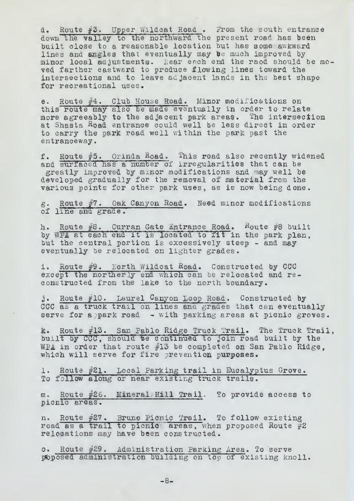
d. Route £2. Upper Wildcat Road . From the south entrancedown the valley to the northward the present roa^. has beenbuilt close to a reasonable location but has some awkwardlines and angles thax eventually may toe much improved byminor local adjustments, i.ear erch end the raod should be mo-ved farther eastward to produce flowing lines toward theintersections and to leave adjacent lands in the best shapefor recreational uses*
e. Route #4. Club House Road. Minor modifications onthis route may also be made eventually in order to relatemore agreeably to the adjacent park areas. The intersectionat Shasta &oad entrance could well be less direct in orderto carry the park road well within the park past theentranceway.
f
.
Route #5. Orinda Road, '-this road also recently widenedand surfaced has a numberTf irregularities that can begreatly improved by minor modifications and raay well be
developed gradually for the removal of material from thevarious points for other park uses, as is now being done.
g. Route #7. Oak Canyon Road . Need minor modificationsof line and grade.
h. Route #8. Curran Gate Entrance Road . #oute #8 builtby WPA at each end it is located to fit in the park plan,but the central portion is excessively steep - and mayeventually be relocated on lighter grades.
i. Route #9. iiorth Wildcat Road . Constructed by CCCexcept the northerly end which can be relocated and re-constructed from the lake to the north boundary.
j. Route #10. Laurel Canyon Loop Road . Constructed byCCC as a truck trail on lines and grades that can eventuallyserve for a park road - with parking areas at picnic groves.
k. Route #13. San Pablo Ridge Truck Trail * The Truck Trail,built by CCC, should -fee continued to join road built by theWPA in order that route #13 be completed on San Pablo Ridge,which will serve for fire prevention purposes.
1. Route #21. Local Parking trail in Eucalyptus Grove.To follow along or near existing truck trails.
m. Route #26. Mineral Hill Trail . To provide access topicnic areas.
n. Route #27. Bruno Pi cn ic Trail . To follow existingroad as a trail to picnic areas, when proposed Route #2relocations may have been constructed.
o. Route #29. Administration Parking Area . To serveproposed administration building on top of existing knoll.
-8-

BQaBit&s situ-
need asrf ^aoi Juaesn 'C&wdiion esii 3J ^sllsv ©TH n£V .ioiJeooX ©XdB. & oi 3boL ud
l59voiqflii •
tf -\;am ^-CBJrtxxB'. 3 ba& aenXXDm sd qLsjo:- si edt fa
t oiawo* eeai. tiiWDll d©vsqi ©vaaJ eaotf
:s XanciJaeioei icl
snoi -xoniM .oboH s .; -ID . £^ aj-uofl .8re Qbsm ©3" " ^sxn ©Ji/oi airij-
j£,9si9t:i bbbib $*naq faecal ha ©riJ 0^ TjXdsaaiga ©loaii©f>io ni d"eyii.D as©! scl Haw JdXjjcd aona'v: tfa
Haw oaoi 2(1 yiiao oJ
b*at tXJxtds . j&bl
.30 fraj tfriiaJ >aa
©d Hew xQr &*b 2noi ..': bom lOfliffi ^d fievc
erft moil Xaiiaifem lo Xavomai arii" 10ri -^IlBJJb.- oqoXs
.anoo ^nied won si ast a©an jtfiaq larito 10I atniog fzuoiiav
30 ill- . oaofl iic^jibO .;«•; . Vi aJ i/
• e fiats oniTa lo
,xsalq; Sib I ni >tiri 6T 'i: *X oua il :
. \6iud
. -5 obi- C no i)9TBooie
ODD ^d 1 .i
>X©r 11101 atoo
\3 batox;iJ-snoO . oaoH gooJ no^naO laii/aj * OX^ ainofl . {,
T&IIsirJuav^ eeTJaii -nil no XiaiJ ioni* a aa 000savoi^ oinoiq ia eaa - oaoi Jtiaq.a 10!
[JtaiT jiomT ©ri'i .Xi . olda-I eJnoH ».tf
esit ^d JlXxrd 0^.01 nio& of fcai/niJnL, o etf "70 03 i£d fXix/d
,egoiH oXcal nac: 1. iJjjoi JaxiJ iai>io n.3&30 aii'i ic aa XIlw iloirfw
*svoi5 eift q^Iac|
X iait £ni vjiiB cI Xaool '•!£% atjiroa
Ts«iJ jIojjtTJ snj.j3ix8 ib© xi '10 areola woXi"
oi jb s&ivoiq . IX ail XX , eiucy;<©ia oinoiq
taJtil .!'.I omng. . VS^ etsroH .n
iiq nen v ,8' oboi.JbeJ; iaoiisooX9i
©via a oT . iJBlflimJ&A *^\ etifoh. .0.XIoriA §n. "no sniOlxi/d noiisiJaiiiim ".oqcJH
-8-

P* Route #31 . 3ig Spring Canyon Trail * To afford accesst o the picnic areas in Big Spring Canyon
.
q. Route #34. Siesta Valley Road, To connect with existingfire trail above Siesta Valley.
r. Route #36. wildcat Peak Loop. Truck. Trail from ^oute /flO
to ciroTe tUiacat peak ana join Route #6 at park boundary.To be used for fire prevention,
s. Route f35. Laurel Canyon Truck Trail. Truck trailfrom Route #1U up Laurel Canyon to Route if36 • ^o be usedfor service road to Boy Scout Area and for fire prevention.
t. Route f38. -gig Flat Truck Trail . One sixth mile fromRoute f6 to i3ig Flat Keereation area.
2. TRAILS SYSTEM EXISTINGA. FOOT TRAILS
1. Lower Canyon Trail. Parallel to Wildcat Creek fromJewell Lake to Par k Offi ee . If- miles rebuilt by CCC in1937, width #
!
f grade maximum 14?b.
2. Upper Canyon Trail . Completed from park office toSouth entranced
3. Big Spring Trail . Big Spring on the east and to theflat area on the east side of the road.
B. HORSE TRAILS.
1. Lakeside Trail. From Spruce Street to North Gate.1 mile through eucalyptus trees , chapparal and a fewoaks arid across the dam of Jewel Lake.
2. North -^ast Trail. Up Tunnel Canyon from North Gateto Wildcat Creek, one mile; is ten to 15$ and fairlycrooked, then east and south near boundaries to the EastSide £^ miles - following sections of old farm roadsand truck trail #6.
3> Horse Trail #3. From Spruce Street to Curran Gate,one mile through chapparal half of the way with a few-
oaks and half th^ way under eucalyptus trees, meetsTrail #4 and Cross Trail rl2. Follows part of trailmade by WPA.
4. Horse Trail #4 . From Curran Gate to Shasta Road,one mile through eucalyptus proves.
5. Little Grizzly Trail. From Shasta Road to LittleGri zzly Gate, one mile through eucalyptus trees 9
6. Grizzly Trail . From Little Grizzly Gate to SouthGate 1^ miles through eucalyptus trees much of the wayand chapparal for a short distance.
-9-

B8 900S MoUs oT « XxaiI nc^gaO gxiiiqS ai£ , 1£^ 9jj/ofi »q.
Iffi Hi 3B9'is -."oiiioig arid-
oj
\\,elieY sj-89x2 evoda Xiaij 9111
)I
-
A 9*j . Xjtai. xT .good jise^ taobliu »dS^ sjjjo£ i
• noiJJi9v9i£r six! 10 1 beau 9d oT
XxaiJ iaxf$I , Ilaix aiox/ii' nc^naO IsijJBg 35-^ 9Jxrofl .8X)6 8Jtf 9o .d< o~* rto^usO LoWaj. qsj~UI\ 9jFx7c5T"j£Oi';
.nGiJiX9v ix/ooS ^o& o t baoi ooxvi
moil 9lxni . XiaiT a&uH JBX* aifr . 3S^ 9Jxro£':0lJB9106A 3" al'a ^XtL Ol ci^ 9 til
18 8JIaST
moix iSv . XiaiT iio^ixaO isv/oj .1AX 01 fX . 9£>ixit0 A 13^ ot ejjBvI If
*.
>X jooxmiixsm eoaig ,f
-=fcdtbiw , Y8£X
o* eoxixo iidg moil oO .XxaiT aoYiisO isggU^--u i m i nw i» i ^ » » » «w—*—efcuJhwy-*—t—«w^
.9.
9riJ . x iqe ^ia »j»
• J&sci 9lU lO' 9fci3 J3B9 edt HO B91B JflXl
. &IIAHT d.HOK i
.ei&i) At io 'A ot Ja9iJ8 9oxn )-& _,_
L
ia ii' 9 i> i. -
9
a 3 J. .
X
a Mb Ibibc dSJtq.xlaoif'i dj&jQizil 9ixni X*
. eiflj X9W9I, XO I.-; SiflO
9JaO if j- ~ floxu vT gU . Ix aix1 J s
a
A d J1o3filial xuis ^cX oj rts J 31 jsXxm exio t d99iO J^ujoXxW ot
•I SlfT OJ 89l^3I)IXJJ0d 139fl lit ISO 3 bH3 J3B9 ttQiit t betiOQ1Qsoaoi m* ilo xo 3iiOi;to93 gnxwoIXol - 39Xxm -£S eb
,b\ Halt ic. ;.. as
, 9Jb3 aaiix/Q oJ J 991 J*- 9-. 1$ ,5% X xsiT 9 310H . oxfJX.v &4J 10 IXe J 9Xxm bxio
37930: bitSJ \3W "rf^ *Ll&d DUB B^BOXxsiJ zo tip , X^ XxbiI bboiO bw f.XaiT
-A f
. 9X5BH1
- aJsx^ xtBilx/0 moi^ .^ XxaiT 9310H «^,39v.' Jc[^Xbox/9 fi^I/OlrfJ 9XXXH 9U0
9XJJIJ oJ Jdbo^ sJaan'S mol'I . XxbtI ^X^-;3XJJxJ .g
t 399'iJ BJjJq%X«0iJ9 lHj~eX£ffi 9X10 , 9 JBt) ^XS3 Ilx)
liJxfoB oJ 9tav ^Xssx-iO 9XJJxJ 11101^ . XxaiT ^XssxiO .6^3W 9llJ !• D 3991J 3X/J'q^lB0;j9 iigXiOlflJ" 3 9XXfll gl Qt&Q
. 90jii^ fzii) JioriB s 10 I Xa*i bas
-e-
12. Girl Scouts Trail . Crossover trail #12 connectsTrail #3 and #JJ
.
20. Laurel Canyon Trail. Cross from Route #10 upLaurel Canyon to the Ridge, joining Truck Trail #36.
24. Cave Canyon Trail. From the Meadows to MineralHill through the head of Caves Canyon. l£ milesthrough grassland, eucalyptus groves and native glens.
3. TRAIL SYSTEM PROPOSED:
A. FOOT TRAILS.
1. Complete Foot trail over dam, due to constructionof reservoir.
B. HORSE TRAILS.
A complete loop around the park is proposed with amiddle crossover twelve miles (12) around the park andone mile across the middle, making one long cirauitand an eight mile (8) southern circuit. Outer loopfollows fl from Spruce Street Entrance to North Entrancethen #2 to East Entrance and to Crossover #12, viaWildcat Peak over portions of old roads and truck trail#6, #36 and #13 to South Entrance. #6 to Little Grizzlyentrance #5 to Shasta Road. #4 to Curran Entranceand #3 to Spruce Street Entrance to meet Trail #1.
13. San Pablo Ridge South Horse Trail. From HorseTrail^#12 at East G&te along top of San Pablo Ridgefor 2f miles to South Gate.
14. Big Spring Horse Trail. From junction of roads#3 and ft> South along Foot Trail #2, then along WildcatCreek Road 1£ miles to South Gate.
15. Mineral Hill Horse Trail. From junction of Roadsf'6 and i5 north along Road #S for l-l/8 miles To EastGate.
16. Wooded Peak Horse Trail. A loop horse trail \ milefrom Horse Trail if 135 at Camp "Caves along canyon ridgeand caves through eucalyptus grove, looping toaok toHorse Trail #12.
18. Big Spring Canyon Crossover. Follows Big SpringCanyon for 2/3 mile from Camp Padre to Horse Trail #13.
IV. UNDEVELOPED AREAS .
A. EXISTLEG.
1. Wild Areas.
-10-

8to9nnoo SI% ilaii lavoseoiO .Xiai' .SI.S| Laa U% lia**
qxr OI^j sti/oH moil ssoiC . I J:aiT no\ its 1 & i
u
&1 . S• oi\ Ilai saxaXpfc £H aciJ o3 '3T"7&ixrBJ
If.: o* ewofiae to'lfll «IXsiT itq-^ubO svaO »&S
I , no^aaC eevaO r±*3 &riJ exit 1~
.8£t8l^ ©7XJJBXI XMB 39V01 >J/8 < j3aBl3B3l&
: C . &
. s
a xJox/iJaao© o£ 9x/£> «mai) aero CxaiJ Joo'5 9^ ;> .1. ixovi93=.i xo
, 8JIAflT BTggQH ,a
B J CI/01J8 q jj"9l(ifl30 AJina Jliaq 9xi t xjxujo'xb (SI) 89lxm erlavrt ievosBoio si.
J"XX/01XO ^XZOX ..Sffl t Qil Ollffi ©noqool i9tx/0 .iiuoiic >vob (8) elxm txi
oaaiJaiil rtfioH oifr eDaaifrak ^891?.- eox/iqB moii 1$ g,vc_lc'i
aiv , SI^ "SfiVQaaoiO o* oris 9qxxb ^bb2 mtliait jiou'ii 5xxs s£30i saoxiioq i9roIssiiO 9IJ-J-X.I oi" d% .aoaaifrall xttxroS oj" SI- .6^
aoixaiJak aaiix/O o S &% . SaoH ataxia of C^ soaaiixxd•X% IlalT t99ra of ssaaitaS #©91*8 aoi/iqg oi" S^ ona
esioH XGOir»£ .XxbiT eaioli xitssoZ $%oin olaa 1! jfe£ -
930XH oIda<I aaFTo qo"J sac I a 9*3$ Ts~SI**™lT8iT.9*3*0 diuoZ ot 89lxm fS 101
aoao'i 'io xxciJoax/i, .XxaiT 9&10H aaxia8 &x£i *£I.ioIb asxf^ ,&\ llBilT^S co'i •
> aTaoc'
:
"iia 'S^'
.eja^ ittucS 0* ssXXrn |-I oaoH ^eaiO
abaoK lo aoitorurt nio-i .IxaiT 9BioH XliK laiaaiM . 31
tej eslim s\l-I %ot $% aaog axtoXa xiJioa Q% tea.et
lifli 4 IxaiJ 9 8ioxl qool k .XxaiT esioH ^asq; Jte&oiW » dl936X':* svaO^qiaaO Ja 51% XXsii" ' xao"iT
od" sioad JoX , 9vei a^Xaojua xisx/oidd- a^vao
.SX^s XxaiT 6310H
liqj& §,xfi swolXoU . lovoaeoiO ao^aaO ^aiigg %i& •Ui.51^ Xxsi'I' 9310K 0^ eioa'I qmaO moil 9ixxn tt\i ;io'I acviBS
.8aS£ka cra cioa:a\rcicniu .vi
«638Xtt. bll\i .X
-ox^.

Eegligable , in a strict interpretation. Tothe average visitor most of the area in Northernportion is "wild".
2. Scenic Areas.
a. Jewel Lake. A former water storage reservoirof two (2) acres one thousand feet long — needsremodelling. However, unless on additional andadequate water supply sufficient to keep this pondfrom stagnation is assured, the dam should beobliterated and the creek bed restored to a nat-ural aspect.
b. Wildcat Gorge with caves ana waterfalls.Between The Meadows and Park Cffice.
c. Local Groves of native trees and chapparal
.
d-» Open Glens of old pasture grasses surroundedby luxuriant growth of native and exotic trees andshrub s
.
e. Kinety foot earthern Dam , creating a 10-acrelake
.
3. Y/ild Life .
State Game Refuge of more than 10,000 acres liesnorth-east, and south of the park, mostly on EastBay Municipal Utility district Lands, and supple-ments the park.
4. Botanic -areas .
The entire park area contains interesting botanicgrowth native and exotic.
5. Geological Area.
Mineral Hill, Wildcat Gorge and Wooded Peak withMineral Springs, Wildcat ^aves and Wildcat Fallsoffer some interesting physiographic features.
B. PROPOSED.
Possible extension of park area to include SiestaValley and Chapparal Hill at the South and Lowerwildcat Canyon and the north may add to the variouswildlife and geologic interests.
V. PUBLIC UTILITIES
A. EXISTING.
1. Water System from East Bay Municipal UtilityDistrict System.
-11-
oT .acitatsiq-istai tolita a ai , 9XdsaxX c\
. "Mxw i: ex nolJioq
iloyi933i sgBioJs isJ-aw isjbic-I a . a^Btl IsweL .aei>©8fi — SiioX jssl ftoaBjereufi axio e9i; : qwfr toJaaa LBaoitibba no aaolrixr , lerewoH .snJtXIeJ&ojB&ic aiiij c&©^ o* tire ^Xq%XM latfaw etax/psJia
9 J Jjlxraifs mab e i no X Janata moil-ten. a ox 09101391 69cf at99t* dub JteJaisfrxXdo
• Jd9c[3b Xaixr
, bXXbxt9Jbw uxa jsvbo xiJxw 9aiOx) jbo&XIW .6.eoillJ ji'ias. Jbxxa avvoaai] HSeewJ
. Xaiaqqaxio ana B99iJ 9vxtan lo sgyp'i-D Xaool . o
Jjtf.faUJOIIXTS 898831% 9lX/JB3q £Xo lo BC19XQ CC9qQ .66ns 8 39^ J oxjoxe 34a 9vxjaxi 'io xi* woia 2 as
x
iirxssl vc
9*ios-OX a Siixj38io , maCE nt9^?iB9 ftoox ^Jexxx-i ,e
• alii Mivv »£
89il 89ioa 000,01 cusdt 91QS0. lo B&stleZ bmbQ etatzJbbIi oo xitsom t jliacL iifi to riJuos Mb f :
-9l< qx/3 ana , 8JE>naJ joxntsi:^ ^XixJU Xagi ! ^ag• iiaq. QxiJ atasm
. 3B91^ OX JSBtOQ. . £
OXXXsJod B: -iSJilX tH© 9J
.oxtoxs dub Bvit&a xftwoig
rffrJw ^a« 9^io€' fraO-DliI t il.eXXa 1
! J . ba& sava^ jbodXxV* , 3g,a:xiq2 iaiea. 8 9ijjj-a9x oxxlqaisox3Ti;iq ^xxx J e9 1©Jul smo a -isllo
:ofls .a
bjssi< Xonx oJ asia ilia dXdxsBO^19W0J ana fttiroS arid
- Ja XXxH XaiaqqsriO i)na \eXJ3JJ0X1BV 9XiJ OJ bb& X&ZL &$ r
L IIO^BOI-Wfoi oxgolifi^ baa xw
2 .A
\^iIi#U lagioxaxrM \bQ. teaS moil meie^g i©£ *I,m9t3\d Joxifax'it
-XX»

a. Large system put in by WPl serves Golf Courseand. Administration Center.
b. Small pipe from Summit Reservoir supples organ-ized group area at CCC camp and small nearbyPicnic areas , but is to be replaced by largerma in p ipe .
2. Sewage System
a. Sewage flows from picnic area toilets southof the CCC, flows into a septic tank of EOO-personcapacity 4* x 6' x 16', of reinforced concrete8" thick. Overflow branches into two drain lines,one, 100' of 4" drain tile, the other, 100'of T, V" type inverter trough in four foot ditch.One foot of coarse gravel covers both types.
b. Sewage from the CCC camp kitchen and StaffQuarters flows into 3^' by 5-J- by 12' reinforcedconcrete septic tank. Kitchen waste is by-passed around tank. Effluent flows into 150'of 4
n drain tile in low area.
c. i/iater from CCC showers flows into stream.
d. CCC enrollees toilets ar= of dry pit types.
e. i'oilet built cy CC U will cram eventually into6 Tt sewer to proposed tank north of Jewel Lakedam.
f. Other toilet buildings in picnic areas haveindividual septic tanks*
3. Garbage Disposal
a. Several garbage cans are located in the picnicarea. Refuse from these along with garbage fromCCC camp is taken to Berkeley for disposal.
4. Telephone System.
a. A metallic line serves the administration centerand drizzly Peak Lookout Tower. Line is infairly good condition.
b. CCC Camp has pole line from P.G. and E linenear Spruce Street Entrance.
5. Power System
a. The P.G.&E. has two lines crossing the parklands f rom near Shasta Gate eastward and two
-12-

bbisjoO Hox) 3 9Tig \6 ax Ji/q, mi)t&x& s
.ie#i*90 aoxjaiJaxai;; ...ia
-aagio aeXqgx/8 ixovi938& Jxujoujg faoii sc/c .d^dn«an 99 000 Ja asis qx/oig, £>6.
1981- .jjlqs*' :>* ai Jud .bssib aine,xq xti
AiuQa aJelxc . i fc^awa'c! •&29q-00S So JinBJ- oijqas a ojix! awoll ,000 94? xo9J9ienoo i>9oioxaiei io ,
' 61 x '8 x ȣ ^Jioaqaosail niBixi owt odxxx 89n"oaaia woX n 8
•001t vL$dto edi t siii a zo s 001 « ea©
foJil) Jool ii/oi ai a"3*/biJ i9;Ti9vai e HP lo.39q^J - 819V0 lev -31309 lo ioo'i 815
list-: 000 9x11 moix .dbooioxaisi 'SI 3 -y^ f £S ofax swoXl aiei-i.c
-•^d si 9J3aw nerfo? ef&ioxtob"QcLC oiai 3 wo II ta9j/Xli£ .jiaaj Jaajj-ois r>9esaq
ol ai Qlit aisi£ ,;
£
.fll£9i: .
s Il 819W0lfB 000 iEOIX
.S9q-^i' jxq -v/iS xo ciB sJ&IioJ aeeXXoiae 000 . £
ot;ii "v tXiw ^00 \o tltud JsXiox *seial XewQt io iffica iaaJ £t>30 qoiq ot i9W98
ifl
9VBfi 88918 oxacxq Hi *j^aiJbIix/d Jeliot 19ilJu• einsJ oii'q93
"i
cqsxCL ess*--
oiaoiq ©rfj ax o9jboqI B19T98)i1 9§8dias rffrj ;
i" moil SoxrisH .aaia£0 2 \,
jffi saoriqe lel .£
»#aoo aeitaitsiaicLDa oxij 397-190 9axX 0iII3J9.1i! A .aai ex 9axJ ,i9woT frx/o;-; siiO
.aoiJx&aoo 000:2, ^Xlxai
sail .i0 000 .d. 9oaaiJf£: j 9 site 901/158 IB
3iiaq 9iiJ axeaoio asaii owJ- asri
owt oaa 6iawt339 ©tfaQ ajBaiiw lasa moi 1 3l>a8X
-SI-

lines from just cast of park office to thenorth boundary.
b. A pole line from Spruce Street to the CCC campwas installed by P. G. & E. and CCC forces in1937.
B. Proposed.
1. Water System
a. An extensive system will be needed for theentire park. Eot yet planned, but one lineproposed from near Spruce Street Reservoir toCCC Camp.
b. water from reservoir created by the new Aam tobe used for golf course, playfields and re-forestation.
c. Development of springs for picnic area thatare accessible for this supply.
2. Sewage System.
a. Location of other toilet structures not yetconstructed shown on the plan. Several indi-vidual septic tanks and tile lines will beneeded.
b. ji filter bed is needed for the dispositionof the effluent from the CCC Camp and nearbytoilets. This camp may be used as an organizedgroup camp when vacant.
3« Garbage System .
No plan.
4. Telephone System.
No o Ian
.
5. Power System.
No plan.
IV. DEVELOPED AREAS .
A. ADMINISTRATION AREA.
1. Existing at park office for temporary use.
a. Circulation
1. Roadways At junction of several roads.
-12-

9rf* ::<! 10 JiOll SSXJXlril loxr
aoxnqS ttoilat 390101 000 I ,ffl * .0 .<£ ^d 1)91.
cr.oesoqoYi
jgela^e 19 J" aW . I
9niX siu , oenrislq jay, to* .siiaq sixixi9oi" ixovies 91J* ©ox; iq
.qmsC
„j& w©n 9rfJ vc hBtsQic ixovi9S9i moil 'Lets., . di Sua aMs; eaujoo Hog lol 6©air 9d
xj-aj-eeiol
•is oi . . a to tt&l .0,v . axril io 1 sldisc©*: 13
.mafra^S 93awas «S
te\ ton eoix/Jox/ita teliot iodic lo aoxJaeoJ ,&~ib£ii £: .o xivvoiia be So
11 iv / baa aioej" oxJq©8 laxji>i7
.X»9i)©9£l
CO.' 10 i JD ; £)°39£X 3X 090 19 j i XI j. «u^cfisan aiaQ 000 9x1* moil Jxiexrlll© oxiJ lo
o9sxxi- .ta aa f>aex; ac so tiifl . sJoIxctgiro i§
.meia^S 9xxoxiqal9 T . £<
oM
.ipatB^S lawoq; .2
.xialq
.ari.3/iA ct^Qiayaq .vi
• 93xx ^isioqmoj' lol s iq J- a ^ixijaxxc: .1
Ix/oixO .a
.aoaoi laiavaa lo aoiioaul f£ a^awI>aofl . I
-SI-

2. Parking ^reas There is no organ-ized parking area. Some space av-ailable for parking.
b. Buildings.
1. An old 5 room farm house of wood frame,drop siding exterior. Interior has beenmodified to include offices, drafting roomand living quarters.
c. Utilities
1. Water System From 2" pipe line connectingwith EBMUD.
2. Sewer System A septic tank east of buil-ding.
3. Telephone System On Shasta Road line.
2. Proposed.
plans show proposed complete administrationarea with roads and office.
B. CUSTODIAN'S AREA.
1. Existing. Farm house mentioned above used tempo-rarily as custodian's residence.
2. Proposed Custodian's Residence. In wing of admin-istration building.
C. GOLF CLUB HOUSE.
1* Existing Golf Club House - with lounge, diningroom, office headquarters and shower rooms.
D. ORGAMZED GROUPS CAMPS.
1. Existing . Boy Scouts and Girl Scouts now use picnicareas for camping.
2. Proposed . Existing CCC Camp when vacant may alsobe so used - also areas as indicated on the plan.
VII. TOURISTS FACILITIES .
A. EXISTING.
How use picnic facilities.
B. PROPOSED.
Only temporary camping for visiting groups of edu-cational or other worth purposes, to use picnic facilities.ko other general tourist camping proposed.
-14-

-a 3X &'ir
.;;
.(IjilBl-VS 9 0SQ TsT
•sni^iaq 10 x sloelxs
«d
« e-fliB'f 33Lr ori mist moot .1used serf ioxisJxiI .lolislx© sax£xe qoi£
Snxj-x&io ,39oxixo sbuioai ot bei'i
ixJilxjU ,o
gnxj-oannoo anxl 9qxq n S jnorrtE ffl&Jsv8 ifrfajjlj
T"
-lix/d lo teas ina* oxjc 016 je E .S
.enxl fuioH sdrsariS £a9?s\c,
3 9^9lqflK) X)930q0.90XllO LilB 31)301 di ' 13
.a
-o quiet j&eaxr bvoOb ibH .^altaix^ .1361 B'lIBXOQtaX/O SB" YlXTi31
-ffiffi££ XO gXXXW . 90fI9I)XS9fl 3 ' HB X X1C J 3X/0 J&©80t' «S'
'. Jbtjqx'
.0
SnxiiJtJB t 9gni/oI iftxw - esiroH cfirlO x!o£ anxtsix,. .
.311100*1 isworls Mb ei 9tiaup .539/1 9oxxxb ,mooi
.£ oho .a
OXflOXq 98XJ WOil 2ti/00£ IllO Ol£B 8*1/0 08 "^oE . §11 X tSIXfl .1.Snxqmao 10 I bbsib
osIb \am tu»9*r at . ^bD 000 afliteixS . 59 so go11 ,S.nalq silt no J&etsoxxkix 86 sesis osIb - dasx; ol
'
:
: ± f2IXI0*.'Z fcieiHUQT .IIV
.A
. s&x txlxos'x oxnoxq 931/ wo
.azsoiofls: .a
-uhQ lo itisxv ic'i axtxi aqmot ^Xauitxlxosx oino^q 981/ 0* « ssaoqix/q rftiow loiito 10 laxxoxtao
. 093oqo 10 snxqwso Jaxii/o* Ifli9xi9g lorijo

VIII. OUTLYING UNITS .
None
.
II. MISCELLANEOUS.
A. EXISTING
1. Entrances.
a. South Entrance. Developed by WPA.
b. Six other entrances not yet planned in detail.Should be planned.
B. PROPOSED.
Each entrance should be carefully designed, graded,planted, fenced and properly labelled.
X. BOUNDARIES .
Existing park includes the head of Wildcat Canyon.It should be extended several miles farther north downthe valley to complete the unit. It should be extendedsouthward to the Walnut Creek Road to include all ofSiesta Valley, and southwest across Grizzly Peck Blvd.to include the area between the existing park and theUniversity of California lands, including ChapparalPeak. All is suggested on the Key Map, and nearly allis on the East Bay Municipal Utility District Lands.
XI. PLANTING . Some planting of minor quantity is needed torenaturalize areas and to supplement existing plantings.
-15-

. aTiau OKiYJiuo ,mv
OKI 8 .A
• ASW ^d fi^qoievsa .eoa**Ja& xfJx/o8 .b
.XiB*9£) a, :slg }s^ Jon ssoaa^as <i9iiJo xx8 .dJbeiiiial.: ..-Ix/oxfE
i .a
,fi*da*8 ,Mtt£ 3iB :/Oife eooaiJxis xfosS.fieXlsdBl ^Iieqotg £ae beoael ,£9j-aBiq
. saiflAQmjos .x
.aov/taD j-£<oi »rf 9nj Befitfiofli Xibg twits
bT^^T IV :T8V9a ******** •'^fixSodB SAe&xejfxe so fiXxrons J I . Jiaxr ©ill 9} t v8XXsv extte^xrloni 30H KeenO ttm "jtaawxttx/oe
.firlfi 2U9S xLssxiO 33010B tBsmntssaa £>aa ,^©llav 3*e9ie9ffJ Daa *'XBq 8ITX*3XX9 9ff* a99W*8d B91B &xf* ©fijjlorri 0*XaiBqqarlO yUbvU jjaaX BxaioxxXsO 10 vJlstsviaULIB yiBSK bam ,'nv ^ no r>e * 3 ax XXA .jia"
toi«#i*i VXIitU la^ioxaxiM |ea teas edS xto a
0* fisfisea si ^maaxrp soaim lo aaxJaBXc 9iao8 .-DKlTPIAJq: tx.eSax*aaXq ^ax^xxu Ja9iDsXqqi* o* to 3B9ia Mil a^J 3a%i
'"
-dl-

//?-"'/ ,\\ .: : yy% - j
B3§v^v r^v /Ruff ---"•--"^" '' r t>- /-av W- ' ^^r^^^^A^-^^^^^i-^--
LfrGtNP
W
Stanparo Ra
Sfcftfc. *
Bains Tt»i
COOP CONDITION
POWER LINE
(HANHH. ^ \ —^
—
3 .
---', fi^O'-Tfet
7*«fet,'
\ .//
UNITED STATESDlftMTMINT OF TMt INTIRIOD
NATIONAL .PARK StRVlCE
CALirOBNIAtAST »AY II1OI0NAI. >AKK OUTHICT
!«%.«•* nn l~ CtiA/llt* tf> Tll»f«r !..*» •«<AEOIDMAL PAKK - t»«<
..w... MA^IEU PUAN -—. ..,
...'.;;.. I
ftOADS 4 T0AIL5 MAD \ ir ,,
L

•-v:
/
.
\
"•v.ire- '.»;"
"
''....

,1em
-«1 N- \ V
-y;
/& v\
\
i
-
Ml' lC>C2 '
/
y
...
.
skv*
-' sIXsT-etr nvNiQ""*L urmr
-,cYrSS?^
- 1? I
^1 - ;'
v* ' ;
~— -'
» r
--^|
-.
U-A
KEY A\APW H.OCAT CJU*'ON SO 3
Utility M F»t>
^ -- U5CIG3 1
OPCINC^ DtVPLOPCD <*-
WftTfrC TONK^' •-fec-jc-voica 1 I
naiN£IN(^ f-OUNTBIN o-
TOlLtT f>UM.DIN<j»J
PtJ^L- : PT^T
PAV-eo
NetO PA.VING
proposs-d
i">0 7- 3ay PezionalPark Districtmaster planUT/LITY MAP
M^ ^**^- _ u±&-MJit/m-

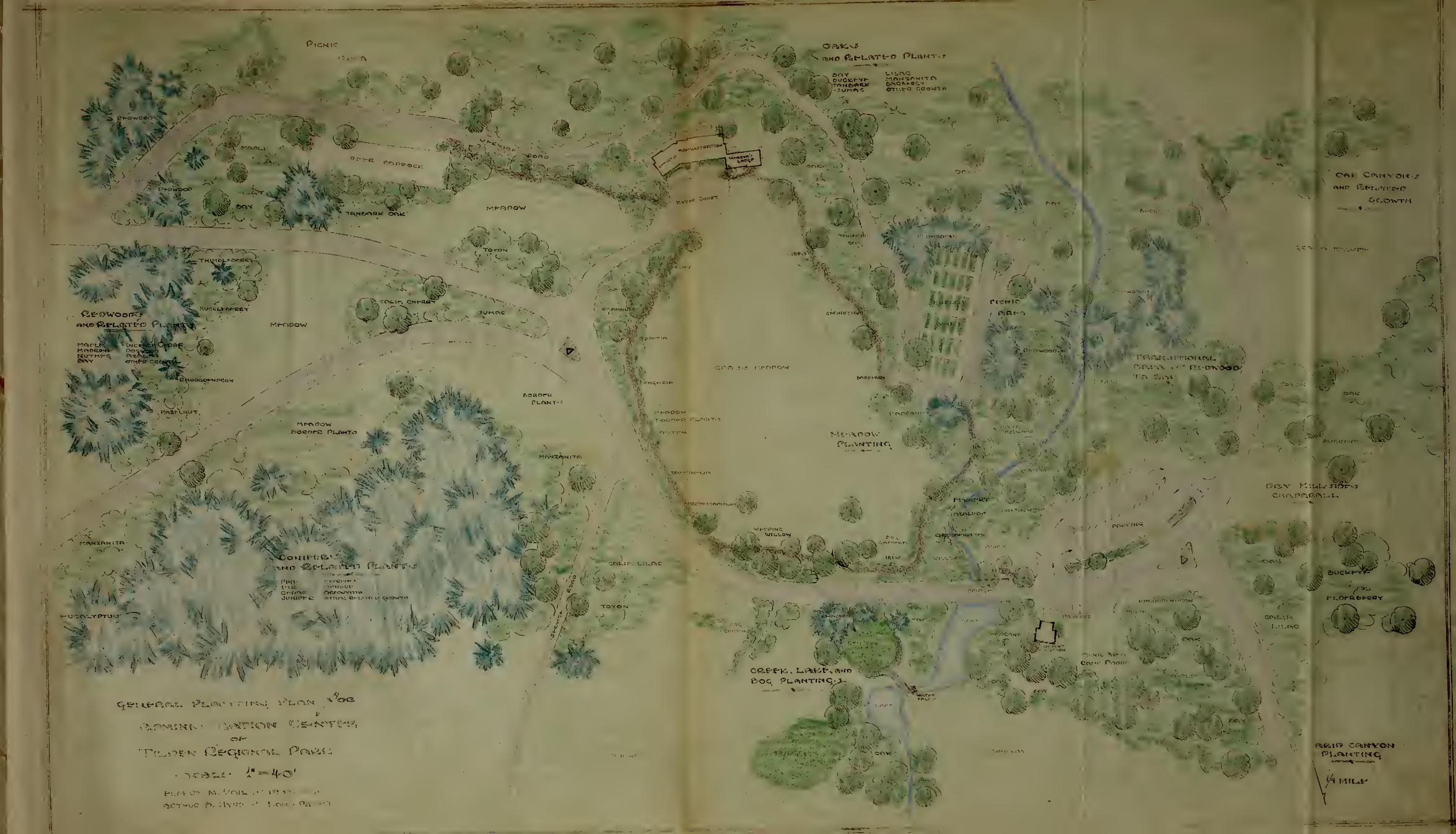
^I ^cw»oo
-»
jP? "OP"*'"
'1
; - --T
idS?f
6o8nrc pi^amto v 1^. 1
^okii-i.'H1 "7.
JM*|C BTHCO T.COVIT
I •
f-U'Jft'-.YPTU'.
- /A
(-:,;- t >(U • 'I '-
V
Ik" /M
V
Wft\ooW
%
/>
C*Ci©WTM
V-"._-'l"-
s
,
4
-
f t-oe-afcf-aoY
L.H.AC
£l


^4, ,
'"•>•
*»*,
•wi"*- iaJ,
-i>," >-*• .;- -
-I
?*f >?rs???* 15re 'J.-7JV
•;;
A*Kj,
•>&
moav
* -* * 4 4
Jr j J iJ
»
v^ 1
i.
t* "> '.''•? ^-_;
-•>..
Kl »V'
'
/
w
ME*HIEMZs
fo xi•-:.. \
-ji
•v^ j^^J* J-J
.. ^r
-j* • - — ^
L.phc:e- /^isfZA
u'hepLEY BoNepTRLU

.4
V-"
. ^!,i I

r *4r
\
(G-C-ts|-e-R.P»lL Of-Vf-l.OPMfKT Pl-RiM
vicaL.fr 1" ~ SO'fu«>f-BT M..V«ii- -*" Oivj-T. Mqc.flOTHue to. HvcJf- ->" L.CWO. ftecHT

~l
'

IUO*- IONPWL*
, /*; // j \i ( ^_
*K
C MRPFlOCPt
OUCKPff-
:S X
M'
b=!t
Ur* 5* \XCf-UCflLVRTUO
,
3^
^v
^r
C.C.C. Comp
^
MfftOO^ I;r--
^^sr#
"
-E-UCRLYPTUvJ
'-''/.-
rtSSk*^ ^ uc*u ftf-i- _,
,^

M-1MQI

'QMS
\
x_
£4770iY
IArea
\ -—M<. :
/ '
I \\\\ \\>>-:\ \\ \ i
' / ..
' i
/' / / .'
I ,^\ \\\Vi! ./ i\ v ,. H-^L.. •
ft V \ \
George Gibbsland5cape architect
PA^iVcaots ESTA-res—CALIFORNIA
CALIfOBNIAIAJT B»V REGIONAL VAKK DISTRICT
WILDCAT CANYONPlan roa
BRI55AC FIELDS 5P-33
**<-<•.. &.; (%&£ w_iiu/*i
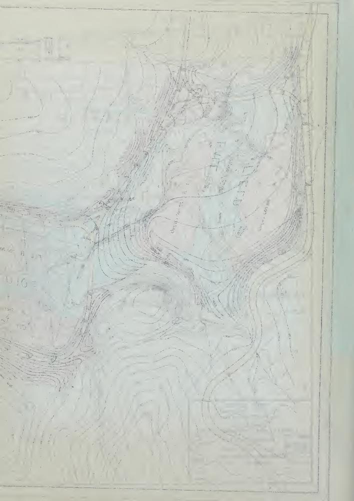
t
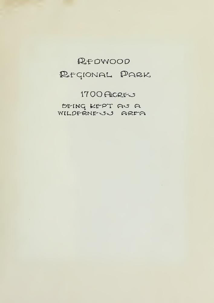
1700FSlgg>^o

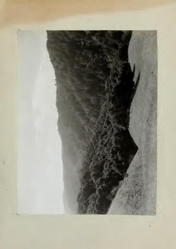

(Sheet #1)
REDWOOD REGIONAL PARK
EAST BAY REGIONAL PARK D1STR1CT
MASTER PLAN REPORT
A. GENERAL:
1. The Park Agency:
The East Bay Regional Park D1 street was authorizedunder the State Legislative Act #1114 of 1933,
The Park Governing Board is comprised of the fol-lowing personnel:
Charles Lee TildenAugust VollmerAurelia Henry ReinhardtLeroy R. Goodri chThomas J. RobertsElbert Mo Vail, Park Manager
The Technical Staff working out this report underauthority of the Park Board:
A. B. Hyde, Landscape ArchitectE. R. SwartUng, EngineerT. A. Merritt, DraftsmanR. A, Wilson, ForesterEtc.
Working in conjunction with and under advisementfrom:
George f&1 tworthWin. L. BiglerH. V. Johnston, CCC Camp director
Representatives of the National Park Service andCCC Camp.
2. The Park Area:
The Redwood Regi onal Park area was purchased by the EastBay Regional Park Di strict on January 10, 1939, fromthe East Bay Municipal Utility District.
It consists of an entire valley 4-j^ miles long,adjoining the most densely populated section of theEastern shore of San Francisco Bay. The valley runsfrom Northwest to Southeast and lies over the firstlow range of hills which skirt back of the East BayCities. It contains approximately 1700 acres.

{I\ * 99113)
mA<i j. m:
T;
I sdT, ',591 te cm
-lot 8 '• biBcfl gn^mti
n©M*rT ssJ e
ismlloVdoi3.rfn"~9£ Tpcfl93 >A
adiscfof: ,t aamcifT
19&HIJ dioq'91 Bhf} J iMlOW YlfldE lBt>f fllfaaT 9fiT
itoacS rfia*! 9dd to ^fiorf:'
frftad 9qB08£nsJt9fi\f .
I99n*g.fi. riaw3 .
nr , t fTisM .A .T19d391C . , .H
.0:;
tn< i lannu l *w no ^oaulaoo
titlCWt I :1090•J .;•
totoettb ,nodenr£oT, .
fins 9o'rvi9Q sCib^i j 9 /id to a©- xaaai
<
qaxaD 300
:soi. ':" 9rfT .S
3£ 9 rfd- y c; iornq; saw 691B ^is^ Xano F&aH boownefl bjIT
. ?5$I ,01 ^IBXfflBt nc fro^idaKI BS• dG^ldSf-G ' j'll Isqror'
?• 9ifdn© na 1c eda-tanoo dl9rid to £10^098 [aanafi arid" sn^n^otaaemu Y^XIav axfl . agonal? na3 to eicds rraaJeaSJairt srid T9vc 39 f- 1 hns freaaiidtfoS od d .
; moltv;s8 dssS ari* to iescf di P>fs rfoMw aXJ ' o 9§nBi wol
• 8etoa OOVI ^IgJafflfacoiqqa an-ad'nco dl •a*t;ff'0

(Sheet 2)
In 1929, the Olmsted-Hall illustrated report whiohrecommended the acquisition of 10,000 acres ofnatural park lands included but a small portion ofthis magnificent valley; the reason being thatthe Water District holdings were all they thoughtcould be acquired. Fortunately, the Water Districtrecently acquired the many private holdings in thevalley and sold them to the Park District; thus theentire valley, four times the size of Mulr WoodsNational Monument, will be preserved as a recrea-tional area for all times.
This valley is by far the most beautiful of all thenatural park lands in the Regional Parks. JohnMcLaren, creator of Golden Gate Park, has declaredthis area to be a na tural arboretum . Many miles ofsecond growth redwoods have sprung from the rootsof the old trees which furnished the first lumberto build San Francisco in the 1850' s. The NationalPark Service, realizing the importance of conservingit, established five CCC Camps m the parks.
The Regional Park Board has been congratulated fromall sources for acquiring this beautiful area for theuse and enjoyment of future generations. There issuch a vast supply of historical, botanical, geolo-gical, biological, and other scientific interestavailable in this area that it would be criminal tolet anything destroy Its natural and native beauty.The fact that it 1s the only large unblemishedwilderness area within easy reach of over two millionpeople living m the Bay area makes it Invaluable asa natural park.
There is no other urban population in the world thathas such a great Redwood wilderness area so close tothe center of population.
The canyon affords a remarkable degree of isolationand entire change of environment, which makes itadmirably adapted to picnicking, camping, horsebackriding, and hiking. It has such an extensive woodedarea with mountain meadows that the picnic groundwill not injure the landscape, If carefully planned.Formerly, there were three ranches In the valley; onesite in the Northern portion, known as the GrimesRanch, £as about 20 acres of level land which isideally suited for a boys 1 camp area. There 1s amplewater supply from springs, large fields for sports,and a sunny exposure for utility buildings, i.e.,camp kitchen and restrooms. In the center of thevalley was the site of the Princess Mi 11 thatfurnished the Redwood lumber for the first houses InSan Francisco. Although this area 1s restricted inlevel land, It is an excellent picnic site withplenty of water. The largest flat area is known asthe Bridges Ranch, situated toward the Southerly end
of the valley. The ranch was of sufficient size to

(s t99d8
(J
do^dw ticq9i fc« sx/IXi IX.sH-baJamXO Sri*t8Sei nl
1c seioa 000,01 1c nc
'
r -; bofcneinciooe^
lo nc'tioq IlBfflB s tud b9buXon>- abneX ^Teq XsitrtBG1st tfi9GH ?, fiS8m afdt
trf- -ft Ha 91bw sgn ^bXcrf 9dtto T teW e< , Igtsnutio*? . ob ad feluoo
<* f RSfl^fcXorf 9oJ3V>-«IC[ VOt? bai^JJpOB YXtfl9G919ifr jo'ri^ I* ot c»xU bXca briB ysIL&v
t its efttyeLiBV 9iftn9
iq 3d XI *rw «t at [srioft
id 69i a Xsncft
UB :
1 x'
-Xol aritf 1'
19:
9rfrf- XXb lo Xi/I^racd te 1 sf «.f "<
dxIcT. . ~bnsi 2fisg Xsiu^an&91BX09b .. lo 1ctB910 ,11918,
1C »»Xifll \l .-"CCfl£ _J3H B 9Cf Ct 8918 S*
etooi 9 rf.t moil 3i dtwois bncosa1 tai*1 ©rid i* bXc 9dt to
••:? •3 t 058X attt at o ai^ naS bXf-trcf ot; l
f-Sfl891 ,30^1*n* aqciaO 000 9V ?1 f>9ria *XdBt3©
(
moil 1X1/Jsiano© n9 9d sBd bisoS :* gafl 9dT
©dt lol B9is Xj/Vti/aed afrrft sn^upoa id 39oiuos XXba
! 'Jsi9Xi9§ 9iutiJl 1c it ;,:i9 boa gau-oXo*3 «Xb'
'
r 30 fiots'rd lo YXcqua t33v b dox/8
ta it o'l'-tns?-.; OBtXsoJ"30Icrd ,XB'
ct XeiUr^io 9d bXuow tt d-sdd- B9i£ n- ©XdsXrsvBY^^sod ev^flji baa Xsi.t/ts it 396 £n\dtYnB t9X
rdau agisX yXhc edt af tf frerit tosl 9dT1x0 HI fai ow 1c do89i Ya ^9 n^d^^w B9is 339ni9&nwas 9Xdj -:8m B913 ;^X 9lqc©q
, laq iBiutBri b
tnemsz-.
bc.B
1
9 0'rV1
[ 9dt \d I
21011 "esei ,
,<oX
9d* 1c8fl£/1 Y9X18Vtsi^l arlt n
YsG fraa.V
.8910/:
tsrit bliow ed* n?- fic f tsljLjqcq nsdia i9dd"c on a* siadTOt 980X0 03 B91B S39fl19bl h; D9H $BS r
, OUZ 3Bd19^X190 i
?•t8Xc^^ lo b 9X: e abiclls ncynBO 9riT
t> BB^iCi,
lo 9 SltJflB bHB^'03d93iod . HBO .3x1*2101 0$ bstqaba YXdBi^mbfl
aojja asrt tl . ;fl^^"d bus ,3nl:b'f i013 OKciOf-q 9d-t tfidj .7 891B
.69nflBlq TjIIulaiflo If ,3^*0 3tuint ton XX *w9no iysIXsv edt n?- sodonB- ^i9dt -YXisaiio'E
>xf* as nworui ^nc^tioq rusdtic iif at ^a8?- hbX XavaX t t
donsf!. '.
:' b ^
t3t-xoqa . ^nfi<i8 icoil YXqqwa letaw
,.'.:. fla^^^6i^t/d Yf'X'-t;/ toI 9ii/80qx9 Ynnj^a b bna
" lo i9tn90 9dt nl ,amc * nadotf3a90fl^1 <I 9dt lo e 1 xeiLsv
n' rod taiH sdt 10I iodaiirX BoowoaH sdt bgda^aii/l^^ beto" a a 'it XA .on 1
/
d' o*no>q tnsXX90x? ns a? tl ,bnaX X9V©X'sons tsll - .istew lo y^dt biewct batsiit^s jdonafl 89gb^i8 9dt
ct 9s^s tn9*o'-11jj3 to 3B<?7 doiisi odT .Y^XXev 9dt lo
(Sheet 3)
provide a livelihood for several generations of theBridges fam* ly. It is fed from springs on the East-ern slopes of the valley. This area dapts Itself toa large overnight or week end camp ground. It is anatural recreational area which can readily includeall types of activities.
Up to the t^'me that the land was acquired by theRegional Park Board, the area was carefully patrolledand guarded against public maliciousness by the WaterCompany. Practically the only use made of the areawas by the many horseback riders who have constructedsome bridle trails *n the valley. There are four-teen stables located near the park boundaries. Somehikers and picnickers have made use of the park lands.
The Regional Park Board feels that with the more In-tense development it has done in Ti lden Regional Parkand Lake ^emescal Regional Park, it has provided re-creation of sufficient forms for the people who areseeking that type of diversion.
There 1 s a great demand and a great need for suchpicnic grounds where families and large groups cancome together for social gatherings. Service groups,fraternal organizations, P. T. A.'s, Boy Scouts, drlScouts, Camp F1re Girls, and other groups, are seekingplaces in these Redwoods where they can have grouplunches and dinners and overnight lodging In such anenvironment as 1s available here.
It is therefore proposed that this area be extremelylimited in its development as follows:
1, That vehicular traffic be restricted to thelower end of the canyon where ample parkingspace will be provided, and other park en-trances w^ll be for pedestrian and equestriantraffic only.
2, That the proposed truck trails be used forservice, for hikers, and, insofar as possible,for the horseback riders, in order to avoidcutting the area with too many trails Thisproject contemplates the clearing and improvingof old logging trails, which would afford manymiles of lovely bridle and hiking trails,
3, That special effort be made to promote andprotect the wild life in all its forms by notdisturbing the natural cover and by refrainingfrom new planting except in necessary cases toprevent soil erosion or to supplement naturalcover already destroyed.
(5 79-
"lot 9fW
19&f!IJ 71<
7ft€
OHB BQ'r\
I 9fl7 Y<* &•noil ,G5ex
,10X
sri* loanxri ysllev7 si rl sflj-
YbS 7 as!• aeio
9rf7 to tooiM toAH* °*g
job lo aaqYo XXs
.... baml &dt ts&t em*t 9ii7 o? qTJ
&8XXoi7 *
>o*Iam o^duq 7 a 1 &9bisu3 6na
v
*
lo < Hso^08i fI .YflBq.
00 avail, .[lev * »XDf10 9(308
n Dstsocl asXcteJa
d* dfrw Salt* 9ri?
-91 :19
nc'
rioue icl fcesn 7 : '^ B 3 *9<I9xiT
hbo 8ffi c9"* s: 3 ot^o^qicl a • 00
|,1 ".. , ,8110^1 5fl19*J
OOo
,0CWb9?iXUfX
.9190'
I1 I
iq 9'
^d 8.H*•19 19W0X
&*voiq 8d IX *w eoeqe
, "no omsi?
1C' ;
teriT
d^iolJ- I/O
-...co ^oetoiqow rfo'rfw
tC 6X0 to
•• ..'
I
.S
.7ioll9 IS'
11/78*8moil
10 nc Jiq

(Sheet 4)
4. That special emphases be given to those formsof recreation, such as hiking, picnicking, andhorseback riding, and that every discouragementand prevention possible be exercised to keepout the type of person who 1s not interested inhaving this park preserved in its natural state.
3. Regional Factors:
This Redwood Regional Park is another step towardthe ultimate goal as set forth in the above men-tioned Olmsted-Hall Report. Tilden Regional Parklies Northwest along the ridge of hills a distanceof 7 miles via the Skyline Boulevard and comprisesand area of approximately 1910 acres „
Round Top Regional Park, along the same ridge anddirection, a distance of 3 miles, Is 227 acres 1nextent.
Future acquisition of lands along these same hillsto both the North and South will be the ultimatescheme and program of the Regional Park Board.
Present access to the park is provided at four?o1nts: On the Northwest from Skyline BoulevardSkyline Entrance); on the Southwest from Redwood
Canyon Road (Redwood Entrance); on the East fromthe pinehurst Road near Lake San Leandro (LakeSan Leandro Entrance); and on the West nearSequoia Park and Redwood Peak (Sequoia Park Entrance).
The Redwood area Is really accessible, as it is
within easy walking distance of the East Bay Citiesand within twenty minutes* ride from the noise andtumult of city life. An Interurban railway runspast this area, while street-car lines bring onewithin a twenty-minute walk to the groves. A busline 1s planned to run to the head of the valley,
4. Land Status:
With the sale of this acreage to the East BayRegional Park District by the East Bay MunicipalUtility District, certain development restrictionswere set forth by the selling body which must be-come a part of this development outline and mustbe regarded as definite rules and regulationsregarding sanitation to be followed in our devel-opment policy. These factors are set forth below:
Sanl tatIon: ,fNo structure apt to invite use orabuse of waterways shall be allwed within 200feet (horizontal distance) of the high waterlevel of any waterways, unless specifically ap-

lol ezait o* fisv^ sd ttaadqisa l£ l osqs *adT .£6ns ,3n^Qfno fq
. .;; st
:>i09i 1ctnamsgBiJJcoE : :>V9 t&dt I. . aicd
qes^f o* bee v oisxe jiq bnBn* bs$ aeiet a> *cr Iw ncaiscr lc eqY* 9d* *#o
a*a Xaiitfen c* ? 9Yi9e -isq a^d* gf*
£>iawc* q9*e iaif*ofla af 3fi3 ci lane
'
E>oqwbafl b*a-noffi evcdB erf* at d*iot *aa aa efraattX
tfisq Xsno^afi nef>X^T ,*ioq9f7 XXaH-i>a*a«XO £>9no'
eoflB*at-£> b allfrl 'to 9sf>""i 3d* ^hoIb *a9wd*ioW as*-!
39a f 1CTDTO0 fiflfi fclBVeXlJOH SflH^pO B^V esl fffl V 10.S9TCB 0X91 t£9*fiJ 1° 6918 f)HB
5riB 9§fc f-x ©maa 9ri* §nolB ,?fis <I Xeflc^9ff qoT f>nuoEllf 89T0B VSS 8*"
t39l'f£I £ 1C 90X16*8 ff> B
tiIC *'*091 ^
.*n9*:x:e
all id area a aaarf* snoXa sJdqbX 1c nc f-* tB^upoa ari/*i
iIm^Iij eri* ao* XX hr d*ucc. fcna rf*icw erf* rftfed o*,r>iBo3 ^na*! Xanof39fl[ act* to msi^ciq fen: ioa
ix/ot *a f)9JL> f-voiq. aq ad* c* asaooa $ neasiv
bisveluoK enrly il 3 aawd* 10W erf* nO :e*nfoqbcowf)9F moil * jOc 9d* ao ;(9pnei*aS aatJhplBjmoil *ea£ 9fi* AC j(90HB1*. | »80fl HBO
9xf8j) ci&nseJ naS 93iaJ iS9n 6 soft *aii/ri9fl fCI eri*
1S9H 9d* no bos •(aonsi*n3' oifinaaJ r.< .
(9onai*nK :lns"-i s'roupeB) rfaa*! Jboowf>9fi bnB iia^ Btoir;
a* ^ a a ,9Xa"r 33 9oos ^Xfaai a! aaia £ccwf>9H 9dT89"'t^0 VCS *a©S 9d* lC 90nB*3 f'6 £fl*2lXBW Ya" fl ^d* .tW
bus 93>on ad* moil 96 *"i 'ze&un*m y*ii9W* a'rf*£w fens
aruji y ^X r'ST nsdiiri 9 *n ^ nA .et^X y* to lo *Xjjr?ii/*
enc snfiq" 89fl-X iao-*99i*a oX'dw ,69113 ^aqsi/cf~A .agvci^ 9d* c* ^Isw e^un^m-'X^iiewi a nrd*
'
•Y9llsv 9d* to b&eii ed* o* nui o* bennsl 3H*£
:au*s*2 &nej .£
Yea *as^ eri* o* ©ssoicb arrf* lo 9Xae 9ri* d**W' -nt/M Ye^ *sb2 eri-t xd *o pi*a' eff
orfo'i-taei *nemqoi. 30 ,/oti^at' tU-ecf *ax/m riofrfw yfiocf ^fl^XXaa 9d.f ^d ifctiol *e«i 9i9w*at/m Bna 9n*I*uo *n©mqoI©vaJb lc *isq a a?
ano**flXus9i Bus aalin at^n'-'iaf' ai 9d-X©v9b mo n^ bevfollcl sd 0* no^ts^f-nBa ^a^biB'gei:wol9d d*iot *9a 9ie 3io*08l 339ri . o+Loq *nsnrqo
10 930 e^rofc o* *qa aiu*oui*i cVl" ; no^*a. :
OOS n^ri*»-w bewlla sd IXada 8YBWi9*aw lo asu19* aw dafd sd* lo [aoxta*»^ Xa*aosf^oiO *ael
-qa yXXaof-'ltoaqa aaeXnjj ,aYBW; yhb 10 lavsX

(Sheet 5)
proved In writing by the Utility District, Bywaterways 1 s meant anv open channel of gulley,even though it Is ordinarily dry but may carryrun-off at certain t^mes of the year. In gen-eral, the structures referred to are those inwhich people live or keep animals, and wouldinclude caretakers 1 houses, camps, tents, andlunch rooms, cookery places, barns, corrals,animal pens, garages, comfort stations and sim-ilar buildings,"
Picnic "Picnic tables shall be at least 50 feetGrounds : away from any stream or watercourse.
"
Garbage "All premises, camps, picnic grounds andDisposal ; other places suitable to public gather-
ings shall be required to have means ofsanitary disposal of sewage, garbageand refuse".
Septic nIn places of public gatherings the waterTank: carriage system of sewage disposal with
septic tank and leaching system shall bepermitted where topography and soil con-ditions are such as to permit disposalof all the septic tank effluent under-ground".
Dry PI t "In all other locations within the water-Latrine : shed area, such as along hiking trails
and bridle paths, dry pit toilets ofapproved design shall be Installed atIntervals most suitable to the conven-ience of the public",
Inpect- "Complete plans, specifications andion by location for sewage disposal systems andEBMUD* dry pit toilets shall be submitted to
the Utility District and constructionshall not commence until sa* d plans areapproved In writing",
5» Financing and Administration:
The Park District Is a municipal organizationmaintained by a 5-cent tax levy on seven East BayCities (Oakland, Albany, Berkeley. Emeryville,Piedmont, San Leandro and Alameda], which amountsto approximately $200,000 a year; other sources ofrevenue are from concessions such as golf courseand swimming; certain funds have been receivedfrom gl fts.

(2 C*93rf8)
. ic fonns-lo nego vn» ^nsom 3 ? a -"tbJbw
XV frlftf Y*££ • aev9«*jh , »d* 1c asm *;f n'r 11c-fll 9sod^ sis ct fi ajdDt ,Igi9bj
,
9T*rI a -fw
f>flB ,,
,B 930CXI *a*I9>fS^91S0 95jjlGfl?-
31100 ^aniscf . 9>(oco ,wnooi-m'rs f>nB anc^Bvts Jiolrooo , . mBq Lamia*
. ^/d ibI f
j-gsl 05 ;?e89l * CIbjIb selde^ • '
. iirooi9^Bw 10 imeeita : ajr
5ns abri; . 'nj9iq II-i9rf^Bs of-Icfui ct hfjja a90s.fq I9rf#b :X6scc;"a'ru
lo 8; '>¥sd ot £9ih:/9§SCflSS
t3£BWe 38
'i £ns
I9?aw srf.? a^r^ierfitss piJ agoslq nl* otiqeZAS'rw iBBoqi '1180 ~T?|nBT
9cf IlBfla fgs*a<78 »X Jbns ^na,t o'r
-no o I * 3 6us Y'i<3
c
J- 919 riw 6 9 j- J-
r-aie qIff! 01/3 9 IB 3'
-isfcr.' -Jills lo.•6flt;oig
-19^-sw Sfld- tttittJ qUsocI d Lla nl* * 113alfBlJ
'
Cs 8B rfo . : ^ifrfijl
lo aj-oi xib .arfj-aq 9Lb* id bne,te 59llacfsn*r 9d I (JB
-u t • I d3 2 I ui J- BO 01 a 1 ft*
. -'oMcfc/q rf
ilioN 09qa . 60" -cfooqnl6fii: "avs Ibs~ ec 10I am d!
•ib•.trUanco £>ab io v ija^G fitiJWl
9is anslq £ ^aa I 'ftrii/ 9on9mrnco tfon Haifa. mjift tTK af- b- b
: no J tsi* a to. rjiM b ns 3n ^ onsxi tf[
flof^BS'-ns^io iBgrornyrrt s «t frft.tctp£C tiia^. sdT'. H9V93 no XV9l XB* 3 | rsffl
<ftIX? . . .-10
BtnuoniB xio ? -
i /t(r>; o. »ej hb£
,
lO 3 9C1iJ0S 19rf;t0 J1B9Y b 000 f 00S( vIgj9311/00 Ho JS BJtCfBB98 1 913 9i/a9V91
59V ? 9091 n99dT 9VS£{ 3' .flf'WB bns,3*1 *g CIOll

(Sheet 6)
The administration 1l carried on through fivedirectors who are elected by the people, who inturn appoints certain officers as provided bythe Enabling Act, I.e., District Manager, Super-intendent, Engineer, etc.
B. DEVELOPED AREAS
1. General:
Because of the Park Boards sincere wish toprevent over development in this park, it isproposed to develop a minimum of picnic facil-ities and leave the park proper to hikers andhorseback riders.
a. At the site of the Bridges Ranch in the lowerend of the valley, near which is the parkingspace, it is proposed to develop the only con-centrated picnic area. There is quite an exten-sive orchard at this site which borders the stream.Throughout this orchard it 1s proposed to distributeapproximately 30 table and bench combinations withcorresponding number of western type fireplaces,drinking fountains, etc.
2. Buildings:
a. Existing - There are many miscellaneousstructures in the lower end of the canyon locatedon formerly private land. Most of these are an-imal pens, coops, barns; with one or two oldhourse. These structures are undesirable andpresent a fire hazard 'n the^r present state.It is proposed to remove them.
1. Ranch house located about one-fourth mile fromRedwood entrance on the floor of the valleyEast of the stream. It is proposed to remodelthis building into administrative quarters.
2. Ranch house close to above. Rather new and couldpossibly be moved to Bridges' Ranch site and re-modelled for temporary caretaker's house.
3. Wooden house at Redwood Entrance. One of thefirst built in Alameda County. Historical value
may prove worthy of preservation.
b. Proposed -
1. Administration building - remodelling existingranch house as mentioned above.

(a -
sv joittt no betiiso a* nQl$a*$*talmb6 srlT
^^ orfw .eXgoaq sricf vd fcs^osls sib oil?/ aiocfoai *"f)
YQr
bsb'-voio; 88 ^iso^lio n^sd-aoo atn'-oqqa anutt
-isqi; . fraKI^.a.*., Mden3 ed*
t199i] .
•a
:Xfl*t9n»x) ,1
CJ 118 ^W 61'90a ? 8 3*fr;'
7y[iBq s 'rid' aJ dTLemqcXsvgb tsyo drisvsiq
bn& eisiLtd od-
'i9qoic [ 9rio evssl bi:
. tori
<~cX grid1
n?- rionsf" J fa edS tA *ef^Tsq 9ri.t s* rfo^rfw issn
ty9Xf3v eriJ tc bri9
1 b98 :; '
, 30
-ae?x s^ fup e> 9i& •next)tdt $b bi&doio 9Vfs
iflrioi '"fgi/OTXlT
d>1 oo flonacf bfl£ sXcfad- OS YX9d-anifxo*in
qy.t ni9t8 9W '' onoqasiico
.ode%an'rB$auc1 ^aftat
; «S
^d"aooX ncyneo siid" 1c bos 19wcX 9ftJ n*- 8 siuJouitf
a
[# lo *s< . Iiermol nobl I io snc . [oco
t3ii9q Je
'-agbni/ 9is asiucf-oi/'ita ea . siuorli*9iid- af E ^l & d-fi9£9iq
^t-9flc cfuoda &9?aool 99 , XCfsv srld
- to iO'~'I'l add- no eoast&as bccwrl
X9borrr9i oj ft< .tj ' uaatj^rtfl 9iid* to ti.si9d-
i9.(. ^nf-mbe oJn bl v ^cf ef-iid"
bXuoo ina wsn T9rid"flfi , 9vod« od" 9SoXo aaj ,S»#*• dtmsR 'aeaM?8 od
- b9von 9d YXc^asoq,9 31/Cd a 10I 69 XXab Oil!
- to aao >9oaai; £91/Xsv £aotao*a£H ,^ni/oO afianialA at tl*ud JaiH
no^dBvisseiq to xdJic,* avoiq vem
- b9 3oqoT<I ,cf
Sn'd-af-xo anHXafiofflai - an Mi X hud ncf-d-aid-afflVrnbA ,X9voda bgncf-d-nsir! aa esucd rfonai

(Sheet 7)
2. Warden* s lodge - located at Bridges 1 Ranch area.To be of native rock construction, as being usedby National Park Service in other park areas.
3. Other Structures -
a. Comfort stations
1. Included in Administration building.2. Located at Bridges' Ranch area.3. Located at area #34. Located at Redwood Bowl.
b. Culvert - stone, vehicular
1. Redwood entrance2. Parking area - site of Bridges* ranch
c. Bridges - wood, pedestrian
1. Boys* camp area2. Picnic area #3
d. Water Storage tanks
1. Bridges* Ranch site - 5000 gallon oapacity2. Boys* Camp area - 5000 gallon capacity3. Picnic areas #6 and #7 - 5000 gallon capacity4. Picnic Area #S - 5000 gallon capacity
e. Picnic area facilities
1. Table and bench combinations2. Western type fireplaces3. Drinking fountains4. Barbecue pi ts
f. Miscellaneous
1. Six miles fencing along west ridge boundary2. Sprinkling system for bowl area and amphi-
theatre3. Entrance gates and turnstiles4. Incinerators and garbage pit5. Piping systems from water storage6. Horse troughs7. Signs

.B9ib rfonBfl 'asgJb^a J a bsd-Boo! - ©gbol a'n9f)iBW .Sfisair gnPgd' as
tno 'rau ffi^snco Mooi bv^ba r
rc scf oTISXiJo nl si; 'viae }!ib c
aao^scfa a'-ro'imcO ,s
.SnffilfLrcT ac^siJa ?n -m&A ni b9bjj!onI .1,B9iB rfonsH »a9s£>ria: Jb Sb^booJ .S
5 VV B9TQ tffi £>9CfS0Cl •£
•JpT *b fcetsooj ,
Mt9HGJe - ;;
90nsid-n© feoowi ,1doasi 'aagMifl 'to afr fe - esie
nef-xtfasbaqtbccw - B»gf> ;ia .o
3913 •
,X
Y^osqso ficiisg 000(5 - a*fe rfoasfl 'aaal>M .1YJfosqso ncIlBg 000S - seie 'avod .S
osgBO ncllss 0005 - V 1^ &ne 6^ sbqib oHioM .5
Y^oaqso nclls^ 000S - S-V- BeiA o*not<5 # £
SBfJ- PI f'OBx ,9
arichten^ci.! ortscf fins sIcfeT ,1aaoalqaiH gq^tf niacfa©?/ «S
anf-B^rujo'l gnr-^nhcG £aj" '(T 9L'09Cr,Xf' .
8JJ09aflIl90 ' lYiBfinuod" agfifi Jsew gnols #£& • .X-h-iqmB fina B9T8 iwod tot mf*y.a satjafa
9l^B9lHsgl^aniitf fins aaJ'aa aa-na^rta .5J*q 9§bgtb§ fins aiotfBi9a±onI .£
©SSiotfa «r aoil 8m9tfaYB sn'^qPI # 5[gtfOI? 9310H ,8
axis'

(Sheet 8)
C. CIRCULATION
1. Approach Roads:
a. The Skyline Boulevard approaches the parkfrom the north and follows a general routealong the cre«t of the range of hills. Is isthe main Une of traffic which will eventuallytie all the Regional Park units together. Theboulevard touches the Northern end of the parkboundary and gives access at that point (Sky-line Entrance).
The Skyline Boulevard is a well-graded roadpaved with oil macadam, approximately 30* 1nwidth with 6* shoulders, and is of ample radiusturns and grades for easy travel. It is usedmainly by sightseers and because of its cir-cuitous route i s not often used for throughtraffic. The boulevard winds in a generalSoutherly direction and somewhat follows thepark's Western boundary a short distance away.The intervening area is ma^nta-'ned by the Cityof Oakland as a parkway.
b. About one-fourth of the way along the park'sWest boundary, Juoquin Miller Toad joins withSkyline Boulevard at Sequoia Park. This parkis adjacent to the Redwood Park boundary andis owned and under construction by the City ofOakland.
Juoquin Miller Road is a direct approach to thepark from Oakland and piedmont via MountainBoulevard, and from Alameda via Fruitvale Avenue.Although a good two-way oil macadam road, it ifa little narrow and circuitous for comfortabledriving, yet it is well travelled.
Where Sequoia Park and Redwood Park are adjacent,another entrance to the area 1s located and 1sknown as Sequoia Park Entrance.
c. The Skyline Boulevard continues South andabout one-half way along the park's West boundaryis intersected by Redwood Road. Skyline Boulevardextension continues South along the ridge and willeventually tie in with traffic from San Leandro,Hayward and points South.

(8 J99£fB)
rogio .0
osoiqqA .X
Xi&q exit asrioBoiqqs b*s- -lyiB edT .8atuoi Xsi9xie§ s asrcllot Ms xrtion 9xl;t fflbr!
el al # all'rii to a t to J»9io gx&f sxicXbYllBifJn9V9 IX hr xiol '"X nfsm eifcf
erlT •isrfcteso* at f-fli;
aCnec 1c bfl9 xnexiJ-': j zadouot bievelncd-Y^B) Jn'-oq d-srfc ?b aaeooa eev oxn/od
|TeoaBTdFfl2 eflM
68C1 f)9bB1S-Il9W •''13V9Xxrc8 9fl*r lY>-5 •
au^Bi 9XqrtB to 8f bnstzieblucda '3 xtt fw rftfMw
f)98jj Bj *I .l9VB1it ^839 TOl B9f>B1?j bap. exrurt-1^0 StfJ
-
1 ;B09Cf bXlB 8199 BO
rfSi/oixI* icl 6981/ ne*!c ten a >• 9tuoi ai/ot f uolBi9fi9S B 0* efin
"
rw £>i8V9lifocf edT , o*TieiJ9ri* swollen terfvemoe 6na no*toei ^JE> Y-CisritifcS
• \'Bwa ©onsle^ft tficxle 3 y^3^™ ** nie;t39W 3 f :?[*rBq
t£9 exit y^ £>s ""sm el n'-neviatn'' 9xfT. "BW^IBq B as fcriBl^sO lo
e'tfisg 9x1* snols y®w 9rft 10 rf;fixxol-9no JucdA # drfcMw en f cjj fiaoT 19XI' .uT,
tviBf>nxjod t89ft
5irisq a '•iff .^is'I 8r"ox/p98 Js 6i rofl en'f).QB yiBbnuod rfie^t bcowb9H 9rf;t ot tn9oac£ta el
to y^^O 9riJ "d nc^touitanoo lebnu bna bsnwo z'r
jfeO
ed& ct dosoiqqB toei^b b e* bsofi lelltll n'njgcuT,n'ratn >v £acxrib9*r <I bn.B bnaX^aO moil jfisq
.eunsvA aXsvt '•Lrc'5 B*rv sbarasXA n oil: bna ,biBV9li/oaa f t ?
tbeoi xnabBOBin X fc ybw-owJ boo§ a rfgjjoiWIA
BXdBticlsoo to! &uq$ +uoifQ bns vconsn 9X-tcf^X a. allevaif XX9w a> $*. tax t
sa"v^ife
,tn90B(;b6 eis jflce* iirB'efl! fins .^tb^ B^ot/peo sis.:
bns b9tsooX s^ B9iB e lit oJ" 90ti8Td ,n9 jr9ri>tonB
.©ofisid-xii 3h 2J riwon3f
fins dd-ixoS 890X1 tfnoo bi^v9Xx/o8 9jp:
9xtT .0YiBbnucd tan iaq ed$ p,ncia vbw lXBxl-9no ^u^ds
biavelucQ. 9xi^Xy>I3 .bsca ftocwbafl yd bstoozistntXX ^w dub 9§Mi 9xlt sxioXa £l^tfc3 aeun^Snco nc^axi9d'X9
totbriBeJ xisB moil Ulsij' flf 9W Y-t-C8i/tfn9V9
•ri^xjo8 ad-n'-oq f>xiB £>ibwybH

(Sheet 9)
Redwood Road approaches this intersection fromthe City of Oakland near Mills College and theFoothill Boulevard, thereby becoming a directmeans of access. From Alameda, Park Avenue 1sa through arterial which comes into Redwood Road,
Redwood Road leads down through a scenic Redwoodcanyon from Skyline Boulevard. It is well-graded,oil macadam road. As It emerges from this canyon,it comes to the Southern and main entrance toRedwood Regional Park (Redwood Entrance
)
It isnear this entrance that parking facilities will bedeveloped for the users of the park.
d. Redwood Road continues on down the lower RedwoodCanyon. Near Lake San Leandro, a main road branchesoff to the North which continues over into Plne-hurst Canyon. Where th-'s road skirts the parkboundary on the East, Lake San Leandro Entrance 1slocated. This road is well gravelled and approxi-mately 30* In width; 1t is well graded and curved.
e. As this road reaches Pinehurst Canyon, whichH es over the Eastern hills of Redwood Canyon Park,it joins the Pinehurst Road. This road continueson Northwest to join the Skyline Boulevard near theNorthern end of Redwood Regional Park. This roadcan be used as a means of access by those comingfrom Moraga, Walnut Creek and the East.
Thus, the system of raodways and approaches sur-rounding the park becomes a matter of directnessand convenience and, together with the proximityof this area to metropolitan centers, will do muchtoward promoting great use of the proposed facili-ties.
2. Park Roads:
There are many factors which have Influenced ourproposed roadway system within the park boundaries.Because of the present cover of the park lands isso valuable and because we are perhaps mindful ofthe devastating Berkeley Hills fire in 1923, wefeel that we can not overs tress the need for fireprevention.
To this end, we have accepted the existing trailsto provide immediate access to all parts of thepart. We do not feel, however, that the system 1s.
overdone, yet we feel it 1s adequate for our needs.

noil noi-foseiet ni Bidi [B baoft hocwbefi.
edS fine s§9llo0 aXX'- ".nsJbleO to 9i£f
*09i^b b an^mooad Ytf9i9rftf «biBV9luoa: II Wfroo'S8^ 9I/H9VA ^13?
tB&9ffiBlA KOtf!! .339008 'ic 8/189111
• baofi bocwb93 o^n^ b9hico rfofrfw iB'rietiB rlsuoirfj b
boowbafi o^nsoe s rfgijcirtt rwob sbsal bsoH bocwbsft
tbBb3i^"llew si tl ,f)ifiV9luoa en*-Ix£Z fflsnl nc^nao
tncYiiao 'il 39319019 J?- 8A .bsci mabaoem X^
bna me £1*1/08 erfr c; oo &f.
al J I »(9onaT:d-nS boowbaH) :ii8<I X ' .bS bcowbsftsd II fw 'I'-ost sn ftfiaq Jeff* 9onai^n9 Bbxtt is9n
. IiBcr 9ri* !o 8iaau 9itt iol baqcX9V9b
Jboowb9H i9wcl 9ri* iwcfc no B»xml bocH boowb9H .6earlo/iaid bsoi rifsni a ,cibna9j i 'si if. •gcy/isO
-bis^ oj-nr aai/ix^cioo rfo'-rfw rfcfx t o& tlotfisq arid" afri^a beoi a f d* 9i9rfW .noYnaO JsiLf/i
ar 9onsi*;? AS9J hbP. atfej ^^asSC d X" Qbnuo<3- ^xcigqa bna b9ll9VBi;a XXaw 3^ baci afdT ,b9*eoo!«b9vii/o bna bebBiy^ Hew a* 31 iAtb*w a'r »0S yletam
riofrfwt ncY^sO $Biurtea l<± 39rioa9i beoi a Ml* aA «a
YflaD bcowb
.
8lf til ni9,; »4* 19V0 89 Hi/n'^nco baoi sfrfT •baofi oaiuilaa^i ari* sn^ot *t
9flo iae*n bisvsIi/oS an^Iv>!B 9:tt nf-ot o* j-sgwrfJ-ioPI nobaoi s f-rfT ..ill a? lanc'r- >fl *io bxi9 ni9rI*ioH§n '•flico eaorfJ y^ 29008 to enaain a a a bssu 9d nao
,*aa3 ed$ bn& tfeaiO tual&Y ^a^ai- ft
—iJ ioaoiqqa bns sYBwfJosi 1c ned-aYa 9ff*tauriT
389n*09i*rb ^c isj-^sm 3 aamcoa<f tfiaq 9rf* sn ? bm/oiY^VmfSEOiq grftf ri* >w i erf
tbn.B 9on9 f xi9vnoo bxis
rioi/rr? ob IX *w ,ai9^n90 na* *lcqo id" 9m ot 89ie |^ lo-^I^03l bascroig 9£tt 1c 9su d-89i;' :iq biawotf
,89'-*
:abaoH ^is^I «S
11/0 baongjjltfl?- 9varf rlofdw aiotoal Y^am 9ie 9i9rfT89 +iBbauod 2fisq 9£f;t n'ri^^w m9^3Y.s Y^wbaoi bgacqoiqaf- 8bn3l XiBq 9/it "to i9vco *xi939iq 9rid- lo aauaoaSto Xi/lbn^ci 3qadi9q 9i.e 9w 9suao9Cf bns eldBuIsv 08
9W ,5SGX n'r Mfl •X9>flG r J"B*8BV9b 9fl*
91 ^ lot b99fl 9fi* 3891*819VC ton £LG0 SW $ BClt iBSt,nof*n9V9iq
3X^a1* 8ri ?,tf8f-X9 9rit b9*q9ooa 9vai{ awtb; ^ oT
9fl* lo sJisq XXa c* 8a9ooa B^s^Btmmi 9fc r o*8^ CT9*3Y8 9ffj j-8rf*
t19V9WOfi , X99l *0H Ob 9W ,HlBq
,8b99n 1UQ 101 StBUpSbB B'r *^ X99l 9W *9Y t9ilcbl9V0

(Sheet 10)
At the lower end of the valley, where there 1s amplelevel land and where the private holdings just ac-quired have somewhat domesticated the terrain, wepropose to open this to vehicular traffic and provideparking space for the cars. The road which now runsup along the floor of the canyon to the proposedparking area 1s narrow and needs some grading anddrainage Improvements. In order to make this wideenough for two-way traffic, it would be necessaryto cut far into the bank in many places because ofthe proximity of the stream* We therefore proposeto Install two one-way roads for In-and-out accessto the parking area. The proposed w in n road willbe taken through the present domesticated area whichis already somewhat graded and scarred. It will needa large stone culvert at the lower end; another willbe nedessary at the parking area where the roadcrosses the main stream.
With the exception of this system of In-and-outvehicular traffic to and from the park-' ng areas,no vehicles of any k^'nd will be allowed in the parkarea.
a. Existing roads - it 1s proposed to accept theexisting roads in the park area and maintainthem for bridle and hiking trails. Enoughpruning will be done to keep these trails clearfor passage of f 1 re trucks in case of emergency,but no widening or scraping will be done,thereby giving plant growth a chance to encroachon them, minimizing the width to that necessaryfor hikers and horses.
1. Canyon Truck Trail #1. This road starts atthe lower (Southerly) end of the valley andfollows the stream to a po 4 nt about two thirdsof the distance up the valley at the site of theold Princess Lumber Mill.
The entrance road will be developed for in-and-out traffic from the Redwood Entrance to theParking area. A minimum of work on this roadwill make it passable and safe for one waytraffic.
2. Tie-in Truck Trail leads from #1 up the Easthills to the Eastern ridge and boundary. Thisroad has completely washed out in places and isimpassable now. Some work is proposed to makethis usable.
3. East Ridge Truck Trail follows the ridge thelength of the Eastern boundary from the Skylineentrance to the Lake San Leandro Entrance.

(01 *9 9xi8)
9lqms af 9i9xl* 9i9riw «Y9IIbv arf* 1c &ns 7 9wo I 9rf* *A-ob *8ir(: a^n^blod. 9*svfiq arfcf 9i9ffw bns dob! I979Iaw ,n :-3*ii9.t exl* b9*so **89xrrob *srfw9rnoa evsrf bo--
9b^vo7q bns o^llsi* i6lx;o'-rf9v 0* £*d* n9qo 0* osoqoiqanx/i won xfofrlw bsci ,bi30 9.1? icl aosqa sn^irf^feq
bsaogoiq 9x1* o* aoynaa exi* ic 100II edit jfuioIb quMa ^n^bai a abasn fine wotibh ef S9is gnfsfiact
eJ5 hi aid* sism c* 19M0 nl . affie*b*qpf 9^snf87bY*rs88909n sd &l£;ow ** «o*11bi* ysw-ow? 10I ri^i/ori9
lo 98U809CT aeoslq Tcnarn a* tfnsc' axl* o*nf 7Sl *uo o*9aoqcTq 9101:91911* 9Y; .ffiB9i*a ad rJtm*xo?q art*
389008 frtfO-ftilB-d* id 3DB01 ^SW-9nO OW* 113*8^ O*IX ^w 6301 "nf" jiq eriT «B9is gn^Taq 9xf* o*
jWw 8918 b9*aO**89XfIDb *fl989iq 9X1* rfgUCIftt n92fB* 9Cf
£99x1 IIlw *I .5911808 fins b9bsis frsrfwomca Y&S9iXs a t
II fW 1-. 19W0I 9Xl* *B *79VlU0 9nc*8 9^781 B* 9i9rfw S91B iBq 9x1* *s Y**a ss9&9n 9Cf
111897*8 flf-J3m 9X1* 8983010
*Lrc-bnB-nf lo xn9*8Y3 bWJ Ito nof*qoox9 9ii* rio
,8S9i8 gn ari* moil bns o* oMlsi* islx/o ^9Vjfisq 9x1* n^ b9woXIs ed Il*w bn*£ x 5̂ **° s9lofrl9v on
B97B
arf* *qsooB 0* boeoqoiq af- *f - abaci sn'ta^xZ .bn^*xi>-Bxn 5ns eens rtiisq 9x1* af abaci an>*afxa
.81*87* sn^rf bns 9lb*ricf 7ol si9xi*
IB9I0 al'-si* t q993f o* 9ncb 9cf XI ?-w 'nrQL'iq
t Yonr • 1c 9sso n* stfoirr* 97*1 to agseaeq 70I,9nob ocf II fw sn^qsioa 10 §n*n9bfw on *i/d
ri030ion9 0* 9onsrfo s xl*wois triBlq. §nhr*:s\ Yrf9i9rf*
YiB83909n *sxi* o* rf*b hi 9:1* sn'-s^in^a'-ni ,rti9rf* no.8981011 bns siojIM 10I
*s atiB*a baoi a^r{T ,i| IfsiT jfouiT iio^nsO ,Xbna y9 XXbv 9ri* lo bae (YX79rl*ucS) iowoX 9d*
abi^rl* ow* *uocfe *n^cq a o* me9i*a 9fl* swell olgri* lo 9*f-a 91I* *b Y9XXBV 9il* qx/ Bonsj-a^r axifr lo
.XX fM ledasjj. asoonfil bio
-bns~rx^ io*i b9qol3V9b 9cf XX
'
rw bsci 9onsi*r,9 9ilT
9x1* 0* 90flBi*n3 bocwb9fT oxl* moil o^IIbi* *xjo
bsoi 3 f rl* no tfiow lo mvmtn >m L .boib -al
Ysw 9nc id 9lsa bns a|o*a *f 9:-fom IXtw.0*1181*
*8bE 9rf* tjj ,il abB9l X'-BiT ^oxx7T n^-9fT ,Se^rlT .y^^^^c^ &I1B 9sb^7 ni9*8B2 9x1* o* zLL*&
8 f bns 8908lq nt *x/o bariaaw Yl9*9lqmoo aaxl baoi9>fBrn 0* b93cqoiq 3^ jliow 9mo3 .von 9ldB3aBqmf
,9lcfB3I/ 3 f Xl*
9x1* 9gb^1 9x1* 8W0II0I I fsiT ^oniT 93b tfi *aa2 .5en^IY5I3 9x1* mcil Y7Bbnxjocf ni9*as3 9ri* lo xl*sn9l
.
r)nai*n!3' oibnagj nfiS 9^sJ 9x1* 0* 9onsi*n9

(Sheet 11)
4. Boys 1 Camp Truck Trail goes from the SkylineEntrance to the floor of the eranyon
It is proposed to leave these roads as now ex-isting and use them for hikers, horseback riders,and service trucks in case of emergencies.
3 Trails:
In further promoting the Park Board's policy ofrestraint from over-develop-' ng this park area,it is proposed, insofar as is possible, to combinehiking and horseback riding on the exist 1 ng andproposed truck trails.
The following trails will be used by both pedes-trians and horses to eliminate duplication,. Thereare numerous trails already in use by the manyequestrians, and 1t is proposed to Improve theseas necessary. The proposed trails are deemednecessary to complete the system and offer variousand interesting loops throughout the park area. Inmany places, the old logging trails can be clearedand used, thus eliminating much labor.
Horseback Trail #1 - will be constructed fromRedwood Entrance to the Parking area along thefloor of the canyon, apart from the in-and-outtraffic. From the parking area on to the SkylineEntrance it will follow existing truck trails andhorseback trails.
#2 - Follows existing truck trail from SkyHnsEntrance along the East ridge to the Lake SanLeandro Entrance, One unit to be constructed totie in from this entrance down to Redwood Entrance.
#3 - Follows existing trail in part, part to beconstructed within park boundaries from Skylineentrance along West Ridge to Redwood Entrance.
#4 - to be constructed from Trail #3 near theSkyline Entrance to tie in aga-<n with Trail #3near the Redwood Entrance. This trail will be approximately half the distance up from the canyon floorto the West Ridge.
#5 - Existing Harold French Trail from RedwoodPeak to the canyon floor, splitting and tielngin with #1 at two points.
#6 - from Redwood Peak to the floor of the canyonin a Northerly direction (existing)

{LL teedZ)
&n*l it moil e iJiT qmsO • eYoa £hoy^-bo 6 rtf lo loo It srCt od- oonei?
-X9 won aa aoaoi 939rfd- 9VB9I od- .&9soqoiq 3± d"I
e«T©6ti iosdaaiOfi . 3**ri lot rn£:
.8 r to 98B0 fl* BV'OUlJ' ar S filUS
: ' 3-lT 5
1o YOtloq a'DiaoH Jfie^ 9rfo gnlJcnoiq iarid-ii/1 nlis ahcag aW snt-qol9V95-iavo moil d-xi^ai^aei
"dnoo od- ,o!c af sb %a1 i_ a'- tl£»n© sri'V mod bns sflfciflxi
tfonid" fcasoqciq
-89&9q riJod Yd &9BJJ 9 6' lift* BlrfliJ *ui '"wollo'i erlT
9i9rfT nc'rd-BOtIqjjn etaa'rwf.19 oi asBion" fina ana^id"yr : E a/ nt Y&S9iIs &L*8i$ suoiemua ei.3
9B9rfJ eVOiqfflf 0^" £'9£ t fcnat3ii.af-icf'
n9maan sis sir Bid* i^iq arlT .Yieea9oen aebjjo?tbv tb na ni9^av8 arid* 9J9lqrnoo sa8909n
nl # B9ia 2{TBq 9 if* d"i/c. rf^i/oidd* sqoc- i9d*n* Mbb9TB9lO 9d X1B0 Bit Bid* 7 I Mo 9 fid" .39061(1 Y^Bffl
.todaI d '
. annd* ,£)QBi/ .5na
moil obJojj o 9d II rw - 1% I*biT :>Ioad93ioHarid* sno ; arid
-
cd" BvOaaifrflS boowbefd*i/c-6nB-n* ericr d*iBqs t noYnBo arid
-
'to 100II•A-M^siCB ©rf* od* no e i^iBq an.t nplj .ortlsid*£>ns 8l f sid* 2toiriJ sn^sf-xa wolloi frr eona%*nS
•BltBT* ?l0 £5 Cf9 310X1
»fltlY2JS £3011 I^fli* >'ouid* gntd-BtXf awollo^ -
I arid-
od- 936*1 *8BS artt snolB eonaij
od-
pBtfoirxtenoo 9d od" ?'fay enO ,8onaid*n3 oihnBSJ*99£LB%ta$i fioavjittf! od- avsoh 9 on arcane 3*ii*r noTfl n* a*d*
ecf cd- Jisq «d*i8q af If-sid* sn f d3>-xa awollo^ -
ea^Iypiii moil 39 riB.bnuod ^Cisq at dt tw D©d*©yi*Baoo;iaid*~ od
- 93b f*H J«ai r nols aoriBid*n9
odd- iB9n 5^ If bit: mat betouiteaco ad od- - ^. rsiT rfd-f-w n^B^a n* a ft od- 90iJGid"nK an^lY^o
txoiqqa 9d II ^w ifBit BtriT .9onsid-nS I>oow59 ?I arid- TS9n100II ncY^iso edt moil qn 9onad-8 to arid- llaii Y-t^^am
i d-aa. ' od-
boowIi f i\ ifbiT rionai^ blcisH an ^afxa - 3%tttBtd" 6na ^nf-d-J-flqc
€ ioo!l noYnso arid- ct ^aa?
8dn^oq owd-
.ta 1\ dtfit at
ncYnno arid" 10 100XI arid- od- alas^ aopw^a it - '
nttBtia] n ud-ioH a nt
(Sheet 12)
#7 - Is a short trail now existing which circuitsRedwood Peak.
#8 and #9 are trails leading from the West R1 dgeTrail #3 to the floor of the valley to tie In withTrail #1.
#10 leads from the picnic area up through a denselywooded canyon to the East Ridge Trail #2. This isan old lumber trail and needs mainly clearing ofoverhanging brush.
#11 trail is the existing truck route from the floorto the East Ridge about halfway up the canyon.
4. Control;
As outlined before, there will be four main entrancesto the park area. With the exception of the RedwoodEntrance, they will be closed except for pedestriansand equestrians. As the park boundaries will be wellfenced and each entrance protected by substantialgates, access to the park will be impossible for anytype of motor vehicle.
It is proposed to construct the Warden* s lodge atthe Bridges' Ranch area, which 1s centrally located.
With this control, all abuse of the Park's rules andregulations will be forestalled. The Park Board hasfull power to deputize police and it is their inten-tion to exercise this authority to protect the parkagainst vandalism and fire,
D. WATER AREAS
1. Streams:
The main stream which runs along the floor of thevalley has some flow all year, though slight attimes in late summer and fall, depending on theprevious winter's rains. Information and data re-garding volume and normal rate of flow will beincluded in the more detailed report to follow. Itis fed by springs, which are numerous and well dis-tributed.
E. UTILITIES
1 Water Supply:
Throughout the park are evidences of ample watersupply from springs. This is especially true nearthe sites of the ranches and lumber mills. Alto-gether, eleven springs are evident which run through-out the year, and there are other encouraging signs

(S£ *99fi3)
a* tuoi+0 do^riw gn'^B-xs wen i+Blt *ioxls 8 8f - V|• 2fS9'I 60CW :
98fc *H 3- El ffltoil §n^f>39l al --81* 9ie .as 8$xl* r-w nF 1
a ?-cf o* Y9llsv oxi* 1c tooII 9x1* o* 5$ I faiTrT
YlssasB 69is ofxiof-q ©xl* no*) eJbsal 01%et Blxff ,8| I'rsiT •& ffl J3f J o* noy ;f>oow
lo gflf-iisslo YXnlsm af>99xi bxia Irsi* iso'mxil bio osn'r,3neili9V0
TooITt 9x1* inert 9*x/oi aioi/i* aat*aJfcx* erf* a? II31& LL\• noYnflo ©rf* qu YaWilsxl *uoor3 ©sJbtJi *aa2 9x1* o*
;Ioi*.:<oD ,£
890X181*119 fl fMOl 90* 11^ 919X1* f910l3(f f>9XlfI*U0 8A9fl* lo nor*qeOX9 ©fit ri .6313 Mi eg 9rf* o*
sn6f-i*a9b9q iol *q3GX3 Jteaolo 9cf II fw Y9Xl* .
IIsw 9d II fw QQtiBbmsod $iaq Sid* aA ana !its sup 3 6x13I b f.txis* adue Ycf f>9*09*oiq 9oaai*r© xios9 I onst
W 10I lI^w Nisq $£f * 88909* ,89*83. Io 'xlav -1 1o 9qY*
*s 9§£)oI a'naiV I* *oi 03 o* baaccroiq *i *I# £>9*aooI Yl^Bi*n90 a'r rioMw
fS9iB donaH f »es6*ri9 ^^
fcxia aalui aVifcn - 1c ssucfa lis <Ioi*rj ' f* ri*
aaxl b'lso?: ii»<l 3f{T .59lia*39iol ecf lltvr ano t*alxj39i-fl9*r^ if-sxi* af- *f &na eo*I'- * i9woq Ilrfl
iaq 3x1* t©9*oiq 0* Y* ficxl* 0/3 9S'-oi3X9 o* no I*
, ntl bns mBlImbtiMV *sr; '-33s
SAEflA P ' .a
9rl* to iooI3: 9xf* $noIa enjji dz ;*s nrsxn 9xlT13 fiairorl* ,139Y US tfOll 9XE08 8BfI Y9IIBT
9rl* no sn'-JbflgqsfitIIsfi fexj .nja 9* si at a9xnf*
-9*i a*s. noi*BffiiolxiI # an ! ai a T i9*n?w auotv9iq3d II?-w woIt 1c 9*81 Ismion baa smi/Iov sn*bia&
*I . ollol o* *ioq9i bel ?8*9& 910m 9il* at bebulorj-a Mb II9W bna e ua qib do fxlw . iqa Yrf £>9^: **
# £)9*ucf "-1*
xTUITU .a
:Y.Iqqw2 i9*aW ,1
19*BF 3 to i).sV9 91 B ?{l3q 9X1* *JJOXl3/J01XlT189X1 9i/i* Y-^-fs^Qgaa a*r a^£l? .agnfiqe moil YlTCf^a-o*IA .ellfm i&timuL btm a*d 9x1* 'to aa^a 9x1*
-rfsuoiri* nui rioMw tnsb'-vs 913 asnfiqa nsvglo . ssan-< ^saii/co d*o 313 sisrf* fina ,189t |d* *i/o

(Sheet 13)
There are good springs and wells located near allthe areas -ft is proposed to develop, which shouldgive ample supply for all needs. It is proposedto develop these springs to protect them and pro-mote further flow.
2. Sewage Disposal:
Septic tanks are installed at the existing ranchhouse buildings. Proposed systems will complywith the rules and regulations as set down by theWater Company.
2-A. Garbage Disposal:
An Incinerator 1s proposed at Bridges' Ranch area,for disposal of dry garbage. A garbage pit willbe Installed according to the same regulations asabove mentioned.
3. Power:
Lines of the P. G. & E. are available in the lowerend of the valley which serves the former ranchsites. Extension of service to the Warden's lodge1s contemplated. No others are contemplated.
4. Telephone:
Lines of the P. T. & T. are available at the lowerend of the valley and will be extended to serve thewarden's lodge.
5V FOREST PROTECTION
1. Vegetative cover:with
The valley Is endowed/fiye distinct types of cover:
1. The entire West side of the valley, which has aNortheasterly exposure, is richly covered with la£gesecond growth Redwood trees and their associatedplants, such as Madrone, Bay, Tanbark, Oak, Lilac,Huckleberry, Hazelnut, and many others. Some ofthese Redwood trees have already reached the size offour feet in diameter.
2. The East side of the valley has dense growth ofCalifornia Live Oak and their associated plants.These plant groups follow the small side ravines andgullies up toward the Eastern ridge.

(SI *99ll3)
LLa 139H b9*sooX sXXow 6ns sgn'-iqa 5oo§ 9iB 9i9XiT
bXx/crfa rfoMw -qol9V9fi o* b93cqoiq a f * f aseiB 9ii*
Bsaoqoiq si J I .ab99ii XXa 10I ylqqi/a 9V*rg
-ciq bxia 139 if* *09*oiq c* e^rriqa 9a 9rf* qoleveb 0*
, /oXl 190**101 9*C
tXsaoqatd 9§bw93 »S
do. I 3ii* *e £>9Jl3j-sn ?- 9ia a^na* o**q93
Y I .3 3n * bX " ud 9 ai/odr
* vcf xiwob *9a as axioms X1J391 bxia 89Xui 9ii* r$*!w
Y^sqmrO 19*
:Xsa< oasrfiaO »A-S
,391s donsH 'eogbriS *b b98oqoiq af io*Bi9irr oxi f oAXX fw * f (i egscfisa A .9§8diB;s, y**6 ^° Xsaoqafb 10I
as a: 9flisa 9x1* 0* 3:1^610000 b9XXs*aiif 9d.09X10 ?*fl90I 9V0dB
:i9W0*I «S
19W0l 9X1* flT- gJtfBX^BVS 91B .3 £ .0 , L4" ^0 390 f-J
rfOilBI 19DI101 9d$ 39Y19 3 rfO f{JW ^IXfl HIS
5cX a , fl9fiisW Bd$ o* eo hvi93 to rio'r 3Xi9o , -J9* *a
.59J-3X'.' 91S 3T9il*0 C." ,i>9*8X 30 3 f
:9norfq9X9T £19W0X 9li* *B 9XcfBXrBVB 91B .T j» .T ,1 9ll* to 39HM
Sff* 9V193 C>+ b9r)H9*X9 9Cf XX ^W 6X13 Y s^ 3y 3j^ ^G'
- i a'agbisw
H0IT3 I(W V5
:19VOO 9Vl*8*9§9V .X
iftfw:19VOO 10 39qY* *C 5 9T^\59W0&n9 8?^ ^9-f^ 8v 9I*T
b asil rfo*xlwtY9 ^-^ 8V 9^ ^° 9&
'
ra 1 >1t*U9 ariT .X9348X rf*fW BeiSVOO 7
:Irt'-'
' ,9lJJ80qX9 YXl9j8B9rf*1Cb9*B*0038B 1*-9;1. 3991* DCOWbSfl lf*WCia 6X10093
,obIM «2irsO ,
|
iflOiBflM as riouet 9$OBl<l
1o emoa .ei9d*o Ynam finst*wal9S0H ,^iT9cf9X3foiiH
lO 9S^ 9dt ybB9lLB 9VB:i 3991* bOOWbBH 989X1*,i9*9rnB*6 n l J 39*1 11/0*
*tO d^WOlS 9 3119 5 3Brf Y^XXBY 9Xl* TtO 9b l 8 *833: 9fiT .S.a*nBXq b9*B^oo3aB i^9xf* bxiB jIbO 9v^J flfnio'if-XsO
bns 89fl fVBi 9b >z XXs^a 9x1* woXXol aquois tnalq 939ilT*9%bti ni 9rf* iriBwo* qu agf-XXus

(Sheet 14)
3. In the Northeasterly or upper end of the valley-there are about 300 acres which were planted someyears ago to Eucalyptus. TJie variety used 1s quitetender and many of the original trees have beenkilled by frost and snow. In their place havesprung up dense second and third growth which inits present state creates a fire hazard. It isproposed to gradually eliminate these trees andreplant with Monterey pines and Redwoods 1n thecanyons.
4. Much of the Eastern s*de of the areas along theWestern boundaries are covered with chaparral growthwhich consists mainly of Baccharis, California Lilac,Coffeeberry, Toyon, Poison Oak, Elderberry, WildCurrent, Snowberry, Huckleberry, and other nativeshrubs.
5. The remainder of the Eastern slope 1s grasslandand small scrubby growth.
In the floor of the valley along the stream is aninteresting collection of species, which is thetransition from the Redwood growth and Its associatedplants. In addition, there are some other types oftrees and shrubs which relish the damp location.
In the Northeast side of the valley quite a numberof Monterey P-'nes were planted many years back andhave since completely naturalized themselves andsupplement the Redwoods where the exposure is alittle severe for them.
Because there have been ranches and private holdingsat various fmes in the valley, there are slight In-dications of domestic trees and shrubs in places.On the floor and in about the center of the valleythere is an old fruit orchard of about fifty trees,mainly cherries. Apple trees have been planted atvarious places throughout the valley, mainly at thesites of the various ranches and lumber mills.
2. Forest Fire Control:
At Redwood Entrance is located the County FireStation, in addition to the Round Top F1re Lookoutwhich commands a view of this area. Other pre-cautions contemplated, which will insure ampleprotection.
3. Wood Utilization:
The cutting of the Eucalyptus trees in the North-west portion of the park will provide ample firewoodfor park use for years to come. It is not proposedto cut in any other area.

(M teeAS)
Yallav &xX* lo £»xxe neqqu 10 Y^'x eri * fl£ »s*aslq eiew doWw 3910a 008 r WtB 4
9* top <I6V 9: .
nsecf evad 1 ' t iBxitotio ad* lo oris i9.bxi9*eve:! 9osIq H9d* fll .wofla brie *aoil yd &9I.
nf do tow d*wois bito* bxis fixiooea esfl9b qu snx/iqasi *I ,f)isSBri siM s 89*B9io b*b*3 *xi9aeiq a*?bae 8991* 939ri* 9*8X1^19 x^BUbsi^ of besoqoiqed$ tit aboowbgH Jpi ;3ie*xioM d* tw *xi3lq-
. |xi©Yoae
eri* gxiola 8S9T» erf* lo £119*383 s a* lo doiM • £ri*woi§ IsYiaqado rlJ- ^w b9isvco 9iB 39toa.bxixjod xrc«*ei,OBlrJ atoiolflsO .etoBriooBa lo Y- r -ixioo do tow
M* ,'
. noafo^tno^oT tYiisd99lloO
eYtosxi i9rf*o J&aBt Yii9cT9l ,
•iiedwoxiS <*ii9ii:.
Jbxislessis 3^ '-8Ba 9ri* lo lafcx^sxirei 9rfT »Sri*wois Yddx/ios llama fins
flB 81 ITIB91*8 9X1* glXOlfl Y9IIBT 911* lo lOCll 9d* fll
erf* ftt do tow .89*09qs lo xio**aelloo 'aeie*fllb9*etooaaa 8*1 xi*wcis &oowf>9fT 9rf* noil nctotonai*
lo aeqY* i^doo ( 'is eie-xi*tacto2bbs nl . a*xielq
• fl >I qxasb erf* rfeHei do^dw aduirfa fins 8991*
i9dxnun b 9* top Yellav exl* lo eblz *3B9ri*ioW arf* nlfcflS iOSd 31B9Y Yfl^^ f>9*n8lq 919W 39 I "1 Y©ie*XloM lO
."earned* bes + l&iu$ha. Y-£e*eIqxnoo eo raid
s a* 9ix/aoqX9 exl* 9i9dw aJDOowbs?? 9x1* ' [!/139X1* 101 919V93 ȣ#*
Med 9*a-7fiq 6ns 39rfoasi xi99d 9vsxl 9isrf* eat/soeS-a?- *rfgtla bib 919x1*
tY9lIsv 9x1* at a9m r * axxo 'ibv *a,8308lq n'- zdwzds has aesi* o! oft lo 39rf>
YBllBV 9X1* 10 19*H90 9x1* *uod8 n^ bxis icoll exl* XlO
si* Y*1M tucxtn lo oiadoio * toil bio ab ef eiexi**b b9*xisXq xiesd evad 3991* elcrqA .89*riiDxlo ^1n ram
exl* *a Ylxi"r Bxrt ,YeIIsv exl* *uo; f>* aeoalq ax/c ^isvBllrfli lerfioul bflS 89rf0flB1 81/0 ^1av Oil* 10 39*^8
:X- ) 91^?' **eiof .S
9i'^; y*^x;oO 9x1* b9*socI a?- 9oflfli*aST boowbsfi *AdkrjoalcoJ 91^ qoT bxiuoH sxl* o* no **»•&]& a fl^
lflof*a*>8
~9iq i9Xl*0 ..39ifi lo ?/9 to a abi I ciw9.' ! xlo tow
tf>9*s: iotoxj-so
not*09*oiq
jnot*BsMf:*U JbooW .S
-xl*ioTl 9ri* nf 3991* sutqxLsouK 9x1* lo 3flr**x/e 9rfTBoowei^l 9fe*r voiq XI ^w ^Iisq 9rf* lo xio f*ioq *aawfieecqoiq *ci nl *i .exooo o* aiae^ iol 9axj Misq iol
8918 13rf*0 YAB flr *UO 0*

(Sheet 15)
4. Special Protection:
All due precautions will be exercised to preventand hinder public abuse of vegetative areas. Itis proposed to use alternative picnic areas, inorder to give the previously used areas a chanceto recuperate from concentrated use,
G. WILDLIFE
1, General Factors:
Since the public has learned that the Park Boardhas acquired this Redwood area, there have beenseveral committees who have come to learn what ourpolicy would be in the proposed development.
The Park Board is appreciative of the Interestbeing shown 1n thi s area, one of the few of itskind left, and certainly none other so easilyavailable to a large population. It will be theBoard's policy to seek advice and suggestions fromthese specialized groups toward the protection andincrease of wild life in all of its forms. Notover developing this park should go far toward thepreservation of these natural assets.
Some deer are to be found 1 n thi s area. Rabbi tsand other small animals are numerous. Many speciesof birds have made this area their home. It isproposed to aid the spread of the numerous coloniesof wild flowers and other flora through the park.None of the natural cover 1s to be removed exceptin such few cases where development is essentialto control public use. It has been decided to-introduce no exotic species Into the park, but thefew species Introduced by early inhabitants willbe left wherever they fit into the landscape,
2, Special Protection:
Signs will be posted and policing methods installedto prevent the removal or destruction of existingflora and fauna. Should predators become prevalentin the park area in such number as to upset thebalance maintained by nature, special steps areproposed to control them,
3, Educational Possibilities. It is understood fromvarious sources that citizens groups, schools, andother interested bodies will make use of thiswi Id-erne ss for field trips. It is proposed that thehistorical, geological, botanical and otherscientific areas will be well labelled for theeducational value they may possess.

{SI *99x!8)
ino^ogtoil lafcftaqB ,£
tBeV9iq oJ BBBr0*9X9 8d l£fTl aaortuzoetq eub Ilk.
*I ,a«9iB ev^'fB&3'%ev to gauds oMduq i9bn*xl fens
n 5-
. 0*118*$ jv f-t '31119* Is eau o* 693oqoiq 3l
90X13X19 | -;« &9SXJ ^I3U0 *V9TCf »* 19 ;
•j 6s* sid Toil 8*ai»<j0©di
RZj
: siot os" BH90 .1
bisoS ?? : I* *srl* D9U««8j asrf ttXd it 890.48fl99Cf 9V8Xl 919fi*
(B91B bOCWbsH 3rrf* bS'I'rupOS 38fi
iuo *axlw niB9l c* sxjoe 9VBrf orfw 888$Jrii$B©9 I3i3vaa.* besocroiq sd* a* 8d 6X009 ^8tlcq
*B9i9*n*' 9x1* to ev^sf-ogiqqs a* bisoa jIis'-I 9dTa** to W9C
. to 9X1Ct691S § trf* fl?" BMQ ' 3d
Yl^3B9 08 19rf*C 9nCH Ylfl fs*^9° £nSt*l9l Dflt\M
exl* 'ad Iliw *I .xio^Bluqoq 931s! s 0* 9ldsl*avaxnoit BflO>*a#ssiJa bus 90'rvba jfeaa o* TjoHoq a'bisctl
*oicr 9rf* dibwo* 18 BBiflaiOBfB eaeri*•ol 1 rsioi a* c to lie xir ftfl 5£tv to session.*
erf* biswc* ist og bfooift ^isq 8*il* ga*rqol9V9b levo,t*9884l IsiJJtsn BiBif* to • /I989iq
3* rdcfBH .8918 3 fri* fi r bXUJOt 9Cf O* 918 199.0 BffiOS
as*09qa %a»] . 191000 bib slsxafna llama i9Xl*o bnaat" tl . I* 8918 < 01 M to
B9*0Oloe auoisciun 9x1* tc 61'
-.: o* bsacqoiq5fisq 9x1* xiguoirfj- aiolt i9d*o bus ai9wo!t bl *w to*q90xo b9vcm9i 9d 0* a* i9vco lain* Sri 9il* to 9acHIs?*xibb6# ml *n9mqol9V9b oisriw aeaao W9t .1003 ml
0* b9bi03b xissd SBxf *I .930 ofld0q loitxioo o*9<1* *Lfd
t3fl8iT 9fl* 0*11* 39*09qa 0**0X9 OH 900001*0*
11 *w a*0B*icf3rfn* yIiss y<* b9oirboi*n* 39*09qa W9t'iSl 9rf* 0*0* * *t ^9ff* 19V919X1W *t9l 9(5
;**09*oi1 Is *osq3 .S
b9ll8*axi* af>ori*9xii gn'-of'Icq fins B9*80q sd II hi? am30**3 *xs to flo^ouitaafc 10 lBToxa9i 91I* *ri9V9iq c*
*ABlBT9iq BxaooBd 8ic*3b9iq 6Iwori8 •BiU/at bns aiolt;q;j 0* as t xloua n* aeis iIiqc[ sdt n*
Is^oeqat9iir*an y<* b»n*a*n f-8.^ eonaled
.xcrorl* Ioi*noo o* bgaoqoiq
xtroit boo*ai9&xi.c; el *I .39** M^tffaao^ Iano**80jj6S: •£
onetelcoxloa ,Bqi/ona BflBS^*rB *exlt aeoix/oa ax/c^iav
-5I^WB*rf? tc 93lfiffl II *w 8 9*r>ocf be*89i9*rt*r i9ri*oeri* *sxl* b98oqciq zi. tl ,aq^ii bin !1 lot 339x119
i9ri*o bn.8 Iflb^lu £os® tIao*io*a ?rf
9ft* lot belledBL II9W 9d II ^w aa9is ortf*xi9fa8,339aeoq Yam %£>&$ 9ulev l3xic**aoub9

(Sheet 16)
From the historical aspect, this canyon is richIn some remaining monuments. As has been mentionedbefore, two of the lumber mills that supplied lumberto San Franc i"s co in the gold rush days were locatedIn this valley. One of the first wood houses builtin Alameda County is still standing at the entranceto the park. At this site, some few exotics in thesurrounding garden have reached an amazing stage ofgrowth. Many of the stumps of the old Redwood treesthat were cut In the 1850 f s are still evident, someof them of unbelievable size. It is proposed todevelop the park*s educational value by callingattention to these various points of interest.
Further study and research may produce more pointsof Interest than are evident at this time, and theywill be included in future reports.

(91 SsedS)
banc ?$ nam nssd asif ai sJiiafliuxiQpi sn^i'-afnpT smca nti9cfini;I £>9 f Iq fTua d sii^ sfl*m lecfmul arft to owt
t9iol9d
frgtfsool 9T9W aya/) rlajji d'Iqs ad$ 0.1 ooa'ronai'S naS otf
Jibuti 39airorf &oow j-ai^l sft$ 10 9fl0 ,Y9lIav efriif n*r
9on3T:tfl9 9iicJ- j-a sn^na^a II*fta af- y\tnuoD 8f>9Bi8lA nt9rid- n* eo^ox© W9l 9nioa
t9J*r a af-ricf tA .iJieq 9.rfJ Ovt
lo 9sa^e ar^s arts ns &9iloa9*i 9veri n9&TS3 gflf-bauoiii/a8 991* bocvbeK 51 o arid- "to eqicitfa 9ftf 1c yasM .ri^wois9i.ica
eJn9Mv9 ll^a ana a»0c!6I 9ri* at j-uo 9i9w cfsrl*
o* f>93ocrciq al J I .,8S"Ml 9ldav9' ,
l9cfaiJ lc n©4JI logn^IIso Ycf 9ul t80Jjfi9 a*5{iaq sri? qol9V9b
• d"89'i9?n t "to efrn fcq ejjc*iav 939ifJ oJ nc^natfjfa
ad-fl'foq 9'iom eouboiq 153m rioio939i 6na "zbuta is At lift
Xad& fcna ,921^ atift $& tnebtra 9ia nariJ taaiatnl lo.aJ-icqai 9Titful n'r babulon.* 3<S 11 iw


\
-a—3 ~>— ->
wi.U/Uu
.¥*.
ii^lp^ffisa
8«?&&^f»-^' //.^W-;^
UNITED STATESDEPARTMENT OF THE INTERIOR
NATIONAL PARK SERVICE
REDWOOO REGIONALPARK
MCWTHl V'E.^M
X/J-l &L. 7/T: P wJliSJl

4R>ound Top
ZZ5 fficfifo
WHICH COMMANDO <=i Vt£-w"of^

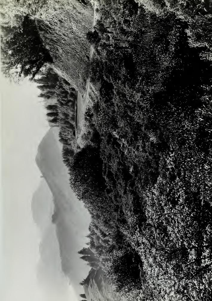
".--.-' '•??<>••;'' -
r'.t-
£ %
,-*\
sShgm


ROUND TOP REGIONAL PARK
EAST Bi>Y REGIONAL PARK DISTRICT
(REVISED 2/l6/39|
I« BRIEF HISTORY AND DESCRIPTION :
A. Round Top Park lies just back of the first row of hillsat the east boundary of Oakland, in Contra Costa County.It contains approximately 227 acres. A portion of thisacreage crosses the hills and lies on the west slope over-looking Piedmont and the Bay Area.
This area, which previously belonged to the Water Districthas been included in reports recommending the acquisitionof certain wtjter district lands, by various interestedagencies. First the Olmsted report in 1929 and again in1936 by the National Park Service. In 1935 the East BayRegional Park District contracted with the East BayMunicipal Utility District for the purohase of this areafor recreational purposes.
B. The Park area contains five distinct types of cover:-
(1) Grass covered slopes.
(2) Large groups of Bays and a scattering of Oaks in thecanyons, some willow growth exists along the creek bottoms,
(3) Chapparal covers much of the area and is composedprincipally of Poison Oak,
(4) Plantings of Eucalyptus were made over much of thearea for commercial purposes, many years ago. Few groupsof them are left, however, as much of the growth has beencut and the severe frosts and snow of a few years bafek,accounted for many more. All these trees, however, havesent out sucker growth from the roots which has attainedconsiderable size.
(5) The remainder of the area is taken up with groups ofMonterey Pines which have stood up well and have beenplanted long enough to have made fine sized trees. Manyseedlings have started from these groves and are in variousstages of growth.
C. Present access to the park area is from Skyline Boulevardon the southwest side. The Water District built some yearsago, a three room bungalow at this entrance, for the con-venience of the firewarden. A fire lookout tower has beenestablished on Round Top Peak (elevation 1750) and commandsa fine view of all the East Bay Area and much of the backcountry. Some planting was done around the bungalow andentrance, using various domestic trees and shrubs.
-1-

]
TO
.1
o wot *•• urt »••Y^rjoO sJsoO a tO lo Jfl
aidcf "io noitioc A . aeioa ?SS YlsJf* b enis^noo ;tl
) sqc.rarfJ' bn?
i e$-: a! be•[ tolid-ait
ni al as MYS9 ^bb3 artt dSei ni .sslT-r»3
srft rtttw fis^aaitiico itss'i \t to
.see
I . ImttLot
•itt ;sS 1c ^i» egieJ (
I
TflB B<
Hi I
19VO SfeBEI 9T9W ajjfrqv (£)
.
,19V9W:, . Yflffln i
b©r ^coi oil rfJwc
to iJJiw qu aeTiRt el ssi.-i r (3)
ni 9i b
>f 8B£ .0
• BCfl/T

D. A road was built at the time the tower was erected inorder to get materials to the peak. Since the tower hasbeen in use, this road has been used for service and accessto the peak by the firewarden. It will serve the park needsfor a truck trail in fire prevention and servicing the upperpicnic area //2,
E. A picnic area was developed near the entrance in theEucalyptus grove but has long since fallen into disrepairand needs development. There are no level areas availablefor extensive play.
F. The present water supply is from a spring located nearthe eastern corner of the park. This was developed at onetime in the past and a sizeable flow was the result. Theold line running to the bungalow is in bad shape and needsreplacing.
G. The closest and most direct access from MetropolitanOakland is on Thornhill Road which leads into MontclairDistrict and Mountain Boulevards back of Piedmont.
II. RECOMMENDATIONS OF IS1, B. R. P. D. AS TO DEVELOPMENTPOSSIBILITIES:
A. For various reasons, it is not recommended to developthis area for intensive recreation. The smallness of thearea is such that extensive development is not possible.If in the future acquisition of Siesta Valley and otherareas on the west should tie this area to Tilden Park, andthe acquisition of Bridges Canyon and other areas on theeast would prolong the chain, this area would become a linkof that chain. Even so, the topography prohibits conoentrated play area development, with the exception of theareas as shown to be developed on the master plan, theremainder of the area is not adaptable for use except ashiking, horseback riding and picnicking.
We recommend that encouragement be given to hikers endhorseback riders as the area is well adapted for thisform of recreational activity.
III. CIRCULATION :
A. Existing.
1. Road System
(a) Grizzly Peak Boulevard and the Skyline Boulevardboth approach tiie Park, from the northwest. Tilden Parkalong these routes is about four miles distance. Thesetwo arteries intersect near the present entrance to the
Park and continue south as the Skyline Boulevard to
Redwood Canyon (Bridges Canyon) about five miles away.
(b) Near the intersection of Grizzly Peak Boulevard and6kyline Boulevard, Elverton Drive takes off of the Sky-line Boulevard and runs southwest down the western slope
-2-

BW T9<
.
.
,
,
i
.
.II
,lT9fc
.
,

of the hills. Shortly below Skyline Boulevard ThornhillRoad branches off of Elverton Drive and continues southwest to Montclair Jan Oakland Suburb) and meets MountainBoulevard about two miles distant. Mountain Boulevard isbeing developed as a through arterial for quiok accessfrom Berkeley to East Oakland.
Both Elverton Drive and Thornhill Road are gravelled andaverage about 15 feet in width and form one boundary ofthe park area. Their grade is very steep (approximately15%) and they have many sharp turns. It is doubted ifthese streets will ever be improved as the adjoining pro-perty is not adaptable to residential sites.
(c) The only road in the park proper is the existingservioe roed from the entrance to the Lookout tower. Itis recommended that a gate be placed at the lower end andthis road closed to general traffic. In addition toserving as a truck trail, this road will be used as atrail for hikers and horse-back riders who wish to gainthe peak.
(d) There is an old abandoned and obliterated road bedwhich at one time left the entrance and continued northwest on park land on down the canyon. This left parkproperty near the northwest corner and continued down tomeet the tunnel road near the east entrance of the BroadwayTunnel. Should this adjacent property and Siesta Valleybe acquired to joing Round Top with Tilden Park, this roadmight be rebuilt to give access and fire control to thePark lands.
B. Proposed.
1. Trail System existi ;
(a) Foot trails - none developed.
(b) Horse trails - none developed.
2. Trail system proposed
(a) Horse trail #1 to go southeast from entrance down maincanyon, up the other side through Pine grove and on up tothe peak. From there, it will lead northwest from thepeak, around the corner of the property, down through thesmall canyon of Bays, and beck up the main canyon to theentrance. Any horsetrails outside the area will no doubtenter the pare near the front entrance so this point mayserve as a means of access.
ThJ s horse trail will also be used by pedestrians. Becauseof the smallness ot the area, there is no need for separ-ation of foot and horse trails.
(b) Trail #2 for foot traffic to be constructed from theentrance and leading in as direct a route as possible to
the summit of the peak.
-3-
-
ai .
b na.
to. 3918
.a xaBtu
.
•:
Go
d)
.
IV. UNDEVELOPED .AREAS
A. Existing
1. Wild areas - none in a strict interpretation - to theaverage visitor any of the deeper canyons are "wild"
2. Scenic areas.
(a) The view fron Round Top Peak is certainly one ofscenic beauty as one can see the entire Bay Area and muchof the back country for I dJ stance of several miles.
(b) Groves of native Bay and heavily wooded Canyons.
(c) Wild life - quail, rabbits and other small wild lifeabound.
(d) Botanic interest - the park contains much native growthinteresting to botanists. One group of Mahonia Pinna ta(California Barberry) near the peak is unusual.
B« Proposed
(a) It is hoped that the East Bay Regional Park Districty acquire that area just southeast of t v:is Round Top
Park. It has been said by several well known Botaniststhat in this small area is one of the most diversifiedcollections of native plant material in this part of theState.
(b) Possible extensi&n of park area may add to the variousexisting interests.
V. PUBLIC UTILITIES
A. Existing
1. Water system - no outside sources of supply, presentbungalow served from springs.
2. Sewage - no outside facility - present bungalos isserviced with a septic tanv installation.
3. Garbage disposal - small incinerator burns trash andcans are buried.
4. Telephone system - the uhnne line to the bungalow comesfrom wires across Skyline Boulevard. A line runs up thehill on wood poles to service the fire lookout station.
5. Power system - the Pacific Gas & Electric line entersthe property on the northwest au i is carried on woodenpoles to the lookout station. One line comes down on thetelephone poles to service the bungalow.
-4-

.
.A
:
rfJwt
J T66.
'
-
-
3&$

B. Proposed
1. Water system - a development of the upper spring shouldeasily provide enough water for the park" needs. It is pro-posed to install a l|" galvanized iron pipe line (approxi-mately 1000 feet) with a gravity flow down to a 2000 gallonconcrete storage tank located in a small ravine below theother spring. This second spring promises some flow ofwater and the two combined should insure ample water supply.
From this storage tank, it is proposed to pump to a smallerstorage tank located near Picnic area #8 (approximately 1000feet) which will service the upper area. The gasoline pumpand upper storage tank are to be supplied by the RegionalPark District. It is suggested that a check valve be in- '
stalled above the pump so that when the upper tank is full,and the pump not running, the lower picnic area will besupplied by pressure from the top of the peak, and notgravity flow from the lower storage tank as this would be soslight.
From the main storage tank it is proposed to continue thelj n main to the main entranoe (approximately 1400 feet).This will service the caretakers bungalow, Picnic Area #1,the proposed latrine, and the secondary picnic area to theright of the entrance.
2. Sewage System - One dry p£t type latrine is recommendedfor Picnic Area #2.
A stone type flush latrine is to be constructed to servethe entrance and Picnic Area #1, and the sewage outletshould serve the caretakers bungalow as well.
3. Garbage Disposal - An incinerator is to be constructedto take care of garbage disposal, as located on the plan.
4. Telephone system - no need
5. Power system - no need.
6. Miscellaneous - wherever the pipe line is near horse-trails, horsetroughs are recommended to be built,
VI. DEVELOPED AfihAS#1
A, Picnio Areas - Located near the entrance in the dense groveof Eucalyptus which should be thinned somewaht. It is recommendedthat this area be constructed to accommodate a maximum of 100people and to be supplied with such tables, western-type fire-places, drinking fountains and taps, etc., for the convenienceand use of such a number. Some of this equipment should beplaced to the right of the entrance in the Pine thickets asshown on the plan.
#2 Located at the summit of the peak on Water Company land.It is recommended that this area be constructed to accommodatea maximum of 50 people and supplied with such tables and so
forth as is necessary,-5-

.
,
i - ax
I
.
.A
.

B. Vehicular areas - A parking area ic to be constructed nearthe caretaker* s cottage et the entrance to accommodate approx-imately 50 cars,
C. Plantings
1, Some clean-up work is necessary in the proves of Baysend other proves where the branches were broken down bythe snow of a few years back. This debris presents a firehazard in its present condition,
2, It is recommended that in the few groves of original-oalyptus still standing, that many of the trees be
eliminated to destroy the straight lines in which theywere planted, to open vistas and meadow effects and togive the regaining trees some further chance to develop.
It has been proven through the results of the lest twofreezes thatthe Eucalyptus i& no t a practical tree for
s certs rk area, ThtI or part of the trees were
frozen £xsai clear back and have sent up sucker growth fromthe stumps. The monterey Pines, on the other hand, with-stood the assult and with the exception of e few branchessnapping off, there was n< irent damage.
area is especially adapted to the growth of thesenes, and as the: lands needsome reforestation, it
is reco.^Tiended that all existinr, eucalyptus stumps bepoisoned onterey Pines be planted to supplement theexistin, .es and to replace the Eucalyptus wherever needed
3, Additional planting of minor quantity to renaturalizesome areas.
-6-

B91R
,
.

E-XLSTING PR0P05tPrtucm Trails
PAVtP U0AQ3
60UNPAAV LINt
NOBSt TBAIL3
WAT E- R LINEFOUNTAIN/
disposal aeoTABL6-S
-O—
DISPOSAL TANK iLATISiNE *LOOKOUT TOwfD $ @yTHE-« GROWTH '->^\S~~1SCONiFeooos Ls£iA*/ fAU-8, pit * j roves 9 SB *3 CH0R5E- THOUGH Mxr QH.TF-OOT TRAILPO WE- B LINF- -• • •- -a—
•
o-
COuHT-t BOl/wDfir LIHt „. .
PARKING ARfA -^*=j-^r
- -y%S. - i ; :
) t i ij ! i
x" ^-——I-—-%L / ' 4/'
-^-
UNITEP STATES
PEPARTMENT OF THE INTERIORNATIONAL PARK SERVICE
COOPFOATINt WITH
CALIFORNIAEAST BAY REGIONAL PARK DISTRICT
ZLZL
BOUND TOP PARKMASTER PLAN
AM flt£T-C«) £BK.fin-fZ
^izLA?£&.... "*' •- •/•/
J
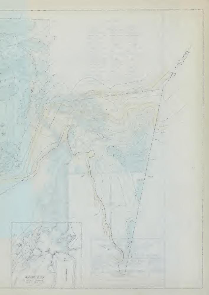
o/»
K. I

50 P&c^eoLOCATION OP THf PACld Of-f-tC*^
ik Tttf n^aaT or THf -ee*5T e>Ptv


LAKE TEL1ESCAL REGIONAL PARK
EAST B/Y REGIONAL PARK DISTRICT
MASTER PLAN
1, BRIEF HISTORY AND LOCATION:
In 1864, when Oakland was but a village needingwater, a dam was built to form a reservoir onTemescal Creek. Chineese Coolies carried thedirt in straw baskets on their heads to bu^'ldthis earth filled dam. The lake, so created,was later named "Temescal" after the IndianChief who headed "the band of Indians that roamedthese hills, "Chief Temescal".
The many springs running all year round fed thelake and made it the principal source of waterfor many years for the East Bay Cities. Whenthe hill district surrounding the lake became denselypopulated, in 1930, it wajs abandoned as a reservoir.
In 1936 the Regional Park District purchase thelake from the Utility District.
It is situated In the foothills of Oakland withinten minutes r1 de from the business district and ison liie Lincoln Highway. It is in~the center of theRegional Park lands, which makes it admirably suitedas an administration headquarters for the RegionalPark District.
The park contains 30 acres of fresh water, 10 acresof level land and 10 aores of wooded slopes.
2. SPORTS:
(1) The "lake 1s stocked with fish bythe CaliforniaState Fish and Game Commission, and is open forfishing.
(2) A 300 foot floating wharf is used by the anglersfor flycasting.
(3) Row boats and canoes are rented.
(4) The principal sport is swimming. "The~fresh springwater that feeds the lake, together with its shelteredand easily accessible location, has made the lake themost popular outdoor swimming beach in Northern Calif-ornia; 5000 to 6000 bathers have used the swimmingfacilities in a single day.
'
'
,
'
,
.

(5) There are picnic grounds with outdoor cookstoves,
(6) A girls camp and lodge was built by theKiwanis Club for any groups of girls in theDistrict who are properly organized.
(7) There are two playfields large enough forsoft ball, one playfield suitable for footballand baseball.
3. DESCRIPTION:
The west slope is covered with native trees andshrubs, principally Live Oak, Willows and Laurels.Ceanothus, Casoara, Blackberry, Toyon and PoisonOak bushes are found in profusion.
The eastern and northern slopes, which were badlymarred by the construction of the two main crosstown arterlals, have been partly healed by planting.The Girl Scouts and Camp Fire Girls have plantedhundred of Pines, Toyons, Redwood and Cherry Treeswhich are thriving and are rapidly covering thescars.
The Idmini strati on Building is situated on theshores of the Lake, it serves four principalneeds; 1. offices of the District; 2. RecreationHall with kitchen; 3; Dressing Rooms with Lockers;4. An eating concession.
There are two beautiful water falls, one at theeastern end and the other et the southern end ofthe lake
•
4. IMPROVEMENTS:_
A few minor improvements are under way to makethis Regional Park complete.
1. Grading of play fields.2. CoverTng of silt on the athletic field for lawn.3. Planting of flowers, trees 8nd shrubs.4. Grading the entrance roads and all trails.5. Rook walls to prevent slides.6. Enlarge the beach.7. Plant the creek with moss covered rock, ferns
and Willows.

'
(
' J* &'
<
•
,
.
|
.
.
"
.
,

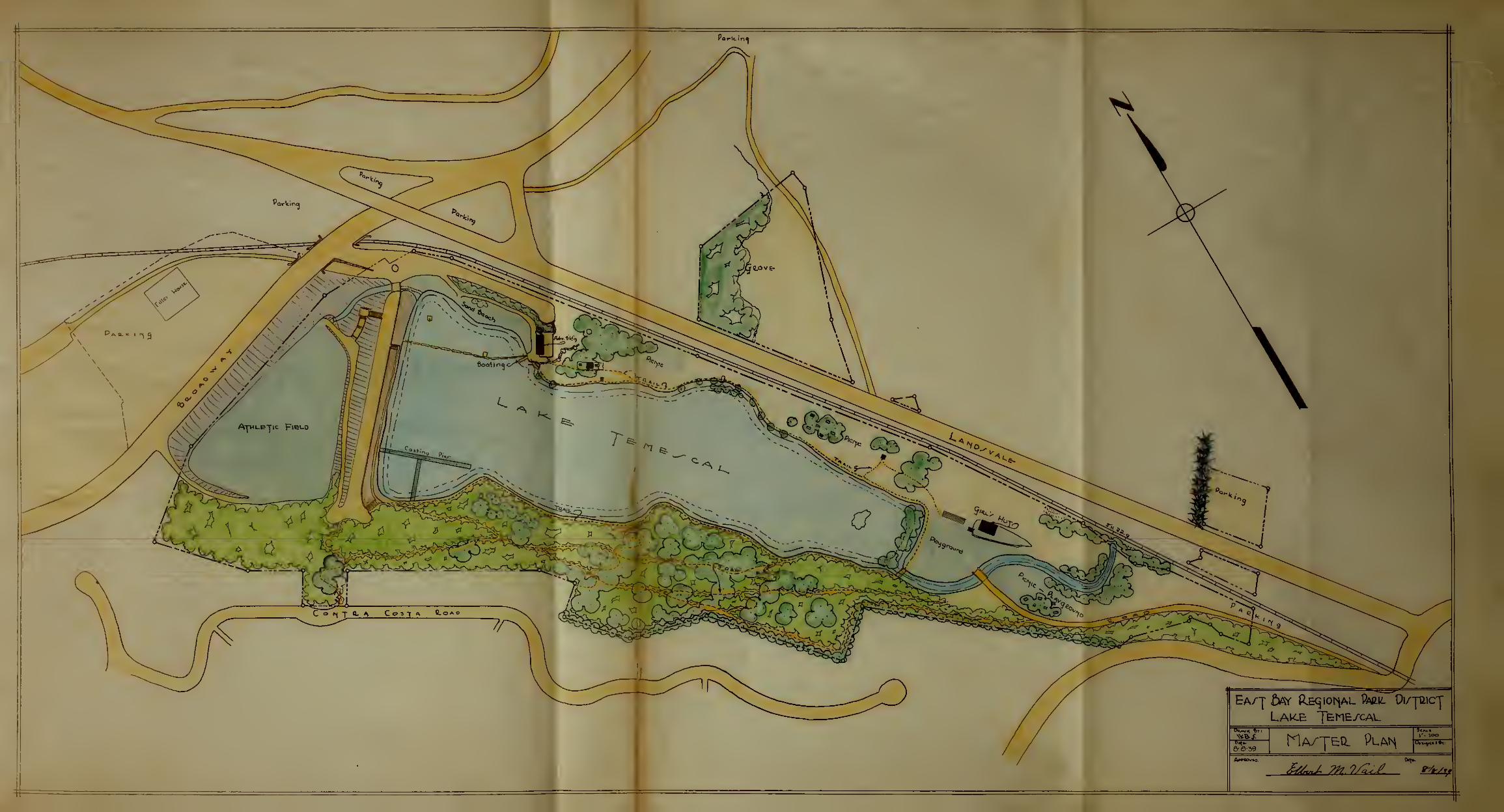

1
•-<
-
-
-.r"' flfna) ^ J j
'7

K IO^OPL.L.PLKf-OU^5
m<^p op p&opoopd pap^ ^pop^vatiom^s &v
1930
CONTOUR HRiP OP £pqtOMAL PA*2kr QrOT^tC
-Prep CONTROL. PLftK ftMP VU^tiMLtTY MAP Op
•poe. PucrrHpe Of-TfrlUFO <3TUDrP»-3 CPf^-C TO YOLUKf il
qt-Kt-ePiL-MGe' PUAN £>Y WftL^-«2 £>.TILI_i=-Y
OU£?MlTT-f-C7 MP*PCH 1936£>Y THP
v5T£fPP Pfi(?e C?IVtv5IOMOP THF-
£PP02T OP PCOPOv5PD PACe €F^F^VAT10K^5 £>VOLHv5T*PC> - H^lUL.
t9C30

/C£Y
ttoin Wp/w&s. **D P-t'ologroph heofioo
txistin? /toads or rrolts. CD Land parcel as described
Proposed /toads or 7rollS. A Approach to park lands
Boundary Lines ffxlStind Or Proposed) (g) Site for service cenler'
rtunicipality aoundaries.
^V^N °'strict tonds reserved/or tteservoirs ond rVoterstieds
.
%$2 District tonds recommended/or fbrA /reservations.
|District lords notincluded M proposed /reservations.
Private lands needed to complete 6oundaries
of Pbrlt tteservotions ond /vrlmoys.
f^f-'i fbd/ic /brirs, Country Clubs, Colleges, $ Institutions,
fcsahMd and otner areas of somewhat general use.
Other land owned by district.
If./inr/,j<:. /
\A,nt\»Kr
/vt>"
pfe
S<"
V'jtfM$
iP^^ mm****•Ve l ^K itS ,j? /t$f*r<sP t A.
aet MMMZJ*
m 4p*
G
Jt?:e^
Bj0ji&rL
J*
s. &&%h &>
EL C£RiVTO
r
y if \ >/
**£y
^
\b
'It] f/ "
\ v /A *•
>&'
m£t
...-j
/"/
^ s»i
SanFrancisco ^^
i
BAST BAY MUNICIPAL UTILITY DISTRICT
OAKLAND - CALIFORNIA
PROPOSED EAST BAY PARK RESERVATIONSSCALE OF MILCS
OLM5T£D BGOTHEBS LAN05CAPL* APCH/T£CrS
SEPTEMBER /930
ftIE NO 6093 PLAN NO
9
San Franciscoj&oy


MMtfa

'.;
] r i i ii i i jl , i j, .. . . , - . . - .
" 'mi "'""""""""'""""'
'""" m -i lx
l


-v#->"'
S /
$& J
„v
, V
'
- LEGENDREGIONAL PARK LANDS
NATURAL PARK LANDSKaA>' /37\;
,( GRIZZLY PEAK FIRE TOWER O•' / '/, VISIBLE AREA EZZ1
^2. I
^ urtST
ROUNDTOP FIRE TOWERVISIBLE AREA
|' \Q „^^-'-"-'' ~ V\ AREA VISIBLE TO BOTH
. .\\J.'.<&y* ALL FIRE STATIONS •
<Z%jM
^m
^v s< -:
', '".I all rmc O 1AM iv>
uO(W^- /O \I
:
'./. MAIN ROADS
*spJ^ee
,v^
m6@%Zm
Wrhr
f ^le,yv .
^y \ p.
f/
L_-
.
X T JW^% \iCajnuL^
Kr_3SE
'i .
n o^'*
O ^7^ W - X >A .
'
: mSrJR: 'Jh
'v^ " r tore, .p \ r-^s
.?>avi:
^
'-^o^iJI/ §<
7 ~ '' -
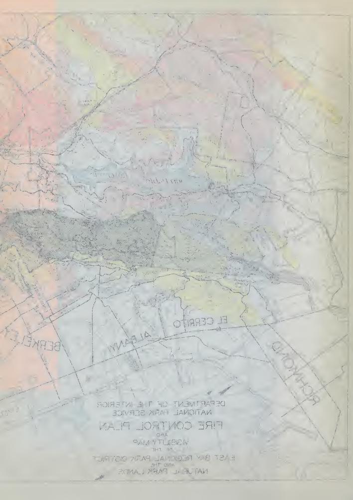
^:r.}d.
3^n
.<<
'

1 ^K '
H O *
5 Fl
u *
O Ai Ho of ooa 5^OjH2*5CtfiLQ

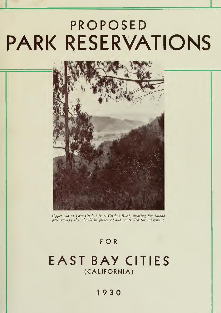
PROPOSEDPARK RESERVATIONS
Upper end of Lake Chabot from Chabot Road, showing fine inland
park scenery that should be preserved and controlled for enjoyment.
FOR
EAST BAY CITIES(CALIFORNIA)
1930

List of Sponsors of the
East Bay Regional Park Association
at Time of Publication
«Xtg£gjm&
Dr. U. S. Abbott
Louis AberW. L. Abrott
Mrs. S. J. Ackcrm.in
C. F. Acree
Charles C. AdamsG. P. AdamsMrs. G. P. AdamsR. L. AdamsDr. Herman Adler
Arthur R. Ahlgren
W. J. Aldridge
Carl Alexander
Jas. P. Allen
Mrs. Jas. P. Allen
John J. Allen
Robt. Allen
Modeste Alloo
Rudolph Altrocchi
J. M. Alvarez
H. C. Anderson
Ralph H. Anderson
C. J. Andruss
Louis J. Angeli
Miss Nellie Anton
Eli D. Antonieu
Charles H. Armstrong
Mrs. Helen S. Artieda
D. L. Artis
Miss Lydia Atterbury
John M. Atthowe
Lewis B. Avery
George E. Axtille
Leon C. Babbitt
Dr. S. H. Babington
Dr. William Frederic Bade
George Chester Badger
Miss Edna W. Bailey
Mrs. Henry Bailey
Alfred E. Baker
Frederick S. Baker
James B. Baker
Miss Harriet B. Bakewell
Martin T. Baldwin
Miss Shirley W. Bale
W. L. Ballenger
Oscar T. Barber
A. L. Barker
Miss Mary BarmbyRev. John Barrett
Mrs. David P. Barrows
Howard H. Barrows
Miss Jeannette Barrows
Miss Ann Little Barry
J. J. Barry
Louis Bartlett
J.G. Bassett
C. D. Bates
Dr. Helen Page Bates
Rev. Dean W. H.
Battershill
\1 is-. Bernice Baxter
Dr. Frank S. Baxter
Howard Baxter
P. S. Beach
George Bean
Charles A. Beardsley
Jas. G. Beaty
J. J. Beaty
T. D. Beckwith
Mrs. Olga Beebe
Mrs. L. K. Beever
R. T. Belcher
Miss Julia A. Martins Beloof
H. J. Bemiss
E. S. Bender
W. A. Benner
Albert N. Benson
Frank A. Berg
John W. Bergcr
Dr. T. L. Bergemann
Lloyd D. Bernard
C. L. Best
Carl Bicdenbach
C. L. Biedenbach
Jack T. Bill
E. R. Billett
Mrs. Addie M. Billings
Miss Dorothy Billings
Miss Margaret Billings
J. W. BingamanMrs. J. W. Bingaman
Mrs. A. A. Bird
Mrs. F. W. Birtch
F. C. Bishop
Miss Anga M. Bjornson
Dr. Benjamin W. Black
Mrs. Benjamin W. Black
Spens Black
Mrs. Spens Black
Mrs. William Wallace Blair
Anson S. Blake
Mrs. Anson S. Blake
Frances J. Blake
G. W. BlakemanA. C. Blanchard
Walter C. Blasdale
Rev. J. M. Boaz
Harold Bodington
Dr. G. A. Boehmcr
Wallace B. Boggs
H. E. Bolton
Rev. Geo. L. Boroughs
J. N. Borroughs
Mrs. B. W. Bours
J. M. Bracker
Mrs. C. C. Bradfield
Henry Bradley
P. R. Bradley
Paul W. Brannon
M. E. Bratcher
Mrs. Marjorie Breck
Samuel Breck
H. L. Breed
Horace H. Breed
Henry Breen
Father Brennan
John A. BrennanEdward B. BrewerThomas B. Bridges
J. W. Bridwcll
Walter M. Briggs
Mrs. Walter M. Briggs
J. C. F. Bright
Mrs. Charles W. BrockHoward Bronstein
Mrs. Richard C. Brookins
F. A. Brooks
Miss Annie Florence BrownDavid E. BrownMrs. David E. BrownMrs. Walter S. BrownWarner BrownDr. L. E. BrowningRobert Brownlce
J. Allison BruncrMrs. H. W. Bryant
W. A. Buckhart
George BudgenP. G. E. Buechner
John D. Bullock
Miss Minnie BunkerMrs. John S. BurdBurg Bros. Inc.
W. C. Burgess
A. E. BurkeMiss Beatrice Burnett
Miss Margaret BurnhamMrs. Walter J. Burpee
E. W. Burr
A. S. Burrill
Mrs. Harry R. Burt
J. G. Buttomer
Mrs. J. G. Buttomer
Sheridan Byrne
B. C. Cain
T. E. Caldecott
A. W. Caldwell
Harry H. Caldwell
Mrs. Tsar N. Calfec
George M. CalhounEdw. L. CampRev. Harold B. CampH. W. CampbellArthur M. Carden
R. L. Carey
Forest Carlisle
W. S. Carson
Andrew Cartwright
A. B. CaryWm. Cavalier
W. E. Chamberlain
WalterS. Chandler
M. C. ChapmanRev. O. K. ChenowcthS. V. ChownMrs. G. Wilson ChurchThomas D. ChurchMrs. Thomas D. Church
Mrs. E. S. Clark
Rcece Clark
Mrs. Thomas J. Clark
Wellyn B. Clark
Rev. Charles F.Clarke
Mrs. C. C. Clay
Mrs. W. T. Cleverdon
Miss Elizabeth K. ClowArthur Cobbledick
LeRoy Coburn, Jr.
Rabbi Rudolph I. Coffee
K. S. Colbie
Wm. E. ColbyC. L. Cole
Mrs. K. A. Cole
Albert S. Colton
Robert F. Connolly
Mrs. C. C. Conrad
Mrs. Dane Coolidgc
Miss Mary Cooper
Wm. P. Cooper
Dr. J. G. Corncille
Mrs. J. G. Corncille
Frank V. Cornish
C. J. J. CoxRay B. CoxMiss Viola CoxHarold H. Cozens
C. S. CramerClarence B. CraneMiss Anita Crellin
Miss Mary Crellin
Mrs. T. A. Crellin
Miss Cornelia V. N. Cress
Miss Helena Critzer
F. J. Croll
Otis Crooks
Daniel Crosby
Ira B. Cross
W. W. Cross
Mrs. W. V. Crucss
Guy M. CrumpG. A. CummingsDr. Ruby CunninghamA. B. Currier
H. A. Curtis
Miss Jane Isabel Curtis
Thomas DabaghStuart Daggett
Mrs. James Dalziel
N. P. Damianakes
Mrs. I. R. DamonHartley Daneke
J. F. Daniel
J. Frank Daniel Jr.
Paul I. Daniels
H. A. Davenport
F. M. Davidson
Albert E. Davies
Charles G. Davis
Charles W. Davis
Curt C. Davis
Earl E. Davis
Gen. Wm. C. Davis
Mrs. Wm. C. Davis
Miss Margaret T. Davis
Albert S. DayRev. Richard C. DayMrs. Grace E. Deadrich
John A. Deadrich, Jr.
Dr. J. Camp DeanMrs. E. R. DeChcneJerry W. De CouGeorge Deethardt
E. I. de Laveaga
H. W. DenhardMrs. H. W. Denhard
J. A. Denis
Mrs. Arthur P. Denton
G. M. Derbyshire
Charles Dcrleth Jr.
F.dington Detrick
Mrs. Edington Detrick
Monroe E. Deutsch
Chas. Capp De WolfR. Stanley Dollar
Augustin DonovanMiss Katherine Douglcs
Thos. F. DowdA. M. DowlingDr. Sam R. DowningM. B. Driver
Aubrey DruryH. L. DruryNewton DruryChas. E. DunscombMrs. Laura L. DurginD. G. DyeMrs. Grace S. DyerThos. C. Eaglesome
Guy C. Earl
Mrs. Guy C. Earl
Carroll Ebright
Ralph Eckert
Geo. A. Edgar
John W. EdgemondMrs. Paul Eliel
E. C. Elliott
Mrs. Minerva G. Elliott
Eben B. Ellis
Mrs. Ralph Ellis
Oliver Ellsworth
Ralph R. Eltse
Rev. C. Herschel EmmingcrFrank W. Epperson
E. O. Essi;;
Mrs. E. O. Essig
Roland Estevcs
H. J. Eustace
Mrs. H. J. Eustace
Dr. Herbert M. Evan'.
Perry Evans
Grant L. EwingWilliam F. EwingMrs. W. F. Faber
Harry H. Fair

Vincent C. Faria
A. C. Faris
Mrs. Ray W. Farley
Mrs. H. B. Farnsworth
Stanley Farrar
L. P. Farris
Everett E. Farwell
Lauren E. Ferguson
Mrs. W. G. Ferguson
D. C. Fessenden
C. P. Finger
Dozier Finlcy
W. H. Fischer
Miles B. Fisher
P. M. Fisher
Ralph T. Fisher
R. M. Fitzgerald
Fred A. Flanders
Dr. Sandford Fleming
Lloyd J. Fletcher
Miss Catharine Flinn
Mrs. Clara E. Flint
Miss Jose Maria Floares
Rev. Clarence E. Flynn
F. E. Forbes
Dr. John N. Force
R. C. Force
Frank Stuart Ford
Bruno Forstercr
James H. Fort
F. W. Foss
Mrs. W. G. Foster
Mrs. Miles E. Fox
W. B. Francis
Miss Anna Graeme Frascr
Mrs. Sue L. Fratis
Verne Frazee
Mrs. Adeline Frederick
Harland Frederick
R. S. French
Carl M. Friden
George Friend
Miss Blanche H. Frost
Mrs. Carl H. Fry
]ohn H. Fuller
Wm. C. Fuller
Mrs. Wm. C. Fuller
George B. Furniss
E. H. Furth
Frank S. Gaines
Esson M. Gale
Howard Gale
Maj. M. M. Garrett
Rev. Edgar F. Gee
Glenn E. Gee
Charles L. Gibb
Rev. Thomas T. Giffcn
Mrs. Edith A. Gilbert
R. E. Gilbert
Howard Gilkey
Clark C. Gillis
Dr. L. FL Ginno
Willard E. Givens
Ray H. Glassley
Monsignor Jos. M. Glcason
Mrs. Robert A. Glenn
H. H. Glessner
Dr. Kate R. Gompertz
LeRoy Goodrich
Mrs. LeRoy Goodrich
Mrs. John E. GoodyArthur W. Gorrill
William H. Gorrill
Mrs. William H. Gorrill
Wilson S. GouldMrs. Henry Francis Grady
Com. J. S. GrahamMrs. J. S. GrahamMrs. A. E. GraupnerRichard Graves
Mrs. Richard Graves
Leon E. Gray
J. C. Green
Miss Virginia Green
Will W. Green
M. GrodenA. R. Groenink
Ernest T. GroveM. F. Guitwits
Charles A. Gulick
Peter Guldbrandsen
Heber GuteH. J. GuteMrs. H. J. GuteMrs. Louisa F. Haas
Mrs. H. D. Hadenfeldt
Hugh L. HaganAnsel F. Hall
Chas. B. Hall
Miss Dorothy Flail
S. W. Hall
Max HammMiss Ida M. HammondE. A. HansenWm. H. HansenMrs. Wm. H. HansenMrs. Etta HansonMiss Elizabeth Hardison
Col. E. J. HardyMrs. Hester Harland
A. K. P. Hartmon, Jr.
John M. HarmonManse M. Harris
Paul Hartsall
Miss Janet M. Flartzell
Mrs.H. F. Hartzell
E. J. HarwardC. F. Hassler
William S. HatchHenry R. Hatfield
J. M. HauanG. E. HauserHerbert HauserMrs. Lila R. HavensR. S. HawleyMiss Bertha HaysM. A. HaysMiss Annie HaywardMiss Anna HeadFskild Heidekker
E. O. Heinrich
Theodore A. Heinrich
Dr. Hubert HcitmanMrs. Hubert HeitmanC. N. HclmickWalter T. HelmsDenis L. Hennessey
J. A. Hensley
W. B. HermsAlex. R. Heron
Jas. Brown Herreshoff
Mrs. H. N. Herrick
George W. HickmanClifton E. HickokMrs. Eva F. Hicks
Ernest Higgins
Sidney A. Higgins
Mrs. Sidney A. Higgins
Frank E. Hinckley
J. H. HinkLester W. HinkDr. Harold H. Hitchcock
Elgin T. Hittell
Mrs. Elgin T. Hittell
Leslie W. HobsonA. F. HockenbeamerRev. W. R. H. HodgkinMiss Emma HoehnerHerman C. Hoferick
E. C. Ffoffman
Mrs. E. C. HoffmanW. A. Hofrichtcr
Lloyd J. HoganMrs. Lloyd J. Hogan
Bruce HolmanE. Bruce HolmesE. Clarence HolmesMrs. E. Clarence HolmesG. N. HolmesPercy HopperC. D. HornerF. L. HorneyMax Horwinski
O. E. Hotchkiss
Charles HouserMiss Edith L. HoustonCharles P. HowardE. A. HowardMrs. E. A. HowardHerbert S. HowardLee HowardDr. Albert B. HoweMrs. Carrie L. HoytMrs. J. G. HoytC. E. Hudsteth
Sam. J. HumeC. H. HuntH. C. HunterRev. Stanley HunterM. E. HurleyEdw. K. HusseyLincoln HutchinsonCharles Gilman HydeGeorge F. ImbachJohn P. Irish
A. H. Irving
Mrs. A. H. Irving
Miss Sue J. Irwin
H. J. Isgar
Edward M. Jaffa
Dr. Edwin P. JamesWm. C. James
J. H. Jamison
Rev. John R. JanewayGeo. A. Janssen
Dr. Irene C. Jenkins
W. T. Jenkins
A. C. Jensen
Dr. Willis Linn Jcpson
H. W. Jewett
Miss Hazel JochcmAlex. JohnsonRev. H. S. JohnsonMrs. Irwin M. Johnson
M. N. JohnsonMrs. O. B. JohnsonH. W. Jones
Herbert Jones
Mrs. O. C. Jones
Roscoe D. Jones
D. L. JungckWilliam C. Jurgens
John B. Kaiser
Eva KantzDenes Karoly
Mrs. Joseph KayMiss Kathleen Keating
Charles Keeler
W. H. KeenanMrs. W. H. KeenanWalter Y. Kellogg
Dr. Frank L. Kelly
A. G. Kelsey
W. W. KempRobert KennedyRodney E. KcnyonRobert J. Kerncr
Charles E. Keyes
Harmon C. Kibbe
George Killion
Ralph W. KinneyMrs. Florence K. KirbyHoward Kirk
Mrs. Howard Kirk
M. W. Kirk
Mrs. M. W. Kirk
Morio Kitagaki
Raymond S. Kitchener
Frank L. Kleeberger
R. H. Kline
Ralph A. KnappH. W. Knoll
P. C. KnudsenChas. A. Kofoid
Mrs. Chas. A. KofoidBen F. KopfF. N. KornhausMrs. Newton A. Koser
Mrs. Peter J. KramerC. C. Kratzer
A. L. Kroeber
Herman Krusi
George Lafabreguc
Glenn C. Laird
Fred B. LamoincH. L. Landis
Col. and Mrs. Edwin Landc
Clemens Laufenberg
Harry B. Langheldt
Stephen LangmaidMrs. Stephen LangmaidMiss Alma R. Lavenson
Miss Anna C. LawAbe P. Leach
Robert F. Leavens
Joseph N. Le ContcL. J. Le ConteH. J. Lederer
H. T. Lederer
Miss Bernice L. Lee
Charles H. Lee
Edwin A. Lee
Dr. Robt. T. LeggeMrs. Robt. T. Legge
B. H. LehmanDerrick N. LehmerMrs. Derrick N. LehmerS. J. Leland
A. O. Leuschner
E. H. LevyIvan M. Linforth
Mrs. Earle G. Linsley
Austin W. Little
F. J. Lobbett
Leonard B. Loeb
Mrs. John Louis Lohsc
Mrs. Annie LongMrs. Oscar F. LongT. S. Lossing
Rev. Sidney LoveMrs. E. P. LoweNorris Lowenthal
Russell LowryDr. Edgar A. LowthcrGeorge L. LuceP. D. Lucey, Jr.
Rev. P. T. LynnHarvey B. LyonMrs. Harvey B. LyonVaughan MacCaugheyAustin F. Macdonald
John A. MacdonaldRev. John S. MacGearyAllister MacKenzicMrs. E. Madison
Frederic E. MagceMrs. Frederic E. Magce
H. C. Maine
Mrs. Fowler Mallett
G. C. MannF. E. Mansfield
Arthur E. ManterLuther Brusie Marchant
W. R. MaringGerald MarshMrs. James M. Marsh
Miss Violet B. Marshall
Mrs. Edna Martin
Dr. L. A. Martin
H. N. MasscyHomer C. MatherMrs. G. A. Mattern
Herbert C. MatthewsMrs. Eleanor P. MayDr. Eugene S. MaySamuel C. MayF.dwin L. MayallB. R. MaybeckCochran McCarronRichard H. McCarthyMrs. Richard H. McCarthyH. N. McClellan
J. Sherman McDowellDuncan McDuffie
Rev. Henry B. McFaddenCharles F. McFarlandF. E. McGurrinJohn H. McHaffieMrs. Florence O. McKibbenMrs. Elizabeth McKinneyMiss Fannie W. McLeanBenoni H. McLureJames McManusMiss Barbara B. McMillanH. E. McMinnO. K. McMurrayMiss Norah McPh. McNeillJames C. McPherson
J. A. McVittieL. R. McWethyWm. H. MeadDr. A. M. MeadsMrs. A. M. MeadsMrs. Robert W. MearnsMrs. Mary T. Meredith
Woodbridge MetcalfChristian MeyerMrs. Christian MeyerMrs. Elsa MeyerDr. Edith MeyerHenry H. MeyersMrs. J. B. MhoonDr. L. Michael
Andrew Miller
Dr. Chas. Howard Miller
Clement H. Miller
Harry East Miller
Harvey D. Miller
John A. Miller
Mrs. Nettie May Miller
Wesley C. Miller, Jr.
Mrs. Joe Miserez
Sidney B. Mitchell
J. K. Moffitt
Wm. MonohanDr. Robert C. MoodyMrs. Robert C. MoodyRev. Addison S. MooreLawrence F. MooreMrs. Stanley MooreFred N. MorcomMrs. Teresina B. MorganWm. S. MorganWalter MorkProf. W. S. MorleyMrs. W. S. MorleyDr. Bert J. Morris
C. E. Morris
Edwin H. Morris, Jr.
Wm. F. Morrish
George D. Morrison
G. E. Mortensen
R. B. MortonMrs. Mary MoundayA. H. MowbrayProf. Walter MulfordEdgar E. Muller
Fred MulvanyMrs. Charles G. MurrayRobert Myers
(Continued on next page)

William H. Myers
H. H. MylanderHudson Nagle
J. H. Napier, Jr.
Albert NashmanChas. NaylorDuncan Neilson
Mrs. Allen NeumanF. R. Neville
Mrs. H. E. NewmanMiss Lois NewmanMiss Nedi E. NewmanElmer E. Nichols
Luther A. Nichols
Roy T. Nichols
Weldon C. Nichols
Mrs. Emily H. Noble
George H. Noble
Harry Noble
Mrs. Harry Noble
Mark Noble
Carter Norris
Franldyn W. OatmanMiss Mary B. O'Bannon
Judge Frank M. Ogden
Roy L. Oliphant
A. L. Oliver
Edwin L. Oliver
J. J. O'Neil
Rev. George A. OsmanGeorge Oulton
Mrs. Winfield Scott Overton
W. G. Paden
Harold L. Paige
Mrs. Mary Trueblood Paine
Geo. C. Pape
Mrs. Geo. C. Pape
F. M. Parcells
Mrs. F. M. Parcells
C. E. Parker
Mrs. Floyd Edson Parker
J. M. Parsar
E. B. Parson
Miss Harriet T. Parson
Mrs. Marion Parson
Rev. N. C. Parson
Mrs. Clara Martin Partridge
Dr. Mary J. Patterson
Frederick R. Peake
A. M. Pearce
Maxwell Pease
Frank J. Peck
Peter O. Pederson
Dr. Hugh E. Penland
Mrs. Hugh E. Penland
Miss Margaret H. Perkins
Dr. Newel Perry
Dr. Chas. E. Peters
Mrs. Chas. E. Peters
H. K. Petersen
Fred C. Peterson
Rev. Geo. W. Phillips
L. B. Phillips
Mrs. Martha E. Phillips
C. Stuart Phister
Mrs. Edgar N. Pickering
Row W. Pilling
Edwin Pillsbury
Mrs. Edwin Pillsbury
Milton E. Pinney
C. C. Plehn
Augustus S. Pollard
Frank Pollard
Miss Margaret I. Poore
Miss Ada Elizabeth Porter
J. P. Porter
Mrs. Thomas M. Potter
Dr. Alvin Powell
Mrs. J. A. Powell
L. S. Pratt
Ralph A. Presher
Clarence N. Price
Clifton Price
H. I. Priestley
George W. Prising
Frank H. Probert
Mrs. Charles QualeMrs. George A. Rader
Max RadinClifford B. Radston
Brother Ralph
P. S. W. RamsdenMiss Gertrude M. Ratcliff
W. H. Radcliffe, Jr.
Mrs. W. H. Radcliffe, Jr.
Rev. Albert E. Raugust
John W. Ravekes
P. O. RayRev. W. P. Reagor
Fred E. Reed
C. Rees
Mrs. C. Rees
Rev. Robert Rehkugel
Dr. Aurelia H. Reinhardt
Dr. A. E. Reische
Harry Reite
Mrs. W. B. Reynolds
Donald B. Rice
Mrs. Austin C. Richards
Dr. Dexter N. Richards
Mrs. Dexter N. Richards
W. A. RichmondSam A. Rico
S. S. Ripley
Mrs. S. S. Ripley
Clifford E. Rishell
George R. Ristrem
Dr. Mary B. Ritter
Mrs. J. Mitchell Roberts
Mrs. O. C. Roberts
T. J. Roberts
R. W. Robertson
Victor J. Robertson
Mrs. W. S. Robie
Judge E. C. Robinson
F. E. Robinson
Harrison S. Robinson
Jas. Bestor Robinson
Leo S. Robinson
T. M. Robinson, Jr.
Mrs. W. Robinson
Dr. P. A. RooneyRev. Galen Lee Rose
Mrs. Bernard J. Rosenthal
Mrs. M. C. Rosseter
Mrs. Oroville W. Rote
Mrs. Albert H. RoweL. E. Rowley
Dr. J. Elliott Royer
Mrs. J. Elliott Royer
C. E. RughMiss Rhea Rupert
Robert N. Rushforth
Miss Carma Russell
Frank M. Russell
Harold B. Rutley
Mrs. Ann RyanRupert R. RyanMrs. Rupert R. RyanHenry A. SammetA. H. Sanborn
Edgar M. Sanborn
B. S. Sanders
Louis B. Sands
Mrs. Louis B. Sands
De Forest Sanford
A. B. Saroni
Miss Blanche E. SawyerMrs. Anna L. Saylor
Robert M. Saylor
O. G. Schaaf
Rudolph Schevill
Mrs. Oscar A. Schlesingcr
Walter S. SchmidtHenry W. Schnebly
Harry L. SchroyLouis E. Schuessler
Walter E. Scott
Mrs. Walter E. Scott
J. T. ScowMrs. Lucia L. Searls
Dr. L. R. Sears
Miss Laurine Seewaldsen
L. B. Self
W. H. Sellander
Alanson Sessions
W. A. Setchell
Fred Seulberger
J. Carl Seulberger
Charles A. ShaneR. W. Shannon
O. D. Sharpe
Dr. J. R. Sharpstein
A. E. ShawMrs. A. E. ShawCharles F. ShawMrs. Harris F. ShawWillard W. Shea
Dr. H. W. Sheldon
George D. Shepherd
H. W. Shepherd
A. T. Shields
Rev. Henry H. Shires
Rev. J. R. Shoemaker
J. A. Shoptaugh
A. F. Shulte
Mrs. A. F. Shulte
Robert Sibley
G. J. Sielaff
Harry R. Sims
Horace G. SimpsonMrs. Horace G. Simpson
L. A. Sirad
Percy R. Slaiter
F. B. Smiley
Mrs. B. J. Smith
C. A. Smith
George W. Smith
L. W. Smith
Seldon C. Smith
Mrs. Seldon C. SmithMiss Susan T. Smith
John J. Snedecor
Chas. E. Snook
Judge Homer Spence
George Sperbeck
Thos. C. Spilker
Robert G. Sproul
Mrs. Robert G. Sproul
Redmond C. Staats
Mrs. Ethel G. Staehling
A. G. Starr
Fred W. Starratt
Miss Lucy Ward Stebbins
Frank W. Steers
J. N. Steiner
J. F. Stephens, Jr.
L. F. Sterner
Harold P. Stevens
E. A. Stevenson
E. B. Stoddard
Robert E. Stone
George M. Stratton
C. J. Struble
Wm. P. St. Sure
Harry E. Styles
Mrs. Clement M. SummersOscar Sutro
John R. Sutton
Mrs. John R. Sutton
H. S. SwansonRev. Herman A. Swartz
Mrs. Herman A. SwartzDr. Charles A. Sweet
Dr. Clifford Sweet
F. H. Swift
Mrs. Telura SwimMiss Mabel SymmesRev. C. W. Taber
Stanley G. Taggard
Mrs. Stanley G. Taggard
Judge R. B. TappanA. G. Tashiera
I. B. Taylor
James P. Taylor
Leo E. Taylor
Paul S. Taylor
Samuel H. Taylor
J. S. TeddySam W. Terry
Frank H. Thatcher
Max Thelen
Mrs. Max Thelen
Rev. Lloyd B. ThomasGeorge C. ThompsonHollis R. ThompsonVernor E. ThorpCarl E. Thorsby
G. S. ThrumanMrs. Amy E. Thurston
Capt. Walter G. Tibbitts
Mrs. R. R. Tillotson
J. L. ToddPerry T. TompkinsMiss Katherine Towlc
C. K. TownsendMrs. C. K. TownsendRev. Ernest A. Trabert
C. T. Travis
Mrs. Wm. Trewartha
Delger Trowbridge
Mrs. Delger Trowbridge
W. B. Trull
Miss Bertha M. TrumanHarold I. Trumbull
C. M. TwiningL. C. UrenRobert P. Utter
E. M. Vail
E. L. Van der Naillen
Dr. F. J. Van HornLester Van Ness
A. Van Pelt
A. Vestal
George R. Vestal
Herbert A. Vicars
Dagmar H. Vinther
Wm. G. VolkmannMrs. Wm. G. VolkmannDr. Edward von Adelung
Sidney M. WahlCapt. G. B. WaitMrs. G. B. Wait
Mrs. Vernon WaldronMiss Maude M. Wallace
Mrs. James Wales
Sidney M. Wales
Burton L. Walsh
Edward M.WalshC. M. Walters
Mrs. Violet R. WardNairne F. WardMrs. E. V. WarnerRoy E. WarrenWilliam H. WasteIrving B. WaterburyEdward J. WaterhouscMiss Jessie E. WatsonChas. C. WayMortimer H. WeedDavid WeeksWalter S. WeeksMrs. Glenna B. WehrungJudge L. R. WeinmannClifford E. Wells
C. W. Wells
E. Wells
Howard O. WeltyFrank W. WentworthD. H. Wessel -
John Franklin WestB. Gail WetzelEdgar WeymouthR. B. WhalenMrs. Benjamin Idc WheelerCharles S. Wheeler, Jr.
Earl D. WhiteJohn D. WhiteRupert WhiteheadH. H. WhitingMiss Beatrice M. WhitnahClarence W. WhitneyMrs. Charles WienerDr. Earl WilburMrs. Earl WilburJohn Lee WilburMiss Alice Earl WilderMiss Beatrice Steel Williams
Miss Cora L. Williams
Miss L. A. Williams
Mrs. Thomas H. Williams
F. A. Williamson
Mrs. C. W. Willis
Mrs. Ben F. WilsonBird Wilson
F. G. Wilson
Mrs. Frank WilsonMiss Mary E. WilsonMrs. S. B. WilsonMrs. George E. Wiltsc
Donald P. WingateMrs. Clara Blackmar Wise
C. W. Withoft
J. H. WittMiss Agnes R. WoodFred T. WoodPhillip R. WoodWallace A. WoodMiss Annie WoodallAllison M. WoodmanGeorge T. WrightVincent WrightMrs. Vincent WrightF. J. WuepperMarnie Yarrington
Dr. George E. YenncMrs. F. E. YoakumChas. M. YoungHobart YoungJoseph YoungJudge Oliver YoungMrs. T. M. YoungW. B. ZamberskyChas. W. ZimmermanHerbert ZuckermanE. W. Zuegcr


This report has been made possible
through the generosity of
THE KAHN FOUNDATION

Report on
Proposed Park Reservations
for East Bay Cities
(California)
Prepared for the
BUREAU OF PUBLIC ADMINISTRATION,UNIVERSITY OF CALIFORNIA,
tyy Olmsted Brothers, Landscape Architects, and
Ansel F. Hall, National Park Service,
in consultation with the East Bay
Regional Park Association
DECEMBER, 1930

"-t.
o
tin
O
o03
-Si

Introduction
DURING the development of the nine cities which border the east shore of San
Francisco Bay the advisability of planning an adequate park system has often
been recognized. Only recently, however, has a peculiarly fortunate chain of
circumstances created a situation which presents an unusual opportunity for acquiring
a comprehensive recreational area which will serve the entire region without involving
a large bond issue or the creation of new governmental agencies.
In 1928 it became necessary for the East Bay Municipal Utility District in acquir-
ing a distributing system to purchase the entire properties of the East Bay Water Com-pany, containing thousands of acres of land not needed for water catchment or storage,
but admirably suited for recreational purposes. Certain far-seeing individuals immedi-
ately recognized the park possibilities inherent in this situation, and in the autumn of
1928 the East Bay Metropolitan Park Association, Oakland Park League, East Bay
Regional Planning Association, and several other organizations were formed for the
purposes of determining what portions of surplus water district lands were suitable for
use as parks, and of apprising the public of the opportunities for its recreational use.
Various organizations presented resolutions to the East Bay Municipal Utility District
asking that the lands be withheld from sale until public sentiment could be ascertained.
A preliminary survey conducted through the assistance of Mr. Ansel F. Hall of the
National Park Service during 1929-1930 showed these surplus water district lands to
be admirably suited to recreational purposes, and demonstrated the necessity for further
study.
The desirability of a comprehensive survey of the recreational needs of the East Baycommunities, with special reference to such water district lands as might be available
and suitable for parks, was brought to the attention of the Kahn Foundation in the
spring of 1930, which generously deposited with the University of California $5,200
in order that the Bureau of Public Administration might undertake this investigation.
It was suggested that a committee of East Bay citizens be organized to cooperate
with the Bureau of Public Administration in giving proper distribution of the informa-
tion contained in the survey to the people of the district.""
In order to secure an impartial and expert appraisal of the local situation it was de-
cided to engage the services of recognized park authorities to study and report upon the
problems involved. Olmsted Brothers, well-known landscape architects, and Mr. Ansel
F. Hall, of the National Park Service, accepted the invitation to undertake jointly this
survey on June 29, 1930.
The results of this investigation are herewith presented to the people of the East Bayregion through the Bureau of Public Administration of the University of California
with the hope that the facts therein contained will form the basis for a constructive
plan of action which will provide for present and future recreational needs.
Samuel C. May, Director,
Bureau of Public Administration.
University of California.
*The names of the members of this committee appear on the inside cover page.


December 1, 1930.
Prof. Samuel C. May, Director,
Bureau of Public Administration
of the University of California,
Berkeley, California.
On June 2 5, 1930, we were asked on your behalf to investigate andto make a joint report upon the various problems involved in the sug-
gestions for utilizing a portion of the surplus lands of the East BayMunicipal Utility District for park purposes.
As a basis for such a report we proposed to consider the following
three questions:
1. What parts of the Utility District lands are well adapted for parkand recreational uses?
2. For what particular kinds of park and recreational functions are
such lands well adapted?
3. In respect to those kinds of recreational functions only; (a) Arethe needs of the communities otherwise provided for with at all
reasonable adequacy? (b) If not, are there other lands in the
region, whether now publicly or privately owned, on which these
functions could be provided for in a manner and at a cost clearly
more advantageous to the public than by the use of these Utility
District lands? (c) Finally: in a broad way, what sort and scale
of program in respect to the establishment, improvement and
operation of parks on these lands appears to be socially and eco-
nomically expedient for the communities concerned and just
which of these lands should be reserved for such use?
In the study of the problem we have been kindly assisted by Mr. F. W.Hanna, Manager of the District, and Mr. Paul I. Daniels, in charge of
District lands, by several of the members of the Citizens' Committee onthe East Bay Park Reservations and by various public officials. The various
studies that had been made prior to this time were suggestive and helpful.
We have obtained photographs from the Cheney Advertising Com-pany, the Berkeley Picture Shop, and R. Bransted. The air views werefurnished by Waters and Hainlin and other pictures were taken by Mr.Hall and Mr. Gibbs during their survey in the field.
Respectfully submitted,
Olmstead Brothers,Landscape Architects.
By Frederick Law Olmstead,Member of Firm.
Ansel F. Hall,National Park Service.


Table of ContentsPage
Letter of Transmittal from Bureau 5
Letter of Submission of Report 7
List of Illustrations 1
1
Chapter I. More Parks Are Needed in theEast Bay District 1
3
Chapter II. Utility District Lands That CouldBe Used for Public Enjoyment 17
Chapter III. Financial and Administrative
Questions Involved 2 5
Chapter IV. Plans and Recommendations 30
Map of District Follows 40


List of IllustrationsPage
Lake Chabot — Cover
1. Looking west from Skyline Boulevard toward Oakland and San Francisco
—
Frontispiece _ 4
2. San Pablo Dam and Reservoir from hill above west end of dam 14
3. Panorama of Lake Chabot from middle of west side looking north, east and south 1
5
4. View of upper end of San Leandro Canyon taken from new county highway 16
5. Looking north down Wildcat Canyon from hill near Spruce Street Reservoir 17
6. View northwest from Berkeley Ridge near Westminister Road, across
Wildcat Canyon 1
7
7. Panorama from Skyline Ridge west of Roundtop looking north and east—. 18
8. Subdivided slopes below Skyline Boulevard just south of Shepards Canyonlooking west 18
9. Panorama looking south, west and north from Roundtop 20
10. View south along proposed extension of Skyline Parkway 18
11. Redwood forest in upper Redwood Canyon on private lands .__. 19
12. Upper Redwood Canyon from just west of Redwood Peak looking north 19
13. Lower Wildcat Canyon from the Berkeley Country Club 19
14. View from near Spruce Street Reservoir looking north _. 22
15. View up Wildcat Canyon from old road junction just below Spruce Street
Reservoir .___ 23
16. Small lake in Wildcat Canyon at the abandoned Diversion Dam 25
17. Small lake in Wildcat Canyon looking north 26
18. Upper Wildcat Canyon looking south across the valley 27
19. Strawberry Canyon from University of California 28
20. View from pinnacle in the upper end of Siesta Valley 31
21. Tunnel Road near Bryant looking west _. 32
22. Panorama from hill near Bryant looking west and north 3 3
23. North side of ridge in proposed reservation northeast of Siesta Valley 3 3
24. Fish Ranch from east end looking west .... 34
2 5. Lower end of proposed reservation lands in upper Redwood Canyon 34
26. Upper end of Grass Valley 3 5
27. Chabot Dam and Canyon below 36
28. San Leandro Dam from road at gate below the dam _ 36
29. Grass land on San Leandro Canyon Road 37
30. South end of grass land in proposed southeastern playfield 37
31. Road along Lake Chabot 3 8
32. Lake Chabot from the proposed parkway 12
33. Chabot Road southeast of dam looking south 39
34. Panorama looking northeast, east and southeast from Roundtop.. 20
3 5. Oakland at night from Grizzly Peak End Piece


CHAPTER I
More Parks Are Needed in the
East Bay District
The East Bay District, including nine municipali-
ties and extending over nearly 150 square miles
of territory, with a population now of over 450,-
000 and still indefinitely increasing, is rapidly becoming
a continuous built-up urban region. It now has but a
very small part of its area in parks, about 900 acres in
all, or less than 1 per cent of the area, as compared to 5
or 10 per cent which is the amount considered by vari-
ous other cities as the smallest amount that can be made
to serve at all adequately. This means for the people
of the District about one acre to 500 people of the
present population compared to a standard of one acre
to 100 in various other cities.
It is adjacent to a long stretch of bay shore on the
west side and to a long range of hills on the east.
The Bay Shores
The bay shore is now being developed for large in-
dustrial and commercial enterprises, and the shore line
is being materially changed by filling far out into the
bay. A fair part, at least, of this shore should eventually
be made accessible to the public for pleasure and for
recreation uses, even though that question is much in-
volved in problems affecting the employment and pros-
perity of the people of the region.
The Hill Lands
The hill lands, on the other hand, are not suitable
for and will not be needed for industrial uses. In places
they do offer fine sites for homes for those who can af-
ford to meet the greater costs of building on difficult
sites and of traveling farther from the main lines of
public conveyances and the centers of general activities.
The hills may be made to bear a share of the public ex-
penses of the community if so used, although purely as
a public problem the use of the steeper portions of the
hills for residential uses may become, and in fact is,
likely to become a burden on the public for develop-
ment and for maintenance far greater than the propor-tionate share of public revenue from those particular
areas would seem to justify.
Private development is now pushing far into those
hills, and has passed through the hills and begun to de-
velop on the rolling foothills and valley lands beyond.
Much of the hill-top land and of the steep-sided valleys
within them is now publicly owned in the watershed
lands and in the wooded area of Sequoia Park, and some
of that area is now accessible to the people for recreation
and enjoyment. Much more of the area could be madeaccessible for such uses, without in any way interfering
with the spread of suburban residential development to
the adjacent areas.
Already the possibility of adapting portions of the
publicly owned lands to recreation uses has been con-
sidered in so far as they may be suitable for such uses.
Certainly the possibility for such development appears
to be unusually favorable and one that would prove of
great value to the entire region.
The Automobile as a Factor
Not until recently has it been possible for a large
portion of the population to spend many leisure hours
in the country surrounding the residential region. Thegeneral use of the automobile as a family convenience
and a necessity rather than a luxury has enormously in-
creased the range of possible travel, formerly closely
limited to the lines of public conveyances. Until re-
cently also, much of the accessible land within the range
of the holiday auto trip was open and free to the people,
but now the road-side lands, even far out from the
built-up areas, are rapidly being fenced in and used
by the owners, except where dedicated to public uses.
If therefore even the present diminishing opportunity
for enjoyment of the roadsides is to be preserved to the
public, much more than the present amount of public
roadside land must be set aside for such uses.
The Ferries and Bridges
The bay cities up to the present time have been large-
ly dependent on ferries for a considerable amount of
their business travel, and have had less opportunity to
use the automobile as a general daily convenience than
might otherwise have been the case; but that condition
is likely to change. Some bridges have been built across
the bay and others are now contemplated that will
doubtless tend to increase still more the use of the auto-
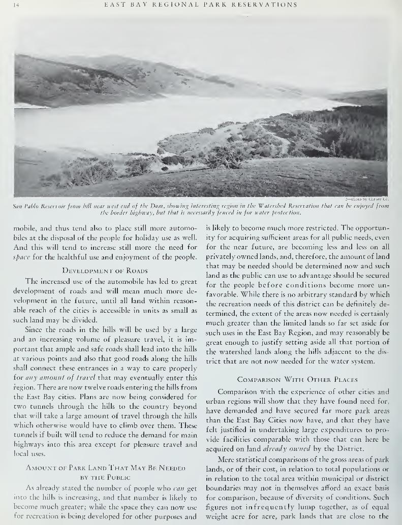
14 EAST BAY REGIONAL PARK RESERVATIONS
«l" *•
M&32—1'hoio by Cheiey Co.
San Pablo Reservoir from hill near west end of the Dam, showing interesting region in the Watershed Reservation that can be enjoyed fromthe border highway, but that is necessarily fenced in for water protection.
mobile, and thus tend also to place still more automo- is likely to become much more restricted. The opportun-
biles at the disposal of the people for holiday use as well, ity for acquiring sufficient areas for all public needs, even
And this will tend to increase still more the need for for the near future, are becoming less and less on all
space for the healthful use and enjoyment of the people, privately owned lands, and, therefore, the amount of land
„ „ that may be needed should be determined now and suchDevelopment of Roads , * \ . ,.
, 1111 1
land as the public can use to advantage should be securedThe increased use of the automobile has led to great r .1 1 1 r j- • 1° tor the people before conditions become more un-
development of roads and will mean much more de-favorable> While there is no arbitrary standard by which
velopment in the future, until all land within reason-the recreation needs of this distric t can be definitely de-
able reach of the cities is accessible in units as small as
such land may be divided.
Since the roads in the hills will be used by a large
and an increasing volume of pleasure travel, it is im-
termined, the extent of the areas now needed is certainly
much greater than the limited lands so far set aside for
such uses in the East Bay Region, and may reasonably be
great enough to justify setting aside all that portion ofportant that ample and safe roads shall lead into the hills
the watershed lands along the hills adjacent to the dis-
at various points and also that good roads along the hills
shall connect these entrances in a way to care properly
for any amount of travel that may eventually enter this
region. There are now twelve roads entering the hills from
the East Bay cities. Plans are now being considered for
two tunnels through the hills to the country beyond
that will take a large amount of travel through the hills
which otherwise would have to climb over them. These
tunnels if built will tend to reduce the demand for main
highways into this area except for pleasure travel and
local uses.
Amount of Park Land That May Be Neededby the Public
trict that are not now needed for the water system.
Comparison With Other Places
Comparison with the experience of other cities and
urban regions will show that they have found need for,
have demanded and have secured far more park areas
than the East Bay Cities now have, and that they have
felt justified in undertaking large expenditures to pro-
vide facilities comparable with those that can here be
acquired on land already owned by the District.
Mere statistical comparisons of the gross areas of park
lands, or of their cost, in relation to total populations or
in relation to the total area within municipal or district
As already stated the number of people who can get boundaries may not in themselves afford an exact basis
into the hills is increasing, and that number is likely to for comparison, because of diversity of conditions. Such
become much greater; while the space they can now use figures not infrequently lump together, as of equal
for recreation is being developed for other purposes and weight acre for acre, park lands that are close to the

EAST BAY REGIONAL PARK RESERVATIONS 15
homes of the people in districts of high land values along adopted plans on which they are now working, on a
with outlying reservations in regions of low land values scale which if applied to the Bay cities would call for
and accessible to most of the people only on holidays and the acquisition of park lands comparable in extent with
week ends. Similarly they lump together park lands that all the area that is likely to be available in the lands that
are intensively usable with park lands of such character could be turned over by the Water District for such uses.
that the number of people who can and do use them per Pittsburgh has recently added 3,* 00 acres to its park
acre per annum is relatively limited. Almost inevitably system, the National Capitol Park and Planning Com-they make no distinction between those park lands which mission is acquiring, with the aid of the states of Mary-render high values of any given kind to each visitor and land and Virginia, a 50-mile chain of parks at a cost of
those which render much lower values of the same kind, thirty-five million dollars, and Philadelphia is cooperat-
Valid conclusions from such comparative statistics, ing through the Tri-State Plan to add very materially
therefore usually depend upon a considerable degree of to the existing 6,489 acres of park within the city limits.
personal knowledge of actual local conditions. The fortu- a tvt r. r,
£ , . . Area Now in Public Parks and Reservationsnate existence of large contiguous areas of public ownedlands, easily accessible, and of high recreational value
A$ Previously stated onl^ about 900 acres or less than
in this district, in the face of the great inadequacy of°nC ^ CCnt °f the area °f the DlStrkt is nOW deVOted
existing parks makes almost any comparison accentuateC° park USCS
'^ mUch °f the *™ °f each °f the?everal
the need for taking advantage of the present oppor-Clties isn«w s"bdiV1ded extending far out onto the slopes
tunity. e ^s< Land values have gone up to such an extent
With this explanatory preface it may be illuminatingthat there '"^ ^ace f°r aC(luIrinS ™Y very large
to cite a few illustrative cases of park area statistics in fr"S exCep
J
m thfhllk The various IoCal areas that arc
support of the following general conclusions.heId aS parks and t0 SOme eXtent the public sch ° o1
T„ , • £ , ,, grounds and playfields, the University campus andIn various parts of the country regions comparable in j a'u i•• . ,
„„o „ „ i • , . ., f
' ° _ ,.*
,grounds, and to a still more limited extent the groundsarea and in population with the East Bay district have r «.l uv • „v .' j u j r i i_ j
ir„„\r A U~ t i j •ot otner Pubhc institutions, and the grounds of clubs andacquired large areas for park and recreation uses or have • „• j a j r r rsocieties do afford opportunity for some forms of outing
A Few Park Systems Which Are Very Suggestiveand recreation for the PeoPIe
'and mav be more extens -
for the East Bay District-"1Vely SO used for such PurPoses -
Tne lar§e areas of coun-
_. _ w ,. , ,
try clubs and golf clubs afford pleasing landscape scen-lhe Boston Metropolitan Park district 18,196 acres j n i • ,. .
Cook County 34,000 acreserv to manv
>and excellent outdoor exercise to a limited
(in addition to 5,912 within the city few, but are not and probably will not be open to the
act? by ?Mg0)'"*^ ^ 64 ' °°
Public at larSe and ma7 at anv time h* converted to
Westchester County, New York . 17,000 acresother private uses. The airports requiring large areas of
Union County, New Jersey 4,168 acres open lands are interesting features, but are and must be(A small county). , , , . , iii ,,.. r
Essex County, New Jersey (Newark) 4,600 acresdevoted to uses which preclude the general admission of
(A small county). public pleasure seekers.
Minneapolis ........ ..„__ 4,721 acres
Metropolitan Parks of Cleveland 10,000 acres QUESTION NOT A New OneDenver, Colorado 11,764 acres t -io^l r it> • •
i j i iiPhoenix, Arizona H,080 acres
In 1 866 beiore the Bay cities had spread over the low-
Fort Worth, Texas _ 9,000 acres lands, one of the first reports on possible need for parkEAST BAY CITIES 900 acres lands was that of Mr. Frederick Law Olmsted, Sr., on
*This information is furnished by the Bureau of Public Administration, Uni- ^1 J £ j\ t T • •*. £ /-> \'£ • 1 • i
versity of California. trie grounds tor the University of California, in which
Panorama of Lake Chabot from middle of west side looking north, east and south. Near left shows month of Grass Valley; middle distancethe groves, above steep banks of reservoir, proposed for picnic ground s; the distance at center right shows San Leandro Canyon and hills
recommended for a deer park. The face of the hills on the right is in the reservoir lands and should be so kept.

16 EAST BAY REGIONAL PARK RESERVATIONS
he urged the need for local park areas and for a pleasant
park roadway extending from the University southward
along the hills.
In 1906 Mr. Charles Mulford Robinson issued a re-
port on a plan for civic improvement of the city of Oak-
land, in which he urged the acquisition of some park and
parkway areas, and again in 1915 Dr. Werner Hegemann
in his report on a city plan for the municipalities of Oak-
land and Berkeley urged the need for acquiring portions
of the shore front and some parkways and park areas
within the city and extending out into the hills.
Because of the pressure of many other municipal
problems, such as the tremendous demand for highways
for the automobile, and the need for a greater water
system for the district, the chance for park develop-
ment under the various plans and recommendations that
have been made in the past has been small. Now that
the cities are becoming more completely built up, and
much progress has been made on the various other muni-
cipal problems it may be and should be possible to arouse
interest in the necessity for setting aside park areas for
enjoyment and healthful recreation, and to establish a
priceless heritage for the future; especially since the
opportunity appears to be very good for accomplishing
such a purpose at very small cost.
The Need a Vital One
The charm of the region as a place in which to live
will depend largely upon natural conditions that are
destined to disappear unless properly protected for the
public in general. The opportunities for enjoyment of
out-of-door life are necessarily doomed to be reduced
or destroyed with the increase in population, at the very
time that the need will be most urgent.
With the growth of a great metropolis here, the
absence of parks will make living condition less and less
attractive, less and less wholesome. In so far, therefore,
as the people fail to show the understanding, courage,
and organizing ability necessary to grasp the present
opportunity, the growth of the region will necessarily
tend to choke itself.
View of upper end of San Leandro Canyon, taken from new county highway.4—Photo by Hall

CHAPTER II
Utility District Lands Which Could be
Used for Public EnjoymentConcurrent with the earlier development of the
East Bay Cities (Oakland, Berkeley, Alameda,
Piedmont, San Leandro, Richmond, El Cerrito,
Albany, and Emeryville) several locally owned water
systems were gradually consolidated over a period of
years until finally but two large companies remained.
These were the Contra Costa Water Company and the
East Bay Water Company. Then followed a period of
intensive competition, not only in the sale and distribu-
tion of water, but also in the acquisition of lands in the
"hinterland" of these nine cities:—lands which would
some day be needed for catchment basins. The comp-anies bought what they needed to round out their ownholdings, but also bought up various parcels of land
which might embarrass the competing company in its
attempt to do likewise.
I—1'hoto by Oibbs
Looking north down Wildcat Canyon from hill near Spruce StreetReservoir; private MacDougall Tract on east side of Canyon in near
right of picture.
The struggle between the two competing companieswas terminated by consolidation and they were con-
tinued as the "East Bay Water Company." This companyoperated for some years carrying a large investment in
idle lands, some of which might eventually serve as catch-
ment basins but others of which were superfluous to the
business of gathering or impounding water.
Later the Mokelumne River Project was proposedas the only adequate permanent solution of the waterproblem for the East Bay cities. The East Bay MunicipalUtility District, comprising the nine cities was then
formed, to bring water from the Sierras and in 1928the important question of whether the District should
purchase the distributing system of the East Bay Water
Company or install a parallel competing system was
settled, when the District commissioners proposed to
purchase the distributing system and the lands necessary
for storage reservoirs. The company, however, insisted
on disposing of all of their lands rather than to hold the
surplus lands severed from the strictly water properties.
At that time they owned about 40,000 acres, more than
half of which would be surplus lands. After much nego-
tiation a final price was agreed upon and all the assets
of the East Bay Water Company were acquired by the
East Bay Municipal Utility District, and the title to
those lands now rests in the people.
In order to determine what disposition should be
made of the extensive holdings in surplus lands, the engi-
neers of the District outlined areas to be reserved for
storage reservoirs, then tentatively divided the remainder
into park lands, subdivision lands, and agricultural lands.
The land classification proposed by them is approxi-
mately that shown on the accompanying map.
Basis for Selection of Lands
To determine what parts of the Utility District lands
are well adapted for park and recreation uses and for
what particular purposes such lands are well adapted it
is necessary first to consider what uses the public could
make and probably will make of such lands if they have
an opportunity. People will come from all parts of the
6—Photo by Gibbs
View northwest from Berkeley Ridge near Westminister Road, acrossWildcat Canyon. Most of the grassy hillside shown is in the Mac-
Dougall tract.

EAST BAY REGIONAL PARK RESERVATIONS
district, mainly on holidays and Sundays when they can
devote several hours at a time to recreation.
The area will be widely used for picnics, outings,
hiking, horseback riding, and field sports, both by fam-
ilies and by organized groups such as the Boy Scouts,
Campfire Girls, hiking clubs, the Girl Scouts, etc. There
are many ideal camping sites where provision can be
made for rustic shelters, fireplaces, and other conven-
iences.
For such uses much of the land of the utility district
is admirably adapted. Much of it is ideal in fact for real
metropolitan park uses, or country park uses of a region-
al character, where continuity, extent, geographical
unity, varied scenery, and freedom from outside activ-
ities are important factors in the value of the park. For
such purposes the land is needed, as distinct from local
or neighborhood parks and playgrounds which also should
be accessible to the people, in smaller units throughout
the residential areas.
7—Photo by Gibbs
View from Skyline Ridge west of Ron mlfop looking north and east,
Roitndfop at right. Proposed Roundtop connection would in general
follow ridge in right distance.
Watershed and Reservoir Lands
The large areas that will be reserved for watershed
and reservoir protection, lying adjacent to possible park
reservations will add greatly to the value of the latter
since they can be brought into the landscape scenery,
and will serve to keep disturbing activities at a distance
from the parks. Those areas by careful selection of
boundary lines and location of ridge roads will add muchto the scenic value of the parks even though they should
be and will be fenced in against public use. Such areas
also offer the great advantage of making it possible to
have very long and attractive trails and roads almost
wholly free from the dangers and disturbances of cross
roads and intersections.
The Front Lands
That part of the District lands lying nearest the
cities, including the hilltops and the adjacent canyons
and other scenic units, will be more accessible and of
greater value for park uses than the more remote and
less scenic areas farther back in the hills that are now
8—Photo by Gibbs
Subdivided slopes below Skyline Boulevard just south of ShepardsCanyon looking west.
being sold off as pasture or agricultural lands. Continu-
ous areas of considerable extent will have greater value
for park purposes than isolated units, for a great numberof those who visit such parks will travel by automobile,
prepared to stay for several hours and will not be satis-
fied either to remain within the limits of one small park
area or to dodge from one to another through interven-
ing suburban developments. They must have easy access
and ample parking space, and many of them will not
walk far from their machines, but without doing so will
desire to enjoy themselves in apparently spacious park
areas. The length of roadways continuously within park
areas will largely determine the numbers that can be
accommodated. Continuity is a very important factor,
for crowds will flow in at the entrances and will becomecongested unless they can "roll on" amid pleasant sur-
roundings till they find room and inducement to park.
Those who will want to attend gatherings, or play in
large numbers in restricted areas will need large parking
areas adjacent to playfields. For them too, continuously
agreeable routes of access and egress are much to be
desired.
Possible Uses
The lands in question offer a great variety of condi-
tions in which various kinds of activities or inactivities
can be provided for. In fact in the length of the hill
region of over twenty miles there are now in public
ownership areas in which almost every form of healthful,
v*w
10—Photo bv Gibbs
View south along proposed extension of Skyline Parkway throng/)property privately owned where a road has already been located and
partly constructed.

EAST BAY REGIONAL PARK RESERVATIONS 19
pleasurable, and educational inland interest can be de-
veloped for the people, (except those facilities that call
for neighborhood parks and playgrounds wihin walkingdistance of the houses of the people, and except those
activities that relate to beaches and large bodies of
water). And such interest can be developed in most cases
In Chapter IV some of the special uses that may bemade of each of the several units of the proposed systemare set forth more in detail.
Organizations Interested
As a further measure of the kinds of uses that suchr ^„ „ ^^ww n.vaoui^ ui nit ivinus ui uses mac sucnin areas or spaces large enough to be fairly commensurate lands may be fitted to serve, a number of organizationswith the size and character of the East gay District. clubs, and societies, have been called upon for expressions
s:mmRedwood forest in upper Redwood Canyon on private lands. Taken from road along ridge south of Ronndtop. Existing trail onYaTlilndro
Ridge is just to right of picture, along which proposed San Leandro Ridge Parkway should be located.
The Plan
In order to determine to some extent at least whatthese possibilities may be we have prepared a plan (No.9 follows page No. 40) showing the nine cities with the
bay on the west side, and with proposed park reserva-
tions, the watershed and reservoir lands, and the nearbysurplus lands of the Water District along almost the
entire easterly portion of the map. On this plan we haveshown also the existing public parks, country clubs, andother areas of somewhat general use, and also certain
areas in private ownership that will be needed to com-plete the boundaries of park reservations and parkways.
We have shown existing main highways, especially
those that may have some particular relation to the pro-
posed park system; also, some other less important roads
and trails, and certain proposed roads and trails that seemimportant in any plan to serve the proposed reservations.
of opinion. The areas in question may afford opportunityfor activities of various organizations interested in scout-ing, hiking, nature study, picnicking, and other outdooractivities. The chances for outings and large gatherings
for religious or fraternal organizations, service clubs,
schools, official organizations and others, are ample, and,
of still greater importance, the opportunity for smaller
family outings and gatherings of neighbors are almostunlimited.
Purposes to be Served
The areas chosen for public park use should be great
enough to serve both the primary purposes for whichthey are chosen, that of "the enjoyment of scenery" andoutdoor life, and also the necessary secondary purposes,that of the "service uses" which are contingent on the
presence of persons attracted to the region.
(Confinned on page 22)
12—Photo by Gibbs
Upper Redwood Canyon from just west of Redwood Peak lookingnorth across private lands not on proposed reservations. Showing Sanlablo Ridge at right along which Redwood Highway is proposed.
11—Photo. by Gibb^
Lower Wildcat Canyon from the Berkeley Country Club. San PabloRidge in the distance and Harvey Canyon with its patches of trees
at the right.

Panorama looking south, west and north from Roundtop, showing Skyline Boulevard in left center foreground; tunnel it
Some of the Many PThe Bureau of Public Administration directs the
readers' attention to the panoramas presented on this
center page and the airplane views by Waters and Hain-
lin on page 24, received subsequent to the completion
of the main report. These pictures give some indication
of the magnificent scale on which nature has provided
an ideally located playground immediately adjoining the
site of the nine cities comprising the East Bay Municipal
Utility District. For over twenty miles this chain of hills
borders the metropolitan area, and from its heights can
be viewed the most beautiful combination of mountain
and marine scenery which America affords. The broad
expanse of San Francisco Bay, the purple mountains of
Marin and out beyond the Golden Gate the sea, stretch
in vast panorama to the west, while toward the east the
towering bulk of Mt. Diablo rises from the ever changing
Panorama looking northeast, cast and southeast from Roundtop; Lafayette Reservoir in cei
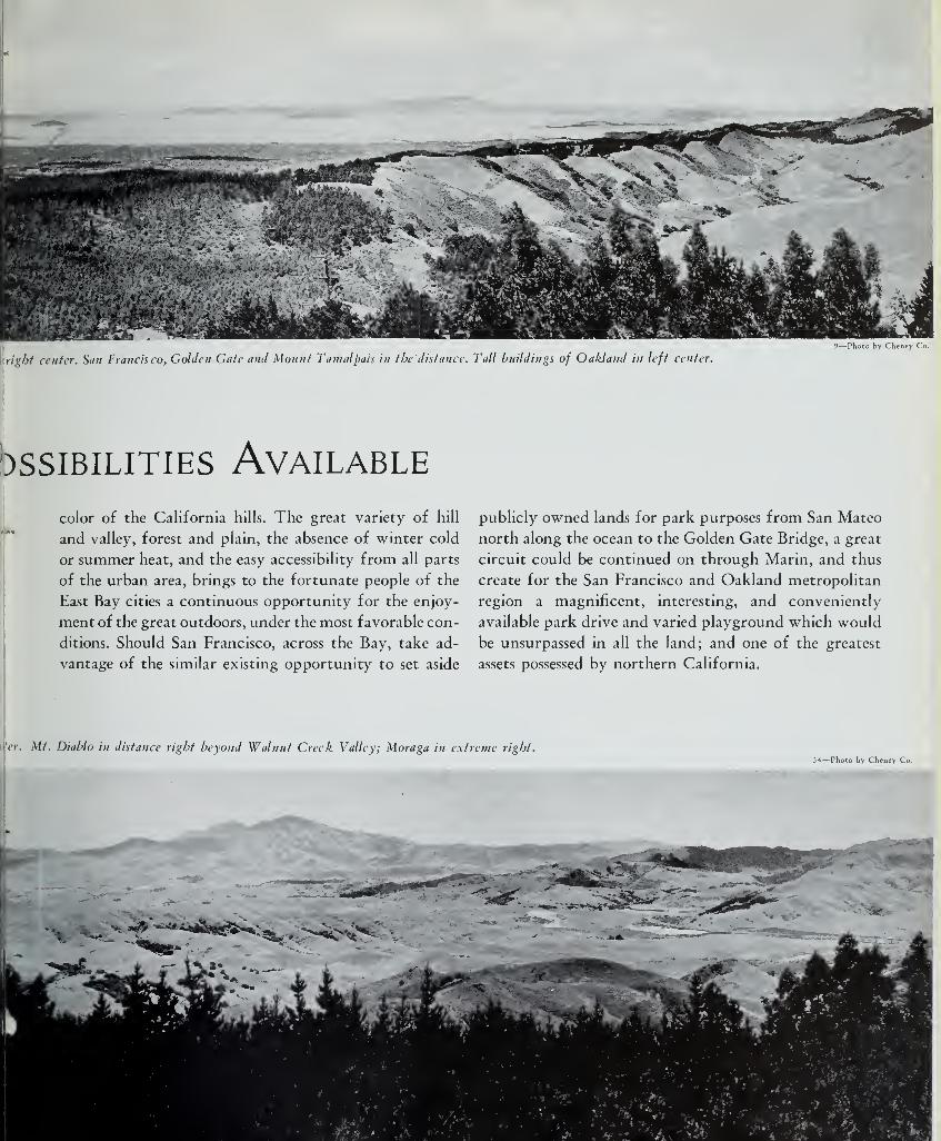
.
right center. San Francisco, Golden Gate and Mount Tamalpais in the'distance. Tali buildings of Oakland in left center
)ssibilities Available
9—Photo by Cheney Co.
color of the California hills. The great variety of hill
and valley, forest and plain, the absence of winter cold
or summer heat, and the easy accessibility from all parts
of the urban area, brings to the fortunate people of the
East Bay cities a continuous opportunity for the enjoy-
ment of the great outdoors, under the most favorable con-
ditions. Should San Francisco, across the Bay, take ad-
vantage of the similar existing opportunity to set aside
publicly owned lands for park purposes from San Mateo
north along the ocean to the Golden Gate Bridge, a great
circuit could be continued on through Marin, and thus
create for the San Francisco and Oakland metropolitan
region a magnificent, interesting, and conveniently
available park drive and varied playground which would
be unsurpassed in all the land; and one of the greatest
assets possessed by northern California.
'cr. Mt. Diablo in distance right beyond Walnut Creek Valley; Moraga in extreme right.54—Photo by Cheney Co.
v•.. ^'^^^Ai^^^s^H,
m ^r 5C- ?•'•:,
Hmmm
f. D .

22 EAST BAY REGIONAL PARK RESERVATIONS
The "service uses," some of which will be furnished
without charge, include such activities as the supplying
of water, lodgings, sanitary facilities, fireplaces, camping
places, seats, benches, tables, gasoline and food supplies to
people attracted to the region primarily for other reasons.
The problem of providing for these service uses gives
rise to problems of administration in their relation on the
one hand to the primary purposes for which the park
lands are acquired, and on the other hand to the second-
ary matter of costs, charges, revenues, financing, selec-
tion of operating agencies. Aside from the question of
finances and administration, the need for meeting these
secondary and service uses involves the inclusion of very
considerable areas for them, chosen in a way to leave
other and more important areas undisturbed for the
main fundamental objectives that constitute the prime
justification for public parks.
Determination of Boundaries
In 1893 in report to the Boston Metropolitan Park
Commission, Charles Eliot wrote the following prin-
ciples which should determine the boundaries for large
reservations:
"First. The boundaries of the proposed reservations should,
if possible, be established so as to include all lands belonging
to the same topographical unit, and exhibiting the type of
scenery characteristic of each reservation. Obviously, a public
domain is not well bounded if it includes only half a hill, half
a pond, or half a glen. Neither is it well bounded unless it
includes such contiguous lands as form the essential framework
of the hill scenery, the pond scenery, the glen scenery, or
whatever other type of scenery it is desired to preserve . . .
To city men it is most refreshing to find themselves in whatappears to be a wilderness of indefinite extent. This impres-
sion cannot be enjoyed unless the boundary of a valley reser-
vation is established beyond the summits of the enclosing hills.
"Second. The boundaries of the proposed reservations should
be, if possible, established upon public streets or roads, or onlines drawn where roads may ultimately be built with good
grades.
"The reasons for this principle are many. It is obvious that
the back fences of private lands cannot make a handsomeboundary for a public domain of any description. It is obvious
that private lands abutting directly upon public lands will
be much more liable to trespass than they would be if a public
roadway separated the two. Private land in the position
described is a nuisance to the public, while the public is likely
to be a nuisance to its owner. Speaking generally, the policing
and the general administration of a public reservation are
greatly facilitated when the boundary is a road. Still more
important is the consideration that, if the private lands which
adjoin the reservation are provided with a road frontage look-
ing on the public domain, they will eventually be greatly
increased in attractiveness and value."
The boundaries of areas recommended for Park Res-
ervations in the East Bay Region have been determined
as far as feasible on similar principles. The areas available
now in public ownership are to a great extent already
in "natural" units.
Areas and Route Lengths
Out of the 40,000 acres in the district now publicly
owned we find that about ten or eleven thousand acres
as surplus lands can be used to create an adequate park
system nearly 22 miles in length, easily accessible to serve
the nine cities of the district.
14—Photo b\ Gibbs
View from near Spruce Street Reservoir looking north, showing cut over lands, with few Eucalyptus and Coyote Brush. Bare hills showing
on westerly slope of San Pablo Ridge are on opposite side of Wildcat Canyon.

EAST BAY REGIONAL PARK RESERVATIONS 23
1S—Photo by Cheney Co.
ip Wildcat Canyon from old road junction just below Spruce Street Reservoir, showing varied and interesting forest and meadowscenery that can be preserved and enhanced under suitable plan for forest control.
Rectification of Boundaries
In addition to the large areas desirable for park pur-
poses which are now publicly owned there are a few areas
in private ownership that should, if possible, be acquired
to rectify boundary lines. Such areas as the MacDougall
Tract in the heart of Wildcat Canyon and the Havens
Tract in the middle of Grass Valley might be acquired
by exchange for other properties lying on the outer
edges of the public lands in a way to offer to the public,
areas better suited for their purposes, and to the owners,
areas that can more readily be developed for their pur-
poses also.
Value of Lands
The value of such lands for recreational uses is greatly
augmented because of the existence of large units of
complete and self-contained scenic and recreational
value. It is great also because of the extensive continuity
of these units with nearly twenty miles of existing roads
and many miles of hikers' trails and bridle trails almost
wholly within the areas in question.
The total area recommended for such uses whencompared to the areas similarly used in other and older
communities seems entirely reasonable, and in some in-
stances other cities that may have neglected such an
opportunity as now confronts the East Bay District, are
now actually making enormous expenditures to provide
similar areas for their people.
Other Opportunities for Recreation
The needs of the East Bay District for such recrea-
tional opportunities as can be found on the hill lands
are not now at all adequately provided for elsewhere,
either within the district or within a reasonable distance
outside.
There are no other lands either in public or in priv-
ate ownership on which such functions could be provided
for, in a manner more advantageous to the public than is
possible on the district lands, or at all in fact except at
prohibitive cost.
Conclusion
We believe, therefore, that practically all of the front
lands owned by the District and not now required for
reservoir purposes should be dedicated to park purposes,
and should be held as park reservations, forest reserves,
wilderness areas, or open parklike pasture land, to be
developed for more intensive use by the public along
certain highways and in certain areas as fast as the de-
mands of the people may warrant.

24 EAST BAY REGIONAL PARK RESERVATIONS
Aerial Views
Northern portion of proposed metropolitan park as seen from Oakland.Photo by Waters and Hainli
Central portion of proposed metropolitan park as seen from San Fran cisco Bay.
Photo by Waters and Hainlii
Southern middle portion of proposed metropolitan park as seen from Alameda Airport.
VPhoto by Waters and Ha

CHAPTER III
The Financial and Administrative
Questions InvolvedPresent Values, Possible Revenues, Possible Costs for Development and Maintenance, Care and Control Needed
to Produce Greatest Benefits to the Public Through Limited Expenditures
INthe other Chapters we have explained why these
lands now publicly owned are very valuable for
park uses. We have shown that other comparable
communities, in order to secure such values, have felt
justified in acquiring park lands of similar character and
extent by purchase or by condemnation from private
owners notwithstanding the large cost to them of such
operations.
The lands now publicly owned, if sold, would neces-
sarily bring prices far below any possible replacement
value, because it is a well known fact that when any
organization and especially a municipal corporation or
governmental agency undertakes to unload large areas
of property in any one region by sale, the prices received
tend to be decidedly low for the time and place, while
on the other hand when such an organization attempts
to acquire large areas from their various private owners,
for any purpose, the prices paid tend to be decidedly
high for the time and place. Such sales are necessarily
made in a "buyers' market" while the purchases are made
in a "sellers' market".
Such a difference between possible present salable
value and possible replacement value of the lands nowowned by the East Bay cities, not needed for other public
purposes, but that are or will be needed for park pur-
poses, would mean, if the lands were to be sold, a real
and serious economic loss to the East Bay cities.
Not only would the economic loss be serious, but
if such lands were to be sold, there would be a serious
and irreplaceable loss to the community, not measure-
able in dollars, in the breaking up of the present large
and attractive areas; for it is unlikely that similar areas
could be assembled again by purchase, at any cost what-
ever, at a time when the need for such reservations shall
have become so urgent as to force an attempt to buythem.
While the value of the lands in question might be
estimated in dollars on the basis of possible residential
uses, the large amount of acreage probably precludes the
16—Photo by Bransted
Small lake in Wildcat Canyon at the abandoned Diversion Dam,which can now be used as a park feature.
possibility of early disposal. Their possible value to the
public for park purposes cannot be accurately estimated
because no cash value can be set upon matters of health,
pleasure and recreation. And yet such values to the public
are doubtless far greater in reality than any cash value
that might be obtained through sales in the present
market or in any future market, and are more nearly
comparable to the higher value of lands that would be
paid for acquisition of similar areas if these were not
available.
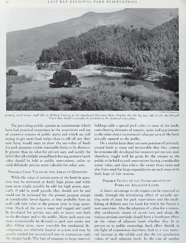
26 EAST BAY REGIONAL PARK RESERVATIONS
17—Photo by Cheney Co.
Looking north across small lake in Wildcat Canyon at the abandoned Diversion Dam, showing also the big bare hills in the MacDougallTract that should eventually be included in the proposed reservation.
The prevailing public opinion in communities which holdings adds a special park value to some of the lands,
have had practical experience in the acquisition and use contributing elements of scenery, quiet and spaciousness
of extensive systems of public parks and which are still to the other direct recreational value per acre of the lands
trying to get more land rather than to sell off any they actually opened to the public.
now have, would seem to show the use-value of lands On a similar basis there are some portions of privately
for park purposes within reasonable limits to be distinct- owned lands so steep and intractable that they cannot
ly greater than its value for private uses, and justify the be economically developed for intensive private use, and,
belief that all publicly owned lands having potential park therefore, might well be given by the owners to the
value should be held as public reservations, unless or public to be held as park reservations having considerable
scenic value, and thus relieve the owner from taxes and
also from need for large expenditures on such areas with
little hope of fair returns.
Possible Effect of the Establishment of
Parks on Adjacent Lands
A direct advantage to the region can be expected to
until definitely proven more valuable for other uses.
Possible Cash Value of the Areas in Question
While the value of certain parts of the lands in ques-
tion may be estimated at fairly high prices and while
some areas might possibly be sold for high prices, espe-
cially if sold in small parcels, they should not be and
could not be reckoned for the present purpose except result, through the stimulating effect of actually set-
at considerably lower figures, as they probably have no ting aside of areas for park reservations and the estab-
such cash sales value at the present time in large quan- lishing of definite uses for lands for which the future is
tities. Much of the area is steep and rugged and could now uncertain. Also the adoption of a plan for a reason-
be developed for private uses only at heavy cost both ably satisfactory means of access into and along the
to the developer and to the public. Many such areas can various sections certainly should have a beneficent effect
more economically be devoted to park uses under any on the values of adjacent lands whether they be in
plan. Other areas, more tractable for residential de- private or in public ownership. Such effect should, in
velopment, are relatively limited in extent and may be the light of experiences elsewhere, lead to a very mate-
greatly needed for recreational uses in connection with rial increase in the salable and also the tax producing
the steeper lands. The fact of nearness to large reservoir values of such adjacent lands. In the case of surplus

EAST BAY REGIONAL PARK RESERVATIONS 17
public lands for sale this would mean the possibility of
larger returns from sale of such lands by the Utility
District.
Possible Private Dedications
In addition to the need for reservation for park uses
of lands now publicly owned and the need for some
minor rectification of boundaries, it is very desirable
also to bring about the dedication to public use of certain
strips of privately owned land along existing or proposed
highways to afford space for the development of park-
way connections to or between the larger reservations.
Such strips might possibly be given by present owners
if they can be brought to realize the greater value to their
remaining lands that will accrue from the opening of
such parkways, and also the greater possibility of getting
extensive public developments under way if the land is
thus made available. Similar conditions in other cities
have in some instances resulted in ready and generous
response by progressive owners of property.
Care and Control of the Public Lands
Rarely if ever have other communities had the un-
usual situation that now confronts the East Bay District,
of owning the title to such lands as can here be set aside
for park purposes. It has been almost invariably true
in other districts that lands needed for park and recrea-
tion purposes have passed into private ownership in wholeor in part long before the need for them for park uses
has been fully realized. The East Bay Cities are unusually
fortunate in having such extensive and such desirable
areas held intact and now available, so that a complete
project can be developed without the need for acquir-
ing much, if any, additional areas. Furthermore such a
system can be developed within the present organiza-
tion which is already administering the area for the
people, and without additional capital investment.
For the administration of these park reservations the
two following possible methods suggest themselves:
1. A new district could be organized to take over
the park lands and to develop and administer them. Such
a plan, however, would probably require special state
legislation as we understand that there is now no ade-
quate law under which such a district could be organ-
ized, and such a plan would, therefore, also involve delays
and changes that might in the end prevent the retaining
by the public of the present desirable and available areas,
and might, therefore, defeat its own purpose.
2. On the other hand it would be possible for the East
Bay Municipal Utility District to be given authority and
jurisdiction to make these areas available for public park
or reservation uses. Such a plan offers several advantages:
(a) The title to the land is already in the Utility
District.
(b) The lands have been held in the past to protect
water bearing lands and water sheds, and large areas
must still be so held by the District adjacent to and co-
extensive with the lands in question.
(c) The lands in question could still be controlle.1
in so far as necessary in a way to protect the water system.
(d) If the law under which the District now oper-
ates is not considered adequate to permit the develop-
ment of certain areas for park or reservation uses, the
act under which it operates could be enlarged and
amplified.
(e) The present act could be and should be amend-ed to give the District authority to levy a small tax for
the purpose of protecting, and maintaining the property
for park purposes, as distinct from any expenditures for
the water project, and in order to prevent the parks frombeing in any way a burden upon the water project.
(f) Administration under the present District will
obviate the necessity of creating another board or com-mission.
There will be need for employees devoted to andtrained for the various sorts of park work, and directed
by a superintendent or park executive who can be held
responsible for the management of the park undertak-
ing as a whole, without dividing his interest and energies
between that work and other activities. Some plan can
7 , xvr-lJ /•-.18—Photo by Gibbs
Upper Wildcat Canyon looking south across the valley, showing Little Grizzly in the center; Grizzly Peak far to the left.

28 EAST BAY REGIONAL PARK RESERVATIONS
19—Photo by Waters and Hainiin
Looking up Strawberry Canyon from the campus of the University of California, showing Skyline Ridge extending across the picture. Mt.
Diablo in left distance and St. Mary's College upper right.
doubtless be worked out by the Utility Board in such
a way that the various park problems will not be allowed
to interfere with the weightier problems with which they
are necessarily engrossed.
Administration
General Principles of Administration: We recom-
mend that the greater part of the proposed park be re-
tained in its present attractive "natural" condition. Bycarefully planning the management of its forests and
open grasslands, the area can year by year be made more
attractive for park purposes at a comparatively low cost,
providing the vegetation native to the region is protected
or reestablished where necessary. Many smaller areas will,
of course, be intensively used for field sports, picnic
grounds, camping and other purposes, and these will have
to be intensively developed as public demand warrants.
It is important that the general principles of admin-
istration be carefully codified by the governing body as
soon as the park is dedicated. Secondly, a general plan
of land use should be evolved so that the permanent de-
velopment of each portion of the area will fit in with a
broad plan which is directed toward the goal of most
effective service to all the people of the district.
Gradual Development: It is not necessary nor advis-
able to immediately begin intensive development of the
entire area. A large part of the proposed park is already
accessible by both roads and trails. These could be im-
proved over a period of years without large capital ex-
penditures. Certain limited areas are particularly well
fitted for use as picnic grounds, playfields and centers
of various field sports, and these should first be improved
under the limited budget proposed below. We believe
it to be an exceedingly important principle that the
development of the park should not be pushed ahead
of current needs but that it should keep pace with the
actual requirements of the people.
Certain parts of the proposed reservations can readily
be made accessible to the public at once, and such areas
will require proper guarding, fire protection, and super-
vision and also will need certain utilities and "services,"
some of which must logically be rendered at public ex-

EAST BAY REGIONAL PARK RESERVATIONS 29
pense and some of which may reasonably become a source trolled operating contractors or lessees as may be most
of revenue. For this purpose the governing body should practicable and expedient in any given case,
have authority to obtain and expend funds for such de-r1 TRK I ROTFCTIOTV
velopment and operation as may be necessary to makei i j • r -1 uu „ J f«, n^f^ f,'n„ t-L One of the details of administration which is of para-the lands progressively available, and tor protecting the r
property, to receive and administer gifts and bequestsmount importance, not only to the park but also to the
for the benefit of the parks, to employ an executiveadjoining cities, is that of fire protection. The long dry
officer and proper subordinates, to obtain expert adviceseason makes Jt operative that every precaution be exer-
and to let proper contracts. It will necessarily be con-cised to Prevent fires and to immediately suppress any
fronted with problems of construction of roads, trails,which do start
'A fine beginning has already been made
convenience stations, fences, shelter buildings, tables,b7 the East Ba^ Municipal Utility District in coopera-
fireplaces, and many similar utilities, and will be calledtlon Wlth the State Board of Forestry and Wlth certain
upon to protect properties and plantations, and to affordEast B^ Clties and organizations in the region. If the
proper police protection and fire protection. It shouldarea 1S °Pened to Park use
>however, more intensive con-
be able to do some improvement planting in places and tro1 Wl11 be necessaiT- Properly located roads and trails
clearing in others. But its primary function will be toWlthin the Park Wl11 great1^ facilitate such protection,
establish and enforce policies which will control the char-Not^ Wl11 fire Protection insure the maintenance of
acter of the areas as they are gradually developed and *>* beautiful area in its attractive natural state but it
i will also present an additional measure of safety to
Among other powers it should have authority tonearb^ cities
'as there is alwa^s dan§er of fire sweeping
let contracts for the rendering of appropriate "servicemto settled distncts from ^jacent grass or forest lands,
uses" and alternatively to render such services through Possible Maintenance Costsits own employees and to collect reasonable charges A .,
, , . , , ... ,
, , „, •i 1 n 1 i i i i
As a possible basis for determining the amount oftherefor. 1 he governing body will doubtless be urged , , , , „ . , -
., „ r ,, , money that may be needed annually in the near futureto grant concessions tor golf courses, camp centers and £ . . . , , . , ,
, . ,. , ,. , ... , . , , , ,. ,tor maintaining the proposed reservations and park areas,
tor establishments which will turmsh tood supplies and , £ , . . , , , .
, . . . . T n i• • and ior sucn minor developments as may be made from
other necessities to visitors. It will become important in, ,
.' , . . ..
, r i i 1 -i -ii-i time to time by the maintenance forces, the followingthe use ot parks that such services be provided with r
., . T n i• hgures may serve:
reasonable adequacy. It will be even more important
that the extent to which they are provided and the L Board of Control, minor expenses ._._ $ 2,000
1 . 1 1 -1111111 2. Secretary, stenographer, clerk, supplies, etc. . 10,000manner in which they are provided should be deter-
3 Superintendent, and
mined by the directors and for the definite purpose of 6 foremen
making the parks as such enjoyable to the people,
—
nota orers
for the purpose of exploiting the park users to make 2 trucks 64,000
profits either on the initiative of concessionaires seeking 4 - Rangers and fire wardens 12,0001 rv 1 • • • . r
15. Roads, buildings, fences, water, electricity,
those pronts or on the initiative ot impecunious parkplanting 40 000
authorities urgently in need of revenue. Provided that
this principle is kept firmly in mind, it is entirely right $128,000
and expedient that, for such special services, not neces- To meet such expenses an annual tax of three cents
sarily used by all visitors to the park and involving con- on $100.00 on the $440,000,000 assessed valuation of the
siderable special costs, special charges should be made, District would produce $132,000, enough to cover the
up to any amounts not in excess of their value to the budget above suggested. This would permit gradual de-
people who use them, so as to make those special services velopment of the park without bond issues or other
partly or wholly self-supporting or even contributory capital outlay. The District is now compelled to spend
in some measure to the general park revenues. The Board, considerable money for the protection and administra-
therefore, should have power, under proper limitations, tion of these lands, which under the park plan will be
to make such services available at proper charges, either charged to the park budget and the cost against water
as wholly public undertakings or through properly con- correspondingly reduced.
CHAPTER IV
Plans and Recommendations
The advisability of setting aside for park use an
area of surplus Utility District land extending
along the hills in a strip 22 miles long from Rich-
mond to San Leandro has been recommended in previ-
ous chapters. The detailed description of the individual
parcels of land and discussion of their interrelation and
their suitability for park use have been reserved for the
present chapter. In order to facilitate the identification
of the smaller tracts they have been given numbers on
the map to correspond with numbers in the text. Careful
reference to the map in connection with the reading of
this chapter is essential.
The property in question naturally divides itself into
several distinct units, and for convenience in discussion
we have numbered them from north to south along the
entire system as follows:
TWENTY-EIGHT AREAS CONSIDERED IN RELATION TO THE PROPOSED PARK RESERVATION SYSTEM
Plan
Reference
Numbers
District Lands NeededThirteen Parcels of
Four AdjacentWater Reservoir Areas
Th,
Publ
ee Adjacent
c Park Areas
Eight Privately OwnedStrips or Areas Needed
1. Alvarado Park
City of Richmond
2. Mouth of Wildcat Canyon
3. Wildcat CanyonReservoir Land
4. Lower Wildcat and
Harvey Canyons
5. McDougall Tract
6. Middle Wildcat Canyonand Brissac Field
7. Upper Wildcat Canyon and
Grizzly and Bald Peaks
8. Bald Peak
Saddle and Picnic Hill
9. San Pablo
Reservoir Land
10. Bryant Roadside and Ridge
11. Siesta Valley
12. Skyline Parkway,
Bald Peak to Roundtop
13. Roundtop Hill and Ridges
14. Fish Ranch
15. Roundtop Ridge connection
16. Skyline Parkway,
Roundtop to Sequoia Park
17. Sequc
City
ia Park
of Oakland
18. Skyline Parkway,
Sequoia Park to Grass Valley
19. San Leandro Ridge connection
20. Upper Redwood Canyon
21. Upper Grass Valley
22. Havens Tract
23. Lower Grass Valley
24. Chabot Hill, Picnic
Grove and Deer Park
25. Lake ChabotReservoir Land
26. Oakland Municipal
Golf Course
27- Chabot LakeRoadside and Playfield
28. San Leandro
Reservoir Land

EAST BAY REGIONAL PARK RESERVATIONS 31
View from20—Photo by Gibbs
pinnacle in the upper end of Siesta Valley, showing new Sk yline Road on the left, passing through the tree covered saddle just to
the left of Bald Peak.
In the above list there are three (3) existing public
park recreation areas adjacent to or near to the district
lands; four parcels in water reservations; eight parcels
or strips of privately owned areas, needed to complete
the system, and thirteen parcels of district lands recom-
mended to be reserved for recreation. In addition, a few
parcels are shown which are now owned by the District
but not included in their plans for water land reserva-
tions and which have relatively little value as a part of
the proposed system and are therefore not included in
the recommendations for park reservations, but are
recommended for sale for other purposes.
Existing Public Park Areas
The three existing public park or recreation areas,
Alameda Park, Sequoia Park and Oakland Municipal
Golf Course (numbered respectively 1, 17 and 26) add
interest to this proposed system and will benefit mate-rially by being adjacent to and connected with the pro-
posed reservations and it is possible that eventually somesatisfactory plans of consolidated or cooperative control
of the two classes of property may prove feasible and
economically desirable for the best interests of the pub-lic. Those three areas have started to attract interest to
the hills and they lie at the gateways to larger areas be-
yond, so they will naturally tend to overflow into the
larger areas when larger areas are made available.
Water Reservation Areas
The four parcels now in water reservations at LowerWildcat Canyon, San Pablo Reservoir, Lake Chabot andSan Leandro Reservoir (numbered respectively 3, 9, 2 5
and 28) are necessarily closed to the public althoughthey may be enjoyed as seen from the highways andnearby lands, for they have great scenic value. Thereservoirs will probably be kept full a part of the timethough they will doubtless be drawn down eight or ten
feet, at other times. The pleasant type of woodland or
partly or full open pastoral scenery can be and likely
will be preserved, and, under a plan for clearing or plant-
ing where needed and for continued grazing of the open
areas, can be made even more attractive in the future.
The boundaries of those areas where adjacent to the pro-
posed park reservations should be so chosen that border
roads will command fine views over the water lands and
thus afford to the public the benefit that results fromthe existence of the water lands, wherever that can be
done without in any way jeopardizing the purity of the
water. Where such boundaries follow existing or pro-
posed roads the fence on the water land side should, if
possible, be kept back far enough from the road so that
it will not be conspicuous and also so as to leave space
for roadside picnics, for border plantations, and for
occasional "overlook" points.
No. 3. Wildcat Canyon Reservoir Lands.
The proposed reservoir in lower Wildcat Canyonmay have a dam nearly one hundred (100) feet high at
the lower end across which a road is suggested. The reser-
vation itself will be a relatively small one that will be
almost entirely surrounded by park reservations.
No. 9. San Pablo Reservoir Land.
The San Pablo Reservoir, four and one-half (4 l/2 )
miles long, containing eight hundred and sixty (860)
acres of water surface, is a large and imposing lake in a
large reservation, as shown in illustration No. 2.
No. 25. Lake Chabot Reservoir Land.
Lake Chabot is a beautiful lake created as a reservoir.
It is closely surrounded by hills and wooded areas as
shown in illustration No. 3.
No. 28. San Leandro Reservoir Land.
San Leandro Reservoir occupies a long narrow can-
yon bottom, is very picturesque and attractive as seen
from the roads or the hills above, such as that shown in
illustration No. 4.
Private Lands Needed
The eight parcels or strips of privately owned areas
needed to complete the system contain three acreage
parcels (numbered 2, 5 and 22) and five proposed park-

32 EAST BAY REGIONAL PARK RESERVATIONS
way connections (numbered 12, 15, 16, 18 and 19),
which are discussed below under their respective
numbers.
No. 2. Mouth of Wildcat Canyon.
The lands lying below the levels of possible side roads
from Alvarado Park to the two ends of the proposed
dam should be publicly owned as a bit of park land to
add interest to the roads leading into the proposed reser-
vations, and also to prevent despoiliation of the canyon
bottom in any attempt to use it through development
which will be at best unsatisfactory.
No. 5. McDougall Tract.
The McDougall Tract on a bare grassy slope in the
narrows of Wildcat Canyon has relatively little direct
value for park purposes as shown in illustrations No. 5
and No. 6, but it is inside the proposed reservations. If
left in private ownership, however, it may become a
source of annoyance, through unsightly development or
trail, a bridal path, and some border plantations, and
sufficient to control the foregrounds of some of the best
views as well.
No. 15. Roundtop Ridge Connection.
On the ridge between Roundtop and the Fish Ranch
a location for a road or trail should be acquired as shown
in illustration No. 7. Possibly a strip can be obtained as
a parkway dedication or in exchange for a portion of
other lands now owned by the District just west of
Roundtop. It should be wide enough to provide space
for a roadway, for trails, a bridle path and some border
plantations, preferably one hundred fifty feet to two
hundred feet (150 feet to 200 feet) in width.
No. 16. Skyline Parkway from Roundtop to
Sequoia Park.
Through the District owned lands past Roundtop
some control over the lands below the level of the road
is needed both to prevent unfortunate attempts to use
21—Photo by Gibbs
Tunnel Road near Bryant looking west—a much used thoroughfare likely to become a state highway. Hills on left in private ownership; onright is proposed park area that can be planted.
otherwise. It should, therefore, be acquired by the pub-
lic, possibly by exchange for other District lands equally
valuable to private use, but less in the way of reservation
development.
No. 12. Skyline Parkway, Bald Peak to Roundtop.
From the Bald Peak Saddle to Roundtop over the
top of the traffic tunnel a new Skyline Boulevard is nowcontemplated, part of the way through District lands
and partly through private lands. The roadway should
be located on easy lines and grades and should be designed
in a way to emphasize some of the finest views.
The right of way should be wide enough to allow
for one or possibly two roads of generous width, for a
the very steep slopes similar to that shown in illustration
No. 8, and also to protect and develop the best views out
over the city.
From the Roundtop reservation to Sequoia Park the
Skyline Boulevard will greatly increase in importance
and should control some land on the upper side for trails
and some on the lower side for control of the fine views
over the city, such as are indicated in illustration No. 9,
and for planting. It should be wide enough also to allow
for further widening and realignment of the road whenthat becomes necessary. Through Sequoia Park some
widening and realignment will doubtless prove neces-
sary as the volume of travel increases.

EAST BAY REGIONAL PARK RESERVATIONS 33
The road should be located on easy lines and grades
and should be designed in a way to emphasize some of
the finest views.
The right of way should be wide enough to allow
for one or two roads, a trail, a bridle trail and some
border plantations and to control some of the best views
as well.
No. 1 8. Skyline Parkway from Sequoia Park
to Grass Valley.
From Sequoia Park to upper Grass Valley along the
present boulevard and through privately owned and
partly developed lands where a road has already been
roughed out as shown in illustration No. 10, a wide park-
way of really fine proportions should be planned. This
might well be a two road parkway, for which a widen-
ing of one hundred to one hundred fiifty feet (100' to
150') on the northeasterly side most of the way should
be acquired. It is possible that under a suitable plan such
right of way might be dedicated by the owners if they
were convinced that such action would stimulate de-
velopment along this route.
No. 19. San Leandro Ridge Connection.
From the Skyline Boulevard to the District lands on
San Leandro Ridge and in upper Redwood Canyon as
suggested in illustrations No. 11 and No. 12 a parkway
connection is needed, for which a right of way might
be acquired as a dedication by the owners of adjacent
lands in connection with possible negotiations for ex-
change of lands farther south (as proposed for parcels
No. 20 and No. 22) . Such a right of way should be one
hundred fifty to two hundred fifty feet (150' to 250')
wide to permit of development of a fine parkway unit
suitable for the region where large park areas and fine
estates may be developed.
No. 22. The Havens Tract.
The Havens Tract in the center of Grass Valley nowdivides that valley into two sections. It is property of
limited value for private use, separated as it is from other
lands now being marketed. It has considerable possible
park value in connection with the surrounding areas
and its acquisition seems desirable. It has been suggested
that this area might be acquired by exchange for prop-
23—Photo by Gibbs
North side of ridge in proposed reservation northeast of Siesta Valley.
erty adjacent to other lands of the same owner, in the
upper end of Redwood Canyon, which even though
valuable for park uses, lie on the outer edge of the pub-
licly owned areas and so could be excluded from the
general plan.
Highway Approaches to the Proposed System
There are now a number of roads entering the hills,
of which the principal ones, twelve in number, from the
cities along the twenty-two miles of front reading from
north to south, and as lettered on the plans are as follows:
A. McBride Avenue at Richmond to Alvarado Park and the
mouth of Wildcat Canyon.
B. Arlington Street and Westminster Road to the hilltop at
El Cerrito.
C. Spruce Street and Euclid Avenue from Berkeley and Albany.
D. Claremont Road from Berkeley, Oakland and Emeryville.
E. Tunnel Road (from same).
F. Snake Road from Oakland, Piedmont and Alameda.
G. Joaquin Miller Road and Skyline Boulevard (from same).
H. Old Redwood Road from Oakland and Alameda.
I. Skyline Boulevard extension across Realty Syndicate lands
(from same)
.
J. Sequoyah Club Road from Oakland (if extended).
K. Golf Links Road.
L. Estudillo Avenue from San Leandro.
Five other roads enter the hills from south, east and north.
M. Lake Chabot Road from Castro Valley.
N. Redwood Road from Castro Valley.
O. Moraga Valley Road.
P. Tunnel Road from Walnut Creek.
Q. San Pablo Road from the north.
These entrances should be recognized and made as
attractive and safe as possible and should connect di-
rectly with such interior roads as may be developed with-
in the reservations.
gmriBM§ttpi
*"#>
^22—Photo bv Gibbs
Panorama from foot of hill near Bryant looking westward, showing at left location for road up the hills, through grass lands.

34 EAST BAY REGIONAL PARK RESERVATIONS
24—Photo by Gibb<
Fish Ranch from east end looking west, showing field area suitable for picnic and playgrounds to be reached by a road or trail from Siesta
Valley at the right. Roundtop just left of center beyond the hills— the Bald Hills in the right distance are just above Siesta Valley.
Photo by Bransted
Country Clubs, Golf Clubs, Institution Grounds
Near to or adjacent to the proposed park system there
are a number of areas more or less used as public grounds
by few or many, and that serve people for some of the
activities similar to those of parks; such areas are shown
on the plan and include:
St. Mary's College
Orinda Country ClubBerkeley Country ClubUniversity of California
Claremont Country ClubMills College
Piedmont Riding ClubSequoyah Country ClubOak Knoll Country Club
2S—Photo by Gibb%
/ on er end of proposed reservation lands in upper Redwood Canyon, showing fields and canyon bottom. Proposed ridge road will follow the
top of ridge at the right; valley road from floor of valley at left will climb up around back of hill in the center.

EAST BAY REGIONAL PARK RESERVATIONS 35
Service Centers
In the discussion various so called "service centers"
have been suggested and these have been shown on the
plan and lettered, reading from the north end of the
properties southward, as follows:
R.
S.
T.
U.
V.
Small center at bottom of Harvey Canyon.Brissac Field.
Upper Wildcat.
Bald Peak Saddle and Picnic Hill.
Bryant cross roads.
W. Lower Siesta Valley.
X. Roundtop Saddle.
Y. Lower end of Upper Redwood Canyon.Z. Havens Corners.
AA. Lower Grass Valley.
BB. Chabot Hill Picnic Grove.
CC. San Leandro Playfield (southeast corner)
.
DD. Castro Valley Gate.
At some of these various points the demand for
shelter and services will arise at the outset and for themthe question of policies and plans as discussed in Chapter
III will need careful consideration in order to prevent
unfortunate or unsightly conditions, and to work toward
an orderly and satisfactory development.
Along the west side a roadway should be located at
the top of the valley slopes in a way to be of real scenic
value and to afford access to possible picnic sites and over-
look points along the route, and to serve as a fire break
as well.
West of this road the remnants of land can be treated
as a roadside parkway strip for picnic grounds and sim-
ilar uses, in such areas as that shown in illustration
No. 14.
The vegetation along the westerly side of the canyonis largely brush with scattered trees. The easterly side is
largely in grass with a few groups of trees, but can be
changed to an interesting landscape by planting in places
and by modification of existing tree groups. Much of the
grass can be maintained as a permanent feature if con-
trolled by suitable methods of pasturing.
No. 6. Middle Wildcat Canyon and Brissac Field.
From the McDougall Tract to Wildcat Road, a
distance of a mile and a half, there is a wider valley with
rolling hills, where golf can be played, and where picnics
Upper end of Grass Valley, showing road in left distance that can be extended down the ridge.
26—Photo hy Gihh.
Proposed Park Reservations
The thirteen parcels of District lands recommended
to be reserved as park reservations are as discussed be-
low under their respective numbers.
No. 4. Lower Wildcat and Harvey Canyons.
In lower Wildcat Canyon and in Harvey Canyona fairly large area should be reserved for park uses ex-
tending up to the top of San Pablo ridge on the east as
shown in illustration No. 13. The boundary should fol-
low a line suitable for a scenic ridge road, and there a
road should be located in a way to command fine views
over the San Pablo Reservoir. Harvey Canyon offers
little attraction at present but should be partly planted
and might be fenced and pastured as a "deer park". Atthe foot of the canyon, at the point marked R, where
roads will meet there will be need for a small service
center.
and various forms of recreation can be provided for. In
this area another small service center will be needed
eventually at the point marked S, as shown in illustration
No. 15, where a road can be extended south from the
lake at the canyon bottom up to the bend in Wildcat
Road on the hills farther south. Such a center should
relate to the wooded area, the small lake and to a pos-
sible site for a club house for golf.
The small lake no longer used for water storage can
be made an interesting feature of the park area as shownin illustrations No. 16 and No. 17.
No. 7. Upper Wildcat Canyon and Grizzly
and Bald Peaks.
From Wildcat Road south to the saddle at Bald Peak,
Upper Wildcat Canyon shown in illustration No. 18 is
a complete unit nearly two miles long, broad enoughfor another golf course or for other forms of active
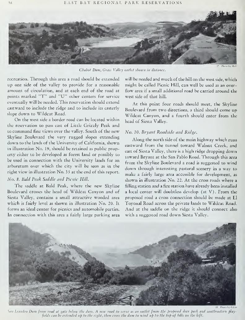
36 EAST BAY REGIONAL PARK RESERVATIONS
Chabot Dam, Grass Valley outlet shown in distance
27—Photo by Hall
recreation. Through this area a road should be extended
up one side of the valley to provide for a reasonable
amount of circulation, and at each end of the road at
points marked "T" and "U" other centers for service
eventually will be needed. This reservation should extend
eastward to include the ridge and to include its easterly
slope down to Wildcat Road.
On the west side a border road can be located within
the reservation to pass east of Little Grizzly Peak and
to command fine views over the valley. South of the newSkyline Boulevard the very rugged slopes extending
down to the lands of the University of California, shown
in illustration No. 19, should be retained as public prop-
erty either to be developed as forest land or possibly to
be used in connection with the University lands for an
arboretum over which the city will be seen as in the
right view in illustration No. 3 5 at the end of this report.
No. 8. Bald Peak Saddle and Picnic Hill.
The saddle at Bald Peak, where the new Skyline
Boulevard crosses the head of Wildcat Canyon and of
Siesta Valley, contains a small attractive wooded area
which is fairly level as shown in illustration No. 20. It
forms an ideal center for picnics and automobile parties.
In connection with this area a fairly large parking area
will be needed and much of the hill on the west side, which
might be called Picnic Hill, can well be used as an over-
flow area if a small additional road be carried around the
west side of that hill.
At this point four roads should meet, the Skyline
Boulevard from two directions, a third should come up
Wildcat Canyon, and a fourth should enter from the
head of Siesta Valley.
No. 10. Bryant Roadside and Ridge.
Along the north side of the main highway which runs
eastward from the tunnel toward Walnut Creek, and
east of Siesta Valley, there is a high ridge dropping downtoward Bryant at the San Pablo Road. Through this area
from the Skyline Boulevard a road is suggested to wind
down through interesting pastoral scenery in a way to
make a fairly large area accessible for development, as
shown in illustration No. 22. At the cross roads where a
filling station and a fire station have already been installed
a local center will doubtless develop (at V). From the
proposed road a cross connection should be made at El
Toyonal Road across the private lands to Wildcat Road.
And at the saddle on the ridge it should connect also
with a suggested road down Siesta Valley.
28—Photo by Gibb<
San Leandro Dam from road at gate below the dam. A new road to serve as an outlet from the proposed deer park and southeastern play-
fields can be extended up to the right, then cross the dam to wind up to the top of hills on the left.

EAST BAY REGIONAL. PARK RESERVATIONS 37
Grass land on San Leandro Canyon Road, showing area suitable for large playfield.
29—Photo by Gibbs
Along the north side of the tunnel road a strip of
land should be reserved for park scenery extending
northward to proposed ridge road for a part of its length,
including the area shown in illustration No. 21. The top
of the high ridge near Siesta Valley, shown in illustration
No. 23 above the proposed ridge road should be kept in
the park reservation.
No. 11. Siesta Valley.
Siesta Valley forms a very attractive and complete
unit of landscape in itself rising from the Tunnel Road,
northward a mile or more in distance to the Saddle at
Bald Peak. The westerly slopes of the valley are partly
wooded and much of the floor is wooded with pines,
eucalyptus, some oaks and California Bay, and the like.
The easterly slopes are almost wholly bare except for
six or eight gullies extending from the floor up the slopes
to the top, in which there are some springs and in which
trees are growing most of the way up the bottoms of
the gullies.
The floor of the valley needs more open space on the
flatter areas, where trees should be cut, while some of
the steep slopes may well be forested. This valley is ex-
ceptionally good for public uses. A road will be needed
winding up first one side of the floor, then the other from
an entrance on the Tunnel Road up to the Skyline Boule-
vard. A golf course easily accessible to the people of the
north end of the city of Oakland may be located in the
valley and a service center will doubtless be needed
eventually and probably should be located near the center
where the road will cross the valley (at W). Space can
doubtless be found near there also for large gatherings,
possibly for a "bowl" for drama and music, and there is
ample space for fireplaces, seats and tables and for vari-
ous fields for games as well.
Two small areas along Claremont Road that lie west
of the Siesta Valley and below the summit of the ridge
are outside the natural limits of the larger park areas and
need not be included in the proposed reservations, there-
fore they can reasonably well be sold for other purposes.
No. 13. Ronndtop Hill and Ridges.
The hill at Roundtop is a prominent feature with its
fire guard tower and fine outlook in all directions. It
has (at X) the one recreational center which is now open
to the public on District lands. This center will grow in
importance and can be made a valuable recreation fea-
ture. The long strips of public lands extending west and
south from Roundtop are exceedingly valuable for park
and parkway uses in connection with Skyline Boulevard
and should be kept in the reservation.
No. 14. Fish Ranch.
The Fish Ranch contains some very interesting, fairly
flat grass land, partly wooded in the northerly and easter-
ly portions, as shown in illustration No. 24, through
which a road or trail from Siesta Valley can be located
to rise to the saddle at the easterly corner. The balance of
the ranch is extremely rugged, unfit for reasonable sub-
division, picturesque and interesting for hikers and
nature explorations and should be kept as a wilderness
for that purpose with one road or trail up from the
easterly corner to the top of the ridge toward Roundtop.
No. 20. Upper Redwood Canyon.
In the Upper Redwood Canyon a fairly large and
complete unit of land is publicly owned, cut off fromexisting highways by private property, both at the head
of the canyon and at the lower end. As one of the lesser
30—Photo by Gibbs
South end of grass land in proposed southeastern playfield, where autoparking space is available.

38 EAST BAY REGIONAL PARK RESERVATIONS
Photo by Ha
Road along south shore of Lake Chabot.
park units, this area, with water lands along its easterly
boundary, can be made accessible and useful. A road
should be opened from the south to run along the ridge
at the edge of the water lands to connect with the pro-
posed parkway No. 19, and thus to become one of the
main if not the main parkway route along the hilltops.
A road along the hilltop will afford access to the area and
form a natural boundary line between water lands and
proposed park reservation. But it is possible that an addi-
tional road for through travel from north to south should
be made through the valley itself, dropping down from
the north on public lands and crossing a short stretch of
private property in the floor of the valley, as shown on
the plan and also in illustration No. 2 5.
On the proposed lower road a service center will be
needed. A small center has already been started at the
cross roads on private property just south of the proposed
reservation and that will tend to grow, and be stimulated
by any park activities, but use of the valley floor for
recreation will develop a need for some shelter, and sup-
plies and conveniences will be needed in the park itself
at or near the Point X.
Just south of the proposed reservation it would be
desirable to acquire some if not all of the lands within
the triangles between the roads. On those areas there are
now several buildings—a school, a store, and a few houses
—that would doubtless prove costly to acquire. Back of
them the land should be acquired, and possibly some
agreement might be reached with property owners to
control private developments in a way to encourage a
better kind of development than otherwise is likely to
occur. Some minor adjustments of boundaries may prove
desirable and the relation to the Piedmont Riding Club
property may prove mutually advantageous in the care
and development of the two properties.
No. 21. Upper Grass Valley.
From its source down to the Havens Tract upper
Grass Valley is a rather barren, steep sided valley with a
relatively narrow bottom. It can be reached from the
north by the proposed extension of Skyline Parkway and
that road can be extended southward along the easterly
ridge to meet the new County Road at the saddle near
the easterly corner of the Havens Tract as suggested in
illustration No. 26.
Another road can be extended along or near the
westerly boundary to serve as a firebreak as well as a
means of access. The valley can be made more attractive
by planting and the bottom land can be used for some
forms of recreation in connection with the proposed
center at the lower end at "Z".
No. 23. Lower Grass Valley.
Below the Havens Tract the floor of Grass Valley is
fairly wide, suitable for golf and other forms of field
recreation. There are now old roads at each side of the
bottom land, but these should be closed to leave the bot-
tom lands for recreation. Roads across the valley are pro-
posed at "Z" and at "AA", and along the ridges at either
side, one on the east side to rise from "AA" to the newcounty road on the ridge.
From the city of San Leandro through the Estudillo
Avenue entrance at "L" a road along the border of the
Lake Chabot Reservoir lands to Grass Valley at "AA" is
needed, and the small area between this road and the
Oakland Municipal Golf Course should be reserved as
land having high value for roadside park uses, as shown
in illustration No. 27. This road should connect also
with the proposed ridge road on the westerlv side of
Grass Valley, by a branch toward the north and another
toward the south.
No. 24. Chabot Hill Picnic Grove and Deer Park.
The largest area available for a single reservation is
that lying between the Lake Chabot and the San Leandro
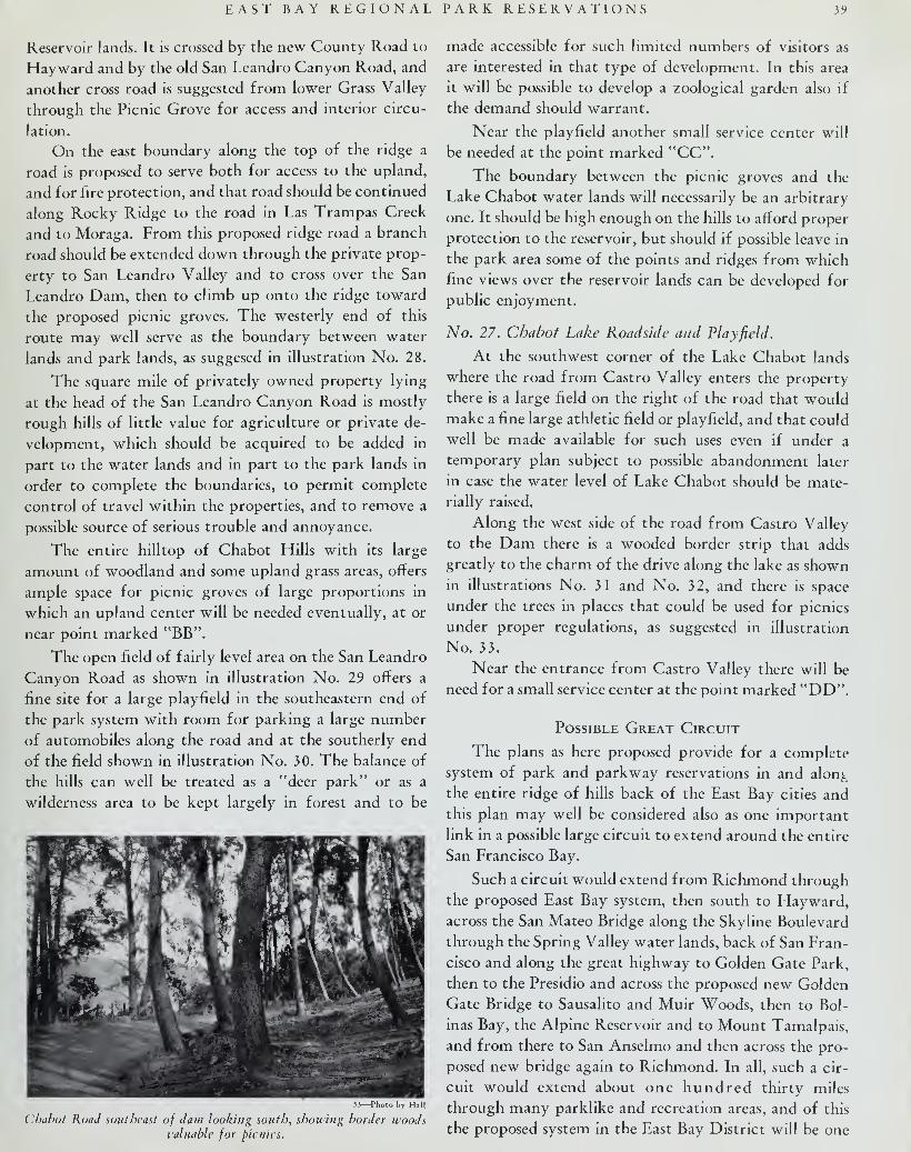
EAST BAY REGIONAL PARK RESERVATIONS 39
Reservoir lands. It is crossed by the new County Road to
Hayward and by the old San Leandro Canyon Road, and
another cross road is suggested from lower Grass Valley
through the Picnic Grove for access and interior circu-
lation.
On the east boundary along the top of the ridge a
road is proposed to serve both for access to the upland,
and for fire protection, and that road should be continued
along Rocky Ridge to the road in Las Trampas Creek
and to Moraga. From this proposed ridge road a branch
road should be extended down through the private prop-
erty to San Leandro Valley and to cross over the San
Leandro Dam, then to climb up onto the ridge toward
the proposed picnic groves. The westerly end of this
route may well serve as the boundary between water
lands and park lands, as suggesed in illustration No. 28.
The square mile of privately owned property lying
at the head of the San Leandro Canyon Road is mostly
rough hills of little value for agriculture or private de-
velopment, which should be acquired to be added in
part to the water lands and in part to the park lands in
order to complete the boundaries, to permit complete
control of travel within the properties, and to remove a
possible source of serious trouble and annoyance.
The entire hilltop of Chabot Hills with its large
amount of woodland and some upland grass areas, offers
ample space for picnic groves of large proportions in
which an upland center will be needed eventually, at or
near point marked "BB".
The open field of fairly level area on the San Leandro
Canyon Road as shown in illustration No. 29 offers a
fine site for a large playfield in the southeastern end of
the park system with room for parking a large number
of automobiles along the road and at the southerly end
of the field shown in illustration No. 30. The balance of
the hills can well be treated as a "deer park" or as a
wilderness area to be kept largely in forest and to be
33—Photo by Hall
Chabot Road southeast of dam looking south, showing border woodsvaluable for picnics.
made accessible for such limited numbers of visitors as
are interested in that type of development. In this area
it will be possible to develop a zoological garden also if
the demand should warrant.
Near the playfield another small service center will
be needed at the point marked "CC".
The boundary between the picnic groves and the
Lake Chabot water lands will necessarily be an arbitrary
one. It should be high enough on the hills to afford proper
protection to the reservoir, but should if possible leave in
the park area some of the points and ridges from which
fine views over the reservoir lands can be developed for
public enjoyment.
No. 27. Chabot Lake Roadside and Playfield.
At the southwest corner of the Lake Chabot lands
where the road from Castro Valley enters the property
there is a large field on the right of the road that would
make a fine large athletic field or playfield, and that could
well be made available for such uses even if under a
temporary plan subject to possible abandonment later
in case the water level of Lake Chabot should be mate-
rially raised.
Along the west side of the road from Castro Valley
to the Dam there is a wooded border strip that adds
greatly to the charm of the drive along the lake as shown
in illustrations No. 31 and No. 32, and there is space
under the trees in places that could be used for picnics
under proper regulations, as suggested in illustration
No. 33.
Near the entrance from Castro Valley there will be
need for a small service center at the point marked "DD".
Possible Great Circuit
The plans as here proposed provide for a complete
system of park and parkway reservations in and alon^
the entire ridge of hills back of the East Bay cities and
this plan may well be considered also as one important
link in a possible large circuit to extend around the entire
San Francisco Bay.
Such a circuit would extend from Richmond through
the proposed East Bay system, then south to Hayward,across the San Mateo Bridge along the Skyline Boulevard
through the Spring Valley water lands, back of San Fran-
cisco and along the great highway to Golden Gate Park,
then to the Presidio and across the proposed new Golden
Gate Bridge to Sausalito and Muir Woods, then to Bol-
inas Bay, the Alpine Reservoir and to Mount Tamalpais,
and from there to San Anselmo and then across the pro-
posed new bridge again to Richmond. In all, such a cir-
cuit would extend about one hundred thirty miles
through many parklike and recreation areas, and of this
the proposed system in the East Bay District will be one

40 EAST BAY REGIONAL PARK RESERVATIONS
of the most varied and interesting. Some of the areas that
would be traversed are shown in illustration No. 34.
Back of the East Bay region is the State Park on Mt.
Diablo, not a part of a circuit, however, as it stands out
as an isolated unit by itself, reached rather by the traffic
roads around the ends of the hills or through tunnels be-
neath them.
In the above discussion of possible and desirable park
and recreation areas and reservations for the East Bay
District mention has been made of many improvements,
roads, trails, forest plantations, clearings, pasturing,
fences, golf courses, recreation fields, picnic groves, serv-
ice centers, bridle trails, acquisitions and exchanges of
lands, all of which have a definite bearing upon the
possible means of enjoyment by the public of the areas
in question.
The question, however, which calls for immediate and
careful consideration is that of setting aside now all
those publicly owned lands which are especially suited
for park purposes, and are not needed for water storage
and protection. A second question is that of obtaining
by dedication, by exchange or otherwise the few strips
and areas of privately owned lands which may be highly
desirable to facilitate the most complete and satisfactory
development of the public lands that may be so set aside
for recreation uses.
When such areas have been established as reservations
subject to proper fire and police protection, grazing and
forest control, the development for special uses can be
advanced gradually and need be made only as and whenpublic demand and use may warrant. The reservation of
the areas, however, must be considered now while lands
are still available and suitable for such purposes.
Conclusion
The East Bay communities face an unusual opportun-
ity. Nature has placed within easy reach of this growing
region a contiguous border of scenic land, most of which
is too rugged for industrial, or extensive residential pur-
poses, but possessed of a high recreational value. A pecu-
liar chain of circumstances has brought over 40,000 acres
of this hill land into public ownership, only a small part
of which is essential for water purposes.
The present inadequacy of the region's park facilities,
and the absence of any other near-by areas suitable in
character or extent to take care of present or future
recreational needs, makes it apparent that an adequate
portion of these publicly owned lands should be reserved
for park purposes; thus securing for the people a greater
benefit than would accrue from any other use, or possible
sale.
The plans and recommendations above presented in
this report provide for an unusually attractive regional
system of park reservations, forest reserves, wilderness
areas and other recreational facilities, without resorting
to the large capital outlays which other metropolitan
communities have been compelled to expend in order to
secure a comparable area of less desirable character.
3 S—Photo by Berkeley Picture Shop
Oakland at night from Grizzly Peak.