Wentworth-Douglass Hospital Rehabilitation Services at Dover
Upload
khangminh22Category
view
2download
0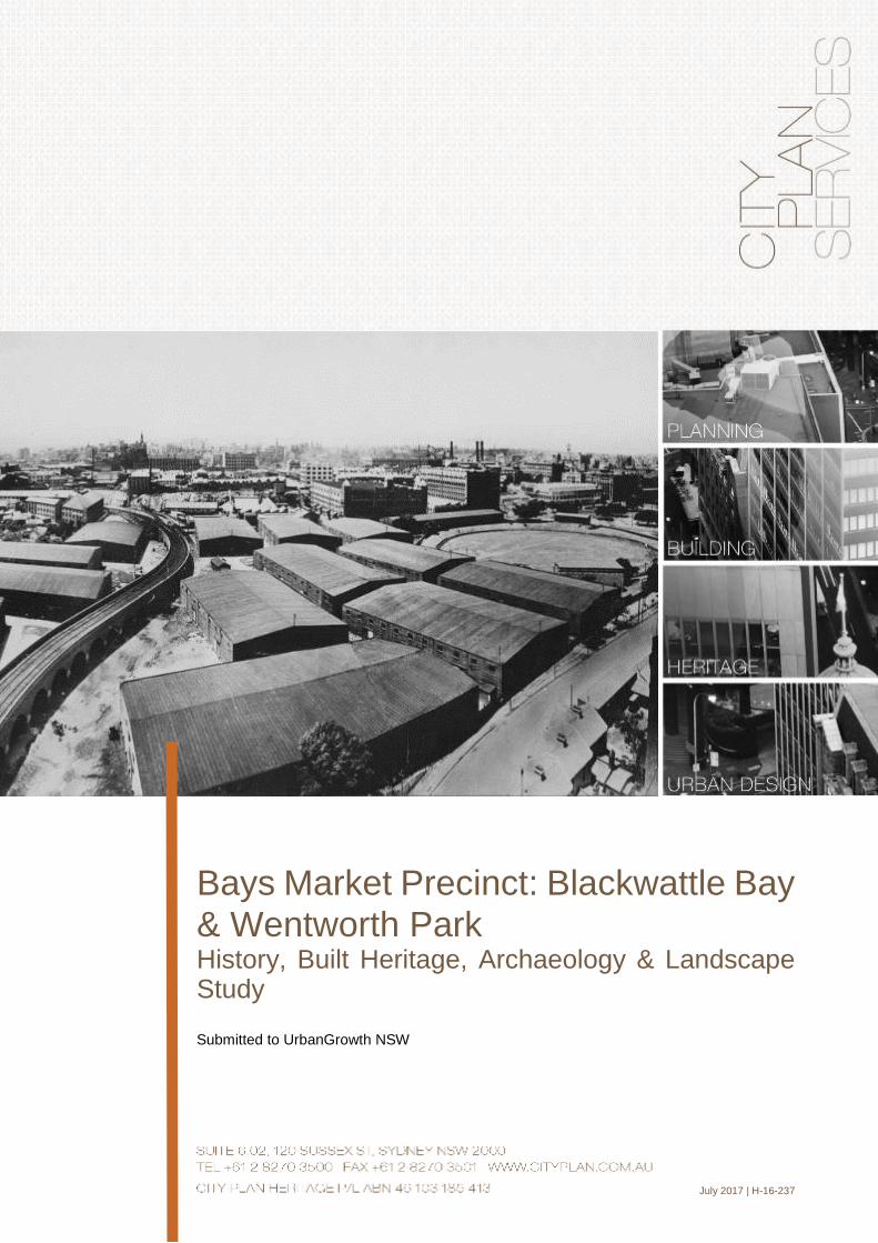
M:\CPHERITAGE\CPH-2016\16-237 BAYS MARKET DISTRICT\REPORTS\BAYS MARKET PRECINCT - HERITAGE_FINAL.DOCX I
Bays Market Precinct: Blackwattle Bay & Wentworth Park History, Built Heritage, Archaeology & Landscape Study
Submitted to UrbanGrowth NSW
July 2017 | H-16-237

M:\CPHERITAGE\CPH-2016\16-237 BAYS MARKET DISTRICT\REPORTS\BAYS MARKET PRECINCT - HERITAGE_FINAL.DOCX II
Revision Date Issued Prepared by Reviewed by Verified by
01 28/04/17 Ana Silkatcheva
Heritage Consultant
(City Plan Heritage)
Kerime Danis
Director - Heritage
(City Plan Heritage)
Dr Terry Kass
Independent Historian
& Heritage Consultant
Chris Betteridge
Landscape Consultant
(MUSEcape)
Kerime Danis
Director - Heritage
(City Plan Heritage)
Kerime Danis
Director - Heritage
(City Plan Heritage)
02 17/07/17
Ana Silkatcheva
Heritage Consultant
(City Plan Heritage)
Report Revision History
M:\CPHERITAGE\CPH-2016\16-237 BAYS MARKET DISTRICT\REPORTS\BAYS MARKET PRECINCT - HERITAGE_FINAL.DOCX III
CERTIFICATION
This report has been authorised by City Plan Heritage P/L, with input from a number of other expert consultants,
on behalf of UrbanGrowth NSW. The accuracy of the information contained herein is to the best of our knowledge
not false or misleading. The comments have been based upon information and facts that were correct at the time
of writing this report.
Copyright © City Plan Heritage P/L
ABN 46 103 185 413
All Rights Reserved. No material may be reproduced without prior permission. While we have tried to ensure the
accuracy of the information in this publication, the Publisher accepts no responsibility or liability for any errors,
omissions or resultant consequences including any loss or damage arising from resilience in information in this
publication
M:\CPHERITAGE\CPH-2016\16-237 BAYS MARKET DISTRICT\REPORTS\BAYS MARKET PRECINCT - HERITAGE_FINAL.DOCX IV
Table of Contents
Executive Summary ...................................................................................... 6
1. Introduction.............................................................................................. 9
1.1 Background .................................................................................................... 9
1.2 Site Location ................................................................................................. 10
1.3 Methodology ................................................................................................. 11
1.4 Author Identification ...................................................................................... 11
2. Thematic History ................................................................................... 12
2.1 Introduction ................................................................................................... 12
2.2 Authorship..................................................................................................... 12
2.3 Chronological Overview ................................................................................ 12
2.4 Thematic History of Bays Market District ..................................................... 12
2.4.1 Occupying the land .......................................................................... 12
2.4.2 Establishing transport infrastructure ................................................ 15
2.4.3 Reclaiming land ............................................................................... 21
2.4.4 Establishing industries ..................................................................... 26
2.4.5 Transporting and storing goods ....................................................... 37
2.4.6 Establishing utility infrastructure ...................................................... 38
2.4.7 Providing building materials ............................................................. 38
2.4.8 Establishing and maintaining leisure facilities ................................. 42
2.4.9 Supplying food ................................................................................. 44
2.4.10 Defending Australia ......................................................................... 45
2.5 Comparative Table of National, New South Wales and Bays Market District
Historical Themes .................................................................................................. 47
3. Built Heritage & Historical Archaeology .............................................. 55
3.1 Phase 1: Heritage Due Diligence ................................................................. 55
3.1.1 Built Heritage ................................................................................... 55
3.1.2 Archaeological Heritage .................................................................. 59
3.1.3 Landscape items.............................................................................. 60
3.1.4 Conclusions and Recommendations ............................................... 72
3.2 Phase 2: Heritage Assessment .................................................................... 72
3.2.1 Bay Street Depot ............................................................................. 73
3.2.2 Wentworth Park ............................................................................... 81
3.2.3 Wentworth Park Greyhound Track .................................................. 87
3.2.4 Stormwater Channel No. 17 beneath Wentworth Park ................... 93
3.2.5 Sydney Stone Storage Yard (10A Wattle Street former quarry) ..... 95
M:\CPHERITAGE\CPH-2016\16-237 BAYS MARKET DISTRICT\REPORTS\BAYS MARKET PRECINCT - HERITAGE_FINAL.DOCX V
3.2.6 Former site of Wentworth Park Caretaker's Cottage ..................... 101
3.2.7 The Fish Markets and Bank Street ................................................ 106
3.2.8 1-3 Bank Street, Pyrmont .............................................................. 111
3.3 Areas of Archaeological Potential .............................................................. 117
3.4 Conclusions and Recommendations .......................................................... 120
4. Cultural Landscapes ........................................................................... 123
4.1 Authorship................................................................................................... 123
4.2 The Bays Market District Precinct as a cultural landscape ........................ 123
4.2.1 Some definitions ............................................................................ 123
4.2.2 Site history and historical themes .................................................. 124
4.2.3 The present cultural landscape ..................................................... 127
4.2.4 Assessment of Landscape Significance ........................................ 131
4.2.5 Landscape management and interpretation recommendations .... 132
5. Summary Conclusions and Recommendations ................................ 134
6. Bibliography ......................................................................................... 136
CITY PLAN HERITAGE P/L - HERITAGE REPORT BAYS MARKET DISTRICT PRECINCT - JULY 2017 6/138
Executive Summary
Background
UrbanGrowth NSW is in the process of preparing plans for the redevelopment of the Bays
Market District in Glebe, especially within the Blackwattle Bay area. At the beginning of 2016,
City Plan Heritage (CPH) was engaged by UrbanGrowth NSW to prepare a heritage
assessment of the Bays Market Precinct in order to exercise due diligence and to inform a
rezoning proposal and future development proposals.
This report follows and continues from a draft assessment report completed by Urbis in 2014,
Bays Precinct Heritage Constraints Assessment Report. This study incorporates a Thematic
History by Dr Terry Kass, an analysis of Built Heritage and Archaeological constraints by City
Plan Heritage, and a Cultural Landscapes Study by Chris Betteridge of Musescape.
The study of Built Heritage and Archaeology was conducted in two phases which were
shaped by UrbanGrowth's evolving interests in the district. Phase 1 was a due diligence
phase which involved review of Urbis' original report and the identification of newly listed and
potential heritage items within Urbis' Blackwattle Bay and Wentworth Park districts. Phase 2
involved a heritage assessment of eight specific areas that were of interest to UrbanGrowth
NSW based on their evolving plans.
Phase 1 involved two stages:
▪ a review of Urbis' 2014 draft report to determine whether any gaps existed with
regard to listed heritage items; and
▪ a field survey of the interior and the perimeter of Urbis' Wentworth Park Precinct and
Blackwattle Bay Precinct to determine whether there were other items of potential
heritage significance that had not yet been assessed or listed
Phase 2 involved:
▪ historical research and significance assessment for eight sites identified by
UrbanGrowth NSW to be of particular interest; and
▪ a review of the archaeological potential of these sites and other known
archaeological sites in the District.
CPH had previously completed detailed archaeological assessment for Blackwattle Bay with
reference to both maritime and terrestrial archaeology in 2013 (Blackwattle Bay Maritime
Precinct: Heritage Significance Assessment - Maritime Archaeology, and Blackwattle Bay
Maritime Precinct: Heritage Significance Assessment incorporating Heritage Impact
Statement - Terrestrial Archaeology). Following review of this existing documentation, it was
decided that the findings of the studies remained relevant. CPH has supplied UrbanGrowth
NSW with hard copies of these reports for their reference.
Study Area
The Bays Market District is located approximately 1.5 kilometres to the south-west of the
Sydney Central Business District (CBD). The Wentworth Park Precinct, as defined by Urbis,
encompasses Wentworth Park itself and a large buffer along the Park's perimeter. The
Wentworth Park Precinct is bounded by the Blackwattle Bay foreshore and Bridge Road in
the north; Burton Lane, Bridge Road, Bellevue Lane, and Cowper Street in the east; the rear
of the houses on Queen Street, and MacArthur Street in the south, and Wattle Street, Fig
Street, Jones Street, and Jones Lane in the west. Urbis' Blackwattle Bay Precinct primarily
includes the marine area of Blackwattle Bay itself as well as some areas of land. The Precinct
is bounded by the Blackwattle Bay foreshore in the east, Wentworth Park in the south, the
Western Distributor Freeway and Bank Street in the west, and an imaginary line drawn
between two points of land that partly enclose the bay in the north.

CITY PLAN HERITAGE P/L - HERITAGE REPORT BAYS MARKET DISTRICT PRECINCT - JULY 2017 7/138
Methodology
The philosophy and process adopted during the work towards this report is guided by the
Australia ICOMOS Burra Charter 2013. The assessments of heritage significance presented
in Section 3.2 of this report have been prepared in accordance with the NSW Heritage
Manual ‘Assessing Heritage Significance’ guidelines.
The Thematic History was guided by the thematic framework developed by the NSW Heritage
Council for use in heritage assessment and management. The historical development of an
area or item can be understood as occurring in a thematic way, with different layers
representing progressively earlier themes. Thinking about a place in terms of themes can
help understanding of its significance as well as establish the interpretative storylines. The
organising principle for the thematic framework is the dynamism of human activity.1 A
Thematic History of a site or area is one that is focused on the themes that have shaped it,
rather than one that provides a detailed chronological account of all events. The themes
identified are placed in context within the established National and State framework.
The Cultural Landscapes Study was conducted according to guidelines presented within the
Department of the Environment, Climate Change and Water (DECCW)'s 2010 publication,
Cultural Landscapes: A Practical Guide for Park Management. It defines the cultural
landscape concept as emphasising “the landscape-scale of history and the connectivity
between people, places and heritage items. It recognises the present landscape is the
product of long-term and complex relationships between people and the environment. A total
cultural landscape management approach enables identification and assessment of potential
heritage items in their historical and environmental context, rather than as stand-alone items.
Findings
The Thematic History identified ten themes that are relevant to the history of the Bays Market
District:
▪ Occupying the land
▪ Establishing transport infrastructure
▪ Reclaiming land
▪ Establishing industries
▪ Transporting and storing goods
▪ Establishing utility infrastructure
▪ Providing building materials
▪ Establishing and maintaining leisure facilities
▪ Supplying food
▪ Defending Australia
Phase 1 of the Assessment of Built Heritage and Historical Archaeology identified several
heritage items that had not been presented in Urbis' report of 2014, including items that had
been listed on the Sydney Local Environment Plan (LEP) 2012 following the preparation of
the report. During two site surveys additional items were identified that could potentially also
be of heritage significance.
Phase 2 focused on eight sites that UrbanGrowth NSW had identified as being of particular
interest to their evolving plans. Historical research informed the assessment of heritage
significance. All items were assessed to have heritage significance within the history of the
Bays Market District.
1 Both the Australian Heritage Commission (national) and the NSW Heritage Office (state) have identified themes for research relating to places of heritage significance.
CITY PLAN HERITAGE P/L - HERITAGE REPORT BAYS MARKET DISTRICT PRECINCT - JULY 2017 8/138
Opportunities and constraints presented by these items were analysed.
The Cultural Landscapes Study identified several landscape items of significance and
provided recommendations for management of these items during any proposal for
redevelopment.
Conclusions and Recommendations
Heritage in the Bays Market District presents several opportunities and constraints that
UrbanGrowth NSW should consider as it develops its plans to rezone and redevelop the
study area.
▪ In particular, it is important to note that listed heritage items and archaeological sites
ordinarily have statutory protection under the NSW Heritage Act 1977 and the
Environmental Planning and Assessment Act 1979. Therefore, finalised proposals
should be assessed for their potential impact on heritage significance in a Heritage
Impact Statement. Proposals may have to go through approvals processes with
State and local government bodies depending on the level of significance of items
and sites.
▪ Items identified as being of potential heritage significance do not have any statutory
protection. Nevertheless, CPH recommends that the City of Sydney Council be
informed of the findings to ensure there is an opportunity for heritage values to be
conserved.
▪ Rezoning with changes in height and FSR should consider impacts on existing
heritage items, such as overshadowing, removal of view corridors, and alteration of
historical subdivision patterns and characters. This may be achieved through height
limitations, appropriate setbacks, and avoidance of subdivision and development in
areas of established heritage significance, amongst other strategies.
▪ There is potential for adaptive re-use of existing buildings and sites along the same
principles as their historic uses.
▪ Any proposal for new works is an opportunity to develop a Heritage Interpretation
Strategy for a site and to implement the Strategy through provision of interpretive
measures as provided therein.
▪ Areas of archaeological potential should be investigated in detailed archaeological
assessments prior to the decision to undertake any works that would disturb the
ground surface. UrbanGrowth NSW may choose to undertake these assessments
prior to rezoning to understand the nature and extent of specific constraints.
▪ Landscape Items of exceptional and high significance should be retained and
conserved.
▪ Landscape Items of moderate significance may be modified.
▪ Landscape Items of little significance may be modified or removed.
▪ Landscape Items considered intrusive should be removed.
▪ Views of exceptional and high significance, as identified in the study of cultural
landscapes, should be maintained. This means that any rezoning plans that result in
changes in height and any subsequent associated development plans should
consider retention of these views.
CITY PLAN HERITAGE P/L - HERITAGE REPORT BAYS MARKET DISTRICT PRECINCT - JULY 2017 9/138
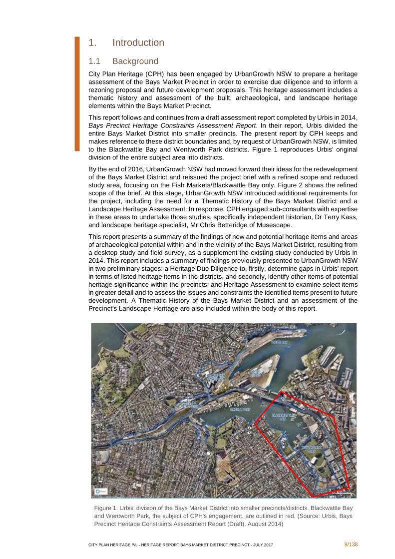
1. Introduction
1.1 Background
City Plan Heritage (CPH) has been engaged by UrbanGrowth NSW to prepare a heritage
assessment of the Bays Market Precinct in order to exercise due diligence and to inform a
rezoning proposal and future development proposals. This heritage assessment includes a
thematic history and assessment of the built, archaeological, and landscape heritage
elements within the Bays Market Precinct.
This report follows and continues from a draft assessment report completed by Urbis in 2014,
Bays Precinct Heritage Constraints Assessment Report. In their report, Urbis divided the
entire Bays Market District into smaller precincts. The present report by CPH keeps and
makes reference to these district boundaries and, by request of UrbanGrowth NSW, is limited
to the Blackwattle Bay and Wentworth Park districts. Figure 1 reproduces Urbis' original
division of the entire subject area into districts.
By the end of 2016, UrbanGrowth NSW had moved forward their ideas for the redevelopment
of the Bays Market District and reissued the project brief with a refined scope and reduced
study area, focusing on the Fish Markets/Blackwattle Bay only. Figure 2 shows the refined
scope of the brief. At this stage, UrbanGrowth NSW introduced additional requirements for
the project, including the need for a Thematic History of the Bays Market District and a
Landscape Heritage Assessment. In response, CPH engaged sub-consultants with expertise
in these areas to undertake those studies, specifically independent historian, Dr Terry Kass,
and landscape heritage specialist, Mr Chris Betteridge of Musescape.
This report presents a summary of the findings of new and potential heritage items and areas
of archaeological potential within and in the vicinity of the Bays Market District, resulting from
a desktop study and field survey, as a supplement the existing study conducted by Urbis in
2014. This report includes a summary of findings previously presented to UrbanGrowth NSW
in two preliminary stages: a Heritage Due Diligence to, firstly, determine gaps in Urbis' report
in terms of listed heritage items in the districts, and secondly, identify other items of potential
heritage significance within the precincts; and Heritage Assessment to examine select items
in greater detail and to assess the issues and constraints the identified items present to future
development. A Thematic History of the Bays Market District and an assessment of the
Precinct's Landscape Heritage are also included within the body of this report.
Figure 1: Urbis' division of the Bays Market District into smaller precincts/districts. Blackwattle Bay
and Wentworth Park, the subject of CPH's engagement, are outlined in red. (Source: Urbis, Bays
Precinct Heritage Constraints Assessment Report (Draft), August 2014)

CITY PLAN HERITAGE P/L - HERITAGE REPORT BAYS MARKET DISTRICT PRECINCT - JULY 2017 10/138
Figure 2: UrbanGrowth NSW's refined study area for the Bays Market Precinct Redevelopment (Source:
UrbanGrowth NSW Bays Market District tender brief, December 2016)
1.2 Site Location
The Bays Market District is located approximately 1.5 kilometres to the west and south-west
of the Sydney CBD.
Urbis' Blackwattle Bay Precinct primarily includes the marine area of Blackwattle Bay itself
as well as some areas of land. The Precinct is bounded by the Blackwattle Bay foreshore in
the east, Wentworth Park in the south, the Western Distributor Freeway and Bank Street in
the west, and an imaginary line drawn between two points of land that partly enclose the bay
in the north. Importantly, it contains the Fish Markets precinct at its east, which is specifically
subject to UrbanGrowth NSW’s latest rezoning and redevelopment plans.
Urbis' Wentworth Park Precinct encompasses Wentworth Park itself and a large buffer along
the Park's perimeter. The Precinct is bounded by the Blackwattle Bay foreshore and Bridge
Road in the north; Burton Lane, Bridge Road, Bellevue Lane, and Cowper Street in the east;
the rear of the houses on Queen Street, and MacArthur Street in the south, and Wattle Street,
Fig Street, Jones Street, and Jones Lane in the west.

CITY PLAN HERITAGE P/L - HERITAGE REPORT BAYS MARKET DISTRICT PRECINCT - JULY 2017 11/138
1.3 Methodology
The aim of the project was to identify heritage items within the Wentworth Park and
Blackwattle Bay Precincts defined by Urbis through a combination of a desktop study and
physical survey. The project methodology may be summarised as follows:
Urbis's 2014 draft heritage report was reviewed for accuracy and completeness, with a view
to determining whether any gaps existed in terms of listed heritage items.
Following the desktop review, field surveys of the Wentworth Park and Blackwattle Bay
Precincts, as identified by Urbis, were performed on 3rd February and 10th February 2016
to further identify items with the potential to be of heritage significance upon further research
and assessment. This stage was augmented by basic historical research including a review
of aerial imagery from 1943.
The findings of the Heritage Due Diligence Assessment, comprising the desktop studies and
field surveys, were presented to UrbanGrowth NSW in a meeting on 16th February 2016.
At the meeting UrbanGrowth NSW identified areas of particular interest to their evolving
projects and refined the scope, to include a more detailed Heritage Assessment of Wentworth
Park itself, the eastern part of the Wentworth Park Precinct, the boundary between the
Wentworth Park and Blackwattle Bay Precincts, and the eastern foreshore of the Blackwattle
Bay Precinct.
A more detailed desktop study was carried out of the areas indicated by UrbanGrowth NSW
to be of particular interest. The Heritage Assessment of these sites resulted in the preparation
of brief histories for each identified item and an assessment of the issues and constraints
recognised for each item.
The findings of the Heritage Assessment phase were presented to UrbanGrowth NSW in a
meeting on the 14th of March, 2016. The Heritage Assessment identified four potential
heritage items in the area that had not been identified by Urbis. During the meeting it was
decided to proceed with GIS mapping and to finalise the heritage assessment with a
significance assessment of the four additional items that were identified within the areas that
are of particular interest to UrbanGrowth NSW. In line with UrbanGrowth NSW's particular
interests to move forward with the project, UrbanGrowth NSW requested that a new
significance assessment be undertaken for two listed heritage items that had been identified
by Urbis in their 2014 draft report, in addition to the significance assessment of the four
additional sites identified by CPH.
Some of the content of this report was originally issued to UrbanGrowth NSW in draft form in
December 2016. At that time, following the evolution of the redevelopment plans,
UrbanGrowth NSW indicated that it had refined its scope to focus on the Blackwattle Bay /
Fish Markets Precinct.
The philosophy and process adopted during the work towards this report is that guided by
the Australia ICOMOS Burra Charter 2013. The assessments of significance presented in
Section 3.2 of this report have been prepared in accordance with the NSW Heritage Manual
‘Assessing Heritage Significance’ guidelines.
1.4 Author Identification
The present report has been compiled by Ana Silkatcheva (Heritage Consultant / City Plan
Heritage) in consultation with Kerime Danis (Director - Heritage). The thematic history has
been written by Dr Terry Kass (Historian / Kass History). In 2016 Ana Silkatcheva and Anna
McLaurin (Heritage Consultant / City Plan Heritage) prepared the built and archaeological
heritage study. Chris Betteridge (Landscape Heritage Consultant / MUSEcape) undertook
the landscape study. The report has been reviewed by Kerime Danis (Director - Heritage)
who endorses its contents.
CITY PLAN HERITAGE P/L - HERITAGE REPORT BAYS MARKET DISTRICT PRECINCT - JULY 2017 12/138
2. Thematic History
2.1 Introduction
The historical development of an area or item can be understood as occurring in a thematic
way, with different layers representing progressively earlier themes. The NSW Heritage
Council developed a thematic framework for use in heritage assessment and management.
Thinking about a place in terms of themes can help understanding of its significance as well
as establish the interpretative storylines. The organising principle for the thematic framework
is the dynamism of human activity.2 A Thematic History of a site or area is one that is focused
on the themes that have shaped it, rather than one that provides a detailed chronological
account of all events. This section provides a Thematic History for the Bays Market District
study area. The identified themes are placed in context within the established National and
State framework in Section 2.5 at the end of this section.
This Thematic History has relied upon numerous reports regarding this area. The historical
research in these reports has been relied upon but has been supplemented where required
by additional research in primary and secondary sources.
2.2 Authorship
This Thematic History has been prepared by Dr Terry Kass, independent Historian.
2.3 Chronological Overview
The Bays Market District around the shores of Blackwattle Bay was originally an unattractive
shoreline with abrupt sandstone cliffs on its eastern shore and a low-lying swamp at its
southern end extending towards Parramatta Road. Demand for additional wharfs and jetties
inspired infilling of the shore along its eastern edge. Construction of a causeway across the
bay and subsequent reclamation of the swamp south of that artery created a large public
park. Wharfs developed to serve bulk handling of coal and blue metal. In addition, Blackwattle
Bay became a major centre for the timber industry, which obtained its raw materials from
oceangoing vessels tying up at wharfs operated exclusively by timber companies.
2.4 Thematic History of Bays Market District
2.4.1 Occupying the land
In 1790, Reverend Richard Johnson was permitted to occupy a large area of 440 acres facing
Blackwattle and Rozelle Bays as a glebe, land set aside for the maintenance of a minister of
religion.3
John Harris commenced his process acquiring land on the peninsula immediately west of
Cockle Bay, later renamed Darling Harbour. The whole land parcel was eventually known as
Ultimo, as the result of a legal technicality involving the terms ‘proximo’ and ‘ultimo’ in a court
case.4
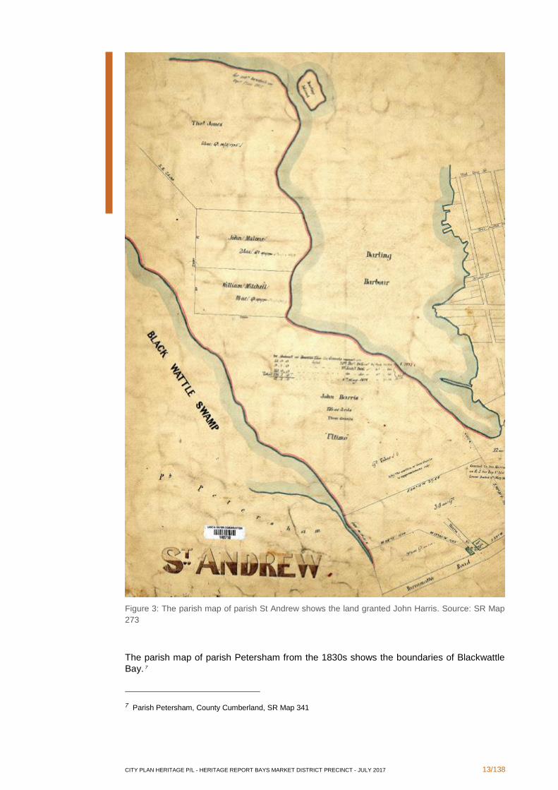
On 31 December 1803, thirty-four acres of land was granted to John Harris.5 On 1 January
1806 John Harris was granted 9 acres 1 rood plus 135 acres so he acquired most of Ultimo.
6 The Eastern part of the study area, running along the eastern shore of Blackwattle Bay is
located on the 135 acre grant to John Harris. The following image of the parish map from
about the 1830s shows this area.
2 Both the Australian Heritage Commission (national) and the NSW Heritage Office (state) have identified themes for research relating to places of heritage significance.
3 W Thorp, Draft Report Thematic History White Bay, Glebe Island, Central Railway to Eveleigh Heritage Study, For Department of Planning, May 1990, p 31
4 S Fitzgerald and H Golder, Pyrmont & Ultimo Under Siege, Hale & Iremonger, Sydney, 1994, pp 17, 19 5 Grants, Volume 3C, No 124 6 Grants, Volume 3C, No 200, Volume 3C No 196
CITY PLAN HERITAGE P/L - HERITAGE REPORT BAYS MARKET DISTRICT PRECINCT - JULY 2017 13/138
Figure 3: The parish map of parish St Andrew shows the land granted John Harris. Source: SR Map
273
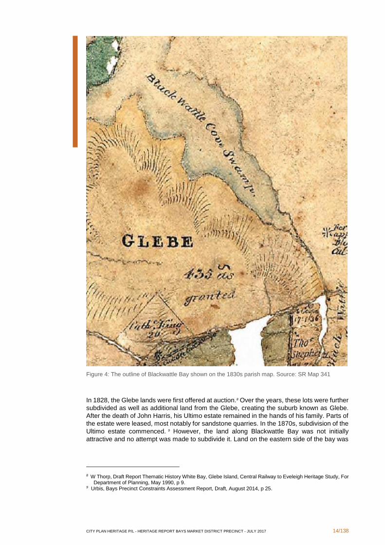
The parish map of parish Petersham from the 1830s shows the boundaries of Blackwattle
Bay. 7
7 Parish Petersham, County Cumberland, SR Map 341
CITY PLAN HERITAGE P/L - HERITAGE REPORT BAYS MARKET DISTRICT PRECINCT - JULY 2017 14/138
Figure 4: The outline of Blackwattle Bay shown on the 1830s parish map. Source: SR Map 341
In 1828, the Glebe lands were first offered at auction.8 Over the years, these lots were further
subdivided as well as additional land from the Glebe, creating the suburb known as Glebe.
After the death of John Harris, his Ultimo estate remained in the hands of his family. Parts of
the estate were leased, most notably for sandstone quarries. In the 1870s, subdivision of the
Ultimo estate commenced. 9 However, the land along Blackwattle Bay was not initially
attractive and no attempt was made to subdivide it. Land on the eastern side of the bay was
8 W Thorp, Draft Report Thematic History White Bay, Glebe Island, Central Railway to Eveleigh Heritage Study, For Department of Planning, May 1990, p 9.
9 Urbis, Bays Precinct Constraints Assessment Report, Draft, August 2014, p 25.
CITY PLAN HERITAGE P/L - HERITAGE REPORT BAYS MARKET DISTRICT PRECINCT - JULY 2017 15/138
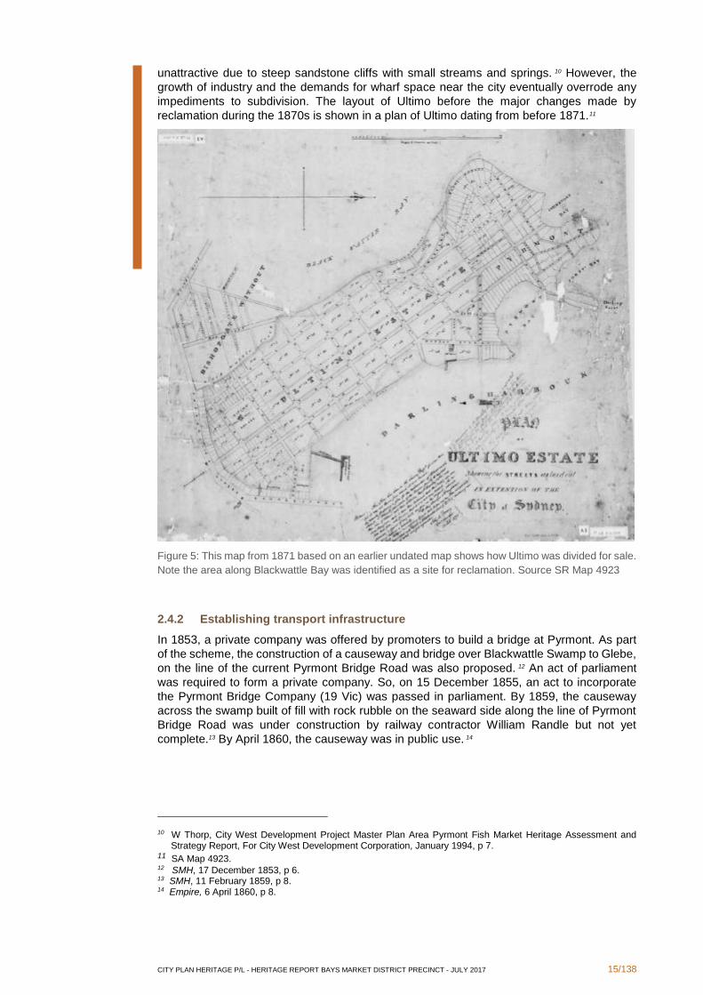
unattractive due to steep sandstone cliffs with small streams and springs. 10 However, the
growth of industry and the demands for wharf space near the city eventually overrode any
impediments to subdivision. The layout of Ultimo before the major changes made by
reclamation during the 1870s is shown in a plan of Ultimo dating from before 1871.11
Figure 5: This map from 1871 based on an earlier undated map shows how Ultimo was divided for sale.
Note the area along Blackwattle Bay was identified as a site for reclamation. Source SR Map 4923
2.4.2 Establishing transport infrastructure
In 1853, a private company was offered by promoters to build a bridge at Pyrmont. As part
of the scheme, the construction of a causeway and bridge over Blackwattle Swamp to Glebe,
on the line of the current Pyrmont Bridge Road was also proposed. 12 An act of parliament
was required to form a private company. So, on 15 December 1855, an act to incorporate
the Pyrmont Bridge Company (19 Vic) was passed in parliament. By 1859, the causeway
across the swamp built of fill with rock rubble on the seaward side along the line of Pyrmont
Bridge Road was under construction by railway contractor William Randle but not yet
complete.13 By April 1860, the causeway was in public use. 14
10 W Thorp, City West Development Project Master Plan Area Pyrmont Fish Market Heritage Assessment and Strategy Report, For City West Development Corporation, January 1994, p 7.
11 SA Map 4923. 12 SMH, 17 December 1853, p 6. 13 SMH, 11 February 1859, p 8. 14 Empire, 6 April 1860, p 8.
CITY PLAN HERITAGE P/L - HERITAGE REPORT BAYS MARKET DISTRICT PRECINCT - JULY 2017 16/138
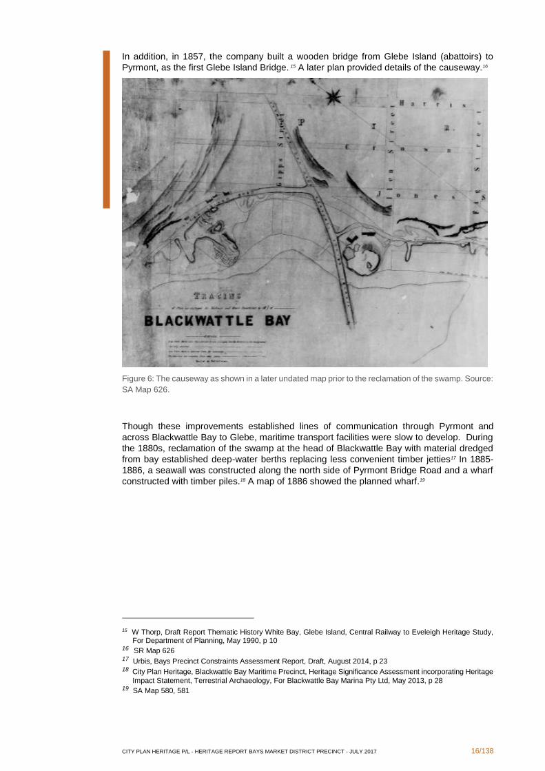
In addition, in 1857, the company built a wooden bridge from Glebe Island (abattoirs) to
Pyrmont, as the first Glebe Island Bridge. 15 A later plan provided details of the causeway.16
Figure 6: The causeway as shown in a later undated map prior to the reclamation of the swamp. Source:
SA Map 626.
Though these improvements established lines of communication through Pyrmont and
across Blackwattle Bay to Glebe, maritime transport facilities were slow to develop. During
the 1880s, reclamation of the swamp at the head of Blackwattle Bay with material dredged
from bay established deep-water berths replacing less convenient timber jetties17 In 1885-
1886, a seawall was constructed along the north side of Pyrmont Bridge Road and a wharf
constructed with timber piles.18 A map of 1886 showed the planned wharf.19
15 W Thorp, Draft Report Thematic History White Bay, Glebe Island, Central Railway to Eveleigh Heritage Study, For Department of Planning, May 1990, p 10
16 SR Map 626 17 Urbis, Bays Precinct Constraints Assessment Report, Draft, August 2014, p 23 18 City Plan Heritage, Blackwattle Bay Maritime Precinct, Heritage Significance Assessment incorporating Heritage
Impact Statement, Terrestrial Archaeology, For Blackwattle Bay Marina Pty Ltd, May 2013, p 28 19 SA Map 580, 581

CITY PLAN HERITAGE P/L - HERITAGE REPORT BAYS MARKET DISTRICT PRECINCT - JULY 2017 17/138
Figure 7: The wharf planned for the southern shore of the Bay along Pyrmont Bridge Road. Source: SA
Map 580
In 1901, construction of a new Glebe Island Bridge commenced.20 Wharfs were also
upgraded. The establishment of the Sydney Harbour Trust in 1901 brought the management
of wharfs under a single government agency. In 1904, improvements were made to the wharf
at the head of Blackwattle Bay by the Sydney Harbour Trust for coal shipping. 21 These wharfs
served coastal ships bringing coal to Sydney from Newcastle and Port Kembla. 22 By 1908,
there were fifteen wharfs around Blackwattle Bay.23
20 W Thorp, Draft Report Thematic History White Bay, Glebe Island, Central Railway to Eveleigh Heritage Study,
For Department of Planning, May 1990, p 14 21 City Plan Heritage, Blackwattle Bay Maritime Precinct, Heritage Significance Assessment incorporating Heritage
Impact Statement, Terrestrial Archaeology, For Blackwattle Bay Marina Pty Ltd, May 2013, p 29 22 Perumal Murphy Wu Pty Ltd, Hughes Trueman Reinhold Pty Ltd and Judy Wing, Conservation Management
Plan, Coal Bins and Associated Structures, Pyrmont Bridge Road, Blackwattle Bay, For Office of Marine Administration, July 1997, p 29
23 Stephen Edward Perdriau, Map of part of the water frontage of the Port of Sydney showing parts of the land and
wharfage vested in the Sydney Harbour Trust Commissioners, 1908, NLA Map G8974.S9P55 1908
CITY PLAN HERITAGE P/L - HERITAGE REPORT BAYS MARKET DISTRICT PRECINCT - JULY 2017 18/138
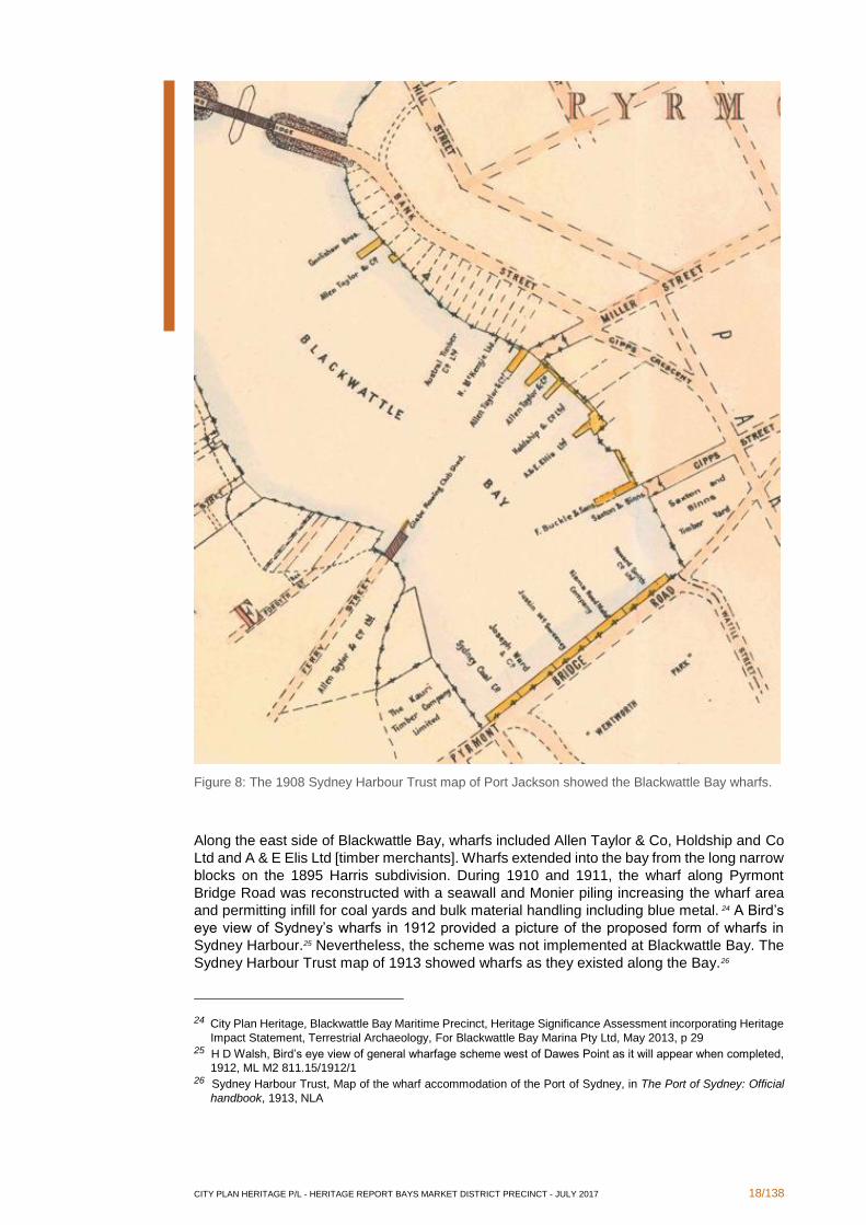
Figure 8: The 1908 Sydney Harbour Trust map of Port Jackson showed the Blackwattle Bay wharfs.
Along the east side of Blackwattle Bay, wharfs included Allen Taylor & Co, Holdship and Co
Ltd and A & E Elis Ltd [timber merchants]. Wharfs extended into the bay from the long narrow
blocks on the 1895 Harris subdivision. During 1910 and 1911, the wharf along Pyrmont
Bridge Road was reconstructed with a seawall and Monier piling increasing the wharf area
and permitting infill for coal yards and bulk material handling including blue metal. 24 A Bird’s
eye view of Sydney’s wharfs in 1912 provided a picture of the proposed form of wharfs in
Sydney Harbour.25 Nevertheless, the scheme was not implemented at Blackwattle Bay. The
Sydney Harbour Trust map of 1913 showed wharfs as they existed along the Bay.26
24 City Plan Heritage, Blackwattle Bay Maritime Precinct, Heritage Significance Assessment incorporating Heritage
Impact Statement, Terrestrial Archaeology, For Blackwattle Bay Marina Pty Ltd, May 2013, p 29 25 H D Walsh, Bird’s eye view of general wharfage scheme west of Dawes Point as it will appear when completed,
1912, ML M2 811.15/1912/1 26 Sydney Harbour Trust, Map of the wharf accommodation of the Port of Sydney, in The Port of Sydney: Official
handbook, 1913, NLA
CITY PLAN HERITAGE P/L - HERITAGE REPORT BAYS MARKET DISTRICT PRECINCT - JULY 2017 19/138
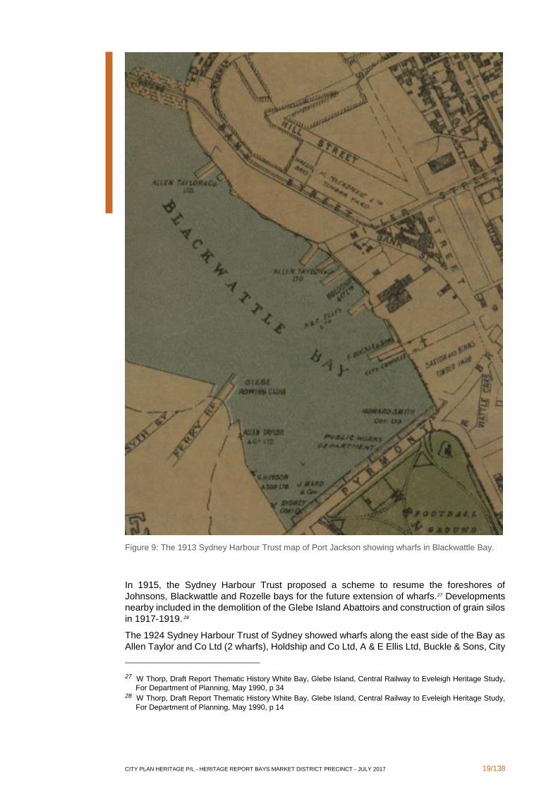
Figure 9: The 1913 Sydney Harbour Trust map of Port Jackson showing wharfs in Blackwattle Bay.
In 1915, the Sydney Harbour Trust proposed a scheme to resume the foreshores of
Johnsons, Blackwattle and Rozelle bays for the future extension of wharfs.27 Developments
nearby included in the demolition of the Glebe Island Abattoirs and construction of grain silos
in 1917-1919. 28
The 1924 Sydney Harbour Trust of Sydney showed wharfs along the east side of the Bay as
Allen Taylor and Co Ltd (2 wharfs), Holdship and Co Ltd, A & E Ellis Ltd, Buckle & Sons, City
27 W Thorp, Draft Report Thematic History White Bay, Glebe Island, Central Railway to Eveleigh Heritage Study,
For Department of Planning, May 1990, p 34 28 W Thorp, Draft Report Thematic History White Bay, Glebe Island, Central Railway to Eveleigh Heritage Study,
For Department of Planning, May 1990, p 14
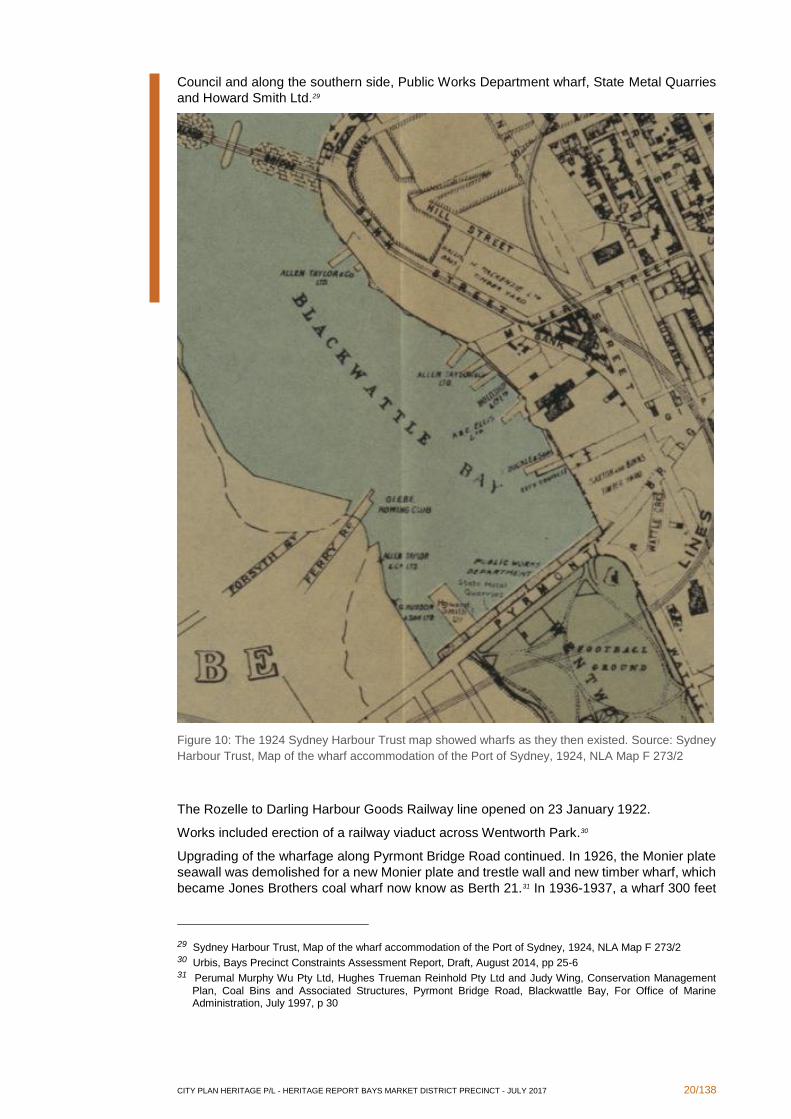
CITY PLAN HERITAGE P/L - HERITAGE REPORT BAYS MARKET DISTRICT PRECINCT - JULY 2017 20/138
Council and along the southern side, Public Works Department wharf, State Metal Quarries
and Howard Smith Ltd.29
Figure 10: The 1924 Sydney Harbour Trust map showed wharfs as they then existed. Source: Sydney
Harbour Trust, Map of the wharf accommodation of the Port of Sydney, 1924, NLA Map F 273/2
The Rozelle to Darling Harbour Goods Railway line opened on 23 January 1922.
Works included erection of a railway viaduct across Wentworth Park.30
Upgrading of the wharfage along Pyrmont Bridge Road continued. In 1926, the Monier plate
seawall was demolished for a new Monier plate and trestle wall and new timber wharf, which
became Jones Brothers coal wharf now know as Berth 21.31 In 1936-1937, a wharf 300 feet
29 Sydney Harbour Trust, Map of the wharf accommodation of the Port of Sydney, 1924, NLA Map F 273/2 30 Urbis, Bays Precinct Constraints Assessment Report, Draft, August 2014, pp 25-6 31 Perumal Murphy Wu Pty Ltd, Hughes Trueman Reinhold Pty Ltd and Judy Wing, Conservation Management
Plan, Coal Bins and Associated Structures, Pyrmont Bridge Road, Blackwattle Bay, For Office of Marine Administration, July 1997, p 30
CITY PLAN HERITAGE P/L - HERITAGE REPORT BAYS MARKET DISTRICT PRECINCT - JULY 2017 21/138
long was constructed there for R W Miller and Co, which became Berth 24. 32 Jones Bros coal
bins were reconstructed in 195-1953.33
In 1983, sites along the eastern side of the Bay included Fork Lift Pty Ltd (No 1 Bank Street),
Colonial Sugar Refining Co Ltd, Sydney County Council (later Poulos site), a Shell service
station, E A Watts Pty Ltd (later Hymix North) and Hymix Concrete (Hymix South).34
Both halves of the new Glebe Island Bridge were joined on 24 July 1995, establishing a new
stronger transport link into the area. On 11 November 1998, the new Glebe Island Bridge was
renamed Anzac Bridge.35
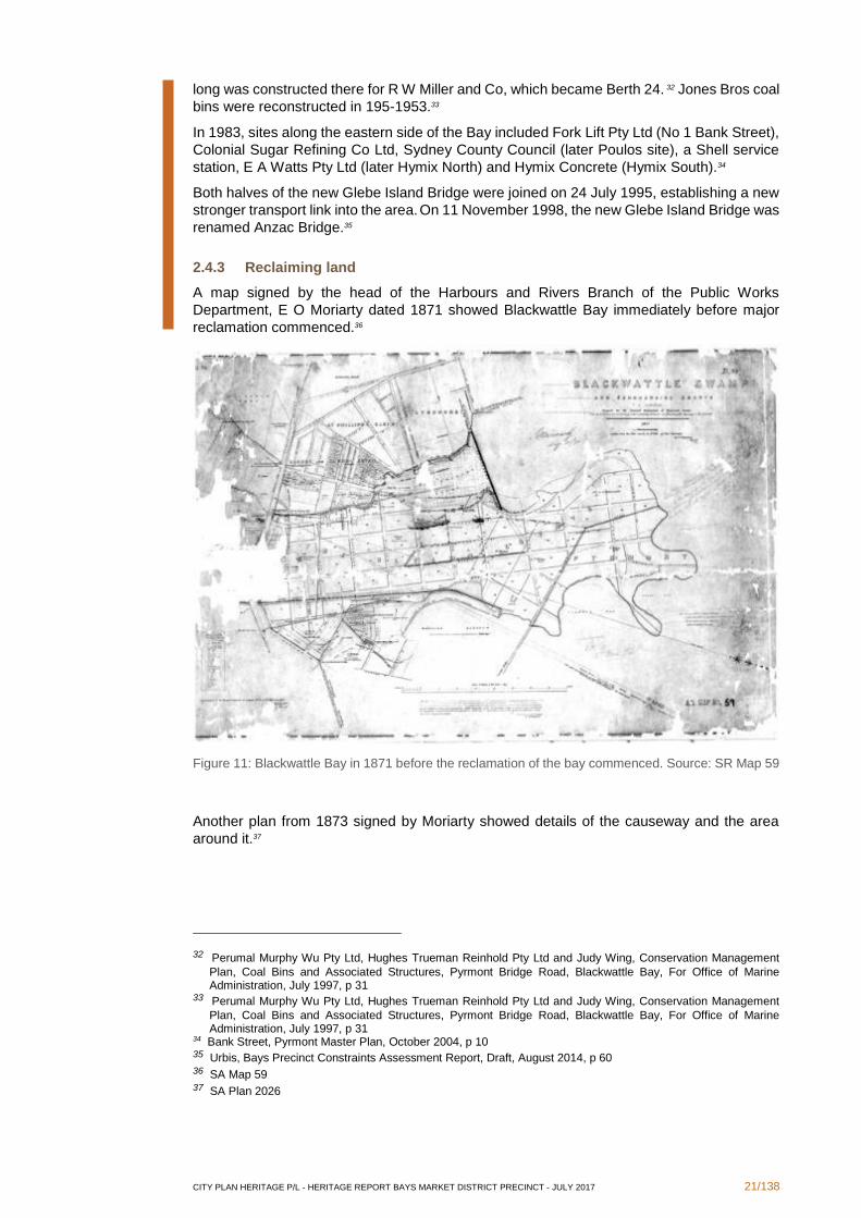
2.4.3 Reclaiming land
A map signed by the head of the Harbours and Rivers Branch of the Public Works
Department, E O Moriarty dated 1871 showed Blackwattle Bay immediately before major
reclamation commenced.36
Figure 11: Blackwattle Bay in 1871 before the reclamation of the bay commenced. Source: SR Map 59
Another plan from 1873 signed by Moriarty showed details of the causeway and the area
around it.37
32 Perumal Murphy Wu Pty Ltd, Hughes Trueman Reinhold Pty Ltd and Judy Wing, Conservation Management
Plan, Coal Bins and Associated Structures, Pyrmont Bridge Road, Blackwattle Bay, For Office of Marine Administration, July 1997, p 31
33 Perumal Murphy Wu Pty Ltd, Hughes Trueman Reinhold Pty Ltd and Judy Wing, Conservation Management
Plan, Coal Bins and Associated Structures, Pyrmont Bridge Road, Blackwattle Bay, For Office of Marine Administration, July 1997, p 31
34 Bank Street, Pyrmont Master Plan, October 2004, p 10 35 Urbis, Bays Precinct Constraints Assessment Report, Draft, August 2014, p 60 36 SA Map 59 37 SA Plan 2026
CITY PLAN HERITAGE P/L - HERITAGE REPORT BAYS MARKET DISTRICT PRECINCT - JULY 2017 22/138
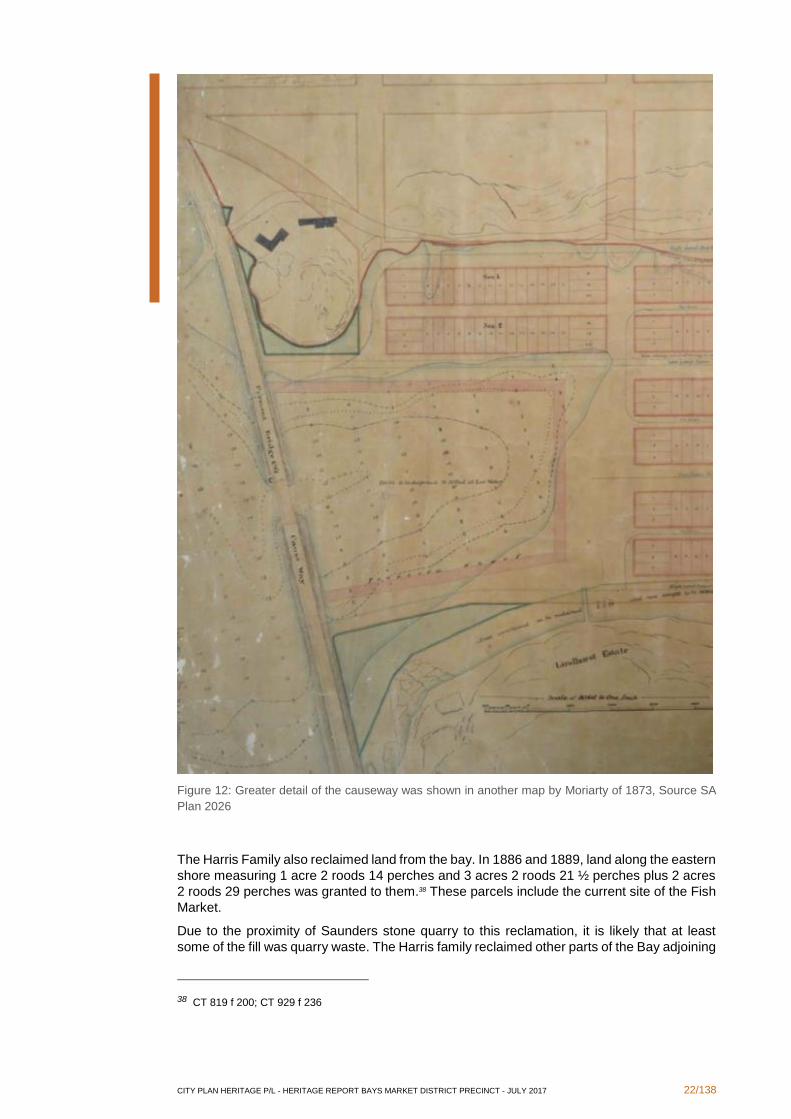
Figure 12: Greater detail of the causeway was shown in another map by Moriarty of 1873, Source SA
Plan 2026
The Harris Family also reclaimed land from the bay. In 1886 and 1889, land along the eastern
shore measuring 1 acre 2 roods 14 perches and 3 acres 2 roods 21 ½ perches plus 2 acres
2 roods 29 perches was granted to them.38 These parcels include the current site of the Fish
Market.
Due to the proximity of Saunders stone quarry to this reclamation, it is likely that at least
some of the fill was quarry waste. The Harris family reclaimed other parts of the Bay adjoining
38 CT 819 f 200; CT 929 f 236
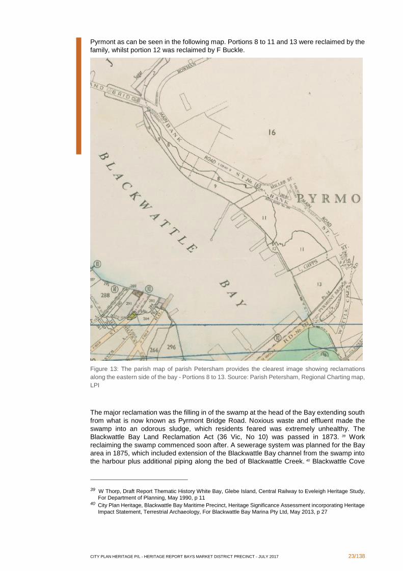
CITY PLAN HERITAGE P/L - HERITAGE REPORT BAYS MARKET DISTRICT PRECINCT - JULY 2017 23/138
Pyrmont as can be seen in the following map. Portions 8 to 11 and 13 were reclaimed by the
family, whilst portion 12 was reclaimed by F Buckle.
Figure 13: The parish map of parish Petersham provides the clearest image showing reclamations
along the eastern side of the bay - Portions 8 to 13. Source: Parish Petersham, Regional Charting map,
LPI
The major reclamation was the filling in of the swamp at the head of the Bay extending south
from what is now known as Pyrmont Bridge Road. Noxious waste and effluent made the
swamp into an odorous sludge, which residents feared was extremely unhealthy. The
Blackwattle Bay Land Reclamation Act (36 Vic, No 10) was passed in 1873. 39 Work
reclaiming the swamp commenced soon after. A sewerage system was planned for the Bay
area in 1875, which included extension of the Blackwattle Bay channel from the swamp into
the harbour plus additional piping along the bed of Blackwattle Creek. 40 Blackwattle Cove
39 W Thorp, Draft Report Thematic History White Bay, Glebe Island, Central Railway to Eveleigh Heritage Study,
For Department of Planning, May 1990, p 11 40 City Plan Heritage, Blackwattle Bay Maritime Precinct, Heritage Significance Assessment incorporating Heritage
Impact Statement, Terrestrial Archaeology, For Blackwattle Bay Marina Pty Ltd, May 2013, p 27
CITY PLAN HERITAGE P/L - HERITAGE REPORT BAYS MARKET DISTRICT PRECINCT - JULY 2017 24/138
and swamp was filled in during 1876-1880. Numerous sea walls and dykes were constructed
as part of the scheme to retain the fill and maintain stability. 41
The Blackwattle Swamp Land Reclamation Amendment Act (41 Vic No 20) of 1878 specified
that the reclaimed land be used as park. 42 In 1885-1886, a seawall was constructed along
the north edge of Pyrmont Bridge Road. 43 In 1889, tidal swamp along the shores of Glebe
and Annandale was also reclaimed.44 The extent of the reclamation creating Wentworth Park
can be seen in maps of the parish of Petersham of 1835 and 1899.45
41 Urbis, Bays Precinct Constraints Assessment Report, Draft, August 2014, p 23 42 Urbis, Bays Precinct Constraints Assessment Report, Draft, August 2014, p 23 43 City Plan Heritage, Blackwattle Bay Maritime Precinct, Heritage Significance Assessment incorporating Heritage
Impact Statement, Terrestrial Archaeology, For Blackwattle Bay Marina Pty Ltd, May 2013, p 28 44 W Thorp, Draft Report Thematic History White Bay, Glebe Island, Central Railway to Eveleigh Heritage Study,
For Department of Planning, May 1990, p 12 45 SR Map 341 and Parish Map, Petersham, County Cumberland, 1899
CITY PLAN HERITAGE P/L - HERITAGE REPORT BAYS MARKET DISTRICT PRECINCT - JULY 2017 25/138
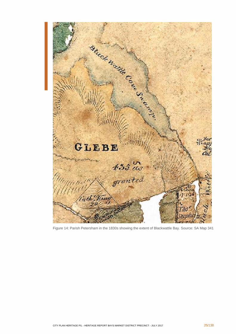
Figure 14: Parish Petersham in the 1830s showing the extent of Blackwattle Bay. Source: SA Map 341
CITY PLAN HERITAGE P/L - HERITAGE REPORT BAYS MARKET DISTRICT PRECINCT - JULY 2017 26/138
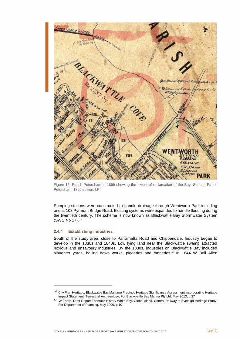
Figure 15: Parish Petersham in 1899 showing the extent of reclamation of the Bay. Source: Parish
Petersham, 1899 edition, LPI
Pumping stations were constructed to handle drainage through Wentworth Park including
one at 103 Pyrmont Bridge Road. Existing systems were expanded to handle flooding during
the twentieth century. The scheme is now known as Blackwattle Bay Stormwater System
(SWC No 17). 46
2.4.4 Establishing industries
South of the study area, close to Parramatta Road and Chippendale, Industry began to
develop in the 1830s and 1840s. Low lying land near the Blackwattle swamp attracted
noxious and unsavoury industries. By the 1830s, industries on Blackwattle Bay included
slaughter yards, boiling down works, piggeries and tanneries.47 In 1844 W Bell Allen
46 City Plan Heritage, Blackwattle Bay Maritime Precinct, Heritage Significance Assessment incorporating Heritage
Impact Statement, Terrestrial Archaeology, For Blackwattle Bay Marina Pty Ltd, May 2013, p 27 47 W Thorp, Draft Report Thematic History White Bay, Glebe Island, Central Railway to Eveleigh Heritage Study,
For Department of Planning, May 1990, p 10
CITY PLAN HERITAGE P/L - HERITAGE REPORT BAYS MARKET DISTRICT PRECINCT - JULY 2017 27/138
established a boiling down works at Blackwattle Bay. 48 Other industries along the catchment
of Blackwattle Creek included Tooth’s brewery and the sugar refinery on Blackfriars estate.49
Moves to remove animal slaughter from the city of Sydney resulted in an act of 1850
establishing Abattoirs on Glebe Island. 50 However, it took some time to establish the works
and the Abattoirs did not commence operations until 1860.51
Though the Glebe Island abattoirs were intended to remove noxious industries such as
animal slaughter from the immediate vicinity of the city, problems arose. In 1879, Commission
of inquiry reported on the management of Glebe Island abattoirs.52 It recommended that
Homebush be considered as a site for a new abattoir. In 1887, a petition demanded that the
abattoirs be moved to Homebush.53
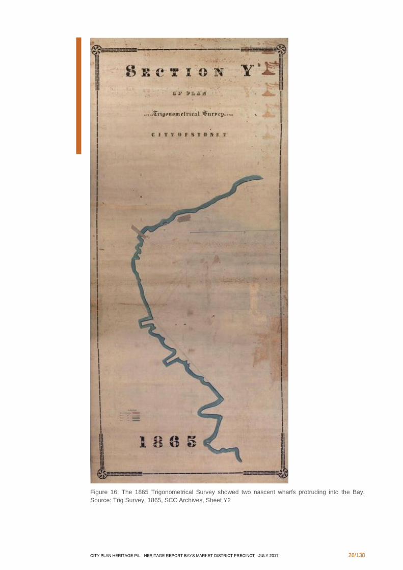
About 1853, Charles Saunders commenced quarrying at Ultimo on land leased from the
Harris family.54 Meanwhile, land along the eastern shore of the Bay had become more
attractive industry and shipping. As early as the 1860s, jetties had appeared along the
eastern shore. The 1865 Trigonometrical survey showed two jetties along the eastern side
of the bay.55
48 W Thorp, Draft Report Thematic History White Bay, Glebe Island, Central Railway to Eveleigh Heritage Study,
For Department of Planning, May 1990, p 31 49 City Plan Heritage, Blackwattle Bay Maritime Precinct, Heritage Significance Assessment incorporating Heritage
Impact Statement, Terrestrial Archaeology, For Blackwattle Bay Marina Pty Ltd, May 2013, p 25 50 W Thorp, Draft Report Thematic History White Bay, Glebe Island, Central Railway to Eveleigh Heritage Study,
For Department of Planning, May 1990, p 10 51 W Thorp, Draft Report Thematic History White Bay, Glebe Island, Central Railway to Eveleigh Heritage Study,
For Department of Planning, May 1990, p 10 52 W Thorp, Draft Report Thematic History White Bay, Glebe Island, Central Railway to Eveleigh Heritage Study,
For Department of Planning, May 1990, p 11 53 W Thorp, Draft Report Thematic History White Bay, Glebe Island, Central Railway to Eveleigh Heritage Study,
For Department of Planning, May 1990, p 12 54 S Fitzgerald and H Golder, Pyrmont & Ultimo Under Siege, Hale & Iremonger, Sydney, 1994, p 45 55 Trigonometrical survey, 1865, City of Sydney, Sheet Y2
CITY PLAN HERITAGE P/L - HERITAGE REPORT BAYS MARKET DISTRICT PRECINCT - JULY 2017 28/138
Figure 16: The 1865 Trigonometrical Survey showed two nascent wharfs protruding into the Bay.
Source: Trig Survey, 1865, SCC Archives, Sheet Y2
CITY PLAN HERITAGE P/L - HERITAGE REPORT BAYS MARKET DISTRICT PRECINCT - JULY 2017 29/138
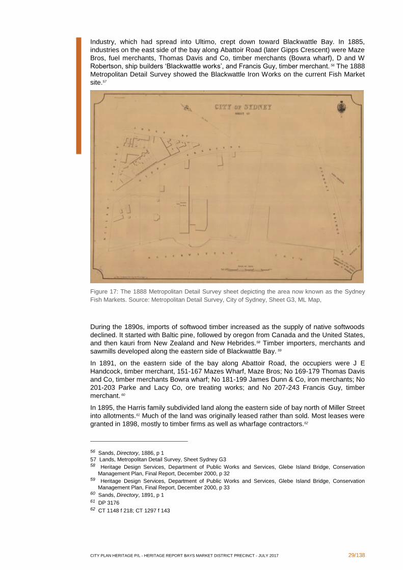
Industry, which had spread into Ultimo, crept down toward Blackwattle Bay. In 1885,
industries on the east side of the bay along Abattoir Road (later Gipps Crescent) were Maze
Bros, fuel merchants, Thomas Davis and Co, timber merchants (Bowra wharf), D and W
Robertson, ship builders ‘Blackwattle works’, and Francis Guy, timber merchant. 56 The 1888
Metropolitan Detail Survey showed the Blackwattle Iron Works on the current Fish Market
site.57
Figure 17: The 1888 Metropolitan Detail Survey sheet depicting the area now known as the Sydney
Fish Markets. Source: Metropolitan Detail Survey, City of Sydney, Sheet G3, ML Map,
During the 1890s, imports of softwood timber increased as the supply of native softwoods
declined. It started with Baltic pine, followed by oregon from Canada and the United States,
and then kauri from New Zealand and New Hebrides.58 Timber importers, merchants and
sawmills developed along the eastern side of Blackwattle Bay. 59
In 1891, on the eastern side of the bay along Abattoir Road, the occupiers were J E
Handcock, timber merchant, 151-167 Mazes Wharf, Maze Bros; No 169-179 Thomas Davis
and Co, timber merchants Bowra wharf; No 181-199 James Dunn & Co, iron merchants; No
201-203 Parke and Lacy Co, ore treating works; and No 207-243 Francis Guy, timber
merchant. 60
In 1895, the Harris family subdivided land along the eastern side of bay north of Miller Street
into allotments.61 Much of the land was originally leased rather than sold. Most leases were
granted in 1898, mostly to timber firms as well as wharfage contractors.62
56 Sands, Directory, 1886, p 1
57 Lands, Metropolitan Detail Survey, Sheet Sydney G3 58 Heritage Design Services, Department of Public Works and Services, Glebe Island Bridge, Conservation
Management Plan, Final Report, December 2000, p 32 59 Heritage Design Services, Department of Public Works and Services, Glebe Island Bridge, Conservation
Management Plan, Final Report, December 2000, p 33 60 Sands, Directory, 1891, p 1 61 DP 3176 62 CT 1148 f 218; CT 1297 f 143
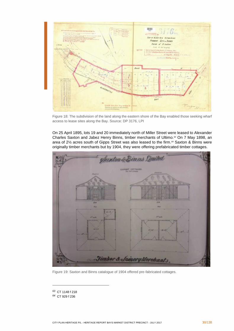
CITY PLAN HERITAGE P/L - HERITAGE REPORT BAYS MARKET DISTRICT PRECINCT - JULY 2017 30/138
Figure 18: The subdivision of the land along the eastern shore of the Bay enabled those seeking wharf
access to lease sites along the Bay. Source: DP 3176, LPI
On 25 April 1895, lots 19 and 20 immediately north of Miller Street were leased to Alexander
Charles Saxton and Jabez Henry Binns, timber merchants of Ultimo.63 On 7 May 1898, an
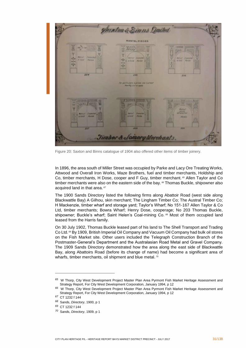
area of 2½ acres south of Gipps Street was also leased to the firm.64 Saxton & Binns were
originally timber merchants but by 1904, they were offering prefabricated timber cottages.
Figure 19: Saxton and Binns catalogue of 1904 offered pre-fabricated cottages.
63 CT 1148 f 218 64 CT 929 f 236
CITY PLAN HERITAGE P/L - HERITAGE REPORT BAYS MARKET DISTRICT PRECINCT - JULY 2017 31/138
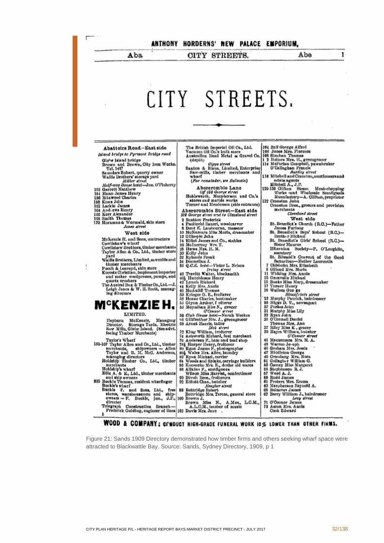
Figure 20: Saxton and Binns catalogue of 1904 also offered other items of timber joinery.
In 1896, the area south of Miller Street was occupied by Parke and Lacy Ore Treating Works,
Attwood and Overall Iron Works, Maze Brothers, fuel and timber merchants, Holdship and
Co, timber merchants, H Dose, cooper and F Guy, timber merchant. 65 Allen Taylor and Co
timber merchants were also on the eastern side of the bay. 66 Thomas Buckle, shipowner also
acquired land in that area. 67
The 1900 Sands Directory listed the following firms along Abattoir Road (west side along
Blackwattle Bay) A Gilhou, skin merchant; The Lingham Timber Co; The Austral Timber Co;
H Mackenzie, timber wharf and storage yard; Taylor’s Wharf; No 151-167 Allen Taylor & Co
Ltd, timber merchants; Bowra Wharf; Henry Dose, cooperage; No 203 Thomas Buckle,
shipowner; Buckle’s wharf; Saint Helen’s Coal-mining Co. 68 Most of them occupied land
leased from the Harris family.
On 30 July 1902, Thomas Buckle leased part of his land to The Shell Transport and Trading
Co Ltd. 69 By 1909, British Imperial Oil Company and Vacuum Oil Company had bulk oil stores
on the Fish Market site. Other users included the Telegraph Construction Branch of the
Postmaster-General’s Department and the Australasian Road Metal and Gravel Company.
The 1909 Sands Directory demonstrated how the area along the east side of Blackwattle
Bay, along Abattoirs Road (before its change of name) had become a significant area of
wharfs, timber merchants, oil shipment and blue metal. 70
65 W Thorp, City West Development Project Master Plan Area Pyrmont Fish Market Heritage Assessment and
Strategy Report, For City West Development Corporation, January 1994, p 12 66 W Thorp, City West Development Project Master Plan Area Pyrmont Fish Market Heritage Assessment and
Strategy Report, For City West Development Corporation, January 1994, p 12 67 CT 1232 f 144 68 Sands, Directory, 1900, p 1 69 CT 1232 f 144 70 Sands, Directory, 1909, p 1
CITY PLAN HERITAGE P/L - HERITAGE REPORT BAYS MARKET DISTRICT PRECINCT - JULY 2017 32/138
Figure 21: Sands 1909 Directory demonstrated how timber firms and others seeking wharf space were
attracted to Blackwattle Bay. Source: Sands, Sydney Directory, 1909, p 1
CITY PLAN HERITAGE P/L - HERITAGE REPORT BAYS MARKET DISTRICT PRECINCT - JULY 2017 33/138
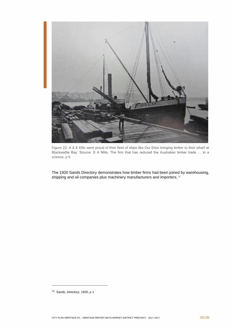
Figure 22: A & E Ellis were proud of their fleet of ships like Our Elsie bringing timber to their wharf at
Blackwattle Bay. Source: S A Mills, The firm that has reduced the Australian timber trade … to a
science, p 6
The 1920 Sands Directory demonstrates how timber firms had been joined by warehousing,
shipping and oil companies plus machinery manufacturers and importers. 71
71 Sands, Directory, 1920, p 1
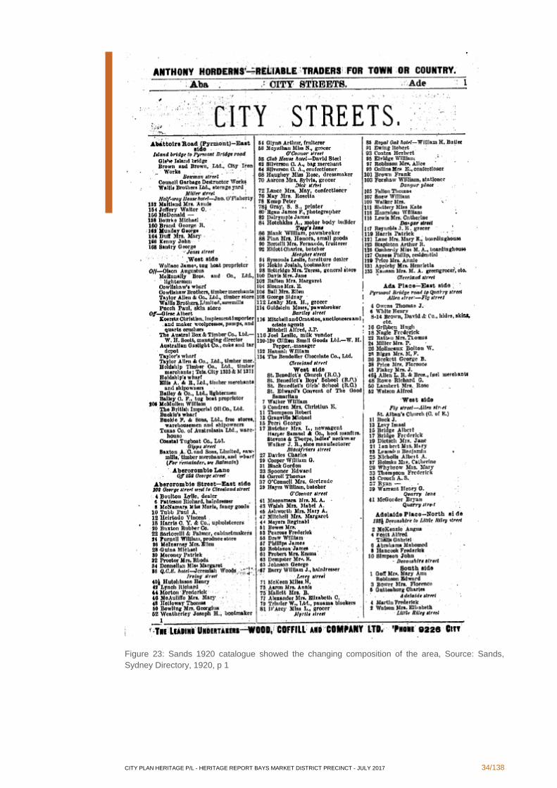
CITY PLAN HERITAGE P/L - HERITAGE REPORT BAYS MARKET DISTRICT PRECINCT - JULY 2017 34/138
Figure 23: Sands 1920 catalogue showed the changing composition of the area, Source: Sands,
Sydney Directory, 1920, p 1
CITY PLAN HERITAGE P/L - HERITAGE REPORT BAYS MARKET DISTRICT PRECINCT - JULY 2017 35/138
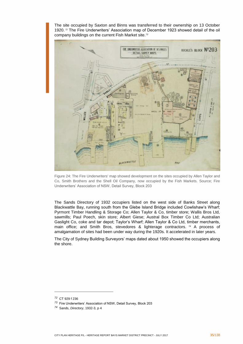
The site occupied by Saxton and Binns was transferred to their ownership on 13 October
1920. 72 The Fire Underwriters’ Association map of December 1923 showed detail of the oil
company buildings on the current Fish Market site.73
Figure 24: The Fire Underwriters' map showed development on the sites occupied by Allen Taylor and
Co, Smith Brothers and the Shell Oil Company, now occupied by the Fish Markets. Source; Fire
Underwriters’ Association of NSW, Detail Survey, Block 203
The Sands Directory of 1932 occupiers listed on the west side of Banks Street along
Blackwattle Bay, running south from the Glebe Island Bridge included Cowlishaw’s Wharf;
Pyrmont Timber Handling & Storage Co; Allen Taylor & Co, timber store; Wallis Bros Ltd,
sawmills; Paul Poech, skin store; Albert Giese; Austral Box Timber Co Ltd; Australian
Gaslight Co, coke and tar depot; Taylor’s Wharf; Allen Taylor & Co Ltd, timber merchants,
main office; and Smith Bros, stevedores & lighterage contractors. 74 A process of
amalgamation of sites had been under way during the 1920s. It accelerated in later years.
The City of Sydney Building Surveyors’ maps dated about 1950 showed the occupiers along
the shore.
72 CT 929 f 236 73 Fire Underwriters’ Association of NSW, Detail Survey, Block 203 74 Sands, Directory, 1932-3, p 4
CITY PLAN HERITAGE P/L - HERITAGE REPORT BAYS MARKET DISTRICT PRECINCT - JULY 2017 36/138
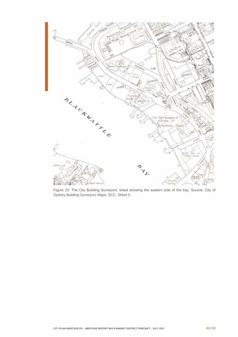
Figure 25: The City Building Surveyors’ sheet showing the eastern side of the bay. Source: City of
Sydney Building Surveyors Maps, SCC, Sheet 5
CITY PLAN HERITAGE P/L - HERITAGE REPORT BAYS MARKET DISTRICT PRECINCT - JULY 2017 37/138
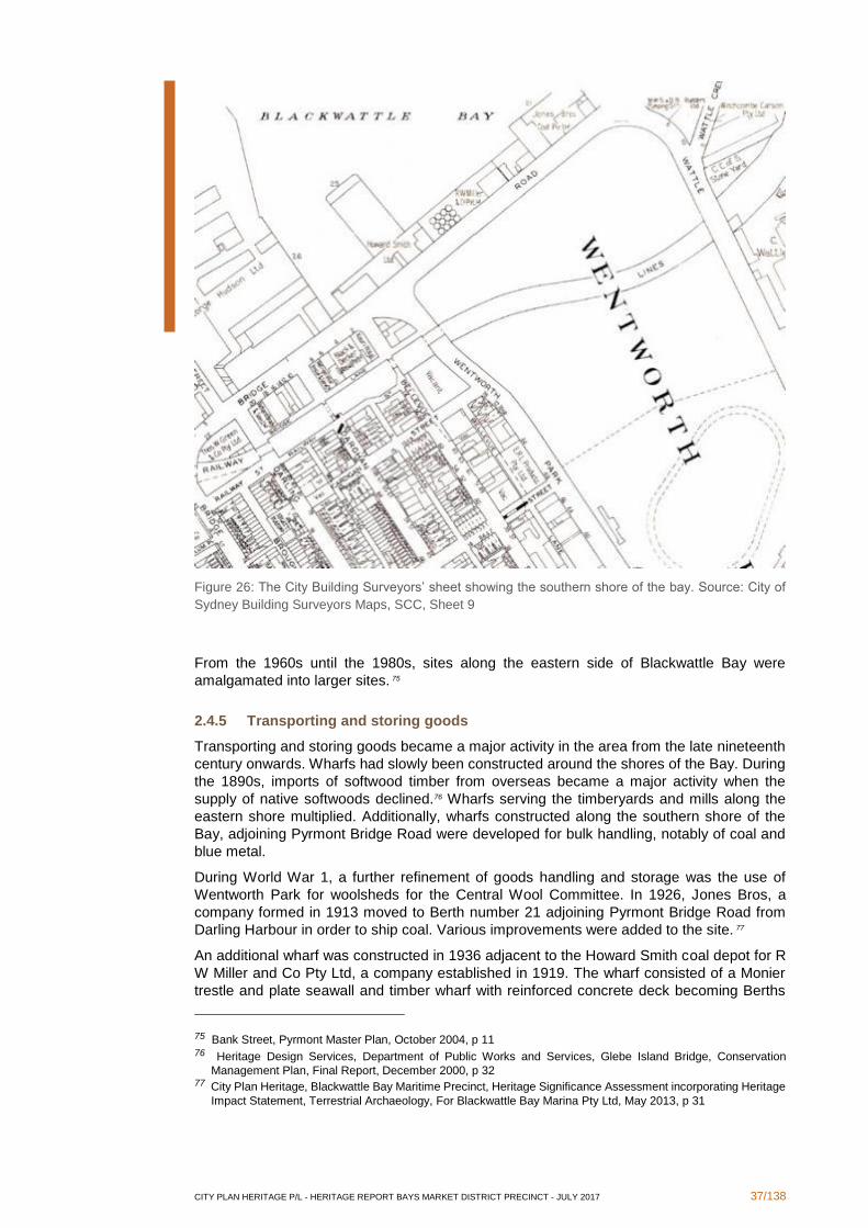
Figure 26: The City Building Surveyors’ sheet showing the southern shore of the bay. Source: City of
Sydney Building Surveyors Maps, SCC, Sheet 9
From the 1960s until the 1980s, sites along the eastern side of Blackwattle Bay were
amalgamated into larger sites. 75
2.4.5 Transporting and storing goods
Transporting and storing goods became a major activity in the area from the late nineteenth
century onwards. Wharfs had slowly been constructed around the shores of the Bay. During
the 1890s, imports of softwood timber from overseas became a major activity when the
supply of native softwoods declined.76 Wharfs serving the timberyards and mills along the
eastern shore multiplied. Additionally, wharfs constructed along the southern shore of the
Bay, adjoining Pyrmont Bridge Road were developed for bulk handling, notably of coal and
blue metal.
During World War 1, a further refinement of goods handling and storage was the use of
Wentworth Park for woolsheds for the Central Wool Committee. In 1926, Jones Bros, a
company formed in 1913 moved to Berth number 21 adjoining Pyrmont Bridge Road from
Darling Harbour in order to ship coal. Various improvements were added to the site. 77
An additional wharf was constructed in 1936 adjacent to the Howard Smith coal depot for R
W Miller and Co Pty Ltd, a company established in 1919. The wharf consisted of a Monier
trestle and plate seawall and timber wharf with reinforced concrete deck becoming Berths
75 Bank Street, Pyrmont Master Plan, October 2004, p 11 76 Heritage Design Services, Department of Public Works and Services, Glebe Island Bridge, Conservation
Management Plan, Final Report, December 2000, p 32 77 City Plan Heritage, Blackwattle Bay Maritime Precinct, Heritage Significance Assessment incorporating Heritage
Impact Statement, Terrestrial Archaeology, For Blackwattle Bay Marina Pty Ltd, May 2013, p 31
CITY PLAN HERITAGE P/L - HERITAGE REPORT BAYS MARKET DISTRICT PRECINCT - JULY 2017 38/138
Nos 23 and 24. 78 By the 1940s, J Norris & Co, ship painters, occupied some of the other
wharfage.79
Coal and Allied Operations Pty Ltd took over berth 24 from R W Miller and Co in 1960 and
bought out Jones Brothers to commence using berth 21 from 1972 onwards.80 From the
1980s onwards, development of coal port facilities at Port Kembla drew coal exports away
from Blackwattle Bay. 81 In 1995 Coal and Allied Operations Pty Ltd gave up their lease of the
coal wharfs. 82 All Occasion Cruises briefly leased the wharfs. 83 By 2000, Pioneer Concrete
was operating a ready mixed concrete plant on the former coal wharfs. 84 Berths 22-24 were
extended at the western end in 2001. 85
2.4.6 Establishing utility infrastructure
Major utility construction occurred near this area from 1912 to 1917 when the first stage of
the White Bay power station was constructed. 86 The addition of the second stage commenced
in 1923. 87
Electric substations were built on the bulk handling wharf area joining Pyrmont Bridge Road.
In 1953 Substation Number 405 underneath the coal bins on Berth 21 was constructed.88 In
1960, substation number 1608 at the western end of Berth 21 was constructed.89 White Bay
power station ceased generating electricity on 25 December 1983.90
2.4.7 Providing building materials
From the 1890s, as commercial development commenced along the eastern side of the Bay,
a significant component was major expansion amongst timber firms in that area. It quickly
became a major focus for timber imports, shipment and timber milling.
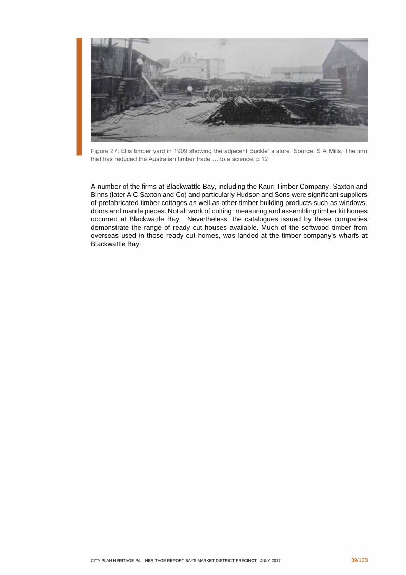
In 1909, Blackwattle Bay was described as ‘the very core, life, and being of Sydney’s Timber
Industry, where timber is piled in stacks and supine forests along the waters edge for near a
two mile stretch; in a locality and atmosphere, that talks, eats, drinks, and thinks timber for
14 hours out of the 24; where the workmen at the machines all carry shavings in their hair’.91
78 City Plan Heritage, Blackwattle Bay Maritime Precinct, Heritage Significance Assessment incorporating Heritage
Impact Statement, Terrestrial Archaeology, For Blackwattle Bay Marina Pty Ltd, May 2013, p 32 79 City Plan Heritage, Blackwattle Bay Maritime Precinct, Heritage Significance Assessment incorporating Heritage
Impact Statement, Terrestrial Archaeology, For Blackwattle Bay Marina Pty Ltd, May 2013, p 33 80 City Plan Heritage, Blackwattle Bay Maritime Precinct, Heritage Significance Assessment incorporating Heritage
Impact Statement, Terrestrial Archaeology, For Blackwattle Bay Marina Pty Ltd, May 2013, p 36 81 Urbis, Bays Precinct Constraints Assessment Report, Draft, August 2014, p 73 82 City Plan Heritage, Blackwattle Bay Maritime Precinct, Heritage Significance Assessment incorporating Heritage
Impact Statement, Terrestrial Archaeology, For Blackwattle Bay Marina Pty Ltd, May 2013, p 36 83 City Plan Heritage, Blackwattle Bay Maritime Precinct, Heritage Significance Assessment incorporating Heritage
Impact Statement, Terrestrial Archaeology, For Blackwattle Bay Marina Pty Ltd, May 2013, p 36 84 Heritage Design Services, Department of Public Works and Services, Glebe Island Bridge, Conservation
Management Plan, Final Report, December 2000, p 34 you 85 City Plan Heritage, Blackwattle Bay Maritime Precinct, Heritage Significance Assessment incorporating Heritage
Impact Statement, Terrestrial Archaeology, For Blackwattle Bay Marina Pty Ltd, May 2013, p 36 86 Urbis, Bays Precinct Constraints Assessment Report, Draft, August 2014, p 71 87 W Thorp, Draft Report Thematic History White Bay, Glebe Island, Central Railway to Eveleigh Heritage Study,
For Department of Planning, May 1990, p 14 88 Perumal Murphy Wu Pty Ltd, Hughes Trueman Reinhold Pty Ltd and Judy Wing, Conservation Management
Plan, Coal Bins and Associated Structures, Pyrmont Bridge Road, Blackwattle Bay, For Office of Marine Administration, July 1997, p 28
89 Perumal Murphy Wu Pty Ltd, Hughes Trueman Reinhold Pty Ltd and Judy Wing, Conservation Management
Plan, Coal Bins and Associated Structures, Pyrmont Bridge Road, Blackwattle Bay, For Office of Marine Administration, July 1997, p 31
90 Urbis, Bays Precinct Constraints Assessment Report, Draft, August 2014, p 73 91 S A Mills, The firm that has reduced the Australian timber trade … to a science, A & E Ellis Ltd, Sydney, 1909, p
2
CITY PLAN HERITAGE P/L - HERITAGE REPORT BAYS MARKET DISTRICT PRECINCT - JULY 2017 39/138
Figure 27: Ellis timber yard in 1909 showing the adjacent Buckle’ s store. Source: S A Mills, The firm
that has reduced the Australian timber trade … to a science, p 12
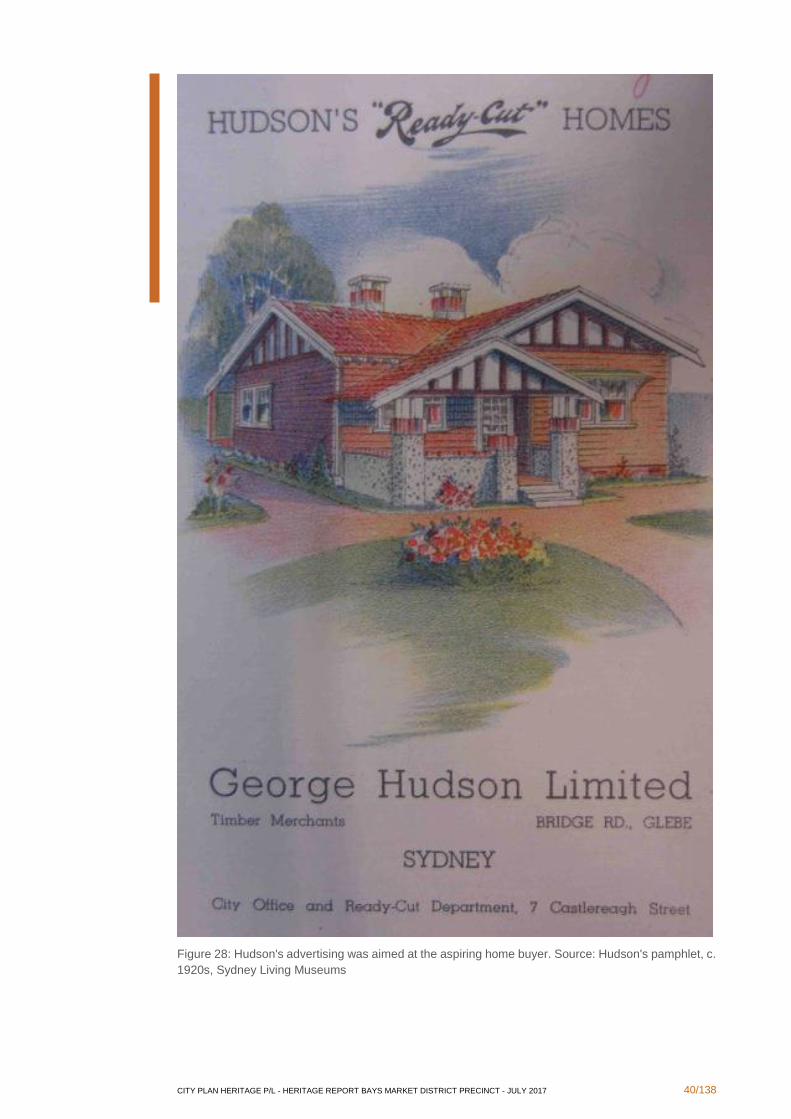
A number of the firms at Blackwattle Bay, including the Kauri Timber Company, Saxton and
Binns (later A C Saxton and Co) and particularly Hudson and Sons were significant suppliers
of prefabricated timber cottages as well as other timber building products such as windows,
doors and mantle pieces. Not all work of cutting, measuring and assembling timber kit homes
occurred at Blackwattle Bay. Nevertheless, the catalogues issued by these companies
demonstrate the range of ready cut houses available. Much of the softwood timber from
overseas used in those ready cut homes, was landed at the timber company’s wharfs at
Blackwattle Bay.
CITY PLAN HERITAGE P/L - HERITAGE REPORT BAYS MARKET DISTRICT PRECINCT - JULY 2017 40/138
Figure 28: Hudson's advertising was aimed at the aspiring home buyer. Source: Hudson's pamphlet, c.
1920s, Sydney Living Museums

CITY PLAN HERITAGE P/L - HERITAGE REPORT BAYS MARKET DISTRICT PRECINCT - JULY 2017 41/138
Figure 29: The cover of Hudson's 1930s catalogue outlines the firm’s activities.
CITY PLAN HERITAGE P/L - HERITAGE REPORT BAYS MARKET DISTRICT PRECINCT - JULY 2017 42/138
Due to the concentration of timber, fires could threaten the district. In 1914, a large fire at S
A Burns timberyards on Blackwattle Bay threatened the adjoining Hudson’s yards.92 In 1928,
there was a large fire at Hudson’s yard. 93 Both of these fires were on the Glebe side of the
bay. The 1928 fire caused significant damage including the ready cut cottage mill.94
During the 1960s, the timber industry started to move to Homebush Bay, where larger less
constricted sites were available. 95
2.4.8 Establishing and maintaining leisure facilities
Reclamation of the Blackwattle swamp was planned in the 1870s, though no purpose was
proposed for the reclaimed area. In 1878, the Blackwattle Swamp Land Reclamation
Amendment Act (41 Vic, No 20) specified that the reclaimed land would be used as a public
park. 96 This established what became known as Wentworth Park. During the 1880s,
Wentworth Park was created as a picturesque garden layout with playing fields. 97 A bowling
green opened in 1884.98 On 10 November 1885 Wentworth Park was formally gazetted.99
The 1890s Higinbotham and Robinson municipal map provided a clear view of the park’s
layout.100
92 W Thorp, Draft Report Thematic History White Bay, Glebe Island, Central Railway to Eveleigh Heritage Study,
For Department of Planning, May 1990, p 14 93 W Thorp, Draft Report Thematic History White Bay, Glebe Island, Central Railway to Eveleigh Heritage Study,
For Department of Planning, May 1990, p 14 94 Sun, 8 March 1928, p 15 95 W Thorp, Draft Report Thematic History White Bay, Glebe Island, Central Railway to Eveleigh Heritage Study,
For Department of Planning, May 1990, p 35 96 Urbis, Bays Precinct Constraints Assessment Report, Draft, August 2014, p 23 97 Urbis, Bays Precinct Constraints Assessment Report, Draft, August 2014, p 24 98 W Thorp, Historical Context Report Wentworth Park Sydney, August 1990, p 11 99 NSW Government Gazette, 10 Nov 1885, p 7218 100 Higinbotham and Robinson, Municipal map, The Glebe, c 1890s
CITY PLAN HERITAGE P/L - HERITAGE REPORT BAYS MARKET DISTRICT PRECINCT - JULY 2017 43/138
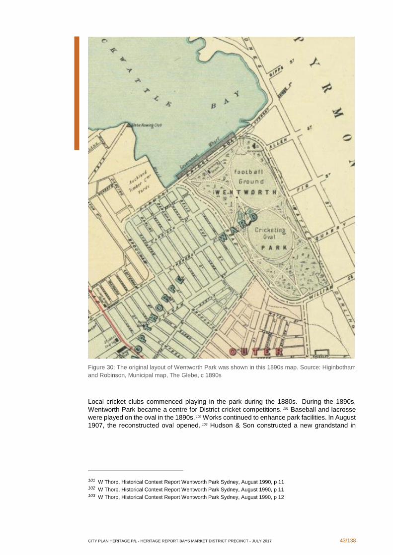
Figure 30: The original layout of Wentworth Park was shown in this 1890s map. Source: Higinbotham
and Robinson, Municipal map, The Glebe, c 1890s
Local cricket clubs commenced playing in the park during the 1880s. During the 1890s,
Wentworth Park became a centre for District cricket competitions. 101 Baseball and lacrosse
were played on the oval in the 1890s. 102 Works continued to enhance park facilities. In August
1907, the reconstructed oval opened. 103 Hudson & Son constructed a new grandstand in
101 W Thorp, Historical Context Report Wentworth Park Sydney, August 1990, p 11 102 W Thorp, Historical Context Report Wentworth Park Sydney, August 1990, p 11 103 W Thorp, Historical Context Report Wentworth Park Sydney, August 1990, p 12
CITY PLAN HERITAGE P/L - HERITAGE REPORT BAYS MARKET DISTRICT PRECINCT - JULY 2017 44/138
1909. 104 In 1908 Wentworth Park was the venue for the first day of rugby league football in
Australia. 105 It became a major centre for games between rival teams. 106
The ornamental lakes were filled in during 1910. 107 In 1925, the old tennis courts were
demolished and refurbished. 108 A cycle track commenced operating on the park in 1928. 109
During the 1930s, licences were granted to speedway operators in 1932 and 1934 and 1936.
110 The greyhound track that became a major feature opened on Wentworth Park on 28
October 1939, attracting numerous enthusiasts as well as persistent opposition from local
residents affected by its operation. 111 A new totalisator was built at the oval in 1963 whilst a
new grandstand was completed in 1985. 112
2.4.9 Supplying food
A significant occupier of land in the area standing upon large parcel of land is the Sydney
Fish Market. Its genesis arose from the 1949 Co-operation Act that established legislation
permitting fishing co-operatives along the coast. 113 A committee investigating fish marketing
in 1953 recommended the establishment of a Fish Authority to manage the Sydney Fish
Market. 114 In its wake, in 1963 the New South Wales Fish Authority was established under
the Fisheries and Oyster Farms (Amended) Act (Act No 20, 1963). 115 The new Fish Authority
took control of the existing Fish Markets previously on a site at the corner of Thomas and
Quay Streets in April 1964. 116
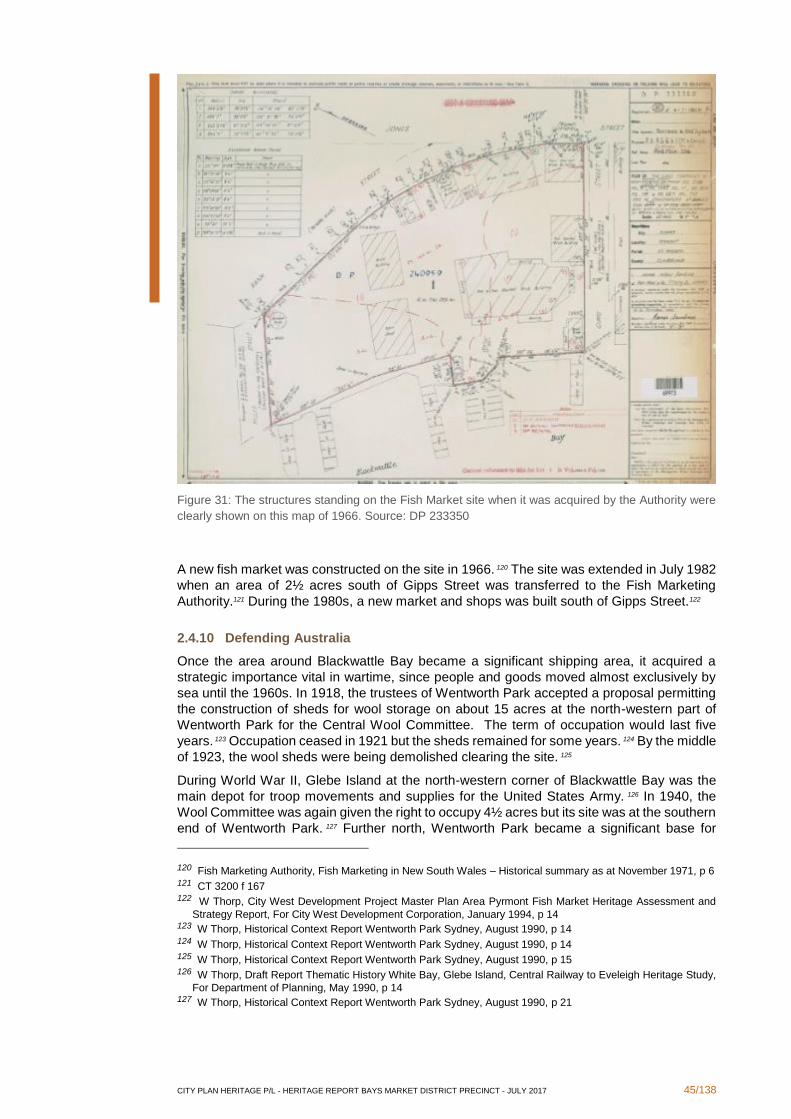
An area of 2 acres north of Gipps Street was transferred to the New South Wales Fish
Authority on 26 March 1965.117 On 18 July 1966, the Fish Marketing Authority moved to its
new site at Blackwattle Bay. 118 A map compiled in 1966 showed the site as it then existed.119
104 W Thorp, Historical Context Report Wentworth Park Sydney, August 1990, p 13 105 Urbis, Bays Precinct Constraints Assessment Report, Draft, August 2014, p 24 106 W Thorp, Historical Context Report Wentworth Park Sydney, August 1990, p 11 107 W Thorp, Historical Context Report Wentworth Park Sydney, August 1990, p 13 108 W Thorp, Historical Context Report Wentworth Park Sydney, August 1990, p 16 109 W Thorp, Historical Context Report Wentworth Park Sydney, August 1990, p 17 110 W Thorp, Historical Context Report Wentworth Park Sydney, August 1990, p 19 111 W Thorp, Historical Context Report Wentworth Park Sydney, August 1990, p 19 112 W Thorp, Historical Context Report Wentworth Park Sydney, August 1990, p 24 113 Fish Marketing Authority, Fish Marketing in New South Wales – Historical summary as at November 1971, p 3 114 Fish Marketing Authority, Fish Marketing in New South Wales – Historical summary as at November 1971, p 4 115 Fish Marketing Authority, Fish Marketing in New South Wales – Historical summary as at November 1971, p 5 116 W Thorp, City West Development Project Master Plan Area Pyrmont Fish Market Heritage Assessment and
Strategy Report, For City West Development Corporation, January 1994, p 14 117 CT 3552 f 17 118 Fish Marketing Authority, Fish Marketing in New South Wales – Historical summary as at November 1971, p 6 119 DP 233350
CITY PLAN HERITAGE P/L - HERITAGE REPORT BAYS MARKET DISTRICT PRECINCT - JULY 2017 45/138
Figure 31: The structures standing on the Fish Market site when it was acquired by the Authority were
clearly shown on this map of 1966. Source: DP 233350
A new fish market was constructed on the site in 1966. 120 The site was extended in July 1982
when an area of 2½ acres south of Gipps Street was transferred to the Fish Marketing
Authority.121 During the 1980s, a new market and shops was built south of Gipps Street.122
2.4.10 Defending Australia
Once the area around Blackwattle Bay became a significant shipping area, it acquired a
strategic importance vital in wartime, since people and goods moved almost exclusively by
sea until the 1960s. In 1918, the trustees of Wentworth Park accepted a proposal permitting
the construction of sheds for wool storage on about 15 acres at the north-western part of
Wentworth Park for the Central Wool Committee. The term of occupation would last five
years. 123 Occupation ceased in 1921 but the sheds remained for some years. 124 By the middle
of 1923, the wool sheds were being demolished clearing the site. 125
During World War II, Glebe Island at the north-western corner of Blackwattle Bay was the
main depot for troop movements and supplies for the United States Army. 126 In 1940, the
Wool Committee was again given the right to occupy 4½ acres but its site was at the southern
end of Wentworth Park. 127 Further north, Wentworth Park became a significant base for
120 Fish Marketing Authority, Fish Marketing in New South Wales – Historical summary as at November 1971, p 6 121 CT 3200 f 167 122 W Thorp, City West Development Project Master Plan Area Pyrmont Fish Market Heritage Assessment and
Strategy Report, For City West Development Corporation, January 1994, p 14 123 W Thorp, Historical Context Report Wentworth Park Sydney, August 1990, p 14 124 W Thorp, Historical Context Report Wentworth Park Sydney, August 1990, p 14 125 W Thorp, Historical Context Report Wentworth Park Sydney, August 1990, p 15 126 W Thorp, Draft Report Thematic History White Bay, Glebe Island, Central Railway to Eveleigh Heritage Study,
For Department of Planning, May 1990, p 14 127 W Thorp, Historical Context Report Wentworth Park Sydney, August 1990, p 21
CITY PLAN HERITAGE P/L - HERITAGE REPORT BAYS MARKET DISTRICT PRECINCT - JULY 2017 46/138
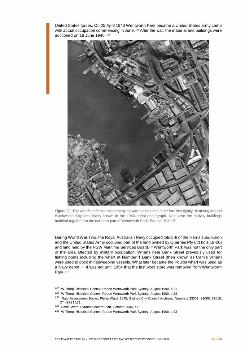
United States forces. On 25 April 1943 Wentworth Park became a United States army camp
with actual occupation commencing in June. 128 After the war, the material and buildings were
auctioned on 19 June 1946. 129
Figure 32: The wharfs and their accompanying warehouses and other facilities tightly clustering around
Blackwattle Bay are clearly shown in the 1943 aerial photograph. Note also the military buildings
huddled together on the northern part of Wentworth Park. Source: SIX LPI
During World War Two, the Royal Australian Navy occupied lots 5-8 of the Harris subdivision
and the United States Army occupied part of the land owned by Quarries Pty Ltd (lots 19-20)
and land held by the NSW Maritime Services Board.130 Wentworth Park was not the only part
of the area affected by military occupation. Wharfs near Bank Street previously used for
fishing boats including the wharf at Number 1 Bank Street (then known as Cam’s Wharf)
were used to dock minesweeping vessels. What later became the Poulos wharf was used as
a Navy depot. 131 It was not until 1954 that the last wool store was removed from Wentworth
Park. 132
128 W Thorp, Historical Context Report Wentworth Park Sydney, August 1990, p 21 129 W Thorp, Historical Context Report Wentworth Park Sydney, August 1990, p 23 130 Rate Assessment Books, Phillip Ward, 1945, Sydney City Council Archives, Numbers 33003, 33008, 33010;
CT 4878 f 131 131 Bank Street, Pyrmont Master Plan, October 2004, p 6 132 W Thorp, Historical Context Report Wentworth Park Sydney, August 1990, p 23
CITY PLAN HERITAGE P/L - HERITAGE REPORT BAYS MARKET DISTRICT PRECINCT - JULY 2017 47/138
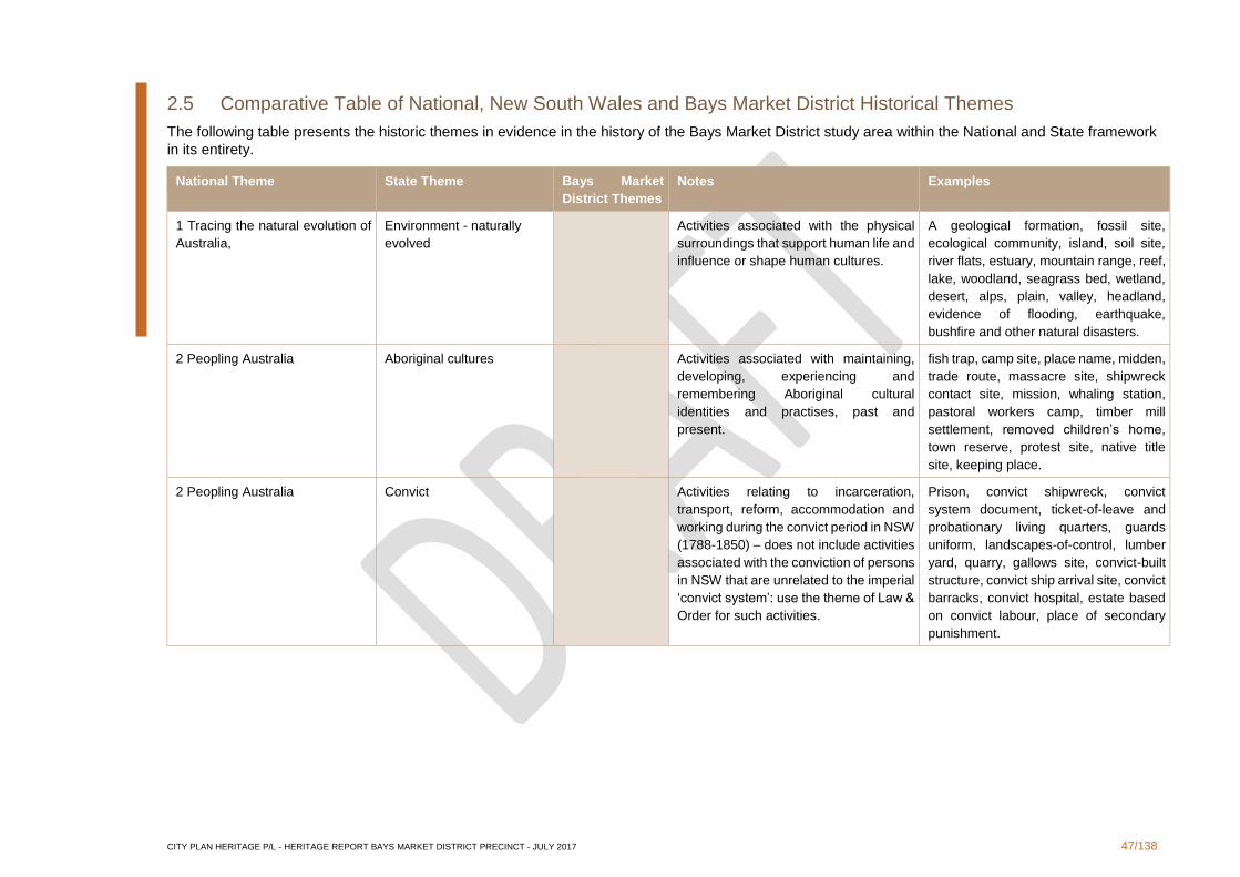
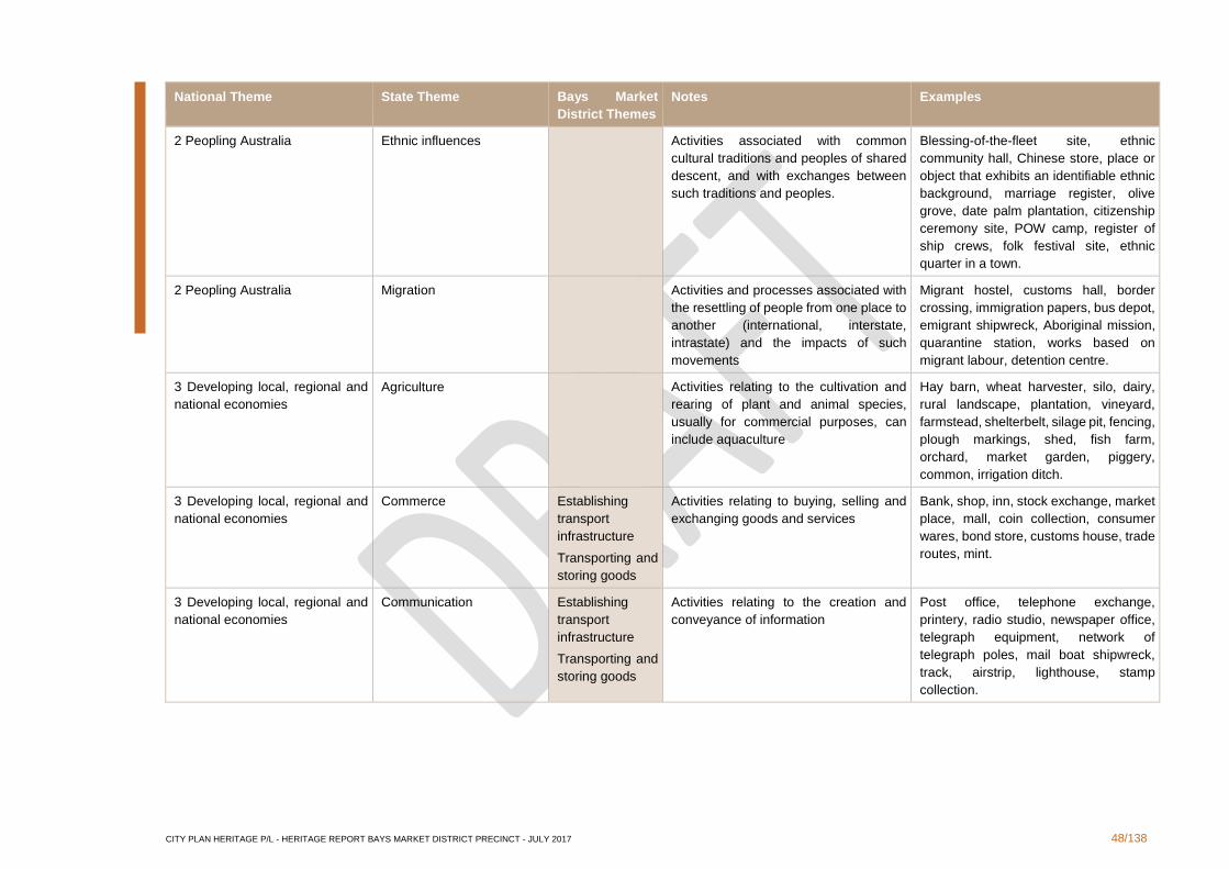
2.5 Comparative Table of National, New South Wales and Bays Market District Historical Themes
The following table presents the historic themes in evidence in the history of the Bays Market District study area within the National and State framework
in its entirety.
National Theme State Theme Bays Market
District Themes
Notes Examples
1 Tracing the natural evolution of
Australia,
Environment - naturally
evolved
Activities associated with the physical
surroundings that support human life and
influence or shape human cultures.
A geological formation, fossil site,
ecological community, island, soil site,
river flats, estuary, mountain range, reef,
lake, woodland, seagrass bed, wetland,
desert, alps, plain, valley, headland,
evidence of flooding, earthquake,
bushfire and other natural disasters.
2 Peopling Australia Aboriginal cultures Activities associated with maintaining,
developing, experiencing and
remembering Aboriginal cultural
identities and practises, past and
present.
fish trap, camp site, place name, midden,
trade route, massacre site, shipwreck
contact site, mission, whaling station,
pastoral workers camp, timber mill
settlement, removed children’s home,
town reserve, protest site, native title
site, keeping place.
2 Peopling Australia Convict Activities relating to incarceration,
transport, reform, accommodation and
working during the convict period in NSW
(1788-1850) – does not include activities
associated with the conviction of persons
in NSW that are unrelated to the imperial
‘convict system’: use the theme of Law &
Order for such activities.
Prison, convict shipwreck, convict
system document, ticket-of-leave and
probationary living quarters, guards
uniform, landscapes-of-control, lumber
yard, quarry, gallows site, convict-built
structure, convict ship arrival site, convict
barracks, convict hospital, estate based
on convict labour, place of secondary
punishment.
CITY PLAN HERITAGE P/L - HERITAGE REPORT BAYS MARKET DISTRICT PRECINCT - JULY 2017 48/138
National Theme State Theme Bays Market
District Themes
Notes Examples
2 Peopling Australia Ethnic influences Activities associated with common
cultural traditions and peoples of shared
descent, and with exchanges between
such traditions and peoples.
Blessing-of-the-fleet site, ethnic
community hall, Chinese store, place or
object that exhibits an identifiable ethnic
background, marriage register, olive
grove, date palm plantation, citizenship
ceremony site, POW camp, register of
ship crews, folk festival site, ethnic
quarter in a town.
2 Peopling Australia Migration Activities and processes associated with
the resettling of people from one place to
another (international, interstate,
intrastate) and the impacts of such
movements
Migrant hostel, customs hall, border
crossing, immigration papers, bus depot,
emigrant shipwreck, Aboriginal mission,
quarantine station, works based on
migrant labour, detention centre.
3 Developing local, regional and
national economies
Agriculture Activities relating to the cultivation and
rearing of plant and animal species,
usually for commercial purposes, can
include aquaculture
Hay barn, wheat harvester, silo, dairy,
rural landscape, plantation, vineyard,
farmstead, shelterbelt, silage pit, fencing,
plough markings, shed, fish farm,
orchard, market garden, piggery,
common, irrigation ditch.
3 Developing local, regional and
national economies
Commerce Establishing
transport
infrastructure
Transporting and
storing goods
Activities relating to buying, selling and
exchanging goods and services
Bank, shop, inn, stock exchange, market
place, mall, coin collection, consumer
wares, bond store, customs house, trade
routes, mint.
3 Developing local, regional and
national economies
Communication Establishing
transport
infrastructure
Transporting and
storing goods
Activities relating to the creation and
conveyance of information
Post office, telephone exchange,
printery, radio studio, newspaper office,
telegraph equipment, network of
telegraph poles, mail boat shipwreck,
track, airstrip, lighthouse, stamp
collection.
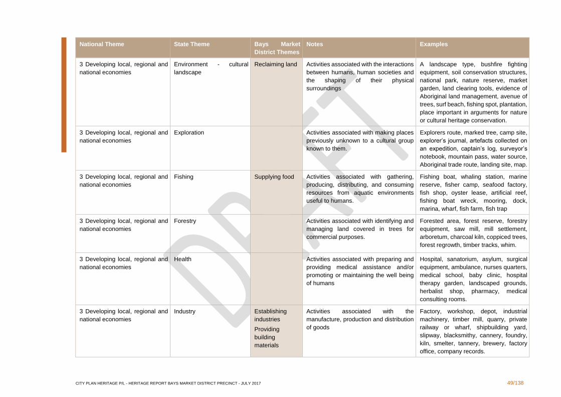
CITY PLAN HERITAGE P/L - HERITAGE REPORT BAYS MARKET DISTRICT PRECINCT - JULY 2017 49/138
National Theme State Theme Bays Market
District Themes
Notes Examples
3 Developing local, regional and
national economies
Environment - cultural
landscape
Reclaiming land Activities associated with the interactions
between humans, human societies and
the shaping of their physical
surroundings
A landscape type, bushfire fighting
equipment, soil conservation structures,
national park, nature reserve, market
garden, land clearing tools, evidence of
Aboriginal land management, avenue of
trees, surf beach, fishing spot, plantation,
place important in arguments for nature
or cultural heritage conservation.
3 Developing local, regional and
national economies
Exploration Activities associated with making places
previously unknown to a cultural group
known to them.
Explorers route, marked tree, camp site,
explorer’s journal, artefacts collected on
an expedition, captain’s log, surveyor’s
notebook, mountain pass, water source,
Aboriginal trade route, landing site, map.
3 Developing local, regional and
national economies
Fishing Supplying food Activities associated with gathering,
producing, distributing, and consuming
resources from aquatic environments
useful to humans.
Fishing boat, whaling station, marine
reserve, fisher camp, seafood factory,
fish shop, oyster lease, artificial reef,
fishing boat wreck, mooring, dock,
marina, wharf, fish farm, fish trap
3 Developing local, regional and
national economies
Forestry
Activities associated with identifying and
managing land covered in trees for
commercial purposes.
Forested area, forest reserve, forestry
equipment, saw mill, mill settlement,
arboretum, charcoal kiln, coppiced trees,
forest regrowth, timber tracks, whim.
3 Developing local, regional and
national economies
Health Activities associated with preparing and
providing medical assistance and/or
promoting or maintaining the well being
of humans
Hospital, sanatorium, asylum, surgical
equipment, ambulance, nurses quarters,
medical school, baby clinic, hospital
therapy garden, landscaped grounds,
herbalist shop, pharmacy, medical
consulting rooms.
3 Developing local, regional and
national economies
Industry Establishing
industries
Providing
building
materials
Activities associated with the
manufacture, production and distribution
of goods
Factory, workshop, depot, industrial
machinery, timber mill, quarry, private
railway or wharf, shipbuilding yard,
slipway, blacksmithy, cannery, foundry,
kiln, smelter, tannery, brewery, factory
office, company records.
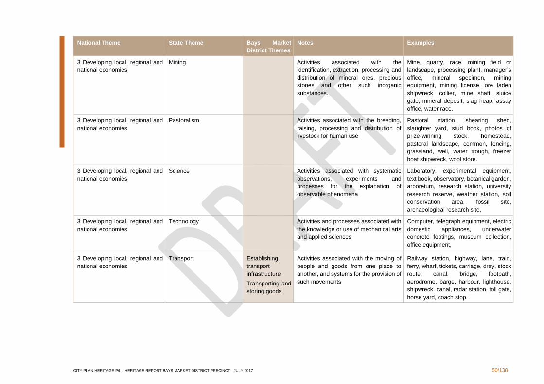
CITY PLAN HERITAGE P/L - HERITAGE REPORT BAYS MARKET DISTRICT PRECINCT - JULY 2017 50/138
National Theme State Theme Bays Market
District Themes
Notes Examples
3 Developing local, regional and
national economies
Mining Activities associated with the
identification, extraction, processing and
distribution of mineral ores, precious
stones and other such inorganic
substances.
Mine, quarry, race, mining field or
landscape, processing plant, manager’s
office, mineral specimen, mining
equipment, mining license, ore laden
shipwreck, collier, mine shaft, sluice
gate, mineral deposit, slag heap, assay
office, water race.
3 Developing local, regional and
national economies
Pastoralism Activities associated with the breeding,
raising, processing and distribution of
livestock for human use
Pastoral station, shearing shed,
slaughter yard, stud book, photos of
prize-winning stock, homestead,
pastoral landscape, common, fencing,
grassland, well, water trough, freezer
boat shipwreck, wool store.
3 Developing local, regional and
national economies
Science Activities associated with systematic
observations, experiments and
processes for the explanation of
observable phenomena
Laboratory, experimental equipment,
text book, observatory, botanical garden,
arboretum, research station, university
research reserve, weather station, soil
conservation area, fossil site,
archaeological research site.
3 Developing local, regional and
national economies
Technology Activities and processes associated with
the knowledge or use of mechanical arts
and applied sciences
Computer, telegraph equipment, electric
domestic appliances, underwater
concrete footings, museum collection,
office equipment,
3 Developing local, regional and
national economies
Transport Establishing
transport
infrastructure
Transporting and
storing goods
Activities associated with the moving of
people and goods from one place to
another, and systems for the provision of
such movements
Railway station, highway, lane, train,
ferry, wharf, tickets, carriage, dray, stock
route, canal, bridge, footpath,
aerodrome, barge, harbour, lighthouse,
shipwreck, canal, radar station, toll gate,
horse yard, coach stop.
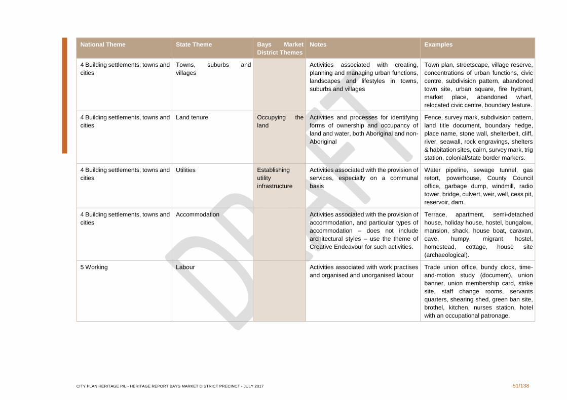
CITY PLAN HERITAGE P/L - HERITAGE REPORT BAYS MARKET DISTRICT PRECINCT - JULY 2017 51/138
National Theme State Theme Bays Market
District Themes
Notes Examples
4 Building settlements, towns and
cities
Towns, suburbs and
villages
Activities associated with creating,
planning and managing urban functions,
landscapes and lifestyles in towns,
suburbs and villages
Town plan, streetscape, village reserve,
concentrations of urban functions, civic
centre, subdivision pattern, abandoned
town site, urban square, fire hydrant,
market place, abandoned wharf,
relocated civic centre, boundary feature.
4 Building settlements, towns and
cities
Land tenure Occupying the
land
Activities and processes for identifying
forms of ownership and occupancy of
land and water, both Aboriginal and non-
Aboriginal
Fence, survey mark, subdivision pattern,
land title document, boundary hedge,
place name, stone wall, shelterbelt, cliff,
river, seawall, rock engravings, shelters
& habitation sites, cairn, survey mark, trig
station, colonial/state border markers.
4 Building settlements, towns and
cities
Utilities Establishing
utility
infrastructure
Activities associated with the provision of
services, especially on a communal
basis
Water pipeline, sewage tunnel, gas
retort, powerhouse, County Council
office, garbage dump, windmill, radio
tower, bridge, culvert, weir, well, cess pit,
reservoir, dam.
4 Building settlements, towns and
cities
Accommodation
Activities associated with the provision of
accommodation, and particular types of
accommodation – does not include
architectural styles – use the theme of
Creative Endeavour for such activities.
Terrace, apartment, semi-detached
house, holiday house, hostel, bungalow,
mansion, shack, house boat, caravan,
cave, humpy, migrant hostel,
homestead, cottage, house site
(archaeological).
5 Working Labour Activities associated with work practises
and organised and unorganised labour
Trade union office, bundy clock, time-
and-motion study (document), union
banner, union membership card, strike
site, staff change rooms, servants
quarters, shearing shed, green ban site,
brothel, kitchen, nurses station, hotel
with an occupational patronage.
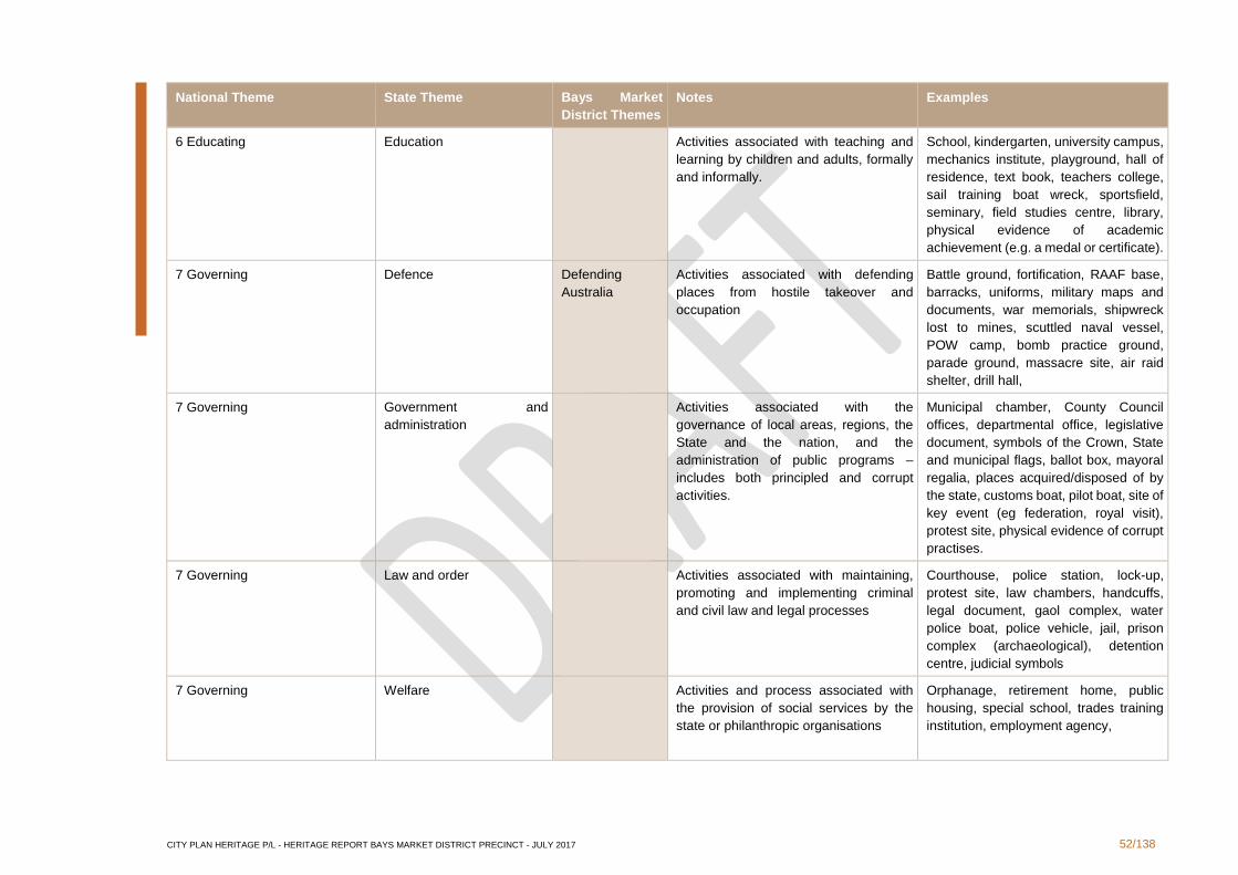
CITY PLAN HERITAGE P/L - HERITAGE REPORT BAYS MARKET DISTRICT PRECINCT - JULY 2017 52/138
National Theme State Theme Bays Market
District Themes
Notes Examples
6 Educating Education Activities associated with teaching and
learning by children and adults, formally
and informally.
School, kindergarten, university campus,
mechanics institute, playground, hall of
residence, text book, teachers college,
sail training boat wreck, sportsfield,
seminary, field studies centre, library,
physical evidence of academic
achievement (e.g. a medal or certificate).
7 Governing Defence Defending
Australia
Activities associated with defending
places from hostile takeover and
occupation
Battle ground, fortification, RAAF base,
barracks, uniforms, military maps and
documents, war memorials, shipwreck
lost to mines, scuttled naval vessel,
POW camp, bomb practice ground,
parade ground, massacre site, air raid
shelter, drill hall,
7 Governing Government and
administration
Activities associated with the
governance of local areas, regions, the
State and the nation, and the
administration of public programs –
includes both principled and corrupt
activities.
Municipal chamber, County Council
offices, departmental office, legislative
document, symbols of the Crown, State
and municipal flags, ballot box, mayoral
regalia, places acquired/disposed of by
the state, customs boat, pilot boat, site of
key event (eg federation, royal visit),
protest site, physical evidence of corrupt
practises.
7 Governing Law and order Activities associated with maintaining,
promoting and implementing criminal
and civil law and legal processes
Courthouse, police station, lock-up,
protest site, law chambers, handcuffs,
legal document, gaol complex, water
police boat, police vehicle, jail, prison
complex (archaeological), detention
centre, judicial symbols
7 Governing Welfare Activities and process associated with
the provision of social services by the
state or philanthropic organisations
Orphanage, retirement home, public
housing, special school, trades training
institution, employment agency,
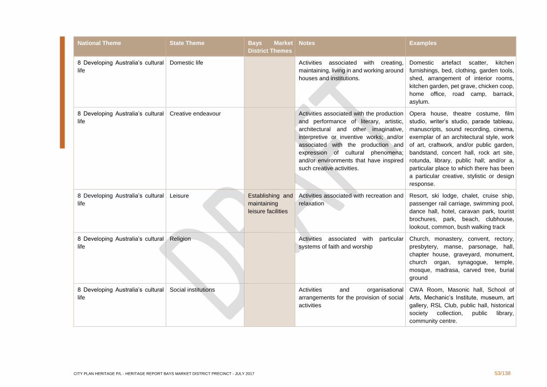
CITY PLAN HERITAGE P/L - HERITAGE REPORT BAYS MARKET DISTRICT PRECINCT - JULY 2017 53/138
National Theme State Theme Bays Market
District Themes
Notes Examples
8 Developing Australia’s cultural
life
Domestic life Activities associated with creating,
maintaining, living in and working around
houses and institutions.
Domestic artefact scatter, kitchen
furnishings, bed, clothing, garden tools,
shed, arrangement of interior rooms,
kitchen garden, pet grave, chicken coop,
home office, road camp, barrack,
asylum.
8 Developing Australia’s cultural
life
Creative endeavour
Activities associated with the production
and performance of literary, artistic,
architectural and other imaginative,
interpretive or inventive works; and/or
associated with the production and
expression of cultural phenomena;
and/or environments that have inspired
such creative activities.
Opera house, theatre costume, film
studio, writer’s studio, parade tableau,
manuscripts, sound recording, cinema,
exemplar of an architectural style, work
of art, craftwork, and/or public garden,
bandstand, concert hall, rock art site,
rotunda, library, public hall; and/or a,
particular place to which there has been
a particular creative, stylistic or design
response.
8 Developing Australia’s cultural
life
Leisure Establishing and
maintaining
leisure facilities
Activities associated with recreation and
relaxation
Resort, ski lodge, chalet, cruise ship,
passenger rail carriage, swimming pool,
dance hall, hotel, caravan park, tourist
brochures, park, beach, clubhouse,
lookout, common, bush walking track
8 Developing Australia’s cultural
life
Religion Activities associated with particular
systems of faith and worship
Church, monastery, convent, rectory,
presbytery, manse, parsonage, hall,
chapter house, graveyard, monument,
church organ, synagogue, temple,
mosque, madrasa, carved tree, burial
ground
8 Developing Australia’s cultural
life
Social institutions Activities and organisational
arrangements for the provision of social
activities
CWA Room, Masonic hall, School of
Arts, Mechanic’s Institute, museum, art
gallery, RSL Club, public hall, historical
society collection, public library,
community centre.

CITY PLAN HERITAGE P/L - HERITAGE REPORT BAYS MARKET DISTRICT PRECINCT - JULY 2017 54/138
National Theme State Theme Bays Market
District Themes
Notes Examples
8 Developing Australia’s cultural
life
Sport Establishing and
maintaining
leisure facilities
Activities associated with organised
recreational and health promotional
activities
Oval, race course, swimming pool,
bowling club, bowling green, trophies,
calendar of fixtures, cricket set, yacht
pens, tennis court, rugby field,
speedway, sporting equipment, bocce
court.
9 Marking the phases of life Birth and Death Activities associated with the initial
stages of human life and the bearing of
children, and with the final stages of
human life and disposal of the dead.
Birth control clinic, maternity hospital,
nursery, baby clinic, baptism register,
circumcision equipment, and Hospice,
nursing home, funeral parlour, grave
furnishings, cremation site, cemetery,
burial register, disaster site, memorial
plantings, shipwreck with loss of life,
9 Marking the phases of life Events Activities and processes that mark the
consequences of natural and cultural
occurrences
Monument, photographs, flood marks,
memorial, ceremonial costume, honour
board, blazed tree, obelisk, camp site,
boundary, legislation, place of
pilgrimage.
9 Marking the phases of life Persons Activities of, and associations with,
identifiable individuals, families and
communal groups
A monument to an individual, a family
home, a dynastic estate, private chapel,
a birthplace, a place of residence, a
gendered site, statue, commemorative
place name, place dedicated to memory
of a person (e.g. hospital wing).
CITY PLAN HERITAGE P/L - HERITAGE REPORT BAYS MARKET DISTRICT PRECINCT - JULY 2017 55/138
3. Built Heritage & Historical Archaeology
3.1 Phase 1: Heritage Due Diligence
Phase 1 consisted of two stages:
▪ a review of Urbis' 2014 draft report to determine whether any gaps existed with
regard to listed heritage items
▪ a field survey of the interior and the perimeter of Urbis' Wentworth Park Precinct and
Blackwattle Bay Precinct to determine whether there were other items of potential
heritage significance that had not yet been assessed or listed
The following sections present a summary of the findings of Phase 1. Since the completion
of Urbis' draft report in 2014, one additional item has been newly listed under Schedule 5 of
the Sydney Local Environment Plan (LEP) 2012: 'Bay Street Depot…' (item no. I2277). This
site was formally listed by the City of Sydney as an item of local heritage significance in
January 2016, following the recommendations of the City of Sydney Industrial and
Warehouse Buildings Heritage Study undertaken by City Plan Heritage in September 2014.
CPH also identified 8 further listed items in the vicinity of the two subject precincts established
by Urbis, which had not been identified in Urbis' report.
3.1.1 Built Heritage
Listed items
'Bay Street Depot former stables and factory buildings, including interiors and Bay
Street garages street wall’
10-16 Bay Street, Ultimo (Wentworth Park Precinct)
SLEP 2012 (amendment no.25) item no. I2277
State Heritage Inventory sheet no. 5062507
The Bay Street Depot, and its associated buildings, was constructed from 1908 to the 1920s.
It was formerly used by Hoskins Iron and Steel Co. as an industrial building, and currently
functions as a council depot for the City of Sydney. The building complex is not within any
Heritage Conservation Area (HCA), nor has it been assessed for its level of contribution to
the area. This item was included in the further study and assessment undertaken in Phase 2
(see Section 3).
‘Electricity Substation no.26’
40 Burton Street, Glebe, (Wentworth Park Precinct)
Listed on the S.170 Heritage Register for Ausgrid
State Heritage Inventory sheet no. no. 3430544
The substation was constructed in 1911, during the earliest phase of the suburban expansion
of the electricity network in Sydney. It is located within the Glebe Point HCA and is identified
as a Contributing Building within the Sydney Development Control Plan (DCP) 2012.
'Friend in Hand Hotel including interior’
58 Cowper Street, Glebe
SLEP 2012 item no. I671
The hotel was constructed in 1937 in the Inter-War Functionalist Style with Art Deco
overtones. It is historically significant for its long association with the Tooths & Co. brewery.
The building is located within the Hughes HCA and is identified as a Contributing Building
within the Sydney Development Control Plan (DCP) 2012.
CITY PLAN HERITAGE P/L - HERITAGE REPORT BAYS MARKET DISTRICT PRECINCT - JULY 2017 56/138
House group in the Blackwattle Bay Precinct, comprising:
'House “Florence Villa” including interior'
49 Leichhardt Street, Glebe
SLEP 2012 item no. I789
House “Drayton Lodge” including interior and front fence
51–51B Leichhardt Street
SLEP 2012 item no. I790
House “The Retreat” including interior
53 Leichhardt Street
SLEP 2012 item no. I791
House “Tranby” including interior and front fence
13 Mansfield Street
SLEP 2012 item no. I793
House including interior and front fencing
14 Oxley Street
SLEP 2012 item no. I797
House “Eurimbla House” including interior
16 Oxley Street
SLEP 2012 item no. I798
These are Victorian period cottages of high local, historical and aesthetic significance. The
cottages are exemplars of various Victorian styles of architectural design. The house group
is located in the Glebe Point HCA and all the houses are identified as Contributing Buildings
within the Sydney Development Control Plan (DCP) 2012.
Items with potential for heritage assessment and subsequent listing
Former warehouse
41 Bridge Rd, Glebe (Wentworth Park Precinct)
This is a sandstone building which is likely to have originally been a warehouse. Its
appearance on aerial imagery from 1943 indicates that it is a historical building of potential
significance. Photographs of the interior presented in an online real estate listing
(realcommercial.com.au) demonstrate that it appears to be well-preserved inside.133 The
building is located within the Glebe Point HCA and is identified as a Contributing Building
within the Sydney Development Control Plan (DCP) 2012.
133 Realcommercial.com.au, 'Nicholas Dattner Building, 41 Bridge Rd, Glebe, NSW 2037', http://www.realcommercial.com.au/property-showrooms+bulky+goods-nsw-glebe-5454504 (accessed 6 July 2016)
CITY PLAN HERITAGE P/L - HERITAGE REPORT BAYS MARKET DISTRICT PRECINCT - JULY 2017 57/138
Terrace group
4-18 Burton Street, Glebe (Wentworth Park Precinct)
This group of terraces present a set of façades which are unified in their design. An
ornamented parapet that stretches along the roofs of most of the group features the date of
1881. The terrace group is located in the Glebe Point HCA, and each terrace is identified as
a Contributing Building within the Sydney Development Control Plan (DCP) 2012.
House/former warehouse
80 Wentworth Park Road, Glebe (Wentworth Park Precinct)
This is a sandstone building with a corrugated metal roof. Its appearance on aerial imagery
from 1943 indicates that it is a historical building of potential significance. The building is
located in the Lyndhurst HCA and is identified as a Neutral Building within the Sydney
Development Control Plan (DCP) 2012.
Glenmore Meat Company building
40-46 Wentworth Park Road, Glebe (Wentworth Park Precinct)
The building that houses the Glenmore Meat Company is constructed of corrugated sheet
metal. Its appearance on aerial imagery from 1943 indicates that it is a historical building of
potential significance, however since that time the northern building has been demolished
and replaced by a car park, and the southern building has been extended north. The
company has been operating since 1967, not originally in this building. The building is located
in the Lyndhurst HCA and is identified as a Detracting Building within the Sydney
Development Control Plan (DCP) 2012, most likely for its non-conformism with the character
of the streetscape.
House
39 Bellevue Lane/Street, Glebe (Wentworth Park Precinct)
This building is constructed of sandstone with a corrugated sheet metal roof. It is elevated,
and accessed from street level by a long stair. In October 2009 the Glebe Society Bulletin
referred to this building as ‘The Castle’ and noted its run-down condition and ‘vulnerable’
heritage status. The building has been listed for sale or auction several times during the last
twenty years or so, though it often sits on the books for many weeks (e.g. 113 weeks in 2009).
Its historical status is unknown as it is unclear whether it is present on aerial imagery from
1943. The building is located within the Lyndhurst HCA and is identified as a Contributing
Building within the Sydney Development Control Plan (DCP) 2012.
Former church
cnr St Johns Road and Bellevue Street, Glebe (Wentworth Park Precinct)
Once clearly a church, the building has been converted for other uses, though it is unclear
whether it now serves a residential or other function. The church is a historical as
demonstrated by its appearance on aerial imagery from 1943. The building is located within
the Lyndhurst HCA and is identified as a Contributing Building within the Sydney
Development Control Plan (DCP) 2012.
Milk bar/deli
cnr Cowper Street and Broughton Street (Wentworth Park Precinct)
CITY PLAN HERITAGE P/L - HERITAGE REPORT BAYS MARKET DISTRICT PRECINCT - JULY 2017 58/138
This two-storey corner property appears to be present on aerial imagery from 1943, indicating
that it could be a building of historical significance. The building is located in St Phillip’s HCA
and is identified as a Contributing Building within the Sydney Development Control Plan
(DCP) 2012.
House/former warehouse
3-5 Queen St, Glebe (Wentworth Park Precinct)
This two-storey building may have once been a warehouse in the Inter-War period, as its
style indicates. Its appearance on aerial imagery rom 1943 is a testament to its history. The
building is well-preserved, at least externally. The building is located in the Hughes HCA and
is identified as a Neutral Building within the Sydney Development Control Plan (DCP) 2012.
Former warehouse
30-34 Bay Street, Glebe (Wentworth Park Precinct)
This five-storey former warehouse is constructed of brick, and its front-facing façade has
been painted. It has several architectural features of note, including a tall stepped parapet
which includes a porthole window with an associated finial. The building is well-preserved at
least externally. The building is present on aerial imagery from 1943. It is located in the
Mountain Street HCA and is identified as a Contributing Building within the Sydney
Development Control Plan (DCP) 2012.
Former warehouse
2-14 Blackwattle Lane, Glebe (Wentworth Park Precinct)
This building has an unusual triangular footprint with an acute angle, straddling a corner. It is
an exceptionally well-preserved example of a warehouse in the Inter-War style. Its historical
status is confirmed by its appearance on aerial imagery from 1943. The building is located
within the Mountain Street HCA and is identified as a Contributing Building within the Sydney
Development Control Plan (DCP) 2012.
Boat sheds: University of Sydney Rowing Club and Glebe Rowing Club
end of Ferry Road, Glebe (Blackwattle Bay Precinct)
Although these buildings are relatively modern, they may have significance associated with
their use by the University of Sydney Rowing Club (founded in 1860) and the Glebe Rowing
Club (founded in 1879). The boat sheds are not located in any HCA, nor have they been
assessed for their level of contribution to the area.
Wharf-front warehouse
1-3 Bank Street, Pyrmont (Blackwattle Bay Precinct)
This brick warehouse has been constructed in a style typical of the Inter-War period, and
appears on aerial imagery from 1943. It currently displays a sign indicating its use and/or
ownership by the NSW Department of Planning and Infrastructure. The building is not in any
HCA, nor has it been assessed for its level of contribution to the area. This item was the
focus on further study and assessment in Phase 2 (see Section 3).
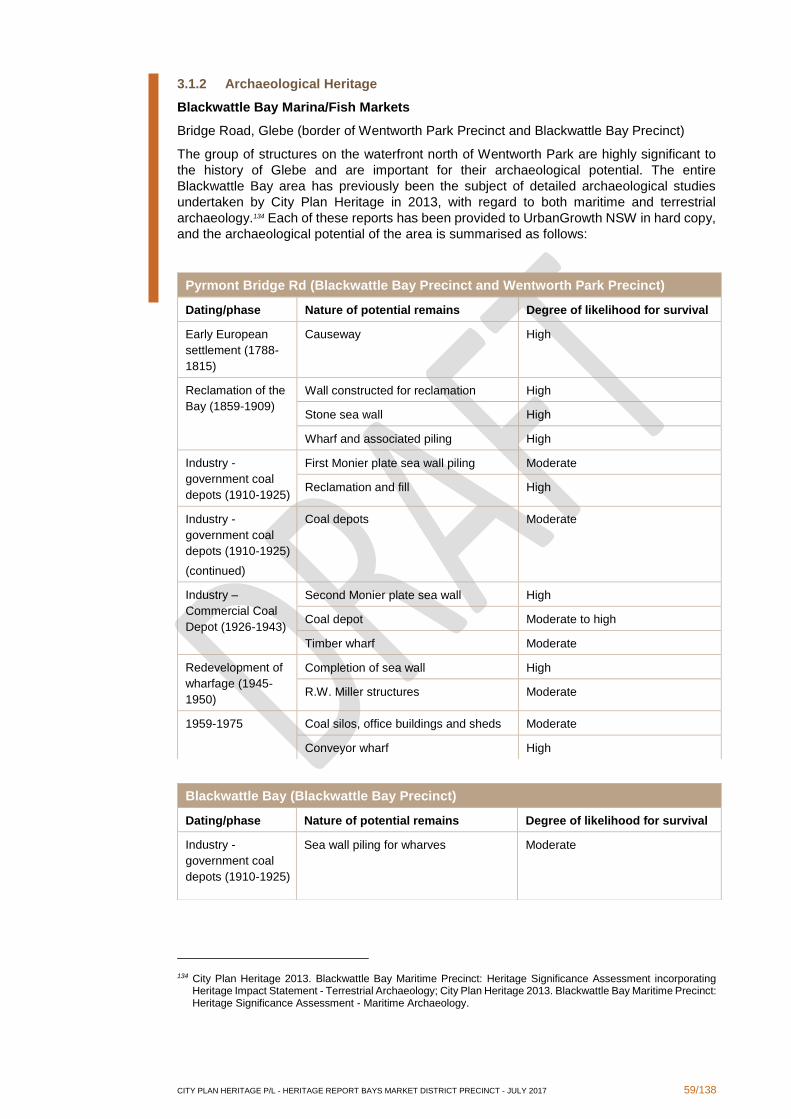
CITY PLAN HERITAGE P/L - HERITAGE REPORT BAYS MARKET DISTRICT PRECINCT - JULY 2017 59/138
3.1.2 Archaeological Heritage
Blackwattle Bay Marina/Fish Markets
Bridge Road, Glebe (border of Wentworth Park Precinct and Blackwattle Bay Precinct)
The group of structures on the waterfront north of Wentworth Park are highly significant to
the history of Glebe and are important for their archaeological potential. The entire
Blackwattle Bay area has previously been the subject of detailed archaeological studies
undertaken by City Plan Heritage in 2013, with regard to both maritime and terrestrial
archaeology.134 Each of these reports has been provided to UrbanGrowth NSW in hard copy,
and the archaeological potential of the area is summarised as follows:
134 City Plan Heritage 2013. Blackwattle Bay Maritime Precinct: Heritage Significance Assessment incorporating Heritage Impact Statement - Terrestrial Archaeology; City Plan Heritage 2013. Blackwattle Bay Maritime Precinct: Heritage Significance Assessment - Maritime Archaeology.
Pyrmont Bridge Rd (Blackwattle Bay Precinct and Wentworth Park Precinct)
Dating/phase Nature of potential remains Degree of likelihood for survival
Early European
settlement (1788-
1815)
Causeway High
Reclamation of the
Bay (1859-1909)
Wall constructed for reclamation High
Stone sea wall High
Wharf and associated piling High
Industry -
government coal
depots (1910-1925)
First Monier plate sea wall piling Moderate
Reclamation and fill High
Industry -
government coal
depots (1910-1925)
(continued)
Coal depots Moderate
Industry –
Commercial Coal
Depot (1926-1943)
Second Monier plate sea wall High
Coal depot Moderate to high
Timber wharf Moderate
Redevelopment of
wharfage (1945-
1950)
Completion of sea wall High
R.W. Miller structures Moderate
1959-1975 Coal silos, office buildings and sheds Moderate
Conveyor wharf High
Blackwattle Bay (Blackwattle Bay Precinct)
Dating/phase Nature of potential remains Degree of likelihood for survival
Industry -
government coal
depots (1910-1925)
Sea wall piling for wharves Moderate

CITY PLAN HERITAGE P/L - HERITAGE REPORT BAYS MARKET DISTRICT PRECINCT - JULY 2017 60/138
Wentworth Park (Wentworth Park Precinct)
The park itself has been in use since the reclamation of Blackwattle Bay. The desktop
analysis and field survey identified some items of high archaeological potential, summarised
as follows:
The history, opportunities and constraints associated with the former site of the Wentworth
Park Caretaker's Cottage were explored further in Phase 2 (see Section 3). One additional
archaeological item, the Sydney Stone Storage Yard/former quarry site at 10A Wattle Street,
was also identified in Phase 2 once the scope of the study was refined. UrbanGrowth NSW
identified that the extensive spread of the system of stormwater channels beneath Wentworth
Park merited more detailed study to support their evolving projects, and this is also provided
in Section 3 below.
3.1.3 Landscape items
In addition to the built heritage and archaeological heritage items identified above, three
landscape items of listed or potential heritage significance are located within the Blackwattle
Bay and Wentworth Park Precincts, summarised as follows:
‘Escarpment Face from Former "Saunders' Quarry"’
Pyrmont (Bank Street and beyond) (Blackwattle Bay Precinct)
SLEP 2012 item no. I1199
This long and tall sandstone escarpment is a testament to the works carried out in Saunders’
Quarry. The quarry was the source of the sandstone used to construct many iconic buildings
in Sydney and in cities in neighbouring countries (see the brief history for 10A Wattle Street
in Section 3 below). A large part of the escarpment faces Bank Street, adjacent to the precinct
boundary.
Sandstone escarpment face
Railway Street / 83 Darghan Lane, Glebe (Wentworth Park Precinct)
Forming the foundation of the house at this address is a narrow but tall sandstone
escarpment face which is evidence for historical human activity such as quarrying or mining.
This escarpment faces the light rail line and the precinct boundary.
Sandstone escarpment face
39-61 Bellevue Lane, Glebe (Wentworth Park Precinct)
A long and tall sandstone escarpment forms the foundation of a number of houses on
Bellevue Lane, stretching between the potential heritage houses identified in subsection
2.2.2., at 38 and 83 Bellevue Lane. The escarpment is evidence of historical human activity
such as quarrying or mining.
Wentworth Park (Wentworth Park Precinct)
Dating/phase Nature of potential remains Degree of likelihood for survival
Reclamation of the
Bay (1859-1909)
Stormwater channels High
Former site of Caretaker’s Cottage and
curtilage
High
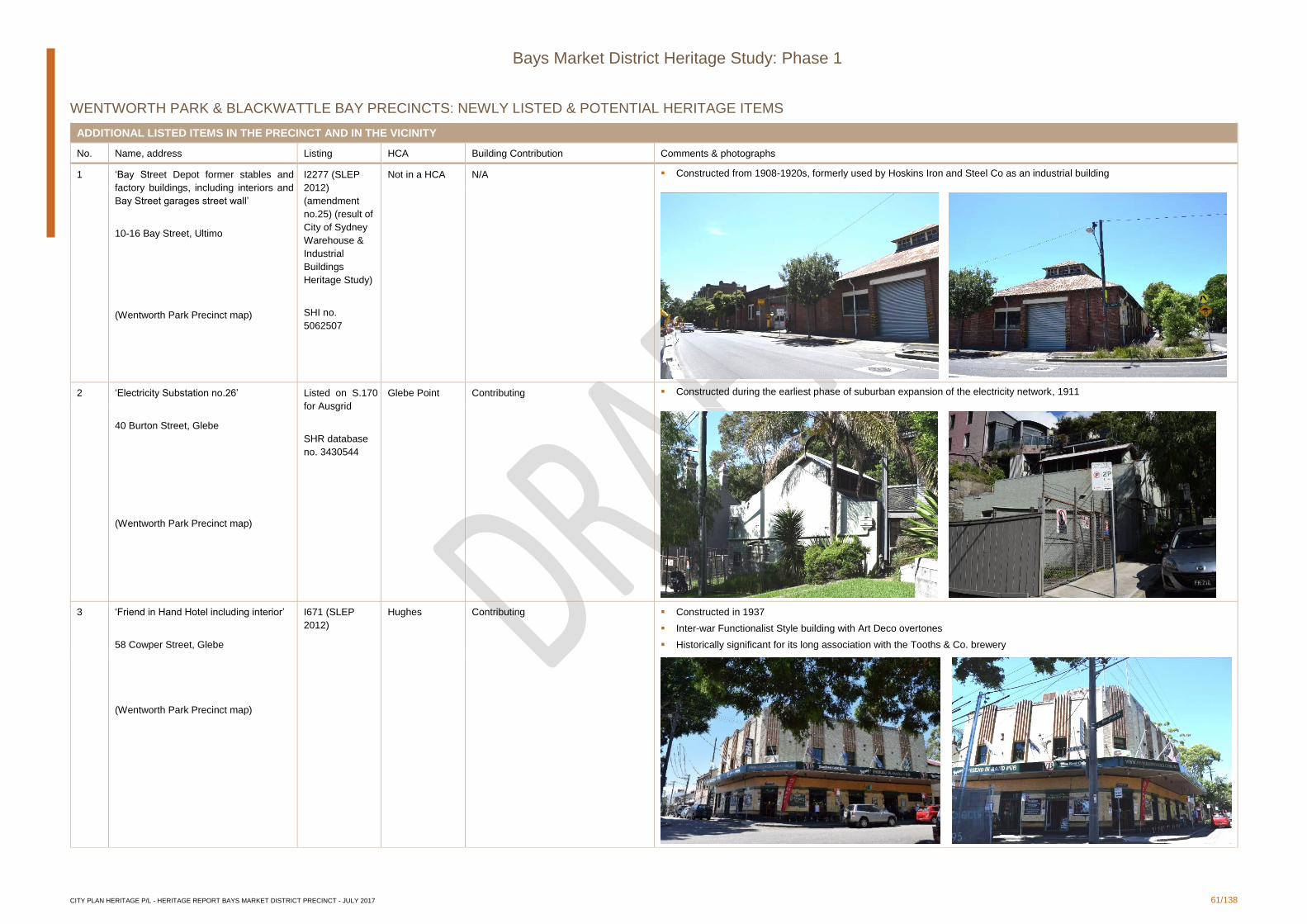
CITY PLAN HERITAGE P/L - HERITAGE REPORT BAYS MARKET DISTRICT PRECINCT - JULY 2017 61/138
Bays Market District Heritage Study: Phase 1
WENTWORTH PARK & BLACKWATTLE BAY PRECINCTS: NEWLY LISTED & POTENTIAL HERITAGE ITEMS
ADDITIONAL LISTED ITEMS IN THE PRECINCT AND IN THE VICINITY
No. Name, address Listing HCA Building Contribution Comments & photographs
1 ‘Bay Street Depot former stables and
factory buildings, including interiors and
Bay Street garages street wall’
10-16 Bay Street, Ultimo
(Wentworth Park Precinct map)
I2277 (SLEP
2012)
(amendment
no.25) (result of
City of Sydney
Warehouse &
Industrial
Buildings
Heritage Study)
SHI no.
5062507
Not in a HCA N/A ▪ Constructed from 1908-1920s, formerly used by Hoskins Iron and Steel Co as an industrial building
2 ‘Electricity Substation no.26’
40 Burton Street, Glebe
(Wentworth Park Precinct map)
Listed on S.170
for Ausgrid
SHR database
no. 3430544
Glebe Point Contributing ▪ Constructed during the earliest phase of suburban expansion of the electricity network, 1911
3 ‘Friend in Hand Hotel including interior’
58 Cowper Street, Glebe
(Wentworth Park Precinct map)
I671 (SLEP
2012)
Hughes Contributing ▪ Constructed in 1937
▪ Inter-war Functionalist Style building with Art Deco overtones
▪ Historically significant for its long association with the Tooths & Co. brewery
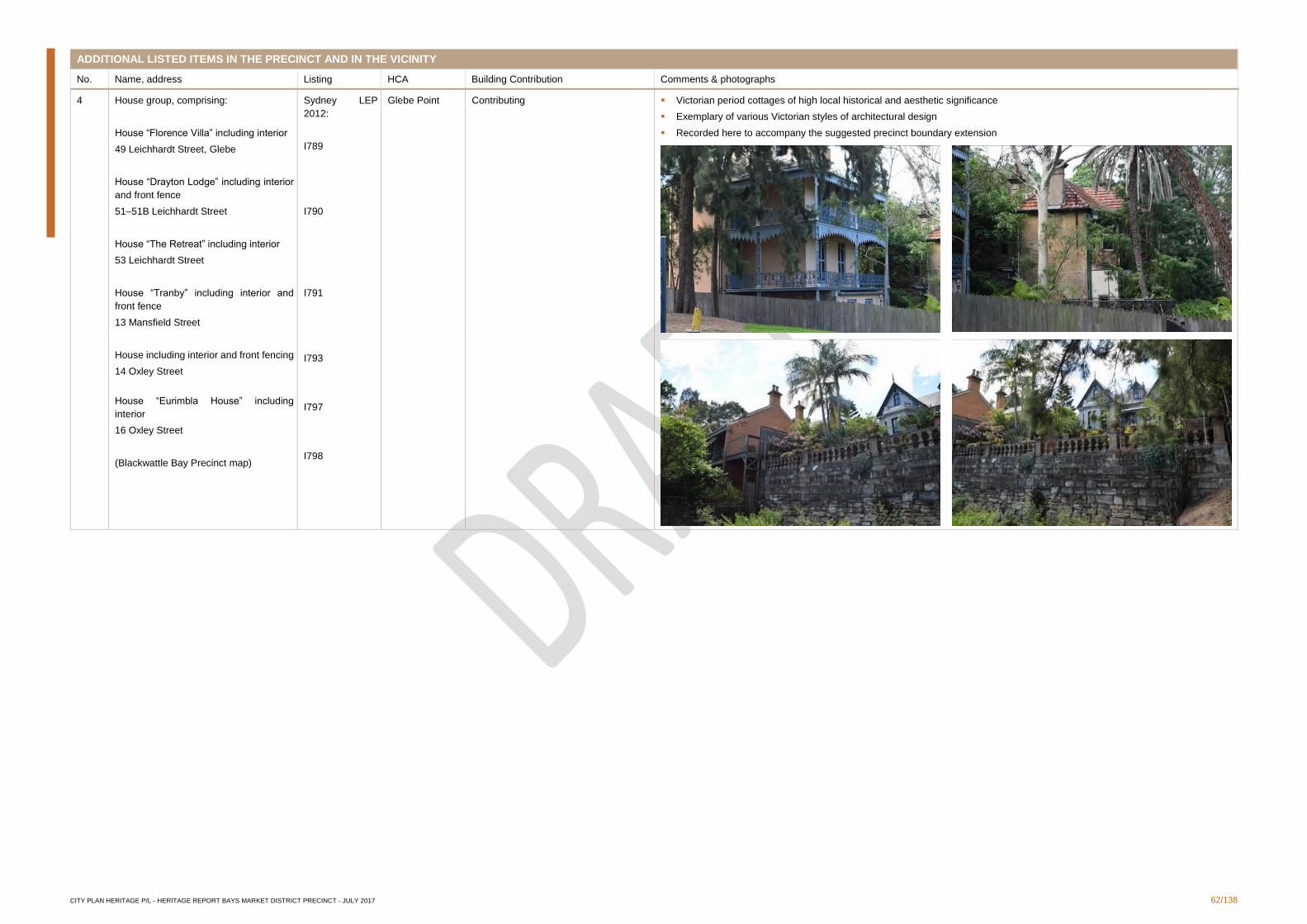
CITY PLAN HERITAGE P/L - HERITAGE REPORT BAYS MARKET DISTRICT PRECINCT - JULY 2017 62/138
ADDITIONAL LISTED ITEMS IN THE PRECINCT AND IN THE VICINITY
No. Name, address Listing HCA Building Contribution Comments & photographs
4 House group, comprising:
House “Florence Villa” including interior
49 Leichhardt Street, Glebe
House “Drayton Lodge” including interior
and front fence
51–51B Leichhardt Street
House “The Retreat” including interior
53 Leichhardt Street
House “Tranby” including interior and
front fence
13 Mansfield Street
House including interior and front fencing
14 Oxley Street
House “Eurimbla House” including
interior
16 Oxley Street
(Blackwattle Bay Precinct map)
Sydney LEP
2012:
I789
I790
I791
I793
I797
I798
Glebe Point Contributing ▪ Victorian period cottages of high local historical and aesthetic significance
▪ Exemplary of various Victorian styles of architectural design
▪ Recorded here to accompany the suggested precinct boundary extension
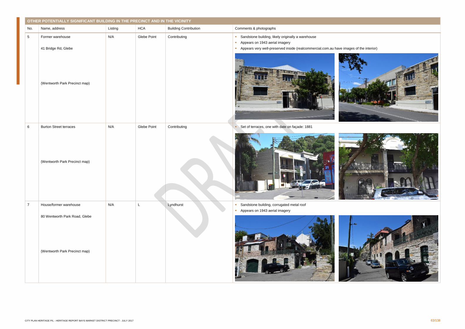
CITY PLAN HERITAGE P/L - HERITAGE REPORT BAYS MARKET DISTRICT PRECINCT - JULY 2017 63/138
OTHER POTENTIALLY SIGNIFICANT BUILDING IN THE PRECINCT AND IN THE VICINITY
No. Name, address Listing HCA Building Contribution Comments & photographs
5 Former warehouse
41 Bridge Rd, Glebe
(Wentworth Park Precinct map)
N/A Glebe Point Contributing ▪ Sandstone building, likely originally a warehouse
▪ Appears on 1943 aerial imagery
▪ Appears very well-preserved inside (realcommercial.com.au have images of the interior)
6 Burton Street terraces
(Wentworth Park Precinct map)
N/A Glebe Point Contributing ▪ Set of terraces, one with date on façade: 1881
7 House/former warehouse
80 Wentworth Park Road, Glebe
(Wentworth Park Precinct map)
N/A L Lyndhurst ▪ Sandstone building, corrugated metal roof
▪ Appears on 1943 aerial imagery
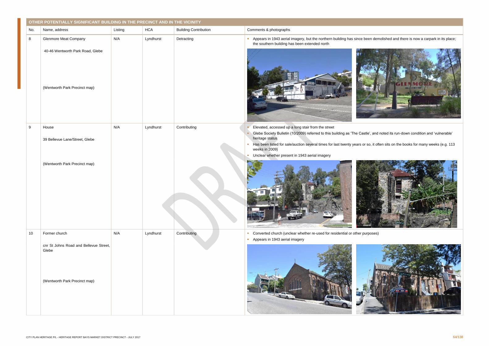
CITY PLAN HERITAGE P/L - HERITAGE REPORT BAYS MARKET DISTRICT PRECINCT - JULY 2017 64/138
OTHER POTENTIALLY SIGNIFICANT BUILDING IN THE PRECINCT AND IN THE VICINITY
No. Name, address Listing HCA Building Contribution Comments & photographs
8 Glenmore Meat Company
40-46 Wentworth Park Road, Glebe
(Wentworth Park Precinct map)
N/A Lyndhurst Detracting ▪ Appears in 1943 aerial imagery, but the northern building has since been demolished and there is now a carpark in its place;
the southern building has been extended north
9 House
39 Bellevue Lane/Street, Glebe
(Wentworth Park Precinct map)
N/A Lyndhurst Contributing ▪ Elevated, accessed up a long stair from the street
▪ Glebe Society Bulletin (10/2009) referred to this building as ‘The Castle’, and noted its run-down condition and ‘vulnerable’
heritage status
▪ Has been listed for sale/auction several times for last twenty years or so, it often sits on the books for many weeks (e.g. 113
weeks in 2009)
▪ Unclear whether present in 1943 aerial imagery
10 Former church
cnr St Johns Road and Bellevue Street,
Glebe
(Wentworth Park Precinct map)
N/A Lyndhurst Contributing ▪ Converted church (unclear whether re-used for residential or other purposes)
▪ Appears in 1943 aerial imagery

CITY PLAN HERITAGE P/L - HERITAGE REPORT BAYS MARKET DISTRICT PRECINCT - JULY 2017 65/138
OTHER POTENTIALLY SIGNIFICANT BUILDING IN THE PRECINCT AND IN THE VICINITY
No. Name, address Listing HCA Building Contribution Comments & photographs
11 Milk bar/deli
cnr Cowper Street and Broughton Street
(Wentworth Park Precinct map)
N/A St Phillip’s Contributing ▪ Appears to be present in 1943 aerial imagery
12 House/former warehouse
3-5 Queen St, Glebe
(Wentworth Park Precinct map)
N/A Hughes Neutral ▪ Appears in 1943 aerial imagery
▪ Well-preserved, at least externally
13 Former warehouse
30-34 Bay Street, Glebe
(Wentworth Park Precinct map)
N/A Mountain Street Contributing ▪ Well-preserved externally at least, though all but the parapet brickwork has been painted
▪ Parapet of stepped form with porthole window and associated finial
▪ Present in 1943 imagery
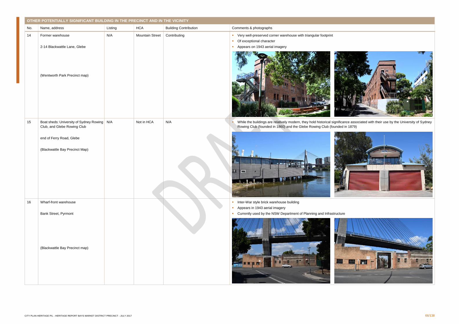
CITY PLAN HERITAGE P/L - HERITAGE REPORT BAYS MARKET DISTRICT PRECINCT - JULY 2017 66/138
OTHER POTENTIALLY SIGNIFICANT BUILDING IN THE PRECINCT AND IN THE VICINITY
No. Name, address Listing HCA Building Contribution Comments & photographs
14 Former warehouse
2-14 Blackwattle Lane, Glebe
(Wentworth Park Precinct map)
N/A Mountain Street Contributing ▪ Very well-preserved corner warehouse with triangular footprint
▪ Of exceptional character
▪ Appears on 1943 aerial imagery
15 Boat sheds: University of Sydney Rowing
Club, and Glebe Rowing Club
end of Ferry Road, Glebe
(Blackwattle Bay Precinct Map)
N/A Not in HCA N/A ▪ While the buildings are relatively modern, they hold historical significance associated with their use by the University of Sydney
Rowing Club (founded in 1860) and the Glebe Rowing Club (founded in 1879)
16 Wharf-front warehouse
Bank Street, Pyrmont
(Blackwattle Bay Precinct map)
▪ Inter-War style brick warehouse building
▪ Appears in 1943 aerial imagery
▪ Currently used by the NSW Department of Planning and Infrastructure
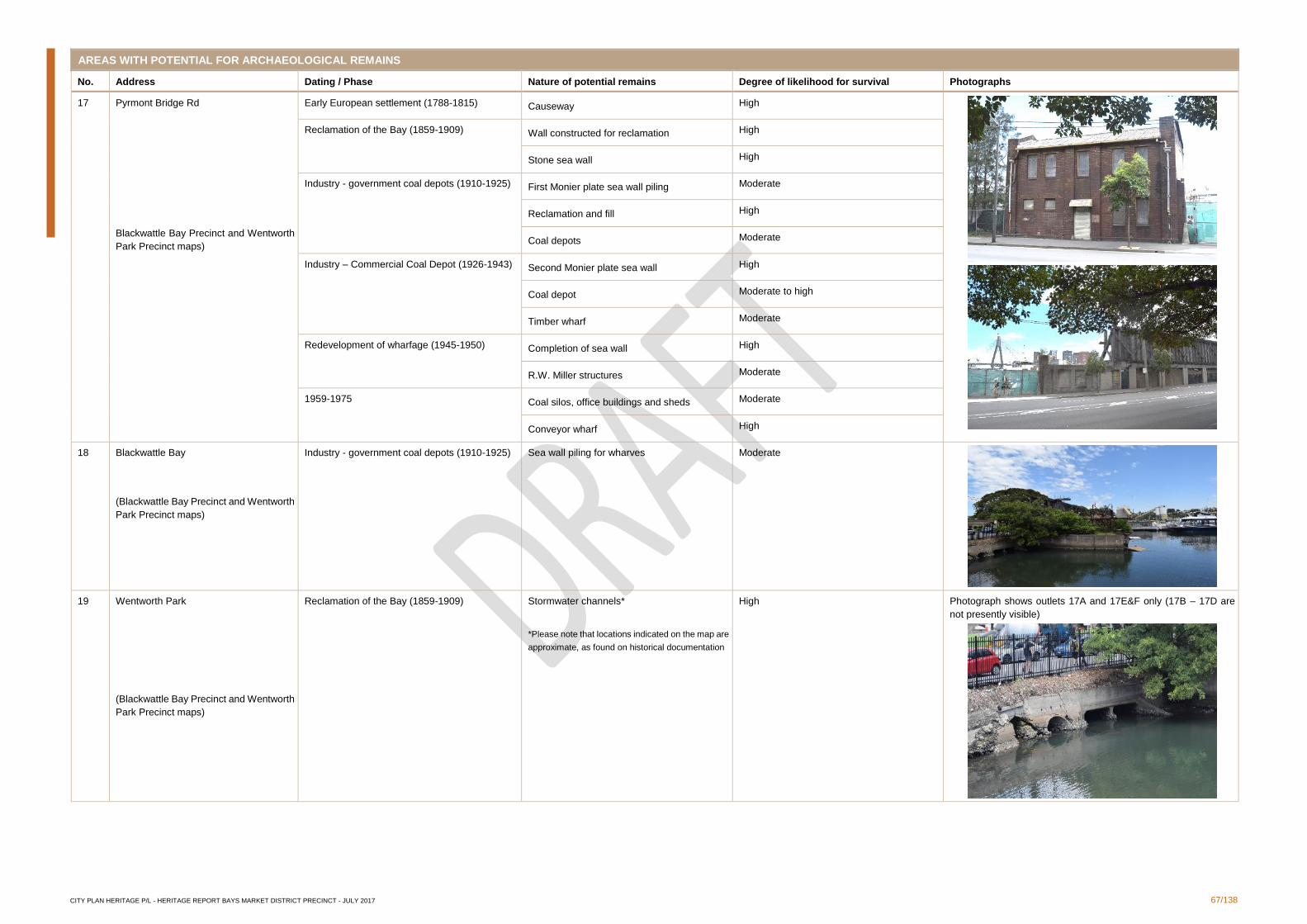
CITY PLAN HERITAGE P/L - HERITAGE REPORT BAYS MARKET DISTRICT PRECINCT - JULY 2017 67/138
AREAS WITH POTENTIAL FOR ARCHAEOLOGICAL REMAINS
No. Address Dating / Phase Nature of potential remains Degree of likelihood for survival Photographs
17 Pyrmont Bridge Rd
Blackwattle Bay Precinct and Wentworth
Park Precinct maps)
Early European settlement (1788-1815) Causeway High
Reclamation of the Bay (1859-1909) Wall constructed for reclamation High
Stone sea wall High
Industry - government coal depots (1910-1925) First Monier plate sea wall piling Moderate
Reclamation and fill High
Coal depots Moderate
Industry – Commercial Coal Depot (1926-1943) Second Monier plate sea wall High
Coal depot Moderate to high
Timber wharf Moderate
Redevelopment of wharfage (1945-1950) Completion of sea wall High
R.W. Miller structures Moderate
1959-1975 Coal silos, office buildings and sheds Moderate
Conveyor wharf High
18 Blackwattle Bay
(Blackwattle Bay Precinct and Wentworth
Park Precinct maps)
Industry - government coal depots (1910-1925) Sea wall piling for wharves
Moderate
19 Wentworth Park
(Blackwattle Bay Precinct and Wentworth
Park Precinct maps)
Reclamation of the Bay (1859-1909) Stormwater channels*
*Please note that locations indicated on the map are
approximate, as found on historical documentation
High Photograph shows outlets 17A and 17E&F only (17B – 17D are
not presently visible)
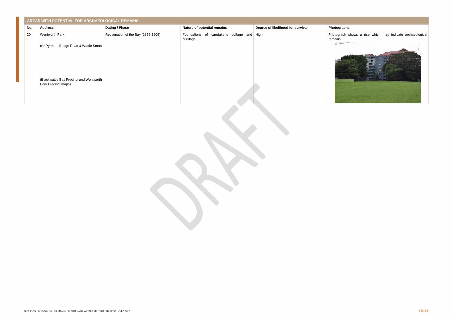
CITY PLAN HERITAGE P/L - HERITAGE REPORT BAYS MARKET DISTRICT PRECINCT - JULY 2017 68/138
AREAS WITH POTENTIAL FOR ARCHAEOLOGICAL REMAINS
No. Address Dating / Phase Nature of potential remains Degree of likelihood for survival Photographs
20 Wentworth Park
cnr Pyrmont Bridge Road & Wattle Street
(Blackwattle Bay Precinct and Wentworth
Park Precinct maps)
Reclamation of the Bay (1859-1909) Foundations of caretaker’s cottage and
curtilage
High Photograph shows a rise which may indicate archaeological
remains
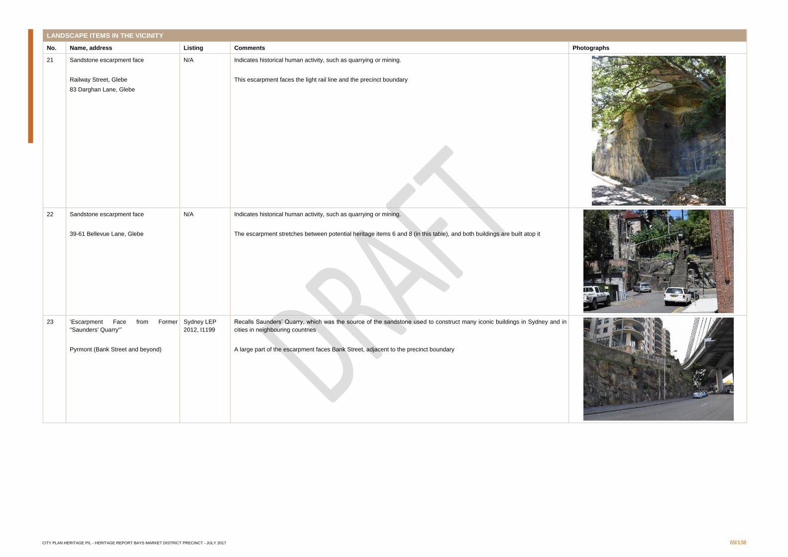
CITY PLAN HERITAGE P/L - HERITAGE REPORT BAYS MARKET DISTRICT PRECINCT - JULY 2017 69/138
LANDSCAPE ITEMS IN THE VICINITY
No. Name, address Listing Comments Photographs
21 Sandstone escarpment face
Railway Street, Glebe
83 Darghan Lane, Glebe
N/A Indicates historical human activity, such as quarrying or mining.
This escarpment faces the light rail line and the precinct boundary
22 Sandstone escarpment face
39-61 Bellevue Lane, Glebe
N/A Indicates historical human activity, such as quarrying or mining.
The escarpment stretches between potential heritage items 6 and 8 (in this table), and both buildings are built atop it
23 ‘Escarpment Face from Former
"Saunders' Quarry"’
Pyrmont (Bank Street and beyond)
Sydney LEP
2012, I1199
Recalls Saunders’ Quarry, which was the source of the sandstone used to construct many iconic buildings in Sydney and in
cities in neighbouring countries
A large part of the escarpment faces Bank Street, adjacent to the precinct boundary
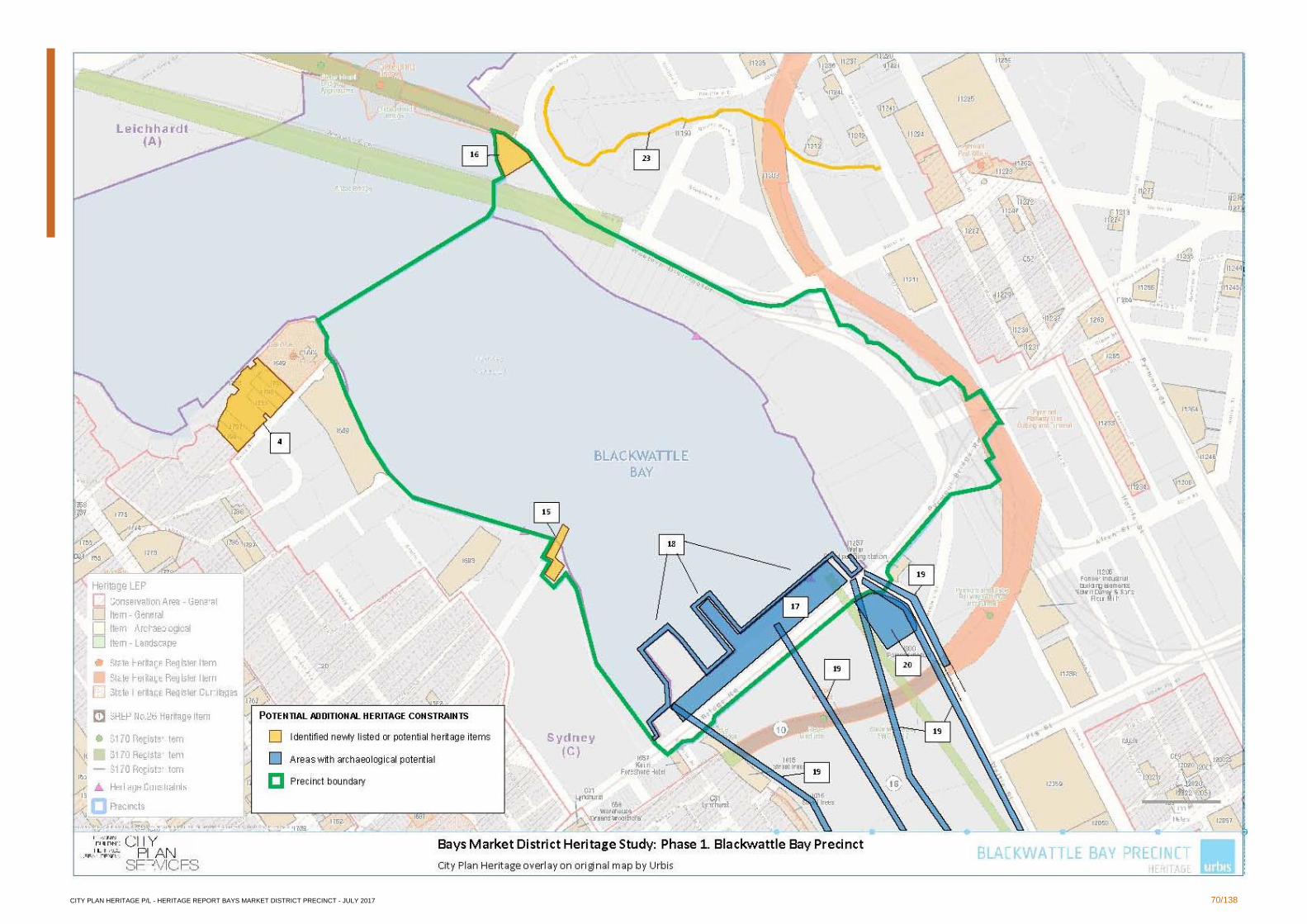
CITY PLAN HERITAGE P/L - HERITAGE REPORT BAYS MARKET DISTRICT PRECINCT - JULY 2017 70/138
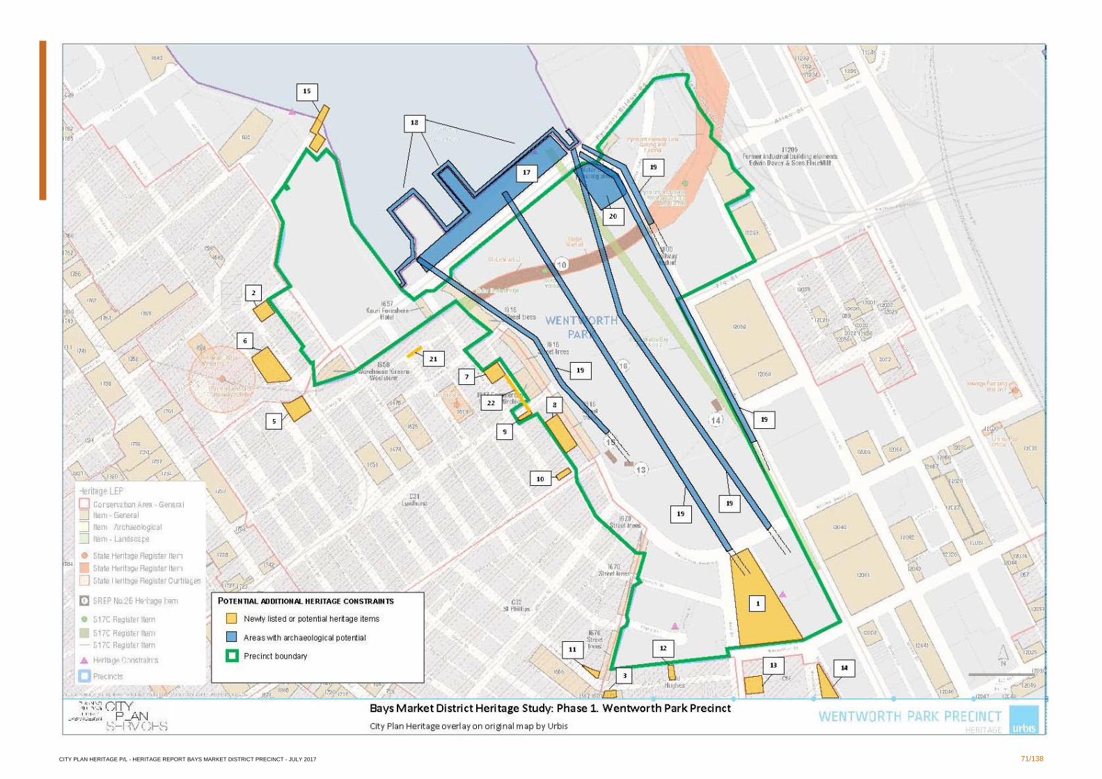
CITY PLAN HERITAGE P/L - HERITAGE REPORT BAYS MARKET DISTRICT PRECINCT - JULY 2017 71/138
CITY PLAN HERITAGE P/L - HERITAGE REPORT BAYS MARKET DISTRICT PRECINCT - JULY 2017 72/138
3.1.4 Conclusions and Recommendations
Urbis' 2014 Bays Precinct Heritage Constraints Assessment identified heritage items within
the Bays Market District, incorporating Blackwattle Bay and Wentworth Park, that are listed
on the State Heritage Register, the Sydney Local Environment Plan (LEP) 2012 and on
various state agencies' Section 170 Heritage and Conservation Registers. Following the
undertaking of a peer review, CPH identified additional listed items of built heritage,
landscape heritage and known archaeological sites, as presented in Section 3.1.1 above.
Heritage items listed on the State Register, as well as archaeological sites, are ordinarily
afforded statutory protection under the Heritage Act, 1977. This means that any development
proposals for State Heritage items or on archaeological sites must be considered and
assessed by the NSW Heritage Council for their potential impact on the heritage significance
and values of the item/site.
Heritage items listed on the Sydney LEP 2012 and on Section 170 Registers are ordinarily
afforded statutory protection under Clause 5.10 of the Sydney LEP 2012. This means that
any development proposals for the heritage items or in the vicinity of them, must be
considered and assessed by the City of Sydney Council for their potential impact on the
heritage significance and values of the item. As a result, any Development Application (DA)
must be accompanied by a Heritage Impact Statement (HIS) to Council.
Rezoning with changes in height and FSR should consider impacts on existing heritage
items, such as overshadowing, removal of view corridors, and alteration of historical
subdivision patterns and characters. This may be achieved through, amongst other
strategies, height limitations, appropriate setbacks, and avoidance of subdivision and
development in areas of established heritage significance.
Items identified by CPH as being of potential heritage significance in this section are not
afforded any statutory protection until and unless they are listed as heritage items. However,
if, either prior to the submission of a DA or during the course of an assessment of a DA, it is
found that an item or site is of high heritage significance, the Minister for the Environment
and Heritage has the power to place an Interim Heritage Order on the building/site, which
temporarily protects the building or site to allow a thorough heritage assessment to be
performed. CPH recommends that City of Sydney Council be informed of the items of
potential heritage significance identified in this report to provide an opportunity for the
heritage significance of these items to be investigated and assessed for possible subsequent
heritage listing.
3.2 Phase 2: Heritage Assessment
Following the presentation of the findings of Phase 1, a decision was made by UrbanGrowth
NSW to refine the scope of detailed study in order to better inform their evolving plans for
rezoning and development opportunities in the precincts. The south and east of the
Blackwattle Bay Precinct, the east of the Wentworth Park Precinct, and Wentworth Park itself
were identified as focal points of specific interest to UrbanGrowth NSW for further heritage
assessment. Phase 2 involved a detailed desktop Heritage Assessment which found four
sites of potential heritage significance in the identified areas of interest: the Bay Street Depot,
the Sydney Stone Storage Yard (former quarry), the former site of the Wentworth Park
caretaker's cottage, and the Inter-War building at 1-3 Bank Street. These findings were
presented to UrbanGrowth NSW and included a brief history and an assessment of the issues
and constraints associated with each site. These findings are presented again below.
During the presentation of the findings to UrbanGrowth NSW, an additional area of interest
was noted. UrbanGrowth NSW requested that a more detailed study be made of two items
that had already been identified as listed heritage items by Urbis in their 2014 draft report
and therefore had not been included in original CPH's scope of study: the stormwater
channels and the Greyhound Track as part of Wentworth Park. Later in 2016, when
UrbanGrowth NSW refined the study area, focus was also drawn on the entirety of the Fish
CITY PLAN HERITAGE P/L - HERITAGE REPORT BAYS MARKET DISTRICT PRECINCT - JULY 2017 73/138
Markets area along Bank Street. These sites are addressed below with regard to their history
and the issues and constraints they present to potential development.
It is noted that UrbanGrowth NSW is also interested in the heritage significance and potential
issues and constraints of Blackwattle Bay itself and its associated structures on Bridge Road,
north of Wentworth Park. As these areas have already been studied in great detail in reports
prepared by CPH in 2013 (Blackwattle Bay Maritime Precinct: Heritage Significance
Assessment - Maritime Archaeology, and Blackwattle Bay Maritime Precinct: Heritage
Significance Assessment incorporating Heritage Impact Statement - Terrestrial
Archaeology), this information is not repeated in this document. CPH has supplied
UrbanGrowth NSW with hard copies of these reports for their reference.
A significance assessment did not constitute part of the report which presented the findings
of Phase 2. The significance assessments and statements of significance are presented for
each of the eight sites of interest in the present document.
3.2.1 Bay Street Depot
The Bay Street Depot and its associated buildings (Figures 33 and 34) served the function
of stables, garages, factories, and warehouses since the time of its construction in 1910. It is
currently used as a storage depot for the City of Sydney Council. Following the
recommendations of the City of Sydney Industrial and Warehouse Buildings Heritage Study,
completed by City Plan Heritage in 2014, the building complex has been listed under
Schedule 5 of the Sydney LEP 2012 (amendment 25) (item no. I2277).
Brief History
The following history for the Bay Street Depot has been reproduced from Proposed
Redevelopment of Bay Street Depot, Bay Street, Glebe: heritage Assessment and
Conservation Guidelines by John Oultram Heritage & Design 2008.
The Bay Street Depot is located at the base of a basin defined by the slopes leading to the
ridges of the peninsulas of Ultimo and Glebe. Wentworth Park to the north is the result of
land reclamation in the late 19th century, but prior to this it was swamp land. During the
reclamation in 1880 a large sewer culvert was laid in the area, which was reconstructed in
1908. There was some residential occupation in the Victorian period, but much of this was
demolished following the Council's resumption of the site in 1906. The subject site, bounded
by William Henry, Wattle, Macarthur and Bay Streets, currently comprises a number of
buildings either purpose-built or acquired by the Sydney City Council. The south-western
section of the site was developed as the council town yards from 1908, when the stables
were constructed and the site extended northwards and eastwards in stages. A three-storey
factory was constructed on Bay Street in 1910 for Hoskins Iron and Steel Co. Motor garages
were built in 1929 immediately north of the stables. A workshop, later known as the 'Nursery
Shed', was constructed on the north-western corner of the site in 1930. The office and store
were constructed on the eastern part of the site by the Commonwealth Government in the
1940s. The engineering workshops were constructed for Council on the north-east corner of
the site in 1961.
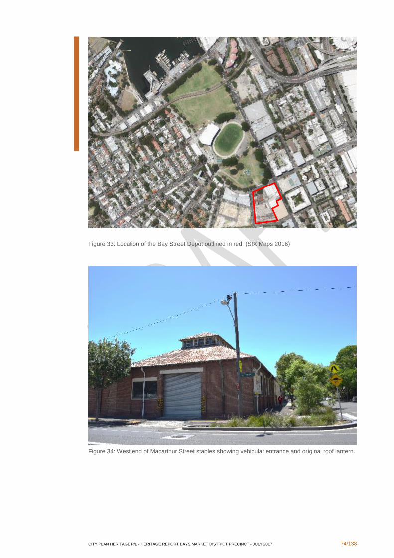
CITY PLAN HERITAGE P/L - HERITAGE REPORT BAYS MARKET DISTRICT PRECINCT - JULY 2017 74/138
Figure 33: Location of the Bay Street Depot outlined in red. (SIX Maps 2016)
Figure 34: West end of Macarthur Street stables showing vehicular entrance and original roof lantern.
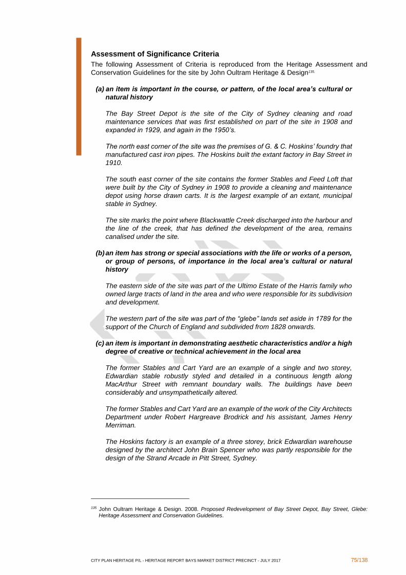
CITY PLAN HERITAGE P/L - HERITAGE REPORT BAYS MARKET DISTRICT PRECINCT - JULY 2017 75/138
Assessment of Significance Criteria
The following Assessment of Criteria is reproduced from the Heritage Assessment and
Conservation Guidelines for the site by John Oultram Heritage & Design135.
(a) an item is important in the course, or pattern, of the local area’s cultural or
natural history
The Bay Street Depot is the site of the City of Sydney cleaning and road
maintenance services that was first established on part of the site in 1908 and
expanded in 1929, and again in the 1950’s.
The north east corner of the site was the premises of G. & C. Hoskins’ foundry that
manufactured cast iron pipes. The Hoskins built the extant factory in Bay Street in
1910.
The south east corner of the site contains the former Stables and Feed Loft that
were built by the City of Sydney in 1908 to provide a cleaning and maintenance
depot using horse drawn carts. It is the largest example of an extant, municipal
stable in Sydney.
The site marks the point where Blackwattle Creek discharged into the harbour and
the line of the creek, that has defined the development of the area, remains
canalised under the site.
(b) an item has strong or special associations with the life or works of a person,
or group of persons, of importance in the local area’s cultural or natural
history
The eastern side of the site was part of the Ultimo Estate of the Harris family who
owned large tracts of land in the area and who were responsible for its subdivision
and development.
The western part of the site was part of the “glebe” lands set aside in 1789 for the
support of the Church of England and subdivided from 1828 onwards.
(c) an item is important in demonstrating aesthetic characteristics and/or a high
degree of creative or technical achievement in the local area
The former Stables and Cart Yard are an example of a single and two storey,
Edwardian stable robustly styled and detailed in a continuous length along
MacArthur Street with remnant boundary walls. The buildings have been
considerably and unsympathetically altered.
The former Stables and Cart Yard are an example of the work of the City Architects
Department under Robert Hargreave Brodrick and his assistant, James Henry
Merriman.
The Hoskins factory is an example of a three storey, brick Edwardian warehouse
designed by the architect John Brain Spencer who was partly responsible for the
design of the Strand Arcade in Pitt Street, Sydney.
135 John Oultram Heritage & Design. 2008. Proposed Redevelopment of Bay Street Depot, Bay Street, Glebe: Heritage Assessment and Conservation Guidelines.
CITY PLAN HERITAGE P/L - HERITAGE REPORT BAYS MARKET DISTRICT PRECINCT - JULY 2017 76/138
(d) an item has strong or special association with a particular community or
cultural group in the local area for social, cultural or spiritual reasons
The City of Sydney cleaning and road maintenance section has been at the site for
nearly 100 years and would have employed hundreds of employees over that time.
The site is distinctive and may have special associations for past and present staff.
(e) an item has potential to yield information that will contribute to an
understanding of the local area’s cultural or natural history
The site may contain remains of the 1880 culvert and sewer that was used to
realign Blackwattle Creek.
The site may contain below ground remains of the early Victorian houses that were
demolished following the resumption of 1906.
The archaeological potential of the site is moderate.
(f) an item possesses uncommon, rare or endangered aspects of the local
area’s cultural or natural history
The former Stable is the largest, extant, municipal stable in Sydney.
Is rare regionally.
(g) an item is important in demonstrating the principal characteristics of a class
of the local area’s
▪ cultural or natural places; or
▪ cultural or natural environments
The site is an example of an inner city, industrial site that was developed over a
former residential subdivision along the line of Blackwattle Creek.
Historically Representative Locally
Aesthetically Representative Locally
Technically Representative Locally
Socially Representative Locally
Statement of Significance
In the absence of a Statement of Significance in the document by Oultram Heritage & Design,
the following statement of significance for the site is quoted from the NSW State Heritage
Inventory (SHI) listing sheet for the item:136
The depot and factory buildings constructed from 1908 to the 1920s for the City of
Sydney and Hoskins as a town yard for street cleaning facilities and storage,
represents the industrial and civic development of Ultimo during the twentieth
century. The site and its buildings provide evidence of significant government
initiatives to alleviate the City's severe pollution and public health issues during the
early twentieth century and over a century of local public works for improving
Sydney’s urban environment and street beautification. The Bay Street factory, as
136 State Heritage Inventory, "Bay Street Depot former stables and factory buildings, including interiors and Bay Street garages street wall",
http://www.environment.nsw.gov.au/heritageapp/ViewHeritageItemDetails.aspx?ID=5062507
CITY PLAN HERITAGE P/L - HERITAGE REPORT BAYS MARKET DISTRICT PRECINCT - JULY 2017 77/138
the only industrial building surviving from the Hoskins Iron and Steel Co use of the
site also provide evidence of the formerly widespread engineering industry of
Sydney from the early twentieth century through to the post-war period.
As part of the first land resumption of 1905 and redevelopment by the local council
to reduce heavy industrial pollution of Blackwattle Creek and address severe public
health issues, the site demonstrates significant local government intervention to
improve the streets and sanitation of Sydney city during the early twentieth century.
The development of this land provides evidence of the new powers granted to the
local council in 1905 to clear slums, re-plan and beautify the city during the period
of the 1909 Royal Commission on the Improvement of Sydney. The former stables
and subsequent garaging on this site for housing the street cleaning fleet also
represent technological advancements in street cleaning during this period when
horse-drawn carts were replaced by motorised vehicles.
Aesthetically, the buildings within this complex represent good examples of the
Federation and inter-war styles, demonstrating the industrial work from prominent
architects including the City architect Robert Hargreave Brodrick for the stables,
John Spencer for the Bay Street factory and W. S. White for the 1929 inter-war
garages street wall. The buildings make important contributions to the surrounding
streetscapes of Macarthur, Bay and William Henry Streets through their industrial
character, distinctive architecture and consistent materials. The buildings are
highly visible from a number of near and distant vantage points in the
neighbourhood.
The Bay Street Depot complex forms part of one of the largest known collections
of industrial and warehouse buildings of its kind in Australia, which records City of
Sydney’s past as one of only two historic industrial heartlands in Australia. This
collection of buildings provides evidence of Australia’s twentieth century
transformation through industrialisation when Sydney became one of the largest
industrialised cities in the South Pacific.
The depot buildings are of local heritage significance in terms of their historical,
aesthetic and representative value.137
Opportunities and Constraints
The recommended management section of the SHI form advises that the Federation, Inter-
War and Post-War buildings that include face brickwork, multi-paned timber and steel
windows, early signage, gabled, hipped and sawtooth roof forms and their roof lanterns,
parapet walls, and other original building features, should be conserved and maintained. Any
new uses for the buildings are to complement and enhance the internal and external industrial
characteristics of the site. Changes made to the building should allow for the essential form
to remain readily identifiable.
The Heritage Assessment undertaken by John Oultram Heritage & Design in August 2008
assessed the significance of the fabric of the depot buildings individually. It concluded that:
The earlier buildings on the site are robust and simply detailed and are a built memory of the
pre-motor vehicle age when horses provided the backbone for transport in the city. The
buildings at the Depot are not at a level of significance that precludes major change but the
built form and fabric of the early buildings, and particularly the Town Yard stables and the
137NSW Office of Environment and Heritage. 'Bay Street Depot former stables and factory buildings, including interiors and Bay Street garages street wall'
http://www.environment.nsw.gov.au/heritageapp/ViewHeritageItemDetails.aspx?ID=5062507 (accessed 26 April 2016).
CITY PLAN HERITAGE P/L - HERITAGE REPORT BAYS MARKET DISTRICT PRECINCT - JULY 2017 78/138
Hoskins factory should be conserved to an extent to allow their appreciation interpretation for
future generation.138
The assessment found that the most significant fabric comprised those buildings constructed
between 1908 and 1946 (Figure 35). Buildings concluded to be of high significance (Figure
5) include the Factory (B2), Workshops (B12A), Workshops and Amenities (B12B), and Staff
Amenities and Stores (B12C). The assessment recommended that all significant fabric be
retained and conserved, including:
▪ all fabric introduced between 1908 and 1946, and
▪ all fabric introduced after 1946 for the preservation and reconstruction of the place.
▪ The exceptions to this recommendation include areas:
▪ where the fabric is clearly of a temporary nature, and
▪ where it is identified as fabric of moderate significance.
Fabric that may be removed (which may include paint finishes and temporary coverings) is:
▪ all fabric introduced after 1946 except where it is identified as significant fabric, i.e.
where fabric has been introduced to preserve and reconstruct the buildings.139
The assessment recommended that all forms of re-use, including historical, compatible, and
redevelopment use, should be allowed, including:
▪ use of the place for its historic use as a Council depot
▪ use that maintains the cultural significance of the place with limited change to
significant fabric:
▪ alternative use for light industrial, workshops or stores
▪ adaptive reuse for commercial or residential development
▪ alternative use that maintains the cultural significance of the place with substantial
change to significant fabric:
▪ redevelopment for commercial or residential development
▪ redevelopment for light industrial development.140
138 John Oultram Heritage & Design, August 2008, Proposed Redevelopment of Bay Street Depot, Bay Street, Glebe: Heritage Assessment & Conservation Guidelines. p.62.
139 Ibid. p.56 140 Ibid. p.54.
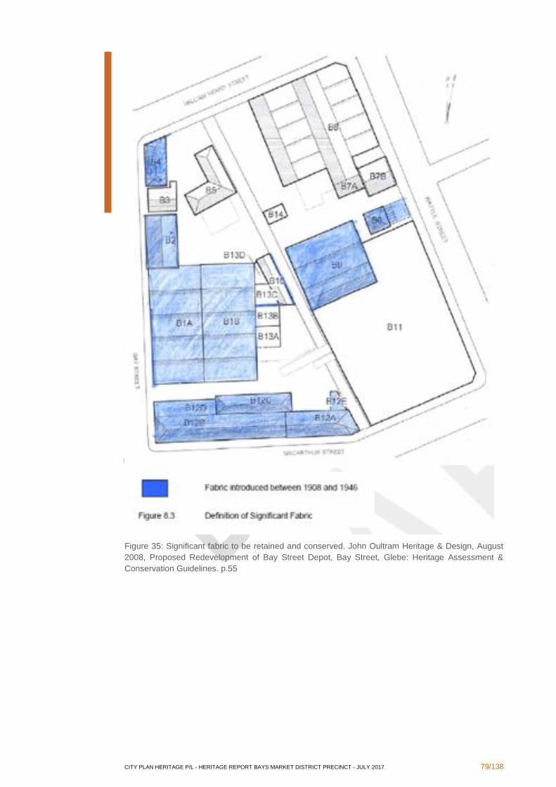
CITY PLAN HERITAGE P/L - HERITAGE REPORT BAYS MARKET DISTRICT PRECINCT - JULY 2017 79/138
Figure 35: Significant fabric to be retained and conserved. John Oultram Heritage & Design, August
2008, Proposed Redevelopment of Bay Street Depot, Bay Street, Glebe: Heritage Assessment &
Conservation Guidelines. p.55
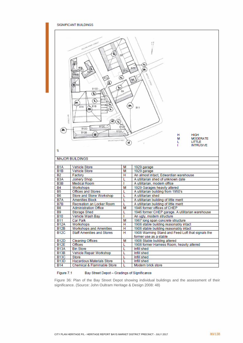
CITY PLAN HERITAGE P/L - HERITAGE REPORT BAYS MARKET DISTRICT PRECINCT - JULY 2017 80/138
Figure 36: Plan of the Bay Street Depot showing individual buildings and the assessment of their
significance. (Source: John Oultram Heritage & Design 2008: 48)
CITY PLAN HERITAGE P/L - HERITAGE REPORT BAYS MARKET DISTRICT PRECINCT - JULY 2017 81/138
In conclusion, the buildings of high significance on the site of the depot cannot be
demolished. There is some scope for adaptive re-use of the buildings and redevelopment,
as long as this is sympathetic to the existing form of the buildings. A Heritage Impact
Statement will be required to be prepared to assess the impact of any proposed changes on
the heritage values of the site. A Conservation Management Strategy may be required to
further analyse the existing fabric and guide future changes to the site.
3.2.2 Wentworth Park
Brief History
Wentworth Park was created through the reclamation of Blackwattle Bay during the late 19th
century.141 According to a map by J.J. Byrne dated 1888, soon after the reclamation, the land
had been transformed into a gardenesque community parkland (Figure 37). Sporting fields
for rugby and cricket, an ornamental lake, a bowling green and a caretaker's cottage were all
included in the Park's design. As part of the reclamation process, a number of drains and
pipes were set in place beneath the present surface of the grounds to aid in the efficient
draining of the wetlands. A Detail Survey Sheet from 1887 indicates that, at that time, a single
drain serviced the entirety of Wentworth Park (Figure 38). A Detail Sheet from 1939 has this
drain labelled as being constructed of brick (Figure 39). The same Detail Sheet shows that,
by that time, an additional four concrete pipes had been laid beneath Wentworth Park.
Wentworth Park was the location of numerous important community sporting events in its
early years, from frequent cricket and rugby matches to the establishment of greyhound
racing at the end of the 1930s.142
As Sydney's industry expanded, a need for transport between rural Australia and the ships
for exporting goods, via Central Station, was required. As such, in 1910, construction began
on the brick and sandstone viaduct, known as the Metropolitan Goods Line, across the
northern portion of Wentworth Park.143
During the First World War, Wentworth Park's large open spaces were used to house
corrugated iron wool sheds in aid of the war effort.144 The woolsheds remained within the
park for some years, as their continued presence was recorded on an aerial photograph
dated to 1943 (Figure 40). During WWII the Wentworth Park Greyhound Track (see section
3.2.3 below for a detailed history) was used as a US Army Camp for the duration of the war.
Evidence of this is also seen on the aerial photograph from 1943 (Figure 41).
At the conclusion of WWII, the woolsheds were removed and the park was returned to
community use. The site is currently a multi-purpose recreational facility used for soccer,
rugby, cricket, playgrounds and picnics.
141 Godden Mackay for Manidis Roberts Consultants 1990, Wentworth Park Plan of Management, p.8. 142 See Section 3.6 below. 143 State Heritage Database, State Heritage Inventory sheet no. 5045444 for 'Glebe Railway Viaduct'. http://www.environment.nsw.gov.au/heritageapp/ViewHeritageItemDetails.aspx?ID=5045444 144 Wendy Thorp 1990, Historical Context Report: Wentworth Park, Sydney, p. 14.
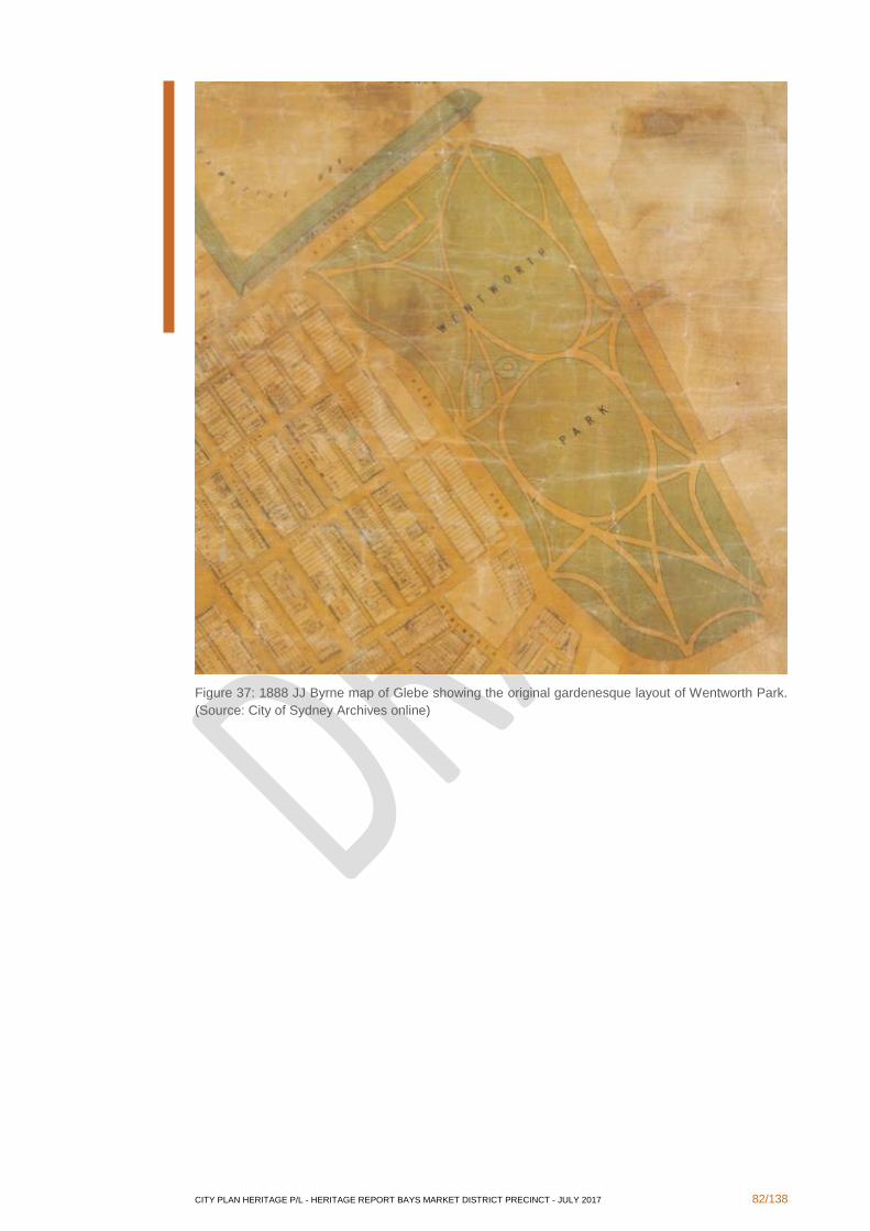
CITY PLAN HERITAGE P/L - HERITAGE REPORT BAYS MARKET DISTRICT PRECINCT - JULY 2017 82/138
Figure 37: 1888 JJ Byrne map of Glebe showing the original gardenesque layout of Wentworth Park.
(Source: City of Sydney Archives online)
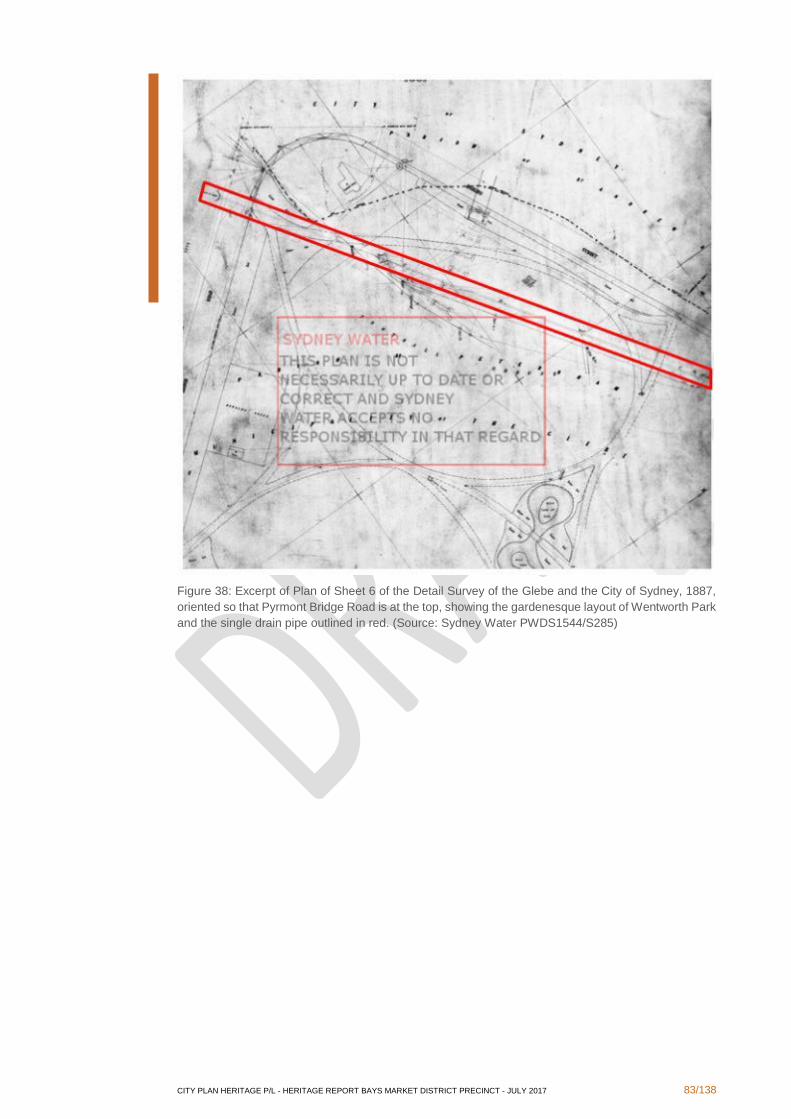
CITY PLAN HERITAGE P/L - HERITAGE REPORT BAYS MARKET DISTRICT PRECINCT - JULY 2017 83/138
Figure 38: Excerpt of Plan of Sheet 6 of the Detail Survey of the Glebe and the City of Sydney, 1887,
oriented so that Pyrmont Bridge Road is at the top, showing the gardenesque layout of Wentworth Park
and the single drain pipe outlined in red. (Source: Sydney Water PWDS1544/S285)
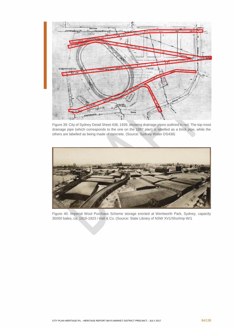
CITY PLAN HERITAGE P/L - HERITAGE REPORT BAYS MARKET DISTRICT PRECINCT - JULY 2017 84/138
Figure 39: City of Sydney Detail Sheet 438, 1939, showing drainage pipes outlined in red. The top-most
drainage pipe (which corresponds to the one on the 1887 plan) is labelled as a brick pipe, while the
others are labelled as being made of concrete. (Source: Sydney Water DS438)
Figure 40: Imperial Wool Purchase Scheme storage erected at Wentworth Park, Sydney, capacity
35000 bales, ca. 1916-1923 / Hall & Co. (Source: State Library of NSW XV1/Sho/Imp W/1
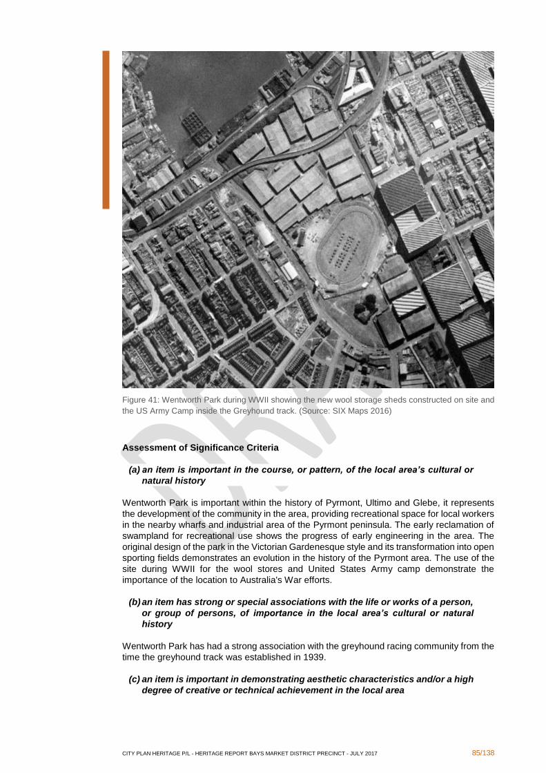
CITY PLAN HERITAGE P/L - HERITAGE REPORT BAYS MARKET DISTRICT PRECINCT - JULY 2017 85/138
Figure 41: Wentworth Park during WWII showing the new wool storage sheds constructed on site and
the US Army Camp inside the Greyhound track. (Source: SIX Maps 2016)
Assessment of Significance Criteria
(a) an item is important in the course, or pattern, of the local area’s cultural or
natural history
Wentworth Park is important within the history of Pyrmont, Ultimo and Glebe, it represents
the development of the community in the area, providing recreational space for local workers
in the nearby wharfs and industrial area of the Pyrmont peninsula. The early reclamation of
swampland for recreational use shows the progress of early engineering in the area. The
original design of the park in the Victorian Gardenesque style and its transformation into open
sporting fields demonstrates an evolution in the history of the Pyrmont area. The use of the
site during WWII for the wool stores and United States Army camp demonstrate the
importance of the location to Australia's War efforts.
(b) an item has strong or special associations with the life or works of a person,
or group of persons, of importance in the local area’s cultural or natural
history
Wentworth Park has had a strong association with the greyhound racing community from the
time the greyhound track was established in 1939.
(c) an item is important in demonstrating aesthetic characteristics and/or a high
degree of creative or technical achievement in the local area
CITY PLAN HERITAGE P/L - HERITAGE REPORT BAYS MARKET DISTRICT PRECINCT - JULY 2017 86/138
Wentworth Park is an important open space within inner Sydney, with large, well-established
fig tree boulevards.
(d) an item has strong or special association with a particular community or
cultural group in the local area for social, cultural or spiritual reasons
Wentworth Park has been the meeting ground of various sporting community groups through
its history, including cricket, rugby and greyhound racing. It continues to be an important
public space for various social purposes.
(e) an item has potential to yield information that will contribute to an
understanding of the local area’s cultural or natural history
As Wentworth Park was established on land reclaimed from Blackwattle Bay and contains a
number of historic drains, including an especially early drain pipe from the late 19th century,
it has the potential to reveal information on the mechanical processes of land reclamation of
that time.
(f) an item possesses uncommon, rare or endangered aspects of the local
area’s cultural or natural history
Wentworth Park is the last remaining large green open space in the Pyrmont and Ultimo
locality, which is the most densely populated area in Australia.
(g) an item is important in demonstrating the principal characteristics of a class
of the local area’s
▪ cultural or natural places; or
▪ cultural or natural environments
Wentworth Park is a man-made park, created by reclaiming the land from Blackwattle
Swamp, and as such is cannot be considered a natural place or environment.
Statement of Significance
Wentworth Park is significant for its role in the development of the Pyrmont/Ultimo peninsula
as a residential and industrial centre. Originally designed in the Victorian Gardenesque style,
the park underwent a number of evolutions, including being used for the Imperial Wool
Purchase Scheme during WWI. Wentworth Park has been associated with greyhound racing,
a sport established there in 1939. Today the park is an important and rare open space in
Australia's most densely populated urban area. As Wentworth Park is situated on reclaimed
land, with a number of historic drains, it has the potential to reveal information on the technical
processes of late 19th century land reclamation.
Opportunities and Constraints
Wentworth Park should remain an open public space available for sport, community and
cultural purposes.
Sports grounds may be regraded and laid out formally in the northern portion of the site.
The location of the original brick drain is known and is considered to be of archaeological
potential, therefore any works surrounding this drain may require an archaeological
assessment and further archaeological work.
Previously, some arches underneath the viaduct were used for showers, tool sheds and
storage. There is possibility for uses similar to this could be reinstated providing the
permeability through the viaduct is maintained and any new structure does not touch the
existing fabric.
Existing trees should remain, there is opportunity for new garden beds and pathways in line
with the original gardenesque design.

CITY PLAN HERITAGE P/L - HERITAGE REPORT BAYS MARKET DISTRICT PRECINCT - JULY 2017 87/138
3.2.3 Wentworth Park Greyhound Track
Brief History
Greyhound races were originally held at the nearby Harold Park race track. Harold Park was
originally known as Epping Racecourse and was owned by the NSW Trotting Club. The first
greyhound race meeting in Australia was held there in 1927.145
In 1933, the NSW Cabinet made the decision to ban the sport as it was run by the Greyhound
Coursing Association and the Greyhound Racing Club.146 Provision was made to open
applications for a new licence, subject to the condition that the controlling body be non-
proprietary and profits be returned to funding the sport. The possibility of a new track was
also explored at this time and Wentworth Park was under consideration to be this site. The
newly formed National Coursing Association (NCA) was considered the major proponent for
the licence.147 The Australian Rules Football body controlled Wentworth Park at the time and
it was initially feared that the two proposed uses of the Park, football and greyhound racing,
would not be compatible, as the requisite installation of a tin hare could compromise the use
of the Park for football games.148 The National Coursing Association held meetings with the
Australian Rules body to address these concerns, assuring all that it would not encroach
upon the playing areas and that the oval would be extended, with new stands erected.149
Despite the proclaimed ban, racing meetings continued to be held at Harold Park until July
1938, when it was announced that the recipient of the new licence to run greyhound racing
meetings at Wentworth Park was the NCA, who would begin the new program in October of
the same year. It was announced that a large sum of money would be spent on improving
and preparing the ground for the new races.150 The Sydney Morning Herald reported the plans
for the new Wentworth Park track:
The committee of the association will meet next Wednesday night when preliminary
work will begin dealing with the ground. It is proposed to lay down a grass track of
480 yards. This will necessitate alterations to the speedway track, which will be
turfed. At Harold Park the spectators are a long way from the dogs. The fascination
of the GCA track at that ground was that galleries were erected against the track,
giving uninterrupted views. This idea will be adhered to at Wentworth Park. A
lighting scheme is being devised similar to the White City, London track. The stand
will be remodelled and every effort is to be made to have the track in readiness for
the opening meeting on October 1.151
Construction work on the track was delayed while legal issues relating to the dedicated use
of the park for football and cricket were resolved. In the meantime, The Newcastle Sun
reported further on the plans for the new facilities:
Construction of the new grass track, which will be a permanent fixture, will be the
first consideration. Other work can be carried on while the track is being made…
Eight dogs will contest races at Wentworth Park, but the question of an inside or
outside hare is still being discussed by the N.C.A. committee. The contour of the
track to eliminate interference, and give consideration to the placing of starting
boxes and distances of races has been carefully considered… The kennels will be
a revelation and the public will be able to view the identification, weighing and
veterinary examination of each dog. Other improvements suggest better conditions
for owners and trainers….152
145 Stearn, D. 2010. The End of Harold Park: A Look Back at the Halcyon Days of NSW Greyhound Racing. http://www.australianracinggreyhound.com/australian-greyhound-racing/new-south-wales-greyhound-racing/the-
end-of-harold-park-a-look-back-at-the-halcyon-days-of-nsw-greyhound-racing/25426 (accessed 7 July 2016). 146 Newcastle Sun Tuesday 4 April 1933, p.1 147 Ibid. 148 Sporting Globe Wednesday 12 April 1933, p.13. 149 Ibid. 150 Referee, Thursday 21 July 1938, p.11 151 Sydney Morning Herald, Friday 22 July 1938, p.15 152 The Newcastle Sun, Wednesday 7 December 1938, p.4
CITY PLAN HERITAGE P/L - HERITAGE REPORT BAYS MARKET DISTRICT PRECINCT - JULY 2017 88/138
It was announced in late January 1939 that the lease contract for the greyhound track
grounds had finally been signed. The supervising architect was named as Mr. C. Glancy, and
building contractor as Mr. R. M. Bowcock (Figure 42).153 Clement Glancy (alternatively
Glancey) was a well-known architect at the time, having completed a number of projects,
primarily Catholic schools and churches in Sydney and Canberra, specialising in the
Romanesque style.154 Newspaper articles show that throughout the 1930s Glancy frequently
collaborated with Raymond Michael Bowcock, who was known as a successful church
builder. Research suggests that the track was a singular departure from Glancy's established
specialisation, as he returned to designing churches immediately after and continued to do
so through the 1950s.155
By mid-February the architect's plans had been prepared, and were reported in detail by the
Sydney Morning Herald:
Races will be run over similar distances to those on the majority of English tracks.
The track will be 470 yards in circumference, and the races will be of 525 yards
and 750 yards. This is to avoid the scrambles which frequently take place in shorter
races and often result in interference.
As the paddock patrons will be near the judge's box, the dogs in all races will pass
them twice. In the shorter events the dogs will start at the end of the straight 55
yards back from the finishing point. The start will be in the north-western corner of
the track. For 750 yards races the start will be on the eastern side.
The track is oval in shape with two long straights. This will assist dogs who lose
ground on bends. The track will be 18 feet wide, with the hare on the outside on an
extended arm.
Paddock patrons will enter the ground at Park Road, at the foot of Bay Street, and
the Leger reserve entrance will be in Wattle Street.156
After an extended delay the track was finally opened and the first race held on 30 October
1939 with a record attendance of 24,000 people, the largest crowd at a greyhound race
meeting achieved in the southern hemisphere.157 The Sporting Globe and the Narandera
Argus and Riverina Advertiser had further detailed descriptions of the track and new facilities:
An innovation was the elimination of the outside fence from the track proper, so
that patrons obtain an uninterrupted view. It was thought that dogs might run off
the course. None failed to negotiate the track…
Grass surface of the track is even and well covered, and is much easier on the feet
of the dogs than the sand surfaces.
The course has two short straights of approximately 60 yards, the remainder of the
distance being semi-circular.
The mechanical hare is on the outside of the track, and is released from behind the
starting boxes. The hare is attached to an arm which protrudes 6ft. toward the
centre of the track. As the hare passes in front of the boxes the dogs are
released…158
153 Sydney Morning Herald Wednesday 25 January 1939, p.12 154 Dictionary of Sydney, 'Glancey, Clement', http://dictionaryofsydney.org/person/glancey_clement 155 Sydney Morning Herald, Tuesday 10 March 1953, "Tenders Accepted", p.8. 156 Sydney Morning Herald, Friday 10 February 1939, p.15 157 Sporting Globe, Wednesday 1 November 1939, p.11 158 Ibid.
CITY PLAN HERITAGE P/L - HERITAGE REPORT BAYS MARKET DISTRICT PRECINCT - JULY 2017 89/138
There is no better race track in Australia than the Wentworth Park track and the
lighting arrangements are almost perfect. The modern automatic totalisators,
housed in convenient buildings, were also a revelation to punters, and they readily
showed the total investments and dividends. The totes are the only ones of their
kind in Australia, being similar to those used at the Canidrome, Shanghai, China.
The public were able to view the dogs in the yards through the plate glass windows,
while the dogs in each race were escorted to their boxes by club officials, each
wearing a white coat.159
In 1979 the NCA applied to build a new grand stand in the expectation that popularity of the
sport would continue to increase and patronage would continue to expand.160 The new grand
stand was completed in 1985 and had blown out financially to such an extent that a rescue
package was provided through the Racecourse Development Fund.161 The expected crowds
never eventuated as off-course betting was legalised, removing the need for punters to be
present on-site to place their bets.162 In 1987 greyhound racing ceased at Harold Park and all
activity continued at Wentworth Park.163 Harold Park has since been turned over for residential
development by Mirvac, and traces of the track have already been erased. The Wentworth
Park track continued to be used by the NSW NCA until 2008 when it ceased its operations
at Wentworth Park in favour of concentrating its attention on developing races in Newcastle.164
Following continued financial difficulties, the Board of Greyhound Racing NSW cancelled the
NCA's registration as a greyhound racing club in 2013,165 but the track continues to be used
by the Greyhound Breeders, Owners and Trainers Association (GBOTA).
Comparison of aerial photographs from the modern day and 1943, shortly after the opening
of the track, shows that the shape of the original track has largely been maintained along the
original lines, although a slight change from an egg shape to an oval shape is discernible
(Figures 43 to 44).
159 Narandera Argus and Riverina Advertiser, Friday 3 November 1939, p.6 160 Wentworth Park Complex, "History of the Park", http://wentworthparksport.com.au/history-of-the-park/ 161 Ibid. 162 The Glebe Society Inc., "Wentworth Park - Its History and Uses", http://www.glebesociety.org.au/wordpress/?socialhistory=wentworth-park-its-history-and-uses 163 D. Stearn, 28 December 2010, "The End of Harold Park: A Look Back at the Halcyon Days of NSW Greyhound
Racing" Australian Racing Greyhound website, http://www.australianracinggreyhound.com/australian-greyhound-racing/new-south-wales-greyhound-racing/the-end-of-harold-park-a-look-back-at-the-halcyon-days-of-nsw-greyhound-racing/25426
164 The Daily Telegraph, 29 May 2008, "Cash problems force NCA quit Wentworth Park", http://www.dailytelegraph.com.au/sport/cash-problems-force-nca-quit-wentworth-park/story-e6frexni-
1111116469977 165 Greyhound Racing NSW, 2 August, 2013, "NCA Registration Cancelled", http://www.wentworthpark.com.au/News/Article?id=4074&ext=1&mid=3
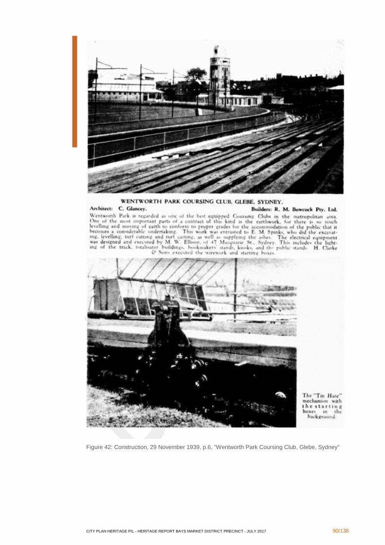
CITY PLAN HERITAGE P/L - HERITAGE REPORT BAYS MARKET DISTRICT PRECINCT - JULY 2017 90/138
Figure 42: Construction, 29 November 1939, p.6, "Wentworth Park Coursing Club, Glebe, Sydney"
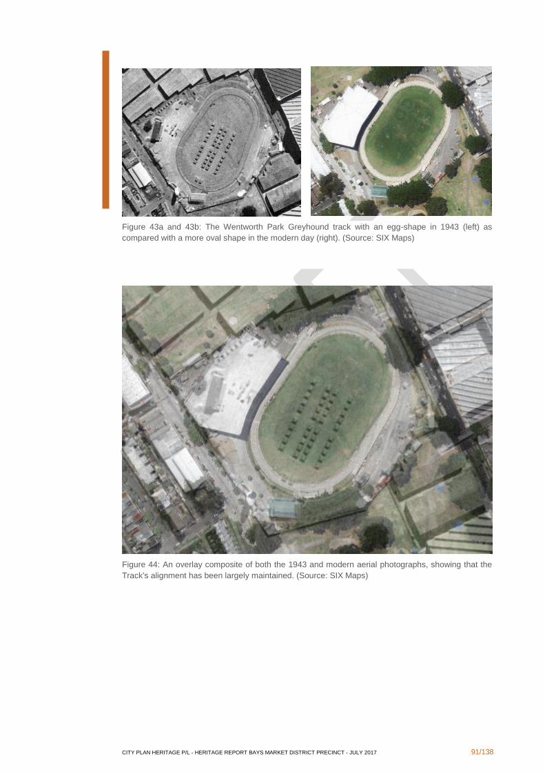
CITY PLAN HERITAGE P/L - HERITAGE REPORT BAYS MARKET DISTRICT PRECINCT - JULY 2017 91/138
Figure 45a and 30b: The Wentworth Park Greyhound track with an egg-shape in 1943 (left) as
compared with a more oval shape in the modern day (right). (Source: SIX Maps)
Figure 43a and 43b: The Wentworth Park Greyhound track with an egg-shape in 1943 (left) as
compared with a more oval shape in the modern day (right). (Source: SIX Maps)
Figure 44: An overlay composite of both the 1943 and modern aerial photographs, showing that the
Track's alignment has been largely maintained. (Source: SIX Maps)
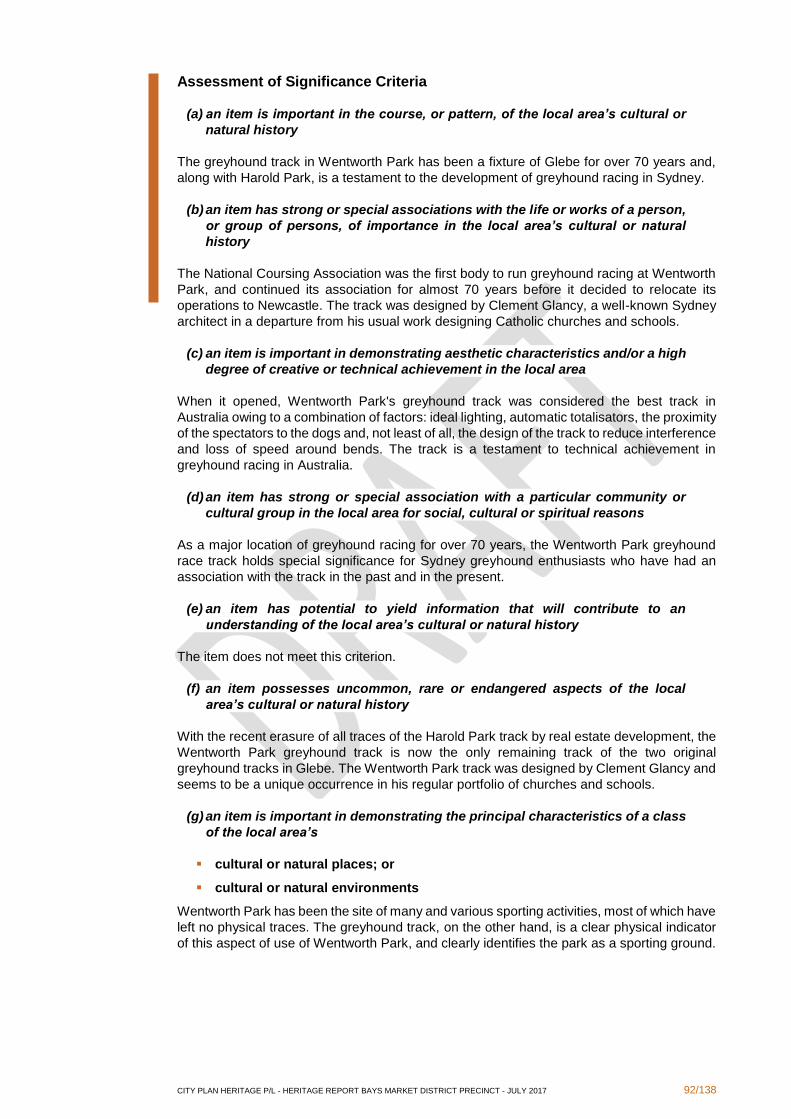
CITY PLAN HERITAGE P/L - HERITAGE REPORT BAYS MARKET DISTRICT PRECINCT - JULY 2017 92/138
Assessment of Significance Criteria
(a) an item is important in the course, or pattern, of the local area’s cultural or
natural history
The greyhound track in Wentworth Park has been a fixture of Glebe for over 70 years and,
along with Harold Park, is a testament to the development of greyhound racing in Sydney.
(b) an item has strong or special associations with the life or works of a person,
or group of persons, of importance in the local area’s cultural or natural
history
The National Coursing Association was the first body to run greyhound racing at Wentworth
Park, and continued its association for almost 70 years before it decided to relocate its
operations to Newcastle. The track was designed by Clement Glancy, a well-known Sydney
architect in a departure from his usual work designing Catholic churches and schools.
(c) an item is important in demonstrating aesthetic characteristics and/or a high
degree of creative or technical achievement in the local area
When it opened, Wentworth Park's greyhound track was considered the best track in
Australia owing to a combination of factors: ideal lighting, automatic totalisators, the proximity
of the spectators to the dogs and, not least of all, the design of the track to reduce interference
and loss of speed around bends. The track is a testament to technical achievement in
greyhound racing in Australia.
(d) an item has strong or special association with a particular community or
cultural group in the local area for social, cultural or spiritual reasons
As a major location of greyhound racing for over 70 years, the Wentworth Park greyhound
race track holds special significance for Sydney greyhound enthusiasts who have had an
association with the track in the past and in the present.
(e) an item has potential to yield information that will contribute to an
understanding of the local area’s cultural or natural history
The item does not meet this criterion.
(f) an item possesses uncommon, rare or endangered aspects of the local
area’s cultural or natural history
With the recent erasure of all traces of the Harold Park track by real estate development, the
Wentworth Park greyhound track is now the only remaining track of the two original
greyhound tracks in Glebe. The Wentworth Park track was designed by Clement Glancy and
seems to be a unique occurrence in his regular portfolio of churches and schools.
(g) an item is important in demonstrating the principal characteristics of a class
of the local area’s
▪ cultural or natural places; or
▪ cultural or natural environments
Wentworth Park has been the site of many and various sporting activities, most of which have
left no physical traces. The greyhound track, on the other hand, is a clear physical indicator
of this aspect of use of Wentworth Park, and clearly identifies the park as a sporting ground.
CITY PLAN HERITAGE P/L - HERITAGE REPORT BAYS MARKET DISTRICT PRECINCT - JULY 2017 93/138
Statement of Significance
The greyhound track at Wentworth Park has historical, associative, technical and social
significance in Wentworth Park itself and the suburb of Glebe. The greyhound track was
considered the best in Australia when it opened in 1939, especially for the technical
considerations of its design to improve track conditions for the greyhounds. The track was
designed by Clement Glancy, an architect known at the time primarily for his designs of
schools and churches, and constitutes an uncharacteristic departure from his established
specialisation. The track was used by the National Coursing Association for almost 70 years,
and has a special association for the thousands of spectators and greyhound racing
enthusiasts who have attended race meetings throughout the years of its operation until now.
The recent removal of the greyhound track at Harold Park, which was in operation alongside
the Wentworth Park track, has rendered the Wentworth Park track both rare and
representative of greyhound racing in Glebe.
Opportunities and Constraints
The Track retains its original shape and parameters which should be not be encroached upon
by any other development. There may be provision to remove the physical remains of the
track itself while leaving a clear outline as an interpretative measure, given that its
significance is tied to the technical achievement of the track's parameters at the time of its
construction.
3.2.4 Stormwater Channel No. 17 beneath Wentworth Park
Brief History
The following history of Stormwater Channel 17, located beneath Wentworth Park, is
reproduced from the State Heritage Inventory form for the item.166
In 1842 the Sydney Municipal Council was incorporated by an Act of Parliament. At this stage
there was no record of any stormwater drains being constructed within the Blackwattle Bay
stormwater system. In 1857 the death rate from disease in the area had reached alarming
levels, and this led to the implementation of a sewerage scheme. In particular five main
combined sewers were built in the city to dispose of stormwater and sewerage into the
Harbour. The Blackwattle Bay sewer was one of these five.
Initially, the sewer discharged into Blackwattle Swamp which was located where Wentworth
Park now is. In 1874, the accumulation of sewer and stormwater in this swamp posed a
serious health risk to the people of the area. The Sewerage and Health Board was created
during this period to alleviate some of the problems in this, and other catchments. On the
Boards recommendations the swamp was resumed and converted into Wentworth Park. In
addition, in 1876 a 450mm pipe was laid along the bed of Blackwattle Creek to extend the
discharge point from the previous Blackwattle Swamp area, into the Harbour at Blackwattle
Bay.
In 1886 most of the sewers' high level land in the catchment was diverted to the extension of
the Bondi Ocean Outfall System (BOOS). Approximately 94 hectares of low lying land
continued to drain into Blackwattle Bay until 1898 when Sewage Pumping Station No. 2 was
constructed to remove the sewerage into the BOOS.
From approximately 1900 to the present the system has been used primarily for stormwater.
The drainage system is now known as the Blackwattle Bay Stormwater System (SWC No.
17).
In addition to the above established history, CPH notes that the extent of the stormwater
channel network beneath Wentworth Park may be seen on plans held by Sydney Water.
Excerpts of relevant plans have been provided under the discussion of the history of
Wentworth Park above, in Figures 38 and 39 above.
166 State Heritage Inventory form no. 4570535 for "Blackwattle Bay Stormwater Channel No. 17", http://www.environment.nsw.gov.au/heritageapp/ViewHeritageItemDetails.aspx?ID=4570535
CITY PLAN HERITAGE P/L - HERITAGE REPORT BAYS MARKET DISTRICT PRECINCT - JULY 2017 94/138
Assessment of Significance Criteria
The following assessment of heritage significance is reproduced from the State Heritage
Inventory form for the item (in italics) with additional information added by CPH as relevant:
(a) an item is important in the course, or pattern, of the local area’s cultural or
natural history
High historical significance as the stormwater channel was initially one of City's five original
Harbour Sewers. Prior to this there was little or no sewerage scheme for the area. Hence it
had an impact of greatly improving the hygiene and living standards of the city's residents at
such an early stage in the State's history. The system was built over Blackwattle Swamps
after they were no longer of any use in supplying freshwater.
(b) an item has strong or special associations with the life or works of a person,
or group of persons, of importance in the local area’s cultural or natural
history
Historical information has not suggested that the stormwater channel has any strong or
special association with any particular person or group of persons.
(c) an item is important in demonstrating aesthetic characteristics and/or a high
degree of creative or technical achievement in the local area
The system is entirely underground and no photographs of the channel are known to exist.
Therefore, there is no basis upon which to assess whether the stormwater is of aesthetic
significance. However, as a utilitarian item, it is unlikely that it has any particular aesthetic
character. As one of the first original Harbour Sewers, the stormwater channel does
demonstrate a technical achievement in Sydney, especially as it was instrumental in
improving hygeine and quality of life in the early city.
(d) an item has strong or special association with a particular community or
cultural group in the local area for social, cultural or spiritual reasons
Greatly improved the public health, hygiene and living standards of Sydney's residents in the
late 1800's. Initially a combined sewer it improved the water quality of Sydney Harbour. The
connection to the BOOS in 1886 and the addition of SPS 2 in 1898 led to the system being
used primarily for stormwater. This further improved the public health of the city and harbour.
The original infrastructure now used as the core of the present stormwater drainage system.
(e) an item has potential to yield information that will contribute to an
understanding of the local area’s cultural or natural history
Of technological significance as it was initially part of the city's original sewerage scheme,
before it was changed to a stormwater drainage system. An excellent example of the
engineering construction techniques of the late 1800's and of the city's early infrastructure.
The numerous extensions and modifications made throughout the years provide a good
example of the advancement of drainage construction techniques.
(f) an item possesses uncommon, rare or endangered aspects of the local
area’s cultural or natural history
The channel is of high historical significance as it is one of the five original combined sewers
built in Sydney around 1857. It is the earliest example of a sewer of its size in the colony.
(g) an item is important in demonstrating the principal characteristics of a class
of the local area’s
▪ cultural or natural places; or
CITY PLAN HERITAGE P/L - HERITAGE REPORT BAYS MARKET DISTRICT PRECINCT - JULY 2017 95/138
▪ cultural or natural environments
The forerunner to what became a more standard method of collecting and disposing of
stormwater and sewage.
Statement of Significance
The following established Statement of Significance is reproduced from the State Heritage
Inventory form for the item:
The Blackwattle Bay stormwater system is of high historical and technical significance as it
was one of the five original combined sewers built in Sydney around 1857. The other four
sewers were; Bennelong, Hay Street, Tank Stream and Woolloomooloo. These five sewers
were responsible for greatly improving public health, hygiene and living standards for the
city's residents in the late 1800's.
Improved public health was achieved by diverting stormwater and sewerage from the streets
and discharging it into the Harbour. The introduction of the Bondi Ocean Outfall Sewer
(BOOS) in 1889 diverted sewer flow to the ocean and eventually led to the drains being used
predominantly for stormwater, hence further improving public health.
The channel is also of technological significance as it provides an excellent example of the
engineering construction techniques of the late 1800's and of the city's early infrastructure.
The numerous extensions and modifications made throughout the years provide a good
example of the advancements made in drainage construction techniques. In addition,
Blackwattle Swamp (now Wentworth Park), into which the original sewer initially deposited,
was used for a short period as Sydney's water supply. This occurred around 1810 when the
Tank Stream dried up, and the swamp was in pristine condition.
Opportunities and Constraints
The network of drains called Stormwater Channel No. 17 extends through and across
Wentworth Park. The location of the channels is documented on historical plans held by
Sydney Water, but reliability of older plans should not be assumed. If excavation works are
required to be undertaken at Wentworth Park, they may require an excavation permit under
section 140 of the Heritage Act..
3.2.5 Sydney Stone Storage Yard (10A Wattle Street former quarry)
The former Council depot at 10A Wattle Street is still utilised as a depot/compound for private
contractors (Figures 46 and 47). The site is not listed as a local or State heritage item, nor is
it listed on the Section 170 Register of any government agency. However, following research,
it is considered that the site could be an item of some significance.

CITY PLAN HERITAGE P/L - HERITAGE REPORT BAYS MARKET DISTRICT PRECINCT - JULY 2017 96/138
Figure 46: Location of 10A Wattle Street outlined in red. (SIX maps 2016)
Figure 47: Stone storage yard, on the site of Hell Hole Quarry, looking north-east from Fig Street
Brief History
The subject site is situated on land that was originally part of Dr John Harris' Ultimo Estate.
The quarry on the site was originally opened by John Young, a builder contracted by colonial
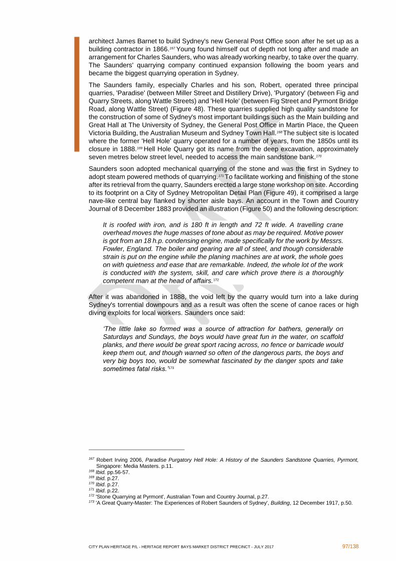
CITY PLAN HERITAGE P/L - HERITAGE REPORT BAYS MARKET DISTRICT PRECINCT - JULY 2017 97/138
architect James Barnet to build Sydney's new General Post Office soon after he set up as a
building contractor in 1866.167 Young found himself out of depth not long after and made an
arrangement for Charles Saunders, who was already working nearby, to take over the quarry.
The Saunders' quarrying company continued expansion following the boom years and
became the biggest quarrying operation in Sydney.
The Saunders family, especially Charles and his son, Robert, operated three principal
quarries, 'Paradise' (between Miller Street and Distillery Drive), 'Purgatory' (between Fig and
Quarry Streets, along Wattle Streets) and 'Hell Hole' (between Fig Street and Pyrmont Bridge
Road, along Wattle Street) (Figure 48). These quarries supplied high quality sandstone for
the construction of some of Sydney's most important buildings such as the Main building and
Great Hall at The University of Sydney, the General Post Office in Martin Place, the Queen
Victoria Building, the Australian Museum and Sydney Town Hall.168 The subject site is located
where the former 'Hell Hole' quarry operated for a number of years, from the 1850s until its
closure in 1888.169 Hell Hole Quarry got its name from the deep excavation, approximately
seven metres below street level, needed to access the main sandstone bank.170
Saunders soon adopted mechanical quarrying of the stone and was the first in Sydney to
adopt steam powered methods of quarrying.171 To facilitate working and finishing of the stone
after its retrieval from the quarry, Saunders erected a large stone workshop on site. According
to its footprint on a City of Sydney Metropolitan Detail Plan (Figure 49), it comprised a large
nave-like central bay flanked by shorter aisle bays. An account in the Town and Country
Journal of 8 December 1883 provided an illustration (Figure 50) and the following description:
It is roofed with iron, and is 180 ft in length and 72 ft wide. A travelling crane
overhead moves the huge masses of tone about as may be required. Motive power
is got from an 18 h.p. condensing engine, made specifically for the work by Messrs.
Fowler, England. The boiler and gearing are all of steel, and though considerable
strain is put on the engine while the planing machines are at work, the whole goes
on with quietness and ease that are remarkable. Indeed, the whole lot of the work
is conducted with the system, skill, and care which prove there is a thoroughly
competent man at the head of affairs.172
After it was abandoned in 1888, the void left by the quarry would turn into a lake during
Sydney's torrential downpours and as a result was often the scene of canoe races or high
diving exploits for local workers. Saunders once said:
‘The little lake so formed was a source of attraction for bathers, generally on
Saturdays and Sundays, the boys would have great fun in the water, on scaffold
planks, and there would be great sport racing across, no fence or barricade would
keep them out, and though warned so often of the dangerous parts, the boys and
very big boys too, would be somewhat fascinated by the danger spots and take
sometimes fatal risks.’173
167 Robert Irving 2006, Paradise Purgatory Hell Hole: A History of the Saunders Sandstone Quarries, Pyrmont, Singapore: Media Masters. p.11.
168 Ibid. pp.56-57. 169 Ibid. p.27. 170 Ibid. p.27. 171 Ibid. p.22. 172 'Stone Quarrying at Pyrmont', Australian Town and Country Journal, p.27. 173 'A Great Quarry-Master: The Experiences of Robert Saunders of Sydney', Building, 12 December 1917, p.50.
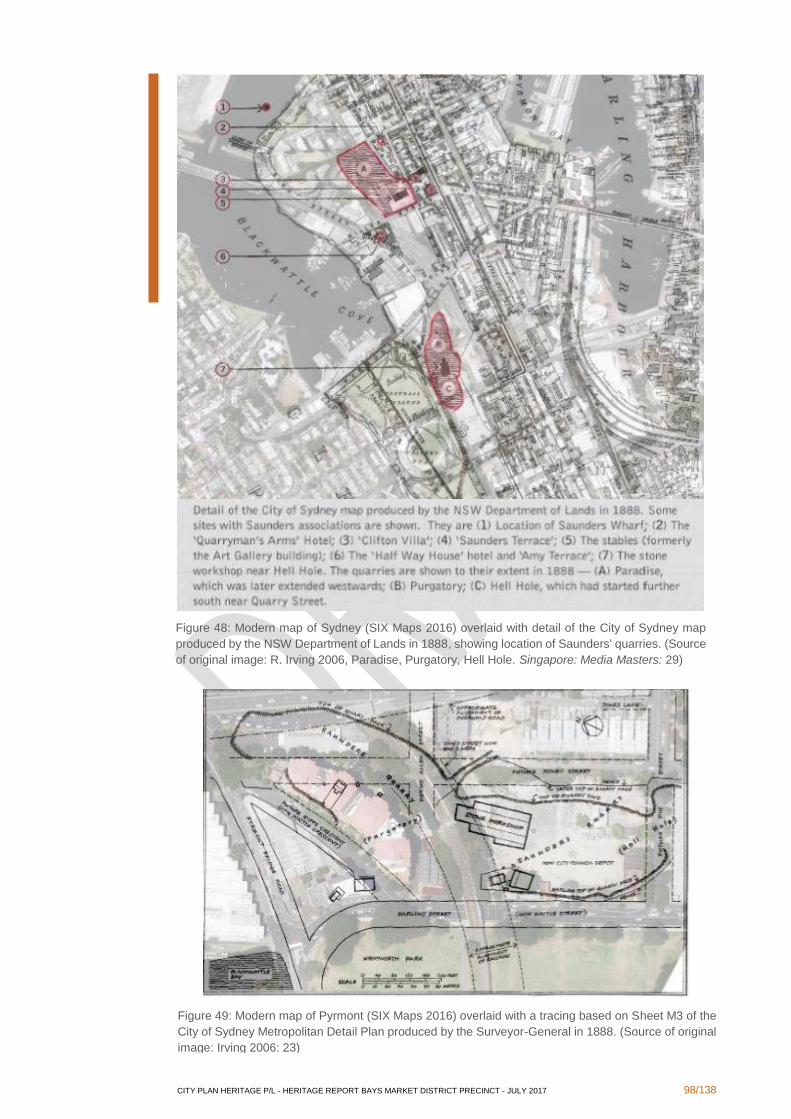
CITY PLAN HERITAGE P/L - HERITAGE REPORT BAYS MARKET DISTRICT PRECINCT - JULY 2017 98/138
Figure 49: Modern map of Pyrmont (SIX Maps 2016) overlaid with a tracing based on Sheet M3 of the
City of Sydney Metropolitan Detail Plan produced by the Surveyor-General in 1888. (Source of original
image: Irving 2006: 23)
Figure 48: Modern map of Sydney (SIX Maps 2016) overlaid with detail of the City of Sydney map
produced by the NSW Department of Lands in 1888, showing location of Saunders' quarries. (Source
of original image: R. Irving 2006, Paradise, Purgatory, Hell Hole. Singapore: Media Masters: 29)
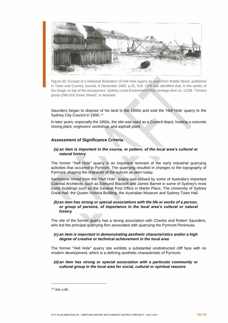
CITY PLAN HERITAGE P/L - HERITAGE REPORT BAYS MARKET DISTRICT PRECINCT - JULY 2017 99/138
Figure 50: Excerpt of a historical illustration of Hell Hole quarry as seen from Wattle Street, published
in Town and Country Journal, 8 December 1883, p.25. N.B. CPH has identified that, in the centre of
the image on top of the escarpment, Sydney Local Environment Plan heritage item no. I1238, 'Terrace
group (286-318 Jones Street)', is depicted.
Saunders began to dispose of his land in the 1900s and sold the 'Hell Hole' quarry to the
Sydney City Council in 1906.174
In later years, especially the 1950s, the site was used as a Council depot, hosting a concrete
mixing plant, engineers' workshop, and asphalt plant.
Assessment of Significance Criteria
(a) an item is important in the course, or pattern, of the local area’s cultural or
natural history
The former "Hell Hole" quarry is an important remnant of the early industrial quarrying
activities that occurred in Pyrmont. The quarrying resulted in changes to the topography of
Pyrmont, shaping the character of the suburb as seen today.
Sandstone mined from the "Hell Hole" quarry was utilised by some of Australia's important
Colonial Architects, such as Edmund Blackett and James Barnet in some of Sydney's most
iconic buildings such as the General Post Office in Martin Place, The University of Sydney
Great Hall, the Queen Victoria Building, the Australian Museum and Sydney Town Hall.
(b) an item has strong or special associations with the life or works of a person,
or group of persons, of importance in the local area’s cultural or natural
history
The site of the former quarry has a strong association with Charles and Robert Saunders,
who led the principal quarrying firm associated with quarrying the Pyrmont Peninsula.
(c) an item is important in demonstrating aesthetic characteristics and/or a high
degree of creative or technical achievement in the local area
The former "Hell Hole" quarry site exhibits a substantial unobstructed cliff face with no
modern development, which is a defining aesthetic characteristic of Pyrmont.
(d) an item has strong or special association with a particular community or
cultural group in the local area for social, cultural or spiritual reasons
174 Ibid. p.88.
CITY PLAN HERITAGE P/L - HERITAGE REPORT BAYS MARKET DISTRICT PRECINCT - JULY 2017 100/138
Although associated with the Saunders family and quarrying workers within the Pyrmont
locality, the site has long since ceased operating as a quarry and therefore no longer has an
association with any living community members.
(e) an item has potential to yield information that will contribute to an
understanding of the local area’s cultural or natural history
The site in general has moderate potential for archaeological resources, such as the footings
of Saunders' stone yards.
(f) an item possesses uncommon, rare or endangered aspects of the local
area’s cultural or natural history
The former "Hell Hole" quarry is a largely undeveloped open site exposing the large
sandstone outcrop without obstruction. That it is a vacant site is considered particularly rare
as Pyrmont/Ultimo is Australia's most densely populated area.
(g) an item is important in demonstrating the principal characteristics of a class
of the local area’s
▪ cultural or natural places; or
▪ cultural or natural environments
Due to its unique nature, the site does not demonstrate the principal characteristics of the
Pyrmont-Ultimo area.
Statement of Significance
The former "Hell Hole" quarry site is significant to Pyrmont-Ultimo as it played an important
role in the growth and development of the area through industry. Founded by Charles
Saunders and continued by his son, Robert, the quarry played a significant part in the growth
and development of the Pyrmont-Ultimo area for three quarters of a century, throughout the
Victorian and Federation periods of Australian history. The site is now considered unique in
its relatively undeveloped state as a salvage yard for the City of Sydney, as the other
remnants of primary Saunders' quarries, 'Paradise' and 'Purgatory' have now been
substantially redeveloped.
Opportunities and Constraints
Prior to any heavy construction on the site, a thorough geotechnical analysis is recommended
to exercise due diligence given the history of the use of the site. Such an analysis can
determine the consistency, compactness and therefore stability of the infill deposit and in turn
determine whether further compacting and levelling will be required to create a stable surface
prior to any construction occurring. There is potential for the deposit to be of poor quality or
contaminated from the site's association with the concrete mixing and asphalt plants of the
20th century. Historical records mention methane pockets below the ground surface, created
through the decomposition of the organic infill, and the prevailing existence of these would
also need to be ruled out.
The site in general has moderate potential for archaeological resource. There is some
potential that the foundations of the stone workshop are extant (see building footprint in
Figure 49 above). This possibility would be subject to in-field archaeological assessment
which may involve the laying out of test sondages. Historical documentary sources indicate
that the infill deposit primarily consists of 'rubbish' including animal remains, vegetable
matter, and ashes. In contrast with the infill of Wentworth Park, it is extremely unlikely that
the faunal remains are associated with the Blackwattle Cove/Glebe slaughterhouses as
these ceased operating in 1860 and the infill of the quarry site occurred up to 1888. As the
contents of the infill are already known through documentary evidence and analysis of the
faunal remains is unlikely to produce previously unknown information, it is considered that
research potential of the infill deposit is low. Although there is potential for household waste
to be included in the definition of the documented term 'rubbish', which would normally be a
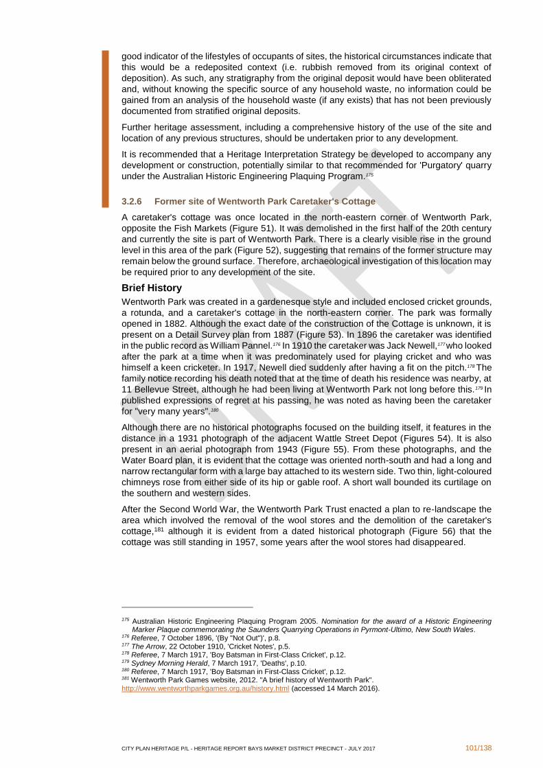
CITY PLAN HERITAGE P/L - HERITAGE REPORT BAYS MARKET DISTRICT PRECINCT - JULY 2017 101/138
good indicator of the lifestyles of occupants of sites, the historical circumstances indicate that
this would be a redeposited context (i.e. rubbish removed from its original context of
deposition). As such, any stratigraphy from the original deposit would have been obliterated
and, without knowing the specific source of any household waste, no information could be
gained from an analysis of the household waste (if any exists) that has not been previously
documented from stratified original deposits.
Further heritage assessment, including a comprehensive history of the use of the site and
location of any previous structures, should be undertaken prior to any development.
It is recommended that a Heritage Interpretation Strategy be developed to accompany any
development or construction, potentially similar to that recommended for 'Purgatory' quarry
under the Australian Historic Engineering Plaquing Program.175
3.2.6 Former site of Wentworth Park Caretaker's Cottage
A caretaker's cottage was once located in the north-eastern corner of Wentworth Park,
opposite the Fish Markets (Figure 51). It was demolished in the first half of the 20th century
and currently the site is part of Wentworth Park. There is a clearly visible rise in the ground
level in this area of the park (Figure 52), suggesting that remains of the former structure may
remain below the ground surface. Therefore, archaeological investigation of this location may
be required prior to any development of the site.
Brief History
Wentworth Park was created in a gardenesque style and included enclosed cricket grounds,
a rotunda, and a caretaker's cottage in the north-eastern corner. The park was formally
opened in 1882. Although the exact date of the construction of the Cottage is unknown, it is
present on a Detail Survey plan from 1887 (Figure 53). In 1896 the caretaker was identified
in the public record as William Pannel.176 In 1910 the caretaker was Jack Newell,177 who looked
after the park at a time when it was predominately used for playing cricket and who was
himself a keen cricketer. In 1917, Newell died suddenly after having a fit on the pitch.178 The
family notice recording his death noted that at the time of death his residence was nearby, at
11 Bellevue Street, although he had been living at Wentworth Park not long before this.179 In
published expressions of regret at his passing, he was noted as having been the caretaker
for "very many years".180
Although there are no historical photographs focused on the building itself, it features in the
distance in a 1931 photograph of the adjacent Wattle Street Depot (Figures 54). It is also
present in an aerial photograph from 1943 (Figure 55). From these photographs, and the
Water Board plan, it is evident that the cottage was oriented north-south and had a long and
narrow rectangular form with a large bay attached to its western side. Two thin, light-coloured
chimneys rose from either side of its hip or gable roof. A short wall bounded its curtilage on
the southern and western sides.
After the Second World War, the Wentworth Park Trust enacted a plan to re-landscape the
area which involved the removal of the wool stores and the demolition of the caretaker's
cottage,181 although it is evident from a dated historical photograph (Figure 56) that the
cottage was still standing in 1957, some years after the wool stores had disappeared.
175 Australian Historic Engineering Plaquing Program 2005. Nomination for the award of a Historic Engineering Marker Plaque commemorating the Saunders Quarrying Operations in Pyrmont-Ultimo, New South Wales.
176 Referee, 7 October 1896, '(By "Not Out")', p.8. 177 The Arrow, 22 October 1910, 'Cricket Notes', p.5. 178 Referee, 7 March 1917, 'Boy Batsman in First-Class Cricket', p.12. 179 Sydney Morning Herald, 7 March 1917, 'Deaths', p.10. 180 Referee, 7 March 1917, 'Boy Batsman in First-Class Cricket', p.12. 181 Wentworth Park Games website, 2012. "A brief history of Wentworth Park". http://www.wentworthparkgames.org.au/history.html (accessed 14 March 2016).
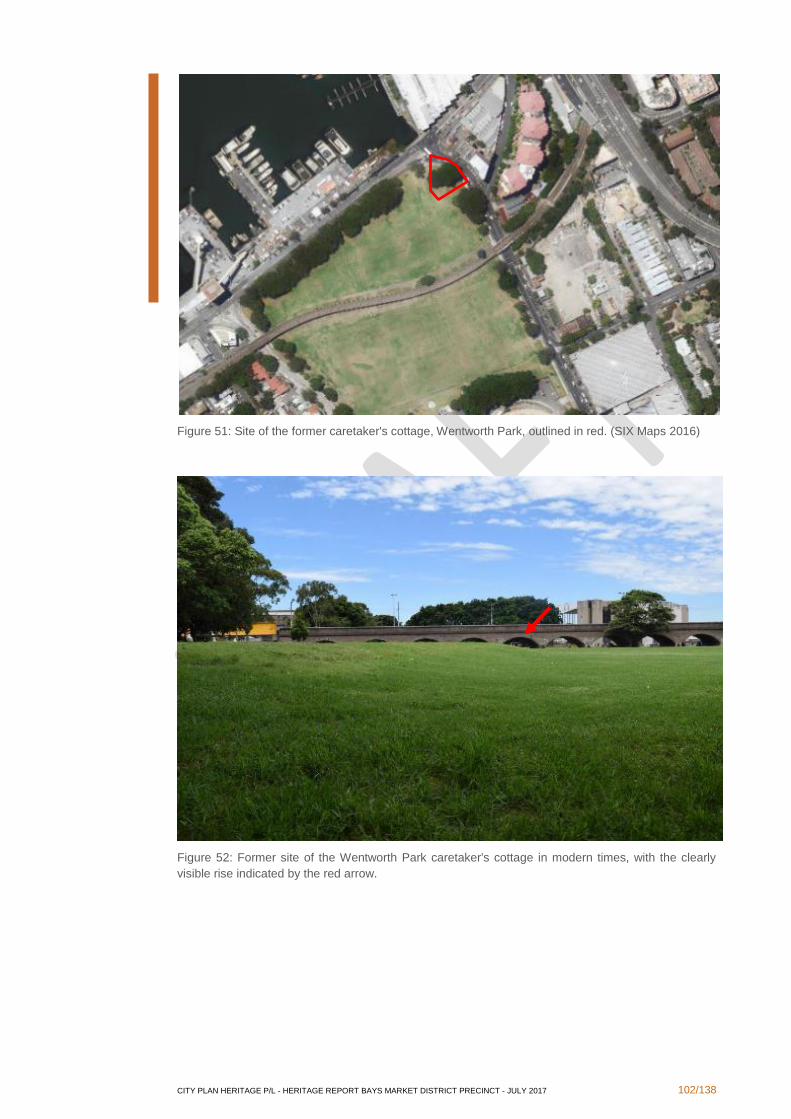
CITY PLAN HERITAGE P/L - HERITAGE REPORT BAYS MARKET DISTRICT PRECINCT - JULY 2017 102/138
Figure 51: Site of the former caretaker's cottage, Wentworth Park, outlined in red. (SIX Maps 2016)
Figure 52: Former site of the Wentworth Park caretaker's cottage in modern times, with the clearly
visible rise indicated by the red arrow.
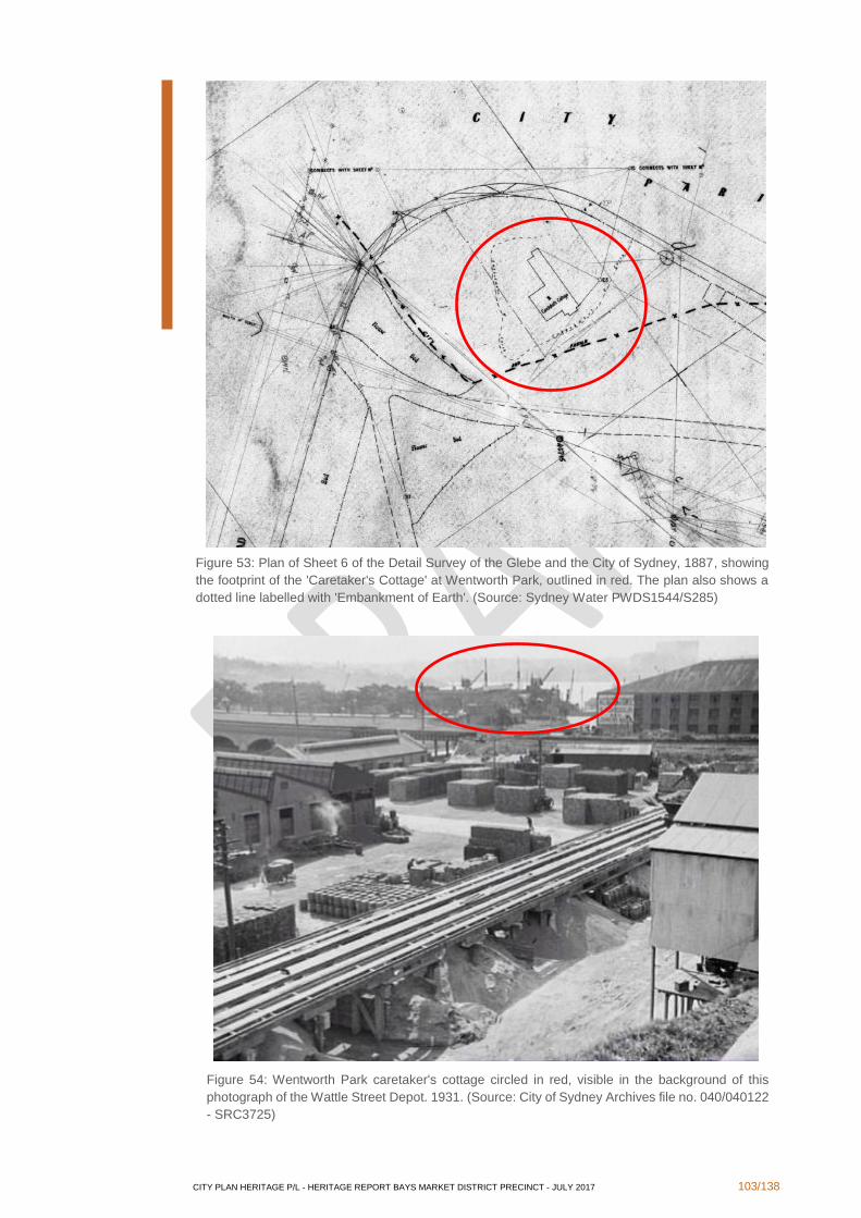
CITY PLAN HERITAGE P/L - HERITAGE REPORT BAYS MARKET DISTRICT PRECINCT - JULY 2017 103/138
Figure 53: Plan of Sheet 6 of the Detail Survey of the Glebe and the City of Sydney, 1887, showing
the footprint of the 'Caretaker's Cottage' at Wentworth Park, outlined in red. The plan also shows a
dotted line labelled with 'Embankment of Earth'. (Source: Sydney Water PWDS1544/S285)
Figure 54: Wentworth Park caretaker's cottage circled in red, visible in the background of this
photograph of the Wattle Street Depot. 1931. (Source: City of Sydney Archives file no. 040/040122
- SRC3725)
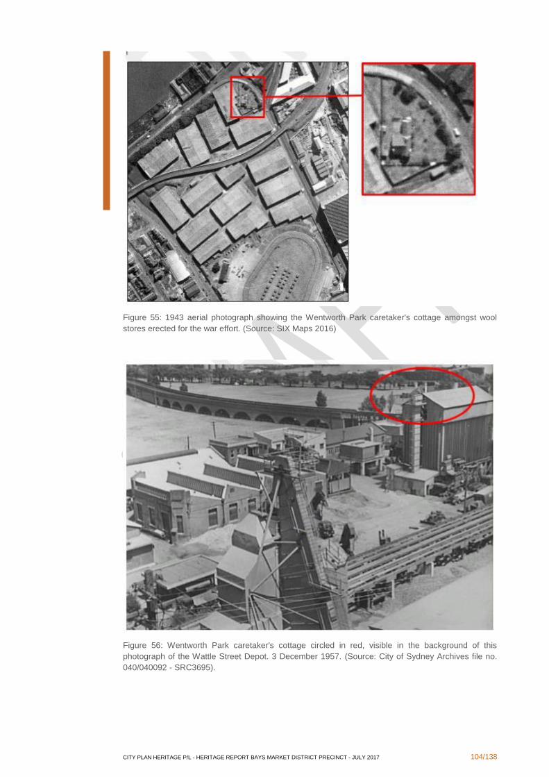
CITY PLAN HERITAGE P/L - HERITAGE REPORT BAYS MARKET DISTRICT PRECINCT - JULY 2017 104/138
Figure 55: 1943 aerial photograph showing the Wentworth Park caretaker's cottage amongst wool
stores erected for the war effort. (Source: SIX Maps 2016)
Figure 56: Wentworth Park caretaker's cottage circled in red, visible in the background of this
photograph of the Wattle Street Depot. 3 December 1957. (Source: City of Sydney Archives file no.
040/040092 - SRC3695).

CITY PLAN HERITAGE P/L - HERITAGE REPORT BAYS MARKET DISTRICT PRECINCT - JULY 2017 105/138
Assessment of Significance Criteria
(a) an item is important in the course, or pattern, of the local area’s cultural or
natural history
The site of the former Wentworth Park Caretaker's Cottage is important in demonstrating the
development of public parks in the late 19th to early 20th centuries, especially in showing the
practice of appointing individual caretakers to tend to the grounds prior to this becoming the
responsibility of local councils.
(b) an item has strong or special associations with the life or works of a person,
or group of persons, of importance in the local area’s cultural or natural
history
The Wentworth Park Caretaker's Cottage was home to a number of caretakers throughout
the years of its use, but it has a special association with Jack Newell, who was the Wentworth
Park Caretaker from at least 1909 until his untimely death in 1917. He had a strong
relationship with the Park, not only as its groundsman but also as a well-known and
appreciated cricket player.
(c) an item is important in demonstrating aesthetic characteristics and/or a high
degree of creative or technical achievement in the local area
In its current state, the site of the former cottage is not important in demonstrating either
aesthetic characteristics or any degree of creative or technical achievement. As there are no
known photographs focusing on the cottage, it is not known whether it could have been
considered to demonstrate particularly strong aesthetic characteristics.
(d) an item has strong or special association with a particular community or
cultural group in the local area for social, cultural or spiritual reasons
Although the Caretaker's Cottage was the residence of a series of caretakers of Wentworth
Park until its demolition in the 1950s, it is not associated with any particular community or
cultural group.
(e) an item has potential to yield information that will contribute to an
understanding of the local area’s cultural or natural history
There are very few remaining photographs that include the building, and none exist with the
building as the focus. However, a survey of the site has indicated that archaeological
remains, which may include foundations of the building, are likely to exist beneath the
surface. The site of the former cottage therefore has a high potential of yielding information
about the building which is not available in the historical record.
(f) an item possesses uncommon, rare or endangered aspects of the local
area’s cultural or natural history
The original Caretaker's Cottage was the only cottage on the site of Wentworth Park, and it
was not reconstructed after its demolition. Therefore, any archaeological remains of the
Cottage contained in the site would provide evidence of a rare building type within the local
area.
(g) an item is important in demonstrating the principal characteristics of a class
of the local area’s
▪ cultural or natural places; or
▪ cultural or natural environments
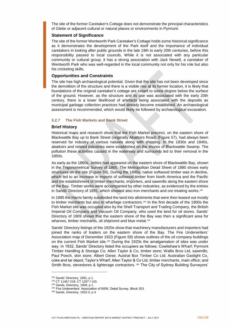
CITY PLAN HERITAGE P/L - HERITAGE REPORT BAYS MARKET DISTRICT PRECINCT - JULY 2017 106/138
The site of the former Caretaker's Cottage does not demonstrate the principal characteristics
of Glebe or adjacent cultural or natural places or environments in Pyrmont.
Statement of Significance
The site of the former Wentworth Park Caretaker's Cottage holds some historical significance
as it demonstrates the development of the Park itself and the importance of individual
caretakers in looking after public grounds in the late 19th to early 20th centuries, before this
responsibility passed to local councils. While it is not associated with any particular
community or cultural group, it has a strong association with Jack Newell, a caretaker of
Wentworth Park who was well-regarded in the local community not only for his role but also
his cricketing skills.
Opportunities and Constraints
The site has high archaeological potential. Given that the site has not been developed since
the demolition of the structure and there is a visible rise at its former location, it is likely that
foundations of the original caretaker's cottage are extant to some degree below the surface
of the ground. However, as the structure and its use was associated with the early 20th
century, there is a lower likelihood of artefacts being associated with the deposits as
municipal garbage collection practices had already become established. An archaeological
assessment is recommended, which would likely be followed by archaeological excavation.
3.2.7 The Fish Markets and Bank Street
Brief History
Historical maps and research show that the Fish Market precinct, on the eastern shore of
Blackwattle Bay up to Bank Street (originally Abattoirs Road) (Figure 57), had always been
reserved for industry of various natures along with shipping. In the 1830s and 1840s,
abattoirs and related industries were established on the shores of Blackwattle Swamp. The
pollution these activities caused in the waterway and surrounds led to their removal in the
1850s.
As early as the 1860s, Jetties had appeared on the eastern shore of Blackwattle Bay, shown
in the Trigonometrical Survey of 1865. The Metropolitan Detail Sheet of 1880 shows early
structures on the site (Figure 58), During the 1890s, native softwood timber was in decline,
which led to an increase in imports of softwood timber from North America and the Pacific
and the establishment of timber merchants, importers, and sawmills along the eastern shore
of the Bay. Timber works were accompanied by other industries, as evidenced by the entries
in Sands' Directory of 1891, which showed also iron merchants and ore treating works.182
In 1895 the Harris family subdivided the land into allotments that were then leased out mostly
to timber mechants but also to wharfage contractors.183 In the first decade of the 1900s the
Fish Market site was occupied also by the Shell Transport and Trading Company, the British
Imperial Oil Company and Vacuum Oil Company, who used the land for oil stores. Sands'
Directory of 1909 shows that the eastern shore of the Bay was then a significant area for
wharves, timber mechants, oil shipment and blue metal.184
Sands' Directory listings of the 1920s show that machinery manufacturers and importers had
joined the ranks of traders on the eastern shore of the Bay. The Fire Underwriters’
Association map of December 1923 (Figure 59) shows outlines of the oil company buildings
on the current Fish Market site.185 During the 1920s the amalgamation of sites was under
way. In 1932, Sands' Directory listed the occupiers as follows: Cowlishaw’s Wharf; Pyrmont
Timber Handling & Storage Co; Allen Taylor & Co, timber store; Wallis Bros Ltd, sawmills;
Paul Poech, skin store; Albert Giese; Austral Box Timber Co Ltd; Australian Gaslight Co,
coke and tar depot; Taylor’s Wharf; Allen Taylor & Co Ltd, timber merchants, main office; and
Smith Bros, stevedores & lighterage contractors. 186 The City of Sydney Building Surveyors’
182 Sands' Directory, 1891, p 1. 183 CT 1148 f 218; CT 1297 f 143. 184 Sands, Directory, 1909, p 1. 185 Fire Underwriters’ Association of NSW, Detail Survey, Block 203. 186 Sands, Directory, 1932-3, p 4
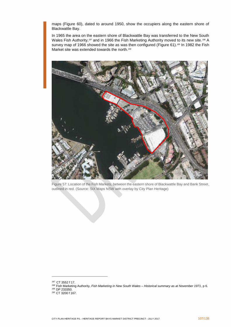
CITY PLAN HERITAGE P/L - HERITAGE REPORT BAYS MARKET DISTRICT PRECINCT - JULY 2017 107/138
maps (Figure 60), dated to around 1950, show the occupiers along the eastern shore of
Blackwattle Bay.
In 1965 the area on the eastern shore of Blackwattle Bay was transferred to the New South
Wales Fish Authority,187 and in 1966 the Fish Marketing Authority moved to its new site.188 A
survey map of 1966 showed the site as was then configured (Figure 61).189 In 1982 the Fish
Market site was extended towards the north.190
Figure 57: Location of the Fish Markets, between the eastern shore of Blackwattle Bay and Bank Street,
outlined in red. (Source: SIX Maps NSW with overlay by City Plan Heritage)
187 CT 3552 f 17. 188 Fish Marketing Authority, Fish Marketing in New South Wales – Historical summary as at November 1971, p 6. 189 DP 233350. 190 CT 3200 f 167.
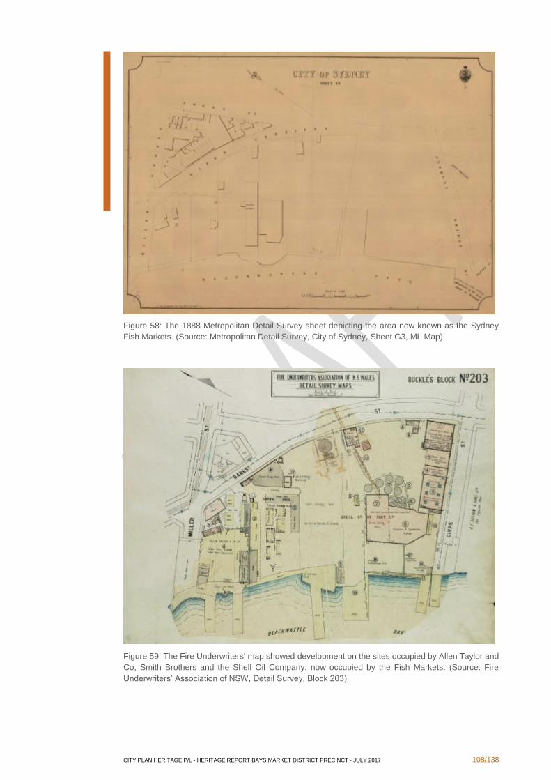
CITY PLAN HERITAGE P/L - HERITAGE REPORT BAYS MARKET DISTRICT PRECINCT - JULY 2017 108/138
Figure 58: The 1888 Metropolitan Detail Survey sheet depicting the area now known as the Sydney
Fish Markets. (Source: Metropolitan Detail Survey, City of Sydney, Sheet G3, ML Map)
Figure 59: The Fire Underwriters' map showed development on the sites occupied by Allen Taylor and
Co, Smith Brothers and the Shell Oil Company, now occupied by the Fish Markets. (Source: Fire
Underwriters’ Association of NSW, Detail Survey, Block 203)
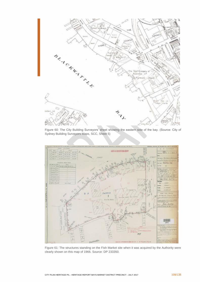
CITY PLAN HERITAGE P/L - HERITAGE REPORT BAYS MARKET DISTRICT PRECINCT - JULY 2017 109/138
Figure 60: The City Building Surveyors’ sheet showing the eastern side of the bay. (Source: City of
Sydney Building Surveyors Maps, SCC, Sheet 5)
Figure 61: The structures standing on the Fish Market site when it was acquired by the Authority were
clearly shown on this map of 1966. Source: DP 233350.
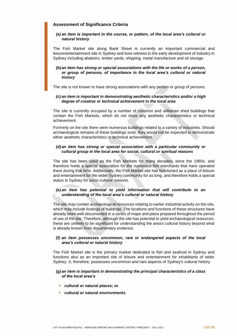
CITY PLAN HERITAGE P/L - HERITAGE REPORT BAYS MARKET DISTRICT PRECINCT - JULY 2017 110/138
Assessment of Significance Criteria
(a) an item is important in the course, or pattern, of the local area’s cultural or
natural history
The Fish Market site along Bank Street is currently an important commercial and
leisure/entertainment site in Sydney and bore witness to the early development of industry in
Sydney including abattoirs, timber yards, shipping, metal manufacture and oil storage.
(b) an item has strong or special associations with the life or works of a person,
or group of persons, of importance in the local area’s cultural or natural
history
The site is not known to have strong associations with any person or group of persons.
(c) an item is important in demonstrating aesthetic characteristics and/or a high
degree of creative or technical achievement in the local area
The site is currently occupied by a number of common and utilitarian shed buildings that
contain the Fish Markets, which do not show any aesthetic characteristics or technical
achievement.
Formerly on the site there were numerous buildings related to a variety of industries. Should
archaeological remains of these buildings exist, they would not be expected to demonstrate
either aesthetic characteristics or technical achievement.
(d) an item has strong or special association with a particular community or
cultural group in the local area for social, cultural or spiritual reasons
The site has been used as the Fish Markets for many decades, since the 1960s, and
therefore holds a special association for the numerous fish merchants that have operated
there during that time. Additionally, the Fish Market site has functioned as a place of leisure
and entertainment for the wider Sydney community for as long, and therefore holds a special
status in Sydney for socio-cultural reasons.
(e) an item has potential to yield information that will contribute to an
understanding of the local area’s cultural or natural history
The site may contain archaeological resources relating to earlier industrial activity on the site,
which may include footings of buildings. The locations and functions of these structures have
already been well-documented in a series of maps and plans prepared throughout the period
of use of the site. Therefore, although the site has potential to yield archaeological resources,
these are unlikely to be significant for understanding the area's cultural history beyond what
is already known from documentary evidence.
(f) an item possesses uncommon, rare or endangered aspects of the local
area’s cultural or natural history
The Fish Market site is the primary market dedicated to fish and seafood in Sydney and
functions also as an important site of leisure and entertainment for inhabitants of wider
Sydney. It, therefore, possesses uncommon and rare aspects of Sydney's cultural history.
(g) an item is important in demonstrating the principal characteristics of a class
of the local area’s
▪ cultural or natural places; or
▪ cultural or natural environments
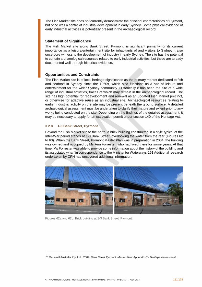
CITY PLAN HERITAGE P/L - HERITAGE REPORT BAYS MARKET DISTRICT PRECINCT - JULY 2017 111/138
The Fish Market site does not currently demonstrate the principal characteristics of Pyrmont,
but once was a centre of industrial development in early Sydney. Some physical evidence of
early industrial activities is potentially present in the archaeological record.
Statement of Significance
The Fish Market site along Bank Street, Pyrmont, is significant primarily for its current
importance as a leisure/entertainment site for inhabitants of and visitors to Sydney.It also
once bore witness to the development of industry in early Sydney. The site has the potential
to contain archaeological resources related to early industrial activities, but these are already
documented well through historical evidence.
Opportunities and Constraints
The Fish Market site is of local heritage significance as the primary market dedicated to fish
and seafood in Sydney since the 1960s, which also functions as a site of leisure and
entertainment for the wider Sydney community. Historically it has been the site of a wide
range of industrial activities, traces of which may remain in the archaeological record. The
site has high potential for redevelopment and renewal as an updated Fish Market precinct,
or otherwise for adaptive reuse as an industrial site. Archaeological resources relating to
earlier industrial activity on the site may be present beneath the ground surface. A detailed
archaeological assessment must be undertaken to clarify their nature and extent prior to any
works being conducted on the site. Depending on the findings of the detailed assessment, it
may be necessary to apply for an excavation permit under section 140 of the Heritage Act.
3.2.8 1-3 Bank Street, Pyrmont
Beyond the Fish Market site to the north, a brick building constructed in a style typical of the
Inter-War period stands at 1-3 Bank Street, overlooking the water from the rear (Figures 62
to 63). When the Bank Street, Pyrmont Master Plan was in preparation in 2004, the building
was owned and occupied by Ms Ann Forrester, who had lived there for some years. At that
time, Ms Forrester was able to provide some information about the history of the building and
its associated wharf in correspondence to the Minister for Waterways.191 Additional research
undertaken by CPH has uncovered additional information.
Figures 62a and 62b: Brick building at 1-3 Bank Street, Pyrmont.
191 Maunsell Australia Pty. Ltd.. 2004. Bank Street Pyrmont, Master Plan: Appendix C - Heritage Assessment.
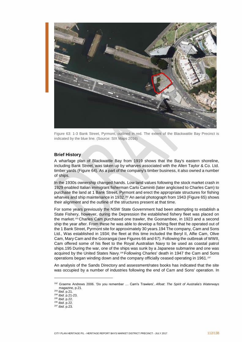
CITY PLAN HERITAGE P/L - HERITAGE REPORT BAYS MARKET DISTRICT PRECINCT - JULY 2017 112/138
Figure 63: 1-3 Bank Street, Pyrmont, outlined in red. The extent of the Blackwattle Bay Precinct is
indicated by the blue line. (Source: SIX Maps 2016)
Brief History
A wharfage plan of Blackwattle Bay from 1919 shows that the Bay's eastern shoreline,
including Bank Street, was taken up by wharves associated with the Allen Taylor & Co. Ltd.
timber yards (Figure 64). As a part of the company's timber business, it also owned a number
of ships.
In the 1930s ownership changed hands. Low land values following the stock market crash in
1929 enabled Italian immigrant fisherman Carlo Caminiti (later anglicised to Charles Cam) to
purchase the land at 1 Bank Street, Pyrmont and erect the appropriate structures for fishing
wharves and ship maintenance in 1932.192 An aerial photograph from 1943 (Figure 65) shows
their alignment and the outline of the structures present at that time.
For some years previously the NSW State Government had been attempting to establish a
State Fishery, however, during the Depression the established fishery fleet was placed on
the market.193 Charles Cam purchased one trawler, the Goonambee, in 1923 and a second
ship the year after. From these he was able to develop a fishing fleet that he operated out of
the 1 Bank Street, Pyrmont site for approximately 30 years.194 The company, Cam and Sons
Ltd., Was established in 1934; the fleet at this time included the Beryl II, Alfie Cam, Olive
Cam, Mary Cam and the Goorangai (see Figures 66 and 67). Following the outbreak of WWII,
Cam offered some of his fleet to the Royal Australian Navy to be used as coastal patrol
ships.195 During the war, one of the ships was sunk by a Japanese submarine and one was
acquired by the United States Navy.196 Following Charles' death in 1947 the Cam and Sons
operations began winding down and the company officially ceased operating in 1961.197
An analysis of the Sands Directory and assessment/rates books has indicated that the site
was occupied by a number of industries following the end of Cam and Sons' operation. In
192 Graeme Andrews 2006. 'Do you remember … Cam's Trawlers', Afloat: The Spirit of Australia's Waterways magazine, p.21.
193 Ibid. p.21. 194 Ibid. p.21-23. 195 Ibid. p.22. 196 Ibid. p.22. 197 Ibid. p.23.
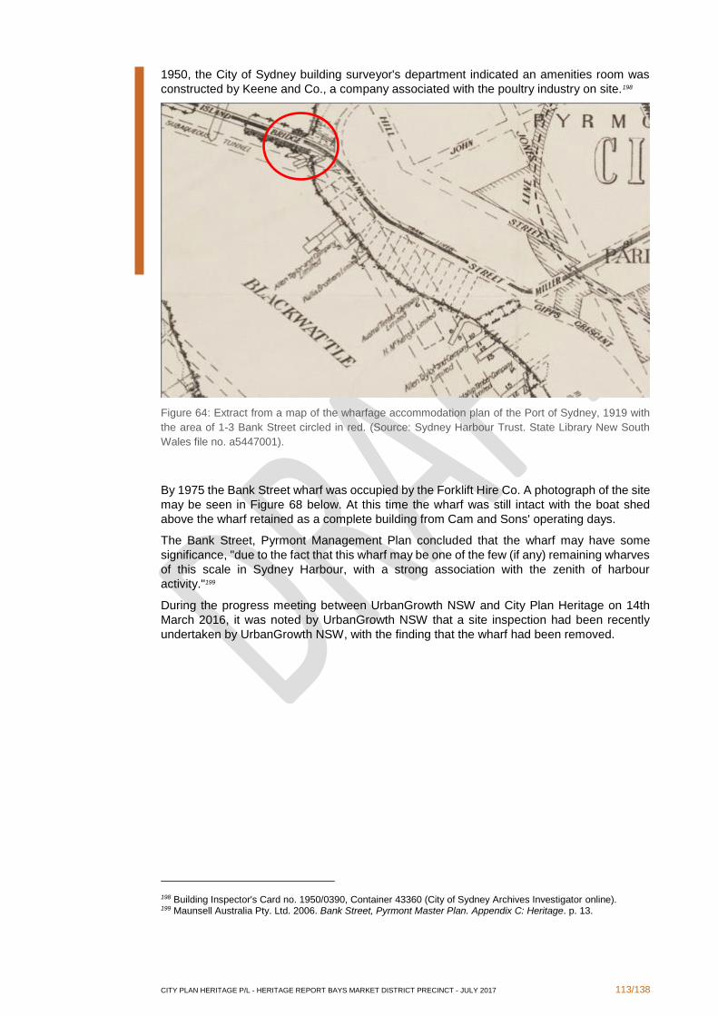
CITY PLAN HERITAGE P/L - HERITAGE REPORT BAYS MARKET DISTRICT PRECINCT - JULY 2017 113/138
1950, the City of Sydney building surveyor's department indicated an amenities room was
constructed by Keene and Co., a company associated with the poultry industry on site.198
Figure 64: Extract from a map of the wharfage accommodation plan of the Port of Sydney, 1919 with
the area of 1-3 Bank Street circled in red. (Source: Sydney Harbour Trust. State Library New South
Wales file no. a5447001).
By 1975 the Bank Street wharf was occupied by the Forklift Hire Co. A photograph of the site
may be seen in Figure 68 below. At this time the wharf was still intact with the boat shed
above the wharf retained as a complete building from Cam and Sons' operating days.
The Bank Street, Pyrmont Management Plan concluded that the wharf may have some
significance, "due to the fact that this wharf may be one of the few (if any) remaining wharves
of this scale in Sydney Harbour, with a strong association with the zenith of harbour
activity."199
During the progress meeting between UrbanGrowth NSW and City Plan Heritage on 14th
March 2016, it was noted by UrbanGrowth NSW that a site inspection had been recently
undertaken by UrbanGrowth NSW, with the finding that the wharf had been removed.
198 Building Inspector's Card no. 1950/0390, Container 43360 (City of Sydney Archives Investigator online). 199 Maunsell Australia Pty. Ltd. 2006. Bank Street, Pyrmont Master Plan. Appendix C: Heritage. p. 13.
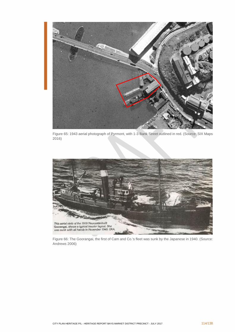
CITY PLAN HERITAGE P/L - HERITAGE REPORT BAYS MARKET DISTRICT PRECINCT - JULY 2017 114/138
Figure 65: 1943 aerial photograph of Pyrmont, with 1-3 Bank Street outlined in red. (Source: SIX Maps
2016)
Figure 66: The Goorangai, the first of Cam and Co.'s fleet was sunk by the Japanese in 1940. (Source:
Andrews 2006)
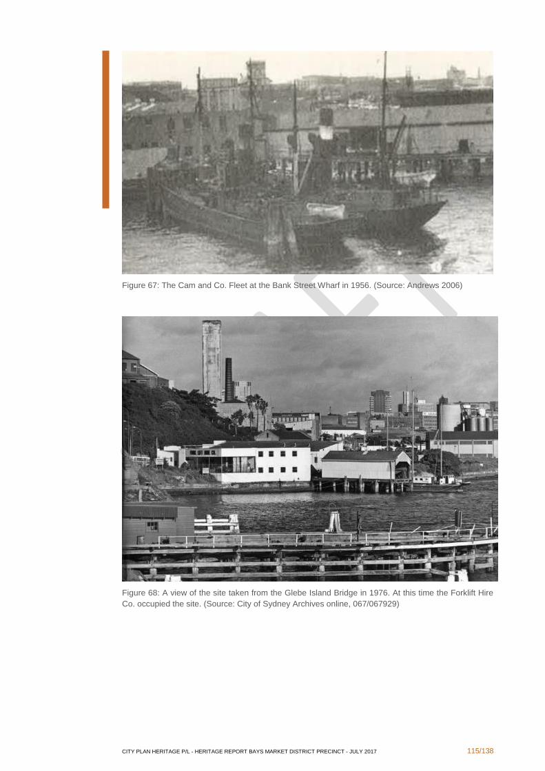
CITY PLAN HERITAGE P/L - HERITAGE REPORT BAYS MARKET DISTRICT PRECINCT - JULY 2017 115/138
Figure 67: The Cam and Co. Fleet at the Bank Street Wharf in 1956. (Source: Andrews 2006)
Figure 68: A view of the site taken from the Glebe Island Bridge in 1976. At this time the Forklift Hire
Co. occupied the site. (Source: City of Sydney Archives online, 067/067929)
CITY PLAN HERITAGE P/L - HERITAGE REPORT BAYS MARKET DISTRICT PRECINCT - JULY 2017 116/138
Assessment of Criteria
(a) an item is important in the course, or pattern, of the local area’s cultural or
natural history
The site at 1-3 Bank Street is representative of Sydney Harbour's working port past. Originally
used as a timber yard and later as a fishing depot by Cam and Co., the site is one of the few
remaining relics in Blackwattle Bay of the maritime industry.
(b) an item has strong or special associations with the life or works of a person,
or group of persons, of importance in the local area’s cultural or natural
history
The site has strong associations with Cam and Sons, a fishing trawling company that
operated out of the 1-3 Bank Street location for approximately thirty years.
(c) an item is important in demonstrating aesthetic characteristics and/or a high
degree of creative or technical achievement in the local area
The site is largely intact from the 1932 construction by the Cam and Sons company, however,
more recently the site has fallen into disrepair and the finger wharf has been removed. The
Inter-War utilitarian construction is relatively common and is not considered aesthetically
significant.
(d) an item has strong or special association with a particular community or
cultural group in the local area for social, cultural or spiritual reasons
Although originally associated with the Cam and Sons Company, the company has been out
of operation for over fifty years and does not form part of general community recollections.
Therefore, the site is not considered to have a particularly strong association with any
community or cultural group in the local area.
(e) an item has potential to yield information that will contribute to an
understanding of the local area’s cultural or natural history
The history associated with the Cam and Sons Company is not well documented, and further
research has the potential to illuminate the history of this aspect of Blackwattle Bay further.
(f) an item possesses uncommon, rare or endangered aspects of the local
area’s cultural or natural history
The extant maritime industrial features of the site are rare within the Blackwattle Bay area.
Much of the area has been redeveloped, leaving few remnants of the early twentieth century
industrial maritime operations. The site and its buildings therefore constitute rare elements
in Blackwattle Bay.
(g) an item is important in demonstrating the principal characteristics of a class
of the local area’s
▪ cultural or natural places; or
▪ cultural or natural environments
The subject site does not satisfy this criterion.
CITY PLAN HERITAGE P/L - HERITAGE REPORT BAYS MARKET DISTRICT PRECINCT - JULY 2017 117/138
Statement of Significance
1-3 Bank Street, Pyrmont has had a long association with Sydney as a working port.
Originally associated with the Blackwattle Bay timber industry, the site was soon redeveloped
for use as the base of the Cam and Sons fishing trawler fleet, where it continuously operated
for over thirty years. Besides the recent removal of the finger wharf, the site is largely intact
from its 1932 construction. It is a rare, extant example of the early-twentieth century maritime
industry within Blackwattle Bay.
Opportunities and Constraints
The site is of local heritage significance as it is a largely intact remnant of the early twentieth
century Blackwattle Bay maritime industry. As a result, demolition may not be supported by
Council. The site has high potential for adaptive reuse, incorporating new structures into the
existing Inter-War building. The former timber wharf may be reinstated.
3.3 Areas of Archaeological Potential
Research undertaken for this report has indicated that there is potential for archaeological
resources to be found across the Blackwattle Bay and Wentworth Park Precincts. CPH
undertook a detailed assessment of the archaeological potential of Blackwattle Bay, with
regard to both maritime and terrestrial archaeology, in 2013. Following review of these
studies, we consider that their findings remain relevant. The following table indicates the
specific locations and nature of potential archaeological deposits throughout the area, and
their locations are also shown on the map in Figure 70.
Map
reference
Location Nature of Deposit Reference within this report
1 Across Wentworth
Park
stormwater channels Section 3.2.4
2 North-eastern corner
of Wentworth Park
potential for
archaeology related to
Wentworth Park
caretaker's cottage
Section 3.2.6
3 Sydney Stone Yard
(10A Wattle Street)
potential for
archaeology related to
Saunders' Hell Hole
quarry
Section 3.2.5
4 Blackwattle Bay
foreshore (Pyrmont
Bridge Road)
potential for extant:
▪ causeway
▪ sea walls and
pilings
▪ coal depots
▪ timber wharves
Section 3.1.2 and City Plan Heritage
2013. Blackwattle Bay Maritime
Precinct: Heritage Significance
Assessment incorporating Heritage
Impact Statement - Terrestrial
Archaeology
5 Blackwattle Bay
waters
potential for extant:
▪ sea walls
▪ pilings for wharves
Section 3.1.2 and City Plan Heritage
2013. Blackwattle Bay Maritime
Precinct: Heritage Significance
Assessment - Maritime Archaeology.
6 Fish Market site and
Bank Street
potential for
archaeology related to
early industrial
activities
Section 3.2.7
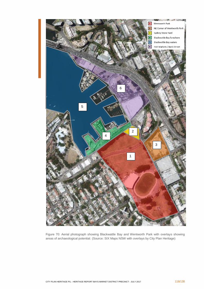
CITY PLAN HERITAGE P/L - HERITAGE REPORT BAYS MARKET DISTRICT PRECINCT - JULY 2017 118/138
Figure 70: Aerial photograph showing Blackwattle Bay and Wentworth Park with overlays showing
areas of archaeological potential. (Source: SIX Maps NSW with overlays by City Plan Heritage)
1
2
3
4
5
6
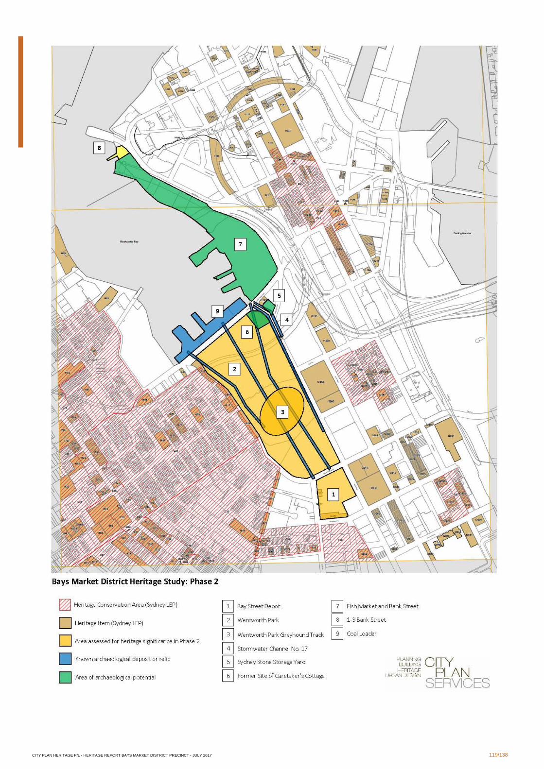
CITY PLAN HERITAGE P/L - HERITAGE REPORT BAYS MARKET DISTRICT PRECINCT - JULY 2017 119/138
CITY PLAN HERITAGE P/L - HERITAGE REPORT BAYS MARKET DISTRICT PRECINCT - JULY 2017 120/138
3.4 Conclusions and Recommendations
Heritage assessment of those buildings and sites identified to be of interest to UrbanGrowth
NSW has identified a number of heritage constraints but has also shown that there is
opportunity for redevelopment within these constraints. These constraints and opportunities
may be summarised as follows:
Bay Street Depot:
▪ the buildings of high significance on the site of the depot, namely the Factory (B2),
Workshops (B12A), Workshops and Amenities (B12B), and Staff Amenities and
Stores (B12C), cannot be demolished;
▪ there is some scope for adaptive re-use of the buildings and redevelopment in the
area, as long as this is sympathetic to the existing form of the buildings;
▪ due to the established heritage significance and listing of the site, a Conservation
Management Strategy (CMS) may be required to be prepared and submitted to City
of Sydney Council prior to approval of any DA for the site. The CMS would further
analyse the existing fabric and guide future development at the site;
▪ due to the established heritage significance and listing of the site, a HIS will be
required to be prepared to assess the impact of any proposed changes on the
heritage values of the site;
▪ any proposal for new works is an opportunity to develop a Heritage Interpretation
Strategy for the site and to implement the Strategy through provision of interpretive
measures as recommended therein.
Wentworth Park:
▪ the Park should remain an open public space available for sport, community and
cultural purposes;
▪ the locations of existing stormwater drains are known and would require
archaeological assessment prior to any works being undertaken in their vicinity (see
further below);
▪ possibility for uses such as showers, storage or tool sheds beneath the arches of the
viaduct may be reinstated providing the permeability through the viaduct is
maintained and any new structure does not touch the existing fabric. As it is a
heritage item (Sydney LEP), a HIS would be required for any works to or in the
vicinity of the viaduct to assess the impact of any proposed changes on the heritage
values of the site;
▪ any proposal for new works is an opportunity to develop a Heritage Interpretation
Strategy for the site and to implement the Strategy through provision of interpretive
measures which may include:
▪ potential reinstatement of the original gardenesque pathway design;
▪ new garden beds and pathways in line with the original gardenesque design;
Wentworth Park Greyhound Track:
▪ the original shape and parameters of the track should not be encroached upon by
any other development;
▪ any proposal for new works is an opportunity to develop a Heritage Interpretation
Strategy for the site and to implement the Strategy through provision of interpretive
measures as recommended therein;
▪ there may be provision to remove the physical remains of the track itself while
leaving a clear outline as an interpretative measure.

CITY PLAN HERITAGE P/L - HERITAGE REPORT BAYS MARKET DISTRICT PRECINCT - JULY 2017 121/138
Stormwater Channel No. 17 beneath Wentworth Park
▪ it is currently unclear to what extent the stormwater channel network retains its
function and services the local area. This would need to be determined prior to any
excavation works that could affect the channels. This would be from a practical
perspective in the first instance;
▪ from a heritage perspective, the stormwater channel network is an established
archaeological resource of State heritage significance due to the established
archaeological potential and the high significance of the archaeological resource, it is
likely that archaeological excavation will be necessary, which require an application
under Section 140 of the Heritage Act.
▪ although the locations of the channels in the stormwater channel network have been
documented on historical plans held by Sydney Water, the reliability of the plans
cannot be assumed without confirmation that could be achieved through a further,
detailed assessment and possibly archaeological testing works.
Sydney Stone Yard:
▪ thorough geotechnical analysis of the infilled quarry void is recommended prior to
any heavy construction on the site;
▪ further heritage assessment, including a comprehensive history and the identification
of locations of any previous buildings, should be undertaken prior to any
development;
▪ any proposal for new works is an opportunity to develop a Heritage Interpretation
Strategy for the site and to implement the Strategy through provision of interpretive
measures as recommended therein.
Former site of Wentworth Park Caretaker's Cottage:
▪ it is likely that foundations of the original Caretaker's Cottage are extant to some
degree below the surface of the ground, therefore an archaeological assessment is
recommended to be undertaken;
▪ due to the established archaeological potential and the high significance of the
archaeological resource, it is likely that archaeological excavation will be necessary,
which may require testing and then an application under Section 140 of the Heritage
Act.
▪ an archaeological assessment would be required prior to any works occurring on
site, but it would be prudent to undertake this prior to rezoning to understand the
extent of any constraints presented by archaeological deposits.
Fish Market site and Bank Street
▪ renewal and redevelopment of the site is supported;
▪ adaptive reuse in ways that feature industrial activities is possible;
▪ some archaeological remains relating to earlier industries may be extant beneath the
ground surface. As the development of the site is known from documentary
evidence, any potential remains may not be of significance to the local history, but
should be further investigated by a qualified archaeologist prior to any works that
would involve disturbance of the ground surface;
▪ it would be prudent to undertake an archaeological assessment prior to rezoning to
understand the extent of any constraints presented by archaeological deposits;

CITY PLAN HERITAGE P/L - HERITAGE REPORT BAYS MARKET DISTRICT PRECINCT - JULY 2017 122/138
timing of the archaeological assessment is up to the discretion of UrbanGrowth
NSW.
1-3 Bank Street:
▪ as the site has been assessed in this report as being of local heritage significance,
demolition may not be supported by Council;
▪ the site has high potential for adaptive reuse, incorporating new structures into the
existing Inter-War building;
▪ the former timber wharf may be reinstated as an interpretive measure;
▪ any proposal for new works is an opportunity to develop a Heritage Interpretation
Strategy for the site and to implement the Strategy through provision of interpretive
measures as recommended therein.
Areas of Archaeological Potential:
▪ several areas of archaeological potential have been identified across the Blackwattle
Bay and Wentworth Park precincts;
▪ although rezoning will not impact upon archaeological resources as there will be no
associated physical works, it would be prudent to undertake detailed archaeological
assessments prior to rezoning to understand the extent of any constraints presented
by archaeological deposits;
▪ in any case, the subsequent development will require appropriate management
strategies, including the preparation of a detailed archaeological assessment if any
development that involves disturbance of the ground surface is considered in these
areas;
▪ considering the above, timing of archaeological assessments is up to the discretion
of UrbanGrowth NSW;
▪ where known or potential archaeological resources are determined to be of high
significance, archaeological excavation will be required prior to any development
works, subject to the approval of a s140 permit application which would be
accompanied by the detailed archaeological assessment and a research design.
CITY PLAN HERITAGE P/L - HERITAGE REPORT BAYS MARKET DISTRICT PRECINCT - JULY 2017 123/138
4. Cultural Landscapes
4.1 Authorship
This section of the report has been prepared by Chris Betteridge, Landscape Heritage
Consultant of MUSEcape.
4.2 The Bays Market District Precinct as a cultural landscape
4.2.1 Some definitions
This report applies to the entire cultural landscape of the Bays Market District Precinct. A
total cultural landscape management approach enables identification and assessment of
potential heritage items in their historical and environmental context, rather than as stand-
alone items. The following text provides some definitions of cultural landscape and the
benefits of adopting a cultural landscape management approach.
“A cultural landscape is fashioned from a natural landscape by a culture group. Culture is the
agent: the natural area is the medium. The cultural landscape the result.”
Carl Sauer200
“Landscape is never simply a natural space, a feature of the natural environment. Every
landscape is the place where we establish our own human organization of space and time”.
John B. Jackson201
Cultural landscapes by their name imply human intervention but they may also include
substantial natural elements.
“They can present a cumulative record of human activity and land use in the landscape, and
as such can offer insights into the values, ideals and philosophies of the communities forming
them, and of their relationship to the place. Cultural landscapes have a strong role in
providing the distinguishing character of a locale, a character that might have varying degrees
of aesthetic quality, but, regardless, is considered important in establishing the communities’
sense of place.”202.
A 2010 publication by the then NSW Department of Environment, Climate Change and Water
(DECCW) provides guidelines for managing cultural landscapes. It defines the cultural
landscape concept as emphasising “the landscape-scale of history and the connectivity
between people, places and heritage items. It recognises the present landscape is the
product of long-term and complex relationships between people and the environment.
On any given area of land, it is likely that some historical activity will have taken place.
Evidence of that activity may be detectable in the vegetation or in landscape modifications
as well as in archaeological evidence, historical documents or people’s stories. Some pasts
have ‘touched the landscape only lightly’, while some places of historical activity are marked
by imposing built structures or are commemorated for their association with important events
or people.
For the purposes of the DECCW guidelines, cultural landscapes are defined as:
‘… those areas which clearly represent or reflect the patterns of settlement or use of the
landscape over a long time, as well as the evolution of cultural values, norms and attitudes
toward the land.’
The elements of a cultural landscape are illustrated below;
200 Sauer 1963, p.343 201 Jackson 1984, p.156 202 Pearson and Sullivan 1995
CITY PLAN HERITAGE P/L - HERITAGE REPORT BAYS MARKET DISTRICT PRECINCT - JULY 2017 124/138
Landscape = Nature + People
Landscape = The Past + The Present
Landscape = Places + Values
Figure 71 The Elements of a Cultural Landscape. (Source: Diagram after Guilfoyle 2006:2, based on
Phillips 2002:5)
The DECCW Guidelines emphasise that cultural heritage management has, until recently,
conceptualised heritage mainly as isolated sites or objects. For example, a hut, woolshed,
fence, ground tank, bridge, scarred tree, grave, orchard or piece of machinery. A site-based
approach is thus an ‘easy’ concept for land managers and heritage practitioners as it supports
separating the natural and cultural for management purposes. However, this site-based
approach has the unfortunate effect of reinforcing the notion of culture and nature as spatially
separate and thus able to be managed independently. In a national park or nature reserve
context, cultural heritage sites are seen as isolated points or pathways that are set in a natural
landscape. The work of nature conservation can go on around these sites. The authors of
the guidelines argue that the natural environment is part of these sites.
Similarly, in an environment such as Blackwattle Bay that has been highly modified by land
reclamation and industrial activity in the past, the natural values may have been almost
obliterated but can be recovered through well-planned rehabilitation measures or interpreted
by appropriate landscaping. A cultural landscape approach offers an opportunity to integrate
natural and cultural heritage conservation by seeing culture and nature as interconnected
dimensions of the same space.
4.2.2 Site history and historical themes
The history of the study area is covered in the thematic history by Dr Terry Kass. Those
historical themes relevant to the evolution and interpretation of the cultural landscape are
shown in the table below. A third column presents examples, derived from the history of the
study area, of the ability of the area to demonstrate those themes.
Australian Theme NSW Theme Ability for Bays Market District to
demonstrate theme
1 Tracing the natural
evolution of Australia
Environment – naturally
evolved (including natural
features which have shaped
or influenced human life and
culture)
The original Blackwattle Swamp was
reclaimed, allowing increased land for
various uses and improved access for
vessels. The natural history of the area can
be interpreted through landscaping and
appropriate interpretation measures.
2 Peopling Australia Aboriginal cultures and
interactions with other
cultures
The Aboriginal occupation and use of the
area prior to and after European settlement
can be interpreted. Were Aboriginal people
employed in the various industries which
operated within the precinct?
2 Peopling Australia Convict Were there any convict associations with
early clearing and use of the site?
2 Peopling Australia Ethnic influences Which ethnic groups were employed in the
timber industry, slaughter houses, Sydney
Fish Market?

CITY PLAN HERITAGE P/L - HERITAGE REPORT BAYS MARKET DISTRICT PRECINCT - JULY 2017 125/138
Australian Theme NSW Theme Ability for Bays Market District to
demonstrate theme
3 Developing local,
regional and national
economies
Commerce Sydney Fish Market is a major hub for
commerce and a meeting place for the
community.
3 Developing local,
regional and national
economies
Environment – cultural
landscape (activities
associated with the
interactions between
humans, human societies
and the shaping of their
physical surroundings)
The landscape resulting from swamp
clearing and land reclamation and the
evolving cultural landscape arising from
changing uses over time can be interpreted
by design and a range of communication
measures.
3 Developing local,
regional and national
economies
Events (activities and
processes that mark the
consequences of natural
and cultural occurrences)
To be determined.
3 Developing local,
regional and national
economies
Fishing (activities
associated with gathering,
producing, distributing and
consuming resources from
aquatic environments
useful to humans
Possible Aboriginal uses of the area for
fishing and gathering food; fishing boats;
seafood processing and marketing;
wharves; seafood cafes and restaurants
3 Developing local,
regional and national
economies
Industry (activities
associated with the
manufacture, production
and distribution of goods)
Slaughter yards; boiling down works;
piggeries and tanneries; Timber industry
(importing, milling, merchants); Glebe
Island Abattoirs; Blackwattle Iron Works; oil
storage and shipment; blue metal
processing; wharves; shipbuilding yards;
Saunders stone quarry; Saxton & Binns
and Hudson & Sons prefabricated homes;
cement batching plants; former wool stores
on Wentworth Park
3 Developing local,
regional and national
economies
Transport (activities
associated with the moving
of people and goods from
one place to another, and
systems for the provision of
such movements
Former timber wharves; coal loader; fishing
docks; roads; Rozelle to Darling Harbour
goods railway line; railway viaduct; former
Glebe Island bridges; Anzac Bridge
4 Building settlements,
towns and cities
Towns, suburbs and
villages (activities
associated with creating,
planning and managing
urban functions,
landscapes and lifestyles in
towns. suburbs and
villages)
Public park; streetscape of Pyrmont Bridge
Road; market place (Sydney Fish Market);
abandoned wharf remnants
4 Building settlements,
towns and cities
Land tenure (activities and
processes for identifying
forms of ownership and
occupancy of land and
water, both Aboriginal and
non-Aboriginal
The land-water interface; early land grants;
subdivision; land reclamation; seawall
along edge of Pyrmont Bridge Road,
boundary between State and privately-
owned land holdings
CITY PLAN HERITAGE P/L - HERITAGE REPORT BAYS MARKET DISTRICT PRECINCT - JULY 2017 126/138
Australian Theme NSW Theme Ability for Bays Market District to
demonstrate theme
4 Building settlements,
towns and cities
Utilities (activities
associated with the
provision of services,
especially on a communal
basis)
Sewage tunnel; Blackwattle Bay
Stormwater System; electricity substations
5 Working Labour (activities
associated with work
practices and organised
and unorganised labour)
Wharves; labour records
7 Governing Defence (activities
associated with defending
places from hostile takeover
and occupation)
Use of northern part of Wentworth Park by
US forces during World War II; use of other
sites by US Army and Royal Australian
Navy
7 Governing Government and
administration (activities
associated with the
governance of local areas,
regions, the State anjd the
nation, and the
administration of public
programs – includes both
principled and corrupt
activities
Blackwattle Bay Land Reclamation Act
1873 and subsequent amendment 1878;
commission of Inquiry into the management
of Glebe Island abattoirs; Creation of
Wentworth Park; Establishment of Sydney
Harbour Trust in 1901; NSW Fish authority
in 1963; Fish Marketing Authority move to
Blackwattle Bay in 1966;
7 Governing Welfare (activities and
process associated with the
provision of social services
by the state or philanthropic
organisations)
Recent use of arches under railway viaduct
by homeless people and the City of Sydney
policy for dealing with welfare related
issues.
8 Developing
Australia’s cultural life
Creative endeavour
(activities associated with
the production of literary,
artistic, architectural and
other imaginative,
interpretive or inventive
works)
Design and construction of railway viaduct;
design and planting of Wentworth Park
including association with Charles Moore,
Director, Botanic Gardens Sydney
8 Developing
Australia’s cultural life
Leisure Recreational boating; hiring of cruise
vessels; visiting the Fish Market; gazettal of
Wentworth Park in 1885
8 Developing
Australia’s cultural life
Sport (activities associated
with organised recreational
and health promotional
activities)
Use of north part of Wentworth Park for
sporting activities including former football
ground; First Rugby League in Australia in
1908; yacht pens in bay
9 Marking the phases
of life
Persons (activities of, and
associations with
identifiable individuals,
families and communal
groups)
Association of fig plantings in Wentworth
Park with Charles Moore, Director, Sydney
Botanic Gardens; associations with other
significant individuals in past and present
industries in the study area.
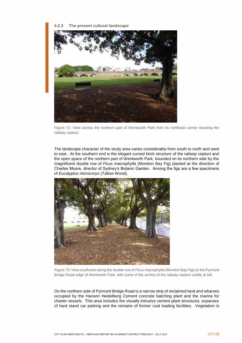
CITY PLAN HERITAGE P/L - HERITAGE REPORT BAYS MARKET DISTRICT PRECINCT - JULY 2017 127/138
4.2.3 The present cultural landscape
Figure 72: View across the northern part of Wentworth Park from its northeast corner showing the
railway viaduct.
The landscape character of the study area varies considerably from south to north and west
to east. At the southern end is the elegant curved brick structure of the railway viaduct and
the open space of the northern part of Wentworth Park, bounded on its northern side by the
magnificent double row of Ficus macrophylla (Moreton Bay Fig) planted at the direction of
Charles Moore, director of Sydney’s Botanic Garden. Among the figs are a few specimens
of Eucalyptus microcorys (Tallow Wood).
Figure 73: View southwest along the double row of Ficus macrophylla (Moreton Bay Fig) on the Pyrmont
Bridge Road edge of Wentworth Park, with some of the arches of the railway viaduct visible at left.
On the northern side of Pyrmont Bridge Road is a narrow strip of reclaimed land and wharves
occupied by the Hanson Heidelberg Cement concrete batching plant and the marina for
charter vessels. This area includes the visually intrusive cement plant structures, expanses
of hard stand car parking and the remains of former coal loading facilities. Vegetation is
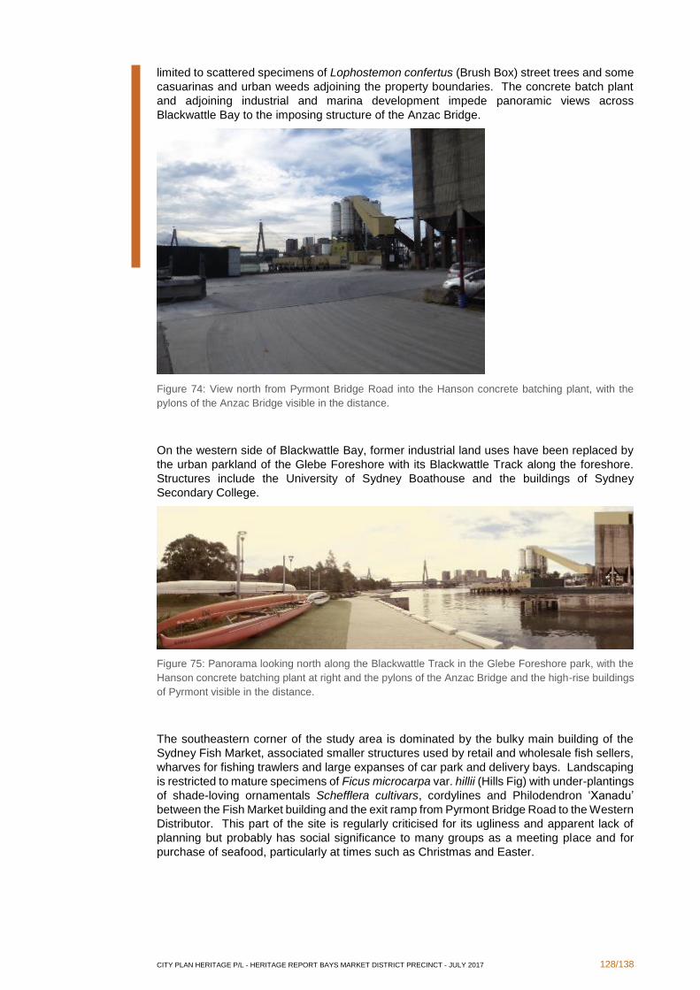
CITY PLAN HERITAGE P/L - HERITAGE REPORT BAYS MARKET DISTRICT PRECINCT - JULY 2017 128/138
limited to scattered specimens of Lophostemon confertus (Brush Box) street trees and some
casuarinas and urban weeds adjoining the property boundaries. The concrete batch plant
and adjoining industrial and marina development impede panoramic views across
Blackwattle Bay to the imposing structure of the Anzac Bridge.
Figure 74: View north from Pyrmont Bridge Road into the Hanson concrete batching plant, with the
pylons of the Anzac Bridge visible in the distance.
On the western side of Blackwattle Bay, former industrial land uses have been replaced by
the urban parkland of the Glebe Foreshore with its Blackwattle Track along the foreshore.
Structures include the University of Sydney Boathouse and the buildings of Sydney
Secondary College.
Figure 75: Panorama looking north along the Blackwattle Track in the Glebe Foreshore park, with the
Hanson concrete batching plant at right and the pylons of the Anzac Bridge and the high-rise buildings
of Pyrmont visible in the distance.
The southeastern corner of the study area is dominated by the bulky main building of the
Sydney Fish Market, associated smaller structures used by retail and wholesale fish sellers,
wharves for fishing trawlers and large expanses of car park and delivery bays. Landscaping
is restricted to mature specimens of Ficus microcarpa var. hillii (Hills Fig) with under-plantings
of shade-loving ornamentals Schefflera cultivars, cordylines and Philodendron ‘Xanadu’
between the Fish Market building and the exit ramp from Pyrmont Bridge Road to the Western
Distributor. This part of the site is regularly criticised for its ugliness and apparent lack of
planning but probably has social significance to many groups as a meeting place and for
purchase of seafood, particularly at times such as Christmas and Easter.
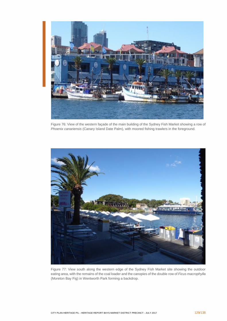
CITY PLAN HERITAGE P/L - HERITAGE REPORT BAYS MARKET DISTRICT PRECINCT - JULY 2017 129/138
Figure 76: View of the western façade of the main building of the Sydney Fish Market showing a row of
Phoenix canariensis (Canary Island Date Palm), with moored fishing trawlers in the foreground.
Figure 77: View south along the western edge of the Sydney Fish Market site showing the outdoor
eating area, with the remains of the coal loader and the canopies of the double row of Ficus macrophylla
(Moreton Bay Fig) in Wentworth Park forming a backdrop.
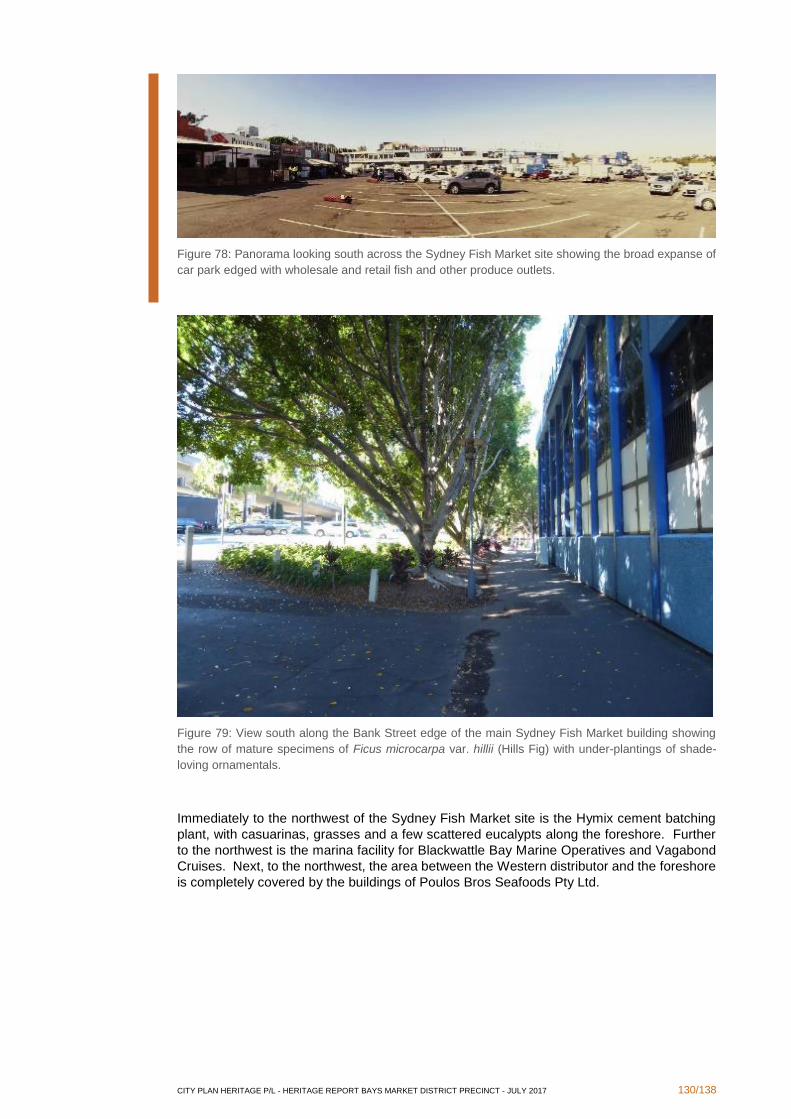
CITY PLAN HERITAGE P/L - HERITAGE REPORT BAYS MARKET DISTRICT PRECINCT - JULY 2017 130/138
Figure 78: Panorama looking south across the Sydney Fish Market site showing the broad expanse of
car park edged with wholesale and retail fish and other produce outlets.
Figure 79: View south along the Bank Street edge of the main Sydney Fish Market building showing
the row of mature specimens of Ficus microcarpa var. hillii (Hills Fig) with under-plantings of shade-
loving ornamentals.
Immediately to the northwest of the Sydney Fish Market site is the Hymix cement batching
plant, with casuarinas, grasses and a few scattered eucalypts along the foreshore. Further
to the northwest is the marina facility for Blackwattle Bay Marine Operatives and Vagabond
Cruises. Next, to the northwest, the area between the Western distributor and the foreshore
is completely covered by the buildings of Poulos Bros Seafoods Pty Ltd.
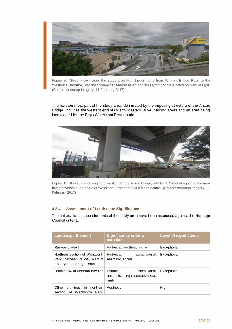
CITY PLAN HERITAGE P/L - HERITAGE REPORT BAYS MARKET DISTRICT PRECINCT - JULY 2017 131/138
Figure 80: Street view across the study area from the on-ramp from Pyrmont Bridge Road to the
Western Distributor, with the Sydney fish Market at left and the Hymix concrete batching plant at right.
(Source: nearmap imagery, 11 February 2017)
The northernmost part of the study area, dominated by the imposing structure of the Anzac
Bridge, includes the western end of Quarry Masters Drive, parking areas and an area being
landscaped for the Bays Waterfront Promenade.
Figure 81: Street view looking northwest under the Anzac Bridge, with Bank Street at right and the area
being developed for the Bays Waterfront Promenade at left and centre. (Source: nearmap imagery, 11
February 2017)
4.2.4 Assessment of Landscape Significance
The cultural landscape elements of the study area have been assessed against the Heritage
Council criteria.
Landscape Element Significance criteria
satisfied
Level of significance
Railway viaduct Historical, aesthetic, rarity Exceptional
Northern section of Wentworth
Park, between railway viaduct
and Pyrmont Bridge Road
Historical, associational,
aesthetic, social
Exceptional
Double row of Moreton Bay figs Historical, associational,
aesthetic, representativeness,
rarity
Exceptional
Other plantings in northern
section of Wentworth Park,
Aesthetic High
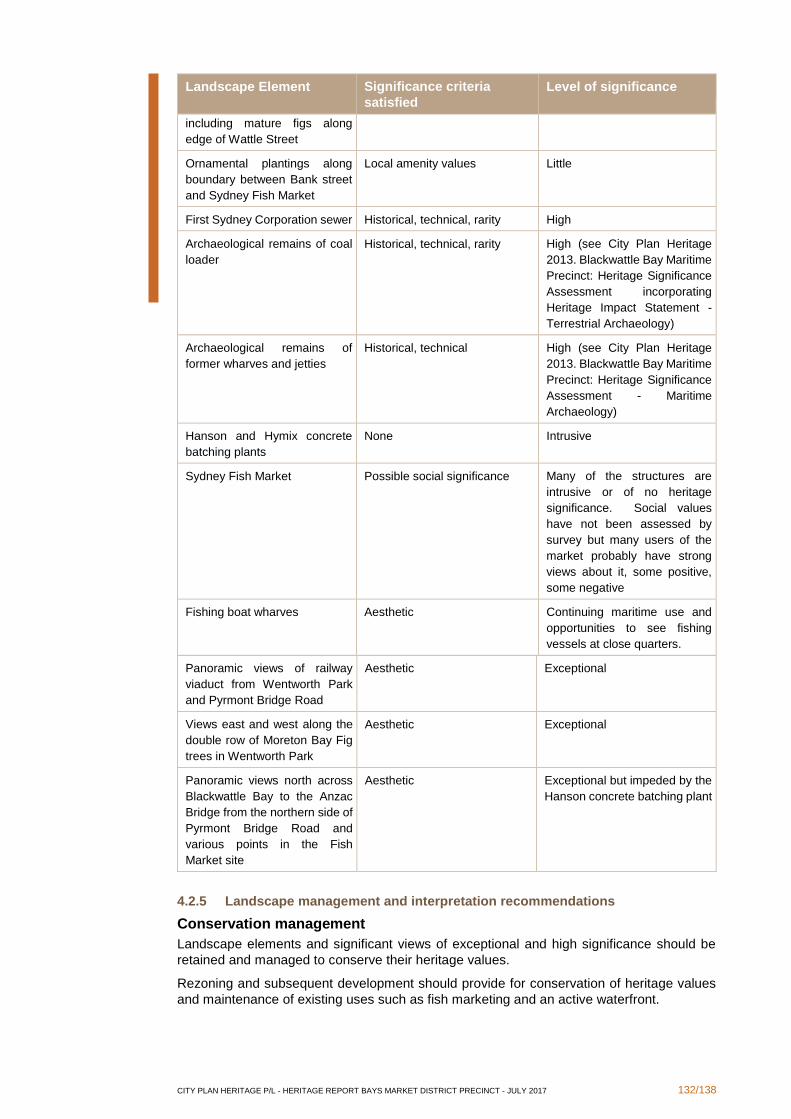
CITY PLAN HERITAGE P/L - HERITAGE REPORT BAYS MARKET DISTRICT PRECINCT - JULY 2017 132/138
Landscape Element Significance criteria
satisfied
Level of significance
including mature figs along
edge of Wattle Street
Ornamental plantings along
boundary between Bank street
and Sydney Fish Market
Local amenity values Little
First Sydney Corporation sewer Historical, technical, rarity High
Archaeological remains of coal
loader
Historical, technical, rarity High (see City Plan Heritage
2013. Blackwattle Bay Maritime
Precinct: Heritage Significance
Assessment incorporating
Heritage Impact Statement -
Terrestrial Archaeology)
Archaeological remains of
former wharves and jetties
Historical, technical High (see City Plan Heritage
2013. Blackwattle Bay Maritime
Precinct: Heritage Significance
Assessment - Maritime
Archaeology)
Hanson and Hymix concrete
batching plants
None Intrusive
Sydney Fish Market Possible social significance Many of the structures are
intrusive or of no heritage
significance. Social values
have not been assessed by
survey but many users of the
market probably have strong
views about it, some positive,
some negative
Fishing boat wharves Aesthetic Continuing maritime use and
opportunities to see fishing
vessels at close quarters.
Panoramic views of railway
viaduct from Wentworth Park
and Pyrmont Bridge Road
Aesthetic Exceptional
Views east and west along the
double row of Moreton Bay Fig
trees in Wentworth Park
Aesthetic Exceptional
Panoramic views north across
Blackwattle Bay to the Anzac
Bridge from the northern side of
Pyrmont Bridge Road and
various points in the Fish
Market site
Aesthetic Exceptional but impeded by the
Hanson concrete batching plant
4.2.5 Landscape management and interpretation recommendations
Conservation management
Landscape elements and significant views of exceptional and high significance should be
retained and managed to conserve their heritage values.
Rezoning and subsequent development should provide for conservation of heritage values
and maintenance of existing uses such as fish marketing and an active waterfront.
CITY PLAN HERITAGE P/L - HERITAGE REPORT BAYS MARKET DISTRICT PRECINCT - JULY 2017 133/138
Heritage Interpretation
A heritage interpretation strategy should include provision for interpreting relevant historical
themes and stories in culturally appropriate ways.
Once rezoning is approved and the nature of future development determined, a detailed
interpretive plan for the precinct should be prepared which identifies locations for delivery of
interpretive messages and identifies appropriate media. The plan should include details of
how the interpretation of the precinct’s heritage values are to be implemented.
CITY PLAN HERITAGE P/L - HERITAGE REPORT BAYS MARKET DISTRICT PRECINCT - JULY 2017 134/138
5. Summary Conclusions and Recommendations
Analysis of historic elements contained within the Bays Market District Precinct and
Wentworth Park has identified a number of heritage constraints not previously considered in
Urbis' report of 2014, but has also shown that there is opportunity for redevelopment within
these constraints. These may be summarised as follows:
▪ Heritage items listed on State Register, as well as archaeological sites, are ordinarily
afforded statutory protection under the Heritage Act, 1977. This means that any
development proposals for State heritage items or on archaeological sites must be
considered and assessed by the NSW Heritage Council for their potential impact on
the heritage significance and values of the item/site, through a section 60 application
which is to be accompanied by a Heritage Impact Statement. Heritage items listed on
the Sydney LEP 2012 and on Section 170 Registers are ordinarily afforded statutory
protection under Clause 5.10 of the Sydney LEP 2012. This means that any
development proposals for the heritage items or in the vicinity of them must be
considered and assessed by the City of Sydney Council for their potential impact on
the heritage significance and values of the item/s. As a result, any Development
Application must be accompanied by a Heritage Impact Statement (HIS) to Council.
▪ Rezoning with changes in height and FSR should consider impacts on existing
heritage items, such as overshadowing, removal of view corridors, and alteration of
historical subdivision patterns and characters. This may be achieved through height
limitations, appropriate setbacks, and avoidance of subdivision and development in
areas of established heritage significance, amongst other strategies.
▪ Some items of potential heritage significance have been identified in the Precinct.
Although conservation of these potential items is not currently subject to any
statutory controls, CPH recommends that City of Sydney Council be informed of the
items of potential heritage significance identified in this report to exercise due
diligence, providing an opportunity for the heritage significance of these items to be
investigated and assessed for possible subsequent heritage listing and protection.
▪ There is potential for adaptive re-use of existing buildings and sites along the same
principles as their historic uses.
▪ Any proposal for new works is an opportunity to develop a Heritage Interpretation
Strategy for a site and to implement the Strategy through provision of interpretive
measures as provided therein.
▪ There are areas of archaeological potential, as established in earlier reports and in
the findings of the present study. Although rezoning itself will not impact upon
archaeological resources, the subsequent development will require appropriate
management strategies, such as the preparation of a detailed archaeological
assessment if any development that involves disturbance of the ground surface is
considered in these areas.
▪ It would be prudent to undertake an archaeological assessment prior to rezoning to
understand the extent of any constraints presented by archaeological deposits;
timing of the archaeological assessment is up to the discretion of UrbanGrowth
NSW.
▪ Where known or potential archaeological resources are determined to be of high
significance, archaeological excavation will be required prior to any development
works, following the submission of a s140 permit application which would be
accompanied by a detailed archaeological assessment and research design.
▪ Due to the established heritage significance and listing of the Bay Street Depot and
the complexity of the site, a Conservation Management Strategy (CMS) may be
required to be prepared for the site and submitted to City of Sydney Council prior to
approval of any Development Application for the site. The CMS would further analyse
the existing fabric and guide future development at the site.
CITY PLAN HERITAGE P/L - HERITAGE REPORT BAYS MARKET DISTRICT PRECINCT - JULY 2017 135/138
▪ Landscape Items of exceptional and high significance should be retained and
conserved.
▪ Landscape Items of moderate significance may be modified.
▪ Landscape Items of little significance may be modified or removed.
▪ Landscape Items considered intrusive should be removed.
▪ Views of exceptional and high significance, as identified in the study of cultural
landscapes, should be maintained. This means that any rezoning plans that result in
changes in height and any subsequent associated development plans should
consider retention of these views.
CITY PLAN HERITAGE P/L - HERITAGE REPORT BAYS MARKET DISTRICT PRECINCT - JULY 2017 136/138
6. Bibliography
Andrews, Graeme 2006. 'Do you remember … Cam's Trawlers', Afloat: The Spirit of
Australia's Waterways magazine.
Andrews, Graeme 1986, Port Jackson 200: An affectionate look at Sydney Harbour 1786 –
1986, Reed Books Pty Ltd, Frenchs forest, NSW.
Australia ICOMOS 2013, The Burra Charter: The Australia ICOMOS charter for places of
cultural significance, Australia ICOMOS, Canberra.
Australian Historic Engineering Plaquing Program 2005. Nomination for the award of a
Historic Engineering Marker Plaque commemorating the Saunders Quarrying Operations in
Pyrmont-Ultimo, New South Wales.
Balint, Emery, Howells, Trevor & Smyth, Victoria 1992, Warehouses & woolstores of Victorian
Sydney, OUP, Oxford et al.
City Plan Heritage 2013. Blackwattle Bay Maritime Precinct: Heritage Significance
Assessment - Maritime Archaeology
City Plan Heritage 2013. Blackwattle Bay Maritime Precinct: Heritage Significance
Assessment incorporating Heritage Impact Statement - Terrestrial Archaeology
Clune, Frank 1961, Saga of Sydney: The birth, growth and maturity of the mother city of
Australia, The author, Sydney.
Coltheart, Lenore & Fraser, Don (Eds) 1987, Landmarks in public works: Engineers and their
works in New South Wales 1884-1914, Hale & Iremonger, Sydney.
Coltheart, Lenore (ed.) 1989, Significant sites: History and public works in New South Wales,
Hale & Iremonger, Sydney.
Fish Marketing Authority, Fish Marketing in New South Wales – Historical summary as at
November 1971
Fitzgerald, Shirley 1992, Sydney 1842 – 1992, Hale & iremonger, Sydney.
Fitzgerald, Shirley & Golder, Hilary 1994, Pyrmont and Ultimo under siege, Halstead Press,
Sydney.
The Glebe Society Inc., "Wentworth Park - Its History and Uses",
http://www.glebesociety.org.au/wordpress/?socialhistory=wentworth-park-its-history-and-
uses
Godden Mackay for Manidis Roberts Consultants 1990, Wentworth Park Plan of
Management.
Government Architect’s Office, Blackwattle Bay Coal Bunker, Statement of Heritage Impact,
October 2004
Gritscher, Helmut & McGregor, Craig 1968, To Sydney with love, Thomas Nelson (Australia)
Ltd, Melbourne & Sydney.
Guilfoyle D 2006, Aboriginal cultural heritage regional studies: an illustrative approach, DEC,
Hurstville, NSW, accessed at
www.environment.nsw.gov.au/nswcultureheritage/AboriginalCulturalHeritageRegionStudies
.htm
Heritage Council of New South Wales 2001, New South Wales Historical Themes: Table
showing correlation of national, state and local themes, with annotations and examples,
Heritage Council of NSW, Sydney.
Heritage Design Services, Department of Public Works and Services, Glebe Island Bridge,
Conservation Management Plan, Final Report, December 2000
CITY PLAN HERITAGE P/L - HERITAGE REPORT BAYS MARKET DISTRICT PRECINCT - JULY 2017 137/138
Huié, Jacqueline 1996, Untourist Sydney: An insider’s guide to the best places to stay, things
to see, do, eat and buy, Revised reprint, UnTourist Co Pty Ltd, Balmain, NSW.
Irving, Robert 2006, Paradise Purgatory Hell Hole: A History of the Saunders Sandstone
Quarries, Pyrmont, Singapore: Media Masters
Jackson, John Brinkerhoff 1984, Discovering the vernacular landscape, Yale University
Press.
Jeans, D N 1972, An historical geography of New south Wales to 1901, Reed Education,
Sydney et al.
John Oultram Heritage & Design. 2008. Proposed Redevelopment of Bay Street Depot, Bay
Street, Glebe: Heritage Assessment and Conservation Guidelines.
Kass, Terry 2017, “Bays Market District Draft Thematic History”, consultant report prepared
for City Plan Heritage on behalf of UrbanGrowth NSW.
Kennedy, Brian and Barbara 1982, Sydney and suburbs: A history and description, Reed,
Frenchs Forest, NSW.
Matthews, Michael R 1982, Pyrmont & Ultimo: A history, the author, Glebe, NSW.
Maunsell Australia Pty. Ltd.. 2004. Bank Street Pyrmont, Master Plan: Appendix C - Heritage
Assessment
Mills, S A, The firm that has reduced the Australian timber trade … to a science, A & E Ellis
Ltd, Sydney, 1909
New South Wales Department of Environment Climate Change and Water 2010, Cultural
landscapes: A practical guide to park management, DECCW, Sydney.
NSW Heritage Office 1998, The Maintenance of Heritage Assets: A Practical Guide, 2nd
edition, NSW Heritage Office, Sydney.
New South Wales Heritage Office 2000, Historical Research for Heritage, NSW Heritage
Office, Sydney.
New South Wales Heritage Office and Department of Urban Affairs & Planning 1996, NSW
Heritage Manual, including guidelines for ‘Assessing Heritage Significance’ and preparing
‘Statements of Heritage Impact’.
Otto Cserhalmi & Partners Pty Ltd, Pyrmont Bridge Darling Harbour Sydney, Conservation
Management Plan, For Sydney Harbour Foreshore Authority, June 2006
Pearson, Michael & Sullivan, Sharon 1995, Looking After Heritage Places: The Basics of
Heritage Planning for Managers, Landowners and Administrators, Melbourne University
Press, Melbourne.
Perumal Murphy Wu Pty Ltd, Hughes Trueman Reinhold Pty Ltd and Judy Wing,
Conservation Management Plan, Coal Bins and Associated Structures, Pyrmont Bridge
Road, Blackwattle Bay, For Office of Marine Administration, July 1997
Russell, Eric 1975 Victorian and Edwardian Sydney from old photographs, John Ferguson
Pty Ltd, St Ives, NSW.
Sauer, Carl O 1963, Land and life: A selection of the writings of Carl Ortwin Sauer, University
of California Press.
Smith, Bernard and Kate 1973, The architectural character of Glebe, University Co-op
Bookshop, Sydney.
Stearn, D. 2010. The End of Harold Park: A Look Back at the Halcyon Days of NSW
Greyhound Racing.
http://www.australianracinggreyhound.com/australian-greyhound-racing/new-south-wales-
greyhound-racing/the-end-of-harold-park-a-look-back-at-the-halcyon-days-of-nsw-
greyhound-racing/25426 (accessed 7 July 2016).
CITY PLAN HERITAGE P/L - HERITAGE REPORT BAYS MARKET DISTRICT PRECINCT - JULY 2017 138/138
Stephensen. P R 1966, The history and description of Sydney Harbour, Rigby Ltd, Adelaide
et al.
The Sun-Herald 1992, The naked city: An insider’s view of Sydney’s high life and low life,
The Sun-Herald, Sydney.
Thorp, Wendy, City West Development Project Master Plan Area Pyrmont Fish Market
Heritage Assessment and Strategy Report, For City West Development Corporation, January
1994
Thorp, Wendy, Draft Report Thematic History White Bay, Glebe Island, Central Railway to
Eveleigh Heritage Study, For Department of Planning, May 1990
Thorp, Wendy, Historical Context Report Wentworth Park Sydney, August 1990
Turnbull, Lucy Hughes 1999, Sydney: Biography of a city, Random House Australia Pty Ltd,
Sydney et al.
Urbis, Bays Precinct Constraints Assessment Report, Draft, August 2014
Walker, Robin & Roberts, Dave 1988, From scarcity to surfeit: A history of food and nutrition
in New South Wales, NSW University Press, Kensington, NSW
Wentworth Park Games website, 2012. "A brief history of Wentworth Park".
http://www.wentworthparkgames.org.au/history.html (accessed 14 March 2016)
Copyright © 2022 FDOKUMEN