Wentworth Falls Conservation Hut Loop - Wildwalks
6
Wentworth Falls Conservation Hut Loop 3 hrs 6.7 km Circuit Hard track 341m 4 This scenic walk from Wentworth Falls Station, winds along the Nature Trail to Conservation Hut, then drops into the magnificent Valley of the Waters, before climbing to Lillians Glen and returning to the station. 789m 914m Blue Mountains National Park Maps, text & images are copyright wildwalks.com | Thanks to OSM, NASA and others for data used to generate some map layers.
-
Upload
khangminh22 -
Category
Documents
-
view
1 -
download
0
Transcript of Wentworth Falls Conservation Hut Loop - Wildwalks

Wentworth Falls ConservationHut Loop
3 hrs
6.7 km Circuit
Hard track
341m4
This scenic walk from Wentworth Falls Station,winds along the Nature Trail to Conservation Hut,then drops into the magnificent Valley of the Waters,before climbing to Lillians Glen and returning to thestation.
789m
914m
Blue Mountains National ParkMaps, text & images are copyright wildwalks.com | Thanks to OSM, NASA and others for data used to generate some map layers.
Conservation HutConservation Hut is a small cafe perched above the Valley of theWaters, Blue Mountains National Park. The hut was opened in 1963as a meeting place for the local conservation movement. Rebuilt,Conservation Hut opened as a cafe in 1993, serving breakfast, lunchand dinner, seven days a week. Around the Conservation Hut is asmall parking area, public toilets, picnic shelters, town water andB&B's. For further information or bookings call (02) 4757 3827.More info.
Queen Victoria LookoutThe Queen Victoria Lookout is perched above the Valley of theWaters, south-west of Conservation Hut. The fenced lookout hasviews into the narrow section of the valley. The views are mademore dramatic by the roar of the waterfalls below and the mistswhich frequent the area. Empress Falls are only just visible - themain views extend down Jamison Valley. Kings Tableland (left) andSublime Point(right) dominate the views and the eastern edge ofMount Solitary and beyond is also visible.
Empress LookoutEmpress Lookout is a fenced and signposted lookout, perched on asandstone overhang above the Valley of the Waters Creek. There is aview down to part of the Empress Falls and into the canyon. Theviews are filtered through the surrounding trees. It makes for a goodspot to catch your breath when walking into, or out of, the Valley ofthe Waters.
Lillian's GlenLillian's Glen is a moss and fern filled section on the 'Valley of theWaters' Creek (where the Nature Track crosses the creek, south ofEdinburgh Castle Rock). There are stepping stones to help cross thecreek. Lillian's Glen is a great spot to rest and enjoy the area,especially on warmer days. For the sure-footed, a short clamberupstream to Asmodeus Pool at the bottom of a waterfall, isworthwhile - a very nice spot at the end of a narrow canyon.
Edinburgh Castle RockEdinburgh Castle Rock is a signposted, unfenced viewpoint on theNature Track, in the Blue Mountains National Park. The rockplatform has an interesting formation, with an uneven surface ofcircular lines. From Edinburgh Castle Rock, there is a view left, upthe valley towards the houses on the ridge. Looking right, down theValley of the Waters, it is possible to see the escarpment of KingsTablelands.
Before You walkBushwalking is fun and a wonderful way to enjoy our natural places.Sometimes things go bad, with a bit of planning you can increaseyour chance of having an ejoyable and safer walk.Before setting off on your walk check
1) Weather Forecast (BOM Central Tablelands District)2) Fire Dangers (Greater Sydney Region)3) Park Alerts (Blue Mountains National Park)4) Research the walk to check your party has the skills, fitness andequipment required5) Agree to stay as a group and not leave anyone to walk solo
Think before you TREKThe 'Think before you TREK' program developed by NSW Police &NPWS promotes the benefits of planning ahead for yourbushwalking trip by using an easy to remember acronym:
Take adequate supplies of food, water, navigation and firstaid equipment.Register your planned route and tell friends and family whenyou expect to return.Emergency beacon (PLB's) should be carried on walks withsignificant gaps in mobile coverage (check terrain profile).Keep to your planned route and follow the map and walkingtrails.
TREK
Topo MapsThe maps provided on wildwalks are helpful, but there are timeswhere you may need maps covering a broader area. Maps that coverthis walk include;1:25 000 Map Series:89301S KATOOMBA1:100 000 Map Series:8930 KATOOMBA
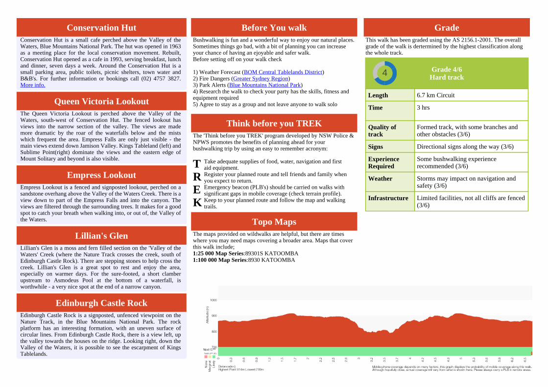
GradeThis walk has been graded using the AS 2156.1-2001. The overallgrade of the walk is dertermined by the highest classification alongthe whole track.
Grade 4/6Hard track4
Length 6.7 km Circuit
Time 3 hrs
Quality oftrack
Formed track, with some branches andother obstacles (3/6)
Signs Directional signs along the way (3/6)
ExperienceRequired
Some bushwalking experiencerecommended (3/6)
Weather Storms may impact on navigation andsafety (3/6)
Infrastructure Limited facilities, not all cliffs are fenced(3/6)

Are you ready to have fun?Please ensure you and your group are well prepared and equipped for allpossible hazards and delays. Check park closures, weather information andFire Danger Rating before setting out. Optional side trips and alternate routesnoted are not included in this walks overall grade, length or time estimate.Please allow extra time for resting and exploring areas of interest. Theauthors, staff and owners of wildwalks take care in preparing this informationbut will not accept responsibility for any inconvenience, loss or injury youmay experience. Please take care, have fun - Happy Walking.Getting there You can get to Wentworth Falls Railway Station (gps:-33.7097, 150.3764) by car, train or bus. Car: There is free parking available.This is a circuit, so you will finish back at the start.Find up to date and more information inlcuding; travel directions, weather,park closures and walker feedback at http://wild.tl/wfchl
0 | Wentworth Falls Railway Station (490 m 9 mins) From Wentworth Falls Railway Station, this walk exits thestation on the western side, on Station St, and turns left to head down to theGreat Western Highway past the shops. At the highway, the walk crosses atthe lights and turns right, heading down the hill along the foot path. Thiswalk then turns left into Wilson Park soon after the colourful bus stop. Thewalk follows the footpath through Wilson Park. At the toilet block in thecentre of the park, the walk tends slightly more to the left until coming to alarge archway entrance to the Charles Darwin Walk, near the tennis courts.
0.49 | Wilson Park (1.2 km 21 mins) Turn right: From the intersection, this walk heads towardsthe road with the tennis courts on the left, and then heads to the left downFalls Rd, along the footpath. This walk then turns right onto Armstrong Rdand follows this to the end.
1.68 | Corner of Armstrong St and Valley Rd (1 km 21 mins) Continue straight: From the corner of Valley Rd andArmstrong St, Wentworth Falls, the wide clay track heads into the bush fromnear the telegraph pole. The track heads down the hill, and is rough and rockyin places. The walk soon comes to an intersection with another track on theleft, signposted as the way to 'Conservation Hut'.Turn left: From the intersection, this walk follows the 'Conservation Hut11min' sign, heading off the main trail. The narrower trail gently meandersuntil coming to a three-way intersection, marked with a 'Nature Track Circuit'sign (and a gate not far up the track to the left).Continue straight: From the intersection, this walk follows the 'Nature TrackCircuit - Valley of the Waters Picnic Area' sign south along the wide trail.The trail soon narrows to a single track and passes some informal tracks (onthe left). Soon after passing a backyard, the walk heads up some steps,passing a toilet block and coming to the front of the 'Conservation Hut'.
2.73 | Conservation Hut Conservation Hut is a small cafe perched above the Valley of the Waters,Blue Mountains National Park. The hut was opened in 1963 as a meetingplace for the local conservation movement. Rebuilt, Conservation Hutopened as a cafe in 1993, serving breakfast, lunch and dinner, seven days aweek. Around the Conservation Hut is a small parking area, public toilets,picnic shelters, town water and B&B's. For further information or bookingscall (02) 4757 3827. More info.
2.73 | Conservation Hut (320 m 8 mins) Continue straight: From Conservation Hut, this walk followsthe 'Valley of the Waters' sign down some timber and dirt steps passing acouple of picnic shelters. The track soon leads to the signposted intersectionwith the 'Short Cut Track' (still in view of the Conservation Hut).
Continue straight: From the intersection, this walk follows the 'Valley of theWaters' sign down the steps, passing an information sign. After the handrailand more signs, the track passes a couple of faint tracks (on the left, leading toan old picnic area). Further down the steps, the walk comes the end of anotherhandrail and a three-way intersection (signposted 'Overcliff Track' and'National Pass').Continue straight: From the intersection, this walk follows the 'National Pass -Valley of the Waters' sign down the timber steps. The track passes a few fainttracks (on the left, that lead to an unfenced view point). The walk continuesdown the steps, soon coming to an unsignposted intersection with the LyrebirdCliff track (on a small sandstone rock platform).Continue straight: From the intersection, this walk heads down the woodensteps to almost immediately come to the signposted intersection with 'QueenVictoria Lookout' track.
3.05 | Optional sidetrip to Queen Victoria Lookout (20 m 1 mins) Turn left: From the intersection, this walk follows the 'QueenVictoria Lookout' sign down the steps towards the handrail. Soon the trackpasses a small lookout on the left and, shortly afterwards, the fence leads tothe rock platform and fenced 'Queen Victoria Lookout'. At the end of thisside trip, retrace your steps back to the main walk then Turn left.
3.05 | Queen Victoria Lookout The Queen Victoria Lookout is perched above the Valley of the Waters,south-west of Conservation Hut. The fenced lookout has views into thenarrow section of the valley. The views are made more dramatic by the roarof the waterfalls below and the mists which frequent the area. Empress Fallsare only just visible - the main views extend down Jamison Valley. KingsTableland (left) and Sublime Point(right) dominate the views and the easternedge of Mount Solitary and beyond is also visible.
3.05 | Int of Valley of the Waters and Queen Victoria Tra (60 m 2 mins) Veer right: From the intersection, this walk heads down thesteps away from 'Queen Victoria Lookout' keeping the rock face to the right.The track soon passes under a sandstone overhang and then down more stepsto come to the fenced and signposted 'Empress Lookout'.
3.11 | Empress Lookout Empress Lookout is a fenced and signposted lookout, perched on a sandstoneoverhang above the Valley of the Waters Creek. There is a view down to partof the Empress Falls and into the canyon. The views are filtered through thesurrounding trees. It makes for a good spot to catch your breath whenwalking into, or out of, the Valley of the Waters.
3.11 | Empress Lookout (520 m 17 mins) Turn right: From Empress Lookout, this walk heads downthe wooden steps, keeping the handrail and valley to the left. Soon the walkheads downs a series of steep metal staircases that zigzag down the hill. Atthe bottom of the staircases, the walk follows the handrail through a longsandstone overhang. The track then heads down some steps to come to anintersection with the 'Nature Track' and a sign pointing back to 'National Pass- Tea Rooms'.Veer right: From the intersection, this walk follows the 'Nature Track' signdown a few steps and over a small wooden bridge, coming to a clearing,picnic table and small waterfall. From the picnic table, this walk heads up thesteps, passing a 'Welcome to the Nature Track' information sign (point 1).The track turns right and passes three numbered posts (2,3,4) - After number3, the track heads down hill. Soon after the handrail starts, the walk comes toan intersection just before Lillian's Bridge and post number 5.Continue straight: From post number 5 at Lillian's Bridge, this walk heads upthe stairs away from the handrail, keeping the bridge and valley to the left.
The track makes its way around the hill, passing a few handrails before headingdown to some stepping stones across the creek. (This is a nice but slipperyspot to enjoy, with a small waterfall to the right). After crossing the steppingstones, the track heads over a small rise to come back down and cross thecreek again, on another set of stepping stones. This is signposted 'LilliansGlen'.
3.63 | Lillian's Glen Lillian's Glen is a moss and fern filled section on the 'Valley of the Waters'Creek (where the Nature Track crosses the creek, south of Edinburgh CastleRock). There are stepping stones to help cross the creek. Lillian's Glen is agreat spot to rest and enjoy the area, especially on warmer days. For the sure-footed, a short clamber upstream to Asmodeus Pool at the bottom of awaterfall, is worthwhile - a very nice spot at the end of a narrow canyon.
3.63 | Lillian's Glen (380 m 12 mins) Continue straight: From Lillian's Glen, this walk heads upthe stairs away from the creek, passing the 'Lillian's Glen' sign. The trackwinds up the hill for some time (passing a handrail) until just after postmarker 7, where the track heads through an sandstone overhang to comes toan unfenced view point with great valley views. From the view point, thiswalk heads away from the valley views through the sandstone overhang,keeping the rockface to the right. After the cave, the walk heads up the stairsto follows a tall rock wall (on the right) and comes to post marker 8. Fromthe number 8 post, the walk heads up the stairs, as the track flattens it cometo a three-way intersection with a 'Edinburgh Castle Rock' sign and post 9.
4.02 | Optional sidetrip to Edinburgh Castle Rock (10 m 1 mins) Turn right: From the intersection, this walk heads past the signsaying 'Edinburgh Castle Rock' towards the unfenced rock and great views -this is Edinburgh Castle Rock. At the end of this side trip, retrace your stepsback to the main walk then Turn right.
4.02 | Edinburgh Castle Rock Edinburgh Castle Rock is a signposted, unfenced viewpoint on the NatureTrack, in the Blue Mountains National Park. The rock platform has aninteresting formation, with an uneven surface of circular lines. FromEdinburgh Castle Rock, there is a view left, up the valley towards the houseson the ridge. Looking right, down the Valley of the Waters, it is possible tosee the escarpment of Kings Tablelands.
4.02 | Int of Nature and Edinburgh Castle Rock Tracks (540 m 15 mins) Veer left: From the intersection, (with Edinburgh CastleRock on the right), this walk heads up the gentle hill. The track heads throughthe bush before crossing a gully using a small metal bridge. Climbing out ofthis gully on the timber steps, the walk then heads up some metal stairs, andthen more timber steps to come to a three-way intersection with 'West Street'Track and a sign pointing back down the 'Nature Track'.Continue straight: From the intersection, this walk follows the 'Valley of theWaters Picnic Area' sign up the steps. The track soon flattens out and headsthrough the bush for a little while until coming to a 'T' intersection with thewide West St trail and a 'Nature Track Circuit' sign.
4.55 | Int of Nature Track and West St Servicetrail (350 m 8 mins) Turn right: From the intersection, this walk follows the'Valley of the Waters Picnic Area' sign along the trail, passing the back of ahouse (on the left). The track soon narrows and then passes the back ofanother house with a private track (on the left). The trail starts heading uphilland, about 60m later, comes to a three-way intersection with a 'ConservationHut 11min' sign (marking the track on the right).

4.9 | Int of Armstrong St Servicetrail and Nature Track (100 m 2 mins) Veer left: From the intersection, the walk heads uphill alongthe wide clay track. This is rough and rocky. The track soon emerges onto thecorner of Armstrong St and Valley Rd, Wentworth Falls.
5 | Corner of Armstrong St and Valley Rd (1.2 km 21 mins) Continue straight: From the intersection, this walk headsdown Armstrong Rd for some time. The walk then turns left onto Falls Rd tocontinue up the footpath, with the road to the left. When the tennis courtsappear on the right, the walk tends right, into the park. The walk continuesinto the park to the intersection above the stairs and Jamison Creek pondage.
6.2 | Wilson Park (490 m 9 mins) Turn left : From the the archway in Wilson Park, this walkheads away from the tennis courts, keeping the creek on the right. At the farend of the park, the walk comes to the Great Western Highway and turnsright. After about 150m, this walk crosses the highway at the traffic lightsand heads up Station St, past the shops and up to Wentworth Falls RailwayStation on the right.

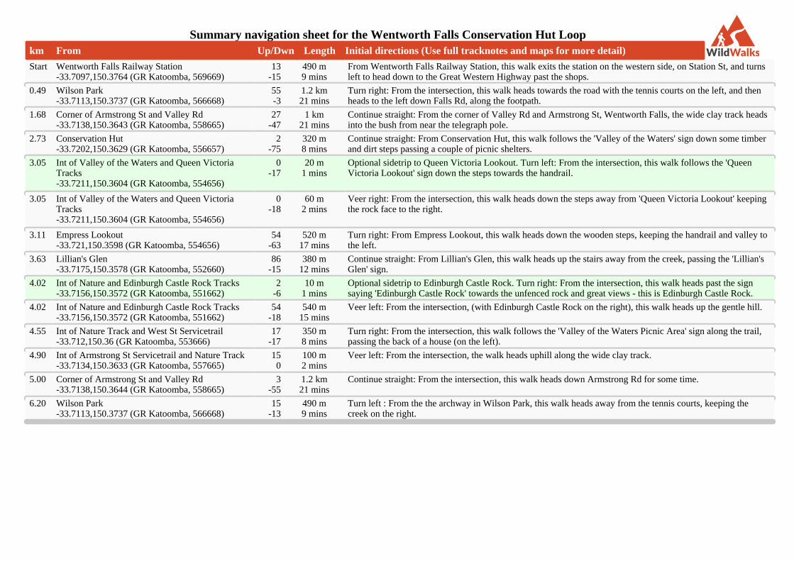
Summary navigation sheet for the Wentworth Falls Conservation Hut Loopkm From Up/Dwn Length Initial directions (Use full tracknotes and maps for more detail)
Start Wentworth Falls Railway Station-33.7097,150.3764 (GR Katoomba, 569669)
13-15
490 m9 mins
From Wentworth Falls Railway Station, this walk exits the station on the western side, on Station St, and turnsleft to head down to the Great Western Highway past the shops.
0.49 Wilson Park-33.7113,150.3737 (GR Katoomba, 566668)
55-3
1.2 km21 mins
Turn right: From the intersection, this walk heads towards the road with the tennis courts on the left, and thenheads to the left down Falls Rd, along the footpath.
1.68 Corner of Armstrong St and Valley Rd-33.7138,150.3643 (GR Katoomba, 558665)
27-47
1 km21 mins
Continue straight: From the corner of Valley Rd and Armstrong St, Wentworth Falls, the wide clay track headsinto the bush from near the telegraph pole.
2.73 Conservation Hut-33.7202,150.3629 (GR Katoomba, 556657)
2-75
320 m8 mins
Continue straight: From Conservation Hut, this walk follows the 'Valley of the Waters' sign down some timberand dirt steps passing a couple of picnic shelters.
3.05 Int of Valley of the Waters and Queen VictoriaTracks-33.7211,150.3604 (GR Katoomba, 554656)
0-17
20 m1 mins
Optional sidetrip to Queen Victoria Lookout. Turn left: From the intersection, this walk follows the 'QueenVictoria Lookout' sign down the steps towards the handrail.
3.05 Int of Valley of the Waters and Queen VictoriaTracks-33.7211,150.3604 (GR Katoomba, 554656)
0-18
60 m2 mins
Veer right: From the intersection, this walk heads down the steps away from 'Queen Victoria Lookout' keepingthe rock face to the right.
3.11 Empress Lookout-33.721,150.3598 (GR Katoomba, 554656)
54-63
520 m17 mins
Turn right: From Empress Lookout, this walk heads down the wooden steps, keeping the handrail and valley tothe left.
3.63 Lillian's Glen-33.7175,150.3578 (GR Katoomba, 552660)
86-15
380 m12 mins
Continue straight: From Lillian's Glen, this walk heads up the stairs away from the creek, passing the 'Lillian'sGlen' sign.
4.02 Int of Nature and Edinburgh Castle Rock Tracks-33.7156,150.3572 (GR Katoomba, 551662)
2-6
10 m1 mins
Optional sidetrip to Edinburgh Castle Rock. Turn right: From the intersection, this walk heads past the signsaying 'Edinburgh Castle Rock' towards the unfenced rock and great views - this is Edinburgh Castle Rock.
4.02 Int of Nature and Edinburgh Castle Rock Tracks-33.7156,150.3572 (GR Katoomba, 551662)
54-18
540 m15 mins
Veer left: From the intersection, (with Edinburgh Castle Rock on the right), this walk heads up the gentle hill.
4.55 Int of Nature Track and West St Servicetrail-33.712,150.36 (GR Katoomba, 553666)
17-17
350 m8 mins
Turn right: From the intersection, this walk follows the 'Valley of the Waters Picnic Area' sign along the trail,passing the back of a house (on the left).
4.90 Int of Armstrong St Servicetrail and Nature Track-33.7134,150.3633 (GR Katoomba, 557665)
150
100 m2 mins
Veer left: From the intersection, the walk heads uphill along the wide clay track.
5.00 Corner of Armstrong St and Valley Rd-33.7138,150.3644 (GR Katoomba, 558665)
3-55
1.2 km21 mins
Continue straight: From the intersection, this walk heads down Armstrong Rd for some time.
6.20 Wilson Park-33.7113,150.3737 (GR Katoomba, 566668)
15-13
490 m9 mins
Turn left : From the the archway in Wilson Park, this walk heads away from the tennis courts, keeping thecreek on the right.
Powered by TCPDF (www.tcpdf.org)