Earth 471 Individual Essay An Overview of McArthur River Uranium Deposits in the Athabasca Basin,...
17
Earth 471 Individual Essay An Overview of McArthur River Uranium Deposits in the Athabasca Basin, Canada Presented by :Qingyang Liu Instructor: Prof. Carl Guilmette Date of Submission: March 6 th , 2014
Transcript of Earth 471 Individual Essay An Overview of McArthur River Uranium Deposits in the Athabasca Basin,...
Earth 471 Individual Essay An Overview of McArthur River Uranium Deposits in the Athabasca Basin, Canada Presented by :Qingyang Liu
Instructor: Prof. Carl Guilmette
Date of Submission: March 6th, 2014

Earth 471 Individual Essay
2
List of Figures and Tables Figure 1. World uranium production from 2005-2012, data retrieved from World Nuclear Association
Figure 2. Model for unconformity-associated uranium deposits in the Athabasca Basin, Canada
Figure 3. Location map of the McArthur River Basin Mine
Figure 4. Uranium oxide price since 1987, World Nuclear Association
Figure 5. Geology map of the Athabasca Basin, figure taken from (Jefferson et al., 2007) Figure 6. Sequence stratigraphy of the Athabasca Basin, figure taken from Jefferson et al., 2007
Figure 7. Lithotectonic domains in northern Saskatchewan, figure taken from Annesley, Madore, &
Portella, 2005
Figure 8. Plan view of the McArthur River property showing the main ore bodies
Figure 9. The results of the U/Pb dating of the uranium rich minerals from the studied
mineralizations, figure taken from Alexandre et al., 2009
Figure 10. Ternary diagram showing the composition of the uranitite in the studied area (Ng et al.,
2013)
Figure 11. Simplified paragenesis in Athabasca Group (Ng et al., 2013)
Figure 12. Two types of unconformity-associated uranium deposits, Jefferson et al., 2007
Figure 13. Genetic model of the monometallic uranium deposit, Jefferson et al., 2007
Table 1. Uranium production from McArthur River Basin Mine, 2011-2013, data retrieved from World
Nuclear Association
Table 2. Pie chart showing the contribution of the McArthur River Mine in the Global uranium production
Table 3. Comparison of the world’s most uranium-productive countries and the major mine, data retrieved
from World Nuclear Association
Earth 471 Individual Essay
3
1.Introduction
Discovered in 1789, uranium was first isolated and found radioactive in 1896 by Henri Becquerel. Since
mid-1950s, uranium has been the source for nuclear energy, which is more efficient than traditional energy
and does not produce greenhouse gases. Being the most important source of naturally occurring uranium,
uranium ore was first found near the Port Radium in Saskatchewan, Canada, and the exploration began in
1942 in response to the military demand. Although uranium deposits are found in many countries, more
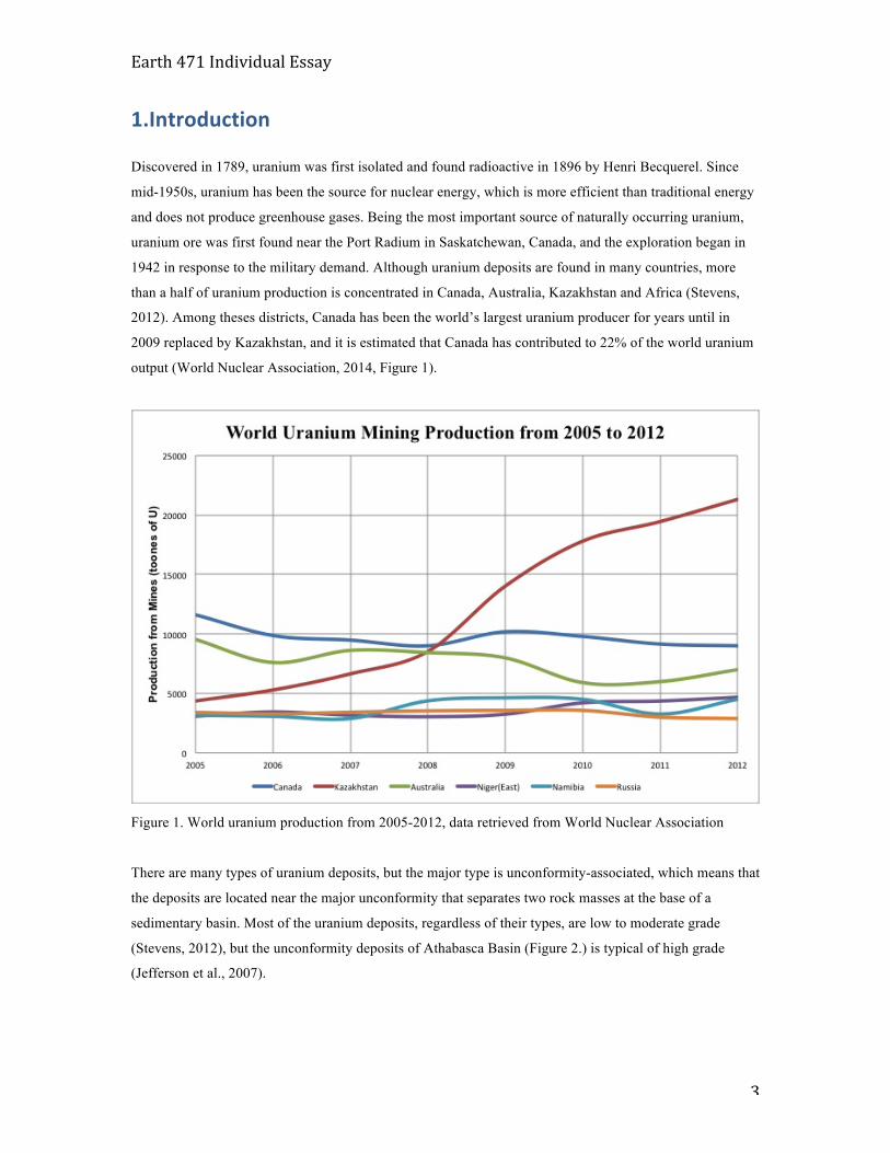
than a half of uranium production is concentrated in Canada, Australia, Kazakhstan and Africa (Stevens,
2012). Among theses districts, Canada has been the world’s largest uranium producer for years until in
2009 replaced by Kazakhstan, and it is estimated that Canada has contributed to 22% of the world uranium
output (World Nuclear Association, 2014, Figure 1).
Figure 1. World uranium production from 2005-2012, data retrieved from World Nuclear Association
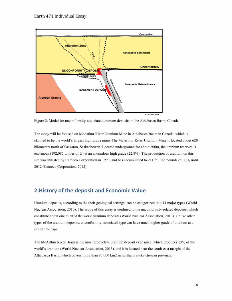
There are many types of uranium deposits, but the major type is unconformity-associated, which means that
the deposits are located near the major unconformity that separates two rock masses at the base of a
sedimentary basin. Most of the uranium deposits, regardless of their types, are low to moderate grade
(Stevens, 2012), but the unconformity deposits of Athabasca Basin (Figure 2.) is typical of high grade
(Jefferson et al., 2007).
Earth 471 Individual Essay
4
Figure 2. Model for unconformity-associated uranium deposits in the Athabasca Basin, Canada
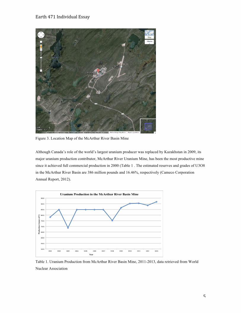
The essay will be focused on McArthur River Uranium Mine in Athabasca Basin in Canada, which is
claimed to be the world’s largest high-grade mine. The McArthur River Uranium Mine is located about 620
kilometers north of Saskaton, Saskachewan. Located underground for about 600m, the uranium reserves is
enormous (192,085 tonnes of U) at an anomalous high grade (22.8%). The production of uranium on this
site was initiated by Cameco Corporation in 1999, and has accumulated to 211 million pounds of U3O8 until
2012 (Cameco Corporation, 2012).
2.History of the deposit and Economic Value
Uranium deposits, according to the their geological settings, can be categorized into 14 major types (World
Nuclear Association, 2010). The scope of this essay is confined to the unconformity-related deposits, which
constitute about one third of the world uranium deposits (World Nuclear Association, 2010). Unlike other
types of the uranium deposits, unconformity-associated type can have much higher grade of uranium at a
similar tonnage.
The McArthur River Basin is the most productive uranium deposit ever since, which produces 13% of the
world’s uranium (World Nuclear Association, 2013), and it is located near the south-east margin of the
Athabasca Basin, which covers more than 85,000 km2 in northern Saskatchewan province.
Earth 471 Individual Essay
5
Figure 3. Location Map of the McArthur River Basin Mine
Although Canada’s role of the world’s largest uranium producer was replaced by Kazakhstan in 2009, its
major uranium production contributor, McArthur River Uranium Mine, has been the most productive mine
since it achieved full commercial production in 2000 (Table 1 . The estimated reserves and grades of U3O8
in the McArthur River Basin are 386 million pounds and 16.46%, respectively (Cameco Corporation
Annual Report, 2012).
Table 1. Uranium Production from McArthur River Basin Mine, 2011-2013, data retrieved from World
Nuclear Association
Earth 471 Individual Essay
6
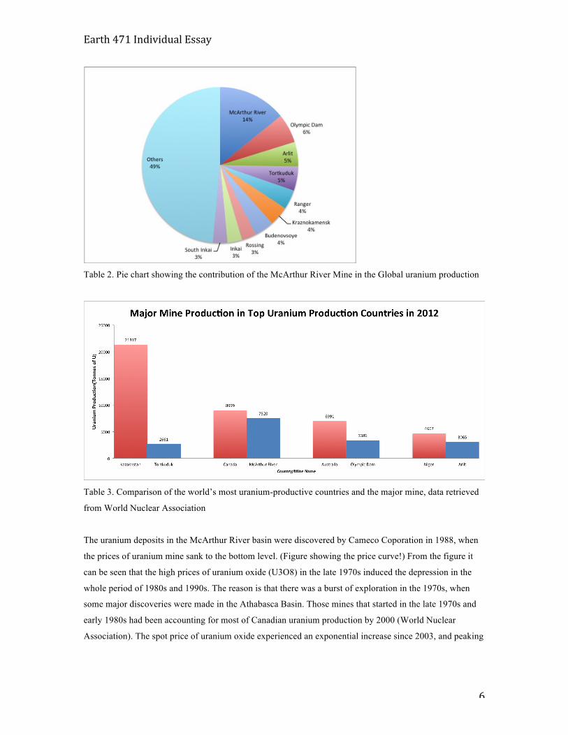
Table 2. Pie chart showing the contribution of the McArthur River Mine in the Global uranium production
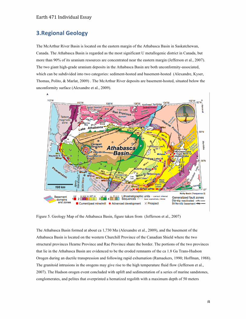
Table 3. Comparison of the world’s most uranium-productive countries and the major mine, data retrieved
from World Nuclear Association
The uranium deposits in the McArthur River basin were discovered by Cameco Coporation in 1988, when
the prices of uranium mine sank to the bottom level. (Figure showing the price curve!) From the figure it
can be seen that the high prices of uranium oxide (U3O8) in the late 1970s induced the depression in the
whole period of 1980s and 1990s. The reason is that there was a burst of exploration in the 1970s, when
some major discoveries were made in the Athabasca Basin. Those mines that started in the late 1970s and
early 1980s had been accounting for most of Canadian uranium production by 2000 (World Nuclear
Association). The spot price of uranium oxide experienced an exponential increase since 2003, and peaking

Earth 471 Individual Essay
7
at over 130 US dollars/lb in 2007, after which the prices decreased to a lesser extent and remained
relatively stable since 2009.
Figure 4. Uranium Oxide Price since 1987, World Nuclear Association
The uranium mines play an important role in Canada’s economy. In terms of energy supply, the energy
contained in the uranium deposits in the Athabasca Basin is equivalent to 19 billion barrels of oil, which is
more than 15 years of Canadian current total crude oil production (Saskatchewan First Nations Natural
Resources Centre of Excellence). Contributing directly over 1.5 billion US dollars to the revenue of the
provincial government, uranium mining is a major patron to Saskatchewan’s economy (Saskatchewan
Mining Association, 2012). In addition, over 286,000 person years of direct employment will be generated
by 2028, and the mining employment is expected to rise by 17% (Saskatchewan Mining Association, 2012).
Cameco Corporation has 69.8% ownership, and the rest 30.2% ownership belongs to AREVA Resources.
With a licensed capacity of 18.7 million pounds U3O8 per year, Cameco made a production of 14.1
millions pounds U3O8 in 2013.
In the near future, it is likely that Canadian uranium production will increase dramatically, as several new
mines are now under construction and will be in operation soon.
Earth 471 Individual Essay
8
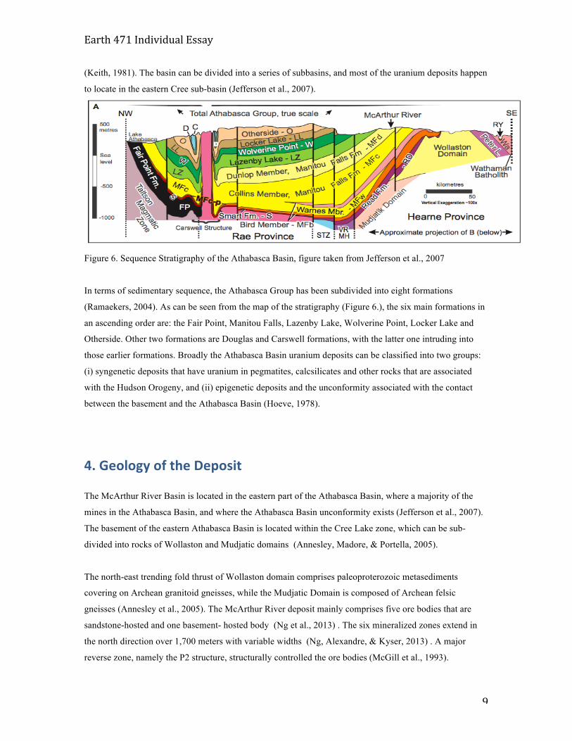
3.Regional Geology
The McArthur River Basin is located on the eastern margin of the Athabasca Basin in Saskatchewan,
Canada. The Athabasca Basin is regarded as the most significant U metallogenic district in Canada, but
more than 90% of its uranium resources are concentrated near the eastern margin (Jefferson et al., 2007).
The two giant high-grade uranium deposits in the Athabasca Basin are both unconformity-associated,
which can be subdivided into two categories: sediment-hosted and basement-hosted (Alexandre, Kyser,
Thomas, Polito, & Marlat, 2009) . The McArthur River deposits are basement-hosted, situated below the
unconformity surface (Alexandre et al., 2009).
Figure 5. Geology Map of the Athabasca Basin, figure taken from (Jefferson et al., 2007)
The Athabasca Basin formed at about ca 1,730 Ma (Alexandre et al., 2009), and the basement of the
Athabasca Basin is located on the western Churchill Province of the Canadian Shield where the two
structural provinces Hearne Province and Rae Province share the border. The portions of the two provinces
that lie in the Athabasca Basin are evidenced to be the eroded remnants of the ca 1.8 Ga Trans-Hudson
Orogen during an ductile transpression and following rapid exhumation (Ramaekers, 1990; Hoffman, 1988).
The granitoid intrusions in the orogens may give rise to the high temperature fluid flow (Jefferson et al.,
2007). The Hudson orogen event concluded with uplift and sedimentation of a series of marine sandstones,
conglomerates, and pelites that overprinted a hematized regolith with a maximum depth of 50 meters
Earth 471 Individual Essay
9
(Keith, 1981). The basin can be divided into a series of subbasins, and most of the uranium deposits happen
to locate in the eastern Cree sub-basin (Jefferson et al., 2007).
Figure 6. Sequence Stratigraphy of the Athabasca Basin, figure taken from Jefferson et al., 2007
In terms of sedimentary sequence, the Athabasca Group has been subdivided into eight formations
(Ramaekers, 2004). As can be seen from the map of the stratigraphy (Figure 6.), the six main formations in
an ascending order are: the Fair Point, Manitou Falls, Lazenby Lake, Wolverine Point, Locker Lake and
Otherside. Other two formations are Douglas and Carswell formations, with the latter one intruding into
those earlier formations. Broadly the Athabasca Basin uranium deposits can be classified into two groups:
(i) syngenetic deposits that have uranium in pegmatites, calcsilicates and other rocks that are associated
with the Hudson Orogeny, and (ii) epigenetic deposits and the unconformity associated with the contact
between the basement and the Athabasca Basin (Hoeve, 1978).
4. Geology of the Deposit
The McArthur River Basin is located in the eastern part of the Athabasca Basin, where a majority of the
mines in the Athabasca Basin, and where the Athabasca Basin unconformity exists (Jefferson et al., 2007).
The basement of the eastern Athabasca Basin is located within the Cree Lake zone, which can be sub-
divided into rocks of Wollaston and Mudjatic domains (Annesley, Madore, & Portella, 2005).
The north-east trending fold thrust of Wollaston domain comprises paleoproterozoic metasediments
covering on Archean granitoid gneisses, while the Mudjatic Domain is composed of Archean felsic
gneisses (Annesley et al., 2005). The McArthur River deposit mainly comprises five ore bodies that are
sandstone-hosted and one basement- hosted body (Ng et al., 2013) . The six mineralized zones extend in
the north direction over 1,700 meters with variable widths (Ng, Alexandre, & Kyser, 2013) . A major
reverse zone, namely the P2 structure, structurally controlled the ore bodies (McGill et al., 1993).

Earth 471 Individual Essay
10
Figure 7. Lithotectonic domains in northern Saskatchewan, figure taken from Annesley, Madore, &
Portella, 2005
Figure 8. Plan View of the McArthur River property showing the main ore bodies
The age and chemistry of uranium mineralization have been examined thoroughly by previous studies
(RW.ERROR - Unable to find reference:45; Cumming & Krstic, 1991; Fayek, Kyser, & Riciputi, 2002; Ng
et al., 2013; Richard et al., 2010) . The examination under the ore microscope of the sample M121-517.7
Earth 471 Individual Essay
11
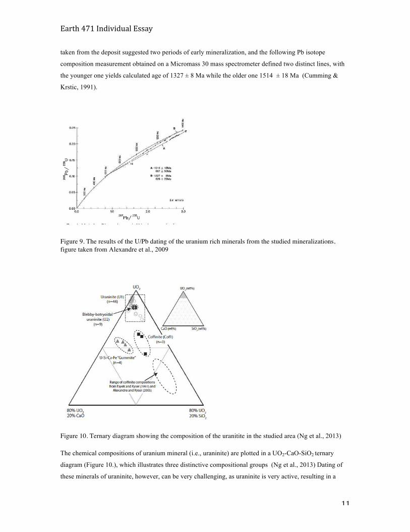
taken from the deposit suggested two periods of early mineralization, and the following Pb isotope
composition measurement obtained on a Micromass 30 mass spectrometer defined two distinct lines, with
the younger one yields calculated age of 1327 ± 8 Ma while the older one 1514 ± 18 Ma (Cumming &
Krstic, 1991).
Figure 9. The results of the U/Pb dating of the uranium rich minerals from the studied mineralizations, figure taken from Alexandre et al., 2009
Figure 10. Ternary diagram showing the composition of the uranitite in the studied area (Ng et al., 2013)
The chemical compositions of uranium mineral (i.e., uraninite) are plotted in a UO2-CaO-SiO2 ternary
diagram (Figure 10.), which illustrates three distinctive compositional groups (Ng et al., 2013) Dating of
these minerals of uraninite, however, can be very challenging, as uraninite is very active, resulting in a
Earth 471 Individual Essay
12
partial release of the radiogenic Pb if the uraninite exhibits recrystallization, which accounts for the
disagreement upon the age of the uranium minerals from various studies (Alexandre et al., 2009) a major
improvement, all the samples are examined under reflected light microscopy, and only those with the
highest reflectance are chosen for the U-Pb dating of the LA-HR-ICP-MS analysis (Alexandre et al., 2009)
The samples are collected from the massive ore zone at the McArthur River basement-hosted deposit, and
the results of U/Pb isotopic compositions yield three distinctive discordia lines, as can be seen from Figure
9 (Alexandre et al., 2009).
The result shows that the ages of uraninite obtained in the McArthhur River Basin is 1,540+- 19 Ma
(Alexandre et al., 2009) , revising the previous biased results. The chemical analysis obtained by
40Ar/39Ar of the clay minerals in the deposits shows that the Athabasca Basin dated from 1,742+-25 Ma
(Alexandre et al., 2009).
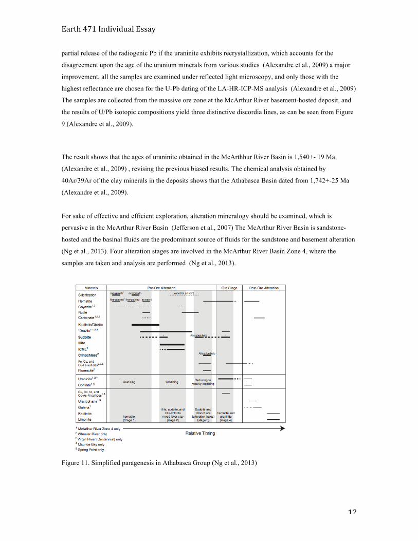
For sake of effective and efficient exploration, alteration mineralogy should be examined, which is
pervasive in the McArthur River Basin (Jefferson et al., 2007) The McArthur River Basin is sandstone-
hosted and the basinal fluids are the predominant source of fluids for the sandstone and basement alteration
(Ng et al., 2013). Four alteration stages are involved in the McArthur River Basin Zone 4, where the
samples are taken and analysis are performed (Ng et al., 2013).
Figure 11. Simplified paragenesis in Athabasca Group (Ng et al., 2013)
Earth 471 Individual Essay
13
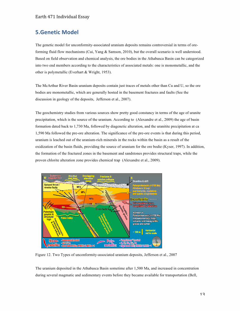
5.Genetic Model
The genetic model for unconformity-associated uranium deposits remains controversial in terms of ore-
forming fluid flow mechanisms (Cui, Yang & Samson, 2010), but the overall scenario is well understood.
Based on field observation and chemical analysis, the ore bodies in the Athabasca Basin can be categorized
into two end members according to the characteristics of associated metals: one is monometallic, and the
other is polymetallic (Everhart & Wright, 1953).
The McArthur River Basin uranium deposits contain just traces of metals other than Cu and U, so the ore
bodies are monometallic, which are generally hosted in the basement fractures and faults (See the
discussion in geology of the deposits, Jefferson et al., 2007).
The geochemistry studies from various sources show pretty good constancy in terms of the age of uranite
precipitation, which is the source of the uranium. According to (Alexandre et al., 2009) the age of basin
formation dated back to 1,730 Ma, followed by diagenetic alteration, and the uranitite precipitation at ca
1,590 Ma followed the pre-ore alteration. The significance of the pre-ore events is that during this period,
uranium is leached out of the uranium-rich minerals in the rocks within the basin as a result of the
oxidization of the basin fluids, providing the source of uranium for the ore bodie (Kyser, 1997). In addition,
the formation of the fractured zones in the basement and sandstones provides structural traps, while the
proven chlorite alteration zone provides chemical trap (Alexandre et al., 2009).
Figure 12. Two Types of unconformity-associated uranium deposits, Jefferson et al., 2007
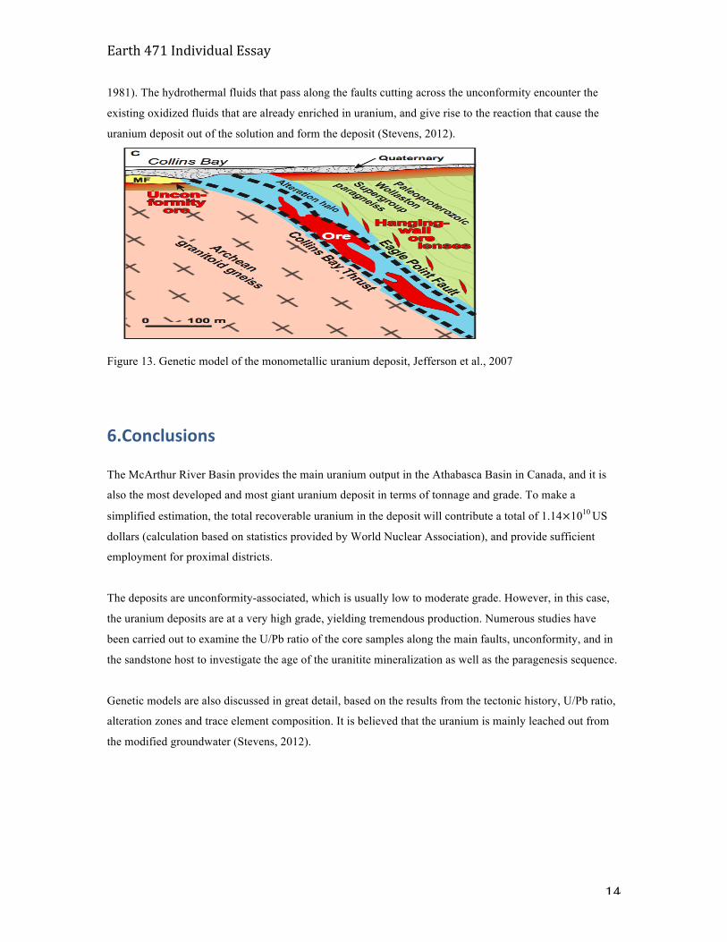
The uranium deposited in the Athabasca Basin sometime after 1,500 Ma, and increased in concentration
during several magmatic and sedimentary events before they became available for transportation (Bell,
Earth 471 Individual Essay
14
1981). The hydrothermal fluids that pass along the faults cutting across the unconformity encounter the
existing oxidized fluids that are already enriched in uranium, and give rise to the reaction that cause the
uranium deposit out of the solution and form the deposit (Stevens, 2012).
Figure 13. Genetic model of the monometallic uranium deposit, Jefferson et al., 2007
6.Conclusions
The McArthur River Basin provides the main uranium output in the Athabasca Basin in Canada, and it is
also the most developed and most giant uranium deposit in terms of tonnage and grade. To make a
simplified estimation, the total recoverable uranium in the deposit will contribute a total of 1.14×10¹⁰ US
dollars (calculation based on statistics provided by World Nuclear Association), and provide sufficient
employment for proximal districts.
The deposits are unconformity-associated, which is usually low to moderate grade. However, in this case,
the uranium deposits are at a very high grade, yielding tremendous production. Numerous studies have
been carried out to examine the U/Pb ratio of the core samples along the main faults, unconformity, and in
the sandstone host to investigate the age of the uranitite mineralization as well as the paragenesis sequence.
Genetic models are also discussed in great detail, based on the results from the tectonic history, U/Pb ratio,
alteration zones and trace element composition. It is believed that the uranium is mainly leached out from
the modified groundwater (Stevens, 2012).
Earth 471 Individual Essay
15
References
Alexandre, P., Kyser, T. K., Thomas, D., Polito, P. A., & Marlat, J. (2009). Geochronology of
unconformity-related uranium deposits in the athabasca basin, saskatchewan, canada and their
integration in the evolution of the basin. Mineralium Deposita, 44(1), 41-59.
Annesley, I. R., Madore, C., & Portella, P. (2005). Geology and thermotectonic evolution of the western
margin of the trans-hudson orogen; evidence from the eastern sub-athabasca basement, saskatchewan.
Canadian Journal of Earth Sciences = Revue Canadienne Des Sciences De La Terre, 42(4), 573-597.
Beattie, D., & Davis, T. (2002a). High-grade uranium mining at McArthur river, saskatchewan, canada. 8th
AusIMM Underground Operators' Conference: Proceedings - Growing our Underground Operations,
(5) pp. 11-19.
Beattie, D., & Davis, T. (2002b). High grade uranium mining and ore handling overview at McArthur river.
The AusIMM Bulletin (1990), 2002(5), 22-23, 25-27.
Cumming, G. L., & Krstic, D. (1991). The age of unconformity-related uranium mineralization in the
athabasca basin, northern saskatchewan. Program with Abstracts - Geological Association of
Canada; Mineralogical Association of Canada; Canadian Geophysical Union, Joint Annual Meeting,
16, 27.
Cuney, M. L. (2005). World-class unconformity-related uranium deposits; key factors for their genesis.
Proceedings of the ...Biennial SGA (Society for Geology Applied to Mineral Deposits) Meeting, 8,
Vol. 1, 245-248.
Everhart, D. L., & Wright, R. J. (1953). The geologic character of typical pitchblende veins. Economic
Geology and the Bulletin of the Society of Economic Geologists, 48(2), 77-96.
Earth 471 Individual Essay
16
Fayek, M., Kyser, T. K., & Riciputi, L. R. (2002). U and pb isotope analysis of uranium minerals by ion
microprobe and the geochronology of the McArthur river and sue zone uranium deposits,
saskatchewan, canada. The Canadian Mineralogist, 40, Part 6, 1553-1569.
Hoeve, J. (1978). Classification of uranium deposits in northern saskatchewan. Short Course Handbook, 3,
397-401.
Jefferson, C. W., Thomas, D. J., Gandhi, S. S., Ramaekers, P., Delaney, G., Brisbin, D., et al. (2007).
Unconformity-associated uranium deposits of the athabasca basin, saskatchewan and alberta. Bulletin
of the Geological Survey of Canada, (588), 23-67.
McGill, B. D., Marlatt, J. L., Matthews, R. B., Sopuck, V. J., Homeniuk, L. A., & Hubregtse, J. J. (1993).
The P2 north uranium deposit, saskatchewan, canada. Exploration and Mining Geology, 2(4), 321-
331.
Mercadier, J., Annesley, I. R., Mckechnie, C. L., Bogdan, T. S., & Creighton, S. (2013). Magmatic and
metamorphic uraninite mineralization in the western margin of the trans-hudson orogen
(saskatchewan, canada): A uranium source for unconformity-related uranium deposits? Economic
Geology, 108(5), 1037-1065.
Mudd, G. M., & Diesendorf, M. (2008). Sustainability of uranium mining and milling: Toward quantifying
resources and eco-efficiency. Environmental Science and Technology, 42(7), 2624-2630.
Ng, R., Alexandre, P., & Kyser, K. (2013). Mineralogical and geochemical evolution of the unconformity-
related McArthur river zone 4 orebody in the athabasca basin, canada: Implications of a silicified
zone. Economic Geology, 108(7), 1657-1689.
Ng, R., Alexandre, P., Kyser, K., Cloutier, J., Abdu, Y. A., & Hawthorne, F. C. (2013). Oxidation state of
iron in alteration minerals associated with sandstone-hosted unconformity-related uranium deposits
and apparently barren alteration systems in the athabasca basin, canada: Implications for exploration.
Journal of Geochemical Exploration, 130, 22-43.
Earth 471 Individual Essay
17
Ramaekers, P., Jefferson, C. W., Yeo, G. M., Collier, B., Long, D. G. F., Drever, G., et al. (2007). Revised
geological map and stratigraphy of the athabasca group, saskatchewan and alberta. Bulletin of the
Geological Survey of Canada, (588), 155-191.
Richard, A., Pettke, T., Cathelineau, M., Boiron, M., Mercadier, J., Cuney, M., et al. (2010). Brine-rock
interaction in the athabasca basement (McArthur river U deposit, canada); consequences for fluid
chemistry and uranium uptake. Terra Nova, 22(4), 303-308.
Vance, R. E. (2002). Uranium resources in canada. Annual Meeting Expanded Abstracts - American
Association of Petroleum Geologists, 2002, 182.
Wilde, A., & Williams, H. (2009). Unconformity uranium deposits; towards an holistic model. Publication
Series - Australasian Institute of Mining and Metallurgy, 5/2009, 35.


![« L'ère auguste : ébauche d'une histoire politique de la Thessalie sous Auguste », BCH 132 (2008)[2010], p. 427-471](https://static.fdokumen.com/doc/165x107/63206f14067e4ea67a0f4d34/-lere-auguste-ebauche-dune-histoire-politique-de-la-thessalie-sous-auguste.jpg)