E4141 v4 - World Bank Documents
368
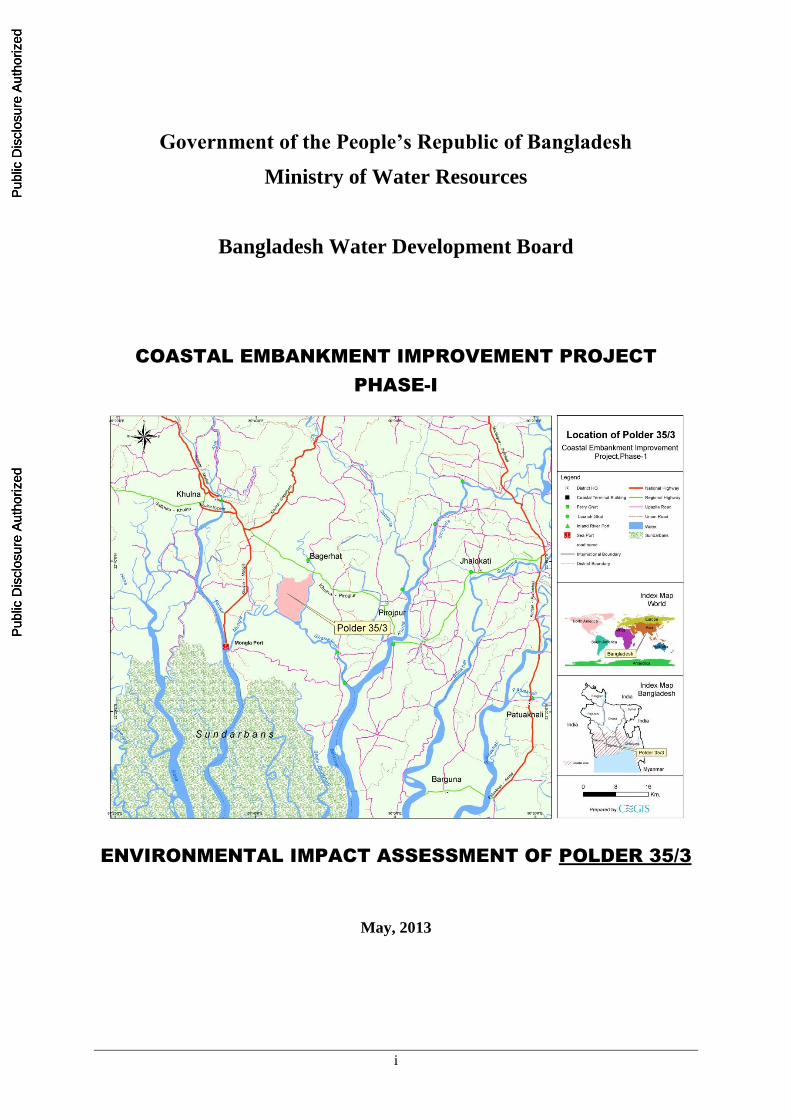
i Government of the People’s Republic of Bangladesh Ministry of Water Resources Bangladesh Water Development Board COASTAL EMBANKMENT IMPROVEMENT PROJECT PHASE-I ENVIRONMENTAL IMPACT ASSESSMENT OF POLDER 35/3 May, 2013 Public Disclosure Authorized Public Disclosure Authorized Public Disclosure Authorized Public Disclosure Authorized Public Disclosure Authorized Public Disclosure Authorized Public Disclosure Authorized Public Disclosure Authorized Public Disclosure Authorized Public Disclosure Authorized Public Disclosure Authorized Public Disclosure Authorized
-
Upload
khangminh22 -
Category
Documents
-
view
0 -
download
0
Transcript of E4141 v4 - World Bank Documents
i
Government of the People’s Republic of Bangladesh
Ministry of Water Resources
Bangladesh Water Development Board
COASTAL EMBANKMENT IMPROVEMENT PROJECT
PHASE-I
ENVIRONMENTAL IMPACT ASSESSMENT OF POLDER 35/3
May, 2013
Pub
lic D
iscl
osur
e A
utho
rized
Pub
lic D
iscl
osur
e A
utho
rized
Pub
lic D
iscl
osur
e A
utho
rized
Pub
lic D
iscl
osur
e A
utho
rized
Pub
lic D
iscl
osur
e A
utho
rized
Pub
lic D
iscl
osur
e A
utho
rized
Pub
lic D
iscl
osur
e A
utho
rized
Pub
lic D
iscl
osur
e A
utho
rized
Pub
lic D
iscl
osur
e A
utho
rized
Pub
lic D
iscl
osur
e A
utho
rized
Pub
lic D
iscl
osur
e A
utho
rized
Pub
lic D
iscl
osur
e A
utho
rized
wb452162
Typewritten Text
E4141 v4

ii
Table of Contents
Table of Contents ................................................................................................................................... ii
List of Tables xi
List of Figures ...................................................................................................................................... xiv
Abbreviations and Acronyms ............................................................................................................ xvii
Glossary ......................................................................................................................................... xx
Executive Summary ........................................................................................................................... xxii
1. Introduction............................................................................................................................ 1
1.1 Background .................................................................................................................................. 1
1.2 Need of the Project ...................................................................................................................... 1
1.3 Polder 35/3 Location and Synopsis of Rehabilitation Work ....................................................... 3
1.4 Regulatory and Policy Framework .............................................................................................. 3
1.5 Objectives of the Study ................................................................................................................ 5
1.6 Scope of Works ........................................................................................................................... 5
1.7 Structure of the Report ................................................................................................................ 6
2. Approach and Methodology ................................................................................................. 8
2.1 Overall Approach ........................................................................................................................ 8
2.2 Methodology ................................................................................................................................ 8
2.2.1 Project Area of Influence ................................................................................................. 9
2.2.2 Analysis of the Project Components and Alternatives ..................................................... 9
2.2.3 Data Collection for Environmental and Social Baseline .................................................. 9
2.2.4 Scoping ........................................................................................................................... 12
2.2.5 Assessment and Scaling of Impacts ............................................................................... 12
2.3 Assessment Methodology .......................................................................................................... 12
2.3.1 Magnitude ...................................................................................................................... 12
2.3.2 Sensitivity ....................................................................................................................... 13
2.3.3 Assigning Significance ................................................................................................... 14
2.3.4 Mitigation Measures ....................................................................................................... 14
2.3.5 Assessment of Residual Impacts .................................................................................... 15
2.3.6 Identification of Enhancement and Mitigating Measures .............................................. 15
2.3.7 Preparation of Environmental Management and Monitoring Plan................................. 15
2.3.8 EIA Report Preparation .................................................................................................. 15
3. Policy, Legal and Administrative Framework .................................................................. 16
3.1 National Environmental Laws ................................................................................................... 16
iii
3.1.1 Bangladesh Environment Conservation Act (ECA), 1995 ............................................. 16
3.1.2 Bangladesh Environment Conservation Act (ECA), (Amendments) 2010 .................... 16
3.1.3 Bangladesh Environment Conservation Rules (ECR), 1997 .......................................... 16
3.1.4 Bangladesh Environment Court Act, 2010..................................................................... 17
3.1.5 Administrative framework of DOE for clearing and monitoring of projects ................. 17
3.2 Relevant National Policies, Strategies and Plans ....................................................................... 19
3.2.1 National Environment Policy, 1992 ............................................................................... 19
3.2.2 National Environment Management Action Plan, 1995 ................................................ 19
3.2.3 NationalWater Policy, 1999 ........................................................................................... 20
3.2.4 National Water Management Plan, 2001 (Approved in 2004) ....................................... 20
3.2.5 Coastal Zone Policy, 2005 ............................................................................................. 21
3.2.6 Coastal Development Strategy, 2006 ............................................................................. 21
3.2.7 National Land Use Policy (MoL, 2001) ......................................................................... 21
3.2.8 National Agriculture Policy, 1999 ................................................................................. 22
3.2.9 National Fisheries Policy, 1996 ..................................................................................... 22
3.2.10 National Livestock Development Policy, 2007 .............................................................. 22
3.2.11 The Forest Act, 1927 & Amendment Act 2000 ............................................................. 23
3.2.12 Standing Orders on Disaster, 2010 ................................................................................. 23
3.2.13 National Adaptation Programme of Action (NAPA) ..................................................... 24
3.2.14 Bangladesh Climate Change Strategy and Action Plan (BCCSAP) 2009 ..................... 24
3.2.15 The Acquisition and Requisition of Immovable Property Ordinance, 1982 .................. 25
3.2.16 The East Bengal State Acquisition and Tenancy Act, 1950 (Revised 1994) ................. 25
3.2.17 Constitutional Right of the Tribal Peoples Rights .......................................................... 26
3.2.18 Ethnic Minority Rights in PRSP 2005 ........................................................................... 26
3.2.19 GoB Laws on Land Acquisition ..................................................................................... 27
3.2.20 Other Relevant Acts ....................................................................................................... 28
3.3 International Treaties Signed by GoB ....................................................................................... 29
3.4 Implication of GoB Polices, Acts and Rules on CEIP & Classification .................................... 31
3.5 World Bank's Environmental Safeguard Policies ...................................................................... 31
3.5.1 Environmental Assessment (OP 4.01) ........................................................................... 31
3.5.2 Natural Habitats (OP 4.04) ............................................................................................. 32
3.5.3 Water Resources Management (OP 4.07) ...................................................................... 33
3.5.4 Physical Cultural Resources (OP 4.11) .......................................................................... 33
3.5.5 Forestry (OP 4.36) .......................................................................................................... 34
3.5.6 Projects on International Waterways (OP 7.50) ............................................................. 34
3.5.7 Pest Management (OP 4.09)........................................................................................... 34
iv
3.5.8 Indigenous Peoples (OP 4.10) ........................................................................................ 34
3.5.9 Involuntary Resettlement (OP 4.12) ............................................................................... 35
3.5.10 Projects in Disputed Areas (OP 7.60) ............................................................................ 35
3.5.11 Safety of Dams (OP 4.37) .............................................................................................. 36
3.5.12 Public Disclosure of Information (BP 17.50) ................................................................. 36
3.5.13 Environment, Health and Safety Guidelines .................................................................. 36
3.6 Implications of the World Bank Policies on CEIP & Environmental Category ........................ 36
4. Description of Proposed Interventions in Polder 35/3 ...................................................... 37
4.1 Project Background ................................................................................................................... 37
4.2 Polder Overview ........................................................................................................................ 38
4.3 Objectives of Improving Polder 35/3 under CEIP- I ................................................................. 38
4.4 Water Management Problems and Issues in Polder 35/3 .......................................................... 39
4.5 Present Status of Water Management Infrastructures ................................................................ 41
4.5.1 Embankments ................................................................................................................. 41
4.5.2 Water Control Structures ................................................................................................ 41
4.5.3 Internal khals (water channels) ...................................................................................... 43
4.6 Rehabilitation/Improvement Activities in Polder 35/3 .............................................................. 44
4.6.1 Works on Embankments ................................................................................................ 45
4.6.2 Construction/Repairing of Drainage Sluices .................................................................. 46
4.6.3 Construction/Repairing of Flushing Inlets ..................................................................... 47
4.6.4 Re-excavation of Drainage Channels ............................................................................. 47
4.6.5 Bank Protection and Slope Protection Works ................................................................ 48
4.6.6 Afforestation .................................................................................................................. 48
4.7 Construction Details .................................................................................................................. 49
4.7.1 Construction Schedule ................................................................................................... 49
4.7.2 Construction Manpower Requirement ........................................................................... 58
4.7.3 Construction Material ..................................................................................................... 58
4.7.4 Construction Machinery ................................................................................................. 62
4.7.5 Construction Camps ....................................................................................................... 63
4.7.6 Vehicular Traffic during Construction ........................................................................... 63
4.7.7 Jetty Construction ........................................................................................................... 64
4.7.8 Project Implementation Arrangements ........................................................................... 64
4.7.9 Community Participation ............................................................................................... 65
4.7.10 People’s Participation of WMO/CBO ............................................................................ 65
4.7.11 Water Management Groups (WMGs) ............................................................................ 66
4.7.12 Water Management Association (WMA) ...................................................................... 66

v
4.7.13 Water Management Federation (WMF) ......................................................................... 66
4.7.14 Participation of Community Based Organizations ......................................................... 67
4.8 Operation and Maintenance Plan ............................................................................................... 67
4.8.1 Operational Plan ............................................................................................................. 68
4.8.2 Maintenance Works ....................................................................................................... 69
4.9 Need of Resettlement Action Plan (RAP) ................................................................................. 71
4.10 No Objection Certificate ............................................................................................................ 71
5. Analysis of Project Alternatives ......................................................................................... 72
5.1 ‘No Project’ Alternative ............................................................................................................ 72
5.2 Site Selection Alternatives ......................................................................................................... 74
5.3 Technical Alternatives ............................................................................................................... 83
5.3.1 Technical, Financial, Economic, Environmental, and Social Considerations of
Selected Options ................................................................................................................... 85
5.4 Alternatives during Construction ............................................................................................... 87
5.4.1 Material Storage ............................................................................................................. 87
5.4.2 Material Sources ............................................................................................................. 87
5.4.3 Alternatives for Workforce Procurement ....................................................................... 89
5.4.4 Alternatives for Mode of Transportation........................................................................ 89
6. Environmental and Social Baseline .................................................................................... 91
6.1 Land Resources .......................................................................................................................... 91
6.1.1 Topography .................................................................................................................... 91
6.1.2 Agro-ecological regions ................................................................................................. 93
6.1.3 Soil ................................................................................................................................. 95
6.1.4 Land types ...................................................................................................................... 95
6.1.5 Land use ......................................................................................................................... 95
6.1.6 Farming Practices ........................................................................................................... 97
6.1.7 Present Cropping pattern and intensity .......................................................................... 97
6.1.8 Cropped Area and Production ........................................................................................ 99
6.1.9 Crop damage ................................................................................................................ 100
6.1.10 Agricultural input use ................................................................................................... 100
6.2 Water Resources ...................................................................................................................... 102
6.2.1 River System ................................................................................................................ 102
6.2.2 Navigation in Rivers and Khals ................................................................................... 103
6.2.3 Drainage Congestion and Water Logging .................................................................... 103
6.2.4 Tropical Cyclones and Tidal Flooding ......................................................................... 104
6.2.5 Land Erosion and Sedimentation ................................................................................. 105

vi
6.3 Environmental Quality ............................................................................................................ 106
6.3.1 Air Quality ................................................................................................................... 107
6.3.2 Noise ............................................................................................................................ 107
6.3.3 Water Quality ............................................................................................................... 108
6.3.4 Surface Water Quality .................................................................................................. 109
6.3.5 Soil Quality .................................................................................................................. 111
6.3.6 Climate and Meteorology ............................................................................................. 111
6.4 Fisheries Resources ................................................................................................................. 115
6.4.1 Fish Habitat Description............................................................................................... 116
6.4.2 Fish Production ............................................................................................................ 120
6.4.3 Fishing Effort ............................................................................................................... 121
6.4.4 Fish Migration .............................................................................................................. 123
6.4.5 Fish Biodiversity .......................................................................................................... 123
6.4.6 Species of Conservation Significance .......................................................................... 124
6.4.7 Area of Conservation Significance .............................................................................. 125
6.4.8 Fish Marketing and Post Harvest Facilities .................................................................. 125
6.5 Ecological Resources ............................................................................................................... 125
6.5.1 The Bio-ecological Zone .............................................................................................. 126
6.5.2 Ecosystems ................................................................................................................... 128
6.5.3 Wildlife ........................................................................................................................ 131
6.6 Livestock and Poultry .............................................................................................................. 131
6.6.1 Feeds and Fodder ......................................................................................................... 132
6.6.2 Livestock and Poultry Diseases.................................................................................... 132
6.7 Socio-economic Resources ...................................................................................................... 133
6.7.1 Area and Location ........................................................................................................ 133
6.7.2 Demography ................................................................................................................. 133
6.7.3 Livelihood .................................................................................................................... 134
6.7.4 Quality of Life .............................................................................................................. 136
6.7.5 Poverty and Safety Nets ............................................................................................... 142
6.7.6 Social Capital ............................................................................................................... 146
6.7.7 Gender and Women ...................................................................................................... 151
6.7.8 Vulnerable Communities.............................................................................................. 152
6.7.9 Common Property Resources ....................................................................................... 152
7. Climate Change .................................................................................................................. 154
7.1 Overview ................................................................................................................................. 154
7.2 Regional Context ..................................................................................................................... 154

vii
7.3 Local Context .......................................................................................................................... 154
7.3.1 Sea Level Rise and Coastal Inundation ........................................................................ 154
7.3.2 Tidal Flooding .............................................................................................................. 155
7.3.3 Salinity Intrusion .......................................................................................................... 155
7.3.4 Cyclones and Storm Surges.......................................................................................... 157
7.3.5 Rainfall, Drainage, and Water logging ......................................................................... 158
7.3.6 River Erosion and Accretion ........................................................................................ 160
7.4 Adaptation Strategy for Climate Change Impacts in the Project Area .................................... 161
7.4.1 Adaption at Local level ................................................................................................ 161
7.4.2 Adaptation at Rehabilitation and Improvement planning ............................................ 162
8. Stakeholder Consultations and Disclosure ...................................................................... 163
8.1 Overview ................................................................................................................................. 163
8.2 Objectives of Stakeholder Consultations ................................................................................. 163
8.3 Identification of Stakeholders .................................................................................................. 164
8.3.1 Primary Stakeholders ................................................................................................... 164
8.3.2 Secondary Stakeholders ............................................................................................... 164
8.4 Approach and Methodology .................................................................................................... 164
8.5 Public Consultation Meetings and FDGs ................................................................................ 165
8.5.1 Consultation Process .................................................................................................... 165
8.5.2 Consultation Participants.............................................................................................. 167
8.6 Issues discussed in FGDs and Meetings .................................................................................. 168
8.7 Community Concerns and Suggested Solutions ...................................................................... 169
8.8 Consultations during RAP Preparation .................................................................................... 171
8.9 EIA Disclosure ........................................................................................................................ 173
8.10 Framework for Consultations during Project Implementation ................................................ 175
9. Assessment of Environmental and Social Impacts ......................................................... 177
9.1 Preamble .................................................................................................................................. 177
9.2 Impact Screening ..................................................................................................................... 180
9.3 Impacts during pre-construction Phase .................................................................................... 183
9.3.1 Damages due to Project Intervention and Land Acquisition ........................................ 183
9.3.2 Conflicts because of absence of proper land ownership legal document ..................... 187
9.3.3 Preparation of facilities for contractor and labor force ................................................ 187
9.3.4 Changes in Land Use ................................................................................................... 188
9.3.5 Fisheries ....................................................................................................................... 189
9.3.6 Increased Vehicular Traffic during Mobilization ......................................................... 190
9.3.7 Increased Inland and Waterway Traffic ....................................................................... 190

viii
9.3.8 Noise ............................................................................................................................ 191
9.3.9 Preparation of Facilities for Contractor(s) and Labor Force ........................................ 191
9.3.10 Issues Addressed during Design Phase for Polder 35/3 to Avoid Environmental
Impact ................................................................................................................................. 192
9.4 Impacts during construction Phase .......................................................................................... 192
9.4.1 Drainage congestion during replacement of drainage regulators ................................. 192
9.4.2 Loss of agriculture land ................................................................................................ 193
9.4.3 Disturbance of fish habitat and migration .................................................................... 194
9.4.4 Impacts on Benthic Fauna ............................................................................................ 194
9.4.5 Disturbance of Flora and Fauna ................................................................................... 195
9.4.6 Safety and Public Health Hazards ................................................................................ 195
9.4.7 Soil and water contamination due to wastes ................................................................ 198
9.4.8 Soil erosion................................................................................................................... 199
9.4.9 Clearing of trees ........................................................................................................... 200
9.4.10 Pollution of external surface water of the rivers .......................................................... 201
9.4.11 Noise ............................................................................................................................ 201
9.4.12 Air quality .................................................................................................................... 202
9.4.13 Hindrance and damages during mobilization and transport of construction
materials .............................................................................................................................. 203
9.4.14 Hindrance for pedestrians and vehicles movement during re-sectioning of
embankment ........................................................................................................................ 204
9.4.15 Social and gender issues ............................................................................................... 205
9.4.16 Disturbance of water way navigation ........................................................................... 205
9.5 Impacts during Post-construction Phase .................................................................................. 208
9.5.1 Risk of embankment failure ......................................................................................... 208
9.5.2 Drainage congestion and increased sedimentation in water channels and rivers ......... 208
9.5.3 Deterioration of soil fertility ........................................................................................ 209
9.5.4 Impact of tidal flooding ................................................................................................ 210
9.5.5 Reduced fish migration ................................................................................................ 211
9.5.6 Impacts on shrimp farming and livelihood................................................................... 211
9.6 Positive Impact of the Project .................................................................................................. 212
9.6.1 Employment Generation .............................................................................................. 212
9.6.2 Gender Promotion ........................................................................................................ 212
9.6.3 Livelihood Development .............................................................................................. 212
9.6.4 Affroestation ................................................................................................................ 212
9.6.5 EMP Promotion ............................................................................................................ 212
9.7 Summary of Assessed Impacts ................................................................................................ 212

ix
10. Cumulative and Induced Impact ...................................................................................... 236
10.1 Cumulative Impacts of CEIP interventions ............................................................................. 236
10.2 Other projects around polder 35/3 ........................................................................................... 236
10.3 Cumulative Impacts of other projects in the study area ........................................................... 238
10.4 Induced impacts caused by CEIP ............................................................................................ 239
10.5 Conclusion ............................................................................................................................... 242
11. Environmental Management Plan ................................................................................... 244
11.1 Objectives of EMP ................................................................................................................... 244
11.2 EMP Components .................................................................................................................... 244
11.3 Institutional Arrangement ........................................................................................................ 245
11.3.1 Overall Responsibility .................................................................................................. 245
11.3.2 Construction phase ....................................................................................................... 245
11.3.3 Post-construction Phase................................................................................................ 246
11.3.4 Need of sound O&M regime ........................................................................................ 246
11.3.5 Need of Inter-agency coordination and MoUs ............................................................. 246
11.4 Mitigation Measures& Plan ..................................................................................................... 247
11.5 Chance-Find Procedures for Physical Cultural Property ......................................................... 256
11.6 Monitoring Plan ....................................................................................................................... 256
11.7 Documentation, Record keeping and Reporting ...................................................................... 262
11.7.1 Record Keeping ............................................................................................................ 262
11.7.2 Monitoring Records ..................................................................................................... 262
11.7.3 Information Sources ..................................................................................................... 263
11.7.4 Non-Compliance Report .............................................................................................. 263
11.7.5 Monthly Internal Reports by CS .................................................................................. 263
11.7.6 Half Early Progress Report by BWDB ........................................................................ 263
11.7.7 Environmental Audit Report & Third Party Monitoring Report .................................. 263
11.8 Contractual arrangements for EMP implementation ............................................................... 264
11.8.1 Guideline to Incorporate Environmental Management in Bid Document &
Preparation of EAP ............................................................................................................. 264
11.9 Guideline for Compensation and Contingency Plan during Project Period ............................ 265
11.10 EMP Implementation Cost ................................................................................................. 265
11.11 Grievance Redress Mechanism ........................................................................................... 266
11.11.1 Grievance Redress Focal Points ................................................................................ 267
11.11.2 Grievance Resolution Process ................................................................................... 267
11.11.3 GRM Disclosure, Documentation and Monitoring ................................................... 269
11.12 Capacity Building ............................................................................................................... 269

x
References272
EIA Study Team .................................................................................................................................. 274
Annex A: Checklist for Field Survey under CEIP ........................................................................... 275
Annex B: No Objection Certificate .................................................................................................... 315
Annex C: Additional Figure ............................................................................................................... 318
Annex D: List of participants of PCM and FGD .............................................................................. 320
Annex E: TOR for Environmental Impact Assessment (EIA) of Polder 35/3 ............................... 326
Annex F: Photo Album Polder 35/3 .................................................................................................. 330

xi
List of Tables
Table 2.1: Parameters for Determining Magnitude ................................................................................ 13
Table 2.2: Criteria for Determining Sensitivity ...................................................................................... 14
Table 2.3: Assessment of Potential Impact Significance ....................................................................... 14
Table 3.1: Laws and Acts ....................................................................................................................... 28
Table 3.2: Treaty or Convention and Responsible Agency ..................................................................... 29
Table 4.1: Status of Structures and Recommendations for Improvement ............................................... 41
Table 4.2: Proposed Interventions in Polder 35/3 ................................................................................... 44
Table 4.3: Detail of Works on Embankments ......................................................................................... 45
Table 4.4: Channels to be Re-excavated ................................................................................................. 47
Table 4.5: Detail works of afforestation .................................................................................................. 48
Table 4.6: Construction Schedule ........................................................................................................... 54
Table 4.7: Required manpower for construction ..................................................................................... 58
Table 4.8: Construction Materials .......................................................................................................... 58
Table 4.9: Availability of earth in the borrow pit area ............................................................................ 59
Table 4.10: List of Construction Equipment and Machinery .................................................................. 63
Table 5.1: Comparison of ‘No Project’ and ‘With Project’ Scenarios .................................................... 72
Table 5.2: Results of Multi-criteria Analysis to Prioritize Polder Rehabilitation ................................... 75
Table 5.3: Technical Alternatives for Polder 35/3 .................................................................................. 83
Table 5.4: Technical, Economic, Environmental and Social Considerations.......................................... 85
Table 6.1: Soil texture of the project area (Polder 35/3) ......................................................................... 95
Table 6.2: Distribution of land type in the Polder area of 35/3 ............................................................... 95
Table 6.3: Present land use of the polder area ......................................................................................... 96
Table 6.4: Cropping Pattern by land type ................................................................................................ 98
Table 6.5: Cropped area, crop productions and damage in the polder area............................................ 99
Table 6.6: Present level of crop production input used within Polder 35/3 .......................................... 101
Table 6.7: Standards of ambient air quality ........................................................................................... 107
Table 6.8: Values of ambient air quality parameters in the study area ................................................. 107
Table 6.9: Daytime noise levels of the study area ................................................................................. 107
Table 6.10: Standards of Noise levels for different zones of Bangladesh ............................................. 108
Table 6.11: Water Quality in Polder 35/3 ............................................................................................. 109
Table 6.12: Groundwater Quality at Bagerhat Sadar ............................................................................ 110
xii
Table: 6.13: Pesticide Residues Analysis Reports ................................................................................ 111
Table 6.14: Fish habitat status of the study area ................................................................................... 119
Table 5.15: Fish production from different habitats of the study area .................................................. 120
Table 6.16: Fishing seasonality of the study area .................................................................................. 121
Table 6.17: Indicative fish species diversity of different fish habitats in the study areas ..................... 124
Table 6.18: List of species of conservation significance ....................................................................... 124
Table 6.19: Present Status of livestock /Poultry in Polder 35-3 ............................................................ 132
Table 6.20: Unions and Upazilas in Polder 35/3 ................................................................................... 133
Table 6.21: Demographic Data of Polder .............................................................................................. 133
Table 6.22: Age Distribution in Polder ................................................................................................. 134
Table 6.23: Main Occupation in Polder ................................................................................................ 134
Table 6.24: Employment status in Polder.............................................................................................. 136
Table 6.25: Housing condition in the study area ................................................................................... 136
Table 6.26: Source of Drinking Water in Polder ................................................................................... 138
Table 6.27: Sanitation Facilities in the Polder ....................................................................................... 139
Table 6.28: Disease Profile in the Polder .............................................................................................. 139
Table 6.29: Health service facilities in the study area ........................................................................... 140
Table 6.30: Literacy Rate at Polder 35/3 Area ...................................................................................... 141
Table 6.31: Landownership Pattern in Polder ...................................................................................... 142
Table 6.32: Annual Income and Expenditure Level ............................................................................. 144
Table 6.33: Affects of Recent Natural Disaster in Project Area ........................................................... 144
Table 6.34: Households Served by Different Social Safety Nets Programs.......................................... 144
Table 6.35: NGOs and their Programs in Project Area ......................................................................... 145
Table 6.36: Road Network in Polder ..................................................................................................... 146
Table 6.37: Traffic volume in the polder 35/3 area ............................................................................... 148
Table 6.38: Major Navigation Routes in the Area ................................................................................ 149
Table 6.39: Academic Institutions ......................................................................................................... 150
Table 6.40: Markets in Project Area ..................................................................................................... 150
Table 6.41: Common Property Places/Resources in Polder 35/3 .......................................................... 152
Table 7.1: Major Cyclones Hitting the Bangladesh Coast .................................................................... 157
Table 8.1: Consultation Details ............................................................................................................ 165
Table 8.2: Participant Details ............................................................................................................... 167
Table 8.3: Community Concerns and Suggested Solutions ................................................................. 169
Table 8.4: Consultation Meetings Held in Polder 35/3 ......................................................................... 172
Table 8.5: Participation Framework ..................................................................................................... 176
Table 9.1: Environmental and Social Screening Matrix (Unmitigated) ............................................... 182

xiii
Table 9.2: Type of Land to be Acquired in Polder 35/3 ........................................................................ 183
Table 9.3:Primary Structures to be Affected in Polder 35/3 ................................................................. 183
Table 9.4:Secondary Structures to be Affected in Polder 35/3 ............................................................. 184
Table 9.5:Common Properties to be Affected in Polder 35/3 ............................................................... 184
Table 9.6:Resettlement Budget for Polder 35/3 .................................................................................... 184
Table 9.7: Number of features displaced during establishment of labour Shade .................................. 188
Table 9.8: Loss of crop production for construction of retired embankment ........................................ 193
Table 9.8: Noise Level from Machineries ............................................................................................. 201
Table 9.9: Significance of environmental Impacts ................................................................................ 213
Table 10.1: List of other projects implemented by the GoB ................................................................. 237
Table 10.2: List of projects implemented by the NGOs ........................................................................ 238
Table 10.3: Crest level of embankments of a few polders .................................................................... 241
Table 11.1: Generic Mitigation/Compensation Measures/Guideline .................................................... 248
Table 11.2: Environmental Monitoring Plan during Construction and Operation of
Rehabilitation and Improvement of Polders System ........................................................... 257
Table 11.3: Environmental Monitoring Plan during Construction and Operation of
Afforestation ........................................................................................................................ 260
Table 11.4: Spot Checking Indicator ..................................................................................................... 261
Table 11.5: Tentative Cost Estimates for Environmental Management and Monitoring* .................... 265
Table 11.6: Environmental Trainings .................................................................................................... 270

xiv
List of Figures
Figure 1.1: Coastal Polders ....................................................................................................................... 2
Figure 1.2: Location of Polders 35/3 ......................................................................................................... 4
Figure 2.1: Overall approach of the EIA study ......................................................................................... 8
Figure 3.1: Process of obtaining Clearance certificate from DOE .......... Error! Bookmark not defined.
Figure 4.1: Alignment of the embankment and existing structures of the polder ................................... 40
Figure 4.2: Daratana river bank erosion at Bashbari ............................................................................... 43
Figure 4.3: Daratana river bank erosion at Mollikerber .......................................................................... 43
Figure 4.4: 6 vents sluice at Bara Bashbari ............................................................................................. 44
Figure 4.5: One vent sluice at Matherdia ................................................................................................ 44
Figure 4.6: 2 vents sluice at Betibunia .................................................................................................... 44
Figure 4.7: 1 vent flushing inlet at Mollikerber ...................................................................................... 44
Figure 4.8: Sayanbanki khal (Sobagi river) inside polder ....................................................................... 44
Figure 4.9: Betbunia khal ........................................................................................................................ 44
Figure 4.10: Typical Cross Section of afforestation works ..................................................................... 48
Figure 4.11 (a): Location of Proposed Interventions in Polder 35/3 (Part-1) .......................................... 50
Figure 4.11 (b): Location of Proposed Interventions in Polder 35/3 (Part2) ........................................... 51
Figure 4.11 (c): Location of Proposed Interventions in Polder 35/3 (Part 3) .......................................... 52
Figure 4.11 (d): Location of Proposed Interventions in Polder 35/3 (Part 4) .......................................... 53
Figure 4.12: Borrow pit area of Polder 35/3............................................................................................ 62
Figure 6.1: Elevation of Polder 35/3 ....................................................................................................... 92
Figure 6.2: Agro-ecological Zone (AEZ) of the Polder area ................................................................... 94
Figure 6.3: Land Use Map ....................................................................................................................... 96
Figure 6.4: View of Boro crop land in the study area ............................................................................. 98
Figure 6.5 Bishnu river western side of the polder ............................................................................... 102
Figure 6.6: Dharatana river eastern side of the polder .......................................................................... 102
Figure 6.7: Sayabankikhal (Sobagi river) .............................................................................................. 102
Figure 6.8: Betbunia khal inside the polder........................................................................................... 102
Figure 6.9: Drainage Congestion in Polder 35/3 ................................................................................... 104
Figure 6.10: Embankment damaged at Bashbaria ................................................................................. 105
Figure 6.11: Embankment of the polder at Mollikerber ........................................................................ 105
Figure 6.12: Locations of Noise, Water and Soil Quality Monitoring Stations .................................... 107
Figure 6.13: Temperature Data for Project Area ................................................................................... 112
Figure 6.14: Yearly Average Temperature in Project Area................................................................... 112
xv
Figure 6.15: Humidity Data for Polder Project Area ............................................................................ 113
Figure 6.16: Average Yearly Humidity in Project Area ........................................................................ 113
Figure 6.17: Rainfall Data for Project Area .......................................................................................... 114
Figure 6.18: Rainfall Trent in Project Area ........................................................................................... 114
Figure 6.19: Open water fish habitat in the study area (Chabagi River) ............................................... 115
Figure 6.20: Fish Habitat Classification of the study area .................................................................... 116
Figure 6.21: Distribution of fish habitat at different Union .................................................................. 117
Figure 6.22: Fish habitat and migratory routes of the study area .......................................................... 118
Figure 6.23: Natural fish habitat of the study area ................................................................................ 119
Figure 6.24: Fish culture in different types of pond .............................................................................. 120
Figure 6.25: Fish production (%) from different sources of the polder area ......................................... 121
Figure 6.26: Local fishing boat (Dinginauka) ..................................................................................... 122
Figure 6.27: Cast net (Jhakijal) ............................................................................................................. 122
Figure 6.28: Major fishes occupying the catch composition of study area fish habitats ...................... 123
Figure 6.29: Location of Polder area in Bio-ecological Zones of Bangladesh and bio-ecological
features of the Polder 35/3. .................................................................................................. 127
Figure 6.30: Typical Terrestrial Vegetation Long Profile of the Polder 35/3 ....................................... 129
Figure 6.31: Vegetation pattern along shoreline of the polder show mangrove succession .................. 131
Figure 6.32 : Livestock of the polder area ............................................................................................. 132
Figure 6.33:Poultry population in the polder area ................................................................................. 132
Figure 6.34: Trend of population in the study area ............................................................................... 134
Figure 6.35: Distribution of population by field of activity .................................................................. 135
Figure 6.36: Employment status in the polder area ............................................................................... 135
Figure 6.37: Housing Types in Polder Area .......................................................................................... 137
Figure 6.38: Jhupri house ...................................................................................................................... 137
Figure 6.39: Kutcha house..................................................................................................................... 137
Figure 6.40: Semi-Pucka House ............................................................................................................ 137
Figure 6.41: Pucka House ..................................................................................................................... 137
Figure 6.42: Housing Types in Polder Area .......................................................................................... 138
Figure 6.43: Sanitation facility in study area......................................................................................... 139
Figure 6.44: Sanitation facility in the polder area. ................................................................................ 139
Figure 6.45: Health Service Providers in Polder ................................................................................... 140
Figure 6.46: Union health and family planning sub-centre ................................................................... 141
Figure 6.47: Trend of literacy rate in the polder 35/3 area .................................................................... 142
Figure 6.48: Trend of electricity facility. .............................................................................................. 142
Figure 6.49: Land holding categories in project area ............................................................................ 143

xvi
Figure 6.50: Self Assessment of Poverty Status .................................................................................... 144
Figure 6.51: Some glimpses of social safety net programs ................................................................... 146
Figure 6.52: Muddy and soling roads in the Polder area. ...................................................................... 147
Figure 6.53: navigation in the polder area. ............................................................................................ 149
Figure 6.54: Educational Institutions in the Polder Area ...................................................................... 150
Figure 6.55: Typical Market/Bazaars in Polder 35/3 ............................................................................ 151
Figure 6.56: Scope of Decision Making by Women ............................................................................. 151
Figure 6.57: School Enrolment ............................................................................................................. 152
Figure 7.1: Changes in flooded area in Bangladesh in the 2030s and 2050s ........................................ 156
Figure 7.2: Five ppt isohaline line for different sea level rise in dry season (IWM and CEGIS,
2007) .................................................................................................................................... 157
Figure 7.3: Previous Cyclonic Storm Tracks ........................................................................................ 159
Figure 7.4: Drainage Congestion in Affected Polders due to Sea Level Rise ....................................... 160
Figure 7.5: Erosion and Accretion of Land in the Meghna Estuary from 2008 to 2010 ....................... 161
Figure 8.1: PCM in Dema UP, Bagerhat Sadar ..................................................................................... 166
Figure 8.2 Open discussion during PCM ............................................................................................. 166
Figure 8.3: Open discussion during PCM ............................................................................................. 166
Figure 8.4: FGD at Dema Union ........................................................................................................... 167
Figure 8.5: FGD at Kara Para Union .................................................................................................... 168
Figure 8.6: Meeting at Malliker Ber Union ........................................................................................... 172
Figure 8.7: Meeting at Dema Union ...................................................................................................... 172
Figure 8.8: Welcome Speech by the Project Coordinator of CEIP ....................................................... 174
Figure 8.9: Presentation of EIA findings by Team Leader of Environmental Study ........................... 174
Figure 8.10: Participants of the Workshop ............................................................................................ 174
Figure 8.11:Chief Guest delivering his speech ...................................................................................... 174
Figure 9.1: Key Potential Impacts in Polder 35/3 ................................................................................. 186
Figure 9.2: International Navigation route surrounding the polder 35/3 ............................................... 207
Figure 9.2 (a): Silted up Bishnu River .................................................................................................. 209
Figure 10.1: Locations of polders under CEIP-I ................................................................................... 237
Figure 10.2 : Satellite Image polder 35/3 .............................................................................................. 240
Figure 11.1: GRM Process Flow Chart ................................................................................................. 268

xvii
Abbreviations and Acronyms
ASA Association for Social Agency
BBS Bangladesh Bureau of Statistics
BMD Bangladesh Meteorology Department
BRDB Bangladesh Rural development Board
BRAC Bangladesh Rural Advance Committee
BUET Bangladesh University of Engineering and Technology
BWDB Bangladesh Water Development Board
CCP Chittagong Coastal Plain
CDS Coastal Development Strategy
CEGIS Center for Environmental and Geographic Information Services
CEIP Coastal Embankment Improvement Program
CEIP-I Coastal Embankment Improvement Project, Phase I
CERP Coastal Embankment Rehabilitation Project
CES Consulting Engineering Services
CZPo Coastal Zone Policy
DAE Department of Agricultural Extension
DevCon Dev Consultants Ltd
DOE Department of Environment
DPHE Department of Public Health engineering
DPM Design Planning & Management Consultants
DTW Deep Tubewell
EA Environment Assessment
ECA Environment Conservation Act
ECC Environmental Clearance Certificate
ECR Environment Conservation Rules
ECRRP Emergency 2007 Cyclone Recovery and Restoration project
EDS Environmental Data Sheet
EIA Environmental Impact Assessment
EMF Environmental Management Framework
EMP Environmental Management Plan
ES Environmental Screening
ESBN Estuarine Set Bag Net
FAO Food and Agriculture Organization
FGD Focus group Discussion
xviii
FRSS Fisheries Resources Survey System
FWIP Future-with-Project
FWOP Future-without-Project
GIS Geographical Information System
GO Government Organization
GTPE Ganges Tidal Plain East
GTPW Ganges Tidal Plain West
ha hactare
HTW Hand Tubewell
HYV High Yielding Variety
IDA International Development Association (World Bank)
IEE Initial Environmental Examination
IESCs Important Environmental and Social Components
IS Institutional Survey
IUCN International Union for Conservation of Nature
KAL Kranti Associates Ltd Bangladesh
KII Key Informant Interview
KJDRP Khulna-Jessore Drainage Rehabilitation Project
LLP Low Lift Pump
MC Main Consultant (for CEIP-I Feasibility study)
MDP Meghna Deltaic Plain
MOEF Ministry of Environment and Forest
MOWR Ministry of Water Resources
MSL Mean Sea Level
NCA Net Cultivated Area
NGO Non-Governmental Organization
NOC No Objection Certificate
NWRD National water Resources database
O&M Operation and Maintenance
PAP Project Affected Person
PCM Public Consultation Meeting
PCD Project Concept Document
PID Project Information Document
PIO Project Implementation Office
PL Post Larva (fish seed)
PRA Participatory Rural Appraisal

xix
PRSP Poverty Reduction Strategy Paper
RCB Reinforced Concrete Box
RRA Rapid Rural appraisal
SEA Strategic Environmental Assessment
SEO Secondary Education Office
SLR Sea Level Rise
SRDI Soils Resources Development Institute
SSO Social Service Office
STW Shallow Tubewell
TDS Total Dissolved Solids
TOR Terms of Reference
UFO Upazila Fisheries Office
UNDP United Nations Development Program
VGD Vulnerable Group Development
VGF Vulnerable Group Feeding
WAO Women Affairs Office
WARPO Water Resources Planning Organization
WMIP Water Management Improvement Project
WB World Bank
WMO Water Management Organization
YDD Youth Development Department

xx
Glossary
Aila: Major Cyclone, which hit Bangladesh coast on May 25, 2009
Aman: Group of rice varieties grown in the monsoon season and harvested in the post-
monsoon season. This is generally transplanted at the beginning of monsoon from
July-August and harvested in November-Dec. Mostly rain-fed, supplemental
irrigation needed in places during dry spell.
Arat: Generally an office, a store or a warehouse in a market place from which Aratdar
conducts his business.
Aratdar: Main actor act as a wholesaler or commission agent or covers both functions at the
same time; carries out public auctions and is the main provider of credit in the
marketing chain.
Aus: Group of rice varieties sown in the pre-monsoon season and harvested in the monsoon
season. These are broadcasted/transplanted during March-April and harvested during
June-July. Generally rain-fed, irrigation needed for HYV T. Aus.
B: When preceding a crop means broadcast (B. Aus)
Bagda: Shrimp (Penaeus monodon), brackish/slightly saline water species.
Baor: Baor dead arm of a river in the Moribund Delta as in the case of the Ganges; also
called oxbow lake. It appears as a saucer shaped depression. The term baor is
synonymous to beel, familiar in the southwestern part of Bangladesh.
Bazar: Market
Beel: A saucer-shaped natural depression, which generally retains water throughout the
year and in some cases seasonally connected to the river system.
Bepari: Middleman in the marketing chain who transports the products to the other places,
use of term depends on the location, sometimes also used synonymously with retailer.
Boro: A group of rice varieties sown and transplanted in winter and harvested at the end of
the pre-monsoon season. These are mostly HYV and fully irrigated, planted in
December-January and harvested before the onset of monsoon in April- May.
Charland: The chars, otherwise know as charlands, are riverine lands located in the active river
basins of the main rivers of Bangladesh. They are located on the banks of the river
and islands in the mid-steam of the main channel that are created by the continual
shifting of these rivers and emerge from the deposition of sand and silt from upstream
Faria: Local trader/agent/intermediary.
Golda Prawn (Macrobrachium rosenbergii), non-saline/fresh water species
Gher Farm lands converted into ponds with low dykes and used for cultivation of
shrimp/prawn/fish.
Haor: A back swamp or bowl-shaped depression located between the natural levees of rivers
and comprises of a number of beels.
Haat: Market place where market exchanges are carried out either once, twice or thrice a
week, however not every day.
xxi
Jaal: Different types of fishing net to catch fish from the water bodies.
Jolmohol: Section of river, individual or group of beels (depression), or individual pond owned
by the government but leased out for fishing. They are also called Jalkar, or Fishery.
Jhupri: Very small shed for living, made of locally available materials. One type of houses
used by very poor community members.
Kacha: A house made of locally available materials with earthen floor, commonly used in the
rural areas.
Khal: A drainage channel usually small, sometimes man-made. The channel through which
the water flows. These may or may not be perennial.
Kharif: Pre-monsoon and monsoon growing season. Cropping season linked to monsoon
between March-October, often divided into kharif-1 (March-June) and kharif-2 (July-
October).
Kua/Kuri: This is a small ditch in agricultural farm that retain water during dry period. Also
used as fish-trap. This also refers to deeper sites in the beel areas wherein the water is
retained all through the year including the dry periods. These are sites for the natural
spawning of native fishes.
Kutcha Toilet: The earthen made latrine consist of a hole without cover.
Mahajan: Powerful intermediary in the value chain or traditional money lender.
Perennial Khal: Water available in the khal all the year round.
Pacca: Well constructed building using modern masonry materials.
Rabi: Dry agricultural crop growing season; mainly used for the cool winter season between
November and February.
Ring Slab: The simple pit latrine consists of a hole in the ground (which may be wholly or
partially lined) covered by a squatting slab or seat where the user defecates. The
defecation hole may be provided with a cover or plug to prevent the entrance of flies
or egress of odor while the pit is not being used.
Seasonal Khal: Water not available in the khal all the year round.
Sidr: Major Cyclone, which hit Bangladesh coast on November 15, 2007.
T. Aman: When preceding a crop means transplanted (T. Aman).
Upazila: Upazila is an administrative subdivision of an district.
Water sealed: A water sealed latrine is simply a pit latrine that has a water barrier to prevent odors.
These latrines are simply pits dug in the ground in which human waste is deposited. A
water sealed latrine has a bowl fixture that has a set amount of water retained in it. It
is operated on the pour to flush system. These types of latrines can be connected to a
septic tank system.

Coastal Embankment Improvement Project, Phase-I (CEIP-I) Bangladesh Water Development Board
Environmental Impact Assessment Executive Summary
Polder 35/3 - xxii
Executive Summary
The Government of Bangladesh (GoB) is planning to implement the Coastal Embankment
Improvement Project, Phase I (CEIP-I), under which seventeen polders will be rehabilitated and
improved in the coastal area of the country. The GoB is seeking financial assistance from the World
Bank (WB) for this Project. In accordance with the national regulatory requirements and WB
safeguard policies, Environmental Impact Assessments (EIAs) of the first batch of five polders have
been carried out. This document presents the EIA report of Polder 35/3, which is one of these five
polders.
Background
The coastal zone in southern Bangladesh adjoining the Bay of Bengal is characterized by a delicately
balanced natural morphology of an evolving flat delta subject to very high tides and frequent cyclones
from the Bay of Bengal encountering very large sediment inflows from upstream. The coastal zone,
in its natural state, used to be subject to inundation by high tides, salinity intrusion, cyclonic storms
and associated tidal surges. In 1960s, polderization was started in the coastal zone of the Country to
convert this area into permanent agricultural lands. The polders in this area are enclosed on all sides
by dykes or embankments, separating the land from the main river system and offering protection
against tidal floods, salinity intrusion and sedimentation. The polders were designed to keep the land
safe from regular tides and allow agriculture activities. These polders are equipped with in- and outlet
sluice gates to control the water inside the embanked area.
The polders were originally designed without proper attention to storm surges. Recent cyclones
caused substantial damage to the em7bankments and further threatened the integrity of the coastal
polders. In addition to breaching of the embankment due to cyclones, siltation of peripheral rivers
surrounding the embankment caused the coastal polders to suffer from water logging, which lead to
large scale environmental, social and economical degradation. Poor maintenance and inadequate
management of the polders have also contributed to internal drainage congestion and heavy external
siltation. As a result, soil fertility and agriculture production in some areas are declining because of
water logging and salinity increase inside the polders.
The above reasons have led the Government to re-focus its strategy on the coastal area from one that
only protects against high tides to one that would provide protection against frequent storm surges as
well. The long term objective of the Government is to increase the resilience of the entire coastal
population to tidal flooding as well as natural disasters by upgrading the whole embankment system.
With an existing network of nearly 5,700 km long embankments in 139 polders, the magnitude of
such a project is daunting and requires prudent planning. Hence a multi-phased approach of
embankment improvement and rehabilitation will be adopted over a period of 15 to 20 years. The
proposed CEIP-I is the first phase of this long term program.
Location and Synopsis of Rehabilitation Work
The polder 35/3 is located in two upazilas namely, Rampal and Bagerhat Sadar of Bagerhat District of
Bangladesh. The administrative and management control lies with Bagerhat O&M Division, BWDB
Bagerhat under Khulna Operation and Maintenance (O&M) circle, and BWDB Khulna under
southwestern zone. The Polder covers a gross area of 6,790 ha of which net cultivable area is 5,090
ha. The Project aims to enhance protection against natural disasters, increase resilience during and
after such disasters, and improve agricultural production by reducing saline water intrusion. To meet
these objectives, the following key improvement and rehabilitation works will be carried out in Polder
35/3 under CEIP-I are: re-sectioning of embankment (35 km); construction of retired embankment

Coastal Embankment Improvement Project, Phase-I (CEIP-I) Bangladesh Water Development Board
Environmental Impact Assessment Executive Summary
Polder 35/3 - xxiii
(5.05 km); construction of four drainage sluices; construction of ten flushing inlets; re-excavation of
drainage channels (23.50 km); bank protection works (1.70 km); slope protection of embankment
(0.90 km) and afforestation on the foreshore areas (26 ha) Other components of the CEIP-I will
include implementation of social action plan and environmental management plan; supervision,
monitoring and evaluation of Project impacts; project management, technical assistance, trainings,
and technical studies; and contingent emergency response.
The Bangladesh Water Development Board (BWDB) is the implementing agency of this Project.
Regulatory and Policy Framework
The Bangladesh Environment Conservation Act, 1995 (amended in 2002), requires that all
development projects shall obtain environmental clearance from the Department of Environment
(DoE), Ministry of Environment and Forest (MoEF). Similarly, the World Bank’s environmental
safeguard policies require an environmental assessment to be carried out for projects being considered
for its financing. The present EIA fulfills both of these requirements.
Under the Environmental Conservation Rules (1997) a classification system has been established for
development projects and industries on basis of the project objective. These categories include Green,
Orange A, Orange B, and Red. The construction, reconstruction, expansion of polders and flood
control embankment is categorized as Red in accordance with the DoE‘s classification. For ‘Red’
category projects, it is mandatory to carry out an Environmental Impact Assessment (EIA) including
Environmental Management Plan (EMP) and where necessary develop a Resettlement Plan for getting
environmental clearance from DoE. According to the World Bank safeguard policies, the project has
been classified as Category A, in view of high risk associated with widely involved major civil works
in the Project and also considering the high ecological sensitivity and vulnerability of the coastal area.
Alternative Analysis
Several alternatives were considered during the design phase of the project. These included ‘no-
project’ alternative and technical alternatives.
The present situation of the polder is extremely vulnerable to cyclones, storm surges, wave action, and
climate change effects, and the Polder is not in a state to provide required services particularly
protection against tidal inundation, efficient drainage, and minimizing the impact of cyclonic surges.
A significant proportion of the Polder area is vulnerable to salinity intrusion and water logging. Due
to high salinity and scarcity of ground water during the periods of low rainfall, a very limited area is
under irrigation. The silted up water channels are resulting in limited navigation in their waterways,
declining fisheries, and increasing environmental pollution. The proposed interventions under CEIP-I
have been designed to address the above mentioned problems of the Polder. If proposed interventions
are not implemented, the present poor state of the Polder will continue and may further deteriorate;
therefore the ‘no-project’ alternative is not a recommended option.
Several technical alternatives were considered to address each of the problems being faced in the
Polder. These included alternatives for embankment strengthening, river bank protection works,
protection of embankment slopes, replacement of drainage sluices, rehabilitation of flushing sluices,
addressing water logging and drainage congestion.
Baseline Condition
The Polder 35/3 is located in the southwest region of Bangladesh near Sundarban. Topographically,
this area is flat and developed by sedimentation process by the three mighty rivers of the country. The
polder area is crisscrossed by a large number of creeks. The total area is basically flat with the central

Coastal Embankment Improvement Project, Phase-I (CEIP-I) Bangladesh Water Development Board
Environmental Impact Assessment Executive Summary
Polder 35/3 - xxiv
part a bit higher than the surrounding land. Administratively, the Polder 35/3 covers part of Bagerhat
Sadar Upazila under Bagerhat district.
As a part of land resources appraisal of Bangladesh for agricultural development, the country has been
subdivided into 30 agro-ecological regions and 88 sub-regions. The key parameters on the basis of
which this classification has been carried out include physiography, soil properties, soil salinity, and
depth and duration of flooding. These parameters are relevant for land use and the assessment of
present and future agricultural potential. The Polder 35/3 lies in agro-ecological zone of the Ganges
Tidal Floodplain.
The soil texture varies from clay to clay loam in the Polder 35/3. Non-calcareous grey floodplain soil
is the major soil type in the Polder. Acid sulfate soils also occupy significant part of the area where it
is extensively acidic during dry season. In general, most of the top soils are acidic and sub-soils are
neutral to mildly alkaline.
In the polder area, about 24%, 69% and 7% of the net cultivable lands falls under High land, Medium
high land and Low land respectively. The soils possess low to very high condition in the dry season
and soil salinity level and pH ranges from 4.9-18ds/m and 5.2-7.6 respectively. Rice is dominant crop
in the polder area. The coverage of rice area is about 85% of the NCA. The Annual rice production is
about 11,658 metric ton in the polder area. Non rice crop production is about 9170 metric tons. The
overall cropping intensity in the study area is about 130%.
Sedimentation is a major problem in the polder area. Sedimentation in most of the internal khals
caused rise of bed level and reduced the conveyance capacity of the khals. Tidal motion dominates
during pre-monsoon and post-monsoon in the polder area. Water logging exists during the dry period
in the Polder due to rise in ground water table along with reduced run-off and infiltration. In the
Polder, Kashimpur, Kalia under the Dema union and some parts of Malliker ber is affected by water
logging problems.
The climate of the project area is tropical in nature with three seasons. The trend analysis shows that
the average temperature during monsoon is about 260C and average annual monsoon rainfall is about
1,390 mm. As per classification of seismic zone of Bangladesh, the polder 35/3 area falls under Zone-
III, which is characterized by low earthquake prone areas. Air pollution is not of much significance in
the coastal area of Bangladesh. The measured air quality parameters (SPM, SOx, NOx) lie within the
range of standard values for Bangladesh.
Estimated total fish production of the polder area is about 3,630 MT. Bulk of the inland fish
production (3,357 MT) is coming from culture fisheries while the rest comes from capture fisheries
habitats. Fish production trend from capture fisheries is declining. Perennial Khals such as Putimari
khal, Betbunia khal along with other seasonal internal khals are used as feeding and shelter ground of
most of the open water fishes. These khals are marked as the area of conservation significance.
Polder 35/3 falls under Ganges Floodplains and the Saline Tidal Floodplain Bio-ecological Zones.
Mangrove and aquatic ecosystems support different aquatic life-forms for their survival. In general,
brackish water ecosystem is dominant in the polder area. The Project area supports different types of
habitats with many species of flora and fauna including globally and nationally threatened shore birds
and other wildlife species. The composition of plant species in the homestead are: Narikel (Cocos
nucifera), Supari (Areca catechu), Kafila (Lanea coromandelica), Neem (Azadirachta indica), Khejur
(Phoenix sylvestris), Taal (Borassus flabeliffer), Kola (Musa Spp.), Kanthal (Artocarpus
heterophyllus), Sisoo (Dalbergia sisoo), Arjun (Terminalia arjuna ), Rain tree ( Samanea saman) and
Bansh (Bambusa Spp.). The aquatic floral species observed frequently within the project area are
Shapla/Shaluk (Nymphaea Spp.), Padma (Nelumbo nucifera), Kachuripana (Eichhornia crassipes),

Coastal Embankment Improvement Project, Phase-I (CEIP-I) Bangladesh Water Development Board
Environmental Impact Assessment Executive Summary
Polder 35/3 - xxv
Kolmi (Ipomoea fistulosa), Dhol Kolmi (Ipomoea fistulosa), Khudipana (Lemna Sp.),Topapana
(Pistia strateotes), Kutipana (Azolla Sp), etc. Indian Pond Frog (Euphlytis haxadactylus), White-
breasted Waterhen (Amaurornis phoenicurus), Great Egret (Casmerodius albus), Little Egret (Egretta
garzetta), Indian Pond Heron (Ardeola grayii) are common among the fauna. Gangetic River Dolphin
(Platanista gangetica) is available in the surrounding rivers.
The population in the Polder 35/3 is about 27,494 of which 13,660 are males and 13,834 females. A
total of 6,668 households exist in the polder area. The density of population is about 1,016 persons per
square kilometer. Overall status of drinking water in the area is generally satisfactory. Most of the
people can collect drinking water from tube well. In the polder area, about 60 percent households
have hygienic sanitation facility (water-sealed). There is no hospital in the study area. However, there
are two community clinics in Dema union and another two in Molliker Ber union. Different types of
roads exist within the Polder for communication of local people. Most of the internal roads are
earthen followed roads brick soled, paved. There are no known historical and archeological sites
declared by government in the Polder area.
Consultation and Disclosure
A number of public consultation meeting were conducted with the participation of local people,
representatives of local government (Union Parishad) and BWDB’s representatives. Local people
showed interest to the project implementation for their existence. They have no objection to
implement the project. They also expressed that if the monitoring plan is implemented properly during
the pre-construction, construction, post-construction and operation period, the local people within the
polder area would help the implementing agency spontaneously. The national level consultation has
been carried out at the end of February in 2013 in presence of Department of Environment, other
Government Institutions, local and national Non Government Organizations. The findings of National
level workshop have been incorporated in the report.
Potential Impacts and their Mitigation
Significant environmental and social impacts are likely to be caused by various activities during
Project phases. The major environmental factors to be impacted of the polder are classified as High,
Moderate and Low. The high impacted environmental factors are: 15 hectares of land will be acquired
for rehabilitation work; due to land acquisition, 113 households will lose their land within the polder
area. During establishing and constructing site facilities in the Polder may potentially cause air and
water contamination, noise generation. Land use pattern in the polder area will be changed temporary
during construction of labor sheds, contractor’s office and material stock yard. Four household, two
shops will be affected during construction labour sheds.
The potential environmental and social impacts associated with the pre-construction phase of the
project include loss of agricultural land, loss of biomass, siltation due to loose soil, air and noise
pollution, change in landscape, displacement of people, and psychological impact on people who have
to change livelihood. Among these, the impacts associated with acquisition of about 15 ha of land are
of foremost significance. The activities will acquire 4.26 ha of single cropped field, 0.81ha of double
cropped field, and 0.6 ha of orchard. It is estimated that about 246 matured trees will be affected for
construction of drainage sluice and flushing sluice. Of these 176 trees are on the country side and 70
trees are on the river side. Establishing the contractor’s temporary site facilities may involve land
clearing, land leveling, excavation, and construction of buildings. It is also observed that the project
will require to cut more than 20000 trees of which are mainly small. These trees are planted under
Foresdt Department and NGO’s afforestation plan. BWDB needs to ensure consultation with NGOs,
local people and Forest Department before uprooting the trees. The potential impacts during the
Coastal Embankment Improvement Project, Phase-I (CEIP-I) Bangladesh Water Development Board
Environmental Impact Assessment Executive Summary
Polder 35/3 - xxvi
construction phase include air pollution, noise pollution, degradation of landscape, soil erosion, water
contamination, increased siltation in water bodies, loss of agriculture, damage to fish and other
aquatic fauna, traffic congestion, and safety hazards. The key construction activities that are likely to
cause these environmental and social impacts include construction camp establishment and operation,
equipment and material transportation, material borrowing, excavation, embankment raising,
dismantling, repair and construction of regulators, re-excavation of water channels, and waste
disposal. The project works on the regulators in the area Betbonia Khal, Sayabanki Khal and
Mogordhara Khal, are likely to worsen the situation and exacerbate the water logging problem.
Furthermore, Bansbaria, Kalia and Kashimpur area will face major drainage congestion problem and
create water logging during post monsoon season. After completion of construction activities, this
temporary water logging will disappear. The fish species including Paisa, Betki, Horina Chingri,
Khorsula, and Chatka Chingri are reported to move between the internal khals and beel during
breeding season (mid May to July). During construction activities, the fish migration between the
outside rivers and internal khals is likely to be affected. The spawning time for open water fish in the
khals is late June to August. Similarly, fish migration within the Polder between khals and beels can
also be affected by the construction activities particularly the khal re-excavation. In addition to health
and safety hazard due to heavy construction material tiger is another threat for the construction labors.
The construction workers are likely to be exposed to this hazard during the construction phase. The
work will be performed in congested residential areas, the construction materials; debris from
demolition of structures, dredged material will be well protected.
The polder 35/3 is located besides the international route Mongla- Ghasiakhali (Figure 9.2). Now the
route is active during high tide, but during low tide no vessels and ships can move through this way
due to low height water level. Mongla to Ghasiakhali navigation route is one of the important
segments of navigation route that joins the Mongla sea port and Khulna with the rest of the country.
This route is the part of Indian Protocol Route and most importantly export and import of bulk goods
from India that uses inland navigation also uses this route. Traffic is increasing in this route. The route
is 31 km in length from the Pussur River at Mongla to the Mongla-Gahsiakhali (M-G) Canal. The cut-
down of the tidal prism due to the construction of Polder 35/3 has already occurred. Strengthening of
this polder may not have any significant effects on the surrounding rivers or Mongla-Ghasiakhali
route. But if the, upstream flow is not ensured by the Gorai-Modhumoti river then the navigation
route will lose their navigability.
The social impacts include social unrest due to conflict between local labour and outside labour, The
presence of outside labor can potentially disrupt the privacy of the local population particularly
women whose mobility can be negatively affected.
The potential impacts during operation phase include soil and water contamination associated with
increased usage of fertilizers and hindrance in fish migration. Rain cuts and public cuts are the major
causes of embankment breaching of the Polder 35/3. Lack of regular maintenance has creates weak
point at the sensitive locations of the embankment. Mal-maintenance and increasing intensity and
magnitude of the cyclone and storm surge simultaneously have accelerated the risk of embankment
failure. Mal-operation and leakage of regulators will result in salinity intrusion during the low flow
season, causing severe damage to the soil, water resources, and crops in the Polder. Construction of
new water control structures on water channels which are currently directly connected with the outer
rivers will potentially result in reduction in fish migration.
To address the involuntary resettlement issues arising from acquisition of 97 ha of land and loss of
other private and or community structures, a resettlement action plan (RAP) has been prepared. The
RAP defines the entitlement criteria and estimates the total compensation to be paid to the affected
people. To address the impacts associated with material and equipment transportation and traffic

Coastal Embankment Improvement Project, Phase-I (CEIP-I) Bangladesh Water Development Board
Environmental Impact Assessment Executive Summary
Polder 35/3 - xxvii
congestion, the contractor will prepare and implement a traffic management plan, which will ensure
that sensitive receptors such as schools and busy markets and bazaars are avoided during the peak
hours. To address the air and water pollution, contractor will prepare and implement a pollution
control plan. Similarly, to address the safety and public health concerns, the contractor will prepare
and implement an occupational health and safety plan.
On the positive aspect, the construction work will generate a significant opportunity of employment
over its construction period to local people and other associated professionals. People will also be
involved to carry out operation and maintenance related jobs to operate the hydraulic structures. It is
expected that the agriculture production will be increased; water logging will be decreased for the
project which will create jobs indirectly from agriculture, business and commercial services.
Environmental Management Plan
The environmental management plan (EMP) provides the implementation mechanism for the
mitigation measures identified during the present EIA. A comprehensive EMP which focuses on
managing construction phase-related impacts should suffice in managing the potential construction
and operation phase impacts. The EMP will be attached with the Bidding Document. The
environmental management parameter will be included in the BoQ. Since most of the contractors do
not have clear understanding on the need of environmental management, some tend to quote very low
price for implementation of EMP and eventually cannot implement EMP as per design. To avoid this
problem, Fixed Budget will be assigned for EMP implementation. The contractors may need
orientation on the requirement of the EMP in the pre-bidding meeting. The total cost of EMP
implementation for Polder 35/3 has been estimated as BDT 32.4 million (without Training and Field
trip costing).The contractor needs to submit an Environmental Action Plan (EAP) based on the EIA
and EMF in line with the construction schedule and guideline. The EAP needs to be reviewed by the
supervision consultant and cleared by BWDB and World Bank.
Extensive monitoring of the environmental concerns of the Polder 35/3 will be required as per World
Bank guideline. The monitoring program will help to evaluate: (i) the extent and severity of the
environmental impacts against the predicted impacts and baseline; (ii) the performance of the
environmental protection measures or compliance with pertinent rules and regulations; (iii) trends in
impacts; and (iv) overall effectiveness of the project environmental protection measures. The
monitoring plans will be included in the EMP for specific sub-projects. Moreover, for all type of
monitoring, a comprehensive database of the polder specific Environmental Impact and
Monitoring information will be created, which will help to evaluate the impacts easily.
Furthermore, EMP identifies capacity building needs with respect to environmental management of
the Project, in addition to defining reporting and record keeping protocol.
Impacts on Near by Area
Polder 35/3 is located downstream of the Poylahara river (Poylahara river is generated from the
converging point of Daratana river and Katakhali khal, the two peripheral rivers of Polder 35/3).
When sea water enters through Baleswar River during dry periods or due to tidal flow or rise in
cyclonic surge, water would not be able to enter Polder 35/3 because of its high crest level. The
embankments may be damaged; water may overtop the embankment and cause flooding during
monsoon or due to rise in surge height.
The existing crest level of polder 34/3 is low (4.27m above sea level), and in many locations the
embankment crest has even merged with the ground. As the construction procedures for Polder 34/3
is not in consideration under CEIP-I, no cumulative impacts are considered from Polder 34/3 for the
time being.

Coastal Embankment Improvement Project, Phase-I (CEIP-I) Bangladesh Water Development Board
Environmental Impact Assessment Executive Summary
Polder 35/3 - xxviii
Sedimentation in smaller water bodies namely Katakhali khal, Putimari river may cause
regular drainage congestion problems. The navigability of rivers may further deteriorate over the
years. Siltation in the rivers or water bodies outside the polder would cause drainage congestion on a
more frequent basis. The smaller lakes and rivers facing east-west direction i.e. Putimari river,
Katakhali khal etc. would undergo frequent congestion. Especially during low tides, Katakhali khal in
the southern periphery of Polder 35/3 gradually becomes very shallow.
Institutional Responsibility and Report Requirement
The contractor is responsible for implementation of EMP during construction works and Project
Supervision Consultant is primarily responsible for supervision of the implementation of the EMP.
BWDB will conduct field inspections and surveys by the environment specialist (to be employed by
BWDB on regular basis) at field. S/he will report to the Senior Environment Specialist at Head
Quarter. The M&E consultant will be responsible for independent monitoring and implementation of
EMP, and external monitoring and evaluation. DoE will be consulted if complicated issues arise
during construction and operation stages. BWDB will apply for annual site clearance from DoE.
WMOs will be trained up to ensure environmental management during project operation.
Environmental Management Unit of BWDB, strengthened through this project, will ensure and
oversee the environmental management during project operation.
BWDB will prepare the Half Yearly Progress Report on environmental management and will share
with World Bank for review. Contributing development partners (if any) may join the field visit to
understand the environmental compliance of the project. In addition, the effectiveness of screening,
monitoring and implementation of EMP will be carried out by the third party monitoring firm along
with the project component activity monitoring annually. The Annual Environmental Audit Report
prepared by the third party monitoring firm will be shared with the safeguards secretariat.
The Environment, Social and Communication Unit (ESC) to be established to implement and manage
the EMP will be structured to provide co-ordination, technical support and services during the
environmental screening and preparation of EA, and implementation of the environmental mitigation
measures. At least one of the two environmental specialists must be on board before effectiveness of
the project. The specialists will prepare subproject specific environment screening/assessment report
with EMP, supervise the implementation of EMP and support capacity building of the field level staff
of BWDB and contractor. ESC will ensure quality of the environmental screening/assessment with
EMP.

Coastal Embankment Improvement Project, Phase-I (CEIP-I) Bangladesh Water Development Board
Environmental Impact Assessment Chapter 1: Introduction
Polder 35/3 - 1
1. Introduction
1.1 Background
The Government of Bangladesh (GoB) is planning to implement the Coastal Embankment
Improvement Project, Phase I (CEIP-I), under which seventeen polders will be rehabilitated and
improved in the coastal area of the country. The GoB is seeking financial assistance from the World
Bank (WB) for this Project. In accordance with the national regulatory requirements and WB
safeguard policies, Environmental Impact Assessments (EIAs) of the first batch of five polders have
been carried out. This document presents the EIA report of the Polder 35/3, which is one of these five
polders. The remaining four EIA reports are presented under separate covers.
Bangladesh is a low lying country. The coastal zone in southern Bangladesh adjoining the Bay of
Bengal is characterized by a delicately balanced natural morphology of an evolving flat delta subject
to very high tides and frequent cyclones coming from the Bay of Bengal encountering a very large
volume of sediment inflowing from upstream. The strength of the tides and the flatness of the delta
causes the tides to influence river processes a long way upstream in the southern estuaries. This entire
area is called the coastal zone. The coastal zone, in its natural state, used to undergo to inundation by
high tides, salinity intrusion, cyclonic storms and associated tidal surges.
In 1960s, polderization was started in the coastal zone of the country to convert the area into
permanent agricultural lands (see Figure 1.1 for coastal polders). The polders in this area are enclosed
on all sides by dykes or embankments, separating the land from the main river system and protecting
against tidal floods, salinity intrusion and sedimentation. The lands inside the polders are slightly
higher than sea level. The polders were designed to keep the land safe from the daily tides and allow
agriculture activities inside the polder. Without embankments the coastal communities would be
exposed to diurnal tidal fluctuations. These polders are equipped with in- and outlet sluice gates to
control the water inside the embanked area.
1.2 Need of the Project
The coastal embankment system of Bangladesh was originally designed without significant attention
to storm surges. Recent cyclones brought substantial damage to the embankments and further
threatened the integrity of the coastal polders. In addition to breaching of the embankment due to
cyclones, siltation of peripheral rivers surrounding the embankment caused the coastal polders to
create water logging resulting a large scale environmental, social and economical degradation. Poor
maintenance and inadequate management of the polders have also contributed internal drainage
congestion along with salinity intrusion and heavy external siltation. As a result, soil fertility and
agriculture production are declining in some areas inside the polders.
The above reasons have led the Government to re-focus its strategy on the coastal area from one that
only protects against high tides to one that would provide protection against frequent storm surges as
well. The long term objective of the Government is to increase the resilience of the entire coastal
population to tidal flooding as well as natural disasters by upgrading the whole embankment system.
With an existing network of nearly 5,700 km long embankments in 139 polders, the magnitude of
such a project is daunting and requires prudent planning. Hence a multi-phased approach of
embankment improvement and rehabilitation will be adopted over a period of 15 to 20 years. The
proposed CEIP-I is the first phase of this long term program.

Coastal Embankment Improvement Project, Phase-I (CEIP-I) Bangladesh Water Development Board
Environmental Impact Assessment Chapter 1: Introduction
Polder 35/3 - 2
Figure 1.1: Coastal Polders

Coastal Embankment Improvement Project, Phase-I (CEIP-I) Bangladesh Water Development Board
Environmental Impact Assessment Chapter 1: Introduction
Polder 35/3 - 3
1.3 Polder 35/3 Location and Synopsis of Rehabilitation Work
The Polder 35/3 is located in two upazilas namely, Rampal and Bagherhat Sadar under Bagerhat
District of southern Bangladesh (see Figure 1.2). The Polder covers a gross area of 6,790 ha of which
net cultivable area is 5,090 ha. The Project aims to enhance protection against natural disasters,
increase resilience during and after such disasters, and improve agricultural production by reducing
saline water intrusion. To meet up these objectives, the following key improvement and rehabilitation
works will be carried out in Polder 35/3 under CEIP-I:
Re-sectioning of embankment : 35.00 km
Construction of retired embankment : 5.05 km
Construction of drainage sluice : 4
Construction of flushing inlets : 10
Re-excavation of drainage channels : 23.50 km
Slope protection of embankment : 0.90 km
Bank protection works : 1.70 km
Afforestation on the foreshore areas : 6.54 ha
Other components of the CEIP-I will include implementation of social action plan and environmental
management plan; supervision, monitoring and evaluation of project impacts; project management,
technical assistance, trainings, and technical studies; and contingent emergency response.
The Bangladesh Water Development Board (BWDB) is the implementing agency of the Project.
Detail information of the Project are presented in the later part of the document.
1.4 Regulatory and Policy Framework
The Bangladesh Environment Conservation Act, 1995 (amended in 2002), requires that all
development projects shall obtain environmental clearance from the Department of Environment
(DoE), Ministry of Environment and Forest (MoEF). Similarly, the World Bank’s environmental
safeguard policies require an environmental assessment to be carried out for projects being considered
for its financing. The present EIA fulfills both of these requirements.

Coastal Embankment Improvement Project, Phase-I (CEIP-I) Bangladesh Water Development Board
Environmental Impact Assessment Chapter 1: Introduction
Polder 35/3 - 4
Figure 1.2: Location of Polders 35/3

Coastal Embankment Improvement Project, Phase-I (CEIP-I) Bangladesh Water Development Board
Environmental Impact Assessment Chapter 1: Introsuction
Polder 35/3 - 5
1.5 Objectives of the Study
The overall objective of the EIA study of Polder 35/3 is to ensure that the environmental and social
management practices are integrated in the design, construction, operation and maintenance of the
polder. The specific objectives of the EIA study are to:
comply with the national regulatory and WB policy frameworks (further discussed later in the
document);
determine and describe the existing environmental and social conditions of the Project area
(the Project area is defined as the entire area inside the polder, working area outside the
polder i.e. the embankments, borrow pits and spoil disposal areas if located outside the
polder; and access routes to the polder);
identify and assess the potential environmental and social impacts of the Project;
identify mitigation measures to minimize the negative impacts and enhancement measure to
enhance the positive impacts; and
prepare an Environmental Management Plan (EMP).
1.6 Scope of Works
The scope of works of the present EIA study for Polder 35/3 includes the following:
i. Carry out detail field investigation of required parameters of environmental and social
baseline, especially on the critical issues.
ii. Determine the potential impacts due to the project through identification, analysis and
evaluation on sensitive areas (natural habitats; sites of historic, cultural and conservation
importance), settlements and villages/agricultural areas or any other identified Important
Environmental and Social Component (IESCs).
iii. Determine the cumulative environmental impacts of the project that may occur inside and
outside the project area.
iv. Distinguish between significant positive and negative impacts, direct and indirect
impacts, immediate and long-term impacts, and unavoidable or irreversible impacts.
v. Identify feasible and cost effective mitigation measures for each impact predicted as
above to reduce potentially significant adverse environmental impacts to acceptable
levels.
vi. Determine the capital and recurrent costs of the measures, and institutional, training and
monitoring requirements to effectively implement these measures. The Consultant is
required to identify all significant changes likely to be generated by the project. These
would include, but not be limited to, changes in the coastal erosion and accretion
due to alteration of tidal currents, changing of fish migration routes, destruction of
local habitats, and water logging.
vii. Consult with modeling consultants to establish conformity of the impact assessment with
existing and ongoing mathematical model due to climate change developed by a number
of reputed firms. The developed models may be available from the main consultant and
implementing agency;

Coastal Embankment Improvement Project, Phase-I (CEIP-I) Bangladesh Water Development Board
Environmental Impact Assessment Chapter 1: Introsuction
Polder 35/3 - 6
viii. Prepare (a) an estimate of economic costs of the environment damage and economic
benefits, where possible, from the direct positive impacts that the project is likely to
cause, and (b) an estimate of financial costs on the mitigation and enhancement measures
that the project is likely to require, and financial benefits, if any; the damage/ cost and
benefits should be estimated in monetary value where possible, otherwise describe in
qualitative terms.
ix. Describe alternatives that were examined in course of developing the proposed project
and identify other alternatives that could achieve the same objectives. The concept of
alternatives extends to the siting and design, technology selection,
rehabilitation/construction techniques and phasing, and operating and maintenance
procedures. Compare alternatives in terms of potential environmental impacts,
vulnerability, reliability, suitability under local conditions, and institutional, training, and
monitoring requirements. When describing the impacts, indicate which are irreversible or
unavoidable and which may be mitigated. To the extent possible, quantify the costs and
benefits of each alternative, incorporating the estimated costs of any mitigating measures.
Include the alternative of not constructing the project to demonstrate environmental
conditions without it.
x. Identify the specific reciprocal impact of climate change and polder. Check the suggested
polder height with respect to the sea level rise (SLR) and high tide. The sub consultant
will ensure that the design will minimize the negative impact on the environment due to
polder rehabilitation activities. For example, adequate fish pass should be provided to
ensure free movement of fish or drainage facility should be provided to avoid water
logging in the surrounding area.
xi. Prepare a detailed Environmental Management Plans along with respective EIA
separately to monitor the implementation of mitigating measures and the impacts
of the project of other inputs (such as training and institutional strengthening)
needed to conduct it during construction and operation. Include in the plan an
estimate of capital and operating costs and a description of other inputs (such as
training and institutional strengthening) needed to implement the plan.
xii. Ensure to address occupational health and safety for the construction workers in the EMP;
xiii. Develop Environmental monitoring format for regular monitoring of the project at the
pre-construction, construction and operational stage;
xiv. Prepare the EIA report
1.7 Structure of the Report
Chapter 1 (Introduction) describes the background of the project objectives of the study, scope of
works with a list of the EIA study team.
Chapter 2 (Approach and Methodology) presents the detailed approach and procedure employed to
conduct the EIA study. The Chapter also describes data sources and methodology of data collection,
processing and impact assessment.
Chapter 3 (Policy, Legal and Administrative Framework) reviews the national legislative,
regulatory and policy framework relevant to the EIA study. Also given in the Chapter is a discussion
on the WB safeguard policies and their applicability for the Project.
Coastal Embankment Improvement Project, Phase-I (CEIP-I) Bangladesh Water Development Board
Environmental Impact Assessment Chapter 1: Introsuction
Polder 35/3 - 7
Chapter 4 (Description of Proposed Interventions in Polder 35/3) provides the simplified
description of the Project and its phases, key activities, manpower, equipment, and material
requirements, implementation arrangements, implementation schedule, and other related aspects.
Chapter 5 (Analysis of Project Alternatives) discusses various alternatives considered during the
feasibility and design stage of the Project, and their environmental and social considerations.
Chapter 6 (Environmental and Social Baseline) describes the existing environmental and social
conditions in respect of water resources, land resources, agriculture, livestock, fisheries, ecosystems
and socio-economic aspects of the Project area.
Chapter 7 (Climate Change) discusses the climate change aspects in global, regional and local
perspectives and the likely impacts on the Project area and its surroundings.
Chapter 8 (Stakeholder Consultations and Disclosure) provides details of the consultations held
with the stakeholders at the Project site and framework for consultations to be carried out during
construction phase. Also included in the Chapter are the disclosure requirements for the EIA.
Chapter 9 (Assessment of Environmental and Social Impacts) assesses the potential impacts of
proposed interventions on the environmental components. The Chapter also proposes appropriate
mitigation measures to eliminate, offset, or reduce the potential impacts.
Chapter 10 (Cumulative and Induced Impacts) assesses the impact of the project on the surrounding
areas of upstream and downstream considering spatial and temporal induced impact.
Chapter 11 (Environmental Management Plan - EMP) specifies the implementation arrangements
for the mitigation measures identified during the EIA study. The EMP includes among others
mitigation plan, enhancement plan, contingency plan and the environmental monitoring plan.
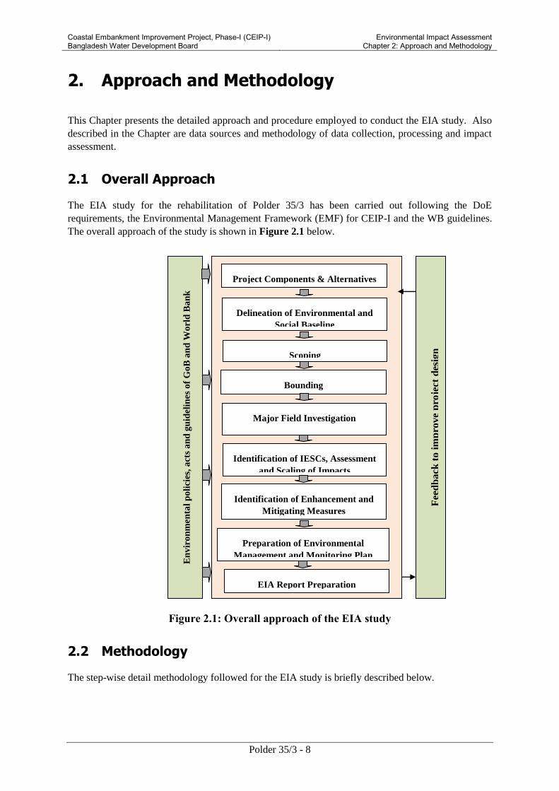
Coastal Embankment Improvement Project, Phase-I (CEIP-I) Bangladesh Water Development Board
Environmental Impact Assessment Chapter 2: Approach and Methodology
Polder 35/3 - 8
2. Approach and Methodology
This Chapter presents the detailed approach and procedure employed to conduct the EIA study. Also
described in the Chapter are data sources and methodology of data collection, processing and impact
assessment.
2.1 Overall Approach
The EIA study for the rehabilitation of Polder 35/3 has been carried out following the DoE
requirements, the Environmental Management Framework (EMF) for CEIP-I and the WB guidelines.
The overall approach of the study is shown in Figure 2.1 below.
Figure 2.1: Overall approach of the EIA study
2.2 Methodology
The step-wise detail methodology followed for the EIA study is briefly described below.
Project Components & Alternatives
Delineation of Environmental and
Social Baseline
Scoping
Identification of Enhancement and
Mitigating Measures
EIA Report Preparation
Major Field Investigation
Identification of IESCs, Assessment
and Scaling of Impacts
En
vir
on
men
tal
po
lici
es,
act
s a
nd
gu
idel
ines
of
Go
B a
nd
Wo
rld
Ba
nk
Co
nsu
lta
tio
n w
ith
sta
keh
old
ers,
BW
DB
, D
OE
an
d W
orl
d B
an
k
Fee
db
ack
to i
mp
rove
pro
ject
des
ign
Preparation of Environmental
Management and Monitoring Plan
Bounding

Coastal Embankment Improvement Project, Phase-I (CEIP-I) Bangladesh Water Development Board
Environmental Impact Assessment Chapter 2: Approach and Methodology
Polder 35/3 - 9
2.2.1 Project Area of Influence
At the outset of the study, the Project area of influence (or Project area for short) was broadly
demarcated. This included the area inside the polder where most of the Project interventions would
take place, area immediately outside the polder embankments (this area could be used for staging of
construction works, material stockpiling, and/or earth borrowing), access routes for the polder, borrow
as well as spoil disposal areas if located outside the polder, and labor camps/contractor facilities if
located outside the polder. The polder is surrounded by Bhairab river to the east, Katakhali River to
the south west, Bishnu River to the west and Putimari River to the North side.
2.2.2 Analysis of the Project Components and Alternatives
Detailed information on the proposed Project including objective, nature and location of interventions,
construction works, and other related aspects was obtained from the Main Consultant of CEIP-I.
The Water Resources Engineer of the EIA study team interpreted this information for the multi-
disciplinary team members for assessing the environmental and social impacts of the proposed
interventions.
Since the location of most of the project interventions are already fixed, alternative design options of
the interventions were analyzed considering environmental, social, and technological criteria to
identify suitable alternatives and appropriate mitigation measures for negative environmental impacts.
2.2.3 Data Collection for Environmental and Social Baseline
Initially a reconnaissance field visit was conducted in the Project area to identify the project and its
functional objectives. Subsequent to this, rapid rural appraisals (RRAs), participatory rural appraisals
(PRAs), focused group discussions (FGDs) and interviews with key informants were conducted to
collect data and information on the environmental and social aspects of the Project area. Local
knowledgeable persons including community representatives, traders, teachers, and political leaders
were interviewed individually to reflect upon the problems regarding the polder. They were also
requested to highlight possible solutions that the project should bring about as per their indigenous
knowledge and experiences.
The baseline condition of the project area was drawn according to the information collected from
secondary and primary data sources through literature review, field investigations and consultations
with different stakeholders. The baseline condition has been established with respect to water
resources, land resources, agriculture, livestock, fisheries, ecosystems and socio-economic conditions
including identification of problems in respect of the proposed project sites and adjoining area.
Source and methodology of both primary and secondary baseline data collection on water resources,
land resources, agriculture, livestock, fishery, ecosystems, and socio-economic resources are
presented in the following sections.
Water Resources
Water resource data in connection with river hydrology, river morphology, surface and ground water
availability, drainage pattern, ground and surface water quality and water use were collected from
secondary sources and primary data collection and analysis as well as observations by the
professionals of the multi-disciplinary team backed up by feedback from the local people during field
visits to the Project area. Major river systems were identified for hydrological and morphological
investigation through historical and current data collection and analysis. Specific areas or points of
interest were selected for collecting data on special hydrological and morphological aspects, water

Coastal Embankment Improvement Project, Phase-I (CEIP-I) Bangladesh Water Development Board
Environmental Impact Assessment Chapter 2: Approach and Methodology
Polder 35/3 - 10
availability, drainage pattern, water quality (surface and ground water), flash flood, risk of erosion
and sedimentation.
Field visits at different stages of the study were made to the Project area and primary data on water
resources components were collected. A checklist (Attached in Annex- A) was developed and used to
obtain the information on different resources. Local knowledgeable persons and community
representatives were also interviewed. During field visits, the multidisciplinary EIA study team
members made professional observations pertaining to their individual areas of expertise.
Meteorological data such as temperature, rainfall, evapo-transpiration, and humidity were collected
and analyzed for assessing local climate which are directly related to water resources of the study area
and the project area. Meteorological data for selected stations were collected from the National Water
Resources Database (NWRD) of Water Resources Planning Organization (WARPO), which contains
long series of temporal data showing daily values for meteorological stations maintained by the
Bangladesh Meteorological Department (BMD). The topographical data were collected from
Geological Survey of Bangladesh and NWRD.
Land Resources
The agro-ecological region of the project area was identified using secondary sources including Food
and Agriculture Organization (FAO) and United Nations Development Program (UNDP). The land
type and soil texture data was collected from Upazila1 Land and Soil Resources Utilization Guide of
Soils Resources Development Institute (SRDI). The secondary data of these parameters was verified
at field level through physical observations as well as consultations with the local people and officials
of the Department of Agriculture Extension (DAE) during field visit. Land use information and maps
were prepared from satellite image classification with field verification.
Agricultural Resources
Data on agricultural resources which included existing cropping patterns, crop variety, crop calendar,
crop yield, crop damage, and agricultural input used were collected from both secondary and primary
sources. Agriculture data were collected through extensive field surveys with the help of
questionnaire and consultations with local people and concerned agricultural officials. Agricultural
resources data were also collected from secondary sources from the DAE. Crop production was
determined using the following formula:
Total crop production = damage free area × normal yield + damaged area × damaged yield.
The crop damage (production loss) was calculated using the following formula:
Crop production loss = Total cropped area ×normal yield (damaged area ×damaged yield+
damage free area × normal yield)
The crop damage data were collected from the field for the last three years.
Livestock Resources
Data on the present status of livestock (cow/bullock, buffalo, goat and sheep) and poultry (duck and
chicken) in the polder area was collected during field survey in consultation with the local people
through participatory rural assessment (PRA) and rapid rural assessment (RRA). Livestock resources
data were also collected from secondary sources from Upazila Livestock Office.
Fish and Fisheries
1 Upazila is an administrative subdivision of a district.

Coastal Embankment Improvement Project, Phase-I (CEIP-I) Bangladesh Water Development Board
Environmental Impact Assessment Chapter 2: Approach and Methodology
Polder 35/3 - 11
Primary data were collected from the fishermen community, fishermen households and local key
informants while secondary data were collected from Upazila Fisheries Offices (UFOs) during field
visits.
Fish habitat classification was made on the basis of physical existence and was categorized into
capture and culture fish habitats. The capture fish habitats included river, khal (water drainage
channel), flood plain, borrow pit, and beel (a natural depression, which generally retains water
throughout the year and in some cases seasonally connected to the river system). The culture fish
habitats included homestead culture fish pond, commercial fish farm, shrimp ghers (farm lands
converted into ponds with low dykes and used for cultivation of shrimp/prawn/fish).
Capture fish habitat was assessed on the basis of species diversity and composition, identification of
species of conservation significance, identification of potential fish habitat prescribing to restore for
fish conservation, fish migration survey, habitat identification for fish conservation. Culture fish
habitat was assessed through homestead culture fish pond survey and commercial fish farm/ gher
survey.
Information on post harvest activities, forward and backward linkages, fishermen livelihood
information, fisheries management issues, potential fish recruitment, fish infrastructure and fishermen
vulnerabilitywere also collected.
Relevant secondary data were collected from the UFO’s annual reports and various literature/study
reports.
Fish productions for individual habitats were obtained from secondary information that was collected
from the UFOs and literatures were blended with primary data in production estimation.
Ecological Resources
The ecological component of the EIA study focused on terrestrial and riverine ecology including
flora, birds, reptiles, amphibians, mammals, and migratory birds. The field activities included
collection of ecosystem and habitat information, sensitive habitat identification, identifying ecological
changes and potential ecological impact. The land use information on different ecosystem was
generated through analysis of recent satellite imagery. Field investigation methods included physical
observations, transect walk, habitat survey and consultations with local people. Field visits were
carried out for establishing the ecological baseline condition. Public consultation meetings were
carried out through FGD and Key Informants Interview (KII) methods. Inventory of common flora
and fauna was developed based on field survey and data base of the International Union for
Conservation of Nature (IUCN).
Socio-economic Data
Demographic information, such as population, occupation and employment, literacy rate, drinking
water, sanitation, and electricity facilities were collected form secondary sources. Data on income,
expenditure, land ownership pattern, self assessed poverty status, migration, social overhead capitals
and quality of life, disasters, conflicts of the study area, information on non-governmental
organizations (NGOs), cultural and heritage features of the project area were collected mainly from
primary sources through PRA and FGDs and public consultations.
The steps followed for collecting socio-economic data are as follows:
Data were collected from Bangladesh Bureau of Statistics(BBS), 2001 and enumerated for
2010 the relevant literatures from BWDB and main consultant was also reviewed;
Reconnaissance field visit and discussions with BWDB officials and local stakeholders were
for primary data collection;
PRA /RRA, FGDs, KII were carried out for primary data collection;

Coastal Embankment Improvement Project, Phase-I (CEIP-I) Bangladesh Water Development Board
Environmental Impact Assessment Chapter 2: Approach and Methodology
Polder 35/3 - 12
Institutional survey was conducted for primary data collection from district and upazila level.
2.2.4 Scoping
A structured scoping process was followed for identifying the Important Environmental and Social
Components (IESCs) which would potentially be impacted by the proposed Project. This was
achieved in two stages as follows. The EIA team made a preliminary list of the components which
could be impacted by the Project. The second stage included village scoping sessions where opinions
of the stakeholders were obtained on their perception about the environmental and social components
which could be impacted by the project interventions. With the help of the professional judgments of
the multidisciplinary EIA team as well as the opinions of the stakeholders, the preliminary list of the
important environmental and social components was finalized.
2.2.5 Assessment and Scaling of Impacts
At this stage, attempts were made to quantify the impacts of the proposed interventions of the Project
as much as possible. Where quantification was not possible, qualitative impacts were assessed and
scores were assigned with (P) sign for positive impacts and (N) sign for negative impacts. The
magnitude of both positive and negative impacts was indicated by HN, MN, HP and MP based upon
extent, magnitude, reversibility, duration and sustainability considerations. The impacts of proposed
interventions, considering the climate-change scenario for 2050, were estimated on the basis of
differences between the future-without-project (FWOP) condition and the future-with-project (FWIP)
condition. The future-without-project (FWOP) conditions were generated through trend analysis and
consultations with the local people. This reflected conditions of IESCs in absence of the proposed
interventions under the Project area. Changes expected to be brought about due to proposed
interventions under the Project were assessed to generate the future-with-project (FWIP) condition.
Comparison and projection methods were used for impact prediction.
2.3 Assessment Methodology
The assessment of effects and identification of residual impacts takes account of any incorporated
mitigation measures adopted due to any potential impact of Project activities, and will be largely
dependent on the extent and duration of change, the number of people or size of the resource affected
and their sensitivity to the change. Potential impacts can be both negative and positive (beneficial),
and the methodology defined below will be applied to define both beneficial and adverse potential
impacts.
The criteria for determining significance are generally specific for each environmental and social
aspect but generally the magnitude of each potential impact is defined along with the sensitivity of the
receptor. Generic criteria for defining magnitude and sensitivity used for the Project are summarized
below.
2.3.1 Magnitude
The assessment of magnitude has been undertaken in two steps. Firstly the key issues associated with
the Project are categorized as beneficial or adverse. Secondly, potential impacts have been
categorized as major, moderate, minor or negligible based on consideration of the parameters such as:
Duration of the potential impact;
Spatial extent of the potential impact;
Reversibility;

Coastal Embankment Improvement Project, Phase-I (CEIP-I) Bangladesh Water Development Board
Environmental Impact Assessment Chapter 2: Approach and Methodology
Polder 35/3 - 13
Likelihood; and
Legal standards and established professional criteria.
The magnitude of potential impacts of the Project has generally been identified according to the
categories outlined in Table 2.1.
Table 2-1: Parameters for Determining Magnitude
Parameter Major Moderate Minor Negligible/Nil
Duration of
potential impact
Long term
(more than 35 years)
Medium Term
Lifespan of the
project
(5 to 15 years)
Less than project
lifespan
Temporary with
no detectable
potential impact
Spatial extent of
the potential
impact
Widespread far
beyond project
boundaries
Beyond
immediate
project
components, site
boundaries or
local area
Within project
boundary
Specific location
within project
component or
site boundaries
with no
detectable
potential impact
Reversibility of
potential impacts
Potential impact is
effectively
permanent, requiring
considerable
intervention to return
to baseline
Baseline requires
a year or so with
some
interventions to
return to baseline
Baseline returns
naturally or with
limited
intervention
within a few
months
Baseline remains
constant
Legal standards
and established
professional
criteria
Breaches national
standards and or
international
guidelines/obligations
Complies with
limits given in
national
standards but
breaches
international
lender guidelines
in one or more
parameters
Meets minimum
national standard
limits or
international
guidelines
Not applicable
Likelihood of
potential impacts
occurring
Occurs under typical
operating or
construction
conditions
(Certain)
Occurs under
worst case
(negative impact)
or best case
(positive impact)
operating
conditions
(Likely)
Occurs under
abnormal,
exceptional or
emergency
conditions
(occasional)
Unlikely to occur
2.3.2 Sensitivity
The sensitivity of a receptor has been determined based on review of the population (including
proximity / numbers / vulnerability) and presence of features on the site or the surrounding area.

Coastal Embankment Improvement Project, Phase-I (CEIP-I) Bangladesh Water Development Board
Environmental Impact Assessment Chapter 2: Approach and Methodology
Polder 35/3 - 14
Criteria for determining receptor sensitivity of the Project’s potential impacts are outlined in Table
2.2.
Table 2-2: Criteria for Determining Sensitivity
Sensitivity Determination Definition
Very High Vulnerable receptor with little or no capacity to absorb proposed
changes or minimal opportunities for mitigation.
High Vulnerable receptor with little or no capacity to absorb proposed
changes or limited opportunities for mitigation.
Medium Vulnerable receptor with some capacity to absorb proposed changes
or moderate opportunities for mitigation
Low / Negligible Vulnerable receptor with good capacity to absorb proposed changes
or/and good opportunities for mitigation
2.3.3 Assigning Significance
Following the assessment of magnitude, the quality and sensitivity of the receiving environment or
potential receptor has been determined and the significance of each potential impact established using
the potential impact significance matrix shown in Table 2.3.
Table 2-3: Assessment of Potential Impact Significance
Magnitude of Potential
impact
Sensitivity of Receptors
Very High High Medium Low /
Negligible
Major Critical Major Moderate Negligible
Moderate Major Major Moderate Negligible
Minor Moderate Moderate Low Negligible
Negligible Negligible Negligible Negligible Negligible
2.3.4 Mitigation Measures
Subsequent to the impact assessment discussed above, appropriate mitigation measures have been
proposed to avoid, offset, mitigate/reduce, or compensate for the identified impacts. Generally,
impacts having moderate to critical consequence significance per the Table 2.3 require appropriate
avoidance/ mitigation/compensatory measures to reduce the significance. Impacts having low to
negligible significance can be left alone not needing any mitigation measures.
Generally, preference is given to the avoidance of the impact with the help of options available for
nature, siting, timing, method/procedure, or scale of any Project activity. If avoidance is not possible,
appropriate mitigation and control measures are proposed to reduce the consequence significance of
the predicted impact. Finally, if impact reduction is not possible, compensatory measures are
proposed.

Coastal Embankment Improvement Project, Phase-I (CEIP-I) Bangladesh Water Development Board
Environmental Impact Assessment Chapter 2: Approach and Methodology
Polder 35/3 - 15
2.3.5 Assessment of Residual Impacts
The final step in the impact assessment process is determining the significance of the residual
impacts, which essentially are the impacts which would be experienced even after implementing the
mitigation/compensatory measures. Ideally, all of the residual impacts should be of negligible to low
significance. For any residual impacts having moderate significance, monitoring mechanism is
necessary to ensure that their significance does not increase. No residual impacts having major or
critical significance are generally acceptable.
2.3.6 Identification of Enhancement and Mitigating Measures
From literature survey, applying expert judgment and consultation with stakeholders, possible
enhancement and mitigating measures were identified for beneficial and adverse effects respectively.
2.3.7 Preparation of Environmental Management and Monitoring Plan
An environmental management plan (EMP) for the proposed Project was prepared comprising the
mitigation/ enhancement measures with institutional responsibilities, environmental monitoring plan,
training and capacity building plan, and reporting and documentation protocols.
2.3.8 EIA Report Preparation
At the end of the study, the present report was prepared incorporating all the findings of the EIA.

Coastal Embankment Improvement Project, Phase-I (CEIP-I) Bangladesh Water Development Board
Environmental Impact Assessment Chapter 3: Policy, Legal and Adminitrative Framework
Polder 35/3 - 16
3. Policy, Legal and Administrative Framework
This Chapter presents a review of the national policy, legal, and regulatory framework relevant to the
environmental and social aspects of the Project. Also reviewed in the Chapter are the WB
environmental and social safeguard policies.
3.1 National Environmental Laws
The key national policies, strategies, and plans relevant to environmental management are briefly
discussed below.
3.1.1 Bangladesh Environment Conservation Act (ECA), 1995
The Environmental Conservation Act (ECA) of 1995 is the main legislative framework relating to
environmental protection in Bangladesh. This umbrella Act includes laws for conservation of the
environment, improvement of environmental standards, and control and mitigation of environmental
pollution. This Act has established the Department of Environment (DOE), and empowers its
Director General to take measures as he considers necessary which includes conducting
inquiries, preventing probable accidents, advising the Government, coordinating with other
authorities or agencies, and collecting and publishing information about environmental pollution.
According to this act (Section 12), no industrial unit or project shall be established or undertaken
without obtaining, in a manner prescribed by the accompanying Rules, an Environmental Clearance
Certificate (ECC) from the Director General of DOE.
In accordance with this Act, the CEIP-I will need to be cleared by DOE before commencing the
project following procedures given in the Environment Conservation Rules (ECR) 1997 (discussed
below). Also the Ecologically Critical Areas in coastal zone, defined by DOE under this act, will be
considered while planning and designing of the CEIP-I project interventions.
The present EIA has been carried out in compliance with this Act.
3.1.2 Bangladesh Environment Conservation Act (ECA), (Amendments) 2010
The ECA 1995 was amended in 2010, which provided clarification of defining wetlands as well as
Ecologically Critical Areas and included many important environmental concerns such as
conservation of wetlands, hill cutting, ship breaking, and hazardous waste disposal. This amendment
empowered the government to enforce more penalties than before. Moreover, affected persons were
given provision for putting objections or taking legal actions against the polluters or any entity
creating nuisance to affected person.
3.1.3 Bangladesh Environment Conservation Rules (ECR), 1997
The Environment Conservation Rules, 1997 were issued by the Government of Bangladesh in
exercise of the power conferred under the Environment Conservation Act (Section 20), 1995. Under
these Rules, the following aspects, among others, are covered:
Declaration of ecologically critical areas
Classification of industries and projects into four categories

Coastal Embankment Improvement Project, Phase-I (CEIP-I) Bangladesh Water Development Board
Environmental Impact Assessment Chapter 3: Policy, Legal and Adminitrative Framework
Polder 35/3 - 17
Procedures for issuing the Environmental Clearance Certificate
Determination of environmental standards.
The Rule 3 defines the factors to be considered in declaring an area 'ecologically critical area' (ECA)
as per Section 5 of ECA95. It empowers the Government to declare an area 'ECA', if it is satisfied that
the ecosystem of the area has reached or is threatened to reach a critical state or condition due to
environmental degradation. The Government is also empowered to specify which of the operations or
processes shall not be carried out or shall not be initiated in the ecologically critical area. Under this
mandate, MOEF has declared Sundarban, Cox's Bazar - Teknaf Sea Shore, Saint Martin Island,
Sonadia Island, Hakaluki Haor, Tanguar Haor, Marzat Baor and Gulshan - Baridhara Lake as ECA
and prohibited certain activities in those areas. Beside these, recently the government of Bangladesh
has declared four rivers such as Buriganga River, Turag River, Shitalakha River and Balu River
around the Dhaka City as ECA.
The Rule 7 classifies industrial units and projects into four categories depending on environmental
impact and location for the purpose of issuance of ECC. These categories are: Green, Orange A,
Orange B, and Red.
All existing industrial units and projects and proposed industrial units and projects, that are
considered to be low polluting are categorized under "Green" and shall be granted
Environmental Clearance. For proposed industrial units and projects falling in the Orange-A, Orange-
B and Red Categories, firstly a site clearance certificate and thereafter an environmental clearance
certificate will be required. A detailed description of these four categories of industries has been
given in Schedule-1 of ECR'97. Apart from general requirement, for every Red category proposed
industrial unit or project, the application must be accompanied with feasibility report, Initial
Environmental Examination (IEE), Environmental Impact Assessment (EIA) based on approved
ToR by DOE, Environmental Management Plan (EMP). As per ECR’97, water resources
development projects fall under ‘Red’ category project. Therefore CEIP-I project is ‘Red’ category
project which requires IEE, EIA and EMP for environmental clearance from DOE.
The ECR'97 describes the procedures for obtaining Environmental Clearance Certificates (ECC) from
the Department of Environment for different types of proposed units or projects. Any person or
organization wishing to establish an industrial unit or project must obtain ECC from the Director
General. The application for such certificate must be in the prescribed form together with the
prescribed fees laid down in Schedule 13, through the deposit of a Treasury Chalan in favor of the
Director General. The fees for clearance certificates have been revised in 2010. Rule 8 prescribes the
duration of validity of such certificate (three years for green category and one year for other
categories) and compulsory requirement for renewal of certificate at least 30 days before expiry of its
validity.
3.1.4 Bangladesh Environment Court Act, 2010
Bangladesh Environment Court Act, 2010 has been enacted to resolve the disputes and establishing
justice over environmental and social damage raised due to any development activities. This act
allows government to take necessary legal action against any parties who creates environmental
hazards/ damage to environmentally sensitive areas as well as human society. According to this act,
government can take legal actions if any environmental problem occurs due to CEIP-I interventions.
3.1.5 Administrative framework of DOE for clearing and monitoring of projects
According to the Environment Conservation Act 1995 no industrial unit or project will be established
or undertaken without obtaining, in the manner prescribed by the Environment Conservation Rules
1997, an Environmental Clearance Certificate from the Director General. Therefore, every

Coastal Embankment Improvement Project, Phase-I (CEIP-I) Bangladesh Water Development Board
Environmental Impact Assessment Chapter 3: Policy, Legal and Adminitrative Framework
Polder 35/3 - 18
development projects/industries which are specified under the Schedule – 1 of the Environmental
Conservation Rules 1997 require obtaining site clearance and environmental clearance from the
Department of Environment. According to the Rule 7 (1) of the Environmental Conservation Rules
1997; for the purpose of issuance of Environmental Clearance Certificate (ECC), every industrial
units or projects, in consideration of their site and impact on the environment, will be classified into
the four categories and they are: Category I (green), Category II (Orange-A), Category III (Orange B)
and Category IV (Red). According to the categorization, all FC and FCD/I projects fall under the
‘Red’ category. For this category, it is mandatory to carry out Environmental Impact Assessment
(EIA) including Environmental Management Plan (EMP) and where necessary develop a
Resettlement Plan for getting environmental clearance from DOE. The application procedure for
obtaining site clearance and environmental clearance for the sub-projects of CEIP is shown in Figure
3.1.
Figure 3.1: Process of obtaining Clearance certificate from DOE
Applicant agency will conduct EIA
study for the proposed project
Obtaining Environmental
Clearance
Renewal of the clearance after each one-year period
Obtaining Site Clearance and approved ToR for
EIA
Application for Environmental Clearance
Application should enclose:
1. Prescribed application form
2. EIA report of the proposed project including EMP
3. Outline of relocation, rehabilitation plan, if applicable
4. Feasibility Study Report of the proposed project, if available
Application for site clearance
Application should enclose:
1. Prescribed application form
2. Application fee
3. IEE report of the proposed project (including ToR for EIA)
4. Location map/ layout plan, etc.
5. No Objection Certificate (NOC) from local government authority
6. Preliminary Feasibility Study Report/ DPP of the proposed project, if
available
Presentation on the EIA and
EMP by the applicant agency to
DOE
Site visit by DOE and applicant
agency, if required

Coastal Embankment Improvement Project, Phase-I (CEIP-I) Bangladesh Water Development Board
Environmental Impact Assessment Chapter 3: Policy, Legal and Adminitrative Framework
Polder 35/3 - 19
3.2 Relevant National Policies, Strategies and Plans
3.2.1 National Environment Policy, 1992
The National Environment Policy (NEP) is one of the key policy documents of the Government. The
policy addresses 15 sectors in all, in addition to providing directives on the legal framework and
institutional arrangements. Coastal and marine environment is one of the key sectors covered in this
policy. The policy declarations that have particular bearing on the Integrated Coastal Zone
Management (ICZM) are listed below.
Sustainable use of coastal and marine resources and preservation of coastal ecosystem
Prevention of national and international activities causing pollution in coastal and marine
environment
Strengthening research in protection and development of coastal and marine resources and
environment
Exploration of coastal and marine fisheries to a maximum sustainable limit
Regarding water resource development, flood control and irrigation sector, the policy seeks to:
ensure environmentally-sound utilization of all water resources;
ensure that water development activities and irrigation networks do not create adverse
environmental impact;
ensure that all steps are taken for flood control, including construction of embankments,
dredging of rivers, digging of canals, etc, be environmentally sound at local, zonal and
national levels;
ensure mitigation measures of adverse environmental impact of completed water resources
development and flood control projects;
keep the rivers, canals, ponds, lakes, haors, baors and all other water bodies and water
resources free from pollution;
ensure sustainable, long-term, environmentally sound and scientific exploitation and
management of the underground and surface water resources; and
conduct environmental impact assessment before undertaking projects for water resources
development and management.
The Policy is applicable to the CEIP-I and the proposed interventions are required to comply with all
the policy directives emphasizing particularly on reducing adverse environmental impacts. The EIA
studies of the coastal polders are required to clearly address the potential impacts and propose
mitigation measures.
3.2.2 National Environment Management Action Plan, 1995
The National Environment Management Action Plan (NEMAP, 1995) identifies the main
national environmental issues, including those related to the water sector. The main water related
national concerns include flood damage, riverbank erosion, environmental degradation of water
bodies, increased water pollution, shortage of irrigation water and drainage congestion; various
specific regional concerns are also identified.
Coastal Embankment Improvement Project, Phase-I (CEIP-I) Bangladesh Water Development Board
Environmental Impact Assessment Chapter 3: Policy, Legal and Adminitrative Framework
Polder 35/3 - 20
3.2.3 NationalWater Policy, 1999
Endorsed by the GoB in 1999, the National Water Policy (NWP) aims to provide guidance to the
major players in water sector for ensuring optimal development and management of water. According
to the policy, all agencies and departments entrusted with water resource management responsibilities
(regulation, planning, construction, operation, and maintenance) are required to enhance
environmental amenities and ensure that environmental resources are protected and restored in
executing their tasks.
The policy has several clauses related to water resource development projects for ensuring
environmental protection. Some of the relevant clauses are:
Clause 4.5b: Planning and feasibility studies of all projects will follow the Guidelines for
Project Assessment, the Guidelines for People's Participation (GPP), the Guidelines for
Environmental Impact Assessment, and all other instructions that may be issued from time to
time by the Government.
Clause 4.9b: Measures will be taken to minimize disruption to the natural aquatic
environment in streams and water channels.
Clause 4.9e: Water development plans will not interrupt fish movement and will make
adequate provisions in control structures for allowing fish migration and breeding.
Clause 4.10a: Water development projects should cause minimal disruption to navigation and,
where necessary, adequate mitigation measures should be taken.
Clause 4.12a: Give full consideration to environmental protection, restoration and
enhancement measures consistent with National Environmental Management Action Plan
(NEMAP) and the National Water Management Plan (NWMP).
Clause 4.12b: Adhere to a formal environment impact assessment (EIA) process, as set out in
EIA guidelines and manuals for water sector projects, in each water resources development
project or rehabilitation program of size and scope specified by the Government from time to
time.
Clause 4.12c: Ensure adequate upland flow in water channels to preserve the coastal estuary
ecosystem threatened by intrusion of salinity from the sea.
Clause 4.13b: Only those water related projects will be taken up for execution that will not
interfere with aquatic characteristics of those water bodies.
Most of the above clauses will be applicable to the CEIP-I. The Project design and present EIA study
will be required to comply with these requirements.
3.2.4 National Water Management Plan, 2001 (Approved in 2004)
The National Water Management Plan (NWMP) 2001, approved by the National Water Resources
Council in 2004, envisions to establish an integrated development, management and use of water
resources in Bangladesh over a period of 25 years. Water Resources Planning Organization
(WARPO) has been assigned to monitor the national water management plan. The major programs
in the Plan have been organized under eight sub-sectoral clusters: i) Institutional Development, ii)
Enabling Environment, iii) Main River, iv) Towns and Rural Areas, v) Major Cities; vi) Disaster
Management; vii) Agriculture and Water Management, and viii) Environment and Aquatic Resources.
Each cluster comprises of a number of individual programs, and a total of 84 sub-sectoral programs
have been identified and presented in the investment portfolio. Most of the programs are likely to be
implemented in coastal areas.

Coastal Embankment Improvement Project, Phase-I (CEIP-I) Bangladesh Water Development Board
Environmental Impact Assessment Chapter 3: Policy, Legal and Adminitrative Framework
Polder 35/3 - 21
The CEIP has been designed in line with this Plan and addresses its key objectives for the water
resource management in the coastal areas.
3.2.5 Coastal Zone Policy, 2005
The Government has formulated the Coastal Zone Policy (CZP) that provides a general guidance to
all concerned for the management and development of the coastal zone in a manner so that the coastal
people are able to pursue their life and livelihoods within secure and conducive environment.
The coast of Bangladesh is known as a zone of vuMNerabilities as well as opportunities. It is prone to
natural disasters like cyclone, storm surge and flood. In this regard, for reducing risk, the policy
emphasizes the improvement of coastal polders and seeks to enhance safety measures by combining
cyclone shelters, multi-purpose embankments, road system and disaster warning system.
The CIEP-I addresses some aspects of this Policy particularly those relating to the polder
improvements.
3.2.6 Coastal Development Strategy, 2006
The Coastal Development Strategy (CDS) focuses on the implementation of the coastal zone policy.
The CDS was approved at the second meeting of the Inter-Ministerial Steering Committee on ICZMP
held on 13 February 2006. Nine strategic priorities, evolved through a consultation process, guide
interventions and investments in the coastal zone:
ensuring fresh and safe water availability
safety from man-made and natural hazards
optimizing use of coastal lands
promoting economic growth emphasizing non-farm rural employment
sustainable management of natural resources: exploiting untapped and less explored
opportunities
improving livelihood conditions of people especially women
environmental conservation
empowerment through knowledge management
creating an enabling institutional environment
The proposed interventions under the CEIP are in line with this strategy and support most of the
above listed priorities.
3.2.7 National Land Use Policy (MoL, 2001)
The National Land Use Policy (NLUP), enacted in 2001, aims at managing land use effectively to
support trends in accelerated urbanization, industrialization and diversification of development
activities. The NLUP urges that increasing the land area of the country may be not possible through
artificial land reclamation process, which is cost-effective only in the long run. Therefore, land use
planning should be based on the existing and available land resources. The policy suggests
establishing land data banks where, among others, information on accreted riverine and coastal chars
will be maintained. Among the 28 policy statements of NLUP, the following are relevant to coastal
area:
forests declared by the Ministry of Environment and Forests will remain as forest lands;

Coastal Embankment Improvement Project, Phase-I (CEIP-I) Bangladesh Water Development Board
Environmental Impact Assessment Chapter 3: Policy, Legal and Adminitrative Framework
Polder 35/3 - 22
reclassification of forest lands will be prevented; and
effective green belts will be created all along the coast.
The CEIP will be designed in accordance with this Strategy and will comply with the above listed
requirements.
3.2.8 National Agriculture Policy, 1999
The overall objective of the National Agriculture Policy is to make the nation self-sufficient in food
through increasing production of all crops including cereals and ensure a dependable food security
system for all. Although the policy does not emphasize the coastal zone separately, all specific
objectives are applicable to the development of coastal zone agriculture. The policy particularly
stressed on minor irrigation capturing tidal water in reservoirs in coastal areas and research on the
development of improved varieties and technologies for cultivation in coastal, hilly, water-logged and
salinity affected areas. The policy also recognizes that adequate measures should be taken to reduce
water-logging, salinity and provide irrigation facilities for crop production.
The proposed CEIP-I is expected to contribute to achieve the objectives of the agriculture policy.
3.2.9 National Fisheries Policy, 1996
The National Fisheries Policy (NFP), 1996 recognizes that fish production has declined due to
environmental imbalances, adverse environmental impact and improper implementation of fish
culture and management programs. The policy particularly focuses on coastal shrimp, aquaculture and
marine fisheries development.
The policy suggests following actions:
Shrimp and fish culture will not be expanded to the areas which could damage mangrove
forest in the coastal region
Biodiversity will be maintained in all natural water bodies and in marine environment
Chemicals harmful to the environment will not be used in fish shrimp farms
Environment friendly fish shrimp culture technology will be used
Expand fisheries areas and integrate rice, fish and shrimp cultivation
Control measures will be taken against activities that have a negative impact on fisheries
resources and vice-versa
Laws will be formulated to ban the disposal of any untreated industrial effluents into the
water bodies.
The CEIP-I interventions may facilitate fisheries production in coastal area. The guidelines of NFP
may be integrated while designing and implementing the CEIP-I interventions. However, conflicts
over agriculture and fisheries cultivation may accelerate in future.
3.2.10 National Livestock Development Policy, 2007
The National Livestock Development Policy (NLDP) has been prepared to address the key challenges
and opportunity for a comprehensive sustainable development of the livestock subsector by creating
an enabling policy framework. Among 60 or more policy statements, the following two policy
statements address the coastal zone:

Coastal Embankment Improvement Project, Phase-I (CEIP-I) Bangladesh Water Development Board
Environmental Impact Assessment Chapter 3: Policy, Legal and Adminitrative Framework
Polder 35/3 - 23
Specific areas will be identified to implement programs for fattening of cattle and livestock.
For this purpose, the Chittagong Hill Tracts, the coastal areas and the islands will be included
under the fattening of livestock and cattle program.
Special programs will be taken up for the production of grass in the Chittagong Hill-tracts and
the coastal areas.
As livestock is one of the key assets in coastal livelihoods, and protection of livestock from cyclones
and tidal surges should be emphasized along with security of human life. The proposed CEIP-I
interventions will contribute to the safety of livestock and thus increase livestock productivity in
coastal areas.
3.2.11 The Forest Act, 1927 & Amendment Act 2000
The National Forestry Policy of 1994 is the revised version of the National Forest Policy of 1977 in
the light of the National Forestry Master Plan. The major targets of the Policy are to conserve the
existing forest areas; bring about 20% of the country’s land area under the afforestation program, and
increase the reserve forest land by 10% by the year 2015 through coordinated efforts of GO-NGOs
and active participation of the people.
The need of amendments of the existing forestry sector related laws and adoption of new laws for
sectoral activities have been recognized as important conditions for achieving the policy goals and
objectives. The Forest Policy also recognizes the importance of fulfilling the responsibilities and
commitments under international multilateral environmental agreements.”
According to the Act the Government (Forest Department) can prohibit certain activities in the
declared Reserved Forest area such as any intervention kindles, keeps or carries any fire; trespasses
or pastures cattle, or permits cattle to trespass; causes any damage by negligence in felling any tree or
cutting or dragging any timber; etc.
“26. Acts prohibited in such forests. -
(1) Any person who, in a reserved forest-
(a) Kindles, keeps or carries any fire except at such seasons as the Forest-Officer may notify in this
behalf;
(b) Trespasses or pastures cattle, or permits cattle to trespass;
(c) causes any damage by negligence in felling any tree or cutting or dragging any timber;
(d) quarries stone, burns lime or charcoal, or collects, subjects to any manufacturing process, or
removes any forest produce other than timber; or who enters a reserved forest with firearms without
prior permission from the Divisional Forest Officer concerned, shall be punishable with
imprisonment for a term which may extend to six months and shall also be liable to fine which may
extend to two thousand taka, in addition to such compensation for damage done to the forest as the
convicting Court may direct to be paid.”
The proposed intervention should not carry out any such activities that may cause damage or
adversely impact on the natural resources including wildlife of the Sundarbans Reserve Forest
because the Sundarban is located about 50 km away from the polder.
3.2.12 Standing Orders on Disaster, 2010
The Standing Orders on Disaster is designed to enhance capacity at all tiers of government
administrative and social structures for coping with and recovering from disasters. The document
Coastal Embankment Improvement Project, Phase-I (CEIP-I) Bangladesh Water Development Board
Environmental Impact Assessment Chapter 3: Policy, Legal and Adminitrative Framework
Polder 35/3 - 24
contains guidelines for construction, management, maintenance and use of cyclone shelter center.
Accordingly to the guideline, geographical information system (GIS) technology will be applied at the
planning stage to select the location of cyclone shelter considering habitation, communication
facilities, distance from the nearest cyclone centre. The advice of the concerned District Committee is
to be obtained before final decision. The cyclone shelters should have easier communication facilities
so that in times of distress delay does not occur to go there. For this reason, the road communication
from the cyclone shelters should not only link up with city or main road but also with neighboring
village areas. Provision of emergency water, food and sanitation and shelter space for livestock during
period should also be kept in view for future construction of shelters.
Improvement of coastal polders under CEIP-I will provide better communication facilities in the
coastal areas, which is crucial for emergency response to disasters.
3.2.13 National Adaptation Programme of Action (NAPA)
In 2005, the Ministry of Environment and Forest (MOEF), Government of the People’s Republic of
Bangladesh has prepared the National Adaptation Program of Action (NAPA) for Bangladesh, as a
response to the decision of the Seventh Session of the Conference of the Parties (COP7) of the United
Nations Framework Convention on Climate Change (UNFCCC). The basic approach to NAPA
preparation was along with the sustainable development goals and objectives of the country where it
has recognized the necessity of addressing climate change and environmental issue and natural
resource management. The NAPA is the beginning of a long journey to address adverse impacts of
climate change including variability and extreme events and to promote sustainable development of
the country. There are 15 adaptation strategies suggested to address adverse effects of climate change.
Among the 15 adaptation strategies the following strategies address the coastal region for reducing
climate change induced vulnerability.
Reduction of climate change hazards through coastal afforestation with community
participation.
Providing drinking water to coastal communities to combat enhanced salinity due to sea level
rise.
Construction of flood shelter, and information and assistance centre to cope with enhanced
recurrent floods in major floodplains
Promotion of research on drought, flood and saline tolerant varieties of crops to facilitate
adaptation in future.
Promoting adaptation to coastal crop agriculture to combat increased salinity.
Promoting adaptation to coastal fisheries through culture of salt tolerant fish special in coastal
areas of Bangladesh.
The CEIP-I broadly contributes toward achieving g the aims and objectives of the climate change
adaptation strategies.
3.2.14 Bangladesh Climate Change Strategy and Action Plan (BCCSAP) 2009
The Government of Bangladesh has prepared the Bangladesh Climate Change Strategy and Action
Plan (BCCSAP), 2009. The BCCSAP is built on six pillars: (i) food security, social safety and health;
(ii) comprehensive disaster management; (iii) infrastructure; (iv) research and knowledge
management; (v) mitigation and low carbon development; and (vi) capacity building. Five programs
have been suggested related to improvement of the water management infrastructures in coastal areas
of Bangladesh under pillar 3 (Infrastructure) of BCCSAP, including:

Coastal Embankment Improvement Project, Phase-I (CEIP-I) Bangladesh Water Development Board
Environmental Impact Assessment Chapter 3: Policy, Legal and Adminitrative Framework
Polder 35/3 - 25
Repair and maintenance of existing flood embankments
Repair and maintenance of existing coastal polders
Improvement of urban drainage
Planning, design and construction of river training works
Planning, design and implementation of resuscitation of the network of rivers and khals
through dredging and de-siltation work.
CEIP-I is relevant to the above mentioned programs and will contribute towards achieving the
objective of other pillars such as (i), (ii) and (iv).
3.2.15 The Acquisition and Requisition of Immovable Property Ordinance, 1982
This Ordinance is the basic instrument governing land acquisition in Bangladesh. It is restricted to
“legal” owners of property as supported by records of ownership such as deeds, title or agreements to
compensating for land as well as any business, structure, trees and crops on the land. The owners of
acquired land receive cash compensation at market value with a premium of 50 per cent on the
assessed price. The law specifies methods for calculation of market value of property based on
recorded prices obtained from relevant Government departments such as Registrar (land), Public
Works Department (structures), Department of Forest (trees), Department of Agriculture (crops) and
Department of Fisheries (fish stock).
The Ministry of Land (MOL) is authorized to deal with land acquisition. The MOL delegates some of
its authority to the Commissioner at Divisional level and to the Deputy Commissioner at the District
level. The Deputy Commissioners (DCs) are empowered by the MOL to process land acquisition
under the Ordinance and pay compensation to the legal owners of the acquired property. Khas
(government owned land) lands should be acquired first when a project requires both khas and private
land. If a project requires only khas land, the land will be transferred through an inter-ministerial
meeting following the acquisition proposal submitted to DC or MOL as the case may be. The DC is
empowered to acquire a maximum of 50 standard bigha (6.75 ha) of land without any litigation where
the Divisional Commissioner is involved for approval. Acquisition of land more than 50 standard
bigha is approved from the central land allocation committee (CLAC) headed by the chief executive
of the Government of Bangladesh proposed by the MOL.
The land owner needs to establish ownership by producing record-of-rights in order to be eligible for
compensation under the law. The record of rights prepared under Section 143 or 144 of the State
Acquisition and Tenancy Act 1950 (revised 1994) are not always updated and as a result legal land
owners have faced difficulties trying to “prove” ownership. The affected person (AP) has also to
produce rent receipt or receipt of land development tax, but this does not assist in some situations as a
person is exempted from payment of rent if the area of land is less than 25 bighas (3.37 ha).
3.2.16 The East Bengal State Acquisition and Tenancy Act, 1950 (Revised 1994)
The State Acquisition and Tenancy Act (Sections 86 and 87) also define the ownership and use right
of alluvion (payosti or reformation in situ or original site) and diluvion land (nadisikosti) in the
country. In legal terms, eroded lands (sikosti) inside the alluvion-diluvion (AD) line (i.e. including
submerged land or underwater land) are considered khas land once declared by concerned Deputy

Coastal Embankment Improvement Project, Phase-I (CEIP-I) Bangladesh Water Development Board
Environmental Impact Assessment Chapter 3: Policy, Legal and Adminitrative Framework
Polder 35/3 - 26
Commissioner (DC) demarcating the AD Line.2 However, the "original" owner(s) can claim the land
if it reappears through natural process within 30 years. The original private owners cannot claim any
eroded land if developed by the government through land filling for use in public purpose.
3.2.17 Constitutional Right of the Tribal Peoples Rights
In the context of People’s Republic of Bangladesh, the Constitution of Bangladesh does not mention
the existence of the cultural and ethnic minorities in Bangladesh. The only protective provision for the
ethnic minorities that the policy makers often refer to in the context is Article 28 (4) which states that:
Nothing shall prevent the state from making special provision in favor of women and children or for
the advancement of any backward section of the citizens. The above provision is an ambiguous one
and it does not define who or what constitutes "backward". However, the Government recognizes
existence of “tribal peoples” and the need for special attention and in general tribal people are
essentially viewed as backward, poor and socio-economically & culturally inferior. Towards this end
a special program was initiated in 1996-97 by the Prime Minister’s Secretariat aimed at improving the
socio-economic situation of the indigenous people of Bangladesh, resident outside the Chittagong Hill
Tracts.
3.2.18 Ethnic Minority Rights in PRSP 2005
Relevant strategic suggestions in the Poverty Reduction Strategy Paper (PRSP)2005 to preserve the
cultural, social and economic identity and interests of the ethnic populations in and outside CHT are
as follows:
Effective recognition of ethnic minority communities and their specific needs in all relevant
government policies and programs towards improving the socio-economic conditions of these
communities.
Proper actions for protecting the rights of ethnic minority people, particularly their rights to
land and forests.
Transfer of land administration in CHT to the hill districts councils in accordance with the
‘Hill District Councils Acts of 1989’.
Provide education to ethnic minority people with a curriculum that allows learning in their
own language at the primary level.
Strengthen their competence in job markets through affirmative actions at higher levels of
education and skill training to promote their inclusion in mainstream economic life.
Scale-up efforts to provide health care, clean water and sanitation facilities to ethnic minority
areas in general and to the more disadvantaged groups among them in particular.
Increase and utilize property the fund available in the Prime Minister’s office for the
development of the ethnic minority people of the plain lands.
Provide wider access to electrification and telecommunications for ethnic minority
communities, particularly in the Hill Tracts.
2 The Assistant Commissioner of Lands (AC Land) in respective districts demarcates the AD Line each
year in areas where rivers frequently erode their banks. According to law, if the land classified by an AD Line
re-appears within 30 years from the date of erosion, the original owner(s) can claim the land.

Coastal Embankment Improvement Project, Phase-I (CEIP-I) Bangladesh Water Development Board
Environmental Impact Assessment Chapter 3: Policy, Legal and Adminitrative Framework
Polder 35/3 - 27
3.2.19 GoB Laws on Land Acquisition
The principle legal instrument governing land acquisition in Bangladesh is the Acquisition and
Requisition of Immovable Property Ordinance, 1982(Ordinance II of 1982 with amendments up to
1994) and other land laws and administrative manuals relevant to land administration in Bangladesh.
According to the Ordinance, whenever it appears to the Government of Bangladesh that any property
in any locality is needed or is likely to be needed for any public purpose or in the public interest, the
Government can acquire the land provided that no property used by the public for the purpose of
religious worship, graveyard and cremation ground. The 1982 Ordinance requires that compensation
be paid for (i) land and assets permanently acquired (including standing crops, trees, houses); and (ii)
any other damages caused by such acquisition. The Deputy Commissioner (DC) determines (a)
market value of acquired assets on the date of notice of acquisition (based on the registered value of
similar property bought and/or sold in the area over the preceding 12 months), and (b) 50% premium
on the assessed value (other than crops) due to compulsory acquisition. The 1994 amendment made
provisions for payment of crop compensation to tenant cultivators. Given that people devalue land
during title transfer to minimize tax payment, compensation for land paid by DC including premium
largely remains less than the actual market price.
Inadequacies of 1982 Ordinance
The Ordinance, however, is not adequate to deal with the adverse impacts associated with land
acquisition and involuntary displacement. Land is acquired under this ordinance but its provisions do
not fully satisfy the requirements of the Bank’s OP 4.12 on Involuntary Resettlement. There are no
other policies in Bangladesh to complement the acquisition law in ways to assess, mitigate and
monitor the adverse impacts that the affected persons may suffer. The law does not cover project-
affected persons without title or ownership record, such as informal settler/squatters, occupiers, and
informal tenants and lease-holders (without registration document) and does not ensure replacement
value of the property acquired. The Ordinance has no provisions for resettlement of the affected
households/businesses or any assistance for restoration of livelihoods of the affected persons. As a
result, land acquisition potentially diminishes productive base of affected farm families and infringe
impoverishment risks to those physically or economically displaced due to undertaking of
infrastructure projects.
As the legal framework falls short of the provisions of the World Bank OP 4.12 on Involuntary
Resettlement, the project proposes added mechanisms to meet the Bank's requirements:
Avoid or minimize resettlement: The law only implicitly discourages unnecessary acquisition,
as lands acquired for one purpose cannot be used for a different purpose. However, there are
no mechanisms to monitor if this condition is actually adhered to.
Eligibility for compensation: The law stipulates compensation only for the persons who
appear in the land administration records as the owners. It does not recognize the rights of
those, such as squatters, who do not possess legal title to the lands they live in or make a
living from.
Compensation: The law provides compensation for lands and other objects built and grown on
them (structures, trees and orchards, crops and any other developments like ponds, built
amenities, etc.). No provisions are there to assess and restore lost income stream or income
sources that acquisition causes to the affected persons, be they legal titleholders or others like
squatters, tenants and employees of affected businesses.
Compensation standards: Although the law stipulates 'market prices' of the acquired lands as
the just compensation, the legal assessment method almost always results in prices that are far
Coastal Embankment Improvement Project, Phase-I (CEIP-I) Bangladesh Water Development Board
Environmental Impact Assessment Chapter 3: Policy, Legal and Adminitrative Framework
Polder 35/3 - 28
below the actual market prices3. Certain pricing standards, which are regarded as unrealistic,
are used to assess other losses like structures and various built amenities, trees, crops and the
like.
Relocation of households and other establishments: No legal obligation is there to relocate, or
assist with relocation of, those whose homesteads have been acquired or whose place of
residence or livelihoods has been affected. Such persons/households, be they titleholders or
squatters, are left on their own.
Ensuring payment of compensation: Lands are legally acquired and handed over to the project
execution agency as soon as the acquisition authority identifies the owners (or 'awardees'), by
examining the records, and sends a legal notice advising them to claim the compensation (or
'awards'). It is the obligation of the affected landowners to prove, by producing an array of
documents that the acquired lands legally belong to them. As gathering these documents is a
long, expensive and cumbersome process, many landowners may remain unable to claim their
awards4.
Socioeconomic rehabilitation: The law shows no concern whatsoever about the long-term
socioeconomic changes the affected persons and households might undergo in the post-
acquisition period. There is no provision in the law except compensation for ensure economic
rehabilitation and social reintegration of the displaced persons.
These shortfalls in the legal provisions have been widely recognized as not fulfilling the requirements
of the OP 4.12, ever since Bangladesh started to address resettlement issues in the Bank-financed
projects in the early 1990s starting with the Jamuna Multipurpose Bridge Project. All infrastructure
agencies in Bangladesh using finance from international development financing institutions like the
World Bank, the ADB, JICA, and DFID are now undertaking resettlement of project affected persons
as an integral part of development projects.
3.2.20 Other Relevant Acts
There are a number of other laws and regulations applicable which are relevant for the project. These
are presented in the Table 3.1 below.
Table 3-1: Laws and Acts
Act/Law/Ordinance Brief description Responsible
Agency
The Vehicle Act (1927) and the
Motor Vehicles Ordinance (1983)
Provides rules for exhaust emission, air
and noise pollution and road and traffic
safety
Road Authority
Rules for Removal of Wrecks and
Obstructions in inland Navigable
Rules for removal of wrecks and
obstructions
IBWTA
3According to the law, the 'market price' is calculated by averaging the sales prices recorded in the previous one year, in
terms of land characteristics by land administration units or mauzas. But it is a widely accepted fact that prices determined as
such hardly reflect the true market value of the lands. As the sale/acquisition prices are grossly under-reported to evade on
sale taxes, assessment of legal compensation almost always fall far too short of the real market prices.
4In the present land administration system, which is widely accepted as antiquated, land transactions, especially in the rural
areas, often remain incomplete. Even after the sale/purchase deeds are legally executed, the sellers continue to remain as
owners in the legal records until mutations are completed. As the transaction process is cumbersome and involves costs
beyond those mandated by the law, and the practice that lands can be used with the deeds alone, most land transactions do
not follow the process beyond deed execution. Many land purchasers are even not aware of the mutation or its significance.

Coastal Embankment Improvement Project, Phase-I (CEIP-I) Bangladesh Water Development Board
Environmental Impact Assessment Chapter 3: Policy, Legal and Adminitrative Framework
Polder 35/3 - 29
Act/Law/Ordinance Brief description Responsible
Agency
Water Ways (1973)
The Water Supply and Sanitation
Act (1996)
Regulates the management and control of
water supply and sanitation in urban
areas.
MOLG, RD&C
The Ground Water Management
Ordinance (1985)
Describes the management of ground
water resources and licensing of tube
wells
UpazilaParishad
The Forest Act (1927) Regulates the protection of forests
reserves, protected forests and village
forests
MOEF
The Private Forests Ordinance
(1959)
Deals with the conservation of private
forests and afforestation of wastelands.
MOEF
The Protection and Conservation
of Fish Act (1950)
Deals with the protection/conservation
offices in Government owned water
bodies
DOF
The Embankment and Drainage
Act (1952)
Describes the protection of embankments
and drainage facilities
MOWR
The Antiquities Act (1968) Describes the preservation of cultural
heritage, historic monuments and
protected sites
DO Arch
Acquisition and Requisition of
Immovable Property Ordinance
(1982)
Describes procedures and provides
guidelines to acquisition and requisition
of land
MOL
Bangladesh Labor Law (2006) Deals with occupational rights and safety
of factory workers; provision of
comfortable work environment and
reasonable working conditions
MOL
3.3 International Treaties Signed by GoB
Bangladesh has signed most international treaties, conventions and protocols on environment,
pollution control, bio-diversity conservation and climate change, including the Ramsar Convention,
the Bonn Convention on migratory birds, the Rio de Janeiro Convention on biodiversity conservation
and the Kyoto protocol on climate change. An overview of the relevant international treaties and
conventions signed by GOB is shown in Table 3.2 below.
Table 3-2: Treaty or Convention and Responsible Agency
Treaty Year Brief Description Relevant
Department
Protection of birds (Paris) 1950 Protection of birds in wild state DOE/DOF
Ramsar Convention 1971 Protection of wetlands DOE/DOF

Coastal Embankment Improvement Project, Phase-I (CEIP-I) Bangladesh Water Development Board
Environmental Impact Assessment Chapter 3: Policy, Legal and Adminitrative Framework
Polder 35/3 - 30
Treaty Year Brief Description Relevant
Department
Protocol Waterfowl Habitat
1982
Amendment of Ramsar Convention to
protect specific habitats for waterfowl
DOE/DOF
World Cultural and Natural
Heritage (Paris)
1972
Protection of major cultural and natural
monuments
DOA
CITES convention 1973 Ban and restrictions on international trade in
endangered species of wild fauna and flora
DOE/DOF
Bonn Convention 1979 Conservation of migratory species of wild
animals
DOE/DOF
Prevention and Control of
Occupational hazards
1974 Protect workers against occupational
exposure to carcinogenic substances and
agents
MOH
Occupational hazards due to
air pollution, noise &
vibration (Geneva)
1977 Protect workers against occupational hazards
in the working environment
MOH
Occupational safety and
health in working
environment (Geneva)
1981 Prevent accidents and injury to health by
minimizing hazards in the working
environment
MOH
Occupational Health services 1985 To promote a safe and healthy working
environment
MOH
Convention on oil pollution
damage (Brussels)
1969 Civil liability on oil pollution damage from
ships
DOE/MOS
Civil liability on transport of
dangerous goods (Geneva)
1989 Safe methods for transport of dangerous
goods by road, railway and inland vessels
MOC
Safety in use of chemicals
during work
1990 Occupational safety of use of chemicals in the
work place
DOE
Convention on oil pollution 1990 Legal framework and preparedness for
control of oil pollution
DOE/MOS
Vienna convention 1985 Protection of ozone layer DOE
London Protocol 1990 Control of global emissions that deplete
ozone layer
DOE
UN framework convention on
climate change (Rio de
Janeiro)
1992 Regulation of greenhouse gases emissions DOE
Convention on Biological
Diversity (Rio de Janeiro)
1992 Conservation of bio-diversity, sustainable use
of its components and access to genetic
resources
DOE
International Convention on
Climate Changes (Kyoto
Protocol)
1997 International treaty on climate change and
emission of greenhouse gases
DOE

Coastal Embankment Improvement Project, Phase-I (CEIP-I) Bangladesh Water Development Board
Environmental Impact Assessment Chapter 3: Policy, Legal and Adminitrative Framework
Polder 35/3 - 31
Treaty Year Brief Description Relevant
Department
Protocol on biological safety
(Cartagena protocol)
2000 Biological safety in transport and use of
genetically modified organisms
DOE
3.4 Implication of GoB Polices, Acts and Rules on CEIP &
Classification
The CEIP project intervention Legislative bases for environmental assessment in Bangladesh are the
Environmental Conservation Act 1995 (ECA'95) and the Environmental Conservation Rules 1997
(ECR'97). Department of Environment (DOE), under the Ministry of Environment and Forest
(MOEF), is the regulatory body responsible for enforcing the ECA'95 and ECR'97. According to the
Rule 7 (1) of the Environmental Conservation Rules 1997; for the purpose of issuance of
Environmental Clearance Certificate (ECC), every industrial units or projects, in consideration of
their site and impact on the environment, will be classified into the four categories and they are:
Category I (green), Category II (Orange-A), Category III (Orange B) and Category IV (Red).
According to the categorization, all construction/reconstruction/expansion of flood control
embankment/polder/dykes etc falls under Red Category. Therefore Project intervention in polder 35/1
falls under the ‘Red’ category.
It is the responsibility of the proponent to conduct an EIA of development proposal, the
responsibility to review EIAs for the purpose of issuing Environmental Clearance Certificate
(ECC) rests on DOE. The procedures for “Red” Category include submission of:
An Initial Environmental Examination (IEE)
An Environmental Impact Assessment (EIA)
An Environmental Management Plan (EMP)
Environment clearance has to be obtained by the respective implementing agency or project
proponent (private sector) from Department of Environment (DOE). The environmental clearance
procedure for Red Category projects can be summarized as follows:
Application to DOE →Obtaining Site Clearance →Applying for Environmental Clearance
→Obtaining Environmental Clearance → Clearance Subject to annual renewal.
The detail DoE clearance procedure is presented in the Environmental Management Framework.
3.5 World Bank's Environmental Safeguard Policies
Developers seeking financing from the World Bank are required to comply with the applicable
environmental and social safeguards, operational policies (OPs) and Bank Procedures (BPs). A
summary of the relevant safeguards policies considered for the Project is provided below.
3.5.1 Environmental Assessment (OP 4.01)
EA requirement. The World Bank requires environmental assessment (EA) of projects proposed for
Bank support to ensure that they are environmentally sound and sustainable, and thus to improve

Coastal Embankment Improvement Project, Phase-I (CEIP-I) Bangladesh Water Development Board
Environmental Impact Assessment Chapter 3: Policy, Legal and Adminitrative Framework
Polder 35/3 - 32
decision making. The Bank Policy OP 4.1 considers that EA is a process whose breadth, depth, and
type of analysis depend on the nature, scale, and potential environmental impact of the proposed
project. EA evaluates a project's potential environmental risks and impacts in its area of influence;
examines project alternatives; identifies ways of improving project selection, siting, planning, design,
and implementation by preventing, minimizing, mitigating, or compensating for adverse
environmental impacts and enhancing positive impacts; and includes the process of mitigating and
managing adverse environmental impacts throughout project implementation. EA takes into account
the natural environment (air, water and land); human health and safety; social aspects (involuntary
resettlement, indigenous peoples and physical cultural resources); and trans-boundary and global
environmental aspects. The Bank Policy also envisages that the borrower Government is responsible
for carrying out the EA and the Bank advises the borrower on the Bank's EA requirements.
The present EIA has been carried out in compliance with this OP.
EA classification. The World Bank classifies the proposed project into oneof the four categories,
depending on the type, location, sensitivity, and scale of the project and the nature and magnitude of
its potential environmental impacts. These categories are defined below.
Category A: A proposed project is classified as Category A if it is likely to have significant
adverse environmental impacts that are sensitive, diverse, or unprecedented. These impacts may
affect an area broader than the sites or facilities subject to physical works.
Category B: A proposed project is classified as Category B if its potential adverse environmental
impacts on human populations or environmentally important areas--including wetlands, forests,
grasslands, and other natural habitats--are less adverse than those of Category A projects.
Category C: A proposed project is classified as Category C if it is likely to have minimal or no
adverse environmental impacts. Beyond screening, no further EA action is required for a
Category C project.
Category FI: A proposed project is classified as Category FI if it involves investment of Bank
funds through a financial intermediary, in subprojects that may result in adverse environmental
impacts.
The proposed CEIP-I has been classified as Category A, since some of the potential impacts are likely
to be significant and diverse. Furthermore, Sundarban – a protected area – is in the close vicinity of
the Project location, and if appropriate safeguards are not integrated in the Project design and
implementation, the adverse impacts can potentially extend to this sensitive area.
3.5.2 Natural Habitats (OP 4.04)
The Policy describes the conservation of natural habitats, like other measures that protect and enhance
the environment, to be essential for long-term sustainable development. The Bank therefore supports
the protection, maintenance, and rehabilitation of natural habitats and their functions in its economic
and sector work, project financing, and policy dialogue. The Bank also supports, and expects
borrowers to apply a precautionary approach to natural resource management to ensure opportunities
for environmentally sustainable development. The Bank- promotes and supports natural habitat
conservation and improved land use by financing projects designed to integrate into national and
regional development the conservation of natural habitats and the maintenance of ecological
functions. Furthermore, the Bank promotes the rehabilitation of degraded natural habitats. The Bank
does not support projects that involve the significant conversion or degradation of critical natural
habitats.
This OP is not triggered for the proposed Project since the proposed activities will be undertaken in an
area where natural habitat has already been modified to farm lands and built-up area. Furthermore,

Coastal Embankment Improvement Project, Phase-I (CEIP-I) Bangladesh Water Development Board
Environmental Impact Assessment Chapter 3: Policy, Legal and Adminitrative Framework
Polder 35/3 - 33
appropriate control measures have been incorporated in the environmental management plan (EMP)
(provided later in the document) to prevent any potential impacts of the Project on the nearby
Sundarban, which is a protected area.
3.5.3 Water Resources Management (OP 4.07)
Through this Policy, the Bank seeks to support operations that provide potable water, sanitation
facilities, flood control, and water for productive activities in a manner that is economically viable,
environmentally sustainable, and socially equitable. The Bank assists borrowers in many priority
areas, among which developing a comprehensive framework for designing water resource
investments, policies, and institutions is very important. Within this framework, when the borrower
develops and allocates water resources, it considers cross-sectoral impacts in a regional setting (e.g., a
river basin). Restoring and preserving aquatic ecosystems and guarding against overexploitation of
groundwater resources are also given priority to the provision of adequate water and sanitation
services for the poor. Furthermore, special attentions are needed by the borrowers to avoid the water
logging and salinity problems associated with irrigation investments by (i) monitoring water tables
and implementing drainage networks where necessary, and (ii) adopting best management practices to
control water pollution.
The proposed Project seeks to address several of the Policy objectives particularly those relating to
flood control and water resource management for productive activities.
3.5.4 Physical Cultural Resources (OP 4.11)
The World Bank’s general policy regarding cultural properties is to assist in their preservation, and to
seek to avoid their elimination. The specific aspects of the Policy are given below. 5
The Bank normally declines to finance projects that will significantly damage non-replicable
cultural property, and will assist only those projects that are sited or designed so as to prevent
such damage.
The Bank will assist in the protection and enhancement of cultural properties encountered in
Bank-financed projects, rather than leaving that protection to chance. In some cases, the
project is best relocated in order that sites and structures can be preserved, studied, and
restored intact in situ. In other cases, structures can be relocated, preserved, studied, and
restored on alternate sites. Often, scientific study, selective salvage, and museum
preservation before destruction is all that is necessary. Most such projects should include the
training and strengthening of institutions entrusted with safeguarding a nation’s cultural
patrimony. Such activities should be directly included in the scope of the project, rather than
being postponed for some possible future action, and the costs are to be internalized in
computing overall project costs.
Deviations from this policy may be justified only where expected project benefits are great,
and the loss of or damage to cultural property is judged by competent authorities to be
unavoidable, minor, or otherwise acceptable. Specific details of the justification should be
discussed in project documents.
This policy pertains to any project in which the Bank is involved, irrespective of whether the
Bank is itself financing the part of the project that may affect cultural property.
5 Excerpts from the OPN 11.03.WB Operational Manual. September 1986.

Coastal Embankment Improvement Project, Phase-I (CEIP-I) Bangladesh Water Development Board
Environmental Impact Assessment Chapter 3: Policy, Legal and Adminitrative Framework
Polder 35/3 - 34
This OP is not triggered since no cultural or archaeological resources are known to exist in the
vicinity of the Project nor have any such resources been identified during field investigations.
However, ‘chance find’ procedures will be implemented in the EMP.
3.5.5 Forestry (OP 4.36)
This Policy recognizes the need to reduce deforestation and promote sustainable forest conservation
and management in reducing poverty. The Bank believes that forests are very much essential for
poverty reduction and sustainable development irrespective of their location in the world. The Bank
assists borrowers with forest restoration activities that maintain or enhance biodiversity and
ecosystem functionality. The Bank also assists borrowers with the establishment and sustainable
management of environmentally appropriate, socially beneficial, and economically viable forest
plantations to help meet growing demands for forest goods and services. The Bank does not finance
projects that, in its opinion, would involve significant conversion or degradation of critical forest
areas or related critical natural habitats. Furthermore, the Bank does not finance projects that
contravene applicable international environmental agreements.
This OP is not triggered since the proposed Project is not located in any forested area and will
therefore not have any direct impact on forests. Any potential impacts on the nearby Sundarban forest
will be forestalled with the help of appropriate mitigation measures included in the EMP, as stated
earlier as well.
3.5.6 Projects on International Waterways (OP 7.50)
Projects on international waterways may affect the relations between the World Bank and its
borrowers, and between riparian states. Therefore, the Bank attaches great importance to the riparian
making appropriate agreements or arrangements for the entire waterway, or parts thereof, and stands
ready to assist in this regard. A borrower must notify other riparian of planned projects that could
affect water quality or quantity, sufficiently far in advance to allow them to review the plans and raise
any concerns or objections.
3.5.7 Pest Management (OP 4.09)
Through this OP, the WB supports a strategy that promotes use of biological or environmental control
methods and reduces reliance on synthetic chemical pesticides. Rural development and health sector
projects have to avoid using harmful pesticides. Other pesticides can be used, but only as an element
of an Integrated Pest Management Plan (IPMP) that emphasizes environmental and biological
controls.
3.5.8 Indigenous Peoples (OP 4.10)
For purposes of this Policy, the term ‘Indigenous Peoples’ is used in a generic sense to refer to a
distinct, vulnerable, social and cultural group possessing the following characteristics in varying
degrees:6
self-identification as members of a distinct indigenous cultural group and recognition of this
identity by others;
collective attachment to geographically distinct habitats or ancestral territories in the project
area and to the natural resources in these habitats and territories;
6 Excerpts from the OP 4.10.WB Operational Manual. July 2005.
Coastal Embankment Improvement Project, Phase-I (CEIP-I) Bangladesh Water Development Board
Environmental Impact Assessment Chapter 3: Policy, Legal and Adminitrative Framework
Polder 35/3 - 35
customary cultural, economic, social, or political institutions that are separate from those of
the dominant society and culture; and
an indigenous language, often different from the official language of the country or region.
The OP defines the process to be followed if the project affects the indigenous people.
No indigenous people - with a social and cultural identity distinct from the dominant society that
makes them vulnerable to being disadvantaged in the development process – are known to exist in the
Project area. Therefore this OP is not triggered.
However if such groups are identified during the Project implementation, the proponents will develop
an Indigenous People Development Plan, in compliance with the OP and get it approved by the Bank.
3.5.9 Involuntary Resettlement (OP 4.12)
The WB’s experience indicates that involuntary resettlement under development projects, if
unmitigated, often gives rise to severe economic, social, and environmental risks: production systems
are dismantled; people face impoverishment when their productive assets or income sources are lost;
people are relocated to environments where their productive skills may be less applicable and the
competition for resources greater; community institutions and social networks are weakened; kin
groups are dispersed; and cultural identity, traditional authority, and the potential for mutual help are
diminished or lost. This policy includes safeguards to address and mitigate these impoverishment
risks.7
The overall objectives of the Policy are given below.
Involuntary resettlement should be avoided where feasible, or minimized, exploring all viable
alternative project designs.
Where it is not feasible to avoid resettlement, resettlement activities should be conceived and
executed as sustainable development programs, providing sufficient investment resources to
enable the persons displaced by the project to share in project benefits. Displaced persons
should be meaningfully consulted and should have opportunities to participate in planning
and implementing resettlement programs.
Displaced persons should be assisted in their efforts to improve their livelihoods and
standards of living or at least to restore them, in real terms, to pre-displacement levels or to
levels prevailing prior to the beginning of project implementation, whichever is higher.
Since the proposed Project will involve land acquisition as well as displacement of houses and other
assets, a Resettlement Action Plan (RAP) has been prepared, under a separate cover, in accordance
with this Policy.
3.5.10 Projects in Disputed Areas (OP 7.60)
Projects in disputed areas may raise a number of delicate problems affecting relations not only
between the Bank and its member countries, but also between the borrower and one or more
neighboring countries. In order not to prejudice the position of either the Bank or the countries
concerned, any dispute over an area in which a proposed project is located is dealt with at the earliest
possible stage.
7 Excerpts from WB OP 4.12.WB Operational Manual. December 2001.

Coastal Embankment Improvement Project, Phase-I (CEIP-I) Bangladesh Water Development Board
Environmental Impact Assessment Chapter 3: Policy, Legal and Adminitrative Framework
Polder 35/3 - 36
The Bank may proceed with a project in a disputed area if the governments concerned agree that,
pending the settlement of the dispute, the project proposed for country A should go forward without
prejudice to the claims of country B. 8
This OP is not triggered since no part of the Project area is located in any disputed territory.
3.5.11 Safety of Dams (OP 4.37)
The Policy seeks to ensure that appropriate measures are taken and sufficient resources provided for
the safety of dams the WB finances. However this OP is not relevant since the proposed Project does
not involve construction of dams.
3.5.12 Public Disclosure of Information (BP 17.50)
This BP deals with the World Bank policy on disclosure of information. It is a mandatory procedure
to be followed by the borrower and Bank and supports public access to information on environmental
and social aspects of projects.
Once finalized, the EIA report and Bengali translation of its executive summary will be disclosed to
the public and will also be available on the official website of the BWDB. EIA will also be sent to the
WB InfoShop.
3.5.13 Environment, Health and Safety Guidelines
The Environment, Health, and Safety (EHS) Guidelines contain the performance levels and measures
that are generally considered to be achievable in new facilities or project by existing technology at
reasonable costs. These Guidelines will be applicable to the Project.
3.6 Implications of the World Bank Policies on CEIP &
Environmental Category
The project intervention for polder 35/3 falls under Category A project, due to the complexity of
environmental issues associated with project activities involving major civil works by reconstruction
and rehabilitation of the coastal embankment to protect against tidal flooding and storm surges. Since
the coastal area is of high ecological sensitivity and vulnerability certain negative environmental
impacts may occur during the implementation and operational phase on overall polder system. There
may be localized impact on the natural habitats especially on the fish spawning site and protected
areas, during the implementation of the civil works.
The environment assessment (OP/BP 4.01), natural habitats (OP/BP 4.04) and forests (OP/BP 4.36)
policy have been triggered for the proposed operation. Although no direct impacts on physical cultural
resources are expected, screening mechanism incorporated into the EA process will identify
subprojects with archeological, paleontological, historical, religious, or unique natural values, chance
and find procedure will be followed to address physical cultural resources (OP/BP 4.11). The
interventions under the proposed Project may result in an increased availability of irrigation water
through cleaning and excavation of water courses in the Polder. This increased water availability can
in turn potentially increase the usage of chemical fertilizers and pesticides. During regular
environment monitoring during operational phase if the water and soil pollution is observed, the
proponent will be responsible for preparing Pest Management Plan with prior approval from Bank.
8 Excerpts from the OP 7.60.WB Operational Manual. November 1994.
Coastal Embankment Improvement Project, Phase-I (CEIP-I) Bangladesh Water Development Board
Environmental Impact Assessment Chapter 3: Policy, Legal and Adminitrative Framework
Polder 35/3 - 37
4. Description of Proposed Interventions in
Polder 35/3
The project description chapter mainly discusses the proposed rehabilitation/development activities
for Polder 35/3. The construction methodology, construction schedule, and the institutional
arrangements for implementation of project is also been discussed in this chapter.
4.1 Project Background
The Bangladesh low lying delta is formed by the interaction of the very large summer discharges of
both water and sediment from the Ganges, Brahmaputra (Jamuna) and Meghna Basins with the tides
in the Bay of Bengal which could vary in range from 3 m in the west to nearly 6 m in the north-
eastern corner of the Bay near Sandwip.
The Coastal Zone of Bangladesh has been defined as the area within which the rivers flows are
influenced by the tide. Given the high tidal range and the very low river gradients, the tide reaches
very far landwards, particularly in the dry season. If the upstream freshwater inflows are reduced in
the dry season, salinity can also intrude very far upstream within the river system which comprises a
number of very large estuaries.
Coastal Embankment Project
The Coastal Embankment Project (CEP) was initiated in the 1960s to reclaim or protect areas in the
coastal zone that lay below the highest tide levels for periodic inundation by saline water. These
lands could now be used for agriculture by providing drainage structures capable of evacuating excess
water during low tide. This system worked well for many years and 1.2 million hectares are now
under the protection of the coastal embankment system bringing immense benefits. However, there
have been unintended consequences of this project. The very act of preventing the high tides from
spreading over the land and confining them within the river channels initially increased the tidal range
by about 30 per cent which might have had an immediate beneficial impact on drainage. However, the
reduction of upstream and overbank storage also decreased the tidal cubature (ie, the volume of water
displaced during a tidal cycle). The reduction in cubature induced sedimentation or more correctly a
reduction in cross sectional areas of the rivers of all types – the large rivers such as the Pussur which
have sandy bottoms and clay/silt banks and the smaller rivers which have an excess of silt and clay.
The consequent choking of smaller rivers resulted in drainage congestion within some internal
polders, and navigation problems in some.
The embankment system was designed originally to keep out the highest tides, without any
consideration of possible storm surges. Recent cyclonic storm damages and the anticipation of worse
future situations on account of climate change, has caused this strategy to be revised. Additional
problems have also been identified – the direct impact of sea level rise on salinity intrusion into the
coastal zone as well as on polder drainage.
The CEIP Initiative
It is well recognized that infrastructural interventions in the coastal areas by embankments and
Cyclone shelters have significantly reduced its vulnerability to natural disasters at least partially and
thus the poor people have some assurance of safety to their lives ad crops. However, some
effectiveness of the infrastructures in most cases has been compromised through poor and inadequate
maintenance and sometimes by shifting the embankments towards country sides. With the occurrence

Coastal Embankment Improvement Project, Phase-I (CEIP-I) Bangladesh Water Development Board
Environmental Impact Assessment Chapter 3: Policy, Legal and Adminitrative Framework
Polder 35/3 - 38
of the frequent storms in the recent period the Coastal Embankment Systems (CES) has weakened and
calls for systematic restoration and upgrading.
After cyclone SIDR struck the coastal area causing severe damage to the infrastructure, lives and
properties of the coastal belt, the Government of Bangladesh (GOB) obtained an IDA/credit for
Emergency Cyclone Recovery and Restoration Project (ECRRP, 2007) and proceeds from this credit
would be used to meet the expenses for preparation of the proposed Coastal Embankment
Improvement Project, Phase-1 (CEIP-1).
It had been appreciated that undertaking the rehabilitation of coastal embankment system under one or
two localized projects will not bring any convincing change in such a vast area. To resolve this multi-
dimensional problem a strategic approach in the name of Coastal Embankment Improvement
Programme (CEIP) was felt necessary. It incorporates a longer term perspective in a programme
spread over a period of 15-20 years, composed of at least 3-4 sub-phases.
The Polder 35/3 is one of the polders to be rehabilitated under the CEIP-I.
4.2 Polder Overview
The polder 35/3 is located in two upazilas namely Rampal and Bagerhat Sadar of Bagerhat District
(Figures 1.2 and 4.1). The management of the water control structures in the Polder lies with
Bagerhat Operation and Maintenance (O&M) Division of BWDB. The Polder covers three unions
parishads9 namely Malliker Ber of Rampal Upazila while Dema and Karapare of Bagerhat Sadar
upazila. The polder is surrounded by Bhairab River to the east, Katakhali River to the south west,
Bishnu River to the west and Putimari River to the North side. The Polder covers a gross area of 6,790
ha of which net cultivable area is 5,090 ha.
Polder 35/3 was constructed during 1981-86 with the aim to protect low lying coastal areas against
tidal flooding and salinity intrusion, considering only the tidal effects but ignoring effects of wind,
wave and cyclonic storm surges. Supplementary irrigation and indirect road communication
development was also another vision in coastal polder development project. In the present context, the
polder is now facing cyclonic storm surges and wave due to climate change effect.
Existing Water Management Infrastructure in Polder 35/3
The Polder is enclosed by embankment and includes various water controlling structures for draining
and flushing the Polder area. Embankments were originally constructed to prevent salinity intrusion
and tidal flooding. The summary of the existing infrastructure is given below.
1. Embankment : 40.00 km.
2. Regulators (drainage / flushing) : 4
3. Flushing inlets : 11
4. Internal khals (water channels) : 75 km.
4.3 Objectives of Improving Polder 35/3 under CEIP- I
The overall objective of the Project is to increase the resilience of coastal population from natural
disasters and climate change. Specifically, the Project aims at (a) reducing the loss of assets, crops
and livestock during natural disasters; (b) reducing the time of recovery after natural disasters such as
9 Union Parishad is an administrative subdivision of an upazila, which in turn is an administrative subdivision of
a district.

Coastal Embankment Improvement Project, Phase-I (CEIP-I) Bangladesh Water Development Board
Environmental Impact Assessment Chapter 3: Policy, Legal and Adminitrative Framework
Polder 35/3 - 39
cyclones; (c) improving agricultural production by reducing saline water intrusion which is expected
to worsen due to climate change; and (d) improving the Government of Bangladesh’s capacity to
respond promptly and effectively to an eligible crisis or emergency.
4.4 Water Management Problems and Issues in Polder 35/3
The Polder is vulnerable to river erosion. Many segments of the embankment have been damaged and
eroded in river side slope in different places mainly due to river erosion, wave action and overtopping
during SIDR. Most of the length of the embankment is remained under sectioned. At some places the
crest level is almost down to the ground level. The total length of the embankment will be re-
sectioned as per recommended CEIP design crest level. The existing structures are in a dilapidated
condition. The gates do not function properly and drainage as well as flushing of water takes place
without any good control. The concrete surfaces of the structures have deteriorated. Somewhere the
reinforcement is found to be exposed which has been rusted due to saline water. There are some
places where there are khals but no drainage structures have been provided.
In the polder area, normally the level of salinity starts increasing from December due to reduction of
upland discharge and reaches the peak in April and then falls due to high upland flow. Shifting of
rainfall pattern in southwest area would influence the salinity period and level in the polder area.
Saline water is stored in the ghers for shrimp culture and salinity goes to highest level during mid-
March to mid-June. Saline water inundates significantly breached areas causing damage to
agricultural practices. There is a conflict between shrimp culture farmer and agriculture farmer in the
whole polder for saline water and sweet water during dry season.
Drainage congestion within the polders due to siltation of peripheral rivers is another problem of this
polder. This is a direct consequence of the impact of polder construction which has reduced the tidal
exchange volumes by about 40 percent of the volume under natural tidal regime before polders were
constructed. Over the years, improper maintenance of internal khals and malfunctioning of sluices as
well as lack of sluices caused drainage congestion in the polder area. Roughly 5-7% area of the polder
are facing drainage problem during monsoon.
Sedimentation is also a problem in the polder area. The downstream of Bhairab and Bishnu rivers
have sandy beds and mud banks along the shore whereas tidal creeks tend to be choked with very fine
sediments. In the tidal rivers, suspended sediments are mainly composed of silt and clay.
Sedimentation in most of the internal khals caused rise of bed level and reduced the conveyance
capacity of the khals.
Vulnerability to high water levels to embankments are subject to overtopping by very high storm
surges travelling up the river system. Further from the bay, the monsoon high water could even
determine the embankment crest level. The resistance to high water levels has been impaired by the
lowering of crest levels due to local settlement and general subsidence. Combined with the
weakening of embankment due to poor maintenance and active interference for constructing
unauthorized inlets has resulted in the frequent occurrence of failures and breaches, sometimes even
before overtopping takes place.
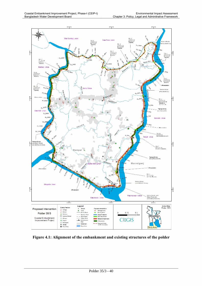
Coastal Embankment Improvement Project, Phase-I (CEIP-I) Bangladesh Water Development Board
Environmental Impact Assessment Chapter 3: Policy, Legal and Adminitrative Framework
Polder 35/3 - 40
Figure 4.1: Alignment of the embankment and existing structures of the polder
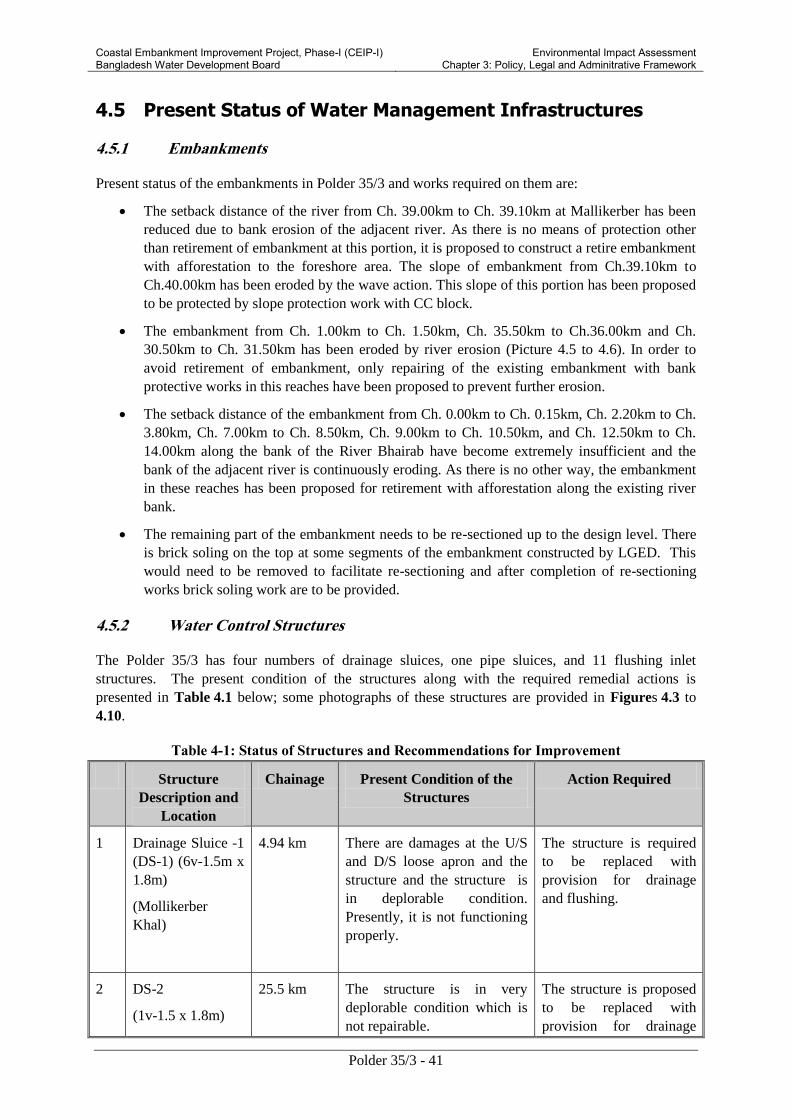
Coastal Embankment Improvement Project, Phase-I (CEIP-I) Bangladesh Water Development Board
Environmental Impact Assessment Chapter 3: Policy, Legal and Adminitrative Framework
Polder 35/3 - 41
4.5 Present Status of Water Management Infrastructures
4.5.1 Embankments
Present status of the embankments in Polder 35/3 and works required on them are:
The setback distance of the river from Ch. 39.00km to Ch. 39.10km at Mallikerber has been
reduced due to bank erosion of the adjacent river. As there is no means of protection other
than retirement of embankment at this portion, it is proposed to construct a retire embankment
with afforestation to the foreshore area. The slope of embankment from Ch.39.10km to
Ch.40.00km has been eroded by the wave action. This slope of this portion has been proposed
to be protected by slope protection work with CC block.
The embankment from Ch. 1.00km to Ch. 1.50km, Ch. 35.50km to Ch.36.00km and Ch.
30.50km to Ch. 31.50km has been eroded by river erosion (Picture 4.5 to 4.6). In order to
avoid retirement of embankment, only repairing of the existing embankment with bank
protective works in this reaches have been proposed to prevent further erosion.
The setback distance of the embankment from Ch. 0.00km to Ch. 0.15km, Ch. 2.20km to Ch.
3.80km, Ch. 7.00km to Ch. 8.50km, Ch. 9.00km to Ch. 10.50km, and Ch. 12.50km to Ch.
14.00km along the bank of the River Bhairab have become extremely insufficient and the
bank of the adjacent river is continuously eroding. As there is no other way, the embankment
in these reaches has been proposed for retirement with afforestation along the existing river
bank.
The remaining part of the embankment needs to be re-sectioned up to the design level. There
is brick soling on the top at some segments of the embankment constructed by LGED. This
would need to be removed to facilitate re-sectioning and after completion of re-sectioning
works brick soling work are to be provided.
4.5.2 Water Control Structures
The Polder 35/3 has four numbers of drainage sluices, one pipe sluices, and 11 flushing inlet
structures. The present condition of the structures along with the required remedial actions is
presented in Table 4.1 below; some photographs of these structures are provided in Figures 4.3 to
4.10.
Table 4-1: Status of Structures and Recommendations for Improvement
Structure
Description and
Location
Chainage Present Condition of the
Structures
Action Required
1 Drainage Sluice -1
(DS-1) (6v-1.5m x
1.8m)
(Mollikerber
Khal)
4.94 km There are damages at the U/S
and D/S loose apron and the
structure and the structure is
in deplorable condition.
Presently, it is not functioning
properly.
The structure is required
to be replaced with
provision for drainage
and flushing.
2 DS-2
(1v-1.5 x 1.8m)
25.5 km The structure is in very
deplorable condition which is
not repairable.
The structure is proposed
to be replaced with
provision for drainage

Coastal Embankment Improvement Project, Phase-I (CEIP-I) Bangladesh Water Development Board
Environmental Impact Assessment Chapter 3: Policy, Legal and Adminitrative Framework
Polder 35/3 - 42
Structure
Description and
Location
Chainage Present Condition of the
Structures
Action Required
(Rautir Khal) and flushing.
3 Flushing Sluice -3
(2v-1.5 x 1.8m)
(Betibunia khal)
34.00 km The sluice is in very bad
conditions
The structure is proposed
to be replaced with
provision for drainage
and flushing.
4 DS-4 (F/S-2)
(1v-0.9mx1.2m)
(Panchamala)
8.75 km There is drainage congestion
in this area, as the flushing
sluice is not adequate for
efficient drainage.
A new drainage-cum-
flushing sluice (1v-1.5 m
x 1.8m) sluice is proposed
to be constructed instead
of the existing flushing
inlet..
5 Pipe sluice
(1v-0.9m)
Madardia
1.55 km RCP sluice is required to be
repaired to drain out rainfall
run-off.
The structure is to be
repaired
6 F/S-1
(1v-0.9m x 1.2m)
0.126 km The barrel wall is being
damaged and holes are formed
on top of the barrel. The sluice
is not repairable.
The sluice is required to
be replaced with re-
excavation of diversion
channel
7 F/S-3
(1v-0.9m x 1.2m)
11.535 km The structure is not
functioning well and there are
some damages to the loose
apron and railing. There is no
lifting arrangement of gate.
The sluice is to be
replaced.
8
F/S-4
(1v-0.9m x 0.9m)
12.45 km The structure is in deplorable
condition and the diversion
channel has been silted up.
The sluice is to be
replaced.
9
F/S-5
(1v-0.9m x 1.2m)
16.65 km Loose aprons and railings have
been damaged. The structure
is repairable.
Structure needs to be
repaired.
10 F/S-6
(1v-0.9m x 1.2m)
17.076 km The gates are missing hence
the sluice is not functioning.
Re-installation of gate is
required.
11 F/S-7
(1v-0.9m x 1.2m)
19.435 km There are some damages to the
loose apron and railing. There
is no lifting arrangement of
gate.
The sluice is to be
replaced.

Coastal Embankment Improvement Project, Phase-I (CEIP-I) Bangladesh Water Development Board
Environmental Impact Assessment Chapter 3: Policy, Legal and Adminitrative Framework
Polder 35/3 - 43
Structure
Description and
Location
Chainage Present Condition of the
Structures
Action Required
12 F/S-8
(1v-0.9m x 1.2m)
21.23 km Vertical lifting gates and flap
gates are not working
properly.
The sluice is required to
be replaced with re-
excavation of diversion
channel
13 F/S-9
(1v-0.9m x 1.2m)
26.40 km The barrel wall is damaged
and holes are formed on top of
the barrel. The sluice is not
repairable.
The sluice is required to
be replaced.
14 F/S-10
(1v-0.9m x 1.2)
27.50 km The structure is in deplorable
condition and the diversion
channel has been silted up.
The sluice is required to
be replaced with re-
excavation of diversion
channel
15 F/S-11
(1v-0.9mx1.m)
33 km Flushing-Inlet are not in good
condition, loose apron are
damaged.
The sluice is to be
replaced.
Note: D/S means Drainage sluices; F/S means Flushing Inlets
4.5.3 Internal khals (water channels)
The area of the polder is criss -crossed by many khals with the total length of 75 km. Most of the
kahls have silted up of which Sayabanki Khal, Betibonia Khal, and Mogordara Khal are mentionable.
The internal drainage channels have silted up due to lack of maintenance for a long time. Therefore,
these khals are not facilitated with drainage or flushing inlets these khals are needed to be urgently re-
excavated to continue the water flow inside the polder area.
Figure 4.2: Daratana river bank erosion
at Bashbari
Figure 4.3: Daratana river bank erosion at
Mollikerber
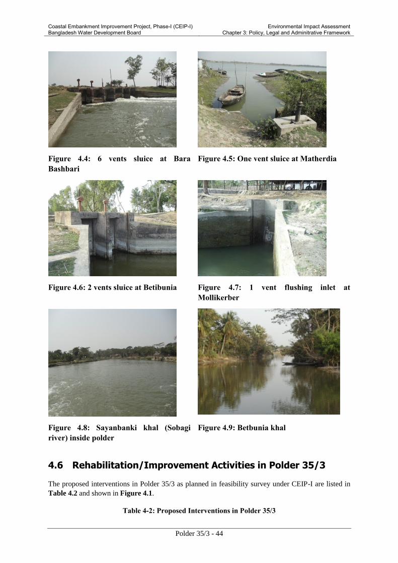
Coastal Embankment Improvement Project, Phase-I (CEIP-I) Bangladesh Water Development Board
Environmental Impact Assessment Chapter 3: Policy, Legal and Adminitrative Framework
Polder 35/3 - 44
Figure 4.4: 6 vents sluice at Bara
Bashbari
Figure 4.5: One vent sluice at Matherdia
Figure 4.6: 2 vents sluice at Betibunia Figure 4.7: 1 vent flushing inlet at
Mollikerber
Figure 4.8: Sayanbanki khal (Sobagi
river) inside polder
Figure 4.9: Betbunia khal
4.6 Rehabilitation/Improvement Activities in Polder 35/3
The proposed interventions in Polder 35/3 as planned in feasibility survey under CEIP-I are listed in
Table 4.2 and shown in Figure 4.1.
Table 4-2: Proposed Interventions in Polder 35/3

Coastal Embankment Improvement Project, Phase-I (CEIP-I) Bangladesh Water Development Board
Environmental Impact Assessment Chapter 3: Policy, Legal and Adminitrative Framework
Polder 35/3 - 45
Proposed intervention Quantity
1 Re-sectioning of embankment 35.00 km
2 Construction of retired embankment 5.05 km
3 Construction of drainage sluices 4
4 Construction of flushing inlets 10
5 Re-excavation of drainage channels 23.50 km
6 Bank protection works 1.70 km
7 Slope protection of embankment 0.90 km
8 Afforestation on the foreshore areas 6.54 ha
Source: Feasibility Report of CEIP, 2012
4.6.1 Works on Embankments
A total of 35.00 km of embankments will be re-sectioned under the proposed interventions. Polder
height will be increased to 4.5.00mPWD and 6.3 km of embankments will be constructed as retired
embankment as shown in the Table 4.3 below.
Table 4-3: Detail of Works on Embankments
Description Chainage
(km)
Height
m (PWD)
Length
(km)
1 Re-section of embankment
(Increasing the height of
embankments)
0.15 to 2.5 4.50 2.35
2
4.00 to 7.00
4.50 3.00
3
8.50 to 9.00
4.50 0.50
4 10.50 to 12.50 4.50 2.00
5 14.00 to 30.50 4.50 16.50
6 31.50 to 39.10 4.50 7.60
7 Retirement 0.00 to 0.15 4.50 0.15
8 2.50 to 4.0 4.50 1.50
9 7.0 to 8.5 4.50 1.50
10 9.00 to 10.50 4.50 1.50
11 12.50 to 14.0 4.50 0.50
12 30.5 to 31.5 4.50 1.0
13
39.1 to 40.0 4.50 0.9
Source: Feasibility Report of CEIP, 2012
Description of construction activities

Coastal Embankment Improvement Project, Phase-I (CEIP-I) Bangladesh Water Development Board
Environmental Impact Assessment Chapter 3: Policy, Legal and Adminitrative Framework
Polder 35/3 - 46
The construction of the embankment will be carried out with the soil/earth obtained either from
drain/canal re-excavation, from borrow pits, or other sources, approved by the Engineer. The earth fill
materials will be well graded, homogenous and free of logs, stumps, roots, rubbish or any other
ingredient, organic/ vegetable matter.
The earth will be placed in layers of 150 mm thickness with soil (minimum 30 percent clay, 0-40
percent silt, 0-30 percent sand) compacted mechanically to attain 85 to 90 percent of maximum dry
density at optimum moisture content to avoid air pocket.
Before commencement of construction activities for embankment works, labor sheds should be
constructed with proper sanitation and other required facilities. A suitable site shall be selected and
prepared by cleaning bushes, weeds, trees etc. Alignment of embankments has to be fixed with
adequate base width. Base stripping and removal of trees, weed etc will be made as per instruction of
the Engineer in charge. The tools required for construction of embankments will be procured during
this period. After validating the final design, excavation of soil/carried earth will be carried and
deposited in a selected area. Soil will be dumped in layers. At the same time, each layer (of 1.5 feet)
of dumped soil will be compacted by compactor machine. The sloping and shaping of embankment
will be developed after proper compaction of layers. The slope of the embankment will be turffed
with grass. Watering and fertilizers will also be provided for proper growth of grass.
4.6.2 Construction/Repairing of Drainage Sluices
Four number of drainage sluices will be replaced under the proposed interventions of the
rehabilitation works of the Polder 35/3. The details description of these sluices has been given in
Table 4.1.
At the outset of the construction activities, required construction materials (sand, cement, wood, and
shuttering materials) will be procured. A suitable site of the structure will be selected and prepared
accordingly. Alternative diversion channels will be constructed before the starting of construction
works. After that the foundation treatment required for flushing inlets will be carried out. Then the
concrete works, pipe and machine pipe along with construction of collar joints will be carried out. The
gates both in the upstream of each flushing inlets will be installed. After completion of all
construction activities, the approach embankments will be constructed and turfed with grass. Finally,
a channel is to be excavated through lead cut and tail cut to make the flow to be channeled through the
flushing gate.
Description of construction activities
At the beginning of the work i.e. during pre-construction phase for construction of drainage sluices,
construction of labor shed, development of sanitation and other facilities etc should be done. During
this period, required construction materials (sand, cement, wood, shuttering materials etc.) will be
procured by the contractor as per tender schedule. Meanwhile, a suitable site will be selected and
prepared for construction of the sluices. Before starting the construction activities of drainage sluices,
Ring bund and diversion channel will have to be constructed. After that the foundation treatment
required for the structure will be carried out. The cement concrete (CC) and reinforced cement
concrete( RCC) works along with cutting, bending and binding of rods will then be performed as per
specification. CC blocks will be prepared and placed as and where required as per design. After
construction of approach roads, fitting and fixing of gates and hoisting device will be carried out.
Gates will be properly painted. The intake and outfall of the gate will be constructed as per design.
The CC blocks will be made for river training works and pitching works will then be conducted.

Coastal Embankment Improvement Project, Phase-I (CEIP-I) Bangladesh Water Development Board
Environmental Impact Assessment Chapter 3: Policy, Legal and Adminitrative Framework
Polder 35/3 - 47
4.6.3 Construction/Repairing of Flushing Inlets
Ten flushing inlets will be replaced under the proposed interventions for rehabilitation work of Polder
35/3. Besides, one flushing inlets will be repaired. The details description has been given in
Table 4.1.
Description of construction activities
Before starting the construction activities of flushing inlets a labor shed will be constructed with
proper sanitation and other facilities. The required construction materials (sand, cement, wood,
shuttering materials etc.) will be procured simultaneously. A suitable site of the structure will then be
selected and prepared accordingly. Alternative diversion channels will be constructed before starting
the construction works. After that the foundation treatment required for flushing inlets will be carried
out. Then the RCC works, pipe and machine pipe along with construction of allied and fittings will be
made along with construction of and collar joints will be made as and where required. After few days
of constructions the gates both in the upstream and downstream of each flushing inlets will be
executed. After completion of all construction activities, the approach embankments will be
constructed and turfed with grass. Finally, a channel is to be excavated through lead cut and tail cut to
make the flow to be channeled through the flushing gate.
4.6.4 Re-excavation of Drainage Channels
Three channels will be re-excavated to decrease the drainage congestion. An estimated volume of
0.67 million cubic meters of soil/silt will be excavated from these channels. The excavated soil will
be used for strengthening the khal banks, making them available to the farmers. The water channels
to be re-excavated under the project are presented in Table 4.4.
Description of construction activities
For re-excavation of the drainage channels, at first the required tools will have to be procured. A
schematic diagram showing centerline and layout plan will be made for the re-excavation noting the
design depth and width of excavation to be made. The entire channel will then be divided into a
number of reaches. The excavation will be started from the upstream of the channel. Cross dams are
to be provided at the starting and final locations of the reach, and then soil from the channels will be
removed up to the required depth and width. The excavated soil/sludge should be disposed into a
suitable place, specified by the Engineer in charge, from where the sludge or soil will not affect the
channel flow by any means. After finalizing excavation on one reach, the other reach in the
downstream would be excavated following structures procedure.
Table 4-4: Channels to be Re-excavated
Name of Khal Length
(km)
Chainage
(km)
1 Sayabanki Khal 14.50 4.940
2 Betibonia Khal 6.00 34.00
3 Mogordara Khal 3.0 8.75
Total 23.50
Source: Feasibility Report of CEIP, 2012

Coastal Embankment Improvement Project, Phase-I (CEIP-I) Bangladesh Water Development Board
Environmental Impact Assessment Chapter 3: Policy, Legal and Adminitrative Framework
Polder 35/3 - 48
4.6.5 Bank Protection and Slope Protection Works
The proposed intervention of the rehabilitation works of the project includes bank protection works.
Bank protection works for length of only 1.7 km will be carried out from chainage 1.0 km to 1.5 km
and 30.5 km to 31.5 km of the polder. In addition, about one km of slope protection (Ch 39.1 km to
40.0 km) of embankment is to be carried out along the Paylahara River.
Description of construction activities
The construction activities involved in the bank protection and slope protection are: the construction
of labor shed, creation of sanitation facility and procurement of construction materials (sand, cement,
wood, shuttering materials etc.), the slope of the river bank as per design will be developed by earth.
At the same time, the required CC blocks will be casted or manufactured and guard walls will be
constructed. After completion of the construction of CC blocks, Geo-textile bags will be placed along
the slope and CC blocks will be placed on it. A launching apron will be prepared with CC blocks
along with dumping of CC blocks in assorted form will be completed up to the toe of embankment in
the river banks. Finally, turfing will be made on the slope of the embankments. Proper drainage
provision will be kept to avoid formation of rain cuts for surface run off.
4.6.6 Afforestation
Plantation of mangrove forest is proposed for afforestation on the foreshore area. The areas selected
for afforestation in the polder 35/3 are shown in Figure 4.11. Establishment of green belts in these
areas can reduce the effect of toe and slope erosion due to wave action and river flow and promote
land accretion. About 26 ha of foreshore area will be planted with mangroves in the Polder, whereas
about 20 ha of land will be kept for timber saplings and 6 ha for Golpata. The saplings are to be
planted at a spacing of 1.5m x 1.5m. Figure 4.10 shows the typical cross-section of this plantation.
Figure 4.10: Typical Cross Section of afforestation works
The afforestation will be made at different locations on the foreshore of the polder area. Total length
of afforestation will be 13 km. Detail information of afforestation with chainage is shown in Table
4.5 below:
Table 4.5: Detail works of afforestation
Sl Description Chainage
(km)
Length
(km)
1 Afforestation 1.50 to 2.00 0.5
2 4.00 to 6.00 2.0
3 9.50 to 11.50 2.0
4 23.50 to 29.00 5.5
Mangrove afforestation Mangrove afforestation

Coastal Embankment Improvement Project, Phase-I (CEIP-I) Bangladesh Water Development Board
Environmental Impact Assessment Chapter 3: Policy, Legal and Adminitrative Framework
Polder 35/3 - 49
Sl Description Chainage
(km)
Length
(km)
5 33.00 to 34.50 1.50
6 36.50 to 38.00 1.50
Total 13.00
4.7 Construction Details
4.7.1 Construction Schedule
The works in Polder 35/3 under the CEIP-I are expected to be completed in four years. The
construction schedule is present in Table 4.6.

Coastal Embankment Improvement Project, Phase-I (CEIP-I) Bangladesh Water Development Board
Environmental Impact Assessment Chapter 3: Policy, Legal and Adminitrative Framework
Polder 35/3 - 50
Figure 4.11 (a): Location of Proposed Interventions in Polder 35/3 (Part-1)

Coastal Embankment Improvement Project, Phase-I (CEIP-I) Bangladesh Water Development Board
Environmental Impact Assessment Chapter 3: Policy, Legal and Adminitrative Framework
Polder 35/3 - 51
Figure 4.11 (b): Location of Proposed Interventions in Polder 35/3 (Part2)

Coastal Embankment Improvement Project, Phase-I (CEIP-I) Bangladesh Water Development Board
Environmental Impact Assessment Chapter 3: Policy, Legal and Adminitrative Framework
Polder 35/3 - 52
Figure 4.11 (c): Location of Proposed Interventions in Polder 35/3 (Part 3)

Coastal Embankment Improvement Project, Phase-I (CEIP-I) Bangladesh Water Development Board
Environmental Impact Assessment Chapter 3: Policy, Legal and Adminitrative Framework
Polder 35/3 - 53
Figure 4.11 (d): Location of Proposed Interventions in Polder 35/3 (Part 4)

Coastal Embankment Improvement Project, Phase-I (CEIP-I) Bangladesh Water Development Board
Environmental Impact Assessment Chapter 4: Description of Proposed Interventions in Polder 35/3
Polder 35/3 - 54
Table 4.6: Construction Schedule
Description Year 1 Year 2 Year 3 Year 4
Jan-
Mar
Apr-
Jun
Jul-
Sep
Oct-
Dec
Jan-
Mar
Apr-
Jun
Jul-
Sep
Oct-
Dec
Jan-
Mar
Apr-
Jun
Jul-
Sep
Oct-
Dec
Jan-
Mar
Apr-
Jun
Jul-
Sep
Oct-
Dec
A. Pre-Construction Activities
A1 Discussion with local stakeholders
about the project and interventions
A2 Disclose rehabilitation plan
A3 Distribute acquisition and requisition
money before the construction works
A4 Display Bill board on the
intervention site for public awareness
A5 Preparation of Stockyard for
construction materials
A6 Mobilization and site preparation
A7 Higher Contractors through tendering
procedure
A8 Construction of labor shed and site
office
A1 Labor shed and site office
preparation
A2 Installment of water and sanitation
facilities
A3 Installment of Garbage disposal
system
B Procurement system of the project

Coastal Embankment Improvement Project, Phase-I (CEIP-I) Bangladesh Water Development Board
Environmental Impact Assessment Chapter 4: Description of Proposed Interventions in Polder 35/3
Polder 35/3 - 55
Description Year 1 Year 2 Year 3 Year 4
Jan-
Mar
Apr-
Jun
Jul-
Sep
Oct-
Dec
Jan-
Mar
Apr-
Jun
Jul-
Sep
Oct-
Dec
Jan-
Mar
Apr-
Jun
Jul-
Sep
Oct-
Dec
Jan-
Mar
Apr-
Jun
Jul-
Sep
Oct-
Dec
B1 Procurement of construction
materials
B2 Procurement of construction
machineries and equipments
C Rehabilitation of embankment
C1
Collection of earth materials from the
borrow pit area from outside of the
embankment through excavator, pay
loader and dump truck and trolley
C2 Collection of earth materials from
Baleswar river through dredging
C3 Use slow moving vehicles/head load
for carrying earth materials
C4
Dumping of earthen materials on the
embankment
C5 Keeping earthen materials for drying
C6 Breaking dried earthen materials
through Clod Breaker
C7 Embankment surface labeling
through dumper machine
C8 Embankment slope pitching and
turfing
D Re-excavation of Canal

Coastal Embankment Improvement Project, Phase-I (CEIP-I) Bangladesh Water Development Board
Environmental Impact Assessment Chapter 4: Description of Proposed Interventions in Polder 35/3
Polder 35/3 - 56
Description Year 1 Year 2 Year 3 Year 4
Jan-
Mar
Apr-
Jun
Jul-
Sep
Oct-
Dec
Jan-
Mar
Apr-
Jun
Jul-
Sep
Oct-
Dec
Jan-
Mar
Apr-
Jun
Jul-
Sep
Oct-
Dec
Jan-
Mar
Apr-
Jun
Jul-
Sep
Oct-
Dec
D1 Bailing out of water with all leads
and lifts by manual labor or pump,
with all arrangements for protection
of ring bund and side slopes of
foundation pit against erosion and
washout
D2
Earth work by manual labor with
clayey soil (minimum 30% clay, 0-
40% silt and 0-30% sand) in
construction of cross bund as per
design and specification with all
leads and lifts, throwing the earth in
layers not exceeding 150 mm in
thickness including breaking clods,
rough dressing, cleaning the jungle,
removing stumps, dug baling and
75mm cambering complete as per
direction of Environmental specialist.
D3 De-silting works of canal through
excavator
D4
Deposited the spoil earth both bank
of the canal through pay loader ,
dump truck and trolley if necessary
using head load as per design and
specification
D5 Earth work by manual labor in all
kinds of soil in removing the gross

Coastal Embankment Improvement Project, Phase-I (CEIP-I) Bangladesh Water Development Board
Environmental Impact Assessment Chapter 4: Description of Proposed Interventions in Polder 35/3
Polder 35/3 - 57
Description Year 1 Year 2 Year 3 Year 4
Jan-
Mar
Apr-
Jun
Jul-
Sep
Oct-
Dec
Jan-
Mar
Apr-
Jun
Jul-
Sep
Oct-
Dec
Jan-
Mar
Apr-
Jun
Jul-
Sep
Oct-
Dec
Jan-
Mar
Apr-
Jun
Jul-
Sep
Oct-
Dec
bund/ring bund, including all leads
and lifts complete and placing the
spoils to a safe distance (minimum
15m apart from the bank) as per
design
E Replacement and repairing of
regulator
E1 construction and repairing of
drainage sluices
E2 construction and repairing of
flushing inlets
F Afforestation
F1 Land preparation
F2 Fencing preparation and setting
F3 Plantation of mangrove trees

Coastal Embankment Improvement Project, Phase-I (CEIP-I) Bangladesh Water Development Board
Environmental Impact Assessment Chapter 4: Description of Proposed Interventions in Polder
35/3
Polder 35/3 - 58
4.7.2 Construction Manpower Requirement
Technical and nontechnical manpower will be required for the Project construction works. They will
include engineers, technicians, supervisors, surveyors, mechanics, foremen, machine operators,
drivers, and un-skilled labor. Around 60 to 70 percent of labor will be engaged from the local area
and remaining will be from outside. The estimated manpower requirement is presented in Table 4.7.
Table 4.7: Required manpower for construction
Required Manpower Number
1 Engineer 2
2 Machinery operation 38
3 Mechanics 2
4 Surveyor 3
5 Skilled labor 4,079
6 Unskilled labor 2,91,543
Source: Feasibility Report of CEIP, 2012
4.7.3 Construction Material
The construction materials required for re-sectioning and retired embankment, water regulatory
sluices and flushing inlets, and bank protection work will include soil, cement, steel, and sand.
Estimated quantities of these materials are presented in Table 4.8.
Table 4.8: Construction Materials
Sl Description Quantity Sources
Re-sectioning and retired embankment
1 Earth work 11,85,884 m3 Borrow pits, dredging spoils from
re-excavation of drainage channels
Construction of sluices and flushing inlets
2 Cement 70,489 bag To be procured from local market
3 Sand 4180 m3 To be procured from Khulna
4 Stone 9,404 m3 To be procured from Khulna
5 Steel 298 Ton To be procured from Khulna
Bank protection
6 CC Blocks 95,999 nos To be made at construction site
during construction
7 Stones 23,900 m3 To be collected from Khulna
The earth for embankment re-sectioning or retired embankment will be collected from the offshore
area of the polder 35/3. The spatial location of the borrow pit areas are delineated in Figure 4.13. The
details of borrow pit area are attributed in the following table:
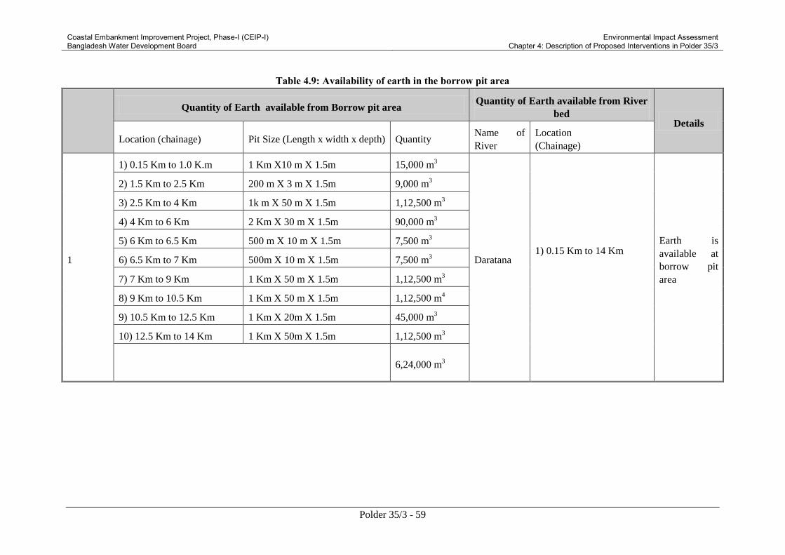
Coastal Embankment Improvement Project, Phase-I (CEIP-I) Bangladesh Water Development Board
Environmental Impact Assessment Chapter 4: Description of Proposed Interventions in Polder 35/3
Polder 35/3 - 59
Table 4.9: Availability of earth in the borrow pit area
Quantity of Earth available from Borrow pit area Quantity of Earth available from River
bed Details
Location (chainage) Pit Size (Length x width x depth) Quantity Name of
River
Location
(Chainage)
1
1) 0.15 Km to 1.0 K.m 1 Km X10 m X 1.5m 15,000 m3
Daratana
1) 0.15 Km to 14 Km
Earth is
available at
borrow pit
area
2) 1.5 Km to 2.5 Km 200 m X 3 m X 1.5m 9,000 m3
3) 2.5 Km to 4 Km 1k m X 50 m X 1.5m 1,12,500 m3
4) 4 Km to 6 Km 2 Km X 30 m X 1.5m 90,000 m3
5) 6 Km to 6.5 Km 500 m X 10 m X 1.5m 7,500 m3
6) 6.5 Km to 7 Km 500m X 10 m X 1.5m 7,500 m3
7) 7 Km to 9 Km 1 Km X 50 m X 1.5m 1,12,500 m3
8) 9 Km to 10.5 Km 1 Km X 50 m X 1.5m 1,12,500 m4
9) 10.5 Km to 12.5 Km 1 Km X 20m X 1.5m 45,000 m3
10) 12.5 Km to 14 Km 1 Km X 50m X 1.5m 1,12,500 m3
6,24,000 m
3

Coastal Embankment Improvement Project, Phase-I (CEIP-I) Bangladesh Water Development Board
Environmental Impact Assessment Chapter 4: Description of Proposed Interventions in Polder 35/3
Polder 35/3 - 60
Quantity of Earth available from Borrow pit area Quantity of Earth available from River
bed Details
Location (chainage) Pit Size (Length x width x depth) Quantity Name of
River
Location
(Chainage)
2 Putimary
1) 14 Km to 23.5 Km
(River bed has been silted
up and become dry during
low tide period, therefore
earth is to be collected
from the bed of nearby
Putimary Khal)
80% of earth
is to be
collected
through
excavation of
khal.
3
Bishnu
1) 23.5 Km to 25.5 Km
(River bed become dry
during low tide period,
therefore earth is to be
collected from the bed of
nearby Bishnu River)
80% of earth
is to be
collected
through
excavation of
khal.
4
1) 25.5 Km to 28 K.m 2.5 Km X 10 m X 1.5m 37,500 m3
Bishnu 1) 25.5 Km to 34 Km
90% of earth
is available at
borrow pit
area.
2) 28 Km to 30 Km 2 Km X 30 m X 1.5m 90,000 m3
3) 30 Km to 32.5 Km 1 Km X 5 0m X 1.5m 75,000 m3
4) 32.5 Km to 34 Km 1.5 Km X 15m X 1.5m 33,750 m3
2,36,250 m3

Coastal Embankment Improvement Project, Phase-I (CEIP-I) Bangladesh Water Development Board
Environmental Impact Assessment Chapter 4: Description of Proposed Interventions in Polder 35/3
Polder 35/3 - 61
Quantity of Earth available from Borrow pit area Quantity of Earth available from River
bed Details
Location (chainage) Pit Size (Length x width x depth) Quantity Name of
River
Location
(Chainage)
5
1) 0.0 Km to 0.15 Km 150m X10m X 1.5m 2,250 m3
Katakhali 1) 0.15 Km to 34 Km
Earth is
available at
borrow pit
area
2) 39 Km to 40 Km 1 Km X 50 m X 1.5m 75,000 m3
3) 35.8 Km to 39 Km 2 Km X 50 m X 1.5m 1,50,000 m3
4) 35 Km to 35.8 Km 500m X 25 m X 1.5m 18,750 m3
5) 34.5 Km to 35 Km 500m X 15 m X 1.5m 11,250 m3
6) 34 Km to 34.5 Km 500 m X 30 m X 1.5m 22,500 m3
2,79,750 m3
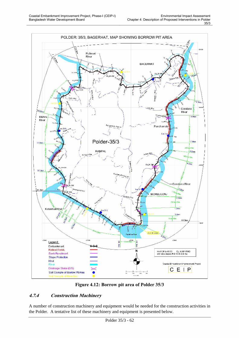
Coastal Embankment Improvement Project, Phase-I (CEIP-I) Bangladesh Water Development Board
Environmental Impact Assessment Chapter 4: Description of Proposed Interventions in Polder
35/3
Polder 35/3 - 62
Figure 4.12: Borrow pit area of Polder 35/3
4.7.4 Construction Machinery
A number of construction machinery and equipment would be needed for the construction activities in
the Polder. A tentative list of these machinery and equipment is presented below.

Coastal Embankment Improvement Project, Phase-I (CEIP-I) Bangladesh Water Development Board
Environmental Impact Assessment Chapter 4: Description of Proposed Interventions in Polder
35/3
Polder 35/3 - 63
Table 4.10: List of Construction Equipment and Machinery
Description Quantity (number)
1 Bolldozer 2
2 Dump- truck 3
3 Pay Loader 2
4 Excavator 2
5 Burge 1
6 Engine Boat 2
7 Vibrator 20
8 Compactor 4
9 Mixture Machine 20
11 Truck 2
12 Tractor 2
13 Generator 7
14 Leveling Instrument 2
15 Total Station 1
16 De-watering System 4
17 Low lift pump 4
4.7.5 Construction Camps
A total of 42 camps for labor will be established during construction period. Out of the total camps,
25 camps for embankment works, four camps for sluice works, 10 camps for flushing inlet works, one
camp for slope protection works, and two camps for bank protection works will be established.
Contractor will select the location of the camp through consultation with local union parishad
Chairman and the local community inside the Polder, and after obtaining permission from the
Supervision Consultants (Engineer).
Drinking Water and Sanitation System of Camps
A total number of 25 tube wells will be installed in the labor camps premises near the construction
sites for obtaining water for the camps and also for construction activities. For sanitation, latrines will
be constructed along with septic tanks for safe disposal of sewage.
4.7.6 Vehicular Traffic during Construction
During construction activities of the polder, the major quantity of earth will be carried to the
embankment by mechanical equipment like excavators, pay loaders, dump trucks, trolleys and some
minor quantity by manual labor.

Coastal Embankment Improvement Project, Phase-I (CEIP-I) Bangladesh Water Development Board
Environmental Impact Assessment Chapter 4: Description of Proposed Interventions in Polder
35/3
Polder 35/3 - 64
The construction materials would be collected from the stock yard at BWBD colony Bagerhat and
then would to be transported using heavy trucks for eastern areas near Paylahara River of the polder;
the trucks or other vehicles will be used for district road coming from Khulna. The materials found
usable from the polder may be carried through small carts, non-motorized vans and other smaller
vehicles.
The equipment and construction materials including hard rock dumping materials and sluice gate
equipment will be transported from Khulna on water vessels through Rupsha River and Daratana
River.
4.7.7 Jetty Construction
A temporary jetty will be constructed at Daratana River near the stock yard in Bagerhat BWDB
colony for unloading and stocking of construction materials. The stocked materials will then be
carried to the individual sites from this place by truck, small trawllers and engine boats.
4.7.8 Project Implementation Arrangements
Overall Project Management. The Government of Bangladesh has the overall responsibility for
project management and coordination through its Ministry of Water Resources. A Project Steering
Committee (PSC) would provide the forum for overall guidance, policy advice and coordination of
the project activities and addressing the inter-agency issues. BWDB will act as the Project
Implementing Agency and will implement the project through a Project Management Unit (PMU).
Project Steering Committee (PSC). The PSC would be chaired by the Secretary of the Ministry of
Water Resources and will include the Secretaries of other Ministries like Finance, Agriculture,
Environment, Public Health Engineering, and Forestry and Wildlife, the Chief Executive officer of
selected NGO, and representatives of the local/district administration as members. The PSC will
oversee the project; provide policy-level guidance and inter-agency coordination for the project. The
Project Director of the PMU will act as the Member Secretary of the PSC.
Project Management Unit (PMU). BWDB will set up a PMU to oversee the development and
management of the project. The PMU, will be led by a Project Director appointed by BWDB. The PD
will be of the rank of Chief Engineer, and will report directly to the Director General (DG). The PMU
will have a central project office located at the headquarters of BWDB in Dhaka. The PMU will have
3 subordinate units: (i) Engineering Unit; (ii) Procurement and Finance Unit; and (iii) Social,
Environment and Communication Unit. In addition to the central unit in Dhaka, three Field Level
Offices will be set up, each headed by an Executive Engineer, recruited by the project. The Field
Offices will be located in each of the three main project districts, namely Khulna, Patuakhali/Barguna,
and Bagerhat.
The Procurement and Finance Unit will be responsible for the entire procurement and financial
management process of the project. It will also be responsible for monitoring progress of the project,
to liaise with the Bank, and to prepare annual programs, implementation reporting, updating all
procurement reporting documents and financial management reporting. Procurement staff would
consist of a Senior Procurement Specialist and one Procurement specialist. The Finance staff would
consist of one Deputy Director Finance, two Accountants and three support staffs.
The Engineering Unit will oversee the work of the consultants on design and construction
supervision matters. A Deputy Project Director will head the Engineering Unit and will spend about
half of his/her time at the site to provide coordination between the PMU, the supervising consultant
and the three Field Offices. In addition to the Deputy Project Director, the engineering unit will also
include two Executive Engineers, two Assistant Engineers.

Coastal Embankment Improvement Project, Phase-I (CEIP-I) Bangladesh Water Development Board
Environmental Impact Assessment Chapter 4: Description of Proposed Interventions in Polder
35/3
Polder 35/3 - 65
A Social, Environment and Communication Unit will supervise the activities compliance with the
Environmental Management Plan and Social Action Program together with the engineering unit to
implement the communication strategy. The unit will include a Sr. Environmental Specialist, a Sr.
Social Specialists, a Sr. Forestry Specialist a Revenue Staff and a Communication Specialist.
Each Field Office will be staffed with one Project Manager/Executive Engineer (XEN), two Sub-
Divisional Engineers (SDEs) and two Assistant Engineers (AEs). In addition, an Environmental
Specialist, a Social Specialist and a Revenue Staff will work across all three field offices.
The PMU will be supported by the following consultancy:
An experienced NGO will be mobilized by the PMU to implement the social afforestation as
provided in the project intervention and EMP; the Social Action Plan including the
mobilization of Water Management Organization; the RAP and the EMP.
A Design and Construction Supervision Consultancy Firm that will assist the PMU in
preparing the detail design of the remaining interventions of the polders and supervise all
construction works. For civil works, the Project Director will serve as the Employer, and the
Project Supervision Consultant will serve as Engineer for construction supervision. At the
site, a Resident Engineer, appointed by the consultant, with a team of specialists and
inspectors will supervise the works of the Contractor.
A Monitoring and Evaluation Consultants will provide support in monitoring project impacts
and supervise the implementation of the EMP/RAP and will report to the PMU.
Procurement Panel. A Procurement Panel will be appointed by BWDB to oversee the
procurement process of large value contracts subject to prior review under the project. The
panel is consist of two international/expatriate specialists and one national specialist.
An Independent Panel of Expert (IPOE). BWDB will also appoint an IPOE to act as an
independent “peer reviewer” and undertake quality control functions of various technical
outputs. The Panel will consist of 5 renowned experts in the field of: morphology/river
engineering; tidal river management/sediment specialist; geotechnical specialist, social
specialist and environment/polderization specialist.
4.7.9 Community Participation
4.7.10 People’s Participation of WMO/CBO
The National Water Policy (NWP) through its various provisions emphasizes the issues of
participatory water management and highlights the importance of stakeholder participation for
sustainable operation of the project. To ensure the stakeholders participation, Ministry of Water
Resources, GoB has prepared guidelines namely The Guidelines for Participatory Water Management
(MoWR 2001) usually known as GPWM. The aim and objectives of GPWM are as follows:
Manage, operate and maintain the Project/ Sub-project/ Scheme;
Maintain liaison with the Implementing Agencies, other concerned Public Sector Agencies,
Local Government Institutions, Non-Government Organizations and Community Self-help
Groups;
Plan and coordinate the activities of the local stakeholders;
Mobilize local resources for contribution towards construction operation and maintenance
costs.

Coastal Embankment Improvement Project, Phase-I (CEIP-I) Bangladesh Water Development Board
Environmental Impact Assessment Chapter 4: Description of Proposed Interventions in Polder
35/3
Polder 35/3 - 66
BWDB managers and field staffs in Divisions, Sub-Divisions and Sections offices do not have
adequate expertise and experienced manpower to carry out the O&M of coastal polders properly.
Moreover, in many places the numbers of field staffs are also insufficient and inadequate to the actual
requirement. In this case to ensure sustainable operation of the project, participation of Water
Management Organization (WMO) and Community Based Organizations (CBOs) is needed.
The GPWM has outlined a three tier organizational structure comprising Water Management Groups
(WMG) at the lowest level, Water Management Associations (WMA) at the mid-tier and Water
Management Federation (WMF) at the apex. The combination of groups, associations and federations
in a particular sub-project is together termed as the Water Management Organization (WMO) which
has been considered in this project.
4.7.11 Water Management Groups (WMGs)
This organization, at the grass-root level will provide the platform for all those who live inside or
adjacent (close vicinity) to the Polder and will be treated as the primary society. The entire command
area of the Polder will be sub-divided into few hydrological units preferably on the basis of
hydrological consideration and each of these Units will have one WMG. The size of the units may
vary depending on the land topography, actual alignment of the existing roads, canals or embankment,
and location of structures, turn-outs or even the field channels. Preferably the size of such
hydrological units should vary within the range of 500 ha to 1500 ha. The areas of the units so
demarcated usually comprise two or three villages and part thereof. One WMG may therefore include
several hundreds to a few thousand as its primary members. As per GPWM, the registration of WMG
is a must.
4.7.12 Water Management Association (WMA)
A numbers of WMGs functioning in Polder area will form a Water Management Association (WMA)
as a coordinating body at the mid-level of the polder/ sub-project. The WMGs are the grass-root
people who would be directly involved in water management while the WMAs will provide necessary
coordination at the mid-level. The WMAs are chosen as the point of formal interface between BWDB
and WMGs. This is the level where formal agreements relating to respective duties and obligations of
the water sector agency (BWDB) and primary societies, i.e WMGs are reached and signed. For this
reason, this level needs to have a legal status and hence the question of registration arises.
Registration of WMA is a must.
4.7.13 Water Management Federation (WMF)
This is conceived as the supervisory type of organization functioning at the apex level of the hierarchy
and is needed to establish linkages with other higher level organizations for support and mobilization
of resources. The requirement of WMF's registration may therefore be kept optional. The WMFs may
exist on the basis of actual functioning strength of WMGs and WMAs. Usually in a district or in a
bigger hydrological basin comprising of several districts may have one or more federations
functioning at the top level of the hierarchy. The office bearers of the WMF, the 5-member federating
body will be selected from the MC members of WMAs. Important personalities of the area like
Member of Parliament or local leader may be nominated as the chair-person of the WMF and other
members (not exceeding 04 nos.) may come from the WMAs by virtue of their importance in
controlling the numbers of WMGs.

Coastal Embankment Improvement Project, Phase-I (CEIP-I) Bangladesh Water Development Board
Environmental Impact Assessment Chapter 4: Description of Proposed Interventions in Polder
35/3
Polder 35/3 - 67
4.7.14 Participation of Community Based Organizations
Community Based Organizations often termed as CBOs can also play a vital role in maintenance
activities. While engaging any of the functional groups of these CBOs in this polder, care should be
taken to twist and turn the methodologies slightly in some of the aspects as per local situation and
project provisions so that it really fits in. Under this project, CBOs are conceived to be included in the
Water Management Groups (WMGs) as Functional Groups (FGs). The FGs have the scope of
working in O&M of the polder under the purview of WMG.
The following CBOs have been recommended for this polder under CEIP.
Embankment Settler (ES)
ESs are the families selected from squatters and project affected persons who do not have any land or
lost it for land acquisition. They can be organized in functional groups for taking part in preventive
maintenance of the embankments in specified reach (approximately 0.5 ha) where they are allowed to
settle on the toe of the embankment. The maintenance activities include small earthworks, new
plantation, re-plantation or enrichment in planting and maintenance of vegetation cover. ESs may be
engaged in embankment maintenance activities through a contract agreement for certain period.
Embankment Maintenance Group (EMG)
EMGs are the groups formed from the destitute women (maximum 10 members per group) selected
from landless families, who are responsible for carrying out preventive earthwork maintenance of a
specified reach of embankment including grass turfs lying. They are the paid laborers on daily basis
payment.
Canal Maintenance Group (CMG)
CMGs are the groups consisting of 10 members selected from landless people and destitute women.
Under this concept, they will be responsible for preventive maintenance of canals capacity
improvement inside the polder and outfall drains. Activities of CMG include the removal of floating
debris, aquatic weeds and water hyacinths; and to some extent disposal of silt deposits in wet
condition. CMGs are paid on daily basis and not on the basis of volumes of actual works done.
Landless Contracting Society (LCS)
LCSs are the groups selected from landless people consisting of nearly 60 members or more per group
(as the case may be). They are responsible to carryout earthworks only up to a limit of Taka 3.00 lacs
in a single contract. During formation of CBOs or CSs women participating in above mentioned
groups will be ensured.
4.8 Operation and Maintenance Plan
Coastal polders surrounded by embankments in the coastal region protect the lives and properties of
people and agricultural lands with crops from tidal inundation; saline water intrusion; storms and
cyclonic surges thereby releasing a large extent of land for permanent agriculture as well as congenial
living condition. Most of the polders were constructed in the pre-liberation period i.e during the
decades of sixties and early seventies. Over and above the polders have been playing vital roles in
safeguarding the coastal area; ensuring and increasing agricultural production; improving livelihoods
of the people; and mitigating environmental damages. But these are vulnerable to storm surges; high
tides; annual floods; land erosion and drainage congestion. In many cases the structures as built have
not been found adequate to cater to the diverse needs of the local people. Changes in the land use
pattern also have created water management conflicts and newer dimension needs asking the

Coastal Embankment Improvement Project, Phase-I (CEIP-I) Bangladesh Water Development Board
Environmental Impact Assessment Chapter 4: Description of Proposed Interventions in Polder
35/3
Polder 35/3 - 68
structures to allow flows of water both ways. So, maintenance of the polder system with
embankments and structural elements built over there has become a permanently important task.
The Coastal Embankment Improvement Program (CEIP) is one of the latest such interventions to
address a systematic restoration and upgrading of polder systems in the coastal region. Under this
long term phased program of polders improvement, Operation and Maintenance issues with special
reference to Local Government Institutions (LGIs) as well as local stakeholders participation and need
based budgeting will continue to remain at the apex.
The most relevant to the current assignment i.e "Guidelines for O&M Planning and Budgeting,
August 2001; CERP-II" has been consulted very carefully to prepare the O&M plan for CEIP.
Moreover, all the pros and cons of polders' O&M issues with BWDB's field staffs and local
stakeholders have been considered for preparation of polder O&M planning. A brief description of
O&M is given below.
4.8.1 Operational Plan
Operational plan involves setting out the schedule of activities related to operation of gates of
structures by the users' organization to control water levels best suited to water management and
agricultural needs. The activities given below have been recommended for the operation plan of
Polder 35/3.
Regulation of Gates
During pre-monsoon period, the vertical lifting gates of each regulator should remain closed for
retention of water for irrigating Aus rice (group of rice varieties sown in the pre-monsoon season and
harvested in the monsoon season) crops by LLPs (Low lift pumps). During monsoon (July to
September), the vertical lifting gates should normally remain closed; but may be opened to regulate
the water levels inside the polder and it should not be allowed to exceed the stated maximum
permissible level for safety reasons. In order to achieve this, discharges into the river should
commence (river levels permitting) as soon as this level is attained. This type of water management
decisions should be taken after due consideration of daily rainfall, river stages, water levels inside the
polder, gate opening schedules. However, the frequency and type of this decision making process will
vary with the seasonal conditions.
During post monsoon season (October to November), the vertical lifting gates will be operated to
retain water in the drainage canals without overtopping the canal banks and increasing the soil
moisture level for cultivation. In all these cases there should have enough consultation with the
beneficiaries' organizations because agricultural practices, crop varieties; and cropping pattern are
changing with time. Operation of Flushing Sluices and Pipe Inlets should also have similar practices
with maximum involvement of beneficiaries' organizations. The O&M section and DWM staffs of
BWDB will assist them in the water management of command areas inside the polders.
Frequent Surveillance of Embankments
This is a typical monitoring activity to be carried out by the BWDB O&M staff. It is intended mainly
to detect weak sections, gullies, slips, sign of squatter settlements, and cultivation of perennial cash
crops, cuts in the embankments to accommodate homesteads, embankment subsidence and erosion
and / or settlement of protection works.
Recommendations for the frequency of field inspections and reporting of the physical condition of
canals and embankments with its associated structures and protective works by BWDB's O&M field
staffs have been made quite in details in the relevant SRP reports and findings.

Coastal Embankment Improvement Project, Phase-I (CEIP-I) Bangladesh Water Development Board
Environmental Impact Assessment Chapter 4: Description of Proposed Interventions in Polder
35/3
Polder 35/3 - 69
Regular Checking of Structures
This is also a typical monitoring activity to be carried out by BWDB's O&M field staffs to detect slips
at abutments, damage of protective works and wing walls, and periodic damage to flap gates and fall
boards. The functional groups under WMGs in the polders will assist the O&M Sectional Office of
BWDB to identify and report the damages for rectification.
Condition (of embankment and structures) Survey and Engineering survey
The survey data obtained by the O&M field staff of BWDB are used for estimating the required
maintenance works. Physical condition of embankments and structures are investigated through field
surveys once in a year. This is specially required to prepare the details for carrying out periodic
maintenance works.
Supervision of Preventive Maintenance Works
Preventive maintenance works are done by community-based functional groups (e.g EMGs, SMGs,
and CMGs) as and when required round the year. The works are most simple, cheaper and cost
effective maintenance works and are implemented more or less continuously. The field staffs of O&M
section of BWDB supervise all preventive maintenance works.
A good planning for operation of structures is very essential to avoid social conflict. In this situation,
during the cropping season, monthly, weekly or daily operational adjustments will be required.
Routine monitoring of water management and hydrological conditions will supply data which
together with the water management plan will dictate the needs of adjusting the operational measures.
Participation of beneficiaries vis-à-vis the farming community is essential in establishing the seasonal
or long term water management plan. This however, reduces to a somewhat lesser extent in setting up
the weekly operation targets. Although the daily structure operation is largely an activity of the
responsible O&M authority like BWDB's Section Office, it can be shifted to the WMG if they are
provided with adequate training and management capabilities.
4.8.2 Maintenance Works
Maintenance of embankments and structures is the most important item of acti.vities in the coastal
polders. It is necessary and cannot be avoided because it helps in preserving the infrastructure in good
and functional condition; protects investments; and prevents high rehabilitation costs. Since this is
included in the day-today tasks schedule and needs continuous efforts, maintenance of coastal polders
put emphasis on simple and cost effective community-based interventions.
In the coastal Polder 35/3, the works which directly serve water management should be regularly
maintained.
Preventive or Routine Maintenance
The objective of preventive maintenance is to keep the overall polder system including all its elements
in good functional order thereby reducing the need of periodic maintenance eventually avoiding high
rehabilitation costs. The works are simple, cheaper and cost effective and can be implemented through
community-based functional groups such as EMGs, CMGs, and SMGs. Preventive maintenance is
carried out round the year, almost continuously or as and when required. The works are mentioned
below:

Coastal Embankment Improvement Project, Phase-I (CEIP-I) Bangladesh Water Development Board
Environmental Impact Assessment Chapter 4: Description of Proposed Interventions in Polder
35/3
Polder 35/3 - 70
All activities related to vegetative covers on embankment i.e. new (or re-) planting;
enrichment planting; and maintenance of vegetation by EMGs and/or EPGs;
Small earthworks on the embankment by EMGs;
Cleaning, greasing, and painting of structures by SMGs;
Cleaning khals and outfall drains from aquatic.
Periodic Maintenance
Periodic Maintenance intends to bring the components of the hydraulic infrastructure back to its
design standard. The works are more expensive than preventive maintenance and are implemented by
LCBs, LCSs, and PICs (food for works). Periodic maintenance has the character of repair works and
is identified during the field assessment at (more or less) regular intervals.
Minor Periodic Maintenance Works include:
Minor earth works on the embankments by LCSs, i.e., shaping and minor fillings including
repair of access ramps;
Minor repair of protective works by LCSs i.e re-positioning of the displaced blocks;
Minor repair of structures by LCSs i.e small patching of brick works, replacing of rubber
seals; and
Re-excavation of khals (costs< Tk.2.0 lacs/km) and removal of earthen cross dams by LCSs
and / or PICs;
Major Periodic Maintenance Works include:
Major earth works by LCBs / LCSs i.e re-sectioning of embankments including turfing;
Major repair of structures by LCBs i.e repair or replacement of metal works / hinges, lifting
mechanisms, gates, block works, head / wing walls;
Re-excavation of Khals (costs > 2.0 lacs/km) by LCSs / PICs.
Under CEIP, the total allocated maintenance cost including preventive and periodic have been
estimated as Tk. 393 lacs (O &M report, CEIP 2012).
Emergency Maintenance
Emergency works cover unforeseen interventions which require immediate actions to protect the
polder as a whole or a part thereof from the adverse effects of flooding or uncontrolled saline
intrusion associated with damage of lives and properties. This type of work requiring immediate
attention includes the closing of an embankment breach, the repair and replacement of flap gates, or
the construction of cross dams over canals if structure fails. The estimated emergency maintenance
amount is at Tk. 250.00 lacs (O & M report, CEIP 2012). The budget items do not cover unforeseen
works as a result of major calamities like cyclones or tidal surges. Other sources of funding viz. donor
assisted emergency programs should also be explored.

Coastal Embankment Improvement Project, Phase-I (CEIP-I) Bangladesh Water Development Board
Environmental Impact Assessment Chapter 4: Description of Proposed Interventions in Polder
35/3
Polder 35/3 - 71
4.9 Need of Resettlement Action Plan (RAP)
Any development project that requires land acquisition may entail some impacts on people or
commercial units and may bring about the changes in the patterns of use of land or other natural
resources. For this reason resettlement program addresses loss of affected people or commercial units
for statutory compensation payment to the affected units. In this respect, Resettlement Plan must be
prepared to ensure that the affected people or commercial units receive fair and adequate
compensation and rehabilitation if needed. It is noted that the Resettlement Action Plan (RAP) study
is conducted by another sub-consultant of CEIP-I for the Polder 35/3 project.
4.10 No Objection Certificate
The polder 35/3 is located in the southern hydrological zone in Bagerhat Sadar and Rampal upazilas
of Bagerhat District. The name of the unions in the polder is: a) Malliker Ber under Rampal upazila b)
Dema and c) Karapare under Bagerhat Sadar Upazila. There is no archeological site or any cultural
heritage in the polder area that might affect the normal activities of the polder after rehabilitation. No
Objection Certificates (NOC) from the Chairmen of the Union Parishads are attached herewith
(Annex B), which are necessary for Environmental Clearance from DoE.
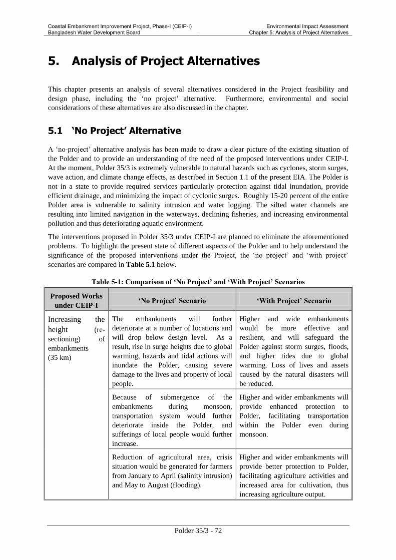
Coastal Embankment Improvement Project, Phase-I (CEIP-I) Bangladesh Water Development Board
Environmental Impact Assessment Chapter 5: Analysis of Project Alternatives
Polder 35/3 - 72
5. Analysis of Project Alternatives
This chapter presents an analysis of several alternatives considered in the Project feasibility and
design phase, including the ‘no project’ alternative. Furthermore, environmental and social
considerations of these alternatives are also discussed in the chapter.
5.1 ‘No Project’ Alternative
A ‘no-project’ alternative analysis has been made to draw a clear picture of the existing situation of
the Polder and to provide an understanding of the need of the proposed interventions under CEIP-I.
At the moment, Polder 35/3 is extremely vulnerable to natural hazards such as cyclones, storm surges,
wave action, and climate change effects, as described in Section 1.1 of the present EIA. The Polder is
not in a state to provide required services particularly protection against tidal inundation, provide
efficient drainage, and minimizing the impact of cyclonic surges. Roughly 15-20 percent of the entire
Polder area is vulnerable to salinity intrusion and water logging. The silted water channels are
resulting into limited navigation in the waterways, declining fisheries, and increasing environmental
pollution and thus deteriorating aquatic environment.
The interventions proposed in Polder 35/3 under CEIP-I are planned to eliminate the aforementioned
problems. To highlight the present state of different aspects of the Polder and to help understand the
significance of the proposed interventions under the Project, the ‘no project’ and ‘with project’
scenarios are compared in Table 5.1 below.
Table 5-1: Comparison of ‘No Project’ and ‘With Project’ Scenarios
Proposed Works
under CEIP-I ‘No Project’ Scenario ‘With Project’ Scenario
Increasing the
height (re-
sectioning) of
embankments
(35 km)
The embankments will further
deteriorate at a number of locations and
will drop below design level. As a
result, rise in surge heights due to global
warming, hazards and tidal actions will
inundate the Polder, causing severe
damage to the lives and property of local
people.
Higher and wide embankments
would be more effective and
resilient, and will safeguard the
Polder against storm surges, floods,
and higher tides due to global
warming. Loss of lives and assets
caused by the natural disasters will
be reduced.
Because of submergence of the
embankments during monsoon,
transportation system would further
deteriorate inside the Polder, and
sufferings of local people would further
increase.
Higher and wider embankments will
provide enhanced protection to
Polder, facilitating transportation
within the Polder even during
monsoon.
Reduction of agricultural area, crisis
situation would be generated for farmers
from January to April (salinity intrusion)
and May to August (flooding).
Higher and wider embankments will
provide better protection to Polder,
facilitating agriculture activities and
increased area for cultivation, thus
increasing agriculture output.
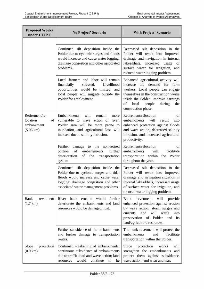
Coastal Embankment Improvement Project, Phase-I (CEIP-I) Bangladesh Water Development Board
Environmental Impact Assessment Chapter 5: Analysis of Project Alternatives
Polder 35/3 - 73
Proposed Works
under CEIP-I ‘No Project’ Scenario ‘With Project’ Scenario
Continued silt deposition inside the
Polder due to cyclonic surges and floods
would increase and cause water logging,
drainage congestion and other associated
problems.
Decreased silt deposition in the
Polder will result into improved
drainage and navigation in internal
lakes/khals, increased usage of
surface water for irrigation, and
reduced water logging problem.
Local farmers and labor will remain
financially stressed. Livelihood
opportunities would be limited, and
local people will migrate outside the
Polder for employment.
Enhanced agricultural activity will
increase the demand for farm
workers. Local people can engage
themselves in the construction works
inside the Polder. Improve earnings
of local people during the
construction phase.
Retirement/re-
location of
embankment
(5.05 km)
Embankments will remain more
vulnerable to wave action of river,
Polder area will be more prone to
inundation, and agricultural loss will
increase due to salinity intrusion.
Retirement/relocation of
embankments will result into
enhanced protection against floods
and wave action, decreased salinity
intrusion, and increased agricultural
productivity.
Further damage to the non-retired
portion of embankments, further
deterioration of the transportation
system
Retirement/relocation of
embankments will facilitate
transportation within the Polder
throughout the year.
Continued silt deposition inside the
Polder due to cyclonic surges and tidal
floods would increase and cause water
logging, drainage congestion and other
associated water management problems.
Decreased silt deposition in the
Polder will result into improved
drainage and navigation situation in
internal lakes/khals, increased usage
of surface water for irrigation, and
reduced water logging problem.
Bank revetment
(1.7 km)
River bank erosion would further
deteriorate the embankments and land
resources would be damaged/ lost.
Bank revetment will provide
enhanced protection against erosion
by wave action, storm surges and
currents, and will result into
preservation of Polder and its
land/agriculture resources.
Further subsidence of the embankments
and further damage to transportation
routes.
The bank revetment will protect the
embankments and facilitate
transportation within the Polder.
Slope protection
(0.9 km)
Continued weakening of embankments;
continuous subsidence of embankments
due to traffic load and wave action; land
resources would continue to be
Slope protection works will
strengthen the embankments and
protect them against subsidence,
wave action, and wear and tear.

Coastal Embankment Improvement Project, Phase-I (CEIP-I) Bangladesh Water Development Board
Environmental Impact Assessment Chapter 5: Analysis of Project Alternatives
Polder 35/3 - 74
Proposed Works
under CEIP-I ‘No Project’ Scenario ‘With Project’ Scenario
damaged/ lost.
Replacement of
drainage sluices
with drainage-
cum-flushing
sluices.
Continued use of the existing drainage
sluices for both flushing and drainage
would cause further damage to these
structures. As a result, water logging and
drainage congestion would be increased
due to malfunctioning of the sluices.
(Currently 15-20 % of the total area is
facing water logging and this is likely to
further increase in future).
Drainage-cum-flushing sluices will
be more efficient and dry season rice
cropping practice will be possible as
sweet water can be stored and used
later in the dry season for irrigation.
Replacement of the
existing flushing
sluices
No dry season agriculture practice will
be possible. Shrimp culture during
January to May, as sweet water cannot
be used in the periods of low rainfall.
Replaced flushing sluices will
facilitate better agriculture practices,
increased dry season rice cropping,
and reduced shrimp culture - thus
benefiting the poor farmers.
Construction of
new flushing
sluices
Cultivable lands and irrigable lands will
further decrease in future.
New flushing sluices will facilitate
increased availability of surface
water, better control on irrigation
during periods of low rainfall and
increased agricultural production.
Afforestation
(26 ha)
Wind and wave action during cyclones
would cause severe damage.
Effects of cyclone surge, wave
action and wind could be mitigated
to some extent, reducing loss of lives
and assets.
Re excavation of
Drainage Channels
(23.5 km)
Depth of water bodies would further
decrease, and drainage congestion and
water logging will further increase.
Depth of water bodies will increase,
water logging and drainage
congestion will decrease and fish
habitats will increase.
5.2 Site Selection Alternatives
Since CEIP-I is a rehabilitation project, no site alternatives could to be considered. However, a
comprehensive multi-criteria analysis was carried out to prioritize the polder for rehabilitation under
CEIP-I. The analysis results are presented in Table 5.2.
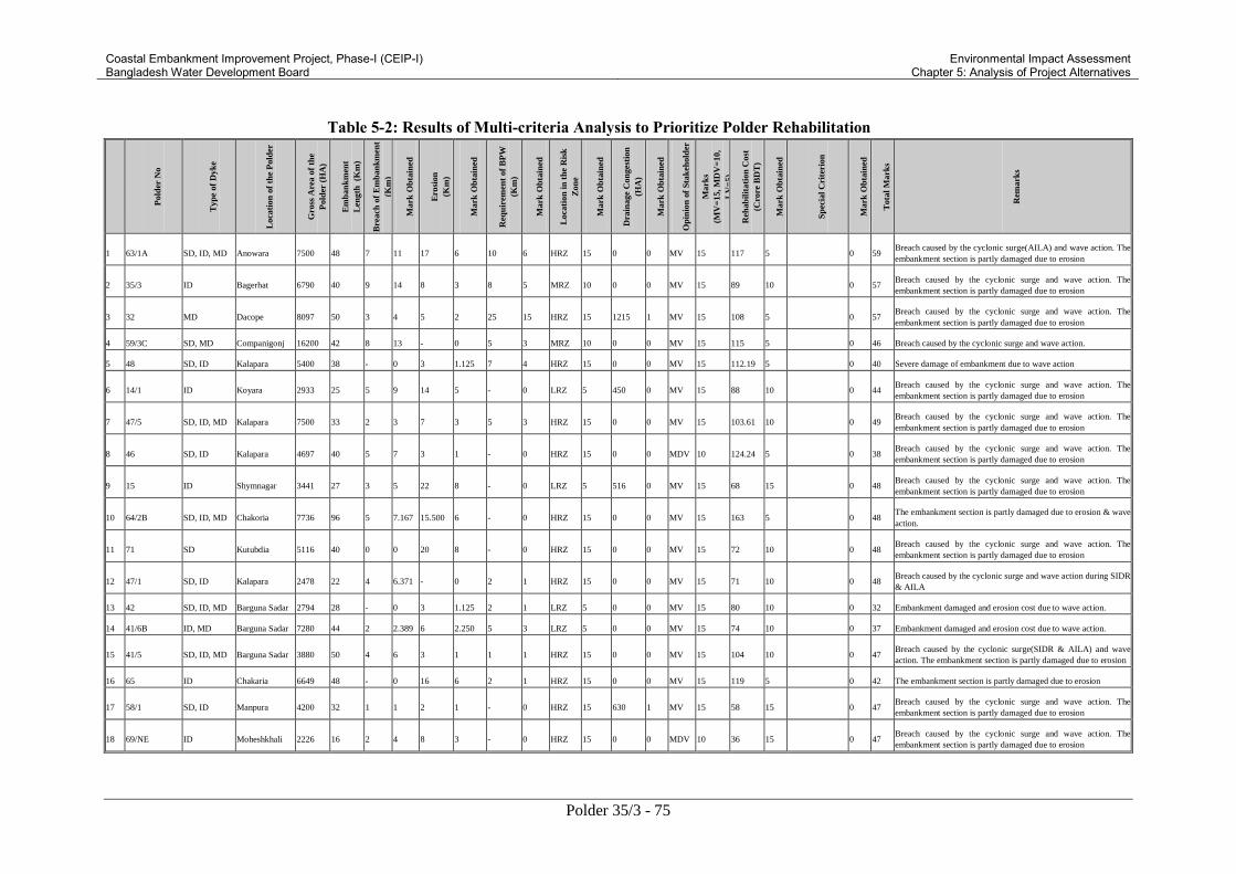
Coastal Embankment Improvement Project, Phase-I (CEIP-I) Bangladesh Water Development Board
Environmental Impact Assessment Chapter 5: Analysis of Project Alternatives
Polder 35/3 - 75
Table 5-2: Results of Multi-criteria Analysis to Prioritize Polder Rehabilitation
Pold
er N
o
Typ
e of
Dyk
e
Loca
tion
of
the
Pold
er
Gro
ss A
rea o
f th
e
Pold
er (
HA
)
Em
ban
km
ent
Len
gth
(K
m)
Bre
ach
of
Em
ban
km
ent
(Km
)
Mark
Ob
tain
ed
Ero
sion
(Km
)
Mark
Ob
tain
ed
Req
uir
emen
t of
BP
W
(Km
)
Mark
Ob
tain
ed
Loca
tion
in
th
e R
isk
Zon
e
Mark
Ob
tain
ed
Dra
inage
Con
ges
tion
(HA
)
Mark
Ob
tain
ed
Op
inio
n o
f S
tak
ehold
er
Mark
s
(MV
=15, M
DV
=10,
LV
=5)
Reh
ab
ilit
ati
on
Cost
(Cro
re B
DT
)
Mark
Ob
tain
ed
Sp
ecia
l C
rite
rion
Mark
Ob
tain
ed
Tota
l M
ark
s
Rem
ark
s
1 63/1A SD, ID, MD Anowara 7500 48 7 11 17 6 10 6 HRZ 15 0 0 MV 15 117 5 0 59 Breach caused by the cyclonic surge(AILA) and wave action. The
embankment section is partly damaged due to erosion
2 35/3 ID Bagerhat 6790 40 9 14 8 3 8 5 MRZ 10 0 0 MV 15 89 10 0 57 Breach caused by the cyclonic surge and wave action. The
embankment section is partly damaged due to erosion
3 32 MD Dacope 8097 50 3 4 5 2 25 15 HRZ 15 1215 1 MV 15 108 5 0 57 Breach caused by the cyclonic surge and wave action. The
embankment section is partly damaged due to erosion
4 59/3C SD, MD Companigonj 16200 42 8 13 - 0 5 3 MRZ 10 0 0 MV 15 115 5 0 46 Breach caused by the cyclonic surge and wave action.
5 48 SD, ID Kalapara 5400 38 - 0 3 1.125 7 4 HRZ 15 0 0 MV 15 112.19 5 0 40 Severe damage of embankment due to wave action
6 14/1 ID Koyara 2933 25 5 9 14 5 - 0 LRZ 5 450 0 MV 15 88 10 0 44 Breach caused by the cyclonic surge and wave action. The
embankment section is partly damaged due to erosion
7 47/5 SD, ID, MD Kalapara 7500 33 2 3 7 3 5 3 HRZ 15 0 0 MV 15 103.61 10 0 49 Breach caused by the cyclonic surge and wave action. The
embankment section is partly damaged due to erosion
8 46 SD, ID Kalapara 4697 40 5 7 3 1 - 0 HRZ 15 0 0 MDV 10 124.24 5 0 38 Breach caused by the cyclonic surge and wave action. The
embankment section is partly damaged due to erosion
9 15 ID Shymnagar 3441 27 3 5 22 8 - 0 LRZ 5 516 0 MV 15 68 15 0 48 Breach caused by the cyclonic surge and wave action. The
embankment section is partly damaged due to erosion
10 64/2B SD, ID, MD Chakoria 7736 96 5 7.167 15.500 6 - 0 HRZ 15 0 0 MV 15 163 5 0 48 The embankment section is partly damaged due to erosion & wave
action.
11 71 SD Kutubdia 5116 40 0 0 20 8 - 0 HRZ 15 0 0 MV 15 72 10 0 48 Breach caused by the cyclonic surge and wave action. The
embankment section is partly damaged due to erosion
12 47/1 SD, ID Kalapara 2478 22 4 6.371 - 0 2 1 HRZ 15 0 0 MV 15 71 10 0 48 Breach caused by the cyclonic surge and wave action during SIDR
& AILA
13 42 SD, ID, MD Barguna Sadar 2794 28 - 0 3 1.125 2 1 LRZ 5 0 0 MV 15 80 10 0 32 Embankment damaged and erosion cost due to wave action.
14 41/6B ID, MD Barguna Sadar 7280 44 2 2.389 6 2.250 5 3 LRZ 5 0 0 MV 15 74 10 0 37 Embankment damaged and erosion cost due to wave action.
15 41/5 SD, ID, MD Barguna Sadar 3880 50 4 6 3 1 1 1 HRZ 15 0 0 MV 15 104 10 0 47 Breach caused by the cyclonic surge(SIDR & AILA) and wave
action. The embankment section is partly damaged due to erosion
16 65 ID Chakaria 6649 48 - 0 16 6 2 1 HRZ 15 0 0 MV 15 119 5 0 42 The embankment section is partly damaged due to erosion
17 58/1 SD, ID Manpura 4200 32 1 1 2 1 - 0 HRZ 15 630 1 MV 15 58 15 0 47 Breach caused by the cyclonic surge and wave action. The
embankment section is partly damaged due to erosion
18 69/NE ID Moheshkhali 2226 16 2 4 8 3 - 0 HRZ 15 0 0 MDV 10 36 15 0 47 Breach caused by the cyclonic surge and wave action. The
embankment section is partly damaged due to erosion

Coastal Embankment Improvement Project, Phase-I (CEIP-I) Bangladesh Water Development Board
Environmental Impact Assessment Chapter 5: Analysis of Project Alternatives
Polder 35/3 - 76
Pold
er N
o
Typ
e of
Dyk
e
Loca
tion
of
the
Pold
er
Gro
ss A
rea o
f th
e
Pold
er (
HA
)
Em
ban
km
ent
Len
gth
(K
m)
Bre
ach
of
Em
ban
km
ent
(Km
)
Mark
Ob
tain
ed
Ero
sion
(Km
)
Mark
Ob
tain
ed
Req
uir
emen
t of
BP
W
(Km
)
Mark
Ob
tain
ed
Loca
tion
in
th
e R
isk
Zon
e
Mark
Ob
tain
ed
Dra
inage
Con
ges
tion
(HA
)
Mark
Ob
tain
ed
Op
inio
n o
f S
tak
ehold
er
Mark
s
(MV
=15, M
DV
=10,
LV
=5)
Reh
ab
ilit
ati
on
Cost
(Cro
re B
DT
)
Mark
Ob
tain
ed
Sp
ecia
l C
rite
rion
Mark
Ob
tain
ed
Tota
l M
ark
s
Rem
ark
s
19 66/2 ID Cox's Bazar &
Ramu 2621 20 - 0 5 2 - 0 HRZ 15 0 0 MV 15 43 15 0 47 The embankment section is partly damaged due to erosion
20 66/4 ID Chakaria 3324 24 9 15 5 2 0 HRZ 15 0 0 MDV 10 53 15 0 57 Breach caused by the cyclonic surge and wave action. The
embankment section is partly damaged due to erosion
21 65/A ID Chakoria 806 9 - 0 5 2 - 0 HRZ 15 0 0 MV 15 18 15 0 47 The embankment section is partly damaged due to erosion
22 66/1 SD, ID, MD Cox's Bazar 4930 20 1 1 1 0 1 1 HRZ 15 0 0 MV 15 61 15 0 47 Breach caused by the cyclonic surge and wave action. The
embankment section is partly damaged due to erosion
23 62 SD
Bandar,
Patenga &
Pahartali
5600 22 - 0 5 2 - 0 HRZ 15 0 0 MV 15 59 15 0 47 The embankment section is partly damaged due to erosion
24 41/7 ID, MD Mirzaganj 6984 51 6 10
1.50 0 3 2 LRZ 5 0 0 MV 15 84 10 0 41
Breach caused by the cyclonic surge and wave action. The
embankment section is partly damaged due to erosion
25 56/57 ID
Bhola Sadar,
Borhanuddin,
Charfassion,
Daulatkhan
123800 250 5 7 15 6 15 9 HRZ 15 5571 5 MV 15 534 -10 0 46 Breach caused by the cyclonic surge(AILA) and wave action. The
embankment section is partly damaged due to erosion
26 33 ID Dacope 8100 52 3 4 10 4 12 7 HRZ 15 1215 1 MV 15 128 5 0 51 Breach caused by the cyclonic surge and wave action. The
embankment section is partly damaged due to erosion
27 65/A1 ID Chakaria 2800 20 - 0 2 1 0 0 HRZ 15 0 0 MV 15 40 15 0 46 The embankment section is partly damaged due to erosion
28 58/3 SD Manpura,
Sudaram 1308 17 - 0 7 3 5 3 HRZ 15 0 0 MDV 10 31 15 0 46 The embankment section is partly damaged due to erosion
29 58/2 SD Manpura 4312 28 - 0 7 2 4 2 HRZ 15 647 1 MV 15 50 15 0 50 The embankment section is partly damaged due to erosion
30 64/1C SD, ID Bashkhali 2151 23 1 1.115 11 4.031 - 0 HRZ 15 0 0 MDV 10 53 15 0 45 Breach caused by the cyclonic surge and wave action. The
embankment section is partly damaged due to erosion
31 63/1B ID, MD Anowara 7300 21 - 0 - 0 - 0 MRZ 10 0 0 MV 15 36 15 0 40 -
32 72 SD, MD Swandip 22700 58 9 15 - 0 - 0 HRZ 15 0 0 MDV 10 192 5 0 45 Breach caused by the cyclonic surge(SIDR ) and wave action
33 17/1 ID Dumuria 5020 45 - 0 37 14 - 0 LRZ 5 753 1 MV 15 88 10 0 44 The embankment section is partly damaged due to erosion
34 7/1 ID Assasuni,
Shamnagar 3110 34 1 1 18 7 - 0 LRZ 5 467 0 MV 15 81 10 0 38
Breach caused by the cyclonic surge(AILA) and wave action. The
embankment section is partly damaged due to erosion
35 55/3 SD, ID Galachipa,
Charfassion 9845 56 - 0 - 0 5 3 HRZ 15 0 0 MV 15 236 -10 0 23 -
36 55/2D SD, MD Patuakhali,
Dashmia 8540 MV 99
37 55/2E MD, ID Patuakhali, 10535 MV 123

Coastal Embankment Improvement Project, Phase-I (CEIP-I) Bangladesh Water Development Board
Environmental Impact Assessment Chapter 5: Analysis of Project Alternatives
Polder 35/3 - 77
Pold
er N
o
Typ
e of
Dyk
e
Loca
tion
of
the
Pold
er
Gro
ss A
rea o
f th
e
Pold
er (
HA
)
Em
ban
km
ent
Len
gth
(K
m)
Bre
ach
of
Em
ban
km
ent
(Km
)
Mark
Ob
tain
ed
Ero
sion
(Km
)
Mark
Ob
tain
ed
Req
uir
emen
t of
BP
W
(Km
)
Mark
Ob
tain
ed
Loca
tion
in
th
e R
isk
Zon
e
Mark
Ob
tain
ed
Dra
inage
Con
ges
tion
(HA
)
Mark
Ob
tain
ed
Op
inio
n o
f S
tak
ehold
er
Mark
s
(MV
=15, M
DV
=10,
LV
=5)
Reh
ab
ilit
ati
on
Cost
(Cro
re B
DT
)
Mark
Ob
tain
ed
Sp
ecia
l C
rite
rion
Mark
Ob
tain
ed
Tota
l M
ark
s
Rem
ark
s
Dashmina,
Bouphol
38 67/B ID Teknaf 900 8 - 0 7 3 - 0 MRZ 10 0 0 MDV 10 26 15 Naf River 5 43 The embankment section is partly damaged due to erosion
39 69/P1 SD Moheshkhali 1800 13 1 1 5 2 - 0 HRZ 15 0 0 MDV 10 96 10 0 38 Breach caused by the cyclonic surge and wave action. The
embankment section is partly damaged due to erosion
40 64/1B ID, MD Bashkhali 8000 53 5 7.167 - 0 - 0 HRZ 15 0 0 MDV 10 144 5 0 37 Breach caused by the cyclonic surge(SIDR & AILA) and wave
action.
41 61/1 SD Sitakunda 8769 27 1 2.150 - 0 - 0 HRZ 15 0 0 MDV 10 107 5 0 32 Breach caused by the cyclonic surge(SIDR & AILA) and wave
action
42 67/A MD Teknaf &
Ukhiya 1500 13 0 0 5 2 - 0 MRZ 10 0 0 MDV 10 48 15 Naf River 5 42
Breach caused by the cyclonic surge and wave action. The
embankment section is partly damaged due to erosion
43 70 SD, ID, MD Moheshkhali 3025 32 - 0 5 2 - 0 HRZ 15 0 0 MDV 10 122 5 0 32 The embankment section is partly damaged due to erosion
44 67 ID Teknaf 2000 13 - 0 5 2 - 0 MRZ 10 0 0 MDV 10 46 15 Naf River 5 42 The embankment section is partly damaged due to erosion
45 65/A3 ID Chakaria 604 10 0 0 - 0 1 1 HRZ 15 0 0 MDV 10 26 15 0 41 Breach caused by the cyclonic surge and wave action
46 59/2 ID Ramgati 21255 82 6 9 4 1 1 1 MRZ 10 0 0 MV 15 190 5 0 41 Breach caused by the cyclonic surge and wave action. The
embankment section is partly damaged due to erosion
47 3 ID Debhata,
Kaliganj 22267 64 1 1 1 0 2 1 LRZ 5 3340 3 MV 15 155 5 Issamoti River 10 40
Breach caused by the cyclonic surge and wave action. The
embankment section is partly damaged due to erosion
48 41/1 SD, MD Barguna Sadar 4048 34 - 0 - 0 1 0 MRZ 10 0 0 MV 15 83 10 0 35 -
49 36/1 ID
Bagerhat,
Chitalmari,
Fakirhat,
Morelgonj,
Rupsa
40343 95 0 0 40 15 - 0 LRZ 5 6051 5 MDV 10 190 5 0 40 Breach caused by the cyclonic surge and wave action. The
embankment section is partly damaged due to erosion
50 47/2 ID, MD Kalapara 2065 17 - 0 - 0 1 0 HRZ 15 0 0 MDV 10 39 15 0 40 -
51 47/4 SD, ID, MD Kalapara 6600 57 0 0 - 0 - 0 HRZ 15 0 0 MV 15 150 5 0 35 Breach caused by the cyclonic surge(SIDR ) and wave action
52 40/1 SD, ID, MD Pathargatha 2105 23 - 0 - 0 - 0 MRZ 10 0 0 MV 15 91 10 0 35 -
53 40/2 SD, ID, MD Pathargatha 4453 36 - 0 - 0 - 0 MRZ 10 0 0 MV 15 85 10 0 35 -
54 45 SD, ID Amtali 4089 27 - 0 - 0 - 0 MRZ 10 0 0 MV 15 96 10 0 35 -
55 23 ID Paikgacha 5910 37 1 2 19 7 - 0 LRZ 5 887 1 MDV 10 123 5 0 30 Breach caused by the cyclonic surge and wave action. The
embankment section is partly damaged due to erosion
56 66/3 SD, ID, MD Cox's Bazar 4832 52 - 0 11 4 - 0 HRZ 15 0 0 MDV 10 133 5 0 34 The embankment section is partly damaged due to erosion
57 55/1 SD, ID Galachipa 10325 46 1 1 0 0 5 3 LRZ 5 0 0 MV 15 145 5 0 29 Breach caused by the cyclonic surge and wave action. The

Coastal Embankment Improvement Project, Phase-I (CEIP-I) Bangladesh Water Development Board
Environmental Impact Assessment Chapter 5: Analysis of Project Alternatives
Polder 35/3 - 78
Pold
er N
o
Typ
e of
Dyk
e
Loca
tion
of
the
Pold
er
Gro
ss A
rea o
f th
e
Pold
er (
HA
)
Em
ban
km
ent
Len
gth
(K
m)
Bre
ach
of
Em
ban
km
ent
(Km
)
Mark
Ob
tain
ed
Ero
sion
(Km
)
Mark
Ob
tain
ed
Req
uir
emen
t of
BP
W
(Km
)
Mark
Ob
tain
ed
Loca
tion
in
th
e R
isk
Zon
e
Mark
Ob
tain
ed
Dra
inage
Con
ges
tion
(HA
)
Mark
Ob
tain
ed
Op
inio
n o
f S
tak
ehold
er
Mark
s
(MV
=15, M
DV
=10,
LV
=5)
Reh
ab
ilit
ati
on
Cost
(Cro
re B
DT
)
Mark
Ob
tain
ed
Sp
ecia
l C
rite
rion
Mark
Ob
tain
ed
Tota
l M
ark
s
Rem
ark
s
embankment section is partly damaged due to erosion
58 55/2B ID, MD Galachipa 2600 30 2 2 1 0 2 1 LRZ 5 0 0 MV 15 81 10 0 34 Breach caused by the cyclonic surge( AILA) and wave action. The
embankment section is partly damaged due to erosion
59 29 ID Batiaghata,
Dumuria 8218 49 2 3 13 5 - 0 LRZ 5 1233 1 MV 15 102 10 0 39
Breach caused by the cyclonic surge and wave action. The
embankment section is partly damaged due to erosion
60 16 ID Paikgacha, Tala 10445 45 1 2 25 9 - 0 LRZ 5 1567 1 MDV 10 108 5 0 33 Breach caused by the cyclonic surge and wave action. The
embankment section is partly damaged due to erosion
61 68 SD, ID Teknaf 3500 27 0 0 5 2 - 0 MRZ 10 0 0 MDV 10 95 10 0 32 Breach caused by the cyclonic surge and wave action. The
embankment section is partly damaged due to erosion
62 64/1A SD, ID Bashkhali 5750 58 1 0.796 2 0.750 - 0 HRZ 15 0 0 MV 15 137 5 0 37 Breach caused by the cyclonic surge and wave action. The
embankment section is partly damaged due to erosion
63 43/1A ID, MD Amtali 2675 27 0 1 - 0 2 1 MRZ 10 0 0 MDV 10 51 15 0 37 Breach caused by the cyclonic surge (SIDR) and wave action.
Breach closed by constructing ring bundh
64 43/2C SD, ID, MD Galachipa 2753 26 1 1 - 0 1 1 LRZ 5 0 0 MV 15 54 15 0 36 Breach caused by the cyclonic surge (SIDR) and wave action
65 34/3 ID Bagerhat 3656 17 - 0 17 6 - 0 LRZ 5 0 0 MDV 10 55 15 0 36 The embankment section is partly damaged due to erosion
66 43/2A ID, MD Patuakhali 5182 39
2.00 0 - 0 2 1 LRZ 5 0 0 MV 15 73 10 0 31
Breach caused by the cyclonic surge(SIDR & AILA) and wave
action
67 73/1 (A & B) SD, ID, MD Hatiya 21377 80 4 6 28 11 - 0 HRZ 15 0 0 MV 15 219 -10 0 36 Breach caused by the cyclonic surge and wave action. The
embankment section is partly damaged due to erosion
68 17/2 ID Dumuria 3400 11 - 0 - 0 - 0 LRZ 5 510 0 MV 15 28 15 0 35 -
69 43/1 SD, ID, MD Amtali 10600 65
1.50 0 1 0 - 0 MRZ 10 0 0 MV 15 128 5 0 30
Breach caused by the cyclonic surge(SIDR & AILA) and wave
action
The embankment section is partly damaged due to erosion
70 28/2 ID Batiaghata 2590 20 - 0 - 0 - 0 LRZ 5 389 0 MV 15 48 15 0 35 -
71 35/3 SD, ID Sharankhola 13058 63 2 2 21 8 - 0 HRZ 15 0 0 MV 15 126 5 0 45 Breach caused by the cyclonic surge and wave action. The
embankment section is partly damaged due to erosion
72 61/2 SD Mirsharai 19855 10 0 0 - 0 - 0 MRZ 10 0 0 MDV 10 54 15 0 35 Breach caused by the cyclonic surge and wave action
73 73/2 SD, MD Hatiya 11134 48 - 0 0 0 - 0 HRZ 15 0 0 MDV 10 214 -10 0 15
The embankment section is partly damaged due to erosion
74 39/1A SD, MD Pathargatha 11740 58 - 0 - 0 - 0 MRZ 10 0 0 MV 15 123 5 0 30 -
75 39/2C SD, MD Matbaria 10748 55 - 0 - 0 - 0 LRZ 5 0 0 MV 15 122 15 0 35 -
76 41/4 SD, ID, MD Barguna Sadar 1741 19 - 0 - 0 - 0 LRZ 5 0 0 MV 15 46 15 0 35 -
77 44 SD, ID Amta!i, 17530 82 - 0 - 0 - 0 HRZ 15 0 0 MV 15 174 5 0 35 -

Coastal Embankment Improvement Project, Phase-I (CEIP-I) Bangladesh Water Development Board
Environmental Impact Assessment Chapter 5: Analysis of Project Alternatives
Polder 35/3 - 79
Pold
er N
o
Typ
e of
Dyk
e
Loca
tion
of
the
Pold
er
Gro
ss A
rea o
f th
e
Pold
er (
HA
)
Em
ban
km
ent
Len
gth
(K
m)
Bre
ach
of
Em
ban
km
ent
(Km
)
Mark
Ob
tain
ed
Ero
sion
(Km
)
Mark
Ob
tain
ed
Req
uir
emen
t of
BP
W
(Km
)
Mark
Ob
tain
ed
Loca
tion
in
th
e R
isk
Zon
e
Mark
Ob
tain
ed
Dra
inage
Con
ges
tion
(HA
)
Mark
Ob
tain
ed
Op
inio
n o
f S
tak
ehold
er
Mark
s
(MV
=15, M
DV
=10,
LV
=5)
Reh
ab
ilit
ati
on
Cost
(Cro
re B
DT
)
Mark
Ob
tain
ed
Sp
ecia
l C
rite
rion
Mark
Ob
tain
ed
Tota
l M
ark
s
Rem
ark
s
Kalapara
78 47/3 ID, MD Kalapara 2025 20 - 0 - 0 - 0 HRZ 15 0 0 LV 5 42 15 0 35 -
79 52/53A SD, ID, MD Galachipa 3663 25 - 0 - 0 - 0 LRZ 5 0 0 MV 15 76 10 0 30 -
80 60 ID Sonagazi 9150 38 - 0 - 0 - 0 MRZ 10 0 0 MDV 10 63 15 0 35 -
81 64/2A ID, MD Chakoria 3750 34 - 0 - 0 - 0 HRZ 15 0 0 LV 5 34 15 0 35 -
82 31 MD Dacope 7288 47 - 0 4 2 4 2 LRZ 5 1093 1 MV 15 126 5 0 29 The embankment section is partly damaged due to erosion
83 13-14/2 ID Koyara 17854 93 0 0 17 6 - 0 LRZ 5 2678 2 MV 15 156 5 0 34 Breach caused by the cyclonic surge and wave action. The
embankment section is partly damaged due to erosion
84 31/Part MD Batiaghata 4848 29 - 0 9 3 - 0 LRZ 5 727 1 MDV 10 86 10 0 29 The embankment section is partly damaged due to erosion
85 22 MD Paikgacha 1630 20 - 0 10 4 - 0 LRZ 5 245 0 MDV 10 50 15 0 34 The embankment section is partly damaged due to erosion
86 06-08 (Ext) ID Satkhira,
Kalarua 8330 9 - 0 8 3 - 0 LRZ 5 1250 1 MDV 10 26 15 0 34 The embankment section is partly damaged due to erosion
87 18-19 ID Paikgacha 3380 32 - 0 9 3 - 0 LRZ 5 507 0 MDV 10 76 10 0 29 The embankment section is partly damaged due to erosion
88 43/2E ID, MD Patuakhali 1650 20 - 0 - 0 6 4 LRZ 5 0 0 MDV 10 89 10 0 29 -
89 34/1 ID Bagerhat 2212 10 - 0 8 3 - 0 LRZ 5 332 0 MDV 10 28 15 0 33 The embankment section is partly damaged due to erosion
90 9 ID Paikgacha. 1255 8 - 0 6 2 - 0 LRZ 5 188 0 MDV 10 28 15 0 32 The embankment section is partly damaged due to erosion
91 39/2A ID, MD Bamna 5080 32 - 0 - 0 4 2 LRZ 5 0 0 MDV 10 88 10 0 27 -
92 55/4 SD Galachipa 5142 33 - 0 - 0 4 2 LRZ 5 0 0 MDV 10 136 5 0 22 -
93 21 MD Paikgacha 1417 17 - 0 5 2 - 0 LRZ 5 213 0 MDV 10 37 15 0 32 The embankment section is partly damaged due to erosion
94 20, 20/1 MD Paikgacha 1600 23 - 0 5 2 - 0 LRZ 10 240 0 MDV 20 59 30 0 93 The embankment section is partly damaged due to erosion
95 4 ID Assasuni 10500 80 2 2 21 8 - 0 LRZ 5 1575 1 MDV 10 153 5 0 32 Breach caused by the cyclonic surge and wave action. The
embankment section is partly damaged due to erosion
96 1 ID
Assasuni,
Debhata &
Satkhira
28381 96 1 1 1 0 3 2 LRZ 5 4257 3 MV 15 171 5 0 31
Lowest Pocket Silted Up. Breach caused by the cyclonic surge and
wave action. The embankment section is partly damaged due to
erosion
97
Kumiriya to
Sonaichari
Flood Control
Project
SD Sitakunda 1610 5 0 0.557 - 0 - 0 HRZ 15 0 0 MV 15 8 15 0 46 Breach caused by the cyclonic surge(SIDR & AILA) and wave
action
98 41/2 SD, ID, MD Barguna Sadar 3644 39 - 0 - 0 1 0 LRZ 5 0 0 MDV 10 118 5 0 20 -
99 43/2F ID, MD Amtali 4453 32 - 0 - 0 - 0 MRZ 10 0 0 LV 5 53 15 0 30 -
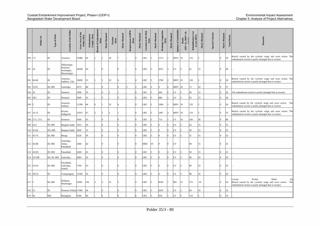
Coastal Embankment Improvement Project, Phase-I (CEIP-I) Bangladesh Water Development Board
Environmental Impact Assessment Chapter 5: Analysis of Project Alternatives
Polder 35/3 - 80
Pold
er N
o
Typ
e of
Dyk
e
Loca
tion
of
the
Pold
er
Gro
ss A
rea o
f th
e
Pold
er (
HA
)
Em
ban
km
ent
Len
gth
(K
m)
Bre
ach
of
Em
ban
km
ent
(Km
)
Mark
Ob
tain
ed
Ero
sion
(Km
)
Mark
Ob
tain
ed
Req
uir
emen
t of
BP
W
(Km
)
Mark
Ob
tain
ed
Loca
tion
in
th
e R
isk
Zon
e
Mark
Ob
tain
ed
Dra
inage
Con
ges
tion
(HA
)
Mark
Ob
tain
ed
Op
inio
n o
f S
tak
ehold
er
Mark
s
(MV
=15, M
DV
=10,
LV
=5)
Reh
ab
ilit
ati
on
Cost
(Cro
re B
DT
)
Mark
Ob
tain
ed
Sp
ecia
l C
rite
rion
Mark
Ob
tain
ed
Tota
l M
ark
s
Rem
ark
s
100 7/2 ID Assasuni. 10486 60 1 2 18 7 - 0 LRZ 5 1573 1 MDV 10 116 5 0 30 Breach caused by the cyclonic surge and wave action. The
embankment section is partly damaged due to erosion
101 24 ID
Abhaynagar,
Dumuria,
Keshobpur,
Manarampur
28340 26 - 0 - 0 - 0 LRZ 5 4251 3 LV 5 61 15 0 28 -
102 06-08 ID Assasuni,
Satkhira, Tala 18450 53 1 2 10 4 - 0 LRZ 5 2768 2 MDV 10 128 5 0 28
Breach caused by the cyclonic surge and wave action. The
embankment section is partly damaged due to erosion
103 55/2C ID, MD Galachipa 6275 48 - 0 - 0 3 2 LRZ 5 0 0 MDV 10 73 10 0 27 -
104 26 ID Dumuria 2696 29 - 0 2 1 - 0 LRZ 5 404 0 LV 5 66 15 0 26 The embankment section is partly damaged due to erosion
105 28/1 ID Dumuria 5600 23 - 0 - 0 - 0 LRZ 5 840 1 LV 5 65 15 0 26 -
106 2 ID Assasuni,
Satkhira 11296 64 0 1 10 4 - 0 LRZ 5 1694 1 MDV 10 129 5 0 26
Breach caused by the cyclonic surge and wave action. The
embankment section is partly damaged due to erosion
107 10-12 ID Koyara,
Paikgacha 16315 67 2 2 3 1 - 0 LRZ 5 2447 2 MDV 10 119 5 0 25
Breach caused by the cyclonic surge and wave action. The
embankment section is partly damaged due to erosion
108 27/1, 27/2 ID Dumuria 4260 45 - 0 - 0 - 0 LRZ 5 713 1 LV 10 109 30 0 86 -
109 41/3 ID, MD Barguna Sadar 1053 20 - 0 - 0 - 0 LRZ 5 0 0 LV 5 43 15 0 25 -
110 41/6A SD, MD Barguna Sadar 3850 33 - 0 - 0 - 0 LRZ 5 0 0 LV 5 49 15 0 25 -
111 41/7A ID, MD Betagi 6220 39 - 0 - 0 - 0 LRZ 5 0 0 LV 5 51 15 0 25 -
112 43/2B ID, MD
Galachipa,
Amtai,
Patuakhali
5460 42 - 0 - 0 - 0 MRZ 10 0 0 LV 49 15 0 25 -
113 43/2D ID, MD Patuakhali 6500 43 - 0 - 0 - 0 LRZ 5 0 0 LV 5 50 15 0 25 -
114 52/53B SD, ID, MD Galachipa 4064 34 - 0 - 0 - 0 LRZ 5 0 0 LV 5 96 10 0 20 -
115 55/2A ID, MD
Patuakhali,
Galachipa,
Amtoli
7166 43 - 0 - 0 - 0 LRZ 5 0 0 LV 5 80 10 0 20 -
116 59/1A ID Companiganj, 15506 36 - 0 - 0 - 0 LRZ 5 0 0 LV 5 98 10 0 20 -
117 5 ID, MD Kaliganj,
Shymnagar 55061 192 2 3 12 5 - 0 LRZ 5 8259 7 MV 15 272 -10 0 24
Lowest Pocket Silted Up
Breach caused by the cyclonic surge and wave action. The
embankment section is partly damaged due to erosion
118 25 ID Dumuria Fultala 17400 46 - 0 - 0 - 0 LRZ 5 2610 2 LV 5 83 10 0 22 -
119 30 MD Batiaghata 6396 40 - 0 - 0 - 0 LRZ 5 959 1 LV 5 110 5 0 16 -

Coastal Embankment Improvement Project, Phase-I (CEIP-I) Bangladesh Water Development Board
Environmental Impact Assessment Chapter 5: Analysis of Project Alternatives
Polder 35/3 - 81
Pold
er N
o
Typ
e of
Dyk
e
Loca
tion
of
the
Pold
er
Gro
ss A
rea o
f th
e
Pold
er (
HA
)
Em
ban
km
ent
Len
gth
(K
m)
Bre
ach
of
Em
ban
km
ent
(Km
)
Mark
Ob
tain
ed
Ero
sion
(Km
)
Mark
Ob
tain
ed
Req
uir
emen
t of
BP
W
(Km
)
Mark
Ob
tain
ed
Loca
tion
in
th
e R
isk
Zon
e
Mark
Ob
tain
ed
Dra
inage
Con
ges
tion
(HA
)
Mark
Ob
tain
ed
Op
inio
n o
f S
tak
ehold
er
Mark
s
(MV
=15, M
DV
=10,
LV
=5)
Reh
ab
ilit
ati
on
Cost
(Cro
re B
DT
)
Mark
Ob
tain
ed
Sp
ecia
l C
rite
rion
Mark
Ob
tain
ed
Tota
l M
ark
s
Rem
ark
s
120 59/1B ID Sudharam,
Laxipur 18218 40 - 0 - 0 - 0 LRZ 5 0 0 LV 5 156 5 0 15 -
121 59/3B SD, ID, MD Shudharam 31376 63 - 0 - 0 - 0 MRZ 10 0 0 LV 5 182 5 0 20 -
122 39/1B Matbaria 13100 63 - 1 - LRZ 5 0 138 5 0 11 -
123 41/7B Betagi 6150 - - LRZ 5 0 58 15 2 22 -
124 Bibichini Betagi 4600 - - LRZ 5 0 33 15 3 23 -
125 43/1B Kalapara 3000 - - HRZ 15 0 63 15 4 34 -
126 CDSP-II Sonagazi 1981 - - HRZ 15 0 35 15 5 35 -
127 Dumki
Laukathi Patukhali 18550 - - LRZ 5 0 61 15 6 26 -
128 Itbaria
Labukhali Patukhali 9650 - - LRZ 5 0 53 15 7 27 -
129 Mirzagonj
Rampura
Mirzagonj,
Patuakhali 16500 - - LRZ 5 0 69 15 8 28 -
130 50/51 Galachipa 6935 - - HRZ 15 0 138 5 9 29 -
131 54
Kalapara,
Amtoli,
Galachipa
13954 - - HRZ 15 0 174 5 10 30 -
132 Satla Bagda-1 Agailjhara,
Wazirpur - - LRZ 5 0 59 15 11 31 -
133 Satla Bagda-2 Uzirpur,
Agailjhara - - LRZ 5 0 196 5 12 22 -
134 Satla Bagda-3 Uzirpur,
Agailjhara - - LRZ 5 0 25 15 13 33 -
135 59/2 Ext. Ramgati 4000 - - HRZ 15 0 52 15 14 44 -
136 Boychar Hatiya - - HRZ 15 0 159 5 15 35 -
137 Char
Bagardona-1 Subornachar 1350 - - HRZ 15 0 24 15 16 46 -
138 Char
Bagardona-2 Subornachar 1200 - - HRZ 15 0 21 15 16 46 -
139 Char Mojid Subornachar 850 - - HRZ 15 0 15 15 16 46 -

Coastal Embankment Improvement Project, Phase-I (CEIP-I) Bangladesh Water Development Board
Environmental Impact Assessment Chapter 5: Analysis of Project Alternatives
Polder 35/3 - 82
Pold
er N
o
Typ
e of
Dyk
e
Loca
tion
of
the
Pold
er
Gro
ss A
rea o
f th
e
Pold
er (
HA
)
Em
ban
km
ent
Len
gth
(K
m)
Bre
ach
of
Em
ban
km
ent
(Km
)
Mark
Ob
tain
ed
Ero
sion
(Km
)
Mark
Ob
tain
ed
Req
uir
emen
t of
BP
W
(Km
)
Mark
Ob
tain
ed
Loca
tion
in
th
e R
isk
Zon
e
Mark
Ob
tain
ed
Dra
inage
Con
ges
tion
(HA
)
Mark
Ob
tain
ed
Op
inio
n o
f S
tak
ehold
er
Mark
s
(MV
=15, M
DV
=10,
LV
=5)
Reh
ab
ilit
ati
on
Cost
(Cro
re B
DT
)
Mark
Ob
tain
ed
Sp
ecia
l C
rite
rion
Mark
Ob
tain
ed
Tota
l M
ark
s
Rem
ark
s
Notes:
a) Rate of marks = Full marks allotted for the criterion against highest quantity of the criterion except "Rehabilitation Cost".
b) Negative marks has been allotted in case of "Rehabilitation Cost" exceeding $30 Million (210 Crore BDT).
c) HRZ = High Risk Zone, MRZ = Medium Risk Zone, LRZ = Low Risk Zone.
d) MV = Most Vulnerable, MDV = Medium Vulnerable, LV = Less Vulnerable.
e) SD = Sea Dyke; ID = Interior Dyke; MD = Marginal Dyke.
f) BPW = Bank Protective Work.
g) Rehabilitation Cost consider embankment section with one meter extra height over the existing designed level.
h) Special Criterion indicates territory loss due to erosion of polders located in border area.
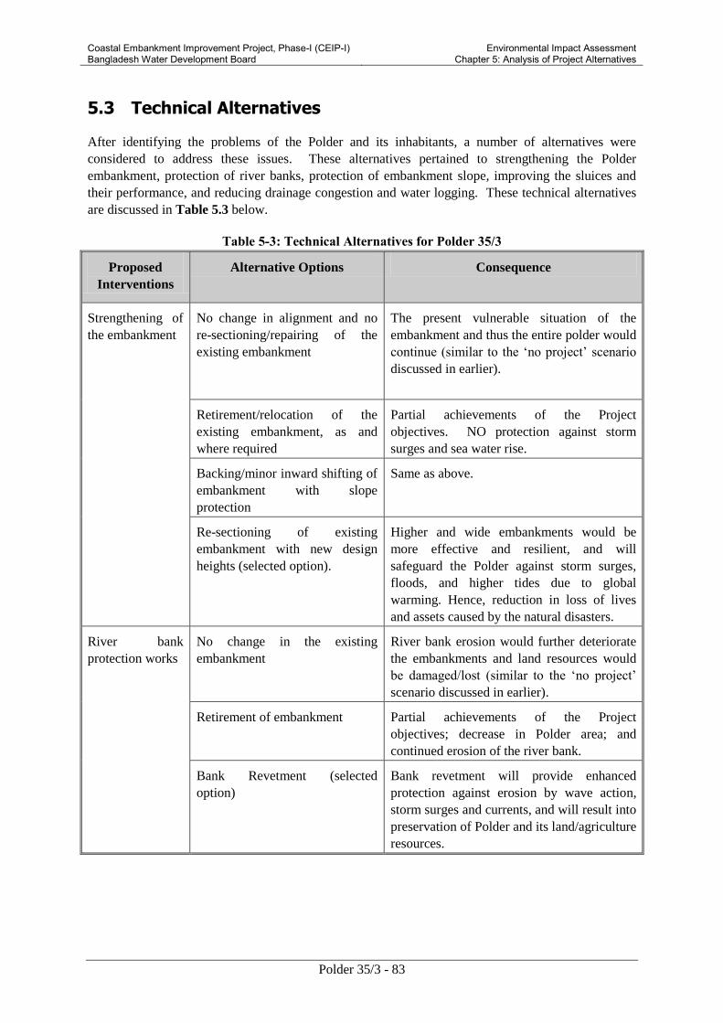
Coastal Embankment Improvement Project, Phase-I (CEIP-I) Bangladesh Water Development Board
Environmental Impact Assessment Chapter 5: Analysis of Project Alternatives
Polder 35/3 - 83
5.3 Technical Alternatives
After identifying the problems of the Polder and its inhabitants, a number of alternatives were
considered to address these issues. These alternatives pertained to strengthening the Polder
embankment, protection of river banks, protection of embankment slope, improving the sluices and
their performance, and reducing drainage congestion and water logging. These technical alternatives
are discussed in Table 5.3 below.
Table 5-3: Technical Alternatives for Polder 35/3
Proposed
Interventions
Alternative Options Consequence
Strengthening of
the embankment
No change in alignment and no
re-sectioning/repairing of the
existing embankment
The present vulnerable situation of the
embankment and thus the entire polder would
continue (similar to the ‘no project’ scenario
discussed in earlier).
Retirement/relocation of the
existing embankment, as and
where required
Partial achievements of the Project
objectives. NO protection against storm
surges and sea water rise.
Backing/minor inward shifting of
embankment with slope
protection
Same as above.
Re-sectioning of existing
embankment with new design
heights (selected option).
Higher and wide embankments would be
more effective and resilient, and will
safeguard the Polder against storm surges,
floods, and higher tides due to global
warming. Hence, reduction in loss of lives
and assets caused by the natural disasters.
River bank
protection works
No change in the existing
embankment
River bank erosion would further deteriorate
the embankments and land resources would
be damaged/lost (similar to the ‘no project’
scenario discussed in earlier).
Retirement of embankment Partial achievements of the Project
objectives; decrease in Polder area; and
continued erosion of the river bank.
Bank Revetment (selected
option)
Bank revetment will provide enhanced
protection against erosion by wave action,
storm surges and currents, and will result into
preservation of Polder and its land/agriculture
resources.

Coastal Embankment Improvement Project, Phase-I (CEIP-I) Bangladesh Water Development Board
Environmental Impact Assessment Chapter 5: Analysis of Project Alternatives
Polder 35/3 - 84
Proposed
Interventions
Alternative Options Consequence
Protection of
embankment
slope (against
wave action)
No change in the existing
embankment
Continued weakening of embankments;
continuous subsidence of embankments due
to traffic load and wave action; land
resources would continue to be damaged/ lost
(similar to the ‘no project’ scenario discussed
in earlier).
Slope Protection (selected
option)
Slope protection works will strengthen the
embankments and protect them against
subsidence, wave action, and wear and tear.
Foreshore plantation (selected
option)
Effects of cyclone surge, wave action and
wind could be mitigated to some extent,
reducing loss of lives and assets.
Replacement of
drainage sluices
No change in the existing
structures
Continued use of the existing drainage
sluices for both flushing and drainage would
cause further damage to these structures. As a
result, water logging and drainage congestion
would be increased due to malfunctioning of
the sluices (similar to the ‘no project’
scenario discussed in earlier).
Repairing of structures (possible
where there is no need of re-
sizing) (selected options for some
structures)
For sluices which are beyond repair, this
option would be similar to the ‘no project’
scenario described above.
Replacement of existing
Drainage Sluice with Drainage-
cum-flushing sluice (selected
option for some of the sluices
depending upon need)
Drainage-cum-flushing sluices will be more
efficient and dry season rice cropping
practice will be possible as sweet water can
be stored and used later in the dry season for
irrigation.
Regulators with provision for
appropriate passages for fish and
small boats.
In addition to the above advantages, the
structures will facilitate fish migration and
navigation across them. The cost of such
structure is likely to be high.
Rehabilitation of
flushing sluices
No change in the existing
structure
No dry season agriculture practice will be
possible. Shrimp culture during January to
May, as sweet water cannot be used in the
periods of low rainfall (similar to the ‘no
project’ scenario discussed in earlier).
Repair of the existing structures For sluices which are beyond repair, this
option would be similar to the ‘no project’
scenario described above.
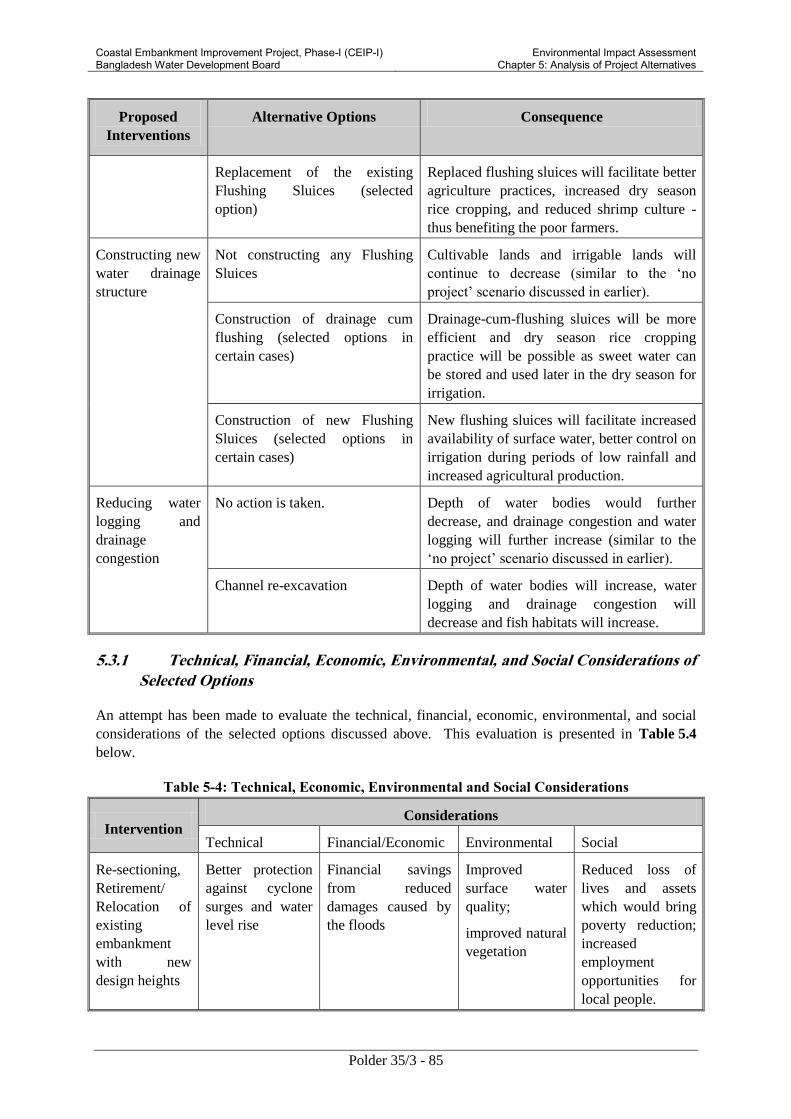
Coastal Embankment Improvement Project, Phase-I (CEIP-I) Bangladesh Water Development Board
Environmental Impact Assessment Chapter 5: Analysis of Project Alternatives
Polder 35/3 - 85
Proposed
Interventions
Alternative Options Consequence
Replacement of the existing
Flushing Sluices (selected
option)
Replaced flushing sluices will facilitate better
agriculture practices, increased dry season
rice cropping, and reduced shrimp culture -
thus benefiting the poor farmers.
Constructing new
water drainage
structure
Not constructing any Flushing
Sluices
Cultivable lands and irrigable lands will
continue to decrease (similar to the ‘no
project’ scenario discussed in earlier).
Construction of drainage cum
flushing (selected options in
certain cases)
Drainage-cum-flushing sluices will be more
efficient and dry season rice cropping
practice will be possible as sweet water can
be stored and used later in the dry season for
irrigation.
Construction of new Flushing
Sluices (selected options in
certain cases)
New flushing sluices will facilitate increased
availability of surface water, better control on
irrigation during periods of low rainfall and
increased agricultural production.
Reducing water
logging and
drainage
congestion
No action is taken. Depth of water bodies would further
decrease, and drainage congestion and water
logging will further increase (similar to the
‘no project’ scenario discussed in earlier).
Channel re-excavation Depth of water bodies will increase, water
logging and drainage congestion will
decrease and fish habitats will increase.
5.3.1 Technical, Financial, Economic, Environmental, and Social Considerations of
Selected Options
An attempt has been made to evaluate the technical, financial, economic, environmental, and social
considerations of the selected options discussed above. This evaluation is presented in Table 5.4
below.
Table 5-4: Technical, Economic, Environmental and Social Considerations
Intervention Considerations
Technical Financial/Economic Environmental Social
Re-sectioning,
Retirement/
Relocation of
existing
embankment
with new
design heights
Better protection
against cyclone
surges and water
level rise
Financial savings
from reduced
damages caused by
the floods
Improved
surface water
quality;
improved natural
vegetation
Reduced loss of
lives and assets
which would bring
poverty reduction;
increased
employment
opportunities for
local people.

Coastal Embankment Improvement Project, Phase-I (CEIP-I) Bangladesh Water Development Board
Environmental Impact Assessment Chapter 5: Analysis of Project Alternatives
Polder 35/3 - 86
Intervention Considerations
Technical Financial/Economic Environmental Social
protection to river
bank erosion
Financial savings as
the embankments
will provide good
road transportation
routes.
Reduced traffic
congestion
inside the polder
because of
improved
embankments,
which will
facilitate
vehicular traffic
Reduction of loss
of assets which
would bring
poverty reduction
Prevention of
salinity intrusion
in the polder
Improved earning of
local people during
construction
Improved cropping
particularly for
small farmers thus
alleviating poverty. Improved cropping
pattern and boosting
the local economy
Bank
revetment,
slope protection
Enhanced
embankment
protection against
tidal wave action
of rivers, provide
erosion protection
Financial savings
from reduced
damages caused by
the floods; increased
life span for the
infrastructure and
associated water
control structures;
improved earnings
of local people
through employment
during bank
revetment works and
slope protection
works.
Improved
embankment
stability; reduced
soil erosion; and
provide good
means of
transportation
Reduced loss of
lives and assets
which would bring
poverty reduction;
increased
employment
opportunities for
local people.
Foreshore
plantation Enhanced
embankment
protection against
tidal wave action
of rivers, provide
erosion protection
Financial savings
from reduced
damages caused by
the floods and
storms; increased
life span for the
infrastructure and
associated water
control structures;
improved earnings
of local people
through employment
during bank
revetment works and
slope protection
works.
Improved
embankment
stability; reduced
soil erosion;
enhanced soil
quality;
improved air
quality;
enhanced
aesthetic value
of the area.
Reduced loss of
lives and assets
which would bring
poverty reduction;
increased
employment
opportunities for
local people;
income from
timber and other
plantation
products.

Coastal Embankment Improvement Project, Phase-I (CEIP-I) Bangladesh Water Development Board
Environmental Impact Assessment Chapter 5: Analysis of Project Alternatives
Polder 35/3 - 87
Intervention Considerations
Technical Financial/Economic Environmental Social
Replacement of
existing
drainage sluice
with drainage-
cum-flushing
sluice and
construction of
new flushing
sluices where
needed
Better functional
performance in
both flushing and
drainage;
achieving the
objectives of
Polder and CEIP-
I
Financial savings
against damages due
to water logging,
drainage congestion,
and salinity
intrusion.
Removal of
inactive sluices
would improve
the drainage
characteristics
Better agriculture
practice could be
achieved which
would improve
cropping pattern,
enhance local
earnings, and
reduce poverty.
Water logging,
drainage
congestion
would be
reduced.
Agricultural
production will be
boosted as dry
season rice cropping
would increase
Channel
re-excavation
Reduce water
logging and
drainage
congestion
Enhanced
agriculture output;
the dredged soil can
later be used in
construction works
and will save
construction cost
Increase
navigability of
water ways and
fish habitats
would improve,
the ecosystem
will be enhanced
Increase in
cultivable area,
increased
availability of
irrigation water
thus increased farm
income for local
community;
increased farm
labor opportunities.
5.4 Alternatives during Construction
The key alternatives available during construction include location of material stockpiling, material
sourcing, manpower sourcing, and transportation of materials, equipment, and manpower. These are
discussed below.
5.4.1 Material Storage
For project works in Polder 35/3, two options are available for material storage: within the Polder at
suitable location(s); and outside the Polder at suitable locations. The first option would entail easy
transportation of bulk materials from the sources outside the Polder, however it would involve regular
transportation of materials from the storage site to the work sites.
The storage site selected at this stage is located in the BWDB colony at Bagerhat, which is situated
within the Polder. The required materials would be collected and transported from their respective
sources to the Polder and then would be stored in the stock yard to be used during construction phase.
5.4.2 Material Sources
The sources from which the construction materials will be brought have been discussed below.

Coastal Embankment Improvement Project, Phase-I (CEIP-I) Bangladesh Water Development Board
Environmental Impact Assessment Chapter 5: Analysis of Project Alternatives
Polder 35/3 - 88
Soil for Embankments
For retirement, re-sectioning, and forwarding of embankments, about 1.18 million cubic meters of soil
will be required. The following options are available for sourcing this material:
Ample quantity of soil can be obtained from borrow pits along the river bank just outside the
embankments, provided the soil quality is appropriate for this purpose. This will be a better
option since it will minimize soil transportation needs, minimizing any additional traffic related to
material transportation, having minimal negative impacts in the borrow areas since these areas
will be silted-up within a few seasons, and having minimum environmental and social impacts
related to excavation and transportation.
Part of the required material can be obtained from the re-excavation of the water channel within
the Polder, provided the quality of this material is technically acceptable. About 0.67 million
cubic meters of earth will be obtained from re-excavation of channels during implementation of
rehabilitation works inside the Polder. This option would minimize the cost of excavation for the
borrow material, though the cost of transportation to work site will be slightly more than the first
option, in addition to some environmental and social impacts such as traffic congestion and air
pollution within the Polder.
Some quantity of soil can be sourced from borrow pits inside the Polder. For this purpose consent
of the land owners will have to be obtained and mutually agreed compensation will have to be
paid to them. This option will entail cost of excavation similar to the first option but more than
the second option discussed above. Other considerations including cost of transportation and
environmental and social impacts are likely to be similar to the ones for the second option, though
land degradation may take place in addition to air pollution and traffic congestion.
If the soil from the riverside just outside the Polder embankment is not suitable, the material may
be obtained from the river beds having required material quality. This option will entail higher
cost of material transportation and other related environmental and social problems such as traffic
congestion, air and water pollution.
At this stage, the final decision regarding the material source has not been finalized. This decision is
likely to be taken during the construction phase.
Sand
Sand would be needed for embankment improvement works, concreting works, and for manufacturing
concrete blocks for slope protection works. Two broad options are available to source this material as
discussed below.
Sand could be procured from markets. This would entail consistent quality and assured supply,
however it would also entail increased transportation cost and associated environmental and social
impacts including traffic congestion and air pollution.
The second option is to obtain sand from the river beds. This would reduce the transportation
needs along with the associated costs and environmental as well as social impacts. However
quality of this sand may not be consistent and this sand may need to be washed before its use.
At this stage, the final decision regarding the source of this material has not been finalized as well.
This decision is likely to be taken during the construction phase.

Coastal Embankment Improvement Project, Phase-I (CEIP-I) Bangladesh Water Development Board
Environmental Impact Assessment Chapter 5: Analysis of Project Alternatives
Polder 35/3 - 89
5.4.3 Alternatives for Workforce Procurement
Two broad options are available for sourcing the manpower for the construction works. These are
discussed below.
Employing bulk of the manpower from outside the Polder. This will entail requirement of larger
labor camps, need for labor transportation causing traffic congestion and air pollution, and
possible resistance and resentment from the local community.
Employing bulk of the manpower from within the Polder and only bringing more skilled and
technical manpower from outside. This option will entail reduced labor camp sizes, and
decreased transportation needs and associated environmental and social problem. This option will
also offer employment opportunities for the local community thus increasing their economic
condition and also increasing the local ownership of the project. In view of these advantages, this
is the preferred option for manpower sourcing.
5.4.4 Alternatives for Mode of Transportation
The major quantity of earth and other materials will be carried to the construction sites with the help
of dump trucks, trolleys, other vehicles, and by manual labor. For construction purposes in the eastern
and central regions of the Polder, the materials would be transported using trucks, smaller carts, non-
motorized vans and other smaller vehicles. The trucks or other vehicles from outside the Polder will
have to cross the Putimari river through bridges.
Construction materials required during construction in the north side (close to Putimari river) of the
Polder may be transported through trucks. Materials needed in the south, east and west portion of the
polder would be transported through water ways using barges, motorized boats, and other vessels.
However, roadway transportation of trucks, smaller carts, non motorized vans are also possible for the
eastern, southern and western parts of the polder.
Waterways
The Polder 35/3 is surrounded by Putimari river (North), Bhairab river (East), Katakhali khal (south),
and Bishnu river (west). The Daratana river, Katakhali khal, and Bishnu river remain navigable
throughout the year and can be used for transportation purposes during construction. However, the
Putimari River is very shallow especially during the periods of low tides and hence water way
transportation cannot be carried out using this route all the time.
For construction works in the east, west and south portion of the Polder, nearby rivers and khals can
be used. The Bhairab River provides the most preferred waterway route. Materials can be carried
through this river using large cargos or motorized boats due to its higher navigability. The Katakhali
khal and Bishnu river should be used for construction works to be carried out in the south and west
directions respectively. However, the Bishnu river is relatively shallow and is not suitable for
transportation of large cargos where as the depth of Katakhali khal is suitable for such transportation.
Therefore materials should be carried using relatively small motorized boats or trawlers through
Bishnu River and large cargos are recommended for waterway transportation through the Katakhali
khal.
The north periphery of the polder is surrounded by Putimari river, but the river is very shallow and is
not at all suitable for waterway transportation of large cargos. Smal boats can be used for carrying out
materials through this river if needed.

Coastal Embankment Improvement Project, Phase-I (CEIP-I) Bangladesh Water Development Board
Environmental Impact Assessment Chapter 5: Analysis of Project Alternatives
Polder 35/3 - 90
Roadways
The materials stored in the stock yard can be transported to the construction sites using several
regional roads, district roads and rural roads. In case of transporting materials to the stock yard from
Khulna or other suitable locations outside the polder, road ways are very much recommended. The
Khulna-Pirojpur regional road and Malliker Ber–Bagerhat district road can be used. The regional road
of Khulna-Pirojpur can be used for construction works to be carried out in the North-east periphery.
However, for construction works to be carried out in the southern part, district road of Bagerhat to
Bagerhat is recommended. In the western part, the district road from Dema to Khegraghat provides
direct access. All the roads discussed above are of good quality for transportation of larger vehicles.
There are a number of rural roads inside the polder. However, the quality and widths of these roads
are not good enough for transportation of larger vehicles. The Engineer in Charge has to prioritize the
routes to be used for transportation during the construction phase.

Coastal Embankment Improvement Project, Phase-I (CEIP-I) Bangladesh Water Development Board
Environmental Impact Assessment Chapter 6: Environmental and Social Baseline
Polder 35/3 - 91
6. Environmental and Social Baseline
This chapter describes the existing environmental and social conditions in respect of water resources,
land resources, agriculture, livestock, fisheries, ecosystems and socio-economic aspects of the Project
area (the definition of Project area is given in Article 2.2.1).
6.1 Land Resources
6.1.1 Topography
Polder 35/3 is located in the southwest region of Bangladesh near Bagherhat Sadar upazila.
Topographically, the sloping pattern of the polder area is mild from north to south and developed by
the delta development process. Before construction of the polder, the low lying area of the polder was
inundated by tidal flooding and more vulnerable due to storm surge. The area of the polder is criss
crossed by many khals. The total area is basically mild slope and north portion of land is higher than
the south. However, the contour map shows that the high lands are situated on the banks of the river
and khals. In the polder area, the elevation of the settlement and agriculture land is in between 1.50 m
to 2.15m, 0.90 m to 1.05 m respectively. Figure 6.1 shows the topography of the Polder.

Coastal Embankment Improvement Project, Phase-I (CEIP-I) Bangladesh Water Development Board
Environmental Impact Assessment Chapter 6: Environmental and Social Baseline
Polder 35/3 - 92
Figure 6.1: Elevation of Polder 35/3
The sea level rise caused by global warming would lead to permanent inundation, drainage
congestion, salinity intrusion and frequent storm surges in the region. It is estimated that about 11

Coastal Embankment Improvement Project, Phase-I (CEIP-I) Bangladesh Water Development Board
Environmental Impact Assessment Chapter 6: Environmental and Social Baseline
Polder 35/3 - 93
percent of the land area will be permanently inundated over the next century in the coastal region of
Bangladesh.
6.1.2 Agro-ecological regions
As a part of land resources appraisal of Bangladesh for agricultural development, the country has been
subdivided into 30 agro-ecological regions and 88 sub-regions. The key parameters on the basis of
which this classification has been carried out include physiography, soil properties, soil salinity, and
depth and duration of flooding. These parameters are relevant for land use and the assessment of
present and future agricultural potential.
Polder35/3 lies under Agro-ecological zone of Ganges Tidal Floodplain (AEZ-13A &13B) (Figure
6.2). The characteristics of this region are discussed briefly below.
Ganges Tidal Floodplain
The soils are formed from clay loam, loam and clay sediments and are seasonally flooded, poorly
drained except soils of high land areas. The high land is not inundated but medium high lands (MHL)
and medium low lands (MLL) are inundated fro 4-5 and 5-6 months at various depths not exceeding
90cm and 180 cm respectively by monsoon flooding. This region occupies an extensive area of tidal
floodplain land in the south-west of the country. 100 % of polder area covered this region. The
Ganges Tidal Floodplain has low relief compared to the Ganges River Floodplain. The area is criss-
crossed by innumerable tidal rivers and khals whose banks generally stand less than a meter above the
adjoining basins. The whole of this zones lies within the cyclone prone area. The main tidal rivers in
the polders areas (Polders 35/3) are Daratana, Bishnu and branch river Soabeki River, Katakhali,
Putimari etc.
Most of the polder areas are shallowly flooded. The natural drainage of the land is towards the South.
Most of the river banks are generally one meter above the adjoining basin centre. The lands are
normally submerged during high tide twice every day. The extent of submergence increases during
rainy season. The shallow basin remains wet during the early days of dry season. The practices of dry
land crops are constrained due to slow and late recession of water. In this situation, the land
preparation for dry land crops cannot be done in proper time. Most of the land remains fallow for this
problem in the polder area.
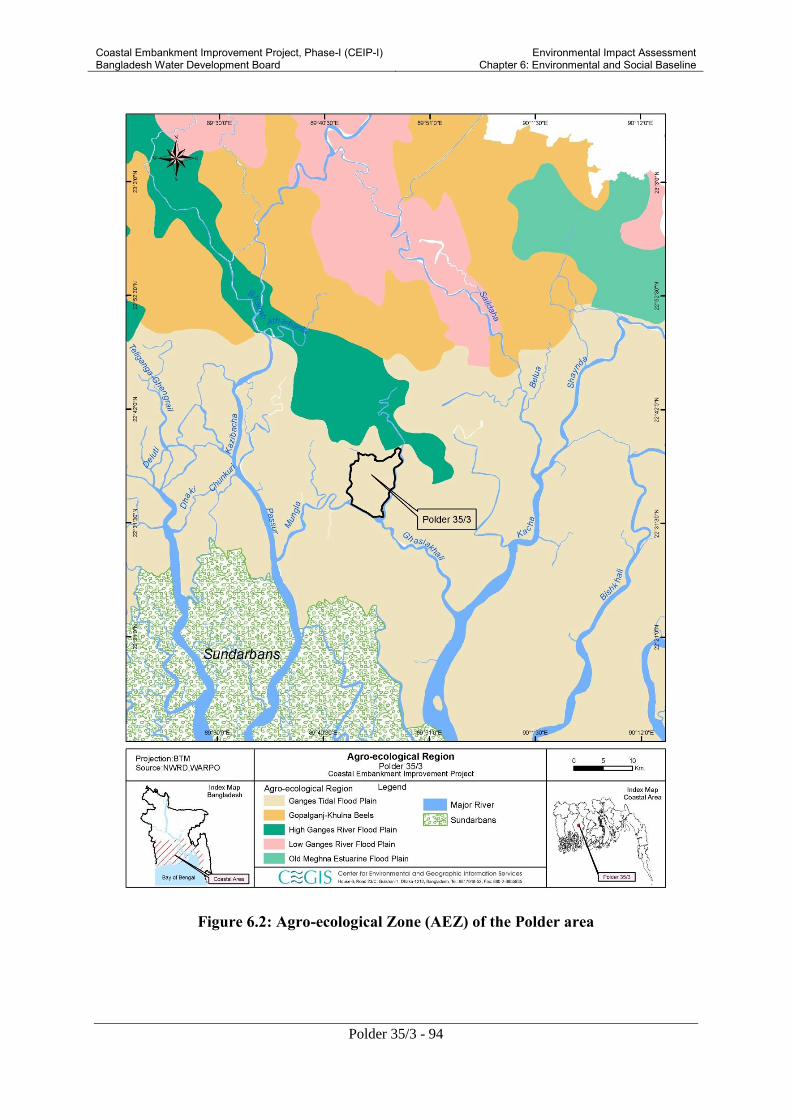
Coastal Embankment Improvement Project, Phase-I (CEIP-I) Bangladesh Water Development Board
Environmental Impact Assessment Chapter 6: Environmental and Social Baseline
Polder 35/3 - 94
Figure 6.2: Agro-ecological Zone (AEZ) of the Polder area

Coastal Embankment Improvement Project, Phase-I (CEIP-I) Bangladesh Water Development Board
Environmental Impact Assessment Chapter 6: Environmental and Social Baseline
Polder 35/3 - 95
6.1.3 Soil
There is a pattern of grey, slightly calcareous, heavy soils on river banks and grey to dark grey, non-
calcareous, heavy silty clays in the extensive basins. Non-calcareous grey floodplain soil is the major
soil type. Acid sulfate soils also occupy significant part of the area where it is extensively acidic
during dry season. In general, most of the top soils are acidic and sub-soils are neutral to mildly
alkaline. The soils are formed from clay-loam, loam and clay sediments and seasonally flooded,
poorly drained except soils of high land areas.
Soil texture is the relative proportions of sand, silt and clay. It is very important for agriculture crop
production. It is observed that the soil texture varies from clay, clay loam and loam. The soil texture
has been presented in Table 6.1.
Table 6.1: Soil texture of the project area (Polder 35/3)
Soil texture with depth(cm) % of NCA
Clay Clay loam Loam
Topsoil (0-15) 30 70 -
Source: CEGIS Estimation from SRDI, 2012
6.1.4 Land types
Land type classification is based on depth of inundation during monsoon season due to normal
flooding on agriculture land. In the polder area, about 24%, 69% and 7% of the net cultivable lands
falls under High land, Medium high land and Low land respectively. The distribution of land types
under polder 35/3 is shown in Table 6.2.
Table 6.2: Distribution of land type in the Polder area of 35/3
Land type Area (ha) % of NCA
Highland 1,208 24
Medium Highland 3,529 69
Medium Lowland 353 7
Lowland - -
Very Lowland - -
Total ( cultivable) 5,090 100
Gross Area 6,790
Source: CEGIS Estimation based on field information, 2012
6.1.5 Land use
The total area of Polder 35/3 is 6,790 ha of which 5,090 ha is net cultivable area (NCA). The
percentage of land utilization for crop production is about 75. About 25% area is covered by others
(settlements and water bodies etc). In the polder area there has no mangrove forest. Scattered, some
mangrove plants have been found near the khals and besides settlement. Golpata plants are common.

Coastal Embankment Improvement Project, Phase-I (CEIP-I) Bangladesh Water Development Board
Environmental Impact Assessment Chapter 6: Environmental and Social Baseline
Polder 35/3 - 96
The area of single cropped is about 3,563 ha and others are fallow land. Detailed land use has been
presented in Table 6.3.Detail land use map is shown in figure 6.3.
Table 6.3: Present land use of the polder area
Source: CEGIS Estimation, 2012
Figure 6.3: Land Use Map
Land use Area (ha) %
Agriculture land 5,090 75
Single crop 3,563 70
Double crop 0 0
Triple crop 0 0
Fallow 1,527 30
Settlements 255 4
Water bodies 1,445 21
Gross area 6,790 100

Coastal Embankment Improvement Project, Phase-I (CEIP-I) Bangladesh Water Development Board
Environmental Impact Assessment Chapter 6: Environmental and Social Baseline
Polder 35/3 - 97
6.1.6 Farming Practices
Farming practices within most of the Polder 35/3 area have adjusted to agro-climatic conditions
prevailing in Kharif-I (March-June), Kharif-II (July –October) and Rabi (November-February)
seasons. The crop year starts from the Kharif-I, season which is characterized by high temperature,
low humidity, high evaporation, high solar radiation and early rains which cause flash floods, high
rainfalls, lower temperatures, high humidity, low solar radiation and high floods that recede towards
the end of the season are the characteristics of Kharif-II. The Rabi season is characterized by low
temperatures, high solar radiation, low evaporation, insignificant rainfalls and low humidity. Kharif-II
crops are harvest in the Rabi season and Rabi is the major planting season of Rabi crops and harvested
in Kharif-I season.
The farming practices in Polder 35/3 are complicated due to physical, biological, climatological and
socioeconomic factors. The siltation of rivers and channels caused drainage congestion/ water logging
during monsoon, natural calamities like cyclone and surge etc cause devastating crop damage in the
polder area. Scarcity of sweet water for irrigation during dry season is also responsible for the non
expansion of the agriculture farming practices. On the other hand, saline surface water creates very
favorable environment for brackish water fish culture. The environment of polder is also suitable for
fish cum paddy cultivation. Some farmers of polder areas are practicing Boro HYV. A limited variety
of crops are grown due to unfavorable situation prevailing in the polder area. Sugarcane and Orchard
(Banana) are annual crops in the polder area. Rice is the main crop grown because of its adaptability
in diversified ecological conditions. S. Vegetables, T. Aus (LV), T Aman (HYV), T. Aman(LV) and
Boro HYV, Potato, Chilli, W. Vegetables, Pulses, Wheat, Oilseeds are grown in Kharif-I, Kharif-II
and Boro/Rabi seasons respectively.
6.1.7 Present Cropping pattern and intensity
The dominant cropping patterns in the polder area are Fallow-T Aman (HYV) –Fallow and Fallow-T
Aman (LV) - Fallow which are about 31.6% and 27% of the net cultivable area respectively. Detailed
existing cropping pattern of the polder area along with land type is presented in Table 6.10. In kharif-I
season; Sugarcane, Orchard, Vegetables and T Aus (LV) crops are grown on about 9.0% of the NCA.
About 89% of the NCA remained fallow in the Kharif-I season. In Kharif-II season; rice is the main
crop covering about 87.3%. The area of T Aman Local (LV) and T Aman (HYVs) are being practiced
in 55.7% and 31.6% respectively. About 12% of the net cultivable area remained fallow. In Rabi/Boro
season, Boro and different types of dry land crops are being practiced. About 22.6% and 9.7 % are
covered for Boro and dry land crops respectively. About 67.7% of the NCA remained fallow in this
season. The overall cropping intensity in the study area is about 130% (Table 6.4).
The dominant cropping pattern is Fallow-Lt Aman- Fallow which is practiced in about 54% of the
NCA. Fallow-HYVAman-Fallow is the next cropping pattern covering about 15% of the NCA.
Fallow- Fallow-HYV Boro cropping pattern is practiced about 1% of the NCA.
In kharif-I season, 100% of the NCA remained fallow. In Kharif-II season, HYV Aman and Lt Aman
are grown in about 15% and 54% of the NCA respectively. In this season, about 31% area remained
fallow. During Rabi/Boro season, 1.0% area is covered by HYV Boro and the rest 99% of NCA
remained fallow. About 30% of the NCA remained fallow throughout the year. These lands are being
used for brackish water shrimp culture. Rice cum fish (white fish) is a common practice in the polder
area during kharif –II season. Shrimp has not been included for calculating the cropping intensity in
the polder area. About 3,563 ha land is used for single crop. The cropping intensity is about 70% in
the polder area.

Coastal Embankment Improvement Project, Phase-I (CEIP-I) Bangladesh Water Development Board
Environmental Impact Assessment Chapter 6: Environmental and Social Baseline
Polder 35/3 - 98
Figure 6.4: View of Boro crop land in the study area
Table 6.4: Cropping Pattern by land type
Land Tpe Kharif-I
(March-
June)
Kharif-II
(July-
October)
Rabi
(Nov-
February)
Present
Area
(ha)
No.o
f
crop
Total
croppe
d area
Cropping
intensity
% High land( F0) Sugarcane Cont’d Cont’d 7 0.1 7
High land( F0) Orchard Cont’d Cont’d 43 0.8 43
High land( F0) Fallow Fallow Potato 45 0.9 45
High land( F0) Fallow T. Aman(LV) Spices 25 0.5 50
High land( F0) Fallow T. Aman Chilli 10 0.2 20
High land( F0) Fallow Fallow W. Vegetables 55 1.1 55
High land( F0) S.Vegetables T.Aman(LV) Fallow 361 7.1 722
High land( F0) Fallow T.Aman(HYV) Fallow 400 7.9 400
High land( F0) Fallow Fallow W.Vegetables 142 2.8 142
High land( F0) Fallow T.Aman(LV) Wheat 120 2.4 240
Sub-total 1,208 23.7 1,724 142.71
Medium
highland(F1)
Fallow T.Aman(LV) Boro(HYV) 900 17.7 1800
Medium
highland(F1)
Fallow T.Aman(LV) Fallow 1374 27.0 1374
Medium
highland(F1)
Fallow T.Aman(HYV) Fallow 1205 23.7 1205
Medium
highland(F1)
T.Aus(LV) T.Aman(LV) Pulses 50 1.0 150
Sub-total 3,529 69.3 4,529 128.34
Medium
lowland( F2)
Fallow Fallow Boro(LV) 247 4.9 247
Medium
lowland( F2)
Fallow Fallow Oilseeds 30 0.6 30
Medium
lowland( F2)
Fallow Fallow Pulses 76 1.5 76
Sub-total 353 6.9 353 100
Total 5,090 100 6,606 129.78
Sources: Feasibility report, 2012
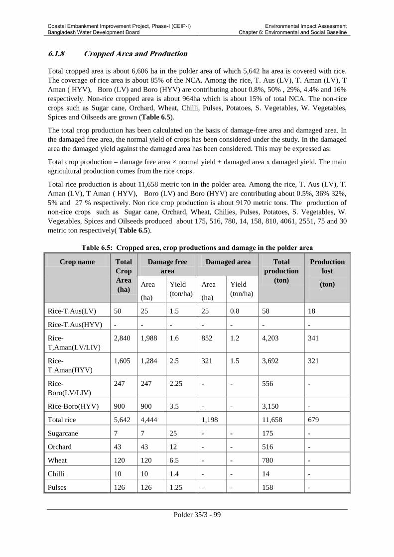
Coastal Embankment Improvement Project, Phase-I (CEIP-I) Bangladesh Water Development Board
Environmental Impact Assessment Chapter 6: Environmental and Social Baseline
Polder 35/3 - 99
6.1.8 Cropped Area and Production
Total cropped area is about 6,606 ha in the polder area of which 5,642 ha area is covered with rice.
The coverage of rice area is about 85% of the NCA. Among the rice, T. Aus (LV), T. Aman (LV), T
Aman ( HYV), Boro (LV) and Boro (HYV) are contributing about 0.8%, 50% , 29%, 4.4% and 16%
respectively. Non-rice cropped area is about 964ha which is about 15% of total NCA. The non-rice
crops such as Sugar cane, Orchard, Wheat, Chilli, Pulses, Potatoes, S. Vegetables, W. Vegetables,
Spices and Oilseeds are grown (Table 6.5).
The total crop production has been calculated on the basis of damage-free area and damaged area. In
the damaged free area, the normal yield of crops has been considered under the study. In the damaged
area the damaged yield against the damaged area has been considered. This may be expressed as:
Total crop production = damage free area × normal yield + damaged area x damaged yield. The main
agricultural production comes from the rice crops.
Total rice production is about 11,658 metric ton in the polder area. Among the rice, T. Aus (LV), T.
Aman (LV), T Aman ( HYV), Boro (LV) and Boro (HYV) are contributing about 0.5%, 36% 32%,
5% and 27 % respectively. Non rice crop production is about 9170 metric tons. The production of
non-rice crops such as Sugar cane, Orchard, Wheat, Chilies, Pulses, Potatoes, S. Vegetables, W.
Vegetables, Spices and Oilseeds produced about 175, 516, 780, 14, 158, 810, 4061, 2551, 75 and 30
metric ton respectively( Table 6.5).
Table 6.5: Cropped area, crop productions and damage in the polder area
Crop name Total
Crop
Area
(ha)
Damage free
area
Damaged area Total
production
(ton)
Production
lost
(ton)
Area
(ha)
Yield
(ton/ha)
Area
(ha)
Yield
(ton/ha)
Rice-T.Aus(LV) 50 25 1.5 25 0.8 58 18
Rice-T.Aus(HYV) - - - - - - -
Rice-
T,Aman(LV/LIV)
2,840 1,988 1.6 852 1.2 4,203 341
Rice-
T.Aman(HYV)
1,605 1,284 2.5 321 1.5 3,692 321
Rice-
Boro(LV/LIV)
247 247 2.25 - - 556 -
Rice-Boro(HYV) 900 900 3.5 - - 3,150 -
Total rice 5,642 4,444 1,198 11,658 679
Sugarcane 7 7 25 - - 175 -
Orchard 43 43 12 - - 516 -
Wheat 120 120 6.5 - - 780 -
Chilli 10 10 1.4 - - 14 -
Pulses 126 126 1.25 - - 158 -

Coastal Embankment Improvement Project, Phase-I (CEIP-I) Bangladesh Water Development Board
Environmental Impact Assessment Chapter 6: Environmental and Social Baseline
Polder 35/3 - 100
Potatoes 45 45 18 - - 810 -
S.Vegetables 361 253 13.5 108 6 4,061 812
W. Vegetables 197 167 14 30 7 2,551 207
Spices 25 25 3 - - 75 -
Oilseeds 30 30 1 - - 30
Total non-rice 964 826 138 9,170 1,019
Total 6,606 5,270 1,336 20,828 1,698
Source: Estimation from field information, 2012
6.1.9 Crop damage
Crop damage data have been collected within inside embankments considering drainage congested
areas, and salinity affected areas in consultation with stakeholders, farmers and officials of the
DAE. Annual crop damage (paddy production losses) along with area has been evaluated. Crop
production loss has been calculated using the formula: Crop production loss = Total cropped area
normal yield - (damaged area ×damaged yield+ damage-free area × normal yield).
About 1,198 ha area of rice crops (T Aman HYV 321 ha, T Aman Local 852 ha and Lt. Aus 25ha) are
damaged. About 679 metric ton of paddy is lost from this area due to drainage congestion, heavy rain
fall, pest and disease infestations, drought and salinity, natural calamities ( Aila, Sidr etc.) etc. About
138ha of non-rice crops (S. Vegetables 108ha and W. Vegetables 30ha) are damaged. About 1,019
metric tons of Vegetables production (S. Vegetables 812 metric tons and W. Vegetables 207 metric
tons) is lost (Table 6.5).
6.1.10 Agricultural input use
Fertilizer and Pesticides Application
The rate of use of fertilizer per hectare varies considerably from farmer to farmer depending on soil
fertility, cropping pattern and financial ability (Table 6.6). The major fertilizers used in this area are
Urea, TSP and MP. Farmers opined that higher price, low quality and lack of different agricultural
inputs, such as seeds, over doses use of chemical fertilizers and pesticides. Urea is used abundantly
compared other organic fertilizers which would affect the soil health and yield. The present scenario
clearly indicates that farmer’s has lack of knowledge on update information and essential plant
nutrients deficiencies and agricultural technology are the common problems for restricting the proper
crop cultivation in the polder.
Almost all the farmers (100%) applied pesticides in T. Aus (LV/HYV), T. Aman (LV/HYV), Chilies,
Potatoes, summer and winter Vegetables and Spices crops. The highest pesticides used in Potato (taka
2000/ha), and T. Aman (Tk.1500) (Table 6.6). The polders farmers applied pesticides two or three
more times. They used pesticides under or over dose. The use of pesticides depends on the degree of
pest infestation. The major insects as reported by the farmers are yellow stem borer, rice hispa, ear
cutting caterpillar, brinjal fruit and shoot borer, fruit weevil etc. Local farmer reported that they are
using different types of pesticides such as Sumithion, Furadan and Kuratar granular, liquid and
powder etc. to prevent pest infestation in Rice, Potatoes, Spices and Vegetables croplands.

Coastal Embankment Improvement Project, Phase-I (CEIP-I) Bangladesh Water Development Board
Environmental Impact Assessment Chapter 6: Environmental and Social Baseline
Polder 35/3 - 101
Table 6.6: Present level of crop production input used within Polder 35/3
Source: Based on main consultant and field information, 2012 *Cost/ha Taka 2000-2500/-
Irrigation
Irrigation is provided to Boro (HYV) crop which is about 18% of the NCA. Irrigation also provided to
other crops like Chilies, Potato, W. Vegetables and Spices in dry season. Surface water is the major
source of irrigation. Most of the farmers provide irrigation with the help of surface water for raising
seedlings, land preparation and transplantation upto mid March. The salinity of the surface water
gradually increases and reaches beyond the tolerance limit during April-May (EC> 10.0 dSm-1
). But
they cannot use this source for irrigation purpose due to salinity of water from the start of March to
May. The surface water becomes fresh due to onset of monsoon during rainy season (EC< 1.5 dSm-1
).
T. Aus (LV),T. Aman (LV),T. Aman (HYV) are grown in rainfed condition.
Seeds
The role of seeds is very important for growing crops. Selection of seeds has to be made carefully.
More than 85% germination rate, free from disease infestation and high yield potential need to be
considered. The different (HYV/Hybrid) varieties crop seeds are available in the local market. Most
of the farmers used their own seeds in case local variety such as T. Aus and T. Aman. The farmers
reported that private dealers’ seed quality is poor and market price is higher than BADC seeds. The
seed rate used in the polder area is 35kg, 3-4 kg, and 45 kg, 35kg, 3kg, 35kg, 3500kg, 2-3kg, 2-3kg
and 10-12 kg for T. Aus(HYV), S. Vegetables, T. Aman (LV), T. Aman (HYV), Chilies, Pulses,
Potato, W. Vegetables, Spices and Oil seeds respectively ( Table 6.6).
Crop
Name
Seeds
used/
ha
(Kg)
Fertilizer (Kg/ha) Irrigation
cost
Pesticide
/ha (Tk)
Used cultivation
equipments
Cost
power
tiller Urea TSP MP Gypsum Zinc Manure
(Cow
dung/compost)
Power
tiller
(%)
Bullock
T.Aus
(HYV)
35 195 178 135 10 10 - - 1500 85 15* 4500
T.Aman
(LV)
45 110 89 35 - - - 1200 90 10 4000
T.Aman
(HYV)
35 152 133 67 16 - - - 1500 90 10 5000
S.
Vegetables
3-4 130 100 67 - - - - 2000 90 10 4000
Chilli 3 60 50 30 - 10 - 200 500 85 15 5000
Pulses 35 40 30 20 - - - - - 85 15 4000
Potatoes 3500 250 135 170 55 11 - 3000 2000 90 10 5000
W.
Vegetables
2-3 120 80 70 - - - 1000 1500 85 15 4500
Spices 2-3 120 60 40 - - 200 300 300 85 15 4500
Oil seeds 10-12 165
90 60 - - - - 1000 90 10 4500

Coastal Embankment Improvement Project, Phase-I (CEIP-I) Bangladesh Water Development Board
Environmental Impact Assessment Chapter 6: Environmental and Social Baseline
Polder 35/3 - 102
6.2 Water Resources
6.2.1 River System
The area of Polder 35/3 is located in the southwestern hydrological zone in Bagerhat district of
Bangladesh. The hydrological description of the polder area has been defined based on the river
system of Daratana and Bishnu rivers which are the main rivers along the east and west boundary and
Katakhali River along the southwest and Putimari River in the north periphery of the polder. These
rivers are perennial. Average width of Daratan, Putimary and Bishnu River is 286 m, 50 m and 146 m
respectively. These surrounding rivers with tidal influence control the flooding and drainage dynamics
of the polder. There are numerous khals inside the polder namely Putimarikhal, Sayanbankikhal
(Sobagi river), Batbuniakhal, Motherdiakhal, Hetalbuniakhal, Keblatolakhal, Raotirkhal, Tanpara
khal, Saragachhia Khal. Morgang khal, Khajar khal, Betilbunia khal, Rautier gang, and other khals
having tidal effect which controls the main drainage system and supplementary irrigation during
monsoon. Polder 35/3 is also located besides the international navigation route. The name of route is
Ghasiakhali. Figures 6.5 to 6.8 present some photographs of the rivers and khals of the area.
Figure 6.5 Bishnu river western side of
the polder
Figure 6.6: Dharatana river eastern side of
the polder
Figure 6.7: Sayabankikhal (Sobagi
river)
Figure 6.8: Betbunia khal inside the polder

Coastal Embankment Improvement Project, Phase-I (CEIP-I) Bangladesh Water Development Board
Environmental Impact Assessment Chapter 6: Environmental and Social Baseline
Polder 35/3 - 103
6.2.2 Navigation in Rivers and Khals
Polder 35/3 is surrounded by Putimari river (North), Daratana River (East), Katakhali khal (south),
and Bishnu river (west). The Daratana River, Katakhali khal, and Bishnu River remain navigable
throughout the year. Large cargos and motorized boats/ trawlers can navigate along the Daratana
River and Katakhali khal. The Bishnu River becomes shallow during the periods of low rainfall and
hence, does not provide suitable navigability for transportation of large cargos in the dry season. The
Putimari River is very shallow especially during the periods of low tides. It is therefore not suitable
for waterway transportation of large cargos. Small boats are to be used for transportation through this
river. The internal lakes/khals of the Polder are suitable for the movement of mostly small non-
motorized boats only.
6.2.3 Drainage Congestion and Water Logging
In the study area, there are many khals and channels with tidal influences. Most of these khals run
from the north to the south and provide drainage of the project area. These channels are also
interconnected by lateral channels running from the east to the west and draining into the main rivers.
During monsoon, water does not drain out properly due to high siltation in external rivers and internal
Betibunia, Mogordhara and Sayabanki khals of the polder. The spatial distribution of drainage
congestion in the Polder is shown in Figure 6.9. Drainage congestion is a common issue in the total
polder area though intensity varies from place to place. The drainage performance through linked
khals has been gradually decreasing due to sedimentation at both the upstream and downstream of the
sluices. Over the years, improper maintenance of internal khals and malfunctioning of sluices as well
as lack of sluices caused drainage congestion in the polder area. About 5-7% area (some places of
Bara Bashbaria under Dema union, Madardia of Mollikerber union) of the polder are facing drainage
problem during monsoon.
In the Polder, roughly 2 percent of the gross area (Kashimpur, Kalia under the Dema union and some
parts of Malliker ber) is affected by water logging problems. In recent years, as a consequence of
gradual deterioration hydraulic structures, the drainage congestion and water logging problems have
been increasing, as reported by the Polder inhabitants (CEGIS field survey, 2012).

Coastal Embankment Improvement Project, Phase-I (CEIP-I) Bangladesh Water Development Board
Environmental Impact Assessment Chapter 6: Environmental and Social Baseline
Polder 35/3 - 104
Figure 6.9: Drainage Congestion in Polder 35/3
6.2.4 Tropical Cyclones and Tidal Flooding
Tropical cyclones are a major threat to the coastal areas, causing loss of human lives and livestock
and severe damage to crops and fisheries and. In the last 125 years, more than 42 cyclones have hit
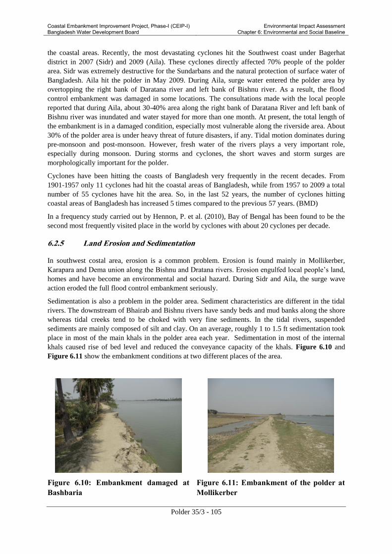
Coastal Embankment Improvement Project, Phase-I (CEIP-I) Bangladesh Water Development Board
Environmental Impact Assessment Chapter 6: Environmental and Social Baseline
Polder 35/3 - 105
the coastal areas. Recently, the most devastating cyclones hit the Southwest coast under Bagerhat
district in 2007 (Sidr) and 2009 (Aila). These cyclones directly affected 70% people of the polder
area. Sidr was extremely destructive for the Sundarbans and the natural protection of surface water of
Bangladesh. Aila hit the polder in May 2009. During Aila, surge water entered the polder area by
overtopping the right bank of Daratana river and left bank of Bishnu river. As a result, the flood
control embankment was damaged in some locations. The consultations made with the local people
reported that during Aila, about 30-40% area along the right bank of Daratana River and left bank of
Bishnu river was inundated and water stayed for more than one month. At present, the total length of
the embankment is in a damaged condition, especially most vulnerable along the riverside area. About
30% of the polder area is under heavy threat of future disasters, if any. Tidal motion dominates during
pre-monsoon and post-monsoon. However, fresh water of the rivers plays a very important role,
especially during monsoon. During storms and cyclones, the short waves and storm surges are
morphologically important for the polder.
Cyclones have been hitting the coasts of Bangladesh very frequently in the recent decades. From
1901-1957 only 11 cyclones had hit the coastal areas of Bangladesh, while from 1957 to 2009 a total
number of 55 cyclones have hit the area. So, in the last 52 years, the number of cyclones hitting
coastal areas of Bangladesh has increased 5 times compared to the previous 57 years. (BMD)
In a frequency study carried out by Hennon, P. et al. (2010), Bay of Bengal has been found to be the
second most frequently visited place in the world by cyclones with about 20 cyclones per decade.
6.2.5 Land Erosion and Sedimentation
In southwest costal area, erosion is a common problem. Erosion is found mainly in Mollikerber,
Karapara and Dema union along the Bishnu and Dratana rivers. Erosion engulfed local people’s land,
homes and have become an environmental and social hazard. During Sidr and Aila, the surge wave
action eroded the full flood control embankment seriously.
Sedimentation is also a problem in the polder area. Sediment characteristics are different in the tidal
rivers. The downstream of Bhairab and Bishnu rivers have sandy beds and mud banks along the shore
whereas tidal creeks tend to be choked with very fine sediments. In the tidal rivers, suspended
sediments are mainly composed of silt and clay. On an average, roughly 1 to 1.5 ft sedimentation took
place in most of the main khals in the polder area each year. Sedimentation in most of the internal
khals caused rise of bed level and reduced the conveyance capacity of the khals. Figure 6.10 and
Figure 6.11 show the embankment conditions at two different places of the area.
Figure 6.10: Embankment damaged at
Bashbaria
Figure 6.11: Embankment of the polder at
Mollikerber

Coastal Embankment Improvement Project, Phase-I (CEIP-I) Bangladesh Water Development Board
Environmental Impact Assessment Chapter 6: Environmental and Social Baseline
Polder 35/3 - 106
6.3 Environmental Quality
Air, noise, water and soil quality were measured during the field survey. The locations are mentioned
in the following table. The objective of the measurement was to set up a strong baseline which will
help to monitor the impact of the present during construction and operation phase. The locations for
air, water, noise and soil quality are shown in Figure 6.12.

Coastal Embankment Improvement Project, Phase-I (CEIP-I) Bangladesh Water Development Board
Environmental Impact Assessment Chapter 6: Environmental and Social Baseline
Polder 35/3 - 107
Figure 6.12: Locations of Noise, Water and Soil Quality Monitoring Stations
6.3.1 Air Quality
Air pollution is not of much significance in the coastal area of Bangladesh. From field visits, it was
observed that overall air quality in the study area is good. The standards of ambient air quality should
be maintained at the project site. The standards of air quality are given in Table 6.7.
Table 6.7: Standards of ambient air quality
Areas Concentration of micrograms per meter cube
SPM (μg/m3) SO2 (μg/m3) NOx (μg/m3)
Industry 500 120 100
Commercial 400 100 100
Residential and rural area 200 80 80
Sensitive 100 30 30
Source: Environment Conservation Rules, 1997
Table 6.8 shows the air quality data measured at Rampal upazila, under Bagerhat district. The values
suggest that the concentrations of the measured air quality parameters (suspended particulate matter -
SPM, oxides of sulpher - SOx, and oxides of nitrogen - NOx) lie within the range of standard values
for Bangladesh (See Table 6.7).
Table 6.8: Values of ambient air quality parameters in the study area
Sample Location
Air Quality Parameters
SPM(μg/m3) SOx(μg/m3) NOx(μg/m3)
Bazar area, Rampal upazila sadar, Bagerhat 125 <25 20
Hedayetpur, Bagerhat 118 <25 22
Source: CEGIS field survey, December 2012
6.3.2 Noise
The noise level for both the normal situation and situation with traffic has been analyzed in the field.
The values of noise level are shown in Table 6.9:
Table 6.9: Daytime noise levels of the study area
Sl.
no
Location Noise level (dB) GPS
Normal
condition
Normal
condition
(Average)
With
traffic
With traffic
(Average)
1 Mirzapur,
Near Dema
Bridge
63.8 60.95 76.4 84.3 N
22°37’19.0”
E 89°45’52.4”
58.1 92.2
2 Kashimpur
bazaar
68.4 68.4 76.5 76.5 N
22°36’03.2”

Coastal Embankment Improvement Project, Phase-I (CEIP-I) Bangladesh Water Development Board
Environmental Impact Assessment Chapter 6: Environmental and Social Baseline
Polder 35/3 - 108
Sl.
no
Location Noise level (dB) GPS
Normal
condition
Normal
condition
(Average)
With
traffic
With traffic
(Average)
E 89°45’30.4”
*All measurements have been taken during daytime.
Source: CEGIS field survey, December 2012
Table 6.10 shows the standard values for noise in Bangladesh. Noise levels exceeding 80dB (with
traffic situation) are usually considered as Noise pollution in our country. However the permissible
limits for the country are less (Table 6.9). The study area can be regarded as a mixed area, and the
noise levels observed in the study area have been found to be exceeding the permissible limits of
mixed zones for daytime.
Table 6.10: Standards of Noise levels for different zones of Bangladesh
Zone Class Limits in dB
Daytime Nighttime
(6 am – 9 pm) (9 pm-6 am)
Silent zone 45 35
Residential zone 50 40
Mixed 60 50
Commercial zone 70 60
Industrial zone 75 70
Source: Bangladesh Gadget, 2006
6.3.3 Water Quality
As described earlier, there has been a decline in the effectiveness of the Polder because of the lack of
repair and maintenance of embankments and water control structures as well as frequent attacks by
minor to major cyclonic surges, and absence of functional community organizations. As a
consequence, during the periods of low rainfall, the surface water of the entire area gets affected by
salinity intrusion.
In order to provide a clear view of the existing condition of the water quality inside the Polder area, a
number of water quality parameters – including salinity, dissolved oxygen (DO), temperature,
electrical conductivity (EC), pH, total dissolved solids (TDS), chlorides (Cl), suspended solids (SS),
and arsenic (As) - were selected by the study team for monitoring and evaluation. The surface water
and ground water was analyzed during the field level survey conducted in two different periods of the
year. The surface water quality was measured at six different locations in the month of December and
the ground water quality was tested in the month of May. The results obtained in the two field surveys
provided an understanding of the water quality in the Polder, discussed below.

Coastal Embankment Improvement Project, Phase-I (CEIP-I) Bangladesh Water Development Board
Environmental Impact Assessment Chapter 6: Environmental and Social Baseline
Polder 35/3 - 109
6.3.4 Surface Water Quality
The surface water quality in Polder 35/3 is influenced by the hydrological connections of the internal
water channels with the surrounding rivers of the polder. The rivers and lakes around the Polder i.e.
the Daratana River (north), Putimari river (north), Katakhali khal (south) and Bishnu river (west)
provide tidal inflow into the Polder during the periods of high tide or low rainfall. The water bodies
inside the Polder are mostly free flowing khals, and apart from salinity intrusion during January to
April, the other water quality parameters remain within the acceptable range. Table 6.11 presents the
values of the water quality parameters measured in a number of selected locations of the Polder. The
standard values of these indicators set by DoE, Bangladesh have also been shown for the comparison
purposes.
Table 6.11: Water Quality in Polder 35/3
Sample Location
Water Quality Parameters
Salinity
(ppt)
Temperature
(°C)
TDS
(ppm)
EC
(mS/cm)
DO
(mg/L) pH
Botolbunia Khal (Chok
ponchomala 3 22.2°C 1622 2.17 7.2 7
Araibari Khal
(Barabashbaria) -
23.0°C
1668 2.27 3.4 7.1
Sobaki Khal Gate
(Barabashbaria) - 22.9°C 1635 2.1 5.9 7.1
Sobaki Khal (Madardi,
Rastar mathar bazar) - 23.1°C 1254 1.66 5.4 7
Kata River (Molliker Ber,
Aulia bazar or Praner
bazar)
3 22.7°C 1278 1.54 5.6 7.2
Kulimari Khal, Kashempur
Bazar, Dema - 22.5°C 1339 1.89 5.8 6.9
Standard Value
(Bangladesh)
Irrigation - 20-30 - - 5.0 7.0-8.5
Fishing - 20-30 - - 4.0-6.0 6.7-9.5
Source: CEGIS field survey, December 2012
Salinity. During monsoon the salinity levels are very low because of the increased amount of fresh
water in the water bodies. The level of salinity starts increasing from January due to the reduction of
upland discharge and reaches the peak in April and then starts decreasing again. Saline water intrudes
the areas near the breached embankments causing damage to agricultural practices.
In the dry season, the overall salinity levels both in soil and surface water are high and roughly about
15-20 percent of the Polder area is affected. This happens because of the following reasons: (i) about
3-4 percent of the polder area is under golda (prawn) culture, (ii) saline water enters through breached
Coastal Embankment Improvement Project, Phase-I (CEIP-I) Bangladesh Water Development Board
Environmental Impact Assessment Chapter 6: Environmental and Social Baseline
Polder 35/3 - 110
embankments, and (iii) malfunctioning of sluices with/without gates. However in the month of
December, the salinity value was low (0-3 parts per thousand) as shown in Table 6.11 above, since
rain water inside the Polder was still present and tidal flow from the ocean was yet to intrude. The
embankments and water controlling structures have experienced significant deterioration over the
years and as a result the salinity values inside the polder have increased. Especially after the
occurrences of Aila and Sidr, the salinity intrusion in the polder during dry season has become a
common phenomenon.
Dissolved Oxygen (DO). This is an essential parameter for the metabolic process that produces
energy for growth and reproduction of fishes and other aerobic aquatic biota. Decrease in DO values
below the critical level of 3 mg/l causes death of most fishes and other aerobic aquatic organisms. DO
is relatively low in dry season than in wet season. The values of DO inside the Polder (measured in
the month of December) ranged between 5 to 6 mg/l at some places, which complies with the DoE
standards for irrigation as well as for fisheries and aquatic life. However, values found in Araibari
khal were lower than the range of standard values for irrigation and fisheries whereas the water of the
Botolbunia khal has higher DO values.
pH. The hydrogen ion concentration of water is expressed by its pH value. A pH value of 7 indicates
a neutral solution, neither alkaline nor acidic. In most of the water bodies of the Polder, the pH range
is found well within the DoE standards.
Temperature. Temperature of water bodies affects the fish habitats and their oxygen holding
capacity. The mean temperature of the water bodies inside the Polder area was around 22°C- 23°C
(Table 6.11), in December. This value lies within the DoE standards for both irrigation and fish
habitats.
Total Dissolved Solids (TDS). The natural range of total dissolved solids concentration for most
lakes occupying open basins is usually between 100 and 200 mg/l. However the values of TDS were
found very high inside the Polder area (ranged between 1,200-1,700 mg/l (see Table 6.11) because of
the saline water intrusion. Livestock and wildlife may be adversely affected by drinking this water
containing excessive dissolved solids. Continuous use of such water may cause a general loss of
condition, weakness, scouring, reduced production, bone degeneration and ultimately death. TDS may
influence the toxicity of heavy metals and organic compounds for fish and other aquatic life. This
takes place primarily because of the antagonistic effect of hardness on metals. The quantity and
quality of dissolved solids often determines the variety and abundance of plants and animals in a
given aquatic situation.
Electrical Conductivity (EC). EC is a useful water quality indicator for estimating the amount of
minerals, assessing the effect of diverse ions on chemical equilibrium, physiological effects on plants
or animals, and corrosion rates. It is an indirect measure of the TDS (TDS = 640 × EC), the effects of
which have been discussed above. The values of EC inside the Polder ranged between 1.5 - 2.5
mS/cm. The higher values of EC indicate that the water bodies inside the Polder area are more
affected by saline water rather than fresh water.
Ground Water (GW)
The ground water quality parameters, measured in the Polder during the month of May were found to
comply with the drinking water quality standards (ECR’97). The values of the ground water quality
parameters of the Polder area as well as the standard values of these parameters set in ECR’97 are
presented in Table 6.12
Table 6.12: Groundwater Quality at Bagerhat Sadar

Coastal Embankment Improvement Project, Phase-I (CEIP-I) Bangladesh Water Development Board
Environmental Impact Assessment Chapter 6: Environmental and Social Baseline
Polder 35/3 - 111
Sample Location Temp (°C) pH Chloride
(mg/l)
Iron
(Fe)
(mg/l)
SS (mg/l) Pb
(mg/l)
Coliforms As (mg/l)
DTW of Karakara
primary school,
Bagerhat sadar
upazila, Bagerhat
24.2 7.56 514 0.98 5 >0.02 Nil 0
Drinking water
quality standard
as per ECR'97
6.5 – 8.5 150 – 600 0.3 – 1.0 10 0.05 Nil 0.05
Source: Laboratory Test, May 2012
6.3.5 Soil Quality
The soils possess low to very high condition in the dry season and soil salinity level and pH ranges
from 4.9-18ds/m and 5.2-7.6 respectively. But Mollikerber Union soil salinities level and soil pH
range from about 2.0-12.0 ds/m and 6.-8.2 (Land Zoning Report of Bagerhat Sadar and Rampal
Upazila, Ministry of Land January2011).
Soil sample were collected for Polder 35/3. The collected soil samples were sent to the Agrochemical
and Environmental Research Division, Institute of Food and Radiation Biology of Atomic Energy
Research Establishment, Savar, Dhaka for detect pesticide residues. As the desired pesticide residues
were analyzed with a detection limit of 0.004 ppm using GC-MC (Thermo Electron & Pekin Elmer).
The analyzed result shows that no pesticide (furadan) exists in the soil samples.
Table: 6.13: Pesticide Residues Analysis Reports
Location Sample ID Carbofuran (ppm)
1 Polder35/3 1A(0-15cm) ND
2 Polder35/3 1B(15-30cm) ND
Here, ND: Not detected, LOD = 0.004ppm, LOQ = 0.01ppm
6.3.6 Climate and Meteorology
The climate of the project area is tropical in nature with three seasons namely summer/pre-monsoon
from March to May, monsoon from June to October, and winter season from November to February.
The rainy season is hot and humid with about 88 percent of the annual rainfall in the area. The winter
is predominately cool and dry. The summer is hot and dry interrupted by occasional heavy rainfall.
The Project area lies in the south west part of Bangladesh, where monsoon comes in the month of
June and recedes in the late October. Data on metrological parameters have been accumulated from
different secondary sources (Bangladesh Meteorological Department - BMD) and synchronized at
district level for Bagerhat. Summary of the analysis of metrological parameters are given in the
following sections.

Coastal Embankment Improvement Project, Phase-I (CEIP-I) Bangladesh Water Development Board
Environmental Impact Assessment Chapter 6: Environmental and Social Baseline
Polder 35/3 - 112
Temperature
The meteorological data of the area measured at Mongla station shows that the monthly maximum
temperature varies from 28ºC to 34ºC. Maximum temperature occurs in the month of April and is
around 34ºC and average temperature during monsoon is about 26º C. Monthly minimum temperature
ranges from 9ºC to 23ºC and the minimum temperature (December to February) is around 9ºC to
11ºC. Figure 6.13 shows the monthly maximum, mean and minimum temperature at Mongla station.
Figure 6.13: Temperature Data for Project Area
Yearly data of average temperature have also been analyzed for the same station (from 1989-2011).
The trend analysis shows that the average temperature for polder 35/3 is increasing by approximately
0.027 C each year (see Figure 6.14).
Figure 6.14: Yearly Average Temperature in Project Area
Humidity
The monthly average relative humidity measured at Mongla stations varies from 74 percent to 89
percent during a year. Even in the winter season the humidity is above 75 percent. Figure 6.15 shows
humidity data for the Project area.

Coastal Embankment Improvement Project, Phase-I (CEIP-I) Bangladesh Water Development Board
Environmental Impact Assessment Chapter 6: Environmental and Social Baseline
Polder 35/3 - 113
Figure 6.15: Humidity Data for Polder Project Area
Data of yearly average relative humidity have also been collected from the BMD station at Mongla.
The trend analysis for the relative humidity of polder 35/3 shows that the humidity increases by
approximately 0.021 percent each year (Figure 6.16).
Figure 6.16: Average Yearly Humidity in Project Area
Rainfall
The annual average rainfall in the Project area is 1,946 mm. Monthly maximum rainfall was recorded
as 983 mm in the month of June 2002. The average rainfall during monsoon is about 1,390 mm in the
Project area. The mean monthly cumulative rainfall measured at Mongla is shown below in Figure
6.17.

Coastal Embankment Improvement Project, Phase-I (CEIP-I) Bangladesh Water Development Board
Environmental Impact Assessment Chapter 6: Environmental and Social Baseline
Polder 35/3 - 114
Figure 6.17: Rainfall Data for Project Area
A trend analysis has also been carried out collecting the yearly rainfall data from the BMD station at
Mongla. The trend reflects that each year, the rainfall in the Project area has been increasing by
approximately 15.74 mm (see Figure 6.18).
Figure 6.18: Rainfall Trent in Project Area
Evaporation
The monthly average evaporation in the Project area varies from 3 to 5 mm per day in a year. The
monthly maximum average evaporation (16 mm/ day) occurs in the month of July.

Coastal Embankment Improvement Project, Phase-I (CEIP-I) Bangladesh Water Development Board
Environmental Impact Assessment Chapter 6: Environmental and Social Baseline
Polder 35/3 - 115
6.4 Fisheries Resources
Fisheries resources of the study area are diversified with different fresh and brackish water fish
habitats. Open water fish habitat of the study includes rivers and khal, such as Dharatana river,
Bishnu river and Katakhali khal, internal khals such as Pachabulia khal, Ghirarkata khal, Khager
khal, Moderdona khal, Abdul Rasulpur khal, Andhari khal, Putimari khal, Dhalipara khal, Sota khal,
Bhigorer khal, HetaMNani khal, Betbunia khal, Kironbabur Gater khal, Moragang, etc which are
acting as major arteries of fish migration into the polder area. These are playing vital role in
maintaining fisheries productivity of internal open water. Bulk of the commercial fish production is
coming from culture fish habitats and capture fish habitat. The productions from the capture fisheries
come from the capture habitat e.g. different seasonal and perennial canals and borrow pits. The study
area is surrounded by two rivers system and one khal such as Daratana River (60% of rivers;
perennial in nature), Bishnu River (30% of rivers; perennial in nature) and Katakhali khal (10% of
rivers; perennial in nature). The fish production from the peripheral river is 28 MT which has not been
considered in the fish production estimation. Fish production trend is declining gradually from the
open water sources. The numbers of fishers has decreased due to decrease of open water fish habitat,
loss of khal-river connectivity, water regulatory structures on the khals and improper operations.
Aquaculture is developing in suitable ponds of congestion free highland area in polder 35/3.
Figure 6.19: Open water fish habitat in the study area (Chabagi River)
The area is relatively moderate in fish biodiversity. But the fish biodiversity has the further decreasing
trend because of morphological changes, obstruction to spawning migration, natural and
anthropogenic drying up of wild fish habitats, indiscriminate fishing, loss of river-khal connectivity
and water regulatory structures on khals. Aquatic environmental quality is unsatisfactory in the study
area though some pollutants are released from crop fields and are substantially causing damage to
fish. On the other hand, water quality of internal khal degrades particularly during dry season.
Moreover fish migration from Daratana river to internal khals through Putimari khal and Bhishnu
river to internal khals through Betbunia khal is obstructed due to improper management of water
regulator on khal off-take. Fisheries sector is contributing financial benefit in small scale to the local
economy and improvement of local livelihoods.
Major fisheries problems and issues so far identified during baseline survey in the study area were as
follows:

Coastal Embankment Improvement Project, Phase-I (CEIP-I) Bangladesh Water Development Board
Environmental Impact Assessment Chapter 6: Environmental and Social Baseline
Polder 35/3 - 116
o siltation of internal khals are causing loss to the year round river-khal connectivity;
o indiscriminate fishing using monofilament gill net, net jal, etc and overexploitation of fishes by
using huge number of narrow meshed ESBN (Estuarine Set Bag Net) fishing;
o reduction of spawning and feeding grounds;
o Viral disease
o indiscriminate harvest of shrimp PL (Post Larvae) by local dwellers;
o hindrances to fish migration and movement due to improper management and mal-functioning of
the water regulatory structures along with encroachment and barriers;
o lack of quality fish seed and feed for the improved aquaculture practices. Moreover, increased
salinity adversely affect pond fish culture;
o lack of trained farmer
o Insufficient loan facilities for aquaculture practices.
6.4.1 Fish Habitat Description
Habitat Classification
Fish habitats of the study area are primarily classified in broad categories e.g. Bagda (3531 ha) and
Golda gher (1018 ha), Borrow pit (14ha), External River (271ha), Khal (272), Floodplain (815ha) and
different types of ponds like homestead (62 ha) and commercial pond (14ha). All types of fish habitat
are shown in the following Figure 6.20.
Figure 6.20: Fish Habitat Classification of the study area
Habitat distribution
Most of the study area fish habitats are situated in Bagerhat Sadar Upazila followed by Rampal
Upazila. Among the unions of those two upazils, Dema union occupies about 51% of the total fish
habitat followed byMallikerber and Karapara as shown in the Figure 6.21.

Coastal Embankment Improvement Project, Phase-I (CEIP-I) Bangladesh Water Development Board
Environmental Impact Assessment Chapter 6: Environmental and Social Baseline
Polder 35/3 - 117
Figure 6.21: Distribution of fish habitat at different Union

Coastal Embankment Improvement Project, Phase-I (CEIP-I) Bangladesh Water Development Board
Environmental Impact Assessment Chapter 6: Environmental and Social Baseline
Polder 35/3 - 118
Figure 6.22: Fish habitat and migratory routes of the study area

Coastal Embankment Improvement Project, Phase-I (CEIP-I) Bangladesh Water Development Board
Environmental Impact Assessment Chapter 6: Environmental and Social Baseline
Polder 35/3 - 119
Capture fisheries
The total fish habitat in the polder area is 8,561 ha. Out of this capture fish habitat of the polder area is
1,827 ha which is distributed in internal river and khal, borrow pit and floodplain as shown in the
following Table 6.14.
Table 6.14: Fish habitat status of the study area
Fisheries Category Habitat Types Area (Ha)
1 Capture Internal River 353.07
2 Khal 339
3 Borrow pit canal 122
4 Floodplain 1,013.18
Sub-total 1,827.25
5 Culture Galda gher 1316
6 Bagda gher 4413
7 Homestead pond 805
8 Commercial pond 200
Sub-total 6,734
Grand Total 8,561.25
Source: Draft Final of Fisheries Report, Volume - 1 (from main consultant)
The study area includes a number of seasonal and perennial canals/khals mentioned above. Among
these Putimari khal, Betbunia khal, Soebagi nadi, etc are important as fish habitat.
Figure 6.23: Natural fish habitat of the study area
Average depth of internal khals is 1-1.5 m which is sufficient for fish habitation. Depth of seasonal
canals of the study area is insufficient for sheltering fish juveniles are getting silted up. Local people

Coastal Embankment Improvement Project, Phase-I (CEIP-I) Bangladesh Water Development Board
Environmental Impact Assessment Chapter 6: Environmental and Social Baseline
Polder 35/3 - 120
reported that siltation rate in the internal fish habitats of the polder area is 2-3 cm per year. Khal beds
are silted up due to deposition of loosened soil comes from agriculture field and tidal action carry lot
of sediment.
Culture fisheries
Aquaculture practice is expanding gradually in the polder area. Various types of fish culture systems
are adopted by the local people including mono-, poly-, and mix-culture. Exclusively poly-culture
practice is adopted by the local people. Estimated area under culture fisheries is 6,734 ha. Most of
these ponds are non-commercial and traditional in nature.
Figure 6.24: Fish culture in different types of pond
6.4.2 Fish Production
Estimated total fish production of the polder area is about 3,630 MT (Table 5.15). Bulk of the inland
fish production (about 92%) is coming from culture fisheries while the rest comes from capture
fisheries habitats. Fish production trend from capture fisheries is decline of the polder area and also in
external rivers of Bishnu and Daratana. The production is declining mostly due to obstacles to fish
migration and decreasing of fish habitat. Aquaculture is expanding gradually in the area by converting
the cultivated land, as well as the medium low lands of the polder area.
Table 5.15: Fish production from different habitats of the study area
Fisheries Category Habitat Types Total production (MT)
1 Capture External River 38.48
Khal 50.85
Borrow pit canal 30.50
Floodplain 153.97
Sub-total 273.81
2 Culture Galda gher 1,292.30
3 Bagda gher 1,103.25
4 Homestead pond 611
5 Commercial pond 350
Sub-total 3,356.54
Grand Total 3,630.35
Source: Draft Final of Fisheries Report, Volume - 1 (From main consultant)

Coastal Embankment Improvement Project, Phase-I (CEIP-I) Bangladesh Water Development Board
Environmental Impact Assessment Chapter 6: Environmental and Social Baseline
Polder 35/3 - 121
Figure 6.25: Fish production (%) from different sources of the polder area
6.4.3 Fishing Effort
Fisher number
It was reported during the field investigation and consultations with the local people that about 2% of
the total households are engaged in commercial fishing while about 8% of households are involved in
part time fishing and 5% of households are in subsistence level fishing in and around the habitats of
the study area. Fisher mostly comes from the Muslim (75%) and rest of (25%) from Hindu
communities. They usually catch fish in the nearby tidal floodplain, external rivers and khals. The
available fisheries occupations of the area are mainly fishing, fish trading and fish farming.
Around (5-10) % women of the traditional fishermen families are involved in collection of shrimp PL
in the study area.
Fishing Season
Monofilament Gill net (Current jal) fishing is the major fishery of the study area. Seine net (Ber jal),
drag net (net jal), cast net (Jhaki jal), push net (Thela Jal/Khochon), badha jal, golsha jal and fish trap
(Borshi, Aton/Charu) fishing are also prominent in the study area fish habitats. Fishing in seasonal
canals as well as in peripheral rivers starts in May and continues up to March. Rest of the time, they
are mainly engaged in other fishing. The traditional fishermen catch fish in the rivers and perennial
khals which are still open all the year round in most cases. The seasonality of major fishery is
furnished in the Table 6.16.
Table 6.16: Fishing seasonality of the study area

Coastal Embankment Improvement Project, Phase-I (CEIP-I) Bangladesh Water Development Board
Environmental Impact Assessment Chapter 6: Environmental and Social Baseline
Polder 35/3 - 122
Source: Field survey, 2012
Fishing Crafts and Location
The commercial fishers of the study area catch fish in the peripheral rivers by using engine boat, Jala
nauka and dingi fishing boats.
Fishing Gears
Seven types of nets/gears are used for fishing: (a) Mono filament net, locally known as Current jal,
which is used to catch poa, ghagla, chingri, tengra, gulsha, along with other estuarine fish; (b) Seine
net, locally known as Kaitu, which is used to catch all types of small and big fishes; (c) Cast net,
locally known as Jhaki jal, which is used to catch rui, katla, puti, pua, bagda, golda, phasa, etc. (d)
Push net, locally known as Thela jal/Khochon, which is used to catch punti, tengra, chingri, etc.; (e)
Drag net locally known as Net jal which is used to catch PL (post larvae) of shrimp and prawn; (f)
Badha jal, which is used to catch baila, chingri, punti, tengra, gulsha as well as other types of small
fishes; (g) Golsha jal, which is used to catch rui, katla, mirka, etc. Around 20% of fishers have fishing
boats and around 70% fishers have fishing gears/nets. Traditional fishing gears of the polder area are
cast net (Jhaki jal), drag net (net jal), push net (Thela jal/Khochon), lining (Borshi), fishing traps
(Aton), etc.
Figure 6.26: Local fishing boat
(Dinginauka)
Figure 6.27: Cast net (Jhakijal)

Coastal Embankment Improvement Project, Phase-I (CEIP-I) Bangladesh Water Development Board
Environmental Impact Assessment Chapter 6: Environmental and Social Baseline
Polder 35/3 - 123
6.4.4 Fish Migration
The riverine and study area resident fish species migrate through open and regulated khals to some
extent during the period of late June to August. Perennial Khals such as Putimari khal, Betbunia khal
along with other seasonal internal khals are used as feeding and shelter ground of most of the open
water fishes (Figure 6.22). Fish species such as Phaisa, Betki, Bagda, Golda, Horina Chingri, Tengra,
Gulsha, Khorsula, and Sotka Chingri migrate horizontally to these water bodies as part of their life
cycle. Peripheral rivers along with internal river and khals of the polder area have silted up naturally
and structures on the khals cause the reduction the length of successive migration routes. Due to
siltation and water control structures hamper the migration of fish and other aquatic biota. According
to field survey and consultation with local people the fish migration status is poor to moderate in the
study area due to the reasons are Most of the water control structures are non-functional, lack of
proper technical knowledge of the local stakeholders for gate operation, lack of gate operation
manual, absence of Water Management Organizations (WMOs), and absence of fish friendly
gate/ladder.
6.4.5 Fish Biodiversity
The study area (polder area with external rivers) is moderate in fish biodiversity though the
biodiversity of fishes has the declining trend over the years. Obstruction in fish migration routes,
morphological changes of internal khals, siltation of fish habitats, squeezing of spawning and feeding
grounds and further expansion of both culture fishery and Aman cultivation are responsible for
gradual decline of fish abundance and biodiversity. The study area comprises of an assemblage of
both fresh and brackish water fish species.
Figure 6.28: Major fishes occupying the catch composition of study area fish habitats

Coastal Embankment Improvement Project, Phase-I (CEIP-I) Bangladesh Water Development Board
Environmental Impact Assessment Chapter 6: Environmental and Social Baseline
Polder 35/3 - 124
Checklist of the fishes of different habitats reported by local fishermen has been analyzed to draw a
tentative scenario of the local fish biodiversity of the study area. List of the fishes of different habitats
of the study area is presented in Table 6.17.
Table 6.17: Indicative fish species diversity of different fish habitats in the study areas
Scientific Name Local Name Habitat Type
River Khal Gher Fish pond
Brackish fish species
Macrobrachium rosenbergii Golda P P P P
Macrobrachium rudi Bagda P P P P
Metapenaeaus monocerus Harina chingri P P P P
Acentrogobius cyanomos Nuna Baila P P A A
Gudusia chapra Chapila P P A A
Pama pama Poa P P P A
Mugil corsula Kholla/Bata P P P A
Latescal carifer Vetki P A A A
Fresh water fish species
Channa straitus Shol A P A A
Channa punctatus Taki A P A P
Puntius titco Tit punti P P A A
Mastacembelus spp. Boro baim P P A A
Mastacembelus pancalus Chirka baim P P A A
Sperata aor Ayre P A A A
Mystus vitatus Tengra P P A A
Mystus cavasius Gulsa P P A A
Leander styliferus Gura chingri P P A P
Culture fish species
Labeo rohita Rui P A A P
Catla catla Catla P A A P
Cirrhinus mrigala Mrigal P A A P
Sarotheradon nilotica Nilotica A A A P
Telapia mossambica Telapia A A P P
Ctenopharyng odonidellus Grass carp A A P P
Ompok pabda Pabda P P A A
Glossogobius giuris Baila P P A A
Here, A=Absent and P=Present
6.4.6 Species of Conservation Significance
Fish species variety those are locally unavailable for last 10 years or have become rare as reported by
the local fisher and concerned elderly people are given in the following table 6.18.
Table 6.18: List of species of conservation significance
Scientific Name Local Name Local Status

Coastal Embankment Improvement Project, Phase-I (CEIP-I) Bangladesh Water Development Board
Environmental Impact Assessment Chapter 6: Environmental and Social Baseline
Polder 35/3 - 125
Rare Unavailable
Notopterus chitola Chital √
Nandus nandus Veda √
Clarius batrachus Magur √
Acanthopagrus latus Datina √
Heteropneustes fossilis Shing √
Channa marulius Gozar √
6.4.7 Area of Conservation Significance
Putimari Nadi and Soebagi Nadi etc are used as feeding and spawning ground of most of the open
water fishes. These are marked as the area of conservation significance. There is no scope for fish
sanctuary development in the existing khals in the polder area.
6.4.8 Fish Marketing and Post Harvest Facilities
Fish edible quality is in good condition for human intake. Local fishermen sell bulk of their catch
either directly to the local fish market (Kashempur Bazar, Dema Bazar, Kalia Bazar, Karapara,
Barakpur, Sannasi Bazar, Mollikerber bazaar, etc.) or to fish traders or buyers (Bapari) coming from
Bagerhat, Khulna, Satkhira, etc. Fish farmers’ sell their fishes to the fish traders. The present price of
carp fish, shrimp (bagda) and prawn (golda) are 120 tk/kg, 500tk/kg and 700tk/kg respectively. Real
fish godown (arats) are lacking in this polder area. No structured fish landing center are found in the
area. Ice from ice plants is used for icing the harvested fish. Good fish storage facility is not available.
Transportation facility at root level is moderately developed. There is no private/ Govt. hatchery inside
the polder area. Availability of fish feeds for culture ponds are insufficient. Fish seeds for culture
fishery are collected from the fish hatcheries and nurseries which are situated in Bagerhat, Khulna,
etc. Post Larvae (PL) are collected from Daratana and Bishnu River. Fish feeds are also collected
from the fish feed mills at Bagerhat, Khulna, etc. Quality of fish feeds is a threat for the fish farmers.
Presently, average daily income of commercial fisher, part time fisher and subsistence level fisher are
Tk. 300-400, Tk. 200-250 and Tk. 100-120 respectively. Income level of traditional fisher is
decreasing. Consequently, they are changing their occupation. They are also vulnerable to the
musclemen that are responsible to convert open water fish habitats into culture fishery as well as
natural degradation of fish habitats. A person involved in fish culture is mostly practicing both
traditional and modern method.
6.5 Ecological Resources
Polder 35/3 is located in the southern ecosystems of the country. It is encircled by tidal river system
and possesses numerous internal canals and homestead ponds. The polder area is moderately
abounded with local vegetation as well as dweller faunal species. Frequent natural calamity and
changing of land use is deteriorating it’s habitat quality and original ecological feature.

Coastal Embankment Improvement Project, Phase-I (CEIP-I) Bangladesh Water Development Board
Environmental Impact Assessment Chapter 6: Environmental and Social Baseline
Polder 35/3 - 126
6.5.1 The Bio-ecological Zone
The World Conservation Union (IUCN) has divided the whole country into 25 Bio-ecological Zones.
These zones are primarily centered on physiography, climate, soil types, flooding depth and
biodiversity. Polder 35/3 is encompassing two of these Bio-ecological Zones namely: the Ganges
Floodplains and the Saline Tidal Floodplain. Map 5.8 shows the project location in Bio-ecological
Zones of Bangladesh. A brief description of these two Bio-ecological zones is presented below.
The Ganges Floodplain
Ganges Floodplain is the active meandering floodplain of the Ganges River. The floodplain mainly
comprises of a smooth landscape of ridge, basins and old channels. The Ganges channel is constantly
shifting within its active floodplain, and eroding as well as depositing large areas of charlands in each
flooding season. Both plants and animals move and adapt with the pattern of flooding (Brahmer,
1996). The floodplain is characterized by mixed vegetation and support a habitat of rich bio-diversity
to some extent due to the presence of a lot of stagnant water bodies and channels, rivers and
tributaries. Beels and other water bodies support good amount of free floating aquatic vegetation.
Homestead forests are prominent with both cultivated and wild plant species. In this zone, the
dominant floral types are the Panimorich (Polygonum orientale), Jhanji (Hydrilla verticillata),
Topapana (Pistia strateotes), Chechra (Schenoplectus articulatus), Sada Sapla (Nymphaea nouchali),
Keshordam (Ludwigia adscendens), Kolmi (Ipomoea sp), Tamarind (Tamarindus indica), Panibaj
(Salix tetrasperma) etc. Moreover, Grasses are abundant in Ganges floodplain and begin to grow as
soon as the floodwater begins to recede. Cyperus rotundus, C. deformis, Eleocharis sp., Hemarthria
sp. etc are the notable grass species.
Major groups of oriental birds are present in this zone by one or more species. In addition, a large
number of migratory birds are found here during the winter. Beside this, different species of
freshwater tortoise and turtles are found in the rivers and ponds. Among the amphibian species, toads,
frogs and tree frogs are well known. Foxes, Jackals, rats, mice, squirrels, bats etc are common
mammals of this bio-ecological zone.

Coastal Embankment Improvement Project, Phase-I (CEIP-I) Bangladesh Water Development Board
Environmental Impact Assessment Chapter 6: Environmental and Social Baseline
Polder 35/3 - 127
Figure 6.29: Location of Polder area in Bio-ecological Zones of Bangladesh and bio-
ecological features of the Polder 35/3.
Coastal Embankment Improvement Project, Phase-I (CEIP-I) Bangladesh Water Development Board
Environmental Impact Assessment Chapter 6: Environmental and Social Baseline
Polder 35/3 - 128
Saline Tidal Floodplain
Saline tidal floodplain bio-ecological zone, which is located the administrative district of Satkhira,
Khulna, Bagerhat, Jhalokathi and Borguna has a transitional physiography. It has a low ridge and
basin relief, crossed by innumerable tidal rivers and creeks. Local differences in elevation are less
than 1 m. The sediments are mainly composed of non-calcareous clays, although in the riverbanks,
they are silty and slightly calcareous. The soil is non-saline throughout the year over substantial
amount of areas in the north and east, but they became saline to varying degrees in the dry season in
the south west and are saline for much of the year in Sundarban. The rivers carry fresh water
throughout the year to the east and northeast, but saline water penetrates increasingly further inland
towards the west mainly in the dry season, and for most or all of the monsoon season in the southwest.
In the northeast, there is moderately deep flooding during the monsoon season, mainly due to
accumulation of rainwater on the land when the water level in Ganges distributaries and the lower
Meghna are high. Elsewhere, there is mainly shallow flooding at high tide, either throughout the year
or only in the monsoon season, except where tidal flooding is prevented by embankments. Within
embankments, seasonal flooding only occurs through accumulation of rainwater (Brammer, 1996).
Except for the Sundarban, the floral diversity of this zone is similar to those of adjoining zones.
Innumerable indigenous weeds grow in beel areas. Several types of palms and bamboo clumps grow
in almost all the villages. Mango (Mangifera indica) and Jackfruit (Artocarpus heterophyllus) supply
the commonest timber and are used for making doors, windows, boxes etc. (Bari, 1978).
The zone affords very lucrative place to game bird watchers. At the advent of winter season,
numerous game bird which include wild goose, wild duck, cranes, spines, jungle fowl and various
waterfowl, begin to flock both in the Sundarban, and the beel and char areas of this zone. Mangrove,
the network of rivers and expanse of beels of this zone teem with different species of fishes.
6.5.2 Ecosystems
The Project area occupies terrestrial as well as aquatic ecosystems. The Project area supports different
types of habitats with many species of flora and fauna including globally and nationally threatened
shore birds and other wildlife species. The area supports the following three types of ecosystem with
flora and fauna:
Terrestrial Ecosystem
Aquatic Ecosystem
Mangrove Ecosystem
Terrestrial ecosystems
Homesteads, embankments and crop fields are the sub-types of terrestrial ecosystems. Homestead is
the major type of terrestrial ecosystem in terms of biological productivity and wildlife habitats. The
composition of plant species in the homestead are: Narikel (Cocos nucifera), Supari (Areca catechu),
Kafila (Lanea coromandelica), Neem (Azadirachta indica), Khejur (Phoenix sylvestris), Taal
(Borassus flabeliffer), Kola (Musa Spp.), Kanthal (Artocarpus heterophyllus), Sisoo (Dalbergia
sisoo), Arjun (Terminalia arjuna), Rain tree (Samanea saman) and Bansh (Bambusa Spp.). From the
vegetation long profile (Figure 6.29), Narikel occupied top of the canopy coverage followed by
Raintree (Albizia Saman), Supari (Areca catechu), Khejur (Phoenix sylvestris), Sissoo (Dalberzia
sissoo) and other dicotyledones. Marginal vegetation is quite common in each homestead periphery.
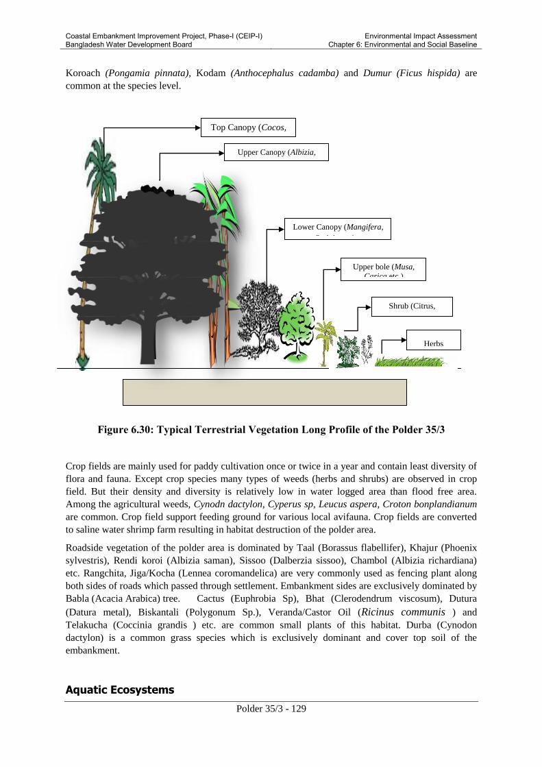
Coastal Embankment Improvement Project, Phase-I (CEIP-I) Bangladesh Water Development Board
Environmental Impact Assessment Chapter 6: Environmental and Social Baseline
Polder 35/3 - 129
Herbs
(Grasses)
Upper Canopy (Albizia,
Bamboosa etc.)
Top Canopy (Cocos,
Areca etc) etc
Lower Canopy (Mangifera,
Syzigium etc.
Upper bole (Musa,
Carica etc.)
Shrub (Citrus, Psidium etc.)
Koroach (Pongamia pinnata), Kodam (Anthocephalus cadamba) and Dumur (Ficus hispida) are
common at the species level.
Figure 6.30: Typical Terrestrial Vegetation Long Profile of the Polder 35/3
Crop fields are mainly used for paddy cultivation once or twice in a year and contain least diversity of
flora and fauna. Except crop species many types of weeds (herbs and shrubs) are observed in crop
field. But their density and diversity is relatively low in water logged area than flood free area.
Among the agricultural weeds, Cynodn dactylon, Cyperus sp, Leucus aspera, Croton bonplandianum
are common. Crop field support feeding ground for various local avifauna. Crop fields are converted
to saline water shrimp farm resulting in habitat destruction of the polder area.
Roadside vegetation of the polder area is dominated by Taal (Borassus flabellifer), Khajur (Phoenix
sylvestris), Rendi koroi (Albizia saman), Sissoo (Dalberzia sissoo), Chambol (Albizia richardiana)
etc. Rangchita, Jiga/Kocha (Lennea coromandelica) are very commonly used as fencing plant along
both sides of roads which passed through settlement. Embankment sides are exclusively dominated by
Babla (Acacia Arabica) tree. Cactus (Euphrobia Sp), Bhat (Clerodendrum viscosum), Dutura
(Datura metal), Biskantali (Polygonum Sp.), Veranda/Castor Oil (Ricinus communis ) and
Telakucha (Coccinia grandis ) etc. are common small plants of this habitat. Durba (Cynodon
dactylon) is a common grass species which is exclusively dominant and cover top soil of the
embankment.
Aquatic Ecosystems

Coastal Embankment Improvement Project, Phase-I (CEIP-I) Bangladesh Water Development Board
Environmental Impact Assessment Chapter 6: Environmental and Social Baseline
Polder 35/3 - 130
Aquatic ecosystems of this polder may be classified into four major categories as follows:
The surrounding rivers,
Internal canals,
Shrimp farms and
Homestead ponds and ditches.
The polder area is encircled by the Baleshwar and Bhairab river systems and many canals also pass
through the entire area, shrimp farms locally known as ‘Gher’ are also available there. The shrimp
farms add some aquatic area to the main aquatic ecosystems to support different aquatic life-forms for
their survival. Homestead’s ponds are normally used for domestic purpose. Ditches exist between
settlement and crop fields which bear comparative high diversity of plant population. There is no free
floating or rooted floating hydrophytes inside the river water due to continuous flow of tidal action.
Internal canals possess some marginal vegetation. All major canal are connected with surrounding
tidal rivers.
The findings of the baselines studies on aquatic biology are divided mainly into two groups: flora and
fauna. The floral species observed frequently within the project area are Shapla/Shaluk (Nymphaea
Spp.), Padma (Nelumbo nucifera), Kachuripana (Eichhornia crassipes), Kolmi (Ipomoea fistulosa),
Dhol Kolmi (Ipomoea fistulosa), Khudipana (Lemna Sp.), Topapana (Pistia strateotes), Kutipana
(Azolla Sp), etc. Indian Pond Frog (Euphlytis haxadactylus), White-breasted Waterhen (Amaurornis
phoenicurus), Great Egret (Casmerodius albus), Little Egret (Egretta garzetta), Indian Pond Heron
(Ardeola grayii) are common among the fauna. Gangetic River Dolphin (Platanista gangetica) is
available in the surrounding rivers.
Mangrove Ecosystem
Mangroves are a unique ecosystem hosting incredible biodiversity: migratory birds, marine creatures
and reptiles in addition to associated species of flora. They function as a natural water treatment
system; as spawning grounds for fish they provide several resources to local communities who
directly or indirectly depend upon them for their livelihoods and sustenance. Biodiversity, the
diversity of life forms – plants, animals, microbes – is the ecological basis of life. Mangrove
ecosystem plays a central role in transferring organic matter and energy from the land to marine
ecosystems. The dense root systems form a home for fish, crabs, shrimps, and molluscs. They also
serve as nurseries for juvenile fish.
River levees, khal bank or even homesteads margins of the polder have scattered mangrove
vegetation. At the species level, Hargoza (Acanthus illicifolious) is a small shrub, available in the
river and canal sides. Ora (Sonneratia caseolaris), Kewra (Sonneratia apetalla) and Gewa
(Ecoecharia agallocha) are sighted in areas with tidal flow. Hada/Tiger fern (Achrostichum aureum)
is another bush plant frequently found all over the polder area.

Coastal Embankment Improvement Project, Phase-I (CEIP-I) Bangladesh Water Development Board
Environmental Impact Assessment Chapter 6: Environmental and Social Baseline
Polder 35/3 - 131
Figure 6.31: Vegetation pattern along shoreline of the polder show mangrove succession
6.5.3 Wildlife
Bangladesh is a part of the Indo-Burma biodiversity hotspot. The coastal zone contains several
ecosystems that have potential conservation values. These ecosystems are not only biodiversity
hotspots, but they also provide the ecological foundations for common property resources. The
wildlife species are generally classified as amphibians, reptiles, birds and mammals. Of the
amphibians, Indian Toad (Bufo melanostictus), Ornate Microhyla (Microhyla ornata), Bullfrog
(Hoplobatrachus tigerinus) and Common Tree Frog (Polypedates leucomystax) are common within
the project site. The reptiles species observed during the survey were large in number compared to
the amphibians. The House Gecko (Hamidactylus flaviviridis), Common Garden Lizard ( Calotes
versicolor), Jerdon’s Calotes (Calotes jerdoni), Little Skink ( Mabuya macularia), Bengal Monitor
(Varanus bengalensis), Checkered Keelback (Xenochropis piscator), Striped Keelback (Amphiesma
stolata) were found frequently during the survey. The Black Drongo (Dicrurus macrocercus), House
Crow (Corvus splendens), Large-billed Crow (Corvus macrorhynchos), Common Kingfisher (Alcedo
atthis), Asian Pied Starling (Sturnus contra), Common Myna (Acridotheres tristis), Jungle Myna
(Acridotheres fuscus), Oriental Magpie Robin ( Copsychus saularis ), Red-vented Bulbul (Pycnonotus
cafer), Spotted Dove (Streptopelia chinensis), Baya Weaver (Ploceus philippinus), Indian Pond Heron
(Ardeola grayii), Little Cormorant (Phalacrocrocorax niger), Garganey (Anas querquedula ), Little
Stint (Calidris minuta ) and Common Sandpiper ( Actitis hypoleucos) are also available throughout
the polder area. The large mammals are in peril due to habitat destruction and hunting pressures.
Mammal species are not very frequent within the site but few of them like Mongoose (Herpestes
edwarsii), Bengal Fox (Vulpes bengalensis), Jungle Cat (Felis chaus), House Rat ( Rattus rattus ),
Field Mouse (Mus booduga), Asian House Shrew (Suncus murinus), Indian Otter (Lutra
perspicillata), Indian Flying Fox (Pteropus gangeticus) were found. Gangetic River Dolphin
(Platanista gangetica) roams in surrounding rivers.
6.6 Livestock and Poultry
Livestock and poultry, being an essential element of integrated farming system, play an important role
in the economy of the polder area. Livestock provide significant draft power for cultivation, threshing
and crushing of oil seeds; cow dung as a source of manure and fuel; a ready source of funds; and
meat, milk and eggs for human consumption. Most of the households raise poultry and livestock, a

Coastal Embankment Improvement Project, Phase-I (CEIP-I) Bangladesh Water Development Board
Environmental Impact Assessment Chapter 6: Environmental and Social Baseline
Polder 35/3 - 132
practice that significantly reduce poverty through generating income and employment. About 60% of
households of the polder area are rearing cows/bullock, 5% of household are rearing buffalo, 40%
household are rearing goat, 50% of household are rearing duck and 80% of household are rearing
chicken. Detailed livestock and poultry population in the polder area are presented in Table 6.19.
Table 6.19: Present Status of livestock /Poultry in Polder 35-3
Livestock/Poultry Households having Livestock/Poultry
(%)
Livestock/Poultry/households
(Nos.)
Cow/bullock 60 3 (11,993)
Buffalo 5 4 (1,332)
Goat 40 4 (10,661)
Sheep - -
Duck 50 5 (16,658)
Chicken 80 7 (37,313)
Source: CEGIS Estimation,2012; Parenthesis indicate total number of livestock/poultry
Figure 6.32 : Livestock of the polder
area
Figure 6.33:Poultry population in the polder
area
6.6.1 Feeds and Fodder
The owners of the livestock population are facing problems in respect of availability of fodder and
feeds during the month of July to December. Rice straw is the main fodder. Oil cake and Bhushi are
the other common fodders in this polder area. Shortage of grazing areas throughout the year
aggravates the feed problem for the animal population. Poultry population at family level survives by
scavenging and generally no feed supplements are provided. However, at times kitchen waste
becomes feed to the poultry.
6.6.2 Livestock and Poultry Diseases
Productions of livestock and poultry are mainly constrained due to diseases and death of the
population. Outbreak of disease is causing a considerable economic loss in livestock farming. Every
year livestock population is affected by different diseases. Major poultry diseases are Ranikhet, Fowl

Coastal Embankment Improvement Project, Phase-I (CEIP-I) Bangladesh Water Development Board
Environmental Impact Assessment Chapter 6: Environmental and Social Baseline
Polder 35/3 - 133
Pox, and Cholera. The most vulnerable period is round year for spreading diseases to livestock and
poultry populations. The major cause of livestock and poultry diseases is wet condition in the coastal
area.
6.7 Socio-economic Resources
6.7.1 Area and Location
The Polder 35/3 covers parts of Bagherhat Sadar and Rampal upazilas under Bagerhat district. The
Polder area falls in four unions namely Dema, Kara Para, Bhojpatia and Malliker Ber as shown in
Table 6.20.
Table 6.20: Unions and Upazilas in Polder 35/3
District Upazila Unions Percentage of Union Area
within Polder
Bagerhat Bagherhat Sadar Dema 92
Rampal Kara Para 12
Bhojpatia 7
Malliker Ber 80
Source: Spatial GIS Analysis, CEGIS, 2012
6.7.2 Demography
Based on the Census Report of Bangladesh Bureau of Statistics (BBS) for 2011, the population in the
Polder 35/3 is 27,494. This includes 13,660 males and 13,834 females. A total of 6,668 households
exist in the polder with average size of 4.12 persons per household. The density of population is
about 1,016 persons per square kilometer. The key demographic data of the Polder is presented in
Table 6.21.
Table 6.21: Demographic Data of Polder
Households Population Size of House Hold
Total Male Female
6,668 27,494 13,660 13,834 4.12
49.68% 50.32%
Source: Population Census 2011, BBS

Coastal Embankment Improvement Project, Phase-I (CEIP-I) Bangladesh Water Development Board
Environmental Impact Assessment Chapter 6: Environmental and Social Baseline
Polder 35/3 - 134
Figure 6.34: Trend of population in the study area
Population trend is shown in thousands in the above figure (Figure: 6.30). It is found that total
number of population is decreasing in the year 2011. The number of female member remains same but
the number of male member changes slightly.
Table 6.22 shows the age group composition of the people of the polder area. About 36 percent of
the population is less than 30 years and 10 percent is over 60 years of age. The data shows that around
40 percent of the population depends on the 60 percent of the earning members of their households.
Hence the dependency ratio is 67.
Table 6.22: Age Distribution in Polder
Age Range
(Years)
0-4 5-9 10-14 15-19 20-
24
25-29 30-49 50-59 60-64 65+
Percent of
Population
8 11 11 8 8 9 27 8 3 7
Source: Population Census 2011, BBS
6.7.3 Livelihood
Occupation
According to the baseline survey, around 72 percent households report agriculture as their main
occupation. About 21 percent population is engaged in service sector and only 7 percent is engaged in
industrial sector. Most of the population is engaged in agriculture and service sector. (Table 6.23)
Table 6.23: Main Occupation in Polder
Union Agriculture (%) Industry (%) Service (%)
Male Female Male Female Male Female
Dema 33 15 - 2 7 10
Kara Para 8 9 2 8 8 24
Bhojpatia 2 1 - - 1 1
Malliker Ber 31 10 4 9 5 12

Coastal Embankment Improvement Project, Phase-I (CEIP-I) Bangladesh Water Development Board
Environmental Impact Assessment Chapter 6: Environmental and Social Baseline
Polder 35/3 - 135
Source: Population Census 2011, BBS
Male and female are equally engaged in livelihood activities. However, participation of female
member is nominal in comparison to male participation. In the polder area only 4 percent female
members are working whereas 96 male members are engaged in income generating activities. (Figure
6.35)
Figure 6.35: Distribution of population by field of activity
Employment
In the Polder, about 37 percent of total population is employed, 36 percent is engaged in household
work, only one percent is looking for work and about 26 percent of total population is not working (it
includes children and physically challenged population). Figure 6.34 shows the employment status of
the people in the Polder area.
Figure 6.36: Employment status in the polder area

Coastal Embankment Improvement Project, Phase-I (CEIP-I) Bangladesh Water Development Board
Environmental Impact Assessment Chapter 6: Environmental and Social Baseline
Polder 35/3 - 136
The following table (Table 6.24) shows the distribution of employment status by male and female in
the polder area. It is found that only one percent female members are employing whereas 36 percent
male members are employing in the study area.
Table 6.24: Employment status in Polder
Union Employed (%) Looking for Work (%) Household Work (%) Do Not Work (%)
Male Female Male Female Male Female Male Female
Dema 41 1 1 - 1 33 10 16
Kara Para 11 1 - - - 10 3 4
Bhojpatia 2 - - - - 1 - 1
Malliker Ber 23 1 - - - 24 8 9
Source: Population Census 2011, BBS
6.7.4 Quality of Life
Housing Condition
In the Project area, overall housing condition is not satisfactory. On an average only 5 percent houses
are pucka (made of bricks and mortar) whereas 80 percent are kutcha (made of wood/bamboo, and
other local materials). Figures 6.38 to 6.41 present some photographs of these housing types.
Statistics show that Kara para union comprises the highest pucka household (13.7%) whereas Dema,
Malliker Ber and Bhojpatia unions comprise the highest kutcha households (respectively 93%, 85%
and 82%). It can be concluded that the people living in the study area belong to extremely poor
category in term of housing type.10
Table 6.25: Housing condition in the study area
Union
Type of Structure (%)
Pucka Semi-
pucka Kutcha Jhupri
Dema 2.8 3.4 92.9 0.9
Kara Para 13.7 22.9 59.2 4.2
Bhojpatia 0.6 1 82.5 15.9
Malliker Ber
1 2 85.1 11.9
10 BBS distinguishes housing structures into four classes such as- i) Jhupri: House which consist mud walls of 1.5 to 3.0 ft
thickness, which carry the roof load. Earthen floor, thatch or CI sheets are used as roofing materials. . There is no
monolithic joint between the wall and the roof. ii) Kutcha: Walls: Organic materials like jute stick, catkin grass, straw, and
bamboo mats. Split are bamboo framing. In some areas wall are made by earth. Foundation: Earthen plinth with bamboo or
timber posts. Roof: Thatch-rice or wheat or maize straw, and catkin grass, with split bamboo framing; iii) Semi-pucka:
Walls: Bamboo mats, CI sheet, Timber or bamboo framing. In some areas wall are made by earth, sometimes part or full
brick. Foundation: Earthen plinth; Brick perimeter wall with earth infill; Brick and concrete also use. Roof: CI sheet with
timber or bamboo framing; and iv) Pucka: House which is made by fully concrete, cement, and iron.

Coastal Embankment Improvement Project, Phase-I (CEIP-I) Bangladesh Water Development Board
Environmental Impact Assessment Chapter 6: Environmental and Social Baseline
Polder 35/3 - 137
Union
Type of Structure (%)
Pucka Semi-
pucka Kutcha Jhupri
Dema 2.8 3.4 92.9 0.9
Kara Para 13.7 22.9 59.2 4.2
Bhojpatia 0.6 1 82.5 15.9
Malliker Ber
1 2 85.1 11.9
Figure 6.37: Housing Types in Polder
Area
Source: Population Census 2011, BBS
Figure 6.38: Jhupri house Figure 6.39: Kutcha house
Figure 6.40: Semi-Pucka House Figure 6.41: Pucka House
Drinking Water
Overall status of drinking water in the area is generally satisfactory. Most of the people can collect
drinking water from tube well. The detail is presented in Table 6.26, which shows that coverage of

Coastal Embankment Improvement Project, Phase-I (CEIP-I) Bangladesh Water Development Board
Environmental Impact Assessment Chapter 6: Environmental and Social Baseline
Polder 35/3 - 138
tube-well is insignificant in both Malliker Ber and Bhojpatia unions (comprise respectively 25% and
41%).
Table 6.26: Source of Drinking Water in Polder
Union Sources of Drinking Water (%)
Tap Tube-well Other
Dema 0.1 80.2 19.7
Kara Para 8.1 85.7 6.2
Bhojpatia 0.5 40.6 58.9
Malliker Ber 2.9 24.5 72.5
Source: Population Census 2011, BBS; and Baseline Survey, 2012.
The figure below (Figure: 6.42) shows the trend of drinking water source from 1991 to 2011 year. It
is found here that the coverage of tube-well is gradually increasing in the study area. People cannot
collect drinking water from tap in 1991 but the tendency is found both in 2001 and 2011 years.
Figure 6.42: Housing Types in Polder Area
The water quality analysis result for drinking water i.e. arsenics or coliforms was mentioned in
baseline chapter of water resources.
Sanitation
The sanitation facilities11
adopted by households of the Project area are presented in Table 6.27 and
Figure 6.43. It shows that about 59 percent households have hygienic sanitation facility (water-
11 BBS defined four types sanitation in Bangladesh such as (i) Sanitary (water-sealed): A water sealed latrine is
simply a pit latrine that has a water barrier to prevent odors. These latrines are simply pits dug in the ground in which human
waste is deposited. (ii) Sanitary (not water-sealed/ring slab), latrine with a slab or other secure cover over the drop hole, or a
polyethylene flap preventing in-sects from flying into or coming out of the pit; and (iii) Non-sanitary (Kucha): latrine is a

Coastal Embankment Improvement Project, Phase-I (CEIP-I) Bangladesh Water Development Board
Environmental Impact Assessment Chapter 6: Environmental and Social Baseline
Polder 35/3 - 139
sealed), 35 percent have not water-sealed sanitation facility and only 6 percent have non-sanitary
sanitation facility.
Table 6.27: Sanitation Facilities in the Polder
Union
Type of Structure
Sanitary
(water-
sealed)
Sanitar
y (not
water-
sealed)
Non-
sanitar
y
Dema 24.5 21.3 0.8
Kara Para 60.9 14.1 0.5
Bhojpatia 31.3 25 6.1
Malliker
Ber
32.7 28.1 6.3
Figure 6.43: Sanitation facility in study area
Source: BBS and Baseline Survey, 2012.
Sanitation facility is quite satisfactory in Kara Para union (61% eater-sealed sanitary) whereas it
covers only 25%, 31% and 32% respectively for Dema, Bhojpatia and Malliker Ber unions.
Figure 6.44: Sanitation facility in the polder area.
Health Profile of Polder People
The health profile of the local people living in the Polder is presented in the Table 6.28. According to
the ranking, the incidence of diarrhea is the most prevalent ailment in the area. Dysentery, skin
diseases, and common fevers are also common in the Polder.
Table 6.28: Disease Profile in the Polder
Disease Ranking by Incidence
Diarrhea 1
frame or platform extending over earth or water; an “open pit latrine” does not have a squat platform or slab on the pit and
(iv) No facilities: Defecation in bushes or fields or other outdoor locations.

Coastal Embankment Improvement Project, Phase-I (CEIP-I) Bangladesh Water Development Board
Environmental Impact Assessment Chapter 6: Environmental and Social Baseline
Polder 35/3 - 140
Disease Ranking by Incidence
Dysentery 2
Skin diseases 3
Influenza/Common fever 4
Cough/cold 5
Chicken pox 6
Typhoid 7
Gastric 8
Asthma 9
Hypertension 10
Diabetes 11
Hepatitis 12
Source: CEGIS fieldwork, 2012
Health Services and Facilities
Field findings show that there is no hospital in the study area. However, there are two community
clinics in Dema union and another two in Molliker Ber union. The local people are to receive health
service and facility from peripheral hospital situated outside the polder area (Table 6.29).
Table 6.29: Health service facilities in the study area
Union Name No of Community Clinic Outside of Polder
Karapara - Bagerhar Sadar
Dema 02 Bagerhar Sadar, Rampal
Mollikerber 02 Rampal
Source: CEGIS fieldwork, 2012
It is found that about 45 percent people tend to receive health service from quack and 20 percent from
trained physicians. About 10 percent cannot receive treatment facility due to their impoverishment
(Figure: 6.45).
Figure 6.45: Health Service Providers in Polder

Coastal Embankment Improvement Project, Phase-I (CEIP-I) Bangladesh Water Development Board
Environmental Impact Assessment Chapter 6: Environmental and Social Baseline
Polder 35/3 - 141
However, quality of health services and facilities is quite poor as reported by the local people. People
responded that they are not satisfied in health services and facilities at all.
Figure 6.46: Union health and family planning sub-centre
Education
In the study area literacy rate is satisfactory in terms of national average (57.44). In all four unions
literacy rate exceeds the national average. It is found that the highest literacy rate in Kara Para union
(65.5%). Literacy rate for both male and female is also quite satisfactory (Table 6.30).
Table 6.30: Literacy Rate at Polder 35/3 Area
Union Literacy Rate (%)
Total/Both Male Female
Dema 60.5 60.7 60.2
Kara Para 65.5 67.6 63.4
Bhojpatia 64.5 65.2 63.9
Malliker Ber 61.4 62.9 59.9
Source: Population Census 2011, BBS
The following figure (Figure: 6.47) shows the trend of literate rate. It shows that overall literacy rate
is increasing gradually. The tendency of being educated is growing among men and women.

Coastal Embankment Improvement Project, Phase-I (CEIP-I) Bangladesh Water Development Board
Environmental Impact Assessment Chapter 6: Environmental and Social Baseline
Polder 35/3 - 142
Figure 6.47: Trend of literacy rate in the polder 35/3 area
Electricity
Electrification as reported in the Population Census is not satisfactory in the Project area. On an
average, only 33 percent households are under electricity coverage. Very few households use solar
electricity in the Project area. Figure 6.48 shows the percentage of electricity connection in different
unions of the Polder areas. It shows that Kara Para union has the highest electricity coverage (69%).
Figure 6.48: Trend of electricity facility.
6.7.5 Poverty and Safety Nets
Landownership Pattern
Landownership pattern can be an indicator of the poverty incidence in the area. The results of the
RRA shows that about 22 percent of households are landless and the remaining 78 percent are having
land for mainly agriculture use and also for settlement and commercial uses (see Table 6.31).
Table 6.31: Landownership Pattern in Polder
Land Ownership Classes Households (%)
Landless/ No land 22
Marginal 09
Small (0.05 to 2.49 acres) 40
Medium (2.5 to 7.49 acres) 25
Large (7.5 acres and above) 04
Source: CEGIS fieldwork, 2012

Coastal Embankment Improvement Project, Phase-I (CEIP-I) Bangladesh Water Development Board
Environmental Impact Assessment Chapter 6: Environmental and Social Baseline
Polder 35/3 - 143
In the Project area the Agricultural Census conducted by BBS in 2008 has found that most of the land
is under small holding category. Small holdings12
comprise 84 percent and medium holdings comprise
14 percent whereas large holdings comprise only 2 percent (Figure 6.49).
Figure 6.49: Land holding categories in project area
Income Poverty
Income poverty profile has been prepared by the participants of the RRA themselves through a self-
assessment exercise. The assessment is based on the year-round income along with the food
consumption of the inhabitants within three different categories (Figure 6.50). It is observed that
about 30 percent of the households in average are in the ‘deficit’ category. These households have
been identified in the RRA as the poor households of the Polder area. Considering the standard
consumption of food (three meals in a day), the deficit group was usually taking two meals in a day in
the lean period since they could not afford three full meals.
12 Agricultural Census by BBS defined farm holding into three broad categories such as- a) small: having minimum
cultivated land 0.05 acre but operated land more than this minimum but up to 2.49 acres; b) medium: having operated
land in between 2.50 to 7.49 acres; and c) large: having operated land 7.50 acres and above.

Coastal Embankment Improvement Project, Phase-I (CEIP-I) Bangladesh Water Development Board
Environmental Impact Assessment Chapter 6: Environmental and Social Baseline
Polder 35/3 - 144
Figure 6.50: Self Assessment of Poverty Status
Income and Expenditure
The income and expenditure at the household level in the Polder area is shown in Table 6.32. Around
62-70 percent households have reported that their income and expenditure level is over 5,000 taka per
month.
Table 6.32: Annual Income and Expenditure Level
Range in Taka Percentage (%) of Households
Income Expenditure
Up to 12,000 - -
12,001 to 24,000 10 12
24,001 to 60,000 20 26
60,001 to 108,000 40 42
108,001 to 240,000 20 13
More than 240,000 10 7
Source: CEGIS fieldwork, 2012
Natural Disasters
The local inhabitants of Polder 35/3 have identified tidal flooding, salinity intrusion and cyclones as
the major hazards in the area. Details about the disasters and their affects in the area are presented in
Table 6.33.
Table 6.33: Affects of Recent Natural Disaster in Project Area
Disaster Affected
Area
(%)
Affected
House
Holds
(%)
Crop
Damaged
(%)
Major
Damaged Crop
Tidal Flood 2007, 2009 and 2010 100 90 90 Rice
Salinity 2007, 2009, 2011 40 40 30 Rice
Cyclone 2007 (Sidr), 2009 (Aila) 100 100 90 Rice
Source: CEGIS fieldwork, 2012
Social Safety Nets and Poverty Reduction Measures
The major social safety nets and poverty reduction programs initiated in the area include the
Vulnerable Group Development (VGD), Food/Taka for Work (F/TFW), Food for Education/Cash for
Education, Rural Maintenance Program (RMP), Old Age Allowance, Freedom Fighter Allowance and
Integrated Poverty Reduction Program. These programs have created food security as well as social
safety nets among the targeted poor households and vulnerable communities (Table 6.34).
Table 6.34: Households Served by Different Social Safety Nets Programs
Social Safety Net Programs Households/Communities Served (%)
Vulnerable Group Development (VGD) 6
Food/Taka For Work (F/TFW) of PIO 4

Coastal Embankment Improvement Project, Phase-I (CEIP-I) Bangladesh Water Development Board
Environmental Impact Assessment Chapter 6: Environmental and Social Baseline
Polder 35/3 - 145
Social Safety Net Programs Households/Communities Served (%)
Food for Education/Cash for Education 10
Rural Maintenance Programme (RMP) 6
Old Age Allowance 5
Freedom Fighter Allowance 3
Integrated Poverty Reduction Program of BRDB 6
Source: CEGIS fieldwork, 2012
A number of local and national NGOs are working in the Project area. The main activities of these
NGOs are to operate micro credit programs among the rural poor and landless women/men. The
major NGOs working in the area include BRAC (Bangladesh Rural Advancement Centre), ASA
(Association for Social Advancement), Udayon Bangladesh, Help, Uttaran, (Table 6.35). These
NGOs are serving with micro credit while BRAC, ASA, Uttaran are working for non-formal
education, Health, human rights, water and sanitation, gender and children development programs.
About 40 percent of households are found to benefit from the NGOs interventions.
Table 6.35: NGOs and their Programs in Project Area
NGOs Type of Programs
Credit Education Water and
Sanitation
Health Human
Rrights
Gender Children
BRAC ✓ ✓ ✓ ✓ ✓ ✓ ✓
ASA ✓ ✓ - - ✓ ✓ -
Udayon
Bangladesh ✓ - - - - - -
Help ✓ - - - - - -
Uttaran ✓ ✓ ✓ - ✓ ✓ -
Source: CEGIS fieldwork, 2012

Coastal Embankment Improvement Project, Phase-I (CEIP-I) Bangladesh Water Development Board
Environmental Impact Assessment Chapter 6: Environmental and Social Baseline
Polder 35/3 - 146
Figure 6.51: Some glimpses of social safety net programs
6.7.6 Social Capital
Roads
Various types of roads provide means of communication mostly within the Polder. Overall about 141
km of road network exists in five unions of which 29 km roads are paved, 34 km roads are brick soled
and 78 km roads are earthen. Table 6.36 presents data on road network in the Project area; Figure
6.52 presents some photographs of these roads.
Table 6.36: Road Network in Polder
Name of
Union
Type of Road Description Length
(Km)
Karapara Herringbone/Brick
soling
Putimari bridge-Radhaballabh sluice,
Nomans shop- Kurer khal
3.0
1.0
Earthen road Rdhaballabh-Gujihati,
Putimari bridge-East side
2.0
1.0
Mollikerber Paved Kashipur-Mollikerber Madrasa,
Sannyasi bazaar-Aulia bazaar
5.0
4.0
Herringbone/Brick
soling
Sannyasi east side-Betibunia,
Aulia bazaar-Madrasa bazaar,
Aulia bazaar-Hakim Sarkarer bari
Sannyasi bridge-Matrimingol school
Sannyasi -Choto sannyasi
20.0
Earthen road Rural road 45.0
Dema Paved Dema bridge-Khegraghat bridge,
Hedayetpur bazaar-Kashimpur bazaar
10.0
10.0
Herringbone/Brick
soling
- 10.0
Earthen road - 30.0
Source: CEGIS fieldwork, 2012

Coastal Embankment Improvement Project, Phase-I (CEIP-I) Bangladesh Water Development Board
Environmental Impact Assessment Chapter 6: Environmental and Social Baseline
Polder 35/3 - 147
Figure 6.52: Muddy and soling roads in the Polder area.
There are two major transport routs in the polder area through which most of the polder living people
communicate.
Dema Bridge to Khegraghat Bridge via Kashipur Bazar
Dema bridge to Matherdia launch ghat via Kashipur Bazar
Main vehicles using the Polder roads include motorbikes, bicycles, vans, and auto rickshaws. Due to
poor road conditions, most of the traffic constitutes motorcycles and bicycles in the Polder area. It is
found that, the total 347 vehicles entered inside the polder and 378 vehicles existed from the polder at
Dema bridge bus station. Similarly, the total 677 vehicles entered to inside to polder and 754 vehicles
existed from the polder at Dasani bus station.

Coastal Embankment Improvement Project, Phase-I (CEIP-I) Bangladesh Water Development Board
Environmental Impact Assessment Chapter 6: Environmental and Social Baseline
Polder 35/3 - 148
Table 6.37: Traffic volume in the polder 35/3 area
Road name : Near Dema Bridge; Mollikerber-Kashimpur to Bagerhat, and Rampal -Khegraghat to Kashimpur
GPS location N-22°37'19.0", E-89°45'52.4" Survey period: 8 hours
Type of Vehicles
7:00 - 8:00 8:00-9:00 9:00-10:00 10:00-11:00 11:00-12:00 12:00-13:00 13:00-14:00 14:00-15:00 15:00-16:00 16:00-17:00 17:00-18:00 18:00-19:00
To
tal
(T)
Fa
cto
rs
(F)
T x F
En
try
Exit
En
try
Exit
En
try
Exit
En
try
Exit
En
try
Exit
En
try
Exit
En
try
Exit
En
try
Exit
En
try
Exit
En
try
Exit
En
try
Exit
En
try
Exit
Van 5 3 4 8 6 4 3 11 4 6 5 4 4 5 6 4 3 3 4 7 4 6 5 8 122 0.5 61
Motocycle 2 4 5 6 4 7 5 6 4 9 5 7 6 6 2 4 6 6 7 8 4 5 8 8 134 0.75 100.5
Rickshaw 5 3 3 4 6 2 3 4 2 5 4 4 5 5 2 6 3 6 5 5 3 7 3 6 101 0.5 50.5
BiCycle 6 5 4 3 5 3 2 6 3 4 6 8 4 8 5 6 6 4 5 4 7 8 8 4 124 0.5 62
Car 0 0 1 0 0 0 0 0 1 1 0 1 0 0 0 0 0 1 0 1 0 0 1 0 7 1 7
Jeep 0 0 0 0 0 1 0 0 0 0 1 0 0 1 0 0 0 0 0 0 0 0 0 0 3 1.75 5.25
Bus 0 0 0 0 1 0 0 0 0 0 0 0 0 0 0 0 0 0 0 0 0 0 0 1 2 3 6
Truck 0 1 0 2 1 0 2 0 0 0 0 2 3 1 4 4 3 2 0 3 3 4 2 5 42 3 126
Pickup/ Mini Truck 2 0 1 0 3 2 0 0 0 0 3 3 5 2 1 3 2 1 0 2 0 4 3 2 39 1.75 68.25
Auto Ricksaw 3 2 1 4 4 4 5 5 2 7 6 4 2 5 4 3 2 3 3 4 4 5 5 2 89 0.75 66.75
Tempo 1 3 3 4 5 5 4 4 6 6 4 4 3 6 4 3 5 4 4 6 5 3 3 4 99 1 99
Sum 652.25
Source: Baseline survey, CEGIS, 2012

Coastal Embankment Improvement Project, Phase-I (CEIP-I) Bangladesh Water Development Board
Environmental Impact Assessment Chapter 6: Environmental and Social Baseline
Polder 35/3 - 149
The above table (Table:00) shows the traffic volume in the study area. It is estimated following the
standard PCU13
(Passenger Car Unit) and found that traffic volume for 8 hours is 81.53 vehicles/ hour
(652.25/8 = 81.53).
Waterways
There are four navigation routs in the study area namely Daratana river, Katakhali khal, Putimari river
and Bishnu river. Among these Daratana river and Katakhali khal are the main navigation routes. The
navigation varies considering dry and wet season.
Figure 6.53: navigation in the polder area.
The main modes of communication through waterways are launch and trawlers. People communicate
and carry goods and commodities through these routes. The following table (Table 6.37) shows the
main navigation path along with type of vehicles.
Table 6.38: Major Navigation Routes in the Area
Sl.
No
Navigation
Route/River
Navigation Path Type of Vehicle
1 Daratana river Bagerhat-Motherdia ghat-Tushkhali ghat
Bagerhat -Motherdia-Geodhora (Trawler)
Bagerhat-Motherdia- Panchgaon (Trawler)
Bagerhat -Motherdia-Shonirjhor (Trawler)
Bagerhat-Motherdia-Shekhpara (Trawler)
Bagerhat-Motherdia- Khaluikhali (Trawler)
Bagerhat-Motherdia-Debraj
Bagerhat-Morelgonj-Moshishali ghat-Fullhata ghat
(Trawler)
Launch, Trawler,
Cargo, Fishing
Boat (to Sea)
2 Katakhali khal
river
Bagerhat-Motherdia-Khulna
Planner bazaar ghat to opposite lounch ghat (Trawler)
Cargo, Trawler
Source: Baseline survey, CEGIS, 2012
13 PCU (Passenger Car Unit) is a metric used in Transportation Engineering, to assess traffic-flow
rate on a roadway. A Passenger Car Unit is essentially the impact that a mode of transport has on
traffic variables (such as headway, speed, density) compared to a single car.
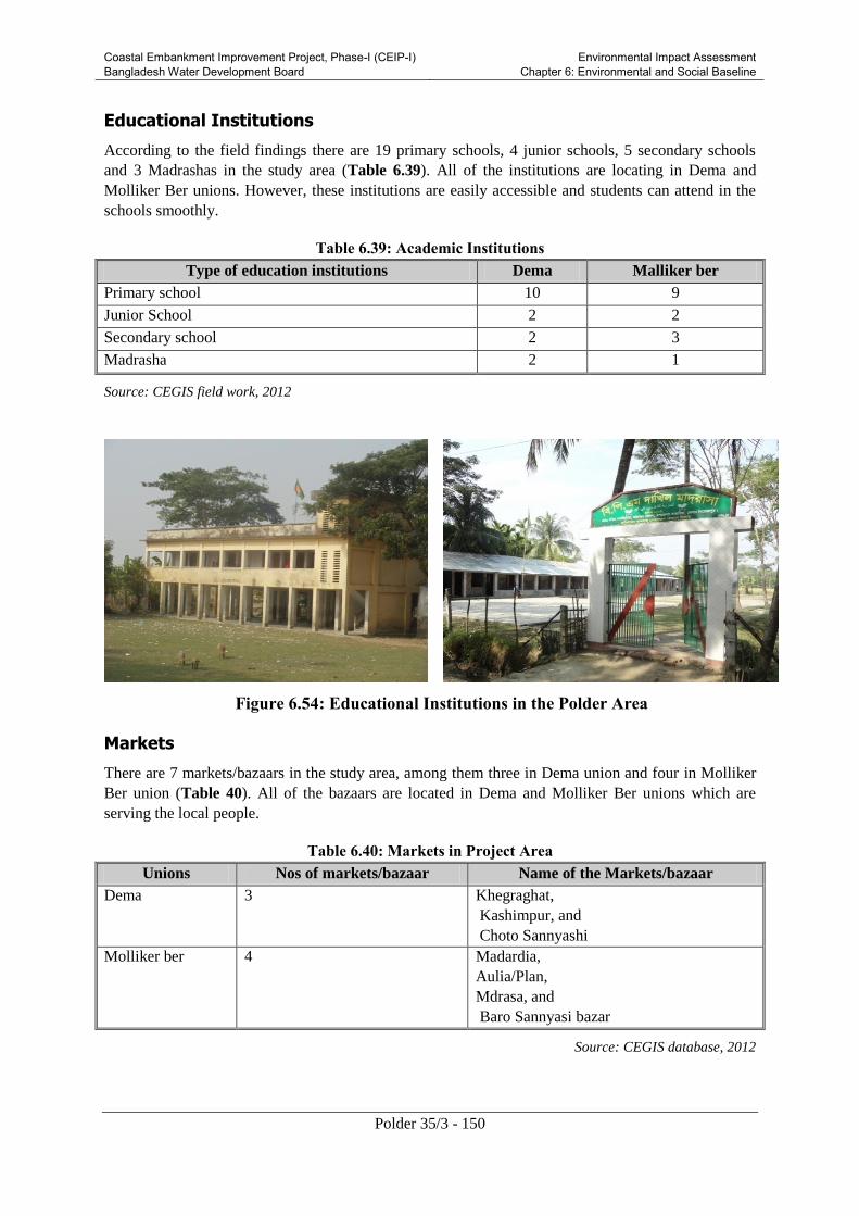
Coastal Embankment Improvement Project, Phase-I (CEIP-I) Bangladesh Water Development Board
Environmental Impact Assessment Chapter 6: Environmental and Social Baseline
Polder 35/3 - 150
Educational Institutions
According to the field findings there are 19 primary schools, 4 junior schools, 5 secondary schools
and 3 Madrashas in the study area (Table 6.39). All of the institutions are locating in Dema and
Molliker Ber unions. However, these institutions are easily accessible and students can attend in the
schools smoothly.
Table 6.39: Academic Institutions
Type of education institutions Dema Malliker ber
Primary school 10 9
Junior School 2 2
Secondary school 2 3
Madrasha 2 1
Source: CEGIS field work, 2012
Figure 6.54: Educational Institutions in the Polder Area
Markets
There are 7 markets/bazaars in the study area, among them three in Dema union and four in Molliker
Ber union (Table 40). All of the bazaars are located in Dema and Molliker Ber unions which are
serving the local people.
Table 6.40: Markets in Project Area
Unions Nos of markets/bazaar Name of the Markets/bazaar
Dema 3 Khegraghat,
Kashimpur, and
Choto Sannyashi
Molliker ber 4 Madardia,
Aulia/Plan,
Mdrasa, and
Baro Sannyasi bazar
Source: CEGIS database, 2012

Coastal Embankment Improvement Project, Phase-I (CEIP-I) Bangladesh Water Development Board
Environmental Impact Assessment Chapter 6: Environmental and Social Baseline
Polder 35/3 - 151
Figure 6.55: Typical Market/Bazaars in Polder 35/3
6.7.7 Gender and Women
The restriction on women mobility, male-female wage discrimination, mortality, health and nutrition,
and girl education are some of the key gender issues in the Polder 35/3. Women have little role in
decision making at the family level and in the society and they are facing gender discrimination in
terms of social and economic activities. Recent studies have revealed that the women/girls of Polder
35/3 are facing discrimination regarding social and economic affairs of family and society. Figure
6.56 shows scope of decision making by women in the Polder area.
Figure 6.56: Scope of Decision Making by Women
Women mobility in the area is mostly localized except when going for medical treatment, fetching
water, farming activities, and visiting relatives.
Mortality rate of the pregnant mother during delivery period has reduced in the area (20/1000). The
growing consciousness among the local people as well as the health services provided by the public
and other health centers including the programs of NGOs have contributed to the decrease of the
mortality rate. About 15 percent women are living with good health condition and the rest are
suffering from various diseases such as low blood pressure and premature delivery. About 20 %

Coastal Embankment Improvement Project, Phase-I (CEIP-I) Bangladesh Water Development Board
Environmental Impact Assessment Chapter 6: Environmental and Social Baseline
Polder 35/3 - 152
women are getting proper nutrition and about 10% have access to the health centers, which are around
15 km away on average from their residence.
However, this scenario is now changing, though slowly, as it can be gauged through women literacy
rate which is increasing gradually and it is now 58% in Polder 35/3 area, while the school attendance
rate of both sexes is almost equal, as shown in Figure 6.57. This should bring about further
improvement in the role and status of women in the household as well as in the society.
Figure 6.57: School Enrolment
6.7.8 Vulnerable Communities
In the Project area, three types of people could be considered as vulnerable. These include marginal
farmers having less than Taka 6,000 monthly income, fishermen, and women headed households.
Local economy is mostly agriculture based and most of the land owners cultivate their land by
themselves. Some of the land lords give their land for sharecropping to the marginal farmers and other
vulnerable groups. Some people of the Project area depend on fishing from the open water bodies. As
per survey, about 7.3% male population and 0.20% female population is involved in fishing or fish
culture. Besides, almost all households catch fish for their daily use during monsoon.
6.7.9 Common Property Resources
The common property places/resources of the area are different social amenities e.g. mosques,
graveyards, temples, cremation grounds, playgrounds and Eidgahs (place for offering Eid prayers).
These are used frequently by the local people for the purposes of religious, social and cultural
gathering. Besides these, the BWDB embankment is also used very commonly for different livelihood
purposes of the local inhabitants. According to the CEGIS fieldwork, about 523 common property
places exist in Polder 35/3, as shown in Table 6.41.
There are no known historical and archeological sites declared by government in the Polder area.
Table 6.41: Common Property Places/Resources in Polder 35/3
Union Type of common property resources Total
School Madrasha Crematorium Market/Bazaar Mosque Temple Tomb
Karapara - - - - 10 1 1 12
Dema 14 2 2 3 28 10 - 59
Molliker
ber
14 1 3 4 20 5 1 48

Coastal Embankment Improvement Project, Phase-I (CEIP-I) Bangladesh Water Development Board
Environmental Impact Assessment Chapter 6: Environmental and Social Baseline
Polder 35/3 - 153
Union Type of common property resources Total
School Madrasha Crematorium Market/Bazaar Mosque Temple Tomb
Total 28 3 5 7 58 16 2 119
Source: CEGIS fieldwork, 2012

Coastal Embankment Improvement Project, Phase-I (CEIP-I) Bangladesh Water Development Board
Environmental Impact Assessment Chapter 7: Climate Change
Polder 35/3 - 154
7. Climate Change
7.1 Overview
Climate change refers to a change in the state of the climate parameters that can be identified by
changes in the mean and the variability of it properties, and that persists for an extended period,
typically decades or longer. It refers to any change in climate over time, whether due to natural
variability or as a result of anthropogenic activity. This usage differs from that in the United Nations
Framework Convention on Climate Change (UNFCCC), where climate change refers to a change of
climate that is attributed directly or indirectly to human activity that alters the composition of the
global atmosphere and that is in addition to natural climate variability observed over comparable time
periods (Fourth Intergovernmental Panel on Climate Change - IPCC Synthesis Report, 2007).
7.2 Regional Context
Asia is very likely to be warm during this century; the warming is likely to be well above the global
mean in central Asia, the Tibetan Plateau and northern Asia, above the global mean in East and South
Asia, and similar to the global mean in Southeast Asia. It is very likely that summer heat waves/hot
spells in East Asia will be of longer duration, more intense, and more frequent. It is very likely that
there will be fewer very cold days in East Asia and South Asia.
Boreal winter precipitation is very likely to increase in northern Asia and the Tibetan Plateau, and
likely to increase in eastern Asia and the southern parts of Southeast Asia. Summer precipitation is
likely to increase in northern Asia, East and South Asia and most of Southeast Asia, but it is likely to
decrease in central Asia. An increase in the frequency of intense precipitation events in parts of South
Asia, and in East Asia, is very likely.
Extreme rainfall and winds associated with tropical cyclones are likely to increase in East, Southeast
and South Asia. Monsoonal flows and the tropical large-scale circulation are likely to be weakened.
The above mentioned regional level climate change impacts were assessed in the second national
communication report of Bangladesh.
7.3 Local Context
Bangladesh is vulnerable to sea level rise, as it is characterized by a densely populated coastal area
with smooth relief comprising broad and narrow ridges and depressions (Brammer, et al., 1993). The
Bay of Bengal is one of the hotspots for the generation of tropical cyclones. In this region, cyclones
occur in the pre- and post-monsoon seasons. The coast is also vulnerable to cyclone-induced storm
surges. Following are the likely implications due to climate change considered in this study for the
coastal areas of Bangladesh:
7.3.1 Sea Level Rise and Coastal Inundation
Bangladesh is vulnerable to current coastal hazards and anticipated Sea Level Rise (SLR) because of
its low elevation. Drainage congestion and water logging are already an alarming problem in
Bangladesh specifically in polder area and likely to be exacerbated by SLR and increased river
flooding. It is reported that inundated areas might increase up to 3 percent (2030s) and 6 percent

Coastal Embankment Improvement Project, Phase-I (CEIP-I) Bangladesh Water Development Board
Environmental Impact Assessment Chapter 7: Climate Change
Polder 35/3 - 155
(2050s) primarily in coastal low lying areas (0 – 30 cm, Khan et al., 2006, using upper estimates of
SLR). Large uncertainties are associated with regional to district level estimates of inundation which
is due to the compounding effects of the variable rates of uplift and sedimentation, river flooding and
erosion. Siltation is gradually increasing in the project area due to SLR. As a result of reduced
upstream flow, the silt flocculate/deposit in the riverbed which restricts removal of excess water from
the countryside and causes drainage congestion.
7.3.2 Tidal Flooding
Tidal flood is a common phenomenon in the coastal belt of Bangladesh. Two tide events (high tide
and low tide) occur in a day. During high tide, low lying and un-protected areas are inundated causing
damage to agriculture and this extent even gradually increased due to climate change impact (sea level
rise).
A recent study entitled ‘Climate Change Impacts on Food Security in Bangladesh’ assessed future
flooding scenarios for Bangladesh (Yu et al., 2010). In this study, MIKE 11 and MIKE BASIN
models were used for generating river flow, discharge and finally flooding. In this study Bangladesh
has been divided into 16 sub regions for incorporating the spatial and temporal variation in flooding in
different parts of the country. In defining the sub regions the MPO/NWMP Plan Unit and district
boundaries are considered to be whole. These sub regions are classified based on various climatic,
agricultural and flooding characteristics. In the classification process of sub regions similar
topography, flooding characteristics etc. have been considered with great importance. The results of
the flooding analysis have been presented utilizing the MPO flood depth classification. This
classification includes five flood phases/land type, based on a three-day maximum flood depth,
theoretically with an exceedence return probability of 1 in 2 years (MPO, 1987). In this classification
F0 is 0-30 cm; F1 is 30-90 cm; F2 is 90-180 cm; F3 is 180-300 cm and F4 is over 300 cm. Figure 7.1
illustrates the percentage changes in flooded area in each sub region due to climate change in the
2030s and 2050s. The results show an increase in flooded area in the coastal region of Bangladesh.
7.3.3 Salinity Intrusion
Saline water intrusion is highly seasonal in the coastal area of Bangladesh. Salinity and its seasonal
variation are dominant factors for the coastal ecosystem, fisheries and agriculture. Therefore, any
change in the present spatial and temporal variation of salinity will affect the biophysical system of
the coastal area. In 2007, Institute of Water Modelling (IWM) and CEGIS jointly carried out a study
on “Investigating the Impact of Relative Sea-Level Rise on Coastal Communities and their
Livelihoods in Bangladesh” and assessed that in base condition about 10 percent of coastal area is
under 1 part per thousand (ppt) salinity and 16 percent area is under 5 ppt salinity and this area will
increase to 17.5 percent (1 ppt) and 24 percent (5 ppt) by 2050 considering 88 cm sea level rise. So,
there will be an increase of around 8 percent in the area under 5 ppt salinity levels due to sea level
rise. The area of influence of 5 ppt salinity line under different sea level rise scenarios are show in
Figure 7.2. The intrusion of salinity will increase soil salinity and surface water salinity and might
affect agriculture crop production.

Coastal Embankment Improvement Project, Phase-I (CEIP-I) Bangladesh Water Development Board
Environmental Impact Assessment Chapter 7: Climate Change
Polder 35/3 - 156
Figure 7.1: Changes in flooded area in Bangladesh in the 2030s and 2050s
(Source: Hassan et. al., 2010)
Polder35/3 area
Polder 35/3
Polder 35/3
Polder 35/3

Coastal Embankment Improvement Project, Phase-I (CEIP-I) Bangladesh Water Development Board
Environmental Impact Assessment Chapter 7: Climate Change
Polder 35/3 - 157
Figure 7.2: Five ppt isohaline line for different sea level rise in dry season (IWM and
CEGIS, 2007)
7.3.4 Cyclones and Storm Surges
Tropical cyclones accompanied by storm surges are among the major disasters that occur in
Bangladesh and severely damage lives and standing crops in the project area. Roughly, three to seven
severe cyclones hit the coastal area each decade. There is some evidence that peak intensity may
increase by 5 percent to 10 percent, which would contribute to enhanced storm surges and coastal
flooding. Increases in wind velocity and storm surge height result in further inland intrusion.
Tropical cyclones and surges are the major threats to the coastal areas, causing loss of human lives
and livestock and severe damage to crops and properties. During last 125 years, more than 42
cyclones had hit the coastal areas (Figure 7.3) and 16 cyclones (Table 7.1) have occurred in the last
25 years. The following table represents the occurrence of cyclone is more frequent due to climate
change (T. Islam, 2009). Last devastating cyclone (SIDR) hit the study area and project site on 2007.
The project area (Polder35/3) is located in the wind risk zone of Bangladesh.
The area is vulnerable to cyclone and storm surge. During SIDR, surge water entered the polder area
by overtopping the right bank of the Bhairab (Daratana) River. As per local community perception,
the site has experienced the maximum surge height during cyclone SIDR. As per local perception, the
area was inundated by the surge of 4.42 m during Aila.
Table 7.1: Major Cyclones Hitting the Bangladesh Coast
Polder35/3

Coastal Embankment Improvement Project, Phase-I (CEIP-I) Bangladesh Water Development Board
Environmental Impact Assessment Chapter 7: Climate Change
Polder 35/3 - 158
Major Cyclone year
and Dates
Maximum
Wind
Speed
(km/hr)
Storm Surge
Height
(meter)
30 Oct 1960 211 4.6-6.1
30 May 1961 160 6.1-8.8
28 May 1963 203 4.2-5.2
11 May 1965 160 6.1-7.6
15 Dec 1965 211 4.6-6.1
1 Nov 1966 146 4.6-9.1
23 Oct 1970 163 3.0-4.9
12 Nov 1970 224 6.1-9.1
25 May 1985 154 3.0-4.9
29 Nov 1988 160 3.0-4.0
29 Apr 1991 225 6.0-7.5
2 May 1994 210 2.0-3.0
25 Nov 1995 140 2.0-3.0
19 May 1997 220 3.1-4.2
15 Nov (Sidr) 2007 240 up to 10
25 May (Aila) 2009 120 3.0
Source: MCSP, 1993; Bangladesh Meteorological Department
and field survey, 2010
7.3.5 Rainfall, Drainage, and Water logging
The rainfall is likely to increase by about 26 percent in the month of March - May; and 13 percent in
the month of June- August (4th IPCC). As a consequence, flooding inundation will change demanding
efficient drainage for crops.
The drainage of coastal polders mainly depends on the tidal characteristics of the surrounding rivers
and degree of siltation of these rivers. In 2008, Institute of Water Modeling (IWM) carried out a study
on “Impact of Sea level rise in coastal river of Bangladesh” and assessed that present study mainly
focused the change in the tidal characteristics of the surrounding rivers due to sea level rise and its
impact on inundation area of the polder.
The result shows that high water level at the surrounding rivers of polders increases in the range of
30-80 cm for sea level rise of 32 cm and 88 cm respectively. This rise will eventually hamper the
smooth drainage of a number of polders. Inundation area in few polders causing drainage congestion
due to sea level rise is presented in Figure 7.4.

Coastal Embankment Improvement Project, Phase-I (CEIP-I) Bangladesh Water Development Board
Environmental Impact Assessment Chapter 7: Climate Change
Polder 35/3 - 159
Sea level rise will deteriorate drainage conditions to a large extent. 17 polders (light green in Figure
7.4) out of 35 will be facing acute drainage congestion where as the present performance of the polder
35/3 is unsatisfactory.
Figure 7.3: Previous Cyclonic Storm Tracks

Coastal Embankment Improvement Project, Phase-I (CEIP-I) Bangladesh Water Development Board
Environmental Impact Assessment Chapter 7: Climate Change
Polder 35/3 - 160
(Source: MCSP, 1993)
Figure 7.4: Drainage Congestion in Affected Polders due to Sea Level Rise
7.3.6 River Erosion and Accretion
Bangladesh is a riverine country and morphology of the rivers is highly dynamic. Disastrous
riverbank erosion is mainly associated with the major river systems of the country. The main rivers
are braided and form islands or chars between the braiding channels. These chars (many of which are
inhabited) move with the flows and are extremely sensitive to bring changes in the river conditions
(CEGIS, 2009). River erosion not only causes people’s displacement but also leads to massive
financial loss. River erosion is commonly observed in the entire coastal area specifically in Meghna
estuary region.
The magnitude of erosion and accretion in the Meghna estuary (Figure 7.5) for the period of 2008-
2010 is represented in the following figure. During this period the extent of accretion was 250 km2
while that of erosion was 153 km2 with a corresponding net accretion of 97 km
2. Extension of
mainland of Noakhali towards the sea continued like the previous period with a net accretion rate of
4.3 km2/yr. Significant amount of accretion occurred in Bhola Island with a net accretion rate of 27.6
km2/yr. Both erosion and accretion process occurred along shoreline in Chittagong district with a net
accretion rate of 8.5 km2/yr. Erosion was observed in Patuakhali and Lakshmipur district with a net
erosion rate of 3.2 and 2.8 km2/yr respectively.
Polder35/3 area

Coastal Embankment Improvement Project, Phase-I (CEIP-I) Bangladesh Water Development Board
Environmental Impact Assessment Chapter 7: Climate Change
Polder 35/3 - 161
Figure 7.5: Erosion and Accretion of Land in the Meghna Estuary from 2008 to 2010
7.4 Adaptation Strategy for Climate Change Impacts in the
Project Area
7.4.1 Adaption at Local level
Local people of the project area are already facing different natural problems due to climate change.
Specifically drainage congestion, tidal flooding, water logging, storm surges and salinity intrusion are
the major natural hazards in the project area, some of which can be linked with the climate change
phenomenon. People have reported that the occurrences of the natural hazards are more frequent than
before in the project area. Locally the following adaptation measures have been practiced in different
physical, environmental and social sectors in coastal belt of Bangladesh for adapting climatic hazards.

Coastal Embankment Improvement Project, Phase-I (CEIP-I) Bangladesh Water Development Board
Environmental Impact Assessment Chapter 7: Climate Change
Polder 35/3 - 162
People switching their livelihood from agriculture to shrimp culture.
High yielding and salinity tolerance verities of paddy are being introduced in the project area.
Social and homestead forestry is being increased due to protect their life and properties from the
strong wind velocity during cyclone.
People raise the plinth level of their houses due to adapt water logging and flooding.
Peoples introduce floating vegetable gardening system and case culture in the water logging area.
Rain water harvesting system is being adopted to mitigate their drinking water problem during dry
season.
7.4.2 Adaptation at Rehabilitation and Improvement planning
The IPCC projections have been considered in the hydrologic and hydro-dynamic modeling of the
feasibility study of the CEIP-I. The climate change projections have been considered to determine the
design criteria and finally these outcomes have been adopted in the planning and design of
rehabilitation and improvement plan. The following criteria and the projected climate change
information have been used in the design and planning of the interventions for taking care of climate
change scenario in 2050.
Sea level rise of 50 cm ;
10 percent increase in maximum wind speed of cyclones; and
Rainfall increase by 26 percent from March through May; and 13 percent increase from June
through August.
These considerations have ultimately led to determine new height (4.27m) of the embankment of
polder 35/3 and improved drainage system to cope with the impact of climate change.

Coastal Embankment Improvement Project, Phase-I (CEIP-I) Bangladesh Water Development Board
Environmental Impact Assessment Chapter 8: Stakeholder Consultation and Disclosure
Polder 35/3 - 163
8. Stakeholder Consultations and Disclosure
This Chapter provides details of the consultations held with the stakeholders at the Project site and
framework for consultations to be carried out during construction phase. Also included in the Chapter
are the disclosure requirements for the EIA.
8.1 Overview
The GoB as well as international donors (e.g. the World Bank) place great importance on involving
primary and secondary stakeholders for determining the environmental and social impacts associated
with project implementation. In order to gather local knowledge for baseline conditions, understand
perceptions of the community regarding impact significance, and propose meaningful mitigation
measures, participation of stakeholders is an integral part of the EIA process. During the present EIA,
an attempt has been made to consult with a full range of stakeholders to obtain their views on Project
interventions.
According to the EIA Guidelines of the DoE, public participation is obligatory for the EIAs of the
Red Category projects. Public participation through consultations in the water sector project is also
mandated according to the Guidelines for the Participatory Water Management (GPWM) of the
BWDB. Similarly, the World Bank’s OP 4.01 requires that stakeholder consultations are carried out
at least twice for the Category A projects, once shortly after environmental screening and before the
terms of reference for the EA are finalized, and then once a draft EIA report is prepared.
The present EIA has been conducted after consulting with local communities, non-governmental
organizations (NGOs) and concerned government departments/ organizations dealing particularly
with related fields, thus ensuring that their views and concerns are taken into account in the study.
8.2 Objectives of Stakeholder Consultations
The following objectives have served as the moving force for the design, implementation and fact
findings during the participation process:
To provide key Project information and create awareness among various stakeholders about
project intervention;
To have interaction for primary and secondary data collection with project beneficiaries,
affectees, and other stakeholders;
To identify environmental and social issues such as displacement, safety hazards, employment,
and vulnerable persons;
To begin establishing communication and an evolving mechanism for the resolution of social and
environmental problems at local and Project level;
To involve Project stakeholders in an inclusive manner; and
To receive feedback from primary stakeholders on mitigation and enhancement measures to
address the environmental and social impacts of the Project.

Coastal Embankment Improvement Project, Phase-I (CEIP-I) Bangladesh Water Development Board
Environmental Impact Assessment Chapter 8: Stakeholder Consultation and Disclosure
Polder 35/3 - 164
8.3 Identification of Stakeholders
Stakeholders include all those who affect and are being affected by policies, decisions or actions
within a particular system. Stakeholders can be groups of people, organizations, institutions and
sometimes even individuals. Stakeholders can be divided into primary and secondary stakeholder
categories.
8.3.1 Primary Stakeholders
Primary stakeholders are people who would be directly benefited or impacted by a certain project
intervention. In case of the proposed Project in Polder 35/3, the primary stakeholders include the
people living within the Project area particularly those who reside within and in the immediate
vicinity of the Polder. The primary stakeholders of the Project include the farmers, fishermen, local
business community as well as the households to be displaced, women groups, and caretakers of
community properties. Primary stakeholders identified and consulted during the present EIA include
communities to be benefitted and/or affected by the Project, local leaders, community members and
other local representatives.
8.3.2 Secondary Stakeholders
This category of stakeholders pertains to those who may not be directly affected but have interests
that could contribute to the study, play a role in implementation at some stage, or affect decision
making on Project aspects. In this Project NGOs, concerned government departments, and line
agencies fall under this category.
Secondary stakeholders for the Project include local government institutions (LGI), Bangladesh Water
Development Board, the Ministry of Water Resources, Department of Forest, other government
agencies, academia, NGOs, the World Bank, and general public at large.
8.4 Approach and Methodology
Participatory approach was followed in conducting the public consultation meetings in the Polder
35/3. The consultants discussed first with the BWDB officials and then the Upazila Parishad
Chairman (UZPC) and/or the Upazila Nirbahi Officers (UNOs) and the Project Implementation
Officers (PIOs) of the polder area to share the Feasibility and EIA process of the CEIP-I. The BWDB
and local government officials/representatives were consulted to identify the potential stakeholders at
the Polder level. With the available support from the UNOs and/or PIOs, the union level public
representatives as well as the key persons were contacted over telephone and informed about the
specific consultation meetings and requested them to be present in the meeting. In this way, the venue,
date and time of the consultation meetings were fixed. Later, the consultant team organized the
meetings at the local level. The participants provided their names, occupations and addresses in each
meeting.
Focus group discussions (FGD) were carried out during in the public consultation process. In order to
conduct the FGD and consultation meetings, two checklists were prepared covering the aspects
including an overview of the proposed CEIP-I, information on the ongoing EIA process, and seeking
information on the problems of the area with their potential solutions, the local needs and demands
have been discussed by giving equal opportunity to all participants attending in the meeting. During
consultation meeting all relevant issues within the water resources, land resources, socio-economic
resources, and disaster aspects were discussed in detail.

Coastal Embankment Improvement Project, Phase-I (CEIP-I) Bangladesh Water Development Board
Environmental Impact Assessment Chapter 8: Stakeholder Consultation and Disclosure
Polder 35/3 - 165
During the FGDs and consultation meetings, the EIA team displayed maps of the Project area, shared
the initial concepts on proposed interventions and facilitated the response of the participants. The
stakeholders of the Polder 35/3 were asked to share their needs, problems, possible sustainable
solutions, and their views on the Project interventions. The stakeholders’ perceived views on
important environmental and social components (IESCs) and Project’s impacts on them, along with
perceived benefits, risks, threats and demand from the Project were identified during discussions.
8.5 Public Consultation Meetings and FDGs
8.5.1 Consultation Process
A number of consultation meetings and FGDs were conducted at different locations of the Polder
35/3. The details of these meetings and FDGs are presented in Table 8.1 and some photographs of
these meetings are given in Figures 8.1 to .8.7 and more photogaraphs are given in Annex-F.
Table 8-1: Consultation Details
Sl District Upazila Union Meeting venue Type of
consultation
Meeting
date
Time
1 Bagerhat Bagherhat
Sadar
Dema Dema UP PCM 22/05/2012 10:00
2 " " Kara Para Katuria FGD 07/03/2012 9:30
3 " " Dema Bansh Bari " 06/03/2012 9:30
4 " Bagherhat
Sadar
Dema Boro Bashbaria
6 Vent sluice
gate
" 13/12/2012 15:00
5 " " Kara Para RadaBallav " 13/12/2012 17:00
6 " Rampal Maliker
Ber
Plan Bazar " 13/12/2012 16:00
7 " " Kara Para Gujihati " 14/12/2012 14:30
8 " " Dema Sarkardanga " 14/12/2012 10:00
9 " " " Khegraghat
Bazar
" 14/12/2012 11:00
10 " Rampal Maliker
Ber
Madardia
Launch Ghat
" 14/12/2012 08:00

Coastal Embankment Improvement Project, Phase-I (CEIP-I) Bangladesh Water Development Board
Environmental Impact Assessment Chapter 8: Stakeholder Consultation and Disclosure
Polder 35/3 - 166
Figure 8.1: PCM in Dema UP, Bagerhat Sadar
Figure 8.2 Open discussion during PCM
Figure 8.3: Open discussion during PCM

Coastal Embankment Improvement Project, Phase-I (CEIP-I) Bangladesh Water Development Board
Environmental Impact Assessment Chapter 8: Stakeholder Consultation and Disclosure
Polder 35/3 - 167
8.5.2 Consultation Participants
The main participants of the consultation meetings included public representative, farmer, trader and
daily-wage laborers of the Polder 35/3 and nearby areas. A total of 57 participants attended these
consultations. The participant details are provided in Table 8.2 below. List of participants are given
in Annex-D.
Table 8-2: Participant Details
Sl Meeting venue Type of
consultation
Type of Participants No. of
participants
1 Dema UP PCM Primary and secondary
stakeholders
45
2 Katuria FGD Primary stakeholders 07
3 Bansh Bari " " 08
4 Boro Bashbaria 6 Vent
sluice gate
" " 15
5 Rada Ballav " " 8
6 Plan Bazar " " 7
7 Gujihati " " 13
8 Sarkardanga " " 12
9 Khegraghat Bazar " " 7
10 Madardia Launch Ghat " " 8
Figure 8.4: FGD at Dema Union
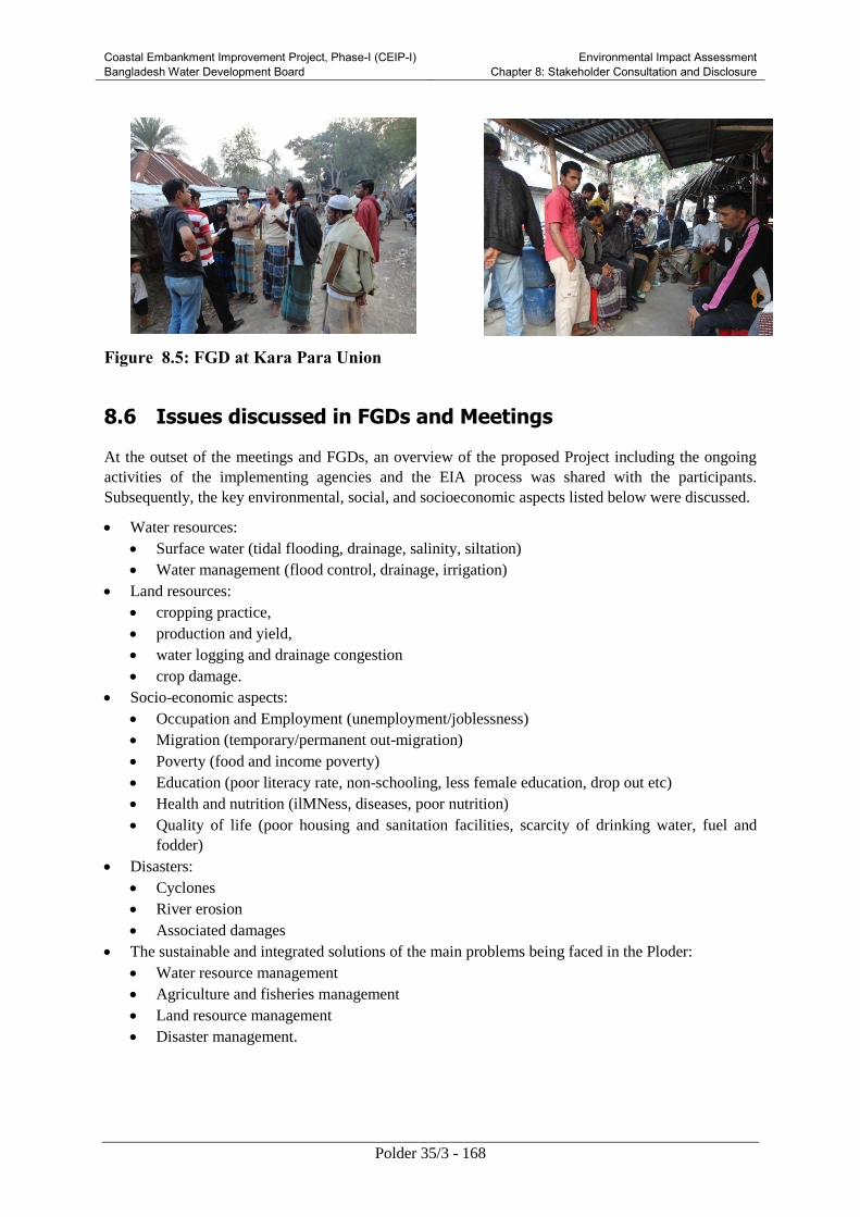
Coastal Embankment Improvement Project, Phase-I (CEIP-I) Bangladesh Water Development Board
Environmental Impact Assessment Chapter 8: Stakeholder Consultation and Disclosure
Polder 35/3 - 168
Figure 8.5: FGD at Kara Para Union
8.6 Issues discussed in FGDs and Meetings
At the outset of the meetings and FGDs, an overview of the proposed Project including the ongoing
activities of the implementing agencies and the EIA process was shared with the participants.
Subsequently, the key environmental, social, and socioeconomic aspects listed below were discussed.
Water resources:
Surface water (tidal flooding, drainage, salinity, siltation)
Water management (flood control, drainage, irrigation)
Land resources:
cropping practice,
production and yield,
water logging and drainage congestion
crop damage.
Socio-economic aspects:
Occupation and Employment (unemployment/joblessness)
Migration (temporary/permanent out-migration)
Poverty (food and income poverty)
Education (poor literacy rate, non-schooling, less female education, drop out etc)
Health and nutrition (ilMNess, diseases, poor nutrition)
Quality of life (poor housing and sanitation facilities, scarcity of drinking water, fuel and
fodder)
Disasters:
Cyclones
River erosion
Associated damages
The sustainable and integrated solutions of the main problems being faced in the Ploder:
Water resource management
Agriculture and fisheries management
Land resource management
Disaster management.

Coastal Embankment Improvement Project, Phase-I (CEIP-I) Bangladesh Water Development Board
Environmental Impact Assessment Chapter 8: Stakeholder Consultation and Disclosure
Polder 35/3 - 169
8.7 Community Concerns and Suggested Solutions
The outcomes of the FGDs and consultation meetings in terms of concerns and the suggested
solutions were noted and organized by themes are presented in the Table 8.3 below.
Table 8-3: Community Concerns and Suggested Solutions
Themes/Topics Concerns/Issues/Problems Suggested Solution/Remedies
Overall Water logging, tidal flooding, salinity
intrusion and cyclone are the main
community concerns in the polder
35/3 area.
Comprehensive rehabilitation of the
polder should be taken up at the earliest
with the active involvement of the local
community.
Water
Resources
The salinity of Bhairab and Bishnu
River is high in the dry season, i.e.
December to May. Normally the
intensity of salinity starts to increase
from December due to reduction of
upland discharge and reaches the peak
in April and then falls due to high
upland flow. The water of Bhairab and
Bishnu River is non-saline, during the
monsoon period i.e. June to
November.
Intrusion of saline water is the prime
problem that has been identified by the
stakeholders. The prawn/shrimp
farming has been established here for
short term benefit. Around 30% area
has been covered by gher for
prawn/shrimp farming. These farming
exercises have caused reduced crop
production in the agricultural lands.
Salinity intrusion in the polder is high
due to low height of embankment and
damaged gates of the structures.
The main cause of water salinity is
unplanned bagda shrimp cultivation.
The cultivators store saline water for
shrimp culture. Besides, illegal
control/operation of sluice gates/
regulators and cutting of embankment
for entering saline water in shrimp
ghers are also responsible for water
salinity in the polder area especially in
Mollikerber, Karapara and Dema.
Local powerful persons, including the
political leaders illegally interfere on
The intrusion of saline water should be
controlled by the improvement of
embankment at the Bansbaria,
Sarkerdanga and Madardia sites. Re-
excavation program in internal canals,
increased height of the embankment and
improvement of sluice gates are very
essential;
Scope of storage will improve
dramatically within internal khals with
proper functioning of associated water
control structures;
Borrow pit of embankment of should be
re-excavated and the slope of
embankment should be constructed with
earth materials;
The re-excavation of rivers and khals are
urgently needed for the improvement of
irrigation facilities and removal of
drainage congestion/water logging in
Polder 35/3 area;
Construction of sufficient freshwater
reservoirs, i.e. protected ponds;
Need formation of water management
Organizations (WMOs) for proper
management of water control
infrastructures, i.e. embankment, sluice
gate, regulator, inlets, bridge, culverts etc
and growing of consciousness among the
community in the project;
Need awareness building about water
management among the communities;
The Government should rehabilitate the
farmers affected by salinity intrusion;

Coastal Embankment Improvement Project, Phase-I (CEIP-I) Bangladesh Water Development Board
Environmental Impact Assessment Chapter 8: Stakeholder Consultation and Disclosure
Polder 35/3 - 170
Themes/Topics Concerns/Issues/Problems Suggested Solution/Remedies
the water control/ management
infrastructure.
Water logging is another problem in
the project area, especially at Chak
Ponchamala that covers 5-7% to the
entire area.
Scarcity of fresh water is one of the
main problems in the study area
during dry season. Malfunctioning of
water control structures and lack of
reserve sweet fresh water in khals for
irrigation during dry season are
responsible for this. Absence of
embankment along the rivers also
makes the surface water unavailable
for the users. Saline water is being
trapped for long time in vast area and
this is responsible for intrusion of
salinity in the groundwater aquifers.
The people of the study area are
suffering from tidal flooding every
year. PCM participants commented
that about 100% areas is affected due
to tidal flooding, 60% household and
80% crops were damaged due to the
Sidr and Aila.
Pond is the main source of drinking
water. According to the participants,
about fifty percent people depend on
pond water for household chores and
drinking as well. The availability of
surface water become low because of
low rainfall in recent years, therefore
pond water level is going down and
creating scarcity of usable water.
Deep Tube Well (DTW) is the major
source (75%) of drinking water in the
polder area. But, local people opined
that, due to salinity problem in tube
well water, they are using pond water.
DTW needs to be installed to a depth
of about 1000-1200 feet for getting
saline free groundwater. But it is very
expensive for most households.
Degraded habitat in the river due to
Re-excavation of khal networks and
draining out of the water into Bhairab and
Bishnu system by constructing flashing
sluice gate;
Salt tolerant varieties of rice need to be
practiced and in this regard necessary
extension works need to be organized by
the respective departments;
All khals should be kept free from illegal
occupier;
Ensure water distribution by
compartmentalization/zoning system for
shrimp cultivation, white fish and
agriculture practice through WMOs.
In most cases the people expressed
opinion to protect river bank rather
construction of the embankment.
Coastal Embankment Improvement Project, Phase-I (CEIP-I) Bangladesh Water Development Board
Environmental Impact Assessment Chapter 8: Stakeholder Consultation and Disclosure
Polder 35/3 - 171
Themes/Topics Concerns/Issues/Problems Suggested Solution/Remedies
fugitive dust particles and turbidity of
water.
Reduction of spawning and feeding
grounds.
The conflict between farmer and
shrimp gher owner are present to some
extent.
Erosion is found mainly in
Mollikerber, Karapara and Dema
union along the Bishnu and Bhairab
rivers. Erosion has rendered local
people’s land, homes and become an
environmental and social hazard.
During Sidr and Aila, the surge wave
action has eroded the flood control
embankment seriously.
Sedimentation is also a problem in the
polder area. Sediment characteristics
are different in the tidal rivers. The
downstream of Bhairab and Bishnu
Rivers have sandy beds and mud
banks along the shore whereas tidal
creeks tend to be choked with very
fine sediments. In the tidal rivers,
suspended sediments are mainly
composed of silt and clay. On an
average, roughly 1 to 1.5 ft
sedimentation took place in most of
the main khals in the polder area each
year. Sedimentation in most of the
internal khals caused rise of bed level
and reduced the conveyance capacity
of the khals. So, the internal khals are
causing loss to the year round
connectivity with rivers and khals.
8.8 Consultations during RAP Preparation
A number of stakeholder consultations were conducted in the Project area while preparing the
resettlement action plan (RAP) for the proposed Project in the Polder 35/3. These are discussed
below.
The local persons who could potentially be affected by the Project along with local community
leaders and other stakeholders were consulted through group meetings and personal contacts. The
opinion of different stakeholders regarding the Project was sought and considered in preparation of
the RAP. A total of four formal stakeholder meetings were held with different communities in the

Coastal Embankment Improvement Project, Phase-I (CEIP-I) Bangladesh Water Development Board
Environmental Impact Assessment Chapter 8: Stakeholder Consultation and Disclosure
Polder 35/3 - 172
Polder 35/3. Different types of stakeholders including concerned UP chairmen/members, teachers,
Imams (prayer leaders), local community leaders, political leaders, farmers, shopkeepers, and other
people to be affected by the Project attended these sessions. The salient details of these consultations
carried out in Polder 35/3 are presented in Table 8.4; some photographs of these meetings are
presented in Figures 8.6 and 8.7.
Table 8-4: Consultation Meetings Held in Polder 35/3
Location, Date and Time Category of Participants
Katuria Bazar
March 07, 2012 at 10.20 am
Land owners, farmers, fishermen, businessmen, teachers,
UP members, and Project Affected Persons (PAPs)
Plan Bazar,
December 13, 2012 at 11.00 am
Businessmen, land owners, service providers, teachers
land owners, and PAPs
Bansh Bari,
December 13, 2012 at 11.00 am
Farmers, Ex-Chairman, land owners, businessmen, local
elites, and PAPs
Gujihati Bazar,
December 14, 2012 at 2:30pm
Shop owners, daily wage laborers, businessman, local
elites, and PAPs
Figure 8.6: Meeting at Malliker Ber Union Figure 8.7: Meeting at Dema Union
During these meetings, the key features of the proposed interventions in Polder 35/3 under CEIP-I, its
key benefits, its potential impacts particularly relating to resettlement and displacement, the process
for determining people to be affected, compensation payment procedure, GoB’s laws and World
Bank’s policy on involuntary resettlement, and cut-off-date for listing assets to be affected were
discussed. The relocation requirements and availability of alternative lands in the surrounded area
suitable for relocation were disclosed to the communities to be affected. Views of the stakeholders
were obtained on the Project and its potential impacts, encroaching government land, relocation
requirements, compensation process, and alternative options. Consultations were also conducted with
women and other vulnerable groups and their views obtained on their livelihood aspects, Projects
impacts, and compensation options.

Coastal Embankment Improvement Project, Phase-I (CEIP-I) Bangladesh Water Development Board
Environmental Impact Assessment Chapter 8: Stakeholder Consultation and Disclosure
Polder 35/3 - 173
The communities including the persons to be affected by the Project expressed their views in favor of
the Project and wanted early implementation to protect them from the tidal surges and disasters such
as cyclone Aila and Sidr. They demanded adequate compensation and other benefits for the loss of
their assets and livelihood, as well as alternative place for relocation of their houses and business.
The inputs from the stakeholder meetings have been used to develop measures and principles to
address the resettlement impacts.
8.9 EIA Disclosure
Regional Workshop
The EIA report and Bengali translation of its executive summary was disclosed to the public on 13th
January, 2013 in Dacope, Khulna. The main aim of the meetings was to present the findings of the
final draft report on FS and EIA and having feedback from the local stakeholders attended. The report
was also finalized through incorporation of comments and suggestions got from the meetings. The
communities including the persons to be affected of polder 35/3 by the Project expressed their views
in favor of the Project and wanted early implementation to protect them from natural disasters. They
demanded following actions to be taken immediately. These are:
The intrusion of saline water might be controlled by the improvement of embankment.
Need awareness building among the communities about water management;
Ensure proper compensation for affected people
O & M for embankments and sluice gates in the polder area
Need formation of Water Management Organizations (WMOs) to manage properly water
control structures
New embankment is required to be constructed by developing village road.
National Workshop
Coastal Embankment Improvement Project (CEIP) organized a national workshop on the
“Environmental Impact Assessment (EIA) and Social Impact Assessment (SIA)” studies under CEIP
at Spectra Convention Centre, Gulshan 1, Dhaka on 28 February 2013. Mr. Md Shaikh Altaf Ali
Senior Secretary, Ministry of Water Resources, Government of the People’s Republic of Bangladesh
was the chief guest of the Workshop, while Mr. Mohammad Azizul Haque, Director General,
Bangladesh Water Development Board (BWDB) and Dr. Sultan Ahmed, Director, Natural Resource
Management, Department of Environment (DoE) were the special guests. The meeting was chaired by
Mr. Salim Bhuiyan, Chief Planning, BWDB.
The program started with registration of the participants at 9:30 am. The main program then started at
10:00 am through recitation from the holy Quran. Mr. Sarafat Hossain Khan, Project Coordinator,
CEIP, BWDB made the introductory speech. After that Mr. Md. Waji Ullah, Deputy Executive
Director (Operations) and Team Leader of Environmental Studies of CEIP presented the findings of
the Environmental study and EA findings of five polders. Mr. Kh Khairul Matin presented the Social
Impact Assessment (SIA).

Coastal Embankment Improvement Project, Phase-I (CEIP-I) Bangladesh Water Development Board
Environmental Impact Assessment Chapter 8: Stakeholder Consultation and Disclosure
Polder 35/3 - 174
Figure 8.8: Welcome Speech by the Project
Coordinator of CEIP
Figure 8.9: Presentation of EIA findings by
Team Leader of Environmental Study
Figure 8.10: Participants of the Workshop Figure 8.11:Chief Guest delivering his speech
National experts from multi disciplinary fields such as engineers, agriculturists, economists,
sociologists as well as local stakeholders were present in that workshop.
Finishing the presentation, the floor was opened for all to take part in discussion on the presentation.
The participants attended and exchanged their views on different issues which were noted by the
professionals of CEGIS with a view to furnishing the final report.
Findings of the National Workshop
The comments and Suggestions from participants are as follows:
i. Impacts on health and hygienic need to be considered in the study
ii. Subsidence due to climate change needs to be included in the study
iii. The cumulative impacts of five polders are assessed in the study why not for the other
polders to be constructed in future?

Coastal Embankment Improvement Project, Phase-I (CEIP-I) Bangladesh Water Development Board
Environmental Impact Assessment Chapter 8: Stakeholder Consultation and Disclosure
Polder 35/3 - 175
iv. The cumulative impacts has used “may increase/decrease”. This should be more specific.
v. As fisheries sector specially Shrimp Gher plays vital role in economy of coastal region, a
Fisheries Specialist is to be included in the proposed Institutional Framework of the EMP
of CEIP
vi. Mal-functioning of structures to be defined in the report
vii. Net value of fisheries impact to be provided
viii. Fish-friendly structure should be constructed. The location of these structures is
important.
ix. Involvement of DoE during implementation of project activities should be ensured.
8.10 Framework for Consultations during Project
Implementation
The stakeholder consultation is a continued process, and should be maintained throughout the project.
The consultations carried out during the present EIA and reported in this Chapter are essentially a first
step in this process. During the subsequent project phases as well, participation of the project
stakeholders need to be ensured. Table 8.5 charts out the proposed participation framework during
different project Phases.

Coastal Embankment Improvement Project, Phase-I (CEIP-I) Bangladesh Water Development Board
Environmental Impact Assessment Chapter 8: Stakeholder Consultation and Disclosure
Polder 35/3 - 176
Table 8-5: Participation Framework
Project Stage Proposed Tool Stakeholders to be Consulted Responsibility
Project Design
Phase
Meetings with institutional stakeholders (carried out during
the present EIA and RAP preparation);
meetings with grass root stakeholders (carried out during the
present EIA and RAP preparation)
Institutional stakeholders;
Grass root stakeholders, including the
communities to be affected by the
Project.
EIA consultant.
Project
Construction
Phase
Information disclosure (sharing of the project objectives,
project components, major benefits, potential impacts,
mitigation measures and Resettlement Plan with the affected
communities and other stakeholders).
Institutional stakeholders;
Grass root stakeholders, including the
communities to be affected during the
project implementation.
BWDB;
Supervision Consultants;
Contractors
Consultations and liaison The communities around the work
sites, borrow areas, and access routes
BWDB;
Supervision Consultants;
Contractors
Grievance Redressal Mechanism and Social Complaint
Register (discussed later in the document).
The affected communities. BWDB;
Supervision Consultants;
Contractors
Consultations with the communities during Compliance
Monitoring and Effects Monitoring (discussed later in the
document).
Affected communities. BWDB;
Supervision Consultants;
Contractors
Consultations with the project affectees / communities during
the external monitoring (discussed later in the document).
Affected communities. External monitoring consultants.
Consultations with the project affectees / communities during
the site visits by the WB monitoring mission.
Project site staff;
Contractors;
Affected communities.
WB monitoring mission.
Project Operation
Phase
Community participation in O&M activities (see Section 4.9)
Institutional stakeholders;
Grass root stakeholders, including the
beneficiary communities.
BWDB

Coastal Embankment Improvement Project, Phase-I (CEIP-I) Bangladesh Water Development Board
Environmental Impact Assessment Chapter 9: Assessment of Environmental and Social Impacts
Polder 35/3 - 177
9. Assessment of Environmental and Social
Impacts
9.1 Preamble
This Chapter identifies the environmental and social impacts that may potentially be caused by
various Project phases, and also proposes appropriate mitigation measures to avoid, offset, reduce, or
compensate these impacts. Potential Intervention which may cause potential environmental impacts
during pre-construction, construction, and O/M stages have been identified in Chapter 4. The project
influence area has been identified in Article 2.2.1 of Chapter 2. The following detailed investigations
are being carried out or proposed to assess the magnitude of these prioritized impacts:
Census survey to assess the extent of land acquisition and resettlement, loss of vegetation,
occupation, income and poverty levels of the affected households, etc.
Polder drainage model developed using the existing calibrated and validated Southwest
Regional Model as base model has been used to understand the impact of project intervention
to improve the existing drainage system and impact of climate change with the existing
drainage system and with modified drainage system.
Environmental quality baseline monitoring of air, noise, surface water, groundwater and soil,
Ecological surveys comprising vegetation, wildlife and fisheries covering both mainland and
Charland,
Charland surveys comprising socioeconomic status and environmental settings,
Expert consultations, focus group discussions, and public consultations.
It is to be mentioned here that some of the studies are in progress, the results of the selected
investigations completed to date are discussed in this chapter. Most of the project activities are yet to
be finalized (for example locations for afforestation component, locations of construction yards,
operational arrangement of the sluices during the operation period). Similarly the detailed bills of
quantities and equipment usage are yet to be ascertained. Therefore, this report has to be further
improved as per suggestions and future need.
Table 9-1: List of Environmental Components and Updating of EIA report by BWDB
Environmental
Component
Present Gap/Pending
Issue in the EIA
Information in the
pipeline to
finalize the EIA
report
Tentative date of
finalization
Natural Environment
Topography Topography analysis for
the afforestation
component of
the project
Sites for the location of
the afforestation
component are
underway. The
possible
locations have
been identified.
However, the
End of August, 2013

Coastal Embankment Improvement Project, Phase-I (CEIP-I) Bangladesh Water Development Board
Environmental Impact Assessment Chapter 9: Assessment of Environmental and Social Impacts
Polder 35/3 - 178
team is now out
for field
checking.
Topography analysis for
construction
camp.
Sites for construction
camp will be
decided by the
contractors
End of December, 2013
Topsoil Total Loss of Top Soil Will be finalized once the
information
regarding the
construction
yards and exact
locations of
borrow pits are
obtained
End of December 2013
Landscape Landscaping to the side
slopes of the
embankment and
surrounding
areas to tree
plantation
Location, length and
geometry of the
afforestation
area are yet to be
finalized
End of August, 2013
Ecological Environment
Endangered Species None None None
Vegetation Change in vegetation
from the project
Require additional
information for
area of
construction
yards and
afforestation
End of December 2013
Wetlands Total Impact on the
wetlands
Require additional
information for
area of wetland
coverage (if any)
for the
construction
yards
End of December 2013
Environment Quality
Noise Quality Noise quality impact
around all
facilities during
construction
Type and number of
equipment,
vehicles, dredger
etc to be used by
the contractors,
Their locations,
End of December 2013

Coastal Embankment Improvement Project, Phase-I (CEIP-I) Bangladesh Water Development Board
Environmental Impact Assessment Chapter 9: Assessment of Environmental and Social Impacts
Polder 35/3 - 179
time and extent
of works etc.
Air Quality Air quality impact around
all facilities
during
construction
Type and number of
equipment,
vehicles, dredger
etc to be used by
the contractors,
Their locations,
time and extent
of works etc.
End of December 2013
Soil Quality Total amount of lands
adjacent to
proposed
facilities
including
construction
yard, borrow and
dredged material
Requires final location
and amounts of
lands for
construction
yards and
stacking of
construction
material and
dredged spoil.
End of December 2013
Wastes Total wastes likely to be
generated at
different
proposed
facilities during
construction
works. Total
population to be
occupied at the
construction
camps
Input requires form the
contractors
about the
required number
of skilled and
unskilled labors.
End of December 2013
Spoils Dredged Spoil amount
and how it will
be managed.
Preliminary
finding say that
it will be kept on
the two sides of
the dredged
canal
The contractor needs to
come up with
the dredged
spoil
management
plan
End of December 2013
Socio Economic Environment
Agriculture Land needed for the
construction
camp set up,
widening of
embankment
base,
afforestation
Pending on finalization of
design, plan for
land acquisition
End of December 2013

Coastal Embankment Improvement Project, Phase-I (CEIP-I) Bangladesh Water Development Board
Environmental Impact Assessment Chapter 9: Assessment of Environmental and Social Impacts
Polder 35/3 - 180
Health and Hygiene Analysis on the total
workers likely to
take part in the
construction
Pending on the output of
the contractors
plan
End of December 2013
Transport Number and type of
construction
equipment,
vehicles, their
possible routes
which will
conflict with the
existing
transport
Pending on the outcome
from contract
units
End of December 2013
Road Accidents Number and type of
construction
equipment,
vehicles, their
possible routes
which will
conflict with the
existing
transport
Pending on the outcome
from contract
units
End of December 2013
Water Transport
Accidents
Number, type of water
transport for
carrying
equipment and
their possible
access routes
Pending on the outcome
from contract
units
End of December 2013
Irrigation Irrigation affected by the
construction
Pending work-plan from
the contractors
for rehabilitation
of the hydraulic
structures
End of December 2013
9.2 Impact Screening
As part of the environmental impact assessment process, a screening matrix was used tailored
specifically to the proposed Project, focusing the potential environmental impacts during the design,
construction and operation phases. The matrix examined the interaction of project activities with
various components of the environment. The impacts were broadly classified as physical, biological
and social, and then each of these broad categories further divided into different aspects. The
potential impacts thus predicted were characterized as follows:
High negative (adverse) impact;
Low negative impact;
Insignificant impact;

Coastal Embankment Improvement Project, Phase-I (CEIP-I) Bangladesh Water Development Board
Environmental Impact Assessment Chapter 9: Assessment of Environmental and Social Impacts
Polder 35/3 - 181
High positive (beneficial) impact;
Low positive impact; and
No impact.
The matrix of polder 35/3 is provided in Table 9.2 (next page). The negative impacts predicted in this
manner were the ‘unmitigated’ impacts. Appropriate mitigation measures were recommended as part
of this EIA, thus reducing the occurrence possibility and severity of the potentially adverse impacts.
The potentially negative impacts identified through this process are discussed in the subsequent
sections.

Coastal Embankment Improvement Project, Phase-I (CEIP-I)
Bangladesh Water Development Board
Environmental Impact Assessment Chapter 9: Assessment of Environmental and Social Impacts
Polder 35/3 - 182
Table 9.1: Environmental and Social Screening Matrix (Unmitigated)
Physical Biological Social and Socioeconomic
Project Phases and Activities
So
il E
rosi
on
/Co
nta
min
atio
n
Air
Qu
alit
y
Su
rfac
e W
ater
Qu
alit
y
Gro
un
dw
ater
Qu
alit
y
Wat
er
Av
aila
bil
ity
an
d
Co
nsu
mp
tio
n
Nat
ura
l V
eget
atio
n
Wil
dli
fe/A
qu
atic
Fau
na
Res
ettl
emen
t
Blo
cked
Acc
ess
Ro
ute
s
No
ise
and
Vib
rati
on
Imp
acts
o
n
Ag
ricu
lture
an
d
gra
zin
g
Imp
acts
on
Fis
her
ies
Flo
od
ing
Veh
icu
lar
Tra
ffic
Saf
ety
Haz
ard
Dam
age
to I
nfr
astr
uct
ure
Pu
bli
c H
ealt
h
Aes
thet
ic V
alu
e
Gen
der
and
Cu
ltu
ral
Issu
es
Em
plo
ym
ent
Op
port
un
itie
s
Design Phase and Pre-
Construction Phase
Land Acquisition 0 0 0 0 0 0 0 HN 0 0 0 0 0 0 0 0 0 0 0 0
Contractor Mobilization MN MN MN 0 0 MN MN 0 MN MN MN MN 0 HN HN HN MN 0 MN MP
Construction Camp Establishment MN MN MN 0 0 MN MN MN MN MN MN MN 0 MN HN MN MN MN MN MP
Construction Phase
Equipment / Material Transportation MN MN MN 0 0 0 0 0 MN MN MN MN 0 MN HN MN MN 0 MN MP
Operation of Construction Camp HN MN HN MN MN 0 MN 0 MN MN 0 MN 0 MN HN MN HN 0 MN MP
Site Clearance MN MN MN 0 0 MN MN 0 MN MN MN MN 0 MN HN MN MN MN MN HP
Borrow and disposal area
management HN MN HN 0 0 MN MN 0 MN MN HN MN MN MN HN MN HN MN MN HP
Excavations of water channels MN MN HN 0 0 MN HN 0 MN MN 0 HN MN MN HN MN MN MN MN HP
Re-sectioning of Embankments HN MN MN 0 0 MN 0 0 HN MN MN 0 MN MN HN MN MN MN MN HP
Retirement of Embankments HN MN MN 0 0 MN 0 0 HN MN MN 0 MN MN HN MN MN MN MN HP
Installation/replacement/repair of
Regulators HN MN MN 0 0 0 MN 0 HN MN 0 MN HN MN HN MN MN MN MN HP
Demobilization MN MN MN 0 0 MN MN 0 MN MN MN MN 0 HN HN HN MN 0 MN MP
Operation Phase
Operation of Regulators MN 0 HN 0 MN 0 MN 0 0 0 HN HN HN 0 0 0 0 0 0 MP
Repair and Maintenance MN 0 MN 0 0 0 MN 0 MN MN HN HN HN MN MN 0 0 0 0 MP
Monitoring 0 0 0 0 0 0 0 0 0 0 0 0 0 MN 0 0 0 0 0 MP
Key:-HN: High negative impact; MN: moderate negative impact; 0: insignificant/negligible impact; HP: high positive impact; MP: moderate positive impact

Coastal Embankment Improvement Project, Phase-I (CEIP-I) Bangladesh Water Development Board
Environmental Impact Assessment Chapter 9: Assessment of Environmental and Social Impacts
Polder 35/3 - 183
9.3 Impacts during pre-construction Phase
Site development involves the following activity:
Mobilization of equipment, construction material/vehicles
Clearing of sites
Collection of earth materials from borrows pits and Daratana river, Putimary river, and
Bishnu river bed.
Construction of civil amenities and development and
Establishment of temporary construction yards
The activities will cause the following environmental impacts
9.3.1 Damages due to Project Intervention and Land Acquisition
Impact
About 15 ha of land will need to be acquired to construct embankments and water control
infrastructure. In addition, houses, shops, common properties, and trees will be affected by the project
affectees. The details of these damages in Polder 35/3 are presented in Tables 9.3 to 9.6.
Table 9.3: Type of Land to be Acquired in Polder 35/3
Description Area (ha)
Houses 3.85
Single cropped fields 4.26
Double cropped fields 0.81
Orchard 0.62
Pond 1.2
Shrimp Culture 3.65
Canal or Beel 0.61
Total 15.00
Source: Socioeconomic survey conducted by KMC in Dec 2011-Feb 2012
Table 9.4:Primary Structures to be Affected in Polder 35/3
Description Quantity Covered Area
(square feet)
Pucca (made of bricks and
mortar)
4 1331
Semi pucca 80 23990
Katcha 324 66439
Total 408 91760
Source: Socioeconomic survey conducted by KMC in Dec 2011-Feb 2012

Coastal Embankment Improvement Project, Phase-I (CEIP-I) Bangladesh Water Development Board
Environmental Impact Assessment Chapter 9: Assessment of Environmental and Social Impacts
Polder 35/3 - 184
Table 9.5: Secondary Structures to be Affected in Polder 35/3
Description Quantity
Pucca latrine (numbers) 5
Slab latrine (numbers) 23
Katcha latrine (numbers) 2
Tube well (numbers) 5
Boundary wall (running feet) 161
Chatal 7350
Gates (numbers) 30
Water tanks (cubic feet) 100
Source: Socioeconomic survey conducted by KMC in Dec 2011-Feb 2012
Table 9.6:Common Properties to be Affected in Polder 35/3
Description Quantity
Mosque 9
Mandir 0
Club House 1
School/Pathshala 0
Graveyard 0
Government Office 1
Madrasa (religious school) 2
Latrine 0
Political Party office 0
Clinic 0
Miscellaneous 1
Total 14
Source: Socioeconomic survey conducted by KMC in Dec 2011-Feb 2012
The significance of this potential unmitigated impact has been assessed as Major on the basis of
impact magnitude and receptor sensitivity as described in Chapter 2.
Mitigation
The resettlement cost estimate is provided below.
Table 9.7:Resettlement Budget for Polder 35/3
Description Amount
(BDT)
Compensation for land acquisition 18,768,006
Compensation for structures 26,374,355
Compensation for Trees 21,856,800
Compensation for Fish Stock 817,680
Other Resettlement Benefits 78,879,401

Coastal Embankment Improvement Project, Phase-I (CEIP-I) Bangladesh Water Development Board
Environmental Impact Assessment Chapter 9: Assessment of Environmental and Social Impacts
Polder 35/3 - 185
Description Amount
(BDT)
Capacity building training for EA 1,000,000
Development of Resettlement sites 1,000,000
Operation cost for RAP Implementing Agency/ INGO 5,000,000
Operation cost for External Monitoring Agency 2,000,000
Contingency @ 10% of the above 8,787,940
Total Estimate Budget (in BDT) 96,667,341
Total budget in USD (1 USD=82 BDT) 1,178,870
Source: Socioeconomic survey conducted by KMC in Dec 2011-Feb 2012
The project has the provision for implementation of resettlement action plan, social action plan and
environmental management plan. The following measures will be implemented to address the
damages due to project intervention and land acquisition:
Effective implementation of the Resettlement Action Plan (RAP) prepared in accordance with
OP 4.12 will be ensured.
Compensation will be paid prior to commencement of the project construction in accordance
with RAP. Complete documentary record will be maintained for compensation assessment
and payment.
Contractor will maintain liaison with communities.
Grievance redress mechanism (GRM) will be established.
“Chance Find”Procedures will be followed for social common properties lke mosques
Residual Impacts
Despite implementing the above mitigation measures, the impacts associated with the involuntary
resettlement are not likely to be fully eliminated, essentially because of the severity and extent of the
involuntary resettlement. The significance of residual impact will therefore be Moderate, and regular
monitoring will be essential to ensure that RAP is effectively implemented and the community
grievances related to resettlement are promptly addressed.
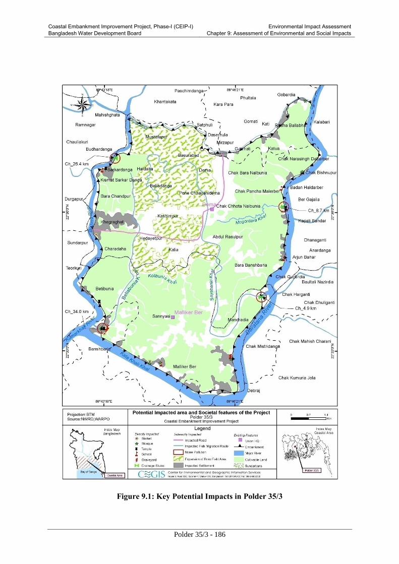
Coastal Embankment Improvement Project, Phase-I (CEIP-I) Bangladesh Water Development Board
Environmental Impact Assessment Chapter 9: Assessment of Environmental and Social Impacts
Polder 35/3 - 186
Figure 9.1: Key Potential Impacts in Polder 35/3
Coastal Embankment Improvement Project, Phase-I (CEIP-I) Bangladesh Water Development Board
Environmental Impact Assessment Chapter 9: Assessment of Environmental and Social Impacts
Polder 35/3 - 187
9.3.2 Conflicts because of absence of proper land ownership legal document
Impact
Different segments of embankment (about 8.05 km), shifting of water control structures and
excavation of alternative canal will be rehabilitated in the polder 35/3. Presently, Planning and Design
consultant has prepared Land Acquisition and Resettlement Action Plan as per guidelines of
acquisition and requisition of immovable property ordinance, 1982 (ordinance II of 1982). In the
polder, about 15 hectares of land will be acquired for rehabilitation work. Due to land acquisition, 113
households will lose their land within the polder area. In this case, the details of the land acquisition
plan, process and cost including the list of the PAPs are incorporated in the RAP report prepared by
planning and design consultants (FS). During distribution of compensation, conflicts may arise due to
absence of proper legal document in connection with the land ownership.
The significance of this potential impact has been assessed as Major on the basis of impact
magnitude and receptor sensitivity.
Mitigation
This conflict would be reduced, if the compensation could be disbursed by the Local Government
Authority in presence of Union Parishad Chairman and Upazila Nirbahi Officer (UNO) of the
Upazila. Additionally, the list of the PAPs will be disclosed in the prominent places e.g. market
places, Union Parishad office of the polder. This mechanism could reduce the conflict of land
ownership of the polder area.
Residual Impact
With the help of above mitigation measures, the impacts associated with the land acquisition and
requisition are likely to be mostly addressed and the significance of residual impact will be Moderate.
9.3.3 Preparation of facilities for contractor and labor force
Impact
During establishing and constructing site facilities in the Polder may potentially cause air and water
contamination, noise generation, and other impacts. Figure 9.1 shows the key locations in the
Project area where this impact is likely to take place. All the labour camps will be built on the
BWDB’s land avoiding tree cutting, to the extent possible. If the proper drainage and sewerage
facilities are not considered during establishment of facilities, the water quality as well as aquatic
condition of the Maderdia khal, Sayabanki khal, Mogordana khal, Betibonia khal may deteriorate
(Figure 4.1).
The significance of this potential impact has been assessed as Major on the basis of impact
magnitude and receptor sensitivity.
Mitigation
The removal of vegetation and trees will be mitigated by preparing a proper landscaping plan and a
budget for future tree planting and landscaping measures to be implemented after completion of the
project. The plan will be prepared during the first year of construction and will be provided to the
Supervision Consultants/environmental monitoring unit for review and approval. These activities will

Coastal Embankment Improvement Project, Phase-I (CEIP-I) Bangladesh Water Development Board
Environmental Impact Assessment Chapter 9: Assessment of Environmental and Social Impacts
Polder 35/3 - 188
be monitored by the Environmental and Social Monitoring Unit (ESMU). The following measure
should be implemented to address the above concerns:
Contractor will prepare site establishment plan and obtain approval from the Construction
Supervision Consultants (CSC)
Approval from CSC will be obtained for the location of temporary facilities.
Tree felling and vegetation clearing will be minimized to establish site facilities
Photographic record will be maintained to record pre-construction condition of the area
Site facilities will be established at a safe distance from communities
Contractor will prepare and implement pollution control and waste management plans
No untreated wastes will be released on ground or in water
Exhaust emissions from vehicles and equipment will comply with standards
Vehicles, generators, and equipment will be properly tuned.
Water will be sprinkled where needed to suppress dust emissions
Vehicles and machinery will have proper mufflers and silencers
Liaison will be maintained with the communities.
Residual Impacts
With the help of above mitigation measures, the impacts associated with establishing the site facilities
are likely to be adequately addressed and the significance of residual impact will be Low.
9.3.4 Changes in Land Use
Impact
Land use pattern in the polder area will be changed temporary during construction of labor sheds,
contractor’s office and material stock yard. Materials stock yard will be set up in the premises of
BWDB colony at Bagerhat Sadar near Daratana River. But, a total of 42 camps for labour will be
constructed near the water regulatory structure. These temporary facilities will be implemented in the
existing acquired land of BWDB. The details environmental and societal features have been attributed
in the Table 9.7 according to chainage.
Table 9.7: Number of features displaced during establishment of labour Shade
Chainage
(Km)
Number of trees and Household
Structure C/S R/S
Homes Shop/others Trees Homes Shop/others Trees
1.5 F/S-1 0 0 20 0 0 10
4.94 D/S-1 0 0 25 0 0 5
5.60 F/S-12 0 0 0 0 0 0
8.75 D/S-4 4 2 73 0 0 0
11.53 F/S-3 0 0 0 0 0 0
12.45 F/S-4 0 0 2 0 0 3
16.65 F/S-5 0 0 0 0 0 0
17.00 F/S-6 0 0 0 0 0 0
19.43 F/S-7 0 0 0 0 0 0
21.23 F/S-9 0 0 0 0 0 0
25.5 D/S-2 0 0 10 0 0 15
26.4 F/S-9 0 0 11 0 0 0
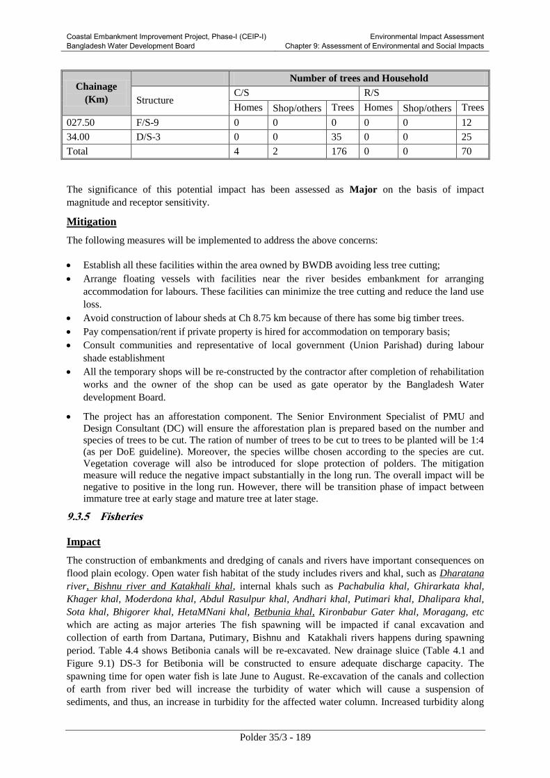
Coastal Embankment Improvement Project, Phase-I (CEIP-I) Bangladesh Water Development Board
Environmental Impact Assessment Chapter 9: Assessment of Environmental and Social Impacts
Polder 35/3 - 189
Chainage
(Km)
Number of trees and Household
Structure C/S R/S
Homes Shop/others Trees Homes Shop/others Trees
027.50 F/S-9 0 0 0 0 0 12
34.00 D/S-3 0 0 35 0 0 25
Total 4 2 176 0 0 70
The significance of this potential impact has been assessed as Major on the basis of impact
magnitude and receptor sensitivity.
Mitigation
The following measures will be implemented to address the above concerns:
Establish all these facilities within the area owned by BWDB avoiding less tree cutting;
Arrange floating vessels with facilities near the river besides embankment for arranging
accommodation for labours. These facilities can minimize the tree cutting and reduce the land use
loss.
Avoid construction of labour sheds at Ch 8.75 km because of there has some big timber trees.
Pay compensation/rent if private property is hired for accommodation on temporary basis;
Consult communities and representative of local government (Union Parishad) during labour
shade establishment
All the temporary shops will be re-constructed by the contractor after completion of rehabilitation
works and the owner of the shop can be used as gate operator by the Bangladesh Water
development Board.
The project has an afforestation component. The Senior Environment Specialist of PMU and
Design Consultant (DC) will ensure the afforestation plan is prepared based on the number and
species of trees to be cut. The ration of number of trees to be cut to trees to be planted will be 1:4
(as per DoE guideline). Moreover, the species willbe chosen according to the species are cut.
Vegetation coverage will also be introduced for slope protection of polders. The mitigation
measure will reduce the negative impact substantially in the long run. The overall impact will be
negative to positive in the long run. However, there will be transition phase of impact between
immature tree at early stage and mature tree at later stage.
9.3.5 Fisheries
Impact
The construction of embankments and dredging of canals and rivers have important consequences on
flood plain ecology. Open water fish habitat of the study includes rivers and khal, such as Dharatana
river, Bishnu river and Katakhali khal, internal khals such as Pachabulia khal, Ghirarkata khal,
Khager khal, Moderdona khal, Abdul Rasulpur khal, Andhari khal, Putimari khal, Dhalipara khal,
Sota khal, Bhigorer khal, HetaMNani khal, Betbunia khal, Kironbabur Gater khal, Moragang, etc
which are acting as major arteries The fish spawning will be impacted if canal excavation and
collection of earth from Dartana, Putimary, Bishnu and Katakhali rivers happens during spawning
period. Table 4.4 shows Betibonia canals will be re-excavated. New drainage sluice (Table 4.1 and
Figure 9.1) DS-3 for Betibonia will be constructed to ensure adequate discharge capacity. The
spawning time for open water fish is late June to August. Re-excavation of the canals and collection
of earth from river bed will increase the turbidity of water which will cause a suspension of
sediments, and thus, an increase in turbidity for the affected water column. Increased turbidity along

Coastal Embankment Improvement Project, Phase-I (CEIP-I) Bangladesh Water Development Board
Environmental Impact Assessment Chapter 9: Assessment of Environmental and Social Impacts
Polder 35/3 - 190
with the suspended sediments can affect fish behavior such as feeding, avoidance, territoriality, and
homing behavior.
Mitigation
The contractor will prepare the work plan for re-excavation of canals, collection of earth from Bhola
and Baleshwar river and construction of sluices avoiding late June to August, during reexcavation of
Betibonia canals and placement of drainage sluice DS-3.
9.3.6 Increased Vehicular Traffic during Mobilization
Impact
During contractor mobilization, equipment, machinery, material, and manpower will be transported to
the Polder resulting in additional traffic on roads and in waterways. This traffic may potentially cause
traffic congestion particularly at roads and jetties. Figure 9.1 shows the key locations in the Project
area where this impact is likely to take place.
The significance of this potential unmitigated impact has been assessed as Moderate to Major.
Mitigation
The following measures will be implemented to address the above concerns:
The contractor will prepare a traffic management plan (TMP) and obtain approval from the
Design Consultant (DC) and Construction Supervision (CS) consultant. The TMP will be
shared with the communities and will be finalized after obtaining their consent.
The TMP will address the existing traffic congestion particularly at the Rayenda and Sonnasir
bazaars. Similarly, schools will be avoided during the school time. Project-related traffic will
be minimized during the peak traffic hours (from 8 am to 2 pm).
Ensure minimal hindrance to local communities and commuters.
Liaise with local communities and concerned authorities
9.3.7 Increased Inland and Waterway Traffic
Impact
Transportation of construction materials is a key concern during implementation of project
intervention. Two broad options are available for carrying construction materials to the Project
stockyards in the Polder. The first option for construction materials in the north side (close to Putimari
river) of the Polder may be transported through in road way. As such, material transportation along
Khulna-Bagerhat road may cause traffic congestion and hindrance to other commuters, travelers, and
transporters due to additional movement of vehicle.
Second option would involve water way transportation for construction works in the east, west and
south portion of the Polder. A temporary jetty will be constructed in Daratana River near the stock
yard in Bagerhat BWDB colony for unloading and stocking of construction materials. The river
(Daratana) is wide and remains navigable throughout year. A few numbers of motorized boats and
country boats move through this channel. Therefore, construction of jetty and material transportation
along the waterways may not create significant water way traffic problems.
Mitigation
The following measures will be implemented to address the above concerns:
Contractor to prepare and implement traffic management plan for loading and unloading of
construction materials at the jetty sight.

Coastal Embankment Improvement Project, Phase-I (CEIP-I) Bangladesh Water Development Board
Environmental Impact Assessment Chapter 9: Assessment of Environmental and Social Impacts
Polder 35/3 - 191
Avoid movement of construction materials at daytime due to smoothning the regional launch
movement.
River crossing for material transportation during nighttime is suitable for reducing water way
traffic problems.
Material transportation through rivers during high tide.
Liaison to be maintained with community and BIWTA.
Residual Impacts
With the help of above mitigation measures, the impacts associated with additional traffic on roads
and along water ways are likely to be adequately addressed and the significance of residual impact
will be Low.
9.3.8 Noise
Impact
Mobilization of construction vehicles for equipment and material transport will deteriorate the noise
level at the surrounding sites. The traffic volume will be increased both in the road and river. A
number of schools and settlement are in the surrounding areas. It is expected the equipment to be used
for excavation from borrow pit and their noise level at 7m distance are excavator: 80 dBA and
scrapper 86 dBA and generator. Bangladesh standard is 60 dBA at the mixed zone during daytime.
The increased traffic volume is anticipated to increase the noise pollution. Table 6.11 shows the noise
level is already above the Bangladesh standard.
Mitigation
The contractors need to aware the vehicle drivers not to use hydraulic horns and to avoid
unnecessary honking. The contractors will encourage the vehicles to come during day time.
9.3.9 Preparation of Facilities for Contractor(s) and Labor Force
Impact
Establishing the contractor’s temporary site facilities may involve land clearing, land leveling,
excavation, and construction of buildings. These activities may potentially cause air and water
contamination, noise generation, safety hazards, hindrance to local communities, and other similar
impacts. Figure 9.1 shows the key locations in the Project area where this impact is likely to take
place. The significance of this potential unmitigated impact has been assessed as Moderate to
Major.
Mitigation
The following measures will be implemented to address the above concerns:
Contractor will prepare site establishment plan and obtain approval from the DCSC
Approval from DC & CS will be obtained for the location of temporary facilities.
Tree felling and vegetation clearing will be minimized to establish site facilities
Photographic record will be maintained to record pre-construction condition of the area
Site facilities will be established at a safe distance from communities
Contractor will prepare and implement pollution control and waste management plans

Coastal Embankment Improvement Project, Phase-I (CEIP-I) Bangladesh Water Development Board
Environmental Impact Assessment Chapter 9: Assessment of Environmental and Social Impacts
Polder 35/3 - 192
No untreated wastes will be released on ground or in water
Exhaust emissions from vehicles and equipment will comply with standards
Vehicles, generators, and equipment will be properly tuned.
Water will be sprinkled where needed to suppress dust emissions
Speed limits will be enforced for vehicles on earthen tracks
Vehicles and machinery will have proper mufflers and silencers
Liaison will be maintained with the communities.
9.3.10 Issues Addressed during Design Phase for Polder 35/3 to Avoid Environmental Impact
The following tasks have been taken into account during design phase to avoid the negative
environmental impact:
To reduce the drainage and water logging and promoting fish migration canals need to be re-
excavated have already been identified. The list of khals (canals) to be considered for re-
excavation are presented in Table 4.4
The locations for borrow pit is identified and presented in Table 4.8. However the soil quality
to meet the requirement of earth volume needs to be addressed. If the currently chosen borrow
pits does not satisfy the soil quality criteria, the Senior Environment Specialist of the PMU
will update the information.
The list of sluices requires reconstruction and repairement have already been listed in Table
4.1.
Table 4.5, Colum II states that the dredged material will be put on two sides of the canals
which is a usual practice by BWDB. It is recommended to keep the dredged spoil 15 m away
from the canal side. The contractor will ensure sufficient fencing has been provided to avoid
any possible accidents
Tidal River Management will not be followed in any place of polder 35/1.
9.4 Impacts during construction Phase
Reconstruction and rehabilitation of embankment and polder area will involve the following tasks
during construction phase:
Mobilization of equipment, construction material/vehicle
Placement and compaction of earth
Re-excavation of canals
Demolition of non-repairable hydraulic structures
Disposal of canal excavated wastes
9.4.1 Drainage congestion during replacement of drainage regulators
Impact
The major drainage canals in the polder area are Betbonia Khal, Sayabanki Khal and Mogordhara
Khal, which canals are connected with water control structures (Figure 9.2). If the replacement of
regulators is not properly replaced during initiation of construction works then the Bansbaria, Kalia
and Kashimpur area will face major drainage congestion problem and create water logging (Figure
6.9). Additionally, dewatering and spoil earth from the three above mentioned khals would create
disturbance to the natural drainage system during earthwork.

Coastal Embankment Improvement Project, Phase-I (CEIP-I) Bangladesh Water Development Board
Environmental Impact Assessment Chapter 9: Assessment of Environmental and Social Impacts
Polder 35/3 - 193
The significant of this potential unmitigated impact has been as Moderate on the Basis of impact
magnitude and receptor sensitivity.
Mitigation
This drainage problem will be removed by construction of alternate canals at each and every site of
the regulator during replacement of regulators.
Residual Impacts
With the help of above mitigation measures, the impacts associated with drainage congestion are
likely to be adequately addressed and the significance of residual impact will be Negligible.
9.4.2 Loss of agriculture land
Impact
About 5 ha ( Ch 0.00-0.5 km; Ch 2.5-4.0 km; Ch.7.0.-8.5 km; Ch.9.0 to 10.5km; Ch.12.5 to
14.0 km; Ch.30.5 to 31.5 km and Ch. 39.1 to 40.0km) of agriculture land will be lost during
construction of 5.05 km retired embankment. This includes single cropped (4.26 ha) and
double cropped (0.86) land.
The losses of production due to acquired agriculture land are given in Table 9.8. In addition,
construction activities, movement of construction machinery, project related vehicular traffic, material
borrowing, material stockpiling, waste disposal or camp establishment can potentially damage crops
or affect the cultivated land. .During collection of earth from the borrow pit. No agriculture land will
be impacted in the Project area as all spoil earth will be collected from offshore area through manual
excavation and rivers of Daratana, Putimary, Bishnu, and Katakhali through dredging.
Table 9.8: Loss of crop production for construction of retired embankment
Name of Crops Area(ha) Yield(Ton/ha) Production loss (m.ton)
T. Aman (HYV) 2.22 3.5 7.8
T. Aman (LV) 1.5 2.2 3.3
Boro (LV) 0.25 2.5 0.6
Oilseeds 0.3 1.0 0.3
Potato 0.5 14.0 7.0
winter vegetable 0.2 13.80 2.8
Pulses 0.1 0.8 0.2
Total 221.9
The significance of this potential unmitigated impact has been assessed as Moderate on the basis of
impact magnitude and receptor sensitivity.
Mitigation
The following measures will be implemented to mitigate the above addressed issue
Compensation will be paid for any crop damage.
Contractor will avoid cultivation fields during construction.
Contractor will avoid agricultural land for material borrowing, material stockpiling, and labor
camps.

Coastal Embankment Improvement Project, Phase-I (CEIP-I) Bangladesh Water Development Board
Environmental Impact Assessment Chapter 9: Assessment of Environmental and Social Impacts
Polder 35/3 - 194
Contractor will ensure that no vehicular movements take place inside cultivation fields.
Contractor will ensure that no material is dumped inside cultivation fields.
Contractor will maintain liaison with communities.
Residual Impacts
With the help of above mitigation measures, the impacts on the agriculture resources are likely to be
adequately addresses and the significance of residual impact will be Low or negligible.
9.4.3 Disturbance of fish habitat and migration
Impact
Fourteen existing water control structures (flushing and drainage sluices) will be replaced by new
sluices. All sluices are connected with the khals of the polder. These khals lost their natural fish
migration system during construction of polders under the Coastal Embankment Project (CEP) in the
sixties. Brackish fish migration has also been disrupted due to the lack of proper and timely operation
and maintenance of sluices. In spite of thse obstacle, fish species like Paisa, Betki, Horina Khorsula,
and Chatka Chingri migrates through these khals. Rauti khal Ch. 25.5 km), Betobonia khal ( Ch 33.5
km) and Sayabank Khal (Ch 4.94 km) are playing vital role for its. Some of these brackish fish
species are still found to move in the internal khals and beel during breeding season. During
construction period, this fish migration will be hampered. But the problems are reversible.
The significant of this potential unmitigated impact has been as Moderate on the Basis of impact
magnitude and receptor sensitivity.
Mitigation
Gate operating by Water Management Group during monsoon season should be ensured
During construction of replaced sluices, by pass canal will be provided for continuation of
fish migration.
Proper operation and maintenance of sluices will mitigate the disturbed migration problem.
Arrange training for WMG after construction regulators
Residual Impacts
With the help of above mitigation measures, the impacts associated with drainage congestion are
likely to be adequately addressed and the significance of residual impact will be Negligible.
9.4.4 Impacts on Benthic Fauna
Impact
Benthic communities play important role in food chain not only for lentic (standing water) but also for
lotic (flowing) water bodies. Construction activities including re-excavation of 3 khals, dredging of
Dartana, Putimari, Bishnu river and Katakhali and discharge of solid wastes and waste effluents can
potentially impact the benthic communities of the water bodies. Most of the construction activities
will be implemented during dry season, during which time the benthic fauna would be more
vulnerable.
Mitigation
The following measures will be implemented to address the above concerns:
Coastal Embankment Improvement Project, Phase-I (CEIP-I) Bangladesh Water Development Board
Environmental Impact Assessment Chapter 9: Assessment of Environmental and Social Impacts
Polder 35/3 - 195
Contractor will not release untreated wastes on soil or in water.
Contractor will carry out khal excavation in segment thus minimizing impacts on benthic fauna.
Residual Impacts
With the help of the above mitigation measures, the Project’s impacts on benthic fauna will be
somewhat reduced. After the construction phase, these resources are likely to fully recover gradually.
The significance of the residual impacts has therefore been assessed as Low.
9.4.5 Disturbance of Flora and Fauna
Impact
During rehabilitation of embankment about 3,500 number of tree will be cut down. These clearances
of plant will have temporary impact on landscape or scenic beauty around the project areas. Loss of
plants will indirectly affect the fauna habitats. As such, this floral and faunal composition may be
affected locally during construction phase.
The significance of this potential unmitigated impact has been assessed as Moderate on the
basis of impact magnitude and receptor sensitivity.
Mitigation
Only identified tress on the basis of feasibility report will be cleared during
construction.
Contractor will prepare a tree cutting plan and re-plantation plan, obtain approvals from
DC&SC, and will carry out compensatory tree plantation towards the end of construction
phase. A plant nursery will be established for this purpose with selected tree species (eg,
Geoa, Kewra and Babla) in the beginning of the Project.
Project people will be restricted from killing the wild animals and birds.
Regular monitoring will be assumed so that any kind of illegal activities related to
forest cut, killing of birds etc. inside or outside of the polder will be conducted.
Noise pollution will be restricted during day time periods and levels will be properly
monitored.
Residual Impacts
With the help of above mitigation measures, the impacts on benthic fauna are likely to be adequately
addresses and the significance of residual impact will be Low or negligible.
9.4.6 Safety and Public Health Hazards
Impact
The area is prone to cyclones and storm surges. Although the works will be carried out during the dry
season, a certain level of safety hazards still exists for the construction staff.
The construction activities will involve operation of heavy construction machinery, vehicular traffic,
excavation and filling operations. These activities may pose some safety hazards to the local

Coastal Embankment Improvement Project, Phase-I (CEIP-I) Bangladesh Water Development Board
Environmental Impact Assessment Chapter 9: Assessment of Environmental and Social Impacts
Polder 35/3 - 196
population as well as for the construction workers. The fuel storage at the camp sites may also pose
safety hazards for the construction staff as well as for surrounding population.
Inappropriate waste disposal at the camps and construction sites, and air quality deterioration caused
by the Project’s vehicular traffic and construction activities potentially pose health hazards for the
construction staff and nearby population. Unhygienic condition and unavailability of safe drinking
water for the construction staff will expose them to health risks. In addition, influx of construction
staff can potentially expose the nearby population to communicable diseases.
The significance of this potential unmitigated impact has been assessed as Major on the basis of
impact magnitude and receptor sensitivity.
Mitigation
The following measures will be implemented to address the above concerns:
Liaison will be established with the Bangladesh Meteorological Department for early warning of
storms and cyclones. Radio and television sets will be kept in all the labor camps for obtaining
weather information.
The contractors will prepare site specific Health, Safety and Environment (HSE) Plan and obtain
approval from the Construction Supervision Consultants. The Plan will also include awareness
raising and prevention measures for particularly for communicable diseases such as hepatitis B
and C, and HIV/AIDS.
The WBG’s EHS Guidelines will be included in the contract documents.
Each contractor will prepare an Emergency Response Plan defining procedures to be followed
during any emergency. This plan will be submitted to Construction Supervision Consultants for
review and approval;
All temporary facilities including labor camps will meet minimum safety, hygine and sanitation
requirements (safe drinking water, proper sewage disposal, solid waste management, general
cleanliness, protection against disease vectors, protection against weather elements, fire fighting,
and other similar essential services).
All workers must be provided with and use appropriate Personal Protective Equipment (PPE).
First aid must be provided and there would be procedures in place to access appropriate
emergency facilities;
The construction sites will have protective fencing to avoid any unauthorized entry, where
appropriate and possible
Health screening of employees would be a Contractor obligation prior to laborers working on site
and living in the temporary accommodation facilities. The health screening would entail normal
review of physical fitness and also include a review of appropriate vaccinations. Workers would
be given vaccinations where required;
All site staff will undergo screening against communicable diseases. Communicable disease
careers will not be employed at the site.
All employees need to carry out induction health and safety training prior to commencement of
work. OHS issues would be part of the employee training plan. Training would include the
provision of appropriate written or visual materials to reinforce learning. Where illiteracy levels
are high, OHS issues need to be covered more frequently than normal in toolbox talks;
Coastal Embankment Improvement Project, Phase-I (CEIP-I) Bangladesh Water Development Board
Environmental Impact Assessment Chapter 9: Assessment of Environmental and Social Impacts
Polder 35/3 - 197
Public awareness training and workshops on safety and health risks will be conducted for local
communities prior to and during construction operations.
Observing statutory requirements relating to minimum age for employment of children and
meeting international standards of not employing any persons under the age of 16 for general
work and no persons under the age of 18 for work involving hazardous activity. The construction
contractor(s) would not hire people under the age of 18 on permanent contracts but would include
short training activities for youth to the extent possible;
Ensuring acceptable conditions of work including observing national statutory requirements
related to minimum wages and hours of work;
Ensuring no workers are charged fees to gain employment on the Project;
Ensuring rigorous standards for occupational health and safety are in place;
Contractor will establish a labor grievance mechanism and documenting its use for complaints
about unfair treatment or unsafe living or working conditions without reprisal.
The contractor will adopt a Human Resource Policy appropriate to the size and workforce which
indicates the approach for management employees (this could be part requested in the tender
process);
Produce job descriptions and provide written contracts and other information that outline the
working conditions and terms of employment, including the full range of benefits;
Provide health insurance for employees for the duration of their contracts;
Provide insurance for accidents resulting in disabilities or death of employees for the duration of
their contracts;
Develop a recruitment process community employees that involves local authorities in clearly
understood procedures;
Employ a community liaison officer (this could be full time or part of another post’s
responsibilities);
Raise awareness prior to recruitment, clarifying the local hire policy and procedures, including
identification of opportunities for women to participate in employment and training;
Report regularly on the labor force profile, including gender, and location source of workers;
Report regularly on labor and working condition key performance indicators, for instance hours
worked (regular and overtime) during period and cumulatively, hours lost, number and type of
accidents, near misses, site audits and meetings; trainings, and use of labor grievance mechanism;
Hold toolbox talks on workers’ rights and the labor grievance mechanisms during the construction
phase;
Organize a training program and keep training registers for construction workers;
Establish Occupational Health and Safety (OHS) procedures in the overall environmental
management system which provide workers with a safe and healthy work environment taking into
account the inherent risks for this type of project:
o Availability of safe drinking water will be ensured for the construction staff.
o First aid boxes will be made available at each construction site. Emergency phone numbers
(including hospitals, Fire Department, and Police) will be displayed at key locations within
the site. Each site will have an ambulance available.
Coastal Embankment Improvement Project, Phase-I (CEIP-I) Bangladesh Water Development Board
Environmental Impact Assessment Chapter 9: Assessment of Environmental and Social Impacts
Polder 35/3 - 198
o Firefighting equipment will be made available at the camps and worksites.
o The camp staff will be provided safety including fire fighting training.
o All safety precautions will be taken to transport, handle and store hazardous substances, such
as fuel.
Waste management plan to be prepared and implemented in accordance with international best
practice.
Liaison with the community will be maintained.
Residual Impacts
With the help of above mitigation measures, the impacts associated with safety and health hazards are
likely to be mostly addressed and the significance of residual impact will be Moderate.
9.4.7 Soil and water contamination due to wastes
Impact
Wastes particularly effluents from the work sites may contaminate the soil and water.
Construction material, demolition debris, or fuel/oils may enter the river or other water
bodies causing contamination. The contractor’s camps will generate domestic solid waste
and waste water including sewage. The contractor’s workshops will generate oily water,
waste oils, oily rags, and other similar wastes. The stores and warehouse will generate solid
waste such as empty cement bags, cardboards, and wooden crates. Improper disposal of
these waste streams can potentially contaminate the soils and water resources of the area. Soil
and water contamination can potentially have negative impacts on the local community,
natural vegetation, agriculture, and biological resources of the area including aquatic flora
and fauna.Borrowing material from the river banks may potentially cause increased turbidity
in the rivers. Further, release of effluents, soil, and/or sand in water bodies may increase
water turbidity, which would prevent sunlight to enter into the water that is necessary for
promoting photosynthesis of aquatic plants. Figure 9.1 shows the key location where these
impacts are likely to take place. The significance of this potential unmitigated impact has been
assessed as Major on the basis of impact magnitude and receptor sensitivity.
Mitigation
Contractor will prepare and implement pollution control plan and submit with the EAP
Contractor will prepare and implement pollution control plan considering the following
aspects and issues:
Workshops will have oil separators/sumps to avoid release of oily water.
Avoid repairing vehicles and machinery in the field
Use plastic sheet or gravel in the workshop and equipment yard to prevent soil and water
contamination

Coastal Embankment Improvement Project, Phase-I (CEIP-I) Bangladesh Water Development Board
Environmental Impact Assessment Chapter 9: Assessment of Environmental and Social Impacts
Polder 35/3 - 199
Dispose contaminated soil appropriately ensuring that it does not contaminate water bodies or
affect drinking water sources
Ensure that there is no leakage, spillage, or release of fuel, oil or any other affluent/waste on the
ground or in the water from its construction machinery, vehicles, boats, launches, and barges.
Contractor will regularly monitor the condition of its fleet.
Material borrowing from the river banks will be carried out sufficiently away from the water line,
minimizing the possibility of loose soil to wash away in the river
Location of camps away from communities and drinking water sources
Prepare and implement camp waste management plan (septic tanks, proper solid waste disposal);
Untreated wastes will not be released on ground or in water
Spoil and excavated material will be re-used where possible
Community consent will be considered during dispose spoil
Construction material, demolition debris, and excavated soil/silt will not be allowed to enter water
bodies.
Residual Impacts
With the help of mitigation measures, the impacts on the water resources are likely to be adequately
addresses and the significance of residual impact will be Low.
9.4.8 Soil erosion
Impact
The construction activities particularly near banks of rivers and other water bodies can potentially
cause soil erosion. In particular, erosion can take place along the banks of Daratana river, Bishnu
river, Putimary river, and Katakhali khal, increasing the risk of damage to nearby settlements and
infrastructure (see Figure 9.1). Similarly, material borrowing can also potentially cause soil erosion
(see Figure 4.14 for potential location of borrow area). Soil erosion can increase the sediment load
and turbidity in the water bodies thus decreasing the amount of sunlight penetrating in the water. The
significance of this potential unmitigated impact has been assessed as Major if not properly treated.
Mitigation
The following measures will be implemented to address the above concerns:
Avoid operating heavy construction machinery and vehicles close to the banks of rivers and
water channels (khals)
Implement appropriate erosion control measures (e.g. stone pitching) where needed
Re-contour borrow areas where needed
Protect untreated embankment slopes
Avoid works in rainy season.
Residual Impacts

Coastal Embankment Improvement Project, Phase-I (CEIP-I) Bangladesh Water Development Board
Environmental Impact Assessment Chapter 9: Assessment of Environmental and Social Impacts
Polder 35/3 - 200
With the help of above mitigation measures, the impacts associated with soil erosion are likely to be
adequately addressed and the significance of residual impact will be Low.
9.4.9 Clearing of trees
Impact
During re-sectioning of embankment, construction of retired embankment and bank protection works,
a total of 20,974 trees located on private land would be required fell down. Most of the trees are
timber. Detail of affected trees is presented in Table 9.9.
Table 9.9: Trees to be affected in Polder 35/3
Types Big Medium Small Plant Total
Fruit trees 1389 1123 1575 1078 5165
Timbers trees 12 3620 8257 2640 14529
Banana 365 254 336 25 980
Bamboo 0 200 100 0 300
Totals 1766 5197 10268 3743 20974
Source: Socioeconomic survey conducted by KMC in Dec 2011-Feb 2012
Since most of the trees are timber species, these are implemented by NGO and Forest Department’s
afforestation program. The significance of this potential unmitigated impact has been assessed as
Major on the basis of impact magnitude and receptor sensitivity.
Mitigation
PMU needs to conordinate with Forest Depaerment before causing any kind of disruption to
the trees planted under other program.
Contractor will carry out tree census thoroughly what numbers of trees need to be cut during
construction activities.
Thick and dense vegetated area will be avoided to prepare the labour shed as far as possible;
Contractor will prepare a tree plantation plan will be prepared for compensation of loss of
trees. Trees will be planted at the end of the construction period during wet season. It is
recommended to establish a nursery with selected tree species (Geoa, Kewra and Babla) in the
beginning of the project in order to reduce the purchasing cost of saplings. All saplings will
be planted and monitored according to section 4.6.6 under project description chapter;
Contractor will avoid dumping of spoil earth in and material borrowing from vegetated areas;
Residual Impacts
With the help of above mitigation measures, the impacts on the floral resources are likely to be
adequately addressed and the significance of residual impact will be Low to negligible.

Coastal Embankment Improvement Project, Phase-I (CEIP-I) Bangladesh Water Development Board
Environmental Impact Assessment Chapter 9: Assessment of Environmental and Social Impacts
Polder 35/3 - 201
9.4.10 Pollution of external surface water of the rivers
Impact
External waterway may pollute by the material and equipment transportations due to spillage of oil
from vessels. Surface water will also be polluted due to waste water discharge from the labour shed.
In some cases, construction debris of the 14 regulators may fall into the adjacent surface water, which
will create the turbidity of the surface water resources. This localized problem may have short term
effects on environment, which is reversible through application of proper mitigation measures.
Huge amount of carried earth will be used on the embankment for re-sectioning and retirement work,
which is collect from borrow pits. Twenty borrow pits (Figure 1, Annex-3) are located on the river
side of the embankment. Due to tidal effect, these boro pits area will be filled up within one or two
years naturally.
The significance of this potential unmitigated impact has been assessed as Moderate on the basis of
impact magnitude and receptor sensitivity.
Mitigation
Contractors will be instructed by the environmental monitoring specialist to use proper vessels or
trawler (i.e. engine boat) to carry construction materials to the construction sites for protecting
spillage of oil from vessels or engine boats. Simultaneously, the environmental monitoring specialist
will check the fitness of the vessels, water quality and waste management systems of labour shed.
This monitoring will be carried out once a week, which has been mentioned in the monitoring section.
Residual Impact
With the help of above mitigation measures, the impacts associated with surface water are likely to be
adequately addressed and the significance of residual impact will be Negligible.
9.4.11 Noise
Impact
The construction activities particularly demolition of existing structures, excavation, compaction,
operation of construction machinery, and vehicular traffic will generate noise and vibration which are
likely to affect the nearby communities. In addition, camp sites may also generate noise.
Increased noise levels may cause disturbance, nuisance and even health hazards for the nearby
communities as well as for the construction workers. In particular, the settlements near the work
areas will be exposed to noise and vibration generated by the Project activities; in addition sensitive
receptors including nine schools along the embankment are likely to be more severely affected by
noise (see Figure 9.1 for the locations of these schools and settlements). Table 9.10 shows the noise
level to be expected from the equipment. According to ECR’97 60 dBA is applicable for mixed area
in Bangladesh.
Table 9.10: Noise Level from Machineries
Equipment Noise Level (7m away (dBA)
1 Bull-dozer 85

Coastal Embankment Improvement Project, Phase-I (CEIP-I) Bangladesh Water Development Board
Environmental Impact Assessment Chapter 9: Assessment of Environmental and Social Impacts
Polder 35/3 - 202
2 Excavator 80
3 Compactor 85
4 Concrete Mixer 85
5 Generator 81
6 Scraper 86
Noise and vibration from construction activity may also disturb wildlife in the area. For schools
(Figure 9.1) near the embankment which located at mouza of Malliker ber (Ch. 39.00 km), Berhonia
(Ch. 34.00 km), Kismat sarkar Danga (Ch. 26.5 km) and one college (Ch. 34.00) will face noise
pollution during construction works. It will trigger problem for the children’s of these schools and the
college student. It will also create problem during prayer time in Kismat Sarkar temple (Ch.
26.00km). The locations of Academic institution and religious/prayer center near the embankment are
within 200 to 300 meter range.
The significance of this potential unmitigated impact has been assessed as Moderate on the basis of
impact magnitude and receptor sensitivity.
Mitigation
The following measures will be implemented to address the above concerns:
Demolition of the regulators will not be carried out during the school time (8 am to 1 pm)
particularly near the schools
Restricting/limiting construction activities during the day time.
Noise levels from vehicles, equipment and machinery to comply with national and WB noise
standards.
Vehicles and machinery will have proper mufflers and silencers
Provision of noise barriers at schools and other sensitive receptors, as needed.
Provision of PPE (ear muffs and plugs) to labor
The construction crew will be instructed to proper use the equipment, to minimize noise
levels
Camps will be located at a safe distance from communities.
Liaison with the communities will be maintained and grievance redress mechanism will be
established at the site.
Residual Impacts
With the help of above mitigation measures, the impacts associated with noise and vibration are likely
to be adequately addressed and the significance of residual impact will be Low.
9.4.12 Air quality
Impact
All the rehabilitation and improvement works related with the embankment improvement like earth
works from borrow pit area, dumping of earth on the embankment for re-sectioning, vehicle and
generator emissions will negatively affect the air quality and dust levels temporarily. In the polder

Coastal Embankment Improvement Project, Phase-I (CEIP-I) Bangladesh Water Development Board
Environmental Impact Assessment Chapter 9: Assessment of Environmental and Social Impacts
Polder 35/3 - 203
area the value of SPM, Sox and NOx are 125µ/m3, <25 µ/m
3 and 20 µ/m
3 at Rampall Upazila Sadar
respectively. But in rural areas the value of SPM, SOx and NOx are 118 µ/m3,
>25 µ/m
3 and 22 µ/m
3
respectively. These values are within the limit of DoE, Bangladesh standard (section 6.1.2 in
Chapter 6).
All the construction works will be implemented during dry season and might increase some emissions
and air borne dust. These emissions and dust are a nuisance for local dwellers and animals and can
create health hazard. The main effect on air quality during construction is caused by increased dust
and emission levels from construction machinery, excavation and cement mixing. The construction
activities will generate airborne dust as well as CO, NOx, SOx and SPM. However, these emissions
will be restricted to the construction site of the polder area.
Exhaust gasses and dust caused by moving vehicles and dust from construction activities may be
blown to the thirteen settlement areas, which are near the rehabilitation sites (Figure and will cause a
nuisance to the local population and animals. These negative impacts will also affect the workers and
the people of the polder and create health hazards. The location of sensitive receptors (schools,
markets and mosques) near the work sites is shown in the Figure 9.1 considering chainage.
The significance of this potential unmitigated impact has been assessed as Moderate on the basis of
impact magnitude and receptor sensitivity.
Mitigation
During field survey, it has been observed that the airborne dust is minimum in the polder area, which
is not harmful for dwellers of the polder. However, some emissions will be generated during
construction phase, which can be mitigated by proper air quality management. The Contractor will fit
all vehicles and machinery with proper exhaust systems and emission control devices. Machinery and
vehicles causing excess pollution will be banned in the project. Dust generation from construction
sites will be restricted as much as possible and water sprinkling will be carried out as appropriate.
Vehicle speed will be on low (15 km per hour) on earthen tracks particularly near settlements. Air
quality will be properly monitored, especially near the thirteen settlement sites (Figure 9.1).
Residual Impacts
With the help of above mitigation measures, the impacts associated with air quality deterioration are
likely to be adequately addresses and the significance of residual impact will be Low.
9.4.13 Hindrance and damages during mobilization and transport of construction
materials
Impact
Four markets are located in the polder near the embankment. During marketing time, all the
stakeholders use the embankment as road for carrying their goods for buying and selling and
other purposes. Earth work for re-sectioning of embankment may create short term
disturbances for the inhabitants of polder.
The significance of this potential unmitigated impact has been assessed as Moderate on the basis of
impact magnitude and receptor sensitivity.

Coastal Embankment Improvement Project, Phase-I (CEIP-I) Bangladesh Water Development Board
Environmental Impact Assessment Chapter 9: Assessment of Environmental and Social Impacts
Polder 35/3 - 204
Mitigation
The works on embankment will be carefully scheduled to minimize impact on local markets
and transportation routes.
The embankment works will be carried out in segments and soil will be placed linearly on
half of the embankment, leaving the other half to be used as track. When the works are
completed on the first half, it will be opened for local traffic while works will be undertaken
on the other half of the embankment.
Work schedule will be finalized in coordination and consultation with local representatives
and communities.
Local routes will not be blocked as much as possible. If unavoidable, alternative routes will
be identified in consultation with local community.
GRM will be put in place.
Residual Impacts
With the help of above mitigation measures, the impacts on hindrance and damages to materials
during mobilization are likely to be adequately addresses and the significance of residual impact will
be Low.
9.4.14 Hindrance for pedestrians and vehicles movement during re-sectioning of
embankment
Impact
About four numbers of markets are located in the polder near the embankment. The names of the
markets are Khegra ghat Bazar and Rastermata Bazar. During hat and marketing time, all the
stakeholders use the embankment as road for carrying their goods for buying and selling and other
purposes. Earth work for re-sectioning of embankment may create short term disturbances for the
inhabitants of polder.
The significance of this potential unmitigated impact has been assessed as Moderate on the basis of
impact magnitude and receptor sensitivity.
Mitigation
Re-sectioning work should be done segment wise
Alternative road can be used. Otherwise alternative road should be constructed by the
contractor.
Earth work for re-section of embankment during hat day can be shorted for essay movement
of local people.
Water way can be used especially along the Daratana river during construction period
All the works will be conducted in presence of Union Parishad Chairman and members.
Project Implementation Officer (PIO) will be informed during construction and finishing of
earth works of embankment.
Residual Impact

Coastal Embankment Improvement Project, Phase-I (CEIP-I) Bangladesh Water Development Board
Environmental Impact Assessment Chapter 9: Assessment of Environmental and Social Impacts
Polder 35/3 - 205
With the help of above mitigation measures, the impacts on pedestrians and vehicles movement are
likely to be adequately addressed and the significance of residual impact will be Low
9.4.15 Social and gender issues
Impact
During construction of all rehabilitation/development activities under this project, around 60 percent
of construction workers will be recruited from within the Polder while the remaining will come from
other side of the polder. The presence of outside laborers in the area may create friction and conflict
between the local labor and outside labor, and between local community and outside labor.
Presence of a large number of outside labor can potentially cause encroachment in the privacy of local
population particularly women and their mobility can be negatively affected.
The significance of this potential unmitigated impact has been assessed as Moderate on the
basis of impact magnitude and receptor sensitivity.
Mitigation
The following measures will be implemented to address the above concerns:
Proper awareness programs will be conducted through public consultation measures such as
village scoping sessions, meetings, and placement of bill boards with assistance from the Union
Parishad Chairman, Upazila Nirbahi Officer (UNO) and BWDB local officers.
Liaison with the communities will be maintained.
Cultural norms of the local community will be respected and honored.
GRM will be established to address the grievances of local as well as outside laborers.
Careful use of local natural resources and project resources, fuel, fuel-wood and electricity;
Restrictions related to consumption of alcohol and drugs;
Safe driving practices;
Respect for the local community and its cultural norms in which laborers are working.
Avoiding construction activities during Prayer time.
Residual Impacts
With the help of above mitigation measures, the impacts associated with social unrest are likely to be
adequately addressed and the significance of residual impact will be Low.
9.4.16 Disturbance of water way navigation
Impact
Existing external waterway navigation around the construction site will be disturbed for certain times
during construction for transportation of construction materials. The polder 35/3 is located besides the
international route. The name of route is Mongla- Ghasiakhali (Figure 9.2). This route is presently
under active silting up process. Now the route is active during high tide, but during low tide no
vessels and ships can move through this way due to low height water level. Mongla to Ghasiakhali
Coastal Embankment Improvement Project, Phase-I (CEIP-I) Bangladesh Water Development Board
Environmental Impact Assessment Chapter 9: Assessment of Environmental and Social Impacts
Polder 35/3 - 206
navigation route is one of the important segments of navigation route that joins the Mongla sea port
and Khulna with the rest of the country. This route is the part of Indian Protocol Route and most
importantly export and import of bulk goods from India that uses inland navigation also uses this
route. Traffic is increasing in this route. The route is 31 km in length from the Pussur River at Mongla
to the Mongla-Gahsiakhali (M-G) Canal.
During the last couple of decades, many of the tidal rivers in the southwest were found to be silted up
rapidly and as a result they were unable to drain the tidal plains surrounded by the embankments
(polder). Due to the reduction of tidal volume resulting from empoldering, the tidal rivers do not have
its pre-polder flow area. As the tidal pumping process is able to bring huge sediment in this area,
rivers can adjust its dimension (width and depth) very rapidly. A chain of such feed-back process has
been initiated in this area in the late 1980s, effects of which are still continuing.
The cut-down of the tidal prism due to the construction of Polder 35/3 has already occurred.
Strengthening of this polder may not have any significant effects on the surrounding rivers or Mongla-
Ghasiakhali route. But if the, upstream flow is not ensured by the Gorai-Modhumoti river then the
navigation route will lose their navigability.
All the above mentioned localized problems may have short term effects on communication system of
the area, which are reversible.
Mitigation
Contractors will be instructed and monitored by the environmental monitoring specialist to
use traffic management plan.
Movement of vessels or engine boat during fog and bad weather situation will be avoided.
Additional temporary jetties where needed will be established for materials distribution.
Liaison will be maintained with community and BIWTA.
Residual Impact
With the help of above mitigation measures, the impacts associated with additional traffic on roads
and along water ways are likely to be adequately addressed and the significance of residual impact
will be Low.

Coastal Embankment Improvement Project, Phase-I (CEIP-I) Bangladesh Water Development Board
Environmental Impact Assessment Chapter 9: Assessment of Environmental and Social Impacts
Polder 35/3 - 207
Figure 9.2: International Navigation route surrounding the polder 35/3

Coastal Embankment Improvement Project, Phase-I (CEIP-I) Bangladesh Water Development Board
Environmental Impact Assessment Chapter 9: Assessment of Environmental and Social Impacts
Polder 35/3 - 208
9.5 Impacts during Post-construction Phase
9.5.1 Risk of embankment failure
Impact
Rain cut and wave action from Daratana river were the major causes of embankment breaching of this
35/3 polder. Lack of regular maintenance created weaker point at the sensitive points of the polder.
Mal-maintenance and increasing intensity and magnitude of the cyclone and storm surge
simultaneously accelerate the risk of embankment failure. The eastern embankment (ch. 0.00 km to
13.5 Km) and western embankment (Ch. 33.00 km to 33.50 km and Ch. 33.00 km to 40.00 km is
more susceptible to breach.
The significance of this potential unmitigated impact has been assessed as Major on the basis of
impact magnitude and receptor sensitivity.
Mitigation and contingency plan
Regular precise monitoring and careful maintenance of the embankment and existing water control
structure especially to the eastern part will be ensured. This monitoring will strictly be followed
during pre- and post-monsoon. Available cyclone and flood shelter will be prepared as a contingency
measure during emergency situation. WMG will develop a fund for this kind of emergency situation.
Moreover, structural measures like geo bag, sand bag etc will be kept in local BWBD office of
Bagherhat district.
Residual Impacts
With the help of above mitigation measures, the impacts associated with risk of embankment failure
are likely to be adequately addressed and the significance of residual impact will be Low.
9.5.2 Drainage congestion and increased sedimentation in water channels and
rivers
Impact
Polder 35/3 is facing severe drainage congestion due to siltation of khals and external rivers
specifically Daratana and Bishnu River [Figure 9.1 (a)] is silted up due to lack of flow from the
upstream. During monsoon, water does not drain out properly due to high siltation in internal
Betbunia, Mogordhara and Sayabanki khals of the polder. This problem is localized and it would be
reversible by proper re-excavation works of khals, which have been considered in Feasibility Study. It
is a long term problem for local people, and has been generated 15 years back due to lack of sediment
management and malfunctioning of water control structures. In future, the low lying areas of the
polder (see Figure 6.8 in Baseline Chapter) may be faced severe drainage congestion due to
anthropogenic activities.
The significance of this potential unmitigated impact has been as Major on the basis of impact
magnitude and receptor sensitivity.
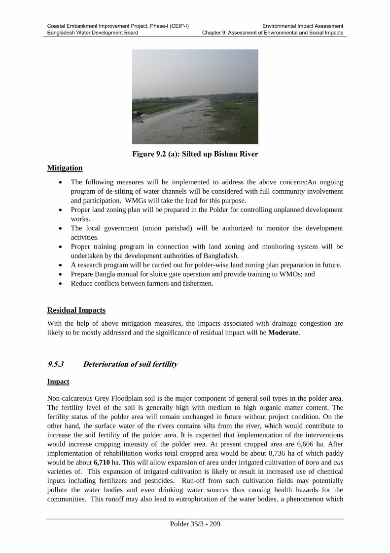
Coastal Embankment Improvement Project, Phase-I (CEIP-I) Bangladesh Water Development Board
Environmental Impact Assessment Chapter 9: Assessment of Environmental and Social Impacts
Polder 35/3 - 209
Figure 9.2 (a): Silted up Bishnu River
Mitigation
The following measures will be implemented to address the above concerns:An ongoing
program of de-silting of water channels will be considered with full community involvement
and participation. WMGs will take the lead for this purpose.
Proper land zoning plan will be prepared in the Polder for controlling unplanned development
works.
The local government (union parishad) will be authorized to monitor the development
activities.
Proper training program in connection with land zoning and monitoring system will be
undertaken by the development authorities of Bangladesh.
A research program will be carried out for polder-wise land zoning plan preparation in future.
Prepare Bangla manual for sluice gate operation and provide training to WMOs; and
Reduce conflicts between farmers and fishermen.
Residual Impacts
With the help of above mitigation measures, the impacts associated with drainage congestion are
likely to be mostly addressed and the significance of residual impact will be Moderate.
9.5.3 Deterioration of soil fertility
Impact
Non-calcareous Grey Floodplain soil is the major component of general soil types in the polder area.
The fertility level of the soil is generally high with medium to high organic matter content. The
fertility status of the polder area will remain unchanged in future without project condition. On the
other hand, the surface water of the rivers contains silts from the river, which would contribute to
increase the soil fertility of the polder area. It is expected that implementation of the interventions
would increase cropping intensity of the polder area. At present cropped area are 6,606 ha. After
implementation of rehabilitation works total cropped area would be about 8,736 ha of which paddy
would be about 6,710 ha. This will allow expansion of area under irrigated cultivation of boro and aus
varieties of. This expansion of irrigated cultivation is likely to result in increased use of chemical
inputs including fertilizers and pesticides. Run-off from such cultivation fields may potentially
pollute the water bodies and even drinking water sources thus causing health hazards for the
communities. This runoff may also lead to eutrophication of the water bodies, a phenomenon which

Coastal Embankment Improvement Project, Phase-I (CEIP-I) Bangladesh Water Development Board
Environmental Impact Assessment Chapter 9: Assessment of Environmental and Social Impacts
Polder 35/3 - 210
would decrease the dissolved oxygen in the water and thus negatively affecting the aquatic fauna. The
impacted possible contamination and reduced soil fertility locations are delineated in the Figure 9.1
under the expansion of Boro filed area. The estimated agriculture inputs have been given in the
baseline chapter under section 6.8.10.
The significance of this potential unmitigated impact has been assessed as Major on the basis of
impact magnitude and receptor sensitivity.
Mitigation
A Pest Management Plan will be prepared before the completion of the construction phase of the
project.
Organic manure will be used to increase soil fertility;
Dhaincha and leguminous crops will be cultivated in the polder area;
Farmers group will have close contact with DAE for adoption of various measures of IPM/ICM;
Integrated Pest Management (IPM) and Integrated Crop Management (ICM) will be practiced.
Residual Impacts
With the help of above mitigation measures, the impacts associated with usage of increased level of
chemical inputs are likely to be somewhat addressed and the significance of residual impact will be
Moderate.
9.5.4 Impact of tidal flooding
Impact
The tidal flooding is one of the major problem in coastal zone of Bangladesh, specifically polder 35/3
is facing severe tidal flooding after Aila for the existing breach points of the embankment and low
height of the embankment. This is a localized problem and would be reversible through proper
rehabilitation works, which have been considered in the Feasibility Study. This is a short term
problem for local people. If the proposed implementation works are not implemented immediately,
the problem will be further aggravated severely in the low lying area like Malliker Ber, Mandaria,
Bara Banshbaria, Chak Narashing ( in between ch 1.00 km to 13 km) and Betbonia will be flood.
The significance of this potential unmitigated impact has been assessed as Major on the basis of
impact magnitude and receptor sensitivity.
Mitigation and enhancement
Regular monitoring of seepage of surface waters from Daratana River through the regulators will be
checked during dry seasons and necessary steps will be taken to check seepage, if any. Afforestation
program will be taken at both side of the embankment, which will help to strengthen the embankment.
Residual Impacts
With the help of above mitigation measures, the impacts associated with tidal inundation are likely to
be adequately addressed and the significance of residual impact will be Low.

Coastal Embankment Improvement Project, Phase-I (CEIP-I) Bangladesh Water Development Board
Environmental Impact Assessment Chapter 9: Assessment of Environmental and Social Impacts
Polder 35/3 - 211
9.5.5 Reduced fish migration
Impact
Construction of new water control structures on water which are currently direct connected with the
outer rivers will potentially affect fish migration in the khals (see Figure 6.15). This can potentially
result in decrease of fish population in the polder.
The significance of this potential unmitigated impact has been assessed as Moderate on the basis of
impact magnitude and receptor sensitivity.
Mitigation
The following measures will be implemented to address the above concerns:
Proper sluice gate operation allowing fish migration.
provide training to WMOs;
Transferring juvenile fish from rivers to Polder.
Residual Impacts
With the help of the above mitigation measures, the impacts on fish habitat and migration are likely to
be adequately addressed and the significance of residual impact will be Low.
9.5.6 Impacts on shrimp farming and livelihood
Imapct
Shrimp farming is a common practice in the polder area. A significant number of farmers are involved
in shrimp farming in this area. It is more profitable than paddy. Shrimp export contributes
significantly to the local and national economic development, employment and income generation as
well as livelihood improvement. Improved drainage system, or protection of saline water intrusion by
embankment and water control structures, the salinity problem will be reduced within the project area.
As a result, rice area would be increased compared to its base condition. On the other hand, shrimp
farm area would be adversely impacted due to reduction in saline prone area and would be reduced to
corresponding shrimp production. It is expected that the livelihood of the shrimp farmers will be
impacted unfavorably no doubt. Many local labours who are exclusively engaged in shrimp farming
will become jobless.
Mitigation
1. Prospective of golda farming should be encouraged through campaigning and by providing
training on improved culture practices as well as rice-cum-golda farming within available
sweet water;
2. Alternative income generation i.e. livestock rearing, poultry and integrated fish culture may
create scope of alternative income for shrimp farm labour;
3. Shrimp farming is not environmentally sound practice. In shripmp farm area, there is no
green environment due to salinity intrusion. But after completion of the CEIP project, people
will be benefitted by different type of by-products like paddy straw, vegetable garden, yard

Coastal Embankment Improvement Project, Phase-I (CEIP-I) Bangladesh Water Development Board
Environmental Impact Assessment Chapter 9: Assessment of Environmental and Social Impacts
Polder 35/3 - 212
garden, poultry and livestock and finally food security from their crop fields. So it may ensure
the proper extension service as well as proper training for betterment of life and livelihood;
4. Shrimp farming is suitable and profitable for only rich farmer but not for landless people,
marginal and small farmer. Considering poverty reduction the proposed CEIP project will be
very helpful for landless people, marginal and small farmer as a whole.
9.6 Positive Impact of the Project
9.6.1 Employment Generation
The construction work will generate a significant amount of employment over its construction period
to local people and other associated professionals. People will also be involved to carry put operation
and maintenance related jobs to operate the hydraulic structures. It is expected the agriculture
production will be increased, water logging will be decreased due to the project which will create jobs
indirectly from agriculture, business and commercial services.
9.6.2 Gender Promotion
Construction work requires various types of skilled and unskilled labors. It is found that in
Bangladesh a portion of construction labors are female. These females are vulnerable to natural
disaster and mostly distressed and widow who are dependent on others and do not have any definite
source of income. Therefore, employment access to them in the construction works and during
operation/maintenance phase is significantly positive.
9.6.3 Livelihood Development
The project is expected to increase resilience of people within Polder 35/3. Agriculture production
increase, reduction of drainage congestion, income generation is expected to improve the livelihood of
the people.
9.6.4 Affroestation
The project will promote afforestation which is expected to largely mitigate the negative impact
associated with felling off the trees. However the impact is expected to be positive in the long run.
9.6.5 EMP Promotion
The project has in built component which will facilitate implantation of Environmental Management
Plan. Under the project, the capacity building for environmental management of BWDB and WMO
will be performed. The project is expected to have long term positive impact on institutional
development of BWDB and WMO for ensuring environmental sustainability.
9.7 Summary of Assessed Impacts
A summary of these impacts and their significance discussed in the sections above is presented in
Table 9.9.

Coastal Embankment Improvement Project, Phase-I (CEIP-I) Bangladesh Water Development Board
Environmental Impact Assessment Chapter 9: Assessment of Environmental and Social Impacts
Polder 35/3 - 213
Table 9.9: Significance of environmental Impacts
Potential Impacts
Temporal
Aspects
Spatial
Aspects Reversibility Likelihood Sensitivity
Significance
(Unmitigated) Mitigation Measures
Residual
Impact (See Table 2.1)
(Table
2.2) (Table 2.3)
A. Pre-construction Phase
Conflicts because
of absence of
proper land
ownership legal
document
Long term Local Irreversible Certain High Major RAP to be prepared
Compensation to be paid
prior to construction in
accordance with RAP
Maintain liaison with
communities.
Grievance redress
mechanism (GRM) in
place
Moderate
Increased traffic
volume for
contractor
mobilization
Short term
Local Reversible
(after
construction
phase)
Certain Medium to
high
Moderate to
major
Contractor to prepare and
implement mobilization
plan.
Liaise with local
communities and
concerned authorities
Ensure minimal hindrance
to local communities and
commuters.
Changes in land
use : preparation of
construction
facilities, borrow
areas, others
Short term Local Reversible
(after
construction
phase)
Certain Medium
to high
Moderate to
major
Establish all these
facilities within the area
owned by BWDB
Pay compensation/rent if
private property is
acquired on temporary
Low

Coastal Embankment Improvement Project, Phase-I (CEIP-I) Bangladesh Water Development Board
Environmental Impact Assessment Chapter 9: Assessment of Environmental and Social Impacts
Polder 35/3 - 214
Potential Impacts
Temporal
Aspects
Spatial
Aspects Reversibility Likelihood Sensitivity
Significance
(Unmitigated) Mitigation Measures
Residual
Impact (See Table 2.1)
(Table
2.2) (Table 2.3)
basis
Consult communities
Avoid impacts on
communities.
B. Construction Phase
Air quality
deterioration (dust,
combustion gases)
Short term Local Reversible
(after
construction
phase)
Certain Medium
to high
Moderate Exhaust emissions from
vehicles and equipment to
comply with standards
Proper tuning of vehicles,
generators, and equipment
Covering construction
material (sand/soil) while
transporting and stock
piled.
Water sprinkling where
needed
Speed limits for vehicles
on earthen tracks
Turn off engine when idle
Use of good quality fuel
Locate camps at a safe
distance from
communities.
Liaison with the
communities will be
maintained and grievance
Low

Coastal Embankment Improvement Project, Phase-I (CEIP-I) Bangladesh Water Development Board
Environmental Impact Assessment Chapter 9: Assessment of Environmental and Social Impacts
Polder 35/3 - 215
Potential Impacts
Temporal
Aspects
Spatial
Aspects Reversibility Likelihood Sensitivity
Significance
(Unmitigated) Mitigation Measures
Residual
Impact (See Table 2.1)
(Table
2.2) (Table 2.3)
redress mechanism will be
established at the site.
Noise and vibration Short term Local Reversible
(after
construction
phase)
Certain Medium to
high
Moderate Restricting/limiting timing
of construction activities
Noise levels from
vehicles, equipment and
machinery to comply with
national and WB noise
standards.
Vehicles and machinery to
have proper mufflers and
silencers
Provision of noise barriers
at schools and other
sensitive receptors
Provision of PPE (ear
muffs and plugs) to labor
Instruction for proper use
of equipment
Liaison with community
Locate camps at a safe
distance from
communities.
Low
Increased traffic
load in water way
Short term Local Reversible
(after
construction
Certain Medium to
high
Moderate Contractor to prepare and
implement traffic
management plan
Low
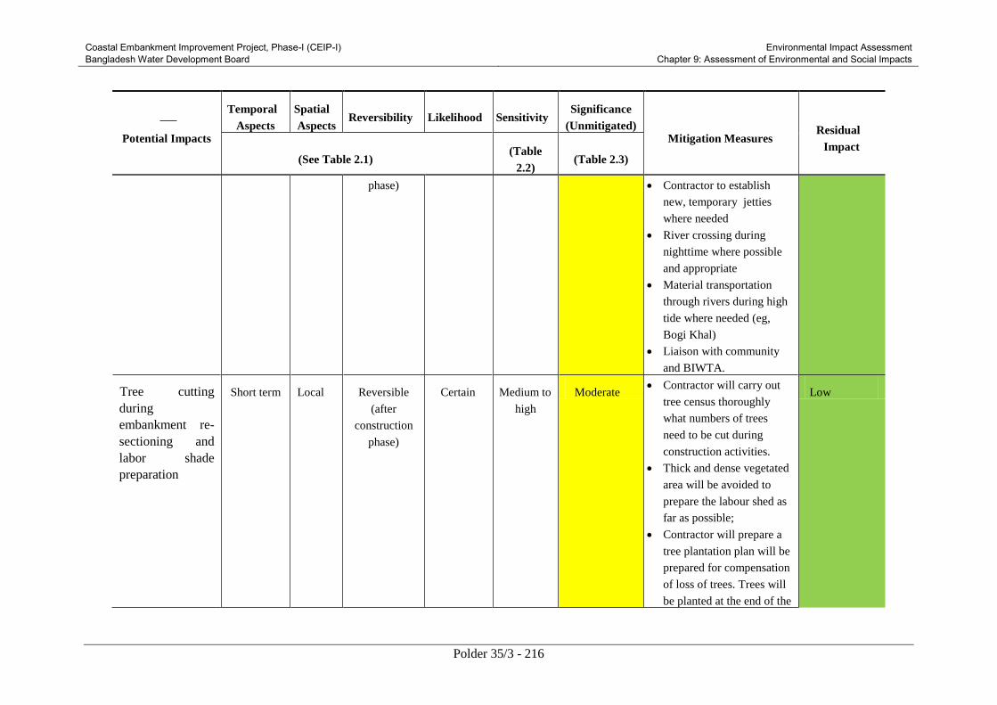
Coastal Embankment Improvement Project, Phase-I (CEIP-I) Bangladesh Water Development Board
Environmental Impact Assessment Chapter 9: Assessment of Environmental and Social Impacts
Polder 35/3 - 216
Potential Impacts
Temporal
Aspects
Spatial
Aspects Reversibility Likelihood Sensitivity
Significance
(Unmitigated) Mitigation Measures
Residual
Impact (See Table 2.1)
(Table
2.2) (Table 2.3)
phase) Contractor to establish
new, temporary jetties
where needed
River crossing during
nighttime where possible
and appropriate
Material transportation
through rivers during high
tide where needed (eg,
Bogi Khal)
Liaison with community
and BIWTA.
Tree cutting
during
embankment re-
sectioning and
labor shade
preparation
Short term Local Reversible
(after
construction
phase)
Certain Medium to
high
Moderate Contractor will carry out
tree census thoroughly
what numbers of trees
need to be cut during
construction activities.
Thick and dense vegetated
area will be avoided to
prepare the labour shed as
far as possible;
Contractor will prepare a
tree plantation plan will be
prepared for compensation
of loss of trees. Trees will
be planted at the end of the
Low

Coastal Embankment Improvement Project, Phase-I (CEIP-I) Bangladesh Water Development Board
Environmental Impact Assessment Chapter 9: Assessment of Environmental and Social Impacts
Polder 35/3 - 217
Potential Impacts
Temporal
Aspects
Spatial
Aspects Reversibility Likelihood Sensitivity
Significance
(Unmitigated) Mitigation Measures
Residual
Impact (See Table 2.1)
(Table
2.2) (Table 2.3)
construction period during
wet season. It is
recommended to establish
a nursery with selected
tree species (Geoa, Kewra
and Babla) in the
beginning of the project in
order to reduce the
purchasing cost of
saplings. All saplings will
be planted and monitored
according to section 4.5.6
under project description
chapter;
Contractor will avoid
dumping of spoil earth in
and material borrowing
from vegetated areas;
Soil and water
contamination:
large volume of
construction
wastes, leakage,
spillage of oil from
vessels and engine
boat, camp wastes,
Short term Local Reversible
(after
construction
phase)
Certain High Major Contractor to prepare and
implement pollution
control plan
Oil separators/sumps for
workshops
Avoid repairing vehicles
and machinery in the field
Use plastic sheet or gravel
Low

Coastal Embankment Improvement Project, Phase-I (CEIP-I) Bangladesh Water Development Board
Environmental Impact Assessment Chapter 9: Assessment of Environmental and Social Impacts
Polder 35/3 - 218
Potential Impacts
Temporal
Aspects
Spatial
Aspects Reversibility Likelihood Sensitivity
Significance
(Unmitigated) Mitigation Measures
Residual
Impact (See Table 2.1)
(Table
2.2) (Table 2.3)
disposal of
demolition
material, spoil, and
excavated silt
in the workshop and
equipment yard
Dispose contaminated soil
appropriately ensuring that
it does not contaminate
water bodies or affect
drinking water sources
Contractor will ensure that
there is no leakage or
release of fuel, oil or any
other affluent/waste in the
water
Locating camps away
from communities and
drinking water sources
Preparing and
implementing camp waste
management plan (septic
tanks, proper solid waste
disposal);
Do not release untreated
wastes on ground or in
water
Re-use spoil and
excavated material where
possible

Coastal Embankment Improvement Project, Phase-I (CEIP-I) Bangladesh Water Development Board
Environmental Impact Assessment Chapter 9: Assessment of Environmental and Social Impacts
Polder 35/3 - 219
Potential Impacts
Temporal
Aspects
Spatial
Aspects Reversibility Likelihood Sensitivity
Significance
(Unmitigated) Mitigation Measures
Residual
Impact (See Table 2.1)
(Table
2.2) (Table 2.3)
Disposal of spoil at
designated areas with
community consent
Construction material and
excavated soil/silt will not
be allowed to enter water
bodies.
Drainage
contestation/water
logging
Short term Local Reversible Occasiona
l
Medium
to high
Moderate Constructing bypass canal
during construction of all
regulators
Ensuring that drainage
channels are not
obstructed or clogged
No water ponding near
cultivation fields
Avoid works during rain;
Avoid works during high
tide.
Low
Loss of agriculture Short term Local Reversible Likely Medium Moderate Compensation to be paid
for any crop damage
Avoiding agricultural land
for labor camps
Avoiding cultivation fields
during construction
No vehicular movements
inside cultivation fields
Low

Coastal Embankment Improvement Project, Phase-I (CEIP-I) Bangladesh Water Development Board
Environmental Impact Assessment Chapter 9: Assessment of Environmental and Social Impacts
Polder 35/3 - 220
Potential Impacts
Temporal
Aspects
Spatial
Aspects Reversibility Likelihood Sensitivity
Significance
(Unmitigated) Mitigation Measures
Residual
Impact (See Table 2.1)
(Table
2.2) (Table 2.3)
No material dumping
inside cultivation fields
Maintain liaison with
communities.
Affects on
irrigation
Short term Local Reversible Likely High Major Constructing bypass canal
during construction of all
regulators
Proper sequencing of
works on regulators and
sluices
Ensuring no negative
impacts on crop irrigation
Maintain liaison with
communities.
Low
Hindrance of fish
migration
Short term Local Reversible Likely Moderate Moderate Constructing bypass canal
during construction of all
regulators
Proper sequencing of
works on regulators and
sluices;
During monsoon runoff
will be diverted to
adjacent depressions and
from there to river after
settling
Transferring fish from
Low

Coastal Embankment Improvement Project, Phase-I (CEIP-I) Bangladesh Water Development Board
Environmental Impact Assessment Chapter 9: Assessment of Environmental and Social Impacts
Polder 35/3 - 221
Potential Impacts
Temporal
Aspects
Spatial
Aspects Reversibility Likelihood Sensitivity
Significance
(Unmitigated) Mitigation Measures
Residual
Impact (See Table 2.1)
(Table
2.2) (Table 2.3)
rivers to Polder water
channels where
appropriate.
Maintain liaison with
communities.
Affects on benthic
communities
Short term Local Reversible (in
medium to
long term)
Likely Medium Moderate Do not release untreated
wastes on soil or in water.
Carry out khal excavation
in segment thus
minimizing impacts on
benthic fauna.
Low to
medium
Damage /
disturbance to flora
and faunal
resources
Short term Local Reversible Likely Medium Moderate No material to be
borrowed from faunal
habitat areas
Avoid dumping of spoil
earth in faunal habitat
areas
Do not release untreated
wastes on soil or in water
Labor not to indulge in
hunting, trapping, or
shooting wild animals.
Carry out compensatory
tree plantation for tree
felling
Avoid dumping of spoil
Negligible

Coastal Embankment Improvement Project, Phase-I (CEIP-I) Bangladesh Water Development Board
Environmental Impact Assessment Chapter 9: Assessment of Environmental and Social Impacts
Polder 35/3 - 222
Potential Impacts
Temporal
Aspects
Spatial
Aspects Reversibility Likelihood Sensitivity
Significance
(Unmitigated) Mitigation Measures
Residual
Impact (See Table 2.1)
(Table
2.2) (Table 2.3)
earth in vegetated areas;
Enhance flora
environment by planting
fruit trees and mangrove
plants;
Use grasses to assist slope
and soil stability.
Damage to floral
resources
Short term Local Reversible (in
medium to
long term)
Likely Medium Moderate Carry out compensatory
tree plantation for tree
felling
Avoid dumping of spoil
earth in vegetated areas;
Enhance flora
environment by planting
fruit trees and mangrove
plants;
Use grasses to assist slope
and soil stability.
No material to be
borrowed from and no
waste to be disposed in
Sundarban.
Negligible
Hindrance for
Pedestrian and
Vehicle Movement
Short term Local Reversible Likely Medium Moderate The works on
embankment will be
carefully scheduled to
minimize impact on local
Low

Coastal Embankment Improvement Project, Phase-I (CEIP-I) Bangladesh Water Development Board
Environmental Impact Assessment Chapter 9: Assessment of Environmental and Social Impacts
Polder 35/3 - 223
Potential Impacts
Temporal
Aspects
Spatial
Aspects Reversibility Likelihood Sensitivity
Significance
(Unmitigated) Mitigation Measures
Residual
Impact (See Table 2.1)
(Table
2.2) (Table 2.3)
markets and transportation
routes.
The embankment works
will be carried out in
segments and soil will be
placed linearly on half of
the embankment, leaving
the other half to be used as
track. When the works are
completed on the first half,
it will be opened for local
traffic while works will be
undertaken on the other
half of the embankment.
Work schedule will be
finalized in coordination
and consultation with local
representatives and
communities.
Local routes will not be
blocked as much as
possible. If unavoidable,
alternative routes will be
identified in consultation
with local community
GRM will be put in place.

Coastal Embankment Improvement Project, Phase-I (CEIP-I) Bangladesh Water Development Board
Environmental Impact Assessment Chapter 9: Assessment of Environmental and Social Impacts
Polder 35/3 - 224
Potential Impacts
Temporal
Aspects
Spatial
Aspects Reversibility Likelihood Sensitivity
Significance
(Unmitigated) Mitigation Measures
Residual
Impact (See Table 2.1)
(Table
2.2) (Table 2.3)
Safety and Public
Health Hazards
Short term Local Reversible Likely High Major Liaison will be established
with the Bangladesh
Meteorological
Department for early
warning of storms and
cyclones. Radio and
television sets will be kept
in all the labor camps for
obtaining weather
information.
Each contractor will
establish a comprehensive
Health and Safety Plan
aimed at preventing
accidents, injuries and
work-related diseases.
This plan will be
submitted to BWDB and
World Bank for review
and approval;
Each contractor will
prepare an Emergency
Response Plan defining
procedures to be followed
during any emergency.
This plan will be
Moderate

Coastal Embankment Improvement Project, Phase-I (CEIP-I) Bangladesh Water Development Board
Environmental Impact Assessment Chapter 9: Assessment of Environmental and Social Impacts
Polder 35/3 - 225
Potential Impacts
Temporal
Aspects
Spatial
Aspects Reversibility Likelihood Sensitivity
Significance
(Unmitigated) Mitigation Measures
Residual
Impact (See Table 2.1)
(Table
2.2) (Table 2.3)
submitted to BWDB and
World Bank for review
and approval;
All workers must be
provided with and use
appropriate Personal
Protective Equipment
(PPE). First aid must be
provided and there would
be procedures in place to
access appropriate
emergency facilities;
Health screening of
employees would be a
Contractor obligation prior
to laborers working on site
and living in the
temporary accommodation
facilities. The health
screening would entail
normal review of physical
fitness and also include a
review of appropriate
vaccinations. Workers
would be given
vaccinations where

Coastal Embankment Improvement Project, Phase-I (CEIP-I) Bangladesh Water Development Board
Environmental Impact Assessment Chapter 9: Assessment of Environmental and Social Impacts
Polder 35/3 - 226
Potential Impacts
Temporal
Aspects
Spatial
Aspects Reversibility Likelihood Sensitivity
Significance
(Unmitigated) Mitigation Measures
Residual
Impact (See Table 2.1)
(Table
2.2) (Table 2.3)
required;
Hazards require staff
training. All employees
need to carry out induction
health and safety training
prior to commencement of
work. OHS issues would
be part of the employee
training plan. Training
would include the
provision of appropriate
written or visual materials
to reinforce learning.
Where illiteracy levels are
high, OHS issues need to
be covered more
frequently than normal in
toolbox talks;
Public awareness training
and workshops on safety
and health risks will be
conducted for local
communities prior to and
during construction
operations.
Observing statutory

Coastal Embankment Improvement Project, Phase-I (CEIP-I) Bangladesh Water Development Board
Environmental Impact Assessment Chapter 9: Assessment of Environmental and Social Impacts
Polder 35/3 - 227
Potential Impacts
Temporal
Aspects
Spatial
Aspects Reversibility Likelihood Sensitivity
Significance
(Unmitigated) Mitigation Measures
Residual
Impact (See Table 2.1)
(Table
2.2) (Table 2.3)
requirements relating to
minimum age for
employment of children
and meeting international
standards of not
employing any persons
under the age of 16 for
general work and no
persons under the age of
18 for work involving
hazardous activity. The
construction contractor(s)
would not hire people
under the age of 18 on
permanent contracts but
would include short
training activities for
youth to the extent
possible;
Ensuring acceptable
conditions of work
including observing
national statutory
requirements related to
minimum wages and hours
of work;

Coastal Embankment Improvement Project, Phase-I (CEIP-I) Bangladesh Water Development Board
Environmental Impact Assessment Chapter 9: Assessment of Environmental and Social Impacts
Polder 35/3 - 228
Potential Impacts
Temporal
Aspects
Spatial
Aspects Reversibility Likelihood Sensitivity
Significance
(Unmitigated) Mitigation Measures
Residual
Impact (See Table 2.1)
(Table
2.2) (Table 2.3)
Ensuring no workers are
charged fees to gain
employment on the
Project;
Ensuring rigorous
standards for occupational
health and safety are in
place;
Contractor will establish a
labor grievance
mechanism and
documenting its use for
complaints about unfair
treatment or unsafe living
or working conditions
without reprisal.
The contractor will adopt a
Human Resource Policy
appropriate to the size and
workforce which indicates
the approach for
management employees
(this could be part
requested in the tender
process);
Produce job descriptions

Coastal Embankment Improvement Project, Phase-I (CEIP-I) Bangladesh Water Development Board
Environmental Impact Assessment Chapter 9: Assessment of Environmental and Social Impacts
Polder 35/3 - 229
Potential Impacts
Temporal
Aspects
Spatial
Aspects Reversibility Likelihood Sensitivity
Significance
(Unmitigated) Mitigation Measures
Residual
Impact (See Table 2.1)
(Table
2.2) (Table 2.3)
and provide written
contracts and other
information that outline
the working conditions
and terms of employment,
including the full range of
benefits;
Provide health insurance
for employees for the
duration of their contracts;
Provide insurance for
accidents resulting in
disabilities or death of
employees for the duration
of their contracts;
Develop a recruitment
process community
employees that involves
local authorities in clearly
understood procedures;
Employ a community
liaison officer (this could
be full time or part of
another post’s
responsibilities);
Raise awareness prior to

Coastal Embankment Improvement Project, Phase-I (CEIP-I) Bangladesh Water Development Board
Environmental Impact Assessment Chapter 9: Assessment of Environmental and Social Impacts
Polder 35/3 - 230
Potential Impacts
Temporal
Aspects
Spatial
Aspects Reversibility Likelihood Sensitivity
Significance
(Unmitigated) Mitigation Measures
Residual
Impact (See Table 2.1)
(Table
2.2) (Table 2.3)
recruitment, clarifying the
local hire policy and
procedures, including
identification of
opportunities for women
to participate in
employment and training;
Report regularly on the
labor force profile,
including gender, and
location source of
workers;
Report regularly on labor
and working condition key
performance indicators,
for instance hours worked
(regular and overtime)
during period and
cumulatively, hours lost,
number and type of
accidents, near misses, site
audits and meetings;
trainings, and use of labor
grievance mechanism;
Hold toolbox talks on
workers’ rights and the

Coastal Embankment Improvement Project, Phase-I (CEIP-I) Bangladesh Water Development Board
Environmental Impact Assessment Chapter 9: Assessment of Environmental and Social Impacts
Polder 35/3 - 231
Potential Impacts
Temporal
Aspects
Spatial
Aspects Reversibility Likelihood Sensitivity
Significance
(Unmitigated) Mitigation Measures
Residual
Impact (See Table 2.1)
(Table
2.2) (Table 2.3)
labor grievance
mechanisms during the
construction phase;
Organize a training
program and keep training
registers for construction
workers;
Establish Occupational
Health and Safety (OHS)
procedures in the overall
environmental
management system which
provide workers with a
safe and healthy work
environment taking into
account the inherent risks
for this type of project.
Local labour vs
outsider labour
conflict
Short term Local Reversible Likely Medium Moderate Proper awareness
programs will be
conducted through public
consultation measures
such as village scoping
sessions, meetings, and
placement of bill boards
with assistance from the
Union Parishad Chairman,
Low

Coastal Embankment Improvement Project, Phase-I (CEIP-I) Bangladesh Water Development Board
Environmental Impact Assessment Chapter 9: Assessment of Environmental and Social Impacts
Polder 35/3 - 232
Potential Impacts
Temporal
Aspects
Spatial
Aspects Reversibility Likelihood Sensitivity
Significance
(Unmitigated) Mitigation Measures
Residual
Impact (See Table 2.1)
(Table
2.2) (Table 2.3)
Upazila Nirbahi Officer
(UNO) and BWDB local
officers.
Cultural norms of the local
community will be
respected and honored.
GRM will be established
address the grievances of
local as well as outside
laborers.
Careful use of local
natural resources and
project resources, fuel,
fuel-wood and electricity;
Restrictions related to
consumption of alcohol
and drugs;
Safe driving practices;
Respect for the local
community and its cultural
norms in which laborers
are working.
Avoiding construction
activities during Prayer
time.
Damage to Short term Local Reversible Likely Medium Moderate The condition of the
Low

Coastal Embankment Improvement Project, Phase-I (CEIP-I) Bangladesh Water Development Board
Environmental Impact Assessment Chapter 9: Assessment of Environmental and Social Impacts
Polder 35/3 - 233
Potential Impacts
Temporal
Aspects
Spatial
Aspects Reversibility Likelihood Sensitivity
Significance
(Unmitigated) Mitigation Measures
Residual
Impact (See Table 2.1)
(Table
2.2) (Table 2.3)
infrastructure infrastructure being used
for the construction and
transportation activities
will be regularly
monitored.
All damaged infrastructure
will be restored to original
or better condition.
C. Post Construction Phase
Risk of
embankment failure
Long term Local Reversible unlikely High Major Regular repair and
maintenance of
embankment and
regulators.
Low
Drainage congestion
and increased
sedimentation in
khals and rivers
Long term Local Reversible Likely High Major Provide water shed
management training to
WMOs
Prepare Bangla manual for
sluice gate operation and
provide training to
WMOs; and
Reduce conflicts between
farmers and fishermen.
Program for on-going de-
silting of water channels.
Implement small scale
tidal river management
Moderate
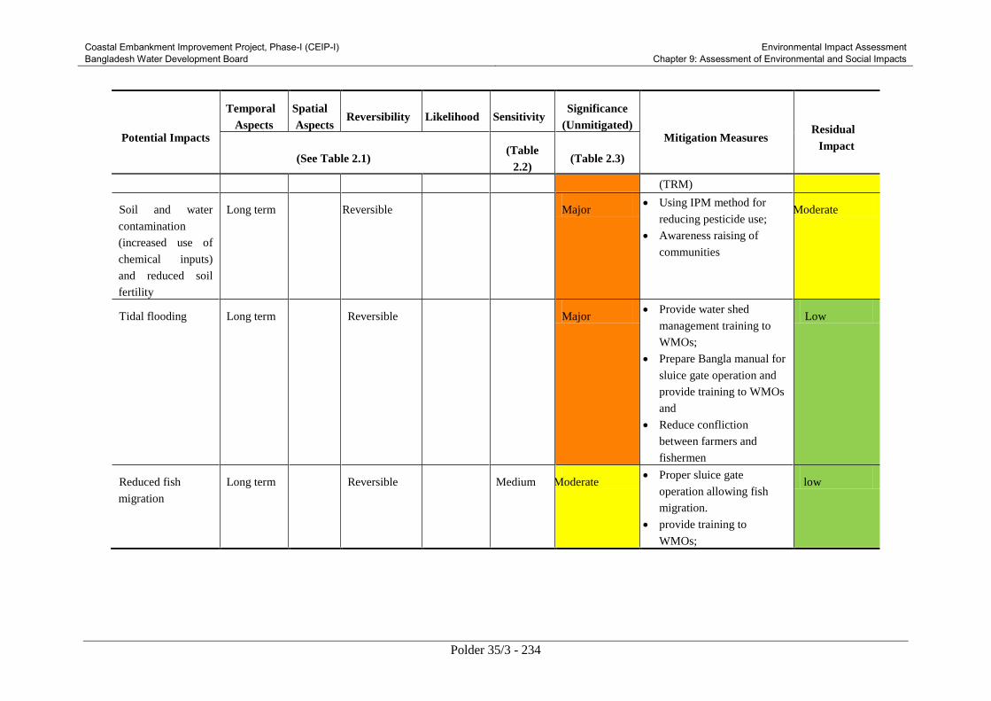
Coastal Embankment Improvement Project, Phase-I (CEIP-I) Bangladesh Water Development Board
Environmental Impact Assessment Chapter 9: Assessment of Environmental and Social Impacts
Polder 35/3 - 234
Potential Impacts
Temporal
Aspects
Spatial
Aspects Reversibility Likelihood Sensitivity
Significance
(Unmitigated) Mitigation Measures
Residual
Impact (See Table 2.1)
(Table
2.2) (Table 2.3)
(TRM)
Soil and water
contamination
(increased use of
chemical inputs)
and reduced soil
fertility
Long term Local Reversible Likely High Major Using IPM method for
reducing pesticide use;
Awareness raising of
communities
Moderate
Tidal flooding Long term Local Reversible Likely High Major Provide water shed
management training to
WMOs;
Prepare Bangla manual for
sluice gate operation and
provide training to WMOs
and
Reduce confliction
between farmers and
fishermen
Low
Reduced fish
migration
Long term Local Reversible Likely Medium Moderate Proper sluice gate
operation allowing fish
migration.
provide training to
WMOs;
low

Coastal Embankment Improvement Project, Phase-I (CEIP-I) Bangladesh Water Development Board
Environmental Impact Assessment Chapter 9: Assessment of Environmental and Social Impacts
Polder 35/3 - 235

Coastal Embankment Improvement Project, Phase-I (CEIP-I) Bangladesh Water Development Board
Environmental Impact Assessment Chapter 10: Cumulative and Induced Impact
Polder 35/3 - 236
10. Cumulative and Induced Impact
This Chapter attempts to present analysis of cumulative impacts of the proposed Project and other
projects in the area. In addition, induced impacts are also covered in the chapter.
10.1 Cumulative Impacts of CEIP interventions
As shown in Figure 10.1, Polder 35/3 is surrounded by a number of rivers and lakes/khals. There is
Putimari River on the north, Daratana River on the east, Katakhali khal on the south and Bishnu river
on the west. Figure 12.1 shows the location of the Polder along with the surrounding polders. The
polder has hydrological connections with Polder 35/3 under CEIP-I. The other polders under CEIP-I
are located far from this polder and therefore the cumulative effects of these other polders on Polder
35/3 are not foreseeable.
Polder 35/3 is located downstream of the Poylahara river (Poylahara river is generated from the
converging point of Daratana river and Katakhali khal, the two peripheral rivers of Polder 35/3).
When sea water enters through Baleswar river during dry periods or due to tidal flow or rise in
cyclonic surge, water would not be able to enter Polder 35/3 because of its high crest level. The
diverted water would partly move on the upstream of Baleswar river to affect Polder 39/1. While a
significant portion of river water would affect Polder 35/3. The embankments may be damaged;
water may overtop the embankment and cause flooding during monsoon or due to rise in surge height.
Infrastructural damage may be caused due to flooding of Polder 35/3.
The polder 35/3 is located in the south direction of polder 34/3 under CEIP (Figure 10.1). The
feasibility studies have been completed for polder 34/3 and the construction activities are to be
initiated later on under a different phase (after the implementation of CEIP in Polders 32, 33, 35/3,
35/3, and 39/2C). The existing crest level of polder 34/3 is low (4.27m above sea level), and in many
locations the embankment crest has even merged with the ground. As the construction procedures for
Polder 34/3 is not in consideration under CEIP-I, no cumulative impacts are considered from Polder
34/3 for the time being.
10.2 Other projects around polder 35/3
Apart from CEIP, there are some other development projects implemented by the Government of
Bangladesh (GoB) and a number of Non Government Organizations (NGOs) at or near polder 35/3.
The activities of these projects may generate cumulative impacts on the polder. Table 10.1 and Table
10.2 show lists of various projects undertaken by the GoB and NGOs frequently in the districts of
Bagerhat and Khulna.

Coastal Embankment Improvement Project, Phase-I (CEIP-I) Bangladesh Water Development Board
Environmental Impact Assessment Chapter 10: Cumulative and Induced Impact
Polder 35/3 - 237
Figure 10.1: Locations of polders under CEIP-I
Table 10.1: List of other projects implemented by the GoB
Agency Project Name Duration Location
DMB, BWDB,
FAO, LGED
Emergency 2007 Cyclone Recovery and
Restoration Project (ECRRP)
2008-
ongoing
Pirojpur, Barguna,
Barisal, Bagerhat,
Bhola, Khulna etc.
BWDB Protection from Saline Water at Nazirpur and
its Surrounding Areas
1994-
2004
Pirojpur, Bagerhat
LGED Flood Rehabilitation Project in the Area of
Rural Development Project-18 (Greater
Khulna, Jessore and Kushtia District)
2000-
2003
Khulna, Satkhira,
Bagerhat
Greater Khulna District Infrastructure
Development Project
2000-
2004
Khulna, Satkhira,
Bagerhat
DoF Extension of Culture Technology of Marine
Shrimp
1997-
2004
Khulna, Bagerhat,
Satkhira & Cox’s
Bazar
RHD Development of Signboard-Morelganj-
Rayenda-Sharankhola Road
Bagerhat
BEPZA Mongla EPZ (Phase-1) 1998-
2004
Khulna
KCC Solid Waste Disposal and Environmental
Improvement in Khulna City Corporation
1996-
2004
Khulna
SUNDARBANS
LEGENDS
Detailed Design (5 Polders)
Feasibility Level Design (12 Polders)
Polders under ECRRP
Others Polder
Planned but implemented

Coastal Embankment Improvement Project, Phase-I (CEIP-I) Bangladesh Water Development Board
Environmental Impact Assessment Chapter 10: Cumulative and Induced Impact
Polder 35/3 - 238
Table 10.2: List of projects implemented by the NGOs
Agency Project Name Duration Location
WRDS Dissemination and standardization of
hydroponics (floating garden) in waterlogged
areas as an adaptation to the impact of
climate change
2003-
2005
Gopalganj, Bagerhat,
Jessore
RIC Sundarbans Biodiversity Conservation
Project
2000-
2004
Pirojpur
CDP CDP-CARE RVCC Partnership Project:
Collection and Dissemination of Information
on Climate Change in South West
Bangladesh: Development of Central
Information Centre (CIC)
2003-
2005
Bagerhat, Khulna,
Satkhira, Jessore,
Narail and Gopalganj
CCEC Sundarban Conservation through Crab
Fattening
2002-
2003
Khulna
10.3 Cumulative Impacts of other projects in the study area
Due to the implementation of various large or small scale projects in the study area, a few cumulative
impacts are generated in Polder 35/3. These impacts may be direct or indirect, major or minor in the
context of Polder 35/3, but the consequences of such impacts need to be investigated. The cumulative
impacts found in polder 35/3 for different projects are discussed below:
a) Emergency 2007 Cyclone Recovery and Restoration Project (ECRRP)
For facilitating recovery from damage to livelihoods and infrastructure caused by Cyclone Sidr and to
build long-term preparedness through strengthened disaster risk management, the GoB implemented
the “Emergency 2007 Cyclone Recovery and Restoration Project (ECRRP)” in a total number of 13
districts (Barguna, Bagerhat, Barisal, Khulna, Bhola, pirojpur, Jhalokati, Noakhali, Feni, Chittagong,
potualkhali, Sathkhira, Laksmipur) of Bangladesh.
However, the locations of the polder under ECRRP are relatively far from Polder 35/3. The most
nearby polder under ECRRP is Polder 39/1C, which is located about 30 kilometers downstream from
Polder 35/3 (along the left bank of Baleswar River). The social consultations made with the local
people and stake holders revealed that the development of polder 39/1C does not generate any notable
cumulative impact in Polder 35/3.
b) Other GoB projects
Apart from ECRRP and CEIP there are other projects undertaken by the GoB at or near the study area
(Table 9.1). There are foreseeable impacts generated by such projects into polder 35/3.
To provide protection from salinity intrusion in Nazirpur, BWDB implemented a project naming
“Protection from Saline Water at Nazirpur and its Surrounding Areas” from 1994 to 2004. This
project still causes hydrological influence in polder 35/3. The social consultations made with local
people revealed that the flow of Daratana and Bishnu rivers is marginally influenced (in terms of flow
velocity and other flow parameters) due to the salinity protection project implemented in Nazirpur. In
recent years, flow has increased in the Daratana and Bishnu rivers.
There is a flood rehabilitation project implemented by LGED, at local level in Khulna, Satkhira,
Bagerhat districts. The project improved the local scenario with a few social impacts in polder 35/3.

Coastal Embankment Improvement Project, Phase-I (CEIP-I) Bangladesh Water Development Board
Environmental Impact Assessment Chapter 10: Cumulative and Induced Impact
Polder 35/3 - 239
The effective implementation of the project ensured development, and hence many people from
polder 35/3 preferred such developed places of Khulna, Sathkhira, Bagerhat for employment. LGED
also implemented an infrastructure development project during 2000-2004 which eventually improved
the communication system, thus affecting the overall socio-economy.
In 1998, Bangladesh Forest Department (BFD) extended the culture technology of marine shrimp on
macro scale in Khulna, Bagerhat, Sathkhira and Cox’s bazaar. The project continued upto 2004,
seeing viral attacks (of white spot syndrome virus, taura syndrome virus, and infectious hypodermal
and haematopoietic necrosis virus) on shrimps in the later stages of the project implementation.
However, the popularity of shrimp culture spread in local level. At present, shrimp culture in polder
35/3 during dry season is a very common practice. The culture of shrimp is not labor intensive, thus
creates more unemployment. In the dry season, a number of places in the embankment were cut down
to allow the entry of saline water; this reduced the strength of the embankment by creating weak
points. One notable positive impact of shrimp culture in polder 35/3 is that it ensured overall socio-
economic development of the area.
Another project that affects the polder is the “Development of signboard-rayenda-sharankhola road”,
a project implemented by the Roads and Highways Division (RHD). This road will aid in the
improvements in the communication system of Bagerhat. The people living in Polder 35/3 would find
it convenient to travel to Rayenda, Sarankhola (of Polder 35/3). Hence the socio-economic
development would be enhanced.
The Mongla EPZ, Phase-1 project completed in 2004 and the cumulative impacts it presently
generates are negligible. The Khulna City Corporation (KCC) implemented the “Solid waste disposal
and environmental improvement” project in 1996-2004. This project improved the surrounding
environment, as the disposal of waste does not affect Sundarbans as the way it used to do before. The
quality and navigability of Katakhali khal have seen significant improvements due to the
implementation of the project by KCC.
c) NGO projects
In recent times, there are few projects implemented in Bagerhat by several NGOs. Most of these
projects are awareness building projects. CDP implemented an awareness building project to
disseminate information on climate change in the southwest region of Bangladesh. Apart from that, a
number of projects were implemented as a measure of climate change adaptation (crab fatting,
floating garden etc.). These non structural projects have mostly been able to spread awareness against
climate change, biodiversity conservation etc. People of Polder 35/3 have been positively affected to
some extent due to the implementation of such awareness building projects.
10.4 Induced impacts caused by CEIP
In polder 35/3, implementation of interventions may cause minimal effects to a number of
environmental and social components in a longer period. Impacts may also be found in different
locations outside the polder. The following sections provide detailed discussions on a number of
spatially and temporally induced impacts of polder 35/3.
a) Sedimentation
The proposed interventions will safeguard the polder against direct intrusion of tidal water during
high tides or cyclonic hazards. The river water carrying huge amount of sediments will move further
downstream or upstream and may cause siltation in the water bodies outside the polder. Sedimentation
is assumed to be taking place in the surrounding Daratana, Putimari and Bishnu rivers and new

Coastal Embankment Improvement Project, Phase-I (CEIP-I) Bangladesh Water Development Board
Environmental Impact Assessment Chapter 10: Cumulative and Induced Impact
Polder 35/3 - 240
morphological changes may be established outside the polder. Most of the areas near Polder 35/3 are
without polder protection. These areas may severely suffer the consequences of sedimentation in
Bishnu and Daratana river. Raripara, Chomra, Debraj etc. locations of Polder 37 and Banstali,
Dakshin Khanpur etc. locations under Polder 34/2 are would be under heavy threat of being inundated
during monsoon as embankment construction process around these polders are still ongoing.
In addition to the above mentioned aspects, sedimentation in smaller water bodies namely Katakhali
khal, Putimari river may cause regular drainage congestion problems. The navigability of rivers may
further deteriorate over the years. A number of smaller water bodies may be permanently silted up.
The following satellite image (Figure 10.1) shows the locations of Polder 35/3 in the district of
Bagerhat along with the nearby unions (Raripara, Chomra, Debraj, Banstali, Dakshin Khanpur etc.).
Figure 10.2 : Satellite Image polder 35/3
b) Erosion
The blockage of tidal flow into the polder will result the flow of the peripheral rivers (Bishnu and
Daratana rivers in particular) to be diverted further downstream and upstream. This may lead to
erosion on the river banks of the unprotected areas (Parts of Polder 34/2, 35/2 and 37). There will be
severe damage to some parts of Polder 34/3 (Gobardia, Kati, Gomati etc.). Areas with no bank
protection would be more vulnerable to tidal flow. In future, the effects on nearby areas due to erosion
may be severe; a large number of people may lose their residences, the agricultural lands can be
reduced.
c) Drainage congestion
Siltation in the rivers or water bodies outside the polder would cause drainage congestion on a more
frequent basis. The smaller lakes and rivers facing east-west direction i.e. Putimari river, Katakhali
khal etc. would undergo frequent congestion. Especially during low tides, Katakhali khal in the
southern periphery of Polder 35/3 gradually becomes very shallow.

Coastal Embankment Improvement Project, Phase-I (CEIP-I) Bangladesh Water Development Board
Environmental Impact Assessment Chapter 10: Cumulative and Induced Impact
Polder 35/3 - 241
d) Flooding
Tidal water would not be able to enter polder 35/3 during monsoon, as a result the nearby areas which
are not protected will be inundated. Loss of assets of the people living in Raripara, Chomra, Debraj,
Banstali, Dakshin Khanpur etc. unions under Bagerhat district may take place due to flood. The
nearby areas with no or insufficient polder protection will be severely affected to cyclones and other
hazards in future.
Table 10.3 shows the design crest levels of embankments in polder 35/3 and 34/3. In most parts of
Polder 34/3, embankments have damaged severely over the years and at some places, embankments
have even merged with the ground surface. The increased flow of the river would therefore cause
further damage to Polder 34/3.
Table 10.3: Crest level of embankments of a few polders
Polder Number Crest level (mPWD)
35/3 4.5 (design)
34/3 4.27 (existing at some places)
Source: Data collected by CEIP
e) Water quality
The development of the polder would generate increased amount of wastes. The disposal of wastes
would deteriorate the quality of surface water in the nearby water bodies. Pollution will also increase
in the downstream. Furthermore, due to increase in agricultural area, more agriculture practices and
industrialisation are expected. Therefore, water pollution by chemical fertilizer, pesticides and
industrial effluents may increase outside the polder as well.
The polders in the vicinity of polder 35/3 (Polder 34/3, 34/2, 35/2 and 37) will be vulnerable to
salinity intrusion as the river water outside polder 35/3 would be headed up. Therefore, saline water
will enter into the nearby areas from January to April. Due to salinity intrusion for a longer period,
water quality and soil quality may further deteriorate.
f) Food security
The proposed interventions would drive economic development inside the polder. Thus, the polder
area may provide food security to the surrounding areas. In future, polder 35/3 would not only be able
to resist the damage of cyclonic hazards or flooding; but may also provide safety against food crisis
for the probable damaged Polders.
g) Cropping pattern
The implementation of the proposed interventions would increase water availability in the polder
during dry season Boro cropping practice. Therefore, stakeholders will be able to sell their products to
other nearby districts (Pirojpur, Barguna, Barisal, Khulna etc.). Again, the salinity intrusion in other
nearby areas that are not protected by embankments would prevent dry season boro cropping. Areas
that would be subjected to the intrusion of saline water for a longer period will possess high soil
salinity and therefore, such lands would not yield good production and be suitable for agricultural
practice in future.
h) Habitat of flora-fauna
Depth of smaller water bodies outside the polder i.e. Katakhali khal, Putimari river would be reduced
due to increased sedimentation, as well as other factors. Due to reduced depth of surrounding water
bodies, the fish habitat as well as fish production may decrease in future. The terrestrial flora may be
increased where as the aquatic flora and fauna may be decreased significantly.

Coastal Embankment Improvement Project, Phase-I (CEIP-I) Bangladesh Water Development Board
Environmental Impact Assessment Chapter 10: Cumulative and Induced Impact
Polder 35/3 - 242
For improvement of the polder, the risk of inundation might be transferred to nearby unprotected
areas. Therefore tidal flood plain for capture fisheries may increase in that area where as overtopping
chances for culture fisheries pond may be further aggravated.
i) Migration and biodiversity
The siltation in peripheral rivers and canals of polder 35/3 may hamper fish migration. In course of
time, fish migration may be fully obstructed. As a result, the fisheries biodiversity for both fresh and
brackish water may marginally decrease. Due to protection of polder from flood water, huge water
will move towards the Shashikhali Khal, Poylahara river and the upstream and downstream of Darata,
Bishu rivers during high tide. This increased volume of water will enhance fish migration in these
regions. Consequently, fish migration of surrounding canals will be improved. In future, the salinity
tolerant fish species will dominate while fresh water fish species may decrease. Biodiversity of
aquatic life may decrease in the Daratana and Bishnu rivers.
j) Housing condition
The embankment giving protection around the polder area would prevent the intrusion of surface
water during monsoon. As a result, the nearby unprotected areas may be subjected to flooding at
regular intervals. This may eventually deteriorate the housing conditions of the people in nearby areas
(Polders 34/3, 35/2, 34/2 and 37)
k) Land use
The implementation of proposed interventions may indirectly affect the land use of nearby areas. Due
to increased surge created in the larger surrounding rivers (Bishnu and Daratana) Polder 37 and 34/2
and a few other unions of Bagerhat district (Karapara, Satphull etc. locations in the north and Chak
betkanta, Banshbaria etc. locations in the south) would undergo flooding on a more frequent basis.
Agricultural areas may be reduced. However, the increased salinity of surface water during dry season
might encourage local people to culture shrimps. In future, the local residences of the nearby areas
would be affected due to flood and other disasters. More erosion may take place in the river banks
causing significant reduction of lands.
l) Employment opportunities
The development of the polder would create better employment opportunities of local people.
Employment will be properly distributed and in the nearby areas the employment opportunities would
be enhanced as well. In a few years time, due to the development of polder 35/3, new employment
opportunities would also be created. This will encourage people from outside the polder to visit the
polder for work and improve their economic status.
10.5 Conclusion
Most of the cumulative and induced impacts discussed above are found to be marginal during the
assessment made in the study. However, these impacts are important from the context of the project as
implementation of the proposed interventions do not only depend on the scenario of the polder but
also its surroundings. The changes that may be caused by the aforementioned induced and cumulative
impacts need further assessments to be evaluated on a quantitative basis. A detailed study on such
impacts would be needed to provide a more vivid perception.
The cumulative and induced impacts discussed in this chapter have covered the physical impacts
causing infrastructural damage as well as those affecting the people and their property. Many of the
impacts stated above have not been directly harming the interventions under different projects. But
these impacts have caused significant changes either to the overall socio-economy or environment.

Coastal Embankment Improvement Project, Phase-I (CEIP-I) Bangladesh Water Development Board
Environmental Impact Assessment Chapter 10: Cumulative and Induced Impact
Polder 35/3 - 243
While assessing the cumulative impacts, the adjacent areas or Polders have been assessed. The
minimal effects caused by the polders located beyond the adjacent ones could not be analyzed because
of the constraints generated due to limited time frame, information unavailability etc. Therefore,
further studies may be carried out in future on cumulative and induced impacts for the entire study
area to quantify the cumulative and induced impacts if needed. Also for considering the polders
outside the adjacent polders of 35/3, more detailed studies are recommended.

Coastal Embankment Improvement Project, Phase-I (CEIP-I) Bangladesh Water Development Board
Environmental Impact Assessment Chapter 11: Environmental Management Plan
Polder 35/3 - 244
11. Environmental Management Plan
This Chapter presents the Environmental Management Plan (EMP) for the CEIP-I activities in the
Polder 35/3. The EMP essentially provides the implementation mechanism for the environmental and
social mitigation measures discussed in Chapter 9.
11.1 Objectives of EMP
The basic objective of the EMP is to manage, prevent, and mitigate potentially adverse impacts of
Project interventions in the Polder 35/3. The specific objectives of the EMP are to:
Facilitate the implementation of the environmental and social mitigation measures identified
during the present EIA and discussed in Chapter 9.
Assign responsibilities for project proponent, contractors, consultants, and other members of the
Project team for the environmental and social management of the Project;
Define a monitoring mechanism and identify monitoring parameters to ensure effective
implementation of the mitigation measures.
Assess environmental training requirements for different stakeholders at various levels.
Describe communication and documentation requirements.
11.2 EMP Components
The EMP components are listed below:
Institutional Arrangement
Mitigation Measures and Plan
Monitoring Plan
Documentation and reporting
Contractual arrangements for EMP implementation
EMP implementation cost
Capacity building
Grievance redress mechanism
These components are discussed in Sections below.
The EMP should be included in all the bid documents of Polder 35/3 and will become a part of
the civil works contract. The strict implementation of the EMP and project management’s strict
enforcement of the adequate construction practices and standards will greatly reduce the
negative impacts of the Project.

Coastal Embankment Improvement Project, Phase-I (CEIP-I) Bangladesh Water Development Board
Environmental Impact Assessment Chapter 11: Environmental Management Plan
Polder 35/3 - 245
11.3 Institutional Arrangement
Clearly defined and functional institutional arrangements are essential for ensuring effective and
sustainable implementation of the EMP, particularly the mitigation measures identified in the EIA.
The institutional arrangements proposed to implement the EMP of Polder 35/3 are described below.
11.3.1 Overall Responsibility
The overall responsibility of EMP implementation and fulfilling other environmental obligations
during the Project rests with the Project Director (PD). For this purpose, the PD will be supported by
environmental and social staff of the PMU, Design and Construction Supervision Consultants
(DCSC), and contractors.
11.3.2 Construction phase
Environment and Social Staff in PMU
As described in Section 4.8, the BWDB will set up the PMU to manage the Project implementation.
The PMU will be led by the Project Director (PD). To manage and oversee the environmental and
social aspects of the Project, the PMU will have an Environment, Social, and Communication
(ESC)Unit .The Unit will supervise compliance with and implementation of the EMP. The Unit will
include a Senior Environmental Specialist. One environment specialist will be posted at the field level
to support all three divisions. The ESC unit will maintain liaison with WB safeguards team,
regulatory agencies, and other stakeholders during the Project implementation. The ESC unit will
also coordinate with the environmental staff of the Construction Supervision (CS) Consultants. In
order to effectively manage the EA process and EMP implementation, the ESC will be established
and made operational before awarding the contract to contractor. ESC will be responsible for updating
the EIA after receiving the pending information.
Environment and Social Staff with Construction Supervision (CS) Consultants
The CS consultants will be responsible for overall supervision of polder rehabilitation related
activities. The CS consultants will ensure quality control and report to PD. The CS will also assist the
ESC for ensuring environmental compliance and monitoring of progress including EMP and/or ECP
implementation. The CS will supervise the contractors, ensuring design compliance and quality of
works. For supervising the EMP implementation, CS will have dedicated and adequately qualified
and experienced environmental staff including field-based environmental monitors (EMs). The EMs
will supervise and monitor contractors to ensure compliance with the EMP. The CS consultants’
environmental staff will maintain coordination with the ESC unit for the effective implementation of
EMP and other environmental commitments and obligations of the Project.
Contractor’s Environment Supervisors
The construction contractors will have adequate number of dedicated, properly qualified and
experienced, site-based Environment Supervisors (ESs) at the construction sites. The ESs will be
responsible to implement various aspects of the EMP particularly the mitigation measures to ensure
that the environmental impacts of the construction works remain within acceptable limits. The ESs
will maintain coordination with the CS (Ems) at the site level. The ESs will also be responsible to
conduct environmental trainings for the construction crew.

Coastal Embankment Improvement Project, Phase-I (CEIP-I) Bangladesh Water Development Board
Environmental Impact Assessment Chapter 11: Environmental Management Plan
Polder 35/3 - 246
11.3.3 Post-construction Phase
BWDB core unit has posts of 4 Assistant Chief and 2 Deputy Chief to oversee the overall
environmental compliance of BWDB implemented projects. Under CEIP, the ESC unit will provide
training to the BWDB people responsible for monitoring of environmental compliance. Thus smooth
transition to BWDB will happen to ensure environmental compliance during the O&M after the
project completion. These staff will be responsible to manage the environmental aspects of the
operation and maintenance of Polder, its water control structures, and other relevant issues such as
protection of key environmental resources of the Polder and fish migration. Water Management
organizations (WMO) will be formed under the Bangladesh Guidelines for Participatory Water
Management (Nov 2000) and involve the beneficiary communities. WMOs will be trained by BWDB
to ensure environmental management during project operation. Environmental Management Unit of
BWDB will ensure and oversee the environmental management during project implementation and
operation. The Water Management Organization will also be trained and involved in EMP
implementation during the operation phase.
11.3.4 Need of sound O&M regime
BWDB field offices have a little amount of fund for Operation and Maintenance (O&M) of large
scale water resources projects which is not only inadequate to cover the exact requirement of major
preventive maintenance works; but also in most cases it is so meagre compared to the total needs that
even no minor maintenance work is possible to undertake. Thus for the years together vital works of
preventive maintenance are deferred and eventually pushed down to expensive rehabilitation
measures. The Coastal Embankment Improvement Program (CEIP) is one of the latest such
interventions to address a systematic restoration and upgrading of polder systems in the coastal
region. Under this long term phased program of polders improvement, Operation and Maintenance
issues with special reference to Local Government Institutions (LGIs) as well as local stakeholders
participation and need based budgeting is required which will continue to remain. BWDB should
ensure preparation of Detail operation and Maintenance of polder which will include standing
operation procedure for hydraulic structure.
11.3.5 Need of Inter-agency coordination and MoUs
The proposed interventions of CEIP may affect many sectors in the coastal region, it is very much
essential to maintain liaison and coordination with all stakeholders, especially with all institutions
who are implementing their development projects in the coastal area. BWDB will need to coordinate
with major stakeholders such as PAPs, BIWTA, WMOs, FD, DoF, DoE, DAE, BADC, SRDI, LGED,
BRDB, DC, DLS, MoL, LGI (Upazila and Union Parishad) and NGOs. Coordination with all relevant
stakeholders and agencies should be done by the Project Director, CEIP and particular member of the
project implementation unit within BWDB. Inter-agency co-ordination mechanism can be
institutionalized as follows:
Forming coordination committee with the provision of regular review meeting with
specific intervals
Signing Memorandum of Understanding (MoU) or contract among stakeholders, if
needed for particular information sharing or for implementing particular tasks specified in
the EMP
Involvement of stakeholders in the implementation and O &M of the sub-projects
Regular capacity building programme for stakeholders through training/ seminar/
workshop
During implementation of the EMP, the institutional mechanism for inter-agency co-ordination can be
assessed using the following:

Coastal Embankment Improvement Project, Phase-I (CEIP-I) Bangladesh Water Development Board
Environmental Impact Assessment Chapter 11: Environmental Management Plan
Polder 35/3 - 247
a. Co-ordination committee formation
b. MoU or contract signed among stakeholder for involvement in CEIP
c. Stakeholders consultation workshops
11.4 Mitigation Measures& Plan
Mitigation is an integral part of impact evaluation. Where mitigation is deemed appropriate, a
proponent should strive to act upon effects, in the following order of priority, to:
Eliminate or avoid adverse impacts, where reasonably achievable.
Reduce adverse impacts to the lowest reasonably achievable level.
Regulate adverse impacts to an acceptable level, or to an acceptable time period.
Create other beneficial impacts to partially or fully substitute for, or counter-balance,
adverse effects.
Mitigation measures should be considered starting with Environmental Assessment process. It is
important therefore, that there is good integration between the EIA team and project design engineers.
Project specific environmental construction guidelines should be developed. These guidelines should
specify precautions and mitigation measures for construction activities, and to be included with the
EMP. Good Environmental Construction guidelines has been compiled in Appendix 10 of
Environmental Management Framework.
Impacts identified severe in consequence category and or likelihood category will be further analyzed
to identify additional mitigation measures that are potentially available to eliminate or reduce the
predicted level of impact. Potential mitigation measures will include:
habitat compensation program
species specific management program
engineering design solutions
alternative approaches and methods to achieving an activity‘s objective
stakeholders participation in finalizing mitigation measures
construction practice, including labor welfare measures.
operational control procedures
management systems
Based on the past experience, a generic Mitigation Measures for EMP has been presented in Table
11.1below for reference. This can be used as a reference material for comprehending the scope of the
EMP. Table 11.1 will be used in conjunction of the polder specific mitigation measure stated in
Chapter 9. BWDB will be responsible for implementing the EMP with the help of Contractor and
Construction Supervision Consultants. Detail responsibility of the agencies should be given in the
EIA study reports.

Coastal Embankment Improvement Project, Phase-I (CEIP-I) Bangladesh Water Development Board
Environmental Impact Assessment Chapter 11: Environmental Management Plan
Polder 35/3 - 248
Table 11.1: Generic Mitigation/Compensation Measures/Guideline
(ECoP: Environmental Code of Practice)
Parameter/Activities Mitigation/Compensation Measure/Guideline
ECoP 1: Soil/ Land Management
Sources of Material
for Earthwork
During design the segment wise soil requirement and location of the sources of
soil for earthwork for each polder construction/rehabilitation should be identified.
Selection of Borrow Areas for earthen material collection.
No objection from land owner/Revenue authorities as applicable
Contractor shall ensure that borrow materials used for embankment filling is free
of pollutants
Disposal of excess soil should be done at site with no objection from DoE and
local authority
Borrowing of Earth Borrow Area Selection Borrowing close to the toe line on any part of the embankment is prohibited. Earth
available from dredging as per design, may be used as embankment material (if
necessary and applicable), subject to approval of the Engineer, with respect to
acceptability of material. Borrowing to be avoided on the following areas:
Lands close to toe line and within 0.5 km from toe line.
Irrigated agricultural lands (In case of necessity for borrowing from such lands,
the topsoil shall be preserved in stockpiles.
Grazing land.
Lands within 1km of settlements.
Environmentally sensitive areas such as reserve forests, protected forests,
sanctuary, wetlands. Also, a distance of 500 m should be maintained from such
areas.
Unstable side-hills.
Water-bodies (only if permitted by the local authority, and with specific pre-
approved redevelopment plans by the concerned authority and engineer-in-
charge)
Streams and seepage areas.
Areas supporting rare plant/ animal species.
Documentation of Borrow Pit The contractor must ensure that following data base must be documented for each
identified borrow areas before commencing the borrowing activity that provide the
basis of the redevelopment plan.
Chainage along with offset distance;
Area (Sq.m);
Photograph and plan of the borrow area from all sides;
Type of access/width/kutcha/pucca etc. from the roadway;
Soil type, Slope/drainage characteristics;
Water table of the area or identify from the nearest well, etc;
Existing land use, for example barren / agricultural /grazing land;
Location/name/population of the nearest settlement from borrow area;
Quantity excavated (likely and actual) and its use;
Copy of agreement with owner/government; and
Community facility in the vicinity of borrow pit.
Rehabilitation certificate from the land owner along with at least four photograph
of the rehabilitated site from different angles.
Excavation
operation and
To minimize the adverse impact during excavation of material following measures
are need to be undertaken:
Adequate drainage system shall be provided to the excavated area

Coastal Embankment Improvement Project, Phase-I (CEIP-I) Bangladesh Water Development Board
Environmental Impact Assessment Chapter 11: Environmental Management Plan
Polder 35/3 - 249
Parameter/Activities Mitigation/Compensation Measure/Guideline
Management of
Excavated Material
At the stockpiling locations, the Contractor shall construct sediment barriers to
prevent the erosion of excavated material due to runoff.
The followings precautions shall be undertaken during quarry operations.
Overburden shall be removed.
During excavation slopes shall be flatter than 20 degrees to prevent their sliding.
In case of blasting, the procedure and safety measures shall be taken as per DOE
guidelines.
The Contractor shall ensure that all workers related safety measures shall be
taken.
The Contractor shall ensure maintenance of crushers regularly as per
manufacturer‘s recommendation.
During transportation of the material, measures shall be taken to minimize the
generation of dust and to prevent accidents.
Handling Dredged
Material from River
Dredging
Deposition of dredged material should be away from the channel edge to limit
damage to streamside habitats. This also allows a degree of flooding to occur on
the floodplain, thereby creating opportunities for wet grassland, scrub/wet
woodland, wetlands and seasonally grazed rough grass.
Where possible biotechnical engineering, for example geo textiles, may be used to
help stabilize the material and aid re-colonization.
Other possibilities include: drying and spreading the spoil over adjacent land,
which can improve soil fertility in some cases, but may also smother important
flora and habitats; excavating a trench and infilling it with spoil, thus minimizing
disturbance to agriculture and the local environment; dumping off-site is possible
but expensive, using spoil to create artificial wetlands.
Contamination of
soil by fuel and
lubrication
ECoP 2: Water Resource & Hydrology Management
Hazardous Waste
Management
The contractor will minimize the generation of sediment, oil and grease, excess
nutrients, organic matter, litter, debris and any form of waste (particularly
petroleum and chemical wastes).
Ponding of
water/water logging
Do not allow ponding of water especially near the waste storage areas and
construction camps
Discard all the storage containers that are capable of storing of water, after use or
store them in inverted position
Reinstate relief and landscape
Monitor drainage pattern after high down pouring and recession flood
Connect water pockets to the nearest drainage structures/canals
Soil Erosion and
siltation
The Contractor shall
Water the material stockpiles, access roads and bare soils on an as required basis
to minimize dust. Increase the watering frequency during periods of high risk (e.g.
high winds)
All the work sites (except permanently occupied by the road and supporting
facilities) should be reinstated to its initial conditions (relief, topsoil, vegetation
cover).
Ensure that roads used by construction vehicles are swept regularly to remove
sediment
Dredging Disturbance can be minimized if mechanical excavators work from one bank. If
the channel is too wide, the digger must work within the channel. Disruption can
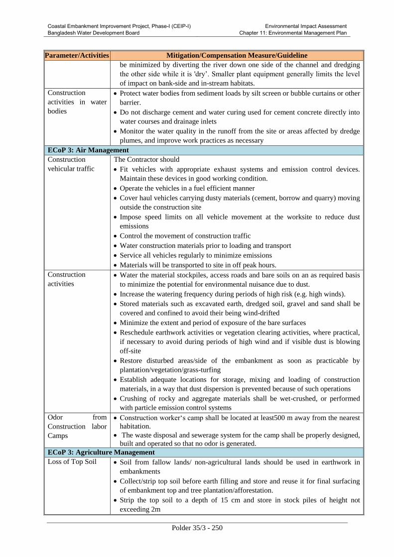
Coastal Embankment Improvement Project, Phase-I (CEIP-I) Bangladesh Water Development Board
Environmental Impact Assessment Chapter 11: Environmental Management Plan
Polder 35/3 - 250
Parameter/Activities Mitigation/Compensation Measure/Guideline
be minimized by diverting the river down one side of the channel and dredging
the other side while it is 'dry’. Smaller plant equipment generally limits the level
of impact on bank-side and in-stream habitats.
Construction
activities in water
bodies
Protect water bodies from sediment loads by silt screen or bubble curtains or other
barrier.
Do not discharge cement and water curing used for cement concrete directly into
water courses and drainage inlets
Monitor the water quality in the runoff from the site or areas affected by dredge
plumes, and improve work practices as necessary
ECoP 3: Air Management
Construction
vehicular traffic
The Contractor should
Fit vehicles with appropriate exhaust systems and emission control devices.
Maintain these devices in good working condition.
Operate the vehicles in a fuel efficient manner
Cover haul vehicles carrying dusty materials (cement, borrow and quarry) moving
outside the construction site
Impose speed limits on all vehicle movement at the worksite to reduce dust
emissions
Control the movement of construction traffic
Water construction materials prior to loading and transport
Service all vehicles regularly to minimize emissions
Materials will be transported to site in off peak hours.
Construction
activities
Water the material stockpiles, access roads and bare soils on an as required basis
to minimize the potential for environmental nuisance due to dust.
Increase the watering frequency during periods of high risk (e.g. high winds).
Stored materials such as excavated earth, dredged soil, gravel and sand shall be
covered and confined to avoid their being wind-drifted
Minimize the extent and period of exposure of the bare surfaces
Reschedule earthwork activities or vegetation clearing activities, where practical,
if necessary to avoid during periods of high wind and if visible dust is blowing
off-site
Restore disturbed areas/side of the embankment as soon as practicable by
plantation/vegetation/grass-turfing
Establish adequate locations for storage, mixing and loading of construction
materials, in a way that dust dispersion is prevented because of such operations
Crushing of rocky and aggregate materials shall be wet-crushed, or performed
with particle emission control systems
Odor from
Construction labor
Camps
Construction worker‘s camp shall be located at least500 m away from the nearest
habitation.
The waste disposal and sewerage system for the camp shall be properly designed,
built and operated so that no odor is generated.
ECoP 3: Agriculture Management
Loss of Top Soil Soil from fallow lands/ non-agricultural lands should be used in earthwork in
embankments
Collect/strip top soil before earth filling and store and reuse it for final surfacing
of embankment top and tree plantation/afforestation.
Strip the top soil to a depth of 15 cm and store in stock piles of height not
exceeding 2m
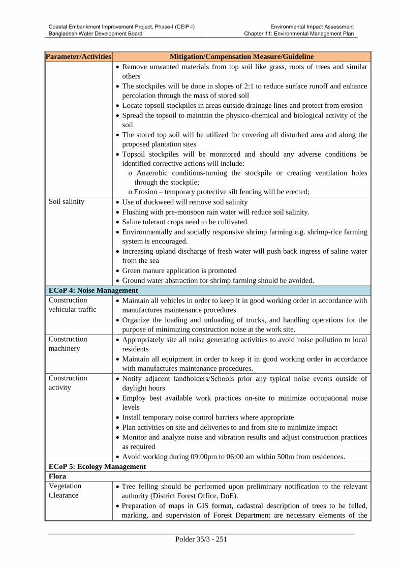
Coastal Embankment Improvement Project, Phase-I (CEIP-I) Bangladesh Water Development Board
Environmental Impact Assessment Chapter 11: Environmental Management Plan
Polder 35/3 - 251
Parameter/Activities Mitigation/Compensation Measure/Guideline
Remove unwanted materials from top soil like grass, roots of trees and similar
others
The stockpiles will be done in slopes of 2:1 to reduce surface runoff and enhance
percolation through the mass of stored soil
Locate topsoil stockpiles in areas outside drainage lines and protect from erosion
Spread the topsoil to maintain the physico-chemical and biological activity of the
soil.
The stored top soil will be utilized for covering all disturbed area and along the
proposed plantation sites
Topsoil stockpiles will be monitored and should any adverse conditions be
identified corrective actions will include:
o Anaerobic conditions-turning the stockpile or creating ventilation holes
through the stockpile;
o Erosion – temporary protective silt fencing will be erected;
Soil salinity Use of duckweed will remove soil salinity
Flushing with pre-monsoon rain water will reduce soil salinity.
Saline tolerant crops need to be cultivated.
Environmentally and socially responsive shrimp farming e.g. shrimp-rice farming
system is encouraged.
Increasing upland discharge of fresh water will push back ingress of saline water
from the sea
Green manure application is promoted
Ground water abstraction for shrimp farming should be avoided.
ECoP 4: Noise Management
Construction
vehicular traffic
Maintain all vehicles in order to keep it in good working order in accordance with
manufactures maintenance procedures
Organize the loading and unloading of trucks, and handling operations for the
purpose of minimizing construction noise at the work site.
Construction
machinery
Appropriately site all noise generating activities to avoid noise pollution to local
residents
Maintain all equipment in order to keep it in good working order in accordance
with manufactures maintenance procedures.
Construction
activity
Notify adjacent landholders/Schools prior any typical noise events outside of
daylight hours
Employ best available work practices on-site to minimize occupational noise
levels
Install temporary noise control barriers where appropriate
Plan activities on site and deliveries to and from site to minimize impact
Monitor and analyze noise and vibration results and adjust construction practices
as required
Avoid working during 09:00pm to 06:00 am within 500m from residences.
ECoP 5: Ecology Management
Flora
Vegetation
Clearance
Tree felling should be performed upon preliminary notification to the relevant
authority (District Forest Office, DoE).
Preparation of maps in GIS format, cadastral description of trees to be felled,
marking, and supervision of Forest Department are necessary elements of the

Coastal Embankment Improvement Project, Phase-I (CEIP-I) Bangladesh Water Development Board
Environmental Impact Assessment Chapter 11: Environmental Management Plan
Polder 35/3 - 252
Parameter/Activities Mitigation/Compensation Measure/Guideline
procedure.
Provide adequate knowledge to the workers regarding nature protection and the
need of avoid felling trees during construction
Fruit and timber trees owned by local population will be compensated at their
replacement cost according to market prices
Plant Management Tree seedlings are planted in a way that minimizes damage to the soil, while
facilitating seedling survival. Tree seedling species are selected appropriate for
maintaining long-term productivity.
Focus on tree species suitable for site condition
Prevent unreasonable species resulting in slow growth, less water and soil
conservation and pest or disease outbreaks
Local species as planting materials, since natural selection and succession are
most suitable for local climates and natural conditions
Ensure avoid single species or clone monoculture
Choose suitable species for berm, turfing and side
Planting Leave set back requirements around streams, restricted areas e.g. native
vegetation, protected riparian strips, historic and heritage sites, research areas.
For nursery raising, physical and biological controls are practiced to control the
pests and diseases in the nurseries.
Do not plant spread-prone species on sites where there is a high risk of
uncontrollable wilding spread beyond the boundaries of the plantation.
Consider appropriate species, patterns and layout when planting areas with high
visual values and/or with important recreational values
Polypropylene Bags
Handling
Make a Borrow Pit at each site for collection of poly bags
Collect all bags at the pits after plantation
If feasible, inform private sector to collect those bag for recycling
Pest Management
to Nursery
During outbreak of any deadly plant disease develop a plan to manage pest in
coordination with neighbors by identifying existing pests and diseases and the
risks for the introduction of new pests and diseases.
Share the plan with Bank before application.
Water Management Install temporary sediment basins, where appropriate, to capture sediment-laden
run-off from nursery
Divert runoff from undisturbed areas around the harvesting site
Stockpile of fertilizer or agrichemical away from drainage lines
Prevent all solid and liquid wastes entering waterways by collecting solid waste,
oils, chemicals, fertilizer waste and transport to an approved waste disposal site
Fauna
Construction works
in
the surrounding
lands
Pre-entry survey and prevention of damage to fauna prior to start up
Limit the construction works within the designated sites allocated to the
contractors
Not be permitted to destruct active nests or eggs of migratory birds
Provide adequate knowledge to the workers regarding protection of flora and
fauna, and relevant government regulations and punishments for illegal poaching.
ECoP 6: Fisheries Management
Construction works
in the rivers and on
the surrounding
Critical breeding areas of major fish species should be identified and declared as
sanctuaries.
Creation of small lagoons and pools that may trap the fishes will be avoided.

Coastal Embankment Improvement Project, Phase-I (CEIP-I) Bangladesh Water Development Board
Environmental Impact Assessment Chapter 11: Environmental Management Plan
Polder 35/3 - 253
Parameter/Activities Mitigation/Compensation Measure/Guideline
lands Creation of artificial waterfalls and other barriers for migration will be avoided.
Natural river channel will be reinstated after completion of construction works
Hydraulic Structure Sufficient free flow will be guaranteed in the design and construction work to
ensure free pass of migrating fishes.
Hydraulic structure will be operated considering fish migration and spawning time
A guideline for area specific hydraulic structure operation guideline should be
developed
Dredging Ensure dredging activity will create minimum sediment load in the water
Avoid dredging during spawning period of fish
ECoP 7: Socio-Economic Management
Construction Camp Management
Siting and Location
of construction
Camps (MRDI,
2011)
Locate the construction camps at areas which are acceptable from environmental,
cultural or social point of view.
Consider the location of construction camps away from communities in order to
avoid social conflict in using the natural resources such as water or to avoid the
possible adverse impacts of the construction camps on the surrounding
communities.
BWDB should endorse detailed layout plan for the development of the
construction camp submitted by the contractor. The plan should show the relative
locations of all temporary buildings and facilities that are to be constructed
together with the location of site roads, fuel storage areas (for use in power supply
generators), solid waste management and dumping locations, and drainage
facilities, prior to the development of the construction camps.
Local authorities responsible for health, religious and security shall be duly
informed on the set up of camp facilities so as to maintain effective surveillance
over public health, social and security matters
Construction Camp
Facilities
The following facilities should be provided by the contractor
Adequate housing for all workers
Safe and reliable water supply
Hygienic sanitary facilities and sewerage system.
Treatment facilities for sewerage of toilet and domestic wastes
Storm water drainage facilities
Provide in-house community/common entertainment facilities, dependence of
local entertainment outlets by the construction camps to be discouraged/prohibited
to the extent possible.
Solid Waste
Management
Ensure proper collection and disposal of solid wastes within the construction
camps
Store inorganic wastes in a safe place within the household and clear organic
wastes on daily basis to waste collector.
Establish waste collection, transportation and disposal systems with the manpower
and equipment/vehicles needed.
Do not establish site specific landfill sites. All solid waste will be collected and
removed from the work camps and disposed in approved disposal sites
Fuel supplies for
cooking and
heating
purposes
Provide fuel to the construction camps for their domestic purpose, in order to
discourage them to use fuel wood or other biomass.
Conduct awareness campaigns to educate workers to protect the biodiversity and
wildlife of the project area, and relevant government regulations and punishments
on wildlife protection.

Coastal Embankment Improvement Project, Phase-I (CEIP-I) Bangladesh Water Development Board
Environmental Impact Assessment Chapter 11: Environmental Management Plan
Polder 35/3 - 254
Parameter/Activities Mitigation/Compensation Measure/Guideline
Health and Hygiene Provide adequate health care facilities within construction sites
Provide first aid facility round the clock. Maintain stock of medicines in the
facility
Provide ambulance facility for the laborers during emergency to be transported to
nearest hospitals.
Initial health screening of the laborers coming from outside areas
Train all construction workers in basic sanitation and health care issues and safety
matters, and on the specific hazards of their work
Provide HIV awareness programming, including STI (sexually transmitted
infections)
And HIV information, education and communication for all workers on regular
basis
Provide adequate drainage facilities throughout the camps to ensure that disease
vectors such as stagnant water bodies and puddles do not form. Regular mosquito
repellant sprays during monsoon.
Carryout short training sessions on best hygiene practices to be mandatorily
participated by all workers.
Place display boards at strategic locations within the camps containing messages
on best hygienic practices
Payment of Wages The payment of wages should be as per the Minimum Wages Act, Department of
Labor, and Government of Bangladesh for both male and female workers.
Display of the minimum wages board at camps and major construction sites
should be done in local languages at the construction and labor camp sites.
Wages should be paid to the laborers only in the presence of BWDB staff;
Contractor is required to maintain register for payment of labor wages with entry
of every labor working for him. Also, he has to produce it for verification if and
when asked by the Engineer, EMU and/or the concerned BWDB staff/Engineer‘s
representative
Rehabilitation of
Labor and
Construction Camp
At the completion of construction, all construction camp facilities shall be
dismantled and removed from the site. The site shall be restored to a condition in no
way inferior to the condition prior to commencement of the works.
Various activities to be carried out for site rehabilitation include:
Oil and fuel contaminated soil shall be removed and transported and buried
in waste disposal areas.
Soak pits, septic tanks shall be covered and effectively sealed off.
Debris (rejected material) should be disposed of suitably.
Underground water tank in a barren/non-agricultural land can be covered.
However, in an agricultural land, the tank shall be removed.
If the construction camp site is on an agricultural land, preserve top soil and
good earth can be spread back for a minimum 30cm for faster rejuvenation
of the land.
Proper documentation of rehabilitation site is necessary.
This shall include the following:
Photograph of rehabilitated site;
Land owner consent letter for satisfaction in measures taken for
rehabilitation of site; and
Undertaking from contractor;
In cases, where the construction camps site is located on a private land holding, the
contractor would still have to restore the campsite as per this guideline. The
rehabilitation is mandatory and should be include in the agreement with the
landowner by the contractor. Also, he would have to obtain a certificate for

Coastal Embankment Improvement Project, Phase-I (CEIP-I) Bangladesh Water Development Board
Environmental Impact Assessment Chapter 11: Environmental Management Plan
Polder 35/3 - 255
Parameter/Activities Mitigation/Compensation Measure/Guideline
satisfaction from the landowner.
Damage and Loss of Cultural Properties
Conservation of
Religious
Structures and
Shrines
All necessary and adequate care shall be taken to minimize impact on cultural
properties which includes cultural sites and remains, places of worship including
temples, mosques, churches and shrines, etc., graveyards, monuments and any
other important structures as identified during design and all properties / sites /
remains notified. No work shall spillover to these properties and premises. The
design options for cultural property relocation and enhancement need to be
prepared.
All conservation and protection measures will be taken up as per design. Access
to such properties from the road shall be maintained clear and clean.
During earth excavation, if any property is unearthed and seems to be culturally
significant or likely to have archaeological significance, the same shall be
intimated to the Engineer. Work shall be suspended until further orders from the
PD. The Archaeological Department shall be intimated of the chance find and the
Engineer shall carry out a join inspection with the department. Actions as
appropriate shall be intimated to the Contractor along with the probable date for
resuming the work.
All fossils, coins, articles of value of antiquity and structures and other remains or
things of geological or archaeological interest discovered on the site shall be the
property of the Government, and shall be dealt with as per provisions of the
relevant legislation.
Worker’s Accident Risk
Risk from
Operations
The Contractor is required to comply with all the precautions as required for the
safety of the workmen as per the International Labor Organization(ILO)
convention. The contractor shall supply all necessary safety appliances such as
safety goggles, helmets, masks, books, etc., to the workers and staff. The
contractor has to comply with all regulation regarding safe scaffolding, ladders,
working platforms, gangway, stairwells, excavations, trenches and safe means of
entry and outlet.
Risk from
Electrical
Equipment
Adequate precautions will be taken to prevent danger from electrical equipment.
No materials on any of the sites will be so stacked or placed as to cause danger or
inconvenience to any person or the public. All necessary fencing and lights will be
provided to protect the public. All machines to be used in the construction will
conform to the relevant Bangladesh Standards (BS) codes, will be free from
patent defect, will be kept in good working order, will be regularly inspected and
properly maintained as per BS provisions and to the satisfaction of the Engineer.
Risk from
Hazardous Activity
All workers employed on mixing material, cement, lime mortars, concrete etc.,
will be provided with protective footwear and protective goggles. Workers, who
are engaged in welding works, would be provided with welder's protective eye-
shields. Stone-breakers will be provided with protective goggles and clothing and
will be seated at sufficiently safe intervals.
Malarial Risk The Contractor shall, at his own expense, conform to all anti-malarial instructions
given to him by the Engineer and the EMU, including filling up any borrow pits
which may have been dug by him.
Disruption to Users
Loss of Access At all times, the Contractor shall provide safe and convenient passage for
vehicles, pedestrians and livestock. Work that affects the use of existing accesses
shall not be undertaken without providing adequate provisions to the prior
satisfaction of the Engineer.
The works shall not interfere unnecessarily or improperly with the convenience of
public or the access to, use and occupation of public or private roads, and any
other access footpaths to or of properties whether public or private.

Coastal Embankment Improvement Project, Phase-I (CEIP-I) Bangladesh Water Development Board
Environmental Impact Assessment Chapter 11: Environmental Management Plan
Polder 35/3 - 256
Parameter/Activities Mitigation/Compensation Measure/Guideline
Traffic
Management
Special consideration shall be given in the preparation of the traffic control plan to
the safety of pedestrians and workers at night
The temporary traffic detours in settlement areas shall be kept free of dust by
frequent application of water
Traffic Control and
Safety
The Contractor shall take all necessary measures for the safety of traffic during
construction and provide, erect and maintain such barricades, including signs,
markings, flags, lights and flagmen as may be required by the Engineer for the
information and protection of traffic approaching or passing through the cross
section.
11.5 Chance-Find Procedures for Physical Cultural Property
The Contractor will be responsible for familiarizing themselves with the following “Chance Finds
Procedures” in case culturally valuable materials are uncovered during excavation or any project
activities as per Antiquities Act, 1968, including:
Stop work immediately following the discovery of any materials with possible archeological,
historical, paleontological, or other cultural value, announce findings to project manager and
notify relevant authorities;
Protect artifacts as well as possible using plastic covers, and implement measures to stabilize
the area, if necessary, to properly protect artifacts;
Prevent and penalize any unauthorized access to the artifacts; and
Restart construction works only upon the authorization of the relevant authorities (e.g.
Upazila Nirbahi Officer, Deputy Commissioner and Department of Archeology).
11.6 Monitoring Plan
Extensive monitoring of the environmental concerns of the CEIP project will be required as per World
Bank guideline. The monitoring program will help to evaluate: (i) the extent and severity of the
environmental impacts against the predicted impacts and baseline; (ii) the performance of the
environmental protection measures or compliance with pertinent rules and regulations; (iii) trends in
impacts; and (iv) overall effectiveness of the project environmental protection measures. The
monitoring plans should be included in the EMP for specific sub-projects. Moreover, for all type of
monitoring, a comprehensive database of the polder specific Environmental Impact and
Monitoring information should be created, which will help to evaluate the impacts easily.
The Monitoring activities during design/preconstruction period are:
(i) checking the contractor’s bidding documents, particularly to ensure that all
necessary environmental requirements have been included; and
(ii) checking that the contract documents’ (Environmental Action Plan) references to
environmental mitigation measures requirements have been incorporated as part of
contractor’s assignment and making sure that any advance works are carried out in
good time.
Environmental monitoring during construction phase is a function of supervision, and the
essential purpose is to ensure adherence to the EMP and RAP. The monitoring is a daily
process, which ensures that departures from the EMP are avoided or quickly rectified, or that
any unforeseen impacts are quickly discovered and remedied. This monitoring will be

Coastal Embankment Improvement Project, Phase-I (CEIP-I) Bangladesh Water Development Board
Environmental Impact Assessment Chapter 11: Environmental Management Plan
Polder 35/3 - 257
carried out by the Design and Supervision Consultants on a regular bassis. Additional
monitoring will be carried out by the Environmental and Social Unit.
Post project monitoring evaluation will be carried to evaluate the impacts of the Project during first
three (3) years of operation of the Project. Regular monitoring of the condition of the embankment,
drainage structures and slope protection structures and afforestation are important from an
environmental management point of view. In addition to this activity, information on the locations,
type and consequences of flooding, erosion, flora and fauna mortality, availability of fish,
occupational shift, migration is required. Recommended air, noise and water quality monitoring,
greening and landscaping and community feedback are also included in the Monitoring Plan. The
monitoring plan and details of monitoring locations for environmental condition indicators of the
project during the construction and operation stage are presented in Table 11.2 and Table 11.3
Table 11.2: Environmental Monitoring Plan during Construction and Operation of
Rehabilitation and Improvement of Polders System
(Source: MRDI, 2011, LGED, 2011)
Parameter Location Means of
Monitoring
Frequency Responsible Agency
Implemented
by
Supervised
by
During Construction
Sources of
Material
Work Site Possession of
official approval or
valid operating
license of suppliers
materials
(Cement, soil).
Before an
agreement
for the
supply of
material is
finalized.
Contractor CS, M&E
Consultant,
BWDB
Operation of
borrow site
Borrow
pit/site
Visual inspection of
borrow site and
ensuring
operational health
and safety
monthly Contractor CS, M&E
Consultant,
BWDB
Top Soil Storage area Top soil of 0.15 m
depth will be
excavated and
stored properly
Beginning
of
earthwork
Contractor CS, BWDB
do The stored top soils
will be used as
cladding material
over the filled lands
Immediately
after filling
and
compaction
of dredge
materials
Contractor CS, BWDB
Work Site Some of the top soil
are placed on top
and berm of
embankment for
turfing and
plantation
At the end
of
filling
activity
Contractor CS, BWDB
Erosion Side slopes Visual inspection of At the end Contractor CS, M&E

Coastal Embankment Improvement Project, Phase-I (CEIP-I) Bangladesh Water Development Board
Environmental Impact Assessment Chapter 11: Environmental Management Plan
Polder 35/3 - 258
Parameter Location Means of
Monitoring
Frequency Responsible Agency
Implemented
by
Supervised
by
of the
embankments
and material
storage sites
erosion prevention
measures and
occurrence of
erosion
of filling
activity
Consultant,
BWDB
Hydrocarbon
and chemical
storage
Construction
camps
Visual Inspection of
storage facilities
Monthly Contractor CS, BWDB
Traffic safety Construction
area
Visual inspection to
see whether proper
traffic signs are
placed and flagmen
for traffic
management are
engaged
Monthly Contractor CS, BWDB
Air quality
(dust)
Construction
site
Visual inspection to
ensure good
standard equipment
is in use and dust
suppression
measures (spraying
of waters) are in
place.
Daily Contractor CS, BWDB
Material
storage
sites
Visual inspection to
ensure dust
suppression work
plan is being
implemented
Monthly Contractor CS
Air Quality
(PM10, PM2.5)
Close to
School/
Madrasha,
Hospital
&Villages
Air quality
monitoring
Half Yearly Contractor
through a
nationally
recognized
laboratory
CS, M&E
Consultant,
BWDB
Noise
Construction
sites
Visual inspection to
ensure good
standard equipment
are in use
Weekly
Contractor CS, M&E
Consultant,
BWDB
Construction
sites
Ensure work
restriction between
09:00 pm-6:00 am
close to School/
Madrasha, Hospital
& Villages
Weekly Contractor CS, M&E
Consultant,
BWDB
Surface
Water Quality
(TDS,
Turbidity,
Water sample
at each of
river for each
polder
Sampling and
analysis of surface
water
quality
Half Yearly Contractor
through a
nationally
recognized
CS, M&E
Consultant,
BWDB

Coastal Embankment Improvement Project, Phase-I (CEIP-I) Bangladesh Water Development Board
Environmental Impact Assessment Chapter 11: Environmental Management Plan
Polder 35/3 - 259
Parameter Location Means of
Monitoring
Frequency Responsible Agency
Implemented
by
Supervised
by
pH, DO,
BOD, COD
etc)
laboratory
Drinking
Water
Quality(TDS,
Turbidity,
pH, FC, as if
groundwater
etc)
Sources of
drinking
water at
construction
camp/site
Sampling and
analysis of water
quality
yearly Contractor
through a
nationally
recognized
laboratory
CS, M&E
Consultant,
BWDB
Sanitation Construction
camp/site
Visual Inspection Weekly Contractor CS, M&E
Consultant,
BWDB
Waste
Management
Construction
camp and
construction
site
Visual inspection of
collection,
transportation and
disposal of solid
waste and solid
waste is deposited
at designated site
Weekly Contractor CS, M&E
Consultant,
BWDB
Flora and
Fauna
Project area Survey and
comparison with
baseline
environment
Yearly Contractor
through
nationally
recognized
institute
CS, M&E
Consultant,
BWDB
Cultural and
archeological
Sites
At all work
sties
Visual observation
for chance finding
Daily
Contractor
CS, M&E
Consultant,
BWDB
Reinstatement
of Work Sites
All Work
Sites
Visual Inspection After
completion
of all works
Contractor
CS, M&E
Consultant,
BWDB
Safety of
workers
Monitoring
and reporting
accidents
At work sites Usage of Personal
Protective
equipment
Monthly Contractor CS, M&E
Consultant,
BWDB
During Operation and Maintenance
Surface
Water Quality
(TDS,
Turbidity,
pH, DO,
BOD, COD
etc)
Water sample
at each of
river for each
polder
Sampling and
analysis of surface
water quality
Yearly BWDB
through a
nationally
recognized
laboratory
M&E
Consultant
Air Quality
(Dust PM10,
PM2.5)
At the
baseline
monitoring
24 hours Air quality
monitoring
Yearly BWDB
through a
nationally
M&E
Consultant

Coastal Embankment Improvement Project, Phase-I (CEIP-I) Bangladesh Water Development Board
Environmental Impact Assessment Chapter 11: Environmental Management Plan
Polder 35/3 - 260
Parameter Location Means of
Monitoring
Frequency Responsible Agency
Implemented
by
Supervised
by
site recognized
laboratory
Flora and
Fauna
specially
fisheries
In the project
area
Detail species
assessment and
compare with
baseline
Yearly BWDB
through a
nationally
recognized
institution
M&E
Consultant
Agriculture In the project
area
Compare the
production with the
baseline
Yearly BWDB
through a
nationally
recognized
institution
M&E
Consultant
Operation of
hydraulic
structure
In the project
area
Visual inspection
and public feedback
Yearly BWDB
M&E
Consultant
Table 11.3: Environmental Monitoring Plan during Construction and Operation of
Afforestation
Parameter Location Means of Monitoring Frequency Responsible Agency
Implemented by Supervised by
During Implementation
Plant
Selection
Nursery Visual inspection.
Type and variety of
plant species to be
planted for turfing on
the top of
embankment and
foreshore
Before
plantation
Contractor CS, BWDB,
M&E
Consultant
Water
Quality
Water
bodies near
nursery
Odor and chemical
testing
Half yearly Contractor
through
nationally
recognized
laboratory
CS, BWDB,
M&E
Consultant
Waste
Management
Work site
and
Nursery
Visual inspection of
collection,
transportation and
disposal of grasses,
debris and is
deposited at
designated site
Weekly Contractor CS, BWDB,
M&E
Consultant
Work site
and
Nursery
Visual inspection of
Water bars & cut-offs
.sediment traps to
Beginning
of work
Contractor CS, BWDB,
M&E
Consultant

Coastal Embankment Improvement Project, Phase-I (CEIP-I) Bangladesh Water Development Board
Environmental Impact Assessment Chapter 11: Environmental Management Plan
Polder 35/3 - 261
Parameter Location Means of Monitoring Frequency Responsible Agency
Implemented by Supervised by
prevent water
pollution caused by
run-off from
harvesting areas
Nursery
Embankment
Management
Nursery Visual inspection of
height of
embankment,
possibility of water
logging and
connection to the
water bodies
Beginning
of each
nursery
Contractor CS, BWDB,
M&E
Consultant
During Operation and Management
Multilevel
belt of trees
Polder top
and along
the polder
Visual inspection yearly BWDB through
nationally
recognized
institution
M&E
Consultant
Flora and
Fauna
In the
project
area
Detail species
assessment and
compare with baseline
Yearly BWDB through
a nationally
recognized
institution
M&E
Consultant
Erosion Along
Alignment
Visual Inspection
presence of gullies or
erosion
Yearly BWDB
M&E
Consultant
The location of monitoring places are shown Annex-C
Qualitative Spot Checking Indicators
Moreover a rapid environmental monitoring will be carried out according the following checklist in
terms of visual judgment during field visit as an indirect control to implement Environmental
Mitigation plan. Table 11.4 can be followed during project construction and operation process.
Table 11.4: Spot Checking Indicator
Parameter Visual Judgment
Poor Moderate Satisfactory
Workers Safety
Camp Site Management
Plant Site Management
Borrow Area Management
Top Soil Prevention
Waste Management
Occupational Health and Safety
Stockpiling of construction materials
Reporting and Documentation
Coastal Embankment Improvement Project, Phase-I (CEIP-I) Bangladesh Water Development Board
Environmental Impact Assessment Chapter 11: Environmental Management Plan
Polder 35/3 - 262
Third Party Validation
BWDB will engage independent consultants to conduct a third party validation (TPV) of the EMP
implementation on a yearly basis during the construction phase. During the TPV, the consultants will
review the implementation and effectiveness of various EMP activities including mitigation measures,
environmental monitoring, trainings, and documentation. The consultants will also identify gaps and
non-compliances in EMP implementation and propose actions for their remediation.
11.7 Documentation, Record keeping and Reporting
11.7.1 Record Keeping
Proper arrangements are necessary for recording, disseminating and responding to information which
emerges from the various environmental monitoring and management programs. They are also
necessary for rendering the environmental management system “auditable”. However, the primary
focus must remain on the pragmatic control of pollution, not the creation of complex bureaucratic
procedures. BWDB will maintain database of the polder specific Environmental Impact and
Monitoring information for keeping all type of monitoring record. ESC unit will assist BWDB for
keeping those records initially. The trained BWDB staff will take the responsibility of record keeping
and monitoring during operation phase.
11.7.2 Monitoring Records
Quantitative Physical Monitoring
The objective of quantitative physical monitoring is to ensure that the mitigation measures designed to
prevent, reduce and where possible offset any significant adverse impacts on the environment are
being implemented throughout the Project lifecycle. CS will regularly monitor and provide
information to ESC for updating the database. CS will provide the following information bi-weekly to
ESC, if not urgent.
Sampling points;
Dates and times of sample collection;
Test results;
Control limits;
“Action limits” (circa 80 percent of the control limits) at which steps must be taken to prevent
the impending breach of the control limit; and
Any breaches of the control limits, including explanations if available.
The monitoring data would be continually processed as it is received, so as to avoid a buildup of
unprocessed data.
General Site Inspections and Monitoring
A Site Inspection Checklist for recording the findings of the general site condition surveys would be
developed by the respective contractors, on the basis of the Environmental Mitigation Plan described
in Chapter 9 and Section 11.4, during the construction phase. The Site Inspection Checklist would
be supported by sketches, as necessary.

Coastal Embankment Improvement Project, Phase-I (CEIP-I) Bangladesh Water Development Board
Environmental Impact Assessment Chapter 11: Environmental Management Plan
Polder 35/3 - 263
11.7.3 Information Sources
A complete and up-to-date file of all relevant sources of information will be maintained by the ESC
unit of PMU. This file would be readily accessible and include, as a minimum, copies of the following
documents:
Current environmental permits and consents;
Action to fulfill the requirement of annual site clearance for polder area
All relevant national regulations, international guidelines and codes of practice;
Manufacturers’ MSDSs for all hazardous substances used on the plant;
Manufacturers’ operating manuals for all the environmental monitoring equipment;
Current calibration certificates for all the equipment that requires calibration by an external
organization; and
The latest version of this Environmental Management and Monitoring Plan.
11.7.4 Non-Compliance Report
Any breaches of the acceptable standards specified, would be reported to the PMU using a standard
form, i.e. a Non-Compliance Report (NCR).
A copy of each completed NCR would be held on file by CS, to be replaced by the reply copy when it
is received. A record of corrective actions would also be made and tracked to their completion.
11.7.5 Monthly Internal Reports by CS
The CS will prepare a monthly report for issue to the ESC of PMU. These reports will summarize the
following:
Progress in implementing this EMP;
Findings of the monitoring programs, with emphasis on any breaches of the control standards,
action levels or standards of general site management;
Any emerging issues where information or data collected is substantially different from the
baseline data reported in the Environmental Assessment;
Outstanding NCRs;
Summary of any complaints by external bodies and actions taken / to be taken; and
Relevant changes or possible changes in legislation, regulations and international practices.
11.7.6 Half Early Progress Report by BWDB
ESC of BWDB will prepare the half yearly progress report on environmental management and will
submit to the World Bank for review during construction phase. The progress report will summarize
the information presented in Article 11.6.5.
11.7.7 Environmental Audit Report & Third Party Monitoring Report
It is expected BWDB will conduct annual environmental audit. In addition, the environmental audit
will be carried out before the mid-term evaluation and before project closing. All Environmental
Coastal Embankment Improvement Project, Phase-I (CEIP-I) Bangladesh Water Development Board
Environmental Impact Assessment Chapter 11: Environmental Management Plan
Polder 35/3 - 264
Audit Report will be shared with Bank. Environmental monitoring will be conducted during the
project Third Party Monitoring. The Third Party Monitoring report will also be shared with Bank. The
Bank would also supervise the environmental compliance as part of regular implementation support
missions.
11.8 Contractual arrangements for EMP implementation
Since many contractors do not have clear understanding the need of environmental management,
some quoted very low price for implementation of EMP and eventually cannot implement EMP as per
design. To avoid this problem, fixed Budget will be assigned for EMP implementation. The
contractors may need orientation on the requirement of the EMP in the pre-bidding meeting. The
contractor needs to submit an Environmental Action Plan (EAP) based on the EIA in line with the
construction schedule and guideline. The EAP needs to be reviewed by the supervision consultant and
cleared by BWDB and World Bank.
11.8.1 Guideline to Incorporate Environmental Management in Bid Document &
Preparation of EAP
Prepare cost estimates, to be incorporate in Bid Documents.
Environmental Management Plan along with the good environmental construction guidelines
to be incorporated in the bid document‘s work requirements.
Preparation of work requirement (addendum/corrigendum to polder & hydraulic structure
construction/afforestation) and
Corrigendum / Addendum to polder/embankment specification, if any, as special provisions
to be incorporated in bid document.
Penalty clauses for not complying with EMP requirements to be incorporated. Indicative
penalty clauses proposed in the CEIP are presented below (Addendum to Clause 17.2
Contractor‘s Care of the Works of FIDIC).
- The contractor has to follow all traffic safety measures as defined in the technical
specification. Damage shall be levied at the rate Tk. 3000/- per day per location for
non – conformity of traffic safety measures as per the decision of the engineer.
- The contractor has to follow all environmental mitigation measures as defined in the
technical specification read along with the Environmental Management Plan for the
specific CEIP activities. Damage shall be levied at the rate Tk. 3000/- per day per
location for nonconformity of Environmental Management Plan measures as per the
decision of the BWDB Engineer.
- The contractor has to ensure that prior to every monsoon season, during the
construction period; all the temporary and permanent cross drainage structures are
free from debris as defined in the Technical Specifications read along with the
Environmental Management Plan. Damage shall be levied at the rate of Tk.3000/- per
day per location for non-conformity as per the decision of the Engineer.
- The contractor has to ensure that sufficient numbers and good quality Personnel
Protective Equipment (PPE), will be provide to staff and labor all time as defined in
the labor codes read along with the EMP. Damage shall be levied at the rate of Tk.
1000/- per day for non-conformity as per the decision of the Engineer.
Coastal Embankment Improvement Project, Phase-I (CEIP-I) Bangladesh Water Development Board
Environmental Impact Assessment Chapter 11: Environmental Management Plan
Polder 35/3 - 265
11.9 Guideline for Compensation and Contingency Plan during
Project Period
Compensation becomes necessary when project impacts cannot be satisfactorily mitigated. This can
be paid in cash or kind and the emphasis will be on ensuring fairness and causing minimum
inconvenience to the affected party. The most common cause of compensation payment is
displacement of people and loss of productive land due to land acquisition, tree cutting, or property
damage. Such impacts can rarely be fully compensated. The compensation will be given as per
provision of the Resettlement Action Framework. Any disputes over the compensation will be
handled by the Grievance Redress Committee.
In addition to the compensation, water management projects should also have a contingency plan to
deal with emergencies and accidents. Such incidences encompass a whole range of situations from
personal injury during operation of a machine to breaching of an embankment. Therefore, BWDB
would prepare for the following emergency situations:
Embankment failure during a flood – keep sufficient number of sand bags in reserve.
Bank caving/erosion – keep sufficient number of concrete blocks and sand bags in reserve.
Have an emergency evacuation plan for the people in the line of danger.
Have a place designated as emergency shelter and ensure proper water supply, power supply
and sanitation at this site.
Accidental spill of harmful chemicals – train some members on how to confine such a spill
and minimize potential danger to humans and other animals.
Fire – keep fire extinguisher or emergency water pump ready at local project office.
Personal injury – keep a first aid box at the project office. Have a plan for quickly
transporting a seriously injured person to the nearest hospital.
11.10 EMP Implementation Cost
The estimated costs for the environmental management and monitoring activities are set out in
Table 11.5 below. The cost has been estimated based on previous project works of BWDB.
Table 11.5: Tentative Cost Estimates for Environmental Management and Monitoring*
Sl. No Description of EMP activities Cost Million BDT Cost Million US$
1 Crop compensation to the direct
loser land owner/ share croppers of
construction sites /damage to
dredge spoils
1.40 0.017
2 Construction of alternative or
bypass channels at each
construction sites
3.5 0.043

Coastal Embankment Improvement Project, Phase-I (CEIP-I) Bangladesh Water Development Board
Environmental Impact Assessment Chapter 11: Environmental Management Plan
Polder 35/3 - 266
Sl. No Description of EMP activities Cost Million BDT Cost Million US$
4 Conservation and stocking of
threatened fish species ( 4 spots of
Betibonia, Mogordhara and
Sayabanki khal)
0.50 0.006
5 Awareness program on plant and
wild life conservation
1.00 0.012
6 Campaigning and providing
training on improved culture
practices as well as the rice-cum-
golda farming
0.5 0.006
7 Social forestry program along both
sides of the embankment and other
khas areas
Included in afforrestation
budget
-
8 Emergency budget allocation for
closing breach points of
embankments and repairing the
damage of structure
10.00 0.566
9 Monitoring cost to fish
biodiversity, migration, fish
production
1.0 0.012
10 Waste disposal arrangement 2.00 0.024
11 Water quality monitoring 1.0 0.012
12 Air and noise quality monitoring
analysis
1.0 0.012
13 Soil and water salinity monitoring 0.50 0.006
15 Land acquisition and compensation
cost
Budget included in RAP
report
16 Capacity building and training 4.00 0.049
17 Consultancy services cost for
supervisions and monitoring
6.00 0.073
Total Cost of EMP 32.4 0.838
11.11 Grievance Redress Mechanism
BWDB will establish a grievance redress mechanism (GRM) as a means to ensure social
accountability and to answer to queries and address complaints and grievances about any irregularities
in application of the guidelines adopted in this EMF for assessment and mitigation of social and
environmental impacts. Based on consensus, the procedure will help to resolve issues/conflicts
amicably and quickly, saving the aggrieved persons from having to resort to expensive, time-
consuming legal action. The procedure will however not pre-empt a person’s right to go to the courts
of law.

Coastal Embankment Improvement Project, Phase-I (CEIP-I) Bangladesh Water Development Board
Environmental Impact Assessment Chapter 11: Environmental Management Plan
Polder 35/3 - 267
11.11.1 Grievance Redress Focal Points
A Grievance Redress Committee (GRC) at local level will be formed for each Union with union level
representation to ensure easy accessibility by the project affected persons and communities. This local
GRC will be the local focal points of the project GRM. The GRM sets out the information and
communications strategy to ensure that PAPs and communities are fully informed about their rights to
offer suggestions and make complaints. All grievances received through the GRM process will
primarily be forwarded to the GRCs. The Secretariat for each GRC will be at the office of the
Executive Engineer. If any grievance is not resolved at GRC, the aggrieved person may request the
convener of GRC to forward the case to the Project Director at PMO, Dhaka. The GRC will officially
forward the cases with their comments to the Project Director. Hearing of petitions with GRCs will be
held at the Convener’s office or at Union Parishad/Ward Councillor’s office as agreed by the
committee members. The membership of the GRCs will ensure proper presentation of complaints and
grievances as well as impartial hearings and investigations, and transparent resolutions.
Membership of GRC
1. Executive Engineer (BWDB Division Office) : Convener
2. Representative of the RP Implementing NGO : Member-Secretary
3. Local UP Chairman /Ward Councillor : Member
4.Teacher from Local Educational Institution (nominated
by Upazila Administration)
: Member
5. Representative from Local Women’s Group : Member
6. Representative from the PAP Group : Member
Members of the GRCs will be nominated by the Executive Engineer at division level and approved by
the Project Director, PMO, BWDB, Dhaka.
11.11.2 Grievance Resolution Process
All complaints will be received at the GRCs facilitated by the implementing agency. The aggrieved
persons may opt to make complaints directly to the Project Director or Secretary of the MoWR or
even to the court of law for resolution. The Member Secretary will review and sort the cases in terms
of nature of grievance, urgency of resolution, and schedule hearings in consultation with the
Convener. All cases will be heard within four weeks from the date of receiving the complaints.
If the resolution attempt at the local level fails, the GRC will refer the complaint with the minutes of
the hearings to the Project Director at PMO for further review. The Project Director will assign the
ESC at PMO for review the grievance cases and assist Project Director in making decision. The ESC
will review the case records and pay field visits for cross examining and consult the GRC members
and aggrieved persons, if required. If a decision at this level is again found unacceptable by the
aggrieved person(s), BWDB can refer the case to the MoWR with the minutes of the hearings at local
and headquarters levels. At the ministry level, decisions on unresolved cases, if any, will be made in
no more than four weeks by an official designated by the Secretary, MoWR. A decision agreed with
the aggrieved person(s) at any level of hearing will be binding upon BWDB.

Coastal Embankment Improvement Project, Phase-I (CEIP-I) Bangladesh Water Development Board
Environmental Impact Assessment Chapter 11: Environmental Management Plan
Polder 35/3 - 268
Figure 11.1: GRM Process Flow Chart
To ensure that grievance redress decisions are made in formal hearings and in a transparent manner,
the Convener will apply the following guidelines:
Reject a grievance redress application with any recommendations written on it by a GRC member
or others such as politicians and other influential persons.
Remove a recommendation by any person that may separately accompany the grievance redress
application.
Disqualify a GRC member who has made a recommendation on the application separately before
the formal hearing:
o Where a GRC member is removed, appoint another person in consultation with the
Project Director.
The Convener will also ensure strict adherence to the impact mitigation policies and guidelines
adopted in this SMRPF and the mitigation standards, such as compensation rates established
through market price surveys.
Project Affected Persons and Communities
Disclosure and
Counselling
IA/SMO, BWDB
PAPs approach for
compensation/assistance
Payment under RPs
Grievance Resolution
At MoWR, Dhaka
Rayon Court
PAPs are aware &
satisfied / accept
grievance resolution
Grievance
Resolved
Valid
complains
Unresolved
Unresolved
Grievance Resolution
at GRC
Grievance Resolution
At PMO, Dhaka DC/
District LA Office
Court of Law
(District Judge Court)
Unresolved
Referred
to DC
Compensation under Law
Resolved
Resolved
Resolved

Coastal Embankment Improvement Project, Phase-I (CEIP-I) Bangladesh Water Development Board
Environmental Impact Assessment Chapter 11: Environmental Management Plan
Polder 35/3 - 269
11.11.3 GRM Disclosure, Documentation and Monitoring
The affected persons and their communities will be informed of the project’s grievance redress
mechanism in open meetings at important locations and in PAP group meetings. Bangla translations
of the EMF and the GRM in the form of information brochures will be distributed among the project
affected persons. The PAPs will also be briefed on the scope of the GRC, the procedure for lodging
grievances cases and the procedure of grievance resolution at the project level.
To ensure impartiality and transparency, hearings on complaints will remain open to the public. The
GRCs will record the details of the complaints and their resolution in a register, including intake
details, resolution process and the closing procedures. BWDB will maintain the following three
Grievance Registers:
Intake Register: (1) Case number, (2) Date of receipt, (3) Name of complainant, (4) Gender,
(5) Father or husband, (6) Complete address, (7) Main grievance regarding social (loss of
land/property or entitlements) or environmental, (8) Complainants’ story and expectation with
evidence, and (8) Previous records of similar grievances.
Resolution Register: (1) Serial no., (2) Case no.,(3) Name of complainant, (4) Complainant’s
story and expectation, (5) Date of hearing, (6) Date of field investigation (if any), (7) Results
of hearing and field investigation, (8) Decision of GRC, (9) Progress (pending, solved), and
(10) Agreements or commitments.
Closing Register: (1) Serial no., (2) Case no., (3) Name of complainant, (4) Decisions and
response to complainants, (5) Mode and medium of communication, (6) Date of closing, (7)
Confirmation of complainants’ satisfaction, and (8) Management actions to avoid recurrence.
Grievance resolution will be a continuous process in RP implementation. The PMO and SMOs will
keep records of all resolved and unresolved complaints and grievances (one file for each case record)
and make them available for review as and when asked for by WB and any other interested
persons/entities. The PMO will also prepare periodic reports on the grievance resolution process and
publish these on the BWDB website.
11.12 Capacity Building
Since the effectiveness of the Environmental Assessment & implementation depends considerably on
the understanding and preparedness of their Engineers and in particular their Environmental Team
(Consisting of Contractor Environmental specialist, Consultant environmental specialist, and
ESC of BWDB). It is important that the project authority makes effort to sensitize the Engineers and
Environmental Team on management of environmental issues, provides guidance, and encourages
them to build requisite capacities.Table 11.6 provides a summary of various aspects of the
environmental and social trainings to be conducted at the construction site. PMU may revise the plan
during the Project implementation as required.
During the O&M phase of the Project, these trainings will continue to be conducted by BWDB staff
for all relevant O&M personnel and community.

Coastal Embankment Improvement Project, Phase-I (CEIP-I) Bangladesh Water Development Board
Environmental Impact Assessment Chapter 11: Environmental Management Plan
Polder 35/3 - 270
Table 11.6: Environmental Trainings
Contents Participants Responsibility Schedule
General environmental and
socioeconomic awareness;
Environmental and social sensitivity
of the project area;
Key findings of the EIA;
Mitigation measures;
EMP;
Social and cultural values of the area.
Selected BWDB;
PMU;
DC & CS staff
DC & CS &
ESC
Prior to the start of the
Project activities.
(To be repeated as
needed.)
General environmental and
socioeconomic awareness;
Environmental and social sensitivity
of the project area;
Mitigation measures;
Community issues;
Awareness of transmissible diseases
Social and cultural values.
PMU;
DC & CS;
selected
contractors’ crew
DC & CS &
ESC
Prior to the start of the
field activities.
(To be repeated as
needed.)
EMP;
Waste disposal;
HSE
Construction
crew
Contractors Prior to the start of the
construction activities.
(To be repeated as
needed.)
Road/waterway safety;
Defensive driving/sailing;
Waste disposal;
Cultural values and social sensitivity.
Drivers;
boat/launch crew
Contractors Before and during the
field operations.
(To be repeated as
needed.)
Camp operation;
Waste disposal;
HSE
Natural resource conservation;
Housekeeping.
Camp staff Contractors Before and during the
field operations.
(To be repeated as
needed.)
Restoration requirements;
Waste disposal.
BWDB core unit
, Restoration
teams
Contractors Before the start of the
restoration activities.
Strengthening of water management
organizations(i.e. WMGs, WMAs
and WMF) and beneficiaries
organizations
Member of water
management
organizations(i.e.
WMGs, WMAs
and WMF) and
beneficiaries
organizations
BWDB, ESC,
Contractor
Before and during
construction activities
Capacity building training programs will be undertaken in the following area:
Training of the management level officials of BWDB, BWDB environmental compliance
personnel on the overall environmental concerns and responsibilities for implementing EMP
Recruitment of new professionals with background on environment, if required and provide
necessary training
Organizing workshop, seminar, with stakeholders on the environmental concerns of CEIP

Coastal Embankment Improvement Project, Phase-I (CEIP-I) Bangladesh Water Development Board
Environmental Impact Assessment Chapter 11: Environmental Management Plan
Polder 35/3 - 271
Special training program for the contractors and workers on the EMP and their
responsibilities, who will actually be involved in the construction of the project interventions.
The Contractors will be provided guideline for preparation of Environmental Action Plan in
line with the construction work plan
Training of the WMOs on successful operation of hydraulic structures
Training on structured format in reporting for all stages of implementation and those of
relevant agencies who are involved in EMP implementation.
The training programs will be arranged before implementation of the interventions in the polder area.
Detail plan can be made by the proposed ESC Unit of BWDB.

Coastal Embankment Improvement Project, Phase-I (CEIP-I) Bangladesh Water Development Board
Environmental Impact Assessment Polder- 35/3
Polder 35/3 - 272
References
BBS,2011. Population Census 2011, Bangladesh Bureau of Statistics (BBS), Statistical Division,
Ministry of Finance and Planning,
Brammer, H., 2000, Agro-ecological aspects of agricultural research in Bangladesh, University Press
Limited: Dhaka.
Bari, K. G. M. L. 1978, Bangladesh District Gazetteers, Khulna, Bangladesh Government Press,
Dacca, p-425.
CEIP,2012, Feasibility Report, Coastal Embankment and Improvement Project (CEIP), Bangladesh
Water Development Board (BWDB), Dhaka, Bangladesh.
CEGIS, 2009b. Prediction of River Bank Erosion along the Jamuna, the Ganges, and the Padma
rivers in 2009. Final Report. Submitted to Bangladesh Water Development Board (BWDB) by
center for Environmental Geographic Information Services (CEGIS), Dhaka, Bangladesh.
DoE, 2001. Bangladesh: State of the Environment 2001. Department of Environment, Ministry of
Environment and Forest, Dhaka, Bangladesh.
GOB. DoE, 1997, EIA Guidelines for Industries. Department of Environment (DoE), Dhaka,
Bangladesh.
GoB, 2009. Bangladesh Climate Change Strategy and Action Plan 2009, Government of Bangladesh,
Dhaka.
Hassan, A., Hossain B.M.T.A., and Ahsan, M. R. 2010a. Mean Area Distribution Method for
Downscaling GCM Results. In: Choudhury, G. A., Hassan, A., and Ahmed, A. U.(Eds.),
Climate Change Risk and Adaptation for Bangladesh, CEGIS, Dhaka, Bangladesh.
IPCC, 2007c. “Climate Change 2007: Synthesis Report”. Contribution of Working Groups I, II and III
to the Fourth Assessment Report of the Intergovernmental Panel on Climate Change [Core
Writing Team, Pachauri, R.K and Reisinger, A. (eds.)]. IPCC, Geneva, Switzerland.
IUCN, 2000. Red list of threatened animals of Bangladesh. The World Conservation Union
(IUCN), Dhaka, Bangladesh. 54 pp.
MoEF,1995. National Environment Management Action Plan (NEMAP), Voll -II, Main Report.
Ministry of Environment and Forest (MoEF), Government of the Peoples Republic of
Bangladesh.
MPO, 1987. National Water Plan, Phase I, Master Plan Organization Development. Dhaka: Master
Plan Organization.
MoFL,1998. National Fisheries Policy, Ministry of Fisheries and Livestock, Government of the
People’s Republic of Bangladesh.
MoA,1999. National Agriculture Policy, Ministry of Agriculture, Government of the People’s
Republic of Bangladesh.
MoFL, 2007. National Livestock Development Policy, Ministry of Fisheries and Livestock,
Government of the People’s Republic of Bangladesh.
MoWR, 1999. National Water Policy, Ministry of Water Resources, Government of the People’s
Republic of Bangladesh.

Coastal Embankment Improvement Project, Phase-I (CEIP-I) Bangladesh Water Development Board
Environmental Impact Assessment Polder- 35/3
Polder 35/3 - 273
MoWR, 2005. Coastal Zone Policy, Ministry of Water Resources, Government of the People’s
Republic of Bangladesh.
Nishat, A., Huq, S.M. Imamul, Barua, Shuvashish P., Reza, Ali A.H.M., Khan, Moniruzzaman A.s.
(eds.), 2002. Bio-ecological zones of Bangladesh. IUCN Bangladesh Country Office, Dhaka,
Bangladesh, xii+ 141 pp.
Yu, W. H., Alam, M., Hassan, A., Khan, A. S., Ruane, A. C., Rosenzweig, C., Major, D. C. and
Thurlow, J., 2010. “Climate change risks and food security in Bangladesh”, South Asia
Region, Agriculture and Rural Development Unit, Sustainable Development Department, the
World Bank, Earthscan Ltd., London, UK.
WARPO, 2005. Guidelines for Environmental Assessment of Water Management (flood control,
Drainage and Irrigation) projects. National Water Management Project. Water Resources
Planning Organization (WARPO), Dhaka
WARPO, 2006. Coastal Development Strategy. Water Resources Planning Organization (WARPO),
Dhaka, February, 2006.

Coastal Embankment Improvement Project, Phase-I (CEIP-I) Bangladesh Water Development Board
Environmental Impact Assessment Polder- 35/3
Polder 35/3 - 274
EIA Study Team
A multidisciplinary team from Center for Environmental and Geographic Information Services
(CEGIS) conducted the EIA study. The study team comprised of the following professionals:
1. Water Resources Engineer/ Team Leader: 2. Md. Waji Ullah
3. Water Resource Expert: 4. Md. Sarfaraz Wahed
5. River Morphologist: 6. Nazneen Aktar
7. Socio-Economists: 8. Dr. Dilruba Ahmed
9. Subrata Kumar Mondal
10. Soil and Agriculture Specialist: 11. Mujibul Huq
12. Agronomist 13. Dr.Anil Chandra Aich
14. Fishery Specialists: 15. Mohammed Mukteruzzaman
16. Ashraful Alam
17. Ecologist/Junior Ecologists: 18. Ashoke Kumar Das
19. Mohammed Amanat Ullah
20. Mohammad Kamruzzaman
21. Environmentalist: 22. Dr. Ashraful Alam
23. Geographical Information System
(GIS)/Remote sensing (RS) specialist:
24.
Kazi Kamrull Hassan
25. GIS/RS Analysts: 26. Mohammed Saidur Rahman
27. Hasan Tawfique Imam
28. Junior Engineers/Junior environmental
Engineers:
29. Syed Ahsanul Haque,
30. Mohammed Shibly Shadik
31. Mohammed Shakil Ahmed
32. Mohammed Jafrul Alom
33. Kanak Kanti Kar
The report has been reviewed by K.B. Sajjadur Rasheed, PhD, Environment Specialist, former
Professor of Geography and Environment, University of Dhaka.. On behalf of BWDB, an Internation
Independent Environment Specialist, Mr. Mohammad Omar Khalid reviewed the document.

Coastal Embankment Improvement Project, Phase-I (CEIP-I) Bangladesh Water Development Board
Environmental Impact Assessment Polder- 35/3
Polder 35/3 - 275
Annex A: Checklist for Field Survey under CEIP
Checklist for Water Resources Information Collection
Center for Environmental and Geographic Information Services (CEGIS)
A. Administrative Information
Name of Polder: BWDB Zone: Hydrological Zone:
BWDB Circle name: BWDB O & M Division:
District (s): Upazila (s):
Union (s): Mouza (s):
B. Project Description
General Information
a. Type of project: b. Area of polder (Ha):
c. Objectives of the scheme:
d. New problems (if any) created by the project activities:
e. Year of Starting: f. Year of completion:
g. Name of surrounding polder
h. Name of the projects hydro-morphologically
dependent on the polder
i. Cumulative hydraulic and morphological
impacts as anticipated by local people
Data Collected by: Date:

Coastal Embankment Improvement Project, Phase-I (CEIP-I) Bangladesh Water Development Board
Environmental Impact Assessment Polder- 35/3
Polder 35/3 - 276
Present Status/condition of Embankment
Embankment length (……………….Km) Embankment Type: Submergible / Full flood protection
Breaching: 1. Yes 2. No Breaching spot (If yes): (Please specify the spot names, length, GPS reading)
Location
of
Breaching
Points
(Name of
Place)
Reasons of breach Good
Moderately
affected
Badly affected/
Vulnerable
Completely
damaged
GPS ID Length GPS
ID
Length GPS
ID
Length GPS
ID
Length
Public Cuts: 1. Yes 2. No Public Cuts (If yes): (Please specify the spot names, length, GPS reading)
Location of
Public Cuts Reasons
Moderately affected Badly affected/
Vulnerable Completely damaged
GPS ID Length GPS ID Length GPS ID Length
Re-sectioning: 1. Yes 2. No Re-sectioning (If yes): (Please specify the spot names, length)
From To Length Height Actual reasons
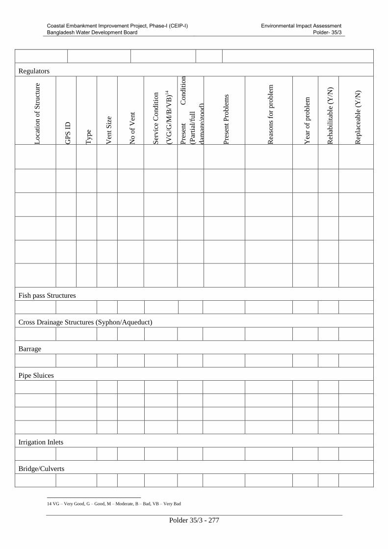
Coastal Embankment Improvement Project, Phase-I (CEIP-I) Bangladesh Water Development Board
Environmental Impact Assessment Polder- 35/3
Polder 35/3 - 277
Regulators
Lo
cati
on
of
Str
uct
ure
GP
S I
D
Ty
pe
Ven
t S
ize
No
of
Ven
t
Ser
vic
e C
ond
itio
n
(VG
/G/M
/B/V
B)1
4
Pre
sen
t C
on
dit
ion
(Par
tial
/full
dam
age/
go
od)
Pre
sen
t P
roble
ms
Rea
son
s fo
r p
rob
lem
Yea
r of
pro
ble
m
Reh
abil
itab
le (
Y/N
)
Rep
lace
able
(Y
/N)
Fish pass Structures
Cross Drainage Structures (Syphon/Aqueduct)
Barrage
Pipe Sluices
Irrigation Inlets
Bridge/Culverts
14 VG – Very Good, G – Good, M – Moderate, B – Bad, VB – Very Bad

Coastal Embankment Improvement Project, Phase-I (CEIP-I) Bangladesh Water Development Board
Environmental Impact Assessment Polder- 35/3
Polder 35/3 - 278
Others
Drainage Channels
Nam
e
Len
gth
Flo
w D
irec
tio
n
Flo
w (
%)
Pre
sen
t S
ervic
e C
on
dit
ion
\Pro
ble
ms
Rea
son
s o
f P
roble
m
Re-
exca
vat
ion
Nee
d (Y
/N)
Pro
po
sed
Re-
exca
vat
ion M
od
e
(Man
ual
/ M
echan
ical
)
Fro
m –
To
(A
pp
rox
. le
ng
th)
GP
S I
D (
Str
uct
ure
)
Irrigation Canals
Nam
e
Len
gth
Pro
ble
ms
Rea
sons
Re-
sect
ionin
g
(Y/N
)
Fro
m
–
To
(Appro
x.
length
)
Protective Works

Coastal Embankment Improvement Project, Phase-I (CEIP-I) Bangladesh Water Development Board
Environmental Impact Assessment Polder- 35/3
Polder 35/3 - 279
Lo
cati
on
Nam
e
Ty
pe
(Tem
po
rary
/Per
man
ent)
Len
gth
Pre
sen
t C
ond
itio
n
(G
/ M
D/
CD
)15
Pro
ble
ms
Rea
son
s
Fro
m
–
To
(A
ppro
x.
len
gth
)
GP
S I
D
(P
rote
ctio
n W
ork
)
Do you think that local people/Stakeholders were involved or
could be involved in future for the maintenance work of the above
mentioned works? If ‘Yes’ mention the source of generating
funds?
Persons engaged in operating gates of the structures: BWDB/Local people or Stakeholders/Beneficiaries
Problems facing in operating the gates of the structures:
Your suggestions regarding the people to be engaged in operating
these gates:
BWDB/Local people or Stakeholders/Beneficiaries
D. Water Resources
1.River system (inside and outside the polder)
Inside Outside Main river Flow direction
2. Name of beels:
Union Beels Union Beels
3. Topography: 4. Drainage pattern:
5. Drainage congestion extent (ha): Causes: Natural / Man made/Through project activities
Problems:
Reasons:
6. Water logging (% of extent) in the month of February
Union Area (%) Causes
15 G – Good, MD – Moderately Damaged, CD – Completely Damaged

Coastal Embankment Improvement Project, Phase-I (CEIP-I) Bangladesh Water Development Board
Environmental Impact Assessment Polder- 35/3
Polder 35/3 - 280
7. Flooding (depth, % of extent, onset, peak and recession)
Flood/Inundation Condition Area (%) Reasons of Flooding Onset:
F0 (< 30 cm)
F1 (30-90 cm) Peak:
F2 (90 – 180 cm)
F3 (180 – 360 cm) Recession:
F4 (> 360 cm)
E. River Erosion
River/Khal name Area (ha) Length (m) Reasons
F. Accretion
River/Khal name Area (ha) Reasons
G. Water Quality (Peoples perception)
1. Ground water (Presence of pollutant)
Arsenic (Yes/No) Location:
Iron (Yes/No) Location:
2. Surface water
River/Khal name Quality of water
(Good/Bad/Avg.)
Type of Pollutant Sources of pollutant
H. Historical severe flood:
Recent
flood Extent
(Days)
Flood level
(cm) Damage of resources
1988
1994
1998

Coastal Embankment Improvement Project, Phase-I (CEIP-I) Bangladesh Water Development Board
Environmental Impact Assessment Polder- 35/3
Polder 35/3 - 281
2004
2007
Last
five
years
Flood year Flooding areas:
Non flood year
I. Participatory Social Mapping by stakeholders (Name of regulators, name of public cuts points, Name of
breaching points, location of water logged area, identification of encroached canal with name and their location
on map)
J. Peoples opinion of the project
Pre-project condition:
Period of project benefits:
Present condition and Present problems:
Causes of problems:
Probable Solution/Improvement:

Coastal Embankment Improvement Project, Phase-I (CEIP-I) Bangladesh Water Development Board
Environmental Impact Assessment Polder- 35/3
Polder 35/3 - 282
Checklist for Land Resources, Agriculture and Livesock Information Collection
Center for Environmental and Geographic Information Services (CEGIS)
Land Resources:
1. Land degradation
Factors Year from starting LD Result of LD
Soil erosion
Sand carpeting
Salinisation
Acidification
Nutrient deficiency
Farming practices
Water logging
Others
Agriculture Resources: (For small project information collection from filed. For large project both
primary and secondary information collection from field and DAE office)
2. Cropping Pattern by land type
Land Type Kharif-I
(March-June)
Kharif-II
(July-October)
Rabi
(Nov-February)
% of area
3. Crop calendar
Crop
name
Seedling Transplanting/Sowing Harvesting
Start End Start End Start End

Coastal Embankment Improvement Project, Phase-I (CEIP-I) Bangladesh Water Development Board
Environmental Impact Assessment Polder- 35/3
Polder 35/3 - 283
4. Crop yield
*Damage area and yield loss calculation: Last 3 years average value
5. Crop damage
Name of hazard Ranked Timing Causes
Flood
Drought
Pest infestation*
Others:
*List name of pest and pesticide by crop
Crop Name Damage free Yield
(ton/ha) Damage area (%)
Damage Yield
(ton/ha)

Coastal Embankment Improvement Project, Phase-I (CEIP-I) Bangladesh Water Development Board
Environmental Impact Assessment Polder- 35/3
Polder 35/3 - 284
6. Fertilizer and pesticide application
Crop
Name
Seed
(Kg/ha)
Fertilizer (Kg/ha) Pesticide
Urea TSP MP Other No of
Appli.
Liq.
(ml/ha)
Gran.
(Kg/ha
7. Irrigation, Land preparation and Labour
Note: Support Services of the project areas
Livestock Resources: Primary and Secondary Information collection from field and DLS offices
8. Livestock and poultry production
Name of livestock and
Poultry
% of HH having
Livestock/Poultry
No. of Livestock/poultry per HH
Cow/Bullock
Buffalo
Goat
Sheep
Duck
Chicken
Crop Name Irrigation Land preparation Labour
Mode % of
Area
Charge
(Tk/ha)
Power
(%of
Area)
Animal
(% of
Area)
Tk/ha Nos./ha Tk/
labour

Coastal Embankment Improvement Project, Phase-I (CEIP-I) Bangladesh Water Development Board
Environmental Impact Assessment Polder- 35/3
Polder 35/3 - 285
9. Feed and Fodder
Name of livestock
and Poultry
Feed/Fodder Scarcity
(Timing)
Causes Remarks
Cow/Bullock
Buffalo
Goat
Sheep
Duck
Chicken
10. Diseases
Name of livestock
and Poultry
Name of
Disease
Disease (Timing) Causes Remarks
Cow/Bullock
Buffalo
Goat
Sheep
Duck
Chicken
Note: Support Services-
11. Where, when, how much and causes of Crop Damage.

Coastal Embankment Improvement Project, Phase-I (CEIP-I) Bangladesh Water Development Board
Volume V: Environmental Impact Assessment Polder- 35/3
Polder 35/3 - 286
Fisheries Baseline Checklist
EIA of Coastal Polders under CEIP
Village: Mouza: Union: Upazila: District: BWDB Circle: BWDB
Division:
Background Water bodies: Name: Alphabetic, Area: in Ha/% of area/Ana, Length: in km, Depth/Inundation depth: in Meter, Flood Duration: in Months, Production: metric
ton
Problem/Issue Fishing Effort Habitat
Type
Water
Quality
Avg.
Production
Production
Trend (+/-
) and
Reason
List
of
Gears
% of
gears
List of
Habitat
Name
Present Past (15-20 yrs back)
Are
a
Len
g
th
Wid
t
h
Dep
t
h
Du
ra
tio
n
Are
a
Len
g
th
Wid
t
h
Dep
t
h
Du
ra
tio
n
Capture
Fisheries:
1.
2.
3.
Culture
Fisheries:
4.
5.
6.
a. Total No.
of fisher
HHs:
b. %/No. of
CFHHs:
c. %/No. of
SFHHS:
d. No. of
Days spend
annually in
fishing by
CFHHs:
SFHHs:
River
Beel
(Leased/non
leased)

Coastal Embankment Improvement Project, Phase-I (CEIP-I) Bangladesh Water Development Board
Volume V: Environmental Impact Assessment Polder- 35/3
Polder 35/3 - 287
Problem/Issue Fishing Effort Habitat
Type
Water
Quality
Avg.
Production
Production
Trend (+/-
) and
Reason
List
of
Gears
% of
gears
List of
Habitat
Name
Present Past (15-20 yrs back)
Are
a
Len
g
th
Wid
t
h
Dep
t
h
Du
ra
tio
n
Are
a
Len
g
th
Wid
t
h
Dep
t
h
Du
ra
tio
n
Indiscriminate
Fishing
Activities:
7.
8.
9.
e. Hrs/Day
spend in
fishing by
CFHHs:
SFHHs:
Khal
Floodplain
Swamp
Forest
Fish pond
Baor
Other
Fish Migration Fish Biodiversity
Species List Species Composition
River Khal Beel Pond Other Group River Khal Beel Pond
Previous
Migration
Status
Fish diversity status
(Poor/Moderate/Rich)/%
Major carp
Exotic carp
Other carp
Catfish
Snakehead
Present
Obstacle to
fish
migration:
1.
2.
Reasons of increase or decrease
1.
2.
Live fish
Other fish
Prawn

Coastal Embankment Improvement Project, Phase-I (CEIP-I) Bangladesh Water Development Board
Volume V: Environmental Impact Assessment Polder- 35/3
Polder 35/3 - 288
3.
3.
4.
5.
Hilsa
Important
breeding,
feeding and
over
wintering
ground
Rui
Catla
Horizontal
Migration
pattern
Species:
1.
2.
3.
4.
5.
Season
(Months): Routes: Significant areas
1.
2.
3.
Mrigel
Koi
Sarpunti
Large prawn
Small Pprawn
Vertical
Migration
Pattern
Species:
1.
2.
3.
4.
5.
Season
(Months): Habitats:
Species of Conservation
Significance
Rare:
Silver carp
Carpu
Grass carp
Tengra
Unavailable:
Chapila
Others
Post Harvest Activities Fishermen Lifestyle

Coastal Embankment Improvement Project, Phase-I (CEIP-I) Bangladesh Water Development Board
Volume V: Environmental Impact Assessment Polder- 35/3
Polder 35/3 - 289
Fish edible quality: Socio-economic Status of
subsistence level fishermen:
Source of pollution in each habitat: Socio-economic Status of
Commercial fishermen:
Seasonal vuMNerability: Other conflict (with muscle
men/ agriculture/ other
sector/laws):
Ice factory (Number, location and
name):
Fishermen community structure
(Traditional/Caste/Religion)
Landing center, whole sale market,
other district markets, etc.:
Traditional fishermen
vulnerability(Occupation
change/others):
Storage facility (number, location
and name):
Existing Fisheries Management
Fish market (Number, location and
name):
Fishermen Community Based
Organizations (FCBOs):
Marketing problems:
WMOs activity:
Fish diseases (Name, Host species,
Season, Syndrome, Reason, etc.):
Fishing right on existing fish
habitats (Deprived/Ltd.
access/Full access):
Other backward and forward
linkages (Number, location and
name):
Leasing system:
Transport facility (Mode of fish
transportation, cost, other
involvements)
Enforcement of fisheries
regulation (Weak/strong):

Coastal Embankment Improvement Project, Phase-I (CEIP-I) Bangladesh Water Development Board
Volume V: Environmental Impact Assessment Polder- 35/3
Polder 35/3 - 290
Dry fish industries (Number,
location and name):
Department of Fisheries (DoF)
activity:
Others information: NGOs activities:
Note: 1. Major Carp - Rui, Catla, Mrigal, 2. Exotic Carp - Silver Carp, Common Carp, Mirror Carp, Grass Carp, 3. Other Carp - Ghania, Kalbasu, Kalia, 4. Cat Fish - Rita, Boal, Pangas, Silon, Aor, Bacha, 5. Snake Head - Shol, Gazar, Taki, 6. Live Fish - Koi,
Singhi, Magur, 7. Other Fish - Includes all other fishes except those mentioned above.
Beels: Rui (Labeo rohita), Catla (Catla catla), Mrigal (Cirrhinus mrigala), Kalbasu (Labeo calbasu), Gonia (Labeo gonius), Boal (Wallago attu), Air (Mystus aor / Mystus seenghala), Shol/Gazar (Channa spp.), Chital/Phali (Notopterus chitala / N. notopterus), Koi
(Anabas testudineus), Singi/Magur (Heteropneustes fossilis /Clarias batrachus), Sarpunti (Puntius sarana), Large Shrimp (Macrobrachium rosenbergii /M. malcomsonii), Small Shrimp, Silver Carp (Hypophthalmichthys molitrix), Carpio (Cyprinus carpio), Grass Crap
(Ctenopharyngodon idellus), Pabda (Ompok pabda), Punti (Puntius spp.), Tengra (Mystus spp.), Baim (Mastacembelus spp.), Chapila (Gudusia chapra), Others.
Pond: Rui (Labeo rohita), Catla (Catla catla), Mrigal (Cirrhinus mrigala), Kalbasu (Labeo calbasu), Mixed Carp, Silver Carp (Hypophthalmichthys molotrix), Grass Carp(Ctenopharyngodon idellus), Mirror Carp (Cyprinus carpio var. specularis), Tilapia (Oreochromis
mossambicus / O. niloticus), Shrimp, Aor (Mystus aor / Mystus seenghala), Boal (Wallago attu), Shol/Gazar & Taki (Channa spp.), Chital/Phali (Notopterus chitala / N. notopterus), Koi (Anabas testudineus), Singi/Magur (Heteropneustes fossilis / Clarias batrachus),
Sarpunti (Puntius sarana), Thai Sarpunti (Puntius gonionotus), Punti (Puntius spp.), Others.

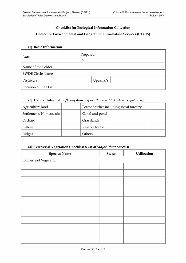
Coastal Embankment Improvement Project, Phase-I (CEIP-I) Bangladesh Water Development Board
Volume V: Environmental Impact Assessment Polder- 35/3
Polder 35/3 - 292
Checklist for Ecological Information Collection
Center for Environmental and Geographic Information Services (CEGIS)
(1) Basic Information
Date Prepared
by
Name of the Polder
BWDB Circle Name
District/s Upazila/s
Location of the FGD
(2) Habitat Information/Ecosystem Types (Please put tick where is applicable)
Agriculture land Forest patches including social forestry
Settlement/Homesteads Canal and ponds
Orchard Grasslands
Fallow Reserve forest
Ridges Others
(3) Terrestrial Vegetation Checklist (List of Major Plant Species)
Species Name Status Utilization
Homestead Vegetation

Coastal Embankment Improvement Project, Phase-I (CEIP-I) Bangladesh Water Development Board
Volume V: Environmental Impact Assessment Polder- 35/3
Polder 35/3 - 293
Mangrove Vegetation
Status: 1= Very common, 2=Common, 3= Rare, 4= Very Rare
Utilization 1=food; 2=timber; 3=fuel; 4=medicinal; 5=fiber/thatching; 6=others
(4) Terrestrial Wildlife Check List
Species Name Habitat Status Migration Status
Mammals
Amphibians
Reptiles

Coastal Embankment Improvement Project, Phase-I (CEIP-I) Bangladesh Water Development Board
Volume V: Environmental Impact Assessment Polder- 35/3
Polder 35/3 - 294
Birds
Habitat: 1= Homestead forest, 2= Floodplains, 3= Wetlands, 4= River, 5= Pond, 6=Forest
Status: 1= Very common, 2=Common, 3= Rare, 4= Very Rare
Migration Status: 1= Local, 2= Local Migratory, 3= Migratory
(5) Aquatic Wildlife Checklist
Species Name Habitat Status Migration Status
Mammals

Coastal Embankment Improvement Project, Phase-I (CEIP-I) Bangladesh Water Development Board
Volume V: Environmental Impact Assessment Polder- 35/3
Polder 35/3 - 295
Amphibians
Reptiles
Birds

Coastal Embankment Improvement Project, Phase-I (CEIP-I) Bangladesh Water Development Board
Volume V: Environmental Impact Assessment Polder- 35/3
Polder 35/3 - 296
Habitat: 1= Homestead forest, 2= Floodplains, 3= Wetlands, 4= River, 5= Pond, 6=Forest
Status: 1= Very common, 2=Common, 3= Rare, 4= Very Rare
Migration Status: 1= Local, 2= Local Migratory, 3= Migratory
(6) Foreshore vegetation/Mangrove vegetation
Name of the forest patches
location (s) Species Name Abundance Utilization
Abundance1= High,2=Moderate,3=Low
Utilization 1=food; 2=timber; 3=fuel; 4=medicinal; 5=fiber/thatching; 6=others
(7) Major Wetland information
Name of wetland Type of
Wetland
Area in
Acre
Connectivity Impor
tance Khal River

Coastal Embankment Improvement Project, Phase-I (CEIP-I) Bangladesh Water Development Board
Volume V: Environmental Impact Assessment Polder- 35/3
Polder 35/3 - 297
Type 1= Beels, 2= Rivers, 3= Open water wetlands, 4= Floodplains, 5= Closed water wetlands, 6= Ponds, 7= Baors (oxbow lake).
1 1=Fish; 2= migratory bird; 3= other wildlife; 4=aquatic flora
Wetland vegetation Checklist
Species Name Habit Status Utilization
Habit 1=Submerged, 2=Free floating, 3=Rooted floating, 4=Sedges, 5=Marginal
Status 1= High, 2= Moderate, 3= Low
Utilization 1=food; 2=timber; 3=fuel; 4=medicinal; 5=fiber/thatching; 6=others
(8) Forest Information (Surrounding/nearer the polder)
Forest Name with
Range/Beet office Type Location
Area in
Acre
Major
Plant Species

Coastal Embankment Improvement Project, Phase-I (CEIP-I) Bangladesh Water Development Board
Volume V: Environmental Impact Assessment Polder- 35/3
Polder 35/3 - 298
Type 1=Swamp Forest, 2=Reserve Forest, 3=Vested Forest, 4=Reed forest, 5=Other (specify)
(9)Anticipated Impacts due to proposed interventions on particular Ecosystems
(Impact from changed land use, noise, human presence etc.)
Name of
Intervention Impacts
Embankment Re-
sectioning
Breach Closing
Construction of
Water control
Structures
(10) Comments (If any):

Coastal Embankment Improvement Project, Phase-I (CEIP-I) Bangladesh Water Development Board
Volume V: Environmental Impact Assessment Polder- 35/3
Polder 35/3 - 299
EIA of Coastal polders under CEIP
RRA/FGD Data Collection Format for Socio-economic Survey
Date of Survey:.................................. Name of Polder:
1. Place of Interview:
Name of Mouza(s).....................................................................................................................................
Union(s)/Ward(s).......................................................................................................................................
Municipality(s).if any
..................................................................................................................................
Upazila(s)/Thana(s).............................................................................
District(s)/......................................
2. Characteristics of Population:
2.1 Total Households, Population (male, female, rural and urban) in Project area
Total Households Population
Male Female Total
Source: BBS
2.2 Age distribution
Age range
0-4 Years 5-9 Years 10-14 Years 15-17Years 18-34 Years 35-59 Years 60+Years
M F M F M F M F M F M F M F
Source: BBS
2.3 Literacy rate
% of Literacy (Over 7 years)
Total Male Female
Source: BBS
2.4 Occupation and employment
Main occupation by population % of population
Not working
Looking for work
Household work

Coastal Embankment Improvement Project, Phase-I (CEIP-I) Bangladesh Water Development Board
Volume V: Environmental Impact Assessment Polder- 35/3
Polder 35/3 - 300
Main occupation by population % of population
Agriculture
Industry
Water, Electricity & Gas
Construction
Transport
Hotel & Restaurant
Business
Service
Others….. Source: BBS
Main occupation by households:
Main occupation by households % of households
Agriculture/Forestry/Livestock
Fishery
Agriculture Laborer
Non-agriculture Laborer
Handloom
Industry
Business
Hawker
Construction
Transport
Religious
Service
Rent
Remittance
Others….. Source: BBS
2.5 Labor availability and wage
a. Labor (Male) for farming (High/Medium/Low), Av. Wage/Day (Tk.) Max:............Min:
..............
b. Labor (M) for non-farming (High/ Medium/ Low), Av. Wage/Day (Tk.) Max:............Min:
..............
c. Labor (Female) for farming (High/Medium/Low), Av. Wage/Day (Tk.) Max:............Min: ..............

Coastal Embankment Improvement Project, Phase-I (CEIP-I) Bangladesh Water Development Board
Volume V: Environmental Impact Assessment Polder- 35/3
Polder 35/3 - 301
d. Labor (F) for non-farming (High/ Medium/ Low), Av. Wage/Day (Tk.) Max:............Min: ..............
2.6 Migration (seasonal/permanent)
a. Seasonal out migration from study area (% per year with location):
b. Seasonal in migration to study area (% per year with location):
c. Permanent out migration from study area (Number per 1/2 years with location):
d. Permanent in migration to study area (Number per 1/2 years with location):
2.7 Annual Expenditure and Income by range
a. Expenditure
Expenditure group (in taka) Percentage of households
<=12,000
12,000-24,000
24,000-60,000
60,000-1,08,000
1,08,000-2,40,000
>=2,40,000
Sources: RRA
b. Income
Expenditure group (in taka) Percentage of households
<=12,000
12,000-24,000
24,000-60,000
60,000-1,08,000
1,08,000-2,40,000
>=2,40,000
Sources: RRA
2.8 Self assessed poverty for year round
Sl. No. Poverty status Percentage of households
1 Deficit

Coastal Embankment Improvement Project, Phase-I (CEIP-I) Bangladesh Water Development Board
Volume V: Environmental Impact Assessment Polder- 35/3
Polder 35/3 - 302
Sl. No. Poverty status Percentage of households
2 Balance/Breakeven
3 Surplus
Sources: RRA
Housing (photographs)
Sl. No. Housing status % of hhs having
1 Jhupri
2 Kutcha
3 Semi Pucka
4 Pucca
Source: RRA
2.10 Drinking water (photographs)
Sl. No. Drinking water sources Percentage of households use
1 Tap
2 Tube well
3 Well
4 Pond
5 Other.........................
Source: BBS
2.11 Sanitation (photographs)
Sl. No. Toilet types Percentage of households under each type
1 Water Sealed
2 Ring Slub
3 Kacha
4 No facilities
Source: RRA
2.12 Diseases in polder area
a. Diseases in area
Sl.
No.
Disease Ranking by
incidence
Sl.
No.
Disease Ranking by
incidence
1 Influenza/ Common
fever
9 Chicken pox
2 Cough/cold 10 Skin disease

Coastal Embankment Improvement Project, Phase-I (CEIP-I) Bangladesh Water Development Board
Volume V: Environmental Impact Assessment Polder- 35/3
Polder 35/3 - 303
Sl.
No.
Disease Ranking by
incidence
Sl.
No.
Disease Ranking by
incidence
3 Diarrhoea 11 Diabetes
4 Dysentery 12 Hypertension
5 Hepatitis 13 Asthma
6 Malaria 14 T B
7 Dengue fever 15 Gastric
8 Typhoid 16 Arsenicosis
Sources: RRA
b. Health facilities in study area (photographs)
Sl. No. Type of facility Number of facilities with name
1 Number of District level Hospitals
2 Number of Upazila Health
Complex
3 Union Health Center
4 Private Health Clinic/ Hospitals
Sources: RRA

Coastal Embankment Improvement Project, Phase-I (CEIP-I) Bangladesh Water Development Board
Volume V: Environmental Impact Assessment Polder- 35/3
Polder 35/3 - 304
b.1 Status of peripheral health facilities used by the study area people:
__________________________________________________________________________________
__________________________________________________________________________________
__________________________________________________________________________________
__________________________________________________________________________________
__________________________________________________________________________________
__________________________________________________________________________________
c. Source of treatment facilities in study area
Sl. No. Source of treatment facilities % of hhs received
1 Trained Physician
2 Paramedic/ Diploma Physician
3 Quack Doctor and Informal Treatments
4 No treatment facilities at all
Sources: RRA
2.13 Electricity
a. Percentage of household having electricity facility: .........................................BBS
b. Percentage of household having electricity facility: .........................................(During Survey)
3. Social overhead capital (photographs)
3.1 Existing road networks in study area and it's level of benefit
a. National Road (km.) ......................(GIS) Beneficial: Highly /Moderately / Poorly
b. Regional Road (km.) ..................... (GIS) Beneficial: Highly /Moderately / Poorly
c. Local Road Pucca (km.) ...................... .... (GIS) Beneficial: Highly /Moderately / Poorly
d. Local Road Kancha (km.) ...................... .... (GIS) Beneficial: Highly /Moderately / Poorly
3.1.1 Status of peripheral road networks (with name) used by the study area people:

Coastal Embankment Improvement Project, Phase-I (CEIP-I) Bangladesh Water Development Board
Volume V: Environmental Impact Assessment Polder- 35/3
Polder 35/3 - 305
__________________________________________________________________________________
__________________________________________________________________________________
__________________________________________________________________________________
__________________________________________________________________________________
__________________________________________________________________________________
__________________________________________________________________________________
__________________________________________________________________________________
__________________________________________________________________________________
______________________________________________________________________.
3.2 Existing railway network in study area and it's level of benefit
a. Railway (km.) ...................... (GIS) Beneficial: Highly /Moderately / Poorly
3.2.1 Status of peripheral railway service used by the study area people:
__________________________________________________________________________________
__________________________________________________________________________________
______________________________________________________________________________
________________________________________________________________________________
________________________________________________________________________________
______________________________________________________________________________
3.3 Existing waterways in study area and it's level of benefit
a. National Route (km.) ...................... (GIS) Beneficial: Highly /Moderately / Poorly
b. Local Route (km.) ...................... .... (GIS) Beneficial: Highly /Moderately / Poorly
3.3.1 Status of peripheral water ways (with name) used by the study area people:
__________________________________________________________________________________
__________________________________________________________________________________
__________________________________________________________________________________
_____________________________________________________________________________
________________________________________________________________________________
________________________________________________________________________________
3.4 Status of the navigation route by season
a. National Route: Served Seasonally/Through out the year
b. Local Route: Served Seasonally/ Through out the year

Coastal Embankment Improvement Project, Phase-I (CEIP-I) Bangladesh Water Development Board
Volume V: Environmental Impact Assessment Polder- 35/3
Polder 35/3 - 306
3.5 Major waterways handicapped
a. by structures.................................... location
b. by siltation................................. location
3.6 Nos. of major ghats/ports and name:
3.7 Academic Institution (school, colleges) (photographs)
Sl. No. Type of facility Nos. of
Institution
Type of facility Nos. of
Institution
1 Primary School Ebtedayee Madrasha
2 High School Dakhil Madrasha
3 College Alim/ Fazil Madrasha
Sources: RRA
3.7.1 Status of peripheral academic institutions (with name) used by people of the study area:
__________________________________________________________________________________
__________________________________________________________________________________
__________________________________________________________________________________
______________________________________________________________________________
_________________________________________________________________________________
3.8 Markets and GC (photographs)
Sl. No. Type of facility Nos. of markets Comments with name
1 Major markets
2 Minor markets
3 Growth Centers
Sources: RRA
3.8.1 Status of peripheral markets used by people of the study area:
__________________________________________________________________________________
__________________________________________________________________________________

Coastal Embankment Improvement Project, Phase-I (CEIP-I) Bangladesh Water Development Board
Volume V: Environmental Impact Assessment Polder- 35/3
Polder 35/3 - 307
__________________________________________________________________________________
____________________________________________________________________________
______________________________________________________________________
_________________________________________________________________________________
4. Land holding categories
4.1 Percentage of HH who have owned agricultural land: ......................(BBS)
4.2 Percentage of households with different land ownership category in the area:
Land ownership classes Percentage of household
Land less/ No land (0 decimal)
Land less (up to 49 decimal)
Marginal (50-100 decimal)
Small (101-249 decimal)
Medium (250-749 decimal)
Large (750 + decimal)
Sources: RRA
5. Conflict between different land owner group and professional group
Reasons of
Conflicts
Present status of problem Solution they want with location
Water control
infrastructures
Coastal Embankment Improvement Project, Phase-I (CEIP-I) Bangladesh Water Development Board
Volume V: Environmental Impact Assessment Polder- 35/3
Polder 35/3 - 308
Reasons of
Conflicts
Present status of problem Solution they want with location
Land
elevation
Cross-interest
6. Disaster related information: (photographs)
6.1 Type of major disaster and damage occurred in the area after completion of the Project
Sl.
No.
Major
Disaster
Severely
affected
year
% of area
affected
% of hhs
affected
% of
crop
damage
Major crop
damaged
1 Flood
2 Drought
3 Tidal flood
4 Storm
5 Cyclone

Coastal Embankment Improvement Project, Phase-I (CEIP-I) Bangladesh Water Development Board
Volume V: Environmental Impact Assessment Polder- 35/3
Polder 35/3 - 309
Sl.
No.
Major
Disaster
Severely
affected
year
% of area
affected
% of hhs
affected
% of
crop
damage
Major crop
damaged
6 Hail storm
7 Salinity
intrusion
8 Water logging
9 Erosion
Sources: RRA
7. Safety Nets and Poverty Reduction Measures in the area:
7.1 Name and activity of GO/ NGOs working in this area
Name
Activity (Credit, Education, Health, Forestry, Fishery,
Livestock Rearing, Women Empowerment, Human
Rights, VGF, Boyosko bhata, etc.)
% of HHs
coverage

Coastal Embankment Improvement Project, Phase-I (CEIP-I) Bangladesh Water Development Board
Volume V: Environmental Impact Assessment Polder- 35/3
Polder 35/3 - 310
Name
Activity (Credit, Education, Health, Forestry, Fishery,
Livestock Rearing, Women Empowerment, Human
Rights, VGF, Boyosko bhata, etc.)
% of HHs
coverage
8. Information on Water Management Organizations (WMOs) (photographs of office building,
committee members, resolution etc)
8.1 Do you know about the CEIP project? Y/N
8.2 Existence of WMOs: Yes/No
8.2.1 If WMO exists:
Sl Issue/Question Response/Suggestion
a) Year of formation
(date if possible)
b) Registered by whom?
c) Number of members
(male-female)
Male Female Comments
Farmer
Trader
Labor
Landless
Fisher
Coastal Embankment Improvement Project, Phase-I (CEIP-I) Bangladesh Water Development Board
Volume V: Environmental Impact Assessment Polder- 35/3
Polder 35/3 - 311
Sl Issue/Question Response/Suggestion
Service holder
Others
d) No. of villages
covered
e) Existence of fund
f) AGM
g) Election
h) EC meetings
i)
Present water
resources
management activities
8.2.2 Name of EC members with address/phone number:
Sl. No. Name Address Phone Number
1
2
3
4
5
6
7

Coastal Embankment Improvement Project, Phase-I (CEIP-I) Bangladesh Water Development Board
Volume V: Environmental Impact Assessment Polder- 35/3
Polder 35/3 - 312
Sl. No. Name Address Phone Number
8
9
10
11
12
13
14
15
8.2.3 If WMO does not exist, please state the reasons for
__________________________________________________________________________________
__________________________________________________________________________________
_______________________________________________________________________________
8.3 Are people willing to form WMO? Y/N
(If yes, give demonstrative proof of their capacity if any)
8.4 Is WMO willing to take up management responsibilities? Y/N
8.4.1 If yes, please give some idea about what to do on management
9. Some other Issues
9.1 Any land acquisition to be needed for the rehabilitation of the polder ? Yes/No
9.1.1 If yes, size of the area? _________________________________(acre)
9.1.2 If yes, are they willing to provide land for acquisition? Yes/No
9.2 Any replacement of people to be needed for the rehabilitation of the scheme? Yes/No
9.2.1 If yes, how many? ____________________________ (number of household)

Coastal Embankment Improvement Project, Phase-I (CEIP-I) Bangladesh Water Development Board
Volume V: Environmental Impact Assessment Polder- 35/3
Polder 35/3 - 313
9.3 Have any cultural heritage /archeological sites in the polder? Yes/No
a. Give some description
9.4 Have any vulnerable communities (e.g. landless, fishermen, boatmen, destitute women without
food and/or shelter) in the scheme area? Yes/No
a. Give some description
9.5 Have any common property resources (e.g. irrigation systems, fishing grounds (wetlands),
pastures, forests, graveyard, cremation ground, mosque, temple, etc.) in the scheme area? Yes/No
a. Give some description
10. Comments of Facilitator:
Name of the RRA/FGD Participants:
Name Age Occupation Address/Phone No.

Coastal Embankment Improvement Project, Phase-I (CEIP-I) Bangladesh Water Development Board
Volume V: Environmental Impact Assessment Polder- 35/3
Polder 35/3 - 314
Name Age Occupation Address/Phone No.

Coastal Embankment Improvement Project, Phase-I (CEIP-I) Bangladesh Water Development Board
Volume V: Environmental Impact Assessment Polder- 35/3
Polder 35/3 - 315
Annex B: No Objection Certificate

Coastal Embankment Improvement Project, Phase-I (CEIP-I) Bangladesh Water Development Board
Volume V: Environmental Impact Assessment Polder- 35/3
Polder 35/3 - 316
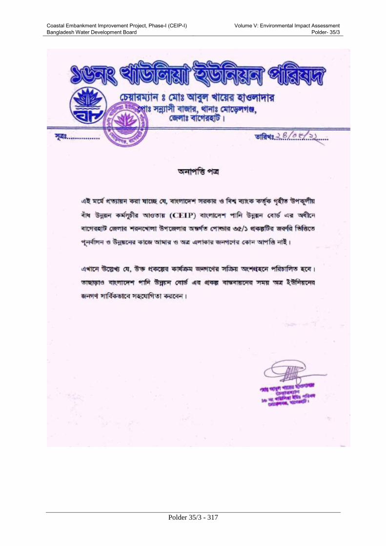
Coastal Embankment Improvement Project, Phase-I (CEIP-I) Bangladesh Water Development Board
Volume V: Environmental Impact Assessment Polder- 35/3
Polder 35/3 - 317

Coastal Embankment Improvement Project, Phase-I (CEIP-I) Bangladesh Water Development Board
Volume V: Environmental Impact Assessment Polder- 35/3
Polder 35/3 - 318
Annex C: Additional Figure
Figure1: Soil and Water Contamination places of Polder 35/3

Coastal Embankment Improvement Project, Phase-I (CEIP-I) Bangladesh Water Development Board
Volume V: Environmental Impact Assessment Polder- 35/3
Polder 35/3 - 319
Figure2: Location of monitoring places in Polder 35/3

Coastal Embankment Improvement Project, Phase-I (CEIP-I) Bangladesh Water Development Board
Volume V: Environmental Impact Assessment Polder- 35/3
Polder 35/3 - 320
Annex D: List of participants of PCM and FGD

Coastal Embankment Improvement Project, Phase-I (CEIP-I) Bangladesh Water Development Board
Volume V: Environmental Impact Assessment Polder- 35/3
Polder 35/3 - 321

Coastal Embankment Improvement Project, Phase-I (CEIP-I) Bangladesh Water Development Board
Volume V: Environmental Impact Assessment Polder- 35/3
Polder 35/3 - 322
Table B1: Gujihati, Kara Para, Bagherhat Sadar, Bagerhat. (FGD-1)
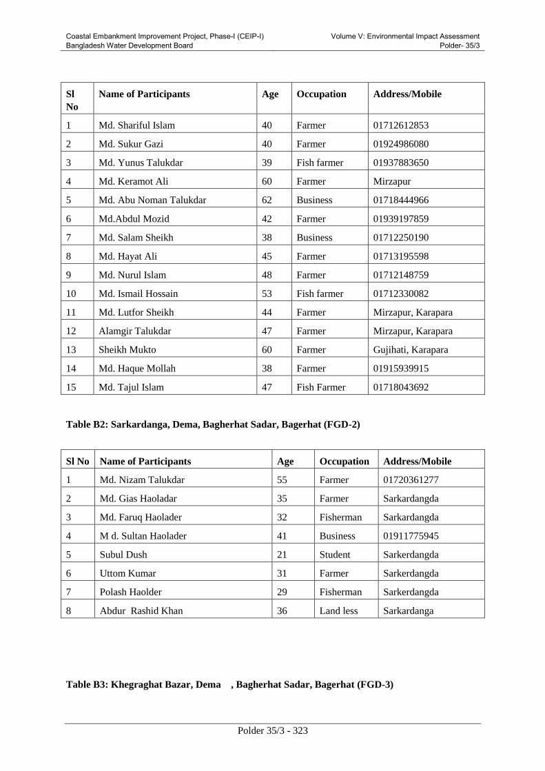
Coastal Embankment Improvement Project, Phase-I (CEIP-I) Bangladesh Water Development Board
Volume V: Environmental Impact Assessment Polder- 35/3
Polder 35/3 - 323
Sl
No
Name of Participants Age Occupation Address/Mobile
1 Md. Shariful Islam 40 Farmer 01712612853
2 Md. Sukur Gazi 40 Farmer 01924986080
3 Md. Yunus Talukdar 39 Fish farmer 01937883650
4 Md. Keramot Ali 60 Farmer Mirzapur
5 Md. Abu Noman Talukdar 62 Business 01718444966
6 Md.Abdul Mozid 42 Farmer 01939197859
7 Md. Salam Sheikh 38 Business 01712250190
8 Md. Hayat Ali 45 Farmer 01713195598
9 Md. Nurul Islam 48 Farmer 01712148759
10 Md. Ismail Hossain 53 Fish farmer 01712330082
11 Md. Lutfor Sheikh 44 Farmer Mirzapur, Karapara
12 Alamgir Talukdar 47 Farmer Mirzapur, Karapara
13 Sheikh Mukto 60 Farmer Gujihati, Karapara
14 Md. Haque Mollah 38 Farmer 01915939915
15 Md. Tajul Islam 47 Fish Farmer 01718043692
Table B2: Sarkardanga, Dema, Bagherhat Sadar, Bagerhat (FGD-2)
Sl No Name of Participants Age Occupation Address/Mobile
1 Md. Nizam Talukdar 55 Farmer 01720361277
2 Md. Gias Haoladar 35 Farmer Sarkardangda
3 Md. Faruq Haolader 32 Fisherman Sarkardangda
4 M d. Sultan Haolader 41 Business 01911775945
5 Subul Dush 21 Student Sarkerdangda
6 Uttom Kumar 31 Farmer Sarkerdangda
7 Polash Haolder 29 Fisherman Sarkerdangda
8 Abdur Rashid Khan 36 Land less Sarkardanga
Table B3: Khegraghat Bazar, Dema , Bagherhat Sadar, Bagerhat (FGD-3)

Coastal Embankment Improvement Project, Phase-I (CEIP-I) Bangladesh Water Development Board
Volume V: Environmental Impact Assessment Polder- 35/3
Polder 35/3 - 324
Sl
No
Name of Participants Age Occupation Address/Mobile
1 Md. Sheikh Siddique 45 Farmer Khegraghat
2 Md. Abdul Hakim 35 Business Khegraghat
3 Md.Elias Sheikh 46 Van Puller Khegraghat
4 Md.Helal Uddin 36 Business Khegraghat
5 Md. Sheikh Abdul Latif 40 Business 01929394688
6 Rabindranath Mistri 49 Farmer 01721759403
7 Md. Nurul Islam 43 UP Member 01752008850
Table B4: Madardia Launch Ghat, Mollikerber, Rampal, Bagerhat (FGD-4)
Sl No Name of Participants Age Occupation Address/Mobile
1 Haoladar Abdus Salam 45 UP Member 01925175601
2 Md. Mosarraf 40 Business 01190674139
3 Md. Shohag Sheikh 38 Business 01827591157
4 Md. Lablu Haoladar 35 Business 01965440703
5 Md. Hasan Sheikh 40 Business 01927621626
6 Md. Kamal Haoladar 45 Farmer 01927033513
7 Md.Moslem Ali Sheikh 50
Farmer 01917873684
8 Sayed Ali Khan 52 Farmer
01920586077
9 Mobakker Ali 45 Farmer 01946514571
10 Razia Begum 38 House wife 01922871993
11 Laltu Haoladar 44 Fishermen 01721886660
12 Jafor Haoladar 55 Teacher 01937877686
13 Md. Monirul Islam 34 Business 01735746012
Table B5: Boro Bashbaria 6 Vent sluice gate, Dema, Bagherhat Sadar, Bagerhat (FGD-5)
Sl No Name of Participants Age Occupation Address/Mobile
1 Md. Abdul Razzak haoladar 28 Farmer 01923361445
2 Md. Mollik Sadeque 35 Farmer 01934718036
3 Biran Sikdar 58 Teacher Bashbaria
4 Md. Sultan Haoladar 48 Farmer 01718207876
5 Md. Jakir Haoladar 40 Business 01725614321

Coastal Embankment Improvement Project, Phase-I (CEIP-I) Bangladesh Water Development Board
Volume V: Environmental Impact Assessment Polder- 35/3
Polder 35/3 - 325
6 Md. Bachchu 28 Business 01935347747
7 Md. Shahidul Islam 48 Boatman Bashbaria
8 Md. Nur islam haoladar 35 Business 01921451563
9 Md. Altab Hossain 45 Business Bashbaria
10 Md. Rubel Haoladar 25 Farmer 01925214093
11 Mahbub Haoladar 22 Farmer Bashbaria
12 Md. Sohaban Haoladar 32 Farmer Bashbaria
Table B6: Rada Ballav, Kara Para, Bagherhat Sadar, Bagerhat (FGD-6)
Sl No Name of Participants Age Occupation Address/Mobile
1 Uttam Kumar 28 UP Member 01934720722
2 Sreemoty Nomita rani 35 House wife Rada Ballav
3 Md. Faruq shake 24 Farmer Rada Ballav
4 Md. Sultan Halder 48 Farmer Rada Ballav
5 Md. Sarwar Hosain 40 Business Rada Ballav
6 Jashim Uddin 28 Farmer Putimari
7 Md. Altab Hossain 48 Fishermen Putimari
Table B7: Plan Bazar, Maliker Ber, Bagherhat Sadar, Bagerhat (FGD-7)
Sl No Name of Participants Age Occupation Address/Mobile
1 Md. Abdul Karim 45 Farmer Plan Bazar
2 Md. Usman Haoladar 55 Farmer Plan Bazar
3 Md. Firaz Ahmed 42 Business Sannasi
4 Md. Shahidul Islam 28 Farmer Sannasi
5 Md. Abdus Salam 50 Farmer Plan Bazar
6 Md. Sahdat Hossain 44 Business Paschim Mollikerber
7 Md. Al Amin 26 Farmer Paschim Mollikerber
8 Md. Mannan Sheikh 45 Farmer 01944228098
Coastal Embankment Improvement Project, Phase-I (CEIP-I) Bangladesh Water Development Board
Volume V: Environmental Impact Assessment Polder- 35/3
Polder 35/3 - 326
Annex E: TOR for Environmental Impact
Assessment (EIA) of Polder 35/3
Background
Bangladesh Water Development Board (BWDB) requires to conduct Environmental Impact
Assessment (EIA) study for Polder 35/3 under CEIP, as per the findings of IEE study as well as the
guidelines of DOE and World Bank. The EIA reports will be submitted to DOE for obtaining
environmental clearance. The EIA study should be conducted according to following scope of works.
Objective
The objective of the EIA study is assessment of environmental impacts and preparation of
environmental management plan for implementing the sub-projects without harming the environment.
Scope of works
i) Carry out detail field investigation of required parameters of environmental and social
baseline, especially on the critical
ii) Determine the potential impacts due to the project through identification, analysis and
evaluation on sensitive areas (natural habitats; sites of historic, cultural and conservation
importance), settlements and villages/agricultural areas or any other identified Important
Environmental and social Component (IESCs).
iii) Determine cumulative environmental impacts of the project that may occur inside and
outside the project area.
iv) Distinguish between significant positive and negative impacts, direct and indirect impacts,
immediate and long-term impacts, and unavoidable or irreversible impacts.
v) Identify feasible and cost effective mitigation measures for each impact predicted as above
to reduce potentially significant adverse environmental impacts to acceptable levels.
vi) Determine the capital and recurrent costs of the measures, and institutional, training and
monitoring requirements to effectively implement these measures. The Consultant is
required to identify all significant changes likely to be generated by the project. These would
include, but not be limited to, changes in the coastal erosion and accretion due to alteration of
tidal currents, changing fish migration routes, destruction of local habitats, and water
logging, etc.
vii) Consult with modeling consultants to establish conformity of the impact assessment with
existing and ongoing mathematical model due to climate change developed by a number of
reputed firms. The developed models may be available from the main consultant and
implementing agency;
viii) Prepare (a) an estimate of economic costs of the environment damage and economic
benefits, where possible, from the direct positive impacts that the project is likely to cause,
and (b) an estimate of financial costs on the mitigation and enhancement measures that the
project is likely to require, and financial benefits, if any; The damage/ cost and benefits
should be estimated in monetary value where possible, otherwise describe in qualititative
terms.
ix) Describe alternatives that were examined in the course of developing the proposed project
Coastal Embankment Improvement Project, Phase-I (CEIP-I) Bangladesh Water Development Board
Volume V: Environmental Impact Assessment Polder- 35/3
Polder 35/3 - 327
and identify other alternatives that would achieve the same objectives. The concept of
alternatives extends to the siting and design, technology selection,
rehabilitation/construction techniques and phasing, and operating and maintenance
procedures. Compare alternatives in terms of potential environmental impacts,
vuMNerability, reliability, suitability under local conditions, and institutional, training, and
monitoring requirements. When describing the impacts, indicate which are irreversible or
unavoidable and which may be mitigated. To the extent possible, quantify the costs and
benefits of each alternative, incorporating the estimated costs of any mitigating measures.
Include the alternative of not constructing the project to demonstrate environmental
conditions without it.
x) Identify the specific reciprocal impact of climate change and polder. Check the suggested
polder height with respect to the SLR and high tide. The sub consultant will ensure that the
design will minimize the negative impact on the environment due to polder rehabilitation
activities. For example, adequate fish pass should be provided to ensure free movement of
fish or drainage facility should be provided to avoid water logging in the surrounding area.
xi) Prepare a detailed Environmental Management Plans along with the respective EIA separately
to monitor the implementation of mitigating measures and the impacts of the project of other
inputs (such as training and institutional strengthening) needed to conduct it during
construction and operation. Include in the plan an estimate of capital and operating costs and
a description of other inputs (such as training and institutional strengthening) needed to
implement the plan.
xii) Ensure to address Occupational health and safety for the construction workers in the EMP;
xiii) Develop Environmental monitoring format for regular monitoring of the project at the pre-
construction, construction and operational stage;
xiv) Prepare the EIA report
Structure of the EIA report
EIA report should be prepared as per following key contents, but not limited to:
1. Executive Summary
2. Introduction: This section will include (i) purpose of the report and (ii) extent of the IEE
study.
3. Methodology of EIA
4. Policy, Legal and Administrative Framework: This section will describe relevant environmental policies,
rules and administrative procedures that need to be followed for the proposed project.
5. Project Description: This section will provide a brief but clear picture about (i) type of
project; (ii) category of Project; (iii) need for project; (iv) location (use maps showing
general location, specific location, and project site); (v) size or magnitude of operation;(vi)
proposed schedule for implementation)
6. Analysis of Alternatives: This section will describe analysis of alternatives in terms of project
location and technical designs and associated environmental impacts.

Coastal Embankment Improvement Project, Phase-I (CEIP-I) Bangladesh Water Development Board
Volume V: Environmental Impact Assessment Polder- 35/3
Polder 35/3 - 328
7. Environmental and Social Baseline: This section will provide sufficient information on the
existing environmental and social baseline resources in the area affected by the project,
including the following:
(i) Physical Resources: (e.g. atmosphere, topography, air quality etc.)
(ii) Water Resources: (e.g. hydrology, surface water and groundwater system, sedimentation,
tidal influence, etc.)
(iii) Land and Agriculture resources: (e.g. land type, landuse, cropping pattern, crop
production, etc.)
(iv) Fisheries resources: (e.g. fisheries diversity, fish production, etc.)
(v) Ecology: (e.g. ecosystems, wildlife, forests, rare or endangered species, protected areas,
coastal resources, etc.)
(vi) Socio-economic condition: (e.g. population and communities (e.g. numbers, locations,
composition, employment), health facilities, education facilities, socio-economic
conditions (e.g. community structure, family structure, social well being), physical or
cultural heritage, current use of lands and resources for traditional purposes by
Indigenous Peoples, structures or sites that are of historical, archaeological,
paleontological, or architectural significance, economic development (e.g. industries,
infrastructure facilities, transportation, power sources and transmission, mineral
development, and tourism facilities, etc.)).
8. Climate Change: Climate change aspects in global, regional and local perspectives and the
likely impacts on the Project area and its surroundings should briefly discus in this section.
9. Stakeholder Consultation and Disclosure: This section will describe the process undertaken to
involve the public in project design and recommended measures for continuing public
participation; summarize major comments received from beneficiaries.
10. Significant Environmental and Social Impacts: Significant environmental and social impacts
due to project location, and related to project design, construction, and operations phase
should discus detail in this section.
11. Cumulative and Induced Impacts: Cumulative impacts of the proposed Project and other
projects as well as induced impacts should provide in this section.
12. Environmental Management Plan: The environmental management plan (EMP) will include
institutional arrangement for EM, mitigation and enhancement plan, compensation and
contingency plan as well as monitoring plan. The EMP should also include tentative cost of
implementation of the plan.
13. List of References
14. Annexes:
Checklist for Environmental and Social Survey
Records of Consultations (list of participants and photographs)
Data and Unpublished Reference Documents

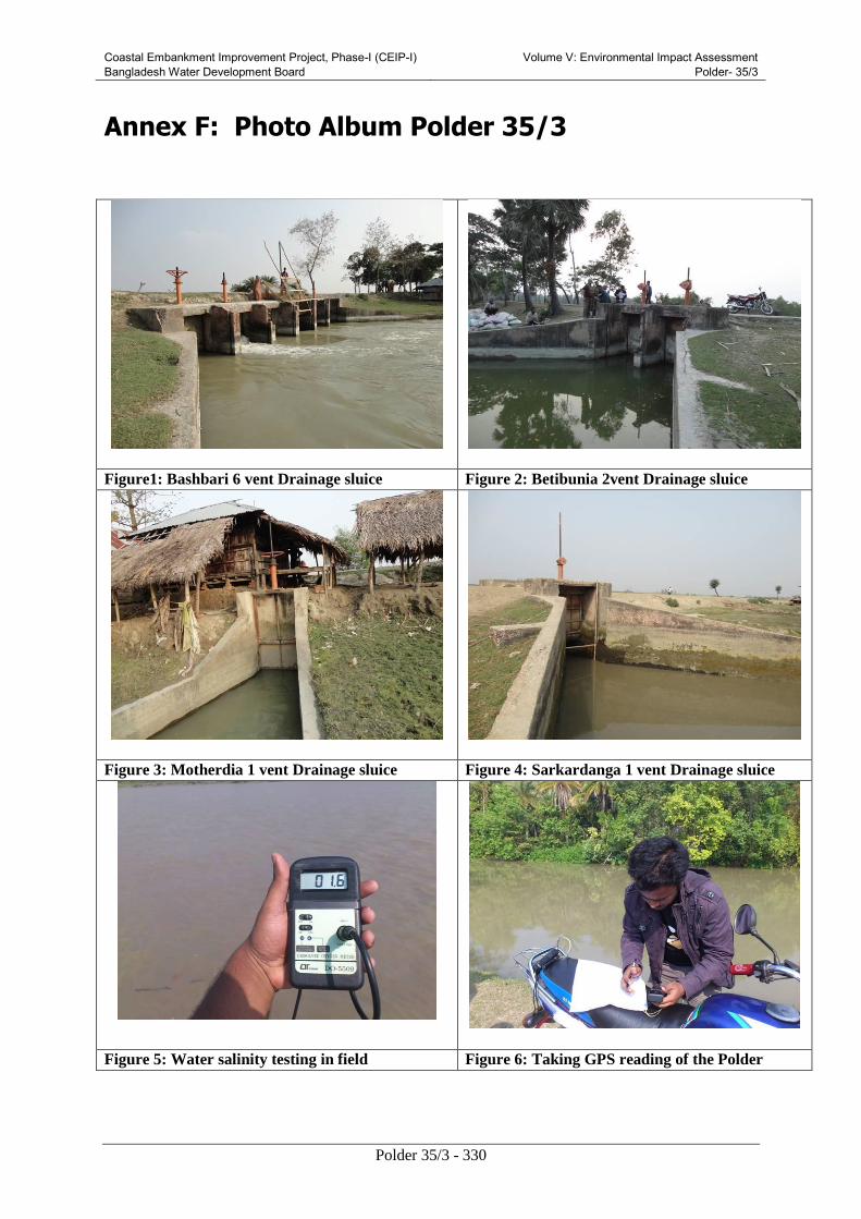
Coastal Embankment Improvement Project, Phase-I (CEIP-I) Bangladesh Water Development Board
Volume V: Environmental Impact Assessment Polder- 35/3
Polder 35/3 - 330
Annex F: Photo Album Polder 35/3
Figure1: Bashbari 6 vent Drainage sluice Figure 2: Betibunia 2vent Drainage sluice
Figure 3: Motherdia 1 vent Drainage sluice Figure 4: Sarkardanga 1 vent Drainage sluice
Figure 5: Water salinity testing in field Figure 6: Taking GPS reading of the Polder

Coastal Embankment Improvement Project, Phase-I (CEIP-I) Bangladesh Water Development Board
Volume V: Environmental Impact Assessment Polder- 35/3
Polder 35/3 - 331
Figure7: River bank erosion at Radabhallob Figure 8: River erosion at Baro Banshbaria
Figure 9: Shifting of house at Panchamal due to
retired of embankment
Figure 10:Embankment used as rural road
Figure 11: Madardia launch ghat Figure 12:Navigation in Bhairab river

Coastal Embankment Improvement Project, Phase-I (CEIP-I) Bangladesh Water Development Board
Volume V: Environmental Impact Assessment Polder- 35/3
Polder 35/3 - 332
Figure 13: Navigation in Bhairab river Figure 14: Navigation in Bhairab river
Figure 15: Internal navigation at Putimari river Figure 16: Internal navigation at Betibunia khal
Figure 17: Kutcha road in the polder Figure 18: Heringbone Road in the polder

Coastal Embankment Improvement Project, Phase-I (CEIP-I) Bangladesh Water Development Board
Volume V: Environmental Impact Assessment Polder- 35/3
Polder 35/3 - 333
Figure 19: Pucca Road in the polder Figure 20: Pucca Road in the polder
Figure 21:View of Aman crop land Figure 22:View of Rice cum fish culture in the
Polder
Figure 23:Farmers ploughing own land for Boro
cultivation
Figure 24: Soil Sample Collection in Paschim
Mollikerber

Coastal Embankment Improvement Project, Phase-I (CEIP-I) Bangladesh Water Development Board
Volume V: Environmental Impact Assessment Polder- 35/3
Polder 35/3 - 334
Figure25:Cattle on the embankment Figure 26: Buffaloes inside the Polder
Figure 27: Fishing boat Figure 28: Saline water entering into Shrimp
gher
Figure 29: Fishing by khepla jal Figure 30: Fish precessing for marketing

Coastal Embankment Improvement Project, Phase-I (CEIP-I) Bangladesh Water Development Board
Volume V: Environmental Impact Assessment Polder- 35/3
Polder 35/3 - 335
Picture 31: Shrimp gher Picture 32: Bagda harvesting from gher
Figure 33: Crab farm inside the Polder Picture 34: Crab collection from gher
Figure 35: Sonnyasi bazar in Polder area Figure 36: Planer bazar along the embankment
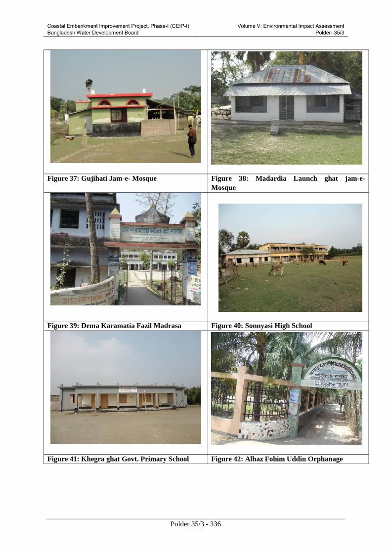
Coastal Embankment Improvement Project, Phase-I (CEIP-I) Bangladesh Water Development Board
Volume V: Environmental Impact Assessment Polder- 35/3
Polder 35/3 - 336
Figure 37: Gujihati Jam-e- Mosque Figure 38: Madardia Launch ghat jam-e-
Mosque
Figure 39: Dema Karamatia Fazil Madrasa Figure 40: Sonnyasi High School
Figure 41: Khegra ghat Govt. Primary School Figure 42: Alhaz Fohim Uddin Orphanage

Coastal Embankment Improvement Project, Phase-I (CEIP-I) Bangladesh Water Development Board
Volume V: Environmental Impact Assessment Polder- 35/3
Polder 35/3 - 337
Figure 43: Semi Pucca House at Radabhallob Figure 44: Kutcha house at Baro Banshbaria
Figure 45: House on the Embankment Figure 46: Kutcha house in the Polder area
Figure 47: Source of drinking(Pond) water inside
the Polder
Figure 48: Source of drinking wate r(Tube well)

Coastal Embankment Improvement Project, Phase-I (CEIP-I) Bangladesh Water Development Board
Volume V: Environmental Impact Assessment Polder- 35/3
Polder 35/3 - 338
Figure 49: PSF/ Source of drinking water Figure 50: Collection of drinking water
Figure 51: Pucca toilet in the Polder Figure 52: Ring Slab toilet in the Polder
Figure 53: Kutcha toilet in the Polder Figure 54: Hanging toilet at Bansh bari
FGD

Coastal Embankment Improvement Project, Phase-I (CEIP-I) Bangladesh Water Development Board
Volume V: Environmental Impact Assessment Polder- 35/3
Polder 35/3 - 339
Figure 55: FGD at Baro Bashbaria Figure 56: FGD at Khegraghat Bazar
Figure 57: FGD at Madardia Launch Ghat Figure 58: FGD at Gujihati
Figure 59: FGD at Rada Ballab Figure 60: FGD at Sarkardanga
Public Consultation Meeting (PCM)
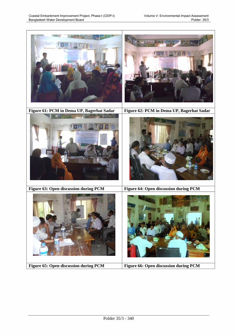
Coastal Embankment Improvement Project, Phase-I (CEIP-I) Bangladesh Water Development Board
Volume V: Environmental Impact Assessment Polder- 35/3
Polder 35/3 - 340
Figure 61: PCM in Dema UP, Bagerhat Sadar Figure 62: PCM in Dema UP, Bagerhat Sadar
Figure 63: Open discussion during PCM Figure 64: Open discussion during PCM
Figure 65: Open discussion during PCM Figure 66: Open discussion during PCM