Dynamics of soil moisture, subsurface flow and runoff in a small alpine basin
7
Status and Perspectives of Hydrology in Small Basins (Proceedings of the Workshop held at Goslar-Hahnenklee, Germany, 30 March–2 April 2009). IAHS Publ. 336, 2010. 96 Dynamics of soil moisture, subsurface flow and runoff in a small alpine basin DANIELE PENNA, MARCO BORGA, MARCO SANGATI & ALBERTO GOBBI Department of Land and Agroforest Environments, University of Padua, Viale dell’Università 16, Agripolis, I-35020 Legnaro (PD), Italy [email protected] Abstract This work focuses on the dynamics of the rainfall–runoff processes in a small alpine catchment (3.3 ha), localized in the central–eastern Italian Alps, where topographic relief and shallow subsurface moisture control the storage and timing of runoff on the landscape. We examined the temporal variations of soil water content, groundwater and streamflow response to rainfall input for a number of flood events; for each flood, the time lag between storm centroid and peak of soil moisture, streamflow and water table level is reported. Data reveal a systematic temporal organisation of the different responses: soil moisture peaks at almost the same time as runoff while the basin-averaged groundwater peak is delayed. This behaviour leads to a constant anticlockwise hysteretic relationship between stream discharge and water table level at the rainstorm scale. Moreover, the piezometric response across the catchment tends to be more delayed with the increasing distance from the stream; thus, groundwater temporal variations in the riparian zone are similar to runoff dynamics, but different from the ones that are more remote from the stream. Such observed dynamics support the point that runoff response in this basin is controlled by the quick reaction of the near-stream riparian zone, which is generally close to saturation. Groundwater response on the hillslope lags behind and is controlled by the formation of transient saturation at the bedrock–soil interface. Finally, a threshold behaviour between soil moisture and streamflow suggests that the antecedent moisture conditions control the size of the saturation zone and hence the runoff rate. Key words runoff; soil moisture and water table dynamics; alpine region INTRODUCTION In small basins of mountain regions, the interaction between groundwater and surface is particularly complex and dependent on a number of factors such as topography, subsurface hydraulic properties, soil properties, preferential flow paths. In these environments, the extent and the wetness conditions of zones located close to or remote from the stream are able to affect the hydrological response of the whole catchment. Various studies revealed the importance of the riparian zone as a control unit for runoff generation (Kendall et al., 1999; McGlynn et al., 1999; McGlynn & McDonnell, 2003; Wenninger et al., 2004; Katsuyama et al., 2005), while a few papers focused on the time lag between runoff and groundwater response at the hillslope scale (Seibert et al., 2003; McGlynn et al., 2004). Such delays in the response timing can lead to a non- unique (hysteretic) behaviour in the relationship between runoff and water table (McGlynn et al., 2004; Beven, 2006; Ewen & Birkinshaw, 2006; Detty & McGuire 2008; Norbiato & Borga, 2008; Herrmann & Schumann, 2009). This work aims at documenting the temporal dynamics characterizing the main hydrological processes in a steep alpine terrain, assessing the influence of initial soil water content and subsurface moisture condition in controlling the storage and timing of runoff. STUDY AREA AND METHODOLOGY Hydro-meteorological data were collected from 14 May to 17 October 2007 in the small Larch Creek catchment (LCC, 3.3 ha) located in the central–eastern Italian Alps (Penna et al., 2009). The basin has a typical alpine climate with a mean annual rainfall of about 1220 mm, 49% of which falls as snow. The average monthly temperature varies from –5.7°C in January to 14.1°C in July. Runoff is usually dominated by snowmelt in May and June, but summer and early autumn floods represent an important contribution to the flow regime. Elevations range from 1970 m a.s.l. to 2120 m a.s.l. Soils are Cambisoil characterized by clay or silty-clay layers underlying a Copyright © 2010 IAHS Press
-
Upload
independent -
Category
Documents
-
view
1 -
download
0
Transcript of Dynamics of soil moisture, subsurface flow and runoff in a small alpine basin
Status and Perspectives of Hydrology in Small Basins (Proceedings of the Workshop held at Goslar-Hahnenklee, Germany, 30 March–2 April 2009). IAHS Publ. 336, 2010.
96
Dynamics of soil moisture, subsurface flow and runoff in a small alpine basin DANIELE PENNA, MARCO BORGA, MARCO SANGATI & ALBERTO GOBBI Department of Land and Agroforest Environments, University of Padua, Viale dell’Università 16, Agripolis, I-35020 Legnaro (PD), Italy [email protected] Abstract This work focuses on the dynamics of the rainfall–runoff processes in a small alpine catchment (3.3 ha), localized in the central–eastern Italian Alps, where topographic relief and shallow subsurface moisture control the storage and timing of runoff on the landscape. We examined the temporal variations of soil water content, groundwater and streamflow response to rainfall input for a number of flood events; for each flood, the time lag between storm centroid and peak of soil moisture, streamflow and water table level is reported. Data reveal a systematic temporal organisation of the different responses: soil moisture peaks at almost the same time as runoff while the basin-averaged groundwater peak is delayed. This behaviour leads to a constant anticlockwise hysteretic relationship between stream discharge and water table level at the rainstorm scale. Moreover, the piezometric response across the catchment tends to be more delayed with the increasing distance from the stream; thus, groundwater temporal variations in the riparian zone are similar to runoff dynamics, but different from the ones that are more remote from the stream. Such observed dynamics support the point that runoff response in this basin is controlled by the quick reaction of the near-stream riparian zone, which is generally close to saturation. Groundwater response on the hillslope lags behind and is controlled by the formation of transient saturation at the bedrock–soil interface. Finally, a threshold behaviour between soil moisture and streamflow suggests that the antecedent moisture conditions control the size of the saturation zone and hence the runoff rate. Key words runoff; soil moisture and water table dynamics; alpine region INTRODUCTION
In small basins of mountain regions, the interaction between groundwater and surface is particularly complex and dependent on a number of factors such as topography, subsurface hydraulic properties, soil properties, preferential flow paths. In these environments, the extent and the wetness conditions of zones located close to or remote from the stream are able to affect the hydrological response of the whole catchment. Various studies revealed the importance of the riparian zone as a control unit for runoff generation (Kendall et al., 1999; McGlynn et al., 1999; McGlynn & McDonnell, 2003; Wenninger et al., 2004; Katsuyama et al., 2005), while a few papers focused on the time lag between runoff and groundwater response at the hillslope scale (Seibert et al., 2003; McGlynn et al., 2004). Such delays in the response timing can lead to a non-unique (hysteretic) behaviour in the relationship between runoff and water table (McGlynn et al., 2004; Beven, 2006; Ewen & Birkinshaw, 2006; Detty & McGuire 2008; Norbiato & Borga, 2008; Herrmann & Schumann, 2009). This work aims at documenting the temporal dynamics characterizing the main hydrological processes in a steep alpine terrain, assessing the influence of initial soil water content and subsurface moisture condition in controlling the storage and timing of runoff. STUDY AREA AND METHODOLOGY
Hydro-meteorological data were collected from 14 May to 17 October 2007 in the small Larch Creek catchment (LCC, 3.3 ha) located in the central–eastern Italian Alps (Penna et al., 2009). The basin has a typical alpine climate with a mean annual rainfall of about 1220 mm, 49% of which falls as snow. The average monthly temperature varies from –5.7°C in January to 14.1°C in July. Runoff is usually dominated by snowmelt in May and June, but summer and early autumn floods represent an important contribution to the flow regime. Elevations range from 1970 m a.s.l. to 2120 m a.s.l. Soils are Cambisoil characterized by clay or silty-clay layers underlying a
Copyright © 2010 IAHS Press
Dynamics of soil moisture, subsurface flow and runoff in a small alpine basin
97
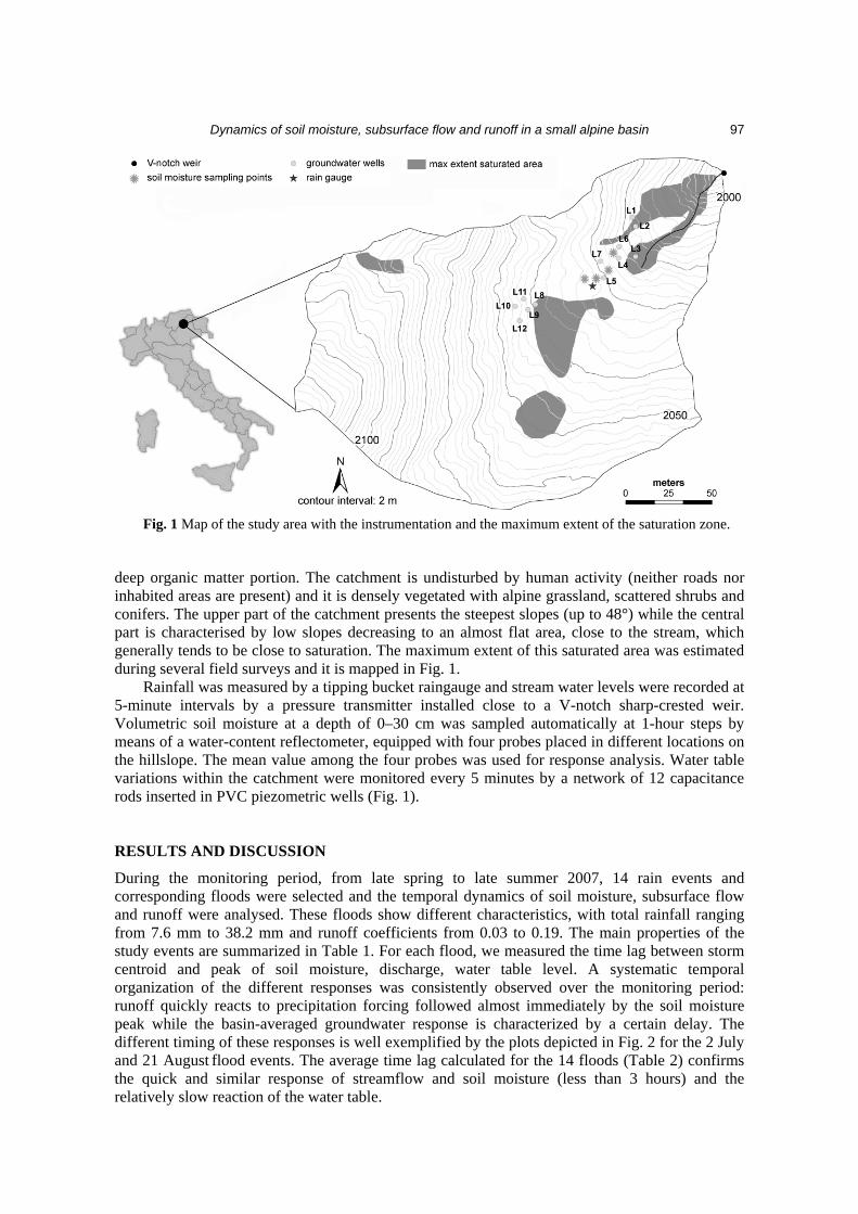
Fig. 1 Map of the study area with the instrumentation and the maximum extent of the saturation zone.
deep organic matter portion. The catchment is undisturbed by human activity (neither roads nor inhabited areas are present) and it is densely vegetated with alpine grassland, scattered shrubs and conifers. The upper part of the catchment presents the steepest slopes (up to 48°) while the central part is characterised by low slopes decreasing to an almost flat area, close to the stream, which generally tends to be close to saturation. The maximum extent of this saturated area was estimated during several field surveys and it is mapped in Fig. 1. Rainfall was measured by a tipping bucket raingauge and stream water levels were recorded at 5-minute intervals by a pressure transmitter installed close to a V-notch sharp-crested weir. Volumetric soil moisture at a depth of 0–30 cm was sampled automatically at 1-hour steps by means of a water-content reflectometer, equipped with four probes placed in different locations on the hillslope. The mean value among the four probes was used for response analysis. Water table variations within the catchment were monitored every 5 minutes by a network of 12 capacitance rods inserted in PVC piezometric wells (Fig. 1). RESULTS AND DISCUSSION
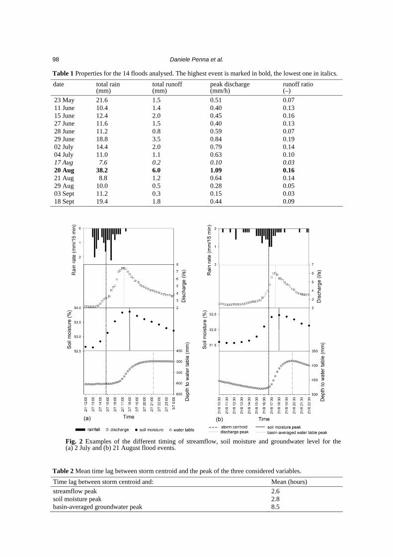
During the monitoring period, from late spring to late summer 2007, 14 rain events and corresponding floods were selected and the temporal dynamics of soil moisture, subsurface flow and runoff were analysed. These floods show different characteristics, with total rainfall ranging from 7.6 mm to 38.2 mm and runoff coefficients from 0.03 to 0.19. The main properties of the study events are summarized in Table 1. For each flood, we measured the time lag between storm centroid and peak of soil moisture, discharge, water table level. A systematic temporal organization of the different responses was consistently observed over the monitoring period: runoff quickly reacts to precipitation forcing followed almost immediately by the soil moisture peak while the basin-averaged groundwater response is characterized by a certain delay. The different timing of these responses is well exemplified by the plots depicted in Fig. 2 for the 2 July and 21 August flood events. The average time lag calculated for the 14 floods (Table 2) confirms the quick and similar response of streamflow and soil moisture (less than 3 hours) and the relatively slow reaction of the water table.
Daniele Penna et al.
98
Table 1 Properties for the 14 floods analysed. The highest event is marked in bold, the lowest one in italics. date total rain
(mm) total runoff (mm)
peak discharge (mm/h)
runoff ratio (–)
23 May 21.6 1.5 0.51 0.07 11 June 10.4 1.4 0.40 0.13 15 June 12.4 2.0 0.45 0.16 27 June 11.6 1.5 0.40 0.13 28 June 11.2 0.8 0.59 0.07 29 June 18.8 3.5 0.84 0.19 02 July 14.4 2.0 0.79 0.14 04 July 11.0 1.1 0.63 0.10 17 Aug 7.6 0.2 0.10 0.03 20 Aug 38.2 6.0 1.09 0.16 21 Aug 8.8 1.2 0.64 0.14 29 Aug 10.0 0.5 0.28 0.05 03 Sept 11.2 0.3 0.15 0.03 18 Sept 19.4 1.8 0.44 0.09
Fig. 2 Examples of the different timing of streamflow, soil moisture and groundwater level for the (a) 2 July and (b) 21 August flood events.
Table 2 Mean time lag between storm centroid and the peak of the three considered variables. Time lag between storm centroid and: Mean (hours) streamflow peak 2.6 soil moisture peak 2.8 basin-averaged groundwater peak 8.5
Dynamics of soil moisture, subsurface flow and runoff in a small alpine basin
99
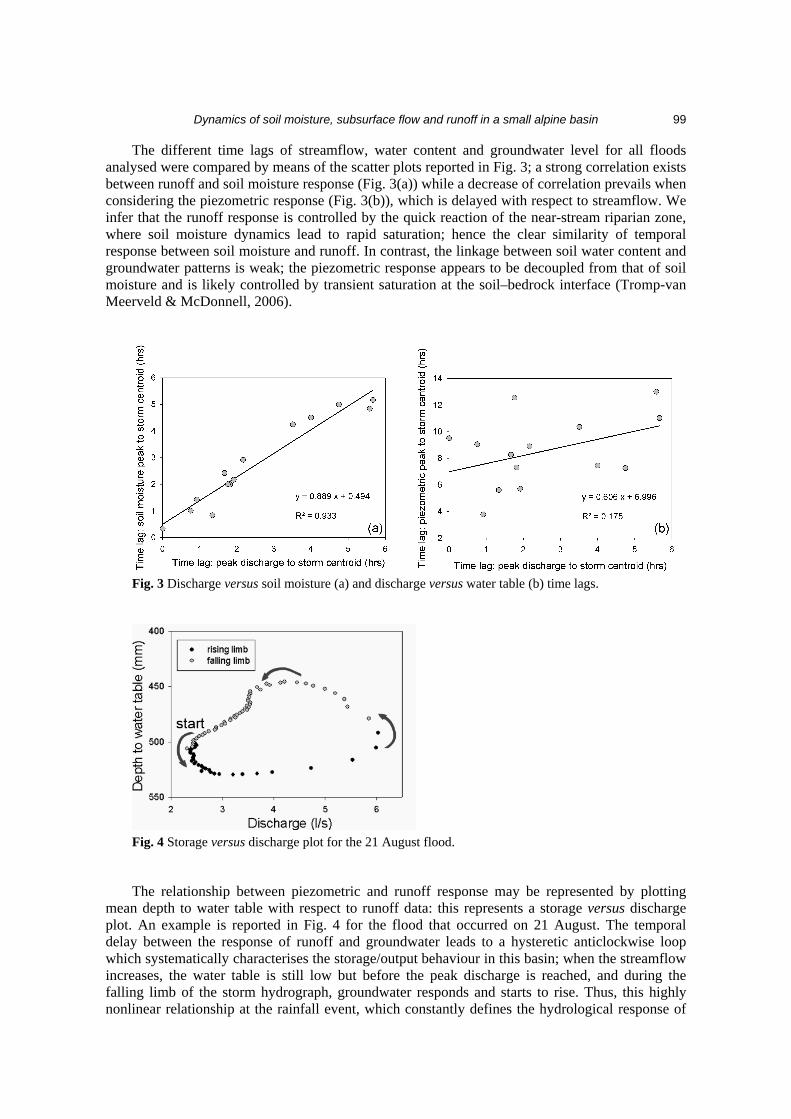
The different time lags of streamflow, water content and groundwater level for all floods analysed were compared by means of the scatter plots reported in Fig. 3; a strong correlation exists between runoff and soil moisture response (Fig. 3(a)) while a decrease of correlation prevails when considering the piezometric response (Fig. 3(b)), which is delayed with respect to streamflow. We infer that the runoff response is controlled by the quick reaction of the near-stream riparian zone, where soil moisture dynamics lead to rapid saturation; hence the clear similarity of temporal response between soil moisture and runoff. In contrast, the linkage between soil water content and groundwater patterns is weak; the piezometric response appears to be decoupled from that of soil moisture and is likely controlled by transient saturation at the soil–bedrock interface (Tromp-van Meerveld & McDonnell, 2006).
Fig. 3 Discharge versus soil moisture (a) and discharge versus water table (b) time lags.
Fig. 4 Storage versus discharge plot for the 21 August flood.
The relationship between piezometric and runoff response may be represented by plotting mean depth to water table with respect to runoff data: this represents a storage versus discharge plot. An example is reported in Fig. 4 for the flood that occurred on 21 August. The temporal delay between the response of runoff and groundwater leads to a hysteretic anticlockwise loop which systematically characterises the storage/output behaviour in this basin; when the streamflow increases, the water table is still low but before the peak discharge is reached, and during the falling limb of the storm hydrograph, groundwater responds and starts to rise. Thus, this highly nonlinear relationship at the rainfall event, which constantly defines the hydrological response of
Daniele Penna et al.
100
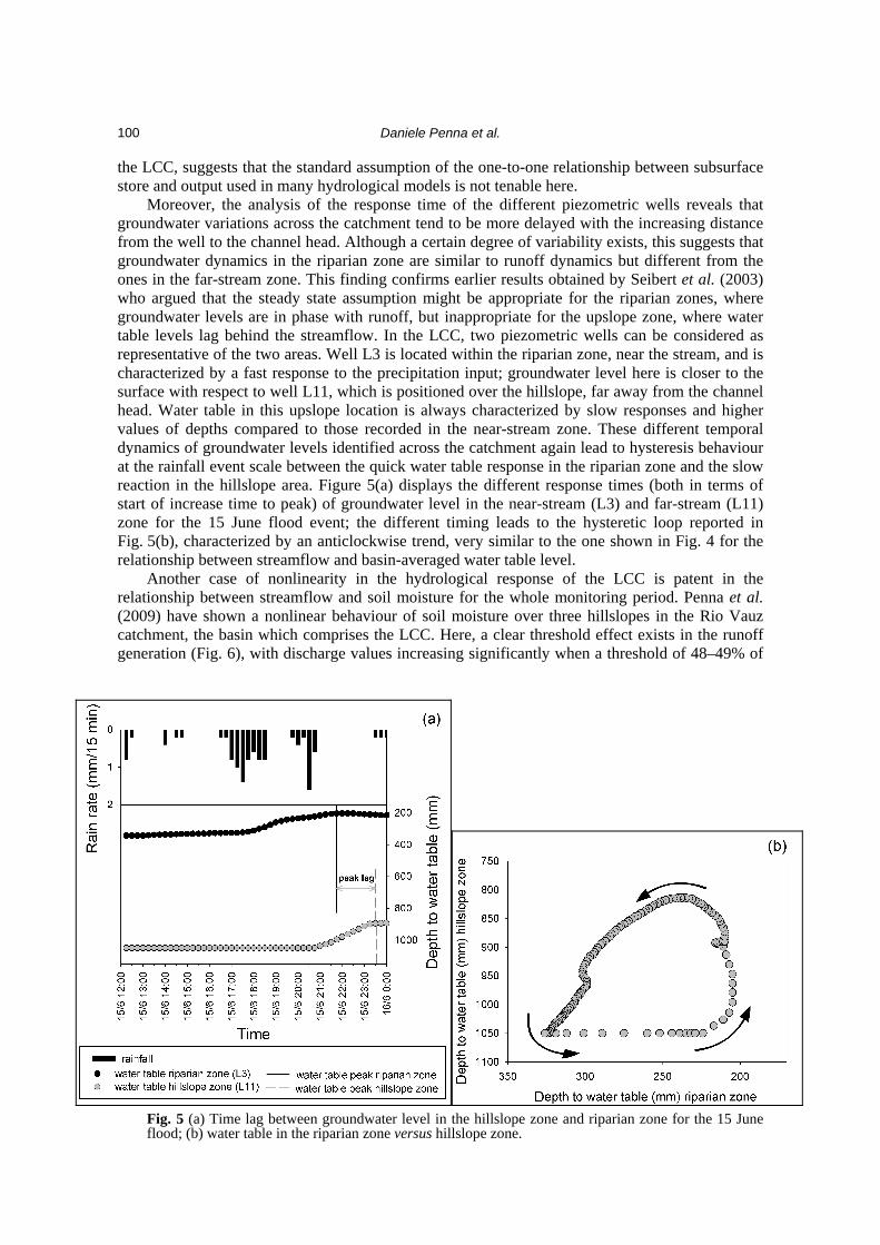
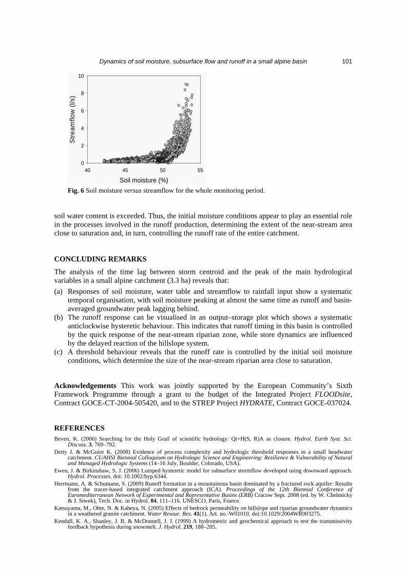
the LCC, suggests that the standard assumption of the one-to-one relationship between subsurface store and output used in many hydrological models is not tenable here. Moreover, the analysis of the response time of the different piezometric wells reveals that groundwater variations across the catchment tend to be more delayed with the increasing distance from the well to the channel head. Although a certain degree of variability exists, this suggests that groundwater dynamics in the riparian zone are similar to runoff dynamics but different from the ones in the far-stream zone. This finding confirms earlier results obtained by Seibert et al. (2003) who argued that the steady state assumption might be appropriate for the riparian zones, where groundwater levels are in phase with runoff, but inappropriate for the upslope zone, where water table levels lag behind the streamflow. In the LCC, two piezometric wells can be considered as representative of the two areas. Well L3 is located within the riparian zone, near the stream, and is characterized by a fast response to the precipitation input; groundwater level here is closer to the surface with respect to well L11, which is positioned over the hillslope, far away from the channel head. Water table in this upslope location is always characterized by slow responses and higher values of depths compared to those recorded in the near-stream zone. These different temporal dynamics of groundwater levels identified across the catchment again lead to hysteresis behaviour at the rainfall event scale between the quick water table response in the riparian zone and the slow reaction in the hillslope area. Figure 5(a) displays the different response times (both in terms of start of increase time to peak) of groundwater level in the near-stream (L3) and far-stream (L11) zone for the 15 June flood event; the different timing leads to the hysteretic loop reported in Fig. 5(b), characterized by an anticlockwise trend, very similar to the one shown in Fig. 4 for the relationship between streamflow and basin-averaged water table level. Another case of nonlinearity in the hydrological response of the LCC is patent in the relationship between streamflow and soil moisture for the whole monitoring period. Penna et al. (2009) have shown a nonlinear behaviour of soil moisture over three hillslopes in the Rio Vauz catchment, the basin which comprises the LCC. Here, a clear threshold effect exists in the runoff generation (Fig. 6), with discharge values increasing significantly when a threshold of 48–49% of
Fig. 5 (a) Time lag between groundwater level in the hillslope zone and riparian zone for the 15 June flood; (b) water table in the riparian zone versus hillslope zone.
Dynamics of soil moisture, subsurface flow and runoff in a small alpine basin
101
Soil moisture (%)40 45 50 55
Stre
amflo
w (l
/s)
0
2
4
6
8
10
Fig. 6 Soil moisture versus streamflow for the whole monitoring period.
soil water content is exceeded. Thus, the initial moisture conditions appear to play an essential role in the processes involved in the runoff production, determining the extent of the near-stream area close to saturation and, in turn, controlling the runoff rate of the entire catchment. CONCLUDING REMARKS
The analysis of the time lag between storm centroid and the peak of the main hydrological variables in a small alpine catchment (3.3 ha) reveals that:
(a) Responses of soil moisture, water table and streamflow to rainfall input show a systematic temporal organisation, with soil moisture peaking at almost the same time as runoff and basin-averaged groundwater peak lagging behind.
(b) The runoff response can be visualised in an output–storage plot which shows a systematic anticlockwise hysteretic behaviour. This indicates that runoff timing in this basin is controlled by the quick response of the near-stream riparian zone, while store dynamics are influenced by the delayed reaction of the hillslope system.
(c) A threshold behaviour reveals that the runoff rate is controlled by the initial soil moisture conditions, which determine the size of the near-stream riparian area close to saturation.
Acknowledgements This work was jointly supported by the European Community’s Sixth Framework Programme through a grant to the budget of the Integrated Project FLOODsite, Contract GOCE-CT-2004-505420, and to the STREP Project HYDRATE, Contract GOCE-037024. REFERENCES Beven, K. (2006) Searching for the Holy Grail of scientific hydrology: Qt=H(S, R)A as closure. Hydrol. Earth Syst. Sci.
Discuss. 3, 769–792. Detty J. & McGuire K. (2008) Evidence of process complexity and hydrologic threshold responses in a small headwater
catchment. CUAHSI Biennial Colloquium on Hydrologic Science and Engineering: Resilience & Vulnerability of Natural and Managed Hydrologic Systems (14–16 July, Boulder, Colorado, USA).
Ewen, J. & Birkinshaw, S. J. (2006) Lumped hysteretic model for subsurface stormflow developed using downward approach. Hydrol. Processes. doi: 10.1002/hyp.6344.
Herrmann, A. & Schumann, S. (2009) Runoff formation in a mountainous basin dominated by a fractured rock aquifer: Results from the tracer-based integrated catchment approach (ICA). Proceedings of the 12th Biennial Conference of Euromediterranean Network of Experimental and Representative Basins (ERB) Cracow Sept. 2008 (ed. by W. Chelmicky & J. Siwek), Tech. Doc. in Hydrol. 84, 111–116. UNESCO, Paris, France.
Katsuyama, M., Ohte, N. & Kabeya, N. (2005) Effects of bedrock permeability on hillslope and riparian groundwater dynamics in a weathered granite catchment. Water Resour. Res. 41(1). Art. no.-W01010, doi:10.1029/2004WR003275.
Kendall, K. A., Shanley, J. B. & McDonnell, J. J. (1999) A hydrometric and geochemical approach to test the transmissivity feedback hypothesis during snowmelt. J. Hydrol. 219, 188–205.

Daniele Penna et al.
102
McGlynn, B. L. & McDonnell, J. J. (2003) Quantifying the relative contributions of riparian and hillslope zones to catchment runoff. Water Resour. Res. 39(11), 1310, doi:10.1029/2003WR002091.
McGlynn, B. L., McDonnell, J. J., Shanley, J. B. & Kendall, C. (1999) Riparian zone flowpath dynamics during snowmelt in a small headwatercatchment. J. Hydrol. 222, 75–92.
McGlynn, B. L., McDonnell J. J., Seibert J. & Kendall C. (2004) Scale effects on headwater catchment runoff timing, flow sources, and groundwater–streamflow relations. Water Resour. Res. 40, W07504, doi:10.1029/2003WR002494.
Norbiato, D. & Borga, M. (2008) Analysis of hysteretic behaviour of a hillslope-storage kinematic wave model for subsurface flow. Adv. Water Resour. 31, 118–131.
Penna, D., Borga, M., Norbiato, D. & Dalla Fontana, G. (2009) Hillslope scale soil moisture variability in a steep alpine terrain. J. Hydrol. 364, 311–327. doi:10.1016/j.jhydrol.2008.11.009.
Seibert, J., Bishop, K., Rodhe, A. & McDonnell, J. J (2003) Groundwater dynamics along a hillslope: a test of the steady state hypothesis. Water Resour. Res. 39(1), 1014. doi:10.1029/2002WR001404.
Tromp-van Meerveld, H. J. & McDonnell, J. J. (2006) Threshold relations in subsurface stormflow: 2. The fill and spill hypothesis. Water Resour. Res. 42, W02411, doi:10.1029/2004WR003800.
Wenninger, J., Uhlenbrook, S., Tilch, N. & Leibundgut, C. (2004) Experimental evidence of fast groundwater responses in a hillslope/floodplain area in the Black Forest Mountains, Germany. Hydrol. Processes 18 (17), 3305–3322.