Some Important Herbaceous Medicinal Flora of Alpine and Sub-Alpine Ecosystem of Western Himalaya
Upload
khangminh22Category
view
5download
0
Theme Trails &
Nature Parks
Flavor of the High Country
Tours from Lake to M
ountain Lake
101
Fabulous Hikes to Alpine Tarns
General Information
Hut and mountain lake hikingin Salzburg‘s Lungau region
Alpine SummerSalzburg‘s Lungau region at a glance
Ferienregion Salzburger LungauRotkreuzgasse 100A-5582 St. MichaelT +43 (0)6477 8988F +43 (0)6477 [email protected]
W I T H T H E F R I E N D LY A S S I S TA N C E O F

01 Gruberalm / S. 31 02 Jakoberalm / S. 33 03 Liasalm / S. 35 04 Muhreralm / S. 36 05 Örgenhiasalm / S. 37 06 Schwarzenbichlhütte / S. 39 07 Zaunerhütte / S. 40 08 Bartlalm / S. 54
10 Ilgalm / S. 5411 Schieferalm / S. 55 12 Franz-Fischer-Hütte / S. 62 13 Südwiener Hütte / S. 66 14 Tappenkarsee Hütte / S. 66 15 Königalm / S. 34 16 Schliereralm / S. 38 17 Müllnerbauerhütte / S. 56
18 Genossenschaftshütte Tweng / S. 57 19 Genossenschaftshütte Trogalm / S. 58 20 Speiereckhütte / S. 63 21 Restaurant Panorama Alm / S. 71 22 Restaurant Schi Alm / S. 71 23 Almstüberl Faningberg 24 Berggasthof Hainererhof 25 Berghof Jacklbauer
25 Bartlalm / p. 6926 Rothenwänderalm / p. 6927 Ilgalm / p. 7028 Schieferalm / p. 7029 Wastalalm / p. 7130 Müllnerbauer Hut / p. 7131 Genossenschaftshut Tweng / p. 7232 Metzgeralm / p. 72
33 Genossenschaftshut Trogalm / p. 7334 Preber-Halter Hut / p. 7335 Eßlalm / p. 7436 Niggei Hut / p. 74 37 Hanslbaueralm / p. 7538 Altwirtsalm / p. 7539 Laußnitzer Hut / p. 7640 Franz Fischer Hut / p. 77
41 Speiereck Hut / p. 7842 Landwiersee Hut / p. 7943 Dr. Josef Mehrl Hut / p. 7944 Rotgüldensee Hut / p. 8045 Stickler Hut / p. 8146 Südwiener Hut / p. 8147 Tappenkarsee Hut / p. 8248 Keinprecht Hut / p. 83
49 Ignaz Mattis Hut / p. 8450 Giglachsee Hut / p. 8451 Golling Hut / p. 8552 Ober Hut / p. 8553 Grazer Hut / p. 8654 New Bonner Hut / p. 8655 Restaurant Panorama Alm / p. 8756 Restaurant Schi Alm / p. 87
57 Almstüberl Faningberg / p. 8858 Sonnblick Hut / p. 8859 Sauschneideralm / p. 8960 Gamsstadl / p. 8961 Zirmbar / p. 9062 Jausenstation Dicktler Hut / p. 9063 Jausenstation Wielandhof / p. 9164 Ludlalm / p. 91
65 Schlögelberger Alpine Inn & Wildlife Park / p. 9266 Adlerhorst Summit Restaurant / p. 9267 Peterbauer Almstub´n / p. 9368 Jausenstation Neuhauserstadl / p. 9369 Gamskogel Hut / p. 94
01 Boarnlacke / S. 902 Esser See / S. 1003 Ilgsee & Zaunersee / S. 1104 Rothenwändersee / S. 1205 Schlierersee / S. 1306 Blauseen / S. 1407 Twenger Almsee / S. 1508 Trogalmseen / S. 16
09 Giglachsee / S. 17 10 Oberer Schönalmsee / S. 18 11 Oberhüttensee / S. 19 12 Wirpitschsee & Tiefenbachsee / S. 20 & 21 13 Lignitzsee / S. 2214 Landawirseen / S. 23 15 Gralatisee / S. 24
16 Landschitzseen / S. 25 17 Zwerfenbergsee & Angersee / S. 26 18 Prebersee / S. 27 19 Rosaninsee / S. 28 20 Rotgüldensee / S. 29 21 Anderleseen / S. 30
Lungauer Bergseen
Table of ContentsGeneral Information Page 3
Fabulous Hikes to Alpine Tarns Page 4
Tours from Lake to Mountain Lake Page 28
Flavor of the High Country Page 45
Theme Trails & Nature Parks Page 95
Them
e Tr
ails
& N
atur
e Pa
rks
Flav
or o
f the
Hig
h Co
untr
y To
urs
from
Lak
e to
Mou
ntai
n La
ke
2
Fabu
lous
Hik
es to
Alp
ine
Tarn
s Ge
nera
l Inf
orm
atio
n
CreditsPublisher:Ferienregion Salzburger Lungau Rotkreuzgasse 100, A-5582 St. Michael T +43 (0)6477 8988, F +43 (0)6477 8988-20 [email protected], www.lungau.atEdition 2019Editorial Texts: Ferienregion Salzburger Lungau, Dr. Gertraud Steiner. Mag. Franziska Lipp, Hannes Modl, Reisebüro lehenauer, Bacher Reisen, Franz GfrererPhoto Credits: SalzburgerLand Tourismus GmbH (pp. 31), Salzburg´s Lungau region (pp. 1,17,28,80,82,94,97,99), G.A.Service GmbH (pp.100), Naturepark Riedingtal (pp.7), Zederhaus Tourist Office (pp. 5,6,9,45,53,77,34), H. Modl (pp. 8,10,13,15,18,19,22,23,24), P. Macheiner (pp. 11), Bergbahnen Lungau (pp. 12,74,87), Weißpriach Tourist Office (pp. 16), P. Kröll (pp. 20, 21), Muhr Tourist Office (pp. 25,26,75), Schlick Family (pp. 46), Gruber Family (pp. 47), Batlogg Family (pp. 48), Gruber Family (pp. 49), P. Jäger (pp. 50), Schiefer Family (pp. 51), Dorfer Family (pp. 52), Kremser Family (pp. 54), Bergmann Family (pp. 55), Macheiner Family (pp. 56), Perner Family (pp. 57), Wirnsperger Family (pp. 58), Otto Neumann (pp. 59), Kocher Family (pp. 60), Fuchsberger Family (pp. 61), Kendlbacher Family (pp. 62), S. Lerchner (pp. 63), Kößlbacher Fa-mily (pp. 64), Barbara Schyr (pp. 65), A. Neuschitzer (pp. 66), Sampl Family (pp. 67), W. Kocher (pp. 68), Bliem Family (pp. 69), Gfrerer Family (pp. 69) Pfeifenberger Family (pp. 70), K. Pfeifen-berger (pp. 70), Gruber Family (pp. 71), I. Ertl-Feyel (pp. 71), H. Mauser (pp. 72), Mauterndorf Tourist Office (pp. 73), Tamsweg Tourist Office (pp. 73,23,44), Lanschützer Family (pp. 74), Pa-gitsch Family (pp. 74), Gruber Family (pp. 75), Pirker Family (pp. 76), P. Steinlechner (pp. 78), Schistl Family (pp. 79), N. Sampl (pp. 79), Winkler Family (pp. 80), B. Laireiter (pp. 81), Scharler Family (pp. 81), Höller Family (pp. 82), E. Fischbacher (pp. 83), Alpenverein Wien (pp. 84), Sieder Family (pp. 84), W. Reiter (pp. 85), F. Oberkofler (pp. 85,15), Moser-Dengg Family (pp. 86), S. Meissnitzer (pp. 86), Müller Family (pp. 88), Schitter Family (pp. 88, 89), Miksch Family (pp. 89), Schreilechner Family (pp. 90), Bogensperger Family (pp. 90), Perner Family (pp. 91), U. Antretter (pp. 91), Sampl Family (pp. 92), Bergbahnen Katschberg (pp. 92), Sampl Family (pp. 93), See-wald Family (pp. 93), R. Aigner (pp. 94), Andreas Fuchsberger (pp. 36), Thomas Wedam (pp. 40, 78), Franz Lehenauer (pp. 41), Weißpriach Tourist Office (pp. 95), Göriach Tourist Office (pp. 29)Design: Die Medienwerkstatt GmbH, 5580 Tamsweg, www.diemedienwerkstatt.infoPrint: Samson Druck, 5581 St. Margarethen, www.samsondruck.atSummer panorama: Heinz Vielkind, PanoramastudioInteractive hiking map (http://karte.lungau.at): Intermaps Software GmbH Not liable for errors or inaccuracies. Information may be subject to change. Any reproduction, in whatever format, in whole or in part, is allowed only with the express written permission of the publisher.
In conclusion, the Salzburg’s Lungau Holiday Region wishes to thank:• Dr. Gertraud Steiner for authoring the editorial texts, • Mr. Peter Bayr for his descriptions of the alpine hut and lake routes,
as well as for compiling cartographical materials, • Mr. Hannes Modl for his descriptions of the alpine hut and lake
routes, as well as for his wealth of ideas during the creative and realization process, and also
• all of the owners, managers and staff of our region’s alpine huts.Without their support and dedication, it would not have been possible to produce this brochure.
Additional Reading on this Topic:• Dr. Gertraud Steiner: Winkelwelt. Sagen aus dem Lungau.
Wolfgang Pfeifenberger Verlag 1999• Dr. Gertraud Steiner: Sagen und Mythen entdecken auf Salzburger
Almen. Tyrolia Verlag 2005
Alpine tarns and huts in Salzburg‘s Lungau region

3
Welcome to Summer in the Hills in the Lungau
Barely 100 kilometers from Salzburg, the City of Mozart, you can truly experience what makes an Alpine summer so special. Here, between mountain and valley, people feel grounded and begin to rediscover who they truly are. Short timeouts and breaks help you in your quest for meaning, to get back in touch with your senses and sensibilities. Slowing down the pace of your life, escaping the stresses of the outside world – both are possible in the Salzburger Lungau region. And did you know, the Salzburger Lungau was actually declared a Biosphere Reserve by UNESCO back in 2012? By accepting this prestigious distinction, the magnificent landscapes of Salzburger Lungau were also placed under special protection. This guarantees you will be able to look forward to incomparable holiday experiences for a long time to come: in the mountains, next to magically beautiful lakes, amid a land of living traditions and creative people who have never forgotten their roots.
Difficulty Rating for Hiking Paths in the Alpine RegionThe following descriptions assume dry, summerlike weather conditions.
• easySimple hiking paths in permanently populated areas and adjacent forested
areas, proceeding through flat terrain with few significant uphill stretches.Special Requirements: None, regular running shoes or street shoes are sufficient. No special equipment necessary. Navigable without use of a hiking map.
• intermediate/mediumMountain trails that require a certain degree of sure-footedness. Steep
stages, water courses, narrow trails at points, wash-out dirt and vegetation may be encountered along these trails.Special Requirements: Basic map-reading skills are required. Hiking/trekking/mountaineering boots with a good tread and extending above the ankle are recommended, as is a topographical hiking map of the area in question.
• difficultDifficult alpine and mountaineering trails, secured at exposed points by
cables, manmade stairways, ladders, chains etc. You may often need to use your hands to maintain balance and move along the trail. The precise trail is not always readily recognizable. Occasionally very exposed areas present a real danger of falling, loose rock, and steep grassy or rocky slopes. Summer hikers may well still encounter unthawed snowpack from the previous winter.Special Requirements: Hikers must have appropriate hiking and mountaineering experience, as well as being able to navigate with a detailed topographical hiking map. Hiking/trekking/mountaineering boots with a good tread and extending above the ankle are indispensible. Hikers should have no physical impairments preventing them from tackling fixed-cable stages, steep stairways or similar obstacles where hiking poles are occasional more of a handicap than a help.
In the Salzburg’s Lungau region you will often find additional red-white-red markings (some of which have trail numbers) next to the yellow trail signs, directing you from one sign location to the next.For important tips on how to stay safe in the mountains, please visit: https://www.lungau.at
Alpine Emergency Number: 140 International Emergency Number: 112(Source: UIAA/VAVÖ)
Theme Trails &
Nature Parks
Flavor of the High Country
Tours from Lake to M
ountain LakeFabulous H
ikes to Alpine Tarns General Inform
ation

㆒ Boarnlacke (elev. 2,214 m)
Riedingtal Nature Park, Zederhaus
Legendary People of Immense Strength
It is said that the simple, good farmhouse cooking, summers spent on the high pastures and the exercise that comes with having to walk long distances contributed to making the people of Zederhaus incredibly strong. Legends grew of people with almost supernatural strength. In this regard, Ignaz Kürsinger tells the tale of one particular son who was told by his father, a farmer in Zederhaus, to take a deer he had recently shot and register it with the authorities in Moosham. But instead of loading it onto the back of the wagon, he carried the creature on his shoulders, not dropping it until he stood in front of the game official in Moosham. The latter was astonished and asked where the lad’s wagon was. His matter-of-fact response: “For a deuced animal like this, it wasn’t worth the effort of harnessing up a horse. They were all out grazing anyway.”
Along the toll road (€ 8 fee, incl. valley bus during the main vacation season) by bus or car to the Schliereralm (1,495 m) in Riedingtal nature park and then take the valley bus to the Königalm (1,667 m). Beginning at the Schliereralm and following the romantic alpine hiking trail to the Königalm, hiking time approx. 1.5 hours. From the Königalm, we continue on the alpine path to the Zauneralm. Directly behind the Zauneralm we reach path no. 711 which leads us to the beautifully located Boarnlacke (2,214 m), a small lake. If you continue hiking, you will reach Riedingscharte gap (2,275 m). Ca. 100 m below, you can see the Riedingsee. For the hike down, you will backtrack along the same route. The route back to the point of departure is via the romantic alpine hiking trail or by valley bus.
Elevation Change: ca. 600 mDifficulty: • intermediateTime on Trail: approximately 2.5 hours to the RiedingscharteBus Service: No. 700/710 to Zederhaus – Schliereralm – KönigalmParking: Parking lot in the Schlierersee areaRefreshments: Schliereralm, Königalm, Zauner Hut, Örgenhiasalm, Ilgalm, Hoislalm, Gruberalm
4Them
e Tr
ails
& N
atur
e Pa
rks
Flav
or o
f the
Hig
h Co
untr
yTo
urs
from
Lak
e to
Mou
ntai
n La
keGe
nera
l Inf
orm
atio
nFa
bulo
us H
ikes
to A
lpin
e Ta
rns

5
㆓ Esser See (elev. 2,088 m)
Riedingtal Nature Park, Zederhaus
The Court Butcher and Zederhaus Bread
Cattle traders from Salzburg used to trek across the Tappenkar and Taferlnock to sell their oxen and calves in Zederhaus. The court butcher, Perner, never shied away from making the long trip either, ever striving to supply the table of the Prince Archbishops with the best meat available. On one such occasion, he had just come to an agreement with a hill farmer and sealed the deal with a handshake. The farmer’s wife served up a hearty snack which included bread and butter. The fine gentleman ate the butter, and slid the bread into his pocket, saying, “I’ll take that with me to Salzburg so that my lords see what terrible bread you have.” On the Tappenkar, however, he was surprised by bad weather. Exhausted and hungry, he rummaged about and pulled out the bread. Nibbling away, he gradually regained his strength, later claiming that he had never tasted better bread.
From the Jakoberalm parking lot in the Riedingtal nature park in Zederhaus - ca. 0.5 km before the Schliereralm (toll road/€ 8 fee, incl. valley bus during the main vacation season), a supply road branching off to the right leads to the Jakoberalm at an elevation of 1,839 m (time on trail ca. 1 hour). Westward on path no. 702, you will reach the Esser See at an elevation of 2,088 m. From there, you will go uphill to the Franz Fischer Hut (2,020 m), where the Zaunersee is also located. Downhill via the Hüttenweg path (no. 711), you will again reach the Riedingtal road. Return to your starting point either along the road or via a romantic hiking path across alpine meadows (during main holiday periods, it is also possible to ride the valley bus from the Franz-Fischer-Hütte car park to the starting point). The hiking route is also possible in the opposite order.
Elevation Change: ca. 600 mDifficulty: • intermediateTime on Trail: approximately 4.5 hours for the entire hikeBus Service: No. 700/710 to Zederhaus – Schliereralm Parking: at the base of the trail up to the JakoberalmRefreshments: Jakoberalm, Gruberalm, Schliereralm, Hoislalm, Ilgalm, Franz-Fischer-Hut
Theme Trails &
Nature Parks
Flavor of the High Country
Tours from Lake to M
ountain LakeGeneral Inform
ationFabulous H
ikes to Alpine Tarns

叅 Ilgsee (elev. 2,099 m) – Zaunersee (elev. 2,020 m, via the Haselloch)
Riedingtal Nature Park, Zederhaus
Death of the Königbauer Farmer below the Haselloch
The beautiful Zederhaus Valley was once particularly remote and daunting, being about a six- to seven-hour hike from the market town of St. Michael. Not much longer and far more beautiful is the trail over the Tappenkar (elev. 2,135 m) to Kleinarl or a crossing of the Taferlnock (elev. 2,236 m) into the Flachau region. Messengers, woodcutters, peddlers, pig castrators and cattle dealers all hiked along these trails and “into the wide outside world.”
At the best times of year, even the most locally savvy and hardy wanderers had to be watchful of drastic changes in the weather. On October 8, 1844, Blasius Dorfer, who lived on the Königbauer farm in Zederhaus, came to an untimely end. Together with his sister, a dairymaid at their parents’ hill farm, he was on his way from the cattle market in St. Johann when they were overcome by driving snows. Ignaz Kürsinger wrote down the story of the two unfortunate siblings, as it was retold to him by Maria Dorfer: I tapped my way slowly forward in the dark, gloomy night – in the snow and fog – but without knowing where I was heading. Overcome by enormous fatigue, I called back to my brother to tell him to follow me. Full of fear, I shouted “Come, we’re going home!” But her brother’s voice was lost in the dark, snowy night. Maria Dorfer eventually fell down a snow-covered slope on the Wurmfeldspitze and lost consciousness, though she was able to save herself on the following day, finding her way back to her mountain hut, where the shocked herdsman there gave the half-frozen woman some hot soup and sent for farmhands in the valley to help assist in the recovery of her unfortunate brother.
Along the toll road (€ 8 fee, incl. valley bus during the main vacation season) by bus or car to the Schliereralm (1,495 m) in Riedingtal nature park and then by valley bus to the Königalm (1,667 m) or by walking on the romantic hiking trail. The uphill trail leads from the Königalm (1,667 m) to the Haselloch (2,136 m). From there, we take marked path no. 702, which is uphill at first and then continues down into the valley, to the Ilgsee. The Zaunersee is located right by the Franz Fischer Hut (2,020 m). The downhill trail into Riedingtal is via Hüttenweg path (no. 711).
Elevation Change: ca. 470 mDifficulty: • intermediateTime on Trail: ca. 5 hours for the entire hikeBus Service: No. 700/710 to Zederhaus – Schliereralm – KönigalmParking: Parking lot in the Schlierersee areaRefreshments: Königalm, Hoislalm, Gruberalm, Schliereralm, Ilgalm, Franz-Fischer-Hut
6Them
e Tr
ails
& N
atur
e Pa
rks
Flav
or o
f the
Hig
h Co
untr
yTo
urs
from
Lak
e to
Mou
ntai
n La
keGe
nera
l Inf
orm
atio
nFa
bulo
us H
ikes
to A
lpin
e Ta
rns

7
㆕ Rothenwändersee (elev. 2,010 m)
Riedingtal Nature Park, Zederhaus
Jovial, high-spirited people of Zederhaus
The Zederhaus Prangstangen are quite famous. These large, 6-8-meter-high, wooden poles, beautifully garlanded in flowers, are ceremoniously paraded to church on the 24th of June. Of course, this process requires some strong young lads. Many tales have been told over the years about these jovial, crafty and thoroughly muscular citizens of Zederhaus. Even the term Hanswurst – the German name given to a village buffoon – is said to have its origins with a native of this valley. The village church is actually consecrated to two saints, John the Baptist and John the Evangelist, which is why so many local boys were christened Johannes (meaning John, commonly shortened to Hans or Hannes). Historian Ignaz Kürsinger, who was the superintendent of Lungau schools during the 1840’s, once commented that the valley’s children often bore the strangest Christian names. There I read Petronilla and Angela, Isabella and Hemma, Polikarpus and Athanasius, etc. (733). The originator of these odd names turned out to be Vicar Joseph Königsdorfer, who summarily gave newborns whatever name happened to appear on the church calendar on the day of their christening.
From the Jakoberalm parking lot in Riedingtal nature park in Zederhaus - ca. 0.5 km before the Schliereralm (toll road/€ 8 fee, incl. valley bus during the main vacation season), a supply road branching off to the right leads to the Jakoberalm at an elevation of 1,839 m (time on trail ca. 1 hour). From there, we hike along the “Tauernhöhenweg” no. 702 up to the Rothenwändersee (2,010 m) and continue to the junction for the Grosskesselalmen. Path no. 741 then leads downhill into the valley to the Riedingstraße and from there back to the starting point.
Elevation Change: ca. 530 mDifficulty: • intermediateTime on Trail: ca. 5 hours for the entire hikeBus Service: No. 700/710 to Zederhaus – Schliereralm Parking: at the start of the trail up to the JakoberalmRefreshments: Jakoberalm, Muhreralm, Schwarzenbichl Hut, Schliereralm
Theme Trails &
Nature Parks
Flavor of the High Country
Tours from Lake to M
ountain LakeGeneral Inform
ationFabulous H
ikes to Alpine Tarns

⓹ Schlierersee (elev. 1,495 m)
Riedingtal Nature Park, Zederhaus
Of the Weisseck Dog
Above the Riedingsee (elev. 2,169 m), where the hiker can look out over the flower-covered Upper Rieding Valley, towers the mighty Weisseck (elev. 2,711 m), home to quartz and rare minerals and to the legends into which they are woven. Where today’s Schlierersee now lies, there was once a broad area of high moors, the so-called Ei´g´hagtes Moos. The pathway there from Zederhaus was known as the Winter Way, because sleighs loaded with hay or wood once traveled along this route.
The last farm in the valley was the old Schwarzenbichler property. This meant, of course, that its residents also had the longest walk to church. One stormy, pitch-black night, a strange visitor knocked on the front door. It was an icy grey mountain dwarf with a knee-length beard and a storm lantern, who immediately ordered the farmer’s wife to follow him. Their path, according to the tale, took them steeply uphill to the rocky cliffs of the Weisseck. Once at the top, the dwarf now explained, they would encounter the Weisseck Dog which, at this very midnight hour, would appear before the mountain with a wooden key in its mouth. With this key, the farmer’s wife would be able to unlock all the treasures hidden within the mountain. Sadly, faced with the prospect of meeting this scary creature, the woman did not have the courage to carry on. The treasure remained where it was. But it is said that if the pine tree in front of the house is ever felled in order to build a cradle, the child who lies in it will again be called upon to win those mysterious treasures.
A Lake used for Hydroelectric PowerThis expedition begins on the enchanting hiking path that leaves
from the car park located near the southern entrance to the Tauern Tunnel (elev. 1,345 m). The hike to the Schlierersee takes about 1 hour. As you follow this trail, you will pass several alpine huts on the way to the Örgenhiasalm (elev. 1,710 m) in the Upper Rieding Valley. This portion of the hike takes around 2 hours. A valley bus runs between the Schliereralm and Königalm mountain inns.
Elevation Change: ca. 370 mDifficulty: • easyTime on Trail: ca. 1 to 3 hours (depending on tour variant)Bus Service: No. 700/710 to Zederhaus – Wald – SchliereralmParking: near the Tauern Tunnel (south entrance), SchliereralmRefreshments: Schliereralm, Gruberalm, Hoislalm, Ilgalm, Königalm, Zauner Hut, Örgenhiasalm
8Them
e Tr
ails
& N
atur
e Pa
rks
Flav
or o
f the
Hig
h Co
untr
yTo
urs
from
Lak
e to
Mou
ntai
n La
keGe
nera
l Inf
orm
atio
nFa
bulo
us H
ikes
to A
lpin
e Ta
rns

9
⓺ Mühlbachsee (elev. 2,115 m)
Nahendfeld in Zederhaustal
Wandering along the water’s edge
Growing on the sunny hill-sides of the Salzburger Lun-gau, protected from the pre-vailing winds, are rye, oats and barley. In the past there was enough here for people to live from. And after harvest, the mills along the stream would clatter day and night, with everyone eagerly awaiting the grain and flour to make their daily bread. Zederhaustal was teeming with mills. The farms’ own mills were known as “Gmachmühlen”, since they also featured a separate room (“Gemach”) where someone could also spend the night and keep an eye on the milling process. But aside from these, milling was also a profession in its own right. Mills stood in a long line along the banks of the Nahendfeldbach, not far from where it flows into the Zederhausbach. In fact, one of these can still be seen to this day. Their big wooden millwheels were driven by water from the Mühlbachsee. The biggest was once owned by a miller, a miserly and greedy man who was envious of the smaller mills run by the farmers. Secretly he stole grain and kept grist entrusted to him for himself. If he had had his own way, he would have loved nothing more than to have total control over all of the valley’s grain. Once again in the pitch black of night, he sneaked out to the nearby mills. But as he was about to drop off his stolen load at his own mill, something amazing and quite incredible happened. The miller’s beard began to grow, it grew and grew so fast that it soon lay in waves across the floor and even billowed out the door. He finally found some scissors in a drawer and cut it off. But it continued to grow, to the point he couldn’t even think of doing his regular work anymore, since he needed all of his time to trim back his beard. In despair, he asked a wise man for his sage advice. “Give back what you took from others!” was the answer he received. Upon hearing this, the miller crept repentantly back to his mill. Sack by sack he lugged back to the rightful owners. And miraculous-ly, with every sack he handed back his beard became a little bit shorter, until finally, it stopped growing altogether. This brought such joy to the miller that, from that time on, he became a better person. And as you might imagine, all of his neighbours were thrilled by the change as well.
The starting point for this hike is the car park by the Hub bus stop, right next to the bridge on the Nahendfeldgraben. The hike takes you up a supply path past Mitterhuberbauer farm to a small, high plateau where an area of alpine pastures known as the Nahendfeldalmen extends out before you (ca. 1 hour walk). Here you continue via a marked trail, past the lower and upper Lechneralm. Now amid high meadows in full bloom, you will hike up a serpentine path to the emerald-green Mühlbachsee. Return via the same route.
Elevation Change: ca. 800 mDifficulty: • easy to • intermediateTime on Trail: ca. 3 hoursBus Service: No. 700/710 to Zederhaus – Wald – Schliereralm Parking: directly at the starting point – bus stop HubRefreshment: Bartlalm
Theme Trails &
Nature Parks
Flavor of the High Country
Tours from Lake to M
ountain LakeGeneral Inform
ationFabulous H
ikes to Alpine Tarns

柒 Blauseen (elev. 2,013 m)
Twenger Lantschfeld
Of the Lantschfeld Witches
Lying in an isolated combe beneath the Grosser (elev. 2,501 m) and Kleiner Pleisslingkeil (elev. 2,418 m) – the two highest peaks of the Radstädter Tauern – are the two Blauseen lakes. From this beautiful lookout point, hikers are able to enjoy fantastic views of the Tauern mountains and out across the alpine pastures of the Lantschfeld. The valley head was once the site of one of the Lungau region’s biggest hut villages, including a small chapel which, after undergoing complete restoration, still stands to this day. Though an avalanche in the 1930’s destroyed most of the huts, these pastures continue to be used for summer grazing. The dairymaids who once ran these huts must have been quite resolute and hardworking people who demanded a degree of fear and respect, otherwise they would not have acquired their nickname as the La´schfödhexen (= Lantschfeld Witches). At the beginning of June, the time of year when cattle were returned to the high pastures, the rain so vital for the growth of seeds and the fields frequently did not arrive. But through years of experience, the older residents of the Lungau developed the superstition that, whenever the Lantschfeld Witches returned to their alpine huts, the event would always be accompanied by beneficial rains.
You can drive your car through the magical Lantschfeld Valley – as far as the Almtor. From there, hike along trail no. 744, which will bring you to the hut village and a chapel (elev. 1,649 m). From here, the path leads up to the Windsfeld (elev. 1,950 m). At the fork, branch off to the right towards the Blauseen lakes. At the entrance to the Lantschfeld Valley, just past the large lumber yard, you will see a gate. For a fee of € 6, you can obtain the key to this gate from the village hall in Tweng, open Monday through Thursday from 8.00 am – 3.30 pm and Friday from 8.00 am – 11.30 am. Outside of these times, the key can also be obtained from the Muik Family at Gasthof Twengerhof, right across from the village hall.
Elevation Change: ca. 880 mDifficulty: • intermediateTime on Trail: approximately 3.5 hours from the Almtor to Blauseen LakesParking: close to the lumber yard Refreshments: Genossenschaftshut Tweng, Müllnerbauer Hut
10Them
e Tr
ails
& N
atur
e Pa
rks
Flav
or o
f the
Hig
h Co
untr
yTo
urs
from
Lak
e to
Mou
ntai
n La
keGe
nera
l Inf
orm
atio
nFa
bulo
us H
ikes
to A
lpin
e Ta
rns

11
⓼ Twenger Almsee (elev. 2,120 m)
Obertauern Lantschfeld
Subterranean Link
From the Twenger Almsee, you can look out across the broad Tweng Valley, which in its turn rises towards the Radstädter Tauern Pass. The ancient Romans once passed through here, maintaining a refuge – known as a mansio – on the pass heights, at the site where today’s visitors can visit the “Cemetery of the Unknowns.” In the Early Middle Ages, the trail over the Oberhüttensattel grew more important since it held fewer perils in store for travelers. The range that lies between, with its countless lakes and high pastures, rewards you with magical views in both directions. Above the combe, at the point where you cross over to the Schönalmsee, you can enjoy one-of-a-kind vistas including the sight of three different lakes. This was also a source of excitement for Michael Dengg, a collector of Lungau legends, who heard from an old hill farmer that, according to legend, Twenger Almsee and the Schönalmsee are connected with one another below ground.
The hike begins at the Schaidberg youth hostel in Obertauern and takes you along trail no. 8 to the Ernst Hut (elev. 1,869 m, closed to the public). The trail now becomes quite flat, taking you to the “Twenger Alm” and branching off to the left just before a barn. You will now cross delightful alpine meadows and tackle somewhat steep climbs until you reach the beautiful Twenger Almsee at 2,120 meters above sea level. You can now return to the Schaidberg or descend into the Weisspriach Valley, making your way via the Schönalmsee and Wirpitschsee to the Grangler Hut (mountain traverse).
Elevation Change: ca. 500 mDifficulty: • intermediateTime on Trail: approximately 2 hours from the youth hostel to the Twenger AlmseeBus Service: No. 280 to Mauterndorf – Obertauern Schaidberg or No. 720 to Mariapfarr – Weisspriach – Znach turn-off – Grangler Hut – Uln HutParking: close to the Schaidberg youth hostel, Znachtal turn-off in the Weisspriach Valley (coin-operated toll booth/fee based)Refreshments: Toni Mörtl Hut, Grangler Hut, Jausenstation Dicktler Hut, Twenger-Alm
Theme Trails &
Nature Parks
Flavor of the High Country
Tours from Lake to M
ountain LakeGeneral Inform
ationFabulous H
ikes to Alpine Tarns

⓽ Trogalmseen (elev. 1,808 m)
Grosseck Mauterndorf
Witches’ Dance on the Speiereck
The Speiereck (elev. 2,411 m) has a reputation as the Lungau region’s witch mountain, with numerous dark tales swirling around it. How did that happen? Well, the sun rises behind the Preber, but sinks behind the Speiereck into a world of shadow. The light of day was extinguished behind this mountain. The night begins its dominion, accompanied by its fiendish companions - witches and sorcerers - who dance in a sinister tempest of lightning and thunder around the summit. Ignaz Kürsinger also became aware of this superstition and reports that, according to local lore, the soul of Schörgentoni also gets up to no good atop the Speiereck, where he conjures up storms, tosses stones and rocks down on cattle grazing below and, upon the stroke of midnight, is visited by witches and sorcerers. It finally got to the point that a Capuchin priest was sent up the mountain to exorcise this evil spirit. But today’s hiker has no cause for fear and is able to enjoy the enchanting landscapes and glorious views that surround the Trogalmsee. In the most beautiful way imaginable, virtually the entire Lungau basin lies right here at your feet – without ever having to resort to magic of any kind!
The Trogalm Lakes are actually manmade, supplying the water to run snowmaking equipment in winter. They were built with great sensitivity for the surrounding countryside and are a highly popular hiking destination in summer. The starting point for this hike in Mauterndorf can be the old lift path, the old Trogweg, or the forest path from the ski center. The hike takes about 2.5 hours. Late-risers can ride the cabin lift, hike from the summit terminal down to the Trogalmsee/Trogalm (elev. 1,808 m) or up to the Speiereck Hut (elev. 2,072 m). Our starting point in St. Michael is across from Hotel Post. Along Schulstrasse as far as St. Martin-Berg, then make a left at the panorama info board towards Sonndörfl (trail no. 93). From there, make a right at the Bacherhof towards the Grubental, then somewhat more steeply uphill to the Trogalm and Trogalm lakes at 1,808 m above sea level. Time on trail is about 2.5 hours.
Elevation Change: ca. 750 mDifficulty: • intermediateTime on Trail: ca. 2.5 hours Bus Service: No. 700/780 to Mauterndorf – Grosseck valley terminal or No. 700/710 to St. Michael – Weissenstein Parking: Grosseck valley terminal, St. Michael town centerRefreshments: Restaurant Panorama Alm, Trogalm, Speiereck Hut, Peterbauer Almstub´n
12Them
e Tr
ails
& N
atur
e Pa
rks
Flav
or o
f the
Hig
h Co
untr
yTo
urs
from
Lak
e to
Mou
ntai
n La
keGe
nera
l Inf
orm
atio
nFa
bulo
us H
ikes
to A
lpin
e Ta
rns

13
⓾ Giglachsee (elev. 1,921 m)
Weisspriach Valley
Of the Schatzbühel and the Venediger in the Granierkar
Schatzbühel is the name of the last slope preceding the final climb up to the Znachsattel. The mining tradition, which was of such significance for this region, once again resonates in this name. A total of eleven separate mineral operations were active here, mining for copper, iron, zinc, and cobalt. Mining was conducted in the Knappenstubengraben south-east of the Granglergut, both at the entrance to and also within the Upper Znachtal Valley, primarily on the Zinkwand, once the focal point of Lungau mining. It is said that the legendary Venediger dwarf used to cross the Schatzbühel. Year after year, the Venediger would come to the Gronia Alm, armed with a divining rod and mirror and a pickaxe, with which he would tear up the precious alpine turf. That is to say, until this all became too much for a cowherd who gave the dwarf a thorough beating. Years later, this same cowherd had become a more respectable person, travelling the countryside as a pig castrator. One day, he entered a rather eminent abode whose owner struck him as oddly familiar. The owner immediately addressed him by name and, it turned out, he was indeed the same miscreant the former cowherd had driven away from the hill farm long ago. Our Lungau friend became rather sheepish, but the owner remained quite friendly and even invited him up to the top floor of his home, where laid out before them was a beautiful collection of crystals and rocks gleaming with gold. “These made me rich,” stated the Venediger, “and back in those days, you threw many a rock at a cow that was worth far more than the cow itself.”
This hike begins at the car park by the turn-off for the Znachtal, located in the Upper Weisspriach Valley, which is easy to reach either by car or on the valley bus (coin-operated toll booth/fee based). You will branch off to the right on trail no. 771, taking you through the Znachtal to the “Obere Greinmeisteralm” (elev. 1,620 m) and then on to the Znachsattel (elev. 2,059 m). The lake lies at 1,921 m and the Giglachsee Hut at 1,955 meters above sea level.
Elevation Change: ca. 780 mDifficulty: • intermediateTime on Trail: approximately 3 hours from the car park to the GiglachseeBus Service: No. 720 to Mariapfarr – Weisspriach – Znach turn-offParking: Znachtal turn-offRefreshments: Giglachsee Hut, Ignaz Mattis Hut
Theme Trails &
Nature Parks
Flavor of the High Country
Tours from Lake to M
ountain LakeGeneral Inform
ationFabulous H
ikes to Alpine Tarns

⓫ Oberer Schönalmsee (elev. 2,115 m)
Weisspriach Valley
A Dangerous Dancer
The extended mountain ridge that stretches from the Tauern to the summits of the Tauernhöhe (elev. 2,328 m), Gollitschspitz (elev. 2,247 m), Gurpitschek (elev. 2,526 m), Karnereck (elev. 2,380 m) and Fanninghöhe, divides the Tweng Valley from the Weisspriach Valley. Magnificent mountain scenery is sprinkled with beautiful lakes amidst delightful alpine pastures, one of the biggest of which is the Schönalm. Dairymaids and cowherds would tend the cattle, sheep, pigs, and goats, filling the butter churns and cheese kettles week after week. On a warm summer’s night, musicians would strike up their dance music and couples would whirl through the moonlit night. The mysterious wild women would come out of their caves and mix with the dancers. Their robes were bright and delicate, their hair light and long, a fragrance like that of elder blossoms wafting in the evening breezes. The dancing was punctuated every now and then by the joyous Juschgaza yells of the young men, echoing off the surrounding mountains. But an unwelcome guest might sneak into this picture as well- a truly fiendish, unfamiliar character, perhaps, dressed in the costume of a hunter, splitting up many a couple and seducing the local beauties. It is said that many of these dancers now repent their wicked recklessness inside Satan’s Wall above Tweng. But not everyone is scared away by tales such as these for, as the local saying goes: In the hill country, there is no such thing as sin!
The starting point for this hike is the car park at the turn-off for the
Znachtal in the Upper Weisspriach Valley, which is easy to reach by car or on the valley bus (coin-operated toll booth/fee based). The hike takes you along gravel path no. 770, past the Grangler Hut (elev. 1,320 m) to the trail fork at the Uln Hut (stop for the valley bus). Make a left behind the hut, continue past the roaring waterfall and cross the Longa. After about 200 m, a marked hiking trail breaks off to the left and takes you to the Toni Mörtl Hut, where refreshments are available. Having reached the hut, you will first keep straight and then make a left, hiking past the Wirpitschsee (elev. 1,699 m) to the Lower Schönalmsee (elev. 1,893 m). From here, the trail continues to climb toward your destination, the Upper Schönalmsee (elev. 2,115 m).
Elevation Change: ca. 840 mDifficulty: • intermediate to • difficultTime on Trail: approximately 3.5 hours to the Upper SchönalmseeBus Service: No. 720 to Mariapfarr – Weisspriach – Znach turn-off – Grangler Hut – Uln HutParking: Znachtal turn-offRefreshments: Grangler Hut, Toni Mörtl Hut
14Them
e Tr
ails
& N
atur
e Pa
rks
Flav
or o
f the
Hig
h Co
untr
yTo
urs
from
Lak
e to
Mou
ntai
n La
keGe
nera
l Inf
orm
atio
nFa
bulo
us H
ikes
to A
lpin
e Ta
rns

15
⓬ Oberhüttensee (elev. 1,866 m)
Weisspriach Valley
A Deadly Pilgrimage to the Filzmooser Kindl
Before the ascent to the Oberhüttensattel and just beyond the last mountain hut, there stands a lonely wayside altar to commemorate a fatal accident that occurred on October 12, 1817. For a long time, the incident was only known in the form of the legend of The Two Denggen Women. Pastor Josef Schitter examined the rotting board more closely and was able to decipher names and a date. The following entry had also been made in the death registry in Mariapfarr: The 19-year-old daughter of the Denggen farm, Maria, and Katharina Moser, 28 years of age, daughter of a tenant farmer in Steindorf, in service as a maid at the Denggen farm, embarked on a pilgrimage to Filzmoos on October 11, 1817. In order to do so, they used the commonly traveled and quite beautiful crossing over the Oberhüttensattel. Such expeditions on foot were not only regarded as spiritual exercises, they were also healthy and enjoyable, taught participants about the outside world, and, last but not least, would provide returning travelers with Styrian apples to fill their rucksacks. But in this particular case, things took a bad turn. On their return journey, the two young women were surprised by fog and driving snow. Already worn out by the strenuous walk through the Forstau Valley, they succumbed to their exhaustion just below the Oberhüttensattel. When they were finally discovered a few days later, it is said that tears frozen to ice still stood upon their cheeks.
The starting point for this hike is the car park at the turn-off for the Znachtal in the Upper Weisspriach Valley, which is easy to reach by car or on the valley bus (coin-operated toll booth/fee based). The hike takes you along gravel path no. 770, past the Grangler Hut (elev. 1,320 m) to the trail fork at the Uln Hut (stop for the valley bus). You will now make a right after the marked path, later taking trail no. 770. Once atop the Oberhüttensattel, you will discover the lake (elev. 1,866 m) and the Ober Hut (elev. 1,869 m), where refreshments are available. Take the same route back to the car park.
Elevation Change: ca. 590 mDifficulty: • intermediateTime on Trail: approximately 3 hours to the OberhüttenseeBus Service: No. 720 to Mariapfarr – Weisspriach – Znach turn-off – Grangler Hut – Uln Hut Parking: Znachtal turn-offRefreshments: Grangler Hut, Ober Hut
Theme Trails &
Nature Parks
Flavor of the High Country
Tours from Lake to M
ountain LakeGeneral Inform
ationFabulous H
ikes to Alpine Tarns
⓭ Wirpitschsee, Tiefenbachsee (elev. 1,699 m, 1,846 m)
Weisspriach Valley
The Frimlgeist
At the foot of the Teufelskirche, the Upper Weisspriach Valley divides into two arms. Take a right and you will come to the Znachtal, while a left will bring you to the Oberhütte and the Wirpitschsee. Before you reach this fork, the path takes you up narrow, steep stage known as the Lahntörl. In earlier times, this area was often threatened by avalanches and rockslides, a place many people found to be very creepy and unsettling. Not far from here is the lower Frimlalm. On the way there is a rock on which, with a little imagination, you will have no problem making out the shape of claws and a face.
The following event is said to have occurred here: It was Christmas Eve and a farmhand from the Frimlbauer Farm was making a long trek out to an alpine hut, in order to fetch back the lid of a butter churn that had been forgotten there. In the local dialect, the object is known as a Riakiwebai. In midwinter, especially, a solitary traveler must always expect strange encounters, for these nights are, after all, the domain of demons and spirits. The lad believed none of this. However, he did begin to get a few butterflies in his stomach as he heard a strange call coming from a rocky mountainside: Attack, attack, don’t you see the red-haired man? Equally as uncanny came the response: I can’t get to him, he is led by that four-legged biter! Now the lad did indeed have his brave dog, Vieräugl, at his side. When he tied him to the fence of the hut in order to retrieve the Riakiwebai from within, the poor animal began to whimper quite pitifully. When he returned from the hut, he couldn’t have been more taken aback, for standing there before him were two tethered dogs, identical in every way. One of the animals seemed like a kind creature to him, with its tail wagging back and forth, so the farmhand went ahead and released him. But that was the wrong decision. Next to a boulder appeared a black dwarf, who placed his cold, clawed hand on the lad’s shoulder and whispered: Whatsoever this day delivers to me, shall belong to me evermore! Thus began a fray for life and death, and the boy would certainly have been lost if it were not for the fact that his brave companion, Vieräugl, had torn himself loose in order to aid his master. Suddenly, the black dwarf disappeared like a ghost in the night. But how thoroughly did this night change the young man! The next morning, when he stepped into the farmhouse at the Frimlbauer Farm, the young farmhand had been transformed into an old man with grey hair.
16Them
e Tr
ails
& N
atur
e Pa
rks
Flav
or o
f the
Hig
h Co
untr
yTo
urs
from
Lak
e to
Mou
ntai
n La
keGe
nera
l Inf
orm
atio
nFa
bulo
us H
ikes
to A
lpin
e Ta
rns
17
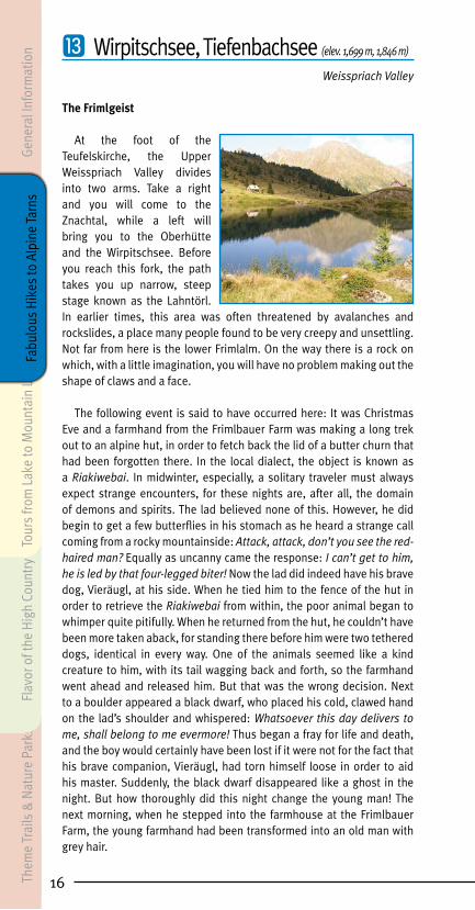
Larch Trees Ablaze in the Autumn Sunlight
Autumn tours of the mountains promise a brilliant display of color: golden sunshine, blue skies and larch trees resplendent in oranges, yellows and greens. Unforgettable moments are guaranteed. The sparkling blue waters of the Wirpitsch and Tiefenbach lakes below the Tauernhöhe, larches and defiant pine trees, along with the crumbling walls of abandoned mountain huts, take the romance of this mountain setting to even greater heights and turn it into a picture book landscape filled with lasting memories.
The starting point for this hike is the car park at the turn-off for the Znachtal in the Upper Weisspriach Valley, which is easy to reach by car or on the valley bus (coin-operated toll booth/fee based). The hike takes you along gravel path no. 770, past the Grangler Hut (elev. 1,320 m) to the trail fork at the Uln Hut (stop for the valley bus). Make a left behind the hut, continue past the roaring waterfall and cross the Longa. After about 200 m, a marked hiking trail breaks off to the left and takes you to the Toni Mörtl Hut, where refreshments are available. After having reached the hut, first continue straight, then turn right just before reaching the Wirpitschsee (elev. 1,699 m). After about 150 vertical meters along an unmarked, but well-trodden pathway, you will come to the Tiefenbachsee at 1,846 meters above sea level.
Elevation Change: ca. 570 mDifficulty: • intermediateTime on Trail: approximately 2 hours to the TiefenbachseeBus Service: No. 720 to Mariapfarr – Weisspriach – Znach turn-off – Grangler Hut – Uln Hut Parking: Znachtal turn-offRefreshments: Grangler Hut, Toni Mörtl Hut
Theme Trails &
Nature Parks
Flavor of the High Country
Tours from Lake to M
ountain LakeGeneral Inform
ationFabulous H
ikes to Alpine Tarns

⓮ Lignitzsee (elev. 1,965 m)
Mariapfarr Lignitz
Spellbound Fishes and the Mountain Dwarves of the Hundstein
Meat was a relatively rare treat in the olden days. But older farmers still recall how, in the days when they were still young shepherds and cowherds, they were able to catch char, trout and schwareiter, all of which they refer to as “small fish.” Up at the hill farms, especially, where there was only butter, cheese soup and cheese for days on end, a fish in the frying pan was a welcome change of pace. The fish in the tranquil waters of the Lignitzsee were also highly desired. But word had it that the dwarves who inhabited the Hundstein guarded the stock of fish in this lake. These were said to be no ordinary fish, but rather spellbound spirits that the dwarves had under their control. As if conjured up from the depths of the earth itself, an iron-grey dwarf would suddenly be seen standing on the shore, tightly wrapped up in his hooded cloak and never uttering a sound. This supernatural creature and his kind have never spoken a single word to man.
Water from the Lignitzsee drains off in mysterious fashion as well. The Lignitzbach flows down to the valley below in three stages, though in doing so, it only reveals itself twice and very briefly above ground.
Setting out from the Kocherbauer Farm (run by the Daum Family) in the Lignitz Valley, you will come to a car park and a gate after 1,500 meters. Hike along this flat gravel road to the upper huts, then across beautiful alpine pastures (trail no. 774) up to the lake (elev. 1,965 m).
Elevation Change: ca. 630 mDifficulty: • intermediateTime on Trail: approximately 2.5 hours to the LignitzseeParking: close to Kocherbauer farmRefreshment: Wielandhof
18Them
e Tr
ails
& N
atur
e Pa
rks
Flav
or o
f the
Hig
h Co
untr
yTo
urs
from
Lak
e to
Mou
ntai
n La
keGe
nera
l Inf
orm
atio
nFa
bulo
us H
ikes
to A
lpin
e Ta
rns

19
⓯ Landwierseen (elev. 1,977 m, 2,047 m)
Göriach Valley
Kaswurm Snake and Kasastoa
The dairymaids of Göriach were always proud of their good cheese. But one day, the cheese worms (Kaswurm) bored into the white and golden yellow rounds of cheese, causing them to become ongla grausig, as the people of the Lungau say whenever they feel that something tastes dreadful. The legend goes on to say that a hunter finally found a long, white snake at the base of a rock on the trail’s edge not far from the hut village. He waited patiently until he was finally able to fire a deadly shot. The monster immediately fell apart into a pile of tiny worms which, as quick as a flash, disappeared into the cracks and fissures of the ground. Since that time, the dairymaids at this hut village have been spared from these vexatious cheese worms, with their savory cheeses appealing even to the most gourmet of palates. The cheese stone (Kasastoa) stands there to this day – clearly visible on the edge of the trail where, as hikers make their way into the valley, the picturesque hut village comes into view. It was also here that the new cowherds were officially welcomed into the community.
From the turning place located just outside the hut village in the Upper Göriach Valley, you will take trail no. 775 to the Landawirsee Hut (elev. 1,985 m). Continuing past the hut, you will come to the smaller Lower Landwiersee (elev. 1,977 m) and the bigger Upper Landwiersee (elev. 2,047 m). The hike from the car park to the Landwierseen takes about 2 hours.
Elevation Change: ca. 610 mDifficulty: • intermediateTime on Trail: about 2 hours to the LandwierseenBus Service: No. 720 to Mariapfarr – Göriach – Göriach Hut Village car parkParking: just before the Göriach Hut VillageRefreshments: Hansal Hut, Landawirsee Hut
Theme Trails &
Nature Parks
Flavor of the High Country
Tours from Lake to M
ountain LakeGeneral Inform
ationFabulous H
ikes to Alpine Tarns

⓰ Gralatisee (elev. 1,816 m)
Upper Lessachtal
The Golden Hen
In the secluded Gralatikar – at the foot of the Hochgolling – lies a small mountain tarn, one of many that adorn the crossing from the Lessachtal to the Schladminger Tauern. For many an hour during the day, the tall rocky crags of the Hochgolling are reflected in its dark green waters, giving the abandoned alpine hut there an almost fairytale appearance.
It has been a long time since the gold miners of the Lessachtal dug for silver, copper, and sulfur, with their greatest bounty discovered on the steep slopes of the Hochgolling itself. At dizzying elevations, they drove their mine galleries deep into the mountainside. Many entrances and steps hewn out of the rock are visible to this day. With the arrival of winter, the miners would abandon the mines and return again in the springtime. One area of snow, located above the Gralatikar, would always remain, taking on the silhouette of a hen, a sign to the miners that the ore mines were once again free of ice and snow. The ore of the Hochgolling petered out many, many years ago and mining ceased, but the Golden Hen above the Gralatisee is still there for everyone to see.
Leaving from the Lasshoferalm (elev. 1,270 m) in the Upper Lessach Valley (toll road/fee: € 5), you will initially hike out in a northerly direction to the point where the valley forks. Hike to the left (west) along the trail, which will take you on a steady climb directly to the eastern slopes of the Hochgolling and the Gollinganger. From there you will continue southwards to the Gralatisee (elev. 1,816 m).
Elevation Change: ca. 550 mDifficulty: • intermediate to • difficultTime on Trail: about 2.5 hours to the GralatiseeParking: LasshoferalmRefreshments: Lasshoferalm
20Them
e Tr
ails
& N
atur
e Pa
rks
Flav
or o
f the
Hig
h Co
untr
yTo
urs
from
Lak
e to
Mou
ntai
n La
keGe
nera
l Inf
orm
atio
nFa
bulo
us H
ikes
to A
lpin
e Ta
rns

21
⓱ Landschitzseen (elev. 1,778 m, 1,937 m)
Upper Lessachtal
Of the mysterious Kasmandl
The dwarf-like, half-savage Kasmandl is an alpine spirit who, in the summer months, inhabits the highest peaks, darkest forests and most inaccessible areas, feeding upon roots and wild herbs. At Martinmas, in late autumn, the little rascal leaves his hiding place and sneaks into the abandoned alpine huts, where he spends his time snacking on remnants of butter and cheese, left there by the hill farmers as a friendly gesture toward him. But in late spring, when up in the mountains the very first grasses and herbs are beginning to peek out of the ground, the Kasmandl must leave the huts and head back up toward the high, lonely mountaintops. Just before the cattle are driven up to the alpine pastures for summer grazing and the dairymaids and cowherds settle in for the summer, the farmer would generally hike up to his hut alone and check that everything was as it should be. Upon his return home, he would then tell his eagerly attentive children how he had, once again, driven away the Kasmandl.
The lowest of the three Landschitzseen (elev. 1,778 m) can be reached from the Lasshoferalm (elev. 1,270 m) in the Upper Lessachtal (toll road/fee: € 5) via a marked trail (no. 784). The hike takes about 2 hours. We would recommend continuing your hike to the middle and then the upper Landschitzsee (elev. 1,937 m). The hike from one lake to the next takes about 45 minutes.
Elevation Change: ca. 510 to 810 m (depending on tour variant)Difficulty: • intermediateTime on Trail: approximately 3.5 hours to the upper LandschitzseeParking: LasshoferalmRefreshments: Lasshoferalm
Theme Trails &
Nature Parks
Flavor of the High Country
Tours from Lake to M
ountain LakeGeneral Inform
ationFabulous H
ikes to Alpine Tarns

⓲ Zwerfenbergsee, Angersee (elev. 2,024 m, 2,100 m)
Upper Lessachtal
Chance Encounters with the Kasmandl
The Kasmandl shies away from people, making any chance encounter so very rare, wondrous and mysterious, that a legend would be woven around any such occurrence. Two such stories come to us from the Lessachtal. Once upon a time there was a hunter who, having just killed a chamois, decided to cook up some fresh liver at an unoccupied mountain hut. As he stepped in the door, he saw no other than the Kasmandl, who was already cooking up his own meal, a charred frog on a wooden skewer sizzling over the open fire.
Yet another tale reveals that the Kasmandl is also a lover of music. A farmhand from Lessach, who also happened to be a wonderful fiddle player, made a deal with the farmer that if he were able to entice the Kasmandl down from the hill country with his music, he would receive a spotted milk cow as his reward. On Martinmas Eve, the time for the trial had finally arrived. The Kasmandl, accompanied by a black cow, strode by the fiddle player and the astonished farmers, before disappearing into the murky night.
From the car park at the Lasshoferalm (elev. 1,270 m) in the Upper Lessachtal (toll road/fee: € 5), we begin a somewhat challenging hike. At the trail fork, you will take trail no. 777 to the biggest lake in the Lungau region, the Zwerfenbergsee, elev. 2,024 m. The hike takes about 3.5 hours. A detour to the somewhat higher Angersee (elev. 2,100 m), which takes about 30 minutes, is highly recommended.
Elevation Change: ca. 850 mDifficulty: • intermediate to • difficultTime on Trail: about 3.5 hours to the ZwerfenbergseeParking: LasshoferalmRefreshments: Lasshoferalm
22Them
e Tr
ails
& N
atur
e Pa
rks
Flav
or o
f the
Hig
h Co
untr
yTo
urs
from
Lak
e to
Mou
ntai
n La
keGe
nera
l Inf
orm
atio
nFa
bulo
us H
ikes
to A
lpin
e Ta
rns

23
⓳ Prebersee (elev. 1,514 m)
Tamsweg Preber Area
The Golden Harrow
Nestled within a delightful, sunny stretch of land is the mysterious Prebersee (elev. 1,514 m). Suspended matter in the water of the moors gives the water surface its dark color. Along the flanks of the Preber (elev. 2,740 m), with its imposing ridgeline, there extends a broad region of alpine pastures boasting a number of rewarding hiking destinations. But rather than the soothing mountain sun, it was the call of gold that enticed treasure hunters to the area throughout the centuries. The old Venediger Books chronicle the existence of the so-called Bishop’s Hole below the Trogleiteneck on the way to the Preberspitze, the site of a gold mine from which high-quality gold ore was extracted over a protracted period of time. Inscriptions on the rocks at the entrance to this protected cave remind us of those days long past. Legend, incidentally, has now transferred the legendary Preber Gold to the lake itself. According to this legend, at some point in the distant future, the lake’s tranquil waters will rise over its shores and flood the entire area of the Murboden. Finally, a harrow made of pure gold will be washed up from the lakebed, one so valuable that it will be possible to rebuild everything anew, including St. Leonhard’s Church. What fears the people of those times must have lived with! Nowadays, we probably have a better perspective on things, seeing those flecks of gold that sparkle atop the lake’s dark moorland waters as perhaps the one grain of truth to this particular legend.
Reachable by car or valley bus from Tamsweg. An alpine moorland lake is located at 1,514 m above sea level is circled by the Self-guided Moors Trail around the lake. Leaving from the car parks, the walk takes about 45 minutes.
Time on Trail: 45-minute loopDifficulty: • easyBus Service: No. 740 from Tamsweg – PreberseeParking: car park next to Lake PreberseeRefreshment: Ludlalm
Theme Trails &
Nature Parks
Flavor of the High Country
Tours from Lake to M
ountain LakeGeneral Inform
ationFabulous H
ikes to Alpine Tarns

⓴ Rosaninsee (elev. 2,080 m)
Bundschuh Nature Sanctuary
The Spirit in the Freimannsloch
The alpine meadows of the Nockberge mountains, fragrant with smell of the herb muskroot, were first worn beautifully smooth by ice-age glaciers and subsequently deforested by ore miners.
Hikers here roam through a very peaceful world. Mining ceased about 100 years ago, which meant that a fire has not burned in the Bundschuh smelter for about the same period of time. But legend has it that there are still treasures out there, hidden amid the fissured crags above the Rosaninsee. One now legendary spot became known as the Freimannsloch. Year after year, a treasure hunter would come here and extract his rewards from a mysterious cave between Stangalm and Rosanin. “If people only knew what wealth lay below their feet, they would have far fewer concerns,” he once revealed to a poor shepherd. The latter, of course, had no grasp that wealth might also come in the form of pristine beautiful countryside. He secretly searched for the hidden cave and did indeed find gold and silver. The local magistrate found his newly acquired fortune suspicious and, since he refused to reveal the truth, he was cast into a dungeon. Only in the night before his scheduled execution did he confide the details to the executioner, in exchange for a promise that he would gain his freedom. The executioner was a scoundrel, kept the secret to himself and put the man to the sword the next morning. But he, too, did not escape punishment, for it is his spirit which now haunts the Freimannsloch, where he stands guard with a bloody axe, scaring away potential intruders.
Setting out from the car park across from the Family and Youth hostel Schönfeld or from the Dr. Josef Mehrl Hut (elev. 1,730 m), you will cross the bridge and then make a left, hiking steadily uphill along trail no. 126 to the Rosaninsee (elev. 2,080 m). Once there, we would highly recommend a hike up to the Grosser Königstuhl (elev. 2,336 m). The hike to the Rosaninsee takes about 1.5 hours, the hike from the Rosaninsee to the Grosser Königstuhl approximately 1 hour.
Elevation Change: ca. 350 to 610 m (depending on tour variant)Difficulty: • intermediateTime on Trail: approximately 1.5 hours to the Rosaninsee Bus Service: line 712 Katschberg-St. Michael Schönfeld (runs from the beginning of July until the beginning of September)Parking: across from the Family and Youth hostel Schönfeld, Dr. Josef Mehrl HutRefreshment: Dr. Josef Mehrl Hut, Eßlalm
24Them
e Tr
ails
& N
atur
e Pa
rks
Flav
or o
f the
Hig
h Co
untr
yTo
urs
from
Lak
e to
Mou
ntai
n La
keGe
nera
l Inf
orm
atio
nFa
bulo
us H
ikes
to A
lpin
e Ta
rns

25
㉑ Rotgüldensee (elev. 1,735 m)
Muhr, the Nature Park Village
The Golden Treasure in the Lake
As evening commences, the lake becomes a sea of reddish gold, warm rays of sunshine streaming across the glistening waters. Rotgülden is a place that still resonates with the long, eventful history of those mines, miners and gold prospectors that were once so much a part of this region.
There was once a rich mine owner, or so the tale would have it, who oversaw gold mining in Muhrwinkel. He was a proud, hard on his miners, but his love for his only daughter surpassed all else. Then the daughter fell in love with a poor mine worker. Overcome with jealousy, the father forbade her any future contact. Overcome by grief, the girl became mortally ill and, in a matter of days, was borne out to the cemetery. The father was in utter despair and, from this day on, hated gold as much as death itself. So filled with sorrow was he, that he sank his entire fortune into the dark waters of this lake, which has been known as the Rotgüldensee (red-gold lake) ever since.
Leaving from the car park at the Arsenhaus (elev. 1,341 m, the hut is not open to the public), you will take the self-guided nature trail to the Rotgüldensee Hut and on to the lower Rotgüldensee (elev. 1,735 m). Option to take way-marked shortcuts (rather steep) leading through different kinds of vegetation (e.g. columbine, larkspur, wild oregano and marjoram, a variety of orchids etc.). From the hut, a beautiful trail leads out above the lake shore to the far shoreline, taking us through tall vegetation and rare plants. A unique experience for anyone who loves flowers. The hike takes about 1.5 hours.
Elevation Change: ca. 400 mDifficulty: • easyTime on Trail: approximately 1.5 hours to the lower RotgüldenseeBus Service: No. 700/710 to Muhr – Muhr RotgüldenParking: Arsenhaus car park (Muhr Rotgülden bus stop)Refreshment: Rotgüldensee Hut Them
e Trails & N
ature ParksFlavor of the H
igh Country Tours from
Lake to Mountain Lake
General Information
Fabulous Hikes to Alpine Tarns

㉒ Karwassersee (elev. 1,897 m)
Muhr, the Nature Park Village
The Witch in the Belfry in Muhr
It had just turned midnight, when a witch on her broom-stick roared into the belfry in Muhr. Her raven-black hair was shaggy, and her dress was equally so. Flying around her were four large birds: a big raven, a screech owl, a jay and an old wood grouse.
With a hammer, she struck the metal, and the bell emitted a dark hum. But she wasn’t content with that. She struck the thick metal coating of the bell with even greater rage, so that a hollow drone could be heard, just as if it were an extended, deep toll of mourning. But the bell remained intact. No matter how much she hammered on it and abused its bronze sides, she was unable to put the hole in it she so hoped for. She fell upon it with a fury, accompanied by a moaning, roaring and hissing, as if all the spirits of hell had been unleashed. But soon the witching hour had past and, though she hadn’t accomplished a thing, the evil witch and her four birds were compelled to withdraw. Since that time, however, the bell in Muhr has lost its beautiful ring. That said, its power to fend off evil weather witchery has endured. It is still possible to see a crack that had never quite managed to split open, on its inner surface. This is known as the Witch’s Mark.
From the Muritzen car park (toll road € 5 fee/coin-operated) you will take the wide forest road as far as the chapel. To the left of the chapel, you will follow the path through the Muritzen hut village. After crossing the bridge, continue to the right on the eastern side of the valley on a marked path along the banks of the Muritzenbach until you come to the Karwassersee. If you now hike via the eastern shores of this lake, then head west to the Schwarzkar, you will come to the Schwarzseen lakes. However, this path is not marked, so it is only recommended for surefooted hikers with mountain experience.
Elevation Change: ca. 400 mDifficulty: • intermediateTime on Trail: 3 hoursBus Service: No. 700/710 to Muhr – Muhr ArsenhausParking: Muritzen car park (toll road € 5 fee/coin-operated) Rotgülden car park (this will add 2 hours to the time of the walk)
26Them
e Tr
ails
& N
atur
e Pa
rks
Flav
or o
f the
Hig
h Co
untr
yTo
urs
from
Lak
e to
Mou
ntai
n La
keGe
nera
l Inf
orm
atio
nFa
bulo
us H
ikes
to A
lpin
e Ta
rns

27
㉓ Anderleseen (elev. 2,080 m)
Bundschuh nature preserve
The legend of the bloody meadow A lot of speculation among history experts
The smooth landscape of the Nockberge in the most southern corner of Lungau was deforested by iron min-ing. There are now green alpine meadows as far as the eye can see. Tumultuousness and stress are quickly forgot-ten here.
How could the legend of the bloody meadow unfold in such peaceful countryside? Yet, this story, a popular oral history in these parts, is said to be rather true. This area has actually been attacked by warring factions three different times. The set-ting of this legend is a type of embankment, which surrounds an alpine plain on three sides. It is divided to the south by the Kremsbach and in the east by the Bundschuhbach. The events of the war, however, can not be confined to such a small space. But one thing at a time:
In the 7th century, the Slavs advanced from the south into the Niedere and Hohe Tauern in search of more land to settle, and there arose a fierce struggle for power with the Bajuwarii who were pushing from Bo-hemia towards the south. To the old settlements of the Alpine Slavs such as Stranach, Göriach (“amongst the mountain dwellers”) or Begöriach, there were now added the names of Bavarian ones such as Oberbayr-dorf, Mörtelsdorf, Seitling, etc. Under the Slavic king Samo, who died in 658, these battles were said to have flared up especially intensely. The Bajuwarii duke Diet along with his wife Gleistrada, according to legend, died there on this bloody meadow in Bundschuh and their gravesite can be found at St. Michael’s parish church. So much blood shed in this beautiful alpine world surrounding the Anderleseen. Today, the area is a blessing for all those who consider the peace and quiet of nature a true gift.
By car you will take the main Bundschuh road (L 267) to the lift parking lot in Schönfeld at an elevation of 1,740 m, the start-ing point for this hike. Keeping to the right, you will hike over the Mattehanshöhe, along the ridge, and over the Zechnerhöhe, Gaipahöhe and Kameritzhöhe to the Anderleseen lakes at an elevation of 2,080 m.
Elevation Change: 340 mDifficulty: • intermediateTime on trail: ca. 3 hoursBus Service: line 712 Katschberg-St. Michael Schönfeld (runs from the beginning of July until the beginning of September)Parking: across from the Family and Youth hostel Schönfeld, Dr. Josef Mehrl HutRefreshment: Dr. Josef Mehrl Hut
Theme Trails &
Nature Parks
Flavor of the High Country
Tours from Lake to M
ountain LakeGeneral Inform
ationFabulous H
ikes to Alpine Tarns

28
From tarn to mountain tarn and valley to valley
“From tarn to tarn and valley to valley” presents five of the most beautiful tours: From a one-day family adventure to an 8-day expedition spanning ten peaks, our tips are certain to appeal to all hikers no matter what their expectations.
The jangling of the cowbells, a meadow blanketed in cotton grass swaying in the breeze, and the view out across the rippling surface of a mountain lake: This is what a perfect Alpine Summer in the Salzburger Lungau looks like. Around 60 tarns can be found here: between alpine cirques and forests, pastures, cliffs and craggy peaks.
Wirpitschsee lake
Gene
ral I
nfor
mat
ion
Them
e Tr
ails
& N
atur
e Pa
rks
Flav
or o
f the
Hig
h Co
untr
yFa
bulo
us H
ikes
to A
lpin
e Ta
rns
Tour
s fro
m L
ake
to M
ount
ain
Lake

29
2-lake hike in Göriachtal valley / 1-day tour
From Göriach to the Landawirsee Hut and to the upper and lower Landwiersee lakes
Starting point for this promising, scenic family tour is the village of Göriach with a population of 400, around 6 km from Tamsweg. Hikers follow – either by car or foot – the road next to the Göriachbach which, after the last occupied houses, gives way to a forest road. There is par-king at the lower Piendlalm Hut and 3 km further along at the Almdörfl. Nine farmers from Göriach each have their own alpine hut in this idyllic hut village, which can be rented or leased, or which, as is the case with the Hansal Hut or the Neumann Hut, invite you to stop in for refresh-ments.
Scenic valley headThe path leads gently uphill between the huts and follows the course
of the Göriachbach. It effortlessly continues uphill and, after a few sharp turns, reveals to the hiker the spectacular crown of mountains surroun-ding the valley head: the northwest ridge of the 2,863 m-high Hoch-golling drops off to the left to the Gollingscharte, and at the foot of the mighty Zwerfenberg, the path to the left leading to the Landawirsee Hut is clearly recognizable. High to the left, hikers are greeted by the sight of the Rotsandspitze and Hoher Wagen.
2 idyllic mountain lakesA little beyond the Zugriegel Huts, you will reach the Landawirsee Hut
(elev. 1,985 m), a hut belonging to the Lungau Chapter of the Austrian Alpine Association. When they are open during the summer months, the hut offers hikers meals and overnight accommodations. Don’t forget to get your hiking logbook stamped! From the romantically situated hut, a trail leads southwest to the lower Landwiersee lake, and to the upper Landwiersee lake (elev. 2,047 m), which can be reached in around 20 min. The trail leads along the same path back to the starting point.
Landwierseen
General Information
Theme Trails &
Nature Parks
Flavor of the High Country
Fabulous Hikes to Alpine Tarns Tours from
Lake to Mountain Lake
30
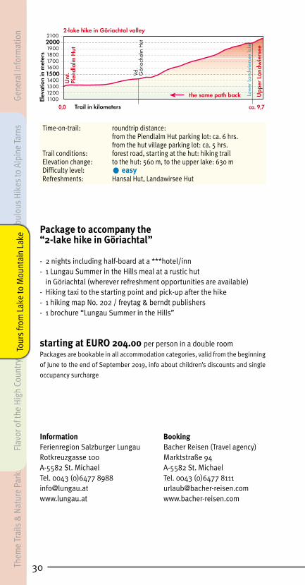
Time-on-trail: roundtrip distance: from the Piendlalm Hut parking lot: ca. 6 hrs. from the hut village parking lot: ca. 5 hrs.Trail conditions: forest road, starting at the hut: hiking trailElevation change: to the hut: 560 m, to the upper lake: 630 mDifficulty level: • easyRefreshments: Hansal Hut, Landawirsee Hut
Package to accompany the “2-lake hike in Göriachtal”
- 2 nights including half-board at a ***hotel/inn- 1 Lungau Summer in the Hills meal at a rustic hut in Göriachtal (wherever refreshment opportunities are available)- Hiking taxi to the starting point and pick-up after the hike- 1 hiking map No. 202 / freytag & berndt publishers- 1 brochure “Lungau Summer in the Hills”
starting at EURO 204.00 per person in a double roomPackages are bookable in all accommodation categories, valid from the beginning
of June to the end of September 2019, info about children’s discounts and single
occupancy surcharge
Information BookingFerienregion Salzburger Lungau Bacher Reisen (Travel agency)Rotkreuzgasse 100 Marktstraße 94A-5582 St. Michael A-5582 St. Michael Tel. 0043 (0)6477 8988 Tel. 0043 (0)6477 [email protected] [email protected] www.bacher-reisen.com
0,011001200130014001500
ca. 9,7
2000
1600170018001900
2100
Vd.
Gör
iach
alm
Hut
Upp
er L
andw
iers
ee
Unt
.Pi
endl
alm
Hut
Low
er L
andw
iers
ee la
ke
2-lake hike in Göriachtal valley
Elev
atio
n in
met
ers
Trail in kilometers
the same path backGene
ral I
nfor
mat
ion
Them
e Tr
ails
& N
atur
e Pa
rks
Flav
or o
f the
Hig
h Co
untr
yFa
bulo
us H
ikes
to A
lpin
e Ta
rns
Tour
s fro
m L
ake
to M
ount
ain
Lake

31
5-lake tour in the Niedere Tauern / 2-day tour
Obertauern – Twenger Almsee lake – Wirpitschsee lake – Grangler Hut – Ober Hut – Obertauern
Day 1:From Mauterndorf by car or bus in the direction of Obertauern.
Around 7 km after the town of Tweng, you will find “Haus Schaidberg” on the right side of the street, the starting point for this splendid 2-day tour. From here, the hiking trail leads via a small bridge on a forest road, steep in parts, to the Ernst Hut (not staffed) at an elevation of 1,869 m. After this, the trail continues on level ground for the time being, yet soon after, the trail steepens and leads up to the Twenger Almsee lake. The climb to the Gollitsch-Scharte (elev. ca. 2,200 m) begins on the right shore. Hiking up this trail, we reach the highest point of the day after ca. 2 hrs. The descent to Weisspriachtal valley first drops steeply to Up-per Schönalmsee lake and then continues to Lower Schönalmsee lake. Particularly impressive is the wonderful pine forest amid the boulders to the left. The fourth mountain lake of the day is the Wirpitschsee lake with the nearby Tonimörtl Hut at an elevation of 1,699 m. After a snack to recharge your batteries, Tiefenbachsee lake entices you to take a detour (about an extra 30 min.). The descent to the valley can be undertaken either along a forest road or a well-marked hiking trail. After 15 min. hi-kers reach tonight’s lodgings, the Grangler Hut. At this certified Summer in the Hills hut (elev. 1,295 m), hikers are treated to exquisite Lungau specialties such as roast pork, Kasnock’n, or Rahmkoch.
Time-on-trail: 2 hrs. in gains 2.5 to 3 hrs. in dropsElevation change: 520 m (uphill), 870 m (downhill)Trail conditions: forest road and trailDifficulty level: • intermediateRefreshments: Tonimörtl Hut, Grangler Hut, Twenger Alm
Twenger Almsee lake
General Information
Theme Trails &
Nature Parks
Flavor of the High Country
Fabulous Hikes to Alpine Tarns Tours from
Lake to Mountain Lake

32
Day 2:From the Grangler Hut, after a hearty alpine breakfast, we make our
way in leisurely fashion via a forest road through the Lantschfeldtal to the last alpine huts. At the chapel, we make a right on trail No. 770, and continue uphill to the Oberhüttensattel (1,866 m). After around 2 hrs. of walking, we will reach Oberhüttensee lake and the nearby hut. After refreshments, the trail takes us on Tauernhöhenweg No. 702 in the di-rection of Obertauern. In the wonderful combe, hikers should defi nitely keep their eyes and ears open: marmots can be observed up close, even without binoculars! From here, the trail climbs steeply to the Klamm-scharte at an elevation of 2,100 m. The highest point of the day is rea-ched in about an hour’s walk. Now we continue for about thirty minutes, with no signifi cant climbs, to the Seekarscharte, which also offers am-bitious mountaineers the opportunity to take trail no. 6 past both the Rosskogel (2,254 m) and the Hundskogel (2,239 m). Otherwise, our trail leads from the Seekarscharte down to the grounds of Hotel Seekarhaus and on to the paved road, then past Hundsfeldsee lake to Obertauern to the bus stop. Once there, we make our way back to the Schaidberg parking lot.
Time-on-trail: 4.5 to 5 hrs.Elevation change: 800 mTrail conditions: forest road and trailDifficulty level: • easyRefreshments: Grangler Hut and Ober Hut
This tour can also be hiked in reverse direction.
Alternative for day 2 or as an additional tour:From the Grangler Hut, we make our way to the Oberhüttensattel as
described above. From there we go right on Tauernhöhenweg No. 702, taking us up a number of steep sections to the Akarscharte (elev. 2,315 m), which we reach in about 1.5 hrs. Here, one path leads off to the right, coming in about half an hour to the Lungauer Kalkspitze (elev. 2,471 m, easy variant), while another makes a left towards the Steirische Kalk-spitze (elev. 2,459 m). Important: surefootedness and mountaineering experience are an absolute must!
From the alpine gap, the trail leads down to the Znachsattel (2,059 m) and eventually to Giglachsee lake and the hut of the same name. The return path leads from the Znachsattel out of the valley to the Untere Greinmeister Hut and the Grangler Hut.
0,01200130014001500
ca. 25
Scha
idbe
rg
2000
1600170018001900
210022002300
Erns
thut
Toni
mör
tl H
ut
Gra
ngle
rhut
Obe
r Hut
Klam
msc
harte
Seek
arha
us
Obe
rtaue
rn
Scha
idbe
rg
Twen
ger A
lmse
e la
ke
Wirp
itsch
see
lake
Obe
rhüt
tens
eela
ke
Hun
dsfe
ldse
ela
ke
Obe
rer S
chön
alm
see
lake
Unt
erer
Sch
önal
mse
e la
ke
Tief
enba
chse
ela
ke ( d
etou
r)
5-lake tour in the Niedere Tauern
Elev
atio
n in
met
ers
Trail in kilometers
Gene
ral I
nfor
mat
ion
Them
e Tr
ails
& N
atur
e Pa
rks
Flav
or o
f the
Hig
h Co
untr
yFa
bulo
us H
ikes
to A
lpin
e Ta
rns
Tour
s fro
m L
ake
to M
ount
ain
Lake

33
Time-on-trail: 6.5 to 7.0 hrs. (not including summit tours)Elevation change: 1,000 mTrail conditions: forest road and trailDifficulty level: • intermediate to • difficultRefreshments: Grangler Hut, Giglachsee Hut
Package for “5-lake tour in the Niedere Tauern”
- 2 nights including half-board at a ***hotel/inn- 1 romantic night at the Grangler Hut “My favorite Hut 2012“- 1 Lungau “Summer in the Hills” meal at a rustic hut in Weisspriachtal (wherever refreshment opportunities are available)
- Hiking taxi to the starting point and pick-up after the hike- Hiking info package with: 1 hiking map No. 202 / freytag & berndt & 1 Rother hiking guide “Lungau”- 1 brochure “Lungau Summer in the Hills”
starting at EURO 254.00 per person in a double roomPackages are bookable in all accommodation categories, valid from the beginning
of June to the end of September 2019, info about children’s discounts and single
occupancy surcharge upon request
Information BookingFerienregion Salzburger Lungau Bacher Reisen (Travel agency)Rotkreuzgasse 100 Marktstraße 94A-5582 St. Michael A-5582 St. Michael Tel. 0043 (0)6477 8988 Tel. 0043 (0)6477 [email protected] [email protected] www.bacher-reisen.com
0,01200130014001500
ca. 23,5
Gra
ngle
r H
ut
2000
1600170018001900
210022002300
Gre
inm
eiste
r Hut
24002500
Obe
rhüt
tens
atte
l
Lung
auer
Kal
kspi
tze
Stei
risch
e Ka
lksp
itze
Gig
lach
see
Hut
Aka
rsch
arte
Obe
r Hut
Gra
ngle
r H
ut
ALTERNATIVE for day 2 - 5-lake tour in the Niedere Tauern
Elev
atio
n in
met
ers
Trail in kilometersG
igla
chse
e la
ke
General Information
Theme Trails &
Nature Parks
Flavor of the High Country
Fabulous Hikes to Alpine Tarns Tours from
Lake to Mountain Lake

34
6-lake tour from Muhr to Riedingtal valley / 3-day tour
Muhr – Stickler Hut – Riedingscharte – Königalm Hut – Haselloch – Franz-Fischer-Hut – Jakoberalm Hut – Rothenwändersee lake –
Grosskessel – Zederhaus
Day 1:The starting point of this 3-day tour is the unstaffed Arsen Hut (elev.
1,341 m) in the Hintermuhr section of Muhr. During the summer holidays a busservice is offered to the Hintermuhr. From here, we travel ca. 4 km by car or valley bus on the toll road (have € 5 in coins ready) to the Muritzen parking lot (1,520 m). We now begin a one-hour walk past a chapel and alpine huts to the staffed Stickler Hut (1,752 m). In front of the hut, trail No. 740 leads off to the right and up to the Riedingscharte (2,274 m), which can be reached in an additional hour and a half. For experienced hikers, there is also the opportunity to scale the Weisseck (2,711 m) in 1 1⁄4 hrs. But for everyone else, the path leads from the Riedingscharte on fl at trail No. 711, accompanied by magnifi cent views, to Riedingsee lake and the Boarnlacke (2,215 m). The occasionally steep descent ends at the Summer in the Hills Hut - Zauner Hut. From here it’s only 10 more min. by foot to our overnight lodgings, the rustic Summer in the Hills hut on the Königalm Hut (elev. 1,667 m). With homemade pressed cheese dumplings and wholegrain cheese noodles, you can re-charge your batteries for the upcoming day.
Time-on-trail: 5.5 hrs.Elevation change: 750 mTrail conditions: forest road, trailDifficulty level: • easy to • intermediateRefreshments: Stickler Hut, Zauner Hut and Königalm Hut
Rothenwändersee lake
Gene
ral I
nfor
mat
ion
Them
e Tr
ails
& N
atur
e Pa
rks
Flav
or o
f the
Hig
h Co
untr
yFa
bulo
us H
ikes
to A
lpin
e Ta
rns
Tour
s fro
m L
ake
to M
ount
ain
Lake

35
Day 2:After spending a peaceful night, we set out from behind the Königalm
on a climb straight up to the Haselloch. Path No. 702 leads, first steeply, then climbing more gently, in ca. 1.5 hrs. to the pond (elev. 2,135 m). The following hike up to the Bärenlacke (elev. 2,020 m), the highest point of the day’s tour, leads us past Allermannsharnisch, a rare garlic plant, which you can already smell from quite a distance. Across a carpet of fl owers, just past the nearby Hoislsee lake (2,040 m) and again slightly ascending to the Ilgsee lake (2,097 m) where the trail leads directly on the shores of the lake to the Zaunersee lake to the Franz-Fischer Hut (2,018 m) in a hike taking around 2.5 hours. Now, it’s only 2 more hrs. to the Jakoberalm (elev. 1,839 m), where we will settle in to our accom-modations for the night: the path there leads past the Esser lakes and through an area of larch trees. The mighty Mosermandl (elev. 2,680 m) constantly watches over you.
Time-on-trail: 5.5 to 6 hrs.Elevation change: 750 mTrail conditions: trailDifficulty level: • intermediateRefreshments: Königalm Hut, Franz-Fischer Hut, Jakoberalm
Day 3:The last leg of this 3-day tour leads from the Jakoberalm (1,839 m) on
path no. 702 in about an hour to Rothenwändersee lake (elev. 2,010 m). Here hikers enjoy a gorgeous and impressive mountain panorama. From the lake, we first hike gently downhill along a trail, then on a gravel road, coming in ca. 1.5 hrs. to the Grosskessel area and the idyllic Summer in the Hills hut, the Muhreralm (1,642 m), where a brief stop for Maria’s de-licious refreshments is an absolute must. After an additional 45 min. we reach the toll booth and also the stop for the post bus, which will bring us back to our starting point.
Time-on-trail: 3.5 hrs.Elevation change: 130 mTrail conditions: trail and forest roadDifficulty level: • easyRefreshments: Muhreralm
0,01200130014001500
1500
2000
ca. 33
Ars
en H
ut
2000
1600170018001900
210022002300
Stic
kler
Hut To
llboo
th
Ried
ings
char
te
Boar
nlac
ke
Köni
galm
Hut
Bäre
nlac
ke
Jako
bera
lm H
ut
Roth
enw
ände
rsee
lake
Muh
rera
lm H
ut
Ilgse
e la
ke
Fran
z-Fi
sche
r Hut
Zaun
erse
e la
ke
Kößl
er-
hias
alm
Hut
Esse
rsee
lake
s
6-lake tour from Muhr to Rieding valley
Elev
atio
n in
met
ers
Trail in kilometers
General Information
Theme Trails &
Nature Parks
Flavor of the High Country
Fabulous Hikes to Alpine Tarns Tours from
Lake to Mountain Lake
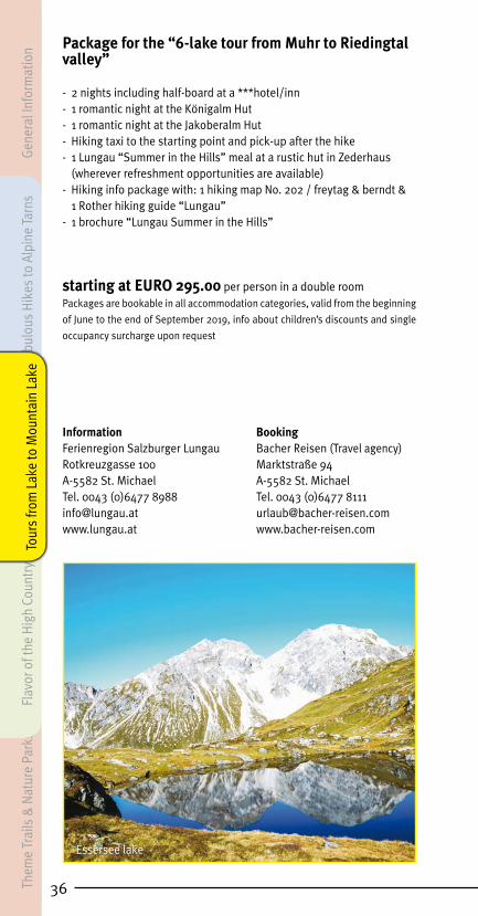
36
Package for the “6-lake tour from Muhr to Riedingtal valley”
- 2 nights including half-board at a ***hotel/inn- 1 romantic night at the Königalm Hut- 1 romantic night at the Jakoberalm Hut- Hiking taxi to the starting point and pick-up after the hike- 1 Lungau “Summer in the Hills” meal at a rustic hut in Zederhaus (wherever refreshment opportunities are available)
- Hiking info package with: 1 hiking map No. 202 / freytag & berndt & 1 Rother hiking guide “Lungau”- 1 brochure “Lungau Summer in the Hills”
starting at EURO 295.00 per person in a double roomPackages are bookable in all accommodation categories, valid from the beginning
of June to the end of September 2019, info about children’s discounts and single
occupancy surcharge upon request
Information BookingFerienregion Salzburger Lungau Bacher Reisen (Travel agency)Rotkreuzgasse 100 Marktstraße 94A-5582 St. Michael A-5582 St. Michael Tel. 0043 (0)6477 8988 Tel. 0043 (0)6477 [email protected] [email protected] www.bacher-reisen.com
Essersee lake
Gene
ral I
nfor
mat
ion
Them
e Tr
ails
& N
atur
e Pa
rks
Flav
or o
f the
Hig
h Co
untr
yFa
bulo
us H
ikes
to A
lpin
e Ta
rns
Tour
s fro
m L
ake
to M
ount
ain
Lake

37
Tauern Sunny-Side Tour / 8-day tour
This tour takes you via the sunny side of the Schladminger and Radstädter Tauern – from Prebersee lake to St. Michael.
Day 1:Individual arrival in St. Michael im Lungau/Oberweissburg section
of town. For example, coming from the direction of Munich/Salzburg: Zederhaus exit, follow the signs for St. Michael. After around 10 kilome-ters, you will arrive in the community of Oberweissburg (an autobahn toll sticker is required and a toll charge of € 6.00 each time through the toll gate).
Day 2:Short Variant: Transfer to Prebersee lake - Gasthaus Ludlalm (1,500
m), hike in the direction of Lessach via the Laraalm, the Wagenberg (1,440 m) and along the supply road to Lessach (1,197 m) and to your accommodations.
Time on Trail: 2 hrsElevation Changes: 100 m (uphill), 400 m (downhill)
Long Variant: Transfer to the turn-off for the Grazer Hut on the Pre-berstraße, 2 km to Prebersee lake (1,514 m), from there continue to the Grazer Hut (1,897 m). Then westerly across the southern slopes of the Preber to the Golzgraben. Follow this downhill to Wagenberg (1,440 m), taking the supply road to Lessach (1,197 m) and your accommodations.
Time on Trail: ca. 5 hrs.Elevation Changes: 500 m (uphill), 800 m (downhill)
Day 3: Second night in Lessach, to spend however you please. Hike to your
preferred mountain tarn.
Day 4:From Lessach in the direction of Wildbach Hut snack station (1,806 m).
A flat path leads you to the Granglitzalmen. Downhill along a forestry road to Hintergöriach (1,230 m) and your lodgings.
Time on Trail: ca. 3.5 hrs.Elevation Changes: 650 m (uphill), 600 m (downhill)
Alternate Variant: from the Wildbach Hut up the Gumma (2,316 m).
Time on Trail: ca. 2.5 hrs. - roundtripElevation Changes: 510 m (uphill), 510 m (downhill)
Day 5:From Hintergöriach (1,230 m) via the Moargut, Moarbergsteig trail G
6 – take the Gensgitsch forestry lane uphill to the right and the Gens-gitsch Hut (1,786 m). Return the same way, but after 10 minutes drop down to the right to the Kobaltsattel (1,554 m). From here, continue on the main lane for around 700 meters southwards, then take the forestry path which branches off to the right and takes you directly to the small
General Information
Theme Trails &
Nature Parks
Flavor of the High Country
Fabulous Hikes to Alpine Tarns Tours from
Lake to Mountain Lake

38
village of Zankwarn (hiking path M 5). Take the footpath into the center of Mariapfarr (1,120 m) and to your lodgings.
Time on Trail: ca. 4.5 hrs.Elevation Changes: 560 m (uphill), 670 m (downhill)
Alternative Variant: from the Gensgitsch Hut up the Gensgitsch (2,279 m).
Time on Trail: ca. 2.5 hrs.Elevation Changes: 500 m (uphill & downhill)
Day 6:From Mariapfarr (1,120 m) via Niederrain to Pürstlmoos (1,212 m).
Along the banks of the Lignitzbach through the Tiergraben to Wielandka-pelle chapel (1,322 m). Along the Platschweg to Kraischaberg (1,380 m). Via Oberfeldgasse to Tscharra, now following a mountain road to the last farm, then via „Sonndörfl ” to Weißpriach (1,102 m) and your lodgings.
Time on Trail: ca. 3.5 hrs.Elevation Changes: 250 m (uphill & downhill)
Day 7:From Weißpriach (1,102 m) along the Skihüttensteig trail to the for-
mer Weißpriacher ski hut. Along the lift road to the valley station of the „6er-Samsonbahn“ lift (1,489 m), continue to the right of the chair lift to the old Raderweg. Follow this via the Schitter Hut to the Rader Hut (1,791 m) and continue along the edge of the ski slope to the mountain station of the chair lift (2,020 m). Descend in a southerly direction to the Moserkopf (1,896 m) and the Almstüberl (1,850 m). Take the Hexensteig trail through high forest to Veitlbauer farmstead (1,406 m), Mauterndorf (1,123 m) and your accommodations.
Time on Trail: ca. 5 hrs.Elevation Changes: 920 m (uphill), 900 m (downhill)
Day 8:Leave for home or extend your stay.
Total Time on Trail: ca. 25 hrs. Total Elevation Change: around 3,800 vertical meters in gains, 4,200 vm in descents (variants not included)Types of Trails: Hiking trails/paths, forestry roads/mountain lanes Difficulty Level: • intermediate Refreshments: Ludlalm, Grazer Hut, Preber-Halter Hut, Wildbach Hut, Almstüberl Fanningberg, Restaurant Schialm, Restaurant Panorama Alm, Speiereck Hut, Speiereck-Halterhut,
Gene
ral I
nfor
mat
ion
Them
e Tr
ails
& N
atur
e Pa
rks
Flav
or o
f the
Hig
h Co
untr
yFa
bulo
us H
ikes
to A
lpin
e Ta
rns
Tour
s fro
m L
ake
to M
ount
ain
Lake

39
0,0
1200
1300
1400
1500
1500
2000
ca. 8
3 km
JunktionGrazer Hut
2000
1600
1700
1800
1900
2100
2200
2300
Gumma
Lessach
2400
1100
1000
Alte
rnat
ive
Gum
ma
Alte
rnat
ive
Gen
sgits
ch
Wildbach Hut
Wildbach Hut
Hintergöriach
Granglitzalmen
Gensgitsch Hut
Gensgitsch Hut
MariapfarrZankwarn
Weißpriach
Wielandkapelle chapel
Mauterndorf
Moserkopf
Großeck
Speiereck
St. MichaelOberweißburg
Alternative Hammer/Mauterndorf Ski Center
Start Prebersee lake25
00
1000
2500
Taue
rn S
unny
-Sid
e To
ur
Elevation in meters
Trai
l in
kilo
met
ers
General Information
Theme Trails &
Nature Parks
Flavor of the High Country
Fabulous Hikes to Alpine Tarns Tours from
Lake to Mountain Lake

40
Package offer for the “Tauern Sunny-Side Tour”
- 7 nights including half-board at an inn with shower/WC or bath- 1 pack lunch per person and day- 1 hiking map per room- 1 Lungau hiking booklet per room- 1 Lungau hiking pin at the end of the tour for each participant- daily luggage transfer to your next night’s accommodations
EURO 690.00 per person in a double roomSurcharge for single occupancy: EURO 95.00
Rental hiking poles: EURO 26.00 per person and week
Bookable from the end of May until the beginning of October, daily arrival pos-
sible.
Total duration: 8 days/7 nights in the valley.
Hiker’s insurance available on request!
Information & Booking Franz Lehenauer Autobus Taxi Reisebüro Gewerbestraße 451A-5582 St. Michael Tel. 0043 (0)6477 8311 [email protected]
Trogalmseen lakes
Gene
ral I
nfor
mat
ion
Them
e Tr
ails
& N
atur
e Pa
rks
Flav
or o
f the
Hig
h Co
untr
yFa
bulo
us H
ikes
to A
lpin
e Ta
rns
Tour
s fro
m L
ake
to M
ount
ain
Lake

41
The Nock Round/ 8-day tourDuring this wonderful tour, you will be following easily walked hiking
paths essentially from start to finish – through pine forests and across alpine pastures – crossing 10 summits in the process.
Day 1:Individual arrival in St. Margarethen im Lungau (1,066 m), if coming
from the direction of Munich/Salzburg for example: St. Michael exit off the autobahn – follow signs for Tamsweg – turn off for St. Margarethen. (an autobahn toll sticker is required and a toll charge of € 6.00 each time through the toll gate).
Day 2:You will leave St. Margarethen along forest paths, hiking via the Es-
seralm (1,593 m) to the Bonner Hut (1,713 m). Drop down to Bundschuh/Hochofen (1,050 m). Transfer to your lodgings.
Time on Trail: ca. 6 hrs.Elevation Changes: 658 m (uphill), 648 m (downhill)
Day 3:Transfer to Bundschuh. Through the Weißseite and via the Größin-
galm to the Gaipahöhe (2,192 m), over the Zechnerhöhe (2,188 m) and on to the Mattehanshöhe (2,086 m). Hike down to Schönfeld past the Dr. Josef Mehrl Hut (1,730 m) to your accommodations.
Time on Trail: ca. 5 to 6 hrs.Elevation Changes: 979 m (uphill), 570 m (downhill)
Nock Round/Gaipa
General Information
Theme Trails &
Nature Parks
Flavor of the High Country
Fabulous Hikes to Alpine Tarns Tours from
Lake to Mountain Lake

42
Day 4:Hike up on the western side below the Schilchernock to the Klöling-
scharte (2,116 m). Drop down through the valley head at the Klölingalm to your lodgings.
Time on Trail: ca. 2.5 hrs.Elevation Changes: 384 m (uphill), 159 m (downhill)
Day 5:Hike up the Kleiner Königstuhl (2,254 m), continuing along a ca. 6
km alpine path taking you to the Feldernock – Vordereck - Windriegel - Gstoßlacke und Baierl Hut to the Gstoßhöhe (1,890 m). Drop down via the Mühlhauser Hut to Ramingstein and the Triebling section of town (974 m). Walk past the ski jump and the BMW workshop along the main highway and the bridge over the Mur, along the bike path to Madling - to your accommodations.
Time on Trail: ca. 6 hrs.Elevation Changes: 491 m (uphill), 1,426 m (downhill)
Day 6:From Madling across the bridge over the Mur, make a left through the
community of Schwarzenberg and continue on the hiking path leading to the Trattnerbauer farm. Hike up via the Tscheller Hut, Franzenbauer Hut and Langer Hut to the top of the Lasaberg (1,935 m). Return the same way as far as the Langerbauer farm, then take path No. 795 until you are close to the Frauenhöhle (the turn-off to a rather inaccessible cave close to a wayside altar at 1,131 m). Hike down to Tamsweg (1,021 m) – to your accommodation.
Time on Trail: ca. 6 to 7 hrs.Elevation Changes: 979 m (uphill), 930 m (downhill)
Day 7:From the town center of Tamsweg along the Ottingweg across the
Taurach bridge to Mörtelsdorf. Hike up the Mitterberg (1,399 m) via the eastern ridgeline. Drop down to Frimlkapelle chapel (1,358 m), and con-tinue via the Friml farmstead and the Culture Path to Schloss Moosham and St. Margarethen, your last night’s accommodations, where your car will also be waiting!
Time on Trail: ca. 5 - 6 hrs.Elevation Changes: 821 m (uphill), 579 m (downhill)
Day 8:Leave for home or extend your stay.
Total Time on Trail: ca. 28 hrs.Total Elevation Change: around 4,000 vertical meters, both uphill and downhillTypes of Trails: Hiking trails/paths, forestry path mountain lanes, alpine pastures, forestry roadsDifficulty Level: • intermediateRefreshments: Bonner Hut, Dr. Josef-Mehrl Hut
Gene
ral I
nfor
mat
ion
Them
e Tr
ails
& N
atur
e Pa
rks
Flav
or o
f the
Hig
h Co
untr
yFa
bulo
us H
ikes
to A
lpin
e Ta
rns
Tour
s fro
m L
ake
to M
ount
ain
Lake

43
0,0
1200
1300
1400
1500
1500
2000
ca. 8
9 km
St. Margarethenim Lungau
2000
1600
1700
1800
1900
2100
2200
2300
Bundschuh/Hochofen
2400
1100
1000
Gaipahöhe90
010
00
Bonner Hütte
Klölingalm
Kleiner Königstuhl
Gstoßlacke
Madling
Lasaberg
Tamsweg
Frimlkapelle
Unternberg
St. Margarethenim Lungau
Tran
sfer
Die
Noc
krun
de
SEEHÖHE IN METER
WA
ND
ERW
EG IN
KIL
OM
ETER
General Information
Theme Trails &
Nature Parks
Flavor of the High Country
Fabulous Hikes to Alpine Tarns Tours from
Lake to Mountain Lake

44
Package offer for “The Nock Tour”
- 7 nights including half-board at an inn (2 nights of which are spent at a mountain inn) with shower/WC or bath- 1 pack lunch per person and day- 1 hiking map per room- 1 Lungau hiking booklet per room- 1 Lungau hiking pin at the end of the tour for each participant- daily luggage transfer to your next night’s accommodations
EURO 685,00 per person in a double roomSurcharge for single occupancy: EURO 90.00
Rental hiking poles: EURO 26.00 per person and week
Bookable from the end of May until the beginning of October,
daily arrival possible.
Total duration: 8 days, of which 5 nights are spent in the valley and 2 nights at
mountain inns.
Hiker’s insurance available on request!
Information & Booking Franz Lehenauer Autobus Taxi Reisebüro Gewerbestraße 451A-5582 St. Michael Tel. 0043 (0)6477 8311 [email protected]
All-Inclusive LungauCardWith the LungauCard, our guests can look
forward to an enormous variety ofa ll-inclusive and discounted activities for the whole family! Complete information about the LungauCard and participating businesses can be found online at: http://card.lungau.at
Prebersee lake
Gene
ral I
nfor
mat
ion
Them
e Tr
ails
& N
atur
e Pa
rks
Flav
or o
f the
Hig
h Co
untr
yFa
bulo
us H
ikes
to A
lpin
e Ta
rns
Tour
s fro
m L
ake
to M
ount
ain
Lake
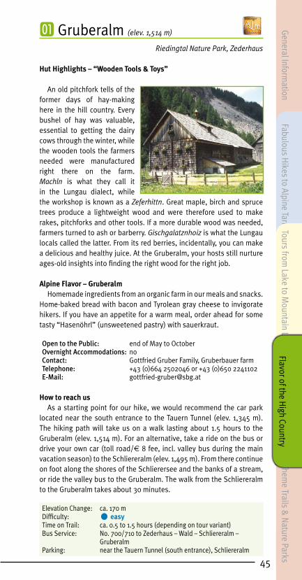
45
㆒ Gruberalm (elev. 1,514 m)
Riedingtal Nature Park, Zederhaus
Hut Highlights – “Wooden Tools & Toys”
An old pitchfork tells of the former days of hay-making here in the hill country. Every bushel of hay was valuable, essential to getting the dairy cows through the winter, while the wooden tools the farmers needed were manufactured right there on the farm. Machln is what they call it in the Lungau dialect, while the workshop is known as a Zeferhittn. Great maple, birch and spruce trees produce a lightweight wood and were therefore used to make rakes, pitchforks and other tools. If a more durable wood was needed, farmers turned to ash or barberry. Gischgalatznhoiz is what the Lungau locals called the latter. From its red berries, incidentally, you can make a delicious and healthy juice. At the Gruberalm, your hosts still nurture ages-old insights into finding the right wood for the right job.
Alpine Flavor – Gruberalm Homemade ingredients from an organic farm in our meals and snacks.
Home-baked bread with bacon and Tyrolean gray cheese to invigorate hikers. If you have an appetite for a warm meal, order ahead for some tasty “Hasenöhrl” (unsweetened pastry) with sauerkraut.
Open to the Public: end of May to OctoberOvernight Accommodations: noContact: Gottfried Gruber Family, Gruberbauer farmTelephone: +43 (0)664 2502046 or +43 (0)650 2241102E-Mail: [email protected]
How to reach usAs a starting point for our hike, we would recommend the car park
located near the south entrance to the Tauern Tunnel (elev. 1,345 m). The hiking path will take us on a walk lasting about 1.5 hours to the Gruberalm (elev. 1,514 m). For an alternative, take a ride on the bus or drive your own car (toll road/€ 8 fee, incl. valley bus during the main vacation season) to the Schliereralm (elev. 1,495 m). From there continue on foot along the shores of the Schlierersee and the banks of a stream, or ride the valley bus to the Gruberalm. The walk from the Schliereralm to the Gruberalm takes about 30 minutes.
Elevation Change: ca. 170 mDifficulty: • easyTime on Trail: ca. 0.5 to 1.5 hours (depending on tour variant)Bus Service: No. 700/710 to Zederhaus – Wald – Schliereralm – GruberalmParking: near the Tauern Tunnel (south entrance), Schliereralm
General Information
Fabulous Hikes to Alpine Tarns
Theme Trails &
Nature Parks
Tours from Lake to M
ountain LakeFlavor of the H
igh Country

㆓ Hoislalm (elev. 1,556 m)
Riedingtal Nature Park, Zederhaus
Hut Highlights - “Hill farming past and present”
At the newly renovated Hoislalm you can experience and discover life on the farm. Old and young visitors alike are given interesting insights into modern hill farming. With advance notice, your farming hosts will be glad to show you the basics of farm work, including milking as well as how to make butter and cheese. “Hoisl Peter” once did all the milking by hand at the Hoislalm. But today, you can watch the cows standing there patiently in a modern milking “parlor”, as you breathe in the healthful mountain air, watch the pigs being their usual lazy selves and the cows grazing, or simply take delight in listening to the rush of the mountain stream… If you are in the mood for some healthy Kneipp therapy, step into the fresh mountain waters of the Riedingbach right next to the hut. Awaiting the children is a great adventure playground as well as a stable with farm animals that just love to be petted.
Alpine Flavor – Hoislalm A particular specialty of the Hoislalm are meat pockets right out
of the hot pan which are then prepared and served for guests of the 2 hill-country festivals. All ingredients used in our delectable alpine snacks are produced here at the Hoislalm. The hill farmers invite you for refreshments, to refuel with farm-fresh organic products, enjoy the beautiful view, or simply to take a break and rest.
We are also happy to host special events at our mountain hut.
Open to the Public: June until mid SeptemberOvernight Accommodations: yesContact: Schlick Family, Hoislbauer farmTelephone: +43 (0)650 3411931E-mail: [email protected]
How to reach usAs a starting point, we recommend the parking area at the south
entrance to the Tauern tunnel (elev. 1,345 m) – from there it takes about 2.5 hrs. to reach the Hoislalm. It’s also possible to travel by car to the parking area for the Nature Park Info Center (toll road/€ 8 fee, incl. valley bus during the main vacation season) – also the starting point of the Almenwanderweg trail. By taking this idyllic trail you will reach the Hoislalm in an hour. Hikes during the main holiday season can also incorporate a ride on the valley bus.
Elevation Change: ca. 210 mDifficulty: • easyTime on Trail: ca. 1 to 2.5 hours (depending on the tour variant)Bus Service: Line 700/710 to Zederhaus - Wald – Nature Park Center at the Schliereralm - with the valley bus to the HoislalmParking: near the Tauern Tunnel (south entrance), Schliereralm
46
Gene
ral I
nfor
mat
ion
Fabu
lous
Hik
es to
Alp
ine
Tarn
s Th
eme
& N
atur
e Tr
ails
Tour
s fro
m L
ake
to M
ount
ain
Lake
Flav
or o
f the
Hig
h Co
untr
y

47
叅 Jakoberalm (elev. 1,839 m)
Riedingtal Nature Park, Zederhaus
Hut Highlights – “Kneipp Therapy in a Mountain Tarn”
The Jakoberalm lies just below the Mosermandl amid magnificent Alpine pastures. From here, you can set out on hikes that vary in length and difficulty. In addition to that, you might be tempted to enjoy a spot of Kneipp therapy in the fresh mountain water – which will do wonders for your toes, soles, heels, calf muscles, knees and arms.
The lovingly run Jakoberalm definitely evokes the phrase “back to your roots”. No matter whether your visit is a timeout from the stresses of daily life, or a pleasant refreshment opportunity after your hike. When it comes to satisfying the guests’ hearty appetites, our first step is always to heat up the wood-burning stove before preparing the delectable selection of specialties.
Alpine Flavor – Jakoberalm At the Jakoberalm, we are dedicated to using regional products
and supporting our local farmers. From farmhouse bread, traditional Bretteljause snack platters, cheese dumplings and Rahmkoch, to a variety of juices including elder, lemon balm and our very popular pine juice, everything is carefully prepared by hand. As a special treat, we offer our guests marvelous Lungau milk that never comes out of the carton, but instead is “freshly tapped” every day at our own farm.
Open to the Public: June until end of SeptemberOvernight Accommodations: yesContact: Christina Wieland and Michaela SchreilechnerTelephone: +43 (0)664 75124193 oder +43 (0)660 2888346E-mail: [email protected]
How to reach usFrom Zederhaus take the toll road (€ 8 fee, incl. valley bus during the
main vacation season) towards Riedingtal (about 9 km) until you get to the Jakoberalm car park (ca. 0.5 km prior to the Schliereralm). From this point, a supply road and a marked hiking path lead to the Jakoberalm (elev. 1,839 m). We highly recommend hiking to the Esser See (see page 5) or the Rothenwändersee (see page 7).
Elevation Change: ca. 350 mDifficulty: • intermediateTime on Trail: ca. 1 hourBus Service: No. 700/710 to Zederhaus – SchliereralmParking: next to the trail to the Jakoberalm
General Information
Fabulous Hikes to Alpine Tarns
Theme Trails &
Nature Parks
Tours from Lake to M
ountain LakeFlavor of the H
igh Country

㆕ Königalm (elev. 1,667 m) Riedingtal Nature Park, Zederhaus
Hut Highlights – “Zwergerlteich and Waterwheel”
We are only a leisurely one-hour hike from the Nature Park House or a short ride on the valley bus from the Königalm. Anyone who makes a refreshment stop here is certain to enjoy the setting with every fiber of their being – the tranquility, the pristine scenery, and, of course, the mouthwatering country cooking. Ducks waddle and splash about in the Zwergerlteich next to the terrace, while sheep and lambs graze nearby – an alpine paradise for children of all ages. After all, here they can play to their hearts’ content, gaze at the waterwheel and pet the lambs.
Alpine Flavor – KönigalmAt the Königalm, the owner cooks for you personally throughout
the day. Hikers can count on hot meals served from opening to closing time. The Königalm serves hearty dishes based on regional recipes, specialties of the hill country and homemade ingredients, including bacon and cheese. The fried bacon dumplings with sauerkraut are delicious, a famous specialty of the Königalm. Mmmh, they simply taste divine!
Open to the Public: beginning of June until mid OctoberOvernight Accommodations: yesContact: Robert Batlogg FamilyTelephone: +43 (0)664 2523297E-mail: [email protected]
How to reach us As a starting point for a hike, we would recommend the car park
located near the south entrance to the Tauern Tunnel (elev. 1,345 m). Following the hiking path we will reach the Königalm after about a 2.5-hour walk. For an alternative, take a ride on the bus or drive your own car (toll road/€ 8 fee, incl. valley bus during the main vacation season) to the Schliereralm. From there continue on foot via the Almenwanderweg path or ride the valley bus to the Königalm. The walk from the Schliereralm to the Königalm takes about 1.25 hours. We also recommend taking a walk to the Boarnlacke (see page 9) or the Ilgsee – Zaunersee (see page 6).
Elevation Change: ca. 350 mDifficulty: • easyTime on Trail: ca. 1.25 to 2.5 hours (depending on tour variant)Bus Service: No. 700/710 to Zederhaus – Wald – Schliereralm – KönigalmParking: near the Tauern Tunnel (south entrance), Schliereralm
48
Gene
ral I
nfor
mat
ion
Fabu
lous
Hik
es to
Alp
ine
Tarn
s Th
eme
& N
atur
e Tr
ails
Tour
s fro
m L
ake
to M
ount
ain
Lake
Flav
or o
f the
Hig
h Co
untr
y

49
⓹ Liasalm (elev. 1,812 m)
Karthäusen - Zederhaus
Hut experience: “Bringing in the hay, then and now”
A hike to the Liasalm is always worthwhile. Once at the hut, with its beautiful floral decorations, hikers can recover from the effort of the climb and enjoy the glorious views of the surrounding mountains. Your hosts will be happy to explain to you how the precious mountain hay used to be harvested using rather primitive equipment, later transported down to the valley in winter, often under very arduous conditions.
Alpine Flavor – Liasalm The milk from cows grazing on the nearby alpine pastures is all turned
into butter or cheese, either so-called “ grey cheese” or cream cheese. Hikers can also recharge their batteries with the help of delicious cheese-dumpling soup, fresh farmhouse doughnuts, or some Rahmkoch, along with a homemade juice of alpine herbs. Snacks, traditionally served on a wooden board, include bacon made from their own pork, venison sausage, a selection of cheeses, along with farmhouse bread lovingly baked right there at the farm. And for the perfect finish to your hearty meal: a shot of excellent pine schnapps.
Open to the Public: mid June until mid SeptemberOvernight Accommodations: noContact: Erich Gruber Family, Liasnbauer farmTelephone: +43 (0)664 2719830 or +43 (0)6478 243E-mail: [email protected]
How to reach usThe starting point for this hike is directly across from a small sawmill
in the center of Zederhaus – about 200 m from the church towards the mouth of the valley. Follow the signs taking you alongside the containment walls for the autobahn, then left along the supply lane until you reach the turn-off for the Karthäusenalmen. Continue on the old cart path, through high forest and alongside the Karthäusengraben, until you reach the Liasalm at 1,812 m above sea level. Alternatively, set out from Gasthof Jägerwirt: Follow the main road, about 50 m beyond the bridge at the Jägerwirt make a left in the direction of the Karthäusenalmen.
Making your way along a gravel lane as far as a gate, you will now come to access routes which will bring you up to the Liasalm: a supply lane as well as a marked hiking path, taking you on a walk to the Liasalm lasting about 2.5 hours.
Elevation Change: ca. 620 mDifficulty: • intermediateTime on Trail: ca. 1.5 to 2.5 hours (depending on tour variant)Bus Service: No. 700/710 to Zederhaus - centerParking: center of Zederhaus – near the shop “Kaufhaus Bliem”
General Information
Fabulous Hikes to Alpine Tarns
Theme Trails &
Nature Parks
Tours from Lake to M
ountain LakeFlavor of the H
igh Country

⓺ Muhreralm (elev. 1,659 m) Grosskessel - Zederhaus
Hut Highlights – “Müchbitschn”
Farmers used to transport milk in wooden buckets, barrels or Bitschn from the hill farm down to the valley below. But most of the milk stayed right where it was produced, where the dairymaid turned it into a variety of cheeses and butter. Mechanization and the construction of access roads made it possible to transport the fresh milk and cream in wooden or aluminum containers to the farms and then on to local dairies. Thus it became possible to supply local communities with fresh, high-quality dairy products. At the Muhreralm, visitors can still view some of these original Müchbitschn, while the youngsters can also look forward to playing with a homemade toy car.
Alpine Flavor – MuhreralmEverything is home-produced – butter, freshly baked bread, cottage
cheese seasoned with herbs and cheese noodles.
Open to the Public: mid June until the end of SeptemberOvernight Accommodations: noContact: Jäger Family, Muhrerbauer farmTelephone: +43 (0)6477 8369 or +43 (0)664 5420241E-mail: [email protected]: www.muhrerbauer.at
How to reach usPrior to the toll station for Riedingtal Nature Park in Zederhaus, the
forestry road branches off towards Grosskessel, where marked path no. 741 begins. This path now takes us to the Muhreralm (elev. 1,659 m) in about a 1-hour’s walk. We also recommend taking a hike to the Rothenwändersee (see page 7).
Elevation Change: ca. 250 mDifficulty: • intermediateTime on Trail: ca. 1 hourBus Service: No. 700/710 to Zederhaus – Zederhaus toll station in RiedingtalParking: Riedingtal toll station
50
Gene
ral I
nfor
mat
ion
Fabu
lous
Hik
es to
Alp
ine
Tarn
s Th
eme
& N
atur
e Tr
ails
Tour
s fro
m L
ake
to M
ount
ain
Lake
Flav
or o
f the
Hig
h Co
untr
y

⓼ Schliereralm (elev. 1,495 m)
Riedingtal Nature Park, Zederhaus
Hut Highlights – “Butter- & Cheese-Making and a Petting Zoo”
The Schliereralm, located at the entrance to Riedingtal Nature Park and declared “Alpine Summer Hut 2016”, is a marvelous oasis during any holiday spent here in the mountains. The views of the landscapes are beautiful and accompanied by mouth-watering treats from the kitchen. The hut which stands next-door, whose dark wood has absorbed the power of the sun for the last three centuries, is still used for butter- and cheese-making. Visitors are encouraged to watch and even to lend a hand. These products are also available for purchase. Awaiting children on the green shoreline of the Schlierersee is a petting zoo, along with play equipment and trees to climb in. Bleating pygmy goats and cackling bantam chickens roam the area in search of the best snacks. Guest may use the public, handicapped-accessible WC at the Schliereralm.
Alpine Flavor – SchliereralmNative trout teem in the clear mountain stream in front of the
Schliereralm. Once caught, fried up fresh and flavored with homemade butter, they are served with Lungau potatoes to make an exceptional meal. Other specialties include Lungau cheese-dumpling soup, wiener schnitzel fried in home-churned butter and, of course, an utterly delicious Kaiserschmarren dessert. Order ahead and you will even be able to look forward to “Hasenöhrl” (unsweetened pastry) with sauerkraut.
Open to the Public: mid May until October Overnight Accommodations: yesContact: Johann Dorfer Family, Schliererbauer farmTelephone: +43 (0)6478 484 or +43 (0)6478 453E-mail: [email protected]: www.schliereralm.at
How to reach usAs a starting point for a hike, we would recommend the car park located
near the south entrance to the Tauern Tunnel (elev. 1,345 m). Following the hiking path we will reach the Schliereralm (elev. 1,495 m) after about a 1-hour walk. For an alternative, take a ride on the bus or drive your own car (toll road/€ 8 fee, incl. bus during the main vacation season) to the Schliereralm (elev. 1,495 m). We recommend taking a hike to the Upper Riedingtal or circumnavigating the Schlierersee (see page 8).
Elevation Change: ca. 150 m Difficulty: • easyTime on Trail: ca. 1 hourBus Service: No. 700/710 to Zederhaus – Wald – SchliereralmParking: near the Tauern Tunnel (south entrance), Schliereralm
Po
i s k a r l
LessachHinter-weißpriach
Z o i t z a c hWasseringKraischaberg
Schwaig
Am Sand
Sonndörfl
Hinter-göriach
Polleralm
A
l te r k a r
S t e i n k a r l
Gralatikar
Göriachwinkel
Ha
fensteinkar
Lans
ch
feldkar
T a lkenkar l
Zinkenkarl
Engelkar
K n a p p e n k a r
B r a u n k a r
V e t t e r n k a r
Gr.
Stierkar
E l e n d ka
r
Gollingwinkel
K
üh k a r
Obere Steinwenderalm
I r
r ka r l
Zwerfenbergalm
Madschurkgraben
Schneegrube
Br
a
nd
G o l z a l
Grundtu l ln
S t i e
Fu chsenkar
Z
e c h n e r k a r
Ö
d k a r
We
it
k
ar
Neualm
UntereGamsenalm
Ut.-
Ob.-
-Bacheralm
HinteralmhüttenMariellahütte
HintereZugriegelalm
VordereZugriegelalm
Moseralm
inhtt.
Jhtt.
t.)
Kirchnerhütte
Unt. Rainhütte
Granierhtt.
Vd. Urbanalm
Vd. Kocherhütte
HintereLignitzalmen
nerhtt.
tschhtt.
chenhtt. Granitzlhütte
Vd. Zehnerhtt.
Vd. Praschalm
Wielandhtt.Vd. Pfarralm
SchlickenhütteJhtt.
Jhtt.
Eseihütte
Ederhütte
Moargut
Gensgitschhütte
LignitzKocher
HanseiEsei
Hanseihtt.
Granglitzalmen
Bachbauerhtt.
Löckerhtt.
Zeineralm
Maxenalm
Karneralm
Greisalm
Greis
Bacher
Engelramer
Wagenberg
SchoberbergerKrug
Tromört
Purga
LaßhoferGamshof
Lerchnergut
Zeinerhütte
Hiasnhütte
Krughütte
Lindlhütte
Stegerhtt.
Lacknerhof
Edergut
ZechnergutPlatsch
Binder
Kirchner
Hinterberg
Tscharra
Abraham
Jh
tt.
ütte
chnerhtt.
Ob. Piendlalm
Ut. Piendlalm
Muhreralm
Lenzenalm
Asendlalm
Laßhoferalm
Ut.-Ob.-
-Burgahütte
Lindlalm
Ut. Demelalm
Praschalm
Radergaßhütt
Lärcherhütte
Ob. Demelalm
Obe
rtal
b
Buckelkarseen
Knappenseen
Knappen-karsee
Kühseelein
Lands
chitzbach
Gralatisee Lessabach
-LandwierseeUt.-
Ob.-
Lignitzsee
Talkensee
Wildsee
Znachbach
UntererGiglachsee
see
EiskarseeElendbergsee
Lungauer Klaffersee
Zwerfenbergsee
Znac
hbac
h
Graniersee
Kleiner See
Lignitzbach
Gurpitschbach
Weißpriachb.
Ham
mer
b.
ch
PiendlseeKalter BrunnenGrafenbrunnen
Neunbrünnl
Mühlbach
Lindlsee
UntererLandsch
-Landwiersee
1278
(1473)
(2127)
2607
2471
2614
2176
(1764)
(1560)
2563
2357
2638
2280
2050
2490
2279
2326
2321
2292
(1498)
2452
1691
(1150)
1274
2316 (1580) 2125
(1216)
1196
1402
(1795)
(1806)
1839
1491
(1287)
1234
(1786)
(1355)
(1625)
(1401)
2096
1117
1126
1506
4)
(1715)
2104
2115
1685
1106
1102
1388
1332
1322
15291196
(1180)
1363
1714
(1577)
(1197)
1181
1699
(1420)
.
(1236)
(1253)
(1270)(1370)
(1703)
(1754)
.
1723
.2275
.
.
.
.
.
.
.
.
p2296
Stierkar-scharte .
(1618)
24532428
Krukeck
KrukeckscharteSauberg
2520
2524
2442 Zinkwand
Rotmandlspitze
Vetternspitzen Pietrach
2237Trockenbrotscharte
Be
be
r z
(1872)
Zischken2661
Hochschuß
2684
(1434)
(1816)
Steinkarlegg2637
Hochgolling2863
Rottor.2260
.Tramortenscharte 2442
(1704)
Rotsandspitze2481
2320
Hoher Wagen
(1985)
Lanschfeld-scharte.2305
Scharnock2470
. 2293
Krautgart-scharte
Brettspitze2412
2205
Lignitzhöhe.
(1965)
2626
Blutspitze
2477Graunock
(2064)
(1620)
2518
Engelkarspitze
scharte
entenkarspitze
stuhl
(1986)2358
Grobfeldspitze
2225
spitzeHading
(2073)
2381.
Samspitze
Gollingscharte2326 .
2672
Elendberg
(1938)(2218)
Zwerfenberg2642
(1705)
Pöllerhöhe
(1641)
2601
Großes Gangl2602
(2197)
(2024)
Kaiserscharte.2298
2617 Meisterspitze
Hundstein
Hundscharte Hocheck
Leßscharte
Ht. Gamsriegel
Vd. Gamsriegel
Faltersch.
Leßhöhe
Pollannock
Gensgitsch
H o c h ö f e n
An
ge
r e t z
Zahlerkogel
Zechnerkarspitze
Granitzstein
Raudinghöhe
Kastlhöhe
Zuppatkopf
Muleteck
Gumma Lachriegel
Lercheck
Vordereck
Wi
es
b
Za
nk
wa
rn
er
B
Aiblhöhe
Zechnerriegel
F i höh
P l a p p e r l i n g
Hocheckgraben
Leßgraben
G r a n i e r
La
hn
g r i es
Graniergraben
Zuppatg
raben
chwerbachgr.
K a r n e i t s c h e n
V
d
.Ht. Brandgraben
S t r e i f g r a b e n
O f e n g r a b e n
Gr
an
i tz
l
GensgitschalmJonesgraben
Lasengr.
S o ß g r a b e n
Go
l zg
ra
be
n
Bodenmoosgr.
Hackenbachgr.
Blankengraben
G r u b e n w a l d
L u c ke n bachgr.
A i b l
Weißhöhe
2659
(2033)
(1910)2566Kreuzhöhe
Kampelfenster2562
2500
Wirriegelhöhe
Kasereck
2740
K ü h k a r
Kaserscharte 2315.
2205
Schoberknopf
2414
Somspitz
Twertzgraben
Lärchriegel
G
(1980)
2505
Stierkopf
Jä
Lä
2
Landschit2345
(1778)
2131
Teufelskirche2550
Sattelspitze
Mitterspitzen Hillebrandk.Ötschenriegel
.
Gummascharte
atzbühel1919
Kübel2340
Schöneckl
Freying2131
(1921)
(2047)
Mattis-Hütte
Keinprechthütte
Gollinghütte
Vd.- Göriachalm
Wildbachhütte
Winkelkapelle
Seekreuz
Landawirsee-hütte
hütte
Diktlerhütte
Greinmeisterhütte
AlmdörflHansalhütte
Neumannhütte
775
0 1000 2000 m
alternative
start/finish
Lesh
S h i
Hinter-göriach
Polleralm
A
l te r k a r
S t e i n k a r l
Gralatikar
Göriachwinkel
Ha
fensteinkar
Lans
ch
feldkar
E l e n d ka
r
Gollingwinkel
K
üh k a r
Obere Steinwenderalm
I r
r ka r l
Madschurkgra
Schneegrube
e r k a r
HinteralmhüttenMariellahütte
HintereZugriegelalm
VordereZugriegelalm
Vd. Urbanalm
Vd. Kocherhütte
HintereLignitzalmen
Granitzlhütte
Vd. Zehnerhtt.
Vd. Praschalm
Wielandhtt.Vd. Pfarralm
SchlickenhütteJhtt.
Jhtt.
Eseihütte
Ederhütte
Moargut
Gensgitschhütte
LignitzKocher
HanseiEsei
Hanseihtt.
Granglitzalmen
Bachbauerhtt.
Löcke
Zeineralm
Maxena
Karneralm
Greisalm
Greis
SchoberbeKrug
Tromör
Purga
Hiasnhütte
Krughütte
Lacknerhof
Binder
Kirchner
Hinterbergm
Ob. Piendlalm
Ut. Piendlalm
Ut.-Ob.-
-Burgahütte
Gralatisee Lessabach
-LandwierseeUt.-
Ob.-
ignitzsee
Lungaue
er See
Lignitzbach
mer
b.
PiendlseeKalter BrunnenGrafenb
Neun
-Landwiersee
(1764)
(1560)
2563
2357
2638
2280
2050
2490
2279
2326
2321
(1498)
2316
(1795)
(1806)
1839
1491
(1287)
1234
(1786)
(1355)
(1625)
(1401)
1106
1388 1322
15291196
1714
(1420)
.
.2275
.
.
.
(1618)
Pietrach
2237Trockenbrotscharte
eb
er z
Hochschuß
(1434)
(1816)
Steinkarlegg2637
Hochgolling2863
Rottor.2260
.Tramortenscharte 2442
(1704)
Rotsandspitze2481
2320
Hoher Wagen
(1985)
Lanschfeld-scharte.2305
Scharnock2470
. 2293
Krautgart-scharte
Brettspitze2412
2205
Lignitzhöhe.
(1965)
2477
2381.
Samspitze
Gollingscharte2326 .
(1938)
Zwerfenberg2642
(1705)
Pöllerhöhe2601
Großes Gangl2602
Hocheck
Leßscharte
Ht. Gamsriegel
Vd. Gamsriegel
Faltersch.
Leßhöhe
Pollannock
Gensgitsch
H o c h ö f e n
An
ge
r e t z
gel
nitzstein
audinghöhe
Gumma
Vordereck
W
Za
nk
Hocheckgraben
Leßgraben
ni t
zl
GensgitschalmJonesgraben
Lasengr.
S o ß g r a b
Blankengraben
Weißhöhe
2659
(2033)
(1910)2566Kreuzhöhe
Kampelfenster2562
2500
Wirriegelhöhe
Kasereck
2740
K ü h k a r
Kaserscharte 2315.Hillebrandk.
Ötschenriegel
Gummascharte
Kübel2340
Schöneckl
(2047)
Vd.- Göriachalm
Wildbachhütte
Landwiersee-hütte
AlmdörflHansalhütte
Neumannhütte
775
0 1000 2000 m
start/finish
Po
i s k a r l
Obertauern
e r w a l d
Mit te recka lm
T a lkenkar l
Zinkenkarl
Engelkar
K n a p p e n k a r
Im
K a l k
B r a u n k a r
Reinkarl
Stockerste
inkk
arl
Lantschfeld
T s c h e i b i t s c h
V e t t e r n k a r
Gr.
Stie
Plattenkar
Fu chsenkar
Z
e c h n e r
Ö
d k a r
Z e h n e r k a rSchaidberg
lahn
T a u e r n k a r
Klammel-karl
SteinkarlFu c hs l o
ch
L a n t s c h f e l d t a l
mhütte
Ob.-
-Zehneralm
Unt.-
Mühlthaleralm
Moseralm Piendlhtt.(Jhtt.)
Jhtt.
Gastalm
Postalm
Hofbauernalm
Breitlahnalm
SonntagskaralmSteinkarlalm
Tauernkaralm
zen-
m
Hundsfeldalm
MoseralmAbrahamalm
Kühbarnalm
Obere Frimmlhütte Ulnhütte
Samerhütte
Restalm
Ernsthütte
Jhtt.
Rupaninhtt.
Jhtt.
(Jhtt.)
Kirchnerhütte
Unt. Rainhütte
Granierhtt.
Karnerhtt.
Gurpitschhtt.
ernhof Ob. Rainhütte
Seekarhaus
Manklalm
Lantschfeldb.
Q.
Wssf.
auernkarsee
GrünwaldseeHundsfeldsee
Buckelkarseen
Knappenseen
Knappen-karsee
Lign
Talkensee
Wildsee
Znachbach
WeißpriachTscheibitschsee
Oberhüttensee
UntererGiglachsee
ObererGiglachsee
Tauernkarsee
UntererSchönalmsee
Wirpitschsee
Tiefenbachsee
ObererSchönalmsee
Wirpitschbach
Schönalm
bach Zn
achb
ach
Graniersee
Kleiner
Gurpitschbach
Unt.-
Ob.--Rupaninsee
Twenger Almsee
Taurach
TennfallKernsee
Karnersee
Fors
ta
u
Krumm-schnablsee
1395
1342
1619
4
2068
(1742)
1899
1297
2099
2299
2328 2098(1869)
(1846)
(1699)
(1323)
1278
(1473)
(2127)
2607
2471
2614
2176
(
2
2292
2452
1691
(1150)
1274
2380
2228
2315
2526
(1987)
(2120)
2247
2025
2096
(1754)
(2074)
1383
(2115)
.
.
.
(1893)
(1295)
.
2409
2200.
Mittereck
Siche lwand
M a h d w a n d
chw
an
d
lwand
Gamsleitenspitze
Zehnerkarspitze
2340
2196
2359
21372321
2361
2226
1621Kleine-
-Kesselspitze
Große-
Herbertspitze
nerkar
Gamsspitzl
2156
Steinkarlspitze
1839
Gamskarlspitz
Seekarspitze2350
2288
Seekarschneid
2217
Seekareck
Seekarscharte 2022
Wurm-wand
2239Hundskogel
2245
Sonntagkarhöhe
(1735)
Plattenspitze2293
2296
Stierkar-scharte .
24532428
Krukeck
KrukeckscharteSauberg
2520
2524
2442 Zinkwand
Rotmandlspitze
Vetternspitzen
Be
be
(1872)
B24
2626
Blutspitze
247Graunock
(2064)
(1620)
2518
Engelkarspitze
Stockerscharte2154.
Mentenkarspitze2341
2410
Schusterstuhl
Znachsattel
2192
Lungauer Kalkspitze
2059.
Samerkogel
2471
(1584)
Wei
ßeW
and
(1555)
Roßkogel
2254
(1915)Gamskarlspitze2411
Oberhüttensattel1866.
(1869)
2235
Meregg
2095
. 2315Akarscharte (1955)
Brotrinnl.2088
Steir. Kalkspitze2459
(1986)2358
Grobfeldspitze
2225
ZnachspitzeHading
(2073)
St
ei n k a r
Tauernhöhe Roßkogel
Steinkarhöhe
Hundstein
Hundscharte
Zahlerkoge
Zechnerkarspitze
Granit
Raud
Kastlhöhe
Zuppatkopf
Muleteck
Karnereck
Blasriegel
Predigtstuhl
Gr. Gurpitscheck
Twenger Almkogel
Gollitschspitze
W i r p i t s c h
P l a p p e r l i n g
G r a n i e r
La
hn
g r i es
Graniergraben
Zuppatg
raben
Schwerbachgr.
R up
an
in
S c h ö n al m
Tw e n g e r A l m
G u r p i t s c h
a b e nG
ra
ni t
2131
Teufelskirche2550
Sattelspitze
Mitterspitzen
(1791)
2100 .
(1665)
(1952)
(1954)
2054
2411
2381
(1671)
Schatzbühel1919(1877)
Pernerkopf
Gollitschscharte
Klammlscharte
Freying2131
(1921)
Weninger Alm
Sonnhof
Hausstättalm
Oberhütte Giglachseehütte
Ignaz-Mattis-Hütte
Keinprechthütte
Knappenhaus
Flubachalm
Grünwaldkopfbahn(Sommerbetrieb)
Zeh
nerk
arba
hn
Bergstation
KringsalmDikt´nalm
Gams-leitenbahnII
JugendheimSchaidberg
Seekreuz
Edelweißhütte
Gam
sleite
n-ba
hnI
Achenrain-bahnI
uschhtt.
Hochalm
Treff 2000
Schaidbergstüberl
Achenrainhütte
Ulnhütte
Granglerhütte
Diktlerhütte
Salzburger Almenweg
Wiesmeyerhaus
Wachtbrücke
Tonimörtlhtt.
Greinmeisterhütte
Twenger Alm
770
770
770702
771
702
8
702
99
0 1000 2000 m
alternative
start/finish
Bru
Gries
Hub
RotgüldenJedl
H i n t e r m u h r
Wald
Sch
loßboden
B
Sto
ck
ac
hg
r.
Zopon i t zenLanschützRoß f a l l g
r.
Schrov i
ngr.
Sch
mal
zgru
be
Hia
sbauern
stelle
nGöllalm
Ab
ra
h
am
g r .
So
l ie
si n
ga
lmNahenfeldalm
Pleißnitz
Z l i e m w a l d
Nahendfe
ldm
ähder
F e r l es c h
Re
i nk
ar b
öd
en
R i e d i n g t a l
S c h l i e re rm o a s
Rauchwald
Weißeckwald
Aschstatt
Hö
l lg
r ab
en
F i n s t e r w a l dA ho r n
gr.
Zmölling
h
Sto f fmä h d e r
L a c k
en
La
nt
sc
Gersbachgraaben
(R
Ur
b
an k a r
J a k o b e r ka
r
Ö d e n ka
r
Rothenkar
Sch ie
I nd e r
Hö
l l e
W e i ß k ar
G r i e ß n e r k ar
Kü h k a r
Za
lu ß en ka r
Sc h r o v i n k a r
Kl .
Re i n ka r
Gro
ßes Reinkar
G r u b e r k
ar
Oberes-
-Wildkar
Za
u
ne
r k a r
Unteres-
Mi l
c h l ei t e n
Ro
ßk
ar
l
D ü r n k a r g r a b e n
l m
T a p p e nk
ar
K r e e k ar
Ob. Eßlalm
Moosalm
Ilgalm
Prodingeralm
Jhtt. Unt. EßlalmHoislalm Gruberalm
HasschermalmSeppalmSchliereralm
Sieglalm
Jh.
EsseralmGspandlalm
Jägerkeusche
Keßler
Blasialm
Rothenwänder
Pleißnitzeralm
Spaunhtt.
Wasserfaller
Schiefe
Duller
MoserKrw.
Gritzer
Gratzeralm
Jhtt.
Mühlbachalm
Köhler- hias
Maureralm
Rothenwänderalm
Pfeifenbergeralm
Bartlalm
Dicktlalm
Lechneralm
Jhtt.Waschbergalm
Örgenhiasalm
Zauneralm
Reinkarhtt.
Hiasbauernalm
Stickleralm
(Jhtt.)
Zalußenalm
Veitalm(verf.)
Marislalm
Wa
DreiSchuppen
Nickl-bauernhtt.
Jackl-bauernalm
Jhtt.
Rotschopfalm
Jh. Muritzen
Unter-gaunitschalm
Jhtt.
Albert-biwak
Plölitzen
Arsenhütte
Blasnerbauer
Brunner
Öllschützen
Stieralm
Huberalm
Trimmingeralm
Neuseßwirtalm
Kößlerhiasalm
Aigneralm
Urbanbauern-alm
Gruberkarhtt.
höderwacht(verf.)
Jhtt.
DürnkaralmSchwabalm
Rothen-
Gr.
Kess
elba
ch Kl. Kesselbach
Ilgsee
Hoislsee
Toifenbach
Boarnlacke
Vd. R
iedin
gb.
Q. Riedingb.
Q.Q.
Zm
öllin
gb.
Zederhausb.
Nahendf
eldb
.
Mühlbachsee
Riedingsee
Ht. Riedingb.
Mur
Reinkarlacke
Q.
Q.
Ros
adie
rb.Ple
ißni
tzb.
Mar
islb
ac
h
Lans
chüt
zb.
Murursprung
Mur
itzen
b.
Unterer--Schwarzsee
Karwassersee
lden
b.
wändersee
Zaunerlacke
EsserseeZaunersee
Eisbrunnen
Bärenlacke
Schödersee(per.)
mb.
Wssf.
Ta
pp
en
k a r s e e
2379 (2097)
(2040)
2062
2255
2366
(1667)
2266
2206
(1805)
(1514) (1495)
2087
2304 2305
1489
1738
1340
1720
1310
2518
2570
2638
1645
1717
12
1245
1761
(1679)
19061572
2128
(1658)
2277
(2114)
2506
2711
2413
2348
2274
(2215)
2136
(1712)
(2233)
25082457
2535
2453
1781
(1752)
1666
2431
2412 2342
2536
2482
2413
2380
2521
2529
2222
2500
1864215
23
2299
2485
2462
25042259
2340
2058
(1599)
(1540)
1592
2340
(2224)
2388
2466
2402
18442200
2475
2333
2678
2444
2661 (2221)
(1895)
2547
2681
2039
1341
12371734
2304
26092680
(2018)
2366
.
(2087)
(1993)
.
.
.
.
2250
.
(2200)
Schöpfing2143
Kl. Mosermandl
Karkopf
2538
1569
(1790)
2108
1900
(1642)
Stampferwand
Gebreinspitze
LabspitzeAignerhöhe
2236
2167
22232104
2342
Rothenkarscharte
Dürneck1979
2335
Ecksattel
1505
(1839)(1865)Wildkarkopf
Weißgruben-scharte
Schiereck
Fetzing
Riedingspitze
Schwarzkogel Rauchkopf
BärnleitenkopfRauchfangkopf
Br ün
nw
an
dZwillingwand
Gr.
Kleine Gu
R o t h e n w a n dKempen
Gröbnitzen
Felskarspitze
S e e wa n d
Weißeck
Pfefferkogel
Riedingscharte
Kl. Reicheschkg.
Haselloch
Prabitschkopf
Jägerspitze Sommerleitenk.
Nebelkarscharte
Nebelkareck
Barleitenkopf
Plankowitzspitze
RöthspitzePleißnitzkogel
Silberplatten
Bloßkogel
Kreuzhöhe
Marislwand
Schober
Ret
Stein
Waben
Sch
mie
d lei te
n
MarislscharteGrießenspitze
Balonspitze
Kaltenfeldsp.
Helm
Bettelwand
Frischinghöhe
Roßkarscharte
Frauennock
Lang
eW
and
Gr. Mureck(Schöderhorn)
Mureck
Kl. Murtörl
Schöderscharte
Marchkareck
Schmalzscharte
Mannsitz
Vord. Schober
Schrovinschartl
Gr. Reicheschkg.
WindischkopfMosermandl
Windischscharte
Ma
2(2179)
Stierkarkopf
2522
Rothorn
R ot
2511
Wildkarhöhe
Hoferscharte2356 .
.
.
2088
Seeköpfl
Wurmfeld
(2010)
Schöderhorn
M u r w a n d
Wasserfallscharte
Glingspitze
Wurmkogel
Maierkogel
Raucheck
Weißgrubenkopf
Tau
erntu
nn
elFranz-Fischer-Hütte
Krw.
Sticklerhtt.
Königalm
Jakoberalm
Muhreralm
Tappenkarseehütte
Tappen-karseealm
702
741
A10
Zederhaus
2369
2188
2475
(1440)
2169
(1762
)
2136
(1770)
2369
2295
(1825)
66
2156
2433
(1740)
.
arbeitsgemeinschaft kartographie & BEV Wien©
0 1000 2000 mMuhr
finish
start
Following the instructions of thehunting owners and landowners!
buildingsforestruins, castleview towerchurch, chapelwayside shrine,cross
motorwayfederal highwaymain roadother roadfootpathgondola cablewaychair liftt-bartrailrefreshmentsparking
KEY
99A10
Lesh
S h i
Hinter-göriach
Polleralm
A
l te r k a r
S t e i n k a r l
Gralatikar
Göriachwinkel
Ha
fensteinkar
Lans
ch
feldkar
E l e n d ka
r
Gollingwinkel
K
üh k a r
Obere Steinwenderalm
I r
r ka r l
Madschurkgra
Schneegrube
e r k a r
HinteralmhüttenMariellahütte
HintereZugriegelalm
VordereZugriegelalm
Vd. Urbanalm
Vd. Kocherhütte
HintereLignitzalmen
Granitzlhütte
Vd. Zehnerhtt.
Vd. Praschalm
Wielandhtt.Vd. Pfarralm
SchlickenhütteJhtt.
Jhtt.
Eseihütte
Ederhütte
Moargut
Gensgitschhütte
LignitzKocher
HanseiEsei
Hanseihtt.
Granglitzalmen
Bachbauerhtt.
Löcke
Zeineralm
Maxena
Karneralm
Greisalm
Greis
SchoberbeKrug
Tromör
Purga
Hiasnhütte
Krughütte
Lacknerhof
Binder
Kirchner
Hinterbergm
Ob. Piendlalm
Ut. Piendlalm
Ut.-Ob.-
-Burgahütte
Gralatisee Lessabach
-LandwierseeUt.-
Ob.-
ignitzsee
Lungaue
er See
Lignitzbach
mer
b.
PiendlseeKalter BrunnenGrafenb
Neun
-Landwiersee
(1764)
(1560)
2563
2357
2638
2280
2050
2490
2279
2326
2321
(1498)
2316
(1795)
(1806)
1839
1491
(1287)
1234
(1786)
(1355)
(1625)
(1401)
1106
1388 1322
15291196
1714
(1420)
.
.2275
.
.
.
(1618)
Pietrach
2237Trockenbrotscharte
eb
er z
Hochschuß
(1434)
(1816)
Steinkarlegg2637
Hochgolling2863
Rottor.2260
.Tramortenscharte 2442
(1704)
Rotsandspitze2481
2320
Hoher Wagen
(1985)
Lanschfeld-scharte.2305
Scharnock2470
. 2293
Krautgart-scharte
Brettspitze2412
2205
Lignitzhöhe.
(1965)
2477
2381.
Samspitze
Gollingscharte2326 .
(1938)
Zwerfenberg2642
(1705)
Pöllerhöhe2601
Großes Gangl2602
Hocheck
Leßscharte
Ht. Gamsriegel
Vd. Gamsriegel
Faltersch.
Leßhöhe
Pollannock
Gensgitsch
H o c h ö f e n
An
ge
r e t z
gel
nitzstein
audinghöhe
Gumma
Vordereck
W
Za
nk
Hocheckgraben
Leßgraben
ni t
zl
GensgitschalmJonesgraben
Lasengr.
S o ß g r a b
Blankengraben
Weißhöhe
2659
(2033)
(1910)2566Kreuzhöhe
Kampelfenster2562
2500
Wirriegelhöhe
Kasereck
2740
K ü h k a r
Kaserscharte 2315.Hillebrandk.
Ötschenriegel
Gummascharte
Kübel2340
Schöneckl
(2047)
Vd.- Göriachalm
Wildbachhütte
Landwiersee-hütte
AlmdörflHansalhütte
Neumannhütte
775
0 1000 2000 m
start/finish
Po
i s k a r l
Obertauern
e r w a l d
Mit te recka lm
T a lkenkar l
Zinkenkarl
Engelkar
K n a p p e n k a r
Im
K a l k
B r a u n k a r
Reinkarl
Stockerste
inkk
arl
Lantschfeld
T s c h e i b i t s c h
V e t t e r n k a r
Gr.
Stie
Plattenkar
Fu chsenkar
Z
e c h n e r
Ö
d k a r
Z e h n e r k a rSchaidberg
lahn
T a u e r n k a r
Klammel-karl
SteinkarlFu c hs l o
ch
L a n t s c h f e l d t a l
mhütte
Ob.-
-Zehneralm
Unt.-
Mühlthaleralm
Moseralm Piendlhtt.(Jhtt.)
Jhtt.
Gastalm
Postalm
Hofbauernalm
Breitlahnalm
SonntagskaralmSteinkarlalm
Tauernkaralm
zen-
m
Hundsfeldalm
MoseralmAbrahamalm
Kühbarnalm
Obere Frimmlhütte Ulnhütte
Samerhütte
Restalm
Ernsthütte
Jhtt.
Rupaninhtt.
Jhtt.
(Jhtt.)
Kirchnerhütte
Unt. Rainhütte
Granierhtt.
Karnerhtt.
Gurpitschhtt.
ernhof Ob. Rainhütte
Seekarhaus
Manklalm
Lantschfeldb.
Q.
Wssf.
auernkarsee
GrünwaldseeHundsfeldsee
Buckelkarseen
Knappenseen
Knappen-karsee
Lign
Talkensee
Wildsee
Znachbach
WeißpriachTscheibitschsee
Oberhüttensee
UntererGiglachsee
ObererGiglachsee
Tauernkarsee
UntererSchönalmsee
Wirpitschsee
Tiefenbachsee
ObererSchönalmsee
Wirpitschbach
Schönalm
bach Zn
achb
ach
Graniersee
Kleiner
Gurpitschbach
Unt.-
Ob.--Rupaninsee
Twenger Almsee
Taurach
TennfallKernsee
Karnersee
Fors
ta
u
Krumm-schnablsee
1395
1342
1619
4
2068
(1742)
1899
1297
2099
2299
2328 2098(1869)
(1846)
(1699)
(1323)
1278
(1473)
(2127)
2607
2471
2614
2176
(
2
2292
2452
1691
(1150)
1274
2380
2228
2315
2526
(1987)
(2120)
2247
2025
2096
(1754)
(2074)
1383
(2115)
.
.
.
(1893)
(1295)
.
2409
2200.
Mittereck
Siche lwand
M a h d w a n d
chw
an
dlwand
Gamsleitenspitze
Zehnerkarspitze
2340
2196
2359
21372321
2361
2226
1621Kleine-
-Kesselspitze
Große-
Herbertspitze
nerkar
Gamsspitzl
2156
Steinkarlspitze
1839
Gamskarlspitz
Seekarspitze2350
2288
Seekarschneid
2217
Seekareck
Seekarscharte 2022
Wurm-wand
2239Hundskogel
2245
Sonntagkarhöhe
(1735)
Plattenspitze2293
2296
Stierkar-scharte .
24532428
Krukeck
KrukeckscharteSauberg
2520
2524
2442 Zinkwand
Rotmandlspitze
Vetternspitzen
Be
be
(1872)
B24
2626
Blutspitze
247Graunock
(2064)
(1620)
2518
Engelkarspitze
Stockerscharte2154.
Mentenkarspitze2341
2410
Schusterstuhl
Znachsattel
2192
Lungauer Kalkspitze
2059.
Samerkogel
2471
(1584)
Wei
ßeW
and
(1555)
Roßkogel
2254
(1915)Gamskarlspitze2411
Oberhüttensattel1866.
(1869)
2235
Meregg
2095
. 2315Akarscharte (1955)
Brotrinnl.2088
Steir. Kalkspitze2459
(1986)2358
Grobfeldspitze
2225
ZnachspitzeHading
(2073)
St
ei n k a r
Tauernhöhe Roßkogel
Steinkarhöhe
Hundstein
Hundscharte
Zahlerkoge
Zechnerkarspitze
Granit
Raud
Kastlhöhe
Zuppatkopf
Muleteck
Karnereck
Blasriegel
Predigtstuhl
Gr. Gurpitscheck
Twenger Almkogel
Gollitschspitze
W i r p i t s c h
P l a p p e r l i n g
G r a n i e r
La
hn
g r i es
Graniergraben
Zuppatg
raben
Schwerbachgr.
R up
an
in
S c h ö n al m
Tw e n g e r A l m
G u r p i t s c h
a b e n
Gr
an
i t
2131
Teufelskirche2550
Sattelspitze
Mitterspitzen
(1791)
2100 .
(1665)
(1952)
(1954)
2054
2411
2381
(1671)
Schatzbühel1919(1877)
Pernerkopf
Gollitschscharte
Klammlscharte
Freying2131
(1921)
Weninger Alm
Sonnhof
Hausstättalm
Oberhütte Giglachseehütte
Ignaz-Mattis-Hütte
Keinprechthütte
Knappenhaus
Flubachalm
Grünwaldkopfbahn(Sommerbetrieb)
Zeh
nerk
arba
hn
Bergstation
KringsalmDikt´nalm
Gams-leitenbahnII
JugendheimSchaidberg
Seekreuz
Edelweißhütte
Gam
sleite
n-ba
hnI
Achenrain-bahnI
uschhtt.
Hochalm
Treff 2000
Schaidbergstüberl
Achenrainhütte
Ulnhütte
Granglerhütte
Diktlerhütte
Salzburger Almenweg
Wiesmeyerhaus
Wachtbrücke
Tonimörtlhtt.
Greinmeisterhütte
Twenger Alm
770
770
770702
771
702
8
702
99
0 1000 2000 m
alternative
start/finish
Bru
Gries
Hub
RotgüldenJedl
H i n t e r m u h r
Wald
Sch
loßboden
B
Sto
ck
ac
hg
r.
Zopon i t zenLanschützRoß f a l l g
r.
Schrov i
ngr.
Sch
mal
zgru
be
Hia
sbauern
stelle
nGöllalm
Ab
ra
h
am
g r .
So
l ie
si n
ga
lmNahenfeldalm
Pleißnitz
Z l i e m w a l d
Nahendfe
ldm
ähder
F e r l es c h
Re
i nk
ar b
öd
en
R i e d i n g t a l
S c h l i e re rm o a s
Rauchwald
Weißeckwald
Aschstatt
Hö
l lg
r ab
en
F i n s t e r w a l dA ho r n
gr.
Zmölling
h
Sto f fmä h d e r
L a c k
en
La
nt
sc
Gersbachgraaben
(R
Ur
b
an k a r
J a k o b e r ka
r
Ö d e n ka
r
Rothenkar
Sch ie
I nd e r
Hö
l l e
W e i ß k ar
G r i e ß n e r k ar
Kü h k a r
Za
lu ß en ka r
Sc h r o v i n k a r
Kl .
Re i n ka r
Gro
ßes Reinkar
G r u b e r k
ar
Oberes-
-Wildkar
Za
u
ne
r k a r
Unteres-
Mi l
c h l ei t e n
Ro
ßk
ar
l
D ü r n k a r g r a b e n
l m
T a p p e nk
ar
K r e e k ar
Ob. Eßlalm
Moosalm
Ilgalm
Prodingeralm
Jhtt. Unt. EßlalmHoislalm Gruberalm
HasschermalmSeppalmSchliereralm
Sieglalm
Jh.
EsseralmGspandlalm
Jägerkeusche
Keßler
Blasialm
Rothenwänder
Pleißnitzeralm
Spaunhtt.
Wasserfaller
Schiefe
Duller
MoserKrw.
Gritzer
Gratzeralm
Jhtt.
Mühlbachalm
Köhler- hias
Maureralm
Rothenwänderalm
Pfeifenbergeralm
Bartlalm
Dicktlalm
Lechneralm
Jhtt.Waschbergalm
Örgenhiasalm
Zauneralm
Reinkarhtt.
Hiasbauernalm
Stickleralm
(Jhtt.)
Zalußenalm
Veitalm(verf.)
Marislalm
Wa
DreiSchuppen
Nickl-bauernhtt.
Jackl-bauernalm
Jhtt.
Rotschopfalm
Jh. Muritzen
Unter-gaunitschalm
Jhtt.
Albert-biwak
Plölitzen
Arsenhütte
Blasnerbauer
Brunner
Öllschützen
Stieralm
Huberalm
Trimmingeralm
Neuseßwirtalm
Kößlerhiasalm
Aigneralm
Urbanbauern-alm
Gruberkarhtt.
höderwacht(verf.)
Jhtt.
DürnkaralmSchwabalm
Rothen-
Gr.
Kess
elba
ch Kl. Kesselbach
Ilgsee
Hoislsee
Toifenbach
Boarnlacke
Vd. R
iedin
gb.
Q. Riedingb.
Q.Q.
Zm
öllin
gb.
Zederhausb.
Nahendf
eldb
.
Mühlbachsee
Riedingsee
Ht. Riedingb.
Mur
Reinkarlacke
Q.
Q.
Ros
adie
rb.Ple
ißni
tzb.
Mar
islb
ac
h
Lans
chüt
zb.
Murursprung
Mur
itzen
b.
Unterer--Schwarzsee
Karwassersee
lden
b.
wändersee
Zaunerlacke
EsserseeZaunersee
Eisbrunnen
Bärenlacke
Schödersee(per.)
mb.
Wssf.
Ta
pp
en
k a r s e e
2379 (2097)
(2040)
2062
2255
2366
(1667)
2266
2206
(1805)
(1514) (1495)
2087
2304 2305
1489
1738
1340
1720
1310
2518
2570
2638
1645
1717
12
1245
1761
(1679)
19061572
2128
(1658)
2277
(2114)
2506
2711
2413
2348
2274
(2215)
2136
(1712)
(2233)
25082457
2535
2453
1781
(1752)
1666
2431
2412 2342
2536
2482
2413
2380
2521
2529
2222
2500
1864215
23
2299
2485
2462
25042259
2340
2058
(1599)
(1540)
1592
2340
(2224)
2388
2466
2402
18442200
2475
2333
2678
2444
2661 (2221)
(1895)
2547
2681
2039
1341
12371734
2304
26092680
(2018)
2366
.
(2087)
(1993)
.
.
.
.
2250
.
(2200)
Schöpfing2143
Kl. Mosermandl
Karkopf
2538
1569
(1790)
2108
1900
(1642)
Stampferwand
Gebreinspitze
LabspitzeAignerhöhe
2236
2167
22232104
2342
Rothenkarscharte
Dürneck1979
2335
Ecksattel
1505
(1839)(1865)Wildkarkopf
Weißgruben-scharte
Schiereck
Fetzing
Riedingspitze
Schwarzkogel Rauchkopf
BärnleitenkopfRauchfangkopf
Br ün
nw
an
d
Zwillingwand
Gr.
Kleine Gu
R o t h e n w a n dKempen
Gröbnitzen
Felskarspitze
S e e wa n d
Weißeck
Pfefferkogel
Riedingscharte
Kl. Reicheschkg.
Haselloch
Prabitschkopf
Jägerspitze Sommerleitenk.
Nebelkarscharte
Nebelkareck
Barleitenkopf
Plankowitzspitze
RöthspitzePleißnitzkogel
Silberplatten
Bloßkogel
Kreuzhöhe
Marislwand
Schober
Ret
Stein
Waben
Sch
mie
d lei te
n
MarislscharteGrießenspitze
Balonspitze
Kaltenfeldsp.
Helm
Bettelwand
Frischinghöhe
Roßkarscharte
Frauennock
Lang
eW
and
Gr. Mureck(Schöderhorn)
Mureck
Kl. Murtörl
Schöderscharte
Marchkareck
Schmalzscharte
Mannsitz
Vord. Schober
Schrovinschartl
Gr. Reicheschkg.
WindischkopfMosermandl
Windischscharte
Ma
2(2179)
Stierkarkopf
2522
Rothorn
R ot
2511
Wildkarhöhe
Hoferscharte2356 .
.
.
2088
Seeköpfl
Wurmfeld
(2010)
Schöderhorn
M u r w a n d
Wasserfallscharte
Glingspitze
Wurmkogel
Maierkogel
Raucheck
Weißgrubenkopf
Tau
erntu
nn
elFranz-Fischer-Hütte
Krw.
Sticklerhtt.
Königalm
Jakoberalm
Muhreralm
Tappenkarseehütte
Tappen-karseealm
702
741
A10
Zederhaus
2369
2188
2475
(1440)
2169
(1762
)
2136
(1770)
2369
2295
(1825)
66
2156
2433
(1740)
.
arbeitsgemeinschaft kartographie & BEV Wien©
0 1000 2000 mMuhr
finish
start
Following the instructions of thehunting owners and landowners!
buildingsforestruins, castleview towerchurch, chapelwayside shrine,cross
motorwayfederal highwaymain roadother roadfootpathgondola cablewaychair liftt-bartrailrefreshmentsparking
KEY
99A10
52
Gene
ral I
nfor
mat
ion
Fabu
lous
Hik
es to
Alp
ine
Tarn
s Th
eme
Trai
ls &
Nat
ure
Park
sTo
urs
from
Lak
e to
Mou
ntai
n La
keFl
avor
of t
he H
igh
Coun
try
2-lake hike in Göriachtal valley 5-lake tour in the Niedere Tauern 6-lake tour from Muhr to Riedingtal valley

柒 Örgenhiasalm (elev. 1,710 m)
Riedingtal Nature Park, Zederhaus
Hut Highlights in the „Talschlusskessel”
The Örgenhiasalm lies far removed from the noisy hustle & bustle of stressful daily life, at the idyllic valley head in Riedingtal. Awaiting you here are boundless tranquility, unique and pristine nature, as well as beautiful hiking opportunities guaranteeing you hours of pure rejuvenation. The rustic mountain hut, which has stood for generations, is an ideal destination for your hiking- or biking tour.
Alpine Flavor – ÖrgenhiasalmAllow your hut host to treat you to local food & drinks in a friendly
atmosphere. All of the products are 100% organic, from their own farm, and prepared with love. Aside from classic “Brettljause” snacks, they also offer platters with a selection of delicious homemade cheeses. Butter, buttermilk and cheeses are produced on-site every day from milk produced by cows that graze nearby. And you should absolutely try the freshly made farmhouse-style doughnuts, along with typical Lungau “Rahmkoch”.
Open to the Public: June to September Overnight Accommodations: yesContact: Karl Schiefer Family, Örgenhias farmTelephone: +43 (0)6477 7294 or +43 (0)664 4593392Internet: www.oergenhias-alm.at
How to reach usAs a starting point for a hike, we would recommend the car park
located near the south entrance to the Tauern Tunnel (elev. 1,345 m). Following the hiking path we will reach the Örgenhiasalm (elev. 1,710 m) after about a 3-hour walk. For an alternative, take a ride on the bus or drive your own car (toll road/€ 8 fee, incl. bus during the main vacation season) to the Schliereralm (elev. 1,495 m). From there continue on foot via the Almenwanderweg path or ride the valley bus to the Königalm, after which you will make your way up to the Örgenhiasalm (about a 30-minute walk). Time on trail from the Schliereralm to the Örgenhiasalm is about 2 hours.
Elevation Change: ca. 370 mDifficulty: • easyTime on Trail: ca. 0.5 to 3 hours (depending on tour variant)Bus Service: No. 700/710 to Zederhaus – Wald – Schliereralm – Königalm Parking: near the Tauern Tunnel (south entrance), Schliereralm
PischelsdorferGr.
Mar
iap
farr
Mau
tern
do
rf
Tam
sweg
Fan
nin
g
Bru
ckd
orf
Zan
kwar
n
Wö
ltin
g
Tulln
ber
g
St.
An
drä
im L
un
gau
Pic
hl
Ste
ind
orf
Litz
elsd
orf
Mö
rtel
sdo
rf
Un
tern
ber
g
Th
om
atal
St.
Mar
gar
eth
enim
Lu
ng
au
Sau
erfe
ld Ken
dlb
ruc
Ram
ing
stei
n
Mad
ling
Sei
tlin
g
Kre
uze
n
Bru
gg
arn
Örm
oo
s
Mie
sdo
rf
Hin
ter- V
ord
er-
-lasa
Meh
lhar
tlau
Rei
tera
uP
rod
ing
Gla
nz
Jud
end
orf
Alt
ho
fen
Sto
cker
feld
Str
anac
hS
tam
pfl
St.
Ger
trau
den
Am
Mo
os
Grö
ben
do
rf
Beg
öri
ach
Mit
terb
erg
Ott
ing
Mo
os
arti
nib
erg
n
Neu
seß
Vo
ider
sdo
rf
Mo
osh
am
Flat
sch
ach
Neg
ger
nd
orf
Pis
chel
sdo
rf
Pic
hle
rnU
nte
rbay
r-d
orf
Sta
ig
Trie
gen O
ber
bay
rdo
rf
Gru
ben
Ein
öd
Mig
nit
z Mu
hr S
chw
arze
nb
erg
-si
edlu
ng
Tafe
rn
L a s a b e r g
Keusching
Feg
end
orf
Win
klW
ald
Kar
ner
alm
Bundschuh
Bu
rgst
all
Ge
ns
git
sc
h
Pö
ll
it
z
Ha
id
en
Re
flin
g
Tr
an
ing
Mü
h
Mit
terb
Sch
loss
erb
üh
elS
te
in
Mislitz
Hi n
te
ri n
g
Lin
tsch
ing
Has
lach
Lueg
-Ebe
n
Ind
er
Sta
uden
F
el
ds
e i t e
Se
em
oo
s
Sa
tte
lmo
os
St e
i ne
rw
al d
P latschgraben
Mislitzw
ald
Klöl
inga
lm
Re
fl
in
gw
ie
se
n
Fö
rs
tl
Ötschgraben
Planergraben
Ec
kw
al
d
Sa
ue
rf
e
L
Kn
ie
Ple
nten
mo
VorderhüttemLip
pe
Weißwandlwald
Lehm
lwal
d
Na
chdemTal
Spre
itzerberg
Dürrn
rain
wal
d
Mi
tt
er
be
rg
Lasa
berg
erW
aldw
iese
n
Br
Hin
ter-
Wö
Sp
ita
lalm
Bl
ut
ig
eA
lm
ensgraben
Ochsenkar Kühkar
S c h ö n f e l d
Hinteralmwald
KendlbruckerGrabe
Allingwald
Sc
hö
nf
el
d
Hai
nere
rhtt
.
Sam
erht
t.R
ader
Nie
derr
ain
Ghf
. Häu
serl
im W
ald
Bue
ggen
Poin
sit
Gru
ber
Pete
rbau
er
Polz
Ran
ner
Flat
tner Ke
mpf
er
Lerc
hpoi
nt
Paße
gger
Veitl
Schi
tter
Schl
oss
Mau
tern
dorf
St. W
olfg
ang
Bac
her
am R
eith
Jhtt
.
Sege
lflug
plat
z
Petz
lmoo
sKü
hbar
m
Frim
l
Gru
ber
Stoc
ker
Ach
ner
Toni
baue
rG
appm
aier
Dop
pelb
auer
Schl
oss
Moo
sham
Ant
on-
Prok
sch-
Hei
m
Tsc
hits
chan
er-
k
apel
le
Hol
ler-
berg
er
örfl
Stic
kler Fe
ld Wie
senb
auer
Gol
fpla
tz
Pich
l
Rei
tbau
erSc
hmal
zer
Jhtt
.
Gra
dner
htt.
Kohl
stat
thüt
te
Gan
slbe
rgPa
lzen
berg
er
Gau
tsch
Schm
alze
ralm
rlsbe
rgha
us
tt.
wei
nera
lm
gelb
ergh
tt.
eral
mEs
sera
lm
tt.)
Jhtt
.
Jhtt
.
Koch
erht
t.
Kra
xner
John
sJh
tt.
Wirt
salm
Scha
fitte
ralm
Föts
chla
lmTa
fern
eral
m
Kan
dolfa
lm
Unt
. Sei
fter
alm
Heu
bach
alm
Fisc
her
Dra
xlal
m
Ob.
-
Unt
.-
-Rei
fens
tein
eral
m
Rue
ppen
alm
Fing
erlo
salm
Hei
ßhüt
te
Eben
wal
dhtt
.
Lauß
nitz
eral
m
Haf
nerh
ütte
Gra
llalm
Unt
.-
Ob.
--G
rillh
ofer
alm
Unt
.-
Unt
er-
Obe
r-
Pich
lbau
eral
m
-toni
baue
ralm
Stef
feia
lm
Ob.
-Pi
chlb
auer
alm
Thom
an-
baue
ralm
Supp
anal
m
Sam
eral
m
Gut
rath
Mus
eum
sbah
n
Museumsbahn
Sim
onre
it
Grö
ßing
auSd
lg.
Gör
a
Dec
hant
-sd
lg.
Rai
n
Erle
bnis
bad
Bru
gger
Alm
Pfar
ralm
Mor
awitz
er A
lmG
röss
inga
lm
Men
tena
lm
Sagm
eist
eral
m
Hia
sbau
er A
lm
Leitn
er
Roß
bach
er
Kolle
r
Bay
erhü
tte
Jess
nerh
ütte
Was
tlSt
apfe
r
Kan
dler
Feic
htin
ger
Trat
tner
Rei
ter
Rai
n
Steu
bere
r
Gap
itsch
er
Kra
met
erho
f
Hoc
huhl
Ber
nhar
dR
anne
rH
uber
Kra
utba
uer
Hat
zenb
auer
Stür
mitz
er A
lm
Pirk
egga
lmK
arne
r am
Ste
in
Trat
tner
alm
Neu
may
er A
lmSt
eger
alm
Ran
nera
lm
Plat
scha
lm
Meh
lhar
tlalm
Rup
pena
lm
Rup
pen
im W
alda
lm
Kühs
chob
er
Lain
eral
mEd
erhü
tte
Mis
litza
lm
Urb
anal
m
Hoc
halm
Prod
inge
rkar
-hü
tte
Rei
tera
lm
Joch
amal
m
Gra
bner
Mar
tl Veit
Vie
hber
ger
Wen
ger W
altl
Eber
lM
ent
Eden
mör
tH
aas
Bac
her
Dik
tenb
auer
Patz
inge
r
Fran
zlba
uer
Trat
tner
Jako
ber
Neu
man
nhüt
te
Ann
ahüt
teSa
uerf
elde
r H
Kre
nn
Illin
Bla
sial
m
Was
tler A
lm
Mös
erhü
tte
Sche
urer
alm
Har
rera
lm
Sch
am Z
GerGö
Kri
Egg
Jaue
rni
Müh
lhau
serh
ütte
Hei
nere
rhüt
teB
aier
lhüt
te
Lipp
enba
uer
Rup
penb
auer
Tsch
rött
ersh
ütte
n
Füch
st
Alte
nber
g
Thill
i
Hia
sbau
er in
der G
rube
n
Lang
erhü
tte
Fran
zenb
auer
hütt
e
Lang
er
Tsch
ella
hütt
en
Mör
tlerh
ütte
Lasa
berg
er H
ütte
Wur
zi
Ott
hütt
en
Rod
lbru
ck
Frim
l-ka
pelle
Erla
cher
htt.
Kam
eritz
htt. H
ansh
tt.
Kre
msb
erge
rhtt
.
Gre
isen
ecka
lm
Wirn
sber
gera
lm
Schi
lche
ralm
Neu
may
eral
m
Dav
idlh
ütte
Och
senk
aral
m
Lenz
enal
m(1
553)
Prem
hütt
e
Stei
nera
lm
Leye
r
Sch
Müh
lbach
hb.
Lignitz
bach
Lessachbach
Taur
ach
rogba
ch
Größenb.
Leiß
nitz
b.
Jose
finen
quel
le
Mur
Burgbach
Bundschuhb.
Leißnitzb.
Feld
bach
Weißbach
Plare
itb.
h
Lauß
nitz
see
Gaipabach
Atz
ensb
erge
r See
Ott
see
Kess
ella
cke
Bär
enla
cke
Mur
Thom
atal
erBa
ch
Klölingb.
Sch
war
zlac
ke
Mislitzb.
Feldbach
Preb
erb.
Bernbach
Mühlbach
Gst
oßla
cke
And
erle
see
Wei
ßbac
h
Feldbach
Mühlbach
Spe
iche
rtei
ch
1258
1081
1089
1209
(115
7)
1143
1151
(112
0)
1554
1896
1163
(140
6)
1137
1252
(125
0)
1118
1098
(112
0)
(107
5)
1113
1097
1094
1055
1108
(105
5)
1239
1112
1364
(102
1)
1336
1112
102510
17
1288
1405
1249
1244
1581
(112
3)
1121
1538
1601
1329 15
25
1125
1119
1562
1092
(102
9)
(102
5)
1089
1271
(101
9)
1571
1256
1523
1508
1130
1031
1343
1279
1529
(158
8)16
04
1253
1080
1044
(109
1)
1128
1114 10
31
1039
(139
6) (153
2)(1
293)
1351
1418
(106
6)
1181
1054
(104
6)
(156
4)
(123
7)
(173
7)
1239
(124
8)
(156
1)
1671
1373 (159
3)
1601
1848
(171
3)
1812
(147
9)
(171
1)
1339
1925
1447
(154
8)
2003
1564
(184
1)
(180
1)
(164
0)20
60
2014
(180
6) (189
7)
(147
0)
1523
(161
3)
(177
8)
(200
1)
(183
9)
(201
7)
(181
8)
.
2181
2214
2130
(188
8)
.
(168
3)(2
000)
(181
9)
2216
(165
4)
.
(122
0)
(976
)
(124
2)
(162
0)
2182
(180
3)
(188
0)
(217
8)
(194
1)
(177
2)
2097
(172
2)
1337.
(177
1)
2257
2133
(189
5)
(185
8)
.
.
.
.
.
1475
1259
1385
(110
9)
1230
1616
(163
2)
1765
1889
(183
4)
1935
(132
0)
(166
0)
(18
(202
9)
.
.
.
.
.
.
.
.
.
.
.
.
.
.
.
.
.
.
.
..
.
.
.
.
.
.
.
.
.
2254
(133
6)
Mos
erko
pf
Vord
er-W
öltin
gerb
erg
Fan
ing
be
rg
Hohe
nbüh
el
Mi
tt
er
be
rg
Leonhardsberg
Ho
ll
e
rb
er g
Fing
erlin
gnoc
k
Be
rg
Fege
ndor
fer K
opf
Heuba
chrü
cken
Schö
ngel
itzhö
he
Eben
wal
dhöh
e
Rote
r Rie
gel
Wirt
snoc
k
ben
Plare
it
wald
S c h ö n a l m
Kristagraben
Kraglgraben Mahdlgraben
Plürschgrab
en
Po
sc
hw
ald
Gr
ei
nw
al
d
tatt
wa
ld
Moo
sgraben
Gre
inw
iese
n
Gru
bach
erwald
Sa
um
oo
s
Sp i tz inggr.
Saum
oos
Bra
ndw
ald
Fe
rn
wa
ld
In
de
rH
al
tLa
ngw
iese
n
og
wa
ld
Jude
nfeld
er
T o n g r a b e n
Retzengraben
R a b e n o f e n g r .
Mo
os
gr.
Sche
reck
Schw
arzw
and
Rupp
enhö
h Gmei
nnoc
k
Müh
lhau
ser H
öhe
Mai
ßlhö
he16
96Go
ldbr
unno
ck17
66 Hoch
kopf
1779
Sc
hw
ar
ze
nb
er
g
1722
Ober
nock
(170
5)
(128
6)
(103
0)
Fegendorfer Graben
Ge
ig
en
waldPi
rkeg
g18
08(1
708)
(176
0)(1
784)
Hühn
erle
itenn
ock
Pred
igts
tuhl
Feld
erno
ck
Vord
erec
k
Ofne
rkop
f
Groß
bich
Hein
richs
höhe
Tsch
elle
rber
g
Tork
oS
(160
Win
drie
gel
2017
(180
7)
(147
3)
(154
3)
Roto
fen
1999
(176
Stie
rbra
ndhö
1904
Gst
oßhö
he18
90
1967
(
Alte
nber
g13
75 (142
7)
(974
)
Lasa
berg
Kl. K
önig
stuh
l
Gai
pahö
he 2192
(192
0)Ka
mer
itzhö
he21
67 1701
Zech
nerh
öhe
2188
(173
0)
2086
Mat
teha
nshö
he
(192
6)
Klöl
ings
char
te. 21
16
(188
8)
(172
1)
2234
Bäre
nnoc
k
Schi
lche
rnoc
k22
70 Ochs
enrie
gel
2282
(194
8)
2106Lenz
enbü
hel
(169
2)
Vord
erhü
ttene
ck22
04
Kiln
prei
n 2408
Hst.
Hst.
Bhf.
Hst.
Röm
erst
eine
Wal
lfahr
tski
rche
St. L
eonh
ard
Kas
erne
Pet
zlka
pelle
apel
le
Wild
gehe
ge
Krw
.
Ghf
. Bun
dsch
uh
Ghf
.Sc
hlög
elbe
rger
Ain
ecks
tubn Bon
ner H
tt.
Bur
gFi
nste
rgrü
n
Ghf
. Son
nblic
k
Jack
lbau
erG
hf.
Alm
stüb
erl
Fann
ingb
erg
KA
.
Frau
enhö
hle
Ghf
. Hai
nere
r
Spor
tcen
ter
Schi
eß-
stät
te
Stof
flerw
irt
Kle
men
tikap
elle
eral
m
Spru
ngsc
hanz
e
S e s se l l i f t
Dr.
Jose
f Meh
rl-H
ütte
Res
taur
ant
Schi
alm
Hoc
hofe
n
95
95
95
99
96
95
96
star
t/fi
nis
h
010
0020
00 m
Tran
sfer
Transfer
r Gr.
Mariapfarr
Mauterndorf
Tamsweg
St. Michaelim Lungau
TwengLessach
Fanning
Bruckdorf
Zankwarn
Wölting
Tullnberg
St. Andräim Lungau
Pichl
Steindorf
Litzelsdorf
Mörtelsdorf
Oberweißburg
Unterweißburg
Unternberg
Höf
Sauerfeld
Weißpriach
Hinter-weißpriach
Z o i t z a c hWassering
Vordergöriach
Kraischaberg
Grabendorf
Schwaig
Am Sand
SonndörflVorderwinkel
St. Rupert
Seitling
Kreuzen
Bruggarn
Pürstlmoos
Örmoos
Miesdorf
Hinter-
Vorder--lasa
Mehlhartlau
Reiterau Proding
GlanzJudendorf
Althofen Stockerfeld
StranachStampfl
St. Gertrauden
Am MoosGröbendorf
Hammer
Begöriach Mitterberg
Otting
Moos
Dasl
Wieden
MartinibergSt. MartinLitzl-
dorf
NeuseßVoidersdorf
Moosham
Flatschach
Neggerndorf
PischelsdorfStaigAuf der Au
F e r n
La
sa
be
rgg
Burgstall
G e n s g i t s c h
P ö l l i t z
H a i d e n R e f l i n g
T r a n i n g AtzmannsdorfP e n k
Hinter-göriach
Lintsching Haslach
wiese
Atlaswiese
r g wa l d
Wei
ßenw
ald
Pl i
rs
ch
wa
l d
S c h a r a l m
Ind
er
We
iß
Lueg-Eben
Br
a
nd
l o o s
Satteleben
R o ß b o d e nG o l z a l m
Grundtu l lnW ö l t i n g e r W a l d
Re
ut e r w i e s e n
V o r d e r w a l d
R e f l i n g w i e s e n
Eckwiesen
F ö r s t l
Ötschgraben
Plan
ergr
aben
Ec
kw
al
d
Sa
ue
rf
el
de
r
Wa
ld
E i n ö t z e nLämmerbrunn
L a s a b e r ge r
Al p
el
L a n g m o o s
Schobermoos
Ü b e r l i n g - S o n n s e i t eGstreikelmoosK o g e l w a l d
Gruberötz
Döchlingboden
Ruhwald
Ötzboden
Überlingmoos
Ü b e r l i n g - S c h a t t s e i t e
I m G r ü b e l
Granitzelm
Kniebeißmoos Latschenmoos
Schwefelbrunnmoos
Stiefelmoos
Plentenmoos
B e r g w i e s e n
Pi
ch
le
Lasaberger Waldwiesen
H o c h w
P r e b e r a l
SpeikbodB a n
nw
a
ld
Pr e
be r g r a b e n
er
ke
ss
el
an
te
ng
ra
be
n
Brandstattgr.
F r i tz e n g r .
Zech
nerg
r.
Hinterwölt ingberg
Hinter-Wöltingerberg
Has
engr
.
Unt.Neuwirtshtt.
Neuwirtshtt.
Hauseralm
Lanschütz
m
einbaueralm
Vd. Kocherhütte
Karnerhtt.
Hofbauerhtt.
Graggaberalm
Unt.-
Ob.--Ernsthütte
Purnalm
Gurpitschhtt.
Karneitschenhtt. Granitzelhütte
Vd. Zehnerhtt.
Vd. PraschalmWielandhtt.
Vd. Pfarralm
SchlickenhütteJhtt.
Jhtt.
Eseihütte
Ederhütte
Moargut
Gensgitschhütte
LignitzKocher Hansei
Esei
Hanseihtt.
Granglitzalmen
Bachbauerhtt.
Löckerhtt.
ZeineralmMaxenalm
Karneralm
Greisalm
Greis
Bacher
Engelramer
Wagenberg
SchoberbergerKrug
Tromört
PurgaLaßhofer Gamshof
Semmelgut
Blabacher
Lerchnergut
TrattnerAu
Löcker
Zeinerhütte
Karner
HiasnhütteKrughütte
Lindlhütte
Stegerhtt.
Polz
Lacknerhof
Edergut
Zechnergut
Kasperlbauer
Pirka
Platsch
Binder
KirchnerHinterberg
Tscharra
Abraham
Jhtt.RaderalmSchitterhtt.
Thomalalm
Kerschhacklhtt.
Resthütte
Zechnerhtt.Dengen
Purn
Lagler
Laglerhtt.
StoffenOberrader
Graggaberhtt.
Seefeldner
Wieseneggeralm
Unt.-
Ob.--Scharhütte
Schieferhtt.
Holzeralm
(Jhtt.)
Kastenmüller Jh.SG.
Legstatthtt.
Jaklhtt.Veitlhtt.
Gamsstadl
Hainererhtt.
Samerhtt.
Sauschneiderhtt.
Rader
HiaslhütteSchmiedhtt.
NiederrainGhf. Häuserlim Wald
Hackl
Bueggen
PoinsitGruber
Schoberhtt.
Peterbauer
Polz
Jessner
Ranner Flattner
Kempfer
Lerchpoint
Paßegger
Veitl
Schitter
SchlossMauterndorf
Stb.
Gastalm
Tonihütte
Resthütte(Jhtt.)
Zallinhtt.
Passeggerhtt.
Kösslerhtt.
Müllnerhtt.
Zallerhtt.
Bacherhtt.
Ablanzerhtt.
Hansbauerhtt.
Stegerhtt.
Jhtt.
Sonnenalm
Trogalm
St. Wolfgang
Bacheram Reith
Jhtt.
Segelf lugplatz
PetzlmoosKühbarm
Friml
Gruber
Stocker
Achner
TonibauerGappmaier
Doppelbauer
SchlossMooshamAnton-Proksch-Heim
Tschitschaner- kapelle
Holler-berger
Sonndörfl
Stickler
Peterbauer
Peterbauerhtt.
Speiereck-Halterhtt.
Lerchnerhtt. Ob. Pindlalmhtt.
St. Egid
Autobahn-meisterei
Auschuster
Stb.
Lattendorf Maut Feld
Pichl
Gutrath
Museumsbahn
Museum
sbahn
Simonreit
GrößingauSdlg.
Göra
Dechant-sdlg.
Rain
HapimagFeriensdlg.
Pfaffenberg
Erlebnisbad
Ut. Piendlalm
BayerhütteWastl
Kandler
Feichtinger
Trattner
Reiter
Rain
Ebenhandlhtt.
Wotschibauerhtt.
Preber Halterhtt.
Prodingerhtt. BlasihütteRadergaßhütte
Eberlhütte
ÖsnerhütteGrabnerhütte
Larahütte GallihütteLärcherhütte
Wirtshütte
RannerhütteWaltlhütte
Stockerhütte
Unt. Kempferhütte
Planitzerhtt.
GrabnerMartl
VeitViehberger
Wenger
Waltl
EberlMent Edenmört
Haas Bacher
Diktenbauer
Patzinger
Franzlbauer
Trattner
Jakober
Neumannhütte
Annahütte
Gasthütte
KonradenhüttePaulnhütte
Hollnhütte
Leitingerhütte
Greither HüttenHiasnhütte
Hartlamhütte
HoisbauerhütteSauerfelder Hütte
G
StanzerhM
Z
ZechnerSchloßberg
MoarhütteAskaleitenhütte
Krenn
Illinger
Gratz
Hiaslerhütte
Gruberhütte
Bacherhütte
Mörtenhütte Überlinghütte
Fritzenhütte
Fie
Fritzenhütte
Wengerhütte
Ludlhütte
Hö
Hiasbauer inder Gruben
Langerhütte
Franzenbauerhütte
Langer
Tschellahütten
Lasaberger Hütte
Bahnhof
Friml-kapelle
Q.
Q.
dalmsee
Ernstlacke
Q.
Weiß
bach
eich
Felle
r B.
G urpitschb.
Ob.--RupaninseeTaurach
TennfallKernsee
Karnersee
Weißpriachb.
Ham
mer
b.R
eitb
.
Q.
Taurach
Mühlbach
Lonka
Göriachb.
Lignitzbach
Lessachbach
Taurach
Q. Q.
Q.
Q.
Lanschütz
Q.
Q. Tr
ogbach
Größ
enb.
Leißnitzb.
Josefinenquelle
Mur
Bad
Zederhausb.
BaggerseeM
ur
Preberb.
Karbach
Brand Bach
Dürrenecksee
Prebersee
Fuchsb.
Be rnbach
Stölzlb.
S
Landschaftsschutzgebiet
Reuterbach
Mühlbach
F
1899
(1487)
2083
)
2340
1550
1364
1714
03
1308
.
20)
2280
2279
2326
2321
2292
(1498)1691
(1150)
2380
2526
(1987)
2025
2316(1580) 2125
(1216)
1196
1402
(1795)
(1806)
1839
1491
(1287)
1234
(1786)
(1355)
(1625)
(1401)
2096
1117
1126
1506
(1754)
(1715)
2181
2378
(2074)
(1823)
(1691)
1993
(1233)
1383
1511
(1599)
1218
1226
(1722)
2104
2115
2115(1791)
1106
1102
1388
(1332)
1322
15291196
1364 (1180)
1714
(1577)
(1197)
1181
1127
1699
1568
12581081
(1352)1150
1134
10891209
1212
(1157)
1143
1097
1151
(1489) 1136
(1120)
1554
1896
2004
1197
1184
1186
1781
2148
2466
2369
(1855)
(1821)
2366
22351988
2347
(1838)
(1730)
1168
1163
(1406)
1137
1252
(1250)
1118
1098
(1120)
(1075)
11131097
1094
1055
1108
(1055)
1239
1112
1364
(1021)
1336
11121025
1017
1288
1405
1249
1244
1581
(1123)
1121
1565
(1808)
2072
(1910)
2355
2411
(1870)
1460
1755
1583
1092
1173
(1704)
(1933)
(1709)
1322
1468
1538
1601
1329
1525
1125
11191562
1092
(1029)
(1025)
10891271
(1019)
1571
1256
1523
1508
1130
1031
1343
1279
1080
1044
1114
1039
(1067)
1039
(1075)
1052
(1066)
1066
1356
.
Kieswerk
Gewerbegebiet
.
.
(1862)
1723 (1514)
(1527)
1724
1476 1797
1391
1659
1475
12591385
(1109)
1230
1616
(1632)
1765
(1576)
1777
1708
1888
1912
1889
1701
(1734)
(1834)
1935(1660)
(1870)
(1522) 1(1652)
(1716).
.2275
.
. .
.
.
.
.
.
.
.
.
.2220
.
.
(1075).
.
.
.
.
.
.
.
.
.
.
.
.
.
.
.
.
.
.
.
.
.
.
.
.
.
.
.
.
.
.
.
.
.
Mittereckd
eberlingspitze
erriegel
Viertleck
g
Lanschützeben
n b e r g
Pollannock
GensgitschRaudinghöhe
Kastlhöhe
Zuppatkopf
Muleteck
Gr. Gurpitscheck
Twenger Almkogel
Rauchkogel
Kl. Gurpitscheck
Karneitschenhöhe
Gumma Lachriegel
Lercheck
Vordereck
Wi
es
be
rg
Za
nk
wa
r ne r
B e r g
Aiblhöhe
Zechnerriegel
Fanninghöhe
FrischlinghöheLapernigspitze
Schareck
Laglerspitz
Schöneck
Moserkopf
Kögerl
Vorder-Wöltingerberg
Faningberg
Weiße Wand
Zallinwand
Kämpenköpfln
Passeggertörl Gr. Lanschütz
Kl. Lanschütz
Ahornkopf
Speiereck
GroßeckRestwand
Hohenbühel
Mi t t e r b e r g
Le
on
ha
rd
sb
er g
Ho
l l e
rb
er
g
Zickenberg
Sp
i tz inggr.
Gra
Zu
ppatgraben
R up
a
Veits
chen
gtab
en
G u r p i t s c h
K a r n e i t s c h e n
V
d.
Ht. Brandgraben
Streifgraben
Ofengraben
Gr
an
i t zl Gensgitschalm
Jonesgraben
Lasengr.
Soßgraben
Gol
zgra
ben
Bodenmoosgr.
Hackenbachgr.
Blankengraben
G r u b e n w a l d
Luckenbachgr.
A i b lPurngr.
Kerngraben
S c h a r
Graggaber
H o l z e r a l m
Twe n g e r
S c h ö n e c k g r .
E s c h a w a l d
Burgstallgr.
Lahnganggr.Brandwald
Niederrainwald
F e r n w a l d
Ochsenforst
I nd e r H a l t
Langwiesen
ZallingrabenP a s s e g g e r a l m
Gr. Lanschützg
r.
Kl. Lanschützgr.
Tr o
g
wa
ld
Judenfelder
To
ng
r ab
en
Retzengraben
Ra
be
no
f en
gr .
Brandgraben
Weiß
burg
er Gr.
Burgstallgr.
M o o s g r .
T g
Maißlhöhe1696
Goldbrunnock1766
b e r g(1705)
Mitterberghöhe1915
rb
Bockleiteneck2460
Trog-leiteneck
(1370)
Lärchriegel
Ofnerkopf
Großbichl
Heinrichshöhe
Tschellerberg
Torkogel
Hartlamnock
SalzriegelS a u e r f e l d e r B e r g
Kleinbichl
16861538
(1602)
12
Höllgr. La
W
Hochwaldriegel1645
1381(140
Wal
lner
gr.
Wengerkopf
Sattelkogel1897
(16
F i eg l e
r b e r g
Satte
Wo l f s ö f e n
Lasaberg
.
.
.
(1453)Gummascharte
2543.Schöneckl
Bhf.
Hst.
RömischerMeilenstein
RuineTurnschall
WallfahrtskircheSt. Leonhard
Kaserne
Annakapelle
Petzlkapelle
Wildbachhütte
Winkelkapelle
Kläranlage
Schwarzenbich
Gasth. Ludlalm
Grazer Hütte
BischofwandlochSeekreuzDiktlerhütte
Wachtbrücke
Ghf. Sonnblick
JacklbauerGhf.
AlmstüberlFanningberg
Krw.
KA.
Frauenhöhle
Preberhof
Peterbauern- almstube
Speiereckhtt.Panorama-alm
Ghf. Hainerer
Sportcenter
Schieß-stätte
Stoff lerwirt
Wieland-kapelle
6er-Samsonbahn
RestaurantSchialm
99
95
95
A10
St. Michael
99
99
96
95
96
finish
startshort variant
startlong variant
0 1000 2000 m
alternativealternative
alternative
PischelsdorferGr.
Mar
iap
farr
Mau
tern
do
rf
Tam
sweg
Fan
nin
g
Bru
ckd
orf
Zan
kwar
n
Wö
ltin
g
Tulln
ber
g
St.
An
drä
im L
un
gau
Pic
hl
Ste
ind
orf
Litz
elsd
orf
Mö
rtel
sdo
rf
Un
tern
ber
g
Th
om
atal
St.
Mar
gar
eth
enim
Lu
ng
au
Sau
erfe
ld Ken
dlb
ruc
Ram
ing
stei
n
Mad
ling
Sei
tlin
g
Kre
uze
n
Bru
gg
arn
Örm
oo
s
Mie
sdo
rf
Hin
ter- V
ord
er-
-lasa
Meh
lhar
tlau
Rei
tera
uP
rod
ing
Gla
nz
Jud
end
orf
Alt
ho
fen
Sto
cker
feld
Str
anac
hS
tam
pfl
St.
Ger
trau
den
Am
Mo
os
Grö
ben
do
rf
Beg
öri
ach
Mit
terb
erg
Ott
ing
Mo
os
arti
nib
erg
n
Neu
seß
Vo
ider
sdo
rf
Mo
osh
am
Flat
sch
ach
Neg
ger
nd
orf
Pis
chel
sdo
rf
Pic
hle
rnU
nte
rbay
r-d
orf
Sta
ig
Trie
gen O
ber
bay
rdo
rf
Gru
ben
Ein
öd
Mig
nit
z Mu
hr S
chw
arze
nb
erg
-si
edlu
ng
Tafe
rn
L a s a b e r g
Keusching
Feg
end
orf
Win
klW
ald
Kar
ner
alm
Bundschuh
Bu
rgst
all
Ge
ns
git
sc
h
Pö
ll
it
z
Ha
id
en
Re
flin
g
Tr
an
ing
Mü
h
Mit
terb
Sch
loss
erb
üh
elS
te
in
Mislitz
Hi n
te
ri n
g
Lin
tsch
ing
Has
lach
Lueg
-Ebe
n
Ind
er
Sta
uden
F
el
ds
e i t e
Se
em
oo
s
Sa
tte
lmo
os
St e
i ne
rw
al d
P latschgraben
Mislitzw
ald
Klöl
inga
lm
Re
fl
in
gw
ie
se
n
Fö
rs
tl
Ötschgraben
Planergraben
Ec
kw
al
d
Sa
ue
rf
e
L
Kn
ie
Ple
nten
mo
VorderhüttemLip
pe
Weißwandlwald
Lehm
lwal
d
Na
chdemTal
Spre
itzerberg
Dürrn
rain
wal
d
Mi
tt
er
be
rg
Lasa
berg
erW
aldw
iese
n
Br
Hin
ter-
Wö
Sp
ita
lalm
Bl
ut
ig
eA
lm
ensgraben
Ochsenkar Kühkar
S c h ö n f e l d
Hinteralmwald
KendlbruckerGrabe
Allingwald
Sc
hö
nf
el
d
Hai
nere
rhtt
.
Sam
erht
t.R
ader
Nie
derr
ain
Ghf
. Häu
serl
im W
ald
Bue
ggen
Poin
sit
Gru
ber
Pete
rbau
er
Polz
Ran
ner
Flat
tner Ke
mpf
er
Lerc
hpoi
nt
Paße
gger
Veitl
Schi
tter
Schl
oss
Mau
tern
dorf
St. W
olfg
ang
Bac
her
am R
eith
Jhtt
.
Sege
lflug
plat
z
Petz
lmoo
sKü
hbar
m
Frim
l
Gru
ber
Stoc
ker
Ach
ner
Toni
baue
rG
appm
aier
Dop
pelb
auer
Schl
oss
Moo
sham
Ant
on-
Prok
sch-
Hei
m
Tsc
hits
chan
er-
k
apel
le
Hol
ler-
berg
er
örfl
Stic
kler Fe
ld Wie
senb
auer
Gol
fpla
tz
Pich
l
Rei
tbau
erSc
hmal
zer
Jhtt
.
Gra
dner
htt.
Kohl
stat
thüt
te
Gan
slbe
rgPa
lzen
berg
er
Gau
tsch
Schm
alze
ralm
rlsbe
rgha
us
tt.
wei
nera
lm
gelb
ergh
tt.
eral
mEs
sera
lm
tt.)
Jhtt
.
Jhtt
.
Koch
erht
t.
Kra
xner
John
sJh
tt.
Wirt
salm
Scha
fitte
ralm
Föts
chla
lmTa
fern
eral
m
Kan
dolfa
lm
Unt
. Sei
fter
alm
Heu
bach
alm
Fisc
her
Dra
xlal
m
Ob.
-
Unt
.-
-Rei
fens
tein
eral
m
Rue
ppen
alm
Fing
erlo
salm
Hei
ßhüt
te
Eben
wal
dhtt
.
Lauß
nitz
eral
m
Haf
nerh
ütte
Gra
llalm
Unt
.-
Ob.
--G
rillh
ofer
alm
Unt
.-
Unt
er-
Obe
r-
Pich
lbau
eral
m
-toni
baue
ralm
Stef
feia
lm
Ob.
-Pi
chlb
auer
alm
Thom
an-
baue
ralm
Supp
anal
m
Sam
eral
m
Gut
rath
Mus
eum
sbah
n
Museumsbahn
Sim
onre
it
Grö
ßing
auSd
lg.
Gör
a
Dec
hant
-sd
lg.
Rai
n
Erle
bnis
bad
Bru
gger
Alm
Pfar
ralm
Mor
awitz
er A
lmG
röss
inga
lm
Men
tena
lm
Sagm
eist
eral
m
Hia
sbau
er A
lm
Leitn
er
Roß
bach
er
Kolle
r
Bay
erhü
tte
Jess
nerh
ütte
Was
tlSt
apfe
r
Kan
dler
Feic
htin
ger
Trat
tner
Rei
ter
Rai
n
Steu
bere
r
Gap
itsch
er
Kra
met
erho
f
Hoc
huhl
Ber
nhar
dR
anne
rH
uber
Kra
utba
uer
Hat
zenb
auer
Stür
mitz
er A
lm
Pirk
egga
lmK
arne
r am
Ste
in
Trat
tner
alm
Neu
may
er A
lmSt
eger
alm
Ran
nera
lm
Plat
scha
lm
Meh
lhar
tlalm
Rup
pena
lm
Rup
pen
im W
alda
lm
Kühs
chob
er
Lain
eral
mEd
erhü
tte
Mis
litza
lm
Urb
anal
m
Hoc
halm
Prod
inge
rkar
-hü
tte
Rei
tera
lm
Joch
amal
m
Gra
bner
Mar
tl Veit
Vie
hber
ger
Wen
ger W
altl
Eber
lM
ent
Eden
mör
tH
aas
Bac
her
Dik
tenb
auer
Patz
inge
r
Fran
zlba
uer
Trat
tner
Jako
ber
Neu
man
nhüt
te
Ann
ahüt
teSa
uerf
elde
r H
Kre
nn
Illin
Bla
sial
m
Was
tler A
lm
Mös
erhü
tte
Sche
urer
alm
Har
rera
lm
Sch
am Z
GerGö
Kri
Egg
Jaue
rni
Müh
lhau
serh
ütte
Hei
nere
rhüt
teB
aier
lhüt
te
Lipp
enba
uer
Rup
penb
auer
Tsch
rött
ersh
ütte
n
Füch
st
Alte
nber
g
Thill
i
Hia
sbau
er in
der G
rube
n
Lang
erhü
tte
Fran
zenb
auer
hütt
e
Lang
er
Tsch
ella
hütt
en
Mör
tlerh
ütte
Lasa
berg
er H
ütte
Wur
zi
Ott
hütt
en
Rod
lbru
ck
Frim
l-ka
pelle
Erla
cher
htt.
Kam
eritz
htt. H
ansh
tt.
Kre
msb
erge
rhtt
.
Gre
isen
ecka
lm
Wirn
sber
gera
lm
Schi
lche
ralm
Neu
may
eral
m
Dav
idlh
ütte
Och
senk
aral
m
Lenz
enal
m(1
553)
Prem
hütt
e
Stei
nera
lm
Leye
r
Sch
Müh
lbach
hb.
Lignitz
bach
Lessachbach
Taur
ach
rogba
ch
Größenb.
Leiß
nitz
b.
Jose
finen
quel
le
Mur
Burgbach
Bundschuhb.
Leißnitzb.
Feld
bach
Weißbach
Plare
itb.
h
Lauß
nitz
see
Gaipabach
Atz
ensb
erge
r See
Ott
see
Kess
ella
cke
Bär
enla
cke
Mur
Thom
atal
erBa
ch
Klölingb.
Sch
war
zlac
keMislitzb.
Feldbach
Preb
erb.
Bernbach
Mühlbach
Gst
oßla
cke
And
erle
see
Wei
ßbac
h
Feldbach
Mühlbach
Spe
iche
rtei
ch
1258
1081
1089
1209
(115
7)
1143
1151
(112
0)
1554
1896
1163
(140
6)
1137
1252
(125
0)
1118
1098
(112
0)
(107
5)
1113
1097
1094
1055
1108
(105
5)
1239
1112
1364
(102
1)
1336
1112
102510
17
1288
1405
1249
1244
1581
(112
3)
1121
1538
1601
1329 15
25
1125
1119
1562
1092
(102
9)
(102
5)
1089
1271
(101
9)
1571
1256
1523
1508
1130
1031
1343
1279
1529
(158
8)16
04
1253
1080
1044
(109
1)
1128
1114 10
31
1039
(139
6) (153
2)(1
293)
1351
1418
(106
6)
1181
1054
(104
6)
(156
4)
(123
7)
(173
7)
1239
(124
8)
(156
1)
1671
1373 (159
3)
1601
1848
(171
3)
1812
(147
9)
(171
1)
1339
1925
1447
(154
8)
2003
1564
(184
1)
(180
1)
(164
0)20
60
2014
(180
6) (189
7)
(147
0)
1523
(161
3)
(177
8)
(200
1)
(183
9)
(201
7)
(181
8)
.
2181
2214
2130
(188
8)
.
(168
3)(2
000)
(181
9)
2216
(165
4)
.
(122
0)
(976
)
(124
2)
(162
0)
2182
(180
3)
(188
0)
(217
8)
(194
1)
(177
2)
2097
(172
2)
1337.
(177
1)
2257
2133
(189
5)
(185
8)
.
.
.
.
.
1475
1259
1385
(110
9)
1230
1616
(163
2)
1765
1889
(183
4)
1935
(132
0)
(166
0)
(18
(202
9)
.
.
.
.
.
.
.
.
.
.
.
.
.
.
.
.
.
.
.
..
.
.
.
.
.
.
.
.
.
2254
(133
6)
Mos
erko
pf
Vord
er-W
öltin
gerb
erg
Fan
ing
be
rg
Hohe
nbüh
el
Mi
tt
er
be
rg
Leonhardsberg
Ho
ll
e
rb
er g
Fing
erlin
gnoc
k
Be
rg
Fege
ndor
fer K
opf
Heuba
chrü
cken
Schö
ngel
itzhö
he
Eben
wal
dhöh
e
Rote
r Rie
gel
Wirt
snoc
k
ben
Plare
it
wald
S c h ö n a l m
Kristagraben
Kraglgraben Mahdlgraben
Plürschgrab
en
Po
sc
hw
ald
Gr
ei
nw
al
d
tatt
wa
ld
Moo
sgraben
Gre
inw
iese
n
Gru
bach
erwald
Sa
um
oo
s
Sp i tz inggr.
Saum
oos
Bra
ndw
ald
Fe
rn
wa
ld
In
de
rH
al
tLa
ngw
iese
n
og
wa
ld
Jude
nfeld
er
T o n g r a b e n
Retzengraben
R a b e n o f e n g r .
Mo
os
gr.
Sche
reck
Schw
arzw
and
Rupp
enhö
h Gmei
nnoc
k
Müh
lhau
ser H
öhe
Mai
ßlhö
he16
96Go
ldbr
unno
ck17
66 Hoch
kopf
1779
Sc
hw
ar
ze
nb
er
g
1722
Ober
nock
(170
5)
(128
6)
(103
0)
Fegendorfer Graben
Ge
ig
en
wald
Pirk
egg
1808
(170
8)
(176
0)(1
784)
Hühn
erle
itenn
ock
Pred
igts
tuhl
Feld
erno
ck
Vord
erec
k
Ofne
rkop
f
Groß
bich
Hein
richs
höhe
Tsch
elle
rber
g
Tork
oS
(160
Win
drie
gel
2017
(180
7)
(147
3)
(154
3)
Roto
fen
1999
(176
Stie
rbra
ndhö
1904
Gst
oßhö
he18
90
1967
(
Alte
nber
g13
75 (142
7)
(974
)
Lasa
berg
Kl. K
önig
stuh
l
Gai
pahö
he 2192
(192
0)Ka
mer
itzhö
he21
67 1701
Zech
nerh
öhe
2188
(173
0)
2086
Mat
teha
nshö
he
(192
6)
Klöl
ings
char
te. 21
16
(188
8)
(172
1)
2234
Bäre
nnoc
k
Schi
lche
rnoc
k22
70 Ochs
enrie
gel
2282
(194
8)
2106Lenz
enbü
hel
(169
2)
Vord
erhü
ttene
ck22
04
Kiln
prei
n 2408
Hst.
Hst.
Bhf.
Hst.
Röm
erst
eine
Wal
lfahr
tski
rche
St. L
eonh
ard
Kas
erne
Pet
zlka
pelle
apel
le
Wild
gehe
ge
Krw
.
Ghf
. Bun
dsch
uh
Ghf
.Sc
hlög
elbe
rger
Ain
ecks
tubn Bon
ner H
tt.
Bur
gFi
nste
rgrü
n
Ghf
. Son
nblic
k
Jack
lbau
erG
hf.
Alm
stüb
erl
Fann
ingb
erg
KA
.
Frau
enhö
hle
Ghf
. Hai
nere
r
Spor
tcen
ter
Schi
eß-
stät
te
Stof
flerw
irt
Kle
men
tikap
elle
eral
m
Spru
ngsc
hanz
e
S e s se l l i f t
Dr.
Jose
f Meh
rl-H
ütte
Res
taur
ant
Schi
alm
Hoc
hofe
n
95
95
95
99
96
95
96
star
t/fi
nis
h
010
0020
00 m
Tran
sfer
Transfer
r Gr.
Mariapfarr
Mauterndorf
Tamsweg
St. Michaelim Lungau
TwengLessach
Fanning
Bruckdorf
Zankwarn
Wölting
Tullnberg
St. Andräim Lungau
Pichl
Steindorf
Litzelsdorf
Mörtelsdorf
Oberweißburg
Unterweißburg
Unternberg
Höf
Sauerfeld
Weißpriach
Hinter-weißpriach
Z o i t z a c hWassering
Vordergöriach
Kraischaberg
Grabendorf
Schwaig
Am Sand
SonndörflVorderwinkel
St. Rupert
Seitling
Kreuzen
Bruggarn
Pürstlmoos
Örmoos
Miesdorf
Hinter-
Vorder--lasa
Mehlhartlau
Reiterau Proding
GlanzJudendorf
Althofen Stockerfeld
StranachStampfl
St. Gertrauden
Am MoosGröbendorf
Hammer
Begöriach Mitterberg
Otting
Moos
Dasl
Wieden
MartinibergSt. MartinLitzl-
dorf
NeuseßVoidersdorf
Moosham
Flatschach
Neggerndorf
PischelsdorfStaigAuf der Au
F e r n
La
sa
be
rgg
Burgstall
G e n s g i t s c h
P ö l l i t z
H a i d e n R e f l i n g
T r a n i n g AtzmannsdorfP e n k
Hinter-göriach
Lintsching Haslach
wiese
Atlaswiese
r g wa l d
Wei
ßenw
ald
Pl i
rs
ch
wa
l d
S c h a r a l m
Ind
er
We
iß
Lueg-Eben
Br
a
nd
l o o s
Satteleben
R o ß b o d e nG o l z a l m
Grundtu l lnW ö l t i n g e r W a l d
Re
ut e r w i e s e n
V o r d e r w a l d
R e f l i n g w i e s e n
Eckwiesen
F ö r s t l
Ötschgraben
Plan
ergr
aben
Ec
kw
al
d
Sa
ue
rf
el
de
r
Wa
ld
E i n ö t z e nLämmerbrunn
L a s a b e r ge r
Al p
el
L a n g m o o s
Schobermoos
Ü b e r l i n g - S o n n s e i t eGstreikelmoosK o g e l w a l d
Gruberötz
Döchlingboden
Ruhwald
Ötzboden
Überlingmoos
Ü b e r l i n g - S c h a t t s e i t e
I m G r ü b e l
Granitzelm
Kniebeißmoos Latschenmoos
Schwefelbrunnmoos
Stiefelmoos
Plentenmoos
B e r g w i e s e n
Pi
ch
le
Lasaberger Waldwiesen
H o c h w
P r e b e r a l
SpeikbodB a n
nw
a
ld
Pr e
be r g r a b e n
er
ke
ss
el
an
te
ng
ra
be
n
Brandstattgr.
F r i tz e n g r .
Zech
nerg
r.
Hinterwölt ingberg
Hinter-Wöltingerberg
Has
engr
.
Unt.Neuwirtshtt.
Neuwirtshtt.
Hauseralm
Lanschütz
m
einbaueralm
Vd. Kocherhütte
Karnerhtt.
Hofbauerhtt.
Graggaberalm
Unt.-
Ob.--Ernsthütte
Purnalm
Gurpitschhtt.
Karneitschenhtt. Granitzelhütte
Vd. Zehnerhtt.
Vd. PraschalmWielandhtt.
Vd. Pfarralm
SchlickenhütteJhtt.
Jhtt.
Eseihütte
Ederhütte
Moargut
Gensgitschhütte
LignitzKocher Hansei
Esei
Hanseihtt.
Granglitzalmen
Bachbauerhtt.
Löckerhtt.
ZeineralmMaxenalm
Karneralm
Greisalm
Greis
Bacher
Engelramer
Wagenberg
SchoberbergerKrug
Tromört
PurgaLaßhofer Gamshof
Semmelgut
Blabacher
Lerchnergut
TrattnerAu
Löcker
Zeinerhütte
Karner
HiasnhütteKrughütte
Lindlhütte
Stegerhtt.
Polz
Lacknerhof
Edergut
Zechnergut
Kasperlbauer
Pirka
Platsch
Binder
KirchnerHinterberg
Tscharra
Abraham
Jhtt.RaderalmSchitterhtt.
Thomalalm
Kerschhacklhtt.
Resthütte
Zechnerhtt.Dengen
Purn
Lagler
Laglerhtt.
StoffenOberrader
Graggaberhtt.
Seefeldner
Wieseneggeralm
Unt.-
Ob.--Scharhütte
Schieferhtt.
Holzeralm
(Jhtt.)
Kastenmüller Jh.SG.
Legstatthtt.
Jaklhtt.Veitlhtt.
Gamsstadl
Hainererhtt.
Samerhtt.
Sauschneiderhtt.
Rader
HiaslhütteSchmiedhtt.
NiederrainGhf. Häuserlim Wald
Hackl
Bueggen
PoinsitGruber
Schoberhtt.
Peterbauer
Polz
Jessner
Ranner Flattner
Kempfer
Lerchpoint
Paßegger
Veitl
Schitter
SchlossMauterndorf
Stb.
Gastalm
Tonihütte
Resthütte(Jhtt.)
Zallinhtt.
Passeggerhtt.
Kösslerhtt.
Müllnerhtt.
Zallerhtt.
Bacherhtt.
Ablanzerhtt.
Hansbauerhtt.
Stegerhtt.
Jhtt.
Sonnenalm
Trogalm
St. Wolfgang
Bacheram Reith
Jhtt.
Segelf lugplatz
PetzlmoosKühbarm
Friml
Gruber
Stocker
Achner
TonibauerGappmaier
Doppelbauer
SchlossMooshamAnton-Proksch-Heim
Tschitschaner- kapelle
Holler-berger
Sonndörfl
Stickler
Peterbauer
Peterbauerhtt.
Speiereck-Halterhtt.
Lerchnerhtt. Ob. Pindlalmhtt.
St. Egid
Autobahn-meisterei
Auschuster
Stb.
Lattendorf Maut Feld
Pichl
Gutrath
Museumsbahn
Museum
sbahn
Simonreit
GrößingauSdlg.
Göra
Dechant-sdlg.
Rain
HapimagFeriensdlg.
Pfaffenberg
Erlebnisbad
Ut. Piendlalm
BayerhütteWastl
Kandler
Feichtinger
Trattner
Reiter
Rain
Ebenhandlhtt.
Wotschibauerhtt.
Preber Halterhtt.
Prodingerhtt. BlasihütteRadergaßhütte
Eberlhütte
ÖsnerhütteGrabnerhütte
Larahütte GallihütteLärcherhütte
Wirtshütte
RannerhütteWaltlhütte
Stockerhütte
Unt. Kempferhütte
Planitzerhtt.
GrabnerMartl
VeitViehberger
Wenger
Waltl
EberlMent Edenmört
Haas Bacher
Diktenbauer
Patzinger
Franzlbauer
Trattner
Jakober
Neumannhütte
Annahütte
Gasthütte
KonradenhüttePaulnhütte
Hollnhütte
Leitingerhütte
Greither HüttenHiasnhütte
Hartlamhütte
HoisbauerhütteSauerfelder Hütte
G
StanzerhM
Z
ZechnerSchloßberg
MoarhütteAskaleitenhütte
Krenn
Illinger
Gratz
Hiaslerhütte
Gruberhütte
Bacherhütte
Mörtenhütte Überlinghütte
Fritzenhütte
Fie
Fritzenhütte
Wengerhütte
Ludlhütte
Hö
Hiasbauer inder Gruben
Langerhütte
Franzenbauerhütte
Langer
Tschellahütten
Lasaberger Hütte
Bahnhof
Friml-kapelle
Q.
Q.
dalmsee
Ernstlacke
Q.
Weiß
bach
eich
Felle
r B.
G urpitschb.
Ob.--RupaninseeTaurach
TennfallKernsee
Karnersee
Weißpriachb.
Ham
mer
b.R
eitb
.
Q.
Taurach
Mühlbach
Lonka
Göriachb.
Lignitzbach
Lessachbach
Taurach
Q. Q.
Q.
Q.
Lanschütz
Q.
Q. Tr
ogbach
Größ
enb.
Leißnitzb.
Josefinenquelle
Mur
Bad
Zederhausb.
Baggersee
Mur
Preberb.
Karbach
Brand Bach
Dürrenecksee
Prebersee
Fuchsb.
Be rnbach
Stölzlb.
S
Landschaftsschutzgebiet
Reuterbach
Mühlbach
F
1899
(1487)
2083
)
2340
1550
1364
1714
03
1308
.
20)
2280
2279
2326
2321
2292
(1498)1691
(1150)
2380
2526
(1987)
2025
2316(1580) 2125
(1216)
1196
1402
(1795)
(1806)
1839
1491
(1287)
1234
(1786)
(1355)
(1625)
(1401)
2096
1117
1126
1506
(1754)
(1715)
2181
2378
(2074)
(1823)
(1691)
1993
(1233)
1383
1511
(1599)
1218
1226
(1722)
2104
2115
2115(1791)
1106
1102
1388
(1332)
1322
15291196
1364 (1180)
1714
(1577)
(1197)
1181
1127
1699
1568
12581081
(1352)1150
1134
10891209
1212
(1157)
1143
1097
1151
(1489) 1136
(1120)
1554
1896
2004
1197
1184
1186
1781
2148
2466
2369
(1855)
(1821)
2366
22351988
2347
(1838)
(1730)
1168
1163
(1406)
1137
1252
(1250)
1118
1098
(1120)
(1075)
11131097
1094
1055
1108
(1055)
1239
1112
1364
(1021)
1336
11121025
1017
1288
1405
1249
1244
1581
(1123)
1121
1565
(1808)
2072
(1910)
2355
2411
(1870)
1460
1755
1583
1092
1173
(1704)
(1933)
(1709)
1322
1468
1538
1601
1329
1525
1125
11191562
1092
(1029)
(1025)
10891271
(1019)
1571
1256
1523
1508
1130
1031
1343
1279
1080
1044
1114
1039
(1067)
1039
(1075)
1052
(1066)
1066
1356
.
Kieswerk
Gewerbegebiet
.
.
(1862)
1723 (1514)
(1527)
1724
1476 1797
1391
1659
1475
12591385
(1109)
1230
1616
(1632)
1765
(1576)
1777
1708
1888
1912
1889
1701
(1734)
(1834)
1935(1660)
(1870)
(1522) 1(1652)
(1716).
.2275
.
. .
.
.
.
.
.
.
.
.
.2220
.
.
(1075).
.
.
.
.
.
.
.
.
.
.
.
.
.
.
.
.
.
.
.
.
.
.
.
.
.
.
.
.
.
.
.
.
.
Mittereckd
eberlingspitze
erriegel
Viertleck
g
Lanschützeben
n b e r g
Pollannock
GensgitschRaudinghöhe
Kastlhöhe
Zuppatkopf
Muleteck
Gr. Gurpitscheck
Twenger Almkogel
Rauchkogel
Kl. Gurpitscheck
Karneitschenhöhe
Gumma Lachriegel
Lercheck
Vordereck
Wi
es
be
rg
Za
nk
wa
r ne r
B e r g
Aiblhöhe
Zechnerriegel
Fanninghöhe
FrischlinghöheLapernigspitze
Schareck
Laglerspitz
Schöneck
Moserkopf
Kögerl
Vorder-Wöltingerberg
Faningberg
Weiße Wand
Zallinwand
Kämpenköpfln
Passeggertörl Gr. Lanschütz
Kl. Lanschütz
Ahornkopf
Speiereck
GroßeckRestwand
Hohenbühel
Mi t t e r b e r g
Le
on
ha
rd
sb
er g
Ho
l l e
rb
er
g
Zickenberg
Sp
i tz inggr.
Gra
Zu
ppatgraben
R up
a
Veits
chen
gtab
en
G u r p i t s c h
K a r n e i t s c h e n
V
d.
Ht. Brandgraben
Streifgraben
Ofengraben
Gr
an
i t zl Gensgitschalm
Jonesgraben
Lasengr.
Soßgraben
Gol
zgra
ben
Bodenmoosgr.
Hackenbachgr.
Blankengraben
G r u b e n w a l d
Luckenbachgr.
A i b lPurngr.
Kerngraben
S c h a r
Graggaber
H o l z e r a l m
Twe n g e r
S c h ö n e c k g r .
E s c h a w a l d
Burgstallgr.
Lahnganggr.Brandwald
Niederrainwald
F e r n w a l d
Ochsenforst
I nd e r H a l t
Langwiesen
ZallingrabenP a s s e g g e r a l m
Gr. Lanschützg
r.
Kl. Lanschützgr.
Tr o
g
wa
ld
Judenfelder
To
ng
r ab
en
Retzengraben
Ra
be
no
f en
gr .
Brandgraben
Weiß
burg
er Gr.
Burgstallgr.
M o o s g r .
T g
Maißlhöhe1696
Goldbrunnock1766
b e r g(1705)
Mitterberghöhe1915
rb
Bockleiteneck2460
Trog-leiteneck
(1370)
Lärchriegel
Ofnerkopf
Großbichl
Heinrichshöhe
Tschellerberg
Torkogel
Hartlamnock
SalzriegelS a u e r f e l d e r B e r g
Kleinbichl
16861538
(1602)
12
Höllgr. La
W
Hochwaldriegel1645
1381(140
Wal
lner
gr.
Wengerkopf
Sattelkogel1897
(16
F i eg l e
r b e r g
Satte
Wo l f s ö f e n
Lasaberg
.
.
.
(1453)Gummascharte
2543.Schöneckl
Bhf.
Hst.
RömischerMeilenstein
RuineTurnschall
WallfahrtskircheSt. Leonhard
Kaserne
Annakapelle
Petzlkapelle
Wildbachhütte
Winkelkapelle
Kläranlage
Schwarzenbich
Gasth. Ludlalm
Grazer Hütte
BischofwandlochSeekreuzDiktlerhütte
Wachtbrücke
Ghf. Sonnblick
JacklbauerGhf.
AlmstüberlFanningberg
Krw.
KA.
Frauenhöhle
Preberhof
Peterbauern- almstube
Speiereckhtt.Panorama-alm
Ghf. Hainerer
Sportcenter
Schieß-stätte
Stoff lerwirt
Wieland-kapelle
6er-Samsonbahn
RestaurantSchialm
99
95
95
A10
St. Michael
99
99
96
95
96
finish
startshort variant
startlong variant
0 1000 2000 m
alternativealternative
alternative
51
General Information
Fabulous Hikes to Alpine Tarns
Theme Trails &
Nature Parks
Tours from Lake to M
ountain LakeFlavor of the H
igh Country The Nock Round Tauern Sunny-Side Tour

53
⓽ Schwarzenbichl Hut (elev. 1,375 m) Riedingtal Nature Park, Zederhaus
Hut Highlights – “Butter- & Cheese-Making”
Riakiwei is the name given in the Lungau to a container used to churn cream, with the aid of a crank and wooden handles, into butter and buttermilk. Children were often assigned to this rather tedious and tiring task, but their efforts were well rewarded when it was time for a tasty sandwich accompanied by a cup of fresh buttermilk. Many hill farms occasionally took advantage of nearby streams, using the force of the water to drive the Riakiwei. At the Schwarzenbichl Hut, there is so much “churning” every day – in the cheese vat or in the butter tub. All of the milk is processed every morning into various types of cheeses, yogurt, cottage cheese or even butter. You can observe this daily work of the hill farmers at the cheese dairy - where delicious, genuine and natural hill farm products are made (advance notice required).
Alpine Flavor – Schwarzenbichl Hut The whey drinks and homemade fruit juices produced by the family
of Andreas Pritz and Gabi Löcker couldn’t be any healthier and they are definitely the best thirst-quenchers imaginable. We also recommend sampling the various homemade cheeses, along with hill-country butter and hearty, freshly baked bread. We promise, you have never tasted anything more delicious in your life!
Open to the Public: end of June until the beginning of SeptemberOvernight Accommodations: yesContact: Pritz/Löcker Family, Trimminger farm Telephone: +43 (0)650 2499223 or +43 (0)650 5585054 (hut)E-mail: [email protected]: www.tiscover.at/schwarzenbichlalm
How to reach usThe Schwarzenbichl Hut (elev. 1,375 m) is about 4.5 km from
Zederhaus as you make your way into the valley and towards Riedingtal Nature Park (ca. 300 m prior to the Riedingtal toll station). Parking is available right next to the hut, as well as on the car park near the south entrance of the Tauern Tunnel (elev. 1,345 m), about a 5 to 10-minute walk from the hut.
Elevation Change: ca. 30 mDifficulty: • easyTime on Trail: ca. 5 to 10 minutesBus Service: No. 700/710 to Zederhaus – Schwarzenbichl HutParking: near the Tauern Tunnel (south entrance), Schwarzenbichl Hut
General Information
Fabulous Hikes to Alpine Tarns
Theme Trails &
Nature Parks
Tours from Lake to M
ountain LakeFlavor of the H
igh Country

⓾ Zauner Hut (elev. 1,733 m)
Riedingtal Nature Park, Zederhaus
Hut Highlights – “Copper Kettle over the Farmhouse Fire”
Copper cooking utensils give foods a more refined flavor than do iron and steel. A large copper pot is thus the pride of every dairymaid. At the Zauner Hut, it hangs above a brick fireplace. It is filled with skimmed milk, since the cream is destined to be turned into butter, which then quietly simmers away over a low heat. The milk baht … the dialect term describing the clotting process of milk as it turns into a curd cheese. The Zauneralm continues to make use of generations-old herbal recipes to make their cheese.
Alpine Flavor – Zauner HutHenasteign, essentially a hot, deep-fried cake, is a Lungau specialty,
traditionally enjoyed as a delicious, meatless summertime treat. It is accompanied, of course, by any one of a number of mixed milk drinks from the “Milk Bar” or simply pure, fresh milk from the farm’s very own cows. For tired, downtrodden feet, whey footbaths are soothing and use the homemade herbal ointment for your cuts, bumps and bruises.
Open to the Public: June to SeptemberOvernight Accommodations: yesContact: Kremser Family, Zaunerbauer farmTelephone: +43 (0)650 3870063 or +43 (0)6478 378E-mail: [email protected]: www.zauneralm.at.tf
How to reach usAs a starting point for a hike, we would recommend the car park
located near the south entrance to the Tauern Tunnel (elev. 1,345 m). Following the hiking path we will reach the Zauner Hut (elev. 1,733 m) after about a 2.75-hour walk. For an alternative, take a ride on the valley bus or drive your own car (toll road/€ 8 fee, incl. bus during the main vacation season) to the Schliereralm (elev. 1,495 m). From there continue on foot via the Almenwanderweg path, or ride the bus to the Königalm, after which you will make your way up to the Zauner Hut (about a 15-minute walk). Time on trail from the Schliereralm to the Zauner Hut is about 1.75 hours. We also recommend hiking to the Boarnlacke (see page 4).
Elevation Change: ca. 390 m Difficulty: • easyTime on Trail: ca. 0.25 to 2.75 hours (depending on tour variant)Bus Service: No. 700/710 to Zederhaus – Wald – Schliereralm – KönigalmParking: near the Tauern Tunnel (south entrance), Schliereralm
54
Gene
ral I
nfor
mat
ion
Fabu
lous
Hik
es to
Alp
ine
Tarn
s Th
eme
& N
atur
e Tr
ails
Tour
s fro
m L
ake
to M
ount
ain
Lake
Flav
or o
f the
Hig
h Co
untr
y

55
⓫ Grangler Hut (elev. 1,320 m) Weisspriach Valley
Hut Highlights – “Herb Garden in a Cot”
It took a lot of effort and not a little sweat to turn the former Palffy Alm into the Grangler Hut we know today. But the Bergmann Family never gave up, finally creating their own little piece of paradise amid these lush alpine pastures. The Longa flows languidly by, nestled amid the glorious natural setting of the Weisspriach Valley. Their humorous emblem: an antique, 70-year-old wooden child’s bed, standing at the entrance to the hut. The children who once slept in it have long since grown up, so now the bed frame serves as a garden spot for fresh herbs used in the kitchen. Of course, they continue to invest an abundance of love in the place, say the owners. Even a playground for kids can be found at the Grangler Hut.
Alpine Flavor – Grangler Hut Hiking always results in a hearty appetite, as we well know. At the
Grangler Hut, you will be greeted by hearty, healthy traditional dishes. The specialty is their Blood-Sausage Griddle featuring homemade blood sausage, caramelized onions and Lungau potatoes. Your taste buds are in for a delicious regional treat if you try the Farmhouse Stew, which includes roasted potatoes, bacon, vegetables and eggs.
Open to the Public: mid May until the end of OctoberOvernight Accommodations: yesContact: Bergmann FamilyTelephone: +43 (0)664 6353715 or +43 (0)6473 7310E-mail: [email protected]: www.hausbergmann.at
How to reach usThe starting point for a hike to the Grangler Hut (elev. 1,320 m) and the
surrounding mountain tarns, incl. the Oberer Schönalmsee, Oberhüttensee, Wirpitsch- and Tiefenbachsee (see pages 14, 15, 16 and 17), is the car park at the Znachtal turn-off in the Upper Weisspriachtal (coin-operated toll booth/fee based) which is easy to reach using the valley bus or your own car. Now following gravel path no. 770 (also suitable for prams), we will take a walk lasting about 30 minutes to the Grangler Hut. The Grangler Hut can also be reached directly using the valley bus.
Elevation Change: ca. 50 m Difficulty: • easyTime on Trail: ca. 0.5 hourBus Service: No. 720 to Mariapfarr – Weisspriach – Znach turn-off – Grangler Hut
Parking: Znachtal turn-off
General Information
Fabulous Hikes to Alpine Tarns
Theme Trails &
Nature Parks
Tours from Lake to M
ountain LakeFlavor of the H
igh Country

⓬ Toni Mörtl Hut (elev. 1,700 m) Weisspriach Valley
Hut Highlights – “Butter from a decorative mold”
True to Alpine tradition, flavorful butter is pressed into a decorative wooden mold known as a Buttermodel. Carved into these molds are an array of plant motifs and symbols of blessing, which are then transferred to the butter itself. In the old days, the dairymaids would gather to compare and admire the beautifully decorated slabs of butter. Nowadays, these molds enjoy a place of honor in every hut. At the Toni Mörtl Hut, for instance, your hosts have managed to preserve a number of exceptionally beautiful examples. They are always quite happy to share details of the origins of themolds and how they are used. Fluffy Kaiserschmarren pancakes are a classic you simply have to taste
Alpine Flavor – Toni Mörtl Hut Among the special treats at the Toni Mörtl Hut are Lungau “Rahmkoch”
dessert, farmhouse donuts, cheese dumpling soup, a hearty country platter with meats and cheeses, pine schnapps and cheese strudel – with all of the ingredients produced right there on their own farm.
Open to the Public: mid June until end of SeptemberOvernight Accommodations: noContact: Macheiner FamilyTelephone: +43 (0)664 9260975 or +43 (0)664 5072407E-mail: [email protected]: www.tonimoertlhof.at
How to reach usThe starting point for a hike to the Toni Mörtl Hut (elev. 1,700 m) is
the car park at the Znachtal turn-off in the Upper Weisspriachtal (coin-operated toll booth/fee based), which is easy to reach using the valley bus or your own car. The hike takes us along gravel path no. 770, past the Grangler Hut to the trail fork at the „Uln Hut“ (a stop for the valley bus). We now continue on behind the hut to the left, passing a thunderous waterfall and crossing the Longa. After ca. 200 m, a marked hiking trail leads off to the left to the Toni Mörtl Hut (serving refreshments), located very close to the Wirpitschsee (see pages 16 and 17). We recommend taking a hike to the Upper Schönalmsee (see page 14).
Elevation Change: ca. 420 m Difficulty: • intermediateTime on Trail: ca. 1.5 to 2 hoursBus Service: No. 720 to Mariapfarr – Weisspriach – Znach turn-off – Grangler Hut – Uln Hut
Parking: Znachtal turn-off
56
Gene
ral I
nfor
mat
ion
Fabu
lous
Hik
es to
Alp
ine
Tarn
s Th
eme
& N
atur
e Tr
ails
Tour
s fro
m L
ake
to M
ount
ain
Lake
Flav
or o
f the
Hig
h Co
untr
y

57
⓭ Grainmeister Hut (elev. 1.320 m) Weisspriach Valley
Hut Highlights Grainmeister Hut
The Grainmeisterhütte we know today was actually built after the original hut had been moved to the Open-Air Museum in Grossgmain. The Pinzgau cattle that graze next to the Grainmeisterhütte are milked using hydro power. The hut lies in an alpine cirque, the starting point for wonderful hikes, including to the Zinkwand, Znachsattel, Lungauer Kalkspitze, Steirische Kalkspitze, Giglachseen.
With your hike under your belt, you will be able to return to a glass of fresh buttermilk, hearty snacks, or perhaps freshly made “Topfengolatschen”, then enjoy the panoramas before heading for home.
Alpine Flavor – Grainmeister HutSpecial highlights at the Grainmeisterhütte include homemade bread
with fresh butter and cheese, Brettljause platters filled with their own products, and served with that fresh buttermilk. For those guests with a sweet tooth, your host is happy to serve up Rahmkoch or homemade Topfengolatschen.
Open to the Public: mid June until mid SeptemberOvernight Accommodations: noContact: Family Manuela and Herbert PernerTelephone: +43 (0)664 9298865E-mail: [email protected]
How to reach usThe starting point for a hike to the Grainmeisterhütte (elev. 1,320
m), which is actually located at a lower levation than its home farm in Mariapfarr/Kraischaberg, is the Hinterlahn car park (coin-operated toll booth/fee based) in upper Weisspriachtal. This can be easily reached by valley bus or car. From there, it is about a 10-minute walk to the hut.
Elevation Change: ca. 50 mDifficulty: • easyTime on Trail: ca. 10 minutes from Hinterlahn car parkBus Service: No. 720 to Mariapfarr - Weisspriach - Znach - GrainmeisterhutParking: car park Hinterlahn
General Information
Fabulous Hikes to Alpine Tarns
Theme Trails &
Nature Parks
Tours from Lake to M
ountain LakeFlavor of the H
igh Country
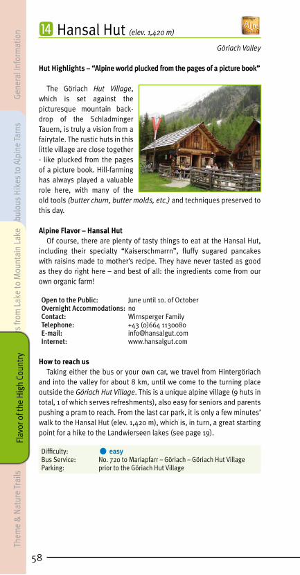
⓮ Hansal Hut (elev. 1,420 m) Göriach Valley
Hut Highlights – “Alpine world plucked from the pages of a picture book”
The Göriach Hut Village, which is set against the picturesque mountain back-drop of the Schladminger Tauern, is truly a vision from a fairytale. The rustic huts in this little village are close together - like plucked from the pages of a picture book. Hill-farming has always played a valuable role here, with many of the old tools (butter churn, butter molds, etc.) and techniques preserved to this day.
Alpine Flavor – Hansal Hut Of course, there are plenty of tasty things to eat at the Hansal Hut,
including their specialty “Kaiserschmarrn”, fluffy sugared pancakes with raisins made to mother’s recipe. They have never tasted as good as they do right here – and best of all: the ingredients come from our own organic farm!
Open to the Public: June until 10. of October Overnight Accommodations: noContact: Wirnsperger FamilyTelephone: +43 (0)664 1130080E-mail: [email protected]: www.hansalgut.com
How to reach usTaking either the bus or your own car, we travel from Hintergöriach
and into the valley for about 8 km, until we come to the turning place outside the Göriach Hut Village. This is a unique alpine village (9 huts in total, 1 of which serves refreshments), also easy for seniors and parents pushing a pram to reach. From the last car park, it is only a few minutes’ walk to the Hansal Hut (elev. 1,420 m), which is, in turn, a great starting point for a hike to the Landwierseen lakes (see page 19).
Difficulty: • easyBus Service: No. 720 to Mariapfarr – Göriach – Göriach Hut Village Parking: prior to the Göriach Hut Village
58
Gene
ral I
nfor
mat
ion
Fabu
lous
Hik
es to
Alp
ine
Tarn
s Th
eme
& N
atur
e Tr
ails
Tour
s fro
m L
ake
to M
ount
ain
Lake
Flav
or o
f the
Hig
h Co
untr
y

59
⓯ Lasshoferalm (elev. 1,270 m)
Lessach Valley
Hut Highlights “The world’s biggest Edelweiss”
In June 2016, what is presumably the world’s biggest metal “Edelweiss” was erected at the Lass-hoferalm. It is 8.25 m high, 4.20 m in diameter, and has a total weight of around 800 kg. The “Edelweiss” is probably the strongest symbol of the Alps and will adorn the “Lasshoferalm” in the summer an the “Edelweißalm” at the Fanningberg in the winter.
Alpine Flavor – Lasshoferalm The Lungau is famous for soil in which mushrooms thrive. The
porcini and chanterelle mushrooms that go into the soup pot at the Lasshoferalm, of course, are all picked locally.
For hungry guests, this hut serves bratwurst, delicious cheeses, a Gröstl hash, plus a farmhouse roast at the weekend. Accompanied, of course, by home-distilled rowanberry schnapps to aid with digestion.
Open to the Public: May and October from Friday to Sunday, daily in June, July, August and September. Overnight Accommodations: noContact: Mr. Otto NeumannTelephone: +43 (0)664 1419820E-Mail: [email protected]: www.lasshoferalm.at
How to reach usDrive from Tamsweg in the direction of the Upper Lessachtal. After
you have paid the toll charges (€ 5), it will be possible for you to drive all the way to the Lasshoferalm (elev. 1,270 m). The starting point for a hike is the car park just prior to the toll station, from which it is about a 1.5-hour walk along a forestry road, past the Lenznalm (elev. 1,253 m) to the Lasshoferalm. The Lasshoferalm is an ideal starting point for a hike to the Gralatisee, the Landschitzseen lakes and the Zwerfenberg- and Angersee lakes (see pages 20, 21 and 22). Along the Lasshofer hiking path, which leads out towards the lower Landschitzsee, in about 30 minutes you will reach a beautiful waterfall, providing invigoration for all your senses.
Elevation Change: ca. 100 mDifficulty: • easyTime on Trail: ca. 2 hours Parking: just before the toll station in the Upper Lessachtal
General Information
Fabulous Hikes to Alpine Tarns
Theme Trails &
Nature Parks
Tours from Lake to M
ountain LakeFlavor of the H
igh Country
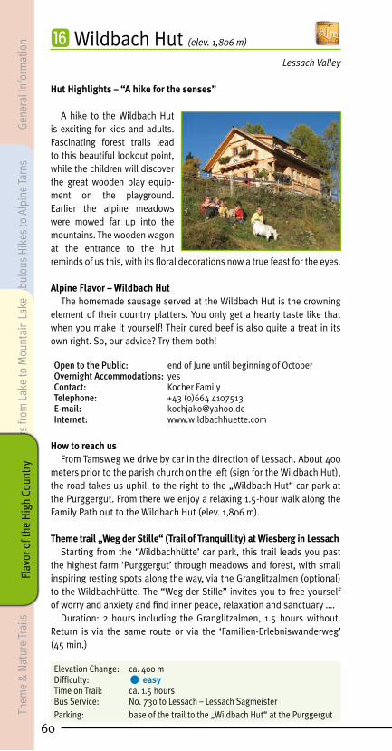
⓰ Wildbach Hut (elev. 1,806 m) Lessach Valley
Hut Highlights – “A hike for the senses”
A hike to the Wildbach Hut is exciting for kids and adults. Fascinating forest trails lead to this beautiful lookout point, while the children will discover the great wooden play equip-ment on the playground. Earlier the alpine meadows were mowed far up into the mountains. The wooden wagon at the entrance to the hut reminds of us this, with its floral decorations now a true feast for the eyes.
Alpine Flavor – Wildbach Hut The homemade sausage served at the Wildbach Hut is the crowning
element of their country platters. You only get a hearty taste like that when you make it yourself! Their cured beef is also quite a treat in its own right. So, our advice? Try them both!
Open to the Public: end of June until beginning of October Overnight Accommodations: yesContact: Kocher FamilyTelephone: +43 (0)664 4107513E-mail: [email protected]: www.wildbachhuette.com
How to reach usFrom Tamsweg we drive by car in the direction of Lessach. About 400
meters prior to the parish church on the left (sign for the Wildbach Hut), the road takes us uphill to the right to the „Wildbach Hut“ car park at the Purggergut. From there we enjoy a relaxing 1.5-hour walk along the Family Path out to the Wildbach Hut (elev. 1,806 m).
Theme trail „Weg der Stille“ (Trail of Tranquillity) at Wiesberg in LessachStarting from the ‘Wildbachhütte’ car park, this trail leads you past
the highest farm ‘Purggergut’ through meadows and forest, with small inspiring resting spots along the way, via the Granglitzalmen (optional) to the Wildbachhütte. The “Weg der Stille” invites you to free yourself of worry and anxiety and find inner peace, relaxation and sanctuary ….
Duration: 2 hours including the Granglitzalmen, 1.5 hours without. Return is via the same route or via the ‘Familien-Erlebniswanderweg’ (45 min.)
Elevation Change: ca. 400 mDifficulty: • easyTime on Trail: ca. 1.5 hoursBus Service: No. 730 to Lessach – Lessach SagmeisterParking: base of the trail to the „Wildbach Hut“ at the Purggergut
60
Gene
ral I
nfor
mat
ion
Fabu
lous
Hik
es to
Alp
ine
Tarn
s Th
eme
& N
atur
e Tr
ails
Tour
s fro
m L
ake
to M
ount
ain
Lake
Flav
or o
f the
Hig
h Co
untr
y

61
⓱ Dorfer Hut (elev. 1,655 m)
Seetal - Tamsweg
Nature Experience on the Gstoder
Clearly marked hiking paths lead through magical forests to the Dorferhütte at the foot of the Gstoder, part of the village of Tamsweg. After a break for welcome refreshments, hikers may well wish to continue to the top of the Gstoder, one of the most beautiful lookout mountains in the region, its summit stan- ding 2,140 m above sea level. In good visibility, you can gaze out from the Lungau basin, flanked by the Lungau mountains, all the way to the valleys of Styria and to the Karawanken in the south. Brochures and other reading materials provide visitors with fascinating insights into the region, hill farming and forestry.
Alpine Flavor – Dorfer Hut They only offer foods which have been produced or processed at
the farm or at the Dorferhütte. Guests truly appreciate the fresh milk, butter, buttermilk, cheese, bacon and ham from home-raised organic pork, cheese-dumpling soup and, above all, the home-baked and absolutely incomparable farmhouse bread. The finishing touches to the menu selection include Lungauer Rahmkoch and “fried mice” (a classic dessert).
Open to the Public: mid June until mid SeptemberOvernight Accommodations: noContact: Fuchsberger FamilyTelephone: +43 (0)6474 8035 or +43 (0)664 2727683E-mail: [email protected]
How to reach usFrom Tamsweg we take either the bus or a car in the direction of Seetal.
The hike takes us from the „In der Stadt“ section of Seetal (elementary school) along a marked cart path to a road, going through a series of bends on the way up to the Seetal Huts, where we also discover the Dorfer Hut at 1,655 m above sea level. As an alternative we recommend a hike from Gasthof Klausnerwirt. We head in the direction of the Gstoder, along a path with blue markings taking us to Klausegg ruins, followed by a forested downhill stretch to the Seetal Huts.
Elevation Change: ca. 420 mDifficulty: • easyTime on Trail: ca. 1.5 to 2 hours (depending on tour variant) Bus Service: No. 895 from Tamsweg – Seetal Stadtkreuz – Seetal Zur KlauseParking: Seetal elementary school, Gasthof Klausnerwirt
General Information
Fabulous Hikes to Alpine Tarns
Theme Trails &
Nature Parks
Tours from Lake to M
ountain LakeFlavor of the H
igh Country

⓲ Platschalm (elev. 1,900 m)
Karneralm - Ramingstein
Hut Highlights – “A little bit closer to heaven!”
The Platschalm is an excellent starting point for hikes and offers visitors breathtaking panoramas. Here, you can observe the alpine plant world and, with a little bit of luck, animals such as chamois and marmots. The woodcutter’s hut, made substantially out of tree bark, gives insight into how houses looked in earlier times, while today it houses a Schaffelbad hot tub and a grill area.
Alpine Flavor – PlatschalmMaria takes loving charge of the cooking, which includes meat,
sausage and bacon from their own farm as well as a traditional woodcutter’s meal and high-quality desserts. In addition, you will also be able to enjoy the rustic comforts and the hospitality of your hosts. Fun and games awaits the kids at the pond and ditch with its wooden waterwheels. The sweet ponies love to be petted gently.
Also wonderfully suited for: groups, company outings, birthday parties and seminars.
Open to the Public: mid June until the end of September Overnight Accommodations: yesContact: Kendlbacher FamilyTelephone: +43 (0)664 1379371 or +43 (0)650 3007881
How to reach usWe reach the start of this hike by traveling from Ramingstein in the
direction of the Karneralm. After about 6 km, at the “Birgeckbrücke“ bridge, our route branches off to the right and takes us to the Platschalm (elev. 1,900 m). From this point, small wooden men at every turn-off show us the way to the hut, which we will reach after a walk lasting about 1 hour.
Elevation Change: ca. 360 mDifficulty: • easyTime on Trail: about 1 hour Parking: “Birgeckbrücke”
62
Gene
ral I
nfor
mat
ion
Fabu
lous
Hik
es to
Alp
ine
Tarn
s Th
eme
& N
atur
e Tr
ails
Tour
s fro
m L
ake
to M
ount
ain
Lake
Flav
or o
f the
Hig
h Co
untr
y

63
⓳ Branntweiner Hut (elev. 1,778 m) Aineck - St. Margarethen
Hut Experiences: “Herbs unite with Alpine cooking“
Welcome to the Brannt- weineralm TEH Hut! A co-operation between Traditional European Healing Association Unken and Branntweiner Organic Farm, which has been run by generations of the same family. 100% authentic - 100% enjoyment. Regionality, hill farm and “ancient healing wisdom” all in one. 60 head of cattle, horses, pigs..., including 25 dairy cows supplying the farm with fresh milk every day. The resulting products, such as cheese, yogurt, whey, butter etc. are served to guests by Sabine, also a TEH practitioner. Here, everything revolves around the herbs that grow on the alpine meadows around the hut, essential ingredients in their homemade products. These include juices, liqueurs, foods, ointments, soaps, teas and much more. After an enjoyable hike to the Branntweinerhütte, you can look over Sabine’s shoulder as she goes about producing her herbal products.
Alpine Flavor – Branntweiner Hut Mmmhhh – doughnuts are so delicious and always in season! Especially
at the Branntweiner Hut, where they have a very special variant of their own – “Drunken Doughnuts” the way grandpa used to make them! Not quite appropriate for children, this doughnut is made from a somewhat firmer dough than usual, and fried in clarified butter. Bon appétit – and cheers!
Open to the Public: beginning of June until mid October Overnight Accommodations: yesContact: Mrs. Sabine LerchnerTelephone: +43 (0)664 5333155E-mail: [email protected]: www.branntweinerhuette.com
How to reach usThe Branntweiner Hut (elev. 1,778 m) can be reached either from St.
Margarethen or from the Katschberghöhe. From St. Margarethen, we can take either the Leisnitz Water Path (path no. 113 and forward to no. 85 via the Meisnitzeralm, ca. 2.5-hour walk) or a road (2 km) to Alpengasthof Schlögelberger (about a 1-hour walk). From there we will reach the Branntweiner Hut via marked path no. 84 or rather no. 112 after about a 1.5 to 2-hour walk. The Branntweiner Hut can also be reached from the Katschberghöhe by walking along path no. 98, which takes about 1.5 hours (ca. 140 vertical meters).
Elevation Change: ca. 140 to 490 m (depending on tour variant)Difficulty: • intermediateTime on Trail: ca. 2 to 3 hours (depending on tour variant) Bus Service: No. 700/710 to St. Margarethen – town center No. 712 from St. Michael – KatschberghöheParking: St. Margarethen town center, Katschberghöhe
General Information
Fabulous Hikes to Alpine Tarns
Theme Trails &
Nature Parks
Tours from Lake to M
ountain LakeFlavor of the H
igh Country

⓴ Kösslbacheralm (elev. 1,780 m)
Aineck - St. Margarethen
Hut Highlights – “Ziachschlitten and Radlbock”
In the car-less days of the past, travel was a long and tedious affair. It required skilled craftsmen and resourceful carpenters to design, carve and build an array of vehicles appropriate to the season and terrain. Sleighs were used to haul wood, hay and straw to the farms for the winter. Small wooden wagons, known as a Radlbock, transported supplies along cart paths up to alpine huts in summer. Sleighs and the occasional Radlbock can still be discovered every now and then even today, though generally having been re-purposed as a picturesque stand for colorful floral decorations.
Alpine Flavor – Kösslbacheralm The Aineck is a popular area for berry pickers. Buttermilk with
cowberries, as the residents of Lungau call the lingonberries, is a delicious specialty drink at the Kösslbacheralm. You can also enjoy fresh farmhouse donuts, blueberry pancakes, or cream cheese with alpine herbs.
Open to the Public: July 1 to September 30Overnight Accommodations: noContact: Kösslbacher FamilyTelephone: +43 (0)664 2113711 or +43 (0)664 2436499E-mail: [email protected]: www.koesslbacheralm.at
How to reach usThe Kösslbacheralm (elev. 1,780 m) can be reached either from
St. Margarethen or from the Katschberghöhe. From St. Margarethen, we can take either the Leisnitz Water Path (path no. 113 and then no. 85 via the Meisnitzeralm, ca. 2.5-hour walk) or a road (2 km) to Alpengasthof Schlögelberger (about a 1-hour walk). From there we will reach the Kösslbacheralm via marked path no. 84 or rather no. 112 after about a 1.5 to 2-hour walk. The Kösslbacheralm can also be reached from the Katschberghöhe by walking along path no. 98, which takes about 1,5 hours (ca. 140 vertical meters). Another tour variant: take the Aineckbahn lift up the Aineck, over the Teuerlnock in direction of the Bonner Hut till the Sackstadl and forward to the Kösslbacheralm, then via the high path back to the Katschberg Passhöhe (time on trail ca. 3 hrs.).
Elevation Change: ca. 140 to 750 m (depending on tour variant)Difficulty: • intermediateTime on Trail: ca. 1,5 to 3 hours (depending on tour variant)Bus Service: No. 700/710 to St. Margarethen – town center No. 712 from St. Michael – KatschberghöheParking: St. Margarethen town center, Katschberghöhe
64
Gene
ral I
nfor
mat
ion
Fabu
lous
Hik
es to
Alp
ine
Tarn
s Th
eme
& N
atur
e Tr
ails
Tour
s fro
m L
ake
to M
ount
ain
Lake
Flav
or o
f the
Hig
h Co
untr
y

65
㉑ Speiereck-Halterhut (elev. 1,933 m)
Speiereck - St. Michael
Hut Highlights – “Homemade Honey Schnapps”
The rustic Speiereck-Halterhut invites hikers to stop in, relax and soak up some sunshine. As you take in the magnificent views, enjoy regional products. The hut’s specialty, and a real treat after a hearty country meal, is their homemade honey schnapps. Your hosts would be delighted to show you precisely how it’s made.
Alpine Flavor – Speiereck-HalterhutHikers who plan on taking a break at the Speiereck-Halterhut can
look forward to their famous country platter featuring bacon, sausage, cheese and bread. If you have an appetite for a hot meal, you might want to sample some of their cheese-dumpling soup. It’s guaranteed to reenergize you for the rest of your hike.
Open to the Public: mid June until the end of OctoberOvernight Accommodations: noContact: Mrs. Barbara SchyrTelephone: +43 (0)664 1221179E-mail: post@speiereck-halterhütteInternet: www.speiereck-halterhütte.at
How to reach usThe hike to the Speiereck-Halterhut (elev. 1,933 m) begins in the town
center of St. Michael, between the pharmacy and the Raiffeisenbank. Following marked hiking path no. 94, we make our way up via the Leitnergasse to the lower Piendl Alm (ruins, elev. 1,322 m) and continue on to the Speiereck-Halterhut.
Elevation Change: ca. 860 mDifficulty: • intermediateTime on Trail: ca. 2.5 hoursBus Service: No. 700/710 to St. Michael – St. Michael WeissensteinParking: St. Michael town center, crossway under the Piendl Alm
General Information
Fabulous Hikes to Alpine Tarns
Theme Trails &
Nature Parks
Tours from Lake to M
ountain LakeFlavor of the H
igh Country

㉒ Pritz Hut (elev. 1,800 m) Gontal Katschberg - Muhr
Hut Highlights – “Pony Express to the Ponyalm”
Here in the midst of the enchanting landscapes of the Gontal Valley, a small mountain streams babbles quietly along just across the way from the Pritz Hut. Rising from the flower-filled meadows are the healthful aromas of countless alpine herbs. A pool filled with cold fresh water invites you to treat your legs to traditional Kneipp therapy. Stepping barefoot into the clear mountain stream, and then allowing your feet to dry off in the sunshine, is probably the ultimate form of relaxation. It tingles, gets the blood flowing and invigorates! The wellness method pioneered by Pastor Sebastian Kneipp (1821 – 1897) has proven itself a reliable means to toughen up the body, as well as to prevent, alleviate and even cure a variety of ailments. Kneippen is a true gift for body and soul. “Horse Taxis” carry visitors from the Katschberg into the Gontal Valley. The Pritz Hut also serves as the trailhead for an easy walk over the Gontalscharte or even a hike to the top of the Kareck. At an elevation of 2,481 m, this path to the summit does require good physical condition and stamina.
The “Ponyalm”: Around the Pritz Hut are various breeds of ponies and small animals. Pet them, make friends with them, enjoy them. A panoramic trail leads through this wonderful world of ponies, sure to get the youngsters’ pulses racing with excitement.
Alpine Flavor – Pritz HutAfter your Kneipp session and an invigorating hike, you will definitely
be ready to take a little rest and put something healthy in your stomach. The specialties of the Pritz Hut include pasta dishes with either cheese or meat.
Open to the Public: mid May to end OctoberOvernight Accommodations: noContact: Mr. Andreas NeuschitzerTelephone: +43 (0)664 2844583E-mail: [email protected]: www.pritzhuette.com
How to reach usPerched at 1,800 meters above sea level, the Pritz Hut is reachable
in ca. 0.5-hour walk via a flat cart path which comes from the car park behind Gasthof Bacher (on the Katschberg).
Elevation Change: ca. 100 m Difficulty: • easyTime on Trail: ca. 0.5 hourBus Service: No. 712 from St. Michael – KatschberghöheParking: behind Gasthof Bacher
66
Gene
ral I
nfor
mat
ion
Fabu
lous
Hik
es to
Alp
ine
Tarn
s Th
eme
& N
atur
e Tr
ails
Tour
s fro
m L
ake
to M
ount
ain
Lake
Flav
or o
f the
Hig
h Co
untr
y

67
㉓ Stöcklalm (elev. 1,755 m)
Gontal Katschberg - Muhr
Hut Highlights – “Splitting Wood”
The farmer’s doing well if he has enough wood in front of his hut. – That was once a popular saying here in the Lungau. Wood stacked in front of the hut, seasoned under the sun, promises a good life and the coziness of a crackling fire in the hearth. Visitors to the Stöcklalm can learn how to split wood with an ax, as well as the fine art of stacking wood the correct way. And you are always welcome to lend a hand! Your hosts will tell you what else can be done with the wood, and what aspects of their daily lives are actually dependent on that wood.
Alpine Flavor – Stöcklalm Carefully selected and precisely counted, the wood is also used to fire
the oven for bread-baking. The folks at the Stöcklalm are very precise in their methods, since a hearty, delicious home-baked bread requires wood that has been carefully selected and cut just the right way. Their home-baked bread, served with a variety of cheeses, is a specialty of the Stöcklalm.
Open to the Public: mid June until mid SeptemberOvernight Accommodations: noContact: Sampl FamilyTelephone: +43 (0)664 1128544 (Mr. Johann Sampl) or +43 (0)664 4968173 (Mrs. Juliane Sampl)
How to reach usThe hike to the Stöcklalm (elev. 1,755 m) begins from the car park
behind Alpengasthof Bacher (on the Katschberg). We first take a flat cart path to the Pritz Hut. From there, initially a gently climb, followed by a downhill to the Doktoralm. Afterwards, you can choose between a forestry path and a hiking trail. The hiking trail passes the Wengeralm, at which point it becomes a little rocky, making surefootedness a must. The forestry path first climbs gently, then takes you downhill for a while, until you come to a turn-off with a sign for the Stöcklalm in about 15 minutes. It isn’t far from here. The walking time out to the Stöcklalm is ca. 2.5 hours. A hike to the Stöcklalm is also possible from the “National Park Village” of Muhr. Actual walking time from the Schellgaden car park is 2 hours. This is also a popular mountain-bike route.
Elevation Change: ca. 150 mDifficulty: • intermediateTime on Trail: ca. 2.5 hoursBus Service: No. 712 from St. Michael – KatschberghöheParking: behind Gasthof Bacher (Katschberg), Schellgaden (Muhr)
General Information
Fabulous Hikes to Alpine Tarns
Theme Trails &
Nature Parks
Tours from Lake to M
ountain LakeFlavor of the H
igh Country

㉔ Twenger-Alm (elev. 1,900 m) Tweng - Obertauern
Hut Highlights – “A piece of heaven on earth”
At the point where you cross over from Obertauern into Weisspriachtal valley, an extended area of alpine pa-stures stretches out surroun-ded by wonderful mountain scenery. Legends recount the tale of dairymaids who once produced butter and cheese in abundance. The good life they had up there at their huts soon wasn’t enough to satisfy them, however, and so they indulged themselves in dances and festivities. But then, on one occasion, the devil himself mingled amongst them, capturing and imprisoning them in a cave high above Tweng, a place which has since been known as Satan’s Wall. The merry life once led by the dairy maids is long since past, though the art of making cheese is once again being venerated at the Twenger-Alm, a hill farm that is run according to traditions that are tried and true.
Alpine Flavor – Twenger-AlmHikers can stop here for a snack, sample the homemade cheese and
even take a look inside the cheesery itself. Your host, Wolfgang, is an expert on alpine herbs, the secrets of pine as well as dishes that feature wild game, and he is glad to share his knowledge with guests.
Open to the Public: mid June until mid September Overnight Accommodations: noContact: Kocher Family / Rigele Telephone: +43 (0)664 3696696E-mail: [email protected]: www.rigele-kocher.at
How to reach usThe easiest way to reach us from Obertauern is the country path
that starts on the B99 (Katschberg Bundesstrasse) at the Schaidberg youth hostel. Follow this in the direction of the Twenger Almsee 2,120 m and Gurpitscheck 2,526 m. From there, you can reach the hut in ca. 50 minutes. More challenging paths to the hut lead directly from Tweng (starting point is the parking lot of the Tweng elementary school – time on trail ca. 3.5 hrs.) and from Weisspriachtal to the Twenger-Alm.
Elevation Change: ca. 250 m (from Obertauern)Difficulty: • intermediateTime on Trail: ca. 50 min.Bus Service: No. 280 to Mauterndorf – Obertauern Schaidberg or No. 720 to Mariapfarr – Weisspriach – Znach turn-off – Grangler Hut – Uln HutParking: Schaidberg youth hostel
68
Gene
ral I
nfor
mat
ion
Fabu
lous
Hik
es to
Alp
ine
Tarn
s Th
eme
& N
atur
e Tr
ails
Tour
s fro
m L
ake
to M
ount
ain
Lake
Flav
or o
f the
Hig
h Co
untr
y

69
Other Alpine Huts in Salzburg’s Lungau region
㉕ Bartlalm (elev. 1,666 m)
Nahendfeld - Zederhaus
How to reach usThe starting point for this hike is the Nahendfeld bridge/Mitterhuber in Zederhaus (bus stop and parking). From there, a marked country lane leads to the Bartlalm (1,666 m), the walk taking about 1.5 hours. One option is the “Rundweg” path: Behind the “Denkmalhof”, take a right following the signs, dropping down to Nahendfeld bridge/Mitterhuber. The hut can also be reached by mountain bike (start: Moserbrücke, distance 7.5 km). If you make arrangements with your hosts in advance, you can even drive all the way up to the hut by car. (You will need a key to open the gate).
Open to the Public: June until the end of SeptemberOvernight Accommodations: yes (at the adjacent Bartlhütte, bookable online at www.urlaubambauernhof.at/bartlhuette)Contact: Bliem Family, Bartlbauer farmTelephone: +43 (0)664 3000836 (hut) or +43 (0)650 8685000 (valley)E-mail: [email protected]: www.urlaubambauernhof.at/bartlhuette
Elevation Change: ca. 350 mDifficulty: • intermediateTime on Trail: ca. 1.5 hoursBus Service: No. 700/710 to Zederhaus – Zederhaus NahendfeldbrückeParking: Nahendfeldbrücke bridge
㉖ Rothenwänderalm (1.748 m)
Zederhaustal
How to reach usAlong the village road in the direction of Rieding-tal Nature Park. In the section of town known as “Hub”, past the Nahendfeldbrücke bus stop. After 200 m, you will come to the turn-off for the Ro-thenwänderalm – a sign is posted right next to the road. A marked country lane will now lead you in about 1,5 hours. to the Rothenwänderalm (1748 m). By prior arrangement with the farmers, you can also reach this hut by car.
Open to the Public: June until SeptemberOvernight Accommodations: noContact: Gfrerer Family, Rothenwänder farmTelephone: +43 (0)6478 317 (valley) or +43 (0)664 4236906 (valley)E-mail: [email protected]
Elevation Change: ca. 430 mDifficulty: • easyTime on Trail: ca. 1.5 hoursBus Service: No. 700/710 to Zederhaus – Zederhaus Wald Parking: right at the turn-off just before the bridge over the autobahn.
General Information
Fabulous Hikes to Alpine Tarns
Theme Trails &
Nature Parks
Tours from Lake to M
ountain LakeFlavor of the H
igh Country
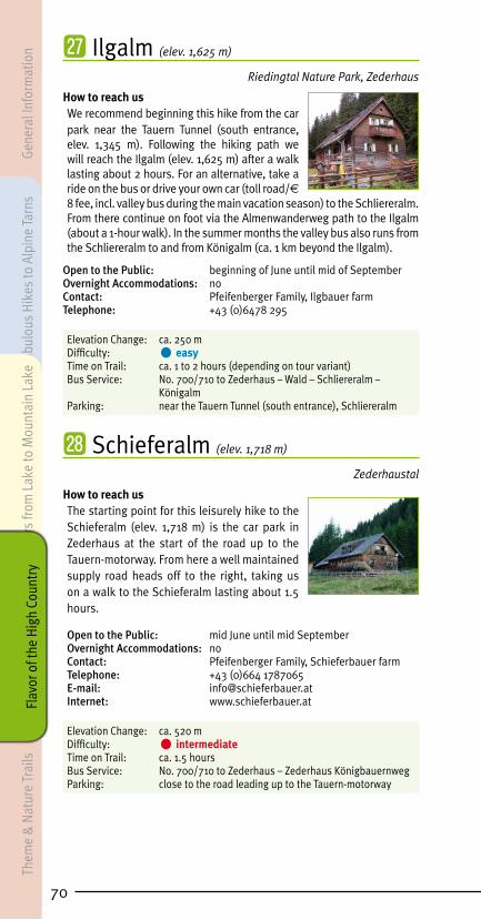
㉗ Ilgalm (elev. 1,625 m)
Riedingtal Nature Park, Zederhaus
How to reach usWe recommend beginning this hike from the car park near the Tauern Tunnel (south entrance, elev. 1,345 m). Following the hiking path we will reach the Ilgalm (elev. 1,625 m) after a walk lasting about 2 hours. For an alternative, take a ride on the bus or drive your own car (toll road/€ 8 fee, incl. valley bus during the main vacation season) to the Schliereralm. From there continue on foot via the Almenwanderweg path to the Ilgalm (about a 1-hour walk). In the summer months the valley bus also runs from the Schliereralm to and from Königalm (ca. 1 km beyond the Ilgalm).
Open to the Public: beginning of June until mid of SeptemberOvernight Accommodations: noContact: Pfeifenberger Family, Ilgbauer farmTelephone: +43 (0)6478 295
Elevation Change: ca. 250 mDifficulty: • easyTime on Trail: ca. 1 to 2 hours (depending on tour variant)Bus Service: No. 700/710 to Zederhaus – Wald – Schliereralm – Königalm Parking: near the Tauern Tunnel (south entrance), Schliereralm
㉘ Schieferalm (elev. 1,718 m)
Zederhaustal
How to reach usThe starting point for this leisurely hike to the Schieferalm (elev. 1,718 m) is the car park in Zederhaus at the start of the road up to the Tauern-motorway. From here a well maintained supply road heads off to the right, taking us on a walk to the Schieferalm lasting about 1.5 hours.
Open to the Public: mid June until mid SeptemberOvernight Accommodations: noContact: Pfeifenberger Family, Schieferbauer farm Telephone: +43 (0)664 1787065E-mail: [email protected]: www.schieferbauer.at
Elevation Change: ca. 520 m Difficulty: • intermediateTime on Trail: ca. 1.5 hoursBus Service: No. 700/710 to Zederhaus – Zederhaus KönigbauernwegParking: close to the road leading up to the Tauern-motorway
70
Gene
ral I
nfor
mat
ion
Fabu
lous
Hik
es to
Alp
ine
Tarn
s Th
eme
& N
atur
e Tr
ails
Tour
s fro
m L
ake
to M
ount
ain
Lake
Flav
or o
f the
Hig
h Co
untr
y

71
㉙ Wastalalm (elev. 1,934 m)
Karthäuse - Zederhaus
How to reach us The first opportunity for the hike up begins next to the building at the shooting range in Zederhaus, or from the town center (across from the hotel grounds and via the containment walls for the autobahn), taking you along the marked, old, somewhat steeper Karthäussen path. The actual walking time is about 2.5 hours. Other variants include making your way on car or by foot from Gasthof Jägerwirt. At the Jägerwirt bridge in the direction of the Karthäussen Almen, through the autobahn underpass, along the Steinitzen forestry lane to the area of the Karthäussen Almen. Distance to the Wastalalm ca. 9 km, drive time about 30 minutes, walking time ca. 3 hours. Those wishing to use the gated “Genossenschaftsweg” will be asked to pay a maintenance fee of € 9 per vehicle. The key to the gate can be obtained from the local hill farmers.
Open to the Public: mid June until beginning of SeptemberOvernight Accommodations: noContact: Gruber Family, WastalTelephone: +43 (0)6478 274E-mail: [email protected]
Elevation Change: 720 mDifficulty: • intermediateTime on Trail: 2.5 to 3 hours (depending on the tour)Bus Service: No. 700/710 to Zederhaus Parking: shooting range, town center or guesthouse Jägerwirt
㉚ Müllnerbauer Hut (elev. 1,660 m)
Twenger Lantschfeld
How to reach usAt the sign at the entrance of Tweng (Tauern side of town), the road branches off to Twenger Lantschfeld, where a lumber yard (gate/fee for the key: € 6) is the starting point for our hike. Following marked path no. 744, we will pass the Postalm (not open to the public) and come to a large wildlife feeding station. From here we are able to reach the Genossenschaftshut Tweng (serving refreshments) and the Müllnerbauer Hut at 1,660 m above sea level. You can take your car quite a way into Lantschfeld and also hike out to the Blauseen lakes (see page 10).
Open to the Public: mid June until the mid of SeptemberOvernight Accommodations: noContact: Mr. Michael FanningerTelephone: +43 (0)650 2503164
Elevation Change: ca. 420 m Difficulty: • easyTime on Trail: ca. 3 hoursBus Service: No. 280 to Mauterndorf – Tweng town centerParking: close to the lumber yard
General Information
Fabulous Hikes to Alpine Tarns
Theme Trails &
Nature Parks
Tours from Lake to M
ountain LakeFlavor of the H
igh Country

㉛ Genossenschaftshut Tweng (elev. 1,630 m)
Twenger Lantschfeld
How to reach usAt the sign at the entrance of Tweng (Tauern side of town), the road branches off to Twenger Lantschfeld, where a lumber yard (gate/fee for the key: € 6) is the starting point for our hike. Following marked path no. 744, we will pass the Postalm and Zechneralm (not open to the public) and come to a large wildlife feeding station. From here we are then able to reach the Genossenschaftshut (serving refreshments, elev. 1,630 m). You can take your car quite a way into Lantschfeld and also hike out to the Blauseen lakes (see page 10).
Open to the Public: mid June until the end of SeptemberOvernight Accommodations: noContact: Mr. Alois PertlTelephone: +43 (0)6471 217 village hall Tweng
Elevation Change: ca. 370 m Difficulty: • easyTime on Trail: ca. 2.75 hours Bus Service: No. 280 to Mauterndorf – Tweng town centerParking: close to the lumber yardKey for gate: during regular office hours at the village hall Tweng, otherwise at the Twengerhof
㉜ Metzgeralm (elev. 1,740 m)
Tweng
How to reach usComing from Mauterndorf, you will drive through the town of Tweng. As you are about to leave town, turn left in the direction of Twenger Lanschfeld. Coming from Obertauern, turn right at the entrance to town. After about 500 m, you will come to a small car park where you can leave your vehicle. Here, a hike begins along a marked path to the Metzgeralm.
Open to the Public: end June until mid September Overnight Accommodations: noContact: Mr. Hermann Mauser Telephone: +43 (0)650 4320252 or +43 (0)6472 7253
Elevation Change: ca. 500 mDifficulty: • intermediateTime on Trail: ca. 1.5 hoursBus Service: No. 280 to the town center of TwengParking: ca. 500 m after the village Tweng
72
Gene
ral I
nfor
mat
ion
Fabu
lous
Hik
es to
Alp
ine
Tarn
s Th
eme
& N
atur
e Tr
ails
Tour
s fro
m L
ake
to M
ount
ain
Lake
Flav
or o
f the
Hig
h Co
untr
y

73
㉝ Genossenschaftshut Trogalm (elev. 1,808 m)
Grosseck - Mauterndorf
How to reach usOur starting point in Mauterndorf is the old lift road, the Alter Trogweg or the forestry path from the ski center. The walk to the Trogalm (elev. 1,808 m) takes about 2.5 hours. Late-risers might wish to ride the cable lift, then hike from the summit terminal down to the Trogalm and Trogalmseen lakes (see page 12). The starting point in St. Michael is opposite the Hotel Post. Via Schulstrasse to St. Martin-Berg, then we make a left at the panorama info board to Sonndörfl (path no. 93). Once there, we turn right at the Bacherhof towards Grubental, making a rather steep climb up to the Trogalm (elev. 1,808 m).
Open to the Public: mid June until end of SeptemberOvernight Accommodations: noContact: Mayr FamilyTelephone: +43 (0)664 2125256
Elevation Change: ca. 750 m Difficulty: • intermediateTime on Trail: ca. 2.5 hoursBus Service: No. 700/280 to Mauterndorf – Grosseck valley terminal or No. 700/710 to St. Michael – St. Michael WeissensteinParking: Grosseck valley terminal, St. Michael town center
㉞ Preber-Halter Hut (elev. 1,862 m)
Preber area - Tamsweg
How to reach usWe will take the bus or car from Tamsweg to Lake Prebersee (ca. 9 km), where we take a ca. 1-hour walk up a mountain lane to the Preber-Halter Hut. And from here: we can cross over to the Grazer Hut (elev. 1,897 m), where there is again an opportunity to drop down to the lake. The whole hike takes about 3.5 hours.
Open to the Public: end of June until beginning of SeptemberOvernight Accommodations: no
Elevation Change: ca. 350 to 470 m (depending on tour variant)Difficulty: • intermediateTime on Trail: ca. 1 to 3.5 hours (depending on tour variant) Bus Service: No. 740 from Tamsweg – Tamsweg LudlalmParking: Prebersee
General Information
Fabulous Hikes to Alpine Tarns
Theme Trails &
Nature Parks
Tours from Lake to M
ountain LakeFlavor of the H
igh Country

㉟ Eßlalm (elev. 1,767 m)
Nockberge-Schönfeld (Salzburg)
How to reach usBy car or valley bus, you can ride to the Dr. Josef-Mehrl-Hütte in Schönfeld. From there, walk along the supply lane into the Rosanintal valley, reaching the Eßlalm after about one kilometer.
Open to the Public: mid June until mid SeptemberOvernight Accommodations: noContact: Mr. Johann LanschützerTelephone: +43 (0)676 5363062E-mail: [email protected]
Bus Service: No. 712 Katschberg-St. Michael Schönfeld (runs from the beginning of July until the beginning of September)Parking: Dr. Josef-Mehrl-Hut, opposite the family- and youth guest house Schönfeld
㊱ Niggei Hut (elev. 1,812 m)
Hochalm - Ramingstein
How to reach usOur drive to the start of this hike takes us from Ramingstein in the direction of the Karneralm. After about 5 km, you will see a power station building on the right, as well as a turn-off on the left across the Mislitzbach (barrier and road-side altar depicting Saint Nepomuk). From there continue along the marked forestry lane to the high pastures, where the Niggei Hut lies at 1,812 m above sea level. The walk takes about 2 hours.
Open to the Public: mid June until mid SeptemberOvernight Accommodations: noContact: Pagitsch Family, Niggei farmTelephone: +43 (0)6475 340
Elevation Change: ca. 620 m Difficulty: • intermediateTime on Trail: ca. 2 hours Parking: Mislitzbach turn-off
74
Gene
ral I
nfor
mat
ion
Fabu
lous
Hik
es to
Alp
ine
Tarn
s Th
eme
& N
atur
e Tr
ails
Tour
s fro
m L
ake
to M
ount
ain
Lake
Flav
or o
f the
Hig
h Co
untr
y
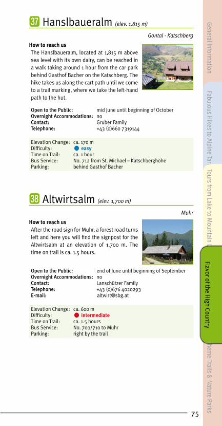
75
㊲ Hanslbaueralm (elev. 1,815 m)
Gontal - Katschberg
How to reach usThe Hanslbaueralm, located at 1,815 m above sea level with its own dairy, can be reached in a walk taking around 1 hour from the car park behind Gasthof Bacher on the Katschberg. The hike takes us along the cart path until we come to a trail marking, where we take the left-hand path to the hut.
Open to the Public: mid June until beginning of OctoberOvernight Accommodations: noContact: Gruber FamilyTelephone: +43 (0)660 7319144
Elevation Change: ca. 170 m Difficulty: • easyTime on Trail: ca. 1 hour Bus Service: No. 712 from St. Michael – Katschberghöhe Parking: behind Gasthof Bacher
㊳ Altwirtsalm (elev. 1,700 m)
Muhr
How to reach usAfter the road sign for Muhr, a forest road turns left and here you will find the signpost for the Altwirtsalm at an elevation of 1,700 m. The time on trail is ca. 1.5 hours.
Open to the Public: end of June until beginning of SeptemberOvernight Accommodations: noContact: Lanschützer FamilyTelephone: +43 (0)676 4020293E-mail: [email protected]
Elevation Change: ca. 600 m Difficulty: • intermediateTime on Trail: ca. 1.5 hoursBus Service: No. 700/710 to MuhrParking: right by the trail
General Information
Fabulous Hikes to Alpine Tarns
Theme Trails &
Nature Parks
Tours from Lake to M
ountain LakeFlavor of the H
igh Country

㊴ Laußnitzer Hut (elev. 1,839 m)
Nockberge (Carinthia)
How to reach usFrom Thomatal/Bundschuh: From the Huber-tus Chapel – shortly before the smelter (mu-seum visits are possible) -a hiking path leads along the banks of the Blareitbach to the Laus-snitzer Hut (1,839 m). Actual walking time: ca. 2 hours. Departing St. Margarethen, the hut may be reached via path No. 113 and from the Katschberghöhe in the direction of the Teuerlnock (2,145 m) in ca. 3 hours (permanent hand-rails to aid with steeper sections). From Rennweg: arrival by car via Frankenberg to the car park at the Laussnitzer Hut turn-off; For this hike up to the hut, you will need about 1.5 hours (also suited for prams).By arrangement, cars may also be driven up to the hut. You may get off as needed: Bundschuh, St. Margarethen, Katschberg Passhöhe
Open to the Public: June until October, Friday through Sunday (also on other days for groups of 10 or more by prior arrangement)Overnight Accommodations: yesContact: Michael Priker & Barbara IlgTelephone: +43 (0)664 6317 175 or +43 (0)664 2106330E-Mail: [email protected]: www.laussnitzer.at
Elevation Change: ca. 550 m (beginning in Bundschuh)Difficulty: • intermediateTime on Trail: ca. 2 to 4 hours (depending on tour variant)Bus Service: No. 712 Katschberg-St. Michael Schönfeld (runs from the beginning of July until the beginning of September)Parking: Bundschuh next to Hubertus Chapel, St. Margarethen town center, Katschberg Passhöhe; from Rennweg: Laussnitzgraben forestry road, then turn onto the hiking path to the Laussnitzer Hut
76
Gene
ral I
nfor
mat
ion
Fabu
lous
Hik
es to
Alp
ine
Tarn
s Th
eme
& N
atur
e Tr
ails
Tour
s fro
m L
ake
to M
ount
ain
Lake
Flav
or o
f the
Hig
h Co
untr
y

77
Hikers’ Refuge Huts in
Salzburg’s Lungau region
㊵ Franz Fischer Hut (elev. 2,020 m)
Riedingtal Nature Park, Zederhaus
How to reach usAlong the toll road (€ 8 fee, incl. valley bus during the main vacation season) by bus or car to the Schliereralm (1,495 m) in the Riedingtal nature park and then by valley bus to the trail leading up to the Franz Fischer Hut. Once you’ve reached the top, path no. 711 tales you to the right and in ca. 1.5 hrs. to the Franz Fischer Hut (2,020 m). As an alternative, you can hike from the car park Schliereralm to the Jakoberalm and then take alpine path no. 702 past the Esser See (see page 5) to the Franz Fischer Hut. This walk takes about 2.5 to 3 hours.
Open to the Public: June until beginning of OctoberContact: Mrs. Evelyn FaberOvernight Accommodations: yesTelephone: +43 (0) 664 75090769E-mail: [email protected] Internet: www.franzfischer-huette.at
Elevation Change: ca. 500 mDifficulty: • intermediateTime on Trail: ca. 1.5 hoursBus Service: No. 700/710 to Zederhaus – Schliereralm – path to the Franz Fischer HutParking: Schliereralm, Jakoberalm path, car park Franz Fischer Hut
General Information
Fabulous Hikes to Alpine Tarns
Theme Trails &
Nature Parks
Tours from Lake to M
ountain LakeFlavor of the H
igh Country

㊶ Speiereck Hut (elev. 2,066 m)
Radstädter Tauern (Salzburg)
How to reach usOur starting point in Mauterndorf is the old lift road, the Alter Trogweg or the forestry path from the ski center. The walk to the Speiereck Hut (elev. 2,072 m) takes about 2.5 hours. Late-risers might wish to ride the cable lift, then take a 20-minute hike from the summit terminal up to the hut. From there we recommend a hike down to the Trogalm and Trogalmseen lakes (see page 12). The Speiereck Hut can also be reached from St. Michael. The starting point in St. Michael is opposite the Hotel Post. Via Schulstrasse to St. Martin-Berg, then we make a left at the panorama info board to Sonndörfl (path no. 93). Once there, we turn right at the Bacherhof towards Grubental, making a rather steep climb up to the Speiereck Hut. This walk takes about 3 hours.
Expected opening hours: mid June until the end of SeptemberOvernight Accommodations: yesContact: Philipp SteinlechnerTelephone: +43 (0)664 4993806E-Mail: [email protected]: www.speiereckhuette.at
Elevation Change: ca. 950 m Difficulty: • intermediateTime on Trail: ca. 2.75 hours Bus Service: No. 700/280 to Mauterndorf – Grosseck valley terminal or No. 700/710 to St. Michael – St. Michael WeissensteinParking: Grosseck valley terminal, St. Michael town center
78
Gene
ral I
nfor
mat
ion
Fabu
lous
Hik
es to
Alp
ine
Tarn
s Th
eme
& N
atur
e Tr
ails
Tour
s fro
m L
ake
to M
ount
ain
Lake
Flav
or o
f the
Hig
h Co
untr
y

79
㊷ Landawirsee Hut (elev. 1,985 m)
Schladminger Tauern (Salzburg)
How to reach usTaking a bus or car, we leave Hintergöriach and travel about ca. 8 km into the valley until we reach the turning place just prior to the Göriach Hut Village. From this point, the Landawirsee Hut (elev. 1,985 m) is about a 2-hour walk away. If we continue past the hut, we come to the Lower (elev. 1,977 m) and Upper (elev. 2,047 m) Landwiersee lakes (see page 19).
Open to the Public: mid June until the end of SeptemberOvernight Accommodations: yesContact: Josef SchiestlTelephone: +43 (0)676 7785375E-mail: [email protected]: www.landawirseehütte.com
Elevation Change: ca. 570 mDifficulty: • intermediateTime on Trail: ca. 2 hoursBus Service: No. 720 to Mariapfarr – Göriach – car park at the Göriach Hut Village Parking: just prior to Göriach Hut Village
㊸ Dr. Josef Mehrl Hut (elev. 1,730 m)
Nockberge-Schönfeld (Salzburg)
How to reach usBy car from St. Margarethen towards Bundschuh-Schönfeld as far as the Dr. Josef Mehrl Hut (elev. 1,730 m). Numerous hiking routes are possible close to the hut, such as one to Rosaninsee lake (elev. 2,080 m, see page 24).
Open to the Public: mid May until beginning of OctoberOvernight Accommodations: yesContact: Mrs. Nicole SamplTelephone: +43 (0)4736 320E-mail: [email protected]: www.mehrlhuette.com
Bus Service: No. 712 Katschberg-St. Michael Schönfeld (runs from the beginning of July until the beginning of September)Parking: Dr. Josef Mehrl Hut
General Information
Fabulous Hikes to Alpine Tarns
Theme Trails &
Nature Parks
Tours from Lake to M
ountain LakeFlavor of the H
igh Country

㊹ Rotgüldensee Hut (elev. 1,735 m)
Ankogel Group (Salzburg)
How to reach usBy bus or car to the National Park community of Muhr-Hintermuhr and the Arsenhaus (elev. 1,341 m, not open to the public). From this point, a path to the left takes us down a nature trail to the Rotgüldensee Hut and the Lower Rotgüldensee (elev. 1,735 m, see page 25). The walk takes about 1.5 hours.
Open to the Public: mid June until mid SeptemberOvernight Accommodations: yesContact: Mrs. Monika WinklerTelephone: +43 (0)6479 348 or +43 (0)650 7819020E-mail: [email protected]
Elevation Change: ca. 400 mDifficulty: • intermediateTime on Trail: ca. 1.5 hoursBus Service: No. 700/710 to Muhr – Muhr Rotgülden Parking: Arsenhaus car park (Muhr Rotgülden bus stop)
80
Gene
ral I
nfor
mat
ion
Fabu
lous
Hik
es to
Alp
ine
Tarn
s Th
eme
& N
atur
e Tr
ails
Tour
s fro
m L
ake
to M
ount
ain
Lake
Flav
or o
f the
Hig
h Co
untr
y

81
㊺ Stickler Hut (elev. 1,752 m)
Radstädter Tauern (Salzburg)
How to reach usBy bus or car to the National Park community of Muhr-Hintermuhr and the Arsenhaus (elev. 1,341 m, not open to the public), continuing on to the Muritzen car park (toll road/coin-operated, fee: € 5). From here we hike for about 1 hour along a footpath to the Stickler Hut (elev. 1,752 m). From the Stickler Hut there is an opportunity to hike to the source of the River Mur. Time on Trail: about 1.25 hours. The Stickler Hut can also be reached directly using the valley bus.
Open to the Public: beginning of June until end of SeptemberOvernight Accommodations: yesContact: Alpenverein Sektion GrazTelephone: +43 (0)316 8222 660
Elevation Change: ca. 250 to 400 m (depending on tour variant)Difficulty: • intermediateTime on Trail: ca. 1 to 2.25 hours (depending on tour variant)Bus Service: No. 700/710 to Muhr – Rotgülden uphill trail – valley bus from Muhr Rotgülden - Stickler HutParking: Muritzen car park
Hikers’ Refuge Huts near the Lungau
㊻ Südwiener Hut (elev. 1,801 m)
Radstädter Tauern (Salzburg)
How to reach usBy bus or car to Gnadenbrücke bridge (elev. 1,272 m), half way between Obertauern and Untertauern. From this point, marked path no. 28 follows the Arnoweg trail to the Südwiener Hut (elev. 1,801 m). Time on Trail: about 1.5 hours.
Open to the Public: June 10 to October 26 (depending on weather conditions)Overnight Accommodations: yesContact: Mrs.Tanja ScharlerTelephone: +43 (0)676 7431628E-Mail: [email protected]: [email protected]
Elevation Change: ca. 530 mDifficulty: • intermediateTime on Trail: ca. 1.5 hoursBus Service: No. 280 to Mauterndorf – Obertauern Gnadenalm Parking: Gnadenbrücke bridge
General Information
Fabulous Hikes to Alpine Tarns
Theme Trails &
Nature Parks
Tours from Lake to M
ountain LakeFlavor of the H
igh Country

㊼ Tappenkarsee Hut (elev. 1,820 m)
Radstädter Tauern (Salzburg)
How to reach usWe take the bus or car along the toll road (toll road/€ 8 fee, incl. valley bus during the main vacation season) to the Schliereralm (elev. 1,495 m) in Riedingtal Nature Park, followed by a ride on the valley bus until we reach the base of the path up to the Franz Fischer Hut. We reach the Franz Fischer Hut (elev. 2,020 m) after about a 1.5-hour walk. Prior to the hut and Zaunersee lake (elev. 2,020 m), we make a left on path no. 702 to the Ilgsee (elev. 2,099 m), then continue with a climb to the Weissgrubenscharte (elev. 2,255 m), before dropping back down to the Tappenkarsee and Tappenkarsee Hut (elev. 1,820 m). For the hike back, we would recommend returning via the Haselloch (on path no. 702 to that point). From the Haselloch (elev. 2,136 m), we hike down to the Königalm (elev. 1,667 m) and back to the car park.
Open to the Public: beginning of June until the end of September (depending on weather conditions!)Overnight Accommodations: yesContact: Höller FamilyTelephone: +43 (0)664 5793178 (hut) or +43 (0)6418 238 (valley)E-mail: [email protected]: www.tappenkarseehuette.at
Elevation Change: ca. 1,030 m (total elevation change for the entire hike)Difficulty: • intermediate to • difficult, very good physical condition a must Time on Trail: ca. 5 to 5.5 hours for the complete hikeBus Service: No. 700/710 to Zederhaus – Schliereralm – base of the path to the Franz Fischer Hut – KönigalmParking: Schliereralm
82
Gene
ral I
nfor
mat
ion
Fabu
lous
Hik
es to
Alp
ine
Tarn
s Th
eme
& N
atur
e Tr
ails
Tour
s fro
m L
ake
to M
ount
ain
Lake
Flav
or o
f the
Hig
h Co
untr
y

83
㊽ Keinprecht Hut (elev. 1,872 m)
Schladminger Tauern (Styria)
How to reach usBy bus or car from Hintergöriach, about 8 km into the valley until we reach the turning place just prior to the Göriach Hut Village. From there, we follow the path up to the Landawirsee Hut (elev. 1,985 m) and continue to the Trockenbrotscharte (elev. 2,237 m) along path no. 702 (ca. 2.5 hours). We now make a steep descent to the Keinprecht Hut (elev. 1,872 m) taking about 2 hours. From there we can hike either a) via the Lignitzhöhe (elev. 2,205 m, path no. 774) to the Lignitzsee and Mariapfarr or b) along path no. 702 to the Rotmandlspitze (elev. 2,453 m), Giglachseen lakes (Ignaz-Mattis-Hut, 1,986 m or Giglachsee-Hut, 1,955 m) and on to the Znachsattel (elev. 2,059 m), then back to Weisspriach. This is an especially beautiful, though somewhat long hike (a 2-day tour). The most beautiful time of year is from the end of June until mid July, when the rhododendrons are in bloom along the shores of the Giglachseen.
Open to the Public: mid June until the beginning of OctoberOvernight Accommodations: yesContact: Mr. Erhard FischbacherTelephone: +43 (0)664 4330346E-mail: [email protected]: www.alpenverein.at/wien
Elevation Change: depending on tour variantDifficulty: • intermediate to • difficultTime on Trail: a) to the Keinprecht Hut about 4.5 hours, from there via Lignitzhöhe (2,205 m, path no. 774) – Lignitzsee and Lignitz about 3 to 3.5 hours b) to the Keinprecht Hut about 4.5 hours, from there via Rotmandlspitze, Giglachseen to the Znachsattel ca. 4 hours and another 3 hours on to Weisspriach Bus Service: No. 720 to Mariapfarr – Göriach – car park at the Göriach Hut Village No. 720 to Mariapfarr – Weisspriach – Znach turn-off – Grangler HutParking: just prior to Göriach Hut Village
General Information
Fabulous Hikes to Alpine Tarns
Theme Trails &
Nature Parks
Tours from Lake to M
ountain LakeFlavor of the H
igh Country
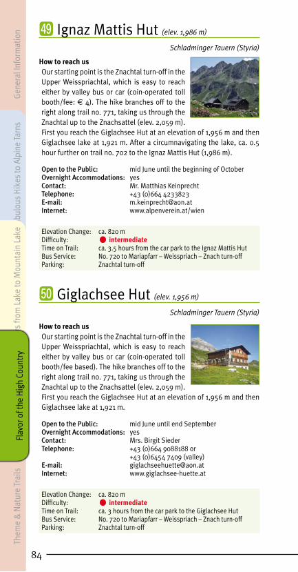
㊾ Ignaz Mattis Hut (elev. 1,986 m)
Schladminger Tauern (Styria)
How to reach usOur starting point is the Znachtal turn-off in the Upper Weisspriachtal, which is easy to reach either by valley bus or car (coin-operated toll booth/fee: € 4). The hike branches off to the right along trail no. 771, taking us through the Znachtal up to the Znachsattel (elev. 2,059 m). First you reach the Giglachsee Hut at an elevation of 1,956 m and then Giglachsee lake at 1,921 m. After a circumnavigating the lake, ca. 0.5 hour further on trail no. 702 to the Ignaz Mattis Hut (1,986 m).
Open to the Public: mid June until the beginning of OctoberOvernight Accommodations: yesContact: Mr. Matthias KeinprechtTelephone: +43 (0)664 4233823E-mail: [email protected]: www.alpenverein.at/wien
Elevation Change: ca. 820 mDifficulty: • intermediateTime on Trail: ca. 3.5 hours from the car park to the Ignaz Mattis HutBus Service: No. 720 to Mariapfarr – Weisspriach – Znach turn-offParking: Znachtal turn-off
㊿ Giglachsee Hut (elev. 1,956 m)
Schladminger Tauern (Styria)
How to reach usOur starting point is the Znachtal turn-off in the Upper Weisspriachtal, which is easy to reach either by valley bus or car (coin-operated toll booth/fee based). The hike branches off to the right along trail no. 771, taking us through the Znachtal up to the Znachsattel (elev. 2,059 m). First you reach the Giglachsee Hut at an elevation of 1,956 m and then Giglachsee lake at 1,921 m.
Open to the Public: mid June until end September Overnight Accommodations: yesContact: Mrs. Birgit Sieder Telephone: +43 (0)664 9088188 or +43 (0)6454 7409 (valley)E-mail: [email protected]: www.giglachsee-huette.at
Elevation Change: ca. 820 mDifficulty: • intermediateTime on Trail: ca. 3 hours from the car park to the Giglachsee HutBus Service: No. 720 to Mariapfarr – Weisspriach – Znach turn-offParking: Znachtal turn-off
84
Gene
ral I
nfor
mat
ion
Fabu
lous
Hik
es to
Alp
ine
Tarn
s Th
eme
& N
atur
e Tr
ails
Tour
s fro
m L
ake
to M
ount
ain
Lake
Flav
or o
f the
Hig
h Co
untr
y

85
� Golling Hut (elev. 1,641 m)
Schladminger Tauern (Styria)
How to reach usTaking the bus or a car, we travel from Hintergöriach for about 8 km into the valley, until we reach the turning place just prior to the Göriach Hut Village. Path no. 775 takes us past lower and upper Zugriegel huts (ruins) to the upper comb. There (at about 1,830 m) we turn right on Tauernhöhenweg no. 702, taking us over rocky terrain (difficult) as we ascend to the Gollingscharte (elev. 2,236 m) in around 3 hours. If you wish, you can climb the Hochgolling (elev. 2,863 m) in about 2 hours (difficult – high-alpine). From the Gollingscharte, we now make our way steeply downhill to the Golling Hut (elev. 1,641 m) in about 2 hours. From there we continue either a) on trail no. 778 to Schladming or b) to the north of the hut, following trail no. 702 to the top of the Greifenberg at 2,618 m above sea level (ca. 3 hours), before descending (difficult – high-alpine) past the Lungauer Klaffersee and Zwerfenbergsee to the Lasshoferalm (elev. 1,270 m) in the Upper Lessachtal (ca. 3.5 to 4 hours).
Open to the Public: mid June until the beginning of OctoberOvernight Accommodations: yesContact: Reiter FamilyTelephone: +43 (0)676 5336288E-mail: [email protected]: www.gollinghuette.com
Elevation Change: depending on tour variant Difficulty: • difficultTime on Trail: depending on tour variant (please consult descriptions)Bus Service: No. 720 to Mariapfarr – Göriach – car park at the Göriach Hut Village Parking: just before the Göriach Hut Village
� Ober Hut (elev. 1,860 m)
Schladminger Tauern (Salzburg)
How to reach usThe Oberhütte (elev. 1,860 m) and the Oberhüttensee (elev. 1,860 m) are both located on the Tauernhöhenweg trail in Salzburg’s Pongau region, reachable from both Obertauern and the Weisspriach Valley (see page 15).
Open to the Public: mid June until mid OctoberOvernight Accommodations: yesContact: Mr. Franz Oberkofler Telephone: +43 (0)664 9169728Internet: www.oberhuette.at
Elevation Change: ca. 590 mDifficulty: • intermediateTime on Trail: ca. 3 hours to the OberhütteBus Service: No. 720 to Mariapfarr – Weisspriach – Znach turn-off – Grangler Hut – Uln HutParking: Znachtal turn-off
General Information
Fabulous Hikes to Alpine Tarns
Theme Trails &
Nature Parks
Tours from Lake to M
ountain LakeFlavor of the H
igh Country

� Grazer Hut (elev. 1,897 m)
Schladminger Tauern (Styria)
How to reach usTake the valley bus or your own car from Tamsweg to Lake Prebersee (ca. 9 km), continuing until you come (in 2 km) to the path (no. 787) up to the Grazer Hut (elev. 1,897 m), which you will reach in about 1.5 hours. Another alternative is to hike from the Prebersee (elev. 1,514 m) via the Preber-Halter Hut to the Grazer Hut (which takes about 2 hours).
Open to the Public: end of May until beginning/mid OctoberOvernight Accommodations: yesContact: Mr. Christian Dengg Telephone: +43 (0)664 2422349E-mail: [email protected]: www.grazer-huette.at
Elevation Change: ca. 450 to 470 m (depending on tour variant) Difficulty: • intermediateTime on Trail: ca. 1.5 to 2 hours (depending on tour variant) Bus Service: No. 740 from Tamsweg – Prebersee – Grazer Hut trailParking: car park by Lake Prebersee, by the Grazer Hut trail
� New Bonner Hut (elev. 1,713 m)
Nockberge (Carinthia)
How to reach usThe Bonner Hut (elev. 1,713 m) can be reached along the road from Rennweg in about a 2.5-hour walk, from St. Margarethen via trail no. 113 in ca. 3 hours and from the Katschberghöhe in the direction of the Teuerlnock (elev. 2,145 m) in around 3.5 hours. Another possibility to reach the hut is the hike starting in Thomatal/Bundschuh. Follow the wonderful forest path ca. 200 m in front of the museum “Hochofen” (visit of the museum is possible) to the Bonner Hut (duration ca. 1.75 hours).
Open to the Public: beginning of June until mid October (depending on weather conditions!)Overnight Accommodations: yesE-mail: [email protected]: www.neue-bonner-huette.at
Elevation Change: ca. 430 m Difficulty: • intermediateTime on Trail: ca. 1.5 to 2.5 hours (depending on tour variant) Bus Service: No. 712 Katschberg-St. Michael Schönfeld (runs from the beginning of July until the beginning of September)Parking: St. Margarethen town center, Katschberghöhe, Bundschuh (next to the Hubertus Chapel)
86
Gene
ral I
nfor
mat
ion
Fabu
lous
Hik
es to
Alp
ine
Tarn
s Th
eme
& N
atur
e Tr
ails
Tour
s fro
m L
ake
to M
ount
ain
Lake
Flav
or o
f the
Hig
h Co
untr
y

87
Alpine Inns and Summit Restaurants
� Restaurant Panorama Alm (elev. 1,980 m)
Grosseck - Mauterndorf
How to reach usRestaurant Panorama Alm (1,980 m) is located right next to the mountain station of the Grosseckbahn lift. From Mauterndorf Ski Center, the hike leads along the “Natur Pur Weg”, taking you on a walk lasting about 2 hrs. to the Panorama Alm. Highly recommended: a hike from the mountain station down to the Trogalmseen elev. 1,808 m, or beautiful mountain tours up the Grosseck and/or Speiereck. NEW: the „Sonnenhangweg“ (ca. 3 km), a path between the Grosseckbahn and Sonnenbahn lifts.
Open to the Public: Open whenever the Grosseckbahn lift is in operation.Overnight Accommodations: noContact: Mr. Peter SchitterTelephone: +43 (0)664 2820453 or +43 (0)664 2644846E-mail: [email protected]: www.auszeit-xl.at
Elevation Change: ca. 850 mDifficulty: • intermediateTime on Trail: ca. 2 hours Bus Service: No. 700/280 to Mauterndorf – Grosseck valley terminal Parking: Grosseck valley terminal
� Restaurant Schi Alm (elev. 1,100 m)
Hammer - Mauterndorf
How to reach usRestaurant Schi Alm stands right next to the valley station of the Grosseckbahn lift. From Mauterndorf Ski Center, an ideal base for hikes to the Trogalm Lakes at 1,808 m above sea level (about a 2-hour hike). Also hiking paths to Anna Chapel, the glacier mill and the medieval town of Mauterndorf. NEW: the Sonnenhangweg (ca. 3 km), a path between the Grosseckbahn and Sonnenbahn lifts.
Open to the Public: beginning of July until mid SeptemberOvernight Accommodations: noContact: Mr. Peter SchitterTelephone: +43 (0)664 88314731 or +43 (0)664 2644846E-mail: [email protected]: www.auszeit-xl.atGood to know: Seating for 30 guests is available for special celebrations.
Bus Service: No. 700/280 to Mauterndorf – Grosseck valley terminal Parking: Grosseck valley terminal
General Information
Fabulous Hikes to Alpine Tarns
Theme Trails &
Nature Parks
Tours from Lake to M
ountain LakeFlavor of the H
igh Country

� Almstüberl Fanningberg (elev. 1,850 m)
Moserkopf - Mauterndorf
How to reach usFrom Mauterndorf Castle a path leads us off to the right to the Stampfl section of Mauterndorf. From here, you will follow markings no. 43 or 46 to Almstüberl Fanningberg at an elevation of 1,850 m. This walk takes about 2.5 hours.
Expected opening hours: July until mid SeptemberOvernight Accommodations: noContact: Mr. Thomas MüllerTelephone: +43 (0)676 4807044
Elevation Change: ca. 720 m Difficulty: • intermediateTime on Trail: ca. 2.5 hoursBus Service: No. 700/280 to Mauterndorf – Mauterndorf StampflParking: Mauterndorf Castle
� Sonnblick Hut (elev. 1,700 m)
Moserkopf – Mauterndorf
How to reach usThe departure point is at the Berghof Jackl-bauer on Fanningberg. From there the hiking trail takes you to the Sonnblick Hut. This walk takes about 1.5 hours.
Open to the Public: beginning of July until mid SeptemberOvernight Accommodations: yesContact: Mr. Anton SchitterTelephone: +43 (0)6472 20037E-mail: [email protected]: www.jacklbauer.com
Elevation Change: ca. 600 m Difficulty: • easyTime on Trail: ca. 1.5 hours Parking: Berghof Jacklbauer
88
Gene
ral I
nfor
mat
ion
Fabu
lous
Hik
es to
Alp
ine
Tarn
s Th
eme
& N
atur
e Tr
ails
Tour
s fro
m L
ake
to M
ount
ain
Lake
Flav
or o
f the
Hig
h Co
untr
y
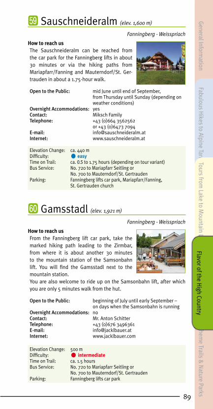
89
� Sauschneideralm (elev. 1,600 m)
Fanningberg - Weisspriach
How to reach usThe Sauschneideralm can be reached from the car park for the Fanningberg lifts in about 30 minutes or via the hiking paths from Mariapfarr/Fanning and Mauterndorf/St. Ger-trauden in about a 1.75-hour walk.
Open to the Public: mid June until end of September, from Thursday until Sunday (depending on weather conditions)Overnight Accommodations: yesContact: Miksch FamilyTelephone: +43 (0)664 3562562 or +43 (0)6473 7094E-mail: [email protected]: www.sauschneideralm.at
Elevation Change: ca. 440 m Difficulty: • easyTime on Trail: ca. 0.5 to 1.75 hours (depending on tour variant) Bus Service: No. 720 to Mariapfarr Seitling or No. 700 to Mauterndorf/St. Gertrauden Parking: Fanningberg lifts car park, Mariapfarr/Fanning, St. Gertrauden church
� Gamsstadl (elev. 1,921 m)
Fanningberg - Weisspriach
How to reach usFrom the Fanningberg lift car park, take the marked hiking path leading to the Zirmbar, from where it is about another 30 minutes to the mountain station of the Samsonbahn lift. You will find the Gamsstadl next to the mountain station. You are also welcome to ride up on the Samsonbahn lift, after which you are only 5 minutes walk from the hut.
Open to the Public: beginning of July until early September – on days when the Samsonbahn is runningOvernight Accommodations: noContact: Mr. Anton SchitterTelephone: +43 (0)676 3496361E-mail: [email protected] Internet: www.jacklbauer.com
Elevation Change: 500 m Difficulty: • intermediateTime on Trail: ca. 1.5 hours Bus Service: No. 720 to Mariapfarr Seitling or No. 700 to Mauterndorf/St. Gertrauden Parking: Fanningberg lifts car park
General Information
Fabulous Hikes to Alpine Tarns
Theme Trails &
Nature Parks
Tours from Lake to M
ountain LakeFlavor of the H
igh Country

� Zirmbar (elev. 1,791 m)
Fanningberg - Weisspriach
How to reach usFrom Fanningberg car park, follow the clearly marked hiking path to the Zirmbar (the Zirmbar is also sign-posted). 45-minutes walk. Or take your car to the Sauschneideralm. There you will find a car park for use by Zirmbar guests. Now comes a 30-minute walk, along a path also suitable for prams, to the Zirmbar.Useful Info: A lift runs every Thursday during holiday season! At the mountain lift terminal, exit on the right. You will then reach the Zirmbar in about 35 minutes. LungauCard Partner
Open to the Public: mid June until mid SeptemberOvernight Accommodations: yes (with reservation)Contact: Schreilechner FamilyTelephone: +43 (0)650 3308883 or +43 (0)664 1769101E-mail: [email protected]: www.zirmbar.at
Elevation Change: 300 m Difficulty: • easyTime on Trail: ca. 1 hour Bus Service: No. 720 to Mariapfarr Seitling or No. 700 to Mauterndorf/St. Gertrauden Parking: Fanningberg lifts car park
� Jausenstation Dicktler Hut (elev. 1,148 m)
Weisspriach Valley
How to reach usJausenstation Dicktler Hut (elev. 1,148 m) can be reached from Weisspriach/Hinterweisspriach by bus, car or on foot (about a 1.5-hour walk).
Open to the Public: mid May until October and mid December until April, closed on Monday and TuesdayOvernight Accommodations: noContact: Bogensperger FamilyTelephone: +43 (0)6473 7061 or +43 (0)664 5583463
Elevation Change: ca. 40 m Difficulty: • easyTime on Trail: ca. 1.5 hours Bus Service: No. 720 to Weisspriach – Hinterweisspriach – Dicktler HutParking: Hinterweisspriach, Jausenstation Dicktler Hut
90
Gene
ral I
nfor
mat
ion
Fabu
lous
Hik
es to
Alp
ine
Tarn
s Th
eme
& N
atur
e Tr
ails
Tour
s fro
m L
ake
to M
ount
ain
Lake
Flav
or o
f the
Hig
h Co
untr
y

91
� Jausenstation Wielandhof (elev. 1,332 m)
Mariapfarr Lignitz Valley
How to reach usJausenstation Wielandhof (elev. 1,332 m) is on the way from Mariapfarr in the direction of the Lignitztal and is reachable either by car, or on foot via path no. 35 in about 1.5 hours. Jausenstation Wielandhof is an ideal starting point for a hike to the Lignitzsee (elev. 1,965 m, please see page 18).
Open to the Public: June 8 to June 16, on weekends (Fri from 5 p.m., Sat, Sun and public holidays all day) June 20 to September 15, daily except for Monday September 21 to October 13, on weekends (Sat and Sun all day)Overnight Accommodations: yesContact: Perner FamilyTelephone: +43 (0)6473 7162E-mail: [email protected]: www.wielandhof.at
Elevation Change: ca. 210 m Difficulty: • easy to • intermediateTime on Trail: ca. 1.5 hours Bus Service: No. 770 to Mariapfarr – Mariapfarr post officeParking: Mariapfarr parking spaces east and west, Jausenstation Wielandhof
� Ludlalm (elev. 1,520 m)
Prebersee – Tamsweg
How to reach usVia Valley Bus or car from Tamsweg via Haiden to Prebersee (ca. 9 km), where the Ludlalm is located right on the lake at 1,520 m above sea level. The Ludlalm is an ideal base for walks around the lake (see page 23) as well as hikes in the area of the Preber. Open to the Public: year-round (except November)Overnight Accommodations: yesContact: Antretter FamilyTelephone: +43 (0)6474 7552E-mail: [email protected]: www.ludlalm.at
Bus Service: No. 740 from Tamsweg – Tamsweg PreberseeParking: car park at the Prebersee
General Information
Fabulous Hikes to Alpine Tarns
Theme Trails &
Nature Parks
Tours from Lake to M
ountain LakeFlavor of the H
igh Country

� Schlögelberger Alpine Inn & Wildlife Park (elev. 1,293 m)
Aineck - St. Margarethen
How to reach usAlpengasthof Schlögelberger (elev. 1293 m) can be reached from St. Margarethen by car (2 km) or on foot along the Leisnitz “Water Path” – in about 1.5 hours. Alpengasthof Schlögelberger, with its magical views over Murtal Valley, is surrounded by wild animals including deer and ibex, as well as alpacas and Highland cattle. There is even a shortcut along the old Schlögelberger Weg, a walk taking about 45 minutes.
Open to the Public: year-round, closed on specific days as postedOvernight Accommodations: yesContact: Sampl FamilyTelephone: +43 (0)6476 313E-mail: [email protected]: www.almdorf-lungau.at
Elevation Change: ca. 230 m Difficulty: • intermediateTime on Trail: ca. 1.5 hoursBus Service: No. 700/710 to St. Margarethen – town centerParking: St. Margarethen town center, Alpengasthof Schlögelberger
� Adlerhorst Summit Restaurant (elev. 2,210 m)
Aineck
How to reach usThe starting point for this hike is the Katschberghöhe (elev. 1,641 m). We ascend to the Aineck via the ski slope, with the Adlerhorst Summit Restaurant perched at 2,210 m above sea level, a hike taking about 2 hours (trail no. 98). If you are a late riser, we would recommend riding the Aineck lift (please check the summer timetable). Once at the summit, enjoy beautiful panoramic views across a vast mountain world. The descent takes us either a) via the Bonner Hut (elev. 1,713 m) in about 2 hours or b) via the Branntweiner and Kösslbacher huts to St. Margarethen in about 2.5 to 3 hours or c) along Katschberg hiking loop no. 98 in around 3 hours (calculated from the summit of the Aineck) back to our original starting point.
Open to the Public: end of June until mid September (same schedule as the Aineckbahn lift)Overnight Accommodations: noContact: Hinteregger FamilyTelephone: +43 (0)4734 284
Elevation Change: ca. 570 m Difficulty: • intermediateTime on Trail: depending on tour variant, please refer to descriptionsBus Service: No. 712 from St. Michael – KatschberghöheParking: Katschberghöhe
92
Gene
ral I
nfor
mat
ion
Fabu
lous
Hik
es to
Alp
ine
Tarn
s Th
eme
& N
atur
e Tr
ails
Tour
s fro
m L
ake
to M
ount
ain
Lake
Flav
or o
f the
Hig
h Co
untr
y

93
� Peterbauer Almstub´n (elev. 1,910 m)
St. Michael
How to reach usThe starting point is the tourist office. Passing the pharmacy (along a narrow lane), you will come to the Leitnergasse. Now steeply uphill, you will come to the Leitnerbauer, an aban-doned farmhouse, and then to the old Grang-lergut. There you will meet up with the Mühl-steigweg (path no. 92). The path leads up the mountain to the lower “Piendl Alm” (a ruin) at 1,322 m above sea level (ca. 0,5 hour). To the left, between the ruin and a spring, you will climb over a fence and hike via a clearly marked trail up to the Peterbauer Almstub’n. You are also welcome to ride up here on the Sonnenbahn lift. Open to the Public: beginning of June until end October - same schedule as the SonnebahnOvernight Accommodations: noContact: Sampl FamilyTelephone: +43 (0)664 4504822 or +43 (0)664 8348410E-mail: [email protected]
Elevation Change: ca. 835 mDifficulty: • intermediateTime on Trail: ca. 3 hours Bus Service: No. 700/710 to St. Michael – WeißensteinParking: St. Michael town center, lift car park St. Martin
� Jausenstation Neuhauserstadl (elev. 1,070 m)
St. Michael
How to reach usJausenstation Neuhauserstadl (elev. 1,070 m)
is reachable by car from St. Michael traveling towards Oberweissburg (ca. 4 km) or on foot along path no. 96, about a 1-hour walk.
Open to the Public: year-round from Thursday until SundayOvernight Accommodations: noContact: Seewald FamilyTelephone: +43 (0)664 9064160E-mail: [email protected]
Difficulty: • easyTime on Trail: ca. 1 hourBus Service: No. 700/710 to St. Michael – St. Michael OberweissburgParking: Jausenstation Neuhauserstadl
General Information
Fabulous Hikes to Alpine Tarns
Theme Trails &
Nature Parks
Tours from Lake to M
ountain LakeFlavor of the H
igh Country

� Gamskogel Hut (elev. 1,830 m)
Katschberg
How to reach usThe starting point for this hike is a) the car park on Katschberg Pass (elev. 1,641 m). Taking the Gontalstrasse, we will hike through the Hotel Village and two road tunnels to Gasthof Bacher. About 200 m further along is b) another car park. From here we initially hike in the direction of the Pritz Hut. Half way there we find a gate, where a forestry path branches off to the left towards the Hanslbaueralm and Gontalscharte (elev. 1,911 m). From there we hike either a) to the Tschaneck (elev. 2,024 m), subsequently dropping back down to the Gamskogel Hut or b) continue at essentially the same elevation to the Gamskogel Hut (elev. 1,830 m). Another route to the Gamskogel Hut, where you will also find the highest registry office in Carinthia, is the 2.5 km long “Herzerlweg”, which is decorated with red hearts. Beginning at the Katschberg tourist office, you hike past Hotel Cristallo and take the path that climbs to the left rather than going through the tunnel and continue above the Landal hut village. A few hundred metres further along, hiking path no. 19 is clearly marked to your right (big gate). Staying on the Herzerlweg, you will come to Marienkapelle chapel and, shortly thereafter, to your destination, the Gamskogel Hut.
Open to the Public: mid June until mid OctoberOvernight Accommodations: noContact: Strafner FamilyTelephone: +43 (0)4734 291 or +43 (0)664 3376678E-mail: [email protected] Internet: www.gamskogel.at
Elevation Change: ca. 270 to 380 m (depending on tour variant)Difficulty: • intermediateTime on Trail: ca. 2.5 to 3 hours for the full hike Bus Service: No. 712 from St. Michael – KatschberghöheParking: Katschberghöhe, just beyond Gasthof Bacher
94
Gene
ral I
nfor
mat
ion
Fabu
lous
Hik
es to
Alp
ine
Tarn
s Th
eme
& N
atur
e Tr
ails
Tour
s fro
m L
ake
to M
ount
ain
Lake
Flav
or o
f the
Hig
h Co
untr
y

95
Theme & Nature Trails
The benefit of some inner-Alpine regions is that many ancient folk customs and deeply rooted popular beliefs have been preserved. Tho-se who wish to discover the Salzburger Lungau with all of their senses, may wish to set out on mystical hikes to mountain tarns and sources of immense natural & spiritual power, plus take advantage of the chance to visit the small pilgrimage chapel. Or reside in a “hut village”, where three different sources of energy guarantee moments of pure happiness.
You may, or may not believe in the energy emanated by certain loca-tions. Some sense it immediately, while others have their doubts. But the fact is, there are places that reenergize you, raise your spirits, or create a sense of inner calm. You also find such places of strength in the Lungau: Places, where you intensively sense nature in its various elements, are able to allow your eyes to roam across the mountains, or simply enjoy an escape from the daily routine. Small moments, with great effects.
General Information
Fabulous Hikes to Alpine Tarns Tours from
Lake to Mountain Lake
Flavor of the High Country
Theme Trails &
Nature Parks

96
Zederhaus / Riedingtal Nature Park- Mill Trail on the Dorfergraben- Almenweg Trail- Self-Guided Forest Path- Schlierersee Theme Trail- Theme Trail “The Power of Still Waters”
Mariapfarr- Sun Trail - Soil-Culture-Path
Mauterndorf- Pure Nature Trail
Göriach- Bee Trail
Lessach- Kids’ Fun Hike- Theme Trail „Weg der Stille“(Trail of Tranquillity)
Tamsweg- Moor Path next to Lake Prebersee (1,514 m)- Passeggen Execution Path - Planet Path
Ramingstein- Iron Trail- Ore Trails
Unternberg- Himmelsteig Trail- Self-Guided Forest Path
St. Margarethen- Leisnitz Water Path
St. Michael- Alpine Herb Garden- Hiking Experience Trail- Birdwatching Trail- Hiking Path of the Senses
Gene
ral I
nfor
mat
ion
Fabu
lous
Hik
es to
Alp
ine
Tarn
s To
urs
from
Lak
e to
Mou
ntai
n La
keFl
avor
of t
he H
igh
Coun
try
Them
e Tr
ails
& N
atur
e Pa
rks

97
Muhr, the National Park Village:- Nature Trail on the Rotgüldensee- Magic Forest Adventure Path
Weißpriach- Mushroom Nature Trail
Thomatal / Schönfeld:- Miners’ Hiking Path
Ferienregion Salzburger Lungau- Arnoweg Trail- Lungau Culture Trail
For additional details about theme paths as well as local walking and hiking trails, please contact your local tourist office.
General Information
Fabulous Hikes to Alpine Tarns Tours from
Lake to Mountain Lake
Flavor of the High Country
Theme Trails &
Nature Parks

98
Riedingtal Nature Park in ZederhausDue to its absolutely enchanting countryside, Riedingtal Valley is a
popular excursion destination for young and old. The natural features and glorious scenery of this area on the edge of the Radstädter Tauern range are simply astonishing.
Information: Zederhaus Tourist Office, T +43 (0)6478 801, [email protected], www.naturpark-riedingtal.at
Göriach Hut VillageAn Alpine village that is unique, one which you can easily reach
whether you are a senior citizen or pushing a pram. It is about a 5-minute walk from the last car park (9 huts in total: of these, the Hansalhütte is open all summer long, while the Neumannhütte is only open to the public at the weekend).
Information: Göriach Tourist Office, T +43 (0)6483 21211, [email protected], www.goeriach.at
Preber Sports & Recreation RegionLocated not far from Tamsweg and easy to reach is the Preber Region,
one of the most popular excursions, whether that be hiking, biking, or taking a romantic stroll around the lake and stopping at one of the huts along the way.
Information: Tourism Lungau, Infocenter Tamsweg, T +43 (0)6474 2145, [email protected], www.tourismuslungau.at
Nockberge Region – Schönfeld/Karneralm
In contrast to the rugged peaks of the Niedere Tauern, the gently rounded hilltops of the Nockberge seemingly snuggle into their natural setting. Experience a high valley in all of its glory. Discover utter peace in the middle of a sun-drenched alpine meadow.
Information: Thomatal-Schönfeld Tourist Office, T +43 (0)6476 250, [email protected], www.thomatal.at
Muhr – the “National Park Village”The beauty and diversity of the mountainous countryside of the Hohe
Tauern National Park is the main reason it belongs to the largest national park in Central Europe. The Mur – Austria’s second-largest river – has its headwaters in this community.
Information: Muhr Tourist Office and National Park Information Center, T +43 (0)650 9933415, [email protected], www.muhr-info.at
Gene
ral I
nfor
mat
ion
Fabu
lous
Hik
es to
Alp
ine
Tarn
s To
urs
from
Lak
e to
Mou
ntai
n La
keFl
avor
of t
he H
igh
Coun
try
Them
e Tr
ails
& N
atur
e Pa
rks

99
TIP: local footpaths and hiking tours
Hike up to wind down: Between mountain and valley, people feel like they belong as they begin to get back in touch with who they really are. The 15 picturesque towns and villages all lie at an average elevation of 1000 m or more. Numerous local footpaths and hiking tours invite the whole family to set out on enjoyable hikes and walks. Relax and slow down the pace of your life – both are possible on our wide selection of hiking paths!
Detailed information can be found online at www.lungau.at
General Information
Fabulous Hikes to Alpine Tarns Tours from
Lake to Mountain Lake
Flavor of the High Country
Theme Trails &
Nature Parks

01 Gruberalm / p. 4502 Hoislalm / p. 4603 Jakoberalm / p. 4704 Königalm / p. 4805 Liasalm / p. 4906 Muhreralm / p. 5007 Örgenhiasalm / p. 5108 Schliereralm / p. 52
09 Schwarzenbichl Hut / p. 5310 Zauner Hut / p. 5411 Grangler Hut / p. 5512 Toni Mörtl Hut / p. 5613 Grainmeister Hut / p. 5714 Hansal Hut / p. 5815 Lasshoferalm / p. 5916 Wildbach Hut / p. 60
17 Dorfer Hut / p. 6118 Platschalm / p. 6219 Branntweiner Hut / p. 6320 Kößlbacheralm / p. 6421 Speiereck-Halterhut / p. 6522 Pritz Hut / p. 6623 Stöcklalm / p. 6724 Twenger-Alm / p. 68
Bewirtschaftete Hütten
01 Boarnlacke / p. 402 Esser See / p. 503 Ilgsee & Zaunersee / p. 604 Rothenwändersee / p. 705 Schlierersee / p. 806 Mühlbachsee / p. 907 Blauseen / p. 1008 Twenger Almsee / p. 11
09 Trogalmseen / p. 1210 Giglachsee / p. 1311 Oberer Schönalmsee / p. 1412 Oberhüttensee / p. 1513 Wirpitschsee & Tiefenbachsee pp. 16 & 1714 Lignitzsee / p. 1815 Landwierseen / p. 19
16 Gralatisee / p. 2017 Landschitzseen / p. 2118 Zwerfenbergsee & Angersee / p. 2219 Prebersee / p. 2320 Rosaninsee / p. 2421 Rotgüldensee / p. 2522 Karwassersee / p. 2623 Anderleseen / p. 27
Alpine tarns
Copyright © 2022 FDOKUMEN