Cyclic Markov chains with an application to an intermediate ENSO model
Upload
independentCategory
view
1download
0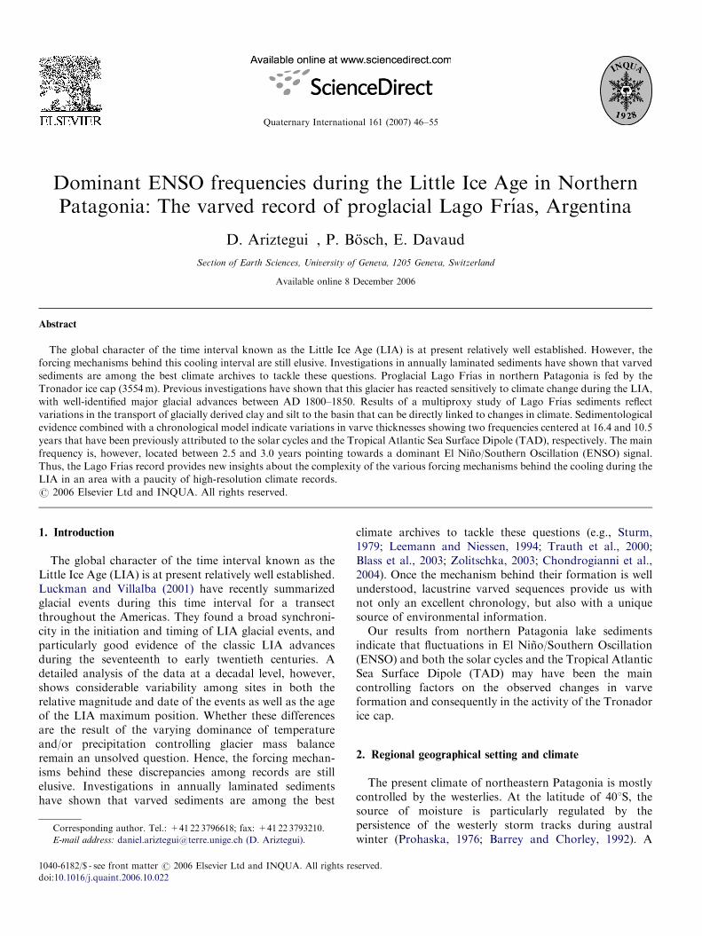
ARTICLE IN PRESS
1040-6182/$ - se
doi:10.1016/j.qu
�CorrespondE-mail addr
Quaternary International 161 (2007) 46–55
Dominant ENSO frequencies during the Little Ice Age in NorthernPatagonia: The varved record of proglacial Lago Frıas, Argentina
D. Ariztegui�, P. Bosch, E. Davaud
Section of Earth Sciences, University of Geneva, 1205 Geneva, Switzerland
Available online 8 December 2006
Abstract
The global character of the time interval known as the Little Ice Age (LIA) is at present relatively well established. However, the
forcing mechanisms behind this cooling interval are still elusive. Investigations in annually laminated sediments have shown that varved
sediments are among the best climate archives to tackle these questions. Proglacial Lago Frıas in northern Patagonia is fed by the
Tronador ice cap (3554m). Previous investigations have shown that this glacier has reacted sensitively to climate change during the LIA,
with well-identified major glacial advances between AD 1800–1850. Results of a multiproxy study of Lago Frıas sediments reflect
variations in the transport of glacially derived clay and silt to the basin that can be directly linked to changes in climate. Sedimentological
evidence combined with a chronological model indicate variations in varve thicknesses showing two frequencies centered at 16.4 and 10.5
years that have been previously attributed to the solar cycles and the Tropical Atlantic Sea Surface Dipole (TAD), respectively. The main
frequency is, however, located between 2.5 and 3.0 years pointing towards a dominant El Nino/Southern Oscillation (ENSO) signal.
Thus, the Lago Frıas record provides new insights about the complexity of the various forcing mechanisms behind the cooling during the
LIA in an area with a paucity of high-resolution climate records.
r 2006 Elsevier Ltd and INQUA. All rights reserved.
1. Introduction
The global character of the time interval known as theLittle Ice Age (LIA) is at present relatively well established.Luckman and Villalba (2001) have recently summarizedglacial events during this time interval for a transectthroughout the Americas. They found a broad synchroni-city in the initiation and timing of LIA glacial events, andparticularly good evidence of the classic LIA advancesduring the seventeenth to early twentieth centuries. Adetailed analysis of the data at a decadal level, however,shows considerable variability among sites in both therelative magnitude and date of the events as well as the ageof the LIA maximum position. Whether these differencesare the result of the varying dominance of temperatureand/or precipitation controlling glacier mass balanceremain an unsolved question. Hence, the forcing mechan-isms behind these discrepancies among records are stillelusive. Investigations in annually laminated sedimentshave shown that varved sediments are among the best
e front matter r 2006 Elsevier Ltd and INQUA. All rights re
aint.2006.10.022
ing author. Tel.: +4122 3796618; fax: +41 22 3793210.
ess: [email protected] (D. Ariztegui).
climate archives to tackle these questions (e.g., Sturm,1979; Leemann and Niessen, 1994; Trauth et al., 2000;Blass et al., 2003; Zolitschka, 2003; Chondrogianni et al.,2004). Once the mechanism behind their formation is wellunderstood, lacustrine varved sequences provide us withnot only an excellent chronology, but also with a uniquesource of environmental information.Our results from northern Patagonia lake sediments
indicate that fluctuations in El Nino/Southern Oscillation(ENSO) and both the solar cycles and the Tropical AtlanticSea Surface Dipole (TAD) may have been the maincontrolling factors on the observed changes in varveformation and consequently in the activity of the Tronadorice cap.
2. Regional geographical setting and climate
The present climate of northeastern Patagonia is mostlycontrolled by the westerlies. At the latitude of 401S, thesource of moisture is particularly regulated by thepersistence of the westerly storm tracks during australwinter (Prohaska, 1976; Barrey and Chorley, 1992). A
served.

ARTICLE IN PRESSD. Ariztegui et al. / Quaternary International 161 (2007) 46–55 47
satellite image from July 2005 (Fig. 1) clearly shows thissituation and indicates that the main source of atmosphericmoisture at this latitude is coming from the Pacific region.A 30-year mean temperature series from a meteorologicalstation located in the city of San Carlos de Bariloche showsa conspicuous seasonality for the Argentinean LakeDistrict (data provided by the Servicio MeteorologicoNacional, Fuerza Aerea Argentina). Fig. 2 indicates thatboth maximum and minimum mean temperature valuesalso follow this seasonal pattern. Furthermore, thisseasonality controls the precipitation centered duringaustral winter confirming that the instantaneous situationshown in Fig. 1 is consistent through time.
Lago Frıas (40 1S, 71 1N, 790ma.s.l.) is a 4.1-km-longand 1.1-km-wide proglacial lake (Fig. 3). The maximumwater depth is 75m and the lake is located at ca. 7.5 kmnorth of the Frıas glacier, which is one of the seven tonguesfrom the Mt. Tronador ice cap (3554m) flowing towardsthe Argentinean side of the Andes (Fig. 3a). Previousinvestigations in the region have shown that the Tronadorice cap has reacted sensitively to climate change duringdistinct episodes such as the Late Glacial–Holocenetransition (Ariztegui et al., 1997; Hajdas et al., 2003) and
Fig. 1. Satellite image (18 July 2005) showing the distribution of moisture for S
Most of the rainfall during austral winter is associated with a seasonal northw
the Medieval Warm Epoch and the LIA, with wellidentified major glacial advances at the Frıas Glacierbetween AD 1800–1850 (Rabassa et al., 1979; Villalbaet al., 1990).A meteorological record for the 1969–1985 interval at
the Mascardi weather station, located at 20 km from theFrıas Glacier, shows identical trends to the one observed inBariloche (Fig. 2) with a mean annual temperature of7.6 1C, varying from 12.9 1C in January to 2.4 1C in July(Villalba et al., 1990). Additionally, these data indicate astrong precipitation gradient between Mascardi(1409mmyear�1) and the River Frıas valley(4300mmyear�1; Perez Moreau, 1945) as well as 1 1Clower temperatures at the Frıas site relative to theMascardi meteorological station. This difference seems tobe independent of the altitude and has been attributed tothe combined effect of heavy cloudiness and highprecipitation at the Frıas Glacier area (Villalba et al.,1990).During the 20th century, the ENSO and ENSO-like
phenomena have dominated climate variations in theAmericas on interannual and decadal time scales, respec-tively (Dettinger et al., 2001). The ENSO impact on local
outh America (Servicio Meteorologico Nacional, Fuerza Aerea Argentina).
ard migration of the westerlies system.

ARTICLE IN PRESS
0
-5
5
10
15
25
20
Month
Jan. July
Mean temperature
Mean maximum temperature
Mean minimum temperature
Mar. May Sept. Nov.
Austral winter
Jan. JulyMar. May Sept. Nov.
0
40
80
120
160
Month
Te
mp
era
ture
(°C
)
Pre
cip
ita
tio
n (
mm
)
Mean precipitation
a b
Fig. 2. (a) Mean, maximum and minimum temperature values per month at the Bariloche meteorological station for the 1961–1990 interval; (b) Values of
average monthly precipitation for the same time slice and station. Shaded intervals indicate austral winter. All data provided by the Servicio
Meteorologico Nacional, Fuerza Aerea Argentina /http://www.meteofa.mil.arS.
D. Ariztegui et al. / Quaternary International 161 (2007) 46–5548
climate has been well determined using meteorological,historical, and dendrochronological approaches at theFrıas valley (Villalba et al., 1990, 1998).
More recently, a sediment trap study in Lake Mascardicovering the 1992–1998 interval combined with meteor-ological data have shown changes in sedimentation ratesthat can be linked to ENSO climatic events (Villarosa et al.,1999). As both proglacial lakes, Frıas and Mascardi, arefed by the Tronador ice cap, the laminated sequence ofLago Frıas can provide a continuous record of ENSO andENSO-like variations through time.
3. Material and methods
Seismic profiles were collected in January 1994 by usingan Ocean Research Equipment (ORE)-GEOPULSEs
3.5 kHz single-channel pinger system with a verticalresolution of approximately 10–20 cm. A multiset of shortsedimentary cores was recovered using a gravity corerduring the same field season and storage at 4 1C. Whole-core petrophysical properties (magnetic susceptibility(MS)) were measured using a Multisensor Track CoreLogger (GeoTeks) at the ETH-Zurich limnogeologyfacilities. Sedimentary cores were subsequently openedand photographed at the Institute Forel, Geneva. Litho-logical features were defined combining a detailed coredescription with observations in both smear slides andepoxy-impregnated thin-sections. A lamination index (LI)was defined following Ariztegui et al. (2001a) and Piovanoet al. (2002) ranging from excellent (4) to lack of noticeablelamination (1). Further analyses of the lamination includedSEM backscattered electron micrographs using a JeolJSM840 SEM.
Total organic and inorganic carbon values (TOC andTIC, respectively) were obtained by Rock-Evals Pyrolysisat the University of Neuchatel (Ariztegui et al., 2001a). Thechronology of the reference core was achieved using acombination of 137Cs decay for the most recent sediments,and AMS 14C dating and varve counting for the oldersection. Varve counting was achieved visually and using acomputer-assisted method developed at the Department ofGeology and Paleontology of the University of Geneva.Statistical (Fourier) analyses were performed using theStatisticas software.
4. Results and discussion
High-resolution seismic profiling in lakes coupled withtargeted coring sites provides powerful tools for paleoen-vironmental reconstructions (Ariztegui et al., 2001b; Gilliet al., 2001). Fig. 3b displays the bathymetric map of LagoFrıas with a relatively large and flat area towards theoutflow that would indicate steady sedimentation. Aseismic profile throughout this part of the basin (Fig. 3c),however, shows a complex pattern of sediment distribu-tion. Despite the low penetration of the acoustic signal, thisprofile was used in the field to find the best position forcore retrieving in order to avoid mass wasting events.Hence, core F94-2 was recovered in the best location withapparently continuous sedimentation, whereas cores F94-3and F94-6 display more irregular sedimentation and arenot discussed in this article (Bosch, 2004).MS shows quite uniform values (average 500� 10�5 SI)
throughout core F94-2, except at ca. 84 cm where a peak isassociated with a�3 cm thick layer mostly composed of areworked tephra (Fig. 4). Thinner tephras at mm scale havebeen also identified in smear slides at different depths (see

ARTICLE IN PRESS
Fig. 3. (a) Map of the Tronador ice cap on the Argentinean/Chilean border (modified from Villalba et al., 1990). The location of the main glacier ice-
tongues descending towards Argentinean territory are indicated by numbers, from north to south as follows: Frıas Glacier (1); Alerce Glacier (2); Castano
Overo Glacier (3); and Rıo Manso Glacier (4). The shaded rectangle indicates the location of proglacial Lago Frıas zoomed out in (b). The bathymetric
data was produced during this survey and further compiled and drawn by C. Bianchi and M. V. Amos, respectively (CONICET, Argentina). The gray line
indicates the position of the seismic profile shown in (c). The white dot shows the position of the reference sedimentary core F94-2 (see text). Gray dots
show the location of two additional short cores.
D. Ariztegui et al. / Quaternary International 161 (2007) 46–55 49
white arrows in Fig. 4), although they do not show up inMS. Despite that the entire core is well laminated, there arechanges in the development and quality of the lamina.These fluctuations have been semi-quantified using the LI(Fig. 4). An excellent lamination (LI 4) is observed fromthe bottom of the core up to ca. 40 cm except in the intervalbetween 100 and ca. 85 cm. A similar less developed type oflamina dominates the interval between 40 cm towards thetop of the core. A clear improvement of the laminationappears from 10 to 5 cm. The uppermost 5 cm are partlydisturbed due to coring operations showing less developedlayers. Total organic carbon is relatively low throughoutthe core (average 1%) and carbonate contents are
negligible. An obvious event occurred between ca. 20 and16 cm, as shown by a decrease in MS and an increase inTOC (Fig. 4). A quick observation of this layer shows thatit is mostly composed of allochthonous organic mattersuch as roots, leaves and other organic remains. The latterwas further confirmed in smear slides. It is important topoint out that a dense vegetation surrounds the lake due tothe extremely high precipitation regime of the area.
4.1. Varves or lamination?
The presence of laminations does not guarantee that theyare true varves (e.g., Zillen et al., 2003). One way to verify

ARTICLE IN PRESS
Depth
(cm)
0
20
40
60
80
100
120
Lithology TOC
(%)
1.00 2.001000
Magnetic Susceptibility
(SI x 10-5)
5000 0 2 4
Lamination index Years
(AD)Frías Glacier
fluctuations
dated moraine
historical record
aerial photographs
measured interval
1950
1900
1850
1800
1750
Years
(AD)
1784
1873
1909
1924
1947
1977
1828
1713 ?
Fig. 4. Log of core F94-2 including main lithological units versus depth. Darker patterns indicate excellent development of lamination that is also
expressed through the LI. Variations in physical properties (MS) and bulk geochemistry (percent TOC) show consistent patterns as highlighted by the
shaded areas. White arrows indicate main tephra layers associated with regional volcanism. The chronology of Frıas Glacier fluctuations is based on
historical records, aerial photographs, tree-ring counts, ice-damaged trees and tree-ring index variations. Distances are relative to the position of the
glacier terminus in summer 1986 and the gray arrow indicates glacier retreat (modified after Villalba et al., 1990).
D. Ariztegui et al. / Quaternary International 161 (2007) 46–5550
the annual character of the lamination is to look in detail atits sedimentological features using a microstratigraphicapproach. Fig. 5 shows a section of the core containing avery well-laminated interval. The SEM inspection of anepoxy-impregnated thin-section produced backscatteredimages that provided excellent grain-size and porosityinformation. These observations combined with detailedanalyses of smear slides allowed us to formulate a model ofan ideal varve that is summarized in Fig. 5. A gray layercomposed of allochthonous organic matter and clasticmaterial (mostly silt) is becoming distinctly more argillac-eous towards the top.
The spring diatom bloom, which occurs most likelyalmost immediately after the snowmelt, is emphasized inthe clastic coarse layer. Further increases in diatomremains account for summer and autumn productivityand they are commonly represented as pulses with slightdifferences in color. The thickness of the organic lamina is,therefore, the sum of autochthonous production within thelake and the amount of allochthonous material and isrelated to the primary production during the warm season.Despite the presence of autochthonous organic matter,clastic material remains dominant.
A second, light brown and finer layer with scarce toabsent diatom frustules represents winter sedimentation.The accumulation of this lamina can be directly linked to
glacier activity. Temperate glaciers increase the productionof fine rock and mineral fragments by abrasion of thebedrock, so that glacial melt waters carry relatively largeamounts of silt and clay-sized particles in suspensionduring summer, which are deposited in proglacial lakes.Because erosion rate increases with glacier size andthickness, and both are controlled by climatic parameters(such as mean summer temperature and winter precipita-tion) variations in the accumulated amount of the silt- andclay-sized mineral fraction in proglacial lake sedimentsprovides a reliable high-resolution record of climatevariations (Leemann and Niessen, 1994). The clearseasonality shown by the available meteorological datafor the area (Fig. 2) supports the development of thismodel for varve formation. Additionally, snowfall dom-inates the winter season (Drago, 1973) and most of thecatchment remains frozen, both limiting factors for theamount of sediment entering the lake during the coldseason.
4.2. Searching for an independent chronology
An independent chronology for the uppermost sedimentswas achieved using the 137Cs decay as shown in Fig. 6. Themaximum peak of Cs activity in South America has beenassigned to AD 1965 (Schuller et al., 2002), whereas no
ARTICLE IN PRESS
allochthonous OM (mineralized)
autochthonous OM (mostly diatoms)
decreasing grain size (mostly silt)
mostly clay
1 mm
winter
autumn
summer
spring
Fig. 5. Photograph of a nicely laminated section in core F94-2. The white arrow indicates a well-defined tephra layer. The schematic model on the right
displays the interpreted sedimentary cycle of the seasonally deposited lamina in Lago Frıas based on observations in smear-slides and impregnated thin
sections. The SEM backscattered electron microphotograph in the center illustrates the regularity of the lamination at micro scale in a polished thin
section.
0
5
10
15
20
25
0 10 20 30 40 50
Cs137 activity (Bq Kg-1)
Depth
(cm)
Core
F94-2
1965
1994
Age
(years AD)
1909-1955
Fig. 6. Photo of the uppermost 25 cm of core F94-2 as well as the
radioisotopic activity of the bulk sediments. The displayed ages are
obtained from the maximum 137Cs peak that in this region of the world is
attributed to 1965. The white arrow indicates the location of an AMS 14C
age measured in a macrofossil at the base of the organic-rich layer.
D. Ariztegui et al. / Quaternary International 161 (2007) 46–55 51
increase in Cs activity is observed associated with theChernobyl accident.
Additionally, the imprint in the sediments of some well-known historical events in the region confirms thischronology. Assuming a constant sedimentation rate theorganic-rich layer observed between 20 and 16 cm can bedated at AD 1960. A major subduction related earthquakeoccurred in May–June that year that triggered a series oftsunami waves along the Chilean coast and formed mass-wasting deposits in lacustrine basins in both sides of theAndes (Chapron et al., 2006). In addition, results of thevisual counting of the lamination in zoomed photographsbetween 10 and 5 cm combined with the 137Cs peak confirmthe annual character of the lamination.
Four 14C radiocarbon samples were analyzed at theETH-Zurich AMS facility. A macrofossil embedded in theorganic-rich layer at 17 cm gave two possible calibrated(dendro-corrected) ages (2s ranges) that are shown inTable 1. Due to the shape of the calibration curve in theregion of interest, several true age ranges are possible. The1794–1952 age, however, is the only one consistent withboth Cs and varve chronologies. The three additionalsamples also shown in Table 1 were measured on bulksediment, delivering ages that are far older than expectedwhen considering the event stratigraphy proposed below.The causes for this discrepancy in radiocarbon ages are stillelusive, since the lack of carbonates in the basin apparentlyrule out the classical hardwater effects (e.g., Gilli et al.,2005). The presence of hiatuses in the sedimentarysequence due to mass wasting events could account forthese old ages. There is neither geophysical evidence (seecore location in the seismic profile in Fig. 3c) norsedimentological features in this core, however, which
would point towards this option. Smear slides show asubstantial amount of a dark-looking mineral fraction thatmay be a form of lignite, which is radiocarbon dead andhas been a noted problem in other sites in Patagonia(Bosch, 2004; Moy, pers. comm.). Further systematicinvestigations are needed in order to understand the causesof this discrepancy.
4.3. Varve counting
Assuming the annual character of the lamination, varveswere counted in the rest of the core using high-resolution
ARTICLE IN PRESS
Table 1
Range finding radiocarbon samples were measured in both microfossil and bulk samples
Depth (cm) Laboratory no. Material remarks AMS 14C age (years BP) Calibrated age (cal AD) 2s d13C (%)
17 ETH-26210 Wood and leaves 170750 1669�1784 �30.2
1794�1952
63 ETH-26889 Bulk 1435780 465�482 �19.9
533�871
87 ETH-26211 Bulk 990770 984�1225 �24.4
90 ETH-26890 Bulk 1190760 724�739 �22.4
771�1020
All samples were measured at the ETH-Zurich AMS facility. Calibrated ages were calculated using the program CALIB Rev. 5.01 (Stuiver and Reimer,
1993) using the South Hemisphere correction (McCormac et al., 2004). See text for discussion.
D. Ariztegui et al. / Quaternary International 161 (2007) 46–5552
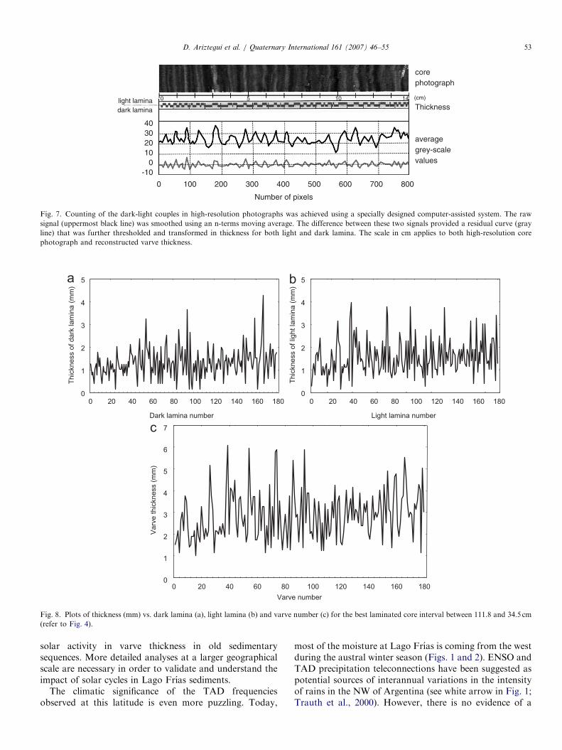
photographs both visually and also using computer soft-ware. Fig. 7 shows a photograph of a well-laminatedsection where the gray-scale average intensity was mea-sured. The raw data was further smoothed using an n-termsmoving average in order to detrend the gray-scale signal.The difference between the raw and the smoothed signalsprovided a residual curve that was further thresholded andtransformed in thickness. Instant events that are notrelated to the lamination, such as tephra layers andturbidites (Fig. 4), were manually deleted. Turbidites aremostly composed of dark and comparatively coarsereworked tephra and were easily identified in smear slides(Bosch, 2004).
Fig. 8 displays the variations in thickness of dark andlight lamina separately as well as of the varves throughoutthe best laminated interval. An age of ca. AD 1713 wasobtained for the base of the core using the counted varves.This age is older than the AD 1762 obtained whenconsidering the position of the 1965 Cs peak and assumingan unrealistic uniform sedimentation rate down core. Thisdiscrepancy, however, is interpreted here as due to thevariable sedimentation rates associated with fluctuatingglacial activity throughout the studied time interval.
4.4. Comparison with other records and paleoclimate
implications
A pioneer dendrochonological study in both frontand lateral moraines in the Frıas Glacier allowed not onlyto date but also to pinpoint cold intervals with higherrainfall and, thus, glacial re-advances (Villalba et al., 1990).Eight cold and rainy intervals were identified between AD1703–1717, 1742–1777, 1826–1838, 1868–1873, 1900–1910,1929–1935, and 1968–1977.
The associated glacier re-advances have been recorded asa better development and increasing thickness of lamina-tion in the lacustrine record. A further comparison with thereconstructed fluctuations in the Frıas Glacier is shown inFig. 4 (after Villalba et al., 1990). While the first noticeablechange in lamination is not exactly coincident with the twofirst cold and rainy intervals, there is significant agreementfor the rest of the sequence, shown by the almost mirrorimage behavior of both curves. The observed change in
lamination dated at AD 1784 would be associated with thetree-ring derived cold and rainy period ending in AD 1873that is assigned to the LIA. A good agreement betweenrecords is also observed in the rest of the core as shown byless development of lamination during glacier retreatintervals. This correlation is particularly significant duringthe well-documented interval of formation of the1968–1977 push-moraines (Rabassa et al., 1979) corre-sponding with increasing values of LI in the lacustrinesediments (Fig. 4). The remarkable coincidence betweenthe sedimentological, geochemical and event stratigraphicdata further validates the chronological model andconfirms the use of varved sediments to reconstruct glaciervariations in great detail.The computer-assisted varve counting permitted sepa-
rated measurements of the gray summer lamina from thelight brown-winter lamina with a thickness varying from0.2 to 4mm, and 0.2 to 4.3mm, respectively (Fig. 8). Theexcellent chronology allowed for a spectral analysis of thecombined couples (i.e., varves) and these results are shownin Fig. 9. Main frequencies of changes in varve thicknessare located between 2.5 and 3.0 years pointing towards adominant ENSO signal. The two secondary, but statisti-cally significant, frequencies centered at 16.4 and 10.4 yearshave previously been attributed to the TAD and the solarcycles, respectively. These results suggest a strong andvariable influence of the ENSO phenomenon besides theseasonal precipitation changes during the studied interval.The latter would in turn produce glacial re-advances thatare consistent with previous work in the region using bothtree-rings and glacial moraines (Villalba et al., 1990, 1998).Moreover, recent investigations using lacustrine varvedsequences at the same latitude on the western side of theAndes have shown comparable frequencies that have alsobeen attributed to the ENSO phenomenon (Boes andFagel, in press).Previous studies have suggested that variations in solar
activity may have affected the climate system (e.g., Haigh,1996). In South America, its influence has been linked to theposition of the mid-latitude storm tracks in southernPatagonia and northern Chile, see Gilli (2003), Van Geelet al. (2000), Grosjean et al. (1998), respectively). Moreover,Sonett and Trebisky (1986) have suggested the influence of
ARTICLE IN PRESS
40302010
-100
0 100 200 300 400 500 600 700 800
Number of pixels
averagegrey-scalevalues
(cm)
Thickness
corephotograph
dark laminalight lamina 1050 14
Fig. 7. Counting of the dark-light couples in high-resolution photographs was achieved using a specially designed computer-assisted system. The raw
signal (uppermost black line) was smoothed using an n-terms moving average. The difference between these two signals provided a residual curve (gray
line) that was further thresholded and transformed in thickness for both light and dark lamina. The scale in cm applies to both high-resolution core
photograph and reconstructed varve thickness.
0
1
2
3
4
5
0 20 40 60 80 100 120 140 160
Light lamina number
0
1
2
3
4
5
0 20 40 60 80 100 120 140 160 180
Th
ickn
ess o
f d
ark
la
min
a (
mm
)
Th
ickn
ess o
f lig
ht
lam
ina
(m
m)
0
1
2
3
4
5
6
7
0 20 40 60 80 100 120 140 160 180
Va
rve
th
ickn
ess (
mm
)
Dark lamina number
Varve number
180
a b
c
Fig. 8. Plots of thickness (mm) vs. dark lamina (a), light lamina (b) and varve number (c) for the best laminated core interval between 111.8 and 34.5 cm
(refer to Fig. 4).
D. Ariztegui et al. / Quaternary International 161 (2007) 46–55 53
solar activity in varve thickness in old sedimentarysequences. More detailed analyses at a larger geographicalscale are necessary in order to validate and understand theimpact of solar cycles in Lago Frıas sediments.
The climatic significance of the TAD frequenciesobserved at this latitude is even more puzzling. Today,
most of the moisture at Lago Frıas is coming from the westduring the austral winter season (Figs. 1 and 2). ENSO andTAD precipitation teleconnections have been suggested aspotential sources of interannual variations in the intensityof rains in the NW of Argentina (see white arrow in Fig. 1;Trauth et al., 2000). However, there is no evidence of a

ARTICLE IN PRESS
Frequency (1/yr.)
Sp
ectr
al d
en
sity
0 0.40.2 0.6 0.8 1700
600
500
400
300
200
100
0
ENSOTAD
Solar
Fig. 9. The solid curve shows the spectral density of the varve thickness
shown in Fig. 8c. Dominant frequency bands are centered at clear values
suggesting a strong influence of ENSO. The dashed line displays the
spectral density for a similar number of varves in NW Argentina (Trauth
et al., 2000) whereas the black triangles designate the dominant
frequencies of the tree-ring record close to the Frıas Glacier (Villalba
et al., 1990, 1998).
D. Ariztegui et al. / Quaternary International 161 (2007) 46–5554
direct effect of this phenomenon during the LIA as farsouth as the study area. Villalba et al. (1998) noticed thatthe influence of high-latitude circulation on precipitationappears to be more significant during the 20th century.Comprehensive studies on the impact and potentialteleconnections of TAD below 301S are still needed inorder to disentangle its influence in the Lago Frıas record.
5. Conclusions
Results of the multiproxy study of Lago Frıas sedimentsillustrate how coordinated seismic surveys and sedimentcoring offer the opportunity to recover optimal paleocli-mate records. The retrieved laminated proglacial depositsreflect variations in the transport of glacially derived clayand silt to the basin. These variations can be directly linkedto changes in climate during the last ca. 280 years.
The varved chronology combined with a consistentsedimentological model indicates a strong ENSO influencein the development of lamination. Combined with previousdendrochronological evidence, these new lacustrine dataindicate variable cold and rainy intervals that in turn wouldhave generated glacier re-advances. A similar mechanismhas been proposed to explain recent glacier variations inwestern Norway associated with variations in the NorthAtlantic Oscillation Index (NAO; Nesje et al., 2001). Theinterplay with other secondary, but well-defined frequen-cies associated to both solar cycles and TAD, may also beinvolved in generating these glacier re-advances. The latteris consistent with data issued from tree-ring records thatindicate that the recent increase of precipitation variabilityin northern Patagonia may reflect stronger interactions
between middle and high-latitude atmospheric circulationin the Southern Hemisphere during the twentieth century.Thus, the Lago Frıas lacustrine record provides new
insights into the complexity of the various forcingmechanisms behind the cooling during the LIA in thisarea of South America. It also points out the need todevelop regional networks of well-understood lake systemswith a reliable chronology. They will be critical evaluatingthe impact of the various mechanisms triggering environ-mental changes at different spatial and temporal scales.
Acknowledgments
We are grateful for the logistic help and fruitfuldiscussions to the former PROGEBA team (CONICET,Argentina), led by the late A. Amos. We thank FrankNiessen, Andreas Lehman, Christina Chondrogianni andKurt Ghilardi for assistance during seismic and coringoperations. The lake surveys would not have been possiblewithout the support and interest of the Prefectura NavalArgentina from Bariloche. We are also grateful toR. Martini and J.L. Loizeau (University of Geneva) fortheir invaluable help with SEM and radioisotope measure-ments, respectively. We thank I. Hajdas and G. Bonani forproviding the radiocarbon AMS 14C data. Also manythanks to journal referees A. Brauer and A. Nesje andguest editor B. Zolitschka for valuable suggestionsconcerning the manuscript. Financial support from theSwiss National Science Foundation (Projects NF21-37689.93 and NF2100-050862.97/1) is kindly acknowl-edged.
References
Ariztegui, D., Bianchi, M.M., Masaferro, J., Lafargue, E., Niessen, F.,
1997. Interhemispheric synchrony of Late-Glacial climatic as recorded
in proglacial Lake Mascardi, Argentina. Journal of Quaternary
Sciences 12 (4), 333–338.
Ariztegui, D., Chondrogianni, C., Lami, A., Guilizzoni, P., Lafargue, E.,
2001a. Lacustrine organic matter and the Holocene paleoenviron-
mental record of Lake Albano (Central Italy). Journal of Paleolimnol-
ogy 26 (3), 283–292.
Ariztegui, D., Anselmetti, F.S., Kelts, K., Seltzer, G., D’Agostino, 2001b.
Identifying paleoenvironmental change across South and North
America using high-resolution seismic stratigraphy in lakes. In:
Markgraf, V. (Ed.), Interhemispheric Climate Linkages. Academic
Press, New York, pp. 227–240 [Chapter 14].
Barrey, R.G., Chorley, R.J., 1992. Atmosphere Weather and Climate,
sixth ed. Routledge, London, p. 392.
Blass, A., Anselmetti, F.S., Ariztegui, D., 2003. 60 years of glaciolacus-
trine sedimentation in Steinsee (Sustenpass, Switzerland) compared
with historic events and instrumental meteorological data. In:
Ariztegui, D., Wildi, W. (Eds.), Lake Systems from Ice Age to
Industrial Time. Eclogae Geologica Helvetiae, Supplement 1,
pp. 59–72.
Boes, X., Fagel, N. Relationships between Southern Chilean varved lake
sediments, precipitation and ENSO for the last 600 years. Journal of
Paleolimnology, in press.
Bosch, P., 2004. Reconstruction paleoenvironnementale des sediments
recents du lac proglaciaire Frıas, Patagonie du Nord. Diploma Thesis,

ARTICLE IN PRESSD. Ariztegui et al. / Quaternary International 161 (2007) 46–55 55
Department of Geology and Paleontology, University of Geneva,
Switzerland, 89pp., unpublished.
Chapron, E., Ariztegui, D., Mulsow, S., Villarosa, G., Pino, M., Outes, V.,
Juvignie, E., Crivelli, E., 2006. Impact of 1960 major subduction
earthquake in Northern Patagonia (Chile–Argentina). Quaternary
International 158 (1), 58–71.
Chondrogianni, C., Ariztegui, D., Rolph, T., Juggins, S., Shemesh, A.,
Rietti-Shati, M., Guilizzoni, P., Lami, A., Niessen, F., McKenzie, J.A.,
Oldfield, F., 2004. Millennial- to interdecadal climate variability in the
Mediterranean during the LGM–The Lake Albano record. Quaternary
International 122, 31–41.
Dettinger, M.D., Battisti, D.S., Garreaud, R.D., McCabe, G.J., Bitz,
C.M., 2001. Interhemispheric effects of interannual and decadal
ENSO-like climate variations on the Americas. In: Markgraf, V.
(Ed.), Interhemispheric Climate Linkages. Academic Press, New York,
pp. 1–16 [Chapter 1].
Drago, E., 1973. Algunas caracterısticas geomorfologicas de la llanura
aluvial del Rıo Manso superior (provde Rıo Negro). Revista de la
Asociacion de Ciencias Naturales del Litoral 4, 187–200.
Gilli, A., 2003. Tracking late Quaternary environmental change in
southernmost South America using lake sediments of Lago Cardiel
(491S), Patagonia, Argentina. Ph.D. Thesis, ETH-Zurich, Switzerland,
172pp., unpublished.
Gilli, A., Anselmetti, F.S., Ariztegui, D., Bradbury, P.J., Kelts, K.R.,
Markgraf, V., McKenzie, J.A., 2001. Tracking abrupt climate change
in the Southern Hemisphere: A seismic stratigraphic analysis of Lago
Cardiel, Argentina (49%oS). Terra Nova 13, 443–448.
Gilli, A., Ariztegui, D., Anselmetti, F.S., McKenzie, J.A., Markgraf, V.,
Hajdas, I., McCulloch, R.D., 2005. Mid-Holocene strengthening of the
Southern Westerlies in South America—sedimentological evidences
from Lago Cardiel, Argentina (491S). Global and Planetary Changes
49, 75–93.
Grosjean, M., Geyh, M.A., Messerli, B., Schreier, H., Veit, H., 1998. A
late Holocene (o2600BP) glacial advance in the south-central Andes
(291S), northern Chile. The Holocene 8 (4), 473–479.
Haigh, J.D., 1996. The impact of solar variability on climate. Science 272,
981–984.
Hajdas, I., Bonani, G., Moreno, P.I., Ariztegui, D., 2003. Precise
radiocarbon dating of Late-Glacial cooling in mid-latitude South
America. Quaternary Research 59 (1), 70–78.
Leemann, A., Niessen, F., 1994. Varve formation and the climatic record
in an Alpine proglacial lake: calibrating annually laminated sediments
against hydrological and meteorological data. The Holocene 4, 1–8.
Luckman, B.H., Villalba, R., 2001. Assessing the synchroneity of glacier
fluctuations in the western cordillera of the Americas during the last
millennium. In: Markgraf, V. (Ed.), Interhemispheric Climate Lin-
kages. Academic Press, New York, pp. 119–137.
McCormac,, F.G., Hogg,, A.G., Blackwell,, P.G., Buck,, C.E., Higham,,
T.F.G., Reimer,, P.J., 2004. SHCal04 Southern Hemisphere calibra-
tion 0–11.0 cal kyrBP. Radiocarbon 46, 1087–1092.
Nesje, A., Matthews, J.A., Dahl, S.O., Berrisford, M.S., Anderson, C.,
2001. Holocene glacier fluctuations of Flatebreen and winter-
precipitation changes in the Jostedalsbreen region, western Norway,
based on glaciolacustrine sediment records. The Holocene 11 (3),
267–280.
Perez Moreau, R.A., 1945. Resena Botanica sobre los Parques Nacionales
Nahuel-Huapi, Los Alerces y Lanın. Anales del Museo de la Patagonia
1, 253–276.
Piovano, E., Ariztegui, D., Damatto Moreira, S., 2002. Recent environ-
mental changes in Laguna Mar Chiquita (Central Argentina):
A sedimentary model for a highly variable saline lake. Sedimentology
49, 1371–1384.
Prohaska, F.J., 1976. The climate of Argentina, Paraguay, and Uruguay.
In: Schwerdtfeger, W. (Ed.), Climates in Central and South America,
World Survey of Climatology, vol. 12. Elsevier, Amsterdam, pp.
13–73.
Rabassa, J., Rubulis, S., Suarez, J., 1979. Rate of formation and
sedimentology of (1976–1978) push-moraines, Frıas Glacier, Mount
Tronador (41110S; 71153W), Argentina. In: Schluchter, Ch. (Ed.),
Moraines and Varves. Rotterdam, Balkema, pp. 65–79.
Schuller, P., Voigt, G., Handl, J., Ellies, A., Oliva, L., 2002. Global
weapon’s fallout 137Cs in soils and transfer to vegetation in south-
central Chile. Journal of Environmental Radioactivity 62, 181–193.
Sonett, C.P., Trebisky, T.J., 1986. Secular change in solar activity derived
from ancient varves and the sunspot index. Nature 322, 615–617.
Stuiver, M., Reimer, P.J., 1993. Extended 14C data base and revised calib
3 age calibration program. Radiocarbon 35 (1), 215–230.
Sturm, M., 1979. Origin and composition of clastic varves. In: Schluchter,
Ch. (Ed.), Moraines and Varves. Rotterdam, Balkema, pp. 281–285.
Trauth, M.H., Alonso, R.A., Haselton, K.R., Hermanns, R.L., Strecker,
M.R., 2000. Climate change and mass movements in the NW
Argentine Andes. Earth and Planetary Science Letters 179, 243–256.
Van Geel, B., Heusser, C.J., Renssen, H., Schuurmans, C.J.E., 2000.
Climatic change in Chile at around 2700BP and global evidence for
solar forcing: a hypothesis. The Holocene 10 (5), 659–664.
Villarosa, G., Massaferro, J., Ariztegui, D., Amos, A., 1999. Changes in
the sedimentation rates as indicators of the El Nino–La Nina climatic
event in Lake Mascardi (Patagonia Argentina). In: Book of Abstracts
from the XV INQUA International Congress. The Environmental
Background to Hominid Evolution in Africa, Durban, South Africa,
pp. 191–192.
Villalba, R., Leiva, J.C., Rubulis, S., Suarez, J., Lenzano, L., 1990.
Climate Tree-rings and Glacial Fluctuations in the Rio Frıas Valley,
vol. 22. Arctic and Alpine Research. Rio Negro, Argentina,
pp. 215–232.
Villalba, R., Cook, E.R., Jacoby, G.C., D’Arrigo, R.D., Veblen, T.T.,
Jones, P.D., 1998. Tree-ring based reconstructions of northern
Patagonia precipitation since AD 1600. The Holocene 8 (6), 659–674.
Zillen, L., Snowball, I., Sandgren, P., Stanton, T., 2003. Occurrence of
varved lake sediment sequences in Varmland, west central Sweden:
lake characteristics, varve chronology and AMS radiocarbon dating.
Boreas 32 (4), 612–626.
Zolitschka, B., 2003. Dating based on freshwater and marine laminated
sediments. In: MacKay, A., Battarbee, R., Birks, J., Oldfield, F. (Eds.),
Global Change in the Holocene. Edward Arnold Publishers, London,
pp. 92–106.
Copyright © 2022 FDOKUMEN