Career progression: Getting‐on, getting‐by and going nowhere
Upload
khangminh22Category
view
1download
0


ENSO WHAT?
LA RED GUIDE TO GETTING RADICALWITH ENSO RISKS
Based on the results of a LA RED-IAIpromoted research project
GUSTAVO WILCHES-CHAUX
2007Bogotá-Colombia

ISBN: 978-958-8198-39-2
1st English edition: December 2007
© Text and photographsGUSTAVO WILCHES-CHAUX
English version:ALLAN LAVELL, based on an original translation byWalter Joe Broderick
Scientific and technical revision:ALLAN LAVELL
Editorial coordination:SANTIAGO MUTIS D.
Anonymous engravings from:Iniciación astronómica, Camilo Flammarión, 1911 - Metamorfosis delos insectos, Mauricio Girard, 1868 - El lector moderno, Juan GarcíaPurón, 1936 - Nociones elementales de historia natural, G. Delafosse,1876 - Astronomía a las damas, Camilo Flammarión, 1911.
Book design and printing:ARFO Editores e Impresores Ltda.Carrera 15 No. 54-32Tels.: 2494992-2175794Bogotá, D. [email protected]

Index
ForewordRodney Martínez Güingla ............................................................................. 7
PresentationAllan Lavell ................................................................................................... 9
Author�s note ............................................................................................... 11
Introduction: As I begin to write this book... ................................................. 13
Postscript to the Introduction ............................................................... 15
PART ONE
THEORETICAL CONSIDERATIONS
CHAPTER 1Nature�s dynamics
Planet Earth is the result of multiple dynamics ................................. 21
The layers of the atmosphere ................................................................ 23
Climate and weather ............................................................................. 25
Climate variability: a characteristic feature of theEarth�s temperament .......................................................................... 27
Volcanoes and climate changes ........................................................... 29
Climate, weather and chaos ................................................................. 31
Climate changes and climate variability ............................................ 34
ENSO what? ............................................................................................ 37
What is El Niño? .................................................................................... 38
CHAPTER 2Territory and community dynamics
Nature + Culture = Territory ................................................................ 43
Spider webs and territories ................................................................... 48
Territorial security: another spider web .............................................. 50
Vulnerability / Sustainability: new spider webs... or the same onesviewed through a magnifying glass .................................................... 53

6
CHAPTER 3The manifestations and impact of ENSO in the study regions
A summary of the argument so far ...................................................... 61
The temporal, spatial and semantic patterns of risk ......................... 62
CHAPTER 4
Risk management and territorial sustainability
Territory and risk: two offspring from the same marriage ................ 67
The scenario where risks materialize .................................................. 69
GRR... Getting Radical with Risk ........................................................ 71
Prevention: saying �no� to hazards .................................................... 73
Mitigation: strengthening the �spider web� in order to say �no�to vulnerability ....................................................................................... 75
PART TWO
CASE STUDIESSummaries
ENSO manifestations in Argentina .......................................................... 79
Manifestations of ENSO in Colombia ....................................................... 87
Manifestations of ENSO in Costa Rica ..................................................... 96
Manifestations of ENSO in Ecuador ......................................................... 107
Manifestations of ENSO in Florida, USA ................................................. 116
Manifestations of ENSO in Mexico ........................................................... 128
ENSO manifestations in Peru .................................................................... 137

7
ith the major climatic events of1997-98, ENSO once more cameon the world scene, this time asnever before in history. This is
Foreword
Win many ways related to the spatial technologyavailable and also internet which allowed usto follow events in real time. Such circums-tances signify a new epoque for science andsociety in terms of the ways of perceiving theENSO phenomenon.
From a scientific perspective there could havebeen no better opportunity for understandingthe ENSO phenomenon. Thus, at the same timethat we had satellite images of the surface seatemperature, we also had good estimates of subsurface temperatures, atmospheric winds andunprecedented measurement of sea levelchanges facilitated by outer space locatedtechnology. What was learnt about the 1997-1998 ENSO led to a change in paradigmaticparameters and the generation of new ideas,abundant scientific knowledge, the impro-vement of climate prediction models, recog-nition of the need to invest in ocean and atmos-pheric observational systems. And, it clearlydemonstrated how scientific and technologicaldevelopment is critical for society.
However, the 1997-98 ENSO was singularlyparadoxical. At the same time that it was themost predicted event ever and an early war-ning was given six months previous to its fulldevelopment, using almost homogenous or
unanimous criteria, and covering govern-ments, response organizations and society ingeneral, the event led to massive impacts andlosses of economy and human life. In theAndean countries economic losses were in thebillions and economic growth indicators werenegatively affected.
ENSO What? How could such a significantcontradiction occur (greater warning andgreater loss at the same time). The present bookcontextualizes the problem with precision. Thisrelates to the lack of a real change of attitudedespite the lessons learnt over the last years interms of increased impacts of climate on society.Today, ten years after the publication of LARED's first guide to local risk management,Gustavo Wilches-Chaux, with his usual bri-lliance and clarity, and at a time when signi-ficant changes are called for in public risk anddisaster policies, puts the present book in ourhands. This is the fruit of an invaluable creative,collective effort that brings together and moldsin an imaginative fashion, research results fromLA RED members. This is a conceptual guidethat allows us to understand the real fissuresin the ways we see, visualize, perceive andconfront climate-society relations
For the scientific world, planners, decisionmakers, and all other actors affected by climatechange �ENSO What� takes us on a journey ofdiscovery along with the author where we areconfronted with the relations between the

8
dynamics of communities and nature and thecomplexity of the relationship between cultureand the socio political and economic cons-truction of territory. This book provides a solidconceptual base for understanding climate riskmanagement and needs from an as yet notwidely dispersed holistic and integral method.
In an elegant, creative, and accessible to allmanner (not just to scientific elites), this bookclosely examines the notion of territorialsecurity and its bases and how these maycollapse when faced with events like ENSO orglobal climatic change in the medium and longterms. The conceptualization of vulnerabilityoffered in this book represents a synthesis ofongoing intense debates between students ofthis notion and reality in the study and realityof risk when faced with natural events. And, itoffers value added in that it adjusts the con-ceptual and methodological framework to ourAndean reality.
After providing us with a magnificent collec-tion of evidence as regards ENSO impacts inLatin America, the author provides us with aprecise and amicable approximation as to whatpublic policy and management should bewhen faced with natural events and changingclimate; as to the relationships between riskmanagement and sustainability, somethingseemingly obvious but which at the same timeis complex, of significant importance and achallenge for national and local governments,planners and development actors
Holistic, pragmatic, real and useful approachesto climate, its manifestations, impacts and thestrategies needed are here presented in thisbrilliant compilation. I invite readers to assi-milate its lessons whilst these are applied inreality.
RODNEY MARTÍNEZ GÜINGLA
Scientific CoordinatorCIIFEN
International Centre for Researchon the Niño Phenomenon
FOREWORD

9
Comparative Research Network created by theInteramerican Institute for Global ChangeResearch (IAI) and financed with funds fromthe National Science Foundation of the UnitedStates of America. Eight national researchteams participated from Florida (USA), Mexico,Costa Rica, Colombia, Ecuador, Peru, Ar-gentina and Brasil, within an overall frame-work provided by the Latin American Networkfor the Social Study of Disaster Prevention �LA RED.
The national teams were coordinated byAnthony Oliver Smith from the University ofFlorida, Gainsville; Virginia Garcia Acosta fromthe Centre for Study and Research on SocialAnthropology-CIESAS, Mexico; Allan Lavelland Adriana Bonilla from the SecretariatGeneral of the Latin American Social ScienceFaculty in Costa Rica; Andres Velazquez fromthe Seismological Observatory for the SouthWest of Colombia-OSSO- University of Valle;Othon Zevallos Moreno from the NationalPolytechnic School, Quito; Eduardo FrancoTemple and Lenkiza Angulo from ITDG, Peru;Hilda Herzer from CENTRO, Buenos Aires,Argentina; and Marx Prestes Barboza of theUniversity of Paraiba, Campina Grande, Brasil
For the first three years the Project wascoordinated globally by Eduardo Franco, friend
Presentation
and colleague of outstanding human andacademic merits, who sadly passed awayprematurely in 2003. Since then the project wascoordinated by the author of this short prologue.The present book is a tribute to the memory andlife of Eduardo who was one of the prime moversin the elaboration and financing of this project .
The project included the following activities:research on ENOS and risk patterns in theregion; the building up of a data base ondisasters associated with climatic eventsbetween 1970 and 2003, using the DESIN-VENTAR soft ware and methodology develo-ped by LA RED; the creation and adminis-tration of a computer based information anddocumentation system; the organization ofacademic meetings and training activities; andproject dissemination activities, articles andother printed pieces.
Almost unique amongst the first round of IAIfunded projects, the Project concentrated on thehuman dimensions of the risk problemexamining the ways society contributes to riskconstruction. Hazards were looked at fromsociety and not the other way around.
Project results are directed to different�markets�: academics and students of theproblem seen from a scientific angle; and, whatare collectively known as decision makers,including politicians, management sectors,and, perhaps most importantly, the populationand its organised sectors.
Between 2000 and 2005 a researchproject on Disaster Risk Managementand ENOS in Latin America wasundertaken in the framework of the

10
Due to this rather coarse grained way of lookingat potential readers and users of researchresults, the need to produce two types ofpublication arose. On the one hand an �aca-demic� book which summarises the principleproject results and methodology; and on theother hand, a publication which makes theresults and their context more accessible to thelay reader and those interested in decisionmaking and training. The latter audience is theprinciple market for the present book
The book has been written, compiled andillustrated by Gustavo Wilches-Chaux,lawyer, writer, social communicator, photo-grapher, humanist and intellectual of outstan-ding experience and reputation and amongstthe 14 founding members of LA RED and isbased on project results and his own reflec-tions and experience with risk and environ-mental management concerns for more than25 years
The more conventionally academic results ofthe project will be published later under thetitle ENOS and Disaster Risk in the Americas:Process, Patterns and Management, compiledby the author of this note.
ENSO What? follows a tradition set by LA REDin 1998 with the publication of Rise, Fall andRecovery of Felipe Pinillo, Mechanic and Solder( The RED Guide to local risk management),also written by Wilches-Chaux, and based onthe research and experience of many REDmembers. This research and experience hadbeen previously systematized by ElizabethMansilla in an internally circulated documentamongst RED members.
Those who work in the local risk managementand disaster areas are well cognizant of theimpact and importance this first book had andcontinues to have on thinking as regards thetopic in Latin America. It is perhaps with thisbook that the notion of risk management andlocal risk management take off in Latin America,rapidly substituting the notions of disastermanagement and administration whichdominated up to that moment.
Our respect and thanks to the researchers onthis project for their dedication, patience andachievements. To IAI and the NationalScience Foundation for their generous sup-port for the research and publications. To theBureau for Crisis Prevention and recovery ofUNDP for its support for the final projectmeeting held in Guayaquil and Las Crucitas,Ecuador, en April 2006. To the InternationalCentre for Research on ENOS- CIIFEN- forhosting and supporting this last meeting.And, to OXFAM Great Britain for its supportfor the Project publications. Finally to Gusta-vo himself for his imagination and com-mitment.
Needless to say, project results and publica-tions are the sole responsibility of the authorsand LA RED.
For me as project coordinator it is a greatpleasure to present this publication in the hopeits contents may contribute to managing theproblems associated with climatic relateddisaster risk.
ALLAN LAVELL
Principal ResearcherENOS Risk Project
Latin American Social Science Faculty-FLACSO
August, 2007
PRESENTATION

11
The concept �Climate Variability� has been adopted conventionally to refer to thecombination of natural and permanent changes proper to the Earth�s climate. The concept�Climate Change�, on the other hand, is limited to the differences between the planet�spresent climate and what its climate will be in the future due to the influence of
anthropogenically induced factors; that is to say, due to the impact of human activity. And, theconcept �Global Change� denotes the combination of ecological and social consequencesassociated with climate change. Among these consequences we include the impact of ClimateChange on the manifestations of Climate Variability.
These terms will be used throughout the text. However, when we speak of �changes of climate�,we are referring to manifestations of every kind of change.
Author�s note

12

13
s I begin to write this book (Januaryto April, 2006), reports come in thatboth the river Elbe and the Danubehave burst their banks after water
Introduction
As I begin to write this book...
way that connects Colombia�s interior regionsto Buenaventura, the country�s main Pacificport, is still being cleared after a number oflandslides completely isolated the port for dayson end. Dozens were buried alive under therubble, and economic losses were enormous.
In its first April issue, Time Magazine featureda cover story on global warming scarily titled -�BE WORRIED. BE VERY WORRIED�.
People are currently speculating as to the 2006hurricane season in the Caribbean. The 2004and 2005 seasons registered the highest num-ber and greatest intensity of storms since offi-cial records began.
What is happening to Planet Earth? And whatis happening to us human beings and the terri-tories we are part of?
It is a well-known fact that globally, disastersassociated with hydro-meteorological factors1
are far more numerous and cause far greaterdamage than disasters due to other naturalphenomena, such as earthquakes or volcaniceruptions.
In the following pages we will examine thenature of disaster risk linked to hydro-meteo-rological phenomena and, in particular, thosethat are expressions of so-called �climatic va-riability�, with emphasis on the process knownas ENSO (El Niño Southern Oscillation).
Alevels rose to heights not experienced (in thecase of the Danube, at least) for more than acentury. Thousands of people are victims offloods which have left hundreds of homes andover two thousand hectares of crops underwater. At the same time, the press reports flashflooding caused by unusually heavy rainfallalong the Uaso Nyiro (Kenya) river basin. As aresult, over three thousand farmers have beenobliged to abandon their lands in an area stillsuffering the consequences of a prolongeddrought that has affected three-and-a-half mi-llion inhabitants and has decimated thousandsof herds of cattle in the north and northeast ofthe country.
In other latitudes, a hail storm and a tornadoleave over seventy-five wounded and destroyharvests, homes, vehicles and infrastructure inIsrael, where these phenomena are uncommon.And, eight states in the South and Midwest ofUSA, where they are frequent, have experiencedthree hundred and fifty one tornadoes so far in2006. That�s four times the norm for thesemonths of the year.
During these first four months of the year floodsand other related phenomena, such as lands-lides, affected numerous regions of Colombia,Ecuador, Peru, Brazil and Bolivia, and the high-
1 DesInventar MethodologicalGuide (in Spanish), OSSO, LaRed (Cali, 2003)

14
But, we will not do this exclusively from theviewpoint of hazards, that is to say, the hydro-logical or climatic phenomena which, undercertain conditions, may turn out to be danger-ous and threatening. Rather, we will analyzedisaster risk from the point of view of ecosys-tems and those human communities that havebeen incapable of living harmoniously and ina �sustainable� way with such phenomena. Inother words, we will look at risk from the pers-pective of ecosystem and community vulnera-bility and the loss of resistance and resilience inthose territories where risks are real and disas-ters finally occur.
With regard to the Danube disaster quotedabove, Gabriel Partos, an analyst with the BBC,points out that rising water levels on theDanube � a perfectly normal phenomenon forthis river and others �spelt disaster for threemain reasons.
First, because of changes in land use, wherebyincreasing use of the flood plains for agricul-ture and human settlements has led to lowerwater levels in the river. Secondly, because ofthe progressive destruction of the watershedsforest cover and a loss of its environmental func-tion in controlling stream flows. And third, dueto the fact that artificial channels have beenbuilt to divert (or �straighten�) the river�scourse, thus totally altering its dynamics2.
Partos� analysis, undertaken in a completelydifferent cultural and geographical context tothat of Latin America, is, however, a goodexample of the type of approach used by re-searchers of the ENSO-IAI-LA RED project. Forvarious years these researchers dedicated theirefforts to ascertaining why ENSO, with its ha-zard characteristics and �patterns�, helps cons-truct risks and generate disasters in the coun-tries studied. Some of the principle results ofthat project are summarized in the second partof this book, which is in itself mainly based ontheir research.
The subject dealt with in these pages is a fasci-nating one because day by day, close to homeand in more remote places, events occur thatconfirm our basic understanding of the prob-lem and corroborate our presuppositions � or,to the contrary, force us to adjust our hypotheses.
But, above all, it is fascinating because the de-bate on climate change, and in particular thedebate on the impact of human activities onglobal warming, has achieved such politicalrelevance and been the cause of such conflict(in the best possible sense of the word), that itseems to me comparable in its implications tothe first half of the XV century debate over theposition of the earth in the solar system.
The effects of climate change, which amongother things determines that phenomena oncethought to be completely natural, such as ElNiño and hurricanes, are now starting to beconsidered in part to be a result of human ac-tivity (so-called socio-natural phenomena)shakes the foundations of the dominant exis-ting development model and it�s implicationsat the economic, ecological, social, institutional,political and ideological levels. It may be com-pared to the way the findings of Galileo Galileioverturned Aristotelian-Thomistic rationalityand questioned the authority of the RomanCatholic Church. A major difference may ofcourse be found in the fact that the heliocentrictheories didn�t imply assigning blame orresponsibility for what went round what, whilethe theories of Global Warming and its possiblehazard implications clearly place the finger onhuman activity and demonstrate that nature isnot the only one to blame.
The IAI-LA RED project explains why the gro-wing disaster impact of El Niño and La Niñaowes less to the intrinsic physical characteris-tics of ENSO and associated hazard events thanto the loss of �territorial security� amongst theaffected communities. This �territorial secu-rity�, to which we will dedicate a completechapter, is the result of the dynamic interac-tion between various factors. These allow com-munities and ecosystems to resist the effects ofcertain natural, socio-natural or anthropoge-nically-induced phenomena without trauma.
To understand territorial security, communityand ecosystem resistance and resilience, andin order to better promote risk management anddisaster prevention, we have to recognize andexplore the roots of those processes which bringabout a loss of �territorial security�. Of course,this can only be achieved when we commit totaking more than merely remedial or cosmeticmeasures. We must Get Radical with Risk(GRR).
Rather than providing a definitive statement,the contents of the following pages attempt tooffer an �interpretation matrix�, a guide to thereading and understanding of those everyday,more frequently occurring and growing in in-tensity phenomena that alter our daily routines,our �normality�. We feel these sensorially anddiscover them through direct experience, or viathe TV, radio, Internet, newspapers and soforth. These phenomena involve us all, sincethe world is getting smaller and the problemsthat affect it are no longer somebody else�s pro-blem, but also our own.
GUSTAVO WILCHES-CHAUX
Bogotá, april 20062 BBC News � http://news.bbc.co.uk/_19 April 2006
INTRODUCTION

15
During the long year that has passed since wecompleted a first version of this book (includingthe introduction) and now, as we go to press,climate and weather dynamics have continuedto do their own thing. This has included intenseperiods of heat followed by intense periodsof cold (or vice versa) in Europe and NorthAmerica; a relatively easy hurricane period inthe Caribbean during 2006 (related to theprescence of El Niño in the Pacific), but withvery strong hurricanes in other regions,including the Mexican Pacific coast; dramaticeffects of El Niño in Bolivia and Peru well into2007; an increase in tornado incidence in theUnited States; and new incidents of flooding,landslides and other disasters of hydro-meteorological origins which are repetetivearound the world but increasingly abundantand with greater and more complex impactson society and environment.
During this same period climate change hasrecieved unprecedented attention in the mediaand at the political level. Al Gore�s documentary�An uncomfortable truth� received an Oscarand brought about a new type of politicaldiscourse; the topic gets on the agenda of theUN Security Council for the first time andclimate hazards are considered along withother hazards in reltionship to the �stability�of our planet; the leaders of the world�s richestnations grouped in G8 (including the UnitedStates, a country traditionally adverse tocommitments to the topic of climate change)come to an agreement to limit �ClimateChange� and reduce carbon emissions by 100%by mid century and also to compare theenvironmental agendas with those of the G5countries (China, Mexico, India, Brasil andSouth Africa); the last Inter Governmental Pa-nel on Climate Change-IPCC- report (February2007) seems to leave no doubt as to theresponsability we humans have in terms of theactual state of our climate and in the imminenceand seriousness of its effects.
* * *
Towards the end of September 2006 six caimansdied in a National University of Colombiaresearch centre in the city of Villavivencio inthe countries Eastern Plains region. The pressreported these deaths as the first victims ofthe 2006-7 Niño in Colombia. They spoke oftemperatures of 7 degrees celsius or more abovelocal averages and decreases in humidity from95 to 79 percent. This was completely true.
However, when one delved deeper one dis-covered that the animal keeper had reportedthat �when we started to run water in order tofill the tanks we realised the animals were deadbecause they seemed to be stuck to the floor�.
Inevitably one was inspired to ask what wouldhave happened if the animals had lived in anatural and relatively well conserved naturalenvironment, with access to the minimumneeded humidity levels and shade, despitetemperature changes. Would they have died orwould they have survived simply by findingpools and shade under the bushes, withoutrecourse to animal keepers turning on the taps?
Evidently the caimanes were not victims of ElNiño but rather to having been displaced fromtheir natural environments, many of whichmost surely have disappeared or been dete-riorated to such an extent that they have losttheir capacity for resistence and resiliencewhen faced with climate changes.
Even though we can not assert that those sixcaimanes were the first victims of El Niño theexperience is didactically illustrative of our ownvulnerability when faced with changes in ourenvironments and when the territories of whichwe form part loose their natural capacity to offersecurity from changes in climate and when the�cultural protheses� which should substitutesuch natural mechanisms do not operate in anopportune and expedite way.
Another example which is equally didactic, butfar more dramatic, is the case of the estimated15000 persons, mainly aged, who died inFrance during the the 2003 summer, suppo-sedly due to the unusually high temperatures.Soon, however, it became obvious that the maincauses were not high temperatures but thelack of human �warmth�. Society and cultureseemed to have lost the capacity to reduce theaffective and physical vulnerability of the agedwhen faced with climate change.
We hope that the following pages help us allunderstand a little better how we as a speciesare loosing our ability to be in tune with thedynamics of those territories that are part of us,and that help us also to find solutions.
GUSTAVO WILCHES-CHAUXBogotá, june 2007
POSTSCRIPT TO THE INTRODUCTION
POSTSCRIPT TO THE INTRODUCTION


PART ONE
THEORETICAL CONSIDERATIONS


Chapter 1
Nature�s dynamics

20
21
reat strides have been made in per-fecting scientific and technologicalmethods for analyzing the earth�sclimate. We now possess instru-
What we weren�t told at school � at least notexplicitly � was how these �layers� interact(particularly the atmosphere, the lithosphereand the hydrosphere). Nobody told us that theyare not concentric, like the layers of an onion,but that they intertwine in their physical struc-ture and function in varied and complex ways.
The conditions that enabled life to develop onEarth around 4 billion years ago � and whichstill allow it to exist � derive from this interac-tion of structure and function. The molding ofthese structures with natural processes, addedto their relationship with Culture, materializein what we call �territory�. Territory will beone of the main subjects of our present dis-course.
A similar awareness of the interrelationshipbetween the planet�s different �layers� had al-ready been expressed by the French naturistJean Baptiste Lamark (1744- 1829). Vernadskytook up this line of thought when in 1928,using a term coined by the Austrian EduardSuess (1875), he wrote �The Biosphere�, a bookwhich has since become a classic. As the au-thor puts it in his preface, the purpose was to�grab the attention of naturists, geologists andparticularly biologists, so that they would un-derstand the importance of quantitative re-search on the interaction between life and thechemical properties of the planet�. The bios-phere is therefore defined as that space on theplanet where life exists, the �territory of life� at
Which was which he could never make out, despite his best endeavor.
Of that there is no shadow of doubt No possible doubt whatever.
W. S. GILBERT, THE GONDOLIERS
Planet Earth is the resultof multiple dynamics
Gments such as satellites and meteorologicalradar systems which enable us to monitor at-mospheric phenomena in real time. Neverthe-less, the fact still remains that we have little orno knowledge about many of the way in whichthe Earth�s atmosphere thinks and behaves as itinteracts with our planet�s other components,and with certain external factors, such asradiation and solar magnetism. This lack ofinformation leaves us humans with a lot ofunanswered questions.
At school we were taught that the Earth is madeup of a series of layers, each of which is com-posed of a different material: the atmosphereis made-up of air; the lithosphere, of rocks; andthe hydrosphere, of water.
In fairly recent times, however, the Russian bio-chemist V.I. Vernadsky (1863-1945) and theFrench philosopher Theilard de Chardin (1881-1955) each separately proposed the existenceof a thought, mind or reason layer which theynamed noosphere. The North-American AlvinToffler (1928) spoke of the infosphere, the in-formation layer that has become more tangiblesince the advent of the internet3. Perhaps themost evident expression of these layers, whichreflect the mark left by the human species onthe planet, is what we call �Culture�.
3 In his book The Third Wave(1980), Toffler stated that therise of �mass culture� is a re-sult of the relations betweenwhat he himself called thetechnosphere, sociosphere andinfosphere.

22
a planetary level. Or better still, the biosphereis life itself witnessed through its concrete te-rritorial expressions: ecosystems4.
The biosphere is the end result of the dynamicinteraction of all of the planet�s ecosystems(human communities are also part of this in-terplay). What allows us to realistically callthis �a living planet� is the fact that matter ischaracterized by a particular dynamic. Inother words, Planet Earth embodies self-regu-latory and homeostatic processes equivalentto the human immunological system, as wasshown by the British atmospheric chemist,James Lovelock, in his �Gaia Hypothesis�(1972).
We could postulate, in a somewhat arbitraryway, that the dynamics that lead to life all oc-cur in the relatively narrow �space� between
the approximately nine thousand meters abovesea level, represented by Mount Everest at itssummit, and the eleven kilometers below sealevel, represented by the Marianas Trench inthe Pacific Ocean.
All of us living beings (humans and others)exist in this vertical �space� of approximately20 kilometers. But our continued existence de-pends on processes that take place at a muchlarger scale, one which extends all the way fromPlanet Earth�s nucleus itself, at a depth of sixthousand kilometers, to places up to 100 kilo-meters above sea level. Processes occur in thisextended �space� that determine � in the short,medium and long terms �some of the condi-tions under which life can exist. In a similarway we depend on a multitude of processeswhich take place on the Sun and within its ge-neral area of influence.
4 An ecosystem is the result ofthe multiple interactions which,in a given space and time, con-nect one species with another,and living beings (animals,plants, microorganisms) withthe so-called abiotic or suppos-edly non-living components ofthose ecosystems (minerals,humidity, luminosity, tempera-ture, and so forth). Wilches-Chaux, Gustavo, De nuestrosdeberes para con la vida(Popayán, 2000).
THEORETICAL CONSIDERATIONS

23
good deal of the phenomena wecall �the weather� occurs in the tro-posphere (from tropos: change), thealtitude of which varies from be-
per million � ppm � as opposed to the 0.04 ppmfound in the troposphere).
Ozone (O3) is a highly toxic gas (which explainswhy it is used as a germicide), but despite itsharmful effects on human beings, life on Earthwould not be possible without it. This gasappeared when gaseous oxygen (O2) rose tothe upper layers of the atmosphere. O2 is abyproduct of photosynthesis. The predecessorsof today�s plants began to make use of oxygennearly two billion years ago5.
In the delicate and fragile ozone layer, this gasabsorbs most of the sun�s ultraviolet (UV) ra-diation. This radiation has wavelengths of 280to 320 nanometers and directly affects the DNAof living cells in both animals and plants. Thisgas also contributes to the atmosphere�s ther-mal balance, since UV radiation converts intoheat when it comes in contact with the ozonemolecules.
At the point where the stratosphere terminates(at an altitude of approximately 50 kilometers),we enter the mesosphere, which reaches analtitude of 80 kilometers and where tempera-tures drop as low as minus 83 to minus 94degrees Celsius.
After the mesosphere there is the thermos-phere, which goes up to between 100 and 200kilometers. Here, given there are almost nogases capable of absorbing the intense solar
The layers of the atmosphere
Atween eight kilometers in temperate latitudesand eighteen kilometers in Equatorial regions.Within the troposphere we find the highestdensity of air and 99% of all the water vaporcontained in the atmosphere, with a higherconcentration (approximately 3% more) in theinter-tropical region- to which it owes its cha-racteristic humidity. Thus an inseparable unityis formed in the troposphere, between the at-mosphere and the hydrosphere.
In this layer the temperature drops vertically ata rate of approximately six degrees Celsius perkilometer until it gets to the tropopause (be-tween 8 and 18 kilometers above sea level, de-pending on the latitude) where the stratospherebegins.
In this part of the atmosphere, which canreach up to 25 kilometers, the air�s tempera-ture stays constant, even though the altitudeitself varies.
From the stratopause upwards, temperaturesstart to rise and can reach 500 degrees Celsiusat an altitude of 50 kilometers.
In the stratosphere, at altitudes that oscillatefrom 20 to 30 kilometers, we find 90 per cent ofthe ozone there is in the atmosphere (10 parts
5 Or possibly even earlier, if wegive credit to researchers who,based on large deposits of ironoxide found in Río Tinto (Spain)and other parts of the world,state that there have been abun-dant quantities of gaseous oxy-gen in the atmosphere for ap-proximately the last 2,700million years.
24
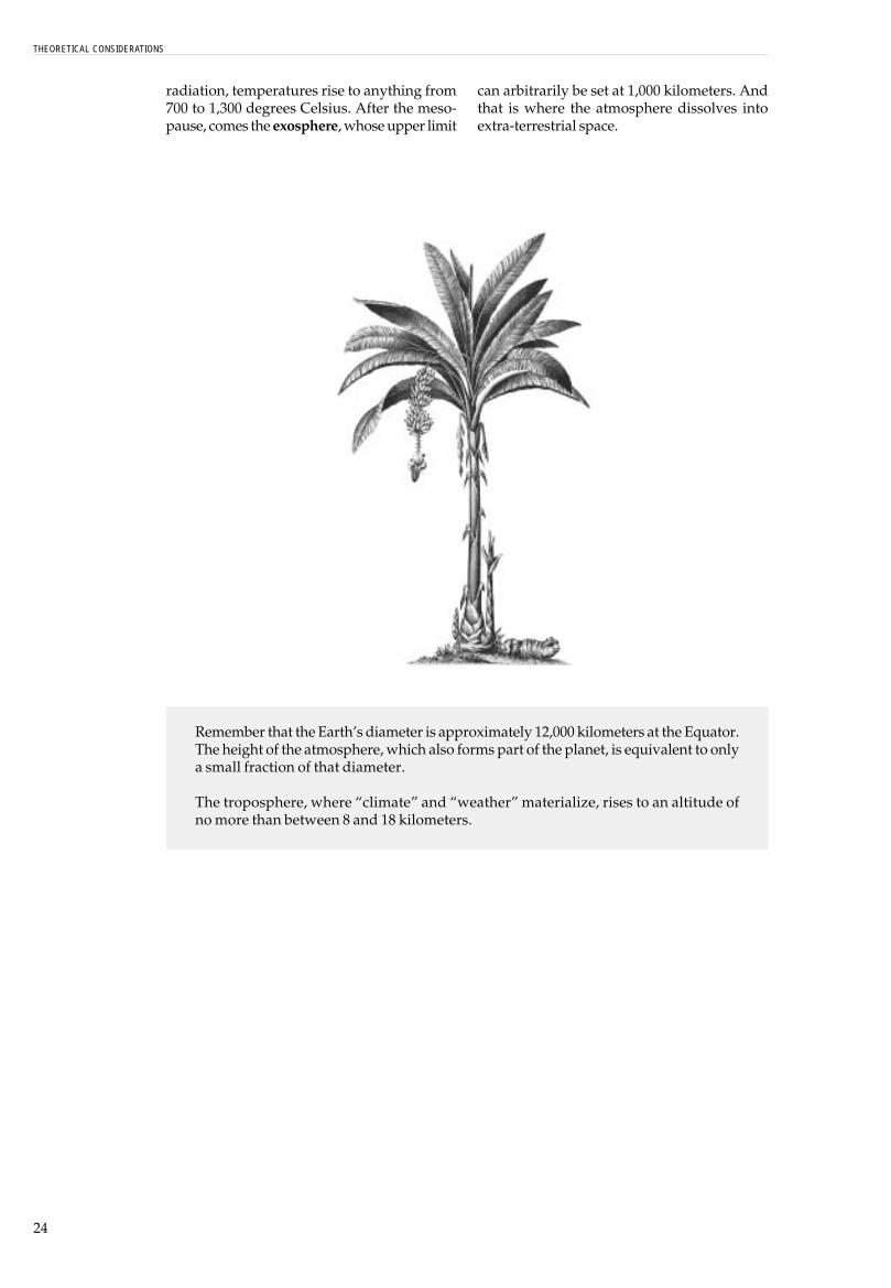
radiation, temperatures rise to anything from700 to 1,300 degrees Celsius. After the meso-pause, comes the exosphere, whose upper limit
Remember that the Earth�s diameter is approximately 12,000 kilometers at the Equator.The height of the atmosphere, which also forms part of the planet, is equivalent to onlya small fraction of that diameter.
The troposphere, where �climate� and �weather� materialize, rises to an altitude ofno more than between 8 and 18 kilometers.
can arbitrarily be set at 1,000 kilometers. Andthat is where the atmosphere dissolves intoextra-terrestrial space.
THEORETICAL CONSIDERATIONS

25
ugene Takle summarizes his defini-tion as follows: �Climate is a meanclimatic behavioral pattern, overlengthy periods of time, in relation to
layers into which, in a somewhat arbitraryfashion, we have divided the terrestrial �or-ganism� for the purpose of studying it. It alsodepends on factors foreign to the planet�s in-ternal dynamics, such as radiation emissionsfrom the Sun in its various activity cycles. These,in turn, are related to solar magnetism and tothe Earth�s position in its orbit around the Sun(movement in transit).
Even the effects the solar wind8 can have onus depend on it�s interaction with theEarth�s magnetic field. This is the result of acombination of electrically-charged particlesin the Earth�s nucleus, the convection cur-rents that generate its heat and the planet�srotation9.
Other factors, such as the angle of the Earth�saxis or the rotation period are not to be consi-dered independently of the planet�s internaldynamics. For instance a great earthquake pro-duced by plate tectonics can slightly alter theaxis�s angle, as is believed may have happenedwith the Indonesian earthquake of the 26th ofDecember 2004.
Two scientists, Benjamin Fong Chao fromNASA�s Goddard Space Flight Center and Ri-chard Gross from the organization�s Jet Pro-pulsion Laboratory, who routinely check theeffects of earthquakes on the Earth�s shape androtation, and also study changes in polar move-ment, state that:
Climate and Weather
Let us begin by defining what we mean by climate.
I received an e-mail from a colleague in France a few months ago and at the bottom was themessage: �Climate is what we expect and weather is what we get.� This says it in a nutshell.Weather is day-to-day values of temperature, rainfall, pressure, winds, etc., and climate is themean of these variables over some suitably long period of time.
But climate encompasses more than just weather variables. A more general definition of climateis the average behavior of the land, ocean, atmosphere, and cryosphere (ice masses) systemsover relatively long periods of time. There is not a rigidly-defined period for the averaging process,but for many operational applications a 30-year period is used. This definition acknowledges theinteractive role of land, water, and ice in determining atmospheric properties. The cryosphereincludes the ice masses of Antarctica and Greenland as well as North Polar sea ice and mountainglaciers. Ice masses are very important because their physical dimensions can change, therebychanging the amount of radiation reflected from the surface of the earth. They are also repositoriesfor enormous amounts of water, and so their change in volume influences the amount of liquid andgaseous water in the atmosphere and liquid water in the ocean�.
TAKLE, EUGENE S., 19976
Efluctuations in the weather�.
In other words: climate is like a person�s tem-perament, an essential part of his or her per-sonality, what is commonly called a person�sway of being. Weather, on the other hand, wouldbe the person�s mood at any given moment orwhen faced with a particular circumstance.
Somebody with a generally sunny and placidpersonality can experience moments of sad-ness, anger or depression, just as a person ofan unyielding and aggressive temperament canenjoy exceptional moments of happiness andbenevolence. Or somebody who is normallylazy can go through periods of great enterpriseand activity or, on the contrary, a hyperactiveperson can temporarily lapse into periods ofcomplete quietude.
As Tackle explains, what he calls the �climaticsystem� depends on something more thanmerely atmospheric factors in the strict and con-ventional sense7. He goes beyond the dictio-nary definition of �climate�; namely; �a seriesof atmospheric conditions that taken togethercharacterize a region�.
Furthermore, climate and weather do notdepend simply on interaction between all the
6 Takle, Eugene S. 1997. http://www.geology.iastate.edu/gccourse/model/basic/basiclecture es.html7 �The wholemass of airsurrounding the earth�. (Ma-rrian-Webster On Line).8 Constant flow of electrically-charged particles proceedingfrom the Sun, or �corpuscularsolar radiation�. Among othereffects, the solar winds pushthe tails of plasma or ions fromcomets in the opposite direc-tion from the Sun. They flow ata speed of between 250 and1,000 kilometers per second.9 The study of paleomagnetismin rocks proceeding from thebottom of the ocean has enabledscientists to determine thatever since the planet began toexist, several inversions of theterrestrial magnetic field havebeen produced, as a result ofwhich the North and South Poleschanged places. The last changeoccurred 780.000 years ago.There are signs that lead us tosuppose that the geomagneticinversions, during which theEarth was temporarily deprivedof its magnetic field, lead toperiods of extremely cold cli-mate. (Hardy, Ralph et al., ElLibro del Clima, page 168.Hermann Blume, EdicionesMadrid, 1982).

26
�The earthquake of the 26th of December displaced themean position of the North Pole of Earth by about 2,5centimeters (1 inch) in the 145 degrees longitude eastdirection, more or less towards Guam in the Pacific Ocean.This movement follows a long-term seismic tendency iden-tified in previous research. The tremor also affected theEarth�s shape. Chao and Gross calculated that the flat-tening of the Earth at the poles (flattened at the tips andswollen at the equator) decreased a little, approximatelyone part in 10,000 million. This confirms the tendency ofearthquakes to make Earth less flattened at the polesand make it more spherical�.
They also detected that the earthquake diminishedthe day�s length by 2, 68 microseconds (amicrosecond is the millionth part of a second). Inother words, the Earth spins a little faster than itused to. This change in the speed of rotation is relatedto change in the flattening of the poles. It is like an iceskater who brings his or her arms closer to the bodyproducing a faster spin.
None of these changes have been verified byquantitative measurements. For the present they
have only been calculated. However, Chao andGross expect to ratify the changes when theyreceive up-to-date information on the Earth�srotation from sensors placed on the ground andin space10.
In any case, these and other very small andgradual changes, often imperceptible in theshort run but accumulated over millions ofyears, as well as some abrupt changes, like theone possibly produced by the impact of an as-teroid on Earth 65 million years ago, determinewhy climate � that most �stable� characteristicof the temperament of terrestrial ecosystems�finds itself subject to a process of constantchange.
This means that not only can a person with astable temperament have different moods, butthat this same temperament tends to undergotransformations. Not for nothing is it said thatpeople who were placid in their youth and adultlife often become irascible and unbending whenthey get old, or, vice versa.
10 http://science.nasa.gov/headlines/y2005/lojan earth-quake.htmFind at Science@Nasa: Howthe Earthquake AffectedEarth
THEORETICAL CONSIDERATIONS

27
nd so, the concept of climate vari-ability emerges. This is not nece-ssarily synonymous with globalwarming even though at the
in a single �mass� to which today�s geologistsgive the name Pangea.
One part, which coincides in general termswith the continents of the northern hemisphere� North America, Europe and Asia (except forIndia) � bears the name Laurasia. The portionthat coincides with the Southern hemisphere �South America, Africa, India, Australia, theAntarctic and New Zealand � is known asGondwana.
Around 165 million years ago, what is nowNorth America broke away from the rest ofLaurasia, and the North Atlantic started to takeshape.
Later the Antarctic broke away from Gondwanaand then, around 90 million years ago, SouthAmerica broke away from Africa. From thisrupture the South Atlantic was born. 60 mi-llion years ago the plate or earth�s crust portionon which the Indian peninsula is found sepa-rated from Africa and started to drift north-wards towards the Asian plate. The frontalcollision between both plates, which still con-tinues, formed the crease or �wrinkle� on theEarth�s crust known as the Himalayas.
The collision between that fragment ofGondwana which constitutes the South Ameri-can plate and the plate over which the PacificOcean lies, led to the formation of the Andes,that other major �wrinkle� on the earth�s sur-
Climate variability:a characteristic featureof the Earth�s temperament
Apresent time the heating of the planet, accord-ing to many experts on the subject, may be oneof its more obvious causes.
Over the 4.500 million years since the Earth�scrust first �cooled down�, changes in climatehave occurred (and continue to occur) � changesthat are not exclusively atmospheric, but partof the planetary landscape in general.
We have already mentioned how, around 2.000million years ago when living things inventedphotosynthesis, the first green plants started tocapture carbon dioxide from the atmosphere andto liberate gaseous oxygen, which then producedozone. Many anaerobic species were unable totransform themselves sufficiently to survive inan atmosphere charged with oxygen; others didnot manage to take refuge in places with no airand so became extinct. Some species, however,discovered how to �breathe�, and these went outand populated the Earth. Thanks to the fact thatthe ozone layer reduced the incidence of harm-ful radiation from the Sun, these new species werenot obliged to live in primordial oceans or pools;they were able to climb out onto the land andexpand over the dry surface of the planet.
Until around 180 million years ago, what arenow the five separate continents were united
28
face. This reached its actual height only 2 or 3million years ago and still grows at a rate of afew millimeters � and at some places, centime-ters � per year.
Sixty-five million years ago, an asteroid crashedinto the Earth where the Gulf of Mexico is nowlocated (near to the town of Xichulub), pro-ducing an alteration in climate that destroyedthe environmental conditions under whichdinosaurs could live. It was then that ourmammal ancestors, who had hitherto been con-fined to hiding among the rocks, were able tocome out and conquer the Earth.
Only just three million years ago, North andSouth America were united by the Panama isth-mus. This did more than merely serve as a bridgewhich the great mammals from the Northcrossed on their way south. In fact their presencebrought about the extinction of a great manyspecies, many of them marsupials11. Anothereffect of the isthmus was to place an obstacle inthe way of equatorial currents which had beencausing a rise in the temperature of the Atlantic,and this contributed to the cooling of theAntarctic and to the freezing of the Arctic (theice sheet which forms the North Pole)12.
After the planet�s �natural heating system�was cut off, the northern continents were dis-placed towards the polar region due to the tec-tonic plate effect. Thus, two-and-a-half millionyears ago, ice began to cover Europe and thiscoincided with the advent of homo erectus. Thiswas not the first nor would it be the last of thegreat glaciations. 500 million years before, alarge portion of the Earth�s surface had alreadybeen covered by ice, and the same phenomenonwas to occur again later.
Even more recently, the planet went throughgreat changes, like the one around 4.000 years
ago that caused the Sahara to cease to be anecosystem rich in flora and water, and turninto the desert we know today. Another caseis the change from the extremely cold periodwhich prevailed during the Iron Age, 2.300 to2.900 years ago, to warmer periods like thatwhich allowed the Vikings to settle onGreenland between the years 950 and 1.250A.D.
Around that same time, about a thousand yearsago, great Meso American and South Americacivilizations (such as the Chimú culture inPeru) dissapeard, possibly due to causes linkedto changes in climate.
Between 1450 and 1850 approximately, �mi-nor glaciations� or �little ice ages� occurred.Such a period forced the Vikings to abandontheir settlements on Greenland13. One �minorglaciation� lasted from the beginning of theXV century until 1814, which was the yearthe river Thames froze over and Londoncelebrated an �Ice Fair�. It was also aroundthat time (1812) that Napoleon and his armiessuffered their great defeat on the Russiantundra.
As the present text is compiled, the NASA�sGoddard Institute of Space Studies confirmsthat the year 2005 has been the hottest (in termsof mean yearly temperatures on the Earth�ssurface) since systematic records began at thestart of the 19th century. The second-highesttemperatures were recorded in 1998 and, as aconsequence of the El Niño, they kept rising in2002, 2003, and 2004.
At the same time, however, the year 2006 be-gan with a cold spell that caused the death ofhundreds of people in Russia and Greece, whileextremely and unusually heavy snow stormsswept the east coast of the United States.
11 Animals, such as the kanga-roo, whose womb is an exter-nal bag known as a �marsupio�12 The Gulf Current still carrieswarm water from the tropicsas far north as the British Isles,enabling people there to enjoylivable temperatures.13 In his book Collapse: HowSocieties Choose to Fail or Suc-ceed, (Penguin, 2004) theNorth American author JaredDiamond explains why theVikings from Norway whoinhabited Greenland wereunable to resist the effectsclimate variability. In the termswe are propounding here,processes of deforestation,erosion and over-exploitationof the soil, combined withextremely hierarchical and in-equitable forms of government,among other factors, led theGreenland Vikings to lose their�territorial security�.
THEORETICAL CONSIDERATIONS

29
here is yet another process where theatmosphere, the lithosphere, thehydrosphere and the biosphere, ofcourse, are knitted together. And that
acid wrapped itself around the planet for sev-eral weeks.
According to research by experts from the Center of At-mospheric and Marine Research of Tasmania, Australia,published in Nature magazine(...) oceans need from tento thirty years to recover their temperature level afterevents such as the Chichon, 1982, or Mount Pinatubo,1991, explosions -the cases that have been most care-fully studied. Simulations indicate that the eruption ofPinatubo in 1991 produced a drop of six millimeters in thelevel of the nearby ocean for approximately one year. Thishas been recovering at a rate of 0.5 millimeters per year,and the same recovery is anticipated over the next tenyears, lower than the 1.5 observed average for the rest ofthe seas. The mean rate of the previous fifty years was0.4 millimeters per year, and in the last ten years an acce-lerated increase of up to three millimeters has beenregistered14.
Among the environmental effects that can beattributed to the eruption of Pinatubo, oneshould include the abnormal snowstorms thathave occurred in Jerusalem and the witheringaway of corals in the Red Sea15.
Despite all this, other research carried out bythe Environmental Science Department ofRutgers University in New Brunswick, N.J., andfinanced by NASA, indicate that while thePinatubo eruption had a cooling effect on thesea, it simultaneously brought about an in-crease in the �positive phase� of the so-called�Arctic Oscillation� by means of which winds
Volcanoes and climate changes
Tis volcanic activity.
Volcanoes cause solid, liquid and gaseousmaterials found below the Earth�s crust to riseto the surface and be ejected into the atmos-phere.
Over millions of years, material which hassettled at the bottom of the ocean, the productof erosion and sedimentation, sinks under thetectonic plates in the so-called �subductionzones�. This occurs when the oceanic platesslide under the continents as a consequence ofplate tectonics. Centuries later this matter re-turns to the surface through volcanic eruptionsand gradually becomes fertile soil in and onwhich life can flourish.
Great volcanic eruptions alter the Earth�s cli-mate at a local, regional, and global level. Aero-sols turn into particles of sulfur dioxide (SO2)which remain in the atmosphere, creating a�shield� that reduces the amount of heat co-ming from the Sun, which in turn lowers thetemperature and ocean water levels.
In June 1991, after 600 years of inactivity, thePinatubo volcano in the Phillipines producedthe greatest volcanic eruption of the 20th cen-tury. A swathe of clouds charged with sulfuric
14 http://earthobservatory.nasa.gov/Study/Volcano/Orsearch: Climate-ChangeVolcanic-Eruptions15 Magazine Science, February2002.http://eob.gsfc.nasa.gov/Newsroom/MediaAlerts/2002/200202157818.html

30
transfer heat from the oceans to the continents,generating greater heat in the high and mediumregions of the northern hemisphere. The sameinvestigations demonstrated the destructiveeffect of volcanic eruptions on the ozone layerwhich also contributes to polar heating16.
Pinatubo�s eruption constitutes a clear and re-cent example of how a process belonging to thelithosphere has a direct effect on two of the at-mospheric layers (the troposphere and thestratosphere), as well as on soils and seas. Notto mention its effects on the human commu-nities directly affected by the mud flows, piro-clastic flows, gaseous emanations and ash androck falls.
Similarly, there are clues that allow us toconclude, for instance, that the reactivationperiods of the Galeras volcano in southernColombia could be linked in some way toseasons of heavy rainfall. In other words, forreasons not yet clear, the rain, a phenomenonof the troposphere, could be �triggering off�volcanic activity. In March-April, 2006, settle-ments near to Galeras were on alert as theyfaced a possible eruption and this in the middleof a season of especially heavy downfalls affec-ting large areas of Colombia.
A curious, but not well know fact, is that on the13th of June 1991, only hours before the violenteruption of Pinatubo, and in the same region,typhoon Yunya was formed. It helped to alterthe normal monsoon patterns and became adetermining factor in explaining why the dis-tribution of ash from the volcano did not coin-cide with what had been foreseen on hazardmaps17. This is an extreme example of how theatmosphere, the hydrosphere and the dyna-mics of the Earth�s crust can interact.
On the effects of the eruption in the immedia-tely region, C.J van Westen, from the EarthResources Research Department of the Geo-in-formation International Science Institute inEnschede (Holland), relates the following18:
One of the most significant effects of the extensive cov-erage of deposits resulting from the piroclastic flow wasthe change in hydrological conditions. Given that thealluvial valleys which existed before the eruption weretotally swamped by piroclastic deposits, a new systemof drainage was developed above the level of thepiroclastic flows, channeled in a manner which waspartially different from the pre-existing model. The mostremarkable example was the new covering at the pointwhere the Sacobia and Abacan rivers meet. The depos-its of piroclastic flow cover this meeting point for almost20 kilometers and were deposited in the upper regionsof the Abacan river basin. Consequently, during and im-
mediately after the eruption, lahars produced by theYunya typhoon did not follow the Sacobia�s pre-erup-tion river bed, but were drained off along the Abacanriver valley, causing destruction in the city of Ángeles.The Sapangbato upper river basin was also redirectedtowards the Abacan river basin�.
Van Westen�s study includes a careful follow-up on the Pinatubo eruption�s impact on thehydrography and topography up until the endof 1993. To give some idea of the magnitude ofthis impact, we transcribe another segment ofhis study:
�The valleys have grown rapidly in the upper section ofthe basin near the point of convergence of the two majorvalleys. This process of massive erosion was increased bya great secondary explosion that occurred on 6 October1993. As a result of this explosion, an immense secondarypiroclastic flow headed in the direction of the Pasig river.This event led to the Pasig capturing the whole of theupper river basin of the Sacobia and producing animportant change as it carried lahars from the Sacobia tothe Pasig. From reconnaissance that can be viewed inaerial photos, one can see that the secondary piroclasticflow covered the major Gully-Gullies with hot deposits ofpiroclastic flows at least 20 meters thick, in both theSacobia and Pasig river basins. This event left no clearevidence of secondary craters due to the intensesubsequent erosion, but only wide flat valleys. The cap-ture occurred during the passing of typhoon Kadiang. Therelative time of the capture could be reconstructed bycomparison with the change in magnitude of the lahars inboth channels, as this was recorded by acoustic sensorsin the lahar monitoring station.
As a result of the capture of the upper section of theSacobia river basin, the Pasig�s erosion increased dra-matically. Rapid erosion both vertically and laterally overthe flows of piroclastic deposits, which were still very hot,produced numerous secondary explosions along the riverPasig. In the lower regions of the Sacobia river, the valley�svertical incision increased, reaching the height of pree-ruption deposits and creating vertical walls of up to 50 to80 meters high.
At the present time, the upper levels of the piroclasticflow have been totally eroded and remains of the secondlevel can be observed only on the Eastern side of the riverbasin. On the level of the lower terraces the erosion, indifferent spots, was as significant as those of thepiroclastic deposits in 1991, which are underlying them.The temporary capacity of the lake to retain water hasconsiderably diminished due to the deposits of lahars inthe Yangca river. In 1993, no lahars were produced thatcould be associated with the break up of the lake, due tothe fact that the barrier created by lahar deposits in theYangca was very much higher than the river�s activechannel. In 1994, however, the barrier formed by the lahardeposits broke down, generating an immense lahar inthe Pasig river and in the river basin downstream�19.
16 http://www.nasa.gov/centers/goddard/news/topstory/2003/0306apin.html17 Scott Oswalt, WilliamNichols, John F. O�Hara, Me-teorological Observations ofthe 1991 Mount PinatuboEruption.http://pusb.usgs.gov/pinatubo/oswalt/18 C.J.Westen, Modelamientode erosión en depósitos deflujos piroclásticos en el volcánMount Pinatubo, Filipinas.http:/www.itc.nl/external/unesco-rapca/Casos%20de%20estudios%20SIG%05%20Amenazas%20por20%20volcanes/Amenazas%20por 20%20volcanes.pdf19 Idem
THEORETICAL CONSIDERATIONS

31
s we have already seen, many vari-ables come into play when oneattempts to describe Planet Earth�stemperament and its moods, or to pre-
There are also factors directly related to theexistence of life on Earth, such as the way at-mospheric composition was altered from themoment life invented photosynthesis (whichis still the fundamental Process (in capitals) ofthe biosphere); the production of methane bythe great insect colonies, ruminant animalsand the organic waste deposits of human com-munities; and, the manner in which a particu-lar kind of vegetative covering affects a specificterritory�s way of absorbing, utilizing or reflec-ting light and caloric energy from the Sun.
And, as if that were not enough, there are thenumerous direct and indirect impacts of hu-man activity on a particular territory whose realeffects on the transformation of climate are stilla matter of debate.
The multiple interactions between the factorsmentioned above (and many others too nume-rous to include here) are so extensive and socomplex that it is impossible � at least from aconventional or �lineal� perspective � to evenbegin to understand exactly how the Earth�satmosphere, in its way of thinking and behaving,interacts with the rest of the planet�s compo-nents.
The North American meteorologist and ma-thematician, Edward Lorenz, endeavored tounderstand the atmosphere�s way of thinkingin order to predict its behavior more accurately.And, in the light of what we have written above,it is perhaps not surprising that he should have
Climate, weather and chaos
Adict the Earth�s long-term behavior in one re-gion or another.
Some of these factors are extreme and their ori-gin often goes far back in time. Solar radiation,related to the fluctuations of the Sun�s mag-netic field, is one such case.
Other factors are not so far removed. There is,for instance, the angle of the Earth�s axis as itcourses along its orbit, occupying a particularposition at different times of the year.
There are factors which are intrinsic to theplanet�s evolutionary dynamic, like the terres-trial magnetic field or the long and short termmultiple effect of continental or tectonic platedrift. First there is the change in position of thecontinental plates on the globe; and second,volcanic eruptions and their effects on soil,water and the two atmospheric layers (tropos-phere and stratosphere) which receive the im-pact of such eruptions.
Then there are topographic factors, such as theway flatlands, mountains and valleys have aneffect on winds and clouds and, as a conse-quence, on precipitation. And of course, lati-tude and height above sea level, which are per-haps two of the factors most evidently relatedto the climate of any given area.

32
come up with the fundamental principle ofchaos theory, known as �the butterfly effect�.In an address to the American Association forthe Advancement of Science (1979), Lorenzstated that when a butterfly flutters its wingsin Brazil, it may very well cause a tornado inthe United States.
By virtue of the �butterfly effect� � also knownas �sensitivity to initial conditions� � apparen-tly insignificant differences in the starting con-ditions of a process (or in the initial data onwhich a model is �run�) can lead to enormousdifferences in the long-term results of the pro-cess (or in the model�s predictions)20. From thisLorenz concludes that it is impossible to rea-lize precise long term atmospheric forecastssince not all of the multiple variables that in-fluence the model can be known with preci-sion in advance. Any unconsidered distur-bance, no matter how small, or any minuteerror in the data the model has been fed, canlead to entirely different results.
This does not mean that significant advanceshave not been made in our ability to make short-term meteorological forecasts, or to foresee, forinstance, the number of tropical storms that willprobably occur during the coming season, orthe possible path of future hurricanes � all ofwhich can be ascertained within an increa-singly accurate range of possibilities.
As if wishing to demonstrate that the namechosen to describe the �butterfly effect� is muchmore than just a metaphor, modern computers,when generating graphs from the apparently�disorderly� data provided by a chaoticprocess, produce what is called the �LorenzAttractor�, a figure that resembles lepidopte-rous wings.
�Sensitivity to initial conditions� serves notonly to explain the difficulties of accuracy withweather forecasts. It also helps us to understandwhy a seemingly insignificant factor, whencompared with other variables that intervenein a system, can generate qualitative modifica-tions which may substantially transform thesystem�s behavior.
This is one of the arguments on which somescientists base their conviction that our beha-vior has become more and more decisive in de-
termining the course of the climatic changeswe are experiencing, despite how insignificantthe impact of human activity on the biospheremight appear to be if we compare it with allother factors that influence climate andweather. Such changes could create conditionsthat endanger the very survival of our own�civilization� on the planet.
A small tack or nail may seem insignificantwhen compared with the automobiles andtrucks that travel at high speed along super-highways. But if the tack punctures the tire of avehicle that is moving at over 200 kilometersper hour, it could cause an accident of enor-mous proportions.
The ways in which our species contribute toclimatic change include:
� new uses of land which many times trans-form the way the biosphere absorbs andprocesses solar radiation;
� the planting of pastures for grazing on te-rrain previously covered by wetlands orforests;
� deforestation;� the expansion of cities � �islands of heat� �
over surrounding rural areas;� the unleashing of great quantities of car-
bonic gas (and the carbon that Nature hadkept �locked up� for centuries in coal andpetrol deposits); and the introduction intothe atmosphere of gases that destroy theozone layer.
All of these factors contribute to the heating ofthe planet on a global scale. And, at the locallevel, they express what those changes signifyto each particular region.
We have not as yet got round to talking aboutthe way our species helps to create certain ha-zards conditions that may spark off disasters.That discussion will come later. For the mo-ment we limit ourselves to stating that we hu-man beings are one more factor causing climaticalterations. To what extent are we to blame?That is the subject of heated debate (perhapsyet another contribution to Global Warming!),involving all those who, in one way or another� either from the perspective of science, politicsor environmental or development management�have taken up the issue.
20 In another field of mathema-tics, we have no problem inmaking an approximation be-tween p (pi) and 3.1416. Ho-wever, p represents a reasonwhose value possesses an infi-nite quantity of decimals. Ifwe were working with a mo-del for atmospheric predic-tions, in the long term we wouldobtain one result startingfrom 3.1415926535897932and a completely differentresult if we started from3.141592653589793238.The two last digits (-3 and �8)represent the flutter of butter-fly wings.
THEORETICAL CONSIDERATIONS

33
Two-and-a-half million years ago the landscape that we contemplate today on the highmountain heath at Sumapaz in Colombia, over 3.500 meters above sea level, was almost athousand meters lower; that is, at the level of the present-day city of Bogotá (2.600 meters).
Up until 28,000 years ago, the terrain occupied today by the savanna of Bogota was onegreat lake. Between 45,000 and 25,000 years ago, the mountain range which borders Bogotáto the east was covered with glaciers which, during that period, reached their greatestextent. At times the ice may have made contact with the forest at altitudes of between 2.700and 2.000 meters above sea level, that is, below the city�s current altitude.
NATURE’S DYNAMICS

34
omen are better endowed thanmen to perceive cosmic cycles,since in their organisms thecycles are much more evident.
By means of their pyramids and calendars, theMayas assured that the life of their Empire andits inhabitants were in harmony with the cos-mic cycles. The so-called ethno-astronomiessystematized a profound knowledge of theheavenly bodies, something which was � andstill is � common to all those cultures that areclosely bound to the rhythms of Nature:
For the Sikuani Indians who live in the Vichada (anAmazonic region of Colombia), what we call �TheMilky Way�, is a giant serpent:
which holds sway over everything and into which nobodymay enter because it fills the whole universe�. So thechief among all supernatural beings ordered two eaglesto lift the serpent out of the Earth and to place it in thesky so it would cease to trouble men. Thus theconstellation we call Taurus, they call �The Crocodile�sJaw�; the Southern Cross is �The Tortoise� and the con-glomerate of stars we know as �The Pleiades�, or �TheSeven Goats�, they call Ivinai, Ivinai, Ivinai, Ivinai, Ivinai, �and when it appears inthe sky it is summer, and when it sets beyond the horizon,in March and April, it coincides with an early abundanceof fish when water levels start to rise, and the bachaco(ants of the Atta species) fly a little. Then, when Ivinaivanishes altogether, in the second half of the month ofApril, the bachaco ants start to fly in swarms21.
Ever since the emperor Constantine imposedChristianity as the �official religion�, all my-thologies or �bodies of belief� started to becalled �pagan�(from the Latin pagus = coun-tryside, forest).
Climate changesand climate variability
WHowever, men and women, and in general allliving beings, work according to cycles, themost immediate of which is the so-called �cir-cadian� cycle or rhythm (from the Latin circa =near and dies = day), that dictates, amongstother things the hours for sleeping and beingawake. If you tamper with that cycle, it willcatch up with you sooner or later.
In times when the survival of human commu-nities depended on their knowing how to tunein precisely to Nature�s �mood�, nobody couldafford to ignore the phases of the moon, or thedates when each season began and ended, orthe life cycles of plants and animal popula-tions.
Great feats of prehistoric human architec-ture, like the Stonehenge observatory in En-gland, were both sacred centers and practi-cal tools for recording the passing of the Sunthrough previously-determined points onthe horizon. When viewed from specificplaces in the �Solar temple�, these pointsmarked the summer solstice (longest day ofthe year), the winter solstice (shortest day ofthe year), and the autumn and spring equi-noxes, when night is exactly the same lengthas day.
21 Álvaro Baquero, Etnoas-tronomías Americanas, quotedby Wilches-Chaux, Gustavo inDel Suelo al Cielo (Ida yRegreso, (Ed. CISP, Bogotá,2003).

35
We who are members of an �urban species�are so good at self-deception that we think andact as if our everyday lives can be lived wi-thout any kind of dependence on natural cycles,of which we know little more than what is re-quired to distinguish day from night. And thatis only because our bodies remind us unfai-lingly that we need to get some sleep. If sleepwere not necessary, we would probably doaway with nighttime � just as we have in fact�blotted� out the stars with the aid of electriclight bulbs.
Nature, however, like Time, marches on.
We have already seen how, within certain pa-rameters of climatic stability (that is, fidelity tothe way of being or temperament of a given sectorof the Earth, which is characterized by the per-manence of �normal� average levels of tempe-rature, moisture, wind speed, atmosphericpressure, etc.), changes in the weather occur.In other words, the moods of the atmospherevary in such-and-such a territory and underparticular circumstances.
But that way of being is not permanent either:variability is an intrinsic characteristic of cli-mate, and is manifested in a sequence of osci-llations or �deviations� from the norm22.
These local and short-term changes � moods �determine the weather, and are part of climaticvariability. Changes in more extensive regions,or for longer periods of time, may span a num-ber of seasons (multi-seasonal), a number of
years (multi-annual), a number of decades(multi-decadal) or a number of centuries.
Some examples of these prolonged fluctuations ofthe weather include abnormally hot and drysummers, as well as extremely cold and snowywinters, and consecutive series of severe winters, orvice versa. And it can occur that a mild winter isfollowed by a strong one. In general, all long-termphenomena are associated with changes in theatmospheric circulation that covers great extensions.At times, these persistent manifestations occursimultaneously over vastly distant and apparentlyunrelated regions of the hemisphere, or even theglobe, and result in abnormal conditions and inunusual temperature and precipitation patterns23.During the last few decades, scientists havediscovered that important aspects of climatic inter-annual (from one year to the next) variability inplanetary climate patterns are related with the cycleknown as the phenomenon of El Niño24.
Inter-annual climatic variability refers to thefluctuation in time of the different meteorologicalelements in a region. This fluctuation is generallyestablished in relation to a historical average. Overtime, climate behaviour is typified by maximumand minimum extremes and oscillations under (andclose to) the average. The ENSO phenomenon is themain known source of large-scale climatic variability.However, ENSO is only one of the many oceanic-atmospheric phenomena that produce variability.Hurricanes, seasonality, thermal domes of the oceans,high and low pressure systems, are also componentsof a complex dynamic system which producesclimatic variation year after year25.
22 Ministerio de Ambiente yRecursos Naturales de Guate-mala, Ponencia sobre losimpactos del Cambio y laVariabilidad Climática (GEF/PNUD, October, 2002).23 A �pattern� is a group ofelements which, when ex-pressed jointly, show a highdegree of repetition or regu-larity. Lavell, Allan, ENOS,Patrones de Riesgo de Desas-tre y su Gestión: ElementosConceptuales y Bases de laInvestigación Comparativa. InAllan Lavell �Riesgo y clima:proceso, patrones y gestión enAmérica (IAI - La Red - Oxfam,2007).24 NOAA � Climate PredictionCenter www.epc.ncep.noaa.gov/products/analysis moni-t o r i n g / e n s o c y c l e / c l i mvari.html; http://www.cpc.ncep.noaa.gov/products/analysis monitor ing/ensocycle/clim vari.shtml25 J. Retana. Rosales, R. Efectode la variabilidad climáticasobre la producción bovina decarne en la Región Chorotega deCosta Rica. Revista TópicosMeteorológicos, IMN, July2001, Vol.8 No. 1.
NATURE’S DYNAMICS

36
�The first pieces of the El Niño puzzle were put together thanks to atmospheric studies. In the early part ofthe twentieth century, British mathematician Sir Gilbert Walker, Director General of Meteorological Observa-tories in India, took advantage of existing weather data to make a substantial breakthrough in atmosphericscience. In 1899, the monsoon rains on which Indian farmers depend failed, triggering a devastatingfamine. Asked to find a way to predict such weather vagaries in the future, Walker began sifting throughsome 40 years� worth of temperature, atmospheric pressure, and rainfall data culled from a worldwidenetwork of weather stations. He noticed a kind of seesaw relationship between atmospheric pressure inthe eastern South Pacific (east of Tahiti) and the Indian Ocean (west of Darwin, Australia)�that is, ifpressure was high in one region, it was usually low in the other and vice versa.
In a 1928 paper presented to the Royal Meteorological Society, Walker named this seesaw pattern theSouthern Oscillation and devised a yardstick that measured pressure differences between the two regions.He observed that, when pressure was very high in the east and low in the west, the monsoon rains in Indiawere heavy. When the pressure difference was small, the rains failed and drought often ensued. Moreover,Walker's research showed that drought conditions hit not only Australia, Indonesia, and India but also partsof sub-Saharan Africa, and at the same time there would be mild winters in Canada. Because he hadplotted certain time-lag correlations between these pressure differences at different times of the year,Walker also believed the measurements could be used for long-range forecasting for some locations.
Despite his insight and vision, Walker was unable to identify the physical processes responsible for theSouthern Oscillation, and for the next three decades numerous factors conspired to dampen furtherresearch on the phenomenon. Chief among them was that from 1930 to 1950 the climate signals markingthe Southern Oscillation and El Niño were much less pronounced than they had been, and interest in thesubject waned. Then in 1957 a confluence of events in climate, science, and international politics broughta resurgence of interest.
That year the Soviet Union launched Sputnik, the first artificial satellite, spurring a dramatic increase insupport for scientific research of all kinds throughout the West. As it happened, the year also ushered in alarge El Niño. Although this caused an unusually forceful impact, it might have passed unnoticed, exceptthat 1957 had been designated as an International Geophysical Year, a year when scientists from allcountries cooperate to improve existing understanding of the solid Earth, the oceans, and the atmosphere.As a result, scientists around the world were conducting intensive measurements of the planet. Among thedata they gathered were not only atmospheric measurements but also sea surface temperatures through-out the Pacific�information that had not been available in Gilbert Walker�s time. Some researchers in the1950s noted that high sea surface temperatures off the coast of Peru seemed to correlate with a smalldifference in pressure across the tropical Pacific. Indeed, scientists at the Scripps Institution of Oceanogra-phy convened a group of scientists in 1959 to discuss the phenomenon. However, it wasn�t until the late1960s that meteorologist Jacob Bjerknes, of the University of California, Los Angeles, described a mecha-nism that linked Walker�s observations of the Southern Oscillation to El Niño�.
THE NATIONAL ACADEMIEShttp://www7.nationalacademies.org/opus/elnino_3.html
THEORETICAL CONSIDERATIONS

37
EL NIÑO
Start Finish Duration(months)
Ago 1951 Feb 1952 7
Mar 1953 Nov 1953 9
Apr 1957 Jan 1958 15
Jun 1963 Feb 1964 9
May 1965 Jun 1966 14
Sep 1968 Mar 1970 19
Apr 1972 Mar 1973 12
Ago 1976 Mar 1977 8
Jul 1977 Jan 1978 7
Oct 1979 Apr 1980 7
Apr 1982 Jul 1983 16
Ago 1986 Feb 1988 19
Mar 1991 Jul 1992 17
Feb 1993 Sep 1993 8
Jun 1994 Mar 1995 10
Mar 1997 Mar 1998 12
(Source: Kevin E. Trenberth, December 1997)
LA NIÑA
Start Finish Duration(months)
Mar 1950 Feb 1951 12
Jun 1954 Mar 1956 22
Mar 1956 Nov 1956 7
May 1964 Jan 1965 9
Jul 1970 Jan 1972 19
Jun 1973 Jun 1974 13
Sep 1974 Apr 1976 20
Sep 1984 Jun 1985 10
May 1988 Jun 1989 14
Sep 1995 Mar 1996 7
Jul 1998 Jun 2000 23
Dec 2000 May 2001 5
(Source: Kevin E. Trenberth, December 1997)
NSO is an acronym that has been inuse for some years now to refer to�El Niño Southern Oscillation�.
ENSO phenomenon is typified when, in theregion known as �Niño 3� (between latitudes4º N and 4º S and longitudes 150º W - 90º W), inthe course of six or seven consecutive months,there are records of heating or cooling in theoceanic waters of at least 0.5 degrees Celsiusabove (or below) a basic line established withreference to the mean temperature of the waterin the 1959-1979 period26. Thus, for example,according to the World Meteorological Orga-nization (WMO), the 1997-1998 ENSO was oneof the strongest ever recorded, with abnormali-ties in temperature on the sea surface (TSM) ofbetween +2 and +5 degrees Celsius above theirnormal value27.
Based on this characterization, the followingepisodes of El Niño and La Niña have beenrecorded between 1950 and 2000:28
ENSO what?
EWhen it was observed that the twelve-monthlyperiods in which the Pacific Ocean heats up asa consequence of El Niño tend to be inter-spersed, at irregular intervals, with cold yearsin which the sea�s temperature is below nor-mal, such periods began to be identified as theyears of Niña, or La Niña. When neither of thesetwo alterations takes place, we have what areknown as �neutral years�.
According to research carried out by Kevin E.Trenberth, a New Zealand climatologist andmathematician at the National Center for At-mospheric Research in Boulder, Colorado, the
26 Magaña, Víctor 1999, Losimpactos de El Niño en México,IAI, SEP-CONACYT, México,D.F., México.27 Zevallos Moreno, Othón,Riesgo asociado a ENOS yvariabilidad climática enEcuador, in �Riesgo y clima:proceso, patrones y gestión enAmérica� (IAI - La Red - Oxfam,2007).28 http://www.atmosfera.cl/HTML/temas/nino4.htm
As can be observed in the above tables, ENSOcorresponds to what meteorologists call �cuasi-periodic phenomena�; that is, phenomena thatoccur with certain periodicity, but not at regu-lar intervals. Some researchers, using approxi-
mate figures recorded over the last fifty years,state that the lapse of time between one ENSOand the next varies from between three and fiveyears, while a really intense ENSO is experi-enced every 15 to 20 years.

38
the southern ocean, pushed northwards bywinds from the Antarctic. Peruvian fishermendepend on these marine life rich waters for theirprosperity, as does the economy based on theexcrements of guano birds.
Still within the �normal� scheme of things, as far as thesea�s surface temperature is concerned, this cycle showshigher values in the equatorial region of both oceans incontrast to the surging of cold subtropical waters. Duringthe summer months in the southern hemisphere, theequatorial strip with its warmer surface temperaturesmoves towards the north, while the waters to the southof the equator cool down. In the semester that follows,the strip of maximum surface temperature moves south-wards, practically reaching the equator; towards Marchand April the strip of warmer waters in the Pacific is foundfurther north than its Atlantic counterpart.29
For reasons still not totally explained byscience30, every so often the low-pressure zoneof Indonesia shifts to the center of the Pacific.This alters the direction and force of the winds,which start to blow from west to east. As a result,the direction of the tepid surface current alsoreverts, and instead of cold water, it is water ofhigher-than-normal temperatures which startsto accumulate. The immediate effect is that thewater becomes void of nutrients, causing themigration and large scale death of birds and fishand consequent disaster for the fishing andguano industries. As we will see later, in 1972-73 and in 1982-83, Peru suffered catastrophiceconomic consequences as a result of El Niño31.
o understand the phenomenon, letus begin by briefly describing howwinds and the sea interact in thetropical Pacific.
What is El Niño?
TBetween a high-pressure (anticyclone) nucleuslocated in the vicinity of the Tropic of Cancer(northern hemisphere) and another near theTropic of Capricorn (southern hemisphere), alow-pressure zone (or �barometric depression�)is formed, one that is known as the Zone ofInter-tropical Convergence (ZITC), whose widthis equivalent to approximately twenty degreeslatitude. This is where the Trade Winds nor-mally blow from east to west � or more pre-cisely from the northeast and southeast to-wards the west; that is, from South Americatowards a region of lower barometric pressurein Indonesia.
As they move along, these Trade Winds drivethe superficial warm layers of the Pacific Oceantowards the Indonesian coasts, where theyaccumulate and produce a slight increase insea level.
Beneath the ocean surface a cooler countercur-rent flows in the west-east direction. This sur-faces near to the South American coast and isloaded with plankton in suspension and nu-trients, thus creating conditions for an abun-dance of fish (the Cromwell Current). Thiscountercurrent interacts with the celebratedHumboldt cold-water current coming up from
29 Reinaldo García, Caracte-rización de las tasas pre-ElNiño en el suroccidente deColombia, Departamento deGeografía, Universidad delCauca, Colombia.30 There is research which linksthe phenomenon to cycles inthe Sun�s orbit as it movesaround the center of mass in thesolar system. See Landscheidt,Theodor, in http://www.john-daly.com/theodor/solarnao.htm31 Gustavo Wilches-Chaux,Meyer, Hansjurgen, Velásquez,Andrés, �La Costa Brava�, enColombia Pacífica. Fondo FEN,Colombia. T. II (Bogotá, 1993).

39
So, an almost imperceptible alteration in tem-perature of the Pacific, sometimes less than halfa Celsius degree one way or the other, bringsabout variations in the inter-annual manifes-tations of climatic variability in different regionsof Earth, some of which would seem to havenothing at all to do with the Pacific�s equato-rial strip.
El Nino South Oscillation (ENSO) is an un-predictable phenomenon that generates criticalconditions as a consequence of a group ofassociated events around the planet, whichhave not been understood in their entirecomplexity. Those effects are not alwaysrepresented in the same way, but rather as aseries of irregular climatic conditions thatinclude changes in temperature and atmos-pheric phenomena of different intensities. Infact, over the last 25 years, stronger and morefrequent El Niño events have been registeredthan in the 1940s to 60s (Gray, 2005), and theireffects have been totally diverse in differentparts of the planet. These dissimilar climaticconditions, which happen to be affected byvariations of intensity that span a few decades,can trigger natural phenomena and environ-mental alterations that, combined with deter-mined social vulnerabilities, are susceptible toproducing catastrophic consequences in someplaces, while in others they generate merelyminimal changes.
According to Sweetman (2000), these multi-decadalvariations of ENSO first became evident in the fifties, whenLa Niña episodes (dry) surpassed in number the El Niño(wet) ones. Since then, however, the number of El Niñoevents has increased considerably.
Given the varying types of effects that ENSO produces indifferent parts of the planet, it has become difficult toassociate this macro phenomenon with particular hazardssuch as hurricanes, tornadoes, droughts and others. Butsince 1997-98, when El Niño was especially strong,scientists have sought to establish possible links betweenthis phenomenon and natural events that are capable ofwreaking havoc on communities.
It is a well-known fact that a slight alteration in the tem-perature of the sea�s surface provoked by ENSO, particu-larly when this occurs in the eastern Pacific Ocean, signifi-cantly increases the possibility of extreme hydro-meteo-rological phenomena such as droughts, floods and storms.What we do not yet know is how a specific ENSO eventmay affect climate beyond the tropics (Sardeshmukh etal, 2002).
It is well known also that ENSO, during its warmphases, suppresses hurricane activity in the Atlanticbasin (Tartaglione et al., 2002).32 This is deduced fromthe fact that hurricanes are more intense during thecold ENSO phases (La Niña) than in the warm ones (ElNiño).
La Niña years are associated with approximately 75% ofdamage registered for the 1950-1990 period in Floridaand the east coast of the U.S., equivalent to losses of55,000 million dollars (at 1990 prices). This may be com-pared to only 2,500 million dollars worth of damage regis-tered during the warmer ten years; that is, when El Niñowas occurring33.
Similarly, Tang and Neelin (2004) discovered that ENSOand the surface temperature in the North Atlantic alsoconstitute important factors in determining the frequencyand intensity of hurricanes. These researchers argue thatthe relations between these factors possibly take placethrough �tele-connections� in the troposphere�s tempera-ture. Saunders and others found that ENSO contributessignificantly to variability in the number of intense tropicalcyclones in the north of the Atlantic Ocean and in theNorthwest Pacific. A revision of the period 1900-1997 forthe Atlantic, and 1965-1997 for the Pacific Northwest,demonstrated the differential impact of the cold and hotphases of ENSO on the landfall in different regions.
In the Caribbean, for example, there is a direct relation-ship between the cold ENSO phase and the impact ofhurricanes on land, these being 65% during the cold phasesand only 18% during the warm ENSO phases (Tartaglioneet al., 2002).
Likewise, it was suspected that ENSO also had to dowith the generation and characteristics of tornadoes.Hagemeyer (2001) suggested that in Florida tornadoesare exceptionally strong (intensity of F2 and higher), butthat the probability of their occurring increases during thedry phases of ENSO. In fact, data recorded after 1950confirms the direct relation between tornado activity andintense ENSO. The two most extreme El Nino events(1982-83 and 1997-98) produced the most significanttornadoes to be registered in that State. (Hagemeyer,2001).
It is important to understand the different effects that ElNiño and La Niña can produce in different parts of theplanet. Apparently El Niño unleashes a stronger but morevariable response than La Niña. While the former is as-sociated with more humid meteorological conditions insome parts of the world, La Nina gives rise to dryer con-ditions. In general these effects of ENSO are tele-con-nected with effects in other regions. According toMorehouse (2000), El Niño implies more humid condi-tions than normal during the winter semesters in thesoutheast and southwest of the United States, whilesimultaneously conditions tend to be dryer than usual inthe northeast of the Pacific.
Likewise La Nina, whose occurrence is linked to a signifi-cant cooling of the Eastern Pacific waters, translates intoabnormally dry conditions in the southeast and south-west of the U.S., but more humid than normal conditionsin its Pacific Northwest (Morehouse 2000).
This doesn�t mean, however, that ENSO generates theseopposite effects in an automatic way. As Sardeshmukh(2002) points out, ENSO does not have opposite effects
32 Tartaglione, Carissa A.,Shawn R. Smith*, and JamesJ. O�Brien 2003ENSO Impact on HurricaneLandfall Probabilities for theCaribbean. Journal of Climate,Vol 16, Issue 17, September2003.33 Figures don�t include theeffects of the 2005 hurricaneseason.
NATURE’S DYNAMICS

40
(nor the same effects) on climate patterns in a uniformmanner in different parts of the world. For example, duringEl Niño periods there is a significant risk of heavy rainfall andflooding in California, and during the La Niña periods the riskof drought and forest fires increases in Florida. This, how-ever, cannot be taken to represent a regular pattern ofbehavior on the part of the ENSO phenomenon.
Observations made over the last decade demonstratethat the wetter and drier conditions that El Niño y La Niñabring about become, respectively, the precursors of floodsand droughts. An example of this occurred during the1997�98 ENSO phase, when because of the phenom-enon of teleconnection, dryer conditions in the northeastof the US were paralleled with more humid conditions inthe southeast, Rainfall in Florida was 200% above normalfor the months of October and December. Immediatelyfollowing this wet period La Niña set in, and betweenApril and June,1998, Florida suffered the hottest and dri-est season registered during the last 104 years (Laing etal., 2000).
Understanding the likelihood of weather variations andtele-connection patterns in both ENSO phases, it is rea-
sonable to link this phenomenon with the occurrence of anumber of associated natural events. Jones, Shriver, andO�Brien show that ENSO influences rainfall rates in Floridaand other parts of the world. They indicate that heavyAutumn rainfall in the Galapagos Islands is frequently fol-lowed by wet winters in the southern United States. Theextended flooding that occurred during the fall of 1997and early spring 1998, is unequivocally associated withENSO.
The effects of ENSO on wildfires are more evident. Ac-cording to Goodrick and Brenner (2000), the interaction ofENSO with Florida wildfire activity during the past decadehas been recognized. Swetnam (2000) confirms the in-fluence of ENSO in creating conditions for forest fires.Using tree-ring analysis from 1600 to the present,Swetnam indicates that ENSO has a significant influenceon fuel load buildup and fire potential, especially in ex-treme events. A wetter El Niño is generally associatedwith exuberant seasonal vegetation, particularly finegrasses, which turn into fuel during the dry season. There-fore, the confluence of a wetter than normal El Niño witha drier than normal La Niña, creates an enormous poten-tial for wildfires34.
THEORETICAL CONSIDERATIONS
34 Anthony Oliver-Smith et al,�Patterns and Processes ofVulnerability to Hazards inFlorida�, in �Riego y clima:proceso, patrones y gestión enAmérica (IAI - La Red - Oxfam,2007).

41
Chapter 2
Territory and communitydynamics

42

43
erritory is not just a physical space ora geographical point of reference. It isalso the complex and dynamic resultof an indissoluble marriage between
when we gather information on the place�s his-tory and memories and when we impregnateeach of the place�s components with a specialsignificance. All of these relationships contri-bute, in part at least, to the way in which aterritory makes us experience fear or uncer-tainty, or on the contrary, feelings of security.Our direct experiences with the territory (or therecollection of experiences our ancestors livedpreviously in that same territory) largely deter-mine the �emotional baggage� which we bringto bear on a specific place, a factor which, inturn, influences our relationship with it.
The concept of territorial security is borne outof the interaction of all these factors and bringswith it the challenge of rediscovering the civicand integral meaning to be ascribed to the se-cond of those two words-security.
Territorial security is intimately linked tosustainability (and to what has been dubbed�sustainable development�). This embraces ourrelations with (and within) a specific territoryin such a way that the dynamics of Nature donot pose a threat to communities, nor do com-munity dynamics pose a threat to the place�secosystems. That is to say, territorial security istwofold: it benefits both communities and Na-ture itself.
Stability is perhaps one of the more importantenvironmental services for human beings. Thissignifies the permanence in space and time of
Nature + Culture = Territory
Territory is a social, political and economic construct expressed in theexistence of regions with human, productive, economic, political andsocial features relating to their natural resource base and geographicalcharacteristics.
ALLAN LAVELL
TNature�s dynamics and the dynamics of thecommunities which form part of it.
Communities relate to their territory in diffe-rent ways. Some of these are material, as is de-monstrated in the use of the natural resourcesand environmental services the territory pro-vides and on which communities depend if theyare to live and grow in a humane and dignifiedfashion, with an adequate standard of life.
Tangible environmental services includewater, air, solar energy, foodstuffs (alimentarysecurity and sovereignty) as well as the ferti-lity and stability of the soil, a factor which isindispensable if one is to occupy the territory,move around it and produce goods.
Intangible environmental services are diffe-rent from the above, but no less important andnecessary. They include a sense of belongingand of identity and, also, the possibility of aes-thetic enjoyment of the landscape, whether byday or by night, as a source of learning, inspi-ration, recreation and tranquility.
We also relate to our territory in a symbolicfashion when we baptize certain features of theland, when we adopt and modify, either for-mally or informally, already existing names,

44
the conditions which make life possible. Thisdoes not mean there will be no change, butrather that such change will take place withincertain predetermined parameters to which li-ving beings (and above all, us humans) are ableto adapt. In other words, the dynamics ofchange should not go beyond the limits of ourability to adapt. These limits or parameters areclosely related to matters of culture. Or betterstill, they are culture, if by �culture� we mean acombination of creations and processesthrough which human beings leave their ma-terial and symbolic imprint on a particular ter-ritory.
The dynamics of Nature are diversely affectedby many human activities. And, for this rea-son, certain changes in Nature, manifestationsof such dynamics, turn out to be greater thanour capacity for adaptation.
This happens, and will continue to happenwith growing frequency, so long as culture isthought of more and more as a tool attemptingto dominate Nature (we use the word �attempt-ing� because, despite the arrogance of manyhuman beings, Nature will always show itselfto be much more powerful than us), and usedless and less as a mechanism for adaptationand dialogue with Nature. Lovelock has al-ready dissertated on this situation in his GaiaHypothesis: ecosystems � and the biosphere ingeneral, of which our human communities arepart � are endowed with self-regulatory or ho-meostasis systems, as occurs in our own or-ganisms. These have the aim of reestablishinga state of stability or dynamic balance whendisturbed by a particular external or internalaction.
Eugene Odum (1913-2002) and other classicexponents on the matter of ecology have taughtus the meaning of concepts such as resistanceand resilience. The former refers, metaphorically,to the ability to avoid a goal in football. Or, tofurther apply the metaphor, resistance representsthe team�s ability to prevent the ball from get-ting near the goal posts (that is, to avoid a haz-ard). On the other hand, resilience refers to theability of the football net to recover its formershape after a goal has in fact been scored. Bothresistance and resilience are related to thoseself-regulatory or homeostasis mechanisms towhich Lovelock has referred.
In our own bodies, resistance represents ourability to stave off sickness even though we arepermanently immersed in an ocean of patho-genic agents. This ability to resist is the resultof multiple, interconnected factors, such as theendowments of our immunological system(which co-evolves as our lives develop) anddepends also on our nutritional levels. It de-
pends no less on emotional and cultural fac-tors to which we are subjected, both as indi-viduals and as members of society. AntonioGramsci, the renowned Italian early 20th cen-tury political scientist and philosopher, oncemade the very important observation that ourhealth depends on our relationship with our-selves (with both our body and our spirit) andalso with our ecological surroundings and ourcommunity.
Resilience is our ability to recover followingillness, an ability which not only depends onphysiological or corporal conditions, but alsoon emotional, psychological and cultural fac-tors. It depends too on individual and socialfactors: we don�t get sick nor are we cured onour own, but as integral members of a socialtissue.
At this point in our argument we must intro-duce a fundamental concept regarding riskmanagement: vulnerability.
Vulnerability has been defined in many ways.However the following definition enables usto understand the concept both as a function ofresistance and resilience and at the same timeas their opposites:
�Vulnerability is an internal risk factor of an element orgroup of elements exposed to a hazard. It relates to thephysical, economic, political or social predisposition or sus-ceptibility of a particular community to be affected by, orto suffer adverse effects, when a dangerous phenom-enon, of natural, socio natural or anthropogenic origins,should occur. It also represents those conditions whichmake autonomous recovery either impossible or extremelydifficult. Differences in the degree of vulnerability of a so-cial and material context when faced with a dangerousphenomenon determine the selective nature and seve-rity of its effect.�35
Let us now introduce the analogy of a spiderand its web to help us understand the conceptsof vulnerability, resistance and resilience. Fromnow on we will use this analogy a great deal toillustrate our arguments.
The mesh, net or spider web is considered to be�resistant� when it can withstand, withoutrupture, the effects of an external or internalaction. This resistance also includes the spiderwhich has spun the web as the concept alsoincludes the ability to avoid hazards and, as aresult, prevent risks. For example: when thespider establishes his web in a place shelteredfrom the wind.
On the other hand, the spider is vulnerablewhen it proves unable to resist the effects ofsuch actions. In that case, the probability of theaction may be seen as a threat or hazard.
35 Allan Lavell, in ENOS,Patrones de Riesgo de Desas-tre y su Gestión: ElementosConceptuales y Bases de laInvestigación Comparativa,en Allan Lavell, en �Riesgo yClima: Proceso, Patrones yGestión en América� ( IAI � LARED-OXFAM, 2007)
THEORETICAL CONSIDERATIONS

45
The spider is considered to be �resilient� when,following the breaking, tearing or destructionof it�s web by an external force such as wind,heavy rain, an intruder, or a falling tree, thespider is capable of spinning his web againand thus recovering territorial control.
Does vulnerability constitute an attribute (al-most always negative) which is exclusive tohuman communities? Or can one speak also ofthe vulnerability of ecosystems?
This is open to debate. Those who believe orargue that vulnerability can only be applied tohuman communities � argue that to speak ofecological or environmental vulnerability in thesame breath can only lead to confusion andresult in internal contradictions in the use ofthe concept, thus reducing its analytical andheuristic powers. This way, they argue, wecould end up equating what are essentiallymanmade processes with processes of naturalenvironmental transformation � the so-called�succession� � by means of which Nature orthe natural environment transforms itself.
Lavell (2004) has suggested that:
�Natural environmental transformation refers to the pro-cess by which nature or the natural environment trans-forms itself, including processes that have existed sincethe formation of the earth and which have moulded andchanged its surface, its flora and fauna in a continuousmanner. Reference is basically made to processes wherenature interacts with other unmodified or essentially un-modified natural elements (ecosystems, rivers, mountains,slopes, coastal zones, etc). Examples can be found withthe impacts of earthquakes on watersheds and slopes,hurricane impacts on forests and mangroves, or sponta-neous fires that regenerate ecosystems. To speak of en-vironmental destruction or environmental loss in thesecases would be anti-evolutionary or anti-natural. A morecorrect use of notions would suggest the idea of transfor-mation, change or regeneration and not destruction ordamage. The former terms are the product of subjectiveand anthropocentric interpretations. Even when transfor-mations affect society, reducing the quantity and qualityof potential resources, these processes are in themselvesnatural and cannot be considered in the same way asdirect event impacts on society, its goods, heritage, ormaterial structures. Thus, the frequently used notion ofecological or environmental vulnerability refers to a typeof vulnerability which is quite different and in no waycomparable with social or human vulnerability. In fact, it isprobably more convenient to speak of different levels ofenvironmental resistance, resilience or fragility instead ofvulnerability, and thus avoid confusions and contradic-tions. This argument also applies to the use of such no-tions as environmental disaster instead of more objectivestatements such as wide or large scale environmentalchange or transformation associated with the occurrenceof large scale, natural physical events. In disaster risk anddisaster studies confusions and contradiction are intro-
duced when the same word, disaster, is employed todepict both social and natural scenarios.
Natural phenomena which modify or transform other natu-ral scenarios are inevitable and have occurred since theorigins of the Earth. With very large scale phenomenasociety can do nothing to impede or change these. Inter-vention is thus essentially reduced to prediction, adapta-tion and, eventually, response.
On the other hand, with lower scale natural or environ-mental processes society frequently intervenes in orderto modify them. This is the case, for example, with thecontrol of the natural flooding of rivers, the control ofspontaneous-natural fires, the modification of slopes inorder to permit agriculture or construction and deforesta-tion permitting expansion of the agricultural frontier. Here,the possibility of future negative impacts always exists asis the case where dykes and dams break, construction onland fill areas is subjected to greater seismic intensities ordeforested areas generate increased flooding, landslideand drought patterns. Environmental change and transfor-mation which takes place in highly intervened, modifiedor weakened ecosystems and environments constitutesa very distinct context and problem to that associatedwith purely natural transformations of the environment.In the case of direct social losses in modified natural envi-ronments, intervention processes have many times ge-nerated new socio-natural hazards or rendered the scaleof natural physical events more powerful, thus genera-ting increasing losses once the event occurs.�36
Those of us, including myself, who believe thatit is possible to speak of �vulnerable ecosys-tems�, not only share many of the notions ex-pressed by Lavell in the preceding paragraphs,but we even base our arguments on his whenwe state that human beings often �vulnera-bilize� ecosystems when attempting to controlor simply exploit them, without due respect fortheir integrity and dynamics. It is extremelydangerous to reduce the concept of ecosystemsto �natural resources� taken as a whole. Thatis to say, there is no irreconcilable contradic-tion here, but rather a difference of focus.
We believe that �vulnerabilizing� ecosystemssignifies affecting their capacity to resist andto be resilient. We block off their immunologi-cal system, so to speak, just as AIDs does inhuman beings.
Perhaps the most obvious example we havewitnessed in recent years was the case of hur-ricane Katrina when it hit the Louisiana coastline on the Gulf of Mexico. The immunologicalor self-regulatory system which enables coastalareas to absorb, without trauma, the periodicvisits of hurricanes (that are, in fact, an inte-gral part of that territory�s natural dynamics),includes mangrove swamps and wetlands, aswell as the course and shape of the area�s ri-vers and the topography of the coastline. All of 36 Idem.
TERRITORY AND COMMUNITY DYNAMICS

46
these factors or features have evolved jointly,as have the tropical storms themselves. Thisevolutionary process has occurred with a viewto resisting the storms� impacts, or even reap-ing positive benefits from them. Over the pasthundred years, however, very many of the ele-ments that make up this self-regulatory systemhave been destroyed or at least altered, to theextent that they have lost their ability to resisthurricanes.
That is to say, human intervention intended to�develop� the coastal terrain, employing thedominant concept of what constitutes �urbandevelopment�, led to ecosystem vulnerability (or,as Lavell would say, a loss of ecosystem resistanceand resilience). On the one hand, this processconverted hurricanes into a threat for those veryecosystems, and, of course, for the humancommunities that reside in that territory. But, italso converted other elements of the ecosystemsinto new hazards for the communities.
In fact, much of the damage caused to theregion�s inhabitants was not a direct result ofthe hurricanes winds, but, rather, of collateralhazards such as the flooding of Lake Pont-chartrain or the storm surge which careeredinland. It should be obvious that these hazardswere intimately related to the hurricane. None-theless, many insurance companies have sincealleged that damage was not caused by thehurricane itself and are thus denying paymentto the victims who were insured against �highwinds�, but not specifically against side effects,such as flooding.37
At this point we only mention the case ofKatrina, since its lessons are both recent andexplicit. But other examples abound. And, asour readers will later realize, the study onwhich this book is based demonstrates howhuman activities, when they relate to territoryin an unsustainable manner, open the way toenvironmental changes which will later con-tribute to risk and finally, disasters.
The discussion about whether or not naturalecosystems may or may not become vulnerablehas more than merely theoretical implications.It also has practical ones since, when faced withconcrete situations, we are enabled to close thecycle and understand the relation between ha-zards and vulnerabilities as a single continuum.
In 2004, under an agreement between Co-lombia�s International Conservation organismand the Water Supply Company in Bogotá, wesuggested alternative ways of managing theurban wetlands of Tibabuyes (otherwise knownas Juan Amarillo/Yellow John). These wetlandscover some 800 hectares within the urban areaas opposed to the 50000 hectares that existed
at the beginning of the 20th century. Our studynoted how, in the indissoluble marriage be-tween communities and the surviving rem-nants of the wetlands, the communities� vul-nerabilities threaten those very wetlands. Thus,for example, in the economic sphere, due to lowincomes people are unable to gain access toterrain apt for housing construction and landup occupying and destroying the remainingremnants of the wet lands. At the same time,the vulnerability of these wetlands and otherwatersheds (due to their desiccation or illegaloccupancy carried out along their shores andriver banks) eventually poses a threat to thecommunities themselves. We need go into nofurther detail on this point, since the graphicson page... are self-explanatory.
So, disasters may be interpreted at the local orregional level as being the result of the loss ofan ecosystems� capacity for self-regulation (theblocking or deterioration of their immunologi-cal system) added to the loss of the communi-ties� ability to adapt to environmental change.This inability to adapt prevents them from re-sisting the effects of a hazard, and from reco-vering adequately within a reasonable lapse oftime after disasters occur. In other words, weare referring to global vulnerability.
However, when it comes to talking about thegeneral or global level of the biosphere, we be-lieve that quite the opposite is the case.
Let me explain. Processes such as Global War-ming and its effects on natural phenomena likehurricanes or El Niño and La Niña can be in-terpreted in either of two ways.
One, they can be seen as the result of the impactof human activity on the biosphere�s self-regulatory mechanisms, and more concretely asa deterioration of those self-regulatory mecha-nisms due to human activities. More simply put,we might say that human beings have eliminatedthe biosphere�s ability to self-regulate.
On the other hand, however, we could come tothe opposite conclusion: that far from havingdeteriorated the biosphere�s self-regulatorymechanisms, these are in fact in good shape.Thus, it can be argued that due to a processsuch as Global Warming and its impact on thenatural phenomena we have described above,the self regulatory mechanisms are reacting inorder to get rid of the plague inflicted on themby humans (for the moment, that is the theory Ipersonally subscribe to)
Our job as agents in the process of risk mana-gement � whether it be as theoreticians or ac-tivists � is to prevent natural, socio-natural andanthropogenically induced phenomena from
THEORETICAL CONSIDERATIONS
37 By december 2006 therewes no decision from the USJustice.
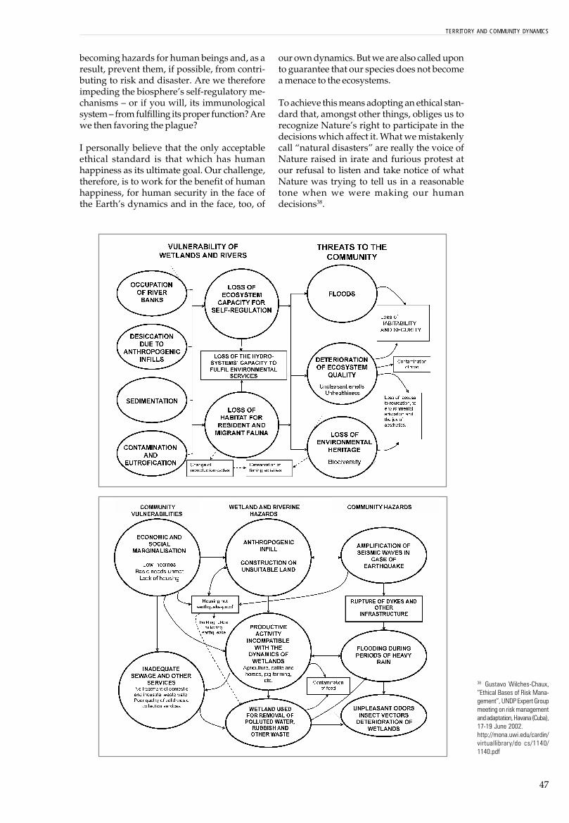
47
becoming hazards for human beings and, as aresult, prevent them, if possible, from contri-buting to risk and disaster. Are we thereforeimpeding the biosphere�s self-regulatory me-chanisms � or if you will, its immunologicalsystem � from fulfilling its proper function? Arewe then favoring the plague?
I personally believe that the only acceptableethical standard is that which has humanhappiness as its ultimate goal. Our challenge,therefore, is to work for the benefit of humanhappiness, for human security in the face ofthe Earth�s dynamics and in the face, too, of
our own dynamics. But we are also called uponto guarantee that our species does not becomea menace to the ecosystems.
To achieve this means adopting an ethical stan-dard that, amongst other things, obliges us torecognize Nature�s right to participate in thedecisions which affect it. What we mistakenlycall �natural disasters� are really the voice ofNature raised in irate and furious protest atour refusal to listen and take notice of whatNature was trying to tell us in a reasonabletone when we were making our humandecisions38.
38 Gustavo Wilches-Chaux,�Ethical Bases of Risk Mana-gement�, UNDP Expert Groupmeeting on risk managementand adaptation, Havana (Cuba),17-19 June 2002.http://mona.uwi.edu/cardin/virtuallibrary/do cs/1140/1140.pdf
TERRITORY AND COMMUNITY DYNAMICS

48
arlier we spoke of the resistance of aspider�s web as it withstands variedinternal and external forces, and wecompared this to a given territory�s
tors or external (and sometimes remote) pro-cesses whose effects materialize or are ex-pressed and experienced locally, and there-fore also affect us.
Can we validly assert that the spider web is thespider�s territory?
Maybe it is not all of its territory, since the spi-der moves in a wider world than its web. But, itis the way in which this little animal claimsthe territory as his own, both materially andsymbolically. That territory is also made up ofbranches and walls, places where he weavesthe threads of his web. And, there are climaticfactors such as wind and rain, as well as thesun�s rays which render his net visible, andthe heat that dries his web after the rain hasceased to fall. There are the animals and peoplewho happen to go by and maybe even walkinto the web, not to mention the insects that aretrapped there, or the spider�s predators, and soforth. The spider web marks off the area inwhich (and from which) the spider exerts itsinfluence over, or is affected by other things.
Nor is the spider web completely different fromthe spider who has woven it. Rather, it is a se-cretion of that very spider. Spider and spiderweb constitute one indissoluble unity, evenwhen the web has not yet been spun, or whenfor some reason it has been destroyed. In thiscase, that unity is composed of different parts:namely, the spider and all its potential webs,
Spider webs and territories
Eability to withstand a threat or hazard. We alsospoke of the spider�s resilience as he spins hisweb again after it has been destroyed, compar-ing this to a territory�s capacity to recover fromthe effects of a disaster. But none of the above isconfined to the realm of mere literature. Whatwe are talking about is a truly functional meta-phor, a tool that we can actually use.
The author of these notes has used the exampleof the spider web for years in order to illustratehow different factors that determine the vul-nerability (or sustainability) of a system areinter-connected (or on the contrary, isolatedfrom one another). Similarly, different agentsand institutional and social sectors convergein a given territory.
Some time ago, in a talk where I employed thisexample, a member of the audience drew myattention to the fact that even when thespider�s web is destroyed, as long as the spi-der survives the possibility that he will rebuildhis web exists.
This sparked off a series of reflections thatcontributed notably to our understanding ofthe relationships that exist between us, as li-ving beings, and our territories, and also be-tween those territories and the multiple fac-

49
the latent ones, all those that the spider is ca-pable of producing � in a word, all the spiderwebs that the spider could manage to spin inhis lifetime.
Likewise a territory can be understood as a �se-cretion� (in quotes this time), either real orpotential, material or symbolic, of the humanbeings who form part of it and live in it. This iswhy we said that territory is much more than amere physical space or a geographical point ofreference.
A territory involves an indissoluble unity withthe communities� dynamics and the ecosys-tems which make it up. The territory withoutthese communities would be a different terri-tory altogether. Taken apart from their territory,these communities also become something else.This represents the drama of displaced peoples:they lose their territorial security, their sense ofidentity, of belonging. They become anony-mous.
The fibers and the fabric of a spider web maybe very strong, but if the tree it hangs from isweak, or if the soil where the tree is planted issoggy and liable to erode, then vulnerabilitiesexist which threaten the spider and its web. Insuch a case, the spider has certainly not beenthe cause of the soil�s vulnerability, neither thatof the trees.
This is not true of the �matapalo� and other para-sitical plants39, which grow and derive theirstrength from sucking on the host tree, makingit vulnerable to insects, showers, wind, andsuchlike. When the parasite becomes strongat the expense of the tree it is unwittinglythreatening itself, as do those human commu-nities that embark on so-called �developmentprojects� that lead to the destruction of the eco-systems which those very same communitiesinhabit. Both of these � parasites and commu-nities � are undermining the ability of their res-pective territories to offer the territorial secu-rity they require.
39 One should not confuse thesespecies of the lorantáceasfamily (commonly knownas �golondrinas�, �guatepa-jaritos�, �matapalos�, etc. thatare truly parasites on theirhost plant) with orchids andbromelias, misnamed �para-sites�. The latter are epífitas(from epi meaning over, andfitos, plant) which do in fact liveon a tree, but do not have aparasitical relationship withthe tree.
TERRITORY AND COMMUNITY DYNAMICS

50
e have spoken earlier about ter-ritorial security. We said thatsuch security is the result of theinteraction between a series of
Let�s look at what each one of these �securi-ties� refers to40.
Food securityFood securityFood securityFood securityFood security is a territory�s ability to guarantee itsinhabitants the basic foodstuffs they require in order toguarantee their right to live a quality and dignified life.Theoretically speaking, food security in a particular regiondepends on its being linked to the global economy, sothat at any moment the products necessary for the ade-quate nourishment of its population can be acquired fromelsewhere. Therefore, a region can guarantee its foodsecurity if it manages to generate the economic resourcesneeded to enable it to gain access to such markets. Insuch a case it would not matter if the region stoppedproducing food altogether in favor of urban industrial ac-tivity, or if it puts all its efforts into the production of asingle crop. From this point of view, it doesn�t mattereither if the region�s farmers stop producing food and turnto growing illegal crops, since the marketing of the latterwill provide them with sufficient resources to import foods-tuffs from other regions.
Our day-to-day experience demonstrates how, on thecontrary, genuine food security should not depend onfluctuations in the global market. We see, too, in coca orpoppy-growing areas for example, that money of itselfdoes not ensure that people will be properly fed. Food isonce again shown to be provided by essential and directrelationship between human communities and theirproductive environment (the land) rather than the resultof a relationship with abstract financial markets. This ex-plains the rise of urban agricultural schemes of variouskinds. In Cuba, for example, by the production of urban�organoponic� crops, people have overcome some of the
Territorial security: another spider web
Wfactors that enable a territory to offer stabilityto those who inhabit it, stability being unders-tood here as permanence in space and time ofthe conditions that make life possible.
Simplifying complex systems and processes,let�s say that the main factors � some of themnatural, others anthropogenic � affecting aterritory�s ability to offer stability and securityto its inhabitants are the following: alimentaryand sovereignty security, ecological security,social security, economic security and institu-tional-juridical security.
As we will see later, when we start to analyzevulnerability and sustainability as nets or spi-der webs, the most important elements are not�securities� seen independently or in isola-tion, but rather the fabric formed by the mul-tiple and dynamic interactions between them.This is shown in the following diagram, insimplified form. These �partial securities� areno more than indicators, hooks we can hangour hammocks on, so to speak. Real territorialsecurity is the spider web that these hammocksform when they are linked together. One ofthe hooks may be very strong � in fact theymay all be strong � but if the cords that holdthem together are weak, then the web it selfwill be weak.
40 Gustavo Wilches-Chaux.Cuy-dados Intensivos. Pub-lished by ENDA Latin America(Bogotá, 2004).

51
ill effects caused by the economic embargo the countryhas been submitted to for decades. It also overcomesCuba�s erstwhile economic dependence on a single agri-cultural product, namely sugar cane. In other Latin Ameri-can countries similar urban agricultural schemes are beingintroduced, although they are still relatively marginal.
Food security does not only refer to the amount of foodneedy persons can access, but also to its quality. It shouldnot depend on chemical products or transgenics which,instead of making us more autonomous, render us morevulnerable, as well as affecting our ecological security.That is why the concept of �food security� is broadenedto include �food sovereignty�. In practice this deals withthe right to consume culturally acceptable products, dishescooked in a way that is part of our identity. That is why �lacuisine� (or home cooking) is part of any nation�s culturalheritage. Food has to retain its cultural significance, apartfrom the calories or other nutrients it presumably suppliesus with. If we are what we eat, then we should not bemade to consume �things� which are foreign to us.
(This is very evident in a disaster situation when some ofthe so-called �humanitarian aid� which arrives consists offoodstuffs completely unfamiliar to the affected commu-nities. The supposition behind this is that those who aresuffering the effects of a disaster ought to be ready andwilling to consume whatever is offered them. Remember,too, that when you are a long way from home, amongstthe things you most miss is the food you are accustomedto, above all the special flavor of your mother�s cooking).
Ecological securityEcological securityEcological securityEcological securityEcological security consists of the possibility thatNature�s dynamics avoid generating hazards for commu-nities, and that community dynamics do not threaten
ecosystems. It also refers to Nature�s ability to sustainablyoffer the community those environmental goods and ser-vices required to live with quality and dignity. One of theseservices is the capacity to absorb, without trauma � or tocushion the effects of � extreme environmental changesresulting from global, regional or local processes. By thismeans, these changes do not exceed our capacity foradaptation. A concrete example of this is where the en-vironmental services a territory offers allow the potentiallydestructive impacts of ENSO to be ameliorated orcushioned.
By social security social security social security social security social security we mean a territory�s ability to offerits inhabitants opportunities for decent employment anddignified labor, the resources necessary to guarantee quali-ty and dignity of life. The term also refers to the existenceof those conditions necessary for a healthy existence, inaccord with Antonio Gramsci�s integral conception of this(cited previously). That is to say, the possibility of enjoyinga balanced relationship with ourselves (both with ourbodies and our minds), as well as with our environmentand community. Social security embraces matters suchas employment and access to institutionalized curativeand preventive medical attention. But it goes much fur-ther than that. Within the notion of territorial social se-curity we also include relations between the differentmembers of a community. And that means solidarity, reci-procity, a sense of belonging and of identity.
By cultural security cultural security cultural security cultural security cultural security (which, acknowledging the rela-tions between all the dimensions of security, could alsobe seen as a component of social security, in the sameway as energy security41 can be seen to be part of eco-logical security) we refer to the ability of a territory�s inhabi-tants to appropriate territory by means of symbols. This
41 Energy security is aterritory�s ability to offer itsinhabitants -and their ability tomake good use of- whateverconditions are necessary inorder to obtain the energyrequired to ensure that societyactually functions.
TERRITORY AND COMMUNITY DYNAMICS
FOODSECURITY
SOVEREIGNTY
ECOLOGICALSECURITY
LEGAL ANDINSTITUTIONAL
SECURITYTERRITORIAL
SECURITY
ECONOMICALSECURITY
SOCIALSECURITY

52
then allows them to discover the meaning of their exis-tence in relationship to that territory ( including aspectssuch as belonging, purpose and identity) and to live in,and enjoy it without having to renounce anything essen-tial, least of all one�s capacity to create-that is to say,one�s cultural identity. When unfamiliar phenomena ap-pear, or when those we are familiar with acquire incom-patible dimensions and characteristics, our hitherto well-known territory becomes foreign to us, and may even, attimes, appear to be a terrible and aggressive force withwhich we can no longer identify at all. The loss of ecologi-cal security thus becomes cultural vulnerability.
By economic securityeconomic securityeconomic securityeconomic securityeconomic security we mean the ability of a terri-tory, State and society in general,42 to offer its inhabi-tants equitable access to production and wealth and toindispensable goods and services. This presupposes theexistence of different options for producing wealth andgenerating resources. It also implies the existence of al-ternatives, such as the exchange of goods and differentforms of economic solidarity in order to produce, offer andprovide access to such goods and services as the com-munity may require. Economic security also includes aregion�s productivity and competitiveness.
Vulnerability and poverty is not the same thing. They arenot synonymous, although in many cases it is easily shownthat poverty � one of inequality�s most tangible expre-ssions � is the cause of many kinds of vulnerability.Such vulnerability could be greatly reduced if all of thecommunity�s agents and sectors had greater access toopportunities and to the goods and services which areessential for genuine development to exist.
Let us not forget that poverty is not just a lack of sufficienteconomic income. More generally, it relates to the lack ofthose conditions that make it possible for people to exer-cise their right to a decent and dignified life. These condi-tions are, to some extent, the �synergical� result of theinteraction between the sum of the factors that form ourspider web. This is why we must be careful with pro-grams designed to �combat poverty�, especially whenthey are focused exclusively on the economic aspect, ongenerating income. They may be confronting communi-ties with false alternatives, such as obliging people tochoose between being employed and enjoying a cleanenvironment, or between conserving their culture or be-ttering their economic situation.
Juridical-institutional securityJuridical-institutional securityJuridical-institutional securityJuridical-institutional securityJuridical-institutional security refers to a territory�sability to offer its inhabitants a State that acts as a public
service and to which everyone has equal access. This isnot because we are all �equal� in real life, but becausethe State itself is charged with recognizing our differen-ces and catering for the special requirements of the diffe-rent sectors of society. The term also refers to the �rulesof the game�. These should be clear cut and not modifiedaccording to the whim of particular interests or circums-tances which favor the dominant sectors of society. Wecould also understand this dimension of security as refe-rring to an individual�s (or a particular human group�s)assurance that society does possess effective mecha-nisms which guarantee respect for human rights, startingwith the right to a decent and dignified life (includingeconomic, social and cultural rights). People also have aright to acquire skills in the management of risks, sincethese constitute a concrete tool for defending people�sright to life in the face of certain hazards, whether of ananthropogenic or natural kind.
Looking at the �spider web� from this particular angleenables us to deal with the subject of risk managementfrom a human rights perspective and to understand whyresearchers � such as the Peruvian, Pedro Ferradas �takevulnerability to be the expression of a given community�sfailure to exercise its rights.43
When faced with what kind of hazard shouldterritorial security be offered to the inhabitants?
The answer is: any kind of hazard, whether itis from phenomena associated with ENSO(which is what we are studying here) or fromthe impact of free trade agreements that affectlocal products. We should also include changesin land use and other measures taken with aview to reducing the impact of free trade, ortaking advantage of it.
When we analyze phenomena such as ENSOand how they affect different countries, wefind that there are territories that have beenweakened in their ability to resist due to thefact that land use has been modified in accor-dance with a given, inadequate, concept ofdevelopment, or with a view to satisfying thedemands of foreign markets. Such develop-ment projects often disregard the primary eco-logical vocation of the soil and are sometimescarried out without considering the way theland acts as part of an ecosystem�s self-regu-latory mechanism.
42 It is worth noting that theState and the Government isnot one and the same thing. TheState is the political expressionof an organized society, whileGovernment is (or should be)the temporary administrator ofthe State�s resources for thebenefit of the whole commu-nity. The State is like a residen-tial unit, with its inhabitants andits houses or apartments, itscommunal areas, its collectiveequipment � such as watertanks, electric cables, commu-nal meeting place, recreationalfacilities, and so forth � whileGovernment is equivalent tothe administrator of the hous-ing estate.43 Commenting on the draft ofthis document in a workshopwe carried out in Piura (Peru) inApril 2006, as guests of thenon-governmental organizationCEPRODA MINGA, Ferradaspresented data showing that in2001, 17 per cent of peasantfamilies in Peru (that is, one outof every six families) sufferedfrom �shock� as a result ofnatural disasters and this leftthem in conditions of extremepoverty, which they had beenunable to recover from at thetime the study was made.
THEORETICAL CONSIDERATIONS

53
early 20 years ago, in 1988, I wrotea text entitled �Global Vulnera-bility�44 in which I showed how aterritory�s ability to resist a haz-
weak or non-existent, then that society will beunable to resist the effects of a hazard when itmaterializes.
Once again, Katrina comprises a recent exam-ple we can learn a great deal from. In this casethere was insufficient communication betweenkey actors, like the scientists, who knew per-fectly well (and had predicted) what was likelyto happen if a hurricane of Katrina proportionswere to strike, and other powerful key actors(such as the police, State and local authorities).Nor were the authorities in general ready totransform scientific knowledge into decisionsthat could have reoriented development plans.One can detect a similar lack of communica-tion between other institutional and social ac-tors in the Gulf states (and between those statesand the nation as a whole), which meant thatthey were not only unable to prevent theKatrina catastrophe, but that they are also stillstruggling to solve enormous problems of re-covery months after the event. The above situa-tion, which is repeated over and over again inmany disaster contexts, allows us to see disas-ters as communication failure between humanactors, and between ecosystems and commu-nities.
Vulnerability / Sustainability:new spider webs...or the same ones viewed througha magnifying glass
44 This was first published inthe book Herramientas para laCrisis: Desastres, Ecologismoy Formación Profesional,SENA, Colombia (1988)
Nard does not depend only on the greater orlesser strength of physical structures or on theirlocation near (or far removed) from the placewhere the hazard occurs. Weakness or strengthdepends also on a series of factors which maybe of an economic, social (organizational),political, educational, ecological, ideological,cultural or institutional nature. At the time Ibelieved that what determines or reduces acommunity�s vulnerability when faced with ahazard was the greater or lesser strength of eachof these factors.
Today we have a clearer idea of things. Wenow know that when we speak of territorialsecurity, there is one factor which is as im-portant, if not more important than thosepreviously mentioned- the strength of the netas such and the fabric that forms the links orhammocks between its different parts. Thisalso turns out to be valid when the mesh re-fers not to key factors, but to key actors. A so-ciety may have very strong social actors, but ifthe lines of communication between them are

54
THE �SPIDERWEBTHE �SPIDERWEBTHE �SPIDERWEBTHE �SPIDERWEBTHE �SPIDERWEB� OF VULNERABILITY / SUST� OF VULNERABILITY / SUST� OF VULNERABILITY / SUST� OF VULNERABILITY / SUST� OF VULNERABILITY / SUSTAINABILITY FAINABILITY FAINABILITY FAINABILITY FAINABILITY FACTACTACTACTACTORSORSORSORSORS
The complexity of a system�s social fabric is not limited to the community�s organizational aspects but also embracesthe whole network of relationships and interaction between the different factors on which the system�s vulnerability orsustainability depends. Sustainability depends on the resistance or resilience of the �spider web�, that is to say, on itsability to withstand the effects of, or recover from an external impact. The impact could be an earthquake, anexceptionally heavy winter season, a generalized economic crisis or an armed conflict. More important than theindividual characteristics of each of these factors are the relationships between them. The factors themselves are likenails hammered into the wall. The relationships are the hammocks or cords which we hang between those nails.
From Wilches-Chaux, Gustavo,�Un viaje por los caminos de la comunicación social y la gestión participativa del riesgo�.
CISP / DIPECHO (Manabí � Los Ríos, Ecuador; Bogotá, Colombia, 2005)
THEORETICAL CONSIDERATIONS
PHYSICALVULNERABILITY
OR SUSTAINABILITY –LOCALIZATION
STRUCTURALVULNERABILITY OR
SUSTAINABILITY
ECONOMICALVULNERABILITY OR
SUSTAINABILITY
ORGANIZATIONALVULNERABILITY OR
SUSTAINABILITY
POLITICALVULNERABILITY OR
SUSTAINABILITY
EDUCATIONALVULNERABILITY OR
SUSTAINABILITY
CULTURALVULNERABILITY OR
SUSTAINABILITY
ECOLOGICALVULNERABILITY OR
SUSTAINABILITY
INSTITUTIONALVULNERABILITY OR
SUSTAINABILITY

55
The choice of these vulnerability-sustainability factors is in fact arbitrary. We could have grouped themtogether in just six factors, or on the contrary, we might have itemized them in even more detail. The mainthing is to have a clear idea of the complexity of both concepts and of the fact that both have their originin a series of interactive and constantly changing dynamics.
When faced with a complex system like this, seen both theoretically and in the context of taking decisionswhich will in some way affect the community�s life (sometimes for generations to come � as in the case ofdeciding whether or not such-and-such a relocation should be recommended ), we are faced with twopossibilities.
First, to do nothing. The situation�s complexity scares us and renders us incapable of taking the requireddecision. We believe that there are too many variables to be taken into consideration, and we find itimpossible to take responsibility for the enormous number of possible effects such a decision might have.
On the other hand, the situation empowers us. The �spider�s web� shows us that it doesn�t matter whatour position is in the system nor from which �nails� (or �hooks�) we may be hanging, any decision willpossibly influence the whole web and all the hooks as well. If we are teachers and are hanging on aneducational nail, we may be able to conceive some way of shaking the spider�s web. The same applies ifwe are members of a municipal council, or if we are entrepreneurs, or researchers, or members of acommunity organization or an environmental NGO. The main thing is to be aware of the system�s complexityand integrity and of its capacity for action when seen from our local position.
We must also be clear that, as with the Rubik Cube, progress with one of the factors does not necessarilymean progress with the whole scheme. On the contrary, progress with one of the cube�s faces could meanthat the other sides of the same cube are in disarray, even when we thought we had them well ordered.Thus, for example, to take a case from real life, promoting the use of gas stoves in an indigenous communitymay signify progress as far as the cube�s ecological side is concerned, since it reduces the use of firewoodand therefore eases pressure on local forests. But, it can also mean a step backwards as far as the cultureis concerned, since culture is transmitted from one generation to another and this is done orally, in familyreunions held around an open fire, and not around a gas oven. To promote a single crop in a community,taking advantage of high prices in the national or international markets, could mean economic progress, butsignify a backward step in ecological, and eventually in cultural matters too, in so far as both depend on theconservation of bio-diversity.
From WILCHES-CHAUX, GUSTAVO,�Un viaje por los caminos de la comunicación social y la gestión participativa del riesgo�.
CISP / DIPECHO (Manabí � Los Ríos, Ecuador; Bogotá, Colombia, 2005)
TERRITORY AND COMMUNITY DYNAMICS
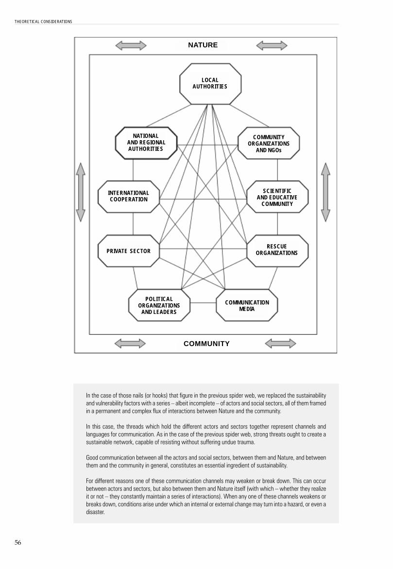
56
In the case of those nails (or hooks) that figure in the previous spider web, we replaced the sustainabilityand vulnerability factors with a series � albeit incomplete � of actors and social sectors, all of them framedin a permanent and complex flux of interactions between Nature and the community.
In this case, the threads which hold the different actors and sectors together represent channels andlanguages for communication. As in the case of the previous spider web, strong threats ought to create asustainable network, capable of resisting without suffering undue trauma.
Good communication between all the actors and social sectors, between them and Nature, and betweenthem and the community in general, constitutes an essential ingredient of sustainability.
For different reasons one of these communication channels may weaken or break down. This can occurbetween actors and sectors, but also between them and Nature itself (with which � whether they realizeit or not � they constantly maintain a series of interactions). When any one of these channels weakens orbreaks down, conditions arise under which an internal or external change may turn into a hazard, or even adisaster.
THEORETICAL CONSIDERATIONS
NATURE
COMMUNITY
LOCALAUTHORITIES
NATIONAL AND REGIONALAUTHORITIES
INTERNATIONALCOOPERATION
PRIVATE SECTOR
POLITICALORGANIZATIONS
AND LEADERS
COMMUNICATIONMEDIA
RESCUEORGANIZATIONS
SCIENTIFICAND EDUCATIVE
COMMUNITY
COMMUNITYORGANIZATIONS
AND NGOs

57
These communication channels are not always of equal weight; the specific �weight� of each depends onthe experience of a community at a particular moment in time.
Let us take an example. The role played by the international community in our local communities may beinsignificant at certain times and definitive at others. This happens, for instance, when an external agentinvests heavily in a particular territory, or when, following a disaster, a massive amount of international aidflows into the territory.
In both cases � as we know from direct experience � our communications spider web often breaks down.Under what are known as �normal� conditions, investments from abroad are usually the result of agree-ments between governments and private companies, but these do not always take into account theinterests and concerns of other social actors. Even less are they concerned with ecosystems, which maywell be affected in diverse ways by such investments.
The communications spider web tends to fail even more so in post-disaster situations. Here it may beasserted that donations are sometimes more geared to the needs of the donor than those of the recipient.A large amount of money is often spent by national authorities or international cooperation bodies onrelocating communities affected by a flood, for example. But communities are sometimes moved to areasthat are prone to landslides. In such a case, what has really happened? There has been a huge communi-cations failure.
A second example: a region�s politicians and the private business sector may reach an agreement with thenational government or with the international banking system to build a given item of infrastructure � areservoir, for example � without sufficient regard for the impact such an enterprise may have on thecommunities it will displace or on the flora and fauna that will be drowned as a result. Sooner or later, societyas a whole will pay for this. Somebody will have to �foot the bill�, so to speak � in other words, face theconsequences of the serious ecological disruption, the ensuing social conflicts, or both. The saddest andmost unjust aspect of all this is that those who caused the damage in the first place are often not thosewho will suffer its consequences. Future generations will inherit the debts of their forbearers.
Those of us who work in the field of social communication ought to identify with those linemen who goabout in trucks with long ladders attached to them, armed with pliers and screw drivers and protectivegloves, and whose job it is to repair electric cables that have been damaged by high winds.
Or better still, we should see ourselves as linemen aware of our social responsibility when designing andinstalling new electric grids, or carrying out preventive maintenance without waiting til the storm hasalready occurred.
Communication is a complex, permanent, many-sided and reciprocal process involvingCommunication is a complex, permanent, many-sided and reciprocal process involvingCommunication is a complex, permanent, many-sided and reciprocal process involvingCommunication is a complex, permanent, many-sided and reciprocal process involvingCommunication is a complex, permanent, many-sided and reciprocal process involvingthe exchange of information between institutional and social actors (or sectors). Thisthe exchange of information between institutional and social actors (or sectors). Thisthe exchange of information between institutional and social actors (or sectors). Thisthe exchange of information between institutional and social actors (or sectors). Thisthe exchange of information between institutional and social actors (or sectors). Thisrequires mutual confidence, the identification of shared concerns and the building of arequires mutual confidence, the identification of shared concerns and the building of arequires mutual confidence, the identification of shared concerns and the building of arequires mutual confidence, the identification of shared concerns and the building of arequires mutual confidence, the identification of shared concerns and the building of acommon language. Only with this may we hope to awaken (and consolidate) people�scommon language. Only with this may we hope to awaken (and consolidate) people�scommon language. Only with this may we hope to awaken (and consolidate) people�scommon language. Only with this may we hope to awaken (and consolidate) people�scommon language. Only with this may we hope to awaken (and consolidate) people�sawareness of the communityawareness of the communityawareness of the communityawareness of the communityawareness of the community �s need to understand how to live in an harmonic and sus�s need to understand how to live in an harmonic and sus�s need to understand how to live in an harmonic and sus�s need to understand how to live in an harmonic and sus�s need to understand how to live in an harmonic and sus-----tainable manner with the dynamics of their territorytainable manner with the dynamics of their territorytainable manner with the dynamics of their territorytainable manner with the dynamics of their territorytainable manner with the dynamics of their territory.45
From Wilches-Chaux, Gustavo,�Un viaje por los caminos de la comunicación social y la gestión participativa del riesgo�.
CISP / DIPECHO (Manabí � Los Ríos, Ecuador; Bogotá, Colombia, 2005)
45 From �Estrategia deInformación y DivulgaciónPública para la Gestión deRiesgos�, consultancy com-missioned with LA RED (Redde Estudios Sociales en laPrevención de Desastres enAmérica Latina) and other spe-cialized firms, in the DominicanRepublic financed by IADB in2000 and 2001. The full re-sults of this consultancy can befound at: www.desenredando.org
TERRITORY AND COMMUNITY DYNAMICS


Chapter 3
The manifestations and impactof ENSO in the study
regions

60
61
n the first chapter of this book we took aclose look at the different ways in whichthe Earth�s layers are held together andinteract, and we spoke of the enormous
its territory, both materially and symbolically,through its web. We referred to the strengthsand weakness of their threads and the strengthand weakness of the branches from which theweb hangs, and we did so in order to introducesuch concepts as a territory�s sustainability andvulnerability, including the resistance and re-silience of the relations between ecosystems andcommunities. As long as the spiders live, wesaid, thousands of potential spider webs willcontinue to exist.
In the present chapter, we will examine howthe phenomenon ENSO has expressed itself inthe different regions studied during the IAI- LARED research project.46
In the light of what we have discussed in ear-lier chapters, we will endeavor to understandwhy (to continue the analogy) the �spider web�of certain territories proved unable to resistmanifestations of the ENSO phenomenonwithout trauma, and why, as a result, disas-ters occurred. In other words, we ask why aterritory (and the ecosystems and communitieswhich make it up) has lost its ability to cohabitwith this particular expression of the Planet�slife-climate variability47. We also need to unders-tand why similar phenomena of lower inten-sity today cause disasters, whereas in the pastthey did not do so. Does this mean that the �spi-der web� has broken down or that the branchesfrom which it hangs have become too weak?
A summary of theargument so far
Inumber of factors which, in one way or ano-ther, intervene to determine climate andweather in any given region. We learned, too,that climatic variability is not only an �exter-nal influence�, but also an intrinsic charac-teristic of the biosphere. We said that ENSO,with its El Niño, La Niña and �neutral years�phases, is but one of many expressions of thisclimatic variability.
In the second chapter, we explored the dy-namic meaning of the word �territory�, whichis the result of a dynamic interaction betweenNature and culture, between ecosystems andcommunities. We understand that territory ismore than merely a simple physical space orgeographical reference point, because one ofthe dimensions through which human beingsrelate to one another is through affection,which has to do with what we call �symbolicappropriation�. This means that the territorywe inhabit constitutes our emotional map.Every detail bears the mark of our experienceswith that territory, either directly or via thepassed on and accumulated memory of ourancestors.
In the second chapter we also attempted tounderstand in what way a spider �dominates�
46 Interamerican Institute forGlobal Change Research andRed de Estudios Sociales sobreDesastres.47 In this field the gravity of thedisasters is measured in accor-dance with the Magnitude In-dex (MI) which reflects nega-tive effects on material goods,services and people and theduration of those effects. In thiscase magnitude refers to theeffects of the disaster, as dis-tinct from the seismologicalfield, in which the magnitude(measured in degrees on theRichter scale) denotes thequantity of energy unleashed bythe earthquake. See Herzer,Hilda et al., Regiones y ciudadesbajo el agua en Argentina. Unahistoria recurrente. (Researchdocument IAI/ENOS-LA RED(2005).
62
pattern is a group of elementswhich, when unfolded, manifestsa high degree of repetition andregularity. Patterns constitute the
system cannot be used to fully analyze risk pa-tterns, but rather patterns of risk associated withdisasters or occasion of loss and damage thathave actually occurred.
The temporal pattern refers to the regularity intime (daily, weekly, monthly, annually, everyfive years, once every second year, and so forth)with which the factor or factors under studyactually occur. This comprehends one or an-other of the following analytically significantconditions:
� The periods of occurrence of ENSO episodesclassified according to the phenomenon�sintensity.
� The temporality of the ENSO phenomenonwith reference to other manifestations of cli-matic variability.
� The temporality of various kinds of physi-cal hazard with relation to the different in-tensities of ENSO.
The term territorial pattern refers to the regu-larity in the spatial or geographical expressionsof the hazards, and to the variability and risksassociated with the ENSO phenomenon andwith climatic variability in general. That is tosay, it refers to the places where hazards aremanifested. In the IAI-LARED research project,territorial patterns constitute the basic patternor framework around which other considera-
Abasis for establishing relationships betweencausal factors and the forms adopted by thefactors and conditions we are analyzing.Changes in patterns (whether normal or regu-lar) and the appearance of anomalies withinthat regularity, indicate changes in the struc-ture and operation of the causal factors, whichare therefore the object of interpretation andanalysis (Lavell, 2007, under preparation)48.
The IAI-LA RED project established the exist-ence of three types of pattern as a basis for analy-sis: temporal, territorial and semantic patterns.
The analysis of these patterns is based on in-formation registered in the data base known asDESINVENTAR, developed by LA RED over thelast 10 years. This data base allows an ana-lysis of hazard incidence and their impactson different territories and social groups.DESININVENTAR embraces both large andsmall disasters (that is to say, events associ-ated with different levels of loss), and enablesus to gauge the regularity and recurrence of thephysical threats which spark off these disas-ters. However, given that DESINVENTAR doesnot record all the physical events that occur� since many are not associated with damageand loss or these have simply not been recordedby any source of accessible information � the
49 Allan Lavell in �ENOS,Patrones de riesgo de desastrey su gestión: elementosconceptuales y bases de lainvestigación comparativa�, enAllan Lavell, �Riesgo y Clima:Proceso, patrones y gestión enAmérica� (IAI - La Red - Oxfam,2007)
The temporal,spatial and semantic patterns of risk

63
tions are introduced, such as the semantic andtemporal patterns of hazards and conside-rations with regard to vulnerability.
And finally there are semantic patterns. Thisterm refers to the permanence or repetition ofthe same kind of hazard (or group of hazards)during and between different phases of theENSO phenomenon (floods, gales, landslides,droughts, storms, hurricanes, and so forth).This regularity can only be identified with re-ference to different territorial expressions ofthe variables, such as the relationship to cer-tain cities, productive areas and specific socialgroups located in the territory. This may be donewith reference to ENSO periods in general orwhere these have been classified according totheir intensity.
With regard to the relations between ENSO anddifferent hazard events and patterns analysisand decision making is complicated becausein some countries and regions, hazards asso-ciated with ENSO are the same as those thatform part of climatic variability in non ENSOyears- droughts, floods, landslides, plaguesor storm surges, for example. In other words,such things can happen whether there is anENSO or not. This is the case with parts ofCentral America, Argentina and Mexico forexample
On the other hand, in other regions ENSO mayusher in hazards which only occur (or occuronly in such a predominant fashion) when theyare linked to certain phases of this pheno-menon. This is the case for instance with heavyand extensive rainfalls in the arid areas of Peru,like Piura, or snowfall in low-lying terrain inthat same country. These are exceptional cases,since they do not coincide with the better-known and normal expressions of climaticregularity in the areas affected.
In other areas or regions, such as Brazil�s nor-theast, ENSO related hazards may be a moreextreme version or expression of normalclimatic phenomena, like drought and aridity.
These different contexts and relationshipscause different problems and present specialchallenges.
When a phenomenon is repeated with similarexpressions and intensity, and with periodi-cal regularity, it is obvious that one must adapt.This is the case with communities that live inlatitudes where heavy snowfall is part of eve-ryday life during a certain period of each year,or of communities in the Amazon basin whonot only live with flooding, but depend on thebenefits that flooding brings with it.
Problems arise, however, when the intensityof the phenomena goes far beyond thecommunity�s capacity for adaptation, as hasbeen happening recently with hurricanes in theCaribbean, or is happens with unusually longdroughts or torrential rains, or when these oc-cur outside the normal season for such phe-nomena.
And things become even more serious, ofcourse, when these phenomena occur regularly,but with a recurrence that goes beyond acommunity�s living memory and therefore, forall practical purposes, turn out to be excep-tional. Or when they are definitely unheard-ofphenomena, as was the case with the Catarinahurricane that struck Brazil�s South Atlanticcoastline in March 2004, where no hurricanehad ever been recorded, or not at least since thenineteen sixties when the first artificial sate-llites were launched into orbit.
All of the above mentioned situations have con-crete and practical effects and although it istrue, on the one hand, that we now enjoy agreater capacity for predicting and monitoringthe ENSO phenomenon at a global level, ourability to anticipate its potential expressions atthe local level is still very precarious-it is atthis level however that decisions have to bemade by the majority of people.
In Chapter 1, we analyzed the enormous num-ber of factors that determine the climate andthe weather in any particular place. Thismeans that a phenomenon which may be glo-bal, regional or (if you like) �national�, maymake itself felt in a differentiated manner at themunicipal level.
As we are unable to anticipate what kind ofdamage threatening events are really likely tocause, it is hard for us to create local risk sce-narios. In other words, envisage with foresight,what might occur in future phases of ENSO.
Added to this is the fact that a given territory�sability to resist or to exhibit resilience (ecosys-tems plus communities) is also ever-changing.That is to say, the �spider web� may have be-come stronger, but more probably it will havebecome weaker, more vulnerable,, and as a re-sult of this a phenomenon which was fairlyinnocuous, may in the future turn out to be ex-tremely damaging.
Let�s see what Lavell has to say on this subject:
�Neither society nor the environment are static. Conse-quently, the degree of risk also varies. For example: be-tween 1983 and 1997, the two most intense ENSO yearsin the 20th century, the environment in affected areas,
THE MANIFESTATIONS AND IMPACT OF ENSO IN THE STUDY REGIONS

64
regions or countries underwent important changes. De-forestation, soil erosion, the destruction of mangroveswamps, changes in land use, the conversion of formeragricultural and rural areas into urban settlements, andso forth, gave rise to enormous transformations, processesof environmental degradation and a general weakeningof the ecosystems and their capacity for resistance andresilience. In both of these ENSO periods, the heavy rain-fall or prolonged droughts associated with them weresimilar and unleashed almost equal amounts of energy.However, due to the above-mentioned transformations,the second phenomenon, which occurred in 1997, fifteenyears after the first, caused greater accumulated destruc-tion and damage. If we examine these events merelyfrom the viewpoint of the physical hazard (that is, exclu-ding the risk perspective as such, which requires that wetake into account the levels and kinds of exposure andvulnerability that exist in the affected areas), we maypostulate that a good part of this difference was due tothe impact of prolonged processes of degradation which,in the end, led to the appearance of new socio naturalhazards, such as landslides, flooding, soil erosion,droughts, and so forth. Because of this, the hazards asso-ciated with ENSO not only caused greater harm to areaswhich had already been �touched�, but also to areaswhich had not been affected by earlier events of thisnature...
Time is a continuum and the present is constructed onand is a continuation of the past. A threat directly linkedto an ENSO period (flooding, drought or landslides) or toclimatic variability in non-ENSO years, has its own pastand future. That is to say, it does not exist independentlyof its environmental and social context. The environmen-tal context includes the potential for humans to trans-form natural physical events into hazards and finally intodamage and loss. The social context refers to aspectsand characteristics that facilitate human vulnerability and,consequently, an increase in the risk associated with phy-sical natural or socio-natural events. Both of these con-texts are dynamic, continuous and often linked.
Risks and hazards associated with ENSO are not an iso-lated function nor are they static. Two ENSO occurrencesmay generate physical magnitudes or intensities whichare of an almost equal magnitude, and yet their impact ineach case may be quite different. This difference can onlybe understood if we take into account the economic,social, historical, environmental and political context ofthe zones and inhabitants affected.
The task of analyzing risk patterns associated with ENSOoffers a serious challenge. Here, we will take examplesfrom a particular risk and disaster scenario to illustrate ourarguments.
In 1998, in Central America, the impact of rainfall asso-ciated with Hurricane Mitch was more severe in terms oferosion, landslides and flooding than would have beenthe case if droughts and forest fires had not occurredpreviously, between 1997 and 1998. Both of these typesof event were also associated with El Niño, a factor whichhad generated vulnerabilities that then became hazards.
A second factor that contributed to an increase in thehazard level was the fact that Mitch occurred towardsthe end of a normal rainy season, when the soil wasalready heavily saturated. In the case of El Salvador, manyzones affected by Mitch were later affected by the im-pact of earthquakes in January and February 2001 andlater an intense drought between 2001 and 2002, whichalso affected other countries in the region. Finally, severalareas affected by these successive events were also se-verely shaken by a fall in coffee prices at the start of thepresent century. Clearly the risk occasioned by (or associa-ted with) these events one by one cannot be understoodwithout taking into account the impact of the others onsubsistence levels and on the vulnerability and fragility ofthe population in the affected areas.
To sum up, the risk associated with a particular ENSOoccurrence should not be examined on its own, that is,without taking into account the context of societies andenvironments in a constant state of evolution and trans-formation.
This supports one of the arguments adduced during theIAI-LA RED project, namely that ENSO cannot be properlyanalyzed if divorced from the risk which it has helped toconstruct. We should look upon ENSO as a dimension ofclimatic variability, or global climate change, operating in acontext of social and economic transformations that affectthe levels of vulnerability or resilience of a society, andtherefore also affect the degree of risk.
With the advent of neo-liberal globalization � which is themost recent phase of a capitalism characterized by ex-treme social exclusion � these ideas will be of even greaterimportance in the future, since they refer to changes inrisk patterns, and to the vulnerability and risks associatedwith ENSO, and also to climatic variability and change�.
THEORETICAL CONSIDERATIONS

65
Chapter 4
Risk managementand territorial sustainability

66

67
everal pages back we were talkingabout the ingredients that make up aterritory, and we said that a territory isthe result of an indissoluble marriage
From this viewpoint, vulnerability is theopposite of resistance and resilience and ofsustainability too. A community or ecosystembecomes vulnerable when its resistance andresilience is lost or weakened in the face of givenhazards.
When nature�s dynamics (or some of nature�smanifestations) become a threat for the com-munity, and when the dynamics of the com-munity threatens the ecosystems, the relation-ship between them becomes unsustainable.This lack of sustainability is manifest in theexistence of multiple hazards and vulnerabili-ties, and consequently in the appearance ofrisks that may easily turn into disasters.
When two people find that their relationshipis no longer sustainable, their marriage nor-mally breaks up. But in the case of ecosystemsand communities, the �marriage� betweenthem is almost always indissoluble. That is,both form part of a partnership called �the te-rritory�, and in practice separation is impo-ssible, except in certain very unusual caseswhen the community is relocated or completelyabandons its original territory. In such cases anew marriage is contracted which may esta-blish a new unsustainable relationship.
Sometimes one of the parties is convinced thatmarriage means staying together �until deathdo us part�. He or she therefore attempts to deny
Territory and risk:two offspring from the same marriage
Sbetween the dynamics of ecosystems and thedynamics of human communities. In otherwords, between nature and culture.
This same marriage gives birth to risk, whichis the product of the convergence of certainhazards with factors that cause the commu-nities � and at times the ecosystems � to be vul-nerable.
In other words, the concepts of hazard andterritory, although far from being synony-mous, do constitute human, socially cons-tructed concepts.
When we talk of a hazard we mean that such-and-such a phenomenon is likely to occur. Andwe are referring to a phenomenon which is ei-ther natural, socio-natural or anthropogenic inorigin49 and which represents a danger to thecommunity or to the ecosystems exposed to itseffects. If such a phenomenon or event repre-sents a danger it is because the communitiesand ecosystems are vulnerable to its impact.That is to say, the �spider web� is unable towithstand the impact of the football or of re-covering its former shape after the goal hasbeen scored (here we must apologize for mi-xing our metaphors!)
49 Natural hazards Natural hazards Natural hazards Natural hazards Natural hazards arethose that arise out of Nature�sown dynamics, such as theeruption of a volcano, an earth-quake or a tsunami. Or, El Niñoand La Niña, when they occurin �normal� conditions. Socio-. Socio-. Socio-. Socio-. Socio-natural hazardsnatural hazardsnatural hazardsnatural hazardsnatural hazards are thosethat occur because of humanintervention in the natural en-vironment. Many of these aresimilar to events occurring innature. For example, landslidesor sinking ground levels aresocio-natural when they are theresult of inadequate manage-ment of river basins and hill-sides. Hurricanes and otherphenomena associated withENSO become socio-naturalin so far as Global Warming(which is also partially influ-enced by human factors) altersits characteristics. And an-an-an-an-an-thropogenic hazardsthropogenic hazardsthropogenic hazardsthropogenic hazardsthropogenic hazards arethose caused totally by humanactivity, such as contaminationor industrial accidents (seeLavell, 1996 (�DegradaciónAmbiental, Riesgo y Desastre�en Fernandez, M.A. Ciudades enRiesgo. LA RED-OFDA-AID,Quito) for a first discussion ofthese different types of hazardand their significance for riskmanagement).

68
or eliminate the other, and even give the otherparty a Christian burial. However the relation-ship is likely to continue-with the dead party�sghost!!
As we commented earlier, Bogotá is a city ofalmost eight million inhabitants built mainlyon flat ground which formerly consisted ofwetlands, most of which have now been buriedunder tons of bricks and cement. However, thewetlands have not disappeared and their pre-sence can be seen in the way some buildings,constructed on what was once a lake, now tendto sink. The effect of the wetlands can be seen,too, in the way water behaves when there is aheavy downpour or in the reaction of the soilin the event of earthquakes.
Through (or beneath) the city of La Paz, in Bo-livia, almost 220 rivers and streams run, se-venty per cent of which have been �impri-soned� in tubes, channels or �vaults�. Manyof the city�s inhabitants are quite unaware thatthese rivers exist, just as most people in Bogotáare unconscious of the wetlands and rivers thathave been buried beneath them. From time totime, when the soil water levels become unu-
sually high, the rivers and streams of La Pazrise to the surface to remind people that theyare still there, alive and kicking, as happeneddramatically in 2002.
For most of the 20th century, the inhabitants ofthe North American Gulf of Mexico states triedto divorce themselves from the wetlands andmangrove swamps that constituted essentialelements of that territory, now mostly coveredwith cities. In fact, what the people did was notso much divorce themselves from these factors,but rather they tried to eliminate them. Theydried them out, they destroyed the vegetation,displaced the natural elements of the land.Thus the territory lost its ability to live harmoni-ously with tropical storms and hurricanes,which are expressions of nature�s dynamics inthat part of the Earth. As a result, these phenom-ena became a hazard. During the 2005 hurricaneseason it became extremely evident that re-lations between communities and the coastalecosystems had broken down. They had becomeunsustainable, just as they were indissoluble.Even temporary separation � that is the emer-gency evacuation of the most vulnerable commu-nities � became almost impossible in most cases.
THEORETICAL CONSIDERATIONS

69
n accordance with the process dynamicsof hazards, we may classify them, as wehave seen previously, as being natural,socio-natural or anthropogenic. Or, de-
Other phenomena originate in certain regionsof the earth and their effects may be limited tothose same regions or, on the contrary, they mayaffect other parts of the planet. Such is the casewith ENSO and this is why a slight change ofthe average climate in the Pacific Ocean givesrise to various alterations in the planet�s cli-mate as a whole, some of which are experiencedas extreme hydro-meteorological phenomena.Therefore, the said alterations constitute localmanifestations of a regional phenomenon.
And a third group of phenomena, such as thosedirectly linked to deforestation and changes inland use in a given locality have local causesand produce local effects. The effects of a �nor-mal� winter season � or of a not-so-normalone � in a river basin which has been deprivedof its vegetation can be perceived immediately,and the relationship between cause and effectis completely lineal.
In fact, phenomena of global origin are closelyrelated to those of regional or local origin. Thus,for example, there is evidence to show that theplanet�s Global Warming is having an effect,amongst other things, on the characteristics oftwo phenomena of a regional kind; namely,hurricanes and El Niño.
There is evidence too, as we learned in Chapter3, that certain manifestations of global and re-gional phenomena depend on the particulartraits of the local economic, social and envi-
The scenario where risks materialize
Ipending on where they occur, we call them glo-bal, regional or local.
In the field of hydro-meteorological pheno-mena, the present over-heating of Planet Earthis a typical global phenomenon, the cause ofwhich can not be found in a single dynamic,but rather in the interaction between naturaland human processes. Nor does it originate injust one part of the Earth, although clearly, cer-tain regions contribute more than others to thiswarming process. Planet Earth is not heatingup as rapidly in one place as in another, nor inthe same way, nor are the effects of this processof change the same in all ecosystems and terri-tories.
Likewise, although the planet as a whole � orrather, the biosphere � tends to get warmer, thisdoes not mean to say that certain regions ceaseto experience intense winter spells, such as thatwhich caused the death of over three hundredpeople in Russia and Central Europe in 2006.NASA�s Goddard Institute for Space Studiesasserted that 2005 was the hottest year duringthe last hundred, according to existing regis-ters of information. Nevertheless, a few daysafter that year had come to an end the east coastof the United States suffered the heaviest snowstorms in all of its history.

70
ronmental scenarios where they materialize.That explains why a relatively �mild� El Niñomay cause greater damage than a �severe� oneif its impacts are felt in a territory where theprevailing ecosystem and society have beendegraded or deteriorated.
And, for example, an accumulation of localphenomena, such as the destruction of largeareas of tropical jungle, atmospheric contami-nation and the pollution of seawater, added tothe �worldwide urbanization process� and theconsequent multiplication of �urban heatislands�50, could lead to a �qualitative leap�or an emerging behavioral pattern like GlobalWarming, which is qualitatively more complexthan the sum of local processes.
An interesting example of how a local scenariocan produce planetary effects was the eruption
of the volcano Pinatubo, where sulfuric gasemissions traveled around the Earth for severalweeks, with measurable effects on global cli-mate. Another example, in a different field, wasthe 11 September attack on the World TradeCenter�s Twin Towers.
Whatever may be the causes and the geo-graphical origins of the processes that ge-nerate hazards, there is no doubt that suchhazards generally materialize or manifestthemselves at the local level. This helps usunderstand why risk management must bean essentially local affair. That does not ex-clude, of course, the possibility of efforts atthe regional or even world level in order forexample, to reduce emissions of �hothousegas� through mechanisms such as the KyotoProtocol, and thus eventually �freezing�Global Warming.
50 Urban Heat Islands (UHI) isa concept that refers to war-ming in large cities as a resultof changes in land use, the ac-cumulation of activities (and ofhuman beings) in relativelyconcentrated spaces, and phe-nomena derived from theseconditions, such as a territory�sgrowing inability to reflect so-lar energy. Scientists are di-vided about just how muchthese �urban heat islands� con-tribute to Global Warming. Amajority seem to agree thattheir contribution is �insignifi-cant�, and some even allegethat the evident heating up ofthe cities has been erroneouslyinterpreted as evidence of theplanet�s Global Warming.
THEORETICAL CONSIDERATIONS

71
ver since life first appeared on PlanetEarth about four thousand millionyears ago, all living beings � and wehumans (and human communities)
ssible the existence of certain species was des-troyed for ever. Others, however, survived tospin new �webs� for themselves.
When the first recognizable predecessors ofhuman beings appeared, some two or threemillion years ago, and before we began to es-tablish ourselves as the �dominant� species(around 100,000 years ago) and to invent Cul-ture, all living species had as main allies in theevolutionary process, both a great deal of timeand a wide range of genetic options for trialand error. Millions of years were at our dis-posal, time enough for whole species to disa-ppear and for others to adapt and evolve. Ho-wever, ever since we human beings began to beaware of ourselves, and to be conscious of theCosmos, we realized that we could not affordthe luxury of leaving our survival to merechance, neither as a species nor as individuals.That is when we began to discover and to in-vent a series of tools useful for creative adapta-tion; that is to say, for conscious evolution. Theoverall name for this phenomenon is Culture.
At many stages in human history, Culture hashelped us to adapt. At other times, it has im-peded our adaptation.
From this viewpoint, risk management can beunderstood as a cultural tool with which weconsciously respond to the challenge of evolu-tion � or better still, co-evolution � in order toremain on the face of the Earth.
GRR...Getting Radical with Risk
Ewere potentially included right from the start,albeit in an embryonic form as bacteria or proto-bacteria �have been co-evolving along with oursurroundings. In response to the need to sur-vive when faced with environmental change,human beings have transformed themselves,as have all other living creatures in like man-ner. As we change, we alter the environmentalso, and we do so in a two-way process whichis both complex and unremitting.
In the course of time, this process has led to theextinction of a great many beings. Millions ofspecies were forced out of the game when theyproved unable to adapt to environmentalchanges. As each one became extinct, the sur-viving species transmitted to their descendantscertain genetic traits and learning processeswhich enabled them to remain on Planet Earth,and to transform it.
Some species became extinct due to externalintervention, as when an asteroid struck theEarth�s surface some 65 million years ago.Others were eliminated by certain �disasters�caused by those very living beings which hadsurvived. Such was the case of gaseous oxy-gen, which appeared about 2000 to 2,700 mi-llion years ago. In this case, as in many others,the �spider web� of interactions that made po-
72
How do we do this? Through institutional andsocial intervention (both of which are culturalphenomena) exerted on factors that generatehazards and vulnerability, in order to reduce,as far as possible, the product of this vulnerabi-lity. In other words, to limit the risk factors andprevent a hazard from becoming a disaster. Wealso want to ensure that when, despite our bestpreventive measures, a disaster does occurr,we will be able to rebuild our �spider web�adequately and in the shortest possible time.
If we broaden our way of focusing on threatsand vulnerability that arise in a given territory,and if we make both concepts as dynamic aspossible, we can briefly state that the purposeof risk management is the following:
� to prevent human activities from threa-tening ecosystems, and to prevent the dy-namics of the ecosystems from threateningcommunities.
� to contribute to the ecosystem�s and thecommunity�s resistance and resilience, inother words, sustainability and territorialsecurity.
From this point of view, risk management canbe understood as synonymous with environ-mental management for sustainable develop-ment, which implicitly includes the need toengage in social, political, economic as well ascultural and institutional management, giventhat the concept �environment� goes beyondmerely ecological contexts and embraces allthose factors which interact in a given terri-tory. Furthermore, to the degree to which aninversely proportional co-relationship clearlyexists between a lack of environmental sus-tainability (that is, risk) and governability, riskmanagement will often mean developmentand the maximum application of the ability tohandle conflict situations.
The term �risk management� is usually accom-panied by a series of adjectives, such as inte-gral, local, participative or prospective. In thepresent text, if we have omitted these adjectives,it has not with the intention of excluding them.Rather we believe that genuine risk manage-ment ought to include all of them � and othersas well � just as humanity will one day unders-tand that all development must be integrally�sustainable� if it is to be truly regarded asdevelopment at all.
Perhaps one of the adjectives not explicitly re-ferred to should be the word �radical� � GET-TING RADICAL WITH RISKS � along with seve-ral of the uses of that much-feared term as de-fined in the dictionary:
� Of or pertaining to a root
� Fundamental, part of a root� In favor of extreme reforms, especially in a
democratic sense� Extreme, uncompromising, intransigent
Risk management is a continuous process em-bracing everything from the handling of risk-generating factors with a view to preventingdisasters, down to the reconstruction of com-munities and the recovery of ecosystemsaffected by disasters. The term also includespreparation for facing eventual emergenciesand the institutional and social responses re-quired to meet them when they occur.
Each and every one of these responsibilities cor-responds to different social actors. Depending onthe process�s characteristics and the moment atwhich it occurs, these actors ought to take on lea-dership roles in a kind of �roster�. Some will playa supporting or secondary role, but all of themwill be necessary and complementary. Only thuswill it be possible to have a decisive effect on theroots of the problem, on the real causes that haveled to the particular hazard. Otherwise, eventhough we may talk about �risk management�and use the term �disaster prevention�, all weare doing in fact is white-washing the situation.
For the past two decades, many institutionaland social actors have adopted risk-manage-ment language and refer to sustainable deve-lopment. For many, this is in accordance withtheir way of thinking and of acting, which inturn reflects a new understanding of whatcauses disasters and hazards. In general thismeans that a lot of people understand the bios-phere in a new way and also better perceive therole we humans play within this. For others,however, the use of such language is merely amatter of cosmetics. Such actors cannot see thewood for the trees, and worse still, they urinateat the foot of certain trees to mark �their terri-tory� and thus place an obstacle in the way ofother actors who may wish to get in on the act.
Another implicit adjective, therefore, when wetalk about risk management, is the word �demo-cratic�, not only in the formal meaning of theword, but also in its all-inclusive sense. For�democratic� means many things; it is hori-zontal, allied to life, committed to building au-tonomies, able to appreciate diversity, respect-ful of differences, open to dialogue betweenthose who know and those who don�t � dia-logue in which each group or actor is aware ofhis or her limitations and potentialities. Whenrisk management is genuine, there is no roomfor authoritarianism, no matter who exerts au-thority. On that point we can be intransigent,as we are, too, in making sure that the humanis-tic sense of words like �democracy�, �security�and �freedom� be fully restored.
THEORETICAL CONSIDERATIONS

73
n common usage, the word �prevention�means �stopping something from ha-ppening, making its occurrence impo-ssible�51. However, in the strict sense and
impossible to prevent them from occurring.There does not exist � not yet, at least � anyway of avoiding a volcanic eruptions, or earth-quakes and tsunamis. Certain procedures foraborting hurricanes while they are gestatingare not only of doubtful efficacy, but even, insome cases, due to the altering of the hydro-logical cycles in the hurricane�s area of influen-ce may lead to greater losses than those asso-ciated with the direct damage caused by thestorms themselves. To put it in a general way,we can assert that climate � fortunately � isstill beyond our control. Just imagine what itwould be like if we human beings could ma-nipulate climate and turn it into a weapon ofwar, or make it into something of great com-mercial value.
El Niño and, in general, those strictly naturalphenomena related to ENSO and to climate va-riability � which can, in turn, also be influencedby climate change � are unavoidable. We can�t�cool down� the Pacific Ocean in order to su-ppress El Niño, any more than we can cool theCaribbean to deprive it of the �fuel� it needs toproduce tropical storms. Nor can we warm thewaters of the Pacific in order to take some of thesting out of La Niña.
This does not of course mean that it is useless(or senseless) to take measures to reduce theemission of the gases that produce a green-house effect on the atmosphere. With regardsto this, even in the most optimistic scenario,several generations will have gone by before
Prevention:saying �no� to hazards
Iwithin the particular terminology of risk man-agement, prevention is often understood as ajointly employed series of measures taken (oractions carried out) to avoid a physical pheno-menon actually materializing as a hazard. Andas we have seen, a hazard refers to somethingthat is likely to occur and which represents athreat to those communities and ecosystems thatare exposed to its effects. In other words, pre-vention means saying �no� to a hazard52.
In the language of risk management (as op-posed to disaster management), however, theconcept must be broadened. Consequently, riskprevention is defined as a combination of �mea-sures and activities planned with anticipationto prevent new risks or to avoid their occu-rrence. This means working with reference toprobable hazards and vulnerabilities. Thusseen, risk prevention deals with ProspectiveRisk Management, whereas the mitigation orreduction of risks is a matter for CorrectiveManagement. Given that total prevention israrely possible, prevention has a semi-utopianconnotation and must be seen in the light ofconsiderations about what degree of risk isacceptable, a concept which will be socially de-termined at its different levels�53.
When hazards derive from phenomena thatform part of the planet�s natural dynamics, it is
51 Oxford Dictionary52 When one speaks, eitherpersonally or institutionally, ofdeveloping a �prevention cul-ture� � or more appropriately,of introducing the notion of pre-vention into a culture � one isreferring to the broad intentionof converting risk managementinto a �normal� mode of behav-ior, something that includes acommunity�s �way of being�.That includes the hope thatcommunities will becomeaware of the consequences thattheir actions have on their natu-ral and social surroundings.53 Allan Lavell, ENOS, Patro-nes de Riesgo de Desastrey su Gestión: Elementos Con-ceptuales y Bases de la In-vestigación Comparativa, inAllan Lavell, �Riesgo y clima:proceso, patrones y gestión enAmérica� (IAI - La Red - Oxfam,2007).

74
the effects of this reduction become apparent.And secondly, such a reduction will have itseffect precisely on the human component of cli-mate change, and not on the natural evolutiona-ry process of the planet.
The same is not true of socio-natural hazards,the result of inadequate use relations betweenhumans and their natural environment. Nor isit true of anthropogenic hazards, since theseare totally attributable to the activity of humanbeings. In both these cases one can act on thefactors which have generated hazards with aview to avoiding them, or at least of reducingtheir frequency or their destructive force.
In some cases, such as urban contamination orindustrial accidents, human �authorship� iseasy to discern.
The same cannot be said of hazards such asflooding, landslides or forest fires, which maybe natural or socio-natural. Each event has tobe analyzed separately in order to determineits true nature.
A landslide, for example, may be a totallynatural occurrence, as was the case with themajority of some three thousand landslidesrecorded in the Colombian region of Tierra-dentro following the 6th June, 1994 earthquake.This quake occurred right in the middle of anintense rainy season when the steep moun-tainsides were totally saturated and not eventhose covered with natural vegetation wereable to resist its effects. The ensuing landslidesblocked the area�s rivers and streams andcaused an avalanche of mud and debris whichin some places attained a height of seventymeters. In Pakistan, similar landslides weresparked off in an area affected by the October2005 earthquake.
Other landslides, like that which occurred inVillatina (a barrio in Medellín, Colombia) in1987, and that which affected Santa Tecla (inEl Salvador) after the earthquake on the 13th of
January 2001, must be catalogued as socio-natural phenomena. Although the latter wasunleashed by an earthquake, it was also due,in part, to an inadequate handling of water re-sources in the higher reaches of the hillsides,which collapsed. Such inadequate handling ofwater resources also helps explain the Villatinacase.
In other landslides, there is an even more di-rect cause-effect relationship between humanintervention and the phenomenon. Such is thecase, for example, when a landslide occurs dueto cuttings made in mountain slopes duringthe construction of roadways.
In all of the aforementioned cases it would havebeen possible to avoid the hazard, or at least tohave reduced the magnitude of its effect.
In the vast majority of he local impact casesstudied in the IAI-LA RED project it seems clearthat these are related to socio-natural as op-posed to natural hazards, despite the fact thatthey occur during the different phases of theENSO phenomenon, which is still predomi-nantly a natural event.
In conclusion, let us not forget that hazards arenot single, isolated events, but rather complexprocesses where a natural happening, such asa hurricane or an earthquake, normally un-leashes a series of chain reactions, which inturn may be natural (like the landslides inTierradentro, or a tsunami after an earthquakeor a tidal wave associated with a hurricane) orsocio-natural (as was the landslide at SantaTecla or the floods in New Orleans due to thecollapse of the dykes) or anthropogenic (likefires caused by gas leaks during a storm, or thesacking of shops and other such disturbancesin public order after a hazard has materialized).Although it is evidently impossible to avoid anearthquake or a hurricane or a tsunami, it ispossible to take measures ahead of time andthus prevent a disastrous chain reaction (re-duce exposure or vulnerability or both).
THEORETICAL CONSIDERATIONS

75
n accordance with the terminology wehave employed in this treatise,, mitiga-tion consists of strengthening the �spi-der web� that is created by the interac-
As we will see later, the results of the IAI-LARED project abound in examples of how �spi-der webs� have been strengthened, either byreinforcing the �nails� or �branches� whichserve as their support, or by strengthening the�hammocks� themselves, the interaction be-tween actors and factors.
The summary provided in the second part ofthis book of some of the major conclusions ofthe IAI-LA RED study intends to demonstratehow, in many cases, the spiders web has beenstrengthened, either by stengthening the nailsor branches or the hammocks or interactionbetween these.
Mitigation:strengthening the �spider web�in order to say �no� to vulnerability54
Ition between the various actors and factors thatconverge in a given territory, with a view toincreasing the territory�s ability to withstandthe effects of a hazard (resistance) and/or torecover from the effects of the hazard once thesehave materialized (resilience). Since many ofthese hazard factors are ecological, mitigationincludes the strengthening of ecological resis-tance and resilience, while recognizing thatnatural factors are inseparable from culturaland anthropological ones.
54 In the terminology of climatechange, the word �mitigation�has a slightly different mean-ing: one thing is to reduce theemission of gases that producea hothouse effect in the atmo-sphere and another is to reduceits sources. The concept of �ad-aptation� is nearer to that of�mitigation� as we understandit in these pages. It can be de-fined as: �A natural adjustmenteither by human systems inresponse to present or ex-pected climatic change or itseffects, which reduces thedamage or makes use of theoccasion for its own benefit.There are various kinds of ad-aptation: they can be eitheranticipated or reactive, privateor public, or either autonomousor planned.� (Glosario deTérminos en Cambio Climático� Cambio Climático enMéxico).


PART TWO
CASE STUDIESSummaries

78

79
ENSO manifestations in Argentina55
Among the more outstanding results obtained, one can underline the relationship that exists between, onthe one hand, the Argentina�s Northwest and the Paraná river basin and, on the other, ENSO occurrenceand the number of recorded disasters.
Some outstanding associated events are: the floods on the Paraná (linked to El Niño), droughts in thenortheast and the Pampa (linked to La Niña) and landslides in the northwest (linked to both phases).
Amongst the social-vulnerability factors that contribute to the increase of disasters in uban areas one canmention the following:
� Uncontrolled and unregulated urban expansion without control.� Lack of maintenance of urban infrastructure.� Increases in risk construction in the city.
Risk management itself faces various problems:
� Decisions are arbitrary, haphazard and disjointed, and influenced by politicking.� The local urban focus is not complemented by a river basin-oriented focus.� Response as opposed to prevention dominate the action scenario
Methodological commentaries:
� The local scale helps to clarify patterns.� ENSO is not a parameter to articulate overall risk management due to the influence of other existing
risk dynamics.
he database on disasters occurringin Argentina between January 1970and December 2001 contains 13,974registers or reports. The majority of
Among the disasters of hydro meteorologicalorigin, floods account for 53% of registers andmore than 60% of the sum of the �magnitudeindices�. Next,, are storms (14%), snowstorms(6%), drought (4%) and forest fires (3.9%). Eventhough there are fewer registers of droughtsthan of forest fires, the impact of the former wasgreater.
WHAT IS THE INCIDENCE OF ENSO EVENTS
ON DISASTER RISK IN ARGENTINA?
Multiple climatic factors act as triggers of di-sasters, among them the ENSO phenomenon -in its Niño or Niña phases.
The most probable effects of each phase, in ac-cordance with the historical evidence availablein the country, are the following.
For hot events - El Niño:
� Increase in river flows and levels in Meso-potamia58 (Northeast of Argentina �NEA)and excess of rain in an extensive strip ofthe north east of the country, towards theend of spring and summer.
� Rains, equal to (or greater than) the climaticmean in the Humid Pampa. Nevertheless,the region shows internal heterogeneity indrought and humidity, which vary territo-rially and temporally.
Tthese disasters were triggered by floods andstorms. Over 55% of reports refer to this type ofphenomena. They are the most recurrent andcause the greatest negative impact, in socialand economical terms.56 The Argentine disas-ter inventory shows that during those 32 years,floods and storms led to 1,7 million evacuees� 93% of the total number associated with alldisasters� and destroyed 28.000 homes � 60%of the total.
Next on the list are fires � some 1300 events,9.16% of the total. These were concentratedin urban areas, fundamentally in the city ofBuenos Aires and adjacent urban areas (77%). In fourth place was snowfall �with 710 re-ports, 5.1% of the total. These occurred mostlyin the Patagonian region (87%). With less than4% of total reports, but very relevant due totheir impact, were forest fires, droughts andgales.
77.5% of reports correspond to disasters ofhydro meteorological origin (10.797). Whencomparing the sum of the Magnitude Indexes(IM)57 of these, it becomes clear that those ofhydro-meteorological origin are not just pre-dominant in frequency but also in their im-pact on society, since they make up 82% ofthe sum of all IM�s.
55 Based on "Regions and Citiesunder water in Argentina: arecurrent story", by HildaHerzer, María Graciela Caputoand Alejandra Celis in Lavell, A,"Risk and Climate: Process,Patterns and Management inthe Americas (IAI-LA RED-OXFAM, 2007)56 SOCIAL EFFECTS: Deaths,wounded or ill, evacuees,affected population, destro-yed or affected dwellings,effects on education andhealth. ECONOMIC EFFECTS:transportation, public servi-ces (energy, communications,potable water, sewage),industry, agriculture andlivestock . (Classification byEconomic Commision for LatinAmerica-ECLA)57 The Magnitude Index-MI-measures the negative effectsof disasters on material goods,public services and people,as well as their duration. Itprovides a measure of theimpact of a disaster in compa-rative perspective.58 River flows are greaterthan average flows due toupper basin rainfall occuring inneighbouring countries.

80
� Temperatures superior to the mean values,in the Northwest of the country (NWA), fromMay to April.
� Excessive rain, in the center-west region ofthe country, from June to November andtemperatures superior to the average values,from May to April, in the same region.
� Droughts in the Northwest of the country(NWA), especially in the province of Salta.
For cold events- La Niña:
� Precipitation inferior to the habitual(droughts) and temperatures inferior to theaverage values in the provinces of La Pampa,(Buenos Aires, Santa Fe, Entre Ríos, LaPampa and Córdoba), particularly betweenOctober and December.
The phases of the ENSO cycle were taken fromthe NOAA chronology since it presents clearcriteria to establish the events59 and because itis the only chronology that shows indices forevery trimester for the 32 year period underconsideration60.
Analysis of Weather
The years with the greatest number of recordsof hydro-meteorological origin are, in descen-ding order: 1981, 1973, 1984, 2000, 1972, 1986,1998, 2001 and 1987. Thus, no correlation canbe established between a determined phaseof the ENSO cycle and a larger number of di-sasters of hydro-meteorological origin regis-tered on a national scale.
In order to analyze the levels of manifest riskassociated with ENSO in Argentina, the recordsof disasters were grouped together accordingto whether they occurred during a Niño, a Niñaor a neutral period. It is in this last period thatwe find the highest concentration of records,followed by the Niña phase, and finally by ElNiño. However, when comparing the numberof records with the total duration of the phases,the number of disasters caused by weather con-ditions was greater during the Niño phase thanother phases. That is, hydrometeorological di-sasters were of greater recurrence during theNiños, intermediate during the neutral periodsand lower during the Niñas.
Analyzing the eight climate and hydrologyrelated triggering events one by one the follo-wing results were obtained:
FloodsOf the total number of the disasters associatedwith floods in the country (5.529), the incidenceis similar for the neutral and Niño phases, andlower for the Niña. However, during the Niño
phases, the monthly average of floods was 30%higher than in the neutral phases and morethan twice that for the Niña events.
In other words, during Niño events, at a na-tional level, there is a greater probability offloods than during neutral and Niña phases.In the latter, the probability is the lowest of allphases. It is important to mention here that dueto the high recurrence of floods, the risk asso-ciated with them is considerable in all phases.
StormsStorms (2,199 recorded), defined here as heavyrainfall and, winds, follow a different patternto that of flooding. During the past 32 years,there are more records of storms correspondingto neutral periods than to El Niño or La Niña.However, the average number of storms permonth was approximately the same in allphases of the ENSO cycle. That is, no relation-ship was found between this cycle and thestorms.
Droughts and forest firesDroughts (435 records) and forest fires (509records) present a similar pattern between. Thisis partly explained by the environmental con-ditions which exist during droughts, whichobviously favor forest fires. Both events occurwith a noticeably greater frequency during Niñaperiods, to an intermediate degree in neutralones and to a lesser degree in Niño periods.Besides this, the average records per monthunderline this pattern, since the average fre-quency of drought was almost four timesgreater during the Niña phases than duringthe Niño ones, and almost three times greaterthan in neutral periods. In the case of forestfires, the frequency was, on average, 2.2 timesgreater during Niña phases than during Niñoones, and 1.7 times greater during the neutralperiods. In this case, during the Niña periodsthe risk of drought and forest fires clearly in-creased by comparison with other eras.
GalesIn the past 32 years, out of 431 cases of galesrecorded in the country the greater number oc-curred during the warm phases and coldphases as compared to neutral periods. If wetake into account the number of gales comparedto the duration of the ENSO phases, we can seethat the recurrence of these disasters wasgreater during the Niño times, intermediateduring the Niña periods and less during theneutral stages.
SnowstormsMost of the 710 snowstorms recorded on anational scale coincide with neutral periods(approximately twice that for warm or coldphases). However, if we divide the number of
59 The chronology of NOAA isbased on the ONI (Oceanic NiñoIndex) index. When this indexis equal or lower than 0.5 (orequal or less than �0.5) for atleast five consecutive months,it is considered that it is a hot(or cold) phase.60 Niño phases (month/year):1/70 - 5/72 to 3/73 (StrongNiño) - 9/76 to 2/77 - 9/77 to1/78 (mild) - 5/82 to 6/83(Extraordinary or Mega Niño) -8/86 to 2/88 (Strong Niño) -5/91 to 6/92 (Strong Niño) -3/93 to 7/93 - 4/94 A 3/95 -5/97 to 4/98 (Extraordinary orMega Niño) - 5/2002 to 3/2003 � Niña Phases: 7/70 al1/72 (Strong) - 5/73 to 5/76(Very strong Niña) - 9/83 to 1/84 - 10/84 to 6/85 - 5/88 to5/89 (Very strong Niña) - 9/95 to 3/96 - 7/98 to 6/00 -10/00 to 2/01 � NeutralPhases: 2/70 to 6/70 - 2/72to 4 /72- 4/73 - 6/76 to 8 /76- 3/77 to 8/77 - 2/78 to 4/82- 7/83 to 8/83 - 2/84 to 9 /84- 7/85 to 7/86 - 3/88 to 4/88- 6/89 to 12/90 - 7/92 to 2/93 - 8/93 to 3/94 - 4/95 to 8/95 - 4/96 to 4/97 - 5/98 to 6/98 - 3/2001 to 4/2002.
CASE STUDIES-SUMMARIES

81
snowstorms recorded by the number of monthseach period lasted, this pattern becomes lessobvious. That is to say, during neutral periodsthe number of snowstorms per month wasapproximately only 20%61 greater than duringthe Niño and Niña periods. As a result, thispattern shows no clear relationship betweensnowstorms and the ENSO cycle.
LandslidesMore than half of the alluviums on record areconcentrated in the neutral years, some 30%during the El Niño phase and 17% during LaNiña. On examining records for the durationof the different phases, one observes that thenumber of alluviums per month was almostthe same during the Niño and neutral phases,and twice those that occurred during La Niñaphases. That is to say, it would seem that du-ring the cold phases there is greater probabi-lity of alluviums occurring than in other phases.This is clearly explained by the relationshipbetween alluviums and soil saturation due tointense and prolonged rain associated with theNiño and neutral phases.
Hailstorms40% of hailstorms occurred during neutralphases, while the rest occurred, in almost equalamounts, during the El Niño phase (31%) andthe La Niña phase (29%). However, during theEl Niño events the average number of hails-torms per month was 20% greater than duringneutral and La Niña periods. That is, duringEl Niño events there seems to be a slightlygreater probability that hailstorms will occurthan during the Niña or neutral periods.
To sum up: In this analysis one sees evidenceof a greater recurrence of flooding during theEl Niño phases and of droughts and forest firesduring the La Niña phases.
SOCIAL CONSTRUCTION OF FLOOD RISKS:THE CASE OF PERGAMINO
The municipality of Pergamino is located to thenorth east of the province of Buenos Aires, inthe lower basin of the river Paraná and formspart of the country�s main agricultural region.It occupies an area of 299,178 hectares (95% ofwhich is farm land) and has a population of99,112 inhabitants,62 of whom approximately83% are concentrated in the main urban cen-ter, the city of Pergamino.
The city of Pergamino is located in a relativelylow-lying zone, characterized by inadequatewater. This is manifest in the canals built inthe rural areas which increase the flow of wa-ter to the urban areas or in the manner in which
pathways and bridges have been built, formingobstacles to the natural flow of water.
The city is predominantly a rural service cen-tre, but also presents an incipient reactiva-tion of industrial activity. During recent de-cades, population growth has not been asimportant as the expansion of the built areaand overall territorial expansion. This hasoccurred on farming land and thus broughtabout changes in hydrological dynamics.The increase in the built and paved area ledto a reduction in water infiltration, favoringthe accumulation of water in low lying areasand a dominance of the horizontal movementof water as opposed to the infiltration, in themore elevated areas.
The Pergamino stream traverses the city, fromeast to west, and the Chu-Chú stream does like-wise, from north to south. The city has grownon the wetlands, occupying water logge areas.Besides this, the canals and lakes in the urbanarea were the object of continual subdivision,leveling, in-filling and opening up of roads andstreets. Consequently, water retention areaswere lost and this has permitted a slower flo-wing water towards the low-lying areas. Onthe other hand, the sewage system is highlydeficient63 and channels flow into the Per-gamino stream through a series of lochs whichare closed when the stream rises above the levelof the lochs themselves. In these cases, waterfilters off into different parts of the city where itaccumulates causing serious problems in thelower areas close to the stream�s banks.
Thus, situations have arisen that increasedvulnerabilities and risks and the city�s fragi-lity when faced with excess water levels.
Floods, rainfall and their relation to ENSO
Throughout the 20th century, the city has beenaffected by two types of flooding: first, thatcaused by the breaking of river levees afterheavy rainfall; and second, that caused by rain-fall alone. The first are more serious and arereferred to locally as �extraordinary�, beingassociated with precipitation above and be-yond what is considered �normal�. However,it is not easy to define what is meant by �nor-mal� in a region characterized by a great varia-bility in annual rainfall.
Between 1912 and 2002, 113 floods of differentmagnitudes occurred (Figure 14). On 48 occa-sions the Pergamino stream overflowed itsbanks, as did the Chu-Chú, and in at least 35cases the two rivers rose to such levels that thepopulation had to be evacuated.64 Three caseswere particularly serious, causing grave harm
ENSO MANIFESTATIONS IN ARGENTINA
61 Only months with snowfall were taken into account.Summer months wereommited.62 INDEC. Censo Nacional dePoblación y viviendas, 2001.63 According to a 2004, Na-tional Water Institute-INA-diagnosis, the pluvial draina-ge system is lacking in somesectors; in others it hasinsufficient installed capacity orsectors are not interconnecteddue to differences in altitude. Atpresent the system is underdi-mensioned and able to deal withflows that are below thosegenerated in the river basin.64 According to the PergaminoDesinventar data base, puttogether using informationpublished by "La Opinión" andother local sources, majorfloods occurred in 1933, 1936,1938, 1939, 1940, 1940,1944, 1963, 1966, 1975,1978, 1982, 1984, 1986,1988, 1991, 1992, 1995,2000 and 2001.

82
to the city: namely in October 1939, February1984 and (the most serious of all) in April 1995.
INCREASE IN THE IMPACT OF FLOODS
Between 1930 and 1994, on at least 52 occa-sions rainfall rose above 55 mm per day wit-hout causing floods. In fact, on many occasions,this level of precipitation was considered be-neficial for farmers. There were cases of copiousrainfall in the Spring of 1945 (112.4 mm perday) and in the Summer of 1948 (115.9 mm or242.3 mm per day) when streams did not breaktheir banks. By contrast, floods broke thestreams� banks in 1896 (55 mm per day, 228evacuees) and 1992 (53mm per day, 166 eva-cuees, over a large area).
These data show that there is no lineal rela-tionship between the amount of rainfall andthe impact of flooding. In other words, this co-rroborates the fact that floods are not the inevi-table effect of rainfall. Other factors come to bearon this relationship. This constitutes one of thefundamental arguments against those who saythat hazard is the main, perhaps the only thingthat comes to bear in the disaster equation .
However, it would appear that concentratingon floods as such gives undue weight to theinability to predict the intensity and durationof precipitation in preventing them. Accordingto this view of things, �extraordinary� rainfallwill lead inevitably to �extraordinary� dama-ge, and when faced with such �extraordinary�circumstances there is nothing to be done butsit and wait for things to blow over. None ofthis is true, and if we take heed of these argu-ments we will fall into a fundamental error asregards the promotion and content of riskmanagement.
Floods in Pergamino can be classified in accor-dance with their impact65 as slight (46) modera-te (21), serious (32) and very serious (those of1995, 1939 and 1984). By relating these catego-ries to the intensity of rainfall which sparkedoff disaster, it can be seen that, when faced withsimilar levels of rainfall, the impact has in-creased in the course of the 20th century. Ingeneral terms, as times goes by the effect of 50or 60 millimeters has become more and moredamaging. There is a tendency for the city tobecome increasingly vulnerable when facedwith similar rainfall levels.
Therefore, we must seek other factors and pro-cesses which may help explain flooding andwe should analyze how these have led to aworsening of the city�s risk conditions. Manyof these factors, such as the city�s physical ex-
pansion, the lack of respect for topography,deficiencies in the sewage and changes in landuse in rural areas are mentioned over and overagain by members of the local community andin the media. But they are referred to in generalterms, taken as a background to understandingwhat is happening. Arguments on this subjecthave not been further elaborated. They aretreated as general concerns and nobody, nosocial actor, is identified as being clearly res-ponsible for the increases in flooding.
Risk and vulnerability from the perspectiveof local society
An historical analysis of flooding in the city ofPergamino shows that this recurrent and asso-ciated with a process of progressive vulnerabi-lity and increasing environmental degradation.Despite this, and at the same time reinforcingthe process, flooding risk is incorrectly mana-ged in Pergamino. This is a recurrent fact andpolicies have not been flexible in the face offlooding.
The social understanding of the phenomenondemonstrates the persistence of a combinationof ambivalent values on the part of local actors.This is due, in part, to the fact that the collec-tive imagination regarding floods would seemto have been structured over a long period oftime around a combination of recurring ideasthat may be summed up in the following terms:
� An ambiguous characterization of the phe-nomenon, which oscillates between twopoles � the �ordinary� and the �extraordi-nary�. In general, discourse on the subjectoscillates between these two forms of assess-ment. Society may even superimpose oneon the other without being really aware ofthe contradiction implied by highlightingone or the other in terms of the managementof risk situations and the possibility of ge-nerating stable policies for mitigating theireffects.
� The explanation given in terms of externaland natural causes, where the scale exceedsthe possibility of any local intervention.
� Engineering works seen as an exclusivemeans of preventing and solving the pro-blem. Such means are in fact at times part ofthe problem.
� Persisting difficulties amongst different lo-cal actors in identifying and accepting therole they play in the problem: their level ofresponsibility in the process of environmen-tal degradation as well as their capacitiesand possibilities as regards the search for
CASE STUDIES-SUMMARIES
65 The following definitionsare used: Weak: flooding ofstreams or due to intensiverainfall, without overflow fromstreams; Moderate: flooding ofsectors of the city without needfor evacuation; Serious: floodingwith evacuation; Very Serious:severe flooding with evacuationincluding serious effects onpeople and prolonged spatialand temporal impacts.

83
solutions. In general, in Pergamino there isa weak predominant perception of collec-tive responsibility in the process of progre-ssive vulnerability, degradation and risk.The actors involved tend to comment onresponsibilities and deficiencies of others,but rarely reflect on their own role, actionsand responsibilities. Similarly, there is littlerecognition (or none at all) of local capa-cities, both one�s own and those of others.This is translated into a lack of hypothesesas regards the types of collective action thatmight contribute to a search for solutionsand thus risk mitigation.
A poor historical memory of former floodingprocesses constitutes an important element invulnerability. The different experiences livedwith emergency situations due to flooding aretaken to be unconnected one to the other. Theyexist in a latent state, activated in critical cir-cumstances by large-scale flooding, causingdamage and loss loss. They also lead to diffi-culties in foreseeing the consequences.
If one accepts the idea of the systematic recu-rrence of flooding and the social actors demanda solution, municipal investment in structuraland non structural measures ought to be per-manent. In the case of an extraordinary, uniqueand singular experience, expenditure can bejustified when the event is conceived as extraor-dinary, carried out once only and which sup-posedly would not have to be repeated, at leastnot within a time lapse of some 100 to 500 years,depending on the cycle which can be reaso-nably foretold.
Fragmented memory of flooding and the socialpractices linked with it are translated into alack of socially agreed upon notions of risk,and also to a lack of hypotheses as regards thetype of collective action which would enablethe community to minimize and prevent futuresituations of this kind. This leads to deficien-cies or severe limitations on the part of localgovernment officials when it comes to organi-zing risk management in the case of flooding.An hypothesis or a clear notion with regard toENSO, climatic variability in general and cli-matic change, flooding and their relevance tomanagement is even less present.
FOCUSING ON RISK MANAGEMENT
IN THE CASE OF PERGAMINO
In the case of Pergamino,66 by means of a work-shop carried out in June 2003,67 a process wasundertaken in order to attempt to reconstitutein society it�s own history in relation to floo-ding and identify the different factors that have
contributed to a sustained increase in vulne-rability when faced with disasters and to re-flect on risk in a collective way, especially onnon structural measures designed to diminishthe effects of flooding.
It is interesting to note how people solved theunderlying communication problems after di-sasters had occurred and how many strategiespoint towards establishing or reestablishingcommunication channels which either did notexist or had been lost.
The workshop underlined the need for findingways to promote the building up of a commonlanguage between the State, the different insti-tutions and organizations and the local popu-lation. Likewise, the need to break down theimportant levels of fragmentation that exist andto integrate academic and scientific-technologi-cal institutions in a program that makes tech-nical knowledge and capabilities availableboth to society and to local and provincial go-vernments.
In risk management there are both structuraland non structural instruments. The former arecarried out with a view to protecting a territorythrough the use of engineering and structuralworks, which require intensive capital invest-ment. However, structural works that can com-pletely reduce hazard and risk do not exist. Thefact that it is impossible to completely elimi-nate risk is corroborated by a study carried outand presented by the National Water Institute(INA).68 If we bear in mind that the magnitudeof the hazards is variable, that society�s vul-nerabilities are changing and dynamic, andthat the works carried out ought to meet withcertain requirements (a level of concrete execu-tion, maintenance, functioning, etc.), very often,in the short term, these works become obsoleteand no longer serve as protection. Moreover,new risks must be considered, risks that thesevery works may generate.
This forcefully underlines the need to count ona series of non structural measures that help toreduce risk. This does not imply laying asideor neglecting structural measures all together.But, it should be kept in mind that structuralworks do not constitute a definitive solutionbut rather an eventual one for particular com-binations of hazards and vulnerabilities in agiven territory.
Non structural components include those ac-tions and instruments that are mobilized in theterritory with the aim of reducing risk and ha-zards, but which are �intensive in intelligence�.That is to say, they involve little financial capi-tal and permit us to intelligently employ theresources that exist in a given territory.
ENSO MANIFESTATIONS IN ARGENTINA
66 Based on "Regions and Citiesunder water in Argentina: arecurrent story", by HildaHerzer, María Graciela Caputoand Alejandra Celis in Lavell, A,"Risk and Climate: Process,Patterns and Management inthe Americas (IAI-LA RED-OXFAM, 2007)67 People from different sectorsof Pergamino society joinedthe workshop, including localgovernment, organizationsrepresenting people affectedby the floods, the NationalInstitute for Agricultural andLivestock Technology-INTA-,Water Authorities, resear-chers, community organiza-tions, social workers, NGOs,communications media, etc.The lack of a collective socialmemory as regards pastflooding incidents constitutesan important aspect of socialvulnerability. Previous cases offlooding are not linked one tothe other in the mind of thepopulation as part of an ongoingprocess, and new cases ofserious flooding and loss takethe population by surprise,without actually serving toprepare them for future occu-rences.If people were conscious of thepermanent recurrence of suchevents, municipal investmentshould also be permanent instructural and non structuralmeasures. But, if the pheno-menon is considered to be"extraordinary", unique andsingular, a once off investmentis seen to be necessary, su-pposing that this does not needto be repeated in 100 or 500years depending on thecalculated period of return ofsuch events.68 Study of flood control in-frastructure in the Pergaminocreek watershed - Rainfall drai-nage in the city of Pergamino.
84
The following are some of the non structuralmeasures proposed by participants at the work-shop:
Those linked to regulating land use
� To identify vulnerable areas within the cityand provide maps that detail flood risk.
� To regulate land use in areas liable to floo-ding and in those not liable to flooding.
� To up date, control and respect the urbanplanning code in such a way that it takesinto account the city�s vulnerable areas.
� To implement regulations and active poli-cies for managing rural areas that have anincidence on the city. For example, syste-matize information on rural land use, con-trol erosion, regulate and control canalbuilding in rural areas.
To improve the management process
� Cooperation amongst organizations in or-der to determine which are the areas ofgreatest risk.
� To modernize information systems in themunicipality.
Maintenance and control
� Guarantee that the norms are respected andcomplied with.
� Control the way residential garbage is dis-posed of, for example, demand that this beleft by the side of public highways where itcan be collected and disposed of.
� Maintain the city�s sewage network.
� Improve a hazard monitoring system anddevelop local and regional forecasts.
� Develop early warning systems and emer-gency plans. The system should involveseveral countries and place a good deal ofemphasis on the transferring of informationand communication. We must develop sys-tematic communication methods betweenone sector and another.
Preparation for � and attending to � an emergency
� Implement a coordinated system of CivilDefense that integrates community organiza-tions, neighborhood committees and NGOs.
� Identify new risks derived from the emer-gency.
� Monitor water quality, intensifying thesamples at each flood site.
� Monitor health during and after the emer-gency.
Amongst the principle lessons to be derivedfrom the case of Pergamino, we should note thefollowing:
� the incorporation of a risk managementpolicy as a basis for local urban develop-ment can only be achieved if we accept andappropriate the fact that, flooding is recu-rrent and that risks are collective and cons-tructed due to a process of progressive vul-nerability.
� If we persist in insisting that increasedflooding is due to extraordinary factors thatare external to local social dynamics thenwe will only increase local vulnerabilityvis-a-vis the phenomenon of flooding.
� Processes of territorial occupation and theproduction of urban space � in other words,urban expansion-, patterns of land use, thelack of regimentation for building and thesevere lack of an adequate infrastructureand of basic services, combined with hu-man poverty, are all factors which putgreater pressure on the environment, expo-sing a growing proportion of the city�s popu-lation to the risk of flooding.
(...)
Disaster management in Pergamino is charac-terized by a lack of continuity, the concentra-tion and centralization of activity by the pro-vincial government, the lack of autonomy formunicipal institutions and the low levels ofparticipation in the process on the part of thepeople and community organizations.
The above comment on the case of Pergaminois a more or less accurate description of the waythings are as regards risk management in manyother Latin American societies, not to mentionother parts of the world. Consequently, the fo-llowing comments are valid, we believe, for si-tuations that go far beyond the cases analyzedhere.
Adequate risk management ought to be con-ceived as a continuous and dynamic process,closely linked to development processes thatare designed to reduce or control vulnerability.The said process should not be promoted ex-clusively by the State or simply by a scientificand technological system. Fundamentally itought to be based on solid mechanisms for so-cial participation; it is a process that should
CASE STUDIES-SUMMARIES

85
arise in a fortified public space that enables theState and civil society to find a common groundthrough their various organizations.
Risk management embraces all of society�s ac-tors, even though forms of participation, effec-tive capacity for action and levels of responsi-bility differ according to whether we are tal-king about public, private or community orga-nizations of diferent kinds. Likewise, the Stateought to adopt a risk �hypothesis�. Society hasto accept responsibility too, and should beready, when necessary, to modify its behaviorand even its most deep-rooted habits. Also itshould exert control and contribute knowledgebased on real experience, offering proposals onhow to solve the territory�s problems.
In this sense, prevention should be directlylinked to neighbourhoods, and these ought to takeon the role of control agencies through localcommissions. This is active citizen action. Lo-cal development cannot be achieved unless oneknows and understands one�s territory, andthat means not just through technical knowl-edge, but also real knowledge, which comesfrom the experience of our neighbors. We mustestablish mechanisms which will enable indi-viduals to teach others what he or she has
learnt, and such mechanisms must be instru-mented throughout the territory in a coordi-nated fashion.
Programs, plans and projects must count onsociety�s participation. When such programsare felt to belong to the people (and indeed, dobelong to them), they will be respected and,most importantly, an attempt will be made tocarry them out. Numerous existing civil defenseprojects which have not received much atten-tion, and have therefore not been put intoeffect, would seem to confirm what we havejust said.
On the other hand, it is necessary to have anholistic and integral vision of things, to iden-tify problems and implement policies on a mi-cro scale within the territory, enabling us toattend to particular situations and the specificcharacteristics of the different groups at risk.
On a regional scale, we propose a managementlogic which would involve different munici-palities within the river basin and would becomplemented by activities on a local level.Thus, we could strengthen flood risk manage-ment at the local and regional levels, assuringthat the process is sustainable
ENSO MANIFESTATIONS IN ARGENTINA
Aiello, José L., Forte Lay, Juan A. y Basualdo, Adriana. (1997) �El Niño, Un fenómeno del Pacífico Ecuatorialcon consecuencias en la Pampa Húmeda�. CONAE � FECEACOP (en línea) Octubre, 1997. Disponibleen:http://www.acopiadores.com.ar/informacion/meteorologia_0498_2.htm
Aiello, José L., Forte Lay, Juan A. y Basualdo, Adriana. (1998) �La Niña y las lluvias en las 5 provinciaspampeanas�. Comisión Nacional de Actividades Espaciales (CONAE) � Federación de Centros yEntidades Gremiales de Acopiadores de Cereales (FECEACOP) (en línea). Buenos Aires, Argentina.Disponible en: http://www.conae.gov.ar/ninio/ninia
Barros, Vicente (2004). Pilot Project on Floods in the Paraná-Plata basin: impacts and climate forcing, UBA-CONICET, mimeo.
Barros, Vicente et al. (2003). Informe del taller sobre Cambio climático global e inundaciones, encuentro entreactores sociales y gubernamentales, FLACSO, marzo 2003, Buenos Aires, Argentina.
Bartolomé, Caputo, Celis, Gurevich, Herzer, Petit, Rodriquez. (2000) «Gestión Municipal. Pergamino:Ciudad en Riesgo». En Informe sobre Desarrollo Humano en la Provincia de Buenos Aires, 2000.Honorable Senado de la Nación, Banco de la Provincia de Buenos Aires, Argentina.
Blaikie, Cannon, Davis, Wisner (1996) �Vulnerabilidad. El entorno social, político y económico de losdesastres�. LA RED; ITDG, Lima, Perú.
Caputo, Celis, Gurevich, Herzer y Petit (1998). �Predicción e imprevisión. Ese es el dilema social� enDesastres y Sociedad, especial: El Niño en América Latina. Enero-diciembre 1998 N° 9, año 6. LARED; ITDG, Lima, Perú.
Caputo, María Graciela e Hilda Herzer (1987). �Reflexiones sobre el manejo de las inundaciones y su incorpo-ración a las políticas de desarrollo regional�. En Desarrollo Económico Nº 106, vol 27, Buenos aires,Argentina.
BIBLIOGRAPHY

86
Celis, Alejandra (2000) �DesInventar Argentina� Informe Proyecto LA RED: Inventarios de Desastres enAmérica Latina usando Desinventar. Website: http://www.desinventar.org.
Chuquisengo, Orlando y Luis Gamarra (2001). �Propuesta metodológica para la gestión local de riesgos dedesastre; una experiencia práctica. Intermediate Technology Development Group �ITDG-, Lima, Perú.
Dourojeanni Axel, Andrei Jouravlev, Guillermo Chávez (2002) �Gestión del agua a nivel de cuencas�,en CEPAL Serie Recursos e Infraestructura Nº 47, Naciones Unidas, Santiago de Chile, Chile.
Glantz, Michel. (1998) �Corrientes de cambio: el impacto de El Niño sobre el clima y la sociedad� Oficina deAsistencia para desastres -USAID, UNESCO. Chile.
Herzer, Hilda; Caputo, María Graciela; Celis, Alejandra; (2003). �Prevención y Reducción de los impactoscausados por inundaciones, el caso de Pergamino, Argentina� Proyecto GTZ-CEPAL sobre Prevención yreducción de las amenazas generadas por desastres. CEPAL, Santiago de Chile, Chile.
Herzer, Hilda; Caputo, María Graciela; Celis, Alejandra; Gurevich, Raquel; Petit, Hernán; Bartolomé,Mara y Rodríguez, Carla (2000). �Grandes inundaciones en la ciudad de Pergamino: extraordinarias, perorecurrentes�. En Realidad Económica, Nº 175, noviembre de 2000.
Herzer, Hilda, Clichevsky Nora (1999). �Política urbana y vulnerabilidad progresiva. Proyecto CI-0294. Informe final.
Herzer Hilda y Gurevich Raquel (1996). �Degradación y desastres: parecidos y diferentes�. En FernándezM.A. Ciudades en riesgo. LA RED: USAID, Lima, Perú.
Herzer, Hilda (1990). �Los desastres no son tan naturales como parecen�. En Medio Ambiente y Urbaniza-ción Nº 30: Desastres y Vulnerabilidad en América Latina, IIED-GEL, Buenos aires, Argentina.
Hewitt (1983). Interpretations of Calamity. Boston, Mass. Allen&Unwin.
INA, (2004). «Estudio de obras de defensa y control de las inundaciones - desagües pluviales de la ciudadde Pergamino». Diagnóstico global del funcionamiento del sistema de desagües realizado por elInstituto Nacional del Agua, completado en 2004, a pedido de la provincia.
LA RED- Observatorio Sismológico de Sur Occidente (OSSO), Universidad del Valle, Colombia (2003)�Guía Metodológica de DesInventar 2003�, julio de 2003. Website: http://www.desinventar.org.
Lavell Allan (1996) (Editor) Estado, sociedad y gestión de los desastres en América Latina. En busca del paradig-ma perdido. LA RED, FLACSO, ITDG., Lima, Perú.
Lavell, Allan. (1996) «Degradación Ambiental, Riesgo y Desastre Urbano. Problemas y Conceptos: Hacia laDefinición de Una Agenda de Investigación». En Fernández María Augusta. Ciudades en Riesgo. LARED, USAID. Lima, Perú.
Morello, Jorge y Matteucci, Sivia. (1999) �Singularidades territoriales y problemas ambientales de un paísasimétrico y terminal�. En Realidad Económica Nº 169. Argentina.
Nuñez, Mario y Vargas, Walter. (1998) �El Niño 1997-1998: Un factor económico y social�, en Boletín Infor-mativo Techint, Nº 295, pp 9-36. Julio/Septiembre. Buenos Aires, Argentina.
Podestá, Guillermo, Letson, David, Messina, Carlos, Royce, Fred, Ferreyra, Andrés, Jones, James, Hanses,James, Llovet, Ignacio, Grondona, Martín, O´Brien, James (2001) «Use of ENSO-related climateinformation in agricultural decision making in Argentina: a pilot experience» En: The FloridaConsortium Technical Report Series. Technical Report FC-UM-2001-002. The Florida Consortiumof Universities.
Smith, C.A. and P. Sardeshmukh �Bivariate ENSO Timeseries or the �Best� ENSO index� (en línea)NOAA-CIRES, Climate Diagnostic Center. (Actualizado 26-07-2001; citado septiembre, 2001) Dis-ponible en: http://www.cdc.noaa.gov/~cas/best/index.html.
Vargas, Jorge Enrique (2002). �Políticas públicas para la reducción de la vulnerabilidad frente a los desastresnaturales y socio-naturales�, en CEPAL Serie Medio Ambiente y Desarrollo Nº 50, Naciones Unidas,Santiago de Chile, Chile.
CASE STUDIES-SUMMARIES

87
o establish a relationship between theENSO phenomenon (hot and cold oc-currences) and the impact in the Co-lombian context during the past three
Impacts of El Niño on the continental land mass
� In most parts of the national territory, anincrease in air temperature during daylighthours of between 1 and 2 degrees Celsiusis experienced. In the Pacific region thesevalues reach two degrees Celsius, or more.
� A tendency to a significant falling off of airtemperatures around dawn, especially onthe plateaus (altiplanos) of Nariño, Cun-dinamarca and Boyacá (over 2,500 metersabove sea level) and on the heaths (páramos)high Andean areas of Antioquia and thetwo departments of Santander.
� A deficit in the volume of precipitation in theAndean, Caribbean and Orinoco river basinregions, while rainfall tends to be heavier inthe southern area of the Pacific region, aswell as on the eastern ranges of the Andesand in certain parts of the Amazon region.
� An increase in ultraviolet radiation rea-ching the Earth�s surface.
� Increases or decreases in water availabilityand supply in the country�s different hy-drographic regions. In some areas, the quan-tity and the effects of this may be reducedby over 30%. This mainly affects the avai-lability of drinking water, hydroelectric ge-nerators, irrigation and navigation systems,among others.
Manifestations of ENSO in Colombia69
Hazard types identified relate to a deficit in precipitation, water rationing and an increase in the number offorest fires.
One can detect a particular relationship between banking procedures and the occurrence of blackouts in1971, 1976, 1979, 1981 and 1991, which leads one to believe that a link exists between socioeconomicand political management and the control of energy.
La Niña: An increase of up to 80% above the average number of disasters are reported due to hydrometeorological events.
Spatial pattern: One observes the existence of a regional multi-level reaction on the part of GIR in the caseof La Niña. At the same time there has been a special focus on the upper Cauca river region, where anautonomous corporation foments activity in favor of management.
The lack of regulation as regards works carried out for structural protection, such as the invasion of dykes bynearby villages. WHAT�
Methodologically, differences can be seen between scaled activities at the territorial level, as in the caseof implementing information systems and systems of early warning, as well as observatories to detectforest fires.
Tdecades, the present analysis is based on theDesInventar disaster inventory and on studiescarried out by the Institute of Hydrology, Me-teorology and Environmental Studies (IDEAM).As for the El Niño and La Niña phases andtheir temporal delimitation, we employ the cla-ssification proposed by NOAA (2006), based onthe Oceanic Index for El Niño.
The studies carried out by IDEAM on the typi-cal impacts in Colombia during ENSO�s hot (ElNiño) and cold (La Niña) phases may be syn-thesized in the following manner (IDEAM,1997a, 1997b, 1998, 2002):
Impacts of El Niño in the Pacific Ocean
� An increase of between 2 and 3 degreesCelsius in the surface temperature of a largepart of the Colombian Pacific Ocean coastalsectors.
� During El Niño, Pacific Ocean sea levelsincreased on average by 20 to 40 centime-ters in Tumaco and Buenaventura.
� Changes in marine conditions, which leadto the emigration and immigration of diffe-rent species and, in some cases, to the wi-descale death of colonies in the coral reefs.
69 Summary of FenómenosENOS en Colombia: Una visiónnacional y regional de losimpactos asociados, byAndrés Velásquez and NayibeJiménez. Observatorio Sis-mológico del Sur Occidente(OSSO) Universidad del Valle,Cali, Colombia. This articleswas written with the help ofRosales, C., Aguilar, V, RamìrezF., Quinmtero C., Buatista M.,Yander, M. A., Caicedo, J.H. yMendoza, J. Members of the re-search team of the ProjectENOS-IAI-LA RED and the de-velopment of DesInventar atOSSO.

88
CASE STUDIES-SUMMARIES
� As a consequence of changes in rainfall,soils experience a decrease in their normalhumidity levels, and this generates a deficitin the content of binding elements (such asclay, for example) and in the vegetationwhich serves as coverage. This leaves soilsmore prone to the propagation of fires andmore susceptible to landslides and ava-lanches whenever there is a rainy season.
� Alterations in the terrestrial ecosystems areexperienced in terms of changes in the mi-gratory mechanisms of some species and therisk of extinction for some of these; a tha-wing of the surface layers of snow coveredmountain peaks; a falling off of river levelsand flows; the risk of fire being sparked offin the vegetation bio-mass which has alreadybeen compromised due to low humidity le-vels and high temperatures; the risk of raininduced flooding in southern parts of thecountry and/or high tides and sea levels.
Impacts of La Niña on the Pacific Ocean
� The increase in the easterly Trade Windson the equatorial strip of the Pacific Oceanleads to an increase in sea levels along thewestern shores of the Pacific basin and adescent on the eastern side. In the southernsection of the Colombian Pacific, this des-cent oscillates between fifteen and twentycentimeters.
� A lowering of the surface temperature ofbetween 1 and 1.5 degrees Celsius in thecoastal waters of Colombia�s Pacific Ocean.Normal temperatures range between 26 and28 degrees Celsius.
� La Niña stimulates the emigration of warm-water species to other regions and the im-migration of relatively cold-water species.However, although no detailed informationis available on the behavior of the marineenvironment in Colombia�s marine areaduring the Ñiña (IDEAM, 1997a), the lo-wering of sea levels and temperatures is notconsidered to pose a serious threat to themarine ecosystems in this region.
� An increase in precipitation and in riverflows also increases the amount of sedimentflowing into the sea, a process that in-fluences the physico-chemical characteris-tics of the water since it modifies the condi-tions of coastal ecosystems such as man-groves, lakes, estuaries and deltas.
Impacts of La Niña on the continental land mass
� In general, although the amount of solarbrilliance is diminished during the colder
periods, this does not represent the predo-minant state of affairs, but rather thesevariations are observed by sections over thewhole of the national territory.
� Air temperature is reduced by two degreesCelsius in comparison with normal monthlyreadings in the Andean and Caribbean re-gions. The Pacific region, on the other hand,does not register important changes in thisvariable.
� Over half the Niña episodes documented todate began from the second trimester of theyear onwards. Rainfall during the firsttrimestre follows normal patterns for thecountry�s five natural regions. As from thatmoment on, and during the following threemonths, excess rainfall is clearly manifestin the Andean, Caribbean and Pacific re-gions. In the last six months of the secondyear, the effect weakens noticeably and rain-fall returns to normal.
� It has been observed that the cooling of thesea�s surface in the tropical Pacific is one ofthe conditions that favors the movement ofcyclones in the Caribbean during the hurri-cane season between June and November.Hurricane Joan (October, 1988) coincidedwith the 1988-1989 Niña period; and in July1996, when a relative cooling of the Pacific�ssurface was also recorded Hurricane Cesaraffected the maritime and island areas ofColombia and the Guajira Peninsula.
STORM SURGES OR HIGH TIDES? they arenot tidal waves
Data bases register 131 reports of ��..??? andtheir effects, of which 66 were alongColombia�s Pacific coast. 39 of these ocurredin El Niño episodes, those of 1982-1983, 1991-1992 and 1997-1998 being the more important.Reports on�????? during El Niño were fourtimes more frequent than those during neutralperiods and eight times more numerous thanthose during La Niña on the Pacific coast. Ac-cording to IDEAM (2002), during El Niño theaverage sea level in Tumaco and Buena-ventura (on Colombia�s southern Pacific coast)rose by 20 to 40 centimeters. These munici-palities coincide with those that recorded thegreatest number of reports on ????? in the databases.
Biological events, epidemics and frosts
Only 7% of reports associated with such eventshave a direct relation with the 1997-1998 ElNiño. The number of reports provides evidencethat under-recording of information is quitecommon, and although ENSO does have an

89
important impact on marine and terrestrial eco-systems, and therefore on the economy aswell70, the lack of systematized informationdoes not allow us to establish direct relation-ships with this phenomenon. Nonetheless,some studies associate the increase in certainillnesses with climate changes, as is the casewith malaria (IDEAM, 1997a, Poveda and Rojas,1997).
Cases of frost, which also indicates the impactof El Niño according to IDEAM (2002), are re-corded 38 times. Of these, only seven corres-pond to warm periods, six to cold ones andtwenty-three to neutral episodes.
Floods, torrential rain, landslides,gales and storms
Between 1970 and 2002, reports on hydro me-teorological events (floods, landslides, storms,rainfall, gales, fog, etc.) represented 75% of thetotal number of reports for that period. Of these,63% correspond to floods, landslides and tor-rential rain, whose behavioral patterns show agreater relation to ENSO�s cold periods. In mostof the warmer (El Niño) periods, reportsassociated with these events show an evidentreduction. During cold periods, 2.6 times moredisasters occurred than during the El Niñoepisodes, and 1.3 more than in neutral periods.
As for gales, as from the second half of the 1990s,an increase in reports during ENSO�s warm,,cold, and neutral periods is experienced. Thismay probably be explained by the number ofsources consulted. During the rest of the studyperiod, increases and decreases in numbers ofdisasters were noted, although these did notoccur systematically during any specific ENSOphase. Reports on storms followed a constantbehavioral pattern over 32 years. On average, 7reports were recorded each year, with little an-nual variance. The number of reports on rain-fall is almost the same in La Niña as neutralperiods (338 and 375, respectively), whereasin El Niño episodes these are reduced to half.
Droughts and Forest Fires
Colombia�s data bases are significantly defi-cient in information on disasters associatedwith these events. Press information (the prin-ciple source) is not published as systematicallyas it would be for floods, storms and landslides,since it is hard to tell exactly when a droughtbegins and ends and its effects can become di-ffused in the course of time. It was not until1997 that data on forest fires was complementedwith information from Colombia�s Office forDisaster Prevention and Attention (ODPA). Thisis why we note a significant increase in theseevents towards the end of the nineties. Thanks
to studies carried out on El Niño, we now knowthat a major increase or intensification in theseevents, especially droughts, are an importantindicator of warm (El Niño) episodes of ENSO(Montealegre, 1998; Poveda and Jaramillo; IDEAM,2002). Despite deficiencies in information, thatavailable offers certain possibilities for analy-sis in terms of the relationship between the di-fferent ENSO phases. Thus we find 439 reportson both types of event during warm episodes,as compared to 186 during La Niña episodes.During neutral periods, there were 462 reports,but of these over half were recorded during2000-2001, and 80% correspond to sourcessuch as the ODPA and the Cali daily newspa-per El Paìs which, as we said earlier, were con-sulted for the last few years of the data base.
Conclusions
Our analysis on the temporal and spatial be-havior of disasters is founded mainly on re-ports associated with floods, torrential down-pours, landslides, droughts and forest fires.Due to the sources employed, the first threeevents are better documented in the DesInventardata base, and therefore allow us to understandmore precisely their relation to ENSO warm andcold episodes, as defined by NOAA.
In Colombia, El Niño years cause a deficit inprecipitation, which is translated into a sig-nificant 20% reduction of in disasters relatedto flooding, torrential rain and landslides. Thatis of course, a positive thing.
On the other hand, this same rainfall deficitfavors the occurrence of forest fires, droughtsand frosts in the Andean plateaus. These havenegative social and economic effects such asthe loss of crops, water deficits, the over exploi-tation of water sources, an increase in tropicaldiseases and an increase in the number of fo-rest fires (most of which are caused, at least inpart, by human intervention). Floods, lands-lides and torrential rains can account for asmany as 82% of the records in certain episodesof the cold Niña period. However, reports onprecipitation and on the three other kinds ofevents are so variable that they do not nece-ssarily show the real relationship with ENSO�swarm and cold phases.
The occurrence of disasters does not follow aspecific spatial pattern in any of the ENSOphases. Reports are concentrated, as would beexpected, on regions such as the Andes, theCaribbean and the Pacific, and certain areas tothe west of the Orinoco river that are importantfor the economy or where the population isdensest. It is estimated that the spatial and tem-poral behavior of El Niño and La Niña affectthe country in a different way in the different
70 Besides the IDEAM informa-tion already mentioned, a newsitem in the Bogotà daily ElTiempo (27 April 1998) offersan overview of the relation be-tween El Niño, a biologicalevent, and the region�s eco-nomy: �After surviving the tre-mendous drought caused by ElNiño, cattle began to die off dueto the heavy rainfall which oc-curs during the transitional pe-riod from the dry season towinter, which on this occasionhas been the heaviest in manyyears and has been the cause ofthe intoxication and death ofover 2,000 milking cows, es-pecially on the Savanna ofBogotá, and the valleys of Ubatéand Chiquinquirá. This phenom-enon, which usually occurs inthe Eastern Plains, the middle-zone of the Magdalena riverbasin and the Atlantic coast,caused losses valued at 5,000million pesos, according to re-ports from cattle ranchers.According to ICA (Colombia�sofficial agrarian institute) cattleare being intoxicated by an ac-cumulation of nitrates that areabsorbed by grass and, on be-ing consumed excessively bythe cattle, cause substantialchanges in their metabolism�.
MANIFESTATIONS OF ENSO IN COLOMBIA

90
CASE STUDIES-SUMMARIES
physical, geographical or climatic regions (theAmazon region, the Orinoco basin, the Andes,the Caribbean and the Pacific).
The most notorious social and economic ef-fects of El Niño in Colombia during theseventies were supposedly associated withenergy rationing. However, it can be shownthat this was really due to structural causesand inefficient State planning. In the case ofthe thirteen-month blackout between 1992and1993, the hydro deficiency, attributed toEl Niño, could have been avoided with rationalmanagement and preventive action, and theapplication of corrective measures in theelectric sector. Energy rationing was due tostructural problems, deficient planning andthe poor operation of the national electric grid,and � according to documents from theMinistry for Mining and Energy, the NationalPlanning Department and the World Bank �to the fact that installed capacity was overes-timated. Also, there was an excessive depen-dence on hydroelectricity. However, theblackout and El Niño served as a basis for theadoption of government policies, legislationand regulation that led to the dismantling ofthe State monopoly in the electric sector.
The effects of ENSO on the institutionalstructure of the Colombian State
The main socioeconomic and institutionaleffect of ENSO in Colombia occurred at the be-ginning of the fifties when the government pro-moted the creation of the Regional AutonomousCorporation for the Cauca Valley (CorporaciònAutònoma Regional del Valle del Cauca) (CVC).This was the first of its kind in Latin America,dedicated integrally to flood control, the ge-neration and distribution of electric energy andthe development and management of naturalresources. To this end, the corporation mode-led itself on the Tennessee Valley Authority inthe United States. Works for regulating theCauca river and managing the subterraneanwaters developed by the CVC since 1958 hel-ped to mitigate droughts (which occurred onaverage every six years) and major floods(which occurred on average every ten years),associated with ENSO in the upper Caucavalley.
However, due to the socioeconomic problems,violence, migrations and internal displacementof the population, corruption, lack of planningand political mismanagement due to vestedinterests in land rental during the period inwhich the CVC works were carried out, thesesame works led to a radical change in land usein Cali, a city that grew from 241,000 inhabi-tants in the early fifties to some 2,300,000 in2005.
Almost half the present population occupiesformer flood plain lands dried out through theuse of the above-mentioned works.. These sec-tors are made up of barrios (both formal andillegal) precariously protected by a dyke(known locally as �el jarillón�) in a state of evi-dent deterioration... Despite the fact that thisdyke has controlled flooding since it was builtin the 1960s, urban settlements in its area ofinfluence have been affected by deficiencies inthe artificial drainage system, which was nei-ther designed nor built to separate rainwaterfrom the city�s water supply.
Finally, the ENSO phenomenon, little under-stood in Colombia before the 1983 Niño, madeits entry into State policy with the 1992-93 Niñoevent which was blamed for the above-men-tioned 13 month energy rationing and blac-kouts. Over the last few years, IDEAM, the na-tional body in charge of climatic aspects andhydro meteorological alerts, has publishedregular daily information on the matter, andissues early warnings based on a network ofmonitoring systems and information providedby international groups and institutions.
The Ministry for Environment, Housing andTerritorial Development, IDEAM and the De-partmental autonomous regional corporations(created along fundamentally the same linesas the CVC) together constitute a National En-vironment System (SINA), that has dissemi-nated early warnings on the ENSO cycle andits potential repercussions in the countriesmunicipalities and regions. It is yet to be seenwhether or not these previsions (supposingthey can be genuinely verified) really are inter-preted and translated into specific actions onthe part of local and regional authorities andcommunities. And, , whether or not they areacted upon by other national government enti-ties and potentially affected sectors.
Our perception is that scientific advances andthe ability to forecast the ENSO cycle (El Niño,La Niña and the neutral years) have not yetbeen fully understood by local bodies or by re-gional and national governments. In the caseof Colombia, as elsewhere, climate variationsand their effects have deep repercussions ondaily life, the economy and the sustainabilityof development, and their causes cannot be re-duced to a simple matter of whether it�s goingto rain or not.
However, it is important to recognize the enor-mous advances made when compared to 1992or 1993 when forecasts had little real effect onState policies. Immediately prior to the 1997-1998 Niño, the decisive participation of re-searchers and institutions from ERFEN, a be-tter and more speedy relationship with inter-

91
national organisms interested in expanding theworld network, along with the permanent roleof IDEAM in disseminating short-range (as wellas intermediate- and long-range) forecasts hasplaced Colombia in a position where it has amuch better chance to promote risk manage-ment associated with ENSO.
FOCUS OF RISK MANAGEMENT
IN THE CASE OF COLOMBIA
After the CVC was established, and, �after acareful study of the natural and socioeconomicconditions prevailing in the region�, the con-sultant firms of OLAP, G&H and KTAM (1956)identified a series of actions that should be ca-rried out by the institution, actions whichcorrespond to what we now know as riskmanagement. While the case of Pergaminodiscussed in the previous section on Argentinaenables us to visualize a series of fundamentalprocesses basically concerned with communityparticipation, in this Colombian case we canvisualize how a State institution can contributeto risk management. Amongst the more salientfeatures of the CVC intervention we may con-sider:
� the establishment of demonstration areasso that farmers can understand the advan-tages of good drainage and irrigation, andcarry out research that will enable decisionsas to the crops most suited to the particularsoils and climatic conditions of the Caucavalley. A program of agricultural informa-tion to teach modern farming methods andirrigation and to create districts for improve-ment was recommended.
� in a normal year some 56,900 hectares of heCauca river valley is flooded, as well asanother 30,500 hectares by its tributaries,making a total of 87,400 hectares. This cor-responds to 23% of the 380,000 hectares ofthe Cauca river valley taken as a whole. Forfear of the damage flooding may cause, mostof the area is given up to pasture for graz-ing, �and this for only part of the time�. Onthe question of what is advisable for pro-tecting against floods, the Plan (outlined byCVC consultants) suggests that �when thearea to be protected is occupied by cities andtowns, a high degree of protection is war-ranted to avoid catastrophic losses thatcould result from sudden heavy storms, suchas those which occur every fifty or one hun-dred years. However, when it comes to pro-tecting farm land more economic measurescan be used, since these face occasionalflooding and do not warrant the high costsof works needed to protect the population
against such infrequent occurrences.Present studies show that in the CaucaValley, the degree of protection need not beany greater than that used for ten-yearlyoccurrences ...�.
� zonification,, since the ten-yearly protectionis not considered adequate in urban areasand � ... although fortunately there are nolarge urban centers in the danger zones,a decree should be issued impedingthe future stablishment of cities within suchzones ...�.
� the need for irrigation given rainfall defi-cits. The average annual precipitation in thelow-lying zone is 1.120 mm, but every sixyears there is 760 mm or less rainfall, andevery ten years, a mere 690 mm at most. Theprogram for hydraulic works proposed inthe development plan was carried out, ingreat part, during the following decades,and the CVC�s management model wasduplicated in other regions of Colombia. Thesaid works undoubtedly contributed to mi-tigating the impact of floods and droughtsin the wide area that embraces the upperCauca river valley. Nonetheless, an analy-sis of urban development in Cali, the prin-cipal city located in the area of influence ofthe CVC and capital of the department(State) of Valle del Cauca, shows thatchanges in land use occurring since theCorporation adequately prepared the te-rrain, implied drastic changes in risk for thepopulation settled on these lands.
The city expanded towards the hills and to-wards the low lands to the east which had beenadequately prepared by the CVC for agricul-tural use but not for urban settlement. The popu-lation increased from 241,000 inhabitants atthe beginning of the fifties, to 2,300,000 inha-bitants in 2005. Almost one million are settledon what were formerly flat lands accustomedto flooding by the river Cauca and its tribu-taries and which are precariously protected bythe �jarillón�).
Since the construction undertaken by the CVCbetween 1958 and 1962, the city has not expe-rienced large scale flooding, as occurred beforethe dyke was built. But the barrios still flood,mainly due to deficiencies in the drainage net-work, which is modified and artificial, and wasnot conceived to handle both rainwater andresidual flows from the water supply system.The living conditions of many inhabitants, thedeterioration of the �jarillón� due to the usegiven to this for house building, the erecting ofpigsties, and so forth, the occuption of a lakethat was designed to regulate a river whichexists in the zone � all of these circumstances
MANIFESTATIONS OF ENSO IN COLOMBIA

92
imply the continuous construction and accu-mulation of vulnerability vis-a-vis hazardssuch as flooding and earthquakes. This hassignified high risk conditions for the inhabi-tants and their belongings, as well as for vitalinfrastructure which serves the rest of the city�spopulation (such as the sewerage plant, thePuerto Mallarino potable water plant, etc.).
Finally the study underlines an aspect of spe-cial interest for those of us who believe that thereestablishment and strengthening of commu-nication links (what the study calls �buildingnetworks�) among the diverse institutional andsocial actors present in the territory constitutesan essential strategy for risk management:
The development of the ENSO project in Colom-bia provided a framework in which the diffe-rent key institutions involved in the handlingof this matter and others associated with itcould be brought together. The creation of toolssuch as the regional data base system- SRID-ENSO- or institutions like the System of Infor-mation on the Agricultural Sector in the Valledel Cauca -SISAV-, whose impact transcendsthe project�s duration, supporting the genera-tion of local abilities for risk management as-sociated with ENSO, is another way in whichthis can be achieved. In what follows, we des-cribe in broad outline the characteristics of theseinitiatives.
Regional system of information on ENSO di-sasters (SRID-ENSO). In the context of the ENSOrisk project,, OSSO, with the support of the OSSOcorporation, has developed the SRID-ENSO sys-tem to facilitate the systematization of docu-mentation and data related to the impacts ofENSO as well as inter-annual climatic variabi-lity. This data base is nourished on line byproject researchers using information gatheredin the course of their research. At the presenttime there are 527 documents available forpublic consultation. The system also allows usto relate written or published informationto disaster information contained in theDesInventar data base and provides for debatesamongst those using the data bases. SRID-ENSOis located on the project�s website (htt://cambioglobal.org/desdoc) and is administeredby OSSO personnel.
Local and regional data bases. During projectdevelopment, the elaboration of new local and
regional disaster data bases has been pro-moted,, through undergraduate studies or aspart of the activities of public entities workingon the subject. Some of these bases are alreadyin existence, as is the case in Pereira andRisaralda. These were constructed by a studentfrom Pereira�s Technological University andfurther enhanced by the Risaralda Depart-mental government with the support ofthe Autonomous Regional Corporation ofRisaralda (CARDER). An Antioquia data basealso exists constructed by the students at EAFITUniversity (School of Administration and Fi-nance) in Medellín. Finally, data bases havebegun to be created in sub-national bodies suchas the Committee for Disaster Prevention andAttention in Quindío and the Sub-secretary forDisaster Prevention and Attention in the officeof the governor of Valle del Cauca.
System of Information on the AgriculturalSector in Valle del Cauca (SISAV). OSSO was afounding member of SISAVA. SISAV concen-trates information resources possessed byunions and enterprises so that this can be em-ployed for the benefit of farmers and the region�sagricultural development. This data base willenable users to gain access to reliable informa-tion and to tools which will assist them in far-ming. The ENSO-IAI project provided databases and criteria on the subject of agriculturalproduction and animal husbandry and on theimpact of disasters on the agricultural sectorin Valle del Cauca.
Colombian Observatory on Forest Fires (COFF).In 2005, COFF was created by the AutonomousUniversity, with its headquarters in Cali. TheObservatory, in its first stage of development,aims to generate knowledge on the occurrenceof forest fires and their impact on the Depart-ment of Valle del Cauca. Later, their impact onthe country as a whole will be examined, inorder to create early warning systems and topromote preventive measures. One of the firstprojects carried out by COFF was the develop-ment of a Desinventar supported data base onforest fires in the region over the past fifty years.This task is being undertaken at present by stu-dents from the Autonomous University and itis hoped that, in the course of the project, newstudents will become involved and producegraduate studies in collaboration with COFFand DesInventar.
CASE STUDIES-SUMMARIESCASE STUDIES-SUMMARIES

93
BIBLIOGRAPHY
Aguilar, V. & Mendoza, D. (2002) Aproximación a un modelo de Susceptibilidad a Movimientos deMasa en la Región del Eje Cafetero, Colombia. Tesis Ingeniería Topográfica, U. del Valle, Cali.
ANDESCO � CEDE (2004) Análisis de la evolución de los servicios públicos domiciliarios durante laúltima década. Capitulo Energía Eléctrica. 195 p. Obtenido de la red mundial en diciembre de 2005en http://economia.uniandes.edu.co/~economia/archivos/ temporal/d2005-21.pdf
Carvajal, Y, Jiménez, H. y H. Materón (sf) Incidencia del fenómeno del Niño en la hidroclimatología delValle del río Cauca. Obtenido de la red mundial en marzo del 2000 en www.unesco.org.uy/phi/libros/ENSO/carvajal.htm
CRECE, DANE, IRD (1999) Mesclier, Évelyne � Coordinadora científica. Dinámicas socioeconómicas enel espacio colombiano. División de ediciones DANE, Bogotá, 147 p.
Cuervo, L. M. (1992) De la vela al apagón. 100 años de servicio eléctrico en Colombia. CINEP, Bogotá.
DANE (1997) XVI CENSO nacional de población y V de vivienda, CENSO 1993. Sistema de consulta enCdrom. Compuarte, Bogotá, 1998.
DGPAD (1998a) Plan nacional para la prevención y contingencia para el manejo de los efectos del eventodel pacífico. DNPDAD. 114 p. Obtenido de la red mundial en junio de 2001 en www.anticorrupcion.gov.co/mininterior/dnpad/Planniño.doc
DGPAD (1998b) Plan nacional para la prevención y contingencia para el manejo de los efectos delevento del pacífico. DNPDAD. 114 p. Obtenido de la red mundial en junio de 2001 en www.anticorrupcion.gov.co/mininterior/dnpad/Planniña.doc
HIMAT (1987) Calendario Meteorológico 1987. Documento HIMAT PE-AM-014. Bogotá diciembre de1986, 221 p.
HIMAT (1988) Estudio sobre el fenómeno �El Niño�. HIMAT. Bogotá, mayo de 1998, 32 p.
HIMAT (1992) Estudio sobre el fenómeno �El Niño�. Bogotá, 42 p.
HIMAT (1994) Estudio sobre el fenómeno �El Niño�. HIMAT. Segunda edición, Bogotá, 42 p.
HIMAT (1990) Calendario Meteorológico 1991. Ediciones Antropos LTDA. Bogotá, diciembre de 1990, 175 p.
García, R. (1998) Caracterización de las fases pre-el Niño 1981-1982 y 1990-1991 en el suroccidente deColombia. Bulletin Inst. fr.etudes andines. 27(3): 733-742.
IDEAM (2002) Efectos naturales y socioeconómicos del Fenómeno El Niño en Colombia. Obtenido de lared mundial en mayo de 2004, www.ideam.gov.co. 58 p.
IDEAM (2002) Movimientos en masa dañinos ocurridos en Colombia durante el Fenómeno Frío del Pacífico( La Niña) 1999 � 2000. Obtenido de la red mundial en mayo de 2004, www.ideam.gov.co. 22 p.
IDEAM (1997a) Posibles efectos naturales y socioeconómicos del fenómeno El Niño en el periodo 1997� 1998 en Colombia. Instituto de Hidrología, Meteorología y Estudios Ambientales �IDEAM. Docu-mento inédito. Julio de 1997. Santafé de Bogotá, 71p.
IDEAM (1997b) Preparémonos para recibir el fenómeno El Niño en los municipios colombianos. Obte-nido de la red mundial en agosto de 1997, www.ideam.gov.co. 139 p.
IDEAM (1998) Fenómeno frío del Pacífico La Niña. Informe especial del IDEAM. 24 de agosto de 1998.Obtenido de la red mundial el 29 de junio del 2000 en www.ideam.gov.co
IDEAM (2002) Boletín No. 83, Condiciones e indicadores ambientales en Colombia, diciembre de 2001:Proyecciones en el corto, mediano y largo plazo. Obtenido de la red mundial en enero del 2002, enwww.ideam.gov.co, 115 p.
IGAC (1996) Diccionario Geográfico de Colombia. Horizonte Impresores Ltada. Bogotá.
IGAC (1992) Atlas de Colombia. Editolaser limitada. Bogotá. 321p.
Jiménez, N. Elementos históricos y urbanos en la generación de desastres por inundaciones ydeslizamientos en Cali, 1950-2000. Trabajo de pregrado, Plan de Historia, Facultad de Humanida-des, Universidad del Valle. 2005. 187 p. + Anexos y Planos.
Montealegre, J. E. (1998) Aspectos relacionados con la predicción climática en Colombia durante laocurrencia de los fenómenos cálidos del Pacífico (El Niño). Boletín Especial No. 1, año 15, ComisiónColombiana de Oceanografía. Bogotá, octubre de 1988. pp 37 � 40.
MANIFESTATIONS OF ENSO IN COLOMBIA

94
Mora, O; Barreto, C; Cuestas, S. (1984) Changes in shrimp abundance in the Colombia Pacific coastduring the 1982-83 El Niño phenomena. Rev. com. perm. pac. sur., No. 15, pp. 247-257.
NOAA (2006) ENSO Cycle: Recent Evolution, Current Status and Predictions. Update prepared byClimate Prediction Center / NCEP. en la red mundial en enero del 2006 en: http://www.cpc.noaa.gov/products/analysis_monitoring/lanina/ENSO_evolution-status-fcsts-web.pdf
NOAA (2005) Cold and Warm Episodes by Season. Climate Prediction Center. Obtenido en la redmundial en noviembre del 2001 en: http://www.cpc.noaa.gov:80/products/
analysis_monitoring/ENSOstuff/ENSOyears.html
Ocampo, J. A. (1981) El desarrollo económico de Cali en el siglo XX. En : Alcaldía de Santiago de Cali(editor) Santiago de Cali - 450 años de historia. Cali: Editorial XYZ, p. 127 - 147.
Olano (2004) Memorias Ricardo Olano. Fondo Editorial Universidad EAFIT. Serie. 1. 958-8173-71-X .Medellín - Colombia.
OLAP, G&H Y KTAM. El desarrollo coordinado de energía y recursos hidrúlicos en el Valle del ríoCauca. Cali : 1956 (enero). XVII-4 p. + apéndices, figuras y cuadros.
Peña, A. J. (2000) Incidencia de los fenómenos El Niño y La Niña sobre las condiciones climáticas en tressitios del valle del río Cauca. Facultad de Ciencias Agropecuarias, Universidad Nacional de Colom-bia, Sede Palmira, 121 p.
Poore, R. Z, J. Darling, H. J. Dowsett & L. Wright (2001) Variations in River Flow to the Gulf of Mexico:Implications for Paleoenvironmental Studies of Gulf of Mexico Marine Sediments. U.S. GeologicalSurvey Bulletin 2187. Obtenido en la red mundial en junio del 2001 en: http://pubs.usgs.gov/bulletin/b2187/table1.html
Poveda G. y A. Jaramillo (2000) ENSO related variability of river discharges and soil moisture inColombia. Biospheric aspects of the hydrologiuc cycle. No. 8, 3-6, IGBP, Diciembre 2000.
Poveda G. y W. Rojas (1996) Association between El Niño phenomenon and malaria outbreaks inColombia. Proc. XII colombian hydrological meeting. Colombian society of Engineers. 1996.
Poveda, G, M. M. Gil & N. Quinceno (1998) El ciclo annual de la hidrología de Colombia en relación conel ENSO y la NAO. Bulletin Institute Fancaise d´Etudes Andines 27 (3) 721-731. Obtenido en la redmundial en junio de 1999 en http://www.unesco.org.uy/phi/libros/ENSO/Indice.html
Poveda, G. y O. J. Mesa (1996) The north atlantic oscillation and its influence on the hydroclimatologyof Colombia (in Spanish). Proc. XVII Latin America Congress on hydraulics and hydrology IAHR,Guayaquil, Ecuador, Vol II, 343/354.
Poveda, G. y O. J. Mesa (1997) Feedbacks between hydrological processes in tropical south america andlarge scale oceanic-atmospheric phenomena. J. Climate, In press. 1997.
Restrepo, J. D. & B. Kjerfve (2000) Magadalena river: interannual variability (1975 � 1995) and revisedwater discharge and sediment load estimates. Journal of hydrology 235, 137 � 149.
Tassara, C. (1998) Análisis y prioridades operativas para enfrentar los efectos de El Niño en AméricaLatina. Bruselas. Obtenido de la red mundial en noviembre del 2000 en http://www.cispngo.org/biblioteca/policy%20CISP/nino%20es.htm
Van Kestern, A & M. Otero (1998) Seminario Regional sobre experiencias para la Prevención de Dañosy Reconstrucción de Zonas Afectadas por el Fenómeno Climático de El Niño, en la Agricultura.Boletin del IICA, COMUNIICA, # 9, junio de 1998. Obtenido de la red mundial en noviembre del2000 en http://www.iicanet.org/comuniica/n_9/espanol/x_nino.html
Velásquez, A. y Jiménez, N. La gestión de riesgos en el ordenamiento territorial: Inundaciones en Cali,la CVC y el fenómeno ENSO. En : Seminario Internacional Ambiental CVC 50 AÑOS. (2004 : Cali).Memorias del Seminario Internacional Ambiental CVC 50 años. Cali : CVC. 16 p. Disponible en:www.desenredando.org
Velásquez A., C. Rosales y F. Ramírez (2000) Los desastres en Colombia una visión desde DesInventar.Cali � Paracas, marzo del 2000. Reporte final del proyecto DesInventar � LA RED. Documentoinédito 71 p.
Velásquez, A. y C. Rosales (2000) Reporte de actividades y preproyecto Colombia. Informe año 1 delproyecto: Gestión de riesgos de desastre ENSO en América Latina, Capítulo Colombia. Disponibleen http://apu.rcp.net.pe/tes/e/ENSO/colombia/colom bia.htm
Veásquez, A. y Meyer, Hj. (1992). Un ensayo de evaluación de las amenazas, de los riesgos y de losdesastres en Colombia. AGID Reporte No. 13.
CASE STUDIES-SUMMARIES

95
Sitios en internet
Página de la Dirección General para la Prevención y Atención de Desastres � DGPADhttp://www.anticorrupcion.gov.co/mininterior/dnpadPágina del instituto de hidrología, meteorología y estudios ambientales � IDEAMhttp://www.ideam.gov.coPágina del Sistema de Interconexión eléctrica Nacional � ISAhttp://www.isa.org.coPágina de la National Oceanic and atmospheric administration � NOAAhttp://www.noaa.govPágina de la Universidad Católica de Chile � Electric power systemshttp://www2.ing.puc.cl/powerPágina del Sistema de Inventario de Desastres � DesInventarhttp.//www.desinventar.orgPágina de la Red de estudios sociales en prevención de desastres en América Latina � LA REDhttp.//www.desenredando.orgPágina del proyecto Gestión de riesgos de desastre ENSO de la REDhttp://cambioglobal.org
Periódicos
El País (EP), Cali.El Tiempo (ET), Bogotá y Cali.
Documentos oficiales
�La Revolución Pacífica�. Programa de Gobierno de Cesar Gaviria, Bogotá. 700 p.Acta final del V reunión de ministros de relaciones exteriores de los países de la Comisión Permanente
del Pacífico Sur, 7 de agosto de 1997.Boletines de alerta climática No. 81 y 82, junio y julio de 1997 Comisión Colombiana de Oceanografía �
CCO, Bogotá.Boletines marítimos No. 5 y 6, julio y agosto de 1997 Centro de Control de Contaminación del Pacífico
CCCP, Tumaco.Comunidad Andina de Fomento � CAF, Acta de su Undecima Reunión, Isla Margarita, Venezuela 26 y
27 de junio de 1998.Declaración sobre el Fenómeno El Niño en Guayaquil Ecuador, 5 de abril de 1998 Decreto 93 de 1998.
Plan de Prevención y atención de desastres.Documento CONPES Documento No. 2948 Orientaciones para prevenir y mitigar posibles efectos del
fenómeno de El Niño 1997 � 1998. 27 de agosto de 1997.Documento CONPES No. 3146. 20 de diciembre de 2001. Estrategia para consolidar la ejecución del
PNPAD en el corto y mediano plazo.Documento del DNPOAD para el CONPES No. 2417, marzo 1 de 1989.Ley 142 de 1994, Servicios PúblicosLey 143 de 1984, Ley EléctricaLey 93 de 1993, Sistema Nacional Ambiental � SINA.Resumen de emergencia ERFEN.
MANIFESTATIONS OF ENSO IN COLOMBIA

96
isasters associated with natural andsocio-natural hazards are the mostfrequently experienced types in de-veloping countries. Harmful events
vulnerability is constructed, reinforced anddistributed, and they also explain an infinitenumber of hazards which coexist in a giventerritory.
Let us imagine that hazards comprise risk�shorizontal plane and vulnerability its verticalplane. Both planes intersect to give rise to agiven risk context, and finally to disaster, or tomany minor events associated with variant le-vels of damage.
The multi-hazard context of Costa Ricaand the focus of this study
In Costa Rica�s multi-hazard scenario, hydrometeorological events are the most relevant asfar as frequency and accumulated damage andloss are concerned. Floods and landslides arethe most frequent events (PEN, 2003, 2004). Theseare particularly relevant because they increasethe vulnerability of communities and low-in-come families.
Poverty is, in general terms, a structural com-ponent of our economic context. In Costa Rica,poverty affects 20% of the population- aboutone million people. And this proportion hasexperienced little variation over the past twentyyears or so. Although poverty and vulnerabil-ity are not synonymous � that is, not all poorpeople are vulnerable � access to resources,economic options and opportunities that ena-ble one to reduce vulnerability, both individua-
Manifestations of ENSO in Costa Rica71
In general one can note several tendencies in the behavior of this phenomenon in Costa Rica.
Semantically, ENSO is directly related to the occurrence of droughts. This has led to the implementation ofpreparatory actions in potentially affected zones.
Temporally, a major accumulation and frequency of reports is noted over time, particularly floods, landslidesand droughts.
Over time one can observe changes in risk related activities and in the perception of risk. There has beenincreased intervention in preventive actions, particularly related to drainage systems for excess rainfall.Local emergency committees have been transformed into Municipal Committees, and this suggests thatthere has been a change in the constitution of Integral Risk Management on a local scale.
Institutionally, this change in the way of perceiving and defining the problem can be noticed when onespeaks, as is the case now, of �disaster prevention� and not, as before, of �handling disasters�. This newway of referring to the problem is reflected in the naming and creation of the new National Risk ManagementSystem.
Drelated to other types of hazard, for example,technological accidents, tend to be sporadic.This is relevant not only because of the charac-teristics which lead to these occurrences, butalso because of the scale at which they occur.
Although what we call �disasters� are impres-sive because of the dimensions they acquire,minor and even daily occurrences are in someways equally important. Why? Because theyenable us to understand and perceive specificvulnerability contexts, and also contribute toour understanding that vulnerability grows inever increasing cycles if nothing is done to in-terrupt the process. Besides, from a researchviewpoint, these small events are extremelyuseful for study purposes, since they have astheir starting point a process focus. Large-scaledisasters can be seen as the corollary of a con-tinuous risk situation, made up of manysmaller, local, �disasters� that occur more fre-quently than we can perhaps imagine (Lavell,1993). Such events reflect a problem which goesfar beyond risk as such. They express a state ofaffairs and a social,, economic and, even politi-cal, way of life, which has its roots in particu-lar types of development, where poverty,wealth distribution and institutional structuresassume a concrete form. These are the aspectswhich finally determine when, where and how
71 Summary of El riesgo poreventos ENOS y variabilidadclimática en Costa Rica:Tendencias e implicacionesidentificadas a partir de la fuenteDesInventar, 1970-2003 byAdriana Bonilla, Programa deInvestigación en Desastres yGestión de Riesgos (SecretaríaGeneral � FLACSO).

97
lly and collectively ( including education, so-cial mobility, social security and adequate hou-sing and environment, not to mention the abi-lity to satisfy one�s basic needs) � are factorsvery much determined by socioeconomic level.
Damaging events on whatever scale, althoughthey may seem to be occasional, exhibit twocharacteristics of which we are not alwaysaware: a) they occur daily, are distributedthroughout the territory, and they occur in va-rious scenarios, even though we are not awareof their occurrence; b) they correspond toanother structural component which is closelylinked with poverty-namely, risk. Risk has itsorigins in political, economic and social con-ditions, and its importance rests not in it�sexistence as a product but rather as a process.This is the quality that allows us to study andconceive of risk in the most adequate mannerthus allowing us to modify it through correctmanagement.
Nonetheless, despite the structural nature ofrisk, the events which make it manifest-disas-ters- are normally �diluted� by the schematicstyle and the idiosyncrasies of institutions, bothbecause of the priorities of the population on aday to day basis and the need that people haveof living together and surviving in an atmos-phere where harmful occurrences are at least anuisance and which, once they occur, peopledo not wish to think about them again, not evenfor the purpose of seeking their causes andavoiding them from happening repeatedly.That is why, when we approach this problemwe endeavor to offer elements with an idea ofintegration, and it is necessary to work on atleast two levels:
a) The exact and immediate level, which givesdetails of the events and their characteristics.
b) The structural level, which contributesan analysis of the whole situation andapproaches, albeit from a focus that may bemore or less speculative � depending on thelimitations of information data and avai-lable methods � to the fundamental causesand what are rightly called �dynamic pres-sures�. Both these components are behindthe occurrence of these events, whose per-ception has been distorted by perverting thereal sense of the phenomena and the mani-festations proper to the terrestrial system bycalling them �natural disasters� (Blaikie etal., 1996).
These levels or criteria are only our way of or-ganizing ideas that are relevant, but for almosttwo decades and under different guises theyhave been the subject of debate, revision andreconceptualization by various specialists in
the region and in the world, in search of themost adequate scale in temporal and spatialterms which will fit the characteristics of theseevents in reality, understood as results of largerprocesses whose origins are diverse and com-plex. Nonetheless it is surprising how littlethese contributions have filtered down to cer-tain circles. And this in turn is significant giventhe desultory manner in which these mattershave been brought to the attention of thenormal citizen who suffers the effects of theseoccurrences which, from his or her point ofview, are most pernicious.
On climatology
It is fundamental, too, that we incorporate cli-mate into this analysis, in accordance with thesame idea of a joint vision, in the hope of con-tributing to the notion that references to ENSOand climatic variability in Central America do,in some way, refer to one and the same ques-tion, given that in both its phases � warm orcold � ENSO has repercussions that simply be-gin to become part of a global context of diffe-rent climatic manifestation in the region. By thiswe do not deny the importance of this pheno-menon with regard to the probable damage thatmay be associated with ENSO and its ownphysical characteristics, but we do wish tomake clear the fact that Central America�s cli-matology is not determined by this pheno-menon alone. Evidence of this can be seen inthe efforts of meteorologists in these countriesto reduce to some extent the El Niño or La Niñaaspects of climatology in order to let other pro-cesses be seen, processes which affect the com-plex dynamics of the region of which they formpart (Alfaro, 2005).
In this same sense, we ought to remember thatthere exists a great variety of aspects related toatmospheric pressure in the Atlantic and in thePacific, thermic variations, winds, precipi-tation, cold fronts and masses of air in conti-nuous and incessant inter-relation whose ef-fects, along with orography, contribute to crea-ting a characteristic climatology of multiplekinds, many micro climates and high humi-dity, and that these make their presence felt overthe major areas of Central America�s territory.
Given its latitudinal location in the zone ofinter-tropical convergence, as well as its cha-racteristics as an isthmus and because of itsorography, the meteors and atmospheric phe-nomena in general bring about a high degreeof instability in all of Central America, and ofcourse Costa Rica is no exception. In fact, cons-tant manifestations of this kind explain whyclimatic variability is the norm. Although wecan describe the daily meteorological behaviorof the region and of the nation based on fore-
MANIFESTATIONS OF ENSO IN COSTA RICA
98
CASE STUDIES-SUMMARIES
casts, as in the rest of the world, it is nonethe-less true, beyond all foreseeable conditions, thatthe reality of local manifestations of climatetend to be erratic and carry much weight amongisthmuses of an inter-oceanic kind and on theorographic effect of genetic cycles in the Cari-bbean. And these are but a few of the elementsthat contribute interesting and varied pheno-mena that may lead to generating harmfulevents.
That is why it is not incorrect to point out thatthere exist natural conditions that are relevantin pre-establishing a fertile area for generatingrisks � many and diverse risks, in fact � whichwill finally arise due to vulnerability of a so-cial nature, indispensable if they are to be mademanifest. It is for this reason also that, at thestart of this section, we have mentioned theconcept of a �multi-threat scenario�. Howeverit is true that we have become so accustomed toour environment and its landscape that wehave probably never understood, as a CentralAmerican society, and a Costa Rican one, thedegree of our fragility in this particular case.That is the cause of our main contemporaryproblems, among which we should not excludethe threat of disasters.
On the case of Costa Rica
This study is a particular portrait, based onhydro meteorological events that have occurredin Costa Rica and have been recorded in aninventory, whose analysis is designed to re-flect, in the light of the development and recordsof these disasters and the damage they havecaused, how far this country has been trans-formed and the effects of social and economicchange, as well as changes in the landscapeitself, on the population�s vulnerability, ex-pressed in a major recurrence of hydro meteo-rological events reported as we progress alongthe lines of the periods submitted to our studyhere.
In this reading, two facts should not be over-looked:
a) The above-mentioned characteristics re-garding the particular nature of the CentralAmerican and Costa Rican territories meanthat, despite the importance of earthquakesand volcanic eruptions, the temporal cli-matic and meteorological scales � in gene-ral, shorter than the geological ones � pro-duce, in the context of regional and na-tional vulnerability, a major frequency inevents associated with climate and withatmospheric phenomena, which results inan accumulative effect of damage causedby these events, which is highly signi-ficant.
b) One can assume there is inevitably a slan-ted focus in the primary sources on whichDesInventar is based, due to the fact thatcirculation, access to the affected areas andthe capacity for coverage by the daily papersis greater now than it was two or threedecades ago, and that may influence, up toa point, the fact that it is not possible to makeexact estimates on the volume of events foreach decade.
Risks and disasters in Costa Rica 1970-2003
4,349 hydrometeorological events were regis-tered for the period. These represent 75.7% ofthe 5,742 events in the national DesInventardata base72.
Although they are not identical, the lines of thegraph are similar, and that is reinforced byrecords over the last six years of study (1998-2003), a situation derived fundamentally fromthe accumulative effect of damage and alter-ations produced by hurricane Mitch and otherphenomena that occurred in the region, whoseeffects increased the danger on the one hand,and on the other, contributed to creating newthreats and to deepening local contexts ofvulnerability across the whole of the nationalterritory. The result of this is the growing num-ber of reports registered as from 1999, which isfomented precisely by reports of a hydro me-teorological nature.(...)In the relation between the typology of events,floods make up a total of 2,400, that is 55% ofthe total, followed by landslides (924) whichare slightly more than 21%. Thus 76% is madeup of both kinds, leaving only 24% for othercategories of hydro meteorological pheno-mena73.(...)On this point, we should revise the provin-cial significance of floods, given that they arean importance point of reference in the Ca-ribbean and until now this aspect has notbeen dealt with. The province of Limón aloneaccounts for 501 records of floods, includedin the grand total of 2,400 events alreadymentioned. However San José reported 597.
In DesInventar, floods refer to the entire pro-cess, in which waters overflowed the system.Thus it is necessary to make clear that thereexists a qualitative difference between bothprovinces, since floods in the Caribbean aretypical of those that occur on the plains whenrivers break their banks and spill their excesssediments out onto the surrounding terrain, aswell as the volume of water flowing from theupper and middle river basin. In the case ofSan José and other provinces of the GreaterMetropolitan Area (GAM), what frequently ha-
72 These are accidents, leaks oftoxic substances, earthquakes,volcanic eruptions, explosionsand eruptions and structuralfires., among others. The latterrepresent 67% of the totalnumber in this group.73 This group includes sud-den storms, rainfall, gales,droughts, forest fires, epidem-ics (malaria, for example),plagues (roya, blue fungus, rats,etc.) and heat waves.

99
ppens is that smaller creeks, often strangledand which flow through urban areas, slightly(or severely) overflow and affect housing alongthe river banks. Another source of these reportsproceeds from the saturation and blocking ofurban systems for draining off rainwater, a si-tuation that in the rainy season can lead to da-mage to dwellings due to water flowing acrosshighways when the sewage system is unableto channel them adequately towards the sub-terranean canals where they should be co-llected.
In this sense, the population is exposed une-qually to floods in a way just as unequal as thehistorical access to resources assigned to peopleby the economic and social systems they live in(Blaikie et al., 1996; Lavell, A., 1994). Many of thefloods reported, especially in San José andDesamparados, correspond to popular barriosand marginal settlements located near to thebanks of rivers and streams.
C. Green (1990), quoted by Blaikie et al., (1996)reflects on the progress of floods in the contem-porary cities of developing countries. The pointthat mainly worries that particular author isthe rapid propagation of urbanized areas, withlittle concern for the characteristics of the sitebeing occupied. He considers that the presentspeed at which this is happening means thatthe importance of rural flooding will be less,whereas flooding in urban areas will increase.This refers not only to the relative importanceof the cities in their present extension, but alsoto future expansion in the course of the nextfew decades where residential spaces will havepreference over areas which we now perhapscatalogue as rural.
In the case of Costa Rica, the coastal provincesare those which record greater damage causedto the population, but are not necessarily thosewhere a greater number of general events arereported. The tendency suggests that, in accor-dance with what we have already pointed out,rural areas report less incidents. However,these are much more intense, whereas in ur-ban areas the opposite occurs: a greater fre-quency but little intensity, and there is stimu-lated a progressive accumulation of data asso-ciated with the events. This point is relevant,since apparently it is the result not only of anincrease and a concentration of the populationin central areas, and a greater attraction, butalso �and this is even more important� it wouldseem to stem from distribution, which is basedon a disorderly expansion of urban settlementsin our national context (PEN, 2004).
Our pattern of urban expansion has produceda �growing segregation of metropolitan terrain,a situation in which lower-income sectors are
compelled to group themselves in geographi-cally critical zones, where a circular process ofeconomic, social and environmental degrada-tion is generated� (PEN, 2002). Socioeconomicheterogeneity in the occupation of a territorytends to become diffuse as the actual process ofurbanization takes place in Costa Rica.
Research shows that, in the case of Costa Rica,in just over ten years, the urban sprawl hasgrown by 8.3%, following the historical ten-dency of the past three decades: it is a questionof a chaotic urban form which expands in alldirections, without planning and with littlecontrol. The major impact of these conditionsis concentrated in the cantons of Desam-parados, Alajuelita and Escazú, towards thesouth; towards the north east, Coronado, aswell as Santo Domingo, San Pablo and Herediain the central canton; and to the west, the Cen-tral Valley in communities located along theGeneral Cañas highway.
At present, the area of greatest growth is thatwhich is located on the periphery of the AMSJ,especially the areas of relatively little develop-ment within the GAN. Among details whichhighlight tendencies on urban growth between1975 and 2005, the canton of Coronado standsout with 184%, followed by the Desamparadosdistrict with 100% growth, San Felipe inAlajuelita with 451% and Trinidad, the Moraviacanton, with 242.7 % (PEN,1999: 2002).
Droughts
Droughts represent the emblematic typology ofEl Niño along the country�s Pacific coastal re-gion. Although droughts can occur that areassociated with other atmospheric phenomena,as happened in 2001 due to a particular cou-pling over the Atlantic, very similar to ENSO74
(Ramírez et al., 2001), records show that, with eachNiño event, the northern Pacific and centralregions reacted with a notable diminishing ofrainfall and a change in the distribution of pre-cipitation.
Various periods in 1972-1973, 1976-1977, 1982-1983, 1991-1993 and 1997-1998 correspondto El Niño events and at the same time con-centrate almost all reports of drought that haveoccurred in our country. This reflects to whatdegree this typology is characteristic of (al-though not exclusive to) the effect of El Niñoepisodes in the Pacific area of Costa Rica, asoccurs in general in all of Central America .
In the province of Guanacaste there occurred334 of the 435 droughts recorded, that is 77%(Fig. 6). From the phenomenological viewpoint,droughts have a particular characteristic whencompared with other kinds of events, given
MANIFESTATIONS OF ENSO IN COSTA RICA
74 In the case of Costa Rica thisevent, although significant, wasfar less severe than in Nicara-gua, Honduras and El Salvador.

100
CASE STUDIES-SUMMARIES
that they tend to be analyzed from second-hand reports, such as the newspaper articleson which DesInventar is based, and this makesit easy for there to arise a time lapse betweenthe genesis and the consolidation of this phe-nomenon, on the one hand, and its dissemi-nation through the press and other media, onthe other, as happened with the ENSO eventsof 1997-1998.
This event caused heavy losses in our country,especially in the agricultural sector, but also inthe generating of hydro electricity and in otherfields (Bonilla and Lavell, 2001). The agriculturalsector alone reported losses of US$ 52.4 mil-lion, equivalent to 56.3% of losses caused tothe national economy as a whole (Flores, 2001).Despite this, the dissemination of the event tothe public was merely superficial, which con-trasted with the activity and the generation ofproducts and actions in national and regionalbodies that are linked to the agricultural and tothe hydro sector, which had never been moreconcentrated for action in the face of an ENSOevent. According to national authorities, CostaRica foresaw what was likely to happen andstored up foodstuffs for cattle and promotedbetter grazing land, relocation of stables andthe excavation of reservoirs (Bonilla and Lavell,2000). Damage was concentrated in the NorthHuetar region and not in the northern Pacificor central regions, as might have been suppo-sed, due precisely to the unequal response ofproducers between one region and another.
Finally, given the behavior of droughts as aprogressive phenomenon that is reinforcedthrough successive stages and with effects indifferent fields � which give rise to a meteoro-logical, a hydrological, an agronomic or atmos-pheric drought (INETER, 2002) � reports in thepress and in official sources are not incorpo-rated nor are they reckoned in the same wayas events which make a more sudden impact� floods, landslides, gales, for example � butrather, once the hydro deficit has been recorded,when there are notable effects on people andon productive systems, that is when thereappear specialized news and reports thatannounce what has occurred. Which is why asingle report on drought refers to somethingwhich is going on, generally over several weeksand even months, and which correspondsterritorially to vast areas of a region, or to thecountry as a whole.(...)As for the phenomenon�s signal (or sign), it maybegin to be significant and to generate a hydroscarcity and drought conditions in certainplaces even before a warm or cold ENSO pe-riod, properly so called, has been established,which would explain why we find reports ofdroughts several months before the moment at
which the beginning of the corresponding ElNiño episode has been officially declared(Alvarado, 2006). This may have occurred du-ring El Niño events in the seventies.
Another explanation which has been gatheringadepts, and which is at present being re-searched by scientists in the region, is the pre-sence of a phenomenon similar to ENSO, but inthe Atlantic, the same one that was related tothe 2001 drought. Apparently, when this phe-nomenon causes a cooling of the ocean�s wa-ters, that is, what in the Pacific we know as anegative phase or anomaly � a La Niña event �its effect is the reverse of that of La Niña in thePacific and tends to produce hydro scarcity inCentral America.
Besides what has already been pointed out, itmay be that not only the anomaly�s intensitybut also certain knowledge that, at a particulartime, we may have possessed regarding thisphenomenon could have contributed notablyto its effects being less, to the extent that itprogresses in time, as is evidenced in the scar-city of reports for the El Niño periods of 1997-98 and 2002-2003, with respect to the 1972-73,1976-77 and 1982-83 periods, given that anopportune intervention by the government hasproven to be effective when there is a responsefrom the private sector.
Fires
Generalized forest fires that occurred in all ofMeso-America from 1995 to 1998 do not ap-pear to have been a direct consequence of therelatively mild but extensive El Niño phenom-enon that oscillat4ed between 1991 and 1995,but probably the conditions which led to thesefires were due, in part, to the sustained effect ofits influence, which through a relative scarcityof rainfall did contribute to the fact that, espe-cially during the dry season, these fires werepropagated throughout all of Central America�s�Dry Arch� and, in general, throughout theregion�s woodland areas, from Mexico toPanama.(...)All of this may suggest that the length of timeduring which the ENSO phenomenon is opera-tive could be as important as its intensity, al-though the latter is what usually claims ourattention. Reviewing tendencies from one de-cade to the next, as they are revealed in the datagathered in the course of our study, we can es-tablish that a moderate prolonged event maycause important and lasting structural dama-ge, whereas a severe but brief phenomenonmight be associated with passing effects whichare serious but not so great as the former. Ofcourse each country and region responds di-fferently to each event, so that this is merely a

101
matter for speculation based on evidence of thephenomenon�s behavior in the past.
What we have found regarding the effects ofENSO in Costa Rica demonstrates very clearlythat there are certain tendencies regarding spa-tial, temporal and semantic patterns, giventhat:
a) Droughts always occur when El Niño isoperating in at least two of the country�sregions, and includes a spatial pattern forthe areas which are usually affected, and asemantic one since drought is a typical ElNiño occurrence, although not one exclu-sive to El Niño.
b) When an ENSO phase prevails, reports in-crease to an undetermined degree on a va-riety of hydro meteorological phenomena,such as floods, droughts, landslides andgales, over the whole of the country, accor-ding the characteristics of each region. Theseevents are not peculiar to ENSO, but it hasbeen demonstrated that they tend to in-crease under its influence, the oppositeoccurring during neutral periods. In otherwords, there does exist a temporality whichis proper to ENSO, associated not with asemantic pattern of exclusive events, butwith their quantity, which is reflected at theend of each decade.
Analysis of a growing process of risk patterns:damage versus non damage in the relationbetween the provinces of San José and Heredia
Heredia and San José occupy opposite extremesin records for events that have caused damagein Costa Rica. While the former is to the fore ineach of the three decades under study, the la-tter always appears in the last place in reports,but the happenings of the last nine years �asuccession of ENSO periods, including hurri-cane Mitch � have modified this tendency in avery noticeable manner. The overall tally in re-ports between one and the other provides agreat deal of evidence of this.
The categories of events are coherent with whathas already been mentioned for the country asa whole regarding the predominance of floods,landslides and gales, if we look at the generaldata for both provinces. What is relevant in thisregard is the number of gales in Heredia, thetypology of regular frequency in each case, thequantity of which is proportionally greater thanfor the rest of the country�s provinces. Almost92% of damaging events in Heredia occurwithin the three categories we have mentioned.
In San José, on the other hand, incidents aremore evenly distributed among different
typologies of events, and gales are much moresignificant, equal to almost a third of the lands-lides reported. One notices, too, the importanceof droughts, a situation of hydro scarcity thataffects the availability of water for human con-sumption, which becomes significantly criti-cal, and represents a similar threat in the faceof the possibility that eventual rationing maybe introduced.
With regard to damage, those affected by hy-dro meteorological events represent the onlycategory in which Heredia has twice as manycases as San José. This is due to the fact that the2,000 persons who were engaged in religiousactivity found themselves temporarily isolatedbecause of flooding, so it was not a representa-tive case but rather a one-off situation.
Damage in the province of Heredia does notgive us a significant clue to anything out of theordinary as far as general statistics are con-cerned, except for the fact that the greater partof events causing damage happened after 1998.By contrast, San José � both the province andthe canton � have witnessed a sustained ten-dency to an increase in reports as from 1970.(...)Heredia�s Central Canton is completely urban,in the urbanizing style of Costa Rica�s centralcities. One of the country�s main public univer-sities, and several of its private ones, as well asdifferent services and a regional hospital, arepart of the urban landscape. Nevertheless. Es-pecially since the early nineties, there has beena greater tendency for families to arrive andsettle, above all middle-class families who wishto live outside San José but still remain rela-tively close to their workplace. A flourishingoffer of commercial and residential sites at thattime sprang up noticeably and among placesaffected were Heredia, Belén and Flores. Ho-wever this immigration process and the occu-pation of terrain was something that occurredall over the province.
These elements help to explain how a changein land use in Heredia and Central Herediahas catalyzed variations in the behavior of re-ports of hydro meteorological events that causedamage in this locality, and in all of the ad-ministrative region to which it belongs.
The particular nature of what has occurred inHeredia is manifested by comparison with someof the main cantons in the matter of the numberof hydro meteorological reports on a nationalscale. San José, Desamaparados, Limón,Talamanca and Rurrialba. This figure mani-fests how the Central Canton of Heredia is theonly one of all these which reported in 1999 asimilar number to that of the entire previousperiod (1970-1998) and a marked increase as
MANIFESTATIONS OF ENSO IN COSTA RICA

102
CASE STUDIES-SUMMARIES
from 2000, which was kept up throughout thefollowing years.
This data leads us to ask, finally, what hashappened in the central canton and in the pro-vince of Heredia since 1999?
In our opinion, the situation can be summedup in various points:
a) As from 1999, a drastic change occurred inthe number of cases recorded in the provinceof Heredia, which had the lowest numberof reports on hydro meteorological eventsin the country. This dated from a worseningin conditions of vulnerability after the Mitchhurricane, an event which brought about asimilar effect in every region in the country,although in the case of Heredia this wasmore noticeable. The most importantnucleus of this transformation can be foundin the central canton and, within it, in thedistricts of Heredia and Ulloa. As from 1999,the province annually recorded more thandouble the number of events reported eachyear up until 1998. That is to say, there hasbeen a break or inflection in the processeslinked to the risk of damaging events thatoccur in this province, an effect that hastended to become concentrated in the cen-tral areas. Vulnerability in the territory asan effect of Mitch.
b) Over the past 20 years Heredia has receivedan immigration equivalent to almost 30%of its inhabitants in 1984. This will havebeen expressed in a dramatic change inpatterns of infiltration and drainage, thelack of permeability of soil in an area of thou-sands of square meters. The growing offerof residential sites derived from this attrac-tion has modified the use of land in one partof the territory, which before was agricul-tural and dedicated to woodlands and isnow residential and commercial, and thathas had an effect on the genesis of new lo-cal threats such as the appearance of newvulnerable groups, where a new organiza-tion of space has located larger populationsin places liable to risk which before had notbeen identified as such (Blaikie et al., 1996).
c) These changes suggest total change re-garding provincial behavior in terms of theprovinces� propensity to suffer from hydrometeorological events associated withdamage.
d) In global reports over the past 23 years,Heredia still occupies the last place inthe number of cases reported, due to thefact that the province�s low profile has
been maintained by comparison withothers. However, taken by itself, the pro-vince has registered from 1999 to 2003 theequivalent of 63% of all reports over the periodbetween 1970 and 2003. That is to say, infour years Heredia has registered 1.7 timesmore events than in the previous 29 years.
e) All this suggests that the province ofHeredia constitutes a unique opportunityfor analyzing, in real time and through aprocess of follow up � and as though it werein a laboratory study and an analysis of theprocess of risk building � the course of howvulnerability has been exacerbated and itseffect on processes of urbanization and di-versification in sectors such as economicsand services. The behavior of events asso-ciated with damage is a criterion that oughtto be studied in order to understand andcompare the said process with that of SanJosé and other provinces, so that it may bepossible to recreate the scenario in whichthere occurs the transformation of a rela-tively small and barely vulnerable space,with stable conditions that allow for riskcontrol in the face of hydro meteorologicalevents in an area of rapidly growing risk.
THE FOCUS OF RISK MANAGEMENT
IN COSTA RICA
The prejudicial effects of El Niño between theyears 1997 and 1998 have been widely docu-mented. In fact, no earlier ENSO event had beenso expected nor had any received so much at-tention and planning to prevent perniciousconsequences, which even so were caused,although to a lesser extent than would havehappened if measures had not been taken tomitigate the effects of the phenomenon. Never-theless, very little was published about theseeffects in the press.
The smallest number of records appear for theyears 1980, 1981, 1984 and 1989, and as a re-sult during that decade (the eighties) there are2.5 times less reports on events than in the nine-ties. On the other hand, the years 1980-1989represent the period in which the least numberof cyclones occurred in the 20th century (AlfaroE., Alvarado L., 2003). This leads us to ask severalquestions:
1. Is it probable that, given the influence of re-gional cyclone genesis on the frequency andintensity of these events, the lack of stormsand hurricanes might have been the rootcause of the drought situation? If so, howdoes this fact relate to vulnerability?

103
2. Is Costa Rica particularly sensitive to theintensity and magnitude of tropical cy-clones with regard to meteorological eventsthat are not influenced by them? Does thereduced number of recurrences of this phe-nomenon during that decade represent ageneral decline in reports on happeningsrelated to natural threats associated withdamage, linked also to a falling off in thenumber of press reports on El Niño?
And as for El Niño, can we believe that ENSO�sbehavior in general is its response to this situa-tion? What would this mean in terms of whatthe threat signifies as a component of risk?
SOME OF THE ADVANCES AND INSTITUTIONAL
ACHIEVEMENTS IN RISK MANAGEMENT
VIS-A-VIS HYDRO METEOROLOGICAL
EVENTS IN THE PAST FEW YEARS
The impact of severe events of relatively littlerecurrence always tends to produce a tempo-ral collapse and a crisis from which nationalinstitutions that are geared to respond to emer-gencies recover with different degrees of rapi-dity, depending on their own aptitudes andtheir knowledge of the national reality regar-ding multi-threat scenarios, on forms of vul-nerability and on the development of a localcapacity for dealing with this kind of situation.Such national institutions still tend to play theirmajor role in interventions after the impact it-self, which is the result of a historical tendencythat must now be corrected. Neverthelessprogress has been made in promoting initia-tives with a risk-management focus. This ad-vance has taken a long time, since people at thepolitical and technical levels had to understandthe real causes of disasters, which of course gofar beyond the immediate emergencies whichwe all can witness. To put it concisely, this hasbeen the path followed by the National Com-mission on Risk Prevention and Attention toEmergencies (CNE).
As the CNE acquired its own identity and ma-tured its process of institutional consolidationit became evident that, in the global scenario aswell as in the national one, it was necessary toplace at the center of debate three elementalconcepts � threat, vulnerability, risk � in orderto look for concrete applications in real sce-narios. This has not been so difficult with re-gard to threats, but is still hard to achieve inmatters of vulnerability and risk, although no-body doubts their importance. The problem islargely methodological, due to the difficulty ofmeasuring vulnerability. This has led to severalimprecise notions and some omissions, such
as the repeated idea of applying these conceptsto some of Nature�s elements such as ecosys-tems, hydro resources and suchlike, or to drawup �risk maps� that are limited to spatial di-mension of a threat that has been identified anda relationship that physically exhibits certaingroups and objects.
In Costa Rica�s case, the CNE created first aSystem for Disaster Management, then a Na-tional Prevention System, and more recentlyhas set up a Risk Management System (LaGaceta, 2006). Just by looking at the way thesesystems have been named we can see how achange for the better has been achieved in thecourse of time as far as institutional focus isconcerned. Until the mid-eighties, the CNE� originally the Office for Attention to Emer-gencies � placed the emphasis on emergenciesas such, doing justice to its name, and also todisasters in general (Lavell, A. In Lavell, A., Franco.E., 1996). At that time risk was not considered,nor had anyone conceived the scale of the ge-nesis of events associated with damage. As aresult, minor localized impacts were not evendiscussed.
Although earthquakes and earth tremors arealways present in the popular imagination, asreflected in what took place during the eightieswhen the main debate was centered on suchoccurrences and when a large part of technicaland technological investment by the State andthe universities was concentrated on these. Adecade later, however, tendencies changed, andENSO became relevant as a subject for study, asdid recurrent events of a hydro meteorologicalkind which today occupy a major place inCNE�s daily concerns and in those of the Cen-ter for Emergency Operations (COE), an or-ganism created to involve the State�s securityinstitutions in such intervention and manage-ment. This involvement embraces institutionsfor public health and includes support for pro-ductive sectors which could be affected even-tually by the impact of a disaster.
It could be said that over the past ten years rapidprogress has been made on the matter of actionby the national State in the face of damagingevents. After the first important legal reform waspassed in 1999, two other reforms have fol-lowed, one in 2002 and the other in early 2006.This last not only refers to the creation of aNational System of Risk Management, as al-ready mentioned, but also makes evident itsproposal to promote change on two fronts: a)the need for different levels of social and insti-tutional management to be involved in the pro-cess of long-term reduction, creating conditionsfor this to occur through instances legitimatedby law, from the local level and through spe-cific paths and procedures; b) to show that risk
MANIFESTATIONS OF ENSO IN COSTA RICA

104
is part of daily life and should be assumed assuch, this being the only way to understandhow risks are generated and how society canlearn to live with an acceptable degree of riskand be ready to handle it.
At present, several regulations, at both the lo-cal and national levels, provide evidence of theabove-mentioned progress in this matter.Namely:
a) A law passed last January modified the fi-gure of the �Local Emergency Committee�(CLE) which has now become the �Munici-pal Emergency Committee� (CME) (LaGaceta, 2006). This change of name mayappear to be superficial, but if we brieflyconsider its implications, it becomes clearthat, in the medium term, it will represent atransformation in the way managementand local intervention is carried out in theface of different risks. Before, the CLE wasmade up of local volunteer leaders and didnot necessarily include representatives ofmunicipal government, which in somecases made it difficult for the CLE to relateto the local administration and develop pro-cesses jointly, processes that are usuallypromoted with the support of the CNE.From now on, the new reform obligesmunicipal authorities to become part of (andto work with) the CMEs.
b) There is a tax on all rainwater drains to bepaid by property owners in the canton ofGoiconechea if their property has at least 8lineal meters of frontage. The sum collectedvia this tax is spent on improving the mu-nicipal sewage and drainage system and iscollected periodically. In 2001 this amountwas estimated at between 120 and 130 mi-llion colons. And this has been a concreteway of making sure that risk managementbecomes part of municipal policy in anexplicit way in this canton (PEN, 2002;Romero, L., Brenes, A., 2002). This initiative � anovelty in Costa Rica � aims to diminishthe number of floods caused by the insuffi-ciency of the local system for draining rain-water due to the increase in the volume offlowing water in urban communities overthe past 30 years. In 2004 alone, 25% offloods reported were caused by problemsin the draining and sewage system in 67cantons (PEN, 2005). Regulations supportedby commitment and economic support onthe part of the inhabitants themselves con-tribute to generating a new and healthy per-ception of risk and on how risks should bemanaged.
c) In the year 2001, the Controller Generalof the Republic ordered all institutions,
public State enterprises and local govern-ments to comply with a regulation thatobliged them to include in their budgets asum of money for the development of pre-ventive and preparatory actions in emer-gency situations in the areas of compe-tence, as was established in the NationalEmergency Law operative at that time andwhich the present government has main-tained (La Gaceta, 2006). In 2002, 48% of mu-nicipalities � 31 cantons of the total of 81 �were complying with the financing of thisactivity, although not all of them had car-ried it out at that time (Romero, L, Brenes, A.,2002). The amount contained in the funddepends on the capacity and budget of themunicipality in each case, but at least thisenables the authorities to attend partiallyto local emergencies, making clear thedifference between local responsibilitiesand those of the nation and the commu-nity, and attributing to the municipalitiesa necessary function which hopefully willbe translated into political will and realoptions for undertaking local risk mana-gement.
d) Other initiatives that have been in opera-tion for several years include the creation ofadministrative instances within the govern-ment system: the Sectorial AgriculturalProgram for Risk Management (PSAGR)created in 2000 and placed under the aegisof the Technical Secretary for SectorialAgricultural Planning (SEPSA) and theOffice for Disaster Prevention and Attention(OPAD) set up in the Municipality of SanJosé in 1997. The first of these promotes thetraining of sectorial officials in the subjectof risk management and in facing eventswhich harmfully affect national agriculturalactivity, as well as stimulating researchwith technical aims, and represents the ag-ricultural sector in the COE, as well as ful-filling other tasks. The second case is a bodythat aims to identify the more problematicareas in the San José canton and the kind ofevents that are most frequent, with a viewto collaborating in mitigating them andreducing the unfortunate consequenceswhich contribute to present risk in this area,as well as trying to reduce these in the longterm, having recourse to inter-institutionalsupport with strategic planning (Romero, L.,Brenes, A., 2002).
e) The Canton Regulation Plans, created bythe Urban Planning Law, are instrumentsthat have significantly transformed themanagement of territory in the cantons andthe municipal criteria for administration.Although it has been pointed out that theseplans contain certain technical deficien-
CASE STUDIES-SUMMARIES
105
cies, more and more cantons are achievinga more responsible management in theirmunicipalities thanks to their application.Besides, these documents attempt to in-clude threats identified with each canton,and that means imposing legal restrictionson the way soil is used (Romero, L., Brenes,A., 2002). An effort in this direction hasalready been made by publishing theAtlas of Natural Threats (CNE, 2001) which,although general and synthetic, does cons-titute a first level of work and providesguidelines for deepening one�s knowledgeof local problems, a step which can be takeneither by local governments or private orinstitutional interests who wish to carryout research.
As statistics have shown, harmful events of ahydro meteorological kind are the most frequentand the damages can be significant, whetherthey be caused by large-scale disasters or byneighborhood gales. Both for these and for eventsassociated with other types of threat, the newadministrative and legal regulations have con-tributed to creating a scenario for risk mana-gement in Costa Rica, the fruits of which in themedium term could contribute to orientingpresent conditions along the right path. Never-theless, we need to do much more, as all thoseknow who are involved in the task of reducingrisks, given that, in order to be effective, this re-quires sustained and lasting commitment on anational scale. In this case, the key is to workfrom the communities upwards if we are finallygoing to achieve such conditions.
MANIFESTATIONS OF ENSO IN COSTA RICA
Alfaro, E., Alvarado, L. Frecuencia de los ciclones tropicales que afectaron a Costa Rica en el siglo XX.En: Fernández, W. et al. Julio, 2003. �Tópicos Meteorológicos�. Publicación periódica. InstitutoMeteorológico Nacional (IMN). Ministerio de Ambiente y Energía. República de Costa Rica. SanJosé, Costa Rica.
Alfaro, E. Comunicación personal. Setiembre, 2005.
Alvarado, L. Comunicación personal. Enero, 2006.
Blaikie, P., Cannon, T., Davis, I., Wisner, B. 1996. Vulnerabilidad: el entorno social, físico y económico de losdesastres. Red de Estudios Sociales en Prevención de Desastres en América Latina (LA RED), IntermediateTecnology Development Group (ITDG-Perú) Tercer Mundo Editores. Bogotá, Colombia.
Bonilla, A., Lavell, A. 2000. Proyecto para la Gestión del Riesgo ENSO en América Latina. Patrones deRiesgo ENSO y su configuración. I Informe Técnico. Instituto Interamericano para el Cambio Glo-bal (IAI) � Red de Estudios Sociales en Prevención de Desastres en América Latina (LA RED) �Secretaría General, Facultad Latinoamericana de Ciencias Sociales (FLACSO). San José, Costa Rica.
Bonilla, A., Lavell, A. 2001. Proyecto para la Gestión del Riesgo ENSO en América Latina. Patrones deRiesgo ENSO y su configuración. II Informe Técnico. Instituto Interamericano para el CambioGlobal (IAI) � Red de Estudios Sociales en Prevención de Desastres en América Latina (LA RED) �Secretaría General, Facultad Latinoamericana de Ciencias Sociales (FLACSO). San José, Costa Rica.
Brenes, A., Romero, L. 2002. Gestión del riesgo en las municipalidades del Área Metropolitana de SanJosé. Centro para la Prevención de Desastres en América Central (CEPREDENAC), Comisión Na-cional de Prevención de Riesgos y Atención de Emergencias (CNE). San José, Costa Rica.
Climate Prediction Center. 2006. ENSO cycle: recent evolution, current status and prediction. ClimatePrediction Center / NCEP. National Oceanic and Atmospheric Administration. Power PointPresentation for public release.
CNE. 2001. Atlas de Amenazas Naturales (por provincia y cantón). En: www.cne.go.cr/atlas_de_ ame-nazas/atlasde.htm. Sitio oficial de la Comisión Nacional de Prevención de Riesgos y Atención deEmergencias (CNE). Consultado: 01-11-2001.
Flores, R. 2001. Estrategia de gestión de riesgos para el espacio rural costarricense. Programa SectorialAgropecuario de Gestión de Riesgos (PSAGR), Secretaría Ejecutiva de Planificación SectorialAgropecuaria (SEPSA) � Gobierno de Costa Rica. San José, Costa Rica.
INEC. 2001. IX Censo Nacional de Población y V de Vivienda: resultados generales. Instituto Nacionalde Estadísticas y Censos. San José, Costa Rica.
BIBLIOGRAPHY
106
INETER. 2002. Amenazas por sequía meteorológica. En: www.ineter.gob.ni/amenazas%naturales/sequia/Informacionsequia/sequia.htm. Sitio oficial del Instituto Nicaragüense de Estudios Terri-toriales (INETER). Consultado: 25-09-2002.
La Gaceta. 2006. Aprobada Ley Nacional de Emergencias y Prevención del Riesgo. En: La Gaceta. DiarioOficial, Gobierno de la República de Costa Rica. Miércoles 11 de enero de 2006. Año CXXVIII, N° 8.La Uruca, San José, Costa Rica.
La Red., 2003. Desinventar: sistema de inventario de desastres. CD-ROM, versión 6.2.4 La Red, 1994-2003. Observatorio del Sur Occidente de Colombia (OSSO), Corporación OSSO, Instituto Interame-ricano para el Estudio del Cambio Global (IAI), Programa de Naciones Unidas para el Desarrollo(PNUD).
Lavell, A. (1993)
Lavell, A. (1994) Comunidades urbanas, vulnerabilidad a desastres y opciones de prevención y mitiga-ción: una propuesta de investigación � acción para Centroamérica. En: Lavell, A. (ed.). 1994. �Vi-viendo en riesgo�. Tercer Mundo Editores. Bogotá, Colombia.
Lavell, A.(1996) Costa Rica: cambio sin transformación. Los límites de un paradigma. En: Lavell, A.,Franco, E. 1996. �Estado, sociedad y gestión de los desastres en América Latina�. IntermediateTecnology Development Group (ITDG-Perú) - Red de Estudios Sociales en Prevención de Desastresen América Latina (LA RED) � Secretaría General, Facultad Latinoamericana de Ciencias Sociales(FLACSO).
PEN. 2000. 6° Informe de Desarrollo Humano Sostenible. Proyecto Estado de La Nación. ConsejoNacional de Rectores (CONARE), Programa de Naciones Unidas para el Desarrollo (PNUD). SanJosé, Costa Rica.
PEN. 2002. 8° Informe de Desarrollo Humano Sostenible. Proyecto Estado de La Nación. ConsejoNacional de Rectores (CONARE), Programa de Naciones Unidas para el Desarrollo (PNUD). SanJosé, Costa Rica.
PEN. 2003. 9° Informe de Desarrollo Humano Sostenible. Proyecto Estado de La Nación. ConsejoNacional de Rectores (CONARE), Programa de Naciones Unidas para el Desarrollo (PNUD). SanJosé, Costa Rica.
PEN. 2004. 10° Informe de Desarrollo Humano Sostenible. Proyecto Estado de La Nación. ConsejoNacional de Rectores (CONARE), Programa de Naciones Unidas para el Desarrollo (PNUD). SanJosé, Costa Rica.
PEN. 2005. 11° Informe de Desarrollo Humano Sostenible. Proyecto Estado de La Nación. ConsejoNacional de Rectores (CONARE), Programa de Naciones Unidas para el Desarrollo (PNUD). SanJosé, Costa Rica.
Ramírez, P. et al. 2001. Condiciones de sequía observadas en el Istmo Centroamericano en el año 2001.Comité Regional de Recursos Hidráulicos. San José, Costa Rica.
Romero, L., Brenes, A. 2002. Diagnóstico de la gestión del riesgo en las municipalidades del AreaMetropolitana de San José. Centro para la Prevención de Desastres en América Central(CEPREDENAC), Comisión Nacional de Prevención de Riesgos y Atención de Emergencias (CNE).San José, Costa Rica.
CASE STUDIES-SUMMARIES

107
n Ecuador, since the 1982-1983 Niñoevent greater attention has been paid tothe ENSO phenomenon as a potentialcause of disasters. The 1997-98 ENSO
It is worth mentioning here that due to anthro-pogenic intervention in the natural environ-ment, both at the global (the hothouse effect,climatic changes) and local levels (induced byurbanization processes, the expansion of theagricultural frontier, the impact of highwaysand other transport infrastructure, hydroelec-tric plants, industrial plants, etc.), hydro me-teorological hazards are increasingly of socio-natural origin and not due solely to naturalcauses.
THE MAGNITUDE OF DISASTERS
The methodology used by La Red to constructthe DesInventar data base, by contrast withother data bases, considers a disaster to be �thecombined effects on human lives and economicinfrastructure produced by an event (whethernatural or not) registered at a maximum scaleof territorial resolution�, without any need tostipulate a minimum number of dead, woun-ded, or affected persons or the need to declarean emergency or solicit international aid, as isrequired in the definition given by the ResearchCenter on the Epidemiology of Disasters at theUniversity of Louvain (CRED).
DesInventar�s definition enables one to definelarge-scale events � such as the 1997-98 El Niñophenomenon, or the 1985 Coca earthquake, orthe eruption of Reventador in 2002 � as the sumof diverse events and effects distributed in di-
Manifestations of ENSO in Ecuador75
In Ecuador, disaster typologies indicate that floods, landslides and alluviums are the events that cause thegreatest impact.
Environmental degradation in the upper regions of river basins and inadequate infrastructure in the lowerparts combine to increase risk conditions.This leads to the spatial expansion of those disasters which occur.
Even so, risk management is still oriented mainly towards attention in cases of emergency. And, he lack ofsectoral level work makes it hard to articulate integrated risk management actions. At the same time wenote signs of a learning process on the part of the private sector which has begun to develop tools for self-financed management.
Ievent, the second most intense during the 20thcentury, caused almost four times as much lossas the earlier one and unleashed a growingconcern and a widely-felt need to study theproblem.
DISASTERS ARE IN FACT INCREASINGLY
LINKED TO CLIMATIC VARIABILITY
The DESINVENTAR data base for the periodJanuary 1970 to December 2003 registers a to-tal of 3,589 disasters; on average, more than105 disasters per year, of which 1,375 are ofanthropogenic origin (accidents, fires, explo-sions, etc.), 101 of geo-dynamic origin (volca-nic eruptions, earthquakes, tremors, tsunamis,etc.) and 2,114 linked to climatic variability(CV) or hydro meteorological origins76, repre-senting 58.9% of the total.
Between 1970 and the last months of 2000, di-sasters of hydro meteorological origin in-creased by between 15.8% and 67.1%, and ofthese the number of floods and landslides washighly significant. Anthropologically induceddisasters (accidents and fires) were the mostfrequent in the seventies, whereas in the nine-ties hydro meteorological events (floods andlandslides) assumed this dominant position.
75 Summary of the study�RIESGO ASOCIADO A ENSOY VARIABILIDAD CLIMATICEN ECUADOR � Patrones yProcesos de Configuración; Unavisión Interpretativa a partir deTres Décadas de Registro deDesastres� por Othón ZevallosMoreno (Co-PL Ecuador).76 Although these are not allstrictly hydro meteorologicalevents, we give that name tothose that are thought to beassociated with (or sparked offby) ENSO phenomena and byclimate variability. These are:floods, landslides, suddenstorms, heavy rainfall, gales,high tides, hurricanes, sedi-mentation, frosts, hailstorms,droughts, alluviums, avalan-ches, forest fires, epidemics,plagues, electric storms, snow,heat waves (Lavell et al, 2001).

108
CASE STUDIES-SUMMARIES
fferent geographic units over a given period oftime. This allows us to sum and compare thelocal effects of these extraordinary events withthe �normality� of the small, frequent, amndrecurrent small scale events that lay no claimto international, or even national, attention, butwhich when taken together may turn out tohave as serious accumulative impacts as themajor disasters.
Analysis of the magnitude of disaster eventsin Ecuador was undertaken using th methodo-logy proposed by the Argentine research team.The magnitude scale goes from zero (no im-pact) to 30 (maximum impact). This Magni-tude Index is based on a quantification of theeffects on material goods and services, theimpact on persons and the duration of theevent. In accordance with this work, out of1,322 disasters of hydro meteorological ori-gin, 1,043 are classified as small, 272 as me-dium-sized and only 7 as large. The small andmedium-sized disasters caused the greatestimpact, which corroborates the hypothesisthat the basic problem is not confined to theeffects of large-scale disasters.
At the national level, Guayas, Pichincha andManabí were the provinces most affected. Theseprovinces, in order, are also the most populousin Ecuador. The greatest number of disastersreported is on the coast, with 58.3% of the totalnumber of records in the data base, followedby the Sierra and the East with 33.9& and 7.8%respectively.
On the coast, floods (606), landslides (161) andepidemics (128) are the more important events.As for the Sierra region, the most frequent di-sasters relate to landslides (258), floods (150)and heavy rainfall (99). In the Amazon region,the most frequent are landslides, floods and, toa lesser degree, heavy rain.
At the municipal level, the greatest numberof disasters are located around the Gulf ofGuyaquil, in Manabí and in the province ofEsmeraldas on the coast, and in Quito andCuenca in the Sierra (or high Andean) area.Due to the coastal area�s heavy rainfall, can-tons with above average disaster levels are lo-cated at the foot of the western ranges, andmunicipalities with low disaster levels are lo-cated in the inter-Andean region and in theAmazon.
The study indicates that the number of disas-ters has increased noticeably over the last 34years. An analysis taking samples every fiveyears shows that the number of disasters dueto hydro meteorological causes has risen froman average of two (2) events per year in the five-year period 1970-1974, to a maximum of 116
during the 1995-1999 period. There is anespecially noticeable increase during thosefive-year periods in which large-scale ENSOevents have occurred, as in the case of 1980-1984 (ENSO �82-�83) and particularly 1995-1999(ENSO ́ 97-´98).
Apart from the increase in numbers of disas-ters of a hydro meteorological origin duringENSO periods, there is also an increase in nonENSO periods (neutral periods, or periods ofthe La Niña phenomenon, according to theTrenberth classification, 1997). That is to say, a�normality� of disaster occurrences existsprovoked by underlying socioeconomic pro-cesses which give rise to the vulnerability ofcertain populations in the face of normal hy-dro meteorological events associated with�normal� climate variability. The number ofevents occurring during extraordinary ENSOperiods (1982-83 and 1997-98) equals the num-ber of events that occurred during the following13.5 years.
A more detailed analysis, summing disastersduring NOAA nominated Niño, Niña or Neu-tral periods (see the chapter on Argentina)shows that 51% of all hydro meteorologicaldisasters and 56% of floods have occurred du-ring the 110 El Niño months. This demons-trates once again that in the warm phases ofENSO in Ecuador, hydro meteorological di-sasters increase, especially those associatedwith flooding and landslides. However, if oneexcludes the two extraordinary ENSO periods(May 1982-June 1983 and May 1997-April1998), when the number of events is signifi-cantly greater, during the remaining periods,whether we are dealing with weak or mode-rately strong Niño periods, or with La Niñaor Neutral periods, ENSO and general climatevariability related disasters also occur. In fact,33% of all disasters, including floods, haveoccurred during the 162 months deemed to beNeutral periods.
On the other hand, La Niña periods are lesssignificant in terms of the occurrence of hydrometeorological disasters. Thus, during the 119Niña catalogued months, 15% of the totalnumber of disasters and only 6% of droughtsoccurred. The occurrence of drought is clearlyassociated with Neutral periods (75% of thetotal).
Thus, one can conclude that, from the view-point of preparing for, mitigating and forecas-ting the occurrence of ENSO related events, ex-traordinary events during the warm ENSOphase are at least as important as the Neutralor Niño occurrences, and to a lesser extentthose of La Niña, whether the latter be weak,moderate or strong (that is, normal climate va-

109
riability) since in all periods and in all regionsone or another significant number of disastersoccur.
Floods
Although it is not always possible to charac-terize floods, 40% of those reported occur inrural areas, affecting agricultural land andsmall groups of population located in isolatedsmall communities, receiving little or no sup-port from authorities, and some 33% occuredin urban areas. An additional 10% affect high-ways, bridges and transport in general, while3% of coastal areas are flooded and 5% affectboth urban and rural zones simultaneously. Inthe case of 9% of occurrences it is impossible todetermine the characteristics of flooding. Ruraland urban floods occur with greater frequencyalong the coast.
In the case of urban areas, 40% of floods arecaused by rivers breaking their banks, and60% to a lack of capacity or deterioration ofthe sewage system, or to blocked drains alongroads on the urban periphery.
Landslides
Landslides constitute the second most recurrentevent and also the second most important interms of the number of people affected. 476landslides occurred throughout the 34 studyperiod. 51.9% of these occurred in the Sierra,33.8% on the coast (including the GalapagosIslands) and 14.3% in the Amazon region.
The greater occurrence of landslides in the inthe Sierra, is a result of steep slopes and thegeological instability of the Andes. This is ag-gravated by inadequate cuttings through themountains or the removal of soil as roads areopened up. Quito and Cuenca � municipali-ties in the central Andean area � are the mostaffected.
Basically, when landslides occur in the citiesthese are due to unplanned urbanization, usua-lly on hillsides and steep slopes. In rural areas,landslides occur basically because of the ad-vance of the agricultural frontier and the des-tabilization of agricultural lands.
On the coast, the most affected municipalitiesare those located along the foothills of the wes-tern mountain range or on the Chongón range.An interesting fact is that the majority of lands-lides reported in Zamora are due to the ex-ploitation of mines.
The recent 1997-1998 El Niño showed thatlandslides are now also a big problem alongthe coast. During this Niño event, coastal
areas reported 57% of all landslides, more thanin the Sierra. Manabí was the province wheremost landslides occurred (44), followed byPichincha (23), Guayas (17) and Esmeraldas(14). On the coast, typical clay formations,degraded by deforestation, inadequate agri-cultural methods, etc., have provided condi-tions that lend themselves to landslides.
In all reported cases, intense and continuousdownpours of rain have sparked off or aggra-vated landslides. This factor is the principalcause of landslides. Another factor to bear inmind is the search for cost cutting, slope desta-bilizing construction of roads on mountainslopes. In Ecuador, some thirty existing riverbasins have unstable slopes.
In the Amazon region large-scale landslideshave also occurred, such as that on the Gua-rumales-Mendez road in the province ofMorona Santiago in 2002. The site of this lands-lide was declared a Holy Sanctuary due to thelarge number of people who were buriedunder the avalanche. The landslide wasattributed to unusually heavy rainfall.
Another indirect consequence of the 1997-1998El Niño was a malaria epidemic77 which oc-curred, according to CAF, due to the mobiliza-tion of large number of people due to the largenumber of local disasters that occurred. Thesepeople spread the disease from the northerncoastal areas throughout the whole coastal re-gion.
Temporal and geographic variation
The occurrence of disasters of hydro meteoro-logical origin has been increasing constantlyover the past three decades. This may be re-lated amongst other factors to the spread ofpopulation throughout the country and mainlytowards coastal and central and southernSierra municipalities. In the seventies, disas-ters were mainly reported in Quito and Gua-yaquíl. In the eighties, however, due mainlyto the 1982-1983 ENSO event, this spectrumbroadened to include a greater number ofcoastal, ,central Sierra and Amazon region mu-nicipalities.
In the nineties, this process accelerated, withdisasters being reported in 67 municipalities,a great number of them in the province ofManabí and in the middle and upper basin ofthe river Guayas.
Thus we are witness to a process affecting agrowing number of areas and associated andexplained by increasing conditions of exposureand vulnerability, since one can reasonablysuppose that there have been no significant
77 And other illnesses whichattack numerous individualsin the same area during briefperiods of time (days, weeks,months at most) such ascholera, typhoid fever, bubolicplague, etc. In Ecuador mostepidemics occur in coastalareas.
MANIFESTATIONS OF ENSO IN ECUADOR

110
CASE STUDIES-SUMMARIES
climatic changes experienced in the affectedgeographical area.
This growth can be partly explained byEcuador�s accelerated rate of urbanizationsince the seventies, which was given impetusby petroleum exports. In fact, according to thepreliminary results of the most recent censustaken in November 2001, the country�s urbanpopulation is now much larger than the ruralpopulation. The urban-rural relationship haschanged from 58.2-41.8% in 1990 to 60.98-39.02% in 2001. During this decade urbanareas grew 3.6% annually, while rural areasshowed a negative 0.07% rate. This is mani-fested in rural-urban migration.
Population growth is undoubtedly another sig-nificant factor. Despite the continual decreasein population growth rates (from 2.9% annuallybetween 1980 and 1990, to 2.1% during thedecade 1990-2000), the country�s populationgrew from 9.6 million in 1990 to 12.1 million in2001.
Effects on people and infrastructure
The loss of human lives, the destruction ofhouses, the number of ill and, wounded and,in general, material and economic losses insectors such as highways and transport, agri-cultural activity and public services, are themajor effects of disasters.
By analyzing recorded disaster occurrences onemay conclude that:
� 36% were associated with some level ofdeath.
� 29% registered cases of destroyed homes.� 20% affected roadways, and 13% affected
the agricultural sector.� Landslides are responsible for most deaths,
followed by epidemics and floods.� Floods, because of their number and extent,
destroy most homes and affect the largestnumber of people.
� Landslides are the second most importantcause of destroyed houses, because dwe-llings are often located on steep slopesalongside streams, rivers and so forth.
Index of materialized hydro meteorological risk
The occurrence of disasters and their effects canboth be employed as Indicators of MaterializedRisk (IMR). The simplest index is the number ofdisasters recorded during the period understudy. If one constructs a series of independentvalues made up of the number of years in whichhydro meteorological events occurred andassuming that the series behaves homoge-neously, if this series is then divided by the
total number of years for which records werekept, one obtains a relative frequency of events,in other words, an approximation to theprobability of their occurrence, with valuesbetween 0.0 and 1.0. This type of analysis canbe made for all types of hydro meteorologicalevent, or for particular types of event, althoughin this case the number of events is obviouslyless.
Applying such an analysis to places in Ecua-dor, Quito, Guayaquíl and especially Cuencapresent the highest indexes during the periodanalyzed. In the case of Cuenca, this is due tothe Josefina landslide in 1993, which caused agreat number of deaths and a huge amount ofdamage. In the case of Zamora, the high IMR isexplained by the occurrence of a landslide atNambija.
In general, those municipalities that correspondto Provincial capital cities are those that showthe highest IMR values, due to the fact thatmany of these have large populations andhighly-exposed infrastructure. However, oth-ers ca such as Quevedo, Pujilí and BaquerizoMoreno also present high indexes of mate-rialized risk.
These factors of vulnerability are contributingto the creation of risk:
� Vulnerability due to lack of access to resources(VAR) is defined with reference to BasicNeeds Met, a quality of life index, an infras-tructure (services) index and overcrowd-ing. This mainly occurs in impoverishedareas along the coast such as Esmeraldas,southern Manabí and the north of Guayas,the provinces of the central and southernSierra (such as Chimborazo, Azuay andLoja) and in Morona Santiago, Pastaza andNapo in the Amazon region. In the provin-cial capitals and large cities, vulnerabilityindexes due to lack of access to resourcesare lower.
� Socioeconomic vulnerability, defined with refe-rence to the number of inhabitants, level ofschooling and the number of economicallyactive persons, is prevalent in urban cen-ters with a large concentration of popula-tion and denser levels of infrastructure, suchas in the Sierra: Quito, Ambato, Riobamba,Guamote, Cuenca, Loja and on the coast:Guayaquíl, Santo Domingo, Portoviejo,Esmeraldas78.
� Demographic and population-related vulne-rability is present fundamentally in the mu-nicipalities of the Sierra, followed by mu-nicipalities in the province of Manabí. Thisis due mainly to poverty and migration.
78 The apparent contradictionthat exists in the fact thatgreater vulnerability due to lackof access to resources (SAR)is presented in the impover-ished areas of the coast,whereas the greatest socio-economic vulnerability is recor-ded in urban centers of largestpopulation concentration, is dueto the difference in the indica-tors employed to measureeach of these �vulnerabilities�.

111
� The area most vulnerable to hydro meteorologi-cal hazards is the inter-Andean corridor, al-though it is not the most exposed area. Onthe coast, the provinces of Esmeraldas,Manabí and Guayas are the most vulnerable,in that order. This vulnerability, combinedwith greater exposure to ENSO threats andclimate variability in the coastal provinces,leads to the widely recognized fact that thisregion is the more highly affected.
Risk and vulnerability in smaller populations
Rural-urban migration processes are expres-sions of survival needs on the part of rural sec-tors. According to Vásquez (in Zevallos et al.,1996, p. 290), the benefits of development inEcuador are centered on Quito, Guayaquíl and,to a lesser extent, Cuenca. Urban centraliza-tion is a common vice in the country, in theregions and municipalities, with the capital citydominating urban structures. The process be-comes more blatantly visible as one moves awayfrom the more developed poles. Smaller cen-tres attempt to extract from even smaller cen-tres what was lost to higher level centres. Ru-ral villages and communities are the last linkin this chain and groan under the weight of allkinds of injustice and are condemned to ha-ving a much lower capacity for resistance.
In general, according to DESINVENTAR data, thelarger a population the more liable it is to sufferthe effects of a disaster. If we divide the index ofthe number of disasters and their effects in eachmunicipality by the number of inhabitants, thisgives us an indirect indicator of the state of vul-nerability in relation to the hydro meteorologi-cal hazard. Here we find that in small munici-palities, although they are less populous andhave fewer goods exposed, they are hit by rela-tively more events and suffer a greater numberof deaths. This is the case, for example, if wedivide the number of deaths due to disasters ofhydro meteorological origin in each province bythe population. The number of deaths per100,000 inhabitants is greater in the provincesof the Amazon region, and also on the coast.
Something similar occurs if we carry out thissame exercise for the number of disasters ofhydro meteorological origin or if we divide theIMR by the number of inhabitants. By thismeans we can observe another dimension tothe problem, closer to the vulnerability of eachpopulation group. Again in these cases, theprovinces of the Amazon and coastal regions(and not the large cities) present greater percapita values for the IMR.
This suggests that small municipalities withless inhabitants and infrastructure are rela-tively more vulnerable when compared with
larger cities. Of course these data imply thatmore significant hydro meteorological hazardsoccur in the coastal region, especially duringENSO periods.
Does this fact contradict the direct relationshipfound between urban growth and increasedvulnerability?
No, given that to the extent the urbanizationprocess is one of the factors that most increasesvulnerability (since it implies that more peopleand a greater number of goods will be exposed),the urban process-vulnerability formula stillstands. There will be a more manifest risk in-dex, more disasters and more destructive effectsassociated with them. However, a closer lookshows us that in proportion to the number ofinhabitants and the quantity of goods exposed,smaller population centers (rural areas, moredispersed human groups, the poorest and thosemost distant from the centers of power) sufferrelatively more deaths and greater ecological andmaterial losses as a result of disasters.
Manifestations of ENSO
According to the World Meteorological Orga-nization (WMO, 1998), the 1997-1998 ENSO phe-nomenon was one of the strongest on record,with sea surface temperature anomalies (TSM)of between 2 and 5 degrees Celsius above theirnormal value. During the 1982-1983 and 1997-1998 events, the most intense maximum rain-fall levels for a 24 period were recorded in va-rious places along the Ecuadorian coast, andextraordinary specific volumes of water wereregistered. As for the hydrological aspects, du-ring the 1997-1998 ENSO record river streamflow statistics were recorded in various places(Heredia-Calderón, 1998), close to a world maxi-mum.
During the cold ENSO phase (Niña events),positive rainfall anomalies sometimes occur.Such was the case during the 1988-1999 Niñaevent when anomalies occurred at variousparts of the coast (Heredia and Galárraga, 1999).Extraordinarily intense local events are alsopossible even though they may not be asso-ciated with. Such is the case with the Manabíregion during the rainy periods associated withthe 1999-2001 Niña, and in the extraordinaryevent recorded in March 2001 at Portoviejo(Zevallos, 2002).
ENSO and climate variability: Normaland Abnormal
To understand in greater detail what is normaland what is abnormal as regards annual rain-fall and its relation to ENSO events, we ana-lyzed pluvi-metric anomalies at the Manta,
MANIFESTATIONS OF ENSO IN ECUADOR

112
79 This refers to index cards onwhich data has been collectedusing the DesInventar method.80 Vulnerabilities that lead tothe ecosystems� losing theirresistance capacity and theirresilience, which in turn leadsto threats for the communitieswhich interact with them.(Note by Wilches-Chaux).
CASE STUDIES-SUMMARIES
Chone and Portoviejo stations. From this analy-sis we may conclude that the presence of a warmENSO period (El Niño) signifies the likelihoodof lower rainfall. However, only very strongENSO events, such as those of 1982-1983 and1997-1997, produce clearly pronounced ano-malies in the matter of precipitation (usuallywith major deviations above 1). The remainingoccurrences during neutral, moderate Niñaand even heavy Niño, periods, can be consi-dered part of normal climate variability (ano-malies with a positive or negative standarddeviation of above 1). Due to the semi-aridclimate on Ecuador�s central coast, the absenceof El Niño events implies a major risk of drought.
PROCESSES OF RISK CONFIGURATION
Spatial analysis: From the nationaland regional to the local levels
The Province of Manabí, mainly its central re-gion, was chosen for study.
This area is the locus of the province�s majorcities, with a total of around 600,000 inhabi-tants. Information was culled from the localnewspaper with a view to constructing a morecomplete and detailed data base for the period1960 to 2003 than was available through thenational DESINVENTAR data base. During thisperiod, episodes of drought and very severefloods were experienced.
Socioeconomic indicators for Manabí
Social Development, Housing and Poverty Gapindicators for Manabi Province are average inrelation to the rest of the country (economic vul-nerability). The Municipal Management Indexis low and barely reaches 29.4% (institutionalvulnerability). The largest and most populousmunicipalities, such as the provincial capital,Portoviejo, have greater indexes of relative de-velopment. At the same time, poverty and thelack of development are more evident in therural areas than in the cities. An example: inPortoviejo municipality the city�s Social Deve-lopment Index is 69.3% and only 48.1% in thecountryside. For the Santa Ana municipality, thehousing index is 66.7% in the city and 46.5% inthe countryside. In terms of municipal manage-ment there is a similar degree of achievement inthe lower ranges. As for gender differences, in-dicators of illiteracy, for example, are greateramong women (16.3%) than among men (14.7%),although this difference is becoming less marked(educational vulnerability).
Due to rural poverty, rural-urban migration hasbecome a spontaneous strategy to mitigate po-
verty. Since the seventies, rural areas have su-ffered a decrease in relative and even absolutepopulation levels and numerous marginalshanty towns have sprung up around the twolargest cities as a result of this (Manta andPortoviejo). The population of Manta munici-pality grew 44.8% between 1990 and 2001,while in others such as Santa Ana, Olmedo, 24de Mayo and Bolívar (fundamentally ruralmunicipalities) population decreased (eco-nomic vulnerability).
The 1968-1969 and 1979-1982 droughts wereparticularly severe. During the former, it did notrain for 20 months, most of the rivers dried upand water had to be supplied from wells exca-vated in the river beds. The drought led to wholefamilies of farmers leaving the land, as wasreported in April 1968 in the Diario Manabita(Card No. 177). The availability of water from alimited number of sources , such as La Guayaba,led at times to mass brawls,, as was reported inthe press in March 1969 (Card No. 35)79.
As for floods, those that occurred during the1997-1998 Niño were the most severe. 3,850mm of rainfall were recorded in Chone in prac-tically 24 consecutive months of rain. In March1998, 10 homes were reported destroyed inOlmeda municipality, while another 200 wereaffected by the rise of the Puca river. In Novem-ber 1997, patients at the Calceta Hospital hadto be evacuated because the Carrizal riverflooded. In June 1998, a month when it usuallydoes not rain, several neigbourhoods in the cityof Chone were flooded by upto 1.5 meters ofwater. In October 1997, the parish of Novillodel Cantó Flavio Alfaro was completely iso-lated due to rain (Card No. 982).
PROCESSES OF RISK CONFIGURATION:THE CASE OF THE RÍO PORTOVIEJO BASIN
Environmental analysis
A diagnosis of environmental problems carriedout by Zevallos (2000) for a Technical Assis-tance in Environmental Management projectrevealed that contamination by sewage andrubbish, the blocking of the river flow due towaste matter left on its banks, the lack of hydrocapacity and sedimentation were the most se-rious environmental problems suffered. Withregard to the river basin, environmental de-gradation due to deforestation and the burningof vegetation, the conversion of woodlands intopastures on steep hillsides and, unplannedurban settlement on hills and slopes, leadto erosion, loss of fertility, lower productivityof the soil and the impoverishment of thecampesinos living in the area80.

113
81 The deterioration of eco-systems reflects a deteriora-tion in people�s quality of life,and viceversa (Comment byWilches-Chaux)82 In short, the disaster is aterritory�s inability to provideits inhabitants with integral se-curity. (Comment by Wilches-Chaux).
In another study carried out by Valencia (2001),under the direction of Zevallos, the followingcauses of flooding were revealed:
� Mismanagement of natural resources,fundamentally in the upper and middleriver basin.
� The inadequate implementation of infra-structure, mainly in the lower river basin.
The major negative index concerns the upperbasin (located to the south of the main basin)which corresponds to the sub-basin of theLodama river. This region is also the poorestand has very serious problems of erosion dueto environmental degradation, aggravated bythe 1997-1998 El Niño. The change in land useand the conversion of woodlands into pas-tures, as has occurred in the sub-basin of theChico river (the central eastern part of the ba-sin), has brought about erosive processes onthe hillsides81.
Effect of infrastructure on flooding
Ill-conceived roads, designed and built on floodplains without taking into account hydraulicsand environment, lead to the damming of flood-waters. Moreover, roads built with insufficientlateral drainage or using narrow bridges act asfunnels which cause rivers to dam up, pro-ducing sedimentation in the valley and con-tributing to the likelihood of floods.
The building of thirteen bridges, twelve of themtoo narrow or too low, has led to the blockingof the river�s course, causing increased floo-ding in several sectors. The most obviousexample is that of the Cruz Verde road (Ceibal)to Rocafuerte which cuts across the valley ofthe Portoviejo river. The bridge is no more than20 meters wide and the river has a capacity atthis point of only 66 cubic meters, whereas thevolume of water can reach 600 cubic meters.One can imagine the consequences.
The building of seven dams with heights ofbetween 2.5 and 3.0 meters, meant the eleva-tion of the river bed and hence, water levelstoo. This has made flooding more likely andhas also increased the sedimentation problemswith serious consequences for agriculture,
for the life of the local farmers and for the eco-systems.
Behind all disasters there is invariably a lackof awareness of risk, and also a lack of alterna-tives due to poverty. Solutions are patchy ordemagogic, people react as if it had been im-possible to foresee what was going to occur,irresponsibility and often corruption are alsopresent. In the end it is clear that the disasterwas not of a natural order. It was political,technical and environmental. In the end thereal disaster is the sort of society that we haveconstructed82.
It has also been shown that the increase in risksassociated with ENSO and with climate va-riability in general can partially be explainedby the greater magnitude and frequency of anatural phenomenon, namely rain, as well asby population growth and the level of infra-structure exposed to hazards. However, as hasalso been demonstrated, in the face of events oflike magnitude, the greatest impacts are duefundamentally to an increase in social vulne-rability. The deterioration of the nationaleconomy, growing poverty and inequality,processes of urbanization and environmentaldegradation are the causes of an increase inthe number of hazards and in the ever increa-sing vulnerability of the population, infra-structure and ecosystems. This, of course, leadsto greater risk conditions.
Last minute, emergency actions designed toprevent or mitigate disasters, have little or noeffect when it comes to significantly reducingthe risk of disasters in the communities. Nordo they prevent floods and landslides fromoccurring, nor diminish the number of deaths,people affected or infrastructure lost. We can-not resolve in a few days what we have beendeteriorating over decades, least of all consi-dering the scanty resources at our command.Emergency works, which almost all govern-ments feel obliged to implement in order to helpassuage social and collective pressures, are notdesigned to solve the real fundamental pro-blems. Rather, they are implemented in ordertodeal with small and isolated cases wherethere is a particular, passing hazard. But thiskind of activity has little impact on the largerand wider problems of a whole region.
MANIFESTATIONS OF ENSO IN ECUADOR
BIBLIOGRAPHY
Aiello, José L., Forte Lay, Juan A. y Basualdo, Adriana. (1997) �El Niño, Un fenómeno del Pacífico Ecuatorialcon consecuencias en la Pampa Húmeda�. CONAE-FECEACOP (en línea) Octubre, 1997. Disponibleen:http://www.acopiadores.com.ar/informacion/meteorologia_0498_2.htm
Anderson, Mary y Peter Woodrow. (1989). Rising from the Ashes: Development Strategies in Times ofDisaster. Boulder Colorado. West View Press.

114
Barrenechea Julieta, Gentile Elvira, González Silvia y Claudia Natenzon (2003). Una propuestametodológica para el estudio de la vulnerabilidad social en el marco de la teoría social del Riesgo.En �En torno de las metodologías: abordajes cualitativos y cuantitativos� Silvia Lago Martínez,Gabriela Gómez y Mirta Mauro-Coordinadoras.
Benavides, A., (2005). Impacto físico del evento ENSO en la infraestructura escolar del Ecuador: Caso deestudio en la cuenca del Río Portoviejo. Proyecto de Titulación, Escuela Politécnica Nacional. Julio2005.
Bendix, J., Bendix, A., (1998) � Climatological Aspects of the 1991/1992 El Niño in Ecuador, Bulletin del�Institut Français d�Études Andines. 27 (3) : 655-666.
Blakie, Piers, Cannon Therry, Ian David, Ben Wisner. Vulnerabilidad: el entorno social, Político yEconómico de los Desastres. LA RED. ITDG Perú. Tercer Mundo Editores, Colombia.
CAF, (Corporación Andina de Fomento) (1999) El Fenómeno �El Niño 1997-1998. Retos y Solucionespara la Región Andina. Resumen Ejecutivo para los Presidentes . XI Reunión del Consejo Presiden-cial Andino. Cartagena de Indias.
Cardona, O., Hurtado, J., Duque, G., Moreno, A., Chardón, A., Prieto, D., (2004) Dimensionamientorelativo del Riesgo y de la Gestión. BID-CEPAL-IDEA, Programa de información en Indicadores deGestión de Riesgos.
Chicaiza, D., (2004) Sistema de inventario de Desastres: Depuración y Complementación del ProgramaDesinventar, Proyecto de Titulación, Escuela Politécnica Nacional. Abril, 2004.
CRED-EM-DAT (2004) EM-DAT Glossary, http://www.emdat.net/glossary.htm
Comisión Económica para América Latina y el Caribe - CEPAL, ECUADOR: Evaluación de los efectosSocioeconómicos del Fenómeno El Niño en 1997-1998, 16 de julio de 1998.
Daqui D. (2004) Análisis del Riesgo Espacial, Temporal y Semántico a partir del Registro de Desastrespor eventos ENSO y Variabilidad Climática en Ecuador, Proyecto de Titulación, Escuela PolitécnicaNacional. Noviembre de 2004.
Franco E., 2000, Documento metodológico. Proyecto Gestión del Riesgo ENSO en América Latina.Componente 2: Investigación comparativa sobre los riesgos de desastre ENSO. ComunicaciónPersonal.
Glantz, M. (1996). Corrientes de Cambio. El Impacto de �El Niño� sobre el clima y la sociedad. CambridgeUniversity Press. Santiago de Chile.
Hewitt, Kenneth (1997). Regions of Risk. Longman Press.
Heredia-Calderón, E. A. y L. Rodríguez-Fiallos, 1998, El Evento ENSO 1997-98: Evaluación Hidráulica yAlgunas Recomendaciones de Diseño para la Rehabilitación de la Red Vial del Litoral Ecuatoriano,Seminario Internacional El Fenómeno �El Niño� 1997-1998: Evaluación y Proyecciones, Guayaquil(Ecuador).
Heredia-Calderón, E. y Galarraga R., Miniproyecto de Investigación: Influencia de la variabilidadclimática tipo ENSO en los Recursos Hídricos del Ecuador, Primer Instituto de Verano IAI/UMsobre Ciencias Interdisciplinarias en América: �Interacciones entre la variabilidad ClimáticaEstacional a Interanual y Sistemas Humanos�, 11-30 de Julio de 1999, Universidad de Miami, Flori-da, EE.UU. http://www.rsmas.miami.edu/IAIUM.
Johnson, D. E. Métodos Multivariados aplicados al análisis de datos. Internacional Thompson Editores,Ciudad de México-México, 2000.
LA RED (2000a), Guía metodológica para el inventario de desastres, Manual de Usuario Desinventarversión 6.0
LA RED (2000b), Manual de Usuario DesInventar versión 6.0
LA RED (2001), Análisis Regional de los Patrones Semánticos, Temporales y Espaciales de los Riesgos deDesastre ENSO y Referencia a Procesos Sociales de Base: Estado de la Cuestión en el Proyecto,Documento de Trabajo, Piura.
LA RED (2002), Documento metodológico para el Proyecto de Investigación Comparativa 2: �Configu-ración de Riesgos de Desastre ENSO�, Documento de Tranajo, Piura.
Larrea Carlos, Carrasco Fernando, Cervantes Javier y Noemí Viedma, 2000, Desarrollo Social y GestiónMunicipal en el Ecuador. Jerarquización y Tipología. Primera Edición, Quito, ODEPLAN.
Lavell Allan, Bonilla Adriana (2001), Costa Rica: Patrones de Riesgo ENSO y su Configuración 1970-2000. La Red, 2000.
CASE STUDIES-SUMMARIES

115
National Research Council, 1999, Making Climate Forecast Matter, U. S. National Academy Press, 175 p.
OMM, Revista Cimate, No. 13, junio 1998, Ginebra, Suiza.
Rossel, F. Roura, J., Pombosa, R., Ontaneda, G., Mejía, R., Heredia, E., Homogeneización y regionalizaciónde la influencia de El Niño �sobre las precipitaciones mensuales y anuales y construcción de mode-los explicativos y de previsión, en Memorias del XV Congreso Latinoamericano de Hidráulica,1998, Oaxaca, México.
Rossel, F., 1997, Influencia de El Niño sobre los regímenes hidro-pluviométricos del Ecuador, serieINSEQ No.18, tomos I, II y III, Publicación INAMHI-ORSTOM.
Rossel Frederic, Cadier Eric, Gustavo Gómez, (1996), Las inundaciones en la zona costera ecuatoriana:causas; obras de protección existentes y previstas, Bulletin de l� Institut d� Etudes Andines.25 (3): pp399-420.
Trenberth, K., 1997, The definition of El Niño, Bulletin of the American Meteorological Society, Vol. 78,No. 12, 2771-77.
Villacís Marcos J., (2001), Influencia de ENSO sobre la precipitación en los Andes Centrales del Ecuador.Proyecto de Titulación, Escuela Politécnica Nacional, Quito.
Zevallos, O., M.A. Fernández, G. Plaza Nieto, S.Klinkicht (Compiladores), 1996. �Sin Plazo para laEsperanza�. Reporte sobre el Desastre de La Josefina-Ecuador, 1993.
Zevallos, Othón. (2000). Informe de Avance I. LA RED. www.desenredando.org
Zevallos, Othón. (2001). Informe de Avance II. LA RED. www.desenredando.org
Zevallos, Othón. (2002). Informe de Avance III. LA RED. www.desenredando.org
MANIFESTATIONS OF ENSO IN ECUADOR
116
RISKS IN FLORIDA HALF A CENTURY OF ACCELERATED CHANGE
(1950-2000)
The second half of the 20th century was a pe-riod of enormous change in Florida. Especiallyover the past thirty years, powerful forces suchas immigration, emigration, climatic change,infrastructure and economic development haveprofoundly altered the social and physicalidentity of Florida and its citizens. In theseyears, the State has experienced a period of sig-nificant population and urban growth, as wellas economic and environmental change.
Florida is the fourth most densely populatedState in the US, with over seventeen millioninhabitants. Its present growth rate is twice thatof the nation as a whole. For example, in mid-twentieth century, from 1950 to 2000, Florida�spopulation was doubled four times over, in-creasing from 2.7 million in 1950 to 15.9 mi-llion in 2000. In the nineties, the growth ratewas in the region of 23.5%, whereas the na-tional rate was 13.1%. This population increasehas certain particular traits. Florida overall, andparticularly cities like Miami, have populationswith a high percentage of elderly folk, oftenpeople who have come to the State to retire.Miami and Southern Florida in general are alsoremarkable for the large number of residentswho were born of foreign parents. The popu-lation is distributed in such a way that there isa large percentage of senior citizens in the
Manifestations of ENSO in Florida, USA83
Este estudio, el único de este proyecto que se realiza en un país del �primer mundo�, revela de qué maneralos cambios en el uso del suelo, el crecimiento urbano, las brechas existentes entre ricos y pobres y laevolución de la economía durante los últimos 50 años, generan los escenarios propicios para que fenóme-nos de carácter natural, como los huracanes, los tornados, las tormentas eléctricas, las inundaciones, lassequías, los incendios forestales y las heladas, produzcan graves desastres en las comunidades quehabitan en territorios que han perdido la capacidad de convivir sin traumatismos con los efectos de esosfenómenos, cuya ocurrencia no es inusual en esas zonas.
En los días en que este libro se preparaba para entrar en prensa (febrero 2 y 3 de 2007) en una noche seregistraron tres tornados que azotaron la zona central de la Florida y dejaron cerca de 20 víctimas mortales,además de una enorme destrucción física y ecológica y enormes pérdidas económicas.
Assessing Florida�s degree of vulne-rability when faced with naturaldisasters is a task which ought tobe carried out in the context of
changing social, economic and environmentalpatterns and processes that have characterizedthe State�s development in the 20th century.
Patterns of local risk and vulnerability are ge-nerated by underlying social, political, territo-rial and economic patterns that function withregionally specific results. The majority of risksassociated with ENSO are more likely to be of asocio-natural kind rather than a simply natu-ral one. Human interventions through defo-restation, infrastructure projects, intensive gra-zing, mining and the exploitation of waterwayscontribute to producing hazards such as floo-ding, forest fires and droughts. At the same time,urbanization, migration and economic deve-lopment projects generate complex patterns ofvulnerability in the face of hurricanes, torna-does and other such storms. Thus the evo-lution of disaster risk cannot be explainedwithout reference to development models andpractices that are operating in the region. Inorder to reduce risk in the future, and in a sus-tainable fashion, such considerations oughtto be broken down into social and economicterms and must take into account territorialdevelopment.
83 Summary of PATRONES YPROCESOS DE VULNERA-BILIDAD ANTE AMENAZASEN LA FLORIDA by AnthonyOliver-Smith, ChristopherBerry, Sarah Cervone, AmandaHolmes, Byron Real, JoannaReilly-Brown and AstridWigidal.

117
peninsula�s coastal area, where developmenthas been mainly urban and suburban. At thebeginning of the 21st century, the percentageof urban residents in the State has grown by75% since 1950 (Mormino, 2005; 19).
The nature of urban growth also presents par-ticular characteristics. At present Florida is in-disputably an urban State, where there are onlya few hundred thousand residents living onthe outskirts of metropolitan areas (Mormino,2005; 20). However, in this urban pattern morepeople live in areas not incorporated than inincorporated municipalities. The fact thatmillions of inhabitants have decided to live inareas remote from urban centers reflects theimpact of the automobile, urban design andplanning. The result of these impacts is thatFlorida�s cities tend to decentralize, exhibitinglow levels of population density (Mormino, 2005;31). Another significant aspect of this tendencyhas been excessive difficulty in regulatinggrowth. Consequently, Florida�s cities tend tobe �marginal�, characterized by uneven urba-nization. Many attribute the deterioration of citycenters to the loss of arable land and to thishaphazard urbanization.
Another pattern of urbanization, mostly a re-sult of Florida�s economy, based on tourism andas a place for retirement, is the development ofcoastal areas. Towards the end of the 20th cen-tury, 25 of the 30 largest cities in the State werelocated either on the Gulf or the Atlantic coast.The areas between the cities, along the beach-front, were affected by unregulated develop-ment, so that many non incorporated areasand small towns are characterized by an unin-terrupted line of large buildings and condo-miniums stretching along the narrow stripof coast. On the Atlantic coast, this thin line,which is densely populated, is located on theislands between the coastal road and the oceanitself. Between 1950 and 2000, the coastal popu-lation increased by 609 per cent, from two mil-lion people to over twelve million. By contrast,the residents of non coastal areas increased byan impressive 493 per cent. However, in abso-lute terms the change from 750,000 to 3.7 mi-llion was merely a slight increase when com-pared with that of the population growth alongthe coast.
By mid-twentieth century the State�s economywas based on agriculture and tourism, al-though it did also possess a manufacturingsector, relatively small when compared withStates in the north of the US. The following fiftyyears brought to Florida, along with an enor-mous increase in population and urban deve-lopment, successive periods of bonanza and ofcrises, generating an economy with stronglymarked contrasts. In Florida there is enormous
wealth alongside critical conditions of poverty.In 2000 the average income in the State waslower than the national level. As Mormino haspointed out, construction, space and defenseindustries, expanding agro-business in citricfruits, winter vegetables, cattle raising and anincrease in tourism have not succeeded in ele-vating the economies among the lower strataof society in the United States. Florida dependsexcessively on two very vulnerable industries:tourism and agriculture. The State�s labor struc-ture has been characterized by marked increasesin the sector which receives the lowest pay andon the agrarian sector. Manufacture representsonly five per cent (5%) of the State�s gross pro-duct. Despite the massive wealth accumulatedin certain sectors, especially in the tourist in-dustry, building and agriculture, Florida�seconomy is characterized by much disparitybetween low incomes and great wealth amongthe population in general.
Both the enormous population increase and theparticular patterns of urban development havehad serious implications for the fragile envi-ronment. In fact, as has happened in the majo-rity of environments, Man has transformedthis region. However, in Florida�s case, the chan-ges have been extreme. People have seriouslymodified the State�s terrain, altering its hydroresources and its temperature, and changingthe chemical composition of the air. Techno-logical innovations in pesticides, air conditio-ning and mass transport have made Floridahabitable and accessible to millions of people(Mormino, 2005; 231). Stimulated by massiveinvestment in tourism, building and agricul-ture, growth and development have devasta-ted large areas of Florida, undermining keyecological characteristics and processes suchas the patterns of rainfall and drainage for onethird of the State�s area in the south. Rivers havebeen channelled, wetlands drained, reclaimedfor building and covered over with housingestates. Forests and natural reserves have beendestroyed. Dunes and beaches have beeneroded or destroyed to make way for buildingsites. Bio-toxins, industrial chemicals andfertilizers have entered the ecosystem in greatquantities. All these costs of growth and deve-lopment have led to the destruction of the envi-ronment, endangering life itself in the State.
There are numerous implications behind suchsocial, demographic, economic and environ-mental processes as regards vulnerability inthe face of hazards. A few examples will serveto illustrate how patterns of vulnerability arelinked to processes of development in Florida.From a demographic perspective, populationdensity presents a problem in situations wherethere arises a need for rapid evacuation. A su-ccessful evacuation depends on how densely
MANIFESTATIONS OF ENSO IN FLORIDA, USA

118
CASE STUDIES-SUMMARIES
populated (or otherwise) the area is, and alsoon the quality of the roads and the duration ofthe early alert system. Population densityalong the coast exposes a lot of people to stormsand tidal variations. Psychologically the highpercentage of senior citizens who have retiredfrom other regions means that the populationhas far less experience of the kind of threatwhich is typical of Florida and therefore mayhave much greater difficulty in responding toan alert or in dealing with post-disaster condi-tions. The high percentage of residents born offoreign parents and who are not native Englishspeakers may also lead to problems of commu-nication when alert signals are given by theauthorities. Economic growth in sectors like theservices and agriculture has meant that manypeople earn low salaries. Such people may havelittle access to communication systems or maylive in inadequate housing conditions. Oldhouses, mobile homes and dwellings built be-fore certain building codes had been esta-blished often prove to be inadequate duringhurricane seasons. Unplanned developmenthas led to vulnerable systems of services suchas water and electricity supply, and this causesa hazard and has a negative effect on the qualityof drinking water. The management of residualwaters, including sewage, may be suspended,and inadequate draining could easily lead tocontamination of surface waters, placing hu-man populations in danger, as well as fish andthe general stability of the fishing and lobsterindustry.
ENSO AND HAZARDS OF A NATURAL ORDER
IN FLORIDA
As has been observed over recent decades, theexceptionally humid and then, conversely, theexcessively dry conditions caused by El Niñoand La Niña respectively, are precursors offlooding and drought. An example of thisoccurred during the early stages of ENSO be-tween 1997 and 1998 when, with the pattern ofteleconnection, El Niño generated dry condi-tions in the north west and wet conditions inthe south east. This caused excessive preci-pitation in Florida, reaching, in 1997, a figuretwenty percent (20%) higher than was normalfor the months of October to December. Inmarked contrast, shortly after El Niño, the Niñaphenomenon occurred ushering in the driestand hottest period Florida had experience inover a century. This occurred between Apriland June 1998. This season was recorded asone of the driest in one hundred and four years(Laing et al, 2000)
When understanding the probabilities of varia-tions in the conditions of weather and the pa-
tterns of teleconnection in both phases of ENSO,it seems reasonable to link the phenomenonwith a number of associated events. Jones,Shriver and O�Brien have shown that ENSO hasan influence on Florida�s precipitation rate, asit does in other parts of the world also. Theyexplain how heavy rain in the Galapagos Is-lands during the autumn season is often fo-llowed by winter rain in the southern States ofthe US. Floods which occurred in the autumnof 1997 and in early spring 1998, are clearlyassociated with this oscillation.
The effects of ENSO on forest fires are even moreevident. According to Goodrick and Brenner(2000), over the past decade of interaction ofENSO in Florida there have been many forestfires. Swetman (2000) confirms the influence ofENSO in creating conditions for fires of this kind.Employing an analysis of tree rings from 1600up to the present time, Swetman points out thatENSO has had a significant influence on avai-lable firewood and potential forest fires, espe-cially during times of extreme occurrences. Anepisode of a more humid Niño phenomenon isusually associated with an increase in exube-rant seasonal vegetation, especially certainkinds of grass, which become inflammableduring the dry season. That is why the con-fluence of an especially wet El NIño period fo-llowed by an unusually dry Niña creates anenormous potential for the propagation of fo-rest fires.
Morehouse (2000) explains that such a conver-gence occurred during the 1997-1998 ENSOperiod when interaction between Niño andNiña increased the potential for the most des-tructive forest fires in the history of Florida.Morehouse (2000) and Goodrick and Brenner(2000) state that when wet conditions suddenlychange into dry conditions (a rapid passagefrom Niño to Niña) there is a greatly increasedlikelihood of forest fires, which are sparked offby social or natural detonators.
As a global event, the ENSO effect produces cli-matic anomalies in different parts of the world,teleconnecting regions of the planet which arewidely separated from one another (Glantz,1994). As has already been pointed out, theseteleconnections function with similar (or op-posite) effects in areas like the South East andthe North West of the United States, or in areassuch as the Galapagos Islands. Such anoma-lies may also make themselves manifest in theform of severe drought, floods or hurricanes.Records in Florida do not necessarily reflect arelationship between ENSO earlier than thenineties, and this is due to the high instabilityof its occurrence, since it only produces jointclimatic conditions that are similar (or oppo-site) in widely separate regions, and that only
119
after a period of many decades. Therefore theanalysis of an area or of a particular weathersample may easily confuse researchers who areunable to perceive the importance of an analy-sis of the local conditions that are generated byENSO. Nonetheless, by broadening the scopeof the analysis, both in space and in time, re-searchers obtain surprising results on howENSO functions in different parts of the worldand on its different patterns of similitude andlack of similitude. This understanding of howthe mechanics of ENSO work notably improvesour knowledge of the role this macro eventplays in spreading social risk and vulnerabi-lity, in combination with the spread of anthro-pologically-generated conditions such as ur-banization, the production of goods and theuse and extraction of natural resources aroundthe world.
HAZARDS OF A NATURAL ORDER IN FLORIDA
Hurricanes
Due to Florida�s geographic location, it is oftenthe first place in the US to be hit by hurricanes.Historically this State has been one of the mostaffected by this kind of hazard and has nece-ssarily had to adopt measures to minimize theeffects of such happenings. Florida�s subtro-pical environment and its closeness to theAtlantic Ocean and the Gulf of Mexico makeit vulnerable to tornadoes, storms and hurri-canes. The communities that are most vulne-rable to the impact of hurricanes are locatedalong the State�s coastal areas, many of whichdepend on coastal resources to sustain econo-mies based on tourism. The impact of hurri-canes may severely affect tourist activities ofthe said coastal communities, and likewisetheir local economies.
Between 1970 and 2001, Florida was affectedby hurricanes that caused economic damageand social instability over eleven years. Accor-ding to Florida�s Data Base for DesInventar,on which this chapter is based, during the pe-riod 1970-2001 hurricanes were responsible forfifty-eight deaths, the destruction of over250,000 houses and economic loss amountingto over twenty-nine billion dollars.
Except for Hurricane Andrew, which causedforty-four deaths, the number of victims due tohurricanes over the past thirty years is mini-mal if we compare them to previous decades.However, economic damage caused by thiskind of occurrence is enormous. HurricaneAndrew is the one that has caused mostdamage during the period under study. Accor-ding to DesInventar, total losses amount to
US$ 29.578�329.175, of which twenty-five bi-llion dollars correspond to Hurricane Andrew.This was the most destructive hurricane in thehistory of the United States. Andrew damagedor destroyed 125,000 dwellings and left 250,000people homeless. (This article was writtenbefore Katrina)*.
Patterns of vulnerability among Florida�s com-munities can be seen in the effects of HurricaneOpal, in Okaloosa County, where twenty-fourmiles of coast on which the tourist industryhas been developed were severely affected.Opal reached land as a Category 4 storm at 6p.m. on 4 October 1995 and produced destruc-tion valued at three billion dollars. Up until2004, Opal was the third most costly hurricanein its impact on the United States, after Andrew(1992) and Hugo (1989). Over 100,000 peoplewere evacuated before the storm hit, andapproximately 40,000 residents were tempo-rarily installed in Red Cross refuge camps. Theintense storms leveled the sand dunes and de-posited three to five feet of sand in front ofhouses and shops facing the beach. Hundredsof boats were destroyed in the marina. Sewageand drainage systems were damaged, road-ways eroded and electric and telephone cableswere also affected. By contrast with other ma-jor disasters, in this case residents and those incharge of attending to the emergency did re-ceive warning from the National HurricaneCenter about when and where a hurricane waslikely to strike a particular area. However, it isa known fact that hurricanes undergo suddenunexpected changes in their course and inten-sity at the moment of making contact with theland. Immediately before Opal hit the beaches,its force increased from Category 2 to Category4, and its speed accelerated from 8 mph to 21mph, which meant that it hit the shore a daybefore it had been expected.
In many of Florida�s counties, tourism is anintegral component of the economy, as it wasin Okaloosa. The tourist industry is highly sus-ceptible to the negative impacts of events ofextreme climatic change. Many coastal commu-nities depend on the quality of their beachesand of their services in order to attract visitorsand make earnings out of tourist activity.Coastal destruction caused by Opal had a sig-nificant impact on tourist trade for well over ayear. A year after the hurricane hit, 70,000 lesspeople had visited the county than was nor-mal. Before Opal, there were 10,000 renteddwellings; after it, only 2,000 of these remainedhabitable. Motels and condominiums had tobe built and available housing was occupiedby contractors, insurance inspectors, people incharge of attending to the emergency and dis-placed proprietors. A year after Opal occurred,the overall earnings from tourism were merely
MANIFESTATIONS OF ENSO IN FLORIDA, USA
* ... struk the Gulf of Mexicoin 2005. Katrina losses arecalculated in 100 billiondollars, and some sourcescalculate about twice thatfigure.

120
CASE STUDIES-SUMMARIES
18% of what they had been before. A year afterthe disaster, one million dollars were spenton announcing to the rest of the nation thatFlorida�s Northwest had recovered from Opal.
Tornadoes
Florida leads national statistics in terms of theannual total of tornadoes reported for every10,000 square miles, and is third in terms of thetotal number of tornadoes per year (FEMA).Nevertheless, most tornadoes in Florida arerelatively small, do not last long and rarely re-sult in deaths. While the greatest number oftornadoes occur in June, July and August, morelethal tornadoes are likely to hit early in theSpring - in February, March and April. Winterand Spring tornadoes are more powerful dueto air currents which move across the Gulf ofMexico at these times.
In the rest of the country, the most violent tor-nadoes occur in the afternoon or at nightfall,due to an increase of heat during the day. Ho-wever, Florida�s most violent tornadoes mayoccur at any time, day or night. This time factorincreases residents� vulnerability, since a lot ofpeople already retire to bed after midnight anddo not hear the alert signals transmitted by ra-dio or television. Nonetheless, Florida�s torna-does are neither so mild nor so brief as not tomerit a timely warning by the State�s Meteoro-logical Service. For example, during the nightof 22-23 February 1998 there were at least seventornadoes. Four of these caused the loss of hu-man lives. At 12,40 a.m. on 23 February, thereoccurred a tornado in the county of Osceolathat was traveling at 56 kph before arising, anhour later, over Orange County. This was themost catastrophic of the seven that occurredthat night. It caused 25 deaths and around 150wounded in the city of Kissimmee and its en-virons in Osceola County. Numerous demo-graphic, economic, environmental and socio-cultural processes, including patterns ofhuman settlement, the basis of the community�seconomy, patterns of conservation and the useof soil and institutional structure activated orincreased people�s vulnerability due to theabove-mentioned events.
Osceola is located in the wider metropolitanarea of Orlando, and is one the counties withespecially rapid growth. The total populationwas 172,000 in 2000, of whom 77% were white,7% colored and 29% Latins (a category that theCensus Office classifies as a �separate racialcategory� and that would seem to be includedunder the general category of �white�). Re-search carried out on the racial characteristicsof the victims in the county revealed that over90% were white, while there were only twoHispanics or Afro Americans. As was pointed
out by Schmidlin et al., this could be a pheno-menon that has more to do with the route thetornado followed than with any special riskassociated with racial types, since the majorityof victims were living in caravans and mobilehomes in parking areas. All victims of the tor-nado were people from mobile homes, re-creation vehicles or automobiles; on the otherhand, the tornado hit the Hispanic subdivisionof the Buenaventura Lakes, which consistsmainly of vacant lots, so that the risk of seriousbodily harm to individuals was greatly re-duced.
Given that the county is located south of Or-lando, a highly developed tourist resort, thebasis of the economy depends on that activity,while citric fruits and cattle ranching playsupplementary roles. Whereas the percentageof people living below the poverty line is sligh-tly lower than in the State taken as a whole, theaverage per capita income, US$17,022 is belowthe State average (US$21.577. The low incomesof the majority of those employed in tourismand agriculture means that less is spent onhousing, and this means that more people livein mobile homes in the Kissimmee area thanelsewhere. Additionally, the economy based ontourism invites people to spend their vacationsin recreational vehicles for months at a time inthis same area. This concentration of a popula-tion economically formed by this lifestyle leadsto greater vulnerability in the face of events suchas tornadoes when they take place in the area,simply due to the number of residents who arealso potential victims. High levels of popula-tion concentrated in the North West of OsceolaCounty, combined with the fact that manypeople live in mobile homes or recreationalvehicles, makes them extremely vulnerable.Also the fact that there are two lakes nearbycontributes to a large concentration of peoplein this already vulnerable area.
Electric storms
According to the National Agricultural SafetyDatabase, a greater number of electric stormsoccur in Florida and therefore there is a greaterimpact due to lightning than in any other State.Electric storms are produced when masses ofair charged with humidity are swept upwardsdue to temperature and, forming cumulusclouds, they darken as further humidityaccumulates. The upper sections of the cloudsgenerate a positive charge, while the lower onesgenerate a negative charge. This causes a flowof energy downwards towards the earth. Thepositive charges try to get as close as possibleto the cloud, normally in the highest objectsnearby, and lightning occurs when the di-fference between positive and negative chargesis sufficiently great to overcome resistance and
121
create a route between them through which itcan pass. Apart from lightning strikes, othervery common phenomena are air blasts fromabove that can reach speeds of over 100 mph.These are known as �vertical explosions� andcan cause considerable damage to infrastruc-ture and the environment.
On average, some ten people are killed an-nually and about thirty are wounded in Floridaas a result of electric storms. Approximately50% of accidents occur in recreational centers,and of these about 40% are related to recrea-tional activities associated with water, such assailing, surfing and swimming (Becker DATE)Our database at DesInventar shows that re-munerated activities, such as those related tobuilding and maintenance, also partly explainaccidents that occur as a result of lightningstrikes. Electric storms and their effects alsocause drastic economic impacts, costing theState thousands of millions of dollars over thepast thirty years according to the ENSO data-base. This database reveals that every countyin Florida has reported at least US$ 100,000 inlosses due to electric storms in the period from1970 to 2000.
In accordance with Florida�s Division of Emer-gency Management (FDEM), the interior areasat the heart of the State are hit by the greatestnumber of storms, with a total of over 100 daysper year. Storms are frequent too in coastalareas, occurring on an average during 80 or 90days in the year. DesInventar reveals that twoareas, in the counties of Gilchrist/Marion andPinellas/Hillsborough Park have reported thehighest figures of loss due to electric stormsduring the past thirty years. Pinellas andHillsborough are also places where there is thegreatest number of people killed or woundedby electric storms.
The impact of electric storms is related to thefact that both regions are located in the State�scoastal area, which receives storms during 80or 90 days every year. High figures of loss re-ported in Gilchrist and Marion can be relatedto agricultural activity in those areas. WhereasPinellas and Hillsborough are highly ur-banized and are therefore more exposed tostructural damage caused by high winds. Thecounty of Polk has a high level of agriculturalactivity and thus is exposed to losses causedby storms. Recreational activities have signifi-cant importance when it comes to examiningthe number of deaths caused by lightning inFlorida. These are more numerous in Pinellasand Hillsborough than in other affectedareas. The fact that these two counties in theGulf area are more affected could be explainedby the great quantity of recreational activities,as well as by their accelerated urban growth,
which means that laborers are often obligedto work out of doors, despite the threat of elec-tric storms.
Floods
Floods occur as a result of the way naturalfactors such as the duration and intensity ofrainfalls, the permeability of the soil and itsdrainage capacities are combined with culturalfactors such as physical infrastructure (asphalt,sewage and gutters). Floods are produced whensoil becomes saturated by a storm with suchrapidity that it is unable to absorb the quantityof water received. The flow of water transportssurface layers of water that flow swiftly due togravity. As a result, everything that is in theway of these surface currents is dragged to-wards draining systems, river basins andnearby waterways. In urban zones, floods mayexacerbate their behavior when faced withblockage or inefficient drainage systems andextensive surfaces covered with asphalt. Thisfacilitates the rapid flow of great volumes ofwater that in other conditions would be ab-sorbed by the soil (Marchman, 2000). Of coursefloods are phenomena that can occur in anyplace where the capacity of a river bed, forexample, is at its maximum level. Along thecoast, storms can temporarily flood the lowerregions, many of which, once the storm haspassed, will remain flooded indefinitely.
Dade County, followed by Pinellas, Volusia andAlachua, are where most floods are recorded,and they also happen to be the counties withsome of the highest population density inFlorida. From this we can deduce that thereexists a direct relation between urbanization/infrastructure and increased damage causedby floods. Although floods can occur anywherein the State, the danger is greater in those areasthat are not equipped to handle periods of in-tense rainfall (Alpalachicola Regional Plan-ning Council, 2004). Both in urban and in ru-ral areas, the impact of flooding varies. Thecombination of certain economic and politicalconditions, plus municipal infrastructure,create conditions that cause territories to beaffected to a greater or lesser degree. For exam-ple, Alachua County reports a higher incidenceof heavy rainfall that many other counties alongthe coast that tend to suffer from tropicalstorms. Hypothetically this could be due topopulation density, which would make themmore susceptible to structural damage, such asfalling trees and damage to roofs.
Despite the high incidence of damage reporteddue to flooding in urban areas, the most severeand recurring damage is experienced in ruralareas. For example, in the case of FranklinCounty, the factor which generated most floods
MANIFESTATIONS OF ENSO IN FLORIDA, USA

122
CASE STUDIES-SUMMARIES
was the succession of tropical storms (Beryl andAlberto)84. In less urbanized areas, the lack ofadequate systems of sewage may retard the rateof absorption, as will occur also where housingconditions are deficient.
It is certainly quite clear that coastal areas aresusceptible to being affected by floods. Manysuch areas record damage estimated in millionsof dollars. Low lying areas and highly urba-nized ones along the coast are definitely thosethat are likely to be most damaged as a result offloods. Both areas suffer structural damage(flooding of roads, houses and shops) althoughurban areas do seem better equipped when itcomes to recovering, or from preventing a cer-tain amount of damage from occurring. Manycounties are highly dependent on agriculturalactivities, and therefore a flood in the area ofcrops may have a greater impact on rural areasthan on urban counties (Livingstone, 2003). Thedestruction of a crop produced more collateralharmful effects. At the same time, the serious-ness of floods in urban areas ought not to beunderestimated. Coastal areas are among thosein which real estate values are high and wherelarge buildings are constructed in the center ofurban areas (for example, St. Augustine and St.Petersburg). This is why the proximity to largeexpanses of water increases the population�svulnerability to floods. The network of da-mage, both immediate and tangible, which iscaused by flooding in urban zones is notoriousaccording to the records kept by DesConsultor.This kind of damage can be analyzed and cla-ssified. However, the resilience of crops andherds may be diminished under sustainedflooding conditions. Situations in which theappearance and dissemination of diseases thatdevelop in aquatic environments could easilylead to a setback in crops and cattle. Likewise,an increase in the turbulence and muddinessof water (quantities of sediment, for example)have an incredible effect on aqua-culture andtherefore on tourism and fishing, which are thepillars of the local economy for many coastalcommunities (Agency for Environmental Protection,1994).
Floods in coastal areas may be a recurring phe-nomenon. Some of the most visible and imme-diately recognizable effects of flooding arecoastal erosion, flooding of low lying land anddamage caused, both to structures and to crops.Independent of the kind of flood which hasoccurred, floods can affect the quality of thewater and thus do harm to local communitiesand industries (MMWR Weekly, 1995). This se-ries of effects do not appear until some timeafter the flood has occurred and may last forlong periods of time. Therefore the chain effectsmay finish up causing much greater damagethan was originally estimated.
What happened in the Apalachicola estuaryin Franklin County in the early nineties, andwent on up to the year 2000, provides a usefulillustration of this. The health of the ecosystemin the Apalachicola bay constitutes a clearexample of how one can detect matters such asregional politics, micro regional weaknesses ininfrastructure, economic susceptibility andenvironmental degradation. The National Re-serve of Estuary Investigation in Apalachicolais the largest of its kind in North America andone of the largest in the western hemisphere.The reserve is located in a major river basinnourished by the upper waters of Georgia andAlabama. Intense urban growth in Atlantaduring the mid-nineties, and right up to theend of that decade, led to worries about irriga-tion rights and the purity of the water resources.This inter-State discussion about water illus-trates the systemic nature of a local problem.The health of Apalachicola ecosystems worksas an indicator of emerging crises due to theirimportance for the economies of a lot of fisher-men, oyster and sea fish gatherers in the regionwho work in the estuary and in the bay area.Their livelihood is not only conditioned by thefact that water is being degraded due to vectorsof dispersed source, contamination of waterupstream and tourists (who throw rubbish outof passing boats), but they are also susceptibleto cyclic climate change, such as periodic tropi-cal storms and droughts that accompany theNiño and Niña systems. These two factors con-verge with urban growth to generate conditionsof economic and environmental susceptibility.For example, development practices that re-move the covering of high land and estuariespermit the direct infiltration of contaminatedwater. This situation is exacerbated by thecoincidence of extreme meteorological condi-tions with inadequate drainage and sewagesystems. This can be seen during storms thatoccurred in the context of the El Niño pheno-menon in the nineties, especially in the tropi-cal storm known as Alberto. This latter stormsaturated the drains and deactivated pump sta-tions, freeing dangerous quantities of contami-nated water which flowed into the local aquaticsystems. The consequent closing down of thebay devastated the fishing industry and acti-vated multiple programs of emergency aid ata local level, as well as State and Nationalsupport. Despite all this, the St George Islandand other coastal regions were subsequentlydeveloped in a way that took no account of thisspecific incident and opted for installing a largenumber of septic tanks, which in the condi-tions we have just described meant high levelsof infiltration.
The recent upsurge of development is paradoxi-cal when one considers that one of the mainfactors that make the region attractive is the
84 Florida Severe Storm, Flood-ing, Tropical Storm AlbertoDeclared July 10, 1994

123
fishing industry. The irony of the matter is thatthe tourist �boom� and subsequent wave ofdevelopment contribute to the deterioration offishing as an activity. The rent obtained fromtaxes on the use of public lands in the Reservehas been displaced by the private sector whichhas taken over these properties. Such is the caseof the St. Joe Paper Company, which now usesits former plantation terrain as a site for urbandevelopment and commerce.
Drought
Before the wave of development, Florida�s cen-tral area consisted of approximately 8.9 millionacres of marshland that made up the main partof the landscape at that time. One of the essen-tial traits of the natural terrain is a system forhandling water. The absorption of a highlyvariable precipitation and extended hydro (orflood) periods are essential components of theenvironment of the wetlands and a factor whichlessens vulnerability during dry spells anddroughts, since it allows a great quantity ofwater to be stored and transported. Environ-mental characteristics are made up of a gradedsurface elevation, a certain quantity of vegeta-tion and layers of turf.
Precipitation in southern Florida is highly va-riable. The area receives almost 55 inches ofrain in a year of normal precipitation. Varia-tions lead to floods or droughts. Floods can beinduced by hurricanes and are more frequentthan droughts, which happen only once everyten years or so. Variability of precipitation isvery noticeable, with about 75% of precipita-tion occurring in the rainy period which goesfrom May to October. The natural hydrologicalcycle may change due to alterations in waterconsumption. Consumers of this resource areNature, agricultural practices and urban popu-lations. Water consumption has been stable.However population growth and its practices,including more intensive agriculture, have in-creased the amount of fresh water required.
The natural hydrological cycle is made up ofevaporizing-transpiration, precipitation, un-derground water and surface draining. Thenatural threat of drought, a regular deviationfrom the normal hydrological cycle, is capableof generating a reduction in the volume of wa-ter in certain parts. Therefore drought has beendefined as either meteorological, agricultural,hydrological or socioeconomic, in which orderit also appears and is experienced by the hu-man population. Meteorological drought refersto a reduction in precipitation when comparedwith the quantity of rainfall in a �normal� year.Agricultural drought is generated when cir-cumstances do not reach the humidity of thesoil required for the growth of a particular spe-
cies. Hydrological drought consists of a reduc-tion in the volume of water in surface bodiesand in subterranean ones such as streams,lakes and canals. Socioeconomic droughtsoccur when their effects begin to affect humancommunities.
The arrival of development in Florida implieda severe and continuous intervention in thehydrological cycle by means of the construc-tion of canals and dykes. Such alterationschanged the area�s territory, which before spenta good part of the year under inches of water,turning it into an area habitable by a great num-ber of people.
The wetlands in Florida�s southern and centralregions have been drained. Control of the hydroperiods of flooding has been achieved by dis-charging massive volumes of water through asystem of canals or by artificial damming bymeans of dykes. Two important characteristicsof wetlands have been lost: the ability to storeimportant quantities of water, and the ability toface up to and resolve the problem of greatirregularity of rainfalls. These changes in thenatural system have made wetlands much moresusceptible in the face of deviations. Through thisprocess, the risk of flooding (or of hydro periods)has increased and, at the same time, the systemhas become more vulnerable to meteorologicaldroughts and to the dry season itself.
Due to the wetlands� lack of capacity for waterstorage, Lake Okeechobee, the second largestlake in the United States with a capacity of 1.05trillion gallons, has become the main object ofa project for controlling floods, creating reser-voirs for agricultural and urban use in sou-thern Florida. The lake provides control offlooding, meeting the needs of agricultural andurban use and the prevention of salt accumu-lation in the coastal wetlands due to low levelscaused by over exploitation. This is also a re-creational area and a source of water for theremaining environmental elements in the area.The system�s fragility increased with the highdemand for urban focuses in the coastal zonesand the demand for water for agriculture,which led to unusually low levels of water indry periods. To meet these multiple demands,levels of water in the lake were kept artificiallyhigh, even though this seriously compromisedecosystems and, as a result, the recreationalpotential on which many of the surroundingcommunities depend. Thus, in times of �nor-mal� precipitation there arises a conflict ofinterests over the use of water. As can be ex-pected, such conflicts increase in periods of me-teorological drought.
For example, Glades County, one of the ruralcounties flanking Lake Okeechobee on its wes-
MANIFESTATIONS OF ENSO IN FLORIDA, USA

124
CASE STUDIES-SUMMARIES
tern side, has based its economic developmenton activities which are highly dependent onthe availability and quality of fresh water. Thecounty�s economic basis consists of prime ma-tter (fishing, vegetable gardens and agriculture)and of tourism based on fresh-water activitiesalong the lake shore. The lake�s ecological de-gradation is affecting various species of ani-mals which are tourist attractions for a lot ofvisitors, mainly due to the high levels of waterpollution and a lowering of water levels, as ha-ppened during the 1980-1982 drought that no-ticeably affected the economic sector. Likewisethe agricultural sector depends on variousirrigation systems which are also seriouslyaffected in times of scarcity.
As distinct from the coastal communities whichhave benefited from (and been protected by)the lake�s capacity for water storage, GladesCounty has not known either the growth northe prosperity of the region in general. In 1999,the per capita income was US$ 18.905 dollars,about US$ 10.000 dollars below the Stateaverage, placing it at number 48 on the State�soverall register. Counties such as Collier, PalmBeach and Martin occupy the first threepositions in the State, with annual incomes ofover US$ 40.000 on average. Historically,unemployment has also been high in the regionby comparison with the State average, run-ning at between 8 per cent and nine per centduring the nineties. Apart from its economicdependence and its growing vulnerability toeconomic change due to unemployment andlow incomes, the population has increased ata much slower rate and, with no more than tenthousand inhabitants in the year 2000, thismeans that one per cent of the populationreceives benefits from the use that is given tothe lake.
Drought, or the events that lead to water shor-tage, can have either natural or social causes.In the period 2000-2001, southern Florida andGlades County experienced a hydrologicaldrought as well as a socioeconomic one causedby human factors such as changes in the natu-ral environment, water consumption and alowering of water levels. These simultaneousfactors led to the lowering of the lake�s waterlevel and consequently to a restriction imposedon all users (both rural and urban), generatingdisastrous impacts especially in the economicsector which had based its activities on re-sources coming from the lake.
Forest Fires
According to the definition given by the FloridaDepartment for Community Affairs (FDCA), aforest fire is �an undesired event occurring inthe natural environment� (FDCA 2004: 16). These
events occur some five thousand times everyyear, and although there are 13 such occu-rrences every day in the State, the social riskwhen faced with this threat has not been care-fully studied85. Climatic conditions and humanbehavior are two of the main causes of forestfires in Florida. Social vulnerability to the firesis located somewhere between natural condi-tions and the increase of population and ur-banization.
In Florida, forest fires are highly influenced byglobal climatic conditions, particularly byENSO. According to Moorhouse (2000), ENSOembraces climate change and weather condi-tions, underlining the following patterns in theUnited States:
� The El Niño phenomenon occurs becauseof significant warming on the sea�s surfacein the Eastern Pacific. As a result, the southeast and south west tend to be more humidthat in normal conditions during the mid-year winter season, while in the North WestPacific, conditions tend to be drier thannormal.
� La Niña is generated due to a significantcooling of the sea�s surface in the EasternPacific. This generally leads to abnormallydry conditions in the South East and SouthWest, but more humid conditions than nor-mal in the North West Pacific.
These patterns suggest that during the LaNiña period there is greater danger than usualof forest fires. During the period 1981 - 1998,the tendency was towards fewer forest firesduring the El Niño episodes, and a highlysignificant increase in times of La Niña. Oneexample of this pattern can be seen in the fo-rest fires that occurred in 1998, when vast tractsof woodland were burned. This happened af-ter a sudden change from a El Niño wet pe-riod (the Spring of 1997 and the Spring of 1998,when Florida experienced heavier rainfallsthan normal) followed by a La Niña dry spellbetween April and June 1998, which was theState�s driest and hottest period in over acentury.
A sudden change from wet to dry conditionsis extremely dangerous in terms of the pro-bable occurrence of forest fires, as has beenpointed out earlier. The wet season generallyleads to the rapid growth of pasture lands,which, in the dry season, are converted intohighly inflammable material for the fires tothrive on. This same pattern is repeated when,after hurricanes and storms, which normallycause trees to fall and leave branches andsuchlike vegetation lying about. During thedry season, the fallen tree trunks become
85 Data on forest fires in Floridaare fragmentary. The FDCAbegan making periodic recordsin 1981. Data on places, areasburned and the causes of thisscourge have been recorded,but there are no references toeconomic loss or to the loss ofhuman lives. NOAA began todocument forest fires in 1996,with periodic records on thenumber of dead and wounded,as well as damage to propertyand crops.

125
highly dangerous as potential fuel for fires(USA TODAY, 2005).
Another element that contributes to vulnerabi-lity to forest fires in Florida is the urbaniza-tion of what were formerly urban-woodlandspaces. According to data provided by FDCA(from their Data Base on Forest Fires, Florida2)86, over 75 per cent of such fires between 1981and 2001 were due to human causes. Amongthe more significant modes of human beha-vior which can lead to forest fires is urbaniza-tion in ecosystems adapted to fire and a re-sulting increase in the number of people whoinhabit such areas. According to FDCA (2004),population growth in Florida over the pastdecade was near to three million inhabitants,and that fomented the massive urbanizationof an area known as the urban-woodland in-terphase. Settlements around these woodedareas increased the probability of forest firesdue to human activity, such as the lighting offires in general, as well as contamination.There is a clear relationship between popula-tion growth and the harm caused by forestfires.
During the 1998 fires, the area most affectedwas the central-eastern coast. Communitieslocated along the 1.95 freeway between St.Augustine and Cocoa Beach (in the countiesof Flagler, Volusia and Brevard) were parti-cularly affected by these devastating fires(Minshew and Towle, 1999). According to the DataBase of Desinventar Florida 1, Brevard andVolusia represented 87 per cent of economiclosses during the 1998 and 1999 fires. InBrevard the total amount of economic damagewas estimated at US$ 200.082,500, and inVolusia at US$ 150,276,000, which signify,respectively, fifty and thirty-five per cent ofdamage caused by forest fires in Floridaduring those two years. Finally, it is importantto underline the fact that forest fires haveserious implications with regard to the popu-lation�s health. According to Sorensen et al.,(1999), in 1997 and 1998, visits to emergencywards increased substantially due to attacksof asthma (91%), serious bronchitis (132%)and chest pains (37%).
Frosts
Frosts generally occur during the months ofJanuary and December, when temperaturesdrop to below 32 degrees Fahrenheit. They lastfor periods of between several hours and, attimes, many days. However, according toDesinventar, frosts as a phenomenon have notoccurred annually between the years 1970 and2001. Frosts have been experienced in the Statein a total of twelve years out of the thirty-oneyears recorded in the data base.
People are put on alert when weather forecastspredict temperatures of 32 degrees Fahrenheitor less over a period of more than 24 hours. Asevere frost alarm occurs when temperaturesdrop to below 29 degrees F for at least threehours. This kind of frost occurs in rural areas,in inland southern Florida, approximately onceevery ten years and are even less frequent inmetropolitan areas near the coast.
According to DesInventar data from 1970 to2001, 273 frosts were reported (that is, 2.9% ofthe total number of recorded disasters).Hillsborough and Collier have experiencedfrosts during eleven out of the twelve years inwhich the phenomenon was recorded inFlorida.
On the other hand, DesInventar records showthat, between 1970 and 2001, in Florida, frostshave occurred in the months of December andJanuary in twelve different years. The lowesttemperatures recorded in that period were lo-calized in the county of Marion during the 1998frost (15 degrees) and in 1971 (16 degrees).Zierden and O�Brien indicate that the recordfor the lowest temperature was in 1899, whenTallahassee experienced temperatures of mi-nus 2 degrees Fahrenheit.
The main social problems derived from frostshave been a number of deaths and unemploy-ment in agriculture. According to the data base,Florida�s frosts have caused eight deaths be-tween 1983 and 2001. However, the NationalMeteorological Service refers to a study thatreported a broader picture, in which there were124 deaths due to frosts between 1979 and 1999.Especially significant are the 26 cases of peoplewho died from Hypothermia in 198987.
Unemployment, particularly in agriculture, isanother of the negative impacts of frosts, espe-cially given that Florida�s agroindustry is ex-tremely sensitive to dramatic changes in theweather. According to the Agency for Innova-tion in the Labor Force (the AWI), 8,330 wor-kers were temporarily unemployed in 2001. Ofthese, 8,242 had been engaged in vegetable pro-duction, and the remainder in artesian fishing.Losses were valued at around US$11.2 billion.
Frosts produced the greatest economic lossesin the field of agriculture. Besides generatingunemployment, they also affected productionstability. Thousands of acres of citric fruit werelost, and in some counties the damage evenaffected soil conditions.
According to DesInventar, in 1983, 1985 and1997, significant losses rose to over US$40 mi-llion dollars per county. The year 1999 saw afall in damage per county caused by frosts; that
MANIFESTATIONS OF ENSO IN FLORIDA, USA
86 The Project on Risk and Di-saster Management ENSOLatin America at Florida Uni-versity has compiled two databases for the State of Florida:DesInventar Florida 1, whichcontains all the natural and hu-manly-induced happenings thathave caused the loss of lives andmaterial damage between1970 and 2001, and DesIn-ventar Florida 2, Forest FiresDatabase, which contains allthe forest fires reported toFDCA that occurred from 1981to 2001. This study is based onboth of these data bases.87 National Weather ServiceForecast: Florida Division ofEmergency Management.

126
year, such losses were estimated at aroundUS$ 130,000. Also, during 2001, a report high-lights the fact that Florida farmers sufferedconsiderable losses in the areas of sugar cane,citric fruits, ferns and the tropical fish industry.These losses were estimated at US$ 179 million(information which has not, however, beenrecorded on the data base)88.
To sum up, throughout any year Florida pro-vides the tourist and the agricultural sector withconditions of a subtropical paradise. Nonethe-less, when the weather fluctuates unexpectedlyand generates frost, the social and economiccosts are high. Why are some areas more vul-nerable than others?
Disasters in Florida seem to spark off economicand socio-demographic processes. However, asa cause of disasters in Florida, frosts may beunique in that they spark off change throughdevastation but without renewing anything.Many inhabitants suffered personal loss fromthe drastic socio-demographic, economic andenvironmental harm caused by frost in theeighties. �Yes, I remember it well. It was onChristmas Eve in 1983,� says Bruce Day, a re-gional planner. Frosts alone destroyed thecitric industry in Marion County.
Since 1800, frosts have been the determiningfactor in establishing where citric fruits andother vegetables can be grown in Florida. WhiteSprings, in Hamilton County, was dominated
by citric plantations up until 1895, when thegreat frost occurred89. After that, producers wereforced to move to Marion, where there werethree main centers: McIntosh (1000 acres), Citra(2000 acres) and Weisdale (between six thou-sand and seven thousand acres)90. Citric fruitproduction did not occupy most of the county�sterrain, but the county did house the main cen-ters of that industry.
Frosts do more harm to agriculture in Floridathan to any other industry. They particularlyaffect orange plantations. �Frosts cause havocto citric fruits, while they do little harm to pas-tures for grazing cattle and horses�91. The area�slocal economy used to be based on citric fruits.Even so, many producers moved south, at-tempting to ensure the industry�s viability. Mostwent broke, others retired. Some planted pinetrees in order to be able to carry on as farmers.In 1985, 9,600 small farmers re-classified theirholdings. A few paid a high price to have fen-cing made and turned their properties intocattle ranches. However, the Orlando regionwas undergoing a population boom and hou-sing estates began to spring up. The beautifulhills and lakes of the old orange plantationswere converted into real estate. However theseparticular sources of income did not becomefuture dividends for the county�s people in ge-neral. Many sold out to urban developers.�People planted rooftops like it was their nextcrop� (Bruce Day).
CASE STUDIES-SUMMARIES
88 Federal Emergency Manage-ment Agency (FEMA): http://www.fema.gov/emanagers/nat021201.shtm89 Bruce Day (Regional PlanningCouncil at Withlacoochee).90 Bill Phillips (Orange producersince 1986 and ex director ofthe IFAS Extension Service dur-ing the frosts of 1983 and1985).91 Lee Ulsberger (AgriculturalAssessor of Properties inMarion County).
Apalachicola Regional Planning Council. Franklin County Local Mitigation Strategy: 2004 Planningfor a Disaster Resistant Community. June 30, 2004. Website: http://www.thearpc.com/srpp/emergency/franklincover.doc
BEBR (Bureau of Economic and Business Research)2004 Florida Statistical Abstract 2004. University of Florida: Warrington College of Business.
FDCA2004 Wildfire Mitigation in Florida. Land Use Planning Strategies and Best Development Practices.
Florida Department of Community Affairs. Florida Department of Agriculture and ConsumerServices.
Goodrick, Scott and Brenner, Jim2000 Climate�s Influence on Wildfires in Florida. In: Barbara Morehouse (Editor), The Implications
Of La Niña And El Niño For Fire Management. Workshop Proceedings. Tucson: University ofArzona.
Goodrick, Scott and Brenner, Jim2000 Climate�s Influence on Wildfires in Florida. In: Barbara Morehouse (Editor), The Implications
Of La Niña And El Niño For Fire Management. Workshop Proceedings. Tucson: University ofArizona.
Glantz, M.(ed.)1994 Usable Science: Food Security, Early Warning, and El Niño. Proceedings of the Workshop on
ENSO/FEWS, Budapest, Hungary, October 1993. UNEP, Nairobi; and NCAR, Boulder, Colorado.
BIBLIOGRAPHY

127
Gray, William2005 The Use of ENSO Information in Hurricane Forecasting. Fort Collins, Colorado: Colorado
State University, Department of Atmospheric Sciences. (http://www.isse.ucar.edu/elnino/gray.html)
Hagemeyer, Bart2001 El Nino - Southern Oscillation (ENSO) and Florida Dry Season Tornadoes Predictability. NWS
(National Weather Service) Melbourne, Florida. (http://lift.wvlc.lib.wv.us/wvfema/Library/Tornadoes/El%20Nino%20Tornados%20predictability.htm)
Jones, Catherine Stephens, Shriver, Jay F., and O�Brien, James J.1999 The Effects of EI Niño on Rainfall and Fire in Florida. The Florida Geographer 30: 55-69
Laing, Arlene G., Paxton, Charles H., Goodrick, Scott L., Sharp, Dave, and Blottman, Peter F.2000 Florida Wildfire Initiation and Environmental Conditions During 1998
Livingston, Robert J., et al.2003 Relationships of River Flow and Productivity of the Apalachicola River-Bay
System. Final Report, NOS/CCMA/Biography Program
Marchman, Grady. Northwest Florida Water Management District, Water Resources2000 Special Report 00-01, March, 2000, An Analysis of Stormwater Inputs to the Apalachicola Bay
Minshew, R.S. and Towle, Jack1999 The 1998 Wildfires in Florida. Volusia�s County Owns Armageddon. Environmental Health,
March 1999.
MMWR WEEKLY. January 20, 1995 / 44(02);37-39, Epidemiologic Notes and Reports 1995 Multistate Outbreakof Viral Gastroenteritis Associated with Consumption of Oysters-Apalachicola Bay, Florida, December1994-January 1995. October 6, 2004
Morehouse, Barbara(Editor)2000 The Implications Of La Niña And El Niño For Fire Management. Workshop Proceedings.
Tucson: University of Arzona.
Mormino, Gary2005 Land of Sunshine, State of Dreams: A Social History of Modern Florida,
Gainesville, University Press of Florida.
Sardeshmukh, Prashant, Compo, Gilbert, Penland, Cécile, and Bacon, Susan2002 El Niño and Probability. NOAA-CIRES, Climate Diagnostics Center. (http://www.cdc.
noaa.gov/spotlight/07092003/sec3.html)
Saunders, M. A., Chandler, R. E., Merchant, C. J., and Roberts, F. P.2000 Atlantic hurricanes and NW Pacific typhoons: ENSO spatial impacts on occurrence and landfall.
Geophysical Research Letters, January 2000.
Sorensen, B, Fuss, M, Mulla, Z, Bigler, W, Wiersma, S, and Hopkins, R.1999 SURVEILLANCE OF MORBIDITY DURING WILDFIRES-CENTRAL FLORIDA, 1998, MMWR:
Morbidity & Mortality Weekly Report, 01492195, 02/05/99, Vol. 48, Issue 4
Swetnam, Tom2000 �Wildfire and Climate in the Paleo and Historical Context: Historical Fire and Drought Pat-
terns in the Western United States.� In: Barbara Morehouse (Editor), The Implications Of LaNiña And El Niño For Fire Management. Workshop Proceedings. Tucson: University of Ari-zona.
Tang, B. H. and Neelin, J. D.2004 ENSO Influence on Atlantic hurricanes via tropospheric warming. Geophysical Research Let-
ters, Vol. 31, 2004.
Tartaglione, Carissa A., Shawn R. Smith*, and James J. O�Brien 2003 ENSO Impact on Hurricane LandfallProbabilities for the Caribbean. Journal of Climate, Vol 16, Issue 17, Septiembre 2003.
US Census Bureau2005 Florida Quick Facts
U.S. Environmental Protection Agency, Office of Water, National Quality Inventory-1995 1994 Reportto Congress (EPA, Washington, DC, 1995)
USA Today2005 �Wildfire forecast fuels concern for Fla. disaster zones�. Section: News, Pg. 03a February 21,
2005.
MANIFESTATIONS OF ENSO IN FLORIDA, USA

128
an one associate certain disastersof a meteorological origin with theENSO phenomenon in Mexico? Itsmanifestations, effects and im-
larity. But some key elements enable us to ex-plore semantic and territorial patterns linkedto a constant and growing construction of di-saster risks.
ENSO IN MEXICO AND THE SOCIAL
CONSTRUCTION OF RISK
As in many other parts of the world climaticanomalies and particularly the effects of ElNiño have began to arouse great interestamongst governments, national and interna-tional organizations since the occurrence ofwhat has become known as the Great Niño of1997-98.
It has been recognized that the only real no-velty of this phenomenon is its name, (althoughin fact it was first baptized in Peru more thanone hundred years ago). It is a global pheno-menon whose associations with abnormalclimatic changes derive from it�s so-called�teleconnections� (Glantz, 1998). The effects andimpacts of this phenomenon have given rise toan impressive number of research projects onthe phenomenon itself, recognizing that it isone of the factors that affects both climate andclimate�s annual variations. However, littleprogress has been made in studying disasterrisk levels deriving from the its presence andthe specific context in which it occurs. That isto say, between the factors that control weather
Manifestations of ENSO in Mexico92
For methodological purposes, a distinction was made between manifestations, effects and impacts.
There is no really clear sign of the manifestations (and therefore of the effects) of ENSO in the communities.
The scope of the analysis was centered on river basins located in Guerrero, Veracruz, the TehuantepecIsthmus and Oaxaca.
In the Tijuana river basin one can clearly discern the relationship between ENSO and natural manifestations.It is precisely in this case that vulnerability has increased due to uncontrolled urban growth.
Among other processes of risk construction, deforestation is mentioned, as are contrasts between the ruraland urban environments, erosion and contamination of drainage systems and of gutters clogged up withrubbish, which leads to greater flooding.
The most outstanding lessons to be learned when the project came to an end were centered on the factthat, with or without ENSO, climatic variability is greater and, besides that, the role of field work is funda-mental when it comes to understanding, especially at a local level, the cultural ecology of risk management.
Cpacts have been identified more clearly, up tonow, in countries like Ecuador and Peru,whereas in Mexico it is less evident that thereexists a relationship between the intensityand/or frequency of ENSO climatic variabi-lity, which occurs every two years, and theincrease in hydro meteorological events thatcontribute to threatening disasters becomingconcrete realities.
The results which we present in what followswould seem to indicate that an increase in theimpact of hydro meteorological phenomena inMexico is not so much associated with mani-festations of the ENSO phenomenon in itself,but rather with a growing social-risk constructwhich has led to a great number of floods.Nevertheless, the presence of the ENSO pheno-menon and the effects associated with it, espe-cially flooding, acts as a detonator of disasterswhen these phenomena occur in local or re-gional contexts that are particularly vulnerable.Which disaster processes have materialized inevents with greater impact? And which can onedirectly attribute (and/or relate) to the ENSOphenomenon?[...]There is no overall consensus with regard toENSO�s direct impact in Mexico, even thoughwe have data to indicate its incidence and regu-
92 A summary of MANIFES-TATIONS, EFFECTS AND IM-PACTS OF ENSO IN MEXICO(PATTERS OF RISK) Study Di-rector: Virgina García Acosta(PI) The project�s students:Fercia Angulo Fernández,Fernando Briones Gamboa,Leticia González Álvarez, JoséAlfonso Herández Gómez,Myriam de la Parra Arellano.Juan Manuel RodríguezEsteves.

129
and climate and the degree of accumulatedvulnerability in societies affected by the par-ticular hazards associated with El Niño (espe-cially floods and droughts).
The concept �social construction of risk� (GarcíaAcosta, 2005 and Lavell, s/f) attempts to respondto the need for deeper social analysis of riskcausation promoting diachronic study of theways in which society constructs insecure orfragile contexts, with increased levels of vul-nerability (Wilches-Chaux, 1993; Cardona, 2001). Thelack of adaptation to the physical environmentthis implies on occasions, signifies that thephysical environment itself becomes a hazardand may even become a factor in generatingrisk. To understand these processes, we mustbegin, therefore, by adopting a holistic ap-proach to the relationship between natural andsocial processes, also examining the ways inwhich these two process influence one anotherdialectically (Cardona, 2001; Lavell)
According to specialists in this matter, El Niñoin Mexico provokes increased rainfall in win-ter and a serious lack of rainfall in summer;that is, its presence is intimately linked withthe availability of water. Winter rains becomeheavier during El Niño years in the northwestand northeast of Mexico, whereas they fall offin the south. El Niño winters, on the other hand,are colder in almost all parts of the country,whereas El Niño summers are drier and hotterthan La Niña summers. and sometimes evenlead to severe drought. The lowering of humi-dity levels in the soil very often leads to the lossof thousands of hectares of woodlands due toforest fires. It is however a recognized fact thatthe effects and impacts of El Niño in Mexicoare not always the same, due in part to the dif-ferent spatial and temporal characteristics ofrainfall and temperature anomalies from oneEl Niño year to the next.
A decrease in rainfall in Mexico during El Niñoyears, mainly in the northwest, seems to beassociated with a decrease in the number ofhurricanes in the Caribbean and the Gulf ofMexico. Therefore the relationship between ElNiño and the Atlantic hurricanes would seemto be significant. On the other hand, it is notclear whether the occurrence of El Niño affectsthe number of hurricanes in Mexico�s Pacificregion or in the northeastern Pacific. One of theregions most affected in terms of availability ofwater is the northern Pacific region where, inEl Niño years a rather weak monsoon andlower ground water discharge levels occur. Infact, during the summer of 1997, there was oneof the worst droughts ever experienced inMexico, with almost fifty per cent (50%) lessrain than normal. This affected the whole coun-try and was an immense setback for the Spring-
Summer agricultural harvest that is fundamen-tal for national food production. This period ofdrought was also accompanied by a large num-ber of forest fires in the Spring of �98, triggeringoff some the most severe ecological and socialcatastrophes in the country�s history. Mean-while, in the winter, towards the end of �97 andin early �98, rainfall was well above the usualparameters in Mexico�s northwest (Baja Cali-fornia) and in the Yucatan peninsula, contraryto all forecasts.
As far as La Niña is concerned, in general,knowledge of climatic variability related to thephenomenon is way behind our knowledge ofits counterpart93. A lack of clarity exists regar-ding the effects and impacts of La Niña, andthere is uncertainty as to whether or not theseare a kind of �tail� product of the most recentEl Niño. Certain scientists identify all non-Niño years as Niña years, due perhaps to thefact that there is no great climatic differencebetween a Niña year and a �normal� one, atleast when compared with the dimensions ofimpacts felt during a Niño episode94.
EL NIÑO IN DESINVENTAR MEXICO
Amongst water related disasters (excess or scar-city) registered in DesInventar over the pastthirty-four years, floods and forest fires domi-nate, the former being over twice as numerous(1.901) as the latter (707). Among the differentevents associated with an abundance of water,floods are followed, in descending order, byrainfall (608), frosts (623) and storms (417).Taken together, these sum (1648) to almost asmany events as floods (1.901). Something simi-lar, but with different proportions, occurs withreports on events deriving from a scarcity ofwater where forest fires (707) constitute aboutsixty per cent (60%) of the total when comparedwith others such as droughts (384) and heatwaves (179).
TODAY AND YESTERDAY:EL NIÑO IN MEXICAN HISTORY
In the context of The present project a specificpiece of research was carried out in order toidentify the presence of ENSO in Mexico�s his-tory. This research was based on a series ofstudies carried out in Mexico on the subject ofhistorical droughts95, and on a well-docu-mented data base including over 500 years ofinformation on the manifestations, effects andimpacts of hydro meteorological phenomena(referred to generically as �agricultural disas-ters�)96.
MANIFESTATIONS OF ENSO IN MEXICO
93 Cornejo-Grunaur, 2002 andGlantz, 2002, among others. Avery good brief summary onwhat this is, how it makes it-self manifest and what impactthe La Niña phenomenon has isthe article by Quintana on Chile(Quintana, 2000).94 Donoso, 200395 We refer especially to thestudies of Florescano (1980-1995)96 Studies carried out byCIESAS and recently published:García Acosta et al, 2003 andEscobar, 2004).

130
CASE STUDIES-SUMMARIES
The semantic and territorial patterns of ENSOin Mexico were identified97, employing studiesof contemporary specialists, data available inDesInventar Mexico, historical data and exis-ting chronological histories of the presence ofENSO, especially in South America (Quinn andNeal, 1992: Quinn, Neal and Antúnez, 1986and Orlieb, 2000). From this analysis we wereable to conclude very interestingly that out oftwenty-seven �strong� or �very strong� Niñoyears identified for Peru and Chile, only eightof these were manifest in Mexican territory98.
This finding was of particular interest, since itconfirmed that the floods and droughts thathave occurred in Mexico�s history in general,and particularly those with the greatest impactand that can be catalogued as �disasters�, havenot necessarily been related to ENSO. Further-more, historical data show that impacts asso-ciated with floods and droughts, whether ornot derived from ENSO, have been increasingin Mexico over the years. Has it been ENSO,then, or other factors, that have led to hydrometeorological disasters in Mexico?
SOCIAL CONSTRUCTION OF RISK AND ENSOIN MEXICO
In the Mexican regions we have selected forstudy, is El Niño something really �abnormal�?Is it �abnormal� in those communities we se-lected within the given regions? Is it �abnor-mal� at an urban or rural level ? Is it seen by thepeople as something different? Does the El Niñophenomenon disrupt daily life in the placeswe studied? Or is it seen as just one more eventamong the many that affect the marginalizedor excluded on a daily basis?
Additionally we may pose other questions:
How can we tell the difference between thoseeffects related to the social construct of riskthat are clearly associated with ENSO fromthose that are not? How can we distinguishbetween those that are identified with the threeprocesses and those that have identified thesocial construction of risk with ENSO? Deser-tification/desertization, deforestation anderosion? How does one discriminate theelements of vulnerability that are directlyrelated to ENSO from those that are not?
We know that the impact of natural hazardsand disastrous events on regional and localeconomies is increasing. This impact is pro-gressively more unequally distributed, bothterritorially and socially. This is due, to a largeextent, to economic processes that have oc-curred in Latin America over the past twenty-
five years, a period which includes two of thecentury�s most intense Niño experiences:1982-1983 and 1997-1998. These processeshave led to risk scenarios and vulnerabilitybecoming more and more heterogeneous andvariable.
When we attempt to define more precisely theterritorial patterns of impacts, we take thosetwo major ENSO phenomena as a point of re-ference. The 1997-98 event is associated witha considerable increase in impacts which arenot concomitant with a similar increase inhazard factors characteristic of the phenom-enon itself. This leads us to hypothesize thatan increase in exposure and vulnerabilitywere responsible for the increased risk andimpacts associated with excess rainfall events-floods in particular.
The study methodology led us to select threeriver basins located in the States of Guerrero,Veracruz and Baja California for detailed ana-lysis. These river basins present a �centripetalsystem of hillsides and streams� which con-verge on a major river99: the river Omitlán(Guerrero)100, Papaloapan (Veracruz) andTijuana (Baja California). In the State of Oaxaca,due to available ad hoc studies on the coastalareas101 and thanks to the possibilities the areaoffered for more in-depth study, we selected theGulf of Tehuantepec area.
THE TIJUANA RIVER BASIN INBAJA CALIFORNIA102
The Tijuana river basin is located in Mexico�sextreme northeastern region and covers 4.481km2, two thirds of which are in Mexican terri-tory and the remaining portion in the US stateof California. The area has a Mediterranean-type climate, with the rainy season duringwinter. Average annual rainfall between 1926and 2000 was 239 mm. However, during thelast ENSO period (1997-1998) annual precipi-tation rose to as much as 495mm. In otherwords, it was 207% higher than in a �normal�year.
Floods are the type of event most frequentlyassociated with ENSO. This is particularly truein the city of Tijuana (1.400.000 inhabitants inthe year 2000) which is located in the lowerriver basin close to where the river Tijuana flowsinto the sea. Floods occurred for several rea-sons. Deficient or non-existent urban infrastruc-ture, a lack of effective urban planning, andconstruction in the zones of influence of therivers (that is on plains liable to flooding or onthe banks of creeks and streams) are amongstthe urban and socioeconomic causes.
97 It was not so easy to identifyweather patterns, mainly dueto the more qualitative natureof the information being used.98 The resulting study waspresented as a thesis for �li-cenciatura� in Archeology byLeticia González Álvarez(2004).99 Lugo, 1989; 58 and Soto yFuentes, 1966; 74.100 In this case it is a sub-basinderived from a larger basin, thatof the Costa Chica- Río Verde,which in turn subdivides intominor basins, one of which isthat of the Papagayo river,whose tributaries flow into theOmitlán river.101 Magaña, 1999.102 Based on the work of JuanManuel Rodríguez Esteves.

131
Then come the natural factors directly relatedto the surface of the tributaries that flow intothe Tijuana river. In this case, the sub-basinsreferred to can sometimes cover dozens ofsquare kilometers, and this leads to a rapidoverflowing of streams that normally lie low intheir river beds. Likewise, the area�s pluvialregime is characterized by irregular down-pours, since these vary considerably from oneyear to the next, especially when ENSO condi-tions prevail.
The city of Tecate (60.000 inhabitants), located50 kms east of Tijuana, also suffers from intenserainfall. However in this case the main factorsare the constant overflowing of the Tecate river,which cuts across the city from east to west,leaving most of the urban area divided into twoparts. Finally, the Valle de las Palmas, a valleydedicated to irrigated agriculture, is an alluvialarea and is therefore the site of the most im-portant accumulation of sediments from theTijuana river basin. El Valle de las Palmas (withits population of 1.500 inhabitants in the year2000) was inundated by overflows from theLas Palmas river, a tributary of river Tijuana,during the ENSO events of 1983 and 1993. Thisled to a number of farm houses being leftwithout communication for days on end.
Tidal waves affect only the city of Tijuana, sinceit is located on the Pacific coast. The city hasbeen hit by tidal waves on the DelegationBeaches of Tijuana, to the west, where therewere approximately 25,000 inhabitants in theyear 2000. The area�s main risk is that the sea-front may be destroyed as well as some buil-dings close to the shore (mainly hotels andrestaurants).
Landslides have occurred mainly in TijuanaCity where fifty-seven per cent (57%) of theterrain is on sloping ground with an inclinationof fifteen per cent (15%) or more. The problemis that many constructions are built on hillsidesor beside streams so that, when cuttings aremade, the terrain becomes unstable, especiallywhen it has been raining. Finally, gales haveoccurred in the area under study, leading toproblems such as the falling of trees, billboardsand electric cables.
A relevant fact regarding the Tijuana riverbasin, especially for Tijuana City, occurred ina non-ENSO year (1980) when heavy down-pours caused the waters of the Abelardo L.Rodríguez reservoir, on one occasion, to riseabove the dam�s safety level. At this time thelocks� sluice-gates had to be opened to avoiddanger to the infrastructure, and this led tothe flooding of the river basin below and tosevere damage to colonies located along bothriver banks.
[...]Based on DesInventar Mexico data, we find thatout of the 45 hydro meteorological occurrencesthat were recorded between 1973 and 1998,89% happened in the city of Tijuana, whereasonly 7% and 4% affected the Tecate and Vallede las Palmas areas respectively. Thus, in theyears 1973, 1978, 1980, 1983, 1993 and 1998,the 45 hydro meteorological occurrencesrelated to ENSO (except for those in 1978 and1980) which took place in the Tijuana riverbasin were related to flooding (31), tidal waves(6), landslides (6) and gales (2), the majority ofwhich affected Tijuana City.
Heavy flooding in Tijuana City may indicatethat it is precisely the fact that there is popula-tion density (compared with other localities)and that land not apt for urban development(such as wetlands) have been occupied by in-habitants, and this would explain why therehave been more floods. However, one must alsoconsider the way newspapers report this kindof event, since news of flooding is more likelyto appear when the floods occur in the citiesthat when they occur in more remote and lesspopulated areas.
THE LOWER BASIN OF PAPALOAPAN,VERACRUZ103
Veracruz is one of the States �possibly� affectedby manifestations of El Niño. It is located in thecentral part of the Gulf of Mexico and its popu-lation in the year 2000 was of 6,908,975 inha-bitants on a surface area of 72,815 km2 dividedinto 210 municipalities. Veracruz, along withChiapas, Guerrero and Oaxaca is one of theStates with the highest indexes of margina-lity.104 Over 1,600,000 of the inhabitants arelocated in the area of influence of hydro meteo-rological phenomena (24.3 % in all, accordingto CONAPO, 2001) and more than half the popu-lation lives in cities exposed to cyclones, thechief effect of which is flooding. However, themedium and low marginal localities are theones most exposed to these occurrences andalso the worst hit. Due to their location, the-refore, in an area of tropical rainfall, their to-pographical characteristics as well as theirdegree of vulnerability understood as �the de-gree on the basis of which groups, classes,regions or countries are differentiated withregard to risk in terms of social, economic andpolitical conditions� (García Acosta, 1997: 11).Added to the above, marginality conditions inone section of the Veracruz population becomepotentially prone to the manifestations andeffects of certain natural phenomena, which canturn into genuine disasters.
MANIFESTATIONS OF ENSO IN MEXICO
103 Based on the work of FerciaAngulo Fernández104 According to data from theNational Popluation Council,index of marginality in the Stateof Veracruz is 1.13, just abovethe entities we mentioned ear-lier (www.conapo.gob.mxconsulted in August, 2002)

132
CASE STUDIES-SUMMARIES
[...]In order to carry out more precise research, onlytwo municipalities were studied carefully. Thefirst was Tlacotalpan, and in particular itsmunicipal township, given the fact that it hadcertain traits which we will mention furtheron. The second was Cosamaloapan.
Tlacotalpan, besides being located on theshores of the Papaloapan river, presented pe-culiar characteristics that would seem to res-pond to certain adaptation strategies whichwere culturally built up and which, nonethe-less, may not have been developed in the sameway in other communities located on thosesame shores. Tlacotalpan seems to haveadapted its landscape to the natural environ-ment surrounding it. For example, houses builtby the river�s edge are constructed on so-called�tapancos�, which enable people to continue tolive in them even when frequent flooding oc-curs due to the Papaloapan river breaking itsbanks.
As regards the second municipality studied, itwas chosen especially as a result of what wasdiscovered by the Veracruz DesInventar pro-gram. By contrast with Tlacotalpan, this mu-nicipality had a greater number of reports as-sociated with abundance and scarcity of waterin one of the El Niño periods surveyed; that is,1982-1983 and 1997-1998, which were the twoNiño periods considered to be those of greatestimpact.
The municipality of Cosamaloapan turned outto be the third hardest hit municipality in theState, above all due to flooding. It is worth men-tioning that, along with Tlacotalpan, these arethe two municipalities to be found in the courseof the Papaloapan�s lower river basin. None-theless, it is a notorious fact that neitherDesInventar Mexico nor DesInventar Veracruzcontain a single report on Tlacotalpan,whereas for Cosamaloapan the period 1997-1998 figures as the second most affected regionin the State.
On the other hand, one of the results of fieldwork showed that Cosamaloapan, withsome of its public se4rvices and its infra-structure, attends to the needs of neighbor-ing municipalities. That implies that everykind of event is recorded for this municipal-ity, not just its own explicit ones. Cosamaloa-pan has a low index of marginality (CONAPO2001) and Tlacotalpan, a high index. Theformer enjoys an economy sustained bysugar cane. The latter�s economy dependsrather on cattle grazing, fishing and to someextent on tourism. The place was declaredCultural Patrimony of Humanity by UNESCOin 1998.
THE SUB-BASIN OF THE OMITLÁN RIVER,GUERRERO105
The State of Guerrero is located in the southernpart of the Republic of Mexico, between 16º 18�and 18º 48� latitude north and 98º03� and102º12� longitude west. Due to its geographiclocation, the State is directly within the tropi-cal zone and has a hot climate with rainy pe-riods during the steamy middle months of theyear from May to the end of October.
Guerrero is made up of three main river basins:Balsas, Costa Grande and Costa Chica-RíoGrande, the last named subdivided into smallerbasins, one of which is that of the Papagayoriver which runs into the Omitlán. The subba-sin of this river is made up of six tributaries:the Omitlán (La Venta-Chapala), the Omitlán(Chapalla- Llano Grande), the Unión (Xochi-tepec-Azul) the Azul or Huacapa and theChapala river.
Geographically the Colotlipa community (mu-nicipality of Quechultenango) is located in avalley surrounded by low hills. The nucleus ofthe population is located between the Azingo,Blanco and Azul rivers, this last being a con-tinuation of the Huacapa river which runsdown from the capital Chilpancingo. A largenumber of people live along the banks of theAzingo and Blanco rivers, a population settledin the Manila quarter on the banks of the Azulriver, which makes the inhabitants susceptibleto floods when the river overflows its banks, asit does regularly, either in the rainy season orwhen sudden storms occur. Tixtla in Guerrerois located in a closed valley where there is alake which, through a series of grottoes andsubterranean rivers, flows towards theQuechultenengo municipality where Colotiplalies. The Tixtla lake is about 1, 300 meters longand measures 800 meters at its widest point; itis 2 meters deep and has an underground drai-ning system known as El Resumidero, which islocated on its eastern side. However, the loca-tion has suffered as a result of constant rises inthe water level, which have affected the inha-bitants of Cantaranas and El Santuario duringthe months of July and October. In the case ofChilpancingo, flooding occurs whenever theiris a rainy season, and this affects the inhabi-tants who have settled on the banks of streamssuch as the Jalahuatzingo and Apatzingo.
The Omitlán sub-basin in Guerrero State has ahigh degree of marginality (CONAPO, 1990-19995and 2000). There were reports of hydro meteoro-logical occurrences on the part of the Omitlánin the El Niño years of 1882-1883 and 1997-1998, causing damage to the population in themunicipalities of which it consists. Localities
105 Based on the work of JoséAlfonso Hernández Gómez.

133
analyzed here are: Chilpancingo de los Bravos(two cliffs, urban context), Tixtla of Guerrero(urban semi-rural), Colotlipa (rural). These lo-calities show signs of particular vulnerabilityand possess human settlements beside the lake,the streams and the river.
THE ISTHMUS OF TEHUANTEPEC, OAXACA106
On the isthmus of Tehuantepec there are tworecurring climatic phenomena: wind and rain.The relation between the ENSO phenomenonand the strong winds which can be observedin the region is represented because the num-ber of �norths� increases during the El Niñoyears by comparison with the Niña years.Schultz et al. (1998) discovered that there aremore cold frontal spells in the south of Mexicoduring El Niño winters than in the Niña ones.(Romero-Centeno et al., 2003; 2637). These windsare popularly known as �tehuanos� and in win-ter they produce a phenomenon called �north�which is characterized by dry strong winds(anti-cyclone whirlwinds), as distinct fromVeracruz where they are accompanied by rain-fall. The �tehuanos� are masses of polar air thatcross the Gulf of Mexico towards the Pacific,passing through the isthmus of Tehuantepecthrough a break in the mountain range justwhere the southern Sierra Madre is separatedfrom the Central American range at a placecalled Paso de Chivela. According to Bourassaand O�Brien (s/f), �these winds make a greatimpact on the surface temperatures of localseas (...) and also increase the productivity offishing, since they attract nutritious and fertileterritorial waters to the surface�.
The influence of the ENSO phenomenon couldbe represented by an increase in the frequencyand intensity of hurricanes and tropicalstorms. The coastal region of Oaxaca is exposedto these meteors, especially towards the end ofthe rainy season; that is, in September andNovember. DesInventar shows us that the ma-jority of disasters reported are related to hydrometeorological phenomena, in particular toexcess of water, which would suggest that thewarm phases (rain increase) tend to increaserisk, as against normal periods when seriousdamage is not reported. In many localities inthe region, floods are recurrent towards the endof the rainy season. Likewise, gales andlandslides occur due to hurricanes and tropicalstorm.[...]It is hard to associate the frequency and regu-larity of ENSO manifestations with disasters.During our field work, some fishermen of theHuave ethnic group (or the �mero ikooc�) re-ferred to cycles of five years of good climate
and five years of bad. The dry and wet seasonsare well identified in the Huave cosmogonyand by the urban zapotecas of Juchitan andTehuantepec. Climatic variability is constantlymentioned by them and they offer numerousexamples of droughts and intense rainfall, butwithout linking them to ENSO or to particulartime sequences. The most representative refe-rence was the event of the Paulina and Rickhurricanes in 1997.[...]DesInventar shows that reports on hydrometeorological events are concentrated in theurban center of Salina Cruz and in municipa-lities with high levels of poverty and margina-lity. The tendency in the increase of disasterreports coincides with demographic increaseand growing levels of poverty.
Isthmus society has a strong cultural heritagewhich is expressed in claiming its identity, itstradition of resistance throughout history andits relative political independence. These traitshave been factors in social movements andpolitical conflict that have, in fact, led to in-creasing their vulnerability.
Among the most obvious consequences of re-cent years have been political confrontationsin the sixties and eighties which led to inva-sions and land takeovers as a strategy for pro-test and proselytism employed by both forcesin conflict: the PRI107 and the COCEI108. The mo-tivations of these movements was linked bothto ancestral problems of land ownership andto the effects of large regional developmentprojects being carried out: the building of anInter-oceanic railway connecting Santa Cruzand Coatzacoacos, the Benito Juárez reservoirin Jalapa del Marqués, the Irrigation DistrictNo. 19 and the PEMEX oil refinery at SalinaCruz. These projects led to expropriation of te-rrain which in turn led to resentment on thepart of those affected.
Over the past fifty years, the Oaxaca Isthmushas undergone a process of industrializationwhich has altered the whole territory and hasfavored rapid demographic growth. The eco-nomic corridor formed by cities like Juchitan,Santo Domingo, Tehuantepec and Salina Cruzhas its origin in the geo-strategic nature of theregion. The installing of the PEMEX refinery inSalina Cruz (1974) created a labor focus whichimplied the formation of surrounding coloniesthat have no adequate public services. Theyrepresent poverty levels and topographic fea-tures which renders them highly vulnerable.During our field work, many inhabitants ofthese areas that have been flooded commentedthat they installed themselves in these placesfor three main reasons:
MANIFESTATIONS OF ENSO IN MEXICO
106 Based on the work ofFernando Briones Gamboa107 Partido RevolucionarioInstitucional. In power for overfive decades with practicessuch as clientelism and pater-nalism.108 Coordinadora ObreroCampesina Estudiantil delIstmo. This left-wing politicalmovement allied to the UnitedSocialist Party of Mexico wonmunicipal elections in 1981 inJuchitan but were ousted bytheir rivals of the PRI whosparked off a conflict in whichpeople were killed, politicaldemonstrations were held anda social fragmentation occurredwhich can still be observedamong militants of both fronts.

134
CASE STUDIES-SUMMARIES
a) the possibility of obtaining their own pro-perty (they were working on ranches or inisolated towns). They acquired terrain asa gift or by buying it from their particularpolitical party.
b) The need to live near their source of work(such as the PEMEX refinery).
c) In order to follow families who had alreadygone to live there ahead of them, somethingwhich also illustrates the importance of thenuclear family in the territory�s organiza-tional structure.
It is clear that of the three most important citiesin the region, Juchitan and Salina Cruz are theones that most suffer from flooding (in Tehuan-tepec a dyke has been built to protect the city).Floods occur mainly towards the end of therainy reason (September-October). Curiously,some of the names of the colonies most liable toflooding suggest the recurrence of these events.For example, Barrio Cheguigo is a Zapoteca termmeaning �the other side of the river� and refersto the COCEI militants who built their homeson the lower part of the river basin. In SalinaCruz the barrio called Cantarranas bears thatname because, during the rainy season, waterbecomes stagnant and as a result there is a pro-liferation of frogs (ranas in Spanish).
Angulo, Fercia, 2006, Construcción social del riesgo y estrategias adaptativas frente a El Niño. El caso deTlacotalpan y Cosamaloapan en la cuenca baja del Papaloapan, Veracruz, Tesis de Maestría, Univer-sidad Autónoma de la Ciudad de México, México.
Bourassa, Mark A. y James J. O'Brien, s/f, �Non-Inertial Flow in NSCAT Observations of TehuantepecWinds�, en: Center for Ocean-Atmospheric Prediction Studies (COAPS), Florida State University.
Braudel, Fernand, 1969 �Histoire et sciences sociales. La longue durée�, en: Écrits sur l´histoire,Flammarion, París.
Briones Gamboa, Fernando, La construction sociale du risque: L�istme de Tehuantepec face au phenomeneclimatique "El Niño (Oaxaca, Mexique). Tesis doctoral, Escuela de Altos Estudios en Ciencias Socia-les, Paris (en proceso).
Capel Molina, José, 1999, El Niño y el sistema climático terrestre, Ariel Geografía, Barcelona.
Cardona, Omar Darío, 2001, �La necesidad de repensar de manera holística los conceptos de vulnerabi-lidad y riesgo. Una crítica y una revisión necesaria para la gestión�, presentado en InternacionalWork-Conference on Vulnerability in Disaster Theory and Practice, Disaster Studies of WageningenUniversity and Research Centre, Wageningen, junio.
CONAPO 1990-1995, www.conapo.gob (consultado en agosto de 2002).
CONAPO, 2000, www.conapo.gob (consultado en agosto de 2002).
CONAPO, 2001, www.conapo.gob (consultado en agosto de 2002).
Cornejo Grunauer, M. Pilar, 2002, "La Niña effects in Ecuador", en: M.Glantz, ed., La Niña and its impacts:Facts and speculation, United Nations University Press, Tokyo/Nueva York/París, pp. 134-138.
Dewar, Robert E. y James R. Wallis, 1999, �Geographical Patterning of Interannual Rainfall Variabilityin the Tropics and Near Tropics: An L-Moments�, en: Approach Journal of Climate, 12(12): 3457�3466.
Donoso, María Concepción, 2003, "La Niña and Mesoamerica", en: http://www.esig.ucar.edu/lanina/report/donoso.html
Escobar Ohmstede, Antonio, 2004, Desastres agrícolas en México. Catálogo histórico, volumen II: Siglo XIX,Fondo de Cultura Económica/CIESAS, México, D.F.
García-Acosta, Virginia, 1997, "Las ciencias sociales y el estudio de los desastres", en: Umbral XXI, 24:8-13.
García Acosta, Virginia, 2002, �Historical Disaster Research�, en: Susanna M. Hoffman y AnthonyOliver-Smith, eds., Catastrophe & Culture. The Anthropology of Disaster, School of American Research/James Currey Ltd., Santa Fe/Oxford, pp. 49-66.
BIBLIOGRAPHY

135
García-Acosta, Virginia, 2004 �La perspectiva histórica en la Antropología del riesgo y del desastre.Acercamientos metodológicos�, en: Relaciones. Estudios de historia y sociedad (Religiosidad ydesastres), XXV (97): 123-142.
García-Acosta, Virginia, 2005, �El riesgo como construcción social y la construcción social de riesgos�,en: Desacatos. Revista de Antropología Social, septiembre-diciembre, 19: 11-24.
García-Acosta, Virginia, Juan Manuel Pérez Zevallos y América Molina del Villar, 2003, Desastresagrícolas en México. Catálogo histórico, volumen I: Épocas prehispánica y colonial (958-1822),Fondo de Cultura Económica/CIESAS, México, D.F.
Girot, Pascal, 2006, "Cambio Global e impacto local: aspectos de la resiliencia", conferencia dictada en"Conferencia Internacional Gestión del Riesgo asociado al evento El Niño/La Niña (ENOS). Varia-bilidad y cambio climático", Centro Internacional de Investigaciones sobre el Fenómeno de ElNiño/LA RED/IAI, Guayaquil, Ecuador, abril.
Glantz, Michael H., 1998, Corrientes de Cambio: El Impacto de �El Niño� sobre el Clima y la Sociedad,traducción y adaptación de Rodrigo H. Núñez, Cambridge University Press/Servicio Hidrográficoy Oceanográfico de la Armada de Chile, Valparaíso.
Glantz, Michael H., ed., 2002, La Niña and its impacts: Facts and speculation, United Nations UniversityPress, Tokyo/Nueva York/Paris.
González Álvarez, Leticia, 2004, El Niño perdido en la historia de México. Búsqueda desde una perspec-tiva multidisciplinaria, tesis de licenciatura en Arqueología, ENAH, México, D.F.
Hernández Gómez, José Alfonso, 2006, La construcción social del riesgo a inundaciones y su asociacióncon El Niño. El caso de la subcuenca del Río Omitlán, Guerrero 1982-83 y 1997-98, Tesis de Maestría,CIESAS, México.
Instituto Nacional de la Pesca, 1998, Boletín No. 38, México.
Lavell, Allan, s/f, �Gestión de riesgos de desastre asociados con la variabilidad climática y el fenómenoENOS en particular: Consideraciones generales y apuntes conceptuales�, manuscrito, FLACSO,CIESAS, LA RED/IAI.
Lavell, Allan, 1998, �Un encuentro con la verdad: los desastres en América Latina durante 1998�, en:Anuario Social y político de América Latina y el Caribe, FLACSO, Año 2, pp. 164-172.
Lavell, Allan, 2000, �Desastres y Desarrollo: hacia un entendimiento de las formas de construcciónsocial de un desastre. El caso del huracán Mitch en Centroamérica�, en Nora Garita y Jorge Nowalski(eds.), Del desastre al desarrollo humano sostenible en Centroamérica, BID/Centro Internacional para elDesarrollo Humano Sostenible, San José de Costa Rica, pp. 7-45.
Lavell, Allan, 2006, "Consideraciones conceptuales y prácticas sobre la gestión del riesgo en torno aENOS, variabilidad climática y cambio climático global", en "Conferencia Internacional Gestióndel Riesgo asociado al evento El Niño/La Niña (ENOS). Variabilidad y cambio climático", CentroInternacional de Investigaciones sobre el Fenómeno de El Niño/LA RED/IAI, Guayaquil, Ecuador,abril.
Lezama-Gutiérrez, Justino, Claudia Islas-Torres, Víctor O. Magaña-Rueda, Tomás Morales-Acoltzi, JoséLuis Pérez-López, Saturnino Orozco-Flores y José Jiménez-López, 1999, "Impacto de `El Niño´ 1998y `La Niña´ 1999 sobre la precipitación pluvial para Tlaxcala", en: Memorias del IX CongresoNacional de Meteorología. Variabilidad climática en México, 25-26 de noviembre Universidad deGuadalajara, Guadalajara, México, pp. 86-88.
Magaña, R., Víctor O, ed., 1999, Los Impactos de El Niño en México, SEP/CONACyT/IAI, México, D.F.
Magaña, Víctor, Jorge L. Vázquez, Joel B. Pérez y José L. Pérez, 1999, �El fenómeno El Niño/Oscilacióndel Sur (ENOS) y sus impactos en México�, en: Elva Escobar Briones, Marcial Bonilla, AntonioBadán, Margarita Caballero y Alain Winckell, comps., Los efectos del fenómeno El Niño en México1997-1998, CONACYT, México.
Magaña, Víctor O., Jorge L. Vázquez y José L. Pérez Joel, 2003, �Impact of El Niño on precipitation inMexico�, en: Geofísica Internacional, 42(3): 313-330.
Maskrey, Andrew, ed., 1998, Navegando entre brumas. La aplicación de los sistemas de InformaciónGeográfica al análisis del riesgo en América Latina, ITDG/LA RED, Bogotá.
Maskrey, Andrew, 2006, "Reducción del riesgo de desastres en América Latina y El Caribe", conferenciadictada en "Conferencia Internacional Gestión del Riesgo asociado al evento El Niño/La Niña(ENOS). Variabilidad y cambio climático", Centro Internacional de Investigaciones sobre el Fenó-meno de El Niño/LA RED/IAI, Guayaquil, Ecuador, abril.
MANIFESTATIONS OF ENSO IN MEXICO

136
Oliver-Smith, Anthony, 2002, �Theorizing Disasters. Nature, Power, and Culture�, en: Susanna M.Hoffman y Anthony Oliver-Smith, eds., Catastrophe & Culture. The Anthropology of Disaster,School of American Research/James Currey, Santa Fe/Oxford, pp. 23-47.
Ortlieb, Luc, 2000, �The documented historical record of El Niño events in Peru: an update of the Quinnrecord (sixteenth trough nineteenth centuries)� en: Henry F. Diaz y Vera Markgraf, eds., El Niñoand the southern Oscillation. Multiscale variability and global and regional impacts, CambridgeUniversity Press, Cambridge, pp. 207-295
Parra, Myriam de la, 2005, �Desastres y pobreza. Los desastres vistos como un problema no resuelto deldesarrollo�, tesis de licenciatura en Antropología Social, Escuela Nacional de Antropología e His-toria, México, D.F.
Quinn, William H., Victor T. Neal y Santiago E. Antúnez de Manolo, 1986, �Preliminary Report on �ElNiño� Ocurrences over the past Four and Half Centuries�, College of Oceanography , Oregon StateUniversity, Lima.
Quinn, William H. y Victor T. Neal, 1992, �The Historical record of �El Niño� events�, en: R. Bradley yP. Jones, eds., Climate since a.D. 1500, pp. 623-648.
Rodríguez Esteves, Juan Manuel, La construcción social del riesgo de desastre en el noroeste de México:ENSO (El Niño/Southern Oscillation) en la cuenca del río Tijuana, Tesis de doctorado en CienciasSociales, CIESAS Unidad Occidente, Guadalajara, México (en proceso)
Romero-Centeno, Rosario, Jorge Zavala-Hidalgo, Artemio Gallegos y James J. O�Brien, 2003, �Notesand Correspondence. Isthmus of Tehuantepec Wind Climatology and ENOS Signal�, en: AmericanMeteorological Society Journal of Climate: 16(15): 2628�2639.
Secretaría de Gobernación, México, 2001, Programa Especial de Prevención y Mitigación del Riesgo deDesastres 2001-2006, México.
Steward, Julian H., 1973, Theory of Culture Change. The Methodology of Multilinear Evolution,University of Illinois Press.
Trasviña, A., D. Lluch Cota, A.E. Filonov y A. Gallegos, 1999, �Oceanografía y El Niño�, en: V. Magaña O.,ed., Los impactos de El Niño en México, op. Cit., pp. 69-101.
Vera, Gabriela, 2005, �Vulnerabilidad social y expresiones del desastre en el distrito de Pochutla,Oaxaca�, en: Virginia García Acosta, coord., La construcción social de riesgos y el huracán Paulina,CIESAS, México, pp. 35-151.
Villegas, Claudia, 2005 �Recuperando el paraíso perdido: el proceso de reconstrucción en la ciudad deAcapulco�, en: Virginia García Acosta, coord., La construcción social de riesgos y el huracán Paulina,CIESAS, México, pp. 153-256.
Wilches-Chaux, Gustavo, 1993, �La vulnerabilidad global�, en Andrew Maskrey (comp.), Los desastresno son naturales, LA RED/Tercer Mundo Editores, Bogotá, pp. 9-50.
CASE STUDIES-SUMMARIES
137
hroughout Peru�s history, there hasalways been interest in El Niño. Eve-ry society, in its own proper histori-cal context, pays attention to this
have failed to do in the matter of risk mana-gement.
Episodes motivated by the El Niño pheno-menon are always accompanied by a series ofchanges and renovations. Every time the phe-nomenon reappears, there is a new opportu-nity for us to improve and make use of whatwe have learned in the past. El Niño not onlybrings with it catastrophes. It has also servedto promote and motivate Peruvian people,practically under duress, to introduce newmodels that imply greater adaptability to ournatural surroundings. El Niño could (andmaybe should) be seen as a fundamental axisof substantial change in Peruvian society. Itcould produce modifications to our patternsof subsistence, it could serve to reorient demo-graphic concerns, leading us to changes incolonization and the settling of territories, andit could even become the axis around whichwe might give expression to a new kind of lo-cal idiosyncrasy.[...]It is estimated that the 1982-1983 El Niño pro-duced two thousand million dollars worth oflosses for Peru as a result of intense rain alongthe northern coastline and droughts that af-fected the southern plateau (...). Damage causedby El Niño at that time was enormous; inTumbes, 85 % (eighty-five per cent) of agricul-tural production was written off; that is, aboutnine thousand hectares of land were affected.Those hardest hit were the small farmers, who
ENSO manifestations in Peru109
Tmatter, some more than others. We have evi-dence of the presence of El Niño in Peru rightfrom the era of the Formative Horizon in thevalley of Cupisnique. At that time El Niñocaused changes in patterns of subsistence andalso in methods of storage110.[...]El Niño in itself is not the problem. The pro-blem lies in the lack of social contextualizationof the El Niño phenomenon. El Niño is part ofa great scheme of things, and therefore shouldbe looked at in its totality and not reduced to amatter of simple geographic or sectional im-pact, which is what frequently happens. ElNiño�s influence will be ineluctably linked toevery sector in the country. Each one of these,to a greater or lesser degree, will be affected byEl Niño�s specific and weather-related climaticconditions. And that brings in its train a se-quel full of multiple upsets which enable us toperceive all kinds of different problems (social,economic, demographic and political ones,among many others).
In this sense, El Niño acts as a sort of sparringpartner who lets us understand the degree ofdevelopment that the country has achieved aswe take account of the way society and the Staterespond. That is why any talk of El Niño meanstalking about what we have done and what we
109 Summary of a study headedby Eduardo Franco and made upof the following team: JuanCarlos Gil H., Gustavo GrimaldoM. Arturo Maldonado N. andMax Watanabe R., ProyectoENSO IAI-LA RED (Lima, De-cember 2001): It�s also basedon research by Lenkisa Angulo.110 Manzanilla, Linda, Indi-cadores Arqueológicos deDesastres: Mesoamérica, LosAndes y otros casos, in GarcíaAcosta V., �Historia y Desas-tres en América Latina�, 1997LA RED, Vol. II.

138
lost not only their crops but also their homesand their domestic animals.
As well as Tumbes and Piura, several depart-ments in Peru suffered the consequences of ElNiño. However, we are all aware of the factthat this kind of occurrence will happen fromtime to time and more intensely in the northerndepartments. It is alarming that the effects ofthe disaster were greater, on that occasion, thanthe damage caused by phenomena of a similarmagnitude in earlier times, and it is even morealarming when one recalls that, in the periodunder study, the government had no additionalbudget to cover losses. The central governmenthad not foreseen this kind of happening andwas not at all ready to deal with the conse-quences of such a crisis.
Paradoxically, events such as this one havebeen repeated for years over and over again.Written sources tell us of the presence of El Niñoen northern Peru since the year 1578 when �thetown of Saña was damaged, but this was over-looked and buildings were constructed againin the same place, despite the fact that the sitewas known to be dangerous�111.[...]
THE IMPORTANCE OF MEMORY
We know that El Niño is a phenomenon that isnever the same twice. We ought not to forgetthat it is a complex problem, and we should beable to distinguish one El Niño from another.One way of doing this is to take each Niño ha-ppening as an �episode�; that is, somethingarbitrary that has been established for its use-fulness. Also we ought to bear in mind thatparticular El Niño events affect each section ofsociety in a different way.
It is impossible to measure the real impact of ElNiño in a certain period of time, since this is arelative matter. El Niño brings with it a follo-wup which affects several aspects of social,economic and structural organization in theregion, something like what happens whenthere are droughts in the high Bolivian valleys,where several years are needed to achieve thesolid recovery of agriculture.
Apart from the losses directly due to the El Niñoimpact, which can be measured as soon as thehappening has occurred � by means of num-bers based on the direct physical impact or oninventories �, there exist also multiple factorswhich, in a circumstantial or deliberate man-ner, combine to increase the economic impactof such an event.
Finally we ought to understand that El Niño isa natural part of our ecosystem, with all thebenefits and disadvantages that a natural phe-nomenon can offer us. Therefore we must learnhow to make maximum use of the gains andreduce to a minimum those losses which theevent brings with it.[...]From remote times, El Niño has formed part ofthe practical common sense of fisher folk andcoastal dwellers in general, since the cold wa-ters that are rich in nutrients are displaced andalterations occur in the normal patterns of pre-cipitation. Although this is a recurring event, itdoes not happen at regular intervals, nor is italways of equal magnitude.
The task of understanding El Niño increasinglyengages the attention of climatologists andmeteorologists, since it supplies an importantkey to revealing the mysteries of patterns ofmeteorological conditions and tropical cli-mates and, to a different degree, its impact out-side the topical areas. As knowledge increaseson the subject of �teleconnections�, forecastsbecome more reliable and a �useful science� isdeveloped, as well as the need to educate thepublic, and above all the politicians, and toreinforce in the latter a marked interest in iden-tifying the social and environmental conse-quences of El Niño.
Atmospheric processes are complex. The samecan be said of oceanic processes. El Niño is theresult of a complex interaction between the at-mosphere and the ocean. From which we canconclude that a complete understanding of thephenomenon cannot really be attained, or ratherthat to do so requires a great deal of time andresources. In any case, the challenge to those ofus who are not natural scientists consists intrying to find a way to decide which discove-ries are relevant to society; that is, which areable to make an impact on decision-making insociety.
WORK HYPOSTHESIS
General hypotheses
� Risks connected to disasters are on the in-crease.
� Every year we see a greater number of eventsthat make some degree of impact, especiallythose events related to ENSO. Because of this,risks when faced with possible disasters havealso increased. In accordance with a growingnumber of events which cause a considerableimpact, one should expect also an increasein the probability of disaster risks.
CASE STUDIES-SUMMARIES
111 Rostworowski, María, ElDiluvio de 1578 in �Desastresy Sociedad�, 1994, No. 3, LaRed.

139
� Disasters bring with them elevated costs insocial and economic terms.
� The vulnerability of populations is on theincrease. This increase is due, on the onehand, to social and economic conditions ofthe population (uncontrolled demographicgrowth, unplanned occupying of territories,etc.) and on the other, to the inadequatemanagement of risks in order to preventdisasters (the use of inadequate technolo-gies for controlling floods, etc.).
� No two El Niño phenomena are the same.
� El Niño, as such, is not a disaster.
Particular hypotheses in the case of Peru
� ENSO events mainly affect the northerncoastal areas.
� The main events associated with ENSO areof a hydro meteorological kind.
� During ENSO periods, the majority of eventsare related to rainfall measurement.
� ENSO events are predicted with a certaindegree of anticipation, but even so damageis not lessened. Systems of forecast haveadvanced to such an extent that it is possibleto predict an El Niño phenomenon severalmonths ahead of time. Nonetheless, this hasnot led to adequate measures being taken tomanage the risk factor, and therefore da-mage has not decreased. On the contrary, ithas increased.
� The majority of events associated with ENSOare concentrated in the early months of theyear. The greatest concentration of these isduring the Summer; that is in January,February and March.
� The effects of El Niño are varied and maychange in each cycle where the pheno-menon occurs.
� El Niño produces effects in the various sec-tors of society in different ways and to a
varying degree in each of the sectors in-volved.
Analysis of results with respectto the hypotheses already indicated
As a result of the study already carried out, onecan determine a slight tendency with regard tothe hypothesis that disaster risks are on theincrease. However, this tendency is quite mo-derate. And that fact can become a little moretangible if we take ENSO events into account.The succession of events every year tends to beirregular. Certain significant peaks can beclearly observed in the El Niño phenomena of1972-1973, 1982-1983 and 1997-1998.
With regard to these peaks, one observes a re-presentative increase in the impact of eventsthat generate disasters. As for the 1970 ENSO,we may note the presence of a peak which isattributed to the earthquake and the landslidesthat occurred in Ancash. Something similarhappened in 1994. From a reading of the graphswe can see that, during that particular year,the El Niño phenomenon was quite moderate.The existing peak is attributed to heavy rain-fall in the Peruvian Andes, and those rains werenot necessarily the result of the El Niño phe-nomenon.
Likewise, on the major impact of ENSO in Peru�snorthern coastal area, the hypothesis has beendemonstrated: Tumbes and Piura are the twodepartments that received the greatest numberof negative effects of ENSO occurrences over thethirty-year period we took into account for thisstudy.[...]As for the hypothesis on a greater concentra-tion of ENSO occurrences during the firstmonths of the year in Peru, this has been posi-tively shown to be a fact: there is an importantnumber of events of this kind in the Summermonths in Peru, and this is also true of eventsnot related to ENSO. During the three decadesstudied, one can clearly observe a very largenumber of events concentrated in the firstmonths of the year (in January, 2,900 disasters;in February, 2,800 disasters: and in March,more than 3,000 disasters).
ENSO MANIFESTATIONS IN PERU
ANGULO Lenkiza (2005). Patrones de Riesgos de Desastre asociados con los efectos locales del Cambio ClimáticoGlobal en la cuenca del río Piura: procesos sociales, vulnerabilidad y adaptación (mimeo), Lima: SolucionesPrácticas ITDG , 522 ps.
BIBLIOGRAPHY

140
________________ (2006). Cambio Climático y Variabilidad Climática en la Cuenca del Río Piura:Recuperando el conocimiento popular sobre sus efectos e impactos locales y las experiencias deadaptación (mimeo), Lima: Soluciones Prácticas ITDG, 39 ps.
BLAIKIE, CANNON, DAVIES y WISNER (1996). Vulnerabilidad: El entorno social, político y económico de losdesastres, La Red. IT Perú. Tercer Mundo Editores, Bogotá-Colombia.
CEPESER (1991). Desarrollo y Conservación de los Recursos Naturales y el Medio Ambiente de la Región Grau,Piura: CEPESER, 95 ps.
CISNEROS Fausto, MUJICA Norma (1999). �Impacto del Cambio Climático en la Agricultura: Efectosdel Fenómeno El Niño en los cultivos de la costa central�, en Perú: Vulnerabilidad frente al CambioClimático. Aproximaciones a la experiencia con el Fenómeno El Niño, Lima: CONAM, 209 ps.
INRENA (2005). Evaluación de la Vulnerabilidad Física Natural Futura y medidas de adaptación en áreas deinterés en la cuenca del río Piura (mimeo), Lima: INRENA ,146 ps.
IPCC. Tercer Informe de Evaluación. Cambio Climático 2001. Impactos, Adaptación y Vulnerabilidad. Parte de lacontribución del Grupo de Trabajo II al Tercer Informe de Evaluación, publicado en página Web http://www.ipcc.ch/, 92 ps.
IPCC. Tercer Informe de Evaluación. Cambio Climático 2001. Informe de Síntesis. Resumen para responsables depolíticas, publicado en página Web http://www.ipcc.ch/, 38 ps.
MARTICORENA, Benjamín. �Presentación de Libro� en Perú: Vulnerabilidad frente al Cambio Climático.Aproximaciones a la experiencia con el Fenómeno El Niño, Lima: CONAM, 209 ps.
SAMALVIDES, NUÑEZ, MARQUIÑO, CABEZAS y CARRILLO. �Cambio Climático: Evaluación de susimpactos desde la perspectiva de la salud pública� en Perú: Vulnerabilidad frente al Cambio Climático.Aproximaciones a la experiencia con el Fenómeno El Niño, Lima: CONAM, 209 ps.
SEMINARIO Bruno (2004). Escenarios Socioeconómicos para el Departamento de Piura 2005-2025 (mimeo),Lima: CONAM, 71 ps.
SENAMHI (2004). Caracterización climática de la cuenca del río Piura, Lima: Dirección de Climatología delSENAMHI, 70 ps.
SENAMHI (2004). Escenarios Climáticos en el Perú 2004-2050 Cuenca del Río Piura y Anexos de Mapas, Lima:Centro de Predicción Numérica de SENAMHI.
WILCHES-CHAUX Gustavo (1993). �La Vulnerabilidad Global�, en Los Desastres no son naturales. LaRed. Tercer Mundo Editores. Bogotá-Colombia.
CASE STUDIES-SUMMARIES

141

THIS BOOKWAS PRINTED
BY ARFO EDITORES&
IMPRESORES LTDA.,IN DECEMBER
2007.
THE TEXTWAS COMPOSED
IN BOOK ANTIQUA FONTSIZE 10
BOGOTÁ, D. C.COLOMBIA
Copyright © 2022 FDOKUMEN