divisions of india -a cartographic analysis
394
CENSUS OF INDIA DIVISIONS OF INDIA -A CARTOGRAPHIC ANALYSIS OCCASIONAL PAPERS SERIES-I VOLUME-V GUJARAT Planning & Supervision B.K. ROY, M.A., Ph. D. Deputy Registrar General (Map) Gtmeral Direction & Editing VIJAY S.VERMA of the Indian Administrative Service Registrar General & Census Commissioner 2-A, Mansingh Road, New Delhi
-
Upload
khangminh22 -
Category
Documents
-
view
2 -
download
0
Transcript of divisions of india -a cartographic analysis

CENSUS OF INDIA
~EGIONAL
DIVISIONS OF INDIA -A CARTOGRAPHIC ANALYSIS
OCCASIONAL PAPERS
SERIES-I
VOLUME-V
GUJARAT
Planning & Supervision B.K. ROY, M.A., Ph. D. Deputy Registrar General (Map)
Gtmeral Direction & Editing VIJAY S.VERMA of the Indian Administrative Service Registrar General & Census Commissioner 2-A, Mansingh Road, New Delhi

Maps included in this volume are based upon Survey of India map with the permission of the Surveyor General of India.
The boundary of Meghalaya shown on the map of India is as interpreted from the North-eastern areas (Reorganisation) Act, 1971, but has yet to be verified (applicable to India map only)
The territorial waters of India extend into the sea to a distance of twelve nautical miles measured from the appropriate base line,
@ Government of India Copyright 1988

FOREWORD
~ It-ft ~
'ft~-99ooo9 HOME MINISTER
INDIA NEW DELHI-110001
Oct. 26, 1988
Experience has taught us that planning has to be related to the situation in tht:: field in order to better respond to local aspirations and for better utilization of local resources. A lot of planning has, of necessity, to be for larger areas, encompassing an agglomeration of administrative units. Even such macro planning has, in order to be realistic, to be cognisant of the realities at the micro level. Correspondingly, such plans for bigger areas and involving larger outlays have also to be administered from a suitably high threshold of administrative authority and by a wide network at administrative hierarchy.
Nevertheless, there is a whole corpus of activities which can be and are, in fact, better planned, conducted and financed at the lower or local levels. I think the essence of decentralized planning, which for operational convenience is, essentially. District level planning, Le. planning for the District and its constituent smaller units at those levels, consists of just this : allowing what is best taken care of at the local level to be so taken care of.
But, all planning, from the national to the sub-micro level, does need, as already stated, a careful study of the situation in the field. And this study also calls for 'a knowledge of the natural regions, demarcated as per the various physiogeographic characteristics, for a proper appreciation of the planning and developmental matrix and for suggesting the appropriate spatial unit for local and higher area planning.
From this point of view, the present study, ,done by the Indian Census, is extremely useful as it provides a framework, a backdrop and also a ground-plan on which other studies and data-sets can be built. I congratulate Shri Vijay S. Verma, Registrar General & Census Commissioner, India, Dr. B.K. Roy, Deputy Registrar General (Map) and their colleagues for this fine and timely s~ries.
(BUT A SINGH)


PREFACE
Regions can be carved out with varying criteria for varying purposes. Basically, however, we could, perhaps, distinguish between natural regions-areas which nature intended to be or marks out as separate, homogeneous units-and human intervention regions-areas which have to be or are treated together for different purposes, with varying degrees of consideration for the natural regions.
Thus, special purpose regions mayor may not coincide with natural regions. Administrative units represent special purpose regions of a kind and their boundaries, too, mayor may not be in conformity with those of natural regions.
But there are further elements making for complexity, even confusion: there are regions within regions-there may be fields with different types of soil calling for different types of treatment even within a village-and different natural yardsticks or criteria may not always converge and coalesce to yield natural regions valid from the point of view of each of the criteria considered or used. Thus, ground water availability and soil texture may not necessarily indicate the same delineation; in theory an area may be thickly wooded and, in reality, quite denuded.
And then comes the final heartbreak for the region-delineator : all the factors and manifestations of nature may point in one direction but the perceptions and the aspirations of the people inhabiting that region may desire something else: nature may cry out for afforestation, rather reafforestation; the people may want to have more and more area under a marginally remunerative agriculture.
The question then arises: why then try to carve out natural regions? How valid and how usable are they going to be?
As in most areas of human endeavour, no one can hope either for totally foolproof delineation or immediate and whole hog adoption thereof for purposes of administration and development planning. And yet, all such exercises, should, I think, be welcome as contributive to the filling out of the complex scenario which serves as the essential backdrop for the formidable task of development planning in India to which a new dimension and fresh urgency have been added by the current, renewed emphasis on local area planning.
This study of ours seeks to take the work of delineation to reaches lower than hitherto attempted, mutating Districts in terms of natural regions, with the village as the constituent unit of each region. One could, of course, go still lower, carving out regions within Blocks, Taluqs or Thanas, may be with hamlets as the constituent units, and by using the appropriate fine-edged criteria for such sub, sub-micro delineation. Obviously, however, such a study will call for a staggered approach and a much deeper acquaintance with the situation on the ground.
(v)

Pend.ing this, the present study which covers the whole of India and posits a scheme comprising of four levels of delineation is, I think, not an inconsiderable step forward and we may not be wrong, I hope, in deriving some satisfaction from its accomplishment. The Census of India is so multi-faceted and so prolific in its output that some aspects of its corporate personality can go at times un or under recognized. One such aspect is cartography. Among other things, I hope, the present series will lead to a better appreciation of the scale and variety of our cartographic output.
The work has been done as a Plan scheme so graciously and thoughtfully sanctioned by the Planning Commission. The foundations of the work were laid under the able stewardship of my predecessor Shri P. Padmanabha. It has been my privilege to steer the work to completion through a time-bound programme. Dr. B.K. Roy, Deputy Registrar General (Map), is one of the stalwarts who have made the Indian Census what it is. This project owes a great deal to him and I have a feeling that he, too, is going to cherish this association. This is not to forget the contribution made by a whole band of able and dedicated officers and cartographers of various ranks at the . headquarters and in our Directorates. This contribution is being acknowledged separately. Shri B.P. Jain, Deputy Director of Census Operations, has ensured speedy printing.
We have been extremely fortunate in as much as Hon'ble Shri Buta Singh, Home Minister of India, has always been able to spare time for Census-related matters even though the claimants for his attention have naturally been innumerable. By kindly consenting to contribute a perspicacious Foreword to this series he has deepened the debt of gratitude the organization owes to him. As indicated by him, ia follow up project could, perhaps, take care of compiling and presenting data-sets, comprising of demographic and other parameters, in terms of the regions herein presented.
New Delhi 2nd of January, 1989
(vi)
(VIJA Y S. VERMA) Registrar General &
Census Commissioner, India

CONTENTS
Foreword I
Preface
PART-I
Regional Division of India - A Cartographic Analysis
Brief Characteristics of Regional Divisions
Statement on Physio-Geographical Regions of India -- (Regiooal Division)
Regional Divisions of Gujaraf
Position of Gujarat in India
Administrative Division of Gujarat, 1981
Relief and Drainage
Normal Monthly and Annual Rainfall
Normal Monthly and Annual Temperature
Geology
Soils
Distribution of Population, 1981
Density of Population, 1981 (By Talukas)
PART-II
GENERAL MAPS
Density of Population, 1981 (By Sub-micro regions)
Aural Density of Population, 1981 (By Talukas)
Aural Density of Population, 1981 (By Sub-micro regions)
Urban Density of Population, 1981 (By Talukas)
Urban Density of Population, 1981 (By Sub-micro regions)
PART-III
REGIONAL DIVISIONS OF DISTRICTS
(1) DISTRICT BANAS KANTHA
(i)
(ii) Regional Divisions of Banas Kantha
Data on Regional Divisions of Banas Kantha
(vii)
Pages iii
v
3-6
7-13
17-24
27-40
43
44
45 46
47
48 49 50
51
52 53 54
55
56
59-60
63-64
(iii) Region-wise village codes of Banas Kantha-1981 65-68 (iv) Statement on Region-wise Physio-cultural details of Banas Kantha 69-72
(2) DISTRICT SABAR KANTHA
(i) Regional Divisions of Sabar Kantha 75
(ii) Data on Regional Divisions of Sabar Kantha 79-80
(iii) Region-wise village codes of Sabar Kantha-1981 81-85
(iv) Statement on Region-wise Physio-cultural details of Sabar Kantha 86-89
(3) DISTRICT MAHESANA
(i) Regional Divisions of Mahesana 91 (ii) Data on Regional Divisions of Mahesana 95-96 (iii) Region-wise village codes of Mahesana-1981 97-100 (iv) Statement on Region-wise Physio-cultural details of Mahesana 101-104
(4) DISTRICT GANDHINAGAR
(i) Regional Divisions of Gandhinagar 105 (ii) Data on Regional Divisions of Gandhinagar 109 (iii) Region-wise village codes of Gandhinagar-1981 110 (iv) Statement on Region-wise Physio-cultural details of Gandhinagar 111-112
(5) DISTRICT AHMADABAD
(i) Regional Divisions of Ahmadabad 113 (ii) Data on Regional Divisions of Ahmadabad 117-118 (iii) Region-wise village codes of Ahmadabad-1981 119-121 (iv) Statemeht on Region-wise Physio-cultural details of Ahmadabad 122-126
(6) DISTRICT KHEDA
(i) Regional Divisions. of Kheda 127-128 (ii) Data on Regional Divisions of Kheda 131-132 (iii) Region-wise village codes of Kheda-1981 133-136 (iv) Statement on Region-wise Physio-cultural details of Kheda 137-140
(7) DISTRICT VADODARA
(i) Regional Divisions of Vadodara 141-142 (ii) Data on Regional Divisions of Vadodara 145-146
(viii)

(iii) Region-wise village codes of Vadodara-1981 147-151
(iv) Statement on Region-wise Physio-cultural details of Vadodara 152-156
(8) DISTRICT BHARUCH
(i) Regional Divisions of Bharuch 157-158
(ii) Data on Regional Divisions of Bharuch 161-162
(iii) Regio,n-wise village codes of Bharuch-1981 163-167
(iv) Statement-on Region-wise Physio-cultural details of Bharuch 168-173
(9) DISTRICT SURAT
(i) Regional Divisions of Surat 175-176
(ii) Data on Regional Divisions of Surat 179-180
(iii) Region-wise village codes of Surat-1981 181-186
(iv) Statement on Region-wise Physio-cultural details of Surat 187-192
(10) DISTRICT VALSAD
(i) Regional Divisions of Valsad 193
(ii) Data on Regional Divisions of Valsad 197-198
(iii) Region-wise village codes of Valsad-1981 199-202
(iv) Statement on Region-wise Physio-cultural details of Val sad 203-205
(11) DISTRICT PANCH MAHALS
0) Regional Divisions of Panch Mahals 207
(ii) Data on Regional Divisions of Panch Mahals 211-212
(iii) Region-wise village codes of Panch Mahals-1981 213-216
(iv) Statement on Region-wise Physio-cultural details of Panch Mahals 217-219
(12) DISTRICT THE DANGS
(i) Regional Divisions of The Dangs 221
(ii) Data on Regional Divisions of The Dangs 225
(iii) Region-wise village codes of The Dangs-1981 226
(iv) Statement on Region-wise Physio-cultural details of The Dangs 227-228
(13) DISTRICT JAM NAGAR
(i) Regional Divisions of Jamnagar 229
(ii) Data on Regional Divisions of Jamnagar 233-234
(ix)

(iii) Region-wise village codes of Jamnagar-1981
(iv) Statement on Region-wise Physio-cultural details of :Jamnagar
(14) DISTRICT RAJKOT
(i) Regional Divisions of Rajkot
(ii) Data on Regional Divisions of Rajkot
(iii) Region-wise village codes of Rajkot-1981
(iv) Statement on Region-wise Physio-cultural details of Rajkot
(15) DISTRICT SURENDRANAGAR
(i) Regional Divisions of Surendranagar
(ii) Data on Regional Divisions of Surendranagar
(iii) Region-wise village codes of Surendranagar-1981
(iv) Statement on Region-wise Physio-cultural details of Surendranagar
(16) DISTRICT BHAVNAGAR
(i) Regional Divisions of Bhavnagar
(ii) Data on Regional Divisions of Bhavnagar
(iii) Region-wise village codes of Bhavnagar-1981
(iv) Statement on Region-wise Physio-cultural details of Bhavnagar
(17) DISTRICT AMRELI
(i)
(ii)
(iii)
(iv)
Regional Divisions of Amreli
Data on Regional Divisions of Amreli
Region-wise village cOdes of Amreli-1981
Statement on Region-wise Physio-cultural details of Amreli
(18) DISTRICT JUNAGADH
(i)
(ii)
(iii)
(iv)
Regional Divisions of Junagadh
Data on Regional Divisions of Junagadh
Region-wise village codes of Junagadh-1981
Statement on Region-wise Physio-cultural details of Junagadh
(19) DISTRICT KACHCHH
(i) Regional Divisions of Kachchh
(x)
235-237
238-240
241-242
245-246
247-250
251-255
257
261
262-264
265-268
269 273-274
275-277
278-281
283
287
288-289
290-292
293
297-278
299-303
304-308
309-310

(ii)
(iii)
(iv)
Data on Regional Divisions of Kachchh
Region-wise village codes of Kachchh-1981
Statement on Region-wise Physio-cultural details of Kachchh
APPENDIX
(xi)
313-314
315-319
320-326
327-339


Technical staff of the RGI Headquarters and Directorate of Census Operations, Gujarat, associated with the project:
Planning & Supervision
Progress & Monitoring
Initial drafting and supervision
Cartographic supervision & other associated work
Initial analysis of maps & cartographic work, DCO, Gujarat
Reprographic Assistance
Regional Divisions: Gujarat
Dr. B.K. Roy Deputy Registrar General (Map)
Smt. Minati Ghosh Assistant Registrar General (Map)
JK Patel Deputy Director, DCO, Gujarat
Mahesh Ram, Research Officer (Map) P.S. Chhikara, Map Analyst Avtar Singh, Sr. Geographer Kum. Sarita, Sr. Geographer 0.8. Goswami, Sr. Geographer NK Roy, Sr. Drawing Assistant Prem Chand, Geographer Dr. RC. S. Taragi, Cartographer PK Patnaik, Sr. Artist Anwar Hussain, Sr. Artist Smt. Anuradha. Sr. Artist Kum. Suyog, Artist Mohd. Ishaque, Artist S.K Verma, Artist PK Mandai, Artist
J.C. Srivastava, Research Officer (Map) Jagannath, Sr. Geographer RV. Sanghani, Investigator B.L. Arya, Geographer R.R. Upadhyay, Statistical Assistant K.K. Patel, Artist M.S. Bhatt, Sr. Draftsman B.J. Modi, Sr. Draftsman B.D. Subhedar, Draftsman RK. Joshi, Draftsman DA Maroo, Draftsman A.A. Saiyad, Draftsman KP. Patel, Draftsman J.K. Brahmbhatt, Draftsman M.D. Patel, Statistical Assistant Smt. K.S. Mehta, Computor Smt. J.R. Sanghani, Computor Smt. K B. Mehta, Computor Kum. R.M. Gandhi, Computor
R.R Chakraborty, Sr. Artist V. Dayal, Ferro Typer
(xiii)

Secretarial work
Printing arrangement and proof reading
G.B. Malek, Farro Print Machine Operator DCO, Gujarat M.R. Patel, Hand Press Machine Operator DCO, Gujarat
P.X. Poly, Jr. Stenographer DCO, Gujarat B.A. Shukla, Lower Division Clerk 1.8. Soniyavora, Lower Division Clerk DCO, Gujarat Sm!. Parveendar Kaur, Assistant Compiler Naresh Kumar, Assistant Compiler
B.P. Jain Deputy Director & his team
P.K. Choksi Printing Inspector N.H. Shah Proof Reader N.M. Rana Proof Reader DCO, Gujarat
(xiv)

PART-I
GENERAL NOTES


REGIONAL DIVISIONS OF INDIA··A CARTOGRAPHIC ANALYSIS
GENERAL NOTE
The regional spatial patterns, variations of resources, heterogeneous physio-geographic factors and problems in development bring out the necessity for a regional approach to planning. Delineation of physio-geographic regions of 0
country of sub-co-uinental size like India w~h an area of 3,287,263 Km2, extendinq between latitud~ 80 4'28" and 37° 17'53" North and longitudes sao 7'53" and 970 24'47" East and having a great range geographic environment, is a gigantic task. During the past 30 years, the macro level planning at the national level and meso level planning at the state level have been duly emphasised. Micro level planning needs, perhaps, to be further emphasised For this to happen, one requirement consists of homogeneous regions, with natural boundaries, forming viable units of planning.
Thus, there was a need to delineate I,licro regions to suit the requirements of micro level regional plans w~hin the frame-work of the national plan. To achieve this end, we need micro regions which are valid on physio-geographic considerations and also definable in terms of administrative units and boundaries in order to facilitate plan formulation and plan execution. For carving out such natur.al regions, the following considerations inter alia, are to be kept in view:
til contiguous geographical area, (ii) homogeneous administrative machinery
capable of formulating and implementing integrated area plans,
(iii) reliable statistical data base, (iv) existence of nodal regions; and (v) amenability of th.e natural boundaries
to marginal adjustments so that the former, may, by and large, conform to
3
administrative boundaries at given points of time.
In India, the district is the major universal admin!strative unit below the State level. The administrative boundaries of the districts usually, however, cut across those of the homogeneous natural regions
though some district boundaries do coincide with the natural sub-regional boundaries and most of the districts have nodal regions. In cases of extreme heterogeneity, however, we may have to think of adjustments in such district boundaries to suit the sub-regional planning to the extent possible. This kind of adjustment was worked out methodologically by V.L.S.P. Rao and L.S. Bhat for the old Mysore State. Also, at the district level, we have an administrative set up which is competent to formulate and implement sub-regional plans. Moreover, a reliable statistical data base (both Census and non-Census) is. available at the district level for the purposes of sub-regional planning.
The Earlier Efforts
I n regional planning of one type or the other, the delineation of proper regional boundaries has always remained a rather difficult task. A number of schemes for delineating natural regions in India have been put forward by scholars from time to time during this century. The first attempt was made by T.H. Holdich in 1904. He made a very berief and sweeping generalisation and formed rather broad geographical zones of India on the basis of geological information only. Later, during the 1921-31 decade regional delineations were done mostly from the point of view of geological structure and stratigraphy. During 1922-24, L.D. Stamp produced a more substantive and well known work. Stamp
adopted physiography and structure at the primary
level and climate for the second order regions. He
divided the country into 3 primary or macro level
regions and 22 sub-regions and designated them as
'natural regions'. Almost simultaneously, but inde
pendent of Stamp's work, J.N L. Baker, following
the work on natural regions initiated by Wood, proposed another scbeme of natural regions. It was in
close agreement with Stamp's regional scheme. Later on, M.B. Pithawala, Kazi S. Ahmad and O.E.
Baker also proposed their schemes of regional divi
sions. O.H.K. Spate gave a more comprehensive
treatment to this scheme. He was in general agree
ment with the schemes proposed by Stamp and
Baker. He divided the sUb-continent into three
paramount macro level regions on the basis of ge
ological structure. The regional scheme proposed
by Spate is empirically derived. He divided India
Into 35 regions of the first order (under the three
macro regions excluding the islands), 74 of the
second order with 225 sub-divisions.
The traditional divisions of the country into
mountains, plateaus and plains and further regional
division as envisaged by Stamp and later on im
proved by Spate provided a base for the study of
regional physical conditions. During 1931--1941.
the regional studies so developed could not be elu
cidated 9r enlarged mainly due to the politically un
stable conditions of the sub-continent. M.w.M.
Yeatts in the General Report of Census of India,
1941, proposed ? broad division of the country into
four regions demarcated according to economic and geographic principles. However, it was only
after 195' that with the help of more elaborate geo
logical surveys and geographical mapping, by for
eign as well as Indian g~ographers, the work on
major natural regions could be reoriented. The 1951
Census of India repol't gave considerable impetus
to the progress of studies of natural regionalisations
as tor the first time the Census data were inter
preted in geographical context in some details. The
map of major natural regions of India of 1951 cen
sus was rather sketchy in character. However, it
served the purpose well and was laudable for its
time considering the resources then available to the
Census Organisation. Subsequently. at the time of
4
the 1961 census, more maps and ideas from for
eign as well as Indian geographer,s were obtained in
carving out the natural regions of India for
development purposes. S.P. Chatter{ee divided
India on the basis of physiography and geological structure. A.Mitra, grouped various districts of India
into four categories on the basis of their develop
ment levels. Late (Miss) P.Sengupta suggested a
scheme of Geographical Economic Regions of India
which was utilised in the Census of India mono
graph entitled "Economic Regionalisation of India,
Problems and Approaches" and Census of India
Atlas of 1961. The basis for this classification was
mainly in the works of Spate and Chatterjee as well
as in those of the previous scholars referred to
above.
However, all these schemes proposed by the
various scholars did not provide a base for mapping
and for statistical analysis of the Census data at
sub-micro level. They did not also provide precise
boundaries or relate the regions to administrative
boundaries. In case a scheme was based on the
district as the basic unit, as was the case with that
proposed by Mitra and Sengupta. it did not take into
consideration the intra-district details. The subse
quent availability of fairly intensive data, specially on
the distribution of soils, forests, geological forma
tions. climatic conditions and large number of maps produced by various national and international
organisations, encouraged B.K. Roy to revise the then existing framework of natural regions. A map
of India showing Physio-geographic Regions was
included in the National Voiume of Census Atlas,
1971 wherein three tiers of regional boundaries
(Macro, Meso and Micro) have been precisely ad
justed with the district boundaries. The important
materials consulted for revising the scheme were
the maps published by the Geological Survey of
India, Chief Soil Survey Office of the Indian Agricultural Research Institute and the book, 'India -- A
Regional Geography' edited by R.L. Singh.
The Present Study
The above work was welcomed by scholars, geographers and planners both in India and abroad. To

further refine such delineation and also to get it
done on a comprehensive scale, the Government of
India sanctioned a plan scheme to the Census Or
ganisation on "Regional Divisions of India -A Carto
graphic Analysis". It aimed at working out a viable
grouping of CenslJs villages and towns on a large
scale map keeping in view their
physio-geographical characteristics in order to
bring out viable homogeneous regions at the sub··
micro level within the districts. Broadly, the
physio-geographical factors which have been kept
in view while undertaking this exercise are (i) Phys
iography, (ii) Geological structure, (iii) Forest-cover
age, (iv) Climatic conditions and (v) Soils These
sub-micro regions have been further pulled up on
uniform scale to provide a framework for mapping
and cartograptric evaluation of Census as well as
non-Census data to enlarge the scope of the Census Atlases of the country and also to help in the
interpretations of population data in terms of sub
micro regions which are physio-geographically
homogeneous in character and have similar prob
lems and prospects requiring uniform application of
planning strategies for better utHisation of resources
and for providing amenities to the inhabitants. Since
each SUb-micro region has been clearly defined in
so far as its rural and urban constituents are con
cerned, the demographic characteristics and other
statiStics car. be generated for the past Censuses
also to the extent to which village-wise/town-wise
data are available. The sub-micro regions haVE:
been delineated witllin the district. In case the
boundaries of the district experience any change in
future, due to administrative or any other reason,
the required scores can be obtained by compilation
of data as we know their consituent units. The sub
micro regions of the districts will play an important
role in the implementation of the plan at the grass
root level within the framework} of the State plan
which, in turn, is a part of the overall National plan.
Agricultural development in India is dependent upon
, the regional approach because of wide areal ~pread
and the resultant contrasts in cropping patterns
arising mainly from the regional variations in physi
cal conditions. Since the land use pattern should be
adopted as per physical conditions of the region,
the demarcation of physio-geographic regions will
5
help in the long-term planning for the, country. It is
hoped that this scheme, the first of its kind in the
history of the Census in India, besides enlarging the scope of Census Atlases, would serve as a useful
framework for administrators, planners, researchers
and other data users.
The Procedure Followed
The procedure for delineation of the sub-micro
regions encompassed the following steps and con·
siderations:
Since the aim was to delineate sub·micro regions
within the district. the number of sheets covering
the areal spread on standard topographical sheets
either on 1 :50,000 or 1 :250,000 scale, as available,
were consulted. These sheets were mosaiced to as
certain the boundary of the district concerned. In
case of change in the district boundaries between
the 1971 and 1981 Censuses, the updated map of
the district as per 1981 Census was consulted. Similarly, TahsiI/Taluk/P.S./C.D. Block/Circle bounda
ries were reoriented. As the second step, the vil
lages alongwith their Census location code num
bers were marked on the topograp,hical sheets for
evaluation of the environs of the group of villages
with reference to the physical details. The deli·
neation of sub-micro, i.e. the fourth order regions fol
lowed. In this exercise physio-geographical details
of contours, drainage, spot heights, bench marks,
watersheds as well as the distribution of high land
and low land (land levels in broader perspective)
were examined. This gave further suitable back
ground for the delineation of a group of villages in one viable unit. Simultaneously, names were as
signed to particular zones on the basis of major and
minor rivers/rivulets, names of mountain ranges
forests or on the consideration of bigger census
villages and popular geographic names of local im
portance which may be acceptable in view of the
regional geographical pattern of the particular re
gion. At times one could feel that the contours or
drainage designs are so complex as to complicate
geographical thinking for the regions. In such
cases, drainage patterns were worked out sepa
rately to ascertain their alignment in the formation of

sub-micro regions. Similarly, due to the complexity of contour lines on topographical maps, profiles were drawn to arrive at a particular conclusion
whether the physio-geographical landscape of the area was consistent with reference to valleys or rivulets of the regions at higher altitudes for zoning of the sub-micro regions. This method provided a
decision making criterion to streamline the regions.
While operating on the above system, step ~ re
quiroo the consulting of maps on geology to further streamline the region-forming factors in the delineation of sub-micro areas. Where the micro relief and the micro physiographic elements on such considerations corresponded fully, the viable region
in the district gave a precise zoning. Further, the forest spread on the maps helped to reorient the sub-micro regional boundaries. In addition, rainfall (isohyetal) maps also helped in the delineation of
these boundaries. Thus, all the factors as envisaged in the programme have been synthesised judiciously and to the extent possible to carve out the sub-micrc regions within the districts throughout the
country.
Code Structure for the Regions and the Scheme of the Contents
The map Regional Divisions of India' included in
this volume depicts 3 digit codes. The first digit stands for the macro regions, the second digit for the meso regions and the third for the micro
regions. The four macro regions have been numbered as: the Northern Mountains (1), the Great
Plains (2), the Deccan Plateau (3) and the Coastal Plains and Islands (t;). In the 3 digit code 2.1.1 on
the map, the first digit (2) stands for the macro region-the Great Plains, second digit (1) for the meso region-the Punjab Plain and the third digit (1) stands for the micro region-Ravi-Beas Inter-fluvial
Plain. In this .frame, 4 macro, 28 meso and 101 mi
cro regions are outlined for the country and the same have been briefly described in the later part. Within this frame of micro regions, sub
micro regions have been delineated within the dis trict Wlder this scheme. These -sub-micro regions are given 4th digit code and this 4th digit has beer,
repeated, district-wise, from 1 to the number of submicro regions in the district.
After finalization of the sub-micro regions and their code numbers, list of villages and towns were prepared for each sub-micro region and basic data pertaining to area and population were generated. In addition, some physio-cultural characteristics are also highlighted. Part II of this volume incorporates
brief description of physio-cuiturai a,spects supplemented by maps and basic data at state level while Part III gives information for each sub-micro region within each district of the state.
It will be seen that the tables included in Parts II
and III approach the configuration from the point of view of the administrative unit, i.e., State/District/~
Taluk/P s./e D.Block, Village. In other words, these
tables give the position of these units with reference to the natural regions in which they fall, as deter
mined at these respective levels. It will be perceived, ilOwever, that the same region or a similar region under a different name may be transcending the administrative boundaries of states and districts and
there may be a legitimate enquiry seeking the total geographical spread of the same region or similar regions across and beyond su~h administrative boundaries but in terms of such administrative units.
F or purposes of planning it is as necessary to know as to what natural regions comprise a state or a district as to know the position from the opposite point of view as to what state and district or seg
ments thereof comprise one region or similar adjoining regions.
To serve this latter purpose, we have added to each state/union territory volume an app,endix
which presents administrative constituents of similar regions which extend beyond district and state boundaries. In the case of the adjoininq states/ union territories, this exercise is, naturally, restricted
to the limits of region/regions transcending the
boundaries of the concerned state/union territory to which a particular volume in this series is devoted. For getting fuller details with regard ~o these
"extended areas" in terms of their constituents the
reader is invited to refer to the volumes dealing with the concerned states/union territories.

BRIEF CHARACTERISTICS OF REGIONAL DIVISIONS
1.THE NORTHERN MOUNTAINS
The Northern Mountains corresponding with the
Himalayan zone facing the northern frontier of the sub-continent comprise Jammu and Kashmir, Himachal Pradesh, Northern Uttar Pradesh, Sikkim, Northern West Bengal, Arunachal Pradesh, Naga
land, Manipur, Mizoram, Tripura, Meghalaya and part of Assam The Northern Mountains have been divided primarily according to the geology and forest cover. The relief and drainage, however, have
also played a dominant role in establishing various sub-divislvOs within the Himalayan zone. This macro region has been divided into 5 sub-regions(meso) and 24· divisions (micro) on the basis
of above mentioned factors.
These sub-regions are:
1.1 Jammu and Kashmir Himalaya
This sub-region covers the entire Jammu and Kashmir and is furthur divided into followi,lg three
divisions (micro regions):
1.1.1 Ladakh 1.1.2 Kashmir Valley
1.1.3 Jammu
In these divisions the relief presents remarkable
variations. The grouping of the districts has been
made in conformity with the geological structure,
elevation and forest cover. Other factors do not play significant role in delineating these divisions. How
ever, SUb-montane soil (Podsolic) is dominant in the
Kashmir Valley and brown hill soil is seen in the southern part of Jammu and Kashmir. Ladakh reaion is funV oredominated by mountain meadow
soils as well as glaciers and eternal snow. Forest is
mostly alpine type in the northern regions and sub
alpine in the southern regions.
7
1.2 Himachal Pradesh Himalaya
Himachal Pradesh state entirely falls under this
sub-region. It has been further divided into the following 4 divisions:
1.2.1 Northern Himachal Pradesh 1.2.2 Trans-Himalayan Zone
1 2.3 Central Himachal Pradesh 1.2.4 Southern Himachal Pradesh
Geologically, it is almost similar to that of Jammu and Kashmir Himalaya. However, this sub-region is
characterised by marked variations in the relief features, mainly on the consideration of micro-relief I
and little variations in soils.
1.3 Uttar Pradesh Himalaya
This sub-region has been divided into three divisions viz.
1.3.1 Kumaon Himalaya--North
1.3.2 Western Kumaon Himalaya, Siwalik and Doons
1.3.3 Kumaon Himalaya--East
In these areas, the elevation has been taken as the main basis for classification, Geology and forest
have also been taken into account The soils are mostly of brown hill type in the sub-region with
marked differences in the southern Siwalik lone, locally kJ.lown as 'Tarai' and 'Bhur soHs The Kumaon Hlmalaya--North has important peaks like Nanda
Devi, Kamet and Badrinath The .Ganga and the Yamuna have their sources in this region. The
Western Kumaon Himalaya, Siwalik and Doons cover Dehra Dun, Garhwal and Tehri Garhwal dis
tricts, and have an elevation of goO to 1000 m. The
Kumaon Himalaya - East which comprises Almora

and Nainital districts is marked with some narrow valle.Ys on high altitudes.
1.4 North Eastern Himalaya
This region includes 4· sub-regions extending over Sikkim, Darjiling and 'Duar' areas of West Bengal and Arunachal Pradesh. The Darjiling section of the Himalayan zone rises abruptly from 'Ouar' plains of West Bengal. Three high peaks, namely, Siwalik Phu (3630m), Sabargam (3546m) and Phalut (3596m) are located in this section of Himalayan zone. Similarly, the lofty ranges of about 50DOm with intermittent summits are the chief characteristics of Arunachal Pradesh. Weather is damp and cold and the forests are dense. Annual rainfall ranges between 250 and 350 cm. The drainage is in evolutionary stage and immature. This region has been divided into 4 divisions as below:--
1.4.1 Sikkim Himalaya 1.4.2 Oarjiling'Himalaya including 'Duars' 1'.4.3 Western Arunachal Pradesh Himalaya 1.4.4 Eastern Arunachal Pradesh Himalaya
1.5 Eastern Hill Zone
This region represents the eastern section qf Himalayan zone extending over Nagaland, Manipur, Mizoram, Tripura, part of A~sam and Meghalaya. This region is interspersed with plains especially in Silchar, North Cachar Hills and adjoining areas. Topographically it is rugged. The slopes are quite steep. Over the Tripura region the topography has interspersed ranges and valleys. Consequently communication is difficult.
The Khasi and Jaintia Hills in Meghalaya is like a table land. Geologically it is an eastward extension of the massive block of the Peninsular region broken by the alluvium of Bengal basin. In its long geological history this region is said to have submerged during Mesozoic and early Tertiary times due to marine transqression which was turther uplifted at the time of Himalayan orogenesis.
8
The region has been divided into 10 divisions as below:
1.5.1 Nagaland Hills 1.5.2 Manipuf Hills 1.5.3 Imphal Valley 1.5.4 Hill Zone 1.5.5 Tripura Plain 1.5.6 Tripura Hills 1.5.7 Cachar Plain 1.5.8 Karbi Anglong & North Cachar Hills 1.5.9 Eastern Meghalaya 1.5.10 Western Meghalaya
2. THE GREAT PLAINS
This is the most important zone in view of human concentration and it stretches from Rajasthan via Punjab, Haryana, Uttar Pradesh, Bihar, West Bengal to the eastern section of Brahmaputra valley. It is an enclosed vast basin of various small and large rivers separated by 'alluvial divides'.
The western section comprising of arid Rajasthan, Punjab, Haryana, Chandigarh, Delhi and Western Uttar Pradesh is slightly hig~er in elevation over 150m, than the eastern section of the plain. However; according to elevation, this plain shows three levels of relief configuration, between Oto 75m in the ea:;tern section, 75 to 150 m in the Central
Uttar Pradesh and 150 to 300 m in western zone with thE! exception of a small zone in eastern Jaisalmer district where the elevation is below 75 m. Geologically. the whole region IS made of alluvium brought by rivers trom Himalayas and this is a gradational plain formed, during Pleistocene and Recent geological times. On the basis of drainage, soils and rainfall, the region has been divided into 7 sub··regions and 24 divisions:-
2.1 Punjab Plain
In this plain 4 divisionsas listed below have been delineated on the basis of soils and rainfall. Soils are alluvial with variations of bangar and khadar Agriculturally, this is the most important region.

2.1.1 Ravi - Beas Interfluvial Plain 2.1.2 Hoshiarour-Chandiqarh Sub-montane
Plain 2.1.3 Beas--,Satluj Doab 2.1.4 Punjab-Malwa Plain
2.2 Haryana Plain
In this region which also includes Delhi, three divisions have been delin~ated on the basis of topography and distribution of soils which are sandy and calcareous.
2.2.1 Eastern Haryana Plain 2.2.2 Western Haryana Plain 2.2.3 60uthern Haryana Plain
2.3 Arid Rajasthan Plain
This meso region receives an average annual rainfall of less than 40 cm. It has been divided into four micro regions mainly on the basis of distribution of rainfall which are:-
2.3.1 Ghaggar Plain 2.3.2 Rajasthan 8agar
2.3.3 Extremely Arid Tract 2.3.4 Luni Valley
2.4 Upper Ganga Plain
This is the vast stretch of the Ganga Plain where the rivers are playing important role in carrying out definite influence area of their own. In general, the soil is alluvial but variations have developed on the upland and the low land areas. The Upper Ganga Plain has been divided into 2 divisions, viz.
2.4.1 Northern Upper Ganga Plain 2.4.2 Southern Upper Ganga Plain
2.5 Middle Ganga Plain
This is the transitional zone between the Upper Ganga Plain and the Lower Ganga Plain and has been divided into two divisions, voz.
9
2.5.1 Middle Ganga Plain - West 2.5.2 Middle Ganga Plain - East
2.6 Lower Ganga Plain
The characteristics of the landscape in the Ganga Plain change abruptly in Lower Ganga Plain extending over Bihar and West Bengal due to high rainfall. It has an elevation of below 75 m and has been further divided into following six micro regions:
2.6.1 North Bihar Plain 2.6.2 South Bihar Plain 2.6.3 Barind Tract 2.6.4 Moriband Delta 2.6.5 Proper Delta 2.6.6 Rarh Plain
2.7 Brahmaputra Valley
The Brahmaputra Valley presents typical geographical features. In general. the valley has an elevation of below 75' m. The eastern section is more undulating. Rainfall is very high and river pattern is braided in various sections of the Brahmaputra. The tributaries joining the main river Brahmaputra discharge large amount of water during the monsoon period and hence cause floods in the valley region. It is also covered with luxuriant veg~tation
throughout. Hence, on this basis this valley has been divided into three divisions with definite characteristics.
2.7.1 Western Brahmaputra Valley 2.7.2 Central Brahmaputra Valley 2.7.3 Eastern Brahmaputra Valley
3. THE DECCAN PLATEAU
The Deccan Plateau represents the whole of South Indian tableland. From the point of view of geology, the whole region is composed of metamorphic rocks of pre-Cambrian age. Considering drainage, elevation, forest cover, soils and rainfall, sub-divisions were delineated. In general, the elevation rises to over 1000 m in the south while it hardly

exceeds 500 m in the north. The rivers of this region have mostly reached their base level of erosion which have carved wide valleys in various regions of
considerable importance. This region has been di· vided into 12 sub-regions and 33 divisions.
3.1 Semi-Arid Rajasthan
This portion of Rajasthan is marked with inter
vening valleys where the soils are red, yellow and mixed red-black in character. The regional characteristics of this regiol,1 are different from those of the
arid zone of Rajasthan (2.3). The annual rainfall
here varies from 35 to 45 cm. Besides, the vegetation is partly developed over the hills and slopes
which mostly belong to semi-arid type; while the arid plains are infested with thorny scrub and bushy vegetation. This region has further been divided into
three divisions.
3.1.1 Aravalli Range and the Associated
Uplands 3.1.2 Semi-Arid Uplands of Eastern Ra
jasthan 3.1.3 Banas - Chambal Basin
3.2 Uttar Pradesh Uplands
Uttar Pradesh Uplands represent well defined
zone of Yindhyan System in the south. The average elevation is 500-600 m and slopes towards the plain in the north. The divisions made in this meso region
are:
3.21 Jhansi Uplands 3.2.2 Mirzapur Uplands
Jhansi Uplands are comparatively dry while the Mirzapur Uplands are wet.
3.3 Bihar - West Bengal Uplands
Bihar - West Bengal Uplands region is one of
the most interesting regions for the studies in geomorphology and cultural geography. The whole
region belongs to the unclassified crystalline rocks. The elevation of the Bihar Highlands known as
10
Chotanagpur Plateau is.in the range of 300-900 m. which is often high above 900 m. at places in the form of rounded hills. Soils in this region are mainly red and yellow and red sandy. Red and black soils are predominant in Singhbhum region. the drainage is radial. Forests are dense in Palamu, Ranchi and Hazaribag areas, while it becomes sparse in Puruliya on account of degenerated soils on the uplands. On the basis of elevation and nature of topography the region has been divided into 4 divisions.
3 3.1 Ranchi Plateau 3.3.2 Hazaribag Plateau
3.3.3 Puruliya Uplands 3.3.4 Singhbhum Plateau
3.4 Northern Madhya Pradesh Uplands
The Northern Madhya Pradesh Uplands region has been sub-divided into three divisions. In gen
eral, the elevation is between 300-600 m with numerous hills which are thickly forested. The northern Madhya Pradesh is typically a ravine and derelict
land zone on account of erosion by the tributaries of Chambal system. The Northern; Madhya Pradesh Uplands - East region represent's the Vindhyas with
well developed scarps. Three divisions made in this meso region are:
3.4.1 Northern Madhya Pradesh Ravine Uplands--West
34.2 f\Jorthern Madhya Pradesh Uplands-- Central
3.4.3 Northern Madhya Pradesh Uplands --East
3.5 Central Madhya Pradesh Plateau
The Central Madrlya Pradesh Plateau inherits a complex geology. In general, gneisses· VindhYiHls and Gondwanas are fairly represented here Forest
is deciduous and present large varieties of sal
Soils are primarily medium black to deep black
types The region has been sub-divided into three divisions:
3 51 Sagar Plateau
3.5.2 Bhopal Plateau
3.5.3 Ratlam Plateau
3.6 Southern Madhya Pradesh Uplands
The region in general represents black soil. Annual rainfall varies between 200-300 cm. The whole
region is densely forested ~n general. According to
the elevation, drainage and micro-orographic
characteristics the region has been divided into three divisions.
3.6.1 Narmada Region including Flanks of Vindhya and Satpura
3.6.2 Mahanadi Basin 3.6.3 Madhya Pradesh Dandakaranya
3.7 Northern Maharashtra
The Northern Maharastra represents the major soil regions developed over 'Deccan flows'. In this region average annual rainfall ranges between 40
and 80 em. The altitudinal characteristics are quite pronounced and hence the delineation of above regions is based on the 'Valleys and Divides' concept of orography of the region. It has been further divided into following two divisions:
3.7.1 Tapti - Puma Valley 3.7.2 Wardha--Penganga -- Wainganga
Plain
3.8 Maharasiltra Plateau
This meso region in general, has an altitude
ranging between 300 and 900 m. and extends over basalts. Some high ranges like Ajanta range, Harisehandra range, Mahadeo range and Balaghat
range break the monotony and thus form a mosaic of plateau with protruded hills. Annual rainfall in general, varies between 80 and 100 cm. except in
the central region of Maharashtra Plateau which
generally gets less than 80 cm. rainfall. Forests cover, in general, is sparse and at places dense
which is of dry deciduous type. Consequently two
11
divisions have been made in this region,Viz
3.8.1 Eastern Plateau 3.8.2 Western Plateau with Protruded Hills
3.9 Karnataka Plateau
The Karnataka Plateau is a well defined plateau
region of the Deccan over the unclassified crystalline rocks. In general, the northern portion is
having an elevation of about 300 m. with a westwarp slope. while the southern portion is high (over 900 m)
and slopes towards the southeast. Tungabhadra river cuts it into two regions. Average annual rainfall is around 80 em. in major part of this region. Soils in
the northern Karnataka are black while in the south these are mostly laterite, red sandy and red loamy. Forests are dense only in Malnad bordering Sahyadri where the main elevation reaches 1000 m. with heavy rainfall of 150 cm. per annum. Three divisions made on the above considerations in this
region are:
3.9.1 Northern Karnataka Plateau 3.9.2 Central Karnataka Plateau 3.9.3 Southern Karnataka Plateau
3.10 Tamil Nadu Uplands
This region is the southern extension of unclassi
fied crystalline rocks of Cambrian period and is marked with fairly wide valley of Cauvery and its tributaries. In general, the elevation is over 900 m. in
the west due to southern Sahyadri and Nilgiri Hills. The western and the eastern flanks get an annual rainfall of about 80 - 200 cm. but the central part of the uplands is almost dry. Due to comparatively high rainfall the hilly areas are forested. On the
basis of elevation two divisions have been carved
out which are:
3.10.1 Eastern Flanks of Sahyadri 3.10.2 Tamil Nadu Uplands
3.11 Andhra Plateau
Andhra Plateau is another well-defined plateau

region over the Archaean gneissic rock of Southern India which is drained mostly by Godavari, Krishna and Penner river systems. Over the western margins, the soils are mostly medium black with intrusion of deep black soils in Krishna valley. The rest of the region is characterised by red sandy soils. The average annual rainfall is below 80 cm. in this region. The region is covered with deciduous forests. On the basis of elevation and other considerations, the region has been divided into four divisions identified as:
3.11.1 Godavari Depression 3.11.2 T elangana Plateau 3.11.3 Krishna Piedmont Plain 3.11.4 Rayalaseema
3.12 Orissa Highlands
The Orissa Highlaoos region is comprised'of the north-eastern extension of unclassified crystalline rocks of the Deccan Plateau. Here the· tbpography is rugged and elevation is about 1200 m in Koraput plateau. The Mahanadi and Brahmani rivers have carved out well defined valleys. Soils of the region are mostly red and sandy interspersed with red and yellow soils in some areas. The western portion of the region consists of deep valleys with spurs. In general, the southern portion is much more dissected and higher than the northern one, wher"e the range of elevation Is between 300 and 900 m. Average annual rainfall of the region is between 200 and 300 cm. The region has been divided into two well marked divisions according to elevation, viz.
3.12.1 Northern Orissa Highlands 3.12.2 Southern Orissa Highlands (Orissa
Dandakaranya)
4. THE COASTAL PLAINS AND ISLANDS
Geologically, the Coastal Plain adjacent to the Peninsular region are mere 'Shore facies' of the Deccan Trap. The region has attained a definite regional approach for classification on account of coastal alluvium 6haracteristics hemmed in between
12
the Sahyadri and Arabian Sea in the west and
the Eastern Ghats and Bay of Bengal in the east. The rainfall varies in the sections which is high (above 300 cm.) in the Western Coastal Region and low (100 cm.) in the Eastern Coastal Region. The Coastal Plain has been stJb-divided into 4 subregions and 20 divisions.
4.1 Gujarat Region
This region represents almost the whole of Gujarat state. This region is composed of 'Deccan Flows' and coastal Tertiary deposits. Gujarat Plain is drained by Sabarmati and Mahi rivers. Eastern Hilly Region is comprised of Panch Mahals and The Dangs districts; Kathiawar Peninsula is partly rocky having an elevation of above 75 m. Radial drainage is the chief characteristic feature of this zone.
Kachchh Peninsula solely corresponds with Kachchh district. The chief characteristic feature of
. the region is the sandy plain with isolated rocky hills. All these regions may typically be said as semiarid while the Kachchh Peninsula is arid. The above mentioned four regions are as follows:
4.1.1 Gujarat Plain 4.1.2 Eastern Hilly Region 4.1.3 Kathiawar Peninsula 4.1.4 Kachchh Peninsula
4.2 Westem Coastal Region
The Western Coastal Region lies just bordering the Sahydarl (the Western Ghats). The width of the region is often very narrow in Karnataka Coastal Region which broadens further south in Kerala. Rainfall is quite heavy over 300 cm. per annull1. Six divisions have been demarcated in this region which cover portions of Maharashtra, Karnataka, Kerala, Mahe district of Pondicherry and Goa district·of Goa, Daman & Diu. The six divisions are:
4.2.1 4.2.2 4.2.3 4.2.4
Maharashtra Littoral Goa Coast Karnataka Coast North Kerala Coast

4.2.5 Central Kerala Coast 4.2.6 South Kerala Coast
4.3 Eastern Coastal Region
The Eastern Coastal Region can be distinguished from the Western coast because the basic geographical factors of these two regions vary to great
extent. The 100 cm. isohyetal line separates the eastern and western coastal aeas at the district level at Kanniyakumari. The Eastern Coastal Region is wide and the soils differ appreciably within this region. The big rivers carve out broader valleys or deltas which give further help in establishing the divisions in the Eastern Coastal Region. The Eastern Ghats are broken as they do not run as continuous geographical barrier. The region has been divided into 8 divisions. viz ..
4.3.1 4.3.2 4.3.3 4.3.4 4.3.5 4.3.6 4.3.7 4.3.8
Kanniyakumari Coast Sandy Littoral Coromandel Coast Southern Andhra Coastal Plain Krishna Delta Godavari Delta Northern Andhra Coastal Plain Mahanadi Delta
13
4.4 The Islands The Andaman and Nicobar Islands in the Bay of
Bengal and Lakshadweep in the Arabian Sea vary between themselves in the geographical location as well as in human geography and form two micro regions.
4.4.1 The Andaman and Nicobar Islands are composed of more than 300 named and unnamed Islands. Out of them 33 major islands are inhabited, while the remaining islands are uninhabited. Geologically, sandstone and shales of Eocene period predominate. Due to hot and humid climate, soils are lateritic and degenerated with luxuriant growth of vegetation cover. Coral formation is the. chief characteristics of the islands and so the group of islands 'torms a definite entity of a region on these considerations.
4.4.2 The Lakshadweep--These islands have developed very near to the continental shelf of the Indian coast. The total number of islands is 27 out of which 10 are inhabited and the remaining 17 are uninhabited.
These two present a particular geographical environment, ecology and culture zone of India.


PHYSIO-GEOGRAPHIC REGIONS OF INDIA (REGIONAL DIVISIONS)
Regions Sub-regions Divisions Districts State I

,01
,oil
.8,
'~d~l 4~OS , ~nd~l IliM I '~~JJ ~JON f
YIII\d~J JO SJlIiJSIO
'IliN '~~'r I 'I!H ~'4i I"l t 51H !Sl)~~ ISiM t Sll~ OJD~ lSD3'2 slIH OJD!) ISiM ~
lllllN~3W JO SllliJS'a
4111'S~1 lUll' Jn~uow"
IOJjU~ Mldruow t ISOl ~~'W' ~IJON Jnd~o~ ~
.96
I HSlOlid llHOlW I Hil~IONYHl Hl
I HSlOlid lIH)IWIH I
I ~WHSI~ aNI nwwlI I
'''''Oill"
----"···OSlN
'OilY" NOISIAIO lYNOl93i 'AiYONnOa
1'18N38
3
N
DOt> 001 001 001 S3iJJW011~
------- ". ". "" .. ·"· .... "J~iJSIO
e
o 0> 001
JIId'~8
00lp'8
_'-'-''''liOJliiJJ NOINn/JJIJS 'lilONn08 -.-.-" . 'lNOIJlNiJJNI ',ilONn08
SNOISII\IO 1\1NOI93~
ViaNI .16 .88 .t8
'1!8
'p'a
091
tf3S
001
081
J ,It
.9,
.08 .9L ,11 .89

oS
oZI
ol6
lNIOd VHIONI
-------------; d.
V3S HIWIOHI _n 0 rV'~ c;! ~ d. ,..I
~. I~IIIII ~
1 UIJ.Og' f). %
,I.'''P,IV~~~ .0
IIIOM,II • , ~ 'I wopIIO:IJDN· q'
{Y"b'08) I
'1""l0
D~d~l ~~DS i DJndJ.lliIilM Z
DJIld!Jl IllJON ~
'!II1d~1 JO SI~iISIO
I~!JIS!O ISO] ~ 'f) 1~'ISro~lnoS\ ~
Il!!jlJO IliM I I'!~IIO ~JDH I ~~,
002 BUDIUtlli ..
Wli.S JO SlllilSIO \~ Dloq'~unZ ~
'!110M \ !un~'l'lOW l
IiOW I
1Il'~IH JO SI)lilgO l\.. • 'II!H D~~DI' ~ 'Ii I
'~H ~'~i IIDJ ~ ,d 'IH !ID4! I''M \ 511~ OJ09 15D3 ~
Sl~ 0109 lSiA'! ~
'l'l'H~JW JO SlllilSIO
41'10S""""1 ,SiM Jn~uow )
1"1111') Mil," \ lID] ~dJuow I
4lJOH Jn~DI1 ~
oSS
1~8N38
jO
II~NI)
N
'p.y!m'l 01 I'I,,~ I~ '1161'1'11'" iI,,,,,,llOIH)"JY u~I"HIJON '~I ""I P'I"d.~ to ~ doW '!III UO ,,"00jI .IDlOij6'N 10 llOjllllOq '41
3 o
"~IIIIOQ Ij~1JdoJddD 'lil IIIOJI p,Jnulw sil,IW IO~!lnc
'AI •• ' )0 UUDI5!P 0 01 D'S i~j DiU! pUiln D!~U! 10 $JijOA IDIJOI!JJI, i~
D!PUI JO IOJt1j'~ lO~UJns '~Jo UOIB!WJld 141 411• dow D1PUI }O ~'AJI\S uodn past
,91 H)lMN33i~ JO ISIl ~I
a N
oS
)
oZI
091
~3S
001


PHYSIC-GEOGRAPHIC REGIONS OF INDIA (REGIONAL DIVISIONS)
Regions Sub-regions Divisions Districts State/ with code with code j,vilhcode Union
No. No. No. Territory (MACRO) [MESO) (MICRO)
2 3 4 5
1. The Northern 1.1 Jammu & 1.1.1 Ladakh Ladakh and Kargil Jammu & Mountains Kashmir Kashmir.
Himalaya
1.1.2 Kashmir Anantnag (KS), Jammu &
Valley Baramula(KN) , Kashmir
Pulwama, Badgam,
Kupwara and Sri nagar
1.1.3 Jammu Doda, Jammu, Kathua, Jammu & Rajauri, Punch and Kashmir
Udhampur
1.2 Himachal 1.2.1 Northern Chamba Himachal Pradesh Himachal Pradesh Himalaya Pradesh
1.2.2 Trans- Kinnaur and Lahul , Himachal Himalayan Spiti Pradesh
Zone
1.2.3 Central Kangra, Kullu, Himachal Himachal Una, Hamirpur Pradesh Pradesh and Mandi
1.2.4. Southern Bilaspur, Solan, Himachal Himachal Shimla and Sirmaur Pradesh Pradesh
1.3 Uttar 1.3.1 Kumaon Chamoli, Uttar Pradesh Himalaya- Pithoragarh and Pradesh Himalaya North Uttarkashi
1.3.2. Western Dehra Dun, Garhwal, Uttar Kumaon Tehri Garhwal Pradesh Himalaya;
Siwalik
& Doons
1.3.3 Kumaol1 Aimora, Uttar Himalaya- Nainitai Pradesh E~st
1.4 North 1.4.1 Sikkim North District .I Sikkim Eastern Himalaya West District, Himalaya South District
& East District
17

2 3 4 5
1.4.2 D<lrjiling Darjiling & We:J1 Himalaya Jalpaiguri Bengal
including
Duars
1.4.3 Western West Kameng, Arunachal
Arunachal East Kameng, Pradesh
Pradesh Lower Subansiri, Himalaya Upp@ Subansirl,
West Siang
East Siang
1.4.4 Eastern Dibang Valley, Arunachal
Arunachal Lohit & Tirap Pradesh
Pradesh Himalaya
1.5 Eastern Hill 1.5.1 Nagaland Hills Kohima, Mokokchung, Nagaland
Zone Mon, Wokha, Zunhe-
boto, Phek and
Tuensang.
1.5.2 Manipur Hills Manipur East, Manipur Manipur
North, Manipur West, Pocket of Manipur Central & Manipur South
1.5.3 Imphal Valley Manipur Central Manipur
& Tengnoupal
1.5.4 Hill Zone Aizawl, Lunglei Mizoram
& Chhimtuipui
1.5.5 Tripura Plain South Tripura & Tripura
West Tripura
1.5.6 Tripura Hills North Tripura Tripura
1.5.7 Cachar Plains Cachar Assam
.,1
1.5.8 Karbi Karbi Anglong & ~
Anglong North Cachar-
& North Cachar Hills
Hills
1.5.9 Eastern West Khasi Hills, e...
M,ghalaya
Meghalaya East Khasi Hills
& Jaintia Hills
1.5.10 Western West Garo Hills Meghalaya
Meghalaya & East Garo Hills
18

2 3 4 5
'l- The Great 2.1 Punjab 2.1.1 Ravi-Beas Amritsar and Punjab
Plains Plain Inter- Gurdaspur
Fluvial
Plain
2:1.2 ; )oshiarpur, Chandigarh, Chandigarh
Chandigarh Hoshiarpur & & Punjab
Sub-Montane Rupnagar
Plain
2.1.3 Beas Jalandhar& Punjab
Satluj Kapurthala
Doab
2.1.4 Punjab ' Bathinda, Firozpur, Punjab
Malwa Ludhiana, Patiala, Plain Sangrur & Faridkot'
2.2 Haryana 2.2.1 Eas1ern Ambala, Kurukshetra, Haryana
Plai'n Haryana Jind, Karnal, Rohtak
Plain and Sonipat.
2.2.2 Western HiS~;, Sirsa and Haryana
Haryana Bhiwani
Plain
2.2.3 Southern Delhi, Gurgaon, Mahend- Delhi & Haryana ragarh and Haryana
Plain Faridabad
2.3 Arid 2.3.1 Ghaggar Ganganagar Rajasthan
Rajas1han Plain
Plain
2.3.2 Rajasthan Churu, Jhunjpunun, Rajasthan
Sagar Nagaur & Sikar
2.3.3 Extremely Bikaner and Rajasthan Arid Tracl Jaisalmer
2.3.4 Luni Barmer, Jalor, Jodhpur Rajas1han Valley &Pali
2.4. Upper 2.4.1 Northern Bijnor, Ghaziabad, Uttar Ganga Upper Meerut, Moradabad, Pradesh Plain Ganga Muzaflarnagar, Rampur
Plain & Saharanpur
19

2 3 4 5
2.4.2 Southern Aligarh, Agra, Barsllly,- Uttar
Upper ~aun, Bulandshahr, Pradesh
Ganga Etah, Etawah, Farrukhabad,
Plain Kheri, Mainpuri, Mathura, Pilibhit and
Shahjahanpur
2.5. Middle 2.5.1 ~iddle Allahabad, Bahraich, Utlar
Ganga Ganga Bara Banki, Faizabad, Pradesh
Plain Plain Fatehpur, Gonda, Har-
West doi, Kanpur, Lucknow,
Pralapgarh, Rae BareH, Sitapur, Sultanpur and
Unnao
2.5.2 Middle Azamgarh, Ballia, Basti, Uttar
Ganga Deoria, Gorakhpur, Pradesh
Plain Varanasi, Jaunpur &
East Ghazipur
2.6 Lower 2.6,1 North Pashchim Champaran, Bihar
Ganga Bihar purba Champaran, Dar-
Plain Plain bhanga, Muzaffarpur, Pumia, Saharsa, Saran,
SitamNhi, Madhubani, Kati~har, Samastipur,
Begusarai, Vaishali,
Siwan and Gopalganj
2.6.2 South Bhagalpur, Gaya, Mun- Bihar
Bihar ger, Patna, Bhojpu,/
Plain Nalanda, Nawada, Rohtas and Aurangabad
2.6.3 Barind Koch Bihar, Maldah West
Tract· & West Dinajpuf Bengal
2.6.4 Moriband Murshidabad and West
Delta Nadia Bengal.
2.6.5 Proper Barddhaman, Calcutta, West
'Delta Hugli, Haora and Bengal Twentyfour parganas
2.6.6 Rab:l_ Bankura. Birbhum & West
Plain Medinipur Bengal
2.7 ~hmaput,a 2.7.1 Western Goalpara and Assam
alley Brahmaputra Kamrup
V'lIey
2.7.2 Central Darrang and Nagaon Assam
Brahmaputra
\.fc.lley
20

2 ~ 4 5 _,
2.7.3 Eastern Lakhimpur, Sibsagar Assam Brahmaputra & Dibrugarh
Valley
3. The 3.1 Semi-Arid 3.1.1 Aravalli Ajmer, AJwar, Bans- Rajasthan
Deccan Ralastnan Range and wara. Chittaurgarh,
Plateau the Asso- Dungarpur. Jaipur, ciated Sirohi & Udaipur
Uplands
3.1.2 Semi-Arid Bhilwara. Bundi, Rajasthan
Upiands Kota, Jhalawar & Tonk
of Eastern Rajasthan
3.1.3 Banas- Bharatpur & Sawai Rajasthan Chambal Madhopur Basin
3.2 Uttar 3.2.1 Jhansi Banda, Hamirpur, Uttar Pradesh Uplands Jalaun; Lalitpur and Pradesh Uplands Jhansi
3.2.2 Mirzapur Mirzapur Uttar Uplands Pradesh
3.3 Bihar 3.31 Ranchi Palamu and Ranchi Bihar West Plateau Bengal
Uplands 3.3.2 Hazaribag Dhanbad, Hazaribag, Bihar Plateau Giridih & Santhal
Pargana
3.3.3 Puruliya Puruliya West Uplands Bengal
3.3.4 Singhbhum Singhbhum Bihar Plateau
3.4 Northern 3.4.1 Northern Bhind, Datia! Gl1na.
Madhya Madhya
Pradesh Madhya Gwalior, Morena and Pradesh
Uplands Pradesh Shivpuri Ravine Uplands
West
3.4.2 Northern Chhatarpur, Panna Madhya Madhya and Tikamgarh Prade,sh Pradesh Uplands
Central
3.4.3 Northern Rewa. Satna, Shabdol. Madhya Madhya Sidhi and Surguja Pradesh Pradesh
Uplands East
21

2 3 4 5
3,5 Central '3,5,1 Sagar Oamoh, Sagar and Madhya Madhya Plateau Vidisha Pradesh Pradesh
plateau 3,5,2 Bhopal Dewas, Indore, Raisen, Madhya
Plateau Shopal & Sehore, Pradesh
3.5,3 Ratlam Dhar, Jhabua, Mandsaur, Madhya Plateau Ratlam, Rajgarh, Shajapur Pradesh
and Ujjain
3.6 Southern 3.6.1 Narmada Balaghat. Betul, Chhin- Madhya Madhya Region dware, Hoshangabad, Pradesh Pradesh including Jabalpur, West Nimar, Uplands Flanks of East Nimar, Mandla,
Vindhya Narsimhapur, Seoni Satpura
3.6.2 Mahanadi Bilaspur, Ourg, Raigarh, Madhya Basin Raj Nandgaon & Raipur Pradesh
3.6.3 Madhya Bastar Madhya Pradesh Pradesh Oandakaranya
3,7 Northern 3.7.1 Tapti-Puma Arnravati, Akola, Buldana, Maharashtra
Maharashtra Valley Dhule & Jalgaon
3,72 Wardha- Bhandara, Maharashtra Penganga - Chandrapur, Nagpur, Wainganga Plain
Wardha & Yav,atmal
3.8 Maharashtra 3.8.1 Eastern Aurangabad. Bid, Kol- Maharashtra Plateau Plateau hapur, Nanded,
Osmanabi:ld, Parbhani, Sangli & Solapur
3.8.2 Western Plateau
Ahmadnagar, Nashik, Pune and Satara
Maharashtra
with Pro-
truded Hills
3.9 Karnataka 3.9.1 Northern Belgaum, Bidar, Karnataka Plateau Karnataka Bijapur &
Plateau~ Gulbarga
3.9.2 Central Bellary. Chikmagalur, Karnataka Karnataka Chitradurga, Dharwad, Plateau Shimoga, Raichur and
Pocket of Tumkur
3.9.3 Southern Bangalore; Kodagu, Karnataka Karnataka Hassan, Kolar, Mandya, Plateau Mysore and Tumkur
3.10 Tamil 3.10.1 Eastern Coimbatore, Madurai. Tamil Nadu Aanks of Nilg;r; and Periyar Nadu Uplands Sahyadri
22

~ 3 4 5
3.10.2 Tamil Nadu Dharmapuri, North Tamil
Uplands Areot & Salem Nadu
3.11 Andhra 3.11.1 Godavari Karimnagar, Khammam Andhra
Plateau Depression & Warangal Pradesh
3.11.2 Telangana Adilabad, Hyderabad, Andhra Plateau Mahbubnagar, Medak, Pradesh
Nizamabad and
Rangareddi
3.11.3 Krishna Nalgonda Andhra Piedmont Pradesh Plain
3.11.4 Rayalaseema Anantapur, Chittoor, Andhra
Cuddapah & Kurnool Pradesh
3.12 Orissa 3.12.1 Northern Dhenkanal, Kendujhar, Orissa High- Orissa Mayurbhanj, Sambalpur lands Highlands and Sun~arh
3.12.2 Southern s.iangir, Ganjam, Orissa
Orissa Phulabani, Kalahandi Highlands and Koraput (Orissa
Dandakaranya)
4. The Coastal 4.1 Gujarat 4.1.1 Gujarat Ahmadabad, Bharuch, Gujarat, Plains & Islands Region Plain Banas Kantha, Gandhi- Dadra &
nagar, Kheda, Mahesana, Nagar
Sabar Kantha, Surat, Have Ii Vadodara, Valsad, Dadra ~Goa, Daman
& Nagar Haveli and Daman & Diu
4.1.2 Eastern Hilly Panch Mahals and The Dangs Gujarat Region
4.1.3 Kathiawar Amreli, Bhavnagar, Gujarat Peninsula Jamnagar, Junagadh, and Goa,
Rajkot, Surendranagar Daman &
and Diu Diu
4.1.4 Kachchh Kaehchh Gujarat Peninsula
4.2 Western 4.2.1 Maharashtra Grea~mbay, Maharashlra Coastal Littoral Raigarh, Ratnagiri Region
and Thane
4.2.2 Goa Coast Goa Goa, Damar,
&Diu
4.2.3 Karnataka Uttar Kannad & Karnataka Coast Dakshin Kannad
Z3
2 3 4 5
4.2.4 North Kerala Cannanore, Kozhikode, KeraJa & te~/- Wayan ad and Mahe Pondicherry
4.2.5 Central ErJ,akulam, Kottayam, KeraJa Kerala Malappuram, Palghat, Coast Trichur & fdukki
4.2.6 South t Alleppey, Trivandrum Kerala Coast & QuiJon
4.3 Eastern 4.3.1 Kanniya Kanniyakumari Tamil Coastal kumari Nadu Region Coast
4.3.2 Sandy Ramanathapuram & Tamil Littoral Tirunelveli Nadu
4.3.3 Coromandel Chengalpattu, M~~S' Pondieherry
Coast Thanjavur, Tiruc ira ,alii, & Tamil South Arcot. I I Nadu Pudukkottai, Karaikal & Pondicherry
4.3.4 Southern Nellore and Andhra Andhra Prakasam Pradesh Coastal Plain
4.3.5 Krishna Guntur and Krishna Andhra Delta Pradesh
4.3.6 Godavari East Godavari, West Andhra Delta Godavari and Yanam Pradesh &
Pondieherry
4.3.7 Northern Srikakulam, Vizia- Andhra Andhra nagaram and Vishakha- Pradesh Coastal patnam Plain
4.3.8 Mahanadi Baleshwar, Cuttaek & Orissa
Delta Puri
4.4 The 4.4.1 Andaman Andaman, Nicobar Andaman & Islands & Nicobar Nicobar
Islands Islands
4.4.2 Laksha- Lakshadweep l..akshadweep dweep
24

PART-II
REGIONAL DIVISIONS OF GUJARAT


REGIONAL DIVISIONS OF GUJARAT
The state of Gujarat extends between latitudes 200 07 - 240 43' N. and longitudes 680 07'- 740 29'
E covering an area of 196024 km2 and is inhabited
by over 34 million population according to the 1981 Census. It is bounded on the north-west (Kachchh border) by Pakistan, on the north-east by Rajasthan,
on the east by Madhya Pradesh, on the south and south-east by Maharashtra state and on the west by
the Arabian Sea.
In view of physiography, Gujarat state shows a composition of Rann, peninsulas and alluvial plains. The relief is characterised with a rising height towards the eastern and north-eastern margin of the
state (even upto 300 mtrs and above) as well as in the central parts of the Kathiwar and Kachchh
peninsulas (150-300 mtrs). The eastern half of the state is drained by the Banas, the Saraswati and the
Rupen in the north that culminate into the little Rann of Kachchh. The southern part is drained by the
rivers, viz., Sabarmati, Mahi, Dhadhar, Narmada, Tapl, Ambica, Par and others, culminating into the
Gulf of Khambhat. The radial pattern of drainage is an obvious characteristic of the central part of the Kathiawar peninsula where eastwards flowing rivers are Bhogava, Bhadar, Ghelo, Kalubhar, Shetrunji
etc. (Guff of Khambhat); the westwards flowing rivers are Ojat, Bhadar, Saraswati etc. (Arabian Sea)
and the northwards flowing rivers are Rangamati, Unci, Deml, Machhu and Bambhan (~ulf of Kachchh
and Little Rann of Kachchh). i The Kachchh peninsula shows a southwards direction of its rivers
draining into the Gulf of Kachchh which are namely, Bhukhi, Naeira, Khari etc.
Geologically, the state is a peninsular formation extending broadly into the Arabian Sea and is
hemmed in between the Gulf of Kachchh in the
north and the Gulf of Khambhat in the south. This
peninsular region is known as Saurashtra since the
ancient times. Geographically, the state of Gujarat is
27
a composition of plain which is mostly alluvial. In
addition, the eastern part of the state is influenced by the flanks of the Aravalli which greatly influence
the socio-cultural aspects of the general system of
landscape development. The Kachchh area, a part
of the peninsular GUjarat, is characterised by a
unique terrain known as Rann which is composed of extensive tidal mud flats and creeks and has
relevance to its geological history in the evolution of
the landscape in this region.
The state has the characteristics of tropical monsoon climate which may be sub-divided into 2
climatic zones, viz., (i) arid and (ii) semi-arid tropical. Arid condition are found in the Kachchh
peninsula and the north-western part of Banas
kantha district. Semi-arid tropical climate prevails
over the rest part of the state. Maximum
temperature varies from 36.7 °c to 430 C (summer) and the minimum from 20 C to 18.3° C (winter)
spatially, the temperature is higher in the northern
part then that in the southern part of the state. The
north-eastern parts are dry receiving the average
annual rainfall of 50 cm. while the southern and
south-western parts are mostly moist with an average annual rainfall of 150 cm .. The Dangs area
gets somewhat better average of 190 cm. Coastal areas (Jamnagar and Kachchh districts) are semiarid with very low rainfall. On the whole, the state
shows a variation of average annual rainfall between
33 to 152 cm.
Vegetal cover in Gujarat state may be identified
with the presence of dry thorny forests
characterised by small trees or open scrubs. Poor
grass and bush are the characteristic features of the vegetation in the northern coast of Kathiawar and Kachchh. The Gir and Girnar hills show dry
deciduous species. To some extent, moist
deciduous, thorny and littoral types of vegetatiotl
are also seen.

The state shows deep black soils in the southern part and medium black soils in the central Kathiwar (basatlic origin) and eastern parts of the state
(Panch Mahals and Sabar Kantha districts). Central part of the Gujarat Plain shows a spread of sandy loam which is quite fertile. Alluvium sandy soil occurs in the western part of Mahesana and Banas Kantha district (granite), the Saurashtra and Kachchh peninsulas (Deccan Lava) and the northern part of Jamnagar, Rajkot and Surendranagar districts (sandstone, cherts and
conglomerate) Desert sandy soils take place in the northern part of the Kachchh area. Coastal alluvium spreads over the western coastal strip, northern Khambhat and Saurashtra coasts.
The state has a total population of 34,035,799 persons (Rural: 23,484,146 and urban: 10,601,653 making a density of 174 persons per km2 (1981 Census). The maps on spatial distribution of population (Map 10 & 11) show that the concentration of population is heavier in the central part and coastal areas of both the Gujarat Plain and Kathiwar peninsula. It decreases towards the northwest considerably as well as it decreases moderately towards the south-east. All this owes to
the physico-climatic conditions of the state. The sex-ratio in the state as per 1981 census comes to 959 females per 1000 males. Among the microregions, the lowest sex-ratio of 932 is recorded by the Gujarat Plain while the highest of 999 by the Kachchh Peninsula. The Kathiawar Peninsula and
the Eastern Hilly Region record 953 and 959 respectively.
There are 30 Scheduled Castes and 29 Scheduled Tribes in the state as per the Scheduled Castes and Scheduled Tribes Order (Amendment) Act, 1976. According to the 1981 Census, total
Scheduled Caste and Scheduled Tribe population accounts for 2438293 and 4848586. persons claiming 7.15 per cent and 14.22 per cent of the total population of the state respectively. The proportion of Scheduled Caste population residing in rural and urban areas in 6.99 per cent and 7.52
per cent respectively. Unlike this, the Scheduled
28
Tribe population records 19.13 per cent rural and 3.35 per cent urban shares. A district-level distribution of Scheduled Caste population shows that Ahmadabad district claims for the highest share, that is 11.77 per cent of the total population
of the district flowed by the district of Mahesana (9.14), Kheda· (7.26), Junagadh (7.24), Banas Kantha (6.97), Vadodara (6.30), Rajkot (5.62), Sabar Kantha (5.27) and the remaining ones below 5.00 per cent. Scheduled Tribe population· is mainly concentrated in the eastern and southern districts of
the state adjoining Madhya Pradesh and Maharashtra states. On the district level, The Dangs
district holds the highest proportion of 92.31 per cent foHowed by the districts of Val sad (54.59%), Bharuch (44.54%) Surat (41.64%), Vadodara
(25.34%), Sabar Kantha (16.17%), Banas Kantha
(6.71%), Kachchh (6.03%) and the remaining ones below 1.00 per cent.
The state on the whole shows 43.70 per cent literacy with 36.20 per cent in rural areas and 60.31 per cent in urban areas. Male literacy is 68.62 per cent and the female literacy is 51.13 per cent. Among the districts, the highest literacy rate is found in Ahmadabad district (56.08%) whereas the
lowest is in Banas Kantha district (23.04%)
The total work force in the state (12702472)
constitutes 37.27 per cent of the total population of which 32.33 per cent are main workers and 5.04 per cent are marginal workers. The population of male main workers to total male population of the state is 52.19 per cent of which 20.32 per cent are cultivators, 9.18 per cent agricultural labourers, 1.27 per cent in house-holds industry, 21.42 per cent other workers and 0.72 per cent marginal workers.
The proportion of female main workers' to total
female population of the state is 11.03 per cent of which 3.31 per cent are cultivators, 5.30 per cent agricultural labourers, 0.28 per cent in household
industry, 2.14 per cent other workers and 9.63 per cent marginal workers. On the district-level, the districts of Panch Mahals, Bharuch, Surat, Val sad and The Dangs have comparatively a higher
percentage of main worker that ranges from 33.00

per cent to 40.00 per cent, if compared to that of
other districts. All these districts are tribal where the work-force is higher than that of the other districts.
On the basis of the above physico-cultural
factors the state of Gujarat, in general, has been
divided into 4 micro division as follows:-
4.1.1.Gujarat Plain covering the districts of Ahmadabad, Bharuch, Banas Kantha, Gandhinagar,
Kheda, Mahesana, Sabar Kantha, Surat, Vadodara
and Valsad.
4.1.2. Eastern Hilly Region extending over the
districts of The Dangs and Panch Mahals.
4.1.3. Kathiawar Peninsula covering the districts of Amreli, Bhavnagar, Jamnagar, Junagadh, Rajkot
and Surendranagar and
4.1.4. Kachchh Peninsula covering only Kachchh
district.
The Gujarat Plain (4.1.1) may be defined as a 'projected jet of Sindhu-Ganga alluvial tract' in the peninsular India. This alluvial projection is the
outcome of an extensive Pieistoncene sedimentation. On the east, the plain is enclosed by the Ara
valli ranges which run to the north and extend upto the right bank of the Narmada in the south. The outliers of Satpura form the water divided between theTapi and Narmada on the eastern border.The
plain is broken at places by detached hills and the
larger part of the region is deeply intersected by streams and estreams of the river Sabarmati, Mahi,
Narmada and TapJ. Salt marshes, sandy formations
and gravel patches mark the topography of the coastal region formed as a strip running along the
Gulf of Khambhat having an average height of not
more than 25 meters. The ever fertile plains range
between the altitude of 25 and 75 meters above the mean sea level. The slope in the northern part is generally from the north-east to south-west while in
the southern part it is from east to west.
The drainage system of the region is comprised of the main rivers, viz, Banas, Saraswati, Rupen,
29
Sabarmati, Mahi, Narmada and Tapi. The Banas, the
Saraswati and the Rupen flow in the northern part of the region from east to west and culminate into the
little Rann of Kachchh. The middle part of region is
drained by the rivers Sabarmati, Mahi, Narmada and
Tapi with their tributaries discharging their waters
into the Gulf of Khambhat. The ri\!ers south of the Tapi are short, speedy and vigorous during rains.
Geologically, recent alluvium, and blown sand,
etc. are found in the larger part of the region which
mostly comes from Rajasthan during pre-monsoon
period. The southern and south-eastern parts are
covered by the Deccan Trap which is intervened by
the Undifferentiated Eocene beds and Sub
nummulitic beds. North-eastern part is characterised with Erinpura grainte and Delhi
system while the eastern part by the Aravalli rocks.
Soils in the region may be specified as (i) usterts
Ochrepts, (ii) Orthids-Aquepts (iii) Orthents
Ochrepts and (iv) Ochrepts-Psamments. The major
coverage is claimed by Usterts-Ochrepts soil sub
order association extending from north to south. Orthids-Aquepts lie beside in the west vyhile
Orthents-Ochrepts are spread along the eastern
side in patches. Ochrepts-Psamments sub-order
association is available in the northern most part of
the region. In general, altogether these soils show
the character of deep black/shallow black/ brown alluvium (recent) and sandy soils of arid region/ blown sand (hydromorphic). On account of soil
propertios, the region is important for cotton, maize and garden crops.
The Eastern Hillly Region (4.1.2) cover the district
of Pach Mahals and The Dangs which are
characteristically· composed of rugged hill
topography. The hills form part of the Aravalli range in Panch Mahals and Sahyadri range in The Dangs
respectively. The topography is characterised by
ridges and valleys. Pavagadh hills in Panch Mahals
rise to 329 meters and Muria and Dhandol hills in
The Dangs rise from 200 to 250 meters above the
mean sea level. It is noted that the general slops falls towards the Gujarat Plain. The hills have flat
tops and steep slopes with thick forests. Panch

- Mahals district is drained by river Mahi and its
tributaries and The Dangs is drained by the rivers Gira, Purna, Khapri and Ambica.
Geologically, Panch Mahals district shows
Aravalli and associated rooks, Erinpura Granite, gneiss and the Deccan Trap while The Dangs district has entirely the Deccan Trap. Soils in the
region are Orthents-Ochrepts bearing a character of
recently formed shallow black/brown and alluvial soils. In addition, the rock outcrops in Panch
Mahals are quite conspicuous.
The Kathiawar Peninsula (4.1.3) covers the distri· cts of Jamnagar, Rajkot, Surendranagar, Bhavnagar,
Amreli and Junagadh. It is integrate to the Gujarat
Plain by a neck of low lying area and is conspicuous
in relief 01) account of low hills with an average altitude between 75 and 150 meters. Intermittently tiny alluvial basins are also noted. The Girnar hills have the highest peak of 1117 meters above the
mean sea level whiJe the Gir range varies between
648 to 256 meters and Barda, Alech, Dalasa etc. have an average altitude of 637 meters. The coastal
plain of Kathiawar is much affectd by its physical
features because of elevation and sedimentation in its formation.
The evolution of drainage pattern in Kathiawar
Peninsular region is largely due to location and
erosion of the Gir ranges. North-flowing streams, viz Bambhan, Machchhu, Demin, Und and Rangmati
with their tributaries drain into the little Rann and the
Gulf of Kachchh. West-flowing rivers, viz, Sani, Shadar, Ojat and Ruben alongwith their tributaries terminate into the Arabian Sea, whereas eastwards
streams like the Bhogava, Bhadar, Ghelo, Kalubhar,
Shetrunji and others discharge their waters in the Gulf of Khambhat. The area under the Girnar hills is
characterised by annular drainage pattern.
The Kathiawar Peninsula has a widespread occurrence of the Decean Trap with the presence of
numerous Trap dykes particularly in the district of
Amreli, Junagadh, Rajkot, Jamnagar and
Bhavnagar. Intera-trappean bedws occur in the
30
northern part of Junagadh district and nearby areas
as well. The southern and western littoral areas of the region show coastal Alluvium, SUb-nummulitic
beds and Dwarka bes. Formations of the Umia
series are found in major part of Surendranagar
district.
In general, soils largely inherit their characteristics
from the Deccan Trap. The coastal areas of the
region are coverd by Orthids-Aquepts with a
character of arid soils/brown soils (hydromorphic).
A significant part of the region is covered by Orthents-ochrepts soil sub-order association which
shows recently formed/shalow black, brown and alluvial soils of northern region Patches of Usterts
Ochrepts take place in the eastern parts which
show the characteristics of deep black/shallow
black, brown and alluvial soils of socthern region.
Kachchh Peninsula (4.1.4) extends over the
districts of Kachchh which consists Lof a unique terrain of the Rann, tidal mud flats and creeks. It is
surrounded by the Rann except in the south-west. The drainage divide is formed by the discontinued
hilly areas extending in the north-west to south-east
direction Numerious streams, eg., Khari, Naiera,
Bhukhi etc. rise from the southern slope of this
drainage divide and culminate into the Gulf of Kachchh. Kachchh island in the north shows a radical pattern of drainage within its narrow compass from its central point.
The region has a complex geology showing
Dwarka beds, Nari and Gaj series and
Undifferentiated Eocene beds in the north-west.
Sub-nmmulitic beds alongwith the Deccan Trap occur in the central part of the Kachchh area while
the same along with the Umid series and
Patchamchad & Katrol series are seen randomly
eastwards. A few Trap dykes and faults may be
seen over the patches of Umia· series ·In the eastern part. There are three soifs-sub-order associations in
the region of which Orthids-Aquepts lies horizontally
in the south-eastern part. Besides this, there lies
Orthids-Argids with a vast coverage. orthids
Psamments takes place in fragmented patches in

the west, north and east. Altogether these soils bear a character of the soils of the arid region and are sandy (recent)/ brown (hydroworphic)
Within the broad frame-work of the physiographic
regional plan, the state of GUjarat envisages here two levels of hierarchy, viz, micro regional and submicro regional. The sub-micro regional level framework of the state, which basically offers an
integration of villages into viable clusters within the districts, may prove as a prerequisite to
formulating area specific plans that would stand
31
conducive for bringing about a balanced socioeconomic development within the state. It is hoped, it
would satisfy the need of area specific planning in the state.
Here, on the basis of socia-cultural heterogeneity, we have delienated 4 micro and 92 submicro regions within the state as given below. The data components of area and population of these sub-micro regions as well as their constituent units
and physico cultural characteristics have been given in the foregoing pages in Part III of this report.

Micro Regions with Code No.
4.1.1
Gujarat
Plain
Districts with Code No.
2
Banas Kantha
08
Sabar Kantha
09
Mahesana
10
Gandhinagar
11
Ahmadabad
12
Kheda
13
Vadodara
15
4.1 GUJARAT REGION
32
Sub-Micro Regions with Code No. (Fourth Tier Regions)
3
4.1.1.1 Vav Sandy Plain
4.1.1.2 Sandy Plain
4.1.1.3 Banas Valley
4.1.1.4 Banas Kantha
Aravalli Range 4.1.1.5 Jasor·Chhotila Hills
4.1.1.6 Uamardasi-Saraswati Plain
4.1.1.1 Idar Upland
4.1.1.2 Sabar Kantha Aravalli 4.1.1.3 Sabarmati Plain
4.1.1.4 Vatrak, Meshwa and Mazam
Plain
4.1.1.5 Khari Plain
4.1.1.1 Western Sandy Waste
4.1.1.2 Central Alluvial Plain : 4.1.1.3 Mahesana Aravalli
4.1.1.4 Sabarmati Basin
4.1.1.5 Mahesana lowland
4.1.1.1 Sabarmati Plain
4.1.1.2 Khari Plain
4.1.1.1 Viragam Plain 4.1.1.2 Sabarrriati Basin 4.1.1.3 Khari-Meshwa-Plain
4.1.1.4 Bhadar-Bhogava Lowland 4.1.1.5 Bhadar River Plain
4.1.1.1 Sabarmati-Vatrak Plain
4.1.1.2 Nadiad Plain
4.1.1.3 Aravalli Forested Rock
Out-crop
4.1.1.4 Mahi Plain
4 . ...,.5 Khambhat Silting Plain
4.1.1.1 Khambhat Silt
4.1.1.2 Mahi Plain
4.1.1.3 Vadodara Plain
4.1.1.4 Orsang-Haran Plain

2 3
4.1.1.5 ViOdhyan Hills
4.1.1.6 Narmada Gorge
4.1.1.7 Lower Narmada Valley
Bharuch 4.1.1.1 Khambhat Silt
16 4.1.1.2 Bharuch Plain
4.1.1.3 Lower Narmad Valley
4.1.1.4 Narmada Gorge
4.1.1.5 Satpura Hills
4.1.1.6 Tapi Basin
4.1.1.7 Valia Plain
4.1.1.8 Khambhat Coast
Surat 4.1.1.1 Khambhat Coast
17 4.1.1.2 Mangrol Plain
4.1.1.3 Umarpada Forested Upland
4.1.1.4 Tapi Basin
4.1.1.5 Mindhol-Purna Plain
4.1.1.6 Kalakakra Hills
4.1.1.7 Chorasi-Palsano Coastal
Plain
Valsad 4.1.1.1 Valsad Coast
18 4.1.1.2 Middle Valsad Plain
4.1.1.3 Western Ghats
4.1.2 Panch Mahals 4.1.2.1 Mahi Plain
Eastern 14 4.1.2.2 Forested and Scrub Zone
Hilly-Region 4.1.2.3 Dohad Upland
The Dangs 4.1.2.1 Lower Dangs
19 4.1.2.2 Upper Dangs
4.1.3 Jamnaga 4.1.3.1 Jamnagar North-West
Kathiawar 01 Coastal Plain Peninsula 4.1.3.2 Jamnagar South Plain
4.1.3.3 Bard a Hill Forest Region
Rajkot 4.1.3.1 Maliya Coastal Plain
02 4.1.3.2 Rajkot Alluvial Plain
4.1.3.3 Rajkot Stony Wasteland
4.1.3.4 Bhadar River Plain
4.1.3.5 Vinchhiya Upland
Surendranagar 4.1.3.1 Halvad, Dharangadhra and
03 Dasada Plain
4.1.3.2 Surendranagar Plain
4.1.3.3 Bhadar River Plain
4.1.3.4 Thangadh Upland
33

2 3
Bhavnagar 4.1.3.1 Bhavnagar Coastal Plain
04 4.1.3.2 Palitana-Savarkundla
Upland
4.1.3.3 Songadh Forested Plain
4.1.3.4 Keri, Kalubhar and Ghelo
Plain
Armeli 4.1.3.1 Bhadar River Plain
05 4.1.3.2 Shetrunji River Plain
4.1.3.3 Gir Forest Upland
4.1.3.4 Amerli Coastal Plain
Junagadh 4.1.3.1 Junagadh Coastal Plain
06 4.1.3.2 Barda Hills Forested
Region
4.1.3.3 Bhadar, Ojat and Harna
River Plain
4.1.3.4 Girnar Hills
4.1.3.5 Junagadh-Gir Forested
Regions
4.1.4 Kachchh 4.1.4.1 Rann of Kachchh
Kachchh 07 4.1.4.2 Dungar Upland
Peninsula 4.1.4.3 • Khadir Upland
4.1.4.4 Banni Lowland
4.1.4.5 Rapar Stony Waste
4.1.4.6 Sathsaida Bet
4.1.4.7 Coastal Plain
4.1.4.8 Bhuj Upland
4.1.4.9 Creek Zone
34

0",
--- ('oj
I I I i I I I I I i I I
>-0: o I-
a: a:
OJ .. ('oj ..,
~ ~ z z o 0
o 0
iii;::: Z LIJ « ::l ~ it Z ....._ U
~~ ~ ~ Z I- « In 5~ Iii 0
0(l't In ..
of'
a:
o ..
C/)
I.{)Z 0 0
II- U; ! ... ' « w -i .. r- Q > : I ~ 0-I '" I«U~ I I j'tJ)..J
I:::>:J« .. I ,,, I/) Z .. f-- \"J Z I w O I U-! (.!)
I I ~ .. ~
N
M A H -4
z o ~
t; : :: ~
"' a:
« o !!!
J


I/)
-yg o I-
u "C Q)
(i)£-gci o o~ (.) Z
Q)
"0
8~
Ol
co
I{)
>< N ><
~ g «I o_ o~ Ol ::l Q)
(.!) a:
co o
>< N
N I{) "<t
I{) I'- C\J I{)
g N I{)
N N N
"": "! "'1"<l: III r: r: r: r: or:
37
C') >< C') 0
g~ ~a;
"": "! "'1 "<l: III r: r: ~ ~ r:
«I c:: «I I/)
~ 0 «I ~
"<D
"": "! "'1 "<l: "l r:~r:r:r:
..f ..f ..f ..f ..f

o
co
l{)
C\
X<O<OIO x
...: "l C'? ": III <C! ":
.,.:. r: ,..; .,..: .,..: ,..; ~
.j- .j- .j- V .j- .j- .j-
~;IllXXXXX l{) ;;;
l{)XXXXX
...: "l C'? ": III <C! ": "? ,...: r: ,..; .,..:,..; ,..; ~ .j- .j- V .j- .j- .j- .j- V
38
--: "l C'? r: ~ r= .j- -i -i
"0 :ll to <U >

xx
a x x
co
xx ..,. I"l X ...
co
I()
C\I I"l ..,. I()
<'i <'i <'i <'i <'i -i -i -i -i -i
39
10
~ co
cox
(\( C') ..,. <'i <'i <'i -i -i -i
III C\I C')co co
(\( C') ..,. <'i<'i<'i<'i -i -i -i -i

t'l X (\j X X X X xx (\j ro ro :2 x ;.:: t- ~ ...
~ III (J) <t <t
~ ~ C') C() 0; '" III
'" t- ~ ~ <t C') or CO t- O CO X CO or '" (J) ~ N 8 (j) C() '" ~
0
lii i ~ '<t Oi t'l lfl co III (j) j::: ~ t- C() co ~
t- C') <t M t-co ,._ (\j
C() 0 I"- '<t C'l '<t 8 ,._
I I"- ro
~ ~ '" N ... ~
(J) N
~ 0 t- 12 C()
~ '<t ~ C') .... (»
(J) (J) I"- m C') !O ,._
C'l '" C'l ... <t N 0 0 <t <:?
0 (fJ X <0 X X X X X X CI:! 0 III <0 X C\i N lii M ~ M III (D
'" C') '"
0> 0 Ol ,._ (\j ,._
'" ro ... (\j <t X co '" III r-: '<i r-: ci oi 0) lli '<i ~ ~ r-: ffi r-: ~ <t 01 co OJ Li) ;;; ,._
<t 0 0 '<t III 0 '<t C'l <t '" I'l III C()
(fJ C() Ol I'l (\j I"- '" C() .... (\j '" 0 '-: co III 0) '<i c:i g 0) 0) lli ;! ~ ~ M (b ('.j r-: Li) :j: ... Ol l{) C') ... (l) <t 0 <t C") t- C() (\j '<t <:? <t '" I'l l() ro
I"- 0 X r:<J X X X X X X <0 N X
(D '<t fiS <1) It) CD N '<t 0 <1/ gx '<t Oi <0 Ol <1) CD ~ l{) C\J <:? <t N r:<J r:<J
C '" "@ e 0.:: "tl iii lil ! I 11)
to (I) "tl e .J;; to ~ c 0 .c "0 ~ <1l <1l 0 "tl a a ~ "0, .c e e ...
LL -; a '" "tl r~ e 0 11) 0 0. c <1l "ro "tl II)
:'!1 6' e ~ l:. a: C!l C!l ~ e e .J;; "@ ~ :l :§ 2 C!l 0::: 2 a "0 or i "0 "tl a "tl L()
'" c (ii 0::: '" II) (5 (ii ...J (f) "@ lil Q.N 0) (ii 0)'"
... :l -'" II! a 0)'6 ""
... <II to OJ "tl "0, U a; II! <II C '" .r: "3' II)
c: iii '" > E c ~ c c '" c 0._ <II II) ::J II) .r:
0: a ::J a C!l ::J .r: '" <1l OJ 0 .c (5 ...., co a: co ...., LL a: a ~ co a: (f) 0 co
C\I C'l <t III (\J C'l '<t L() co I"- C() Ol
<1 <1 <1 <1 <1 ~ " ~ ~ "<i. ~ "<i. ~ ~ ... '<i '<i .f .f .f .f .f .f .f -.i .f .f .f '<i
.r: u .c C!l .c OJ 0 <1l 8 .c l"-e u
<t :l OJ 0 -, ~
.r:
.r: .~ u
.r: .!!l " u c
C'l OJ '" ::l <f ::.:: Q.. rJl
40

GENERAL MAPS


CENSUS OF INDIA ~ M~
~.
.1
;
ARABIAN
SEA
I
'" '" "
N D I A
43
POSITION OF GUJARA T IN INDIA, 1981
Boundary. International. . _._._ Boundary. State/Union Territo,.,. .. _._._
Capital of India ....
* Capital of State IUnion Territory .......
Kilometres
100 a 100 200 300 400
The administrative headquar1e'S of Chandigarh Haryana and Punjab are at Chandigarh. '
G. 0." D. GOA, DAMAN a DIU
PONDICHERI\ Y
c E A N
II' ~
u' INDIRA POINT
31
3l

« 0 ~
"-0
111 ;:) 111 Z W U
0 .. ....
0",
....
0_ ....
°0 ....
0 ..
'"
0 ..
'"
° ~
I! ! !
I ! I i I iii
1< o l-
ii cr. W I-
I« a:: « .., => (!)
I./)
z o I./)
> o w > ~ 0:: lI./)
Z ~ o «
.. • " ~
o ..
o
.. .. co .. .. ...
N N
0_
'"
.. ~ ::;
" o
(/)
a: w ... ~ ::J o ~ w I
(/) a: w ~ « ::J o o ~ I
0_ ....
0 ..
'"
°co
'"

II)
~ w C)
, I- « z « « a:: a:
'1-4( 0 .... ~ A. ::> IJ..
w (!) -...J W ~
~ E 2 0 0 Il'I I()
1.111j"'I "
45

<D
a. « ~
I I j I I I i I
).
~ t-
0: II:
"' ...I t-< 2: Z 0 o _
Ui ~ § ~ z -.... a: a: "' "w ... o I- ~ Z Z U1 :::> -0 al
I-« a::: « I ::::> <!)
~ 0 ~ u. 0
.",
'"
. E
'" 0 ..
0 ..
O
a I\J
0 ..
....J
....J
~ Z <{ 0:
....J <{ ::J Z Z <{
aD
~ I I-Z 0 :2 ....J <{
:2 a: 0 Z
.. '" II) .. '" '" :e
0
:e
Ul
A-
~
0" '"
46
N N
000 g 000 III . , ~
006 000 . " ,
·0 ...

H a~ 0", N 0_ 0 0", OJ '" '" N '" '" r
0 I 0
I i
. • <~ E '" " I, \-\'( A Pf:?
i 0 '[
. ' ~ -4D~ A H I "" '" M I: ~
I ~ Sly -4 I i I ~ ~ "1 ,.
Sly a: 0
0 .. .;! ... \>'
}- " II
'" $,<~ ~ '" -' ...
~ 4 Z
"1 Z 0 o _ ,- Z ~ ~ :J - Z ....
I "a: ... ~~ ~ Z Z l-
I o:! 8 - '"
0",
., "
I :::; I OJ I
0> z"
I "r I
,,'" I ",,, 0'" "" I ... " oz
0 ... ~ .",
"
o_ ... °
z ;::
2 I-
" I-
'" .J
" u ...J " <; ·R 0 ~ '<, .J 0 ::l '" °0 0 ... Z f/) OJ ... OJ Z ~
~LLJ_ OJ r l- I-1tJ0': "-c( :0 .. 0 ~~ " z , 0 0:: "- ;:: :1:< " 0 .. U C J-Q: :0 0 '" N .J ZLLJ '<- • -, 00. It. ~
:l ~~ 1 OJ w
\ C) LLJ a: 0: ...JI- , :> ::::l f-
" I-~ '" <I: OJ 0:11) 0., ~ a.
wLIJ ~
'" OJ z Q.Q
" a: f- 0 ~<I: u .~ i 0 ::; wO: 0 0 : <",
I-~ 0 0 '" r '« .- .- .. .. oil
" Z f- ,-, N N N N '" z
!~ !! 0 ;; " ~ 1 ~ . Z • " OJ I!; . ,..
'" i z .. ' .. 0", o~ 00
III .. ... N ;; U N
47

'i'-
°0 .... °0
(f) "
'" I-
0 .. « >-.., 0::
(.9
0 0", .., « .J 'i'-,. 0 0: Z -, A.
< , ~ ;: , '" on '" a:
W 0: w " " ," <II
::J :: ~ 11.1 8 8 ~8 " :>
(.9 I- "Z w u w u "'u iii ~
;;; ffi o 'w ;;; "z « "''' '" (.)
"u ,_w i;; "0- " :rl "- :JQ u wu trw tr w
t!) "- 8 0:0 0: "'" " 0: . ., a: :;, 02 (.)w u -,u -, Q.
'" ~
! ~ .c ~ .0)
~~ ..
" ~ 0 ~~ ~ .. ~ ~ 11 , • D ti
! ~~ ., ':::'{l ~ <II 2 ~ j j 0 ~ .~ :0 E ~.
&~ 1 .;; ~<II U
E E " Ii'" § ,_ 0 ~ E l ~ ~.: ~ J; " . . ~ , . z ~g~ 0- • W " ~ ~.
~ '" , ~ . :::I 0 til CI E
~ ij -68 .D 2 ~:t. .g 'g E s §t~-g ~ ~ « ~ " ° " ~ " Q Z :Ow '" ()!-'O .E • :0 UJw(f}1U '0
<l ....
mll~~DII III ~
is .
'" 0
~ w
"" .....
0 '" Vl L____ ___ ::l Vl Z ·Ol ... .,., 0" 0_ °0 L/J '" '" '" OJ OJ OJ
U .------
48

'" 0",
'" Q_
4: l:
I I . E ! I '" . 0
I I .. I
I i i I ,.
a: 0
I, " 0.. a. " a:
UJ ...J ...
0 .. z Z 0 o _
0 - Z
I/)~ :> ...
'"
w-' a: a: Wa: ::! 0 ..t(UJ t- I-
" 0 .... 4. en 0 5 ~ t; 0 0/)
0 0.. III ...
'If
""l
<(
IX
..... <t 0: U)
<t :d 0 -. U)
:::l <!)
" N
~
'" 0 ..(-
:!:
':/..
A.
....
49
o_ N
::> ;;
.. 0 ~
-<I
·0
'"
.... ....
~
0 ~ 0.,
'" d
.0

0
~ 0_ 0 0", " ~ '" '" 0- '" '" <{
~
I I M
,. H -'1
I I IY >- ~ 0: 0
0" ." ~ 'i>" I- r-... 0: 0:
~ ..J W I-
'" z -?- "'? z 0 2
~;: z w'" :J -z
" a: a: OJ "'w !;; :::; 01-W zz I-
:l_ '" 0
o~ 0", III r-
"<
..., ","
~.~ 0 0",
~ r-
'I{
I % 0_
I -III
~~ 0: :J '"
",VI ... a.. a: 15 :> Ow
0: Q.Q.
-'<>
A
«0 o_ a:o "'0 " a:~ o_
"

.", a.. " « l:
I I I i E
.. I " I " .
0
I I I '" ., ..
i I I ,. ::: a: 0 0 " ... I-
" ii ~ a: OJ _, I-
'" z -?-z 0 0 0 Q
~i= z OJ'" ::> I- 0 -z
__ u
'" <II ~
a: a: OJ ii " "'OJ S ~ ::J 0 01- _, " Zz '" ::J _
"'0 I-0
.", III
"
'If"
0-...
co ·0
'" ...
Z (/)
0 I- ~ « '"" ... ...J III ., 0::: :J <
lI' Q. ::::l
« .J
0 < I-..., Q. A. >-
::J lJ... CD .._,
0 . ., C> ... >-I-l/)
Z LLI
« 0 0 0 ...
! .,
lL 0
VI :;) VI Z
.., ... UI " ... u
.. '" '" OJ OJ '" --1----
rI,(A
~
'i>'
,.
,.
N
E >::
IX: W a..
Vl z 0 Vl IX: w Il.
... .",
" '"
51
. N
.<1 I?
"I
::J
1i .. :z '" ::;
'" 0
,. '"
':>
~ ::: " '" ~ o.
" > ... w ! > ~
0 ... '" VI ... t .. .. CJ
.. .. z ... .... ... ;; .. <> .. ....
~I~ .-"
0 "
)I: 0 --' W
'" '" z ...
~ .. '"
D .
'0
"
J OJ
~ :r
.... ....
.... ...
0" ...
0-...
·0 ...
0", ..,
·CD .., ~ .~
" ;; :: • OJ
° ... ..

0.. < '£
~r.;~;:;;;:~.~~~;;;:;:;:~;;~q;;~;:;:;:;:;:~~~;:;:;:;:~;:~~~;:;:;;;;;:;;~O_~~;:;:;:;:;;;;;:'o~~;;;;;:ll ..-----~';'--------T"--------T~---
< ;5 ~ u. o Vl ;:,
o_
"
°0 "
0 ..
<0
.11> ..,
..... '"
'" I I I I I I I i I I
I« 0::: « ., ::::> (!)
. " . '" ,. ~ .,
o ..
o
c ..
..,
a:
! .. I
>>-ID f-'-' fJ)
Z W o
M A H -4
N
E
" a: w Il.
'" > o m «
o z «
~
<:> <:> ... <>
<:> ... <:> <:>
> 0: ..
I ! x I I , x I I I xI I .
~ :: :: :.
" o CD
o z « <:> on
0 ..
"
0",
"
0",
"
0-
"
°0
"
'", .,
0", ., .< u ] · · a
· • '" 0" ..,
~ o~ O~ I)~ ~ oN o~ ~~~~~~~~~~~~~~~~~~~~~~~~~~~~~~~~~~~~
52
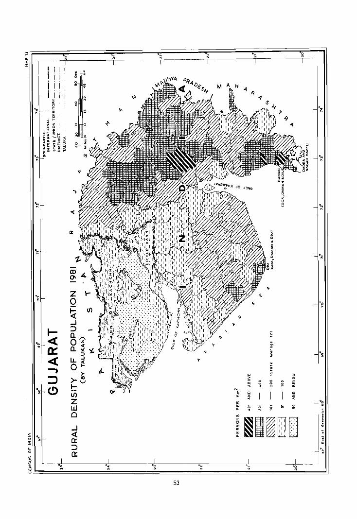
I I i I i i I I i I i ,.
0: 0 l-
ii II: OJ
.J I-< z z 0 0
~ ~ ~t: OJ<
--U< -z UI ii lit: 0:" <OJ ~!n :3 01-
~ is ;! Zz ,,-0 .,
I-« 0::: « I :::J e>
~ 0 ~ lL. 0
0",
'"
. E
'" 0 OJ
N ... 0 ..
:!!
0 0
0 1\1 '!
0 ..
z 0
~ (J')
_J :> a. A
O~':(. a.:!I! ::l ...J
LL~ 0
>->-e l-lI)
z w 0
_J <{ 0:: :> 0::
~
A-
0 .. N
~
53
o_ N

::! CI.
0", ~ '" OJ
" " N " <I: ---~- -1-~--
o-N
~ I I I i
. ~
I I E ~" "
I I I 0
tWA .. '" .. I I I '" ~ ,.. '" a: 0
0 .. 0"
t-
" cr ~ ~ a: UJ
.J t-
" :z 0 ..(-z 0 0 0
ti1~ 2 LU" :> 0 - z ...._ N ~ Il: c: '" « UJ I- 0 o t- " Z Z I-
.. :> - '" 0
0", III
'" <r
•• 0",
" 0 ~ °N
"
I I I )( I
:> i I I 0 : )( I
I I I : )( I
0_
'" ! I I O_
" i
CO ~ Q ~ ~ ~
()\ \9 ~
° W c: c:
<)
Z ~ °Ooi
°o 5«110:: I
0 <UI~rO
" " 1 ~ ~ >- '0
r If) c: "
« «
r-. o ~ ~ ~
..J u'l z • ~
Z :> 0
"' t- :> 0 Q. C>
,
« 0 UJ 0 .. 0: ... ~ Q.
0 '0'
« LL 0: U ~
.,
-, 0 ~ 6-I
::::> >- CO :::>
w ~
(!) r u'l :> 0
0",
0 <> '" '" ..J
'" ...., '" <> '" := w
t!) )0- E ... ~ N '"
Z CO :.: Cl 0
..... z Z 'co
W a: ... ... W
<J
C a. ;; ;; :;:; <> '" -t N e '" .!! • III · · z
~I~ 0 ...J · 0 " <I: « III
o!:; a: ;;
Ci ~ w ...
! a. . •
u. :::> '" 0
~ . ,...
Ul
<>
:::l Ul :z: on 0 .. 0", ON
lJJ '" '0 ... N OJ N N
U
54

• I ! I i I iii iii
>a: ~ ii a: w
..J ....
" z Z 0 o _ .;.; i= 5, .. : ~ ~ -.~ ~ «Cl w a: j
~w ~ ~ ...J Z I- I- _ ~ ~ ~ 111 0 o «>
o ..
o
o ..
..,
"(
a:
'II"
., ..
o
w > o CD
'" o z
'"
"' N N
'" .. '" " ~ .. ~
'" <> <>
"'
:> 0
<> <> <>
" 0 ~
3< o ...J W
'" Cl Z
'" ...J
'" a: ::> a:
0 .. ....

!!! Il.. « ::Ii:
« o z
lJ.. o
'" ::l
0.,
"
0..,
"
0_
"
·0
"
.", ...
·ID
'"
.(0
I I i I I I I I
r 0: 0 0-
ii 0: uJ
...) 0-.. "Z Z
0 0
"'l- i " Ill" -z -
"'0: uJ ~~ ~ Z Z 0-::> - '" 0 CD
I« 0::: « .., :::::> (.!)
0",
'" I \
I I
. E
" 0 CD
0 ..
0
0 N
0 ..
..,
z o
.. '" ., .. N
'" ~
0
~
~ (f)
..J';n :J5 Cl. (9 ow Cl. 0:
o IJ..O: aU
~ I
)-m I- ~ I./) >zm w'-./ o
.. N
~
~
~
'" N
'" N
0_ N
'" > o III <
~
o o o
o o o
I I I
iii : )( I
I I I : )( I
I I I : : '
o o o
0 N
:J uJ
~ :r
0.,
"
.",
"
0 ..
"
.r-
·0
"
.O' ...
7;
1: G OJ
.... ...
'" ~ ~~~~==~~~~~~~~~O~~~~~~~~~~~~~~~~~~~~O~~~~~~~~~·~N~~~~~~~~.~~~~~~~~ 56

PART-III REGIONAL DIVISIONS
OF DISTRICTS


DISTRICT BANAS KANTHA
Regional Divisions
Banas Kantha district is a part of the Gujarat Plain (4.1.1.) and is sub-divided into following six submicro regions on the basis of geology, soils, topography, climate and natural vegetation.
4.1.1.1 Vav Sandy Plain
The region spreads over the western part of Banas Kantha district occupying the large part of Vav taluka and some parts of Santalpur, Deodar and Tharad talukas and includes 162 villages. There is no town in the region. The area of the region is 2,103.96 Km2
which is inhabited by 158,536 persons. The density is 75 persons per Km2. Geologically the region is covered by Alluvium, blown sand etc. The soils found in the region are Orthids-Aquepts and OchreptsPsamments.
4.1.1.2 Sandy Plain
The region extends over the Tharad, Dhanera, Dessa, Deodar and small parts of Radhanpur, Santalpur and Vav talukas covering north-western half of the district. The region is sloped towards the west in which direction the river Sukal flows and disappears near village Dhanera. Geologically this region is covered by Alluvium, blown sand. The soils are Orthids-Aquepts and Ochrepts-Psamments. The region contains 375 villages and one town (Tharad) with an area of 3676.21 Km2 and is inhabited by 456.668 persons of which 13,354 persons reside in urban areas and 443,314 in rural areas. The region has density of 124 persons per Km2 which reflect Jssser development in the region.
4.1.1.3 Banas Valley
The region extends over the central and southwestern parts of Banas Kantha district, occupying
59
larger parts of Santalpur, Radhanpur, Kankrej (whole), Palanpur Deesa and Dhanera taluks and includes 392 villages and 2 towns. The area of the region is 3,988.4 Km2. The region is inhabited by 550,700 persons of which 487,836 reside in rural and
62,684 in urban areas. Geologically Alluvium blown sand etc; Sub-Numerilitic Beds, Patcham, Chari and Katrol sens, Erinpura Granite, Aravalli and associated rocus form the region. Soils are Orthids-Aquepts, Orthids-Psamments, Orthents-Ochrepts and Ochrepts-Psamments. The region has density of 138 persons per Km2 and is agriculturally developed.
4.1.1.4 Banas Kantha Aravalli Range
The region spreads over the eastern parts of the Banas Kantha district occupying Danta and part of Palanpur and some small area of Vadgam taluks. The region is having 287 villages covered by 1,538.9 Km2
area and inhabited by 188,727 persons ~hich reside in entirely rural areas. Geologically the region is having Alluvium, blown sand etc., Erinpura granits. Epidiorite, horn blend Sehist, Dolerite and Gabbro and Delhi system. Orthents-Ochrepts, OchreptsPsamments and Usterts-Ochrepts. The Aravalli ranges are covered by Danta and Palanpur divisions of forests. This region also receives good amount of rainfall (Palanpur taluka 481.mm and Danta taluka, 712 mm. The density of the region is 123 persons per Km2.
4.1.1.5 Jasor Chhotila Hills
The region is actually the part of Aravalli range (Banas Kantha) which is distrupted by Banas Valley. the region lies in Dhanera and Palanpur talukas with an area of 147.3 Km2. The inhabitants of the region are living in 12 villages with the total number of 9170 persons. The population is entirely rural. Geologically
the region is covered by Alluvium blown sand, etc. racks Erinpura Granite Aravalli and associated. Soils are Orthents-Ochrepts and Ochrepts-Psamments. The density of the region is 62 persons per Km2.
4.1.1.6 Uamardasi Saraswati Plain
The region extends over the south-eastern part of the Banas Kantha district covering the parts of
60
Palanpur and Vadgam talukas. The area of the region is 893.12 Km2. The total inhabitants in rural areas are living in 145 villages and there number is 235,495. There are two urban centres viz. Palanpur (districts headquarters) and Kanodar having population of 67,950. Geologically the region is covered by Alluvium, blown sand etc. and Soils are OrthentsOchrepts, Ochrepts-Psamments and UstertsOchrepts. The density of the region is 340 persons per km2, which is highest in the district.


c o 0 • n ~ -I I -I m ~ I ~ m m -I ~ Z • -I -I
• • 0 n
• 0 I • n ~ > I m t ~ • t m
-I m ~ • z -I
-I • •
II~
;tJ < ~~ I ~ ~ Z i 11 C C1( ;tJ~
-l~ Z i () C r )I C ~ 0 , m
o Z
)I
~ ()
I ()
I z
I ~ ~ I m VI ~ Z ~
o VI -l ;tJ
()
:i
'" ~,
Gl
[0 ~ " i ~O ! Gl ' 0(
11: 0 ' 11 : C , i: ~, -l:
0: z:
G) C L » ;U
~
s: )
~======================~======~==================~~

coO • n ~ -I I -I m » I ~ ~ ~ -I 1 Z • " -I I •• o , I
n 1 0 I • n ~ ~ I ~ t ~ 1 t ~ -I m 1
• Z -I
-I • •
II~ )lJ 1/1 CD)
z~ ~ 5~ On' H ,I 2 Z 5 ~~ r .c ~, r ~~, on C Z ~.~ rI r 0 I., ,,~ ~;" , I I
m~ ii ri (0 "'-.f!_,.... ""\ ~ 0 0 I) \'I" 0 ~... ,..
i
~ (II ~1,,,.o coo 0\".' ... ·0: ~ 1'1 ~ ) 0 Ii 0 0 0 0 0 ~
~ i (0 0 0 0 0 0 0 0 " \ 0 0 0 0 0 I) 0 C I
• Q 00000 0 .
fi'7l \" 110 0" 0 II ":
-------------~~------------~r_--------~==:::;t:::::::::::::~~::~~~~
c
N N
o F
k 4 c
H H
(I r\
J ? I (
,1 \ r") \
\
I/)
o 'T1
z o ):


DATA ON REGIONAL DIVISIONS
District Name: BANAS KANTHA Census Location Code No, 08 State: GUJARAT
District Region No, of village No, of towns Areas in Kmf 1.981 Population 1981
No. and in each Region in each Total Rural Urban Total Rural Urban
Name as evolved Region
2 3 4 5 6 7 8 9 10
Banas- 4,1,1,1 162 Villages Nil 2,103,9 2,103,9 158,536 158,536
Kantha Vav (113 villages
Sandy of Vav taluka,
Plain 23 villages
of Thrad
taluka,
19 villages
of Deodar
taluka and
7 villages
of Santalpur
taluka.)
4,1.1,2 375 Villages 1 Town '3,676,2 3,654,0 22,2 456,668 443,314 13,354
Sandy (111 villages of Tharad (vp)
Plain Thread taluka, 01 Tharad
7 villages of laluka.
Vavtaluka,
105 villages
of Deodar
taluka,
2 villages of
Santalpur
taluka,
4, villages of
Radhanpur
laluka,
78 villages of
Dhanera
taluka and
68 villages
of Deesa
ta~ka.)
63

2 3 4 5 6 7 B 9 10
4.1.1.3 392 Villages 2 Towns 3,988.4 3,943.0 45.4 550,700 487,836 62,864
Banas (63 villages of Radhanpur
Valley Santalpur (N.P) of
taluka, Radhanpur
so villages of taluka & Radhanpur Deesa (NP)
taluka, of Deesa
106 villages of taluka
Kankrej taluka, 78 villages of
Deesa taluka,
47 village
of Dhanera
taluka, and
48 villages of
Palanpur
taluka)
4.1.1.4 287 Villages Nil 1,538.9 1,538.9 188,727 188,727 Banas (76 villages of
Kantha I;'alanpur taluka,
Aravalli 25 villages of
Range Vadgam
tatuka and
186 villages of
Danta taluka)
4.1.1.5 12 Villages Nil 147.3 147.3 9,170 9,170 Jasor- (5 villages of
Chhotila Dhanera
Hills taluka
and 7
villages of
Palanpur
taluka)
4.1.1.6 145 Villages 2 Towns 893.2 870.4 22.8 303,445 235,495 67,950
Uamar- (85 villages of Palanpur (M)
dasi Vadgam and
Sabar- taluka and Kanodar
mati 60 villages of (VP) at Plain Palanpur Palanpur
taluka) taluka
Grand 6 1,373 Villages 5 Towns 12,347.9 12,257.5 90A 1,667,246 1,523,078 144,168
Total
64

REGION-WISE VILLAGE CODES, 1981
District Name: BANAS KANTHA Census location Code No. 08 State: GUJARAT
81. Division No. TaJuka Location. Code Total No. of Area in Km2 Remarks
No. and Name No. of Census ViliagesjTowns villages as per of In
ofTaluka In
1981 Taluka division Regional
division
2 3 4 5 6 7 8 9
l. 4.1.1.1 (I}Vav 1 to 50, 66 to 74, 113 1630.2 Code No. 61 to 65, 8S and 89 are in
Vav 76 to 87, 90 division No. 4.1.1.2.
Sandy to 121 Code No. 75 falls in Kachchh
Plain district.
(2) Tharad " 2, 3, 5 to 9, 23 212.7 Code No.4, 10 to 22,
23 to 30, 50 to 31 to 49, 56 to 80, 82 to 134
55,81 are in division No. 4.1.1.2.
(3) Deodar 28, 59 to 62, 86 19 153.4 Code No.1 to 27, 29 to
to 93, 107 to 110, 58, 63 to 85, 94 to 106, 111 to
120, 121 119,122 to 124 are in division
No. 4.1.1.2.
(4) Santalpur 4to 8,11 &29 7 107.6 Code No.9 & 10 are in division
No. 4.1.1.2.
Code No.1, 2, 3,12 to 28, 30
to 7(), 72 & 73 are in division
No. 4.1.1.3.
162 2.103,9 Code No. 71 falls under
Villages Mahesana district.
Town
Nil
2103.9
II. 4.1.1.2 (1) Tharad 4, 10 to 22, 31 to 111 1123.0 Code No.1 to 3, 5 to Sandy 49, 56 to 80, 82 9, 23 to 30, 50 to 55 & Plain to 134 81 are in division No. 4.1.1.1.
Tharad 1 Town 22.2 Urban
(2) Vav 61 to 65, 7 48.9 Code No.1 to 60, 66 to 74, 88,89 76 to 87, 90 to 121 are in
division No.4. 1.1.1
Code No. 75 falls under
Kachchh district.
65

2 3 4 5 6 7 8 9
(3) Deodar 1 to 27, 2910 105 858,1 Code No, 28, 59 to 62, 86 to
58,63 to 85, 93, 107 to 110, 120, 121 are in
94 to 106, division No, 4,1,1,1,
111 to 119,
12210124
(4) Santalpur 9, 10 2 21,3 Code No, 1 to 3, 12 to 28,
30 to 70, 72 & 73 are in division
No, 4.1.1,3.
Code No. 71 falls under Mahesana
district.
Code No, 4 to 8, 11 & 29 are
in division No, 4,1,1,1,
(5) Radhan- 4,5,6,7 4 36.8 Code No.1, 2. 3, 8 to 54 are in
pur division No. 4.1.1.3.
(6) Dhanera 1 to 68, 70 78 826,3 Code No. 69, 80 to 101,
to 79 103to 110, 115to 130 are
in division No.4, 1.1.3.
(7) Deesa 1 to 16,21 to 23, 68 739,6 Code No. 17 to 20, 24 to 28,
29 to 65, 85 to 6610 84, 96, 98 to 146 are
95 &97 in division No.4, 1.1,3.
375 3654.00
Villages
+ 1 Town ~ R§L
III 4.1.1.3 (1) Santalpur 1103, 12 to 63 1211.2 Code Nc 4 to 8, 11 & 29 are
Banas 28. 30 to 70, in division No. 4.1.1.1
Valley 72 & 73 Code No.9, 10 are in division
Nc.4.1.1.2.
(2) Randhan- 1,2,3,8 50 521.9 Code No. 71 falls under Mahesana
pur to 54 dislrict.
Radhanpur 37.0 Code No. 410 7 are in
Urban 1 Town division No. 4.1.1.2.
(3) Kankrej I to 106 106 795.5
(4) Deesa 17 to 20, 24 78 733.5 Code No.1 to 16,21,22,
to 28, 66 to 84, 23. 29 to 65, 85 to 95,
96, 98 to 146 97 are in division.No 4. 1.1.2.
Oeesa 1 Town 8.4
Urban
(5) Dhanera 69,8010101, 47 322.1 Code Nu. 102. 111 to 114
10310110,115 are in division No. 4.1.1.5.
to 130 Code No, 1 to 68. 70 to 79
are in divrsion No, 4.1. I .2.
66

2 3 4 5 6 7 8 9
(6) Palanpur 5,810 10,12, to 48 358.8 Code No. 39 to 61, 38,621078 114,115,132,13410142,160
to 166 are in division No. 4.1.1.4.
Code No.1 to 4, 6, 7 & 11 are in
division 4.1.1.5.
Code No. 113, 116 to 131, 133,
143 to 159, 167 to 191 are in division 4.1.1.6.
392 3943.0 Villages
+ 2 Towns ...§.L 3988.4
IV 4.1.1.4 (1) Palanpur 39 to 61, 79 to 76 559.3 Code No.1 to 4, 6, 7 & 11 are Banas 112, 114to 115, in division No. 4.1.1.5. Kantha
I Code No. 113, 116 to 131, 133, 132, 134 to 142,
Aravalli 160to 166 14310 159, 16710 191 are in Range division No.4. 1.1.6.
Code No.5, 8 to 10, 12 to 38,
62 to 78 are in division
No. 4.1.1.3.
(2) Vadgam 15 to 29, 55, 57 25 119.2 Code No.1 to 14, 30 to 54, 56, to 65 66 to 110 are in division 4.1.1.6.
(3) Danta 1 to 186 186 860.4
287 1538.9 Villages
+ Town Nil
1538.9
V 4.1.1.5 (1) Dhanera 102,111 to 114 5 40.1 Code No.1 to 68, 70 to 79 are Jasor· in division 4.1.1.2. Chhotila Code No. 69, 8010 101, 103 to Hills 110, 115 to 130 are in division
No. 4.1.1.3.
(2) Palanpur 1 to 4, 6, 7, 11 7 107.2 Code No. 113,11610131,133,
143 to 159, 167 to 191 are in
division 4.1.1.6.
Code No.5, 8 to 10, 12 to 38,
62 to 78 are in division No.4, 1.1.3.
Code No. 39 to 61. 79 to 112, 114,
115,132, 134to 142, 160to 166 are
in division No. 4.1.1.4. 12 147.3 Villages
+ Town
Nil
.11LL_
67

2 3 4 5 6 7 8 9
VI 4,1,1,6 (1) Vadgam 11014,30 to 85 445.4 Code No, 15 to 29, 55, 57 to Uamar- 54,56,66to 65 are in division No; 4.1.1.4. dasi- 110
Saras-
watt (2) Palanpur 113,11610131, 60 425.0 Code No.5, 8 to 10, 12 to 38 Plain 133,143 to 159, 62 to 78 are in division No, 4.1.1.3.
16710191 Code No, 39 to 61, 79 to 112, 114,
115,132,13410142,16010166are
in division No.4, 1,1.4,
Code No.1 104,6, 7 & 11 are in
division 4,1.1.5,
Palanpur 2 Towns 22.8
Urban
Kanodar 145 870.4
Urban Village!S
+ 2 Towns .1.tl. 893,2
68

District Name: BANAS KANTHA
State District
name
Division
number
Name of
adminis-
STATEMENT ON REGION-WISE
PHYSIO·CULTURAL DETAILS
Census Location Code No. 08
Geology Soils
and name trative
2
Gujarat Banas
Kantha
3
4.1.1.1
Vav
Sandy
Plain
divisions
4
Vav,
Tharad,
Deodar and
Santalpur
talukas
5 6
Alluvium, Orthids-
blown Aquepts,
sand, etc, Ochrepts.
Psamments
69
State GUJARAT
Physio-Cultural Characteristics
7
This region spreads over western part of the
Banas Kantha district occupying the major part of
Vav taluka and some parts of Tharad, Deodar and
Santalpur talukas.
The region makes its boundaries with Sandy Plain
in the east, Bahas Valley in the south Rann of
Kachchh (Kachchh district) in the west and
Rajasthan state in the north.
From the relief point of view, the region is sandy
plain of below 100 metres height from M.S.L.
Geologically the area is having Alluvium, blown
sand. The stablized sand dunes can also be seen.
There is no major river which passes through this
region. There are some small channels which
merge into little Rann of Kachchh.
The soils as classified by NBSS & LUP (ICAR),
Nagpur, have been found in the region are
Orthids-Aquepts and Ochrepts-Psamments type.
Onhids:--8oil of arid rr,gion with some
development.
Aquepts: Brown soils (Hydromorphic)
Ochrepts: Shallow black, brown and alluvial soil of
northern region.
Psamments: Sandy soils (Recent)
National highway (No. 15) passes through the
region. There is another road which connects the
region with Nadu Bet.

2
Gujarat Banas
Kantha
Gujarat Banas Kantha
3
4.1.1.2
Sandy
Plain
4.1.1.3
Banas
Valley
4
Vav,
Tharad,
Dhanera,
Deesa,
Deodar,
Radhanpur
and
SantaJpur
talukas
Kankrej,
Dhanera,
Palanpur,
Deesa,
Radhanpur
and
Santalpur
talukas
5
Alluvium,
blown
sand,
etc.
Alluvium,
blown
Sand, etc
Sub
Nummu
litic Beds
I'atcham,
Cherri and
Katrol Services
Erjnpura
Granite
Aravalli
and
associated
rocks.
70
6
OrthidsAquepts,
Ochrepts
Psamments
Orthids
Aquepts
Orthids
Psamments
Orthents
Ochrepts
Ochrepts
Psamments
7
The region covers Tharad, Dhanera, Deesa,
Deodar and small parts of Radhanpur, Santalpur
and Vav talukas. On the western side of the region
is Vav Sandy Plain 4.1.1.1 and eastern boundary
of the region 'is made by Banas Valley 4.1.1.3 and
the northern boundary is touching the Rajasthan
state.
Relief of the region is below 100 metres with
westward slope. Geologically this region is
covered by Alluvium, blown sand, etc.
In the northern part of the region there is river
Sukal which originates in Rajasthan and passing
through Dhanera taluka, disappears in Tharad
taluka.
The soils as classified by NBSS & LUP (ICAR),
Nagpur has been found in the region Orthids,
Aquepts and Ochrepts-Psamments.
Orthids:--Soil of arid region with some
development.
Aquepts: Brown soils (Hydromorphic)
Ochrepts: Shallow bla6k, brown and alluvial soil of
northern region.
Psamments: Sandy soils (Recent)
The transport and communication net-work in the
region is satisfactory. National highway (15)
passes through the region. The metre gauge
section (Northern railway) also passes through the
eastern part of the region. Tharad town is
connected with Oeesa town by a state highway.
The region spreads over Dhanera, Palanpur,
Deesa, Kankrej, Radhanpur and Santalpur talukas.
The northern bOl:ndary of the region runs along
the Vav Sandy Plain 4.1.1.1 and Sandy Plain
4.1.1.2 while the south-western part runs along the
Rann of Kachchh. Southern boundary is made by
district Mahesana and the eastern boundary is
along the Uamardasi-Saraswati Plain 4.1.1.6 and
Banas Kantha Aravafli Range 4.1'.1.4 and the north
eastern part is touching Rajasthan state and Jasor
Chhotila Hills.

2
Gujarat Banas
Kantha
3
4.1.1.4
Banas
Kantha
Aravalli
Range
4
Vadgam,
Palanpur
and
Danta
talukas
5
Alluvium,
blown
sand, etc.
Erinpura
Granite
Epidiorite,
horn blend
s~hist,
dolerite
and gabbro
Delhi
System
6
OlthentsOchrepts, OchreptsPsamments, UsteltsOchrepts
71
7
The elevation in the northern part is 300 metres
while in southern and south western parts it is
below 100 mts. with sand dunes. Geologically the
region is covered by Alluvium, blown .sand etc.
Sub-Nummulitic Beds, Patchaw, Chari and Katral
Series, Erinpura Granite Aravalli and associated
rocks.
The Banas is the major river of the region and
drains the region along with its tributaries.
The soils as classified by NBSS & LUP (lCAR) ,
Nagpur have been found in the region are
Orthids-Aquepts, Orthids-Psamments, Orthents
Ochrepts and Ochrepts-Psamments types of soils
Olthids:--Soil of arid region with some development.
Aquepts: Brown soils (Hydromorphic)
Ochrepts: Shallow black, brown and'alluvial soil of
northern region.
Psamments: Sandy soils (Recent)
Orthents : Recently formed soil
Transport and Communication network in the
region is very good the region is connected
through the Palanpur-Gandhidham section and
Bhildi-Raniwada section of railways with other
parts of the district, state and other states.
National highway (15) passes through the south
western part of the region. There is a good
network of state highways and other district roads.
The region spreads over Danta, Palanpur and
some small area of Vadgam talukas and makes
its boundaries with Banas Valley 4.1.1.3 in the
west, Uamardasi-Saraswali Plain 4.1.1.6 in the
south west, Mahesana district in the south, Sabar
Kantha in the east and Rajasthan state in the
north.
From relief point of view this is the highly elevated
region in the district. The north-eastern parts are
300 metres, while the southern parts are 100
metres above the M.S.L. The slope of the region is
from north east to south-west. Geologically it is
covered by Alluvium, blown sand, etc Erinpura
Granite, Epidiorits, horn blend schists, dolerite and
gabbro and Delhi system. Saraswati is the r:1ain
river and the region is well forested.

2
Gujarat Banas
Kantha
Gujarat Banas
Kantha
3
4.1.1.5
Jasor
Chhotila
Hills
4.1.1.6
Uamardasi
Saraswati
Plain
4
Dhanera
and
PaJanpur
talukas
Vadgam
and
PaJanpur
taluka
5 6
Alluvium, Ochrepts-
blown Psamments,
sand, etc. Orthents,
Erinpura Ochrepts
Granite
Aravalli
and
associated
rocks
Alluvium,
blown
sand
etc.
Orthents
Ochrepts
Ochrepts
Psamments
Usterts
Ochrepts
72
7
The soils as classified by NBSS & LUP (ICAR)
Nagpur, have been found in the region are
O/thents-Ochrepts, Ochrepts-Psamments, and
Usterts-Ochrepts type of soils.
Orthents-Recently formed soils.
Ochrepts-Shallow Black, browm and alluvial soils
of northern region.
Psamments-sandy soils (Recent).
Usterts-Deep soils,black
From transport and communication point of view,
the region is having fair roads. The main centre
Ambaji is connected with Abu Road (Sirohi dis~rict
of Rajasthan) and also Khedbrahma by State
highway (No.9). This region is also connected by
road with Palanpur (The district headquarters):
The region covers the parts of Palanpur and
Dhanera talukas. In the north the region makes- its
boundary with Rajasthan state and in the west,
south and eastern sides thjl Banas Valley 4.1.1.3
is touching with this region.
From relief point of view, the region is 300 metres
above the M.S.L. Geologically the region is
composlld of Alluvium, blown sand, etc. Erinpura
Granites, Aravalli and associated rocks. The
region is hilly and covered by forests.
The soils as classified by NBSS & LUP (I CAR)
Nagpur have been found in the region are
Otthents-Ochrepts and Ochrepts-Psamments type
of soils.
Psamments-Sandy Soils
Qrthents-Recenlly formed soils.
Ochrepts-Shallow Black, brown and alluvial soils
of northern region.
The region has no road or rail.
The region r :lvers the parts of Pal an pur and
Vadgam talukas. In southern side the region
makes its boundary with Mahesana district and in
western Side with Banas Valley 4.1.1.3 in northern
side with Banas Kantha Aravalli Range 4.1.1.4.

2 3 4 5
73
6 7
From relief point of view, the region is 100 metre
above the M.S.L. Geologically, the region is
covered by Alluvium, blown sand, etc. The region
is drained by Umardasi and Saraswati rivers.
The soils as classified by NBSS & LUP (ICAR),
Nagpur have been found in the region are
Orthents-Ochrepts, Ochrepts-Psamments and
Usterts-Ochrepts types of soils. Psamments
Sandy soils (Recent) Orthents-Recently formed
soils Ochrepts-shallow-black, brown and alluvial
soils of northern region. Usterts-Deep black soils.
From transport and communication point of view
the region is well connected with rail (metre
gauge) and sands. The Ahmadabad-Abu Road
and Palanpur-Gandhidham metre gauge sections
pass through this region. The main town of the
region, Palanpur (district headquarters) is well
connected by road, with other parts of the district
and the state. This is also connected with
Rajasthan state.


DISTRICT SABAR KANTHA
Regional Divisions
Sabar Kantha district is a part of Gujarat Plain (4.1.1.1) and is sub-divided into five sub-micro regions on the basis of geology, soils, topography, climate and natural vegetation.
4.1.1.1Idar Upland
The region spreads over the north·western part at the district occupying major part of Idar taJuka and some parts of Khedbrahma and Himatnagar talukas. The areas of the region is 1194.5 Km2 and the inhabitant of the rural areas living in 221 villages are 230,571 and inhabitants living in two urban areas are 34,544. Geologically the region is covered with Alluvium blown sand, etc., Erinpura Granite and Delhi System and the soils are Onhents-Ochrepts and Ustens-Ochrepts. The density of the region is 222 persons per Km2.
4.1. t2 Sabar Kantha Aravalli
This region covers northern and eastern parts of the district which run all along the Rajasthan border. The region occupies Vijaynagar, Bhiloda and Meghraj talukas (fully), major part of Khedbrahma and some parts of Idar, l-oIimatnagar, Modasa and Malpur talukas. The total population is 522,277 out of which 511125 persons are living in 629 villages and 11152
persons are living in Khedbrahma and Meghraj towns. Geologically the region is composed of Alluvium, blown sand, etc, Erinpura Granite, Delhi System, Aravalli and associated rocks. Soils found in this region Onhents-Ochrepts and Usterts-Ochtepts are Vijayanagar, taluka and some parts of Khedbrahma taluka are fairly covered by reserved forests. The density of the region is 167 persons per Km2
75
4.1.1.3 Sabarmati Plain
This plain falls in the south-western part of the district and covers parts of Idar, Himatnagar and Prantij talukas. The region has an area of 445.8 Km2. The population of the region is 149,040. The rural inhabitants (90913 persons) are living in 58 villages and 58127 persons are living in two urban areas, including the district headquarters Himatnagar. Geologically the region is covered by Alluvium blown sand, etc., and the soils are Orthents-Ochrepts and. Usterts-Ochrepts. The density of the region is 384 persons per Km2.
4.1.1.4 Vatrak Meshwa and Majham Plain
This region covers the south central part of the district occupying Himatnagar, Modasa and prant~
talukas. The total area of the region is 2203.2 Km and is inhabited by 486036 persons. Rural area is covered by 417 villages with 454047 inhabitants and 31989 inhabitants live in urban area of Modasa. Geologically region is covered by Alluvium blown sand, etc. Deccan Trap Infra-Trappean Beds and Lameta Beds. Erinpura Granite, Delhi System, Aravalli and associated rocks. Soils found in the region are Usterts-Ochrepts. Here cultivation is the main occupation and cash crop has significant output. Th\3 density of the region is 221 persons per Km2.
4.1.1.5 Khari Plain
This small region falls in south-western part and covers an area of 309.6 Km2 of Prantij taluka in which 66918 persons live in rural areas (59 villages) and 12898 persons live in urban area (Talod) Town. The total inhabitants of the region are 79816. Geologically this part is composed of Alluvium, blown sand, etc. and the soils Usterts-Ochrepts. The density is 258
persons per Km2.


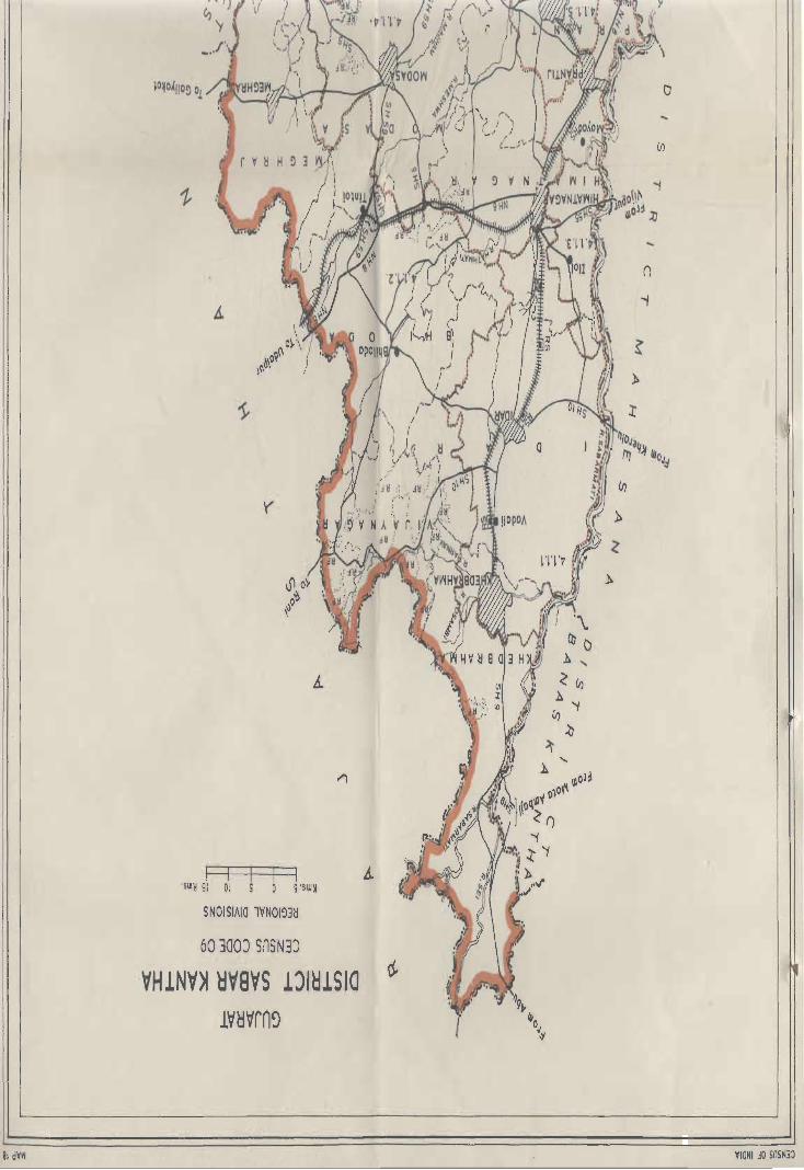
81 dV~
~
'(
I I 'SW~ 51 01 5 'SW~
SNOISIAIO lVNOI~3M
60300J SnSN3J
VH1NV~ ~V8VS lJI~lSIO
IV~Vrn~
....
n .,
o ...
(/)
VIONI .:10 SnS~3J

['Ja!l E 01 dn S~PO) dow O!DUI 110 '41 01 mWj3J 41!M SUO!S!A!P IOUo!63J jO nuanbas a41 pDa~]
.... or --------------AHVONn08 HllM O~JI~-ans r ---------- ----------------OHJt~
1Ri+;:.J-,.. - --- ---------------------- -OS3~
~ t f------------------------O~J\I~
'1' 1' 1 'V NOISIAIO lVNOI~3~
~ '" '" '" '" '" '" '" '" '" ,,, '" '" '" ", '" M3AIM
+H+t!J1+tt '" ," '" '" '" '" '" '" '" ", ", '" 3~n\l~ 3~13Vi
S~ 'NOIlYlS HllM 3NI1 AYM1IY!! --,,, '" '" '" " , ," '" " aVO!! 0311YBVi !NmOdViI
Qi"'H'S'" '" '" '" '" '" ", '" '" '" '" ''' AYMH~IH 3J.\IlS
-eH-N- '" ", '" '" '" '" " , '" '" ", ' ''AYMH~IH lYNOI1YN
• " , NOIIV1ndOd 3A08\1 ONV 0005 ~NIAYH S3~VllIA
~ '" '" ' " '" '" '" '" ' " ' .. '" .. , '" " Y3!!Y NYB!!n
~ " """"'" '" , " , .. '" 00 , '" ' .. lS3~0~ 03AH3S3~ " :,," " ;, ~,, .. : ------ '" ", " , '" ", .. , '" .. , .. , .. , v~nlVl
-,-,-, '" '" ", '" " , '" , .. ' " '" .. , lJI~lSIO II
"_ .. _00 .. ' '" , .... , 00 , .. ' .. , '" '" '" '" 3!VlS 'A!fVQNn08
NIVld I'tlVH~ 's '1'1 'v NIVld ViVHryVi QNV VMHS3Vi'~VH1VA 'v 'I ' I 'v
NIVld 11VVi'tlV8VS '£'I Tv 111VAV'tlV VH1NV~ HV8VS '~'I " 'v
ONVldn HVOI 'I 'I 'I 'V
~
W31SAS IH130 m mo~ 031VlJOSSV rnm 311NV~9 v~ndNI~3 0
ON~ I11~Am ~ dV~J NVJJ30 0
'JJ3 '5039 V~~VMO ~
'Jl3 'am NM019 'wnlAnllV W ,'~ o.,~<
00 0 01 °o~~
o .''\>4 JJ.N1,f J.J>UJ..J.1'O 0 0 00 ,",
000 c,.... ·
r-1 'SW~ 01 0
A~Ol03~ Sl10S
SJd3~HJO-m3lSn ~OOI
Sld3HHJO'SlN3Hl~O ~8~
()
.,


District Name SABAR KANTHA
District Region No. of Villages
No. in each reglon
and as evolved
name
2 3
Sabar 4.1.1.1 221 Villages
Kantha Idar (ZT villages at Upland Khedbrahma
taluka, 171 villages of
!dar taluka,
23 Villages of
Himatnagar
talul<a)
4.1.1.2 629 Villages
Sabar (109 villages of Kantha Khedbrahma
Aravatti taluka,
85 villages of
Vijayanagar
Mahal
167 villages of
Bhiloda taluka,
127 villages of
Meghraj tsluka,
24 villages of
Idar taluka,
23 villages of
DATA ON REGIONAL DIVISIONS
Census Location Code No. 09
No. of Towns
in Region
4
2
Khedbrahma
(VP) of
Khedbrahma
taluka & Idar
(NP) of Idar
taluka
2
Meghraj
(VP) of
Met]hraJ taluka,
Malpur (VP) of
Malpur
!aluka
._ . K 2. R . ",,,8 In m-In eglon
Total Rural Urban
5 6 7
1194.5 1151.4 43.1
3128.0 3114.4 13.6
Himatnagar taluka,
18 villages of
Modasa taluka,
74 villages of
Malpur taluka,
2 villages of
Bayad taluka.)
79
State: GUJARAT
Population in ReQion
Total Rural Urban
8 9 10
265,115 230,571 34,544
522,277 511,125 11,152

2 3 4 5 6 7 8 9 10
4,1,1,3 58 Villages 2 445.8 416.6 29.2 149,040 90,913 58,127 Sabar- (5 villages of Himatnagar
mati Idar taluka, (NP) of
Plain 23 villages of Himatnagar
Himatnagar taluka,
taluka, Prantij
30 villages of (NP) of
Prantij Prar.tij
taluka) taluka
4.1.1.4 417 Villages 2203.2 2189.7 13.5 486,036 454,047 31,989 Vatrak, (65 villages of Modasa (NP) of
Meshwa Himatnagar Modasa
and taluka, taluka
Majham 1 village of
Plain Bhiloda
taluka,
122 villages of
Modasa
taluka,
26 villages of
Malpur
taluka,
159 villages of
Bayad
taluka.)
4.1.1.5 59 villages 1 309.6 287.2 22.4 79,816 66,918 12,898 Khari (59 villages of Talod (NP) of Plain Prantij Prantij
taluka) taluka
Grand 5 1384 8 7281,1 71593 121.8 1,502,284 1,353,574 148,710
Total
80

REGION-WISE VILLAGE CODES, 1981
District Name: SABAR KANTHA
51. Division No. Taluka
No. and Name
2 3
4.1.1.1 (1) Khed-
1adar brahma
Upland
Khed·
brahma
(Urban)
(2) Idar
Idar
(Urban)
Location Code
No. of Census
villages as per
1981
4
102, 104 to 108,
110, 111, 115 to
132, 135
lt014,19to
42, 44 to 70, 78
to 109, 112 to 139
142to 169, 175
to 184, 190 to 197
(3) Hitmat- 4 to 10, 12,34
Tolal
for
Dblision
No.
4.1.1.1
nagar to 40, 48 to
52,76,77,81
Census Location Code No. 09
Tolal No. of . Area of
Villaqes/ Towns Regional
Taluka In division
division in Km 2
5 6 7
27 138.6
27.3
Town
171 890.2
1 Town 15.8
23 122.6
221 1151.4
villages
+ 2
Tcwns £L_
~
81
State: GUJARAT
Remarks
8
Code No.1 to 101, 103,
109,112 to 114,133,134
& 136 are in division
NO.4.1.1.2.
Code No. 15 to 18,43
71 to 77,110,111,140,
141,170to 174, 198 to 200
are in division No. 4.1.1.2.
Code No. 185 to 189 are in
division No. 4.1.1.3 Javanpura
Village
Code No. 11, 13 to 27, 30,
33,60 to 63, 94 are in division
No. 4.1.1.2.
Code No.1 to 3, 41 to 47, 78
1080, 10610 115 are in division No. 4.1.1.3.
Code No. 28, 29,31,32,53to
59, 64 to 75, 82 to 93, 95 to
105, 116 to 134 are in division
No. 4.1.1.4.

2 3 4 5 6 7 e
II 4.t.l.2 (1) Khed- 1 to 101, 103, 109 680,4 Code No. 102, 104 to 108, Sabar brahma 109,11210114, 110,111,11510132,135 Kantha 133, 134, 136 are in division 4.1.1.1 Aravalli
(2) Vijay- 1 to 85 85 456.1
nagar
(Mahar)
(3) Bhiloda 1 to 158, 160 167 718.4 Code No. 159 is in division
to 168 No. 4.1.1.4
(4) Meghraj 1 to 127 127 539.6
Meghraj 1 Town 5.7
(Urban)
(5) Idar 15,10 18, 43, 24 197.8 Code No. 185 to 189 are in 71 to 77, 110, division 4.1.1.3.
111,140,141, Code NO.1 to 14, 19 to 42, 17010174,198 44 to 70, 78 to 109, 112 to to 200 139,142 to 169, 175 to
184, 190 to 197 are in
division No. 4.1.1.1.
(6) Himal- 1',13to 27, 23 116.7 Code No.1, 2, 3, 41 to
nagar 30,33,6010 47,78 to 80, 106 to 115 are
63,94 in division 4.1.1.3.
Code No. 28, 29, 31, 32, 53 to 59,
64 to 75,; 82 to 93, 95 to
105, 116 to 134 are in division
No. 4.1.1.4.
Code NO.4 to 10, 12,34 to 40,48
to 52, 76,77 & 81 are in
division No. 4.1.1.1.
(7) Modasa 5 to 14,32 18 117.0 Code No.1 to 4, 15to 31, 38
to 37, 58, 59 to 57, 6010 140 are in division
No. 4.1.1.4.
(8) Malpur 1109,17to 74 278.0 Code No. 10 to 16, 27,
26,29,36to 26,30 to 35, 70 to 74,
69, 75, 77 76, 94 to 98 are in division
to 93, 99 & 100 No. 4.1.1.4.
Malpur 1 Town 7.9
(Urban)
(9) Bayad 69, 70 2 10.4 Code No.1 to 68, 71 to 161
are in division No. 4.1.1.4.
Total 629 3114.4
for villages
Division + 2
4.1.1.2 TOWns + 13.6 3126.0
82

2 3 4 5 6 7 8
III 4.1.1.3 (1) Idar 185to 189 5 33.1 Code No.1 to 14, 19 to 42,
Sabar- 44 to 70, 78 to 109, 112 to
mati 139, 142 to 169, 175 to 184,
Plain 190 to 197 are in division
No.4.1.1.1.
Code No. 15 to 18, 43~ 71 to
77,110,111,140,141,170
to 174, 198 to 200 are in division
No.4.1.1.2.
(2) Himat- 1 to 3, 4110 23 182.6 Code No. 28, 29, 31, 32, 53
nagar 47,781080, to 59, 64 to 75, 82 to 93,
106 to 115 95 to 105, 116 to 134 are in
division No. 4.1.1.4.
Code No.4 to 10, 12,34 to 40,
48 to 52, 76, 77 & 81 are in division
No. 4.1.1.1.
Code No.l1, 13to 27, 30, 33,
60 to 63, 94 are in division
No. 4.1.1.2.
Himal- 1 Town 8.8
nagar
(Urban)
(3) Prantij 1 to 5, 29 to 30 200.9 Code No.6 to 27, 39 to
35,54 to 58, 48,68 to 72,98 to 101,127,
81 to 89,110 128 & 129 are in division 4.1.1.4.
to 113
Code No. 28. 36 to 38, 49 to
53, 59 to 67, 73 to 80, 90
to 97, 102 to 109, 114 to 126, 130 to
133 are in division No. 4.1.1.5.-
Prantij 1 Town 20.4
(Urban)
Total 58 416.6
for villages + Division 2 Towns . 29.2
No.4.1.1.3. 445.8
83

2 3 4 5 6 7 8
IV 4.1.1.4 (1) Himat· 28, 29, 31, 32, 65 342.5 Code No.4 to 10, 12,34 to
Vatrak, nagar 53 to 59, 64 to 75 40,48 to 52, 76, 77 & 81
Meshwa 82 to 93, 95 to are in division 4.1.1.1.
and 105, 116 to Code No. 11, 13 to 27, 30, 33,
Majham 134 60 to 63, 94 are in division
Plain No. 4.1.1.2.
Coqe No.1, 2,3,41 to 47, 78 tQ
80, 106 to 115 are in division
No. 4.1.1.3.
(2) Prantij 6to 27, 39 to 44 293.2 Code No.1 to 5, 29 to 35,
48,68 to 72, 54, to 58, 81 to 89, 110 to
9810101, 113 are in division No.4. 1.1.3.
12710129 Code No. 28, 36 to 38, 49 to 53,
59 to 67, 73 to 80, 90 to
97,102 to 109, 114 to 126, 130
to 133 are in division No. 4.1.1.5.
(3) Bhiloda 159 5.2 Code No.1 to 158, 16010 168
are in division No.4. 1.1 .2.
(4) Modasa 1 to 4, 15 to 31, 122 731.7 Code No.5 to 14,32 to 37, 58,
38to 57, 60 59 are in division No. 4.1.1.2.
to 140
Modasa , Town 13.5
(Urban)
(5) Malpur 101016,27, 26 79.4 Code No.1 to 9, 17 to 26, 29,
28,30 to 35, 36 to 69, 75, 17 to 93, 99 &
70 to 74, 76, 100 are in division No.4. 1.1.2.
94 to 98
(6) Bayad 1 to 68, 71 to 159 737.7 Code No. 69 & 70 are in
161 division No. 4.1.1.2.
Total 417 2189.7
for villages
Division + No. 1 Town + 13.5
4.1.1.4. 2203.2
84

2 3 4 5 6 7
V 4.1.1.5 (1) Pranlij 28,361038, 59 287.2 Code No.1 10 5, 29
Khari 49 10 53, 59 to to 35,541058,81 to 89,
Plain 67,73 to 80, 11010 113 are in division
901097,102 to No. 4.1.1.3.
109, 11410 Code No. 610 27, 39 to 48,
126, 130 to 68 to 72, 98 to 101, 127 to
133 129 are in division No. 4.1.1.4.
Talod 1 Town 22.4 (Urban)
Tolal 59
for villages m.2
Division + No. t Town
4.1.1.5 + 22.4
309.6
85

District Name: SA BAR KANTHA
State District
name
Division
number
Nameo!
adminis-
STATEMENT ON REGION-WISE PHYSIQ-CULTURAL DETAILS
Census Location Code No. 09
Geology Soils
and name trative
divisions
2 3 4 5 6
Gujarat Sabar 4.1.1.1. Idar, Alluvium, Orthents
Kantha Idar Khedbrahma, blown Ochrepts
Upland and Himat- sand, etc. Usterts
nagar talukas Erinpura Ochrepts
Granite
Delhi System.
86
State: GUJARAT
Physio-Cultural Characteristics
7
The region covers Idar and parts of
Khedbrahma and Himatnagar talukas. On the
western side Mahesana district is making
boundary with the region while northern,
eastern and southern boundaries are made by
Sabarmati plain 4.1.1.3.
From relief point al view, the contour of 200
meter passes through Idar town in north-west
to south easterly direction. The north eastern
part of the region is above 200 meters to the
M.S.L. while rest of the region is having 100
meters height above the M.S.L.
Geologically the region is having rocks of Delhi
System near by Idar and Erinpura Granite
north- of it, while the rest of region is covered
by Alluvium, blown, sand etc.
The sOils as per classification of NBSS of LUP
(ICAR) Nagpur have been found in the region
are Orthents-Ochrepts and Usterts Ochrepts.
Orthents - Recently formed soils.
Ochrepts - Shallow black, brown and alluvial
soils of northern region.
Usterts - Deep black soils.
Transport and communication network in the
region is fairly good. The Himatnagar -
Khedbrahrna section of the meter gauge rail
line passes through this region. The urban
centers Khedbrahma and Idar are well
connected with other parts of the district and
other districts of the stale.

2
Gujarat Sabar
Kantha
Gujarat Sabar
Kantha
3
4.1.1.2
Sabar
Kantha
Aravalli
4.1.1.3
Sabarmati
Plain
4
Vijaynagar,
Bhiloda,
Meghraj,
Idar,
Khedbrahma,
Himatnagar,
Modasa and
Malpur and
Bayad
talukas
Idar,
Himatnagar
and Prantij
talukas
5 6
Alluvium, Orthents-
blown Ochrepts
sand, etc. Usterts-
Erinpura Ochrepts
Granite
Delhi
system
Aravalli and
associated
rocks.
Alluvium,
blown
sand, etc.
87
Orthents
Ochrepts
Usterts
ochrepts
7
This region spreads over Vijayanagar, Bhiloda,
Meghraj, Idar, Khedbrahma, Himatnagar,
Modasa and Malpur talukas. In the north, the
region touches the Rajasthan state, in the east
Panch Mahals district and in the south Kheda
district. In the west and south west are Idar
Upland 4.1.1.1 and Vatrak, Meshwa and
Majham Plain.
From relief point of view, the region has 200
meter and above altitude from the M.S.L. in
Khedbrahma. The altitude some time touches
300 meters and above. The Vijayanagar is the
highest part of region and height goes upto
500 meters and above, The landscape of the
region comprises of high hills and valleys. The
Vijayanagar and Khedbrahma are well
forested, Geologically the region is covered by
Alluvium, blown sand, etc, Erinpura granite,
Delhi System and Aravalli and associated
rocks,
The soils as per classification of NBSS & LUP
(ICAR), Nagpur have been found in the region
are Orthents-Ochrepts and Usterts-Ochrepts,
Orthents - Recently formed soils.
Ochrepts - Shallow black brown and alluvial
soils of northern region.
Usterts - Deep black soils.
Transport and communication is fairly good,
Ahmadabad-Udaipur section of meter gauge
and the national highway (No.8) pass through
this region. There is well connected network of
state highways and other district roads in the
region.
The region extends over Idar, Himatnagat and
Prantij talukas. The region makes its
boundaries with district Mahesana in the west,
Idar Upland 4.1.1.1 in the north, the Sabar
Kantha Aravalli 4,1.1.2 in the east and Khari
Plain in the south-east the boundaries of
district Ahmadabad and Gandhinagar also
touch the region,
From relief point of view, the general height of
the region is 100 meters above the M,S,L.

2
Gujarat Sabar
Kantha
3
4.1.1.4
Vatrak,
Meshwa
and
Majham
Plain
4
Himatnagar,
Modasa,
Prantij,
Bayad
Bhiloda
and
Malpur
talukas
5
Alluvium,
blown
6
Usterts
Ochrepts
sand, elc.
Deccan Trap
Infra-Trappean,
Bagh and
Lameta Beds.
Erinpura
Granite
Delhi System
Aravalli and
associated rocks.
88
7
Geologically the Alluvium, blown sand, etc.
cover the region.
The soils as per classification of NBSS & LUP
(ICAR), Nagpur, have been found in the region
are Orthents - Ochrepts and Usterts-Ochrepts.
Orthents - Recently formed soils
Ochrepts - Shallow black, brown and alluvial
soils of northern region.
Usterts - Deep black soils.
From transport and communication point of
view the region is well connected with
Ahmadabad-Udaipur section of meter gauge.
National highway (No.8) also passes through
the district and state highway and other district
roads also have good network in the region.
The region spreads over Himatnagar, Modasa,
Prantij, Bayad Bhiloda and Malpur talukas. In
the north the region makes its boundary with
Idar Upland 4.1.1.1,: in the north. and east
Sabar Kanta Aravalli 4.1.1.2 and in the south
district Kheda. Sabarmati Plain 4.1.1.3 and
Khari Plain 4.1.1.5 make boundaries with the
region in the west.
From relief point of view, the general height of
the region is 100 meter and above the M.S.L.
and in the northern part som& hillocks are also
in the region with some pockets of rei;erved
forests.
Geologically the region is covered by Alluvium,
blown sand, etc, Deccan Trap, Infra-Trappean,
Bagh and Lameta Beds, Erinpura granite,
Delhi System, Aravalli and associated rocks.
The soils as per classification of NBSS & LUP
(ICAR), Nagpur, have been found in the region
are Usterts-Ochrepts.
Ochrepts - Shallow black, brown and alluvial
soils of northern region
Usterts - Deep black soils.
From transport and communication point of
view the region is fairly well off. In the northern

2
Gujarat Sabar
Kantha
3
4.1.1.5
Khari
Plain
4
Prantij
taluka
5 6
Alluvium, Usterts-
blown sand Ochrepts
etc.
89
7
portion Ahamadabad - Udaipur section of
metre gauge and National highway pass
through (Himatnagar) the region. The main
towns Himatnagar (district headquarters) and
Modasa are connected with other parts of the
district and the state.
The region spreads over the parts of Prantij
taluka. It touches Ahmadabad district in the
south, Sabarmati Plain in the west and Vatrak,
Meshwa and Majham Plain in the north and
east.
The altitude of the region is 100 meters above
the M.S.L. Geologically the region is covered
by Alluvium, blown sand etc.
The soils as per classification of NBSS & LUP
(ICAR), Nagpur, have been found in the region
are Usterts-Ochrepts.
Ochrepts -Shallow black, brown and alluvial
soils of northern region.
Usterts - Deep black soils.
Transport and Communication network in the
region is good. The region is having meter
gauge rail line of Ahmadabad-Udaipur section.
The .regien is also well connected through
state highways and other district roads with
other parts of the district and the state.


DISTRICT MAHESANA
Regional Divisions
Mahesana district is a part of Gujarat Plain (4.1.1)
and is sub-divided into following five sub-micro
regions on the basis of geology, soils topography,
climate and natural vegetation.
4.1.1.1 Western Sandy Waste:
The region spreads over the western part covering Sami, Harij talukas and some part of
Chanasma taluka with an area of 1934.5 Km2. The
total inhabitants of the region are 195714 persons
out of which 180822 persons live in 137 villages while 14892 persons constitute urban population living in Harij town. Geologically the region is
covered by Alluvium blown sand, etc. while the soils are orthids-Aquepts, Orthids-Psamments and Ochrepts-Psamments. The density of the region is 101 persons per Km2.
4.1.1.2 Central Alluvial Plain:
The region occupies the northern part of the district and covers Patan, Sidhpur, Kheralu,
Chanasma, Vis nagar, V~apur and Kalal talukas with an area of 4044.0 Km . The total inhabitants are 1404108 persons, out of which 1131990 persons are
living in 519 villages while 272118 persons live in
seven urban areas. Geologically, Alluvium, blown
sand, etc. are predominant and the soils are
Orthids-Aquepts, Ochrepts-Psamments and
Usterts-Usterts-Ochrepts. The density is 347 persons per km2 in the region.
4.1.1.3 Mahesana Aravalli:
the district, occupying Khera!u taluka. The area of
the region is 312.4Km2 and inhabit,ed by 58238
persons living in 68 villages. There is no urban area
in the region. Geologically the region is covered by
Alluvium, blown sand etc. Erinpura Granite and
Delhi·System. Soils found in this region are UstertsOchrepts. The density of the region is 186 persons
per Km2.
4.1.1.4. Sabarmati Basin:
This basin occupies parts of Kh-eralu, Vijapur and Kalal talukas covering an area of 579.8Km2 and
inhabited by 183586 persons 'Of which 144138
persons are living in 71 villages. Vijapur and Mansa
urban centers are inhabited by 39448 persons.
Geology of the region is Alluvium blown sand, etc. The soils are Usterts-Ochrepts in the region. The
density of the region is 317 persons per Km2.
4.1.1.5 Mahesana Lowland:
This lowland occupies Kadi, Mahesana and part of Chana sma and Kalal talukas with an area of 2175.5 Km2. The total population of the region is
707809 of which 522847 are inhabited in 305
villages. The urban inhabitants are 184962 living in
four towns including the district headquarters Mahesana. Geologically the region is covered by
,Alluvium, blown sand, etc. and the soils are OrthidsAquepts, Ochrepts-Psamments and UstertsOchrepts.
The density of the region is 325 persons per This region spreads over north-eastern parts of Km2.
91


/
/
o
0
(fl ., :lJ
, ,
(fl
l>
(D
l>
:lJ
l>
z
0' J
~ 'l) c: .,
~
0 ~ ~ II ~ ~ 0
H 1 N c,
V ~
61 dVW
Nisve IIVVi~VeVS '~"l'l'v
I11vmv VNVS3HVVi '£'ITv
NIVld lVIAnllV mIND 'nl'v 3ISVM AONVS N~31S3M nTv
~J /~ Iyly ~S tt ~Iy
10 p.~ ~p. J~O of
'f,( {I)
\
~I) C,
0'" 0 'y ~"" o~
"'0 't) ~
, ')
'y
SW~Sl Ol S S 'SWM
SNOISIAIO lVNOI~3~
01 300) SnSND
VNVS3HV~ lJI~lSla
l~~~rn~
VIONI ~O snSN3~

[ J31l E 01 dn npo~ dow O!PUI IIO '41 01 3~U3Ja13J 41!M SUO!S!A!P IDUO!63J 10 a~uanbu '41 po,~]
::[-=~-~~~~~_-~~~O~~~~~~~~~~~;~,~
i 1 fr-----------------OSl" r-- - - - ----------------O~~y~ 'I '1'1 'v
NOISIAIO lVNOI!)3H
~'" '" '" ,,, '" '" ", ," '" '" '" ,,' '" '" ", '" '" ''' H3AIH
~ '" '" ,,' '" ''' 3!)nY!) 3mVi'NOI1V1S HllM 3Nll AVM11VH S~
" '" '" '" '" '" '" '" '" ", ' ''OyO~ 0311V13Vi lNmOd~1
-- '" '" '" ", '" '" '" '" ,,' '" '" '" '" '" '" "'AVMH!>IH 31V1S 01 HS
• "'NOI1YlndOd 3AOBY ONV 000 S !)NIAVH 53!)Vl11A
_ '" ," '" ," ", '" '" '" '" '" ,,, '" ,,' '" '" '" '" V3H~ NVBHn
~M ' ": ", '" ,,' '" '" '" '" '" '" " 'lS3~0~ 03AH3S3H Ii
.-----,,' ,,, '" '" '" '" ,,' '" '" '" ", '" '" "'v~nlVl "
_._._ '" '" ,, ' '" ," ," '" ,,' '" '" ,,' ", "'LJIH1510 'AHVONnOB
~31SAS IH130
31IN~~~ ~~ndNI~3 f~-=-=-=-J
.(',,!.J}, ~ 0 0 0:
1'000 I
000 '
) 0 00/
r'f 'o 0 0 /
'II' 0 00 0 [' , '" 1\ \ 0 0 0 0 0 ,.1> ' ''', • ' ~''\ • 0 0 0 0 0 0 0 oLI O 0 ,
I 0 0 0 0 0 0 0 I' 0 0 0 0~~.t.1' ' 00000000000 I 0 0 0 0 0 0 0 0 0 0 0 0 o;L '0 0 0 0 0 0 0 0 0 0 0 0 ~ ] 1 0 000 00 0 000 OJ ' J ;Q 0 0 0 0 0 0 0 0 0 ,' ~ 0 0 0 0 0 0 0 0 0,'
~• 00 OOOOO l '
""\0 0 0 0 j , ( ""f 00 f ~ , ',\0('
'"",
r--1 SWM 01 0 A!)0103!)
Sld3~HJO- Sl~31sn ~OOI
SlN3~~VSd - Sld3~HJO [+ + IEL
SlN3WWVSd-SOIHl~0 g6Z
Sld3nOv - 501Hl~O L.:.:.:.J 81
r---I 'swM 01 0
51105
I
(v~n1V1 AVA) lJIH1Sio YH1NV~ 5VNV8 ~O lHVd ,,~,
ONV1MOl VNVS3HVVi 'S'ITv Nlsve 11VriHV8VS 'HI'V
I11VAVHV VNVS3HVri '£' I Tv NIVld lVIAnllV lVH1N3J ' ~'Ilv
31SYM AONVS Nij31S3M 'l'lH
I
o


DATA ON REGIONAL DIVISIONS
District: MAHESANA Census Location Code No. 10. State: GUJAAAT
District Region No. of villages No. of Towns Area in Km2. in Region Population in Region
No. and in each region in Region Total Rural Urban Total Rural Urban
Name as evolved
2 3 4 5 6 7 8 9 10
Mahe- 4.1.1.1. 137 Villages .1934.5 1904.4 30.1 195714 180822 14892
sana Western (98 villages Harij (NP) of
Sandy of Sam! taluka, Harij taluka
Waste 1 village of
Santalpur taluka
of Banas Kantha,
36 villages of
Harij taluka and
2 villages of
Chansma taluka)
4.1.1,2 519 Villages 7 4044.0 3867,7 176.3 1404108 1131990 272118
Central (140 villages Patan (M)
Alluvial of Patan laluka, of Patan
Plain 3 villages of taluka, Sidhpur
Harij taluka, (UA) & Unjha
82 villages of (M) of Sidhpur
Sidhpur taluka, taluka, Chan sma
65 villages of (NP) of Chansma
Chansma taluka, taluka Visnagar
59 villages of (M) of Visnagar
Visnagar tafuka, taluka, Kheralu
7 villages of (NP) & Vadnagar Mehsana taluka, (NP) of Vadhnagar
24 villages of taluka.
Kalol taluka,
62 villages of
Vijapur taluka,
77 villages of
Kheralu taluka)
4.1.1.3 68 Villages Nil 312.4 312.4 58238 58238
Mahe- (68 villages sana of Kheralu Aravalli taluka)
95

2 3 4 5 6 7 8 9 10
4.1.1.4 71 Villages 2 579.8 551.5 28.3 183586 144138 39448
Sabar- (3 villages of Vijapur (NP)
mali Kalal taluka, & Mansa (NP)
Basin 46 villages of of Vijapur
Vijapur taluka, taluka
22 villages of
Kheralu taluka)
4.1.1.5 305 villages 4 2175.5 2111.5 64.0 707809 522847 184962
Mahe- (102 villages of Mahesana (UA)
sana Mahesana taluka, of Mahesana
Lowland 118 villages of taluka Kadi
Kadi taluka, (UA) of Kadi
41 villages of taluka Kalal
Kalal taluka, (M) of Becha-
43 villages of raji (VP)
Chansma taluka of Chansma
1 village of taluka
Visnagar taluka)
Grand Total 5 1100 14 9046.2 8747.5 298.7 2549455 2038035 511420
96

REGION-WISE VILLAGE CODES, 1981
District Name: MAHESANA Census Location Code No. 10 State: GUJARAT
Sr. Division Taluka Location Code Total No. of Area in Km2 Remarks
No. Number No. of Census Villages/Towns of In
and Villages as 01 in Taluka Regional
Name per 1981 Taluka Division Divisions
2 3 4 5 6 7 8 9
4.1.1.1. (1) Sami 1 to 98 98 1514.7
Western (2) Santalpur 71 7.7 Code No. 71 of Santalpur laluka,
Sandy District district Banas Kantha, falls in this
Waste Banas Kanlha district and division.
(3) Harij 110 24, 27 to 35, 36 356.8 Code No. 25, 26 & 36 are in
371039 division No. 4.1.1.2
Harij 30.1
(Urban) Town
(4) Chansma 81,82 2 25.2 Code No. 110 49, 5610 67, 78 to
80 & 83 are in division No. 4.1.1.2
Code No. 50 to 55, 68 to 77, 84 to
110 are in division No. 4.1.1.5
Total 137 villages 1904.4
for + 1 Town + 30.1
division 1934.5
No.4.1.1.1.
II 4.1.1.2 (1) Palan 1 to 140 140 1040.5
Cenlral
Alluvial
Plain Patan 13.6
(Urban) Town
(2) Harij 25,26,36 3 20.1 Code No.1 10 24, 2710 35, 37 to
39 are in division No. 4.1.1.1
(el) Sidhpur 1 to 82 82 620.9
Sidhpur
(Urban) 9.4 Km2 area of Sidhpur village Unjha 2 46.8
(Urban) Town + 9.4 (Rural) included in Sidhpur urban
urban area.
97

2 3 4 5 6 7 8 9
(4) Chansma 1 to 49, 65 485.5 Code No. 50 to 55, 68 to 77, 84 to
56 to 67, 110 are in division No. 4.1.1.5
78 to 80, 83 Code No. 81 & 82 are in division
No. 4.1.1.1
Chan sma 20.5
(Urban) Town
(5) Visnagar 1 to 57, 59 485.2 Code No. 58 is in division No.
59 &60 4.1.1.5
Visnagar 4.7
(Urban) Town
(6) Mahe- 70 to 72. 7 92.7 Code No.1 to 69, 73 to 105 are in
sana 106 to 109 division No. 4.1.1.5.
(7) Kalol 1 to 14, 24 178.2 Code No. 15, 16 & 17 are in
18 to 26, 32 division No. 4.1.1.4
Code No. 27 to 31,33 to 68 are in
division No. 4.1.1.5.
(8) Vijapur 1,2,12 to 17, 62 518.4 Code No. 3to 11, 18 to 24, 38 to
25 to 37, 44 43, 56 to 62, 75 to 81, 94 to 101,
to 55, 63 to 107 & 108 "re in division No.
74, 82 to 93, 4.1.1.4
102 to 106
(9) Kheralu 59 to 61, 76 to 77 426.2 Code No.1 to 58, 62 to 67, 72,
78, 81 to 102, 73, 79 & 80 are in the division No.
108 to 122, 126 4.1.1.3 Code No. 68 to 71,74,75,
to 145,151 to 103to 107, 123to 125, 146to
to 164 150,165 to 167 are in division
No.4.1.1.4
Kheralu 2 37.00
(Urban) Towns + 44.27
+ Vadnagar 81.27
(Urban)
Total for 519 villages 3867.7
division + 7 Towns + 176.3 No. 4044.0
4.1.1.2
III 4.1.1.3 (1) Kheralu 1 to 58, 68 312.4 Code No. 68 to 71,74, 75, 103 to Mahe- 62 to 67, 72, 107, 123to 125, 146to 150, 165 sana 73,79,80 to 167 are in division No. 4.1.1.4 Aravalli Code No. 59 to 61,76 to 78, 81 to
102, 108to 122, 126to 145,151
to 164 are in division No. 4.1.1.2
98

2 3 4 5 6 7 8 9
Total tor 68 villages 312.4
division + Town Nil + Nil
No. 312.4
4.1.1.3
IV 4.1.1.4 (1) Kheralu 68 to 71, 22 133.9 Code No.1 to 58, 62 to 67. 72,
Sabar- 74,75.103to 73. 79 & BO are in division No.
mati 107,123, to 4.1.1.3 Code No. 59 to 61.76 to
Basin 125.146 to 78,81 to 102, 108 to 122. 126 to
150.165 to 167 145, 151 to 164 are in division
No.4.1.1.2
(2) Vijapur 3 to 11, 18 46 397.1 Code No.1. 2,12 to 17.25 to 37,
to 24. 38 to 44 to 55. 63 to 74. 82 to 93, 102
43. 56 to 62. to 106 are in division No.4, 1.1.2
75 to 81. 94
to 101, 107 & 108
Vijapur 2 1.4 (Urban) Towns + 26.9
+ Mansa 28.3
(Urban)
(3) Kalol 15.16 & 17 3 20.4 Code No. 27 to 31. 33 to 68 are in
division No. 4.1.1.5 Code No.1 to
14. 18 to 26. 32 are in division
No. 4_1.1.2
Total for 71 Villages 551.5 division + 2 Towns + '28.3
No. 579.8 4.1.1.4
V 4.1.1.5 (1) Mahe- 1 to 69, 73 to 102 677.3 Code No. 70 to 72. 106 to 109 are Mahe- sana 105 in division No.4. 1. 1.2 sana
Lowland
Mahesana 12.9 8.8 Km2
area of Mahesana (Urban) Town + 8.8 Yillage (Rural) included in the
21.7 Urban area
(2) Kadi 1 to 118 118 8133 Kadi 2.8 13.5 Km2 area of Kadi (Urban) Town + 13.5 village (Rural) included in the
'16.3 Urban area
99

2 3 4 5 6 7 8 9
(3) Kalol 27 to 31, 41 271.3 Code No.1 to 14, 18 to 26, and 33 to 68 32 are in division No, 4,1,1.2
Code No, 15 to 17 are in division
No. 4.1,1.4
Kalol 1 Town 17,2 (Urban)
(4) 50 to 55, 68 to 43 346.7 Code No, 81 & 82 are in division Chanasrna 77, 84 to 110 No, 4,1, U Code No.1 to 49, 56
to 67, 78 to 80, 83 are in division No. 4.1.1,2
Bechalaji 1 Town 8,8 (Urban)
(5) Visanagar 58 2.9 Code No.1 to 57 and 59 to 60
are in division No, 4,1,1,2
Total for 305 2111.5
division Villages + 64.0 No, t 4 Towns 2175.5 4.1.1,5
100

District Name: MAHESANA
State District
name
Division
number
and name
2 3
Gujarat Mahesana 4.1.1.1
Western
Sandy
Waste
Name of
adminis
trative
divisions
Sami,
Harij and
Chanasma
talukas.
STATEMENT ON REGION-WISE PHYSIO-CULTURAL DETAILS
Census Location Code No. 10
Geology
5
Alluvium,
blown
sand, etc.
101
Soils
6
Orthids
Aquepts
Orthids
Psamments
Ochrepts
Psamments
State: GUJARAT.
Physio-Cultural Characteristics
7
The region extends over Sami, Harij, and parts
of Chanasma talukas. In the north it is making
boundary with distt. Banas Kantha, Little Rann
of Kachchh is touching its south-western part.
Surendra nagar dislt. is making boundary with
the region in the south and the Central Alluvial
Plain in the east.
From relief point of view, the region is having
low relief in comparison to the other parts of
the region. The height in Chanasma taluka of
this region is about 57 metres above the MSL
while it decreases towards west. Saraswati is
the main river of the region and flows from
north-east to south-west and submerges in the
Little Rann of Kachchh. River Banas also
touched the northern boundary of the region.
Geologically Alluvium blown sand, etc. are
found with sand dunes at some places.
The soils as classified by NBSS & LUP (ICAR)
Nagpur, the region has Orthids-Aquepts,
Orthids, Psamments and Ochrepts
Psammenls types of soils.
Orthids - Soils of arid region with some
development.
Aquepts - Brown Soils (Hydromorphic)
Psamments - Sandy Soils (Recent)
Ochrepts - Shallow black brown and alflJvial
soils of northern region.
Transport and communication facilities in the
region are comparatively lesser than the other
part of the district. Metre gauge railway line
runs from Mahesana via Chanasma up to

2 3
Gujarat Mahesana 4.1.1.2
Central
Alluvial
Plain
4
Patan,
Sidhpur,
Chanasma,
Kheralu,
Mahesana,
Vijapur,
Kalol,
, Visanagar and
Hurji
Talukas
5
Alluvium,
blown
sand, etc.
102
6
Orthids·
Aquepts
Ochrepts
Psamments
Usterts
Ochrepts
7
Harij. State highway from Radhanpur and
Viramgam also passes via Sami and Harij and
connects the district headquarters Mahesana
via Chanasma.
The region covers the Patan, Sidhpur,
chanasma, and parts of Kheralu, Mahesana,
Visanagar, Vijapur, Kalal and Harij talukas. The
region makes its boundaries with Banas
Kantha distt. in the north, Western Sandy
Waste 4.1.1.1 in the west, Mahesana Aravaili
4.1.1.3 in the north east, Sabarmati Basin
4.1.1.4 in the east, Mahesana Lowland in the
south·west and Gandhinagar dist[l(;t in the
south-east.
From relief point of view this region is having
100 metre as maximum height from the M.S.L.
The 100 metres contour passes through.
Patan, lower parts of Sidhpur and eastern
parts of Mahesana talukas. Slope is westward.
River Banas, Saraswati, Rupen and its
tributaries drain the region. The sand dunes
have been partially stabilised in the western
part. Geologically the region is covered by
Alluvium, blown sand, etc.
Soils as classified by NBSS & LUP (ICAR),
Nagpur, the region has Orthids·Aquepts,
Ochrepts • Psamments and Usterts - Ochrepts.
Orthids - Soils of arid region with some
del/elopment.
Aquepts - Brown soils (Hydromorphic)
Psamments • Sandy soils (Recent)
Ochrepts - Shallow black, brown and alluvial
soils of northern region.
Usterts - Deep black soils.
The transport and communication network is
well developed in this region. The
Ahamadabad-Delhi metre gauge rail link
passes through the middle of this while other
metre gauge rail links are Mahesana·Kheralu,
Mahesana·Patan.Kakosi and Mahesana
Chanasma·Bechraji. The network of roads
connect all the towns with district
headquarters (Mahesana) and other parts of
the district and the state.

2 3
Gujarat Mahesana 4.1.1.3
Mahesana
Aravalli
Gujarat Mahesana 4.1.1.4
Sabarmati
Basin
4
Kheralu
taluka
Kheralu
Kheralu
Vijapur and
Kalal
talukas
5 6
Alluvium, Usterts-
blown Ochrepts
Sand, etc.
Erinpura
Granite
Delhi System.
Alluvium, Usterts-
blown Ochrepts
sand, etc.
103
7
The region covers the northern part of Kheralu
taluka and makes .its boundary with Banas
Kantha and district in the west and north while
Sabar Kantha touches in the south-east. In the
south, regional boundaries are common with
Central Alluvial Plain 4.1.1.2 and Sabarmati
Basin.
From relief point of view, the height goes up to
370 metres above the MSL (Tranga Hill) and
the 200 metres contour runs along the
southern boundary of the region.
Geologically the region is having Alluvium,
blown sand, etc. Erinpura Granite and Delhi
System. The rocks are metasedimentary.
The soils as classified by NBSS & LUP (ICAR)
Nagpur, the region has Usterts-Ochrepts types
of soils.
Ochrepts - Shallow black, brown and alluvial
soils of northern region.
Usterts - Deep black soils.
From transport and communication point of
view, the facilities in the region are as good as
in the Alluvial Plain. Metre gauge from
Mahesana terminates at Tranga. One state
highway also passes through the region which
makes accesibility possible to Banas Kantha
district and other parts of the district.
The region spreads over Kheralu, Vijapur and
Kalal talukas. In the north lies Mahasana
Aravalli 4.1.1.3 while in the east is Sabar
Kantha district and southern boundary is
touched by Alhmadabad and Gandhinagar
district. The Central Alluvial Plain 4.1.1.2 is
making boundary with region on the western
side.
From relief point of view, the regi~r. 's having
100 metres above the M.S.L. and the general
slope of the region is towards east (Sabarmati
river.) Sabarmati is the main river which drains
the region from north to south. Geologically
the region is covered by Alluvium, blown sand,
etc.

2 3
Gujarat Mahesana 4,1,1.5
Mahesana
Lowland
4
Kadi,
Mehasana,
Kalal,
Chansma
and
Visnagar
talukas
5 6
Alluvium, Orthids·
blown Aquepts
sand, etc. Ochrepts·
104
Psamments
Usterls·
Ochrept$
7
The soils as classified by NBSS & LUP (ICAR)
Nagpur, the region is covered by Usterts·
Ochrepts types of soils,
Ochrepts • Shallow black, brown and alluvial
soils of northern region.
Usterts· Deep black soils.
Transport communication is quite good, The
state highway (10) passes through the
northern part of the region. Vijapur town is
connected by metre gauge railway from
Mahesana and Kalal. The state highway from
the district headquarters passes through
Vijapur to Himatnagar and other parts of the
state. Mansa town is also connected by metre
gauge railway.
The region spreads over Kadi, Mahesana and
parts of Chanasma, Visnagar and Kalal
talukas. In the south the region touches the
boundary of Ahmadabad district while in the
north and eastern ,sides the Central Alluvial
Plain is running with the boundary of this
region.
The topography of the region is flat and of
sandy plain. Near mahesana the height is 99
metres above the M.S.L. and near Becharaji it
is 68 metres above the M.S.L. which indicate
general slope toward west. Geologically the
region is covered by Alluvium, blown sand,
etc.
The soils as classified by NBSS & LUP (ICAR),
Nagpur, the region is covered 'by Orthids·
Aquepts, Ochrepts . Psamments and Usterts·
Ochrepts types of soils.
Orthids • Soils of arid region with some
development.
Aquepts • Brown soils (Hydromorphic)
Psamments • Sandy soils (Recent)
Ochrepts • Shallow black, brown and alluvial
soils of northern region.
Usterts· Deep black soils.

DISTIRICT GANDHINAGAR Regional Divisions
Gandhinagar forms the part of Gujarat Plain
(4.1.1) and is sub-divided into following two subdivided into following two sub-micro regions on the basis of geology, soils, topography, climate and
natural vegetation.
4.1.1.1 Sabarmati Plain
The region covers the major part of the district. It is a alluvial plain. The region contains 67 villages
and Gandhinagar town, the state capital of Gujarat. Its area is 588.7 Km2 which is inhabited by 265499 persons of which 203056 and 62443 persons live in
rural and urban areas respectively. The region is
105
composed of Alluvium blown sand, etc. and soils
are Usterts-Ochrepts. The density of population is
451 persons per Km2 in the region.
4.1.1.2 Khari Plain
The region covers .Khari river's catchment area in
the eastern parts of the district and includes 11 villages with an area of 97.9 Km2. The population of the region is 32713 which is entirely rural.
Geologically the region is having Alluvium, blown sand, etc. The soils in the region are UstertsOchrepts. The density of this region is 334 persons per Km2.


o
o
~ t 0 ;, ~
Q~ ;, 0
/
H
~ ~
~ c: ,
o
S
o
SW~ 9 S 7 E I I 0 I 'sw~
SNOISIAIO 1¥NOI~3~
11300J SnSN3J
~V~VNIHaNV~ lJI~lSla
lv~vrn9
01 m ~laNI ~o snSN3l

'J13'aN~S NM018 'WniAnm roo-o1 ~
.11) ..... ;"'.-"1 '_,. '\ f'v;/ o 00 ", \ 0, i~'J, ~ 0 0 0 '7 '0 r ''6 I) I) I) I) C I)
( '}- ."j I) 0 I) I) I) I) I) I) I)
10 I) I) I) I) 0 0 I) I) I) Cv·~ / 0 I) I) I) I) I) I) I) 0 I) I) I) I) I ) c I) I) I) I) I) I) I) 0 I) 0 I) ~ .'
-I) I) I) I) I) I) I) I) 0 I) I) I) olJ b I) I) I) I) I) I) I) I) I) I) I) 0 b '/ • I) I) I) I) I) I) I) I) I) I) I) I) I) I)
1 I) I) I) I) I) I) I) I) I) I) I) I) I) i / I) I) I) I) I) I) I) I) I) I) I) I) I) 0,
,I) I) I) I) I) I) I) I) I) I) I) I) I) ''0 \ ~ I) I) I) I) I) I) I) I) I) I) I) I) I) •
'j I) I) I) I) I) I) I) I) I) I) I) I) I) I 'I) I) 0 I) I) I) I) I) I) I) I) I) I) 6\
\ I) I) I) I) I) I) I) I) I) I) I) I) I) "')
'0 I) I) I) I) I) I) I) I) I) I) I) I) I),
\ I) I) I) I) I) I) I) I) I) Q I) I) I) 0' J ooooooooooo °ooooooooooooco(
(0 I) I) I) I) I) I) I) I) I) I) I) I) I ..... °0°0°0°0°0°0°0°0°0°0°0°0°0 \ ~ I) I) I) I) I) I) I) I) I) I) I) I) I) 0/
(0 I) I) I) I) I) I) I) I) I) I) I) 0('" j I) I) I) I) I) I) I) I) I) I) I) I),
'Il 0 0 0 o,~ 0 0 0 0 0 0 ~ ,t..,..",/',,,\ , .~ 0 I) 0.... ._,''''' '
I (',_' ... , .... .I
" "Ol Z 0
A~Ol03~
'(LJIM1Sla a~8~a~f'lH~) ~~n1~1 f'I~~H3a ~O lM~d .~.
o
»
NI~ld IM~HnTrv
NIY1d 11Yf'lMY8YS Tin
Sld3~H JO · Sl~31sn ~OOI
1
n " I l Z 0
51105
rJll1 E 01 dn upo~ dow 0IPUI 110 341 01 3~U3J3j3J
41!M SU01S!A1P IDUOl6aJ jO manbas 341 poa~]
-r ----- -A~yaNnOB HIIM 0~Jlf'I-8n5 ""r ---------------O~:llf'l -""'r ----------------OS3f'1
r - - - - - - - - - - - - - - - OMJV~
'z ' ~ ' ~ 'v NOISIAIO lVNOI~3~ ~ ...... , ......................... , .. , .... " ........ , ~3AI~
1I111I1I1!!:I1II1I111 ·'· 3!)nV~ 3~13f'1 " " -M- ,., 3~nY~ aVO~8' NOlms HIIM 3NI1 AVM1IV~
S~ ... ............ '" ... avo~ a311V13f'1 INV1~OdV'l1 99HS ........ , ... ...... '" ... .... " ...... ... AVMH~IH 3IVIS
JSHN ... " .... '" ". ". , .. " . .... " .. , "hVMH~IH lVNOllVN • ", ". '" '.' .. , .. , .. , .. , " . ... '" NOIIVlndOd 3A08V
aNY 000 5 ~NIAYH S3~YllIA ~'" '" " .... '" ... ... ...... ...... " .... ... V3~V N~8~n
;"""' j~" " ~ .... " ." .. , ", ,. ' ' ·1S3~O~ a3AM3S3M " ;;'_"-';';;.;;';;" . . " " .... ". ". ,., ,., ,., ,., '" l:l1~lSla ' A~vaNn08
o


DATA ON REGIONAL DIVISIONS
District Name: GANDHINAGAR Census Location Code No. 11 State: GUJARAT
District Region No. of village No. of towns in Area in Km£ 1981 Population 1981
No. and in each Region each Region Total Rural Urban Total Rural Urban
name as evolved
2 3 4 5 6 7 8 9 10
Gandhi- 4.1.1.1 67 Villages 588.7 531.9 56.8 265499 203056 62443
nagar Sabar- (64 villages of Gandh'lnagar mali Gandhinagar (n.a) of
Plain taluka and 3 Gandhinagar
villages of taluka
Dehgam taluka
of Ahmadabad
district).
4.1.1.2 11 Villages Nil 97.9 97.9 32713 32713 Khari (11 villages of
Plain Gandhinagar
taluka.)
Grand
Total 2 78 686.6 6298 56.8 298212 235769 62443
109

REGlON·WISE VILLAGE CODES, 1961
District Name: GANDHINAGAR Census location Code No. 11 State: GUJARAT
SI. Division Taluka Location code Total No of Area in Km2 Remarks
No. No. & No. of Census villagesLIowns
Name villages as per of In of Tall)ka In
1981 Taluka divi- Regional
sian division
2 3 4 5 6 7 8 9
4.1.1.1 (1) Gandhi. 1 to 33, 36 64 496.7 Code No. 34, 35, 50, 51,63 to 67,
Sabar- nagar to 49, 52 to 62, 74 & 75 are in division No. 4.1.1.2
mati Plain 68 to 73
Gandhinagar 56.8
(Urban) Town
(2) Dehgam 1,2,3 3 35.2 Code No.1, 2, & 3 of Dehgam
taluka, district Ahmadabad lall in
this district,
Total for 67 531.9
division villages
No. 1 Town t 56.8
4.1.1.1 588.7
4.1.1.2 (1) Gandhi- 34,35,50, 11 97.9 Code No.1 to 33, 36 to 49, 52 to
Khari nagar 51 63to 67, 62,68 to 73 are in division No.
Plain 74 & 75. 4.1.1.1
Total for 11 97.9
division villages t
No. t .Jill_ 4.1.1.2 Town Nil
97.9
110

District Name: GANDHINAGAR
State District Division
name number
and name
2 3
Gujarat Gandhi- 4,1,1.1,
nagar Sabarmati
Plain
STATEMENT ON REGION-WISE
PHYSIO-CULTURAL DETAILS
Census Location Code No, 11
Name of Geolcgy Soils
adminis-
tralive
divisions
4 5 6
Gandhi- Alluvium, Usterts-
nagar taluka blown Ochrepts
and Dehgam sand, etc.
taluka of
Ahmadabad.
111
State: GUJARAT
Physio-Cultural Characteristics
7
The region spreads over major parts of the
district and some part of Dehagam taluka of
Ahmadabad district. The region makes its
boundaries with Sabar Kantha and
Ahamadabad districts in the north-esst and
south, The northern and western boundaries
are adjoining with Mahesana district.
From relief point of view, the region has a
maximum height of 75 metres above the
M,S,L .. The region as a whole is occupied by a
flat plain with minor undulations through
deeply cut by Sabarmati river. The region is
constituted by young and old alluvium upon
which mobile sand has been deposited
creating minor undulations, The river
Sabarmati which flows from north to south
divides the district into two parts, It has cut its
channel and fluvial terraces through the
alluvial plain, Deep gullies have been
developed on both the banks of the
Sabarmati. Geologically the region is covered
by Alluvium, blown sand, etc,
Soils found in the region are sandy alluvials
and as per classification by NBSS & LUP
(ICAR), Nagpur, the region has Usterts -
Ochrepts types of soils,
Ochrepts - Shallow black, brown and alluvial
soils of northern region,
Usterts - Deep black soils,
2
Gujarat Gandhi-
nagar
3
4.1.1.2
Khari
Plain
4 5
Garldhi- Alluvium,
nagar Taluka blown sand, etc.
112
6
UstertsOchrepts
7
Transport and communication net-work in the
region is well' connected with rest of the state,
since the state capital Gandhinagar falls in this
region. National highway passes through
Gandhinagar and a broad gauge rail line
connects, it with Ahmadabad. Apart from this
there are district roads which pass through the
region.
This region covers the South-eastern part of
the district. It is bounded in the northern and in
the western side by Sabarmati Plain 4.1.1.1
and eastern and southern boundaries are
common with Ahmadabad district.
From relief point of view, the region is
occupied by flat alluvial plain with minor
undulations. However, the exploration of oil
and natural gas has been conducted recently,
proved the existance of rocks. Geologically the
region is composed of Alluvium blown sand,
etc.
Soils found in the region are alluvial and as per
classification of NBSS & LUP (I CAR) Nagpur,
the region has Usterts-Ochrepts types of soils.
Ochrepts - ShallOW black, brown 'and alluvial
soils of northern region
Usterts - Deep black soils,
Transport and communication facilities in this
region are as good as in other part of Gujarat
Plain, Metre gauge railways passes through.
this region which connects Ahmadabad with
Dehgam, The state highway from Ahmadabad
to Dehgam also passes through the region
along with a district road which approaches
the state capital Gandhinagar.

DISTRICT AHMADABAD
Regional Divisions
Ahmadabad district is a part of Gujarat Plain (4.1.1) and is sub-divided into following five submicro regions on the basis of geology, soils, topography, climate and natural vegetation.
4.1.1.1 Vir~mgam Plain
The region spreads over the northern parts of Ahmadabad district, occupying a large part of Viramgam taluka and some parts of Sanand taluka. There are 163 villages in the region covering an area of 1798.9 Km2 and inhabited by 280319 persons. The urban inhabitants living in two urban areas (69.1 Km2) are 58615 persons. Geologically the area is covered by Alluvium blown sand, etc. and the soils are Orthids-Aquepts and Usterts-Ochrepts. The density of the regio" is 156 persons per Km2.
4.1.1.2 Sabarmati Basin
This basin is in the north-eastern part of Ahmadabad district and extends over Sanand, Daskroi, city taluka of Ahmadabad and Dholaka talukas covering an area of 1589.6 Km2. The total inhabitants are 2948607 persons out of which 295555 persons are living in rural areas in 155 vilJages. The urban population is 2653052 living in 24 towns (including Ahmadabad urban Agglomeration). This is the highly urbanised region. Geologically the region is covered by Alluvium, blown sand, etc. and soils are Orthids-Aquepts and Usterts-Ochrepts. The density of the region is 1855 persons per Km2.
113
4.1.1.3 Khari-Meshwa Plain
This plain is occupying Dehgam taluka and parts of Daskroi taluka in the north eastern part of the district. There are 132 villages covering an area of 868.5 Km2 as rural part and is inhabited by a 261361 persons. The only urban centre Dehgam is inhabited by 24868 persons. Geologically the region is covered by Alluvium blown sand, etc. and the
soils are Usterts·Ochrepts black. The density of the region is 320 persons per Km2.
4.1.1.4 Bhadar - Bhogava lowland This region is occupying the central part of the
district, covering parts of Viramgam, Sanand, Dholka and Dhandhuka talukas. The total area of the region is 2831.5 Km2. The total population of the region is 188784 which is entirely rural and living in 127 villages. Geologically the area is covered by Alluvium, blown sand, etc. and the soils of the region are Orthids-Aquepts, and Usterts-Ochrepts. The density of the region is 67 persons per Km2
which is the lowest in the district.
4.1.1.5 Bhadar River Pfain This plain occupies the south-western part of the
district and covers the part of Dhandhuka taluka. The region is inhabited by 118188 persons in 89 villages while 44543 persons live in three urban centres (Dhandhuka, Barwala and Ranpur). Geologically the region is covered by Alluvium, blown sand, etc. Deccan Trap. The soils are Orthents-Ochrepts and Usterts-Ochregts. The density of this plain is 119 persons per Km
2.


0 « «Xl « 0 C\I « I- w ~o «
a: 1:8 « .., « V) :::>
:J .... V)
t9 z U w
u a: .... en -0
Q ~ Cr)
(J
....
it
If)
....
Q
vi & E " III ~ Z
0 !!! S? > 0
'" _J
< ~ 0
i3 UJ [[ '" ~
E "
It ~
It
It Ci a
N 3
o
~ 0 C' 0 ~ 0 ~ ~ ... ':; III
~ 0 .. II-
& n S
J. .J
Z III ot: - z ~ ::I [[ I-1IJ Z :::! UJ
g ~ ~ 1= ~ III « z zO « u mill ~t o I:
a3 t: « ~ o~ « z ~ 0 I...J « «
/
11" .i
t.
1 s o


District Name: AHMADABAD
District Region No. of villages
No. and in each region
Name as evolved
2 3
Ahmada- 4.1.1.1. 163 villages
bad Viram- (147 villages of
gam Viramgam taluka
Plain 16 villages
of Sanand taluka)
4.1.1.2 i55 villages
Sabar- (36 villages of
mati Sanand taluka,
Basin 18 villages of
Ahmadabad city
taluka, 48 viii·
ages of Daskroi
taluka & 53
villages of
Dholka taluka)
DATA ON REGIONAL DIVISIONS
Census Location Code No. 12
No. of Town
in region
4
2
Viramgam (M)
& Mandai (VP)
of Vir am gam
taluka
24
Ahmadabad (M.C.)
City, Sardar-
nagar (M), Sahij-
pur Bogha (NP)
Naroda (NP),
Naroda (INA),
Hansol (VP),
Ahmadabad can·
lonment (Coni!.),
Odhav (NP), Odhav
INA, Nikol (VP)
Ranip (NP), Vejal·
pur (VP), Vastrapur
A . K 2. R . rea In m- In eglon
Total Rural Urban
5 6 7
1798.9 1729.8 69.1
1589.6 1310.9 278.7
(VP), Memnagar (VP),
Ghatlodia (VP),
Ghodasar (VP),
Isanpur (VP), Kali
(VP), Vatva INA &
Sarkhej (VP) of
Ahmadabad City
taluka, Nandej (VP)
Of Deskroi taluka,
Dholka (M)
& Bavla (NP) of
Dholka taluka
Sanand (NP) of
Sanand ta\uka.
117
State: GUJARAT
Population in Reqion
Total Rural Urban
8 9 10
280319 221704 58615
2948607 295555 2653052

2 3 4 5 6 7 8 9 10
4.1.1.3 132 village 1 Degham 895.5 868.5 27.0 286229 261361 24868
Khari- (42 village (NP) of
Meshwa of Daskroi Degham
Plain Taluka & taluka
90 villages
of Degham
taluka)
4.1.1.4 127 villages Nil 2831.5 2831.5 188784 188784
Bhadar- (11 villages
Bhogava of Vir am gam
Lowland taluka,
14 villages
of Sanand
taluka
63 villages
of Dholka
taluka,
39 villages
of Dhandhuka
taluka.)
4.1.1.5 89 villages 3 1365.4 1247.2 118.2 162731 ' 118188 44543
Bhadar (89 villages Dhandhuka
River of Dhandhuka (NP)
Plain Taluka.) Ranpur (VP)
& Barwala
(VP) of
Dhandhuka
Taluka
Grand Total 5 666 30 8480.9 7987.9 493.0 3866670 1085592 2781078
118

REGION-WISE VILLAGE CODES, '981
District Name : AHMADABAD Census Location Code No. 12 State: GUJARAT
Sr. Division Taluka Location Code Total No. of Area in Km 2 Remarks
No. Number & No. of Census Villages/Towns of In
Name Villages as of in Taluka Regional
per 1981 Taluka Division. Division
2 3 4 5 6 7 8 9
4.1.1.1 (1) Viram- 1 to 146, 158 147 1487.6 Code No. 147 to 157 are in
Viram- gam division No. 4.1.1.4
gam Plain
Viramgam 2 69.1
(Urban)& Towns
M'andal
(Urban)
(2) Sanand 1 to 4, 15to 16 242.2 Code No.5 to 14, 21 to 28, 35 to 20,29 to 34 50,65 & 66 are in division No.
4.1.1.2. Code No. 51 to 64 are in
division No.4.1.1.4.
Total for 163 villages 1729.8
division + 2 Towns + 69.1
No. 1798.9
4.1.1.1.
II 4.1.1.2 (1) San and 5 to 14, 36 320.0 Code No.1 to 4, 15 to 20, 29 to 34 Sa bar- 21 to 28, 35 to 29 to 34 are in division No. mati 50,65 to 66 4.1,1.1 ,Code No. 51 to 64 are in Basin division No. 4.1,1.4.
San and 40.4 (Urban) Town
(2) Ahma- 1 to 18 18 125,7 dabad City
Taluka
119

2 3 4 5 6 7 8 9
Ahmadabad (1) Ahmadabad City 20 Towns 198.5
U.A (2) Sardarnagar
(3) Sahijpur Bogha
(4) Naroda
(5) Naroda INA
(6) Hansol
(7) Ahmadabad
Cantonment
(8) Odhav
(9) Odhav INA
(10) Nikol
(11) Ranip
(12) Vejalpur
(13) Vastrapur
(14) Memnagar
(15) Ghatlodia
(16) Ghodasar
(17) Isanpur
(18) Kali
(19) Vatva INA
Sarkhej
(3) Daskroi 1 to 18, 48 48 372.3 Code No.19 to 47, 63 to 75 are in
to 62, 76 to 90 to 75 are in division No. 4.1.1.3
Namdei 9.1
(Urban) Town
(4) Dholka 10 to 32, 35 53 492.9 Code No.1 to 9, 33, 34, 50 to 59,
to 49, 60 to 71, 72 to 89, 93 to 116 are in
90,91,92 division No. 4.1.1.4
Dholka 2 30.7
(Urban) & Towns
Bavla
(Urban)
Total for - 155 villages 1310.9
division + 24 + 278.7
No. Towns 1589.6
4.1.1.2
III 4.1.1.3 (1) Daskroi 19to 47, 42 310.5 Code No.1 to 18,48 to 62, 76 to
Khari- 63 to 75 90 are in division No. 4.1.1.2
Meshwa
Plain
(2.) Dehgam 4to 93 90 558.0 Code No.1, 2 & 3 of this taluka
fall in Gandhinagar district
Oehgam 27.0
(Urban) Town
120

2 3 4 5 6 7 8 9
Total for 132 villages 868.5
division + 1 Town 27.0
No. 895.5
4.1.1.3
IV 4.1.1.4 (1 ) 147to157 11 157.4 Code No.1 to 146 and 158 are in
Bhadar- Viramgam division No. 4.1.1.1
Bhogava
Lowland
(2) Sanand 51 to 64 14 188.1 Code No.1 to 4, 15 to 20, 29 to 34
are in division No. 4.1.1.1 Code
NO.5 to 14, 21 to 28,35 to 50,65
& 66 are in division No. 4.1.1.2
(3) Dholka 1 to 9,33, 63 1168.5 Code No.1 0 to 32, 35 to 49, 60 to
34,50 to 59, 71,90 to 92 are in division No.
72 to 89, 93 to 116 4.1.1.2
(4) Dhan- 7 to 12, 32 to 39 1317.5 Code No.1 to 6, 13 to 31,42 to
dhuka 41,59 to 65, 58,66 to 92,102 to 117, 123 to
93 to 101, 118 126 are in division No. 4.1.1.5
to 122, 127, 128
Total for 127 villages 2831.5
division Town Nil + Town Nil
No. 2831.5
4.1.1.4
V 4.1.1.5 (1) Dhan- 1 to 6, 13 a9 1247.2 Code No. 7to 12,321041,5910
Bhadar dhuka to 31, 42 to 65,93 to 101, 11810 122, 127 & River 58,66 to 92, 128 are in division NC'. ~.1.1.4
Plain 102to 117,
123to 126
Dhandhuka
Urban
Ranpur
(Urban) & - 3 Towns 118.2
Barwala
(Urban)
Total 89 villages 1247.2
for + 3 Towns + 118.2
division 1365.4
No.4.1.1.5
121

District Name: AHMADABAD
State District
name
Division
number
Name of
adminis-
STATEMENT ON REGION-WISE
PHY.SIO-CULTURAL DETAILS
Census Location Code No. 12
Geology Soils
and name trative
divisions
2 3 4 5 6
Gujarat Ahma- 4.1.1.1 Viramgam Alluvium, Orthids-
dabad Viramgam and Sanand blown Aquepts
Plain taluka sand etc. Usterts-
Ochrepts
122
State: GUJARAT.
Physio-Cultural Characteristics
7
The region spreads over the north-eastern
parts of Ahmadabad district, occupying a large
part of Viramgam taluka and some part of
San and taluka. This region makes its
boundaries with distt. Surendranagar in the
west, district Mahesana in the north and east,
SabarmaU Basin in the south-east and Bhadar,
Bhogava Lowland in the south.
From relief point of view, the general slope of
the region is from north to south. The highest
point is in the north eastern part of the distt.
Near village Telavi, (17) in Viramgam taluka
the height is 85 metres. The height in the
southern parts of the district goes upto 35
metres. The region is composed of Alluvium,
blown sand, etc. and some seasonal channels
emerged in the western part of the region in
rainy season. The soils are sandy alluvial. soils
as classified by NBSS & LUP (ICAR), Nagpur,
the region has Orthids-Aquepts and Usterts
Ochrepts types of soils.
Orthids - Soils of arid region with some
development.
Aquepts - Brown soil (Hydromorphic)
Ochrepts - Sha~ow black, brown and alluvial
soils of northern region.
Usterts - Deep black soils,
Transport and communication facilities in the
region are good. Viramgam is main town
known for transportation and transhipment
facilities, State highway passes through

2 3 4
Gujarat Ahma- 4.1.1.2 San and
dabad Sabarmati Daskroi
Basin and Dholka
taluka
and
Ahmadabad
city
taluka
5 6
Alluvium, Orthids-
blown Orthids-
sand, etc. Aquepts
Usterts-
Ochrepts
123
7
Viramgam town and the broad gauge railways
which pass through Viramgam are
Ahmadabad - Kandla section and Ahmadabad
- Okha sections. Ahmadabad Mahesana (Metre
gauge) line also links Viramgam. The Mandai
town of the region is also well connected with
other parts of region, district as well as state.
The region extends over Daskroi, City taluka of
Ahmadabad and parts of Sanand and Dholka
talukas. This region makes its boundaries with
Mahesana and Gandhinagar district, in the
north and Khari-Meshwa Plain 4.1.1.3 and
distt. Kheda in the east, Viramgam Plain
4.1.1.1 in the west and Bhadar-Bhogava
Lowland 4.1.1.4 in the south and southwest.
From relief point of view, region is having
height from 22 metres to 67 metres. The
highest point in the region is 67 metres at Sola
(10) of Daskroi taluka white the height near
Dholka is only 22 metres above the M.S.L. The
general slope is from north to southwards. It is
transversed by Sabarmati river the terrain is
undulating. Geologically the region is covered
by Alluvium, blown sand, etc.
The region is covered by sandy alluvial soils.
There are oil bearings fields in the region and
Sanand field is quite result oriented. Soils as
classified by NBSS & LUP (leAR), Nagpur, the
region has Orthids·Aquepts and Usterts
Ochrepts Types of soils.
Orthids - Seils of arid region with some
development
Aquepts - Brown soil (Hydromorphic)
Ochrepts - Shallow black, brown and alluvial
soils of northern region.
Usterts . Deep black soils.
From transport and communication point of
view, the region on the whole, is well
developed. The main town is Ahmadabad
which is known as the hub of tht'
transportation network not only in this region

2
Gujarat Ahma-
dabad
3
4.1.1.3
Khari
Meshwa
Plain
4
Dehgam
and Daskroi
taluka
5
Alluvium,
blown
sand, etc.
124
6
Usterts
Ochrepts
7
and district but also in the state as a whole.
Ahmadabac;l is connected with Ahmadabad -
Bombay - Ahamadabad - Okha, Ahmadabad
Kandla se~lions of broad gauge railways and
also by Ahmadabad - Delhi, Ahmadabad -
Bhavnagar, Ahmadabad - Bhuj/Jodhpur,
Ahmadabad - Udaipur sections of Metre
gauage railway lines. National highway (8A)
from Kandla to Ahmadabad and national
highway (8) from Bombay to Delhi via -
Udaipur also pass through the region after
touching Ahmadabad. Apart from this, the
region is having a good network of state
highways and other district roads. All other
towns are also well connected with the other
parts of the district and the state including the
region.
The region spreads over the eastern part of the
Ahmadabad district; covering Dehgam taluka
and some parts of Daskroi taluka. The region
makes its boundaries in the east by Sabarmati
Basin 4.1.1.2 and in the north-west and north
by Gandhinagar and Sabar. Kantha districts
respectively while southern and south eastern
boundary is extended upto Kheda district.
As regards the relief 100 metre contour passes
through north eastern part of the region. The
general height of the region is between 60
metres to 100 metres above the MSL.
Geologically the region is covered by Alluvium
blown sand, etc. Soils as classified by NBSS & LUP (leAR), Nagpur, the region has Usterts·
Ochrepts types of soils.
Ochrepts • Shallow black, brown and alluvial
soils of northern region.
Usterts • Deep black soils
As regards transport and communication
network, the region is well off. The
Ahmadabad Udaipur section of the metre
gauge rail way passes through Dehgam town
which is the only town in the region. Dehgam
is also well connected with state highways and
other district. roads.

2 3 4 5
Gujarat Ahma- 4.1.1.4 Viramgam Alluvium,
dabad Bhadar- Sanand blown
Bhogava Dholka and sand, etc.
Lowland Dhandhuka
talukas
125
6
Orthids-
Aquepts
Usterts-
Ochrepts
7
This region spreads over the central part of the
district and occupies the major parts of Dholka
and Dhandhuka talukas and some parts of
Viramgam and Sanand talukas. The region
makes its boundaries wth district
Surendranagar in the east, Viramgam Plain in
the north, Sabarmati Basin in the north east,
distt. Kheda in the east, Gulf of Khambhat in
the south and Bhadar River Plain in the west.
As it has been named the region is having
lowest relief in the district. In the northern parts
the height is 20 metres above the MSL, while
the southern parts are having only 12 metres
height above the MSL. Geologically the region
is covered by Alluvium, blown sand, etc.
Sabarmati, Bhogava and Bhadar are the main
rivers of the region. All of them merges in the
Gulf of Khambhat.
The southern part of the region gets fully
submerged under water during rainy season
and major parts remain marshy.
Soils as classified by NBSS & LUP (ICAR),
Nagpur, the region has Orthids-Aquepts and
Usterts-Ochrepts types of soils.
Orthids - Soils of arid region with some
development.
Aquepts - Brown soil (Hydromorphic)
Ochrepts - Shallow black, brown and alluvial
soils of northern region.
Usterts - Deep black soils.
From transport and communication point of
view, the region has good network. The
Bhavnagar - Ahmadabad rail link passes
through the region, the national highway also
passes through the region just parallel to the
rail line. There are also state highways and
other district roads in the region which form a
good communication and transport network.

2 3 4 5
Gujarat Ahma- 4.1.1.5 Dhandhuka Alluvium
dabad Bhadar taluka blown
River sand, etc.
Plain Deccan
Trap
126
6
Orthents-
Ochrepts
Usterts-
Ochrepts
7
The region spreads over south western part of
the district in Dhandhuka taluka. The region
makes its boundary with Bhadar-Bhogava
Lowland. 4.1.1.4 in the east, district
Surendranagar makes its boundary with the
region in the north and distt. Bhavnagar
touches the region in the west and south.
From relief point of view, the general slope of
the region is from west to east. The height is
82 metres in the west, 65 metres in the south
and the eastern part is having 21 metres above
the MSL. Geologically the area is having
Alluvium, blown sand, etc and Deccan Trap.
Soils as classified by NBSS & LUP (ICAR)
nag pur, the region has Orthents-Ochrepts -
and Usterts-Ochrepts types of soils.
Orthents - Recently formed soils.
Ochrepts - Shallow black brown and alluvial
soils of northern rellion.
Uslerts - Deep black soils.
As regards transport and communication the
region is having good network of state
highways, other district roads and
Ahmadabad-Bhavnagar and Botad
Surendranagar sections metre gauge railways
which pass through the region. All three towns
(Dhandhuka, Ranpur, Barwala), are well con
nected with the region and other parts of the
district and the state.

DISTRICT KHEDA
REGIONAL DIVISIONS
Kheda district is the part of Gujarat Plain (4.1.1) and is sub-divided into following five sub-divided into following five sub-micro regions on the basis of geology, soils, topography, climate and natural vegetation.
4.1.1.1 Sabarmati - Vatrak Plain
The plain covers some parts of Matar, Mehmedabad and Kapadvanj talukas which occupied the western part of the district. The area of the region is 1154.1 km2 which is inhabited by 399218 persons out of which 357940 persons live in rural and 41278 persons live in urban areas of Kheda and Mehmedabad. Geologically the region is having Alluvium, bel own sand, etc. coverage. The soils found in this region are Orthids-Aquepts and Usterts-Ochrepts. The density of the region is 346 persons per km2, which reflects its agricultural development.
4.1.1.2 Nadiad Plain
This region extends over Petlad, Nadiad, Thasra, Anand, Borsad and parts of Matar and Kapadvanj talukas, covering the central part of the district. It has an area 3247.1 km2. This is the biggest-micro region of the district having 470 villages inhabited by 1292327 persons. The region is also highly urbanised and there are 13 urban centres with a population of 476233. In the northern part, the region is having Infra-Trappean, Bagh and Lameta Beds and Deccan Trap while the rest of the region is full of Alluvium, blown sand, etc. The region has Orthids-Aquepts and Usters-Ochrepts types of soils. The density of this plain is 545 persons per km2
which reveals its development.
127
4.1.1.3 Aravalli Forested Rock-Outcrops
The region covers part of the Balasinor taluka, the extreme northern part of the district. The area of the region is 287.7 km2 and inhabited by 74638 persons living in 60 villages. There is no urban area
in the region. In this region the granites intruded into Aravallis and form hummock and large mounds and geologically this region is composed of Alluvium, blown sand etc., Deccan Trap, InfraTrappean, Bagh and Lameta Beds, Erinpura Grante, Aravalli and associated rocks., The soils of the region are Usterts-Ochrepts. The density of region
2 ., I is 259 persons per km . The region IS ess developed as compared to other regions of the
district.
4.1.1.4 Mahi Plain
The Mahi Plain covers the eastern part of the district and extends over the parts of Balasinor, Thasra, Anand, Khambhat and Borsad talukas. The region is having 795.1 km2 area. The rural area is 780.6 km2 and inhabited by 375063 persons while the Pali town (urban area 14.5 km2) is inhabited by 12625 persons. Geologically the region is covered by Alluvium blown sand, etc. Infra-Trappena, Bagh and Lameta Beds and near the Balasllior Erinpura granites are found in a small part. The region is having Usterts-Ochrepts types of soils. The density of the region is 488 persons per km2, which reaveals its development.
4.1.1.5 Khambhat Silting Plain
This region covers the southern part of the

district and extends over Khambhat and Borsad talukas. The area of the region is 1405.7 km2 out of
which 1323.7 km2 area is rural which is inhabited by 308704 persons and 82.00 km2 area comes under the urban areas of Khambhat and Dhuvaran with a
128
population of 76219. Geologically the region is
covered by Alluvium, blown sand, etc. and the soils
are Orthids-Aquepts and usterts-Ochrepts. Th{)
density of the region is 274 persons per km2.


tt dVN
D
o
--.-- JC6CUAC48
I I 'SWM Sl Ol 5 'SWM
SNOISIAIO WNOI!)3~
£1 300:) SnSN3:)
va3H~ l:)l~lSla
IV~Vrn~
'( WOJ~
'110NI ~o snSN3J

[HIl E 0, dn upo~ dDw O!PUIIiO 3ql
01 m~Ja~3J qllM SUOISIA!P IOUO!63J 10 manbas 3ql P03~] -r ---------A~VONn08 H!IM O~JIVi-8ns
I --rr----------------------O~Jlt'i
I -------""------------OS3t'i ~,~, ~, -------------------O~JVt'i
'~ I I ~ NOISIAIO lVNOI!)3ll y-- .. , .. ' .. , .. ' .. , .. , .. , '" .. , ", .. , '" '" '" ~3AI~
-IH+OO** .. , "3!)nV!) MO~~VN" "" S~
~ '" .. , 3!)nV!) OVO~B' NOIlV!5 H!IM 3Nll AVM1IV~ 5~ -- .. , .. , .. , .. , .. , '" "OVOll 0311V!3Vi !NV!~Odrll
"""'6fH5 .. , .............. , ", .. , .. , ... "'AVMH!>tH 3!V!5
BH'N .. , ", .. , ..... , '" ." .. , '" '''AVMH!)IH lVNOI!VN
• 'NOllVl0dOd 3A08V ONV OOOS !)NIAVH 53!)Vll1A _ ........... , '" .. , .. , ... ".' ", '" .. , V3MV NV8Mn
: "'j~"": ..... , '" ..... , "153MO~ 03AM353M I'
:':'::.:.:.::::.::':: .. ' .. , .. , .............. , .. , V~nlV! " _._._ ...... , .............. , .. , .. , lJIM!510 ' A~vaNn08
NIVld !)NllliS !VHBrlVH~ 'S'I'I'Y
NIVld IHVrl 'y'l'l'y
SdOM:>!nO ~JO~ 03!S3MO~ Il1VAVMV '£ '1'l'Y NIVld OVIOVN 'n 'I 'y
NIVld ~VM!VA-IlVrlMV8V5 'I'l' I'Y
(V3MV 031~I!oN lVIM!5noNi) MV!)YN!)OAOn lYH!IA ®
MY!)YNYAOIA H8YllYA Q) V3MV NY8Mn
()
D
o
1.
\
31lNm ~~ndNI~3 [::::::::::::1
5038 m~Wl [", :' 1 aN~ H~V8 'NV3ddV~H~.:INI ,:.(, "
dV~! N~JJ3a E~ ~ AI
,---, 'SW~ OZ 0
A!)0103!)
51d3~HJo·m315n f.l/l!JjOO~
Sld3nOV'501Hl~O EJ 8Z
,---, 'sw~ Ol 0
51105
_",.",.,......_ J060UA048
'f UJOJ.:I
.....


DATA ON REGIONAL DIVISIONS
District Name: KHEDA Census Location Code NO.13 Slate: GUJARAT
District Region No. of villages No. of towns in Area in km-1981 Po~ulation 1981.
No. and in each Region each Region Total Rural Urban Total Rural Urban
Name as evolved
2 3 4 5 6 7 8 9 10
Kheda 4.1.1.1 192 villages 2 1154.1 1119.3 34.8 399218 357940 41278
Sabar- (65 villages of Mehmedabad (NP)
mali Malar laluka, 2 Kheda (NP)
Vatrak 62 villages of of Mehmedabad
Plain Mehmedabad laluka
taluka 65 villages
of Kapadvanj laluka)
4.1.1.2 470 villages 13 3247.1 3043.1 204.0 1768560 1292327 476233
Nadiad (17 villages of Kapadvanj (M)
Plain Malar taluka, of Kapadvanj
14 villages of laluka, Bala-
Mehmedabad sinor (NP) of
taluka, 96 viII- Balasionr
ages of Kapad- taluka, Thasra,
vanj taluka, 33 (VP) & Dakor
villages of (UA) of
balasinor talu- Thasra taluka,
ka, 50 villages Umreth (M),
of Thasra taluh, Anand (M)
44 villages of Vallabh-
Anand taluka, 31 vidyanagar
Villages of bar- (NP), & Vithal
sad taluka, 79 Udyognagar (INA)
villages of of -Anand taluka,
Petlad taluka, Borsad (M) of
100 villages of Borsad taluka,
Nadiad taluka, Petlad (M) &
& 6 villages of Sojitra (NP) of
Khambhat taluka) Petlad taluka,
Vaso (NP) of Nadiad taluka
4.1.1.3 60 villages Nil 287.7 287.7 74638 74638 Ariivalli (60 villages of Forested Balasinor
Rock taluka)
Outcrops
131
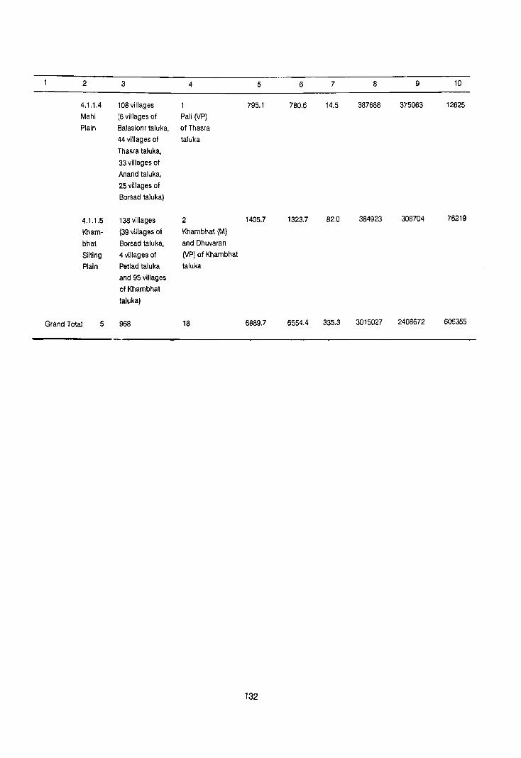
2 3 4 5 6 7 8 9 10
4.1.1.4 108 villages 795.1 780.6 14.5 387688 375063 12625
Mahi (6 villages of Pali (VP)
Plain 8alasionr taluka, of Thasra
44 villages of taluka
Thasra taluka,
33 villages of
Anand taluka,
25 villages of
Borsad taluka)
4.1.1.5 138viliages 2 1405.7 1323.7 82.0 384923 308704 76219
Kham- (39 villages of Khambhat (M)
bhat Borsad taluka, and Dhuvaran
Silting 4 villages of (VP) of Khambhat
Plain Petlad taluka taluka
and 95 villages
of Khambhat
taluka)
Grand Total 5 968 18 6889.7 6554.4 335.3 3015027 2408672 606355
132

REGION-WISE VILLAGE CODES, 1981
District Name: l<HEDA Census Location Code No. 13 State: GUJARAT
SI. Division Taluka Location code Total No. of Area in km Remarks
No. No.& No. of Census villagesLTowns
Name villages as per of In ofTaluka In
1981 Taluka division Regional
division
2 3 4 5 6 7 8 9
4.1.1.1. (1) Matar 1 to 27, 32 to 42, 65 451.6 Code No. 28 to 31,43 to 47, 59,
Sabar- 48 to 58, 61 to 60,70 to 73, 81 & 82 are in
mati 69,74 to 80 division No. 4.1.1.2
Vatrak (2) Mehme- 1 to 25, 28 to SO, 62 379.8 Code No. 26, 27, 51, 54 to 58, 71
Plain dabad 52, 53, 59 to 70 to 76 are in division No. 4.1.1.2
Mehmedabad
(Urban) & 2 34.8
Kheda Towns
(Urban)
(3) Kapad- 1 to 6, 24 to 30, 65 287.9 Code NO.7 to 23,31 to 45,47,
vanj 46, 48 to 56, 72 57 to 71, 85 to 99, 118, 123 to to 84, 100 to 117, 139,147 to 161 are in division 119to 122, 140to No. 4.1.1.2 146
Total for
division - 192 village.s 119.3 No. + 2 Towns 34.8 4.1.1.1
1154.1
II. 4.1.1.2 (1) Kapad· 7to 23, 31 to 96 678.6 Code No.1 to 6, 24 to 30,
Nadiad vanj 45,47,57to 46, 48 to 56, 72 to 84,
Plain 71, 85to 99, 100 to 117, 119to 122,
118, 123 to 139, 140 to 146 are in division
147 to 161 No.4.1.1.1
Kapadvanj 19.2 urban Town (2) 8ala- 55,57,63 to 74, 33 206.8 Code No.1 to 54, 56, 58 to 62 are in
sinor 77, to 84, 88 to division NO.4.1.1.3 and Code No.
'35,97, 98 & 99 75, 76, 85 to 87 & 96 are in
division No.4.1.1.4
133

2 3 4 5 6 7 8 9
Balasinor 21.6 Urban Town (3) Thasra 1 to 14, 24 to 40, 50 347.7 Code No. 15 to 23, 41 to 55,
56 to 66, 72 to 79 67 to 71, 80 to 94 are in division
No.4.1.1.4
Thasra
Urban & 2 29.9 Dakor Towns Urban
(4) Anand 1 to 3, 6 to 13, 44 318.9 Code No.4, 5, 14 to 18, 27 to 19 to 26, 33 to
32, 38 to 44, 51, to 57, 67 37,45 to 50, 58
to 69, 75, 76 & 77 are in to 66, 70 to 74
division No. 4.1.1.4
(1) Umreth
Urban,
(2) Anand)
Urban
(3) Vallabh. 4 44.9 Vidyanagar Towns (Urban) &
(4) Vitha\·
Udyognagar
(Urban)
(5) 1 to 19, 21 to 23, 31 318.9 Code No. 24 to 31, 48 to 54, II 32 to 36, 38, 45,
70 to 77, 95 and 20 are in 47 &55
division No.4. 1. 1.4 Code No. 37,
39 to 44, 46, 56 to 69, 78 to 94
are in division NO.4.1.1.5
Borsad 24.9 Urban Town
(6) Petiad 1 to 73, 76, 79 to 79 438.4 Code No.74, 75, 77 & 78 are 83
In division No.4.1.1.S
Pet/ad
Urban & 2 16.6 6.9 km2
area of Pet/ad village Sojitra Towns + 6.9 (Rural) included in the Urban ----Urban
23.5 area (7) Nadiad 1 to 100 100 622.3
Nadiad
Urban & 2 40.3 Vaso Towns Urban
134

2 3 4 5 6 7 8 9
(8) Mater 28 to 31, 43 to 17 125.4 Code No.1 to 27, 32 to 42, 48 47,59,60,70to to 58, 61 to 69, 74 to 80 are 73,81, to 82 in division No.4.1.1.1
(9) Kham- 25,27 to 31 6 49.9 Code No.1 to 24, 26, 32 bhat to 101 are in division No.4.1.1.5
(10) Mehme- 26,27,51, 54 to 14 87.7 Code No.1 to 25, 28 to 50, 52, 53, dabad 58,71 to 76 59 to 70 are in division No. 4.1.1.1
Total for 470 villages 3043.1 division + 13 + 204.0 4.1.1.2' Towns
3247.2
"' 4.1.1.3 (1) Balasinor 1 to 54, 56, 60 287.7 Code No.75, 76, 85 to 87, Aravalli 58 to 62 96 are in division No. forested 4.1.1.4 Rock Code No.55, 5763 to 74, Outcrops 77 to 84, 88 to 95, 97, 98 & 99 are
in division No.4.1.1.2
Total for
division - 60 287.7 4.1.1.3 villages +
+ Town-
NIL
287.7
IV 4.1.1.4 (1) Bala- 75,76,85 6 36.2 Code No.1 to to 54, 56, 58 to 62 Mahi sinor to 87, 96 are in division No.4.1.1.3 Plain Code No.55, 57, 63 to 74,
77 to 84, 88 to 95, 97 98 & 99 are
in division No. 4.1.1.2
(2) Thasra 15to 23, 44 267.8 Code No.1 to 14,24 to 40, 41 to 55, 5610 66, 72 to 79 are in division 67 to 71, 80 to 94 No.4.1.1.2
Pali 14.5 (Urban) Town (3) Anand 4,5,14to 33 312.2 Code No.1 to 3,6 to 13, 19
18,27 to 32, to 26,33 to 37, 45 to 50, 58 38 to 44, 51 66, 70 to 74 are in division to 57, 67 to No.4.1.1.2 69,75 to 77
IV 4.1.1.4 (4) Borsad 20,24 to 25 164.4 Code No.37, 39 to 44, 46, 31,48 to 54, 56 to 69, 78 to 94 are in division 70 to 77,95 No.4.1.1.5
135

2 3 4 5 6 7 8 9
Code No.1 to 19, 21 to 23, 32 to
36,3845,47 & 55 are in division
No.4.1.1.2
Total for - 108 780.6
division villages oj. 14.5
No. + 1 Town
4.1.1.4 795.1
V 4.1.1.5 (1) Borsad 37,39to 39 250.7 Code No.1 to 19,21 to 23,
Kham- 44,46,56 32 to 36, 38, 45, 47 & 55 are
bhat to,69, 78 to 94 in division No.4.1.1.2
Silting Code No. 20, 24 to 31, 48 to 54, Plain 70 to 77, 95 are in division 4.1.1.4
(2) Petlad 74,75, 4 13.3 Code No.1 to 73, 76', 79 to 83 are
77 & 78 in division-No.4.1.1.2
(3) Kham- 1 to 24, 26, 95 1059.7 Code No.25, 27 to 31 are in
bhat 32 to 101 division No. 4.1.1.2
Khabhat
(Urban)
& 2 - 82.0 ;
Dhuvaran Towns
(Urban)
Total 138 1323.7
for villages + division 2 Towns 82.0 No.
4.1.1.5 1405.7
136

District Name: KHEDA
State District Division
name number
and name
2 3
Gujarat Kheda 4.1.1.1
Sabarmati-
Vatrak
Plain
STATEMENT ON REGION-WISE
PHYSIO-CULTURAL DETAILS
Census Location Code No.13
Name of
adminis
trative
division
4
Matar,
Mehmedabad
Geology
5
Alluvium,
blown
and Kapadvanj sand,
talukas etc.
137
Soils
6
Orthids
Aquepts
Usterts
Ochrepts
State: GUJARAT
Physio-cultural Characteristics
7
The region covers the western part of district
along the border of Ahmadabad dislt. and
spreads over Matar, Mehmedabad and
Kapadvanj, talukas. This region makes its
boundary with Ahmadabad dislt. in the west
Khambhat Silting Plain in the south, Nadiad
Plain in the east and district Sabar Kantha in
the north.
As regards the relief of the region, it is higher
in the north (70 meters above the MSl) and
becomes lower towards soutA (22 meters)
above the MSL), Sabarmati, Vatrak are the
main rivers of the region. The region is
composed of A1luvil1111, blo\\tn sand, etc. Soils
found in the region are deep black in the north
and gray brown in the rest of the region. Soils
as classified by NBSS & LUP (leAR), Nagpur,
the region has Orthids-Aquepts and usterts
Ochrepts type of soils.
Orthids-Soils of arid region with some
developments.
Aquepts-Brown soils (Hydromophic)
Ochrepts: Shallow black, brown and Alluvial
soils of northern region.
Usterts-Deep black soils.
The region has good network of roads and
railway. The broad guage section of
Ahmadabad Bombay passes through the
region. The region is having national highway,
state highways and other major district roads,
of which most of them are connecting the
region with Ahmadabad.

2
Gujarat Kheda
3
4.1.1.2
Nadiad
Plain
4
Petlad
Nadiad,
Thasra,
Anand
Borsad,
Parts of
Matar
Mehmedabad
Kapadvanj,
Balasinor,
Khambhat,
talukas
5
Alluvium,
blown
sand, etc.
Deccan
Trap Infra-
Trappean,
Bagh and
lameta Beds
138
6
Orthids
"quepts.
Usterts-
Ochrepts
7
The region forms the central part of the district
and extends over Petlad, Nadiad, Thasra,
Anand, Borsad, Mehmedabad, Kapadvanj,
Balasinor, Khambhat and parts of Malar
taluka, The region makes its boundary with
Sabarmati-Vatrak Plain. 4.1.1.1 in the west,
district, Sabar-Kantha in the north, Mahi Plain
4.1.1.4 in the east and khambhat sliting Plain
4.1.1.5 in the south.
As regards relief the 100 metre, contour
passes through the region in northern part.
The general slope of the region is from north
to south, and in the southern part of the plain
touches the hughts upto 32 meters above the
MSL. Geologically the region is having
Alluvium blown sand, etc generally but in the
northern part Infra-Trappen Bagh and Lameta
Beds and Deccan Trap are also found in very
small areas.
In northern part the soils are deep black,
shallow black, alluvial and rest of the region is
covered by gray and brown soils. Soils as
classified by NBSS & LUP (ICAR), Nagpur, the
region has Orthids-Aqrepts and Usterts
Ochrepts types of soils, Othids-Soils of arid
region with some development.
Aqepts-Brown soils, (Hydromorphic)
Ochrepts-Shallow black, brown and alluvial
soils of northern region.
Usterts-Deep black soils.
As regards the trasport and communication
facilities the region is having well developed
network of rail and roads. The Ahmadabad -
Vadodara section of br.oad gauge railway
passes through the region connecting Natliad
and Anand towns, from Anand Godhra
section Broad gauge also passes through .the
region and connects Umreth, Dakor and
Thasra town with Anand. The second section
Anand to Khambhat (BG) pa~ses through the
region and connect Petlad town with Anand.
The third section Vasad Kantha also passes
through Borsad in the region. There are two
sections of narrow gauge Nadiad-Kap~dvanj
and Nadiad-Bhardran which connect the

2 3 4 5 6 7
Nadiad town with Kapadvanj, Vaso, Sojitra,
Pet lad towns. The National highway (No, 8)
also connects the region with other parts of the
district and the state. There is a well developed
network of state highway and other district
roads .. Industrial development has taken place
in the region.
Gujarat Kheda 4.1.1 ,3 Balasinor Alluvium Usterts- This region covers the north-eastern part of the Aravalli taluka blown Ochrepts district and occup the northern part of the Forested sand, etc Balasinor taluka. The region makes it rock Deccan boundary with Sabar Kantha district in the Outcrops Trap Infra- west and North, district Panch Mahals forms
Trappean, Bagh boundary with the region in the east and in the and lam eta Beds south Nadiad Plain 4.1.1.2 makes its boundary Erinpura with the region.
Granite
Aravalli and As regards the relief of the region, it has 100 associated rocks. metre height in general above the MSL. This
region is also highest part of the district, which
in some places has alevation 212 meters,
Geologically the region is composed of. The
soils are deep.black, shallow black, brown and
alluviums. The soils as classified by NBSS & LUP (ICAR), Nagpur, the region has usterts-
Ochrepts types of soils.
Ochrepts: Shallow black, brown and alluvial
soils of northern region.
Usterts- Deep black soils.
The transport and communication network of
the region is very poor. There is no rail or road
link to the region except on e state highway
which rs very close to its boundary in Panch
Mahals district.
Gujarat Kheda 4.1.1.4 Balasinor, Alluvium, Usterts- The region occupies the eastern part of the Mahi Thasra, blown Ochrepts district, covering Balasinor, Thasra, Anand, Plain Anand, sand, etc. and Borsad talukas, the region is making its
and Borsad Infra-Trappean, boundary with district, Vadodara and district talukas. Bagh and Panch mahals in the east and Nadiad Plain
Lameta Beds 4,1,1,2 in the west and Khambat Silting Plain
Erinpura in the south-west.
Granite.
From relief point of view, the region is having
60 metres height above the MSL in the north
and 35 metres above the MSL in the south,
Geologically the region is covered by Alluvium,
blown sand etc. Infra-Trappean, Bagh and
139

2 3 4
Gujarat Kheda 4.1.1.5 Khambhat
Khambhat Borsad
Silting and Petlad
Plain talukas.
5 6
Alluvium, Orthids-
blown Aquepts
sand; etc. Usterts-
Qchrepts
140
7
Lameta Beds and Erinpura Granite. The soils
found in the region are gray brown. Soils as
classified by NBSS & LUP (ICAR), Nagpur, the
region has Usterts-Ochrepts types of soils
Ochrepts: Shallow black, brown and alluvial
soils of northern region.
Usterts-Deep black soils.
The transport and communication network in
the region is fairly good, the railways,
Ahmadabad-Vadodara, Anand - Godhra,
Vasad - Kathana section of broad guage pass
through the middle of the region.
The region occupies the south-western part of
the district and extends over Khambhat, Petlad
and Borsad talukas. The region makes its
boundary with distt. Ahmadabad in the west,
Sabarmati-Vatrak Plain 4.1.1.1. and Nadiad
Plain 4.1.1.2 in the north, Mahi Plain 4. 1.1.4 in
the east, Gulf of Khambhat and District.
Bharuch in the south.
From relief point of view, the region has very
low profile of slope. The region has 50 metres
height above the the MSL in the north, wile the
salt watery area of coastal part in 10 to 16
metres above the MSL, and usually remain
flooded in rainy season. Geologically the
region is covered by Alluviums blown sand,
etc. Soils are gray and brown types. The south
western part is composed of coastal alluvium
with saline and alkaline soils. Soils as
classified by NBSS & LUP (ICAR), Nagpur, the
region has Orthids-Aquepts and Usterts-,
Ochrepts-types of soils.
Ochrepts - Shallow black, brown and alluvium
soils of northern region.
Usterts - Deep black soils.
Aquepts - Brown soils (Hydromorphic)
Orthids·Soils of arid region with some develop
ment.
The transport and communication network of
the district is good. Anand-Khanbhat and
Vasad • Kantha section of (BG) Western rail
way pass through the region along with slate
highway and other district road.

DISTRICT VADODARA
REGIONAL DIVISIONS
The district Vadodara is the part of Gujarat Plain (4.1.1) and is sub-divided into following seven submicro regions on the basis of geology, soils, topography, climate and natural vegetation.
4.1.1.1 Khambhat Silt:
This is the smallest region in the district and occupies western part of the Padra taluka and located in the mid western side of the district. There are 30 villages in the region with an area of 224.1 km2, which is inhabited by 83878 persons. This is an entirely rural area. Geologically the region is composed of Alluvium blown sand, etc. Soils are Usterts-Ochrepts. Density of the region is 347 persons per km2.
4.1.1.2 Mahi Plain:
This region extends over the north-western part of the district and covers parts of talukas of Padra, Vadodara and major part of Savli taluka. The area of the region is 952.3 km2 out of which 920.8 km2 is rural which is inhabited by 320,523 persons in 158 villages. Six towns with an area of 31.5 km2 is inhabited by 62,003 persons. Major parts of the region is geologically composed of Alluvium blown sand, etc. except the northern part where' small patches of Erinpura Granite and Deccan Trap are found. Soils of the region are Usterts-Ochrepts. The density of the region is 402 persons per km2 which reveals its development.
4.1.1.3 Vadodara Plain:
This region occupies the central part of the district and extends over Padra, Vadodara, Savfi, Vagodia, Dabhoi, Karjan, Sinor and Sankheda talukas covering an area of 2618.9 km2. The rural
141
area of the region is 244.3 km2 and is inhabited by 497,022 urban persons in 418 villages. The region is also highly urbanised in the district. Its urban population is 827473 living in six towns including the district headquarters Vadodara. Geologically the region is covered by Alluvium, blown sand etc. Deccan Trap and gneiss. The soils of the region are Usterts-Ochrepts. The .region is having very good agricultural as well as industrial base and is supported by fertile soils and climate. The density of the region is 506 person per km2. Which reflects its development.
4.1.1.4 Orsang-heran Plain:
This region occupies the mid-eastern part of the district and extends over Dabhoi, Sankheda, Chhota Udaipur, Nasvadji, Jetpur Pavi and Tilakwada talukas of Vadodara and some parts of Nandod taluka of Bharuch districts. The area of the region is 2438.3 km2 out of which 2403.2 km2 is rural which is inhabited by 465658 persons in 670 villages. The urban population is 46595 in five towns. Geologk !'y the region is composed of Alluvium, blown sand, etc, Deccan Trap Infra, Trappean Bagh 'and lameta Beds, gneiss Aravalli and associated rocks, the soils are orthents-Orchrepts and ustertsOchrepts. Summer seasons are very dry and humiclity increases only in rainy season. The density of the region is 210 persons per km2.
4.1.1.5 Viddhyan Hills:
This region in the eastern part of the district and extends over Chhota Udaipur and Nasvadi talukas. there is a pocket of Madhya Pradesh state in Chhota Udaipur taluka, which consists of a single village of Jhabua district. The area of the region is 827.6 km2 of which 825.6 km2 is rural and is

inhabited by 129,631 persons in 212 villages. The
Urban population is 5,738 living in Kavant town.
Geologically the region is composed of Alluvium,
blown sand, etc, Deccan Trap, Infra-Trappean, Bagh and lameta beds. There is forest cover in the
south-western part of the region. The weather
conditions are same as in other regions of the
district, i.e. hot and dry summer with good rains in
monsoon. Soils are Orthents-ochrepts. The density
of the region is 164 persons per km2 which reveals that area is not developed.
4.1.1.6 Narmada Gorge:
This region occupies south-eastern part of the
district and covers some parts of Chhota Udaipur and Nasvadi tal ukas. The area of the region 190.8
km2 and is inhabited by 8192 persons in 33 villages.
The region is not having any urban area.
Geologically the region is composed of Deccan
Trap Infra-Trappean, 8agh and lameta Beds and the
soils are Orthents Ochrepts and Orthents Rockoutcrops. The density of the region is 43 persons per km2. It is lowest in the district which reflects that
it is not developed region.
4.1.1.7 Lower Narmada Valley:
This valley extends over Oabhoi, Karjan, Sinor
and Tilakwada talukas in the southern part of the
district. The total area of this valley is 530.7 km2 out
of which 514.5 km2 is rural area and is inhabited by
103381 persons in 136 villa~es and the urban area
of Sinor town is 16.2 km whose population is
8,718. Geologically the valley is composed of
Alluvium, blown sand, etc., Deccan Trap, InfraTrappean, Bagh and lameta Beds. The soils are
Othids-Ochrepts and Usterts. The density of the region is 211 persons per km2.
142


(1 dVW
c
I I ' SW~ SI 01 S 0 S 'sw~
SNOISIAIO 1VNOI~3't!
51 300:) SnSN3::J
VijVaOaVA lJlijlSla l'v~~rn~
H '0
H n
(b ,)~ 00 U ~i1 ~ ,)
"" ,.,
\
'y
VIONI ~o snSN3J

[Ja!l £ Ol dn sapo~ dow O!PUI 110 341 01 3~u3J31aJ 41!M SUO!S!AiP IDUO!63J 10 3mnb3s 34l PD3~
-r---------- A~VONn08 Hl/M O~J/Vi·SnS -,.-r-----------------------·
~~--------------------~~~~Vi ··r------------------j j I + ----O~JVVi
l '~ l 'y NO/SItIiO lVNO/93~ ~ '" '" '" ," '" '" '" '" '" '''''' "~3A1~
I111 :1 ~ /I 111111 39nV9 MOl:ll:lVN II " (I
S~
• -i!j- • "39M9 OVOl:l8 (NOIIV1S H1IM 3NIl AVM1/Vl:l S~
," ". '" .. , '''OVOl:l 0311V13Vi 1NV1l:lOdVi/ II HS .....,................... .. AVMH9/H 31V1S
-~9 H-N- '" .. , '" , .... , ... " ... , AVMH91H lVNOI1VN • .., '" ," .. , ..... , '" ", '" "'NOIlYlndOd
3A08V ONV 000 S 9NIAYH S39VlliA ~ '" '" ... , .... , , .. '" ", ." V3l:lV NV8l:ln
ji .... ". ". '" '" "lS3l:l0~ 03Al:l3S3l:l II
-------- .... ,. " ...... , lVHVVi/v~nlV1 " _,_.- ." ." " .... '" .. ' "'1JIl:l1SIO
_,,_,,- ", ," .. , ". ," " ... ' "31VlS 'Al:lVONn08
. HS30Vl:ld VAHOVVi ~O ll:lVd l
'~l:lVNI~3l:l lvmn9) l:lV9VNl:lVHVMVr ·S 'l:lV9VNl:l3ZI1/1l:l3~ 'y
VMrv8 '£
'G3l:lV 031.:l1l0N lVIl:llsnOND X31driOJ lVJlri3HJOl:l13d 'z '&m 03/~/lON lVIl:l1snONY /l:lVS30NVN '~ ,
V3t1V NlfSl:ln
Sld3~HJO· Sl~31sn m 001
SdO~'lno ~JO~·SlN3HlijO r.;:-:-;, 09
a Sld3~H~O-SlN3HlijO 9S
II 'swX OZ 0
51105
A311YA VOVVil:lYN l:l3MOl 'L I I 'y
39l:l09 VOVril:lVN '9 1 '~ 'y
S111H NVAHON/A 'S l 'I 'y
NIVld NYl:l3H· 9NVS\j0 'y I I 'y
NIVld Vl:lVOOOVA E I " 'y
NIVld IHYVi '~l 'I 'y m IVH8riVH~ I 'I 'I 'y
S~JO~ Q31~IJOSS~ 'W!l/!!1lJ. ON~ Ilm~~~ ~
SSI3N9 = 31lNm ~dndNld3 1::::::::::::1
S038 ~m-lVl ON~ [""" j H9~8 'N~3ddm·mNI , ••... • .
dV~l NVJJ30 B 'm 'ON~S NM018 , ~nl~nm roooJ
~
'(
II SW~ oz 0
A901039


District Name: VADODARA
District Region No. of villages
No. and in each Region
Name as evolved
2 3
Vadodara 4.1.1.1 30 Villages
Kham- (30 villages of
bhat Padra taluka)
4.1.1.2 158 villages
Mahi (11 villges of Plain Padra taluka,
29 villages of
Vadodara taluka,
118 villages of
Savli taluka.)
4.1.1.3 418 villages
Vadodara (41 villages of
Plain Padra taluka,
73 villages of
Vadodara taluka,
19 villages of
Savli taluka,
95 villages of
Vaghodia taluka,
84 villages of
Dabhoi taluka,
64 villages of
Karjan taluka,
22 villages of
Sinor taluka,
20 villages of
Sankheda taluka)
DATA ON REGIONAL DIVISION
Census Location Code No,:15 State: GUJARAT
Area in km- 1981 Population 1981 No. of towns in
each Region Total Rural Urban Total Rural Urban
4 5 6 7 8 9 10
NIL 224.1 224.1 83878 83878
6 952.3 920.8 31.5 382526 320523 62003 (Padra (U.A.) of
Padra taluka,
Fertilizer nagar
(NM), Jawahar-
nagar (NM), Bajwa
(VP), Petrochemical
Complex INA
(INA), Nandesari-
INA (INA) of
Vadodara taluka.
6 2618.9 2441.3 177.6 1324495 497022 827473
Chhani (NP),
Vadodara (Me) &
Tarsali (VP) of
Vadodara taluka,
Vaghodia (VP) of
Vaghodia taluka,
Dabhoi (M) of Dabhoi
taluka, Karjan
(NP) of Karjan
taluka
145

2 3 4 5 6 7 8 9 10
4.1.1.4 670 villages 5 2438.3 2403.2 35.1 512253 465658 46595 Orsang- (124 villages of Jetpur (VP) Heran Nasvadi taluka, of Jetpur-Plain 212 villages of pavi taluka,
Jetpur pavi- Bahadarpar-
taluka, 21 vill- (VP),Bodeli-
ages of Tilak- (VP) and
wada, 21 villa- Sankheda (VP)
ges of Dabhoi of Sankheda
taluka,164 1a,luka, Chhota
villages of Udaipur (NP) of
Sankheda taluka, Chhola Udaipur
127 villages of taluka
Chhola Udaipur
taluka & 1 village
of Nandod taluka,
district Bharuch.)
4.1.1.5 212 villages 827.6 825.6 2.0 1353(39 129631 5738
Vindhyan (68 villages of Kavan! (VP) of
Hills Nasvadi taluka, Chhota Udaipur
143 villages taluka
of Chhota Udaipur
laluka, 1 village
of Alirajpur taluka,
Disl. Jhabua of
Madhya Pradesh.)
4.1.1.6 33 villages NIL 190.8 190.8 8192 8192
Narmada (6 villages of
Gorge. Chhota Udaipur
taluKa,27
villages of
Nasvadi laluka.)
4.1.1.7 136 villages 530.7 514.5 16.2 112099 103381 8718
Lower (76 villages of Sinor (VP) of
Narmada Tilakwada Sinor taluka
Valley taluka, 18
villages of
Sinor taluka,
29 villages of
Karjan taluka &
13 village of
Dabhoi taluka.
Grand 7 1657 19 7782.7 7520.3 262.4 2558812 1608285 950527
Total
146

REGION-WISE VILLAGE CODES, 1981
District Name: VADODARA Location Code No, 11 State: GUJARAT
SI. Division Taluka Location code Total No. of Area in km Remarks
No. No,& No. of Census villages/Towns
Name villages as per ot In otTaluka In
1981 Taluka division Regional
division
2 3 4 5 6 7 8 9
4.1.1.1. (1) Padra 1 to 5,12 30 224,1 Code No,6 to 11, 23 to 26 & 32
Kham- 1022,33 to are in division No, 4,1.1,2,
bhal 41,61 to 65 Code No, 27 to 31,4'2 to 60, 66 to
Silt 82 are in division No, 4.1,1.3
Tolal for
division 30 224,1
4.1,1,1 villages
Towns NIL + -
224.1
II 4,1.1.2 (1) Padra 6to 11, 11 69,2 Code No, 1 to 5, 121022, 3310
Mahi 23 to 26 &32 41, 61 to 65 are in division No.
Plain 4,1,1,-1 Code'No, 27to31, 42 to
60, 66 to 82 are in division No,
4.1.1.3,
Padra
(Urban) 1 Town 13.3 12.8 km2 are of Padra village
(Rural) included in Urban area
(2) Vado- 1 to 11, 16 29 178.4 Code No, 12 to 15,24 to 32,
dara to 23, 33 to 40 to 42, 45 to 101 are in division
39,43,44 & No,4,1,1,3
102
Fertilizer
nagar, (Urban),
Jawaharnagar
(Urban),
8ajwa (Urban), 5 Towns 18,2
Petrochemical-
Complex INA
(INA), Nandesari
INA (INA)
147

2 3 4 5 6 7 8 9
(3) Savli 1 to 88, 118 673.2 Code No. 89 to 94, 97,
95,96,98 122 to 130, 135 to 137
to 121, 131 are in division No. 4.1.1.3
to 134,
Total for
division 158 920.8
No. villages t 31.5 -4,1,1,2 + 6 Towns 952,3
III 4.1.1 ,3 (1) Padra 271031, 41 228.0 Code No, 1 to 5, 12 to 22,
Vado- 421060, 33 to 41, 61 to 65 are in
dara 66 to 82, division No. 4.1.1.1
Plain Code No.6 to 11, 23 to 26 & 32
are in division No, 4,1.1.2
(2) Vadodara 12 to 15, 73 360.1 Code No.1 to 11,16 to 23,
24 to 32, 33 to 39, 43, 44 & 102 are
40 to 42, in division No. 4.1.1.2
45 to 101
Chhani (Urban)
Vadodara (Urban) 3 Towns 123,1
& Tarsali (Urban)
(3) Savli 89 to 94, 19 118.8 Code No.1 to 88, 95, 96,
97, 122 to 130, 98 to 121, 131 to 134 are
135 to 137 in division No.4.1.1 ,2
(4) Vaghodia 11095 95 549.4
Vaghodia 15.0
(Urban) Town
(5) Dabhoi 1 to 53, 57 to 84 474,2 Code No. 54 to 56, 71 to 74, 92 to
70, 75 to 91 104, 108 are in division No.
4.1.1.4 Code No.l0S to 107, 109
to 118 are in division No. 4.1.1.7
Dabhoi 23,8
(Urban) Town
(6) Karjan 1 to 52, 64 455.4 Code No. 53 to 55, 68 to 93
56 to 67 are in division No. 4.1,1.7
Karjan 15,7
(Urban) Town
(7) Sinor 1 to 21 & 23 22 141.4 Code No.22, 24 to 40 are in
division No. 4.1.1.7
148

2 3 4 5 6 7 8 9
(8) Sankheda 14 to 21, 40 to- 20 114,0 Code No.1 to 13, 22 to 39,
47,76 to 79, 48 to 75, 80 to 184 are in division
No. 4.1.1.4
Total for - 418 villages 2441,3
division No. + 6 To\\,ns + 177.6
4.1.1.3 2618.9
IV 4,1.1.4 (1) Nasvadi 1 to 89, 99 to- 124 290.6 Code No. 90 to 96, 98, I
Orsang- 119,138 to 145, 120to 137, 146to 165,
Heran 166 to 170 171 to 186, 188, to 192, 194 are
Plain in division No.4.1.1.5 Code No.
187,193, 195 to 219 are in
division No.4, 1.1.6
(2) Jetpur- 1 to 212 212 800.8
pavi
Jetpur 4.4
(Urban) Town
(3) Tilakwada 2 to 1" 14, 25 to- 21 53.9 Code No.1, 1210 13, 15 to 24,34,
33,36 35, 3710 97 are in division
No.4.1.1.7
(4) Dabhoi 54 to 56, 71 to 74, 2~ 75.4 Code No. 10510 107, 10910 118
92 to 104 & 108 are in division No. 4.1.1.7
Coele No.1 to 53, 57 to 70, 75 to
91 are in division No.4.1.1.3
(5) Sankheda 11013,221039, 164 582.0 Code No. 14 to 21, 40 to .47,
48 to 75,80 to 184 76 to 79 are in division No.
4.1.1.3
Bahadarpur
(Urban)
Bodeli
(Urban) 3 19.2 7.5 km2 area of Sankheda
Sankheda Towns +7.5 village (Rural) included
(Urban) 26.7 in the Urban area
(6)
Chhota- 1,2,101015,19- 127 599.1 Code No,3 to 9, 16 to 18,
Udaipur to 26,31 to 47, 27 ot30, 48 to 71, gO to 108,
72 to 89, 10910- 124to 127, 138to 140, 143,-
123, 128to 137, 144,151 to 155,157, 167to
141,142,145 to- 174,193 to 208, 224 to 269 &
150,156,158to- & 272 are in division No.
166, 175 to 192 4.1.1,5 Code No. 270, 271,
209 to 223 273 to 276 are in division No.
4.1.1.6 149

2 3 4 5 6 7 8 9
Chhota-
Udaipur 4,0
(Urban) Town
(7) Nadod 19 1.4 Code No, 19 of Nadod taluka,
(Dis!. district Bharuch falls in
Bharuch) this region,
Total for
division 670 villages 24Q3.2
No, + 5 Towns + 35,1
4,1,1.4 2438.3
V 4.1,1.5 (1) Nasvadi 90 to 96, 98, 120- 68 143,7 Code No. 187,193,195 to 219
Vin- 137, 146to 165, are in division No.4,l, 1,6
dhyan 171 to 186, 188 to Code No.1 to 89, 97,99 to 119,
Hills 192, 194 138 to 145, 156 to 170 are in
division No.4,I, 1.4
(2) Chhota- 3 to 9,16 143 678.2 Code No.270, 271, 273 to 276
Udaipur to 18, 27 to are in division No. 4.1.1.6
30,48 to 71,- Code No. 1,2, 10to 15,
90 to 108, 124 19 to'26, 31 to 47, 72 to 89,
to 127, 138 to 109 to 123, 12810 137, 141,
140, 143, 144, 142, 145to 150, 156, 158 to-
151 to 155, 157, 166,175 to 192, 209 to 223
167 to 174, 193 are in division No.4,1.1.4
to 208, 224 to
269,272
Kavant 2.0
(Urban) Town
(3) Alirajpur 31 3.7 Code No. 31 of Tal. Aliraj-
Dist. pur dist. Jabua of Madhya
Jabua Pradesh falls in Tal. Chho-
(M.P.) ta Udaipur, disl. Vadodara.
Total for
division 212 vi~lages 825.6
No. t 1 Town t 2.0
4.1.1.5 827.6
VI 4.1.1.6 (1) Chhota- 270,271,273 6 89.9 Code No,I,2,10to 15,
Nar- Udaipur to 276 191026,3110 47, 72 to 89,
mada 109 to 123, 12810 137, 141,
Gorge. 142, 145tb 150, 156, 158to 166,
175 to 192, 209 to 223 are in
150

2 3 4 5 6 7 8 9
division No.4. 1.1.4
Code No.3 to 9, 16 to 18, 27 to
30,48 to 71, go to 108, 124 to 30,
48 to 71, 90 to 108, 124 to 127,
138 to 140, 143, 144, 151 to 155,
157, 167 to 174, 193 to 208, 224
to 269 & 272 are in division No.
4.1.1.5
(2) Nasvadi 187,193, 27 100.9 Code 1 to 89, 97, 99 to 119, 138
19510219 to 145, 166 to 170 are in division
No.4. 1 . 1.4 Code No.go to 96, 98,
120to 137, 146to 165, .171 to
186, 188 to 192 & 194 are in
division No.4.1.1.5
Total for
division - 33 190.8 No. villages + 4.1.1.6 Town-NIL
190.8
VII 4.1.1.7 (1) nlak- 1,12,13, 76 190.6 Code No.2 to 11, 14, 25 to 33 Lower wada 15, to 24, 34, & 36 are in division No. 4.1.1.4 Narmada 35, 37 to 97 Code No.1 to 21 & 23 are in Valley (2) Sinor 22, 24 to 40 18 134.9 division No.4. 1.1.3
Sinor 1 16.2 (Urban) Town
(3) Karjan 53to55,68 29 130.8 C6de No.1 to 52, 56 to 67 are in to 93 division No.4. 1.1.3
(4) Oabhoi 105 to 107, 109 to- 13 58.2 Code No.1 to 53, 57 to 70, 118 75 to 91 are in division No.
4.1.1.3 Code No. 54 to 56, 71 to
74,92 to 104 & 108 are in
division No.4. 1.1.4
Total for
division 136 514.5 No. villages + 16.2 4.1.1.7 1 Town
---530.7
151

District Name: VADODARA
State Division
name
Division
number
and name
2 3
Gujarat Vadodara 4.1.1.1
Khambhat
Silt
Gujarat Vadodara 4.1.1.2 Mahi
Plain
Name of
adminis
trative
• divisions
4
Padra
taluka
Padra, Vadodara
and
Savli
talukas
STATEMENT ON REGION·WISE
PHYSIO-CUL TURAL DETAILS
Census Location Code No. 15
Geology Soils
5 6
Alluvium, Usterts-
blown Ochrepts
sand,
etc.
Alluvium, Usterts-blown Ochrepts
sand, etc,
Deccan
Trap
Erinpura
Granite
152
State GUJARAT
Physio-Cultural Characteristics
7
The region occupies the parts of Padra taluka in
the mid western part of the district. The region
makes its boundaries with Vadodara Plain 4.1.1.3
in the east, district Bharuch in the west and Kheda
district in the north.
From relief point of view, the eastern part is 22 metres above the MSL and the western part is 10 metres above the MSL. The region is elevated
towards west. Geologically the region is
composed of Alluvium, blown, Sand, etc. The
soils are gray-brown and deep black. Soils as
classified by NBSS & LUP (ICAR), Nagpur, the
region has Usterts-Ochrepts types of soils.
Ochrepts-Shallow black, brown and alluvial soils
of northern region.
Usterts-Deep black soils.
The transport and communication network of the
region is based on the state highway and (No.6)
and narrow gauge section of Jambusar and
Vadodara which passes through the district_
This region covers the north western part of the
district and extends over Padra, Vadodara and
Savli talukas. It makes its boundaries with district
Kheda in the north, Vadodara Plain in the south
east and district Panch Mahals in the north east
and the district Bharuch in the west.
Regarding the relief of this plain, the northern
portion is up to 100 metres above the MSL. The
middle part is 85 metres above the MSL and the
western part is 30 metres above the MSL. General

2 3
Gujarat Vadodara 4.1.1.3
Vadodara
Plain
4
Padra, Vadodara
Savli,
Vagodia,
Dabhoi,
Karjan,
Sinor
and
Sankheda
talukas
5
Alluvium, blown
sand, etc.
Deccan
Trap
Gneiss
-153
6
UstertsOchrepts
7
slope of the region is towards south-west
Geologically the region is composed of Alluvium,
blown sand etc, Deccan Trap and Erinpura
Granite. The soils are gray, Brown and deep
black. Soils as classified by N~SS & LUP (I CAR) ,
Nagpur, the region has Usterts Ochrepts types of
soils.
Usterts-Deep black soils.
Ochrepts: Shallow black, brown and alluvial soils
of northern region.
The transport and communication network of the
region is good. The Ahmadabad-Vadodara
section of broad gauge passes through the region
along with national highway (No.8). There is a
narrow gauge section in the eastern- part which
connects the two broad gauge rail links of Anand
Godhra and Vadodara-Godhra.
The region extends over, Padra, Savli, Vagodia,
Vadodara, Dabhoi, Karjan, Sinor and Sankheda
talukas in the central part of the district. The
region makes its boundaries with Khambhat silt
4.1.1.1 and Mahi plain 4.1.1.2 in the west, district
Panch Mahals in the north, Orsimg-Heran Plain
4.1.1.4 in the east and Lower Narmada Valley
4.1.1.7 in the south.
From relief paint of view, the northern part is 8!l
metres and near Karjan town the height is 27
metres above the MSL. Geologically the region is
composed of Alluvium blown sand, etc, Deccan
Trap and Gneiss. Soils are medium black, deep
black and gray brown. Soils as classified by NBSS
& LUP (I CAR) , Nagpur, the region has Usterts
Ochrepts types of soils.
Ochrepts: Shallow black, brown and alluvial soils of northern region.
Usterts-Deep black soils.
From transport and communication point of view,
the region has good network of roads and rails.
Bharuch-Vadodara section of broad gauge passes
through the region along with national highway
(No.8). The other broad gauge section of

2 3 4
Gujaral Vadodara 4.1.1.4 Dabhoi,
Orsang Sankheda,
. Heran Chhota-
Plain Udaipur,
Nasvadi,
Jetpur-
Pavi,
Tilakwada
Talukas
and some
part of
NanE:lod of
Bharuch
district
5
Alluvium, blown
sand etc.
Deccan
Trap
Infra-
Trappean,
Bagh and
Lameta
Beds.
GneiSS
Aravalli
and
associated
rocks.
154
6
Orthents-Ochrepts Usterts-Ochrepts
7
Vadodara-Godhra also passes through the region.
The narrow gauge section has a very good
network and connects Karjan, Dabhoi, Trasali and
Vagodia. There are also other district roads and
state highways i,n the region.
This plain extends over Dabhoi, Sankheda,
Chhota Udaipur, Nasvadi, Jetpur-Pavi and
Tilakwada tal uk as. The region makes it boundary
with Vadodara Plain 4.1.1.3 in the west, Lower
Narmada Valley 4.1.1.7. Bharuch district in the
South and Vindhyan Hills 4.1.1.5 in the east and
district Panch Mahals in the north.
From relief point of view, northern part of the
region is 400 metres above the MSL, while the
middle part is having height of 90 metres above
the MSL. Near Nasvadi in lower part the height is
75 metres above the MSL General slope of the
is from south to west. Geologically the region is
composed of Alluvium, blown, sand, etc, Deccan
Trap, Intra-Trappean, Bagh and Lameta Beds,
Gneiss, Aravalli and asso~iated rocks.
The soils are medium black and deep black. Soils
as Classified by NBSS & LUP (ICAR), Nagpur, the
region has Orthents-Recently formed soils.
Ochrepts: Shallow black, brown soils of northern
region.
Usterts-Deep black soils.
The region is having good forest coverage in
general and particularly in the eastern part.
From transport and communication network pain'
of view, the region is well connected by state
highway, other district roads and' Dabhoi·Chhota
Udaipur section of narrow gauge connect
Sankheda, Bodeli, Jetpur·Pavi and Chhota
Udaipur towns. Sankheda·Nasvadi section of
narrow gauge connects Sankheda and Nasvadi
towns.

2 3
Gujarat Vadodara 4.1.1.5
Vindhyan
Hills
Gujarat Vadodara 4.1.1.6
Narmada
Gorge
4
Chhota-
Udaipur
and Nasvadi,
talukas,
and one
village of
Jhabua
district of
Madhya
Pradesh
Chhota
Udaipur
and
Nasvadi
talukas
5
Alluvium,
blown
sand, etc.
Deccan
trap
Intra-
Trappean
Bagh and
Lameta
Beds
Gneiss
Deccan
Trap
Intra-
Trappean,
Bagh and
Lameta
Beds
155
6
Orthents-Ochrepts
Orthents-Ochrepts
Orthents-
Rock
Outcrops
7
This region occupiei> the eastern part of the
district and extends over Chhota Udaipur, Nasvadi
talukas. The region makes its boundary with
Madhya Pradesh in the east and north, Orsang
Herim Plain 4.1.1.4 in the west and Narmada
Gorge in the south.
From the relief point of view, 300 metres contour
passes through the northern part of the region.
Geologically this part is composed of Alluvium,
blown sand, etc., Deccan Trap Intra-Trappean,
Bagh and Lameta Beds. The soils are medium
black. Soils as classified by NBSS & LUP
(ICAR),Nagpur, have been found in the region are
Orthents-Ochrepts types of soils.
Orthents-Recently tormed soils.
Ochrepts: Shallow black, brown and alluvial soils
of northern region.
With regard to the means of transport and the
region is communication, by state highway (No.
11) which connects this region with Madhya
Pradesh and there is a district road which
connects Kavant town with Chhota Udaipur town.
This small region forms its position in south
eastern part of the district and covers the parts of
Chhota Udaipur and Nasvadi talukas. It makes its
boundaries with Madhya Pradesh in the east,
Maharashtra in the south, district Bharuch in the
west and Orsang-Heran Plain in the north.
As regards the relief, the region is 300 metres
above the MSL, and at some places it goes upto
520 metres. Geologically the region is composed
of Deccan Trap Intra-Trappean, Bagh and Lameta
Beds. Soils, as classified by NBSS & LUP (ICAR),
Nagpur, found in the region are Orthents-Ochrepts and Orthents-Rock out crops.
Orthents-Recently formed soils.
Ochrepts: Shallow black, brown and alluvial soils
of Northern region,
From transport and communication point of view,
the region has no road or rail.

2 3 4
Gujarat Vadodara 4.1.1.7 Dabhoi,
Lower Karjan,
Narmada Sinor
Valley and
Tilakwada
talukas
5
Alluvium
blown
sand, etc.
Deccan
Trap
Infra-
Trappean
Bagh and
Lameta
Beds
6
Orthents-
Ochrepts-
Usterts-
Ochrepts
156
7
This region occupies southern part of the district
and extends over the parts of Dabhoi, Karjan,
Sinor and Tilak with district Bharuch in the south,
Vadodara Plain in the north west and Orsang
Heran Plain in the east.
From relief point of view the region is having
elevation of 45 metres above MSL in the eastern
part while the western part is 20 metres above
MSL. Geologically the region is, composed of
Alluvium blown sand etc, Deccan Trap, Infra
Trappean Bagh and Lameta Beds and soils are
medium black. Soils as classified by NBSS & LUP
(ICAR), Nagpur, the region has Orthents-Ochrepts
and Usterts-Ochrepts types of soirs.
Orthents-Recently formed soiis.
Ochrepts: Shallow black, brown and alluvial soils
of northern region.
Usterts-Deep black soils.
As regards transport and communication network.
of the region there is a state highway and a
district road. Narrow gauge rail line also connects.
The region with Dabhoi, ~Karjan and Vadodara
towns.

DISTRICT BHARUCH Regional Divisions
District Bharuch is the part of Gujarat Plains (4.1.1) and has been divided into eight sub-micro regions on the basis of geology, soils, topography, climate and natural vegetations.
4.1.1.1 Khambhat Silt
The region covers the coastal areas of the district and extends over the talukas of Amad, Vagra, Bharuch and Jambusar. This is low land and most of the coastal parts are filled with water in rainy season. Geologically it is formed by Alluvium, blown sand, etc. Soils of the region are Orthids-Aquepts and Usterts-Ochrepts. There are 174 villages and two towns in the region 'which cover an area of 2259.9 km2. It is inhabited by 266774 persons of which 226350 and 40424 persons live in rural and urban areas respectively. The density of the region is 118 persons per' km2.
4.1.1.2 Bharuch Plain
The region spreads over the parts of Amad, Vagra and Bharuch talukas. This region is covered by Alluvium, blown sand, etc~ Soils of the region are Orthids-Aquepts and Usterts-Ochrepts. The region is drained by Narmada river. General slope of the region is westward. There are 82 villages and one town in the region with an area of 553.3 km2 which is inhabited by 123206 persons. Its rural and urban population are 115146 and 8060 respectively. The density of the region is 223 persons per km2 which reveals that the region is agriculturally developed.
4.1.1.3 lower Narmada Valley
The region extends over the central part of the
district and occupies parts of Bharuch, Ankleshvar, Hansot, Valia, Jhagadia, Nandod and Dediapada talukas. It has geological f::lrmation of Alluvium,
157
blown sand, etc. Uncflfferentiated, Eocene Beds, SubNummulit Beds. Deccan Trap, Infra-Trappean, bagh and Lameta Beds. The soils are Orthids-Aquepts, Orthents-Ochrepts and Usterts.Ochrepts. This is a conan growing region. General slope of the region is
toward south-west. It is covered with forests. There are 420 villages and we towns in the region covering an area of 2196.3 Km2 and is inhabited by 598259 persons, of which 405234 and 193025 are in rural and urban areas respectively. This area is agriculturally developed and has density of 272 persons per Km2.
4.1.1.4 Narmada Gorge
The region spreads over ·the north-eastern part of the district, occupying parts of Nandod and Dediapada talukas. River Narmada flows from east to west in the region. General height of the region is more than 300 metres. Geologically this region lies on Deccan Trap Infra-Trappean Bagh and Lameta Beds. Soits' found in the region are OrthentsOchrepts and Usterts-Ochrepts. The region is entirely rural and has 21 villages which cover an area of 271.3 Km2 and it is inhabited by 17159 persons. Its density of population is 63 persons per Km2 which reveals that the region is not developed. Major portion of the region is covered with forests.
4.1.1.5 Satpura Hills
These hUis occupy the eastern part of the district and extends over the talukas of Valia, Jhagadia, Nandod, Dediapada and Sagbara. Geologically. it comes under Deccan Trap and Infra-Trappean, Bagh and Lameta Beds. The soils are Orthents-Ochrepts and Usterts-Ochrepts. The region is covered with forests. Eastern part of the region has height of 500 metres and above. This is entirely rural region having 322 villages covering 1605.3 Km2 which is inhabited

by 142809 per~ons. The density of population of the region is 89 persons per km2.
4.1.1.6 Tapi Basin
This region extends over the south-eastern part of the district and occupies eastern parts of Sagbara taluka. The region is drained by river Tapi and its tributaries. This is an entirely rural region having 61
villages which has an area of 146.5 Km2. The region lies on Deccan Trap and the soils are OrthentsOchrepts and Usterts-Ochrepts. It is agriculturally developed and supports 36p1 persons. It has a density of 247 persons per Km2.
4.1.1.7 Valia Plain
This region extends over southern-middle part of the district and occupies parts of Valia taluka. It is drained by river Kim and its tributaries towards southwest. The geology of the region is Alluvium
158
blown sand, etc. Undifferentiated Eocene Beds, SubNummulitics Beds and Deccan Trap. The soils found in the region are Usterts-Ochrepts. The area of the region is 324.7 Km2. There are 63 villages in the region where 65245 persons reside. The region is agriculturally developed and has a density of 201
persons per Km2.
4.1.1.8 Khambhat Coast
The region spreads over south-western coastal part of the district and occupies parts of Hansot and Ankleshvar talukas. Major parts of' the region is covered with Alluvium blown sand, etc. and some parts in the south has Undifferentiated Eocene Beds. Soil of the region are Orthids-Aquepts and UstertsOchrepts. This region is entirely rural and has 49 villages which cover an area of 402.2 Km2. The region is inhabited by 46774 persons and the density of population is 116 persons per Km2,


(k:
lI ~ I})
«
« I
«
1 n
o c o
I I I 'SW~ II 01 S 'SW~
SNOISIAIO 1YNOI~3~
91 3aO) SnSN3J
s
HJn~VH8 lJI~lSla
1~~~rn9
1 "II , 0 a r 0 J 0. ~,
:) ~ 1 S
"II , 0 a
/
/
I
~
I (!)
u. o
u.
J
J
VIONI ~o SnSN3J

[J3 11 £ 01 dn sapOl dow 0IPUIIiD '41 01
m3J3j3J 41lM SUOl5lAlP IOUO!&aJ jO mlnb" 141 POlij]
'S 'I 'I 'v NOISIAIO 1VNOI~3~ 7 .. , .. , '" .. , .. , .. , .. , '" .. , .. , .. , .. , .. , .. , .. , "'~3AI~
1I1I1I~1I1111"""'''3~nv~ MOMMVN " I( II SH
- ~ - '" '" "'3~nv~ aVOij8'NOIlVlS HllM 3NIl AVM1IVM SH
"'" .,. " ...... , ... '" "·ovo~ 0311V13r1 1NmOd~1
9 HS "'" ". '" .; '" ", ". '" '" " .. " '" ". "'AVMH~IH 31V1S
8 HN ". " .. " ." ". '" ". '" ." ... ". '''AVMH~IH WNOI1VN
• ,,, ... '" ." '" ... '" ". " .... '" '''NOI1VlndOd 3A08V
ONV 000 S ~NIAVH S3!)V11IA
W. '" '" '" .... " '" ." '" .. , ". ". " .. " ...... V3~V NV8~n ...... :'" ,,' ." ." '" ... '" ·"lS3MO.:l 03AM3S3ij II J~
~.::.::.::.:;_;:..:.;: '" '" '" ." ". ". '" '" ". '" lVHVrI!vxnlV1 "
_._._,_ ,,' '" '" ." '" ." '" ." ." '" '" "'lJI~lS 10 II
_ .. _ .. _'" '" '" '" '" '" '" '" '" ." '" '" ". "'31m IAijVONnOa
1
'V3ijY 031.:lllON lYlij1SnONI'V'N'1
'DIM1S10 V~VOOOYA NI 030nlJNI vxnm OOONVN jO l~Vd 't
~ ~ n s 1
'" , 0 3
t Q :I Q.
~,
S038 m~~l ON~ D H~VB 'NV3dd~Hl·VH,NI '.
dVHl NVJJ30 AA W AHA
S038 JI1Ilnl1~nN·8ns _
S038 3N3J03 031 ~IIN3H3'.JIONn L..:..:.J
'J13'0N~S NMOl8'NnlAnllV I',',' ,I
,.----, 'SW~ OZ 0 A!)Ol03!)
Sld3HHJO" SlH3lSn ~ 001
Sld3MHJO - SJN3HJMO ~ 91
Sld3nOHOIHIHO I :: : 19z
r-; 'SW~ 01 0
Sl10S
lSYOJ lYH8r1VHX '8'lTt
NIVld mVA 'L'In
NISV8 IdYl '9 '!'l't
SlllH v~ndlVS 'nn
3~~0~ YOVrl1fVN 'f In
A311VA YOYrI~YN ~3MOl T rn
NIVld HJnijVHB TI'I'~
11lS 1VH8r1VHX 'I 'lTv
,~
J ~ 1 S a I -. ----.. , ._-
'II -. , 0 ~


DATA ON REGIONAL DIVISIONS
District Name BHARUCH Census Location Code No. 16 State : GUJARA T
District Region No. of villages No. of Towns Area in Kmg. in Region 1981 Population in Region
No. and in each region in Region
Name as evolved Total Rural Urban Total Rural Urban
2 3 4 5 6 7 8 9 10
Bharuch 4.1.1.1 174 Villages 2 2259.9 2202.6 57.3 266774 226350 40424
Kham- (81 villages of Jambusar (NP) of
bhat Jambusar Jambusar
Slit taluka, taluka, & 15 Villages Amod (NP)
of Amod taluka, of Arnod
61 villages of taluka
Vagra taluka,
17 villages of
Bharuch
taluka)
4.1.1.2 82 villages 553.3 549.2 4.1 123206 115146 8060
Bharuch (37 villages of Palej (VP) of Bharuch
Plain Amod taluka, taluka
8 villages of
Vagra taluka,
37 villages of
Bharuch taluka)
4.1.1.3 420 villages 5 2196.3 2134.8 61.5 598259 405234 193025
Lower (45 villages Bharuch (UA) 01 Narmada- of Bharuch Bharuch
Valley taluka,47 taluka,
villages of Anklesvar (UA)
Anklesvar Anklesvar
taluka,7 Anklesvar
villages of (INA) of
Hansot Anklesvar
taluka,21 taluka,
villages of Rajpipla
Valia taluka, (M) of
125 villages of Nandod
Jhagadia taluka, & taluka, Hansot
172 villages of (VP) of
Nandod Hansot
taluka, taluka
3 villages of
Dediapada
taluka)
161

2 3 4 5 6 7 8 9 10
4.1.1.4 21 Villages Nil 271.3 271.3 17159 17159
Narmada (18 villages 01
Gorge Nandod of
Nandod
taluka & 3 Villages of
Dediapada
taluka)
4.1.1.5 322 Villages NIL 1605.3 1605.3 142809 142809
Satpura (208 villages of
Hills Dediapada
taluka,
46 villages of
Sagbara
Taluka,
14 villages of
Nandod
taluka
43 Villages of
Jhagadia
taluka &
11 Villages of
valia taluka)
4.1.1.6 61 Villages Nil 146.5 146.5 36131 36131
Tapi 61 villages of
Basin Sagbara
taluka
4.1.1.7 63 Villages Nil 324.7 65245 65245
Valia- 63 villages of
Plain Valia
taluka)
4.1.1.8 40 Villages Nil 402.2 402.2 46774 46774
Kham· 38 villages of
bhat Hansol
Coast taluka & 11 Villages
Anklesvar
ta/uka
Grand Total 8 1192 8 7759.5 7636.6 122.9 1296357 1054848 241509
162

REGION-WISE VILLAGE CODES, 1981
District Name: BHARUCH Census Location Code No. 16 State: GUJARAT
SI. Division Taluka Location Code No. Total No. of Area of regional Remark
No. Number of Census Villages Villages/Towns Divisions
and Name as per 1981 Taluka in in'
Division Sq. km.
2 3 4 5 6 7 8 9
4.1.1.1 (1) Jambusar 1 to 81 81 1058.6
Kham- Jambusar 1 38.70 bhat (Urban) Town
Silt
(2)Amod 1,2,5,15to 15 187.2 Code No.3, 4, 6 to 14, 24, 23,25,40, 26 to 39, 4210 52 are in division 41 No. 4.1.1.2
Amod 18.54 (Urban) Town
(3) Vagra 1 to 7, 1310 61 836.7 Code NO.8 to 12, 291031
28,321069 are in division No. 4.1.1.2
(4) Bharuch 40, 60 to 65, 17 120.1 Code no. 1 to 15,20,21,23 to
77 to 79, 81 31,38,39,41 to 43, 57 to
to 87 59, 66, 67, 69 are in division
NO.4.1.1.2
Code No. 161019,22,32 to 37,
44 to 56, 68, 7010 76, 80, 88
to 99 are in division No. 4.1.1.3
Total for - 174 2202.6
division No. Villages + 57.24
4.1.1.1 +2 2259.84
Towns
4.1.1.2 (1) Amod 3,4,610 14, 37 262.4 Code No.1, 2, 5, 151023,25,
Bharuch 24,261039 40,41 are in division No. 4.1.1.1
Plain 42 to 52
(2) Vagra 810 12,29, 8 46.7 Code No.1 to 7,13 to 28, 3210
30,31 69 are in division No. 4.1.1.1
163

2 3 4 5 6 7 8 9
(3) Bharuch 1 to 15, 20, 21, 37 240.1 Code No. 40, 60 to 65, 17 to 79, 231031,38, 81 to 87 are in division No. 4.1.1.1
39,41 to 43, Code No. 1610 19,22,32 to 37,
57 to 59, 66, 44 to 56, 68, 70 to 76, 80, 88 to
67,69 99 are in division No. 4.1.1.3
Palej 4.11
(Urban) Town
Total for 82 549.2
division villages
No. 4.1.1.2 '+ 1 Town .±....W. 553.31
III 4.1.1.3 (1) Bharuch 1610 19,22, 45 256.6 Code No. 40, 6010 65, 77 10 79,
Lower 32 to 37, 44 to 81 to 87, are in division No.
Narmada 56,68,7010 4.1.1.2
Valley 76,80,8810 Code No.1 10 15,20,21,23 to 31,
99 38,39,4110 43, 5710 59, 66,
67 & 69 are in division No. 4.1.1.2
Bharuch 8.02 11.93 Km2 area of Bharuch
Town + 11.93 village
(Urban) 19.95 (Rural) included in Ihe Bharuch
urban:
(2) Anklesvar 1 10.28,3010 47 341.6 Code No. 29, 43, 44, 4610
42,45,5410 53 are in lhe division No. 4.1.1.8
58
Anklesva~ 2 8.50 4.24 Km2 area of Anklesvar
(Urban) & Towns + 4.24 village (Rural) included in
Anklesvar (INA) + the urban area of Anklesvar
(INA) 8.25
20.99
(3) Hansol 2108 7 58.2 Code No.1, 9 to 45 are in Ihe
division No. 4.1.1.8
Hansot 16.23
(Urban) Town
(4) Valia 110 18,42, 21 143.3 Code No. 24, 25, 27 to 30, 62
43,45 to 64, 94, 95 are in division No.
4.1.1.5
Code No. 19, to 23, 26, 31 to 41,
44,46 to 61,651093 are in
division No. 4.1.1.7
164

2 3 4 5 6 7 8 9
(5) Jhagadia 1 to 65, 73 to 125 600.2 Code No. 66 to 72, 95 to 112, 135
94, 113 to 134, to 152 are in division No. 4.1.1.5
153 to 168
(6) Nandod 1 to 18, 20 to 172 726.2 Code No. 19 falls in Vadodara
73, 76 to 142, Dist. Boundary Code No. 74, 75,
153to 179, 187 143to 152, 180 to 185 are in
to 189,191, division No. 4.1.1.4
204,205 Code No. 186, 190, 192, to 203
are in division No. 4.1.1.5
III Rajpipla 4.45
(Urban) Town
(7) Dedia- 1,2,3 3 8.7 Code No. 17, 18, 19 are in division pada No.4.1.1.4
Code No.4 \0 16,20 to 214 are
in division No. 4.1.1.5
Total for 420 2134.8 division villages + 61.62 No. t 5 Towns 2196.42 4.1.1.3
·IV 4.1.1.4 (1) Nandod 74,75,143to 18 240.8 Code NO.1 to 18, 20 to 73, 76 Narmada 152, 180 to to 142, 153 to 179, 18710 189, Gorge 185 191, 204 & 205 are in division
No. 4.1.1.3
Code No. 19 falls in Vadodara
Dis!. Boundary Code No. 186, 190,
192 to 203 are in division
No. 4.1.1.5
(2) Dedia- 17,18 & 19 3 30.5 Code No.4 to 16,20 to 214 pada are in division No. 4.1.1.5
Code NO.1, 2 & 3 are in division
No. 4.1.1.3
Total lor 21 271.3 division villages 4.1.1.4 t Town
Nil
271.3
V 4.1.1.5 (1) Dedia- 4 to 16,20 208 988.7 Code No.1, 2 & 3 in division Satpura pada to 214 No. 4.1.1.3 Hills Code No. 17, 18 & 19 are in
division No. 4.1.1.4
165

2 3 4 5 6 7 8 9
(2) Sagbara 1 to lD, 16, 46 211,5 Code No, 1110 15, 191031,
17,183210 4D 10 51, 57 to 8D, 91 to 96,
39,521056, & 1 D7 are in division No, 4,1,1,6
81 to 90, 97
10106
(3) Nandod 186, 190, 192 14 146,8 Code No, 1 10 18, 2010 73,
10203 76 to 142, 15310 179, 18710
189, 191, 204 & 205 are in division
No. 4.1.1.3 Code No. 74, 75, 143
10 152, 180 to 185 are in division
No. 4.1.1.4
Code No. 19 falls in Vadodara dislt
boundary
(4) Jhagadia 66 to 72, 95 to 112, 43 212.3 Code No. 110 65, 73 to 94, 13510152 11310134, 153 to 168 are in
division No. 4.1.1.3
(5) Valia 24,25,2710 11 46.0 Code No. 191023,26,311041,
30, 62, to 64, 44, 46 to 61, 65 to 93 are in
94 &95 division No. 4.1.1.7
Code NO.1 10 18,42,43 & 45
are in division No. 4.1.1.3
Tolal for - 322 1605.3
division villages
No. 4.1.1.5 + Town
Nil 161i5.3
Vl 4.1.1.6 (1) Sagbara 11 to IS, 19 61 146.5 Code No.1 to 10, 16to 18,
Tapi to 31,40to 51, 32 to 39: 52 to 56, 81 to
Basin 57 to 80; 91 to 90, 97 to 106 are in division
96 & 107 No. 4.1.1.5
Total for 61 146.5
division villages
No. Town 4.1.1.6 Nil
VII 4.1.1.7 (1) Valia 19 to 23,26, 63 324.7 Code NO.1 to 18,42,43 & 45
Valia 31 to 41, 44, are in division No. 4.1.1.3
Plain 461061,65 Code No. 24, 25, 2710 30, 62
to 93 10 64, 94 & 95 are in division
No.4.1.1.5
Total for - 63 324.7
division Villages for Town 4,1.1,7 Nil
166

2 3 4 5 7 8 9
VIII 4.1.1.8 (1) Hansot 1, 9to 45 38 324.3 Code No. 210 8 are in division Khllmbhat No. 4.1.1.3 Coast
(2) Anklesvar 29,43,44, 11 77.9 Code No. 110 28, 3010 42, 45, 46 to 53 54 to 58 are in division No. 4.1.1.3
Tr:~aI1Qr 49 402.2 division villages No. Town 4.1.1.8 Nil
-.;_.
167

Distril't Name: 6HARUCH
State District Division Nameo!
name numbeF adminis-
andoamCi trative
divisions
2 3 '4
Gujarat Bharuch 41.1.1 Amod,
Khambhat Vagra,
Silt Bharuch
arid
Jambusar
talukas
STATEMENT ON REGION-WISE
PHYSIO-CULTURAL DETAILS
Census location Code No. 16
Geology Soils
5 6
Alluvium, Orthids-
blown Aquepts sand, Usterts-etc. Ochrepts
168
State GUJARAT
Physio-Cultural CHaracteristics
7
The region spreads over Amod, Vagra, Bharuch
and Jambusar talukas in the western part 01 the
district and makes its boundaries with district
Kheda in the north, district Vadodara and Bharuch
Plain 4.1.1.2 in the east and Gulf of Khambhat in
the southwest.
Since it is the coastal area, the relief is low, in the
eastern part 25 meters is the height above the
MSL, while towards west the slope becomes very
close to the MSL Le, 8 metres above the MSL.
Geologically the region is composed of Alluvium,
blown sand etc. Soils as per classification of
NBSS & LUP (ICAR). Nagpur the region has
Orthids-Aquepts and Usterts-Ochrepts types of
soils Orthids-Soils of arid region with some
development.
Aquepts-Brown soils (Hyaromorphic)
Ochrepts-Shallow black, brown and alluvial soils
of northern region.
Usterts-Deep black soils.
As regards ~he transport and communication
network, the region has narrow gauge rail link
connecting Kavi Amod towns with district
headquarters Bharuch. There is also a good
network of state highway and other district roads.
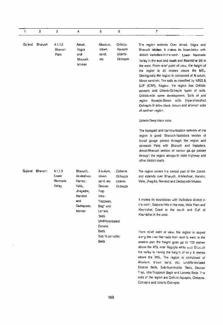
2
Gujarat Bharuch
Gujarat Bharuch
3
4.1.1.2
Bharuch
Plain
4.1.1.3
Lower
Narmada
Valley
4
Amod,
Vagra
and
Bharuch
talukas
Bharuch,
Ankleshvar,
Hansot,
Valia,
Jhagadia,
Nandod
and
Dadiapada
talukas
5
Alluvium, blown
sand,
etc.
Alluvium,
blown
sand, etc.
Deccan
Trap
Infra-
Trappean,
Bagh and
Lameta
6
OrthidsAquepts
Usterts
Ochrepts
Orthents
Ochrepts
Usterts
Ochrepts
Beds
Undifferentiated
Eocene
Beds
Sub-Nummulitic
Beds
169
7
The region extends Over Amod, Vagra and
Bharuch talt:ikas. It makes its boundaries with
district Vadodara in the north. Lower Narmada
Valley in the east and south and Khambhat Silt in
the west. From relief point of view, the height of
the region is 20 metres above the MSL.
Geologically the region is composed of Alluvium,
blown sand etc. The soils as classified by NBSS &
LUP (ICAR), Nagpur, the region has Orthids
aquepts and Usterts-Ochrepts types of soils.
Orthids-with some development. Soils of arid
region Aquepts-Brown soils (Hyaromorphic)
Ochrepts-Shallow black, brown and alluvium soils
of northern region.
Usterts-Deep black soils.
The transport and communication network of the
region is good. Bharuch-Vadodara section of
broad gauge passes through the region and
connects Palej with Bharuch and Vadodara.
Amod-Bharuch section of narrow gauge passes
through the region alongwith state highway and
other district roads.
The region covers the central part of the district
and extends over Bharuch, Ankleshvar, Hansot,
Valia, Jhagdia, Nandod and Dediapada talukas.
It makes its boundaries with Vadodara district in
the north, Satpura Hills in the east, Valia Plain and
Khambhat Coast in the south and Gulf of
Khambhat in the west.
From relief point ot view, the region is sloped
along the river Narmada from east to west. In the
eastern part the height goes VP to 100 metres
above the MSL near Rajpipla while I,ca, m',aruch
the valley is having the height of only 8 metres
above the MSL. The region is composed of
Alluvium, blown sand, etc, Undifferentiated
Eocene Beds, Sub-Nummulitic Beds, Deccan
Trap, Infra-Trappe an Bagh and Lameta Beds. The
soils of the region are Orthids-Aquepts, Orthents
Ochrepts and Usterts-Ochrepts.

2
Gujarat Bharuch
3
4.1.1.4 Narmada
Gorge
4
Nandod
and
Dediapada
talukas
5
Deccan
Trap
Infra
Trappean
6
Orthents
Ochrepts
Ochrepts
Usterts-
Bagh and Ochrepts
Lameta
Beds
170
7
Orthids-Soils of arid region with some
development
Aquepts-Brown Soils (Hyaromorphic)
Orthents-Recently formed soils.
Ochrepts-Shallow black, brown and alluvial soils
of northern region
Usterts-Deep black soils
This region receives good amount of rains in the
Monsoon's time. [June-Sept.) It has favourable
conditions to support the agricultural activity. In the eastern and south eastern part the region has
reserved forests. As regards the transport and
communication network the region has a very
good network of roads and rails. The Surat
Vadodara section of broad gauge along with
national highway (No.. 8) passes through the
region and connects Ankleshvar and Bharuch
towns with Vadodara and Surat and other parts of
the state. Ankleshvar-Rajpipla and Ankleshvar
Netrang sections of narrow gauge connect
Rajpipla and Netrang with Ankleshvar. There is a
good network of stat!! highways and other district
roads connecting Hansol, Ankleshvar, Bharuch
and Rajpipla towns.
The region covers north-eastern part of the district
and extends over Nandod and Dediapada talukas.
The region makes its boundaries with Lower
Narmada Valley 4.1.1.3 in the north, Satpura Hills
4.1.1.5 in the south and Maharashtra state in the
east.
From relief point of view, the region is having the
height of 400 metres above the MSL and some
places it increases up to 600 metres. Geologically
the region is composed of Deccan Traps and
Intra-Trappean Bagh and Lameta Beds. The soils
are medium black. Soils as classified by NBSS & LUP (I CAR) , Nagpur, the region has Orthents
Ochrepts and Usterts-Ochrepts types of soils.
Orthents-Recently formed Soils.
Ochrepts-Shallow black, brown and alluvium soils
of northern region.

2 3 4 5 6 7
Usterts-Deep black soils.
As regard the transport and communication
network, the region is very poor. Only one road
(district road) passes through the region and
eonnects.Rajpipla and Netrang towns.
Gujanat 8haru<::h 4.1.1.5 Valia, Deccan Orthents- This region spreads over Valia, Jhagadia,
Satp\lr@ Jhagadia, Trap Ochrepts- Nandod, Dediapada and Sagbara talukas in the
Hill$ Nsndod, Infra- Usterts- eastern parts of the district. The region makes its
Oediapada Trappean, Ochrepts boundary with Maharashtra state in the east,
a.nd Bagh and district Surat in the south, Lower Narmada Valley
~ra Lameta 4.1.1.3 and Narmada Gorge 4.1.1.4 in the north
talukas Beds and west. The elevation varies in the region
between 200 to 400 metres above the MSL. and at
some places it goes upto 525 metres (Hindava
Dungar) above the MSl. Geologically the region is
composed of Deccan Trap, Infra-Trappean, Bagh
and Lameta Beds. The soils are deep black,
shallow black, alluviums and recently formed
soils. Soils as classified by NBSS & LUP (ICAR),
Nagpur, The region has Orthents-Ochrepts and
Usterts-Ochrepts types of soils.
Orthents-Recently formed soils
Ochrepts-Shallow black, brown, alluvial soils of
northern region
Usterts-Deep black soils
Soils, climate and topography play an important
role for the growth of forests which are covering
most parts of the region.
As regards transport and communication, the
region is having a good network of state highway
and other district roads. The Ankleshvar-Nelrang
section of the narrow gauge also passes through
the south western part of the region.
'3ujarat Bharuch 4.1.1.6 Sagbara Deccan Orthents- This basin occupies the south eastern part of the
I Tap! taluk8 Trap Ochrepts district and covers parts of Sagbara taluka. The
Basin Usterts region makes its boundaries with Maharashtra
Ochrepts state in the north, district Surat in the south and
. east and Sa\pura Hills 4.1.1.5 in the west. Ihe
elevation of the region is 200 metres which
gradually becomes lower towards river Tapi.
Deccan Trap js the main geological formation of
the region and soils are deep black, shallow
black, brown and alluvium. The soils as classified
by NBSS & LUP (I CAR) , Nagpur, the region has
. Orthents-Ochrepts and Usterts-Ochrepts types of
soilS.
171

2
Gujara! BharlJQh
Gujarat Bharuch
3
4.1.1.7
V"Ji2
Plain
4.1.1.8 Khambha!
Coast
4
Valia taluka
Ankleshvar and
Hansot
talukas
5
Alluvium, blown
6
UstertsOchrepts
sand, etc.
Undifferentiated
Eocene
Beds Sub-Nummulitic
Beds
Deccan
Trap
Alluvium,
blown
sand, etc.
Undiffer
entiated
Eocene
Beds
Orthids
Aquepts
Usterts
Ochrepts
172
7
Orthents-Recently formed soils
Ochrepts-Shallow black, brown and alluvial soils
of northern region.
Usterts-Deep black soils.
As regards trarisport and communication facility,
the region has no road and rail links.
The region spreads over southern middle part of
the district and occupies parts of Valia taluka. The
region makes its boundaries with Surat dislrict in
the south, Lower Narmada Valley 4.1.1.3 in the
west, Satpura Hills 4.1.1.5 in the north and east.
The general slope of the region is from east to
west. The eastern part has height upto 58 metres
above the MSL. It is 10 metres above the MSL in
the west. Geologi~ally the region is composed of
Alluvium blown sand, etc, Undifferentiated
Eocene Beds, Sub-Nummulitic Beds and Deccan
Trap. The soils are deep black and medium black.
The soils as classified by NBSS & LUP (lCAR),
Nagpur, the region has Usterts-Ochrepts types of
soils.
Ochrepts-Shallow black brown and alluvial Soils of
northern region.
Usterls-Deep black soils
The transport and communication centre of the
region is Netrang which is connected by roads
and rail (Ankleshvar-Netrang section).
The region covers the south-western part of the
district and occupies part of Ankleshvar and
Hansot talukas. The region makes its boundaries
with district Surat in the south, Gult of Khambhat
in the west and Lower Narmada Valley in the north
and east.
From relief point of view, the eastern part of the
region are above 15 metres while lhe western
parts are above the 8 metres 10 the MSL.
Geologically the region is composed of Alluvium,
blown sand, etc. and Undifferentiated Eocene
Beds.
Soils as classified by NBSS & LUP (ICAR),
Nagpur, the region has Orthids-Aquepts and
Usterts-Ochrepts types of soils.

2 3 4 5
173
6 7
Orlhids-Soils of arid region with some
development.
Aquepts-8rown soils (Hyaromorphic)
Ochrepts-Shallow black, brown and alluvial soils
of northern region
Usterts-Deep black soils.
The transport and communication of the region
depend upon state highways and other districts
roads which pass t!vough the region.


SURAT DISTRICT
Regional Divisions
The region forms the part of Gujarat Plain (4.1.1)
and is sub-divided into following six sub-micro regions on the basis of geology, topography, climate, soil and natural vegetation.
4.1.1.1 Khambhat Coast
This region occupies the north-western part of the district and extends over Olpad and Mangrol talukas. The total area of the region is 686.1 km2 which is 'inhabited by 135349 persons living in 103 villages :and two towns. The rural population of the region is "121435. The urban' population of Sayan and Olpad Itowns is 13914. Geologically the region is composed '.of Alluvium blown sand, etc. and Undifferentiated '~ocene Beds. Soils are Orthids-Aquepts and Usterts·(:)chrepts. The density of the region is 197 persons per km2.
4.1.1.2 Mangrol Plain
Mangrol Plain extenas oyer part of Mangrol and Mandvi talukas and ocCupy-total area of 487.3 km2. The rural area of 470.1 km2 is inhabited by a
. population of 91373 in 75 villages. The urban population of th,e region is 10127 living in Kosamba town. Geologically the region is composed of
I NJuvium, blown sand, etc. Undiffe1entiated Eocene Beds, SUb-Nummulitic Beds and Deccan Trap, The soils are Usterts-Ochrepts. The density of the region is 208 persons per km2.
4.1.1.3 Umerpada Forested Upland
This small region falls in the northern part of the district and occupies parts of Mangrol and Mandvi talukas. The total area of the region is 289.9 km2
which is entirely rural and the population is 56673
living in 67 villages. Geologically the region is composed of Deccan Trap. The. soils are OrthentsOchrepts and Usterts-Ochrepts. The density of the region is 195 persons per km2.
4.1.1.4 Tapi Basin
This region extends over the central part of the 'district and occupies Nijhar, Uchchhal, Songadh and parts of Mangrol, Chor~i, Mandvi, Kamrej, Bardoli and Vyara talukas. The total area of the region is 2915.4 km2 out of which 2812.5 km2 is the rural area and inhabited by 517740 persons living in 495
villages. The urban population of the region is
879,618 living in nine towns. Geologically the western part of the region is composed of Alluvium, blown sand etc. while the eastern part is of Deccan Trap and the central part having Undifferentiated Eocene Beds and SUb-Nummulitic Beds. Soils of the region are Orthids-Aquepts, Orthents-Ochrepts and Usterts-OChrepts. The density is 479 persons per km2 in the region.
4.1.1.5 Mindhola-Purna Plain
This region occupies the southern part of the district and covers the part of Palsana, Kamrej, Bardoli, Vyara, Songadh, Mahuva, Valod talukas. The total area of the region is 1744.9 km2. The rural area is consisting of 376 villages with an area of 1724.8
. km2 and inhabited by 486979 persons. The urban population of three towns of the region is 64292 persons. Geologically the region is composed by Alluvium, blown sand, etc: SUb-Nummulitic Beds and Deccan Trap. The soils of the region are UstertsOchrepts. The density of Hie region is 316 persons per km2.
175

4.1.1.6 Kalakara Hills
This region occupIes the south-eastern part of the district and covers Vyara and Songadh talukas and parts of The Dangs . district. The total area of the region is 617.4 km2 and is inhabited by 64369 persons living in 108 villages. The region is entirely rural. Geologically the region is composed of Deccan Trap, and the soils are Orthents-Ochrepts and Usterts-Ochrepts. The density of the region is 104 persons per km2.
176
4.1.1.7 Chorasi-Palsafla Coastal Plain
This region occupies the south-western part of the district and extends over the parts of Chorasi and Palsana talukas. The area of the region is 304.0 km2
out of which 279.1. km2 Is the rural part inhabited by 91245 persons living in 67 villages and the urban population is 98088. Geologically the region is composed of Alluvium, blown sand, etc. The soils of the region are Orthids-Aquepts and UstertsOchrepts. The density of the region is 623 persons per km
2. Thi~ region is ind"strially developed.


I
()
a:
Q
GULF OF KHAMBHAT
't~ I I I
I I I I

0. « :l:
I
u
J
a:
«
I
I) '0 to till
.:1
To NondurbOr
'(
~ I~ W J o 4 I ~ Q
I
o ~ o I_ ~
W [
I U o I ~ IZ W I
I- I~ [
o 0
~. ~ ". > ,,' > ". > " > " > '" >
()
o Z 4: J a. J
,..: ~ ,..: ~ ~ . ,
,.; ,..: ~ ~ ...; ~ ""
~~~~~~~
: H1 ..: i I I . I
1f~ I I I r::' tlI
I I I I ;; I I II ~ I'l
._ 0 I I I ~ J ..
I I I a: " a. <f. c: ::l
I I I 0 ~ ~ Z .~ tI
I I I J > '0
I I I ~ ~ ~ I I I:r. ~ ~ I I I ~ .~ E
I I I ~ ~.~ L. "CI
I I 10 c 0:: ..
Z I I I ~ ~ ~ QIII~U III


DATA ON REGIONAL DIVISIONS
District Name: SURAT Census Location Code No. 17 State: GUJARAT
District Region No. of village No. of towns in Area in Kmg
1981 Pogulation 19~1 _.s::zp
No. and in each Region each Region Total Rural Urban Total Aural Urban
Name aaevolved
2 3 4 5 6 7 8 9 10
Surat 4.1.1 103 VlIIages 2 686.1 664.1 22.0 135349 121435 13914
Kham· (102 villages of Olpad bhat Olpad taluka & (VP) & Coast 1 village of Sayan (VP) of
Mangrol taluka) Olpad taluka)
4.1.1.2 75 Villages 487.3 470.1 17.2 101500 91373 10127
Mangrol (72 villages of Kosamba
Plain Mangrol tal uka (VP) of
& 3 villages of Mangrol
Mandvi taluka) taluka
4.1.1.3 67 Villages Nil 289.9 289.9 56673 56673
Umar· (65 villages of
pad a Mangrol taluka
Forested & 2 villages of
Upland Mandv; taluka)
4.1.1.4 495 Villages 9 2915.4 2812.5 102.9 1397358 517740 879618
Tapi (57 villages Surat (MC),
Basin of Chorasi Surat
taluka,53 Umra (VP),
villages of Karanj (VP),
Kamrej taluka, Utran (VP),
143 villages of Nana
Mandvi taluka, Varachha
8 villages of (VP) of Chorasi
Bardoli taluka, Kathor
12 villages of (VP) of
Vyara taluka, Kamrej
56 villages of taluka,
Songadh Mandvi
taluka,68 taluka,
villages of Kadod (VP)
Uchchhal of Bardoli taluka, taluka,
87 villages of Ukai (VP) of
Nijhar taluka, & Songadh
taluka.
179

2 3 4 5 6 7 8 9 10
11 villages
of Mangrol
taluka)
4.1.1.5 376 Villages 3 1744.9 1724.8 20·1 551271 486979 64292
Mindhola· (19 villages of Bardoli Puma Palsana (NP) of Plain laluka, taluka,
16 villages of Vyara Kamrej (NP) of Vyara taluka, taluka,
76 villages of Songadh Bardoli (VP) of Taluka,69 Songadh villages of taluka
Mahuva taluka,
40 villages of
Valod taluka,
84 villages of
Vyara taluka,
72 villages of
Songadh
taluka.)
4.1.1.6 108 Villages NIL 617.4 617.4 64369 64369 Kalakakra (53 villages of
Hills Vyara taluka,
49 villages of
Songadh
laluka,
and 6 villages
of The
Dangs taluka
ofdist.
The Dangs.
4.1.1.7 67 Villages 6 304.0 279.1 24.9 189333 91245 98088 Chorasi· (37 villages Limbayal NP) Palsana of Chorasi Dindoli (VP), Coastal taluka,30 Bhestan (VP), Plain villages of Udhana (NP),
Palsana Bhedwad (VP), laluka) Pandesara (VP)
INA of
Chorasi
taluka.)
Grand 7 1291 21 7045.0 6857.9 187.1 2495853 1429814 1066039 Tolal
180

REGION-WISE VILLAGE CODES, 1981
District Name: Surat Census Location Code No. 17 State: GUJARAT
SI. Division Taluka Location code Total No. of area in Km 2 Remarks
No. No. & No. of Census vi Ilages [Towns
Name villages as per of In In 1981 Taluka division of Regional
Taluka division
2 3 4 5 6 7 8 9
4.1.1.1 (1) Olpad 1 to 102 102 653.9
Kham- Olpad
bhat (Urban)
Coast & 2 22.0
Sayan Towns
(Urban)
(2) Mangrol 46 10.2 Code NO.1 to 17,33 to 45, 47 to
65,99, 102 to 117, 119, 122, 123,
128 to 130 are in division No. 4.1.1.2
Code No. 18 to 32, 66 to 98, 100
to 101, 131, 133, 134, 136, 137,
139, 141 to 149 are in division
No.4.1.1.3
Code No. 118, 120, 121, 12410 127,
132,135,138 & 140 are in division
No. 4.1.1.4
Total for 103 664.1 division + villages + 22.0 No.4.1.1.1 2 Towns 686.1
4.1.1.2 (1) Mangrol 1 to 17, 33 to 72 423.6 Code No. 18 to 32, 66 to 98, Mangrol 45,47 to 65, 10010101,131,133,134,136, Plain 99, 102to 117, 137,139,141 to 149 are in
119, 122, 123, division No. 4.1.1.3
128 to 130
Code No. 118, 120, 121, 124to
127,132,135,138,140 are in
division No. 4.1.1.4
Code No. 46 is in division
No.4.1.1.1
'181

2 3 4 5 6 7 8 9
Kosamba 17.2
(Urban) Town
(2) Mandvi 1,2,3 3 46.5 Code No. 16 & 22 are in
division No. 4.1.1.3
Code No. 4to 15, 171021,23
to 148 are in division No. 4.1.1.4
Total for - 75 470.1 division villages No. 4.1.1.2 +...l?:?
+ 1 Town 487.3
III 4.1.1.3 (1) Mangrol 18 to 32, 66 to 65 278.3 Code No.1 to 17,33 to 45, Umar- 98, 100, 101, 471065,99, 102 to 117, 119, pada 131,133, 134, 122,123,12810130arein Forested 136, 137, 139, division No. 4.1.1.2 Upland 141 to 149
Code No. 118,120, 121, 124- to 127,
132, 135138, 140 are in division No. 4.1.1.4
Code No. 46 is in division No. 4.1.1.1
(2) Mandv; 16&22 2 11.6 Code NO.1, 2 & 3 are in division No. 4.1.1.2
Code No.4 to 15, 17 to 21, 23 to
148 are in division No. 4.1.1.4
Total for 67 289.9 division villages No. Towns + 4.1.1.3 Nil 289.9
IV 4.1.1.4 (1) Chorasi 1 to 36, 38 to 57 336.9 Code No. 37, 50, 51,59, to 66, 69 to Tapi 49,52 to 58, 94 are in division No. 4.1.1.7 Basin 67 &68
Sura! 5 67.6 4.5 Km2
area of Surat lIillage (Urban) Towns + 4.5 included in Urban area of Sura! Umra 72.1 (Urban)
Karan;,
(Urb~n)
Utran
(Urban)
Nana
Varachha
(UrbaQ)
182

2 3 4 5 6 7 8 9
IV 4.1.1.4 (2) Kamrej 1 to 44, 49 to 53 293.1 Code No. 45 to 48, 53 to
52, 62to 66 61,67 to 69 are in division No.
4.1.1.5
Kathor 11.1
(Urban) Town
(3) Mandvi 41015,17to 143 665.4 Code No.1, 2 & 3 are in division
21, 23 to 148 No. 4.1.1.2
Code No. 16 & 22 are in division
No.4.1.1.3
Mandvi 7.6
(Urban) Town
(4) Bardoli 6to 13 8 35.9 Code No.1 to 5, 14 to 84
are in division No. 4.1.1.5
Kadod 2.7
(Urban) Town
(5) Vyara 1 to 9,13 12 76.0 Code No. 10 to 12, 16 to 65, 67
to 15 to 6.9, 73, 75 to 78, 84, 92 to
103, 122 to 129, 138, 140
are in division No. 4.1.1.5
Code No. 66, 70 to 72, 74, 79 to 83,
85t091, 104 to 121, 130to
137,139,141 to 149 are in division
No. 4.1.1.6
(6) Songadh 1 to 46, 48 to 56 612.3 Code No. 47, 56, 57, 60 to 118"
55,58 &59 124, 125, 128, 130 to 133, 138,
142 & 143 are in division
No. 4.1.1.5
Code No. 119 to 123,126,127,129,
134 to 137, 139 to 141, 144 to
177 are in division No. 4.1.1.6
Ukai 9.4
(Urban) Town
(7) Uchchhal 1 to 68 68 325.3
(8) Nijhar 1 to 87 87 396.0
(9) Mangroi 118,120,121, 11 71.6 Code No. 46 is in division
124to 127, No.4.1.1.1
132,135,138 Code No.1 to 17,33 to 45,
& 140 47 to 65, 99, 102 to 117, 119,
122, 123, 128 to 130 are in division
No.4.1.1.2
183

2 3 4 5 6 7 8 9
Code No: 18 to 32,66 to 98,
100,101,131,133,134,
136,137,139,141 to 149 are
division No. 4.1.1.3
Total for 495 2812.5 division villages
No. 4.1.1.4 + 9 + 102.9
Towns 2915.4
V 4.1.1.5 (1) Palsana 10, 18t021, 19 79.3 Code NO.1 to 9,11 to 17, Mind- 32 to 38, 43 22 to 31, 39 to 42 are in division hola- to 49 No.4.1.1.7
Puma
Plain
(2) Kamrej 45 to 48, 53 16 76.5 Code No.1 to 44, 49 to 52,
t061,67 62 to 66 are in division No.
to 69 4.1.1.4
(3) Bardoli 1 to 5, 14 76 333.7 Code No.6 to 13 are in division
to 84 No.4.1.1.4
Bardoli 6.5
(Urban) Town
(4) Mahuva 1 to 69 69 354.0
(5) Val ad 1 to 40 40 199.7
(6) Vyara 10to 12, 16 84 402.3 Code No. 66, 70 to 72, 74, 79 to
to 65, 67to 83,85 to 91,104 to 121, 130to
69, 73, 75 to 78, 137,139,141 to 149 are
84, 92 to 103, in division No. 4.1.1.6
122 to 129,
138,140 Code no. 1 to 9,13 to 15 are in
division No. 4.1.1.4
Vyara 7.9
(Urban) Town
(7) Songadh 47,56,57,6010 72 279.3 Code No. 119to 123, 126, 127,
118,124,125, 129, 134to 137, 139to 141,
128,130to 144 to 177 are in division No.
133,138,142 4.1.1.6
& 143
Code No.1 to 46, 48 to 55, 58 & 59 are in division No. 4.1.1.4
184

2 3 4 5 6 7 8 9
Songadh 5.7
(Urban) Town
Total for - 376 1724.8
division villages
No. 3 Towns i:.?Ql 4.1.1.5 1744.9
VI 4.1.1.6 (1) Vyara 66, 70 to 72, 53 326.3 Code No.1 to 9, 13 to 15
Kala- 74, 79 to 83, are in division No. 4.1.1.4
kakra 851091,104 Code No. 10 to 12, 16 to 65,
Hills 10121,13010 6710 69, 73, 7510 78, 84, 92 137, 139, 141 10103, 122to 129, 138 & 140
to 149 are in division No. 4.1.1.5
(2) Songadh 119to 123, 126 49 257.0 Code No.1 to 46, 48 to 55,
10127,129, 58 & 59 are in division No. 4.1.1.4
134 to 137, Code No. 47, 56, 57, 60 to 118, 13910141, 124,125,128, 130 to 133, 138, 14410177 142 & 143 are in division
No. 4.1.1.5
(3) The 14 to 19 6 34.1 Code No. 14 to 19 of the Dangs Dangs taluka of district.The (District Dangs fall in this district The & region. Dangs)
Total for - 108 617.4 division lIillages No. Town + Nil -4.1.1.6 Nil 617.4
VII 4.1.1.7 (1) Chorasi 37,50,51, 37 157.5 Code No. 11036, 3810 49, Chorasi- 591066,69 52, 10 58, 67 & 68 are Palsana 1094 in division No. 4.1.1.4 Coastal
Plain
Limbayat
(Urban)
Dindoli
(Urban)
Sheslan 6 24.9 (Urban) Towns
Udhana
(Urban)
Shedvad
(Urban)
Pandesara
(INA)
185

2 3 4 5 6 7 8 9
(2) Palsana 1 to 9,11 30 121.6 Code No. 10, 18 to 21, 32 to
to 17, 22 to 38, 43 to 49 are in division No.
31, 39 to 42 4.1.1.5
Total for 67 279.1 division villages
No. +6 + 24.9 -4.1.1.7 Towns 304.0
186

District Name: SURAT
State District
Name
2
Gujarat Surat
Division
number
and name
3
4~ 1.1.1
Khambhat
Coast
Name of
administ
rative
divisions
4
Olpad
Mangrol
talukas
STATEMENT ON REGION-WISE
PHYSIO-CULTURAL DETAILS
Census Location Code No. 17
Geology Soils
5 6
Alluvium, Orthids-
clown Aquepts,
sand, etc. Usterts-
Undifferen- Ochrepts
tiated Eocene
Beds
187
State: GUJARAT
Physio-Cultural Characteristics
7
T~e region spreads over north-western part of the
district and occupies Olpad and parts of Mangrol
talukas. The region makes its boundaries with
district Bharuch in the north, Mangrol Plain in the
east, Tapi Basin in the south and Arabian Sea in
the west.
From relief point of view, this part is coastal area
with maximum height of 20 metres in the east to
10 metres above the MSL. in the west. The
geological formations of the region are Alluvium,
blown sand, etc, Undifferentiated Eocene Beds.
The soils found in the region are of coastal
alluvium types. Soils as classified by NBSS & LUP
(I CAR) , Nagpur, the region is covered by Orthids
Aquepts and Usterts-Ochrepts types of soils.
Orthids-Soil of arid region with some
development.
Aquepts·Brown Soils (Hydromorphic)
Ochrepts-Shallow black brown and alluvial soils of
northern region.
Usterts-Deep black soils.
As regards the transport and communication
network, Surat-Bharuch section of the broad
gauge railway line passes through this region
connecting Sayan town with other parts of the
district and the state. The other town Olpad is also
connected by state highway with district
headquarters Surat and other towns of Surat and
Bharuch districts.

2
Gujarat Surat
Gujarat Surat
3
4.1.1.2
Mangrol
Plain
4.1.1.3
Umarpada
Forested
Upland
4
Mangrol
and
Mandvi
talukas
Mangrol
and
Mandvi
tall!kas
5 6
Alluvium, Usterts
blown Usterts-
sand, etc. Ochrepls
Undifferen-
tiated
Eocene Beds
Sub-Nummulitic
Beds
Deccan
Trap
Deccan
Trap
188
OrthentsOchrepts
Usterts
Ochrepts
7
This region occupies the northern part of the
district and covers Mangrol and parts of Mandvi
talukas. The region makes its boundaries with
district Bharuch in the north, Khambhat Coast in
the east, Tapi Basin in the South and Umarpada
Forested Upland in the east.
From relief point of view, the general slope of the
region is from east to west. In the eastern part, the
height goes upto 67 metres while near Kosamba
town the height is 27 metres above the M.S.L.
Geologically the region in formed of Alluvium,
blown sand, etc, Undifferentiated Eocene Beds,
Sub-Nummulitic Beds and Deccan Trap.
Soils found in the region are of deep black types.
Soils as classified by NBBS & LUP (I CAR) Nagpur,
the region has Usterts Ochrepts types of soils.
Usterts-Deep black soils
Ochrepts-Shallow black, brown and alluvial soils
of northern region.
The transport and communication network is
good. The region is crossed by Surat-Bharuch
section of broad gauge railway which passes
through Kosamba town. The national highway
(No.8) also passes through the region and
Kosamba town. The Kosamba-Umarpada section
of narrow gauge also passes through the region
and connects this region with Umarpada Forested
Upland.
This region covers the northern part of the district
and extends over the parts of Mangrol and
Mandvi talukas. This upland makes its boundaries
with district Bharuch in the north, Mangrol Plain in
the west and Tapi Basin in the south and east.
As regards the relief of the region, 300 metres
contour covers most of the upland. In the eastern
part the height of purukmal Dungar goes upto 375
metres above the MSL. The region is .well
forested. The region is formed of Deccan Trap.
Soils as classified by NBSS & LUP (ICAR),
Nagpur, the region is covered by Orthents
Ochrepts and Usterts-Ochrepts types of soils.

2 3 4 5
Gujarat Surat 4.1.1.4 Nijhar, Alluvium,
Tapi Uchchhal, Blown Basin Songadh, sand, etc.
Mangrol, Undifferen-
Chorasi, liated,
Mandvi, Eocene
Kamrej, Beds,
Bardoli and
Deccan Trap
Vyara
talukas
189
6
Orthids-
aquepts
Orlhents-
Ochrepts
Usterts-
Ochrepts
7
Orthents-Recently formed soils.
o"chrepts-Shallow black, brown and alluvial soils
of northern regions.
Usterts·Deep black soils.
As regards the transport and communication, the
region is connected by the narrow gauge
Kosamba Umrarpada section of the railways.
There is also are state highway which passl!s
through Umarpada and connect the region with
Bharuch district (Sagbara) and also other parts of
the district.
The region occupies the central part of the district
and extends over Nijhar, Uchchhal, Songadh and
parts of Mangrol, Chorasi, Mandvi, Kamrej,
Bardoli and Vyara talukas. The region is making
its boundaries with Khambhat Coast 4.1.1.1,
Mangrol Plain 4.1.1.2, Umarpada Forested Upland
4.1.1.3 and district. Bharuch in the north. The
north eastern and south-eastern part of the region
is making its boundaries with Maharashtra state
and the southern' part with Mindhola-Purna Plain
4.1.1.5 and Chorasi Palsana Coastal Plain 4.1.1.7.
In the west the region makes its boundaries with
the Arabian Sea. The central part of the region is
covered under forests.
The region is formed by Alluvium, blown sand,
etc, Undifferentiated, Eocene Beds, Sub
Nummulitic Beds and Deccan Trap.
The soils as classified by NBSS & LUP (ICAR),
Nagpur the region is having Orthids-Aquepts,
Orthents-Ochrepts and Usterts-Ochrepts types of
soils.
Orthids:--Soils of arid region with some
development. •
Aquepts:--Brown soils (Hydromorphic)
Orthents:--Recently formed soils.
Ochrepts:--Shal/ow black, brown and aI/uvial soils
of northern region.
Usterts: .. Deep black soils
From transport and communication poinl of view,
the re0:'~ has a well developed network of rail
and re s. The Surat·Bharuch section (broad
gauge) rail ways passes through the western part

2 3 4
Gujarat Surat 4.1.1.5 Palsana,
Mindhola- Kamerej,
Purna Bardoli,
Plain Vyara,
Songadh,
Mahuva
and Valod
talukas
5 6
Alluvium, Usterts-
blown Ochrepts
sand, etc.
Sub-
Nummulitic
Beds
Deccan
Trap
190
7
of the district which connects the region to
8haruch in the north and Valsad in the south. The
national highway (No.8) also passes through the
region and is almost parallel to the Surat-Bharuch
section. There is a good network of roads which
connect the region with other parts of the district.
In the south eastern part of the district Surat
Bhusaval (broad gauge) rail ways appears in the
region just after Songadh and there is also a road
which conneots the region with Maharashtra State
(Shahda, Nadurbas, BhusC!val).
This region covers the south central part of the
district and extends over Palsana, Kamrej, Bardoli,
Vyara, Songadh, Mahuva and Valod talukas. The
region is making its boundaries with Tapi Basin
4.1.1.4 in the north, Kalakakra Hills 4.1.1.6 in the
east, district Val sad in the south and Chorasi.
Palsana Coastal Plain 4.1.1.7 in the west.
From relief point of view, the general slope of the
region is from east to west. The height of eastern
part goes upto 75 metr!'s above the MSL near
Vyara town, and 35 metres above the MSL, near
Bardoli town while the part of Palsana taluka is
less than 35 metres above the MSL. Geologically
the region is formed of Alluvium, blown sand, etc,
Sub-Nummulitic Beds and Deccan Trap.
Soils as classified by NBSS & LUP (ICAR),
Nagpur, the region is having Usterts-Ochrepts
types of soils.
Ochrepts Shallow black, brown and alluvial soils
of northern region.
Usterts-Deep black soils.
From transport and communication point of view,
the region has very good network of rails and
roads. The Surat-Bhusaval section of the broad
gauge railway passes through the region and
connects Bardoli, Vyara and Songadh towns with
each of other alongwith districl headquarters,
Sural and Bhusaval town of Maharashtra. In the
southern part, the Bilirnora-Waghai section of
narrow gauge railway also passes through the
region. There is also very good network of state
highways and other district roads. There are some
packets of forests also in this region.

2
Gujarat Surat
Gujarat Surat
3
4.1.1.6
Kalakakra
Hills
4.1.1.7
Chorasi
Palsana
Coastal
Plain
4
Vyara
Songadh
talukas
and parts
01 The
Dangs
district
Chorasi and
Palsana
taluka
5
Deccan
Trap
6
Orthents
Ochrepts
Usterts
Ochrepts
Alluvium, Orlnids-
blown Aquepts
sand, Usterts-
etc. Ochrepts
191
7
This hilly region forms the south-eastern part of
the district and covers the parts of Songadh and
Vyara talukas alongwith some part 01 The Dangs
district. In the north the region makes its
boundaries with Maharashtra State, in the soutl\.
byThe Oangs district and in the west by Mindhola
Puma Plain 4.1.1.5.
As regards the relief, 300 metres contour passes
through the eastern part and at some places the
height goes apove 500 metres above the MSL.
The height of the hills in western part is
comparatively low. Geologically the region is
composed of Deccan Trap. Soils as classified by
NBSS & LUP (Nagpur), the region is covered by
Orthents-Ochrepts and Usterts-Ochrepts types of
soils.
Orthents-Recently formed soils.
Ochrepts-Shallow black, brown and alluvial soils
01 northern region.
Usterts-Deep black soils.
As regards the transport and communication
network 01 the region, there is only one road
which connects the region with Mindhola-PIJrna
Plain 4.1.1.5 (Songadh town) and Maharashtra
state.
This coastal plain occupies the south-western part
of the district and extends over parts of Chorasi
and Palsana talukas. Tapi Basin 4.1.1.4 makes its
boundary in the west and north, Mindhola. Purna
Plain 4.1.1.5 in the east and district Valsad in the
south.
From relief point, the region has very low prOfile,
the height of eastern part is 11 metres above the
MSL while the western part is about 6/7 metres
above the MSL. Geological formation of the
region is Alluvium, blown sand, etc.
SOils as classified by NBSS & LUP (ICAR), Nagpur
the region has Orthids-Aquepls and Usterts
Ochrepts types 01 soils.
Orthids:--Soils of arid region with some
development.
Aquepts:--Brown soils (Hydromorphic)

2 3 4 5 6
192
7
. . Ochrepts:--Shallow black, brown and alluvial soils
of northern region.
Usterts:--Deep black soils.
From transport and communication point of view,
there are Surat-Valsad (broad gauge) rail section
and Surat-Bhusaval (BG) section which pass
through the region in the north-south and east
west directions respectively. The national highway
(No.8) passes through the region in the north
south direction. There are some state highways
and other district roads also in the region which
connect the region with district headquarters
Sural.
DISTRICT VALSAD
Regional Divisions
District Valsad is the part of the Gujarat Plain (4.1.1.) and is sub-divided into following three submicro regions on the basis of geology, topography, soils, climate and natural vegetation.
4.1.1.1 Valsad Coast
The region occupies the western parts of the district and extends over Umbergaon, Pardi, Valsad, Gandevi and Navsari talukas. The total area of the region ,is 1458.7 Km2 which is inhabited by 855220 persons of these 508473 persons reside in 233
vDlages and 346747 persons in 18 towns. Geologically the region is composed of Alluvium, blown sand, etc. and Deccan Trap. The soils of this regions are Orthids-Aquepts and Tropepts-Aquepts. The density of the region is 586 persons per Km2
which reveals its economic development.
4.1.1.2 Middle Valsad Plain
As the name of the region speaks out, the region Is situated in the middle of the district and covers the Umbergaon, Pardi, Valsad, Gandevi, Navsari, Chikhll, Bansda and Dharampur talukas and part of
193
the Dadra and Nagar Haveli Union territory. There are 287 villages and four towns which cover an area of 1613.1 km2. It is inhabited by 619813 persons of which 577698 persons reside in rural and 42115 persons in urban areas. Geologically major parts of the region is composed of Deccan Trap and a small part 'on the north is of SUb-Nummulitic Beds and Alluvium, blown sand, etc. Orthids-Aquepts, Tropepts-Aquepts and Usterts-Ochrepts. The density of the region is 384 persons per Km2, which reflects its agricultural and industrial development.
4.1.1.3 Western Ghats
This region extends over the eastern part of the district and occupies Chikhli, Bansda and Dharampur talukas. The area of the region is 2063.6 Km2, which is entirely rural and is inhabited by 300652 persons. The region has 308 villages. Geologically the region is composed of Deccan Trap. The soils are Orthents-Ochrepts, OrthentsTropepts and Usterts - Ochrepts. The density of the region is 146 persons per Km2. This is up-land and it has less agricultural development.


» I
CD
» »
z
s
·sw~ OZ S~ O~ 9 0 5 'Sw~ J SNOISIAIO ~VNOI~3~ I
81 300) SnSN3)
aVS1VA !JI~!Sla o
9 "tW

[Jan E Ol do sapOJ dow
0lpulliD 34l Ol nU3JajaJ : 4WA 'UO!S!AIP ID UOl6aJ jO 3)U30bas 34l poa~ - 'I - - - - - - - - -- - AbvGNnOa HllM 0~JIW-8nS
I --- - - - - - - ---- -- ---- --O~JI~
--~ ---------------------OS3~
~' .. eB-- - - - - -- - -------- ----O~J~W +
'l 'l 'l .~ NOISI~la WNOI93~ ~' ............. " ............. , .. , .......... , " ... ' "~3~1~
1IIIfl~!I" SB . ~- ... "
SB
SHS
..... 3~n~0 MO~~VN cc :1 " '" .... , 3~nV9 Q~0~8 'NOI1~15 HllM 3NIl A~M1IV~
............. a~o~ C3lW13Vl lNn~OdWI
..... '" ... A~MH0IH 3'lVlS
-_ .......... , ........ " ........... , ......... '''AVMH0IH lVNOllVN SHN
• ....... , .. NOlmndOd 3A08V ~ 000 S 0NIA~H S30~111A
'" ....... , .......... '" .............. , V3~V NV8~n
WllIIlIIA .:, ,: .. . ............. "'lS3~0~ a3A~3S3~ "
;;':';:"~~""; ." ...... " ... '" .... " ...... '" ......... ~~nlVl I(
_.-._ '" ................ , ... ; ......... ' ...... DI~lSla ((
- .. - .. _ .............. , ............................ 31V1S (A~vaNn08
dm N~JJ30 B Jl3'ONV5 NMJ18 l~nlMlW ~
r--l 'IW~ o~ 0
A901039
'Iw~on 51105
~Nv~rn8 I~V5 Q) 'V3~V 031:l110N l~l~lsnaNI 'V"N"I
mvrn9 ':J
113AVH ~V~VN ~ v~ovo '0
SlVH~ N~31S3M .£ 'l '1 '7
NIVld OVS1VA 3100lVl 'z 'l 'l '7
lSVOJ OVSWA 'l 'l 'l '~
I


DATA ON REGIONAL DIVISIONS
District Name: VALSAD Census Location Code No. 18 State: GUJARAT
District Region No. of village No. of towns Area in Kmg
1981 POQulation 1981
No. and in each in each Region Total Rural Urban Total Rural Urban
Name Region
as evolved
2 3 4 5 6 7 8 9 10
Valsad 4.1.1.1 233 villages 18 1458.7 1341.8 116.9 855220 508473 346747
Val sad (39 villages of Umbergaon (VP)
Coast Umbergaon & Umbergaon
taluka, (INA) of
42 villages of Umbergaon taluka,
Pardi taluka, Vapi (NP), 43 villages of Vapi (INA) & Valsad taluka, Pardi (NP) of
23 villages of Pardi taluka,
Gandevi taluka, Pamera (VP), 86 villages of Val sad (UA)
Navsari taluka) Kosamba (VP),
Abrama (VP),
Valsad (INA).
Atul (NM) of
Valsad taluka
Bilimora (M) & Seeri Bujrang (VP) Devsar (VP) of
Gandevi taluka,
Navsari (M),
Vejalpor (VPl. Jalalpore (VP)
& Mahuwar (VP)
of Navsari
taluka
4.1.1.2 287 villages 4 1613.1 1586.2 26.9 619813 577698 42115 Middle (10 villages of Gandevi (NP) of Valsad U'ilbergaon Gandevi taluka, Plain Taluka Chikhli (VP) of
37 villages of Chikhli taluka, Pardi taluka, Dharampur (NP) 3 villages of of Dharampur Dadra & Nagar- taluka, Bansda Haveli (U.T.), (VP) of Bansda 48 villages of taluka
197

2 3 4 5 6 7 8 9 10
Valsad taluka
30 villages of
Gandevl taluka,
53 villages of
Navsari, taluka
66 villages of
Chikhli taluka
19 villages of
Dharampur taluka,
21 villages of
Bansda taluka.)
4.1.1.3 308 villages Nil 2063.6 2063.6 300652 300652
Western (18 villages Of Ghats Chikhli taluka,
21? villages of
Dharampur taluka,
73 villages of
Bansda taluka).
Grand
Total 3 828 22 5135.4 4991.6 143.8 1775685 1386823 388862
198

REGION-WISE VILLAGE CODES, 1981
District Name: VALSAD Census Location Code No. 18 State: GUJARAT
SI. Division Taluka Location code Total No. of Mea in Km2 Remarks
No. No. & No. of Census Villages{lowns
Name villages as per of In of Taluka In
1981 Taluka divi- Regional
sion division
2 3 4 5 6 7 8 9
4.1.1.1 (1) 1 to 13, 16, 18 39 286.5 Code No. 14, 15, 17,26,27,34
Valsad Umbergaon to 25, 28 to 33, to 38 are in division No. 4.1.1.2
Coast 39 to 49
Umbergaon
(Urban)
& 2 13.6
Umber- Towns
gaon
(INA)
(2) Pardi 1 to 5,121022, 42 202.1 Code No.6 to 11, 23 to 30, 45 to
31 to 44, 57 to 61 56, 62 to 65, 73 to 79 are in
66 to 72. division No. 4.1. ~.2
Vapi
(INA)
Vapi
(Urban) 3 30.2
& Towns
Pardi
(Urban)
(3) Valsad 1 to 6, 9 to 43 196.7 Code No.7 8, 16 to 19, 26 to 33, 15,20 to 25, 40 to 46, 55 to 67, 78 to 91 are in
34 to 39, 47 to division No. 4.1.1.2
54,68 to 77
Val sad
(Urban)
Kosamba 6 25.7 (Urban) towns Abrama
(Urban)
199

2 3 4 5 6 7 8 9
Val sad
(INA)
Atul
(Urban) Parnera
(Urban)
(4) Gandevi 1 to 3,16 23 145.4 Code No.4 to 15, 20 to 26, 31 to
to 1927 to 30, 36, 43 to 47 are in division No.
37 to 42, 48 to 53. 4.1.1.2
Bilimora
(Urban)
Devsar 3 22.2
(Urban) Towns
Sari Bujrang
(Urban)
(5) Navsari 1 to 9, 16 to 38, 86 511.1 Code No. 10 to 15,39 to 46, 62 to
47 to 61, 77 to 76,89 to 101, 116 to 126 are in
88,102 to 115. division No. 4.1.1.2
127 to 139
Navsari
(Urban)
Vejalpore - 4 25.2
(Urban) Towns
Jalalpore
(Urban)
Mahuwar
(Urbart)
Total for
division 233 1341.8
No. villages
4.1.1.1 18 Towns +116.9
1458.7
II 4.1.1.2 (1) 14,15.17. 10 61.9 Code No.1 to 13. 16, 18 to 25, 28
Middle Umbergaon 26. 27, 34 to 38 to 33, 39 to 49 are in division No.
Valsad 4,1,1.1
Plain
(2) Pardi 6 to 11,23 to 30, 37 193,6 Code No, 1 to 5, 12 to 22, 31 to
45 to 56, 62 to 44, 57 to 61,66 to 72 are in
65, 73to 79. division No. 4.1.1.1
(3) Dadra & 1.2,3 3 6.9 Code No, 1,2, & 3 of Dadra &
Nagar Nagar Haveli (U,T,) fall in this
Haveli district & division.
200

2 3 4 fi 6 7 8 9
(4) Valsad 7,8,16to 48 278.4 Code No.1 to 6, 9 to 15, 20 to 25,
19, 26 to 33, 34 to 39, 47 to 54, 68 to 77 are in
40 to 46, 55 to division No. 4.1.1.1
67,78 to 91.
(5) Gandevi 4to 15,20 30 110.1 Code No.1 to 3, 16 to 19,27 to
to 26, 31 to 30, 37 to 42, 48 to 53 are in
36,43 to 47 division No. 4.1.1.1
Gandevi 4.4
(Urban) Town
(6) Navsari IOta IS, 53 204.2 Code No.1 to 9, 16 to 38, 47 to
39 to 46, 62 '61,77 to 88, 102 to 115, 127 to
to 76, 89 to 139 are in division No. 4.1.1.1.
101 116 to 126
(7) Chikhli 1 to 46, 50 66 472.4 Code No. 47 to 49, 63 to 71, 74 to
to 62, 72, 73, 77, 83 & 84 are in division No.
78 to 82 4.1.1.3
Chikhli 1.1
(Urban) Town
(8) Dharam- 1 to 6,34 19 134.3 Code No.7 to 33, 43 to 122, 126
pur to 42, 123 to to lSI, 153 to 20B, 210 to 237 are
125 & 152 in division No. 4.1.1.3 Code No.
209 falls in Dadra & Nagar Haveli
(U.T.) division No. 4.1.1.1
Dharam- 15.5
pur Town
(Urban)
(9) 8ansda 1 t07, 14to 21 124.4 CodeNo.8to 13, 1710 19,23, 16, 20 to 22, 24, 27 to 35, 39 to 42, 45 to 49, 25,26,36,37, 51 to 94 are in division No. 38, 43, 44 & 50 4.1.1.3
8ansda 5.9 (Urban) Town
Total for 287 1586.2 Division villages No.
4.1.1.2 + 4 Towns + 26.9
1613.1
201

2 3 4 5 6 7 8 9
III 4.1.1.3 (1) Chikhli 47 to 49, 18 101.0 Code No.1 to 46, 50 to 62, 72,
Western 63 to 71,74 to 73, 78 to 82 are in division No.
Ghats 77,83 & 84 4.1.1.2
(2) Dharam- 7to 33,43 217 1493.5 Code NO.1 to 6, 34 to 42, 123 to
pur to 122126to 125, 152 are in division No. 151,153 to 208, . 4.1.1.2 Code No. 209 falls in
210 to 237 Dadra & Nagar Haveli (U.T.),
Division No. 4.1.1.1
(3) Bansda 8to13,17to 73 469.1 Code NO.1 to 7,14 to 16,20 to
19,23, 24,27to 22, 25, 26, 36 to 38, 43, 44 & 50
35, 39 to 42, 45 are in division No. 4.fl.2 to 49, 51 to 94.
Total for 308 2063.6
division villages + Nil
No. Town Nil
4.1.1.3 2063.6
202

District Name: VALSAD '
State District
name
2
Gujarat Valsad
Division
number
and name
3
4.1.1.1 Valsad
Coast
Nameo!
adminis
trative
divisions
4
STATEMENT ON REGION·WISE
PHYSIO-CULTURAL DETAILS
Census Location Code No. 18
Geology Soils
5 6
lJmbergaon, Alluvium, Orthids-Pardi, blown Aquepts
Valsad. sand, etc. Tropepts-
Gandevi, Deccan Aquepts
and Navsarai Trap Usterts-
taluka Ochrepts
203
State: GUJARA T
Physio-Cultural Characteristics
7
The val sad Coast covers the western part of
the district and extends over Umbergaon,
Pardi, Val sad , Gandevi and Navsari talukas.
The region makes it boundaries with Arabian
Sea in the west, district Surat in the north,
Middle Valsad Plain 4.1.1.2 in the east and
Maharashtra state in the south.
From relief point of view, the height of the
region varies from 25 metres in eastern part to
10 metres in western parts above the MSL.
Geologically the r~gion is composed of
Alluvium blown sand, etc and Deccan Trap.
Soils of the region are coastal alluvium and
deep black soil. As per classification of NBSS
& LUP (ICAR), Nagpur, the region has Orthids
Aquepts and Usterts-Ochrepts types of soils.
Orthids - Soils of arid regions with some
development.
Aquepts - Brown Soils (Hydromorphic)
Ochrepts - Shallow black, brown and alluvial
soils of northern region.
Tropepts - Shallow black, brown and alluvial
soils of southern region.
Usterts - Deep black soils.
The region as a whole has very good effect of
sea and land breeze. There is a good
agricultural activity in this part supported by
good soils and moist weather conditions.

2 3 4
Gujarat Val sad 4.1.1.2 Umbergaon, Middle Pardi,
Val sad Valsad, Plain Gandevi
Navsari,
Chikhli,
Bansda and
Dharampur,
talukas,
and parts of
Dadra & Nagar
Havel; (UT)
5 6
Alluvium, Orthids-blown Aquepts
sand, etc. Tropepts-
Sub- Aquepts
Nummulilic Usterts-
Beds, Oohrepts
Deccan
Trap
204
7
The transport and communication network of
the region is very good and the Bombay -
Surat section of the broad gauge passes
through . the region along with national
highway (No.8). All the major towns are
connected by this rail link. The region is also
connected by metalled roads with other parts
of the district and the state.
The region occupies the Umbergaon, Pardi,
Valsad, Gandevi, Navsari, Chikhli, Bansda
and Dharampur talukas along with some parts
of Dadra & Nag~r Haveli (UT). The region
makes its boundary with Val sad Coast 4.1.1.1
in the west, Surat district in the north, Western
Ghats 4.1.1.1 in the east and Dadra & Nagar
Haveli (UT) in the south.
The maximum height of the region is 300
metres above the MSl near Bansda town and
minimum height is: 10 metres above the MSL
near Navsari town. General slope of the region
is west ward. It is drained by river Kaveri, river
Auranga and river Par towards west. The
region is formed of Alluvium, blown sand, etc.
Sub-Nummulitic Beds and Deccan Trap. Soils
found in the region are deep black and
medium black.
Soils as classified by NBSS & LUP (ICAR)
Nagpur, the region has Orthids-Aquepts,
Tropepts-Aquepts and Usterts-Ochrepts types
of soils.
Orthids - Soils of arid region with some
development.
Aquepts - Brown soils (Hydro,morphic)
Ochrepts - Shallow black, brown and allUVial
soils of northern region.
Tropepts - Shallow black, brown and alluvial
soils of southern region.

2
Gujarat Valsad
3
4.1.1.3 Western
Ghats
4
Chikhli, Bansda and
Dharampur,
talukas
5
Deccan Trap
205
6
Orthents· Ochrepts
Orthents·
Tropepts
Usterts·
Ochrepts
7
Usterts • Deep black soils.
The region has good network of transport and
communication facilities. Towns of Navsari,
Gandevi, Bansda, Dharmapur are well
connectM by the metalled roads and a narrow
gauge railway. Most of the villages are well
linked by the district and state highways.
The region extends over the eastern part of the
district and covers Chikhli, Bansda and
Dharampur talukas. The region makes its
boundaries with Surat in the north, The Dangs district and Maharashtra state in the east,
Dadra & Nagar Haveli (UT) in the south and
Middle Val sad Plain 4.1.1.2 in the west.
From relief point of view, the maximum height
of the region is 615 metres above the MSL
near Huda village (Code No. 170) of
Dharampur taluka and minimum height is 280
metres above the MSL near Dharampur town.
The region is formed of Deccan Trap. Soils
found in the region are medium black. General
slope of the region is westward and it is
undulating plain. The region is covered with
mixed forests.
Soils as per classification of NBSS & LUP
(ICAR), Nagpur, the region has Orthents·
Ochrepts, Orthents· Tropepts and Usterts·
Ochrepts types of soils.
Orthents • Recently formed soils
Ochrepts • Shallow black, brown and alluvial
soils of northern region.
Tropepts • Shallow black, brown and alluvial
soils of southern region.
Usterts • Deep black soils.
The transport and communication network of
the region is fairly good. State highway (No.5
and 15) and other district roads connect the
region with other parts of the state.


DISTRICT PANCH MAHALS
Regional Divisions
The district Panch Mahals is the part of Eastern Hilly Region (4.1.2) and is sub-divided into following three sub-micro regions on the basis of geology, soils, topography, climate and natural vegetations.
4.1.2.1 Mahi Plain
The region occupies the western part of the district and covers Lunawada, Santrampur, Godhra, Kalal, Devgad Baria~ Shehera and Halol talukas.· The rural area of the region is 2216.1 km2 which is inhabited by 585117 persons and they live in 598 villages, while the urban population is 143452 who live in four towns having an area of 56.9 Km2. Geologically the region is composed of Alluvium, blown sand, etc. Deccan Trap, Erinpura Granite, Gneiss, Aravalli and associated rocKS. The soils are Orthents-Ochrepts and Usterts-Ochrepts. The region is having a good coverage forests. The density of the region is 321 persons per Km2.
4.1.2.2 Forested and Scrub Zone
This region extends over Devgad Baria, Kalol, Godhra, Shehera, Lunawada, Santrampur, Jhalod, Dahod, Limkheda and Jambughoda talukas and
207
covers the central part of the district. The area of the region is 4840.3 Km2 of which rural part is 4793.4 Km2 and is inhibited by 1114869 persons. The urban population is 31844 in three towns covering an area of 46.9 Km2. Geologically the region is having Alluvium, blown sand, etc., Deccan Trap, Infra-Trappean, Bagh and Lameta Beds, Erinpura Granite, Gneiss, Aravalli and associated rocks. The soils are Orthents-Ochrepts, Ochrepts-Orthents and Usterts-Ochrepts. The density of the region is 237 persons per Km2. The region is having thick coverage of forests.
4.1.2.3 Dohad Upland
The region forms the eastern part of the district and covers Jhalod, Dohad and Limkheda talukas. The area of the region is 1714.2 Km2 out of which 1683.2 Km2 is the rural part and is inhabited by 364151 persons. The urban population is 82256, living in Dohad and Free Land Ganj towns covering an area of 31.0 Km2 Geologically the region is comprised of Deccan Trap, Infra-Trappean Bagh and Lameta Beds, Gneiss, Aravalli and associated rocks. The soils are Orthents-Ochre~ts.' The density of this region is 260 persons per Km .


LZ dVI'I
~
Iji
~
' SUl~ 51 01 5 5 'SUl~
SNOISIAIO 'VNOI!)3~
vi 3aO) SnSN3)
SlVHVVi H:)NVd l:)l~lSla IV~Vrn9
-i
~~ .. ' .. ( ;u .... ,
.:. ~~ J ' .. ",
"' ......... I
'If
()
VIONI ~o snsm

rJan £ Ol dn upo~ dow O!PUI 110 34l Ol m3J3~3J 4l!M SUO!S!A!P IDUO!D3J JO mJnbas 34l PD3~ ] - r--------- ---------A~VONn08 HllM O~:)It'i·ans .,..r-- - - - - -- - --- - - --- -- -- ---------O~:>IN ~-------------------------------O~3N '~'Z .~.~ ------------------------------O~JVrl
NOISIAIO lVNOI!)3~ :::::r- ......... ...... ............................................ .... ~3AI~ ~ ......... ......... 3!)nV!) MO~~VN " " "
SH I ..................... 3!)nV!) OVO~8' NOllV1S H!IM 3Nll AVM1IV~ ................. , '" .. , ... '" ......... ovo~ 0311V!3Vi lNV1~Od~1
~ .. , ... ... '" .. , ........ , ............ '" ......... ... AVMH!>IH 31V!S
• ... ...... .. NOllVlndOd 3A08V ONV 000 S !)NIAVH S3!)Vl1IA _ ...................................................... V3~V NV8~n
:' '''''''~''~'"'' '; ......... , ...... '" ............... lS3~0~ 03A~3S3~ " ':;:::.:: ,:::~;.:; .............. , ..................... lVHVVi/v~n1V! "
_.-.- ." .... " ........................... ......... lJIH1SIO " _ .. _ .. - ..... , ........... , ..... , ... ........... , ......... 31V!S 'AHVONn08
'v~nlVl VOVMVNnl ~o lHVd ~.
ONVldn OVHOO .£ ·z '1 'f 3NOZ 8n~JS ONV 03153~0~ 'z ·z '1 'f
NIVld IHVVi '1 ·z '1 'f
V 6
~ ~ (>.
.~~ .~
~ 6-0 \'"
-0 ~ 0
~ ~ , D 0 .,
~
9
S~jO~ 031V1JOSSV ~ aNY I1mYHV ~
SSI3N~ _
311NVH~ YHndNIH3 f:::::::::::1
S038 mWVl ON~ II?Tl ~Y8INV3ddYij1-VH~NI U
i dV~l NV))3Q IA\\\ \1 ~dONVS NMOl8 (f'lniAnm G I
o o
Sld3HH:JO'SlH31sn ~oo~
SlN3HIHO'Sld3HH:JO [DJ II Sld3HH:JO·S1N3HIHO B 95
r-1 '5W~ OZ 0
51105
l)
OJOP~P~~ 6~Q~r;
H -l,uQ ~Ol' QO'O
Q
.0:
r-
lfl
!IADS WOJj


DATA ON REGIONAL DIVISIONS
District Name: PANCH MAHAL Census Location Code No. 14 State: GUJARAT
District Region No. of villages No. of TOwns Area in Km2
No. and in each region in Region in Region Population
Name as evolved Total Rural Urban Total Rural Urban
2 3 4 5 6 7 8 9 10
Panch 4.1.2.1 598 villages 4 2273.0 2216.1 56.9 728569 585117 143452 Mahals Mahi (65 villages of Halol (NP)
Plain Halol taluka, of Halol
31 villages of taluka,
Oevgadhbaria Kalol (NP)
taluka,63 of Kalol
villages of taluka, Godhra
Kalol taluka, (UA) of Godhra
85 villages of taluka, &
Godhra taluka, Lunawada (NP)
22 villages of of Lunawada
Shehen!. taluka, taluka
221 villages of
Lunawada taluka
and 111 villages of
Santrampur taluka)
4.1.2.2 1009 villages 3 4840.3 4793.4 46.9 1146713 1114869 31844 Forested (58 villages of Shivrajpur (NP) and Halol taluka, of Halol taluka,
Scrub 155 villages of Oevgadhbaria
Zone Oevgadhbaria (NP) of Oevgadh-
taluka,5 baria taluka
villages of Santrampur (NP)
Kalol taluka, of Santrampur
77 villages of taluka
Godhra taluka,
60 villages of
Shehera taluka,
106 villages of
Lunawada taluka,
283 villages of
Santrampur taluka,
150 villages of
Jhalod taluka,
54 villages of
Limkheda taluka,
55 villages of
Jambughoda taluka,
6 villages of
Oohad taluka).
211

2 3 4 5 6 7 8 9 10
4.1.2.3 302 villages 2 1714.2 1683.2 31.0 446407 364151 82256
Dohad (1 village of Dohad (UA) & Upland Jhalod taluka, Freelandganj
.113 villages of (NM) of Dohad
Dohad taluka & taluka
188 villages of
Umkheda taluka)
Grand Total 1909 9 8827.5 8692.7 134.8 2321689 2064137 257552
212

REGION-WISE VILLAGE CODES, 1981
District Name: PANCH MAHALS Census Location Code No. 14 State: GUJARAT
Sr. Division Taluka Location Code No. Total No. of Area of Remarks
No. Number of Census villages ViliagesfTowns Regional
and as per 1981 of in Divisions
Name Taluka Divisions in Sq. Km.
2 3 4 5 6 7 8 9
4.1.2.1 (1) Halol 1 to 21, 24 65 261.7 Code No. 22, 23, 29 to 45, 55 to
Mahi to 28, 46 to 66,74,75,77 to 87, 97, 99 to 109,
Plain 54,67 to 73, 121, 122 are in division No.
76,88 to 96, 4.1.2.2.
98, 110 to 120, 123.
Halol 16.3
(Urban) Town
(2) Devgadh- 53 to 59, 31 159.9 Code No.1 to 52, 60 to 82, 89 to
Baria 83 to 88,109 108, 115, 117 to 149, 159 to 167,
to 114,116, 169 to 185 are in division No.
150 to 158, 168, 4.1.2.2.
186
(3) Kalal 1 to 11, 15, 17 63 338.3 Code No. 12, 13, 14, 16 & 31
to 30, 32 to 68 are in division No. 4.1.2.2
Kalol
(Urban) 1 Town 7.6
(4) Godhra 51 to 67, 79, 81 85 494.5 Code No.1 to 50, 68 to 78, 80,
to 83, 86 to 108, 84,85,109,110,111,127,128,
112 to 126, 129, 130to 135161 & 162 are in 136 to 160 division No. 4.1.2.2
Godhra 20.2 (Urban) Town
(5) Shehera 1 to 4, 32 22 135.7 Code No. 5to 31, 36 to 54, 57, to 35, 55, 56, 58,70 to 78, 80, 81, 82 are in 59 to 69, 79 division No. 4.1.2.2.
(6) Luna- 46,49,52to 221 581.8 Code No.1 to 45, 47, 48, 50, 51, wada 56,60t0211, 57 to 59,212,214 to 217, 246 to
213,218 to 245, 254, 265 to 278, 284 to 295, 304
255 to 264, 279 to 308, 310, 312, 321 to 327 are
to 283, 296 to in division No, 4.1.2.2 303,309,311,
313to 320
213

2 3 4 5 6 7 8 9
Lunawada 12.8
(Urban) Town
(7) Santo 61,62,65, 111 244.2 Code No.1 to 60, 63, 64, 66 to
rampur 73 to 79, 72,80,81,83,86,87,88,9Oto
82, 84, 85, 89, 120, 158 to 220 240, 242 to 283,
121 to 157, 221, 312 to 347, 351,361 to 394 are in
to 239,241,284 division No. 4.1.2.2
t0311,348to
350, 352 to 360
Total for 598 villages 2216.1
division + 4 Towns + 56.9
No. 2273.0
4.1.2.1
4.1.2.2 (1) Halol 22,23,29 58 221.7 Code No.1 to 21, 24 to 28,46 to
Fore- 54, to 45, 55 to 67 to 73, 76, 88 to 96 98, 110 to
sted 66,74 to 75, 120, 123 are in division No.
and 77 to 87, 97, 4.1.2.1
Serub 99 to 109,
Zone 121,122
Shivraj- 19.6
pur Town
(Urban)
(2) Devgadh 1 to 52, 60 155 974.5 Code No. 53 to 59, 83 to 88, 109
Baria to'82, 89 to to 114, 116, 150 to 158, 168 &
108,115,117 to 186 are in division No. 4.1.2.1
149, 159to 167,
169 to 185.
Devgadh
Baria 10.2
(Urban) Town
(3) Kalol 12,13,14, 5 49.5 Code No.1 to 11, 15, 17 to 30, 32
16 & 31 to 68 are in division No. 4.1.2.1
(4) Godhra 1 to 50, 68 77 504.5 Code No. 51 to 67, 79, 81 to 83,
to 78, 80, 84, 86 to 108, 112to 126, 129, 13610
85, 109, 110, 160 are in division No. 4.1.2.1
111,127,128,
130 to 135,
161 to 162
(5) Shehera 5 to 31, 36 to 60 442.4 Code No.1 to 4, 32 to 35, 55, 56,
54,57,58, 59 to 69 & 79 are in division No.
70 to 78, 80, 4.1.2.1
81 &82
214

2 3 4 5 6 7 8 9
(6) Luna- 1 to 45, 47, 106 348.2 Code No. 46, 49, 52 to 56, 60
wada 48,50,51, to 211,213,218 to 245,255 to
57,58,59, 264, 279 to 283, 296 to 303, 309, 212,214 to 217 311, 313 to 320 are in division 246 to 254, No. 4.1.2.1
265 to 278,
284 to 295,
304 to 308, 310,
312,321 to 327.
(7) Sant- 1 to 60, 63, 283 1110.2 Code No, 61, 62, 65, 73 to 79, rampur 64,66to 82,84,85,89,121 to 157,221 to
72,80,81,83, 239,241,284 to 311, 34810 350, 86 to 88, 90 to 352 to 360 are in division No. 120,158 to 220, 4.1.2.1 240, 242 to 283,
312t0347,351,
361 to 394.
Satrampur 1 Town 17.1
(Urban)
(8) Jhalod 1 to 115, 117 150 774.5 Code No. 116 is in division No. to 151 4.1.2.3
(9) Dohad 4, 22, 23, 24, 6 47.6 Code No.1 to 3, 5 to 21,251033, 34 &36 35,37 to 119 are in division No.
4.1.2.3
(10) Lim- 1 to 21, 2710 54 199.0 Code No. 22 to 26, 39 to 47, 55 to kheda 38,48 to 54, 72,80to 100, 107to 121, 123to
73 to 79, 101 to 242 are in division No. 4.1.2.3 106, 122
(11) Jambu- 1 to 55 55 121.3 ghoda
Total for - 1009 4793.4 division villages + 46.9 No. + 3 Towns 4840.3 4.1.2.2
III 4.1.2.3 (1) Jhalod 116 23.7 Code No.1 to 115, 117to 151 are Dohad in division No. 4.1.2.3 Upland
(2) Dohad 1 103, 5 to 21, 113 794.9 Code No.4, 22 to 24, 34 & 36 are 25to 33,35, in division No. 4.1.2.2 37to 119
215

2 3 4 5 6 7 8 9
Dohad 2 6.5 21.74 Km2
area of Dohad village (Urban) Town + 21.7 included in the urban area of
& Dohad. Freeleendganj + 2.8 (Urban) 31.0
(3) Umkheda 22 to 26, 39 to 188 864.6 Code No.1 to 21,27 to 38, 48 to 47,55 to 72, 54,731079, 101 to 106, 122 are 80 to 100,.107 in division No. 4.1.2.2 to 121, 123 to 242.
Total for 302 1683.2 division villages No. 4.1.2.3 + 2 Towns + 31.0 -
1714.2
216

District Name: PANCH MAHALS
State District Division
name number
and name
2 3
Gujarat Panch 4.1.2.1 Mahals Mahi
Plain
STATEMENT ON REGION-WISE PHYSIO-CUL TURAL DETAILS
Census Location Code No. 14
Name of Geology Soils
adminis-
trative
divisions
4 5 6
Lunawada, Alluvium, Orthents-
Santrampur, blown Ochrepts
Godhra, sand, etc. Usterts-
Kalol, Deccan Ochrepts
Devgadhbaria Trap Erin-
Shehera and pura, Granite
Halol Gneiss
talukas Aravalli
and
associated
rocks
217
State GUJARAT
Physio-Cultural Characteristics
7
This region is in the western part of the district
and spreads over Lunawada, Santrampur,
Godhra, Kalol, Devgadhbaria, Shehera and
Halol talukas. On the western and southern
sides, the region makes its boundary with
district Kheda and Vadodara and on the
northern and eastern side with Forested and
Scrub Zone 4.1.2.1.
The general slope of the region is from north
to south and the general height is 100 metres
above the MSL. Geologically the rock
formation found in the region are Alluvium,
blown, sand, etc, Deccan Trap, Erinpura
Granite, Gneiss, Aravalli and associated rocks.
The region gets good rains in the rainy season
i.e. June to Sept. and support a healthy growth
of trees. Summers are hot and dry. The soils of
the region are medium black in the north and
gray brown in the south. Soils as classified by
NBSS & LUP (ICAR), Nagpur, has been found
in the region are Orthents-Ochrepts and
Usterts-Ochrepts types of soils.
Orthents - Recently formed soils.
Ochrepts - Shallow black, brown and alluvial
soils of northern region.
Usterts - Deep black soils.
From tr,ansport and communication point of
view, the region is well connected with road
and rail network. Anand - Godhra and
Vadodara - Ratlam sections of broad gauge
railway pass through the region. The narrow

2 3 4
Gujarat Pt;lnch 4.1.2.2 Halol,
Mahals Forested Devgadh-
and Scrub baria.
Zone Kalol,
Godhra,
Shehera,
Lunawada
San tram pur,
Jhalod,
Dohad,
Limkheda
and
Jambughoda
talukas
5 6
Alluvium, °rtVents-blown Ochrepts
sand, etc. Ochrepts-
Deccan Orthents
Trap Infra- Usterts-
Trappean, Ochrepts
Bagh and
Lameta Beds
Erinpura
Granite
Gneiss Aravalli
and aSSOCiated
rocks
218
7
gauge links of Godhra lunawada and
Champaner - Pani - mines also pass through
the region in the north and south respectively.
There is also a good network of state highways
and other district roads which connect the
region with other regions of the district and the
state.
The region extends over the central part and
occupies major parts ot the district. It makes
its boundaries with Rajasthan state on the
north and north-east, Dohad Upland on the
east, district Vadodara on the south and Mahi
Plain on the west.
From relief point of view the region is higher
than the Mahi Plain having an elenation of 150
metres above the MSL. in general. The high
hills are covered with forests. The region, as
indicates by its name is covered with good
forests. The region gets good amount of rain
in the rainy season while the summers are dry.
Most of the precipitation received is. from
south-west monsoon. Geologically the region
is having Alluvium, blown sand, etc, Deccan
Trap, Infra-Trappean, Bagh and Lameta Beds,
Erinpura Granite, Gneiss, Aravalli and
associated rocks. The soils of the region are
medium black, deep black and brown. SOils as
classified by NBSS & LUP (ICAR), Nagpur, has
been found in the region are Orthents
Ochrepts, Ochrepts-Orthents and Usterts
Ochrepts type of soils.
Orthents - Recently formed soils.
Ochrepts - Shallow black, brown and alluvial,
soils of northern region.
Usterts - Deep black soils.
Fr.om transport and ccmmunication point of
view, the region has good network of rail and
roads. The Vadodara-Ratlam section of the
broad gauge passes through middle of the

2
Gujarat Panch Mahals
3
4.1.2.3 Dohad
Upland
4
Jhalod, Dohad and
Limkheda
talukas
5
Deccan
Trap
Infra-
Trappean
Bagh and
Lameta Beds
Gneiss
Aravalliand
associated
rocks
219
6
Orthents-Ochrepts
7
region. The road links Devgadhbaria and
Santrampur towns. there is a rail link of narrow
gauge section connecting Devgadhbaria with
Piplod.
The region occupies the eastern part of the
district coverage Jhalod, Dohad and Limkheda
talukas: The region makes its boundary with
Forested and Scrub Zone 4.1.2.2 in the west
and north and with Madhya Pradesh in the
south and east.
This region is the highest part of the district
and its average height is 300 metres above the
MSL. and at some places it goes upto 400
metres above the MSL. Geologically the region
is composed of Deccan Trap, Infra-Trappe an ,
Bagh arid Lameta Beds, Gneiss, Aravalli and
associated rocks. The soils of the region are
medium black. Soils as classified by NBSS &
LUP (ICAR), Nagpur, have been found in the
region are Orthents-Ochrepts types of soils.
Orthents - Recently formed soils.
Ochrepts - Shallow black, brown and alluvial
soils of northern region.
The transport and communication network of
the region is good. The Vadodara-Ratlam
section passes through the region via Dohad,
the main town. Dohad also connects Ratlam
and Indore in Madhya Pradesh by road with
rest of Gujarat through state highways and
other district roads.


DISTRICT THE DANGS
Regional Divisions
The dangs district is the part of the Eastern Hilly Region (4.1.2) and the district has been divided into two sub-micro regions on the basis of geology, topography, soils, climate and natural vegetation.
4:1.2.1 Lower Dangs
The region extends over the western part of the district and occupies an area of 1034.3 Km2 which is Inhabited by 68,165 persons who live in 160 vUlages. The region is entirely rural. Geologically the region is composed of Deccan Trap. The soils are Orthents..ochrepts and Orthents-Rock Outcrops. The region has dense forests. The density of the
221
region is 66 persons per Km2. The region is not developed.
4.1.1.2 Upper Dangs
The region occupies the eastern part of the district having an area of 639.8 Km2 with a population of 42,857 who live in 145 villages. The population is entirely rural. The only hill station of Gujarat state I.e. Saputara is located in this region. Geologically the region is composes of Deccan Trap. The soils are Orthents-Ochrepts and OrthentsRock Outcrops. This region has also dense reserved forest coverage. The density of the region is 67 persons per Km2 The region is not developed.


8Z dVW
S9NVO ~3MOl 'l'ZT~
,
n s 't
<0 l>r(/)
I I I I I I I '!II~ OZ 91 ZI 9 tr 0 , ·SW~
SNOISIAIO lVNOl93H
61 300; SnSN3;
lJI~lSla S~NVa 3Hl IV~Vrn~
VIONI .:10 snSN3~
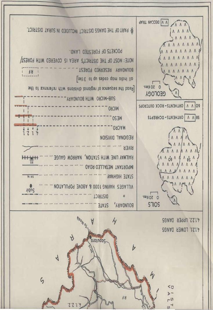
'l":>I~!SIO IV~nS NI Q30m:>NI IJI~!Sla S~NVQ 3H130 l~Vd 'X' •
'ONVl 031S3MO~ ~O S!3~JOd
/!S3~O~ HIIM a3~3AOJ 51 V3~V S~JIH1SIO 3Hl .:iO lSO~ : 310N : ..... ~ ·HN .. N: ........................ -'lS3HOd 03AH3S3ij A~VONn08 , . .... N ...... ..... ~an E 01 dn sapOl dow 0IPUI 110
341 01 alU3JaJ3J 4l!M SUOISIAIP IDUO!6aJ JO 3luanbas 341 pDa~]
i - - - - - - - - - - - - A~VONn08 HIIM OMJI~-BnS I
r - - - - - - - - - - - - - - - - - - - - - - O~JI~ I I
I I r---------------- --------OS3~
~ ~ ~ r- ---------------------OHJV~ 'l 'Z 'l .~
NOISIAIO lVNOI~3H "'7 - ................. , ........... , .................. ~3AI~ 11111 ~ II ......... 3~nv~ MOH~VN 'NOIIVIS HIIM 3NI1 AVM1IV~
SH ........................... avo~ a~llV13~ INVI~Od~1
-"'-tl-HS-'" ................................. I ..... AVMH9IH 3IVlS
• .. ....... NOIIVlndOd 3A08V ~ 000 l ~NIAVH S3~VllIA JIQnS
•. -.-._ ................................. 1:>IHISla II
_ .. - .. - .. , ................................. 3IVIS 'A~VONn08
SdOM:>lno ~:>O~ "SlN3Hl~O ~09
Sld3ijH:>O "SlN3Hl~O ~8S
11 ...... · A\ " A A A.
(A A A\ " A A A A\""" I
.~'''A''A A A A At
(!A A 09 A A as A ! C II II A A II II ~ : AA AA"")
,~ II A II " A A)'
('."" "fV\A. Ii '''''. 'tv' '''~
·SW~ O~ 0 \~'\ S110S ~ .. "
S~Nva ~3ddn 'Z'ZT~
S9Nva ~3MOl lZT~
<0
l>-: rVl (/1-4 --


DATA ON REGIONAL DIVISIONS
District Name: THE DANGS Census Location Code No. 19 State: GUJARAT
District Region No. of village No. of towns Area in Kmf. 1981 Population 1981
No. and in each In each Region Total Rural Urban Total ~ral Urban
Name RegioR
as evolved
2 .3 4 5 6 7 8 9 10
The 4.1.2.1 160 villages Nil 1034.3 1034.3 68165 68165
Dangs Lower (160 villages
Dangs of the Dangs
taluka)
4.1.2.2 145 villages Nil 639.8 639.8 42857 42857
Upper (145 villages
Dangs .01 the Dangs
taluka)
Grand 2 305 Nil 1674.1 1674.1 111022 111022
Total
Note:- Out of 311 villages 6 villages of The Dangs taluka included in Sural district.
225

REGION-WISE VILLAGE CODES, 1981
District Name: THE DANGS Census Location Code No. 19 State: GUJARA T
SI. Division Taluka Location code Total No. of Area in Km2 Remarks
No. No.& No. of Census villages/Towns
Name village as per of in of Taluka In
1981 Taluka divi- Regional
sion division
2 3 4 5 6 7 8 9
4.1.2.1 TheDangs 1 to 13,20 160 1034.3 Code No. 14 to 1901 the Dangs
Lower to 44, 49 to taluka included in Surat district,
Dangs 79, 94 to 122, division No. 4.1.1.6. Code No. 45
132, 138 to 166, to 48,8010 93, 12310131, 13310
187 to 209, 231 137,167 to 186,210 to 230,238
to 237, 243 & 244. 10 242, 245 10 311 are in divisiol)
No. 4.1.2.2
Total for
division 160 1034.3
No. villages +-
4.1.2.1 t Town Nil
1034.3
II 4.1.2.2 The 45 to 48, 80 to 145 639.8 Code No. 1 to 13, 20 to 44, 49 to
Upper Dangs 93, 123 to 131, 79,9410122,132, 138 to 166,
Dangs 133 to 137, 167 187 to 209, 231 to 237, 243, 244
10 186,210 to are in division No. 4.1.2.1
230, 238 to 242. Code No. 14 \019 are inctuded in
24510311. Sural district.
Total for 145 639.8 division villages t-
No. Town Nil
4.1.2.2 639.8
226 •

District Name: THE DANGS
State District Division Name of
name number adminis-
and name trative
divisions
2 3 4
Gujarat The Oangs 4.1.2.1 The Dangs
Lower taluka
Oangs
STATEMENT ON REGION-WISE PHYSIO-CULTURAL DETAILS
Census Location Code No. 19 State: GUJARAT
Geology
5
Deccan
Trap
227
Soils
6
OrthentsOchrepts
Orthents-
Physio-Cultural Characteristics
7
This region occupies the western part of the
district and makes its boundaries with district
Valsad and Surat in the west and north and
Rock Outcrops Upper Oangs in the east and Maharashtra
state in tAe south. Forests are the main
features which influence the socia-economic
aspects of the region.
From physiographic pOint of view, the
maximum height of the region is 590 metres
above the M.S.L. in the south of Ahwa and 560
metres near Suber village. The region is
elevated towards west. Major rivers of the
region are Gira, Puma, Khapri and Arnbika
which drain the region with their tributaries.
Geologically the region is formed of Deccan
Trap. The soils found in the region are red
loamy and black soils. These soils are not
suitable for agriculture.
Soils as classified by NBSS & LUP (ICAR),
Nagpur, the region bas Orthents-Ochrepts and
Orthents-Rock Outcrops types of soils.
Orthents - Recently formed soils.
Ochrepts • Shallow black, brown and alluvial
soils of northern region.
Regarding transport and communication, the
region has good network of state highways
and other district roads. Ahwa and Waghai are
well connected with other parts of district and
state.

2 3
Gujarat The Dangs 4.1.2.2 Upper
Oangs
4
The Dangs taluka
5
Deccan Trap
6 7
Orthents- Thi$ region extends over the eastern part of Ochrepts the district and makes its boundaries with the
Orthents- lower Dangs 4.1.2.1 in the west, Maharashtra Rock Outcrops state in the north-east and south.
From relief point of view, the maximum height of the region is 1290 metres above the M.S.l. near Chinchil Gadad and 675 metres above
the M.S.L. near Saputara village. General slcpe of the region is westward. Major rivers like Gira. Puroa, Khapri and Ambika drain the
region with their tributaries. Geclogically the region is composed of Deccan Trap. Soils found in the region are black rock outcrops and recently formed soils.
AA per classification of NBSS & LUP (ICAR).
Nagpur, the (egion has Orthents-Ochrepts and Orthents-Rock Outcrops types of soils.
228
Orthents - Recently formed soils.
Ochrepts - Shallow black, brown and alluvial soils of northern regiort.
From transport and communication point of
view, the region has good road connections to Saputara, the hill station. The socia-economic activities in the region are based on forests.

DISTRICT JAM NAGAR
Regional Divisions
Jamnagar district is a part of Kathiawar Peninsula (4.1.3) and is sub-divided into following three submicro regions on the basis of geology, soils, topography, climate, aDd natural vegetation.
4.1.3.1 Jamnagar North-West Coastal Plain
The region extends over the coastal tract of district Jamnagar, occupying Jodiya and Okhamandal and large parts of Dhrol, Jamnagar, Khambhalia, Kalyanpur, Lalpur and Kalavad talukas. The coast is generally flat but fringed with a line of wind blown sand hills. Marshes and mangroves are common features of the coastal plain. General slope of the region is north wards except, in Kalyanpur taluka where the slope is towards south-west. North-eastern part of the region is undulating plain. Geologi9ally it is composed of Alluvium, blown sand, etc, Dwarka Beds, etc, Nari and Gaj series, SUb-Nummulitic Beds, Deccan Trap and Trap dykes. Soils found in the region are Orthids-Aquepts and Orthents-Ochrepts. There are 406 villages and 14 towns in the region, occupying an area of 5690.8 Km2 which is inhabited by 928681 persons of which 458763 and 469918 persons are in rural and Urban areas respectively.
The density of population is 163 persons per Km2.
4.1.3.2 Jamnagar South Plain
The region spreads over the parts of talukas of Kalyanpur, Jamnagar, Khambhaliya, Bhanvad, Lalpur, Kalavad, Jamjodhpur, and Dhrol and some parts of Paddhari taluka of Rajkot district. Larger
229
parts of Lalpur, Jamnagar and Kalavad talukas are covered by hilloc~s and the terrain. Average height of the region is 75 metres in Lalpur taluka and 45 to 60 metres above the mean sea level in Khambhaliya taluka. General slope of the region is north ward in Kalavad and Jamnagar talukas, and towards southwest in Kalyanpur and Bhanvad talukas. The reqion is drained by Manvar, Nagmati, Sasoi, Vatru and Sani rivers. Geologically the region is composed of Alluvium, blown sand, etc, Nari and Gaj Series, SubNummulitic Beds. Deccan Trap and Trap dykes. Soils found in the region are Orthents-Aquepts and Orthents-Ochrepts.
The region contains 277 villages and three towns, which account for an area of 3888.2 Km2. The total population of the region is 403268 with 351594 persons in rural areas and 51674persons in urban areas. The density of population is 104 persons per Km2.
4.1.3.3 Barda Hills Forested Region
The region extends over the southern parts of the district occupying parts of Bhanvad and Jamjodhpur talukas. The Barda Hill 'has the maximum height of 627 metres above the mean sea leveL Other hills are below 300 metres. Geologically the region is covered by Deccan Trap and Trap dykes. The soils found in the region are OrthidsAquepts and Orthents-Ochrepts. Large part of the region is covered by forests. There are 68 villages in the region covering an area of 587.9 Km2 which is inhabited by 61860 persons in entirely rural areas. The density of population is 105 persons per Km2
which reflects that the region is not developed.


'OJ
-~
'\ 0 ')
~
, 0
~ ~
~ ~ ~
I I I ~ 'SW~ 51 01 5'sw~ ~
SNOISIAIO 'YNOI~IH
10 300J SnSN3J ,.
~V~VN~Vr lJlijlSIO :l' Q
ii' lV~Vrn~
VIONI

[Uil E 01 dn saPO) dow D1PUIliD I~l 01 3)UJ3J3J 411M §UO!§IA!P IDUO!5,J JO amnbu 341 PDa~J
"'"r---------------AijVONnOS HlllA OijjIYi-SnS 1 r---------------------------Oij~Yi
*1; I r--------------------------OS3Yi
t ~ ~ J------------------------O~jVYi
. 1'£ '1 '~ NOISIAIO 'YNOI~3~ ~ .. · .. · .. ·' .... " .... · .. ·"' .. ' .. "" .. ·"·'~3hl~
IIIIII~IIIIIIII ", , .. "'3~nV~ 3~13Yi "" " =+ .. , ", .. 3~nV~ OVOijS'NOlmS HlllA 3NI1 AYIA'IY~ 5~
.. , ", ,,, ...... '" .. , OYOM 0311Yl3Yi lNYlijOdYiI ---II HS .. , , .. ,,, .. , '" ..... , .. , ,,, ,,, .. , "AIAH~IH 31Y1S
• "N011YlndOd 3A08Y ONY OOOS ~NlhYH S3~Y"lh _& ... ," .. "I, .. , .... , , .. , .... , ", , .. Y3ijY Nmn
j8 : .. , .. '''' .. , .. , '" "lmo~ 03mm II
------- , .. '" .. , ", , .. '" '" '" .. , .. , 'V~n1Vl II
._._._. ,,' , .. '" '" .. , .. , .. , '" '" '''DlijlSIO'AijYONn08
·J.)lijlSIO MV9VNYiVr NI 030nl)NI DlM1SIO lO~m :10 lijYd ,X,
DIM1SIO lO~rVij NI 030nlJNI v~nlVl 10MHO ~O lijVd :0
\
'SW~ OZ 0
A~o,oa~
,...., 'IW~ 01 0
S110S
NOI~3M lS3MO j': ll1H YOm '£'1
NIVld Hinos MV~VNvm TI
I 0 NIYld lV1SVO) lS3M-HWON MV~YNYiYr '1'1


DATA ON REGIONAL DIVISIONS
District Name: JAM NAGAR Census Location Code No. 01 State: GUJARAT
District Region No. of village No. of towns Area in Km£ 1981 Population 1981
No. and in each in each Region Total Rural Urban Total Rural Urban
Name Region
as evolved
2 3 4 5 6 7 8 9 10
Jam- 4.1.3.1 406 Villages 14 Towns 5690.8 5352.9 337.9 928681 458763 469918
nagar Jam- (51 villages of Jodiya (\IP)
nagar Jodiya laluka, of Jodiya
North· 95 villages of taluka, Jamnagar
west Jamnagar taluka, U, Bedi (NPl,
Coastal 61 villages of Navagamghed (VP),
Plain Lalpur taluka, Sikka (\IP) & 52 villages of Oigvijaygram (\iP)
Khambhaliya of Jamnagar
taluka,28 taluka, Lalpur
villages of (VP) of Lalpur
Dhroltaluka, taluka, Khambhaliya
31 villages of (NP) & Salaya (NPl
Kalyanpur taluka, of Khambhaliya
78 villages'of taluka, Ohrol
Okhamandal (NP) of Ohrol
taluka, 10 villages taluka, Owarka
of Kalvad (NP), Mithpur (NM),
taluRa.) Beyt (VP), & Okha
port (NP) of Okha·
mandai taluka.
4.1.3.2 277 Villages 3 Towns 3888.2 3747.6 140.6 403268 351594 51674 Jam· (38 villages of Bhanvad (NP) nagar Kalyanpur taluka, of Bhanvad South 16 villages of -taluka, Jam· Plain Jamnagar taluka, jodhpur (NP)
30 villages of of Jamjodhpur Khambhaliya taluka, Kalavad
taluka, (NPl of Kalavad
29 villages of taluka. Bhanvad taluka,
10 villages of
Lalpur ialuka.
53 villages of
Jamjodhpur tal·
uka, 2 villages
of Paddhari
233

2 3 4 5 6 7 8 9 10
taluka of Rajkot
district, 88
villages of
Kalavad taluka & 11 vi!lages
of Dhrol taluka).
4.1.3.3 68 villages Nil 587.9 587.9 61860 61860
Barda (16 villages of
Hills Jamjodhpur
Forested taluka & 52 villages
Region of Bhanvad talu~a).
Grand
Total 3 751 Villages 17 Towns 10,166.9 9,688.4 478.5 1,393,809 872,217 521,592
234

REGION·WISE VILLAGE CODES, 1981
District Name; JAMNAGAR Census Location Code No. 01 .State: GUJARAT
SI. Division Location code Total No. of Area in Km2 Remarks
No. No.& Taluka No. of Census villages/Towns
Name villages as per of In of Taluka In
1981 Taluka division Regional
division
2 3 4 5 6 7 8 9
4.1.3.1 (1) Jodiya 1 to 51 51 791.1
Jamnagar
North· Jodiya Urban 77.6
West Coastal
Plain
(2) Jam· 1 t041, 43 to 95 931.9 Code No. 42, 61, 62, 67 to 70, 91
nagar 60,63 to 66, to 99 are in Region 4.1.3.2
71 to 90,
100 to 111
Jamnagar
(Urban)
Bedi
Navagam 5 44.6 Note;· 51.2 Km2 area of
Ghed Jamnagar village (Rural) Sikka + 51.2 included in Jamnagar urban Dig· 95.8 area.
vijaygram
(3) Lalpur 1 to 44, 61 903.5 Code No. 45, 46, 57 to 60, 64 to
47 to 56, 61 to 66, 70 are in region 4.1.3.2 63, 67 to 69
Lalpur 32.2 Urban
(4) Kham· 1 to 34, 37, 52 791.6 Code No.35, 36, 38 to 41, 53 to bhaliya 42 to 52, 60 to 59, 63 to 79 are in Region 4.1.3.2 Kham· 62, 80 to 82 bhaliya
(Urban) 2 13.1 Salaya
(Urban)
(5) Dhrol 1 to 27 & 33 28 402.3 Code No. 28 to 32, 35 to 38, 40 & 41 are in Region 4.1.3.2 While
Code No. 34 & 39 of this taluka
fall in Rajkot district 4.1.3.2
235

2 3 4 5 6 7 8 9
Dhrol 39.0 Urban
(6) Kalyan- 1 to 10, 14 31 784.0 Code No. 11, 12, 13,21 to 31,38
pur to 20, 32 to 37, to 57, 62 to 65 are in Region
58 to 61, 66 to 69 4.1.3.2
(7) Okha- 11078 78 636.6
mandai
(Urban)
(I) Owarka 4 80.2
(1/) Mithapur
(I/!) Beyt
(IV) Okha-Port
(8) Kalavad 1,22 to 27, 10 111.9 Code No, 2to 21, 28 to 42, 46 to
43,44,45 98 are in Region 4.1,3.2
406 villages 5352.9
+14 Towns + 337.9
5690.8
4.1.3.2 (1) Kala- 11 to 13, 38 628,2 Code No.1 to 10, 14 to 20, 32 to
Jam- yanpur 21 to 31, 38 37, 58 to 61, 66 to 69 are in
nagar to 57, 62 to 65, Region 4.1.3.1
South
Plain
(2) Jamnagar 42; 61,62,67 to 16 199.5 Code No.1 to 41, 43 to 50, 63 to
70,91 to 99 66,71 to 90,100 to 111 are in
Region 4.1.3.1
(3) Kham- 35,36,38 to 41, 30 409.5 Code No.1 to 34, 37, 42 to 52, 60
bhaliya 5:3 to 59, 63 to to 62, 80 to 82 are in Region
79 4.1.3,1
(4) Bhanvad 1 to 26, 30, 31, 33 29 397.6 Code No. 27 to 29, 32, 34 to 81
are in Region 4.1.3.3
Bhanvad
(Urban) 35.2
(5) Lalpur 45, 46, 57 10 60, 10 139,9 Code No, 1 to 44, 47 to 56, 61 to
64 to 66, 70 63, 67 to 69, 71 are in Region
4.1.3.1
(6) Jam- 1 to 51, 53, 54 53 733,0 Code No, 52, 55 to 69 are in
jodhpur Region 4.1.3,3
236

2 3 4 5 6 7 8 9
Jamjodhpur
(Urban) 69.5
(7) Paddhari 29,30 2 23.9 These two villages of Paddhari
(District taluka of Rajkot district fall in this
Rajkot) district boundary
(8) Kalavad 2 to 21, 28 to 42, 88 1096.7 Code No.1, 22 to 27, 43 to 45
46 to 98 are in Region 4.1.3.1
Kalavad
Urban 35.9
(9) Dhrol 28 to 32, 35 11 119.3 Code No.1 to 27 & 33 are in
to 38, 40, 41 Region 4.1.2 1 while Code No. 34
& 39 of this taluka fall in Rajkot
dist. 4.1.3.2
277 3747.6
villages
+ 3 Towns + 140.6
3888.2
III 4.1.3.3 (1) Jam- 52, 55 to 69 16 288.8 Code No.1 to 51, 53, 54 are
Barda jodhpur in Region 4.1.3.2
Hills
Forested
Region
(2) Bhanvad 27, 28, 29, 32, 52 299.1 Code No.1 to 26, 30, 31, 33 are
in 34 to 81 Region 4.1.3.2
68 villages 587.9
Town Nil + -587.9
2:)7

District Name: JAM NAGAR
State District
name
Division
number
Name of
adminis-
STATEMENT ON REGION-WISE PHYSIC-CULTURAL DETAILS
Census Location Code N. 01
Geology Soils
and name trative
2 3
Gujarat Jamnagar 4.1.3.1 Jamnagar
North
West Coastal
Plain
divisions
4
Jodiya, Jamnagar,
Lalpur,
'Khambha
liya,
Ohrol,
Kalyan
pur,
Okhama
ndal and
Kalavad
talukas
5 6
Alluvium, Orthids-blown Aquepts
sand, etc. Orthents-
Dwarka Ochrepts Beds, etc.
Nari and
Gaj
Series
Sub-Numm-
ulitic
Beds.
Deccan
Trap
dykes.
238
State: GUJARAT
Physio-Cultur~t Characteristics
7
The region extends over the coastal tract of
Jamnagar district, occupying Jodiya and
Okhamandal talukas and larger parts of Ohrol,
Jamnagar, Khambhaliya, Kalayanpur, Lalpu(,
and Kalaad talukas. The region is bounded by
Gulf and Rann of Kachchh. In the north by
Rajkot district, in the east by Jamnagar South
Plain in the south and by Arabian Sea in the
west.
The region has roughly about 351 kms off
coast of which 93 Kms, from Meda Ereck 10
Okha tidal station are wa~hed by Arabian Sea
in the west, while about 258 kms of the coast
face the Gulf of Kacl'lchh in the north. The
coast is generally flat and fringed with a line of
wind blown sand hills. The gulf coast on the
other hand is a built up coast. Marshes, sand
and mangroves are common features of this
coast, aile rating with rocky buttresses and
islands in the Gulf. The coastal tract of Jodiya,
Jamnagar, Khambhaliya and Okhamandal are
covered by water during high tides because of
very low lying areas. The slope of the region is
towards north, except in Kalyanpur taluka
where the slope is south-west ward. Parts of
Ohrol taluka is undulating plain. The region is
drained from south to north in the Gulf of
Kachchh. Major rivers are Demi, Aji, Maover,
Nagmati, Sasoi and Phuljar. The only river
Bhozat flows towards south-west in Katyanpur
taluka.
Geologically the region is, composed of
Alluvium, blown sand, etc, Dwarka Beds, etc,
Nari and Ganj Series, Sub-Nummufitic Beds,
Deccan Trap and Trap dykes. As per NBSS & LUP (ICAR), Nagpur, soils found in the region
are: Orthids-Aquepts and Qrthents-Ochrepts
types of soils.

2 3 4
Gujarat Jamnagar 4.1.3.2 Kalyanpur, Jamnagar Khambhali-
South ya, Plain Bhanvad,
Lalpur,
Jamjodhpur,
Jamnagar,
Kalavad,
Ohrol
and
Paddhari
talukas
5 6
Alluvium, Orthids-blown Aquepts sand, etc. Orthents-
Nari and Ochrepts
Gaj Series
Sub-
Nummulitic
Beds.
Deccan 'Trap
Trap
dykes
239
7
Orthids - Soil of arid region with some
development.
Aquepts - Brown Soils (Hydromorphic)
Orthents - Recently formed soils.
Ochrepts - Shallow black, brown and alluvial
soils of northern region.
Jamnagar, Khambhaliya, Dwarka, Lalpur,
Ohrol and Jodiya are the major towns of the
region. Transport and communioation facilities
are better in the region. all the towns are
connected by state highways. Dwarka being a
religious place is well connected by rails and
roads.
The region spreads over Kalavad taluka and
parts of Kalyanpur, Khambhaliya, Bhanvad,
Lalpur, Jamjodhpur, Jamnagar, Ohrol and
Paddhari talukas. The region is surrounded by
Jamnagar North-West Coastal Plain on the
north, Barda Hills. Forested Region on the south and district Rajkot on the east.
From the reUef pOint of view, the region has an
average height of 100 metres above the mean
sea level, but it is intersected by hillocks in
Kalavad and Jamjodhpur talukas. The height
of hillocks is about 150 metres at some places.
The slope of the region in the talukas of
Kalavad and Lalpur is north wards, while rest
of the region is sloped towards south-west.
The region is drained by rivers Sani, Vartu,
Nagmati and manvar.
Geologically the region is composed of
Alluvium, blown sand, etc, Nari and Gaj Series,
Sub-Nummulitic Beds, Deccan Trap and Trap
dykes. Soils found in the region are alluvium,
black, brown etc. Alluvium soil is known as
'Ghed' in the district and it is most fertile soil of
the region. These soils are categorised by
NBSS & LUP (I CAR) , Nagpur as Orthids·
Aquepts and Orthents-Ochrepts types of soils.
Orthids - Soil of arid region with some
developmen't
Brown soils (Hydromorphic)
Orthents - Recently formed soils.

2 3 4 5
Gujarat Jamnagar 4.1.3.3 Bhanvad and Deccan Barda Jamjodhpur Trap;
Hills taluk' Trap dykes
Forested
Region.
240
6
Orthids-Aquepts
Orthents-
Ochrepts
7
Ochrept3 - Shallow black, brown and alluvial
soils of northern region. Transport and
communication facilities are not enough as in
Jamnagar North·West Coastal Plain. Western
part of the region e.g. Kalyanpur, Khambhaliya
and Bhanvad .talukas are well connected by
rail and roads while eastern part e.g. Kalaad,
Jamjodhpur talukas, is very poor in these
facil ities.
The region spreads over the southern part of
Jamjodhpur and Bhanvad talukas of the
district. The region makes its boundaries with
Junagadh district in the west and south, Rajkot
district in the east and South Jamnagar Plain
in the north.
From physiographic point of view, 'maximum
height at Barda Hill is more than 500 metres
above the mean sea level in the region. River
Dai flows from north to south between A1ech
and Barda hills in the region. Also, the region
is characterised by hillocks and covered with
forests.
The geologically the iegion is covered by
Deccan Trap and Trap dykes.
As per classification of NBSS & LUP (ICAR),
Nagpur, the region has Orthids·Aquepts and
Orthents·Ochrepts types of soils.
Orthents . Ochrepts types of soils.
Orthids . Soils of arid region with some
development.
Aquepts - Brown soils (Hydromorphic)
Orthents • Recently formed soils.
Ochrepts • Shallow black, brown and alluvial
soils of northern region.
Transport and communication, facilities are
good in the region, The region is connected by
a broad gauge and narrow gauge railway lines.
One state highway crosses the region from
north to south in Bhanvad taluka. Jamjodhpur
taluka is poor in transport facilities but there
are minor roads in the region,

DISTRICT RAJKOT
Regional Divisions
Rajkot district is a part of Kathiawar Peninsula (4.1.3) and is sub-divided into following five submicro regions on the basis of geology, soils, climate, topography, and natural vegetation.
4.1.3.1 Maliya Coastal Plain
The region spreads over the Maliya taluka and parts of MONi taluka. The coast is a long mudcovered flat plain with mangroves, swamps and abounds in reefs, rocks and small islands. Rann stretches about 20 Kms. from Vavaniya to Venasar. This Rann in rainy season becomes a shallow lake and in dry season it is bare of vegetation and is studded with salt and sand. The plain is drained by river Machchhu. The geological formation of the region is Alluvium, blown sand, etc. The soils of the region are Orthids-Aquepts. There are 57 villages covering an area of 873.2 Km2 where 70535 persons are residing. The region is entirely rural. The density of population is 81 persons per Km2 in the region. The region is agriculturally, not developed
4.1.3.2 Rajkot Alluvial Plain
The region extends over Paddhari taluka: parts of Lodhika, Rajkot, Wankaner talukas and major part of Morvi taluka. Average height of the region is 100
metres above the mean sea level. General slope of the region is towards north. The region is drained by river Machchhu. Geologically the region is composed of Alluvium, blown sand, etc, Deccan Trap, Trap dykes and Umia series. Soils are OrthidsAquepts and Orthents-Ochrepts. The region contains 216 villages and four towns with an area of 2690.2 Km2. In this region 800406 persons are residing of which 269181 are in rural and 531225 in
241
urban areas, which reflects concentration of population in urban areas because of major business activities in the towns. The density of population is 298 persons per Km2 in the region.
4.1.3.3 Rajkot Stony Waste Land
The region eldends over the parts of Wan kaner, Morvi, Rajkot, Kotda Sangani, Gondal and Lodhika talukas. These talukas are covered with small rock ranges. The relJion is no where higher than 150 metres above the mean sea level. The geological formation of the region is Deccan Trap and Trap dykes. The SOil8 of the region are Orthids-Aquepts and Orthents-Ochrepts. There are 99 villages in this region, covering an area of 1223.6 Km2. which are inhabited by 12.5398 persons. There is no town in the region. The density of population is 102 persons per Km2. The soils of the region are not suitable for cultivation.
4.1.3.4 Bhadar Fliver Plain
The region spreads over the southern and southwestern parts of Rajkot District occupying Upieta, Dhoraji, Jamkandorna, Jetpur talukas and parts of Gondal, Lodhika, Kotda Sangani and Jasdan talukas. General slope of the region is towards south-west. Eastern part of the region is above 200 metres while western part has a height of 100 metres above the mean sea level. The region is covered by Deccan Trap Inter Trappean, Beds and Trap dykes, and the soils found in the region are Orthids-Aquepts and Orthents-Ochrepts. The region is rich in agriculture. There are 316 villages and six towns in the region. Its area is 4477.0 Km2 which is inhabited by 883733 persons of which 590566

reside in rural and 293167 in urban areas. The region has density of 197 persons per Km2.
4.1.3.5 Vinchhiya Upland
The region extends over the south-eastern part of the district occupying parts of Wankaner, Raj kat, and Jasdan talukas. There are 170 villages and two towns with an area of 1902.7 Km2 where 215969 persons are residing, of which 176039 and 39930
-
persons are in rural and urban areas respectively.
The region has a density of 114 persons per Km2. Maximum and minimum height is noticed in Jasdan and Wankaner taluka respectively. General slope of the region is to~ards north. The region has characteristics of hills and hillocks. Geologically the region is covered by Deccan Trap, Inter-Trappean, Beds, Trap dykes and Umia Series. The soils of the region are Orthids-Aquepts and Orthents-Ochrepts. The soils are generally not suitable for cultivation.
242

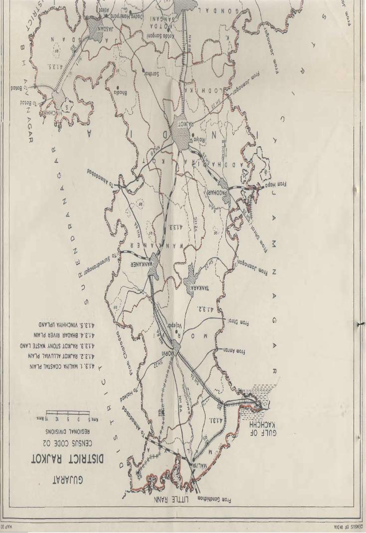
tj
A
~
A
C!-
O
~
~
?
Jl
ONVldn VAIHHJNIA 's 'ny NIVld ~3AI~ ~VOVH8 'v'£n
ONVl 31SVM AN01S lO~rv~ '£ 'nv NIVld lVIAnllV lO~m 'nn NIVld lV!SVOJ VAllYri '~'En '(
'SWM SI 01
SNOISIAIO lVNOI!)3~
GO 300:) SnSN3:)
lO~rV~ lJI~lSla
'y
\
'y
»
z
»
II
'(
NNV~ 311111 WD4P!4PUD!) WOJJ
DE dV~ VIO Nt ~o SnSN3:l

~ .. · .. ·"· · .... ··"· .. · .. · .... · .. · .. ·· .... · .. · .. · .. · .. · .. ·~3AI~
mr'" '" .. ·3~nV!l MO~~VN , , , , , ,
T .. · .. · .. · .. ·3~nY!l3m~ " " "
[Ja!l E Ol do S3pO~ dow 0lpUI 110341 01 m3J313J
II. suolslAIP IDUO!63J 10 m3nb3s 34l pD3~]
=-r" ...... · .. 3~nV!) OYO~8 'NOIIVIS HIIM 3NI1 AVM1IV~ _ ............................. '''OYO!! 0311¥l3t'l .LN'f1!JOdt'l1
---rHs"''' ..... , ............ '" .. , ........ , ... " .... "'AVMH!)IH 31VIS 8""8'H'N " ......................... I" ......... "'AVMH!lIH lVNOllYN
-n~VONnOB HIIM O~:)I~·8nS 1 -:r---------- -------O~:)I~
~r-----------------OS3~
J t t r--------------O~:)V~
• '" "'NOlmndOd 3A08V , 000 S !)NIA'fH S3!)YllIA
~ ::: .::' .. :" .. : ...... ::. ::: .::' .::' '::1' ~~~~~ .. ~'~;~~~~'~'f3~Y ~Y8~n : ~~ : :.:c,;;cc.::.::':: ....................... , ........ '''1VHV~ 1'f~n1Vl "
NOISIAIO 1YNOI!)3~ _._.- ............... " ........... " ...... "DI!lISIO iA!lYONn08
'1VHVVi Y~IHOOl ~O 13~:)Od '1 H a v ~ l:)l~lSIO ~V!)VN~\lr ~O m:)Od 'r
'l\fH\f~ IN\f!)N\fS \fOlO~ ~O m:)Od .~
() '\f~nlVl lVONO!) ~O mJOd .!)
'lJ1!llSIO ~\f!)VNV~aN3~ns ~O m:)Od 'S
'lJl~lSla 113~~v ~O 13~JOd '\f
1J1~lSla ~\f~VN~m NI a30nlJNI :.~.
~ N n r


DATA ON REGIONAL DIVISIONS
District Name; RAJKbr Census Location Code No. 02 State: GUJARAT
District Region No. of village No. of towns Area in Km- 1981 Population 1981
No. and in each in each Region Total Rural Urban Total Rural Urban
Name Region
2 3 4 5 6 7 8 9 10
Rajkot 4.1.3.1 57 Villages Nil 873.2 873.2 70,535 70,535 Maliya (47_villages of
Coastal Maliya taluka & Plain 10 villages of
Morvi taluka)
4.1.3.2 216 villages 4 Towns 2690.2 2562.1 128.1 800,406 269,181 531,225 Rajkot (102 villages of Morvi (M) & Alluvial Morvi taluka Tankara (VP)
Plain 59 villages of of Paddhari
Paddhari taluka, (VP) of Pad-2 villages of dhari taluka,
Dhrol taluka of Rajkot (MC) Jamnagar district, of Rajkot 24 villages of taluka. Rajkot t'lluka,
16 villages of
Lodhika Mahal,
13 villages of
Wankaner taluka)
4.1.1.3 99 Villages Nil 1223.6 1223.6 125,398 125,398 Rajkot (14 villages of Stony Wankaner taluka, Wasje 9 villages o~ Land Marvi taluka,
46 villages of
Rajkot taluka,
10 villages of
KOlda Sangani-
Mahal, 18 villages
of Ladhika Mahal
and 2 villages of
Gondal taluka)
4.1.3.4 316 Vlllages 6 Towns 4477.0 4167.4 309.6 883,733 590,566 293,167 Bhadar (50 villages of Upleta (M) of River Plain
Upleta taluka, Upleta taluka,
245

2 3 4 5 6 7 8 10
30 villages of Dharaji (UA) of Dhoraji taluka Dhoraji taluka, 47 villages of Jetpur (UA) & Jetpur taluka Jetalsar (VP) of 46 villages of Jetpur taluka, Jam Kandorna Gondal (UA) of taluka, 1 viII- Gondal taluka, age of Kukavav and Jasdan (NP) vadia taluka of of Jasdan Taluka. Almeli district,
79 villages of
Gondal taluka, 28 villages of
Jasdan taluka,
31 villages of
Kotda sangani Mahal, 4 villages
of Lodhika Mahal)
4.1.3.5 170 villages 2 Towns 1902.7 1868.2 34.5 215,969 176,039 39,930 Vinchhiya (73 villages of Wankaner (M) Upland Wankaner taluka ofWankaner
24 villages of taluka and Rajkot taluka, Vinchhiya (VP) 72 villages of of Jasdan taluka Jasdan taluka, and 1 (one) vill-
age of Saylla-
taluka district
Surendranagar)
Grand Total 5 858 villages 12 Towns 11,166.7 10,694.5 472.2 2,096,041 1,231,719 864,322
246

REGION·WISE VilLAGE CODES, 1981
District Name; RAJKOT Census Location Code No. 02 State; GUJARAT
SI. Division Taluka Location code Total No. of Area in Km2 Remarks
No. No.& No. of Census ViliageslTowns
Name villages as per of In of Taluka in
1981 Taluka division Regional
division
2 3 4 5 6 7 8 9
4.1.3.1 (1) Maliya 1 to 47 47 770.0
Maliya
Coastal
Plain
(2) Morvi 1 to 5, 26 to 30 10 103,2 Code No.6 to 25, 31 to 106, 111
to 114, 119, 120 are in division
No, 4,1,3,2 and Code No.1 07 to
110, 115 to 118 and 121 are in
4,1.3.3
57 villages 873.2
Town Nil
II 4.1,3,2 (1) Morvi 6 to 25, 31 to 106, 102 1434.1 Code No.1 to 5, 26 to 30 are in
Rajkot 111 to 114, 119 & division 4.1,3,1 and Code No,
Alluvial 120 107 to 110 & 115 to 118 & 121
Plain are in 4,1,3.3
Morvi
Urban
Tankara
Urban 2 43.0
(2) Paddhari 1 to 28, 31 to 61 59 6055 Code No. 29, 30 of this taluka fall
in Jamnagar district (4.1.3.2)
Paddhari
(Urban) 16.1
(3) Dhrol 34,39 2 9.0 Code No, 34 & 39 of taluka Dhrol, (dist. dist. Jamnagar fall in this district. Jamnagar)
(4) Rajkot 13 to 20, 32 to 41, 24 230,1 Code No.1 to 4, 9 to 12,21 to 24,
521056,58 31,42,43,50,51,57,591062,
66 to 89 are in 4.1.3.3 Code
No.5 to 8, 25 to 30, 44 to 49, 63
to 65, 90 to 94 are in 4.1.3.5
247

2 3 4 5 6 7 8 9
Rajkot
Urban 69.0
(5) Lodhika 1 to 10, 14to 16 141.4 Code No. 11 to 13, 19 to 23, 25 to
(Mahal) 18,24 .29, 34 to 38 are in 4.1.3.3 and
Code No. 30 to 33 are in division
4.1.3.4
(6) Wankaner 1,3 to 10,17 to 20 13 142.0 Code No. 34 to 36, 53 to 59, 71 to
74 are in division 4.1.3.3
Code No.2, 11 to 16,21 to 33, 37
to 52, 60 to 70,75 to 100 are in
4.1.3.5
216 2562.1
villages
+ 4 Towns 1281.1
""269D.2
III 4.1.3.3 (1) Wankaner 34 to 36, 5310 59, 14 245.3 Code No.1, 3 to 10, 171020 are
Rajkot 71 to 74 in division 4.1.3.2 Code No.2, 11
Stony to 16, 21 to 33, 37 to 52, 60 to 70,
Waste 75 to 100, are in 4.1.3.5.
Land
(2) Morvi 10710110,115 9 117.0 Code No.1 to 5, 26 to 30 are in
to 118, 121 division 4.1.3.1 and code No.6 to
25,31 to 106, 111 to 114, 119 &
120 are in division 4.1.3.2
(3) Rajkot· 1 to 4, 9 46 531.0 Code No.5 to 8, 25 to 30, 44 to
to 12,21 to 49, 63 to 65, 90 10 94 are in
24,31,42,43, division 4.1.3.5 Code No. 1310
50, 51, 57, 59 to 20, 32 to 41, 52 to 56, 58 are in
62,66 to 89 division 4.1.3.2
(4) KOlda- 3105,9 to 15 10 118.0 Code No.1, 2, 6 to 8, 16 to 41 are
Sangani in division 4.1.3.4
(Mahal)
(5) Lodhika 11 to 13, 191023, 18 188.1 Code No. 30 to 33 are in division
(Mahal) 25 to 29, 34 to 38 4.1.3.4. Code No.1 10 10, 14'to
18,24 are in 4.1.3.2
(6) Gondal 3,4 2 24.2 Code No.1, 2, 5 to 81 are in
division 4.1.3.4
99 villages 1223.6
Town Nil
1223.S
248

2 3 4 5 6 7 8 9
IV 4.1.3.4 (1) Upleta 1 to 50 50 742.6 46.5 Km2 area of Upleta village
Bhadar Upleta 2.8 (Rural) included in the Upleta River Urban Town Upleta +46.5 urban. Plair. village
area 49.3
(2) Dhoraji 1 to 30 30 415.1
Dhoraji 15.5 53.3 Km2 area of Dhoraji village
Urban Town Dhoraji + 53.3 (Rural) included in the Dhoraji
village 68.8 urban
area
(3) Jetpur 1 to 47 47 605.3
Jetpur 2 Jetpur 10.4 41.4 Km 2
area of Jetpur village (Urban) Towns Village +41.4 (Rural) included in Jetpur urban Jetalsar area
(Urban) 51.8
21.9
(4) Jam 1 to 46 46 560.3 Kandorna
(5) Kunka- 14.0 Code No.1 of Kunkavav Vadia, vavVadia dist. Amreli falls in this district. (Dist. Amreli)
(6) Gondal 1,2,5t081 79 1095,9 Code No.3, 4 are in division
4.1.3.3.
Gondal
Urban Gondal 7.3 66.20 Km2
area of Gondal village
Town village + 66,2 (Rural) included in Gondal urban area 73,5
(7) Jasdan 48, 50 to 53, 28 361.5 Code No.1 to 47, 49, 54 to 67, 68 to 71,73, 72, 75 to 83 are in division 74,84 to 100 4.1.3.5.
Jasdan
Urban 1 Town 44.3
(8) Kotda- 1,2, 6to 8, 16to 31 329.0 Code No: 3to 5, 9to 15are in Sangani 41 division 4.1.3.3 (Mahal)
249

2 3 4 5 6 7 8 9
, (9) Lodhika 30,31,32,33 4 43.7 Code No.1 to 10, 14 to 18,24 are
(Mahal) in division 4.1.3.2 and 11 to 13,
1 9 to 23, 25 to 29, 34 34 to 38 are
in division 4.1.3.3
316 4167.4
villages
+ 6 Towns t309.6
4477.0
V 4.1.3.5 (1) Wankaner 2,11 to 73 714.5 Code No.1, 3 to 10,17 to 20 are
Vin- 16,21 to 33, in 4.1.3.2. Code No. 34 to 36, 53
chhiya 37 to 52, 60 to 59, 71 to 74 are in division
Upland 70,75 to 100 4.1.3.3
Wankaner - Wankaner 4.5 11.43 Km2 area of Wankaner
Urban village .±..11A village (Rural) included in
area 15.9 Wankaner urban
(2) Rajkot 5 to 8, 25 to 30, 24 236.5 Code No. 13 to 20, 32 to 41,52 to
44 to 49, 63 to 56, 58 are in division 4.1.3.2 and
65,90 to 94 Code No.1 to 4,9 to 12,21 to 24,
31,42,43,50,51,57,59 to 62, 66
to 89 are in division 4.1.3.3
(3) Jasdan 1 to 47,49,54 to 72 902.1 Code No. 4B, 50 to 53, 68 to 71,
67, 72, 75 to 83 73,74,84 to 100 are in division
4.1.3.4.
Vinchhiya 18.6
Urban Town
(4) Sayla 75 15.1 Le. No. 75 of Sayla taluka,
(District district Surendranagar falls in this
Surendra- district.
nagar
170 1868.2
villages
+ 2Towns "'34.5 1902.7
250

District Name: RAJKOT
State District
name
2
Gujarat Rajkot
Gujarat Raj kat
Division
number
Name of
adminis-
and name trative
3
4.1.3.1
Maliya
Coastal
Plain.
4.1.3.2 Rajkot
Alluvial
Plain
division
4
Taluka
Maliya
and parts
of Morvi
taluka.
Paddhari,
Lodhika,
Rajkot,
Morvi
Wankaner
and Dhrol
talukas.
STATEMENT ON REGION-WISE PHYSIO-CULTURAL DETAILS
Census Location Code No: 02
Geology
5
Alluvium
blown
sand, etc.
Alluvium,
blown
Soils
6
Orthids
Aquepts
Orthids
Aquepts
sand, etc. Orthents-
Deccan Ochrepts
Trap Trap
dykes Umia
series
251
State: Gujarat
Physio-Cultural Characteristics
7
The region extends over coastal areas of
Rajkot district occupying Maliya taluka and
some parts of Morvi taluka. The region is
bounded by Gulf of Kachchh in the north by
district Surendranagar in the east by Rajkot
Alluvial Plain in the south by Jamnagar district
in the west.
The region has a coast line of 32 Kms. It is a
long mud covered flat land with mangrove
swamps and abounds in reefs, rocks and
small islands. Also the Rann stretches in the
region about 20 Kms from Vavania to Venasar.
General slope of the region is northwards and
it is drained by river Machchhu. Geologically
the region is covered with Alluvium, blown
sand, etc.
The soils of the region are Orthids-Aquepts
types.
Orthids - Soils of arid _ Region with some
development.
Aguepts - Brown soils (Hydromorphic)
The region has the only port, Navlakhi,
situated on the Thansthal Creek. The region is
well connected by rails and roads.
The region spreads over talukas of Paddhari,
Morvi and some parts of Lodhika, Rajkot and
Wankaner talukas. It is bounded by Maliya
Coastal Plain in the north by Surend(anagar
district in the north east by Rajkot Stony Waste
Land in the south and east and by Jamnagar
district on the west.

2
GtJjarst Rajkot
3
4.1.3.3
Aajkot
Stony
Waste
land
4
Wankaner Morvi
Rajkot
Kolda
Sangani
Gondal and
Lodhika
talukas.
5 6
Deccan Orthids-Trap Aquepls
Trap Orthents-
dykes Ochrepts
252
7
From the relief point of view, the region has an
average height of 100 metres. The general
slope of the region is north wards in MaIVi
taluka while in other talukas it is towards north
west.
The region is drained by river MaChchhu and
its tributaries.
Geologically the region is composed of
Alluvium, blown sano, etc, Deccan Trap, Trap
dykes and Umia series.
SoilS as classified by NBSS & LUP (I CAR)
Nagpur, the region has Orthids-Aquepts and
Orthents-Ochrepts types of soils.
Orthids - Soils of arid region with some
development.
Aquepts - Brown soils (Hydromorphic)
Orthents - Recently formed soils.
Ochrepts - Shallow black, brown and alluvial
soils of northern region.;
Transport and communication facilities are
well in the region. Rajkot and MOIVi are major
business towns of the district as well as of the
Saurashtra region. Towns of the region are well connected by rails and roads.
The region spreads over the parts of the
ta/ukas of Wan kaner, Morvi, Aajkot, Kotda
Sangani, Gondai and Lodhika. The region is
surrounded on the north and north-west by
Rajkot Alluvial Plain, on the east by Vinchhiya
Upland and on the south by Bhadar River
Plain.
From the relief point of view, the region is
characterised by scattered hillocks. Southern
part of Rajkot taluka, northern part of Gondal
and KOlda Sangani talukas have average
height of 200 metre above the mean sea I~vel,
while northern part of the region has an
elevation of 100 metres. General slope of the
region is northwards. Th~ region is drained by
the tributaries of Demi, Aji and Dondi rivers.

2
Gujarat Rajkol
3
4.1.3.4 Bhadar
River
Plain
4
Upleta, Dhoraji,
Jetpur,
Jamkan
dorna,
Gnodal,
Jasdan,
Lodhika,
Kotda
Sanganiand
Kunkavav
Vadia talukas
(Amreli district)
5 6
Deccan Orthids-
Traps, Aquepts
Trappean, Orthents-
Beds Ochrepts.
Trap
dykes
253
7
The region is covered by Deccan Trap and
Trap dykes. As per classification of NBSS & LUP (ICAR) Nagpur, the region has Orthids
Aquepts and Orthents-Ochrepts types 01 soils.
Orthids - Soils of arid region with some
development.
Aquepts - Brown soils (Hydromorphic)
Orthents - Recently formed soils.
Ochrepts - Shallow black, brown and alluvial
soils of northern region.
Transport and communication facilities in the
region are as good as in the other regions of
the district, but there is no town in the region
as a business centre.
The region extends over parts of Jasdan,
Kotda Sang ani and Lodhika, Upleta, Dhoraji,
Jetpur, Jamkandorna and Gondal talukas of
the district and one village of Kunkavav Vadia
talukas of Amreli district. It covers southern
part of the district. It is sourrounded by Rajkot
Stony Waste Land and Vinchhiya Upland in the
north, district Amreli in the east, district
Junagadh in the south and district Jamnagar
in the west.
The maximum height of the region is 200
metres above the mean sea level in Jasdan
and Kotda Sangani talukas, while the
minimum height is 100 metres in Jetpur,
Jamkandorna and Upleta talukas. General
slope of the region is towards south-west. The
region is drained by river Bhadar and its
tributaries. Geologically the region is formed of
Deccan Trap, Inter-Trappean Beds and Trap
dykes.
The low lands of the plain are underlain by
black soil derived from the trap. Alluvial soils
cover the trap soils towards the south-west in
the region.

2
Gujarat Rajkot
3
4.1.3.5
Vinchhiya
Upland
4
Part of Wankaner,
Rajkot,
5
Deccan Traps,
Inter
Jasdan and Trappean
Sayla talukas. Beds
(Surendranagar Trap
distt.) dykes Umia
Series
254
6
OrthidsAquepts-
Orthents
Ochrepts
7
The soils as classified by NBSS & LUP (ICAR)
Nagpur, the region has Orthids-Aquepts and Orthents-Ochrepts types of soils.
Orthids . - So'ils of arid region with some
development.
Aquepts - Brown soils (Hydromorphic)
Orthents - Recently formed soils
Ochrepts - Shallow black, brown and alluvial
soils of northern region.
The transport and communication facilities in
the area are better than other regions af the
district. Major towns oJ the region are Upleta,
Dhoraji, Jetpur, Gondal and Jasdan. They are
well connected by rail and roads. This region is
one of the most fertile regions of the district.
The region extends over the eastern portion of
the district covering parts of Wan kaner, Rajkot
and Jasdan taluka~ and one villages of Sayla
taluka of Surendranagar district. The region is
surrounded by Rajkot Alluvial Plain in the
north, district Surendranagar in the east,
district Bhavnagar in the south-east, Bhadar River Plain in the south and Rajkot Stony
Waste Land in the west.
The maximum height of the region is more
than 250 metres in Jasdan taluka near
Vinchhiya and Jasdan towns and in the north
east of Rajkot tQwn, while minimum height is
100 metres around the Wankaner town.
General slope of the region is towards north.
There are two principal ranges of hills known
as Mandar and Thanga hills.
Deccan Trap occupies almost the entire region. Inter-Trappean Beds, Trap dykes and
Umia Series are also found in the region. The
most prevalent soil of the. region is black
cotton soil, known as regur produced by
alternation of Deccan Trap. The brown and
yellowish soil of the region is not useful for
cultivation.

2 3 4 5 6
255
7
The soils as clas$ified by NBSS and LUP
(I CAR) Nagpur, the region is having Orthids
Aquepts and Orthents·Ochrepts.
Orthids • Soils of arid region with some
development.
Aquepts· Brown soils (Hydromorphic)
Orthenls • Recently formed soils.
Ochrepts • Shallow black, brown and alluvial
soils of northern region.
Transport and communication facilities in the
region are not so good as in the Rajkot Alluvial
Plain. a metre gauge railway line links Jasdan
from Vinchhiaya and a broad gauge railway
line connects Wankaner from Rajkot. Major
towns viz. Vinchhiya and Wankaner are well
connected by rail and roads.


DISTRICT SURENDRANAGAR
REGIONAL DIVISIONS
District Surendranagar is the part of Kathiawar Peninsula (4.1.3) and has been divided into four sub-micro regions on the basis of topography, geology, soils, climate and natural vegetation.
4.1.3.1 Halvad, Dhrangadhra and Dasada Plain
The region spreads over the north western parts of Surendranagar district occupying Dasada, Dhrangadhra and Halvad talukas and some parts of Chotila, Muli and Wadhwan talukas. The region has sand dunes and sand hills with a height of 100 to 185 metres above the mean sea level. The general slope of the region is towards north except in Dasada taluka which is sloped towards west. Geologically the region is composed of Alluvium, blown sand, etc., Trap dykes, Infra-Trappean, Bagh and Lameta Beds and Umia Series. The soils of the region are Orthids-Aquepts, Orthids-Psamments and Orthents-Ochrepts. The region is having 182 villages and four towns with an area of 3748,9 km2.
The total population Qf the region is 315614 of which 22~959 persons live in rural areas and 85655 persons in urban areas. Tne area is agriculturally less developed in the district and its density is 84 persons per Km2.
4.1.3.2 Surendrangar Plain
The region extends over the central eastern parts of the district and occupies Lakhtar taluka and parts of Dasada, Limbdi, Sayla, Muli, and Chotila talukas. Generally the region is elevated towards east and north-east. Most of the rivers originate in Chotila hills. It is characterised by sand dines and sand hills. The region is geologically covered by Alluvium, blown sand, etc. Deccan Trap, Trap dykes, InfraTrappean Bagh and lameta Beds, Umia Series, Patchan, Chari and Katrol series, etc. The soils are
257
Orthids-Aquepts, Orthids-Psamments, OrthentsOchrepts and Usterts-Ochrepts. There are 292 villages and six towns in the region which cover an area of 4526.1 km2. Total inhabitants of the region are 527947 of which 335201 persons live in rural areas and 192746 persons in urban areas. This is a developed region in the district and its density is 117 persons per km2.
4.1.3.3 Bhadar River Plain
This region spreads over the southern parts of the district and it occupies parts of Limbdi and Sayla talukas. River Bhadar triginates in Chotila and flows east word in the region. Western part of the region is undulating. Geologically the region is composed of Alluvium, blown sand, etc. Deccan Trap and Umia Series. Soils of the region are Orthjds-Ochrepts and Usterts-Ochrepts. There are 79 villages in the regia. The total area of the region is 11 Qa.o km2 which is inhabited by 107327 persons. The density of the region is 92 persons per km2.
4.1.3.4 Thangadh Upland
The region extends over the parts of Chotila, Muli and Sayla talukas. It contains hills, Hillocks and small forests. Most of the rivers of Saurashtra peninsula originate in this hilly region. Geologicall.>;' it is covers by Deccan Trap dykes and Umia'series the soils are Orthids-Aquepts and Orthids-Ochrepts, The region contains 97 villages and one town with an area of 76.5 km2 which is inhabited by 81665 persons of which 63079 persons reside in rural area and 18586 persons in urban area. The area is less developed in the district and it has a density of 84 persons per km2


o
S 3
1 J H 1 S
IE d~W
I-
u
+ 1 J I H 1
o
' SW~ SI 01 S 0 S ·SW~
SNOISIAIO lYNOI!)3M
£0 300J SnSN3J
~V~VNv~aN3~ns l:>l~lSla
l~~~rn~
YIONI ,0 snsrm

[JJil £ 01 dn S3pOJ dow O!PUI 110 341 01 3JU3Jaj3J 41!M SUO!S!A!P IOuo!&aJ 10 nmbu 341 p03H]
• .. T-------------A~VONn08 HilM OHJllHnS l!---------------- --------OH~IVi
_I ~~ ~ ~ ~ ~ --~ -----~ ~ ~ == ~ = = = ~=~~S~:)V., '~ '£ '~ 'y NOISIAIO 1VNOI~3H ~'" '" '" '" '" '" '" ," '" '" ," ", '''''' ", ,,' '" ," ," H3AUI
1I11111~llllll-" ' .. ' .. '" '" 3~nV~ MOHHVN II (I II
""I II !!I III III ," '" ," '" '" 3~nV~ 3MBri ,I II (e
• .; M"'" ", '" '" 3~nV!) OVO~8 'NOUVlS H!IM 3NI1 AVM1IV~ SM ," ," '" '" '" ,,' ," '" '" '" OVOH 0311n3ri iNmOd~1
(I HS ", '" '" '" '" '" '" '" '" ,,' '" ,,' '" ," ", AVMH~IH 31VlS
ve HN ,,' ," ", ", ," ,., '" '" '" ' .. ", '" '" '" AVMH!)IH lVNOI1VN
• ,,' "'''' NOI1VlndOd 3A08V ONV 000 S ~NIAVH S3~mIA ~'" '" '" ," '" '" ,,, '" ,,, '" ,,' '" '" '" '" '" ¥3HV NVQHn ;"" ~M ;'" ," '" .. , , .. '" .. , , .... , .. , mHO.:! 03AH3S3H II
;',;:;":':"'~;'~ '" '" '" '" , .. ," ," '" '" ". ", .... " ." v~nlY! I(
_.-._" .. " ," '" '" '" ", '" ." ." ." ,,' " .. " lJIHlSIO 'AHVONnOQ
'lJIH1510 1O~r¥H NI mo n1:lN I v~nm VlA¥S .:10 lHYd ,,~,
aNVldn HOV!)NVH! 'y'E 'I 'y NIVld H3A1H HVOVHQ .£ '£ 'I 'y
NIVld HY!)YNVHON3Hns ·z·( 'I 'I'
NIVld voma ONV VHHOV!)NVHO 'OVA1VH 'I 'E 'I 'I'
S::Rj3S 'KlMIV~ONV. S31M3S vl~n rmm IMVH:J '~VH:J1 Vd ri1LUJJ
5038 VJ3~Vl 0 ONV H9ve 'NV3ddVMHMdNI ' sma mil dVMI NV:J:J30 m JJ3 'ONVS NM018 '~nl~n1lV W
,.-, 'SUJ~ OZ 0
A~0103~
Sld3~HJO-SmISn mODI
Sld3~HJO - SIN3HI~O B es
SIN3~~VSd' sOimo []6Z Sld3nOV-SOIH1~O Dez
,.-, 'SUJ~ oz 0
51105
I-
u

DATA ON REGION DIVISION
District Name: SURENDRANAGAR Census Location Code No.: 03 State: GUJARAT
District Region No of village No. of towns in Area in km£'19Bi POl2ulation 1981
No. and in each Region each Region Total Rural Urban Total Rural Urban Nam& as evolved
2 3 4 5 6 7 8 9 10
Surendra- 4.1.3.1 182 Villages 4 Towns 3748.9 3545.1 203.8 315614 229959 85655
nagar Halvad, (24 villages of Paldi (VP) & Dhranga- Dasada Taluka, Kharaghoda (VP)
dhra 63 villages of of Dhasada taluka,
and Dhrangdhra Dhrangdhra (M)
Dasada taluka67 of Dhrangdhra taluka,
Plain Halvad taluka villages of
23 villages of Halvad (NP) of
Muli taluka, Halvad taluka.
3 villages of
Chotila laluka
and 2 villages of
Wadhwan taluka)
4.1.3.2 292 Villages 6 Towns 4526.1 4246.9 279.2 527947 335201 192746
Surendra- (63 villages of Lakhtar (VP) of
nagar Dasada taluka, Lakhtar taluka; Plain 42 villages of Surendanagar (M)
lakhtar taluka, & Wadhwan (M) of
44 villages of Wadhwan taluka,
Wadhwan !aluka, Sayla (VP) of
23 villages of Sayla taluka,
Muli taluka, Chotila (VP) of
38 villages of Chotila taluka,
Sayla taluka, and Umbdi
28 villages of (M) of Limbdi
Chotila !aluka taluka.
and 54 villages
of Limbdi taluka
4.1.3.3 79 Villages Nil 1168.0 1168.0 107,327 107,327
Bhadar (47 villages of
River Umbdi taluka
Plain and 32 villages
of Sayla taluka)
4.1.3.4 97 Villages 1 Town 976.5 926.1 50.4 81,665 63,079 18,586
Than- (81 villages of Thangadh (NP)
gadh Chotila taluka, of Chotlla Upland 4 villages of taluka.
Sayla taluka,
12 villages of Muli taluka)
Grand
Total 4 650 11 TownS 10419.5 9886.1 533.4 1,032,553 735,566 296,987
261

REGION-WISE VILLAGE CODES, 1981
District Name: SURENDRANAGAR Census Location Code No.03 State: GUJARAT
SI. Division Location code Total No. of Area in km2Remarks No. No.& Taluka No.of Census villages/Towns
Name villages as per of In division of Taluka In regional
1981 Taluka division
2 3 4 5 6 7 8 9
4.1.3.1 (1) 1 to 3, 14 to 24 666.9 Code No.4 to 13, 17 to 24 28 to
Halvad, Dasada 16,25 to 27, 37, 44 to 55, 59 to 63, 67 to 71 Dhra- 38 to 43, 56 to and 75 to 87 are in division
nadhra 58, 64 to 66, 72 4.1.3.2
and to 74
Dasada
Plain
Patdi 2 62.9
Kharangdhra
(2) Dhra· 1 to 63 63 1303.0
ngdhra 10.4 56.4 km2 area of Dhrangdhra
Dhra- + 56.4 villages (Rur1ll) Included in
ngdhra 66.8 Dhrangdhra 'urban area.
Urban
(3) Halvad 1 to 67 67 1144.0
halvad 1 74.1
Urban
(4) Muli 1 to 6, 14to 23 382.0 Code No.7 to 13,26 to 32,
24,37 to 42 50 to 58 are in division NO.4. 1.3.2
and Code No.25, 33 to 36, 43 to
49 are in division NO.4.1.3.4
(5) Chotila 1,2,3 3 23.4 Code No.26, 28, to 30, 33 to 40.
43, to 51, 60, 63, 65, 66 & 68 are
in d-ivision NO.4.1.3.2 while code
No.4 to 25, 27, 31,32,41,42,52
to 59, 64, 67, 69 to 112 are in
division No.4.1.3.4
(6) Wadhwan 1,2 2 25.8 Code No.3 to 46 are in division
No.4.1.3.2
Total 182 3545.1
for villages + 2Q~.8 divi- + 4 Towns 3748.9
sion
262

2 3 4 5 6 7 8 9
4.1.3.2 (1) Dasada 4 to 13, 17 to 24, 63 900.3 Code No.1 to 3, 14 to 16,25 to Sure- 28 to 37, 44)0 27, 38 to 43, 56 to 58, 64 to 66, ndra 55,59 to 63, 72 to 74 are in division 4.1.3.1 nagar 67t071,
Plain 75 to 87
(2) Lakhtar 1 to 42 683.3 Lakhtar 57.4 Urban
(3) Wadhwan 3to 46 44 672.5 Code No.1, 2 are in division Surendra- 2 32.6 No.4.1.3.1. nagar- +64.9 64.9 Km
2 area of Wadhwan
Wadhwan 97.5 village (Rural) included in
Wadhwan urban area.
(4) Muli 7 to 13, 26 23 415.7 Code No.1 to 6, 14 to 24, 37 10 to 32, 50 to 58 42 are in division 4.1.3.1 while
Code No. 25, 33 to 36, 43 to 49
are in division No. 4.1.3.4.
(5) Sayla 3t027,29 38 376.6 Code No. 28, 42 to 54, 57 to 74 to 41 are in division 4.1.3.3. and Code
No. 1,2,55, & 56 are in 4.1.3.4
Code No. 75 of sayla taluka falls
in Rajkot district. Sayla Urban 65.2
(6) Chotila 26,28to 28 2180 Code No.4 to 25, 27, 31,32,41, 30,33 to 40, 42, 52 to 59, 64, 67, 69 to 112 are 43 to 51,60 to in division 4.1.3.4. While Code 63,65,66,68 NO.1, 2, 3 are in Division 4.1.3.1.
Chotila 28.2 Urban
(7) Limbdi 1 to 43, 46 54 980.5 Code No. 44, 45, 53 to 59, 61 to to 52, 60, 78,8210101 are in division 791081 4.1.3.3
Limbdi 5.2 257 km2 area of Limbdi village Urban +25.7 (Rural) included in Limbdi urban
30.9 area.
292 4246.9 villages
+6 Towns -1m.1 4526.1
263

2 3 4 5 6 7 8 9
III 4.1.3.3 (1) Limbdi 44, 45, 53 to 59 47 702.4 Code No.1 to 43, 46 to 52, 60, 79
Bhadar 61 to 78, 82 to to 81 are in division 4.1.3.2
River 101
Plain
(2) Sayla 28,42 to 54, 32 465.6 Code No.1, 2, 55 & 56 are in
57 to 74 division 4.1.3.4 and Code No .. 3
to 27, 29 to 41 are in division No.
4.1,3.2 while Code No. 75 falls in
Rajkot district.
79 1168.0
villages
Town-NIL
total for 1168.0
division
IV 4.1.3.4 (1) Ch01ila 4 to 25, 27, 81 738.28 Code No.1, 2 & 3 are in 4.1.3.1 Than- 31,3241,42, while Code No. 26, 28 to 30, 33 gadh 52 to 59, 64, to 40, 43 to 51 60 to 63, 65, 66 & Upland 67, 69 to 112 68 are in division 4.1.3.2
Thangadh 50.4 Urban
(2) Sayla 1,2,55,56 4 50.4 Code No.3 to 27, 29 to 41 are in
division 4.1.3.2 Code No. 28, 42
to 54, 57 to 74 are in division
4.1.3.3 while Code No. 75 falls in
Rajkot district.
(3) Muli 25,33 to 36, 12 137.4 Code No.1 to 6, 14 to 24, 37 to 42 43 to 49 97 villages 926.1 are in division 4.1.3.1, while Code
+ 1 Town +50.4 No.7 to 13, 26 to 32, 50 to 58 are
976.5 in division 4.1.3.2
264

District Name: SURENDRANAGAR
State District Division
name number
and name
2 3
Gujarat Surendra- 4.1.3.1 nagar Halvad,
Dhranga-
dhra and
Dasada
Plain
Name of
admins-
trative
division
4
Dasada,
STATEMENT ON REGION-WISE PHYSIO-CULTURAL DETAILS
Census Location Code No. 03
Geology Soils
5 6
Alluvium, Orthids-Dhrangadhra, blown Aquepts
Halvad, sand, ect Orthids-
Muli, Trap dykes Psamments
Chotila and Infra- Orthents
Wadhwan trappean, Ochrepts
talukas bagh and
Lameta Beds
umia Series
265
State: GUJARAT
Physio-Cultural Characteristics
7
The region extends over north western parts of
Surendranagar district and occupies parts of
talukas of Dasada, Dhrangadhra, Muli, Chotila,
Wadhwan and Halvad talukas.
The region mades its boundaries with Little
Rann of Kachchh in the north, district Rajkot in
the west, and Surendranagar Plan in threpts
and south. From physiographic point of view,
the maximum height of the region is 151
metres above the MSL near villi age
Bhavanigadh in Muli taluka while the minimum
height is 7 metres along the boundary of the
district with Kachchh district.
The region is towards north except in Dasada
taluka which is sloped west ward. The region is
drained by the rivers of Bambhan, Phulka and
with their tributaries towards north while taluka
Dasada is drained by river Okara which flows
from east to west. the region has sand dunes
and sand hills.
Geologically the region has the formafrom of
Aluvium, blown sand, etc, Trap Dykas, Infra
trappean, Bagh and Lameta Beds and Umia
Series. Soils found in the region are gray
brown detaile sandy alluviul and medium
black. Soils of the region are not saitable for
agricultural growth and development. Soils as
classified by NBSS (ICAR), Nagpur the region
has
Orthids-Aquepts, Orthids-Psamments and
Orthents-Ochrepts of soils.

2
Gujarat Surendra-nagar
3
4.1.3.2 Surendra
nagar
Plain
4
lakhtar, Dasada,
limbdi,
Sayla,
Muli
Chotila
and
Wadhvaan
talukas
5
Alluvium, blown
sand, etc.
Deccan
Trap Trap
dykes
Trappean
Bagh and
Lameta
Beds Umia
Series
Patch am ,
Chari
and Katrol,
series, etc,
6
Orthids
Aquepts
Orthids
Psamments
Orthents
Ochrepts
Usterts
Ochrepts
266
7
Orthids-Soils of arid region with some
development
Aquepts-Brown Soils (Hyofromorphic)
Psarnmetns-Sandy Soils (Recent)
Orthents-Recently formed soils
Ochrepts-Shallow black, brown and alluvial
soils of northern region.
The region is covered by mixed for~st8. With
regard to the means of transport and
communication the region has good
connection Of rails and roads. A broad gauge
railway and a narrow gauge railway run
through the region. State highway (No. 19 & 22) and other district roads pass through the
region.
The region extends over the eastern and
central parts of the district. It occupies Lakl:ltar
taluka and parts of Dasada, limbdi, Sayla, Muli
and Chotila talukas. It is surrounded by district
Mahesana in the north, district Ahmadabad in
the east, Bhadar River Plain in the south and
Halvad, Dhrangadhra and Dasada Plain in the
west. The maximum heightiof. the region is 270
metres above the M.S.L. near ChotiJa town.
while the miximum height is 14 metres above
the M.S.l. in the east of lakhtar town. The
region is formed by Alluvium, blown sand, etc.
Deccan Trap, trap dykes, Infra-Trappean, Bagh
and Lameta Beds, Umia Series and Patchanu,
Chari and Katrol series, etc. Generally the
region is elevated towards east and north-east,
Parts of Chotila taluka failing in the region, is
characterised by hillocks and most of the
rivers of this region originate here. Soils of the
region are alkaline in northern p'art while rest
of the region has sandy, recently formed soils,
deep black and medium black soils. Soils as
classified by NBSS & LUP (ICAR) Nagpur, the
region has Orthids-Aquepts, Orthids
Psamments, Orthents-Ochrepts and Usterts
Ochrepts types of soils.
Orthids - Soils of arid region with some
development.
Aquepts - Brown Soils (Hydromorphic)
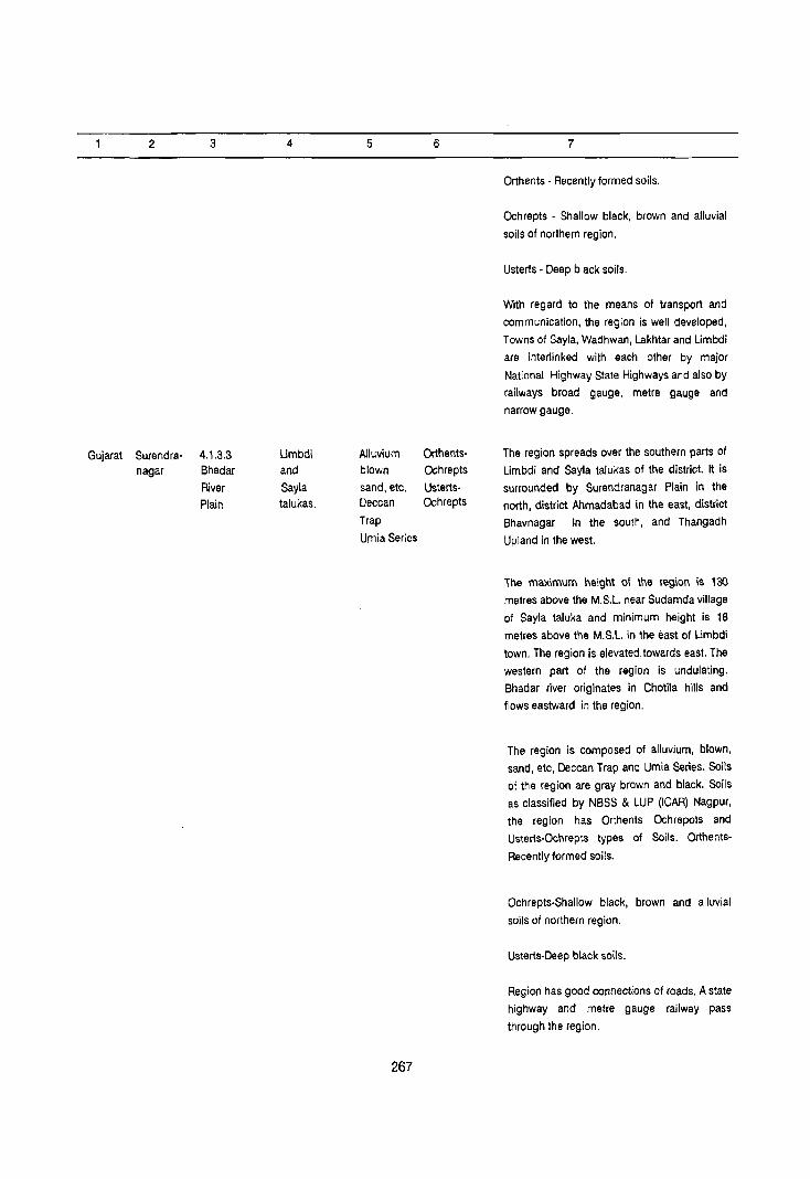
2
Gujarat Surendra-nagar
3
4.1.3.3 Bhadar
River Plain
4
Umbdi and
Sayla talukas.
5
Alluvium blown
sand, etc. Deccan
Trap
Urnia Series
267
6
OrthentsOchrepts
UstertsOchrepts
7
Orthents - Recently formed soils.
Ochrepts - Shallow black, brown and alluvial
soils of northern region.
Usterts - Deep black soils.
With regard to the means at transport and
communication, the region is well developed,
Towns of Sayla, Wadhwan, Lakhtar and Limbdi
are interlinked with each other by major
National Highway State Highways and also by
railways broad gauge, metre gauge and
narrow gauge.
The region spreads over the southern parts of
Limbdi and Sayla talukas of the district. It is
surrounded by Surendranagar Plain in the
north, district Ahmadabad in the east, district
Bhavnagar in the south, and Thangadh
Upland in the west.
The maximum height of the region is 130
metres above the M.S.L. near Sudamda village
of Sayla taluka and minimum height is 18
metres above the M.S.L. in the east of Umbdi
town. The region is elevated towards east. The
western part of the region is undulating.
Bhadar river originates in Chotila hills and
flows eastward in the region.
The region is composed of alluvium, blown,
sand, etc, Deccan Trap and Umia Series. Soils
of the region are gray brown and black. Soils
as classified by NBSS & LUP (ICAR) Nagpur,
the region has Orthents Ochrepots and
Usterts-Ochrepts types of Soils. Orthents
Recently formed soils.
Ochrepts-Shallow black, brown and aI/uvial
soils of northern region.
Usterts-Deep black soils.
Region has good connections of roads. A state
highway and metre gauge railway pass
through the region.

2 3 4
Gujarat Surendra- 4.1.3.4 Chotila, nagar Thangadh Muli and
Upland Sayla
talukas
5 6
Deccan Orthids-Trap Aquepts
Trap Orthents-
dykes Ochrepts
Umia
series
268
7
The region extends over parts of Chotila, Muli
and Sayla talukas. It covers south-western
upland of the district.
The region makes its boundaries with Halvad,
Dhrangadhra and Dasada Plain in the north.
Surendranagar Plain and Bhadar River Plain in
the east, district Rajkot in the south and west.
The maximum height of the region is 340
metres above the M.S.L near Mahidad village
and minimum height is 117 metres above the
M.S.L. near Thangadh town in Chotila taluka.
Most of the pernnial rivers originate in the
region and flow in all direction. But general
slope of the region is eastward. Major rivers of the region are Bhogava and Bhadar and their
tributaries. Tne region is composed 01
Deccan Trap, dykes and Umia series. The soils
found in the region are medium black and
gray brown. The soils of the region are shot
suitable for the growth of crops.
Soils as classified by NBSS & LUP (ICAR),
Nagpur, the region has Orthids-Aquepts and
Orthents-Ochrepts types of soils.
Orthids-Soils and region with some
development.
Aquepts-Brown soils (Hydromorphic)
Orthents-Recently formed soils
Ochrepts-Shallow black, brown, and alluviul
soils of northern region.
The transport and communication in the
region are hot developed but Chotila and
Thangadh towns are well connected by major
roads and railways with the other parts of the
district and the state.

DISTRICT BHAVNAGAR
Region Divisions
District Bhavnagar, is a part of Kathiwar Penisuola (4.1.3) and has been divided into four
micro regions on the basis of topography, geology,
soils, climate and vegetation.
4.1.3.1 Bhavnagar Coastal Plain
The region extends over the coastal areas of the
district and occupies major parts of Bhavnagar,
Ghogha, Talaja and Mahuva talukas and some
parts of Vallabhipur and Rajula talukas. Major parts
of Bhavnagar taluka is marshy and low area. Geologically the region is composed of Alluvium,
blown sand, etc. Nari and Gaj eries, SUb-Nummultic
Beds, Deccan Trap and Trap dykes. Soils of the
region are Orthids-Aquepts, Orthents-Ochrepts and
Usterts-Ochrepts. There are 275 villages and five
towns in the region. Its area is 3139.5 km2 whichis
inhabited by 804017 persons of which 407557
reside in rural and 396460 in urban areas. The
region has a density of 256 persons per km2 and it
is agriculturally developed.
4.1.3.2 Palitana-5avarkundla Upland
The region extends over Savarkundla and parts
of Mahuva, Talaja, Palitana and Gariadhar talukas.
The slope of the region is eastward. Parts of
Savarkundla and Palitana are forested with a
general height of 150 metres above the mean sea
level. Its geology is Composed of Deccan Trap and
Trap dykes soils found in the region are Orthids
Aqupets and Orthids-Ochrepts. the region contains
200 villages and two towns with an area of 2490.9
269
km2 and is inhabited by 406029 persons of which
320149 reside in rural and 85880 in urban areas. Its
density is 163 persons per km2. the region is less
developed.
4.1.3.3. Songadh Forested Plain
The region spreads over the parts of Talaja,
Palitana, Gariadhar, Sihor and some parts of
Ghogha and Umrala talukas. General slope of the
region is eastward. It is covered by Alluvium, blown
sand, etc. and Deccan Trap. The soils found in the
region are Orthents-Ochrepts and Usterts-Ochrepts.
The region contains 180 villages and Tree towns.
It area is 1480,7 km2 where 275794 persons reside.
Rural and urban population of the region is 230449
c.nd 45345 respectively. The density of the region is
186 Persons per km2.
4.1.3.4 Keri, Ka.lubhar and Ghelo Plain
The region extends over the Botad and
Gadhada and parts of Bhavnagar, Vallabhipur, Sihor
and Umrala, talukas. The region is elevated towards
east. There are 222 villages and six towns in the
region. It area is 2687.8 km2 which is inhabited by
393715 persons of which 295826 persons reside in
rural and 97889 persons in urban Areas. It has
geologically formation of Aluvium, blown sand, etc,
SUb-Nummultic Beds the soils of the region are
orthents-Ochrepts and Usterts-Ochrepts. The
density of the region is 146 person per km2. the
agricultural sector of the region is less developed.


C I
I I
r-
Ij
0
Ij
' SW~ oz S~ O~ S 0 SSW~
SNOISIAIO 1'VNOI93~
VO 3aO:) SnSN3:)
~~~VNAVH8 lJI~lSla
IE d~f'I
o ,
l -I
:u 1\ _
Q
o () uopsor WOJ~
-I -I .~ uopsor WOJ~
\
% q;IOYJ OJ
:/
VIONI :10 snSN3)

mAO dV~l/dV~l NV:J:J30 ~
5038 Jl1l1n~~nN· ens
S31~3S rv~ ONV I~VN [[]
Sld3~HJo·m3lSn WOOl
Sld3~HJO-SIN3Hl~O Bas Sld3n~~·SOIHl~O [Jaz '313 'ONVS NMOl8 '~nIAnm ~ I
I
r---l SUJ~ oz 0
S1105
NIVld 013H!.l ONV ~VHenlV~' 1~3~ 'n ','1 NIVld a31S3~0~ HaV!.lNOS n TV
ONVldn V10Nn~~vAVS' VNVlIlVd '~'£' r 1 NIVld 1V1SVO) ~V!.lVNMHa ','£ "'1
' 113~~V l~l~lSla ~o l~Vd' V
~H90H~ lYHV~ JO l~Vd'~ 'VOVHOV9 V~n1Vl ~o l~Vd '~.
G) ._ -c .. ,..
r-
1)
0
1)
~ S ~
I I
r Jail £ Ol dn S3~OJ dow DIPUI 110
341 01 mW~3J 4llIA SUOlslAIP IOUO!03J 10 manbu 341 pD3H]
-,- - -A~vaNn08 HllM o~JI~·ens - rr - - - - -- - -- - O~JI~
~ - - - - - - - - - - - ·OS3~
.",,- - - - - - - - - - - -O~JV~
' ~'E 'I 'r NOISIAIO lVNOI93~ ~ .. ' ... , .. ....................... · .. · .. · ~3AI~
~ ..... ' ... '" "'3~nv~ MO~~VN
S~ .. , .. , '" ...... 3~nv~ 3~.I.3rl
~ C NOI.l.V.l.S H.l.IM 3NIl AVM1IV~ ~ .. , ' ..... "avo~ a311V13~ lNV1~Od~1 _ .. , ... .. , ........ , .. , ... "' AVMH~IH 31V1S
9 HS
• ... ... ..... ' ...... ... NOI1VlndOd 3Aoev
ONV OOOS ~NIAVH S39VlliA ~ ..... , .. , ...... .. , .. , .. , ... .. ' V3~V Nve~n
;' "" ~ ~ "": ..... , ... lS3~OJ a3M3S3~ c, "-"'- ';" '-" ';; ... ... ... "·lVHv~/v~nlV.I. " _._._ ..... ' ... .. ' .. , .. , ... DI~.I.Sla 'A~VaNnoe
1 3


DATA ON REGIONAL DIVISIONS
District Name: BHAVNAGAR Census Location Code No: 04 State: GUJARAT
District Region No. of village No. of towns in Area in Km2
1981 Population 1981
No. and in each Region each Region Total Rural Urban Total Rural Urban
name
2 3 4 5 6 7 8 9 10
Bhav- 4.1.3.1 275 Villages 5 Towns 3139.5 2969.3 170.2 804017 407557 396460
nagar Bhav- (87 villages of Mahuva (UA) of
nagar Mahuva taluka, Mahuva taluka,
Coastal 81 villages of Talaja (NP) of
Plain Talaja taluka Talaja taluka,
45 villages of Ghogha (VP) of
Ghogha Mahal. Ghogha Mahal,
57 villages of Bhavnagar (UA)
Bhavnagar taluka, & Vartej (VP)
4 villages of of Bhavnagar
Vallabhipur Mahal taluka.
and one village
Rajula taluka,
dis!. AmrelL)
4.1.3.2 200 Villages 2 Towns 2490.9 2367.5 123.4 406029 320149 85880
Palitana (81 villages of Savarkundla (UA)
Savar- Savarkundla of Kundla taluka,
kundla taluka, Palitana (M) of
Upland 44 villages of Palitana Taluka
Mahuva taluka,
10 villages of
Talaja taluka,
42 villages of
Palitana taluka
and 23 villages of
Gariadhar taluka).
4.1.3.3 180 Villages 3 Towns 1480.7 1412.2 68.5 275794 230449 45345
Songadh (28 villages of Gariadhar (VP)
Forested Gariadhar taluka, of Gariadhar
Plain 50 villages of taluka, Sihor
Palitana taluka, (NP) and Songadh
23 villages of (VP) of Sihor
Talaja taluka, taluka.
74. vi lIages of
Sihor taluka,
2 villages of
Ghogha Mahal,
3 villages of
Umrala taluka.)
273

2 3 4 5 6 7 8 9 10
4.1.3.4 222 Villages 6 Towns 2687.8 2461.4 226.4 393715 295826 97889 Kerl, (51 villages of Sotad (M) and Kalubhar Sotad taluka, Paliyad (VP) of and 53 villages of Sotad taluka, Ghelo Vallbhipur Vallabhipur (NP) Plain Mahal,2 of Vallabhipur
villages of Mahal, Umrala (VP) Bhavnagar and Dho(a (VPJ of taluka,4 Umrala taluka villageso. and Gadhada (NP) Sihor taluka, of Gadhada taluka. 38 villages of
Umrala taluka,
74 villages of
of Gadhada
taluka.)
Grand
Total 4 877 16 Towns 9798.9 9210.4 588.5 1,879,555 1,253,981 625,574
274

REGION·WISE VILLAGE CODES, 1981
District Name: BHAVNAGAR Census Location Code No.'()4 State: GUJARAT
51. Division No. Taluka Location code Areajn Km2
No. & Name No. of Census villagesLIowns
villages as per of In of Taluka In Remarks
19a1 Taluka division Regional
Divisions
2 3 4 5 6 7 8 9
4.1.3.1 (1) Mahuva 37 to 40, 49 a7 647.8 Code No.1 to 36 and 41 to 4a
Bhav- to 131 are in division 4.1.3.2
nagar
Coastal
Plain Mahuva 1 Town 6.0 27.3 Km2 area of Mahuva village
Urban + 27.3 (Rural) included in Mahuva urban 33.3 area
(2) Talaja 16 to 29,37 to 4a 81 587.2 Code No. 50 to 56,71 10.73 are in 57 to 70, 74 to 114 division 4.1.3.2.
Code No.1 to 15,30 to 36, 49 are
in division 4.1.3.3
Talaja 14.4 Urban Town
(3) Ghogha 1 to 18, 21 to 47 45 412.4 Code No. 19 & 20 are in division Urban No. 4.1.3.3
(4) Shav- 2to 4, 6 to 59 57 1304.6 Code No.1 & 5 are in division nagar No. 4.1.3.4
Bhavnagar Urban 2 110.6 Vartej Towns Urban
(5) Valla- 47. 48, 55 & 57 4 14.1 Code No.1 to 46.49 to 54 & 56 bhipur are in division No. 4.1.3.4
(6) Rajula 32 3.2 Code No. 32 of Rajula laluka, (DiS!. Amreli) district Amreli falls in this district
and division.
275 2969.3 villages
+ 5 Towns + 170.2
3139.5
275

2 3 4 5 6 7 8 9
II. 4.1.3.2 (1) Savar- 1 to 81 81 1135.4
kundla
Pali- Savarkundla 8.0 71.00 Km2 area of Kundla village
tana- Urban 71.0 (Rural) included in the urban area
Shavar I qf the Savarkundla.
Kundla 79.0
Upland
(2) Mahuva 1 to 36, 41 44 539.6 Code No 37 to 40, 49 to 131 are
to 48 in division No. 4.1.3.1
(3) Talaja 50 to 56, 10 92.4 Code No.1 to 15,30 to 36 and 49
71 to 73 are in division No. 4.1.3.3
Code No. 16 to 29, 37 1048,5710
70,7410 114 are in division No.
4.1.3.1
(4) Palilana 35,37,45 to 51, 42 377.3 Code No.1 to 34,36, 38 to 44 52,
53,581069, 54 to 57, 70 10 72 are in division
73 to 92 No. 4.1.3.3
Palilana 13.0 31.40 Km2 area of Palitana
Urban + 31.4 village (Rural) included in the
44.4 urban area of Palitana
(5) Gariadhar 27t029,31, 23 222.8 Code No. I to 26, 30 and 32 are
33 to 51 in division No. 4.1.3.3
200 2367.5
villages
+ 2 Towns :!:...1£M 2490.9
III 4.1.3.3 (1) Gariadhar 1 to 26, 30,32 28 234.6 Code No. 27 to 29, 31" 33 to
Songadh 51 are in division No. 4.1.3.2
Forested
Plain
Gariadhar 27.7
Urban
(2) Palitana 1 to 34, 36, 38 to 50 313.1 Code No. 35, 37, 45 to 51, 53,
44, 52, 54 to 57, 58 to 69, 73 to 92 are in division
70 to 72 No. 4.1.3.2
(3) Talaja 1 to 15,30 23 175.8 Code No. 16 to 29, q7 to 48, 57 t<
to 36, 49 70; 74 to 114 are in division No.
4.1.3.1 Code No. SO to 56 and 71
to 73 are in division No. 4.1.3.2
(4) Sihor 4to 21, 23 to 78 74 647.3 Code No.1 to 3 & 22 are in
division on No. 4.1.3.4
276

2 3 4 5 6 7 ·8 9
Sihor 2 40.8 Urban Towns Songadh Urban
(5) .Ghogha 19,20 2 13.5 Code No.1 to 18,21 to 47 are in
division No. 4.1.3.1
Urnrala 39,40,41 3 27.9 Code No.1 to 38 are in division
No. 4.1.3.4
180 1412.2
villages
+ 3 Towns + 68,5
1480.7
IV 4.1.3.4 (1) Sotad 1 to 51 51 649.5
Keri, Kalubhar
and Ghelo
Plain
Sotad 2 43.1 56.80 Krn2 area of Botad village
Urban Towns + 56.8 (Rural) included in the urban area
Paliyad 99.9 of Sotad
(2) Valla- 1 to 46, 49 to 54 53 539.0 Code No. 47, 48, 55 and 57
bhipur 56 are in the division No. 4.1.3.1
Vallabhipur 40.9
Urban Town
(3) Shav- 1,5 2 47.8 Code No.2 to 4, 6 to 59 are in
nagar the division No. 4.1.3.1
(4) Sihor 1,2,3&22 4 32.8 Code No. 4to 21, 23 to 78 are in
divisio,n No. 4.1.3.3
(5) Urnrala 1 to 38 38 358.3 Code No. 39, 40 & 41 are in
division No. 4.1.3.3
Urnrala 2 21.1
Urban
Dhala
Urban
(6) Gadhada 1 to 74 74 834.0
Gadhada 64.5
Urban 222 2461.4 villages + 226.4 + 6 Towns 2687.8
277

District Name: BHAVANAGAR
State District Division
name number and name
2 3
Gujarat Bhavnagar 4.1.3.1
Bhavnagar Coastal Plain
STATEMENT ON REGION-WISE
PHYSIO-CULTURAL DETAILS
Census Location Code No: 04
Name of Geology Soils
adminis-trative
divisions
4 5 6
Bhallnagar Alluvium, Orthids-
Ghogha, blown Aquepts
Mahuva, sand, etc. Orthents-
Talaja, Nari and Ochrepts
Val1abhipur Gaj Series Usterts-
and Rajula Sub- Ochrepts
talukas. Nummulitic
Beds Deccan
Trap Trap dykes.
278
State: Gujarat
Physio-Cultural Characteristics
7
The region extends over 145 km2, along the coast line of Bhavnagar district and it occupies
Bhallnagar, Ghogha, Mahulla, Talaja,
Vallabhipur and Rajula talukas.
The region makes its boundaries with district
A1hmadabad in the north, Gulf of Khambhat in the east, Arabian Sea in the south and
Palitana-Savarkundla Upland 4.1.3.2.,
Songadh Forested Plain 4.1.3.3. and Keri,
Kalubhar and Ghelo Plain 4.1.3.4 in the west.
Behind the coastal belt, the maximum height is 88 metres abovl!. the fA.S.L. in Bhavnagar
taluka and minimum height is 10 metres above the M.S.L in the Bhavnagar cOast. The.
coast is intersected by numerous creeks and
betwElen the creeks the coast is occupied by
sandy and mudy beaches and tidal flats.
Behind the coast the plain tracts are fertile.
The geological formation of the region are Nari
and Gaj Series, Alluvium blown sand, etc.,
Sub-Nummulitic Beds Deccan Trap and Trap
dykes. Soils found in the region are red sandy,
gray brown and deep black. Soils and water table are favourable for the agricultural
development of the region.
Soils as classified by NBSS & LUP (ICAR),
Nagpur, the region has Orthids-Aquepts, Orthents-Qchrepts, and Usterts-Ochrepts
types of soilS.
Orthids- Soils of arid region with some
development.

2 3 4
Gujarat Bhavnagar 4.1.3.2 Savar-
Politana kundla,
Savarkundla Mahuva,
Upland Talaja
Palitana
and Guriadhar
talukas.
5 6
Deccan Orthids-
Trap Trap Aquepts
dykes Orthents-
Ochrepts
279
7
Aquepts - Brown soils (Hydromorphic)
Ochrepts - Shallow black, brown and alluvial
soil of northern region.
Usterts - Deep black soils.
The means of transport and communication of
the region is well developed. District
headquarters Bhavnagar and towns of Talaja
and Mahuva are well connected with other
parts of the c!:strict and state by major
metalled roads and railways (narrow guage).
The region extends over south-western part of
the district occupying lalukas of Savarkundla,
Mahuva, Talaja, Palitana and Gariadhar.
The region is surrounded by district Amreli in
the south and west, Bhavnagar Coastal Plain
in the east and Songodh forested Plain in the
north.
The maximum height of the region is 501
metres above the M.S.L. near Palitana town
and followed by Lonch hills 431 metres. The
minimum height is 60 metres above the M.S.L.
near the bed of Shetrunji river. It is drained by
river Shertrunji and its tributaries. General
slope of the region is eastward. Except
Shetrunji river basin, the region has uneven
topography and it is covered with mixed
forests. In the uplands Deccan Trap ridges
Stand out prominently intervened by narrow
ridges. The region does not support
agricultural activity except in the fertile
Shetrunji basin.
Soils found in the region are deep black,
shallow black and brown and alluvial soils.
Soils as classified by NBSS & LUP (ICAR),
Nagpur the region has Orthids-Aquepts- and
Orthents-Ochrepts types of soils.
Orthids - Soils of arid region with some
development
Aquepts - Brown soils (Hydromorphic)
Orthents - Recently formed soils

2 3 4 5
Gujarat Bhavnagar 4.1.3.3 Talaja, Alluvium, Songadh Palitana, blown Forested Gariadhar, sand, etc. Plain Sihor, Ghogha Deccan
and Umrala Trap
talukas
6
Orthents-
Ochrepts
Usterts-
Ochrepts
280
7
Ochrepts - Shallow black, brown and alluvial
soils of northern region.
The means of Transport and communication in
the region is not well developed. But towns Of
Savarkundla, and Palitana are well linked by narrow gauge railways and state highways.
Due to upland in the south of Shetrunji river,
parts 01 the region is not connected by roads
and railways.
The region extends over mid western parts of
the district and occupies parts of Talaja,
Palitana, Gariadhar, Sihor, Ghogha and
Umrala talukas. The region is surrounded by
Keri, Kalubhar and Ghelo Plain in the north,
Bhavnagar Coastal Plain in the east, Palitana
Savarkundla Upland in the south and district
Amreli in the west.
The maximum height in the region is 154
metres above the MSL near Sanosara village
of Songadh taluka and minimum height is 89
metres above the MSL in the north of Palitana
town. General slope of the region is eastward
and it is drained by river Kharo. Part of Sihor
taluka of the region is undulating and covered
with mixed forests. Geologically the region is
tormed by Alluvium, blown sand, etc. and
Deccan Trap. Soils found in the region are
deep black and shallow black and alluvial
soils.
SoilS as classified by N8SS & LUP (ICAR),
Nagpur, the region has Orthents-Ochrepts and
Usterts-Qchrepts types of soils.
Orthents - Recently formed soils.
Ochrepts - Shallow black, brown and alluvial
soils of northern region
Usterts - Deep bloack soils.
The means of transport and communications
in the region is well developed. Town songadh
and Sihor are connected by roads and narrow
guage railways with other parts of the district
and the state.

2 3 4
Gujarat Bhavnagar 4.1.3.4 Sotad,
Keri, Kalu- Gadhada,
bharand Bhavnagar,
Ghelo Plain Vallabhipur
Sihor and
Umrala
talukas.
5 6
Alluvium, Orthents-
blown Ochrepts-
sand, etc. Usterts-
Sub- Ochrepts
Nummulitic
Beds Deccan
Trap Trap
dykes.
281
7
The region extends over north-western part of
the district occupying parts of Botad,
Gadhada, Bhavnagar, Vallabhipur, Sihor and
Umrala talukas. The region makes its
boundaries with district Ahmadabad in the
north, Bhavnagar Coastal Plain in the east,
Songadh Forested Plain in the south and
district of Amreli and Rajkot in the west.
The maximum height is 166 metres above the
M.S.L. near Botad town and minimum height
is 16 metres above the M,S.L. near Vallabhipur
town. General slope 01 the region is eastwards.
Region is drained by river Keri, Ghelo and
Kalubhar with their tributaries towards east.
The region is formed by Alluvium, blown sand,
etc, Sub-Nurnmulitic Beds, Deccan Trap and
Trap dykes. Soils found in the region are deep
black and medium black, which are suitable
for cultivation,
Soils as classified by NBSS & LUP (ICAR),
Nagpur, the region has Orthents-Ochrepts and
Usterts-Ochrepts types of soils.
Orthents - Recently formed soils.
Ochrepts - Shallow black, brown and alluvial
soils of northern region.
Usterts - Deep black soils.
The means 01 transport and communication in
the region is well developed. Towns of Paliyad,
Botad, Gadhada, Dhola, Umrala and
Vallabhipur are well linked with each other by
major metalled roads and railways,


DISTRICT AMRELI
Regional Divisions
District Amreli is a part of Kathiwar Peninsula {4.1.3} and has been divided into four sub-micro regions on the basis of topography, geology, soils,. natural vegetation and climate.
4.1.3.1 Bhadar River Plain
This region extends over north-western part of the district and occupies major parts of Sabra and Kunkavav Vadia talukas. The region is drained by the tributaries of Bhadar river. General slope of the region is towards north-west. Geologically the re~ion is formed of Deccan Trap and Trap dykes. Soils of the region are Orthents-Ochrepts and Usterts-Ochrepts. The region contains 79 villa~es and one town which cover an area of 1018.2 Km . It is inhabited by 138817 persons of which 129122 persons reside in rural and 9695 persons in urban areas. The region has density of 136 persons per Km2.
4.1.3.2 Shetrunji River Plain
This region extends over north-eastern part of the district occupying Lathi, Lilia and Amreli and parts of Sabra, Kunkavav Vadia and Dhari talukas. The region is elevated towards east. Geoligically it is formed by Deccan Trap and Trap dykes. Soils found in the region are Orthents-Ochrepts and UstertsOchrepts. The region has 228 villages and six towns which cover an area of 2772.7 Km2. It is inhabited by 480888 persons of which 350076 persons live in rural and 130812 persons in urban areas. The region is agriculturally less developed. Its density of
283
population is 173 persons per Km2.
4.1.3.3 Gir Forest Upland
The region spreads over the south-western part of the district occupying Khambha, and parts of Dhari and Rajula talukas. Some parts of the region adjoining Junagadh district is covered with forests. From the elevation point of view the region is divided between two parts i.e. south-west and north-west. The south-western part is elevated towards south while north-western part is elevated towards north. There are 108 villages and one town in the region. Its area is 1359.2 Km2 which is inhabited by 148792 persons of which 131252 persons live in rural and 17540 persons in urban areas. Its density of population is 109 persons per Km2. Geologically the region is formed by Deccan Trap and Trap dykes. Soils found in the region are Orthids-Aquepts and Orthents-Ochrepts.
4.1.3.4 Amreli Coastal Plain
The region extends over the coastal parts of the district occupying Jafrabad and pa~s of Rajula taluka. General slope of the region Is south-ward. The region is composed of Alluvium, blown sand, etc. Nari and Gaj series, SUb-Nummulitic Beds, Deccan Trap and Trap dykes. Soils of the region are Orthids-Aquepts. It has 113 villages and three towns which cover an area of 1019.7 Km2. It is inhabited by 167054 persons of which 126490 persons reside in rural and 40564 in urban areas. The density of population is 164 persons per Km2.


EE dY~
" l::>nllSIO ~V~VNAVHe NI 030nl:>NI V~nlVl VlnrV~ ~O l~Vd ~ P.
DI~lSIO HOV~VNnr NI 030nl:>NI V~nlVll~VHO .:lO lijVd 0 'it lJl~lSIO HOV~I/Nnr NI 030nl:>NI V~nll/1 VIOl/A AI/AI/~Nn~ ~O l~l/d A ~
1J1~lSIO lO~rl/ij NI 030nlJNI V~nlVlI/IOVA AI/AI/XNn~ ~O l~Vd ,~,
o
l
c
o
\
'SWM 51 01 5 0 5 'SWM
SNOISIAlO 'YNOI!)3~
SO 300) SnSN3)
113~~V lJI~lSla
lV~Vrn9

NIVld lV1SVOJ I13l:lYfY '~'£'~'~
ONYldn lS3lfO:l lfl~ 'E 'E '~ "
NIYld H3/1IH IrNnlf13HS 'z t '~ '~
NIYld lf3/1llf HVOVH9 '! 'E '! '~
~a!l £ Ol dn 53pO~ dDw D!PUI liD 3~l Ol a~uaJaJaJ 4l!M sUO!s!A!P IDUO!&3J 10 man bas 34l PDa~
,-- - - - - - - -AijVONn08 HllM OijJI~-8nS
-I-r -------- --- - -- - -----Oij:>l~ I ...... r - -- - - - - - - -- - - - - - - - --OS3ri --r ------------------Oij:>Vri 'I '£ '! '~ NOISIAIO lVNOI~3ij ~ _" .. , .. , .. , .. , .. , .. ' '" .. ' .. , .. , .. , .. , .. , .. , "'ij3Alij
1I1111111~1II1II1I 3~nV~ 3l:l13ri 'NOIlVlS HllM 3NI1 AVM11'Vl:l S~ .. , .. ' .. , .. , '" '''OVOij 0311V13~ lNVlijOdYiI
EE HS .. '" .. , .. , .. , '" ' .. , .. , .. , .. , ,., "A'VMH~IH 31'V1S
• NOllVlndOd 3A08V , 000 S ~NIAVH S3~Vlll" .. '" ..... , .. , .. , ..... , .. ' .. , .. , "'V3ijV NV8ijn
~ .. , ", .. , ", .. , '''1531:10:1 03"1:13531:1 C'
:;"',",,':":""~'cd, .. , .. , , •• ". , .. "'lVHV~/vlInlVl (I
_. -.~ ...... , ..... , .. , ......... 'lJlijlSIO Cl
_ .. _.,-" ........ , ............. .
'lJllf1SIO HOY~YNnr
NI 030n1JNI YlIn1Yl tlYNIOOli
"'31V1S rAijVONn08
~ l:)1~lSIO ~Y~YNAYH8
NI 030nl:>NI Y)lnlVl VlnrY~ ~O l~Yd ~ f>,
lJl~lSIO HOY~VNnr
rn'"Til sma dV~l/d~~l N~))3a ~
,..---, 'SWMOZ 0
A90'03~
Sld3HH~O-SlN3H1HO ~ 95 ~
Sld3nov· SOIHlijO !:::: :::j 9l
Sld3ijH:lO-S1M31sn ~OOI .~~
. . "..J
. \
~ l:l V N \-.-.,
a 0 lI' I .-.":'
l' ,. . / \ . \ ! .\.. ",',\.\ I "". .
\,\
i 'i
l
c
o ...
(/)
...
()
NI 030n"::JNI Y)lnlY1I~YHO ~O l~Yd a 1t ~i~ 2
lJl'tHSIO HOY~VNnr NI 030nl:>NI o,,\t:-V)lnlVl VIOVA AVAVlINnll :lOll:lYd A ~ iJ~ l>
____ ~~~~.ru~_~~ ____ _ __ ~ ____ ~ .. ~._~~~~~ __ ~ __ ~~ __ _


DATA ON REGIONAL DIVISIONS
District Name: AMRELI Census Location Code No. 05 State: GUJARAT
District Region No. of villages in No. of towns in Area in Km2 1981 Population· 1981
No. and each Region as each Region Total Rural Urban Total Rural Urban
Name evolved
2 3 4 5 6 7 8 9
Amreli 4.1.3.1 79 villages 1 Town 1018.2 1003.0 15.2 138817 129122 9695
Bhadar (40 villages of Vadia (VP) of
River Babra taluka Kukavav Vadia
Plain and 39 villages of taluka
Kukavav Vadia
taluka)
4.1.3.2 228 Villages 6 Towns 2772.7 2517.7 255.0 480888 350076 130812
Shetrunji (16 villages of Babra (VP) of
River Babra taluka Babra taluka,
Plain 49 villages of Lathi (NP) & Lathi taluka, Damnagar (VP) of
70 villages of Lathi taluka,
Amreli taluka, Amreli (UA) of
37 villages of Amreli taluka,
Lilia Mahal, Bagsara (NP) of
27 villages of Kunkavav vadia
Kunkavav Vadia taluka, Chalala
taluka, (VP) of Dhari
29 villages of taluka.
Dhari taluka)
4.1.3.3 108 villages 1 Town 1359.2 1308.0 51.2 148792 131252 17540
Gir Forest (53 villages of Dhari (VP) of
Upland Dhari taluka, Dhari taluka.
36 villages of
Khambha Mahal,
19 villages of
Rajula taluka)
4.1.3.4 113 Villages 3 Towns 1019.7 942.6 77.1 167054 126490 40564
Amreli (71 villages of Rajula (NP) &
Coastal Rajula taluka & Dungar (VP) of
Plain 42 villages of Rajula taluka,
JafrabadMahal) ·Jafrabad (VP) of
Jafrabad Mahal.
Grand
Total 4 528 villages 11 Towns 6169.8 5771.3 398.5 935551 736940 198611
divisions
287
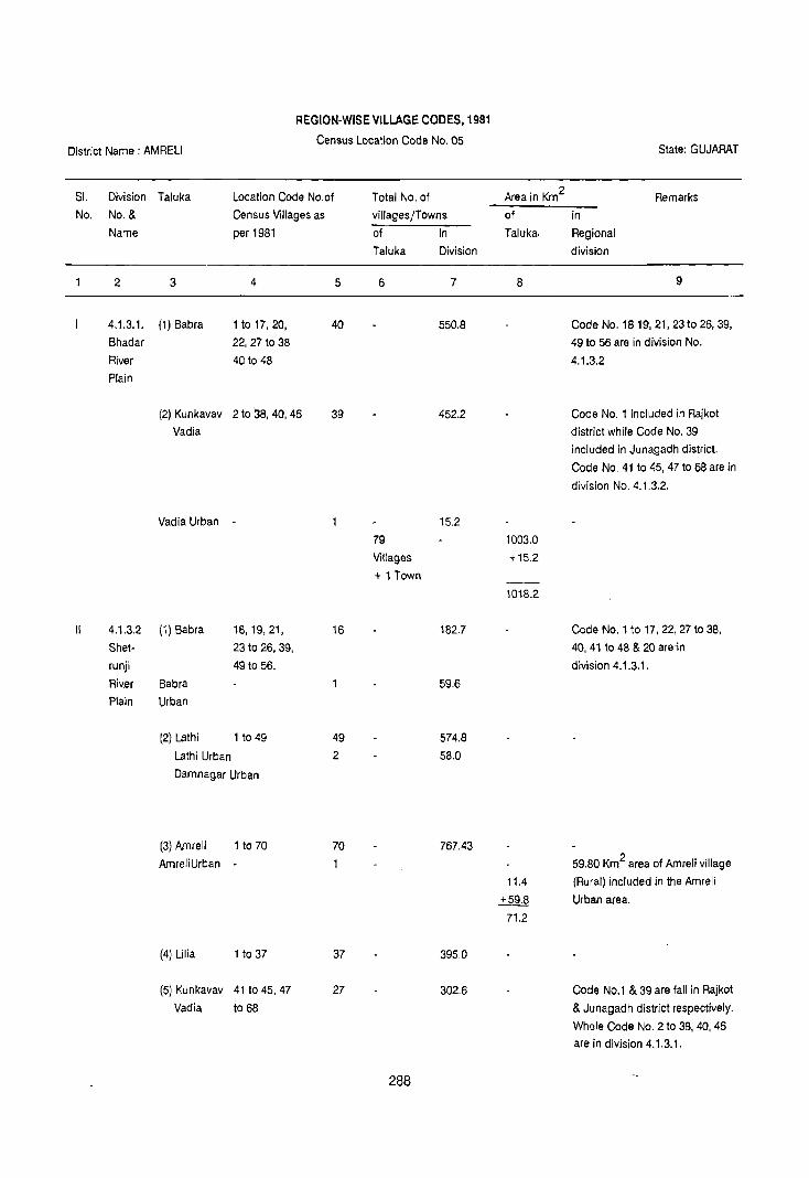
REGION-WISE VILLAGE CODES, 1981
Census Location Code No. 05 State: GUJARAT District Name: AMRELI
51. Division Taluka Location Code No.of Total No. of Area in Km2 Remarks
No. No. & Census Villages as villages/Towns of in
Name per 1981 of In Taluka. Regional
Taluka Division division
2 3 4 5 6 7 8 9
4.1.3.1. (1) Sabra 1 to 17, 20, 40 550.8 Code No. 18 19,21, 23to 26, 39,
Bhadar 22,27 to 38 49 to 56 are in division No.
River 40 to 48 4.1.3.2
Plain
(2) Kunkavav 210 38, 40, 46 39 452.2 Code No.1 included in Rajkot
Vadia district while Code No. 39
included in Junagadh district.
Code No. 41 to 45, 4710 68 are in
division No. 4.1.3.2.
Vadia Urban 15.2
79 1003.0
Villages +15.2
+ 1 Town
1018.2
4.1.3.2 (1) Sabra 18,19,21, 16 182.7 Code No. 110 17, 22, 27 to 38,
Shet- 23 to 26, 39, 40,41 to 48 & 20 are in
runji 49 to 56. division 4.1.3.1.
Riv.er Sabra 59.6
Plain Urban
(2) Lathi 1 to 49 49 574.8
Lathi Urban 2 58.0
Damnagar Urban
(3) Amreli 1 to 70 70 767.43
AmreliUrban 59.80 Km2 area of Amreli village
11.4 (Rural) included in lhe Amreli
+59.8 Urban area.
71.2
(4) Lilia 1 to 37 37 395.0
(5) Kunkavav 41 to 45, 47 27 302.6 Code No.1 & 39 are fall in Rajkot
Vadia to 68 & Junagadh district respectively.
Whele Code No.2 to 38, 40, 46
are in division 4.1.3.1.
288

2 3 4 5 6 7 8 9
Bagsara 43.8
Urban
(6) Dhari 1,3 to 22, 29 295.3 Code No.2 included in
33 to 40 Junagadh district. Code No. 23
to 32, 41 to 83 are in 4.1.3.3
Chalala Urban 22.4
228 2517.7
villages +255.0
+ 6 Towns
2772.7
III 4.1.3.3 (1) Dhari 23 to 32, 41 53 717.8 Code No.2 included in
Gir to 83 Junagadh district. Code No.1, 3
Forest to 22, 33 to 40 are in division
Upland 4.1.3.2
Dhari Urban 1.5 49.70 Km2 area of Dhari village + 49.7 (Rural) included in Dhari Urban
51.2 area.
(2) Khambha 1 to 36 36 407.5
(3) Rajula 20, 40 to 52, 19 182.7 Code No.1 to 19,21 to 31, 33 to
76 to 80 3953 to 75, 81 to 91.are in
division 4.1.3.4.
Code No. 32 included in
Bhavnagar district.
108 1308.0
villages +51.2
+ 1 Town
1359.2
IV 4.1.3.4 (1) Rajula 1 to 19,21 to 31, 71 615.8 Code No. 20, 40 to 52, 76 to 80
Amreli 33 to 39, 53 to- are in division No. 4.1.3.3 and
Coastal 75,81 to 91. code No. 32 included in
Plain Bhavnagar district.
Rajula Urban - 2 24.0 24.3 Km2area of Rajula village
Dungar +24.3 (Rural)included in Rajula Urban
Urban 48.3 area
(2) Jafrabad 1 to 42 42 326.8
Jafrabad 1 28.8
Urban 113 942.6
villages
+3 Towns +77.1
1019.7
Kodinar Kodinar taluka fall in Junagadh
district. _._-, 289

District Name:AMRELI
State District
name
2
Gujarat Annreli
Gujarat Amreli
Division
number
and name
3
4.1.3.1 Shadar
River
Plain
4.1.3.2
Shetrunji
River
Plain
STATEMENT ON REGION-WISE
PHYSIO-CULTURAL DETAILS
Name of
administ
trative
divisions
4
Sabra and Kunkavav
Vadia
talukas
Babra,
Kunkavav
Vadia, Lathi,
Annreli, Lilia
and Dhari
talukas.
Census Location Code No. 05
Geology
5
Deccan
Trap
Trap
dykes
Deccan
Trap
Trap
dykes
290
Soils
6
Orthents
Ochrepts
Usterts
Ochrepts
Orthents
Ochrepts
Usterts
Ochrepts
State: GUJARAT
Physio-Cultural Characteristics -
7
This region extends over the north·western
parts of Kunkavav Vadia and Sabra talukas. It
is surrounded by district Rajleo! in the west and
north, Shetrunji River Plain in the east and
south.
The maximum height of the region is 216
metres above the M.S.L. in the north of Sabra
town and minimum height is 131 metres
above the M.S.L. near Vadia town. The region
is formed of Deccan Trap and Trap dykes.
Soils found in the regiOn are deep black and
medium black. Soils as classified by NSSS &
LUP (lCAR), Nagpur, the region has Orthents·
Ochrepts and Usterts~Ochrepts types of soils.
Orthents - Recently formed soils.
Ochrepts - Shallow black, brown and alluvial
soils of northern region
Usterts - Deep black soils.
With regard to the means of transport and
communication the region has good
connection of roads and railways. Sabra town
is well connected with other parts of district by
metalled roads. Vadia town is linked by road
and narrow gauge railway.
The region extends over the talukas of Sabra,
Kunkavav Vadia, Lathi, Annreii, Lilia and Dhari
talukas, It is surrounded by Shadar River Plain
in the north, district 8havnagar in the east,
Amreli Coastal Plain in the south and district
Junagadh in the west.

2
Gujarat Amreli
3
4.1.3.3
Gir
Forest
Upland
4
Dhari,
Khamba
and
Rajula
taluka
5
Deccan
Trap
Trap
dykes
291
6
Orthids
Aquepts
Orthents
Ochrepts
7
The maximum height of the region is 272
metres above the M.S.L. near Dhari town and
minimum height is 103 metres near Damnagar
town. General slope of the region is eastward.
Major rivers of the region are Shetrunji and
Kalubhar. It is composed of Deccan Trap and
Trap dykes. Soils found in the region are deep
black, medium black and mixed soils. Soils as
classified by NBSS & LUP (ICAR) Nagpur, the
region has Orthents-Ochrepts and Usterts
Ochrepts types of soils.
Orthents • Recently formed soils.
Ochrepts • Shallow black, brown and alluvial
soils of northern region
Usterts - Deep black soils.
The transport and communication facilities in
the region are well developed. Towns of Sabra,
Lathi, Amreli (district headquarters), Chalala
and Sagsara are interlinked with each other by
major metalled roads and metre gauage
railways.
The region covers thE' talukas of Dhari,
Khamba and Rajula and extends over south
western parts of the district. The region makes
its boundaries with Shetrunji River Plain in the
north, district Bhavnagar in the east, Amreli
Coastal Plain in the south and district
Junagadh in the west.
The region has maximum height of 648 metres
above the M.S,L in the Savarkundla Dungar (in
the south west of Dhari taluka) and minimum
height is 134 metres above the M.S,L. near
Chalala town. South western parts of the
region is hilly and covered with Gir forests.
Due to.high lands in the middle of the region,
it has northwards and southwards slopes, The
region is formed of Deccan Trap and Trap
dykes, Soils found in the region are medium
black, mixed red and black soils. According to
the classification of NBSS & LUP (ICAR),
Nagpur the region has Orthids-Aquepts and
Orthents-Ochrepts types of soils.

2
Gujarat Armeli
3
4.1.3.4
Amreli
Coastal
Plain
4
Rajula
and
Jafrabad
talukas
5 6
Alluvium, Orthids-
blown Aquepts.
sand, etc.
Nari and
Gaj Series
Sub-Nummulitic
Beds
Deccan Trap
Trap dykes
292
7
Orthids - Soils of arid region with some
development.
Aquepts - Brown soils (Hydromorphic)
Orthents - Recently formed soils.
Ochrepts - Shallow black, brown and alluvial
soils of northern region.
The means of transport and communication in
the region is not developed. Dhari town is
connected with other parts of the district by
metalled roads and metre guage railways.
The region extends over the southern part of
the district and occupies Rajula and Jafrabad
talukas. It is surrounded by Gir Forest Upland
in the north, district Bhavnagar in the east,
Arabian Sea in the south and district Junagadh
in the west.
The region is 147 metres above the M.S.L.
near Dungar town and minimum height is 5
metres above the M.S.l. near Jafrabad town.
The region is sloped towards south.
Geologically the region is formed by Alluvium,
blown sand, etc, Nar; and Gaj Series, Sub
Nummulitic Seds, Deccan Trap and Trap
dykes. Soils of the region are coastal alluvial.
Soils as classified by NBSS & LUP (ICAR),
Nagpur, the region has Orthids-Aquepts types
of soils.
Orthids • Soils of Arid region with some
development.
Aquepts· Brown soils (Hydromorphic)
The means of transport and communication in
the region is well developed. Towns of Rajula,
Dungar and Jafrabad are well connected by
metalled roads. Rajula and Dungar towns are
linked by metre gauge railway with the, other
parts of the region.

DISTRICT JUNAGADH
Regional Divisions
District Junagadh is the part of Kathiawar Peninsula (4.1.3) and has been divided into five submicro regions on the basis of topography, geology, soils, climate, and natural vegetation.
4.1.3.1 Junagadh Coastal Plain
This region spreads over Porbandar, Ranavav, Kutiyan, Mangrol, Manavadar, Keshod, Malia, Patan-Varaval and Una talukas of Junagadh and Kodinar taluka of Amreli district. Some parts of this plain adjoining the coast is covered with forest. Geologically the region is formed by Alluvium, blown sand, etc. Dwarka Bed, Nari Gaj Series, SubNummulitic Beds, Deccan Trap and Inter-Trappean Beds. Soils are Orthids-Aquepts and OrthentsOchrepts. There are 394 villages and 10 towns in the region. Total area of the region is 3959.8Km2
which is inhabited by 1039828 persons of which 675117 persons reside in rural and 364711 persons in urban areas. The density of the population in the region is 262 persons per Km2. This region is agriculturally developed.
4.1.3.2 8arda Hills Forested Region
The region extends over north western part of the district occupying Porbandar, Ranavav and Kutiyana talukas. The region is covered with reserved mixed forests. Barda hill is one of the major hills of the district. The region is covered by Alluvium, blown sand, etc, Deccan Trap and Intertrappean Beds. Soils of the region are OrthidsAquepts and Orthents-Ochrepts. The rural areas contain 50 villages covering an area of 444.9 Km2. Which is inhabited by 38110 persons. The region has a density of 86 persons per Km2.
4.1.3.3 8hadar, Djat and Harna River Plain
This region extends over the talukas of Kutiyana, Mangrol, Manavadar, Keshod, Malia, Patan-Varaval,
293
Vanthall, Junagadh, Mendarda, Talala, Bhesan, Visavadar and some parts of Kunkavav Vadia and Dhari talukas of Amreli district. The region is sloped towards south. The region is formed of Alluvium, blown sand, etc., Nari -Gaj Series, Deccan Trap Inter-Trappean Beds and Trap dykes. The soils of the region are Orthids-Aquepts and OrthentsOchrepts. This region includes 488 villages and 13 towns covering an area of 4410.3Km2. The region is inhabited by 1023447 persons of which 726626 persons reside in rural and 296821 persons in urban areas. The density of population in the region is 232 persons per Km2. The region is agriculturally developed due to fertility of soils.
4.1.3.4 Girnar Hills
This hilly region extends over the talukas of Junagadh and Bhesan. The region is covered by reserved forests. It is formed by Deccan Trap and Inter-Trappean Beds. The soils found in the region are Orthids-Aquepts. The region is entirely rural and it has 15 villages covering an area of 180.2 Km2
which is inhabited by 1494 persons. The density of population is only 8 persons per Km2 as the region is hilly and densely forested.
4.1.3.5 Junagadh-Gir Forested Region
The region extends over the south eastern part of the district and is a well known Lion's Sanctuary in India. The region occupies talukas of Una, Mendarda, Talala, and Visavadar, and Kodinar taluka of Amreli district. Entire region is covered with dense reserved forest. It is formed of Alluvium, blown sand, etc., Deccan Trap and Trap dykes. Soils of the region are Orthids-Aquepts and Orthents-Ochrepts. It is entirely rural and contains 266 villages which cover an area of 20997.7 Km2. The region is inhabited by 139113 persons. The density of population is 66 persons per Km2 in the region.


>
o
'IW~ 51 01 5 0 5'1 ~
SNOISIAIO lVNOI~311
90 300J SnSN3J
HaV~VNnr lJI~lSla
lV~Vrn9
~ ~
~
NOI~3~ O31mO.:l ~1~·Hav~mr nT, S111H IIVNIII~ 'fEn
NIV1d ~3AI~ VNIIYH ONY lYrO Ilivom '£ 'En
NOI~311 O3lmo.:l 5111H yom 'ZTl'v
NIVld 1Yl5VOJ HOV~VNnr T£ TV
~ :» 0 ;,
J ~ ~
~ 0'1
~ § S ~ $0 ~
(' 1 d ~1 Q'<:
~
Q
YIONI jO snsrm

SllMl dlil/SOliNllddlil~ IllNlldll1 NIlJlO ~
501S~lI1n""nN'ins.
Sl'ilslI mONlliIN
'IJl'SOlS III1MO ~
r-1 SWMOI 0
A~0103~
3
Sjd3~H)O'SjN3Hj~O BIS SJd3nOY'SOIHJ~O Dil
r-1
'SWMOI 0
S1IOS
~I!I £ 01 dn sapo, dDw Dipul liD 141 01
mmllJ ~II" SUO!S!AIP IDUDI&'J 10 mlnbls a~1 PDI~
" .... ""T----------AijYONnOe H-1IM OijJIVi·enS _.-.-.-[- -- - - - - - -- ----- - - ----OijJIVi -".r ------------------OS3Vi
D'IlIIb!RI.r -- - - - - - - - - -- ----OmVi
n 'I' t NOISIAIO lVNOI~3~ ~ ..... , .. , ........................................... '''~3AI~
~ ........ '''3~nY~ m3Vi " II "
~ ..... '" ~ 3~nY!) OYO~B I NOIlYlS HllM 3NJ1 AVM11YH ___5L_ .... , ...................... OVO~ OmVl3Vi lNmOdViI
9 HS ...... , ......................... ', ... '''AVMH~IH 31Y1S
e I HN ...... " ..... " .................... "'AYMH~IH lYNOI1YN
• NOI1YlndOd 3AOeV '0005 ~NlhVH mmA ~ ........................... " ............. '''V3~V NVB~n
. .. .. ji , .. , .... , ........... '" ... "lS3~0~ 03A~3S3~ " _'"'';;';;';;' .:"' ........ , ............ '" ... "'1VHVVi I Y~nlVl "
-, -, _ ......... '" '" ........ , '" ." '" "'lJl~lSIO II
-,,-,,- .............. ' ........ , ............ "'31VlS IA~YONnOB
'[lJI~lSIO 1'3~ViYI Y~nlYl ~YNIOO~ :.~
'Y~n1Yl YIlYVi ~O mJOd: Vi
'lJl~lSIO 113~ViV ~O mJOd: V
NOI~3~ 031S3~O~ ~I~· Hmmr n n S111H ~ml~ 'nTv
NIVld ~3AI~ YN~VH ONY mo 'ijYOYHB n n NOI~3~ 03!mO~ SlllH yom nn
NIYld lV1SYO:l HOV~YNnr n n


DATA ON REGIONAL DIVISIONS
District Name: JUNAGADH Census Location Code No. 06 State: GUJARAT
District Region No. of village No. of towns in Area in Km2 1981 Population 1981
No. and in each Region each Region Total Rural Urban Total Rural Urban
name as evolved
2 3 4 5 6 7 8 9 10
Juna- 4.1.3.1 394 Villages 10 Towns 3959.8 3707.0 252.8 1,039,828 675,117 364,711
gadh Junagadh (75 villages of Porbandar (M) &
Coastal Porbandar taluka, Chhaya (VP) of
Plain 18 villages of Porbandar laluka,
Ranavav taluka, Ranavav (NPl and
22 villages of Adityana (vPl of
Kutiyana taluka, Ranavav taluka,
60 villages of Mangrol (M) of
Mangrollaluka, Mangrol taluka,
8 villages of Patan (M) and
Manavadar taluka, Veraval (M) in
8 villages of Patan-Veraval
Keshod taluka, laluka, Kodinar-
13 villages of (NP) of Kodinar-
Malia laluka, 59 laluka of Amreli,
villages of patan- Una (NP) and
Veravallaluka, Oelwada (VP)
42 villages of of Una laluka.
Kodinar taluka,
of Amreli district,
89 villages of
Una taluka)
4.1.3.2 50 Villages Nil 444.9 444.9 38,110 38,110
Barda (35 villages of
Hills Ranavav taluka,
Forested 1 (one) village of
Region Porbandar taluka,
14 villages of
Kutiyana taluka)
4.1.3.3 488 Villages 13 Towns 4410.3 4097.7 312.6 1,023,447 726,626 296,821
Bhadar 47 villages of Ban\wa (NP} and
Ojat and Manavadar taluka, Manavadar (NP) of
Harna 45 villages of Manavadar taluka,
River Vanthali taluka, Shapur (VP) and
297

2 3 4 5 6 7 8 9 10
Plain 67 villages of Vanthali (NP) in
Junagadh taluka, Vanthali taluka, 36 villages of Junagadh (UA), Mendarda Mahal, Dungarpur (VP)
45 villages of and Bilkha (VP) Keshod taluka, of Junagadh
50 villages of taluka, Mendarda
Malia taluka, (VP) of Mendarda
43 villages of Mahal, Keshod (NP)
patan-Veraval of Keshod taluka,
taluka, 22 villages Malia (VP) of
of Talala taluka, Malia laluka,
42 villages of Talala (VP) of
Bhesan-Mahal, Talala laluka,
1 village of Visavadar (NP) of
Kunkavav Vadis Visavsdar taluka,
taluka of Amreli Kutiyans (NP) of
district, Kutiyana taluka.
75 villages of Visavadar taluka,
1 village of Dhari taluka of
Almeli district,
11 villages of Kutiyana laluka,
3 villages of
Manglol taluka.)
4.1.3.4 15 villages Nil 180.2 1802 1494 1494
Girnar (11 villages of
Hills Junagadh laluka
and 4 villages of Bhesan Mahal)
4.1.3.5 266 Villages Nil 2099.7 2099.7 139,113 139,113
Junagadh (11 villages of
Gir Mendarda Mahal
Forested 77 villages of
Region Talala taluka,
21 villages of
Kodinar taluka of Amleli district,
27 villages of
Visavadar taluka,
130 villages of Una taluka)
Grand Tolal 5 1213 23 Towns 11094.9 10529.5 565.4 2,241,992 1,580,460 661,532
(Including
Town)
Kodinar
298

REGION-WISE VILLAGE CODES, 1981
District Name:JUNAGADH Census Location Code No. 06 State: GUJARAT
SI. Division Taluka Location code Total No. of Area in Km2 Remarks
Nc. No. & No. of Census villagesLTowns
Name villages as per of In of Taluka In
1981 Taluka division Regional
division
2 3 4 5 6 7 8 9
4.1.3.1 (1) Por- 1 to 32, 34 75 1085.4 Code No. 33 is in division No.
Juna- bandar to 76 4.1,3.2
gadh
Coastal
Plain
Porbandar 2 Towns 30.1
Urban
Chhaya
Urban
(2) Ranavav 361053 18 289.7 Code No.1 to 35 are in division
Ranavav 2 Towns 79.7 No. 4.1.3.2
Urban
Adityana
Urban
(3) Kutiyana 8,24,25,29 to 47 22 226.9 Code No. 13 to 18, 22, 23, 26 to
28 are in division No, 4,1.3.3
Code No.1 to 7, 9, to 12, and 19 to 21 are in division No, 4,1.3.2
(4) Mangrol 1 to 45, 49 to 63 60 501.5 Code No. 46, 47 & 48 are in
division 4.1.3,3 Mangrol 28.50 6.5 Km2 area of Mangrol village Urban Town +6.50 included in Mangrol urban area.
35.0
(5) Mana- 291031, 44to 48 8 70.1 Code No.1 10 28, 32 to 43, 49 to. vadar 55 are in division No. 4.1.3.3
(6) Keshod 1103,171021 8 88.5 Code No.4 to 16, 22 to 53 are in
division No, 4.1.3.3
(7) Malia 32 to 37, 53 to 58, 13 115.2 Code No.1 to 31, 38 to 52, 59,61
60 to 63 are in division 4.1.3.3
299

2 3 4 5 6 7 8 9
(8) Patan- 1t03,13t023,36 59 424.0 Code No.4 to' 12, 24 to 35, 39, 40 Veraval to 38, 41 to 47, 60 48 to 59, 72 to 77, 79 and 90 are
to 71, 78, 80 to in division No. 4.1.3.3 89,91 to 102
Patan Urban 2 38.4 Veraval Urban Towns
(9) Kodinar 16, 22, 24 to 63 42 335.4 Code No.1 to 15, 17 to 21 and 23 Dist. are in division 4.1.3.5 of Amreli , Junagadh district.
i.e. All 63 villages of Kodinar
taluka, district Amreli fall in
Junagadh district.
Kodinar Urban 16.6
Town
'(10) Una 7,21 to 33, 43 to 89 570.3 Code No.1 to 6, 8 to 20, 34 to 42, 54,63 to 125 55 to 62,126 to 219 are in
division No. 4.1.3.5
Una Urban 2 53.0 Delwada Towns Urban
394 3707.0 villages
+ 10 Towns + 252.8
3959.8
II. 4.1.3.2 (1) Ranavav 1 to 35 35 102.8 115.9 Km2
forest area included in Barda ~ Ranavav rural i.e. 102.8 Km2 area Hills 218.7 of this region division. Code No. Forested 36 to 53 are in division 4.1.3.1 Region
(2) Porbandar 33 17.7 Forest area of this taluka.
Code No. I to 32, 34 to 76 are in
division 4.1.3.1 (3) Kutiyana I to 7,9 to 12, 14 208.5 Code No.8, 24, 25, 29 to 47 are in
19,20,21 division 4.1.3.1. Code No. 13to
18, 22, 23, 26 to 28 are in division
4.1.3.3
50 444.9
villages
+ Town-Nil
444.9
300

2 3 4 5 6 7 8 9
III 4.1.3.3 (1) Mana- 1 to 28, 32 47 463.6 Code No. 29 to 31 and 44 to 48
Bhadar, vadar to 43, 49 to 55 are in division 4.1.3.1
Ojat and
Harna
River Plain
Bantwa Urban 2 58.0
Manavadar Towns
Urban
(2) Vanthali 1 to 45 45 339.1
Shapl,Jr Urban 2 Towns 54.1
Vanthali Urban
(3) Junagadh 1 to 67 67 458.1 Code No. 68 to 78 are in division
4.1.3.4
Junagadh 3 13.5 6.6 Km2 area of Junagadh village
urban Towns ---±..M (Rural) included in Junagadh
Dungarpur 20.1 urban
Urban 5.0 Bilkha 13.2 Urban
(4) Men- 1 to 34, 39, 36 276.7 Code No. 35 to 38, 40 to 45, 47
darda 46 are in division No. 4.1.3.5
Mendarda 19.2 I:Jrban Town
(5) Keshod 4to 16, 22 to 53 45 426.2 Code No.1 to 3, 17 to 21 are in
division 4.1.3.1
Keshod 41.9 Urban Town (6) Malia 1 to 31, 38 to 52, 50 395.5 Code No. 32 to 37, 53 to 58, 60
59,61 to 63 are in division No. 4.t.3.1
Malia 29.0 Urban Town
(7) Patan- 4 to 12,24 to 43 225.3 Code NO.1 to 3, 13 to 23, 36 to Veraval 35, 39 40, 48 to 38,41 to 47, 60 to 71, 78, 80 to
59, 72to 77, 89,91 to 102 are in division No.
79,90 4.1.3.1
(8) Talala 2,6,7,13 to 23, 22 246.8 Code No.1, 3to 5, 8to 12, 2410
28 to 35 27, 36 to 99 are in division No.
4.1.3.5
301

2 3 4 5 6 7 8 9
Talala Urban 9.8
Town
(9) Bhesan- 1 to 26, 28 to 42 438.6 Code No. 27, 39 to 41 are in
Mahal 38,42t046 division No. 4.1.3.4
(10) Kun· 39 11.4 Code No. 39 Kunkavav Vadia
kavav dist. Amreli falls in this district.
Vadia
(DiS!. Amreli)
(11) Visa- 1 to 57, 59 to 76 75 680.1 Code No. 58, 77 to 102 are in
vadar division 4.1.3.5
Visa- 26.1
vadar Town
Urban'
(12) Dhari 2 5.5 Code No.2 of Taluka Dhari, dist.
(Dist. Amreli) Amreli falls in this district
(13) Kutiyana 13to 18,22 11 94.7 Code No.1 to 7,9 to 12, 19 to 21
23, 26 to 28 are in Division No. 4.1.3.2
Coqe No.8, 24, 25, 29 to 37 are
in Division No. 4.1.3.1
(13) Kutiyana 36.2
Urban Town
(14) Mangrol 46,47,48 3 36.1 Code No. 110 45, 49 to 63 are in
488 4097.7 division No. 4.1.3.1
villages
+ 13 Towns ug§ 4410.3
IV 4.1.3.4 (1) Junagadh 68 to 78 11 180.2 Code No.1 to 67 are in division
Girnar 4.1.3.3180 Km2 area of Forest.
Hills
(2) Bhesan 27, 39 to 41 4 Code No.1 to 26, 28 to 38, 42 to
Mahal 46 are in division 4.1.3.3
15 villages 180.2
Town Nil
V 4.1.3.5 (1) Men- 35 to 38, 40 to 45, 1 t 67.9 Code No.1 to 34, 39 and 46 are
Juna· darda 47 in division No. 4.1.3.3
gadh Gir
Forested
Region
302

2 3
(2) Talala
(3) Kodinar
(District
Amreli)
4 5
1,3105,81012, 77
24 to 27, 36 to 99
lto15,17t021, 21
23
(4) Visavadar 58, 7710 102 27
(5) Una 1 to 6, 8 to
20,34,40,41,
42, 55 to 62,
12610 219.
130
6
266
villages
+ Town-Nil
303
7
184.8
8
225.7
+470.7
636.4
33.3
+ 162.2
195.5
322.0
-+63~.1
955.1
2099.7
2099,7
9
470.7 Km2 area of Forest
included in this taluka
Code No. 16,22,24 to 63 are in
division No. 4.1.3.1 of Junagadh
district i.e. All 63 villages of
Kodinar taluka, dis!. Amreli fall in
Junagadh district.
Code No.1 to 57, 59 to 76 are in
division No. 4.1.3.3 162.16 Km2
area of forest included in this
division
Code No.7, 21 to 33, 43 to 54, 63
to 125 are in division 4.1.3.1
633.09 Km2area of forest
included in this division

District Name: JUNAGADH
State District
2
Gujarat Junagadh
Division
name
3
4.1.3.1
Junagadh
Coastal
Plain
STATEMENT ON REGION-WISE
PHYSIO-CULTURAL DETAILS
Name of
number
Census Location Code No. 06
Geology
adminis-
Soils
and name trative
divisions
4 5 6
Porbandar, Alluvium, Orthids-
Ranavav, blown Aquepts,
Kutiyana, sand, etc. Orthents-
Mangrol, Dwarka Ochrepts
Manavadar, Beds, etc.
Keshod, Nari and
Malia, Gaj Series
Patan- Sub-Nummulitic
Veraval and Beds,Deccan
Una talukas Trap, Inter-
of Junagadh Trappean
district and Beds.
Kodinar
taluka of
Amreli
district.
304
State: GUJARAT
Physio-Cultural Characteristics
7
The region extends over parts of Probandar,
Ranavav, Kutiyana, Mangrol, Manavadar,
Keshod, Malia, Patan-Veraval and Una talukas
of Junagadh district and parts of Kodinar
taluka of Armeli district.
The region makes its boundaries with Barda
Hills forested Region and Bhadar, Ojat and
Harna River Plain in the north, Junagadh Gir
Forested Region and Amreli district in the east.
Arabian Sea in the south and south-west and
district Jamnagar in the north-west.
From physiographic pOint of view, the
maximum height of the region is 52 metres
above the MSL near Una town and minimum
height varies from 5 to 14 metres above the
MSL along coastal areas of the district. Major
rivers of the region are Ojat, Bhadar and Raval.
The region is composed of Alluvium, blown
sand, etc, Dwarka Bed$ etc, Nari and Gaj
Series, Sub-Nummulitic Beds, Deccan Trap
and Inter-Trappean Beds.
The soils found in the region are alluvium
locally known as 'Ghed'. These are fertile soils
which support good crops of the region. Soils
as classified by NBSS & LUP (ICAR), Nagpur,
the region has Orlhids·Aquepts and Orthents·
Ochrepts types of soils.
Orthids - Soils of add region with some
development.
Aquepts - Brown soils (Hydromorphic)
Orthents • Recently formed soils.
Ochrepts - Shallow black, brown and alluvial
soils of northern region.

2 3 4 5
Gujarat Junagadh 4.1.3.2 Porbandar Alluvium, Barda Ranavav, blown Hills and sand, etc. Forested Kutiyana Deccan Region talukas Trap Inter-
Trappean
Beds.
6
Orthids-
Aquepts,
Orthents-
Ochrepts
305
7
The means of transport and communication in
the region is well developed. Towns of Una,
Kodinar, Patan, Veraval, Mangrol, Porbandar,
and Ranavav are interlinkied with each other
by the major metalled roads. Towns of Una,
Kodinar, Patan, Veraval and Porbandar are
also linked with other parts of the district by
metre gauge and broad gauge railways. Most
of the coastal towns are ports.
The region extends over parts of Porbandar,
Ranavav and Kutiyana talukas of the district. It
is surrounded by district Jamnagar in the
north, Bhadar, 0lat and haryana River Plain in
the east, Junagadh coastal Plain in the south
and west.
In this region the height of the hills is ranging
between 200 to 630 metres above the MSL in
Ranavav taluka.
River Minsor flows south ward in the region. It
is covered by Alluvium, blown sand, etc.
Deccan Trap and Inter-Trappean Beds. Soils of
the region are brown and shallow black. Most
part of the region is covered with dense
reserved lorestes.
Soils as classified by NBSS & LUP (leAR),
Nagpur, the region has Orthids-Aquepts and
Orthents-Ochrepts types of soils.
Orthids - Soils of arid region with some
developmet.
Brown soils (Hydromorphic)
Orthents - Recently formed soils.
Ochrepts . Shallow black, brown and alluvial
soils of northern region.
Transport and communication in the region is
not developed. But a metre gauge railway and
state highway pass through the region.

2
Gujarat Junagadh
3
4.1.3.3 Bhadar,
Ojat and
Harna
River
Plain
Gujarat Junagadh 4.1.3.4 Girnar
Hills
4
Kutiyana Mangrol,
Manavadar,
Keshod,
Malia, Patan-Vara
lIal, Vanthli,
Junagadh,
Mendarada,
Talala,
Bhesan,
Mahal,
Visavadar,
and some part
of Kunkavav
Vadia and Dhari
talukas of
Amreli distt.
Junagadh and Bhesan
talukas.
5
Alluvium, blown
sand,etc.
Nari and
6
OrthidsAquepts
Orthents
Ochrepts
Gaj Series
Deccan Trap
Inter.Trappean
Beds,
Trap dykes.
Deccan Trap
OrthidsAquepts
Inter· Trappean
Seds.
306
7
The region extends over middle part of the
district from north-west to south-east. it covers
parts of talukas of Kutiyana, Mangrol.
Manavadar, Keshod, Malia, Patan-Veraval,
Vanthli, Junagadh, Mendarda, Talala, Shesan,
Visavadar and some parts of Kunkavav Vadia
and Dhari talukas of Amreli district.
The region makes its boundaries wiUl district
Rajkot in the north, district Amreli in the east,
Junagadh Coastal Plain in the south and west.
From Physiographic point of view, maximum
height of the region is 241 metres above the
MSL near Visavadar town and minimum height
is 45 metres above the MSL near Shapur town
in Vanthli taluka. General slope of the region is
formed by Alluvium, blown sand, etc, Nari and
Gaj Series, Deccan Trap, Inter-Trappean Seds
and Trap dykes. SoilS found in the region are
brown, deep black and shallow black and
alluvium in river beds. According to the
classification of bJ8SS & LUP (ICAR), Nagpur,
the region has Orthids-Aquepts and Orthents
Ochrepts types of soils.
Aquepts - Brown soils (Hydromorphic)
Orthids • Soils of arid region with some
development.
Orthents - Recently formed soils.
Ochrepts - Shallow, black, brown and alluvial
soils of northern region.
The means oi transport and communication in
the region is well developed. Most of the
grown up towns of the region are interlinked
with each other and orther parts of district by
metalled (oads and metre gauge railways.
The region extends over parts of Junagadh
taluka and some parts of Bhesan taluka. It is
surrounded by Bhadar, Ojat and Harna River
Plain from all sides.
From relief point of view, the maximum height
of the hills in the region is 846 metres and
minimum height is 201 metres above the MSL.
It includes 5 peaks, viz. Amba Mata,

2 3 4
Gujarat Junagadh 4.1.3.5 Una Junagadh· Mendarda,
Gir Talala, and
Forested Visavadar,
Region talukas of
Junagadh
and some
part of
Kodinar,
taluka of
Amreli
district.
5 6
Alluvium, Orthids· blown Aquepts,
sand, tc. Orthents·
Deccan Ochrepts.
Trap
Trap dykes.
307
7
Gorakhnath, Oghad Shikhar, Guru Datatrya
and Kalika. Gorakhnath peak is the highest of
all. Drainage pattern of the region is radial.
The region is covered with dense reserved
forests. Geological formation of the region is
Deccan Trap and Inter·Trappean Beds. Soils of
the region are bJack and brown. Soils as
classified by NBSS & LUP (I CAR) , Nagpur, the
region has Orthids·Aquepts types of soils.
Orthids • Soils of arid region with some
development.
Brown soils (Hydromorphic)
With regard to the means of transport and
communication the region is poor. No road passes through the region. But Junagadh town
is situated by the side of the region which
pro~ides transport and communication
facilities.
The region extends over south·eastern part of
the district occupying talukas of Una,
Mendarada, Talala, Visavadar, and Kodinar.
The region is bounded by Bhadar, Ojat and
Harna river Plain in the north and west, district
Amreli in the south and Junagadh Coastal
Plain in the south.
The max:mum height of the region is 480
metres above the MSL in the middle of the
region. The minimum height is 106 metres
near Gir Gadhada village in the Una taluka.
Near the highest point of the region drainage
pattern is seen. General elevation of the region
is south ward. It is formed of Alluvium, blown
sand, etc. Deccan Trap and Trap dykes. The
soils of the region are medium black brown.
Soils as classified by NBSS & UJP (ICAR),
Nagpur, the region has Orthids·Aquepts and
Orthents·Ochrepts types of soils.

2 3 4 5 6
308
7
Orthids - Soils of arid region with some
developments.
Aquepts - Brown soils (Hydromorphic)
Orthents· Recently formed soils.
Ochrepts - Shallow black, brown and alluvial
soils of northern region.
The region is covered with famoUS Gir forests.
These forests are of mixed deciduous type and
rich in flora and fauna which mostly contain
teak and bamboo and many other species like
Rayan, Haldu, Shashan, Gord, Sag etc.
With regard to the means of transport and
communication, the region is poor. Only two
state highways and a metre gauge railway
pass through the region.

DISDTRICT KACHCHH
Regional Divisions
Peninsular district Kachchh has been divided into nine sub-micro regions on the basis of topography, geology soils, climate and natural vegetation.
4.1.4.1. Rann of Kachcl1h
The region extends over the entire northern and south -eastern parts of the district occupying Rann of Kachchh and Little Rann of Kachchh.The entire region is covered with tidal mud flats.Only two villages have emerged as island in region. Out of these two villages one is uninhabited and the other is inhabited by 324 persons in an area of 59.2 Km.
4.1.4.2 Dungar Upland
The region spreads over the northern parts of Bhuj taluka of the district which includes 14 villages. The area of the region is 456.8 Km2 which is inhabited by 17098 persons. It is entirely rural region.The region is characterised by sand dunes. Geologically the region is formed of Sub -Nummulitie Bed amd Patcham,Charl and Katrol Series.Soils of the region are Orthids Psamments. The region is not developed. Its density is 37 persons per Km2.
4.1.4.3 Khadir Island
The region extends over the parts of Bhachau taluka which has emerged as an Island in the Rann of Kachchh. There are 1 0 villa~es in the region which cover an area of 314.1 Km It is inhabited by 5617 persons. The region is entirely rural. The Island is formed of Patcham, Chari and Katrol series .SubNummuliv Beds. Soils of the region are Orthids Argids. Northern part of the region is covered by forests. The density of the region is 18 persons per Km2.
309
4.1.4.4 Banni Lowland
The region extends over the northern and south eastern parts of the distiict occupying parts of Rapar, Bhuj, Bhachau, Nakhatrana, Anjar and' Lakhpat talukas. This 'is a low area adjoining the -Rann of Kachchh. The region is' elevated towards north. The region is formed of Dwarka Beds, etc. Sub-Nummulitic Beds, Umia Series, Patcham, Chari and Katrol Series. Soils of the region are OrthidsAquepts, Orthids-Psamments and Orthids-Argids. The region is entirely rural and has 122 villages which cover an area of 3408.2 Km2. It is inhabited by 148690 persons. The region is not developed. The density of the region is 44 persons per Km2.
4.1.4.5 Rapar Stony Vaste
The region spreads over the north-eastern part ofthe district which occuupies parts of Rapar and Bhachau talukas. Entire region is covered with sand hills and rocks except western part near Rapar town. Drainage pattern of the region is arial. Geologically the region is formed of Dwarla Bed etc Sub-Nummulitic Beds, Umia Series Patcham, Chari and Katral Series. Soils found in the region are Orthids-Psmments and Orthids -Argids. There are 30 villages and one town in the region. The area of the region is 748.2 Km2.which is inhabited by 49107 persons of which 38586 persons reside in rural· areas and 10521 persons in Rapar town. It has a density of 66 persons per km2.
4.1.4.6 Sathsaida Bet
The region extends over south-easterns part of the district occupying parts of Anjar taluka and Little Rann of Kachchh. Entire region is covered with tidal mud flats and mangroves Swamps. Kandla port

town is the only inhabited area in the region. It is formed of Dwarka Beds ,etc.and Deccan Trap. Soils of the region are Orthids -Agiepts. The area of Kandla port town is 3.0 Km2 which is inhabited by 23978 persons having the density 7993 persons per Km2.Kandla port is one of the major ports of India.
4.1.4.7 Coastal Plain
The region spreads over the Western parts of the district occupying Bhachau, Nakhatrana, Anjar, Lakhpat, Mundra, Mandvi,and Abdasa talukas. The region is flat plain but intersected by sand dunes. Geologically the region 'is formed of Dwarka Beds etc., Nari and Gaj Series undifferentiated Eocean Bed,Sub-Nummulitic Beds, Deccan Traps, UrnJa series and Patcham, Chari and Katrol Series Soils found in the region are Orthids Aquepts,Orthids -Psamrnents and Orthids Argids. The region has 354 villages and six towns which cover an area ·of 5864.1 Km2.lt is inhabited by 430346 persons of which 271928 persons reside in rural and 158418 persons in urban areas. The density of the region is 73 persons per Km2. This is comparatively developed region in the district.
4.1.4.8 Bhuj Upland
The region spreads over the middle part of the district occupying Bhuj, Nakhatrana, Anjar, Lakhpat,
310
Mundra. Mandvi and Abdasa talukas. This region Is characterised by hills (ranging between 200 to 375 metres above the mean sea level) and sand dunes. Radial drainage patterns are seen in the region. Geologically it is formed of Dwarka Beds,etc.Nari and Gaj Series , Undifferentiated Eocene Beds, SUb-Nummulitic Beds, Deccan Traps, Urnia Series and Patcham, Chari and Katrol Series. Soils found in the region are Orthids-Aquepts, OrthidsPsarnments and Orthids-Argids. There are 391 villages and two towns in the region which cover an area of 8232.8 Km2. It is inhabited by 367299 persons of which 285844 persons reside in rural and 81455 persons in urban areas. The density of the region is 45 persons per Km2.
4.1.4.9 Creek Zone
The region extends over the Western part of the district occupying talukas of Lakhpat and Abdasa, Entire region is low area with some islands and islets. Most of the villages are uninhabited. Among the creeks, Kori is the major one. Geologically the region Is formed of Dwarka Bed,etc: Nari and Gaj Series .Soils found in the region are Orthids Psamments and Orthids -Argids. There are 26 Villa~es in the region which cover an area of 417.5 Km . It is inhabited by 7702 persons. The density of the region is 18 persons per Km2 which reveals that the region is not developed.


~
Cl Z
IL o 1/1
t-I
\
I , ::J I
I (j i .
I I
IU
I ! 1:;1 ~ ~ 1 ~ I-H " • , I:, III ID I'l -, I II I:., • I ~ , I 10
, : • I:~; Z 1/1 .. 1 I I" II I I , ~., I I I ~
I.", I I I C
, :' "'" I I I ~ . , , : ' 'z ' , , , " I I" : : : , .' " I , • • :
" 0"" ' I I I" , ' , ' ' : - : : : ' :, I • , : ' , , 'I- ' " I I I" ' , ' : : ,« : : : W W' I : .: 'J"'" ,", I I I ~ , ' , , : ' 1111 , ..
, : ' : : :;:) : : :;);:)' I I I> '; :': .. ,(1. «, IX'
, :', 0 : : : C) C): I I I < ~ : :: ::(1.'" I I 0 cn ' ,:, ,', 0 00' : I 0': , : , ' ,: ::: .. ' Z - w : ' : ' :·W , < IX, I I I;) ~ ,-, : , : , : > : : : 0 I- : ') .. : ' : : : '0 '« w, I I 10-, , " "t, dl"O(I) , :, 1-: III : : : dl,,' I I I : ' : : II) '« , - 0
J : ' 'Ill, :: 0, : I I I Ie .. , ' 'N '.. e( Z I- C « ':"'''':'00 : 1 1 - 0 0. Z :' 0", , I~., ' :' : 0 'a: - I CI o : U. , 1-. ' I w " ,0:: "" -: I 10' -- : : '0' ,"' - w
~ ,I- : III :0 : : ~ ~ : I I I a: .. "0 z:U«>:I/»'J ' III~OO NW-lI!a:, « :JI :Z I "tw u "1-0:;:)111 :C)~ 'e(1- '0 Ilfuo. W«I-JII) z >1-- ,- 110 co 1-1-~«1iJ :>l«UJ~::~ IX~WE ~UlOI-a:««~~lUJ :> I IUII)~o • WIll Z '0 10~ W'_
)0 0: C)I-- ' 011)" ~"O 0: «II)J-zJ :Ja:1IJ W.: « UJ«Ie()o :<Ul ~ o zC)z I-e( 'Ze( .. = z::::««o~a:~.a:Ol "00 J mJ~«OJ'UJ~ Ow O J« ~- > ~~ 0:_ I-"te( _UJ a: .. m ;:»Zll)~a: era: ~
~~========~============~==============~~==========~==========================~=

/;
tV/; ~ ~ V ~
'( ~ ') p
\\' J'~ « ~ z '( \ J'/ 0
J
BANAS I/)
f-U
4-
\-I
> ~ lH oX:
52] 1110 IJ
~ V, E J~ -0
~:J
11\ W ~ W 11\
11\ ~ z III
~III\ ~IO We JII\!!)
~~~ I~ I
11\0 VI 0-0 -I-;~~ ~IU 000
.
~ 19(J)~ NNM


DATA ON REGIONAL DIVISION
District Name: KACHCHH Census Location Code No. 07 State: GUJARAT
District Region No. of village No. of towns Area in Km2 1981 Population 1981
No. and in each in each Region Total Rural Urban Total Rural Urban
name Region as
evolved
2 3 4 5 6 7 8 9 10
Kaehchho 4.1.4.1 2 Villages Nil 59.2 59.2 324 324 Rann of (One village of
Kachchh Vav !aluka, dis!.
Banas Kantha and
one village of
Rapar taluka)
4.1.4.2 14 Villages Nil 456.8 456.8 17,098 17,098 Dungar (14 villages of
Upland Bhuj !aluka)
4.1.4.3 10 villages Nil 314.1 314.1· 5,617 5,617 Khadir (10 villages of
Island Bhachau taluka)
4.1.4.4 122 villages Nil 3408.2 3408.2. 148,690 148,690 Banni
Low (20 lJillages of
Land Bhuj taluk.a,
2 villages of
Nakhatrana taluka,
11 villages of
Anjar taluka,
18 villages of
Bhachau taluka,
1 village of
Lakhapat taluka,
70 villages of
Rapar taluka)
4.1.4.5 30 villages 1 Town 748.2 696.4 51.8 49,107 38,586 10,521
Rapar (4 villages of Rapar (VP) of
Stony Bhachau taluka Rapar taluka
Waste and 26 villages of
Rapar taJuka)
313

2 3 4 5 6 7 8 9 10
4.1.4.6 -Nil- 1 Town 3.0 3.0 23,978 23,978
Sathsaida Kandl8-
Bet port
4.1.4.7 354 villages 6 Towns 5864.1 5577.6 286.5 430,346 271,926 158,418
Coastal \39 villages of Bhachau (NP) of Plain Bhachau taluka, Bhachau taluka,
5 villages of Aniar (M), and
Nakhatrana Gandhidham (UA)
taluka,39 orAniar taluka,
villages of Mundra (NP) of Aniar taluka, Mundra taluka, 56 villages of Mandvi (M) of Mundra taluka, Mandvi taluka, 58 villages of Naliya (VP) of Mundra taluka, Abdasa taluka 109 villages of-
Abdasa taluka,
48 villages of
Lakhpat taluka)
4.1.4.8 391 Vi"a~es 2 Towns 8232.8 8069.2 163.6 367,299 285,844 81,455 Bhuj (43 villages of Bhuj (U.A.) and Upland Lakhpal taluka, Madhapar (NP)
125 villages of in Bhuj taluka. Nakhatrana taluka,
37 villages of
Abdasa taluka
124 villages of
Bhuj taluka,
33 villages ~f Mandvi taluj<a,
4 villages of
Mundra taluka,
25 villages of
Anjar taluka)
4.1.4.9 26village& Nil 417.5 417.5 7,702 7,702 Creek (7 villages of Zone Lakhpat taluka,
and 19 villages
of Abdasa !aluka)
Grand
Total 9 949 10 Towns 19503.9 18999.0 504.9 1,050,161 775,789 274,372
314

REGION-WISE VILLAGE CODES, 1981
District Name: KACHCHH Census Location Code No: 07 State: GUJARAT
SI. Division Taluka Location code Total No. of Area in Km 2 Rel}'larks
No. No.& No. of Census Villages/Towns
name Villages as per of In of Taluka In
1981 Taluka division Regional
division
2 3 4 5 6 7 8 9
4.1.4.1 (1) Vav 75 32.7 Code No. 75 of taluka Vav, dist. Rann of dist. Banas Kantha falls in this district. Kach· Banas chh Kantha
(2) Rapar 38 26.5 Code No.1 to 33, 36, 37, 39, 48 to 55, 63 to 72, 79 to 81,84 to 86,
88 to 97 are in division 4.1.4.4.
Code No. 34, 35, 40 to 47, 56 to
62, 73 to 78, 82, 83 & 87 are in
division 4.1.4.5
2 villages 59.2
Town-Nil
59.2
II 4.1.4.2 (1) Bhuj 18to 31 14 456.8 Code No.1 to 17 & 32,33,34 are Dungar 14 villages 456.8 in division 4.1.4.4. Code No. 35 Upland Town Nil to 158 are in division 4.1.4.8
456.8
III 4.1.4.3 (1) Bhachau 1 to 10 10 314.1 Code No. 11 to 15, 18 to 24, 38 to Khadir 43 are division 4.1.4.4. Code No. Island 16,17,25 & 27 are in division
4.1.4.5. Code No. 26, 28 to 37, 44
to 71 are in division 4.1.4.7
10 villages 314.1
Town·Nil
314.1
IV 4.1.4.4 (1) Bhuj 1 to 17,32, 33, 34 20 75.9 Code No. 35 to 158 are in Banni division 4.1.4.8 Code No. 18to Lowland 31 are in division 4.1.4.2
315

2 3 4 5 6 7 8 9
(2) Nakha- 58,59 2 147.6 Code No. 38 to 42 are in division
trana 4.1.4.7 Code NO.1 to 37, 4310
57, ooto 132 are in division No. 4.1.4.8
(3) Anjar 1 to 10 & 12 11 176.8 Code No. 11, 13 to 16,28 to 38,
40, 54 to 75 are in division
4.1.4.7. Code No. 17 to 27, 39, 41
to 53 are in division 4.1.4.8
(4) Bhachau lltol5,18 18 520.7 Code No. 16, 17, 25 & 27 are in
to 24, 38 to 43 division 4.1.4.5. Code No. 26, 28
to 37, 44 to 71 are in division
4.1.4.7. Code No.1 to 10 are in
division No. 4.1.4.3
(5) Lakhapat 56 111.6 Code No.1 to 10, 14 to 20, 23 to
27,29,40 to 43, 46, 47, 59 to 63,
65,74,76,77,86 to 88, 91 to 97
are in division 4.1.4.7 Code No.
11 to 13,28,30 to 39, 48 to 55,
57,58,66 to 73, 78 to 85, 89, 98,
99 are in division No. 4.1.4.8.
Code No. 21, 22, 44, 45, 64, 75 & 90 are in division No. 4.1.4.9
(6) Rapar 1 to 33, 36, . 70 2375.6 Co~ No. 34, 35, 40 to 47, 56 to
37,39,4810 62, 73 to 78; 82, 83 & 87 are in
55, 63 to 72, division No. 4.1.4.5. Code No. 38
79 to 81, 84 to is in division No. 4 .. 1.4.1
86, 88 to 97
122 3408.2
villages
Town Nil
3408.2
V 4.1.4.5 (1) Bhachau 16, 17,25 & 27 4 126.7 Code No. 26, 28 to 37, 4410 71
Rapar are in division No. 4.1.4.7. Code
Stony No.1 to 10 are in division No.
Waste 4.1.4.3. Code No. 11 to 15, 18 to
24; 38 to 43 are in division
4.1.4.4.
(2) Rapar 34, 35, 40 to 47, 26 569.7 Code No.1 to 33, 36, 37, 39, 48
56 to 62, 73 to to 55, 63 to 72, 79 to 81, 84 to 86,
78, 82, 83 and 87 88 to 97 are in division No.
4.1.4.4. Code No. 38 is in division
No. 4.1.4.1.
316

2 3 4 5 6 7 8 9
Rapar 51.8
Urban Town 30 villages 696.4
1 Town ----±.ill 748.2
VI 4.1.4.6 Anjar Villages-Nil There is no rural area in this
division
Sath- Kandla 3.0
saida Urban Village-Nil Bet
1 Town 3.0
VII 4.1.4.7 (1) Bhachau 26,281037, 39 931.3 Code NO.1 to 10 are in division
Coastal 44 to 71 No. 4.1.4.3; Code No. 11 to 15,
Plain 18 to 24, 38 to 43 in division
4.1.4.4; Code No. 16, 17,25 & 27
are in division No. 4.1.4.5
(1) Bhachua 26, 28 to 37 39 931.3 Code No.1 to 10 are in division No.
44t071 4.1.4.3; Code No. 11 tc? IS, 18 to 24,
38 to 43 in division 4.1.4.4; Code No.
Bhachau 92.4 16,17,25 & 27 are in division No.
Urban Town 4.1.4.5
(2) Nakha- 38 to 42 5 48.2 Code No.1 to 37, 43 to 57, 60 to
trana 132 are in division No. 4.1.4.8.
Code No. 58, 59 are in division
No. 4.1.4.4.
(3) Anjar 11, 13to 16,28to 39 687.3 Code No. 17 to 27, 39, 41 to 53 38, 40, 54 to 75 are in division No.4. 1.4.8; Code
No.1 to 10 & 12 are in division
No. 4.1.4.4.
Anjar Urban 2 30.8 53.8 Km 2
area of Anjar village Gandhidham 53.8 included in Anjar Urban Urban 84.6
(4) Mundra I, 2, 3, 6 to 18, 56 803.4 Code No.4, 5, 19 & 20 are in 21 to 60 division 4.1.4.7
Mundra 20.7 Urban Town
(5) Mandv; 24 to 28, 30, 39, 58 882.5 Code No.1 to 23, 29,31 to 38, 41 40,421091 are in division No. 4.1.4.8
Mandvi 14.9 urban Town
317
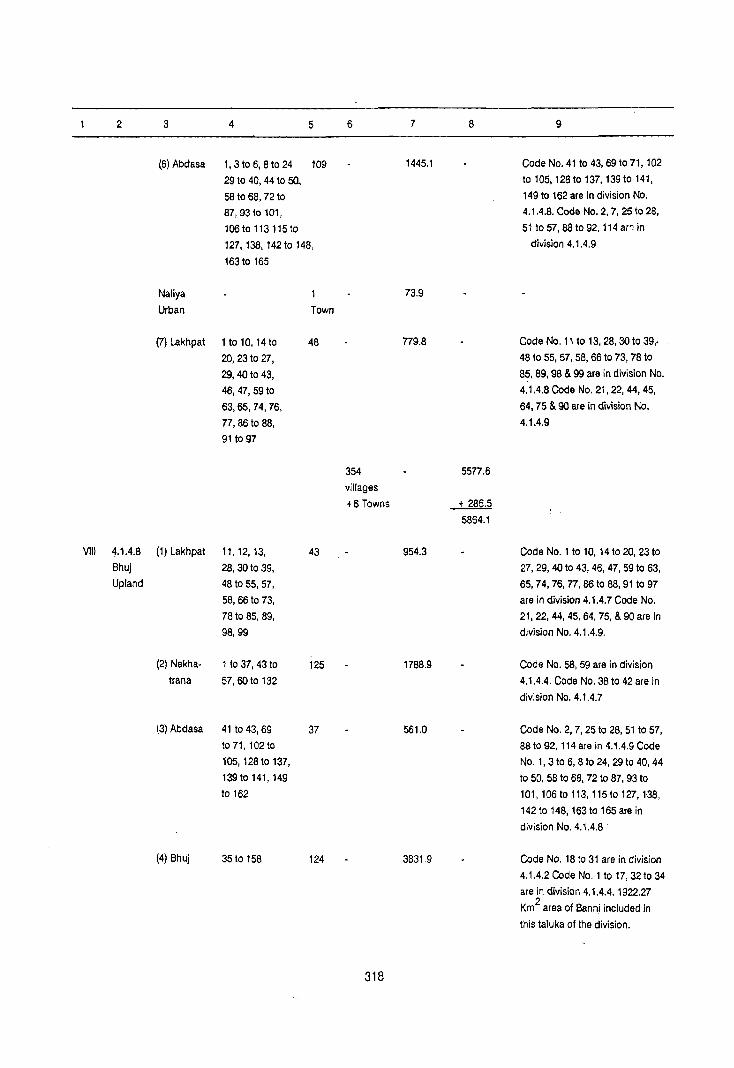
2 3 4 5 6 7 8 9
(6) Abdasa 1,3 to 6, 8 to 24 109 1445.1 Code No. 41 to 43, 69 to 71,102
29 to 40, 44 to sa. to 105, 128 to 137, 139 to 141,
58 to 68, 72 to 149 to 162 are in division No.
87,93t0101, 4.1.4.8. Code No.2, 7, 25 to 28,
106 to 113115to 51 to 57, 88 to 92, 114 ar":: in
127, 138, 142 to 148, division 4.1.4.9
163 to 165
Naliya 73.9
Urban Town
(7) Lakhpat 1 to 10, 14 to 48 779.8 Code No. 11 to 13,28,30 to 39,.
20, 23 to 27, 48 to 55, 57, 58, 66 to 73,78 to
29, 40 to 43, 85, 89, 98 & 99 are in division No.
46,47,59to 4.1.4.8 Code No. 21, 22, 44, 45,
63,65,74,76, 64,75 & 90 are in division No.
77,86 to 88, 4.1.4.9
91 to 97
354 5577.6
villages
+6 Towns + 286.5
5864.1
VIII 4.1.4.8 (1) Lakhpat 11,12,13, 43 954.3 Code No.1 to 10, 14 to 20, 23 to
Bhuj 28, 30 to 39, 27,29,40 to 43, 46, 47, 59 to 63,
Upland 48 to 55, 57, 65,74,76,77,86 to 88, 91 to 97
58, 66 to 73, are in division 4.1.4.7 Code No.
78to 85, 89, 21, 22, 44, 45, 64, 75, & 90 are in
98,99 division No. 4.1.4.9.
(2) Nakha· 1 to 37, 43 to 125 1788.9 Code No. 58, 59 are in division
trana 57,60 to 132 4.1.4.4. Code No. 38 to 42 are in
division No. 4.1.4.7
(3) Abdasa 41 to 43, 69 37 561.0 Code No.2, 7, 25 to 28, 51 to 57,
to 71, 102to 88 to 92, 114 are in 4.1.4.9 Code
105, 128 to 137, No.1, 3 to 6, 8 to 24, 29 to 40, 44
139to 141,149 to 50, 58 to 68, 72 to 87, 93 to
to 162 101, 106 to 113, 115to 127, 138,
142 to 148, 163 to 165 are in
division No. 4.1.4.8 .
(4) Bhuj 35 to 158 124 3831.9 Code No. 18 to 31 are in division
4.1.4.2 Code No.1 to 17,32 to 34
are in division 4.1.4.4.1922.27
Km2
area of Banni included in
this laluka of the division.
318

2 3 4 5 6 7 8 9
Bhuj urban 2 45.3 Included 118.3 Km2 area of Bhuj
& Towns .j- 118.3 village (Rural) included in Ihe
Madhapar 163.6 Bhuj urban.
Urban
(5) Mandvi 110 23, 29, 31 to 33 508.8 Code No. 2410 28, 30, 39, 40, 42
38,41 1091 are in division No. 4.1.4.7
(6) Mundra 4,5,19 &20 4 64.0 Code No .. 1,2,3,610 18,211060
are in division No. 4.1.4.7 .
(7) Anjar 171027,39, 25 360.3 Code No.1 to 10, 12 are in
411053 division No. 4.1.4.4. Code No. II,
13 to 16, 281038,40,541075
are in division No. 4.1.4.7
391 8069.2
villages
+ 2 Towns ~ 8232.8
IX 4.1.4.9 (1) lakhpal 21,22,44, 7 99.3 Code No. 56 is in division No.
Creek 45,64,75 & 90 4.1.4.4. Code No.1 to 10, 14 to
Zone 20,23 to 27, 29, 40 to 43 46,47,
59 to 63, 65, 7~, 76, 77, 86 to 88,
91 to 97 are in division No.
4.1.4.7. Code No. 11 to 13,28,30
t9 39, 48 to 55, 57, 58, 66 to 73,
7810 85, 89,98, 99 are in division
No. 4.1.4.8.
(2) Abdasa 2,7,2510 19 318.2 Code No.1, 3106,8 to 24, 29 to
28,51 to 57, 40, .44 to 50 58 to 68, 72 to 87, 93
881092,114 to 101, 10610 113, 115 to 127,
138, 142 to 148, 163 to 165 are in
division No. 4.1.4.7 Code No. 4.1,
42,43,69 to 71, 102 to 105, 128
to 137, 139 to 141, 149 to 162 are
in division No. 4.1.4.8
26 417.5
villages
Town Nil
417.5
319

District Name: KACHCHH
State District
name
2
Gujarat Kachchh
Gujarat Kachchh
Division
number
and name
3
4.1.4.1
Rann of
Kachchh
4.1.4.2
Dungar
Upland
STATEMENT ON REGION-WIS::
PHYSIO-CULTURAL DETAILS
Name of adminis
trative
divisions
4
Rann and Parts of
Rapar taluka
of Kachchh
and Vav
taluka of
Banas Kantha
district.
Bhuj
taluk"
Census Location Code No: 07
Geology Soils
5 6
Sub- Orthids-Nummulitic Psamments
Beds
Patcham,
Chari and
Katrol Series
320
State: GUJARAT
Physio-Cultural Characteristics
7
The region extends over the entire northern
part and south-eastern part of the district. The
region occupies entire Rann area of the
district. It is surrounded by Pakistan in the
north, Rajasthan in the north, Rajasthan in the
north east, district Banas Kantha and
Surendranagar in the east, district Rajkot and
Jamnagar in the south and Arabian Sea in the
west.
The entire region is low lying and covered with tidal mud flats.
The region spreads over northern part of Bhuj
taluka of the district. The region is surrounded
by Rann of Kachchh in the north, east and
west, and Banni Lowland in the south.
From relief point of view, the maximum height
of the region is 458 meters above the M.S.l.
near Kala Dungar (Kala Hills) in the north and
minimum height is 8 meters above the M.S.L.
near Khavda village in the west. General slope
of the region is east ward.
Drainage pattern of the region is dendritic.
Sand dunes and sand hills are seen in the
region. The region is formed of Sub
Nummulitic Beds Patcham, Chari and Katrol
Series. Sails found in the region are sandy.
SOils as classified by NBSS & LUP (I CAR], Nagpur, the region has Orthids-Psamments
type of soils.
Orthids - Soils of arid region with some
development.

2
Gujarat Kachchh
Gujarat Kachchh
3
4.1.4.3 Khadir
Island
4.1.4.4. Banni
Lowland
4
Bhachau taluka
Rapar. Bhuj.
Bhachau.
Nakhatrana,
Anjar and
Lakhpat Taluka
5 6
Sub- Orthids-
Nummulitic Argids
Beds Patcham,
Chari and
Katrol
Series
Dwarka Sub-
OrthidsAquepts
Nummulitic Orthids-
Beds, Psamments
Umia Orthids-
Series Argids
Patcham,
Chari and
Katrol Series
321
7
Psamments - Sandy soils (Recent)
From transport and communication point of
view, the region is not developed. Only
metalled road links the region with other parts
of the district.
The region spreads over the parts of Bhachau
taluka. This is an island which has emerged in
the Rann of Kachchh. It is located in the north
of the district and is surrounded by Rann.
From relief point of view, the maximum height
of the region is 284 meters above the M.S.l.
near Hadibhadang Dungar (Hill) and the
minimum height is 13 meters above the M.S.L.
in the most southern parts of the region.
Northern part of the region is hilly and covered
with mixed forest. General slope of the region
is south-ward. THe entire region is covered
with dense scrub. Geologically it is formed of
SUb-Nummilitic Beds and Patcham, Chari and
Katrol Series. soils of the region are sandy.
Soils as classified by NBSS & LUP (ICAR),
Nagpur, the region has Orthids-Argids types of
soils.
Orthids Soils of arid region with some
development,
Argids - Soils of arid regions with clay
accummulation in lower horizon.
The means of transport and communication in
the region is very poor. The island is linked
with other part of the district by a metalled
road only. In summer season communication
gap is minimised by cart tracks which pass
through the Rann.
The region spreads over the north-eastern and
south-eastern part of the district, occupying
parts of talukas of Rapar, Bhuj, Bhachau,
Nakhatrana, Anjar and Lakhpat. It is
surrounded by Rann of Kachchh in the north,
east and so·uth-east, Coastal Plain in the south·
west and Bhuj Upland in the west.
From relief point of view, the maximum height

2
Gujarat Kachchh
3
4.1.4.5 Rapar
Stony
Waste
4
Raparand Bhachau
talukas
5 6
Owarka Orthids-Beds, etc. Psamments
Sub- Orthids-
Nummulitic Argids
Beds Umia
Series
Patcham,
Chari and
Katrol Series
7
of the region is 232 meters above the M.S.L.
on the Nilwa Dungar (Hills) in Rapar taluka and
minimum height is 16 meters above the M.S.L.
near Desalpur village in the Bhachau taluka.
Drainage pattern of the region is dendritic.
Northern part of the region is hilly.
The region is characterised by perennial ponds, sand hiJIs, swamps and scrubs.
Geological formation of the region are Owarka
Beds, etc, SUb-Nummulitic Beds, Umia Series, Patcham, Chari and Katrol Series. Soils of the
region are sandy and deltaic alluvial.
According to the soils claSSification of NBSS & LUP (I CAR) , Nagpur, the region has OrthidsAquepts, Orthids-psamments and Orthids
Argids types of soils.
Orthids - Soils of arid region with some
development.
Aquepts - Brown soils (Hydromorphic)
Psamments - Sandy sOilt (Recent)
Argids • Soils of arid regions with clay
accumulation in lower horizon.
Transport and communication of the region
are not developed. A state highway and a national highway (No. 15) link the region with
other parts of the district as well as the slate.
The region extends over north-eastern part of the district occupying parts of Rapar and
Bhachau talukas. The region is surrounded by
Banni Lowland in the north, south and east
and Coastal Plain in the west.
The maximum height in the region is 203
meters above the M.S.L. in the north of Adhoi village of 8hachau taluka and minimum height
is 68 meters above the M.S.L. in the east of
Rapar town. The region has a characteristics of
stony waste and gravel waste, perennial
ponds, scrubs and sand hills. General slope of
the region is north ward. Dendritic drainage
pattern is seen in the region. Geological
formations of the region are Owarka 8eds, e19,

2 3 4 5
Gujarat Kachchh 4.1.4.6 Anjar Owarka Sathsaida taluka and Beds etc. Bet Parts of Deccan
Ultle Trap Rann,
323
6
Orthids-
Aquepts
7
Sub-Nummulitic Beds Umia Series Patcham,
Chari and Katrol Series. Soils found in the
region are sandy. Soils as classified by NBSS
& LUP (ICAR), Nagpur, the region has Orthids
Psamments and Orthids-Argids types of soils.
Orthids - Soils of arid region wit.h some development.
Psamments - Sandy soils (Recent)
Argids . - Soils of arid regions with clay accumulation in lower horizon.
The transport and communication of the
region are developed. Rapar town is linked
with other parts of the district by state highway
(No. 52) and southern part of the region is
linked with metre gauge railway.
The region extends over south-eastern parts of
the district occupying parts of Uttle Rann and
Anjar taluka. It is surrounded by Coastal Plain
in the north and west, Little Rann of Kachchh
in the east, districts of Rajkot, Jamnagar and
Gulf of Kachchh in the south.
fhe region is covered with mangrove swamps
and mud flats except Kandla port-town, which is located on the height of 4 meters above the
M.S.L. General slopes of the region is south
west ward. There are creeks which influence
the drainage pattern in the region.
Geologically the region is formed of Dwarka
Beds, etc, and Deccan Trap. Soils of the region are deltaic alluvium. Some parts of the region
is covered with Orthids-Aquepts types of soils
which are as per classification of NBSS & LUP (ICAR) Nagpur.
Orthids - Soils of arid region with some development.
Aquepts - Brown Soils (Hydromorphic)
Kandla port town is well developed. This port
is one of the major ports of India. It is linked
with other parts of the State by metalled roads and railways,

2
Gujarat Kachchh
3
4.1.4.7 Coastal
Plain
4
Bhachau, Nakhatrana,
Anjar
Lakhpat,
Mundra,
Mandvi,
and
Abdasa talukas.
5 6
Dwarks Orthids-beds, etc. Aquepts
Nari and Orthids-
Gaj Series Psamments
Undifferen- Orthids-
tiated Argids
Eocene Beds
Sub-Nummulitic
Beds Deccan
Trap Umia
Series Patch am ,
Chari and
Katrol Series.
324
7
The region extends oller south-western parts of
the district occupying parts of talukas of
Bhachau, Nakhatrana, Anjar, Lakhpat, Mundra,
Mandvi and Abdasa.
It is surrounded by Bhuj Upland in the north,
Rapar Stony Waste and Banni lowland in the
east, Gulf of Kachchh in the south and Creek Zone in the west.
The maximum height of the region is 161
meters above the M.S.L. near Adhoi village of
Bhachau taluka and minimum height is
between 3 to 15 meters on the coast line.
General slope of the region is south ward. Perennial wells, ponds, sand dunes, stony
wastes etc. are the features of the plain.
Geologically, it is compo~ed of Dwarks Beds,
etc., Nari and Gaj Series, Undifferentiated
Eocene Beds, Sub·Nummulitic Beds, Deccan
Trap, Umia Series and Patcham, Chari and
Katrol Series. Soils found in the region are red
sandy deltaic allullium, deep black and
medium black.
Soils as classified by NBSS & LUP (ICAR),
Nagpur, the region has Orthids-Aquepts,
Orthids-Psamments and Orthids-Argids types
of soils.
Orthids - Soils of arid region with some
development.
Aquepts - Brown soils (Hydromorphic)
Psamments -Sandy soils (Recent)
Argids • Soils of arid region with clay
accummulation in lower horizon.
As regard transport and communication, the
region is developed in the district. TOWllS of
Bhachau, Anjar, Gandhidham, Mundra,
Mandvi, and Naliya are interlinked with each other by metalled roads.

2
Gujarat Kachchh
3
4.1.4.8
Bhuj
Up/and
4
Bhuj,
Nakhatrana,
Anjar,
Lakhpat,
Mundra,
Mandvi
and
Abdasa
taluka
5 6
Dwarka Orthids-
Beds, etc. Aquepts
Nari and Orthids-
Gaj Series Psamments,
Undifferen- Orthids-
tiated Argids
Eocene Beds
Sub-Nummulitic
beds Deccan Trap
Umia Series
Patcham,
Chari and
Katrol Series.
325
7
The region extends ever the middle part of the
district occupying parts of talukas of Bhuj,
Nakhatrana, Anja(, Mundra, Lakhpat, Mandvi
and Abdasa.
The region makes its boundaries with Banni
Lowland in the north, Rann of Kachchh in the
east and Coastal Plain in the south and wEIst.
The maximum height of the region is 388
meters above the M.S.L. in the north of
Nakhatrana and minimum height is 30 meters
above the M.S.L. in the south-west of Bhuj.
Entire upland is covered with sand dunes,
sand hills, perennial ponds and wells, stony
waste and g(ovel waste. It contains reserved
and protected forests and also open and
dense scrub and cactus. Dendritic pattern of
drainage is seen in the region. Geologically the
region is covered with Dwarka Beds, etc, Nari
and Gaj Series, Undifferentiated Eocene Beds,
Sub-Nummulitic Beds, Deccan Trap, Umia
Series. Patch am, Chari and Katrol Series. The
soils of the region are deep black, shallow,
blacks and alluvials. SoilS as classified by
N.B.S.S. & L.U.P. (I CAR) , Nagpt,lr, the region
has Orthids-Aquepts Orthids-Psamments and
Orthids·Argids types of soils.
Orthids • Soils of arid region with some
development.
Aquepts • Brown soils (HydromorphiC)
Psamments - Sandy soils (Recem)
Argids • SOils of arid (egion with clay
accummulation in lower horizone.
From the means of transport and
communication point of view, the (egion is
developed in the district. Bhuj town being the
headquarters of the district is well connected
with other parts of the district by metalled roads.

2 3 4
Gujarat KachChh 4.1.4.9 lakhpat Creek and
Zone Abdasa
talukas
5
Dwarka Beds, etc.
Nari and
Gaj Series
326
6
Orthids. Psamments,
Orthids·
Argids.
7
The region extends over western part of the district occupying parts of talukas of Lakhpat
and Abdasa.
It makes its boundaries with Pakistan and
Rann of Kachchh in the north, Coastal Plain in
the east, Arabian Sea in the south and West.
The region is composed of islets and islands.
General height of the region varies from 5 to
20 meters above the M.S.l. parts of the region
are covered with forests. Creeks form the
dendritic patte~n ot drainage. Geologically, the
region is formed of Owarka Beds, etc., Nari and Gaj Series. Soils found in the region are
Cleltain alluvial. Soils as claSsified by NBSS &
LUP (leAR) Nagpur the region has OrthidS·
Psamments and Orthids·Argids types of soils.
Orthids • Soils of arid region with some
development.
Psarnments • Sandy soils (Recent)
Argids • Soils of; arid region with clay
accummulation in lower horilon.
From the means of. transport and
communication point of view, the region is
poor.

APPENDIX
Showing Adminlstratlv, Constituents by Districts with Reference to the Sub· Micro Regions In Gularat and other States, Namely, Maharashtra, Karnataka, Kerala, Rajasthan, Madhya Pradesh and Tamil Nadu and the Union Territories of Goa, Daman
Macro Region Meso Region
with Code No. with Code No. & Name & Name
2 3
4. The 4.1 Gujarat Goa, Coastal Region Daman & Plains & Diu Islands
Gujarat
Goa, Daman & Diu
Gujarat
4,2 Western Maharashtra
Coastal
Region
& Diu and Pondicherry
State Micro Region
with Code No.
& Name
4 5 6
COASTAL PLAINS (WEST)
4.1.1. Gujarat Daman Plain
Vadodara
Val sad
Bharuch
Surat Kheda
Surat
Bharuch
4.1.3 Kathiawar Diu
Peninsula
Junagadh
Bhavnagar
Jamnagar
Raj kat
Amreli
4.1.4 Kachchh Kachchh Peninsula
4,2.1 Maharashtra Thane
District Sub· Micro Region with Code No.
& Name
7 8
4.1.1.1 Daman (Valsad)
Coast.
4.1.1.1 Khambhat Silt
4.1.1.1 Val sad Coast.
4.1.1.1 Khambhat Silt.
4.1.1.1 Khambhat Coast 4.1.1.5 Khambhat silting Plain.
4.1.1.7 Chorasi·Palsana Coastal
Plain
4.1.1.B Khambhat Coast
4.1.3.1 Diu Coast (Junagadh
Coastal
Plain)
4.1.3.1 Junagadh Coastal Plain.
4,1.3.1 Bhavnagar Coastal Plain,
4.1.3,1 Jamnagar North West-Coastal Plain,
4.1.3,1 Maliya Coastal Plain.
4.1.3.4 Amreli Coastal Plain
4,1.4,7 Coastal Plain
4.2.1.1 Thane Coast. Littoral Great-Bombay 4,2.1.1 Greater Bombay Coast.
Raigarh 4,2,1,1 Raigarh Coast.
Ratnagiri 4.2,1.1 Aatnagiri Coast.
327

2 3 4 5 6 7 8
Goa 4.2.2 Goa Coast Goa 4.2.2.1 Goa Coast.
Daman & Goa 4.2.2.4 Chauri Forested Coast.
Diu
Karnataka 4.2.3 Karnataka Uttar-Kannad 4.2.3.1 Karwar Honavar Coast
Coast Dakshin 4.2,3.1 Coondapoor-Mangalore
Kannad Coast
Kerala 4.2.4 North Cannanore 4.2.4.1 Cannan ore Coast.
Kerala
Coast
Kozhikode 4.2.4.1 Kozhikode Coast
Mahe 4.2.4.1 Mahe-Kallaye Coastal
Region
Pondicherry 4.2.5 Central Malappuram 4.2.5.1 Malappuram Coast.
Kerala Kerala
Coast Trichur 4.2.5.1 Trichur Coast.
Ernakulam 4.2.5.1 Cochin Coast.
4.2.6 South Alleppy 4.2.6.1 A1leppey Coast
Coast QuHon 4.2.6.1 Quilon Coast.
Trivandrum 4.2.6.1 Trivandrum Coast.
SANOY PlAIN
2. The 2.3 Arid Rajasthan 2.3.4 Luni Valley Jalor 2.3.4.1 Luni Lowland Sandy
Great Rajasthan Waste.
Plains Plain Jalor 2.3.4.2 Sukri Basin.
Barmer 2.3.4.5 Barmer Sandy Plain.
4. The 4.1 Gujara! Gujara! 4.1.1 Gujarat Banas Kantha 4.1.1.1 Vav Sandy Plain
Coastal Region Plain Mahesana 4.1.1.1. Western Sandy Waste.
Plains & Banas Kantha 4.1.1.2 Sandy Plain.
IslandS
4.1.3 Kathiawar Rajkot 4.1.3.3 Rajkot Sandy Waste Land.
Peninsula
RANN OF KACHCHH
4.1.4 Kachchh Kachchh 4.1.4.1 Rann of Kachchh.
Peninsula Kachchh 4.1.4.2 Dungar Upland.
Kachchh 4.1.4.3 Khadir Island.
Kachchh 4.1.4.4 Bann; Lowland.
Kachchh 4.1.4.5 Rapar Stony Waste.
Kachchn 4.1.4.6 Sathsaidia Bet.
Kachchh 4.1.4.9 Creek Zone.
328
2
3. The 3.1
Deccan
Plateau
4. The 4.1
Coastal
Plains & Islands
3
Semi-Arid Rajasthan
Rajasthan
Gujarat Gujarat
Region
4
4.1.1
4.1.3
3.1.1
4.1.1
5
PLAIN
Gujarat
Plain
Kathiawar
Peninsula
BANAS VALLEY
Aravali
Range & the
Associated
Uplands
Gujarat
Plains
329
6 7 8
Ahmadabad 4.1.1.1 Viramgam Plain.
Surat 4.1.1.2 Mangrol Plain.
Mahesana 4.1.1.2 Central Alluvial Plain.
Valsad 4.1.1.2 Middle Valsad Plain.
Kheda 4.1.1.2 Nadiad Plain.
Ahmadabad 4.1.1.4 Bhadar-Bhogava Lowland.
Sabar Kantha 4.1.1.4 Vatrak-Meshwa and Majham
Plain.
Vadodara 4.1.1.4 Oraang-Heran Plain.
Ahmadabad 4.1.1.5 Bhadar River Plain.
Surat 4.1.1.5 Mindhola-Purna Plain. Mahesana 4.1.1.5 Mahesana Lowland. Banas Kantha 4.1.1.6 Uamardasi-Saraswati Plain. Bharuch 4.1.1.7 Valia Plain.
Surendra- 4.1.3.1 Halvad, Ohrangadhra
Nagar and Oasada Plain.
Amreli 4.1.3.1 Bhadar River Plain.
Amreli 4.1.3.2 Shetrunji River Plain.
Surendra- 4.1.3.2 Surendranagar Plain.
nagar
Rajkot 4.1.3.2 Rajkot Alluvial Plain.
Jamnagar 4.1.3.2 Jamnagar South Plain.
Surendranagar 4.1.3.3 Bhadar River Plain
Junagadh 4.1.3.3 Bhadar, Ojat and Harna
River Plain
Rajkot 4.1.3.4 Bhadar River Plain
Bhavnagar 4.1.3.4 Keri, Kalubhar and Ghelo
Plain
Sirohi 3.1.1.3 Sipu-8anas Valley
BanasKantha 4.1.1.3 Banas Valley
2 3 4 5 6 7 8
SABARMATI BASIN
Gandhinagar 4.1.1.1 Sabarmati Plain Kheda 4.1.1.1 Sabarmati-Vatrak Plain
Ahmadabad 4.1.1.2 Sabarmati Basin
Gandhinagar 4.1.1.2 Khari Plain Ahmadabad 4.1.1.3 Khari-Meshwa Plain.
Saba Kantha 4.1.1.3 Sabarmati Plain
Mahesana 4.1.1.4 Sabarmati Basin
Saba Kantha 4.1.1.5 Khari Plain
MAHI BASIN
3. The 3.1 Semi-Arid Rajasthan 3.1.1 Aravalli Range Banaswara 3.1.1.1 Mahi-Anas Basin Deccan Rajasthan & the Associated Plateau Uplands
Dungarpur 3.1.1.2 Mahi-Som Basin
Dudngarpur 3.1.1.3 Mahi-Vatrak Basin
4. The 4.1 Gujarat Gujarat 4.1.1 Gujarat Vadodara 4.1.1.2 Mahi Plain Coastal Region Plain
Plains & Islands
Bharuch 4.1.1.2 Bharuch Plain
Vadodara 4.1.1.3 Vadodara Plain
Kheda 4.1.1.4 Mahi Plain
4.1.2 Eastern Panch 4.1.2.1 Mahi Plain
Hilly Mahals
Region
NARMADA VALLEY
3. The 3.4 The Madhya 3.4.3 Northern Shahdol 3.4.3.6 Upper Narmada Basin
Deccan Northern Pradesh Madhya
Plateau Madhya Pradesh
Pradesh Uplands
Uplands East
3.5 Central 3.5.2 Bhop~1 Sehore 3.5.2.3 Middle Narmada Valley.
Madhya Plateau
Pradesh Plateau
Devas 3.5.2.4 Middle Narmada Valley
Raisen 3.5.2.5 Middle Narmada Valley
3.5.3 Ratlam Dhar 3.5.3.4 Narmada Valley
Plateau Jhabua 3.5.3.5 Narmada Gorge.
Dhar 3.5.3.5 Narmada Gorge
330

2 3 4 5 6 7 8
3.6 Southern 3.6.1 Narmada Region Hoshangabad 3.6.1.1 Middle Narmada Valley
Madhya Including Flanks of
Pradesh Vindhyan-Satpura
Uplands East Nimar 3.6.1.1 Middle Narmada Valley
Seoni 3.6.1.1 Upper Narmada Valley
West Nimar 3.6.1.2 Middle Narmada Valley
Narsimhapur 3.6.1.2 Middle Narmada Valley
Mandla 3.6.1.2 Upper Narmada Valley
West Nimar 3.6.1.3 Narmada Gorge
Jabalpur 3.6.1.6 Upper Narmada Valley
3.7 Northern Maha- 3.7.1 Tapti- Dhule 3.7.1.1 Narmada Gorge
Maha- rashtra Puma
rashtra Valley
4. The 4.1 Gujarat Gujarat 4.1.1 Gujarat Bharuch 4.1.1.3 Lower Narmada
Valley Region Plain Valley
Coastal
Plains & Islands
Bharuch 4.1.1.4 Narmada Gorge
Vadodara 4.1.1.6 Narmada Gorge
Vadodara 4.1.1.7 Lower Narmada Valley
TAPTI-PURNA VALLEY
3. The 3.6 Southern Madhya 3.6.1 Narmada Betul 3.6.1.3 Tapi Basin Deccan Madhya Pradesh Region East Nimar 3.6.1.3 Tapi Basin Plateau Pradesh Including
Uplands Flanks of
Vindhyan-
Satpura
3.7 Northern Maha- 3.7.1 Tapti-Puma Amravati 3.7.1.1 Tapi Valley Maha- rashtra Valley Akola 3.7.1.2 Purna Valley rashtra Buldana 3.7.1.2 Puma Valley (North)
Jalgaon 3.7.1.2 Tapi Basin Akola 3.7.1.3 Akola Plain Amravati 3.7.1.3 Puma Basin Buldana 3.7.1.3 Khamgaon Plain Jalgaon 3.7.1.3 Panjhra Basin Dhule 3.7.1.3 Tapi Basin Jalgaon 3.7.1.4 Bori Basin Jalgaon 3.7.1.5 Girna Basin Dhule 3.7.1.5 Panjhra Valley Jaigaon 3.7.1.6 Jamner Plain DhuJe 3.7.1.6 Sori Basin Jalgaon 3.7.1.8 Puma Valley
331

2 3 4 5 6
3.8 Maha- 3.8.2 Western Nashik
rashtra Plateau
Plateau with
Protruded
Hills
4_ The 4.1 Gujarat Gujarat 4.1.1 Gujarat Surat
Coastal Region Plain
Plains & Islands Bharuch
PLATEAU/UPLAND
3. The 3.1 Semi-Arid Rajasthan 3.1.1. AravalJi Dungarpur
Deccan Rajas- Range &
Plateau than the Associated
Uplands
Banswara
Chillaur-
garh
Udaipur
Chittaur-
garh
3.1.2. Semi-Arid Bundi
Uplands Kota
of Eastern Kota
Rajasthan Bhilwara
Tonk
Jhalawar
Jhalawar
Bundi
Jhalawar
Kola
Kota
3.4 Northern Madhya 3.4.1. Northern Guna Madhya Pradesh Madhya Morena Pradesh Pradesh Morena Upland Ravine
Uplands-
West
332
7
3.8.2.3
4.1.1.4
4.1.1.6
3.1.1.1.
3.1.1.2
3.1.1.3
3.1.1.5.
3.1.1.5.
3.1.2.1.
3.1.2.2.
3.1.2.3.
3.1.2.4.
3.1.2.4.
3.1.2.4.
3.1.2.5.
3.1.2.6.
3.1.2.6.
3.1.2.6.
3.1.2.7.
3.4.1.2.
3.4.1.2.
3.4.1.3.
8
Girna Basin
Tapi Basin
Tapi Basin
Dungarpur Upland.
8anaswar Upland
Eastern Chillaurgarh
Uplands.
Salumbar-Dhariawad
Forested Uplands.
Wester~ Chittaurgarh
Upland.
Hindoli Roneeja Upland.
Kola Plateau.
Basan Upland.
Forested Upland of
Shahabad.
Todaraisingh Upland.
Aldera Plateau.
Pirawa Upland.
Dab; Plateau.
Dag Plateau
Chhipa Barod-Chhabra
Upland.
Chechat Upland.
Chachaura Upland.
Karhal Plateau.
Sabalgarh-Imlia Upland.

2 3 4 5 6 7 8
3.5 Central 3.5.3. Ratlam Jhabua 3.5.3.1. Thandla Upland.
Madhya Plateau
Pradesh Dhar 3.5.3.1. Sardarpur Plateau
Plateau Mandsaur 3.5.3.1. North-Western Mandsaur
Upland.
Shajapur 3.5.3.1. Agar Plateau.
Rajgarh 3.5.3.1. Machhalpur-Rajgar)l
Upland.
Ujjain 3.5.3.2. Ujjain Plateau (Milkidesh).
Jhabua 3.5.3.2. Petlawad Plateau.
Ratlam 3.5.3.2. Ratlam Plateau.
Mandsaur 3.5.3.2. Mansa Forested Upland.
Shajapur 3.5.3.2. Shajapur Forested Upland.
Ujjain 3.5.3.3. Tarana Forested Plateau.
Mandsaur 3.5.3.4. Eastern Mandsaur Upland.
Mandsaur 3.5.3.5. Southern Mandsaur Upland.
4. The 4.1 Gujarat Gujarat 4.1.1. Gujarat Sabar Kantha 4.1.1.1. Idar Upland.
Coastal Region Plain Surat 4.1.1.3. Umarpada Forested Upland.
Plains
& Islands
4.1.2. Easter Panch Mahals . 4.1.2.2. Forested and Scrub Zone .
Hilly Panch Mahals 4.1.2.3. Dohad Upland.
Region
4.1.3. Kathiawar Bhavnagar 4.1.3.2. Palitana-Savarkundla
Peninsula Upland.
Bhavnagar 4.1.3.3 Songadh Forested Plain
Amreli 4.1.3.3. Gir Forest Upland
Surendranagar 4.1.3.4 Thangadh Upland
Rajkot 4.1.3.5 Vinchhiya Upland
4.1.4 Kachchh Kachchh 4.1.4.8 Bhuj Upland
Peninsula
ARAVALLI HILLS
2. The 2.2 Haryana Haryana 2.2.2. Western Bhiwani 2.2.2.2 Bhiwani Plain with Aravallj Great Plain Haryana Offshoots Plains Plain
2.2.3 Southern Faridabad 2.2.3.1 Faridabad Undulating Plain Hatyana
Plain Gurgaon 2.2.3.2. Sohna Undulating Plain with
Aravalli Offshoots.
Mahendragarh 2.2.3.2 Mahendragarh Undulating
Plain.
Gurgaon 2.2.3.4 Firozpur-Zirka Dissected
Upland Delhi Delhi 2.2.3.4 Aravalli Rock Outcrops
333

2 3 4 5 6 7 8
2.3 Arid Rajas· 2.3.2 Rajasthan Sikar 2.3.2.3 Central Sikar Aravalli Hills
Rajas· than Bagar
than Sikar 2.3.2.4 Eastern Sikar Aravalli.
Nagaur 2.3.2.5 Nagaur Aravalli Region.
2.3.4 LuniValley Jalor 2.3.4.3 Jalor Aravalli
Pali 2.3.4.5 Pali Aravalli
3. The 3.1 Semi·Arid 3.1.1 Aravalli Udaipur 3.1.1.1 Western Aravalli Deccan Rajasthan Range and
Plateau the Associ· Udaipur 3.1,1.2. Central Aravalli.
ated Uplands
Ajmer 3.1.1.2 Aravalli Hills
Sirohi 3.1.1.2. Mt.Abu Hills
Sirchi 3.1.1.4 Sirohi Aravalli
Ajmer 3.1.1.5 Ajmer Aravalli
3.1.2 Semi·Arid Bhilwara 3.1.2.1 Bhilwara Aravalli
Uplands of Jhalawar 3.1.2.3 Mukandara Hills
Eastern Bundi 3.1.2.3 Bundi Hills
Rajasthan Kota 3.1.2.5 Mukandara Hills
3.1.3 Banas· Sawai 3.1.3.2 GOdhwara Range
Chambal Madhopur
Basin
4. The 4.1 Gujarat Gujarat 4.1.1 Gujarat Sabar 4.1.1.2 Sabar Kantha Aravalli
Coastal Region Plain Kantha
Plains & Mahesana 4.1.1.3 Mahesana Aravalli Islands Kheda 4.1.1,3 Aravalli Forested Rock
Outcrop.
Banas 4,1.1.4 Banas Kantha Aravalli
Kantha Range
Banas Kantha 4.1,1,5 Jasor·Chhotila Hills
VINDYAN RANGE
3. The 3,4 Northern Madllya 3.4.2 Northern Panna 3.4.2.3 Pawar Hills
Deccan Madhya Pradesh Madhya
Plateau Pradesh Pradesh
Uplands Uplands Central
3.4,3 Northern Sidhi 3.4.3.1 Kaimur Hills
Madhya
Pradesh
Uplands
East
334

2 3 4 5 6 7 8
Rewa 3.4.3.4 Kaimur Hills
Satna 3.4.3.4 Kaimur Hills
3.5.1 Sagaur Vidisha 3.5.1.1 Dhumgarh Forest
Plateau Damoh 3.5.3.1 Tendul Forested Zone
Sagar 3.5.1.4 Deori Forested Hills
Vidisha 3.5.1.5 Teonda Range
3.5.2 Bhopal Bhopal 3.5.2.1 Berasia Scruby
Plateau Forest
Raisen 3.5.2.2 Vindhyan Range
Sehore 3.5.2.2 Vindhyan Range
Oevas 3.5.2.3 Vindhyan Range
Indore 3.5.2.3 Vindhyan Range
3.5.3. Ratlam Dhar 3.5.3.3 Vindhyan Range
Plateau Jhabua 3.5.3.3 Vindhyan Range (Bagh
Hills)
3.6.1 Narmada West Nimar 3.6.1.1 Vindhyan Range
Region
including
Flanks of
Vindhyan
Satpura Jabalpur 3.6.1.2 Kaimur Hills
4. The 4.1 Gujarat Gujarat 4.1.1. Gujarat Plain Vadodara 4.1.1.5 Vindhyan Hills
Coastal Region
Plains
&Islands
SATPURA RANGE
3. The 3.4 Northern Madhya 3.4.3 Northern Shahdol 3.4.3.5 Maikala Range
Deccan Madhya Pradesh Madhya
Plateau Pradesh Pradesh
Uplands
East
3.6 Southern 3.6.1 Narmada Betul 3.6.1.1 Satpura Range Madhya Region Chhindwara 3.6.1.1 Satpura Range Pradesh including Mandla 3.6.1.1 Shahpura Forested Hills Uplands Flanks of Balaghat 3.6.1.1 Satpura Range
Vindhyan East Nimar 3.6.1.2 Satpura Range
335

2 3 4 5 6 7 8
Satpura Hoshangabad 3.6.1.2 Satpura Range
Seoni 3.6.1.2 Satpura Range
Narsimhapur 3.6 .. 1.3 Satpura Range
Mandla 3.6.1.3 Maikala Range
West Nimar 3.6.1.4 Satpura Range
East Nimar 3.6.1.4 Gawilgarh Hills Betul 3.6.1.4 Gawilgarh Hills
Jabalpur 3.6.1.4 Jabalpur Forested Hills
Balaghat 3.6.1.5 Maikala Range
3.6.2 Mahanadi Bil1:spur 3.6.2.1 Maikala Range
Basin Raj Nandgaon 3.6.2.2 Maikala Range
3.7 Northern Maharashtra 3.7.1 Tapti-Purna Jalgaon 3.7.1.1 Satpura Range
Maharashtra Valley Akola 3.7.1.1 Satpura Range Buldana 3.7.1.1 Gawilgarh Hills
Amravati 3.7.1.2 Gawilgarh Hills
Dhule 3.7.1.2' Satpura Range
3.7.2 Wardha- Bhandara 3.7.2.1 Satpura Range
Penganga-
Wainganga
Plain
Nagpur 3.7.2.4 Satpura Range
Bhandara 3.7.2.5 Satpura Range
4. The 4.1 Gujarat Gujarat 4.1.1 Gujarat Bharuch 4.1.1.5 Satpura Hills
Coastal Region Plain
Plains&
1s.lands
WESTERN GHATS/SAHYADRI HILLS
3. The 3.7 Northern Maharashtra 3.7.1 Tapti- Dhule 3.7.1.4 Western Ghats
Deccan Maharashtra Puma
Plateau Valley
3.8 Maharastra 3.B.l Eastern Kolhapur 3.8.1.1 Sahyadri Hms
Plateau Plateau Sangli 3.8.1.1 Sang Ii Sahyadri Hills
3.8.2 Western Satara 3.8.2.1 Sahyadri Hills
Plateau
with
Protruded
Hills
Pune 3.B.2.1 Sahyadri Hills
Ahmadanagar 3.8.2.1 Sahyadrl Hills
Nashik 38.2.1 Sahyadri Hills
Nashik 38.2.2 Satmala Hill Range
336

2 3 4 5 6 7 8
3.9 Karnatai<a Karnataka 3.9.1 Northern Belgaum 3.9.1.3 Gokak-Saundatti Hill
Plateau Karnataka Belgaum 39.15 Khanapur Forests.
Plateau
3.9.2 Central Shimoga 3.9.2.1 Sagar-sorab-Shikarpur
Karnataka Rolling Humid Region
Plateau Chikmangalur 3.9.2.1 Sringeri-Koppa Rolling
Humid Tract. Oharwad 3.9.2.2 Kalghetgi-Lakshmeshwar
Residual Hills. Chikmangalur 3.9.2.2 Kudermukh-Bababudan
Forested Hilly Zone. Chikmangalur 3.9.2.4 Chikmangalur-Mudigere
Rolling Humid Belt. Shimoga 3.9.2.4 Shimoga Forested Hills. Oharwad 3.9.2.4 Byadgi-Hirekerur Rocky
Knobs. Shimoga 3.9.2.5 Tirthahalli Rolling Tract. Shimoga 3.9.2.6 Western Ghats (Shimoga)
3.9.3 Southern Kodagu 3.9.3.1 Patti-Brahmagiri Ghats Karnataka Kodagu 3.9.3.2 Somvarpet-Virajpet Plateau Rolling Humid Region
Kodagu 3.9.3.3 Yedavanad-Nalkeri Forest
Belt.
Hassan 3.9.3.4 Manjarabad Ghats.
3.10 Tamil Tamil 3.10.1 Eastern Periyar 3.10.1.1 Talamalai-Burgur Forested
Nadu Nadu Flanks of Hills
Uplands Sahyadri Coimbatore 3.10.1.1 Coimbatore Forested Hills
Nilgiri 3.10.1.2 MudamalaiForested Hills
Madurai 3.10.1.2 Kodaikanal Forested Hills
Nilgiri 3.10.1.3 Sigur Forested Hills
Nilgiri 3.101.5 Kunda Forested Hills
Coimbatore 3.10.1.5 Anaimalai Forested Hills
Madurai 3.10.1.6 Cardamom-Varushanad
Forested Hills
4. The 4.1 Gujarat Oadra & 4.1.1 Gujarat Oadra & Nagar 4.1.1.2 Western Ghats
Coastal Region nagar Plain Haveli
Plains Haveli Valsad 4.1.1.3 Western Ghats
& Islands Gujarat Surat 4.1.1.6 Kalakakra Hills
4.1.2 Eastern The Oangs 4.1.2.1 Lower Oangs
Hilly The Oangs 4.1.2.2 Upper Oangs
Region
337
2 3 4 5 6 7 8
4.2 Western Mahara- 4.2.1 Mahara- Thane 4.2.1.2 Konkan Hills
Coastal shtra shira
Reg ibn Littoral Greater 4.2.1.2 Kanheri-Konkan Hills
Bombay
Raigarh 4.2.1.2 Konkan Forested Hills
Raigarh 4.2.1.4 Sahyadri Hills
Ratnagiri 4.2.1.4 Sahyadri Hills
Thane 4.2.1.4 Sahyadri Hills
Thane 4.2.1.8 Jayshet Hills
Thane 4.2.1.10 Tungar Hills
Thllne 4.2.1.12 Kankan Forested Hills
Goa 4.2.2 Goa Coast Goa 4.2.2.3 Sahyadri Hills
Oaman & Diu
Karnataka 4.2.3 Karnataka Uttar 4.2.3.2 Western Ghats (Uttar
Coast Kannad Kannad)
Uttar 4.2.3.3 Yellapur-Dandeli Forests
Kannad
Dakshin 4.2.3.3 . Western Ghats (Dakshin
Kannad Kannad
Oakshin 4.2.3.4 Beltangadi Dissected Zone
Kannad
Uttar 4.2.3.4 Sirsi-Siddapur Dissected
Kannad Humid Tract.
Kerala 4.2.4 North Wyanad 4.2.4.1 Wayan ad Forested Hills Kerala
Coast
Kozhikode 4.2.4.3 Kozhikode Forested Hills
Cannanore 4.2.4.5 Kannoth Forested Hills
4.2.5 Central Kerala Idukki 4.2.5.1 Anamalai Forested Hilts Coast Idukki 4.2.5.2 Marayur Forested Hills
Palghat 4.2.5.2 Mannarghat-Balghat
Forested Hills
Palghat 4.2.5.3 Palghat Gap Ernakulam 4.2.5.3 Malayattur Forested Hills Idukki 4.2.5.3 Cardamon' Hill
Kottayam 4.2.5.4 Ranni Forested Hills Trichur 4.2.5.4 Kodasseri Forested Hills
Palghat 4.2.5.4 Chittaur Forested Hills
Malappuram 4.2.5.4 Nilambur Forested Hills Idukki 4.2.5.5 Thekkadi Forested Hills
338

2 3 4 5 6 7 8
4.2.6 South Coast Trivandrum 4.2.6.3 Ponmudi-Agasthiar
Forested Hills.
Quilon 4.2.6.4 Pamba-Kakki Forested Hills
Quilon 4.26.5 Kulathupuzha Forested Hills
4. The 43 Eastern Tamil 4.3.1 Kanniya- Kanniya- 4.3.1.1 Kanniyakumari Forested
Coastal Coastal Nadu kumari kumari Hills
Plains Region Coast
& Islands
4.3.2 Sandy Tirunel- 4.3.2.1 Tirunelveli Forested Hills
Littoral veli
Ramanatha- 4.3.2.1 Srivillipultur Forested Hills
puram
OTHER HILLS
4.1 Gujarat Gujarat 4.1.3 Kathiawar Junagadh 4.1.3.2 8arda Hills Forested Region
Region Peninsula
Jamnagar 4.1.3.3 8arda Hills Forested Region
Junagadh 4.1.3.4 Girnar Hills
Junagadh 4.1.3.5 Junagadh-Gir Forested
Region
339


LIST OF PUBLICATION ON REGIONAL DIVISIONS OF INDIA-A CARTOGRAPHIC ANALYSIS
Ocassional Papers:
Series 1, Vol. I Series 1, Vol. II Series 1, Vol. III Series 1, Vol. IV Series 1 , Vol. V Series 1, Vol. VI Series 1, Vol. VII Series 1, Vol. VIII Series 1, Vol. IX Series 1, Vol. X Series 1, Vol. XI Series 1, Vol. XII Series 1, Vol. XIII Series 1, Vol. XIV Series 1, Vol. XV Series 1, Vol. XVI Series 1, Vol. XVII Series 1, Vol. XVIII Series 1, Vol. XIX Series 1, Vol. XX Series 1, Vol. XXI Series 1, Vol. XXII Series 1, Vol. XXIII Series 1, Vol. XXIV Series 1, Vol. XXV Series 1, Vol. XXVI Series 1, Vol. XXVII Series 1, Vol. XXVIII Series 1, Vol. XXIX Series 1, Vol. XXX Series 1, Vol. XXXI Series 1, Vol. XXXII
.Combined Volume
India Andhra Pradesh Assam Bihar Gujarat Haryana Himachal Pradesh Jammu and Kashmir Karnataka Kerala Madhya Pradesh Maharashtra Manipur Meghalaya Nagaland Orissa Punjab Rajasthan Sikkim Tamil Nadu Tripura Uttar Pradesh West Bengal Andaman & Nicobar Islands· Arunachal Pradesh Chandigarh Dadra & Nagar Haveli Delhi Goa, Daman & Diu Lakshadweep* Mizoram Pondicherry