District Disaster Management Plan
196
District Disaster Management Plan March 2020 District Disaster Management Authority Office of the District Magistrate Alipurduar, West Bengal Pin-736121 DEOC: 03564-253637 Control Room: 03564-257091 Email ID - [email protected]
-
Upload
khangminh22 -
Category
Documents
-
view
1 -
download
0
Transcript of District Disaster Management Plan
District Disaster Management Plan
March 2020
District Disaster Management Authority Office of the District Magistrate
Alipurduar, West Bengal
Pin-736121
DEOC: 03564-253637
Control Room: 03564-257091
Email ID - [email protected]
District Disaster Management Plan
District- Alipurduar
March 2020
District Disaster Management Authority Office of the District Magistrate
Alipurduar, West Bengal
District Disaster Management Plan A publication of: District Disaster Management Authority Disaster Management and Civil Defence Section, Office of the District Magistrate, Alipurduar West Bengal – 736122
The following citation should be used while citing of this report: District Disaster Management Plan, 2020. A publication of the District Disaster Management Authority, Alipurduar. March 2020.
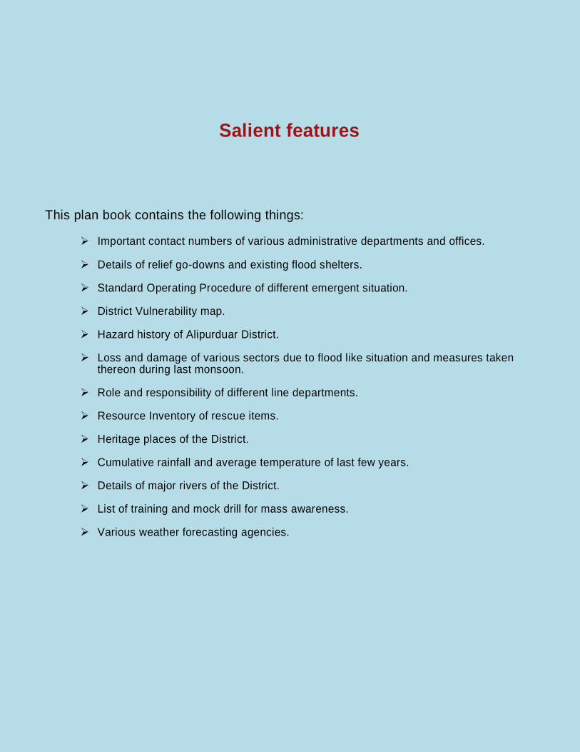
Salient features This plan book contains the following things:
Important contact numbers of various administrative departments and offices.
Details of relief go-downs and existing flood shelters.
Standard Operating Procedure of different emergent situation.
District Vulnerability map.
Hazard history of Alipurduar District.
Loss and damage of various sectors due to flood like situation and measures taken thereon during last monsoon.
Role and responsibility of different line departments.
Resource Inventory of rescue items.
Heritage places of the District.
Cumulative rainfall and average temperature of last few years.
Details of major rivers of the District.
List of training and mock drill for mass awareness.
Various weather forecasting agencies.

District Disaster Management Plan 2020
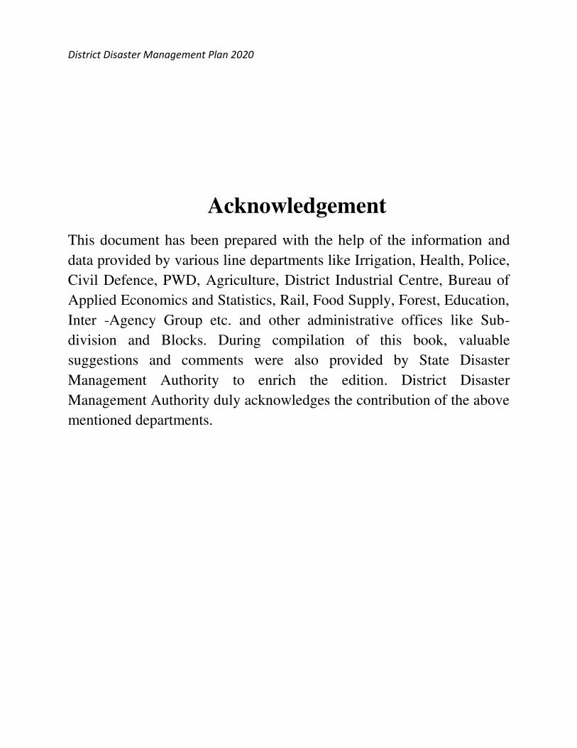
Acknowledgement
This document has been prepared with the help of the information and
data provided by various line departments like Irrigation, Health, Police,
Civil Defence, PWD, Agriculture, District Industrial Centre, Bureau of
Applied Economics and Statistics, Rail, Food Supply, Forest, Education,
Inter -Agency Group etc. and other administrative offices like Sub-
division and Blocks. During compilation of this book, valuable
suggestions and comments were also provided by State Disaster
Management Authority to enrich the edition. District Disaster
Management Authority duly acknowledges the contribution of the above
mentioned departments.
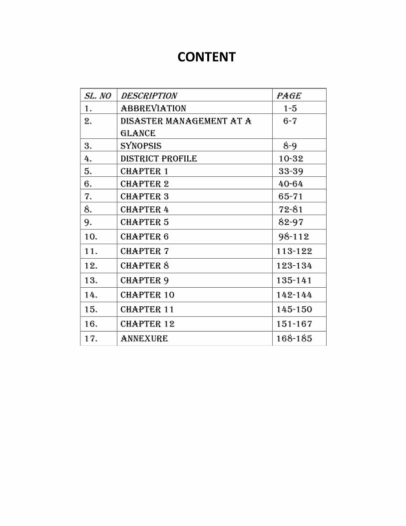
CONTENT
Sl. No Description Page 1. Abbreviation 1-5 2. Disaster Management at a
glance 6-7
3. Synopsis 8-9 4. District Profile 10-32 5. Chapter 1 33-39 6. Chapter 2 40-64 7. Chapter 3 65-71
8. Chapter 4 72-81 9. Chapter 5 82-97
10. Chapter 6 98-112
11. Chapter 7 113-122
12. Chapter 8 123-134
13. Chapter 9 135-141
14. Chapter 10 142-144
15. Chapter 11 145-150
16. Chapter 12 151-167
17. Annexure 168-185
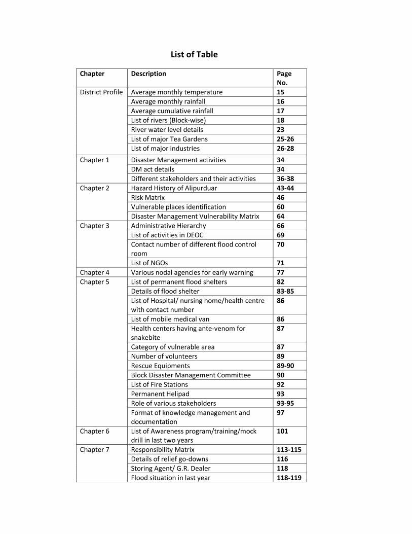
List of Table
Chapter Description Page No.
District Profile Average monthly temperature 15
Average monthly rainfall 16
Average cumulative rainfall 17
List of rivers (Block-wise) 18
River water level details 23
List of major Tea Gardens 25-26
List of major industries 26-28
Chapter 1 Disaster Management activities 34
DM act details 34
Different stakeholders and their activities 36-38
Chapter 2 Hazard History of Alipurduar 43-44
Risk Matrix 46
Vulnerable places identification 60
Disaster Management Vulnerability Matrix 64
Chapter 3 Administrative Hierarchy 66
List of activities in DEOC 69
Contact number of different flood control room
70
List of NGOs 71
Chapter 4 Various nodal agencies for early warning 77
Chapter 5 List of permanent flood shelters 82
Details of flood shelter 83-85
List of Hospital/ nursing home/health centre with contact number
86
List of mobile medical van 86
Health centers having ante-venom for snakebite
87
Category of vulnerable area 87
Number of volunteers 89
Rescue Equipments 89-90
Block Disaster Management Committee 90
List of Fire Stations 92
Permanent Helipad 93
Role of various stakeholders 93-95
Format of knowledge management and documentation
97
Chapter 6 List of Awareness program/training/mock drill in last two years
101
Chapter 7 Responsibility Matrix 113-115
Details of relief go-downs 116
Storing Agent/ G.R. Dealer 118
Flood situation in last year 118-119
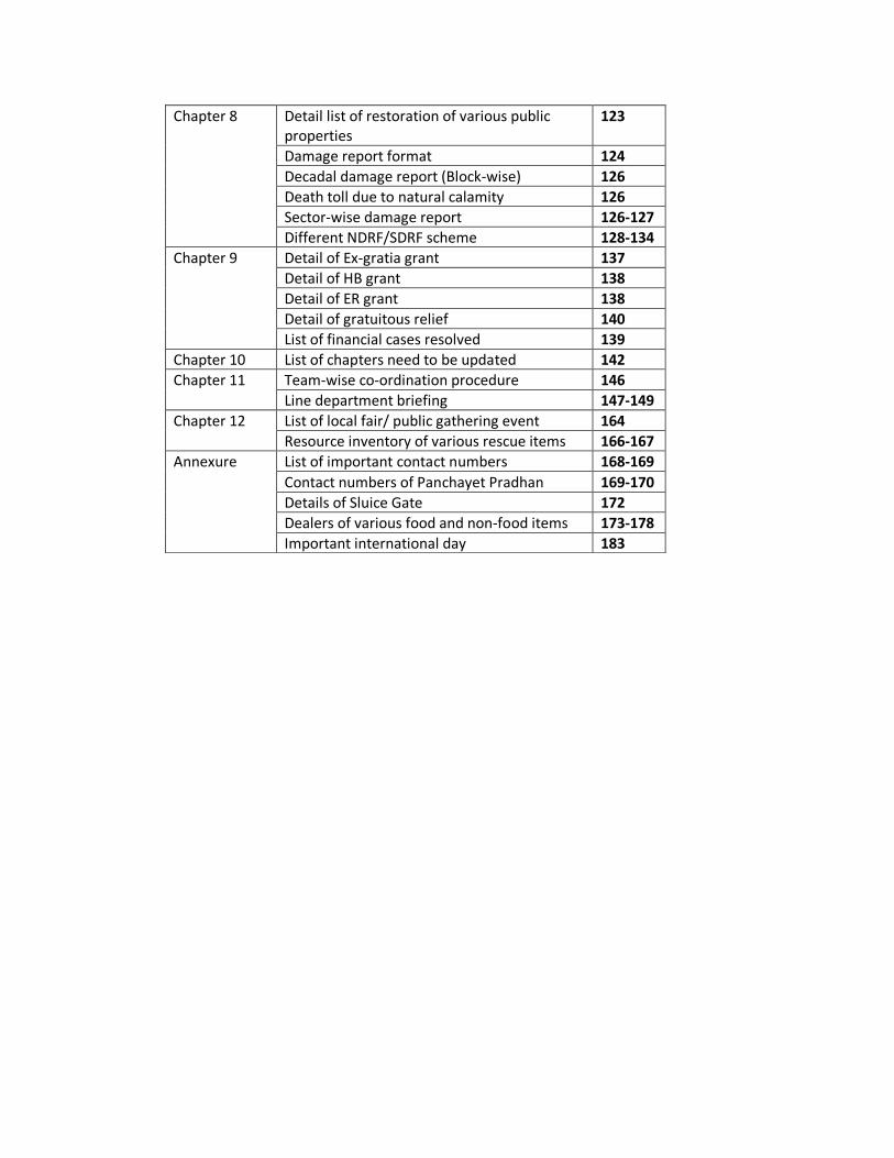
Chapter 8 Detail list of restoration of various public properties
123
Damage report format 124
Decadal damage report (Block-wise) 126
Death toll due to natural calamity 126
Sector-wise damage report 126-127
Different NDRF/SDRF scheme 128-134
Chapter 9 Detail of Ex-gratia grant 137
Detail of HB grant 138
Detail of ER grant 138
Detail of gratuitous relief 140
List of financial cases resolved 139
Chapter 10 List of chapters need to be updated 142
Chapter 11 Team-wise co-ordination procedure 146
Line department briefing 147-149
Chapter 12 List of local fair/ public gathering event 164
Resource inventory of various rescue items 166-167
Annexure List of important contact numbers 168-169
Contact numbers of Panchayet Pradhan 169-170
Details of Sluice Gate 172
Dealers of various food and non-food items 173-178
Important international day 183
1
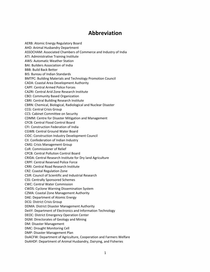
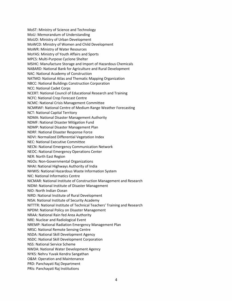
Abbreviation
AERB: Atomic Energy Regulatory Board
AHD: Animal Husbandry Department
ASSOCHAM: Associated Chambers of Commerce and Industry of India
ATI: Administrative Training Institute
AWS: Automatic Weather Station
BAI: Builders Association of India
BBB: Build Back Better
BIS: Bureau of Indian Standards
BMTPC: Building Materials and Technology Promotion Council
CADA: Coastal Area Development Authority
CAPF: Central Armed Police Forces
CAZRI: Central Arid Zone Research Institute
CBO: Community Based Organization
CBRI: Central Building Research Institute
CBRN: Chemical, Biological, Radiological and Nuclear Disaster
CCG: Central Crisis Group
CCS: Cabinet Committee on Security
CDMM: Centre for Disaster Mitigation and Management
CFCB: Central Flood Control Board
CFI: Construction Federation of India
CGWB: Central Ground Water Board
CIDC: Construction Industry Development Council
CII: Confederation of Indian Industry
CMG: Crisis Management Group
CoR: Commissioner of Relief
CPCB: Central Pollution Control Board
CRIDA: Central Research Institute for Dry land Agriculture
CRPF: Central Reserved Police Force
CRRI: Central Road Research Institute
CRZ: Coastal Regulation Zone
CSIR: Council of Scientific and Industrial Research
CSS: Centrally Sponsored Schemes
CWC: Central Water Commission
CWDS: Cyclone Warning Dissemination System
CZMA: Coastal Zone Management Authority
DAE: Department of Atomic Energy
DCG: District Crisis Group
DDMA: District Disaster Management Authority
DeitY: Department of Electronics and Information Technology
DEOC: District Emergency Operation Center
DGM: Directorates of Geology and Mining
DM: Disaster Management
DMC: Drought Monitoring Cell
DMP: Disaster Management Plan
DoACFW: Department of Agriculture, Cooperation and Farmers Welfare
DoAHDF: Department of Animal Husbandry, Dairying, and Fisheries
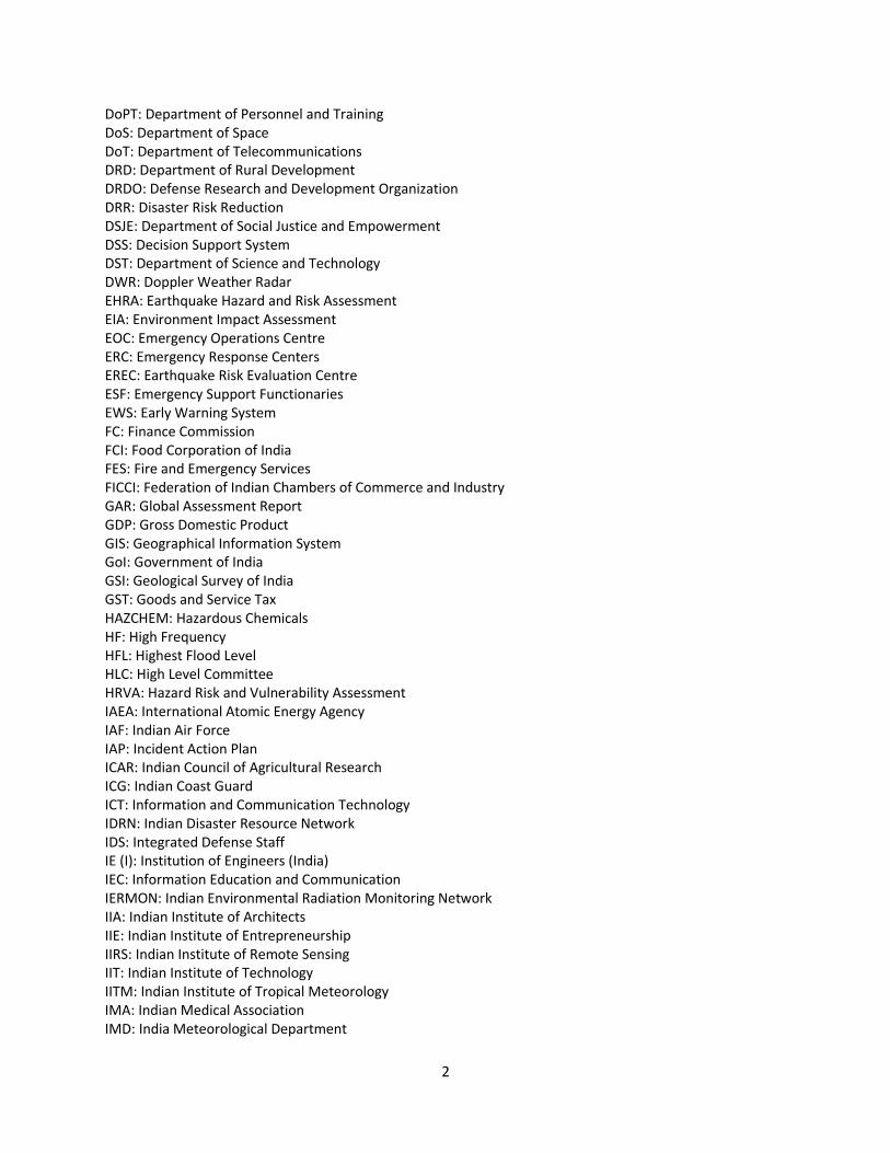
2
DoPT: Department of Personnel and Training
DoS: Department of Space
DoT: Department of Telecommunications
DRD: Department of Rural Development
DRDO: Defense Research and Development Organization
DRR: Disaster Risk Reduction
DSJE: Department of Social Justice and Empowerment
DSS: Decision Support System
DST: Department of Science and Technology
DWR: Doppler Weather Radar
EHRA: Earthquake Hazard and Risk Assessment
EIA: Environment Impact Assessment
EOC: Emergency Operations Centre
ERC: Emergency Response Centers
EREC: Earthquake Risk Evaluation Centre
ESF: Emergency Support Functionaries
EWS: Early Warning System
FC: Finance Commission
FCI: Food Corporation of India
FES: Fire and Emergency Services
FICCI: Federation of Indian Chambers of Commerce and Industry
GAR: Global Assessment Report
GDP: Gross Domestic Product
GIS: Geographical Information System
GoI: Government of India
GSI: Geological Survey of India
GST: Goods and Service Tax
HAZCHEM: Hazardous Chemicals
HF: High Frequency
HFL: Highest Flood Level
HLC: High Level Committee
HRVA: Hazard Risk and Vulnerability Assessment
IAEA: International Atomic Energy Agency
IAF: Indian Air Force
IAP: Incident Action Plan
ICAR: Indian Council of Agricultural Research
ICG: Indian Coast Guard
ICT: Information and Communication Technology
IDRN: Indian Disaster Resource Network
IDS: Integrated Defense Staff
IE (I): Institution of Engineers (India)
IEC: Information Education and Communication
IERMON: Indian Environmental Radiation Monitoring Network
IIA: Indian Institute of Architects
IIE: Indian Institute of Entrepreneurship
IIRS: Indian Institute of Remote Sensing
IIT: Indian Institute of Technology
IITM: Indian Institute of Tropical Meteorology
IMA: Indian Medical Association
IMD: India Meteorological Department
3
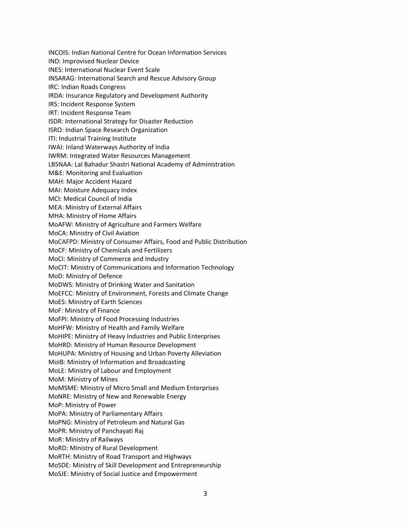
INCOIS: Indian National Centre for Ocean Information Services
IND: Improvised Nuclear Device
INES: International Nuclear Event Scale
INSARAG: International Search and Rescue Advisory Group
IRC: Indian Roads Congress
IRDA: Insurance Regulatory and Development Authority
IRS: Incident Response System
IRT: Incident Response Team
ISDR: International Strategy for Disaster Reduction
ISRO: Indian Space Research Organization
ITI: Industrial Training Institute
IWAI: Inland Waterways Authority of India
IWRM: Integrated Water Resources Management
LBSNAA: Lal Bahadur Shastri National Academy of Administration
M&E: Monitoring and Evaluation
MAH: Major Accident Hazard
MAI: Moisture Adequacy Index
MCI: Medical Council of India
MEA: Ministry of External Affairs
MHA: Ministry of Home Affairs
MoAFW: Ministry of Agriculture and Farmers Welfare
MoCA: Ministry of Civil Aviation
MoCAFPD: Ministry of Consumer Affairs, Food and Public Distribution
MoCF: Ministry of Chemicals and Fertilizers
MoCI: Ministry of Commerce and Industry
MoCIT: Ministry of Communications and Information Technology
MoD: Ministry of Defence
MoDWS: Ministry of Drinking Water and Sanitation
MoEFCC: Ministry of Environment, Forests and Climate Change
MoES: Ministry of Earth Sciences
MoF: Ministry of Finance
MoFPI: Ministry of Food Processing Industries
MoHFW: Ministry of Health and Family Welfare
MoHIPE: Ministry of Heavy Industries and Public Enterprises
MoHRD: Ministry of Human Resource Development
MoHUPA: Ministry of Housing and Urban Poverty Alleviation
MoIB: Ministry of Information and Broadcasting
MoLE: Ministry of Labour and Employment
MoM: Ministry of Mines
MoMSME: Ministry of Micro Small and Medium Enterprises
MoNRE: Ministry of New and Renewable Energy
MoP: Ministry of Power
MoPA: Ministry of Parliamentary Affairs
MoPNG: Ministry of Petroleum and Natural Gas
MoPR: Ministry of Panchayati Raj
MoR: Ministry of Railways
MoRD: Ministry of Rural Development
MoRTH: Ministry of Road Transport and Highways
MoSDE: Ministry of Skill Development and Entrepreneurship
MoSJE: Ministry of Social Justice and Empowerment
4
MoST: Ministry of Science and Technology
MoU: Memorandum of Understanding
MoUD: Ministry of Urban Development
MoWCD: Ministry of Women and Child Development
MoWR: Ministry of Water Resources
MoYAS: Ministry of Youth Affairs and Sports
MPCS: Multi-Purpose Cyclone Shelter
MSIHC: Manufacture Storage and Import of Hazardous Chemicals
NABARD: National Bank for Agriculture and Rural Development
NAC: National Academy of Construction
NATMO: National Atlas and Thematic Mapping Organization
NBCC: National Buildings Construction Corporation
NCC: National Cadet Corps
NCERT: National Council of Educational Research and Training
NCFC: National Crop Forecast Centre
NCMC: National Crisis Management Committee
NCMRWF: National Centre of Medium Range Weather Forecasting
NCT: National Capital Territory
NDMA: National Disaster Management Authority
NDMF: National Disaster Mitigation Fund
NDMP: National Disaster Management Plan
NDRF: National Disaster Response Force
NDVI: Normalized Differential Vegetation Index
NEC: National Executive Committee
NECN: National Emergency Communication Network
NEOC: National Emergency Operations Center
NER: North East Region
NGOs: Non-Governmental Organizations
NHAI: National Highways Authority of India
NHWIS: National Hazardous Waste Information System
NIC: National Informatics Centre
NICMAR: National Institute of Construction Management and Research
NIDM: National Institute of Disaster Management
NIO: North Indian Ocean
NIRD: National Institute of Rural Development
NISA: National Institute of Security Academy
NITTTR: National Institute of Technical Teachers' Training and Research
NPDM: National Policy on Disaster Management
NRAA: National Rain fed Area Authority
NRE: Nuclear and Radiological Event
NREMP: National Radiation Emergency Management Plan
NRSC: National Remote Sensing Centre
NSDA: National Skill Development Agency
NSDC: National Skill Development Corporation
NSS: National Service Scheme
NWDA: National Water Development Agency
NYKS: Nehru Yuvak Kendra Sangathan
O&M: Operation and Maintenance
PRD: Panchayati Raj Department
PRIs: Panchayati Raj Institutions
5
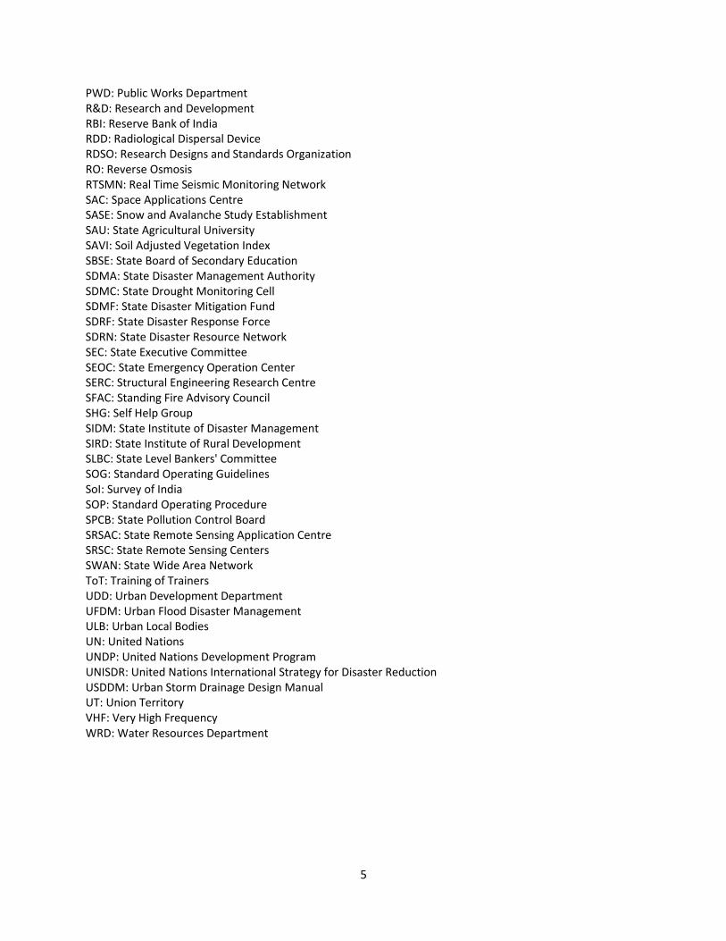
PWD: Public Works Department
R&D: Research and Development
RBI: Reserve Bank of India
RDD: Radiological Dispersal Device
RDSO: Research Designs and Standards Organization
RO: Reverse Osmosis
RTSMN: Real Time Seismic Monitoring Network
SAC: Space Applications Centre
SASE: Snow and Avalanche Study Establishment
SAU: State Agricultural University
SAVI: Soil Adjusted Vegetation Index
SBSE: State Board of Secondary Education
SDMA: State Disaster Management Authority
SDMC: State Drought Monitoring Cell
SDMF: State Disaster Mitigation Fund
SDRF: State Disaster Response Force
SDRN: State Disaster Resource Network
SEC: State Executive Committee
SEOC: State Emergency Operation Center
SERC: Structural Engineering Research Centre
SFAC: Standing Fire Advisory Council
SHG: Self Help Group
SIDM: State Institute of Disaster Management
SIRD: State Institute of Rural Development
SLBC: State Level Bankers' Committee
SOG: Standard Operating Guidelines
SoI: Survey of India
SOP: Standard Operating Procedure
SPCB: State Pollution Control Board
SRSAC: State Remote Sensing Application Centre
SRSC: State Remote Sensing Centers
SWAN: State Wide Area Network
ToT: Training of Trainers
UDD: Urban Development Department
UFDM: Urban Flood Disaster Management
ULB: Urban Local Bodies
UN: United Nations
UNDP: United Nations Development Program
UNISDR: United Nations International Strategy for Disaster Reduction
USDDM: Urban Storm Drainage Design Manual
UT: Union Territory
VHF: Very High Frequency
WRD: Water Resources Department
6
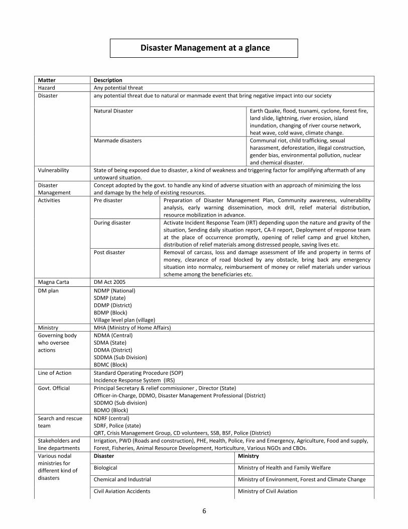
Matter Description
Hazard Any potential threat
Disaster any potential threat due to natural or manmade event that bring negative impact into our society
Natural Disaster Earth Quake, flood, tsunami, cyclone, forest fire,
land slide, lightning, river erosion, island
inundation, changing of river course network,
heat wave, cold wave, climate change.
Manmade disasters Communal riot, child trafficking, sexual
harassment, deforestation, illegal construction,
gender bias, environmental pollution, nuclear
and chemical disaster.
Vulnerability State of being exposed due to disaster, a kind of weakness and triggering factor for amplifying aftermath of any
untoward situation.
Disaster
Management
Concept adopted by the govt. to handle any kind of adverse situation with an approach of minimizing the loss
and damage by the help of existing resources.
Activities Pre disaster Preparation of Disaster Management Plan, Community awareness, vulnerability
analysis, early warning dissemination, mock drill, relief material distribution,
resource mobilization in advance.
During disaster Activate Incident Response Team (IRT) depending upon the nature and gravity of the
situation, Sending daily situation report, CA-II report, Deployment of response team
at the place of occurrence promptly, opening of relief camp and gruel kitchen,
distribution of relief materials among distressed people, saving lives etc.
Post disaster Removal of carcass, loss and damage assessment of life and property in terms of
money, clearance of road blocked by any obstacle, bring back any emergency
situation into normalcy, reimbursement of money or relief materials under various
scheme among the beneficiaries etc.
Magna Carta DM Act 2005
DM plan NDMP (National)
SDMP (state)
DDMP (District)
BDMP (Block)
Village level plan (village)
Ministry MHA (Ministry of Home Affairs)
Governing body
who oversee
actions
NDMA (Central)
SDMA (State)
DDMA (District)
SDDMA (Sub Division)
BDMC (Block)
Line of Action Standard Operating Procedure (SOP)
Incidence Response System (IRS)
Govt. Official Principal Secretary & relief commissioner , Director (State)
Officer-in-Charge, DDMO, Disaster Management Professional (District)
SDDMO (Sub division)
BDMO (Block)
Search and rescue
team
NDRF (central)
SDRF, Police (state)
QRT, Crisis Management Group, CD volunteers, SSB, BSF, Police (District)
Stakeholders and
line departments
Irrigation, PWD (Roads and construction), PHE, Health, Police, Fire and Emergency, Agriculture, Food and supply,
Forest, Fisheries, Animal Resource Development, Horticulture, Various NGOs and CBOs.
Various nodal
ministries for
different kind of
disasters
Disaster Ministry
Biological Ministry of Health and Family Welfare
Chemical and Industrial Ministry of Environment, Forest and Climate Change
Civil Aviation Accidents Ministry of Civil Aviation
Disaster Management at a glance
7
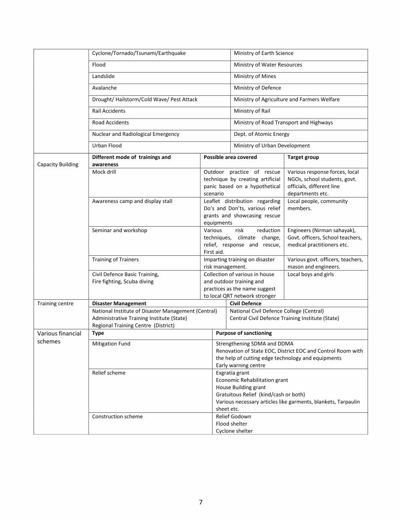
Cyclone/Tornado/Tsunami/Earthquake Ministry of Earth Science
Flood Ministry of Water Resources
Landslide Ministry of Mines
Avalanche Ministry of Defence
Drought/ Hailstorm/Cold Wave/ Pest Attack Ministry of Agriculture and Farmers Welfare
Rail Accidents Ministry of Rail
Road Accidents Ministry of Road Transport and Highways
Nuclear and Radiological Emergency Dept. of Atomic Energy
Urban Flood Ministry of Urban Development
Capacity Building
Different mode of trainings and
awareness
Possible area covered Target group
Mock drill Outdoor practice of rescue
technique by creating artificial
panic based on a hypothetical
scenario
Various response forces, local
NGOs, school students, govt.
officials, different line
departments etc.
Awareness camp and display stall Leaflet distribution regarding
Do’s and Don’ts, various relief
grants and showcasing rescue
equipments
Local people, community
members.
Seminar and workshop Various risk reduction
techniques, climate change,
relief, response and rescue,
First aid.
Engineers (Nirman sahayak),
Govt. officers, School teachers,
medical practitioners etc.
Training of Trainers Imparting training on disaster
risk management.
Various govt. officers, teachers,
mason and engineers.
Civil Defence Basic Training,
Fire fighting, Scuba diving
Collection of various in house
and outdoor training and
practices as the name suggest
to local QRT network stronger
Local boys and girls
Training centre Disaster Management Civil Defence
National Institute of Disaster Management (Central)
Administrative Training Institute (State)
Regional Training Centre (District)
National Civil Defence College (Central)
Central Civil Defence Training Institute (State)
Various financial
schemes
Type Purpose of sanctioning
Mitigation Fund Strengthening SDMA and DDMA
Renovation of State EOC, District EOC and Control Room with
the help of cutting edge technology and equipments
Early warning centre
Relief scheme Exgratia grant
Economic Rehabilitation grant
House Building grant
Gratuitous Relief (kind/cash or both)
Various necessary articles like garments, blankets, Tarpaulin
sheet etc.
Construction scheme Relief Godown
Flood shelter
Cyclone shelter
8
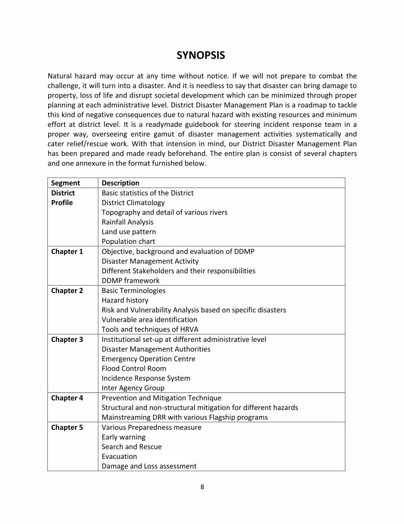
SYNOPSIS
Natural hazard may occur at any time without notice. If we will not prepare to combat the
challenge, it will turn into a disaster. And it is needless to say that disaster can bring damage to
property, loss of life and disrupt societal development which can be minimized through proper
planning at each administrative level. District Disaster Management Plan is a roadmap to tackle
this kind of negative consequences due to natural hazard with existing resources and minimum
effort at district level. It is a readymade guidebook for steering incident response team in a
proper way, overseeing entire gamut of disaster management activities systematically and
cater relief/rescue work. With that intension in mind, our District Disaster Management Plan
has been prepared and made ready beforehand. The entire plan is consist of several chapters
and one annexure in the format furnished below.
Segment Description
District
Profile
Basic statistics of the District
District Climatology
Topography and detail of various rivers
Rainfall Analysis
Land use pattern
Population chart
Chapter 1 Objective, background and evaluation of DDMP
Disaster Management Activity
Different Stakeholders and their responsibilities
DDMP framework
Chapter 2 Basic Terminologies
Hazard history
Risk and Vulnerability Analysis based on specific disasters
Vulnerable area identification
Tools and techniques of HRVA
Chapter 3 Institutional set-up at different administrative level
Disaster Management Authorities
Emergency Operation Centre
Flood Control Room
Incidence Response System
Inter Agency Group
Chapter 4 Prevention and Mitigation Technique
Structural and non-structural mitigation for different hazards
Mainstreaming DRR with various Flagship programs
Chapter 5 Various Preparedness measure
Early warning
Search and Rescue
Evacuation
Damage and Loss assessment
9
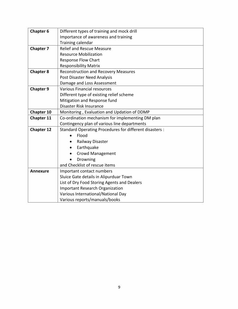
Chapter 6 Different types of training and mock drill
Importance of awareness and training
Training calendar
Chapter 7 Relief and Rescue Measure
Resource Mobilization
Response Flow Chart
Responsibility Matrix
Chapter 8 Reconstruction and Recovery Measures
Post Disaster Need Analysis
Damage and Loss Assessment
Chapter 9 Various Financial resources
Different type of existing relief scheme
Mitigation and Response fund
Disaster Risk Insurance
Chapter 10 Monitoring , Evaluation and Updation of DDMP
Chapter 11 Co-ordination mechanism for implementing DM plan
Contingency plan of various line departments
Chapter 12 Standard Operating Procedures for different disasters :
Flood
Railway Disaster
Earthquake
Crowd Management
Drowning
and Checklist of rescue items
Annexure Important contact numbers
Sluice Gate details in Alipurduar Town
List of Dry Food Storing Agents and Dealers
Important Research Organization
Various International/National Day
Various reports/manuals/books
10
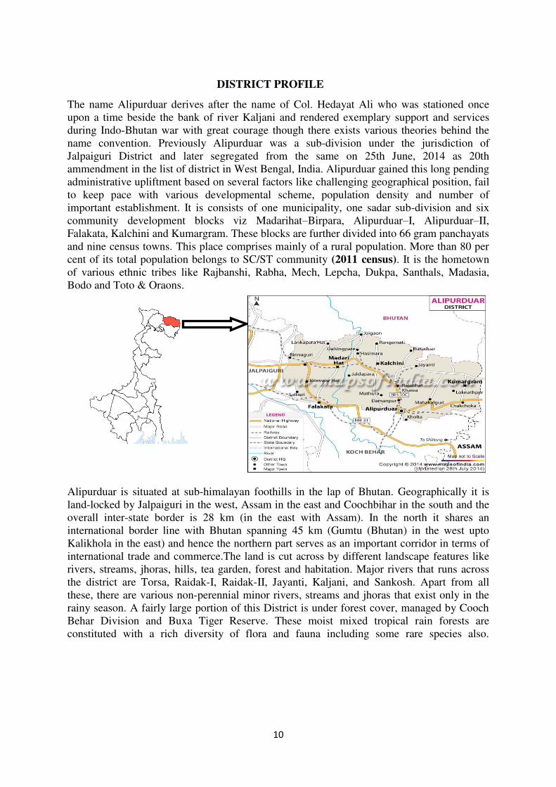
DISTRICT PROFILE
The name Alipurduar derives after the name of Col. Hedayat Ali who was stationed once
upon a time beside the bank of river Kaljani and rendered exemplary support and services
during Indo-Bhutan war with great courage though there exists various theories behind the
name convention. Previously Alipurduar was a sub-division under the jurisdiction of
Jalpaiguri District and later segregated from the same on 25th June, 2014 as 20th
ammendment in the list of district in West Bengal, India. Alipurduar gained this long pending
administrative upliftment based on several factors like challenging geographical position, fail
to keep pace with various developmental scheme, population density and number of
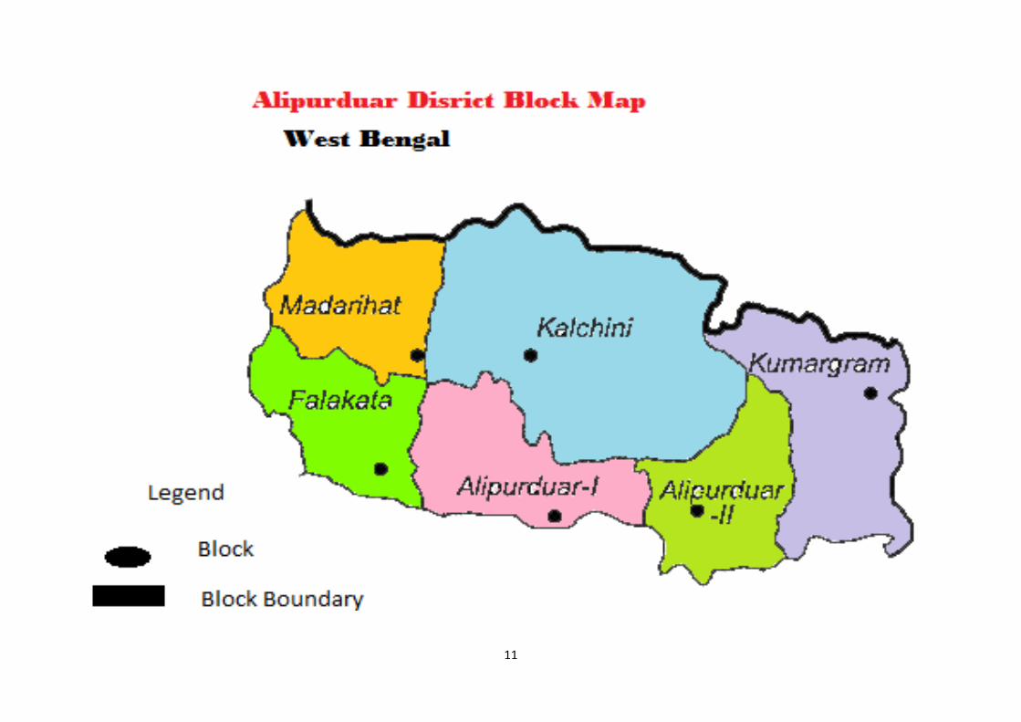
important establishment. It is consists of one municipality, one sadar sub-division and six
community development blocks viz Madarihat–Birpara, Alipurduar–I, Alipurduar–II,
Falakata, Kalchini and Kumargram. These blocks are further divided into 66 gram panchayats
and nine census towns. This place comprises mainly of a rural population. More than 80 per
cent of its total population belongs to SC/ST community (2011 census). It is the hometown
of various ethnic tribes like Rajbanshi, Rabha, Mech, Lepcha, Dukpa, Santhals, Madasia,
Bodo and Toto & Oraons.
Alipurduar is situated at sub-himalayan foothills in the lap of Bhutan. Geographically it is
land-locked by Jalpaiguri in the west, Assam in the east and Coochbihar in the south and the
overall inter-state border is 28 km (in the east with Assam). In the north it shares an
international border line with Bhutan spanning 45 km (Gumtu (Bhutan) in the west upto
Kalikhola in the east) and hence the northern part serves as an important corridor in terms of
international trade and commerce.The land is cut across by different landscape features like
rivers, streams, jhoras, hills, tea garden, forest and habitation. Major rivers that runs across
the district are Torsa, Raidak-I, Raidak-II, Jayanti, Kaljani, and Sankosh. Apart from all
these, there are various non-perennial minor rivers, streams and jhoras that exist only in the
rainy season. A fairly large portion of this District is under forest cover, managed by Cooch
Behar Division and Buxa Tiger Reserve. These moist mixed tropical rain forests are
constituted with a rich diversity of flora and fauna including some rare species also.
11
12
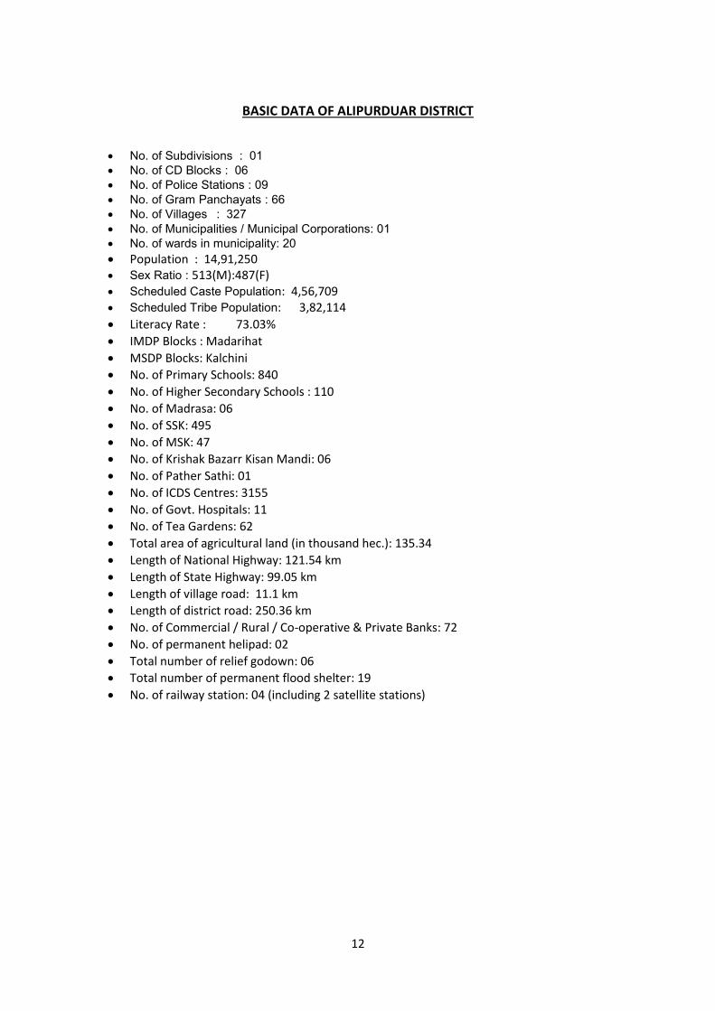
BASIC DATA OF ALIPURDUAR DISTRICT
No. of Subdivisions : 01
No. of CD Blocks : 06
No. of Police Stations : 09
No. of Gram Panchayats : 66
No. of Villages : 327
No. of Municipalities / Municipal Corporations: 01
No. of wards in municipality: 20
Population : 14,91,250
Sex Ratio : 513(M):487(F)
Scheduled Caste Population: 4,56,709
Scheduled Tribe Population: 3,82,114
Literacy Rate : 73.03%
IMDP Blocks : Madarihat
MSDP Blocks: Kalchini
No. of Primary Schools: 840
No. of Higher Secondary Schools : 110
No. of Madrasa: 06
No. of SSK: 495
No. of MSK: 47
No. of Krishak Bazarr Kisan Mandi: 06
No. of Pather Sathi: 01
No. of ICDS Centres: 3155
No. of Govt. Hospitals: 11
No. of Tea Gardens: 62
Total area of agricultural land (in thousand hec.): 135.34
Length of National Highway: 121.54 km
Length of State Highway: 99.05 km
Length of village road: 11.1 km
Length of district road: 250.36 km
No. of Commercial / Rural / Co-operative & Private Banks: 72
No. of permanent helipad: 02
Total number of relief godown: 06
Total number of permanent flood shelter: 19
No. of railway station: 04 (including 2 satellite stations)
13
Geography and climate
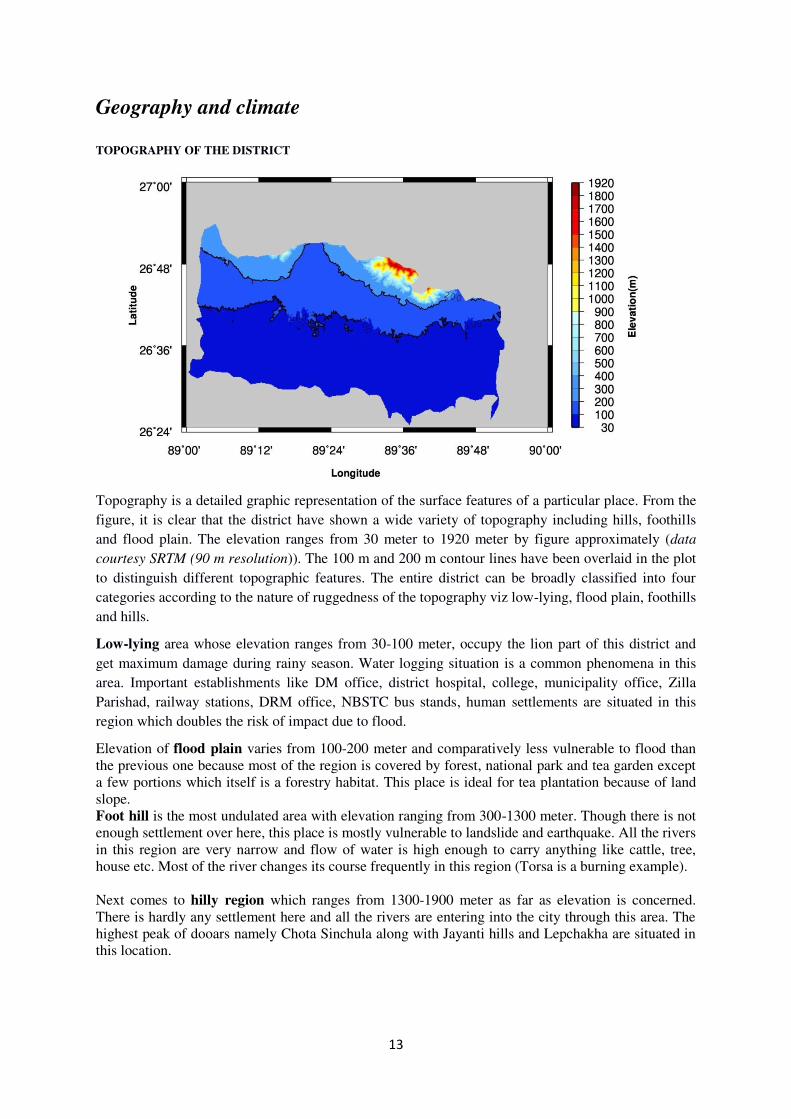
TOPOGRAPHY OF THE DISTRICT
Topography is a detailed graphic representation of the surface features of a particular place. From the
figure, it is clear that the district have shown a wide variety of topography including hills, foothills
and flood plain. The elevation ranges from 30 meter to 1920 meter by figure approximately (data
courtesy SRTM (90 m resolution)). The 100 m and 200 m contour lines have been overlaid in the plot
to distinguish different topographic features. The entire district can be broadly classified into four
categories according to the nature of ruggedness of the topography viz low-lying, flood plain, foothills
and hills.
Low-lying area whose elevation ranges from 30-100 meter, occupy the lion part of this district and
get maximum damage during rainy season. Water logging situation is a common phenomena in this
area. Important establishments like DM office, district hospital, college, municipality office, Zilla
Parishad, railway stations, DRM office, NBSTC bus stands, human settlements are situated in this
region which doubles the risk of impact due to flood.
Elevation of flood plain varies from 100-200 meter and comparatively less vulnerable to flood than
the previous one because most of the region is covered by forest, national park and tea garden except
a few portions which itself is a forestry habitat. This place is ideal for tea plantation because of land
slope.
Foot hill is the most undulated area with elevation ranging from 300-1300 meter. Though there is not
enough settlement over here, this place is mostly vulnerable to landslide and earthquake. All the rivers
in this region are very narrow and flow of water is high enough to carry anything like cattle, tree,
house etc. Most of the river changes its course frequently in this region (Torsa is a burning example).
Next comes to hilly region which ranges from 1300-1900 meter as far as elevation is concerned.
There is hardly any settlement here and all the rivers are entering into the city through this area. The
highest peak of dooars namely Chota Sinchula along with Jayanti hills and Lepchakha are situated in
this location.
14
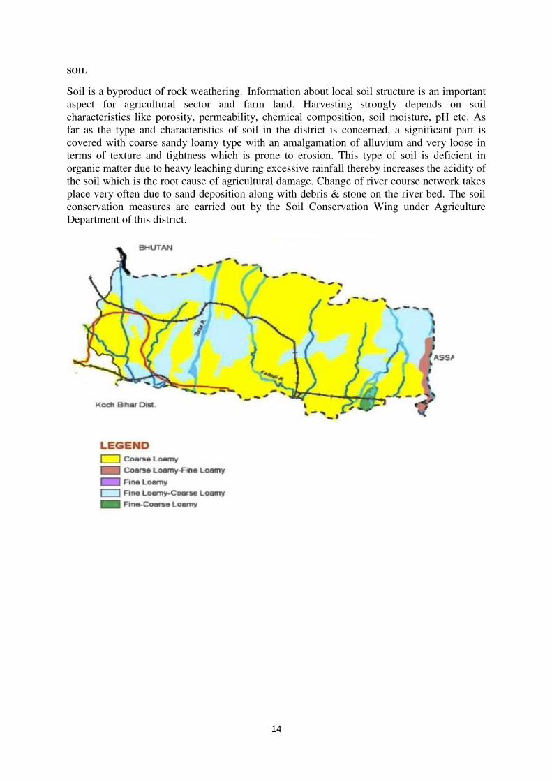
SOIL
Soil is a byproduct of rock weathering. Information about local soil structure is an important
aspect for agricultural sector and farm land. Harvesting strongly depends on soil
characteristics like porosity, permeability, chemical composition, soil moisture, pH etc. As
far as the type and characteristics of soil in the district is concerned, a significant part is
covered with coarse sandy loamy type with an amalgamation of alluvium and very loose in
terms of texture and tightness which is prone to erosion. This type of soil is deficient in
organic matter due to heavy leaching during excessive rainfall thereby increases the acidity of
the soil which is the root cause of agricultural damage. Change of river course network takes
place very often due to sand deposition along with debris & stone on the river bed. The soil
conservation measures are carried out by the Soil Conservation Wing under Agriculture
Department of this district.
15
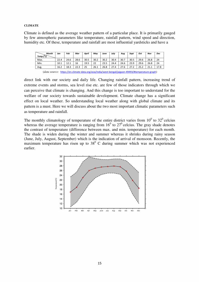
CLIMATE
Climate is defined as the average weather pattern of a particular place. It is primarily gauged
by few atmospheric parameters like temperature, rainfall pattern, wind speed and direction,
humidity etc. Of these, temperature and rainfall are most influential yardsticks and have a
(data source: https://en.climate-data.org/asia/india/west-bengal/jaigaon-49493/#temperature-graph)
direct link with our society and daily life. Changing rainfall pattern, increasing trend of
extreme events and storms, sea level rise etc. are few of those indicators through which we
can perceive that climate is changing. And this change is too important to understand for the
welfare of our society towards sustainable development. Climate change has a significant
effect on local weather. So understanding local weather along with global climate and its
pattern is a must. Here we will discuss about the two most important climatic parameters such
as temperature and rainfall.
The monthly climatology of temperature of the entire district varies from 100 to 32
0 celcius
whereas the average temperature is ranging from 160 to 27
0 celcius. The gray shade denotes
the contrast of temperature (difference between max. and min. temperature) for each month.
The shade is widen during the winter and summer whereas it shrinks during rainy season
(June, July, August, September) which is the indication of arrival of monsoon. Recently, the
maximum temperature has risen up to 380 C during summer which was not experienced
earlier.
Month
Temp.(0C)
Jan Feb Mar April May June July Aug Sept Oct Nov Dec
Max. 22.4 24.6 28.6 30.5 30.2 30.2 30.4 30.7 30.5 29.6 26.8 24
Min. 10.1 12.1 16 19.5 22 23.5 24.4 24.6 23.9 29.6 26.8 24
Avg. 16.2 18.3 22.3 25 26.1 26.8 27.4 27.6 27.2 25.2 21.1 17.8
16
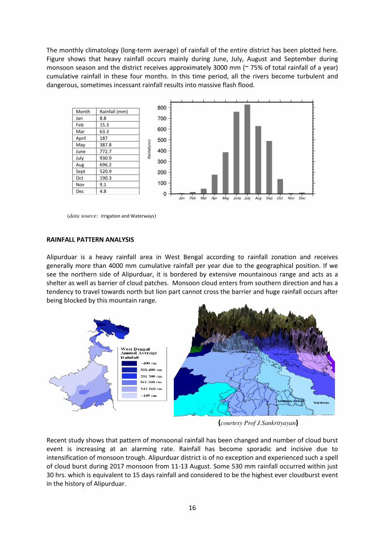
The monthly climatology (long-term average) of rainfall of the entire district has been plotted here.
Figure shows that heavy rainfall occurs mainly during June, July, August and September during
monsoon season and the district receives approximately 3000 mm (~ 75% of total rainfall of a year)
cumulative rainfall in these four months. In this time period, all the rivers become turbulent and
dangerous, sometimes incessant rainfall results into massive flash flood.
(data source: Irrigation and Waterways)
RAINFALL PATTERN ANALYSIS
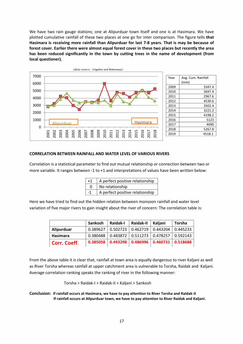
Alipurduar is a heavy rainfall area in West Bengal according to rainfall zonation and receives
generally more than 4000 mm cumulative rainfall per year due to the geographical position. If we
see the northern side of Alipurduar, it is bordered by extensive mountainous range and acts as a
shelter as well as barrier of cloud patches. Monsoon cloud enters from southern direction and has a
tendency to travel towards north but lion part cannot cross the barrier and huge rainfall occurs after
being blocked by this mountain range.
(courtesy Prof J.Sankrityayan)
Recent study shows that pattern of monsoonal rainfall has been changed and number of cloud burst
event is increasing at an alarming rate. Rainfall has become sporadic and incisive due to
intensification of monsoon trough. Alipurduar district is of no exception and experienced such a spell
of cloud burst during 2017 monsoon from 11-13 August. Some 530 mm rainfall occurred within just
30 hrs. which is equivalent to 15 days rainfall and considered to be the highest ever cloudburst event
in the history of Alipurduar.
Month Rainfall (mm)
Jan 8.8
Feb 15.3
Mar 63.3
April 187
May 387.8
June 772.7
July 930.9
Aug 696.2
Sept 520.9
Oct 190.3
Nov 9.1
Dec 4.8
17
We have two rain gauge stations; one at Alipurduar town itself and one is at Hasimara. We have
plotted cumulative rainfall of these two places at one go for inter comparison. The figure tells that
Hasimara is receiving more rainfall than Alipurduar for last 7-8 years. That is may be because of
forest cover. Earlier there were almost equal forest cover in these two places but recently the area
has been reduced significantly in the town by cutting trees in the name of development (from
local questioner).
(data source: Irrigation and Waterways)
CORRELATION BETWEEN RAINFALL AND WATER LEVEL OF VARIOUS RIVERS
Correlation is a statistical parameter to find out mutual relationship or connection between two or
more variable. It ranges between -1 to +1 and interpretations of values have been written below:
Here we have tried to find out the hidden relation between monsoon rainfall and water level
variation of five major rivers to gain insight about the river of concern: The correlation table is:
From the above table it is clear that, rainfall at town area is equally dangerous to river Kaljani as well
as River Torsha whereas rainfall at upper catchment area is vulnerable to Torsha, Raidak and Kaljani.
Average correlation ranking speaks the ranking of river in the following manner:
Torsha > Raidak-I > Raidak-II > Kaljani > Sankosh
Conclusion: If rainfall occurs at Hasimara, we have to pay attention to River Torsha and Raidak-II
If rainfall occurs at Alipurduar town, we have to pay attention to River Raidak and Kaljani.
0
1000
2000
3000
4000
5000
6000
7000
20
01
20
02
20
03
20
04
20
05
20
06
20
07
20
08
20
09
20
10
20
11
20
12
20
13
20
14
20
15
20
16
20
17
20
18
Alipurduar Hasimara
Year Avg. Cum. Rainfall
(mm)
2009 3347.4
2010 3697.4
2011 2967.6
2012 4530.6
2013 3502.4
2014 3221.2
2015 4198.2
2016 5123
2017 4090
2018 5267.8
2019 4518.1
+1 A perfect positive relationship
0 No relationship
-1 A perfect positive relationship
Sankosh Raidak-I Raidak-II Kaljani Torsha
Alipurduar 0.389627 0.502723 0.462719 0.443204 0.445233
Hasimara 0.380488 0.483872 0.511273 0.478257 0.592143
Corr. Coeff. 0.385058 0.493298 0.486996 0.460731 0.518688
18
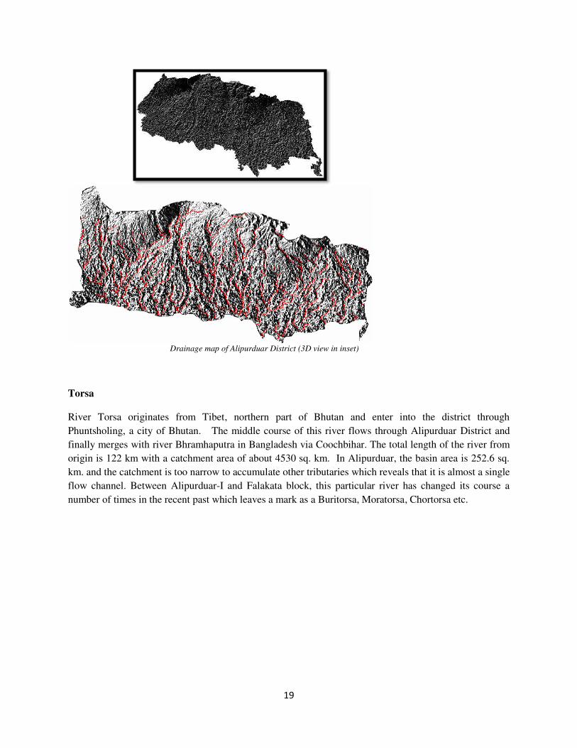
RIVERS
Alipurduar is a riverine district and numerous rivulet/jhoras are scattered here and there throughout the
district. A blockwise list has been prepared and written below.
Among all the mentioned rivers, Kaljani, Rydak, Torsa and Sankosh are the most influential and
devastating in terms of flood/flash flood. Any natural changes of these rivers like river course network
shifting, river bed rising, erosion etc. or disturbances like embankment and guard wall breaching have an
immense effect into the society. Apart from these, there are various minor rivers, streams and tributaries
which run across the district, has been shown below as drainage map. All these small streams are non-
perennial and appear only in the rainy season when they become rogue and turbulent enough to overtop
the banks. Due to the lack of proper information like streamline and channel geometry of those small
tributaries, we will concentrate only on these four major rivers. The catchment area and streamline
structure has been derived by the help of an open source GIS tool (GRASS GIS). The basin area is
calculated only in the district and hence the end of the basin or streamline should not be interpreted as the
end of the entire river.
Block Rivers
Madarihat Mujnai, Titi, Pugli, Howri, Dimdima
Falakata Mujnai, Dudua, Birkiti, Chor Torsa, Buri
Torsa
Kalchini Pana, Basra, Gobarjyoti, Jogi Khola, Kali
Jhora, Fagu Dhuba Jhora, Torsa.
Alipurduar-I Sishamara, Siltorsa, Chartorsa, Buritorsa,
Sanjay, Nonai, Dima, Kaljani.
Alipurduar-II Nonai, Gadadhar, Jayanti, Dharsi, Cheko,
Rydak-I, Haribhanga.
Kumargram Rydak-I, Rydak-II, Sankosh
19
Drainage map of Alipurduar District (3D view in inset)
Torsa
River Torsa originates from Tibet, northern part of Bhutan and enter into the district through
Phuntsholing, a city of Bhutan. The middle course of this river flows through Alipurduar District and
finally merges with river Bhramhaputra in Bangladesh via Coochbihar. The total length of the river from
origin is 122 km with a catchment area of about 4530 sq. km. In Alipurduar, the basin area is 252.6 sq.
km. and the catchment is too narrow to accumulate other tributaries which reveals that it is almost a single
flow channel. Between Alipurduar-I and Falakata block, this particular river has changed its course a
number of times in the recent past which leaves a mark as a Buritorsa, Moratorsa, Chortorsa etc.
20
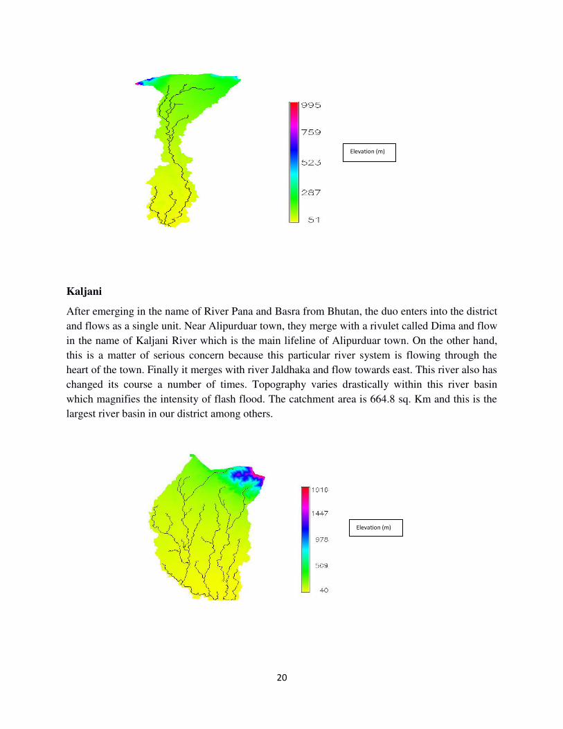
Kaljani
After emerging in the name of River Pana and Basra from Bhutan, the duo enters into the district
and flows as a single unit. Near Alipurduar town, they merge with a rivulet called Dima and flow
in the name of Kaljani River which is the main lifeline of Alipurduar town. On the other hand,
this is a matter of serious concern because this particular river system is flowing through the
heart of the town. Finally it merges with river Jaldhaka and flow towards east. This river also has
changed its course a number of times. Topography varies drastically within this river basin
which magnifies the intensity of flash flood. The catchment area is 664.8 sq. Km and this is the
largest river basin in our district among others.
Elevation (m)
Elevation (m)
21
Jayanti-Gadadhar
Jayanti River is a sinuous river flowing through the Buxa forest. The river emerges from the lap of a hill
bearing same name at Bhutan and flows all the way down to Alipurduar. It usually remains dry
throughout the year except monsoons when it gushes with cool sparkling water. Once upon a time this
particular river was the lifeline of Kalchini block but now-a-days it has become too narrow to carry water
and looks like a drain. The pattern of changing this particular river course network is a matter of debate.
But recent study reveals that excessive sand and pebble mining may be the root cause of this. This place
is famous for its scenic beauty and every year is flooded with tourists from different corner.
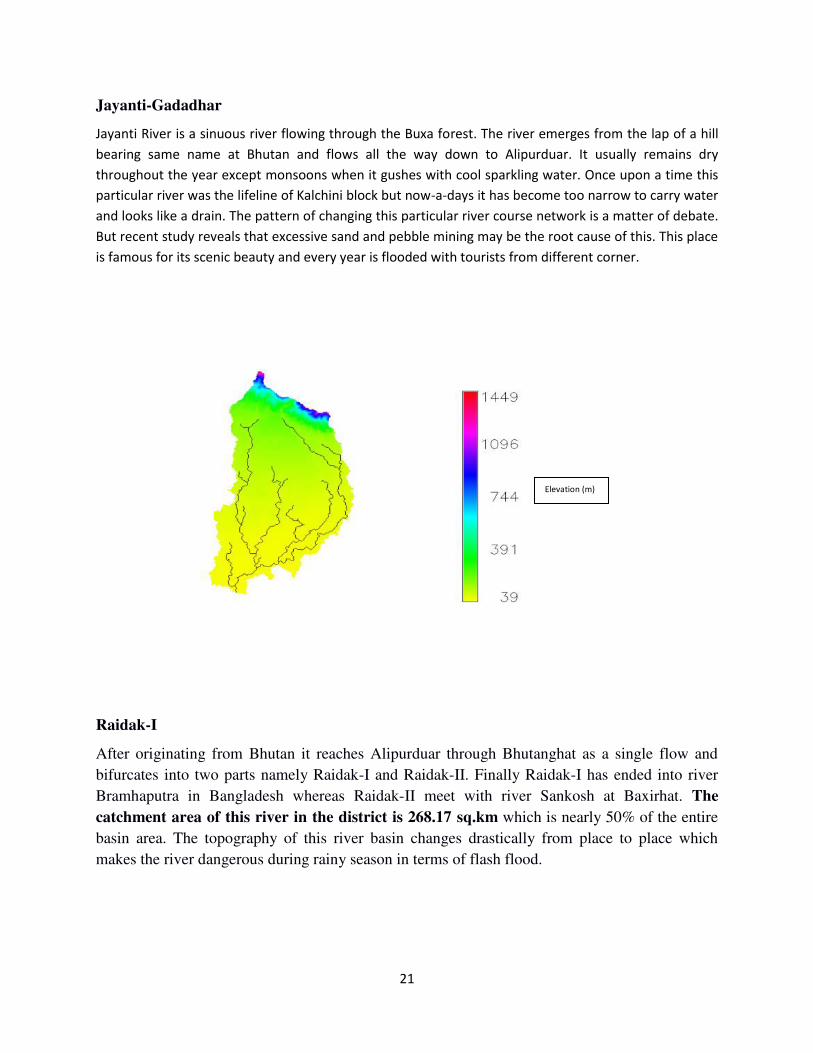
Raidak-I
After originating from Bhutan it reaches Alipurduar through Bhutanghat as a single flow and
bifurcates into two parts namely Raidak-I and Raidak-II. Finally Raidak-I has ended into river
Bramhaputra in Bangladesh whereas Raidak-II meet with river Sankosh at Baxirhat. The
catchment area of this river in the district is 268.17 sq.km which is nearly 50% of the entire
basin area. The topography of this river basin changes drastically from place to place which
makes the river dangerous during rainy season in terms of flash flood.
Elevation (m)
22
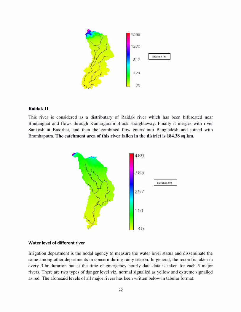
Raidak-II
This river is considered as a distributary of Raidak river which has been bifurcated near
Bhutanghat and flows through Kumargaram Block straightaway. Finally it merges with river
Sankosh at Baxirhat, and then the combined flow enters into Bangladesh and joined with
Bramhaputra. The catchment area of this river fallen in the district is 184.38 sq.km.
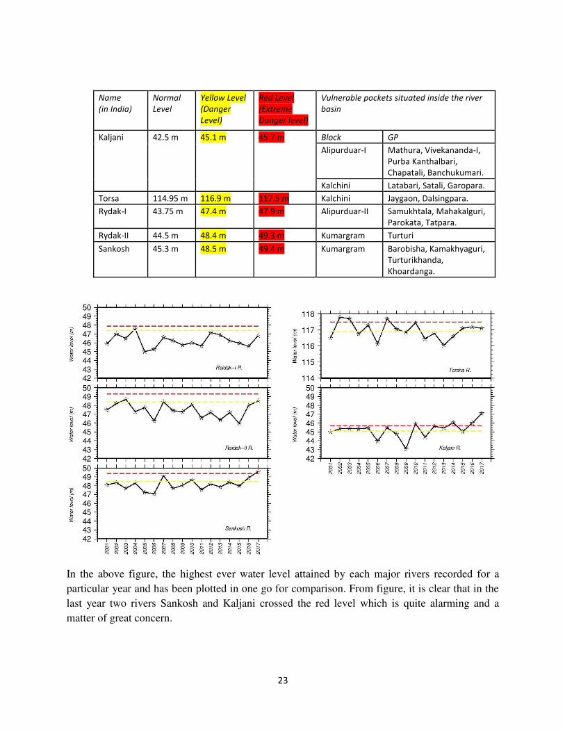
Water level of different river
Irrigation department is the nodal agency to measure the water level status and disseminate the
same among other departments in concern during rainy season. In general, the record is taken in
every 3-hr durarion but at the time of emergency hourly data data is taken for each 5 major
rivers. There are two types of danger level viz, normal signalled as yellow and extreme signalled
as red. The aforesaid levels of all major rivers has been written below in tabular format:
Elevation (m)
Elevation (m)
23
Name
(in India)
Normal
Level
Yellow Level
(Danger
Level)
Red Level
(Extreme
Danger level)
Vulnerable pockets situated inside the river
basin
Kaljani 42.5 m 45.1 m 45.7 m Block GP
Alipurduar-I Mathura, Vivekananda-I,
Purba Kanthalbari,
Chapatali, Banchukumari.
Kalchini Latabari, Satali, Garopara.
Torsa 114.95 m 116.9 m 117.5 m Kalchini Jaygaon, Dalsingpara.
Rydak-I 43.75 m 47.4 m 47.9 m Alipurduar-II Samukhtala, Mahakalguri,
Parokata, Tatpara.
Rydak-II 44.5 m 48.4 m 49.3 m Kumargram Turturi
Sankosh 45.3 m 48.5 m 49.4 m Kumargram Barobisha, Kamakhyaguri,
Turturikhanda,
Khoardanga.
In the above figure, the highest ever water level attained by each major rivers recorded for a
particular year and has been plotted in one go for comparison. From figure, it is clear that in the
last year two rivers Sankosh and Kaljani crossed the red level which is quite alarming and a
matter of great concern.
24
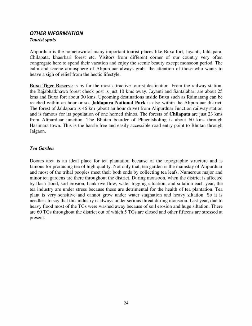
OTHER INFORMATION Tourist spots
Alipurduar is the hometown of many important tourist places like Buxa fort, Jayanti, Jaldapara,
Chilapata, khaerbari forest etc. Visitors from different corner of our country very often
congregate here to spend their vacation and enjoy the scenic beauty except monsoon period. The
calm and serene atmosphere of Alipurduar always grabs the attention of those who wants to
heave a sigh of relief from the hectic lifestyle.
Buxa Tiger Reserve is by far the most attractive tourist destination. From the railway station,
the Rajabhatkhawa forest check post is just 10 kms away. Jayanti and Santalabari are about 25
kms and Buxa fort about 30 kms. Upcoming destinations inside Buxa such as Raimatang can be
reached within an hour or so. Jaldapara National Park is also within the Alipurduar district.
The forest of Jaldapara is 46 km (about an hour drive) from Alipurduar Junction railway station
and is famous for its population of one horned rhinos. The forests of Chilapata are just 23 kms
from Alipurduar junction. The Bhutan boarder of Phuentsholing is about 60 kms through
Hasimara town. This is the hassle free and easily accessible road entry point to Bhutan through
Jaigaon.
Tea Garden
Dooars area is an ideal place for tea plantation because of the topographic structure and is
famous for producing tea of high quality. Not only that, tea garden is the mainstay of Alipurduar
and most of the tribal peoples meet their both ends by collecting tea leafs. Numerous major and
minor tea gardens are there throughout the district. During monsoon, when the district is affected
by flash flood, soil erosion, bank overflow, water logging situation, and siltation each year, the
tea industry are under stress because these are detrimental for the health of tea plantation. Tea
plant is very sensitive and cannot grow under water stagnation and heavy siltation. So it is
needless to say that this industry is always under serious threat during monsoon. Last year, due to
heavy flood most of the TGs were washed away because of soil erosion and huge siltation. There
are 60 TGs throughout the district out of which 5 TGs are closed and other fifteens are stressed at
present.
25
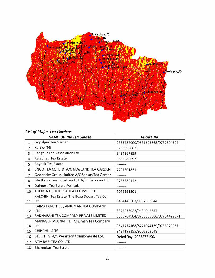
List of Major Tea Gardens
NAME OF the Tea Garden PHONE No.
1 Gopalpur Tea Garden 9333787000/9531625663/9732894504
2 Kartick TG 9733399862
3 Rangpur Tea Association Ltd. 9434367859
4 Rajabhat Tea Estate 9832089697
5 Raydak Tea Estate -------
6 ENGO TEA CO. LTD. A/C NEWLAND TEA GARDEN 7797801831
7 Goodricke Group Limited A/C Sankas Tea Garden -------
8 Bhatkawa Tea Industries Ltd A/C Bhatkawa T.E. 9733380442
9 Dalmore Tea Estate Pvt. Ltd. -------
10 TOORSA TE, TOORSA TEA CO. PVT. LTD 7076561201
11
KALCHINI Tea Estate, The Buxa Dooars Tea Co.
Ltd. 9434143583/9932983944
12
RAIMATANG T.E., , ANJUMAN TEA COMPANY
LTD. 8372036022/9434042557
13 RADHARANI TEA COMPANY PRIVATE LIMITED 9593704984/9735305086/97754422371
14
MANAGER MUJNAI T.E., Anjuman Tea Company
Ltd. 9547774168/8721074139/9733029967
15 CHINCHULA TG 9434199155/9002803048
16 BEECH TG A/C Weastern Conglomerate Ltd. Debol Roy. 7063877190/
17 ATIA BARI TEA CO. LTD -------
18 Bharnobari Tea Estate -------
26
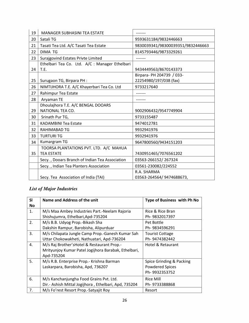
19 MANAGER SUBHASINI TEA ESTATE -------
20 Satali TG 9593631184/9832446663
21 Tasati Tea Ltd. A/C Tasati Tea Estate 9830039341/98300039351/9832446663
22 DIMA TG 8145793446/9873329261
23 Surajgovind Estates Privte Limited -------
24
Ethelbari Tea Co. Ltd. A/C : Manager Ethelbari
T.E. 9434449563/8670143373
25 Surugaon TG, Birpara PH :
Birpara- PH 204739 / 033-
22254980/197/038 (fax)
26 NIMTIJHORA T.E. A/C Khayerbari Tea Co. Ltd 9733217640
27 Rahimpur Tea Estate -------
28 Aryaman TE -------
29
Dhoulajhora T.E. A/C BENGAL DOOARS
NATIONAL TEA CO. 9002906432/9547749904
30 Srinath Pur TG, 9733155487
31 KADAMBINI Tea Estate 9474012781
32 RAHIMABAD TG 9932941976
33 TURTURI TG 9932941976
34 Kumargram TG 9647800560/9434151203
35
TOORSA PLANTATIONS PVT. LTD. A/C MAHUA
TEA ESTATE 7430951465/7076561202
Secy. , Dooars Branch of Indian Tea Association 03563-266152/ 267324
Secy. , Indian Tea Planters Association 03561-230082/224552
Secy. Tea Association of India (TAI)
R.A. SHARMA
03563-264564/ 9474688673,
List of Major Industries
Sl
No
Name and Address of the unit Type of Business with Ph No
1. M/s Maa Ambey Industries Part.-Neelam Rajoria
Shishujumra, Ethelbari,Apd-735204
Rice & Rice Bran
Ph- 9832017397
2. M/s B.B. Udyog Prop.-Bikash Sha
Dakshin Rampur, Barobisha, Alipurduar
Pet Bottle
Ph- 9834596291
3. M/s Chilapata Jungle Camp Prop.-Ganesh Kumar Sah
Uttar Chokowakheti, Nathuatari, Apd-736204
Tourist Cottage
Ph- 9474382442
4. M/s Raj Brother’sHotel & Restaurant Prop.-
Mrityunjoy Kumar Patel Jogijhora Barabak, Ethelbari,
Apd-735204
Hotel & Retaurant
5. M/s R.B. Enterprise Prop.- Krishna Barman
Laskarpara, Barobisha, Apd, 736207
Spice Grinding & Packing
Powdered Spices
Ph- 9932353752
6. M/s Kanchanjungha Food Grains Pvt. Ltd.
Dir.- Ashish Mittal Jogijhora , Ethelbari, Apd, 735204
Rice Mill
Ph- 9733388868
7. M/s Fo’rest Resort Prop.-Satyajit Roy Resort
27
UttarChakowakheti, Nathuatari, Apd Ph-9903362610
8. M/s Bania River Retreat Prop.-Smt. Gargi Roy
Uttar Chokowakheti, Nathuatari, Apd,
Resort
Ph- 9830791555
9. M/s Sanjay Prasad Prop.- Sanjoy Prasad
Jogijhora, Ethelbari, Alipurduar, 735204
Package Drinking Water
Ph- 7797976751
10. M/s Priya Precast Company Prop.- Rinku Dutta(
Banik) Chingmaritari, Ethelbatri, Apd, 735204
Concrete Bricks & Tiles
Ph- 9434191512
11. M/s Greenx Concreto Prop.- Nisha agarwal
Jogijhora Barabak, Ethelbari, Apd
Hollow and Concrete Bricks
Ph- 8345698171
12. M/s pradyut Kumar Bhowmick Prop.- Pradyut Kumar
Bhowmick Dakshin Paniyalguri, Majherdabri, Apd
Wooden Furniture
Ph- 9609125560
13. M/s Capital Tyres Prop.- M.D. Neyaz
B.G. Road, Jaigaon, Apd, 735222
Tyre Retreading( Cold
Process)
14. M/s Sishujhumra Rice Mill Prop.- Hari Prakash Jindal
Sishujhumra, Ethelbari, Apd, 735204
Rice Mill
Ph-9733365673
15. M/s jai Hanuman Industries Part.- Neelam Rajoria
Sishujhumra, Ethelbari, Apd, 735204
Fly Ash Bricks
Ph- 9832017397
16. M/s Torsa Tea Factory Part.- Pranab Kumar Saha
Ajay Nagar, Falakata, Apd, 735211
Tea processing
Ph-9593622928
17. M/s Golden Valley Ice Factory Prop.- Smt. Bhaswati
Mitra Birpara, Apd, 736121
Ice making without using
Ammonia
Ph-9475512600
18. M/s Ali Hollow Brick Industries Prop.- Md. Moksed Ali
Islamabad, Rangalibazna, Apd, 735213
Cement Concrete Hollow
brick
Ph- 9593704050
19. M/s Pyramid Steel Prop.- Sadip kumar Ghosh
Dakshin Majherdabri, Majherdabri, Apd, 736123
Steel pipes for furniture,
fencing, railing etc.
Ph- 9434117944
20. M/s Om Namah Shivaya Prop.- manu agarwal
Sishujhumra, Ethelbari, Apd, 735204
Cement concrete Bricks
Ph- 7407967355
21. M/s Mathura Cottage and Restaurant Part.- Krishna
das Dakshin Chokowakheti, Apd, 736204
Home stay 7 Restaurant
Ph- 7585077469
22. M/s Tanvi Industries Prop.- Neelam Rajoria
Jogojhora Barabak, Ethelbari, apd, 735204
Hume Pipes( Cemented
Products)
23. M/s Priyashree Rajoria Prop.- Priyashree Rajoria
Jogijhora Barabak, Ethelbari, Apd, 735204
Hume Pipes( Cemented
Products)
24. M/s |Neelam Rajoria Prop.- Neelam Rajoria
Sishujhumra, Ethelbari, Apd,735204
Concrete Cement Bricks
Ph- 9832017397
25. M/s Munni Devi Rajoria Prop.- Munni Devi Rajoria
Sishujhumra, Ethelbari, Apd, 735204
Concrete Cement Brick
Ph- 9832017397
26. M/s Dooars Infra Projects(P) Ltd. M.D.- Ashim Kr.
Ghosh Baganbari, Falakata, Apd, 735211
Cold storage
Ph- 9434104055
27. M/s Punj Lloyd Ltd P.M.- Vikas Pathania
Paschim Chekamari, Rangalibazna,Apd, 735213
W.M.M. Plant
Ph- 8945010962
28. M/s Haldar Electrical Works Prop.- Rita Haldar
Station road, Apd Jn. Apd, 736123
Transformer repairing
Ph- 9733463526
29. M/s Bhai Bhai Enterprise Prop.- Sanjit Ghosh Betel Nut Processing
28
Kunjanagar, Falakata, Apd, 735211 Ph- 9635291148
30. M/s Sarvashiva Rice Mill Pvt. Ltd. Dir.- Shibraj Dutta
Tapsikhata, Gharghariahat, Apd, 736121
Parboiled rice Mill
Ph- 9733314056
31. M/s Sayan Steel Furniture Prop.- Ajit Paul
Changpara, Chapararpar, Apd, 736121
Steel Furniture
Ph- 8945092096
32. M/s Sumaru Jungle Resort Prop.- Arnab Dasgupta
Madhya Madarihat, Apd, 735220
Resort
33. M/s Tinbaandhari Minerals( P) Ltd. Direc.- Rajesh
Sharma Jogijhora Barabak, Ethelbari, Apd, 735204
Dolomite and Lime Stone
Powder
Ph- 9832952974
34. M/s Ethelbari Cold StoragePvt Ltd. Prop.- Pradip
Prasad Narsingpur, Ethelbari, apd, 736204
Cold Storage
Ph- 9932040831
35. M/s lahar Industries Prop.- Smt. Neelam agarwal
Madhya rangalibazna, Gopal Bagan, Apd, 735213
Packaged drinking water
Ph- 9800569699
36. M/s Mahakal Himghar Pvt Dir. Sri Tridibesh Das
Pararpar, Tapshikhata, Apd, 736121
Cold storage
Ph- 9434005918
37. M/s Anjali Industry Part.- Samir saha
Raichanga, Falakata, Apd, 735211
Cement Products
Ph-9832350401
38. M/s J.P.C. Rice Mill Prop.- Sri Jay prakash Chowdhury
Dakshin Latabari, Apd
Raw Rice
39. M/s swastika Stone Crusher Industries Prop.- Smt.
Lipi sarkar Radhanagar, Alipurduar
Stone Crusher
40. M/s West Bengal Alluminium Industries Prop: Pradoip
Baid Subhash Pally,Alipurduar,736121
Alluminium Industries
Ph-9832062014
Culture & language Mainstay of Alipurduar district is Tea Garden and Tourism industry. Next is collecting forest product
mainly timber and wood. A fairly large portion of population depends on tea gardens for their livelihood
directly or indirectly. Most of the plantation labourers were migrated from different parts of our country.
These plantation workers belonged to different ethno-cultural and linguistic groups. In course of time
they created a different kind of culture. They usually speak in their own tribal language within the tribe
for communication. 'Sadri' a language practiced by their ancestors in Chhotonagpur area is used as link-
language among the different tribes. Now a day’s Hindi is also used for this purpose.
The area was originally inhabitated by aborigine tribes and castes like Ravas, Garos, Meches, totos,
Dhimals, Koches and Rajbanshis etc. the migration of Hindus from the erstwhile East Bengal at the time
of partition in 1947 and their settlement in these areas reduced land-man ratio to a great extent. The
culture of these migrated Hindu people, mingled with rich folk culture of the aboriginals, enriched the
cultural life of this area. Gradually people came and settled down in this area from almost all corners of
India. These people speak about 141 languages including some distinct dialect. However, Bengali is
largely spoken language. Intermingling of heterogeneous ethno cultural groups helped evolve a strong
eco-friendly material culture in this area since prehistoric period. Admixture of traditional knowledge of
different ethnic groups with advanced technology, easy availability of indigenous materials and climatic
condition of this area augmented this process to gain a different shape than other parts of Bengal.
29
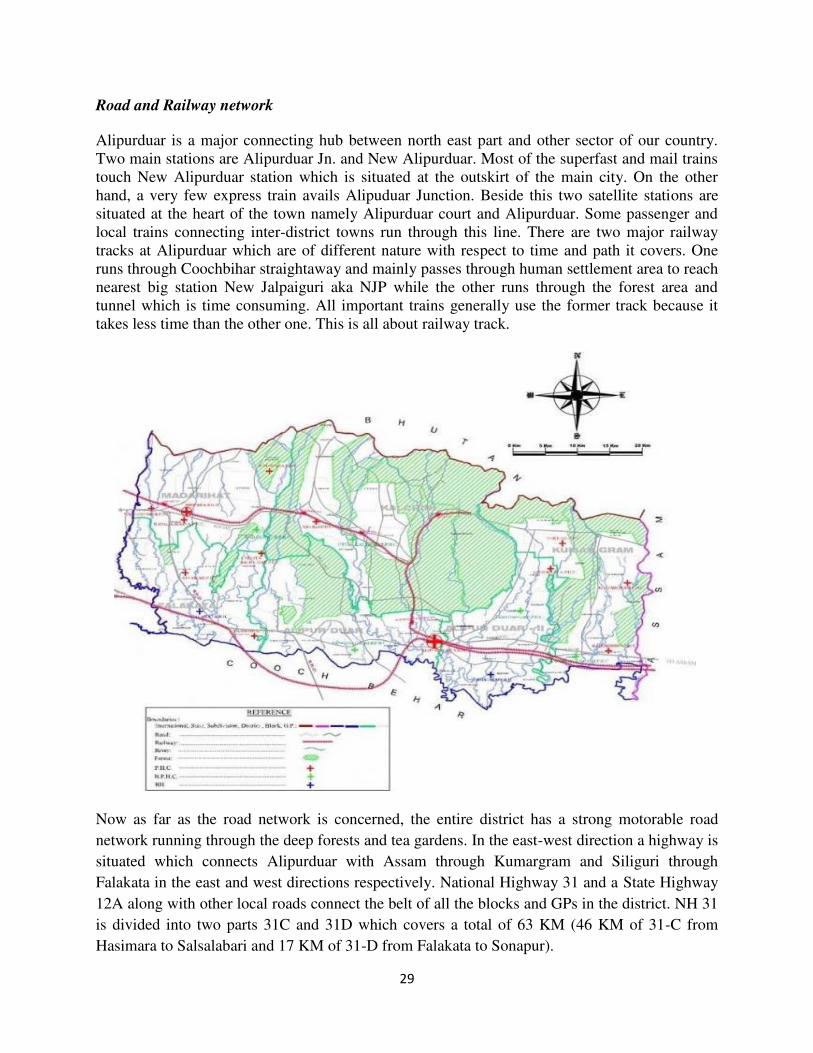
Road and Railway network
Alipurduar is a major connecting hub between north east part and other sector of our country.
Two main stations are Alipurduar Jn. and New Alipurduar. Most of the superfast and mail trains
touch New Alipurduar station which is situated at the outskirt of the main city. On the other
hand, a very few express train avails Alipuduar Junction. Beside this two satellite stations are
situated at the heart of the town namely Alipurduar court and Alipurduar. Some passenger and
local trains connecting inter-district towns run through this line. There are two major railway
tracks at Alipurduar which are of different nature with respect to time and path it covers. One
runs through Coochbihar straightaway and mainly passes through human settlement area to reach
nearest big station New Jalpaiguri aka NJP while the other runs through the forest area and
tunnel which is time consuming. All important trains generally use the former track because it
takes less time than the other one. This is all about railway track.
Now as far as the road network is concerned, the entire district has a strong motorable road
network running through the deep forests and tea gardens. In the east-west direction a highway is
situated which connects Alipurduar with Assam through Kumargram and Siliguri through
Falakata in the east and west directions respectively. National Highway 31 and a State Highway
12A along with other local roads connect the belt of all the blocks and GPs in the district. NH 31
is divided into two parts 31C and 31D which covers a total of 63 KM (46 KM of 31-C from
Hasimara to Salsalabari and 17 KM of 31-D from Falakata to Sonapur).
30
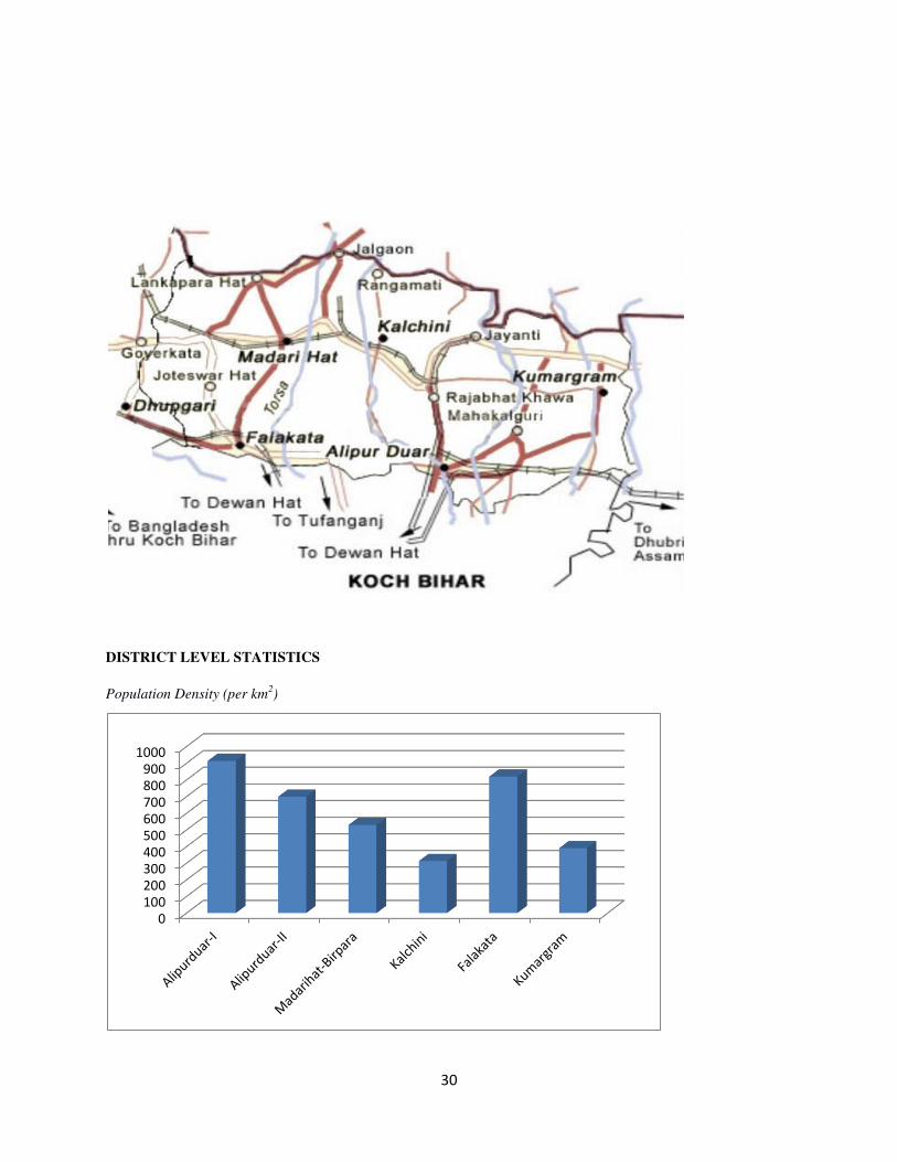
DISTRICT LEVEL STATISTICS
Population Density (per km2)
0
100
200
300
400
500
600
700
800
900
1000
31
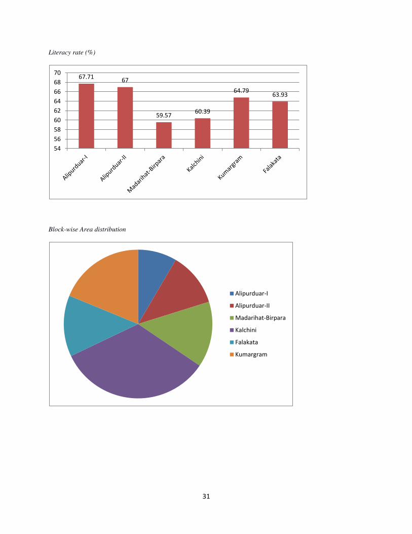
Literacy rate (%)
Block-wise Area distribution
67.71 67
59.57 60.39
64.79 63.93
54
56
58
60
62
64
66
68
70
Alipurduar-I
Alipurduar-II
Madarihat-Birpara
Kalchini
Falakata
Kumargram
32
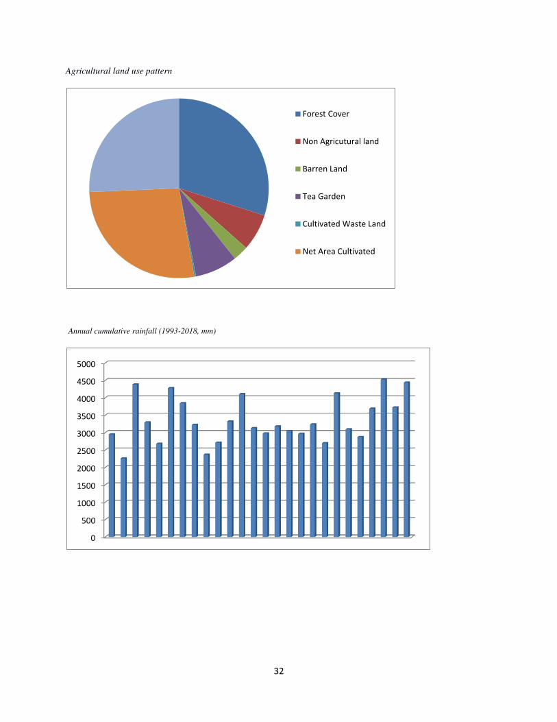
Agricultural land use pattern
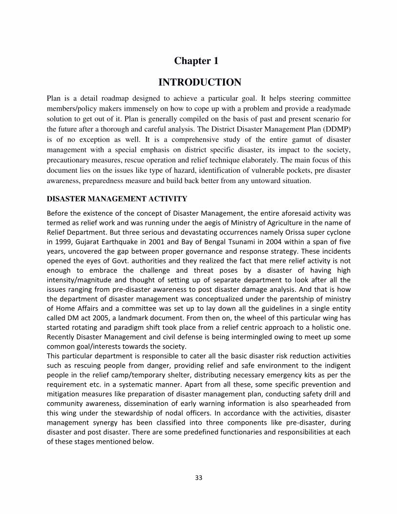
Annual cumulative rainfall (1993-2018, mm)
Forest Cover
Non Agricutural land
Barren Land
Tea Garden
Cultivated Waste Land
Net Area Cultivated
0
500
1000
1500
2000
2500
3000
3500
4000
4500
5000
33
Chapter 1
INTRODUCTION
Plan is a detail roadmap designed to achieve a particular goal. It helps steering committee
members/policy makers immensely on how to cope up with a problem and provide a readymade
solution to get out of it. Plan is generally compiled on the basis of past and present scenario for
the future after a thorough and careful analysis. The District Disaster Management Plan (DDMP)
is of no exception as well. It is a comprehensive study of the entire gamut of disaster
management with a special emphasis on district specific disaster, its impact to the society,
precautionary measures, rescue operation and relief technique elaborately. The main focus of this
document lies on the issues like type of hazard, identification of vulnerable pockets, pre disaster
awareness, preparedness measure and build back better from any untoward situation.
DISASTER MANAGEMENT ACTIVITY
Before the existence of the concept of Disaster Management, the entire aforesaid activity was
termed as relief work and was running under the aegis of Ministry of Agriculture in the name of
Relief Department. But three serious and devastating occurrences namely Orissa super cyclone
in 1999, Gujarat Earthquake in 2001 and Bay of Bengal Tsunami in 2004 within a span of five
years, uncovered the gap between proper governance and response strategy. These incidents
opened the eyes of Govt. authorities and they realized the fact that mere relief activity is not
enough to embrace the challenge and threat poses by a disaster of having high
intensity/magnitude and thought of setting up of separate department to look after all the
issues ranging from pre-disaster awareness to post disaster damage analysis. And that is how
the department of disaster management was conceptualized under the parentship of ministry
of Home Affairs and a committee was set up to lay down all the guidelines in a single entity
called DM act 2005, a landmark document. From then on, the wheel of this particular wing has
started rotating and paradigm shift took place from a relief centric approach to a holistic one.
Recently Disaster Management and civil defense is being intermingled owing to meet up some
common goal/interests towards the society.
This particular department is responsible to cater all the basic disaster risk reduction activities
such as rescuing people from danger, providing relief and safe environment to the indigent
people in the relief camp/temporary shelter, distributing necessary emergency kits as per the
requirement etc. in a systematic manner. Apart from all these, some specific prevention and
mitigation measures like preparation of disaster management plan, conducting safety drill and
community awareness, dissemination of early warning information is also spearheaded from
this wing under the stewardship of nodal officers. In accordance with the activities, disaster
management synergy has been classified into three components like pre-disaster, during
disaster and post disaster. There are some predefined functionaries and responsibilities at each
of these stages mentioned below.
34
BACKGROUND OF THE PLAN
As mentioned earlier, DM Act was institutionalized in the year 2005 for the sake of resilient
society and good governance. It consists of 11 chapters and 79 sections as a whole. These are:
Phase Activities
Before Disaster Preparation of DM Plan, Community
awareness, early warning dissemination,
mock drill, relief material distribution,
resource mobilization in advance, hands on
training regarding various safety tools etc.
During Disaster Activate Incident Response Team (IRT)
depending upon the gravity and impact of
any disaster, compilation of daily situation
report, CA-II report, Deployment of response
team at the place of occurrence promptly,
opening of relief camp, distribution of relief
materials among distressed people, saving
lives etc.
After Disaster Removal of carcass, loss and damage
assessment of property in terms of money,
clearance of road blocked by any obstacle,
bring back the situation into normalcy,
reimbursement of money or relief materials
under various scheme among the
beneficiaries etc.
Chapter Description
Chapter 1 Title, extent, comments and various definitions
Chapter 2 National Disaster Management Authority
Chapter 3 State Disaster Management Authority
Chapter 4 District Disaster Management Authority
Chapter 5 Measures by government for Disaster Management
Chapter 6 Local authority
Chapter 7 National Institute of Disaster Management
Chapter 8 National Disaster Response Force
Chapter 9 Finance, Accounts and Audits
Chapter 10 Offences and penalties
Chapter 11 Miscellaneous
35
As per the section 31 of the Disaster Management Act, 2005 (DM Act), the mandatory
provisions of DM plan are
There has to be a specific plan for every district of a state.
The district plan shall be compiled by District Disaster Management
Authority (DDMA), negotiating with local bodies, municipalities, and blocks.
On completion of the plan, it is duly approved by the state authority.
In addition to this, the DDMP has to be reviewed and updated annually as
per the section 31(4) of the act.
The copies of the District Plan referred to in sub-sections shall be made
available to the Departments of the Government in the district.
The District Authority shall send a copy of the District Plan to the State
Authority for further transmission to the State Government.
The District Authority shall, review from time to time, the implementation of
the Plan and issue such instructions to different departments of the
Government in the district as it may deem necessary for the implementation
thereof.
The present edition has been compiled keeping all the rules and regulations of DM Act 2005 into
consideration. A bottom up approach has been followed during preparation of this plan. Each
block has collected information from various Gram Panchayet (GP) and transferred the same to
the district level. Finally DDMA has piled up the information collectively in the present format.
Apart from this, we have taken some useful information from various line departments and inter-
agency groups like Agriculture, Health, Forest, PWD, Irrigation, Civil Defence, Fire and
Emergency services, Food & Supply, BAES, Police etc.
OBJECTIVE OF THE STUDY
A District Disaster Management Plan is a prototype of the current situation of a district regarding
the scope and/or strength and an elaboration of how the entire system will response based on the
available potential it possess.
As per the section 31 of the Disaster Management Act, 2005 (DM Act), a district plan should
include the following:
The vulnerable places in the district which are under serious threat by
different forms of disasters.
The measures to be taken, for prevention and mitigation of disaster, by the
Departments of the Government at the district level and local authorities in
the district.
The capacity-building and preparedness required by the Departments of the
36
Government at district level and local authorities in the district to face any
threatening emergency situation.
The response plans and procedures, in the event of a disaster, providing for-
i) Allocation of responsibilities to the Departments of the Government
at the district level and local authorities.
ii) Prompt response to disaster and relief.
iii) Procurement of essential resources,
iv) Establishment of communication links and
v) The dissemination of information to the public.
In a nutshell, DDMP covers the entire procedure ranging from pre-disaster awareness to post-
disaster restoration as a whole. It also helps us to find out the solution during emergency period.
DIFFERENT STAKEHOLDERS AND THEIR RESPONSIBILITIES
Department/Organization Functionaries
Police Department Maintaining law and order during and after disaster.
Providing security arrangements for VIP persons visiting to
assess the post disaster damage.
Lending co-operation to the local people for evacuation of
people from vulnerable areas.
Help in collecting real information regarding loss and damage as
a consequence of a disaster.
Electricity Department Restoring power supply to the affected area at the earliest.
Periodic inspection of the places where high tension wires,
transformers and power grid system lies.
Uninterrupted power supply to some important places like
collector's office, district court, municipality office, police
station, temporary makeshifts like relief shelters and
hospitals/nursing homes during emergency.
Making arrangements for additional support to the relief camp
for extended period.
Raising awareness and encouraging local people towards the use
of solar and renewable energy.
37
Health Department Ability to undertake emergency health service for the distressed
people in the spot.
Keep additional bed in hospitals and round the clock medical
facilities.
Strengthen blood bank and keep mobile medical van ready for
emergency help.
Raising awareness regarding different kind of health hazards
especially water and vector borne disease.
Public Works Department Responsible for restoring various public properties, damaged
building and civil construction.
Give emphasis on earthquake proof building construction.
Inspect the high rise buildings and hospitals periodically before
and during the disaster.
Construct public information centre for community awareness.
Irrigation Department Keep watch on dam and water discharge rate during heavy
rainfall.
Provide extensive protection to the irrigation infrastructure and
restore the damaged embankments.
Identify flood prone rivers and start to implement flood
monitoring mechanism before the onset of monsoon.
Repairing of culvert, bridges and pump at the time of need.
In case of possibilities of flooding in the downstream, the
settlements should be informed well in advance and necessary
warnings for evacuation should be given to the adjoining
districts and to those districts beyond the state borders.
Agriculture Department Restore the district specific agricultural product and monitoring
soil health.
Assure protection of crop during extreme condition.
Carry out the surveillance for pests and diseases.
Damage and loss assessment after any catastrophe takes place
owing to meet up crop insurance.
Civil Defence Department Taking prime responsibility for rescue and relief during and after
disaster.
Ability to protect life from dreadful situation.
Monitoring stock of rescue items periodically.
Provide support in the flood control room and round the clock
surveillance.
Provide training among local boys and girls with the intention of
making the network of quick response team stronger.
School Education Department Practice the culture of preparedness among students and make
school a safer place to reside during emergency.
Various activities like road show, poster presentation, quiz
competition etc. should be carried out for awareness.
38
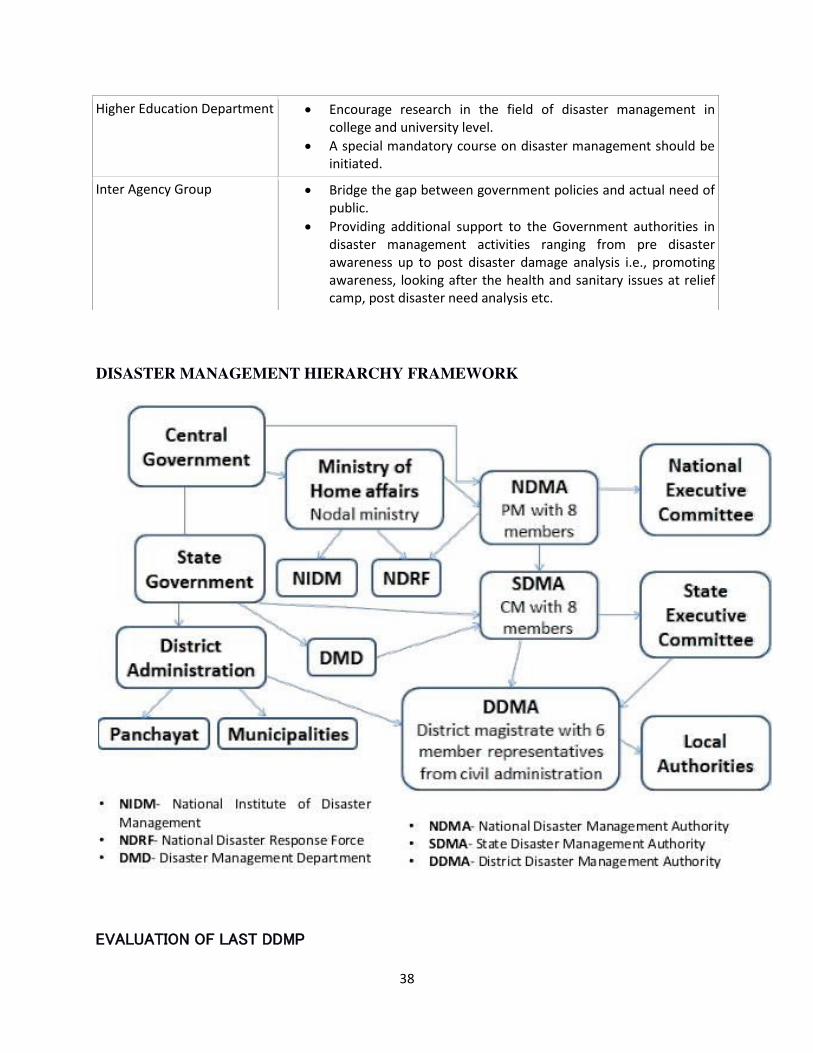
DISASTER MANAGEMENT HIERARCHY FRAMEWORK
EVALUATION OF LAST DDMP
Higher Education Department
Encourage research in the field of disaster management in
college and university level.
A special mandatory course on disaster management should be
initiated.
Inter Agency Group Bridge the gap between government policies and actual need of
public.
Providing additional support to the Government authorities in
disaster management activities ranging from pre disaster
awareness up to post disaster damage analysis i.e., promoting
awareness, looking after the health and sanitary issues at relief
camp, post disaster need analysis etc.
39
According to NDMA guideline, every district should prepare/compile and publish Disaster
Management Plan on annual basis and has to be assessed properly before next edition. Our
DDMP-2019 was prepared as per the norms as laid down by NDMA. Preparation of a plan is a
dynamic process and has to be evaluated every year to find out various loopholes. We have
assessed our last edition and identified the gaps.
The new version of this book is enriched by:
1. Resource inventory of various rescue items in chapter 12.
2. Detail damage report in chapter 8.
3. Various climatological data in District Profile.
4. Detail of various tourist spots in Annexure part.
5. Rainfall analysis in Annexure part.
6. Brief description of different departments/authority/rescue force in chapter 11.
40
Chapter 2
VULNERABILITY ASSESSMENT OF THE DISTRICT
Hazard, risk and vulnerability assessment (HRVA) is a study of making a place disaster resilient,
by addressing the issues like major disaster, vulnerable zone, cause of vulnerability and disaster
preparedness. It is generally prepared with the help of best available information like hazard
history, vulnerability profile, ranking of hazards based on its frequency/impact, preparation of
risk matrix etc. A HRVA will not make a place hazard free overnight, rather it help us to
understand the cause of vulnerability and guide us in making preparation to face any adverse
situation with available resources well in advance. Put another way, it is a remedy for reducing
the damage/threat poses by any area specific disaster. HRVA has both spatial and temporal
dimension. We have considered here the Gram Panchayet (GP) being the smallest unit for our
study. Before going into details, we should familiar with few terminologies that will be used very
frequently in this entire edition. They are not watertight compartment and related to each other.
Hazard is any kind of event in a geographical area which can pose threat to people, society,
economic assets, livelihood, behavioural pattern of flora/fauna etc. which may turn into a disaster.
This may be manmade or natural occurrences.
Disaster is defined as a serious disruption of the functioning of a society, causing widespread
human, material or environmental losses which exceed the ability of the affected society to cope
using its own resources. Disaster is a consequence of a hazard in largely populated area where
chances of getting damage are very high because a hazard like tsunami has no meaning in an
uninhabited island.
Vulnerability is the extent to which a community, structure, service and geographic area is
likely to be damaged or disrupted by the impact of a particular hazard, on account of their nature,
construction and proximity to hazardous terrain or a disaster prone area. It is a type of societal
disability. For example a low-lying area is always vulnerable to flood or coastal area is always
vulnerable to cyclone etc.
Risk is a measure of expected losses in terms of death, injuries, assets or economic activities due
to a potential hazard occurring in a given area over a specific period of time. Risk analysis
involves determining the probability of the occurrence of an event and the level of vulnerability
of the people that may be affected by the event. Disaster is the realisation of a risk. For example,
there is always a risk of injuries of a bike rider riding without helmet.
Capacity is the helpful individual or social abilities with the help of which any untoward
situation can be challenged.
Prevention is the set of rules to prevent any disaster from its occurrence. It is applicable
especially in man-made disaster; no natural disaster can be prevented fully as such.
41
Mitigation is the process or collection of techniques owing to make a place disaster resilient. It
is further classified into two categories: structural and non-structural. Structural mitigation is
referred to adopting some technology or implementation of some engineering works whereas
non-structural mitigation is referred to adopting non-engineering policies like promoting
awareness, vulnerable area identification and early warning dissemination.
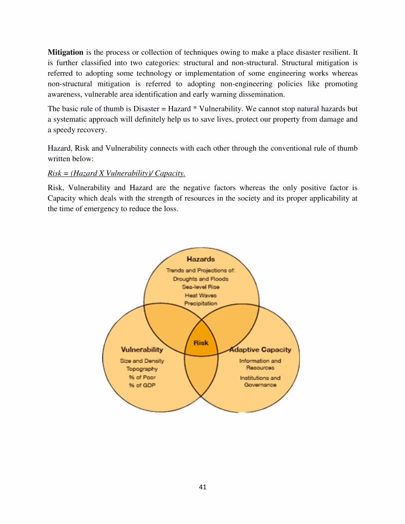
The basic rule of thumb is Disaster = Hazard * Vulnerability. We cannot stop natural hazards but
a systematic approach will definitely help us to save lives, protect our property from damage and
a speedy recovery.
Hazard, Risk and Vulnerability connects with each other through the conventional rule of thumb
written below:
Risk = (Hazard X Vulnerability)/ Capacity.
Risk, Vulnerability and Hazard are the negative factors whereas the only positive factor is
Capacity which deals with the strength of resources in the society and its proper applicability at
the time of emergency to reduce the loss.
42
Tools and Techniques of HRVA:
HRVA is an approach of minimising threat of any disaster by thoroughly analysing the
characteristic of a particular place from different perspective. The whole initiative is broadly
classified in different mutually exclusive tasks furnished below:
Hazard analysis and ranking of hazards based on frequency from hazard
history.
Vulnerability analysis of a society.
Risk analysis by calculating frequency and thrust/impacts of different
disasters.
Hazard analysis
Hazard is any kind of disturbance that may turn into a disaster due to lack of co-ordination and
poor governance. Types of different possible hazards are listed below:
Natural
hazard
Geological
hazard
Earthquake, Tsunami, Volcanic eruption, Mine burst,
Landslide.
Water and
Climatic hazard
Tropical cyclone, Flood, Drought, Heat and cold wave,
Coastal erosion, Avalanche.
Environmental
and Biological
hazard
Environmental pollution, Epidemic, Pest attack,
Deforestation, Food poisoning, Desertification, change of
bio-diversity.
Climate change Cloud burst, extreme weather, sea level rise, island
inundation.
Manmade
hazard
Boat/Road/Train accident, Air crash, Building collapse,
Stampede, Riot, Mutiny, child trafficking, sexual
harassment, Chemical and industrial disaster, Nuclear plant
failure, Power grid failure, Oil spill.
Furthermore, all the hazards may be classified again into two groups according to the rapid onset
and slow onset. Rapid onset disasters are earthquake, cyclone, tsunami, flash flood, forest fire etc.
whereas slow onset disasters are climate change, island inundation, sea level rising, drought etc.
Whatever the case may be, India is a diverse country that experiences the threat of different
natural hazards like drought, flood, coastal erosion, storm surge, landslide, forest fire, heat wave,
hailstorm etc. because of having different characteristics and geographical features of different
places like topography, local weather, riverine system and catchment area, rainfall pattern, bio-
diversity etc. To focus on area specific hazards, analysis of past disasters is of paramount
importance. It is none other than hazard history which will describe the details of specific
disasters that a district might have been facing for a decade or so and thereby lead the decision
makers to a proper way in policy making. History of hazard of Alipurduar District for last 27
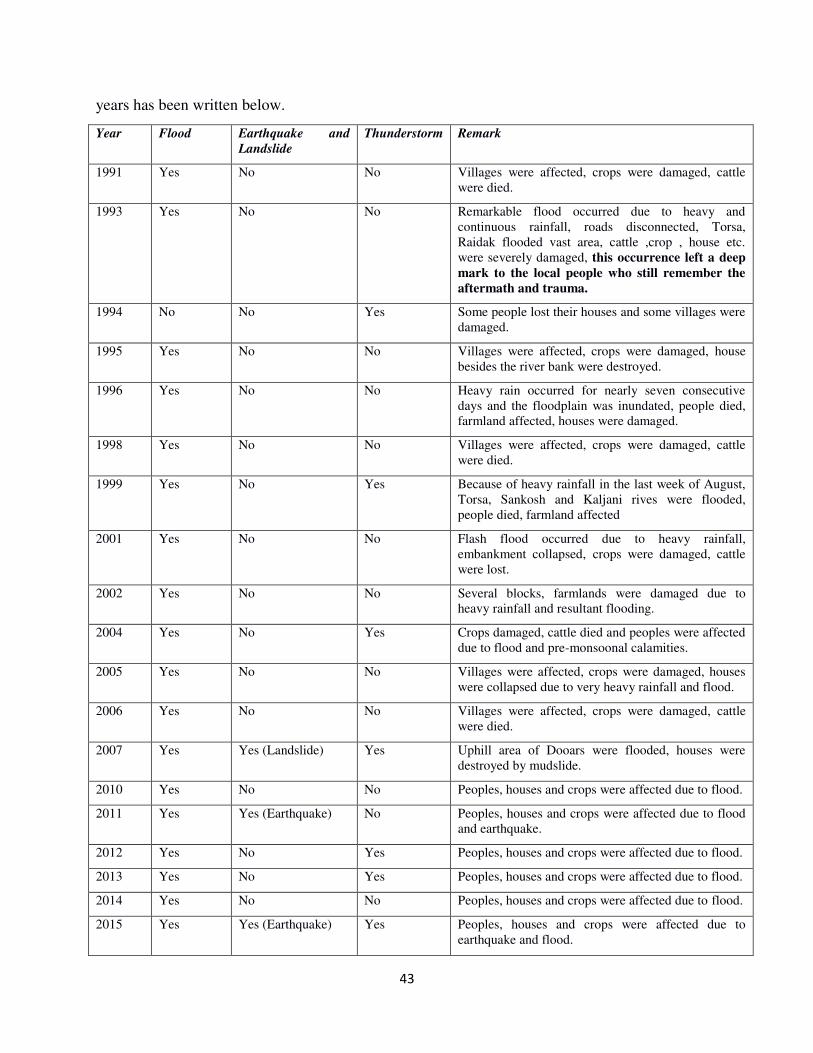
43
years has been written below.
Year Flood Earthquake and
Landslide
Thunderstorm Remark
1991 Yes No No Villages were affected, crops were damaged, cattle
were died.
1993 Yes No No Remarkable flood occurred due to heavy and
continuous rainfall, roads disconnected, Torsa,
Raidak flooded vast area, cattle ,crop , house etc.
were severely damaged, this occurrence left a deep
mark to the local people who still remember the
aftermath and trauma.
1994 No No Yes Some people lost their houses and some villages were
damaged.
1995 Yes No No Villages were affected, crops were damaged, house
besides the river bank were destroyed.
1996 Yes No No Heavy rain occurred for nearly seven consecutive
days and the floodplain was inundated, people died,
farmland affected, houses were damaged.
1998 Yes No No Villages were affected, crops were damaged, cattle
were died.
1999 Yes No Yes Because of heavy rainfall in the last week of August,
Torsa, Sankosh and Kaljani rives were flooded,
people died, farmland affected
2001 Yes No No Flash flood occurred due to heavy rainfall,
embankment collapsed, crops were damaged, cattle
were lost.
2002 Yes No No Several blocks, farmlands were damaged due to
heavy rainfall and resultant flooding.
2004 Yes No Yes Crops damaged, cattle died and peoples were affected
due to flood and pre-monsoonal calamities.
2005 Yes No No Villages were affected, crops were damaged, houses
were collapsed due to very heavy rainfall and flood.
2006 Yes No No Villages were affected, crops were damaged, cattle
were died.
2007 Yes Yes (Landslide) Yes Uphill area of Dooars were flooded, houses were
destroyed by mudslide.
2010 Yes No No Peoples, houses and crops were affected due to flood.
2011 Yes Yes (Earthquake) No Peoples, houses and crops were affected due to flood
and earthquake.
2012 Yes No Yes Peoples, houses and crops were affected due to flood.
2013 Yes No Yes Peoples, houses and crops were affected due to flood.
2014 Yes No No Peoples, houses and crops were affected due to flood.
2015 Yes Yes (Earthquake) Yes Peoples, houses and crops were affected due to
earthquake and flood.
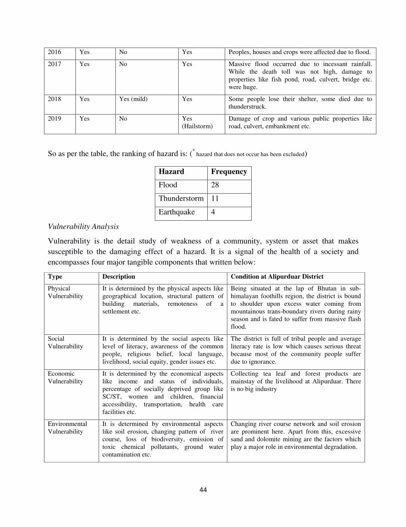
44
2016 Yes No Yes Peoples, houses and crops were affected due to flood.
2017 Yes No Yes Massive flood occurred due to incessant rainfall.
While the death toll was not high, damage to
properties like fish pond, road, culvert, bridge etc.
were huge.
2018 Yes Yes (mild) Yes Some people lose their shelter, some died due to
thunderstruck.
2019 Yes No Yes
(Hailstorm)
Damage of crop and various public properties like
road, culvert, embankment etc.
So as per the table, the ranking of hazard is: (*
hazard that does not occur has been excluded)
Vulnerability Analysis
Vulnerability is the detail study of weakness of a community, system or asset that makes
susceptible to the damaging effect of a hazard. It is a signal of the health of a society and
encompasses four major tangible components that written below:
Hazard Frequency
Flood 28
Thunderstorm 11
Earthquake 4
Type Description Condition at Alipurduar District
Physical
Vulnerability
It is determined by the physical aspects like
geographical location, structural pattern of
building materials, remoteness of a
settlement etc.
Being situated at the lap of Bhutan in sub-
himalayan foothills region, the district is bound
to shoulder upon excess water coming from
mountainous trans-boundary rivers during rainy
season and is fated to suffer from massive flash
flood.
Social
Vulnerability
It is determined by the social aspects like
level of literacy, awareness of the common
people, religious belief, local language,
livelihood, social equity, gender issues etc.
The district is full of tribal people and average
literacy rate is low which causes serious threat
because most of the community people suffer
due to ignorance.
Economic
Vulnerability
It is determined by the economical aspects
like income and status of individuals,
percentage of socially deprived group like
SC/ST, women and children, financial
accessibility, transportation, health care
facilities etc.
Collecting tea leaf and forest products are
mainstay of the livelihood at Alipurduar. There
is no big industry
Environmental
Vulnerability
It is determined by environmental aspects
like soil erosion, changing pattern of river
course, loss of biodiversity, emission of
toxic chemical pollutants, ground water
contamination etc.
Changing river course network and soil erosion
are prominent here. Apart from this, excessive
sand and dolomite mining are the factors which
play a major role in environmental degradation.
45
Apart from all these, there are some intangible components of vulnerability as well like social
relationship, communal harmony, political instability etc. We have not taken into account these
components because these parameters cannot be quantified easily. Here are some basic
parameters of vulnerability that can be a symbol of the present situation of Alipurduar District
has been written below.
Indicator Condition at
Alipurduar
Road networks Good (G)
Wireless communication Bad (B)
Availability of drinking water Good (G)
School/Education Medium (M)
Health centre Medium (M)
Capacity Assessment
Capacity assessment is the process to determine how people cope up with any crisis situation
with the help of traditional practice, previous knowledge, existing resources and off course
proper co-ordination. Trained volunteers and personnel, procurement of rescue equipments,
raising awareness, local logistic supports prompt response, early warning dissemination etc. are
some of the indicators of capacity assessment.
Indicator Condition at
Alipurduar
Literacy Medium (M)
Trained local volunteer Good (G)
Number of Divers Medium (M)
Raising awareness Good (G)
Procurement of rescue items Medium (M)
Early warning dissemination Medium (M)
Livelihood Low (L)
46
Risk Analysis
Risk is the chances of occurring harmful event and untoward situation. Risk assessment is
carried out by analysing frequency, magnitude, intensity and location based on historical data
and is a mammoth task. Outcome of this analysis is risk matrix which is basically a ranking of
risks in a single frame and thereby helps us in gaining insight, building knowledge, adopting
strategy and making policy about some specific disasters.
Risk Matrix (Risk= probability * impact)
Impact
Probability
Low (1) Moderate (2) High (3)
Low (1) 1 (Low) 2 (Low) 3(Low)
Moderate (2) 2(Low) 4 (Moderate) 6(Moderate)
High (3) 3(Low) 6(Moderate) 9(High)
Risk matrix of Alipurduar district is as follows,
Hazard Probability Impact Risk*
Flash Flood 3 3 9 (Very High)
Erosion 3 3 9 (Very High)
Landslide 2 3 6 (High)
Thunder squall 2 2 4 (Moderate)
Earth quake 1 3 3 (Low)
Snake bite 3 1 3 (Low)
* (9 - Very High, 6 - High, 4 - Medium, 3 - Low, 2 - Very Low, 1 - Minimum)
Hence flood should be put in highest priority and should be paid much attention at the time of
preparing any contingency plan followed by erosion, land slide, thunder squall and earthquake.
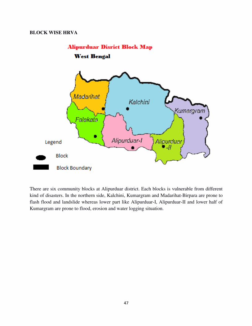
47
BLOCK WISE HRVA
There are six community blocks at Alipurduar district. Each blocks is vulnerable from different
kind of disasters. In the northern side, Kalchini, Kumargram and Madarihat-Birpara are prone to
flash flood and landslide whereas lower part like Alipurduar-I, Alipurduar-II and lower half of
Kumargram are prone to flood, erosion and water logging situation.
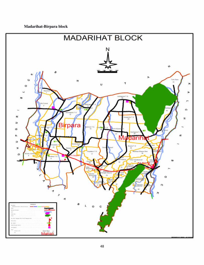
48
Madarihat-Birpara block
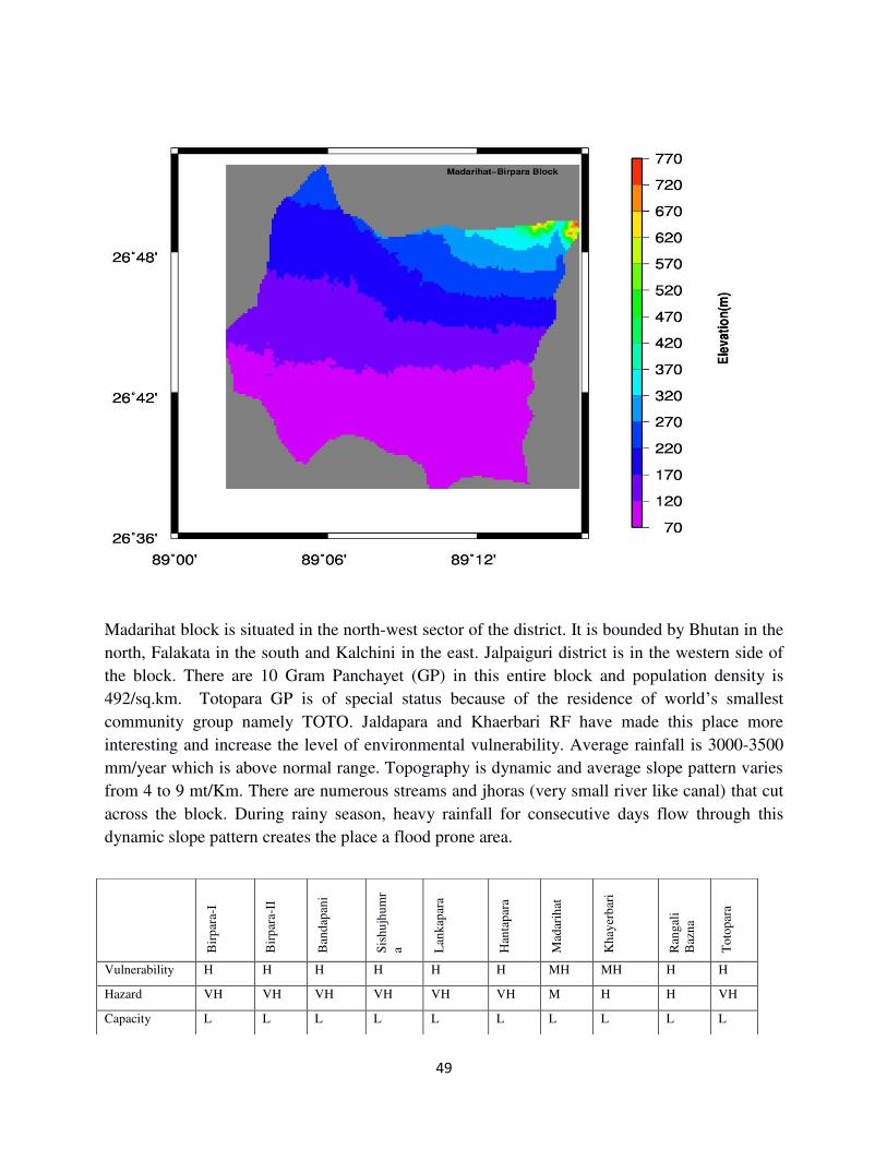
49
Madarihat block is situated in the north-west sector of the district. It is bounded by Bhutan in the
north, Falakata in the south and Kalchini in the east. Jalpaiguri district is in the western side of
the block. There are 10 Gram Panchayet (GP) in this entire block and population density is
492/sq.km. Totopara GP is of special status because of the residence of world’s smallest
community group namely TOTO. Jaldapara and Khaerbari RF have made this place more
interesting and increase the level of environmental vulnerability. Average rainfall is 3000-3500
mm/year which is above normal range. Topography is dynamic and average slope pattern varies
from 4 to 9 mt/Km. There are numerous streams and jhoras (very small river like canal) that cut
across the block. During rainy season, heavy rainfall for consecutive days flow through this
dynamic slope pattern creates the place a flood prone area.
Bir
par
a-I
Bir
par
a-II
Ban
dap
ani
Sis
hu
jhu
mr
a Lan
kap
ara
Han
tap
ara
Mad
arih
at
Kh
ayer
bar
i
Ran
gal
i
Baz
na
To
top
ara
Vulnerability H H H H H H MH MH H H
Hazard VH VH VH VH VH VH M H H VH
Capacity L L L L L L L L L L
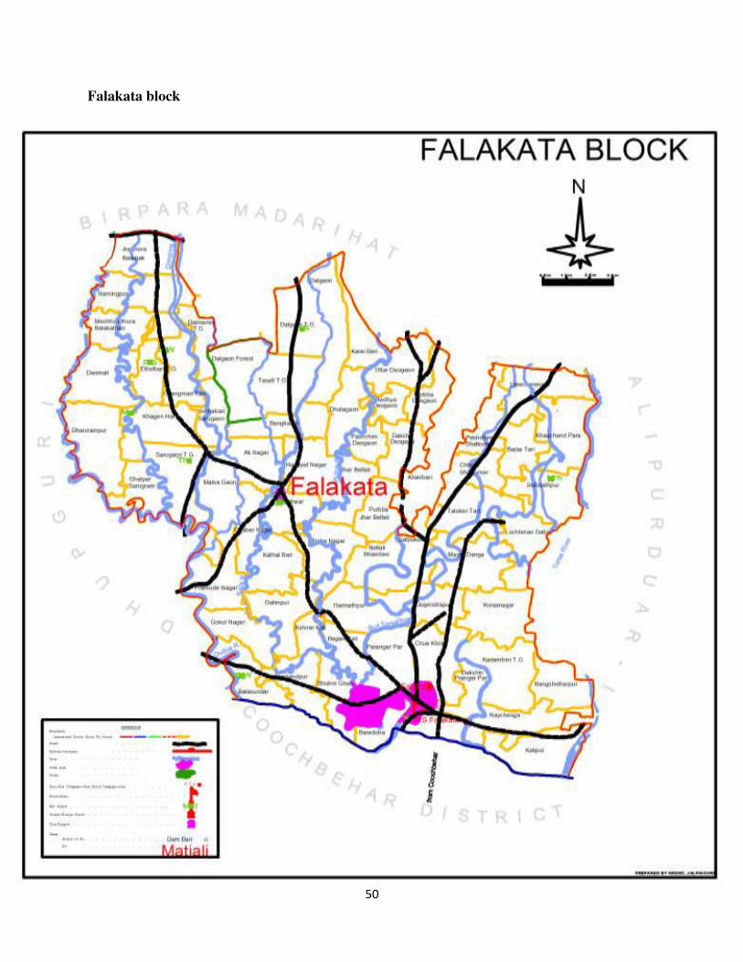
50
Falakata block
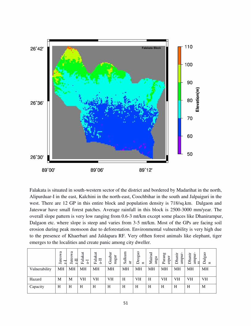
51
Falakata is situated in south-western sector of the district and bordered by Madarihat in the north,
Alipurduar-I in the east, Kalchini in the north-east, Coochbihar in the south and Jalpaiguri in the
west. There are 12 GP in this entire block and population density is 718/sq.km. Dalgaon and
Jateswar have small forest patches. Average rainfall in this block is 2500-3000 mm/year. The
overall slope pattern is very low ranging from 0.6-3 mt/km except some places like Dhanirampur,
Dalgaon etc. where slope is steep and varies from 3-5 mt/km. Most of the GPs are facing soil
erosion during peak monsoon due to deforestation. Environmental vulnerability is very high due
to the presence of Khaerbari and Jaldapara RF. Very ofthen forest animals like elephant, tiger
emerges to the localities and create panic among city dweller.
Jate
swa
r-I
Jate
swa
r-II
Fal
akat
a-I
Fal
akat
a-II
Gu
abar
nag
ar
Sal
ku
m
ar
Deo
gao
n
Mai
rad
ang
a
Par
ang
erp
er
Dh
anir
amp
ur-
I Dh
anir
amp
ur-
II
Dal
gao
n
Vulnerability MH MH MH MH MH MH MH MH MH MH MH MH
Hazard M M VH VH VH H VH H VH VH VH VH
Capacity H H H H H H H H H H H M
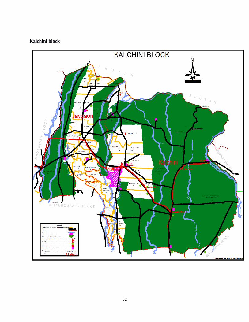
52
Kalchini block
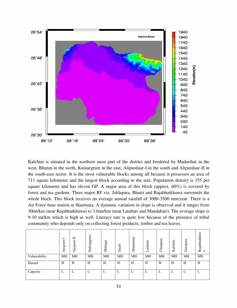
53
Kalchini is situated in the northern most part of the district and bordered by Madarihat in the
west, Bhutan in the north, Kumargram in the east, Alipurduar-I in the south and Alipurduar-II in
the south-east sector. It is the most vulnerable blocks among all because it possesses an area of
711 square kilometre and the largest block according to the size. Population density is 355 per
square kilometre and has eleven GP. A major area of this block (approx. 60%) is covered by
forest and tea gardens. Three major RF viz. Jaldapara, Bhutri and Rajabhatkhawa surrounds the
whole block. This block receives an average annual rainfall of 3000-3500 mm/year. There is a
Air Force base station at Hasimara. A dynamic variation in slope is observed and it ranges from
30mt/km (near Rajabhatkhawa) to 3.6mt/km (near Latabari and Mandabari). The average slope is
9-10 mt/km which is high as well. Literacy rate is quite low because of the presence of tribal
community who depends only on collecting forest products, timber and tea leaves.
Jay
gao
n-I
Jay
gao
n-I
I
Dal
sin
gp
ara
Mal
ang
i
Sat
ali
Man
dab
ari
Lat
abar
i
Ch
uap
ara
Kal
chin
i
Gar
op
ara
Raj
abh
atk
haw
a
Vulnerability MH MH MH MH MH MH MH MH MH MH MH
Hazard H H H H H H H H H H H
Capacity L L L L L L L L L L L
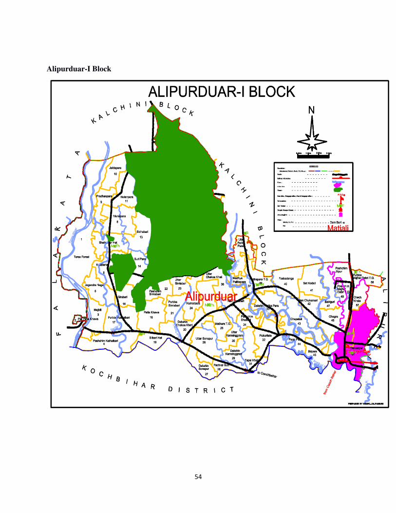
54
Alipurduar-I Block
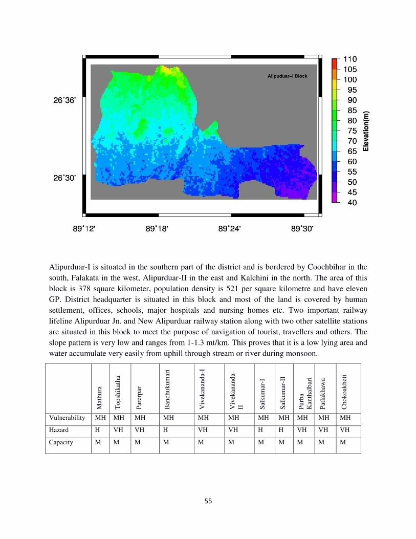
55
Alipurduar-I is situated in the southern part of the district and is bordered by Coochbihar in the
south, Falakata in the west, Alipurduar-II in the east and Kalchini in the north. The area of this
block is 378 square kilometer, population density is 521 per square kilometre and have eleven
GP. District headquarter is situated in this block and most of the land is covered by human
settlement, offices, schools, major hospitals and nursing homes etc. Two important railway
lifeline Alipurduar Jn. and New Alipurduar railway station along with two other satellite stations
are situated in this block to meet the purpose of navigation of tourist, travellers and others. The
slope pattern is very low and ranges from 1-1.3 mt/km. This proves that it is a low lying area and
water accumulate very easily from uphill through stream or river during monsoon.
Mat
hu
ra
To
psh
ikat
ha
Par
erp
ar
Ban
chu
ku
mar
i
Viv
ekan
and
a-I
Viv
ekan
and
a-
II
Sal
ku
mar
-I
Sal
ku
mar
-II
Pu
rba
Kan
thal
bar
i
Pat
lak
haw
a
Ch
ok
oak
het
i
Vulnerability MH MH MH MH MH MH MH MH MH MH MH
Hazard H VH VH H VH VH H H VH VH VH
Capacity M M M M M M M M M M M
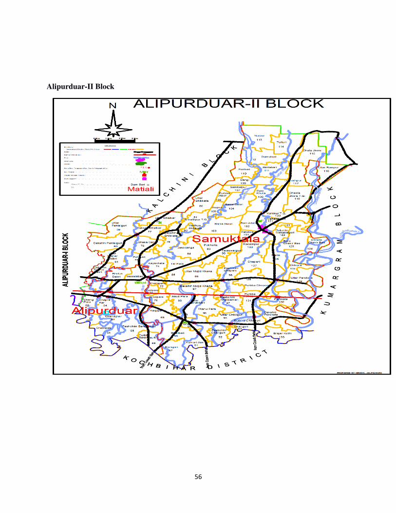
56
Alipurduar-II Block
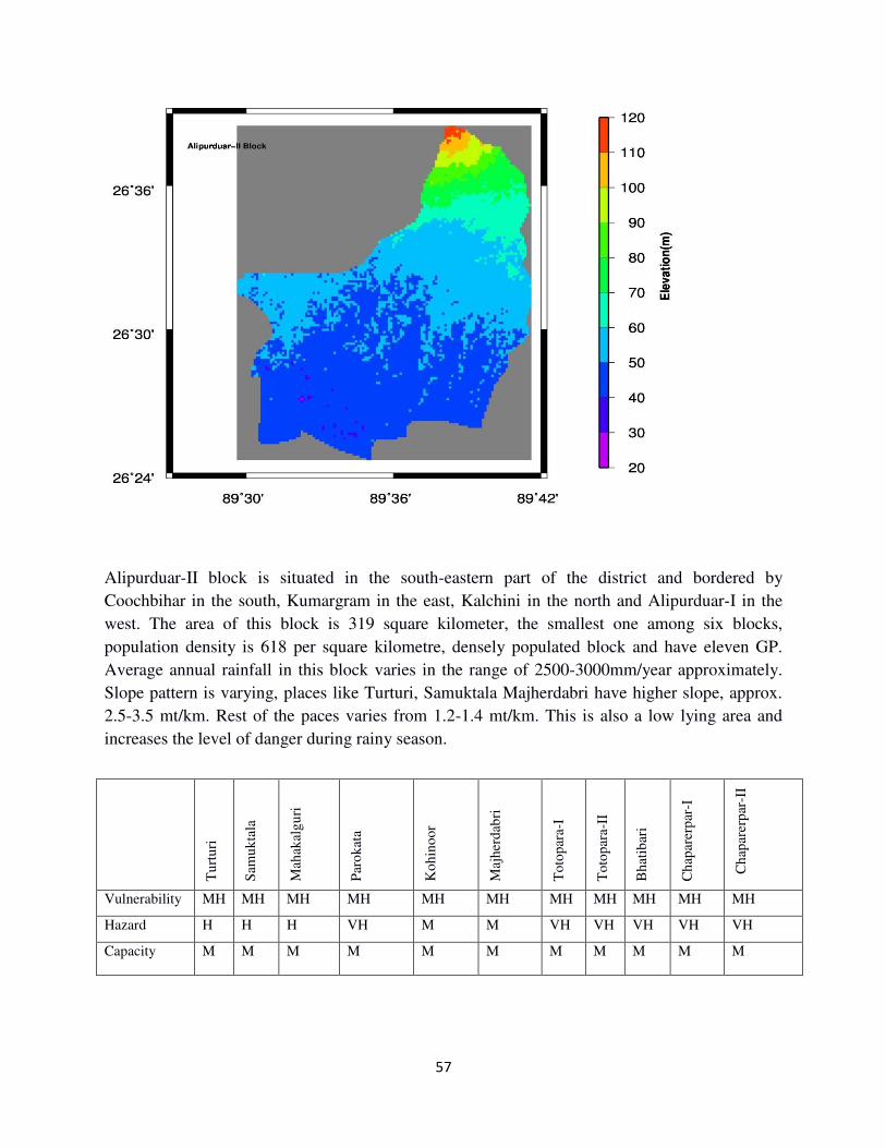
57
Alipurduar-II block is situated in the south-eastern part of the district and bordered by
Coochbihar in the south, Kumargram in the east, Kalchini in the north and Alipurduar-I in the
west. The area of this block is 319 square kilometer, the smallest one among six blocks,
population density is 618 per square kilometre, densely populated block and have eleven GP.
Average annual rainfall in this block varies in the range of 2500-3000mm/year approximately.
Slope pattern is varying, places like Turturi, Samuktala Majherdabri have higher slope, approx.
2.5-3.5 mt/km. Rest of the paces varies from 1.2-1.4 mt/km. This is also a low lying area and
increases the level of danger during rainy season.
Tu
rtu
ri
Sam
uk
tala
Mah
akal
gu
ri
Par
ok
ata
Ko
hin
oor
Maj
her
dab
ri
To
top
ara-I
To
top
ara-I
I
Bh
atib
ari
Ch
apar
erp
ar-I
C
hap
arer
par
-II
Vulnerability MH MH MH MH MH MH MH MH MH MH MH
Hazard H H H VH M M VH VH VH VH VH
Capacity M M M M M M M M M M M
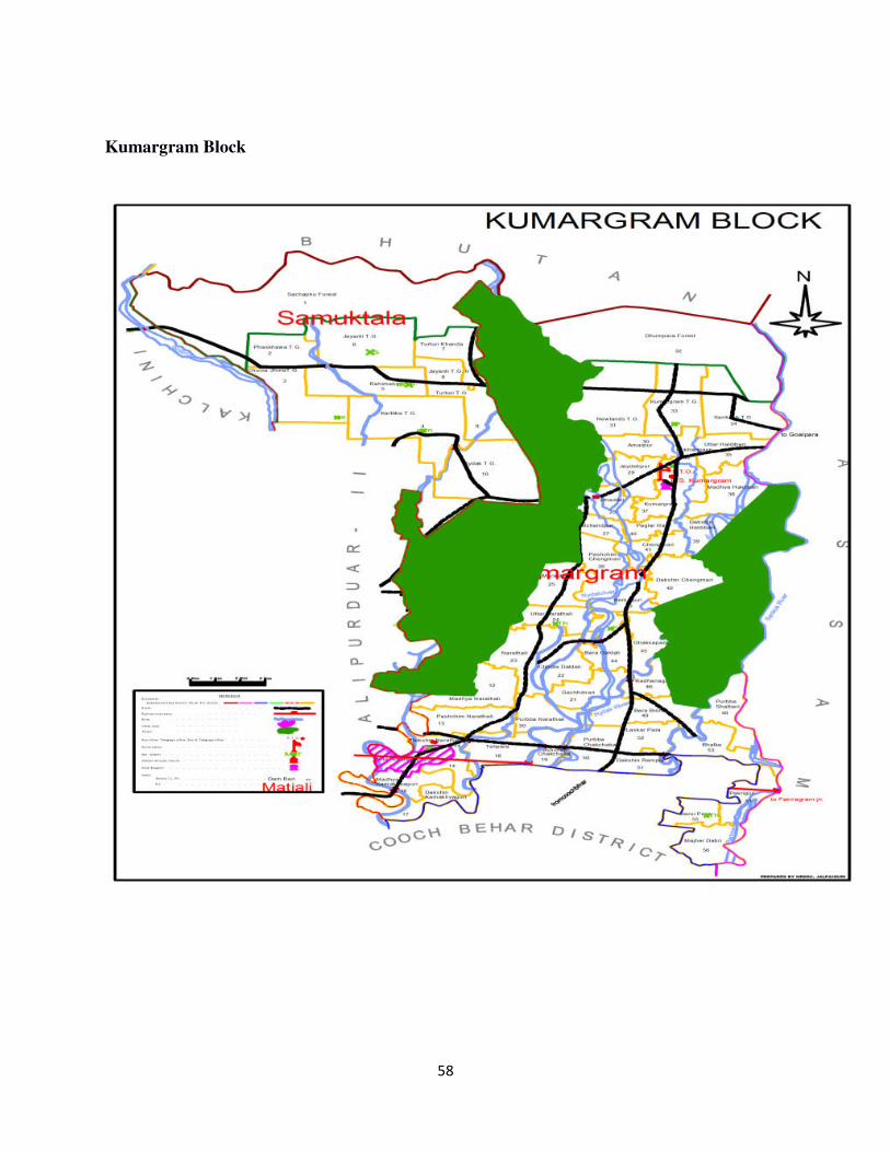
58
Kumargram Block
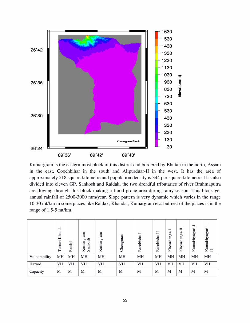
59
Kumargram is the eastern most block of this district and bordered by Bhutan in the north, Assam
in the east, Coochbihar in the south and Alipurduar-II in the west. It has the area of
approximately 518 square kilometre and population density is 344 per square kilometre. It is also
divided into eleven GP. Sankosh and Raidak, the two dreadful tributaries of river Brahmaputra
are flowing through this block making a flood prone area during rainy season. This block get
annual rainfall of 2500-3000 mm/year. Slope pattern is very dynamic which varies in the range
10-30 mt/km in some places like Raidak, Khanda , Kumargram etc. but rest of the places is in the
range of 1.5-5 mt/km.
Tu
rtu
ri K
han
da
Rai
dak
Ku
mar
gra
m-
San
ko
sh
Ku
mar
gra
m
Ch
eng
mar
i
Bar
ob
ish
a-I
Bar
ob
ish
a-II
Kh
oar
dan
ga-I
Kh
oar
dan
ga-I
I
Kam
akh
yag
uri
-I
Kam
akh
yag
uri
–
II
Vulnerability MH MH MH MH MH MH MH MH MH MH MH
Hazard VH VH VH VH VH VH VH VH VH VH VH
Capacity M M M M M M M M M M M
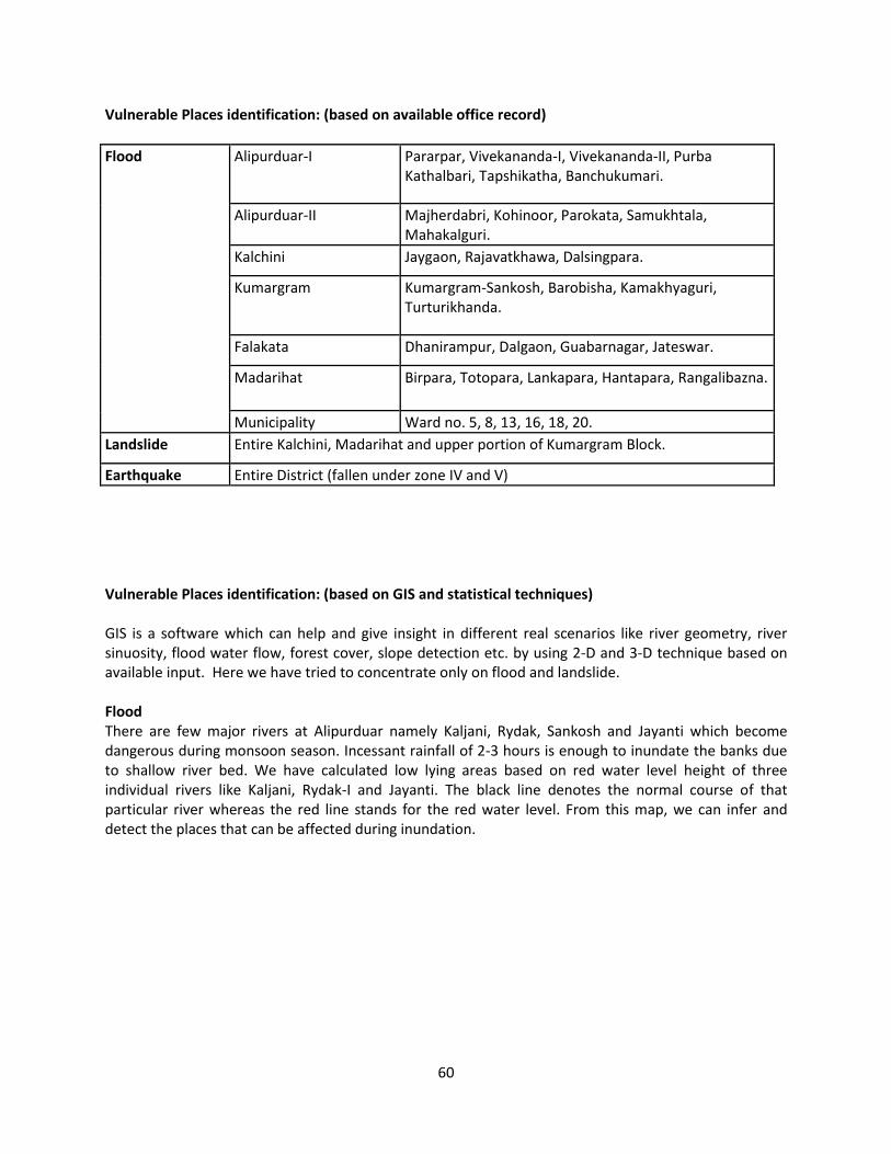
60
Vulnerable Places identification: (based on available office record)
Flood Alipurduar-I Pararpar, Vivekananda-I, Vivekananda-II, Purba
Kathalbari, Tapshikatha, Banchukumari.
Alipurduar-II Majherdabri, Kohinoor, Parokata, Samukhtala,
Mahakalguri.
Kalchini Jaygaon, Rajavatkhawa, Dalsingpara.
Kumargram Kumargram-Sankosh, Barobisha, Kamakhyaguri,
Turturikhanda.
Falakata Dhanirampur, Dalgaon, Guabarnagar, Jateswar.
Madarihat Birpara, Totopara, Lankapara, Hantapara, Rangalibazna.
Municipality Ward no. 5, 8, 13, 16, 18, 20.
Landslide Entire Kalchini, Madarihat and upper portion of Kumargram Block.
Earthquake Entire District (fallen under zone IV and V)
Vulnerable Places identification: (based on GIS and statistical techniques)
GIS is a software which can help and give insight in different real scenarios like river geometry, river
sinuosity, flood water flow, forest cover, slope detection etc. by using 2-D and 3-D technique based on
available input. Here we have tried to concentrate only on flood and landslide.
Flood
There are few major rivers at Alipurduar namely Kaljani, Rydak, Sankosh and Jayanti which become
dangerous during monsoon season. Incessant rainfall of 2-3 hours is enough to inundate the banks due
to shallow river bed. We have calculated low lying areas based on red water level height of three
individual rivers like Kaljani, Rydak-I and Jayanti. The black line denotes the normal course of that
particular river whereas the red line stands for the red water level. From this map, we can infer and
detect the places that can be affected during inundation.
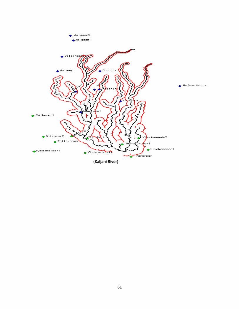
61
(Kaljani River)
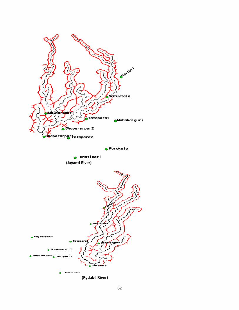
62
(Jayanti River)
(Rydak-I River)
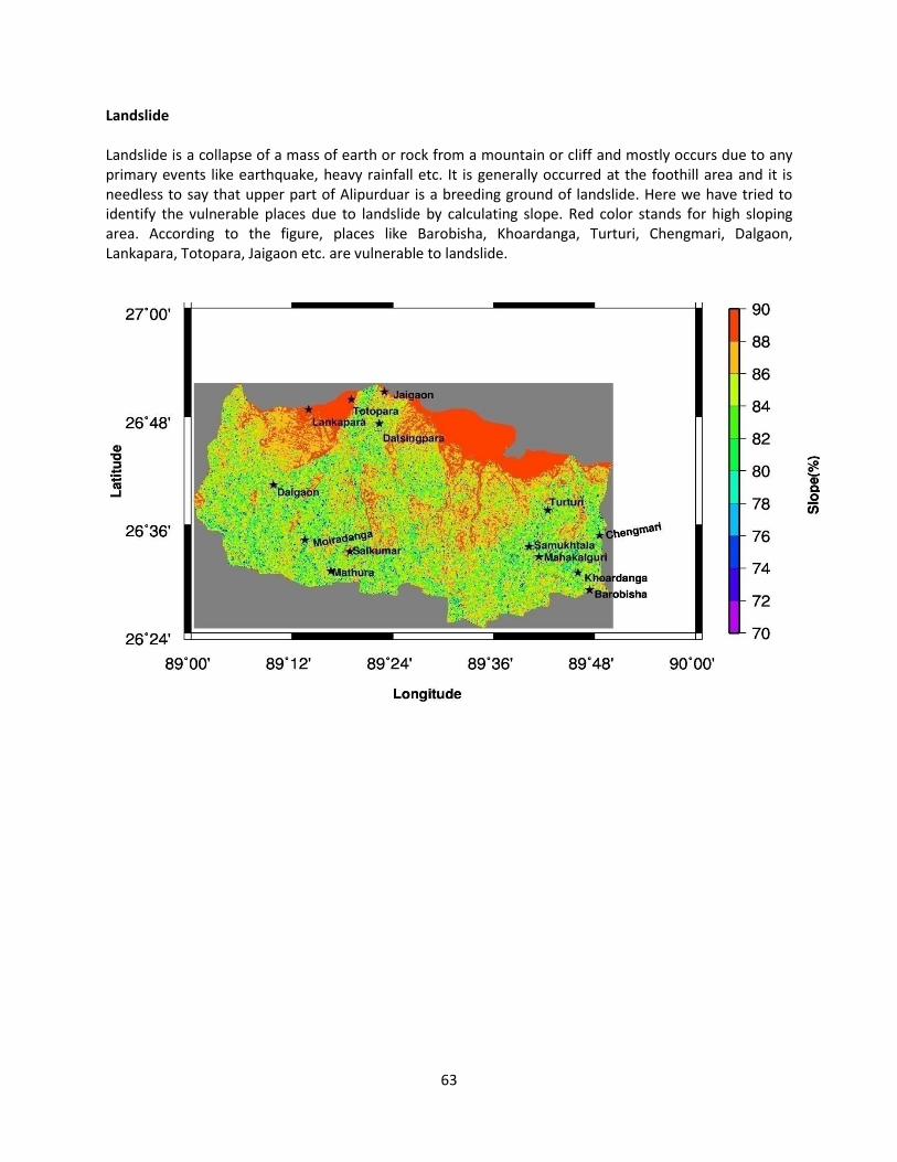
63
Landslide
Landslide is a collapse of a mass of earth or rock from a mountain or cliff and mostly occurs due to any
primary events like earthquake, heavy rainfall etc. It is generally occurred at the foothill area and it is
needless to say that upper part of Alipurduar is a breeding ground of landslide. Here we have tried to
identify the vulnerable places due to landslide by calculating slope. Red color stands for high sloping
area. According to the figure, places like Barobisha, Khoardanga, Turturi, Chengmari, Dalgaon,
Lankapara, Totopara, Jaigaon etc. are vulnerable to landslide.
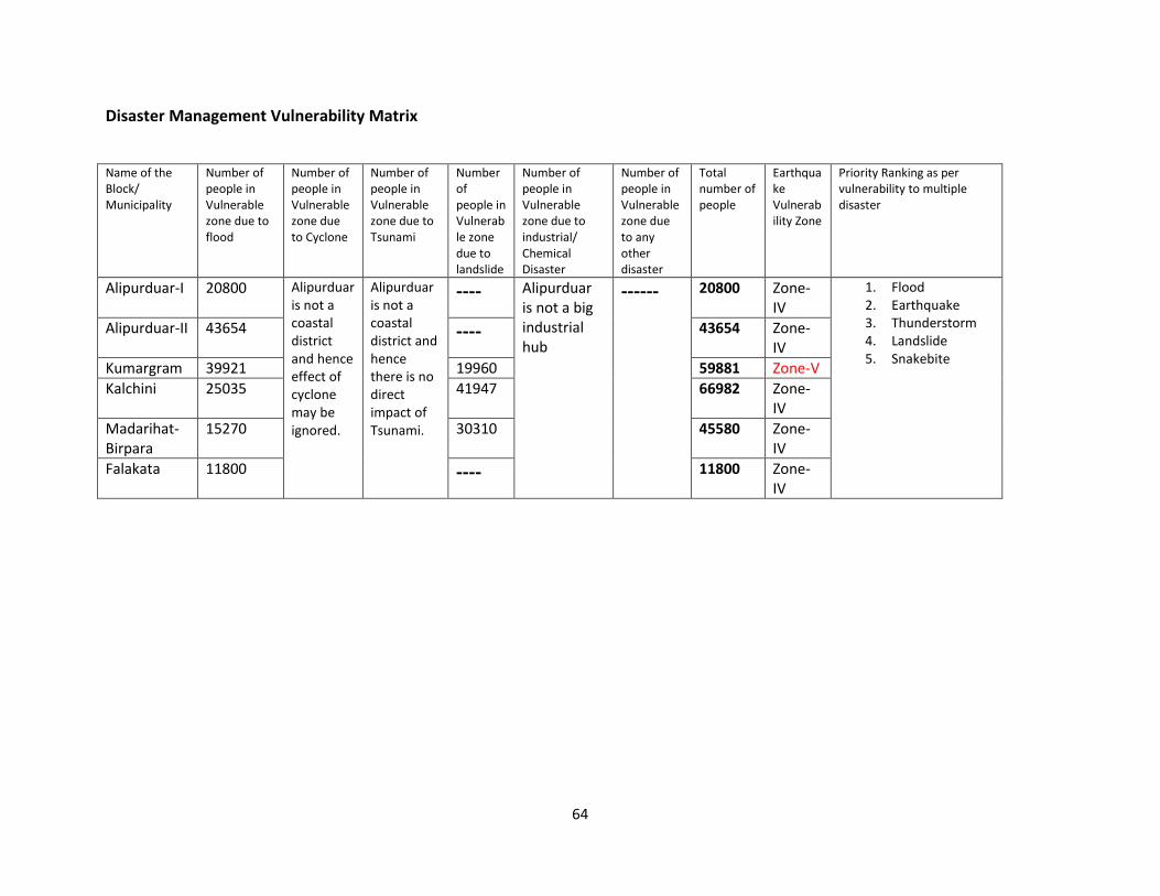
64
Disaster Management Vulnerability Matrix
Name of the
Block/
Municipality
Number of
people in
Vulnerable
zone due to
flood
Number of
people in
Vulnerable
zone due
to Cyclone
Number of
people in
Vulnerable
zone due to
Tsunami
Number
of
people in
Vulnerab
le zone
due to
landslide
Number of
people in
Vulnerable
zone due to
industrial/
Chemical
Disaster
Number of
people in
Vulnerable
zone due
to any
other
disaster
Total
number of
people
Earthqua
ke
Vulnerab
ility Zone
Priority Ranking as per
vulnerability to multiple
disaster
Alipurduar-I 20800 Alipurduar
is not a
coastal
district
and hence
effect of
cyclone
may be
ignored.
Alipurduar
is not a
coastal
district and
hence
there is no
direct
impact of
Tsunami.
---- Alipurduar
is not a big
industrial
hub
------ 20800 Zone-
IV
1. Flood
2. Earthquake
3. Thunderstorm
4. Landslide
5. Snakebite
Alipurduar-II 43654 ---- 43654 Zone-
IV
Kumargram 39921 19960 59881 Zone-V
Kalchini 25035 41947 66982 Zone-
IV
Madarihat-
Birpara
15270 30310 45580 Zone-
IV
Falakata 11800 ---- 11800 Zone-
IV
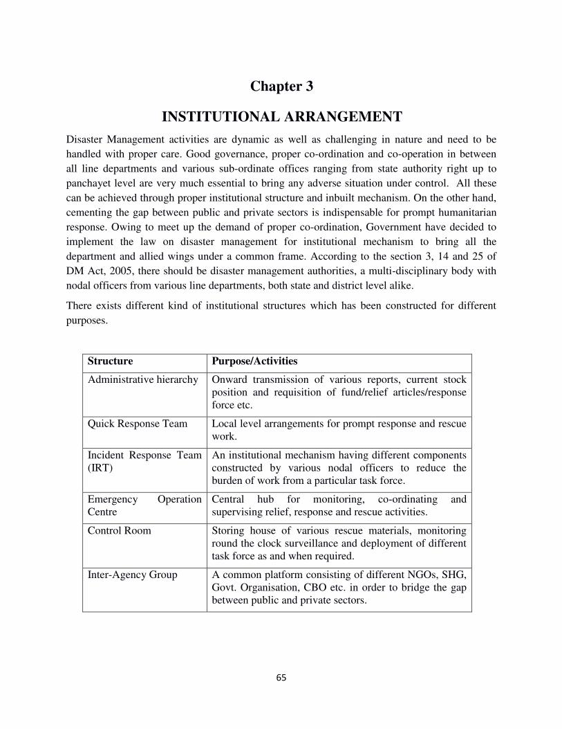
65
Chapter 3
INSTITUTIONAL ARRANGEMENT
Disaster Management activities are dynamic as well as challenging in nature and need to be
handled with proper care. Good governance, proper co-ordination and co-operation in between
all line departments and various sub-ordinate offices ranging from state authority right up to
panchayet level are very much essential to bring any adverse situation under control. All these
can be achieved through proper institutional structure and inbuilt mechanism. On the other hand,
cementing the gap between public and private sectors is indispensable for prompt humanitarian
response. Owing to meet up the demand of proper co-ordination, Government have decided to
implement the law on disaster management for institutional mechanism to bring all the
department and allied wings under a common frame. According to the section 3, 14 and 25 of
DM Act, 2005, there should be disaster management authorities, a multi-disciplinary body with
nodal officers from various line departments, both state and district level alike.
There exists different kind of institutional structures which has been constructed for different
purposes.
Structure Purpose/Activities
Administrative hierarchy Onward transmission of various reports, current stock
position and requisition of fund/relief articles/response
force etc.
Quick Response Team Local level arrangements for prompt response and rescue
work.
Incident Response Team
(IRT)
An institutional mechanism having different components
constructed by various nodal officers to reduce the
burden of work from a particular task force.
Emergency Operation
Centre
Central hub for monitoring, co-ordinating and
supervising relief, response and rescue activities.
Control Room Storing house of various rescue materials, monitoring
round the clock surveillance and deployment of different
task force as and when required.
Inter-Agency Group A common platform consisting of different NGOs, SHG,
Govt. Organisation, CBO etc. in order to bridge the gap
between public and private sectors.
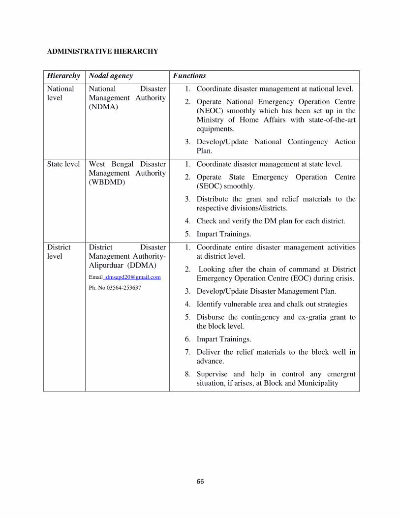
66
ADMINISTRATIVE HIERARCHY
Hierarchy Nodal agency Functions
National
level
National Disaster
Management Authority
(NDMA)
1. Coordinate disaster management at national level.
2. Operate National Emergency Operation Centre
(NEOC) smoothly which has been set up in the
Ministry of Home Affairs with state-of-the-art
equipments.
3. Develop/Update National Contingency Action
Plan.
State level West Bengal Disaster
Management Authority
(WBDMD)
1. Coordinate disaster management at state level.
2. Operate State Emergency Operation Centre
(SEOC) smoothly.
3. Distribute the grant and relief materials to the
respective divisions/districts.
4. Check and verify the DM plan for each district.
5. Impart Trainings.
District
level
District Disaster
Management Authority-
Alipurduar (DDMA)
Email :[email protected]
Ph. No 03564-253637
1. Coordinate entire disaster management activities
at district level.
2. Looking after the chain of command at District
Emergency Operation Centre (EOC) during crisis.
3. Develop/Update Disaster Management Plan.
4. Identify vulnerable area and chalk out strategies
5. Disburse the contingency and ex-gratia grant to
the block level.
6. Impart Trainings.
7. Deliver the relief materials to the block well in
advance.
8. Supervise and help in control any emergrnt
situation, if arises, at Block and Municipality
67
DDMA is the apex body to monitor and supervise all the disaster management activities in a district
ranging from raising awareness to providing relief and rescue to a people in need. DDMA can also
support the district by assisting with various thought provoking mitigation measure to build back better
and make our society disaster resilient. According to the order under section 25 of DM act, 2005 every
district should have a DDMA comprising of seven persons at most. We have already formed DDMA at
our district with the following members:
District Magistrate
Sabhadhipati/ Zilla Parishasad
Additional District Magistrate
Superintendent of Police
Chief Medical Officer of Health
Functionaries:
1. Build/Construct a proper disaster management plan including preparedness, relief, response and
rehabilitation of the district.
2. Coordinate and monitor the implementation of the National Policy, State Policy, National Plan,
State Plan and District Plan. 3. Detecting vulnerable areas in the district prone to specific disaster and ensuring special
mitigation measure for those places.
4. Give directions to different authorities at the district level and local authorities to take such other
measures for the prevention or mitigation of disasters as may be necessary. 5. Lay down guidelines for prevention of disaster management plans by the department of the
Government at districts level and local authorities in the district. 6. Organize training programs for different levels of officer, employees and voluntary rescue
workers in the district.
7. Coordinate immediate response to any threatening disastrous situation. 8. Review the state of capabilities for responding to any disaster or threatening disaster situation in
the district and give direction to the relevant departments or authorities at the district level for
their up gradation as may be necessary. 9. Conduct meeting with all BDMO for reviewing and assessing the progress on yearly
basis.
10. Advise and coordinate the activities of the Department of the Government at the district level,
statutory bodies and non-governmental organization in the district engaged in various activities
related to disaster management.
11. Identify buildings and places which can serve the purpose of relief centers or camps and make
arrangements for water supply and sanitation in such buildings or places. 12. Provide information to the State Authority related to different aspects of disaster management at
the time of their need. 13. Maintain stockpiles of relief and rescue materials in a systematic way to make them available
within a short notice.
14. Perform other functions as the State Govt. or State Authority may assign from time to time
which is necessary for disaster management in the District.
68
QUICK RESPONSE TEAM
The ultimate target of disaster management activists is to reduce loss of life and damage to properties,
public and private alike. That can only possible by providing prompt response without delay, resource
mobilisation as per the need/demand of indigent people and rescuing distressed persons from danger.
Quick Response Team is a task force that can perform all the above mentioned tasks at a single stroke.
QRT is generally formed with the help of local boys and girls (if necessary) for immediate response and is
deployed to strengthen all the vulnerable areas identified based on vulnerability analysis in a particular
locality. We have 966 trained civil defence volunteers throughout the district till date who can serve
the purpose of forming QRT and among them 31 personnel are well trained scuba divers. Some of
them have taken fire fighting training also. To make local QRT network stronger, the district
administration is regularly organising basic training at local level.
INCIDENT RESPONSE TEAM
While efforts have been made towards responding disasters to the best of available resources, the analysis
of various responses indicated the following lacunas.
1. Lack of systematic planning process.
2. Weak chain of command and supervision of response activity.
3. Lack of proper communication plan and inefficient use of available resources.
4. Want of coordination between first responders, duty officers and NGOs with specialized skills
during the response phase.
Incidence Response System aka IRS is a built-in in-house mechanism which reduces the burden of
responsibilities from the shoulder of a particular task force by distributing tasks among various expert
group, called Incident Response Team, depending upon the nature and magnitude of a particular disaster.
The basic characteristics of IRS are
1. It is a system with flexibility of activating a particular wing from an existing structure without
hampering other counterparts as per the situation demands.
2. It incorporates all the responsibilities and activities through a well-designed chain of command and
strictly follows the top-down approach.
3. It select all the officers required for a particular scenario and get them trained.
IRS is a framework whereas IRT is a team that can be activated during crisis as per the situation. It
comprises of various officers:
i) INCIDENT COMMANDER- Command and control of the specific response team.
ii) OPERATIONS SECTION CHIEF- Supervision and Performance of different tactical actions
required for disaster response.
iii) PLANNING SECTION CHIEF- Collection, analysis of data, working out the resource
requirement and preparing an action plan.
iv) LOGISTIC & FINANCE SECTION CHIEF - Providing logistic support, procurement,
maintaining accounts and ensuring cost effectiveness.
We have formed IRT at different administrative levels such as District, Sub-division and Block.
69
DISTRICT EMERGENCY OPERATION CENTRE (DEOC)
EOC is the backbone of disaster management section. Important decisions and activities like early
warning dissemination, close monitoring of any untoward situation, deployment of various response team,
keeping communication with different stakeholders and higher authorities during crisis period etc. is
performed from this particular wing in a systematic manner. Bold decision and proper communication
network is two important pillar of good governance and timely response which is executed here under the
guidance of committee members and nodal officers. So disaster management section without an EOC is
just like an aircraft without a pilot. The two most important sectors that might be affected by any hazard
are power/electricity and communication.
Keeping all these things in mind, recently we have refurbished our DEOC with state-of-the-art
equipments like digital display board for run time water level monitoring, two dedicated computer system
of having high performing capability, microphone with speaker for spreading alert message, inverter with
capability of providing power supply for extended period etc. To run the emergency centre smoothly
during crisis period, senior officials like Officer-in-Charge, DDMO, SSOI (civil defence), Disaster
Professional, other office staffs and volunteers from civil defence are available and perform their
individual duty meticulously. Following activities are performed in our DEOC in general:
Normal
Period Receive routine information from block and municipality level.
Distribute relief materials to the block in advance.
Ensure proper dissemination of information of district control.
Identify manpower belongs to different stakeholders, NGOs, Corporate sectors and
line department with contact number and address to form a team.
Monitor preparedness measures of the blocks by visiting the places.
Organise monthly meeting with the block level personnel for their progress.
Maintain a proper database for all the resources like relief materials, trained
manpower, technical instruments etc.
Updation/modification of DM plan according to the NDMA guidelines.
Identification of vulnerable area in terms of intensity of a catastrophe to put extra
effort towards saving life and property.
Monitoring stock of relief materials periodically.
Emergency
Period Keep constant watch on weather report and disseminating the same in the form of
radiogram to the various block and municipality.
Produce CA-II report to the higher authority periodically.
Deploy different trained manpower and task forces in the vulnerable places as and
when required.
Keep contact with the relief camp time to time to meet up the need of distressed
persons.
Keep close contact with different line departments and other stakeholders like NGO,
CBO etc.
70
FLOOD CONTROL ROOM
Control room is the storehouse of various rescue materials, diving instruments and manpower.
In the district, a seasonal control room for five months is opened according to the
commencement and withdrawal of monsoon. During this period activities like round the clock
surveillance, close watch on weather report/rainfall measurement/water level, keeping record
of any negative event like water logging condition/heavy rainfall/ drowning etc. is carried out
by civil defense volunteers according to a duty roster furnished by the district authority. We
have a flood control room at our district which generally open on 01.06.2018 and close on
31.10.2018 and it has a dedicated landline telephone number marked as hotline with Army
because of the importance.
INTER AGENCY GROUP (IAG)
Inter Agency Group is a common platform to share thoughts and views of different govt. and
non govt. organizations that are attached with various disaster risk reduction activities. In a
nutshell, it is an effort towards bridging the gap between govt. sectors and non govt.
organization. Our state level IAG was formed in the year 2014 and started the journey. In this
due course of time, it has been extended far enough and at present it has more than 150
members from different sectors like Ham radio operator, members of various NGO’s, Police
dept., NDRF personnel, DDMO, SDDMO, BDMO etc. Among them, we have identified those
organizations that are long been working in our area at Alipurduar from grass root level and
made a database of them along with the sector of expertise they are working for. Some of them
work only for the safety of children, some are working for environment and health hazard,
some are attached with social activities and some are attached with entire DRR activities. This
database guides us to take prompt decision to select the expert group without wasting time.
Place Control room number
District HQ 03564-257091
Sadar Sub-Division 03564-256391
Municipality 03564-255580
Alipurduar-I Block 7797864100
Alipurduar-II Block 7797864200
Kalchini Block 03566-240205
Kumargram Block 03564-252239
Madarihat Block 7797863900
Falakata Block 03563-260283
71
Organization Area of expertise Contact person
PRISM Disaster Risk Reduction,
School safety, Health hazard.
Anirudhdha De-9748107612
Nita Dhar-9832664896
CASA DRR activities, child safety
issues.
Animesh Mazumdar-
8145523347
Debojyoti Chakravorty-
9433190122
DPGBS DRR activities. Pritwish Karmakar-
9733142464
Rural Aid Community awareness. Manik Dhar-8509391010
Mahila Sishu Suswastha
Suchetana Org. (MSSO)
Women health awareness and
empowerment 9733272943
Lok Kalyan Parishad Social welfare 9641608940
BIRPARA WELFARE
ORGANIZATION
Social welfare Indrajit Dey- 9832515736
JALDAPARA-MADARIHAT
WELFARE ORGANIZATION
Social welfare Sugam Goutam
-9734024747
NEST Environmental activities Kallol Dey- 9733120504
St. John Ambulance & Red
Cross Society
Medical Treatment, First Aid
and Snakebite Specialist
Jayanta Das-8967408378
SIREN SYSTEM
Siren is a device which acts as an alarm bell for warning of any danger. It is basically a sound
system and is blown for a particular time period with various frequencies to aware local
peoples and officials about any event. We have our own siren system which is kept functional
and is blown on daily basis at sharp 9:00 AM for one minute.
DISASTER MANAGEMENT GROUP
We have formed a disaster management Whatsapp group at Alipurduar District comprising
various nodal officers of different line departments, Sub-Division and Blocks in order to conduct
relief and rescue activities smoothly at the time of emergency. After formation of this group,
activities like rescuing people from danger, special protection at various vulnerable places,
prompt action on restoration works of different public properties etc. on emergency basis is
being done very well and hastily.
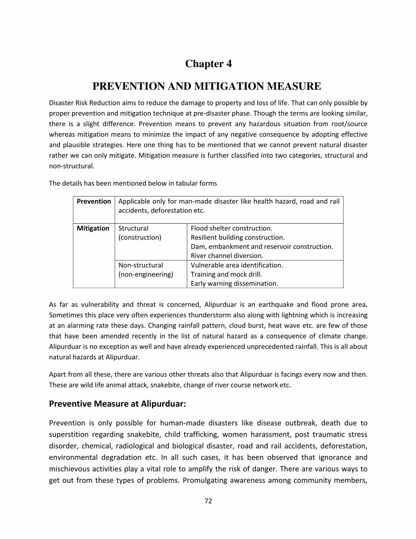
72
Chapter 4
PREVENTION AND MITIGATION MEASURE
Disaster Risk Reduction aims to reduce the damage to property and loss of life. That can only possible by
proper prevention and mitigation technique at pre-disaster phase. Though the terms are looking similar,
there is a slight difference. Prevention means to prevent any hazardous situation from root/source
whereas mitigation means to minimize the impact of any negative consequence by adopting effective
and plausible strategies. Here one thing has to be mentioned that we cannot prevent natural disaster
rather we can only mitigate. Mitigation measure is further classified into two categories, structural and
non-structural.
The details has been mentioned below in tabular forms
As far as vulnerability and threat is concerned, Alipurduar is an earthquake and flood prone area.
Sometimes this place very often experiences thunderstorm also along with lightning which is increasing
at an alarming rate these days. Changing rainfall pattern, cloud burst, heat wave etc. are few of those
that have been amended recently in the list of natural hazard as a consequence of climate change.
Alipurduar is no exception as well and have already experienced unprecedented rainfall. This is all about
natural hazards at Alipurduar.
Apart from all these, there are various other threats also that Alipurduar is facings every now and then.
These are wild life animal attack, snakebite, change of river course network etc.
Preventive Measure at Alipurduar:
Prevention is only possible for human-made disasters like disease outbreak, death due to
superstition regarding snakebite, child trafficking, women harassment, post traumatic stress
disorder, chemical, radiological and biological disaster, road and rail accidents, deforestation,
environmental degradation etc. In all such cases, it has been observed that ignorance and
mischievous activities play a vital role to amplify the risk of danger. There are various ways to
get out from these types of problems. Promulgating awareness among community members,
Prevention Applicable only for man-made disaster like health hazard, road and rail
accidents, deforestation etc.
Mitigation Structural
(construction)
Flood shelter construction.
Resilient building construction.
Dam, embankment and reservoir construction.
River channel diversion.
Non-structural
(non-engineering)
Vulnerable area identification.
Training and mock drill.
Early warning dissemination.
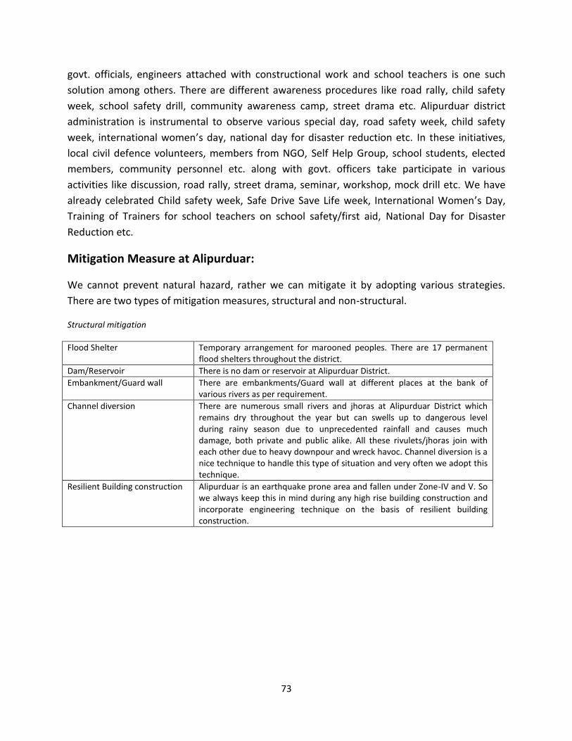
73
govt. officials, engineers attached with constructional work and school teachers is one such
solution among others. There are different awareness procedures like road rally, child safety
week, school safety drill, community awareness camp, street drama etc. Alipurduar district
administration is instrumental to observe various special day, road safety week, child safety
week, international women’s day, national day for disaster reduction etc. In these initiatives,
local civil defence volunteers, members from NGO, Self Help Group, school students, elected
members, community personnel etc. along with govt. officers take participate in various
activities like discussion, road rally, street drama, seminar, workshop, mock drill etc. We have
already celebrated Child safety week, Safe Drive Save Life week, International Women’s Day,
Training of Trainers for school teachers on school safety/first aid, National Day for Disaster
Reduction etc.
Mitigation Measure at Alipurduar:
We cannot prevent natural hazard, rather we can mitigate it by adopting various strategies.
There are two types of mitigation measures, structural and non-structural.
Structural mitigation
Flood Shelter Temporary arrangement for marooned peoples. There are 17 permanent
flood shelters throughout the district.
Dam/Reservoir There is no dam or reservoir at Alipurduar District.
Embankment/Guard wall There are embankments/Guard wall at different places at the bank of
various rivers as per requirement.
Channel diversion There are numerous small rivers and jhoras at Alipurduar District which
remains dry throughout the year but can swells up to dangerous level
during rainy season due to unprecedented rainfall and causes much
damage, both private and public alike. All these rivulets/jhoras join with
each other due to heavy downpour and wreck havoc. Channel diversion is a
nice technique to handle this type of situation and very often we adopt this
technique.
Resilient Building construction Alipurduar is an earthquake prone area and fallen under Zone-IV and V. So
we always keep this in mind during any high rise building construction and
incorporate engineering technique on the basis of resilient building
construction.
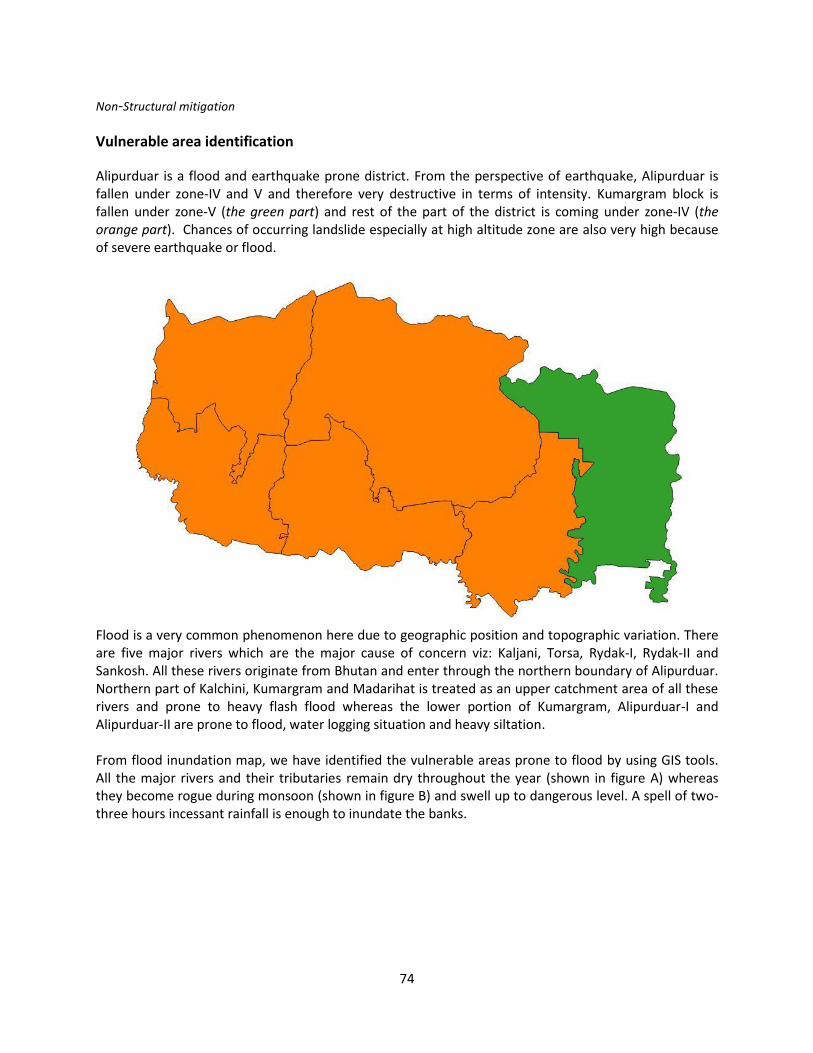
74
Non-Structural mitigation
Vulnerable area identification
Alipurduar is a flood and earthquake prone district. From the perspective of earthquake, Alipurduar is
fallen under zone-IV and V and therefore very destructive in terms of intensity. Kumargram block is
fallen under zone-V (the green part) and rest of the part of the district is coming under zone-IV (the
orange part). Chances of occurring landslide especially at high altitude zone are also very high because
of severe earthquake or flood.
Flood is a very common phenomenon here due to geographic position and topographic variation. There
are five major rivers which are the major cause of concern viz: Kaljani, Torsa, Rydak-I, Rydak-II and
Sankosh. All these rivers originate from Bhutan and enter through the northern boundary of Alipurduar.
Northern part of Kalchini, Kumargram and Madarihat is treated as an upper catchment area of all these
rivers and prone to heavy flash flood whereas the lower portion of Kumargram, Alipurduar-I and
Alipurduar-II are prone to flood, water logging situation and heavy siltation.
From flood inundation map, we have identified the vulnerable areas prone to flood by using GIS tools.
All the major rivers and their tributaries remain dry throughout the year (shown in figure A) whereas
they become rogue during monsoon (shown in figure B) and swell up to dangerous level. A spell of two-
three hours incessant rainfall is enough to inundate the banks.
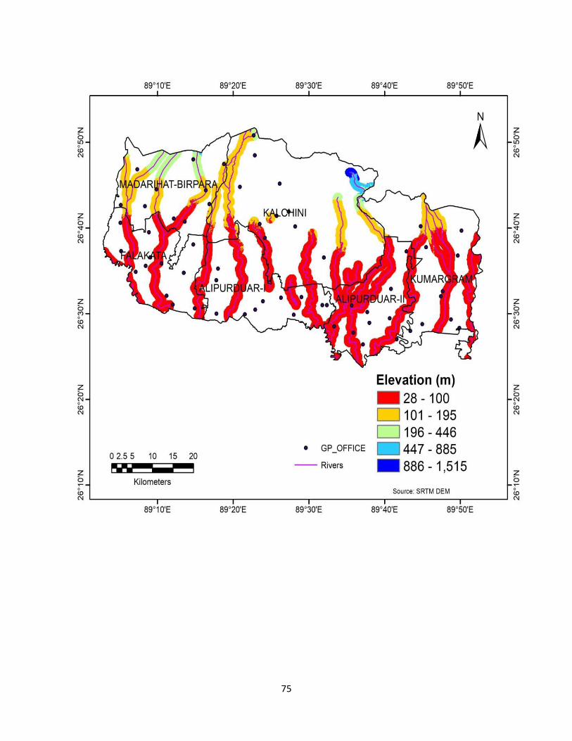
75
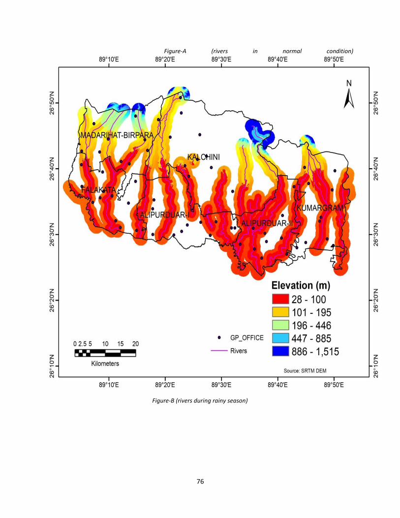
76
Figure-A (rivers in normal condition)
Figure-B (rivers during rainy season)
77
Training/ Mock Drill/Awareness
Capacity building is an essential tool to face any negative consequence and withstand disasters.
This is considered to be a vital non-structural mitigation measure. There are various types of
capacity building procedures (details have been discussed elaborately in chapter 6). Community
awareness, mock drill, special day observance, awareness camp, training of trainers,
workshop/seminar is few of them. All these trainings are regularly being conducted at
Alipurduar district based on the nature and gravity of disaster. Special emphasis is given on
flood, earthquake, snakebite, thunderstorm etc.
Early warning dissemination
Nothing is better than being aware about any forthcoming untoward situation well in advance.
Science and technology has gone very far and some natural hazards like cyclone, heavy rainfall,
thunderstorm, tsunami etc. are predictable now-a-days except earthquake which is
unpredictable. We cannot prevent natural hazard but systematic approach and early warning
can save our society from major damage later on. So early warning on time about any natural
hazard is an essential tool for better preparedness. Various nodal agencies are responsible for
early warning dissemination due to different natural hazards. The list is mentioned below:
Gone are those days when we had to depend only on radio for weather forecast. Now peoples
and community members are receiving warning messages in their personal mobile phone; beside
Name of the hazard Nodal forecasting agency Instrument used
Heavy rainfall, cyclone, cloud
burst, heat and cold waves, drought,
earthquake.
IMD INSAT image/ Doppler
RADAR/ AWS
Tsunami, coastal hazard, high wave
alert
INCOIS Wave Rider Buoy
Flood and flash flood CWC Water level gauge
Landslide GSI ---
Snow and avalanche Snow and Avalanche Study
Establishment
----
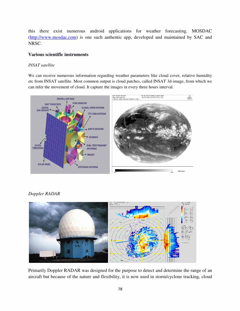
78
this there exist numerous android applications for weather forecasting. MOSDAC
(http://www.mosdac.com) is one such authentic app, developed and maintained by SAC and
NRSC.
Various scientific instruments
INSAT satellite
We can receive numerous information regarding weather parameters like cloud cover, relative humidity
etc from INSAT satellite. Most common output is cloud patches, called INSAT 3d-image, from which we
can infer the movement of cloud. It capture the images in every three hours interval.
Doppler RADAR
Primarily Doppler RADAR was designed for the purpose to detect and determine the range of an
aircraft but because of the nature and flexibility, it is now used in storm/cyclone tracking, cloud
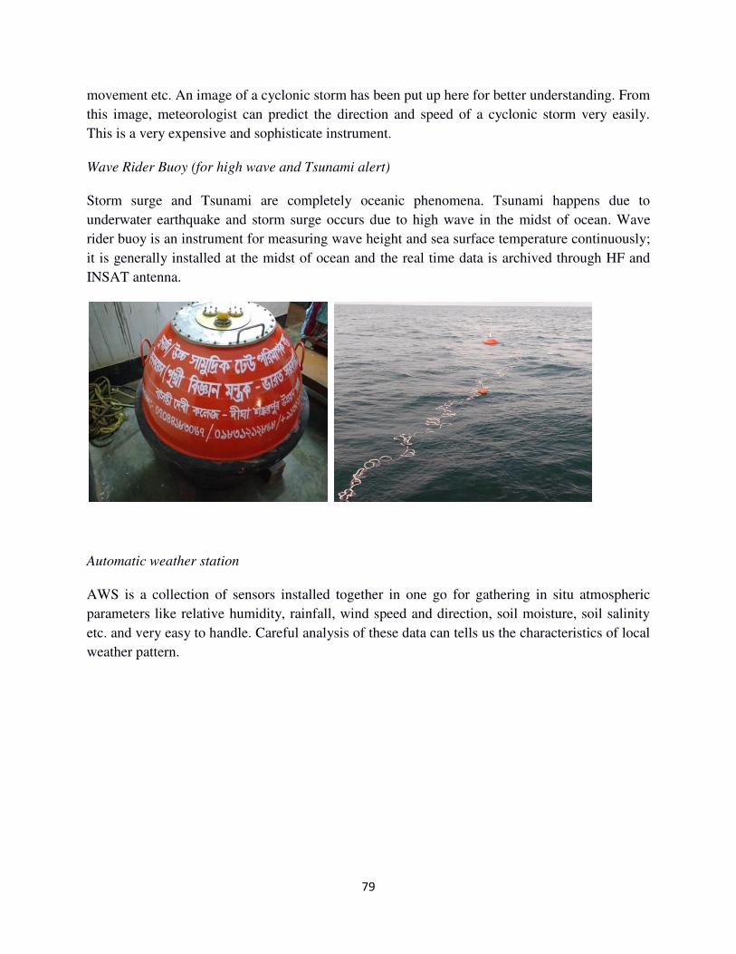
79
movement etc. An image of a cyclonic storm has been put up here for better understanding. From
this image, meteorologist can predict the direction and speed of a cyclonic storm very easily.
This is a very expensive and sophisticate instrument.
Wave Rider Buoy (for high wave and Tsunami alert)
Storm surge and Tsunami are completely oceanic phenomena. Tsunami happens due to
underwater earthquake and storm surge occurs due to high wave in the midst of ocean. Wave
rider buoy is an instrument for measuring wave height and sea surface temperature continuously;
it is generally installed at the midst of ocean and the real time data is archived through HF and
INSAT antenna.
Automatic weather station
AWS is a collection of sensors installed together in one go for gathering in situ atmospheric
parameters like relative humidity, rainfall, wind speed and direction, soil moisture, soil salinity
etc. and very easy to handle. Careful analysis of these data can tells us the characteristics of local
weather pattern.
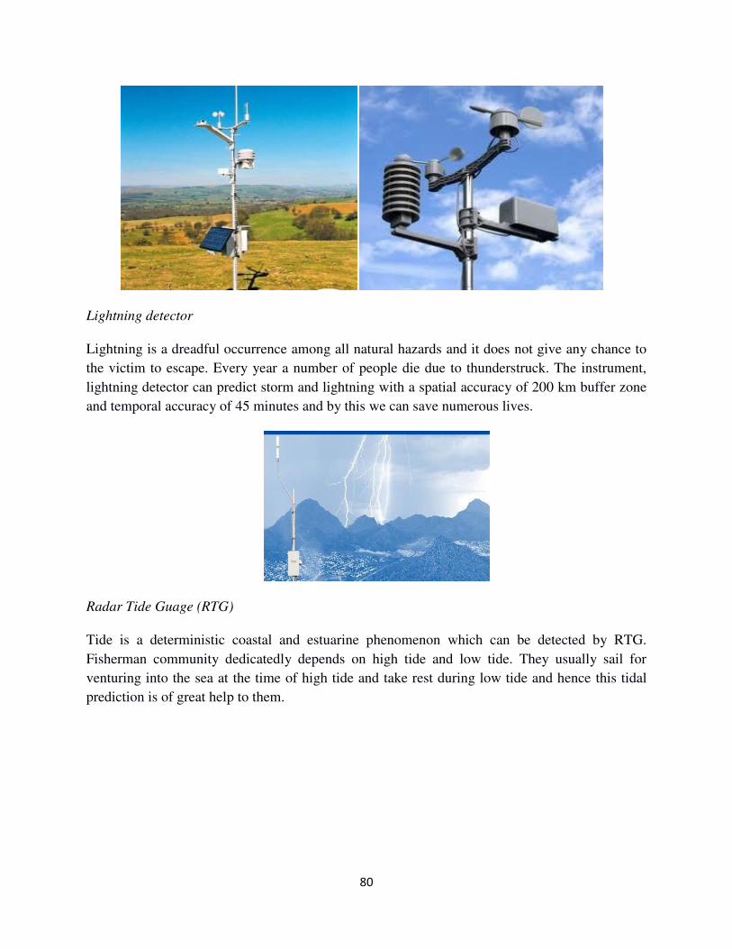
80
Lightning detector
Lightning is a dreadful occurrence among all natural hazards and it does not give any chance to
the victim to escape. Every year a number of people die due to thunderstruck. The instrument,
lightning detector can predict storm and lightning with a spatial accuracy of 200 km buffer zone
and temporal accuracy of 45 minutes and by this we can save numerous lives.
Radar Tide Guage (RTG)
Tide is a deterministic coastal and estuarine phenomenon which can be detected by RTG.
Fisherman community dedicatedly depends on high tide and low tide. They usually sail for
venturing into the sea at the time of high tide and take rest during low tide and hence this tidal
prediction is of great help to them.
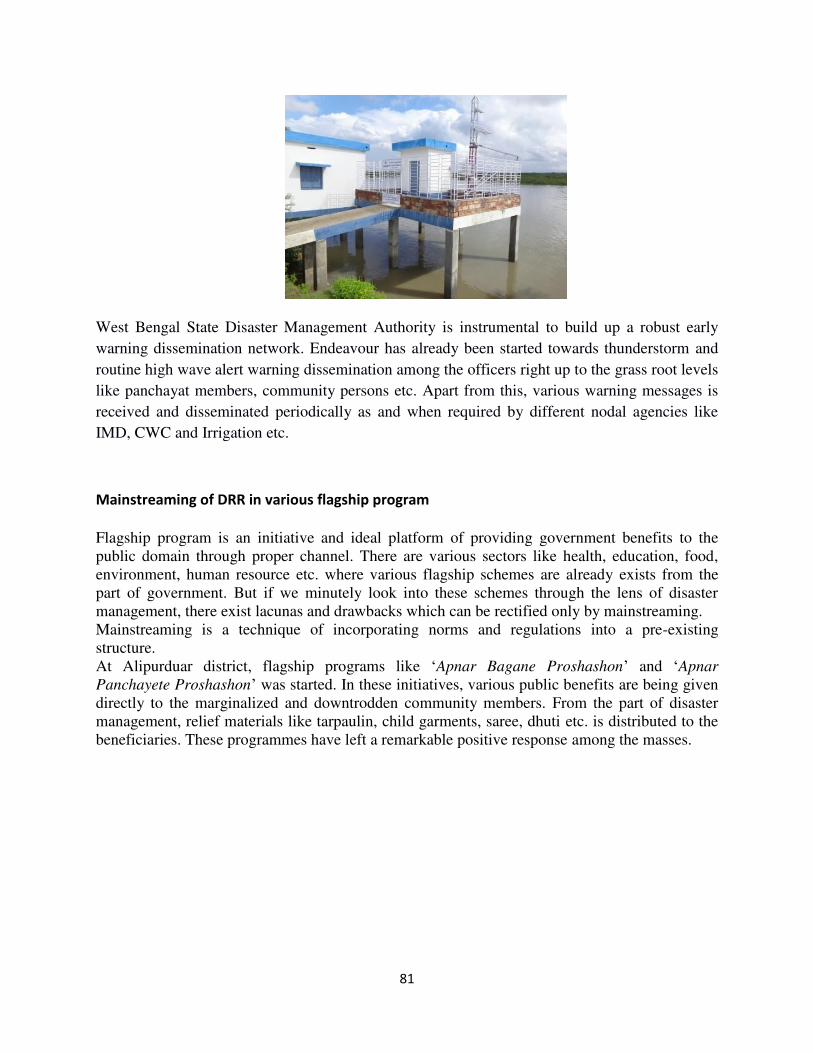
81
West Bengal State Disaster Management Authority is instrumental to build up a robust early
warning dissemination network. Endeavour has already been started towards thunderstorm and
routine high wave alert warning dissemination among the officers right up to the grass root levels
like panchayat members, community persons etc. Apart from this, various warning messages is
received and disseminated periodically as and when required by different nodal agencies like
IMD, CWC and Irrigation etc.
Mainstreaming of DRR in various flagship program
Flagship program is an initiative and ideal platform of providing government benefits to the
public domain through proper channel. There are various sectors like health, education, food,
environment, human resource etc. where various flagship schemes are already exists from the
part of government. But if we minutely look into these schemes through the lens of disaster
management, there exist lacunas and drawbacks which can be rectified only by mainstreaming.
Mainstreaming is a technique of incorporating norms and regulations into a pre-existing
structure.
At Alipurduar district, flagship programs like ‘Apnar Bagane Proshashon’ and ‘Apnar
Panchayete Proshashon’ was started. In these initiatives, various public benefits are being given
directly to the marginalized and downtrodden community members. From the part of disaster
management, relief materials like tarpaulin, child garments, saree, dhuti etc. is distributed to the
beneficiaries. These programmes have left a remarkable positive response among the masses.
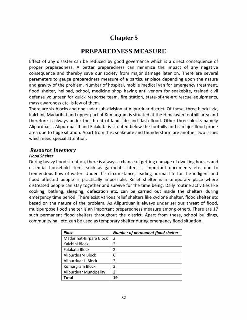
82
Chapter 5
PREPAREDNESS MEASURE
Effect of any disaster can be reduced by good governance which is a direct consequence of proper preparedness. A better preparedness can minimize the impact of any negative consequence and thereby save our society from major damage later on. There are several parameters to gauge preparedness measure of a particular place depending upon the nature and gravity of the problem. Number of hospital, mobile medical van for emergency treatment, flood shelter, helipad, school, medicine shop having anti venom for snakebite, trained civil defense volunteer for quick response team, fire station, state-of-the-art rescue equipments, mass awareness etc. is few of them. There are six blocks and one sadar sub-division at Alipurduar district. Of these, three blocks viz, Kalchini, Madarihat and upper part of Kumargram is situated at the Himalayan foothill area and therefore is always under the threat of landslide and flash flood. Other three blocks namely Alipurduar-I, Alipurduar-II and Falakata is situated below the foothills and is major flood prone area due to huge siltation. Apart from this, snakebite and thunderstorm are another two issues which need special attention.
Resource Inventory
Flood Shelter
During heavy flood situation, there is always a chance of getting damage of dwelling houses and essential household items such as garments, utensils, important documents etc. due to tremendous flow of water. Under this circumstance, leading normal life for the indigent and flood affected people is practically impossible. Relief shelter is a temporary place where distressed people can stay together and survive for the time being. Daily routine activities like cooking, bathing, sleeping, defecation etc. can be carried out inside the shelters during emergency time period. There exist various relief shelters like cyclone shelter, flood shelter etc based on the nature of the problem. As Alipurduar is always under serious threat of flood, multipurpose flood shelter is an important preparedness measure among others. There are 17 such permanent flood shelters throughout the district. Apart from these, school buildings, community hall etc. can be used as temporary shelter during emergency flood situation.
Place Number of permanent flood shelter
Madarihat-Birpara Block 2
Kalchini Block 2
Falakata Block 2
Alipurduar-I Block 6
Alipurduar-II Block 2
Kumargram Block 3
Alipurduar Muncipality 2
Total 19
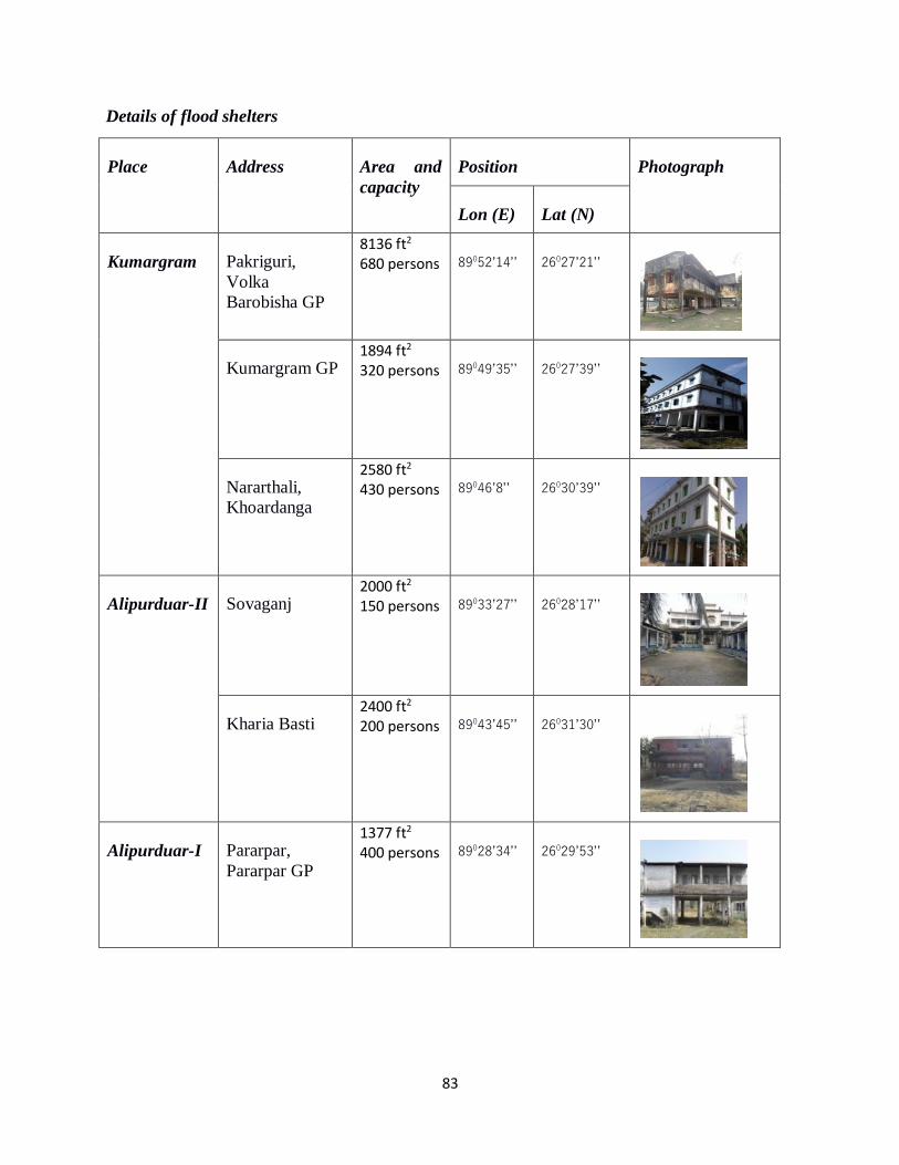
83
Details of flood shelters
Place Address Area and
capacity
Position Photograph
Lon (E) Lat (N)
Kumargram Pakriguri,
Volka
Barobisha GP
8136 ft2 680 persons 89052’14’’ 26027’21’’
Kumargram GP 1894 ft2 320 persons 89049’35’’ 26027’39’’
Nararthali,
Khoardanga
2580 ft2 430 persons 89046’8’’ 26030’39’’
Alipurduar-II Sovaganj 2000 ft2 150 persons 89033’27’’ 26028’17’’
Kharia Basti 2400 ft2 200 persons 89043’45’’ 26031’30’’
Alipurduar-I Pararpar,
Pararpar GP
1377 ft2 400 persons 89028’34’’ 26029’53’’
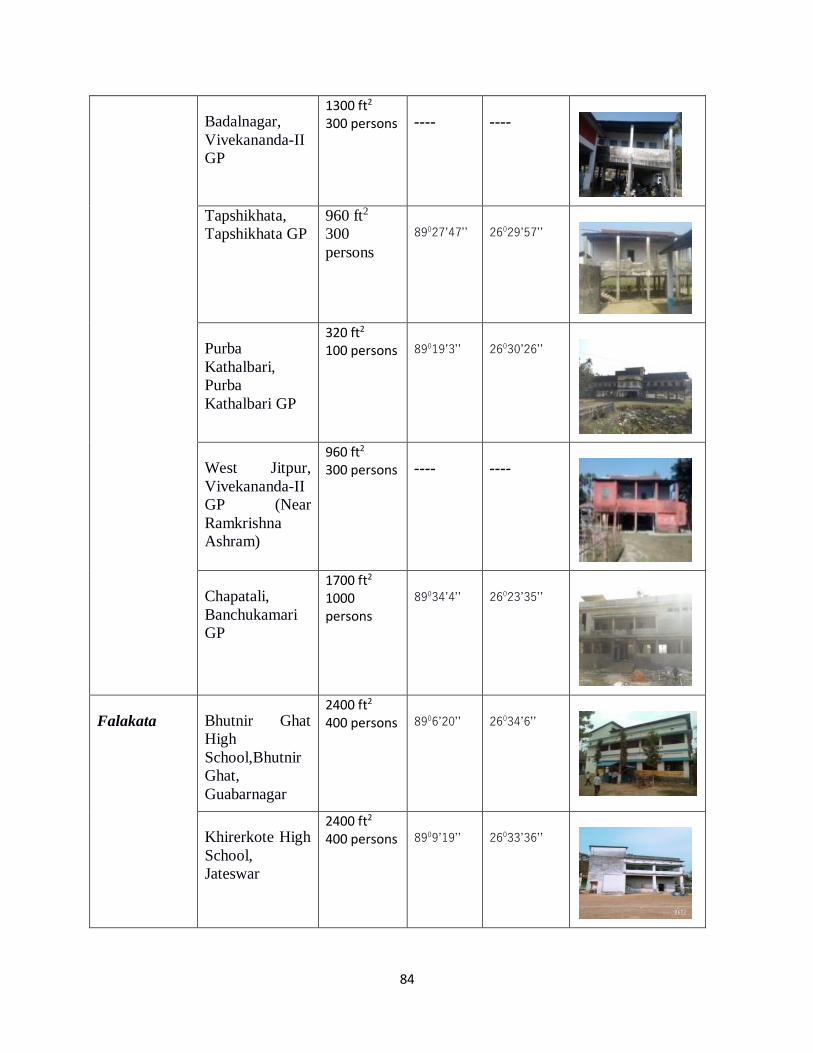
84
Badalnagar,
Vivekananda-II
GP
1300 ft2 300 persons ---- ----
Tapshikhata,
Tapshikhata GP
960 ft2
300
persons
89027’47’’ 26029’57’’
Purba
Kathalbari,
Purba
Kathalbari GP
320 ft2 100 persons 89019’3’’ 26030’26’’
West Jitpur,
Vivekananda-II
GP (Near
Ramkrishna
Ashram)
960 ft2 300 persons ---- ----
Chapatali,
Banchukamari
GP
1700 ft2 1000 persons
89034’4’’ 26023’35’’
Falakata Bhutnir Ghat
High
School,Bhutnir
Ghat,
Guabarnagar
2400 ft2 400 persons 8906’20’’ 26034’6’’
Khirerkote High
School,
Jateswar
2400 ft2 400 persons 8909’19’’ 26033’36’’
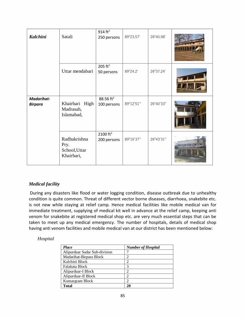
85
Kalchini Satali 914 ft2 250 persons 89023.57’ 26040.98’
Uttar mendabari 205 ft2 50 persons 89024.2’ 26037.24’
Madarihat- Birpara Khairbari High
Madrasah,
Islamabad,
88.56 ft2 100 persons 89012’51’’ 26040’33’’
Radhakrishna
Pry.
School,Uttar
Khairbari,
2100 ft2 200 persons 89016’37’’ 26043’31’’
Medical facility
During any disasters like flood or water logging condition, disease outbreak due to unhealthy condition is quite common. Threat of different vector borne diseases, diarrhoea, snakebite etc. is not new while staying at relief camp. Hence medical facilities like mobile medical van for immediate treatment, supplying of medical kit well in advance at the relief camp, keeping anti venom for snakebite at registered medical shop etc. are very much essential steps that can be taken to meet up any medical emergency. The number of hospitals, details of medical shop having anti venom facilities and mobile medical van at our district has been mentioned below:
Hospital
Place Number of Hospital
Alipurduar Sadar Sub-division 7
Madarihat-Birpara Block 2
Kalchini Block 2
Falakata Block 3
Alipurduar-I Block 2
Alipurduar-II Block 2
Kumargram Block 2
Total 20
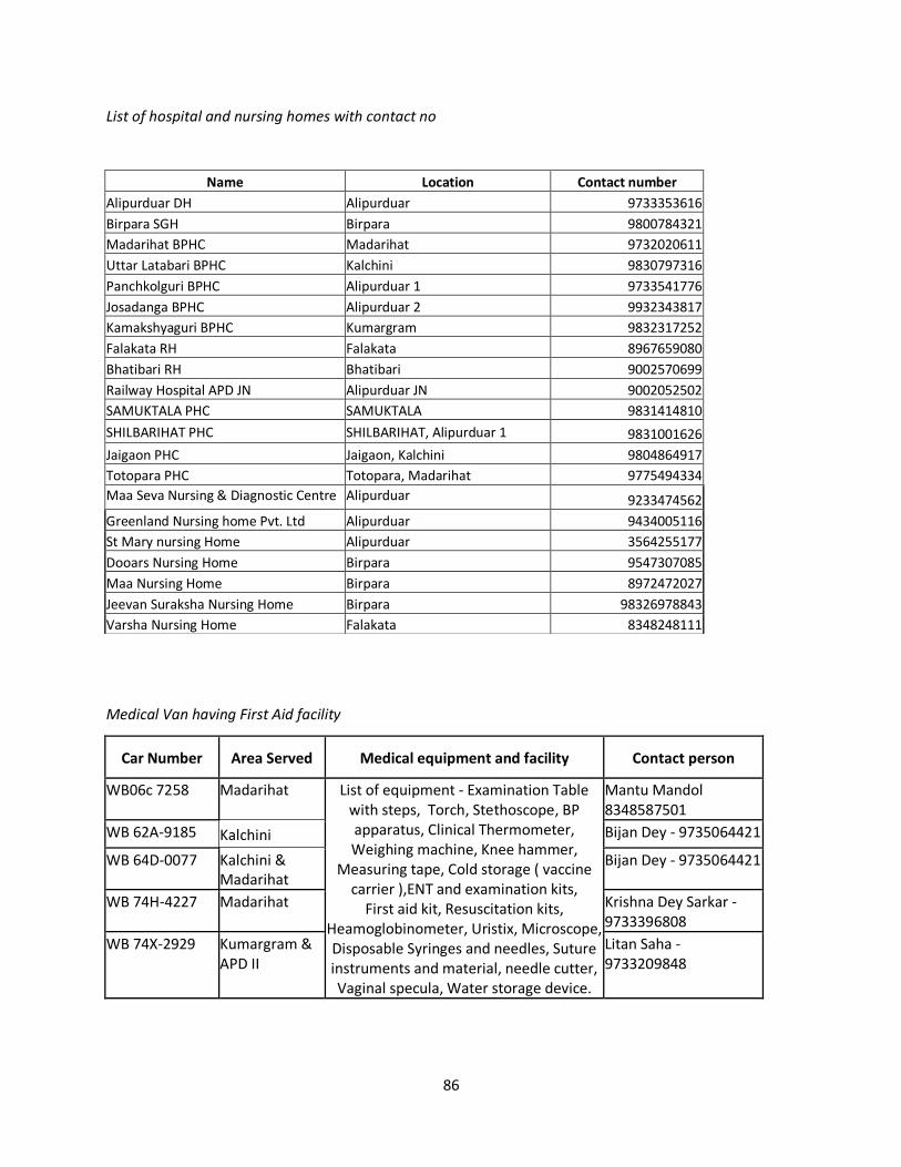
86
List of hospital and nursing homes with contact no
Medical Van having First Aid facility
Car Number Area Served Medical equipment and facility Contact person
WB06c 7258 Madarihat List of equipment - Examination Table with steps, Torch, Stethoscope, BP apparatus, Clinical Thermometer, Weighing machine, Knee hammer,
Measuring tape, Cold storage ( vaccine carrier ),ENT and examination kits,
First aid kit, Resuscitation kits, Heamoglobinometer, Uristix, Microscope, Disposable Syringes and needles, Suture instruments and material, needle cutter, Vaginal specula, Water storage device.
Mantu Mandol 8348587501
WB 62A-9185 Kalchini Bijan Dey - 9735064421
WB 64D-0077 Kalchini & Madarihat
Bijan Dey - 9735064421
WB 74H-4227 Madarihat Krishna Dey Sarkar - 9733396808
WB 74X-2929 Kumargram & APD II
Litan Saha - 9733209848
Name Location Contact number
Alipurduar DH Alipurduar 9733353616
Birpara SGH Birpara 9800784321
Madarihat BPHC Madarihat 9732020611
Uttar Latabari BPHC Kalchini 9830797316
Panchkolguri BPHC Alipurduar 1 9733541776
Josadanga BPHC Alipurduar 2 9932343817
Kamakshyaguri BPHC Kumargram 9832317252
Falakata RH Falakata 8967659080
Bhatibari RH Bhatibari 9002570699
Railway Hospital APD JN Alipurduar JN 9002052502
SAMUKTALA PHC SAMUKTALA 9831414810
SHILBARIHAT PHC SHILBARIHAT, Alipurduar 1 9831001626
Jaigaon PHC Jaigaon, Kalchini 9804864917
Totopara PHC Totopara, Madarihat 9775494334
Maa Seva Nursing & Diagnostic Centre Alipurduar 9233474562
Greenland Nursing home Pvt. Ltd Alipurduar 9434005116
St Mary nursing Home Alipurduar 3564255177
Dooars Nursing Home Birpara 9547307085
Maa Nursing Home Birpara 8972472027
Jeevan Suraksha Nursing Home Birpara 98326978843
Varsha Nursing Home Falakata 8348248111
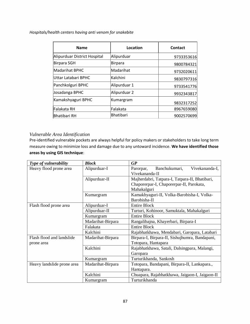
87
Hospitals/health centers having anti venom for snakebite
Vulnerable Area Identification Pre-identified vulnerable pockets are always helpful for policy makers or stakeholders to take long term
measure owing to minimize loss and damage due to any untoward incidence. We have identified those
areas by using GIS technique:
Type of vulnerability Block GP
Heavy flood prone area Alipurduar-I Parorpar, Banchukumari, Vivekananda-I,
Vivekananda-II
Alipurduar-II Majherdabri, Tatpara-I, Tatpara-II, Bhatibari,
Chaporerpar-I, Chaporerpar-II, Parokata, Mahakalguri
Kumargram Kamakhyaguri-II, Volka-Barobisha-I, Volka-
Barobisha-II
Flash flood prone area Alipurduar-I Entire Block
Alipurduar-II Turturi, Kohinoor, Samuktala, Mahakalguri
Kumargram Entire Block
Madarihat-Birpara Rangalibajna, Khayerbari, Birpara-I
Falakata Entire Block
Kalchini Rajabhatkhawa, Mendabari, Garopara, Latabari
Flash flood and landslide
prone area
Madarihat-Birpara Birpara-I, Birpara-II, Sishujhumra, Bandapani,
Totopara, Hantapara
Kalchini Rajabhatkhawa, Satali, Dalsingpara, Malangi,
Garopara
Kumargram Turturikhanda, Sankosh
Heavy landslide prone area Madarihat-Birpara Totopara, Bandapani, Birpara-II, Lankapara.,
Hantapara.
Kalchini Chuapara, Rajabhatkhawa, Jaigaon-I, Jaigaon-II
Kumargram Turturikhanda
Name Location Contact
Alipurduar District Hospital Alipurduar 9733353616
Birpara SGH Birpara 9800784321
Madarihat BPHC Madarihat 9732020611
Uttar Latabari BPHC Kalchini 9830797316
Panchkolguri BPHC Alipurduar 1 9733541776
Josadanga BPHC Alipurduar 2 9932343817
Kamakshyaguri BPHC Kumargram 9832317252
Falakata RH Falakata 8967659080
Bhatibari RH Bhatibari 9002570699
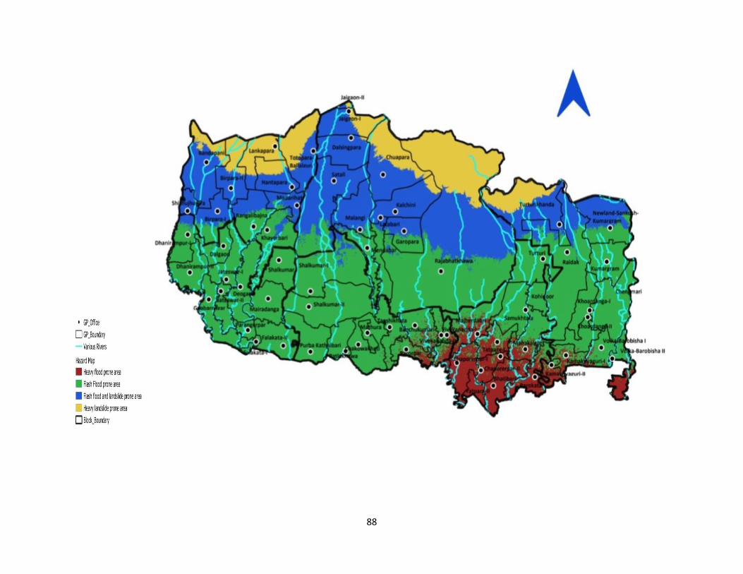
88
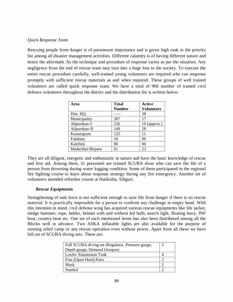
89
Quick Response Team
Rescuing people from danger is of paramount importance and is given high rank in the priority
list among all disaster management activities. Different calamity is of having different nature and
hence the aftermath. So the technique and procedure of response varies as per the situation. Any
negligence from the end of rescue team may turn into a huge loss to the society. To execute the
entire rescue procedure carefully, well-trained young volunteers are required who can response
promptly with sufficient rescue materials as and when required. These groups of well trained
volunteers are called quick response team. We have a total of 966 number of trained civil
defence volunteers throughout the district and the distribution list is written below:
They are all diligent, energetic and enthusiastic in nature and have the basic knowledge of rescue
and first aid. Among them, 31 personnel are trained SCUBA diver who can save the life of a
person from drowning during water logging condition. Some of them participated in the regional
fire fighting course to learn about response strategy during any fire emergency. Another set of
volunteers attended refresher course at Hatikisha, Siliguri.
Rescue Equipments
Strengthening of task force is not sufficient enough to save life from danger if there is no rescue
material. It is practically impossible for a person to confront any challenge in empty hand. With
this intention in mind, civil defense wing has acquired various rescue equipments like life jacket,
sledge hammer, rope, ladder, helmet with and without led bulb, search light, floating buoy, INF
boat, country boat etc. One set of each mentioned items has also been distributed among all the
Blocks well in advance. Two ASKA inflatable lights are also available for the purpose of
running relief camp or any rescue operation even without power. Apart from all these we have
full set of SCUBA diving sets. These are:
Full SCUBA diving set (Regulator, Pressure gauge,
Depth gauge, Demand Octopus)
2
Luxfer Aluminium Tank 4
Fins (Open Heel)-Pairs 2
Mask 2
Snorkel 2
Area Total
Number
Active
Volunteers
Dist. HQ ----- 38
Municipality 307 17
Alipurduar-I 226 10 (approx.)
Alipurduar-II 149 28
Kumargram 125 11
Falakata 18 09
Kalchini 80 06
Madarihat-Birpara 61 23
90
Weight Belt 2
Weights Unit 4
Rope-0.75 inc (Nylon) –50 mts. 2
Diver’s knife 2
Mouth Piece 20
Face Mask Strap 20
Breathing Air Compressor 2
ASKA inflatable light Rescue equipments Block Disaster Management Committee
Block Disaster Management Committee is the governing body to combat any emergency
situation effectively. This committee is comprised of administrative employee as well as local
elected members at every Gram Panchayat. We have already formed BDMC at each block level.
The complete particulars of BDMC have been written below with their contact number:
Block BDO BDMO/Relief
Clerk
BMOH O/C Fire
station
O/C, Police station
Alipurduar-I 7797864100 9832442662 9002570699 8584027269
(Alipurduar FS)
9083272808
(Alipurduar PS)
Alipurduar-II 9423835927 9749039027 9804370580 ----- 9083272811 (Samukhtala PS)
Falakata 7797864000 8906464318 7719247142 9434228737/
8348908060
(Falakata FS)
9083272809
(Falakata PS)
Kumargram 9732332543 9064754240 8967659080 9434083927
(Barobisha FS)
9083272810
(Kumargram PS)
Kalchini 9434746850 9434603948 9434035032 9475477761
(Hasimara FS)
9083272812
(Kalchini PS)
9083272815
(Jaygaon PS)
9083272818
(Hasimara OP)
Madarihat-
Birpara
7797863900 9038006606 8016069300 ----- 9083272814 (Birpara
PS)
9083272813 (Madarihat PS)
91
The particulars of elected GP pradhan are written below:
Block Gram Panchayat Contact no.
Alipurduar-I SALKUMAR-I 8972037100
SALKUMAR-II 9733106850
PURBA KATHALBARI 7584015072
CHAKOWAKHETI 9749161590
PATLAKHAWA 9635400607
PARARPAR 7076461975
MATHURA 6294847668
BANCHUKAMARI 8637896646
TAPSHIKHATA 9641152046
VIVEKANANDA-I 7602208425
VIVEKANANDA-II 9679492294
Alipurduar-II TATPARA-I 9933504938
TATPARA-II 7602608103
CHAPARERPAR-I 8927699010
CHAPARERPAR-II 9775882186
BHATIBARI 8670481184
MAJHERDABRI 7432995795
PAROKATA 8972687960
SAMUKTALA 9733070661
KOHINOOR 8918825831
TURTURI 7001007904/9609729012
MAHAKALGURI 9641975488
Falakata FALAKATA-I 9144538049
FALAKATA-II 7430848300
MAIRADANGA 9593351270
PARANGERPAR 9641211497
SALKUMAR 7548019065
JATESWAR-I 9734961292
JATESWAR-II 9533138198
GUABARNAGAR 7908651857
DALGAON 7908831337
DEOGAON 8345879490
DHANIRAMPUR-I 9775153715
DHANIRAMPUR-II 9733148062
Kumargram CHENGMARI 9093287192
KAMAKHYAGURI-I 9093631239
KAMAKHYAGURI-II 9378051581
KHOURDANGA-I 8167744559
KHOURDANGA-II 7047474299
KUMARGRAM 9733197557
NKS 7076515829
RYDAK 9647586055
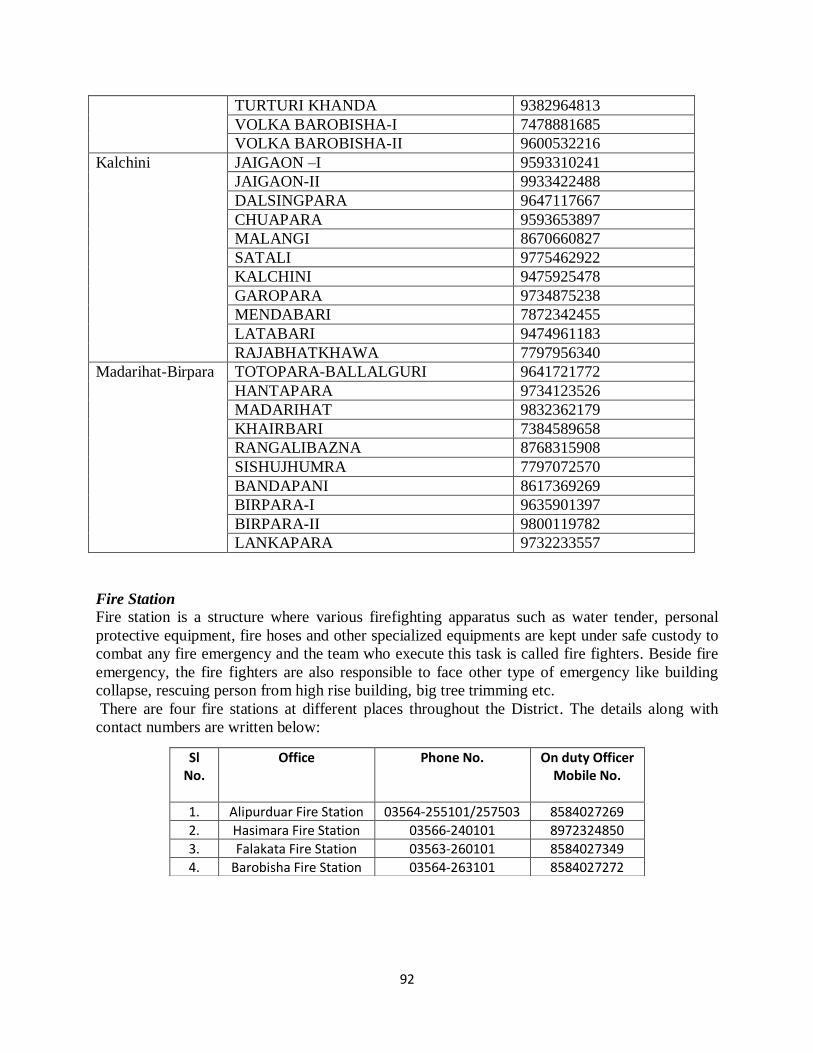
92
TURTURI KHANDA 9382964813
VOLKA BAROBISHA-I 7478881685
VOLKA BAROBISHA-II 9600532216
Kalchini JAIGAON –I 9593310241
JAIGAON-II 9933422488
DALSINGPARA 9647117667
CHUAPARA 9593653897
MALANGI 8670660827
SATALI 9775462922
KALCHINI 9475925478
GAROPARA 9734875238
MENDABARI 7872342455
LATABARI 9474961183
RAJABHATKHAWA 7797956340
Madarihat-Birpara TOTOPARA-BALLALGURI 9641721772
HANTAPARA 9734123526
MADARIHAT 9832362179
KHAIRBARI 7384589658
RANGALIBAZNA 8768315908
SISHUJHUMRA 7797072570
BANDAPANI 8617369269
BIRPARA-I 9635901397
BIRPARA-II 9800119782
LANKAPARA 9732233557
Fire Station
Fire station is a structure where various firefighting apparatus such as water tender, personal
protective equipment, fire hoses and other specialized equipments are kept under safe custody to
combat any fire emergency and the team who execute this task is called fire fighters. Beside fire
emergency, the fire fighters are also responsible to face other type of emergency like building
collapse, rescuing person from high rise building, big tree trimming etc.
There are four fire stations at different places throughout the District. The details along with
contact numbers are written below:
Sl No.
Office Phone No. On duty Officer Mobile No.
1. Alipurduar Fire Station 03564-255101/257503 8584027269
2. Hasimara Fire Station 03566-240101 8972324850
3. Falakata Fire Station 03563-260101 8584027349
4. Barobisha Fire Station 03564-263101 8584027272
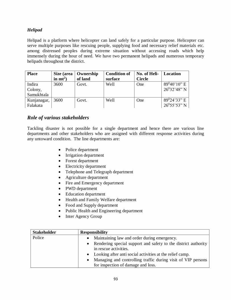
93
Helipad
Helipad is a platform where helicopter can land safely for a particular purpose. Helicopter can
serve multiple purposes like rescuing people, supplying food and necessary relief materials etc.
among distressed peoples during extreme situation without accessing roads which help
immensely during the hour of need. We have two permanent helipads and numerous temporary
helipads throughout the district.
Role of various stakeholders
Tackling disaster is not possible for a single department and hence there are various line
departments and other stakeholders who are assigned with different response activities during
any untoward condition. The line departments are:
Police department
Irrigation department
Forest department
Electricity department
Telephone and Telegraph department
Agriculture department
Fire and Emergency department
PWD department
Education department
Health and Family Welfare department
Food and Supply department
Public Health and Engineering department
Inter Agency Group
Stakeholder Responsibility
Police Maintaining law and order during emergency.
Rendering special support and safety to the district authority
in rescue activities.
Looking after anti social activities at the relief camp.
Managing and controlling traffic during visit of VIP persons
for inspection of damage and loss.
Place Size (area
in mt2)
Ownership
of land
Condition of
surface
No. of Heli-
Circle
Location
Indira
Colony,
Samukhtala
3600 Govt. Well One 89040’10” E
26032’48” N
Kunjanagar,
Falakata
3600 Govt. Well One 89024’33” E
26055’53” N
94
Irrigation Providing protection of river bank.
Constructing Dam, reservoir, embankment or guard wall
according to the necessity.
Adopting various structural mitigation measures for flood.
Keep constant watch on water level and percolating the same
information throughout the district.
Preparing post disaster damage report if there is any.
Forest Keeping track of movement of wildlife animal.
Preparation of post disaster damage report if there is any.
Implementing various DRR schemes like afforestation
smoothly under the territory of forest.
Electricity Immediate restoration of power supply after a catastrophe.
Providing special protection around high tension line, power
grid etc.
Telephone and
Telegraph Immediate restoration of communication system after a
catastrophe.
Inspecting the availability of various restoration materials
periodically.
Agriculture Conducting post disaster damage analysis properly.
Identifying flood affected beneficiaries to provide crop risk
insurance.
Fire and Emergency
Services Safekeeping of fire emergency materials properly.
Organizing fire emergency mock drill for promoting
awareness.
Meeting up any emergency situation apart from fire like
rescuing people from high rise building etc. using ladder/rope
as and when required.
PWD Monitoring earthquake resilient building construction.
Supervising the condition of bridge, culvert, flyover etc.
periodically.
Post disaster damage analysis if there is any.
Education Organizing school safety program and mock drill in order to
promulgate awareness.
Making arrangements of temporary flood shelter beforehand.
Analyzing damage of schools due to any catastrophe.
Health and Family
Welfare Raising awareness regarding any disease outbreak and health
hazard.
Providing necessary medicine at relief camp as and when
required.
Installing medical camp beside relief shelter if situation
demand.
Food and Supply Earmarking of GR dealer well in advance before monsoon.
Supplying necessary food and other ancillary items in the
relief camp during emergency.
95
Public Health
Engineering Checking drinking water supply pipeline periodically and
restoring is required.
Elevating the existing tubewell at each vulnerable panchayat
area to safe drinking water.
Supplying mechanical water pouches in the relief camp on
demand.
Inter Agency Group Identifying the gap between demand and need of relief.
Providing additional support to the district authority in relief
and rescue related work.
Help in preparing damage analysis report.
Monitoring closely the distribution of relief materials
reaching last mile or not.
Preparedness meeting District level pre-monsoon preparedness meeting is a kind of last minute preparation and is essential to
chalk out the entire disaster management activities all at once in the presence of various nodal officers,
stakeholders and district authority. In this meeting, discussions regarding individual contingency plan of various line departments, their drawbacks and lacunas, checklists of essential items, action plan for
response, earmark and authentication of storing agents for food supply etc. takes place and a resolution is
prepared after completion of the meeting. In the resolution, decisions taken in the meeting is generally mentioned clearly for circulating among participants. Every year Alipurduar District arranges such
meeting before commencement of monsoon to confirm and verify the entire response strategies.
Type of Meeting Hosting agency Purpose
Pre-Monsoon Preparedness District Authority Chalk out individual action plans
and gap evaluation
Flood meeting with Army Army and NDRF Information exchange for good
governance during any emergency
Post flood damage
assessment
District Authority Immediate restoration of
important lifelines and figure out public need
Dos, Don’ts, table calendar and wall writing Promoting awareness through various info graphics or posters or wall writing among masses is always a
good practice. An info graphics is worth of thousand words. There are numerous safety issues for each
and every natural hazard which can easily be followed. Various mediums are there to promulgate these awareness materials like wall writing, flex, table calendar etc. Every year disaster management
department compile table calendar and distribute the same among various districts for onward
transmission up to lowest administrative unit. Apart from this, the department has designed the rules and regulations to be followed against each natural hazard like heat wave, cyclone, flood, earthquake etc. in
the form of Do’s and Don’ts. We have already completed wall writing with those matters developed by
the department at different public gathering places like bus depots, rail station, market etc.
96
Community preparedness Community is defined as a group of people who stay together in a same geographical area or environment with common perspectives like language, culture, livelihood etc. As for example Bengali, Panjabi, Nepali, Oriya etc. are the community according to their language whereas farmer, fisherman or labor of a tea garden is a community according to their individual livelihood. We will concentrate only on the community as per their livelihood simply because they are the backbone of our society and first responder of any disaster. In most of the cases, in has been observed that they turn scapegoat because of their ignorance. Keeping this in mind, the concept of Community Based Disaster Management (CBDM) has been introduced for the welfare of our society. CBDM is a framework developed for safeguarding their lives, property and livelihood by involving them in different mitigation activities. Skillful persons are involved to train them regarding various natural hazards like earthquake, tsunami, landslide etc by showing videos, promulgating dos and don’ts etc.
Protocol for seeking help from other agencies Preventing a natural hazard is next to impossible for human being and sometimes the impact is
beyond the coping capacity for an institution with the help of existing resources. Under these
circumstances, one can seek external help from expert group of having ample exposures of
rescue activities to meet up the demand of situation. The lists of companies/agencies are written
hereunder:
As mentioned, SDRF is under state authority and can be summoned as and when required
depending on the situation. NDRF is under the hand of central govt. and district authority cannot
deploy them directly. At first district authority should prepare a requisition for the same to the
state authority informing the detail situation for onward transmission and then state authority
resend the same petition to the nodal NDRF commandant assigned for deployment of company if
required. We have 2nd Battalion headquartered at Kalyani, Nadia.
Knowledge management and documentation Every disaster opens a window of opportunity, be it natural or manmade. So proper
documentation of an event like lessons learnt from the catastrophe, identifying drawbacks etc.
are indispensible to face any challenges more effectively if such type of situation occurs in
future. This documentation should be properly written after each disaster in a systematic way and
kept under safe custody for future use. A model format for event documentation has been
designed at our district and written below in tabular format:
Name of the task force Administrative territory Consist of
NDRF Central BSF, CISF, CRPF, SSB,
ITBP etc.
SDRF State SAP-DMG, State Police.
97
Matter Detail Description
Name of the event Earthquake/Flood/heat wave/cyclone/chemical disaster etc.
Details of the event Earthquake Magnitude, epicenter, affected places.
Flood Cause of flood, type and name of the
water body, danger level of water.
Cyclone Wind speed and direction, originating
place, affected area
Heavy rainfall Amount and duration of rainfall, name
of the place.
Chemical
Disaster
Name of the chemical component, Type
of industry, mane of the place.
Date of occurrence mention the date of commencement and withdrawal if
required
Number of people died Name, age, address, cause of death.
Number of people affected -----
Number of persons rescued -----
Deployment of task force for
rescue
Name of the company, number of persons and place of
deployment.
Relief material distributed Type of materials, Number of materials, Area of distribution.
Rescue equipments used Type and Name of the equipment.
Lessons learnt Shortfall of resources like relief item/manpower/rescue
material.
98
Chapter 6
CAPACITY BUILDING AND TRAINING
As mentioned earlier, training and awareness is an integral part of Disaster Management
activities. Very often we see that people fall prey because of any disaster, manmade or natural,
due to lack of knowledge. That may be thunderstruck, earthquake, cyclone, flood or any other
health hazard in the form of outbreak or environmental/industrial pollutions. Promoting
awareness and conducting mock drill is the best remedy for reducing damage of every individual
or a society. This entire process of training, workshop, awareness camp and mock drill
collectively is termed as capacity building. Put another way, capacity building is the
amalgamation of all strengths and resources within a community, society or organization that can
reduce the level of risk. There are different types of process oriented capacity building programs
like:
a) School safety program.
b) Mock drill.
c) Road show, wall writing, tableau, quiz competition etc.
d) Civil defense basic training/ fire fighting.
e) Training of trainers.
f) Institutional capacity building through workshop and seminar.
School safety program:
Schools are precious local investments of a nation and often serve multiple purposes like
learning centers, gathering places for community events, meeting places for clubs and religious
organizations, storage places for books and technical equipment, and public shelters in
emergencies. While chances are very high of getting damaged in different ways by disaster,
directly and indirectly, and in the long and short term, the vulnerability of schools can be reduced
with structural and non-structural mitigation measures in a systematic manner. Some example of
direct effect by disaster events on a school is something like damage of school building due to
earthquake, water logging situation due to flood etc. As a consequence, school hours may be
disrupted, daily routine may also be hampered and panic may be spread among students. On the
other hand, indirect effect of disasters on schools can be gauged as increasing dropout rates of
students. It is a common fact that students leave school after a disaster event, either because their
parents need them to work for their livelihood, or because they are afraid of sending their wards
back to an unsafe environment. Additionally, students may feel unable to attend classes or have
problems concentrating on study due to post traumatic effect. So a safe school environment is of
paramount importance to protect our local establishment as well as our future generation.
School students are quick learners who carry forward the messages to their family and local
community injected by their so called teacher. Hence it is always a good opportunity to train
them regarding various disaster management activities. It has been observed that children are one
99
of the most vulnerable groups in our society during disaster because they can be easily
victimized due to lack of awareness of parents and teachers both. Child abuse and trafficking,
sexual harassment etc are increasing at an alarming rate which reveals that they are not safe.
Although the risk due to any disaster persists everywhere, it amplifies the level of anxiety when
students are away from home for learning. Moreover it become a matter of concern when we see
that a large amount of govt. and privately owned schools are being constructed in a congested
area in an unplanned way & exposed to various hazards. Inadequate infrastructure and lack of
awareness from the end of school authority are the main triggering factors to fuel these issues
which can be mitigated through awareness and training.
Mock drill:
Mock drill is the practice and verification of the ability of facing any negative consequence in
front of expert persons by creating artificial panic and generally conducted with an intention to
reduce the loss and damage if such situation occurs in reality. It is a noble platform through
which we can showcase our preparedness/rescue service and unearth the drawbacks/failures very
easily. Special attention should be paid on specific hazards from which a particular place suffers
the most. Different disaster has different mitigation approach as well as rescue technique and
hence procedure of mock drill differs from disaster to disaster. Care should be taken to save each
person from any mishap during conducting mock drill.
Various activities like road show, wall writing, tableau, quiz competition:
These are another way of promoting awareness. Different peoples belong to various social
statuses and identities in our society like school teachers, students, govt. officials, members of
NGOs, SHG, CBO etc. are generally requested to involve in this activity and is normally
performed to observe special day like NDDR, child safety week, International Women’s Day,
Safe Drive Safe Life week etc. By these activities, endeavor is mainly put to eradicate various
man-made disasters like environmental pollution, health hazard, deforestation, killing of wildlife
animal, wastage of food, child trafficking, sexual harassment, chemical pollution, communal riot
etc. Keeping placard in hand, arranging street drama and road show, rally, quiz competition on
climate change etc. are the procedures which are followed for this purpose. This particular type
of awareness strategy always leaves a deep mark among masses because it tells the story about
what is happening in our daily life like superstition, rape, sexual harassment, deforestation etc.
Civil defense basic training/ fire fighting:
No other activity is as important as to save and rescue life from natural calamity. Different
calamity is of having different nature and hence the aftermath. So the technique of response and
rescue varies according to the situation. Any negligence from the end of rescue team may turn
into a huge loss to the society. To execute the entire rescue procedure carefully, well-trained
young volunteers are required who can response promptly. Basic level training is provided to the
local youth with the hope of producing a group of trained volunteers and to make the quick
response team network stronger. Topics like Disaster risk management, rescue procedure from
different scenario like fire, flood, earthquake etc, and providing basic first aid to the victim is
100
generally taught in this course curriculum. At the end of the course, they are undergone an
examination and certificate is provided on successful completion of the program.
Beside this, accidental fire is as devastating as any other disaster and can be harmful in terms of
damage if not handle with proper care at right time. Fire fighters are trained personnel who
extinguish fire by the help of different equipments systematically, pursue fire inspection and
investigation, maintain all fire fighting equipments, and provide training for these activities.
There are number of issues like source of fire, area engulfed by fire and neighborhood locality
which need to be understood properly before starting any fire fighting operation. Fire fighting
course addresses all these issues.
Training of trainers:
This approach is adopted to train the govt. officials or school teachers who can in turn percolate
the same among the persons of his/her surroundings. Administrative Training Institute (ATI),
Regional Training Centre (RTC) etc. are the places where training is provided on regular basis
regarding various topics like Climate Change, Post Disaster Need Analysis, Disaster Risk
Reduction, Sustainable development, Incidence Response System etc.
Special day celebration:
UNISDR Day
Recent study reveals that the frequency and occurrence of disaster is increasing worldwide day
by day at a rapid pace. To confront this situation, United Nations (UN), an inter-governmental
organization to promote international cooperation, felt the necessity to construct a roadmap by
adopting some plausible strategy to reduce the impact of any disaster. And hence in this way the
concept of United Nations International Strategy for Disaster Reduction (UNISDR) came into
existence. In this regard, a draft of mitigation and preventative measures has been formulated
under the guidance of policy makers and board members which should be followed by UN
countries. Conducting awareness camp and mock drill is one such activity under this module.
India too, has no exception as well and decided 13th
October to mark the day with workshop and
seminar.
National Day for Disaster Risk Reduction (NDDR)
This is a decade old practice in our country to celebrate the day. Mainly school goers and
panchayet members participate in this celebration with workshop, seminar and road rally.
Alipurduar district is no different than the other districts and we try to arrange various levels of
training and awareness program throughout the year for different stakeholders and target groups.
In the year 2019-20, our training calendar has been written below in tabular form:
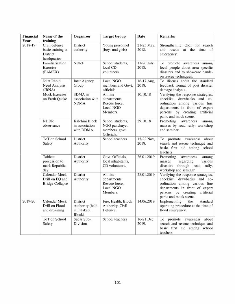
101
Financial
Year
Name of the
training
Organizer Target Group Date Remarks
2018-19 Civil defense
basic training at
District
headquarter
District
authority
Young personnel
(boys and girls)
21-25 May,
2018.
Strengthening QRT for search
and rescue at the time of
emergency.
Familiarization
Exercise
(FAMEX)
NDRF School students,
local CD
volunteers
17-26 July,
2018.
To promote awareness among
local people about area specific
disasters and to showcase hands-
on rescue techniques.
Joint Rapid
Need Analysis
(JRNA)
Inter Agency
Group
Local NGO
members and Govt.
officials
16-17 Aug,
2018.
To discuss about the standard
feedback format of post disaster
damage analysis.
Mock Exercise
on Earth Quake
SDMA in
association with
NDMA
All line
departments,
Rescue force,
Local NGO
Members.
10.10.18 Verifying the response strategies,
checklist, drawbacks and co-
ordination among various line
departments in front of expert
persons by creating artificial
panic and mock scene.
NDDR
observance
Kalchini Block
in association
with DDMA
School students,
NGO panchayet
members, govt.
Officials.
29.10.18 Promoting awareness among
masses by road rally, workshop
and seminar.
ToT on School
Safety
District
Authority
School teachers 15-22 Nov,
2018.
To promote awareness about
search and rescue technique and
basic first aid among school
teachers.
Tableau
procession to
mark Republic
day
District
Authority
Govt. Officials,
local inhabitants,
CD volunteers.
26.01.2019 Promoting awareness among
masses regarding various
disasters through road rally,
workshop and seminar.
Calendar Mock
Drill on EQ and
Bridge Collapse
District
Authority
All line
departments,
Rescue force,
Local NGO
Members.
28.01.2019 Verifying the response strategies,
checklist, drawbacks and co-
ordination among various line
departments in front of expert
persons by creating artificial
panic and mock scene.
2019-20 Calendar Mock
Drill on Flood
and drowning
District
Authority (held
at Falakata
Block)
Fire, Health, Block
Authority, Civil
Defence.
14.06.2019 Implementing the standard
operating procedure at the time of
flood emergency.
ToT on School
Safety
Sadar Sub-
Division
School teachers 16-21 Dec,
2019.
To promote awareness about
search and rescue technique and
basic first aid among school
teachers.
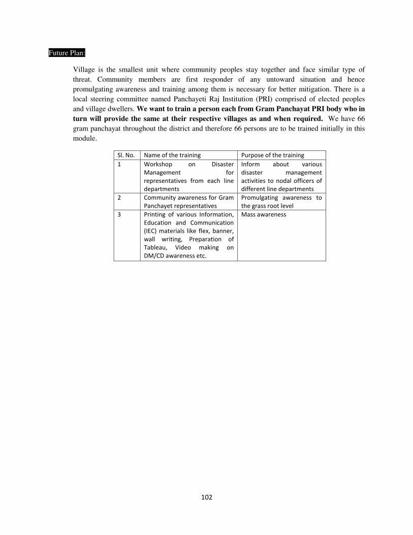
102
Future Plan:
Village is the smallest unit where community peoples stay together and face similar type of
threat. Community members are first responder of any untoward situation and hence
promulgating awareness and training among them is necessary for better mitigation. There is a
local steering committee named Panchayeti Raj Institution (PRI) comprised of elected peoples
and village dwellers. We want to train a person each from Gram Panchayat PRI body who in
turn will provide the same at their respective villages as and when required. We have 66
gram panchayat throughout the district and therefore 66 persons are to be trained initially in this
module.
Sl. No. Name of the training Purpose of the training
1 Workshop on Disaster
Management for
representatives from each line
departments
Inform about various
disaster management
activities to nodal officers of
different line departments
2 Community awareness for Gram
Panchayet representatives
Promulgating awareness to
the grass root level
3 Printing of various Information,
Education and Communication
(IEC) materials like flex, banner,
wall writing, Preparation of
Tableau, Video making on
DM/CD awareness etc.
Mass awareness
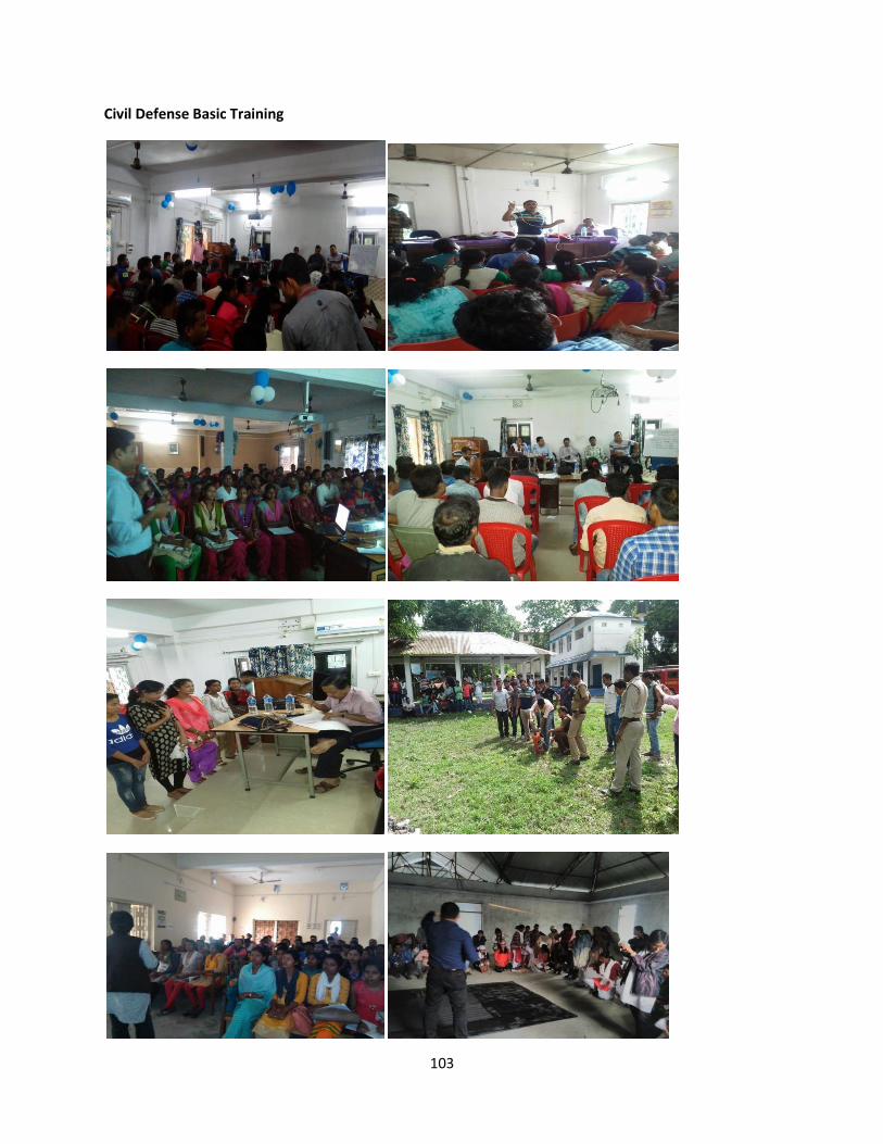
103
Civil Defense Basic Training
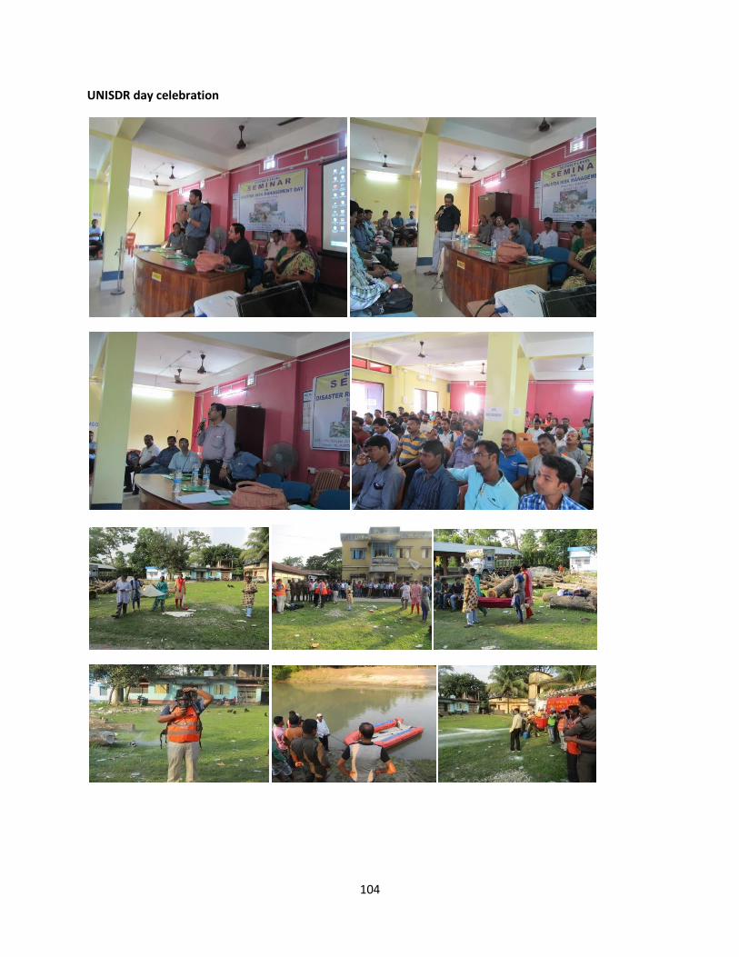
104
UNISDR day celebration
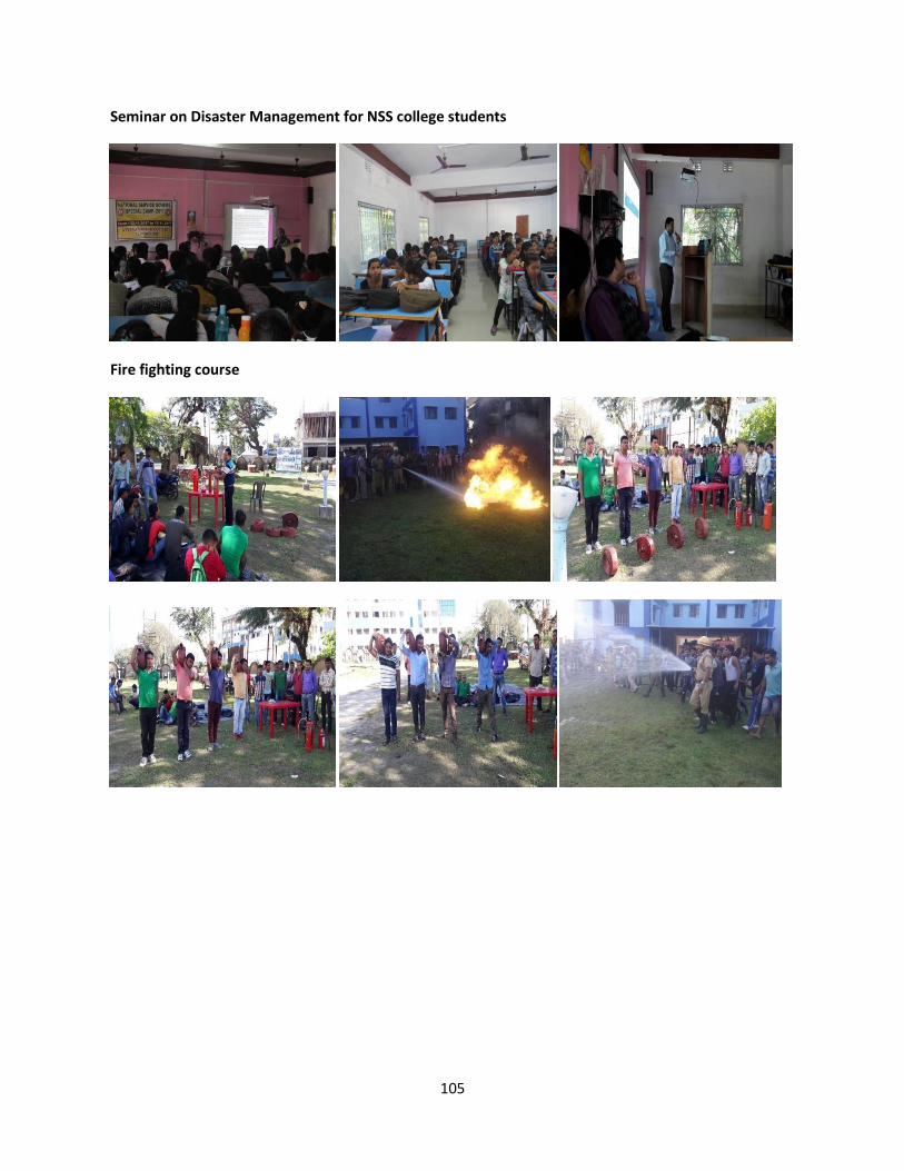
105
Seminar on Disaster Management for NSS college students
Fire fighting course
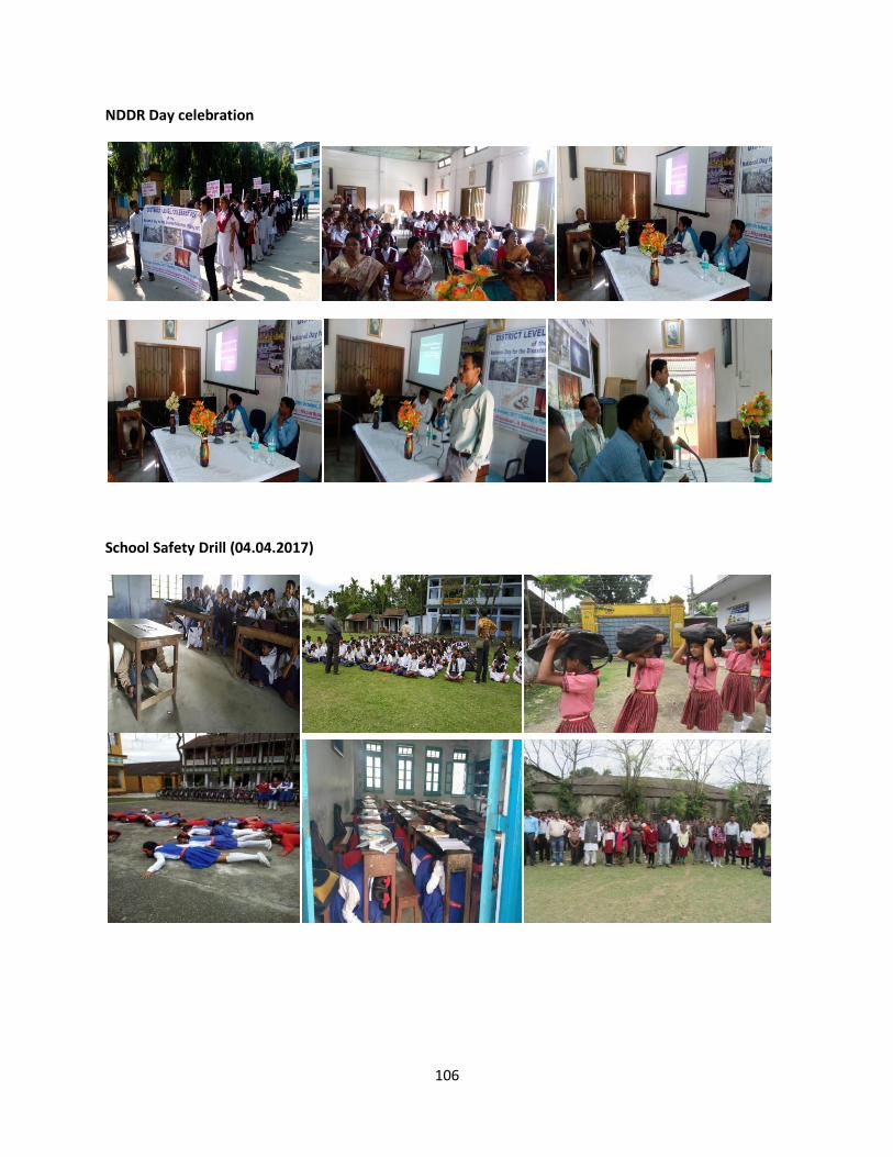
106
NDDR Day celebration
School Safety Drill (04.04.2017)
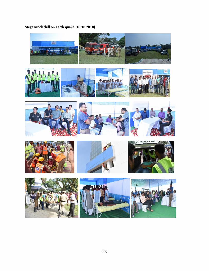
107
Mega Mock drill on Earth quake (10.10.2018)
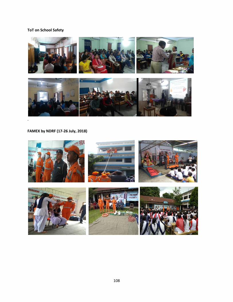
108
ToT on School Safety
Tableau zxjgj
FAMEX by NDRF (17-26 July, 2018)
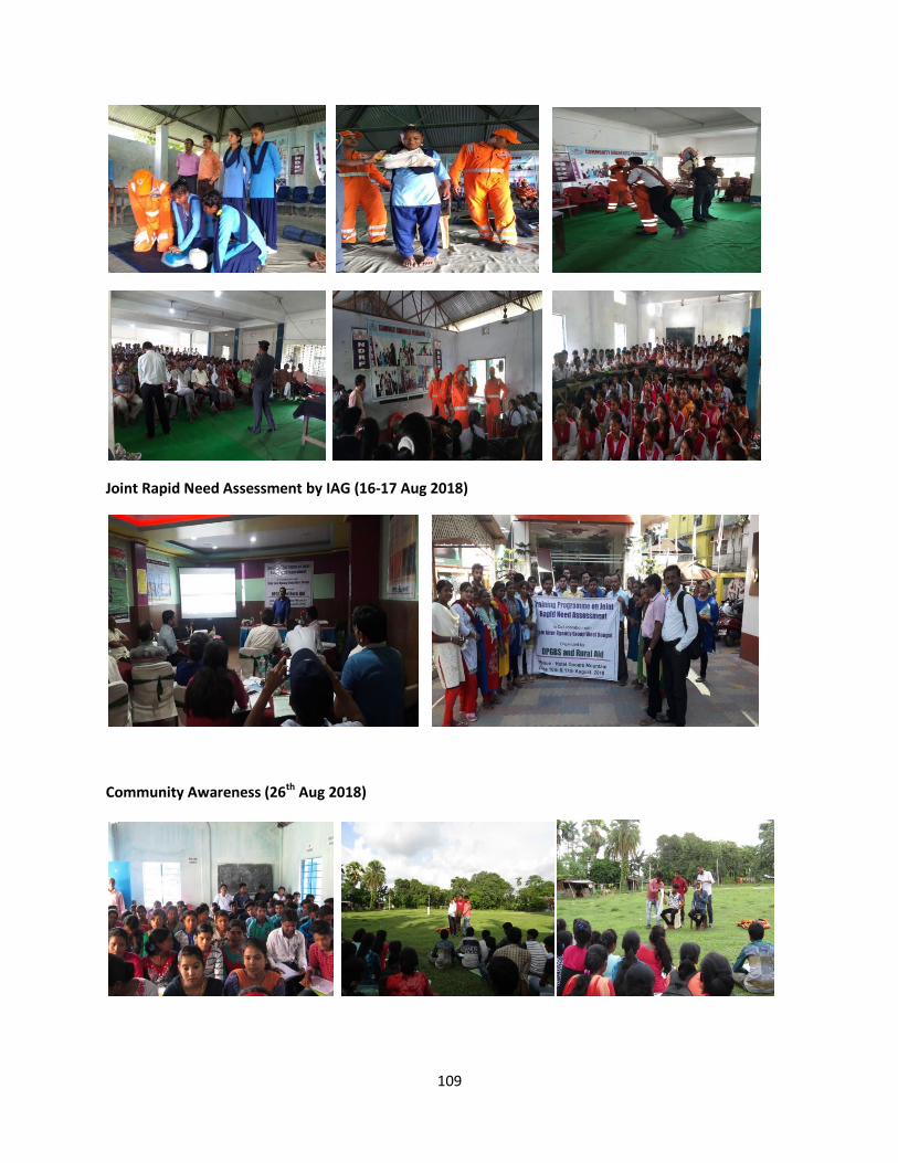
109
Joint Rapid Need Assessment by IAG (16-17 Aug 2018)
Community Awareness (26th
Aug 2018)
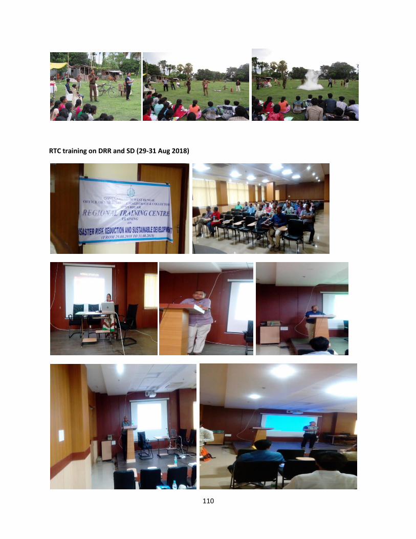
110
RTC training on DRR and SD (29-31 Aug 2018)
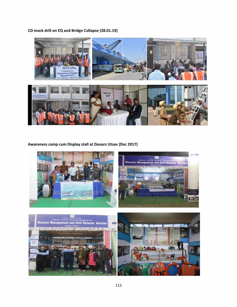
111
CD mock drill on EQ and Bridge Collapse (28.01.19)
A
Awareness camp cum Display stall at Dooars Utsav (Dec 2017)
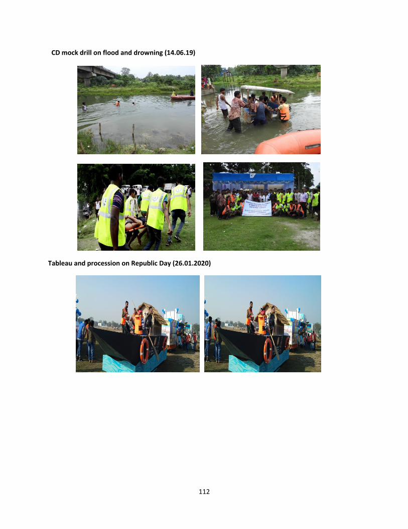
112
CD mock drill on flood and drowning (14.06.19)
Tableau and procession on Republic Day (26.01.2020)
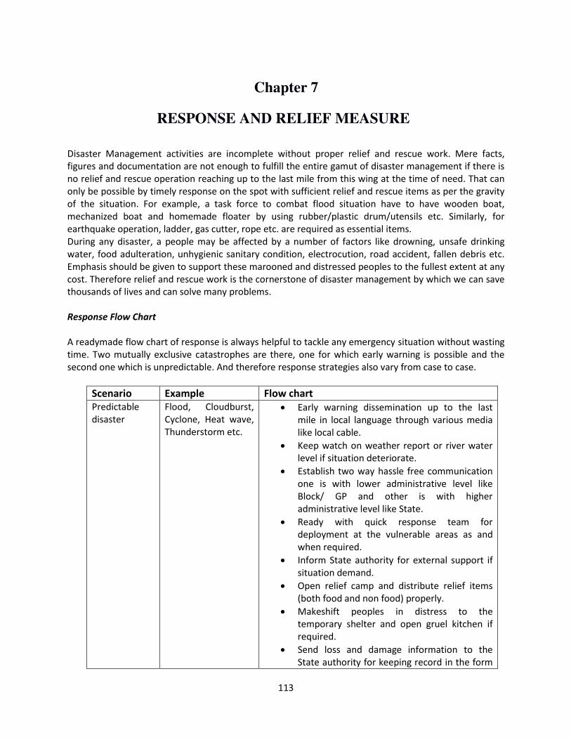
113
Chapter 7
RESPONSE AND RELIEF MEASURE
Disaster Management activities are incomplete without proper relief and rescue work. Mere facts,
figures and documentation are not enough to fulfill the entire gamut of disaster management if there is
no relief and rescue operation reaching up to the last mile from this wing at the time of need. That can
only be possible by timely response on the spot with sufficient relief and rescue items as per the gravity
of the situation. For example, a task force to combat flood situation have to have wooden boat,
mechanized boat and homemade floater by using rubber/plastic drum/utensils etc. Similarly, for
earthquake operation, ladder, gas cutter, rope etc. are required as essential items.
During any disaster, a people may be affected by a number of factors like drowning, unsafe drinking
water, food adulteration, unhygienic sanitary condition, electrocution, road accident, fallen debris etc.
Emphasis should be given to support these marooned and distressed peoples to the fullest extent at any
cost. Therefore relief and rescue work is the cornerstone of disaster management by which we can save
thousands of lives and can solve many problems.
Response Flow Chart
A readymade flow chart of response is always helpful to tackle any emergency situation without wasting
time. Two mutually exclusive catastrophes are there, one for which early warning is possible and the
second one which is unpredictable. And therefore response strategies also vary from case to case.
Scenario Example Flow chart
Predictable
disaster
Flood, Cloudburst,
Cyclone, Heat wave,
Thunderstorm etc.
Early warning dissemination up to the last
mile in local language through various media
like local cable.
Keep watch on weather report or river water
level if situation deteriorate.
Establish two way hassle free communication
one is with lower administrative level like
Block/ GP and other is with higher
administrative level like State.
Ready with quick response team for
deployment at the vulnerable areas as and
when required.
Inform State authority for external support if
situation demand.
Open relief camp and distribute relief items
(both food and non food) properly.
Makeshift peoples in distress to the
temporary shelter and open gruel kitchen if
required.
Send loss and damage information to the
State authority for keeping record in the form
114
of CA-II report and daily situation report.
Demobilization and winding up of resources if
situation becomes normal.
Circulate the withdrawal information among
masses.
Unpredictable
disaster
Earthquake,
Landslide, Road
accident, chemical
and radiological
disaster etc.
Immediate deployment of task force with
proper rescue equipments as per the
situation.
Deployment of first aid team with specialized
doctors to handle cases like cardiac arrest,
head injury, burn injury, trauma etc. for
providing medical support on the spot.
Keep mobile medical van and ambulance
ready with medical facilities like stretcher,
saline bottle etc.
Rescue victims from danger and send to the
hospital if required.
Seek external help from State Authority if
required.
Send situation report and damage report to
the State authority for taking necessary
action.
Responsibility matrix (for predictable disasters: flood due to heavy rainfall as
case study)
Time Task Department/Agency
D-72 Hrs Early warning dissemination CWC, Irrigation and Disaster
Management
D-48 Hrs Round the clock surveillance and
keep watch on the present
situation
Irrigation and Civil Defence
Control room
Aware local people about the
danger through extensive miking
CD volunteers, Police and
Irrigation
Evacuate people to safer place if
required
Police
Civic Volunteer
D-24 Hrs Checklist and Response team
formation for deployment
Civil Defence
D0 Hrs DM Plan activation Disaster Management
D+15 Min Emergency meeting with all line
departments and stakeholders for
IRT Activation and rescue team
District Emergency Operation
Centre
115
formation
D+30 Min Response begin and Rescue
operation start with necessary
rescue items like boat, life jacket,
floater etc.
Civil Defence
Police
Civil Emergency Force
Fire and Emergency Service
SSB
D+1 Hr Resource Mobilization and Relief
Camp open for safeguarding
people in distress
Disaster Management
Transport Department
D+2 Hrs Distribute fuel like kerosin oil and
food items like rice, daal, chira,
gur, baby milk powder at relief
camp from storing agent
Disaster Management
Food and Supply
Open gruel kitchen for preparation
of cooked meal
Self Help Group
Local NGO
CBO
Mechanical drinking water pouch
distribution
PHE
Medical kit distribution Health
D+3 Hrs Meet up the need and demand of
the people staying at shelter
Local NGO and SHG
D+24 Hrs Winding up the process and closing
of relief camp
(as per the withdrawal notice of
the event)
Disaster Management
D+48 Hrs Post Disaster Damage analysis Cultivation field Agriculture
Embankment and
Guard wall
Irrigation
Road, culvert and
bridge
PWD
Fishing pond Fisheries
D+72 Hrs Documentation of the entire event
with cumulative CA-II report
Disaster Management
Relief measure
State authority allots various perishable and non perishable relief materials in favour of district authority
through proper channel based on requirement and we receive the non perishable part from our zonal
godown periodically from SDMA and keep in our district godown under safe custody. For perishable
food items we have earmarked some storing agents among fair price ration dealers and recycle
rice/wheat or chira/gur with them. List of all kind of relief items are written here under:
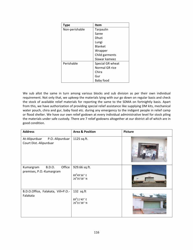
116
Type Item
Non-perishable Tarpaulin
Saree
Dhuti
Lungi
Blanket
Wrapper
Child garments
Slawar kameez
Perishable Special GR wheat
Normal GR rice
Chira
Gur
Baby food
We sub allot the same in turn among various blocks and sub division as per their own individual
requirement. Not only that, we upkeep the materials lying with our go down on regular basis and check
the stock of available relief materials for reporting the same to the SDMA on fortnightly basis. Apart
from this, we have authorization of providing special relief assistance like supplying DM kits, mechanical
water pouch, chira and gur, baby food etc. during any emergency to the indigent people in relief camp
or flood shelter. We have our own relief godown at every individual administrative level for stock piling
the materials under safe custody. There are 7 relief godowns altogether at our district all of which are in
good condition.
Address Area & Position Picture
At-Alipurduar P.O.-Alipurduar
Court Dist.-Alipurduar
1125 sq.ft.
Kumargram B.D.O. Office
premises, P.O.-Kumargram
929.66 sq.ft.
89
049’36’’ E
26035’58’’ N
B.D.O.Office, Falakata, Vill+P.O.-
Falakata
132 sq.ft
89
011’40’’ E
26031’38’’ N
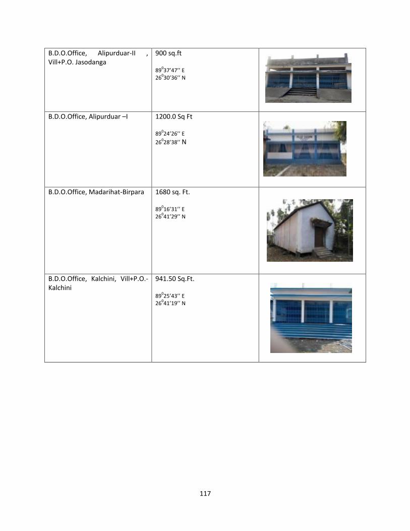
117
B.D.O.Office, Alipurduar-II ,
Vill+P.O. Jasodanga
900 sq.ft
89
037’47’’ E
26030’36’’ N
B.D.O.Office, Alipurduar –I 1200.0 Sq Ft
89
024’26’’ E
26028’38’’ N
B.D.O.Office, Madarihat-Birpara 1680 sq. Ft.
89
016’31’’ E
26041’29’’ N
B.D.O.Office, Kalchini, Vill+P.O.-
Kalchini
941.50 Sq.Ft.
89
025’43’’ E
26041’19’’ N
118
Storing Agent/ G.R. Dealer at different places
Measures taken during rainy season in last year (2019)
Name of the
Block/Municipality
Name of G.R. Dealer with contact number
Madarihat-Birpara Maya SHG Model fair price SHOP FPS No.
WB0034681998. Birpara T. G.
Contact No. 9832037037
Falakata Abul Hossain, Vill & P.O.-Moiradanga, P.S.-Falakata,
Dist.-Alipurduar Contact No.-7602227104
Kalchini J.P.Chowdhury,
Kalchini Modi Line
Contact No.-9434181081
Kumargram Rabindra Nath Roy, Vill & P.O.-Kumargramduar,
Dist.-Alipurduar, PIN-736203
Conact No.-9733120428
Alipurduar-I Nirmal Kanti Das, New Town,
Alipurduar.
Contact No.-8016160934 Alipurduar-II
Municipality
Flood Situation Caused by Remarks Loss and damage
25-26 June Incessant rainfall
from 25th June night
to 26th June morning
at Alipurduar District
(some 328.6 mm avg.
rainfall in 8 hrs. as
recorded by
Irrigation Dept.) due
to low pressure
system formed near
sub-himalayan
foothills
Few rivers reached almost extreme danger
level and two of them namely Kaljani and
Torsa crossed the red level as well.
Action taken:
Round the clock surviellance
Miking was done for local awareness
Boat deployed: 15
Person rescued: 905
Relief camp opened: 20
No. of people stayed at camp: 1770
No. of GP affected:35
No. of ward affected: 14
No. of people affected: 37640
No. of house damage: 838
(fully:288, partly:550)
10-14 July Heavy and intense
rainfall from 12 July
to 14 July
River Kaljani and River Sankosh crossed
yellow level once.
Action taken:
Miking was done for local awareness
Boat deployed: 2
Relief camp opened: 7
No. of people stayed at camp: 720
No. of Tarpaulin distributed: 5711
No. of dewatering pump operated to clear
logged water: 7
No. of GP affected:14
No. of ward affected: 6
No. of people affected: 28,325
No. of house damage: 758
(fully:476, partly:282)
No. of persons evacuated: 720
No. of death due to drowning: 2
119
Cumulative rainfall so far recorded (29th July) from 1st January at Alipuruduar Ditrict is 3154.6
mm.
2. Measures taken so far.
There were 3(three) meetings held at district level along with all line departments, SDO
and BDOs.
Date Meeting
07.05.19 Pre-monsoon preparedness meeting
27.06.19 Flood co-ordination meeting
12.07.19 Review meeting on reconstruction and
restoration
A co-ordination meeting on Flood preparedness was also held at Bengdubi near Bagdogra
on 08.06.2019 which was organized by Army. Task force like NDRF was also present in that
meeting. Prime target of the meeting was to chalk out the standard operating procedure of
Flood Emergency.
Relief work
a. Gruel kitchen was made operational for the Relief Camps.
b. Dry foods like Muri, Chira, Gur, Biscuits etc. was distributed to the marooned people in municipality
and blocks.
c. Relief materials distributed. Advance sub allotment in the following manner had been made to the
BDOs:
Block Dhuti Saree Tarpaulin Male
Wrapper
Blanket
Alipurduar-I 400 1000 1000 500 1000
Alipurduar-
II
400 1000 1000 500 1000
Kumargram 400 1000 1000 500 1000
Kalchini 400 1000 1000 500 1000
Madarihat 400 1000 1000 500 1000
Falakata 400 1000 2000 500 1000
21-24 July Heavy rainfall from
21st July to 24th July.
River Kaljani and Raidak-II crossed yellow
level once during this period.
Action Taken:
Boat deployed: 2
Relief camp opened: 8
No. of people stayed at camp: 1468
No. of dewatering pump operated to clear
logged water: 7
Distributed dry food, water pouch,
Tarpaulin and Spl. GR rice
No. of GP affected:24
No. of ward affected: 4
No. of people affected: 14907
No. of house damage: 190
(fully:28, partly:162)
No. of persons evacuated: Nil

120
d. Medical teams were deployed from the end of health department for medical assistance.
Bleaching powder and life saving drugs were distributed at various camps.
e. Drinking water pouches were distributed at various relief camps as per requirements by PHE
department.
Date of Distribution Receiving Authority Quantity of pouches 26.06.19 BDO, Madarihat-Birpara 5000
BDO, Alipurduar-II 2000
EO, Alipurduar Municipality EO,
Alipurduar Municipality
3000
27.06.19 EO, Alipurduar Municipality 7000
28.06.19 BDO, Kalchini 8000
14.07.19 Alipurduar Municipality 3000
BDO, Alipurduar-II 2000
One 35000 ltr. water tanker was also supplied at Jayanti area to combat scarcity of drinking
water.
Restoration work
a. PWD (Roads), NHAI, Irrigation & Waterways departments have started restoring their respective
damages.
b. Blocks and Gram Panchayet under took emergency work at various places in their respective
jurisdiction.
Rescue Measure
Type of Boat Number Distribution
INF boat & OBM 6 Dist. HQ --- 3
Alipurduar I --- 1
Falakata --- 1
Kumargram --- 1
Apart from this, wooden country boats were there in standby mode at various vulnerable places.
Deployment of West Bengal Civil Emergency Force (WBCEF) and Water Wing Civil Defence (WWCD)
Name Total
Strength
Deployed at
WBCEF/ WWCD 5 Dist HQ 1
Falakata 1
Kumargram 2
Alipurduar-I 1
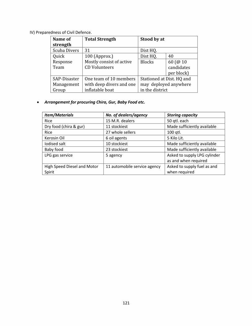
121
IV) Preparedness of Civil Defence.
Name of
strength
Total Strength Stood by at
Scuba Divers 31 Dist HQ.
Quick
Response
Team
100 (Approx.)
Mostly consist of active
CD Volunteers
Dist HQ. 40
Blocks 60 (@ 10
candidates
per block)
SAP-Disaster
Management
Group
One team of 10 members
with deep divers and one
inflatable boat
Stationed at Dist. HQ and
may deployed anywhere
in the district
Arrangement for procuring Chira, Gur, Baby Food etc.
Item/Materials No. of dealers/agency Storing capacity
Rice 15 M.R. dealers 50 qtl. each
Dry food (chira & gur) 11 stockiest Made sufficiently available
Rice 27 whole sellers 100 qtl.
Kerosin Oil 6 oil agents 5 Kilo Lit.
Iodised salt 10 stockiest Made sufficiently available
Baby food 23 stockiest Made sufficiently available
LPG gas service 5 agency Asked to supply LPG cylinder
as and when required
High Speed Diesel and Motor
Spirit
11 automobile service agency Asked to supply fuel as and
when required
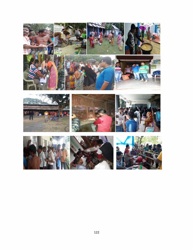
122
123
Chapter 8
RECONSTRUCTION AND REHABILITATION
After any disaster, the most important task is to analyses loss and damage in terms of money for speedy
recovery and to bring back the situation into normalcy at the earliest. Though the terms loss and
damage may sound similar, there is a slight difference between these two. Loss is irreparable whereas
damage can be recovered after a certain time period by putting effort. For example, death of a person
due to any catastrophe is a loss for society but uprooting of an electric pole is a type of damage.
The sectors which may get affected due to the impact of any natural calamity are Irrigation, PWD,
Agriculture, Animal Resource, Food and Supply, WBSEDCL, Telegraph etc. Few common types of losses
and damages are loss of human life, building collapse, road damage, uprooting of electric pole,
embankment breaching, destruction of fishing pond, demolishing of culvert and wooden bridge etc.
Various departments look after their sectoral damage and prepare a report regarding the same after a
major calamity takes place. The reason of carrying out damage analysis is to speedy recovery from a
disastrous situation. There are various methods which are generally adopted to perform this task.
Conducting meeting with all line departments and elected members, filling up questionnaire by taking
the inputs from community members etc. are some traditional methods among a few. The entire task
through which we can compile a damage assessment report is called Joint Rapid Need Analysis.
Department/Agency Responsible for immediate restoration of
Irrigation Embankment
Dam
Guard wall/ Boulder sausage
Sluice gate
Barrage
PWD Building
Road
Culvert
Bridge
WBSEDCL Transformer up to 11 KV
High tension wire
Electric pole
BSNL Telephone wire
Pole
Communication system
Forest Wildlife animal/ endangered species
Any construction fallen under their jurisdiction
Uprooting of important trees
Fisheries Fishing pond
Fishing farm
Carp and fishes
Tourism Important tourist establishment
PHE Drinking water pipeline
124
All important lifelines have to be restored immediately after any severe catastrophe to build back better
and is called as short term recovery. These are:
Electricity and communication
Embankment/Bridge
Road and railway network
Hospitals/ Nursing homes
Office establishments like court/police station/collectorate building
Educational institutions like school/college
A detail damage report helps immensely to identify the category of the disaster whether it is to
be labeled as national level or state level. And monetary assistance reaches to the place of
occurrence accordingly after proper investigation. A standard damage report is something like
this:
Number of persons died
Number of persons affected/injured
Number of cattle lost
Number of house damage
Number of persons lost their livelihood
Road damage
Bridge collapse
Number of building collapsed
Uprooting of electric pole
Communication tower shut down
Damage of important establishment
Damage of drinking water
pipeline/sewage
Tube well/Hand pump/Ring well/ cistern
Leaking overhead reservoir
Damaged pumping machine
Animal Resource Livestock
Poultry and other farms
Health Damaged approach roads and electric lines of
PHC/Hospital/nursing homes.
Panchayat Village internal roads
Choked drainage/sewerage lines
Internal water supply lines
Street lights
Primary school/community halls/Anganwadi
Disaster Management Relief Go down
Flood/Cyclone Shelter
Damaged house
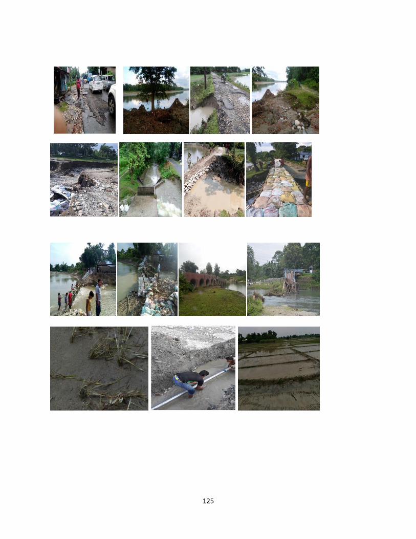
125
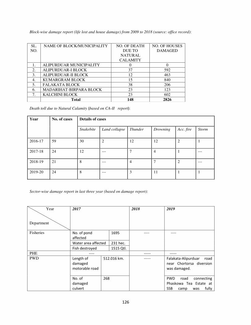
126
Block-wise damage report (life lost and house damage) from 2009 to 2018 (source: office record):
Death toll due to Natural Calamity (based on CA-II report):
Year No. of cases Details of cases
Snakebite Land collapse Thunder Drowning Acc. fire Storm
2016-17 59 30 2 12 12 2 1
2017-18 24 12 --- 7 4 1 ---
2018-19 21 8 --- 4 7 2 ---
2019-20 24 8 --- 3 11 1 1
Sector-wise damage report in last three year (based on damage report):
SL.
NO.
NAME OF BLOCK/MUNICIPALITY NO. OF DEATH
DUE TO
NATURAL
CALAMITY
NO. OF HOUSES
DAMAGED
1. ALIPURDUAR MUNICIPALITY 0 0
2. ALIPURDUAR-I BLOCK 37 592
3. ALIPURDUAR-II BLOCK 12 463
4. KUMARGRAM BLOCK 15 840
5. FALAKATA BLOCK 38 206
6. MADARIHAT-BIRPARA BLOCK 23 123
7. KALCHINI BLOCK 23 602
Total 148 2826
Year
Department
2017 2018 2019
Fisheries No. of pond
affected
1695 ---- ----
Water area affected 231 hec.
Fish destroyed 1515 Qtl.
PHE ---- ----- -----
PWD Length of
damaged
motorable road
512.016 km. ----- Falakata-Alipurduar road
near Chortorsa diversion
was damaged.
No. of
damaged
culvert
268 PWD road connecting
Phaskowa Tea Estate at
SSB camp was fully
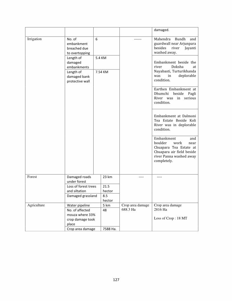
127
damaged.
Irrigation No. of
embankment
breached due
to overtopping
6 ------ Mahendra Bundh and
guardwall near Arjunpara
besides river Jayanti
washed away.
Length of
damaged
embankments
5.4 KM
Embankment beside the
river Doksha at
Nayabasti, Turturikhanda
was in deplorable
condition.
Length of
damaged bank
protective wall
7.54 KM
Earthen Embankment at
Dhumchi beside Pagli
River was in serious
condition.
Embankment at Dalmoni
Tea Estate Beside Koli
River was in deplorable
condition.
Embankment and
boulder work near
Chuapara Tea Estate at
Chuapara air field beside
river Panna washed away
completely.
Forest Damaged roads
under forest
23 km ---- ----
Loss of forest trees
and siltation
21.5
hector
Damaged grassland 8.5
hector
Agriculture Water pipeline 5 km Crop area damage
688.3 Ha
Crop area damage
2816 Ha
Loss of Crop : 18 MT
No. of affected
mouza where 33%
crop damage took
place
48
Crop area damage 7588 Ha.
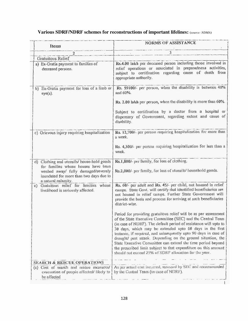
128
Various SDRF/NDRF schemes for reconstructions of important lifelines: (source: NDMA)
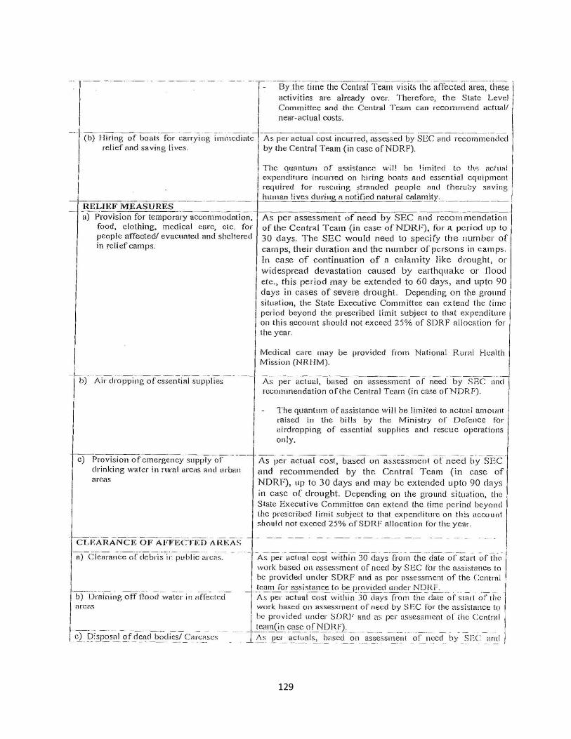
129
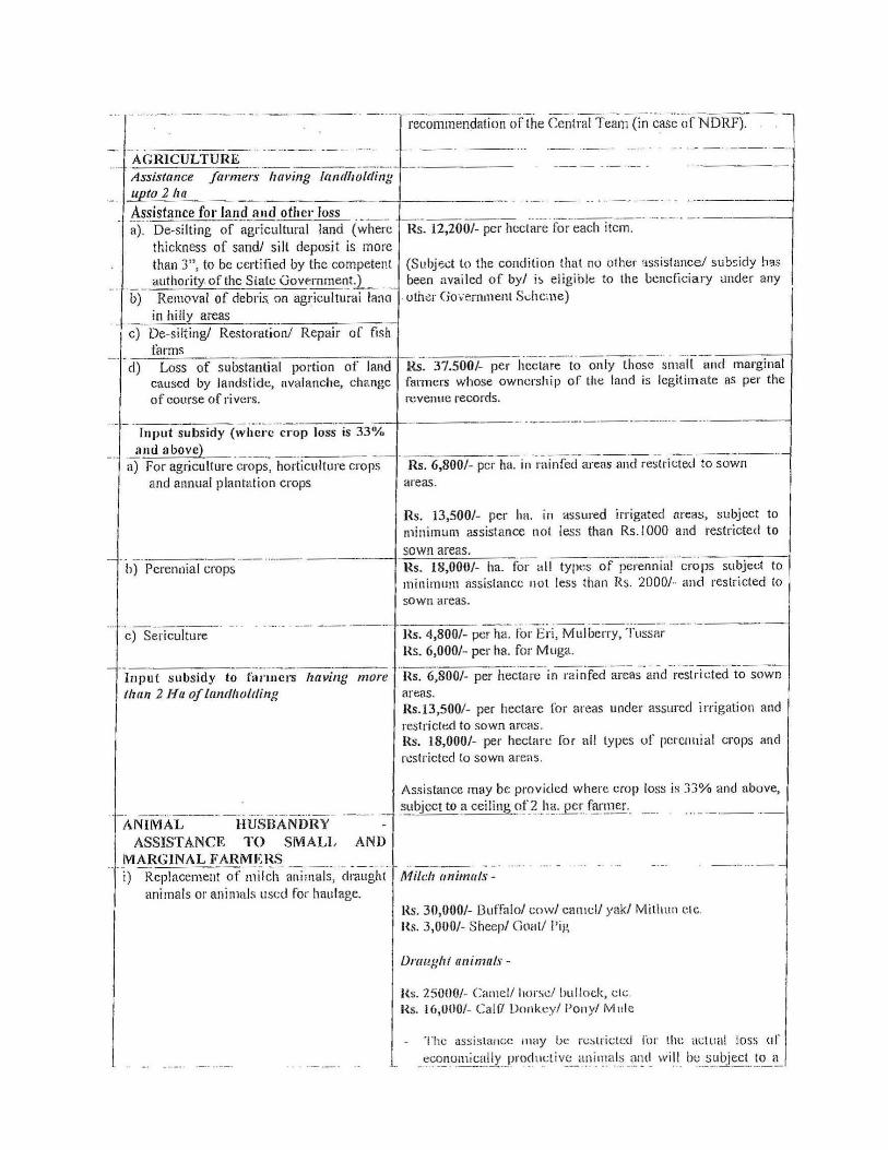
130
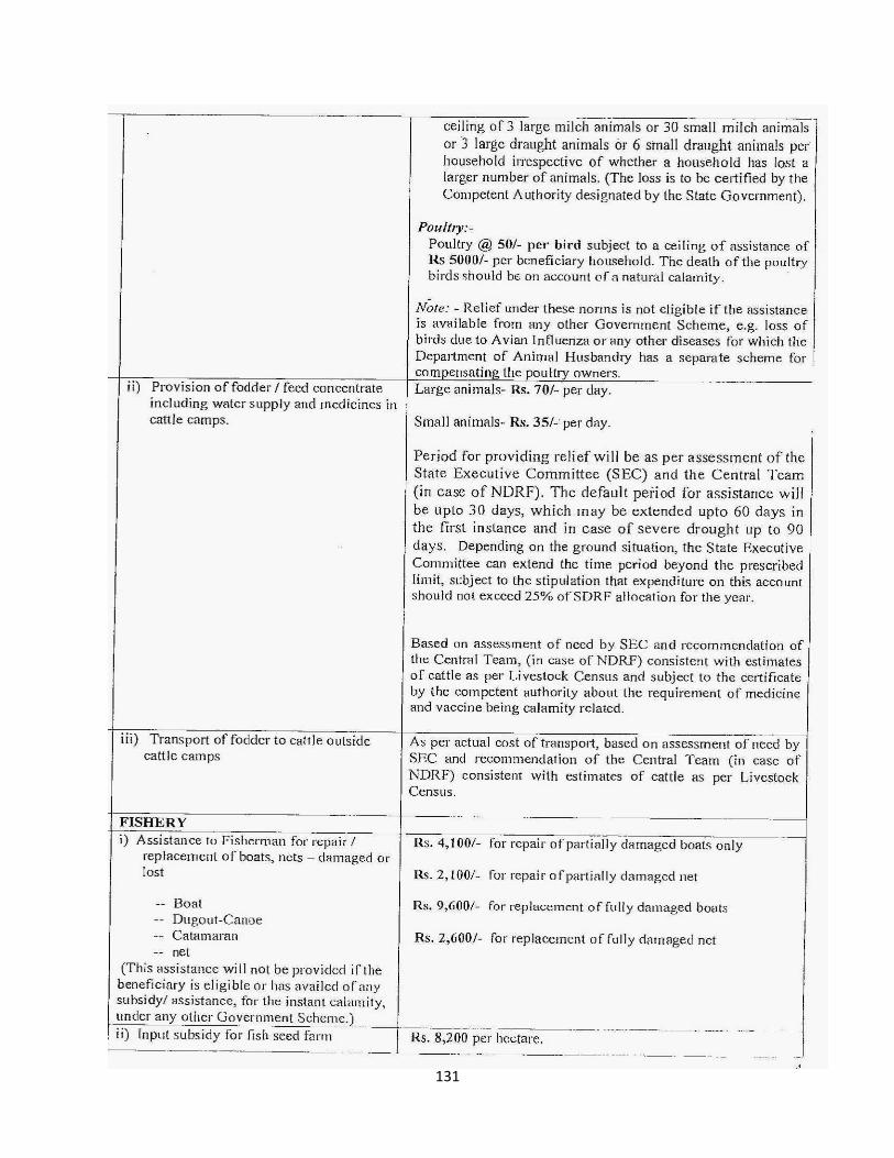
131
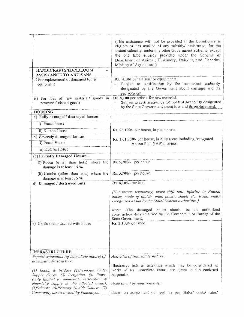
132
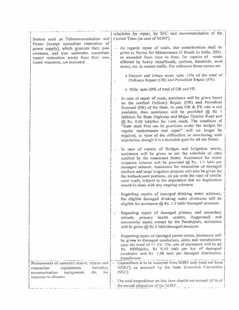
133
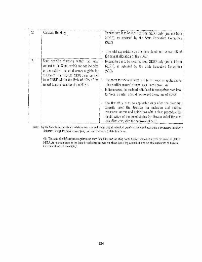
134
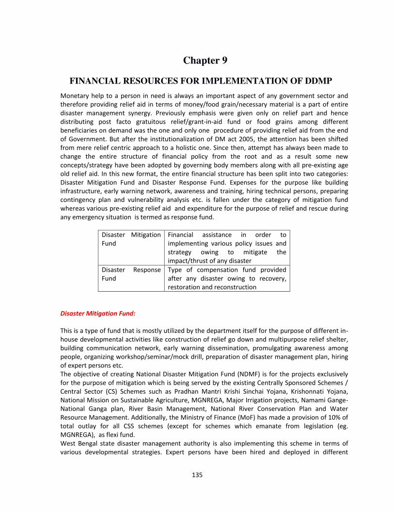
135
Chapter 9
FINANCIAL RESOURCES FOR IMPLEMENTATION OF DDMP
Monetary help to a person in need is always an important aspect of any government sector and
therefore providing relief aid in terms of money/food grain/necessary material is a part of entire
disaster management synergy. Previously emphasis were given only on relief part and hence
distributing post facto gratuitous relief/grant-in-aid fund or food grains among different
beneficiaries on demand was the one and only one procedure of providing relief aid from the end
of Government. But after the institutionalization of DM act 2005, the attention has been shifted
from mere relief centric approach to a holistic one. Since then, attempt has always been made to
change the entire structure of financial policy from the root and as a result some new
concepts/strategy have been adopted by governing body members along with all pre-existing age
old relief aid. In this new format, the entire financial structure has been split into two categories:
Disaster Mitigation Fund and Disaster Response Fund. Expenses for the purpose like building
infrastructure, early warning network, awareness and training, hiring technical persons, preparing
contingency plan and vulnerability analysis etc. is fallen under the category of mitigation fund
whereas various pre-existing relief aid and expenditure for the purpose of relief and rescue during
any emergency situation is termed as response fund.
Disaster Mitigation
Fund
Financial assistance in order to
implementing various policy issues and
strategy owing to mitigate the
impact/thrust of any disaster
Disaster Response
Fund
Type of compensation fund provided
after any disaster owing to recovery,
restoration and reconstruction
Disaster Mitigation Fund:
This is a type of fund that is mostly utilized by the department itself for the purpose of different in-
house developmental activities like construction of relief go down and multipurpose relief shelter,
building communication network, early warning dissemination, promulgating awareness among
people, organizing workshop/seminar/mock drill, preparation of disaster management plan, hiring
of expert persons etc.
The objective of creating National Disaster Mitigation Fund (NDMF) is for the projects exclusively
for the purpose of mitigation which is being served by the existing Centrally Sponsored Schemes /
Central Sector (CS) Schemes such as Pradhan Mantri Krishi Sinchai Yojana, Krishonnati Yojana,
National Mission on Sustainable Agriculture, MGNREGA, Major Irrigation projects, Namami Gange-
National Ganga plan, River Basin Management, National River Conservation Plan and Water
Resource Management. Additionally, the Ministry of Finance (MoF) has made a provision of 10% of
total outlay for all CSS schemes (except for schemes which emanate from legislation (eg.
MGNREGA), as flexi fund.
West Bengal state disaster management authority is also implementing this scheme in terms of
various developmental strategies. Expert persons have been hired and deployed in different
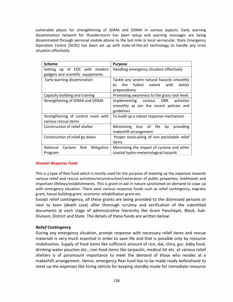
136
vulnerable places for strengthening of SDMA and DDMA in various aspects. Early warning
dissemination network for thunderstorm has been setup and warning messages are being
disseminated through personal mobile phone to the last mile in local vernacular. State Emergency
Operation Centre (SEOC) has been set up with state-of-the-art technology to handle any crisis
situation effectively.
Disaster Response Fund:
This is a type of flexi fund which is mostly used for the purpose of meeting up the expenses towards
various relief and rescue activities/reconstruction/restoration of public properties, livelihoods and
important lifelines/establishments. This is grant-in-aid in nature sanctioned on demand to cope up
with emergency situation. There exist various response funds such as relief contingency, exgratia
grant, house building grant, economic rehabilitation grant etc.
Except relief contingency, all these grants are being provided to the distressed persons or
next to keen (death case) after thorough scrutiny and verification of the submitted
documents at each stage of administrative hierarchy like Gram Panchayet, Block, Sub-
Division, District and State. The details of these funds are written below:
Relief Contingency
During any emergency situation, prompt response with necessary relief items and rescue
materials is very much essential in order to save life and that is possible only by resource
mobilization. Supply of food items like sufficient amount of rice, dal, chira, gur, baby food,
drinking water pouches etc., non food items like tarpaulin, medical kit etc. at various relief
shelters is of paramount importance to meet the demand of those who resides at a
makeshift arrangement. Hence, emergency flexi fund has to be made ready beforehand to
meet up the expenses like hiring vehicle for keeping standby mode for immediate resource
Scheme Purpose
Setting up of EOC with modern
gadgets and scientific equipments
Handling emergency situation effectively
Early warning dissemination Tackle any severe natural hazards smoothly
to the fullest extent with better
preparedness
Capacity building and training Promoting awareness to the grass root level.
Strengthening of SDMA and DDMA Implementing various DRR activities
smoothly as per the recent policies and
guidelines
Strengthening of control room with
various rescue items
To build up a robust response mechanism
Construction of relief shelter Minimizing loss of life by providing
makeshift arrangement
Construction of relief go down Proper stock-piling of non perishable relief
items
National Cyclone Risk Mitigation
Program
Minimizing the impact of cyclone and other
coastal hydro-meteorological hazards
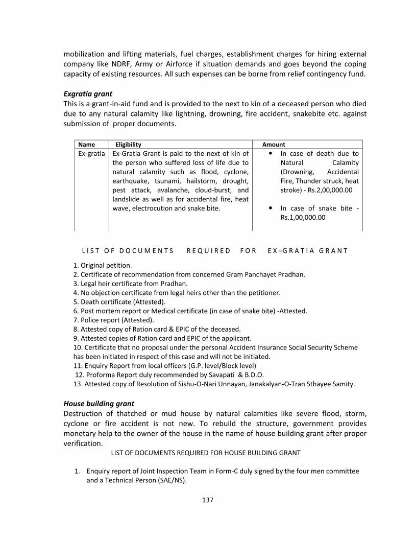
137
mobilization and lifting materials, fuel charges, establishment charges for hiring external
company like NDRF, Army or Airforce if situation demands and goes beyond the coping
capacity of existing resources. All such expenses can be borne from relief contingency fund.
Exgratia grant
This is a grant-in-aid fund and is provided to the next to kin of a deceased person who died
due to any natural calamity like lightning, drowning, fire accident, snakebite etc. against
submission of proper documents.
L I S T O F D O C U M E N T S R E Q U I R E D F O R E X –G R A T I A G R A N T
1. Original petition.
2. Certificate of recommendation from concerned Gram Panchayet Pradhan.
3. Legal heir certificate from Pradhan.
4. No objection certificate from legal heirs other than the petitioner.
5. Death certificate (Attested).
6. Post mortem report or Medical certificate (in case of snake bite) -Attested.
7. Police report (Attested).
8. Attested copy of Ration card & EPIC of the deceased.
9. Attested copies of Ration card and EPIC of the applicant.
10. Certificate that no proposal under the personal Accident Insurance Social Security Scheme
has been initiated in respect of this case and will not be initiated.
11. Enquiry Report from local officers (G.P. level/Block level)
12. Proforma Report duly recommended by Savapati & B.D.O.
13. Attested copy of Resolution of Sishu-O-Nari Unnayan, Janakalyan-O-Tran Sthayee Samity.
House building grant
Destruction of thatched or mud house by natural calamities like severe flood, storm,
cyclone or fire accident is not new. To rebuild the structure, government provides
monetary help to the owner of the house in the name of house building grant after proper
verification.
LIST OF DOCUMENTS REQUIRED FOR HOUSE BUILDING GRANT
1. Enquiry report of Joint Inspection Team in Form-C duly signed by the four men committee
and a Technical Person (SAE/NS).
Name Eligibility Amount
Ex-gratia Ex-Gratia Grant is paid to the next of kin of
the person who suffered loss of life due to
natural calamity such as flood, cyclone,
earthquake, tsunami, hailstorm, drought,
pest attack, avalanche, cloud-burst, and
landslide as well as for accidental fire, heat
wave, electrocution and snake bite.
In case of death due to
Natural Calamity
(Drowning, Accidental
Fire, Thunder struck, heat
stroke) - Rs.2,00,000.00
In case of snake bite -
Rs.1,00,000.00
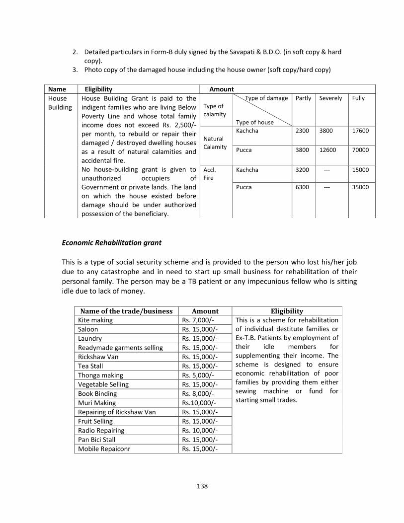
138
2. Detailed particulars in Form-B duly signed by the Savapati & B.D.O. (in soft copy & hard
copy).
3. Photo copy of the damaged house including the house owner (soft copy/hard copy)
Economic Rehabilitation grant
This is a type of social security scheme and is provided to the person who lost his/her job
due to any catastrophe and in need to start up small business for rehabilitation of their
personal family. The person may be a TB patient or any impecunious fellow who is sitting
idle due to lack of money.
Name of the trade/business Amount Eligibility
Kite making Rs. 7,000/- This is a scheme for rehabilitation
of individual destitute families or
Ex-T.B. Patients by employment of
their idle members for
supplementing their income. The
scheme is designed to ensure
economic rehabilitation of poor
families by providing them either
sewing machine or fund for
starting small trades.
Saloon Rs. 15,000/-
Laundry Rs. 15,000/-
Readymade garments selling Rs. 15,000/-
Rickshaw Van Rs. 15,000/-
Tea Stall Rs. 15,000/-
Thonga making Rs. 5,000/-
Vegetable Selling Rs. 15,000/-
Book Binding Rs. 8,000/-
Muri Making Rs.10,000/-
Repairing of Rickshaw Van Rs. 15,000/-
Fruit Selling Rs. 15,000/-
Radio Repairing Rs. 10,000/-
Pan Bici Stall Rs. 15,000/-
Mobile Repaiconr Rs. 15,000/-
House
Building
House Building Grant is paid to the
indigent families who are living Below
Poverty Line and whose total family
income does not exceed Rs. 2,500/-
per month, to rebuild or repair their
damaged / destroyed dwelling houses
as a result of natural calamities and
accidental fire.
No house-building grant is given to
unauthorized occupiers of
Government or private lands. The land
on which the house existed before
damage should be under authorized
possession of the beneficiary.
Type of
calamity
Type of damage
Type of house
Partly
Severely
Fully
Natural
Calamity
Kachcha 2300 3800 17600
Pucca 3800 12600 70000
Accl.
Fire
Kachcha 3200 --- 15000
Pucca 6300 --- 35000
Name Eligibility Amount
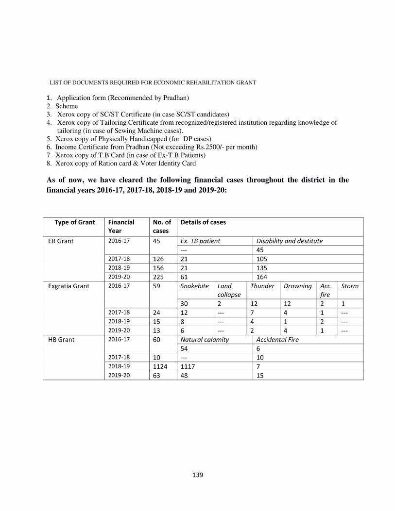
139
LIST OF DOCUMENTS REQUIRED FOR ECONOMIC REHABILITATION GRANT
1. Application form (Recommended by Pradhan)
2. Scheme
3. Xerox copy of SC/ST Certificate (in case SC/ST candidates)
4. Xerox copy of Tailoring Certificate from recognized/registered institution regarding knowledge of
tailoring (in case of Sewing Machine cases).
5. Xerox copy of Physically Handicapped (for DP cases)
6. Income Certificate from Pradhan (Not exceeding Rs.2500/- per month)
7. Xerox copy of T.B.Card (in case of Ex-T.B.Patients)
8. Xerox copy of Ration card & Voter Identity Card
As of now, we have cleared the following financial cases throughout the district in the
financial years 2016-17, 2017-18, 2018-19 and 2019-20:
Type of Grant Financial
Year
No. of
cases
Details of cases
ER Grant 2016-17 45 Ex. TB patient Disability and destitute
--- 45
2017-18 126 21 105
2018-19 156 21 135
2019-20 225 61 164
Exgratia Grant 2016-17 59 Snakebite Land
collapse
Thunder Drowning Acc.
fire
Storm
30 2 12 12 2 1
2017-18 24 12 --- 7 4 1 ---
2018-19 15 8 --- 4 1 2 ---
2019-20 13 6 --- 2 4 1 ---
HB Grant 2016-17 60 Natural calamity Accidental Fire
54 6
2017-18 10 --- 10
2018-19 1124 1117 7
2019-20 63 48 15
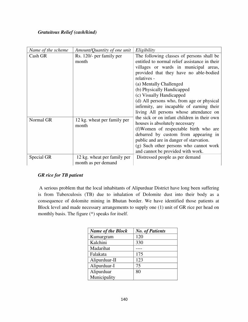
140
Gratuitous Relief (cash/kind)
GR rice for TB patient
A serious problem that the local inhabitants of Alipurduar District have long been suffering
is from Tuberculosis (TB) due to inhalation of Dolomite dust into their body as a
consequence of dolomite mining in Bhutan border. We have identified those patients at
Block level and made necessary arrangements to supply one (1) unit of GR rice per head on
monthly basis. The figure (*) speaks for itself.
Name of the Block No. of Patients
Kumargram 120
Kalchini 330
Madarihat ----
Falakata 175
Alipurduar-II 123
Alipurduar-I 75
Alipurduar
Municipality
80
Name of the scheme Amount/Quantity of one unit Eligibility
Cash GR Rs. 120/- per family per
month
The following classes of persons shall be
entitled to normal relief assistance in their
villages or wards in municipal areas,
provided that they have no able-bodied
relatives -
(a) Mentally Challenged
(b) Physically Handicapped
(c) Visually Handicapped
(d) All persons who, from age or physical
infirmity, are incapable of earning their
living All persons whose attendance on
the sick or on infant children in their own
houses is absolutely necessary
(f)Women of respectable birth who are
debarred by custom from appearing in
public and are in danger of starvation.
(g) Such other persons who cannot work
and cannot be provided with work.
Normal GR 12 kg. wheat per family per
month
Special GR 12 kg. wheat per family per
month as per demand
Distressed people as per demand
141
*(This list is not an exhaustive list and subject to change depending upon the cases, the old
patients who has been cured may be dropped from the list and new patients may be replaced
if any. So preparing the list is a continuous and dynamic approach).
Various compensatory funds:
Apart from all these mentioned funds, some other category of fund also exist which is called
compensatory fund. In this initiative, flood affected farmers or handloom workers are provided
with compensation after a careful analysis regarding damage of property to initiate their business
again. This fund is provided for welfare of society with an aim to uplift the status of socially
marginalized community people.
Future Plan (After due approval from the department):
Round the clock surveillance in district control room throughout the year.
Installation of Automatic Weather Station for keeping record of meteorological
parameters such as wind speed, temperature, rainfall etc.
One disaster management activist per Gram Panchayet for better coordination.
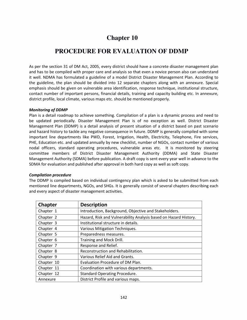
142
Chapter 10
PROCEDURE FOR EVALUATION OF DDMP
As per the section 31 of DM Act, 2005, every district should have a concrete disaster management plan
and has to be compiled with proper care and analysis so that even a novice person also can understand
it well. NDMA has formulated a guideline of a model District Disaster Management Plan. According to
the guideline, the plan should be divided into 12 separate chapters along with an annexure. Special
emphasis should be given on vulnerable area identification, response technique, institutional structure,
contact number of important persons, financial details, training and capacity building etc. In annexure,
district profile, local climate, various maps etc. should be mentioned properly.
Monitoring of DDMP
Plan is a detail roadmap to achieve something. Compilation of a plan is a dynamic process and need to
be updated periodically. Disaster Management Plan is of no exception as well. District Disaster
Management Plan (DDMP) is a detail analysis of present situation of a district based on past scenario
and hazard history to tackle any negative consequence in future. DDMP is generally compiled with some
important line departments like PWD, Forest, Irrigation, Health, Electricity, Telephone, Fire services,
PHE, Education etc. and updated annually by new checklist, number of NGOs, contact number of various
nodal officers, standard operating procedures, vulnerable areas etc. It is monitored by steering
committee members of District Disaster Management Authority (DDMA) and State Disaster
Management Authority (SDMA) before publication. A draft copy is sent every year well in advance to the
SDMA for evaluation and published after approval in both hard copy as well as soft copy.
Compilation procedure
The DDMP is compiled based on individual contingency plan which is asked to be submitted from each
mentioned line departments, NGOs, and SHGs. It is generally consist of several chapters describing each
and every aspect of disaster management activities.
Chapter Description Chapter 1 Introduction, Background, Objective and Stakeholders.
Chapter 2 Hazard, Risk and Vulnerability Analysis based on Hazard History.
Chapter 3 Institutional structure in details.
Chapter 4 Various Mitigation Techniques.
Chapter 5 Preparedness measures.
Chapter 6 Training and Mock Drill.
Chapter 7 Response and Relief.
Chapter 8 Reconstruction and Rehabilitation.
Chapter 9 Various Relief Aid and Grants.
Chapter 10 Evaluation Procedure of DM Plan.
Chapter 11 Coordination with various departments.
Chapter 12 Standard Operating Procedure.
Annexure District Profile and various maps.
143
Updation of DDMP
Plan is dynamic in nature and need to be updated periodically. Among the mentioned 12 Chapters, the
most important sections are Chapter 4 to chapter 9. The portions that need to be paid special focus
during updation of the plan are written below:
Chapter 4 Mentioning new structural and non-structural mitigation techniques that can be
adopted to reduce disaster risk.
Chapter 5 Number of flood shelter constructed recently.
Number of new CD volunteers that has been trained.
Number of registered medicine shop having anti venom for snakebite.
Chapter 6 Training Calendar.
Future Plan of new training and mock drill.
Chapter 7 New response strategies.
Chapter 8 Budgetary plan of reconstruction of important lifeline if there is any.
Chapter 9 New financial schemes for implementing various DRR schemes smoothly.
Circulation and Uploading of DDMP at the website of SDMA/DDMA
Plan is not made to be kept in bookshelf only. Rather it is to be reached up to the last mile and needs
wide publicity among stakeholders. In order to circulate the plan, one hard copy is sent among each line
departments and IAG coordinator. But hard copy is limited and can’t be circulated door to door. To
overcome this, the soft copy of the same is uploaded in SDMA and DDMA website which has been
written below.
SDMA website
http://wbdmd.gov.in/Pages/Default.aspx
DDMA website
http://alipurduar.gov.in/
Resources of conducting various Training and Mock Drills
Training Resource Persons
Calendar Mock drill twice in
a year
Disaster Management Section
Fire and Emergency Services
Civil Defence Section
Inter Agency Group
Health and Family Welfare
RTC training (as per
prescribed schedule by ATI)
Expert Resourceful Persons
Community Awareness District Authority
Mega mock drill Disaster Management Section
Fire and Emergency Services
Civil Defence Section
144
Inter Agency Group
Health and Family Welfare
Forest
Higher Education
Irrigation
PWD
Municipality Office
SDRF
NDRF
Central Para Military Force
Post Disaster Damage Analysis and Gap Evaluation
After any disaster, first and foremost duty is to evaluate loss of life and damage to property due to the
catastrophe. Communication gap and drawbacks has to be found out and to be updated in the very next
edition of the plan for the purpose of better response, rescue and recovery. In this connection, a
meeting regarding loss and damage analysis is essential with all necessary line departments and sub-
ordinate officers. Hazards are natural whereas disaster is manmade, in a sense it happens due to lack of
proper coordination and use of existing resources properly. So lessons learned from the event have also
to be mentioned clearly to tackle such type of event in future.
145
Chapter 11
COORDINATION MECHANISM FOR IMPLEMENTATION OF DDMP
Disaster Management is incomplete without proper coordination. The purpose of compiling Disaster
Management Plan is to handle any unforeseen event smoothly through proper coordination and chain
of command. Two types of coordination* mechanisms are there, one is horizontal and other is vertical.
*Here coordination means coordination at District level unless stated otherwise and hence co-ordination in this chapter may
be treated as co-ordination with district hereinafter.
Horizontal Linkage
Horizontal Linkages Various line departments like Irrigation,
PWD, Health, Police, Food and Supply
etc.
NGO, SHG, CBO and Corporate Agency
Other private agencies
Vertical Linkages Various higher and lower authorities like
NDMA at national level, SDMA at state
level, BDMC at block level.
Various rescue teams like NDRF at
national level, SDRF at state level.
Disaster
Management
PWD
Forest Health
Irrigation
Police
Food Supply
NGO, SHG, CBO,
Corporate Agency
Indian Railway
WBSEDCL BSNL
146
Vertical Linkage
(Administrative) (Rescue Force)
Team wise coordination procedure for any mishap:
Team
Responsible departments
Task assigned for
Early warning
Dissemination (in case if
there is any early warning
well in advance)
Disaster Management Circulation of early warning messages up to the last
mile
Rescue
Civil defence, SSB, Police, Fire.
Carcass removal.
Debris clearing.
Rescuing distressed people from collapsed
building.
Relief
Health, PHE, Municipality,
PRI, NGO, SHG.
Opening of relief camp.
Providing shelter, Food, drinking water, medical
assistance.
Assessment
PWD, Rail, WBSEDCL, BSNL, PHE,
Health, Fire, School education.
Assessment of loss and damages of life and
property, both public and private under the
jurisdiction of individual sectors like building,
bridge, road, water tank, drinking water pipe,
electric pole, power grid station, telephone line
connection etc.
NDMA NDMA
SDMA
DDMA
BDMC
GPDMC/PRI
NDRF
SDRF
Local Task Force
147
Line department/Stakeholder briefing:
Name of
the
department
Activities at various phases of disaster
Pre Disaster During Disaster Post Disaster
Irrigation
and
waterways
Looking after the river
protection works and
restores the same
based on necessity.
Keep close liaison with
flood control room and
providing information
of river water level on
emergency basis for
taking action.
Preparation of post
disaster damage report if
there is any.
Health and
Family
Welfare
Promoting mass
awareness among local
people on health hazard
and disease outbreak.
1. Setting up of
emergency
medical camp.
2. Deployment of
Rapid Response
Team with
mobile medical
van.
3. Making
arrangement of
additional beds
in hospitals/
health centers
Preparation of post
disaster damage report if
there is any.
Forest ------ Keep close contact with
District HQ and block
offices for any mishap
under the jurisdiction of
forest and its adjoining
area.
Preparation of post
disaster damage report if
there is any.
Police Promoting mass
awareness among local
people on safe driving,
road safety etc.
1. Maintaining law
and order.
2. Handling traffic
smoothly.
3. Deployment of
special task
force for
cordoning.
4. Protecting
public
properties from
exited mob.
1. Removal of
carcass.
2. Clearing of roads
and garbage.
Civil
Defence
1. Imparting
Foundation
training to local
boys and girls to
make QRT
Formation and
deployment of QRT as
and when required.
Preparation of post
disaster damage report if
there is any.
148
network
stronger.
2. Keep rescue
materials
functional
beforehand.
Agriculture ------ ------ 1. Preparation of
post disaster
damage report if
there is any.
2. Ensuring crop
insurance to the
farmers in need.
3. Compensation
requirement from
SDRF if there is
any.
PWD ---- ---- Preparation of post
disaster damage report if
there is any.
Fire and
Emergency
Services
1. Promoting mass
awareness.
2. Keep fire-
fighting
equipments and
peripheral
accessories
functional
beforehand.
1. Deployment of
Response Team
as and when
required.
2. Respond to any
fire mishap
immediately.
----
Education 1. Encouraging
students on
school safety.
2. 2. Earmarking
of schools that
may be served
as temporary
flood shelter.
Providing space for
temporary flood shelter
and gruel kitchen.
Preparation of post
disaster damage report if
there is any.
Inter
Agency
Group
Promoting mass
awareness, child safety
among grass root level.
Providing additional
support in rescue and
relief activities.
Preparation and
compilation of Rapid
Need Assessment.
Rail 1. Conducting
Mock Drill.
2. Keep rescue
equipments in
proper order.
Providing additional
help in rescue works.
--------------
Army ----- Providing additional ----------------
149
support with state-of-
the-art rescue
equipments in special
operation on
emergency basis.
SSB 1. Conducting
Mock Drill on
regular basis.
2. Keep rescue
equipments in
proper order.
Support with extra
manpower in rescue
operation as and when
required.
------------
IOCL 1. Conducting
Mock Drill on
regular basis.
2. Keep rescue
equipments in
proper order.
3. Check and
proper vigilance
of gas pipeline
and its
adjoining area
Providing additional
support to the district
authority in rescue
operation with state-of-
the-art modern
equipments as and
when required.
Assess the damage and
prepare a report thereof.
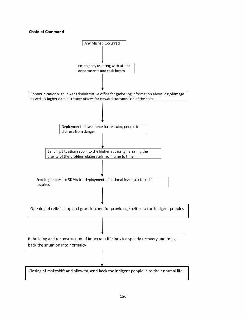
150
Chain of Command
Emergency Meeting with all line
departments and task forces
Any Mishap Occurred
Communication with lower administrative office for gathering information about loss/damage
as well as higher administrative offices for onward transmission of the same.
Deployment of task force for rescuing people in
distress from danger
Sending Situation report to the higher authority narrating the
gravity of the problem elaborately from time to time
Sending request to SDMA for deployment of national level task force if
required
Opening of relief camp and gruel kitchen for providing shelter to the indigent peoples
Rebuilding and reconstruction of important lifelines for speedy recovery and bring
back the situation into normalcy.
Closing of makeshift and allow to send back the indigent people in to their normal life
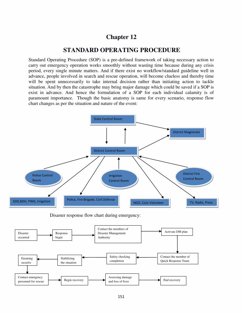
151
Chapter 12
STANDARD OPERATING PROCEDURE
Standard Operating Procedure (SOP) is a pre-defined framework of taking necessary action to
carry out emergency operation works smoothly without wasting time because during any crisis
period, every single minute matters. And if there exist no workflow/standard guideline well in
advance, people involved in search and rescue operation, will become clueless and thereby time
will be spent unnecessarily to take internal decision rather than initiating action to tackle
situation. And by then the catastrophe may bring major damage which could be saved if a SOP is
exist in advance. And hence the formulation of a SOP for each individual calamity is of
paramount importance. Though the basic anatomy is same for every scenario, response flow
chart changes as per the situation and nature of the event:
Disaster response flow chart during emergency:
kp423kl;
State Control Room
District Control Room
District Magistrate
Police Control
Room
Irrigation
Control Room
District Fire
Control Room
SDO,BDO, PWD, Irrigation Police, Fire Brigade, Civil Defense
NGO, Civic Volunteer TV, Radio, Press
Disaster
occurred
Response
begin
Contact the members of
Disaster Management
Authority
Activate DM plan
Contact the member of
Quick Response Team
Safety checking
completion Stabilizing
the situation
Ensuring
security
Contact emergency
personnel for rescue Begin recovery Assessing damage
and loss of lives End recovery
152
Here we discuss about different SOPs in details from the perspective of district level disasters.
SOP for flood:
Flood is a type of geo-hydrological disaster and may occur due to various reasons such as heavy
rainfall, embankment breaching, dam failure, glacial lake outburst etc. It can be categorized into
two different types such as normal flood and flash flood based on local geography. In
mountainous terrain, flash flood is a very common phenomenon whose nature cannot be
predicted well in advance. It generally occurs due to land burst or sudden unprecedented rainfall
within a very short span of time and causes major damage especially in the foothill area where
river becomes too turbulent and rogue to carry anything whichever falls upon in the mouth of a
particular channel. According to the nature of flash flood, water flows very rapidly for first two-
three hours, causing major damage and then calms down slowly and disappears by the course of
time. The time threshold may vary from place to place depend upon different factors like local
topography, land use and land cover, habitation etc. Close watch on rainfall prediction and water
level of major rivers very frequently, timely deployment of response teams as per requirement
etc. are some of the few remedies for flash flood.
Alipurduar, a small district situated in the northern part of West Bengal has always been a
vulnerable district with regard to flood. Flash floods especially become a major bane during the
monsoons because of its geographical location and topographic feature. The rivers coming from
Bhutan pose a dangerous threat to the areas of this district which fall in the Bhutan foothills.
Information regarding rainfall in Bhutan does not reach to this district in adequate time due to the
unavailability of any system of dissemination of rainfall data directly to the district authorities of
Bhutan. This creates a major problem as pre disaster litigation is not possible to be done on time
due to lack of information as to which area should be watched and protected on priority basis.
Under this circumstance, flood control room of district disaster management authority has to
shoulder upon all burdens to face the challenge.
Therefore, what basically happens is that the rivers which are flash flood prone swell to
dangerous levels within a short span of time providing no warning to any person or animal in its
way. The destruction is swift and devastating. Especially the places which are situated at low
lying area are at high risk of getting damage due to tremendous river discharge. As a
consequence, bridges collapse, roads get damaged and human and animal life is lost. Sometimes
these rivers break through the bundhs and wreak havoc in the villages near these rivers. Kalchini
and Madarihat block are the major sufferer of flash floods. Here, Jogi Jhora, a tributary of Basra
River is a cause of concern. Other blocks, fallen in the low lying area of this district namely,
Falakata, Alipurduar-I, Alipurduar-II and lower part of Kumargram, floods are also regularly
hampering life, property, agriculture etc. The major rivers causing floods are Torsha, Kaljani,
Sankosh, Rydak-I & Rydak-II. Among them, river Kaljani is the biggest one on the basis of
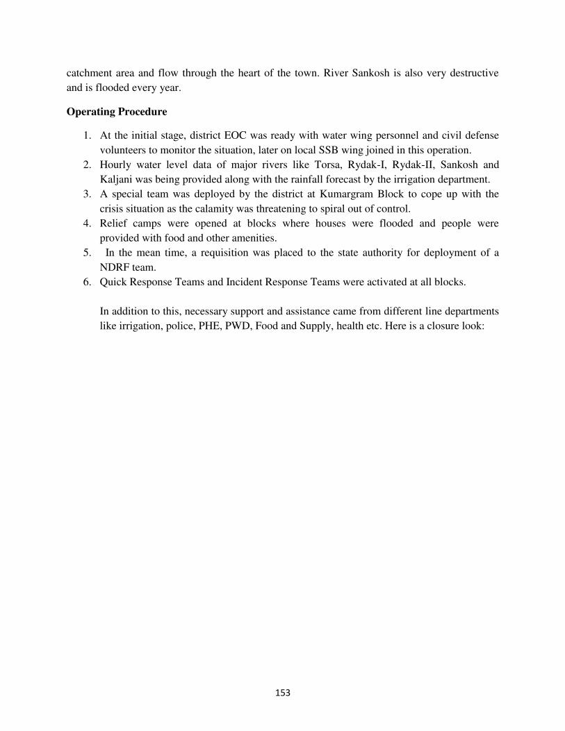
153
catchment area and flow through the heart of the town. River Sankosh is also very destructive
and is flooded every year.
Operating Procedure
1. At the initial stage, district EOC was ready with water wing personnel and civil defense
volunteers to monitor the situation, later on local SSB wing joined in this operation.
2. Hourly water level data of major rivers like Torsa, Rydak-I, Rydak-II, Sankosh and
Kaljani was being provided along with the rainfall forecast by the irrigation department.
3. A special team was deployed by the district at Kumargram Block to cope up with the
crisis situation as the calamity was threatening to spiral out of control.
4. Relief camps were opened at blocks where houses were flooded and people were
provided with food and other amenities.
5. In the mean time, a requisition was placed to the state authority for deployment of a
NDRF team.
6. Quick Response Teams and Incident Response Teams were activated at all blocks.
In addition to this, necessary support and assistance came from different line departments
like irrigation, police, PHE, PWD, Food and Supply, health etc. Here is a closure look:
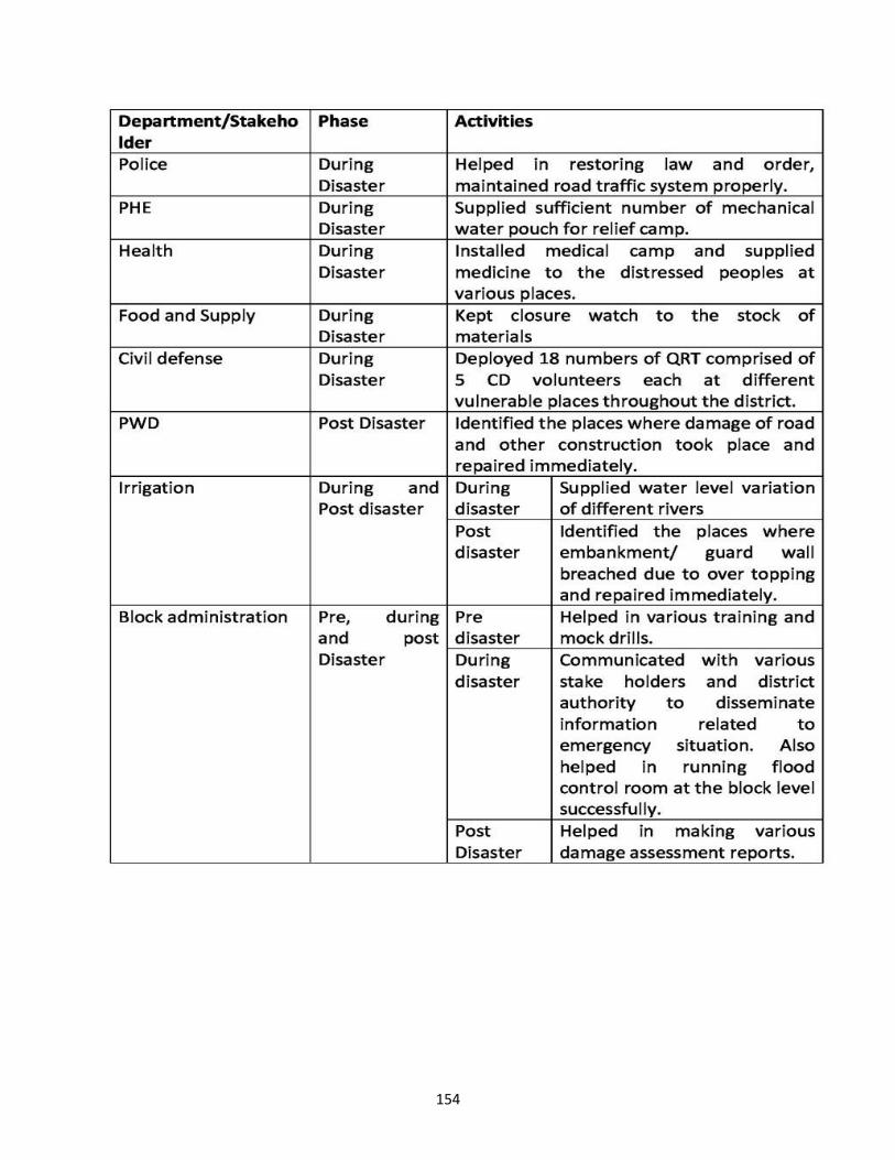
154
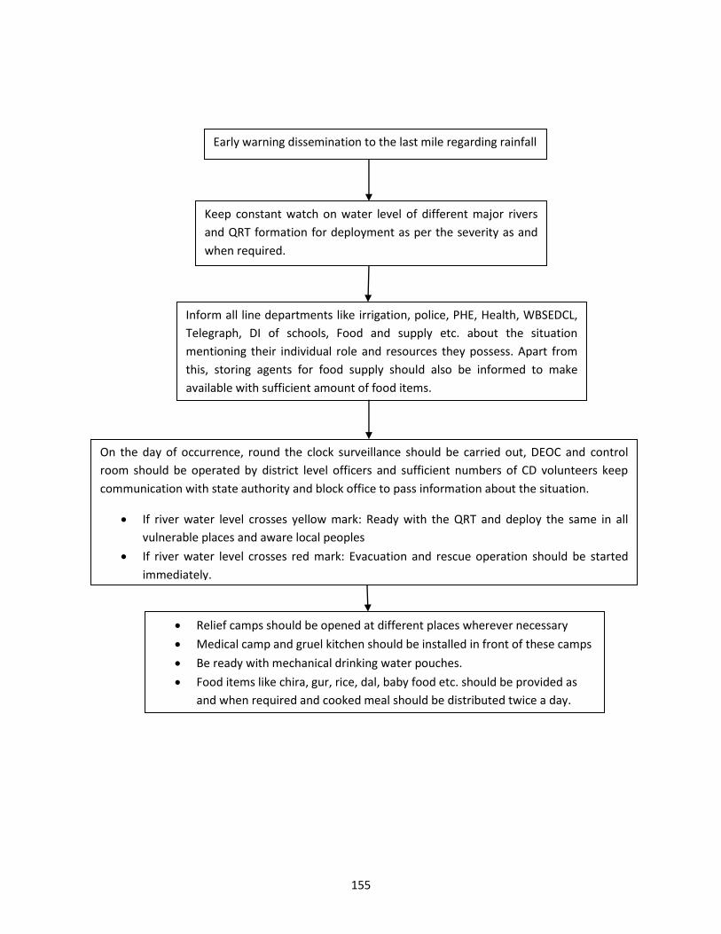
155
Early warning dissemination to the last mile regarding rainfall
Keep constant watch on water level of different major rivers
and QRT formation for deployment as per the severity as and
when required.
Inform all line departments like irrigation, police, PHE, Health, WBSEDCL,
Telegraph, DI of schools, Food and supply etc. about the situation
mentioning their individual role and resources they possess. Apart from
this, storing agents for food supply should also be informed to make
available with sufficient amount of food items.
On the day of occurrence, round the clock surveillance should be carried out, DEOC and control
room should be operated by district level officers and sufficient numbers of CD volunteers keep
communication with state authority and block office to pass information about the situation.
If river water level crosses yellow mark: Ready with the QRT and deploy the same in all
vulnerable places and aware local peoples
If river water level crosses red mark: Evacuation and rescue operation should be started
immediately.
Relief camps should be opened at different places wherever necessary
Medical camp and gruel kitchen should be installed in front of these camps
Be ready with mechanical drinking water pouches.
Food items like chira, gur, rice, dal, baby food etc. should be provided as
and when required and cooked meal should be distributed twice a day.
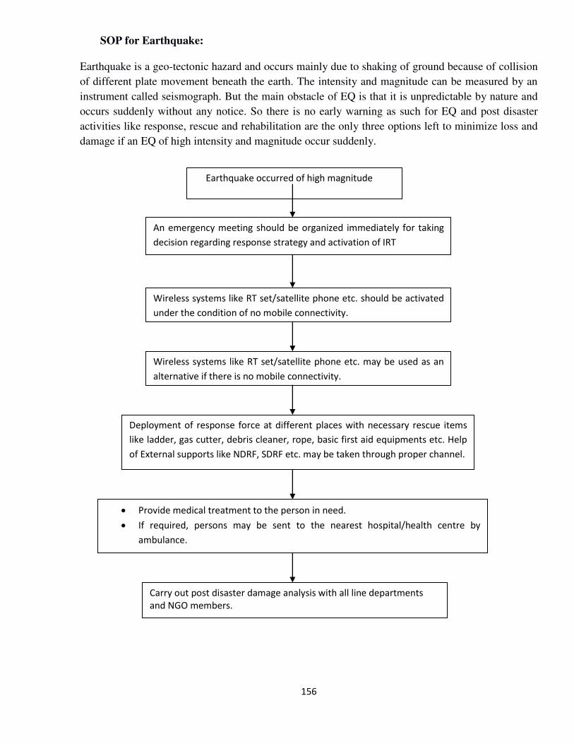
156
SOP for Earthquake:
Earthquake is a geo-tectonic hazard and occurs mainly due to shaking of ground because of collision
of different plate movement beneath the earth. The intensity and magnitude can be measured by an
instrument called seismograph. But the main obstacle of EQ is that it is unpredictable by nature and
occurs suddenly without any notice. So there is no early warning as such for EQ and post disaster
activities like response, rescue and rehabilitation are the only three options left to minimize loss and
damage if an EQ of high intensity and magnitude occur suddenly.
Earthquake occurred of high magnitude
An emergency meeting should be organized immediately for taking
decision regarding response strategy and activation of IRT
Wireless systems like RT set/satellite phone etc. should be activated
under the condition of no mobile connectivity.
Wireless systems like RT set/satellite phone etc. may be used as an
alternative if there is no mobile connectivity.
Deployment of response force at different places with necessary rescue items
like ladder, gas cutter, debris cleaner, rope, basic first aid equipments etc. Help
of External supports like NDRF, SDRF etc. may be taken through proper channel.
Provide medical treatment to the person in need.
If required, persons may be sent to the nearest hospital/health centre by
ambulance.
Carry out post disaster damage analysis with all line departments
and NGO members.
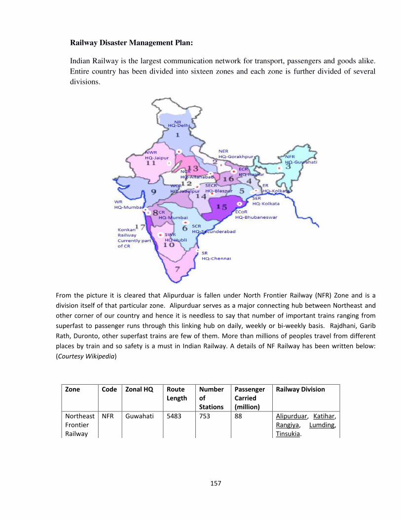
157
Railway Disaster Management Plan:
Indian Railway is the largest communication network for transport, passengers and goods alike.
Entire country has been divided into sixteen zones and each zone is further divided of several
divisions.
From the picture it is cleared that Alipurduar is fallen under North Frontier Railway (NFR) Zone and is a
division itself of that particular zone. Alipurduar serves as a major connecting hub between Northeast and
other corner of our country and hence it is needless to say that number of important trains ranging from
superfast to passenger runs through this linking hub on daily, weekly or bi-weekly basis. Rajdhani, Garib
Rath, Duronto, other superfast trains are few of them. More than millions of peoples travel from different
places by train and so safety is a must in Indian Railway. A details of NF Railway has been written below:
(Courtesy Wikipedia)
Zone Code Zonal HQ Route
Length
Number
of
Stations
Passenger
Carried
(million)
Railway Division
Northeast
Frontier
Railway
NFR Guwahati 5483 753 88 Alipurduar, Katihar,
Rangiya, Lumding,
Tinsukia.
158
The structure of safety response of Indian Railway has been briefed:
Control Room Every division has a Control Room for train
operations, where all the trains in the division are
controlled and monitored. There are different
types of control rooms such as engineering
control, mechanical control etc. which coordinate
with operating control and employees of the
respective department.
Accident Relief Trains Every division has Accident Relief Trains (ARTs),
Accident Relief Medical Vans (ARMVs) and
Breakdown Cranes for assisting in disaster
management. These are under the supervision of
the Senior Divisional Manager of Engineering (Sr.
DME) of the Division, who is also the head of
Division.
Maintenance of sick line Every division has some coaching depots to
maintain its passenger cars and sick lines to
maintain freight cars which are found unfit at the
freight examination points.
Management of Natural Disaster:
Earthquake
When first tremors are sensed during an Earthquake, all personnel should evacuate and
assemble at safe places away from structures, walls and falling objects.
Emergency shutdown should be declared.
Emergency response plan to be activated.
After proper restoration, personnel should inspect all facilities for damage assessment, cleanup,
restoration and recovery.
Landslide
If there is any probability of landslide due to heavy down pour especially in the hilly region, all
train services should be regulated.
Rescue team should be rushed immediately for restoration work.
Flood
Bridge watchman to be provided at vulnerable points to inform flow of water.
To shift all personnel and important movable items around the bank.
Construction of sandbag may be made if possible to ensure safe passage of trains.
Regulate train service till flood recedes.
Evacuate people on train at station and move them to a safer place.
Contact Army, local Fire Brigade, air force, local boat man and arrange divers and boats.
Keep communication with divisional control office.
Contact St. John Ambulance Brigade, local doctors and provide medical care to the affected.
159
Apart from all these, there are several manmade disasters as well like fire, head-on collision, derailment,
terrorism etc.
GM, AGM or CSO has been nominated by Railway Board for declaring a very serious accident or any other
untoward incident as Railway Disaster. If the accident is declared as disaster, all instructions as contained
here in this disaster management plan would automatically come into force, and Officers and staff or all
departments would take action as laid down in this book. All Officers and supervisors concerned should be
fully conversant with various duties listed there in and carry them out without fail.
GOLDEN HOUR AND EXERCISES:
If a critical trauma patient is not given definite medical care within ONE hour from the time of accident,
chances of his ultimate recovery reduce drastically, even with the best of medical attention thereafter. This
one hour period is generally known as GOLDEN HOUR.
During the golden hour, every effort should make to:-
a) Render definite medical care to the extent possible preferably by quality medical
practitioner. b) Stop bleeding and restore blood pressure. c) Persons under shock should be relief of shock immediately.
d) Transport casualty to the nearest hospital, so that to reach within this golden hour period.
VARIOUS PHASES OF DISASTER MANAGEMENT:-
8.1. Phase-I:
In the period immediately after accident, the following action has to be taken on war footing by Railway Officials / Officers. i) Guard, Driver, Conductor and TTEs etc. must pass on the information quickly to the
nearest station or to control, about the accident. Being trained in first aid, they should simultaneously render every possible medical aid to injured people.
ii) Senior most Officer traveling by the affected train, whether on duty or on leave shall
take charge at site. iii) All Railway Officers and staff available on train must report to the Guard and work as
per the directions of senior most Officers.
iv) SMs of the adjoining stations must inform Control about the happening. v) Chief Controller of Divisional Control/APDJ shall order for immediate movement of
ARME/ART after consultation with DRM/ADRM.
8.2 Phase-II:
8.2.1 Phase-II begins with the arrival of Accident Relief Train (ART). The senior most Officers who reach the site first become the “Accident In charge (Site)”. All staff and Officers work as per the directions of the Officer In charge (site).
8.2.2 Site Organization:- i) Medical relief camp. ii) Security of luggage.
iii) Clue preservation. iv) Relief Rescue and Restoration. v) Coordination with Civil & Press.
vi) Liaison with Control. vii) Communication – STD phones, Walkie-talkies, Mobiles, FAX, Satellite Phone.
viii) Lighting arrangements. ix) Commercial – information booth. Arrangement of Food and Water, evacuation of
passengers including road vehicle, payment of ex-gratia etc. The medical team
reaching the spot must comprise of adequate number of doctors and staff. The senior
most Doctor & Officer at site should have all details about dead / injured and hospitals where they have been sent.
160
8.3 Special Task Teams:
i) Medical Medical Relief and transportation to hospitals.
ii) Commercial 1. Catering – food and drinking water. 2. Liaison with Civil administration and Press.
3. Display the names of injured, dead on the local TV and at nearest major stations.
iii) Commercial & RPF Security of luggage.
iv) Operating Liaison with Control and arranging logistics including shunting.
v) S&T Establishment of communication and free telephone booths.
vi) Mechanical Relief operations including rescue, re-railment and preservation
of clues.
vii) Electrical Lighting arrangement.
DUTIES AND CHECK LIST OF ACTION TO BE TAKEN BY VARIOUS OFFICIALS & DEPARTMENTS IN CASE OF DISASTER:-
10.1 DUTIES OF GUARD:- a) Note the time when the mishap took place.
b) Arrange to protect the adjacent line/lines and then the same line. c) Send information through the quickest means to the Control/SMs on either side after making
a quick survey. Assistance required is to be assessed and asked for. d) Take action to render First Aid to save lives. e) Call for Doctors, TTEs and Volunteers travelling in the train to seek assistance.
f) Depute Railway Employee(s) to arrange the connection of field telephone to ensure regular feed of information to Control. g) Preserve and safeguard all clues of the possible cause of accident.
h) Arrange protection of railway and public property through RPF, GRP and other available railway staff. i) Remain in-charge till arrival of, and replacement by a senior railway official for taking over
charge and shall not leave the site until permitted by a competent authority.
10.2 DUTIES OF THE ENGINE CREW:-
a) Switch on the flasher light of the locomotive and arrange to protect the adjacent line(s) and then also the same line according to Rules in force. b) Arrange to advise Control/SMs on either side. c) Take necessary precautions as deemed fit to safeguard the Loco/Train.
d) Extend all possible assistance to the guard in rendering First Aid, also assist in other respects. e) In case the Guard is injured in such a manner that he (the Guard) is incapable to work, the
duties of guard shall devolve on the Loco Pilot/Assistant Loco Pilot.
10.3 DUTIES OF SMs/ASMs AT ADJACENT STATIONS:- SM/ASM of the nearest stations shall immediately do the following:-
a) Ensure that no other train enters the affected section and take other necessary measures for protecting the site.
b) Advice Control about the magnitude of the accident, type of medical and other
assistance needed. c) They shall advise all Civil Authorities such as SP, DM, etc. d) Call for assistance locally from nearby hospitals, dispensaries and medical practitioners.
e) Call out all the off duty staff and allot them specific duties for relief and rescue. f) Arrange to provide to the extent possible relief/assistances to the affected passengers
such as catering, drinking water, issue of complimentary passes, arranging free
messages to relatives.
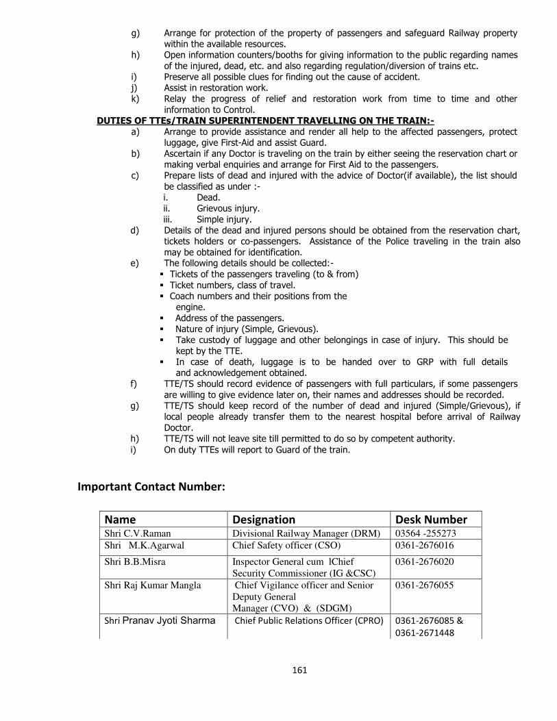
161
g) Arrange for protection of the property of passengers and safeguard Railway property within the available resources.
h) Open information counters/booths for giving information to the public regarding names
of the injured, dead, etc. and also regarding regulation/diversion of trains etc. i) Preserve all possible clues for finding out the cause of accident. j) Assist in restoration work. k) Relay the progress of relief and restoration work from time to time and other
information to Control. DUTIES OF TTEs/TRAIN SUPERINTENDENT TRAVELLING ON THE TRAIN:-
a) Arrange to provide assistance and render all help to the affected passengers, protect luggage, give First-Aid and assist Guard.
b) Ascertain if any Doctor is traveling on the train by either seeing the reservation chart or making verbal enquiries and arrange for First Aid to the passengers.
c) Prepare lists of dead and injured with the advice of Doctor(if available), the list should
be classified as under :- i. Dead. ii. Grievous injury.
iii. Simple injury. d) Details of the dead and injured persons should be obtained from the reservation chart,
tickets holders or co-passengers. Assistance of the Police traveling in the train also
may be obtained for identification. e) The following details should be collected:-
Tickets of the passengers traveling (to & from)
Ticket numbers, class of travel. Coach numbers and their positions from the
engine. Address of the passengers. Nature of injury (Simple, Grievous). Take custody of luggage and other belongings in case of injury. This should be
kept by the TTE. In case of death, luggage is to be handed over to GRP with full details
and acknowledgement obtained. f) TTE/TS should record evidence of passengers with full particulars, if some passengers
are willing to give evidence later on, their names and addresses should be recorded. g) TTE/TS should keep record of the number of dead and injured (Simple/Grievous), if
local people already transfer them to the nearest hospital before arrival of Railway
Doctor. h) TTE/TS will not leave site till permitted to do so by competent authority.
i) On duty TTEs will report to Guard of the train.
Important Contact Number:
Name Designation Desk Number Shri C.V.Raman Divisional Railway Manager (DRM) 03564 -255273
Shri M.K.Agarwal Chief Safety officer (CSO) 0361-2676016
Shri B.B.Misra Inspector General cum lChief
Security Commissioner (IG &CSC)
0361-2676020
Shri Raj Kumar Mangla Chief Vigilance officer and Senior
Deputy General
Manager (CVO) & (SDGM)
0361-2676055
Shri Pranav Jyoti Sharma Chief Public Relations Officer (CPRO) 0361-2676085 &
0361-2671448
162
SOP for Crowd Management during large crowd pulling fair:
Causes and Triggers for Crowd Disasters:
Structural
Structure collapse of
Barricades/ bamboo railings/wire fence/ Metal
barrier
Makeshift bridge.
Temporary structure.
Railings of the bridge caused by panic triggered by
rumors
Barriers on the way
Poor guard railings, poorly lit stairwells
Difficult terrain (famous religious sites built on top of hills that are difficult to
access)
Slippery/muddy roads
Narrow streets with illegal vendors on sides; sloped gradient; bad weather
leading to crushing
Windowless structure, narrow
stairs
Narrow and very few entry/exits
Absence of emergency exits
unauthorized construction surrounded by high brick walls preventing evacuation
2.2.2. Fire/Electricity
Fire in a makeshift facility or a
shop
Cooking in a makeshift facility
Wooden structure/ quick burning acrylic catching
fire
Fire at illegal structure Non-availability of fire
extinguisher/fire extinguishers not in working
condition
Unauthorized fireworks in enclosed places
Inappropriate points of manufacturing and sale of
fireworks
Building and fire code violations
Lack of adequate flood lighting of the assembly area and the path ways use by
the crowd
163
Electricity supply failure creating panic and triggering a sudden exodus
Illegal electric connections
Inappropriate fittings such as MCB, Aluminum wires instead of copper wires
etc.
Short circuit from electrical generator, (synthetic) tent catching fire.
Elevators catching fire, people on higher floors panic, steep stair designs
Security
Under deployment of security personnel to regulate to control crowd.
Lack of adequate scientific planning in making police arrangement to deal with
crowd with proper sectoral deployment under an officer with adequate
manpower and the each sector reporting to the senior police personnel in
charge of the police arrangement.
Lack of proper wireless deployment with clutter free call arrangement between
sector in-charge and officer in-charge of the police arrangement
Inadequate briefing of security personnel on crowd control before deployment
Lack of adequate dress rehearsals before actual deployment
Lack of adequate observation towers with PA system and back up force with
proper wireless communication with the tower to monitor and regulate crowd
Lack of adequate CCTV surveillance of the crowd with PA system to control
monitor and guide as and when required
Lack of adequate briefing of the personnel manning the observation towers,
CCTV and PA system on dealing with problems in effective manner as and
when they see and observe the crowd
Absence of walkie-talkies for the police on duty
Absence of public announcement systems or effective wireless system with the police
Crowd Behaviour
A wild rush to force the way towards entrance/exits
Crowds attempting to enter a venue after the start/closing time
A collision between large inward flows and outward flows
Rush during distribution of disaster relief supplies
A large number of pilgrims trying to board a ferry for a sacred island site
Free distribution of gifts/toys/food/Prasad/alms/blankets/cash/clothes
triggering a surge and crush
Tussle to catching a glimpse/autograph of a celebrity
A large (much more than expected) anxious and competitive crowd gathering
because of limited period promotional events at malls
Rush to get covered/free/unnumbered seats at the venue
Scramble to get event tickets
Crowds trying to re-enter the venue (flows inward/outward flows mixed)
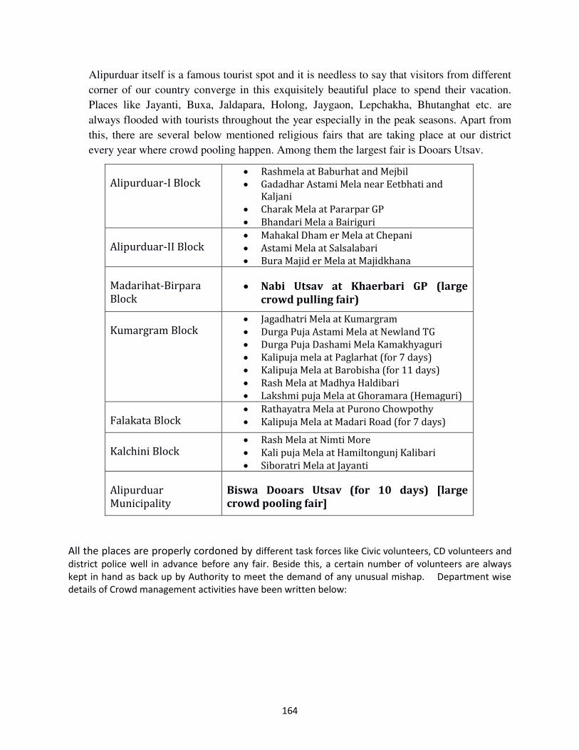
164
Alipurduar itself is a famous tourist spot and it is needless to say that visitors from different
corner of our country converge in this exquisitely beautiful place to spend their vacation.
Places like Jayanti, Buxa, Jaldapara, Holong, Jaygaon, Lepchakha, Bhutanghat etc. are
always flooded with tourists throughout the year especially in the peak seasons. Apart from
this, there are several below mentioned religious fairs that are taking place at our district
every year where crowd pooling happen. Among them the largest fair is Dooars Utsav.
Alipurduar-I Block Rashmela at Baburhat and Mejbil
Gadadhar Astami Mela near Eetbhati and
Kaljani
Charak Mela at Pararpar GP
Bhandari Mela a Bairiguri
Alipurduar-II Block Mahakal Dham er Mela at Chepani
Astami Mela at Salsalabari
Bura Majid er Mela at Majidkhana
Madarihat-Birpara
Block Nabi Utsav at Khaerbari GP (large
crowd pulling fair)
Kumargram Block Jagadhatri Mela at Kumargram
Durga Puja Astami Mela at Newland TG
Durga Puja Dashami Mela Kamakhyaguri
Kalipuja mela at Paglarhat (for 7 days)
Kalipuja Mela at Barobisha (for 11 days)
Rash Mela at Madhya Haldibari
Lakshmi puja Mela at Ghoramara (Hemaguri)
Falakata Block Rathayatra Mela at Purono Chowpothy
Kalipuja Mela at Madari Road (for 7 days)
Kalchini Block Rash Mela at Nimti More
Kali puja Mela at Hamiltongunj Kalibari
Siboratri Mela at Jayanti
Alipurduar
Municipality
Biswa Dooars Utsav (for 10 days) [large
crowd pooling fair]
All the places are properly cordoned by different task forces like Civic volunteers, CD volunteers and
district police well in advance before any fair. Beside this, a certain number of volunteers are always
kept in hand as back up by Authority to meet the demand of any unusual mishap. Department wise
details of Crowd management activities have been written below:
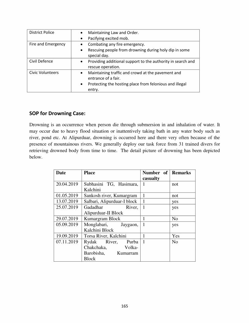
165
SOP for Drowning Case:
Drowning is an occurrence when person die through submersion in and inhalation of water. It
may occur due to heavy flood situation or inattentively taking bath in any water body such as
river, pond etc. At Alipurduar, drowning is occurred here and there very often because of the
presence of mountainous rivers. We generally deploy our task force from 31 trained divers for
retrieving drowned body from time to time. The detail picture of drowning has been depicted
below.
District Police Maintaining Law and Order.
Pacifying excited mob.
Fire and Emergency Combating any fire emergency.
Rescuing people from drowning during holy dip in some
special day.
Civil Defence Providing additional support to the authority in search and
rescue operation.
Civic Volunteers Maintaining traffic and crowd at the pavement and
entrance of a fair.
Protecting the hosting place from felonious and illegal
entry.
Date Place Number of
casualty
Remarks
20.04.2019 Subhasini TG, Hasimara,
Kalchini
1 not
01.05.2019 Sankosh river, Kumargram 1 not
13.07.2019 Salbari, Alipurduar-I block 1 yes
25.07.2019 Gadadhar River,
Alipurduar-II Block
1 yes
29.07.2019 Kumargram Block 1 No
05.09.2019 Monglabari, Jaygaon,
Kalchini Block
1 yes
19.09.2019 Torsa River, Kalchini 1 Yes
07.11.2019 Rydak River, Purba
Chakchaka, Volka-
Barobisha, Kumarram
Block
1 No
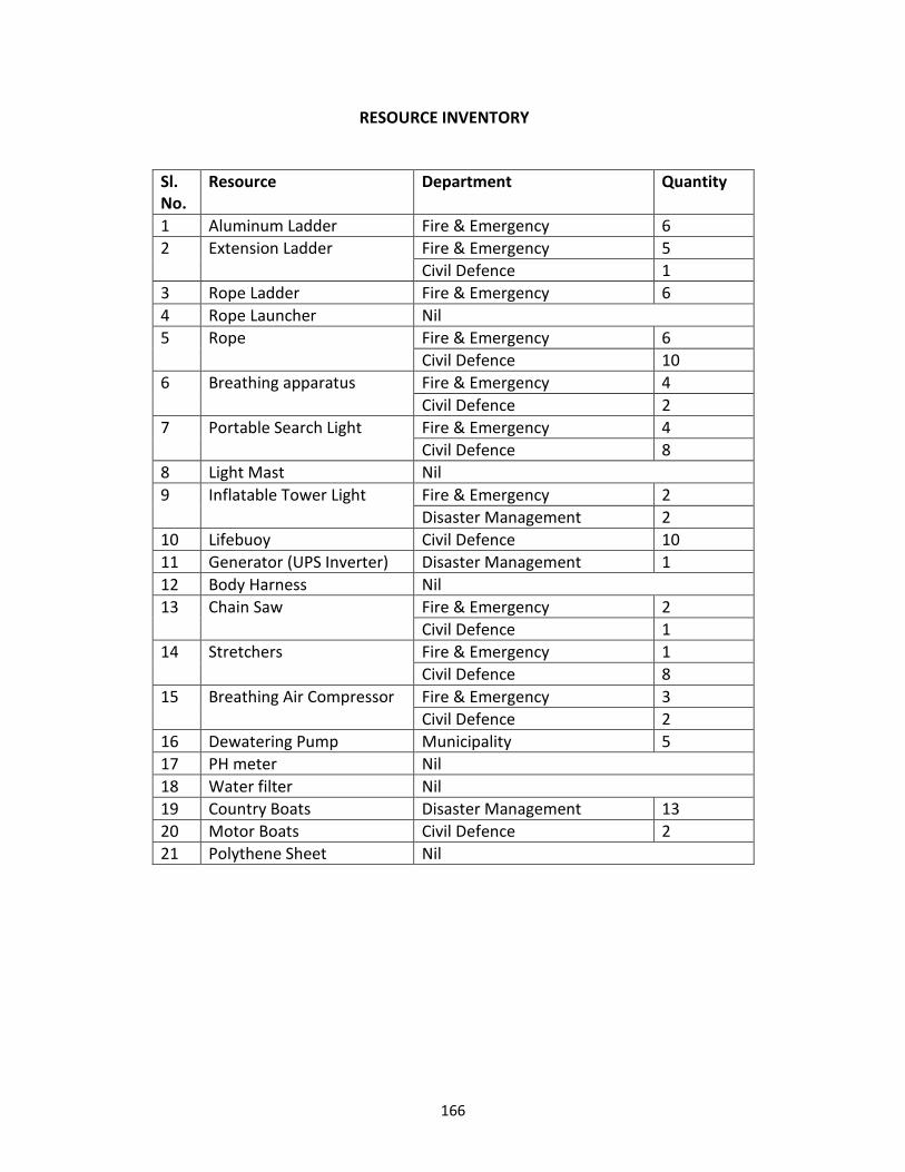
166
RESOURCE INVENTORY
Sl.
No.
Resource Department Quantity
1 Aluminum Ladder Fire & Emergency 6
2 Extension Ladder Fire & Emergency 5
Civil Defence 1
3 Rope Ladder Fire & Emergency 6
4 Rope Launcher Nil
5 Rope Fire & Emergency 6
Civil Defence 10
6 Breathing apparatus Fire & Emergency 4
Civil Defence 2
7 Portable Search Light Fire & Emergency 4
Civil Defence 8
8 Light Mast Nil
9 Inflatable Tower Light Fire & Emergency 2
Disaster Management 2
10 Lifebuoy Civil Defence 10
11 Generator (UPS Inverter) Disaster Management 1
12 Body Harness Nil
13 Chain Saw Fire & Emergency 2
Civil Defence 1
14 Stretchers Fire & Emergency 1
Civil Defence 8
15 Breathing Air Compressor Fire & Emergency 3
Civil Defence 2
16 Dewatering Pump Municipality 5
17 PH meter Nil
18 Water filter Nil
19 Country Boats Disaster Management 13
20 Motor Boats Civil Defence 2
21 Polythene Sheet Nil
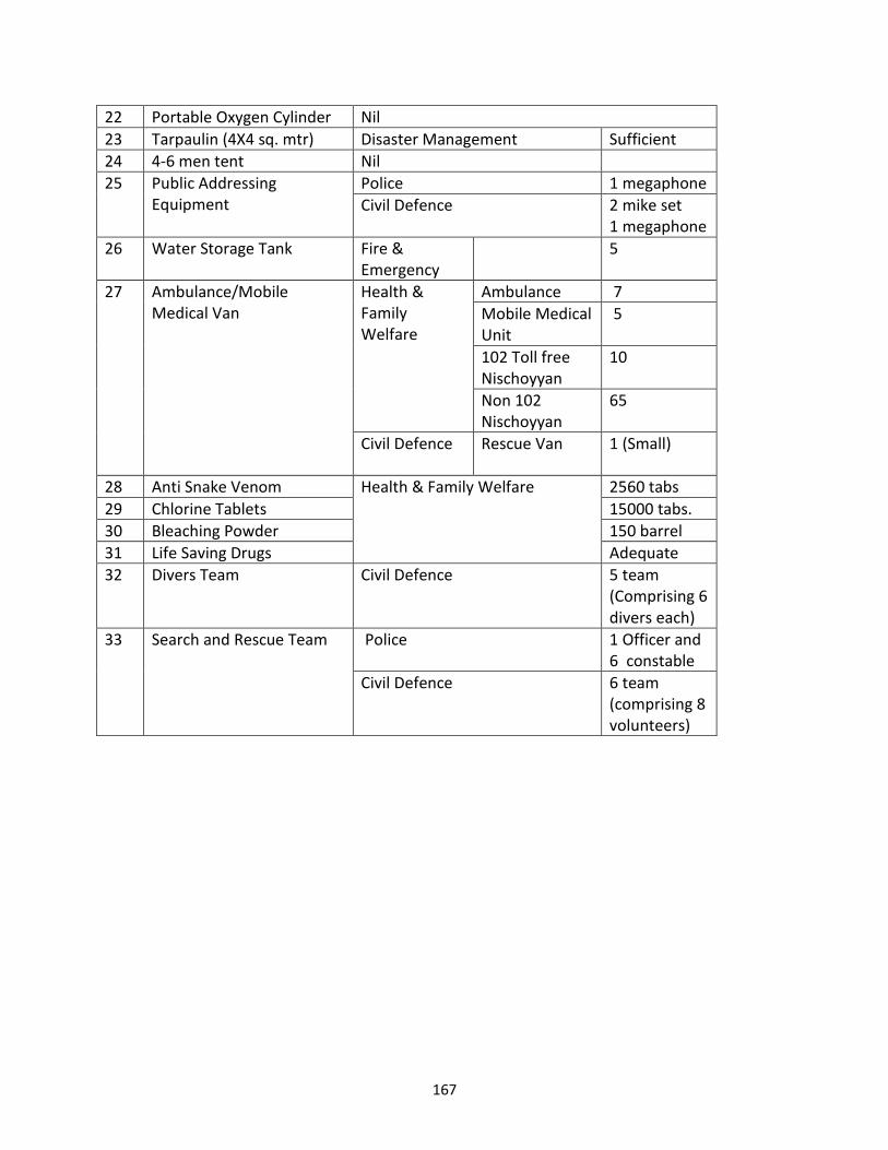
167
22 Portable Oxygen Cylinder Nil
23 Tarpaulin (4X4 sq. mtr) Disaster Management Sufficient
24 4-6 men tent Nil
25 Public Addressing
Equipment
Police 1 megaphone
Civil Defence 2 mike set
1 megaphone
26 Water Storage Tank Fire &
Emergency
5
27 Ambulance/Mobile
Medical Van
Health &
Family
Welfare
Ambulance 7
Mobile Medical
Unit
5
102 Toll free
Nischoyyan
10
Non 102
Nischoyyan
65
Civil Defence Rescue Van
1 (Small)
28 Anti Snake Venom Health & Family Welfare 2560 tabs
29 Chlorine Tablets 15000 tabs.
30 Bleaching Powder 150 barrel
31 Life Saving Drugs Adequate
32 Divers Team Civil Defence 5 team
(Comprising 6
divers each)
33 Search and Rescue Team Police 1 Officer and
6 constable
Civil Defence 6 team
(comprising 8
volunteers)
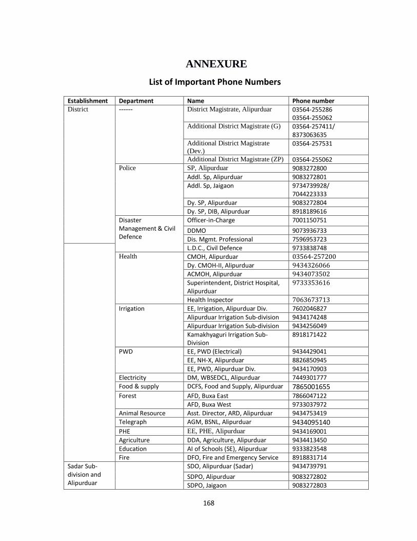
168
ANNEXURE
List of Important Phone Numbers
Establishment Department Name Phone number District ------ District Magistrate, Alipurduar 03564-255286
03564-255062
Additional District Magistrate (G) 03564-257411/ 8373063635
Additional District Magistrate
(Dev.) 03564-257531
Additional District Magistrate (ZP) 03564-255062 Police SP, Alipurduar 9083272800
Addl. Sp, Alipurduar 9083272801
Addl. Sp, Jaigaon 9734739928/ 7044223333
Dy. SP, Alipurduar 9083272804
Dy. SP, DIB, Alipurduar 8918189616
Disaster Management & Civil Defence
Officer-in-Charge 7001150751
DDMO 9073936733
Dis. Mgmt. Professional 7596953723
L.D.C., Civil Defence 9733838748 Health CMOH, Alipurduar 03564-257200
Dy. CMOH-II, Alipurduar 9434326066
ACMOH, Alipurduar 9434073502
Superintendent, District Hospital, Alipurduar
9733353616
Health Inspector 7063673713
Irrigation EE, Irrigation, Alipurduar Div. 7602046827
Alipurduar Irrigation Sub-division 9434174248
Alipurduar Irrigation Sub-division 9434256049
Kamakhyaguri Irrigation Sub-Division
8918171422
PWD EE, PWD (Electrical) 9434429041
EE, NH-X, Alipurduar 8826850945
EE, PWD, Alipurduar Div. 9434170903
Electricity DM, WBSEDCL, Alipurduar 7449301777
Food & supply DCFS, Food and Supply, Alipurduar 7865001655
Forest AFD, Buxa East 7866047122
AFD, Buxa West 9733037972
Animal Resource Asst. Director, ARD, Alipurduar 9434753419
Telegraph AGM, BSNL, Alipurduar 9434095140
PHE EE, PHE, Alipurduar 9434169001
Agriculture DDA, Agriculture, Alipurduar 9434413450
Education AI of Schools (SE), Alipurduar 9333823548
Fire DFO, Fire and Emergency Service 8918831714
Sadar Sub-division and Alipurduar
SDO, Alipurduar (Sadar) 9434739791
SDPO, Alipurduar 9083272802
SDPO, Jaigaon 9083272803
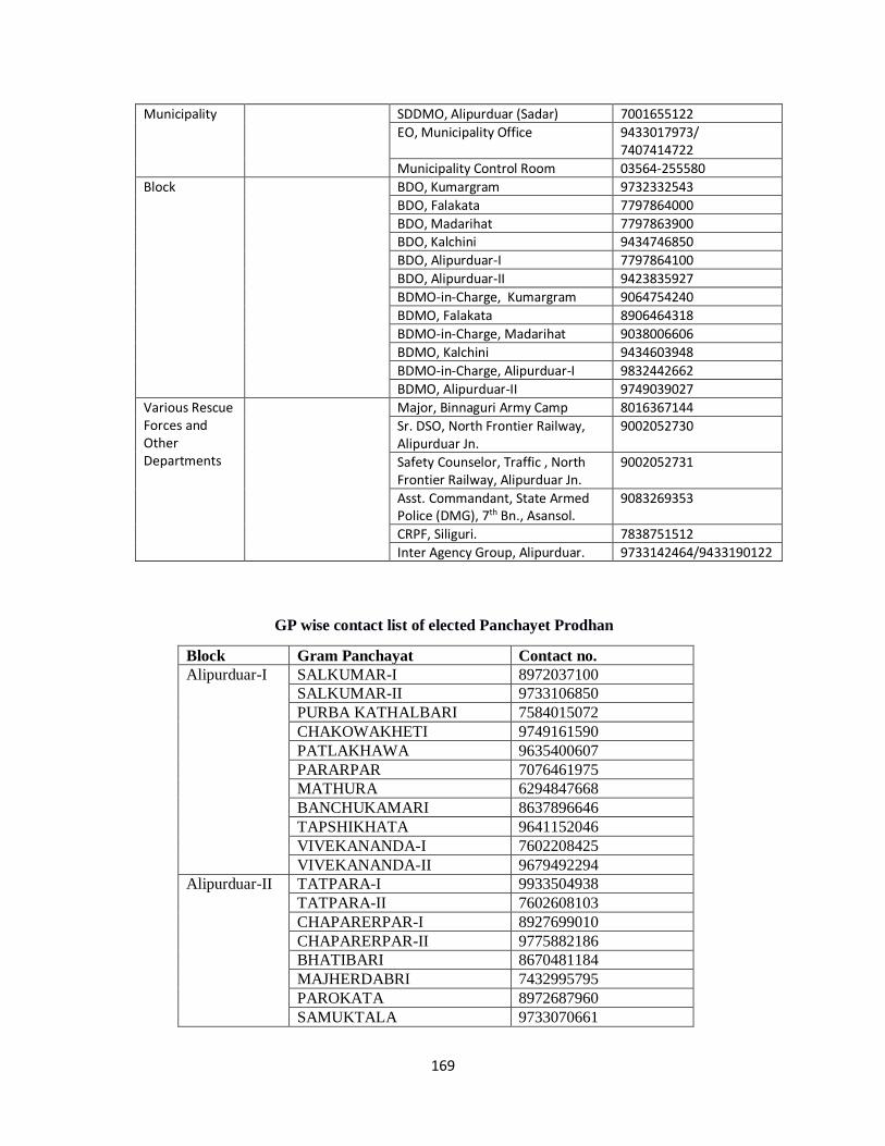
169
Municipality SDDMO, Alipurduar (Sadar) 7001655122
EO, Municipality Office 9433017973/ 7407414722
Municipality Control Room 03564-255580
Block BDO, Kumargram 9732332543
BDO, Falakata 7797864000
BDO, Madarihat 7797863900 BDO, Kalchini 9434746850
BDO, Alipurduar-I 7797864100
BDO, Alipurduar-II 9423835927
BDMO-in-Charge, Kumargram 9064754240
BDMO, Falakata 8906464318
BDMO-in-Charge, Madarihat 9038006606
BDMO, Kalchini 9434603948
BDMO-in-Charge, Alipurduar-I 9832442662
BDMO, Alipurduar-II 9749039027
Various Rescue Forces and Other Departments
Major, Binnaguri Army Camp 8016367144
Sr. DSO, North Frontier Railway, Alipurduar Jn.
9002052730
Safety Counselor, Traffic , North Frontier Railway, Alipurduar Jn.
9002052731
Asst. Commandant, State Armed Police (DMG), 7th Bn., Asansol.
9083269353
CRPF, Siliguri. 7838751512
Inter Agency Group, Alipurduar. 9733142464/9433190122
GP wise contact list of elected Panchayet Prodhan
Block Gram Panchayat Contact no.
Alipurduar-I SALKUMAR-I 8972037100
SALKUMAR-II 9733106850
PURBA KATHALBARI 7584015072
CHAKOWAKHETI 9749161590
PATLAKHAWA 9635400607
PARARPAR 7076461975
MATHURA 6294847668
BANCHUKAMARI 8637896646
TAPSHIKHATA 9641152046
VIVEKANANDA-I 7602208425
VIVEKANANDA-II 9679492294
Alipurduar-II TATPARA-I 9933504938
TATPARA-II 7602608103
CHAPARERPAR-I 8927699010
CHAPARERPAR-II 9775882186
BHATIBARI 8670481184
MAJHERDABRI 7432995795
PAROKATA 8972687960
SAMUKTALA 9733070661
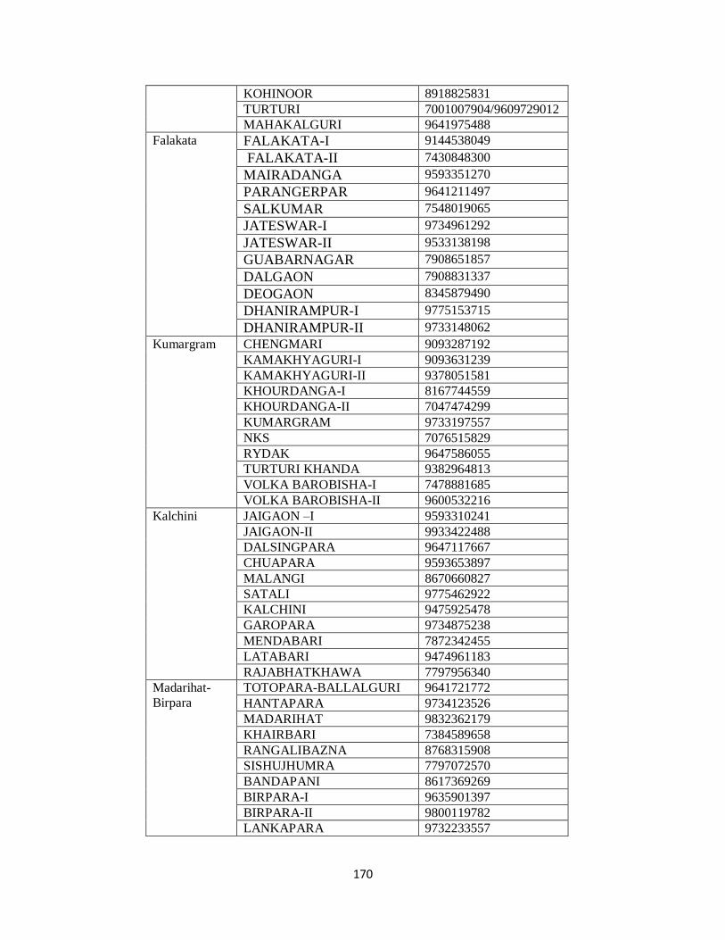
170
KOHINOOR 8918825831
TURTURI 7001007904/9609729012
MAHAKALGURI 9641975488
Falakata FALAKATA-I 9144538049
FALAKATA-II 7430848300
MAIRADANGA 9593351270
PARANGERPAR 9641211497
SALKUMAR 7548019065
JATESWAR-I 9734961292
JATESWAR-II 9533138198
GUABARNAGAR 7908651857
DALGAON 7908831337
DEOGAON 8345879490
DHANIRAMPUR-I 9775153715
DHANIRAMPUR-II 9733148062
Kumargram CHENGMARI 9093287192
KAMAKHYAGURI-I 9093631239
KAMAKHYAGURI-II 9378051581
KHOURDANGA-I 8167744559
KHOURDANGA-II 7047474299
KUMARGRAM 9733197557
NKS 7076515829
RYDAK 9647586055
TURTURI KHANDA 9382964813
VOLKA BAROBISHA-I 7478881685
VOLKA BAROBISHA-II 9600532216
Kalchini JAIGAON –I 9593310241
JAIGAON-II 9933422488
DALSINGPARA 9647117667
CHUAPARA 9593653897
MALANGI 8670660827
SATALI 9775462922
KALCHINI 9475925478
GAROPARA 9734875238
MENDABARI 7872342455
LATABARI 9474961183
RAJABHATKHAWA 7797956340
Madarihat-
Birpara
TOTOPARA-BALLALGURI 9641721772
HANTAPARA 9734123526
MADARIHAT 9832362179
KHAIRBARI 7384589658
RANGALIBAZNA 8768315908
SISHUJHUMRA 7797072570
BANDAPANI 8617369269
BIRPARA-I 9635901397
BIRPARA-II 9800119782
LANKAPARA 9732233557
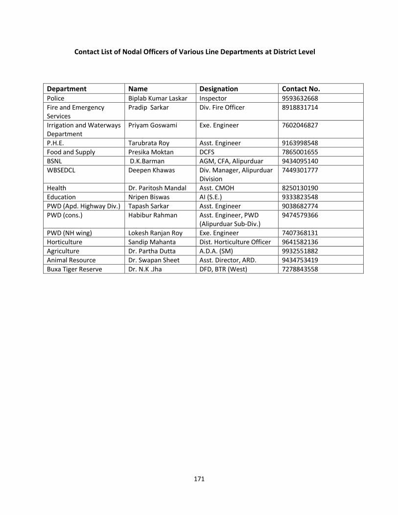
171
Contact List of Nodal Officers of Various Line Departments at District Level
Department Name Designation Contact No. Police Biplab Kumar Laskar Inspector 9593632668
Fire and Emergency Services
Pradip Sarkar Div. Fire Officer 8918831714
Irrigation and Waterways Department
Priyam Goswami Exe. Engineer 7602046827
P.H.E. Tarubrata Roy Asst. Engineer 9163998548
Food and Supply Presika Moktan DCFS 7865001655
BSNL D.K.Barman AGM, CFA, Alipurduar 9434095140
WBSEDCL Deepen Khawas Div. Manager, Alipurduar Division
7449301777
Health Dr. Paritosh Mandal Asst. CMOH 8250130190
Education Nripen Biswas AI (S.E.) 9333823548
PWD (Apd. Highway Div.) Tapash Sarkar Asst. Engineer 9038682774
PWD (cons.) Habibur Rahman Asst. Engineer, PWD (Alipurduar Sub-Div.)
9474579366
PWD (NH wing) Lokesh Ranjan Roy Exe. Engineer 7407368131
Horticulture Sandip Mahanta Dist. Horticulture Officer 9641582136
Agriculture Dr. Partha Dutta A.D.A. (SM) 9932551882
Animal Resource Dr. Swapan Sheet Asst. Director, ARD. 9434753419
Buxa Tiger Reserve Dr. N.K .Jha DFD, BTR (West) 7278843558
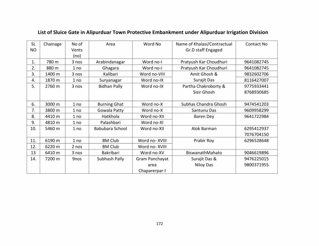
172
List of Sluice Gate in Alipurduar Town Protective Embankment under Alipurduar Irrigation Division
SL NO
Chainage No of Vents (no)
Area Word No Name of Khalasi/Contractual Gr.D staff Engaged
Contact No
1. 780 m 3 nos Arabindanagar Word no-I Pratyush Kar Choudhuri 9641082745
2. 880 m 1 no Ghagara Word no-I Pratyush Kar Choudhuri 9641082745
3. 1400 m 3 nos Kalibari Word no-VIII Amit Ghosh & Surajit Das
9832602706
4. 1870 m 1 no Suryanagar Word no-IX 8116427007
5. 2760 m 3 nos Bidhan Pally Word no-IX Partha Chakroborty & Sisir Ghosh
9775933441 8768930685
6. 3000 m 1 no Burning Ghat Word no-X Subhas Chandra Ghosh 9474541203
7. 3800 m 1 no Gowala Patty Word no-X Santunu Das 9609958299
8. 4410 m 1 no Hatkhola Word no-XII Baren Dey 9641722984
9. 4810 m 1 no Palashbari Word no-XI
10. 5460 m 1 no Babubara School Word no-XII Alok Barman 6295412937 7076704150
11. 6190 m 1 no BM Club Word no- XVIII Prabir Roy 6296528648
12. 6220 m 2 nos BM Club Word no- XVIII
13 6410 m 3 nos Bakribari Word no-XV BiswanathMahato 9046619896
14. 7200 m 9nos
Subhash Pally Gram Panchayat area
Chaparerpar-I
Surajit Das & Niloy Das
9476225015 9800371955
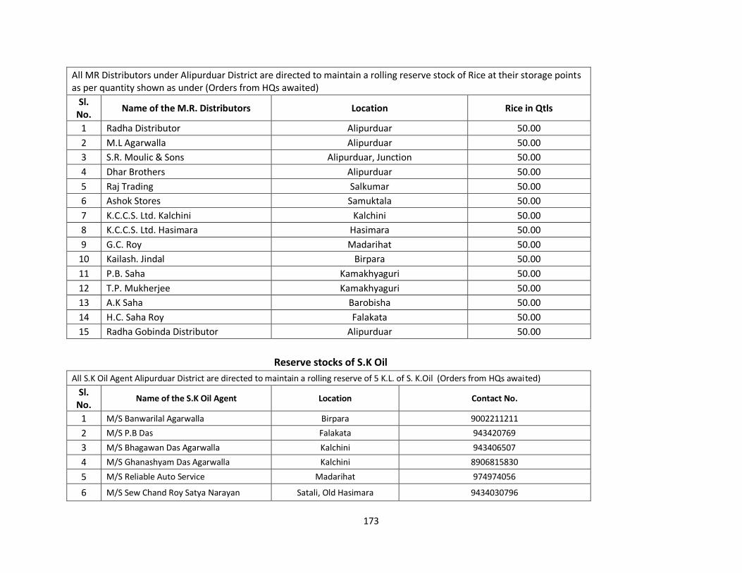
173
All MR Distributors under Alipurduar District are directed to maintain a rolling reserve stock of Rice at their storage points as per quantity shown as under (Orders from HQs awaited)
Sl. No.
Name of the M.R. Distributors Location Rice in Qtls
1 Radha Distributor Alipurduar 50.00
2 M.L Agarwalla Alipurduar 50.00
3 S.R. Moulic & Sons Alipurduar, Junction 50.00
4 Dhar Brothers Alipurduar 50.00
5 Raj Trading Salkumar 50.00
6 Ashok Stores Samuktala 50.00
7 K.C.C.S. Ltd. Kalchini Kalchini 50.00
8 K.C.C.S. Ltd. Hasimara Hasimara 50.00
9 G.C. Roy Madarihat 50.00
10 Kailash. Jindal Birpara 50.00
11 P.B. Saha Kamakhyaguri 50.00
12 T.P. Mukherjee Kamakhyaguri 50.00
13 A.K Saha Barobisha 50.00
14 H.C. Saha Roy Falakata 50.00
15 Radha Gobinda Distributor Alipurduar 50.00
Reserve stocks of S.K Oil
All S.K Oil Agent Alipurduar District are directed to maintain a rolling reserve of 5 K.L. of S. K.Oil (Orders from HQs awaited)
Sl. No.
Name of the S.K Oil Agent Location Contact No.
1 M/S Banwarilal Agarwalla Birpara 9002211211
2 M/S P.B Das Falakata 943420769
3 M/S Bhagawan Das Agarwalla Kalchini 943406507
4 M/S Ghanashyam Das Agarwalla Kalchini 8906815830
5 M/S Reliable Auto Service Madarihat 974974056
6 M/S Sew Chand Roy Satya Narayan Satali, Old Hasimara 9434030796
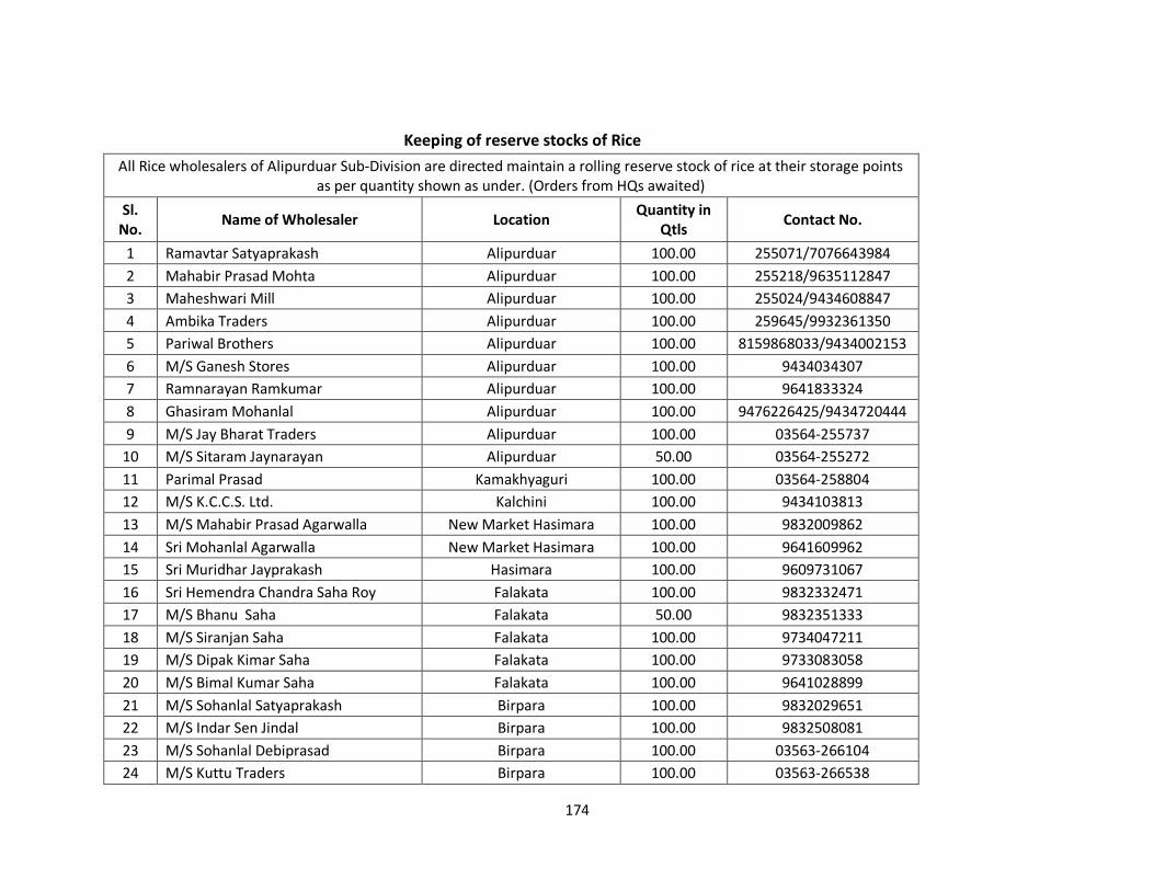
174
Keeping of reserve stocks of Rice
All Rice wholesalers of Alipurduar Sub-Division are directed maintain a rolling reserve stock of rice at their storage points as per quantity shown as under. (Orders from HQs awaited)
Sl. No.
Name of Wholesaler Location Quantity in
Qtls Contact No.
1 Ramavtar Satyaprakash Alipurduar 100.00 255071/7076643984
2 Mahabir Prasad Mohta Alipurduar 100.00 255218/9635112847
3 Maheshwari Mill Alipurduar 100.00 255024/9434608847
4 Ambika Traders Alipurduar 100.00 259645/9932361350
5 Pariwal Brothers Alipurduar 100.00 8159868033/9434002153
6 M/S Ganesh Stores Alipurduar 100.00 9434034307
7 Ramnarayan Ramkumar Alipurduar 100.00 9641833324
8 Ghasiram Mohanlal Alipurduar 100.00 9476226425/9434720444
9 M/S Jay Bharat Traders Alipurduar 100.00 03564-255737
10 M/S Sitaram Jaynarayan Alipurduar 50.00 03564-255272
11 Parimal Prasad Kamakhyaguri 100.00 03564-258804
12 M/S K.C.C.S. Ltd. Kalchini 100.00 9434103813
13 M/S Mahabir Prasad Agarwalla New Market Hasimara 100.00 9832009862
14 Sri Mohanlal Agarwalla New Market Hasimara 100.00 9641609962
15 Sri Muridhar Jayprakash Hasimara 100.00 9609731067
16 Sri Hemendra Chandra Saha Roy Falakata 100.00 9832332471
17 M/S Bhanu Saha Falakata 50.00 9832351333
18 M/S Siranjan Saha Falakata 100.00 9734047211
19 M/S Dipak Kimar Saha Falakata 100.00 9733083058
20 M/S Bimal Kumar Saha Falakata 100.00 9641028899
21 M/S Sohanlal Satyaprakash Birpara 100.00 9832029651
22 M/S Indar Sen Jindal Birpara 100.00 9832508081
23 M/S Sohanlal Debiprasad Birpara 100.00 03563-266104
24 M/S Kuttu Traders Birpara 100.00 03563-266538
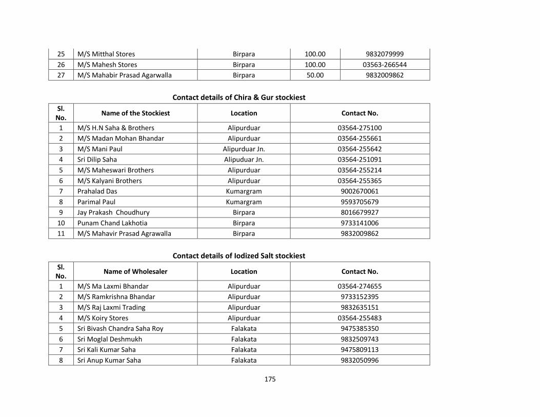
175
25 M/S Mitthal Stores Birpara 100.00 9832079999
26 M/S Mahesh Stores Birpara 100.00 03563-266544
27 M/S Mahabir Prasad Agarwalla Birpara 50.00 9832009862
Contact details of Chira & Gur stockiest
Sl. No.
Name of the Stockiest Location Contact No.
1 M/S H.N Saha & Brothers Alipurduar 03564-275100
2 M/S Madan Mohan Bhandar Alipurduar 03564-255661
3 M/S Mani Paul Alipurduar Jn. 03564-255642
4 Sri Dilip Saha Alipuduar Jn. 03564-251091
5 M/S Maheswari Brothers Alipurduar 03564-255214
6 M/S Kalyani Brothers Alipurduar 03564-255365
7 Prahalad Das Kumargram 9002670061
8 Parimal Paul Kumargram 9593705679
9 Jay Prakash Choudhury Birpara 8016679927
10 Punam Chand Lakhotia Birpara 9733141006
11 M/S Mahavir Prasad Agrawalla Birpara 9832009862
Contact details of Iodized Salt stockiest
Sl. No.
Name of Wholesaler Location Contact No.
1 M/S Ma Laxmi Bhandar Alipurduar 03564-274655
2 M/S Ramkrishna Bhandar Alipurduar 9733152395
3 M/S Raj Laxmi Trading Alipurduar 9832635151
4 M/S Koiry Stores Alipurduar 03564-255483
5 Sri Bivash Chandra Saha Roy Falakata 9475385350
6 Sri Moglal Deshmukh Falakata 9832509743
7 Sri Kali Kumar Saha Falakata 9475809113
8 Sri Anup Kumar Saha Falakata 9832050996
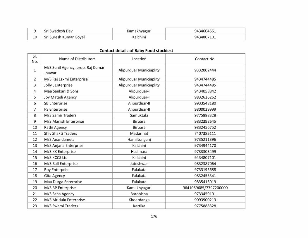
176
9 Sri Swadesh Dev Kamakhyaguri 9434604551
10 Sri Suresh Kumar Goyel Kalchini 9434807101
Contact details of Baby Food stockiest Sl.
No. Name of Distributors Location Contact No.
1 M/S Sunil Agency, prop. Raj Kumar Jhawar
Alipurduar Municiaplity 9332002444
2 M/S Raj Laxmi Enterprise Alipurduar Municiaplity 9434744485
3 Jolly , Enterprise Alipurduar Municiaplity 9434744485
4 Maa Sankari & Sons Alipurduar-I 9434058842
5 Joy Matadi Agency Alipurduar-I 9832626262
6 SB Enterprise Alipurduar-II 9933548180
7 PS Enterprise Alipurduar-II 9800029999
8 M/S Samir Traders Samuktala 9775888328
9 M/S Manish Enterprise Birpara 9832392645
10 Rathi Agency Birpara 9832456752
11 Shiv Shakti Traders Madarihat 7407385111
12 M/S Anandamela Hamiltonganj 9735211396
13 M/S Anjana Enterprise Kalchini 9734944170
14 M/S KK Enterprise Hasimara 9733303499
15 M/S KCCS Ltd Kalchini 9434807101
16 M/S Ball Enterprise Jateshwar 9832387064
17 Roy Enterprise Falakata 9733195688
18 Gita Agency Falakata 9832453341
19 Maa Durga Enterprise Falakata 9835413019
20 M/S BP Enterprise Kamakhyaguri 9641069685/7797200000
21 M/S Saha Agency Barobisha 9733459101
22 M/S Mridula Enterprise Khoardanga 9093900213
23 M/S Swami Traders Kartika 9775888328
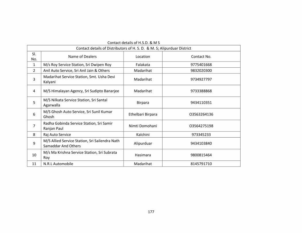
177
Contact details of H.S.D. & M S
Contact details of Distributors of H. S. D. & M. S; Alipurduar District
Sl. No.
Name of Dealers Location Contact No.
1 M/s Roy Service Station, Sri Dwipen Roy Falakata 9775401668
2 Anil Auto Service, Sri Anil Jain & Others Madarihat 9832020300
3 Madarihat Service Station, Smt. Usha Devi Kalyani
Madarihat 9734927797
4 M/S Himalayan Agency, Sri Sudipto Banarjee Madarihat 9733388868
5 M/S Nilkata Service Station, Sri Santal Agarwalla
Birpara 9434110351
6 M/S Ghosh Auto Service, Sri Sunil Kumar Ghosh
Ethelbari Birpara O3563264136
7 Radha Gobinda Service Station, Sri Samir Ranjan Paul
Nimti Domohani O3564275198
8 Raj Auto Service Kalchini 973345233
9 M/S Allied Service Station, Sri Sailendra Nath Samaddar And Others
Alipurduar 9434103840
10 M/s Ma Krishna Service Station, Sri Subrata Roy
Hasimara 9800815464
11 N.R.L Automobile Madarihat 8145791710
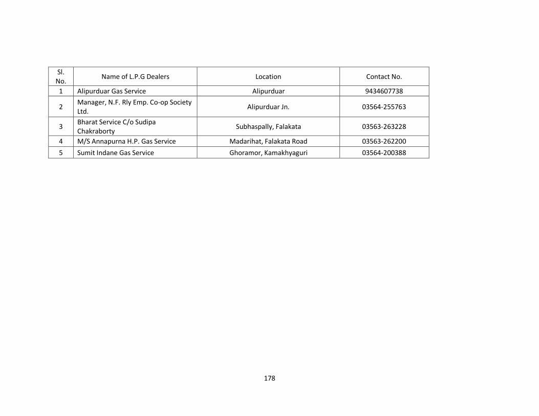
178
Sl. No.
Name of L.P.G Dealers Location Contact No.
1 Alipurduar Gas Service Alipurduar 9434607738
2 Manager, N.F. Rly Emp. Co-op Society Ltd.
Alipurduar Jn. 03564-255763
3 Bharat Service C/o Sudipa Chakraborty
Subhaspally, Falakata 03563-263228
4 M/S Annapurna H.P. Gas Service Madarihat, Falakata Road 03563-262200
5 Sumit Indane Gas Service Ghoramor, Kamakhyaguri 03564-200388
179
List of Heritage Place/Establishment
Heritage is deemed to mean those buildings, artifacts, structures, areas and precincts that are
of historic, aesthetic, architectural or cultural significance and should include natural
features within such areas or precincts of environmental significance or scenic beauty such as
sacred groves, hills, hillocks, water bodies (and the areas adjoining the same), open areas,
wooded areas, etc. It must be recognized that the 'cultural landscape' around a heritage site is
critical for the interpretation of the site and its built heritage and thus is very much its integral part.
The conservation of built heritage is generally perceived to be in the long term interest of
society. This can be better understood if categorized under 'economic’, 'cultural', and
'environmental', although they are not mutually exclusive and, indeed, they are often
interlocked.
Most buildings are capable of beneficial use, whether for their original purpose or for some
other use. Buildings and their precincts need to be used in order to survive and such use can be
made into an economically viable enterprise.
Heritage comprises archaeological sites, remains, ruins, and monuments protected by the
Archaeological Survey of India (ASI) and their counterparts in the States, and also a large
number of unprotected buildings, groups of buildings, neighborhoods, and public spaces
including landscapes and natural features which provide character and distinctive identity to
cities. Conservation plans and projects for cities must take into account both the protected and
unprotected components of the heritage.
The three key concepts need to be understood to determine whether a property is worthy of
listing as a Heritage are namely according to Historic significance, Historic integrity, Historic
context.
Mere listing is of limited use unless it serves the cause of preservation and conservation of the
heritage of the area. Publication of the Listing of the area does help in raising the level of
awareness and public consciousness about what constitutes their heritage. However, the cause of
preservation and conservation of heritage can be served only by providing statutory backing to the
listing. Only the statutory backing makes it an effective tool for conservation.
180
Criteria for listing heritage building
The three key concepts need to be understood to determine whether a property is
worthy of listing.
• Historic significance
• Historic integrity
• Historic context
Historic significance is the importance of a property to the history,
architecture, archaeology, engineering or culture of a community, region or nation.
In selecting a building, particular attention should be paid to the following:
• Association with events, activities or patterns
• Association with important persons
• Distinctive physical characteristics of design, construction or form, representing
work of a master
• Potential to yield important information such as illustrating social, economic history,
such as railway stations, town halls, clubs, markets, water works, etc.
• Technological innovations such as dams, bridges, etc.
• Distinct town planning features like squares, streets, avenues
Historic integrity is the authenticity of a property's historic identity, evidenced by the
survival of physical characteristics that existed during the property's historic period.
Historic integrity enables a property to illustrate significant aspects of its past. Not only
must a property resemble the historic appearance but it must also retain physical
materials, design features and aspects of construction dating from the period when it
attained significance. Historic context is information about historic trends and properties
grouped by an important theme in the history of a community, region or nation during
a particular period of time. Knowledge of historic context enables listers to understand
a historic property as a product of its time.
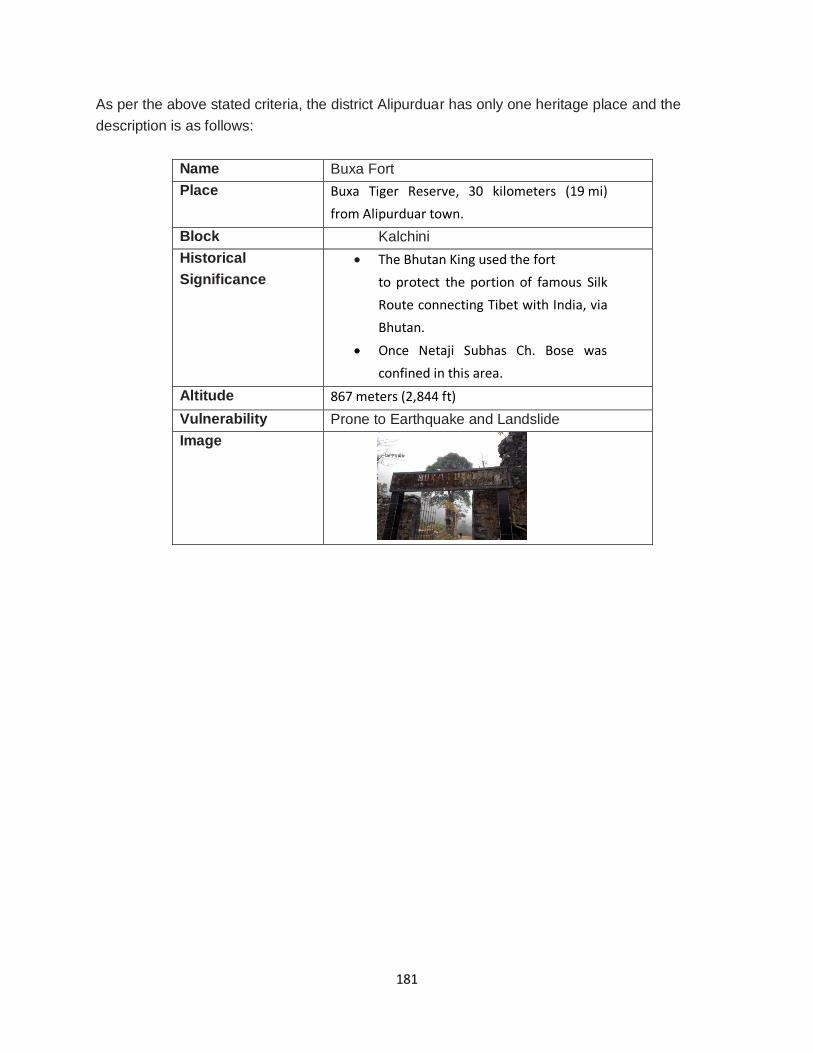
181
As per the above stated criteria, the district Alipurduar has only one heritage place and the
description is as follows:
Name Buxa Fort
Place Buxa Tiger Reserve, 30 kilometers (19 mi)
from Alipurduar town.
Block Kalchini
Historical
Significance
The Bhutan King used the fort
to protect the portion of famous Silk
Route connecting Tibet with India, via
Bhutan.
Once Netaji Subhas Ch. Bose was
confined in this area.
Altitude 867 meters (2,844 ft)
Vulnerability Prone to Earthquake and Landslide
Image
182
Various Important Links
Type Organization Link
Research
Organization
India Meteorology
Department
http://www.imd.gov.in/
Indian National Centre
for Ocean Information
Services
https://incois.gov.in/
Geological Survey of
India
https://www.gsi.gov.in/
Central Water
Commission
http://cwc.gov.in/
National Institute of
Hydrology
http://nihroorkee.gov.in/
Space Application
Centre
https://www.sac.gov.in/
National Remote
Sensing Centre
https://www.nrsc.gov.in/
National Institute of
Disaster
Management
https://nidm.gov.in/
Snow and Avalanche
Study Establishment
https://www.drdo.gov.in/drdo/labs1/SASE
Government
Organization
Ministry of Home
Affairs
https://mha.gov.in/
National Disaster
Management Authority
https://ndma.gov.in
State Disaster
Management
Authority-West Bengal
http://wbdmd.gov.in
Weather
forecasting
Android APP
MOSDAC https://www.mosdac.gov.in/
DAMINI https://www.apkmonk.com/app/com.lightening.
live.damini/
SAGARVANI https://apkpure.com/sagarvani/com.incois.gaian
.incois
183
Important International/ National Day
Description Date National Youth Day 12th January
National Science Day 28th February
World Wildlife Day 3rd March
International Women’s Day 8th March
International Day of Forests 21st March
World Day for Water 22nd March
World Meteorological Day 23rd March
International Day for Biological Diversity 22nd May
World TB Day 24th March
World Health Day 7th April
World anti-tobacco Day 31st May
World Environmental Day 5th June
World Ocean Day 8th June
International Day of Yoga 21st June
World Snake Day 16th July
International Youth Day 12th August
World Animal Welfare Day 4th October
International Day for Disaster Reduction-UNISDR 13th October
World Food Day 16th October
National Day for Disaster Reduction-NDDR 29th October
International Day for the Elimination of Violence against
Women
25th November
National Immunization Day 9th December
National Energy Conservation Day 14th December
184
Various Books, Reports and Manual Type of the
document
Name of the document Link
Departmental Manual/Act/Plan
Disaster Management Act, 2005 https://ndma.gov.in/en/disaster.html
Disaster Management Manual http://wbdmd.gov.in/Pages/Manual.aspx
Disaster Management Plan, Indian Railways http://www.indianrailways.gov.in/railwayboard/uploads/direct
orate/safety/pdf/2018/DM_Plan_2018.pdf
Drought Management Plan, Department of Agriculture
http://agricoop.nic.in/sites/default/files/Drought%20Management%20Plan%20.pdf
Chemical Disaster https://nidm.gov.in/PDF/modules/chemical.pdf
Hospital Safety https://ndma.gov.in/images/pdf/NDMAhospitalsafety.pdf
Contingency Plan on Oil Spill https://www.indiancoastguard.gov.in/WriteReadData/bookpdf/201512281221565793127NOSDCPCGBR771.pdf
Crowd Management at events https://ndma.gov.in/images/pdf/managingcrowdsguide.pdf
Landslide and Avalanche Plan https://nidm.gov.in/pdf/guidelines/new/landslidessnowavalanc
hes.pdf
Urban Flooding http://amrut.gov.in/writereaddata/SOP_Urbanflooding_5May2
017.pdf
Compendium of Civil Defence https://dgcd.assam.gov.in/information-services/compendium
Research Article/
Book/Report
Storm Drainage Modeling http://www.cityofbrookings.org/DocumentCenter/Home/View/
305
Rapid Flood Inundation Model https://pubs.usgs.gov/of/2016/1038/ofr20161038.pdf
Introduction to Flash Flood http://www.wmo.int/pages/prog/hwrp/flood/ffgs/hdrffg/documents/presentations/day1/HRC_HDRFFG_09062016_RG1.pdf
Disaster Risk Reduction: Community Resilience and Responses
https://link.springer.com/book/10.1007/978-981-10-8845-2
Simplified Flood Inundation Mapping Based
On Flood Elevation-Discharge Rating Curves Using Satellite Images in Gauged Watersheds
https://www.researchgate.net/publication/270195714_Simplifi
ed_Flood_Inundation_Mapping_Based_On_Flood_ElevationDischarge_Rating_Curves_Using_Satellite_Images_in_Gauged_
Watersheds
SPHERE Project handbook for Humanitarian
Charter
https://www.ifrc.org/PageFiles/95530/The-Sphere-Project-
Handbook-20111.pdf
Principles of Remote Sensing https://webapps.itc.utwente.nl/librarywww/papers_2009/gener
al/principlesremotesensing.pdf
Principles of Geographic Information System
(GIS)
https://webapps.itc.utwente.nl/librarywww/papers_2009/gener
al/principlesgis.pdf
IPCC Assessment Report 5 https://ar5-syr.ipcc.ch/ipcc/ipcc/resources/pdf/IPCC_SynthesisReport.pdf
Coastal Dynamics https://www.nccarf.edu.au/sites/default/files/tool_downloads/IM_8_coastal%20sediments_uploaded.pdf
Basics of Thunderstorm https://incois.gov.in/documents/ITCOocean/OITC018/L6Part-II Thunderstorm_Naresh%20Kumar.pdf
Air Pollution https://www.basingstoke.gov.uk/content/page/26744/Air%20pollution%20-
%20what%20it%20means%20for%20your%20health.pdf
Atmospheric Chemistry http://elte.prompt.hu/sites/default/files/tananyagok/AtmosphericChemistry/book.pdf
Biogeochemistry of North Indian Ocean https://www.researchgate.net/publication/27667310_Biogeo chemistry_of_the_North_Indian_Ocean
Mainstreaming CCA and DRR https://www.ndmindia.nic.in/images/pdf/Mainstreaming%20Report_Final_sept7.pdf
Various statistical handbook https://www.wbpspm.gov.in/publications/all
185
List of various departmental reports
Name of the report Purpose Periodicity Stock position report For proper monitoring, tracking and
utilization of allotment of various relief items like clothing, tarpaulin, DM kit, blanket, wrapper etc.
Twice in a month on fortnightly basis throughout the year
Pendency list For any pending allotment of different grant/scheme/ training program
Monthly basis throughout the year
CA-II report To inform about number of casualties, number of affected families, house damage, sectoral damage, relief measures taken due to any untoward situation in details
Based on situation
Daily rainfall report For dissemination of information about daily and cumulative rainfall during monsoon period
Daily basis during entire monsoon season as long as flood control room runs
Situation report To inform about number of casualties, loss and damage due to any untoward situation in brief
Based on emergency situation

186
Space for Note/Suggestion
District Disaster Management Plan
District- Alipurduar
March 2020
District Disaster Management Authority Office of the District Magistrate
Alipurduar, West Bengal
Pin-736121
DEOC: 03564-253637
Control Room: 03564-257091
Email ID - [email protected]