Geomorphological evidence for variations of the North Patagonian Icefield during the Holocene
Journal of Geochemical Exploration 134 (2013) 17–26
Contents lists available at ScienceDirect
Journal of Geochemical Exploration
j ourna l homepage: www.e lsev ie r .com/ locate / jgeoexp
Distribution of trace elements in stream sediments of Arta plain (western Hellas):The influence of geomorphological parameters
Kyriaki Papadopoulou-Vrynioti a, Dimitris Alexakis b, George D. Bathrellos a,⁎, Hariklia D. Skilodimou a,Dimitris Vryniotis c, Evripides Vassiliades c, Dimitra Gamvroula d
a Department of Geography & Climatology, Faculty of Geology & Geoenvironment, National & Kapodistrian University of Athens, University Campus, 15784, Zografou, Athens, Greeceb Department Laboratory of Reclamation Works & Water Resources Management, School of Rural & Surveying Engineering, National Technical University of Athens, Greecec Institute of Geology & Mineral Exploration, 1st Spirou Louis St., Olympic Village, 13677 Athens, Greeced Institute of Mineralogy–Geology, Agricultural University of Athens, Greece
⁎ Corresponding author. Tel./fax: +30 2107274882.E-mail address: [email protected] (G.D. Bathre
0375-6742/$ – see front matter © 2013 Elsevier B.V. Allhttp://dx.doi.org/10.1016/j.gexplo.2013.07.007
a b s t r a c t
a r t i c l e i n f oArticle history:Received 13 March 2013Accepted 9 July 2013Available online 15 July 2013
Keywords:Arta plain riversStream sedimentGISFactor analysisHellas
Stream sediment samples were collected from Arachthos River, Arachthos–Vovos Artificial Channels, LourosArtificial Channels, Louros River and Vovos River, which are located in Arta plain (western Hellas). The sam-ples were taken in order to determine the spatial distribution of selected elements (Co, Cr, Cu, Fe, Li, Mn, Ni,Pb, Sr, V and Zn), and to evaluate the geogenic and anthropogenic factors controlling the distribution of ele-ments in sediments. The methodology applied in this study includes geomorphological analysis, chemicalanalysis, factor analysis and comparison of element contents with other data sets. The weathering materials,derived from the Arachthos River's drainage basin, contribute the high element contents in the sediments ofthe Arta plain. The high element contents may be related with the very gentle slope of the area and the longlength of artificial channels. Interpretation of factor analysis results points to geogenic (Fe-oxides, calcareousrocks with phosphorite intercalations, ophiolite fragments within deltaic deposits) and possibly anthropo-genic contamination sources (intensive agricultural and farming practices), which control the element distri-bution in the stream sediments.
© 2013 Elsevier B.V. All rights reserved.
1. Introduction
Metals in stream sediment, soil and water have both geogenic (e.g.,weathering of ultramafic rocks and phosphorite deposits, wind-blowndust) and anthropogenic origins (e.g., urban development, extensiveagriculture, industrial activities) (Alexakis et al., 2012; Batista et al.,2012; De Vos et al., 2006; Demetriades et al., 2010; Gamvroula et al.,2013; Papadopoulou-Vrynioti, 2002; Salminen et al., 2005; Stamatis etal., 2011).
The holistic stream/river basin approach of theWater Framework Di-rective (WFD, 2000/60/EC) requires, among others, the evaluation of thestream/river sediment quality and water quality. Especially for rivers,management of sediments may strongly control the achievement of“good ecological status” of surface water, since river sediments could actas a sink for metals or as a source of metals depending on the prevailingphysicochemical conditions (Alexakis, 2011; Segura et al., 2006). Inorder to fully understand the factors controlling river water quality, it isvery important to study sediment quality. The direct link between sedi-ment quality and water quality led the European Commission to recog-nise the importance of deterioration of sediment quality as a problem of
llos).
rights reserved.
water quality across the European Union. Although all metals adsorbedon stream sediments are not bioavailable, certain function mechanisms(e.g., redox reactions, desorption) may induce the release of metals backto the water column (Hakanson, 1980; Saleem et al., 2013).
The geochemistry of stream sediments of a drainage basin is con-trolled by several factors such as geomorphological, hydrological, litho-logical and climate (Salomons and Förstner, 1984). Apart from thegeogenic factors, anthropogenic activities influence the fluvial processand the environmental quality of stream sediments (Keller, 1980;Mantei and Foster, 1991). In many cases, stream sediments may bethe natural sink of large amounts of contaminants, derived from thedrainage basin, and thus, a source of contamination (Dinelli et al., 2005).
The study of the spatial distribution of chemical elements in streamsediments is a significant issue for the assessment of contamination.Geographical information systems (GIS) are valuable tools for the spatialanalysis of environmentally sensitive data (Bathrellos et al., 2008;Vassiliades, 2010) and land use planning (Bathrellos et al., 2012, 2013;Migiros et al., 2011; Panagopoulos et al., 2012; Papadopoulou-Vrynioti,2004; Papadopoulou-Vrynioti et al., 2013; Skilodimou et al., 2002,2003).
The objectives of this study were: (a) to examine and compare thegeomorphological characteristics of Arta plain (western Greece), suchas hydrographic networks, the sediment load of the rivers and theslope angle in comparison to sediment element contents, and (b) to

18 K. Papadopoulou-Vrynioti et al. / Journal of Geochemical Exploration 134 (2013) 17–26
determine geogenic and anthropogenic influences on stream sedimentquality.
2. Study area
2.1. Geomorphological settings
The study area of the Arta plain covers 645.1 km2 and is located inthe western part of central Hellas (Fig. 1A). It receives sediments fromthe drainage basins of Louros (LR), Arachthos (AR) and Vovos (VR)Rivers, with the study area, and covers areas of about 962, 1950 and205 km2, respectively (Fig. 1B). The Pantanassa dam (Pantanassa res-ervoir) was constructed in 1957 on the main channel of LR (Mertzaniset al., 2011), and the Pournari dams (Pournari reservoir) in 1981 and1997, respectively, on AR. The three rivers discharge into Ambracian(Amvrakikos) Gulf and form a complex landscape consisting of thedouble delta of the Louros and Arachthos Rivers, a series of threelarge lagoons (Rhodia, Tsoukalio and Logarou) and several smallerones (Fig. 1C). The deltaic deposits of Louros and Arachthos occur be-tween the main channels of the two rivers and shape the Arta plain.
The study area is characterised by a low hilly relief with altitudesvarying from 0 to 740 m a.s.l. The main hills of the area are: Stroma tothe north, Valaora to the east, Mavrovouni to the south, and Areonand Profitis Elias to the north-west (Fig. 1C).
The annual precipitation reaches up to 1200 mm. Themean temper-ature is 25 °C in the summer and 5 °C in the winter (Papadopoulou andVryniotis, 2007).
2.2. Geological setting
The geological formations that provide material to the alluvial de-posits of the Louros and Arachthos delta belong to the Adriatic–Ioni-an, Pindos and Gavrovo–Tripoli zones (IGME, 1983). The drainagebasin of the LR is entirely developed on the geological formations ofthe Adriatic–Ionian zone, while the Arachthos and Vovos are on for-mations of the Pindos and Gavrovo–Tripoli zones. Therefore, there isa differentiation in the composition of the weathered materialstransported by the rivers (Vryniotis and Papadopoulou, 2004).
Fig. 1. (A) Location map of the study area, (B) hydrographic basins of Louros, Arachthos anelevations of the study area.
The geological formations of the study areawere classified accordingto their lithological characteristics (Fig. 2). The LR drainage basin con-sists of (a) alluvial, near shore, talus cone and scree deposits ofHoloceneage, (b) Pliocene marine and lagoonal deposits, (c) mollasic formationsof Aquitanian–Burdigalian age, (d) flysch formations, (e) carbonaterocks comprising mainly limestone and at some locations intercalatedwith phosphorite, and (f) Early Triassic breccia of calcareous originwith gypsum formations.
The geological formations of Pindos zone with the overlyingthrusted ophiolites supply detritus to the AR drainage basin, especiallyto its northern part. According to Chrisostomides (1982) and Vryniotis(2001) alluvial chromite deposits have been recorded in the widerarea of Arta plain. The lithological formations developed in the drainagebasin are: (a) Holocene alluvial, near shore, talus cone and scree de-posits, (b) Pleistocene moraines, (c) flysch formations, (d) carbonaterocks (mainly limestone), and (e) mafic and ultramafic rocks ofophiolithic affinity.
Finally, the VR drainage basin consists of (a) Holocene alluvial andnear shore deposits, (b) flysch formations, and (c) limestone.
2.3. Biological elements
The community of aquatic organisms in the Arachthos and LourosRivers is mainly composed of benthic macroinvertebrates (Skoulikidiset al., 2009) and crustaceans (Koutrakis et al., 2007). According toZogaris et al. (2009) in both rivers there is a rich ichthyofauna diversitywith endemic species.
3. Materials and methods
3.1. Primary data
Two topographic maps at scales of 1:250,000 and 1:50,000, pub-lished by the Hellenic Army Geographical Service (H.A.G.S.), werescanned and digitised. Geological formations and lithology wereextracted by digitising the scanned and georeferenced 1:50,000and 1:500,000 geological maps of the Hellenic Institute of Geologyand Mineral Exploration — IGME (IGME, 1966, 1969, 1983).
d Vovos Rivers and the study area, and (C) road network, hydrographic network and
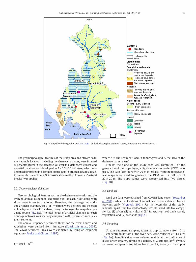
Fig. 2. Simplified lithological map (IGME, 1983) of the hydrographic basins of Louros, Arachthos and Vovos Rivers.
19K. Papadopoulou-Vrynioti et al. / Journal of Geochemical Exploration 134 (2013) 17–26
The geomorphological features of the study area and stream sedi-ment sample locations, including the chemical analyses, were insertedas separate layers in the database. All available data were utilised anda spatial database was developed in ArcGIS 10.0 software, which wasalso used for processing. For identifying gaps in ordered data to aid fac-tor score class selection, a GIS classification method known as “naturalbreaks” was applied.
3.2. Geomorphological features
Geomorphological features such as the drainage networks, and theaverage annual suspended sediment flux for each river along withslope were taken into account. Therefore, the drainage networksand artificial channels, used for irrigation, were digitised and insertedas line layers in the GIS database, using the topographic map sheets asa data source (Fig. 3A). The total length of artificial channels for eachdrainage network was spatially compared with stream sediment ele-ment contents.
The annual suspended sediment fluxes for the rivers Louros andArachthos were derived from literature (Kapsimalis et al., 2005).The Vovos sediment fluxes were estimated by using an empiricalequation (Poulos and Chronis, 1997):
S ¼ 1954� A0:88 ð1Þ
where S is the sediment load in tonnes/year and A the area of thedrainage basin in km2.
Finally, the slope of the study area was computed. For thegeneration of the slope layer, a digital elevation model (DEM) wasused. The data (contours with 20 m intervals) from the topograph-ical maps were used to generate the DEM with a cell size of20 × 20 m. The slope values were categorised into five classes(Fig. 3B).
3.3. Land use
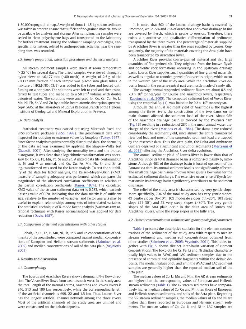
Land use data were obtained from CORINE land cover (Bossard etal., 2000), while the locations of animal farms were extracted from aprevious study (Vryniotis, 2001). For the necessities of this study,land use, apart from livestock activity, was classified into five catego-ries i.e., (i) urban, (ii) agricultural, (iii) forest, (iv) shrub and sparselyvegetation, and (v) wetlands (Fig. 4).
3.4. Sampling
Stream sediment samples, taken at approximately from 0 to10 cm depth on bottom of the river-bed, were collected at 114 sites(Fig. 3A). Sampling sites were selected mainly at the confluence oflower order streams, aiming at a density of 2 samples/km2. Twentysediment samples were taken from the AR, twenty six samples
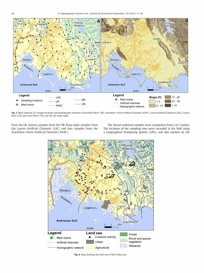
Fig. 3.Maps showing (A) sample locations and hydrographic network of Arachthos River (AR), Arachthos–Vovos Artificial Channels (AVAC), Louros Artificial Channels (LAC), LourosRiver (LR) and Vovos River (VR) and (B) the slope angle.
20 K. Papadopoulou-Vrynioti et al. / Journal of Geochemical Exploration 134 (2013) 17–26
from the LR, sixteen samples from the VR, forty-eight samples fromthe Louros Artificial Channels (LAC) and four samples from theArachthos–Vovos Artificial Channels (AVAC).
Fig. 4. Map showing the land
The stream sediment samples were composites from 2 to 3 points.The locations of the sampling sites were recorded in the field usinga Geographical Positioning System (GPS), and also marked on the
uses of the study area.
21K. Papadopoulou-Vrynioti et al. / Journal of Geochemical Exploration 134 (2013) 17–26
1:50,000 topographicmap. Aweight of about 1–1.5 kg stream sedimentwas taken in order to ensure that sufficient fine-grainedmaterial wouldbe available for analysis and storage. After sampling, the samples weresealed in clean polyethylene bags and transported to the laboratoryfor further treatment. During the sediment sampling campaigns, site-specific information, related to anthropogenic activities near the sam-pling sites, was recorded.
3.5. Sample preparation, extraction procedures and chemical analysis
All stream sediment samples were dried at room temperature(b25 °C) for several days. The dried samples were sieved through anylon sieve to b0.177 mm (b80 mesh). A weight of 2.5 g of theb0.177 mm fraction of each sample was placed into glass tubes. Amixture of HCl:HNO3 (3:1) was added to the tubes and heated untilfuming on a hot plate. The solutions were left to cool and then trans-ferred to test tubes and made up to a 50 cm3 volume with doubledeionised water. The solutions were analysed for Co, Cr, Cu, Fe, Li,Mn, Ni, Pb, Sr, V and Zn by double-beam atomic absorption spectros-copy (AAS) at the laboratory of Epirus Regional Branch of the HellenicInstitute of Geological and Mineral Exploration in Preveza.
3.6. Data analysis
Statistical treatment was carried out using Microsoft Excel andSPSS software packages (SPSS, 1998). The geochemical data wereinspected for outlying or extreme values by boxplots (Tukey, 1977).Since factor analysis requires normally distributed data, the normalityof the data set was examined by applying the Shapiro–Wilks test(Statsoft, 2001). After studying the normality tests and the plottedhistograms, it was clear that a logarithmic transformation was neces-sary for Co, Cu, Fe, Mn, Pb, Sr and Zn. A mixed data file containing Cr,Li, Ni and V as normal, and Co, Cu, Fe, Mn, Pb, Sr and Zn aslog-transformed was used for the factor analysis. To test the suitabil-ity of the data for factor analysis, the Kaiser–Meyer–Olkin (KMO)measure of sampling adequacy was performed, which compares themagnitudes of the observed correlation coefficients in relation tothe partial correlation coefficients (Kaiser, 1974). The calculatedKMO value of the stream sediment data set is 0.783, which exceedsKaiser's value of 0.70, indicating that the data matrix is of sufficientsize, relative to the number of variables, and factor analysis may beuseful to explain relationships among sets of interrelated variables.The statistical technique of R-mode factor analysis (Varimax-raw ro-tational technique with Kaiser normalisation) was applied for datareduction (Davis, 1987).
3.7. Comparison of element concentrations with other studies
Cobalt, Cr, Cu, Fe, Li, Mn, Ni, Pb, Sr, V and Zn concentrations of sed-iments of the area studied were compared against median concentra-tions of European and Hellenic stream sediments (Salminen et al.,2005) and median concentrations of soil of the Arta plain (Vryniotis,2001).
4. Results and discussion
4.1. Geomorphology
The Louros and Arachthos Rivers show a dominant N–S flow direc-tion. The Vovos River flows from east to south-west. In the study area,the total length of the natural Louros, Arachthos and Vovos Rivers is246, 513 and 180 km, respectively, while the corresponding lengthof the artificial channels is 699, 22 and 1.5 km. Thus, Louros Riverhas the longest artificial channel network among the three rivers.Most of the artificial channels of the study area are unlined andwere constructed on the deltaic deposits.
It is noted that 50% of the Louros drainage basin is covered bylimestone, while 72% and 75% of Arachthos and Vovos drainage basinsare covered by flysch, which is prone to erosion. Therefore, thereexists a quantitative and qualitative differentiation of sedimentstransported by the three rivers. The percentage of materials suppliedby Arachthos River is greater than the ones supplied by Louros. Con-sequently, the majority of the materials covering the Arta plain havebeen transported by Arachthos River.
Arachthos River provides coarse-grained material and also largequantities of fine-grained silt. They originate from the known flyschand ophiolitic rock formations occurring in the upstream drainagebasin. Louros River supplies small quantities of fine-grained materials,as well as angular or rounded gravel of calcareous origin, which occurin the western part of the study area. While the Arachthos River de-posits found in the eastern-central part are mostly made of sandy silt.
The average annual suspended sediment fluxes are about 0.8 and7.3 × 106 tonnes/year for Louros and Arachthos Rivers, respectively(Kapsimalis et al., 2005). The computed sediment load of Vovos River,using the empirical Eq. (1), was found to be 0.2 × 10⁶ tonnes/year.
Although the annual sediment yield of Arachthos is the highestamong the three rivers, the construction of the two dams on itsmain channel affected the sediment load of the river. About 98%of the Arachthos drainage basin is blocked by the Pournari dam(Fig. 1B) resulting in a reduction of 28% in the mean annual water dis-charge of the river (Marinos et al., 1984). The dams have reducedconsiderably the sediment yield, since almost the entire transportedriver bed load and most of the suspended sediment load are trappedby the reservoir dam. Thus the Arta plain, the Delta and AmbracianGulf are deprived of a significant amount of sediments (Mertzanis etal., 2011) affecting the Arachthos River delta evolution.
The annual sediment yield of Louros River is lower than that ofArachthos, since its total drainage basin is comprised mainly by lime-stone. Although 40% of the drainage basin is located upstream of thePantanassa dam, its annual sediment load is not significantly affected.The small drainage basin area of Vovos River gives a low value for theestimated sediment discharge. The extensive occurrence of flysch for-mations in its drainage basin significantly contributes to the sedimentdischarge.
The relief of the study area is characterised by very gentle slope.More specifically, 70% of the total study area has very gentle slopes,4% gentle slopes (6–10°), 10% moderate slopes (11–20°), 10% steepslope (21–30°) and 5% very steep slopes (N30°). The very gentleslopes of the Arta plain occur in the delta area of Louros andArachthos Rivers, while the steep slopes in the hilly area.
4.2. Element concentrations in sediments and geomorphological parameters
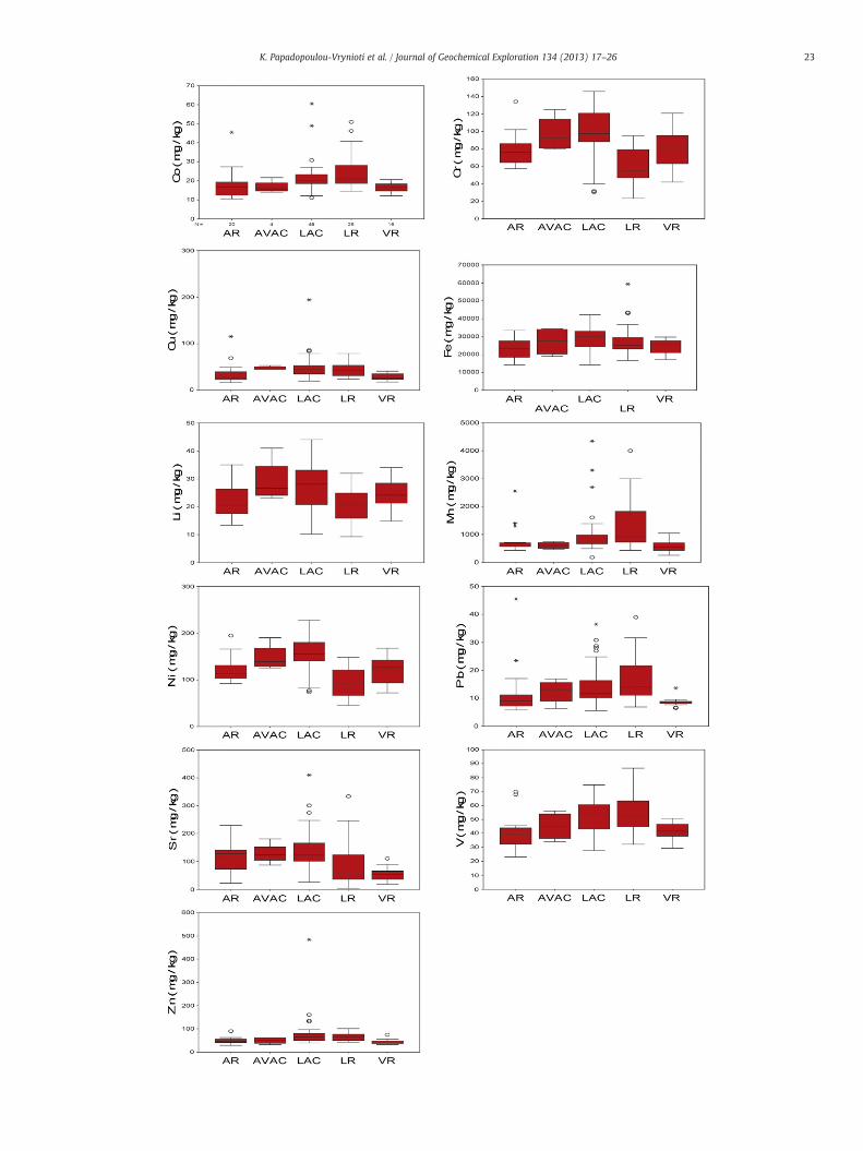
Table 1 presents the descriptive statistics for the element concen-trations of the sediments of the study area with respect to medianstream sediment and median soil concentrations obtained fromother studies (Salminen et al., 2005; Vryniotis, 2001). This table, to-gether with Fig. 5, shows distinct inter-basin variation of elementconcentrations. The boxplots for Cr, Fe, Li and Ni display characteris-tically high values in AVAC and LAC sediment samples due to thepresence of chromite and ophiolite fragments within the deltaic de-posits. The median values of Cu and Sr in the AVAC and LAC sedimentsamples are generally higher than the reported median soil of theArta plain.
The median values of Co, Li, Mn and Ni in the AR stream sedimentsare higher than the corresponding values of European and Hellenicstream sediments (Table 1). The LR stream sediments have compara-tively higher median values of Co, Cu and Mn than those of Europeanand Hellenic stream sediments, and soils of the Arta plain. Regardingthe VR stream sediment samples, the median values of Co and Ni arehigher than those reported in European and Hellenic stream sedi-ments. The median values of Co, Cu, Li and Ni in LAC samples are
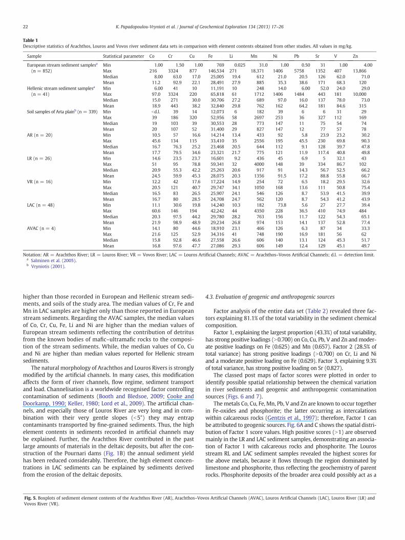
Table 1Descriptive statistics of Arachthos, Louros and Vovos river sediment data sets in comparison with element contents obtained from other studies. All values in mg/kg.
Sample Statistical parameter Co Cr Cu Fe Li Mn Ni Pb Sr V Zn
European stream sediment samplesa
(n = 852)Min 1.00 1.50 1.00 769 0.025 31.0 1.00 0.50 31 1.00 4.00Max 216 3324 877 146,534 271 18,371 1406 5758 1352 407 13,866Median 8.00 63.0 17.0 25,005 19.4 612 21.0 20.5 126 62.0 71.0Mean 11.2 92.9 22.1 28,491 27.9 885 35.3 38.6 171 68.3 120
Hellenic stream sediment samplesa
(n = 41)Min 6.00 41 10 11,191 10 248 14.0 6.00 52.0 24.0 29.0Max 97.0 3324 220 65,818 61 1712 1406 1484 443 181 10,000Median 15.0 271 30.0 30,706 27.2 689 97.0 16.0 137 78.0 73.0Mean 18.9 443 38.2 32,840 29.8 762 162 64.2 181 84.6 315
Soil samples of Arta plainb (n = 339) Min bd.l. 39 14 12,073 6 182 39 6 6 31 29Max 39 186 320 52,956 58 2697 253 36 327 112 169Median 19 103 39 30,553 28 773 147 11 75 54 74Mean 20 107 52 31,400 29 827 147 12 77 57 78
AR (n = 20) Min 10.5 57 16.6 14,214 13.4 433 92 5.8 23.9 23.2 30.2Max 45.6 134 115 33,410 35 2556 195 45.5 230 69.8 90.3Median 16.7 76.3 25.2 23,468 20.5 644 112 9.1 128 39.7 47.8Mean 17.7 79.5 34.6 23,321 21.7 775 121 11.9 117.4 40.8 49.8
LR (n = 26) Min 14.6 23.5 23.7 16,601 9.2 436 45 6.9 5 32.1 43Max 51 95 78.8 59,341 32 4000 148 39 334 86.7 102Median 20.9 55.3 42.2 25,263 20.6 917 91 14.3 56.7 52.5 66.2Mean 24.5 59.9 45.3 28,075 20.3 1356 91.5 17.2 88.8 55.8 66.7
VR (n = 16) Min 12.2 42 17.6 17,224 14.9 254 72 6.5 18.2 29.5 32.6Max 20.5 121 40.7 29,747 34.1 1050 168 13.6 111 50.8 75.4Median 16.5 83 26.5 25,907 24.1 546 126 8.7 53.9 41.5 39.9Mean 16.7 80 28.5 24,708 24.7 562 120 8.7 54.3 41.2 43.9
LAC (n = 48) Min 11.1 30.6 19.8 14,240 10.3 182 73.8 5.6 27 27.7 39.4Max 60.6 146 194 42,242 44 4350 228 36.5 410 74.9 484Median 20.3 97.5 44.2 29,780 28.2 763 156 11.7 122 54.3 65.1Mean 21.9 98.9 48.9 29,234 26.8 974 153 14.1 137 52.8 77.4
AVAC (n = 4) Min 14.1 80 44.6 18,910 23.1 466 126 6.3 87 34 33.3Max 21.6 125 52.9 34,316 41 748 190 16.9 181 56 62Median 15.8 92.8 46.6 27,558 26.6 606 140 13.1 124 45.3 51.7Mean 16.8 97.6 47.7 27,086 29.3 606 149 12.4 129 45.1 49.7
Notation: AR = Arachthos River; LR = Louros River; VR = Vovos River; LAC = Louros Artificial Channels; AVAC = Arachthos–Vovos Artificial Channels; d.l. = detection limit.a Salminen et al. (2005).b Vryniotis (2001).
22 K. Papadopoulou-Vrynioti et al. / Journal of Geochemical Exploration 134 (2013) 17–26
higher than those recorded in European and Hellenic stream sedi-ments, and soils of the study area. The median values of Cr, Fe andMn in LAC samples are higher only than those reported in Europeanstream sediments. Regarding the AVAC samples, the median valuesof Co, Cr, Cu, Fe, Li and Ni are higher than the median values ofEuropean stream sediments reflecting the contribution of detritusfrom the known bodies of mafic–ultramafic rocks to the composi-tion of the stream sediments. While, the median values of Co, Cuand Ni are higher than median values reported for Hellenic streamsediments.
The natural morphology of Arachthos and Louros Rivers is stronglymodified by the artificial channels. In many cases, this modificationaffects the form of river channels, flow regime, sediment transportand load. Channelisation is a worldwide recognised factor controllingcontamination of sediments (Booth and Bledsoe, 2009; Cooke andDoorkamp, 1990; Keller, 1980; Lord et al., 2009). The artificial chan-nels, and especially those of Louros River are very long and in com-bination with their very gentle slopes (b5°) they may entrapcontaminants transported by fine-grained sediments. Thus, the highelement contents in sediments recorded in artificial channels maybe explained. Further, the Arachthos River contributed in the pastlarge amounts of materials in the deltaic deposits, but after the con-struction of the Pournari dams (Fig. 1B) the annual sediment yieldhas been reduced considerably. Therefore, the high element concen-trations in LAC sediments can be explained by sediments derivedfrom the erosion of the deltaic deposits.
Fig. 5. Boxplots of sediment element contents of the Arachthos River (AR), Arachthos–VovVovos River (VR).
4.3. Evaluation of geogenic and anthropogenic sources
Factor analysis of the entire data set (Table 2) revealed three fac-tors explaining 81.1% of the total variability in the sediment chemicalcomposition.
Factor 1, explaining the largest proportion (43.3%) of total variability,has strong positive loadings (N0.700) on Co, Cu, Pb, V and Zn andmoder-ate positive loadings on Fe (0.625) and Mn (0.657). Factor 2 (28.5% oftotal variance) has strong positive loadings (N0.700) on Cr, Li and Niand a moderate positive loading on Fe (0.629). Factor 3, explaining 9.3%of total variance, has strong positive loading on Sr (0.827).
The classed post maps of factor scores were plotted in order toidentify possible spatial relationship between the chemical variationin river sediments and geogenic and anthropogenic contaminationsources (Figs. 6 and 7).
The metals Co, Cu, Fe, Mn, Pb, V and Zn are known to occur togetherin Fe-oxides and phosphorite; the latter occurring as intercalationswithin calcareous rocks (Gentzis et al., 1997); therefore, Factor 1 canbe attributed to geogenic sources. Fig. 6A and C shows the spatial distri-bution of Factor 1 score values. High positive scores (N1) are observedmainly in the LR and LAC sediment samples, demonstrating an associa-tion of Factor 1 with calcareous rocks and phosphorite. The Lourosstream RL and LAC sediment samples revealed the highest scores forthe above metals, because it flows through the region dominated bylimestone and phosphorite, thus reflecting the geochemistry of parentrocks. Phosphorite deposits of the broader area could possibly act as a
os Artificial Channels (AVAC), Louros Artificial Channels (LAC), Louros River (LR) and
23K. Papadopoulou-Vrynioti et al. / Journal of Geochemical Exploration 134 (2013) 17–26

Table 2Varimax-rotated R-mode factor analysis parameters of the stream sediment geochem-ical data set from the study area (n = 114).
Variable Factor 1 Factor 2 Factor 3 Communality
Co 0.839 0.098 −0.395 0.869Cr −0.082 0.944 0.205 0.941Cu 0.855 0.021 0.193 0.769Fe 0.625 0.629 −0.285 0.868Li 0.210 0.873 0.084 0.813Mn 0.657 −0.141 −0.494 0.695Ni −0.062 0.927 0.164 0.890Pb 0.885 −0.139 −0.123 0.818Sr −0.017 0.261 0.827 0.753V 0.808 0.226 −0.257 0.769Zn 0.810 0.147 0.250 0.740Eigenvalue 4.759 3.143 1.024Cumulative eigenvalue 4.759 7.902 8.926Variance (%) explained 43.3 28.5 9.3Cumulative % variance 43.3 71.8 81.1
Notation: bold numbers show strong positive loadings N0.700; italicised numbersdenote moderate positive loadings N0.500 to 0.699.
24 K. Papadopoulou-Vrynioti et al. / Journal of Geochemical Exploration 134 (2013) 17–26
source of V. Since there are no geochemical data for the phosphate rocksof the area studied, the available geochemical data of theNeogene phos-phate rocks of Hellas are used for comparison purposes (Stamatakis,2004). According to Stamatakis (2004), the element ranges for phos-phorites are: P2O5 (0.51–33%), Fe2O3 (0.24–20.5%), MnO (below de-tection limit −0.83%), Co (3.5–35 mg/kg), Cu (5.0–53.4 mg/kg), Pb(2–14 mg/kg), V (8–118 mg/kg) and Zn (12–98 mg/kg). Zinc isalso known to occur in Hellenic ophiolites, but it is found in fertilisers
Fig. 6.Maps showing: Factor 1 scores values (Co–Cu–Fe–Mn–Pb–V–Zn) in relation to litholoand land uses (D).
and livestock manure too (Kabata Pendias and Mukherjee, 2007).According to these authors, the Zn contents in fertilisers range from61 to 625 mg/kg, while in livestock manure varies between 495 and919 mg/kg. Furthermore, the occurrence of Fe-oxides of geogenic originhas been also reported in the sediments of Louros estuary in theAmbracian Gulf (Scoulos et al., 1996).
Chromium, Li, Ni and Fe occur in the known bodies of Hellenicophiolites, as well as in their weathering products; therefore, Factor2 is directly attributed to geogenic sources, and mainly the ophioliterocks, and their detritus within the deltaic deposits. High positiveFactor 2 scores (N1) correspond to higher values of Cr, Li, Ni, and Fein sediments, and are mainly recorded in LAC sediment samples,suggesting an association with artificial channels, but their spatialdistribution possibly indicates that the dominant sediments are de-rived from the ophiolitic rocks (Fig. 6B and D).
Strontium is known to be associated mainly with limestone and do-lomite, since its geochemical characteristics are similar to Ca (KabataPendias and Mukherjee, 2007). Moreover, according to Kabata Pendiasand Mukherjee (2007) Sr occurs in phosphorite up to 2000 mg/kg;while other potential sources of Sr in soil are P-fertilisers (up to610 mg/kg) and manure (up to 80 mg/kg). The higher positive scoresof Factor 3 are recorded mainly in the LAC, LR and AR stream sedimentsamples, especially at the part of the study area characterised by thedominance of calcareous rocks and the occurrence of phosphorite. Fur-thermore, in these areas there are intensive agricultural activities(Figs. 4, 7A and B). Therefore, Factor 3 appears to be related to bothgeogenic and anthropogenic sources.
Regarding all the studied elements, only Co and Ni present medianvalues higher than those in European and Hellenic stream sediments
gy (A) and land uses (C), Factor 2 score values (Cr–Li–Ni–Fe) in relation to lithology (B)

Fig. 7. Maps showing: Factor 3 score values (Sr) in relation to lithology (A) and land uses (B).
Fig. 8. Symbol map of Νi stream sediment concentrations (mg/kg) in relation to lithology.
25K. Papadopoulou-Vrynioti et al. / Journal of Geochemical Exploration 134 (2013) 17–26
(Table 1). For this reason, Ni was selected for further discussion. HighNi concentrations (ranging from 139.5 to 227.6 mg/kg) are observedin stream sediment samples of LAC and AVAC (Fig. 8). Since the studyarea is characterised by the absence of industrial activities, the Nianomalies can be directly attributed to geogenic sources such as de-tritus derived from the weathering and erosion of mafic–ultramaficrocks (ophiolites).
5. Conclusions
The total length of the streams of rivers and artificial channels wasfound to be 939 km and 722.5 km, respectively. The artificial channelsaremainly unlined andwere constructed on the deltaic deposits of LourosandArachthos Rivers. The latter supplies the greater amounts ofmaterialsin the study area, which are derived mainly from flysch and mafic–ultra-mafic rock masses. About 70% of the total area has very gentle slope.
The higher median values of Cr, Fe, Li and Ni are recorded in AVACand LAC sediments samples due to the presence of chromite andophiolite fragments within deltaic deposits; while the compositionof LAC, LR and AR stream sediments is modified by contributionsfrom geogenic and various anthropogenic sources (metal-rich agri-cultural chemicals and fertilisers).
Factor analysis suggests that geogenic (detritus from Fe-oxides,calcareous rocks with phosphorite intercalations, and mafic–ultramaficrocks within deltaic deposits) and anthropogenic sources (intensiveagricultural and farming practices) govern the distribution of elementsin the stream sediments of the study area. The very gentle slopes andthe long length of the artificial channels of the study area are associatedwith the recorded high element contents.
Acknowledgements
The work was financed by the Second Community Support Frame-work. The authors would like to thank the staff of IGME (Institute ofGeology & Mineral Exploration) for their contribution to the comple-tion of this work. The authors gratefully acknowledge the assistanceof the two anonymous reviewers whose valuable comments helpedthe authors to improve the quality of this manuscript.
References
Alexakis, D., 2011. Diagnosis of stream sediment quality and assessment of toxic ele-ment contamination sources in East Attica, Greece. Environmental Earth Sciences63 (6), 1369–1383.
26 K. Papadopoulou-Vrynioti et al. / Journal of Geochemical Exploration 134 (2013) 17–26
Alexakis, D., Gotsis, D., Giakoumakis, S., 2012. Assessment of drainage water quality inpre- and post-irrigation seasons for supplemental irrigation use. EnvironmentalMonitoring and Assessment 184 (8), 5051–5063.
Bathrellos, G.D., Skilodimou, H.D., Kelepertsis, A., Alexakis, D., Chrisanthaki, I., Archonti,D., 2008. Environmental research of groundwater in the urban and suburban areasof Attica region, Greece. Environmental Geology 56 (1), 11–18.
Bathrellos, G.D., Gaki-Papanastassiou, K., Skilodimou, H.D., Papanastassiou, D., Chousianitis,K.G., 2012. Potential suitability for urban planning and industry development by usingnatural hazard maps and geological–geomorphological parameters. EnvironmentalEarth Sciences 66 (2), 537–548.
Bathrellos, G.D., Gaki-Papanastassiou, K., Skilodimou, H.D., Skianis, G.A., Chousianitis,K.G., 2013. Assessment of rural community and agricultural development usinggeomorphological–geological factors and GIS in the Trikala prefecture (CentralGreece). Stochastic Environmental Research and Risk Assessment 27 (2), 573–588.
Batista, M.J., Abreu, M.M., Locutura, J., De Oliveira, D., Matos, J.X., Silva, C., Bel-Lan, A.,Martins, L., 2012. Evaluation of trace elements mobility from soils to sediments be-tween the Iberian Pyrite Belt and the Atlantic Ocean. Journal of Geochemical Explo-ration 123, 61–68.
Booth, D.B., Bledsoe, B., 2009. Streams and urbanization. In: Baker, R.A. (Ed.), TheWaterEnvironment of Cities. Springer, pp. 93–123.
Bossard, M., Feranec, J., Otahel, J., 2000. CORINE Land Cover Technical Guide — Adden-dum 2000. European Environment Agency, Copenhagen 104.
Chrisostomides, P., 1982. Alluvial chromite deposits in coastal areas of Ionian Sea andAmbracian Gulf. Unpublished Report IGME, Department of Preveza (in Greek).
Cooke, R.U., Doorkamp, J.C., 1990. Geomorphology in Environmental Management.Clarendon Press, Oxford.
Davis, S.N., 1987. Statistics and Data Analysis in Geology, 2nd ed. John Wiley & Sons,New York.
De Vos, W., Tarvainen, T., Salminen, R., Reeder, S., De Vivo, B., Demetriades, A., Pirc, S.,Batista, M.J., Marsina, K., Ottesen, R.T., O'Connor, P.J., Bidovec, M., Lima, A., Siewers,U., Smith, B., Taylor, H., Shaw, R., Salpeteur, I., Gregorauskiene, V., Halamic, J.,Slaninka, I., Lax, K., Gravesen, P., Birke, M., Breward, N., Ander, E.L., Jordan, G.,Duris, M., Klein, P., Locutura, J., Bel-lan, A., Pasieczna, A., Lis, J., Mazreku, A.,Gilucis, A., Heitzmann, P., Klaver, G., Petersell, V., 2006. Geochemical Atlas ofEurope. Part 2 — Interpretation of Geochemical Maps, Additional Tables, Figures,Maps and Related Publications. Geological Survey of Finland, Espoo, Finland(http://weppi.gtk.fi/publ/foregsatlas/ (Last accessed 1/6/2013)).
Demetriades, A., Li, X., Ramsey, M.H., Thornton, I., 2010. Chemical speciation and bioac-cessibility of lead in surface soil and house dust, Lavrion urban area, Attiki, Hellas.Environmental Geochemistry and Health 32 (6), 529–552.
Dinelli, E., Cortecci, G., Lucchini, F., Zantedeschi, E., 2005. Sources of major and traceelements in the stream sediments of the Arno river catchment (northern Tuscany,Italy). Geochemical Journal 39, 531–545.
Gamvroula, D., Alexakis, D., Stamatis, G., 2013. Diagnosis of groundwater quality andassessment of contamination sources in the Megara basin (Attica, Greece). ArabianJournal of Geosciences 6 (7), 2367–2381.
Gentzis, T., Goodarzi, F., Foscolos, A., 1997. Geochemistry and mineralogy of Greeklignites from the Ioannina basin. Energy Sources 19 (2), 111–128.
Hakanson, L., 1980. An ecological risk index for aquatic pollution control. A sedimento-logical approach. Water Resources 14, 975–1001.
IGME (Institute of Geology and Mineral Exploration), 1966. Geological map of Greece,sheet “Peta”, scale 1:50,000.
IGME (Institute of Geology and Mineral Exploration), 1969. Geological map of Greece,sheet “Arta”, scale 1:50,000.
IGME (Institute of Geology and Mineral Exploration), 1983. Geological map of Greece,scale 1:500,000.
Kabata Pendias, A., Mukherjee, A.B., 2007. Trace Elements from Soil to Human. Springer-Verlag, Berlin Heidelberg.
Kaiser, H.F., 1974. An index of factorial simplicity. Psychometrika 39 (1), 31–36.Kapsimalis, V., Pavlakis, P., Poulos, S.E., Alexandri, S., Tziavos, C., Sioulas, A., Filippas, D.,
Lykousis, V., 2005. Internal structure and evolution of the Late Quaternary sequencein a shallow embayment: the Amvrakikos Gulf, NW Greece. Marine Geology 222,399–418.
Keller, E.A., 1980. Channelization: environmental, geomorphic, and engineering as-pects. In: Coates, D.R. (Ed.), Geomorphology and Engineering. G. Allen & Unwin,London, pp. 115–140.
Koutrakis, E., Perdikaris, C., Machino, Y., Savvidis, G., Margaris, N., 2007. Distribution,recent mortalities and conservation measures of crayfish in Hellenic fresh waters.Bulletin Francais de la Peche et de la Pisciculture 385, 25–44.
Lord, M.L., Germanoski, D., Allmendinger, N.E., 2009. Fluvial geomorphology: monitoringstream systems in response to a changing environment. In: Young, R., Norby, L.(Eds.), Geological Monitoring. Geological Society of America, Boulder, Colorado,pp. 69–103.
Mantei, E.J., Foster, M.V., 1991. Heavy metals in stream sediments: effect of human ac-tivities. Environmental Geology and Water Sciences 18, 95–104.
Marinos, G., Stournaras, G., Karotsieris, Z., 1984. A detailed study on the combinedutilisation of the water resources of the rivers Louros and Arachthos drainage ba-sins. Technical Report to the Ministry of Energy and Natural Resources, Athens(in Greek).
Mertzanis, A., Papadopoulos, A., Goudelis, G., Pantera, A., Efthimiou, G., 2011. Human-induced impact to the environment and changes in the geomorphology: some ex-amples of inland and coastal environments in Greece. Journal of Ecology and theNatural Environment 3 (8), 273–297.
Migiros, G., Bathrellos, G.D., Skilodimou, H.D., Karamousalis, T., 2011. Pinios (Peneus)River (Central Greece): hydrological–geomorphological elements and changesduring the Quaternary. Central European Journal of Geosciences 3 (2), 215–228.
Panagopoulos, G.P., Bathrellos, G.D., Skilodimou, H.D., Martsouka, F.A., 2012. Mappingurban water demands using multi-criteria analysis and GIS. Water Resources Man-agement 26 (5), 1347–1363.
Papadopoulou, K., Vryniotis, D., 2007. Quality of soil and water in deltaic deposits ofLouros and Arachthos Rivers related to karstic rocks of the wider area. Bulletin ofthe Geological Society of Greece 40 (4), 1599–1608.
Papadopoulou-Vrynioti, K., 2002. Lost rivers associated with hazard pollution inGreece. Proceedings of 6th International Symposium on Speleology and KarstologyAlCaDi 55–61.
Papadopoulou-Vrynioti, K., 2004. The role of epikarst in the morphogenesis of thekarstic forms in Greece and especially of the karstic hollow forms. Acta Carsologica33/1 (14), 219–235.
Papadopoulou-Vrynioti, K., Bathrellos, G.D., Skilodimou, H.D., Kaviris, G., Makropoulos,K., 2013. Karst collapse susceptibility mapping considering peak ground accelera-tion in a rapidly growing urban area. Engineering Geology 158, 77–88.
Poulos, S., Chronis, G., 1997. The importance of the Greek River Systems in the evolu-tion of the Greek coastline. In: Briand, F., Maldolado, A. (Eds.), Transformationsand Evolution of the Mediterranean Coastline. Bulletin Institute OceanographiqueSpecial No. 18, CIESM Science Series No. 3, pp. 75–96.
Saleem, M., Iqbal, J., Shah, M., 2013. Study of seasonal variations and risk assessment ofselected metals in sediments from Mangla Lake, Pakistan. Journal of GeochemicalExploration 125, 144–152.
Salminen, R., Batista, M.J., Bidovec, M., Demetriades, A., De Vivo, B., De Vos, W., Duris,M., Gilucis, A., Gregorauskiene, V., Halamic, J., Heitzmann, P., Lima, A., Jordan, G.,Klaver, G., Klein, P., Lis, T., Locutura, J., Marsina, J., Mazreku, K., O'Connor, A.,Olsson, P.J., Ottesen, S.Å., Petersell, R.T., Plant, V., Reeder, J.A., Salpeteur, S.,Sandström, I., Siewers, H., Steenfelt, U., Tarvainen, A., 2005. Geochemical Atlas ofEurope. Part 1 — Background Information, Methodology and Maps. Geological Sur-vey of Finland, Espoo, Finland (http://weppi.gtk.fi/publ/foregsatlas (Last accessed1/6/2013)).
Salomons, W., Förstner, U., 1984. Metals in the Hydrocycle. Springer-Verlag, Berlin.Scoulos, M., Dasenakis, M., Zeri, C., 1996. Trace metal behaviour during summer in a
stratified Mediterranean system: the Louros estuary (Greece). Water, Air, andSoil Pollution 88, 269–295.
Segura, R., Arancibia, V., Zuniga, M.C., Pasten, P., 2006. Distribution of copper, zinc, leadand cadmium concentrations in stream sediments from the Mapocho River in San-tiago, Chile. Journal of Geochemical Exploration 91, 71–80.
Skilodimou, H.D., Stefouli, M., Bathrellos, G.D., 2002. Spatio-temporal analysis of thecoastline of Faliro Bay, Attica, Greece. Estudios Geologicos 58 (3–4), 87–93.
Skilodimou, H., Livaditis, G., Bathrellos, G., Verikiou-Papaspiridakou, E., 2003. Investi-gating the flooding events of the urban regions of Glyfada and Voula, Attica,Greece: a contribution to Urban Geomorphology. Geografiska Annaler, Series A85 (2), 197–204.
Skoulikidis, N., Gritzalis, K., Kouvarda, T., Buffagni, A., 2009. The development of an eco-logical quality assessment and classification system for Greek running watersbased on benthic macroinvertebrates. Hydrobiologia 516, 149–160.
SPSS, 1998. SPSS Base 8.0 — Application Guide. SPSS Inc., Chicago.Stamatakis, M., 2004. Phosphate deposits of Neogene age in Greece. Mineralogy, geo-
chemistry and genetic implications. Chemie der Erde-Geochemistry 64, 329–357.Stamatis, G., Alexakis, D., Gamvroula, D., Migiros, G., 2011. Groundwater quality assess-
ment in Oropos–Kalamos basin, Attica, Greece. Environmental Earth Sciences 64(4), 973–988.
Statsoft, 2001. STATISTICA System Reference. Statsoft, Inc., 2300 East 14th Street, TulsaOK 74104 USA (1098 pp.).
Tukey, J.W., 1977. Exploratory Data Analysis. Addison-Wesley, Reading.Vassiliades, E.A., 2010. Zonation of Risk of the Landslide Phenomena in the Hellenic ter-
ritory. Development and Application of Models with Geographic Information Sys-tems. Unpublished Ph.D. Thesis Geology Department, University of Patras, Patras,Hellas.
Vryniotis, D., 2001. Soil geochemical survey of deltaic sediments of Louros–Arachthos in combination with hydrogeochemical data. I.G.M.E. Open File Re-port, Athens (86 pp.).
Vryniotis, D., Papadopoulou, K., 2004. The role of Arachthos and Louros Rivers in thedevelopment of sediments of the Arta's plain with the contribution of geochemicalparameters. Bulletin of the Geological Society of Greece 36, 150–157.
WFD, 2000. Council Directive 2000/60/EC. Directive of the European Parliament and ofthe Council establishing a framework for the Community action in the field ofwater policy. The European parliament and the Council of the European Union. Of-ficial Journal of the European Communities L 327.
Zogaris, S., Economou, A., Dimopoulos, P., 2009. Ecoregions in the Southern Bal-kans: should their boundaries be revised? Environmental Management 43,682–697.
Copyright © 2022 FDOKUMEN