Distribution and abundance of shorebirds in the coastal wetlands of the Yucatan Peninsula, Mexico
9
148 INTRODUCTION Many shorebirds that nest in the United States and Canada migrate to Mexico, Central America and South America for the boreal winter (Morrison 1984). Throughout their migration cycle shorebirds use a chain of critical interior and coastal habitats (Myers et al. 1987, Skagen et al. 1999). Although the coastal wetlands of the Gulf of Mexico and Central America are used by many waterfowl and shorebirds, quantitative information on shorebirds is scarce and major geographical gaps remain. Most information comes from the coast of Texas and Tamaulipas, which is considered the most important place for shorebirds in the entire Gulf of Mexico (Withers 2002). More than 100,000 shorebirds visit Laguna Atascosa National Wildlife Refuge on the coast of Texas (Skagen et al. 1999). Contreras-Balderas (1993) as well as Withers & Chapman (1993) have provided species accounts for the northern and southern portion of the Laguna Madre complex which straddles the Mexico–US border. Ground counts of shorebirds have been conducted in the Mexican part of Laguna Madre. Harrington et al. (2000) and Olalla- Kerstupp (2003) surveyed the region as habitat for shorebirds and reported on the relative abundance and seasonality of 29 species. However, apart from one aerial survey flown in January in the early 1990s (Morrison et al. 1993), there is no information available about sites preferred by shorebirds or any quantitative assessment of numbers for the eastern coast of Mexico south to the Yucatan Peninsula. Morrison et al. (1993) suggested that the use of the Yucatan wetlands during southward and northward migration needed to be determined. Likewise, Scott & Carbonell (1986) suggested, without giv- ing figures, that the wetlands of the Yucatan Peninsula were important for migratory shorebirds and waterfowl. Moreover, Correa-Sandoval & García-Barrón (1993) reported the pres- ence and relative abundance of shorebird species in the Ría Lagartos and Ría Celestún biosphere reserves on the north and west coasts of the peninsula, respectively. Various long-term monitoring programs have detected negative trends in populations of several shorebird species in the Western Hemisphere (Howe et al. 1989, Morrison et al. 1994, 2000). Although explanations for these trends might be multiple, shorebirds are particularly vulnerable to habitat loss and degradation along their migration routes (Myers et al. 1987). The coast of the Yucatan Peninsula is under pressure from tourism and holiday housing development. However, we still need to identify critical areas for shorebirds as well as assess the order of magnitude of abundance and timing of migration within the peninsula. Even though there are several protected areas in the region, quantitative information to support local management and coordinate with international conservation efforts is missing. Our objectives were to (1) identify which sites are used by shorebirds in the coastal wetlands on the west and north coasts of the Yucatan Peninsula, (2) document the relative abundance of shorebirds in the region, and (3) evaluate the phenology of shorebirds in the Yucatan Peninsula. METHODS Fieldwork was conducted in wetlands along the north and west coast of the Yucatan Peninsula, Mexico (Fig. 1) which comprise a mosaic of tropical wetlands, including mangrove swamps (Rhizophora mangle, Avicennia germinans, Lagun- cularia racemosa, and Conocarpus erecta), and sawgrass Distribution and abundance of shorebirds in the coastal wetlands of the Yucatan Peninsula, Mexico JORGE CORREA-SANDOVAL 1 & ARMANDO J. CONTRERAS-BALDERAS 2 1 El Colegio de la Frontera Sur, Calzada Centenario km 5.5 Chetumal 77090, Quintana Roo, Mexico. [email protected] 2 Laboratorio de Ornitología, Facultad de Ciencias Biológicas, Universidad Autónoma de Nuevo León, Apartado Postal 425, San Nicolás de los Garza, 66450, Nuevo León, Mexico Correa-Sandoval, J. & Contreras-Balderas, A.J. 2008. Distribution and abundance of shorebirds in the coastal wetlands of the Yucatan Peninsula, Mexico. Wader Study Group Bull. 115(3): 148–156. Key words: Charadriiformes, coastal wetlands, migration, shorebirds, waders, Yucatan Peninsula Although it has long been known that large numbers of shorebirds occur on passage and in winter on the Yucatan Peninsula, Mexico, quantitative information has been lacking and is needed to guide management of the wetlands in the region. Aerial and ground counts of shorebirds were therefore conducted from October 2004 to January 2006 in order to locate and assess the size of shorebird concentrations and to investigate to what extent the coastal wetlands of the NW Yucatan Peninsula are used by resident and migratory shorebirds. Peak counts for the region per season were 37,911 shorebirds in winter 2004 and 26,818 in fall 2006 and the aggregate non-breeding season peak count was 51,058 shorebirds in 2005–2006. The most abundant shorebirds were: Western Sandpiper Calidris mauri (32.3% of the aggregate total), dowitchers Limnodromus spp. (16.1%), Least Sandpiper C. minutilla (16.1%), Sanderling C. alba (7.8%), and yellowlegs Tringa spp. (6.6%), which together comprised 79% of all shorebirds identified. Compared with other sites on the Gulf Coast of Mexico, the Yucatan Peninsula region is only second in importance after the Laguna Madre complex. The area qualifies as a site of regional importance within the Western Hemisphere Shorebird Reserve Network.
Transcript of Distribution and abundance of shorebirds in the coastal wetlands of the Yucatan Peninsula, Mexico

148 Wader Study Group Bulletin 115 (3) 2008
148
INTRODUCTION
Many shorebirds that nest in the United States and Canada migrate to Mexico, Central America and South America for the boreal winter (Morrison 1984). Throughout their migration cycle shorebirds use a chain of critical interior and coastal habitats (Myers et al. 1987, Skagen et al. 1999). Although the coastal wetlands of the Gulf of Mexico and Central America are used by many waterfowl and shorebirds, quantitative information on shorebirds is scarce and major geographical gaps remain. Most information comes from the coast of Texas and Tamaulipas, which is considered the most important place for shorebirds in the entire Gulf of Mexico (Withers 2002). More than 100,000 shorebirds visit Laguna Atascosa National Wildlife Refuge on the coast of Texas (Skagen et al. 1999). Contreras-Balderas (1993) as well as Withers & Chapman (1993) have provided species accounts for the northern and southern portion of the Laguna Madre complex which straddles the Mexico–US border. Ground counts of shorebirds have been conducted in the Mexican part of Laguna Madre. Harrington et al. (2000) and Olalla-Kerstupp (2003) surveyed the region as habitat for shorebirds and reported on the relative abundance and seasonality of 29 species. However, apart from one aerial survey flown in January in the early 1990s (Morrison et al. 1993), there is no information available about sites preferred by shorebirds or any quantitative assessment of numbers for the eastern coast of Mexico south to the Yucatan Peninsula. Morrison et al. (1993) suggested that the use of the Yucatan wetlands during southward and northward migration needed to be determined. Likewise, Scott & Carbonell (1986) suggested, without giv-ing figures, that the wetlands of the Yucatan Peninsula were
important for migratory shorebirds and waterfowl. Moreover, Correa-Sandoval & García-Barrón (1993) reported the pres-ence and relative abundance of shorebird species in the Ría Lagartos and Ría Celestún biosphere reserves on the north and west coasts of the peninsula, respectively.
Various long-term monitoring programs have detected negative trends in populations of several shorebird species in the Western Hemisphere (Howe et al. 1989, Morrison et al. 1994, 2000). Although explanations for these trends might be multiple, shorebirds are particularly vulnerable to habitat loss and degradation along their migration routes (Myers et al. 1987). The coast of the Yucatan Peninsula is under pressure from tourism and holiday housing development. However, we still need to identify critical areas for shorebirds as well as assess the order of magnitude of abundance and timing of migration within the peninsula. Even though there are several protected areas in the region, quantitative information to support local management and coordinate with international conservation efforts is missing.
Our objectives were to (1) identify which sites are used by shorebirds in the coastal wetlands on the west and north coasts of the Yucatan Peninsula, (2) document the relative abundance of shorebirds in the region, and (3) evaluate the phenology of shorebirds in the Yucatan Peninsula.
METHODS
Fieldwork was conducted in wetlands along the north and west coast of the Yucatan Peninsula, Mexico (Fig. 1) which comprise a mosaic of tropical wetlands, including mangrove swamps (Rhizophora mangle, Avicennia germinans, Lagun-cularia racemosa, and Conocarpus erecta), and sawgrass
Distribution and abundance of shorebirds in the coastal wetlands of the Yucatan Peninsula, Mexico
JorGe Correa-Sandoval1 & armando J. ContreraS-BalderaS2
1El Colegio de la Frontera Sur, Calzada Centenario km 5.5 Chetumal 77090, Quintana Roo, Mexico. [email protected] 2Laboratorio de Ornitología, Facultad de Ciencias Biológicas, Universidad Autónoma de Nuevo León,
Apartado Postal 425, San Nicolás de los Garza, 66450, Nuevo León, Mexico
Correa-Sandoval, J. & Contreras-Balderas, A.J. 2008. Distribution and abundance of shorebirds in the coastal wetlands of the Yucatan Peninsula, Mexico. Wader Study Group Bull. 115(3): 148–156.
Key words: Charadriiformes, coastal wetlands, migration, shorebirds, waders, Yucatan Peninsula
Although it has long been known that large numbers of shorebirds occur on passage and in winter on the Yucatan Peninsula, Mexico, quantitative information has been lacking and is needed to guide management of the wetlands in the region. Aerial and ground counts of shorebirds were therefore conducted from October 2004 to January 2006 in order to locate and assess the size of shorebird concentrations and to investigate to what extent the coastal wetlands of the NW Yucatan Peninsula are used by resident and migratory shorebirds. Peak counts for the region per season were 37,911 shorebirds in winter 2004 and 26,818 in fall 2006 and the aggregate non-breeding season peak count was 51,058 shorebirds in 2005–2006. The most abundant shorebirds were: Western Sandpiper Calidris mauri (32.3% of the aggregate total), dowitchers Limnodromus spp. (16.1%), Least Sandpiper C. minutilla (16.1%), Sanderling C. alba (7.8%), and yellowlegs Tringa spp. (6.6%), which together comprised 79% of all shorebirds identified. Compared with other sites on the Gulf Coast of Mexico, the Yucatan Peninsula region is only second in importance after the Laguna Madre complex. The area qualifies as a site of regional importance within the Western Hemisphere Shorebird Reserve Network.

149Correa-Sandoval & Contreras-Balderas: Shorebirds in the coastal wetlands of the Yucatan Peninsula, mexico
Fig. 1. Study area on the Yucatan Peninsula, mexico showing sectors used during aerial surveys: las Coloradas (Co), dzilam (dZ), laguna rosada (lr), Progreso Wetlands (PW), la Carbonera (lC), ría Celestún (rC), los Petenes (lP). Solid black line is aerial census path. Blow-ups show sites of terrestrial counts: a) las Coloradas, B) Progreso Wetlands, and C) la Carbonera.
(Cladium jamaicense), saltgrass (Distichlis spicata), and cattail (Thypha spp.) marshes. Characteristic of this region are hypersaline mudflats known locally as “blanquizal” which have a thin mat of bacteria and cyanobacteria in a superficial and sub-superficial layer (Paerl et al. 2000, Zamudio-Maya et al. 2008). These wetlands are separated from the sea by a system of sand dunes and vary in width from 2–6 km although, in some parts, flooded forest can be found more than 15 km inland. Open mudflats range from 0.5–4 km in width and seasonal variation in water levels is dependent on rainfall which peaks during Jun–Aug. The greatest depth of water (50 cm) occurs during Sep–Oct and then slowly recedes in the dry season. In Mar–Apr, most of the area is dry except for some places that retain water due to the presence of fresh water springs. As a result of the large size of the region, there are always mudflats present with various water depths. During high tides or storms, seawater may enter the system over the sand dunes. Salinity ranges from 4 practical salinity units (PSU) in the rainy season to 103 PSU in the dry season,
150 Wader Study Group Bulletin 115 (3) 2008
with corresponding water temperatures from 23°C to 38°C (Batllori-Sampedro et al. 2006). At any time both wind speed and direction may influence local water depth more than tides. Since there is limited connection with the sea, tides have a small range of around 30 cm.
There is industrial salt production with man-made salt pans that maintain water and favorable conditions for shore-birds all year long in Las Coloradas at the easternmost point of the study area. The study area extends from 21°29'22"N, 87°35'16"W to 19°58'32"N, 90°27'03"W (Fig. 1).
Ground counts
Three sites were chosen for ground counts, based on our experience and their accessibility. Counts were made from a truck or on foot along levees and roads. The counts in Las Coloradas (CO; 21°36'N, 87°59'W) took place within the system of evaporation ponds and saltpans of Industria Salinera de Yucatán and the contiguous estuarine shore of the Ría Lagartos. There we followed dikes and levees for a total of 28 km looking to both sides. The entire census took about 4 h (Fig. 1A, Appendix). South of Puerto Progreso (PW; 21°36'N, 89°37'W) we followed the roads to the city garbage dump and the road to Chicxulub for a total of 5 km taking about 1½ h (Fig. 1B, Appendix). At La Carbonera (LC; 21°13'N, 89°53'W), our surveys lasted around 2 h and covered 9 km; we looked to the south and at the easternmost point we counted the birds in the inlet (Fig. 1C, Appendix).
We conducted 57 ground counts between 7 Feb 2004 and 20 May 2006: 16 during fall migration (Sep–Nov), 17 during winter (Dec–Feb), and 24 during spring migration (Mar–May) (see Appendix). No counts were conducted during summer (Jun–Aug). From fall 2005 to spring 2006, the three sites were surveyed every month. To avoid double-counting caused by birds moving between sites, censuses were carried out on the same day or the next day. Most birds were easily seen and identified at a distance of <50 m; however, some were counted from as much as 250 m. We used 10× binoculars and 20–60× spotting scopes. Counts were conducted during the morning and began when there was enough light for accurate identification. We attempted to count individual birds, but large groups were initially counted in units of 10, 50 or 100; if they remained long enough, we attempted to count them individually. We identified birds to species whenever possible. Undifferentiated small sandpipers (Calidris spp.) were grouped under “peeps”, and undifferentiated plovers as “plovers”. However, Greater Yellowlegs Tringa melanoleuca and Lesser Yellowlegs T. flavipes were combined as “yellow-legs”, and Long-billed Dowitcher Limnodromus scolopaceus and Short-billed Dowitcher L. griseus as “dowitchers”. When birds were moving too rapidly or were too distant for accurate identification, we grouped them as “shorebirds”.
Aerial counts
To determine whether there were other sites, apart from the three selected for ground counts, which might sustain significant shorebird populations, we carried out four-monthly aerial surveys of the entire region from Oct 2004 to Jan 2005 (see Appendix). These surveys were always conducted by the same pilot and two observers (J. Correa & M. Tuz). We flew at an altitude of 40–50 m and an airspeed of 176–190 km/hr as is the norm for shorebird surveys (Morrison & Ross 1989, Morrison et al. 1993). We had good visual coverage of a zone 150 m either side of the plane; small shorebirds are almost impossible to detect if they are further away and did not take
flight. Our flight path was designed so that we would remain approximately in the middle of the wetland strip along the coast; the seashore was not covered. We always flew from east to west and then south (the full length of the study area described above) for a distance of about 450 km, covering about 13,500 ha of the approximately 90,000 ha of wetlands (Fig.1, Appendix). Data were recorded in sectors based on length, ecological similarity, and management regime: Las Coloradas (CO), Dzilám (DZ), Laguna Rosada (LR), Progreso Wetlands (PW), La Carbonera (LC), Ría Celestún (RC), Los Petenes (LP) (Fig.1). The eastern coast of the peninsula was not surveyed because our experience in the region indicated few concentrations of shorebirds in these mostly oligothrophic coastal waters. In addition to the species categories mentioned above, during aerial surveys, we added the category “medium-sized shorebird” that included Black-bellied Plover, Ruddy Turnstone, Yellowlegs, and Dowitchers as suggested by Morrison & Ross (1989).
Data analysis
To obtain a general index of relative abundance we aggregat-ed all the ground counts for each species for the entire study period and area. To obtain an index of relative abundance by season we aggregated the seasonal counts (fall 2004–2005, winter 2004–2005–2006, and spring 2004–2005–2006) and calculated mean (±SD) for each species. For each of ground-count sites (CO, PW, and LC), we calculated the mean (±SD) for each season. We selected the peak count for each species for each of the seasons sampled, giving us a bare minimum count of each species during the season. The figures for the coordinated ground census from fall migration 2005, winter 2005–2006 and spring 2006 were summed to obtain a year total. Aerial counts were not combined with ground counts. To test for significant differences between site and season means, as well as significant interactions between variables, we used R 2.6.0 (Ihaka & Gentleman 1996) to run an ANOVA with log-transformed abundance as the response variable. The equality of error variances was assessed visually and with Levene’s Test. Scientific names for all shorebird species recorded in our study are provided in Table 1.
RESULTS
Species
We recorded 27 shorebird species, representing four families (Table 1). Western Sandpipers, dowitchers (probably all of them Short-billed), and Least Sandpipers were the most abundant, followed by Sanderlings and yellowlegs (Lesser and Greater). These species made up 79.0 % of all identified shorebirds (Table 1).
Western Sandpiper, Least Sandpiper and yellowlegs were in the top five during the three seasons, while Sanderlings and dowitchers made the top five in two seasons (Table 2). White-rumped Sandpipers and Stilt Sandpipers were only the fifth most abundant species in one season. In contrast, dowitchers were only eighth in fall but their importance increased to second and first in winter and spring, respectively. A similar pattern, that of being practically absent during fall and win-ter, was shown by White-rumped Sandpipers and by Semi-palmated Sandpipers that were fifth and sixth respectively in numerical importance during spring migration.
Of the species that nest locally but whose populations are increased after the breeding season by migrants, the most abundant was Black-necked Stilt followed by Wilson’s Plover
151Correa-Sandoval & Contreras-Balderas: Shorebirds in the coastal wetlands of the Yucatan Peninsula, mexico
and Snowy Plover. There was no evidence of a migratory pulse of American Oystercatchers (Table 2).
A notable observation was a color-banded Piping Plover at
LC on 30 Oct 2005, which had been banded at Big Quill Lake, Saskatchewan, Canada, in the summer of 2005 (C. Gratto-Trevor pers. comm.).
Table 2. relative abundance of shorebird species by season in the nW Yucatan Peninsula coastal wetlands of mexico (ordered by fall abundance; fall = Sep–nov, winter = dec–Feb, spring = mar–may). data for each species and season are: ranking (mean count, standard deviation, and number of appearances in census for that season; * = not in top 15).
Species Fall (16 surveys) Winter (17 surveys) Spring (24 surveys)Western Sandpiper 1 (1367.9±2947.9, 15) 1 (398.6±613.0, 13) 2 (179.7±462.9, 13)Least Sandpiper 2 (452.8±1191.9, 14) 3 (327.5±1011.3, 13) 3 (150.7±504.0, 11)Yellowlegs spp. 3 (379.7±646.4, 14) 5 (239.8±841.4, 11) 4 (104.5±267.4, 13)Sanderling 4 (122.9±281.0, 10) 4 (302.3±1020.1, 10) 8 (36.8±69.1, 12)Stilt Sandpiper 5 (90.1±250.5, 5) 12 (21.7±66.8, 6) 11 (7.8±27.3, 4)Black-necked Stilt 6 (77.1±134.6, 9) 8 (70.1±259.6, 2) 15 (3.6±7.6, 8)Wilson’s Plover 7 (65.0±199.6, 7) 13 (19.4±80.0, 1) –* (3.2±8.6, 8)Dowitcher spp. 8 (62.7±221.9, 9) 2 (360.9±1024.6, 9) 1 (243.2±818.7, 8)Dunlin 9 (60.2±237.3, 4) 11 (40.6±74.0, 7) –* (1.8±5.1, 5)Semipalmated Plover 10 (26.9±49.4, 10) 7 (79.3±186.7, 7) 12 (6.1±12.8, 6)Wilson’s Phalarope 11 (17.1±39.1, 6) –* (0.1±0.2, 1) 14 (5.5±14.2, 6)Ruddy Turnstone 12 (12.6±14.4, 11) 6 (219.9±871.1, 9) 10 (14.4±26.9, 15)Snowy Plover 13 (9.3±20.9, 8) –* (0.6±2.2, 2) 13 (5.7±10.3, 10)Black-bellied Plover 14 (4.6±5.3, 11) 10 (42.1±121.5, 9) 9 (33.3±53.7, 16)Willet 15 (2.8±3.3, 10) 9 (55.3±131.3, 7) 7 (41.9±99.8, 14)American Avocet –* (1.0±2.1, 4) –* (1.7±2.9, 1) –* (2.2±11.0, 1)Spotted Sandpiper –* (0.4±0.9, 4) –* (1.4±2.6, 8) –* (0.9±1.4, 11)American Oystercatcher –* (0.4±1.1, 2) –* (0.3±1.0, 2) – * (0.5±1.1, 4)Killdeer –* (0.2±1.0, 1) 15 (7.1±17.5, 6) –* (0.2±0.8, 4)White-rumped Sandpiper –* (0.2±1.0, 1) –* (0.0±0.0, 0) 5 (70.0±202.8, 5)Marbled Godwit –* (0.2±0.8, 2) –* (1.8±7.5, 1) –* (2.2±6.3, 4)Red-necked Phalarope –* (0.1±0.5, 1) –* (0.0±0.0, 0) –* (0.3±1.6, 1)Piping Plover –* (0.1±0.3, 2) –* (0.1±0.2, 1) –* (0.0±0.0, 0)Whimbrel –* (0.1±0.3, 2) –* (0.0±0.0, 0) –* (0.0±0.0, 0)Semipalmated Sandpiper –* (0.1±0.3, 2) 14 (9.2±33.0, 2) 6 (44.0±91.6, 10)Red Knot –* (0.0±0.0, 0) –* (0.1±0.2, 1) –* (0.7±3.3, 1)Unidentified shorebirds 267±570 1,701.0±3,362.2 778.9±1179.9
Species * Aggregate
count
% Rank
CharadriidaeBlack-bellied Plover Pluvialis squatarola3 1,589 1.6 13Snowy Plover Charadrius alexandrinus1 296 0.3 –Wilson’s Plover C. wilsonia2 1,447 1.4 14Semipalmated Plover C. semipalmatus3 1,927 1.9 10Piping Plover C. melodus1 3 0.0 –Killdeer C. vociferus3 128 0.1 –HaematopodidaeAmerican Oystercatcher Haematopus palliatus2 22 0.0 –
RecurvirostridaeBlack-necked Stilt Himantopus mexicanus3 2,512 2.5 7
American Avocet Recurvirostra americana3 82 0.1 –
ScolopacidaeYellowlegs Tringa spp. (flavipes & melanoleuca) 6,748 6.6 5
Willet T. semipalmata3 1,991 2.0 9
Table 1. aggregate counts of shorebirds recorded in 57 ground counts on the northern coast of the Yucatan Peninsula of mexico during Sep–may of 2004–2006.
* Conservation priority according to the US Shorebird Conservation Plan (Brown et al. 2001): 1 Highly Imperiled, 2 High Conservation Concern, 3 Moderate Concern.
Species * Aggregate
count
% Rank
Spotted Sandpiper Actitis macularia3 53 0.1 –Whimbrel Numenius phaeopus2 2 0.0 –Marbled Godwit Limosa fedoa2 87 0.1 –Ruddy Turnstone Arenaria interpres2 4,285 4.2 6Red Knot Calidris canutus1 17 0.0 –Sanderling C. alba2 7,988 7.8 4Semipalmated Sandpiper C. pusilla3 1,213 1.2 15Western Sandpiper C. mauri2 32,974 32.3 1Least Sandpiper C. minutilla3 16,431 16.1 3White-rumped Sandpiper C. fuscicollis3 1,683 1.6 12Dunlin C. alpina 1,698 1.7 11Stilt Sandpiper C. himantopus3 1,998 2.0 8Dowitchers Limnodromus spp. (probably all griseus) 16,475 16.1 2
Wilson’s Phalarope Phalaropus tricolor2 406 0.4 –Red-necked Phalarope P. lobatus3 10 0.0 –Total identified 102,065 100 –Shorebirds unidentified 51,877
152 Wader Study Group Bulletin 115 (3) 2008
Phenology
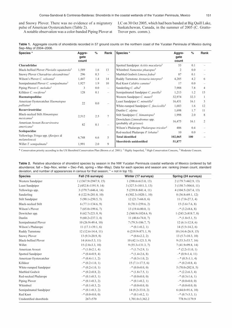
Migratory shorebirds mostly begin to arrive on the Yucatan peninsula in fall at the beginning of September; numbers increase in October, and peak in November. Populations are much lower during winter in December and January, but increase when northward migration starts in February. Peak spring migration occurs in April with a drop in May (Fig. 2).
Abundance
Peak counts of individual species varied both between sea-sons and years (Table 3). There were two major peaks of abundance; the first was in late winter (8 Feb 2004) at PW when we recorded 24,872 shorebirds including 3,600 Ruddy Turnstones, 4,250 dowitchers, and 12,160 that could not be identified. The second occasion was 20 Nov 2005 at LC, when we recorded 20,481 shorebirds including 11,556 Western Sandpipers, 4,750 Least Sandpipers, 950 Dunlin, and 950 Stilt Sandpipers. The latter count added to the previous
Fig. 2. total number of shorebirds recorded in the Yucatan coastal wetlands of mexico during the non-breeding season 2005–2006 at la Carbonera, Progreso Wetlands and las Coloradas (except that the Progreso Wetlands were not included in the count in nov and Feb).
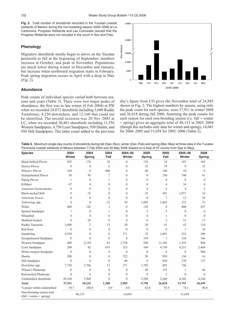
Table 3. maximum single-day counts of shorebirds during fall (Sep–nov), winter (dec–Feb) and spring (mar–may) at three sites in the Yucatan Peninsula coastal wetlands of mexico between 7 Feb 2004 and 20 may 2006 (based on a total of 57 counts from Sep to may).
Species 2004Winter
2004Spring
2004Fall
2004–05Winter
2005Spring
2005Fall
2005–06Winter
2006Spring
Black-bellied Plover 502 176 10 0 176 18 107 105Snowy Plover 0 0 6 0 35 79 9 35Wilson’s Plover 330 0 800 0 40 140 10 0Semipalmated Plover 50 45 7 0 0 150 740 41Piping Plover 1 0 1 0 0 0 0 0Killdeer 67 4 0 0 0 4 34 0American Oystercatcher 0 0 4 0 4 2 4 2Black-necked Stilt 0 25 0 0 25 491 1,071 16American Avocet 0 0 0 0 0 7 12 54Yellowlegs spp. 0 0 22 50 1,005 3,403 152 33Willet 400 142 3 0 138 8 400 457Spotted Sandpiper 1 0 1 0 2 3 8 6Whimbrel 0 0 0 0 0 1 0 0Marbled Godwit 0 26 0 0 0 3 31 17Ruddy Turnstone 3,600 2 13 30 20 41 42 116Red Knot 0 0 0 0 0 0 1 16Sanderling 4,250 0 6 171 32 1,001 223 240Semipalmated Sandpiper 0 0 0 0 310 1 136 166Western Sandpiper 400 2,130 83 1,758 580 11,556 1,355 800Least Sandpiper 200 82 419 323 160 4,750 4,231 2,469White-rumped Sandpiper 0 0 0 0 0 4 0 960Dunlin 200 0 0 222 20 950 136 16Stilt Sandpiper 0 0 0 80 0 950 270 127Dowitcher spp. 7,750 3,706 13 271 1,795 895 726Wilson’s Phalarope 0 0 0 0 20 153 1 66Red-necked Phalarope 0 0 0 0 8 2 0 0Unidentified shorebirds 20,160 3,904 0 0 5,380 2,206 4,102 4,546Total 37,911 10,242 1,388 2,905 9,750 26,818 13,791 10,449% peeps within unidentified 39.7 100.0 0.0 0.0 42.8 95.5 74.1 40.8Non-breeding season total (fall + winter + spring) 48,153 14,043 51,058
day’s figure from CO gives the November total of 24,885 shown in Fig. 2. The highest numbers by season, using only the peak count for each species, were 37,911 in winter 2004 and 26,818 during fall 2006. Summing the peak counts for each season for each non-breeding season (i.e. fall + winter + spring) gives an aggregate total of 48,153 in 2003–2004 (though this includes only data for winter and spring), 14,043 for 2004–2005 and 51,058 for 2005–2006 (Table 3).
153Correa-Sandoval & Contreras-Balderas: Shorebirds in the coastal wetlands of the Yucatan Peninsula, mexico
Critical sites
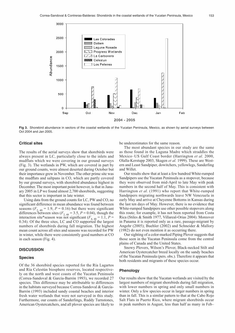
The results of the aerial surveys show that shorebirds were always present in LC, particularly close to the inlets and mudflats which we were covering in our ground surveys (Fig. 3). The wetlands in PW, which are covered in part by our ground counts, were almost deserted during October but their importance grew in November. The other prime site was the mudflats and saltpans in CO, which are partly covered by our ground surveys, with shorebird abundance highest in December. The most important point however, is that in Janu-ary 2005 in LP we found almost 2,700 shorebirds, suggesting that this sector is important in late winter.
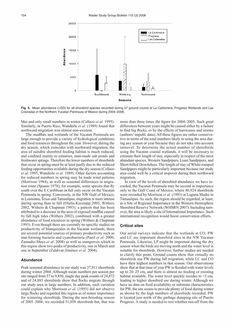
Using data from the ground counts for LC, PW and CO, no significant difference in mean abundance was found between seasons (F2, 48 = 1.9, P = 0.16) but there were significant differences between sites (F2, 48 = 3.5, P = 0.04), though the interaction site*season was not significant (F4, 48 = 1.1, P = 0.34). Of the three sites, LC and CO supported the largest numbers of shorebirds during fall migration. The highest mean count across all sites and seasons was recorded for PW in winter, while there were consistently good numbers at CO in each season (Fig. 4).
DISCUSSION
Species
Of the 36 shorebird species reported for the Ría Lagartos and Ría Celestún biosphere reserves, located respective-ly on the north and west coasts of the Yucatan Peninsula (Correa- Sandoval & García-Barrón 1993), we recorded 27 species. This difference may be attributable to differences in the habitats surveyed because Correa-Sandoval & García-Barrón (1993) included sandy coastal beaches and interior fresh water wetlands that were not surveyed in this study. Furthermore, our counts of Sanderlings, Ruddy Turnstones, American Oystercatchers, and all plover species are likely to
be underestimates for the same reason. The most abundant species in our study are the same
as those found in the Laguna Madre which straddles the Mexico–US Gulf Coast border (Harrington et al. 2000, Olalla-Kerstupp 2003, Skagen et al. 1999). These are West-ern and Least Sandpiper, dowitchers, yellowlegs, Sanderling and Willet.
Our results show that at least a few hundred White-rumped Sandpipers use the Yucatan Peninsula as a stopover, because they were observed from mid-April to late May with peak numbers in the second half of May. This is consistent with Harrington et al. (1991) who report that White-rumped Sandpipers migrating northwards leave NW Venezuela in early May and arrive at Cheyenne Bottoms in Kansas during the last ten days of May. However, there is no evidence that White-rumped Sandpipers use other possible stopovers along this route; for example, it has not been reported from Costa Rica (Stiles & Smith 1977, Villareal-Orias 2004). Moreover in Panama it is reported only as a rare, passage-migrant by Angehr (2005); Buehler (2002) and Schneider & Mallory (1982) do not even mention it as occurring there.
Our sighting of a color-marked Piping Plover suggests that those seen in the Yucatan Peninsula come from the central plains of Canada and the United States.
Snowy Plovers, Wilson’s Plover, Black-necked Stilt and American Oystercatcher breed locally on the sandy beaches of the Yucatan Peninsula (pers. obs.). Therefore it appears that both residents and migrants of these species occur.
Phenology
Our results show that the Yucatan wetlands are visited by the largest numbers of migrant shorebirds during fall migration, with lower numbers in spring and only small numbers in winter. Only a few species occur in larger numbers in spring than in fall. This is a similar pattern to that at the Cabo Rojo Salt Flats in Puerto Rico, where migrant shorebirds occur in peak numbers in August, less than half as many in Feb–
Fig 3. Shorebird abundance in sectors of the coastal wetlands of the Yucatan Peninsula, mexico, as shown by aerial surveys between oct 2004 and Jan 2005.
154 Wader Study Group Bulletin 115 (3) 2008
Mar and only small numbers in winter (Collazo et al. 1995). Similarly, in Puerto Rico, Wunderle et al. (1989) found that northward migration was almost non-existent.
The mudflats and wetlands of the Yucatan Peninsula are large enough to provide a variety of hydrological conditions and food resources throughout the year. However, during the dry season, which coincides with northward migration, the area of suitable shorebird feeding habitat is much reduced, and confined mainly to estuaries, man-made salt ponds and freshwater springs. Therefore the lower numbers of shorebirds that occur in spring must be at least partly due to the reduced feeding opportunities available during the dry season (Collazo et al. 1995, Wunderle et al. 1989). Other factors accounting for reduced numbers in spring may be trade wind patterns (Morrison 1984), as well as seasonal differences in migra-tion route (Spaans 1978); for example, some species that fly south over the E Caribbean in fall only occur on the Yucatan Peninsula in spring. Conversely, in the NW Gulf of Mexico, in Louisiana, Texas and Tamaulipas, migration is more intense during spring than in fall (Olalla-Kerstupp 2003, Withers 2002, Withers & Chapman 1993); a pattern that has been attributed to a decrease in the area of exposed mudflat caused by fall high tides (Withers 2002), combined with a greater abundance of food resources in spring (Withers & Chapman 1993). Even though there are currently no specific studies on productivity of blanquizales in the Yucatan wetlands, there are several potential sources of primary productivity such as mat-forming bacteria and cyanobacteria (Paerl et al. 2000, Zamudio-Maya et al. 2008) as well as mangroves which in this region show two peaks of productivity, one in March and one in September (Zaldivar-Jiménez et al. 2004).
Abundance
Peak seasonal abundance in our study was 37,911 shorebirds during winter 2004. Although mean numbers per season per site ranged from 57 to 9,850, single day peak counts of 24,872 and of 24,885 shorebirds show that flocks migrate through our study area in large numbers. In addition, such variation could explain why Morrison et al. (1993) did not observe large flocks and regarded this region as of minor importance for wintering shorebirds. During the non-breeding season of 2005–2006, we recorded 51,058 shorebirds but, that was
more than three times the figure for 2004–2005. Such great differences between years might be caused either by a failure to find big flocks, or by the effects of hurricanes and storms (authors’ unpubl. data). All these figures are rather conserva-tive in terms of the total numbers likely to using the area dur-ing any season or year because they do not take into account turnover. To determine the actual number of shorebirds using the Yucatan coastal wetlands, it will be necessary to estimate their length of stay, especially in respect of the most abundant species, Western Sandpipers, Least Sandpipers, and Short-billed Dowitchers. The length of stay of White-rumped Sandpipers might be particularly important because our study area could well be a critical stopover during their northward migration.
In view of the levels of shorebird abundance we have re-corded, the Yucatan Peninsula may be second in importance only to the Gulf Coast of Mexico, where 80,924 shorebirds were recorded by Morrison et al. (1993) at Laguna Madre in Tamaulipas. As such, the region should be regarded, at least, as a Site of Regional Importance in the Western Hemisphere Shorebird Reserve Network (WHSRN 2007). Including turn-over, the area is likely a site of International Importance. Such international recognition would boost conservation efforts.
Critical sites
Our aerial surveys indicate that the wetlands at CO, PW and LC are important shorebird sites in the NW Yucatan Peninsula. Likewise, LP might be important during the dry season when the birds are moving north and the water level is suitable for shorebirds. However, further studies are needed to clarify this point. Ground counts show that virtually no shorebirds use PW during fall migration; while LC and CO have their highest numbers in that season. Our observations show that at that time of year PW is flooded with water levels up to 20–25 cm, and there is almost no feeding or roosting habitat available. The water level quickly recedes to <5 cm, leading to higher shorebird use during winter. Although we have no data on food availability or substrate characteristics for PW, the site seems to provide plenty of food during winter as shown by the high numbers of shorebirds recorded. PW is located just north of the garbage dumping site of Puerto Progreso. A study is needed to test whether run-off from the
Fig. 4. mean abundance (+Sd) for all shorebird species recorded during 57 ground counts at la Carbonera, Progreso Wetlands and las Coloradas in the northern Yucatan Peninsula of mexico during 2004–2006.

155Correa-Sandoval & Contreras-Balderas: Shorebirds in the coastal wetlands of the Yucatan Peninsula, mexico
dumping site could bring excess nutrients to PW. Of the sites we studied, only CO and LP are already within
a protected area. In contrast, PW and LC may be under serious threat because they are close to Puerto Progreso which has a major holiday housing development. The entire NW coastal plain of the Yucatan Peninsula has already been recognized in Mexico by the National Commission for the Knowledge and Use of Biodiversity (CONABIO) as a Maritime Priority Region, Terrestrial Priority Region and Hydrological Prior-ity Region (CONABIO 2004). Similarly, the region has been designated as an Important Bird Area by Birdlife International and its Mexican Section (CIPAMEX 2005).
ACkNOWLEDGEMENTS
This study was funded by a grant from the North Ameri-can Wetlands Conservation Act in partnership with Ducks Unlimited de México A. C. and El Colegio de la Frontera Sur. Scopes, tripods and binoculars were partially funded by Optics for the Tropics and Eagle Optics. During this study J. Correa received a Ph. D. scholarship (register No. 178311) from the Mexican Council for Science and Technology (CONACYT). We received permits and logistical support from Comisión Nacional de Áreas Naturales Protegidas and Dirección General de Vida Silvestre. Similarly, the Yucatan State Ecology Secretariat provided facilities to our work. We thank Margarito Tuz, Alejandro De Alba, Jesús García and Brisa Pantaleón for assistance in field work. Holger Weissen-berger helped with map preparation. Eloy Sosa gave us advice on the statistical analysis. Several other individuals offered their time in the field, some of them were: David Alonzo, Waldemar Santamaría, Sandra Flores, Uriel Ortiz, Mario Marín, Carlos Cupul and Gabriel Pacheco. Minerva Arce-Ibarra, Nils Warnock, Guillermo Fernández and Humphrey Sitters gave valuable comments to an earlier version of the manuscript.
REFERENCES
Angehr, G.R. 2005. Final Report Waterbirds in Panama. Waterbird Conser-vation for the Americas. Panama Audubon Society. Panama.
Batllori-Sampedro, E., J.I. González-Piedra, J. Díaz-Sosa & J.L. Febles-Patrón. 2006. Caracterización hidrológica de la región costera noroccidental de el estado de Yucatán, México. Investigaciones Geográ-ficas 59: 74–92.
Brown, S., C. Hickey, B. Harrington & R. Gill. 2001. The US Shorebird Conservation Plan, Second Edition. Manomet Center for Conservation Sciences, Manomet, MA.
Buehler, D.M. 2002. Shorebird counts in Panama during 2002 emphasize the need to monitor and protect the Upper Panama Bay. Wader Study Group Bull. 99: 41–44.
Collazo, J.A., B.A. Harrington , J.S. Grear & J.A. Colón. 1995. Abun-dance and distribution of shorebirds at the Cabo Rojo Salt Flats, Puerto Rico. J. Field Ornith. 66 (3): 424–438.
CIPAMEX. [online]. 2005. Sección Mexicana del Consejo Internacional para la Preservación de las Aves, A.C. [online] http://www.cipamex.org.mx/AICAS.htm (accessed 5 August 2008)
Comisión Nacional para el Conocimiento y Uso de la Biodiversidad. [on-line]. 2004. Regionalización. http://www.conabio.gob.mx/conocimiento/regionalizacion/doctos/regionalizacion.html (accessed 3 December 2007).
Contreras-Balderas, A.J. 1993. Avifauna de Laguna Madre, Tamaulipas. In: pp. 553–558. Biodiversidad marina y costera de México. S.I. Salazar Vallejo & N.E. González (eds)., Comisión Nacional para Conocimiento y Uso de la Biodiversidad y Centro de Investigaciones de Quintana Roo, Chetumal, Mexico.
Correa-Sandoval, J. & J. García-Barrón. 1993. Avifauna de Ría Celestún y Ría Lagartos. In: pp. 641–649. Biodiversidad marina y costera de México. S.I. Salazar Vallejo & N.E. González. (eds). Comisión Nacional para
Conocimiento y Uso de la Biodiversidad y Centro de Investigaciones de Quintana Roo, Chetumal, Mexico.
Harrington, B.A., F.J. Leeuwerberg, S. Lara Resende, R. McNeil, B.T. Thomas, J.S. Grear & E.F. Martínez. 1991. Migration and mass change of White-rumped Sandpipers in North and South America. Wilson Bull. 103: 621–636.
Harrington, B.A., Cruz-Nieto M.A. & A. Álvarez. 2000. Shorebirds during a brief survey in Tamaulipas, Mexico, January 2000. Wader Study Group Bull. 93: 51–54.
Howe, M.A., P.H. Geissler & B.A. Harrington. 1989. Population trends of North American shorebirds based on the International Shorebird Survey. Biol. Conserv. 49 (39): 185–199.
Ihaka, R. & R. Gentleman. 1996. R: A language for data analysis and graphics. J. Computational & Graphics Statistics. 5: 299–314. http://www.r-project.org
Morrison, R.I.G. 1984. Migration systems of some New World shorebirds. pp. 125–202 In: Shorebirds Migration and Foraging Behavior. J. Burger & B.L. Olla (eds). Plenum Press, New York, NY.
Morrison, R.I.G & R.K. Ross. 1989. Atlas of Neartic shorebirds on the coast of South America. Volume 1. Canadian Wildlife Service. Ottawa, Canada.
Morrison, R.I.G., R.K. Ross, J. Guzmán P. & A. Estrada. 1993. Aerial surveys of Neartic shorebirds wintering in México: Preliminary results of surveys on the Gulf of México and Caribbean coasts. Canadian Wildlife Service Progress Notes 206: 1–14.
Morrison, R.I.G., C. Downes & B. Collins. 1994. Population trends of shorebirds on fall migration in Eastern Canada 1974–1991. Wilson Bull. 106 (3): 431–447.
Morrison, R.I.G., R.E. Gill, B.A. Harrington, S. Skagen, G.W. Page, C.L. Gratto-Trevor & S.M. Haig. 2000. Population estimates of neartic shorebirds. Waterbirds 23(3): 337–552.
Myers, J.P., R.G. Morrison, P.Z. Antas, B.A. Harrington, T.E. Lovejoy, M. Sallaberry, S.E. Senner & A. Tarak. 1987. Conservation strategy for migratory species. Am. Scientist 75: 19–26.
Olalla-Kerstupp, A. 2003. Aves playeras de la Laguna Madre, Tamaulipas. B.Sc. dissertation, Universidad Autónoma de Nuevo León, Mexico.
Paerl, H.W., J.L. Pinckney & T.F. Steppe. 2000. Cyanobacterial-bacterial mat consortia: examining the functional unit of microbial survival and growth in extreme environments. Environmental Microbiol. 2(1): 11–26.
Schneider, D. & E.P. Mallory. 1982. Spring migration of shorebirds in Panama. Condor 84: 344–345.
Scott, D.A. & M. Carbonell. 1986. A directory of Neotropical wetlands. IUCN, Cambridge & IWRB, Slimbridge, UK.
Skagen, S., P.B. Sharpe, R.G. Waltermire & M.B. Dillon. 1999. Bio-geographical profiles of shorebird migration in Midcontinental North America. Biological Science Report USGS/BRD/BSR-2000-0003. U.S. Government Printing Office, Denver, Colorado.
Spaans, A. 1978. Status and numerical fluctuations of some North American waders along the Surinam coast. Wilson Bull. 90 (1): 60–83.
Stiles, F.G. & S.M. Smith. 1977. New information on Costa Rican water-birds. Condor 79(1): 91–97.
Villareal-Orias, J. 2004. Diversidad de aves playeras migratorias (Char-adriiformes) en la Península de Nicoya, Costa Rica. Programa Conjunto INBio-SINAC con financiamiento del proyecto Desarrollo de Recursos de Biodiversidad del Banco Mundial. Nicoya, Costa Rica.
Western Hemisphere Shorebird Reserve Network [online]. 2007. http://www.whsrn.org (accessed 2 May 2008).
Withers, K. 2002. Shorebird use of coastal wetland and barrier island habitat in the Gulf of Mexico. Scientific World Journal 2: 514–536.
Withers, K. & B. Chapman. 1993. Seasonal abundance and habitat use of shorebirds on an Oso Bay mudflat, Corpus Christi, Texas. J. Field Ornith. 64(3): 382–392.
Wunderle, J.M., R.W. Waide & J. Fernández. 1989. Seasonal abundance of shorebirds in the Jobos Bay estuary in southern Puerto Rico. J. Field Ornith. 60(3): 329–339.
Zaldivar-Jiménez, A., J. Herrera-Silveira, C. Coronado-Molina & D. Alonzo-Parra. 2004. Estructura y productividad de los manglares en la Reserva de la biósfera Ría Celestún, Yucatán, México. Madera y Bosques Número Especial 2: 25–35.
Zamudio-Maya, M., J. Narváez-Zapata & R. Rojas-Herrera. 2008. Isola-tion and identification of acid lactic bacteria from sediments of a coastal marsh using a differential selective medium. Letters Appl. Microbiology 46: 402–407.

156 Wader Study Group Bulletin 115 (3) 2008
APPENDIxCounting effort in terms of number of counts, area surveyed, habitat, and dates for 57 ground and four aerial counts
in the Yucatan Peninsula, mexico, from September 2004 to may 2006.Area Area
coveredHabitat Dates
Ground countsLas Coloradas (28 counts)
2,487 ha Blanquizal, artificial hypersaline ponds, estuarine beach.
29 Sep 2004, 16 Dec 2004, 19 Jan 2005, 22 Feb 2005, 21 Apr 2005, 22 Apr 2005, 7 May 2005, 8 May 2005, 18 Sep 2005, 20 Sep 2005, 23 Sep 2005, 11 Oct 2005, 12 Oct 2005, 18 Oct 2005, 29 Oct 2005, 19 Nov 2005, 12 Dec 2005, 13 Dec 2005, 14 Dec 2005, 27 Jan 2006, 6 Feb 2006, 16 Feb 2006, 16 Mar 2006, 4 Apr 2006, 6 Apr 2006, 7 Apr 2006, 27 Apr 2006, 20 May 2006.
Progreso Wetlands (15 counts)
230 ha Soft mudflat, blanquizal. 8 Feb 2004, 17 Mar 2004, 16 Oct 2004, 17 Mar 2005, 23 Apr 2005, 16 Sep 2005, 30 Oct 2005, 10 Dec 2005, 26 Jan 2006, 14 Feb 2006, 15 Mar 2006, 8 Apr 2006, 13 Apr 2006, 26 Apr 2006,18 May 2006.
La Carbonera (14 counts)
229 ha Blanquizal, estuarine mudflat, sand barrier.
7 Feb 2004, 16 Oct 2004, 14 Dec 2004, 18 Mar 2005, 23 Apr 2005, 17 Sep 2005, 30 Oct 2005, 20 Nov 2005, 10 Dec 2005, 26 Jan 2006, 15 Mar 2006, 7 Apr 2006, 25 Apr 2006, 18 May 2006.
Aerial surveys (4 counts)
13,500 ha Blanquizal, artificial hypersaline ponds, estuarine mudflat, sand barrier.
15 Oct 2004, 13 Nov 2004, 15 Dec 2004, 22 Jan 2005.
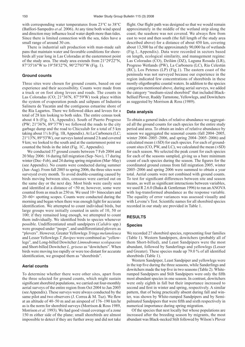
Western Sandpipers and some Semipalmated Sandpipers and Sanderlings at las Coloradas, Yucatan. the pink spots in the background are Greater Flamingoes. the water has a reddish hue due to microscopic algae and bacteria living in
hypersaline conditions. Photo by Jorge Correa-Sandoval.