Riparian vegetation: degradation, alien plant invasions, and restoration prospects
Upload
khangminh22Category
view
4download
0
1
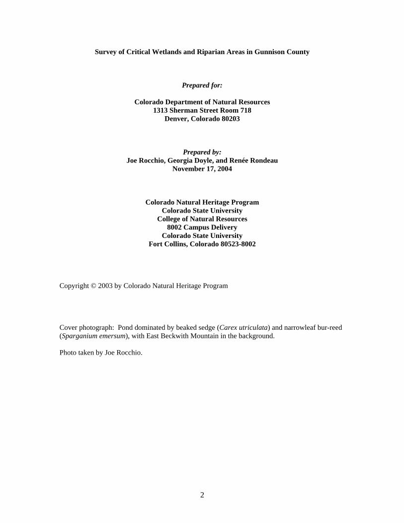
Survey of Critical Wetlands and Riparian Areas in Gunnison County
Colorado Natural Heritage Program Colorado State University
8002 Campus Delivery Fort Collins, Colorado 80523-8002
2
Survey of Critical Wetlands and Riparian Areas in Gunnison County
Prepared for:
Colorado Department of Natural Resources 1313 Sherman Street Room 718
Denver, Colorado 80203
Prepared by: Joe Rocchio, Georgia Doyle, and Renée Rondeau
November 17, 2004
Colorado Natural Heritage Program Colorado State University
College of Natural Resources 8002 Campus Delivery
Colorado State University Fort Collins, Colorado 80523-8002
Copyright © 2003 by Colorado Natural Heritage Program Cover photograph: Pond dominated by beaked sedge (Carex utriculata) and narrowleaf bur-reed (Sparganium emersum), with East Beckwith Mountain in the background. Photo taken by Joe Rocchio.

i
ACKNOWLEDGEMENTS
Financial support for this study was provided by the Colorado Department of Natural Resources (CDNR) through a grant from the Environmental Protection Agency (EPA), Region 8. We greatly appreciate the support and assistance of Alex Chappell of the Colorado Division of Wildlife, Kimberly Seymour of the Colorado Department of Natural Resources, and Sarah Fowler and Ed Sterns of the EPA, Region 8. This project would not have been possible without the help of many dedicated individuals. We appreciate the support of the members of the Gunnison Wetland Focus Area Committee for providing their local knowledge of important wetlands in Gunnison County. Art and Sandy Hayes, both with the Bureau of Land Management, provided moral support, lots of input on sites, and plenty of research materials, especially GIS data. Thanks so much, and we’ll never lose site of what could be “If sage grouse had antlers.” Barry Johnston, of the U.S. Forest Service in Gunnison, provided invaluable incite, recommendations, and data (via the “Barry Bible,” as we like to call his incredible publication: “Ecological types of the Upper Gunnison Basin: Vegetation-soil-landform-geology-climate-water land classes for natural resource management”.) Gay Austin, also with the U.S. Forest Service in Gunnison, assisted us with valuable suggestions of interesting wetland sites and attended any questions we had throughout the summer. Ian Billick, Director of the Rocky Mountain Biological Laboratory (RMBL), kindly answered questions, provided suggestions, and provided access to the resources RMBL had to offer. Butch Clark provided many helpful suggestions and contacts and a tour of his property along Tomichi Creek, a wonderful oasis of willows in an otherwise ‘sea of pastures’. We are also very thankful to Lynn Cudlip, whose input and enthusiasm for this project was invaluable. Kathy Darrow also provided much support via site suggestions and a wonderfully written article, which appeared in the Gunnison Times and Crested Butte Weekly, touting this project and its benefit to Gunnison County. Thanks so much, Kathy, for educating the citizens of Gunnison County about the Colorado Division of Wildlife’s Wetland Program’s effort to work toward voluntary wetland protection and restoration and the role the Colorado Natural Heritage has in that process. Paula Lehr kindly shared her home and knowledge of the locations of rare high elevation wetland species. Paula’s input and hospitality was much appreciated! And speaking of hospitality, we’d like to especially acknowledge and thank Matt Malick of the National Park Service and the Curecanti National Recreation Area for providing us with a place to rest, work, and sleep for the latter half of the summer. Your hospitality made our time in Gunnison County very enjoyable. John Hess, Planner with the City of Crested Butte, provided us with a tour of the Crested Butte Land Trust wetland properties and much input and data on the wetland resources found there. Special thanks to Jessica Young (Western State College) and Paul Jones (Colorado Division of Wildlife) who provided invaluable input on the Gunnison Sage Grouse, David Gann (The Nature Conservancy) provided suggestion on sites, and Dan Bauch (Colorado Division of Wildlife) provided us with information on fish in Gunnison County. We are also grateful to the landowners who gave us permission to survey their property. We enjoyed meeting them, and in some cases hiking with them on their property. Our staff in Fort Collins, including Kathy Carsey, Jodie Bell, Jill Handwerk, Jeremy Siemers, Amy Lavender, Alison Loar, Barbara Brayfield, and Katie Newhaus all worked with us patiently. Brad Lambert provided much assistance with boreal toad data.

ii
TABLE OF CONTENTS ACKNOWLEDGEMENTS .......................................................................................................... i
LIST OF TABLES ........................................................................................................................ v
LIST OF FIGURES .................................................................................................................... vii
EXECUTIVE SUMMARY .......................................................................................................... 1
CONSERVATION STRATEGIES ............................................................................................. 4
INTRODUCTION......................................................................................................................... 8
WETLAND DEFINITIONS, REGULATIONS, AND FUNCTIONAL ASSESSMENTS.......................................................................................................................... 11
WETLAND DEFINITIONS...........................................................................................................................11 WETLAND REGULATION IN COLORADO ..................................................................................................11 WETLAND FUNCTIONS AND VALUES.......................................................................................................12 WETLAND FUNCTIONAL ASSESSMENT ....................................................................................................13
Overall Functional Integrity............................................................................................................................13 Flood Attenuation and Storage .......................................................................................................................14 Sediment/Shoreline Stabilization ...................................................................................................................14 Groundwater Discharge/Recharge .................................................................................................................14 Dynamic Surface Water Storage ....................................................................................................................14 Elemental Cycling ............................................................................................................................................15 Removal of Imported Nutrients, Toxicants, and Sediments.......................................................................15 Habitat Diversity...............................................................................................................................................15 General Wildlife and Fish Habitat .................................................................................................................15 Production Export/Food Chain Support ........................................................................................................15 Uniqueness.........................................................................................................................................................16
HYDROGEOMORPHIC (HGM) APPROACH TO WETLAND FUNCTIONAL ASSESSMENT .............................16 PROJECT BACKGROUND...................................................................................................... 19
LOCATION AND PHYSICAL CHARACTERISTICS OF STUDY AREA.............................................................19 HYDROLOGY ............................................................................................................................................22 VEGETATION............................................................................................................................................24 OBSERVATIONS ON MAJOR THREATS TO WETLAND BIODIVERSITY .......................................................25
Hydrological Modifications ............................................................................................................................27 Development .....................................................................................................................................................28 Mining ................................................................................................................................................................28 Livestock Grazing.............................................................................................................................................28 Logging ..............................................................................................................................................................28 Recreation ..........................................................................................................................................................29 Roads ..................................................................................................................................................................29 Non-native Species...........................................................................................................................................29 Fragmentation and Edge Effects ....................................................................................................................30
THE NATURAL HERITAGE NETWORK AND BIOLOGICAL DIVERSITY ................ 31 COLORADO NATURAL HERITAGE PROGRAM...........................................................................................33

iii
THE NATURAL HERITAGE RANKING SYSTEM..........................................................................................34 METHODS .................................................................................................................................. 44
COLLECT AVAILABLE INFORMATION ......................................................................................................44 IDENTIFY RARE OR IMPERILED SPECIES AND SIGNIFICANT PLANT ASSOCIATIONS WITH POTENTIAL TO OCCUR IN GUNNISON COUNTY.........................................................................................44 IDENTIFY TARGETED INVENTORY AREAS ...............................................................................................45 LANDOWNER CONTACTS .........................................................................................................................45 CONDUCT FIELD SURVEYS ......................................................................................................................45
General Field Information ...................................................................................................................................46 Natural Heritage Information ..............................................................................................................................47 General Wetland Information..............................................................................................................................47 Qualitative Functional Assessment......................................................................................................................47 Restoration Potential ...........................................................................................................................................47
DELINEATE POTENTIAL CONSERVATION AREA BOUNDARIES ................................................................47 RESULTS .................................................................................................................................... 49
SIGNIFICANT ELEMENTS ASSOCIATED WITH WETLANDS AND RIPARIAN AREAS ...................................51 SITES OF BIODIVERSITY SIGNIFICANCE ...................................................................................................54
Gunnison Basin Potential Conservation Area .....................................................................................................61
POTENTIAL CONSERVATION AREAS WITHIN THE GUNNISON BASIN POTENTIAL CONSERVATION AREA........................................................................................................................................................66 B3 Potential Conservation Areas
Beaver Creek at Gunnison SWA Potential Conservation Area ...........................................................................66 East Elk Creek at Blue Mesa Reservoir Potential Conservation Area.................................................................71 East River at Roaring Judy Potential Conservation Area ....................................................................................75 Gunnison River at Neversink Potential Conservation Area ................................................................................81 Stevens Creek Potential Conservation Area ........................................................................................................87 West Antelope Creek Potential Conservation Area.............................................................................................92
B4 Potential Conservation Area Alder Creek Potential Conservation Area ...........................................................................................................97
POTENTIAL CONSERVATION AREAS OUTSIDE THE GUNNISON BASIN POTENTIAL CONSERVATION AREA ...........................................................................................................................102 B2 Potential Conservation Areas
Cement Creek Potential Conservation Area ......................................................................................................102 Mount Emmons Iron Fen Potential Conservation Area.....................................................................................110 Redwell Basin Iron Fen Potential Conservation Area .......................................................................................115 Triangle Pass Potential Conservation Area .......................................................................................................119 Whitepine Iron Fen Potential Conservation Area..............................................................................................122
B3 Potential Conservation Areas Blue Creek at Curecanti Needle Potential Conservation Area ..........................................................................128 Canyon Creek Potential Conservation Area ......................................................................................................132 Coal Creek Potential Conservation Area ...........................................................................................................135 Coal Creek at Keystone Mine Potential Conservation Area..............................................................................141 Cow Creek at Soap Creek Potential Conservation Area....................................................................................145 Crystal River Potential Conservation Area........................................................................................................148 Dark Canyon Potential Conservation Area........................................................................................................152 East Fork Cimarron River Potential Conservation Area....................................................................................156 East Fork Powderhorn Creek Potential Conservation Area...............................................................................160 East River at Rustler Gulch Potential Conservation Area .................................................................................164 Fivemile Creek Potential Conservation Area ....................................................................................................168 Horse Ranch Park Potential Conservation Area ................................................................................................171

iv
Lake Fork Gunnison River at Blue Mesa Reservoir Potential Conservation Area............................................175 Little Cimarron River Potential Conservation Area ..........................................................................................179 Lost Lake Potential Conservation Area.............................................................................................................182 North Castle Creek Potential Conservation Area ..............................................................................................188 North Fork Gunnison River Potential Conservation Area.................................................................................192 Pass Creek at Cottonwood Pass Potential Conservation Area...........................................................................196 Porphyry Creek Potential Conservation Area....................................................................................................199 Quartz Creek Potential Conservation Area........................................................................................................203 Slate River Potential Conservation Area ...........................................................................................................208 Snowshoe Canyon Potential Conservation Area ...............................................................................................214 Soap Creek Potential Conservation Area ..........................................................................................................218 South Fork at Beaver Reservoir Potential Conservation Area...........................................................................222 Spring Creek at Manganese Peak Potential Conservation Area ........................................................................225 West Brush Creek Potential Conservation Area................................................................................................229
B4 Potential Conservation Areas Splains Gulch Potential Conservation Area.......................................................................................................233 Union Park Potential Conservation Area...........................................................................................................237
NATURAL HISTORY INFORMATION........................................................................................................242 Rare and Imperiled Plants Dependent on Wetlands of Gunnison County .........................................................242 Rare and Imperiled Animals Dependent of Wetlands of Gunnison County ......................................................244 Rare and Imperiled Wetland Plant Communities of Gunnison County.............................................................248
REFERENCES CITED............................................................................................................ 286
v
LIST OF TABLES
Table 1. Hydrogeomorphic wetland classes in Colorado ...................................................................................17 Table 2. Threats observed at the potential conservation areas..........................................................................26 Table 3. Definition of natural heritage imperilment ranks. ................................................................................36 Table 4. Federal and State Agency special designations for rare species. .......................................................38 Table 5. Element occurrence ranks and their definitions....................................................................................39 Table 6. Natural Heritage Program biological diversity ranks and their definitions. .....................................41 Table 7. Natural Heritage Program protection urgency ranks and their definitions. ......................................42 Table 8. Natural Heritage Program management urgency ranks and their definitions...................................43 Table 9. Known elements of concern found within PCAs, by taxonomic group. ..........................................51 Table 10. Known elements documented in CNHP’s Biological Conservation Data system but not
included within PCAs presented in this report. ..........................................................................................53 Table 11. Potential Conservation Areas contained within the Gunnison Basin PCA. ..................................59 Table 12. Potential Conservation Areas outside of the Gunnison Basin PCA. ..............................................59 Table 13. Natural Heritage element occurrences at Gunnison Basin PCA. ....................................................62 Table 14. Natural Heritage element occurrences at Beaver Creek at Gunnison SWA PCA. .......................67 Table 15. Wetland functional assessment for the riverine wetland at the Beaver Creek PCA.....................69 Table 16. Natural Heritage element occurrences at East Elk Creek at Blue Mesa Reservoir PCA..............72 Table 17. Wetland functional assessment for the riverine wetland at the East Elk Creek PCA. .................73 Table 18. Natural Heritage element occurrences at East River at Roaring Judy PCA. .................................76 Table 19. Wetland functional assessment for the riverine wetland at the East River at Roaring
Judy PCA...........................................................................................................................................................78 Table 20. Natural Heritage element occurrences at Gunnison River at Neversink PCA. .............................82 Table 21. Wetland functional assessment for the riverine wetland at the Gunnison River at
Neversink PCA. ................................................................................................................................................84 Table 22. Natural Heritage element occurrences at Stevens Creek PCA. .......................................................88 Table 23. Wetland functional assessment for the riverine wetland at the Stevens Creek PCA. ..................90 Table 24. Natural Heritage element occurrences at West Antelope Creek PCA............................................93 Table 25. Wetland functional assessment for the riverine wetland at the West Antelope Creek
PCA. ...................................................................................................................................................................95 Table 26. Natural Heritage element occurrences at Alder Creek PCA............................................................98 Table 27. Wetland functional assessment for the riverine wetland at the Alder Creek PCA. ....................100 Table 28. Water chemistry for the Cement Creek extreme rich fen as compared to extreme rich
and rich fens in South Park, Colorado.........................................................................................................104 Table 29. Natural Heritage element occurrences at the Cement Creek PCA................................................105 Table 30. Wetland functional assessment for the slope wetland at the Cement Creek PCA......................107 Table 31. Wetland functional assessment for the riverine wetland at the Cement Creek PCA. ................108 Table 32. Natural Heritage element occurrences at the Mount Emmons Iron Fen PCA. ...........................111 Table 33. Wetland functional assessment for the slope wetland at the Mount Emmons PCA...................113 Table 34. Natural Heritage element occurrences at the Redwell Basin Iron Fen PCA. ..............................116 Table 35. Wetland functional assessment for the slope wetland at the Redwell Basin Iron Fen
PCA. .................................................................................................................................................................117 Table 36. Natural Heritage element occurrences at Triangle Pass PCA.........................................................120 Table 37. Natural Heritage element occurrences at the Whitepine Iron Fen PCA. .....................................123 Table 38. Wetland functional assessment for the slope wetland at the Whitepine Iron Fen PCA.............125 Table 39. Wetland functional assessment for the riverine wetland at the Whitepine Iron Fen
PCA. .................................................................................................................................................................126 Table 40. Natural Heritage element occurrences at Blue Creek at Curecanti Needle PCA........................129

vi
Table 41. Wetland functional assessment for the riverine wetland at the Blue Creek at Curecanti Needle PCA.....................................................................................................................................................130
Table 42. Natural Heritage element occurrences at Canyon Creek PCA. .....................................................133 Table 43. Natural Heritage element occurrences at Coal Creek PCA. ..........................................................136 Table 44. Wetland functional assessment for the riverine wetland at the Coal Creek PCA.......................139 Table 45. Natural Heritage element occurrences at Coal Creek at Keystone Mine PCA. ..........................142 Table 46. Wetland functional assessment for the riverine wetland at the Coal Creek at Keystone
Mine PCA. .......................................................................................................................................................143 Table 47. Natural Heritage element occurrences at Cow Creek at Soap Creek PCA..................................146 Table 48. Natural Heritage element occurrences at Crystal River PCA........................................................149 Table 49. Natural Heritage element occurrences at Dark Canyon PCA........................................................153 Table 50. Natural Heritage element occurrences at East Fork Cimarron River PCA..................................157 Table 51. Wetland functional assessment for the riverine wetland at the East Fork Cimarron
River PCA. ......................................................................................................................................................158 Table 52. Natural Heritage element occurrences at East Fork Powderhorn Creek PCA. ...........................161 Table 53. Natural Heritage element occurrences at East River at Rustler Gulch PCA. ..............................165 Table 54. Wetland functional assessment for the riverine wetland at the East River at Rustler
Gulch PCA.......................................................................................................................................................166 Table 55. Natural Heritage element occurrences at Fivemile Creek PCA. ...................................................169 Table 56. Natural Heritage element occurrences at Horse Ranch Park PCA. ..............................................172 Table 57. Wetland functional assessment for the riverine wetland at the Horse Ranch Park PCA...........173 Table 58. Natural Heritage element occurrences at Lake Fork Gunnison River at Blue Mesa
Reservoir PCA. ...............................................................................................................................................176 Table 59. Wetland functional assessment for the riverine wetland at the Lake Fork Gunnison
River at Blue Mesa Reservoir PCA. ............................................................................................................177 Table 60. Natural Heritage element occurrences at Little Cimarron River PCA. ........................................180 Table 61. Natural Heritage element occurrences at Lost Lake PCA. ............................................................184 Table 62. Wetland functional assessment for the riverine wetland at the Lost Lake PCA.........................185 Table 63. Wetland functional assessment for the slope wetland at the Lost Lake PCA. ............................186 Table 64. Natural Heritage element occurrences at North Castle Creek PCA..............................................189 Table 65. Natural Heritage element occurrences at North Fork Gunnison River PCA...............................193 Table 66. Wetland functional assessment for the riverine wetland at the North Fork Gunnison
River PCA. ......................................................................................................................................................194 Table 67. Natural Heritage element occurrences at Pass Creek at Cottonwood Pass PCA. .......................197 Table 68. Natural Heritage element occurrences at Porphyry Creek PCA. ..................................................200 Table 69. Wetland functional assessment for the riverine wetland at the Porphyry Creek PCA...............201 Table 70. Natural Heritage element occurrences at Quartz Creek PCA........................................................204 Table 71. Wetland functional assessment for the riverine wetland at the Quartz Creek PCA. ..................206 Table 72. Natural Heritage element occurrences at Slate River PCA............................................................210 Table 73. Wetland functional assessment for the riverine wetland at the Slate River PCA.......................212 Table 74. Natural Heritage element occurrences at Snowshoe Canyon PCA. .............................................215 Table 75. Natural Heritage element occurrences at Soap Creek PCA...........................................................219 Table 76. Natural Heritage element occurrences at South Fork at Beaver Reservoir PCA. .......................222 Table 77. Natural Heritage element occurrences at Spring Creek at Manganese Peak PCA. ....................226 Table 78. Wetland functional assessment for the riverine wetland at the Spring Creek at
Manganese Peak PCA....................................................................................................................................227 Table 79. Natural Heritage element occurrences at West Brush Creek PCA. ..............................................230 Table 80. Natural Heritage element occurrences at Splains Gulch PCA. .....................................................234 Table 81. Wetland functional assessment for the riverine wetland at the Splains Gulch PCA..................235 Table 82. Natural Heritage element occurrences at Union Park PCA. ..........................................................238 Table 83. Wetland functional assessment for the riverine wetland at the Union Park PCA. .....................240
vii
LIST OF FIGURES Figure 1. Location of Gunnison County in Colorado.........................................................................................20 Figure 2. Precipitation in Gunnison County. .......................................................................................................20 Figure 3. Geological Summary of Gunnison County.........................................................................................22 Figure 4. Summary of Targeted Inventory Areas. ...............................................................................................49 Figure 5. CNHP Wetland and Riparian Targeted Inventory Areas.................. Error! Bookmark not defined. Figure 6. CNHP Wetland and Riparian Potential Conservation Areas and Gunnison Basin
Potential Conservation Area. ..........................................................................................................................56 Figure 7. TNC Priority Sites with CNHP Wetland and Riparian Potential Conservation Areas.Error! Bookmark not defFigure 8. Gunnison Basin Potential Conservation Area.............................Error! Bookmark not defined. Figure 9. Beaver Creek at Gunnison SWA Potential Conservation Area. ....... Error! Bookmark not defined. Figure 10. East Elk Creek Potential Conservation Area. .................................... Error! Bookmark not defined. Figure 11. East River at Roaring Judy Potential Conservation Area. ............... Error! Bookmark not defined. Figure 12. Gunnison River at Neversink Potential Conservation Area. ........... Error! Bookmark not defined. Figure 13. Stevens Creek Potential Conservation Area. ..................................... Error! Bookmark not defined. Figure 14. West Antelope Creek Potential Conservation Area. ....................... Error! Bookmark not defined. Figure 15. Alder Creek Potential Conservation Area......................................... Error! Bookmark not defined. Figure 16. Cement Creek Potential Conservation Area. ..................................... Error! Bookmark not defined. Figure 17. Mount Emmons Iron Fen Potential Conservation Area.................................................................114 Figure 18. Redwell Basin Iron Fen Potential Conservation Area...................... Error! Bookmark not defined. Figure 19. Triangle Pass Potential Conservation Area........................................ Error! Bookmark not defined. Figure 20. Whitepine Iron Fen Potential Conservation Area. ............................ Error! Bookmark not defined. Figure 21. Blue Creek at Curecanti Needle Potential Conservation Area........ Error! Bookmark not defined. Figure 22. Canyon Creek Potential Conservation Area. ..................................... Error! Bookmark not defined. Figure 23. Coal Creek Potential Conservation Area. .......................................... Error! Bookmark not defined. Figure 24. Coal Creek at Keystone Mine Potential Conservation Area. .......... Error! Bookmark not defined. Figure 25. Cow Creek at Soap Creek Potential Conservation Area.................. Error! Bookmark not defined. Figure 26. Crystal River Potential Conservation Area........................................ Error! Bookmark not defined. Figure 27. Dark Canyon Potential Conservation Area........................................ Error! Bookmark not defined. Figure 28. East Fork Cimarron River Potential Conservation Area.................. Error! Bookmark not defined. Figure 29. East Fork Powderhorn Creek Potential Conservation Area. ........... Error! Bookmark not defined. Figure 30. East River at Rustler Gulch Potential Conservation Area. .............. Error! Bookmark not defined. Figure 31. Fivemile Creek Potential Conservation Area. ................................... Error! Bookmark not defined. Figure 32. Horse Ranch Park Potential Conservation Area. .............................. Error! Bookmark not defined. Figure 33. Lake Fork Gunnison River at Blue Mesa Reservoir Potential Conservation Area.Error! Bookmark not defineFigure 34. Little Cimarron River Potential Conservation Area. ........................ Error! Bookmark not defined. Figure 35. Lost Lake Potential Conservation Area.............................................. Error! Bookmark not defined. Figure 36. North Castle Creek Potential Conservation Area. ............................ Error! Bookmark not defined. Figure 37. North Fork Gunnison River Potential Conservation Area............... Error! Bookmark not defined. Figure 38. Pass Creek Potential Conservation Area............................................ Error! Bookmark not defined. Figure 39. Porphyry Creek Potential Conservation Area. .................................. Error! Bookmark not defined. Figure 40. Quartz Creek Potential Conservation Area......................................................................................207 Figure 41. Slate River Potential Conservation Area............................................ Error! Bookmark not defined. Figure 42. Snowshoe Canyon Potential Conservation Area............................... Error! Bookmark not defined.

viii
Figure 43. Soap Creek Potential Conservation Area........................................... Error! Bookmark not defined. Figure 44. South Fork at Beaver Reservoir Potential Conservation Area........ Error! Bookmark not defined. Figure 45. Spring Creek at Manganese Peak Potential Conservation Area. .... Error! Bookmark not defined. Figure 46. West Brush Creek Potential Conservation Area. .............................. Error! Bookmark not defined. Figure 47. Splains Gulch Potential Conservation Area. ...................................................................................236 Figure 48. Union Park Potential Conservation Area. .......................................... Error! Bookmark not defined.

1
EXECUTIVE SUMMARY Although the rate of wetland loss in Gunnison County is difficult to quantify, it is clear that many wetlands have been lost or profoundly altered from their pre-settlement state. Agriculture, grazing, development, construction of reservoirs, water diversions, and mining have had many impacts on wetlands throughout the study area. Fertile soils and available water for irrigation make floodplains productive areas for agriculture. Since the nineteenth century, hydrological diversions have been developed for irrigation and drinking water supplies. Such activities have eliminated or altered some wetlands, and created other wetlands very different from those in existence prior to European settlement. It is clear that with the current rate of land use conversion and the lack of comprehensive wetland protection programs, wetlands will continue to be lost or dramatically altered. However, the likelihood for human conflicts with biologically important wetlands is minimized if there is the opportunity to proactively plan for managing human activity or managing the species or habitat of interest. The purpose of this project is to provide a data resource for the Colorado Division of Wildlife and the Gunnison Wetland Focus Area Committee in conducting proactive planning. This document should be considered a tool for managing lands that support rare wetland species and plant associations within Gunnison County. In 2002, the Colorado Natural Heritage Program (CNHP) received funding from the Colorado Department of Natural Resources (CDNR) through a grant from the U.S. Environmental Protection Agency (EPA), Region 8 to survey for critical wetlands within Gunnison County. The goal of the project was to systematically identify the localities of rare, threatened, or endangered species dependent on wetland and riparian areas and the locations of significant natural wetland and riparian plant communities. This project supports the CDNR’s effort to strategically protect Colorado’s wetland resources. The results of this survey support six statewide wetland efforts: (1) The Colorado Wetlands Initiative Legacy Project, a wetlands protection partnership that
includes the Colorado Division of Wildlife, the Colorado Office of The Nature Conservancy, Colorado State Parks, Partners for Wildlife, Ducks Unlimited, and GOCO;
(2) The Gunnison Wetland Focus Area Committee’s effort to identify protection and restoration priorities;
(3) The Colorado Division of Wildlife’s Riparian Mapping Project; (4) CNHP’s Comprehensive Statewide Wetland Classification and Characterization Project; (5) The Nature Conservancy’s Priority Conservation sites in the Gunnison Basin; and (6) The hydrogeomorphic (HGM) wetland functional assessment program. This project supports the IBI and HGM development process by identifying potential reference wetlands and the range of variation and potential subclasses within Gunnison County, and by performing a qualitative wetland functional assessment to guide future quantitative efforts in assessing the range of variation within a subclass. CNHP’s wetland work provides input to the Wetlands Initiative Partners (e.g., The Nature Conservancy) and the Colorado Wetlands Partnership by identifying potential sites for protection and restoration. Finally, the results of this survey will be incorporated into CNHP’s Comprehensive Statewide Wetlands Classification. Field surveys began in June 2002 and continued through September 2002. High quality examples of wetlands and riparian areas and those supporting populations of rare wetland-dependent

2
species were given highest priority. Such locations were identified by: (1) examining existing biological data for rare or imperiled plant and animal species and significant plant communities (collectively called elements) from the Colorado Natural Heritage Program’s database, (2) accumulating additional existing information on these elements, (3) input from local citizens of Gunnison County and more specifically, the Gunnison Wetland Focus Area Committee, and, (4) conducting extensive field surveys. Areas that were found to contain significant elements were delineated as “Potential Conservation Areas (PCA).” These areas were prioritized by their biological urgency (the most rare or imperiled) and their ability to maintain viable populations of the elements (degree of threat). A qualitative functional assessment was conducted at most of the wetland and riparian areas visited. The restoration potential of each PCA was also noted. Results of the wetland and riparian survey confirm that Gunnison County contains areas with high biological significance and a diverse array of wetlands that support a wide variety of plants, animals, and plant associations. At least 49 major wetland/riparian plant communities, 10 plants, four birds, one fish, one amphibian, and two invertebrates from CNHP's Tracking List of plants, animals, and plant communities are known to occur in, or are associated with, wetlands in Gunnison County. Forty wetland and riparian sites of biodiversity significance are profiled in this report as Potential Conservation Areas (PCAs). These PCAs represent the best examples of 49 wetland and riparian communities observed on the private and public lands visited. CNHP believes these PCAs include those wetlands that most merit conservation efforts, while emphasizing that protecting only these PCAs will, in no way, adequately protect all the functions and values associated with wetlands in Gunnison County. Despite the best efforts during one field season, it is likely that some elements that are present were not documented during the survey due to either lack of access, phenology (reproductive timing) of species, or time constraints. Future surveys will likely identify additional areas of biological significance that have not been identified in this report. The delineation of PCA boundaries in this report does not confer any regulatory protection on recommended areas, rather are intended to support wise planning and decision making for the conservation of these significant areas. Additional information may be requested from Colorado Natural Heritage Program, Colorado State University, 8002 Campus Delivery, Fort Collins, CO 80523. Protection and/or proper management of the PCAs would help to conserve the biological integrity of Gunnison County, and Colorado. Of these PCAs, several stand out as very significant such as the Cement Creek Potential Conservation Area. This PCA harbors the first documented occurrence of an extreme rich fen outside of South Park in Colorado. Extreme rich fens are unique wetland types only found in a few locations in the Western Hemisphere. Floristically, only those in Wyoming and California appear to be similar. Three other PCAs harbor another unique wetland type, iron fens. Iron fens are very unique due to their water chemistry which supports a flora very typical of poor fens and true bogs. Additionally, Triangle Pass supports one of the best known breeding locations for the critically imperiled boreal toad in Colorado. In addition to supporting interesting and rare wetland types, Gunnison County and the Gunnison Basin support the best remaining population of Gunnison Sage Grouse, a critically imperiled and declining species. The Gunnison Sage Grouse is an upland species but is dependent on riparian areas and wet meadows for brood rearing habitat. The continued survival of the species depends on the conservation of both uplands and wetlands. Therefore, all riparian areas and wet meadows in the Gunnison Basin have high conservation and/or restoration value. The Gunnison Basin PCA is of irreplaceable biodiversity significance (B1).

3
Of the 40 wetland and riparian PCAs, we identified six as being nearly irreplaceable biodiversity significance (B2), 31 of high biodiversity significance (B3), and three of moderate biodiversity significance (B4). The highest ranking PCAs are the highest priorities for conservation action. Gunnison County PCAs ranking B4 and B5 are not presented in this report, except for three B4 PCAs, which we feel merit conservation attention due to some outstanding feature. Overall, the concentration and quality of imperiled elements and habitats attest to the fact that wetland conservation efforts in Gunnison County will have both state and global significance. The results of the survey will be provided to the Colorado Division of Wildlife's Wetlands Program and the Gunnison Wetland Focus Area Committee and will be available to the public on CNHP's website (http:\\www.cnhp.colostate.edu).

4
CONSERVATION STRATEGIES
Conservation strategies can be classified as three major types: (1) Land protection can be accomplished through conservation easements, land exchanges, long
term leases, purchase of mineral or grazing rights, acquisition, or government regulation; (2) Management of the land can be influenced so that significant resources are protected; and (3) Public education about the significant ecological values of the county can engender support
for land use decisions that protect these values. The first necessary step, identification of the significant elements of biodiversity in the county, and their locations, has been taken with this survey. The next step is to use this information to conserve these elements and Potential Conservation Areas (PCA). Specific protection and management needs are addressed under the descriptions of individual PCAs. However, some general recommendations for conservation of biological diversity in Gunnison County are given here: 1. Develop and implement a plan for protecting riparian areas and wetlands within the Gunnison Basin Potential Conservation Area profiled in this report. The Gunnison Basin supports the best remaining population of the critically imperiled and declining Gunnison Sage Grouse and riparian areas and wet meadows are important brood rearing habitat. The PCA has a biodiversity significance rank of B1 (irreplaceable biodiversity significance) and is of both state and global conservation importance as the loss of the species in this PCA would mean the extinction of the species. Consider purchasing development rights or outright purchase from willing owners of land for significant areas that are in need of protection. Support local organizations, such as land trusts, in purchasing or acquiring conservation easements for protection of biological diversity or open space. Explore opportunities to form partnerships to access federal and state funding for conservation projects. Continue to promote cooperation among local entities to preserve the county’s biodiversity. Coordinate efforts through the Colorado Sage Grouse Working Group. 2. Develop and implement a plan for protecting the Potential Conservation Areas profiled in this report, with most attention directed toward PCAs with biodiversity rank (B-rank) B2 and B3. The PCAs in this report provide a basic framework for implementing a comprehensive conservation program. The B2 and B3 PCAs, because they have global significance, are in need of priority attention. Consider purchasing development rights or outright purchase from willing owners of land for significant PCAs that are in need of protection. Support local organizations, such as land trusts, in purchasing or acquiring conservation easements for protection of biological diversity or open space. Explore opportunities to form partnerships to access federal funding for conservation projects. Continue to promote cooperation among local entities to preserve the county’s biodiversity. 3. Use this report in the review of proposed activities in or near Potential Conservation Areas to determine whether activities do or do not adversely affect elements of biodiversity. All of the areas presented contain natural heritage elements of state or global significance. Also, consider the potential natural heritage values of all other PCAs for which land use decisions are made, using this report as a guide for values to be considered. Insist on careful assessments of potential damages, including weed invasion and fragmentation.

5
Certain land use activities in or near a PCA may affect the element(s) present. Wetland and riparian areas are particularly susceptible to impacts from off-site activities if the activities affect water quality or hydrologic regimes. In addition, cumulative impacts from many small changes can have effects as profound and far-reaching as one large change. As proposed land use changes within Gunnison County are considered, they should be compared to the maps presented herein. If a proposed project has the potential to impact a PCA, planning personnel should contact persons, organizations, or agencies with the appropriate biological expertise for input in the planning process. The Colorado Natural Heritage Program routinely conducts site-specific environmental reviews and should be considered a valuable resource. To contact CNHP’s Environmental Review Coordinator call 970-491-7331. In addition, one of our key partners, the Colorado Division of Wildlife, should be consulted. 4. Recognize the importance of all natural communities and lands at all elevations. Although much effort in the past has been directed at protecting the most scenic, high elevation areas, the lower elevations have received less attention. While the specific PCAs identified here contain the known locations of significant elements of natural diversity, protection of large areas in each vegetation type, especially where these are connected, may ensure that we do not lose species that have not yet been located. Work to protect large blocks of land in each of the major vegetation types in the county, and avoid fragmenting large natural areas unnecessarily with roads, trails, etc. Although large migrating animals like deer and elk are not tracked by CNHP as rare species, they are a part of our natural diversity, and their needs for winter range and protected corridors to food and water should be taken into consideration. Fragmentation of the landscape also affects smaller animals and plants, opening more edge habitats and introducing exotic species. Encourage cluster developments that designate large common areas for preservation of natural communities, as an alternative to scattering residences over the landscape with one house on each 35-acre parcel. Work with developers early in the planning process to educate them about the benefits of retaining natural areas. Locate trails and roads to minimize impacts on native plants and animals. See Forman and Alexander (1998) for an excellent review of the literature on the ecological effects of roads. See the booklet published by the State Trails Program (Colorado Department of Natural Resources 1998) for suggestions regarding planning trails with minimum impacts to wildlife. 5. Develop and implement comprehensive programs to address loss of wetlands. In conjunction with the information contained in this report, information regarding the degree and trend of loss for all wetland types (e.g., fens, emergent marshes, riparian forests, seeps/springs, etc.) should be sought and utilized to design and implement a comprehensive approach to the management and protection of Gunnison County wetlands. Such an effort could provide a blueprint for wetland conservation in the County. Encourage and support statewide wetland protection efforts such as CDOW's Wetlands Partnership. County governments are encouraged to support research efforts on wetlands to aid in their conservation. Countywide education on the importance of wetlands could be implemented through the county extension service or other local agencies. Encourage communication and cooperation with landowners regarding protection of wetlands in Gunnison County. Utilize the expertise and breadth of experience within the Gunnison Wetland Focus Area Committee. 6. Increase efforts to protect biodiversity, promote cooperation and incentives among landowners, pertinent government agencies, and non-profit conservation organizations, and increase public awareness of the benefits of protecting significant natural areas. Involve all stakeholders in land use planning. The long-term protection of natural diversity in Gunnison County will be facilitated with the cooperation of many private landowners, businesses, government agencies, and non-government organizations. Efforts to provide stronger ties among

6
federal, state, local, and private interests involved in the protection or management of natural lands will increase the chance of success. Expand public and staff awareness of Gunnison County's natural heritage and its need for protection by providing community education and forums where protection of our natural heritage is discussed. 7. Promote wise management of the biodiversity resources that exist within Gunnison County, recognizing that delineation of potential conservation areas does not by itself provide protection of the plants, animals, and plant communities. Development of a site-specific conservation plan is a necessary component of the long-term protection of a Potential Conservation Area. Because some of the most serious impacts to Gunnison County's ecosystems are at a large scale (e.g., altered hydrology, residential encroachment, and non-native species invasion), considering each area in the context of its surroundings is critical. Several organizations and agencies are available for consultation in the development of conservation plans, including the Colorado Natural Heritage Program, the Colorado Division of Wildlife, the Natural Resources Conservation Service, The Nature Conservancy, and various academic institutions. With the rate of population growth in Colorado, rare and imperiled species will continue to decline if not given appropriate protection. Increasing the public's knowledge of the remaining significant areas will build support for the initiatives necessary to protect them, and allow proactive planning. Encourage good management by supporting incentives to landowners for improvements such as fencing riparian areas, controlling weeds, and restoring wildlife habitat. 8. Stay informed and involved in public land management decisions. Many of the PCAs identified here are on public land that may be protected from development, but not from incompatible uses. Even ownership is not always secure, since the federal and state agencies are becoming more and more involved in land exchanges. Encourage protection for the most biologically significant PCAs on public lands by implementation of compatible management designated in Forest Management Plans, Grazing Management Plans, etc. 9. Continue inventories where necessary, including inventories for species that cannot be surveyed adequately in one field season and inventories on lands that CNHP could not access in 2002. Not all targeted inventory areas can be field surveyed in one year due to either lack of access, phenology of species, or time constraints. Because some species are ephemeral or migratory, completing an inventory in one field season is often difficult. Despite the best efforts during one field season, it is likely that some elements that are present were not documented during the survey and other important sites have not been identified in this report. 10. Continue to take a proactive approach to weed control in the County. Give adequate support, in funding and staff, to the county Weed Management offices for weed control. Recognize that weeds affect both agriculture and native plant communities. Discourage the introduction and/or sale of non-native species that are known to significantly impact natural areas. Encourage the use of native species for revegetation and landscaping efforts. Ideally, seed should be locally harvested. This includes any seeding done on county road right-of ways. The Colorado Natural Areas Program has published a book entitled Native Plant Revegetation Guide for Colorado that describes appropriate species to be used for revegetation. Please visit http://www.parks.state.co.us/cnap/index.html for further details. 11. Encourage public education. One of the greatest tools in conserving land for biodiversity is to explain the value of such areas to the public. As described in this report, Gunnison County is rich in wetland animal and plant diversity and houses some of the most unique environments in Colorado as well as the nation. Conveying the value and function of these habitats and the species that inhabit them to the public can generate greater interest in conserving lands.

7
Conducting forums or presentations that highlight the biodiversity of Gunnison County should increase awareness of the uniqueness of the habitats within the county. Similarly, providing educational pamphlets or newsletters that explain why these areas are so valuable can increase public interest and support for biodiversity conservation.

8
INTRODUCTION Wetlands are places where soils are inundated or saturated with water long enough and frequently enough to significantly affect the plants and animals that live and grow there. Until recently, most people viewed wetlands as a hindrance to productive land use. Consequently, many wetlands across North America were purposefully drained. Since 1986, wetlands have been lost at a rate of 58,500 acres/year (Dahl 2000). In Colorado an estimated 1 million acres of wetlands (50% of the total for the state) were lost prior to 1980 (Dahl 1990). Although the rate of wetland loss in Gunnison County is difficult to quantify, it is clear that many wetlands have been lost or profoundly altered from their pre-settlement state. Agriculture, grazing, development, construction of reservoirs, water diversions, and mining have had many impacts on wetlands throughout the study area. Fertile soils and available water for irrigation make floodplains productive areas for agriculture. Since the nineteenth century, hydrological diversions have been developed for irrigation and drinking water supplies. Such activities have eliminated or altered some wetlands, and created other wetlands very different from those in existence prior to European settlement. For example, the development of an extensive network of canals and irrigation agriculture has created irrigation-induced wetlands where none previously existed. This same activity has altered many natural wetlands by changing hydrological patterns across the landscape. It is clear that with the current rate of land use conversion and the lack of comprehensive wetland protection programs, wetlands will continue to be lost or dramatically altered. Because of the profound hydrological alterations within Gunnison County, restoring degraded wetlands and riparian areas to pre-settlement conditions is probably not realistic. However, by enacting a watershed level wetland protection and enhancement program, many of the beneficial functions and values performed by wetlands could be enhanced or restored. Increasingly, local Colorado governments, federal agencies, and non-profit organizations, particularly in rapidly growing parts of the state, are expressing a desire to better understand their natural heritage resources, including wetlands. The Colorado Natural Heritage Program approached this project with the intent of addressing this desire. Rare plants, animals, and plant associations are usually the least understood organisms in a landscape. Some of these organisms are only understood after their rarity is recognized, as in the case of federal threatened and endangered species. However, conservation of these organisms can often be accomplished more quickly and less expensively if there is a clear understanding of their distribution and abundance. Furthermore, the likelihood for human conflicts is minimized if there is the opportunity to proactively plan for managing human activity or managing the species or habitat of interest. The Survey of Critical Wetlands and Riparian Areas in Gunnison County, conducted by the Colorado Natural Heritage Program (CNHP), is a part of ongoing wetland surveys of Colorado counties by CNHP. To date, similar surveys have been conducted in all or parts of over 14 counties. Currently, CNHP has completed the Comprehensive Statewide Wetland Characterization and Classification Project (Carsey et al. 2003). This project compiled data from multiple sources, including CNHP’s Riparian Classification, to produce a comprehensive wetland classification for the State of Colorado.

9
The purpose of this project is to provide a data resource for the Gunnison Wetland Focus Area Committee and federal, state, and local agencies in conducting proactive planning for wetland conservation in Gunnison County. This document should be considered a tool for managing lands that support rare wetland species and plant associations within Gunnison County, although there are limitations to the information within it. In particular, the survey work was conducted over a one-year period. The distribution and abundance of all organisms change with time, and it is anticipated that the conservation areas described in the report will also change with time. Also, all areas of Gunnison County were not surveyed. Due to limitations of time and land access, this report only includes information from readily observed species or from areas that biologists received permission to visit. Finally, this report does not include all wetland species or associations found within Gunnison County. This project specifically targeted the organisms that are tracked by CNHP (CNHP has a methodology specific to Natural Heritage Programs and this study was intended to survey for those species believed to be the most rare or the least known). The primary objective was to identify biologically significant wetlands within Gunnison County. The Survey of Critical Wetlands and Riparian Areas in Gunnison County used the methodology that is used throughout Heritage Programs in North, South, and Central America. The primary focus was to identify the locations of the wetland plant and animal populations, and plant associations on CNHP’s list of rare and imperiled elements of biodiversity, assess their conservation value, and to systematically prioritize these for conservation action. Wetland functions and restoration potential for each site visited was also assessed. The locations of biologically significant wetlands were identified by: • Examining existing biological data for rare or imperiled plant and animal species, and
significant plant associations (collectively called elements); • Accumulating additional existing information from local knowledgeable citizens, National
Wetland Inventory maps, and aerial photographs; • Conducting extensive field surveys. Locations in the county with natural heritage significance (those places where elements have been documented) are presented in this report as Potential Conservation Areas (PCAs). The goal is to identify a land area that can provide the habitat and ecological needs upon which a particular element or suite of elements depends for their continued existence. The best available knowledge of each species' life history is used in conjunction with information about topographic, geomorphic, and hydrologic features, vegetative cover, as well as current and potential land uses to delineate PCA boundaries. The PCA boundaries delineated in this report do not confer any regulatory protection of the PCA, nor do they recommend automatic exclusion of all activity. It is hypothesized that some activities will prove degrading to the element(s) or the ecological processes on which they depend, while others will not. The boundaries represent the best professional estimate of the primary area supporting the long-term survival of the targeted species or plant associations and are presented for planning purposes. They delineate ecologically sensitive areas where land-use practices should be carefully planned and managed to ensure that they are compatible with protection of natural heritage resources and sensitive species. Please note that these boundaries are based primarily on our understanding of the ecological systems. A thorough analysis of the human context and potential stresses was not conducted. All land within the PCA planning boundary should be considered an integral part of a complex economic, social, and ecological landscape that requires wise land-use planning at all levels.

10
CNHP uses the Heritage Ranking Methodology to prioritize conservation actions by identifying those areas that have the greatest chance of conservation success for the most imperiled elements. The PCAs are prioritized according to their biodiversity significance rank, or “B-rank,” which ranges from B1 (irreplaceable) to B5 (general or statewide biodiversity significance). These ranks are based on the conservation (imperilment or rarity) ranks for each element and the element occurrence ranks (quality rank) for that particular location. Therefore, the highest quality occurrences (those with the greatest likelihood of long-term survival) of the most imperiled elements are the highest priority (receive the highest B-rank). See the section on Natural Heritage Ranking System for more details. The B1-B3 PCAs are the highest priorities for conservation actions. The sum of all the PCAs in this report represents the area CNHP recommends for protection in order to preserve the natural heritage of Gunnison County's wetlands.

11
WETLAND DEFINITIONS, REGULATIONS, AND FUNCTIONAL ASSESSMENTS
Wetland Definitions The federal regulatory definition of a jurisdictional wetland is found in the regulations used by the U.S. Army Corps of Engineers (Corps) for the implementation of a dredge and fill permit system required by Section 404 of the Clean Water Act Amendments (Mitsch and Gosselink 1993). According to the Corps, wetlands are “those areas that are inundated or saturated by surface or groundwater at a frequency and duration sufficient to support, and that under normal circumstance do support, a prevalence of vegetation typically adapted for life in saturated soil conditions.” For Corps programs, a wetland boundary must be determined according to the mandatory technical criteria described in the Corps of Engineers Wetlands Delineation Manual (Environmental Laboratory 1987). In order for an area to be classified as a jurisdictional wetland (i.e., a wetland subject to federal regulations), it must have all three of the following criteria: (1) wetland plants; (2) wetland hydrology; and (3) hydric soils. The U.S. Fish and Wildlife Service defines wetlands from an ecological point of view. Classification of Wetlands and Deepwater Habitats of the United States (Cowardin et al. 1979) states that “wetlands are lands transitional between terrestrial and aquatic systems where the water table is usually at or near the surface or the land is covered by shallow water." Wetlands must have one or more of the following three attributes: (1) at least periodically, the land supports predominantly hydrophytes (wetland plants); (2) the substrate is predominantly undrained hydric soil; and/or (3) the substrate is non-soil and is saturated with water or covered by shallow water at some time during the growing season of each year. This definition only requires that an area meet one of the three criteria (vegetation, soils, and hydrology) in order to be classified as a wetland. CNHP prefers the wetland definition used by the U.S. Fish and Wildlife Service, because it recognizes that some areas display many of the attributes of wetlands without exhibiting all three characteristics required to fulfill the Corps’ criteria. Additionally, riparian areas, which often do not meet all three of the Corps' criteria, should be included in a wetland conservation program. Riparian areas perform many of the same functions as other wetland types, including maintenance of water quality, storage of floodwaters, and enhancement of biodiversity, especially in the western United States (National Research Council 1995).
Wetland Regulation in Colorado Wetlands in Colorado are currently regulated under the authority of the Clean Water Act. A permit issued by the Corps is required before placing fill in a wetland and before dredging, ditching, or channelizing a wetland. The Clean Water Act exempts certain filling activities, such as normal agricultural activities. The 404(b)(1) guidelines, prepared by the Environmental Protection Agency in consultation with the Corps, are the federal environmental regulations for evaluating projects that will impact wetlands. Under these guidelines, the Corps is required to determine if alternatives exist for minimizing or eliminating impacts to wetlands. When unavoidable impacts occur, the Corps requires mitigation of the impacts. Mitigation may involve creation or restoration of similar wetlands in order to achieve an overall goal of no net loss of wetland area.

12
The U.S. Fish and Wildlife Service has conducted inventories of the extent and types of our nation’s wetlands. The Cowardin et al. (1979) classification system provides the basic mapping units for the U.S. National Wetlands Inventory (NWI). Photo-interpretation and field reconnaissance was used to refine wetland boundaries according to the wetland classification system. The information is summarized on 1:24,000 and 1:100,000 maps. The NWI maps provide important and accurate information regarding the location of wetlands. They can be used to gain an understanding of the general types of wetlands in the county and their distribution. The NWI maps cannot be used for federal regulatory programs that govern wetlands for two reasons. First, the U.S. Fish and Wildlife Service uses a definition for a wetland that differs slightly from Corps, the agency responsible for executing federal wetland regulations. Secondly, there is a limit to the resolution of the 1:24,000 scale maps. For example, at this scale, the width of a fine line on a map represents about 5 m (17 ft) on the ground (Mitsch & J.G. Gosselink 1993). For this reason, precise wetland boundaries must be determined on a project-by-project basis. Colorado’s state government has developed no guidelines or regulations concerning the management, conservation, and protection of wetlands, but a few county and municipal governments have, including the City of Boulder, Boulder County, and San Miguel County.
Wetland Functions and Values Wetlands perform many functions beyond simply providing habitat for plants and animals. It is commonly known that wetlands act as natural filters, helping to protect water quality, but it is less well known that wetlands perform other important functions. (Adamus et al. 1991) list the following functions performed by wetlands:
• Groundwater recharge--the replenishing of below ground aquifers. • Groundwater discharge--the movement of ground water to the surface (e.g., springs). • Floodflow alteration--the temporary storage of potential flood waters. • Sediment stabilization--the protection of stream banks and lake shores from erosion. • Sediment/toxicant retention--the removal of suspended soil particles from the water,
along with toxic substances that may be adsorbed to these particles. • Nutrient removal/transformation--the removal of excess nutrients from the water, in
particular nitrogen and phosphorous. Phosphorous is often removed via sedimentation; transformation includes converting inorganic forms of nutrients to organic forms and/or the conversion of one inorganic form to another inorganic form (e.g., NO3
- converted to N2O or N2 via denitrification).
• Production export--supply organic material (dead leaves, soluble organic carbon, etc.) to the base of the food chain.
• Aquatic diversity/abundance--wetlands support fisheries and aquatic invertebrates. • Wildlife diversity/abundance--wetlands provide habitat for wildlife.
(Adamus and Stockwell 1983) include two items they call “values” which also provide benefits to society:
• Recreation--wetlands provide areas for fishing, bird watching, etc. • Uniqueness/heritage value--wetlands support rare and unique plants, animals, and plant
associations.

13
“Values” are subject to societal perceptions, whereas “functions” are biological or physical processes, which occur in wetlands, regardless of the value placed on them by society (National Research Council 1995). The actual value attached to any given function or value listed above depends on the needs and perceptions of society.
Wetland Functional Assessment For this project, CNHP utilized a qualitative, descriptive functional assessment based on the best professional judgment of CNHP ecologists while incorporating some of the principles of the hydrogeomorphic (HGM) assessment method. Each wetland was classified according to both the Cowardin et al. (1979) and hydrogeomorphic (HGM) (Brinson 1993) classification systems and twelve categories (listed below) were used to assess each wetland. Using the HGM method, wetland functions are evaluated or compared only with respect to other wetlands in the same subclass, because different subclasses often perform very different functions. For example, a montane kettle pond may provide habitat for rare plant associations never found on a large river but provides little in the way of flood control, while wetlands along a major river perform important flood control functions but may not harbor rare plant species. Thus, the category, Overall Functional Integrity, was included in the functional assessment to provide the user of some indication of how a particular wetland is functioning in comparison to its natural capacity, as opposed to comparing it to different wetland types. The functional assessment assigns to most of the functions a value rating of “low,” “moderate,” or “high.” Overall Functional Integrity is given as either “At Potential” or “Below Potential.” Elemental Cycling is rated as either “Normal” or “Disrupted” depending on unnatural disturbances. The following functions were evaluated for most of the PCAs profiled in this report:
• Overall functional integrity • Flood attenuation and storage • Sediment/shoreline stabilization • Groundwater discharge/recharge • Dynamic surface water storage • Elemental cycling • Removal of imported nutrients, toxicants, and sediments • Habitat diversity • General wildlife habitat • General fish/aquatic habitat • Production export/food chain support • Uniqueness
Overall Functional Integrity The overall functional integrity of each wetland is a rating indicating how a particular wetland is functioning in comparison to wetlands in its same hydrogeomorphic class and/or subclass. For example, mineral soil flats (salt meadows) do not typically function as high wildlife habitat but do have high capacity for storing surface/groundwater. Thus, a mineral soil flat that is given a low rating for General Wildlife Habitat, General Fish Habitat, and Production Export/Food Chain Support does not necessarily indicate that the wetland is not functioning to its capacity. These ratings may just reflect that mineral soil flats, because of their landscape position and soil chemistry, naturally perform fewer functions than a depressional wetland. However, this

14
particular wetland may be functioning the ‘best’ that could be expected from a mineral soil flat. The Overall Functional Integrity rating would reflect this by giving this particular wetland an "At Potential" rating based on the best professional judgment of CNHP ecologists. In summary, a mineral soil flat wetland having more low ratings than a depressional wetland does not necessarily mean that it is functioning improperly. However, if this particular mineral soil flat was given an Overall Functional Integrity rating of "Below Potential," then it could be assumed that the wetland is not functioning to the capacity that it should (relative to other mineral soil flat wetlands). Flood Attenuation and Storage Many wetlands have a high capacity to store or delay floodwaters that occur from peak flow, gradually recharging the adjacent groundwater table. Indicators of flood storage include: debris along streambank and in vegetation, low gradient, formation of sand and gravel bars, high density of small and large depressions, and dense vegetation. This field assesses the capability of the wetland to detain moving water from in-channel flow or overbank flow for a short duration when the flow is outside of its channel. Sediment/Shoreline Stabilization Shoreline anchoring is the stabilization of soil at the water’s edge by roots and other plant parts. The vegetation dissipates the energy caused by fluctuations of water and prevents streambank erosion. The presence of woody vegetation and sedges in the understory are the best indicator of good sediment/shoreline anchoring. Groundwater Discharge/Recharge Groundwater recharge occurs when the water level in a wetland is higher than the surrounding water table resulting in the movement (usually downward) of surface water. Groundwater discharge results when the groundwater level of a wetland is lower than the surrounding water table, resulting in the movement (usually laterally or upward) of surface water (e.g., springs, seeps, etc.). Ground water movement can greatly influence some wetlands, whereas in others it may have minimal effect (Carter and Novitzki 1988). Both groundwater discharge and recharge are difficult to estimate without intensive data collection. Wetland characteristics that may indicate groundwater recharge are: porous underlying strata, irregularly shaped wetland, dense vegetation, and presence of a constricted outlet. Indicators of groundwater discharge are the presence of seeps and springs and wet slopes with no obvious source. Dynamic Surface Water Storage Dynamic surface water storage refers to the potential of the wetland to capture water from precipitation and upland surface (sheetflow). Sheetflow is nonchannelized flow that usually occurs during and immediately following rainfall or a spring thaw. Wetlands can also receive surface inflow from seasonal or episodic pulses of floodwaters from adjacent streams and rivers that may otherwise not be hydrologically connected with a particular wetland (Mitsch and Gosselink 1993). Spring thaw and/or rainfall can also create a time-lagged increase in groundwater flow. Wetlands providing dynamic surface water storage are capable of releasing these episodic pulses of water at a slow, stable rate thus alleviating short term flooding from such events. This function is applicable to wetlands that are not subject to flooding from in-channel or overbank flow (see Flood Storage and Attenuation). Indicators of potential surface water storage include flooding frequency, density of woody vegetation (particular those species with many small stems), coarse woody debris, surface roughness, and size of the wetland.

15
Elemental Cycling The cycling of nutrients, or the abiotic and biotic processes that convert elements from one form to another, is a fundamental ecosystem process, which maintains a balance between living biomass and detrital stocks (Brinson et al. 1985). Disrupting nutrient cycles could cause an imbalance between the two resulting in one factor liming the other. Thus, impacts to aboveground primary productivity or disturbances to the soil, which may cause a shift in nutrient cycling rates, could change soil fertility, alter plant species composition, and affect potential habitat functions. Indicators of wetlands with intact nutrient cycling need to be considered relative to wetlands within the same hydrogeomorphic class/subclass. Such indicators include high aboveground primary productivity and high quantities of detritus, within the range expected for that particular hydrogeomorphic class of wetlands. Removal of Imported Nutrients, Toxicants, and Sediments Nutrient retention/removal is the storing and/or transformation of nutrients within the sediment or vegetation. Inorganic nutrients can be transformed into an organic form and/or converted to another inorganic form via microbial respiration and redox reactions. For example, denitrification, which is a process that is mediated by microbial respiration, results in the transformation of nitrate (NO3
-) to nitrous oxide (N2O) and/or molecular nitrogen (N2). Nutrient retention/removal may help protect water quality by retaining or transforming nutrients before they are carried downstream or are transported to underlying aquifers. Particular attention is focused on processes involving nitrogen and phosphorus, as these nutrients are usually of greatest importance to wetland systems (Kadlec and Kadlec 1979). Nutrient storage may be for long-term (greater than 5 years) as in peatlands or depressional marshes or short-term (30 days to 5 years) as in riverine wetlands. Some indicators of nutrient retention include: high sediment trapping, organic matter accumulation, presence of free-floating, emergent, and submerged vegetation, and permanently or semi-permanently flooded areas. Sediment and toxicant trapping is the process by which suspended solids and chemical contaminants are retained and deposited within the wetland. Deposition of sediments can ultimately lead to removal of toxicants through burial, chemical break down, or temporary assimilation into plant tissues (Boto and Patrick 1979). Most vegetated wetlands are excellent sediment traps, at least in the short term. Wetland characteristics indicating this function include: dense vegetation, deposits of mud or organic matter, gentle sloping gradient, and location next to beaver dams or human-made detention ponds/lakes. Habitat Diversity Habitat diversity refers to the number of Cowardin wetland classes present at each site. Thus, a site with emergent, scrub/shrub, and forested wetland habitat would have high habitat diversity. The presence of open water in these areas also increases the habitat diversity at a site. General Wildlife and Fish Habitat Habitat includes those physical and chemical factors, which affect the metabolism, attachment, and predator avoidance of the adult or larval forms of fish, and the food and cover needs of wildlife. Wetland characteristics indicating good fish habitat include: deep, open, non-acidic water, no barriers to migration, well-mixed (high oxygen content) water, and highly vegetated. Wetland characteristics indicating good wildlife habitat are: good edge ratio, islands, high plant diversity, diversity of vegetation structure, and a sinuous and irregular basin. Production Export/Food Chain Support Production export refers to the flushing of organic material (both particulate and dissolved organic carbon and detritus) from the wetland to downstream ecosystems. Production export

16
emphasizes the production of organic substances within the wetland and the utilization of these substances by fish, aquatic invertebrates, and microbes. Food chain support is the direct or indirect use of nutrients, carbon, and even plant species (which provide cover and food for many invertebrates) by organisms, which inhabit or periodically use wetland ecosystems. Indicators of wetlands that provide downstream food chain support are: an outlet, seasonally flooded hydrological regime, overhanging vegetation, and dense and diverse vegetation composition and structure. Uniqueness This value expresses the general uniqueness of the wetland in terms of relative abundance of similar sites occurring in the same watershed, size, geomorphic position, peat accumulation, mature forested areas, and the replacement potential.
Hydrogeomorphic (HGM) Approach to Wetland Functional Assessment In an effort to provide a more consistent and logical basis for regulatory decisions about wetlands, a new approach to assessing wetland functions--the hydrogeomorphic approach is being developed. In Colorado, the hydrogeomorphic, or HGM, approach to wetland function assessment is being developed by the Colorado Geological Survey, with help from the U.S. Army Corps of Engineers, other government agencies, academic institutions, the Colorado Natural Heritage Program, and representatives from private consulting firms (Colorado Geological Survey et al. 1998). This approach is based on a classification of wetlands according to their hydrology (water source and direction of flow) and geomorphology (landscape position and shape of the wetland) called “hydrogeomorphic” classification (Brinson 1993). There are four hydrogeomorphic classes present in Colorado: riverine, slope, depression, and mineral soil flats (Table 1). Within a geographic region, HGM wetland classes are further subdivided into subclasses. A subclass includes all those wetlands that have essentially the same characteristics and perform the same functions. One of the fundamental goals of HGM is to create a system whereby every wetland is evaluated according to the same standard. In the past, wetland functional assessments typically were on a site-by-site basis, with little ability to compare functions or assessments between sites. HGM allows for consistency, first through the use of a widely applicable classification, then through the use of reference wetlands. Reference wetlands are chosen to encompass the known variation of a subclass of wetlands. A subset of reference wetlands is a reference standard, wetlands that correspond to the highest level of functioning of the ecosystem across a suite of functions (Brinson and Rheinhardt 1996). HGM assumes that the highest, sustainable functional capacity is achieved in wetland ecosystems and landscapes that have not been subject to long-term anthropogenic disturbance. Under these conditions, the structural components and physical, chemical, and biological processes in the wetland and surrounding landscape are assumed to be at a dynamic equilibrium, which allows maximum ecological function (Smith et al. 1995). If a wetland is to be designated a reference standard for a given subclass of wetlands, it must meet these criteria. The need to locate reference wetlands is compatible with CNHP’s efforts to identify those wetlands with the highest biological significance, in that the least disturbed wetlands will often be those with the highest biological significance.

17
Table 1. Hydrogeomorphic wetland classes in Colorado (Colorado Geological Survey et al. 1998). Class Geomorphic
setting Water Source
Water Movement
Subclass Examples
R1-steep gradient, low order streams
The Salix wolfii/Carex aquatilis community in the Whitepine Iron Fen PCA
R2-moderate gradient, low to middle order
The Salix drummondiana/Calamagrostis canadensis community in the Coal Creek at Keystone Mine PCA.
R3-middle elevation, moderate gradient along small/mid-order stream
The Populus angustifolia/Crataegus rivularis community found in the montane zone in Gunnison County
R4-low elevation canyons or plateaus
The Populus angustifolia/ Salix lucida var. caudata community in the Beaver Creek PCA
Riverine In riparian areas along rivers and streams
Overbank flow from channel
One-directional and horizontal (downstream)
R5-low elev. floodplains
Colorado River
S1-alpine and subalpine fens on non-calcareous substrates.
Iron fens at Mount Emmons, Redwell Basin, and Whitepine.
S2-subalpine and montane fens on calcareous substrates
Extreme rich fen at Cement Creek.
S3-wet meadows at middle elev.
Large hillside seeps
Slope At the base of slopes, e.g., along the base of the foothills; also, places where porous bedrock overlying non-porous bedrock intercepts the ground surface.
Groundwater One-directional, horizontal (to the surface from groundwater)
S4-low elevation meadows
Unaweep Seep in Mesa County.
Depressional In depressions cause by glacial action (in the mountains) and oxbow ponds within floodplains.
Shallow ground water
Generally two-directional, vertical: flowing into and out of the wetland in
D1-mid to high elevation basins with peat soils or lake fringe without peat
Splains Gulch

18
D2-low elevation basins that are permanently or semi-permanently flooded
Depressional wetlands in Colorado River floodplain
D3-low elevation basin with seasonal flooding
Depressional wetlands in Colorado River floodplain
D4-low elevation basins that are temporarily flooded
Abandoned beaver ponds
Lake, reservoir, and pond margins are also included.
the bottom and sides of the depression
D5-low elevation basins that are intermittently flooded
Playa lakes
Mineral Soil Flat
Topographically flat wetland
Precipitation and groundwater
Two directional
F1-low elevation with seasonal high water table
Antero Reservoir in South Park

19
PROJECT BACKGROUND Location and Physical Characteristics of Study Area Gunnison County comprises approximately 3,258 square miles, or 2,085,951 acres, of west central Colorado (Figure 1). It is located in the Nature Conservancy's Southern Rocky Mountain Ecoregion (Bailey (1994). Most of the county occurs in the Upper Gunnison Basin, a high elevation hydrographic basin defined by the West Elk Mountains to the west, Elk Mountains to the north, Sawatch Range to the east, and the San Juan Mountains to the south (Johnston et al. 2001). Elevations range from about 7,500 to 14,000 ft. The northwestern corner of the county lies between the southeast slopes of Grand Mesa and the West Elk Mountains. Precipitation varies throughout the county, with as little as 23 cm (~ 9 inches) of rain near Powderhorn to approximately 60 cm (~ 24 inches) of rain at Crested Butte (Johnston et al. 2001) (Figure 2). The town of Gunnison has approximately 27 cm (~ 10.5 inches) of annual precipitation. Precipitation is highest in the county during July and August except for some high elevation areas (e.g., Crested Butte) where it is highest during January, February, and March (Western Regional Climate Center 2002). Local rainshadows are a prominent climatic feature in the Upper Gunnison Basin, especially in the southern portion of the county where much of the precipitation originates from the west but is obstructed by the West Elk and San Juan mountains. In between these major mountain ranges, lie two smaller north-south ridges, Cerro Summit and Cimarron Ridge which also serve as precipitation barriers for the lower elevations in the county, thus Gunnison Basin is a relatively dry, high elevation basin when compared to other basins of a similar elevation (Johnston et al. 2001) Cold air drainage in the Upper Gunnison Basin can be a stronger influence on temperature than elevation (USDA 1975). The average minimum temperature in Crested Butte is 17.8 degrees F and average maximum is 51.6 degrees F while Gunnison's temperatures only vary slightly with an average minimum temperature of 19.6 degrees F and average maximum temperature of 55.3 degrees F. High elevation mountain parks are a bit colder, such as Taylor Park, which has average minimum temperature of 15.8 and average maximum temperature of 48.9 degrees F (Western Regional Climate Center 2002). Gunnison is frost-free for about 71 days while Crested Butte is frost-free for about 51 days (USDA 1975). Gunnison County has varied geology with rock from Precambrian age through the late Cenozoic well exposed and all periods of geologic time, excluding Silurian and Triassic, are represented in the area (Prather 1999) (Figure 3). Steep glaciated mountains characterize the northern portion of the county while the middle and southern portions consist of open broad valleys, rounded hills, mesas, buttes, and older pediment surfaces derived from past erosional activities (Johnston et al. 2001). Four major geologic structural units comprise Gunnison County (Johnston et al. 2001; Prather 1999): (1) Gunnison Uplift - a monocline rising abruptly east of Montrose through which the Gunnison River has cut forming the Black Canyon of the Gunnison. Sedimentary beds and Precambrian igneous bedrock slope gently to the north/east while the southern/western edge of the uplift forms a 1,500-foot escarpment along the Cimarron Fault (Prather 1999). The West Elk Mountains, a subset of this structural unit, were once a large volcano with its crater near the vicinity of West Elk Peak. Erosion of this volcano has created the peaks and valley of the present day West Elk Mountains. Breccia, mudflows (tuffs), and welded tuffs characterize rock types in this area.

20
Figure 1. Location of Gunnison County in Colorado
Figure 2. Precipitation in Gunnison County.
21
These rocks are often more resistant to weathering than underlying sedimentary rocks, thus the prevalence of mesas, buttes, and other topographic features in the Gunnison area. (2) Elk Mountains - although an uplifted block of crust, like many of Colorado's mountain ranges, these mountains are unique in that Paleozoic and Mesozoic sedimentary rocks and many Cenozoic intrusive igneous rocks, in addition to Precambrian igneous bedrock, are exposed throughout the range (Prather 1999). The main portion of the range consists of the Maroon Formation and three white granite Cenozoic stocks (Prather 1999). The Precambrian bedrock is only uplifted to approximately 8,000 feet compared to over 14,000 feet in the Sawatch Range. Thus, sedimentary rock is often between 4,000 and 6,000 feet thick in the Elk Mountains (Prather 1999). (3) Sawatch Range - a block uplift composed largely of Precambrian bedrock. This range is the highest Precambrian block in Colorado and is composed of granite, metamorphic rocks, and some Tertiary intrusives of granite (Prather 1999). (4) San Juan volcanic field - this area consists of historical volcanoes, which were active 10-30 million years ago. Today, remnants of the volcanoes aren't visible, except for Cochetopa Dome, which formed from lava flows near the center of the Cochetopa Caldera (Prather 1999). However, the visible rock in this area is derived from ash falls, ash flows, lava flows, and mudflows (tuffs) from these ancient volcanoes.
These geologic structural units influence the distribution of wetland plant associations through their direct affect on soil development, groundwater movement, and fluvial processes. For example, numerous seeps and springs exist in the San Juan volcanic area, and are likely discharging from permeable bedrock derived from lava flows, tuffs, and ash flows. Steep terrain in mountainous regions results in narrow linear riparian areas while broad floodplain wetlands, associated with the alluvial groundwater system in the gravels of the Gunnison River, Tomichi Creek, and Ohio Creek floodplain, are the result of the Gunnison Uplift and subsequent erosion from nearby mountain ranges and volcanic debris (Prather 1999). Soils of the area may be alluvial, wind deposited, or weathered in place. Some soils at the lowest elevations may have excess salt or sodium. A special situation in the semi-desert is the presence of cryptobiotic crusts on the soils. This living soil, containing mosses, lichens, algae and bacteria is important for stabilizing the sandy soils and adding to the long-term stability of desert grasslands (USDI 2001). Mountain soils are normally rocky and shallow, except in areas where groundwater discharge or slope wetlands occur. At high elevation sites, these areas often form organic soils (e.g., peat or muck) due to organic matter production, persistent soil saturation and thus anaerobic conditions, and cool year round temperatures. Along drainages, both in the mountains and at lower elevations, wetland plant associations occur on alluvial soils. Soil development around many of the seeps and springs in Gunnison County varies according to their geomorphic setting (e.g., steep hillsides, atop geologic bedrock, or gentle slopes). Soils along the lower river valleys (Gunnison River and Tomichi and Ohio creeks) are highly variable ranging from very fine material to areas of sand and gravel. Some oxbows and backchannels have organic soil horizons but may not be classified as an organic soil. Soils also vary according to the parent material from which they've weathered. For example, soils derived from breccias are typically very rocky and sandy, limestone soils are often rich in silt and clay but have stony subsurface layers, soils derived from sandstones, such as the Maroon Formation, are often poorly developed due to constant erosion, and soils derived from shale are usually high in clay (Johnston 1999). For more specific information, see “Soil Survey of Gunnison County Area, Colorado. Parts of Gunnison, Hinsdale, and Saguache Counties” (USDA 1975).

22
Figure 3. Geological Summary of Gunnison County Ownership is divided between U.S. Forest Service (~60%), private (~20%), Bureau of Land Management (~18%), State of Colorado (~1%), and National Park Service (not shown on map; ~1%) (Figure 4). Private lands are located primarily along the river corridors. BLM land is mainly in the southern half of the county. The Gunnison National Forest manages most of the U.S. Forest Service lands while a small amount is managed by the White River National Forest. Hydrology Almost the entire county lies within the Gunnison River Basin, the exception being the Crystal and North Fork Gunnison drainages, which drain a small portion of the northwest corner of the county. The Gunnison River begins in Almont at the confluence of the East and Taylor Rivers, which drain the upstream areas of the northern portion of the county. Tomichi Creek is another major drainage encompassing the eastern and southern portion of the county. Ohio Creek drains the western end south of Kebler Pass. Numerous tributaries, such a Big Blue Creek, Cebolla Creek, and Lake Fork Gunnison River carry drainage north from the San Juan Mountains into the Morrow Point and Blue Mesa reservoirs. Approximately 57 percent of the Upper Gunnison River Watershed, which is mostly within Gunnison County but also includes portions of Saguache, Hinsdale, and Montrose counties, is forested while 32 percent is used as rangeland (Gurdak et al. 2002). Tundra comprises over seven percent while urban and developed areas encompasses less than one percent of the county (Gurdak et al. 2002). Spring snowmelt dominates annual discharge, as is typical of the southern Rocky Mountains, and typically begins in April, peaks in May or June, then decreases through July and August (Gurdak et al. 2002). The remainder of the year has relatively constant flow (Gurdak et al. 2002).
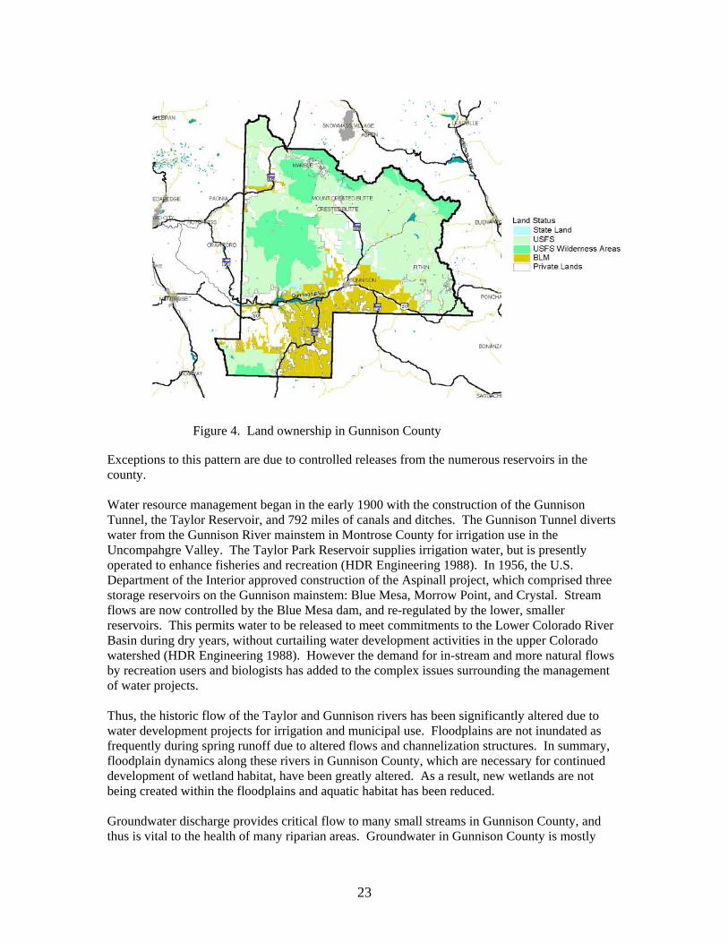
23
Figure 4. Land ownership in Gunnison County Exceptions to this pattern are due to controlled releases from the numerous reservoirs in the county. Water resource management began in the early 1900 with the construction of the Gunnison Tunnel, the Taylor Reservoir, and 792 miles of canals and ditches. The Gunnison Tunnel diverts water from the Gunnison River mainstem in Montrose County for irrigation use in the Uncompahgre Valley. The Taylor Park Reservoir supplies irrigation water, but is presently operated to enhance fisheries and recreation (HDR Engineering 1988). In 1956, the U.S. Department of the Interior approved construction of the Aspinall project, which comprised three storage reservoirs on the Gunnison mainstem: Blue Mesa, Morrow Point, and Crystal. Stream flows are now controlled by the Blue Mesa dam, and re-regulated by the lower, smaller reservoirs. This permits water to be released to meet commitments to the Lower Colorado River Basin during dry years, without curtailing water development activities in the upper Colorado watershed (HDR Engineering 1988). However the demand for in-stream and more natural flows by recreation users and biologists has added to the complex issues surrounding the management of water projects. Thus, the historic flow of the Taylor and Gunnison rivers has been significantly altered due to water development projects for irrigation and municipal use. Floodplains are not inundated as frequently during spring runoff due to altered flows and channelization structures. In summary, floodplain dynamics along these rivers in Gunnison County, which are necessary for continued development of wetland habitat, have been greatly altered. As a result, new wetlands are not being created within the floodplains and aquatic habitat has been reduced. Groundwater discharge provides critical flow to many small streams in Gunnison County, and thus is vital to the health of many riparian areas. Groundwater in Gunnison County is mostly

24
associated with alluvial and valley fill aquifers of Holocene age. These aquifers are typically shallow and unconfined and are located in and near stream valleys, mostly near Crested Butte and Gunnison, but also in smaller river valleys (Gurdak et al. 2002). Other aquifers occur in consolidated sandstone of varying age scattered throughout the county and in volcanic rocks of varying age in the southwestern part of the watershed (Gurdak et al. 2002). The sandstone aquifers are likely associated with the Dakota-Glen Canyon aquifer as noted in the Groundwater Atlas of the United States (USGS 1995). This aquifer contains four permeable zones that are referred to as the Dakota aquifer (associated with the Dakota Sandstone), Morrison aquifer (associated with sandstone portions of the Morrison Formation), Entrada aquifer (associated with the Entrada Sandstone), and Glen Canyon aquifer (associated with the Kayenta and Wingate Sandstone). The volcanic aquifers discharge at over 500 seeps and springs in the southwest portion of the county. Snowmelt from the San Juan Mountains likely infiltrates these porous rocks and flows downslope discharging as seeps and springs. Most of the seeps and springs have been developed for livestock use, thus much wetland habitat associated with them has been lost or drastically altered.
Vegetation Distribution of vegetation in Gunnison County is mostly determined by elevation, however, topography, soils, and local climatic factors all contribute to the distribution patterns. Johnston et al. (2001) describe five vegetation zones, distinguished mainly by elevation. Local topography, climate, and soils create a variety of vegetation patterns within these zones. The five zones are Foothills-Semidesert Shrub, Mountain Shrub, Montane, Subalpine, and Alpine. Foothills-Semidesert Shrub: This zone mostly consists of shrubs and grasslands dominated by Wyoming big sagebrush (Artemisia tridentata ssp. wyomingensis), Rocky mountain juniper (Juniperus scopulorum), Indian ricegrass (Achnatherum hymenoides), and needle-and-thread grass (Hesperostipa comata) (Johnston et al. 2001). Forested areas are restricted to riparian areas, where narrowleaf cottonwood (Populus angustifolia) is common, and protected slopes, where pockets of Douglas-fir (Pseudotsuga menziesii) and aspen (Populus tremuloides) are common (Johnston et al. 2001). This vegetation type is found on dry benches and windswept ridges in the lowest elevations in the county. Mountain Shrub: This is a discontinuous band of vegetation and occurs as patches of serviceberry (Amelanchier ssp.) and Gambel’s oak (Quercus gambelii) between pockets of Douglas-fir. Montane: This zone is mostly dominated by various sagebrush species, usually mountain big sagebrush (Artemisia tridentata ssp. vaseyana) although black sagebrush (A. nova) is dominant on shallow clay soils on south and west facing slopes (Johnston et al. 2001). Some areas are dominated by ponderosa pine (Pinus ponderosa) or Douglas-fir with lodgepole pine (Pinus contorta) or aspen as co-dominants (Johnston et al. 2001). Subalpine: A continuous band of conifer forests, dominated by subalpine fir (Abies lasiocarpa) and Engelmann spruce (Picea engelmannii), is indicative of this zone. Bristlecone pine (Pinus aristata), lodgepole pine, Douglas-fir, and aspen are also found throughout the zone. Mountain big sagebrush dominates open parklands at lower elevations in the zone while Thurber and Idaho
25
fescues (Festuca thurberi and F. idahoensis, respectively) are common in parklands in the uppermost elevations in the zone. Alpine: Low herbaceous species such as curly sedge (Carex rupestris), alpine avens (Geum rossii), and tufted hairgrass (Deschampsia cespitosa) are common in this zone, however erosional processes such as freeze-thaw and rock glaciers dominate the landscape in this zone. Wetland and Riparian Vegetation: Wetland and riparian vegetation is found within all of the zones discussed above. At the lowest elevations, along the major rivers, the dominant native vegetation is narrowleaf cottonwood, alder (Alnus incana ssp. tenuifolia), and various willows (Salix monticola, S. geyeriana, S. bebbiana, S. drummondiana, S. exigua, S. lucida var. caudata). At higher elevations, narrowleaf cottonwood is replaced by alder, blue spruce (Picea pungens), Engelmann spruce, aspen, bog birch (Betula glandulosa), and low stature willows such as Wolf willow (Salix wolfii) and planeleaf willow (S. planifolia). Disruption of the natural flood regime of the rivers by dams and alteration of the river channel has severely impacted regeneration of cottonwoods. Johnston et al. (2001) state the following: “In the Upper Gunnison River basin most cottonwood stands lack tall or medium shrubs, and have been reduced to cottonwood-Kentucky bluegrass or cottonwood-tree juniper gullies, which have considerably reduced forage, wildlife habitat, and watershed values.” Large cottonwood trees are important for nesting and roosting of Bald Eagles, Great Blue Herons, and other birds. Protection of young cottonwoods, and planting new trees may be necessary to ensure replacement of older trees for the future. Smaller streams in the canyons and mountains are essential for wildlife. It has been estimated that riparian areas, which account for only 1% of the landscape, are used by greater than 70% of wildlife species (Knopf 1988). In Colorado, 27% of the breeding bird species depend on riparian habitats for their viability (Pague and Carter 1996.) Dense riparian vegetation provides a protected corridor for migration of deer and elk, as well as cover for smaller animals. Riparian areas generally have a greater diversity of plant species than surrounding uplands. Along the smaller streams, grazing has altered much natural riparian vegetation. Protection of some riparian areas by fencing out cattle has improved some formerly degraded areas (e.g. Alder Creek).
Observations on Major Threats to Wetland Biodiversity The following table lists only those threats that were observed at or near the Potential Conservation Areas and were thought to potentially impact the elements of concern.

26
Table 2. Threats observed at the potential conservation areas.
Potential Conservation Area B –rank
Hyd
rolo
gic
Mod
ifica
tion
Res
iden
tial
Dev
elop
men
t
Min
ing
Inco
mpa
tible
G
razi
ng
Log
ging
Rec
reat
ion
Roa
ds
Non
-nat
ive
Spec
ies
Cement Creek B2 X X X Mount Emmons Iron Fen B2 X X Redwell Basin Iron Fen B2 X X
Triangle Pass B2 X Whitepine Iron Fen B2 X X X X
Beaver Creek at Gunnison SWA B3 X X X X Blue Creek at Curecanti Needle B3 X X
Canyon Creek B3 X X X X X Coal Creek B3 X X X X
Coal Creek at Keystone Mine B3 X X X Cow Creek at Soap Creek B3 X X
Crystal River B3 X X X Dark Canyon B3 X
East Elk Creek at Blue Mesa Reservoir B3 X X East Fork Cimarron River B3 X
East Fork Powderhorn Creek B3 East River at Roaring Judy B3 X X X X East River at Rustler Gulch B3 X X
Fivemile Creek B3 X X X X Gunnison River at Neversink B3 X X X X X
Horse Ranch Park B3 X X X Lake Fork Gunnison River at Blue
Mesa Reservoir B3 X X X
Little Cimarron River B3 X X Lost Lake B3 X X X
North Castle Creek B3 X North Fork Gunnison River B3 X X
Pass Creek at Cottonwood Pass B3 X X Porphyry Creek B3
Quartz Creek B3 X X X X X Slate River B3 X X X X X X
Snowshoe Canyon B3 Soap Creek B3 X
South Fork at Beaver Reservoir B3 X X X Spring Creek at Manganese Peak B3 X X X X
Stevens Creek B3 X X West Antelope Creek B3 X X X
West Brush Creek B3 X X Alder Creek B4 X X
Splains Gulch B4 X Union Park B4 X X X

27
Some general threats to biodiversity were not observed specifically at sites but rather have an effect on biodiversity on a larger landscape-level scale. These threats are discussed in the following text. Hydrological Modifications Hydrological alteration in the form of reservoirs and irrigation ditches or canals can affect aquatic dependent plants and animals (Chien 1985). Annual flooding is a natural ecological process that has been severely altered by the construction of dams, reservoirs, and other water diversions. These actions have altered the normal high peak flows that were once a part of the natural hydrological regime of the rivers and smaller tributaries in Gunnison County. These natural flows are necessary for continued viability of most riparian vegetation. For example, many plants can only reproduce with flooding events, e.g., cottonwood trees (Rood and Mahoney 1993). As plant composition changes in response to alterations in the flooding regime, the composition of the aquatic and terrestrial fauna may also change. Thus, floodplain dynamics along the rivers and smaller tributaries, which are necessary for continued development of wetland habitat, have been greatly altered in Gunnison County. New wetlands are not being created within the floodplains and aquatic habitat has been reduced. In addition to river impoundment, rivers have also been altered by stream bank stabilization projects (e.g., channelization) (Rosgen 1996). Most streams and rivers are dynamic and inherently move across the land. Stabilizing or channelizing stream banks forces the river to stay in one place and often leads to changes in riparian ecology and more serious destruction downstream. It is also well known that different plant associations require different geomorphologic settings, e.g., point bars are required for some species of willows to regenerate, mature cottonwood/shrubland forests occur on terraces, and old oxbow reaches may eventually provide habitat for many wetland associations. By stabilizing a river, the creation of these geomorphic settings is often eliminated. Thus, the plant associations that require such fluvial processes are no longer able to regenerate or survive. In general, the cumulative affects from dams, reservoirs, and channelization on plant associations, have caused a gradual shift from diverse multi-aged riparian woodlands to mature single aged forest canopies. Many wetlands, not associated with fluvial processes, have been altered by irrigation practices, water diversions, and well pumping. The increase of irrigated agriculture in Gunnison County inadvertently created many new wetlands in areas where wetlands never existed. For example, seepage from hundreds of miles of unlined canals and earthen ditches and much of the water applied in irrigation contributes to groundwater recharge and surface water runoff. As a result, many areas have developed wetland characteristics where none existed prior to irrigation. Conversely, many historical wetlands, such as seeps and springs, have been lost or altered due to water “development” projects, such as water diversions and impoundments, to create stock ponds. Thus, as the quality and extent of historical wetlands diminished, some of the habitat loss was offset by irrigation-induced wetlands. It is debatable whether the biodiversity significance of an integrated network of river bottom wetlands, sinuous marshy streams, and extensive intact seep and spring wetlands can be equated to the dispersed pattern of irrigation-induced wetlands across an agricultural landscape. However, irrigation-induced wetlands perform some of the functions performed by natural wetlands. For example, in addition to providing valuable wildlife habitat, irrigation-induced wetlands may be acting to remove nitrate, pesticides, and sediments from agricultural tail waters before entering major rivers and local aquifers.

28
Development Residential development is a localized but increasing threat in Gunnison County, especially in the Crested Butte area. Development creates a number of stresses, including habitat loss and fragmentation, introduction of non-native species, fire suppression, and domestic animals (dogs and cats) (Oxley et al. 1974 and Coleman and Temple 1994). Habitat loss to development is considered irreversible and should therefore be channeled to areas with less biological significance. Since development tends to occur adjacent to watercourses, wetland and riparian habitats are highly susceptible to development stresses. Mining Historic mining operations were widespread throughout Gunnison County, as much of the county lies within the Colorado Mineral Belt (Prather 1999). Silver and coal mining have seen major booms in the past, but mining for other resources such as gold and molybdenum (mine on Mount Emmons) have also been sought. Impacts from mines, both past and present affect many areas, especially wetland and riparian areas via degradation of water quality. Overall, the upper Gunnison Basin has good water quality (Gurdak et al. 2002), however localized impacts from old mine adits and current operations negatively affect the counties biodiversity. In response to Colorado's rapid growth rate, aggregate mining in Colorado has increased by over 30 percent since 1993 (Macalady 2000). Gravel mining is not a large industry in Gunnison County, however its impacts are still of concern for wetland and riparian areas. As of 2000, there were 27 active gravel mine permits, totaling approximately 443 acres, in Gunnison County (Macalady 2000). Floodplain gravel mines remove riparian vegetation and shallow, bottomland habitat and replace them with deepwater ponds. The removal of riparian vegetation coupled with the increase in non-native plant species has decreased essential habitat for numerous species, especially avian species (Macalady 2000). Alternative exist to minimize impacts associated with gravel mining such as improved reclamation efforts, targeting terrace deposist, utilizing crushed stone, and recycles material such as asphalt (Macalady 2000). Livestock Grazing Much of the Gunnison Basin has been grazed at some point in the last 150 years (Johnston et al. 2001). In lower elevations, prior to 1970, grazing was moderate to heavy for extended periods resulting in decreased vigor and quantity of native vegetation, especially in riparian areas and serviceberry shrublands (Johnston et al. 2001). The number of livestock in the Gunnison Basin has decreased since its peak in the early 1970’s (Johnston et al. 2001), however past use has left a broad and often subtle impact on the landscape. Today, many riparian areas and seeps and springs in Gunnison County are utilized for rangeland. At most elevations in the county, livestock tend to congregate near wetland and riparian areas for shade, lush browse, and access to water. Long-term, improper livestock use of wetland and riparian areas can potentially erode stream banks, cause streams to incise, lower the water table, alter channel morphology, impair plant regeneration, establish non-native species, shift community structure and composition, degrade water quality, and diminish general riparian and wetland functions (Windell et al. 1986). Depending on grazing practices and local environmental conditions, impacts can be minimal and largely reversible (slight shifts in species composition) to severe and irreversible (extensive channel incision, introduction of non-native forage species). Logging Many lower-elevation forests on gentle slopes have been logged for fuelwood, house logs, mine timbers, and fence posts (Johnston et al. 2001). Today, the largest use of public timber is fuelwood. However, many areas on public and private lands have been commercially logged and

29
the impact from these activities is still visible (Johnston et al. 2001). Most logging operations require a large network of roads. The impacts from roads can result in threats to biodiversity (see “Roads” below for more detailed discussion). The Forest Service monitors logging closely, nonetheless, problems can still occur. Recreation Recreation, once very localized and perhaps even unnoticeable, is increasing and becoming a threat to natural ecosystems in Gunnison County, especially in the Crested Butte area. Different types of recreation (e.g., motorized versus non-motorized activities) typically have different effects on ecosystem processes. ATVs can disrupt migration and breeding patterns, and fragment habitat for native resident species. ATVs have also been identified as a vector for the invasion of non-native plant species. Non-motorized recreation, mostly hikers but also some mountain biking and rock climbing, presents a different set of issues (Cole and Knight 1990; Knight and Cole 1991). Wildlife behavior can be significantly altered by repeat visits of hikers/bicyclists. Alpine areas, mountain lakes, and riparian zones are routes and destinations for many established trails. Thus, impacts to native vegetation (mainly trampling) in these areas could potentially be high. Roads There is a complex, dense network of roads in many parts of Gunnison County due to livestock activities, past timber harvests, mining operations, and recreation. Expansion of the existing road network in some areas will detrimentally affect the natural heritage values of the region. Roads are associated with a wide variety of impacts to natural communities, including invasion by non-native plant species, increased depredation and parasitism of bird nests, increased impacts of pets, fragmentation of habitats, erosion, pollution, and road mortality (Noss et al. 1997). Roads function as conduits, barriers, habitats, sources, and sinks for some species (Forman 1995). Road networks crossing landscapes can increase erosion and alter local hydrological regimes. Runoff from roads may impact local vegetation via contribution of heavy metals and sediments. Road networks interrupt horizontal ecological flows, alter landscape spatial pattern, and therefore inhibit important interior species (Forman and Alexander 1998). Effects on wildlife can be attributed to road avoidance (a species avoids crossing a road) and occasionally roadkill. Traffic noise appears to be the most important variable in road avoidance, although visual disturbance, pollutants, and predators moving along a road are alternative hypotheses as to the cause of avoidance (Forman and Alexander 1998). Songbirds appear to be sensitive to remarkably low noise levels, even to noise levels similar to that of a library reading room (Reijnen et al. 1995). Non-native Species Invasion of non-native and aggressive species, and their replacement of native species, is one of the biggest threats to Gunnison County’s natural diversity (James 1993; D’Antonio and Vitousek 1992). Non-native plants or animals can have wide-ranging impacts and can increase dramatically under the right conditions and essentially dominate a previously natural area (e.g., scraped roadsides). This can generate secondary effects on animals (particularly invertebrates) that depend on native plant species for forage, cover, or propagation. Although complete eradication of non-native aggressive species is not possible, some control efforts can pay off. One important guideline is that when a plant is removed, something will take its place. “Ecological voids do not exist” (Young 1981). Simply killing aggressive species,

30
unless there is a seed source for desirable replacements, will result in more unwanted species, perhaps even more noxious than those removed. Seeding of desirable plant species is usually necessary. When seeding, it is important to consider seedbed characteristics including rock cover, and the potential of the soil to support the planted species. A first step is to assess the current vegetation, in relation to the potential of the site. For example, former attempts to control halogeton (Halogeton glomeratus) were given up because land managers were unable to come up with a desirable species to replace it, especially on saline or alkaline soils (Young 1981). One approach is to experiment on a small scale to determine the potential success of a weed control/seeding project, using native plant species. Ideally, seed should be harvested locally. A mixture of native grasses and forbs is desirable, so that each species may succeed in the microhabitat for which it is best suited. In general, lower elevations of the county are more affected by non-native and aggressive plant species than higher elevations and level valley bottoms more than steep slopes. Most of the major river corridors, and many of their tributaries have been invaded by pasture grasses. Non-native species that are prevalent in Gunnison County wetlands include: Timothy Phleum pratense Meadow foxtail Alopecurus pratensis Reedcanary grass Phalaris arundinacea Redtop Agrostis gigantea Barnyard grass Echinochloa crus-galli Kentucky bluegrass Poa pratensis Smooth brome Bromus inermis Canada thistle Cirsium arvense Oxeye daisy Chrysanthemum leucanthemum Wild chamomile Matricaria perforata Bull thistle Cirsium vulgare Common dandelion Taraxacum officinale White sweet clover Melilotus alba Yellow sweet clover Melilotus officinalis Horseweed Conyza canadensis White-Dutch clover Trifolium repens Red clover Trifolium pratense Fragmentation and Edge Effects Edges are simply the outer boundary of an ecosystem that abruptly grades into another type of habitat (e.g., edge of a conifer forest adjacent to a meadow) (Forman and Godron 1986). Edges are often created by naturally occurring processes such as floods, fires, and wind and will recover naturally over time. Edges can also be created by human activities such as roads, timber harvesting, agricultural practices, rangeland, etc. Human induced edges are often dominated by plant species that are adapted to disturbance. As the landscape is increasingly fragmented by large-scale, rapid anthropogenic conversion, these edges become increasingly abundant. The overall reduction of large landscapes jeopardizes the existence of specialist species, may increase non-native species, and limits the mobility of species that require large landscapes or a diversity of landscapes for their survival (e.g., large mammals or migratory waterbirds).

31
THE NATURAL HERITAGE NETWORK AND BIOLOGICAL DIVERSITY
Just as ancient artifacts and historic buildings represent our cultural heritage, a diversity of plant and animal species and their habitats represent our “natural heritage.” Colorado’s natural heritage encompasses a wide variety of ecosystems from tallgrass prairie and shortgrass high plains to alpine cirques and rugged peaks, from canyon lands and sagebrush shrublands to dense subalpine spruce-fir forests and wide-open tundra. These widely diversified habitats are determined by water availability, temperature extremes, altitude, geologic history, and land use history. The species that inhabit each of these ecosystems have adapted to the specific set of conditions found there. Because human influence today touches every part of the Colorado environment, we are responsible for understanding our impacts and carefully planning our actions to ensure our natural heritage persists for future generations. Some generalist species, like house finches, have flourished over the last century, having adapted to habitats altered by humans. However, many other species are specialized to survive in vulnerable Colorado habitats; among them are Bell’s twinpod (a wildflower), the Arkansas darter (a fish), and the Pawnee montane skipper (a butterfly). These species have special requirements for survival that may be threatened by incompatible land management practices and competition from non-native species. Many of these species have become imperiled not only in Colorado, but also throughout their range of distribution. Some species exist in less than five populations in the entire world. The decline of these specialized species often indicates disruptions that could permanently alter entire ecosystems. Thus, recognition and protection of rare and imperiled species is crucial to preserving Colorado’s diverse natural heritage. Colorado is inhabited by some 800 vertebrate species and subspecies, and tens of thousands of invertebrate species. In addition, the state has approximately 4,300 species of plants and more than 450 recognized plant associations that represent upland and wetland ecosystems. It is this rich natural heritage that has provided the basis for Colorado’s diverse economy. Some components of this heritage have always been rare, while others have become imperiled with human-induced changes in the landscape. This decline in biological diversity is a global trend resulting from human population growth, land development, and subsequent habitat loss. Globally, the loss in species diversity has become so rapid and severe that Wilson (1988) has compared the phenomenon to the great natural catastrophes at the end of the Paleozoic and Mesozoic eras. The need to address this loss in biological diversity has been recognized for decades in the scientific community. However, many conservation efforts made in this country were not based upon preserving biological diversity; instead, they primarily focused on preserving game animals, striking scenery, and locally favorite open spaces. To address the absence of a methodical, scientifically based approach to preserving biological diversity Dr. Robert Jenkins of The Nature Conservancy pioneered the Natural Heritage Methodology in the early 1970s. Recognizing that rare and imperiled species are more likely to become extinct than common ones, the Natural Heritage Methodology ranks species according to their rarity or degree of imperilment. The ranking system is scientifically based upon the number of known locations of the species as well as their biology and known threats. By ranking the relative rarity or imperilment of a species, the quality of its populations, and the importance of associated

32
conservation sites, the methodology can facilitate the prioritization of conservation efforts so the most rare and imperiled species may be preserved first. As the scientific community realized that plant associations are equally important as individual species, this methodology has been applied to ranking and preserving rare plant associations, as well as the best examples of common associations. The Natural Heritage Methodology is used by Natural Heritage Programs throughout North, Central, and South America, forming an international database network. The 85 Natural Heritage Network data centers are located in each of the 50 U.S. states, five provinces of Canada, and 13 countries in South and Central America and the Caribbean. This network enables scientists to monitor the status of species from a state, national, and global perspective. Information collected by the Natural Heritage Programs can provide a means to protect species before the need for legal endangerment status arises. It can also enable conservationists and natural resource managers to make informed, objective decisions in prioritizing and focusing conservation efforts. What is Biological Diversity Protecting biological diversity has become an important management issue for many natural resource professionals. Biological diversity at its most basic level includes the full range of species on Earth, from single-celled organisms such as bacteria and protists through the multicellular kingdoms of plants and animals. At finer levels of organization, biological diversity includes the genetic variation within species, both among geographically separated populations and among individuals within a single population. On a wider scale, diversity includes variations in the biological associations in which species live, the ecosystems in which associations exist, and the interactions between these levels. All levels are necessary for the continued survival of species and plant associations, and many are important for the well being of humans. The biological diversity of an area can be described at four levels: Genetic Diversity — the genetic variation within a population and among populations of a plant or animal species. The genetic makeup of a species varies between populations within its geographic range. Loss of a population results in a loss of genetic diversity for that species and a reduction of total biological diversity for the region. Once lost, this unique genetic information cannot be reclaimed. Species Diversity — the total number and abundance of plant and animal species and subspecies in an area. Community Diversity — the variety of plant communitiess or associations within an area that represent the range of species relationships and inter-dependence. These associations may be diagnostic or even restricted to an area. Although the terms plant association and plant community have been described by numerous ecologists, no general consensus of their meaning has developed. The terms are similar, somewhat overlapping, and are often used more or less interchangeably. The U.S. National Vegetation Classification (USNVC) (Anderson et al. 1998), the accepted national standard for vegetation, defines a community as an "assemblage of species that co-occur in defined areas at certain times and that have the potential to interact with one another", and a plant association as a type of plant community with "definite floristic composition, uniform habitat conditions, and uniform physiognomy" (Flahault and Schroter 1910). Identifying and protecting representative examples of plant communities ensures conservation of multiple numbers of species, biotic interactions, and ecological process. Using communities as a "coarse-filter" enables conservation efforts to work toward protecting a more complete spectrum of biological diversity.

33
Landscape Diversity — the type, condition, pattern, and connectedness of natural communities. A landscape consisting of a mosaic of natural communities may contain one multifaceted ecosystem, such as a wetland ecosystem. A landscape also may contain several distinct ecosystems, such as a riparian corridor meandering through shortgrass prairie. Fragmentation of landscapes, loss of connections and migratory corridors, and loss of natural communities all result in a loss of biological diversity for a region. Humans and the results of their activities are integral parts of most landscapes. The conservation of biological diversity should include all levels of diversity: genetic, species, community or association, and landscape. Each level is dependent on the other levels and inextricably linked. In addition, and all too often omitted, humans are also closely linked to all levels of this hierarchy. We at the Colorado Natural Heritage Program believe that a healthy natural environment and a healthy human environment go hand in hand, and that recognition of the most imperiled species is an important step in comprehensive conservation planning. Colorado Natural Heritage Program To place this document in context, it is useful to understand the history and functions of the Colorado Natural Heritage Program (CNHP). CNHP is the state's primary comprehensive biological diversity data center, gathering information and field observations to help develop statewide conservation priorities. After operating in the Colorado Division of Parks and Outdoor Recreation for 14 years, the Program was relocated to the University of Colorado Museum in 1992, and then to the College of Natural Resources at Colorado State University in 1994, where it has operated since. The multi-disciplinary team of scientists, planners, and information managers at CNHP gathers comprehensive information on the rare, threatened, and endangered species and significant plant associations of Colorado. Life history, status, and locational data are incorporated into a continually updated data system. Sources include published and unpublished literature, museum and herbaria labels, and field surveys conducted by knowledgeable naturalists, experts, agency personnel, and our own staff of botanists, ecologists, and zoologists. The Biological and Conservation Data System (BCD) developed by The Nature Conservancy is used by all Natural Heritage Programs to house data about imperiled species. This database includes taxonomic group, global and state rarity rank, federal and state legal status, observation source, observation date, county, township, range, watershed, and other relevant facts and observations. The Colorado Natural Heritage Program also uses the Biodiversity Tracking and Conservation System (BioTiCS) for digitizing and mapping occurrences of rare plants, animals, and plant associations. These rare species and plant associations are referred to as “elements of natural diversity” or simply “elements.” Concentrating on site-specific data for each element enables CNHP to evaluate the significance of each location for the conservation of biological diversity in Colorado and in the nation. By using species imperilment ranks and quality ratings for each location, priorities can be established to guide conservation action. A continually updated locational database and priority-setting system such as that maintained by CNHP provides an effective, proactive land-use planning tool.

34
To assist in biological diversity conservation efforts, CNHP scientists strive to answer questions such as the following: • What species and ecological associations exist in the area of interest? • Which are at greatest risk of extinction or are otherwise significant from a conservation
perspective? • What are their biological and ecological characteristics, and where are these priority
species or associations found? • What is the species’ condition at these locations, and what processes or activities are
sustaining or threatening them? • Where are the most important sites to protect? • Who owns or manages those places deemed most important to protect, and what is
threatening those places? • What actions are needed for the protection of those sites and the significant elements of
biological diversity they contain? • How can we measure our progress toward conservation goals?
CNHP has effective working relationships with several state and federal agencies, including the Colorado Department of Natural Resources, the Colorado Division of Wildlife, Colorado State Parks, Colorado Department of Transportation, the Bureau of Land Management, and the U.S. Forest Service. Numerous local governments and private entities, such as consulting firms, educators, landowners, county commissioners, and non-profit organizations, also work closely with CNHP. Use of the data by many different individuals and organizations encourages a cooperative and proactive approach to conservation, thereby reducing the potential for conflict.
The Natural Heritage Ranking System Key to the functioning of Natural Heritage Programs is the concept of setting priorities for gathering information and conducting inventories. The number of possible facts and observations that can be gathered about the natural world is essentially limitless. The financial and human resources available to gather such information are not. Because biological inventories tend to be under-funded, there is a premium on devising systems that are both effective in providing information that meets users’ needs and efficient in gathering that information. The cornerstone of Natural Heritage inventories is the use of a ranking system to achieve these twin objectives of effectiveness and efficiency. Ranking species and ecological assocations according to their imperilment status provides guidance for where Natural Heritage Programs should focus their information-gathering activities. For species deemed secure, only general information needs to be maintained by Natural Heritage Programs. Fortunately, the more common and secure species constitute the majority of most groups of organisms. On the other hand, for those species that are by their nature rare, more detailed information is needed. Because of these species’ rarity, gathering
35
comprehensive and detailed population data can be less daunting than gathering similarly comprehensive information on more abundant species. To determine the status of species within Colorado, CNHP gathers information on plants, animals, and plant associations. Each of these elements of natural diversity is assigned a rank that indicates its relative degree of imperilment on a five-point scale (for example, 1 = extremely rare/imperiled, 5 = abundant/secure). The primary criterion for ranking elements is the number of occurrences (in other words, the number of known distinct localities or populations). This factor is weighted more heavily than other factors because an element found in one place is more imperiled than something found in twenty-one places. Also of importance are the size of the geographic range, the number of individuals, the trends in both population and distribution, identifiable threats, and the number of protected occurrences. Element imperilment ranks are assigned both in terms of the element's degree of imperilment within Colorado (its State-rank or S-rank) and the element's imperilment over its entire range (its Global-rank or G-rank). Taken together, these two ranks indicate the degree of imperilment of an element. For example, the lynx, which is thought to be secure in northern North America but is known from less than five current locations in Colorado, is ranked G5 S1 (globally-secure, but critically imperiled in this state). The Rocky Mountain Columbine, which is known only in Colorado from about 30 locations, is ranked a G3 S3 (vulnerable both in the state and globally, since it only occurs in Colorado and then in small numbers). Further, a tiger beetle that is only known from one location in the world at the Great Sand Dunes National Monument is ranked G1 S1 (critically imperiled both in the state and globally, because it exists in a single location). CNHP actively collects, maps, and electronically processes specific occurrence information for animal and plant species considered extremely imperiled to vulnerable in the state (S1 - S3). Several factors, such as rarity, evolutionary distinctiveness, and endemism (specificity of habitat requirements), contribute to the conservation priority of each species. Certain species are "watchlisted,” meaning that specific occurrence data are collected and periodically analyzed to determine whether more active tracking is warranted. A complete description of each of the Natural Heritage ranks is provided in Table 3. This single rank system works readily for all species except those that are migratory. Those animals that migrate may spend only a portion of their life cycles within the state. In these cases, it is necessary to distinguish between breeding, non-breeding, and resident species. As noted in Table 3, ranks followed by a "B,” for example S1B, indicate that the rank applies only to the status of breeding occurrences. Similarly, ranks followed by an "N,” for example S4N, refer to non-breeding status, typically during migration and winter. Elements without this notation are believed to be year-round residents within the state. Global imperilment ranks are based on the range-wide status of a species. State imperilment ranks are based on the status of a species in an individual state. State and Global ranks are denoted with an "S" or a "G" respectively, followed by a number or letter. These ranks should not be interpreted as legal designations.

36
Table 3. Definition of natural heritage imperilment ranks. G/S1
Critically imperiled globally/state because of rarity (5 or fewer occurrences in the world/state; or 1,000 or fewer individuals), or because some factor of its biology makes it especially vulnerable to extinction.
G/S2
Imperiled globally/state because of rarity (6 to 20 occurrences, or 1,000 to 3,000 individuals), or because other factors demonstrably make it very vulnerable to extinction throughout its range.
G/S3
Vulnerable through its range or found locally in a restricted range (21 to 100 occurrences, or 3,000 to 10,000 individuals).
G/S4
Apparently secure globally/state, though it may be quite rare in parts of its range, especially at the periphery. Usually more than 100 occurrences and 10,000 individuals.
G/S5
Demonstrably secure globally/state, though it may be quite rare in parts of its range, especially at the periphery.
G/SX
Presumed extinct globally, or extirpated within the state.
G#? Indicates uncertainty about an assigned global rank.
G/SU
Unable to assign rank due to lack of available information.
GQ
Indicates uncertainty about taxonomic status.
G/SH Historically known, but usually not verified for an extended period of time.
G#T#
Trinomial rank (T) is used for subspecies or varieties. These taxa are ranked on the same criteria as G1-G5.
S#B
Refers to the breeding season imperilment of elements that are not residents.
S#N
Refers to the non-breeding season imperilment of elements that are not permanent residents. Where no consistent location can be discerned for migrants or non-breeding populations, a rank of SZN is used.
SZ
Migrant whose occurrences are too irregular, transitory, and/or dispersed to be reliably identified, mapped, and protected.
SA
Accidental in the state.
SR
Reported to occur in the state but unverified.
S?
Unranked. Some evidence that species may be imperiled, but awaiting formal rarity ranking.
Note: Where two numbers appear in a state or global rank (for example, S2S3), the actual rank of the element is uncertain, but falls within the stated range.

37
Legal Designations for Rare Species Natural Heritage imperilment ranks should not be interpreted as legal designations. Although most species protected under state or federal endangered species laws are extremely rare, not all rare species receive legal protection. Legal status is designated by either the U.S. Fish and Wildlife Service under the Endangered Species Act or by the Colorado Division of Wildlife under Colorado Statutes 33-2-105 Article 2. In addition, the U.S. Forest Service recognizes some species as “Sensitive,” as does the Bureau of Land Management. Table 4 defines the special status assigned by these agencies and provides a key to abbreviations used by CNHP. Candidate species for listing as endangered or threatened under the Endangered Species Act are indicated with a “C." While obsolete legal status codes (Category 2 and 3) are no longer used, CNHP continues to maintain them in its Biological and Conservation Data system for reference.

38
Table 4. Federal and State Agency special designations for rare species. Federal Status: 1. U.S. Fish and Wildlife Service (58 Federal Register 51147, 1993) and (61 Federal Register 7598, 1996) LE Listed Endangered: defined as a species, subspecies, or variety in danger of extinction
throughout all or a significant portion of its range. E (S/A) Endangered: treated as endangered due to similarity of appearance with listed species. LT Listed Threatened: defined as a species, subspecies, or variety likely to become endangered
in the foreseeable future throughout all or a significant portion of its range. P Proposed: taxa formally proposed for listing as Endangered or Threatened (a proposal has
been published in the Federal Register, but not a final rule). C Candidate: taxa for which substantial biological information exists on file to support
proposals to list them as endangered or threatened, but no proposal has been published yet in the Federal Register.
2. U.S. Forest Service (Forest Service Manual 2670.5) (noted by the Forest Service as "S”) FS Sensitive: those plant and animal species identified by the Regional Forester for which
population viability is a concern as evidenced by: Significant current or predicted downward trends in population numbers or density. Significant current or predicted downward trends in habitat capability that would reduce a species' existing distribution.
3. Bureau of Land Management (BLM Manual 6840.06D) (noted by BLM as “S”) BLM Sensitive: those species found on public lands designated by a State Director that could
easily become endangered or extinct in a state. The protection provided for sensitive species is the same as that provided for C (candidate) species.
4. State Status: The Colorado Division of Wildlife has developed categories of imperilment for non-game species (refer to the Colorado Division of Wildlife’s Chapter 10 – Nongame Wildlife of the Wildlife Commission's regulations). The categories being used and the associated CNHP codes are provided below. E Endangered: those species or subspecies of native wildlife whose prospects for survival or
recruitment within this state are in jeopardy, as determined by the Commission. T Threatened: those species or subspecies of native wildlife which, as determined by the
Commission, are not in immediate jeopardy of extinction but are vulnerable because they exist in such small numbers, are so extremely restricted in their range, or are experiencing such low recruitment or survival that they may become extinct.
SC Special Concern: those species or subspecies of native wildlife that have been removed from the state threatened or endangered list within the last five years; are proposed for federal listing (or are a federal listing “candidate species”) and are not already state listed; have experienced, based on the best available data, a downward trend in numbers or distribution lasting at least five years that may lead to an endangered or threatened status; or are otherwise determined to be vulnerable in Colorado.
Element Occurrences and their Ranking Actual locations of elements, whether they are single organisms, populations, or plant associations, are referred to as element occurrences. The element occurrence is considered the most fundamental unit of conservation interest and is at the heart of the Natural Heritage Methodology. To prioritize element occurrences for a given species, an element occurrence rank (EO-Rank) is assigned according to the ecological quality of the occurrences whenever sufficient information is available. This ranking system is designed to indicate which occurrences are the

39
healthiest and ecologically the most viable, thus focusing conservation efforts where they will be most successful. The EO-Rank is based on three factors: Size – a measure of the area or abundance of the element’s occurrence, relative to other known, and/or presumed viable, examples. Takes into account factors such as area of occupancy, population abundance, population density, population fluctuation, and minimum dynamic area (which is the area needed to ensure survival or re-establishment of an element after natural disturbance). Condition/Quality – an integrated measure of the composition, structure, and biotic interactions that characterize the occurrence. This includes factors such as reproduction, age structure, biological composition (such as the presence of non-native versus native species), structure (for example, canopy, understory, and ground cover in a forest community), and biotic interactions (such as levels of competition, predation, and disease). Landscape Context – an integrated measure of two factors: the dominant environmental regimes and processes that establish and maintain the element, and connectivity. Dominant environmental regimes and processes include herbivory, hydrologic and water chemistry regimes (surface and groundwater), geomorphic processes, climatic regimes (temperature and precipitation), fire regimes, and many kinds of natural disturbances. Connectivity includes such factors as a species having access to habitats and resources needed for life cycle completion, fragmentation of ecological associations and systems, and the ability of the species to respond to environmental change through dispersal, migration, or re-colonization. Each of these factors is rated on a scale of A through D, with A representing an excellent grade and D representing a poor grade. These grades are then averaged to determine an appropriate EO-Rank for the occurrence. If not enough information is available to rank an element occurrence, an EO-Rank of E is assigned. EO-Ranks and their definitions are summarized in Table 5. Table 5. Element occurrence ranks and their definitions. A Excellent viability. B Good viability C Fair viability. D Poor viability. H Historic: known from historical record, but not verified for an extended period of time. X Extirpated (extinct within the state). E Extant: the occurrence does exist but not enough information is available to rank. F Failed to find: the occurrence could not be relocated.
Potential Conservation Areas and Their Ranking In order to successfully protect populations or occurrences, it is helpful to delineate Potential Conservation Areas (PCAs). These PCAs focus on capturing the ecological processes that are necessary to support the continued existence of a particular element occurrence of natural heritage significance. Potential Conservation Areas may include a single occurrence of a rare element, or a suite of rare element occurrences or significant features. The goal of the PCA process is to identify a land area that can provide the habitat and ecological processes upon which a particular element occurrence, or suite of element occurrences, depends for its continued existence. The best available knowledge about each species' life history is used in conjunction with information about topographic, geomorphic, hydrologic features, vegetative

40
cover; and current and potential land uses. In developing the boundaries of a Potential Conservation Area, CNHP scientists consider a number of factors that include, but are not limited to: • ecological processes necessary to maintain or improve existing conditions; • species movement and migration corridors; • maintenance of surface water quality within the PCA and the surrounding watershed; • maintenance of the hydrologic integrity of the groundwater; • land intended to buffer the PCA against future changes in the use of surrounding lands; • exclusion or control of invasive non-native species; • land necessary for management or monitoring activities.
The boundaries presented are meant to be used for conservation planning purposes and have no legal status. The proposed boundary does not automatically recommend exclusion of all activity. Rather, the boundaries designate ecologically significant areas in which land managers may wish to consider how specific activities or land use changes within or near the PCA affect the natural heritage resources and sensitive species on which the PCA is based. Please note that these boundaries are based on our best estimate of the primary area supporting the long-term survival of targeted species and plant associations. A thorough analysis of the human context and potential stresses has not been conducted. However, CNHP’s conservation planning staff is available to assist with these types of analyses where conservation priority and local interest warrant additional research. Off-Site Considerations Frequently, all necessary ecological processes cannot be contained within a site of reasonable size. The boundaries described in this report indicate the immediate, and therefore most important, area to be considered for protection. Continued landscape level conservation efforts are necessary as well, which will involve regional efforts in addition to coordination and cooperation with private landowners, neighboring land planners, and state and federal agencies. Ranking of Potential Conservation Areas CNHP uses element and element occurrence ranks to assess the overall biological diversity significance of a PCA, which may include one or many element occurrences. Based on these ranks, each PCA is assigned a biological diversity rank (or B-rank). See Table 6 for a summary of these B-ranks.

41
Table 6. Natural Heritage Program biological diversity ranks and their definitions. B1 Outstanding Significance:
Only known occurrence of an element A-ranked occurrence of a G1 element (or at least C-ranked if best available occurrence) Concentration of A- or B-ranked occurrences of G1 or G2 elements (four or more)
B2 Very High Significance: B- or C-ranked occurrence of a G1 element A- or B-ranked occurrence of a G2 element One of the most outstanding (for example, among the five best) occurrences rangewide (at least A- or B-ranked) of a G3 element. Concentration of A- or B-ranked G3 elements (four or more) Concentration of C-ranked G2 elements (four or more)
B3 High Significance: C-ranked occurrence of a G2 element A- or B-ranked occurrence of a G3 element D-ranked occurrence of a G1 element (if best available occurrence) Up to five of the best occurrences of a G4 or G5 community (at least A- or B-ranked) in an ecoregion (requires consultation with other experts)
B4 Moderate Significance: Other A- or B-ranked occurrences of a G4 or G5 community C-ranked occurrence of a G3 element A- or B-ranked occurrence of a G4 or G5 S1 species (or at least C-ranked if it is the only state, provincial, national, or ecoregional occurrence) Concentration of A- or B-ranked occurrences of G4 or G5 N1-N2, S1-S2 elements (four or more) D-ranked occurrence of a G2 element At least C-ranked occurrence of a disjunct G4 or G5 element Concentration of excellent or good occurrences (A- or B-ranked) of G4 S1 or G5 S1 elements (four or more)
B5
General or State-wide Biological Diversity Significance: good or marginal occurrence of common community types and globally secure S1 or S2 species.
Protection Urgency Ranks Protection urgency ranks (P-ranks) refer to the timeframe in which it is recommended that conservation protection occur. In most cases, this rank refers to the need for a major change of protective status (for example agency special area designations or ownership). The urgency for protection rating reflects the need to take legal, political, or other administrative measures to protect the area. Table 7 summarizes the P-ranks and their definitions.

42
Table 7. Natural Heritage Program protection urgency ranks and their definitions. P1 Protection actions needed immediately. It is estimated that current stresses may
reduce the viability of the elements in the PCA within 1 year. P2 Protection actions may be needed within 5 years. It is estimated that current stresses
may reduce the viability of the elements in the PCA within this approximate timeframe.
P3 Protection actions may be needed, but probably not within the next 5 years. It is estimated that current stresses may reduce the viability of the elements in the PCA if protection action is not taken.
P4 No protection actions are needed in the foreseeable future. P5 Land protection is complete and no protection actions are needed.
A protection action involves increasing the current level of protection accorded one or more tracts within a potential conservation area. It may also include activities such as educational or public relations campaigns, or collaborative planning efforts with public or private entities, to minimize adverse impacts to element occurrences at a site. It does not include management actions. Situations that may require a protection action are as follows: • Forces that threaten the existence of one or more element occurrences at a site. For
example, development that would destroy, degrade or seriously compromise the long-term viability of an element occurrence; or timber, range, recreational, or hydrologic management that is incompatible with an element occurrence's existence;
• The inability to undertake a management action in the absence of a protection action; for
example, obtaining a management agreement; • In extraordinary circumstances, a prospective change in ownership or management that
will make future protection actions more difficult. Management Urgency Ranks Management urgency ranks (M-ranks) indicate the timeframe in which it is recommended that a change occur in management of the element or site. This rank refers to the need for management in contrast to protection (for example, increased fire frequency, decreased grazing, weed control, etc.). The urgency for management rating focuses on land use management or land stewardship action required to maintain element occurrences at the potential conservation area. A management action may include biological management (prescribed burning, removal of non-natives, mowing, etc.) or people and site management (building barriers, rerouting trails, patrolling for collectors, hunters, or trespassers, etc.). Management action does not include legal, political, or administrative measures taken to protect a potential conservation area. Table 8 summarizes M-ranks and their definitions.
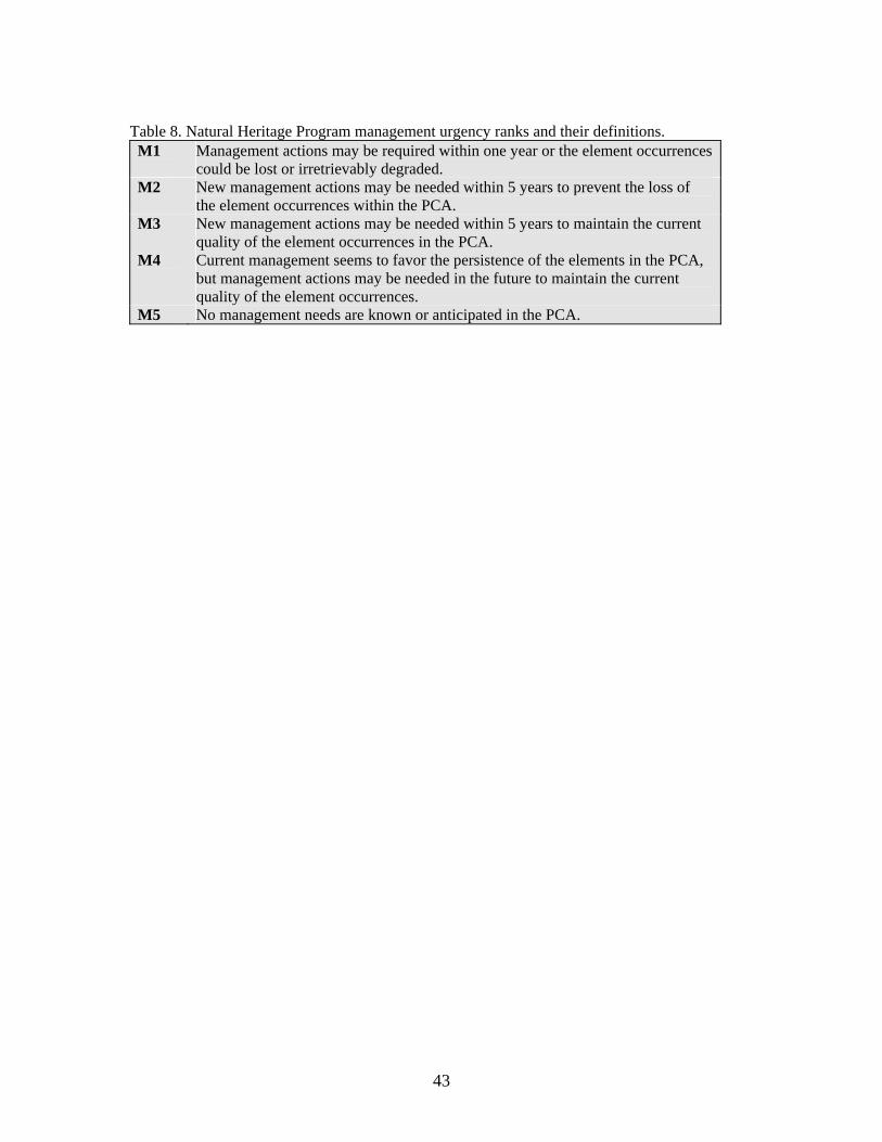
43
Table 8. Natural Heritage Program management urgency ranks and their definitions. M1 Management actions may be required within one year or the element occurrences
could be lost or irretrievably degraded. M2 New management actions may be needed within 5 years to prevent the loss of
the element occurrences within the PCA. M3 New management actions may be needed within 5 years to maintain the current
quality of the element occurrences in the PCA. M4 Current management seems to favor the persistence of the elements in the PCA,
but management actions may be needed in the future to maintain the current quality of the element occurrences.
M5 No management needs are known or anticipated in the PCA.

44
METHODS
Focusing on private lands, site selection was based on the objective of visiting every wetland type at various geomorphic positions and elevations within Gunnison County. The highest quality occurrences of each wetland type were targeted during the field season. Wetland types were defined using plant associations. CNHP classifies wetland and riparian plant associations, not wetland types. Plant associations reflect the broad nature of wetlands in the study area (e.g., willow carr, sedge meadow, cottonwood riparian forest, etc.), while also mirroring the local nature of wetlands in the watershed. Most other classifications applied to wetlands in Colorado, and across the nation, discriminate wetlands based primarily on the physiognomy (physical structure) of the vegetation. Broad structural classes, however, do not recognize the relative rarity of the plant species or associations contained in Gunnison County.
Collect Available Information CNHP databases were updated with information regarding the known locations of species and significant plant associations within Gunnison County. A variety of information sources were searched for this information. The Colorado State University museums and herbarium were searched, as were plant and animal collections at the University of Colorado, Rocky Mountain Herbarium, and local private collections. The Colorado Sage Grouse Working Group and the Colorado Division of Wildlife provided information on the Gunnison Sage Grouse. The Colorado Division of Wildlife provided data on the fishes of Gunnison County. Both general and specific literature sources were incorporated into CNHP databases as either locational information or as biological data pertaining to a species in general. Such information covers basic species and community biology including range, habitat, phenology (timing), food sources, and substrates. This information was entered into CNHP's Biological Conservation Database (BCD).
Identify rare or imperiled species and significant plant associations with potential to occur in Gunnison County The list of plant associations thought to occur in Gunnison County was derived from the Colorado Statewide Wetland Classification and Characterization (CSWCC) project (Carsey et al. 2003) which is based on the U.S. National Vegetation Classification (USNVC) (Anderson et al. 1998), the accepted national standard for vegetation. The CSWCC utilized and integrated previously collected data from the Classification of Riparian Wetland Plant Associations of Colorado (Kittel et al. 1999), CNHP wetland surveys, and Colorado State University. The CSWCC incorporated all these data on riparian and other wetlands collected during the past 12 years as well as data from other researchers to avoid duplication of effort. The information collected in the previous step was used to refine the potential element list and to refine our search areas. In general, species and plant associations that have been recorded from Gunnison County, or from adjacent counties, are included in this list. Species or plant associations which prefer habitats that are not included in this study area were removed from the list. The list includes those elements currently monitored by CNHP that were thought to potentially occur in Gunnison County and were therefore targeted in CNHP field inventories. The amount of effort given to the inventory for each of these elements was prioritized according to the element's rank. Globally rare (G1 - G3) elements were given highest priority; state rare (S1-S3) elements were secondary.

45
Identify Targeted Inventory Areas Survey sites or Targeted Inventory Areas (TIAs) were chosen based on their likelihood of harboring rare or imperiled species or significant plant associations. Known locations were targeted, and additional potential areas were chosen using a variety of information sources, such as aerial photography. Precisely known element locations were always included so that they could be verified and updated. Many locations were not precisely known due to ambiguities in the original data, e.g., "headwaters of Cataract Creek." In such cases, survey sites for that element were chosen in likely areas in the general vicinity. Areas with potentially high natural values were chosen using aerial photographs, geology maps, vegetation surveys, personal recommendations from knowledgeable local residents, and numerous roadside surveys by our field scientists. Aerial photography is perhaps the most useful tool in this step of the process. General habitat types can be discerned from the aerial photographs, and those chosen for survey sites were those that appeared to be in the most natural condition. In general, this means those sites that are the largest, least fragmented, and mostly free of visible disturbances such as roads, trails, fences, quarries, etc. The above information was used to delineate over 148 survey areas that were believed to have high probability of harboring natural heritage resources. Roadside surveys were useful in further resolving the natural condition of these areas. The condition of wetlands is especially difficult to discern from aerial photographs, and a quick survey from the road can reveal such features as weed infestation or overgrazing. Because of the overwhelming number of potential sites and limited resources, surveys for all elements were prioritized by the degree of imperilment. For example, all species with Natural Heritage ranks of G1-G3 were the primary target of our inventory efforts. Although species with lower Natural Heritage ranks were not the main focus of inventory efforts, many of these species occupy similar habitats as the targeted species, and were searched for and documented as they were encountered.
Landowner Contacts Attaining permission to conduct surveys on private property was essential to this project. Once survey sites were chosen, land ownership of these areas was determined using records at the Gunnison County assessor's office. Landowners were then either contacted by phone or mail or in person. If landowners could not be contacted, or if permission to access the property was denied, this was recorded and the site was not visited. Under no circumstances were properties surveyed without landowner permission.
Conduct Field Surveys Survey sites, where access could be attained, were visited at the appropriate time as dictated by the phenology of the individual elements. It is essential that surveys take place during a time when the targeted elements are detectable. For instance, breeding birds cannot be surveyed outside of the breeding season and plants are often not identifiable without flowers or fruit which are only present during certain times of the season. The methods used in the surveys necessarily vary according to the elements that were being targeted. In most cases, the appropriate habitats were visually searched in a systematic fashion

46
that would attempt to cover the area as thoroughly as possible in the given time. Some types of organisms require special techniques in order to capture and document their presence. These are summarized below:
Amphibians: visual or with aquatic nets Birds: visual or by song/call, evidence of breeding sought Wetland plant associations: visual, collect qualitative or quantitative composition, soil, hydrological, and function data
When necessary and permitted, voucher specimens were collected and deposited in local university museums and herbaria. When a rare species or significant natural community was discovered its precise location and known extent was recorded on 1:24,000 scale topographic maps. Other data recorded at each occurrence included numbers observed, breeding status, habitat description, disturbance features, observable threats, and potential protection and management needs. The overall significance of each occurrence, relative to others of the same element, was estimated by rating the quality (size, vigor, etc.) of the population or community, the condition or naturalness of the habitat, the long-term viability of the population or community, and the defensibility (ease or difficulty of protecting) of the occurrence. These factors are combined into an element occurrence rank, which is useful in refining conservation priorities. See the previous section on Natural Heritage Network for more about element occurrence ranking. Field surveys also included a wetland functional evaluation. Some of the PCAs profiled in this report were not visited by the author of this report but rather by previous CNHP ecologists. For these PCAs, no functional evaluation is given. For those PCAs visited by an author, a qualitative wetland functional evaluation is detailed in the PCA profile. Site visits and assessments were conducted on the following two levels: (1) Roadside or adjacent land assessments. Many of the sites could be viewed at a distance from a public road or from adjacent public land. While on the ground the field scientist can see, even from a distance, many features not apparent on maps and aerial photos. The road assessments determined the extent of human and livestock impacts on the survey area, which included ditching, adventive plant species, indicator plant species of intensive livestock use, stream bank destabilization, major hydrologic alterations, excessive cover of non-native plant species, or new construction. Sites with one or more of these characteristics were generally excluded as potential conservation areas and no extensive data were gathered at these areas. (2) On-Site assessments. On-site assessment was the preferred method, as it is the only assessment technique that can yield high-confidence statements concerning the known or potential presence of rare and imperiled elements or excellent examples of common associations. On-site assessments are also the most resource intensive because of the effort required to contact landowners. In several cases where on-site assessments were desired, they could not be conducted because either field personnel were denied access to the property by the landowner, or CNHP was unable to contact the landowner during the time frame of this study. The following information was collected for the PCAs in this report: General Field Information • list of all plant associations in the wetland complex, including the amount of wetland area
covered by that community. In almost all cases, plant associations were immediately placed

47
within CNHP’s Statewide Wetland Classification. However, on rare occasions a plant association was encountered which could not be easily classified based on the stands that had been previously sampled.
• vegetation data for each major plant association in the wetland were collected using visual ocular estimates of species cover in a representative portion of the plant association.
• sketch of the site layout, with distribution of community types indicated (this was generally done on the 7.5-min. USGS topographic map, but occasionally for clarity a separate map was drawn on the site survey form)
• UTM coordinates collected from Garmin GPS 12 Personal Navigator • elevation (from 7.5-min. USGS topographic maps) • current and historic land use (e.g., grazing, logging, recreational use) when apparent • notes on geology and geomorphology • reference photos of the site • indicators of disturbance such as logging, grazing, flooding, etc. Natural Heritage Information • list of elements present or expected at the site • element occurrence (EO) ranks or information that will lead to EO Rank • proposed conservation area boundaries General Wetland Information • proposed HGM Class and Subclass • Cowardin System and Subsystem • water source • hydroperiod • general soils description (these are based on either a detailed description of a soil profile in
the field (e.g., horizons, texture, color, cobble size, percent mottling) or from information from the county soil surveys.
Qualitative Functional Assessment • hydrological functions (e.g., groundwater recharge/discharge, flood storage, shoreline
anchoring) • biogeochemical functions (e.g., elemental cycling, sediment trapping, and toxicant
retention/removal) • biological functions (e.g., foodchain support, production export, fish and wildlife habitat,
habitat diversity) Restoration Potential • cause of disturbances, if any (e.g., alteration of hydrology, peat removal, fill material,
presence of non-native species, etc.) • feasibility of rectifying the disturbance (re-establishing natural hydrological regime, remove
fill material, plant native species, etc.) • discussion of possible methods for restoration.
Delineate Potential Conservation Area Boundaries Finally, since the objective for this inventory is to prioritize specific areas for conservation efforts, potential conservation area boundaries were delineated. Such a boundary is an estimation of the minimum area needed to assure persistence of the element. Primarily, in order to insure the

48
preservation of an element, the ecological processes that support that occurrence must be preserved. The preliminary potential conservation area boundary is meant to include features on the surrounding landscape that provide these functions. Typically, a minimal buffer of at least 1,000 feet was incorporated into the boundaries. Data collected in the field are essential to delineating such a boundary, but other sources of information such as aerial photography are also used. These boundaries are considered preliminary and additional information about the site or the element may call for alterations of the boundaries.

49
RESULTS
CNHP ecologists identified 148 wetland/riparian Targeted Inventory Areas (TIAs) that merited on-site investigation (Figure 4 and Figure 5). Of the 148 TIAs, 51% are encompassed within Potential Conservation Areas. An effort was made to select sites that potentially had natural hydrology, native species composition, and vegetation structure intact. However, on-site inspection revealed that many of the wetland TIAs (21%) were heavily impacted by roads, buildings, non-native species, agriculture, and/or grazing or were considered to be common types and were dropped from the inventory. Due to time limitations, 28% of the TIAs were not visited; most of these were located on U.S. Forest Service and Bureau of Land Management land. Figure 5 depicts TIAs identified in the county which (1) are found within PCAs; (2) were visited but not within PCAs; and (3) those not visited.
Not Visited - 28%
Dropped - 21%
PCAs - 51%
Figure 4. Summary of Targeted Inventory Areas.

50

51
Significant Elements Associated with Wetlands and Riparian Areas The following table presents CNHP elements of biological significance known to occur in or associated with wetlands in the Potential Conservation Areas in this report. This is not a comprehensive list of the elements known to occur in or associated with wetlands in Gunnison County, but rather only includes those elements deemed significant enough to be archived in CNHP’s Biological Conservation Data System. Table 9. Known elements of concern found within PCAs, by taxonomic group. Elements with the highest global significance (G1-G3) are in bold type. Detailed descriptions of the wetland elements listed below can be found in the Natural History section. Scientific Name Common Name Global
Rank State Rank
Federal and State Status
Animals Bufo boreas Boreal toad – southern Rocky
Mountain population G4T1Q S1 C, E
Centrocercus minimus Gunnison Sage Grouse G1 S1 C, SC Cypeseloides niger Black Swift G4 S3B Oncorhynchus clarki pleuriticus Colorado River cutthroat trout G4T3 S3 FS/BLM
SC Plants Carex viridula Green sedge G5 S1 Comarum palustre Marsh cinquefoil G5 S1S2 Drosera rotundifolia Round-leaf sundew G5 S2 FS Equisetum variegatum Variegated scouring rush G5 S1 Sullivantia hapemanii var. purpusii
Hanging garden sullivantia G3T3 S3
Trichophorum pumilum Rolland’s bulrush G5 S2 FS Plant Communities Abies lasiocarpa-Picea engelmannii/Alnus incana ssp. tenuifolia
Subalpine fir-Engelmann spruce/ thinleaf alder forest
G5 S5
Abies lasiocarpa-Picea engelmannii/Mertensia ciliata
Subalpine fir-Engelmann spruce/tall fringed bluebells forest
G5 S5
Abies lasiocarpa-Picea engelmannii-Populus angustifolia/Lonicera involucrata
Subalpine fir-Engelmann spruce-Narrowleaf cottonwood/twinberry honeysuckle forest
G4 S3
Alnus incana ssp. tenuifolia/mesic forb
Thinleaf alder/mesic forb shrubland
G3 S3
Alnus incana ssp. tenuifolia-mixed Salix species
Thinleaf alder/mixed willow shrubland
G3 S3
Alnus incana ssp. tenuifolia-Salix drummondiana
Thinleaf alder/Drummond (blue) willow shrubland
G3 S3
(Picea engelmannii)/Betula glandulosa/Carex aquatilis/Sphagnum sp.
Bog birch/water sedge/Sphagnum moss iron fen
G2 S2
Betula glandulosa/mesic forb-mesic graminoid
Bog birch/mesic forb-mesic graminoid shrubland
G3G4 S3

52
Scientific Name Common Name Global Rank
State Rank
Federal and State Status
Carex aquatilis Water sedge herbaceous vegetation
G5 S4
Carex aquatilis-Carex utriculata Water sedge – beaked sedge herbaceous vegetation
G4 S4
Carex utriculata Beaked sedge herbaceous vegetation
G5 S5
Carex vesicaria Inflated sedge herbaceous vegetation
G4Q S1
Kobresia myosuroides-Thalictrum alpinum
Extreme rich fen Pacific bog sedge – alpine meadowrue herbaceous vegetation
G2 S1
Picea engelmannii/Cornus sericea
Engelmann spruce/red-osier dogwood woodland
G3 SU
Picea pungens/Alnus incana ssp. tenuifolia
Blue spruce/thinleaf alder woodland
G3 S3
Populus angustifolia/Alnus incana ssp. tenuifolia
Narrowleaf cottonwood/thinleaf alder woodland
G3 S3
Populus angustifolia/Cornus sericea
Narrowleaf cottonwood/red-osier dogwood woodland
G4 S3
Populus angustifolia/Crataegus rivularis
Narrowleaf cottonwood/river hawthorn woodland
G2 S2
Populus angustifolia/mixed Salix species
Narrowleaf cottonwood/mixed willow woodland
G3 S3
Populus angustifolia/Salix exigua Narrowleaf cottonwood/sandbar willow woodland
G4 S4
Populus angustifolia/Salix lucida var. caudata
Narrowleaf cottonwood/whiplash (Pacific) willow woodland
G1Q S1Q
Populus angustifolia-Picea pungens/Alnus incana ssp. tenuifolia
Narrowleaf cottonwood-blue spruce/thinleaf alder woodland
G4 S4
Populus balsamifera Balsam poplar woodland GU S2 Populus tremuloides/Alnus incana ssp. tenuifolia
Quaking aspen/thinleaf alder forest
G3 S3
Salix boothii/mesic forb Booth willow/mesic forb shrubland
G3 S3
Salix drummondiana/ Calamagrostis canadensis
Drummond (blue) willow/bluejoint reedgrass shrubland
G3 S3
Salix drummondiana/mesic forb Drummond (blue) willow/mesic forb shrubland
G4 S4
Salix geyeriana/Carex aquatilis Geyer willow/water sedge shrubland
G3 S3

53
Scientific Name Common Name Global Rank
State Rank
Federal and State Status
Salix geyeriana/Carex utriculata Geyer willow/beaked sedge shrubland
G5 S3
Salix lucida var. caudata Whiplash (Pacific) willow shrubland
G3Q S2S3
Salix monticola/Calamagrostis canadensis
Rocky Mountain (serviceberry) willow/ bluejoint reedgrass shrubland
G3 S3
Salix monticola/Carex utriculata Rocky Mountain (serviceberry) willow/beaked sedge shrubland
G3 S3
Salix monticola/mesic forb Rocky Mountain (serviceberry) willow/mesic forb shrubland
G3 S3
Salix monticola/mesic graminoid
Rocky Mountain (serviceberry) willow/mesic graminoid shrubland
G3 S3
Salix wolfii/Calamagrostis canadensis
Wolf willow/bluejoint reedgrass shrubland
G3 S2S3
Salix wolfii/Carex aquatilis Wolf willow/water sedge shrubland
G4 S3
Salix wolfii/Carex utriculata Wolf willow/beaked sedge shrubland
G4 S3
Salix wolfii/mesic forb Wolf willow/mesic forb shrubland G3 S3
Table 10. Known elements documented in CNHP’s Biological Conservation Data system but not included within PCAs presented in this report. Most of the elements are considered globally secure (G4 or G5) and therefore were considered lower priority for survey and PCA evaluation. Scientific Name Common Name Global
Rank State Rank
Federal and State Status
Animals
Empidonax traillii extimus Southwestern willow flycatcher G5T1T2 SR
LE, FS, E
Haliaeetus leucocephalus Bald eagle G4 S1B,S3N LT*, T
Ferrissia walkeri Cloche ancylid (freshwater snail) G4G5 S3
Promenetus umbilicatellus Umbilicate sprite (freshwater snail) G4 S3
Plants Eriophorum altaicum var. neogaeum Altai cotton-grass G4?T3T4 S3 FS Eriophorum gracile Slender cotton-grass G5 S2 BLM Platanthera sparsifolia var. ensifolia Canyon bog-orchid G4G5T4? S3

54
Scientific Name Common Name Global Rank
State Rank
Federal and State Status
Salix lanata ssp. calcicola Lanate willow G4T4 S1 FS Plant Communities
Abies lasiocarpa-Picea engelmannii/Salix drummondiana
Subalpine fir-Engelmann spruce/Drummond (blue) willow forest G5 S4
Alnus incana ssp. tenuifolia –Cornus sericea
Thinleaf alder-red-osier dogwood shrubland G3Q S3
Betula occidentalis/mesic forb River birch/mesic forb shrubland G4? S2
Calamagrostis canadensis Bluejoint reedgrass herbaceous vegetation G4 S4
Glyceria borealis Northern mannagrass herbaceous vegetation G4 S3
Picea pungens/Cornus sericea Blue spruce/Red-osier dogwood woodland G4 S2
Salix boothii/Carex utriculata Booth willow/beaked sedge shrubland G4 S3
Salix brachycarpa/mesic forb Barrenground willow/mesic forb shrubland G4 S4
Salix geyeriana-Salix monticola/mesic graminoid
Geyer willow-Rocky Mountain (serviceberry) willow/mesic graminoid shrubland GU S3
Salix planifolia/Caltha leptosepala
Planeleaf willow/marsh marigold shrubland G4 S4
Salix planifolia/Carex aquatilis Planeleaf willow/water sedge shrubland G5 S4
Sites of Biodiversity Significance The 40 most important wetland sites in Gunnison County are profiled in this section as Potential Conservation Areas (PCAs) with biodiversity ranks (Figure 6). These PCAs include the wetlands with the highest biodiversity significance, as well as the best examples of common wetland types present in the study area. Five B2 and 32 B3 were identified during this project. The highest ranking PCAs are the highest priorities for conservation action. Gunnison County PCAs ranking B4 and B5 are not presented in this report, except for three B4 PCAs, which we feel merit conservation attention due to some outstanding feature. Also presented is the Gunnison Basin Potential Conservation Area, which was established for the ecological needs of the Gunnison Sage Grouse. The Gunnison Basin PCA (Figure 6) has irreplaceable biodiversity significance (B1) as the continued survival of the Gunnison Sage Grouse depends on survival of the species in the Gunnison Basin. Though not a wetland-based PCA, it provides important context for those wetland PCAs found within its boundaries, as wetland/riparian areas are important brooding areas for the Gunnison Sage Grouse. Thus, the PCAs are organized into two categories: (1) those contained within the Gunnison Basin PCA, and (2) those found outside the Gunnison Basin PCA. Any PCA found within the

55
Gunnison Basin PCA, and more specifically within two miles of known Gunnison Sage Grouse leks, may be more important than their B-Rank may suggest. For example, a PCA supporting an excellent example of a common riparian plant community may only be considered a B4 PCA. However, given that the PCA may provide important habitat to the globally critically imperiled (G1) Gunnison Sage Grouse, it needs to be considered within the context of the larger, Gunnison Basin PCA-a B1 PCA. Within each of the two categories, the PCAs are arranged in ascending order according to their B-Rank (e.g. B1 to B5). The Nature Conservancy recently completed an assessment of the Southern Rocky Mountain Ecoregion (Neely et al. 2001) outlining a portfolio of conservation areas. Figure 7 shows the nine priority areas that are within Gunnison County overlain by the CNHP PCAs. Each Potential Conservation Area (PCA) is described in a standard PCA profile report that reflects data fields in CNHP’s Biological and Conservation Data (BCD) System. The contents of the profile report are outlined and explained below:
PCA Profile Explanation Biodiversity Rank: B# The overall significance of the PCA in terms of rarity of the Natural Heritage resources and the quality (condition, abundance, etc.) of the occurrences. Please see Natural Heritage Ranking System section for more details. Protection Urgency Rank: P# A summary of major land ownership issues that may affect the long-term viability of the PCA and the element(s). Management Urgency Rank: M# A summary of major management issues that may affect the long-term viability of the PCA and the element(s). Location: General location. Legal Description: USGS 7.5-minute Quadrangle name(s) and Township Range Section(s). Size: Expressed in acres. Elevation: Expressed in feet. Johnston et al. (2001) Ecological and Community Type: Barry Johnston and his colleagues at the U.S. Forest Service developed a classification of the ecological types of the Gunnison Basin. The Ecological Series, Ecological Type, and Community Type found at each PCA are presented in this section. Often, this classification fit very well with CNHP’s Wetland Classification, however in some instances a correlation between the two classifications was not possible. General Description: A brief narrative of the topography, hydrology, vegetation, and current use of the potential conservation area. Biodiversity Rank Comments: A synopsis of the rare species and significant plant communities that occur within the proposed conservation area. A table within the area profile lists each element occurrence found in the PCA, global and state ranks of these elements, the occurrence

56
ranks and federal and state agency special designations. See Table 3 for explanations of ranks and Table 4 for legal designations. Boundary Justification: Justification for the location of the proposed conservation area boundary delineated in this report, which includes all known occurrences of natural heritage resources and, in some cases, adjacent lands required for their protection. Protection Rank Comments: Discussion of major land ownership issues that may affect the long-term viability of the PCA and the element(s). Management Rank Comments: Discussion of major management issues that may affect the long-term viability of the PCA and the element(s). Soils Description: Soil profile descriptions were generally conducted at each PCA. When these profile descriptions were found to match the mapped soil type found in the county soil surveys, then reference is only given to that particular soil series and no profile description is provided. However, if a profile description did not match the mapped soil type, then profile descriptions are presented. Classification of these soils was conducted, when possible, using Keys to Soil Taxonomy (USDA 1994). Wetland Functional Assessment: A summary of the functions and the proposed HGM classification, Cowardin system, and the plant community derived from CNHP's Statewide Wetland Classification for the wetlands occurring within each Potential Conservation Area. (Note: Some of the PCAs profiled in this report were not visited by an author but rather by previous CNHP ecologists. For these PCAs, no functional evaluation is given. For those PCAs visited by an author, a wetland functional evaluation is detailed in the PCA profile.) Restoration Potential: A brief summary describing the feasibility of restoring ecosystem processes at each PCA.

57

58

59
Table 11 displays the seven PCAs contained within the Gunnison Basin PCA. Table 12 displays the 33 PCAs not contained in the Gunnison Basin PCA. All of these PCAs merit protection, but available resources should be directed first toward the higher B-ranked PCAs (e.g., B2 & B3 PCAs). These PCAs alone do not represent a complete wetland conservation program; they represent only the rare and imperiled elements. In addition, as was discussed above, inventory efforts were focused on private lands and due to time limitations a comprehensive inventory of public lands (e.g., U.S. Forest Service and BLM) was not conducted. Table 11. Potential Conservation Areas contained within the Gunnison Basin PCA, arranged by biodiversity rank (B-rank).
Potential Conservation Areas contained within the Gunnison Basin PCA
B3 Beaver Creek at Gunnison SWA
East Elk Creek at Blue Mesa Reservoir East River at Roaring Judy
Gunnison River at Neversink Stevens Creek
West Antelope Creek B4
Alder Creek Table 12. Potential Conservation Areas outside of the Gunnison Basin PCA, arranged by biodiversity rank (B-rank).
Potential Conservation Areas outside of the
Gunnison Basin PCA B2
Cement Creek Mount Emmons Iron Fen Redwell Basin Iron Fen
Triangle Pass Whitepine Iron Fen
B3 Blue Creek at Curecanti Needle
Canyon Creek Coal Creek
Coal Creek at Keystone Mine Cow Creek at Soap Creek
Crystal River Dark Canyon
East Fork Cimarron River East Fork Powderhorn Creek East River at Rustler Gulch
Fivemile Creek Horse Ranch Park
60
Lake Fork Gunnison River at Blue Mesa Reservoir
Little Cimarron River Lost Lake
North Castle Creek North Fork Gunnison River
Pass Creek at Cottonwood Pass Porphyry Creek
Quartz Creek Slate River
Snowshoe Canyon Soap Creek
South Fork at Beaver Reservoir Spring Creek at Manganese Peak
West Brush Creek B4
Splains Gulch Union Park

61
Gunnison Basin Potential Conservation Area Biodiversity Rank: B1. Irreplaceable biodiversity significance. The Gunnison Basin PCA supports very good (B-ranked) occurrences of the globally- and state- critically imperiled (G1 S1) Gunnison Sage Grouse (Centrocercus minimus) designated a species of special concern by the Colorado Division of Wildlife and a candidate for listing under the Federal Endangered Species Act. This PCA represents the largest and most likely to succeed population of the Gunnison Sage Grouse. (That is, there are no remaining A-ranked occurrences). This PCA also supports nearly the entire world’s population of the Gunnison milkvetch (Astragalus anisus) (G2 S2). Protection Urgency Rank: P2. Protection actions may be needed within 5 years. It is estimated that current stresses may reduce the viability of the elements in the PCA within this approximate timeframe. Protection actions are urgently needed to secure the long-term survival of the Gunnison Sage Grouse. Although much of the land is federally owned, numerous important brood rearing and leks for the grouse are under private ownership with potential for development. Management Urgency Rank: M1. Management actions may be required within one year or the element occurrences could be lost or irretrievably degraded. Although current management in many parts of this PCA is good to excellent, there are many areas that require management action. One of the most urgent management actions is to increase canopy cover and height of grasses and forbs under the sagebrush as well as in the riparian areas used for brood rearing. Location: Gunnison and Saguache counties. The Gunnison Basin PCA encompasses sagebrush shrublands extending over 40 miles from north to south and 30 miles east to west, centered near the town of Gunnison.
U.S.G.S. 7.5-min. quadrangles: Cochetopa Park, Cold Spring Park, Sargents Mesa, West Baldy, Razor Creek Dome, Sawtooth Mountain, Spring Hill Creek, Sargents, Doyleville, Houston Gulch, Iris, Iris NW, Pitkin, Parlin, Signal Peak, Gunnison, Crystal Creek, Almont, Flat Top, Cement Mountain, Crested Butte, Powderhorn, Gateview, Poison Draw, Big Mesa, Carpenter Ridge, Sapinero, McIntosh Mountain, West Elk Peak SW, Little Soap Park, Squirrel Creek. Legal Description: T15S R84W, T15S R85W, T15S R 86W, T15S R87W,
T45N R2E, T46N R1E, T46N R2E, T47N R1E, T47N R1W, T47N R1.5W, T47N R2E, T47N R2W, T47N R3E, T47N R3W, T47N R4E, T47N R4W, T48N R1E, T48N R1W, T48N R1.5W, T48N R2E, T48N R2W, T48N R3E, T48N R3W, T48N R4E, T48N R4W, T48N R5E, T49N R1E, T49N R1W, T49N R2E, T49N R2W, T49N R3E, T49N R3W, T49N R4E, T49N R4W, T50N R1E, T50N R1W, T50N R2E, T50N R2W, T50N R3E, T51N R1E, T51N R1W, T51N R2E, T51N R2W.
Elevation: 7,500-11,465 ft. Size: Approximately 552,900 acres General Description: The Gunnison Basin PCA is best characterized as rolling hills of sagebrush shrublands with dissecting rivers and creeks. Many of the hilltops are windblown free of snow and represent a more xeric landscape dominated by either dwarf sagebrush shrublands (sagebrush steppe) or montane grasslands. All of these ecological systems are extremely

62
important for the Gunnison Sage Grouse, a sagebrush specialist. The sagebrush shrublands are winter and nesting habitat, while the xeric hilltops are leks, and the rivers and creeks are brood-rearing habitat. This PCA represents the world’s largest remaining habitat and population for the Gunnison Sage Grouse (Colorado Sage Grouse Working Group 1997), one of Colorado’s rarest birds. Numerous species of sagebrush dominate these shrublands, but Wyoming sagebrush (Artemisia tridentata ssp. wyomingensis) is usually the dominant below 8,500 feet in elevation, while mountain sagebrush (A. tridentata ssp. vaseyana) is dominant above 8,500 feet. The dwarf sagebrush shrublands on the windswept slopes and ridges may be black sagebrush (A. nova) or low sagebrush (A. arbuscula). The dominant grasses in the grasslands vary with elevation as well. The riparian areas along the creeks and rivers vary significantly depending on elevation, stream gradient, stream volume, and floodplain width. The most significant riparian areas within this PCA are those dominated by shrubs, including willows (Salix spp.), and thinleaf alder (Alnus incana ssp. tenuifolia) that also have high grass and forb cover during the summer months when grouse are present. Biodiversity Rank Justification: This area represents the best remaining site for the Gunnison Sage Grouse (G1). This grouse was recently described as a distinct species and has a high potential for being federally listed as an endangered species due to a declining population. Within the Gunnison Sage Grouse range (primarily southwest Colorado), only Gunnison County has a secure population (Colorado Sage Grouse Working Group 1997). In 1995, the spring population of sage grouse in the Gunnison Basin was about 2,200 birds (Colorado Sage Grouse Working Group 1997). Factors clearly implicated in the long-term decline of sage grouse are habitat loss; habitat fragmentation (caused by roads, power lines, reservoirs, land conversion, land treatments, etc.); and habitat degradation caused by land treatments and other uses which have changed grass, forb, and sagebrush composition, reduced organic material in the soil, and increased the loss/movement of soil resulting in changes in water table levels, and basic soil productivity. Sage grouse are specialists of sagebrush ecosystems and have not adapted to changing land uses. In addition to the Gunnison Sage Grouse, the Gunnison milkvetch (Astragalus anisus) is of high biodiversity significance. The world’s distribution of Gunnison milkvetch is tightly associated with the same sagebrush ecosystem that the Gunnison Sage Grouse use. Nearly all of the worlds known populations of Gunnison milkvetch occur within the Gunnison Basin PCA. Table 13. Natural Heritage element occurrences at Gunnison Basin PCA. Elements in bold are those upon which the PCA's B-rank is based. Scientific Name Common Name Global
Rank State Rank
Federal and State Status
EO* Rank
Animals Centrocercus minimus Gunnison Sage Grouse G1 S1 C, SC B Centrocercus minimus Gunnison Sage Grouse G1 S1 C, SC B Centrocercus minimus Gunnison Sage Grouse G1 S1 C, SC B Centrocercus minimus Gunnison Sage Grouse G1 S1 C, SC B Centrocercus minimus Gunnison Sage Grouse G1 S1 C, SC B Centrocercus minimus Gunnison Sage Grouse G1 S1 C, SC B Centrocercus minimus Gunnison Sage Grouse G1 S1 C, SC C

63
Scientific Name Common Name Global Rank
State Rank
Federal and State Status
EO* Rank
Centrocercus minimus Gunnison Sage Grouse G1 S1 C, SC C Centrocercus minimus Gunnison Sage Grouse G1 S1 C, SC C Centrocercus minimus Gunnison Sage Grouse G1 S1 C, SC C Centrocercus minimus Gunnison Sage Grouse G1 S1 C, SC C Centrocercus minimus Gunnison Sage Grouse G1 S1 C, SC C Centrocercus minimus Gunnison Sage Grouse G1 S1 C, SC C Centrocercus minimus Gunnison Sage Grouse G1 S1 C, SC C Centrocercus minimus Gunnison Sage Grouse G1 S1 C, SC D Centrocercus minimus Gunnison Sage Grouse G1 S1 C, SC D Centrocercus minimus Gunnison Sage Grouse G1 S1 C, SC D Plants Astragalus anisus Gunnison milkvetch G2 S2 B Astragalus anisus Gunnison milkvetch G2 S2 B Astragalus anisus Gunnison milkvetch G2 S2 C Astragalus anisus Gunnison milkvetch G2 S2 C Astragalus anisus Gunnison milkvetch G2 S2 C Astragalus anisus Gunnison milkvetch G2 S2 C Astragalus anisus Gunnison milkvetch G2 S2 C Astragalus anisus Gunnison milkvetch G2 S2 C Astragalus anisus Gunnison milkvetch G2 S2 C Astragalus anisus Gunnison milkvetch G2 S2 D Astragalus anisus Gunnison milkvetch G2 S2 D Astragalus anisus Gunnison milkvetch G2 S2 D Astragalus anisus Gunnison milkvetch G2 S2 E Astragalus anisus Gunnison milkvetch G2 S2 E Astragalus anisus Gunnison milkvetch G2 S2 E Astragalus anisus Gunnison milkvetch G2 S2 E Astragalus anisus Gunnison milkvetch G2 S2 E Astragalus anisus Gunnison milkvetch G2 S2 E Astragalus anisus Gunnison milkvetch G2 S2 E Astragalus anisus Gunnison milkvetch G2 S2 E
*EO=Element Occurrence. Multiple listings represent separate locations. Boundary Justification: This boundary represents all known leks within the Gunnison Basin, as well as nesting habitat, critical winter habitat, and the rivers and creeks used for brood rearing. There are areas within this PCA that have concentrations of leks and high quality habitat as well as areas that have been developed and no longer serve as sage grouse habitat. This boundary includes nearly all of what the Colorado Division of Wildlife has identified as the Gunnison Sage Grouse overall habitat in Gunnison Basin (CDOW 2002). In addition, this boundary represents nearly the entire world’s population of Gunnison milkvetch. Protection Comments: Protection actions are needed to secure long-term survival of the Gunnison Sage Grouse. Although much of the land is federally owned, numerous important brood rearing and leks for the grouse are under private ownership with potential for development. Management Comments: The following is excerpted from the Gunnison Sage Grouse Conservation Plan (Colorado Sage Grouse Working Group 1997):

64
The major factors that drive sage grouse populations are quality and extent of habitat. No other bird is so habitat specific to one particular plant type (sagebrush) in meeting its annual life requirements. Size of habitat is important because sage grouse move seasonally between suitable habitat types. Sage grouse require several distinct habitat types during different times of the year, which can be divided as following: 1. Winter 2. Nesting and early brood-rearing (uplands) 3. Late summer (riparian) 4. Escape and hiding habitat (needed yearlong) 5. Lek (breeding areas)
The key to sage grouse management is habitat, but in many locations of the Gunnison Basin key components of the sagebrush ecosystem are either insufficient or have been altered. The number and distribution of high quality nesting and early brood-rearing areas appear to be a limiting factor for sage grouse in the Gunnison Basin (Colorado Sage Grouse Working Group 1997). The quality and quantity of residual herbaceous cover have an important role in sage grouse production and survival. Residual herbaceous vegetation (grasses and forbs) in sagebrush areas which provide adequate cover, both horizontal and vertical, is necessary to hide nests and nesting hens, and broods, as well as provide habitat for insects upon which birds depend. However, recent studies have shown that grasses and forbs are under-represented in a large portion of the Gunnison Basin sagebrush ecosystem.

65

66
Potential Conservation Areas within the Gunnison Basin Potential Conservation Area
Beaver Creek at Gunnison SWA Potential Conservation Area
Biodiversity Rank: B3. High biodiversity significance. The PCA supports a good example of a globally critically imperiled (G1Q) riparian plant community. Protection Urgency Rank: P4. No protection actions are needed in the foreseeable future. The PCA is entirely public lands and includes Gunnison State Wildlife Area, Bureau of Land Management, and U.S. Forest Service lands including the West Elk Wilderness Area. Management Urgency Rank: M4. Current management seems to favor the persistence of the elements in the PCA, but management actions may be needed in the future to maintain the current quality of the element occurrences. Grazing is currently excluded from at least part of the PCA as part of management focused on maintaining reintroduced Colorado cutthroat trout. Location: This PCA is located about five miles west of Gunnison and about four miles north of Highway 50.
U.S.G.S. 7.5-min. quadrangles: McIntosh Mountain, Squirrel Creek, and West Elk Peak Legal Description: T49N R2W Section 2;
T50N R2W Sections 3-6, 9, 10, 14, 15, 22, 23, 26, 27, 34, 35; T51N R2W Sections 30-33; and T51N R3W Sections 15, 16, 21-26, 33, and 36.
Elevation: 7,800-9,900 ft. Size: Approximately 4,400 acres Johnston et al. (2001) Ecological and Community Type: FR1A – Riparian Forests – Narrowleaf Cottonwood Ecological Series – Cottonwood-Pacific willow-swamp bluegrass Ecological Type – Cottonwood-Pacific willow-alder-swamp bluegrass-Community Type. General Description: Beaver Creek flows through a U-shaped valley between rolling hills of sagebrush uplands. The creek supports a narrowleaf cottonwood (Populus angustifolia) woodland with a dense and diverse understory. Understory shrubs include whiplash (Pacific) willow (Salix lucida var. caudata), thinleaf alder (Alnus incana ssp. tenuifolia), Geyer willow (S. geyeriana), Woods’ rose (Rosa woodsii), and chokecherry (Padus virginiana). Beaver activity creates a series of ponds. Songbirds are abundant in the trees and shrubs. Grasses in the understory are mainly non-native pasture species but there are large patches of native bluejoint reedgrass (Calamagrostis canadensis). The creek was flowing (though at low flow) during August 2002 when many other creeks had dried up due to extended drought conditions. A fish barrier was installed as a cooperative project between the National Fish and Wildlife Foundation, the Colorado Division of Wildlife, and the U.S. Forest Service to isolate reintroduced Colorado River cutthroat trout (Oncorhynchus clarki pleuriticus) in the upper part of the creek. However,

67
removal of non-native brook trout was incomplete in the creek and the reintroduced cutthroat trout coexist with brook trout. The PCA is within the overall habitat range for the globally critically imperiled (G1) Gunnison Sage Grouse (Centrocercus minimus). Wet meadows and riparian areas are important habitat for the Gunnison Sage Grouse as they use these areas for brood rearing (Colorado Sage Grouse Working Group 1997). Livestock grazing has occurred within the watershed but is currently excluded as part of the management for cutthroat trout. A road follows the creek part way up the drainage but is closed to vehicular traffic above the fish barrier. Johnston et al. (2001) state the following: “In the Upper Gunnison River basin most cottonwood stands lack tall or medium shrubs, and have been reduced to cottonwood-Kentucky bluegrass or cottonwood-tree juniper gullies, which have considerably reduced forage, wildlife habitat, and watershed values.” The globally imperiled riparian community and the dense and diverse understory in the Beaver Creek PCA add to the biological importance of this PCA. Biodiversity Rank Justification: This PCA supports a good example of the globally critically imperiled (G1Q) narrowleaf cottonwood/whiplash (Pacific) willow woodland. The Q in the Global and State ranks indicate the question as to whether the community is its own taxonomic entity. It may be more closely aligned with the Populus angustifolia/mixed Salix species plant association. A reintroduced population of the Colorado River cutthroat trout (Oncorhynchus clarki pleuriticus) also exists in the PCA. The globally imperiled (G4T3/S3) Colorado River cutthroat trout is a sensitive species, which is native to the Colorado River basin, and has recently been in decline. Remnant populations still remain in Colorado, Wyoming, and Utah. Table 14. Natural Heritage element occurrences at Beaver Creek at Gunnison SWA PCA. Elements in bold are those upon which the PCA's B-rank is based. Scientific Name Common Name Global
Rank State Rank
Federal and State Status
EO* Rank
Plant Communities Populus angustifolia/Salix lucida var. caudata
Narrowleaf cottonwood/whiplash (Pacific) willow woodland
G1Q S1Q B
Fish Oncorhynchus clarki pleuriticus
Colorado River cutthroat trout
G4T3 S3 FS/BLM SC
C
*EO=Element Occurrence. Multiple listings represent separate locations. Boundary Justification: The boundary includes a portion of Beaver Creek and the surrounding watershed. The upstream boundary of the PCA includes Colorado Division of Wildlife fish monitoring stations in the West Elk Peaks Wilderness area where reintroduced Colorado River cutthroat have been documented. The boundary represents a preliminary estimate of the area needed to maintain local hydrological conditions. However, it should be noted that the hydrological processes necessary to the riparian area are not fully contained by the PCA boundaries. Any upstream activities along Beaver Creek and its tributaries such as water diversions, impoundments, improper livestock grazing, and development could potentially be

68
detrimental to the hydrology of riparian area. This boundary indicates the minimum area that should be considered for any conservation management plan. Protection Comments: The PCA is a mosaic of public lands including state (Gunnison State Wildlife Area), and federal (Bureau of Land Management and U.S. Forest Service). Management Comments: Livestock grazing is currently excluded from the PCA, which is likely benefiting the riparian community. Primary uses include recreational fishing. Downstream from the PCA, ditches divert water to hay fields and the riparian vegetation zone narrows. Soils Description: Soils within the riparian area are rocky and alluvium derived. Johnston et al. (2001) describe soils in this Ecological Type as predominantly Endoaquolls and some Fluvaquentic. Restoration Potential: Restoration opportunities include control of non-native plant species and control of non-native brook trout. Ditches could also be retired and filled.

69
Wetland Functional Assessment for the Beaver Creek at Gunnison SWA PCA: Proposed HGM Class: Riverine Subclass: R3/4 Cowardin System: Palustrine CNHP's Wetland Classification: Populus angustifolia/Salix lucida var. caudata Table 15. Wetland functional assessment for the riverine wetland at the Beaver Creek PCA.
Function Rating Comments Overall Functional
Integrity At Potential This wetland appears to be functioning at its potential.
Hydrological Functions Flood Attenuation and Storage
High There is a high density of shrubs and trees and a moderate sized floodplain.
Sediment/Shoreline Stabilization
High Dense growth of herbaceous and woody species along the streambank.
Groundwater Discharge/ Recharge
Yes There are springs within the floodplain.
Dynamic Surface Water Storage
N/A This wetland floods via overbank flow.
Biogeochemical Functions Elemental Cycling Normal A diverse canopy of herbaceous and woody species plus
large quantities of woody debris, leaf litter, and soil organic matter suggest intact and functioning nutrient cycles.
Removal of Imported Nutrients, Toxicants, and Sediments.
Moderate Intact nutrient cycles and a dense and diverse cover of vegetation give this PCA a moderate rating for this function. Beaver ponds add to sediment removal potential.
Biological Functions Habitat Diversity High There are forested, scrub-shrub, emergent, and open water
wetland habitats. General Wildlife Habitat High The forest, shrub, and herbaceous canopies provide a
diversity of vegetation structure, which along with high vegetation volume, provide excellent habitat for birds, mammals, and insects. The riparian area and surrounding sagebrush uplands are within the overall habitat range for the critically imperiled Gunnison Sage Grouse.
General Fish/Aquatic Habitat
High Colorado Division of Wildlife has constructed a fish barrier and reintroduced Colorado River cutthroat trout. Non-native brook trout are also present above the fish barrier.
Production Export/Food Chain Support
Moderate A permanent water source and large quantities of allochthonous organic substrates provide various sources of carbon (both dissolved and particulate) and nutrients for downstream ecosystems. Beaver Creek flows into Blue Mesa Reservoir.
Uniqueness Moderate The PCA supports a globally imperiled riparian plant community. Good condition cottonwood stands are uncommon in the Upper Gunnison River Basin.

70

71
East Elk Creek at Blue Mesa Reservoir Potential Conservation Area Biodiversity Rank: B3. High biodiversity significance. The PCA supports a good example of a globally vulnerable (G3) riparian plant community. Protection Urgency Rank: P4. No protection actions are needed in the foreseeable future. The PCA is entirely public lands and includes primarily Gunnison State Wildlife Area and Bureau of Land Management lands. U.S. Forest Service lands including the West Elk Wilderness Area is upstream from the PCA. Management Urgency Rank: M4. Current management seems to favor the persistence of the elements in the PCA, but management actions may be needed in the future to maintain the current quality of the element occurrences. Location: The East Elk Creek PCA is located north of Highway 50 about twelve miles west of Gunnison.
U.S.G.S. 7.5-min. quadrangles: Carpenter Ridge, and West Elk Peak SW Legal Description: T49N R3W Sections 3, 4, 10, 14, 15, 22, and 23
T50N R3W Section 34 Elevation: 7,600-9,200 ft. Size: Approximately 1,227 acres Johnston et al. (2001) Ecological and Community Type: FR1A – Riparian Forests – Narrowleaf Cottonwood Ecological Series – Cottonwood-Pacific willow-swamp bluegrass Ecological Type – Cottonwood-Pacific willow-alder-swamp bluegrass-Community Type. General Description: East Elk Creek flows through a U-shaped valley between rolling hills of sagebrush uplands. The creek supports a narrowleaf cottonwood (Populus angustifolia)/thinleaf alder (Alnus incana ssp. tenuifolia) riparian forest with a dense and diverse understory. Shrubs in the understory include Bebb willow (Salix bebbiana), Geyer willow (S. geyeriana), whiplash (Pacific) willow (S. lucida var. caudata), and Woods’ rose (Rosa woodsii). Beaver activity creates a series of ponds. Songbirds are abundant in the trees and shrubs. The predominant grass in the understory is smooth brome (Bromus inermis). The creek was flowing during August 2002 when many other creeks had dried up due to extended drought conditions. The southernmost two miles of the PCA is within the overall habitat range for the globally critically imperiled (G1) Gunnison Sage Grouse (Centrocercus minimus). Wet meadows and riparian areas are important habitat for the Gunnison Sage Grouse as they use these areas for brood rearing (Colorado Sage Grouse Working Group 1997). Livestock grazing occurs within the watershed. No major roads occur within the watershed. A dirt road follows the creek upstream but is subject to flooding by beaver ponds. Johnston et al. (2001) state the following: “In the Upper Gunnison River basin most cottonwood stands lack tall or medium shrubs, and have been reduced to cottonwood-Kentucky bluegrass or cottonwood-tree juniper gullies, which have considerably reduced forage, wildlife habitat, and watershed values.” The globally imperiled riparian community and the dense and diverse understory in the East Elk Creek PCA add to the biological importance of this PCA.

72
Biodiversity Rank Justification: This PCA supports a good example of a globally vulnerable (G3) narrowleaf cottonwood/thinleaf alder riparian forest (Populus angustifolia/Alnus incana ssp. tenuifolia). This association is known from New Mexico and Colorado. Although not well documented from other states, it is expected to occur throughout the range of Populus angustifolia in the Rocky Mountains. In Colorado, this is a common community along montane streams, but few high quality examples exist. This association is highly threatened by improper livestock grazing, development and stream flow alterations. Table 16. Natural Heritage element occurrences at East Elk Creek at Blue Mesa Reservoir PCA. Elements in bold are those upon which the PCA's B-rank is based. Scientific Name Common Name Global
Rank State Rank
Federal and State Status
EO* Rank
Plant Communities Populus angustifolia/Alnus incana ssp. tenuifolia
Narrowleaf cottonwood/thinleaf alder woodland
G3 S3 B
*EO=Element Occurrence. Multiple listings represent separate locations. Boundary Justification: The boundary includes a portion of East Elk Creek and the surrounding watershed. Downstream from the PCA the creek is submerged by Blue Mesa Reservoir. The boundary represents a preliminary estimate of the area needed to maintain local hydrological conditions. Any activities within the watershed such as water diversions, impoundments, improper livestock grazing, development, and mining could potentially be detrimental to the hydrology of riparian area. The boundary represents the minimum area that should be considered for any conservation management plan. Protection Comments: The PCA consists primarily of Gunnison State Wildlife Area and Bureau of Land Management lands. A small portion of the upstream end of the PCA is U.S. Forest Service land. Management Comments: Current management appears adequate to maintain the riparian area in good condition but management changes may be needed in the future. Soils Description: Soils within the riparian area are rocky and alluvium derived. Johnston et al. (2001) describe soils in this Ecological Type as predominantly Endoaquolls and some Fluvaquentic. Restoration Potential: Restoration opportunities include control of non-native plant species.

73
Wetland Functional Assessment for the East Elk Creek at Blue Mesa Reservoir PCA: Proposed HGM Class: Riverine Subclass: R3/4 Cowardin System: Palustrine CNHP's Wetland Classification: Populus angustifolia/Alnus incana ssp. tenuifolia Table 17. Wetland functional assessment for the riverine wetland at the East Elk Creek PCA.
Function Rating Comments Overall Functional
Integrity At Potential This wetland appears to be functioning at its potential.
Hydrological Functions Flood Attenuation and Storage
High There is a high density of shrubs and trees and a moderate sized floodplain.
Sediment/Shoreline Stabilization
High Dense growth of herbaceous and woody species along the streambank.
Groundwater Discharge/ Recharge
Yes There are springs within the floodplain.
Dynamic Surface Water Storage
N/A This wetland floods via overbank flow.
Biogeochemical Functions Elemental Cycling Normal A diverse canopy of herbaceous and woody species plus
large quantities of woody debris, leaf litter, and soil organic matter suggest intact and functioning nutrient cycles.
Removal of Imported Nutrients, Toxicants, and Sediments.
Moderate Intact nutrient cycles and a dense and diverse cover of vegetation give this PCA a moderate rating for this function. Beaver ponds add to sediment removal potential.
Biological Functions Habitat Diversity High There are forested, scrub-shrub, emergent, and open water
wetland habitats. General Wildlife Habitat High The forest, shrub, and herbaceous canopies provide a
diversity of vegetation structure, which along with high vegetation volume, provide excellent habitat for birds, mammals, and insects. The riparian area and surrounding sagebrush uplands are within the overall habitat range for the critically imperiled Gunnison Sage Grouse.
General Fish/Aquatic Habitat
Moderate Fish are present in the creek.
Production Export/Food Chain Support
Moderate A permanent water source and large quantities of allochthonous organic substrates provide various sources of carbon (both dissolved and particulate) and nutrients for downstream ecosystems. East Elk Creek flows into Blue Mesa Reservoir.
Uniqueness Moderate The PCA supports a globally vulnerable riparian plant community. Good condition cottonwood stands are uncommon in the Upper Gunnison River Basin.

74

75
East River at Roaring Judy Potential Conservation Area Biodiversity Rank: B3. High biodiversity significance. The PCA supports a fair example of a globally imperiled (G2) riparian plant community. Protection Urgency Rank: P3. Protection actions may be needed, but probably not within the next five years. It is estimated that current stresses may reduce the viability of the elements of the PCA if protection action is not taken. Much of the extent of the community is within Roaring Judy Fish Hatchery, with portions under private ownership. Management Urgency Rank: M3. New management actions may be needed within five years to maintain the current quality of the element occurrences in the PCA. Non-native species need to be controlled and/or eradicated. Streambanks need recovery. Location: This PCA is located up and downstream of the Roaring Judy Fish Hatchery, just north of Almont, CO.
U.S.G.S. 7.5-min. quadrangles: Almont, Cement Mountain, and Crested Butte Legal Description: T14S R85W Sections 34 and 35;
T15S R85W Sections 2, 3, 10-15, 22-26, 35, and 36; T51N R01E Sections 9, 10, 15, 16, and 22.
Elevation: 8,000-8,700 ft. Size: Approximately 5,508 acres Johnston et al. (2001) Ecological and Community Type: FR1B – Riparian Forests – Narrowleaf Cottonwood Ecological Series – Cottonwood-Pacific willow-swamp bluegrass Ecological Type – River hawthorn-rose-Kentucky bluegrass Community Type. General Description: This PCA occupies a moderate, alluviated mountain valley along the East River. Much of the upstream portion of the PCA is dotted with houses and agricultural activities. There are numerous structures, roads, and trails associated with the Roaring Judy Fish Hatchery in the area. Surrounding slopes are dominated by sagebrush. Hwy. 135 traverses the east side of the PCA. Up and downstream of the PCA there are many homes and agricultural fields within the floodplain. The narrowleaf cottonwood/river hawthorn community (Populus angustifolia/Crataegus rivularis) occurs along the primary floodplain terrace. Incision of the river channel has left many areas of this terrace somewhat "high-n-dry" (due to unstable streambanks). Currently, narrowleaf cottonwood and sandbar willow (Salix exigua) are reproducing on point bars. The stream may be stabilizing from past abuses but many streambanks are still unstable and lack adequate vegetation cover. Mature stands of cottonwood and thinleaf alder (Alnus incana ssp. tenuifolia) occupy older, secondary floodplain terraces. Much of the secondary floodplain to the west of the river is now dotted with structures/artificial ponds associated with the fish hatchery. Beaver ponds are abundant at the confluence of Roaring Judy Creek and the East River and are dominated by willows and sedges. Many river hawthorn individuals near the river appear to be stressed, possibly due to the lowering water table associated with channel incision. Vegetation structure is diverse but this occurrence seems to have less cottonwood than other examples of this community type. Thus, the tree canopy is less pronounced. The understory consists of a diverse group of shrubs including, shrubby cinquefoil (Pentaphylloides floribunda), Woods’ rose (Rosa woodsii), Rocky Mountain (serviceberry) willow (Salix monticola), sandbar willow, Drummond (blue) willow (S. drummondiana), Geyer willow (S. geyeriana), thinleaf alder (Alnus incana ssp. tenuifolia), gooseberry (Ribes inerme), twinberry honeysuckle (Lonicera involucrata), river birch (Betula occidentalis), and bog birch (Betula glandulosa) (this is a low

76
elevation occurrence for this species, plus it was almost 2 meters high!!!). The herbaceous understory consists of many non-native and invasive species such as redtop (Agrostis gigantea), smooth brome (Bromus inermis), timothy (Phleum pratense), reed canarygrass (Phalaris arundinacea), Canada thistle (Cirsium arvense), dandelion (Taraxacum officinale), white-Dutch clover (Trifolium repens), red clover (T. pratense), and oxeye daisy (Leucanthemum vulgare). Past livestock activity, the prevalence of irrigated hay meadows full of non-native pasture grasses, and much ground disturbance associated with buildings and roads in the area are the likely culprits for the dominance of non-native species. The PCA is within the overall habitat range for the globally critically imperiled (G1) Gunnison Sage Grouse (Centrocercus minimus). Wet meadows and riparian areas are important habitat for the Gunnison Sage Grouse as they use these areas for brood rearing (Colorado Sage Grouse Working Group 1997). Johnston et al. (2001) state the following: “In the Upper Gunnison River basin most cottonwood stands lack tall or medium shrubs, and have been reduced to cottonwood-Kentucky bluegrass or cottonwood-tree juniper gullies, which have considerably reduced forage, wildlife habitat, and watershed values.” Thus, despite the prevalence of non-native species, dense and diverse shrub understory at this PCA add to its biological importance. Biodiversity Rank Justification: This PCA supports the globally imperiled (G2) narrowleaf cottonwood/river hawthorn community (Populus angustifolia/Crataegus rivularis) woodland. This type is only known from Colorado on the lower slopes of the San Juan Mountains, in the Gunnison Basin, and along tributaries of the San Miguel River, Colorado. The understory is typically very dense and consists of river hawthorn and other shrub species including red-osier dogwood (Cornus sericea) and various tall willow species. Graminoid and forb cover is minimal. This association generally occurs away from the immediate stream bank in moderately wide valleys. It also occurs along dry back channels or ephemeral streams. Fair occurrences of the globally apparently secure (G4) narrowleaf cottonwood/red-osier dogwood woodland (Populus angustifolia/Cornus sericea) and arrowleaf cottonwood-blue spruce/thinleaf alder (Populus angustifolia-Picea pungens/Alnus incana ssp. tenuifolia) also occur within the PCA. Table 18. Natural Heritage element occurrences at East River at Roaring Judy PCA. Elements in bold are those upon which the PCA's B-rank is based. Scientific Name Common Name Global
Rank State Rank
Federal and State Status
EO* Rank
Plant Communities Populus angustifolia/Crataegus rivularis
Narrowleaf cottonwood/river hawthorn woodland
G2 S2 C
Populus angustifolia/Cornus sericea
Narrowleaf cottonwood/red-osier dogwood woodland
G4 S3 BC
Populus angustifolia-Picea pungens/Alnus incana ssp. tenuifolia
Narrowleaf cottonwood-blue spruce/thinleaf alder woodland
G4 S4 BC
*EO=Element Occurrence. Multiple listings represent separate locations. Boundary Justification: The boundary includes a portion of the East River and the surrounding watershed. The boundary represents a preliminary estimate of the area needed to maintain local hydrological conditions and incorporate an area that will allow natural hydrological processes

77
such as seasonal flooding, sediment deposition, and new channel formation to maintain viable populations of the elements. The boundaries also provide a small buffer from nearby agriculture fields, roads, and houses where surface runoff may contribute excess nutrients, sediment, and herbicides/pesticides. The PCA contains areas where old oxbows, sloughs, and ponds could provide a source of recruitment for native wetland and riparian plant species and provide fish habitat. However, it should be noted that the hydrological processes necessary to the riparian area are not fully contained by the PCA boundaries. Any upstream activities along East River and its tributaries such as water diversions, impoundments, improper livestock grazing, and development could potentially be detrimental to the hydrology of the riparian area. This boundary indicates the minimum area that should be considered for any conservation management plan. Protection Comments: The Colorado Division of Wildlife manages a portion of the PCA as a State Fish Hatchery and recreation area (fishing). Additional protection measures may be needed to ensure adequate recovery of the area from past disturbances. Management Comments: Non-native species need to be controlled and/or eradicated, especially Canada thistle and oxeye daisy. Many parts of the floodplain have been displaced from the river’s hydrology by channel incision. Most streambanks have not recovered from past disturbances. These areas need to be rested to allow plants to revegetate the streambanks. Hydrology is altered by diversions upstream for irrigation and locally by the Fish Hatchery. Future diversions will decrease the viability of the riparian communities at this PCA. Soils Description: Soils within the riparian area are rocky and alluvium derived. Johnston et al. (2001) describe soils in this Ecological Type as predominantly Endoaquolls and some Fluvaquentic. Restoration Potential: Restoration opportunities include control of non-native plant species, revegetation along streambanks, and efforts to encourage channel stability. Grazing practices should be minimized or a reasonable method of grazing, such as fencing off riparian areas, especially those closest to the river and backchannels, implemented in order to improve the health of the riparian vegetation. Over time, well-vegetated streambanks will prevent channel incision and allow the river to adjust to a new equilibrium. Depending on upstream water diversions, water tables could begin to rise and restore many wetland areas near the channel. Mechanical improvements to the stream channel could also be implemented, although it is recommended that initial efforts focus on removing disturbances and allowing natural recovery to proceed. Working toward restoring natural, river flows by eliminating channel diversion structures and riprap hindering natural channel meanders is critical to restoring hydrology at this PCA. A rise in local water tables would likely aid in controlling and/or eradicating some non-natives. However, species such as Canada thistle, reed canarygrass, and oxeye daisy pose a more difficult challenge. Resting the areas from additional grazing will increase the vigor of native wetland species, which may help control the spread of non-native species. Referring to such resources as the Nature Conservancy’s web site on invasive species (http://tncweeds.ucdavis.edu/index.html) or http://www.invasivespecies.gov/ may provide some assistance with control and eradication of non-native species.

78
Wetland Functional Assessment for the East River at Roaring Judy PCA: Proposed HGM Class: Riverine Subclass: R3/4 Cowardin System: Palustrine CNHP's Wetland Classification: Populus angustifolia/Crataegus rivularis, Populus angustifolia/Cornus sericea, and Populus angustifolia-Picea pungens/Alnus incana ssp. tenuifolia Table 19. Wetland functional assessment for the riverine wetland at the East River at Roaring Judy PCA.
Function Rating Comments Overall Functional
Integrity Below
Potential Channel incision has compromised the functional integrity of the PCA.
Hydrological Functions Flood Attenuation and Storage
Low This rating would normally be high, but channel degradation hasdisplaced the floodplain from the bankfull stage of the river.
Sediment/Shoreline Stabilization
Low This rating would normally be high, but channel degradation hasdisplaced the floodplain from the bankfull stage of the river.
Groundwater Discharge/ Recharge
Yes The river is likely recharging the local alluvial aquifer.
Dynamic Surface Water Storage
N/A This wetland floods via overbank flow.
Biogeochemical Functions Elemental Cycling Disrupted The presence of aerated water (the river) and large areas of
saturated soil (oxbows, sloughs) provide a gradient for various nutrient transformations. However, alteration of the herbaceous understory, such as a change in species composition (prevalence of non-native species) may be disrupting nutrient cycles. Altered hydrology has also disrupted nutrient cycles by eliminating normal flushing cycles and lack of deposition of organic material from floodwaters.
Removal of Imported Nutrients, Toxicants, and Sediments.
Moderate Removal of excess nutrients and sediment (e.g. from upstream and local livestock and agricultural activity) is likely being performed by this wetland considering the large area in which such transformations could occur prior to reaching the river. Toxicants and sediments from nearby roads are likely also intercepted in the floodplain prior to reaching the river. However, this is moderated by altered hydrology.
Biological Functions Habitat Diversity High There are forested, scrub-shrub, emergent, and open water
wetland habitats. General Wildlife Habitat High This area provides browse and cover for deer, coyote, black
bear, and other large and small mammals and cover, nesting habitat, and food for songbirds and birds of prey such as eagles, hawks, and falcons. Oxbows and sloughs provide open water for waterbirds. However, livestock, agriculture, development associated with the Fish Hatchery, nearby roads, and housing development have eliminated much wildlife habitat in the area. The riparian area and surrounding sagebrush uplands are within the overall habitat range for the critically imperiled Gunnison Sage Grouse.
General Fish/Aquatic Habitat
High The East River supports trout and other fishes. However, the status of the native fish populations is not known and is affected by a predominance of non-native fish in the river

79
and decreased quality of habitat by channel incision. Production Export/Food Chain Support
Moderate A permanent water source and allochthonous organic substrates provide various sources of carbon (both dissolved and particulate) and nutrients for downstream ecosystems. This function is being negatively affected by the dominance of non-native species and lack of historical flooding regime.
Uniqueness Moderate The PCA supports a globally imperiled riparian plant community. Good condition cottonwood stands are uncommon in the Upper Gunnison River Basin.

80

81
Gunnison River at Neversink Potential Conservation Area Biodiversity Rank: B3. High biodiversity significance. The PCA supports a fair example of a globally imperiled (G2) riparian plant community. Protection Urgency Rank: P3. Protection actions may be needed, but probably not within the next five years. It is estimated that current stresses may reduce the viability of the elements of the PCA if protection action is not taken. The National Park Service manages most of the site, however upstream portions remain in private ownership. Management Urgency Rank: M3. New management actions may be needed within five years to maintain the current quality of the element occurrences in the PCA. Grazing is currently excluded from National Park Service lands. However, non-native species and upstream water diversions are of concern. Location: The Gunnison River at Neversink PCA is located about two miles west of Gunnison just upstream of Blue Mesa Reservoir along Highway 50.
U.S.G.S. 7.5-min. quadrangles: McIntosh Mountain and Gunnison. Legal Description: T49N R1W Sections 3-10, 15-19; T49N R2W Sections 12, 13, and 24.
Elevation: 7,500-7,900 ft. Size: Approximately 3,294 acres Johnston et al. (2001) Ecological and Community Type: FR1B – Riparian Forests – Narrowleaf Cottonwood Ecological Series – Cottonwood-Pacific willow-swamp bluegrass Ecological Type – River hawthorn-rose-Kentucky bluegrass Community Type. General Description: This PCA sits in an alluviated, broad, lowland floodplain surrounded by sagebrush-dominated hills. Aerial photographs indicate that the Gunnison River has actively meandered throughout this broad floodplain leaving numerous old sloughs. Most of the floodplain has been cleared and channelized to maximize use for hay meadows, sewage treatment plants, trailer parks, etc. while a two-mile stretch has an intact canopy of narrowleaf cottonwood (Populus angustifolia) extending on one or both sides of the river about 200 meters. Within this stretch (managed by the National Park Service), beaver dams and sloughs are scattered throughout the area. Beaked sedge (Carex utriculata), common spikerush (Eleocharis palustris), and meadow foxtail (Alopecurus pratensis) are common near the beaver ponds. Wetland and riparian vegetation is dense and the diversity of vegetation volume and structure is excellent. Various willows (Salix spp.), Woods’ rose (Rosa woodsii), thinleaf alder (Alnus incana ssp. tenuifolia), twinberry honeysuckle (Lonicera involucrata), and river hawthorn (Crataegus rivularis) comprise the shrub understory. False-Solomon’s seal (Maianthemum stellata) is abundant in places. Numerous non-native species such as smooth brome (Bromus inermis), Kentucky bluegrass (Poa pratensis), reed canarygrass (Phalaris arundinacea), meadow foxtail, redtop (Agrostis gigantea), orchard grass (Dactylis glomerata), dandelion (Taraxacum officinale), white and yellow sweetclover (Melilotus alba and M. officinale), Canada thistle (Cirsium arvense), and wild chamomile (Matricaria perforata) are prevalent throughout the PCA. This stand of cottonwoods is one of the largest remaining stands in Gunnison Basin. Johnston et al. (2001) state the following: “In the Upper Gunnison River basin most cottonwood stands lack

82
tall or medium shrubs, and have been reduced to cottonwood-Kentucky bluegrass or cottonwood-tree juniper gullies, which have considerably reduced forage, wildlife habitat, and watershed values.” The globally imperiled (G2) riparian community and its dense and diverse understory add to the biological importance of this PCA. Regeneration of willows and cottonwoods is occurring within the protected portion of the PCA, otherwise they seem to be discouraged to maximize hay production. Hydrology has been altered by upstream diversions and the downstream presence of Blue Mesa Reservoir. The reservoir acts as a local base level causing the channel gradient upstream to decrease via sediment deposition (Wohl and Hammack, unknown date). This caused a decrease in sinuosity in the lateral migration of the channel and ultimately caused the river to move from the lower gradient northern channel to the higher gradient southern channel (Wohl and Hammack, unknown date). Over the course of a few decades, the river should adjust to the new channel and lateral migration will occur again. The PCA is within the overall habitat range for the globally critically imperiled (G1) Gunnison Sage Grouse (Centrocercus minimus). Wet meadows and riparian areas are important habitat for the Gunnison Sage Grouse as they use these areas for brood rearing (Colorado Sage Grouse Working Group 1997). Biodiversity Rank Justification: This PCA supports the globally imperiled (G2) narrowleaf cottonwood/river hawthorn community (Populus angustifolia/Crataegus rivularis) woodland. This type is only known from Colorado on the lower slopes of the San Juan Mountains, in the Gunnison Basin, and along tributaries of the San Miguel River, Colorado. The understory is typically very dense and consists of river hawthorn and other shrub species including red-osier dogwood (Cornus sericea) and various tall willow species. Graminoid and forb cover is minimal. This association generally occurs away from the immediate stream bank in moderately wide valleys. It also occurs along dry back channels or ephemeral streams. Table 20. Natural Heritage element occurrences at Gunnison River at Neversink PCA. Elements in bold are those upon which the PCA's B-rank is based. Scientific Name Common Name Global
Rank State Rank
Federal and State Status
EO* Rank
Plant Communities Populus angustifolia/Crataegus rivularis
Narrowleaf cottonwood/river hawthorn woodland
G2 S2 C
*EO=Element Occurrence. Multiple listings represent separate locations. Boundary Justification: The boundary includes a portion of the Gunnison River and the surrounding floodplain. The boundaries incorporate an area that will allow natural hydrological processes such as seasonal flooding, sediment deposition, and new channel formation to maintain viable populations of the elements. The boundaries also provide a small buffer from nearby agriculture fields, roads, and houses where surface runoff may contribute excess nutrients, sediment, and herbicides/pesticides. The PCA contains areas where old oxbows, sloughs, and ponds could provide a source of recruitment for native wetland and riparian plant species and provide fish habitat. It should be noted that the hydrological processes necessary to the elements are not fully contained by the PCA boundaries. Given that the elements are dependent on natural hydrological processes associated with the Gunnison River, Tomichi Creek and their tributaries upstream activities such as water diversions, impoundments, improper livestock grazing, and development are detrimental to the hydrology of the riparian area. This boundary indicates the minimum area that should be considered for any conservation management plan.

83
Protection Comments: The National Park Service manages a portion of the PCA, where natural values are the most concentrated. However, upstream private parcels remain in intensive agricultural use. Conservation easements and/or acquisitions should target areas within the floodplain upstream and adjacent to the NPS parcel. Management Comments: Non-native species need to be controlled and/or eradicated. Hydrology is altered by diversions upstream for irrigation and other agricultural uses. Future diversions will decrease the viability of the riparian communities at this PCA. Soils Description: Soils within the riparian area are alluvium derived. Johnston et al. (2001) describe soils in this Ecological Type as predominantly Endoaquolls and some Fluvaquentic. Restoration Potential: River hydrology has been drastically altered and is the most significant disturbance affecting this site. Working toward restoring natural, river flows by eliminating channel diversion structures and riprap hindering natural channel meanders is critical to restoring hydrology at this PCA. A rise in local water tables would likely aid in controlling and/or eradicating some non-natives. Others will prove to be more challenging. Referring to such resources as the Nature Conservancy’s web site on invasive species (http://tncweeds.ucdavis.edu/index.html) or http://www.invasivespecies.gov/ may provide some assistance with control and eradication of non-native species. There has been much alteration of plant communities within the floodplain of the Gunnison River that stem from altered hydrology and past land use. Current land use patterns allow for overuse of the many upstream areas by livestock and hay meadows. The primary concerns from such activity are uncontrolled non-native species invasions and increased erosion and downcutting of the stream banks. Grazing practices should be minimized or a reasonable method of grazing, such as fencing off much of the riparian areas, especially those closest to the river and backchannels, implemented in order to improve the health of the riparian vegetation and hence the riparian ecosystem as a whole. There are numerous hay meadows and roads that could be restored to natural vegetation patterns.

84
Wetland Functional Assessment for the Gunnison River at Neversink PCA: Proposed HGM Class: Riverine Subclass: R3/4 Cowardin System: Palustrine CNHP's Wetland Classification: Populus angustifolia/Crataegus rivularis. Table 21. Wetland functional assessment for the riverine wetland at the Gunnison River at Neversink PCA.
Function Rating Comments Overall Functional
Integrity Below
Potential Altered hydrology and a prevalence of non-native species have compromised the functional integrity of the PCA.
Hydrological Functions Flood Attenuation and Storage
Low Although the floodplain is extensive and vegetated with a high density of shrubs and trees, some areas are sparse due to excessive grazing and agriculture. Altered hydrology limits the capability of the wetland performing this function, including a reservoir downstream (which essentially moots any flood attenuation value of this PCA) and diversions upstream.
Sediment/Shoreline Stabilization
Moderate The streambanks within the NPS parcel are well vegetated, However, upstream, many streambanks are degraded.
Groundwater Discharge/ Recharge
Yes The river is likely recharging the local alluvial aquifer.
Dynamic Surface Water Storage
N/A This wetland floods via overbank flow.
Biogeochemical Functions Elemental Cycling Disrupted The presence of aerated water (the river) and large areas of
saturated soil (oxbows, sloughs) provide a gradient for various nutrient transformations. However, alteration of the herbaceous understory, such as a change in species composition (prevalence of non-native species) may be disrupting nutrient cycles. Altered hydrology has also disrupted nutrient cycles by eliminating normal flushing cycles and lack of deposition of organic material from floodwaters. However, altered hydrology moderate the wetland’s ability to perform this function.
Removal of Imported Nutrients, Toxicants, and Sediments.
Moderate Removal of excess nutrients and sediment (e.g. from upstream and local livestock and agricultural activity) is likely being performed by this wetland considering the large area in which such transformations could occur prior to reaching the river. Toxicants and sediments from nearby roads are likely also intercepted in the floodplain prior to reaching the river.
Biological Functions Habitat Diversity High There are forested, scrub-shrub, emergent, and open water
wetland habitats. General Wildlife Habitat High This area provides browse and cover for deer, coyote, black
bear, and other large and small mammals and cover, nesting habitat, and food for songbirds and birds of prey such as eagles, hawks, and falcons. Oxbows and sloughs provide open water for waterbirds. However, hay meadows, pastures, and Blue Mesa Reservoir have eliminated much wildlife habitat in the area. The riparian area and surrounding sagebrush uplands are within the overall habitat range for the critically imperiled Gunnison Sage Grouse.
General Fish/Aquatic High The Gunnison River supports trout and other fishes.

85
Habitat However, the status of the native fish populations is affected by a predominance of non-native fish in the river and downstream reservoir.
Production Export/Food Chain Support
Moderate A permanent water source and allochthonous organic substrates provide various sources of carbon (both dissolved and particulate) and nutrients for downstream ecosystems. However, given that Blue Mesa Reservoir has inundated downstream ecosystems, the ecological value of production export is minimized. Given the diverse habitats in the area, food chain support via abundant invertebrate populations is high.
Uniqueness High The PCA supports one of the largest remaining cottonwood stands in the Gunnison Basin.

86

87
Stevens Creek Potential Conservation Area Biodiversity Rank: B3. High biodiversity significance. The PCA supports a fair example of a globally imperiled (G2) riparian plant community and good examples of two globally vulnerable (G3) riparian plant communities. Protection Urgency Rank: P3. Protection actions may be needed, but probably not within the next five years. It is estimated that current stresses may reduce the viability of the elements of the PCA if protection action is not taken. Currently the Colorado Division of Wildlife, Bureau of Land Management, and the U.S. Forest Service manage the PCA. Management Urgency Rank: M3. New management actions may be needed within five years to maintain the current quality of the element occurrences in the PCA. Grazing management should be altered to benefit riparian health. Location: The Stevens Creek PCA is located approximately nine miles west of Gunnison, north of Hwy. 50.
U.S.G.S. 7.5-min. quadrangles: McIntosh Mountain, West Elk Peak SW, and Big Mesa. Legal Description: T49N R2W Sections 5-8, 17, 18, and 20; T50N R2W Sections 30 and 31; T50N R3W Section 36.
Elevation: 7,600-9,200 ft. Size: Approximately 1,211 acres Johnston et al. (2001) Ecological and Community Type: FR1A – Riparian Forests – Narrowleaf Cottonwood Ecological Series – Cottonwood-Pacific willow-swamp bluegrass Ecological Type – Cottonwood-Pacific willow-alder-swamp bluegrass-Community Type; FR1B – Riparian Forests – Narrowleaf Cottonwood Ecological Series – Cottonwood-Pacific willow-swamp bluegrass Ecological Type – River hawthorn-rose-Kentucky bluegrass Community Type; RI1C – Non-forested Riparian – Yellow Willow Ecological Series – Yellow willow/beaked sedge Ecological Type - Yellow (or Pacific) willow-other willows –moist to dry grasses and forbs Community Type. General Description: Stevens Creek, within the PCA boundaries, flows through a U-shaped valley between rolling hillsides of sagebrush. A complex of riparian communities occur along the creek including a narrowleaf cottonwood/river hawthorn (Populus angustifolia/Crataegus rivularis) woodland (the hawthorn actually found here is Crataegus saligna not C. rivularis) downstream near the road, a narrowleaf cottonwood/mixed willow woodland upstream of that, followed by a whiplash (Pacific) willow shrubland (Salix lucida var. caudata) further upstream, then an aspen (Populus tremuloides) dominated riparian area at the higher elevations in the PCA. Immediately adjacent to the riparian area is a mesic slope dominated by chokecherry (Padus virginiana) and Woods’ rose (Rosa woodsii). Non-native species are prevalent throughout the PCA and there is a lack of regeneration due to heavy grazing. Increasers such as Woods’ rose, yarrow (Achillea lanulosa), wild iris (Iris missouriensis), Baltic rush (Juncus balticus), smooth brome (Bromus inermis), Kentucky bluegrass (Poa pratensis), stinging nettle (Urtica dioica), white-Dutch clover (Trifolium repens) and dandelion (Taraxacum officinale) are abundant.

88
Streambanks are unstable in many areas. Sagebrush (Artemisia tridentata) is encroaching into floodplain areas, indicating a drop in the water table. Many areas of willows are dense but are being hedged by livestock. However, despite the prevalence of non-native in the herbaceous understory, there are many native shrubs such as various willows (Salix monticola, S. lucida var. caudata, S. drummondiana, S. bebbiana, S. exigua, and S. eriocephala (=lutea)), thinleaf alder (Alnus incana ssp. tenuifolia), twinberry honeysuckle (Lonicera involucrata), baneberry (Actaea rubra), gooseberry (Ribes inerme), hawthorn, and Woods’ rose in the understory. Johnston et al. (2001) state the following: “In the Upper Gunnison River basin most cottonwood stands lack tall or medium shrubs, and have been reduced to cottonwood-Kentucky bluegrass or cottonwood-tree juniper gullies, which have considerably reduced forage, wildlife habitat, and watershed values.” The globally imperiled riparian communities and their dense understory of shrubs add to the biological importance of this PCA. The PCA is within the overall habitat range for the globally critically imperiled (G1) Gunnison Sage Grouse (Centrocercus minimus). Wet meadows and riparian areas are important habitat for the Gunnison Sage Grouse as they use these areas for brood rearing (Colorado Sage Grouse Working Group 1997). Biodiversity Rank Justification: This PCA supports the globally imperiled (G2) narrowleaf cottonwood/river hawthorn community (Populus angustifolia/Crataegus rivularis) woodland. This type is only known from Colorado on the lower slopes of the San Juan Mountains, in the Gunnison Basin, and along tributaries of the San Miguel River, Colorado. The understory is typically very dense and consists of river hawthorn and other shrub species including red-osier dogwood (Cornus sericea) and various tall willow species. Graminoid and forb cover is minimal. This association generally occurs away from the immediate stream bank in moderately wide valleys. It also occurs along dry back channels or ephemeral streams. The narrowleaf cottonwood/mixed willow community (Populus angustifolia/mixed Salix species) is an early to mid-seral stage of more mature Populus angustifolia dominated plant associations. This association is known from the Colorado Plateau, the San Juan Mountains, and the Great Basin areas of Colorado, Utah and Nevada. The whiplash (Pacific) willow shrubland (Salix lucida var. caudata or var. lasiandra) community is a tall willow community often found within a mosaic of several other riparian communities. It is generally a small patch type on large floodplain ecosystems and is more or less confined to the low montane belt (5,000-8,000 ft) in Colorado. This association is documented from Montana to Colorado. Table 22. Natural Heritage element occurrences at Stevens Creek PCA. Elements in bold are those upon which the PCA's B-rank is based. Scientific Name Common Name Global
Rank State Rank
Federal and State Status
EO* Rank
Plant Communities Populus angustifolia/Crataegus rivularis
Narrowleaf cottonwood/river hawthorn woodland
G2 S2 C
Populus angustifolia/mixed Salix species
Narrowleaf cottonwood/mixed willow woodland
G3 S3 B
Salix lucida var. caudata Whiplash (Pacific) willow shrubland
G3Q S2S3 B
*EO=Element Occurrence. Multiple listings represent separate locations.

89
Boundary Justification: The boundaries incorporate an area that will allow natural hydrological processes such as seasonal flooding, sediment deposition, and new channel formation to maintain viable populations of the elements. It should be noted that the hydrological processes necessary to the elements are not fully contained by the PCA boundaries. Given that the elements are dependent on natural hydrological processes associated with activities in upstream tributaries such as water diversions, impoundments, improper livestock grazing, and development are detrimental to the hydrology of the riparian area. This boundary indicates the minimum area that should be considered for any conservation management plan. Protection Comments: The Colorado Division of Wildlife, Bureau of Land Management, and the U.S. Forest Service manage the PCA. No special protection has been attributed to the PCA. Management Comments: Changes in grazing regime need to be made to improve riparian health. Improvements in stream stability and release of grazing pressure may allow water tables to rise and native species to increase. Soils Description: Soils within the riparian area are alluvium derived. Johnston et al. (2001) describe soils in the Cottonwood-Pacific willow-swamp bluegrass Ecological Type as predominantly Endoaquolls and some Fluvaquentic while Endoaquolls and some Endoaquents or Argiborolls are found in the Yellow willow/beaked sedge Ecological Type. Restoration Potential: Restoration opportunities include control of non-native plant species, revegetation along streambanks, and efforts to encourage channel stability. Grazing practices should be minimized or a reasonable method of grazing, such as fencing off riparian areas, especially those closest to the river and backchannels, implemented in order to improve the health of the riparian vegetation. Over time, well-vegetated streambanks will prevent channel incision and allow the river to adjust to a new equilibrium. Depending on upstream water diversions, water tables could begin to rise and restore many wetland areas near the channel. Mechanical improvements to the stream channel could also be implemented (and appear to have been implemented in one section by the CDOW), although it is recommended that initial efforts focus on removing disturbances and allowing natural recovery to proceed. Working toward restoring natural, river flows by eliminating channel diversion structures and riprap hindering natural channel meanders is critical to restoring hydrology at this PCA. A rise in local water tables would likely aid in controlling and/or eradicating some non-natives. Resting the areas from additional grazing will increase the vigor of native wetland species, which may help control the spread of non-native species. Referring to such resources as the Nature Conservancy’s web site on invasive species (http://tncweeds.ucdavis.edu/index.html) or http://www.invasivespecies.gov/ may provide some assistance with control and eradication of non-native species.

90
Wetland Functional Assessment for the Stevens Creek PCA: Proposed HGM Class: Riverine Subclass: R3/4 Cowardin System: Palustrine CNHP's Wetland Classification: Populus angustifolia/Crataegus rivularis, Populus angustifolia/mixed Salix species, and Salix lucida var. caudata. Table 23. Wetland functional assessment for the riverine wetland at the Stevens Creek PCA.
Function Rating Comments Overall Functional
Integrity Below
Potential Lowered water table and a prevalence of non-native species have compromised the functional integrity of the PCA.
Hydrological Functions Flood Attenuation and Storage
Low The floodplain is narrow and stream gradient is high.
Sediment/Shoreline Stabilization
Low The streambanks are unstable in many places allowing for excessive erosion in those areas.
Groundwater Discharge/ Recharge
Yes Given the course nature of the soils, the river is likely recharging the local alluvial aquifer and springs discharge in upstream areas.
Dynamic Surface Water Storage
N/A This wetland floods via overbank flow.
Biogeochemical Functions Elemental Cycling Disrupted A change in species composition, soil instability along
streambanks, and a drop in the water table has disrupted nutrient cycles.
Removal of Imported Nutrients, Toxicants, and Sediments.
Low Removal of excess nutrients and sediment (e.g. from upstream and local livestock activity) is low due to a narrow floodplain and a drop in the water table. Toxicants and sediments from nearby roads may be intercepted in the floodplain prior to reaching the river.
Biological Functions Habitat Diversity Moderate There are forested and scrub-shrub wetland habitats. General Wildlife Habitat Moderate This area provides browse and cover for deer, coyote, black
bear, and other large and small mammals and cover, nesting habitat, and food for songbirds and birds of prey such as eagles, hawks, and falcons. Numerous Wilson’s Warbler were observed feeding on the hawthorn fruits. The riparian area and surrounding sagebrush uplands are within the overall habitat range for the critically imperiled Gunnison Sage Grouse.
General Fish/Aquatic Habitat
Low Stevens Creek was dry during the 2002 PCA visit. Streambanks are also unstable.
Production Export/Food Chain Support
Moderate Willows contribute much allochthonous material, however lowered water tables decrease the ability to decompose the material. When the stream is flowing, this litter would be exported. Food chain support is moderate due to lack of water and more diverse habitats.
Uniqueness Moderate Although the community types are represented of most streams at this elevation, very few are intact.
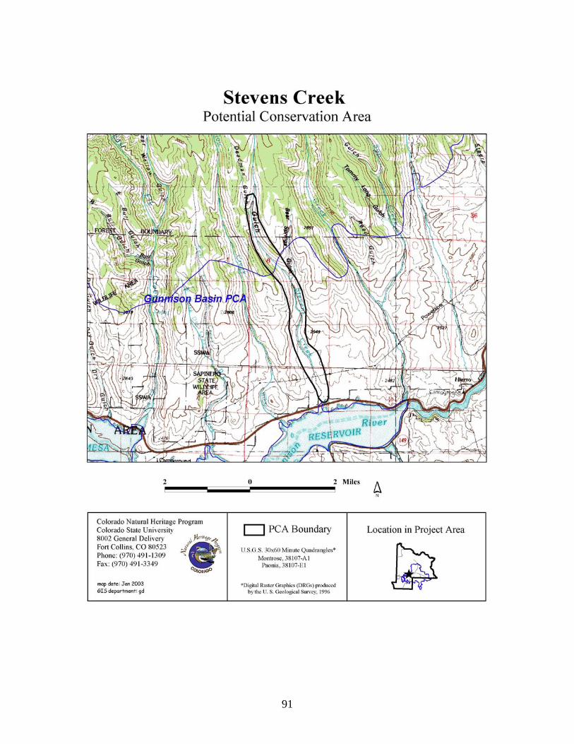
91

92
West Antelope Creek Potential Conservation Area Biodiversity Rank: B3. High biodiversity significance. The PCA supports a good example of a globally vulnerable (G3) riparian plant community. Additionally, the PCA supports the only known historic (not reintroduced) population of Colorado cutthroat trout (G4T3 S3) in the Upper Gunnison River Basin (above Blue Mesa Reservoir). Protection Urgency Rank: P4. No protection actions are needed in the foreseeable future. The PCA is entirely public lands and includes U.S. Forest Service, Bureau of Land Management, and a small piece of the Gunnison State Wildlife Area. Management Urgency Rank: M3. New management actions may be needed within five years to maintain the current quality of the element occurrences in the PCA. Cattle are currently excluded from riparian area as a management strategy for Colorado River cutthroat trout. The riparian vegetation and creek banks appear to be slowly recovering from previous grazing regimes. Location: The West Antelope Creek PCA is located about five miles northwest of Gunnison and about five miles east of the Ohio Creek road.
U.S.G.S. 7.5-min. quadrangles: Squirrel Creek, McIntosh Mountain, and Gunnison Legal Description: T50N R1W Sections 17-21;
T50N R2W Sections 1-3, 11-13; T51N R2W Sections 22, 23, 26-28, 34-36
Elevation: 8,000-10,800 ft. Size: Approximately 2,140 acres Johnston et al. (2001) Ecological and Community Type: RI3C – Non-Forested Riparian – Blue Willow-Serviceberry Willow-Booth Willow Ecological Series – Serviceberry willow/beaked sedge Ecological Type - Bebb-Geyer willows-shrubby cinquefoil-Baltic rush-dandelion-yarrow Community Type. General Description: West Antelope Creek flows through a U-shaped valley between rolling hills of sagebrush uplands in the lower elevations and grading into spruce forest at the higher elevations. At the middle elevations, the creek supports a riparian shrubland of thinleaf alder and mixed willow species (Alnus incana ssp. tenuifolia-mixed Salix species) (G3). Willows include Bebb (Salix bebbiana), Geyer (S. geyeriana), Rocky Mountain (serviceberry) (S. monticola), Drummond (blue) (S. drummondiana), and whiplash (Pacific) (S. lucida ssp. caudata). In some areas, aspen (Populus tremuloides) from the upper slopes continue down into the riparian area and are the dominant overstory. The understory is primarily native grasses and sedges with non-native pasture grasses abundant in some areas. Much of the creek was dry during the 2002 season due to extended drought conditions but minimal beaver activity had created a few shallow ponds. Some channel entrenchment has occurred, especially in the downstream reach. The only known historic remnant (not reintroduced) population of Colorado River cutthroat trout (Oncorhynchus clarki pleuriticus) in the Upper Gunnison River Basin (upstream of Blue Mesa Reservoir) occurs in West Antelope Creek (pers. comm. D. Brauch, CDOW). Testing of the fish population in 1997 indicates that they are genetically pure (pers. comm. D. Brauch, CDOW). However, due to drought conditions in 2002, most of the creek was dry and fish die-offs

93
occurred. About 50 fish were collected by CDOW in late summer 2002 in an attempt to preserve the population off-site. CDOW documented survival of some of the fish in the creek following the summer’s drought, but the drought resulted in the death of the great majority of the cutthroat population(pers. comm. D. Brauch, CDOW). The potential for long-term survival of this population is not known. Historically, the cutthroat trout could reestablish themselves from the Gunnison River following drought years. A wide variety of land management practices have been suggested to affect Colorado River cutthroat trout including overgrazing (Binns 1977) and water depletion and diversion (Jesperson 1981). These practices may have served to isolate this population of trout and protect them from invasion by non-native salmonids (CRCT Task Force 2001). These practices also fragment streams, restrict movement between formerly connected populations, and create small, isolated populations that may be more likely to go extinct (CRCT Task Force 2001). The lower elevation portion of the PCA is within the overall habitat range for the globally critically imperiled (G1) Gunnison Sage Grouse (Centrocercus minimus) and within two miles of a documented lek. Wet meadows and riparian areas are important habitat for the Gunnison Sage Grouse as they use these areas for brood rearing (Colorado Sage Grouse Working Group 1997). Biodiversity Rank Justification: The PCA supports a good example of the globally vulnerable (G3) thinleaf alder/mixed willow (Alnus incana ssp. tenuifolia-mixed Salix species) riparian shrubland. This association is widespread in Colorado and is expected to occur in other Rocky Mountain states. This association is a more general type than other thinleaf alder types. It has a high diversity of associated shrub species, unlike the nearly pure stands of alder found in other alder-dominated plant associations. The abundance of other shrubs may represent a transition in the physical setting, for example, from a broad floodplain dominated by willows to a narrow valley bottom and channel lined with only alder. This PCA also supports the only known historic population of Colorado River cutthroat trout (Oncorhynchus clarki pleuriticus) in the Upper Gunnison Basin. The globally imperiled (G4T3/S3) Colorado River cutthroat trout is a sensitive species, which is native to the Colorado River basin, and has recently been in decline. Remnant populations still remain in Colorado, Wyoming, and Utah. Table 24. Natural Heritage element occurrences at West Antelope Creek PCA. Elements in bold are those upon which the PCA's B-rank is based. Scientific Name Common Name Global
Rank State Rank
Federal and State Status
EO* Rank
Plant Communities Alnus incana ssp. tenuifolia-mixed Salix species
Thinleaf alder/mixed willow shrubland
G3 S3 B
Fish Oncorhynchus clarki pleuriticus
Colorado River cutthroat trout
G4T3 S3 FS/BLM SC
U
*EO=Element Occurrence. Multiple listings represent separate locations. Boundary Justification: The boundary includes the entire watershed of West Antelope Creek except for the most downstream portion. The boundary represents an estimate of the area needed to maintain local hydrological conditions. Any activities within the watershed such as water diversions, impoundments, improper livestock grazing, development, and mining could

94
potentially be detrimental to the hydrology of riparian area. This boundary indicates the minimum area that should be considered for any conservation management plan. Protection Comments: The PCA is a mosaic of public lands including federal (Bureau of Land Management and U.S. Forest Service) and state (Gunnison State Wildlife Area). Management Comments: Livestock grazing has been excluded from the allotment since 1996 (pers. comm. D. Brauch DOW), which has benefited the riparian community. Primary uses include recreational fishing and ATV use on roads. Downstream from the PCA the creek is altered by agricultural activities. Soils Description: Soils are derived from alluvium. Johnston et al. (2001) describe soils in this Ecological Type as mostly Cryaquolls and some Borohemists. Restoration Potential: Continued improvement of stream bank stability and riparian vegetation condition would be beneficial for the cutthroat trout population. Over time, well-vegetated streambanks will prevent channel incision and allow the creek to adjust to a new equilibrium. A rise in local water tables would likely aid in controlling and/or eradicating some non-natives. Referring to such resources as the Nature Conservancy’s web site on invasive species (http://tncweeds.ucdavis.edu/index.html) or http://www.invasivespecies.gov/ may provide some assistance with control and eradication of non-native species.

95
Wetland Functional Assessment for the West Antelope Creek PCA: Proposed HGM Class: Riverine Subclass: R3/4 Cowardin System: Palustrine CNHP's Wetland Classification: Alnus incana ssp. tenuifolia-mixed Salix species Table 25. Wetland functional assessment for the riverine wetland at the West Antelope Creek PCA.
Function Rating Comments Overall Functional
Integrity At Potential This wetland appears to be functioning near its potential.
Hydrological Functions Flood Attenuation and Storage
High There is a high density of shrubs and trees and a moderate sized floodplain.
Sediment/Shoreline Stabilization
Moderate Dense growth of herbaceous and woody species along the streambank. Cut banks in some areas.
Groundwater Discharge/ Recharge
Yes There are springs within the floodplain.
Dynamic Surface Water Storage
N/A This wetland floods via overbank flow.
Biogeochemical Functions Elemental Cycling Normal A diverse canopy of herbaceous and woody species plus
large quantities of woody debris, leaf litter, and soil organic matter suggest intact and functioning nutrient cycles.
Removal of Imported Nutrients, Toxicants, and Sediments.
Moderate Intact nutrient cycles and a dense and diverse cover of vegetation give this PCA a moderate rating for this function. Beaver ponds add to sediment removal potential.
Biological Functions Habitat Diversity High There are forested, scrub-shrub, and emergent wetland
habitats. General Wildlife Habitat High The forest, shrub, and herbaceous canopies provide a
diversity of vegetation structure, which along with high vegetation volume, provide excellent habitat for birds, mammals, and insects. The riparian area and surrounding sagebrush uplands are within the overall habitat range for the critically imperiled Gunnison Sage Grouse and within two miles of a documented lek.
General Fish/Aquatic Habitat
High A native historic population of Colorado River cutthroat trout survives in this reach. This is the only known historic population in the Upper Gunnison River Basin. No other fish species are known from the reach.
Production Export/Food Chain Support
Moderate The creek is dry throughout much of its reach. Large quantities of allochthonous organic substrates provide various sources of carbon (both dissolved and particulate) for food chain support.
Uniqueness High This reach supports the only known historic native population of Colorado River cutthroat trout in the Upper Gunnison River Basin.
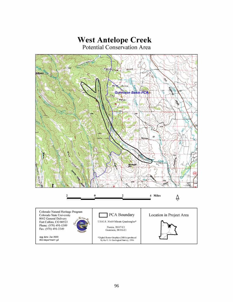
96

97
Alder Creek Potential Conservation Area
Biodiversity Rank: B4. Moderate biodiversity significance. The PCA supports good and excellent examples of globally common (G5) riparian plant communities. Additionally, this riparian area lies within two miles of four known Gunnison Sage Grouse leks. Protection Urgency Rank: P4. No protection actions are needed in the foreseeable future. The PCA is nearly all public lands with limited private inholdings. The lower elevations are managed by the Bureau of Land Management and the higher elevations by the U.S. Forest Service. Management Urgency Rank: M4. Current management seems to favor the persistence of the elements in the PCA, but management actions may be needed in the future to maintain the current quality of the element occurrences. Progressive changes in grazing management have lead to significant improvements in the condition of the BLM portion of the riparian area over the last 10-15 years (Johnston et al. 2001). Location: The Alder Creek PCA is located about five miles northwest of Parlin.
U.S.G.S. 7.5-min. quadrangles: Parlin, Crystal Creek Legal Description: T49N R2E Sections 1, 12 T49N R3E Sections 6, 7
T50N R2E Sections 24, 25, 36 T50N R3E Sections 4, 5, 7, 8, 17-19, 30, 31 T51N R3E Sections 32, 33
Elevation: 8,160-11,400 ft. Size: Approximately 2,345 acres Johnston et al. (2001) Ecological and Community Type: below treeline RI1A and B – Non-forested Riparian – Yellow Willow Ecological Series – Yellow willow/beaked sedge Ecological Type - Yellow (or Pacific) willow – Geyer willow – other willows – beaked sedge Community Type (A); Geyer willow – beaked sedge Community Type (B). General Description: The lower elevation section of Alder Creek is a small meandering stream within a deep canyon with steep sagebrush/bitterbrush vegetated slopes. Beaver activity is extensive creating a series of ponds and songbirds are abundant. The creek supports dense stands of mixed willow species, with an understory of sedges and other graminoids. Patches of dense willows alternate with patches of sedges and grasses that correspond to beaver ponds and dams of various ages (Johnston et al. 1991). Geyer willow (Salix geyeriana) is the dominant willow throughout much of the reach and beaked sedge (Carex utriculata) is the dominant understory species. Other willows present include whiplash (Pacific) (S. lucida ssp. caudata), Rocky Mountain (serviceberry) (S. monticola), sandbar (S. exigua), and Bebb (S. bebbiana). Other prevalent shrubs include thinleaf alder (Alnus incana ssp. tenuifolia), gooseberry (Ribes inerme), Woods’ rose (Rosa woodsii), and river hawthorn (Crataegus rivularis). The lower elevation portion of the PCA is within the habitat range for the globally critically imperiled (G1) Gunnison Sage Grouse (Centrocercus minimus) and within two miles of four documented lek sites. Wet meadows and riparian areas are important habitat for the Gunnison Sage Grouse as they use these areas for brood rearing (Colorado Sage Grouse Working Group

98
1997). A pair of Gunnison Sage Grouse was observed within the riparian area during our site visit in June 2002. The beaver population in the creek has created a rising water table and water is present within the channel year round - previously, the creek bottom would be dry in late seasons (Johnston et al. 1991). Alder Creek below treeline has recovered significantly from effects of heavy livestock grazing over that last 10-15 years due to progressive changes in grazing management agreed to by the BLM and the grazing permitee (Johnston et al. 2001). A road parallels Alder Creek at the bottom of the canyon. Flooding due to beaver activity makes the road impassable in some areas. Fish surveys conducted in 1999 showed brook trout in the stream and beaver ponds (Wang and Lambert 2000). At higher elevations, Alder Creek is within a steep V-shaped valley with forested slopes of Engelmann spruce (Picea engelmannii), lodgepole pine (Pinus contorta), and aspen (Populus tremuloides). The dominant species near the headwaters of East Fork Alder Creek is Engelmann spruce, with tall fringed bluebells (Mertensia ciliata), arrowleaf ragwort (Senecio triangularis), and heartleaf bittercress (Cardamine cordifolia) in the understory. Biodiversity Rank Justification: This PCA supports good and excellent examples of globally common (G5) riparian plant communities. Table 26. Natural Heritage element occurrences at Alder Creek PCA. Elements in bold are those upon which the PCA's B-rank is based. Scientific Name Common Name Global
Rank State Rank
Federal and State Status
EO* Rank
Plant Communities Salix geyeriana/Carex utriculata
Geyer willow/beaked sedge shrubland
G5 S3 B
Abies lasiocarpa-Picea engelmannii/Mertensia ciliata
Subalpine fir-Engelmann spruce/tall fringed bluebells forest
G5 S5 A
*EO=Element Occurrence. Multiple listings represent separate locations. Boundary Justification: The boundary includes a portion of Alder Creek and the surrounding watershed. The boundary represents a preliminary estimate of the area needed to maintain local hydrological conditions. However, it should be noted that the hydrological processes necessary to the riparian area are not fully contained by the PCA boundaries. Any upstream activities along Alder Creek such as water diversions, impoundments, improper livestock grazing, development, and mining could potentially be detrimental to the hydrology of riparian area. This boundary indicates the minimum area that should be considered for any conservation management plan. Protection Comments: The PCA is nearly entirely public lands with the higher elevations managed by the U.S. Forest Service and the lower elevations by the Bureau of Land Management. There are a few limited parcels of private inholdings, the largest being at the headwaters of East Fork Alder Creek. Management Comments: Progressive changes in grazing management agreed to by the BLM and the grazing permitee have led to significant recovery of the low elevation riparian vegetation over the last 10-15 years (Johnston et al. 2001). At the headwaters of East Fork Alder Creek

99
there area private inholdings associated with old mining claims. In this region, camping, ORV use, and fossil hunting occur. Downstream from the PCA the banks have been heavily grazed and the vegetative community and structure has been altered. Soils Description: Soils within the riparian area are variable and include organic rich and mineral soils. Johnston et al. (2001) describe soils in this Ecological Type as predominantly Endoaquolls and some Endoaquents or Argiborolls. Restoration Potential: Restoration of the riparian area is occurring with the progressive grazing management and active beaver population. A rise in local water tables should aid in controlling and/or eradicating some non-natives by increasing the vigor of native wetland species. Referring to such resources as the Nature Conservancy’s web site on invasive species (http://tncweeds.ucdavis.edu/index.html) or http://www.invasivespecies.gov/ may provide some assistance with control and eradication of non-native species

100
Wetland Functional Assessment for the Alder Creek PCA: Proposed HGM Class: Riverine Subclass: R3/4 Cowardin System: Palustrine CNHP's Wetland Classification: Salix geyeriana/Carex utriculata Table 27. Wetland functional assessment for the riverine wetland at the Alder Creek PCA.
Function Rating Comments Overall Functional
Integrity At Potential This wetland appears to be functioning at its potential.
Hydrological Functions Flood Attenuation and Storage
High There is a high density of shrubs and trees and a moderate sized floodplain.
Sediment/Shoreline Stabilization
High Dense growth of herbaceous and woody species along the streambank.
Groundwater Discharge/ Recharge
Yes There are springs within the floodplain.
Dynamic Surface Water Storage
N/A This wetland floods via overbank flow.
Biogeochemical Functions Elemental Cycling Normal A diverse canopy of herbaceous and woody species plus
large quantities of woody debris, leaf litter, and soil organic matter suggest intact and functioning nutrient cycles.
Removal of Imported Nutrients, Toxicants, and Sediments.
Moderate Intact nutrient cycles and a dense and diverse cover of vegetation give this PCA a moderate rating for this function. Beaver ponds add to sediment removal potential.
Biological Functions Habitat Diversity High There are scrub-shrub, emergent, and open water wetland
habitats. General Wildlife Habitat High The shrub and herbaceous canopies provide a diversity of
vegetation structure, which along with high vegetation volume, provide excellent habitat for birds, mammals, and insects. The riparian area and surrounding sagebrush uplands are within the overall habitat range for the critically imperiled Gunnison Sage Grouse.
General Fish/Aquatic Habitat
Moderate Fish are present in the creek.
Production Export/Food Chain Support
Moderate A permanent water source and large quantities of allochthonous organic substrates provide various sources of carbon (both dissolved and particulate) and nutrients for downstream ecosystems. Alder Creek flows into Quartz Creek, which then flows into Tomichi Creek.
Uniqueness Moderate The PCA supports globally common riparian plant communities. Low elevation riparian systems are generally in poor condition due to extensive livestock grazing and other human uses. Alder Creek is in good condition making it uncommon.

101

102
Potential Conservation Areas outside the Gunnison Basin Potential Conservation Area
Cement Creek Potential Conservation Area
Biodiversity Rank: B2. Very high biodiversity significance. This PCA supports a globally imperiled (G2) extreme rich fen plant community and numerous state rare plants. Protection Urgency Rank: P3. Protection actions may be needed, but probably not within the next five years. It is estimated that current stresses may reduce the viability of the elements of the PCA if protection action is not taken. Much of this PCA is privately owned with no special protection. Management Urgency Rank: M4. Current management seems to favor the persistence of the elements in the PCA, but management actions may be needed in the future to maintain the current quality of the element occurrences. Location: This PCA is located east of the community of Crested Butte South along Cement Creek.
U.S.G.S. 7.5-min. quadrangle: Cement Mountain and Pearl Pass Legal Description: T13S R84W Section 31;
T14S R84W Sections 4-10, 17-21, 29, and 30. Elevation: 9,400-12,172 ft. Size: Approximately 4,416 acres. Johnston et al. (2001) Ecological and Community Type: RI9A - Non-forested Riparian – Water Sedge Ecological Series – Water sedge-beaked sedge/tufted hairgrass Ecological Type – Water sedge-wet sedges and forbs Community Type in the seeps; and RI3A – Non-forested Riparian – Blue Willow-Serviceberry Willow-Booth Willow Ecological Series – Serviceberry willow/beaked sedge Ecological Type – Serviceberry willow-beaked sedge Community Type on the floodplain. General Description: This PCA sits in a moderately large valley. Just downstream of the PCA, Cement Creek has carved a narrow, box canyon before entering a steep V-shaped valley prior to its confluence with the East River near Crested Butte South. The upland slopes are steep and sparsely vegetated with spruce-fir. Some horse and cattle ranching occur within the floodplain both within and upstream of the PCA. Forest Road 740 traverses the northern side of the PCA. Upstream of the box canyon, there is a large travertine deposit on the northern side of the creek. The deposit was formed over time by groundwater discharging from perennial warm springs releasing carbon dioxide to the atmosphere and precipitating calcium carbonate (Blatt et al. 1990). The calcium carbonate precipitates from the groundwater and encrusts the substrate near the spring source. Following hundreds or thousands of years, the precipitate has formed a large solid mound of calcium carbonate. Numerous structures now exist on top of the mound, including many small guest cabins, a barn, stable, and an inhabited home. Some of the groundwater discharge has been rerouted to an artificial pool, which then flows over the travertine mound as a beautiful waterfall. The current landowners utilize a nearby spring as their domestic water source.

103
There are many seeps discharging on top of the travertine mound, along slopes, and in sporadic patches on the floodplain. East of the guest cabins is an area of standing water, which likely represents a groundwater discharge point. The state rare green sedge (Carex viridula) is abundant here. Upstream of this pool, along the north-northeastern slopes of the travertine mound, are a series of seeps. An extreme rich fen plant community of Pacific bog sedge and alpine meadow rue (Kobresia myosuroides-Thalictrum alpinum) (Cooper and Sanderson 1997) along with rare plants such as Rolland’s bulrush (Trichophorum pumilum), variegated scouring rush (Equisetum variegatum), and green sedge are found in these seeps. There are also pockets of the extreme rich fen and the aforementioned rare plants, in various locations within the floodplain. These fens are conspicuously parallel with the seeps near the travertine mound. In other words, upstream from where the travertine mound ends, there are no pockets of extreme rich fen in the floodplain, clearly suggesting that groundwater discharge near the travertine mound is connected with the same upwelling of groundwater. The floodplain fen patches are surrounded by either a Booth willow/mesic forb riparian shrubland (Salix boothii/mesic forb) or water or beaked sedge wet meadows (Carex aquatilis and C. utriculata, respectively). Scientists call both fens and bogs “peatlands.” Peatlands are wetlands with organic soils that consist of at least 12-18% organic-carbon content (by weight) (USDA 1994). They form where the rate of plant growth exceeds the rate of decomposition of litter. Both saturated soils and cool climates contribute to the conditions necessary for peatland formation. Peat accumulates slowly in all southern Rocky Mountain peatlands, but the rate of accumulation in extreme rich fens--as low as 4 inches per thousand years (Cooper 1990; Chimner and Cooper 2002)--is exceedingly slow. Also, contrary to what might seem intuitive, the extreme nutrient rich nature of these peatlands makes growing conditions for plants worse, not better, thus plant production is lower. Many plants cannot grow well at very high pH because certain essential nutrients are locked up in the soil. Since peat accumulation rates result from a combination of saturated conditions and plant productivity, the rate is low in extreme rich fens. Thus, the depth of peat in extreme rich fens tends to be less than that in rich fens. The slow accumulation rates also suggest that extreme rich fens cannot be restored to historic conditions after massive disturbance in any time period relevant to humans. Fens are peatlands that remain saturated primarily as a result of water percolating up from the ground with some contribution from surface water runoff. Peatlands are often classified along a chemical gradient (pH and concentration of cations such as Ca2+, Na+, K+, and Mg2+) (Cooper and Andrus 1994). The gradient is typically as follows: ombrotrophic bogs and poor fens are characterized by low pH and low cation concentration, whereas rich and extreme rich fens are characterized by high pH and high cation concentration. Most fens in Colorado would be considered “intermediate” or “rich” fens. These terms do not refer to the number of species in the wetland. They refer instead to the levels of nutrients (calcium, magnesium, etc.) in the water. Intermediate and rich fens are found in river basins, near seeps, and in small, water-filled depressions formed by glaciers. Intermediate and rich fens typically are dominated by beaked sedge (Carex utriculata), water sedge (Carex aquatilis), and planeleaf willow (Salix planifolia). Their pH tends to be near neutral (7.0) or slightly acidic (less than 7.0). The peat soils in these fens range from shallow (less than 1 meter) to moderately deep (up to 4 meters). In contrast to the wide distribution of intermediate and rich fens, extreme rich fens appear restricted to a small area in Colorado, primarily the west and north portions of South Park and Cement Creek. On a global basis extreme rich fens also appear to be quite uncommon. Only three other small locations of extreme rich fens are known in the Western U.S.

104
As with the intermediate and rich fens, “extreme rich” in the name of these wetlands refers to the chemical content of the water, not to species richness or community diversity (Cooper and Andrus 1994). The levels of calcium, magnesium, and other plant nutrients in the groundwater that feeds this system are very high (see Table 28). The groundwater picks up these elements as it percolates through the limestone found at Cement Creek. As a result of the dissolution of limestone and subsequent high bicarbonate concentrations, the water that feeds Cement Creek’s extreme rich fens is very basic (high pH) relative to other montane fens. The occurrence of these extreme rich fens at Cement Creek is very exciting as this is the first documentation of this unique wetland type outside of South Park in Colorado. The extreme rich fens in South Park have generated quite a bit of excitement within the botanical and conservation communities because of their unusual nature and their important natural heritage value for Colorado and the world. Several public and private entities have recently taken an interest in preserving this unique natural heritage resource. The government of Park County and the South Park Heritage Resource Program are interested in preserving the heritage values of the county in order to maintain the county’s unique features and to promote the county as a tourist destination. The U.S. Army Corps of Engineers, the primary regulator of wetlands in Colorado, is interested in the nature and status of these wetlands in order to better process wetland permit applications. The Nature Conservancy, a private conservation organization, has already pursued protection of the best example of South Park’s extreme rich fens through the purchase of High Creek Fen, a wetland system approximately 9 miles south of Fairplay. The extreme rich fens at Cement Creek are unique in that they represent the only documented occurrence of this wetland type outside of South Park. Any conservation and/or educational activities that could occur at this PCA would be of great value for the conservation of one of Colorado’s most unique wetland ecosystems. Table 28. Water chemistry for the Cement Creek* extreme rich fen as compared to extreme rich and rich fens in South Park, Colorado.
PCA pH Conductivity µS
HCO3 mg/L
SO4 mg/L
Ca mg/L
Na mg/L
Mg mg/L
Extreme Rich Fens High Creek Fen 7.65-8.60 360-860 248-284 26.2-54.7 56.5-60.3 5.8-6.6 25.7-28.6 Cement Creek 7.4-8.2 380-650 301 81 77 35 20 Brinkerhoff PCA
7.88-8.22 338-600 251-290 3.9-9.9 37.9-86.0 1.9-7.0 16.6-42.2
Fremont’s Fen 7.38-8.34 116-576 .5-3.1 2.8-28.7 14.8-94.9 2.0-9.9 2.2-9.1 Rich Fens Sacramento Creek
6.67-7.59 332-403 152-187 1.4-64.6 35.5-42.2 1.3-2.2 18.2-22.8
East Lost Park 6.06-6.89 24-59 NA NA NA 1.9-2.3 0.4-0.8 McMaster’s 6.95 83-148 28-73 3.4-32.8 7.1-15.7 1.9-2.3 3.4-6.9 Carpenter’s 7.0-8.1 163-209 59-117 3.9-9.9 12.3-22.1 1.4-2.6 4.9-9.6 Note: South Park data from Cooper (1990). *Data for Cement Creek was collected using a Myron L EP11 pH/Conductivity Meter for all but one set of measurements for pH and conductivity, while the remaining measurements are from Truebe, 1975 which were collected from a spring approximately 20 meters upslope of the actual extreme rich fens.

105
Biodiversity Rank Justification: Extreme rich fens appear restricted to a small area in Colorado, primarily the west and north portions of South Park (Cooper 1996) and the new location at Cement Creek. Even on a global basis extreme rich fens appear to be quite uncommon. Only three other small locations of extreme rich fens exist in the Western U.S.: in northwestern Montana (Lesica 1986), in California at Convict Creek Basin (Major and Taylor 1977), and in northwestern Wyoming (Fertig and Jones 1992). They are also known from the foothills of the Rocky Mountains eastern slope in Canada (Slack et al. 1980, Karlin and Bliss 1984), from northern Ontario (Sjörs 1961), and from Scandinavia (Nordqvist 1965). Only the Wyoming and California sites appear to be floristically similar to the South Park extreme rich fens. The extreme rich fens located at Cement Creek are the first documented Colorado occurrence of this plant community outside of South Park. The extreme rich fen (Kobresia myosuroides-Thalictrum alpinum) plant community (Cooper and Sanderson 1997), or a very closely related one, was reported in the Convict Creek Basin in California (Major and Taylor 1977). Nothing similar to it has been reported from any other extreme rich fens outside of South Park and Cement Creek, Colorado. Numerous state rare plants are also found in these extreme rich fens. For example, Rolland’s bulrush (Trichophorum pumilum) is a circumboreal species with disjunct populations in Colorado, Wyoming, Montana, and California (Hitchcock and Cronquist 1973; Fertig and Jones 1992). Within Colorado all known occurrences of this species are found in and around South Park and the newly documented occurrence at Cement Creek. Green sedge (Carex viridula) is found only in peatlands, and is reported from Newfoundland to Alaska, southward to New Jersey, Indiana, Colorado, and California (Hermann 1970). A total of seven occurrences are located in Colorado. The Booth willow/mesic forb (Salix boothii/mesic forb) plant association is a tall (4-5 ft., 1-2 m) shrubland that often forms extensive thickets, or willow carrs, on broad montane floodplains. It occurs in Idaho, Wyoming (Youngblood et al. 1985), Utah (Padgett et al. 1989) and Colorado (Colorado Natural Heritage Program 2003). Variegated scouring rush is circumboreal in distribution in the northern hemisphere but is near its southern extent in Colorado. Table 29. Natural Heritage element occurrences at the Cement Creek PCA. Elements in bold are those upon which the PCA's B-rank is based. Scientific Name Common Name Global
Rank State Rank
Federal and State Status
EO* Rank
Plant Communities Kobresia myosuroides-Thalictrum alpinum
Extreme rich fen Pacific bog sedge – alpine meadowrue herbaceous vegetation
G2 S1 B
Salix boothii/mesic forb Booth willow/mesic forb shrubland
G3 S3 B
Plants Trichophorum pumilum Rolland’s bulrush G5 S2 FS B Carex viridula Green sedge G5 S1 B Equisetum variegatum Variegated scouring
rush G5 S1 B
*EO=Element Occurrence Boundary Justification: Boundaries are drawn to include the potential groundwater recharge zones, which must be maintained to preserve the hydrological integrity of the extreme rich fens. These boundaries, however, are preliminary and additional research on the recharge zones is warranted. The boundaries also incorporate an area that will allow natural hydrological processes

106
such as seasonal flooding, sediment deposition, and new channel formation to maintain viable populations of the elements along Cement Creek. The boundaries provide a small buffer from nearby agriculture fields, roads, and houses where surface runoff may contribute excess nutrients, sediment, and herbicides/pesticides. The PCA contains areas where old oxbows, sloughs, and ponds could provide a source of recruitment for native wetland and riparian plant species and provide fish habitat. It should be noted that the hydrological processes necessary to the elements are not fully contained by the PCA boundaries. Given that the elements are dependent on natural hydrological processes associated with Cement Creek and its tributaries upstream activities such as water diversions, impoundments, improper livestock grazing, and development are detrimental to the hydrology of the riparian area. This boundary indicates the minimum area that should be considered for any conservation management plan. Protection Comments: The PCA has no formal protection but the current landowners are aware of the conservation value of the wetlands. Protecting this PCA either via an easement or acquisition is highly recommended due to the unique nature of extreme rich fens. However, immediate threats to the wetlands are not likely under the current ownership. Management Comments: Groundwater studies should be implemented to determine recharge zones and sensitive areas associated with groundwater flow to the extreme rich fens. Currently, one spring is diverted for residential use. This activity could be monitored to determine whether the diversion has any impact on the extreme rich fen communities. The diversion currently does not appear to have had a large impact on the extreme rich fens, however the guest cabins and any future construction activities in this area could negatively affect the fens. Grazing should not occur near or in the extreme rich fens. Soils Description: Soils in the extreme rich fens are Histosols. The peat (hemic material) is at least 32 inches deep is most places. Johnston et al. (2001) describe soils in Water sedge-beaked sedge/tufted hairgrass Ecological Type as Borohemist or Cryaquolls-Cryaquepts. The following is a soil profile from one of the extreme rich fens: Oi 0-4 inches, calcium carbonate precipitate covers much of the soil surface; Oe 4-? inches; Sulphur odor exuded from lower layers of peat. Soils along the riparian area are derived from alluvium. Johnston et al. (2001) describe soils in the Serviceberry willow/beaked sedge Ecological Type as mostly Cryaquolls and some Borohemists. Soils associated with wet meadows and near beaver ponds/dams are typically fine grained and have a high organic matter content. Restoration Potential: Restoring natural flow to the diverted spring may be difficult given that the spring occurs on the opposite side of a Forest Service Road. Large portions of the floodplain are currently used to graze cattle and horses. These areas should be rested to allow native vegetation to recuperate from heavy grazing. Referring to such resources as the Nature Conservancy’s web site on invasive species (http://tncweeds.ucdavis.edu/index.html) or http://www.invasivespecies.gov/ may provide some assistance with control and eradication of non-native species.

107
Wetland Functional Assessment for the Cement Creek PCA: Proposed HGM Class: Slope Subclass: S2 Cowardin System: Palustrine. CNHP's Wetland Classification: Kobresia myosuroides-Thalictrum alpinum Table 30. Wetland functional assessment for the slope wetland at the Cement Creek PCA.
Function Ratings Comments Overall Functional
Integrity At Potential This wetland is functional at potential.
Hydrological Functions Flood Attenuation and Storage
N/A This wetland is supported by groundwater discharge.
Sediment/Shoreline Stabilization
N/A This wetland is supported by groundwater discharge.
Groundwater Discharge/ Recharge
Yes Groundwater discharges from the numerous seeps in the area.
Dynamic Surface Water Storage
Moderate Peat soils store large quantities of surface water but the overall size of the fens limit extent.
Biogeochemical Functions Elemental Cycling Normal A diverse canopy of herbaceous species plus large quantities
of leaf litter and accumulating peat suggest intact and functioning nutrient cycles. Could be impacted by road and guest cabins, but no indication of that was observed.
Removal of Imported Nutrients, Toxicants, and Sediments.
Low Inputs are low in most patches. Inputs may be occurring in patch near road.
Biological Functions Habitat Diversity Low Emergent vegetation. General Wildlife Habitat Low Low habitat diversity and unstable soils. General Fish/Aquatic Habitat
N/A No flowing or deep open water present.
Production Export/Food Chain Support
Moderate Peat is present in this type of wetland and thus is likely exporting dissolved carbon. Wetland likely supports numerous invertebrates.
Uniqueness High This community type was previously only known from South Park, Colorado.

108
Wetland Functional Assessment for the Cement Creek PCA: Proposed HGM Class: Riverine Subclass: R2 Cowardin System: Palustrine. CNHP's Wetland Classification: Salix boothii/mesic forb Table 31. Wetland functional assessment for the riverine wetland at the Cement Creek PCA.
Function Ratings Comments Overall Functional
Integrity At Potential This wetland is functional at potential.
Hydrological Functions Flood Attenuation and Storage
High Large floodplain dotted with numerous beaver ponds.
Sediment/Shoreline Stabilization
High Streambanks are well vegetated.
Groundwater Discharge/ Recharge
Yes Groundwater discharges from numerous seeps in the floodplain.
Dynamic Surface Water Storage
N/A
Biogeochemical Functions Elemental Cycling Normal A diverse canopy of herbaceous and woody species plus large
quantities of woody debris, leaf litter, and soil organic matter suggest intact and functioning nutrient cycles. May be slightly impacted by grazing, especially along the northern portion of the floodplain (where grazing is intense).
Removal of Imported Nutrients, Toxicants, and Sediments.
High Capacity is high due to large, vegetated area with a diversity of saturated soil conditions allowing for many chemical transformations. Inpusts occur from road, grazing, and housing structures.
Biological Functions Habitat Diversity High Emergent, shrub, and open water wetland types. General Wildlife Habitat High High habitat diversity. Good vegetation structure and
volume for migratory birds, open water for waterbirds, and plenty of cover and browse for large and small mammals.
General Fish/Aquatic Habitat
High Stable streambanks, overhanging vegetation, and diversity of pools and riffles provide good fish/aquatic habitat.
Production Export/Food Chain Support
High Large amounts of allochthonous material (litter from willows, herbaceous plants, etc.) are able to be transported downstream. Beaver ponds also produce dissolved carbon. Various vegetation types support invertebrates.
Uniqueness Low This community type is common.

109

110
Mount Emmons Iron Fen Potential Conservation Area Biodiversity Rank: B2. Very high biodiversity significance. Supports an excellent example of a globally imperiled (G2) plant community and a state rare (S2) plant. Protection Urgency Rank: P2. Protection actions may be needed within 5 years. It is estimated that current stresses may reduce the viability of the elements in the PCA within this approximate timeframe. The Colorado Natural Areas Program has designated small portion of the PCA as a State Natural Area. However, upstream and upslope recharge areas are owned by a mining company (a molybdenum mine) and the U.S. Forest Service. Any future mining activity on the private land could affect the hydrology within the PCA. Management Urgency Rank: M4. Current management seems to favor the persistence of the elements in the PCA, but management actions may be needed in the future to maintain the current quality of the element occurrences. Location: This site is located on the south-facing flank of Mount Emmons, approximately 3 miles west of Crested Butte.
U.S.G.S. 7.5-min. quadrangle: Mount Axtell and Oh-Be-Joyful Legal Description: T14S R86W Sections 5 and 6 T13S R86W Sections 31 and 32
Elevation: 9,400-10,160 ft. Size: Approximately 897 acres. Johnston et al. (2001) Ecological and Community Type: RI9A - Non-forested Riparian – Water Sedge Ecological Series – Water sedge-beaked sedge/tufted hairgrass Ecological Type – Water sedge-wet sedges and forbs Community Type. General Description: The Mount Emmons iron fen is a slope fen in the West Elk Mountains near Crested Butte. The fen lies on the flank of Mount Emmons, a local landmark. The water sources for the PCA are perennial cold springs of acidic highly mineralized water, fed by groundwater percolating through the complex fault systems underlying Mount Emmons. The fen drains south and is captured by a drainage ditch and rerouted to a culvert to pass underneath County Road 12 down into Coal Creek, a major tributary of the Slate River. Limonite, a hardened iron precipitate, surrounds much of the upslope area around the fen, indicating that previous springs had discharged in this area. Iron fens are unusual peatlands in that surface/groundwater pH and the associated plant species are typical of ombrotrophic bogs and acidic, nutrient poor fens, while the concentration of ions is more typical of rich and extreme rich fens (Cooper 1999). Peatlands are often classified along a chemical gradient (pH and concentration of cations such as Ca2+, Na+, K+, and Mg2+). The gradient is typically as follows: ombrotrophic bogs and poor fens are characterized by low pH and low cation concentration, whereas rich and extreme rich fens (e.g., High Creek Fen near Fairplay, CO) are characterized by high pH and high cation concentration. Iron fens do not fit into this gradient because of the unusual biogeochemistry (low pH but high concentration of ions (especially Ca2+ and SO4
2-). This occurs due to groundwater draining through rock rich in pyrite. As the pyrite oxidizes, it produces sulfuric acid leading to a nutrient rich yet acidic water supply (Cooper 1999). Iron fens are characterized by limonite ledges, which form when iron precipitates out of solution and then solidifies into hard rock. Organic substrates (e.g., peat and coarse woody

111
debris) often are mixed with the iron precipitate thus limonite often contains large amounts of organic materials. The plant species typically found in iron fens include: Engelmann spruce (Picea engelmannii), lodgepole pine (Pinus contorta), bog birch (Betula glandulosa), dwarf blueberry (Vaccinium cespitosum), creeping wintergreen (Gaultheria humifusa), water sedge (Carex aquatilis), and bluejoint reedgrass (Calamagrostis canadensis), with a continuous carpet of mosses mainly dominated by sphagnum species (Sphagnum spp.). The iron fen at this PCA consists of a complex of vegetation associated with the acidic seepage. The upper pond margin and the lower end of the fen are forested with lodgepole pine and an understory of water sedge, bluejoint reedgrass, and various sphagnum species. Closer to the pond, bog birch, water sedge, and sphagnum are dominant. Fewflower spikerush (Eleocharis quinqueflora) is common in the low rills. Dwarf blueberry and creeping wintergreen are growing on higher sphagnum mounds. Star sedge (Carex angustior) and cottonsedge (Eriophorum angustifolium) are scattered about the PCA. Silvery sedge (Carex canescens) is also scattered through the PCA both in monotypic patches and individually. The northern margins of the fen near the pond support a population of the state-rare roundleaf sundew (Drosera rotundifolia). Biodiversity Rank Justification: The PCA supports the globally imperiled iron fen plant community ((Picea engelmannii)/Betula glandulosa/Carex aquatilis/Sphagnum sp.). Iron fens are unusual peatlands where the surface/groundwater pH and plant species are typical of ombrotrophic bogs and acidic, nutrient poor fens (pH < 4.4), while the concentration of ions is more typical of rich and extreme rich fens (pH > 6.0) (Cooper 1999). The combination of species (more typical of true bogs) that occur in iron fens is rare in Colorado (less than 20 occurrences are known in the state). In Colorado, iron fens are found in the mineral belt. Mineralized zones in Idaho, Montana, Wyoming, and South Dakota may contain similar wetlands (George Jones, personal communication, 1999). For example, there is an Iron Bog Research Natural Area within the Challis National Forest in Idaho where cation concentrations and pH are very similar to the iron fens documented here in Colorado (Fred Rabe, personal communication, 1999). More research is needed within the Rocky Mountain region to determine the extent of this wetland type. The round-leaf sundew is common in the northern portion of the U.S. and in Canada but only seven populations are found in Colorado. One in Gunnison County while the remaining six are found in Grand and Jackson counties. Table 32. Natural Heritage element occurrences at the Mount Emmons Iron Fen PCA. Elements in bold are those upon which the PCA's B-rank is based. Scientific Name Common Name Global
Rank State Rank
Federal and State Status
EO* Rank
Plant Communities (Picea engelmannii)/Betula glandulosa/Carex aquatilis/Sphagnum sp.
Bog birch/water sedge/Sphagnum moss iron fen
G2 S2 B
Plants Drosera rotundifolia Round-leaf sundew G5 S2 FS B
*EO=Element Occurrence Boundary Justification: Boundaries are drawn to include the potential groundwater recharge zones, which must be maintained to preserve the hydrological integrity of the iron fen. These boundaries, however, are preliminary and additional research on the recharge zones is needed, as local hydrology is complex (Lamm 1998).

112
Protection Comments: The Colorado Natural Areas Program has designated small portion of the PCA as a State Natural Area. However, upstream and upslope recharge areas are owned by a mining company (a molybdenum mine) and the U.S. Forest Service. The Taylor River/Cebolla Ranger District of the Grand Mesa-Uncompahgre-Gunnison National Forests manages the PCA as a Special Interest Area to protect its unique botanical and ecological values. Special Interest Area designation provides the fen a certain amount of protection. The Taylor River/Cebolla Ranger District has also begun the process of establishing the fen as a Research Natural Area, which would further restrict use and development of the wetland. Any future mining activity on the private land could affect the hydrology within the PCA. Protection actions should target these areas. Management Comments: Special Interest Area designation provides management prescriptions which prohibit construction of new roads and trails through the PCA, discourage increased recreational use, and limit fire management techniques to those which minimize ground disturbance. The hydrology of the fen is extremely complex and sensitive to disturbance. Re-opening of the molybdenum mine is likely to have an impact on the wetland's hydrology. Approximately 1/3 of the wetland area has dried out since historic mining operations began. Although a popular county road (Kebler Pass road) runs within a few hundred feet of the wetland, the fen itself is inconspicuous and receives little use. Local mountain bike groups want to establish a multiple-use trail on the abandoned wagon road that runs along the hillside above the county road and below the fen. Soils Description: Soils in the iron fen are Histosols (hemic and fibric material). Johnston et al. (2001) describe soils in this Ecological Type as Borohemist or Cryaquolls-Cryaquepts. Restoration Potential: Currently, little can be done to restore any disruption in hydrology that previous mining activities may have caused. Efforts should focus on protecting recharge zones and areas where future mining may occur.

113
Wetland Functional Assessment for the Mount Emmons Iron Fen PCA: Proposed HGM Class: Slope Subclass: S1 Cowardin System: Palustrine. CNHP's Wetland Classification: (Picea engelmannii)/Betula glandulosa/Carex aquatilis/Sphagnum sp. Table 33. Wetland functional assessment for the slope wetland at the Mount Emmons PCA.
Function Ratings Comments Overall Functional
Integrity Below
Potential Historic mining operations have dried up nearly 1/3 of original wetland acreage. Otherwise, the remaining portion of the fen is functioning At Potential.
Hydrological Functions Flood Attenuation and Storage
N/A This wetland is supported by groundwater discharge.
Sediment/Shoreline Stabilization
N/A This wetland is supported by groundwater discharge.
Groundwater Discharge/ Recharge
Yes Groundwater discharges from the numerous seeps in the area.
Dynamic Surface Water Storage
Moderate Peat soils store large quantities of surface water, however much of the area no longer stores water due to altered hydrology from historic mining operations.
Biogeochemical Functions Elemental Cycling Normal/
Disrupted Altered hydrology has disrupted cycles in some areas. Hydrologically intact areas are normal.
Removal of Imported Nutrients, Toxicants, and Sediments.
Moderate Inputs likely from mining areas. Low pH may inhibit some chemical transformations.
Biological Functions Habitat Diversity High Forested, emergent, and open water areas. General Wildlife Habitat High Diversity of habitat, vegetation structure, and presence of
open water provide good habitat for songbirds, and native ungulates.
General Fish/Aquatic Habitat
Low The aquatic areas of the fen are likely too acidic to support fish populations and there is no passable surface connection between the fen and Coal Creek.
Production Export/Food Chain Support
High Numerous macroinvertebrates were observed both within the pond and in various locations throughout the iron fen. Very little particulate carbon is exported but dissolved carbon export is likely high.
Uniqueness High Iron fens are a unique wetland type in Colorado.
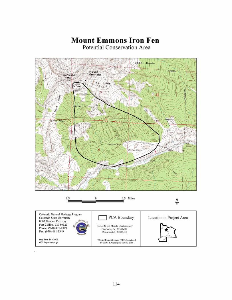
114
.

115
Redwell Basin Iron Fen Potential Conservation Area Biodiversity Rank: B2. Very high biodiversity significance. This PCA supports a good example of a globally imperiled (G2) plant community. Protection Urgency Rank: P3. Protection actions may be needed, but probably not within the next five years. It is estimated that current stresses may reduce the viability of the elements of the PCA if protection action is not taken. The U.S. Forest Service manages most of the PCA but private mining claims also exist in the area. Management Urgency Rank: M4. Current management seems to favor the persistence of the elements in the PCA, but management actions may be needed in the future to maintain the current quality of the element occurrences. Location: This PCA is located on the north-facing flank of Mount Emmons, just north of Gunsight Pass.
U.S.G.S. 7.5-min. quadrangle: Oh Be Joyful Legal Description: T13S R86W Sections 30 and 31; T13S R87W Sections 25 and 36.
Elevation: 10,200-12,090 ft. Size: Approximately 405 acres. Johnston et al. (2001) Ecological and Community Type: RI9A - Non-forested Riparian – Water Sedge Ecological Series – Water sedge-beaked sedge/tufted hairgrass Ecological Type – Water sedge-wet sedges and forbs Community Type; General Description: The Redwell is a spring which discharges near the head of the basin through Cretaceous-age rocks and is depositing hydrous iron oxides (limonite) (Neubert 2000). The limonite has built up around the discharging spring, creating a 5-6 ft. deep “well”. However, iron fen vegetation is not found at this location. The water in the Redwell was found to have a pH of 3.51, conductivity of 304 µS, very high levels of lead, zinc, cadmium, iron, aluminum, manganese, and copper (Neubert 2000). Drainage from the Redwell and other upstream springs flow through the center of the basin. Between the Redwell and where the road crosses the creek is an acidic seep on the east side of the creek. Typical iron fen vegetation is found here and at another seep, also on the east side of the creek, downstream of the road. Development of iron fen vegetation is minimal in both locations, but enough exists to identify it as an area receiving different groundwater than other nearby portions of the wetland. Upland slopes are covered in spruce-fir and the area is near treeline. Old mine adits are nearby as well as associated roads. Iron fens are unusual peatlands in that surface/groundwater pH and the associated plant species are typical of ombrotrophic bogs and acidic, nutrient poor fens, while the concentration of ions is more typical of rich and extreme rich fens (Cooper 1999). Peatlands are often classified along a chemical gradient (pH and concentration of cations such as Ca2+, Na+, K+, and Mg2+). The gradient is typically as follows: ombrotrophic bogs and poor fens are characterized by low pH and low cation concentration, whereas rich and extreme rich fens (e.g., High Creek Fen near Fairplay, CO) are characterized by high pH and high cation concentration. Iron fens do not fit into this gradient because of the unusual biogeochemistry (low pH but high concentration of ions (especially Ca2+ and SO4
2-). This occurs due to groundwater draining through rock rich in pyrite. As the pyrite oxidizes, it produces sulfuric acid leading to a nutrient rich yet acidic water supply

116
(Cooper 1999). Iron fens are characterized by limonite ledges, which form when iron precipitates out of solution and then solidifies into hard rock. Organic substrates (e.g., peat and coarse woody debris) often are mixed with the iron precipitate thus limonite often contains large amounts of organic materials. The plant species typically found in iron fens include: Engelmann spruce (Picea engelmannii), lodgepole pine (Pinus contorta), bog birch (Betula glandulosa), dwarf blueberry (Vaccinium cespitosum), creeping wintergreen (Gaultheria humifusa), water sedge (Carex aquatilis), and bluejoint reedgrass (Calamagrostis canadensis), with a continuous carpet of mosses mainly dominated by sphagnum species (Sphagnum spp.). Iron fens at this PCA are dominated by water sedge and sphagnum peat moss. Tufted hairgrass (Deschampsia cespitosa) and dwarf blueberry are also found in the iron fen areas. Very few shrubs or trees occur in the iron fens. Small, stunted individuals of bog birch and Engelmann spruce are in a few locations. Dark, blackish moss is found on seeping limonite outcrops. Most of the nearby non-iron fen meadows support water sedge, tufted hairgrass, bluejoint reedgrass, King’s crown (Rhodiola integrifolia), elephantella (Pedicularis groenlandica), rushes (Juncus spp.), and planeleaf willow (Salix planifolia). Biodiversity Rank Justification: The PCA supports the globally imperiled iron fen plant community (Picea engelmannii)/Betula glandulosa/Carex aquatilis/Sphagnum sp.) Iron fens are unusual peatlands where the surface/groundwater pH and plant species are typical of ombrotrophic bogs and acidic, nutrient poor fens (pH < 4.4), while the concentration of ions is more typical of rich and extreme rich fens (pH > 6.0) (Cooper 1999). The combination of species (more typical of true bogs) that occur in iron fens is rare in Colorado (less than 20 occurrences are known in the state). In Colorado, iron fens are found in the mineral belt. Mineralized zones in Idaho, Montana, Wyoming, and South Dakota may contain similar wetlands (George Jones, personal communication, 1999). For example, there is an Iron Bog Research Natural Area within the Challis National Forest in Idaho where cation concentrations and pH are very similar to the iron fens documented here in Colorado (Fred Rabe, personal communication, 1999). More research is needed within the Rocky Mountain region to determine the extent of this wetland type. Table 34. Natural Heritage element occurrences at the Redwell Basin Iron Fen PCA. Elements in bold are those upon which the PCA's B-rank is based. Scientific Name Common Name Global
Rank State Rank
Federal and State Status
EO* Rank
Plant Communities (Picea engelmannii)/Betula glandulosa/Carex aquatilis/Sphagnum sp.
Bog birch/water sedge/Sphagnum moss iron fen
G2 S2 B
*EO=Element Occurrence Boundary Justification: Boundaries are drawn to include the potential groundwater recharge zones, which must be maintained to preserve the hydrological integrity of the iron fen. These boundaries, however, are preliminary and additional research on the recharge zones is needed, as local hydrology is complex. Protection Comments: Most of the PCA is managed by the U.S. Forest Service and is only accessible via a four wheel drive vehicle. Private mining claims also exist in the area. Any future mining activity on the private land could affect hydrology of PCA. Protection actions should target these areas.

117
Management Comments: Monitor any impacts from road (non-native species encroachment) or change in hydrology. Soils Description: Soils in the iron fen are Histosols (hemic and fibric material). Johnston et al. (2001) describe soils in this Ecological Type as Borohemist or Cryaquolls-Cryaquepts. Restoration Potential: Currently, little can be done to restore any disruption in hydrology that previous mining activities may have caused. Efforts should focus on protecting recharge zones and areas where future mining may occur. Wetland Functional Assessment for the Redwell Basin Iron Fen PCA: Proposed HGM Class: Slope Subclass: S1 Cowardin System: Palustrine. CNHP's Wetland Classification: (Picea engelmannii)/Betula glandulosa/Carex aquatilis/Sphagnum sp. Table 35. Wetland functional assessment for the slope wetland at the Redwell Basin Iron Fen PCA.
Function Ratings Comments Overall Functional
Integrity At Potential This wetland is functioning at potential.
Hydrological Functions Flood Attenuation and Storage
N/A This wetland is supported by groundwater discharge.
Sediment/Shoreline Stabilization
N/A This wetland is supported by groundwater discharge.
Groundwater Discharge/ Recharge
Yes Groundwater discharges from the numerous seeps in the area.
Dynamic Surface Water Storage
Moderate Peat soils store large quantities of surface water, however the wetland is narrow and the peat is only about 1 foot deep.
Biogeochemical Functions Elemental Cycling Normal The presence of aerated water (the river) and large areas of
saturated soil (oxbows, sloughs) provide a gradient for various nutrient transformations.
Removal of Imported Nutrients, Toxicants, and Sediments.
Moderate Inputs likely from mining areas. Low pH may inhibit some chemical transformations.
Biological Functions Habitat Diversity Low Emergent and open water areas. General Wildlife Habitat Low Low habitat diversity and low pH of water may limit
usefulness to wildlife. However, wet meadows provide browse for ungulates and insects.
General Fish/Aquatic Habitat
Low The aquatic areas of the fen are likely too acidic to support fish populations.
Production Export/Food Chain Support
Moderate Very little particulate carbon (due to lack of litter input from shrubs) is exported but dissolved carbon export is likely high from decomposing peat. Insects were observed crawling through peat moss.
Uniqueness High Iron fens are a unique wetland type in Colorado.

118

119
Triangle Pass Potential Conservation Area Biodiversity Rank: B2. Very high biodiversity significance. The site supports a good breeding location for boreal toad (Bufo boreas) (G4T1Q), a globally critically imperiled subspecies. Protection Urgency Rank: P4. No protection actions are needed in the foreseeable future. The site is entirely within the Maroon Bells-Snowmass Wilderness Area managed by the U.S. Forest Service. There are very limited private inholdings. Management Urgency Rank: M4. Current management seems to favor the persistence of the elements in the PCA, but management actions may be needed in the future to maintain the current quality of the element occurrences. Recreational use from hikers and horse packers is a concern. Recovery from disturbance in the alpine is slow to impossible (Johnston et al. 2001). Location: The Triangle Pass PCA is located along the continental divide about eight miles north northwest of Crested Butte.
U.S.G.S. 7.5-min. quadrangles: Gothic and Maroon Bells Legal Description: T12S R85W Sections 17-21 and 28-30;
T12S R86W Sections 13, 24, and 25 Elevation: 10,600-13,520 ft. Size: Approximately 3,615 acres Johnston et al. (2001) Ecological and Community Types: AL – Alpine Ecological Type. No vegetation information available to determine Community Type. General Description: The site straddles the continental divide and encompasses Copper Pass, Triangle Pass, and Coffee Pot Pass. Conundrum Creek drains north into Pitkin County and Copper and West Brush creeks drain south into Gunnison County. Nearly the entire site is above treeline. A pack trail runs through the site and crosses the divide at Triangle Pass. The Colorado Division of Wildlife documented a boreal toad (Bufo boreas) breeding location within the site. The boreal toad breeds in still or slowly moving water and successful breeding generally requires permanent or semipermanent water sources. The boreal toad was once common throughout the mountains of Colorado, but has undergone declines over the last 20 years. In 1993 the boreal toad was listed as state endangered and is currently a candidate species for federal listing under the U.S. Endangered Species Act. Biodiversity Rank Justification: This site supports a known active breeding location for boreal toad (Bufo boreas), a globally critically imperiled subspecies.
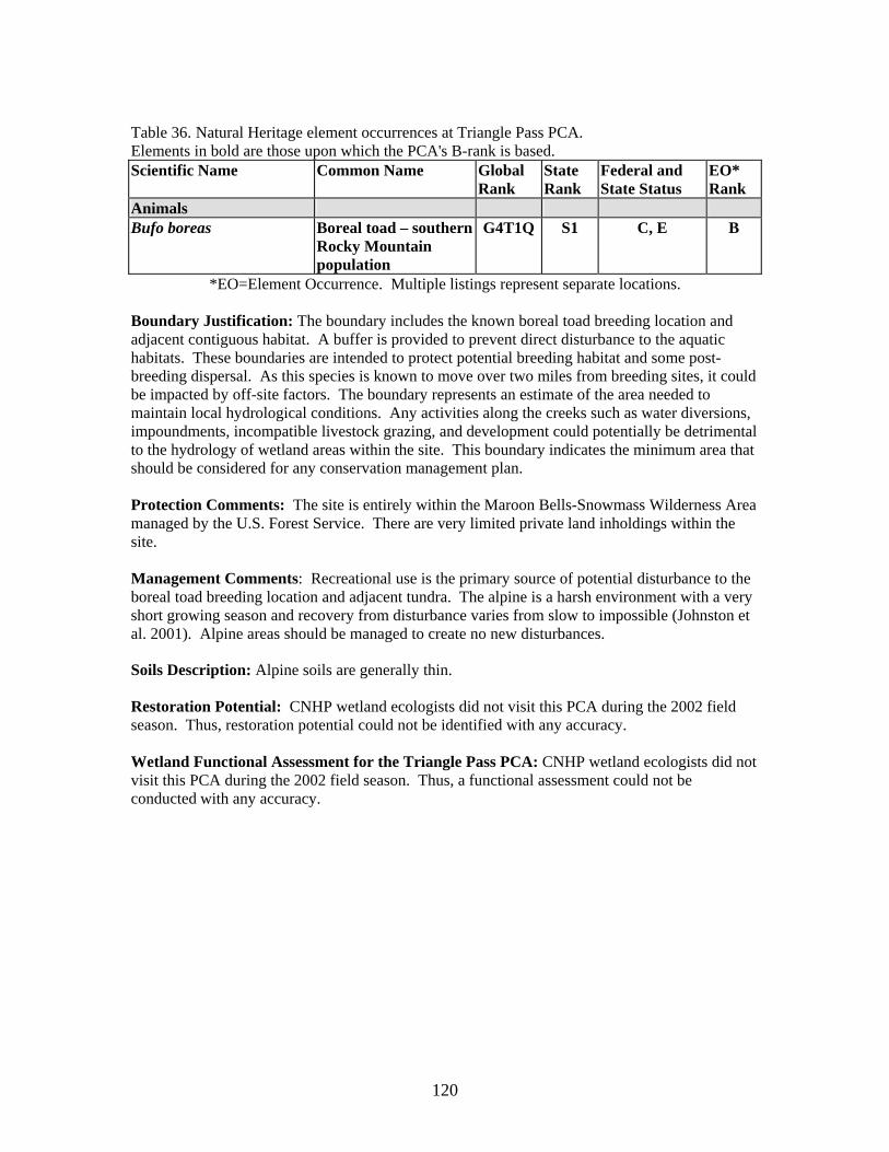
120
Table 36. Natural Heritage element occurrences at Triangle Pass PCA. Elements in bold are those upon which the PCA's B-rank is based. Scientific Name Common Name Global
Rank State Rank
Federal and State Status
EO* Rank
Animals Bufo boreas Boreal toad – southern
Rocky Mountain population
G4T1Q S1 C, E B
*EO=Element Occurrence. Multiple listings represent separate locations. Boundary Justification: The boundary includes the known boreal toad breeding location and adjacent contiguous habitat. A buffer is provided to prevent direct disturbance to the aquatic habitats. These boundaries are intended to protect potential breeding habitat and some post-breeding dispersal. As this species is known to move over two miles from breeding sites, it could be impacted by off-site factors. The boundary represents an estimate of the area needed to maintain local hydrological conditions. Any activities along the creeks such as water diversions, impoundments, incompatible livestock grazing, and development could potentially be detrimental to the hydrology of wetland areas within the site. This boundary indicates the minimum area that should be considered for any conservation management plan. Protection Comments: The site is entirely within the Maroon Bells-Snowmass Wilderness Area managed by the U.S. Forest Service. There are very limited private land inholdings within the site. Management Comments: Recreational use is the primary source of potential disturbance to the boreal toad breeding location and adjacent tundra. The alpine is a harsh environment with a very short growing season and recovery from disturbance varies from slow to impossible (Johnston et al. 2001). Alpine areas should be managed to create no new disturbances. Soils Description: Alpine soils are generally thin. Restoration Potential: CNHP wetland ecologists did not visit this PCA during the 2002 field season. Thus, restoration potential could not be identified with any accuracy. Wetland Functional Assessment for the Triangle Pass PCA: CNHP wetland ecologists did not visit this PCA during the 2002 field season. Thus, a functional assessment could not be conducted with any accuracy.

121

122
Whitepine Iron Fen Potential Conservation Area Biodiversity Rank: B2. Very high biodiversity significance. This PCA supports a good example of a globally imperiled (G2) plant community and a good example of an apparently secure (G4) plant community. Protection Urgency Rank: P3. Protection actions may be needed, but probably not within the next five years. It is estimated that current stresses may reduce the viability of the elements of the PCA if protection action is not taken. The iron fen is on private property. Management Urgency Rank: M3. New management actions may be needed within five years to maintain the current quality of the element occurrences in the PCA. Research on recharge zones and directional flow of local groundwater needs to be conducted. Location: This PCA is located approximately 1.5 miles upstream of the town of Whitepine along Tomichi Creek.
U.S.G.S. 7.5-min. quadrangle: Garfield and Whitepine. Legal Description: T50N R5E Sections 1, 2, 10-15, and 22-27; T50N R6E Sections 18, 19, and 30.
Elevation: 9,800-13,024 ft. Size: Approximately 6,117 acres. Johnston et al. (2001) Ecological and Community Type: RI9A - Non-forested Riparian – Water Sedge Ecological Series – Water sedge-beaked sedge/tufted hairgrass Ecological Type – Water sedge-wet sedges and forbs Community Type; RI5A - Non-forested Riparian – Planeleaf Willow–Wolf Willow–Bog Birch Ecological Series – Wolf-planeleaf willows/Water sedge Ecological Type – Wolf willow-water sedge Community Type. General Description: Tomichi Creek has cut a broad valley through Precambrian granite and Tertiary, intrusive rocks, modified by glaciers, which left a veneer of moraine on the lower valley slopes. Aspen (Populus tremuloides), lodgepole pine (Pinus contorta), and Engelmann spruce (Picea engelmannii) dominate upland slopes. Beavers have modified the valley into an extensive complex of wet meadows and ponds. A large willow carr dominated by Wolf willow (Salix wolfii) and water sedge (Carex aquatilis) occupy much of the riparian area in the valley. Acidic springs support the iron fen at this PCA. Additional iron springs are located upstream but have not developed extensive iron fen vegetation as the one documented in this report. Iron fens are unusual peatlands in that surface/groundwater pH and the associated plant species are typical of ombrotrophic bogs and acidic, nutrient poor fens, while the concentration of ions is more typical of rich and extreme rich fens (Cooper 1999). Peatlands are often classified along a chemical gradient (pH and concentration of cations such as Ca2+, Na+, K+, and Mg2+). The gradient is typically as follows: ombrotrophic bogs and poor fens are characterized by low pH and low cation concentration, whereas rich and extreme rich fens (e.g., High Creek Fen near Fairplay, CO) are characterized by high pH and high cation concentration. Iron fens do not fit into this gradient because of the unusual biogeochemistry (low pH but high concentration of ions (especially Ca2+ and SO4
2-). This occurs due to groundwater draining through rock rich in pyrite. As the pyrite oxidizes, it produces sulfuric acid leading to a nutrient rich yet acidic water supply (Cooper 1999). Iron fens are characterized by limonite ledges, which form when iron precipitates out of solution and then solidifies into hard rock. Organic substrates (e.g., peat and coarse woody

123
debris) often are mixed with the iron precipitate thus limonite often contains large amounts of organic materials. The plant species typically found in iron fens include: Engelmann spruce (Picea engelmannii), lodgepole pine (Pinus contorta), bog birch (Betula glandulosa), dwarf blueberry (Vaccinium cespitosum), creeping wintergreen (Gaultheria humifusa), water sedge (Carex aquatilis), and bluejoint reedgrass (Calamagrostis canadensis), with a continuous carpet of mosses mainly dominated by sphagnum species (Sphagnum spp.). Lodgepole pine and Engelmann spruce dominate the iron fen with an understory of water sedge and various sphagnum species. During the 2002 PCA visit, the PCA was very dry and the sphagnum carpet was very yellow. The owners of the property indicated that they have never seen the wetland so dry in the 30 years they've owned the property. A private driveway cuts through the iron fen, covering part of it. Downstream of the driveway crossing, the fen appears somewhat drier, however typical iron fen vegetation remains intact. Biodiversity Rank Justification: The PCA supports the globally imperiled iron fen plant community ((Picea engelmannii)/Betula glandulosa/Carex aquatilis/Sphagnum sp.). Iron fens are unusual peatlands where the surface/groundwater pH and plant species are typical of ombrotrophic bogs and acidic, nutrient poor fens (pH < 4.4), while the concentration of ions is more typical of rich and extreme rich fens (pH > 6.0) (Cooper 1999). The combination of species (more typical of true bogs) that occur in iron fens is rare in Colorado (less than 20 occurrences are known in the state). In Colorado, iron fens are found in the mineral belt. Mineralized zones in Idaho, Montana, Wyoming, and South Dakota may contain similar wetlands (George Jones, personal communication, 1999). For example, there is an Iron Bog Research Natural Area within the Challis National Forest in Idaho where cation concentrations and pH are very similar to the iron fens documented here in Colorado (Fred Rabe, personal communication, 1999). More research is needed within the Rocky Mountain region to determine the extent of this wetland type. Table 37. Natural Heritage element occurrences at the Whitepine Iron Fen PCA. Elements in bold are those upon which the PCA's B-rank is based. Scientific Name Common Name Global
Rank State Rank
Federal and State Status
EO* Rank
Plant Communities (Picea engelmannii)/Betula glandulosa/Carex aquatilis/Sphagnum sp.
Bog birch/water sedge/Sphagnum moss iron fen
G2 S2 B
Salix wolfii/Carex aquatilis Wolf willow/water sedge shrubland
G4 S3 AB
*EO=Element Occurrence Boundary Justification: The boundary represents a preliminary estimate of the area needed to maintain local hydrological conditions and incorporate an area that will allow natural hydrological processes such as seasonal flooding, groundwater recharge, sediment deposition, and new channel formation to maintain viable populations of the elements. Groundwater recharge zones are of special importance, as they must be maintained to preserve the hydrological integrity of the iron fen. Additional research on the recharge zones is needed, as local groundwater hydrology is complex. The PCA contains areas where old oxbows, sloughs, and ponds could provide a source of recruitment for native wetland and riparian plant species and provide fish habitat. This boundary indicates the minimum area that should be considered for any conservation management plan.

124
Protection Comments: The iron fen is on private property, however the current owners are not conducting any activity that may impact the PCA. The owners were very interested in the results of this study and showed much interest in the biological value of the property. A conservation easement would ensure that the PCA remains protected from future disturbances. Any future mining activity in the area could affect the hydrology of the PCA. Management Comments: Small cabins are scattered up and downstream of the PCA. Septic and water wells associated with these developments may affect the PCA's hydrology. Forest road 888 runs just upslope of the iron fen. Old mine adits also occur upstream, otherwise, upland slopes appear intact. There is a need to assess the impact of the driveway on groundwater flow and quality in the iron fen. If flow has been impacted, then restoration activities should be implemented. Research on recharge zones and directional flow of local groundwater needs to be conducted. Soils Description: Soils in the iron fen are Histosols (fibric and hemic material). Soil profile descriptions: Pit 1 (near small pool at downstream end of the PCA near Tomichi creek): Oa 0-6 inches Oe 6-9 inches Cb 9-12 inches Oa 12-14 inches; Dark black color and strong sulfur smell Oe 14-36 inches; C surface of old drainage where peat filled in. Pit 2 (just south of driveway) Oi 0-7 inches; Oi2 7-36+ inches; No sulfur smell. Very little decomposition Johnston et al. (2001) describe soils in the Water sedge-beaked sedge/tufted hairgrass Ecological Type as Borohemist or Cryaquolls-Cryaquepts and Cryaquolls and Cryohemists in the Wolf-planeleaf willows/Water sedge Ecological Type. Restoration Potential: The easiest approach to restoring any impacted groundwater flow resulting from the presence of the driveway would be to end the driveway before it enters the iron fen and remove all remaining material associated with the driveway. A lower-impact walkway could then be used to access the house. Removing fill material and compacted gravels should release any restrictive barriers to groundwater flow. Much effort should be placed into revegetating the newly exposed portion of the fen with native species to avoid a non-native species problem. Barring any change in soil nutrient status, sphagnum moss will likely colonize the exposed area with time. Thus, no supplemental nutrients should be used in revegetation efforts, as this would encourage non-iron fen species to colonize the area. Referring to such resources as the Nature Conservancy’s web site on invasive species (http://tncweeds.ucdavis.edu/index.html) or http://www.invasivespecies.gov/ may provide some assistance with control and eradication of non-native species
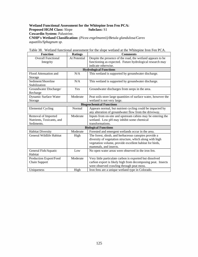
125
Wetland Functional Assessment for the Whitepine Iron Fen PCA: Proposed HGM Class: Slope Subclass: S1 Cowardin System: Palustrine. CNHP's Wetland Classification: (Picea engelmannii)/Betula glandulosa/Carex aquatilis/Sphagnum sp. Table 38. Wetland functional assessment for the slope wetland at the Whitepine Iron Fen PCA.
Function Ratings Comments Overall Functional
Integrity At Potential Despite the presence of the road, the wetland appears to be
functioning as expected. Future hydrological research may indicate otherwise.
Hydrological Functions Flood Attenuation and Storage
N/A This wetland is supported by groundwater discharge.
Sediment/Shoreline Stabilization
N/A This wetland is supported by groundwater discharge.
Groundwater Discharge/ Recharge
Yes Groundwater discharges from seeps in the area.
Dynamic Surface Water Storage
Moderate Peat soils store large quantities of surface water, however the wetland is not very large.
Biogeochemical Functions Elemental Cycling Normal Appears normal, but nutrient cycling could be impacted by
any alteration of groundwater flow from the driveway. Removal of Imported Nutrients, Toxicants, and Sediments.
Moderate Inputs from on-site and upstream cabins may be entering the wetland. Low pH may inhibit some chemical transformations.
Biological Functions Habitat Diversity Moderate Forested and emergent wetlands occur in the area. General Wildlife Habitat High The forest, shrub, and herbaceous canopies provide a
diversity of vegetation structure, which along with high vegetation volume, provide excellent habitat for birds, mammals, and insects.
General Fish/Aquatic Habitat
Low No open water areas were observed in the iron fen.
Production Export/Food Chain Support
Moderate Very little particulate carbon is exported but dissolved carbon export is likely high from decomposing peat. Insects were observed crawling through peat moss.
Uniqueness High Iron fens are a unique wetland type in Colorado.

126
Wetland Functional Assessment for the Whitepine Iron Fen PCA: Proposed HGM Class: Riverine Subclass: R1 Cowardin System: Palustrine. CNHP's Wetland Classification: Salix wolfii/Carex aquatilis Table 39. Wetland functional assessment for the riverine wetland at the Whitepine Iron Fen PCA.
Function Ratings Comments Overall Functional
Integrity At Potential This wetland is functioning at potential.
Hydrological Functions Flood Attenuation and Storage
High Large floodplain dotted with numerous beaver ponds.
Sediment/Shoreline Stabilization
High Streambanks are well vegetated.
Groundwater Discharge/ Recharge
Yes Groundwater discharges from numerous seeps in the floodplain.
Dynamic Surface Water Storage
N/A This wetland floods via overbank flow.
Biogeochemical Functions Elemental Cycling Normal A diverse canopy of herbaceous and woody species plus large
quantities of woody debris, leaf litter, and soil organic matter suggest intact and functioning nutrient cycles.
Removal of Imported Nutrients, Toxicants, and Sediments.
High Capacity is high due to large, vegetated area with a diversity of saturated soil conditions allowing for many chemical transformations. Inputs from local septic tanks may be occurring.
Biological Functions Habitat Diversity High Emergent, shrub, and open water wetland types. General Wildlife Habitat Moderate High habitat diversity. Diversity of vegetation structure and
volume is good for migratory birds and open water for waterbirds. Johnston et al. (2001) point out that deer and elk tend to avoid these wetlands due to the number of pits caused by old channels.
General Fish/Aquatic Habitat
High Stable streambanks, overhanging vegetation, and diversity of ponds, pools and riffles provide good fish/aquatic habitat.
Production Export/Food Chain Support
High Large amounts of allochthonous material (litter from willows, herbaceous plants, etc.) are able to be transported downstream. Beaver ponds also produce dissolved carbon. Various vegetation types support invertebrates.
Uniqueness Low This community type is common.

127

128
Blue Creek at Curecanti Needle Potential Conservation Area Biodiversity Rank: B3. High biodiversity significance. The PCA supports a good example of a globally vulnerable (G3) riparian plant community. Protection Urgency Rank: P3. Protection actions may be needed, but probably not within the next five years. It is estimated that current stresses may reduce the viability of the elements of the PCA if protection action is not taken. The Bureau of Land Management and National Park Service manage the PCA. The BLM portion does not have special protection afforded to it. Management Urgency Rank: M3. New management actions may be needed within five years to maintain the current quality of the element occurrences in the PCA. Location: This PCA is located approximately five miles east of the Gunnison-Montrose County line, where Hwy. 50 crosses Blue Creek.
U.S.G.S. 7.5-min. quadrangles: Curecanti Needle Legal Description: T48N R5W Sections 2, 3, 10, 11, 14, 23, and 24.
Elevation: 7,400-8,600 ft. Size: Approximately 1,092 acres Johnston et al. (2001) Ecological and Community Type: FR4A – Riparian Forests – Blue & Engelmann Spruces-Subalpine Fir Riparian Ecological Series – Spruce/honeysuckle-reedgrass Ecological Type – Blue spruce-alder-reedgrass-water sedge-horsetail Community Type. General Description: Blue Creek has cut a narrow, steep canyon through metamorphic gneiss and schist and granite before emptying into the Gunnison River, just downstream of Blue Mesa Reservoir. The floodplain is narrow through much of the PCA. Near the upstream end of this PCA, the gradient somewhat moderates and the floodplain begins to widen. Hwy. 50 cuts across the PCA near the upstream end. Access to much of the area is difficult and no trail runs down the canyon. Adjacent slopes are very steep and sporadically covered with spruce-fir. Grazing is occurring near the upstream end of the PCA. Blue spruce (Picea pungens) and thinleaf alder (Alnus incana ssp. tenuifolia) dominate the riparian area. Drummond (blue) willow (Salix drummondiana), Woods’ rose (Rosa woodsii), gooseberry (Ribes sp.), beaked sedge (Carex utriculata), bluejoint reedgrass (Calamagrostis canadensis), and horsetail (Equisetum arvense) increase in abundance upstream. Biodiversity Rank Justification: This PCA supports a good example of the globally vulnerable (G3) blue spruce/thinleaf alder (Picea pungens/Alnus incana ssp. tenuifolia) woodland. This woodland occurs in deep, shaded canyons and narrow valleys along relatively straight stream reaches. It generally forms small patches, but can be continuous for several river miles. This association is known from Wyoming to New Mexico. Fewer than 100 stands exist in Colorado, and very few of these are in pristine condition. This association is threatened by development, road building and maintenance, heavy recreational use, improper livestock grazing, and stream flow alterations.

129
Table 40. Natural Heritage element occurrences at Blue Creek at Curecanti Needle PCA. Elements in bold are those upon which the PCA's B-rank is based. Scientific Name Common Name Global
Rank State Rank
Federal and State Status
EO* Rank
Plant Communities Picea pungens/Alnus incana ssp. tenuifolia
Blue spruce/thinleaf alder woodland
G3 S3 B
*EO=Element Occurrence. Multiple listings represent separate locations. Boundary Justification: The boundaries incorporate an area that will allow natural hydrological processes such as seasonal flooding, sediment deposition, and new channel formation to maintain viable populations of the elements along Blue Creek. The boundaries also provide a small buffer from nearby agriculture fields, roads, and houses where surface runoff may contribute excess nutrients, sediment, and herbicides/pesticides. It should be noted that the hydrological processes necessary to the elements are not fully contained by the PCA boundaries. Given that the elements are dependent on natural hydrological processes associated with Blue Creek and its tributaries upstream activities such as water diversions, impoundments, improper livestock grazing, and development are detrimental to the hydrology of the riparian area. This boundary indicates the minimum area that should be considered for any conservation management plan. Protection Comments: The Bureau of Land Management and National Park Service manage the PCA. The Bureau of Land Management portion does not have any special protection afforded to it. Management Comments: Monitor PCA to determine extent and influx of non-native species associated with the road. Soils Description: Soils within the riparian area are rocky and alluvium derived. Johnston et al. (2001) describe soil types for this Ecological Type as Cryaquolls-Cryaquents or Cryoborolls. Restoration Potential: The PCA is functioning as expected and restoration opportunities are minimal at this point. Referring to such resources as the Nature Conservancy’s web site on invasive species (http://tncweeds.ucdavis.edu/index.html) or http://www.invasivespecies.gov/ may provide some assistance with control and eradication of non-native species.

130
Wetland Functional Assessment for the Blue Creek at Curecanti Needle PCA: Proposed HGM Class: Riverine Subclass: R3/4 Cowardin System: Palustrine CNHP's Wetland Classification: Picea pungens/Alnus incana ssp. tenuifolia Table 41. Wetland functional assessment for the riverine wetland at the Blue Creek at Curecanti Needle PCA.
Function Rating Comments Overall Functional
Integrity At Potential This wetland appears to be functioning at its potential.
Hydrological Functions Flood Attenuation and Storage
Low The valley is narrow and V-shaped with rocky slopes and limited floodplain.
Sediment/Shoreline Stabilization
Moderate Streambank vegetation appears intact, especially in lower reaches, but is less so in the upper portion of the PCA.
Groundwater Discharge/ Recharge
No No evidence of groundwater discharge was observed and much of the creek bottom consists of bedrock, thus limiting recharge potential.
Dynamic Surface Water Storage
N/A This wetland floods via overbank flow.
Biogeochemical Functions Elemental Cycling Normal A diverse canopy of herbaceous and woody species plus large
quantities of woody debris, leaf litter, and soil organic matter suggest intact and functioning nutrient cycles. May be slightly impacted by upstream grazing.
Removal of Imported Nutrients, Toxicants, and Sediments.
Moderate Inputs from upstream livestock activity and road may be entering wetland, however the narrow floodplain minimizes extent to which the function can be performed.
Biological Functions Habitat Diversity Moderate Forested and scrub-shrub wetlands. General Wildlife Habitat Moderate Evidence of use by herbivores and a variety of birds.
Diversity of vegetation structure is moderate. General Fish/Aquatic Habitat
Moderate Fish expected to be in creek. Habitat characteristics are good. Stable streambanks and pool and riffles.
Production Export/Food Chain Support
Moderate Large amounts of allochthonous material (litter from willows, herbaceous plants, etc.) are able to be transported downstream. Various vegetation types support invertebrates.
Uniqueness Low Similar river canyons are common in the montane zone.

131

132
Canyon Creek Potential Conservation Area Biodiversity Rank: B3. High biodiversity significance. The site supports a good example of a globally vulnerable (G3) riparian plant community. Protection Urgency Rank: P4. No protection actions are needed in the foreseeable future. The entire site is managed by the U.S. Forest Service. Management Urgency Rank: M3. New management actions may be needed within five years to maintain the current quality of the element occurrences in the PCA. Location: This PCA is located along Canyon Creek near Snowblind Campground, which is downstream of the town of Whitepine.
U.S.G.S. 7.5-min. quadrangle: Whitepine Legal Description: T49N R5E Sections 4, 5, 8, and 9;
T50N R4E Section 36; T50N R5E Sections 30, 31, and 32.
Elevation: 9,400-10,200 ft. Size: Approximately 738 acres Johnston et al. (2001) Ecological and Community Types: RI5A – Non forested riparian – Planeleaf Willow-Wolf Willow-Bog birch Ecological Series – Wolf-planeleaf willows/water sedge Ecological Type - Wolf willow-water sedge Community Type. RI9A - Non-forested Riparian – Water Sedge Ecological Series – Water sedge-beaked sedge/tufted hairgrass Ecological Type – Water sedge-wet sedges and forbs Community Type. General Description: Canyon Creek is a small tributary of Tomichi Creek. The stream has gentle meanders and a large overflow channel that shows evidence of past high flows. Much of the creek flows through a medium-wide valley with a moderate gradient. In this portion, thinleaf alder (Alnus incana ssp. tenuifolia) and various forbs dominate the riparian area. However, there is high vegetation structural diversity. The headwaters are dominated by Wolf willow (Salix wolfii) and planeleaf willow (S. planifolia) where the stream is moderately sinuous, forming a beaver carr mosaic. Much of the Wolf willow stand has been grazed resulting in low species richness and unstable streambanks banks. The stream is entrenched in many places. Engelmann spruce (Picea engelmannii) and lodgepole pine (Pinus contorta) are also present along the creek. The entire valley shows signs of human use, more historical than present. A trail runs parallel to the creek; grazing and logging are all noticeable. Biodiversity Rank Justification: This PCA supports a good example of the globally vulnerable (G3) Wolf willow/bluejoint reedgrass (Salix wolfii/Calamagrostis canadensis) shrubland. The PCA also supports a good example of the globally vulnerable (G3) thinleaf alder/mesic forb (Alnus incana ssp. tenuifolia/mesic forb) riparian shrubland. This association is documented from several states but is not well documented in Colorado and is expected to be more common if properly inventoried. This plant association was once common and widespread, but is now declining. The association is rarely found in good condition without non-native species in the undergrowth. Because this community can change significantly with improper grazing, this plant association may not be recognized as the same type across state lines. There are over 30

133
documented occurrences of this plant association in Colorado. However, none are very large and only one or two are in pristine condition. All stands are highly threatened by improper livestock grazing, stream flow alterations, road and railroad improvements and maintenance and heavy recreational use. Table 42. Natural Heritage element occurrences at Canyon Creek PCA. Elements in bold are those upon which the PCA's B-rank is based. Scientific Name Common Name Global
Rank State Rank
Federal and State Status
EO* Rank
Plant Communities Salix wolfii/Calamagrostis canadensis
Wolf willow/bluejoint reedgrass shrubland
G3 S2S3 BC
Alnus incana ssp. tenuifolia/mesic forb
Thinleaf alder/mesic forb shrubland
G3 S3 B
Carex aquatilis Water sedge herbaceous vegetation
G5 S4 B
*EO=Element Occurrence. Multiple listings represent separate locations. Boundary Justification: The boundaries incorporate an area that will allow natural hydrological processes such as seasonal flooding, sediment deposition, and new channel formation to maintain viable populations of the elements along Canyon Creek. It should be noted that the hydrological processes necessary to the elements are not fully contained by the PCA boundaries. Given that the elements are dependent on natural hydrological processes associated with Canyon Creek and its tributaries, upstream activities such as water diversions, impoundments, and improper livestock grazing are detrimental to the hydrology of the riparian area. This boundary indicates the minimum area that should be considered for any conservation management plan. Protection Comments: No protection actions are needed in the foreseeable future. The entire site is managed by the U.S. Forest Service. Management Comments: New management actions may be needed within five years to maintain the current quality of the element occurrences in the PCA. May want to divert recreation trail to upland slopes. At current use levels, an increase in grazing could degrade site. Grazing is also occurring up and downstream. Logging is occurring above site. There are also indications of historic logging and mining operations. Recreation (bikes, hikers, ATV, and horses) occurs along nearby pack trail. Soils Description: Soils within the riparian area are alluvium and peat. Johnston et al. (2001) describe soil types for the Wolf-planeleaf willows/water sedge Ecological Type as Cryaquolls and Cryohemists; and in the Water sedge-beaked sedge/tufted hairgrass Ecological Type as Borohemist or Cryaquolls-Cryaquepts. Restoration Potential: CNHP wetland ecologists did not visit this PCA during the 2002 field season. Thus, restoration potential could not be identified with any accuracy. Wetland Functional Assessment for the Canyon Creek PCA: CNHP wetland ecologists did not visit this PCA during the 2002 field season. Thus, a functional assessment could not be conducted with any accuracy.

134

135
Coal Creek Potential Conservation Area Biodiversity Rank: B3. High biodiversity significance. The PCA supports good examples of globally vulnerable (G3) riparian plant communities and examples of apparently secure (G4) and secure (G5) riparian plant communities. Protection Urgency Rank: P4. No protection actions are needed in the foreseeable future. The PCA is almost entirely managed by the U.S. Forest Service with a few private inholdings. The West Elk Wilderness surrounds three sides of Coal Creek within this PCA. Management Urgency Rank: M3. New management actions may be needed within five years to maintain the current quality of the element occurrences in the PCA. Location: This PCA is located approximately 6 miles south of Paonia Reservoir along Forest Road 709.
U.S.G.S. 7.5-min. quadrangles: West Beckwith Mountain and Minnesota Pass Legal Description: T14S R88W Sections 30 and 31; T14S R89W Sections 3, 10, 11, 14-17, 20-27, and 33-36; T15S R88W Section 6; T15S R89W Section 1, 4, 5, and 6;
T15S R90W Section 1. Elevation: 7,000-10,000 ft. Size: Approximately 6,190 acres Johnston et al. (2001) Ecological and Community Type: FR5A – Riparian Forests – Blue & Engelmann Spruces-Subalpine Fir Riparian Ecological Series - Spruce/Red-osier Ecological Type – Spruce-Red-osier Community Type; FR3A – Riparian Forests – Blue & Engelmann Spruces-Subalpine Fir Riparian Ecological Series – Blue spruce-cottonwood/alder-silvertop sedge Ecological Type - – Blue spruce-cottonwood/alder-silvertop sedge-Kentucky bluegrass Community Type; and FR6A - Riparian Forests – Blue & Engelmann Spruces-Subalpine Fir Riparian Ecological Series – Fir-spruce/wet forbs Ecological Type – Engelmann spruce-subalpine fir-bittercress-arrowleaf groundsel Community Type; RI2B – Non-forested Riparian – Blue Willow-Serviceberry Willow-Booth Willow Ecological Series – Blue willow/reedgrass-beaked sedge Ecological Type – Blue-serviceberry-Geyer willows-Kentucky bluegrass-moist forbs Community Type. General Description: Coal Creek is a medium size, flat-bottomed creek in a narrow and steep valley. The riparian area has a complex of plant communities depending on the gradient and width of the floodplain. The slopes are dominated by Engelmann spruce (Picea engelmannii) and aspen (Populus tremuloides) or when very steep then bare soil. In upstream areas of the PCA, the river has been dramatically altered due to overgrazing causing heavy stream erosion with subsequent channel incision. Near the confluence of Robinson and Coal Creek, narrowleaf cottonwood (Populus angustifolia), blue spruce (Picea pungens), and thinleaf alder (Alnus incana ssp. tenuifolia) dominate a relatively flat riparian area. About a mile downstream of this community, blue spruce and thinleaf alder begin to dominate the riparian zone as the floodplain narrows and increases in gradient. At the Cascade Creek and Coal Creek confluence, subalpine fir (Abies lasiocarpa),

136
Engelmann spruce, and thinleaf alder are dominant. The canopy is dense and supports a shady moss- covered floor. Downed trees are common and form dams and steep drops. The water quality appears to be good with most rocks having mayflies and caddisflies. Willow Creek, a tributary to Coal Creek, supports primarily Rocky Mountain (serviceberry) and Drummond (blue) willows (Salix monticola, S. drummondiana) with patches of Engelmann spruce and thinleaf alder in narrow sections. Dominant forbs in the willow understory include cow parsnip (Heracleum sphondylium var. montanum), tall fringed bluebells (Mertensia ciliata), lovage (Ligusticum porteri), coneflower (Rudbeckia ampla), and waterleaf (Hydrophyllum fendleri). Biodiversity Rank Justification: This PCA supports a good example of the globally vulnerable (G3) blue spruce/thinleaf alder (Picea pungens/Alnus incana ssp. tenuifolia) woodland. This woodland occurs in deep, shaded canyons and narrow valleys along relatively straight stream reaches. It generally forms small patches, but can be continuous for several river miles. This association is known from Wyoming to New Mexico. Fewer than 100 stands exist in Colorado, and very few of these are in pristine condition. This association is threatened by development, road building and maintenance, heavy recreational use, improper livestock grazing, and stream flow alterations. The PCA also supports a good example of the globally vulnerable (G3) Rocky Mountain willow/mesic forb (Salix monticola/mesic forb) shrubland. This association is only known from Colorado, where over thirty stands have been documented. Many stands of this association may represent grazing induced shifts from other Salix monticola dominated plant associations. Stands with a complete native herbaceous understory intact are threatened by improper livestock grazing, inappropriate stream flow alterations, and heavy recreational use. Rocky Mountain willow appears to be the center of its distribution in Colorado, where it frequently forms large thickets with few other willow species present. Literature from Utah, Wyoming, Montana, Idaho, Nevada and Oregon indicate that Rocky Mountain willow loses importance north and west of Colorado, where Rocky Mountain willow mixes with other Salix species. For example, in central and eastern Utah, Rocky Mountain willow dominated stands are infrequent and due to structural and ecological similarities are included in Booth willow (Salix boothii) associations (Padgett et al. 1989), and in Idaho, Rocky Mountain willow also has a limited distribution and largely associates with other willow species (Brunsfeld and Johnson 1985). The PCA also supports two common riparian plant associations: the globally apparently secure (G4) arrowleaf cottonwood-blue spruce/thinleaf alder woodland (Populus angustifolia-Picea pungens/Alnus incana ssp. tenuifolia) and globally secure (G5) subalpine fir-Engelmann spruce/thinleaf alder forest (Abies lasiocarpa-Picea engelmannii/Alnus incana ssp. tenuifolia). Table 43. Natural Heritage element occurrences at Coal Creek PCA. Elements in bold are those upon which the PCA's B-rank is based. Scientific Name Common Name Global
Rank State Rank
Federal and State Status
EO* Rank
Plant Communities Salix monticola/mesic forb Rocky Mountain
(serviceberry) willow/mesic forb shrubland
G3 S3 B
Picea pungens/Alnus incana ssp. tenuifolia
Blue spruce/thinleaf alder woodland
G3 S3 B

137
Scientific Name Common Name Global Rank
State Rank
Federal and State Status
EO* Rank
Populus angustifolia-Picea pungens/Alnus incana ssp. tenuifolia
Narrowleaf cottonwood-blue spruce/thinleaf alder woodland
G4 S4 BC
Abies lasiocarpa-Picea engelmannii/Alnus incana ssp. tenuifolia
Subalpine fir-Engelmann spruce/thinleaf alder forest
G5 S5 A
*EO=Element Occurrence. Multiple listings represent separate locations. Boundary Justification: The boundaries incorporate an area that will allow natural hydrological processes such as seasonal flooding, sediment deposition, and new channel formation to maintain viable populations of the elements along Coal Creek. The boundaries also provide a small buffer from nearby roads where surface runoff may contribute excess nutrients, toxicants, and sediment. It should be noted that the hydrological processes necessary to the elements are not fully contained by the PCA boundaries. Given that the elements are dependent on natural hydrological processes associated with Coal Creek and its tributaries upstream activities such as water diversions, impoundments, improper livestock grazing, and development are detrimental to the hydrology of the riparian area. This boundary indicates the minimum area that should be considered for any conservation management plan. Protection Comments: The PCA is almost entirely managed by the U.S. Forest Service with a few private inholdings. The West Elk Wilderness surrounds three sides of Coal Creek within this PCA. Management Comments: Upstream areas are experiencing heavy grazing pressure causing channel incision and thus altering hydrology. The PCA is adjacent to a well-used wilderness access road. Horse packing is popular in the area and outfitters graze horses near the river. Soils Description: Soils within the riparian area are rocky and alluvium derived. Johnston et al. (2001) describe soil types for the Spruce/Red-osier Ecological Type as Cryaquolls or Cryaquents; for the blue spruce-cottonwood/alder-silvertop sedge Ecological Type soils are deep Endoaquolls; for the fir-spruce/wet forbs Ecological Type soils are moderately deep Cryaquolls; and for the blue willow/reedgrass-beaked sedge Ecological Type soils are mostly deep Cryaquolls. Restoration Potential: Improvement of stream bank stability and riparian vegetation condition in the heavily grazed areas is needed. Grazing practices should be minimized or a reasonable method of grazing, such as fencing off riparian areas, especially those closest to the river, implemented in order to improve the health of the riparian vegetation. Over time, well-vegetated streambanks will prevent channel incision and allow the creek to adjust to a new equilibrium. Depending on upstream water diversions, water tables could begin to rise and restore many wetland areas near the channel. Mechanical improvements to the stream channel could also be implemented, although it is recommended that initial efforts focus on removing disturbances and allowing natural recovery to proceed. A rise in local water tables would likely aid in controlling and/or eradicating some non-natives. Resting the areas from additional grazing will increase the vigor of native wetland species, which may help control the spread of non-native species. Referring to such resources as the Nature

138
Conservancy’s web site on invasive species (http://tncweeds.ucdavis.edu/index.html) or http://www.invasivespecies.gov/ may provide some assistance with control and eradication of non-native species.

139
Wetland Functional Assessment for the Coal Creek PCA: Proposed HGM Class: Riverine Subclass: R3/4 and R2. Cowardin System: Palustrine CNHP's Wetland Classification: Salix monticola/mesic forb, Picea pungens/Alnus incana ssp. tenuifolia, Populus angustifolia-Picea pungens/Alnus incana ssp. tenuifolia, Abies lasiocarpa-Picea engelmannii/Alnus incana ssp. tenuifolia. Table 44. Wetland functional assessment for the riverine wetland at the Coal Creek PCA.
Function Rating Comments Overall Functional
Integrity Below
Potential Channel incision is limiting the functional capacity of this PCA.
Hydrological Functions Flood Attenuation and Storage
Moderate Although the valley is narrow and incised in many places, dense riparian vegetation allows for some flood attenuation.
Sediment/Shoreline Stabilization
Moderate Streambank vegetation appears intact in some locations, especially in lower reaches, but is less so in the upper portion of the PCA.
Groundwater Discharge/ Recharge
Yes Although no evidence of groundwater discharge was observed, considering that Coal Creek cuts through sedimentary rock, it is likely seeps/springs are present in the area.
Dynamic Surface Water Storage
N/A This wetland floods via overbank flow.
Biogeochemical Functions Elemental Cycling Normal/
Disrupted A diverse canopy of herbaceous and woody species plus largequantities of woody debris, leaf litter, and soil organic matter suggest intact and functioning nutrient cycles. However upstream areas are disrupted by altered hydrology.
Removal of Imported Nutrients, Toxicants, and Sediments.
Moderate Inputs from upstream livestock activity and road may be entering wetland, however incised channel minimizes extent to which the function can be performed.
Biological Functions Habitat Diversity Moderate Forested and scrub-shrub wetlands. General Wildlife Habitat Moderate Diversity of vegetation structure and volume is good for
migratory birds. Browse and cover for large and small mammals is also good.
General Fish/Aquatic Habitat
High Some portions of the creek have overhanging vegetation, diversity of pools and riffles, and a plethora of mayflies and stoneflies suggesting fish habitat is good.
Production Export/Food Chain Support
High Large amounts of allochthonous material (litter from willows, herbaceous plants, etc.) are able to be transported downstream. Various vegetation types support invertebrates.
Uniqueness Low Similar riparian plant communities are common in the montane zone.

140

141
Coal Creek at Keystone Mine Potential Conservation Area Biodiversity Rank: B3. High biodiversity significance. The PCA supports a good example of a globally vulnerable (G3) riparian plant community and an excellent example of a globally apparently secure (G4) riparian plant community. Protection Urgency Rank: P4. No protection actions are needed in the foreseeable future. Special area designation should not be necessary if management issues are adequately addressed. Management Urgency Rank: M3. New management actions may be needed within five years to maintain the current quality of the element occurrences in the PCA. Non-native species and siltation from road are of concern. Location: The PCA is located approximately four miles west of Crested Butte along Coal Creek.
U.S.G.S. 7.5-min. quadrangles: Mount Axtell Legal Description: T14S R86W Sections 5 and 6;
T14S R87W Section 12. Elevation: 9,300-9,800 ft. Size: Approximately 495 acres Johnston et al. (2001) Ecological and Community Type: RI2A – Non-forested Riparian – Blue Willow-Serviceberry Willow-Booth Willow Ecological Series – Blue willow/reedgrass-beaked sedge Ecological Type – Blue willow/reedgrass-beaked sedge Community Type. General Description: Coal Creek originates near the townsite of Irwin and drains east down a steep, V-shaped valley cut through igneous, sedimentary (Mesa Verde Formation), and unconsolidated glacial drift bedrock. Coal Creek is fairly sinuous with scattered beaver ponds along its course. Willows and pockets of spruce stands fill the valley bottom, broken by occasional dry meadows on colluvial slopes. Kebler Pass road (County Road 12), which gets a lot of traffic during summer months, skirts the north side of the PCA. The Mount Emmons mine is also upslope of the PCA. Upland slopes are dominated by spruce-fir and are very steep. Within this PCA, beaver ponds are prevalent. Drummond (blue) willow (Salix drummondiana), planeleaf willow (S. planifolia), bluejoint reedgrass (Calamagrostis canadensis), beaked sedge (Carex utriculata), and numerous forbs such as, large-leaved avens (Geum macrophyllum), cow parsnip (Heracleum sphondylium var. montanum), monk’s hood (Aconitum columbianum), elephantella (Pedicularis groenlandica), bistort (Polygonum bistortoides), geranium (Geranium richardsonii), horsetail (Equisetum arvense), orange sneezeweed (Dugaldia hoopesii), lovage (Ligusticum tenuifolium), and arrowleaf groundsel (Senecio triangularis) dominate the riparian and beaver pond areas. Graminoids such as tufted hairgrass (Deschampsia cespitosa), water sedge (Carex aquatilis), tufted sedge (C. lenticularis), and woodrush (Luzula parviflora) are also common. Plant species diversity is high although non-natives such as dandelion (Taraxacum officinale) and Kentucky bluegrass (Poa pratensis) are common. Biodiversity Rank Justification: This PCA supports a good example of the globally vulnerable (G3) Drummond (blue) willow/bluejoint reedgrass (Salix drummondiana/Calamagrostis canadensis) shrubland. This association has a wide distribution, although few undisturbed stands have been documented. In Colorado, less than ten stands have been documented, but at least an

142
additional ten to twenty stands are expected to occur. This association may have been reduced from its historic abundance by heavy livestock grazing at the turn of the century. Remaining stands are threatened by continued improper livestock grazing, altered stream flows, and heavy recreational use. An excellent example of the globally apparently secure (G4) Drummond (blue) willow/mesic forb (Salix drummondiana/mesic forb) shrubland is also found at this PCA. This is a common and abundant association, which forms fairly small and often narrow riparian habitats. In Colorado, over 40 stands have been documented and an additional 10-20 are expected to occur. However, improper livestock grazing, stream flow alterations, and heavy recreational use currently threaten this association. Table 45. Natural Heritage element occurrences at Coal Creek at Keystone Mine PCA. Elements in bold are those upon which the PCA's B-rank is based. Scientific Name Common Name Global
Rank State Rank
Federal and State Status
EO* Rank
Plant Communities Salix drummondiana/ Calamagrostis canadensis
Drummond (blue) willow/bluejoint reedgrass shrubland
G3 S3 B
Salix drummondiana/mesic forb
Drummond (blue) willow/mesic forb shrubland
G4 S4 AB
*EO=Element Occurrence. Multiple listings represent separate locations. Boundary Justification: The boundaries incorporate an area that will allow natural hydrological processes such as seasonal flooding, sediment deposition, and new channel formation to maintain viable populations of the elements along Coal Creek. The boundaries also provide a small buffer from nearby roads where surface runoff may contribute excess nutrients, toxicants, and sediment. It should be noted that the hydrological processes necessary to the elements are not fully contained by the PCA boundaries. Given that the elements are dependent on natural hydrological processes associated with Coal Creek and its tributaries upstream activities such as water diversions, impoundments, improper livestock grazing, and development are detrimental to the hydrology of the riparian area. This boundary indicates the minimum area that should be considered for any conservation management plan. Protection Comments: The PCA is almost entirely managed by the U.S. Forest Service. Special area designation should not be necessary for protection if management issues are adequately addressed. Management Comments: Kebler Pass road (County Road 12), which gets a lot of traffic during summer months, skirts the north side of the PCA. Non-native species and siltation from this road are of concern. Upslope mining activity and downstream housing development may also pose threats to the PCA. There appears to be some grazing in the area. Soils Description: Soils within the riparian area are rocky and alluvium derived. Johnston et al. (2001) describe soil types for the Blue willow/reedgrass-beaked sedge Ecological Type as deep to moderately deep Cryaquolls. Restoration Potential: Influx of non-native species from upstream, downstream, and on-site disturbances should be monitored. Referring to such resources as the Nature Conservancy’s web site on invasive species (http://tncweeds.ucdavis.edu/index.html) or

143
http://www.invasivespecies.gov/ may provide some assistance with control and eradication of non-native species. Wetland Functional Assessment for the Coal Creek at Keystone Mine PCA: Proposed HGM Class: Riverine Subclass: R2 Cowardin System: Palustrine CNHP's Wetland Classification: Salix drummondiana/ Calamagrostis canadensis and Salix drummondiana/mesic forb Table 46. Wetland functional assessment for the riverine wetland at the Coal Creek at Keystone Mine PCA.
Function Rating Comments Overall Functional
Integrity At Potential This wetland appears to be functioning at its potential.
Hydrological Functions Flood Attenuation and Storage
High There is a high density of shrubs and trees and a moderate sized floodplain with numerous beaver ponds.
Sediment/Shoreline Stabilization
High Dense growth of herbaceous and woody species along the streambank.
Groundwater Discharge/ Recharge
High There are springs within or near the floodplain.
Dynamic Surface Water Storage
N/A This wetland floods via overbank flow.
Biogeochemical Functions Elemental Cycling Normal A diverse canopy of herbaceous and woody species plus
large quantities of woody debris, leaf litter, and soil organic matter suggest intact and functioning nutrient cycles.
Removal of Imported Nutrients, Toxicants, and Sediments.
High Intact nutrient cycles and a dense and diverse cover of vegetation give this PCA a high rating for this function. Beaver ponds add to sediment removal potential. Inputs are from road and nearby mining activities.
Biological Functions Habitat Diversity High There are scrub-shrub, emergent, and open water wetland
habitats. General Wildlife Habitat Moderate The shrub and herbaceous canopies provide a diversity of
vegetation structure, which along with high vegetation volume, provide excellent habitat for birds, mammals, and insects. However, the steep nature of the canyon and the nearby road probably limit the use of the area.
General Fish/Aquatic Habitat
Moderate Fish are present in the creek.
Production Export/Food Chain Support
High A permanent water source and large quantities of allochthonous organic substrates provide various sources of carbon (both dissolved and particulate) and nutrients for downstream ecosystems.
Uniqueness Low The PCA supports riparian plant communities that are common in the local area.

144

145
Cow Creek at Soap Creek Potential Conservation Area Biodiversity Rank: B3. High biodiversity significance. The site supports a good example of a globally vulnerable (G3) riparian plant community. Protection Urgency Rank: P5. Land protection is complete is complete and no protection actions are needed. The PCA is contained within the West Elks Wilderness Area, managed by the U.S. Forest Service. Management Urgency Rank: M4. Current management seems to favor the persistence of the elements in the PCA, but management actions may be needed in the future to maintain the current quality of the element occurrences. Location: The site is located just upstream from the Soap Creek campground in western Gunnison County.
U.S.G.S. 7.5-min. quadrangle: Little Soap Park Legal Description: T50N R4W Sections 20, 21, 28, 29, 32, and 33.
Elevation: 7,800-8,800 ft. Size: Approximately 620 acres Johnston et al. (2001) Ecological and Community Types: RI2A – Non-forested Riparian – Blue Willow-Serviceberry Willow-Booth Willow Ecological Series – Serviceberry willow/beaked sedge Ecological Type – Blue willow/reedgrass-beaked sedge Community Type. General Description: Cow Creek is a small tributary to Soap Creek. Upland slopes are dominated by an open coniferous forest consisting of ponderosa pine (Pinus ponderosa) and Douglas-fir (Pseudotsuga menziesii). The riparian area is narrow and mainly consists of thinleaf alder (Alnus incana ssp tenuifolia) and Drummond (blue) willow (Salix drummondiana) with a diverse understory. Narrowleaf cottonwood (Populus angustifolia), aspen (P. tremuloides), balsam poplar (P. balsamifera), Engelmann spruce (Picea engelmannii), and blue spruce (P. pungens) are patchy along the creek. Some grazing is occurring along the adjacent slopes and a recreation trail occurs along the creek. The hydrology of the site appears intact. Biodiversity Rank Justification: This PCA supports a good example of the globally vulnerable (G3) thinleaf alder/Drummond (blue) willow (Alnus incana ssp. tenuifolia-Salix drummondiana) shrubland. This plant association has only been documented from Colorado and is small but widespread. It is highly threatened by improper livestock grazing and stream impoundments. This association is generally found along steep-gradient streams with stable, shaded stream banks. The site also supports a good example of the balsam poplar (Populus balsamifera) woodland. This plant association is a minor type in Colorado, has a limited distribution, and rarely forms stands larger than a few hundred yards long. Balsam poplar is distinguished from narrowleaf cottonwood by its broad leaves and large, sticky-resinous buds. There is not enough information to rank this plant association.

146
Table 47. Natural Heritage element occurrences at Cow Creek at Soap Creek PCA. Elements in bold are those upon which the PCA's B-rank is based. Scientific Name Common Name Global
Rank State Rank
Federal and State Status
EO* Rank
Plant Communities Alnus incana ssp. tenuifolia-Salix drummondiana
Thinleaf alder/ Drummond (blue) willow riparian shrubland
G3 S3 B
Populus balsamifera Balsam poplar woodland
GU S2 B
*EO=Element Occurrence. Multiple listings represent separate locations. Boundary Justification: The boundaries incorporate an area that will allow natural hydrological processes such as seasonal flooding, sediment deposition, and new channel formation to maintain viable populations of the elements along Cow Creek. It should be noted that the hydrological processes necessary to the elements are not fully contained by the PCA boundaries. Given that the elements are dependent on natural hydrological processes associated with Cow Creek and its tributaries, upstream activities such as water diversions, impoundments, and improper livestock grazing are detrimental to the hydrology of the riparian area. This boundary indicates the minimum area that should be considered for any conservation management plan. Protection Comments: Land protection is complete is complete and no protection actions are needed. The PCA is contained within the West Elks Wilderness Area, managed by the U.S. Forest Service. Management Comments: Current management seems to favor the persistence of the elements in the PCA, but management actions may be needed in the future to maintain the current quality of the element occurrences. Manage grazing and stream use to minimize impact. Soils Description: Soils within the riparian area are alluvium derived. Johnston et al. (2001) describe soil types for the serviceberry willow/beaked sedge Ecological Type as deep to moderately deep Cryaquolls. Restoration Potential: CNHP wetland ecologists did not visit this PCA during the 2002 field season. Thus, restoration potential could not be identified with any accuracy. Wetland Functional Assessment for the Cow Creek at Soap Creek PCA: CNHP wetland ecologists did not visit this PCA during the 2002 field season. Thus, a functional assessment could not be conducted with any accuracy.

147

148
Crystal River Potential Conservation Area Biodiversity Rank: B3. High biodiversity significance. The PCA supports good examples of three globally vulnerable (G3) riparian plant communities, a good example of a globally vulnerable (G3) plant, a fair example of a globally apparently secure (G4) bird, and good examples of common riparian plant communities. Protection Urgency Rank: P2. Protection actions may be needed within 5 years. It is estimated that current stresses may reduce the viability of the elements in the PCA within this approximate timeframe. Most of the PCA is private land with no special protection. Housing development is an immediate threat. Management Urgency Rank: M3. New management actions may be needed within five years to maintain the current quality of the element occurrences in the PCA. Recreational use is high and non-native species are prevalent. Location: Crystal River is located in the northwest corner of the county, and this PCA is located upstream and downstream of the town of Marble.
U.S.G.S. 7.5-min. quadrangles: Chair Mountain and Marble. Legal Description: T11S R87W Sections 17-20 and 30; T11S R88W Sections 17-22, 24-28, and 33.
Elevation: 7,600-11,000 ft. Size: Approximately 3,508 acres Johnston et al. (2001) Ecological and Community Type: FR4A – Riparian Forests – Blue & Engelmann Spruces-Subalpine Fir Riparian Ecological Series – Spruce/honeysuckle-reedgrass Ecological Type – Blue spruce-alder-reedgrass-water sedge-horsetail Community Type; RI2A – Non-forested Riparian – Blue Willow-Serviceberry Willow-Booth Willow Ecological Series – Serviceberry willow/beaked sedge Ecological Type – Blue willow/reedgrass-beaked sedge Community Type; FR6A - Riparian Forests – Blue & Engelmann Spruces-Subalpine Fir Riparian Ecological Series – Fir-spruce/wet forbs Ecological Type – Engelmann spruce-subalpine fir-bittercress-arrowleaf groundsel Community Type; and RI3A – Non-forested Riparian – Blue Willow-Serviceberry Willow-Booth Willow Ecological Series – Serviceberry willow/beaked sedge Ecological Type – Serviceberry willow-beaked sedge Community Type on the floodplain. General Description: The Crystal River has eroded mostly through sedimentary rocks, forming a steep, but moderately wide valley through much of the PCA. Upper portions of the valley are much more narrow and steep. The valley is very dramatic and beautiful. The town of Marble sits in the middle of the PCA. Downstream of Marble there are numerous homes, roads, and campgrounds in the valley. Upstream of Marble, four-wheel drive roads, foot trails, small reservoirs, and mining operations occur in the landscape. The entire area is a popular recreation area. Mixed conifers and aspen (Populus tremuloides) dominate the upland slopes. The riparian area has a mixture of communities from the lower to upper reach. Blue spruce (Picea pungens), thinleaf alder (Alnus incana ssp. tenuifolia), and Rocky Mountain (serviceberry) willow (Salix monticola) are common along the lower reaches of the Crystal River. In some locations of the river, and along some of the smaller tributaries, subalpine fir (Abies lasiocarpa) and Engelmann spruce (Picea engelmannii) are conspicuously present along with the previously

149
mentioned species. Kentucky bluegrass (Poa pratensis) and timothy (Phleum pratense) are common in the understory. Up one of the side drainages (Milton Creek) is a large, beautiful waterfall, which supports a population of the globally vulnerable (G3) hanging garden sullivantia (Sullivantia hapemanii var. purpusii) and a breeding pair of Black Swifts (Cypeseloides niger). Near the town of Marble, a large expanse of willows dominated by Rocky Mountain (serviceberry) willow, twinberry honeysuckle (Lonicera involucrata), and bluejoint reedgrass (Calamagrostis canadensis) occurs. Further upstream Drummond (blue) willow (Salix drummondiana), bluejoint reedgrass, and heartleaf bittercress (Cardamine cordifolia) are common along the riparian zone. Biodiversity Rank Justification: This PCA supports a good example of the globally vulnerable (G3) blue spruce/thinleaf alder (Picea pungens/Alnus incana ssp. tenuifolia) woodland. This woodland occurs in deep, shaded canyons and narrow valleys along relatively straight stream reaches. It generally forms small patches, but can be continuous for several river miles. This association is known from Wyoming to New Mexico. Fewer than 100 stands exist in Colorado, and very few of these are in pristine condition. This association is threatened by development, road building and maintenance, heavy recreational use, improper livestock grazing, and stream flow alterations. This PCA also supports a good example of the globally vulnerable (G3) Drummond (blue) willow/bluejoint reedgrass (Salix drummondiana/Calamagrostis canadensis) shrubland. This association has a wide distribution, although few undisturbed stands have been documented. In Colorado, less than ten stands have been documented, but at least an additional ten to twenty stands are expected to occur. This association may have been reduced from its historic abundance by heavy livestock grazing at the turn of the century. Remaining stands are threatened by continued improper livestock grazing, altered stream flows, and heavy recreational use. Another globally vulnerable (G3) plant community, the Rocky Mountain (serviceberry) willow/bluejoint reedgrass (Salix monticola/Calamagrostis canadensis) shrubland, occurs in the PCA. This association is known only throughout the mountains of Colorado. There are thirteen documented locations and an additional twenty to thirty more stands are expected to occur. This association is threatened by improper livestock grazing, inappropriate stream flow alterations, and heavy recreation use. The globally vulnerable (G3T3) hanging garden sullivantia (Sullivantia hapemanii var. purpusii) grows on moist cliff faces (hanging gardens). The species is endemic to Colorado, in Garfield, Gunnison, Montrose, Pitkin, and Rio Blanco counties, where there are 45 documented occurrences and approximately 40,000 individuals (NatureServe 2002). The PCA also supports good examples of globally secure (G5) subalpine fir (Abies lasiocarpa) riparian plant associations. Table 48. Natural Heritage element occurrences at Crystal River PCA. Elements in bold are those upon which the PCA's B-rank is based. Scientific Name Common Name Global
Rank State Rank
Federal and State Status
EO* Rank
Plant Communities Picea pungens/Alnus incana ssp. tenuifolia
Blue spruce/thinleaf alder woodland
G3 S3 B
Salix drummondiana/ Calamagrostis canadensis
Drummond (blue) willow/bluejoint reedgrass
G3 S3 B
Salix monticola/ Calamagrostis canadensis
Rocky Mountain (serviceberry) willow/bluejoint
G3 S3 B

150
Scientific Name Common Name Global Rank
State Rank
Federal and State Status
EO* Rank
reedgrass shrubland Abies lasiocarpa-Picea engelmannii/Alnus incana ssp. tenuifolia
Subalpine fir-Engelmann spruce/ thinleaf alder forest
G5 S5 B
Abies lasiocarpa-Picea engelmannii/Alnus incana ssp. tenuifolia
Subalpine fir-Engelmann spruce/ thinleaf alder forest
G5 S5 B
Plants Sullivantia hapemanii var. purpusii
Hanging garden sullivantia
G3T3 S3 B
Animals Cypeseloides niger Black Swift G4 S3B C
*EO=Element Occurrence. Multiple listings represent separate locations. Boundary Justification: The boundaries incorporate an area that will allow natural hydrological processes such as seasonal flooding, sediment deposition, and new channel formation to maintain viable populations of the elements along the Crystal River. The boundaries also provide a small buffer from nearby roads and homes where surface runoff may contribute excess nutrients, toxicants, and sediment. It should be noted that the hydrological processes necessary to the elements are not fully contained by the PCA boundaries. Given that the elements are dependent on natural hydrological processes associated with the Crystal River and its tributaries, upstream activities such as water diversions, impoundments, improper livestock grazing, and development are detrimental to the hydrology of the riparian area. This boundary indicates the minimum area that should be considered for any conservation management plan. Protection Comments: Most of the PCA is private land with no special protection. Housing development is an immediate threat. Management Comments: Management is needed within five years. Recreational use is high and non-native species are prevalent. There are campgrounds, four-wheel drive roads, and angler and hiker trails throughout the PCA. Horse pastures, roads, mining, and homes pose a threat via non-native species introductions, altered hydrology, and changes in water quality. Soils Description: Soils within the riparian area are rocky and alluvium derived. Johnston et al. (2001) describe soil types for the Spruce/honeysuckle-reedgrass Ecological Type as Cryaquolls-Cryaquents or Cryoborolls; soils in the Serviceberry willow/beaked sedge Ecological Type as deep to moderately deep Cryaquolls; soils in the fir-spruce/wet forbs Ecological Type are moderately deep Cryaquolls, and soils in the Serviceberry willow/beaked sedge Ecological Type as mostly Cryaquolls and some Borohemists. Restoration Potential: Influx of non-native species should be monitored. Referring to such resources as the Nature Conservancy’s web site on invasive species (http://tncweeds.ucdavis.edu/index.html) or http://www.invasivespecies.gov/ may provide some assistance with control and eradication of non-native species. Wetland Functional Assessment for the Crystal River PCA: CNHP wetland ecologists did not visit the entire portion of this PCA during the 2002 field season. Thus, a functional assessment could not be conducted with any accuracy.

151
152
Dark Canyon Potential Conservation Area Biodiversity Rank: B3. High biodiversity significance. The PCA supports an excellent example of a globally vulnerable (G3) riparian plant community plus numerous examples of globally apparently secure (G4) riparian plant communities. Protection Urgency Rank: P5. Land protection is complete is complete and no protection actions are needed. Almost the entire PCA is contained within the Raggeds Wilderness Area while the U.S. Forest Service manages the remaining portion. Management Urgency Rank: M4. Current management seems to favor the persistence of the elements in the PCA, but management actions may be needed in the future to maintain the current quality of the element occurrences. Location: This PCA is located upstream of the Erickson Springs Campground, on the west side of Kebler Pass, along Anthracite Creek.
U.S.G.S. 7.5-min. quadrangles: Marcellina Mountain and Paonia Reservoir. Legal Description: T12S R88W Sections 32-34; T13S R88W Sections 2-6, 10, and 15.
Elevation: 6,800-8,600 ft. Size: Approximately 2,392 acres Johnston et al. (2001) Ecological and Community Type: FR1A – Riparian Forests – Narrowleaf Cottonwood Ecological Series – Cottonwood-Pacific willow-swamp bluegrass Ecological Type – Cottonwood-Pacific willow-alder-swamp bluegrass-Community Type; FR3A – Riparian Forests – Blue & Engelmann Spruces-Subalpine Fir Riparian Ecological Series – Blue spruce-cottonwood/alder-silvertop sedge Ecological Type - – Blue spruce-cottonwood/alder-silvertop sedge-Kentucky bluegrass Community Type; General Description: Anthracite Creek, through this PCA, is a large third order stream. The walls of the canyon are steep, rocky, and bare of vegetation. Talus slopes and cliffs come right down to the river. In spite of the narrowness, a lush strip of riparian vegetation is found throughout the PCA. Vegetation structure along the riparian area is diverse and with dense volume. This PCA contains an excellent example of a moderately low elevation riparian community. Other than Kentucky bluegrass (Poa pratensis) and white-Dutch clover (Trifolium repens) very few non-native species were observed along the length of the creek. A trail parallels the creek but is sometimes well removed from the riparian area. No upstream alterations of hydrology were observed. Riparian vegetation along the creek varies with the amount of flooding and width of floodplain in a given area. Large stands dominated by narrowleaf cottonwood (Populus angustifolia), blue spruce (Picea pungens), and thinleaf alder (Alnus incana ssp. tenuifolia) occur in moderately broad valleys on secondary floodplain terraces while narrowleaf cottonwoods saplings and sandbar willow (Salix exigua) occupy point bars which are flooded more frequently. The floodplain along the creek is active as indicated by a wide-braided channel, cobble bars, and log debris.

153
Biodiversity Rank Justification: This PCA supports an excellent example of a globally vulnerable (G3) narrowleaf cottonwood/thinleaf alder riparian forest (Populus angustifolia/Alnus incana ssp. tenuifolia). This association is known from New Mexico and Colorado. Although not well documented from other states, it is expected to occur throughout the range of narrowleaf cottonwood (Populus angustifolia) in the Rocky Mountains. In Colorado, this is a common community along montane streams, but few high quality examples exist. This association is highly threatened by improper livestock grazing, development and stream flow alterations. The PCA also supports four common globally apparently secure riparian plant communities. Table 49. Natural Heritage element occurrences at Dark Canyon PCA. Elements in bold are those upon which the PCA's B-rank is based. Scientific Name Common Name Global
Rank State Rank
Federal and State Status
EO* Rank
Plant Communities Populus angustifolia/Alnus incana ssp. tenuifolia
Narrowleaf cottonwood/thinleaf alder
G3 S3 A
Populus angustifolia/Salix exigua
Narrowleaf cottonwood/sandbar willow woodland
G4 S4 A
Abies lasiocarpa-Picea engelmannii-Populus angustifolia/Lonicera involucrata
Subalpine fir-Engelmann spruce-Narrowleaf cottonwood/twinberry honeysuckle forest
G4 S3 AB
Populus angustifolia-Picea pungens/Alnus incana ssp. tenuifolia
Narrowleaf cottonwood-blue spruce/thinleaf alder woodland
G4 S4 AB
Populus angustifolia-Picea pungens/Alnus incana ssp. tenuifolia
Narrowleaf cottonwood-blue spruce/thinleaf alder woodland
G4 S4 B
*EO=Element Occurrence. Multiple listings represent separate locations. Boundary Justification: The boundaries incorporate an area that will allow natural hydrological processes such as seasonal flooding, sediment deposition, and new channel formation to maintain viable populations of the elements along Anthracite Creek. The boundaries also provide a small buffer from nearby trails where surface runoff may contribute excess nutrients and sediment. It should be noted that the hydrological processes necessary to the elements are not fully contained by the PCA boundaries. Given that the elements are dependent on natural hydrological processes associated with Anthracite Creek and its tributaries, upstream activities such as water diversions, impoundments, and improper livestock grazing are detrimental to the hydrology of the riparian area. This boundary indicates the minimum area that should be considered for any conservation management plan. Protection Comments: Protection is adequate as almost the entire PCA is contained within the Raggeds Wilderness Area while the U.S. Forest Service manages the remaining portion.

154
Management Comments: Potential impacts associated with the Erickson Springs campground and the trail should be monitored, especially for an influx of non-native species. Soils Description: Soils within the riparian area are rocky and alluvium derived. Johnston et al. (2001) describe soils in the Cottonwood-Pacific willow-swamp bluegrass Ecological Type as predominantly Endoaquolls and some Fluvaquentic and soils for the blue spruce-cottonwood/alder-silvertop sedge Ecological Type as deep Endoaquolls. Restoration Potential: Restoration opportunities include ensuring that trails crossing the creek are constructed to minimize their impact on the riparian zone. Wetland Functional Assessment for the Dark Canyon PCA: CNHP wetland ecologists did not visit the entire portion of this PCA during the 2002 field season. Thus, a functional assessment could not be conducted with any accuracy.

155

156
East Fork Cimarron River Potential Conservation Area Biodiversity Rank: B3. High biodiversity significance. The PCA supports a good example of a globally vulnerable (G3) riparian plant community. Protection Urgency Rank: P5. Land protection is complete is complete and no protection actions are needed. Almost the entire PCA is contained within the Big Blue Wilderness Area while the U.S. Forest Service manages the remaining portion. Management Urgency Rank: M4. Current management seems to favor the persistence of the elements in the PCA, but management actions may be needed in the future to maintain the current quality of the element occurrences. Location: This PCA is located approximately two miles upstream of Silver Jack Reservoir, in the southwest corner of Gunnison County.
U.S.G.S. 7.5-min. quadrangles: Sheep Mountain Legal Description: T45N R3W Section 35 T46N R3W Section 2
Elevation: 9,200-9,600 ft. Size: Approximately 198 acres Johnston et al. (2001) Ecological and Community Type: Unable to match CNHP plant community to Johnston Community Type. General Description: The East Fork Cimarron River is situated in a wide valley, yet the stream is entrenched and located in a canyon. The river is low due to drought in 2002 but is still flowing strong. For being a second order stream the flow volume is high and flooding is common. There are dramatic breccia cliffs along this portion of the river and the landscape is very rocky with some overflow channels. Small floodplains have formed in a few areas. There is good regeneration of conifers along the riparian area. Livestock were observed grazing on adjacent slopes but did not appear to be grazing heavily in the riparian area. The slopes, both east and west facing, are dominated by Engelmann spruce (Picea engelmannii) and subalpine fir (Abies lasiocarpa). The hydrology appears to be intact. Engelmann spruce, blue spruce (Picea pungens), subalpine fir, thinleaf alder (Alnus incana ssp. tenuifolia), Drummond (blue) willow (Salix drummondiana), and twinberry honeysuckle (Lonicera involucrata) dominate the tree and shrub layers along the riparian zone. The understory consists of herbaceous species such as geranium (Geranium richardsonii), dandelion (Taraxacum officinale), cow parsnip (Heracleum sphondylium var. montanum), Parry’s goldenrod (Oreochrysum parryi), cowbane (Oxypolis fendleri), willowherb (Epilobium saximontanum), horsetail (Equisetum arvense), and small-winged sedge (Carex microptera). Biodiversity Rank Justification: This PCA supports a good example of the globally vulnerable (G3) thinleaf alder/Drummond (blue) willow (Alnus incana ssp. tenuifolia-Salix drummondiana) shrubland. The association is generally found along steep-gradient streams with stable, shaded stream banks. This plant association is small, but widespread and has only been documented from Colorado. It is highly threatened by improper livestock grazing and stream impoundments.

157
Table 50. Natural Heritage element occurrences at East Fork Cimarron River PCA. Elements in bold are those upon which the PCA's B-rank is based. Scientific Name Common Name Global
Rank State Rank
Federal and State Status
EO* Rank
Plant Communities Alnus incana ssp. tenuifolia-Salix drummondiana
Thinleaf alder/Drummond (blue) willow shrubland
G3 S3 B
*EO=Element Occurrence. Multiple listings represent separate locations. Boundary Justification: The boundaries incorporate an area that will allow natural hydrological processes such as seasonal flooding, sediment deposition, and new channel formation to maintain viable populations of the elements along the East Fork Cimarron River. The boundaries also provide a small buffer from nearby trails where surface runoff may contribute excess nutrients and sediment. It should be noted that the hydrological processes necessary to the elements are not fully contained by the PCA boundaries. Given that the elements are dependent on natural hydrological processes associated with the East Fork Cimarron River and its tributaries, upstream activities such as water diversions, impoundments, and improper livestock grazing are detrimental to the hydrology of the riparian area. This boundary indicates the minimum area that should be considered for any conservation management plan. Protection Comments: Protection is adequate as almost the entire PCA is contained within the Big Blue Wilderness Area while the U.S. Forest Service manages the remaining portion. Management Comments: Management may be needed in the future. Cattle grazing is light on side slopes, but should be kept as such and monitored. The upstream watershed is contained within the Big Blue Wilderness. A hiking trail goes up creek, but is usually far enough away from the river that impacts are minimal. Soils Description: Soils within the riparian area are rocky and alluvium derived. Restoration Potential: Restoration opportunities include ensuring that trails crossing the creek are constructed to minimize their impact on the riparian zone.

158
Wetland Functional Assessment for the East Fork Cimarron River PCA: Proposed HGM Class: Riverine Subclass: R3/4 Cowardin System: Palustrine CNHP's Wetland Classification: Alnus incana ssp. tenuifolia-Salix drummondiana Table 51. Wetland functional assessment for the riverine wetland at the East Fork Cimarron River PCA.
Function Rating Comments Overall Functional
Integrity At Potential This wetland appears to be functioning at its potential.
Hydrological Functions Flood Attenuation and Storage
High There is a high density of shrubs and trees and a moderate sized floodplain.
Sediment/Shoreline Stabilization
Moderate Dense growth of herbaceous and woody species along the streambank. Incised banks in some areas.
Groundwater Discharge/ Recharge
Yes Springs likely exist in the area.
Dynamic Surface Water Storage
N/A This wetland floods via overbank flow.
Biogeochemical Functions Elemental Cycling Normal A diverse canopy of herbaceous and woody species plus
large quantities of woody debris, leaf litter, and soil organic matter and intact hydrology suggest intact and functioning nutrient cycles.
Removal of Imported Nutrients, Toxicants, and Sediments.
Moderate Intact nutrient cycles and a dense and diverse cover of vegetation provide ample opportunity for removal, however inputs are minimal other than from livestock.
Biological Functions Habitat Diversity Moderate There are forested and scrub-shrub wetland habitats. General Wildlife Habitat High The forest, shrub, and herbaceous canopies provide a
diversity of vegetation structure, which along with high vegetation volume, provide excellent habitat for birds, mammals, and insects.
General Fish/Aquatic Habitat
High Overhanging vegetation and pools and riffles in river provide good fish habitat.
Production Export/Food Chain Support
High Large quantities of allochthonous organic substrates provide various sources of carbon (both dissolved and particulate) for food chain support.
Uniqueness Low Similar types of riparian areas are common locally.

159

160
East Fork Powderhorn Creek Potential Conservation Area Biodiversity Rank: B3. High biodiversity significance. The PCA supports a good example of a globally vulnerable (G3) riparian plant community. Protection Urgency Rank: P5. Land protection is complete and no protection actions are needed. Almost the entire PCA is contained within the Powderhorn Primitive Area (BLM) while the Bureau of Land Management manages the remaining portion. Management Urgency Rank: M3. New management actions may be needed within five years to maintain the current quality of the element occurrences in the PCA. Grazing regimes should be altered to benefit riparian health. Location: This PCA is located along the border of Gunnison and Hinsdale counties within the Powderhorn Primitive Area.
U.S.G.S. 7.5-min. quadrangles: Rudolph Hill and Mineral Mountain. Legal Description: T45N R2W Sections 4, 8, 9, 16, 17, 20, 21, 28, 29, and
33. Elevation: 9,300-10,900 ft. Size: Approximately 2,156 acres Johnston et al. (2001) Ecological and Community Type: RI3A – Non-forested Riparian – Blue Willow-Serviceberry Willow-Booth Willow Ecological Series – Serviceberry willow/beaked sedge Ecological Type – Serviceberry willow-beaked sedge Community Type on the floodplain. General Description: East Fork Powderhorn Creek runs through a moderately wide and moderately deep valley with gently sloping to steep sided slopes. Aspen (Populus tremuloides), buffalo berry (Shepherdia canadensis), Douglas-fir (Pseudotsuga menziesii), and Engelmann spruce (Picea engelmannii) dominate these slopes. The valley bottom consists of a complex of beaver ponds, both active and abandoned, along with large willow carrs, open wet meadows, and stands of thinleaf alder (Alnus incana ssp. tenuifolia). Beaver dams are large and numerous causing the usual steep gradient stream to slow, forming pool-drops. Rocky Mountain (serviceberry) willow (Salix monticola), Geyer willow (S. geyeriana), beaked sedge (Carex utriculata), Kentucky bluegrass (Poa pratensis), and numerous forbs dominate the riparian area forming a mosaic of sedge meadows and large willow carrs. Biodiversity Rank Justification: This PCA supports a good example of the globally vulnerable (G3) Rocky Mountain (serviceberry) willow/beaked sedge (Salix monticola/Carex utriculata) shrubland. This association is know only from thirteen locations in Colorado, and an additional ten to twenty are expected to occur. This association is threatened by improper livestock grazing, inappropriate stream flow alterations, and heavy recreational use. The PCA also supports a good example of the globally vulnerable (G3) Rocky Mountain (serviceberry) willow/mesic forb (Salix monticola/mesic forb) shrubland. This association is only known from Colorado, where over thirty stands have been documented. Many stands of this association may represent grazing induced shifts from other Salix monticola dominated plant associations. Stands with a complete native herbaceous understory intact are threatened by improper livestock grazing, inappropriate stream flow alterations, and heavy recreational use.

161
Rocky Mountain (serviceberry) willow appears to be the center of its distribution in Colorado, where it frequently forms large thickets with few other willow species present. Literature from Utah, Wyoming, Montana, Idaho, Nevada and Oregon indicate that Rocky Mountain willow loses importance north and west of Colorado, where Rocky Mountain willow mixes with other Salix species. For example, in central and eastern Utah, Rocky Mountain willow dominated stands are infrequent and due to structural and ecological similarities are included in Booth willow (Salix boothii) associations (Padgett et al. 1989), and in Idaho, Rocky Mountain willow also has a limited distribution and largely associates with other willow species (Brunsfeld and Johnson 1985). Table 52. Natural Heritage element occurrences at East Fork Powderhorn Creek PCA. Elements in bold are those upon which the PCA's B-rank is based. Scientific Name Common Name Global
Rank State Rank
Federal and State Status
EO* Rank
Plant Communities Salix monticola/Carex utriculata
Rocky Mountain (serviceberry) willow/beaked sedge shrubland
G3 S3 B
Salix monticola/mesic forb Rocky Mountain (serviceberry) willow/mesic forb shrubland
G3 S3 B
*EO=Element Occurrence. Multiple listings represent separate locations. Boundary Justification: The boundaries incorporate an area that will allow natural hydrological processes such as seasonal flooding, sediment deposition, and new channel formation to maintain viable populations of the elements along East Fork Powderhorn Creek. The boundaries also provide a small buffer from nearby trails where surface runoff may contribute excess nutrients and sediment. It should be noted that the hydrological processes necessary to the elements are not fully contained by the PCA boundaries. Given that the elements are dependent on natural hydrological processes associated with East Fork Powderhorn Creek and its tributaries, upstream activities such as water diversions, impoundments, and improper livestock grazing are detrimental to the hydrology of the riparian area. This boundary indicates the minimum area that should be considered for any conservation management plan. Protection Comments: Protection is adequate as almost the entire PCA is contained within the Powderhorn Primitive Area (BLM) while the Bureau of Land Management manages the remaining portion. However, water rights are not protected in the wilderness. Management Comments: Management is needed within 5 years (or degrade). Alter grazing regime or remove cattle grazing to allow riparian vegetation to recover. A pack trail exists in the area and may have allowed such non-natives as dandelion (Taraxacum officinale) and Kentucky bluegrass (Poa pratensis) to become prevalent. Soils Description: Johnston et al. (2001) describe soil types for the Serviceberry willow/beaked sedge Ecological Type as mostly Cryaquolls and some Borohemists. Restoration Potential: Portions of the PCA are currently used to graze cattle. These areas should be rested to allow native vegetation to recuperate from heavy grazing. Referring to such

162
resources as the Nature Conservancy’s web site on invasive species (http://tncweeds.ucdavis.edu/index.html) or http://www.invasivespecies.gov/ may provide some assistance with control and eradication of non-native species. Wetland Functional Assessment for the East Fork Powderhorn Creek PCA: CNHP wetland ecologists did not visit this PCA during the 2002 field season. Thus, a functional assessment could not be conducted.

163

164
East River at Rustler Gulch Potential Conservation Area Biodiversity Rank: B3. High biodiversity significance. The PCA supports a good example of a globally vulnerable (G3) riparian plant community. Protection Urgency Rank: P4. No protection actions are needed in the foreseeable future. The PCA is entirely managed by the U.S. Forest Service and no immediate protections are needed. Management Urgency Rank: M4. Current management seems to favor the persistence of the elements in the PCA, but management actions may be needed in the future to maintain the current quality of the element occurrences. Location: This PCA is located north of Gothic, near the Gothic Picnic Grounds.
U.S.G.S. 7.5-min. quadrangles: Gothic, Oh-Be-Joyful, and Snowmass Mountain. Legal Description: T12S R86W Sections 20, 21, 28, 29, and 33.
Elevation: 9,550-10,200 ft. Size: Approximately 1,079 acres Johnston et al. (2001) Ecological and Community Type: RI5 A – Non forested riparian – Planeleaf Willow-Wolf Willow-Bog birch Ecological Series – Wolf-planeleaf willows/water sedge Ecological Type - Wolf willow-water sedge Community Type. General Description: East River flows through a moderate size valley through this PCA cutting through sedimentary bedrock and unconsolidated glacial drift. Forest Road 317 skirts the west side of the river and the Gothic Picnic Grounds are nearby. Spruce-fir dominate upland slopes. Numerous beaver ponds are scattered about the area. Wolf willow (Salix wolfii) and planeleaf willow (S. planifolia) with an understory of mostly bluejoint reedgrass (Calamagrostis canadensis) dominate much of the riparian area. In slightly drier areas, Wolf willow and various forbs occur while Drummond (blue) willow (Salix drummondiana) and Rocky Mountain (serviceberry) willow (S. monticola) are found near the beaver ponds and river channel. Other shrubs such as bog birch (Betula glandulosa), Drummond (blue) willow (Salix drummondiana), Geyer willow (S. geyeriana), and shrubby cinquefoil (Pentaphylloides floribunda) along with herbaceous species such as false-hellebore (Veratrum tenuipetalum), heartleaf bittercress (Cardamine cordifolia), cow parsnip (Heracleum sphondylium var. montanum), tall fringed bluebells (Mertensia ciliata), large-leaved avens (Geum macrophyllum), King’s crown (Rhodiola integrifolia), star gentian (Swertia perennis), monk’s hood (Aconitum columbianum), elephantella (Pedicularis groenlandica), and beaked sedge (Carex utriculata) are present through much of the riparian area. No non-native species were observed and no known hydrological alterations occur upstream. Biodiversity Rank Justification: This PCA supports a good example of the globally vulnerable (G3) Wolf willow/bluejoint reedgrass (Salix wolfii/Calamagrostis canadensis) shrubland. This association is documented from several states but is not well documented in Colorado, but is expected to be more common if properly inventoried.

165
Table 53. Natural Heritage element occurrences at East River at Rustler Gulch PCA. Elements in bold are those upon which the PCA's B-rank is based. Scientific Name Common Name Global
Rank State Rank
Federal and State Status
EO* Rank
Plant Communities Salix wolfii/Calamagrostis canadensis
Wolf willow/bluejoint reedgrass shrubland
G3 S2S3 B
*EO=Element Occurrence. Multiple listings represent separate locations. Boundary Justification: The boundaries incorporate an area that will allow natural hydrological processes such as seasonal flooding, sediment deposition, and new channel formation to maintain viable populations of the elements along the East River. The boundaries also provide a small buffer from the nearby road where surface runoff may contribute excess nutrients and sediment. It should be noted that the hydrological processes necessary to the elements are not fully contained by the PCA boundaries. Given that the elements are dependent on natural hydrological processes associated with the East River and its tributaries, upstream activities such as water diversions, impoundments, and improper livestock grazing are detrimental to the hydrology of the riparian area. This boundary indicates the minimum area that should be considered for any conservation management plan. Protection Comments: No protection actions are needed in the immediate future as the PCA is managed by the U.S. Forest Service and current use is compatible with protection of the element. Management Comments: The influx of non-native species from the road and nearby picnic grounds should be monitored. Soils Description: Soils within the riparian area are alluvium and peat. Johnston et al. (2001) describe soil types for the Wolf-planeleaf willows/water sedge Ecological Type as Cryaquolls and Cryohemists. Restoration Potential: Currently much of the PCA is in good condition, thus restoration opportunities are minimal.

166
Wetland Functional Assessment for the East River at Rustler Gulch PCA: Proposed HGM Class: Riverine Subclass: R3/4 Cowardin System: Palustrine CNHP's Wetland Classification: Salix wolfii/Calamagrostis canadensis Table 54. Wetland functional assessment for the riverine wetland at the East River at Rustler Gulch PCA.
Function Ratings Comments Overall Functional
Integrity At Potential This wetland is functioning at potential.
Hydrological Functions Flood Attenuation and Storage
High Large floodplain dotted with numerous beaver ponds and a high density of vegetation.
Sediment/Shoreline Stabilization
High Large floodplain dotted with numerous beaver ponds and a high density of vegetation.
Groundwater Discharge/ Recharge
? Possible seepage discharging in floodplain or around base of nearby slopes, but none observed.
Dynamic Surface Water Storage
N/A This wetland floods via overbank flow.
Biogeochemical Functions Elemental Cycling Normal A diverse canopy of herbaceous and woody species plus large
quantities of leaf litter and accumulating peat suggest intact and functioning nutrient cycles.
Removal of Imported Nutrients, Toxicants, and Sediments.
Moderate Capacity is high due to large, vegetated area with a diversity of saturated soil conditions allowing for many chemical transformations. However, inputs are minimal.
Biological Functions Habitat Diversity Moderate Emergent, shrub, and open water wetland types. General Wildlife Habitat Moderate Moderate habitat diversity. Diversity of vegetation structure
and volume is good for migratory birds and open water for waterbirds. Johnston et al. (2001) point out that deer and elk tend to avoid these wetlands due to the number of pits caused by old channels.
General Fish/Aquatic Habitat
High Stable streambanks, overhanging vegetation, and diversity of ponds, pools and riffles provide good fish/aquatic habitat.
Production Export/Food Chain Support
High Large amounts of allochthonous material (litter from willows, herbaceous plants, etc.) are able to be transported downstream. Beaver ponds also produce dissolved carbon. Various vegetation types support invertebrates.
Uniqueness Low This type of riparian area is locally common.

167

168
Fivemile Creek Potential Conservation Area Biodiversity Rank: B3. High biodiversity significance. The site supports a good example of a globally rare (G3) riparian plant community. Protection Urgency Rank: P3. Protection actions may be needed, but probably not within the next five years. It is estimated that current stresses may reduce the viability of the elements of the PCA if protection action is not taken. The entire PCA is managed by the U.S. Forest Service. Management Urgency Rank: M3. New management actions may be needed within five years to maintain the current quality of the element occurrences in the PCA. Location: This PCA is a tributary of the Taylor River and is located approximately three miles east of Almont, CO.
U.S.G.S. 7.5-min. quadrangle: Crystal Creek Legal Description: T15S R83W Sections 18, 19, 30, and 31.
Elevation: 9,000-10,500 ft. Size: Approximately 548 acres Johnston et al. (2001) Ecological and Community Types: RI5A – Non forested riparian – Planeleaf Willow-Wolf Willow-Bog birch Ecological Series – Wolf-planeleaf willows/water sedge Ecological Type - Wolf willow-water sedge Community Type. General Description: Fivemile Creek flows through a medium wide, shallow valley. The main channel is small with very little gradient, although many small swales and channels are scattered about the area. Sagebrush (Artemisia sp.), aspen (Populus tremuloides), and ponderosa pine (Pinus ponderosa) dominate upland slopes. Some upland areas burned approximately 10 years ago. Grazing is occurring along the wetland fringe. Tall willows (Salix monticola and S. geyeriana) are common in patches but Wolf willow (S. wolfii) is dominant and extensive. Stands of bluejoint reedgrass (Calamagrostis canadensis) are also common. Water sedge (Carex aquatilis), star gentian (Swertia perennis), elephantella (Pedicularis groenlandica), and tall fringed bluebells (Mertensia ciliata) are common in the Wolf willow stands. Biodiversity Rank Justification: This site supports a good example of the globally vulnerable (G3) Wolf willow/mesic forb (Salix wofii/mesic forb) riparian plant community. The association occurs at mid- to upper montane and lower subalpine elevations. It frequently covers wide, open, gently sloping areas near first- and second-order streams. It can be recognized by the generally dense layer of low-growing, silvery Wolf willow dominating the overstory with a variety of mesic forbs and some graminoids in the understory. This is a wide spread association, although never very abundant where it occurs. It is known from less than 20 locations. More stands are expected to occur. The association is threatened by improper livestock grazing and heavy recreational use.

169
Table 55. Natural Heritage element occurrences at Fivemile Creek PCA. Elements in bold are those upon which the PCA's B-rank is based. Scientific Name Common Name Global
Rank State Rank
Federal and State Status
EO* Rank
Plant Communities Salix wolfii/mesic forb Wolf willow/mesic
forb G3 S3 B
*EO=Element Occurrence. Multiple listings represent separate locations. Boundary Justification: The boundary represents an estimate of the area needed to maintain local hydrological conditions. Any upstream activities along Fivemile Creek and its tributaries such as water diversions, impoundments, improper livestock grazing, and development could potentially be detrimental to the hydrology of wetland areas within the PCA. This boundary indicates the minimum area that should be considered for any conservation management plan. Protection Comments: Protection actions may be needed, but probably not within the next five years. It is estimated that current stresses may reduce the viability of the elements of the PCA if protection action is not taken. The entire PCA is managed by the U.S. Forest Service. Management Comments: New management actions may be needed within five years to maintain the current quality of the element occurrences in the PCA. A four-wheel drive road runs through the upper portion of the site. Grazing is occurring along the wetland fringe. Soils Description: Soils within the wetlands are variable and include areas of peat and areas of fine-grained sediments. Johnston et al. (2001) describe soil types for the Wolf’s-planeleaf willow/water sedge Ecological Type as Cryaquolls and Cryohemists. Restoration Potential: CNHP wetland ecologists did not visit this PCA during the 2002 field season. Thus, restoration potential could not be identified with any accuracy. Wetland Functional Assessment for the Fivemile Creek PCA: CNHP wetland ecologists did not visit this PCA during the 2002 field season. Thus, a functional assessment could not be conducted with any accuracy.

170

171
Horse Ranch Park Potential Conservation Area Biodiversity Rank: B3. High biodiversity significance. The PCA supports a good example of a globally vulnerable (G3) riparian plant community. Protection Urgency Rank: P4. No protection actions are needed in the foreseeable future. The PCA is entirely managed by the U.S. Forest Service and no immediate protections are needed. Management Urgency Rank: M4. Current management seems to favor the persistence of the elements in the PCA, but management actions may be needed in the future to maintain the current quality of the element occurrences. Location: This PCA is located a few miles west of Kebler Pass along Anthracite Creek.
U.S.G.S. 7.5-min. quadrangles: Anthracite Range Legal Description: T14S R87W Sections 5-8;
T14S R88W Sections 1 and 12. Elevation: 8,500-12,000 ft. Size: Approximately 656 acres Johnston et al. (2001) Ecological and Community Type: RI2A – Non-forested Riparian – Blue Willow-Serviceberry Willow-Booth Willow Ecological Series – Serviceberry willow/beaked sedge Ecological Type – Blue willow/reedgrass-beaked sedge Community Type. General Description: Anthracite Creek cuts through sedimentary bedrock and unconsolidated glacial drift within this PCA forming a broad floodplain dotted with numerous beaver ponds. Adjacent slopes are mostly aspen (Populus tremuloides) with spruce-fir scattered within. Recreation, mainly fishing and equestrian are popular in this area, although much of the riparian area is much too dense for such activities. County Road 12 runs along the northern side of the creek. Cattle graze margins of wetland but not interior as vegetation density precludes their entry. The hydrology of the PCA appears intact as there are no upstream hydrological alterations and streambanks are in good condition. Thinleaf alder (Alnus incana ssp. tenuifolia), Drummond willow (Salix drummondiana), and Rocky Mountain (serviceberry) willow (S. monticola) dominate the shrub layer in the riparian area. Much of the alder is young and the willows are dense. There is a lush and diverse herbaceous understory consisting of species such as aster (Aster foliaceus), common dandelion (Taraxacum officinale), nodding ragwort (Senecio bigelovii), monk’s hood (Aconitum columbianum), Canada thistle (Cirsium arvense), curly dock (Rumex crispus), English plaintain (Plantago lanceolata), willowherb (Epilobium latifolium), cow parsnip (Heracleum sphondylium var. montanum), stinging nettle (Urtica dioica), large-leaved avens (Geum macrophyllum), Canada goldenrod (Solidago canadensis), vetch (Vicia americana), Indian paintbrush (Castilleja sulphurea), tufted hairgrass (Deschampsia cespitosa), horsetail (Equisetum arvense), beaked sedge (Carex utriculata), small-winged sedge (C. microptera), tufted sedge (C. lenticularis), bluejoint reedgrass (Calamagrostis canadensis), Rocky Mountain bluegrass (Poa aggassizensis), Kentucky bluegrass (P. pratensis), swamp bluegrass (P. palustris), fowl mannagrass (Glyceria striata), alpine timothy (Phleum commutatum), timothy (P. pratense), rush (Juncus tracyi), and blue wild rye (Elymus glaucus).

172
Water starwort (Callitriche sp.), yellowcress (Rorippa sinuata), cattail (Typha latifolia), northern mannagrass (Glyceria borealis), and common spikerush (Eleocharis palustris) are common in the wettest sites. The point bars are covered with white-Dutch clover (Trifolium repens), water foxtail (Alopecurus aequalis), wild chamomile (Matricaria perforata), pearly everlasting (Anaphalis margaritacea), dock (Rumex triangulivalvis), and young willow and thinleaf alder saplings. White-Dutch clover was especially abundant on the point bars while stinging nettle was abundant throughout the floodplain. Biodiversity Rank Justification: This PCA supports a good example of the globally vulnerable (G3) thinleaf alder/bluejoint reedgrass (Alnus incana ssp. tenuifolia-Salix drummondiana) shrubland. This plant association has only been documented from Colorado and is small but widespread. It is highly threatened by improper livestock grazing and stream impoundments. This association is generally found along steep-gradient streams with stable, shaded stream banks. Table 56. Natural Heritage element occurrences at Horse Ranch Park PCA. Elements in bold are those upon which the PCA's B-rank is based. Scientific Name Common Name Global
Rank State Rank
Federal and State Status
EO* Rank
Plant Communities Alnus incana ssp. tenuifolia-Salix drummondiana
Thinleaf alder/Drummond (blue) willow shrubland
G3 S3 B
*EO=Element Occurrence. Multiple listings represent separate locations. Boundary Justification: The boundaries incorporate an area that will allow natural hydrological processes such as seasonal flooding, sediment deposition, and new channel formation to maintain viable populations of the elements along Anthracite Creek. The boundaries also provide a small buffer from nearby trails and roads where surface runoff may contribute excess nutrients and sediment. It should be noted that the hydrological processes necessary to the elements are not fully contained by the PCA boundaries. Given that the elements are dependent on natural hydrological processes associated with Anthracite Creek and its tributaries, upstream activities such as water diversions, impoundments, and improper livestock grazing are detrimental to the hydrology of the riparian area. This boundary indicates the minimum area that should be considered for any conservation management plan. Protection Comments: The PCA is entirely managed by the U.S. Forest Service and no immediate protection actions are needed. Management Comments: Non-native species should be monitored. Impacts from recreation (angling and equestrian) and grazing should also be monitored. Excessive equestrian and livestock activity could damage streambanks, negatively affect water quality, and serve as a conduit for non-native species. Soils Description: Soils within the riparian area are rocky and alluvium derived. Johnston et al. (2001) describe soil types for the serviceberry willow/beaked sedge Ecological Type as deep to moderately deep Cryaquolls. Restoration Potential: Influx of non-native species from upstream, downstream, and on-site disturbances should be monitored. Referring to such resources as the Nature Conservancy’s web

173
site on invasive species (http://tncweeds.ucdavis.edu/index.html) or http://www.invasivespecies.gov/ may provide some assistance with control and eradication of non-native species. Wetland Functional Assessment for the Horse Ranch Park PCA: Proposed HGM Class: Riverine Subclass: R2 Cowardin System: Palustrine CNHP's Wetland Classification: Alnus incana ssp. tenuifolia-Salix drummondiana Table 57. Wetland functional assessment for the riverine wetland at the Horse Ranch Park PCA.
Function Rating Comments Overall Functional
Integrity At Potential This wetland appears to be functioning at its potential.
Hydrological Functions Flood Attenuation and Storage
High There is a high density of shrubs and trees and a moderate sized floodplain with numerous beaver ponds.
Sediment/Shoreline Stabilization
High Dense growth of herbaceous and woody species along the streambank.
Groundwater Discharge/ Recharge
Yes There are springs within or near the floodplain.
Dynamic Surface Water Storage
N/A This wetland floods via overbank flow.
Biogeochemical Functions Elemental Cycling Normal A diverse canopy of herbaceous and woody species plus
large quantities of woody debris, leaf litter, and soil organic matter and intact hydrology suggest intact and functioning nutrient cycles.
Removal of Imported Nutrients, Toxicants, and Sediments.
High Intact nutrient cycles and a dense and diverse cover of vegetation give this PCA a high rating for this function. Beaver ponds add to sediment removal potential. Inputs from road, livestock, horses, and other recreation activity.
Biological Functions Habitat Diversity Moderate There are scrub-shrub, emergent, and open water wetland
habitats. General Wildlife Habitat High The shrub and herbaceous canopies provide a diversity of
vegetation structure, which along with high vegetation volume, provide excellent habitat for birds, mammals, and insects. Beaver ponds provide habitat for waterbirds.
General Fish/Aquatic Habitat
High Stable streambanks, overhanging vegetation, and diversity of ponds, pools and riffles provide good fish/aquatic habitat.
Production Export/Food Chain Support
High Large amounts of allochthonous material (litter from willows, herbaceous plants, etc.) are able to be transported downstream. Beaver ponds also produce dissolved carbon. Various vegetation types support invertebrates.
Uniqueness Low This type of riparian area is locally common.

174

175
Lake Fork Gunnison River at Blue Mesa Reservoir Potential Conservation Area
Biodiversity Rank: B3. High biodiversity significance. The PCA supports a good example of a globally vulnerable (G3) riparian plant community. Protection Urgency Rank: P4. No protection actions are needed in the foreseeable future. The PCA is almost entirely managed by the Bureau of Land Management, while a small portion is contained within the Curecanti National Recreation Area. Management Urgency Rank: M4. Current management seems to favor the persistence of the elements in the PCA, but management actions may be needed in the future to maintain the current quality of the element occurrences. Location: This PCA is located on the south side of Blue Mesa Reservoir, along the Lake Fork Gunnison River just upstream from Curecanti National Recreation Area boundaries, and north of the town of Gateview.
U.S.G.S. 7.5-min. quadrangles: Gateview and Carpenter Ridge. Legal Description: T47N R3W Sections 5, 6, 8, 9, 16, and 17; T48N R3W Sections 29-32.
Elevation: 7,500-8,700 ft. Size: Approximately 1,393 acres Johnston et al. (2001) Ecological and Community Type: FR4A – Riparian Forests – Blue & Engelmann Spruces-Subalpine Fir Riparian Ecological Series – Spruce/honeysuckle-reedgrass Ecological Type – Blue spruce-alder-reedgrass-water sedge-horsetail Community Type. General Description: The Lake Fork Gunnison River has cut a steep canyon through igneous bedrock just before it flows into the Blue Mesa Reservoir. A road skirts down the canyon, running immediately adjacent to the river. Recreation (primarily fishing, camping, and ATV) appears to be the primary use of the river canyon. Hydrology appears intact, as there are no dams or reservoirs upstream, although diversions for irrigation are present. The surrounding slopes are very steep and covered with juniper (Juniperus sp.), Douglas-fir (Pseudotsuga menziesii), sagebrush (Artemisia sp.), and oak (Quercus gambelii). The oak is often adjacent to the riparian area. The river is mostly dominated by patchy stands of blue spruce (Picea pungens) and thinleaf alder (Alnus incana ssp. tenuifolia). Narrowleaf cottonwood (Populus angustifolia), Douglas-fir, red-osier dogwood (Cornus sericea), sandbar willow (Salix exigua), Woods’ rose (Rosa woodsii), and chokecherry (Padus virginiana) are also present. The riparian area is very narrow and the plant community is patchy through the canyon. Biodiversity Rank Justification: This PCA supports a good example of the globally vulnerable (G3) blue spruce/thinleaf alder (Picea pungens/Alnus incana ssp. tenuifolia) woodland. This woodland occurs in deep, shaded canyons and narrow valleys along relatively straight stream reaches. It generally forms small patches, but can be continuous for several river miles. This association is known from Wyoming to New Mexico. Fewer than 100 stands exist in Colorado, and very few of these are in pristine condition. This association is threatened by development,

176
road building and maintenance, heavy recreational use, improper livestock grazing, and stream flow alterations. Table 58. Natural Heritage element occurrences at Lake Fork Gunnison River at Blue Mesa Reservoir PCA. Elements in bold are those upon which the PCA's B-rank is based. Scientific Name Common Name Global
Rank State Rank
Federal and State Status
EO* Rank
Plant Communities Picea pungens/Alnus incana ssp. tenuifolia
Blue spruce/thinleaf alder woodland
G3 S3 B
*EO=Element Occurrence. Multiple listings represent separate locations. Boundary Justification: The boundaries incorporate an area that will allow natural hydrological processes such as seasonal flooding, sediment deposition, and new channel formation to maintain viable populations of the elements along the Lake Fork Gunnison River. The boundaries also provide a small buffer from nearby trails and roads where surface runoff may contribute excess nutrients and sediment. It should be noted that the hydrological processes necessary to the elements are not fully contained by the PCA boundaries. Given that the elements are dependent on natural hydrological processes associated with the Lake Fork Gunnison River and its tributaries, upstream activities such as water diversions, impoundments, and improper livestock grazing are detrimental to the hydrology of the riparian area. This boundary indicates the minimum area that should be considered for any conservation management plan. Protection Comments: The PCA is almost entirely managed by the Bureau of Land Management, while a small portion is contained within the Curecanti National Recreation Area. Management Comments: Recreation (primarily fishing, camping, and ATV) appears to be the primary use of the river canyon. A road parallels the creek and ATV trails take off from the main road. Livestock graze the area and there are some non-native grasses, such as reed canarygrass (Phalaris arundinacea) in the understory within the riparian area. The road is likely contributing to sedimentation and influx of non-native species. Port-a-potties are also present and may affect water quality. Soils Description: Soils within the riparian area are rocky and alluvium derived. Johnston et al. (2001) describe soil types for this Ecological Type as Cryaquolls-Cryaquents or Cryoborolls. Restoration Potential: Grazing practices should be minimized or a reasonable method of grazing, such as fencing off riparian areas, especially those closest to the river, implemented in order to improve the health of the riparian vegetation. Resting the areas from additional grazing will increase the vigor of native wetland species, which may help control the spread of non-native species. Referring to such resources as the Nature Conservancy’s web site on invasive species (http://tncweeds.ucdavis.edu/index.html) or http://www.invasivespecies.gov/ may provide some assistance with control and eradication of non-native species.

177
Wetland Functional Assessment for the Lake Fork Gunnison River at Blue Mesa Reservoir PCA: Proposed HGM Class: Riverine Subclass: R3/4 Cowardin System: Palustrine CNHP's Wetland Classification: Picea pungens/Alnus incana ssp. tenuifolia Table 59. Wetland functional assessment for the riverine wetland at the Lake Fork Gunnison River at Blue Mesa Reservoir PCA.
Function Rating Comments Overall Functional
Integrity At Potential This wetland appears to be functioning at its potential.
Hydrological Functions Flood Attenuation and Storage
Low The valley is narrow and V-shaped with rocky slopes and a limited floodplain.
Sediment/Shoreline Stabilization
Moderate Streambank vegetation appears intact, especially in lower reaches, but is less so in the upper portion of the PCA.
Groundwater Discharge/ Recharge
No No evidence of groundwater discharge was observed and much of the creek bottom consists of bedrock, thus limiting recharge potential.
Dynamic Surface Water Storage
N/A This wetland floods via overbank flow.
Biogeochemical Functions Elemental Cycling Normal A diverse canopy of herbaceous and woody species plus large
quantities of woody debris, leaf litter, and soil organic matter and intact hydrology suggest intact and functioning nutrient cycles. May be slightly impacted by grazing.
Removal of Imported Nutrients, Toxicants, and Sediments.
Moderate Inputs from upstream livestock activity, port-a-potties, and road may be entering wetland, however narrow floodplain minimizes extent to which the function can be performed.
Biological Functions Habitat Diversity Moderate Forest and scrub-shrub wetlands. General Wildlife Habitat Moderate Evidence of use by herbivores and a variety of birds.
Diversity of vegetation structure is moderate. General Fish/Aquatic Habitat
Moderate Fish expected to be in creek. Habitat characteristics are good. Stable streambanks and pool and riffles.
Production Export/Food Chain Support
Moderate The densely vegetated riparian area supplies nutrients and carbon sources for downstream transport. However, the immediate downstream ecosystem is Blue Mesa Reservoir.
Uniqueness Low Similar river canyons are common in the montane zone.

178

179
Little Cimarron River Potential Conservation Area Biodiversity Rank: B3. High biodiversity significance. The PCA supports a good example of a globally vulnerable (G3) riparian plant community. Protection Urgency Rank: P4. No protection actions are needed in the foreseeable future. The PCA is almost entirely managed by the U.S. Forest Service and Bureau of Land Management with a small amount of private land. No immediate protection concerns are foreseen. Management Urgency Rank: M4. Current management seems to favor the persistence of the elements in the PCA, but management actions may be needed in the future to maintain the current quality of the element occurrences. Location: This PCA is located in Johnson Park in the southwest corner of Gunnison County.
U.S.G.S. 7.5-min. quadrangles: Lost Lake and Sheep Mountain. Legal Description: T46N R5W Sections 5, 8, 17, 20, and 29;
T46N R6W Sections 1, 12, 13, 24, and 25. Elevation: 9,200-11,000 ft. Size: Approximately 3,012 acres Johnston et al. (2001) Ecological and Community Type: RI3A – Non-forested Riparian – Blue Willow-Serviceberry Willow-Booth Willow Ecological Series – Serviceberry willow/beaked sedge Ecological Type – Serviceberry willow-beaked sedge Community Type. General Description: The Little Cimarron River flows through an alluviated valley through this PCA. The river has formed flat, broad meanders across the valley floor with numerous beaver ponds throughout the area. Subalpine fir (Abies lasiocarpa), Engelmann spruce (Picea engelmannii), and scattered aspen (Populus tremuloides) dominate upland slopes. Forest Road 864 runs along the river and is mainly used for recreation and logging. The riparian area is dominated by a long and contiguous stand of Rocky Mountain (serviceberry) willow (Salix monticola), planeleaf willow (S. planifolia), beaked sedge (Carex utriculata), bluejoint reedgrass (Calamagrostis canadensis), and cow parsnip (Heracleum sphondylium var. montanum). Biodiversity Rank Justification: This PCA supports a good example of the globally vulnerable (G3) Rocky Mountain (serviceberry) willow/mesic graminoid (Salix monticola/mesic graminoid) riparian shrubland. This association is a tall (5-8 ft., 1.5-2.5 m), deciduous shrubland, with an open to closed canopy of willows on broad, gentle floodplains, or in narrow canyon bottoms. It is known only from Colorado at six documented locations, and an additional twenty to fifty stands are estimated to occur. Stands with intact, native, herbaceous undergrowth are threatened by improper livestock grazing, inappropriate stream flow alterations, and heavy recreational use.

180
Table 60. Natural Heritage element occurrences at Little Cimarron River PCA. Elements in bold are those upon which the PCA's B-rank is based. Scientific Name Common Name Global
Rank State Rank
Federal and State Status
EO* Rank
Plant Communities Salix monticola/mesic graminoid
Rocky Mountain (serviceberry) willow/mesic graminoid shrubland
G3 S3 B
*EO=Element Occurrence. Multiple listings represent separate locations. Boundary Justification: The boundaries incorporate an area that will allow natural hydrological processes such as seasonal flooding, sediment deposition, and new channel formation to maintain a viable population of the element along the Little Cimarron River. The boundaries also provide a small buffer from nearby trails and roads where surface runoff may contribute excess nutrients and sediment. It should be noted that the hydrological processes necessary to the elements are not fully contained by the PCA boundaries. Given that the elements are dependent on natural hydrological processes associated with the Little Cimarron River and its tributaries, upstream activities such as water diversions, impoundments, and improper livestock grazing are detrimental to the hydrology of the riparian area. This boundary indicates the minimum area that should be considered for any conservation management plan. Protection Comments: The PCA is almost entirely managed by the U.S. Forest Service and Bureau of Land Management with a small amount of private land. No immediate protection concerns are foreseen. Management Comments: Selective logging is occurring on immediate upland slopes to the west. There is also evidence of grazing nearby, but it does not appear to be heavy at this time. Impacts of from logging, recreation, and grazing should be monitored as they may impact stream and sedimentation rates. Soils Description: Soils within the riparian area are rocky and alluvium derived. Johnston et al. (2001) describe soil types for the Serviceberry willow/beaked sedge Ecological Type as deep to moderately deep Cryaquolls. Restoration Potential: Portions of the PCA are currently used to graze cattle. These areas should be rested to allow native vegetation to recuperate from heavy grazing. Referring to such resources as the Nature Conservancy’s web site on invasive species (http://tncweeds.ucdavis.edu/index.html) or http://www.invasivespecies.gov/ may provide some assistance with control and eradication of non-native species. Wetland Functional Assessment for the Little Cimarron River PCA: CNHP wetland ecologists did not visit this PCA during the 2002 field season. Thus, a functional assessment could not be conducted.

181

182
Lost Lake Potential Conservation Area Biodiversity Rank: B3. High biodiversity significance. The PCA supports a good example of a globally vulnerable (G3) riparian plant community, a globally apparently secure (G4Q) plant community, and a state imperiled (G5S1S2) plant. Protection Urgency Rank: P3. Protection actions may be needed, but probably not within the next five years. It is estimated that current stresses may reduce the viability of the elements of the PCA if protection action is not taken. The PCA is entirely managed by the U.S. Forest Service but may need additional protection due to the amount of recreation in the area. Management Urgency Rank: M4. Current management seems to favor the persistence of the elements in the PCA, but management actions may be needed in the future to maintain the current quality of the element occurrences. Location: This PCA is located on the west side of Kebler Pass at the Lost Lake Slough campground area.
U.S.G.S. 7.5-min. quadrangles: Anthracite Range and Marcellina Mountain. Legal Description: T13S R88W Sections 26, 34, and 35 T14S R88W Sections 2 and 3
Elevation: 8,500-10,000 ft. Size: Approximately 900 acres Johnston et al. (2001) Ecological and Community Type: FR4A – Riparian Forests – Blue & Engelmann Spruces-Subalpine Fir Riparian Ecological Series – Spruce/honeysuckle-reedgrass Ecological Type – Blue spruce-alder-reedgrass-water sedge-horsetail Community Type; RI9 – Non-forested Riparian – Water Sedge Ecological Series – Water sedge-beaked sedge/tufted hairgrass Ecological Type – Beaked sedge-water sedge Community Type. General Description: The Lost Lake area is a popular recreation spot for fishing, hiking, camping, and equestrian activities. Much of the upland slopes are dominated by spruce-fir. Forest Road 706 enters the PCA near its western end while a smaller, rarely used four-wheel drive road runs up along Middle Creek. Middle Creek is a moderately steep and narrow creek, which drains out of Lost Lake Slough. The riparian area is dominated by blue spruce (Picea pungens), thinleaf alder (Alnus incana ssp. tenuifolia), Engelmann spruce (Picea engelmannii), subalpine fir (Abies lasiocarpa), and Drummond (blue) willow (Salix drummondiana). The understory is diverse and includes species such as twinberry honeysuckle (Lonicera involucrata), tufted sedge (Carex lenticularis), small-winged sedge (C. microptera), bluejoint reedgrass (Calamagrostis canadensis), bracken fern (Pteridium aquilinum), geranium (Geranium richardsonii), false hellebore (Veratrum tenuipetalum), arrowleaf groundsel (Senecio triangularis), horsetail (Equisetum arvense), tall fringed bluebells (Mertensia ciliata), wild strawberry (Fragaria virginiana), cow parsnip (Heracleum sphondylium var. montanum), large-leaved avens (Geum macrophyllum), monk’s hood (Aconitum columbianum), orange sneezeweed (Dugaldia hoopesii), thimbleberry (Rubus parviflorus), miterwort (Mitella sp.), false-Solomon’s seal (Maianthemum stellata), dandelion (Taraxacum officinale), water parsnip (Sium suave), bog-orchid (Limnorchis hyperborea), Brandegee’s fumewort (Corydalis caseana subsp. brandegei), monkeyflower (Mimulus guttatus),
183
and bedstraw (Galium septentrionale). There is a lot of woody debris within the stream channel forming a nice riffle-pool complex. Structural diversity is high, with a diverse tree, shrub, and herbaceous canopies. The state imperiled (G5S1S2) marsh cinquefoil (Comarum palustre) occurs along the western shore of a pond west of Lost Lake Slough. This area consists of a large open water area with extensive beaked sedge (Carex utriculata) and inflated sedge (Carex vesicaria) meadows surrounding it. The pond formed behind a glacial moraine. Marsh cinquefoil is dense on the western shore of the pond on slightly higher ground than the sedge meadows, although in some places marsh cinquefoil is extending out into open water. Bog bean (Menyanthes trifoliata) is also found sporadically along the shoreline. Rocky Mountain (serviceberry) willow (Salix monticola) occurs on the edge of the wetland. An inflated sedge meadow occurs in a small depression on a hillside bench west of Forest Road 706 about a ¼ mile north of Lost Lake Slough. The depression doesn’t appear to have an obvious inlet or outlet and may be an old kettle pond that has filled. Other smaller depressions are in the area but do not support much wetland vegetation. Surrounding slopes are vegetated with aspen (Populus tremuloides) and spruce-fir. Inflated sedge dominates most of the depression although beaked sedge is dominant in the lowest, wettest portions of the wetland. Small open water areas, which were dry during the 2002 site visit, are scattered about the wetland. Rocky Mountain willow is growing at the south end of the depression. These shrubs may indicate a possible inlet, but no defined channel, either coming into or out of the wetland, was found. Biodiversity Rank Justification: This PCA supports a good example of the globally vulnerable (G3) blue spruce/thinleaf alder (Picea pungens/Alnus incana ssp. tenuifolia) woodland. This woodland occurs in deep, shaded canyons and narrow valleys along relatively straight stream reaches. It generally forms small patches, but can be continuous for several river miles. This association is known from Wyoming to New Mexico. Fewer than 100 stands exist in Colorado, and very few of these are in pristine condition. This association is threatened by development, road building and maintenance, heavy recreational use, improper livestock grazing, and stream flow alterations. This PCA also supports a good example of the globally apparently secure (G4Q) inflated sedge plant association. This association has a wide regional distribution, but has only been documented in very small patches on the landscape. The association is documented from only two stands in Colorado, which may represent its southern distribution. The association forms open meadows similar to the beaked sedge plant association. As with beaked sedge, it occurs along the shores of lakes and ponds in shallow water, as well as in poorly drained basins and along rivers and streams. The water table typically remains above the ground surface throughout the year. The globally secure (G5S1S2) marsh cinquefoil (Comarum palustre) is also found at this PCA. The species is circumboreal in distribution but is currently only known from six counties in Colorado. In Colorado, this species is associated with high elevation peatlands.

184
Table 61. Natural Heritage element occurrences at Lost Lake PCA. Elements in bold are those upon which the PCA's B-rank is based. Scientific Name Common Name Global
Rank State Rank
Federal and State Status
EO* Rank
Plant Communities Picea pungens/Alnus incana ssp. tenuifolia
Blue spruce/thinleaf alder riparian woodland
G3 S3 B
Carex vesicaria Inflated sedge herbaceous vegetation
G4Q S1 B
Plants Comarum palustre Marsh cinquefoil G5 S1S2 A
*EO=Element Occurrence. Multiple listings represent separate locations. Boundary Justification: The boundaries incorporate an area that will allow natural hydrological processes such as seasonal flooding, sediment deposition, and new channel formation to maintain viable populations of the elements along Middle Creek. The boundaries also provide a small buffer from nearby trails and roads where surface runoff may contribute excess nutrients and sediment. Recharge areas necessary for the maintenance of hydrology both within Middle Creek and for the ponds associated with the inflated sedge meadow and marsh cinquefoil population are also included in the site boundaries. This boundary indicates the minimum area that should be considered for any conservation management plan. Protection Comments: The PCA is entirely managed by the U.S. Forest Service but may need additional protection due to the amount of recreation in the area. Management Comments: Current management appears adequate to maintain the riparian area in good condition. However, impacts associated with the road, campground, and recreation, especially non-native species influx, should be monitored. Increase in road use along Middle Creek could result in sedimentation impacts. Soils Description: Soils within the riparian area are rocky and alluvium derived. Johnston et al. (2001) describe soil types for the Spruce/honeysuckle-reedgrass Ecological Type as Cryaquolls-Cryaquents or Cryoborolls and soils in the Water sedge-beaked sedge/tufted hairgrass Ecological Type as Borohemists or Cryaquolls-Cryaquepts. Restoration Potential: Restoration opportunities include ensuring that trails crossing creeks are constructed to minimize their impact on the riparian zone. Referring to such resources as the Nature Conservancy’s web site on invasive species (http://tncweeds.ucdavis.edu/index.html) or http://www.invasivespecies.gov/ may provide some assistance with control and eradication of non-native species.

185
Wetland Functional Assessment for the Lost Lake PCA: Proposed HGM Class: Riverine Subclass: R3/4 Cowardin System: Palustrine CNHP's Wetland Classification: Picea pungens/Alnus incana ssp. tenuifolia Table 62. Wetland functional assessment for the riverine wetland at the Lost Lake PCA.
Function Rating Comments Overall Functional
Integrity At Potential This wetland appears to be functioning at its potential.
Hydrological Functions Flood Attenuation and Storage
Low The valley is narrow and V-shaped with a limited floodplain.
Sediment/Shoreline Stabilization
High Streambank vegetation appears intact and numerous herbaceous and woody species, plus large boulders protected streambanks.
Groundwater Discharge/ Recharge
? No evidence of groundwater discharge was observed however, the local geology (unconsolidated glacial drift) suggests some may exist..
Dynamic Surface Water Storage
N/A This wetland floods via overbank flow.
Biogeochemical Functions Elemental Cycling Normal A diverse canopy of herbaceous and woody species plus large
quantities of woody debris, leaf litter, and soil organic matter suggest intact and functioning nutrient cycles.
Removal of Imported Nutrients, Toxicants, and Sediments.
Moderate Inputs from upstream recreation activities and roads may be entering the riparian area, however the narrow floodplain minimizes extent to which the function can be performed.
Biological Functions Habitat Diversity Moderate Forested and scrub-shrub wetlands. General Wildlife Habitat Moderate Evidence of use by herbivores and a variety of birds.
Diversity of vegetation structure is moderate. General Fish/Aquatic Habitat
Moderate Fish expected to be in creek. Habitat characteristics are good. Stable streambanks and pool and riffles.
Production Export/Food Chain Support
Moderate Large amounts of allochthonous material (litter from willows, herbaceous plants, etc.) are able to be transported downstream. Various vegetation types support invertebrates.
Uniqueness Low Similar river canyons are common in the montane zone.

186
Wetland Functional Assessment for the Lost Lake PCA: Proposed HGM Class: Slope Subclass: S1 Cowardin System: Palustrine. CNHP's Wetland Classification: Carex vesicaria Table 63. Wetland functional assessment for the slope wetland at the Lost Lake PCA.
Function Ratings Comments Overall Functional
Integrity At Potential This wetland appears to be functioning at its potential
Hydrological Functions Flood Attenuation and Storage
N/A This wetland is likely supported by groundwater discharge.
Sediment/Shoreline Stabilization
N/A This wetland is likely supported by groundwater discharge.
Groundwater Discharge/ Recharge
Yes Unsure of hydrology of the site, however it is likely that groundwater discharge is the driving factor.
Dynamic Surface Water Storage
Moderate The depression is not large but would store surface water.
Biogeochemical Functions Elemental Cycling Normal A dense canopy of sedges and lots of soil organic matter
suggest intact and functioning nutrient cycles. Removal of Imported Nutrients, Toxicants, and Sediments.
Moderate Inputs are minimal.
Biological Functions Habitat Diversity Low Emergent, and open water areas. General Wildlife Habitat Moderate Two fawns were observed resting in the sedge meadow. General Fish/Aquatic Habitat
Low No suitable habitat existed for fish, however small open pools may support aquatic insects.
Production Export/Food Chain Support
Low No discernible outlet was located, thus export may not occur. Pools and sedges support macroinvertebrates.
Uniqueness Moderate If indeed this is a kettle pond, then it would be somewhat unique.

187

188
North Castle Creek Potential Conservation Area Biodiversity Rank: B3. High biodiversity significance. The site supports two good examples of globally rare (G3) riparian plant communities. Protection Urgency Rank: P4. No protection actions are needed in the foreseeable future. The site is managed by the U.S. Forest Service with over half the PCA within the West Elk Wilderness Area. Management Urgency Rank: M4. Current management seems to favor the persistence of the elements in the PCA, but management actions may be needed in the future to maintain the current quality of the element occurrences. However, non-native species are a concern. Location: The site is located about 20 air miles northwest of Gunnison and is about three miles west of the Ohio Creek Road.
U.S.G.S. 7.5-min. quadrangle: Anthracite Range Legal Description: T15S R87W Sections 6-9 T15S R88W Sections 12 and 13
Elevation: 9,400-10,000 ft. Size: Approximately 960 acres Johnston et al. (2001) Ecological and Community Types: RI3 C – Non-Forested Riparian – Blue Willow-Serviceberry (mountain) Willow-Booth Willow Ecological Series – Serviceberry willow/beaked sedge Ecological Type – Serviceberry willow – beaked sedge Community Type. RI5 A – Non forested riparian – Planeleaf Willow-Wolf Willow-Bog birch Ecological Series – Wolf-planeleaf willows/water sedge Ecological Type - Wolf willow-water sedge Community Type. RI9 B - Non-forested Riparian – Water Sedge Ecological Series – Water sedge-beaked sedge/tufted hairgrass Ecological Type – Beaked sedge - water sedge Community Type. General Description: North Castle Creek flows through a broad curving valley with dense willow carrs and successive beaver ponds. Higher ground has dense cover of non-native species due to historic overgrazing and current horse packing/recreation. Many ephemeral streams drain into the creek. Uplands are dry grassland of Thurber fescue (Festuca thurberi) on south-facing slopes and dense Engelmann spruce (Picea engelmannii) on north-facing slopes. Dominant species within the willow carrs include Rocky Mountain (serviceberry) willow (Salix monticola), Wolf willow (S. wolfii), and bluejoint reedgrass (Calamagrostis canadensis). Associated species include planeleaf willow (S. planifolia), Geyer willow (S. geyeriana), arrowleaf ragwort (Senecio triangularis), tall fringed bluebells (Mertensia ciliata), and American vetch (Vicia americana). Beaked sedge (Carex utriculata) is dominant within the associated sedge meadows. The willow carrs and sedge meadows form a large mosaic of wetland communities. The willows are on the drier areas surrounded by sedges. The surface is hummocky with standing water. Biodiversity Rank Justification: This PCA supports good examples of globally vulnerable (G3) Rocky Mountain (serviceberry) willow/bluejoint reedgrass (Salix monticola/Calamagrostis canadensis) and Wolf willow/bluejoint reedgrass (Salix wolfii/Calamagrostis canadensis) willow shrublands. The Rocky Mountain (serviceberry) willow/bluejoint reedgrass association is known

189
only throughout the mountains of Colorado. There are thirteen documented locations and an additional twenty to thirty more stands are expected to occur. This association is threatened by improper livestock grazing, inappropriate stream flow alterations, and heavy recreation use. The Wolf willow/bluejoint reedgrass association is documented from several states but is not well documented in Colorado and is expected to be more common if properly inventoried. Table 64. Natural Heritage element occurrences at North Castle Creek PCA. Elements in bold are those upon which the PCA's B-rank is based. Scientific Name Common Name Global
Rank State Rank
Federal and State Status
EO* Rank
Plant Communities Salix monticola/ Calamagrostis canadensis
Rocky Mountain (serviceberry) willow/bluejoint reedgrass riparian shrubland
G3 S3 B
Salix wolfii/Calamagrostis canadensis
Wolf willow/bluejoint reedgrass shrubland
G3 S2S3 B
Carex aquatilis-Carex utriculata
Water sedge – beaked sedge herbaceous vegetation
G4 S4 AB
*EO=Element Occurrence. Multiple listings represent separate locations. Boundary Justification: The site includes a portion of North Castle Creek and the adjacent watershed. The boundary represents a preliminary estimate of the area needed to maintain local hydrological conditions. However, it should be noted that the hydrological processes necessary to the riparian area are not fully contained by the PCA boundaries. Any upstream activities along North Castle Creek and its tributaries could potentially be detrimental to the hydrology of the riparian area. This boundary indicates the minimum area that should be considered for any conservation management plan. Protection Comments: The entire site is part of the Gunnison National Forest with 80 percent within the West Elk Wilderness Area. Management Comments: Current management appears adequate to maintain the riparian area in good condition. Management concerns include encroachment of non-native plants. Higher ground has dense cover of non-native species (including smooth brome (Bromus inermis) and dandelion (Taraxacum officinale)) due to historic overgrazing and current horse packing/recreation. Soils Description: Soils within the riparian area are rocky and alluvium derived. Johnston et al. (2001) describe soils as predominantly Cryaquolls and Borohemists in the Serviceberry willow/beaked sedge Ecological Type, predominately Cryaquolls and Cryohemists in the Wolf-planeleaf willows/water sedge Ecological Type, Cryaquolls-Cryaquents and Borohemists in the Water sedge-beaked sedge/tufted hairgrass Ecological Type. Restoration Potential: CNHP wetland ecologists did not visit this PCA during the 2002 field season. Thus, restoration potential could not be identified with any accuracy.

190
Wetland Functional Assessment for the North Castle Creek PCA: CNHP wetland ecologists did not visit this PCA during the 2002 field season. Thus, a functional assessment could not be conducted with any accuracy.

191

192
North Fork Gunnison River Potential Conservation Area Biodiversity Rank: B3. High biodiversity significance. The PCA supports a good example of a globally vulnerable (G3) riparian plant community. Protection Urgency Rank: P3. Protection actions may be needed, but probably not within the next five years. It is estimated that current stresses may reduce the viability of the elements of the PCA if protection action is not taken. The U.S. Forest Service and Bureau of Land Management manage most of the PCA but private land also exists. Management Urgency Rank: M3. New management actions may be needed within five years to maintain the current quality of the element occurrences in the PCA. Location: This PCA is located immediately downstream of Paonia Reservoir.
U.S.G.S. 7.5-min. quadrangles: Paonia Reservoir and Somerset. Legal Description: T13S R89W Sections 5-9 and 16-19;
T13S R90W Sections 1 and 10-12. Elevation: 6,180-7,200 ft. Size: Approximately 2,038 acres Johnston et al. (2001) Ecological and Community Type: FR1A – Riparian Forests – Narrowleaf Cottonwood Ecological Series – Cottonwood-Pacific willow-swamp bluegrass Ecological Type – Cottonwood-Pacific willow-alder-swamp bluegrass-Community Type. General Description: A low gradient stretch of the North Fork Gunnison River flows through this PCA. Paonia Reservoir is located just upstream and has drastically altered the hydrology of this site. The reservoir is located just upstream of the confluence of the North Fork Gunnison River and Anthracite Creek. No dams exists along Anthracite Creek, thus the PCA still has some seasonal flooding. Farms and pastures up and down stream alter hydrology, nutrients, bank stability, and potential for increase in non-native species. Highway 133 is also nearby. Despite the presence of the Paonia Reservoir, large flow volumes during spring runoff (mainly from Anthracite Creek) maintain an active floodplain consisting of a 20-meter band of active floodplain with sparse vegetation, then a band of narrowleaf cottonwood (Populus angustifolia) and thinleaf alder (Alnus incana ssp. tenuifolia) on a slightly higher floodplain. Five to ten year old narrowleaf cottonwoods are abundant here. Douglas-fir (Pseudotsuga menziesii) dominates many stretches. Other species found in the riparian area include sandbar willow (Salix exigua), Pacific willow (S. lucida), red-osier dogwood (Cornus sericea), and coneflower (Rudbeckia ampla). Non-natives such as redtop (Agrostis stolonifera), Kentucky bluegrass (Poa pratensis), timothy (Phleum pratense), and dandelion (Taraxacum officinale) are also present. Biodiversity Rank Justification: This PCA supports a good example of a globally vulnerable (G3) narrowleaf cottonwood/thinleaf alder riparian forest (Populus angustifolia/Alnus incana ssp. tenuifolia). This association is known from New Mexico and Colorado. Although not well documented from other states, it is expected to occur throughout the range of narrowleaf cottonwood in the Rocky Mountains. In Colorado, this is a common community along montane streams, but few high quality examples exist. This association is highly threatened by improper livestock grazing, development and stream flow alterations.

193
Table 65. Natural Heritage element occurrences at North Fork Gunnison River PCA. Elements in bold are those upon which the PCA's B-rank is based. Scientific Name Common Name Global
Rank State Rank
Federal and State Status
EO* Rank
Plant Communities Populus angustifolia/Alnus incana ssp. tenuifolia
Narrowleaf cottonwood/thinleaf alder woodland
G3 S3 B
*EO=Element Occurrence. Multiple listings represent separate locations. Boundary Justification: The boundaries incorporate an area that will allow natural hydrological processes such as seasonal flooding, sediment deposition, and new channel formation to maintain viable populations of the elements along the North Fork Gunnison River. The boundaries also provide a small buffer from nearby trails and roads where surface runoff may contribute excess nutrients and sediment. This boundary indicates the minimum area that should be considered for any conservation management plan. Protection Comments: The U.S. Forest Service and Bureau of Land Management manage most of the PCA but private land also exists. Management Comments: Highway 133 and nearby agricultural activities may be contributing excess nutrients, toxicants, sediment and non-native species to the PCA. Soils Description: Soils within the riparian area are rocky and alluvium derived. Johnston et al. (2001) describe soils in the Cottonwood-Pacific willow-swamp bluegrass Ecological Type as predominantly Endoaquolls and some Fluvaquentic. Restoration Potential: River hydrology has been drastically altered and is the most significant disturbance affecting this site. True river flow restoration would entail removal of the dam at the Paonia Reservoir. More feasible options to ensure a somewhat natural flooding regime is to ensure no additional hydrological alterations occur along Anthracite Creek, which currently is functioning normally. A rise in local water tables would likely aid in controlling and/or eradicating some non-natives. Others will prove to be more challenging. Referring to such resources as the Nature Conservancy’s web site on invasive species (http://tncweeds.ucdavis.edu/index.html) or http://www.invasivespecies.gov/ may provide some assistance with control and eradication of non-native species. Current land use patterns allow for overuse of many nearby areas by agricultural activities. The primary concerns from such activities are uncontrolled non-native species invasions and increased erosion and downcutting of the stream banks. Grazing practices should be minimized or a reasonable method of grazing, such as fencing off much of the riparian areas, especially those closest to the river and backchannels, implemented in order to improve the health of the riparian vegetation and hence the riparian ecosystem as a whole. There are numerous hay meadows that could be restored to natural vegetation patterns.

194
Wetland Functional Assessment for the North Fork Gunnison River PCA: Proposed HGM Class: Riverine Subclass: R2 Cowardin System: Palustrine CNHP's Wetland Classification: Populus angustifolia/Alnus incana ssp. tenuifolia Table 66. Wetland functional assessment for the riverine wetland at the North Fork Gunnison River PCA.
Function Rating Comments Overall Functional
Integrity Below
Potential Altered hydrology has compromised the functional integrity of the PCA.
Hydrological Functions Flood Attenuation and Storage
Moderate There is a high density of shrubs and trees and a moderate sized floodplain, however the presence of Paonia Reservoir upstream moderates the ability for the wetland to perform this function.
Sediment/Shoreline Stabilization
Moderate Vegetation growth is sparse along some point bars.
Groundwater Discharge/ Recharge
Yes It is likely that the river is recharging local aquifers.
Dynamic Surface Water Storage
N/A This wetland floods via overbank flow.
Biogeochemical Functions Elemental Cycling Disrupted Altered hydrology has disrupted nutrient cycles by
eliminating normal flushing cycles and lack of deposition of organic material from floodwaters.
Removal of Imported Nutrients, Toxicants, and Sediments.
Moderate Inputs are likely high, but altered hydrology has moderated the ability of this wetland to remove nutrients and toxicants and trap sediment due to decreased flooding.
Biological Functions Habitat Diversity Moderate There are forested, scrub-shrub, and open water wetland
habitats. General Wildlife Habitat Moderate The forest and shrub canopies provide a diversity of
vegetation structure, which along with high vegetation volume, provide excellent habitat for birds, mammals, and insects. However, the prevalence of nearby human activities and Hwy. 133 affects the value of the site as wildlife habitat.
General Fish/Aquatic Habitat
Moderate Fish are present in the creek but face upstream obstacles (the reservoir).
Production Export/Food Chain Support
High A permanent water source and large quantities of allochthonous organic substrates provide various sources of carbon (both dissolved and particulate) and nutrients for downstream ecosystems.
Uniqueness Low Similar riparian areas are common locally.
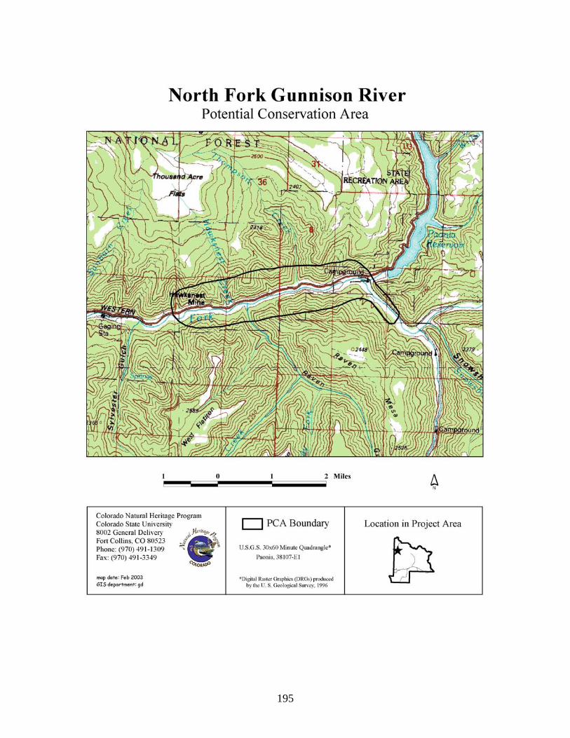
195

196
Pass Creek at Cottonwood Pass Potential Conservation Area Biodiversity Rank: B3. High biodiversity significance. The site supports a good example of a globally rare (G3G4) riparian plant community and an excellent occurrence of a state rare (G5 S1) plant species. Protection Urgency Rank: P4. No protection actions are needed in the foreseeable future. The site is managed by the U.S. Forest Service. Management Urgency Rank: M3. New management actions may be needed within five years to maintain the current quality of the element occurrences in the PCA. Widening/paving of the road through the site may threaten the riparian community and the plant species. Location: The site is located along Cottonwood Pass Road about a mile northwest of Cottonwood Pass.
U.S.G.S. 7.5-min. quadrangle: Tincup Legal Description: T14S R81W Sections 8-11, 14, and 15
Elevation: 10,300-11,600 ft. Size: Approximately 431 acres Johnston et al. (2001) Ecological and Community Types: RI4C – Non-forested Riparian – Planeleaf willow-Wolf willow-Bog birch Ecological Series - Planeleaf willow/water sedge Ecological Type – planeleaf willow-moist sedges-Baltic rush-moist forbs Community Type. General Description: Pass Creek flows through willow carrs, sedge meadows with beaver ponds, and forested reaches. The valley is rather wide in places but the riparian vegetation generally occupies just a narrow band along the creek. Forested reaches are dominated by Engelmann spruce (Picea engelmannii) and non-forested reaches by willows or sedges. A portion of the creek supports a community of bog birch with mixed mesic forbs and graminoids (Betula glandulosa/mesic forb-mesic graminoid). Associated species include Engelmann spruce, lodgepole pine (Pinus contorta), shrubby cinquefoil (Pentaphylloides floribunda), Wolf willow (Salix wolfii), barrenground willow (Salix brachycarpa), angelica (Angelica pinnata), tall fringed bluebells (Mertensia ciliata), strawberry (Fragaria sp.), willowherb (Epilobium angustifolium), hemlockparsley (Conioselinum scopulorum), and sedges (Carex spp.). Variegated scouringrush (Hippochaete variegata) grows in hummocky water sedge (Carex aquatilis) dominated fens. The associated community is planeleaf willow (Salix planifolia) willow carrs with bog birch. Associated species include Engelmann spruce, sedges (Carex microglochin, C. cappilaris), elephantella (Pedicularis groenlandica), tufted hairgrass (Deschampsia cespitosa), marsh marigold (Caltha leptosepala), meadow bistort (Polygonum bistorta), saxifrage (Saxifraga odontoloma), and cowbane (Oxypolis fendleri). Cottonwood Pass Road is very close by with an old two-track road even closer to the creek. Biodiversity Rank Justification: This PCA supports a good example of a globally vulnerable (G3G4) bog birch/mesic forb-mesic graminoid shrubland (Betula glandulosa/mesic forb-mesic graminoid). This association is documented only within Colorado. This plant association is a low-stature open shrubland of subalpine and lower alpine elevations. It occurs intermixed with

197
willow (Salix) shrublands and sedge (Carex) meadows, forming complex wetland mosaics. It grows in areas where soils are saturated from snowmelt runoff for a significant part of the growing season, and often on fens where the vegetation receives water from seeps and springs. It typically grows on very wet peat in the subalpine and lower alpine elevations and is threatened by peat mining, stream flow alterations, and heavy recreational use. Variegated scouring rush is circumboreal in distribution in the northern hemisphere but is near its southern extent in Colorado. Table 67. Natural Heritage element occurrences at Pass Creek at Cottonwood Pass PCA. Elements in bold are those upon which the PCA's B-rank is based. Scientific Name Common Name Global
Rank State Rank
Federal and State Status
EO* Rank
Plant Communities Betula glandulosa/mesic forb-mesic graminoid
Bog birch/mesic forb-mesic graminoid shrubland
G3G4 S3 B
Plants Equisetum variegatum ssp. variegatum
Variegated scouring rush
G5T? S1 B
*EO=Element Occurrence. Multiple listings represent separate locations. Boundary Justification: The site includes a portion of South Fork and the adjacent watershed. The boundary represents a preliminary estimate of the area needed to maintain local hydrological conditions. However, it should be noted that the hydrological processes necessary to the riparian area are not fully contained by the PCA boundaries. Any upstream activities along Pass Creek and its tributaries could potentially be detrimental to the hydrology of the riparian area. This boundary indicates the minimum area that should be considered for any conservation management plan. Protection Comments: The entire site is part of the Gunnison National Forest. Management Comments: Widening/paving of the Cottonwood Pass Road is the primary management concern as the effects of construction activities on the riparian area are not known. The area is lightly grazed by livestock. Recreational use is a management concern. Soils Description: Soils vary within the site from thick peat mats to gravelly sands. Johnston et al. (2001) describe soil types for in the Planeleaf willow/water sedge Ecological Type as Cryaquolls and Borohemists. Restoration Potential: CNHP wetland ecologists did not visit this PCA during the 2002 field season. Thus, restoration potential could not be identified with any accuracy. Wetland Functional Assessment for the Pass Creek at Cottonwood Pass PCA: CNHP wetland ecologists did not visit this PCA during the 2002 field season. Thus, a functional assessment could not be conducted with any accuracy.

198

199
Porphyry Creek Potential Conservation Area Biodiversity Rank: B3. High biodiversity significance. The PCA supports a good example of a globally vulnerable (G3) riparian plant community. Protection Urgency Rank: P4. No protection actions are needed in the foreseeable future. The PCA is almost entirely managed by the U.S. Forest Service and has no threats, given current use levels and management. Management Urgency Rank: M4. Current management seems to favor the persistence of the elements in the PCA, but management actions may be needed in the future to maintain the current quality of the element occurrences. Location: This PCA is located just over three miles north of the town of Sargents, CO.
U.S.G.S. 7.5-min. quadrangles: Pahlone Peak and Sargents Legal Description: T49N R5E Sections 22-27.
Elevation: 8,800-10,400 ft. Size: Approximately 1,303 acres Johnston et al. (2001) Ecological and Community Type: FR6 B – Riparian Forests – Blue & Engelmann Spruces-Subalpine Fir Riparian Ecological Series – Subalpine fire-Engelmann spruce/arrowleaf groundsel-bluebells-bittercress Ecological Type – Aspen-alder-reedgrass-wet forbs Community Type. General Description: Porphyry Creek flows through a secluded canyon just north of Sargents. The creek is a narrow, continually dropping creek with many active beaver ponds and dams. The stream is straight to gently meandering. Streambanks are a jumble of dead branches, logs, rocks, with a thin layer of soil. There are no trails in the area but faint remnants of an old road traverse up the canyon for a short distance. There appears to be grazing near the mouth of the creek but not in the upper canyon. No evidence of logging was observed. Upland vegetation alternates between sagebrush and conifer forest, composed primarily of lodgepole pine (Pinus contorta), limber pine (Pinus flexilis), and scattered Engelmann spruce (Picea engelmannii) and ponderosa pine (Pinus ponderosa). Large scree slopes intersect the upland vegetation at regular intervals. Beaver ponds are dominant toward the lower end of the creek, and are composed of species such as Rocky Mountain (serviceberry) willow (Salix monticola), Geyer willow (S. geyeriana), and bluejoint reedgrass (Calamagrostis canadensis). Further upstream, the site changes to a dense thinleaf alder (Alnus incana ssp. tenuifolia) stand alongside the creek, with a dense, diverse mix of mesic forbs including cow parsnip (Heracleum sphondylium var. montanum), geranium (Geranium richardsonii), tall fringed bluebells (Mertensia ciliata), bedstraw (Galium trifidum), large-leaved avens (Geum macrophyllum), arrowleaf groundsel (Senecio triangularis), meadowrue (Thalictrum fendleri), monk’s hood (Aconitum columbianum) and graminoids such as bluejoint reedgrass, slimstem reedgrass (Calamagrostis stricta), beaked sedge (Carex utriculata), fowl mannagrass (Glyceria striata), wood reed (Cinna latifolia), and tufted hairgrass (Deschampsia cespitosa). Elk and deer seem to browse the area heavily causing some streambanks to be unstable from their activity. Vegetation volume and structural diversity are high. Many alders are dying back and may be the result of sediment accretion, which may be “suffocating” alder roots or diverting water flow from the shrubs.

200
Biodiversity Rank Justification: This PCA supports an excellent example of the globally vulnerable (G3) thinleaf alder/mesic forb (Alnus incana ssp. tenuifolia/mesic forb) riparian shrubland. This plant association was once common and widespread, but is now declining. It is rarely found in good condition without non-native species in the undergrowth. Because this community can change significantly with improper grazing, this plant association may not be recognized as the same type across state lines. There are over 30 documented occurrences of this plant association in Colorado. However, none are very large and only one or two are in pristine condition. All stands are highly threatened by improper livestock grazing, stream flow alterations, road and railroad improvements and maintenance and heavy recreational use. This plant association is characterized by stands of medium-tall, deciduous shrubs and thick herbaceous undergrowth of forbs and wetland-indicator grasses. Undisturbed stands have abundant forbs and native grasses. Stands disturbed by season-long livestock grazing have reduced forb cover and an increase in non-native grasses including Kentucky bluegrass (Poa pratensis) and redtop (Agrostis stolonifera). Table 68. Natural Heritage element occurrences at Porphyry Creek PCA. Elements in bold are those upon which the PCA's B-rank is based. Scientific Name Common Name Global
Rank State Rank
Federal and State Status
EO* Rank
Plant Communities Alnus incana ssp. tenuifolia/mesic forb
Thinleaf alder/mesic forb shrubland
G3 S3 A
*EO=Element Occurrence. Multiple listings represent separate locations. Boundary Justification: The boundaries incorporate an area that will allow natural hydrological processes such as seasonal flooding, sediment deposition, and new channel formation to maintain viable populations of the elements along Porphyry Creek. It should be noted that the hydrological processes necessary to the elements are not fully contained by the PCA boundaries. Given that the elements are dependent on natural hydrological processes associated with Porphyry Creek and its tributaries upstream activities such as water diversions, impoundments, improper livestock grazing, and development are detrimental to the hydrology of the riparian area. This boundary indicates the minimum area that should be considered for any conservation management plan. Protection Comments: The PCA is almost entirely managed by the U.S. Forest Service and has no threats, given current use levels and management. Management Comments: Current management appears adequate to maintain the riparian area in good condition. Grazing and human activity associated with a nearby home occur at the mouth of the creek. Soils Description: Soils within the riparian area are rocky and alluvium derived. Johnston et al. (2001) describe soil types for the subalpine fire-Engelmann spruce/arrowleaf groundsel-bluebells-bittercress Ecological Type as Cryaquolls. Restoration Potential: Influx of non-native species should be monitored. Referring to such resources as the Nature Conservancy’s web site on invasive species (http://tncweeds.ucdavis.edu/index.html) or http://www.invasivespecies.gov/ may provide some assistance with control and eradication of non-native species.

201
Wetland Functional Assessment for the Porphyry Creek PCA: Proposed HGM Class: Riverine Subclass: R2 Cowardin System: Palustrine CNHP's Wetland Classification: Alnus incana ssp. tenuifolia/mesic forb Table 69. Wetland functional assessment for the riverine wetland at the Porphyry Creek PCA.
Function Rating Comments Overall Functional
Integrity At Potential This wetland appears to be functioning at its potential.
Hydrological Functions Flood Attenuation and Storage
High The valley is narrow but there are many beaver ponds along the stream.
Sediment/Shoreline Stabilization
High There is dense vegetative cover on the banks, stream channel appears to be vertically stable, and numerous beaver ponds help trap sediment and stabilize banks.
Groundwater Discharge/ Recharge
? Groundwater recharge and discharge are likely occurring at high and low flow, respectively but no obvious evidence of these processes was observed.
Dynamic Surface Water Storage
N/A This wetland floods via overbank flow.
Biogeochemical Functions Elemental Cycling Normal A diverse canopy of herbaceous and woody species plus
large quantities of woody debris, leaf litter, and soil organic matter and intact hydrology suggest intact and functioning nutrient cycles.
Removal of Imported Nutrients, Toxicants, and Sediments.
Moderate Intact nutrient cycles and a dense and diverse cover of vegetation provide ample opportunity for removal, however inputs are minimal.
Biological Functions Habitat Diversity Moderate Scrub-shrub and emergent wetlands along with the
immediately adjacent forest create moderate habitat diversity.
General Wildlife Habitat Moderate Evidence of use by herbivores and a variety of birds. General Fish/Aquatic Habitat
High Fish were observed in the stream and habitat characteristics are good.
Production Export/Food Chain Support
Moderate The densely vegetated riparian area supplies nutrients and carbon sources for invertebrates and fishes and downstream transport.
Uniqueness Moderate Similar river canyons are common in the montane zone; however, the quality of this riparian area is high.

202

203
Quartz Creek Potential Conservation Area Biodiversity Rank: B3. High biodiversity significance. The PCA supports good examples of two globally vulnerable (G3) riparian plant communities. Protection Urgency Rank: P4. No protection actions are needed in the foreseeable future. The PCA is mostly managed by the U.S. Forest Service. There are private lands within the upstream portion of the PCA. Management Urgency Rank: M3. New management actions may be needed within five years to maintain the current quality of the element occurrences in the PCA. Location: This PCA is located just downstream of the town of Pitkin, CO.
U.S.G.S. 7.5-min. quadrangles: Pitkin Legal Description: T50N R4E Sections 16, 17, 20, and 21.
Elevation: 8,900-9,600 ft. Size: Approximately 744 acres Johnston et al. (2001) Ecological and Community Type: RI3A – Non-forested Riparian – Blue Willow-Serviceberry Willow-Booth Willow Ecological Series – Serviceberry willow/beaked sedge Ecological Type – Serviceberry willow-beaked sedge Community Type; and RI4C – Non-forested Riparian – Planeleaf willow-Wolf willow-Bog birch Ecological Series - Planeleaf willow/water sedge Ecological Type – planeleaf willow-moist sedges-Baltic rush-moist forbs Community Type. General Description: This PCA is located along a stretch of Quartz Creek downstream of the town of Pitkin. County Road 76 parallels the creek through the site. Lodgepole pine (Pinus contorta) and aspen (Populus tremuloides) dominate adjacent slopes. Several old mines and an old railroad grade occur above the riparian area. The riparian community may have changed significantly since these developments. The hydrology has been modified due to upstream diversions (Town of Pitkin, fish hatchery, irrigation, etc.). Upstream, private lands are grazed heavily. The riparian area is dotted with beaver ponds where Rocky Mountain (serviceberry) willow (Salix monticola), Drummond (blue) willow (S. drummondiana), and bluejoint reedgrass (Calamagrostis canadensis) are dominant. There are numerous thinleaf alders (Alnus incana ssp. tenuifolia) that are dying back but the willow, forbs, and graminoids look healthy. Non-natives such as Kentucky bluegrass (Poa pratensis), reed canarygrass (Phalaris arundinacea), dandelion (Taraxacum officinale), and white-Dutch clover (Trifolium repens) are abundant near the road. Much of the area has dense vegetation volume with much dead and downed woody debris. Overflow from one beaver dam supports a dense stand of bog birch (Betula glandulosa) in highly organic soils covered with mosses. Bluejoint reedgrass and water sedge (Carex aquatilis) occur in the wettest patches. This is somewhat of a low elevation for this community type. Very few non-native species were observed. Biodiversity Rank Justification: This PCA supports a good example of the globally vulnerable (G3) Rocky Mountain (serviceberry) willow/mesic forb (Salix monticola/mesic forb) shrubland.
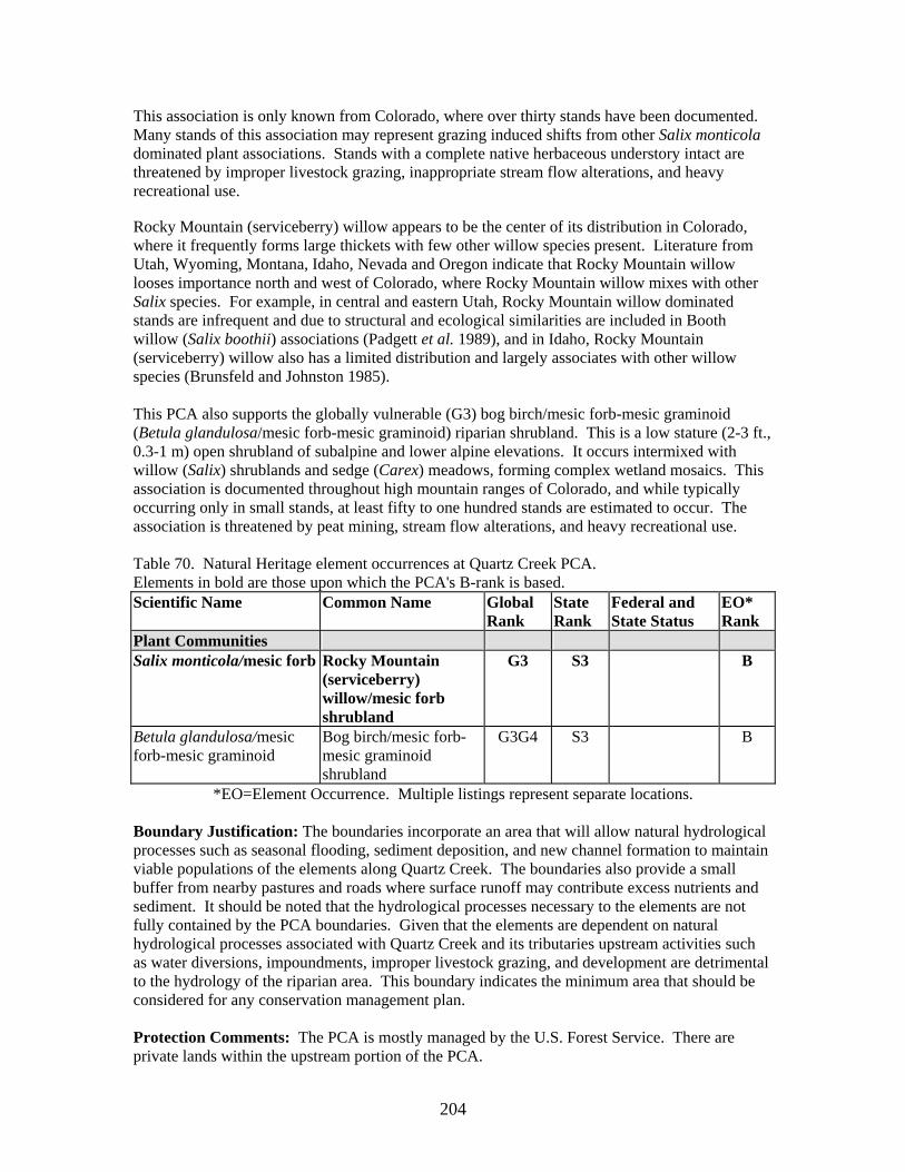
204
This association is only known from Colorado, where over thirty stands have been documented. Many stands of this association may represent grazing induced shifts from other Salix monticola dominated plant associations. Stands with a complete native herbaceous understory intact are threatened by improper livestock grazing, inappropriate stream flow alterations, and heavy recreational use. Rocky Mountain (serviceberry) willow appears to be the center of its distribution in Colorado, where it frequently forms large thickets with few other willow species present. Literature from Utah, Wyoming, Montana, Idaho, Nevada and Oregon indicate that Rocky Mountain willow looses importance north and west of Colorado, where Rocky Mountain willow mixes with other Salix species. For example, in central and eastern Utah, Rocky Mountain willow dominated stands are infrequent and due to structural and ecological similarities are included in Booth willow (Salix boothii) associations (Padgett et al. 1989), and in Idaho, Rocky Mountain (serviceberry) willow also has a limited distribution and largely associates with other willow species (Brunsfeld and Johnston 1985). This PCA also supports the globally vulnerable (G3) bog birch/mesic forb-mesic graminoid (Betula glandulosa/mesic forb-mesic graminoid) riparian shrubland. This is a low stature (2-3 ft., 0.3-1 m) open shrubland of subalpine and lower alpine elevations. It occurs intermixed with willow (Salix) shrublands and sedge (Carex) meadows, forming complex wetland mosaics. This association is documented throughout high mountain ranges of Colorado, and while typically occurring only in small stands, at least fifty to one hundred stands are estimated to occur. The association is threatened by peat mining, stream flow alterations, and heavy recreational use. Table 70. Natural Heritage element occurrences at Quartz Creek PCA. Elements in bold are those upon which the PCA's B-rank is based. Scientific Name Common Name Global
Rank State Rank
Federal and State Status
EO* Rank
Plant Communities Salix monticola/mesic forb Rocky Mountain
(serviceberry) willow/mesic forb shrubland
G3 S3 B
Betula glandulosa/mesic forb-mesic graminoid
Bog birch/mesic forb-mesic graminoid shrubland
G3G4 S3 B
*EO=Element Occurrence. Multiple listings represent separate locations. Boundary Justification: The boundaries incorporate an area that will allow natural hydrological processes such as seasonal flooding, sediment deposition, and new channel formation to maintain viable populations of the elements along Quartz Creek. The boundaries also provide a small buffer from nearby pastures and roads where surface runoff may contribute excess nutrients and sediment. It should be noted that the hydrological processes necessary to the elements are not fully contained by the PCA boundaries. Given that the elements are dependent on natural hydrological processes associated with Quartz Creek and its tributaries upstream activities such as water diversions, impoundments, improper livestock grazing, and development are detrimental to the hydrology of the riparian area. This boundary indicates the minimum area that should be considered for any conservation management plan. Protection Comments: The PCA is mostly managed by the U.S. Forest Service. There are private lands within the upstream portion of the PCA.

205
Management Comments: Continued upstream impacts such as hydrological modifications, heavy recreation use, and heaving grazing threaten the communities. Past mining activity may also be impacting site. Need to study and monitor effects from these activities. Non-natives are also a threat and likely the result of the above threats. Soils Description: Soils within the riparian area are rocky and alluvium derived. Johnston et al. (2001) describe soil types for the Serviceberry willow/beaked sedge Ecological Type as deep to moderately deep Cryaquolls and soils in the Planeleaf willow/water sedge Ecological Type as Cryaquolls and Borohemists. Restoration Potential: The creek’s hydrology has been drastically altered. Working toward restoring natural flows by eliminating channel diversion structures and riprap hindering natural channel meanders upstream is critical to restoring hydrology at this PCA. A rise in local water tables would likely aid in controlling and/or eradicating some non-natives. Others will prove to be more challenging. Referring to such resources as the Nature Conservancy’s web site on invasive species (http://tncweeds.ucdavis.edu/index.html) or http://www.invasivespecies.gov/ may provide some assistance with control and eradication of non-native species. There has been much alteration of plant communities within the floodplain upstream that stem from altered hydrology and past land use. Current land use patterns allow for overuse of many upstream areas by livestock and hay meadows. The primary concerns from such activity are uncontrolled non-native species invasions and increased erosion and downcutting of the stream banks. Grazing practices should be minimized or a reasonable method of grazing, such as fencing off much of the riparian areas, especially those closest to the river and backchannels, implemented in order to improve the health of the riparian vegetation and hence the riparian ecosystem as a whole.

206
Wetland Functional Assessment for the Quartz Creek PCA: Proposed HGM Class: Riverine Subclass: R2 Cowardin System: Palustrine CNHP's Wetland Classification: Salix monticola/mesic forb and Betula glandulosa/mesic forb-mesic graminoid Table 71. Wetland functional assessment for the riverine wetland at the Quartz Creek PCA.
Function Rating Comments Overall Functional
Integrity At Potential This wetland appears to be functioning at its potential,
however altered hydrology upstream and the proximity of the road and housing development may be affecting the functional potential of the site.
Hydrological Functions Flood Attenuation and Storage
High Numerous beaver ponds occur in the area.
Sediment/Shoreline Stabilization
High There is dense vegetative cover on the banks and the stream channel appears to be mostly stable.
Groundwater Discharge/ Recharge
N/A Groundwater discharge is likely occurring but no obvious evidence of these processes was observed.
Dynamic Surface Water Storage
N/A This wetland floods via overbank flow.
Biogeochemical Functions Elemental Cycling Normal A diverse canopy of herbaceous and woody species plus
large quantities of woody debris, leaf litter, and soil organic matter suggest intact and functioning nutrient cycles. However, altered hydrology may be impacting nutrient cycles by eliminating normal flushing cycles and lack of deposition of organic material from floodwaters.
Removal of Imported Nutrients, Toxicants, and Sediments.
High Intact nutrient cycles and a dense and diverse cover of vegetation provide ample opportunity for removal of inputs from upstream development, town, pastures, and nearby road.
Biological Functions Habitat Diversity Moderate Scrub-shrub and emergent wetlands along with the
immediately adjacent forest create moderate habitat diversity.
General Wildlife Habitat Moderate Evidence of use by herbivores and a variety of birds. However, proximity of wetland near road limits capability of the site as excellent habitat.
General Fish/Aquatic Habitat
High Beaver ponds and overhanging vegetation provide good fish habitat.
Production Export/Food Chain Support
High The densely vegetated riparian area supplies nutrients and carbon sources for invertebrates and fishes and downstream transport.
Uniqueness Low Similar river canyons are common in the montane zone.

207
.

208
Slate River Potential Conservation Area Biodiversity Rank: B3. High biodiversity significance. The PCA supports multiple examples of globally vulnerable (G3) and globally secure (G5) riparian plant communities in addition to two good examples of a globally vulnerable (G3) plant species. Protection Urgency Rank: P2. Protection actions may be needed within 5 years. It is estimated that current stresses may reduce the viability of the elements in the PCA within this approximate timeframe. Approximately half of the PCA is private land, while the U.S. Forest Service and Bureau of Land Management manage the remaining portion. Development pressure is high on the private lands. The Crested Butte Land Trust (CBLT) has protected a significant portion of this PCA through acquisitions and conservation easements on private lands. Additional effort by the CBLT and other organizations to protect wetlands and surrounding uplands located in this PCA will greatly enhance the viability of the elements. Management Urgency Rank: M3. New management actions may be needed within five years to maintain the current quality of the element occurrences in the PCA. Location: This PCA is located up and downstream of Crested Butte along the Slate River.
U.S.G.S. 7.5-min. quadrangles: Crested Butte, Gothic, Mount Axtell, and Oh-Be-Joyful. Legal Description: T12S R87W Sections 25, 26, and 33-36;
T13S R86W Sections 6, 7, 17-21, 26-29, and 33-36; T13S R87W Sections 1-3, 11-13, and 24; T14S R85W Section 6; and T14S R86W Sections 1-4, 11, and 12.
Elevation: 8,850-11,000 ft. Size: Approximately 8,911 acres Johnston et al. (2001) Ecological and Community Type: RI1B – Non-forested Riparian – Yellow Willow Ecological Series – Yellow willow/beaked sedge Ecological Type - Yellow (or Pacific) willow – Geyer willow – beaked sedge Community Type (B); RI2A – Non-forested Riparian – Blue Willow-Serviceberry Willow-Booth Willow Ecological Series – Serviceberry willow/beaked sedge Ecological Type – Blue willow/reedgrass-beaked sedge Community Type; RI3A – Non-forested Riparian – Blue Willow-Serviceberry Willow-Booth Willow Ecological Series – Serviceberry willow/beaked sedge Ecological Type – Serviceberry willow-beaked sedge Community Type; and RI9A - Non-forested Riparian – Water Sedge Ecological Series – Water sedge-beaked sedge/tufted hairgrass Ecological Type – Water sedge-wet sedges and forbs Community Type. General Description: This PCA encompasses almost the entire reach of the Slate River. Except for the uppermost reaches, the entire river valley within this PCA has been glaciated and forms a beautiful U-shaped valley. The upland slopes of the site are steep with scattered spruce, lodgepole pine (Pinus contorta), aspen (Populus tremuloides), and exposed cliffs of sedimentary rock. Beaver ponds are prevalent throughout the site. Forest Road 734 parallels the river to the headwaters along with numerous side roads. Numerous mines also exist in the PCA. However, despite all this activity the hydrology of the site is mostly intact, except in areas downstream of Peanut Lake. Grazing and recreational use occur in some portions of the site.

209
The riparian vegetation is quite diverse given the elevation change, although it mostly consists of various willows and sedges. In places where the valley floor widens, beaver dams are common. A mosaic of willow and sedge communities dominates these areas. Sedge communities are dominated by water sedge (Carex aquatilis) and beaked sedge (Carex utriculata) while bluejoint reedgrass (Calamagrostis canadensis) is often co-dominant. Planeleaf willow (Salix planifolia), Wolf willow (S. wolfii), or Rocky Mountain (serviceberry) willow (S. monticola) dominate willow communities in the upper reach while Geyer willow (S. geyeriana) or Drummond (blue) willow (S. drummondiana) are more common further downstream. Growing near a few waterfalls along the side tributaries of the Slate River is the rare hanging garden sullivantia (Sullivantia hapemanii var. purpusii). Downstream of Nicholson Lake is a large, complex of beaver ponds. Despite so much development nearby, this wetland is intact and functioning well. The diversity of wetland types ranges from aquatic communities to sedge meadows, willow carrs, and forested types. Drummond willow and bluejoint reedgrass dominate near the river channel while Wolf willow, planeleaf willow, and Geyer willow are common throughout the floodplain. Sedge meadows are dominant behind and near beaver ponds. This section of the PCA contains the most intact and highest quality wetlands along the Slate River. Ditching and removal of wetland vegetation for hay production and development have negatively affected the downstream portion of the PCA by creating unstable streambanks. As a result, the river channel has incised causing the channel to migrate laterally across the floodplain and lower floodplain water tables (Cooper 1993). Thus, wetland acreage has been lost in this portion of the site due to a change in the hydrology and land use. Downstream of Crested Butte, the wetlands are comprised of wet meadows dominated by non-native pasture grasses such as timothy (Phleum pratense), Kentucky bluegrass (Poa pratensis), meadow foxtail (Alopecurus pratensis) and native species such as Baltic rush (Juncus balticus), ticklegrass (Agrostis scabra), tufted hairgrass (Deschampsia cespitosa), marsh marigold (Caltha leptosepala), large-leaved avens (Geum macrophyllum), and dock (Rumex triangulivalvis). Beaked sedge and inflated sedge (Carex vesicaria) occupy the wettest areas. Geyer willow, Rocky Mountain (serviceberry) willow, planeleaf willow, Wolf willow, bog birch (Betula glandulosa), and bluejoint reedgrass (Calamagrostis canadensis) dominate areas near the river. Streambanks are failing in this area as they are dominated mostly by timothy and redtop (Agrostis gigantea) as opposed to sedges, which provide more stability due to their deep and fibrous root systems. Biodiversity Rank Justification: This PCA supports an excellent example of the globally vulnerable (G3) Drummond willow/bluejoint reedgrass (Salix drummondiana/Calamagrostis canadensis) shrubland. This association has a wide distribution, although few undisturbed stands have been documented. In Colorado, less than ten stands have been documented, but at least an additional ten to twenty stands are expected to occur. This association may have been reduced from its historic abundance by heavy livestock grazing at the turn of the century. Remaining stands are threatened by continued improper livestock grazing, altered stream flows, and heavy recreational use. An excellent example of the globally vulnerable (G3) Geyer willow/water sedge (Salix geyeriana/Carex aquatilis) shrubland is also found at this PCA. This association forms a tall-willow shrubland with smaller shrubs often occurring under the canopy. The canopy is nearly closed and a thick carpet of mesic grasses and forbs blanket the undergrowth. The ground surface is often hummocky with willows establishing on the raised mounds and grasses dominating in the swales. This association is reported from several western states, but few pristine stands occur, and it is threatened by improper livestock grazing. This association is relatively uncommon in Colorado. Few stands are in pristine condition. It may be less common

210
than it was historically due to heavy grazing at the turn of the century. Today it continues to be threatened by improper livestock grazing, stream flow alterations and heavy recreational use. The PCA also supports a good example of the globally vulnerable (G3) Rocky Mountain (serviceberry) willow/mesic forb (Salix monticola/mesic forb) shrubland. This association is only known from Colorado, where over thirty stands have been documented. Many stands of this association may represent grazing induced shifts from other Salix monticola dominated plant associations. Stands with a complete native herbaceous understory intact are threatened by improper livestock grazing, inappropriate stream flow alterations, and heavy recreational use. The globally vulnerable (G3T3) hanging garden sullivantia (Sullivantia hapemanii var. purpusii) grows on moist cliffs near waterfalls (hanging gardens). The species is endemic to Colorado, in Garfield, Gunnison, Montrose, Pitkin, and Rio Blanco counties, where there are 45 documented occurrences and approximately 40,000 individuals (NatureServe 2002). Table 72. Natural Heritage element occurrences at Slate River PCA. Elements in bold are those upon which the PCA's B-rank is based. Scientific Name Common Name Global
Rank State Rank
Federal and State Status
EO* Rank
Plant Communities Salix drummondiana/ Calamagrostis canadensis
Drummond willow/bluejoint reedgrass riparian shrubland
G3 S3 A
Salix geyeriana/Carex aquatilis
Geyer willow/water sedge shrubland
G3 S3 A
Salix monticola/mesic forb Rocky Mountain (serviceberry) willow/mesic forb shrubland
G3 S3 B
Carex aquatilis Water sedge herbaceous vegetation
G5 S4 A
Carex utriculata Beaked sedge herbaceous vegetation
G5 S5 B
Plants Sullivantia hapemanii var. purpusii
Hanging garden sullivantia
G3T3 S3 B
*EO=Element Occurrence. Multiple listings represent separate locations. Boundary Justification: The boundary includes a portion of the Slate River and the surrounding watershed. The boundary represents a preliminary estimate of the area needed to maintain local hydrological conditions and incorporate an area that will allow natural hydrological processes such as seasonal flooding, sediment deposition, and new channel formation to maintain viable populations of the elements. The boundaries also provide a small buffer from nearby agriculture fields, roads, and houses where surface runoff may contribute excess nutrients, sediment, and herbicides/pesticides. The PCA contains areas where old oxbows, sloughs, and ponds could provide a source of recruitment for native wetland and riparian plant species and provide fish habitat. However, it should be noted that the hydrological processes necessary to the riparian area are not fully contained by the PCA boundaries. Any upstream activities along Slate River and its tributaries such as water diversions, impoundments, improper livestock grazing, and development could potentially be detrimental to the hydrology of the riparian area. This

211
boundary indicates the minimum area that should be considered for any conservation management plan. Protection Comments: Approximately half of the PCA is private land, while the U.S. Forest Service and Bureau of Land Management manage the remaining portion. Development pressure is high on the private lands. The Crested Butte Land Trust (CBLT) has protected a significant portion of this PCA through acquisitions and conservation easements of private lands. Additional effort by the CBLT and other organizations to protect wetlands and surrounding uplands located in this PCA will greatly enhance the viability of the elements. Management Comments: Grazing, recreation, housing development, and altered hydrology are of most concern at this site. Very few non-native species were observed in the wetlands. Active ditches are present and clearing of vegetation is occurring in areas downstream, but there is little activity in the highest quality portions of the site. Soils Description: Soils within the riparian area are rocky and alluvium derived. In areas where springs are discharging peat soils have developed. Soils in the upper Slate River floodplain area are mapped as the Iris series, a Typic Haplaquoll loam. In downstream portions of the site, soils are mapped as Gas Creek series, a Typic Haplaquoll sandy loam. Johnston et al. (2001) describe soils in the Yellow willow/beaked sedge Ecological Type as predominantly Endoaquolls and some Endoaquents or Argiborolls; in the Blue willow/reedgrass-beaked sedge Ecological Type as deep to moderately deep Cryaquolls; in the Serviceberry willow/beaked sedge Ecological Type as mostly Cryaquolls and some Borohemists; and in the Water sedge-beaked sedge/tufted hairgrass Ecological Type as Borohemist or Cryaquolls-Cryaquepts. Restoration Potential: River hydrology has been drastically altered in the downstream portion of the PCA and is the most significant disturbance affecting this site. Working toward restoring natural, river flows by eliminating ditches, dikes, and other water diversion structures is critical to restoring hydrology at this PCA. There has been much alteration of plant communities within this area that stem from altered hydrology and past land use. The primary concerns from such activity are uncontrolled non-native species invasions and increased erosion and downcutting of the stream banks. Mechanical improvements to the stream channel could be implemented, although it is recommended that initial efforts focus on removing disturbances and allowing natural recovery to proceed. Planting willow cuttings along degraded streambanks will also assist streambank recovery. Over time, well-vegetated streambanks will prevent channel incision and allow the river to adjust to a new equilibrium. Depending on upstream water diversions, water tables could begin to rise and restore many wetland areas near the channel. Ideally, beavers will move into these areas and accelerate the buildup of local water tables. Grazing practices should be minimized or a reasonable method of grazing, such as fencing off much of the riparian areas, especially those closest to the river and backchannels, implemented in order to improve the health of the riparian vegetation and hence the riparian ecosystem as a whole. There are numerous hay meadows and roads that could be restored to natural vegetation patterns, especially in areas downstream of Crested Butte. Referring to such resources as the Nature Conservancy’s web site on invasive species (http://tncweeds.ucdavis.edu/index.html) or http://www.invasivespecies.gov/ may provide some assistance with control and eradication of non-native species.

212
Wetland Functional Assessment for the Slate River PCA: Proposed HGM Class: Riverine Subclass: R2 and R3/4 Cowardin System: Palustrine CNHP's Wetland Classification: Salix drummondiana/ Calamagrostis canadensis, Salix monticola/mesic forb, and Salix geyeriana/Carex aquatilis. Table 73. Wetland functional assessment for the riverine wetland at the Slate River PCA.
Function Rating Comments Overall Functional
Integrity At Potential/
Below Potential
Wetlands upstream of Peanut Lake are mostly functioning at potential while those downstream of Peanut Lake are functioning Below Potential due to altered hydrology.
Hydrological Functions Flood Attenuation and Storage
High There is a high density of shrubs and herbaceous species along with numerous beaver ponds scattered throughout a large floodplain. Areas downstream of Peanut Lake are not functioning as high as they could due to altered hydrology.
Sediment/Shoreline Stabilization
High Dense growth of herbaceous and woody species along the streambank. Areas downstream of Peanut Lake are not functioning as high as they could due to altered hydrology.
Groundwater Discharge/ Recharge
High There are springs within or near the floodplain.
Dynamic Surface Water Storage
N/A This wetland floods via overbank flow.
Biogeochemical Functions Elemental Cycling Normal to
Disrupted A diverse canopy of herbaceous and woody species plus large quantities of woody debris, leaf litter, and soil organic matter suggest intact and functioning nutrient cycles. Altered hydrology downstream of Peanut Lake may be impacting nutrient cycles by eliminating normal flushing cycles and lack of deposition of organic material from floodwaters.
Removal of Imported Nutrients, Toxicants, and Sediments.
High Intact nutrient cycles and a dense and diverse cover of vegetation give this PCA a high rating for this function. Beaver ponds add to sediment removal potential. Inputs are from road, housing developments, and nearby mining activities. Areas downstream of Peanut Lake are not functioning as high as they could due to altered hydrology.
Biological Functions Habitat Diversity High There are forested, scrub-shrub, emergent, and open water
wetland habitats. General Wildlife Habitat High The forest, shrub and herbaceous canopies provide a
diversity of vegetation structure, which along with high vegetation volume, provide excellent habitat for birds, mammals, and insects. Open water areas provide habitat for waterbirds.
General Fish/Aquatic Habitat
High Beaver ponds and overhanging vegetation provide good fish habitat.
Production Export/Food Chain Support
High A permanent water source and large quantities of allochthonous organic substrates provide various sources of carbon (both dissolved and particulate) and nutrients for downstream ecosystems.
Uniqueness Moderate The PCA supports riparian plant communities that are uncommon, but more importantly is the size and quality (of upstream areas) of the wetlands contained in this site.

213

214
Snowshoe Canyon Potential Conservation Area Biodiversity Rank: B3. High biodiversity significance. The site supports excellent and good examples of globally rare (G3) riparian plant communities. Protection Urgency Rank: P4. No protection actions are needed in the foreseeable future. Most of the site is managed by the U.S. Forest Service with limited private lands. Management Urgency Rank: M4. Current management seems to favor the persistence of the elements in the PCA, but management actions may be needed in the future to maintain the current quality of the element occurrences. The canyon is apparently not grazed by livestock. Location: The site is located about one mile south of Paonia Reservoir.
U.S.G.S. 7.5-min. quadrangle: Paonia Reservoir and Marcellina Mountain Legal Description: T13S R88W Sections 18-21, 28, and 29;
T13S R89W Sections 9, 10, 13-16, and 22-27. Elevation: 6,600-8,000 ft. Size: Approximately 2,450 acres Johnston et al. (2001) Ecological and Community Types: FR2A – Riparian Forests – Narrowleaf Cottonwood Ecological Series – Aspen-cottonwood Ecological Type – Aspen-reedgrass-swamp bluegrass-cow parsnip-vetch Community Type. FR5A – Riparian Forests - Narrowleaf Cottonwood Ecological Series – Spruce/red-osier Ecological Type – Spruce – red-osier Community Type. General Description: Snowshoe Canyon is a narrow, steep gradient, scenic canyon. Snowshoe Creek flows through the canyon and supports a narrow band of riparian vegetation. The canyon is rather inaccessible due to its steep walls and the riparian area is in excellent condition. There are very few non-native plants and the canyon does not appear to be grazed by livestock. Dominant plants along the stream are blue spruce (Picea pungens) and thinleaf alder (Alnus incana ssp. tenuifolia) with narrowleaf cottonwood (Populus angustifolia), strapleaf (yellow) willow (Salix eriocephala (=lutea)), Bebb willow (Salix bebbiana), twinberry honeysuckle (Lonicera involucrata), Rocky Mountain maple (Acer glabrum), and red-osier dogwood (Cornus sericea). Riparian vegetation along Grouse Spring Creek, a tributary to Snowshoe Canyon is dominated by quaking aspen (Populus tremuloides), Douglas-fir (Pseudotsuga menziesii), thinleaf alder, tall fringed bluebells (Mertensia ciliata), and Brandegee’s fumewort (Corydalis caseana subsp. brandegei). Uplands range from dense stands of aspen and Douglas-fir to open woodlands. Biodiversity Rank Justification: This site supports an excellent example of the globally vulnerable (G3) quaking aspen/thinleaf alder riparian plant community (Populus tremuloides/Alnus incana ssp. tenuifolia). This plant association is located in narrow ravines and along first- and second-order streams of the west slope of Colorado. The site also contains a good example of the globally vulnerable (G3) blue spruce/thinleaf alder (Picea pungens/Alnus incana ssp. tenuifolia) riparian plant community. This woodland occurs in deep, shaded canyons and narrow valleys along relatively straight stream reaches. It generally forms small patches, but can be continuous for several river miles. This association is known from Wyoming to New Mexico. Fewer than 100 stands exist in Colorado, and very few of these are in pristine condition. These

215
associations are threatened by development, road building and maintenance, heavy recreational use, improper livestock grazing, and stream flow alterations. This site also supports an excellent example of an apparently globally secure (G4) riparian plant community: narrowleaf cottonwood-blue spruce/thinleaf alder (Populus angustifolia-Picea pungens/Alnus incana ssp. tenuifolia). Table 74. Natural Heritage element occurrences at Snowshoe Canyon PCA. Elements in bold are those upon which the PCA's B-rank is based. Scientific Name Common Name Global
Rank State Rank
Federal and State Status
EO* Rank
Plant Communities Picea pungens/Alnus incana ssp. tenuifolia
Blue spruce/thinleaf alder woodland
G3 S3 B
Populus angustifolia-Picea pungens/Alnus incana ssp. tenuifolia
Narrowleaf cottonwood- blue spruce/thinleaf alder woodland
G4 S4 A
Populus tremuloides/Alnus incana ssp. tenuifolia
Quaking aspen/thinleaf alder forest
G3 S3 A
*EO=Element Occurrence. Multiple listings represent separate locations. Boundary Justification: The site includes a portion of Grouse Spring Creek and Snowshoe Creek and the adjacent canyon walls. Because of the steep nature of the adjacent slopes in Snowshoe Canyon, the boundary extends to the rim of the canyon. This should be sufficient to prevent direct and indirect disturbance, including but not limited to, exotic species invasion, physical alteration, and local hydrologic alteration. Any upstream activities along Snowshoe Creek and its tributaries, such as water diversions, impoundments, improper livestock grazing, and development could potentially be detrimental to the hydrology of the riparian area within the site. This boundary indicates the minimum area that should be considered for any conservation management plan. Protection Comments: Ninety percent of the site is managed by the U.S. Forest Service as part of the Gunnison National Forest. The remaining portions are privately owned or managed by the BLM. Management Comments: Current management appears adequate to maintain the riparian area in good condition. The canyon is quite inaccessible and does not appear to be grazed by livestock. Non-native hay grasses and other exotic species threaten the riparian area in some sections. Soils Description: Soils within the riparian area are rocky and alluvium derived. Johnston et al. (2001) describe soils as primarily Endoquolls in the Aspen-cottonwood Ecological Type and as predominantly Cryaquolls and some Cryaquents in the Spruce/red-osier Ecological Type. Restoration Potential: CNHP wetland ecologists did not visit this PCA during the 2002 field season. Thus, restoration potential could not be identified with any accuracy.

216
Wetland Functional Assessment for the Snowshoe Canyon PCA: CNHP wetland ecologists did not visit this PCA during the 2002 field season. Thus, a functional assessment could not be conducted with any accuracy.

217

218
Soap Creek Potential Conservation Area Biodiversity Rank: B3. High biodiversity significance. The PCA supports a good example of a globally vulnerable (G3) riparian plant community. Protection Urgency Rank: P4. No protection actions are needed in the foreseeable future. The PCA is managed by the U.S. Forest Service and about 85 percent of it is within the West Elks Wilderness Area. Management Urgency Rank: M4 Current management seems to favor the persistence of the elements in the PCA, but management actions may be needed in the future to maintain the current quality of the element occurrences. Location: The PCA is located about 20 miles west northwest of Gunnison.
U.S.G.S. 7.5-min. quadrangles: Big Soap Park and West Elk Peak Legal Description: T51N R4W Sections 10, 13-16, 20-22, 28, and 29
Elevation: 8,400-9,800 ft. Size: Approximately 1,410 acres Johnston et al. (2001) Ecological and Community Type: FR4C – Riparian Forests – Blue & Engelmann Spruces-Subalpine Fir Riparian Ecological Series – Spruce/honeysuckle-reedgrass Ecological Type – Engelmann spruce-honeysuckle Community Type; RI1C – Non-forested Riparian – Yellow Willow Ecological Series – Yellow willow/beaked sedge Ecological Type - Yellow (or Pacific) willow-other willows –moist to dry grasses and forbs Community Type. General Description: Soap Creek is within a wilderness area and is in good condition. The valley is wide with a flat, well-worked floodplain. The riparian vegetation is mostly early seral species (e.g. willows and young narrowleaf cottonwoods). Plant associations documented include Rocky Mountain (serviceberry) willow/mesic forb (Salix monticola/mesic forb) and subalpine fir-Engelmann spruce/thinleaf alder (Abies lasiocarpa-Picea engelmannii/Alnus incana ssp. tenuifolia). Within the Rocky Mountain (serviceberry) willow community, associated species include twinberry honeysuckle (Lonicera involucrata), currant (Ribes spp.), strawberry (Fragaria sp.), orange sneezeweed (Dugaldia hoopesii), false Solomon’s seal (Maianthemum stellata), red raspberry (Rubus idaeus), and cow parsnip (Heracleum sphondylium var. montanum). Within the subalpine fir-Engelmann spruce/thinleaf alder community associated species include Drummond willow (Salix drummondiana), twinberry honeysuckle, red-osier dogwood (Cornus sericea), tall fringed bluebells (Mertensia ciliata), and cow parsnip. The broad flat valley floor is a mosaic of cobble bars, beaver ponds, and overflow channels. Side slopes are gently to mostly steep grasslands with pocket of aspen and conifer groves. Biodiversity Rank Justification: The site supports a good example of the globally vulnerable (G3) Rocky Mountain (serviceberry) willow/mesic forb (Salix monticola/mesic forb) shrubland. This association is only known from Colorado, where over thirty stands have been documented. Many stands of this association may represent grazing induced shifts from other Salix monticola dominated plant associations. Stands with a complete native herbaceous understory intact are threatened by improper livestock grazing, inappropriate stream flow alterations, and heavy recreational use.

219
Rocky Mountain (serviceberry) willow appears to be the center of its distribution in Colorado, where it frequently forms large thickets with few other willow species present. Literature from Utah, Wyoming, Montana, Idaho, Nevada and Oregon indicate that Rocky Mountain willow looses importance north and west of Colorado, where Rocky Mountain willow mixes with other Salix species. For example, in central and eastern Utah, Rocky Mountain willow dominated stands are infrequent and due to structural and ecological similarities are included in Booth willow (Salix boothii) associations (Padgett et al. 1989), and in Idaho, Rocky Mountain (serviceberry) willow also has a limited distribution and largely associates with other willow species (Brunsfeld and Johnson 1985). This site also supports an excellent example of a globally secure (G5) riparian plant community: subalpine fir-Engelmann spruce/thinleaf alder (Abies lasiocarpa-Pieca engelmannii/Alnus incana ssp. tenuifolia). Table 75. Natural Heritage element occurrences at Soap Creek PCA. Elements in bold are those upon which the PCA's B-rank is based. Scientific Name Common Name Global
Rank State Rank
Federal and State Status
EO* Rank
Plant Communities Salix monticola/mesic forb Rocky Mountain
(serviceberry) willow/mesic forb shrubland
G3 S3 B
Abies lasiocarpa-Picea engelmannii/Alnus incana ssp. tenulfolia
Subalpine fir-Engelmann spruce/thinleaf alder forest
G5 S5 A
*EO=Element Occurrence. Multiple listings represent separate locations. Boundary Justification: The boundary includes a portion of Soap Creek and East Soap Creek and the surrounding watershed. The boundary represents a preliminary estimate of the area needed to maintain local hydrological conditions. However, it should be noted that the hydrological processes necessary to the riparian area are not fully contained by the PCA boundaries. Any upstream activities along Soap Creek and its tributaries could potentially be detrimental to the hydrology of the riparian area. This boundary indicates the minimum area that should be considered for any conservation management plan. Protection Comments: The PCA is managed by the U.S. Forest Service and most of it is within the West Elk Wilderness Area. Management Comments: Current management appears adequate to maintain the riparian area in good condition. Management concerns include encroachment of non-native plants. Soils Description: Soils within the riparian area are rocky and alluvium derived. Johnston et al. (2001) describe soils as predominantly Cryaquolls-Cryaquents and Cryoborolls in the Spruce/honeysuckle-reedgrass Ecological Type and predominantly Endoquolls in the Yellow willow/beaked sedge Ecological Type. Restoration Potential: CNHP wetland ecologists did not visit this PCA during the 2002 field season. Thus, restoration potential could not be identified with any accuracy.

220
Wetland Functional Assessment for the Soap Creek PCA: CNHP wetland ecologists did not visit this PCA during the 2002 field season. Thus, a functional assessment could not be conducted with any accuracy.

221

222
South Fork at Beaver Reservoir Potential Conservation Area Biodiversity Rank: B3. High biodiversity significance. The site supports a good example of a globally rare (G3) riparian plant community. Protection Urgency Rank: P4. No protection actions are needed in the foreseeable future. The site is managed by the U.S. Forest Service. Management Urgency Rank: M4. Current management seems to favor the persistence of the elements in the PCA, but management actions may be needed in the future to maintain the current quality of the element occurrences. Management concerns include livestock grazing and recreational use. Location: The site is located about eight miles southeast of Paonia.
U.S.G.S. 7.5-min. quadrangle: Minnesota Pass Legal Description: T14S R90W Sections 17, 20, 21, 28, 29, and 32-34
Elevation: 6,900-10,800 ft. Size: Approximately 1,190 acres Johnston et al. (2001) Ecological and Community Types: FR1A – Riparian Forests – Narrowleaf Cottonwood Ecological Series – Cottonwood-Pacific willow-swamp bluegrass Ecological Type – Cottonwood-Pacific willow-alder-swamp bluegrass-Community Type. General Description: South Fork is a steep creek within a narrow valley. Riparian vegetation is dominated by narrowleaf cottonwood (Populus angustifolia) and thinleaf alder (Alnus incana ssp. tenuifolia) with red-osier dogwood (Cornus sericea) and Woods’ rose (Rosa woodsii) in the understory. Additional associated species include wintergreen (Pyrola rotundifolia), Porter’s groundsel (Ligularia porteri), Rocky Mountain maple (Acer glabrum), and Bebb willow (Salix bebbiana). The vegetation is dense and with few non-natives where cattle have not grazed. Biodiversity Rank Justification: This PCA supports a good example of a globally vulnerable (G3) narrowleaf cottonwood/thinleaf alder riparian forest (Populus angustifolia/Alnus incana ssp. tenuifolia). This association is known from New Mexico and Colorado. Although not well documented from other states, it is expected to occur throughout the range of Populus angustifolia in the Rocky Mountains. In Colorado, this is a common community along montane streams, but few high quality examples exist. This association is highly threatened by improper livestock grazing, development and stream flow alterations. Table 76. Natural Heritage element occurrences at South Fork at Beaver Reservoir PCA. Elements in bold are those upon which the PCA's B-rank is based. Scientific Name Common Name Global
Rank State Rank
Federal and State Status
EO* Rank
Plant Communities Populus angustifolia/ Alnus incana ssp. tenuifolia
Narrowleaf cottonwood /Thinleaf alder montane riparian forest
G3 S3 B
*EO=Element Occurrence. Multiple listings represent separate locations.

223
Boundary Justification: The site includes a portion of South Fork and the adjacent watershed. The boundary represents a preliminary estimate of the area needed to maintain local hydrological conditions. However, it should be noted that the hydrological processes necessary to the riparian area are not fully contained by the PCA boundaries. Any upstream activities along South Fork and its tributaries could potentially be detrimental to the hydrology of the riparian area. This boundary indicates the minimum area that should be considered for any conservation management plan. Protection Comments: The entire site is part of the Gunnison National Forest. Management Comments: The area is grazed by livestock and adjacent areas are somewhat degraded. Management concerns include cattle grazing, horses, recreation, and exotic plants. Soils Description: Soils are rocky and alluvium derived. Johnston et al. (2001) describe soils in the Cottonwood-Pacific willow-swamp bluegrass Ecological Type as predominantly Endoaquolls and some Fluvaquentic. Restoration Potential: CNHP wetland ecologists did not visit this PCA during the 2002 field season. Thus, restoration potential could not be identified with any accuracy. Wetland Functional Assessment for the South Fork at Beaver Reservoir PCA: CNHP wetland ecologists did not visit this PCA during the 2002 field season. Thus, a functional assessment could not be conducted with any accuracy.

224

225
Spring Creek at Manganese Peak Potential Conservation Area Biodiversity Rank: B3. High biodiversity significance. The PCA supports a good example of a globally vulnerable (G3) riparian plant community. Protection Urgency Rank: P4. No protection actions are needed in the foreseeable future. The PCA is almost entirely managed by the U.S. Forest Service with private land at the downstream end. Management Urgency Rank: M4. Current management seems to favor the persistence of the elements in the PCA, but management actions may be needed in the future to maintain the current quality of the element occurrences. Location: This PCA is located along Spring Creek, about two miles upstream from the confluence with Taylor River, and about seven miles northwest of Almont.
U.S.G.S. 7.5-min. quadrangles: Almont, Cement Mountain, and Matchless Mountain Legal Description: T14S R84W Sections 24, 25, 26, 27, 34, 35
T15S R84W Sections 3 10, 15 Elevation: 8,500-10,000 ft. Size: Approximately 1,464 acres Johnston et al. (2001) Ecological and Community Type: FR5A – Riparian Forests – Blue & Engelmann Spruces-Subalpine Fir Riparian Ecological Series - Spruce/Red-osier Ecological Type – Spruce-Red-osier Community Type in lower reach. RI5A – Non-forested riparian – Planeleaf Willow-Wolf Willow-Bog birch Ecological Series – Wolf-planeleaf willows/water sedge Ecological Type - Wolf willow-water sedge Community Type in upper reach. General Description: Spring Creek drains a narrow, steep, rocky, V-shaped canyon to the west of Taylor Canyon. The PCA includes Spring Creek from below Spring Creek Reservoir to near the confluence with the Taylor River. In the upper reaches, the banks are densely vegetated with Wolf willow and water sedge (Salix wolfii/Carex aquatilis) (G4). Along four miles of the creek in the lower reach the banks are densely vegetated with red-osier dogwood (Cornus sericea) with scattered Engelmann spruce (Picea engelmannii). Other prevalent species include Drummond willow (Salix drummondiana) and twinberry honeysuckle (Lonicera involucrata). A road parallels the creek up the canyon to above Spring Creek Reservoir. Surrounding slopes are either talus covered or lodgepole pine forest grading into spruce-fir at higher elevations. Biodiversity Rank Justification: This PCA supports a good example of the a globally vulnerable (G3) Engelmann spruce/red-osier dogwood (Picea engelmannii/Cornus sericea) montane riparian woodland. This community has a broad range, and the environmental conditions capable of supporting the community (i.e. alluvial terraces) are not uncommon. Although it has been impacted by human activities like logging and stream channelization, it is nevertheless a relatively common riparian type in areas where lack of disturbance has allowed succession from cottonwood to spruce dominated communities. This community is restricted to flat or gently sloping alluvial terraces or benches and, less frequently, moist toeslopes or margins of fens or marshes. Stands may be temporarily flooded in the spring, and due to its location in

226
riparian zones, the water table is usually within 1 m of the surface. Water flow and aeration in the rooting zone is usually good. Table 77. Natural Heritage element occurrences at Spring Creek at Manganese Peak PCA. Elements in bold are those upon which the PCA's B-rank is based. Scientific Name Common Name Global
Rank State Rank
Federal and State Status
EO* Rank
Plant Communities Picea engelmannii/Cornus sericea
Engelmann spruce/red-osier dogwood woodland
G3 SU B
*EO=Element Occurrence. Multiple listings represent separate locations. Boundary Justification: The boundary includes a portion of Spring Creek and the surrounding watershed. The boundary represents a preliminary estimate of the area needed to maintain local hydrological conditions. However, it should be noted that any upstream activities along Spring Creek and its tributaries such as water diversions, impoundments, improper livestock grazing, and development could potentially be detrimental to the hydrology of wetland areas within the PCA. This boundary indicates the minimum area that should be considered for any conservation management plan. Protection Comments: The PCA is almost entirely managed by the U.S. Forest Service as part of the Gunnison National Forest. The extreme downstream end of the PCA is privately owned. Management Comments: Recreation (primarily fishing, camping, and ATV) appears to be the primary use of the river canyon. A road parallels the creek and ATV trails take off from the main road. Domestic livestock graze the area and there are some exotic grasses in the understory within the riparian area. Downstream of the PCA, the banks have been developed with campgrounds and housing altering the vegetation. Soils Description: Soils within the riparian area are rocky and alluvium derived. Johnston et al. (2001) describe soil types for the spruce-red-osier dogwood Ecological Type as Cryaquolls and Cryaquents and for the Wolf-planeleaf willows/water sedge Ecological Type as Cryaquolls and Cryohemists. Restoration Potential: Grazing practices should be minimized or a reasonable method of grazing, such as fencing off riparian areas, especially those closest to the river, implemented in order to improve the health of the riparian vegetation. Resting the areas from additional grazing will increase the vigor of native wetland species, which may help control the spread of non-native species. Restoration opportunities include ensuring that trails crossing the creek are constructed to minimize their impact on the riparian zone.

227
Wetland Functional Assessment for the Spring Creek at Manganese Peak PCA: Proposed HGM Class: Riverine Subclass: R2 Cowardin System: Palustrine CNHP's Wetland Classification: Picea engelmannii/Cornus sericea, Salix wolfii/Carex aquatilis Table 78. Wetland functional assessment for the riverine wetland at the Spring Creek at Manganese Peak PCA.
Function Rating Comments Overall Functional
Integrity At Potential This wetland appears to be functioning at its potential.
Hydrological Functions Flood Attenuation and Storage
Moderate The valley is narrow and V-shaped with rocky slopes and limited floodplain.
Sediment/Shoreline Stabilization
High There is dense vegetative cover on the banks and the stream channel appears to be vertically stable.
Groundwater Discharge/ Recharge
Yes Groundwater recharge and discharge are likely occurring at high and low flow, respectively but no obvious evidence of these processes was observed.
Dynamic Surface Water Storage
N/A This wetland floods via overbank flow.
Biogeochemical Functions Elemental Cycling Normal A diverse canopy of herbaceous and woody species plus large
quantities of leaf litter and accumulating peat suggest intact and functioning nutrient cycles.
Removal of Imported Nutrients, Toxicants, and Sediments.
Moderate Dense vegetation and occasional beaver pond trap sediment.
Biological Functions Habitat Diversity High Forest, scrub-shrub, and emergent wetlands along with the
immediately adjacent forest create high habitat diversity. General Wildlife Habitat Moderate Evidence of use by herbivores and a variety of birds. General Fish/Aquatic Habitat
High Fish were observed in the stream.
Production Export/Food Chain Support
Moderate The densely vegetated riparian area supplies nutrients and carbon sources for downstream transport.
Uniqueness Moderate Similar river canyons are common in the montane zone; however, the size of the red-osier dogwood stand (over 4 miles) is unusual.

228

229
West Brush Creek Potential Conservation Area Biodiversity Rank: B3. High biodiversity significance. The site supports two unranked breeding locations for boreal toad (Bufo boreas) (G4T1Q), a globally critically imperiled subspecies. Protection Urgency Rank: P4. No protection actions are needed in the foreseeable future. The site is almost entirely owned by the U.S. Forest Service with very limited private inholdings. Management Urgency Rank: M4. Current management seems to favor the persistence of the elements in the PCA, but management actions may be needed in the future to maintain the current quality of the element occurrences. There is a road that receives a fair amount of use. People may fish beaver ponds from the road. Location: The West Brush Creek PCA is located along West Brush and Middle Brush creeks about 6 miles northwest of Crested Butte out 738 Road.
U.S.G.S. 7.5-min. quadrangles: Gothic and Pearl Pass Legal Description: T12S R85W Sections 33-35
T13S R85W Sections 1-4, 9-16, 21-24, 26, 27 Elevation: 9,200-13,200 ft. Size: Approximately 8,050 acres Johnston et al. (2001) Ecological and Community Types: FR4C – Riparian Forests - Narrowleaf Cottonwood Ecological Series – Spruce/honeysuckle-reedgrass Ecological Type – Engelmann spruce – honeysuckle Community Type; R19B – Non-forested Riparian – Water sedge Ecological Series – Water sedge-beaked sedge/tufted hairgrass Ecological Type – Beaked sedge-water sedge Community Type. General Description: West Brush and Middle Brush creeks drain canyons on opposite sides of Teocalli Ridge. Vegetation along West Brush Creek varies from forested reaches within narrow canyons to willow carrs and sedge meadows in wider, U-shaped, glaciated valleys. Dominant shrubs beneath the subalpine fir-Engelmann spruce (Abies lasiocarpa-Picea engelmannii) forested reaches include thinleaf alder (Alnus incana ssp. tenuifolia), Drummond willow (Salix drummondiana), and twinberry honeysuckle (Lonicera involucrata). In the wider areas, willow-sedge mosaics dominate with the wettest areas supporting dense stands of beaked sedge and the drier areas dominated by Geyer willow (Salix geyeriana) or Rocky Mountain (serviceberry) willow (S. monticola). Bluejoint reedgrass (Calamagrostis canadensis) forms dense understory beneath the Geyer willow. Beaver activity within both creeks has created a series of ponds. The Colorado Division of Wildlife documented two boreal toad (Bufo boreas) breeding locations within the site. The boreal toad breeds in still or slowly moving water and successful breeding generally requires permanent or semipermanent water sources. The boreal toad was once common throughout the mountains of Colorado, but has undergone declines over the last 20 years. In 1993 the boreal toad was listed as state endangered and is currently a candidate species for federal listing. In the lower elevations of the site, the uplands are dominated by sagebrush and some aspen stands with north slopes dominated by spruce/fir forest with thick patches of aspen.
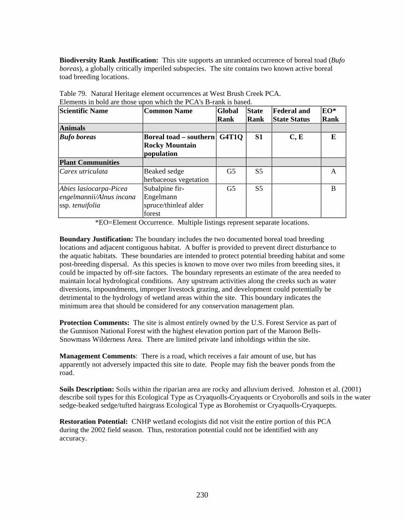
230
Biodiversity Rank Justification: This site supports an unranked occurrence of boreal toad (Bufo boreas), a globally critically imperiled subspecies. The site contains two known active boreal toad breeding locations. Table 79. Natural Heritage element occurrences at West Brush Creek PCA. Elements in bold are those upon which the PCA's B-rank is based. Scientific Name Common Name Global
Rank State Rank
Federal and State Status
EO* Rank
Animals Bufo boreas Boreal toad – southern
Rocky Mountain population
G4T1Q S1 C, E E
Plant Communities Carex utriculata Beaked sedge
herbaceous vegetation G5 S5 A
Abies lasiocarpa-Picea engelmannii/Alnus incana ssp. tenuifolia
Subalpine fir-Engelmann spruce/thinleaf alder forest
G5 S5 B
*EO=Element Occurrence. Multiple listings represent separate locations. Boundary Justification: The boundary includes the two documented boreal toad breeding locations and adjacent contiguous habitat. A buffer is provided to prevent direct disturbance to the aquatic habitats. These boundaries are intended to protect potential breeding habitat and some post-breeding dispersal. As this species is known to move over two miles from breeding sites, it could be impacted by off-site factors. The boundary represents an estimate of the area needed to maintain local hydrological conditions. Any upstream activities along the creeks such as water diversions, impoundments, improper livestock grazing, and development could potentially be detrimental to the hydrology of wetland areas within the site. This boundary indicates the minimum area that should be considered for any conservation management plan. Protection Comments: The site is almost entirely owned by the U.S. Forest Service as part of the Gunnison National Forest with the highest elevation portion part of the Maroon Bells-Snowmass Wilderness Area. There are limited private land inholdings within the site. Management Comments: There is a road, which receives a fair amount of use, but has apparently not adversely impacted this site to date. People may fish the beaver ponds from the road. Soils Description: Soils within the riparian area are rocky and alluvium derived. Johnston et al. (2001) describe soil types for this Ecological Type as Cryaquolls-Cryaquents or Cryoborolls and soils in the water sedge-beaked sedge/tufted hairgrass Ecological Type as Borohemist or Cryaquolls-Cryaquepts. Restoration Potential: CNHP wetland ecologists did not visit the entire portion of this PCA during the 2002 field season. Thus, restoration potential could not be identified with any accuracy.

231
Wetland Functional Assessment for the West Brush Creek PCA: CNHP wetland ecologists did not visit the entire portion of this PCA during the 2002 field season. Thus, a functional assessment could not be conducted with any accuracy.

232

233
Splains Gulch Potential Conservation Area Biodiversity Rank: B4. High biodiversity significance. The PCA supports an excellent example of a state imperiled (G5S1S2) plant. Protection Urgency Rank: P4. No protection actions are needed in the foreseeable future. The PCA is managed by the U.S. Forest Service and is on a vacant grazing allotment and currently receives little use. Management Urgency Rank: M4. Current management seems to favor the persistence of the elements in the PCA, but management actions may be needed in the future to maintain the current quality of the element occurrences. Location: This PCA is located approximately 22 miles north northwest of Gunnison and just east of Ohio Pass and County Road 730.
U.S.G.S. 7.5-min. quadrangles: Mount Axtell. Legal Description: T14S R87W Sections 13, 14, and 23.
Elevation: 10,400-10,550 ft. Size: Approximately 183 acres Johnston et al. (2001) Ecological and Community Type: RI9A - Non-forested Riparian – Water Sedge Ecological Series – Water sedge-beaked sedge/tufted hairgrass Ecological Type – Water sedge-wet sedges and forbs Community Type General Description: The PCA contains a subalpine lake with a pristine wetland complex composed of a floating/submerged palustrine wetland, a floating mat fen, and wet meadows (Carsey et al. 1999). The lake and surrounding meadows occupy a broad saddle on a volcanic plateau at the edge of the West Elk Mountains west of Crested Butte. Glacial till covers the entire area. Groundwater from a small watershed is channeled through the upper meadow into the lake. Water drains subsurface out of the lake into the lower meadow. The Splains Gulch PCA is an outstanding example of a large subalpine ring wetland system and lake-filling succession. The lake has open water in the center and water lilies (Nuphar luteum) near the shore. Paedomorphic salamanders swarm in the shallow waters at lake edges. Peat is slowly filling in the lake and now forms floating mats 30 to 75 feet wide, covered with intermediate rich fen vegetation consisting of fewflower spikerush (Eleocharis quinqueflora), silvery sedge (Carex canescens), and water sedge (Carex aquatilis) (Carsey et al. 1999). A large population of the state imperiled (S1S2) marsh cinquefoil (Comarum palustre) is growing near lake margins. Sphagnum (Sphagnum sp.) mats are scattered around the floating sedge mat encircling the lake. Willow carrs dominated by low stature planeleaf willow (Salix planifolia) cover the upper margins of the peatland. Upper and lower meadows are dominated by water sedge, beaked sedge (Carex utriculata), and tufted hairgrass (Deschampsia cespitosa). Biodiversity Rank Justification: This PCA supports an excellent example of the globally secure (G5S1S2) marsh cinquefoil (Comarum palustre) plant species. This species is circumboreal in distribution but is currently only known from six counties in Colorado. In Colorado, this species is associated with high elevation peatlands. The PCA also supports an outstanding example of a large subalpine ring wetland system and lake-filling succession.
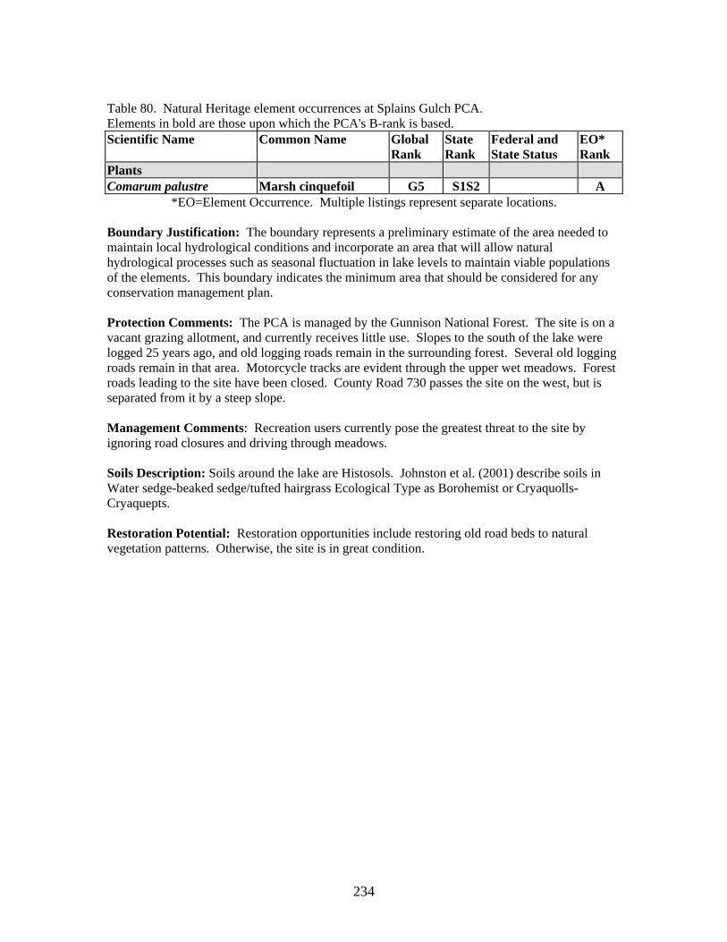
234
Table 80. Natural Heritage element occurrences at Splains Gulch PCA. Elements in bold are those upon which the PCA's B-rank is based. Scientific Name Common Name Global
Rank State Rank
Federal and State Status
EO* Rank
Plants Comarum palustre Marsh cinquefoil G5 S1S2 A
*EO=Element Occurrence. Multiple listings represent separate locations. Boundary Justification: The boundary represents a preliminary estimate of the area needed to maintain local hydrological conditions and incorporate an area that will allow natural hydrological processes such as seasonal fluctuation in lake levels to maintain viable populations of the elements. This boundary indicates the minimum area that should be considered for any conservation management plan. Protection Comments: The PCA is managed by the Gunnison National Forest. The site is on a vacant grazing allotment, and currently receives little use. Slopes to the south of the lake were logged 25 years ago, and old logging roads remain in the surrounding forest. Several old logging roads remain in that area. Motorcycle tracks are evident through the upper wet meadows. Forest roads leading to the site have been closed. County Road 730 passes the site on the west, but is separated from it by a steep slope. Management Comments: Recreation users currently pose the greatest threat to the site by ignoring road closures and driving through meadows. Soils Description: Soils around the lake are Histosols. Johnston et al. (2001) describe soils in Water sedge-beaked sedge/tufted hairgrass Ecological Type as Borohemist or Cryaquolls-Cryaquepts. Restoration Potential: Restoration opportunities include restoring old road beds to natural vegetation patterns. Otherwise, the site is in great condition.

235
Wetland Functional Assessment for the Splains Gulch PCA: Proposed HGM Class: Depression Subclass: D1 Cowardin System: Palustrine CNHP's Wetland Classification: Carex utriculata and Carex aquatilis Table 81. Wetland functional assessment for the riverine wetland at the Splains Gulch PCA.
Function Rating Comments Overall Functional
Integrity At Potential This wetland appears to be functioning at its potential.
Hydrological Functions Flood Attenuation and Storage
N/A This wetland receives groundwater inputs and thus does not experience large, short-term fluctuations in lake levels.
Sediment/Shoreline Stabilization
High There is dense vegetative cover on the lake margins which buffers wind-generated wave action and anchors the shoreline.
Groundwater Discharge/ Recharge
High Groundwater discharges to fill small pools around the lake, and the perennial waters of the lake serve to recharge groundwater.
Dynamic Surface Water Storage
Yes The lake and extensive peat soils hold large quantities of surface water.
Biogeochemical Functions Elemental Cycling Normal A diverse canopy of herbaceous species plus large quantities
of leaf litter and accumulating peat suggest intact and functioning nutrient cycles.
Removal of Imported Nutrients, Toxicants, and Sediments.
Moderate Inputs are low however, organic soils and extensive wet meadows provide ample opportunity for removal.
Biological Functions Habitat Diversity High Scrub-shrub, emergent, and open water wetlands create high
habitat diversity. General Wildlife Habitat High Extensive wetland complex with a high diversity of wetland
types provide much cover, browse, and nesting habitat for a variety of herbivores and birds.
General Fish/Aquatic Habitat
High The site is important amphibian habitat and fish were observed in the small channel draining from the lake.
Production Export/Food Chain Support
High The densely vegetated wetland complex supplies nutrients and carbon sources for invertebrates and fishes and downstream transport.
Uniqueness High Pristine example of a lake-fill succession wetland complex.

236
.
237
Union Park Potential Conservation Area Biodiversity Rank: B4. Moderate biodiversity significance. The PCA supports excellent examples of globally common wetland plant communities. Protection Urgency Rank: P4. No protection actions are needed in the foreseeable future. The PCA is almost entirely managed by the U.S. Forest Service with limited private inholdings. The uppermost portion of the PCA is part of the U.S. Forest Service Fossil Ridge Recreation Area with limited vehicular access. Management Urgency Rank: M3. New management actions may be needed within five years to maintain the current quality of the element occurrences in the PCA. The wetland is in excellent condition in the upper portions of the watershed; however the lower portions have been adversely affected by livestock grazing. In the upper portion, a jeep road has damaged approximately five acres of wetland. Location: Union Park encompasses the Lottis Creek drainage above Union Canyon, and south of Taylor Park, approximately 25 miles northeast of Gunnison.
U.S.G.S. 7.5-min. quadrangles: Fairview Peak and Taylor Park Reservoir Legal Description: T15S R82W Sections 8-10, 15, 16, 21, 22, 26-28, and 33-35
Elevation: 9,680-11,600 ft. Size: Approximately 3,050 acres Johnston (2001) Ecological and Community Type: RI5A – Non forested riparian – Planeleaf Willow-Wolf Willow-Bog birch Ecological Series – Wolf-planeleaf willows/water sedge Ecological Type - Wolf willow-water sedge Community Type. General Description: Union Park is a high, flat valley along the Lottis Creek drainage, surrounded by rounded granite bedrock ridges covered by lodgepole (Pinus contorta) and spruce-fir forest (Carsey and Decker 1999). It is separated from Taylor Park to the north by a low divide. Lottis Creek originates in a large glacial cirque on the north side of Fairview Peak, northwest of Gunnison. The creek flows northward through a glaciated valley to Union Park, where it spreads out into a long series of shallow beaver ponds, sedge-filled beaver meadows, and willow carrs. Lottis Creek turns westward across the valley floor and descends into Union Canyon on its way to its confluence with the Taylor River below Taylor Park Reservoir. The upper end of Union Canyon is a deep narrow cut in the granite ridge that borders the park on its western edge. The floor of Union Park features at least two levels of glacial outwash (at approximately 10 and 30 feet above the wetland) (Carsey and Decker 1999). Sideslopes are cloaked in lateral and recessional moraine. It is possible that Union Park once held a lake, which drained catastrophically down Union Canyon. The modern flat topography is a result of extensive beaver activity; dam building led to sediment collection and forced the creek channel to shift back and forth across the entire valley floor. The area includes excellent examples of a variety of common montane wetland community types, as well as good examples of beaver processes and pond succession. The large wetland area in Union Park is composed of numerous shallow beaver ponds with emergent wetlands dominated by common sedges such as beaked sedge (Carex utriculata) and water sedge (C. aquatilis).

238
There is modest peat accumulation up to two feet thick in scattered, poorly drained areas. Most water flow is in channels, especially in the lower reach of the wetland where dam failure appears to be a common event. Willow carrs consist primarily of Wolf willow (Salix wolfii) intermixed with planeleaf willow (S. planifolia) and bog birch (Betula glandulosa). Slightly drier areas support meadows of tufted hairgrass (Deschampsia cespitosa) and water sedge. Nearby uplands support sagebrush shrubland and limited fescue grassland. Biodiversity Rank Justification: This PCA supports excellent examples of two globally apparently secure (G4) wetland plant communities: Wolf willow with beaked sedge (Salix wolfii/Carex utriculata) and Wolf willow with water sedge (Salix wolfii/Carex aquatilis). Table 82. Natural Heritage element occurrences at Union Park PCA. Elements in bold are those upon which the PCA's B-rank is based. Scientific Name Common Name Global
Rank State Rank
Federal and State Status
EO* Rank
Plant Communities Salix wolfii/Carex utriculata
Wolf willow/beaked sedge shrubland
G4 S3 A
Salix wolfii/Carex aquatilis Wolf willow/water sedge shrubland
G4 S3 A
*EO=Element Occurrence. Multiple listings represent separate locations. Boundary Justification: The boundary represents an estimate of the area needed to maintain local hydrological conditions. Any upstream activities along Lottis Creek and its tributaries such as water diversions, impoundments, improper livestock grazing, and development could potentially be detrimental to the hydrology of wetland areas within the PCA. This boundary indicates the minimum area that should be considered for any conservation management plan. Protection Comments: The PCA is almost entirely managed by the U.S. Forest Service as part of the Gunnison National Forest. The upper portion of the watershed is part of the U.S. Forest Service Fossil Ridge Recreation Area that excludes some motorized vehicles. There are patented mining claims in the lower portion of the wetland. Management Comments: Domestic livestock graze the area. Grazing impacts in the upper portion of the watershed appear minimal. In the lower portion of the watershed willow cover is decreased, soil hummocking has occurred, as well as some channel entrenchment, all indicative of heavy grazing by livestock (Johnston et al. 2001). Other than grazing, the primary use of the area is recreational. A motorized trail (four wheel drive, ATV, dirtbike) follows the creek up the drainage and appears to receive moderate use. Union Park is the site of a proposed dam. Construction of such a project would completely eliminate the wetland plant communities and associated biological value. The most immediate concern is from recreational use, especially on the motorized trail. At the upper end of Union Park the trail has damaged approximately five acres of wetland. Heavily used social trails split off from the developed trail at the wetland because of the muddy surface. Development of patented mining claims in the lower part of the Union Park wetland would severely impact the integrity of the PCA.

239
Soils Description: Soils within the wetlands are variable and include areas of peat and areas of fine-grained sediments. Johnston et al. (2001) describe soil types for the Wolf-planeleaf willow/water sedge Ecological Type as Cryaquolls and Cryohemists. Restoration Potential: Restoration opportunities include modifying the grazing regime in the downstream portion of the wetland where willow cover is decreased, soil hummocking has occurred, and channels have become entrenched. Grazing practices should be minimized or a reasonable method of grazing, such as fencing off riparian areas, especially those closest to the river, implemented in order to improve the health of the riparian vegetation. Resting the areas from additional grazing will increase the vigor of native wetland species, which may help control the spread of non-native species. Another restoration opportunity is rerouting the road in the upper portion of the watershed where heavily used social trails split off from the developed trail at the wetland because of the muddy surface. The road has affected about five acres of wetland.

240
Wetland Functional Assessment for the Union Park PCA: Proposed HGM Class: Riverine Subclass: R2 Cowardin System: Palustrine CNHP's Wetland Classification: Salix wolfii/Carex utriculata, Salix wolfii/Carex aquatilis Table 83. Wetland functional assessment for the riverine wetland at the Union Park PCA.
Function Rating Comments Overall Functional
Integrity At Potential This wetland appears to be functioning at its potential.
Hydrological Functions Flood Attenuation and Storage
High The valley is very wide with a low gradient and abundant beaver ponds and dense vegetation. Each year, the system absorbs a tremendous snow pack and moderates its release, providing valuable natural flood protection for communities downstream.
Sediment/Shoreline Stabilization
High Abundant beaver ponds and dense sedge cover.
Groundwater Discharge/ Recharge
Yes Portions of the wetland are permanently flooded (peat accumulation, permanently flooded beaver ponds) indicating groundwater discharge is occurring.
Dynamic Surface Water Storage
N/A This wetland floods via overbank flow.
Biogeochemical Functions Elemental Cycling Normal A diverse canopy of herbaceous and woody species plus large
quantities of leaf litter and accumulating peat suggest intact and functioning nutrient cycles.
Removal of Imported Nutrients, Toxicants, and Sediments.
High Dense vegetation, peat accumulation, a gently sloping gradient, and beaver dams provide high potential to capture sediments and nutrient removal.
Biological Functions Habitat Diversity High Scrub-shrub, emergent, and open water wetlands along with
the immediately adjacent forest create high habitat diversity. General Wildlife Habitat High Extensive willow and sedge production at the PCA not only
supports beaver, but also elk, deer, raccoon, and various songbirds and waterfowl.
General Fish/Aquatic Habitat
High Fish were observed in the stream and beaver ponds.
Production Export/Food Chain Support
High Production export is high, providing organic matter used by fish and invertebrates both onsite and downstream.
Uniqueness Moderate The vegetative community is globally common but the size of the wetland and excellent condition (in the upper portions) – along with the high habitat diversity – add to the uniqueness of this PCA.

241

242
Natural History Information Rare and Imperiled Plants Dependent on Wetlands of Gunnison County Green sedge (Carex viridula) G5 S1 Green sedge is associated with calcareous fens. It fruits in early July through early October. The species is widely distributed and is found in Japan, Newfoundland to Alaska, south to New Jersey, Indiana, New Mexico, Utah, and California. In Colorado the species is found in Gunnison, Jackson, La Plata, Park and Summit counties. This species is threatened by peat removal and other habitat alteration. (photo © UDSA PLANTS database)
Marsh Cinquefoil (Comarum palustre) G5 S1S2 Marsh cinquefoil is a species associated with high elevation peat bogs. A member of the rose family, it flowers in July and August. The species is circumboreal in distribution. It is known in Colorado from five counties: Mesa, Delta, Gunnison, Routt, and Jackson. This species is threatened by peat removal and other habitat alteration. (photo © UDSA PLANTS database)
Round-leaf sundew (Drosera rotundifolia) G5 S2 (Forest Service Sensitive Species) Round-leaf sundew is a species associated with floating peat mats and on the margins of acidic ponds and fens. A member of the sundew family, it blooms in July although flowers seldom open in Colorado. The species occurs in Eurasia, the northeast U.S. and Canada, south to Idaho, Montana, California, Nevada, Florida, and Colorado. Within Colorado it is only known from a few locations in Jackson County, one location in Grand County, and one location in Gunnison County. This species is threatened by peat removal and other habitat alteration. (photo © UDSA PLANTS database)
Hanging garden sullivantia (Sullivantia hapenamii var. purpusii) G3T3 S3 Hanging garden sullivantia is associated with hanging gardens, wet cliffs, and wet boulders of various geologic formations at elevations between 7,000 and 10,000 feet. A member of the saxifrage family, it flowers from mid June to late July and fruits in July and August. This variety is known only from Colorado. There are 45 known locations from Rio Blanco, Gunnison, Garfield, Pitkin, and Montrose counties. This species is somewhat naturally protected by its inaccessible hanging garden habitat. Although, rock climbing may disturb or destroy individuals, while
alteration of hydrology is needed for the survival of these locations. Most occurrences occur on Forest Service, Bureau of Land Management or Naval Oil Shale properties. (photo © CNHP)

243
Variegated scouring rush (Equisetum variegatum = Hippochaete variegata) G5 S1 Variegated scouring rush is associated a variety of moist habitats including riparian areas, lakeshores, ditches, and wet meadows. It flowers and fruits between June and September. The species occurs in the U.S., Canada, and Eurasia. In Colorado, it is known from Gunnison, San Miguel, San Juan, and Archuleta counties. This species is threatened by habitat alteration including peat removal.
Rolland’s bulrush (Tricophorum pumilum = Scirpus pumilus) G5 S2 (Forest Service Sensitive Species) Rolland’s bulrush, a member of the sedge family, is associated with moss hummocks in extreme rich fens. It flowers between June and July and fruits in August and early September. It is a circumboreal species. Within Colorado, Rolland’s bulrush is known only from Park County, where it is common in the many extreme rich fens, and one extreme rich fen in Gunnison County. This species is threatened by peat removal and other habitat alteration.

244
Rare and Imperiled Animals Dependent of Wetlands of Gunnison County Boreal Toad (Bufo boreas boreas) Taxonomy: Class: Amphibia Order: Anura Family: Bufonidae Genus: Bufo Taxonomic Comments: Prior to the 1990s, morphological, biogeochemical, and vocal differences were noted between toads of the Bufo boreas complex in the southern Rocky Mountains and those in the Pacific Northwest (Burger and Bragg 1947, Hubbard 1972). Goebel (1996) described Bufo boreas in the southern Rocky Mountains as genetically distinct from those in the Pacific Northwest. These differences may warrant recognition as one or more distinct species. Until this change is formally accepted, Hammerson (1999) has offered the common name of Mountain Toad for the interim, and suggests that the Latin name may become Bufo pictus. For the purposes of this report, we are referring all naming to boreal toad (Bufo boreas boreas). CNHP Ranking: G4T1Q S1 State/Federal Status: USFWS candidate for listing (warranted but precluded), USFS Sensitive, State endangered Habitat Comments: The boreal toad breeds in still or slowly-moving water such as can be found in marshes, ponds, and lakes. Successful breeding generally requires permanent or semipermanent water sources. Post breeding, one may find the boreal toad in more terrestrial environments. Though they still tend to linger near water in damp environments, some females will use drier, more densely vegetated areas. Rocks, logs and rodent burrows provide cover while away from water during periods of inactivity (Hammerson 1999).
Distribution: The southern Rocky Mountain population of boreal toads is likely distinct from other populations (A. Geobel, unpbl. data). Although relationships among populations of this toad are not resolved, recent genetic evaluations suggest that the southern Rocky Mountain population ranges from southern Idaho to New Mexico (Goettl 1997; Steve Corn pers. comm.; A. Goebel unpbl. data). In Colorado, this species occurs throughout the mountains above approximately 8,000 feet in elevation. There are approximately 206 historical localities for the boreal toad in Colorado, while currently there are just 35 known active breeding sites. Important Life History Characteristics: Boreal toads are long-lived, reaching
ages of nine years or more (Campbell 1976). Reproductive maturity does not occur until age four in males and six in females (Carey 1976). Other important considerations include sensitivity to toxicants, relatively short breeding season (starting as the winter snowpack begins to thaw), and slow metabolic rates of the larvae (Hammerson 1999). Known Threats and Management Issues: Presently, only three to four healthy populations remain across the entire range, comprised of less than 40 high priority breeding sites (Steve Corn, pers. comm.; Lauren Livo, pers. comm.). Based on the small numbers of egg masses, it is estimated that there are currently fewer than 1,000 breeding adults. Although there is an abundance of “protected” habitat, populations have declined precipitously or disappeared over the past 20 years, and continue to do so (Goettl 1997). The reasons for this decline are varied and largely unknown and the factors important to the persistence of this species are not well understood.

245
Gunnison Sage Grouse (Centrocercus minumus) Taxonomy: Class: Aves Order: Galliformes Family: Phasianidae Genus: Centrcercus Taxonomic Comments: Recently recognized as distinct species (AOU, 2000) CNHP Ranking: G1 S1 State/Federal Status: USFWS candidate for listing, State species of Special Concern Habitat Comments: Several different types of sagebrush habitats are used seasonally by sage grouse. Lek sites, for example, tend to be relatively open areas with dense sagebrush or other shrub cover nearby (Gill 1965, Klott and Lindzey 1989). Leks often are located on sites that are surrounded by potential nesting habitat (Wakkinen et al. 1992). Nesting habitat is generally characterized by dense vegetative cover, including an overstory of sagebrush and an understory of grasses and forbs (Wakkinen 1990, Gregg 1991, Holloran 1999). Vegetative characteristics of brood-rearing habitats vary greatly, but abundant forbs and insects are nearly always present (e.g., Dunn and Braun 1986, Drut et al. 1994, Sveum et al. 1998). Early brood-rearing areas tend to be located near nesting areas in upland sagebrush habitats (Sveum et al. 1998b, Lyon 2000). As the summer progresses and upland vegetation dries out, hens and chicks move to wet meadows where forbs and insects remain available (Wallestad 1971, Autenrieth 1981). Winter habitat for sage grouse consists of areas with tall, dense sagebrush that is critical for hiding and thermal cover as well as food (Hupp and Braun 1989). Distribution: The Gunnison Sage Grouse has been extirpated from more than 75 percent of its former range (Webb 2000). The species currently inhabits portions of 6 (possibly 7) counties in southwestern Colorado and 1 county in southeastern Utah (Young et al. 2000). In Colorado, the current range of Gunnison Sage Grouse extends southward and eastward from the Colorado and Eagle rivers to the Arkansas River and San Luis Valley. In Utah, Gunnison Sage Grouse distribution is limited
to a small area at the extreme eastern edge of San Juan County, along the Colorado border. Fewer than 4,000 birds remain, with the largest group (about 2,500) in the Gunnison Basin (Young et al. 2000, Jarrett 2001). Known Threats and Management Issues: The major threat facing Gunnison Sage Grouse is loss of habitat through land-use conversion, fragmentation, and degradation (Yocum 1956; Hammerstrom and Hammerstrom 1961; Martin 1976, Braun et al. 1977, 1994; Drut 1994; Connelly and Braun 1997; Braun 1998; Hays et al. 1998; Connelly et al. 2000; Oyler-McCance et al. 2001). In Colorado, Oyler-McCance et al. (2001) documented a steady loss of sagebrush vegetation since 1958, and substantial fragmentation of sagebrush habitats. They concluded that if current trends in habitat loss and fragmentation continue, Gunnison Sage Grouse may face extinction (Oyler-McCance et al. 2001).
The introduction of large numbers of domestic livestock in the 1800s, and the unregulated grazing that followed, caused severe degradation of sagebrush habitats which led to sharp declines in sage grouse numbers (Autenreith et al. 1982, Klebenow 1982, 1985). Loss and degradation of sagebrush-dominated lands continued, due to overgrazing and the clearing of land for cultivated crops (Swenson et al. 1987, Fleischner 1994). Sage grouse numbers in Colorado declined at an increasing rate beginning in the late 1950s (Rogers 1964), and this trend has persisted to the present (Braun 1995, 1998). During the 1960s and 1970s, the large-scale application of herbicides and fire to sagebrush lands (to improve conditions for livestock grazing) caused further reduction and fragmentation of sage grouse habitats (Braun 1995). In Colorado, this trend toward reduced size and continued degradation of the remaining sage grouse habitat patches is increasing on both public and private lands (Braun 1995).
Overall habitat range (CDOW, 2002)
photo by Louis F. Swift ©

246
Black Swift (Cypseloides niger) Taxonomy: Class: Aves Order: Apodiformes Family: Apodidae Genus: Cypseloides Taxonomic Comments: Subfamily Cypseloidinae CNHP Ranking: G4 S3B State/Federal Status: USFS Sensitive Habitat Comments: Black Swifts nest on vertical rock faces, near waterfalls or in dripping caves (Lack 1956). Beyond that requirement, they inhabit a variety of landscapes, from seacoasts to the high elevations of the Rocky Mountains (CBBA 1998).
Distribution: Black swifts breed in scattered colonies in western North America, from southeast Alaska to central Mexico, and migrate to the Neotropics in the winter (Stiles and Negret 1994). In Colorado, black swifts breed most commonly in the San Juan mountains, with scattered colonies in four other mountain ranges -- Sangre de Cristo, Flat Tops, Gore, and Front (CBBA 1998). Important Life History Characteristics: After arriving in Colorado in June, black swifts take all summer to raise a single nestling (CBBA 1998). The cool microclimates they select for nesting presumably slows the developmental metabolism of the nestlings. Since nestlings are typically fed only once per day after the adults return from a day of foraging, slower development rates would
help the survival. Known Threats and Management Issues: There are few obvious threats to this species, except where development alters nesting habitat. The Colorado Breeding Bird Atlas (1998) hypothesizes that at least 20% of all black swifts breed in Colorado.

247
Colorado River Cutthroat Trout (Oncorhynchus clarki pleuriticus)
Taxonomy: Class: Actinopterygii Order: Salmoniformes Family: Salmonidae Genus: Oncorhynchus Taxonomic Comments: Subclass - Neopterygii CNHP Ranking: G4T3 S3 State/Federal Status: USFS sensitive, BLM sensitive, State species of special concern Habitat Comments: The historical habitat included most clearwater streams and rivers of western Colorado (Behnke 1992). The trout remains only in smaller order streams and a few high elevation lakes of the mountainous country.
Distribution: This subspecies is the only trout native to the upper Colorado River basin. Its native range extends southward to the Escalante River on the west and San Juan drainage on the east sides of the basin, including the Green, Yampa, Gunnison, Dolores, and San Juan river systems (CDOW 1986, CDOW 1987, Proebstel 1994, Young et al. 1996). Currently, remnant populations remain in Colorado, Wyoming, and Utah. Important Life History Characteristics: Competition and hybridization with non-native salmonids occurs. This trait has contributed to the current preferences of this native trout for lakes, beaver ponds, and small streams. Clean, cold water running
over a boulder-cobble substrate marks the preferred habitat of this trout (Trotter 1987). Known Threats and Management Issues: The Colorado River cutthroat trout is heavily managed and studied. Presently, there are 42 populations in Colorado judged to be genetically pure (Proebstel 1994). However, the primary reasons for conservation concern at the global and state levels are long-term trend prognoses and threats. Populations continue to decline in many streams (Young et al. 1996); hybridization between this species and non-native trout species (Rainbow trout Onchorhynchus mykiss) poses the greatest threat to the elimination of pure populations. Competition with non-native trout species and exotic fish diseases also pose threats, and declines have been hastened by loss of habitat to grazing, clearcutting, water diversions, and stream channelization (Trotter 1987).

248
Rare and Imperiled Wetland Plant Communities of Gunnison County Subalpine fir - Engelmann spruce / Thinleaf alder Forest Abies lasiocarpa - Picea engelmannii / Alnus incana ssp. tenuifolia
General Description
Occurs on heavily forested stream reaches where Abies lasiocarpa-Picea engelmannii (subalpine fir-Engelmann spruce) forests also occur on adjacent hillslopes. Tall Alnus incana ssp. tenuifolia (thinleaf alder) and Salix drummondiana (Drummond willow) grow in a thick band along the edge of the stream. At lower elevations, Alnus incana is more abundant than Salix drummondiana. At mid-elevations, the two shrubs can be codominant. At higher elevations, Salix drummondiana becomes dominant and Alnus incana drops out, forming the Abies lasiocarpa-Picea engelmannii/Salix drummondiana plant association.
This is a common community on first- and second-order streams above 8,000 ft in elevation. Habitats are generally narrow, 150-800 ft (40-250 m), V-shaped valleys on stream benches and banks. Most commonly occurs within 15-20 ft (5-6 m) of the channel edge and is rarely more than 2 ft (0.5 m) above the stream bank. Stream channels are narrow
and steep, moderately wide with a moderate gradient or wide and very sinuous.
Soils are shallow, dark-colored, thin layers of loamy sands, silty loams, and sandy clay loams over cobbly alluvium. There is generally a high organic matter content in the top 20 inches (50 cm) and mottles at 40 inches (100 cm), becoming skeletal at 60 inches (150 cm).
Vegetation Description Picea engelmannii (Engelmann spruce) and/or Abies lasiocarpa (subalpine fir) dominates the upper canopy, with Picea engelmannii present more often that Abies lasiocarpa. Other tree species such as Picea pungens (blue spruce), Pinus contorta (lodgepole pine), and Populus tremuloides (aspen) are occasionally present. Alnus incana ssp. tenuifolia (thinleaf alder) is always present in the shrub canopy layer, and other shrubs are often present as well. The herbaceous undergrowth is usually rich in forb species, with an overall herbaceous cover of 20-70%.
Ecological Processes This association appears to be a late-seral, or at least a long-lived, riparian community that may also represent a successional change from deciduous-dominated overstory to a conifer-dominated overstory at lower elevations, a shift which may be attributed to a lack of fire in the association. The successional process of the spruce-fir forest is slow (200 + years); factors such as fire frequency, wind-throw and insect attack can affect the composition and age structure of Abies lasiocarpa and Picea engelmannii stands.
Avg. Cover
% (Range) Species Name # Plots (N=56) Other species with < 5% average cover present in at least 10% of plots:
34 (1-80%) Alnus incana ssp. tenuifolia 56 31 (1-82%) Picea engelmannii 51 22 (1-53%) Cornus sericea ssp. sericea 8 21 (1-77%) Abies lasiocarpa 43 17 (3-30%) Salix geyeriana 8 14 (2-48%) Pinus contorta 9 12 (1-32%) Acer glabrum 9
12 (1-43%) Corydalis caseana ssp. brandegeei 7
9 (0.1-95%) Calamagrostis canadensis 32 9 (1-43%) Equisetum arvense 29 7 (1-20%) Salix drummondiana 25 7 (1-10%) Picea pungens 9 6 (1-30%) Lonicera involucrata 40 5 (0.1-15%) Carex aquatilis 9 5 (1-21%) Populus tremuloides 15
5 (1-20%) Salix monticola 6
Heracleum maximum (0.1-25%), Oxypolis fendleri (1-34%), Mertensia ciliata (0.1-11%), Mertensia franciscana (1-7%), Amelanchier alnifolia (1-10%), Maianthemum racemosum ssp. amplexicaule (1-18%), Rubus parviflorus (1-10%), Streptopus amplexifolius var. chalazatus (1-8%), Pyrola asarifolia ssp. asarifolia (1-10%), Cardamine cordifolia (1-11%), Glyceria striata (1-14%), Ribes inerme (1-10%), Saxifraga odontoloma (1-10%), Symphyotrichum foliaceum (1-10%), Hydrophyllum fendleri (1-10%), Vaccinium scoparium (1-8%), Ribes lacustre (1-7%), Viola canadensis var. scopulorum (0.1-20%), Galium trifidum ssp. subbiflorum (1-10%), Equisetum pratense (1-6%), Osmorhiza depauperata (1-10%), Aconitum columbianum (1-10%), Actaea rubra ssp. arguta (1-8%), Senecio triangularis (1-9%), Arnica cordifolia (1-7%), Thalictrum fendleri (1-10%), Mitella pentandra (1-10%), Geranium richardsonii (1-8%), Rosa woodsii (1-7%), Chamerion angustifolium ssp. circumvagum (1-6%), Maianthemum stellatum (1-8%), Osmorhiza berteroi (1-3%), Dodecatheon pulchellum (1-5%), Galium triflorum (1-8%), Chaenactis douglasii (1-4%), Elymus glaucus (1-5%), Carex disperma (0.1-5%), Orthilia secunda (1-3%), Conioselinum scopulorum (0.1-5%), Rubus idaeus ssp. strigosus (1-3%), Luzula parviflora (0.1-4%), Taraxacum officinale (1-3%), Achillea millefolium var. occidentalis (1-5%), Poa pratensis (1-4%), Pyrola minor (1-3%), Geum macrophyllum var. perincisum (0.1-3%), Fragaria virginiana ssp. glauca (1-3%), Pseudocymopterus montanus (1-2%), Galium boreale (1-3%), Carex microptera (1-2%), Bromus ciliatus var. ciliatus (1%).
Global rank/State rank G5 / S5
HGM subclass: R2, R3/4
Colorado elevation range:
7,200-10,300 ft (2,200-3,100 m)

249
Subalpine fir - Engelmann spruce / Tall fringed bluebells Forest Abies lasiocarpa - Picea engelmannii / Mertensia ciliata
General Description This association is a heavily shaded forest with no shrubs and a thick line of wildflowers lining the stream edge. It is a common community in the subalpine zone along first- and second-order streams. Mertensia ciliata (tall fringed bluebells) is nearly always present but can be absent. Other forbs consistently present include Cardamine cordifolia (heartleaf bittercress), Saxifraga odontoloma (brook saxifrage) and Senecio triangularis (arrowleaf groundsel). Salix drummondiana (Drummond willow), Lonicera involucrata (honeysuckle), and Ribes (currant) species can be present, but with less than 10% cover. At high elevations, Vaccinium myrtillus (whortleberry), typically an upland species, can intergrade with this riparian plant association on the stream banks. This is a common plant association throughout the southern Rocky
Mountains of Colorado and occurs in all mountain ranges and national forests in Colorado, comprising approximately 2,000+ miles of stream habitat in Colorado alone. This association occurs in narrow to wide valleys, 35-350 feet (10-100 m) wide, and is limited to the immediate stream channel edge and overflow areas. It usually establishes within 15 feet (5 m) of the channel and within 2 feet (0.5 m) of channel bankfull height. Typically this association occurs along steep (2-15% gradient), narrow streams, but can also be found along moderate gradient stretches. Soils range from a thin layer of skeletal sandy loams to somewhat deep, mottled loamy sands over colluvial boulders. Total soil depth is never more than 7 feet (2 m), and is typically less than 3 feet (1 m). Consistent to all profiles is a deep, dark brown color and high organic content. Vegetation Description Either Picea engelmannii (Engelmann spruce) or Abies lasiocarpa (subalpine fir) is present, although they are not always present together. The tree canopy can be very thick, completely overhanging the stream, or it can be quite open, with a wide gap over the stream. There is generally very little shrub cover. Vaccinium myrtillus (whortleberry), can be abundant with 1-50% cover, however it was present in only a third of the stands sampled. Other shrub species that may be present include Salix drummondiana (Drummond willow), S. planifolia (planeleaf willow), S. monticola (mountain willow), Alnus incana ssp. tenuifolia (thinleaf alder), Lonicera involucrata (honeysuckle), and several Ribes (currant) species. The dense, mossy forb layer is the diagnostic part of this vegetation type. The forb layer is usually very narrow, often well under 3 ft (1 m) wide, clinging to and undulating with the side of the narrow stream channel. It is species rich with 20-80% total combined forb cover. No single forb species is consistently present in every stand, however, a distinct suite of species is present in varying combinations. Ecological Processes Many first- and second-order streams run through subalpine spruce-fir forests providing habitats for obligate riparian shrubs, forbs, and grasses, forming a number of riparian Abies lasiocarpa - Picea engelmannii (subalpine fir-Engelmann spruce) plant associations. Although Abies lasiocarpa and Picea engelmannii are not obligate riparian species, the two species strongly influence subalpine riparian ecosystems.
Avg. Cover % (Range) Species Name
# Plots (N=90) Other species with < 5% average cover present in at least 10% of plots:
33 (1-100%) Picea engelmannii 90 17 (1-90%) Abies lasiocarpa 80 13 (2-24%) Alnus incana ssp. tenuifolia 12 10 (1-50%) Senecio triangularis 71 10 (1-50%) Vaccinium myrtillus var. oreophilum 31 10 (1-50%) Cardamine cordifolia 83 9 (1-20%) Ribes lacustre 14 9 (1-53%) Mertensia ciliata 81 8 (1-44%) Populus tremuloides 10 7 (1-56%) Saxifraga odontoloma 66 7 (1-20%) Oxypolis fendleri 73 7 (1-21%) Vaccinium scoparium 17 6 (1-20%) Trollius laxus ssp. albiflorus 15 6 (1-66%) Equisetum arvense 34 5 (1-13%) Salix drummondiana 15 5 (1-27%) Ribes montigenum 18 5 (1-37%) Carex aquatilis 26
Calamagrostis canadensis (1-40%), Caltha leptosepala (1-20%), Salix planifolia (1-20%), Streptopus amplexifolius var. chalazatus (1-18%), Salix monticola (1-20%), Erigeron peregrinus ssp. callianthemus (1-10%), Arnica mollis (1-16%), Arnica cordifolia (1-29%), Lonicera involucrata (1-20%), Delphinium barbeyi (1-10%), Heracleum maximum (1-20%), Mitella pentandra (1-15%), Angelica grayi (1-10%), Ligusticum porteri (1-10%), Aconitum columbianum (1-10%), Geranium richardsonii (1-15%), Conioselinum scopulorum (1-16%), Deschampsia caespitosa (1-11%), Bromus ciliatus var. ciliatus (1-10%), Primula parryi (1-6%), Chamerion angustifolium ssp. circumvagum (1-10%), Orthilia secunda (1-7%), Maianthemum stellatum (1-3%), Juncus balticus var. montanus (1-5%), Osmorhiza depauperata (1-6%), Polygonum bistortoides (1-3%), Fragaria virginiana ssp. glauca (1-5%), Achillea millefolium var. occidentalis (1-5%), Luzula parviflora (1-10%), Juncus drummondii (1-5%), Taraxacum officinale (1-6%), Poa pratensis (1-4%), Rhodiola rhodantha (1-4%), Viola canadensis var. scopulorum (1-4%), Pyrola minor (1-3%), Listera cordata (1-2%), Phleum alpinum (1-2%), Veronica wormskjoldii (1-2%), Platanthera dilatata var. albiflora (1%), Polygonum viviparum (1%).
Global rank/State rank: G5 / S5
HGM subclass: R2
Colorado elevation range:
8,200-11,500 ft (2,500-3,500 m)

250
Subalpine fir - Engelmann spruce - Narrowleaf cottonwood / Twinberry honeysuckle Forest Abies lasiocarpa - Picea engelmannii - Populus angustifolia / Lonicera involucrata
General Description The Abies lasiocarpa-Picea engelmannii-Populus angustifolia/Lonicera involucrata (subalpine fir-Engelmann spruce-narrowleaf cottonwood/twinberry honeysuckle) plant association is an unusual combination occurring at the upper elevational limits of Populus angustifolia (narrowleaf cottonwood) and is generally restricted to the southern parts of the Colorado Rockies. The community occurs on active floodplains of larger rivers in the upper montane valleys, on terraces or elevated stream benches between 1.5-7 ft (0.5-1.2 m) above the active channel elevation. The rivers are wide and slightly sinuous. Soils are fairly shallow (6-15 in, 10-40 cm) sandy loam and sand over deep, coarse alluvial materials. Vegetation Description The overstory is a mix of Picea engelmannii (Engelmann spruce) and Populus angustifolia (narrowleaf cottonwood). Other tree species that may be present include Abies lasiocarpa (subalpine fir), Abies concolor (white fir) seedling and saplings, and Pseudotsuga menziesii (Douglas-fir). Overall,
shrubs are not abundant and provide less than 50% cover. Lonicera involucrata (twinberry honeysuckle) is the most constant shrub species, but may not be abundant. Other species include: Acer glabrum (Rocky Mountain maple), Alnus incana ssp. tenuifolia (thinleaf alder), Salix geyeriana (Geyer willow), and Symphoricarpos rotundifolius (roundleaf snowberry). Herbaceous cover is sparse and no species is consistently present. The most typical species include: Bromus canadensis (Canadian brome), Festuca rubra (red fescue), Fragaria virginiana (strawberry), Heracleum maximum (common cowparsnip), Maianthemum stellatum (starry false Solomon seal), and Geranium richardsonii (Richardson geranium). Ecological Processes The Abies lasiocarpa-Picea engelmannii-Populus angustifolia/Lonicera involucrata (subalpine fir-Engelmann spruce-narrowleaf cottonwood/twinberry honeysuckle) plant association is a mid- to late-seral community. Populus angustifolia (narrowleaf cottonwood) will continue to co-occur with conifer species where fluvial activity (e.g., flooding, channel migration, sediment deposition, and scouring) persists. Higher elevations and cool, shaded canyon bottoms create an environment for Abies lasiocarpa (subalpine fir) and Picea engelmannii (Engelmann spruce). The active channel flooding and sediment deposition allows Populus angustifolia (narrowleaf cottonwood) to perpetuate. On higher terraces that no longer experience flooding, Abies and Picea may become the climax tree species. Avg. Cover
% (Range) Species Name # Plots (N=8)* Other species with < 5% average cover present in at least 10% of plots: 49 (20-93%) Populus angustifolia 6 23 (4-55%) Abies lasiocarpa 6 22 (10-40%) Picea engelmannii 8 19 (2-44%) Pseudotsuga menziesii 3 13 (5-20%) Pyrola asarifolia ssp. asarifolia 2 11 (3-20%) Ribes lacustre 3 9 (3-20%) Alnus incana ssp. tenuifolia 5 8 (1-20%) Lonicera involucrata 7 8 (5-10%) Streptopus amplexifolius var. chalazatus 2 6 (1-10%) Heterotheca villosa 2 6 (1-10%) Vaccinium myrtillus var. oreophilum 2 6 (1-10%) Vaccinium scoparium 2 6 (1-10%) Salix monticola 2 4 (1-10%) Geranium richardsonii 6
Senecio atratus (3-5%), Picea pungens (2-5%), Thalictrum fendleri (1-10%), Equisetum arvense (1-5%), Calamagrostis canadensis (1-5%), Cardamine cordifolia (1-5%), Rubus idaeus ssp. strigosus (1-5%), Taraxacum officinale (1-7%), Populus tremuloides (1-4%), Acer glabrum (1-3%), Cornus sericea ssp. sericea (1-3%), Heracleum maximum (1-5%), Osmorhiza depauperata (1-5%), Solidago simplex ssp. simplex var. simplex (1-3%), Erigeron glabellus (1-3%), Pedicularis procera (1-3%), Maianthemum stellatum (1-5%), Fragaria virginiana ssp. glauca (1-3%), Symphoricarpos rotundifolius (1-3%), Ligusticum porteri (1-3%), Achillea millefolium var. occidentalis (1-3%), Bromus inermis (1-2%), Actaea rubra ssp. arguta (1-3%), Bromus ciliatus var. ciliatus (1-2%), Mertensia ciliata (1%), Paxistima myrsinites (1%), Senecio triangularis (1%), Amelanchier alnifolia (1%), Galium triflorum (1%), Chamerion angustifolium ssp. circumvagum (1%), Vicia americana (1%), Ribes montigenum (1%).
Global rank/State rank: G4 / S3
HGM subclass: R3/4
Colorado elevation range:
9,000-9,500 ft (2,700-2,800 m)

251
Thinleaf alder / Mesic forb Shrubland Alnus incana ssp. tenuifolia / Mesic forb
General Description This association is characterized by stands of medium-tall, deciduous shrubs and a thick, herbaceous undergrowth of forbs and wetland grasses. A low canopy of shorter shrubs may also be present with Ribes (currant) and Salix (willow) species and Cornus sericea (red-osier dogwood). Undisturbed stands have abundant forbs and native grasses. Stands disturbed by season-long livestock grazing have reduced forb cover and an increase in non-native grasses including Poa pratensis (Kentucky bluegrass) and Agrostis stolonifera (creeping bentgrass). Large stands (>0.5 acre, 0.2 ha) with the native herbaceous undergrowth intact are uncommon. This plant association occurs along narrow, 130-230 ft (40-70 m) wide, alluvial benches and terraces of canyons and valleys. It also occurs as narrow bands
in wider valleys and occasionally forms a wide band on the floodplain. Stream channels are highly variable. They can be steep (3-12%) gradient and narrow or wider, rocky, and moderately sinuous. Occasionally, stream channels are low gradient and highly sinuous, narrow and highly sinuous, or braided. Soils are well drained silt loams, loams, sandy clay loams, sandy loams, or just sand. Some profiles have a high percentage of organic matter and are either skeletal or stratified with skeletal layers. Some profiles have significant silt fractions in the upper layers. Vegetation Description Alnus incana ssp. tenuifolia (thinleaf alder) creates a dense, tall shrub canopy. Other shrubs occasionally present include: Lonicera involucrata (twinberry honeysuckle), Ribes inerme (whitestem gooseberry), R. montigenum (gooseberry currant) Rosa woodsii (Woods rose), Salix bebbiana (Bebb willow), S. drummondiana (Drummond willow), S. geyeriana (Geyer willow), S. lucida ssp. caudata (shining willow) and S. monticola (mountain willow). A few trees, including Picea engelmannii (Engelmann spruce), Populus tremuloides (quaking aspen), and Populus angustifolia (narrowleaf cottonwood) may be present along the edges of the stand. The ground is generally very wet and covered with tall, 3-7 ft (1-2 m), forbs and graminoids. Forb cover is high in undisturbed stands, with total cover often exceeding 60%. Dominant forb species include Heracleum maximum (common cowparsnip), Angelica ampla (giant angelica), Aconitum columbianum (Columbian monkshood), Mertensia ciliata (tall fringed bluebells), Rudbeckia laciniata (cutleaf coneflower), Viola canadensis var. scopulorum (Canada white violet) and Streptopus amplexifolius (claspleaf twistedstalk). Graminoid species include Glyceria striata (fowl mannagrass), Calamagrostis canadensis (bluejoint reedgrass), Carex microptera (smallwing sedge), and C. utriculata (beaked sedge) A dense ground cover also includes Equisetum arvense (field horsetail), Equisetum hyemale (scouringrush horsetail) and Equisetum pratense (meadow horsetail). Ecological Processes Alnus incana ssp. tenuifolia (thinleaf alder) is a long-lived, early-seral species. It is one of the first species to establish on fluvial or glacial deposits as well as the spoils of placer mining. After establishment, young stands of Alnus incana are continually flooded. As stands mature, the stems can slow flood waters and trap sediment. Fine-textured sediments accumulate on top of the coarser alluvial material and the land surface eventually rises above annual flood levels. Flooding is then less frequent and soils begin to develop. Avg. Cover % (Range) Species Name # Plots (N=56)Other species with < 5% average cover present in at least 10% of plots:
56 (10-98%) Alnus incana ssp. tenuifolia 56 14 (0.1-70%) Heracleum maximum 42 12 (1-70%) Aconitum columbianum 27 9 (0.1-18%) Picea engelmannii 14 8 (1-62.5%) Senecio triangularis 27 7 (1-40%) Mertensia ciliata 40 7 (1-20%) Salix drummondiana 15 7 (1-20%) Rudbeckia laciniata var. ampla 13 7 (1-20%) Populus tremuloides 14 7 (1-18%) Salix geyeriana 8 7 (1-70%) Rosa woodsii 14 6 (1-30%) Ribes inerme 12 6 (1-32%) Salix lucida ssp. caudata, lasiandra 11 6 (1-30%) Lonicera involucrata 25 6 (1-16%) Salix monticola 13 6 (1-30%) Equisetum arvense 39 5 (1-25%) Cardamine cordifolia 21 5 (1-13%) Urtica dioica ssp. gracilis 13 5 (1-20%) Calamagrostis canadensis 31 5 (1-11%) Salix bebbiana 7
Maianthemum stellatum (0.1-27%), Glyceria striata (0.1-15%), Geranium richardsonii (1-15%), Elymus glaucus (1-10%), Mentha arvensis (1-14%), Oxypolis fendleri (1-37.5%), Rubus idaeus ssp. strigosus (1-15%), Carex utriculata (1-6%), Poa pratensis (1-12%), Streptopus amplexifolius var. chalazatus (0.1-10%), Saxifraga odontoloma (1-5%), Taraxacum officinale (1-13%), Conioselinum scopulorum (1-10%), Abies lasiocarpa (1-6%), Arnica cordifolia (1-11%), Mitella pentandra (1-6%), Galium boreale (1-10%), Carex aquatilis (1-5%), Galium triflorum (1-5%), Osmorhiza depauperata (1-5%), Thalictrum fendleri (1-5%), Achillea millefolium var. occidentalis (1-8%), Actaea rubra ssp. arguta (1-5%), Phleum pratense (0.1-10%), Bromus inermis (1-5%), Fragaria virginiana ssp. glauca (1-3%), Geum macrophyllum var. perincisum (0.1-3%), Carex microptera (1-3%), Chamerion angustifolium ssp. circumvagum (1%).
Global rank/State rank: G3 / S3
HGM subclass: R2, R3/4
Colorado elevation range:
5,800-9,600 ft (1,750-2,930 m)
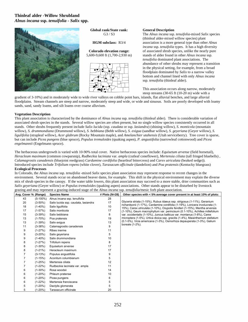
252
Thinleaf alder -Willow Shrubland Alnus incana ssp. tenuifolia - Salix spp.
General Description The Alnus incana ssp. tenuifolia-mixed Salix species (thinleaf alder-mixed willow species) plant association is a more general type than other Alnus incana ssp. tenuifolia types. It has a high diversity of associated shrub species, unlike the nearly pure stands of alder found in other Alnus incana ssp. tenuifolia dominated plant associations. The abundance of other shrubs may represent a transition in the physical setting, for example, from a broad floodplain dominated by Salix to a narrow valley bottom and channel lined with only Alnus incana ssp. tenuifolia (thinleaf alder). This association occurs along narrow, moderately steep streams (30-65 ft (10-20 m) wide with a
gradient of 3-10%) and in moderately wide to wide river valleys on cobble point bars, islands, flat alluvial benches, and large alluvial floodplains. Stream channels are steep and narrow, moderately steep and wide, or wide and sinuous. Soils are poorly developed with loamy sands, sand, sandy loams, and silt loams over coarse alluvium. Vegetation Description This plant association is characterized by the dominance of Alnus incana ssp. tenuifolia (thinleaf alder). There is considerable variation of associated shrub species in the stands. Several willow species are often present, but no single willow species consistently occurred in all stands. Other shrubs frequently present include Salix lucida (ssp. caudata or ssp. lasiandra) (shining willow), S. monticola (mountain willow), S. drummondiana (Drummond willow), S. bebbiana (Bebb willow), S. exigua (sandbar willow), S. geyeriana (Geyer willow), S. ligulifolia (strapleaf willow), Acer glabrum (Rocky Mountain maple), and Amelanchier utahensis (Utah serviceberry). Tree cover is sparse, but can include Picea pungens (blue spruce), Populus tremuloides (quaking aspen), P. angustifolia (narrowleaf cottonwood) and Picea engelmannii (Engelmann spruce). The herbaceous undergrowth is varied with 10-90% total cover. Native herbaceous species include: Equisetum arvense (field horsetail), Heracleum maximum (common cowparsnip), Rudbeckia laciniata var. ampla (cutleaf coneflower), Mertensia ciliata (tall fringed bluebells) , Calamagrostis canadensis (bluejoint reedgrass) Cardamine cordifolia (heartleaf bittercress) and Carex utriculata (beaked sedge)). Introduced species include Trifolium repens (white clover), Taraxacum officinale (dandelion) and Poa pratensis (Kentucky bluegrass) Ecological Processes In Colorado, the Alnus incana ssp. tenuifolia -mixed Salix species plant association may represent response to recent changes in the environment. Several stands occur on abandoned beaver dams, for example. This shift in the physical environment may explain the diverse mix of shrub species in the canopy. If the water table lowers, this plant association may succeed to a more stable, drier communities such as Salix geyeriana (Geyer willow) or Populus tremuloides (quaking aspen) associations. Other stands appear to be disturbed by livestock grazing and may represent a grazing-induced stage of the Alnus incana ssp. tenuifolia/mesic forb plant association. Avg. Cover % (Range) Species Name # Plots (N=28) Other species with < 5% average cover present in at least 10% of plots:
43 (5-100%) Alnus incana ssp. tenuifolia 28 20 (3-50%) Salix lucida ssp. caudata, lasiandra 17 18 (1-40%) Salix ligulifolia 10 17 (1-57%) Salix monticola 17 15 (3-39%) Salix bebbiana 8 13 (1-70%) Poa pratensis 19 13 (1-39%) Salix exigua 13 11 (3-38%) Calamagrostis canadensis 9 9 (1-27%) Ribes inerme 11 9 (3-20%) Salix geyeriana 5 9 (1-40%) Salix drummondiana 10 8 (1-27%) Trifolium repens 8 8 (1-30%) Equisetum arvense 17 8 (1-21%) Heracleum maximum 17 7 (3-13%) Populus angustifolia 9 7 (1-15%) Aconitum columbianum 5 7 (1-25%) Mertensia ciliata 12 7 (1-22%) Rudbeckia laciniata var. ampla 11 6 (1-30%) Rosa woodsii 14 6 (1-20%) Phleum pratense 10 6 (1-20%) Picea pungens 6 6 (1-22%) Mertensia franciscana 5 5 (1-20%) Dactylis glomerata 5 5 (1-20%) Taraxacum officinale 20
Glyceria striata (1-15%), Rubus idaeus ssp. strigosus (1-11%), Geranium richardsonii (1-17%), Cardamine cordifolia (1-19%), Lonicera involucrata (1-15%), Carex utriculata (1-10%), Oxypolis fendleri (1-15%), Mentha arvensis (1-10%), Geum macrophyllum var. perincisum (0.1-10%), Achillea millefolium var. occidentalis (1-10%), Juncus balticus var. montanus (1-8%), Carex microptera (1-5%), Urtica dioica ssp. gracilis (1-4%), Maianthemum stellatum (0.1-5%), Vicia americana (1-3%), Osmorhiza depauperata (1-3%), Galium boreale (1-2%).
Global rank/State rank: G3 / S3
HGM subclass: R3/4
Colorado elevation range:
5,600-9,600 ft (1,700-2,930 m)

253
Thinleaf alder-Drummond willow Shrubland Alnus incana ssp. tenuifolia -Salix drummondiana
General Description Alnus incana ssp. tenuifolia-Salix drummondiana (thinleaf alder-Drummond willow) is a relatively common plant association on the Western Slope. The association is generally found along steep-gradient streams with stable, shaded stream banks. This association occurs in the Gunnison, Arkansas, and St. Vrain River Basins and the San Juan and Rio Grande National Forests. This association occurs along very steep, fast-moving streams in sheer-walled, confined canyons. It also occurs along or within the active channel of moderately to slightly entrenched channels in wider valleys. Stream channels are steep and rocky, less steep with limited floodplains and gravel and cobble
bottoms, or wide and sinuous. Soils of this association are highly variable, but most are stratified alluvium with buried A horizons. Stands with a rich, herbaceous undergrowth have a thick layer, 5-10 inches (10-30 cm), of fine sandy loam and sandy clay loam over a coarse alluvial deposit. Stands with little shrub cover and herbaceous growth have coarse, skeletal soils without an accumulated fine layer at the surface. Vegetation Description This plant association is characterized by a dense, closed canopy of Alnus incana ssp. tenuifolia (thinleaf alder) and Salix drummondiana (Drummond willow) bordering the stream. Other willows that may be present include: Salix monticola (mountain willow), S. boothii (Booth willow), S. exigua (sandbar willow), S. lucida (ssp. caudata or ssp. lasiandra) (shining willow), and S. geyeriana (Geyer willow). Other shrubs occasionally present include: Lonicera involucrata (twinberry honeysuckle), Ribes inerme (whitestem gooseberry), Cornus sericea (red-osier dogwood), Rosa woodsii (Woods rose), Amelanchier utahensis (Utah serviceberry), Acer glabrum (Rocky Mountain maple), Symphoricarpos rotundifolius (roundleaf snowberry), and Ribes montigenum (gooseberry currant). Some stands have a rich herbaceous understory that includes Oxypolis fendleri (Fendler cowbane), Heracleum maximum (common cowparsnip), Equisetum pratense (field horsetail), Mertensia ciliata (tall fringed bluebells) Rudbeckia laciniata (cutleaf coneflower), and Angelica ampla (giant angelica). In some stands, the herbaceous undergrowth is sparse (less than 10% cover) due to shading and flood-scouring. Ecological Processes The Alnus incana ssp. tenuifolia-Salix drummondiana (thinleaf alder-Drummond willow) plant association is an early to midseral community restricted to stream margins, rarely forming large, extensive stands. Both species are prolific seed producers and are the first to colonize coarse-textured cobble bars and recently scoured alluvial surfaces. When young, these shrubs are flexible, can tolerate most flood events, and readily resprout. With time, Salix drummondiana may become more abundant by taking advantage of the nitrogen-rich soils associated with Alnus incana ssp. tenuifolia.
Avg. Cover % (Range) Species Name
# Plots (N=22) Other species with < 5% average cover present in at least 10% of plots:
46 (14-98%) Alnus incana ssp. tenuifolia 22 27 (7-60%) Salix drummondiana 22 13 (2-70%) Heracleum maximum 13 11 (2-30%) Carex utriculata 4 10 (1-43%) Salix monticola 12 9 (1-30%) Calamagrostis canadensis 13 8 (1-30%) Equisetum arvense 10 7 (1-23%) Picea pungens 7 6 (1-25%) Salix lucida ssp. caudata, lasiandra 6 6 (1-20%) Lonicera involucrata 11 6 (1-16%) Equisetum pratense 5 6 (1-10%) Geranium richardsonii 9 5 (1-15%) Mertensia ciliata 14 5 (1-11%) Abies lasiocarpa 4 5 (1-10%) Poa pratensis 10
Cardamine cordifolia (1-11%), Rudbeckia laciniata var. ampla (1-10%), Taraxacum officinale (1-13%), Salix bebbiana (3-7%), Picea engelmannii (0.1-10%), Cornus sericea (1-10%), Ribes inerme (1-6%), Oxypolis fendleri (0.1-14%), Carex microptera (1-9%), Fragaria vesca ssp. bracteata (1-8%), Thalictrum fendleri (1-5%), Rubus idaeus ssp. strigosus (1-5%), Mertensia franciscana (1-6%), Achillea millefolium var. occidentalis (1-8%), Fragaria virginiana ssp. glauca (1-10%), Viola canadensis var. scopulorum (1-4%), Osmorhiza depauperata (1-3%), Galium triflorum (1-3%), Senecio triangularis (1-5%), Geum macrophyllum var. perincisum (0.1-4%), Galium boreale (1-5%), Conioselinum scopulorum (0.1-4%), Chamerion angustifolium ssp. circumvagum (1-2%), Luzula parviflora (0.1-4%), Maianthemum stellatum (1-2%), Rosa woodsii (1%).
Global rank/State rank: G3 / S3
HGM subclass: R3/4
Colorado elevation range:
7,300-9,700 ft (2,200-3,000m)

254
Engelmann Spruce / Bog birch / Water sedge / Sphagnum moss Iron Fen (Picea engelmannii) / Betula nana (=glandulosa) / Carex aquatilis / Sphagnum angustifolium
General Description This community occurs in habitats commonly referred to as iron fens. These are peatlands with acidic waters and high concentrations of dissolved ions. Two of the most striking features of iron fens are their limonite ledges and their characteristic suite of acid-tolerant plants. Limonite ledges form when iron precipitates into and solidifies the substrate (often thick layers of peat), forming hard rock ledges many meters thick. Springs often bubble up from the tops of the ledges continually depositing more iron. Iron fens often have networks of small pools and ponds. Fens and bogs (peatlands) are generally classified according to pH and dissolved concentrations of mineral ions in the water supply. Peatlands primarily fed by rain contain low ion concentrations and have low pHs. This type of
acid peatland does not occur in Colorado. Peatlands fed by calcareous groundwaters have high ion concentrations and high pHs. High Creek Fen in South Park is an example of this type, referred to as an extreme rich fen. In contrast, iron fens have a low pH (acidic waters) and high concentrations of dissolved ions. Consequently they look very different from other fens in Colorado. This plant association usually occurs on very wet, gentle, lower slopes in fairly wide valleys in the subalpine zone. Water sources for these fens originate on hillsides of iron pyrite-rich fractured bedrock and talus. Soils are deep peats, often solidified by iron pyrite deposits. Vegetation Description Only a few plant species can tolerate the acidic conditions in iron fens. This association is typically dominated by Betula nana (=glandulosa) (bog birch) shrubs, Carex aquatilis (water sedge), and the small shrubs Vaccinium scoparium (grouse whortleberry), V. myritillus (whortleberry), V. cespitosum (dwarf bilberry), Gaultheria humifusa (alpine spicywintergreen), and/or Kalmia microphylla (alpine laurel). Calamagrostis canadensis (bluejoint reedgrass) is also common in the understory. Patches of Picea engelmannii (Engelmann spruce), Abies lasiocarpa (subalpine fir), or Pinus contorta (lodgepole pine) may occur in areas raised slightly above the level of standing water. Thick Sphagnum groundcover is an indicator for this type. Sphagna and other mosses form a continuous carpet in all microsites except pools deeper than 4-8 inches (10-20 cm). Fens are the only Colorado ecosystems that support continuous Sphagnum carpets and hummock complexes. Dr. David Cooper found three disjunct boreal species in Colorado iron fens: • Sphagnum balticum in shallow pools at one site, the first record for the coterminous U.S. • The liverwort, Gymnocolea inflata, in springs and water tracks at sites where limonite was exposed at the surface.
Ecological Processes These communities are stable and long-lived. Iron-saturated peat layers may be up to 10 to 15 ft (3-5 m) deep. As long as iron-rich waters flow from springs in these sites, thicker layers of peat will continue to accumulate, acidic conditions will prevail, and the same suite of plants will persist. Drier conditions could lead, over time, to a reduction in the acidity of soils and to replacement of the iron fen community with the surrounding spruce-fir forest and subsequent loss of rare species habitat. Reindeer lichen, Cladina ragiferina, on fen margins under spruce trees.
Avg. Cover
% (Range) Species Name # Plots (N=6) Other species with < 5% average cover present in at least 10% of plots:
32 (6-65%) Sphagnum spp. 6 26 (5-70%) Carex aquatilis 6 21 ― Carex utriculata 1 20 (10-30%) Betula nana 5 12 (3-20%) Calamagrostis canadensis 5 5 (0.3-15%) Picea engelmannii 5 5 ― Vaccinium caespitosum 1 5 ― Pinus contorta 1 5 ― Deschampsia caespitosa 1
Dasiphora floribunda (3%), Vaccinium myrtillus var. oreophilum (2%), Gaultheria humifusa (0.3-5%), Carex canescens (1%).
Global rank/State rank: G2 / S2
HGM subclass: S1
Colorado elevation range:
9,800-11,300 ft (2,987-3,444 m)

255
Bog birch / Mesic forb - Mesic graminoid Shrubland Betula nana (=glandulosa) / Mesic forb - Mesic graminoid
General Description The Betula nana (=glandulosa)/mesic forb-mesic graminoid (bog birch/mesic forb-mesic graminoid) plant association is a low stature (2-3 ft, 0.3-1 m) open shrubland of subalpine and lower alpine elevations. It occurs intermixed with Salix (willow) shrublands and Carex (sedge) meadows, forming complex wetland mosaics. It typically grows in very wet peat fens. This association is documented throughout high mountain ranges of Colorado, although typically occurring only in small stands. Most stands of this association occur within a mosaic of subalpine meadows or willow communities. It grows in areas where soils are saturated from snowmelt runoff for a significant part of the growing season, often in fens, where the vegetation receives water from seeps and springs. Stream channels may be wide and slightly sinuous. Soils are deep peats and moderately deep (9-12 in, 23-30 cm) silty clay loams over gravels with a water table 10-48 inches
(25-120 cm) deep. Vegetation Description Betula nana (=glandulosa) (bog birch) is the most dominant shrub in the canopy. Several other shrubs may be present; however, none are as abundant as Betula. Shrub species occasionally present include: Dasiphora floribunda (shrubby cinquefoil), Salix wolfii (Wolf willow), S. planifolia (planeleaf willow), S. brachycarpa (barrenground willow), S. monticola (mountain willow), and Lonicera involucrata (twinberry honeysuckle). The herbaceous undergrowth grows on small hummocks and is usually dominated by a dense mixture of mesic forbs and graminoids. Mesic graminoid species include: Calamagrostis canadensis (bluejoint reedgrass), Carex aquatilis (water sedge), C. utriculata (beaked sedge), C. norvegica (Norway sedge), Deschampsia caespitosa (tufted hairgrass) and Phleum alpinum (alpine timothy). Forb species include: Achillea millefolium var. occidentalis (western yarrow), Fragaria virginiana (strawberry), Galium boreale (northern bedstraw), Epilobium angustifolium (fireweed), Caltha leptosepala (marsh marigold), Ligusticum tenuifolium (Idaho licoriceroot), Angelica pinnata (small-leaf angelica), Mertensia ciliata (tall fringed bluebells), Thalictrum alpinum (alpine meadowrue), and Conioselinum scopulorum (Rocky Mountain hemlockparsley). Due to their small size, Betula nana (=glandulosa) (bog birch) communities often inter-grade with surrounding communities. Ecological Processes This plant association appears to be a long-lived mid- to late-seral community. As peatland hummocks develop or become more pronounced, they may become more heavily dominated by Salix (willow) species. Due to cold temperatures and a short growing season, this process may take several decades to occur.
Avg. Cover % (Range) Species Name
# Plots (N=10) Other species with < 5% average cover present in at least 10% of plots:
44 (20-80%) Betula nana 10 21 (3-80%) Carex aquatilis 5 17 (3-50%) Picea engelmannii 4 16 (10-25%) Salix planifolia 5 13 (3-30%) Poa pratensis 3 12 (3-20%) Salix monticola 4 12 (3-30%) Salix brachycarpa 5 11 (3-20%) Pinus contorta 3 9 (1-30%) Calamagrostis canadensis 4 9 (1-21%) Salix wolfii 7 9 (1-20%) Dasiphora floribunda 8 9 (3-11%) Ligusticum tenuifolium 4 8 (1-10%) Chamerion angustifolium ssp. circumvagum 4 6 (1-11%) Lonicera involucrata 4 6 (1-25%) Fragaria virginiana ssp. glauca 7 6 (1-10%) Caltha leptosepala 4 6 (1-20%) Trisetum wolfii 4 6 (1-10%) Carex utriculata 2 5 (1-10%) Deschampsia caespitosa 5
Bromus ciliatus var. ciliatus (1-8%), Galium boreale (1-13%), Poa reflexa (1-10%), Taraxacum officinale (1-12%), Conioselinum scopulorum (1-10%), Salix boothii (3-3%), Mertensia ciliata (1-10%), Geum macrophyllum var. perincisum (1-4%), Polygonum bistortoides (1-7%), Geum triflorum var. triflorum (1-4%), Thalictrum alpinum (2-3%), Arnica cordifolia (1-3%), Geranium richardsonii (1-3%), Juncus drummondii (1-3%), Trollius laxus ssp. albiflorus (1-3%), Symphyotrichum foliaceum (1-3%), Maianthemum stellatum (1-3%), Castilleja sulphurea (1-3%), Valeriana edulis (1-2%), Phleum alpinum (1-3%), Achillea millefolium var. occidentalis (1-3%), Luzula parviflora (1-2%), Polygonum viviparum (1%), Aconitum columbianum (1%), Veronica wormskjoldii (1%), Stellaria umbellata (1%), Pedicularis groenlandica (1%), Luzula comosa (1%), Trisetum spicatum (1%), Carex norvegica (1%), Equisetum arvense (1%), Rhodiola rhodantha (0.1%).
Global rank/State rank: G3G4 / S3
HGM subclass: S1/2, R1, R2
Colorado elevation range:
8,200-11,000 ft (2,500-3,350 m)

256
Water sedge Herbaceous Vegetation Carex aquatilis
General Description Carex aquatilis (water sedge) is a common, widespread plant association that can occur as large meadows in high montane valleys or as narrow strips bordering ponds and streams at lower elevations. It occurs in a variety of environmental settings in the montane and subalpine zones. A clear dominance by Carex aquatilis and low cover of C. utriculata (beaked sedge) or Pedicularis groenlandica (elephanthead lousewort) set this plant association apart from closely related types. This plant association occurs in a variety of valley types, but the largest expanses occur in broad, low-gradient valleys where large snow-melt fed swales and slopes dominate the landscape. It can also grow in fine sediments at the margins of lakes and beaver
ponds. The largest occurrences are found adjacent to narrow, deep, sinuous streams. Some stands occur along steep streams, others along wide, shallow streams, as well as where beaver dams and ponds have altered the channel morphology. Soils are mostly deep, dark colored heavy clays, silts or organic layers over more skeletal layers. Soils are often saturated to the surface, and if not, mottling is commonly present within 10 cm of the surface. Vegetation Description This plant association is characterized by a dense rhizomatous meadow of Carex aquatilis (water sedge), usually accompanied by a few other graminoids species such as Calamagrostis canadensis (bluejoint reedgrass) or Deschampsia caespitosa (tufted hairgrass). Eleocharis quinqueflora (fewflower spikerush) can be abundant on organic substrates. Carex utriculata (beaked sedge) may be present. When present, Carex utriculata (beaked sedge) is usually not more than one third the cover of C. aquatilis (water sedge) cover. If it is more than that, the stand may be a Carex aquatilis - Carex utriculata (water sedge- beaked sedge) or Carex utriculata (beaked sedge) plant association. Forbs are often present, although sometimes inconspicuously. Species include Epilobium spp. (willowweed), Pedicularis groenlandica (elephanthead lousewort), Caltha leptosepala (marsh marigold), Cardamine cordifolia (heartleaf bittercress), and Mertensia ciliata (tall fringed bluebells). Ecological Processes Presence of Carex utriculata (beaked sedge) may indicate the site has progressed from the more wet Carex utriculata community to the current less mesic conditions, and may become dominated by Salix planifolia (planeleaf willow) or Salix wolfii (Wolf willow). Carex aquatilis (water sedge) associations trap sediment from overbank flows which forms a clay pan, eventually raising the water table. This process drives retrogressive succession and a plant association dominated by Carex utriculata takes over on these sites.
Avg. Cover % (Range) Species Name
# Plots (N=133) Other species with < 5% average cover present in at least 10% of plots:
60 (5-95%) Carex aquatilis 133 13 (0.1-48%) Caltha leptosepala 30 10 (1-30%) Carex utriculata 35 9 (1-40%) Calamagrostis canadensis 27 6 (0.1-31%) Deschampsia caespitosa 40 6 (1-30%) Juncus balticus var. montanus 19 5 (0.1-30%) Salix planifolia 32
Taraxacum officinale (0.1-20%), Cardamine cordifolia (1-15%), Achillea millefolium var. occidentalis (1-36%), Poa pratensis (1-7%), Geum macrophyllum var. perincisum (0.1-5%), Pedicularis groenlandica (0.1-10%), Rhodiola rhodantha (0.1-5%).
Global rank/State rank: G5 / S4
HGM subclass: S1/2
Colorado elevation range:
7,600-11,800 ft (2,300-3,600 m)

257
Water sedge - Beaked sedge Herbaceous Vegetation Carex aquatilis - Carex utriculata
General Description This plant association is recognized by the presence of both Carex aquatilis (water sedge) and Carex utriculata (beaked sedge) in roughly equal proportions. This is a common association that generally occurs in small to moderate size patches in very shallow, slow-moving to still water or on saturated soils near low-order streams, lakes, and backwater areas of larger rivers. This plant association occurs in broad, glaciated, subalpine meadows that remain saturated with snowmelt runoff for most of the growing season. It is also often associated with beaver activity. Stream channels are narrow, deep, and sinuous, or wide and shallow. Soils are often organic, thick peat or sandy clays and sandy clay loams originating from glacial
till. Vegetation Description This plant association has relatively low species diversity due to saturated soil conditions. Carex aquatilis (water sedge) and Carex utriculata (beaked sedge) co-dominate the association. Both species are present in equal or near equal amounts. For example, a stand with 10% cover of each Carex (sedge) species would classify as this type, however a stand with 10% Carex aquatilis (water sedge) and 80% Carex utriculata (beaked sedge) would classify as a Carex utriculata (beaked sedge) plant association. Other graminoid and forb species may also be present. Graminoid species include: Carex microptera (smallwing sedge), Deschampsia caespitosa (tufted hairgrass), Poa pratensis (Kentucky bluegrass), Juncus balticus var. montanus (mountain rush), Carex nebrascensis (Nebraska sedge), and Carex canescens (pale sedge). Forb species include: Caltha leptosepala (marsh marigold), Rhodiola rhodantha (redpod stonecrop), Cardamine cordifolia (heartleaf bittercress), Senecio triangularis (arrowleaf groundsel), Pedicularis groenlandica (elephanthead lousewort), and Epilobium spp. (willowweed). Ecological Processes The difficulty in classifying mixed stands of Carex aquatilis (water sedge) and Carex utriculata (beaked sedge) has been discussed in the literature and attempts have been made to differentiate the types based on soil characteristics. In some cases a dominance of Carex utriculata on organic soils and Carex aquatilis on mineral soils has been noted, while in other cases the opposite trend where Carex aquatilis appears to occur more often on rich organic soils, while Carex utriculata occurs on less nutrient rich soils is observed. In stands observed for this study, water availability appears to be a stronger factor in determining relative dominance of these two sedge species. Carex utriculata appears to tolerate standing water and may be a pioneering species since it readily establishes on exposed, saturated mineral soil. In Colorado, Carex utriculata occurs more often in standing water and often grades into a mesic terrestrial habitat where Carex aquatilis is commonly dominant. The Carex aquatilis-Carex utriculata plant association may, therefore, represent a spatial transition between a wet Carex utriculata association and a mesic Carex aquatilis association. Avg. Cover
% (Range) Species Name # Plots (N=20) Other species with < 5% average cover present in at least 10% of plots:
32 (9-65%) Carex utriculata 19* 30 (6-90%) Carex aquatilis 20 18 (1-40%) Deschampsia caespitosa 6 10 (3-20%) Caltha leptosepala 4 7 (2-10%) Carex canescens 3
Carex microptera (1-10%), Poa pratensis (1-11%), Calamagrostis canadensis (1-13%), Juncus balticus var. montanus (1-7%), Pedicularis groenlandica (1-5%), Cardamine cordifolia (1-5%), Senecio triangularis (1-5%), Taraxacum officinale (1-3%), Achillea millefolium var. occidentalis (1-3%), Dasiphora floribunda (1-3%), Equisetum arvense (1-3%), Salix wolfii (1-3%).
*Carex utriculata occurred in all stands, but was not captured in every sample plot.
Global rank/State rank: G4 / S4
HGM subclass: D1, S1/2/3/4
Colorado elevation range:
8,200-11,100 ft (2,500-3,400 m)

258
Beaked sedge Herbaceous Vegetation Carex utriculata
General Description The Carex utriculata (beaked sedge) plant association is a common wet meadow community that occurs around the edges of montane lakes and beaver ponds, along the margins of slow-moving reaches of streams and rivers, and in marshy swales and overflow channels on broad floodplains. The water table is usually near the surface for most of the growing season. This association is well documented throughout the western states. A clear dominance of Carex utriculata over other Carex species including C. aquatilis (water sedge), sets this association apart from closely related types. Carex utriculata (beaked sedge) grows in standing water or saturated soils of wet swales and overflow
channels along low-gradient streams. It also occurs along the margins of lakes and beaver ponds. Stream channels are wide and slightly sinuous, to wide and more sinuous. Soils are saturated organics or fine silty clays to clays over cobbles and alluvium. Mottling often occurs within a few centimeters of the surface. Vegetation Description This plant association is characterized by stands dominated by Carex utriculata (beaked sedge). Stands often appear to be nearly pure Carex utriculata (beaked sedge), but a variety of other graminoid species may be present as well. Carex aquatilis can be abundant, but if equal in cover to C. utriculata, see the Carex aquatilis-Carex utriculata association on page 257. Other Carex (sedge) species present include Carex lenticularis (shore sedge) and C. microptera (small-wing sedge), but usually with low cover relative to the amount of C. utriculata (beaked sedge) present. Other graminoid species that may be present include: Glyceria striata (fowl mannagrass), Calamagrostis canadensis (bluejoint reedgrass), and Juncus balticus var. montanus (mountain rush). Forb cover is very inconspicuous and can include: Mentha arvensis (wild mint), Mimulus guttatus (seep monkeyflower), and Geum macrophyllum (largeleaf avens). Willow carrs (i.e., shrubland thickets) are often adjacent and a few scattered willows will occur within the Carex utriculata (beaked sedge) stand. Individual willows tend to be very short if present, either from limiting growth conditions (extremely cold and/or extremely wet), or because of heavy browsing by wildlife or livestock. The elevation of the site determines which willow species are in and adjacent to Carex utriculata (beaked sedge) stands. Willow species that are present may include: Salix monticola (mountain willow), S. drummondiana (Drummond willow), S. geyeriana (Geyer willow), S. planifolia (planeleaf willow), and S. exigua (sandbar willow). Ecological Processes The Carex utriculata (beaked sedge) plant association occurs on the wettest sites of the riparian or wetland area, such as low-lying swales, and shallow margins of lakes and ponds, often in standing water. It is an early-seral community and is known to invade margins of newly formed beaver ponds, as well as the freshly exposed silt beds of drained beaver ponds. With time, the Carex utriculata plant association will grade into a Carex aquatilis (water sedge) and Calamagrostis canadensis (bluejoint reedgrass) associations. Successional shifts in species composition can be initiated by a change in the physical environment of the riparian area. Flooding events can result in sediments deposited on the floodplain, raising the surface higher above the water table. As aggradation, or build up, of the floodplain proceeds, the site can become drier and the dominant graminoid cover changes. Abandoned beaver ponds also go through a similar succession. With time, ponds become silted-in and Carex utriculata establishes on the new, saturated substrate. As the site becomes firm and raised above the old pond level, Carex aquatilis and willows may become established. With further aggradation and time Calamagrostis canadensis may become established in the undergrowth. Depending on site characteristics, various willow species may become established in the overstory as well, creating the Salix monticola/Carex utriculata (mountain willow/beaked sedge) plant association or the Salix geyeriana/Calamagrostis canadensis (Geyer willow/bluejoint reedgrass) plant association, for example. Distance from the stream channel can also differentiate the graminoid dominance spatially within the riparian mosaic. Carex utriculata commonly occurs at the stream channel or pond edge where the water table is close to or at the ground surface. As the floodplain surface becomes higher with increased distance from the channel edge, the ground becomes slightly less saturated and shifts to mesic meadows of Carex aquatilis, or on higher surfaces, to slightly drier meadows of Calamagrostis canadensis.
Avg. Cover % (Range) Species Name
# Plots (N=144) Other species with < 5% average cover present in at least 10% of plots:
71 (7-100%) Carex utriculata 144 9 (0.1-50%) Carex aquatilis 41 7 (0.1-30%) Calamagrostis canadensis 21 7 (1-20%) Carex microptera 15 7 (1-20%) Juncus balticus var. montanus 16 6 (1-10%) Salix monticola 15 5 (0.1-15%) Mentha arvensis 15
Equisetum arvense (0.1-20%), Glyceria striata (0.1-10%), Deschampsia caespitosa (1-10%), Geum macrophyllum var. perincisum (0.1-15%), Poa pratensis (1-10%).
Global rank/State rank: G5 / S5
HGM subclass: D1, D2/3, R2, S3/4
Colorado elevation range:
5,600-11,000 ft (1,700-3,350 m)

259
Blister sedge Herbaceous Vegetation Carex vesicaria
General Description The Carex vesicaria (blister sedge) plant association forms open meadows similar to the Carex utriculata (beaked sedge) plant association. As with Carex utriculata, it occurs along the shores of lakes and ponds in shallow water, as well as in poorly drained basins and along rivers and streams. The water table typically remains above the ground surface throughout the year. A single stand of Carex vesicaria found on the Colorado West Slope has significant cover of Carex utriculata, but is distinct from the Carex utriculata plant association because of the high cover of Carex vesicaria. Soils are typically Histosols, except in young stands along streambanks where the soil is coarse- to fine-textured alluvium.
Vegetation Description Carex vesicaria (blister sedge) forms nearly monotypic stands, however, Carex utriculata may be present. On wetter sites, emergent wetland plants such as Sparganium spp. (burreed) may be sparsely present. On drier sites, Deschampsia caespitosa (tufted hairgrass) and Galium trifidum (three petal bedstraw) may be present in low amounts. Ecological Processes A persistently high water table and thick organic soil horizons provide conditions favorable to the long-term dominance of Carex vesicaria (blister sedge). As with other wetland communities, vegetation composition will likely change with the alteration of the hydrology. If water levels remain below the soil surface permanently, the dominant species may shift to Carex utriculata (beaked sedge). Avg. Cover
% (Range) Species Name # Plots (N=2)
68 (50-85%) Carex vesicaria 2 40 ― Carex aquatilis 1 30 ― Fragaria virginiana ssp. glauca 1 10 ― Potentilla gracilis 1 10 ― Carex utriculata 1 5 ― Salix monticola 1 1 ― Thalictrum fendleri 1
Other species with < 5% average cover present in at least 10% of plots: Taraxacum officinale (1%), Symphyotrichum foliaceum (1%), Poa palustris (1%), Phleum pratense (1%), Geum macrophyllum var. perincisum (1%), Dasiphora floribunda (1%), Calamagrostis stricta (1%).
Global rank/State rank: G4Q / S1
HGM subclass: R3/4, S1/2
Colorado elevation range:
8,000-9,700 ft (2,430-3,000 m)

260
Bellardi bog sedge-Alpine meadowrue Extreme Rich Fen Kobresia myosuroides-Thalictrum alpinum
General Description The Kobresia myosuroides-Thalictrum alpinum (Bellardi bog sedge-alpine meadowrue) association is found in extreme rich fens (fens with high levels of calcium, magnesium, and other plant nutrients in the groundwater that feeds this system) in the intermountain valley of South Park, Colorado. This plant association tends to occur on the outer, somewhat drier edges of the peatland, growing on the tops of hummocks that it builds as it grows. Where best developed, these hummocks may be up to 20 inches (50 cm) high. A similar association occurs in California’s Convict Creek Basin. There it occurs in depressions which are very wet or have standing water in early summer. These areas have a long-persisting snow cover and a peaty sod with hummocks or solifluction. Soils are generally deep peats somewhat better drained than
lower, surrounding soils. Vegetation Description This association is characterized by Kobresia myosuroides (10-60% cover) and Thalictrum alpinum (5-25% cover) occurring on hummocks often up to 20 inches (50 cm) tall in the drier end of the hydrologic gradient of the fen. The presence of Thalictrum alpinum at 100% constancy in the community separates this association from the Kobresia myosuroides-dominated alpine communities. Associated plant species occurring in at least half of the plots include Salix brachycarpa (barrenground willow), Ptilagrostis porteri (=Ptilagrostis mongholica ssp. porteri, Porter false needlegrass), Juncus balticus var. montanus (mountain rush), Kobresia simpliciuscula (simple bog sedge) Polygonum viviparum (alpine bistort), Deschampsia caespitosa (tufted hairgrass), Muhlenbergia filiformis (pullup muhly), Dasiphora floribunda (shrubby cinquefoil), Carex aquatilis (water sedge), and Carex capillaris (hairlike sedge). A number of rare plant species may occur in this association: Ptilagrostis porteri (Porter false needlegrass), Sisyrinchium pallidum (pale blue-eyed grass), Primula egaliksensis (Greenland primrose), Packera pauciflora (alpine groundsel), and Carex scirpoidea (northern singlespike sedge). Ecological Processes Extreme rich fens are small-patch communities confined to specific environments defined by groundwater discharge, soil chemistry, and peat accumulation of at least 40 cm. Fens form at low points in the landscape at or near slopes where groundwater intercepts the soil surface. The water chemistry is distinct in that it contains high levels of calcium and magnesium. Saturated soils in the fens and the cool climate in South Park produce the conditions necessary for the formation of layers of peat in the fens. The rate of peat accumulation in extreme rich fens is even slower than in the rich and intermediate fens found in other parts of the state. While rich fens accumulate 10 to 16 inches of peat in one thousand years, the extreme rich fens of South Park accumulate only about 4.3 inches in one thousand years. Avg. Cover
% (Range) Species Name # Plots (N=8)
44 (10-60%) Kobresia myosuroides 8 17 (3-60%) Kobresia simpliciuscula 5 16 (5-30%) Juncus balticus var. montanus 7 13 (5-25%) Thalictrum alpinum 8 11 (1-25%) Muhlenbergia filiformis 4 8 (2-20%) Dasiphora floribunda 4 7 (1-10%) Salix brachycarpa 5 6 (2-10%) Ptilagrostis porteri 6 6 (2-10%) Deschampsia caespitosa 4 6 (1-20%) Parnassia palustris var. parviflora 4
Other species with < 5% average cover present in at least 10% of plots: Polygonum viviparum (2-5%), Festuca arizonica (1-5%), Carex capillaris (1-5%), Packera pauciflora (1-4%), Elymus trachycaulus ssp. trachycaulus (1-5%), Gentianopsis thermalis (1-3%), Carex aquatilis (1-3%), Primula incana (1%), Triglochin palustre (1%), Symphyotrichum foliaceum (1%), Campanula parryi (1%), Crepis runcinata ssp. runcinata (1%), Trifolium longipes (1%), Symphyotrichum spathulatum (1%), Primula egaliksensis (1%), Lomatogonium rotatum (0.1-1%).
Global rank/State rank: G2 / S1
HGM subclass: S1/2
Colorado elevation range:
9,300-9,700 ft (2,830-2,950 m)

261
Blue spruce / Red-osier dogwood Forest Picea pungens / Cornus sericea (note: similar to Picea engelmannii/Cornus sericea of Spring Creek at Manganese Peak PCA)
General Description The Picea pungens/Cornus sericea (blue spruce/red-osier dogwood) plant association is a cool, moist riparian woodland occurring in deep narrow canyons. It was once a more common type and represents slightly more stable habitats than those of the Picea pungens/Alnus incana ssp. tenuifolia (blue spruce/thinleaf alder) plant association. The Picea pungens/Cornus sericea association is characterized by an open to thick understory of Cornus sericea (red-osier dogwood), deeply shaded by Picea pungens (blue spruce). This plant association occurs on floodplains and benches in narrow valleys, 20-100 ft (7-30 m) wide, with variable stream gradients (1-10%). It occurs along broad, slightly meandering channel reaches and occasionally along steep and narrow reaches. Soils are deep, dark-colored clay loams to sandy loams, often with signs of mottling. Coarse fragments range from up to 50% with the percentage increasing with depth. There may be high organic matter in the top layers.
Vegetation Description The upper canopy of this plant association is dominated by Picea pungens (blue spruce), which is present in all stands. Other tree species present with less than 40% frequency include Populus tremuloides (quaking aspen), Populus angustifolia (narrowleaf cottonwood), Abies lasiocarpa (subalpine fir) and Picea engelmannii (Engelmann spruce). The shrub canopy is dominated by Cornus sericea (red-osier dogwood), which is present in all stands and forms an open to dense thicket with 5-80% cover. Symphoricarpos rotundifolius (roundleaf snowberry) and Lonicera involucrata (honeysuckle) are present in >60% of sampled stands. Other shrubs with lower frequency but noticeably high abundance include: Alnus incana ssp. tenuifolia (thinleaf alder), Betula occidentalis (river birch), Salix monticola (mountain willow), Salix drummondiana (Drummond willow), Acer glabrum (Rocky Mountain maple), Prunus virginiana (chokecherry), and Amelanchier utahensis (Utah serviceberry). The herbaceous understory is highly variable, depending on the site conditions and the amount of past disturbance. No one forb or graminoid species is present in all stands. Frequently encountered (>50% frequency) herbaceous species include: Equisetum arvense (field horsetail), Maianthemum stellatum (starry false Solomon seal), and Geranium richardsonii (Richardson geranium).
Ecological Processes In deep, narrow canyons with swift-moving streams and narrow floodplains and benches, Picea pungens (blue spruce) appears to be a climax riparian species, and will remain until removed or damaged by a catastrophic flood. Cornus sericea (red-osier dogwood) is more abundant on level sites where water tables are periodically high. Picea pungens (blue spruce) is a slow-growing, long-lived tree which regenerates from seed. Seedlings are shallow rooted and require perennially moist soils for establishment and optimal growth. P. pungens (blue spruce) is intermediate in shade tolerance, being somewhat more tolerant than Pinus ponderosa (ponderosa pine) or Pseudotsuga menziesii (Douglas-fir), and less tolerant than Abies lasiocarpa (subalpine fir) or Picea engelmannii (Engelmann spruce). Avg. Cover
% (Range) Species Name # Plots (N=11) 37 (19-63%) Picea pungens 9* 29 (3-78%) Cornus sericea ssp. sericea 11 18 (1-50%) Populus tremuloides 3 17 (10-30%) Betula occidentalis 3 16 (1-30%) Picea engelmannii 2 11 (3-20%) Salix drummondiana 5 9 (5-13%) Acer glabrum 2 8 (1-20%) Populus angustifolia 3 7 (1-19%) Alnus incana ssp. tenuifolia 9 7 (3-10%) Abies lasiocarpa 2 6 (1-10%) Rudbeckia laciniata var. ampla 5 6 (1-10%) Ribes inerme 2 5 (1-20%) Salix bebbiana 5 5 (1-25%) Rosa woodsii 7
Other species with < 5% average cover present in at least 10% of plots: Geranium richardsonii (1-10%), Amelanchier utahensis (1-10%), Symphoricarpos rotundifolius (1-10%), Lonicera involucrata (1-10%), Salix ligulifolia (1-10%), Salix exigua (3-5%), Heracleum maximum (1-7%), Calamagrostis canadensis (1-5%), Equisetum arvense (1-10%), Poa pratensis (1-5%), Maianthemum stellatum (1-10%), Osmorhiza depauperata (1-5%), Geum macrophyllum var. perincisum (1-5%), Amelanchier alnifolia (1-5%), Actaea rubra ssp. arguta (1-3%), Taraxacum officinale (1-3%), Maianthemum racemosum ssp. amplexicaule (1%), Fragaria virginiana ssp. glauca (1%), Achillea millefolium var. occidentalis (1%), Conioselinum scopulorum (1%), Viola canadensis var. scopulorum (1%), Galium triflorum (1%), Equisetum hyemale var. affine (1%), Juncus compressus (1%), Bromus inermis (1%), Quercus gambelii (1%), Pseudostellaria jamesiana (1%), Prunella vulgaris (1%), Cardamine cordifolia (1%), Aconitum columbianum (0.1-1%). * Picea pungens occurred in all stands, but was not captured in every sample plot.
Global rank/State rank: G4 / S2
HGM subclass: R3/4
Colorado elevation range:
7,000-8,500 ft (2,100-2,600 m)

262
Blue spruce / Thinleaf alder Forest Picea pungens / Alnus incana ssp. tenuifolia
General Description The Picea pungens/Alnus incana ssp. tenuifolia (blue spruce/thinleaf alder) plant association occurs in montane riparian areas in Colorado. It occurs in deep, shaded canyons and narrow valleys along relatively straight stream reaches. It generally forms small patches, but can be continuous for several river miles. This plant association occurs along narrow to moderately wide floodplains and stream benches in canyons subject to cold air drainage and limited sunlight. Stream channels are steep and narrow, moderately broad and slightly sinuous, or broad and highly sinuous. Soils are generally shallow and range from loamy sand to silty clay loams with heavy organic matter content over gravel, cobbles, and boulders. Vegetation Description
Picea pungens (blue spruce) dominates the overstory with 5-70% cover. There are typically many seedling and saplings as well as mature trees. Abies lasiocarpa (subalpine fir) is usually present with up to 50% cover. Other tree species that occurred in half or fewer of the stands sampled include Picea engelmannii (Engelmann spruce), Populus tremuloides (quaking aspen), Pinus contorta (lodgepole pine) and Pinus ponderosa (ponderosa pine). The thick shrub understory is confined to a narrow band lining the stream channel. Alnus incana ssp. tenuifolia (thinleaf alder) was present in all stands sampled, and ranged in cover from 1 to 80%. Other shrub species present were highly variable, with constancy of less then 40%, but often appearing with abundant cover when present. These shrubs include: Salix drummondiana (Drummond willow), Cornus sericea (red-osier dogwood), Ribes lacustre (current), Acer glabrum (Rocky Mountain maple), Vaccinium spp. (whortleberry), Salix boothii (Booth willow), and Salix wolfii (Wolf willow). The forb canopy layer is thick, up to 50% total cover and species-rich, often with more than 40 species represented in one stand. Species include Actaea rubra (baneberry), Conioselinum scopulorum (Rocky Mountain hemlockparsley), Oxypolis fendleri (cowbane), Geranium richardsonii (Richardson geranium), Heracleum maximum (common cowparsnip), Maianthemum stellatum (starry false Solomon seal), Mertensia ciliata (tall fringed bluebells), Rudbeckia laciniata var. ampla (cutleaf cornflower), and Equisetum arvense (field horsetail). Ecological Processes In deep, narrow canyons with swift-moving streams and narrow floodplains and benches, Picea pungens (blue spruce) appears to be a climax riparian species, and will remain until removed or damaged by a catastrophic flood. In Colorado, the closely related Picea pungens/Equisetum arvense (blue spruce/field horsetail) plant association is considered an indicator of frequent flooding. With less frequent flooding, this association may gradually change to a Picea pungens/Alnus incana ssp. tenuifolia (blue spruce/thinleaf alder) plant association.
Avg. Cover % (Range) Species Name # Plots (N=35) Other species with < 5% average cover present in at least 10% of plots:
32 (1-70%) Picea pungens 35 28 (1-80%) Alnus incana ssp. tenuifolia 34* 12 (1-85%) Calamagrostis canadensis 13 12 (1-55%) Salix exigua 5 12 (1-50%) Abies lasiocarpa 15 9 (1-28%) Acer glabrum 6 9 (1-32%) Salix bebbiana 7 9 (1-28%) Salix monticola 7 9 (1-18%) Populus tremuloides 8 8 (1-45%) Equisetum arvense 27 8 (1-40%) Salix drummondiana 16 8 (1-20%) Ribes lacustre 7 7 (1-32%) Ribes inerme 10 7 (1-18%) Pinus contorta 6 5 (1-25%) Poa pratensis 20 5 (1-30%) Lonicera involucrata 26 5 (0.1-20%) Rudbeckia laciniata var. ampla 14 5 (1-10%) Cornus sericea 8 5 (0.1-20%) Trifolium repens 8
Saxifraga odontoloma (1-10%), Symphoricarpos rotundifolius (1-20%), Heracleum maximum (1-15%), Rubus idaeus ssp. strigosus (0.1-20%), Mertensia ciliata (1-10%), Thalictrum fendleri (1-10%), Streptopus amplexifolius var. chalazatus (1-10%), Senecio triangularis (1-10%), Erigeron speciosus var. speciosus (1-9%), Maianthemum stellatum (0.1-13%), Geranium richardsonii (0.1-10%), Bromus ciliatus var. ciliatus (1-11%), Actaea rubra ssp. arguta (1-10%), Salix ligulifolia (1-5%), Rosa woodsii (1-10%), Aconitum columbianum (1-10%), Taraxacum officinale (0.1-15%), Poa palustris (1-5%), Amelanchier alnifolia (1-10%), Phleum pratense (1-10%), Cardamine cordifolia (1-10%), Urtica dioica ssp. gracilis (1-10%), Elymus glaucus (1-10%), Galium triflorum (1-10%), Luzula parviflora (0.1-8%), Conioselinum scopulorum (0.1-5%), Dasiphora floribunda (1-7%), Chamerion angustifolium ssp. circumvagum (1-10%), Osmorhiza depauperata (0.1-10%), Fragaria virginiana ssp. glauca (1-5%), Glyceria striata (0.1-5%), Achillea millefolium var. occidentalis (1-5%), Galium boreale (1-5%), Orthilia secunda (1-3%), Viola canadensis var. scopulorum (0.1-3%), Carex microptera (1-3%), Vicia americana (1-5%), Oxypolis fendleri (1-3%), Osmorhiza berteroi (1-3%), Geum macrophyllum var. perincisum (0.1-5%), Prunella vulgaris (1%), Ranunculus macounii (1%).
*Alnus incana ssp. tenuifolia occurred in all stands, but was not captured in every sample plot.
Global rank/State rank: G3 / S3
HGM subclass: R2, R3/4, R5
Colorado elevation range:
6,100-10,650 ft (1,900-3,200 m)

263
Narrowleaf cottonwood / Thinleaf alder Woodland Populus angustifolia / Alnus incana ssp. tenuifolia
General Description The Populus angustifolia/Alnus incana ssp. tenuifolia (narrowleaf cottonwood/thinleaf alder) plant association is characterized by a dense stand of Alnus incana lining the stream bank and an open to nearly closed canopy of Populus angustifolia. Other shrubs may occur but Alnus incana ssp. tenuifolia (thinleaf alder) has at least 10-20% cover and is the most abundant of all other shrubs within the stand. It occurs along narrow, fast-moving stream reaches in montane areas. This plant association occurs on active floodplains in narrow to broad valleys. It forms a narrow, dense band along stream banks and benches. Some of the stands have signs of recent flooding. Stream
gradient and channel width are highly variable. Some sites occur along steep, narrow reaches with little sinuosity. Other sites occur along low gradient, moderately sinuous, broad channel reaches, low gradient, highly sinuous reaches, or very narrow and highly sinuous stream sections. Soils are mostly coarse textured ranging from deep sands to shallow sandy loams. Some profiles show stratification with loams to clay loams alternating with sands. Most profiles become skeletal at an average depth of 12 inches (30 cm). Vegetation Description The dominance of Populus angustifolia (narrowleaf cottonwood) and Alnus incana ssp. tenuifolia (thinleaf alder) are the key diagnostic characteristics of this association. Several other tree and shrub species may be present, but they rarely equal the abundance of the diagnostic species. The overstory is an open to dense canopy of Populus angustifolia, which is always present, if sometimes only as sapling-sized individuals. Other tree species that may be present include: Pseudotsuga menziesii (Douglas-fir), Juniperus scopulorum (Rocky Mountain juniper), Populus tremuloides (quaking aspen), Pinus ponderosa (ponderosa pine), Populus x acuminata (lanceleaf cottonwood), Abies concolor (white fir), or Picea pungens (blue spruce). The shrub understory is dominated by a dense band of Alnus incana ssp. tenuifolia (thinleaf alder) lining the stream bank. A variety of other shrubs may be present, intermingling with the alder but usually less than the total alder cover. Other shrub species include: Salix bebbiana (Bebb willow), Salix monticola (mountain willow), Salix drummondiana (Drummond willow), Salix ligulifolia (strapleaf willow), Salix lucida ssp. caudata (shining willow), Salix exigua (sandbar willow), Cornus sericea (red-osier dogwood), Rosa woodsii (Woods rose), Acer glabrum (Rocky Mountain maple), and Betula occidentalis (river birch). The herbaceous undergrowth is generally sparse. Herbaceous species include: Poa pratensis (Kentucky bluegrass), Taraxacum officinale (dandelion), Equisetum arvense (field horsetail), Rudbeckia laciniata (cutleaf coneflower), Heracleum maximum (common cowparsnip), Maianthemum stellatum (starry false Solomon seal), Trifolium repens (white clover), Calamagrostis canadensis (bluejoint reedgrass), Oxypolis fendleri (Fendler cowbane), and Cardamine cordifolia (heartleaf bittercress). Ecological Processes The Populus angustifolia/Alnus incana ssp. tenuifolia (narrowleaf cottonwood/thinleaf alder) plant association is considered a mid-seral community (not the youngest and not the oldest stands of cottonwoods within a reach). With time and without flooding disturbance, stands may become dominated by invading conifers from adjacent upland communities such as Pseudotsuga menziesii (Douglas-fir), Juniperus spp. (juniper), or Picea engelmannii (Engelmann spruce). Avg. Cover
% (Range) Species Name # Plots (N=37) Other species with < 5% average cover present in at least 10% of plots: 37 (3-84%) Populus angustifolia 3735 (1-80%) Alnus incana ssp. tenuifolia 37 18 (1-40%) Agrostis gigantea 5 13 (1-30%) Salix lucida ssp. caudata, 14 13 (3-28%) Betula occidentalis 5 12 (1-48%) Trifolium repens 7 11 (3-35%) Salix drummondiana 10 10 (1-30%) Poa pratensis 26 10 (1-30%) Cornus sericea ssp. sericea 12 10 (1-34%) Populus tremuloides 5 8 (1-32%) Salix exigua 8 7 (1-15%) Agrostis stolonifera 6 7 (1-14%) Salix monticola 9 6 (1-22%) Cardamine cordifolia 5 6 (0.1-40%) Dactylis glomerata 9 6 (1-20%) Rubus idaeus ssp. strigosus 6 6 (1-17%) Calamagrostis canadensis 8 6 (1-14%) Pseudotsuga menziesii 7 5 (1-14%) Salix bebbiana 8 5 (1-11%) Ribes inerme 5 5 (1-20%) Rudbeckia laciniata var. 12
Acer glabrum (1-10%), Rosa woodsii (1-30%), Heracleum maximum (0.1-15%), Pyrola asarifolia ssp. asarifolia (1-10%), Poa palustris (1-10%), Taraxacum officinale (1-20%), Juniperus scopulorum (1-11%), Salix ligulifolia (1-10%), Lonicera involucrata (0.1-10%), Equisetum arvense (0.1-18%), Oxypolis fendleri (1-11%), Urtica dioica ssp. gracilis (1-10%), Prunus virginiana var. melanocarpa (1-7%), Maianthemum stellatum (0.1-10%), Osmorhiza depauperata (1-4%), Achillea millefolium var. occidentalis (0.1-12%), Clematis ligusticifolia (1-3%), Juncus balticus var. montanus (1-6%), Vicia americana (1-5%), Mertensia ciliata (1-5%), Galium triflorum (1-4%), Thalictrum fendleri (1-5%), Geum macrophyllum var. perincisum (1-6%), Geranium richardsonii (1-5%), Fragaria virginiana ssp. glauca (1-5%), Chamerion angustifolium ssp. circumvagum (1-3%), Galium boreale (1-3%), Mentha arvensis (1-4%), Symphoricarpos rotundifolius (1-3%), Galium trifidum ssp. subbiflorum (1-3%), Actaea rubra ssp. arguta (0.1-3%), Phleum pratense (1%), Equisetum laevigatum (0.1-1%).
Global rank/State rank: G3 / S3
HGM subclass: R3/4
Colorado elevation range:
6,200-8,900 ft (1,900-2,700 m)
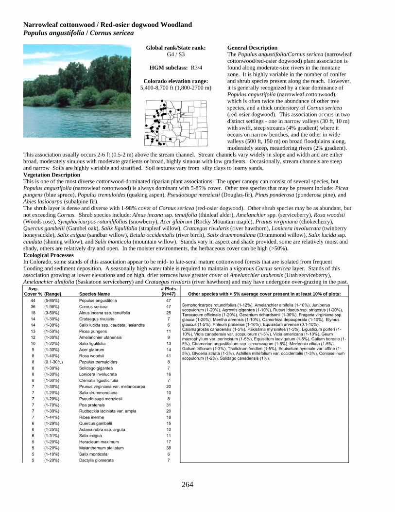
264
Narrowleaf cottonwood / Red-osier dogwood Woodland Populus angustifolia / Cornus sericea
General Description The Populus angustifolia/Cornus sericea (narrowleaf cottonwood/red-osier dogwood) plant association is found along moderate-size rivers in the montane zone. It is highly variable in the number of conifer and shrub species present along the reach. However, it is generally recognized by a clear dominance of Populus angustifolia (narrowleaf cottonwood), which is often twice the abundance of other tree species, and a thick understory of Cornus sericea (red-osier dogwood). This association occurs in two distinct settings - one in narrow valleys (30 ft, 10 m) with swift, steep streams (4% gradient) where it occurs on narrow benches, and the other in wide valleys (500 ft, 150 m) on broad floodplains along, moderately steep, meandering rivers (2% gradient).
This association usually occurs 2-6 ft (0.5-2 m) above the stream channel. Stream channels vary widely in slope and width and are either broad, moderately sinuous with moderate gradients or broad, highly sinuous with low gradients. Occasionally, stream channels are steep and narrow Soils are highly variable and stratified. Soil textures vary from silty clays to loamy sands. Vegetation Description This is one of the most diverse cottonwood-dominated riparian plant associations. The upper canopy can consist of several species, but Populus angustifolia (narrowleaf cottonwood) is always dominant with 5-85% cover. Other tree species that may be present include: Picea pungens (blue spruce), Populus tremuloides (quaking aspen), Pseudotsuga menziesii (Douglas-fir), Pinus ponderosa (ponderosa pine), and Abies lasiocarpa (subalpine fir). The shrub layer is dense and diverse with 1-98% cover of Cornus sericea (red-osier dogwood). Other shrub species may be as abundant, but not exceeding Cornus. Shrub species include: Alnus incana ssp. tenuifolia (thinleaf alder), Amelanchier spp. (serviceberry), Rosa woodsii (Woods rose), Symphoricarpos rotundifolius (snowberry), Acer glabrum (Rocky Mountain maple), Prunus virginiana (chokecherry), Quercus gambelii (Gambel oak), Salix ligulifolia (strapleaf willow), Crataegus rivularis (river hawthorn), Lonicera involucrata (twinberry honeysuckle), Salix exigua (sandbar willow), Betula occidentalis (river birch), Salix drummondiana (Drummond willow), Salix lucida ssp. caudata (shining willow), and Salix monticola (mountain willow). Stands vary in aspect and shade provided, some are relatively moist and shady, others are relatively dry and open. In the moister environments, the herbaceous cover can be high (>50%). Ecological Processes In Colorado, some stands of this association appear to be mid- to late-seral mature cottonwood forests that are isolated from frequent flooding and sediment deposition. A seasonally high water table is required to maintain a vigorous Cornus sericea layer. Stands of this association growing at lower elevations and on high, drier terraces have greater cover of Amelanchier utahensis (Utah serviceberry), Amelanchier alnifolia (Saskatoon serviceberry) and Crataegus rivularis (river hawthorn) and may have undergone over-grazing in the past.
Avg. Cover % (Range) Species Name
# Plots (N=47) Other species with < 5% average cover present in at least 10% of plots:
44 (5-85%) Populus angustifolia 47 36 (1-98%) Cornus sericea 47 18 (3-50%) Alnus incana ssp. tenuifolia 25 14 (1-30%) Crataegus rivularis 7 14 (1-30%) Salix lucida ssp. caudata, lasiandra 6 13 (1-50%) Picea pungens 11 12 (1-30%) Amelanchier utahensis 9 10 (1-22%) Salix ligulifolia 13 9 (1-30%) Acer glabrum 14 8 (1-40%) Rosa woodsii 41 8 (0.1-30%) Populus tremuloides 8 8 (1-30%) Solidago gigantea 7 8 (1-30%) Lonicera involucrata 16 8 (1-30%) Clematis ligusticifolia 7 7 (1-30%) Prunus virginiana var. melanocarpa 20 7 (1-20%) Salix drummondiana 10 7 (1-20%) Pseudotsuga menziesii 8 7 (1-70%) Poa pratensis 31 7 (1-30%) Rudbeckia laciniata var. ampla 20 7 (1-44%) Ribes inerme 18 6 (1-29%) Quercus gambelii 15 6 (1-25%) Actaea rubra ssp. arguta 10 6 (1-31%) Salix exigua 11 5 (1-20%) Heracleum maximum 17 5 (1-20%) Maianthemum stellatum 38 5 (1-10%) Salix monticola 6 5 (1-20%) Dactylis glomerata 7
Symphoricarpos rotundifolius (1-12%), Amelanchier alnifolia (1-10%), Juniperus scopulorum (1-20%), Agrostis gigantea (1-10%), Rubus idaeus ssp. strigosus (1-20%), Taraxacum officinale (1-20%), Geranium richardsonii (1-30%), Fragaria virginiana ssp. glauca (1-20%), Mentha arvensis (1-10%), Osmorhiza depauperata (1-10%), Elymus glaucus (1-5%), Phleum pratense (1-10%), Equisetum arvense (0.1-10%), Calamagrostis canadensis (1-5%), Paxistima myrsinites (1-5%), Ligusticum porteri (1-10%), Viola canadensis var. scopulorum (1-5%), Vicia americana (1-10%), Geum macrophyllum var. perincisum (1-5%), Equisetum laevigatum (1-5%), Galium boreale (1-5%), Chamerion angustifolium ssp. circumvagum (1-8%), Mertensia ciliata (1-5%), Galium triflorum (1-3%), Thalictrum fendleri (1-5%), Equisetum hyemale var. affine (1-5%), Glyceria striata (1-3%), Achillea millefolium var. occidentalis (1-3%), Conioselinum scopulorum (1-2%), Solidago canadensis (1%).
Global rank/State rank: G4 / S3
HGM subclass: R3/4
Colorado elevation range:
5,400-8,700 ft (1,800-2700 m)

265
Narrowleaf cottonwood / River hawthorn Woodland Populus angustifolia / Crataegus rivularis
General Description The Populus angustifolia/Crataegus rivularis (narrowleaf cottonwood/river hawthorn) plant association is characterized by having dense to sparse canopy cover of mature Populus angustifolia (narrowleaf cottonwood) trees. The understory is typically very dense and consists of Crataegus rivularis (river hawthorn) and other shrub species including Cornus sericea (red-osier dogwood) and various tall Salix (willow) species. Graminoid and forb cover is minimal. This association generally occurs away from the immediate stream bank in moderately wide valleys. It also occurs along dry backchannels or ephemeral streams. Stream channels are wide and moderately to highly sinuous. The soils are sandy clays and highly stratified alluvium.
Vegetation Description Populus angustifolia (narrowleaf cottonwood) forms an open to dense overstory canopy with 4-63% cover. Crataegus rivularis (river hawthorn) forms a dense shrub canopy with 10-70% cover, and Rosa woodsii (Woods rose) forms a sub-shrub canopy. These three species were present in every stand sampled. Other tree species may be present, including Pinus ponderosa (ponderosa pine) and Pseudotsuga menziesii (Douglas-fir). Shrub species may include: Symphoricarpos rotundifolius (roundleaf snowberry), Quercus gambelii (Gambel oak), Dasiphora floribunda (shrubby cinqefoil), Cornus sericea (red-osier dogwood), Salix bebbiana (Bebb willow), Salix ligulifolia (strapleaf willow) and Salix monticola (mountain willow). Graminoid and forb cover is typically low due to dry soil conditions. Taraxacum officinale (dandelion) and Iris missouriensis (wild iris) are present in nearly all sampled stands. Other herbaceous species present include: Maianthemum stellatum (starry false Solomon seal), Poa pratensis (Kentucky bluegrass), Thermopsis montana (mountain goldenbanner), Thalictrum fendleri (Fendler meadow rue), Rudbeckia laciniata (cutleaf coneflower), Carex praegracilis (clustered field sedge), and Delphinium nuttallianum (Nuttal larkspur). Ecological Processes An abundance of Crataegus rivularis (river hawthorn) may indicate a late seral stage of the cottonwood stand. Crataegus occupies the driest part of the riparian habitat, and may indicate the surface is no longer flooded. In Montana, thickets of Crataegus are considered a grazing disclimax. Cattle will browse Crataegus and heavy pressure can cause thickets to become open and increaser species such as Rosa woodsii (Woods rose), Symphoricarpos (snowberry) and Poa pratensis (Kentucky bluegrass) become established and abundant.
Avg. Cover % (Range) Species Name
# Plots (N=10) Other species with < 5% average cover present in at least 10% of plots:
44 (4-63%) Populus angustifolia 10 35 (1-100%) Ribes inerme 3 25 (10-70%) Crataegus rivularis 10 14 (1-30%) Cornus sericea 5 14 (3-40%) Symphoricarpos rotundifolius 6 10 (1-20%) Salix monticola 3 10 (1-30%) Rosa woodsii 10 10 (3-20%) Pinus ponderosa var. scopulorum 4 8 (1-50%) Maianthemum stellatum 9 6 (1-15%) Quercus gambelii 5 6 (1-20%) Amelanchier alnifolia 6
Rudbeckia laciniata var. ampla (1-10%), Dasiphora floribunda (1-10%), Poa pratensis (1-10%), Osmorhiza depauperata (1-6%), Melilotus officinalis (1-10%), Thalictrum fendleri (1-9%), Geranium richardsonii (1-6%), Thermopsis montana (1-3%), Juncus balticus var. montanus (1-3%), Phleum pratense (1-3%), Fragaria virginiana ssp. glauca (1-3%), Vicia americana (1-5%), Bromus inermis (1-3%), Taraxacum officinale (1-3%), Achillea millefolium var. occidentalis (1%), Iris missouriensis (1%), Galium triflorum (1%), Pseudocymopterus montanus (1%), Trifolium longipes (1%).
Global rank/State rank: G2 / S2
HGM subclass: R3/4
Colorado elevation range:
6,900-8,000 ft (2,100-2,400 m)

266
Narrowleaf cottonwood/Mixed willow Woodland Populus angustifolia / Salix spp.
General Description The Populus angustifolia / Salix spp. (narrowleaf cottonwood/mixed willow) plant association is an early to mid-seral stage of more mature Populus angustifolia dominated plant associations. The cottonwoods are fairly young trees (5-15 in, 12-38 cm dbh), with a diverse mix of willows and other shrubs in the understory canopy. This community occurs on active floodplains, stream benches and low terraces, generally within 1-4.5 ft (0.3-1.4 m) of the active channel elevation. Stream channels range from steep and narrow to broad, moderate gradient and more sinuous. Sites show signs of active flooding. One stand occurs on an overflow or back channel. Soils are somewhat deep
(about 3 ft, 1 m), loamy to clay sands over very coarse alluvial layers with at least 25% gravel and other coarse fragments present in all layers. Vegetation Description The upper canopy is dominated by young (sapling, pole and medium-sized 5-15 in, 12-35 cm in diameter) Populus angustifolia (narrowleaf cottonwood) trees with 25-90% cover. The understory has a consistent mixture of two or more willow species, which can include Salix exigua (sandbar willow), S. ligulifolia (strapleaf willow), S. monticola (mountain willow), S. lucida ssp. caudata (shining willow), S. drummondiana (Drummond willow), and S. geyeriana (Geyer willow). Total cover of the shrub layer is between 15-70%. Other, non-willow shrubs are usually present as well, and include Rosa woodsii (Woods rose), Ribes spp. (gooseberry), Alnus incana ssp. tenuifolia (thinleaf alder), Crataegus rivularis (river hawthorn), Dasiphora floribunda (shrubby cinquefoil) and/or Symphoricarpos spp. (snowberry). The herbaceous undergrowth is generally low in total cover, with 10-40% forbs and 5-15% graminoids. Common species include Maianthemum stellatum (starry false Solomon seal), Trifolium spp. (clover), Erigeron spp. (fleabane), Poa pratensis (Kentucky bluegrass), and Bromus inermis (smooth brome). Ecological Processes As with all cottonwood woodlands, this association is found within a continually changing alluvial environment where riparian vegetation is constantly being “re-set” by flooding disturbance. Mature cottonwood stands do not regenerate in place, but regenerate by “moving” up and down a river reach. Over time, a healthy riparian area supports all stages of cottonwood communities. The process of cottonwood regeneration is dependent on flooding disturbance. Periodic flooding allows cottonwood seedlings to germinate and become established on newly deposited, moist sandbars. Natural river processes of bank erosion, deposition and channel migration result in a dynamic patchwork of different age classes, plant associations and habitats. Avg. Cover
% (Range) Species Name # Plots (N=4) Other species with < 5% average cover present in at least 10% of plots:
57 (23-89%) Populus angustifolia 4 17 (6-36%) Salix monticola 3 13 (10-16%) Alnus incana ssp. tenuifolia 2 12 ― Salix drummondiana 1 11 ― Juniperus monosperma 1 7 ― Ribes cereum 1 6 (1-13%) Poa pratensis 4 5 (1-9%) Ribes inerme 2 5 (4-6%) Salix exigua 2 5 (3-7%) Salix lucida ssp. caudata, lasiandra 2 5 ― Maianthemum stellatum 1
Symphyotrichum foliaceum (4%), Symphoricarpos albus (4%), Rosa woodsii (1-8%), Lonicera involucrata (3%), Equisetum arvense (3%), Heracleum maximum (3%), Bromus ciliatus var. ciliatus (3%), Galium triflorum (3%), Equisetum pratense (3%), Crataegus rivularis (3%), Cornus sericea ssp. sericea (3%), Trifolium pratense (3%), Thermopsis montana (3%), Symphoricarpos rotundifolius (3%), Salix geyeriana (3%), Rudbeckia laciniata var. ampla (3%), Pseudocymopterus montanus (3%), Phleum pratense (3%), Pedicularis procera (3%), Medicago lupulina (3%), Salix ligulifolia (2-3%), Taraxacum officinale (2-3%), Achillea millefolium var. occidentalis (1-2%), Juncus balticus var. montanus (1%), Glyceria striata (1%), Fragaria virginiana ssp. glauca (1%), Dasiphora floribunda (1%), Iris missouriensis (1%), Thalictrum fendleri (1%), Dactylis glomerata (1%), Amelanchier alnifolia (1%), Angelica pinnata (1%), Geranium richardsonii (1%), Bromus inermis (1%), Chamerion angustifolium ssp. circumvagum (1%), Calamagrostis canadensis (1%), Carex pellita (1%), Cardamine cordifolia (1%), Carex microptera (1%), Mertensia ciliata (1%), Castilleja sulphurea (1%), Castilleja miniata (1%), Carex utriculata (1%), Elymus glaucus (1%), Vicia americana (1%), Trifolium repens (1%), Solidago canadensis (1%), Ribes lacustre (1%), Heterotheca villosa (1%), Platanthera sparsiflora var. ensifolia (1%), Pinus ponderosa var. scopulorum (1%), Oxypolis fendleri (1%), Mimulus guttatus (1%), Zigadenus elegans ssp. elegans (1%), Maianthemum racemosum ssp. amplexicaule (1%), Rubus idaeus ssp. strigosus (1%).
Global rank/State rank: G3 / S3
HGM subclass: R3/4
Colorado elevation range:
7,900-8,880 ft (2,400-2,700 m)

267
Narrowleaf cottonwood / Sandbar willow Woodland Populus angustifolia / Salix exigua
General Description This is a very common plant association of young seedling and sapling Populus angustifolia (narrowleaf cottonwood) intermixed with Salix exigua (sandbar willow). The association occupies point bars, gravel bars, benches and low areas that are flooded annually. This plant association occurs on recently flooded point bars, low terraces, and stream benches. It is usually well within the active channel and immediate floodplain of the stream and does not occur more than 3-6 ft (1-2 m) above the high-water mark. Stream channels are wide and slightly sinuous, or wide and moderately sinuous. Soils are skeletal (40% gravel and 10-20% cobbles) and shallow, 15 inches (35 cm) deep, sands, sandy loams, sandy clay
loams, or silty clays over coarse alluvial material. Vegetation Description This plant association represents the early, successional stage of nearly all Populus angustifolia (narrowleaf cottonwood) dominated plant associations, and is characterized by an open to dense stand Populus angustifolia (narrowleaf cottonwood) young trees, seedlings and saplings with Salix exigua (sandbar willow). Populus x acuminata (lanceleaf cottonwood) may also be present in similar age classes. Other more widely scattered trees occurring in fewer than 20% of sampled stands include: Abies lasiocarpa (subalpine fir), Picea engelmannii (Engelmann spruce), Pinus ponderosa (ponderosa pine), and Picea pungens (blue spruce). The shrub canopy is typically at the same height of the seedling and sapling cottonwood trees, although older, transitional, stands will have taller, more mature trees with Salix exigua as an understory. Other shrubs that may be present include: Alnus incana ssp. tenuifolia (thinleaf alder), Salix lucida ssp. caudata or ssp. lasiandra (shining willow), Salix ligulifolia (strapleaf willow), Salix drummondiana (Drummond willow), and Salix bebbiana (Bebb willow). The herbaceous undergrowth is generally invasive, non-native and sparse from frequent flooding disturbance. Non-native species include: Poa pratensis (Kentucky bluegrass), Trifolium repens (white clover), Agrostis stolonifera (creeping bentgrass) (1%), Linaria vulgaris (butter and eggs), Taraxacum officinale (dandelion), Medicago lupulina (black medick), Phleum pratense (timothy), Melilotus officinalis (yellow sweetclover), Dactylis glomerata (orchardgrass), and Elymus repens (quackgrass). Native herbaceous species that can be present include: Equisetum arvense (field horsetail), Achillea millefolium var. occidentalis (western yarrow), Rudbeckia laciniata (cutleaf coneflower), Carex microptera (big head sedge), Carex pellita (woolly sedge), and Mentha arvensis (wild mint). Ecological Processes Populus angustifolia/Salix exigua (narrowleaf cottonwood/sandbar willow) is one of the earliest successional stages of a cottonwood-dominated plant association. Populus angustifolia and Salix exigua seeds often germinate together on freshly deposited sandbars. If the site becomes more stable and less frequently flooded (i.e., the stream channel migrates away from the site), the Populus angustifolia saplings mature, but the Salix exigua population eventually declines. The association can become one of several mid- or late-seral floodplain types including Populus angustifolia/Alnus incana ssp. tenuifolia (narrowleaf cottonwood/thinleaf alder) and Populus angustifolia/ Cornus sericea (narrowleaf cottonwood/red-osier dogwood).
Avg. Cover % (Range) Species Name
# Plots (N=27) Other species with < 5% average cover present in at least 10% of plots:
38 (15-80%) Populus angustifolia 27 22 (1-64%) Salix exigua 24* 17 (0.1-40%) Agrostis gigantea 5 13 (1-70%) Poa pratensis 19 11 (1-40%) Trifolium pratense 5 10 (1-88%) Equisetum arvense 11 8 (1-20%) Salix lucida ssp. caudata, lasiandra 6 6 (1-30%) Melilotus officinalis 10 6 (1-38%) Trifolium repens 12 6 (1-20%) Medicago lupulina 9 5 (1-12%) Salix ligulifolia 5 5 (1-19%) Bromus inermis 6 5 (2-10%) Alnus incana ssp. tenuifolia 7 5 (1-10%) Dactylis glomerata 4
Phleum pratense (1-10%), Poa compressa (1-15%), Heterotheca villosa (1-10%), Juncus balticus var. montanus (0.1-10%), Juniperus scopulorum (1-8%), Eleocharis palustris (1-5%), Taraxacum officinale (0.1-20%), Rudbeckia laciniata var. ampla (0.1-5%), Clematis ligusticifolia (0.1-6%), Mentha arvensis (1-5%), Rosa woodsii (0.1-5%), Achillea millefolium var. occidentalis (1-3%), Carex microptera (1%),.
*Salix exigua was present in all stands, but was not captured in every sample plot.
Global rank/State rank: G4 / S4
HGM subclass: R3/4, R5
Colorado elevation range:
6,300-7,500 ft (1,900-2,300 m)

268
Narrowleaf cottonwood / Shining willow Woodland Populus angustifolia / Salix lucida ssp. caudata or ssp. lasiandra
General Description The Populus angustifolia/Salix lucida ssp. caudata or ssp. lasiandra (narrowleaf cottonwood/shining willow) plant association is a tentative association known from only a few locations in western and south central Colorado. It is a mature stand of Populus angustifolia (narrowleaf cottonwood) with a sub-canopy of Salix lucida var. caudata (shining willow). The Populus angustifolia/Salix lucida ssp. caudata or ssp. lasiandra community occurs on low terraces and floodplains. The low terrace is a flat, nutrient-rich surface approximately 3 ft (1 m) above the active channel. The terrace appears to be an old beaver pond that was drained by the stream. The channel was once braided, but is now sinuous, and is becoming incised. The soil is a deep loamy sand
with 10-25% organic matter that accumulated in the once-present beaver pond. Lower layers have no coarse fragments and little horizon development. Vegetation Description Tall (25-40 ft, 7-10 m), mature Populus angustifolia with 20-35% cover create the upper canopy. Tall (10-15 ft, 3-4 m) Salix lucida ssp. caudata comprise the second canopy. Alnus incana ssp. tenuifolia (thinleaf alder) or Salix exigua (sandbar willow) may also be present in low amounts. The herbaceous undergrowth is sparse and includes Poa pratensis (Kentucky bluegrass), Solidago canadensis (Canada goldenrod), Cirsium arvense (Canada thistle), Agrostis gigantea (redtop), Taraxacum officinale (dandelion) and Melilotus officinalis (yellow sweetclover), among other species. Ecological Processes Salix lucida is often associated with abandoned beaver ponds or found along steep stream reaches below beaver ponds. It appears to colonize areas that have filled with silt or are in the process of doing so. Eventually, this association will be replaced by slightly drier-site willow species. However, with disturbance such as overuse by livestock, willow cover may decline. With severe disturbance, the willows will completely disappear. As with all cottonwood woodlands, this association is found within a continually changing alluvial environment where riparian vegetation is constantly being “re-set” by flooding disturbance. Mature cottonwood stands do not regenerate in place, but regenerate by “moving” up and down a river reach. Over time, a healthy riparian area supports all stages of cottonwood communities. The process of cottonwood regeneration is dependent on flooding disturbance. Periodic flooding allows cottonwood seedlings to germinate and become established on newly deposited, moist sandbars. Natural river processes of bank erosion, deposition and channel migration result in a dynamic patchwork of different age classes, plant associations and habitats.
Avg. Cover % (Range) Species Name
# Plots (N=3) Other species with < 5% average cover present in at least 10% of plots:
37 (10-80%) Salix lucida ssp. caudata, lasiandra 3 28 (20-35%) Populus angustifolia 3 18 (10-25%) Poa pratensis 2 11 (1-20%) Solidago canadensis 2 10 ― Carex nebrascensis 1 10 ― Pseudostellaria jamesiana 1 10 ― Salix exigua 1 5 (5-5%) Agrostis gigantea 2 5 ― Juncus balticus var. montanus 1 5 ― Alnus incana ssp. tenuifolia 1 5 ― Phalaris arundinacea 1 5 ― Poa palustris 1 5 ― Trifolium hybridum 1
Melilotus officinalis (1-5%), Cirsium arvense (1%), Taraxacum officinale (1%), Phleum pratense (1%), Maianthemum stellatum (1%), Geum macrophyllum var. perincisum (1%), Equisetum hyemale var. affine (1%), Elymus repens (1%), Cardamine cordifolia (1%), Bromus inermis (1%), Carex praegracilis (1%), Achillea millefolium var. occidentalis (1%), Vicia americana (1%), Potentilla gracilis (1%), Rudbeckia laciniata var. ampla (1%), Sidalcea candida (1%), Symphyotrichum foliaceum (1%), Trifolium pratense (1%), Mentha arvensis (1%).
Global rank/State rank: G1Q / S1Q
HGM subclass: R3/4
Colorado elevation range:
6,580-7,640 ft (2,000-2,330 m)

269
Narrowleaf cottonwood – Blue spruce / Thinleaf alder Woodland Populus angustifolia - Picea pungens / Alnus incana ssp. tenuifolia
General Description This is a common mixed deciduous-evergreen community of montane valleys, where Populus angustifolia (narrowleaf cottonwood) and Picea pungens (blue spruce) are co-dominant along a stream reach. Frequently, other conifer trees are present, but not as abundant as Picea pungens (blue spruce). The shrub understory is typically dense and diverse. Alnus incana ssp. tenuifolia (thinleaf alder) is almost always present. Only a handful of good condition stands are known, and it is highly threatened by improper livestock grazing, heavy recreational use, and stream flow alterations. This association occurs in valleys with narrow to moderately wide floodplains, 30-600 ft (10-200 m), and in deep canyons. This association is commonly found on slightly meandering to meandering floodplains of broad reaches. Occasionally, stands
occur along steep reaches. Soils range from shallow sandy loams to silty clay loams and clays over cobbles and boulders. Profiles are generally highly stratified, with layers of fine soils over layers of coarser sediments. Vegetation Description The upper canopy is dominated by Populus angustifolia (narrowleaf cottonwood) and either Picea pungens (blue spruce) or Picea engelmannii (Engelmann spruce). Other less frequently encountered tree species may also be present and include: Pseudotsuga menziesii (Douglas-fir), Abies concolor (white fir), Populus tremuloides (quaking aspen), and Abies lasiocarpa (subalpine fir). Alnus incana ssp. tenuifolia (thinleaf alder) is almost always present in the shrub canopy layer, although cover amounts vary and other shrub species may be mor abundant. Lonicera involucrata (twinberry honeysuckle) is the most frequently encountered species after Alnus. Many other shrub species can occur within this association, including: Amelanchier alnifolia (Saskatoon serviceberry), Acer glabrum (Rocky Mountain maple), Salix drummondiana (Drummond willow), S. exigua (sandbar willow), S. lucida ssp. caudata (shining willow), S. geyeriana (Geyer willow), S. boothii (Booth willow), Prunus virginiana (chokecherry), and Symphoricarpos rotundifolius (snowberry). The undergrowth is diverse and can be sparse or dense, depending on local conditions. Total herbaceous cover rarely exceeds 40%. Maianthemum stellatum (starry false Solomon seal) and Geranium richardsonii (Richardson geranium) are frequently found. Graminoid cover is less diverse than forb cover. Ecological Processes This mixed deciduous-evergreen plant association is a mid-seral community. With continued fluvial activity, such as flooding, channel migration, sediment deposition, and scouring, narrowleaf cottonwood and blue spruce will continue to co-occur along the reach. Gradual and slightly sinuous stream channels that have overbank flow and sediment deposition favor establishment of Populus angustifolia. Picea pungens is favored along reaches in deep valleys with steep canyon walls that provide conditions for strong cold-air drainage. If the floodplain is no longer active, i.e., is no longer flooded because the stream channel has become lower (surface becomes a terrace) or upstream dams control floods, then cottonwoods will eventually die and the conifers may persist.
Avg. Cover % (Range) Species Name
# Plots (N=56) Other species with < 5% average cover present in at least 10% of plots:
34 (2-90%) Populus angustifolia 51* 28 (1-60%) Betula occidentalis 8 27 (0.1-90%) Alnus incana ssp. tenuifolia 41 25 (1-80%) Picea pungens 51 17 (1-50%) Picea engelmannii 9 17 (1-96%) Cornus sericea ssp. sericea 31 12 (4-30%) Abies lasiocarpa 6 11 (1-50%) Salix ligulifolia 15 11 (1-25%) Pseudotsuga menziesii 17 9 (1-50%) Acer glabrum 12 7 (1-40%) Lonicera involucrata 33 7 (1-28%) Populus tremuloides 8 7 (1-23%) Abies concolor 9 7 (1-15%) Salix drummondiana 11 6 (2-20%) Salix exigua 8 6 (0.1-24%) Trifolium repens 6 6 (1-30%) Calamagrostis canadensis 8 5 (1-30%) Salix monticola 15 5 (1-20%) Prunus virginiana var. melanocarpa 8 5 (1-15%) Amelanchier alnifolia 17
Rudbeckia laciniata var. ampla (1-16%), Symphoricarpos rotundifolius (1-30%), Salix bebbiana (0.1-15%), Equisetum arvense (1-10%), Maianthemum stellatum (0.1-30%), Elymus glaucus (1-20%), Equisetum hyemale var. affine (1-20%), Geranium richardsonii (1-10%), Salix lucida ssp. caudata, lasiandra (1-10%), Heracleum maximum (1-11%), Juncus compressus (1-6%), Pyrola asarifolia ssp. asarifolia (1-10%), Osmorhiza depauperata (1-30%), Poa pratensis (1-16%), Actaea rubra ssp. arguta (1-10%), Taraxacum officinale (0.1-16%), Mertensia franciscana (1-9%), Ligusticum porteri (1-10%), Fragaria virginiana ssp. glauca (1-9%), Rosa woodsii (0.1-9%), Thalictrum fendleri (1-10%), Pseudocymopterus montanus (1-10%), Ribes inerme (1-5%), Mahonia repens (1-5%), Viola canadensis var. scopulorum (1-10%), Amelanchier utahensis (0.1-3%), Paxistima myrsinites (1-4%), Phleum pratense (1-3%), Galium triflorum (1-10%), Aconitum columbianum (1-5%), Chamerion angustifolium ssp. circumvagum (1-3%), Equisetum pratense (1-4%), Orthilia secunda (1-3%), Rubus idaeus ssp. strigosus (1-5%), Geum macrophyllum var. perincisum (0.1-4%), Cardamine cordifolia (1-4%), Achillea millefolium var. occidentalis (1-5%), Vicia americana (1-5%), Carex geyeri (1-3%), Galium boreale (0.1-5%), Oxypolis fendleri (1-4%), Mertensia ciliata (0.1-5%), Maianthemum racemosum ssp. amplexicaule (1-2%).
*Populus angustifolia occurred in all stands, but was not captured in every sample plot.
Global rank/State rank: G4 / S4
HGM subclass: R3/4
Colorado elevation range:
6,800-9,600 ft (2,070-2,925 m)

270
Balsam poplar Forest Populus balsamifera
General Description The Populus balsamifera (balsam poplar) plant association is a minor type in Colorado. It occurs in Routt National Forest, on tributaries of the Colorado River near Eagle, along the Cache la Poudre River, and within the Gunnison River Basin. Colorado appears to be the southern limit of the range of Populus balsamifera,which has a limited distribution and rarely forms stands larger than a few hundred yards long. Populus balsamifera is distinguished from Populus angustifolia (narrowleaf cottonwood) by its broad leaves with pale undersides and large, sticky-resinous buds. This plant association occurs along a variety of streams (first through fourth order) in moderate to wide, 200-600 ft (60-180 m), glacial out-wash valleys. This association appears to be limited to immediate stream banks, overflow channels, and
floodplains. Stream channels are broad and slightly meandering. Soils are fairly deep, fine sandy and silty loams over skeletal alluvial deposits. Vegetation Description Mature trees and saplings of Populus balsamifera (balsam poplar) create an overstory canopy. Picea pungens (blue spruce) may also be present. A thick band of shrubs can occur along the stream edge including: Alnus incana ssp. tenuifolia (thinleaf alder), Salix drummondiana (Drummond willow), Rosa woodsii (Woods rose), Lonicera involucrata (twinberry honeysuckle), Ribes inerme (whitestem gooseberry), and Sambucus racemosa (red elderberry). The herbaceous undergrowth includes mesic forbs such as Heracleum maximum (common cowparsnip), Geranium richardsonii (Richardson geranium), Osmorhiza depauperata (bluntseed sweetroot), Equisetum arvense (field horsetail), Poa pratensis (Kentucky bluegrass), Hydrophyllum fendleri (Fendler waterleaf), and Maianthemum stellatum (starry false Solomon seal). Ecological Processes Populus balsamifera (balsam poplar) is a common horticultural addition to urban landscapes and may become established from cultivated areas. Careful observation is required to determine if stands in the wild are dominated by the native species. Avg. Cover
% (Range) Species Name # Plots (N=6)
59 (23-91%) Populus balsamifera 6 29 (5-60%) Alnus incana ssp. tenuifolia 4 26 (1-70%) Heracleum maximum 5 18 (3-33%) Salix drummondiana 2 14 (10-20%) Picea pungens 3 12 (1-30%) Rudbeckia laciniata var. ampla 3 6 (1-20%) Equisetum arvense 6 6 (1-10%) Calamagrostis canadensis 2 5 (2-10%) Mertensia ciliata 3 5 (1-10%) Geranium richardsonii 5
Other species with < 5% average cover present in at least 10% of plots: Osmorhiza depauperata (1-8%), Hydrophyllum fendleri (1-8%), Rosa woodsii (1-10%), Ribes inerme (0.1-10%), Maianthemum racemosum ssp. amplexicaule (1-5%), Cardamine cordifolia (3-3%), Populus tremuloides (1-5%), Poa pratensis (1-6%), Taraxacum officinale (0.1-7%), Cicuta douglasii (1-4%), Salix bebbiana (0.1-4%), Lonicera involucrata (1-3%), Geum macrophyllum var. perincisum (1-2%), Fragaria virginiana ssp. glauca (1-2%), Achillea millefolium var. occidentalis (1-2%), Galium boreale (0.1-3%), Oxypolis fendleri (1-1%), Phleum alpinum (1%), Viola canadensis var. scopulorum (1%), Conioselinum scopulorum (0.1-1%).
Global rank/State rank: GU / S2
HGM subclass: R2, R3/4
Colorado elevation range:
7,300-8,900 ft (2,225-2,700 m)

271
Quaking aspen / Thinleaf alder Forest Populus tremuloides / Alnus incana ssp. tenuifolia
General Description The Populus tremuloides/Alnus incana ssp. tenuifolia (quaking aspen/thinleaf alder) plant association is located in narrow ravines and along first- and second-order streams where upland Populus tremuloides forests intermix with riparian shrub vegetation and at lower elevations where Populus tremuloides persists only in the riparian zone. The presence of obligate riparian species distinguish this association from upland Populus tremuloides communities. This plant association is known from throughout the Western Slope. This plant association occurs in narrow, 25-225 ft (10-70 m) wide, valleys along stream banks of first- and second-order streams. Stream channels are steep and narrow and occasionally, of moderate gradient
and width. Stream gradients range from 1-30%. Soils are generally skeletal, shallow, sandy and sandy clay loams or deeper sandy clay loams. Vegetation Description This plant association has a tall, 20-40 ft (6-12 m), overstory of Populus tremuloides (quaking aspen). Several conifer species can occur, however the aspen is clearly the dominant tree canopy, at least along the streambanks. Other tree species that may be present include: Pinus contorta (lodgepole pine), Abies lasiocarpa (subalpine fir), Picea pungens (blue spruce) and Pseudotsuga menziesii (Douglas-fir). The shrub and forb canopy along the immediate streambank distinguish this riparian plant association from the adjacent forests. The shrub layer is dominated by Alnus incana ssp. tenuifolia (thinleaf alder). Other shrubs that may be present in this association include: Salix drummondiana (Drummond willow), Lonicera involucrata (twinberry honeysuckle), Rosa woodsii (Woods rose), Salix bebbiana (Bebb willow), and Cornus sericea (red-osier dogwood). The forb undergrowth can be dense and includes: Cardamine cordifolia (heartleaf bittercress), Mertensia ciliata (tall fringed bluebells), Osmorhiza depauperata (bluntseed sweetroot) and Senecio triangularis (arrowleaf groundsel). Graminoid cover includes: Calamagrostis canadensis (bluejoint reedgrass), Equisetum arvense (field horsetail) and Carex disperma (softleaf sedge). Ecological Processes Populus tremuloides (quaking aspen) forests and woodlands can be self-perpetuating climax plant associations or early-seral stages of coniferous types. Populus tremuloides (quaking aspen) is a non-obligate riparian species and often occurs in upland communities. Where valley bottoms are moist and stable, Populus tremuloides can dominate the riparian area, while also occurring on adjacent mesic hillslopes. Alnus incana ssp. tenuifolia (thinleaf alder) is a long-lived, early-seral species. It is one of the first species to establish on fluvial or glacial deposits as well as the spoils of placer mining. After establishment, young stands of Alnus incana are continually flooded. As stands mature, the stems can slow flood waters and trap sediment. Fine-textured sediments accumulate on top of the coarser alluvial material and the land surface eventually rises above annual flood levels. Flooding is then less frequent and soils begin to develop.
Avg. Cover % (Range) Species Name # Plots (N=22) Other species with < 5% average cover present in at least 10% of plots:
44 (3-100%) Populus tremuloides 22 37 (5-89%) Alnus incana ssp. tenuifolia 22 14 (3-22%) Salix drummondiana 3 13 (3-20%) Picea pungens 4 11 (1-20%) Picea engelmannii 6 10 (1-52%) Abies lasiocarpa 9 8 (1-40%) Mertensia ciliata 18 8 (3-10%) Rudbeckia laciniata var. ampla 5 8 (1-30%) Heracleum maximum 14 8 (3-10%) Pseudotsuga menziesii 3 7 (1-20%) Carex utriculata 3
7 (1-10%) Corydalis caseana ssp. brandegeei 3
6 (3-12%) Actaea rubra ssp. arguta 3 6 (1-11%) Ribes montigenum 3 6 (1-20%) Calamagrostis canadensis 13 6 (1-20%) Equisetum arvense 11 6 (1-25%) Bromus inermis 5 6 (1-15%) Arnica cordifolia 5 6 (1-20%) Salix bebbiana 4 6 (1-13%) Acer glabrum 4 5 (1-30%) Cardamine cordifolia 16
Senecio triangularis (1-16%), Poa compressa (1-9%), Geranium richardsonii (1-25%), Taraxacum officinale (1-15%), Lonicera involucrata (1-10%), Ribes inerme (1-13%), Orthilia secunda (1-10%), Oxypolis fendleri (1-8%), Aconitum columbianum (1-15%), Galium triflorum (1-8%), Osmorhiza depauperata (1-10%), Rosa woodsii (1-10%), Streptopus amplexifolius var. chalazatus (1-9%), Chamerion angustifolium ssp. circumvagum (1-9%), Fragaria virginiana ssp. glauca (1-7%), Carex microptera (1-5%), Poa pratensis (1-5%), Hydrophyllum fendleri (1-4%), Glyceria striata (1-5%), Geum macrophyllum var. perincisum (1-5%), Bromus ciliatus var. ciliatus (1-3%), Conioselinum scopulorum (1-9%), Maianthemum stellatum (1-4%), Saxifraga odontoloma (1-4%), Trifolium repens (1-3%), Viola canadensis var. scopulorum (1-3%), Achillea millefolium var. occidentalis (1-3%), Urtica dioica ssp. gracilis (1-3%), Galium boreale (1-3%), Rubus parviflorus (1-2%), Poa palustris (1%), Mahonia repens (1%), Sambucus racemosa var. racemosa (1%), Veronica americana (0.1-1%).
Global rank/State rank: G3 / S3
HGM subclass: R3/4
Colorado elevation range:
7,850-9,700 ft (2,400-2,950 m)

272
Booth willow / Mesic forb Shrubland Salix boothii / Mesic forb
General Description The Salix boothii/mesic forb (Booth willow/mesic forb) plant association is a tall (4-5 ft, 1-2 m) shrubland that often forms extensive thickets (willow carrs) on broad montane floodplains. This association is common in the northern half of Colorado. This association occurs on wetter sites within the floodplain environment. It is usually found within 2.5 ft (0.75 m) of the water table, but is occasionally located above the channel on low terraces of straighter sections of river. The ground surface is often uneven and hummocky due to past flooding and beaver activity. A narrow to broad, low-gradient floodplain is common along all of the river reaches. Stream channels are steep and narrow, broad and sinuous, narrow and meandering, or recently eroding. Soils are highly stratified with alternating
layers of sandy loams and clay loams and mottled within the top 4 inches (10 cm). Others are finely textured, dark-colored, highly organic soils with silty clay loam mottling. Lower profiles contain a gravel or cobble layer which may indicate that the soil section is a silted-in beaver pond. Vegetation Description Salix boothii (Booth willow) forms large stands with a canopy ranging from 20-80% cover. Other shrub species can be as abundant but do not exceed that of Salix boothii nor are they consistently present. Other shrub species include: Salix drummondiana (Drummond willow), Salix geyeriana (Geyer willow), Salix monticola (mountain willow), Dasiphora floribunda (shrubby cinquefoil), Betula nana (=glandulosa) (bog birch), and Alnus incana ssp. tenuifolia (thinleaf alder). The undergrowth is characterized by a sparse to lush forb layer growing on raised hummocks. No one forb species is dominant, but rather includes several species with a combined cover of 40-60%. Forb species include: Swertia perennis (star gentian), Pedicularis groenlandica (elephanthead lousewort), Polygonum bistortoides (American bistort), Heracleum maximum (common cowparsnip), and Achillea millefolium var. occidentalis (western yarrow). Graminoid cover is typically low (< 20%), but it can be as high as 80%. Graminoid species include: Carex aquatilis (water sedge), Carex utriculata (beaked sedge), and Calamagrostis canadensis (bluejoint reedgrass). Ecological Processes The Salix boothii (Booth willow)/mesic forb plant association appears to be a stable and long-lived community on sites that are neither completely saturated nor dry throughout the growing season. The undergrowth of Salix boothii dominated associations varies according to the substrate and water regime. Wetter stands have an understory of Carex utriculata (beaked sedge), while drier stands may have Calamagrostis canadensis (bluejoint reedgrass) and various forb species. It is unclear whether grazing increases the dominance of either mesic forbs or graminoids or if there are subtle environmental differences between sites that contribute to this. With excessive grazing, this community may be replaced by a Salix boothii/Poa pratensis (Booth willow/Kentucky bluegrass) type with native forbs once dominant in the Salix boothii/mesic forb plant association growing under the protection of shrub bases. Avg. Cover
% (Range) Species Name # Plots (N=19) Other species with < 5% average cover present in at least 10% of plots:
57 (20-80%) Salix boothii 19 31 (1-80%) Salix drummondiana 7 13 (1-34%) Salix geyeriana 8 12 (1-80%) Calamagrostis canadensis 10 10 (1-20%) Salix wolfii 6 9 (1-40%) Heracleum maximum 13 9 (1-40%) Poa pratensis 11 9 (1-20%) Agrostis gigantea 4 9 (1-50%) Fragaria virginiana ssp. glauca 15 7 (1-30%) Alnus incana ssp. tenuifolia 6 6 (1-20%) Rudbeckia laciniata var. ampla 8 5 (1-30%) Sidalcea candida 7 5 (1-20%) Phleum pratense 11 5 (1-20%) Carex utriculata 7 5 (1-50%) Taraxacum officinale 17
Maianthemum stellatum (1-30%), Urtica dioica ssp. gracilis (1-10%), Elymus repens (1-10%), Symphyotrichum foliaceum (1-10%), Lonicera involucrata (1-5%), Galium boreale (1-20%), Elymus glaucus (1-7%), Poa palustris (1-10%), Geranium richardsonii (1-10%), Mertensia ciliata (1-5%), Ribes inerme (1-5%), Achillea millefolium var. occidentalis (1-10%), Equisetum arvense (1-6%), Cardamine cordifolia (1-5%), Thalictrum fendleri (1-5%), Solidago canadensis (1-5%), Dactylis glomerata (1-5%), Symphyotrichum lanceolatum ssp. hesperium var. hesperium (1-5%), Rubus idaeus ssp. strigosus (1-5%), Geum macrophyllum var. perincisum (1-5%), Hymenoxys hoopesii (1-5%), Senecio bigelovii var. hallii (1-4%), Vicia americana (1-5%), Aconitum columbianum (1-2%), Carex microptera (1%), Senecio triangularis (1%), Glyceria striata (1%), Conioselinum scopulorum (1%).
Global rank/State rank: G3 / S3
HGM subclass: R2, S1/2
Colorado elevation range:
7,000-9,100 ft (2,130-2,770 m)

273
Drummond willow / Bluejoint reedgrass Shrubland Salix drummondiana / Calamagrostis canadensis
General Description The Salix drummondiana/Calamagrostis canadensis (Drummond willow/bluejoint reedgrass) plant association is characterized by a dense canopy of Salix drummondiana and a thick undergrowth of Calamagrostis canadensis. This association is often associated with beaver activity along streams and can also occur within the riparian mosaic with Abies lasiocarpa-Picea engelmannii (subalpine fir-Engelmann spruce) forests. This plant association occurs in scattered locations on the West Slope in the Yampa, Colorado and Gunnison River Basins and in the and Routt National Forest. This plant association occurs as small, isolated patches in forest and shrubland openings along
channels in narrow valley bottoms. Salix drummondiana (Drummond willow) usually occurs along steep, narrow stream margins. It is often associated with beaver activity and can occasionally occur along low-gradient streams. Vegetation Description Salix drummondiana (Drummond willow) dominates the shrub overstory. Other shrubs can be present and abundant, such as Salix planifolia (planeleaf willow) and Alnus incana ssp. tenuifolia (thinleaf alder). The graminoid layer is dominated by Calamagrostis canadensis (bluejoint reedgrass). Other abundant graminoids include: Carex aquatilis (water sedge), Carex utriculata (beaked sedge), and Glyceria striata (fowl mannagrass). Forb cover is typically low and includes: Galium boreale (northern bedstraw), Geranium richardsonii (Richardson geranium), and Mertensia ciliata (tall fringed bluebells). Ecological Processes The Salix drummondiana/Calamagrostis canadensis (Drummond willow/bluejoint reedgrass) plant association is often an early colonizer of first-order, boulder-strewn, steep streams. Only a few stands representing the Salix drummondiana/Calamagrostis canadensis (Drummond willow/bluejoint reedgrass) plant association have been found in Colorado, and livestock grazing has probably altered the species composition of these stands. The abundance of this association appears to be limited to saturated wetland environments and therefore may be dependent on beaver populations that maintain a high water table. In addition, near beaver activity, this association may be a mid-successional community that will eventually become a Salix planifolia (planeleaf willow) or S. monticola (mountain willow) type as the area dries slightly and accumulates sediment. Avg. Cover
% (Range) Species Name # Plots (N=11) Other species with < 5% average cover present in at least 10% of plots:
51 (20-95%) Salix drummondiana 11 37 (3-80%) Calamagrostis canadensis 10 15 (5-30%) Carex utriculata 3 14 (5-30%) Carex aquatilis 4 13 (5-20%) Salix geyeriana 2 11 (1-20%) Salix planifolia 2 10 (1-20%) Salix monticola 3 8 (5-10%) Glyceria striata 2 6 (0.1-30%) Heracleum maximum 7
Equisetum arvense (1-7%), Chamerion angustifolium ssp. circumvagum (1-5%), Deschampsia caespitosa (2-3%), Alnus incana ssp. tenuifolia (2-3%), Geranium richardsonii (1-5%), Mertensia ciliata (1-5%), Taraxacum officinale (1-3%), Fragaria virginiana ssp. glauca (1-3%), Poa pratensis (1-3%), Galium triflorum (1-3%), Cardamine cordifolia (1-3%), Veratrum tenuipetalum (1-2%), Thalictrum sparsiflorum (1-2%), Geum macrophyllum var. perincisum (1-3%), Achillea millefolium var. occidentalis (1%), Senecio triangularis (1%), Lonicera involucrata (1%), Galium boreale (1%), Rubus idaeus ssp. strigosus (1%), Bromus ciliatus var. ciliatus (1%), Conioselinum scopulorum (0.1-1%), Epilobium lactiflorum (0.1-1%).
Global rank/State rank: G3 / S3
HGM subclass: R2, S1/2
Colorado elevation range:
8,000-9,800 ft (2,400-3,000 m)

274
Drummond willow / Mesic forb Shrubland Salix drummondiana / Mesic forb
General Description The Salix drummondiana/mesic forb (Drummond willow/mesic forb) plant association most commonly occurs on relatively steep streams and rarely forms more than a narrow, 5-25 ft (1.5-7.5 m) wide, band along streambanks. The closed to partially open canopy of Salix drummondiana and a thick carpet of many forb species characterize this plant association. This plant association occurs throughout the Western Slope and in montane regions along the Colorado Front Range. Habitats include narrow, V-shaped valleys as a dense, narrow band along high gradient streams and as large willow carrs in broad valleys, along low gradient (1-3%), moderately sinuous streams. It is also located along broad, highly sinuous streams and broad, actively downcutting channels. This association also occurs near seeps. Soils range from deep sandy loams and sandy clay loams with no coarse fragments to shallow silty clay loams and sandy clay loams over coarse, angular cobbles.
Vegetation Description Salix drummondiana (Drummond willow) forms an open to closed, narrow canopy of tall shrubs lining the stream bank. Other shrub species may be present with cover equal to but not exceeding that of Salix drummondiana. Mature trees may be present as a few individuals scattered through the shrubland or as canopy from an adjacent forested association. Stands with an overstory canopy of aspen are currently included in this association, although a Populus tremuloides/Salix drummondiana type may be split out at later date. The herbaceous undergrowth may be sparse or richly diverse. In general, total forb cover exceeds that of graminoid cover, and no single species is dominant. Ecological processes The Salix drummondiana/mesic forb (Drummond willow/mesic forb) association is often an early colonizer of first-order, boulder-strewn, steep streams. This association could be an early-seral stage of the Abies lasiocarpa-Picea engelmannii (subalpine fir-Engelmann spruce) plant association which also occurs along steep streams and alternates with the willow carrs. In wider valleys, this association occurs as a broad willow carr on well-developed soils near seeps or downstream from beaver dams. It appears to be a stable community in these environments. Avg. Cover
% (Range) Species Name # Plots (N=61) Other species with < 5% average cover present in at least 10% of plots:
56 (20-98%) Salix drummondiana 61 15 (2-37%) Salix planifolia 7 13 (1-75%) Populus tremuloides 10 12 (1-21%) Alnus incana ssp. tenuifolia 17 11 (0.1-40%) Salix monticola 33 10 (0.1-44%) Mertensia ciliata 41 10 (1-21%) Salix bebbiana 6 9 (1-40%) Heracleum maximum 40 9 (1-29%) Carex utriculata 12 8 (1-38%) Salix brachycarpa 6 8 (1-26%) Mertensia franciscana 9 8 (1-34%) Picea engelmannii 21 8 (1-30%) Delphinium barbeyi 8 8 (1-60%) Equisetum arvense 31 7 (1-20%) Carex aquatilis 7 6 (0.1-30%) Lonicera involucrata 36 6 (1-40%) Cardamine cordifolia 44 6 (0.1-30%) Calamagrostis canadensis 32 6 (1-24%) Ligusticum porteri 12 6 (1-30%) Oxypolis fendleri 24 5 (1-20%) Ribes inerme 14 5 (1-20%) Agrostis gigantea 7 5 (1-21%) Arnica cordifolia 8 5 (1-13%) Picea pungens 10 5 (1-34%) Saxifraga odontoloma 19
Hydrophyllum fendleri (1-17%), Rudbeckia laciniata var. ampla (1-14%), Veronica americana (1-13%), Dasiphora floribunda (1-19%), Senecio triangularis (1-24%), Abies lasiocarpa (1-12%), Geranium richardsonii (1-20%), Aconitum columbianum (1-20%), Elymus glaucus (1-10%), Osmorhiza depauperata (1-10%), Sambucus racemosa var. racemosa (1-10%), Chamerion angustifolium ssp. circumvagum (1-12%), Salix geyeriana (1-10%), Maianthemum stellatum (1-10%), Poa pratensis (1-20%), Osmorhiza occidentalis (1-10%), Equisetum pratense (1-7%), Conioselinum scopulorum (1-8%), Bromus ciliatus var. ciliatus (1-5%), Carex microptera (1-10%), Glyceria striata (1-11%), Deschampsia caespitosa (1-7%), Thalictrum fendleri (1-5%), Galium triflorum (1-5%), Veratrum tenuipetalum (1-5%), Viola canadensis var. scopulorum (1-10%), Angelica ampla (1-5%), Geum macrophyllum var. perincisum (1-10%), Taraxacum officinale (0.1-8%), Fragaria virginiana ssp. glauca (1-6%), Phleum pratense (1-5%), Urtica dioica ssp. gracilis (1-5%), Achillea millefolium var. occidentalis (0.1-5%), Streptopus amplexifolius var. chalazatus (1-5%), Rubus idaeus ssp. strigosus (1-5%), Mitella pentandra (1-4%), Juncus balticus var. montanus (1-3%), Symphoricarpos rotundifolius (1-5%), Mimulus guttatus (1-3%), Bromus inermis (1-3%), Rosa woodsii (1-3%), Galium boreale (1-2%), Thlaspi montanum (1%), Descurainia incana (1-%), Pedicularis groenlandica (1%), Phleum alpinum (1%), Luzula parviflora (0.1-1%).
Global rank/State rank: G4 / S4
HGM subclass: R2, R3/4, S3/4
Colorado elevation range:
7,500-11,300 ft (2,400-3,500 m)

275
Geyer willow / Water sedge Shrubland Salix geyeriana / Carex aquatilis
General Description Salix geyeriana (Geyer willow) forms a tall-willow shrubland with smaller shrubs often occurring under the canopy. The canopy is nearly closed and a thick carpet of mesic grasses and forbs blanket the undergrowth. The ground surface is often hummocky with willows establishing on the raised mounds and grasses dominating in the swales. It also occurs on hillside seeps. This association is relatively uncommon in Colorado. Few stands are in pristine condition. It may be less common than it was historically due to heavy grazing at the turn of the century. This association occurs on floodplains have an undulating topography with hummocks, ridges and
swales that create a microenvironment for its heterogeneous understory. The floodplains tend to be broad, are usually flooded in early spring/summer, and have saturated soils throughout the growing season. This plant association occurs on narrow, flat benches along steep stream reaches. It also occurs on floodplains of narrow, subalpine, low gradient, braided or highly sinuous steams. Stream channels can also be broad and sinuous. Soils are shallow to deep with mottling often occurring near the surface. Soil textures are fine sandy clay loams, clay loams and silty loams often alternating with layers of coarse sand. Vegetation Description This plant association is characterized by a tall-willow canopy dominated by Salix geyeriana (Geyer willow). Other shrubs may include: Betula nana (=glandulosa) (bog birch), Salix brachycarpa (barrenground willow), S. boothii (Booth willow), S. monticola (mountain willow), and S. planifolia (planeleaf willow). Graminoid cover is greater than forb cover and is dominated by Carex aquatilis (water sedge). Other graminoids that may be present include: Carex utriculata (beaked sedge), Deschampsia cespitosa (tufted hairgrass), and Calamagrostis canadensis (bluejoint reedgrass). Forb cover is concentrated on elevated micro-ridges and higher areas where shrubs are rooted. Forb species that may be present include: Senecio triangularis (arrowleaf groundsel), Achillea millefolium var. occidentalis (western yarrow), Conioselinum scopulorum (Rocky Mountain hemlockparsley), and Geum macrophyllum (largeleaf avens). Ecological Processes Salix geyeriana dominated associations appear to be long-lived and late-seral, remaining in areas where a shallow water table saturates soils, not dropping below 3 ft (1 m) for much of the growing season. Stands are limited to cold, wet environments of broad valley bottoms at high elevations. Due to the colder environments, organic matter builds up in the soils and succession to other associations is likely to be slow. Beaver activity is also important in maintaining this association since it may be the last successional community to establish on naturally silted-in beaver ponds. Carex utriculata (beaked sedge), Carex aquatilis (water sedge), and Calamagrostis canadensis (bluejoint reedgrass) are common dominant undergrowth of several Salix plant associations. These three graminoids indicate different micro-environments, generally separating out along a moisture gradient related to the depth of the water table, and can represent different stages of succession of the floodplain. Carex utriculata (beaked sedge) occurs on the wettest sites, such as shallow pond margins, low-lying swales, and overflow channel with the shallowest water tables. Carex aquatilis (water sedge) occurs on intermediate sites that have saturated but not inundated soils. Calamagrostis canadensis (bluejoint reedgrass) dominates the drier sites with lower water tables. Avg. Cover
% (Range) Species Name # Plots (N=9) Other species with < 5% average cover present in at least 10% of plots:
37 (12-80%) Salix geyeriana 9 29 (10-60%) Carex aquatilis 9 16 (1-30%) Salix brachycarpa 2 14 (1-30%) Salix boothii 3 11 (1-25%) Equisetum arvense 4 10 (5-16%) Salix monticola 3 10 (3-20%) Calamagrostis canadensis 6 10 (5-14%) Carex utriculata 4 8 (1-19%) Juncus balticus var. montanus 3 7 (1-20%) Salix planifolia 6 6 (2-14%) Senecio triangularis 3 6 (1-15%) Thalictrum fendleri 3 6 (1-20%) Poa pratensis 5 5 (1-9%) Agrostis stolonifera 2 5 (1-9%) Stellaria longifolia 2
Conioselinum scopulorum (1-10%), Fragaria virginiana ssp. glauca (1-11%), Dasiphora floribunda (1-10%), Deschampsia caespitosa (1-10%), Lonicera involucrata (3-4%), Geum macrophyllum var. perincisum (1-10%), Phleum pratense (1-5%), Cardamine cordifolia (1-6%), Luzula parviflora (1-4%), Achillea millefolium var. occidentalis (1-4%), Aconitum columbianum (1-3%), Mertensia ciliata (1-4%), Vicia americana (1-3%), Pedicularis groenlandica (1-3%), Taraxacum officinale (1-3%), Oxypolis fendleri (1-2%), Galeopsis bifida (1-2%), Heracleum maximum (1%), Geranium richardsonii (1%), Glyceria striata (1%), Chamerion angustifolium ssp. circumvagum (1%), Thlaspi montanum (1%).
Global rank/State rank: G3 / S3
HGM subclass: R2, S1/2
Colorado elevation range:
8,400-10,500 ft (2,500-3,200 m)

276
Geyer willow / Beaked sedge Shrubland Salix geyeriana / Carex utriculata
General Description The Salix geyeriana/Carex utriculata (Geyer willow/beaked sedge) plant association is a tall (5-15 ft, 1.5-2.5 m), deciduous shrubland with a nearly closed canopy of willows and thick carpet of sedges in the undergrowth. It is often wet, with saturated soils throughout much of the growing season. This association is well documented from many western states, but is relatively uncommon in Colorado. This association occurs in moderately wide to wide valley bottoms in swales and overflow channels of active floodplains adjacent to wide stream channels. This association often occurs near beaver activity. Stream channels are slightly meandering or braided from beaver activity. Soils textures are silty clay loam, clay, and sandy clay, usually forming thick, cohesive layers interspersed with layers of gravel or
sand. Mottling or gleying is often present. Vegetation Description Salix geyeriana (Geyer willow) dominates the shrub overstory with 20-70% cover. Other willow species that may be present include: Salix monticola (mountain willow), Salix drummondiana (Drummond willow), Salix wolfii (Wolf willow), and Salix planifolia (planeleaf willow). Other shrubs that may be present include: Alnus incana spp. tenuifolia (thinleaf alder) and Lonicera involucrata (twinberry honeysuckle). The graminoid layer is dominated by 20-80% cover of Carex utriculata (beaked sedge). Other graminoids that may be present include: Carex aquatilis (water sedge), Calamagrostis canadensis (bluejoint reedgrass), and Carex praegracilis (clustered field sedge). Forb cover is generally minor. Ecological Processes Salix geyeriana dominated associations appear to be long-lived and late-seral, remaining in areas where a shallow water table saturates soils, not dropping below 3 ft (1 m) for much of the growing season. Stands are limited to cold, wet environments of broad valley bottoms at high elevations. Due to the colder environments, organic matter builds up in the soils and succession to other associations is likely to be slow. Beaver activity is also important in maintaining this association since it may be the last successional community to establish on naturally silted-in beaver ponds. Carex utriculata (beaked sedge), Carex aquatilis (water sedge), and Calamagrostis canadensis (bluejoint reedgrass) are common dominant undergrowth of several Salix plant associations. These three graminoids indicate different micro-environments, generally separating out along a moisture gradient related to the depth of the water table, and can represent different stages of succession of the floodplain. Carex utriculata (beaked sedge) occurs on the wettest sites, such as shallow pond margins, low-lying swales, and overflow channel with the shallowest water tables. Carex aquatilis (water sedge) occurs on intermediate sites that have saturated but not inundated soils. Calamagrostis canadensis (bluejoint reedgrass) dominates the drier sites with lower water tables.
Avg. Cover % (Range) Species Name
# Plots (N=14) Other species with < 5% average cover present in at least 10% of plots:
45 (20-70%) Salix geyeriana 14 39 (14-80%) Carex utriculata 14 21 (1-70%) Poa pratensis 5 15 (9-20%) Salix monticola 5 13 (1-31%) Equisetum arvense 3 13 (1-24%) Aconitum columbianum 2 11 (2-27%) Carex aquatilis 10 10 (2-30%) Salix planifolia 7 9 (1-30%) Calamagrostis canadensis 5 9 (1-16%) Cardamine cordifolia 2 9 (1-16%) Bromus ciliatus var. ciliatus 2 8 (1-20%) Deschampsia caespitosa 3 8 (1-20%) Ribes inerme 3 8 (5-10%) Salix wolfii 2 8 (5-10%) Salix boothii 2 7 (1-16%) Phleum pratense 4 6 (1-20%) Fragaria virginiana ssp. glauca 4 5 (1-11%) Taraxacum officinale 7 5 (1-12%) Senecio triangularis 3 5 (3-7%) Potentilla pulcherrima X hippiana 2 5 (1-10%) Geranium richardsonii 3
Saxifraga odontoloma (1-10%), Juncus balticus var. montanus (1-5%), Pedicularis groenlandica (1-7%), Galium triflorum (1-5%), Lonicera involucrata (1-5%), Agrostis stolonifera (1-5%), Geum macrophyllum var. perincisum (1-10%), Trifolium repens (1-7%), Achillea millefolium var. occidentalis (1-10%), Heracleum maximum (1-4%), Mentha arvensis (1-4%), Carex microptera (1-3%), Maianthemum stellatum (1-3%), Dasiphora floribunda (1-3%), Alnus incana ssp. tenuifolia (1-3%), Cicuta douglasii (1-2%), Rumex crispus (1-2%), Mertensia ciliata (1-2%), Vicia americana (1%), Rosa woodsii (1%), Cirsium tioganum var. coloradense (1%), Oxypolis fendleri (1%).
Global rank/State rank: G5 / S3
HGM subclass: R2
Colorado elevation range:
6,800-9,000 ft (2,100-2,800 m)

277
Shining willow Shrubland Salix lucida ssp. lasiandra or ssp. caudata
General Description The Salix lucida ssp. caudata or ssp. lasiandra (shining willow) plant association is a tall willow community often found within a mosaic of several other riparian communities. It is generally a small patch type on large floodplain ecosystems and is more or less confined to the montane to lower subalpine belt (5,000-8,000 ft) in Colorado. This plant association occurs in saturated areas, usually adjacent to the channel flow. It is found on low point bars and islands, as well as on low stream banks and overflow channels of larger rivers. It also occurs in steep foothill tributary streams. Soils have high organic matter content with reduced conditions.
Vegetation Description This association is dominated by Salix lucida, either ssp. caudata or ssp. lasiandra (shining willow). Stands may consist of one or several willow species. The particular composition of willows is highly variable, depending on the stand's elevation and location. Other willows that may be present include: Salix ligulifolia (strapleaf willow), Salix boothii (Booth willow), and Salix geyeriana (Geyer willow). Other shrub species that may be present included: Ribes montigenum (gooseberry currant), Alnus incana ssp. tenuifolia (thinleaf alder), and Betula occidentalis (river birch). One higher elevation stand had Pinus contorta (lodgepole pine). The undergrowth is dominated by mesic grasses and sedges including Calamagrostis canadensis (bluejoint reedgrass), and several Carex (sedge) species. Forb cover is insignificant. In degraded stands, the undergrowth includes non-native grasses such as Agrostis gigantea (redtop), Phleum pratense (timothy), and Poa pratensis (Kentucky bluegrass). Ecological Processes The Salix lucida (shining willow) plant association establishes on deep alluvial materials and is considered to be early-seral. It is often associated with abandoned beaver ponds or along steeper reaches below beaver ponds. It appears to colonize areas that have been or are currently filling in with silt. This association will eventually be replaced by slightly drier-site willow species. However, with disturbance such as overuse by livestock, willow cover may decline. With severe disturbance, the willows will disappear. This association will then become dominated by Rosa woodsii (Woods rose) and eventually Poa pratensis (Kentucky bluegrass).
Avg. Cover % (Range) Species Name
# Plots (N=12)
Other species with < 5% average cover present in at least 10% of plots:
45 (8-82%) Salix lucida ssp. caudata, lasiandra 11* 35 (1-80%) Salix ligulifolia 4 21 (12-30%) Salix boothii 2 20 (10-30%) Agrostis gigantea 3 16 (1-30%) Poa pratensis 6 16 (8-23%) Calamagrostis canadensis 2 13 (1-40%) Salix monticola 4 12 (4-25%) Alnus incana ssp. tenuifolia 6 11 (1-42%) Phleum pratense 5 9 (3-14%) Carex pellita 2 8 (6-10%) Salix geyeriana 3 8 (3-21%) Juncus balticus var. montanus 5 8 (3-12%) Mertensia ciliata 2 8 (2-13%) Equisetum pratense 2 7 (1-15%) Trifolium repens 4 6 (1-15%) Geranium richardsonii 3 5 (1-9%) Thermopsis montana 2 5 (3-7%) Bromus inermis 2
Taraxacum officinale (1-9%), Rosa woodsii (1-12%), Salix exigua (1-10%), Prunella vulgaris (3-5%), Eleocharis palustris (1-5%), Ribes montigenum (1-7%), Carex aquatilis (1-6%), Mentha arvensis (1-5%), Rudbeckia laciniata var. ampla (1-5%), Carex utriculata (1-4%), Equisetum arvense (1-4%), Dasiphora floribunda (1-4%), Fragaria virginiana ssp. glauca (1-2%), Maianthemum stellatum (1-3%), Galium boreale (1-2%), Heracleum maximum (1-2%), Deschampsia caespitosa (1-2%), Achillea millefolium var. occidentalis (1-5%), Conioselinum scopulorum (1%), Dactylis glomerata (1%), Geum macrophyllum var. perincisum (1%), Castilleja sulphurea (1%), Melilotus officinalis (1%), Amelanchier alnifolia (1%), Glyceria striata (1%), Thalictrum fendleri (1%), Ribes aureum (1%).
*Salix lucida occurred in all stands, but was not captured in every sample plot.
Global rank/State rank: G3Q / S2S3
HGM subclass: R2, R3/4
Colorado elevation range:
6,500-9,500 ft (1,980-2,900 m)

278
Mountain willow / Bluejoint reedgrass Shrubland Salix monticola / Calamagrostis canadensis
General Description The Salix monticola/Calamagrostis canadensis (mountain willow/bluejoint reedgrass) plant association is a tall (4-5 ft, 1.5-2 m) shrubland with an open to closed canopy of willows and a lush carpet of grasses. It occurs along broad floodplains and narrow streams in the montane and upper montane elevations. This plant association occurs on narrow to wide, 100-1,000 ft (30-300 m) wide, low-gradient (2-3.5%) valley bottoms and floodplains. In wider valleys, large stands of this association occur between meanders and at the edges of beaver ponds. Stream channels are steep and narrow, moderately steep and wide, wide and sinuous, or braided from beaver activity. Soils are finely textured sandy clays to silty
clay loams, often saturated to within 10 inches (30 cm) of the surface. Soils can also be silty loams over sand and coarse sand. Mottling often occurs at 5-15 inches (20-40 cm) depth. Vegetation Description This plant association has a closed, mixed canopy of willows with Salix monticola (mountain willow) being the dominant or matrix willow. The matrix species is the willow with the highest abundance, even though other willow species combined may have greater canopy cover. Other willows that may be present include: Salix drummondiana (Drummond willow), S. boothii (Booth willow), S. geyeriana (Geyer willow), and S. wolfii (Wolf willow). Calamagrostis canadensis (bluejoint reedgrass) forms an open to dense graminoid layer. Other graminoids that may be present include: Carex aquatilis (water sedge), C. utriculata (beaked sedge), C. microptera (small-wing sedge), Deschampsia caespitosa (tufted hairgrass), and Glyceria grandis (American mannagrass). Total forb cover ranges from 20-50% cover and may include Cardamine cordifolia (heartleaf bittercress), Geranium richardsonii (Richardson geranium), Mertensia ciliata (tall fringed bluebells), Oxypolis fendleri (Fendler cowbane), Geum macrophyllum (largeleaf avens), Solidago canadensis (Canada goldenrod), Senecio bigelovii var. hallii (Hall ragwort), and Galium boreale (northern bedstraw). Ecological Processes Salix monticola (mountain willow) dominated plant associations appear to be long-lived and stable. They occur on mesic sites that support a diversity of graminoids and forbs. Salix monticola appears to grow only where the water table does not drop below 3 ft (1 m) of the surface. It appears to be limited to cold, wet environments in broad valley bottoms at high elevations. The presence of dying conifer trees in these associations may indicate an increase in the water table. A higher water table allows for the increase in cover of Calamagrostis canadensis (bluejoint reedgrass) and the conversion from a conifer/Calamagrostis canadensis type to a Salix spp./ Calamagrostis canadensis type. Carex utriculata (beaked sedge), Carex aquatilis (water sedge), and Calamagrostis canadensis (bluejoint reedgrass) are common dominant undergrowth of several Salix plant associations. These three graminoids indicate different micro-environments, generally separating out along a moisture gradient related to the depth of the water table, and can represent different stages of succession of the floodplain. Carex utriculata (beaked sedge) occurs on the wettest sites, such as shallow pond margins, low-lying swales, and overflow channels with the shallowest water tables. Carex aquatilis (water sedge) occurs on intermediate sites that have saturated but not inundated soils. Calamagrostis canadensis (bluejoint reedgrass) dominates the drier sites with lower water tables.
Avg. Cover % (Range) Species Name
# Plots (N=38) Other species with < 5% average cover present in at least 10% of plots:
58 (17-99%) Salix monticola 38 38 (1-95%) Calamagrostis canadensis 38 12 (2-40%) Salix drummondiana 15 12 (1-25%) Salix geyeriana 10 11 (1-18%) Alnus incana ssp. tenuifolia 8 10 (0.1-33%) Angelica ampla 5 10 (3-15%) Ribes lacustre 5 8 (1-20%) Carex aquatilis 6 8 (0.1-47%) Equisetum arvense 19 7 (0.1-30%) Heracleum maximum 20 7 (1-19%) Carex microptera 5 7 (1-25%) Salix planifolia 10 6 (1-17%) Salix bebbiana 10 6 (3-10%) Salix ligulifolia 5 6 (0.1-20%) Cirsium arvense 4 6 (1-20%) Poa pratensis 17 5 (0.1-15%) Mertensia ciliata 15 5 (1-20%) Fragaria virginiana ssp. glauca 10
Carex utriculata (1-14%), Taraxacum officinale (0.1-17%), Ribes montigenum (1-12%), Lonicera involucrata (0.1-15%), Betula nana (1-11%), Rudbeckia laciniata var. ampla (0.1-7%), Conioselinum scopulorum (0.1-15%), Chamerion angustifolium ssp. circumvagum (1-8%), Geranium richardsonii (0.1-12%), Equisetum pratense (1-5%), Dasiphora floribunda (1-5%), Achillea millefolium var. occidentalis (1-8%), Montia chamissoi (1-4%), Maianthemum stellatum (0.1-5%), Phleum pratense (1-5%), Viola canadensis var. scopulorum (1-6%), Geum macrophyllum var. perincisum (0.1-5%), Rosa woodsii (1-3%), Picea pungens (0.1-4%), Cardamine cordifolia (1-4%), Picea engelmannii (1-3%), Mentha arvensis (1-2%), Ribes inerme (0.1-3%), Oxypolis fendleri (1%), Stellaria crassifolia (1%), Galium boreale (0.1-2%), Aconitum columbianum (0.1-2%).
Global rank/State rank: G3 / S3
HGM subclass: R2
Colorado elevation range:
7,500-10,000 ft (2,280-3,050 m)

279
Mountain willow / Beaked sedge Shrubland Salix monticola / Carex utriculata
General Description The Salix monticola/Carex utriculata (mountain willow/beaked sedge) plant association is a tall (5-8 ft, or 1.5-2.5 m), deciduous shrubland with an open canopy of willows and a thick understory of grasses and sedges. It occurs on open floodplains and often occupies the entire valley floor. The undergrowth is dominated by patches of Carex utriculata (beaked sedge). This association often includes Carex aquatilis (water sedge) and Calamagrostis canadensis (bluejoint reedgrass), but is distinguished from the Salix monticola/Carex aquatilis (mountain willow/water sedge) and Salix monticola/Calamagrostis canadensis (mountain willow/bluejoint reedgrass) associations because Carex utriculata is either the clear dominant or most consistently present of the three throughout the stand.
This plant association commonly occurs near beaver ponds. Willows establish on hummocks of higher ground and Carex utriculata (beaked sedge) establishes at the pond margins. This association also occurs along wet stream banks and terraces of low gradient (<3%), broad valley bottoms. Stream reaches can be moderately wide with a gentle gradient, wide and meandering, or altered by beaver activity, creating multiple channels. Soils are clay loam, sandy clay loam and heavy silty clay textures with occasional mottling. Some profiles have a buried organic layer. Others have up to 40% organic matter in the top 20 inches (50 cm). Vegetation Description This association is characterized by a thick canopy dominated by Salix monticola (mountain willow) as the matrix species. The matrix species is the willow with the highest abundance, even though other willow species combined may have greater canopy cover. Other shrub species that may be present include: Salix geyeriana (Geyer willow), Salix brachycarpa (barrenground willow), Salix drummondiana (Drummond willow), Salix. ligulifolia (strapleaf willow), and Salix boothii (Booth willow). Carex utriculata (beaked sedge) is the most abundant graminoid. Other graminoid cover is minor and includes Carex aquatilis (water sedge), Poa pratensis (Kentucky bluegrass), and Deschampsia caespitosa (tufted hairgrass). Total forb cover is generally less than 10%. Forb species include: Cardamine cordifolia (heartleaf bittercress), Mertensia ciliata (tall fringed bluebells), and Heracleum maximum (common cowparsnip). Ecological Processes This plant association requires a high water table and saturated soils for much of the growing season and may be an early successional stage of the Salix monticola/Carex aquatilis and the Salix monticola/Calamagrostis canadensis associations. Carex utriculata (beaked sedge), Carex aquatilis (water sedge), and Calamagrostis canadensis (bluejoint reedgrass) are common dominant undergrowth of several Salix plant associations. These three graminoids indicate different micro-environments, generally separating out along a moisture gradient related to the depth of the water table, and can represent different stages of succession of the floodplain. Carex utriculata (beaked sedge) occurs on the wettest sites, such as shallow pond margins, low-lying swales, and overflow channel with the shallowest water tables. Carex aquatilis (water sedge) occurs on intermediate sites that have saturated but not inundated soils. Calamagrostis canadensis (bluejoint reedgrass) dominates the drier sites with lower water tables. Avg. Cover
% (Range) Species Name # Plots (N=29)
Other species with < 5% average cover present in at least 10% of plots:
52 (10-95%) Salix monticola 29 39 (1-80%) Carex utriculata 29 18 (1-60%) Carex aquatilis 9 15 (4-40%) Salix geyeriana 9 11 (1-25%) Salix wolfii 7 9 (1-28%) Salix brachycarpa 8 7 (1-20%) Salix drummondiana 9 6 (1-20%) Salix planifolia 4 6 (1-11%) Salix ligulifolia 5 6 (1-20%) Cardamine cordifolia 12 6 (2-10%) Ribes lacustre 3 6 (3-9%) Equisetum pratense 3 5 (1-15%) Betula nana 5 5 (1-15%) Equisetum arvense 17 5 (1-25%) Calamagrostis canadensis 9
Poa pratensis (1-24%), Phleum pratense (1-10%), Juncus balticus var. montanus (2-8%), Conioselinum scopulorum (1-10%), Glyceria striata (0.1-15%), Swertia perennis (0.1-10%), Juncus tracyi (1-9%), Fragaria virginiana ssp. glauca (1-9%), Mertensia ciliata (1-20%), Oxypolis fendleri (1-7%), Heracleum maximum (1-10%), Trifolium repens (0.1-8%), Alnus incana ssp. tenuifolia (1-5%), Lonicera involucrata (1-7%), Dasiphora floribunda (1-5%), Picea pungens (1-6%), Pedicularis groenlandica (1-6%), Taraxacum officinale (1-5%), Geum macrophyllum var. perincisum (0.1-5%), Achillea millefolium var. occidentalis (0.1-5%), Deschampsia caespitosa (1-4%), Senecio triangularis (1-3%), Angelica ampla (1-3%), Chamerion angustifolium ssp. circumvagum (1-3%), Aconitum columbianum (1-3%), Geranium richardsonii (0.1-3%), Ribes inerme (1%), Rosa woodsii (1%), Castilleja miniata (1%).
Global rank/State rank: G3 / S3
HGM subclass: R2, S1/2
Colorado elevation range:
6,600-10,300 ft (2,000-3,100 m)

280
Mountain willow / Mesic forb Shrubland Salix monticola / Mesic forb
General Description The Salix monticola/mesic forb (mountain willow/mesic forb) plant association is a tall (5-8 ft, 1.5-2.5 m), deciduous shrubland with a somewhat open canopy and an herbaceous layer dominated by a variety of forbs and grasses. While no single herbaceous species is a clear dominant, total forb cover is generally greater than 30% and exceeds total graminoid cover. This association occurs along broad, swift-moving streams and active floodplains in narrow to moderately wide valleys. The ground surface is usually undulating, from past flooding or beaver activity. Stands form narrow bands at the stream edge, ranging from 1-6 ft (0.1-2 m) above the
channel elevation. In wider valley bottoms, stands occur further from the bank, but never more than 2.5 ft (0.75 m) above the annual high water mark. Most stands occur adjacent to straight, wide, and shallow channels ranging from bedrock to silty-bottomed reaches. A few stands occur on meandering, cobble-bottomed reaches or streams braided by beaver activity. Soils are fine textured sandy clays to silty and sandy clay loams. Vegetation Description Salix monticola (mountain willow) forms a dense to open canopy, and if not the clear dominant, then it is the matrix willow. The matrix species is the willow with the highest abundance, even though other willow species combined may have greater canopy cover. Other shrub species that may be present include: Ribes inerme (whitestem gooseberry), Salix drummondiana (Drummond willow), S. planifolia (planeleaf willow), S. bebbiana (Bebb willow), S. geyeriana (Geyer willow), S. brachycarpa (barrenground willow), S. wolfii (Wolf willow), S. lucida ssp. caudata or lasiandra (shining willow), Alnus incana ssp. tenuifolia (thinleaf alder) and Lonicera involucrata (honeysuckle). Total forb cover ranges from 10-70%. No one forb species is particularly more abundant than any other, nor is any species consistently present in all stands. Forb species that may be present include: Heracleum maximum (common cowparsnip), Rudbeckia laciniata (cutleaf coneflower), Mertensia ciliata (tall fringed bluebells), and Fragaria virginiana (strawberry). Graminoid cover may be absent or up to 50% cover; in general it does not exceed the total forb cover. Graminoid species that may be present include Calamagrostis canadensis (bluejoint reedgrass) and Carex utriculata (beaked sedge). Generally, forbs are dominant under shrubs on hummocks and ridges while graminoids dominate the undergrowth in low-lying, wetter swales. Exotic graminoid and forb species include Poa pratensis (Kentucky bluegrass), Trifolium repens (white clover), and Taraxacum officinale (dandelion). Ecological Processes Salix monticola (mountain willow) dominated plant associations appear to be long-lived and stable. They occur on mesic sites that support a diversity of graminoids and forbs. Salix monticola appears to grow only where the water table does not drop below 3 ft (1 m) of the surface. It appears to be limited to cold, wet environments in broad valley bottoms at high elevations. Due to the colder environments, organic matter builds up in the soils, and it is likely that succession to other associations is slow. This plant association occurs on mesic sites and supports a rich diversity of forbs. On broad, hummocky floodplains stands can form extensive willow carrs. Sites with a higher abundance of exotic forbs and graminoids may be grazing-induced. At higher elevations, this association grades into the Salix planifolia/mesic forb (planeleaf willow/mesic forb) association.
Avg. Cover % (Range) Species Name # Plots (N=93) Other species with < 5% average cover present in at least 10% of plots:58 (1-100%) Salix monticola 93 17 (1-40%) Ribes lacustre 26 16 (0.1-60%) Salix drummondiana 31 16 (1-75%) Heracleum maximum 49 12 (1-70%) Ribes inerme 23 11 (1-40%) Alnus incana ssp. tenuifolia 16 10 (1-30%) Salix geyeriana 15 9 (1-50%) Poa pratensis 42 9 (0.1-30%) Salix bebbiana 15 9 (1-20%) Salix brachycarpa 11 9 (0.1-60%) Mertensia ciliata 55 9 (1-30%) Salix planifolia 18 8 (1-28%) Rudbeckia laciniata var. ampla 13 8 (0.1-30%) Calamagrostis canadensis 31 7 (1-60%) Juncus balticus var. montanus 10 7 (1-22%) Trifolium repens 10 6 (1-14%) Picea pungens 14 6 (0.1-30%) Cardamine cordifolia 22 6 (1-20%) Lonicera involucrata 43 6 (1-25%) Urtica dioica ssp. gracilis 21 5 (0.1-20%) Equisetum arvense 44 5 (1-16%) Aconitum columbianum 18 5 (1-20%) Carex utriculata 13
Picea engelmannii (1-13%), Bromus ciliatus var. ciliatus (0.1-20%), Conioselinum scopulorum (0.1-15%), Hydrophyllum fendleri (1-10%), Carex aquatilis (1-10%), Dasiphora floribunda (0.1-13%), Fragaria virginiana ssp. glauca (0.1-10%), Geranium richardsonii (0.1-10%), Senecio triangularis (1-10%), Taraxacum officinale (0.1-12%), Maianthemum stellatum (0.1-12%), Achillea millefolium var. occidentalis (1-10%), Chamerion angustifolium ssp. circumvagum (0.1-11%), Thalictrum fendleri (0.1-9%), Ligusticum porteri (0.1-10%), Geum macrophyllum var. perincisum (1-5%), Rosa woodsii (0.1-5%), Oxypolis fendleri (1-5%), Vicia americana (0.1-5%).
Global rank/State rank: G3 / S3
HGM subclass: R2, R3/4, S1/2
Colorado elevation range:
6,800-10,700 ft (2,070-3,260 m)

281
Mountain willow / Mesic graminoid Shrubland Salix monticola / Mesic graminoid
General Description The Salix monticola/mesic graminoid (mountain willow/mesic graminoid) plant association is a tall (5-8 ft, 1.5-2.5 m), deciduous shrubland, with an open to closed canopy of willows on broad, gentle floodplains, or in narrow canyon bottoms. The herbaceous undergrowth is diverse, with a variety of graminoid and forb species. This association is distinguished from the Salix monticola/mesic forb association by having a higher cover of graminoid species. Stands with predominantly non-native graminoid species in the undergrowth are considered grazing-induced. Stands are considered high quality when their undergrowth is predominantly native graminoid species. The Salix monticola/mesic graminoid (mountain
willow/mesic graminoid) plant association dominates stream reaches in narrow to wide valleys, 65-400 ft (20-120 m) wide, with active floodplains and broad, swift-moving streams. Stands usually occur > 2 ft (0.5 m) above the bankfull channel along the stream edge or away from the channel up to 50 ft (15 m). The ground surface is usually undulating due to past flooding or beaver activity. Stream channels can be fairly steep and narrow with cobble beds, moderately wide and sinuous with cobble beds or broad, meandering rivers with a developed floodplain. Some stands also occur along channels that are braided due to beaver activity. Soils are fine textured clay loams and sandy clay loams of varying depths, 4-18 inches (10-45 cm). Mottling and gleyed layers often occur within 5 inches (12 cm) of the ground surface. Vegetation Description Salix monticola (mountain willow) forms a dense to open canopy. If it is not the clear dominant, then it is the matrix willow. The matrix species is the willow with the highest abundance, even though other willow species combined may have greater canopy cover. Other shrubs that may be present at higher elevations include: Salix planifolia (planeleaf willow), S. geyeriana (Geyer willow), and S. brachycarpa (barrenground willow). At lower elevations, other shrubs that may be present include: Salix irrorata (bluestem willow), S. lucida ssp. caudata (shining willow), Alnus incana ssp. tenuifolia (thinleaf alder) and Dasiphora floribunda (shrubby cinquefoil). Total graminoid cover ranges from 10-55% and exceeds that of total forb cover. No single species is particularly dominant over the others, and no one species is present in every stand. Graminoid species that may be present include: Poa pratensis (Kentucky bluegrass), Juncus balticus var. montanus (mountain rush), Carex aquatilis (water sedge), and Equisetum arvense (field horsetail). Forb cover ranges from 5-20% and forbs generally are not as abundant as graminoids. Forb species that may be present include: Heracleum maximum (common cowparsnip), Fragaria virginiana (strawberry) and Achillea millefolium var. occidentalis (western yarrow). In stands with pronounced hummock micro-topography underneath the willow canopy, graminoids will typically dominate the low-lying swales, while forbs will dominate the better drained hummocks and ridge tops. Ecological Processes The Salix monticola/mesic graminoid (mountain willow/mesic graminoid) plant association appears to be a stable, long-lived community. Stands with an abundance of Poa pratensis (Kentucky bluegrass) or Agrostis stolonifera (creeping bentgrass) may be a grazing-induced disclimax. Stands with abundant Salix planifolia (planeleaf willow) may indicate a transition between higher elevational sites dominated by Salix planifolia and lower elevational sites where Salix monticola is more abundant.
Avg. Cover % (Range) Species Name
# Plots (N=30)
Other species with < 5% average cover present in at least 10% of plots:
51 (7-90%) Salix monticola 30 25 (5-48%) Salix drummondiana 5 22 (2-40%) Salix planifolia 6 18 (0.1-60%) Juncus balticus var. montanus 13 17 (1-50%) Carex aquatilis 11 15 (4-20%) Alnus incana ssp. tenuifolia 4 13 (1-40%) Poa pratensis 17 12 (2-30%) Salix geyeriana 7 12 (0.1-40%) Carex utriculata 12 8 (1-20%) Calamagrostis canadensis 10 7 (0.1-21%) Dasiphora floribunda 11 7 (1-30%) Deschampsia caespitosa 6 6 (0.1-25%) Salix lucida ssp. caudata, lasiandra 7 6 (1-15%) Phleum pratense 4 5 (0.1-22%) Taraxacum officinale 19 5 (1-15%) Picea pungens 5 5 (0.1-20%) Equisetum arvense 11
Salix bebbiana (0.1-16%), Lonicera involucrata (1-10%), Carex microptera (1-10%), Trifolium repens (0.1-6%), Dodecatheon pulchellum (0.1-10%), Achillea millefolium var. occidentalis (0.1-8%), Mertensia ciliata (0.1-10%), Ribes inerme (1-5%), Salix brachycarpa (1-5%), Geranium richardsonii (1-4%), Conioselinum scopulorum (1-5%), Fragaria virginiana ssp. glauca (1-3%), Equisetum pratense (1-3%), Geum macrophyllum var. perincisum (0.1-3%), Cardamine cordifolia (0.1-3%), Heracleum maximum (1-3%).
Global rank/State rank: G3 / S3
HGM subclass: R2, S1/2, S3/4
Colorado elevation range:
6,600-11,000 ft (2,000-3,350 m)

282
Wolf willow / Bluejoint reedgrass Shrubland Salix wolfii / Calamagrostis canadensis
General Description In Colorado, Salix wolfii (Wolf willow) grows in small patches and does not form large, expansive willow carrs like Salix planifolia (planeleaf willow). Salix wolfii often forms a mosaic with stands of Salix planifolia, Salix brachycarpa (barrenground willow) and open Carex spp. (sedge) meadows. This plant association occurs in moderately wide to wide valleys along flat to rolling floodplains. Stream channels are wide and sinuous or sinuous and braided from beaver activity. Soil textures are silty loam, clay, sandy clay loam, and loamy sand with mottling. Vegetation Description
The shrub layer is a mix of 30-80% cover of Salix wolfii (Wolf willow) and 10-30% cover of Salix planifolia (planeleaf willow). Salix monticola (mountain willow) and Salix geyeriana (Geyer willow) may also be present. A dense and rich graminoid undergrowth is dominated by Calamagrostis canadensis (bluejoint reedgrass). Carex utriculata (beaked sedge), Carex aquatilis (water sedge) and Deschampsia cespitosa (tufted hairgrass) are also present. Forb cover may be sparse but is diverse. Ecological Processes Salix planifolia (planeleaf willow), Salix brachycarpa (barrenground willow) and Salix wolfii (Wolf willow) are abundant low-stature willows of first- and second-order streams of subalpine elevations of Colorado. Stands of Salix wolfii are less frequently encountered, and are usually limited in size. Salix wolfii dominated stands are more common on the Western Slope. Salix wolfii grows on deep, undecomposed peat, while Salix planifolia tends to grow on more decomposed (humified) organic soils. Avg. Cover
% (Range) Species Name # Plots (N=5) Other species with < 5% average cover present in at least 10% of plots:
52 (30-80%) Salix wolfii 5 36 (20-50%) Calamagrostis canadensis 5 24 (10-30%) Salix planifolia 4 20 ― Cardamine cordifolia 1 10 ― Vicia americana 1 8 (5-10%) Senecio triangularis 2 7 (3-10%) Carex utriculata 2 6 (3-10%) Carex aquatilis 3 6 (1-15%) Mertensia ciliata 4 5 ― Valeriana edulis 1
Poa pratensis (1-10%), Dasiphora floribunda (1-5%), Alopecurus aequalis (3%), Veronica americana (3%), Conioselinum scopulorum (1-5%), Deschampsia caespitosa (1-3%), Salix geyeriana (1-3%), Salix monticola (1-3%), Phleum pratense (2%), Geum macrophyllum var. perincisum (1-2%), Pedicularis groenlandica (1%), Taraxacum officinale (1%), Carex pellita (1%), Trisetum spicatum (1%), Castilleja sulphurea (1%), Chamerion angustifolium ssp. circumvagum (1%), Trifolium repens (1%), Descurainia incana (1%), Elymus glaucus (1%), Fragaria virginiana ssp. glauca (1%), Achillea millefolium var. occidentalis (1%), Senecio bigelovii var. hallii (1%), Scirpus microcarpus (1%), Rhodiola integrifolia (1%), Salix boothii (1%), Thalictrum alpinum (1%).
Global rank/State rank: G3 / S2S3
HGM subclass: R1
Colorado elevation range:
8,700-9,800 ft (2,650-3,000 m)

283
Wolf willow / Water sedge Shrubland Salix wolfii / Carex aquatilis
General Description The Salix wolfii/Carex aquatilis (Wolf willow/water sedge) plant association is an uncommon community of very wet subalpine sites in western Colorado. In Colorado, Salix wolfii grows in small patches and does not form as large, expansive willow carrs as Salix planifolia (planeleaf willow). Salix wolfii often forms a mosaic with stands of Salix planifolia, Salix brachycarpa (barrenground willow) and open Carex spp. (sedge) meadows. The Salix wolfii/Carex aquatilis (Wolf willow/water sedge) plant association occurs in moderately narrow to wide valleys and glacial basins. It occurs on saturated peat wetlands and floodplains with lateral seepage of groundwater. Stream reaches can be moderately steep (gradient of 3-7%). Stream channels are deep, narrow, and sinuous, shallow, broad, and gently meandering, and highly divided by beaver activity. Soils vary from highly organic or peat to mineral-based. Soil textures include heavy silty clay loams, silty loams, and sandy clay loams with mottling. Some stands occur on deep sandy
clays, often with a high organic content, and others occur on shallow silty clays over gravels and rocks. Vegetation Description The shrub layer is dominated by 20-70% cover of Salix wolfii (Wolf willow). Other willow species that may be present include: Salix planifolia (planeleaf willow), Salix boothii (Booth willow), Salix monticola (mountain willow) and Salix brachycarpa (barrenground willow). Betula nana (=glandulosa) (bog birch) may also be present. The herbaceous graminoid cover is generally dense and rich, dominated by Carex aquatilis (water sedge). Other graminoid species that may be present include: Carex utriculata (beaked sedge) and Deschampsia caespitosa (tufted hairgrass). Forb cover varies from sparse (< 10% cover) to very dense (70%) and species are generally diverse. Forb species that may be present include: Caltha leptosepala (marsh marigold), Ligusticum tenuifolium (Idaho licoriceroot) and Thalictrum alpinum (alpine meadowrue). Ecological Processes The dense shrub canopy and thick undergrowth of the Salix wolfii/Carex aquatilis (Wolf willow/water sedge) plant association indicate stable conditions. Carex utriculata (beaked sedge), Carex aquatilis (water sedge), and Calamagrostis canadensis (bluejoint reedgrass) separate out along a moisture gradient related to the depth of the water table at a particular site. Carex utriculata occurs on the wettest sites, such as low-lying swales, with the highest water tables. Carex aquatilis occurs on intermediate sites. Calamagrostis canadensis dominates the driest sites with the lowest water tables and often colonizes clumps of Carex utriculata and Carex aquatilis. Carex aquatilis is well-suited to wet, organic soils and succession will occur slowly under these conditions. If the water table is lowered, other herbaceous species may become dominant in the undergrowth and eventually give way to non-native graminoid species. Avg. Cover
% (Range) Species Name # Plots (N=19) Other species with < 5% average cover present in at least 10% of plots:
42 (10-80%) Carex aquatilis 18 40 (20-70%) Salix wolfii 19 13 (1-30%) Salix planifolia 9 12 (1-30%) Betula nana 7 9 (2-20%) Salix brachycarpa 4 8 (1-20%) Caltha leptosepala 10 8 (5-13%) Salix monticola 4 8 (1-20%) Polygonum bistortoides 3 8 (1-20%) Aconitum columbianum 3 6 (1-19%) Carex utriculata 5 6 (2-20%) Dasiphora floribunda 13 6 (1-25%) Mertensia ciliata 6 5 (1-20%) Fragaria virginiana ssp. glauca 5 5 (1-20%) Geum macrophyllum var. perincisum 7 5 (1-7%) Swertia perennis 3 5 (1-13%) Thalictrum alpinum 6
Juncus balticus var. montanus (1-10%), Conioselinum scopulorum (0.1-8%), Deschampsia caespitosa (1-7%), Achillea millefolium var. occidentalis (1-5%), Cardamine cordifolia (1-6%), Taraxacum officinale (1-5%), Carex microptera (1-5%), Antennaria corymbosa (1-3%), Pedicularis groenlandica (1-7%), Poa pratensis (1-3%), Calamagrostis canadensis (1-2%), Veronica wormskjoldii (1-2%), Polygonum viviparum (1-2%), Castilleja sulphurea (1-2%), Equisetum arvense (1%), Carex aurea (1%), Luzula parviflora (1%).
Global rank/State rank: G4 / S3
HGM subclass: R1, S1/2
Colorado elevation range:
8,400-11,400 ft (2,600-3,500 m)

284
Wolf willow / Beaked sedge Shrubland Salix wolfii / Carex utriculata
General Description The Salix wolfii/Carex utriculata (Wolf willow/beaked sedge) plant association is a community of very wet subalpine sites in western Colorado. In Colorado, Salix wolfii grows in small patches and does not form as large, expansive willow carrs (i.e., shrubland thickets) as Salix planifolia (planeleaf willow). Salix wolfii often forms a mosaic with stands of Salix planifolia, Salix brachycarpa (barrenground willow) and open Carex spp. (sedge) meadows. This plant association occurs on saturated floodplains in broad to narrow valleys. It is often associated with beaver pond wetlands. Soil textures are silty loams to silty clay loams.
Vegetation Description This plant association is characterized by a low, dense shrub layer dominated by 15-60% cover of Salix wolfii (Wolf willow). Other shrubs that may be present include: Salix planifolia (planeleaf willow) and Dasiphora floribunda (shrubby cinqefoil). Carex utriculata (beaked sedge) dominates the lush graminoid undergrowth. Other graminoid species that may be present include: Calamagrostis canadensis (bluejoint reedgrass) and Carex aquatilis (water sedge). Ecological Processes Salix planifolia (planeleaf willow), Salix brachycarpa (barrenground willow) and Salix wolfii (Wolf willow) are abundant low-stature willows of first- and second-order streams of subalpine elevations of Colorado. Stands of Salix wolfii are less frequently encountered, and are usually limited in size. Salix wolfii dominated stands are more common on the Western Slope. Salix wolfii grows on deep, undecomposed peat, while Salix planifolia tends to grow on more decomposed (humified) organic soils. Stands of Salix wolfii are less frequently encountered, and are usually limited in size. Carex utriculata (beaked sedge), Carex aquatilis (water sedge), and Calamagrostis canadensis (bluejoint reedgrass) separate out along a moisture gradient related to the depth of the water table at a particular site. Carex utriculata occurs on the wettest sites, such as low-lying swales, with the highest water tables. Carex aquatilis occurs on intermediate sites. Calamagrostis canadensis dominates the driest sites with the lowest water tables and often colonizes clumps of Carex utriculata and Carex aquatilis. The Salix wolfii/Carex utriculata plant association occurs on saturated floodplains and wetlands. If the water table is lowered and the site begins to dry out, the Salix wolfii/Carex utriculata association may become a Salix wolfii/Deschampsia cespitosa (Wolf willow/tufted hairgrass) or Salix wolfii/mesic forb type. Avg. Cover
% (Range) Species Name # Plots (N=8) Other species with < 5% average cover present in at least 10% of plots:
46 (15-60%) Salix wolfii 8 35 (10-80%) Carex utriculata 8 23 (10-40%) Salix planifolia 3 10 (1-25%) Carex aquatilis 5 7 (3-10%) Deschampsia caespitosa 5 6 (3-10%) Calamagrostis canadensis 3 6 (1-15%) Phleum pratense 3
Caltha leptosepala (1-7%), Geum macrophyllum var. perincisum (3-5%), Betula nana (3-5%), Heracleum maximum (1-5%), Dasiphora floribunda (1-5%), Conioselinum scopulorum (1-6%), Salix brachycarpa (2-3%), Pedicularis groenlandica (1-2%), Cardamine cordifolia (1%), Polygonum viviparum (1%), Trisetum wolfii (1%).
Global rank/State rank: G4 / S3
HGM subclass: R1/2, S1/2
Colorado elevation range:
8,600-10, 700 ft (2,600-3,260 m)

285
Wolf willow / Mesic forb Shrubland Salix wolfii / Mesic forb
General Description The Salix wolfii/mesic forb (Wolf willow/mesic forb) plant association occurs at mid to upper montane and lower subalpine elevations. It frequently covers wide, open, gently sloping areas near first- and second-order streams. It can be recognized by the generally dense layer of low-growing, silvery Salix wolfii (Wolf willow) dominating the overstory with a variety of mesic forbs and some graminoids in the undergrowth. In Colorado, Salix wolfii (Wolf willow) grows in small patches and does not form aslarge, expansive willow carrs (i.e., shrubland thickets) as Salix planifolia (planeleaf willow). Salix wolfii often forms a mosaic with stands of S. planifolia, S. brachycarpa (barrenground willow) and open Carex spp. (sedge) meadows. This association occurs in wide mountain valleys,
along first- or second-order streams on well-drained slopes and hummocks on the valley floor. The water table is usually within the top meter of soil and groundwater slowly seeps to the surface. Stream channels are narrow, relatively deep and sinuous. The soils may be saturated in the spring and early summer, but dry somewhat during the summer as the water table drops. Soil textures often have a high organic content and are silty clays, silty clay loams, silty loams, or deep sandy clays, clay loams, and sandy clay loams over gravels and rocks. Some stands have a loamy horizon underlain by a clay horizon. Vegetation Description Salix wolfii (Wolf willow) dominates the shrub layer with 10-90% cover. Other willow species that may be present include: Salix planifolia (planeleaf willow), Salix boothii (Booth willow), and Salix geyeriana (Geyer willow). Total forb cover exceeds that of total graminoid cover. No single forb species is particularly more abundant than any other, and no one species is present in every stand. Forb species that may be present include: Caltha leptosepala (marsh marigold), Mertensia ciliata (tall fringed bluebells), Senecio triangularis (arrowleaf groundsel), Ligusticum porteri (Porter licoriceroot), Fragaria virginiana (strawberry), Cardamine cordifolia (heartleaf bittercress), Geum macrophyllum (large-leaved avens), and Heracleum maximum (common cowparsnip). Graminoid species present are diverse, yet generally have a low cover relative to the amount of total forb cover. Graminoid species may include: Deschampsia cespitosa (tufted hairgrass), Calamagrostis canadensis (bluejoint reedgrass), and various Carex (sedge) species. Ecological Processes Salix planifolia (planeleaf willow), Salix brachycarpa (barrenground willow) and Salix wolfii (Wolf willow) are abundant low-stature willows of first- and second-order streams of subalpine elevations of Colorado. Stands of Salix wolfii are less frequently encountered, and are usually limited in size. Salix wolfii grows on deep, undecomposed peat, while Salix planifolia tends to grow on more decomposed (humified) organic soils. When non-native and increaser species are abundant, the Salix wolfii/mesic forb association may be a grazing-induced phase of the Salix wolfii/Carex aquatilis (Wolf willow/water sedge) association. Many stands in the Routt National Forest are heavily grazed and contain a high number of exotic and increaser species such as Taraxacum officinale (dandelion) and Fragaria virginiana (strawberry). However, other stands in Colorado without abundant increaser or non-native species do not appear to be grazing induced. Avg. Cover
% (Range) Species Name # Plots (N=39)
Other species with < 5% average cover present in at least 10% of plots:
58 (10-98%) Salix wolfii 39 24 (1-80%) Salix planifolia 16 21 (3-40%) Salix boothii 10 17 (1-30%) Salix monticola 7 12 (1-40%) Carex aquatilis 21 11 (3-20%) Salix geyeriana 6 11 (1-70%) Carex utriculata 14 10 (1-60%) Caltha leptosepala 18 10 (3-20%) Betula nana 12 8 (1-20%) Calamagrostis canadensis 16 7 (1-40%) Deschampsia caespitosa 20 5 (1-20%) Thalictrum alpinum 10 5 (1-22%) Mertensia ciliata 19 5 (1-15%) Fragaria virginiana ssp. glauca 24 5 (1-10%) Juncus balticus var. montanus 6
Dasiphora floribunda (1-15%), Conioselinum scopulorum (1-15%), Maianthemum stellatum (1-16%), Carex microptera (1-15%), Swertia perennis (0.1-10%), Poa pratensis (1-10%), Symphyotrichum foliaceum (1-8%), Cardamine cordifolia (1-10%), Taraxacum officinale (1-10%), Senecio triangularis (1-8%), Geranium richardsonii (1-10%), Rhodiola rhodantha (1-5%), Aconitum columbianum (1-9%), Geum macrophyllum var. perincisum (1-10%), Phleum alpinum (1-10%), Pedicularis groenlandica (1-10%), Gentianopsis thermalis (0.1-5%), Achillea millefolium var. occidentalis (1-6%), Galium boreale (1-6%), Equisetum arvense (1-5%), Elymus trachycaulus ssp. trachycaulus (1-5%), Trifolium repens (1-3%), Erigeron coulteri (1-5%), Saxifraga odontoloma (1-5%), Trisetum wolfii (1-5%), Thalictrum fendleri (1-3%), Vicia americana (1-3%), Luzula parviflora (1-2%), Castilleja sulphurea (0.1-2%), Valeriana edulis (0.1-4%), Oxypolis fendleri (1-1%), Veronica wormskjoldii (1%), Phleum pratense (1%), Polygonum viviparum (0.1-1%).
Global rank/State rank: G3 / S3
HGM subclass: R1, S1/2
Colorado elevation range:
7,900-11,000 ft (2,400-3,400 m)

286
REFERENCES CITED
Adamus, P. R., and L.T. Stockwell. 1983. A Method for Wetland Functional Assessment. U.S. Department of Transportation, Federal Highway Administration, Washington D.C. Adamus, P. R., L.T. Stockwell, E.J. Jr. Clairain, M.E. Morrow, L.P. Pozas, and R.D. Smith. 1991. Wetland Evaluation Technique (WET) Vol. 1: Literature Review and Evaluation Rationale. U.S. Army Corps of Engineers, Springfield, VA. American Ornithologists’ Union. 2000. Forty-second supplement to the American Ornithologists’ Union Checklist of North American Birds. Auk 117:847-858. Anderson, M., P. Bougeron, M.T. Bryer, R. Crawford, L. Engelking, D. Faber-Langendoen, M. Gallyoun, K. Goodin, D.H. Grossman, S. Landaal, K.D. Patterson, M. Pyne, M. Reid, L. Sneddon, and A.S. Weakley. 1998. International classification of ecological associations: terrestrial vegetation of the United States. Volume II. The National Vegetation Classification System: list of types. The Nature Conservancy, Arlington, Virginia. Autenrieth, R. E. 1981. Sage Grouse management in Idaho. Idaho Dept. Fish and Game, Boise. Wildl. Bull. 9. Autenrieth, R. E., W. Molini, and C. E. Braun (editors). 1982. Sage grouse management practices. Tech. Bull. No. 1. Western States Sage Grouse Committee. Twin Falls, Idaho. 42 pp. Bailey, R. G., P.E. Avers, T. King, and W.H. McNab. 1994. Ecoregions and Subregions of the United States (Map). Scale 1:75,000,000; Colored. U.S. Geological Survey, Washington D.C. Behnke, R. J. 1992. Native trout of western North America. American fisheries Monograph 6. XX + 275 pp. Binns, N.A. 1977. Present status of indigenous populations of cutthroat trout, Salmo clarki, in southwest Wyoming. Wyoming Game and Fish Department, Cheyenne. Fisheries Technical Bulletin 2. Blatt, H., G. Middleton, and R. Murray. 1990. Origin of sedimentary rocks, 2nd Edition. Princeton-Hall, Inc. Englewood Cliffs, New Jersey 07632. Boto, K. G. and W.H. Jr. Patrick. 1979. The role of wetlands in the removal of suspended sediments. In: Wetland Functions and Values: The State of Our Understanding. American Water Resources Association, Minneapolis, MN. Braun, C. E. 1995. Memorandum dated July 24, 1995 to Bob Towery re: Sage grouse habitat Miramonte Reservoir area. Colorado Division of Wildlife. [Cited by Webb 2000:52.] Braun, C. E. 1998. Sage Grouse declines in western North America: What are the problems? Proc. Western Assoc. State Fish and Wildl. Agencies 78:139-156. Braun, C. E., T. Britt, and R. O. Wallestad. 1977. Guidelines for maintenance of Sage Grouse habitats. Wildl. Soc. Bull. 5:99-106.
287
Braun, C. E., K. Martin, T. E. Remington, and J. R. Young. 1994. North American grouse: issues and strategies for the 21st century. Trans. No. Am. Wildl. and Nat. Resour. Conf. 59:428-438. Brinson, M.M., F.R. Hauer, L.C. Lee, W.L. Nutter, R.D. Rheinhardt, R.D. Smith, and D. Whigham. 1985. Guidebook for Application of Hydrogeomorphic Assessments to Riverine Wetlands. Wetlands Research Program Technical Report WRP-DE-11, U.S. Army Corps of Engineers Waterways Experiment Station. Brinson, M.M. 1993. A Hydrogeomorphic Classification for Wetlands. Wetlands Research Program Technical Report WRP-DE-4, U.S. Army Corps of Engineers, Springfield, VA. Brinson, M.M. and R. Rheinhardt. 1996. The role of reference wetlands in functional assessment and mitigation. Ecological Applications 6, 69-76. Brunsfeld, S.J. and F.D. Johnson. 1985. Field guide to the Willows of East-Central Idaho. Forest, Wildlife, and Range Experiment Station Bulletin No. 39. University of Idaho, Moscow, ID. Burger, W. L., Jr., and A. N. Bragg. 1947. Notes on Bufo boreas (B. and G.) from the Gothic region of Colorado. Proceedings of the Oklahoma Academy of Science 27:61-65. Campbell, J. B. 1976. Environmental controls on boreal toad populations in the San Juan Mountains. Pages 289-295 in Ecological impacts of snowpack augmentation in the San Juan Mountains, Colorado, H. W. Steinhoff and J. D. Ives, eds. Final Report, San Juan Ecology Project. Colorado State University Publications, Fort Collins. Carey, C. 1976. Thermal physiology and energetics of boreal toads, Bufo boreas boreas. Ph.D. dissertation, University of Michigan, Ann Arbor. Carsey, K. and K. Decker. 1999a. Identification and Evaluation of Wetlands of Statewide Significance in Colorado. Report prepared for Colorado Department of Natural Resources and U.S. Environmental Protection Agency by the Colorado Natural Areas Program, Denver, Colorado. Carsey, K., J. Coles, K. Decker, and R. Fenwick. 1999b. Identification and Evaluation of Wetlands of Statewide Significance in Colorado. Report prepared for Colorado Department of Natural Resources and U.S. Environmental Protection Agency by the Colorado Natural Areas Program, Denver, Colorado. Carsey K., D. Cooper, K. Decker, G. Kittel and D. Culver. 2003. Statewide Wetlands Classification and Characterization: Wetland and Riparian Plant Associations of Colorado. Final report and CD-ROM. Colorado Natural Heritage Program, Colorado State University, Ft. Collins, CO. Carter, V. and R.P. Novitzki. 1988. The Ecology and Management of Wetlands Vol. 1. Timber Press, Portland, OR. Chien, N. 1985. Changes in river regime after the construction of upstream reservoirs. Earth Surface Processes 10, 143-159.

288
Chimner, R.A. and D.J. Cooper. 2002. Modeling carbon accumulation in Rocky Mountain fens. Wetlands 22: 100-110. Cole D.N. and R.L. Knight. 1990. Impacts of recreation on biodiversity in wilderness. In: Proceedings of a Symposium on Wilderness Areas: Their Impact. D.N. Cole and R.L. Knight, (editors).
Coleman J.S. and S.A. Temple. 1994. How Many Birds Do Cats Kill? Unpublished Report. University of Wisconsin, Department of Wildlife Ecology, Madison, WI. Colorado Breeding Bird Atlas (CBBA). 1998. Hugh Kingery, ed. Colorado Bird Atlas Partnership and Colorado Division of Wildlife. 636 pp. Colorado Geological Survey, Colorado Department of Natural Resources, Colorado School of Mines Division of Environmental Science and Engineering, & Colorado State University, Department of Earth Sciences. 1998. Characterization and Functional Assessment of Reference Wetlands in Colorado: a Preliminary Investigation of Hydrogeomorphic (HGM) Classification and Functions for Colorado's Wetlands. Colorado Department of Natural Resources and U.S. Environmental Protection Agency, Denver, CO. Colorado Department of Natural Resources. 1998. Planning trails with wildlife in mind. Colorado Department of Natural Resources, Trails Program. Denver, CO Colorado Division of Wildlife (CDOW). 1986. Colorado Stream Data Bank, Second Edition. December 1986. Colorado Division of Wildlife, Denver. Colorado Division of Wildlife (CDOW). 1987. Colorado Lake Data Bank, First Edition. January 1987. Colorado Division of Wildlife, Denver. Colorado Division of Wildlife (CDOW). 2002. Gunnison Sage Grouse Overall Habitat Map. ArcView layer. Gunnison, CO. Colorado Natural Heritage Program (CNHP). 2003. Biological and Conservation Data (BCD) System. Data from field surveys. Colorado Natural Heritage Program, Colorado State University, Fort Collins, CO. Colorado Sage Grouse Working Group. 1997. Gunnison Sage Grouse Conservation Plan, Gunnison Basin - Colorado. Connelly, J. W., and C. E. Braun. 1997. Long-term changes in Sage Grouse Centrocercus urophasianus populations in western North America. Wildl. Biol. 3:229-234. Connelly, J. W., M. A. Schroeder, A. R. Sands, and C. E. Braun. 2000. Guidelines to manage sage grouse populations and their habitats. Wildl. Soc. Bull. 28:967-985. Cooper, D.J. 1990. An evaluation of the effects of peat mining on wetlands in Park County, Colorado. Unpublished report prepared for Park County, Colorado. 31 pp. Cooper, D.J. 1993. Wetlands of the Crested Butte Region: Mapping, Functional Evaluation, and Hydrologic Regime. Unpublished report prepared for the Town of Crested Butte, Colorado and the Environmental Protection Agency, Region VIII.
289
Cooper, D. J. 1996. Soil and water chemistry, floristics and phytosociology of the extreme rich High Creek Fen, South Park, Colorado. Canadian Journal of Botany 74: 1801-1811, Cooper, D.J. and C. D. Arp. 1999. "Colorado's Iron Fens: Geochemistry, Flora, and Vegetation". Unpublished Report submitted to the Colorado Natural Areas Program. Cooper, D. J. and R. Andrus. 1994. Peatlands of the west-central Wind River Range, Wyoming: Vegetation, flora and water chemistry. Canadian Journal of Botany 72: 1586-1597. Cooper, D. J. and J. Sanderson. 1997. A montane Kobresia myosuroides fen community type in the South Rocky Mountains. Arctic and Alpine Research 29: 300-303. Cowardin, L. M., V. Carter, F.C. Golet, and E.T. LaRoe. 1979. Classification of Wetlands and Deepwater Habitats of the United States, U. S. Department of the Interior, Fish and Wildlife Services, Office of Biological Services, Washington D.C. CRTC (Colorado River Cutthroat Trout) Task Force. 2001. Conservation agreement and strategy for Colorado River cutthroat trout (Oncorhynchus clarki pleuriticus) in the States of Colorado, Utah, and Wyoming. Colorado Division of Wildlife, Fort Collins. 87pp. Dahl, T. E. 1990. Wetland Losses in the United States: 1780's to 1980's. U.S. Fish and Wildlife Service, Washington D.C. Dahl T.E. 2000. Status and Trends of Wetlands in the Conterminous United States 1986-1997. U.S. Department of the Interior, Fish and Wildlife Service, Washington D.C. 82 pp. D’Antonio, C. M. and P. M. Vitousek. 1992. Biological invasions by exotic grasses: the grass/fire cycle and global change. Ann. Rev. Ecol. and Syst. 23:63-87. Drut, M. S. 1994. Status of Sage Grouse with emphasis on populations in Oregon and Washington. Audubon Soc. of Portland, Oregon. Dunn, P. O., and C. E. Braun. 1985. Natal dispersal and lek fidelity of Sage Grouse. Auk 102:621-627. Environmental Laboratory. 1987. Corps of Engineers Wetlands Delineation Manual. Technical Report Y-87-1, U.S. Army Engineer Waterways Experiment Station, Vicksburg, MS. Fertig, W. and G. Jones. 1992. Plant communities and rare plant species of the Swamp Lake Botanical Area, Clark’s Fork Ranger District, Shoshone National Forest. Unpublished report prepared for Shoshone National Forest by the Wyoming Natural Diversity Database, Laramie, Wyoming. Flahault, C. and C. Shroter. 1910. Rapport sur la nomenclature phytogeographique. Proceedings of the Third International Botanical Congress, Brussels 1: 131-164. Fleischner, T. L. 1994. Ecological costs of livestock grazing in western North America. Conserv. Biol. 8:629-644.

290
Forman, R. T. T., and M. Godron. 1986. Landscape Ecology, John Wiley & Sons, New York, New York. Forman, R. T. T. 1995. Land Mosaics: The Ecology of Landscapes and Regions. Cambridge Press, Cambridge, UK.
Forman, R. T. T., and L.E. Alexander. 1998. Roads and their major ecological effects. Annual Reviews of Ecological Systems. pp. 207-226. Gill, R. B. 1965. Distribution and abundance of a population of Sage Grouse in North Park, Colorado. M.S. thesis. Colorado State Univ., Fort Collins. Goebel, A. M. 1996. Ystematics and conservation of bufonids in North America and in the Bufo boreas group. Ph.D. dissertation, University of Colorado, Boulder. Goettl, J.P. (editor) and The Boreal Toad Recovery Team. 1997. Boreal Toad (Bufo boreas boreas) (Southern Rocky Mountain Population), Recovery Plan. Colorado Division of Wildlife, Denver. Gregg, M. A. 1991. Use and selection of nesting habitat by sage grouse in Oregon. Thesis, Oregon State University, Corvallis. Gurdak, J.J., A.I. Greve, and N.E. Spahr. 2002. Water Quality Date Analysis of the Upper Gunnison River Watershed, Colorado, 1989-99. U.S. Geological Survey, U.S. Department of Interior, Water Resources Investigations Report 02-4001. Denver, CO. Hammerson, G. A. 1999. Amphibians and Reptiles in Colorado. Second edition. University Press of Colorado. Niwot, Colorado. 484 pp. Hammerstrom, F. N., Jr., and F. Hammerstrom. 1961. Status and problems of North American grouse. Wilson Bull. 73:284-294. Hays, D. W., M. J. Tirhi, and D. W. Stinson. 1998. Washington State status report for the sage grouse. Wash. Dept. Fish and Wildl., Olympia. 62 pp. HDR Engineering, Inc. 1988. Upper Gunnison-Uncompahgre Basin Study. Final Report, Vol. 1. Unpublished report, Denver, CO. Hermann, F.J. 1970. Manual of the Carices of the Rocky Mountains and Colorado Basin. USDA Forest Service Ag. Handbook Hitchcock, C.L. and A. Cronquist. 1973. Flora of the Pacific Northwest. University of Washington Press, Seattle, WA. Holloran, M. J. 1999. Sage grouse (Centrocercus urophasianus) seasonal habitat use near Casper, Wyoming. Thesis, University of Wyoming, Laramie. Hubbard, J. D. 1972. Some aspects of geographic variation in the boreal toad, Bufo boreas boreas. Journal of the Colorado-Wyoming Academy of Science. 7 (2):65-66 Hupp, J. W., and C. E. Braun. 1989. Topographic distribution of sage grouse foraging in winter. J. Wildl. Manage. 53:823-829.

291
James, D. 1993. The threat of exotic grasses to the biodiversity of semiarid ecosystems. Aridlands Newsletter 37:6-7. Jarrett, J. 2001. Gunnison Sage Grouse lek counts and population estimate 2001. Unpubl. final report to Colo. Div. Wildl. 50 pp. Jesperson, D.M. 1981. A study of the effects of water diversion on the Colorado River cutthroat trout (Salmo clarki pleuriticus) in the drainage of the North Fork of the Little Snake River in Wyoming. Master’s Thesis, University of Wyoming, Laramie. Johnston, B.C. L. Huckaby, T.J. Hughes, and J. Pecor. 2001. Ecological types of the Upper Gunnison Basin: Vegetation-soil-landform-geology-climate-water land classes for natural resource management. Technical Report R2-RR-2001-01, 858 pp. Lakewood, CO: USDA Forest Service, Rocky Mountain Region. May 2001. Kadlec, R. H. and J.A. Kadlec. 1979. The use of freshwater wetlands as a tertiary wastewater treatment alternative. Crit. Rev. Environ. Control 9, pp. 185-212. Karlin, E.F. and L.C. Bliss. 1984. Variation in substrate chemistry along microtopographical and water-chemistry gradients in peatlands. Canadian Journal of botany 62:142-153. Kittel, Gwen M., Erika VanWie, Mary Damm, Renée Rondeau, Steve Kettler, and John Sanderson. 1999. A Classification of Riparian Plant Associations of the Rio Grande and Closed Basin Watersheds, Colorado. Prepared for: The Colorado Department of Natural Resources and the Environmental Protection Agency, Region VIII Denver, Colorado. The Colorado Natural Heritage Program, Colorado State University, Ft. Collins, CO. Klebenow, D. A. 1982. Livestock grazing interactions with sage grouse. Pages 113-123 in J. M. Peek and P. D. Dalke (eds.). Proceedings of the wildlife-livestock relationships symposium, Coeur d’Alene, Idaho, April 20-22, 1981. Univ. Idaho, Forest, Range and Expt. Stn. Moscow, Idaho. Klebenow, D. A. 1985. Habitat management for sage grouse in Nevada. World Pheasant Assoc. J. 10:34-46. Klott, J. H., and F. G. Lindzey. 1989. Comparison of Sage and Sharp-tailed Grouse leks in south central Wyoming. Great Basin Nat. 49:275-278. Knight R.L. and D.N. Cole. 1991. Effects of recreational activity on wildlife in wildlands. In: Trans. 56th N.A. Wildl. and Nat. Res. Conf. Knopf, F. L., R. R. Johnson, T. Rich, F. B. Samson, and R. C. Sears. 1988. Conservation of riparian ecosystems in the United States. Wilson Bull. 10(2):272-284. Lack, D. 1956. A review of the genera and nesting habits of swifts. Auk 72:1-32. Lamm, N.B. 1998. Ground Water Hydrology Investigations at the Mount Emmons Iron Bog Gunnison County, Colorado. Unpublished report prepared for the Colorado Natural Areas Program, Denver, CO.

292
Lesica, P. 1986. Vegetation and flora of Pine Butte fen, Teton County, Montana. Great Basin Naturalist 46:22-32. Macalady, A. 2000. Draft Report: Sand and Gravel Mining in Colorado Rivers and Riparian Areas. Impacts, Regulations and Suggestions For the Future. Prepared for the Western Slope Environmental Resource Council and the Western Colorado Congress. Major, J. and D.W. Taylor. 1977. Alpine. pp. 601-675 in: M.G. Barbour and J. Major. eds. Terrestrial Vegetation of California. John Wiley & Sons. New York. Martin, N. S. 1976. Life history and habitat requirements of Sage Grouse in relation to sagebrush treatment. Proc. West. Assoc. State Game and Fish Comm. 56:289-294. Mitsch, W. J. and J.G. Gosselink. 1993. Wetlands. Second edition, Van Nostrand Reinhold, New York, NY. National Research Council. 1995. Wetlands: Characteristics and Boundaries. National Academy Press, Washington D.C. NatureServe 2002: An online encyclopedia of life [web application]. Version 1.7. Arlington, Virginia, USA: Association for Biodiversity Information. Available: http://www.natureserve.org/. Neely, B., P. Comer, C. Moritz, M. Lammert, R. Rondeau, C. Pague, G. Bell, H. Copeland, J. Humke, S. Spackman, T. Schulz, D. Theobald, and L. Valutis. 2001. Southern Rocky Mountains: An Ecoregional Assessment and Conservation Blueprint. Prepared by The Nature Conservancy with support from the U.S. Forest Service, Rocky Mountain Region, Colorado Division of Wildlife, and Bureau of Land Management. Nordqvist, Y. 1965. Calcareous fens in Jämtland. Acta Phyto. Suecica 50:193-197. Noss, R. F., M.A. O'Connel, and D.D. Murphy. 1997. The science of conservation planning: Habitat conservation under the Endangered Species Act. Island Press, Washington D.C.
Oxley, D. J., M.B. Fenton, and G.R. Carmody. 1974. The effects of roads on populations of small animals. Journal of Applied Ecology 11, 51-59.
Oyler-McCance, S. J., K. P. Burnham, and C. E. Braun. 2001. Influence of changes in sagebrush on Gunnison Sage Grouse in southwestern Colorado. Southwest. Nat. 46:323-331.
Padgett, W.G., A.P. Youngblood, and A. H. Winward. 1989. Riparian Community Type Classification of Utah and Southeastern Idaho. USDA Forest Service R4-ECOL-89-01. Intermountain Region, Ogden, UT. Pague, C. A., and M. Carter. 1996. Unpublished data. Prather, T. 1999. Geology of the Gunnison Country. B & B Printers, Gunnison, CO. Proebstel, D. S. 1994. Taxonomic identification of Colorado River cutthroat trout (Oncorhynchus clarki pleuriticus) in Colorado. Draft report. Progress Report October 1994.

293
Reijnen R., R. Foppen, T.C. Braak, and J. Thissen. 1995. The effects of car traffic on breeding bird populations in woodland. Journal of Applied Ecology 32, 187-202. Rogers, G. E. 1964. Sage grouse investigations in Colorado. Colorado Game, Fish, and Parks Dept., Tech. Publ. 16, Denver, Colorado. Rood, S. B. and J.M. Mahoney. 1993. River damming and riparian cottonwoods: Management opportunities and problems. In: Riparian Management: Common Threads and Shared Interests (Editors: B. Tellman, H.J. Cortner, M.G. Wallace, L. F. DeBano, R.H. Hamre) USDA Forest Service General Technical Report RM-226, Fort Collins, CO. Rosgen, D. 1996. Applied River Morphology. Wildland Hydrology, Pagosa Springs, CO.
Sjörs, H. 1961. Forest and peatland at Hawley Lake, northern Ontario. National Museum of Canada Bulletin No. 171. pp. 1-31. Slack, N.G., D.H. Vitt and D.G. Horton. 1980. Vegetation gradients of minerotrophically rich fens in western Alberta. Canadian Journal of Botany 58:330-350. Smith, R. D., A. Ammann, C. Bartoldus, and M.M. Brinson. 1995. An Approach for Assessing Wetland Functions Using Hydrogeomorphic Classification, Reference Wetlands, and Functional Indices. Technical Report WRP-DE-9, U.S. Army Engineer Waterways Experiment Station, Vicksburg, MS. Spackman, S., B. Jennings, J. Coles, C. Dawson, M. Minton, A. Kratz, and C. Spurrier. 1997. Colorado Rare Plant Field Guide. Prepared for the Bureau of Land Management, the U.S. Forest Service and the U.S. Fish and Wildlife Service by the Colorado Natural Heritage Program. Stiles, F.G. and A.J. Negret. 1994. The nonbreeding distribution of the Black Swift: A clue from Colombia and unsolved problems. Condor 96:1091-1094. Sveum, C. M., J. A. Crawford, and W. D. Edge. 1998. Use and selection of brood-rearing habitat by Sage Grouse in south central Washington. Great Basin Nat. 58:344-351. Swenson, J. E., C. A. Simmons, and C. D. Eustace. 1987. Decrease of sage grouse Centrocercus urophasianus after ploughing of sagebrush steppe. Biol. Conserv. 41:125-132. The Nature Conservancy. 1999. An Allicance Level Classification of Vegetation of the Conterminous Western United States. Submitted to the University of Idaho, Cooperative Fish and Wildlife Research Unit. Trotter, P. C. 1987. Cutthroat: native trout of the west. Colorado Associated University Press. Boulder, Colorado. 219 pp. Truebe, H.A. 1975. Geology of the Cement Creek Ranch. Unpublished report. USDA, NRCS 1999. The PLANTS database (http://plants.usda.gov/plants). National Plant Data Center, Baton Rouge, LA 70874-4490 USA. United States Department of Agriculture (USDA). 1975. Soil Survey of Gunnison Area, Colorado. Parts of Gunnison, Hinsdale, and Saguache Counties. United State Department of

294
Agriculture, Soil Conservation Service, in Cooperation with Colorado Agricultural Experiment Station. United State Department of Agriculture (USDA). 1994. Keys to Soil Taxonomy. Soil Survey Staff, Soil Conservation Service, U.S. Department of Agriculture. Sixth Edition. Pocahontas Press, Inc. Blacksburg, Virginia. United States Department of Interior (USDI) Bureau of Land Management. 2001. Biological Soil Crusts: Ecology and Management. Technical Reference 1730-2. Bureau of Land Management Printed Materials Distribution Center, Denver, CO. United State Geological Survey (USGS). 1995. Groundwater Atlas of the United States. HA 730-C, Arizona, Colorado, New Mexico, and Utah. Online version: http://sr6capp.er.usgs.gov/gwa/ch_c/index.html Wakkinen, W. L. 1990. Nest site characteristics and spring-summer movements of migratory sage grouse in southeastern Idaho. Thesis, University of Idaho, Moscow. Wakkinen, W. L., K. P. Reese, and J. W. Connelly. 1992. Sage Grouse nest locations in relation to leks. J. Wildl. Manage. 56:381-383. Wallestad, R. O. 1971. Summer movements and habitat use by Sage Grouse broods in central Montana. J. Wildl. Manage. 35:129-136. Wang, A. and A. Lambert. 2000. Surveys and Sampling for Colorado River Cutthroat Trout completed by the Forest Service on the Grand Mesa, Uncompahgre, Gunnison National Forests 1999. Unpublished report prepared for the U.S. Forest Service. Webb, R. 2000. Status review and petition to list the Gunnison Sage Grouse (Centrocercus minimus). Submitted to U.S. Fish and Wildlife Service in January 2000. Wohl. E.E. and L.A. Hammack. Unknown date. Recent Channel Change Along the Gunnison River at Curecanti National Recreation Area. Unpublished report submitted to the Curecanti National Recreation Area. Department of Earth Sciences, Colorado State University, Fort Collins, CO. Western Regional Climate Center. 2002. WebPCA: http://www.wrcc.dri.edu/precip.html. Wetzel, R. G., Michigan State University. 1983. Limnology, Second ed., Saunders College Publishing. Wilson, E. O. 1988. Bio Diversity, National Academy Press. Washington, D.C. Windell, J. T., B.E. Willard, D.J. Cooper, S.Q. Foster, C. Knud-Hansen, L.P. Rink, and G.N. Kiladis. 1986. An Ecological Characterization of Rocky Mountain Montane and Subalpine Wetlands. Fish and Wildlife Service, U. S. Department of the Interior, Biological Report 86 (11). U. S. Department of the Interior, Washington, D. C. Yocum, C. N. 1956. The sage hen in Washington State. Auk 73:540-550. Young, J. A. 1981. Principles of weed control and plant manipulation. In

295
Managing Intermountain Rangelands--Improvement of Range and Wildlife Habitats. U.S.D.A. Forest Service Intermountain Forest and Range Experiment Station, Ogden, UT 84401. Gen Tech Report INT-157. Young, J. R., C. E. Braun, S. J. Oyler-McCance, J. W. Hupp, and T. W. Quinn. 2000. A new species of sage-grouse (Phasianidae: Centrocercus) from southwestern Colorado. Wilson Bull. 112:445-453. Young, M. K., R. N. Schmal, T. W. Kohley, and V. G. Leonard. 1996. Conservation status of Colorado River cutthroat trout. General Technical Report RM-GTR-282. Fort Collins, CO: U.S. Department of Agriculture, Forest Service, Rocky Mountain Forest and Range Experiment Station. 32 pp. Youngblood, A.P., W.G. Padgett, and A.H. Winward. 1985. Riparian Community Type Classification of Eastern Idaho-Western Wyoming. USDA Forest Service R4-ECOL-85-01. Intermountain Region, Ogden, UT.
Copyright © 2022 FDOKUMEN