A Review of Techniques for RSS-Based Radiometric Partial ...
Upload
independentCategory
view
0download
0
Deployment of RSS-based Indoor PositioningSystems
Christian Espositoa,b and Massimo Ficcob,c
(a) Dipartimento di Informatica e Sistemistica, Universita di Napoli Federico II, via Claudio 21, 80125 Napoli, IT(b) Laboratorio ITEM ‘C. Savy’, Consorzio Interuniversitario Nazionale per l’Informatica, via Cinthia 1, 80126 Napoli, IT
(c) Dipartimento per le Tecnologie, Universita degli Studi di Napoli Parthenope, Centro Direzionale di Napoli, IT{christian.esposito, ficco}@unina.it
Abstract—Location estimation based on Received SignalStrength (RSS) is the prevalent method in indoor positioning.The most adopted RSS-based solutions are based on WiFi,Bluetooth and RFID technologies. Typically, one of the previoustechnologies is adopted to estimate user location. However, sincesome studies have shown that such systems exhibit limitationsin the achievable accuracy, innovative hybrid systems have beenproposed. Specifically, more than one RF technology are used tofurther increase the offered accuracy.
For RSS-based positioning systems, a massive collection oftraining RSS samples is needed for their calibration so toachieve a high accuracy. In fact, the accuracy of these methodsis directly related to the placement of the reference pointsin the workspace and the radio map used to compute thedevice location. Traditionally deploying the reference points andbuilding the radio map require human intervention and areextremely time-consuming.
In this paper we present an approach to reduce the manualcalibration efforts needed to deploy a RSS-based localizationsystem, both when using only one RF technology or when usinga combination of RF technologies. It is an automatic approachboth to build a radio map in a given workspace by means of asignal propagation model, and to assess the system calibrationthat best fits the required accuracy by using a multi-objectivegenetic algorithm.
I. INTRODUCTION
The recent progress in portable mobile devices and theproliferation of pervasive applications made context-awaresystems of growing interest. Context-awareness is related tothe ability of a system to adapt content and presentation ofprovided services to the user context [1]. Such a context can bedefined by means of several elements, but location representsthe most considered one, so that in the last years research hasspent a massive amount of efforts to devise location-sensingtechnologies and support location-aware applications [2]. Thekey problem to provide location-awareness within the contextof mobile computing is to compute the exact physical locationof the user; such a problem is named positioning. If positioningin outdoor scenarios is no more an issue thanks to widelyadopted solutions, when it comes to deal with indoor scenarios,things have not been settled down and positioning in suchenvironments is still considered an open issue.
In the last years, several positioning systems for indoorenvironments have been proposed [3], and they can be char-acterized in terms of infrastructure costs, i.e., efforts made todesign and setup the infrastructure in a given workspace, and
Fig. 1. Localization error for a generic positioning system.
accuracy, i.e., how well the system is able to estimate theuser location. As illustrated in Figure 1, a positioning systemperform a partitioning of the workspace in a certain numberof areas, where all the points share the same localizationinformation that is equal to the location at the center of thearea. Therefore, indoor positioning systems aims at assigningan area identifier as user location, implying a localization errorequal to the distance between the real user location and thecenter of the assigned area. So, the margin of localization errorfor a given area can be calculated as the distance between itspoints on the border and its center. Accuracy consists of themaximum margin along all the areas within the workspace, andis in inverse proportion to the positioning quality provided bya certain system (higher is the accuracy, worse is the qualityof the positioning system).
Indoor positioning systems can be classified in two distinctgroups, which differ with respect to offered accuracy andrequired infrastructure costs. The first group contains thosepositioning systems that adopt dedicated infrastructures (e.g.,based on ultrasound emissions or ultra-wide band), whose onlyscope is to support positioning operations. On the other hand,the second group contains those positioning systems that adoptnon-dedicated technologies (e.g., Bluetooth, WiFi or RFID),whose primary function is not related to positioning, but theyhave been deployed for communication purposes. Using a ded-icated infrastructure allows exposing lower accuracy, but alsoexhibiting strong costs since an ex-novo infrastructure needsto be deployed. On the other hand, the spreading of wirelesshot-spots into many public and private places, as well as the

new generation of mobile devices supporting several wirelesstechnologies (e.g., the Nokia C7-001 supports both WiFi andBluetooth, or new Mobile RFID Reader DL7102 also provideswireless transfer functions by means of WiFi and Bluetooth)has fostered the development of indoor positioning systemsbased on standard wireless communication technologies [4]. Infact, both academia and industry have developed several indoorpositioning systems based on non-dedicated infrastructures [5],which mostly adopt Received Signal Strength (RSS) measuresof Radio Frequency (RF) signals as a mean to compute theuser location. However, such systems are affected by someserious issues on calibration efforts and achievable accuracy.Specifically, a study presented in [6] has proved that such lim-its in the accuracy offered by RSS-based positioning systemsare intrinsic due to the use of standard RF technologies and isunlike to be further improved if more complex approachesand additional infrastructure are not introduced. To reducethe accuracy exhibited by RSS-based positioning solutions,hybrid approaches have been proposed [7]. They computeuser location by combining location information obtained byAccess Points (APs), namely reference points or sensors, ofdifferent wireless technologies.
A generic RSS-based positioning system usually adopta Fingerprinting localization technique, which performs thefollowing operations: measuring the strength of the signalspropagated from a set of reference points, and using thecollected measures to compute user position. Such a system ischaracterized by two distinct operational phases [4]. During anoff-line phase, the system is calibrated by deploying the givenreference points in the workspace, and building the so-calledRadio Map (RM), i.e., a table mapping RSS samples measuredat a number of known locations to the respective locations.During an on-line phase, strength of the signals generated fromthe reference points is measured by the user device, then theyare used to compute device/user location by using the builtRM. The user location is assumed equal to the position in theRM related to the RSS values that are numerically closestto the measured ones. Specifically, a RSS sample has theform of a vector such as < val0, val1, ..., valn > when nsensors are deployed and where vali is the average of RSSvalues of signals received from the i-th sensor. Then, we assessthe nearness between two RSS samples, i.e., one obtainedfrom massive measurements, namely RSS, and one retrievedfrom the RM, namely rss, can be computed as the euclidiandistance between two vectors:
d =√
(RSS0 − rss0) + ...+ (RSSn − rssn) (1)
The RSS sample in the RM with the lowest value for Equa-tion 1 with respect to RSS is assumed as the numericallyclosest one, and its associated location information is assignedto the user.
The accuracy of an indoor positioning system is affectedby how well the system has been configured, i.e., how the
1www.nokia.co.uk/find-products/all-phones/nokia-c7-002www.rfid-in-china.com/2010-04-20/info 5969.html
RM has been constructed, and where reference points areplaced. Since the deployment of these APs is not usuallymade by considering positioning demands, but consideringthe signal coverage of the overall workspace, the accuracy ofthe location system may be poor. Using more than one wire-less technology allows improving accuracy, but on the otherhand, it further increases the complexity of the deploymentand the calibrating of indoor location-sensing infrastructures.Specifically, reference points of different technologies have tobe placed in order to maximize the accuracy of positioningas well as to minimize any interference phenomena that mayarise among them. Moreover, the number of reference pointsper each technology has to be chosen in order to maximizethe achievable accuracy and to reduce the infrastructure costs.To the best of our knowledge, we argue that such problemhas not been fully investigated by the research community.A paper [8] has been recently published on such issues, butit still requires a massive usage of measurements and dealsonly with the RM construction, while it does not treat sensorplacement. An interesting industrial product is Ekahau RealTime Location System (RTLS)3, which is fully integratedwith Ekahau Site Survey (ESS)4 to minimize deployment timeand cost. However, it is tailored only on 802.11a/b/g/n Wi-Fi networks, it does not consider the possibility of usingmore than one RF technology and it is not equipped withan automatic approach for choosing the best deployment.
In this work, we present an approach aiming at reducing theefforts spent during the calibration phase, and at improving theoverall accuracy of the system. In particular, the contributionof this paper is twofold:
1) limiting the human intervention when building the RMby modeling the signal propagation in the workspace,and reducing the need of a massive campaign to collectRSS samples;
2) proposing a methodology to assist the system deployerin the choice of the best placement of the referencepoints. In particular, possible scenarios that we canconsider are the following ones:• The system makes use of infrastructures deployed
only for positioning demands. The issue is to esti-mate how many and what kind of wireless referencepoints are needed, and where they have to be placedin order to achieve an accuracy that fits the userrequirements.
• The adopted infrastructure consists of classical wire-less APs already deployed in the workspace forcommunications purposes. The issue is yet to definehow many additional, what kind of reference pointsare needed, and where to place them, so to improvesystem accuracy.
We have proposed to formulate the issue of deploying apositioning system as an optimization problem. Specifically,we adopt an approach based on a genetic algorithm in order to
3www.ekahau.com/products/real-time-location-system/overview.html4www.ekahau.com/products/ekahau-site-survey/overview.html

automatically select the best configuration (i.e., number, kindand locations of the reference points to place in the workspace)that fits the user/application requirements in terms of accuracy.In addition, we have used an analytical model of the signalpropagation in order to reduce off-line manual efforts neededto build an RM.
The rest of the paper is organized as follows: Section IIprovides a detailed survey of positioning approaches in in-door environments, examining the most adopted ones andthe reasons of their success. Section III illustrates the issuesof calibrating an RSS-based indoor positioning system. Itis composed of two subsections: one is about the problemsrelated to calibration, while the other one discusses the stateof the art of solutions to the problems formulated in the firstsubsection. Section IV presents our approach and how it canbe used to built RMs and/or to select the optimal placementpattern. Section V speaks about how signal propagation ismodeled so to reduce the need of on-field measurements,while Section VI explains how placement pattern is selectedin an automatic manner. Section VII discusses experimentalcampaigns we have conducted to assess the effectiveness ofour approach. Last, we conclude with Section VIII, whichcontains final remarks on our approach and future work.
II. INDOOR POSITIONING SYSTEM
The most recognized positioning system uses signals fromsatellites to estimate user location (satellite positioning) sincenowadays almost every smartphone is equipped with a GPSreceiver [9]. However, satellite signals exhibit poor cover-age in indoor environments [4]. The other widely knownpositioning solution uses the GSM/CDMA mobile cellularnetwork to estimate user location with respect to the cell-ID(cellular positioning). However, even such a solution poorlyperforms [3]. In fact, their accuracy depends on the cell size,which is within the range of 50-200 meters. As it is intuitive,methods commonly used in outdoor environments face scarseapplicability or too high accuracy in indoor environments,so they have been poorly considered to address the issue ofestimating the user location in indoor scenarios, as shown inFigure 2A. In fact, only 4% of all the available systems onindoor positioning make use of such methods.
During the recent years, there have been several researchprojects and industrial solutions that aimed at designing bettersolutions for the indoor positioning [3–5]. The first kindof such solutions makes use of infrastructures specificallydeployed for positioning purposes. Several practical examplesof such kind of systems can be found in the literature, and aremainly based on the following technologies:
• InfraRed (IR) Positioning [11]: Infrared technology isadopted to perform location sensing by using short-rangenarrow-transmission-angle beam.
• UltraSound (US) Positioning [12]: ultrasonic technologyis used to measure the location of a tag carried by theuser, similarly to the navigating system adopted by batsto move in the darkness. Specifically, a set of receiversare mounted on the ceiling of the indoor environment at
TABLE ISURVEY OF INDOOR POSITIONING SYSTEMS
Prototype Technology AccuracyActive Badge [3] IR n.a.
Firefly [3] IR 3.0 mmOPTOTRACK PROseries [3] IR 0.1-0.5 mm
IRIS LPS [3] IR 16 cmActive Bat [3] US 3 cm
Cricket [3] US 10 cmSonitor [3] US n.a.
Ubisense [3] UWB 15 cmRADAR [3] WIFI 3-5m
Horus [4] WIFI 2 mDIT [4] WIFI 3 m
PinPoint 3D-iD [4] WIFI 1-3mEkahau [4] WiFi 1m
Robot-based [4] WIFI 1.5 mMultiLoc [4] WIFI 2.7 m
TIX [4] WIFI 5.4 mCOMPAS [3] WIFI 1.65 m
Topaz [3] BT 2-3 m[16] BT 2.06 m[17] BT 1.5 m
BLPA BT 3.76 mWhereNet [3] RFID 2-3 m
LANDMARC [4] RFID < 2 mSpotOn [4] RFID n.a.
SmartLOCUS [4] US+RF 2-15 cmEIRIS [4] IR+RF < 1 m
[18] RFID+WIFI 260-554 cm[19] RFID+BT 0,25-2,25 m[20] BT+ WIFI 2-2.5 m
known locations, and the user tag periodically broadcastsa short pulse of ultrasound signals.
• Ultra Wide Band (UWB) [13]: it requires sending ultra-short pulses (i.e., with a bandwidth lower than 500 MHz).
• Vision-based Positioning [14]: several cameras are usedto analyze the scene and figure out where the user islocated.
• Magnetic-based Positioning [15]: DC magnetic fields areadopted to locate an user device.
As clearly illustrated in Figure 2B and Table I, this firstclass of positioning systems solutions is extremely accurate,i.e., they provide the lowest accuracy that is between 0.1mmand around 1m. However, Figure 2A reveals that they arenot widely adopted (in fact, only about 26% of the solutionsavailable on indoor positioning belong to this first class),while the largest part (e.g., about 70%) of the positioningsystems devised by research and commercialized by industriesuses standard wireless networking technologies, i.e., Bluetooth(BT), WiFi, RFID or Ultra High Frequency (UHF). In fact,such systems with ad-hoc infrastructures grant low accuracy atthe expenses of a too strong financial investment. Therefore,it is more convenient the use of technologies that performother duties jointly to positioning ones. There have been manyattempts to realize RF-based positioning systems based onBluetooth (BT), WiFi, RFID or Ultra High Frequency (UHF).Figure 2A illustrates a possible classification of such systems.

Fig. 2. Study of the literature on indoor positioning considering around 70 papers collected from [3; 4; 10]: A) Taxonomy of the availablepapers with respect to the adopted technologies for location estimation; B) Summary of the accuracy of the main current indoor positioningsystems, which has been computed as the mean of the accuracy exhibited by the systems surveyed in Table I; and C) Adoption of certainpositioning techniques with given RF wireless technologies.
Despite the systems based on RF technologies are consideredpromising solutions for indoor environments, they could notmeet the same success as GPS in outdoor environment due toa sever drawback: as illustrated in Figure 2B, they exhibit ahigher accuracy than ad-hoc solutions, i.e., achievable accu-racy fluctuates between 1.5 m and 3.76 m with BT, between2 m and 3 m with RFID, and from 1 m to 5,4 m with WiFi.
A solution to improve the high accuracy of RF-basedsystems is to combine heterogeneous technologies for thelocation estimation (Hybrid Positioning) [7]. Such systemshave shown a sensible improvement in the accuracy comparedto using only one single RF technology (e.g., a accuracy of2-2.5 meters with the combined use of BT and WiFi, 260-554 centimeters with WiFi and RFID, and 0,25-2,25 meterswith BT and RFID, as listed in Table I). Using more than oneRF technology is not only motivated by accuracy concerns.In fact, a workspace may not be uniformly covered by theRF signals of a given technology, so a positioning system isrequired to be opportunistic by using the specific technologiesthat are available in the area within which the user is moving.
A generic positioning system is architected according toa layered structure [21], as depicted in Figure 3, wheretechnologies stand at the bottom. On top of them there arethe so-called methods, which represent the features measuredby using the adopted technologies. The following ones are themost cited methods in the literature [5]:
• Time of Arrival (ToA): time taken by a signal to reachits destination;
• Time Difference of Arrival (TDoA): difference amongreception instances of a signal at two, or more, spatiallyseparated receiver devices;
• Angle of Arrival (AoA): estimation of the direction fromwhich a device receives a signal emitted by a givensource;
• Received Signal Strength (RSS): power of signals re-ceived by a given device.
As illustrated in Figure 3, on top of the methods we find thetechniques, which specify how to use raw measures to computethe user location. In the literature there have been proposedseveral different techniques, however, the most known, andwidely adopted, are the following ones [5]:
• Triangulation, or multilateration: the user location iscomputed from given measures of angles and sides of oneor more triangles formed by the point where the user islocated and two, or more, so-called anchors, i.e., sensorsat known location;
• Fingerprinting: the strength of the signals received fromsome reference points is sampled in some areas of theworkspace with known location; such samples are calledfingerprints. The user position is equal to the area withfingerprint closer to the signal strength measured in thelocation where the user is placed. This simple approachhas been further evolved by more sophisticated ones. Aconcrete example is the so called Probabilistic Finger-printing Approach, such as [22]: the location informationof each fingerprint is summarized by Probability DensityFunctions (PDF), so to create a probability model of theworkspace. Pattern Recognition techniques are used toinfer the user location from the probability model byusing measured RSS values;
• Proximity: the user position is equal to the one of thenearest emitter with known location, and a nearness

Fig. 3. Layered structure of a generic positioning system
measure can be formulated in terms of (i) signal timeof arrival, i.e., if an emitter is closer to the user devicethan the other ones, its signals will be the first ones to bereceived; and (ii) signal reachability, i.e., the user devicewill receive signals from a given emitter only if locatednearby due to the short range of the adopted technology.In case more than one sensor is detected as the closestto the user device (e.g., it is reached by beacons of morethan one sensor with the same ToA), then Triangulationcan be used to resolve this situation.
Not all the possible combinations between technologies,methods and techniques are feasible in real indoor positioningsystems. For a concrete example, due to the short range ofthe infrared radiation, IR-based systems mainly make use ofproximity to estimate user location, or the distance betweenthe ultra-sound tags and receivers can be computed throughthe ToA of the pulse, from which user location is obtained byusing the ToA information of at least three receivers by usingsimple geometrical rules that go back to the Pitagora theorem.With respect to RF-based systems, we have performed ananalysis of the most adopted techniques. As shown in Fig-ure 2C, such positioning systems mostly use Fingerprinting astechnique and RSS as method. For this reason, this paper isfocused on them; however, any other technique related to RSSis also applicable.
III. DEPLOYMENT AND CONFIGURATION CONCERNS FORINDOOR RSS-BASED POSITIONING
As mentioned, the quality of a given positioning system isformulated in terms of accuracy, which indicates how close theestimated locations are to the real one, and is strongly affectedby how well it has been configured, i.e., how adopted RMhas been constructed, and where reference points have beenplaced. In addition, since more than one wireless technologymay be used to improve accuracy, the complexity of deploy-ment and calibration of indoor location-sensing infrastructuresis further increased. Specifically, reference points of differenttechnologies have to be placed so maximize the achievableaccuracy as well as to minimize the infrastructure costs.
A. Problem Statement
RSS-based indoor positioning systems are characterized bytwo distinct operational phases [4]: an off-line phase, wherethe system is configured by building RM; and an on-line
phase, where RSS samples are measured and used to computeuser location by using the built RM. Therefore, in the off-line phase, we have to deal with two distinct problems so toproperly calibrate the given indoor positioning system:
• RM construction: given a set of reference points, char-acterized by the same wireless technology or not, wehave to obtain a characterization of the signal propagationwithin the workspace so to extract RSS patterns at knownlocations and build an RM;
• Optimal Placement Pattern: we have to decide whichtechnologies to use, how many reference points pertechnology to deploy, and where such sensors need to belocated so to achieve the optimal positioning accuracy.
Both problems strongly require a computer-aided approachin order to reduce the effort of manually tuning the systemby automatically generating solutions that best fit the userrequirements in terms of accuracy by limiting the usage ofon-field measurements. The following two paragraphs providea detailed description of these two problems.
1) RM Construction: The solution to the first issue tra-ditionally begins by dividing the workspace in several areas,whose number is indicate with NA. Then, since signal strengthvaries noticeably due to interferences and environment condi-tions, several measurements need to be collected in a singlepoint (i.e., at the center of each area), and we indicate withNS the number of samples collected in a given location. If weindicate with TM the time needed to measure an RSS samplefrom all the reference points deployed within the workspace,the time to calibrate the system, namely TC , is formulated asfollows [8]:
TC = NA ×NS × TM + ε, (2)
where ε is not negligible (it is even possible that it is higherthat the time spent to record RSS values, i.e., the first addendin the equation) and represents the time spent moving betweenthe calibration points and/or performing other tasks duringwhich the system is not actively recording RSS values.
Traditional measurements-based solutions to build RMspresent a pivotal requirement that can be expressed by thefollowing question: ”is it possible to reduce to the minimumthe number of needed measurements without compromisingthe accuracy of the obtained RM?”. In fact, conducting anheavy measurement campaign requires strong efforts in termsof time spent to perform it and money spent to have aperson measuring RSS patterns. When tuning the system, arequirement is to keep lower the needed measurements soto minimize the quantity TC in Equation 2, and restraincalibration efforts.
2) Placement Pattern Selection: When a newly RSS-basedindoor positioning system has to be deployed, it is crucial todefine how many sensors have to be used (if the system ishybrid such choice must be made per each used technology),and where they have to be located. Moreover, such issue raisesnot only at the beginning of the positioning system life cycle,but also in other cases:

1) one or more sensors failed due to hardware malfunction-ing, so other ones need to be placed in order to preventa drop in accuracy;
2) one or more sensors have to be moved to new locationswithout compromising the overall accuracy of the posi-tioning system;
3) one or more sensors need to be included in a propermanner so to improve the positioning accuracy.
Selection of the optimal placement pattern exhibits twokey requirements. On one hand, it is important to achieve areasonable radio coverage of the workspace. If there is nocoverage in a particular area of the workspace, the systemmay not be able to compute the user position in there. On theother hand, the system tuned with the selected pattern has toexpose an optimal positioning accuracy.
Unfortunately, no general guidelines exist when configuringthese systems. In fact, the goodness of a placement patternhighly depends on the specific workspace conditions, i.e., wallposition and material, space topography, noise sources, numberand disposition of the people that attend the place.
For identifying an optimal placement pattern, the position-ing system installer or designer should typically perform amassive field measurement campaign. In particular, per eachchosen placement patter, the installer has to perform thefollowing operations:
1) arrange the sensors according to the given pattern;2) measure wireless coverage and accuracy in a set of given
points within the workspace;3) assign to the placement pattern a grade that expresses its
goodness (which reflects the accuracy of the positioningsystem deployed by using the given placement pattern).
After examining an enough-large set of placement patterns, theinstaller can determine the optimal as the one with the bestgrade and use it to deploy the system. The total time spentto select the optimal placement, namely TD, is equal to thefollowing equation, where TC is defined in Equation 2:
TD = ν × (TC + δ) with ν � (NAP )NA , (3)
where ν is the number of examined patterns, whose maximumnumber, namely νmax, is equal to (NAP )NA (where NAPis the maximum number of sensors deployable within theworking area) but usually is equal to an integer that is muchlower than νmax. In the previous equation δ is not a negligiblecontribution to TD, and represents the time needed to deploythe sensors given a certain placement pattern (i.e., putting inplace the required network infrastructures, such as electricitywires or networking cables, and hanging the sensors on wallsand ceilings). This method is evident to be costly, time-consuming and error-prone. In fact, efficiency (i.e., how fastthe selection is performed) is in conflict with effectiveness (i.e.,how good the selection is performed): higher is ν the approachis less efficient (since TD increases) but more effective (since itis probable to find better solutions than the cases with a lowerν due to the possibility of evaluating more solutions). Thetrade-off among the two characteristics is a very challenging
issue that does not have a solution without the support of anautomatic tool to find the most suitable value for ν (i.e., highervalues can not further improve the effectiveness over a giventhreshold while keeping TD within acceptable value).
B. Available Solutions for Deploying and Tuning Indoor RSS-based Positioning Systems
In this section, we focus on presenting the state of the arton approaches to deal with the previous two problems.
1) Approaches for RM Construction: Since TM in theEquation 2 only depends on the adopted technologies, andε on the size of the working area and NA, the traditionalways to lower the calibration efforts are (1) reducing thenumber of the areas in which the workspace is partitioned(reduction of NA), and/or (2) spending less time to collectRSS samples at each area (reduction of NS) [23]. However,such solutions may bring to RMs of lower quality, i.e., itdoes not fully characterize the features of signal propagationwithin the workspace, with the consequence to compromisethe quality of the overall positioning system [8].
An other solution is to predict RSS values values by meansof modeling signal propagation. Ekahau Site Survey representsa professional tool to simulate signal propagation featuresgiven a set of sensors deployed within a certain workspace.This tool has been mainly designed for ground-level viewof coverage and performance of Wi-Fi networks, withoutconsidering any positioning concerns. Also other works, suchas [24], propose to use Ray Tracing [25] as a mean to modelsignal propagation. It considers an AP as launching rays, eachis considered locally straight for a certain, even small, distance,(e.g., until a solid obstacle is found), after which the newdirection of the ray is calculated, and a new ray is sent out.As the simulation advances, the strength of the ray is altered.The process is repeated until a complete path is generated andall the workspace is covered. The weaknesses of this solutionare the following ones:
1) They are tailored on a given RF technology and do notconsider the case where more than one RF technologyis used within the positioning system;
2) Ray Tracing is an accurate method for indoor signalstrength estimation; however, its performances are quitehigh with respect to other estimation methods [26].
Since we consider RM construction as a building block of theoverall approach to efficient calibration of a given positioningsystem, we seek a simple and fast method for modelingsignal propagation even if this choice slightly compromisesthe achievable accuracy.
2) Approaches for Placement Pattern Selection: As formu-lated in Equation 3, the calibration time, i.e., TD, is functionof the number of solutions to be evaluated, i.e., ν, and the timeto construct an RM for a given placement pattern, i.e., TC . Thepossible ways to reduce the calibration time is, therefore, toreduce ν and/or TC .
A first solution, such as Ekahau Site Survey, consists ofintroducing a model-based approach to construct the RM andminimizing the need of an on-field measurement campaign.

Despite being successful to address the issue of deployingAPs for communication concerns, such a solution presentsthree drawbacks if we want to use if for dealing with theplacement pattern selection: (i) arrangements are made de-pending operator judgement and not via an automatic approach(i.e., the operator has to select a certain number of possibledeployments and evaluate it with the tool), and (ii) onlysignal coverage is considered, which is not the only factor thatnegatively affects accuracy, and (iii) only WiFi is considered.
An other solution is to lower ν without compromising theeffectiveness of the placement selection. However, to the bestof our knowledge, there are no works on positioning calibra-tion that adopt such solution. On the contrary, there are otherworks in related fields that apply such approach. Specifically,deployment issues in RSS-based indoor positioning systems isclosely related to other well-known planning problems:
• Planning Process for Cellular Networks [27], which con-sists of two sub-problems: Antenna Positioning Problem(APP), i.e., deciding the site location for the antennas,number or type of antennas per each site, and otherantenna parameters; and Frequency Assignment Problem,i.e., selecting which available frequencies to assign to theantennas in the network.
• Design Wireless ad-hoc Networks in Indoor Environ-ments [28], whose main objective is to find a configura-tion of APs so to assure high coverage, low interferencelevel or minimum available throughput.
• Coverage Problems in Wireless Sensor Networks [29],which aims at deploying sensors in a way that they areable to observe a certain physical space in an appropriatemanner, i.e., at least one sensor covers each location ofthe physical space of interest. Moreover, deployment isperformed by considering additional requirements ratherthan only coverage, e.g., sensor sensing range may bedynamically adjusted so to conserve energy resourceswithout compromising the sensing coverage objective.
Such problems have been extensively studied in the lastdecades by formulating them in terms of optimization prob-lems and resolving them by means of highly effective op-timization algorithms, such as exact solving approaches orheuristic ones. The fundamental question we have asked toourselves is “Could we apply approaches contained in such arich literature to address the calibration issues in RSS-basedindoor positioning systems?”. The only answer we came up is“No”. In fact, as proved by [30], a placement pattern chosenfor only communication purposes (i.e., by maximizing signalcoverage or provided QoS), without taking care of positioningconcerns, can not be optimal for positioning systems. In fact,such paper shows that even the best placement for commu-nication purposes exhibited a non appropriate accuracy, e.g.,accuracy of around 8 meters that is completely not suitablefor indoor positioning. Our approach to deal with calibrationissues in RSS-based indoor positioning systems is to drawnon the experience of planning approaches for wireless andcellular networks and to extend them by including positioning
Fig. 4. Overview of the proposed approach
concerns in the formulation of the overall optimization prob-lem and by inserting positioning model-based emulation in theadopted solving approach.
A last solution is to do not perform the selection pro-cess, and to select sensor deployment according to specificguidelines. Literature on US-based positioning contains somepapers, such as [31], which provides guidelines to wherelocate sensors, but they are not applicable for indoor RF-basedsystems, due to the strong differences in terms of propagationfeatures between RF and UD signals. Moreover, an automaticapproach to deploy US-based sensors is also described in [32].Despite the fact that this approach is tailored on US-basedpositioning systems and consider TOA technique instead ofFingerprinting, this approach does not fit to our case sinceit aims to optimize only signal coverage, which, as we havepreviously said, is not a winning choice for RSS-based indoorpositioning systems.
IV. AN AUTOMATED STRATEGY FOR DEPLOYINGRSS-BASED POSITIONING SYSTEMS
This section describes the approach that we propose todeal with the issue of calibrating RSS-based positioning sys-tems. Figure 4 provides a general overview of our approach.Specifically, it consists of three components: the first one,called Workspace Characterizer, has the scope of dialogingwith the user and obtaining a description of the workspace,adopted sensors and chosen positioning technique; the secondone, called RM Builder, constructs RMs starting from user

Fig. 5. Process of obtaining an RM by using a model of the signal propagation
inputs, and can be also teamed up with a third one, namedPlacement Pattern Finder, that handles the selection of thebest deployment configuration.
The rest of this section is structured in two subsections.Subsection IV-A describes how the proposed approach is usedto build RMs without wasting time to perform any heavymeasurement campaigns. Whereas, Subsection IV-B illustrateshow our approach is used to optimally place reference pointsin the workspace without requiring an inefficient traditionalway of guessing the best deployment only by trying somepossible solutions.
A. Building Radio Maps by reducing on-field measurements
As illustrated in Figure 4, RM Builder is composed oftwo elements: an RSS Estimator, which returns a character-ization of RSS patterns within the workspace given a certainplacement pattern, and RM Synthesizer, which constructs anRM starting from the RSS patterns provided as input. In thetraditional approaches the RSS Estimator consists of massiveon-field measurement campaigns, while the RM Synthesizerimplements the adopted positioning technique, such as Finger-printing, with one or more technologies. To avoid the recourseto time-consuming measurements, we propose to implement inthe RSS Estimator a model of signal propagation features inthe workspace.
Given a model for the signal propagation, our approach forbuilding an RM is executed by the RM Builder by performingthe following steps, as illustrated in Figure 5:
• Step-1: the user provides a description of the workspace,in terms of the following factors:
– space topography, i.e., shape and size of theworkspace, and location and type of walls and doors;
– deployment, i.e., number and position of the refer-ence points;
– tessellation, i.e., size of the areas in which theworkspace is partitioned.
• Step-2: the graphical characterization of the workspaceis transformed into a mathematical matrix, which can beused to resolve an analytical signal propagation model.
• Step-3: the matrix is provided as input of the propagationmodel, so to find as output the estimated RSS measuresin each area of the workspace. The model is resolved asfollows:
– Step-3.1: the matrix D is computed, where d(i, j) isthe distance of the i-th point of the workspace fromthe j-th sensor on the direct path;
– Step-3.2: the matrix A is evaluated, where a(i, j) isthe attenuation of the signal due to the met obstacles,i.e., the second and third terms of the equation inFigure 7;
– Step-3.3: the matrix PL is estimated, where pl(i, j)is obtained using the equation in Figure 7 consideringthe distance d(i, j) and the attenuation a(i, j);
– Step-3.4: the matrix RSS is calculated, where d(i, j)is obtained by subtract to the output gain of the j-thsensor the value of pl(i, j).
• Step-4: the RM is constructed from the RSS measuresobtained from the model resolution.

Fig. 6. Methodology for deploying RSS-based positioning systems
B. Optimal placement of the reference sensors
In Figure 4, the key element of Placement Path Finder is thePattern Selection Solver, which searches within the set of allthe possible deployment configurations looking for the optimalone. The issue is to find the suitable approach for such a duty.
As said before, the optimal configuration is the one thatexhibits the best accuracy. It is quite obvious that, in general,increasing the number of sensor raises the accuracy. However,it also leads to an increase in the costs: having a lot ofsensors causes higher static costs, and also implies a stronggrowth of dynamic costs. Specifically, we witness to a riseof the economic investment needed to acquire and deploythe positioning infrastructure (i.e., static costs), and the timeneeded to estimate the user location (i.e., dynamic costs). Ifstatic costs are paid only once when the system is built, so theyare sustainable, dynamic costs strongly affect the efficiencyof the positioning system since they are paid every time thesystem is used, and need to be properly managed. In particular,with respect to dynamic costs, there is an increase of eitherthe time to collect RSS values from all the reference points(i.e., referring to Equation 2, having a large number of sensorsincreases TM ), either the time to query the RM in order tocompute the user location (i.e., the fingerprint size grows whenthe number of sensors increases, so the size of RM and thetime to perform a matching between measured fingerprint andstored fingerprint is higher). Even if the first increase is minordue to the low time to measure an RSS, the last one can notbe neglected since the positioning system has to be loadedby mobile devices characterized by limited resources (bothfor processing and storing data). For this reason, the numberof sensors can not exceed a certain threshold otherwise thesystem cannot be properly used.
So, the number of sensors has to be chosen as smallas possible in order to limit such drawbacks, but withoutcompromising the accuracy provided by the system. Therefore,
we can formulate the issue of deploying the reference points asa problem where accuracy has to be maximized while sensornumber has to be minimized, under the condition of completewireless coverage of the workspace (if there is no coveragein a particular area of the workspace, the system is not ableto compute position in such an area). Such kind of problemsare called Multi-Objective Optimization Problems (MOOPs),since they have the scope of simultaneously optimizing twoor more conflicting objectives, subject to certain constraints.
Using a given solver to handle the issue of selecting theright number and location of the reference points, the stepsperformed by our approach to deploy RSS-based positioningsystems are the ones shown in Figure 6:
• Step-1: the user provides a graphical representation ofthe workspace, which is then converted in a matrix, aspreviously said in Step-1 and Step-2 of the approach tobuild the RM. In addition, the user performs the followingactions by means of the Workspace Characterizer:
– indicating the wireless technologies that will beadopted within the workspace;
– placing within the workspace representation sensorsthat cannot be moved at will (e.g., sensors already-deployed for communication concerns and used alsofor positioning purposes);
– indicating the maximum number of sensors that canbe deployed per each technology;
– setting proper values for the parameters of the solver.• Step-2: the inputs of the user gathered in the previous
step is provided to the solver, implemented in the Place-ment Pattern Finder, which returns a set of suboptimalsolutions;
• Step-3: the returned solutions are presented at the user,which decides the particular solution to use. In fact,well-defined MOOPs do not have a single solution thatsimultaneously optimizes each objective, but a set of

Fig. 7. Signal Propagation: A) Multiple paths that a signal can take to reach its destination, and B) Mathematical Expression of RSS
solutions for which each objective has been optimizedto the extent that if it is further optimized, then the otherobjective(s) will suffer as a result.
V. SIGNAL PROPAGATION MODEL
As shown in Figure 7B, a RSS pattern can be defines as thedifference of the following two factors: Emitter Signal Strength(ESS), i.e., the output gain of the sensors used as referencepoints, which is provided by the transmitter manufacturer,and Path Loss (PL), i.e., the attenuation experienced by thesignal on its path from the emitter to the receiver. As shownin Figure 7A, a radio wave can take several routes, whichgenerally fall into three distinct classes. Only one directpath exists and this is called Line-Of-Sight (LOS) if thereare no obstacles, or, Obstructed Line-Of-Sight (OLOS) ifone or more obstacles are placed between transmitter andreceiver. In addition, as illustrated in Figure 7, signals canreach a given destination by following other paths, causedby phenomena such as reflection. Such paths belong to theclass called Non Line-Of-Sight (NLOS). To avoid becomingoverwhelmed by attempting to consider all these paths, wehave chosen to model signal propagation by means of the onlyOLOS. However, the methodology expressed by this paper canbe applied even if the adopted signal propagation model isimproved by considering multi-path effects. Despite exhibitinghigh accuracy, such models may not be suitable since they alsoimply high calculation complexity.
We have adopted the so-called Multi-wall Model [33] tofind the average signal strength at the receiver given somefeatures of the transmitter, receiver and along the path, sinceit represents a good trade-off between accuracy and complex-ity. However, any other propagation model among the onesavailable in the literature [34–36] can be effectively used inour approach. Multi-Wall Model is based on the assumptionthat PL among obstacles is considered equal to the one in
free space. So, PL is computed by considering the followingcontributions illustrated in Figure 7B:
1) PL in free space depends on the logarithm of thedistance, namely d, between transmitter and receiver;
2) attenuation to pass through all the obstacles met alongOLOS (where Pi is the number of obstacles of i-th typefound on the OLOS, and AFi is the attenuation factorassociated to the i-th type of obstacle);
3) attenuation, namely FAFn, caused if the source and thedestination are not placed on the same floor, which isfunction of the number of crossed floors, namely n;
4) attenuation, namely CoAi,j , produced by passive coex-istence of two RF technologies, respectively indicatedwith indexes i and j, that use the same transmissionfrequency, namely λ, and compete on the access tothe channel, e.g., using WiFi and Bluetooth in thesame workspace results in a potential for reciprocalinterference [37].
The values for AFi, FAFn and CoAi,j can be obtained bythe literature, such as [38]; a concrete example is providedby Table II. If they are not available in the literature or it isneeded to have a better characterization of attenuation causedby elements within the workspace, they can be inferred fromsome on-field measurements. Specifically, such measurementscan be performed without assuming a particular sensor de-ployment, but placing a certain AP behind the given obstacleand measuring RSS values at different locations, characterizedby a certain distance and angle from the obstacles. Althoughsuch measurements are not complex to perform, they are verytime-consuming. So, the evaluation of the model parameters bymeans of on-field measurements should be avoided as muchas possible since they can limit the advantages brought bythe application of our approach in terms of needed calibrationtime. Moreover, the detailed and exact modeling of attenuationfactors of all the obstacles within the workspace is not crucial

TABLE IITYPICAL ATTENUATION FACTORS FOR OBSTACLES TAKEN FROM [38]
Obstacle Type Loss (dB)Moveable Walls 1.4
Doors 2.0Windows 2.0
Fixed Walls 3.0Metal Partitions 5.0Exterior Walls 10.0
Basement Walls 20.0
for a good RM and an optimal placement selection, as we haveshown in Section VII.
This model needs two corrections in order to achieve an ac-ceptable accuracy. On one hand, the environmental pollution,multi-path or factors unconsidered into the model can causean error between the simulated and the real PL. Therefore, wehave changed the traditional Multi-wall model by adding anoptional attenuation factor K in the equation (indicated as 5thaddend in the formula shown in Figure 7B), which representsthe difference between the real and the simulated values. Onthe other hand, RFID sensors exhibit a peculiar characteristicthat we do not meet when using WiFi and Bluetooth sensors:the adopted antenna is directional, i.e., the signal strengthis higher in front of the antenna than behind or beside theantenna. Figure 8 provides a graphical description of thisfeature of directional antenna. Some studies, such as [39], haveinvestigated the radiation area of this kind of antennas andconcluded that it can be approximated by an ellipsoid, whichis definable by the RFID system parameters. In other words,this approximation completely ignores the three tiny ellipsoidsof Figure 8, placed behind and beside the antenna. Despite ofthe lower accuracy achievable by using this approximation, wehave decided to apply it in our approach due to its simplicity.However, this decision does not preclude an user to use anyother RFID propagation model so to obtain an higher accuracyeven at the cost of increasing model complexity. Therefore, inour work we assume that RSS for points outside the RFIDradiation area is null, while inside it is computed by applyingthe previously-described Multi-wall Model.
VI. MOOP SOLVER
In literature, there are several approaches to be used forsolving MOOPs [40], and the most widely-adopted ones arethe evolutionary algorithms [41] since they have been demon-strated to be general, robust and fast search mechanisms [42].We have chosen a particular evolutionary algorithm knownas Multi-Objective Genetic Algorithm (MOGA) [43], since itis simple to implement and efficient (at each iteration of thealgorithm, more than one sub-optimal solution are generatedand evaluated, so to reduce the convergence time), but anyother evolutionary algorithm can be used in our approach.
MOGA, as any evolutionary optimization algorithm, workson two key elements: Chromosome, i.e., a representation ofa certain solution to the given optimization problem, andPopulation, i.e., a collection of chromosomes that are analyzed
Fig. 8. Signal strength of directional antennas, taken from www.connect802.com/wcu/2005/newsletter\ 050601.htm
at a given iteration of the algorithm. So, the description ofthe MOGA execution has to provide answers to two crucialquestions: “How do solutions are represented by means ofchromosomes?” and “How is the solution space explored bythe algorithm by means of evolving from one population toanother one?”. Figure 9A partially provides an answer to thefirst question. It illustrates how a chromosome is able to codea placement patter of sensors of the same RF technology.Specifically a chromosome is made of a single vector of digits,named string, composed of two distinct parts: (i) a binarycode, which represents the number of reference sensors, and(ii) a permutation vector, which contains the identificationsof all the possible areas where a reference sensor may beplaced. In particular, if in the placement pattern the numberof reference sensors is set to n, then the first n elements ofthe permutation vector represent where the reference pointsare located. Since we focused on deploying sensors of morethan one RF technology, then a chromosome is composedby more than one string, each for a certain RF technologyused within the positioning system. In addition, not all thechromosome can be analyzed by the MOGA resolver, but onlythose, admissible, ones that verify the following rules:
1) The sum of the binary codes of all the strings doesnot have to exceed the maximum number of sensorsindicated by the user as an input to the approach, asshown in Figure 4;
2) It is impossible to find two permutation vectors thatshares even a single number in its first positions. E.g.,let us consider two permutation vectors, namely α andβ, whose relative binary codes are respectively equal tonα and nβ , the following condition is never satisfied:
∃i ∈ {0, ..., nα} ∧ ∃j ∈ {0, ..., nβ} :αi ∈ α, βi ∈ β ⇒ αi = βj
(4)
An evolutionary algorithm, such as MOGA, explores thesolution space of a given optimization problem by movingfrom a population to a newer one:
• Step-1: chromosomes for the initial population are ran-domly calculated;

Fig. 9. (A) Construction of a chromosome, and (B) Execution of the MOGA Resolver
• Step-2: each chromosomes within the current populationis evaluated by computing the relative RM through theapproach presented in Subsection V and a quality scoreis assigned by estimating the accuracy of the positioningsystem with the computed RM and the relative signalcoverage;
• Step-3: the chromosomes that presents greatest qualityscore and does not exhibit a positive value of coveragescore is stored in an archive. If some of the chromosomesthat are already stored in the archive exhibit worse qualityscores than the new chromosomes, they are taken awayfrom the archive.
• Step-4: if the termination condition of the algorithm isverified, the content of the archive is returned to the user.Otherwise, the algorithm proceeds by executing the nextstep.
• Step-5: at this point a new population needs to be gener-ated, so to explore other possible solutions to the problem.Using the chromosomes in the current population, thenew ones are determinate using the specific operators ofbiological evolution:
– Mating - new chromosomes are made by recombin-ing the old ones. Two different techniques are appliedbetween strings of the same RF technology for twomating chromosomes:
∗ One-point cross-over for the binary part: A singlecross-over point, namely π, is selected. All binarydigits beyond that point in either chromosomes areswapped between the two parent chromosomes.The resulting chromosomes are the children:
010|1101001|1001
π=4−−−→ 010|1001001|1101 (5)
∗ OX cross-over for the permutation part: Twocross-over points, namely π1 and π2, are randomlyselected. Everything between the two points isswapped between the parent chromosomes, ren-
dering two child chromosomes:
315|46|79201|94|38
π1=4,π2=6−−−−−−−→ 201|46|38315|94|79 (6)
– Mutation - a new chromosome is made by arbitrarilychanging one value in the old one. Also in this casethere are two different techniques depending if wehave to mutate the binary or the permutation part ofa string:∗ Bit-flip for the binary part: a point of mutation,
namely µ, is randomly selected, and the binarydigit in that place is changed to the opposite value,according to a given probability:
010|1101µ=4−−−→ 010|0101 (7)
∗ Reciprocal exchange for the permutation part: twopoints of mutation, namely µ1 and µ2, are ran-domly selected. The order of everything betweenthe two points is inverted, according to a givenprobability:
315|46|79µ1=4,µ2=6−−−−−−−→ 315|64|79 (8)
Given the new chromosomes, the algorithm executes theStep-2, by assessing their quality in terms of accuracyand coverage.
VII. EXPERIMENTAL EVALUATIONS
Based on the methodology introduced in the previoussection, we have implemented a Java-based prototype5 thatprovides to a user the abilities of (i) describing its workspace,(ii) obtaining a RM for a given sensor placement pattern, and(iii) computing a set of optimal placement patterns. We usedthis prototype to evaluate the quality of the proposed approach.
The experimental environment consisted of two premisesof the CINI laboratory of Naples: the old laboratory, which iscomposed of two areas located on two floors with a dimension
5For details on how to obtain the developed prototype, visit www.mobilab.unina.it/BlueJOIBP.htm.

Fig. 10. Assessment of the adopted signal propagation model: A) AP location in the workspace map and and direction along which themeasurements have been performed; and B) Comparison of measured RSS values and estimated ones when varying the distance betweenmeasuring device and AP and the adopted RF technology
of about 270 m2 and is shown in Figure 11A-B, and thenew laboratory, which has a dimension of about 130 m2 witha layout depicted in Figure 10A and Figure 12A. Severalwireless devices electromagnetically pollute such a testingenvironment, and human presence has not been avoided.During our experiments, we have respectively considered thefirst laboratory decomposed in about 180 locations of about1.5 m x 1.5 m, while the second one in about 60 areas ofabout 1.5 m x 1.5 m. Several measurement campaigns havebeen performed into these experimental environments in orderto collect the real RSS fingerprints given a certain sensorplacement. In particular, during each measurement campaigna different number of samples (they consist of a series of RSSmeasurements, one for each AP deployed in the workspace)were collected at each location. The average over the collectedsamples represents the RSS fingerprint at the given area of theworkspace.
A. Signal strength model evaluation
The scope of this subsection id to assess the goodness ofthe propagation model used within our calibration approach.For this aim, we have performed a measurement campaignby using one AP within the environment of the new CINIlaboratory. We have placed it on one of the external wallsand made measurements by augmenting the distance betweenthe measuring device and the AP, by moving along the arrow
depicted in Figure 10A. We have repeated each measurement20 times and made it varying the adopted RF technology. Asillustrated in Figure 10B, we registered an error between theestimated RSS values, namely RSSmod, and the measuredones, namely RSSmeas, and it is expected. Specifically, theaverage error (i.e., the average of the difference betweenRSSmod and RSSmeas) is respectively equal to 9,66 forWiFi, 0,47 for Bluetooth and 11,5 for RFID. The next twosubsection will investigate how this imperfect modeling of thesignal propagation influences RM construction and placementselection.
B. RM construction evaluation
In this subsection we investigate the effects of the usageof a propagation model on the quality of an indoor RSS-based positioning system, and how it differs with respect tothe case of building RMs by means of on-field measurementcampaigns. As previously mentioned, more than one measureis taken per each area of the workspace, and more measure-ments are collected and less the average is affected by signalvariability. So, it is needed a large number of samples perarea to obtain RMs of high quality. But, the calibration timeto construct an RM, i.e., TC in Equation 2 and consequentlyTD in Equation 3, is function of the time spent at each area tocollect a certain number of measures and the total number ofareas where measurements are performed, so a large number of

Fig. 11. Assessment of the proposed approach for RM construction: A) Location of the used WIFI APs displayed on the workspace map; B)Location of the used WIFI, Bluetooth and RFID APs displayed on the workspace map; C) Comparison of RM quality varying constructionapproaches and the number of measured RSS samples when only WiFi is used; D) Comparison of RM quality varying construction approachesand the number of measured RSS samples when WiFi, Bluetooth and RFID are used
samples that covers all the areas of the workspace implies anhigh calibration time. In our campaign, we have consideredto reduce such measurement time, by making experimentswhere we have varied the number of collected samples ateach area and the number of areas where measurements areperformed. We have considered the solutions of performingmeasurements in a subset of the areas (whose elements arerandomly chosen) and the size of such subset is equal to thetotal number of areas divided by a factor, called samplingratio and indicated as r. We have assumed r respectively equalto 1/2 and 1/4. Moreover, we have also used an HMM-algorithm [8] to improve RM quality when measurementsare not performed in all the areas (in this case the samplingration is equal to 1/2). We have compared such measurement-based approaches to our model-based one. As mentioned inSection V, the signal propagation in a real indoor environmentis subject to the diffraction, reflection, multi-path effects, noiseand interference caused by the structure and the complexityof the environment, so we have applied to our model anattenuation factor K estimated of about 3dB. As depicted inFigure 11, we have conducted two different campaigns in the
old CINI laboratory: one using only WiFi sensors, and onewith WiFi, Blueetooth and RFID sensors, whose deploymentsare illustrated in boxes A and B of the figure. Boxes C and Dshow the quality of the RMs achieved per each experiment. Wedefine the quality of an RM as the ratio of cases with a rightlocation identification, namely DetectedLoc and the number oflocations, namely TotalLoc:
Q =DetectedLoc
TotalLoc(9)
As shown in figure, the quality provided by our approach iscomparable with the one that empirically builds a RM (i.e.,HMM-based curve) considering about 35 training samples ateach location and a sampling ratio equal to 1/2. Therefore, inorder to get the same quality a measurement-based calibrationwould require about one hour and 45 minutes, while ourmethod spend less than one minute. As shown in box D,when more than one technology is adopted in the workspace,the situation is exacerbated and more samples are required,increasing the time needed for a measurement-based calibra-tion, while we have not witnessed a remarkable performanceaggravation when using our model-based approach.

Fig. 12. Assessment of the proposed approach for placement selection: A) used placement pattern displayed on the workspace map; and B)Evaluation of the placement selection outcomes
C. Pattern selection evaluation
As mentioned in Paragraph III-B2, there are no generalguidelines or standard deployment patterns that we can usefor evaluating our selection approach. We have decided toconsider two placements of reference points (sensor patterns)belonging to three different technologies (i.e., Bluetooth (BT),WiFi and RFID), which are illustrated in Figure 12A, anddrawn from [44]: Saw-tooth Partitioning, which places thesensors according to a saw-tooth configuration, and EqualPartitioning, which decomposes the overall environment intofour portions and puts a sensor of a technology at the 2.4frequency (e.g., Bluetooth or WiFi) in the center of eachpartition and place an RFID sensor at the external walls.These two placements are the ones that someone would comeup with if signal coverage and interference avoidance wouldbe the only matters, without making use of any particularautomated planning tool. Among the solutions generated bythe tool, the placement pattern illustrated in Figure 12A andindicated as “Approach Placement” has been chosen. Such aplacement pattern has been compared with the previous twomanual placement patterns. Specifically, we have deployedsensors according to one of the three patterns, and we haveconsidered a fingerprinting RSS-based positioning system thatestimates user location by matching the measured RSS and
the one stored in the RM. Therefore we have performed theexperiments by randomly selecting several locations within theworkspace (whose number is around 50), and we have usedthe positioning system around 20 times per each location soto obtain the user location in terms of identifier of one ofthe areas that partitions the workspace. we have defined asaccuracy the distance between the real area where the useris located and the area estimated by the positioning system.Then, we have computed the average of such distances so tohave a measure of the accuracy of the system. As depictedin the box B of Figure 12, the placement pattern computedby our approach overwhelms the other two patterns since itpresents better values for accuracy.
VIII. CONCLUSIONS AND FUTURE WORK
Configuring hybrid RSS-based positioning systems is costlyand time consuming, because an extensive measurement cam-paigns is needed, and no general guidelines are availableto choose which technology to use, how many sensors todeploy and where to locate them. Here, we have describeda novel automatic tuning approach for positioning systemsthat provide twofold innovative contributions to address theissue of calibrating such positioning systems without requiringany heavy measurements campaign, but offering a rigorousmethod for the placement pattern selection. On one hand,
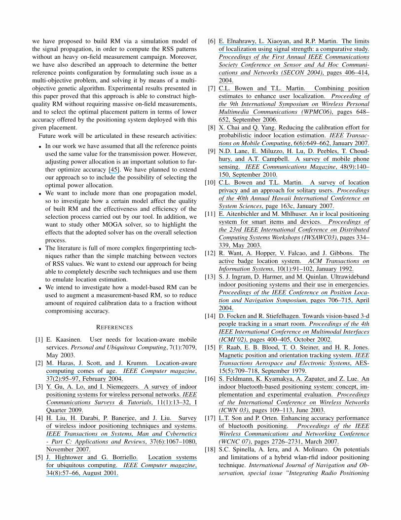
we have proposed to build RM via a simulation model ofthe signal propagation, in order to compute the RSS patternswithout an heavy on-field measurement campaign. Moreover,we have also described an approach to determine the betterreference points configuration by formulating such issue as amulti-objective problem, and solving it by means of a multi-objective genetic algorithm. Experimental results presented inthis paper proved that this approach is able to construct high-quality RM without requiring massive on-field measurements,and to select the optimal placement pattern in terms of loweraccuracy offered by the positioning system deployed with thisgiven placement.
Future work will be articulated in these research activities:
• In our work we have assumed that all the reference pointsused the same value for the transmission power. However,adjusting power allocation is an important solution to fur-ther optimize accuracy [45]. We have planned to extendour approach so to include the possibility of selecting theoptimal power allocation.
• We want to include more than one propagation model,so to investigate how a certain model affect the qualityof built RM and the effectiveness and efficiency of theselection process carried out by our tool. In addition, wewant to study other MOGA solver, so to highlight theeffects that the adopted solver has on the overall selectionprocess.
• The literature is full of more complex fingerprinting tech-niques rather than the simple matching between vectorsof RSS values. We want to extend our approach for beingable to completely describe such techniques and use themto emulate location estimation.
• We intend to investigate how a model-based RM can beused to augment a measurement-based RM, so to reduceamount of required calibration data to a fraction withoutcompromising accuracy.
REFERENCES
[1] E. Kaasinen. User needs for location-aware mobileservices. Personal and Ubiquitous Computing, 7(1):7079,May 2003.
[2] M. Hazas, J. Scott, and J. Krumm. Location-awarecomputing comes of age. IEEE Computer magazine,37(2):95–97, February 2004.
[3] Y. Gu, A. Lo, and I. Niemegeers. A survey of indoorpositioning systems for wireless personal networks. IEEECommunications Surveys & Tutorials, 11(1):13–32, IQuarter 2009.
[4] H. Liu, H. Darabi, P. Banerjee, and J. Liu. Surveyof wireless indoor positioning techniques and systems.IEEE Transactions on Systems, Man and Cybernetics- Part C: Applications and Reviews, 37(6):1067–1080,November 2007.
[5] J. Hightower and G. Borriello. Location systemsfor ubiquitous computing. IEEE Computer magazine,34(8):57–66, August 2001.
[6] E. Elnahrawy, L. Xiaoyan, and R.P. Martin. The limitsof localization using signal strength: a comparative study.Proceedings of the First Annual IEEE CommunicationsSociety Conference on Sensor and Ad Hoc Communi-cations and Networks (SECON 2004), pages 406–414,2004.
[7] C.L. Bowen and T.L. Martin. Combining positionestimates to enhance user localization. Proceeding ofthe 9th International Symposium on Wireless PersonalMultimedia Communications (WPMC06), pages 648–652, September 2006.
[8] X. Chai and Q. Yang. Reducing the calibration effort forprobabilistic indoor location estimation. IEEE Transac-tions on Mobile Computing, 6(6):649–662, January 2007.
[9] N.D. Lane, E. Miluzzo, H. Lu, D. Peebles, T. Choud-hury, and A.T. Campbell. A survey of mobile phonesensing. IEEE Communications Magazine, 48(9):140–150, September 2010.
[10] C.L. Bowen and T.L. Martin. A survey of locationprivacy and an approach for solitary users. Proceedingsof the 40th Annual Hawaii International Conference onSystem Sciences, page 163c, January 2007.
[11] E. Aitenbichler and M. Mhlhuser. An ir local positioningsystem for smart items and devices. Proceedings ofthe 23rd IEEE International Conference on DistributedComputing Systems Workshops (IWSAWC03), pages 334–339, May 2003.
[12] R. Want, A. Hopper, V. Falcao, and J. Gibbons. Theactive badge location system. ACM Transactions onInformation Systems, 10(1):91–102, January 1992.
[13] S. J. Ingram, D. Harmer, and M. Quinlan. Ultrawidebandindoor positioning systems and their use in emergencies.Proceedings of the IEEE Conference on Position Loca-tion and Navigation Symposium, pages 706–715, April2004.
[14] D. Focken and R. Stiefelhagen. Towards vision-based 3-dpeople tracking in a smart room. Proceedings of the 4thIEEE International Conference on Multimodal Interfaces(ICMI’02), pages 400–405, October 2002.
[15] F. Raab, E. B. Blood, T. O. Steiner, and H. R. Jones.Magnetic position and orientation tracking system. IEEETransactions Aerospace and Electronic Systems, AES-15(5):709–718, September 1979.
[16] S. Feldmann, K. Kyamakya, A. Zapater, and Z. Lue. Anindoor bluetooth-based positioning system: concept, im-plementation and experimental evaluation. Proceedingsof the International Conference on Wireless Networks(ICWN 03), pages 109–113, June 2003.
[17] L.T. Son and P. Orten. Enhancing accuracy performanceof bluetooth positioning. Proceedings of the IEEEWireless Communications and Networking Conference(WCNC 07), pages 2726–2731, March 2007.
[18] S.C. Spinella, A. Iera, and A. Molinaro. On potentialsand limitations of a hybrid wlan-rfid indoor positioningtechnique. International Journal of Navigation and Ob-servation, special issue ”Integrating Radio Positioning

and Communications: New Synergies”, 2010.[19] J. Bohn. ipos: A fault-tolerant and adaptive multi-sensor
positioning architecture with qos guarantees. SensorReview, 27(3):239–249, 2007.
[20] S. Aparicio, J. Perez, A. M. Bernardos, and J. R. Casar. Afusion method based on bluetooth and wlan technologiesfor indoor location. Proceedings of IEEE InternationalConference on Multisensor Fusion and Integration forIntelligent Systems, pages 487–491, August 2008.
[21] J. Hightower, B. Brumitt, and G. Borriello. The loca-tion stack: A layered model for location in ubiquitouscomputing. Proceedings of the 4th IEEE Workshopon Mobile Computing Systems & Applications (WMCSA2002), pages 22–28, June 2002.
[22] A. Bekkali, H. Sanson, and M. Matsumoto. Rfid indoorpositioning based on probabilistic rfid map and kalmanfiltering. Proceedings of the 3rd IEEE InternationalConference on Wireless and Mobile Computing, Net-working and Communications (WIMOB 2004), pages 21–26, October 2007.
[23] J. Krumm and J.C. Platt. Minimizing calibration effortsfor an indoor 802.11 device location measurement sys-tem. Technical Report, Microsoft Research, November2003.
[24] K. Sayrafian-Pour and D. Kaspar. A novel model-basedindoor positioning using signal strength. Proceedingsof the IEEE 18th International Symposium on Personal,Indoor and Mobile Radio Communications (PIMRC 07),pages 1–5, September 2007.
[25] S.Y. Seidel and T.S. Rappaport. A ray tracing techniqueto predict path loss and delay spread inside buildings.Proceedings of the IEEE Global TelecommunicationsConference (GLOBECOM 92), 2:649–653, December1992.
[26] T.K. Sarkar, Z. Ji, K. Kim ad A. Medour, and M. Salazar-Palma. A survey of various propagation models formobile communication. IEEE Antennas and PropagationMagazine, 45(3):51–82, June 2003.
[27] M. Vasquez and J.-K. Hao. A heuristic approach forantenna positioning in cellular networks. Journal ofHeuristics, 7(5):443–472, September 2001.
[28] K. Jaffres-Runsera, J.-M. Gorceb, and S. Ubedab. Mono-and multi-objective formulations for the indoor wirelesslan planning problem. Computers & Operations Re-search, 35(12):3885–3901, December 2008.
[29] M. Cardei and J. Wu. Energy-efficient coverage problemsin wireless ad-hoc sensor networks. Computer Commu-nications, 29(4):413–420, February 2006.
[30] M. Heidari and K. Pahfavan. Performance evaluation ofindoor geolocation systems using propsim hardware andray tracing software. Proceedings of the InternationalWorkshop on Wireless Ad-Hoc Networks, pages 351–355,May/June 2004.
[31] R. Casas, D. Cuartielles, A. Marco, H. J. Gracia, and J. L.Falco. Hidden issues in deploying an indoor locationsystem. IEEE Pervasive Computing, 6(2):62–69, April
2007.[32] P. Kumar Ray and A. Mahajan. A genetic algorithm-
based approach to calculate the optimal configuration ofultrasonic sensors in a 3d position estimation system.Robotics and Autonomous Systems, 41(4):165–177, De-cember 2002.
[33] D. Molkdar. Review on radio propagation into and withinbuildings. IEEE Proceedings of Microwaves, Antennasand Propagation, 138(1):61–73, 1991.
[34] H. Hashemi. The indoor radio propagation channel.Proceedings of the IEEE, 81(7):943–968, July 1993.
[35] W.K. Tam and V.N. Tran. Propagation modelling forindoor wireless communication. Electronics & Com-munication Engineering Journal, 7(5):221–228, October1995.
[36] P. Kumar Ray and A. Mahajan. Propagation predictionmodels for wireless communication systems. IEEETransactions on Microwave Theory and Techniques,50(3):662–673, March 2002.
[37] L. Ophir, Y. Bitran, and I. Sherman. Wi-fi (ieee 802.11)and bluetooth coexistence: issues and solutions. Pro-ceedings of the 15th IEEE International Symposium onPersonal, Indoor and Mobile Radio Communications(PIMRC 2004), pages 847–852, September 2004.
[38] R. Morrow. Wireless network coexistence. McGraw-Hill,2004.
[39] R. Aliberti, E. Di Giampaolo, and G. Marrocco. A modelto estimate the rfid read-region in real environments. Pro-ceedings of the 38th European Microwave Conference,pages 290–293, October 2008.
[40] R.T. Marler and J.S. Arora. Survey of multi-objective op-timization methods for engineering. Structural and Mul-tidisciplinary Optimization, 26(6):369–395, April 2004.
[41] M. Zitzler, M. Laumanns, and S. Bleuler. A tuto-rial on evolutionary multiobjective optimization. In X.Gandibleux et al., editors, Metaheuristics for Multiob-jective Optimisation, Lecture Notes in Economics andMathematical Systems - Springer, 535:3–37, 2004.
[42] T. Back, U. Hammel, and H.-P. Schwefel. Evolution-ary computation: Comments on the history and currentstate. IEEE Transactions on Evolutionary Computation,1(1):317, October 1997.
[43] C. M. Fonseca and P. J. Fleming. Genetic algorithmsfor multi-objective optimization: Formulation, discussionand generalization. Proceedings of the 5th InternationalConference on Genetic Algorithms, pages 416–423, July1999.
[44] K. Maksuriwong, V. Varavithya, and N. Chaiyaratana.Wireless lan access point placement using a multi-objective genetic algorithm. Proceedings of the IEEEInternational Conference on Systems, Man and Cyber-netics, 2:1944–1949, October 2003.
[45] K. Sayrafian-Pour and J. Perez. Robust indoor position-ing based on received signal strength. Proceedings of the2nd International Conference on Pervasive Computingand Applications (ICPCA 07), pages 693–698, July 2007.
Copyright © 2022 FDOKUMEN