DCHS Geography - Higher Course Notes - Drummond ...
49
DCHS Geography DCHS Geography Higher Course Notes 1
-
Upload
khangminh22 -
Category
Documents
-
view
1 -
download
0
Transcript of DCHS Geography - Higher Course Notes - Drummond ...

DCHS Geography
DCHS Geography
Higher Course Notes
1
DCHS Geography
HIGHER GEOGRAPHY REVISION
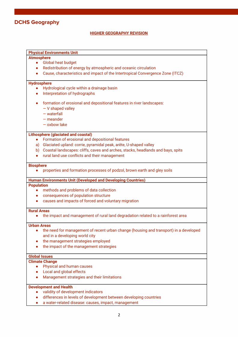
Physical Environments Unit Atmosphere
● Global heat budget ● Redistribution of energy by atmospheric and oceanic circulation ● Cause, characteristics and impact of the Intertropical Convergence Zone (ITCZ)
Hydrosphere ● Hydrological cycle within a drainage basin ● Interpretation of hydrographs
● formation of erosional and depositional features in river landscapes: — V shaped valley — waterfall — meander — oxbow lake
Lithosphere (glaciated and coastal) ● Formation of erosional and depositional features a) Glaciated upland: corrie, pyramidal peak, arête, U-shaped valley b) Coastal landscapes: cliffs, caves and arches, stacks, headlands and bays, spits ● rural land use conflicts and their management
Biosphere ● properties and formation processes of podzol, brown earth and gley soils
Human Environments Unit (Developed and Developing Countries) Population
● methods and problems of data collection ● consequences of population structure ● causes and impacts of forced and voluntary migration
Rural Areas ● the impact and management of rural land degradation related to a rainforest area
Urban Areas ● the need for management of recent urban change (housing and transport) in a developed
and in a developing world city ● the management strategies employed ● the impact of the management strategies
Global Issues Climate Change
● Physical and human causes ● Local and global effects ● Management strategies and their limitations
Development and Health ● validity of development indicators ● differences in levels of development between developing countries ● a water-related disease: causes, impact, management
2

DCHS Geography
● primary healthcare strategies
Global Issues Global Climate Change
● Physical and human causes ● Local and global effects ● Management strategies and their limitations
Development and Health ● validity of development indicators ● differences in levels of development between developing countries ● a water-related disease: causes, impact, management ● primary healthcare strategies
3

DCHS Geography
ATMOSPHERE
Global heat budget
1. The Distance through the atmosphere the energy has to travel:
The sun’s rays have less atmosphere to pass through at the tropics, so less energy is lose through absorption and reflection by clouds, gas and dust
2. The Oblique Angle of Insolation:
The sun’s angle in the sky decreases towards the poles due to the curvature of the Earth, which spreads the heat energy over a larger surface area. The sun’s rays are concentrated on tropical latitudes as the intensity of insolation is greatest where rays strike vertically
3. The Albedo Effect at the Poles
Albedo rates differ from the darker forest surfaces at the tropics absorbing radiation, in contrast to the ice and snow covered polar areas reflecting radiation.
4. Different Concentrations of Energy at the Surface with the Changing Seasons
Tilt of the axis results in the Sun being higher in the sky between the tropics throughout the year, focusing energy. No solar insolation at the winter solstices at the poles producing 24-hour darkness, whereas the tropics receive insolation throughout the year.
4
DCHS Geography Redistribution of energy by atmospheric and oceanic circulation
5

DCHS Geography
6

DCHS Geography Cause, characteristics and impact of the ITCZ
7
DCHS Geography
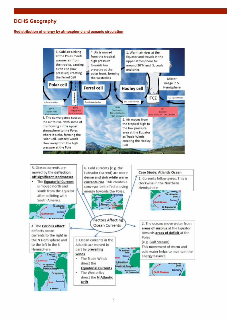
HYDROSPHERE
Hydrological cycle within a drainage basin
8

DCHS Geography Interpretation of hydrographs
1. There is a slight increase (steady) n discharge (until 09.00 hours) in response to the rain (which started to fall at 07.00 hours). At first, this rain would have been intercepted by vegetation and infiltrated the soil.
2. There is a steep rising limb up to a peak discharge (100 cumecs at 18.00 hours). This water would have filled
up storages in the soil due to throughflow and groundwater. As the soil became saturated, surface run-off increased causing a peak. The rising limb becomes less steep (between 13.00 and 15.00 hours) which was caused by a marked reduction in rain (to 4mm at 10.00 hours)
3. There is a short lag time (5 hours) which could be due to steep slopes or impremable rock. A high number of
tributaries may lead to the short lag time as water is transported more rapidly by surface run-off
4. The river discharge quickly decreases, shown by a steep falling limb because of no more rainfall (after 15.00 hours).
V shaped valley: Rivers begin high up in the mountains so they flow quickly downhill eroding the landscape vertically.
● The river cuts a deep notch down into the landscape using hydraulic action, corrasion and corrosion. ● As the river erodes downwards the sides of the valley are exposed to freeze-thaw weathering which
loosens the rocks (some of which will fall into the river) and steepens the valley sides. ● The rocks which have fallen into the river help the process of corrasion and this leads to further erosion. ● The river transports the rocks downstream and the channel becomes wider and deeper creating a V-shaped
valley between interlocking spurs.
9
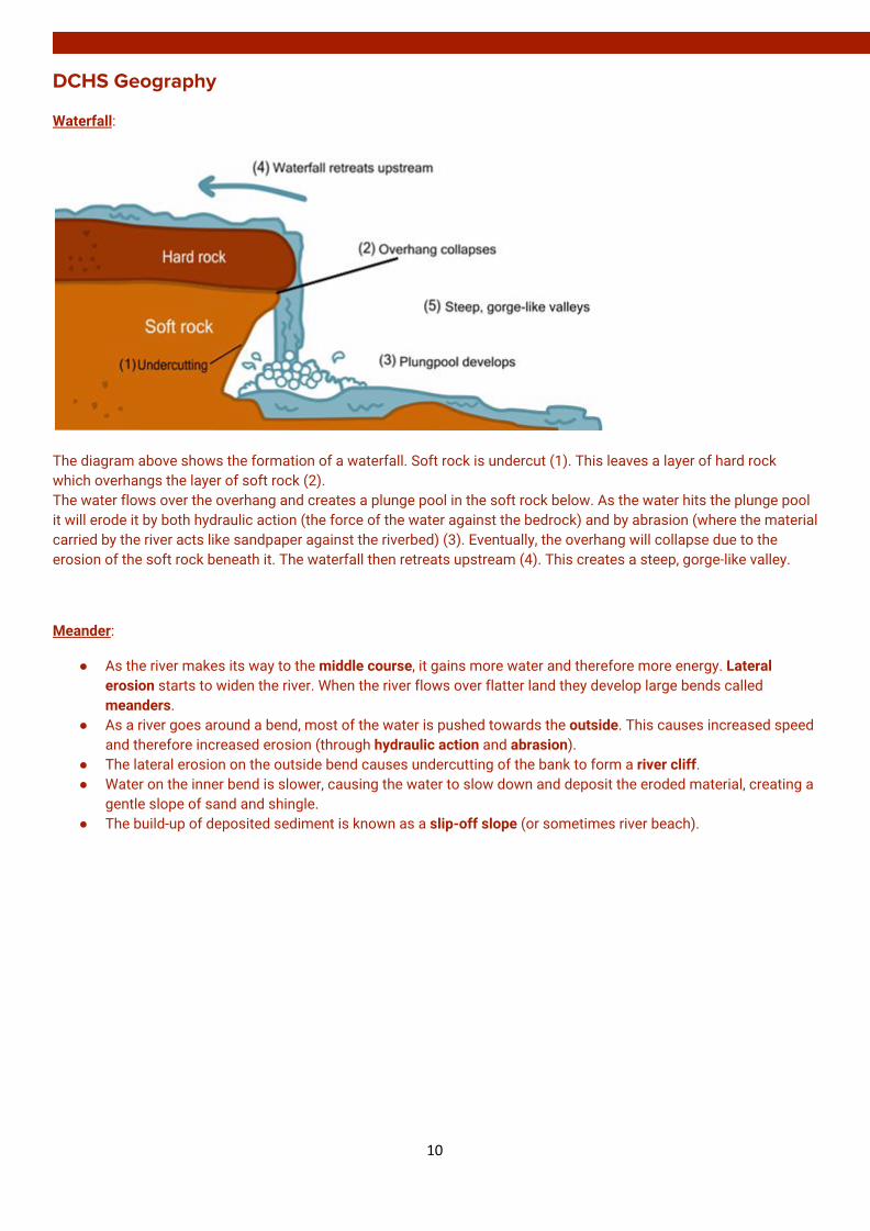
DCHS Geography Waterfall:
The diagram above shows the formation of a waterfall. Soft rock is undercut (1). This leaves a layer of hard rock which overhangs the layer of soft rock (2). The water flows over the overhang and creates a plunge pool in the soft rock below. As the water hits the plunge pool it will erode it by both hydraulic action (the force of the water against the bedrock) and by abrasion (where the material carried by the river acts like sandpaper against the riverbed) (3). Eventually, the overhang will collapse due to the erosion of the soft rock beneath it. The waterfall then retreats upstream (4). This creates a steep, gorge-like valley.
Meander:
● As the river makes its way to the middle course, it gains more water and therefore more energy. Lateral erosion starts to widen the river. When the river flows over flatter land they develop large bends called meanders.
● As a river goes around a bend, most of the water is pushed towards the outside. This causes increased speed and therefore increased erosion (through hydraulic action and abrasion).
● The lateral erosion on the outside bend causes undercutting of the bank to form a river cliff. ● Water on the inner bend is slower, causing the water to slow down and deposit the eroded material, creating a
gentle slope of sand and shingle. ● The build-up of deposited sediment is known as a slip-off slope (or sometimes river beach).
10

DCHS Geography Oxbow lake:
Due to erosion on the outside of a bend and deposition on the inside, the shape of a meander will change over a period of time. Erosion narrows the neck of the land within the meander and as the process continues, the meanders move closer together. When there is a very high discharge (usually during a flood), the river cuts across the neck, taking a new, straighter and shorter route. Deposition will occur to cut off the original meander, leaving a horseshoe-shaped oxbow lake.
Human activities affecting the hydrological cycle:
For deforestation Maharashtra, India: The cutting down of trees increases run-off and the potential for soil erosion.(1 mark) Decreases in evapo-transpiration and therefore cloud formation impacts on local rainfall patterns. (1 mark) Changes to vegetation cover can lead to more extreme river flows as water is not intercepted and stored by the trees. (1 mark) For irrigation Bengkulu, Indonesia: Taking water from a river or ground water storage can reduce river flow.(1 mark) Lowering water tables and increasing evaporation/evapo-transpiration by placing water in surface stores, eg ditches/canals. (1 mark) Increased farming opportunities provided by irrigating crops removes water from the hydrological cycle as the crops grow. (1 mark) For urbanisation Hurricane Harvey, Houston, USA: The removal of natural vegetation and replacement with impermeable concrete/hard surfaces and drains (1 mark) can speed up overland flow and can lead to higher river levels. (1 mark) As more urban land is concreted over the rate of evaporation from these surfaces increases as the rate of percolation through the land surface decreases. (1 mark). It also decreases the amount of water which returns to groundwater storage, possibly reducing the water table. (1 mark) For mining Kadoma, Zimbabwe: The silting up of lakes, rivers and reservoirs leads to reduced storage capacity in these areas. (1 mark) Mining may also lead to reduced vegetation cover leading to increased run-off (1 mark), higher evaporation and cloud formation altering the rainfall pattern. (1 mark)
11
DCHS Geography
LITHOSPHERE
Formation of erosion and depositional features
Stack:
Sand Bar:
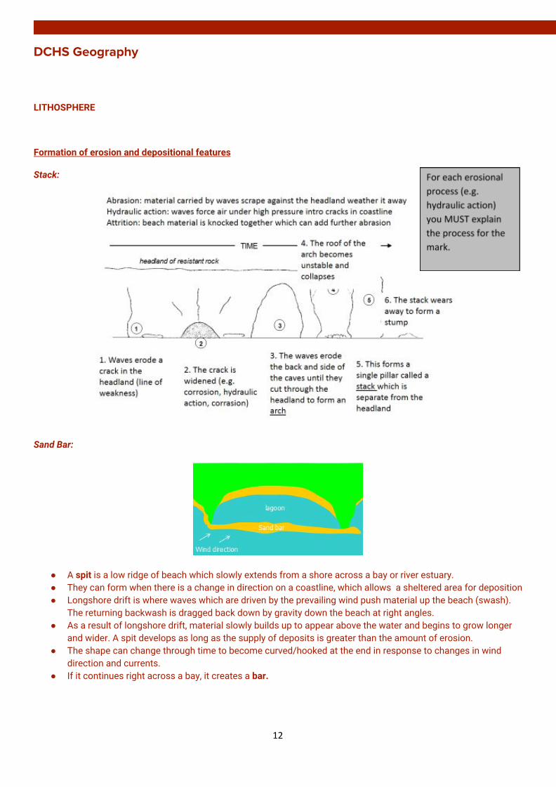
● A spit is a low ridge of beach which slowly extends from a shore across a bay or river estuary. ● They can form when there is a change in direction on a coastline, which allows a sheltered area for deposition ● Longshore drift is where waves which are driven by the prevailing wind push material up the beach (swash).
The returning backwash is dragged back down by gravity down the beach at right angles. ● As a result of longshore drift, material slowly builds up to appear above the water and begins to grow longer
and wider. A spit develops as long as the supply of deposits is greater than the amount of erosion. ● The shape can change through time to become curved/hooked at the end in response to changes in wind
direction and currents. ● If it continues right across a bay, it creates a bar.
12
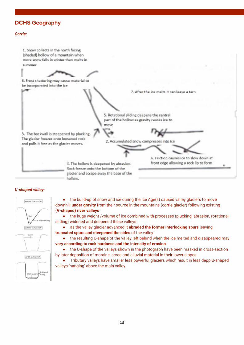
DCHS Geography Corrie:
U-shaped valley:
● the build-up of snow and ice during the Ice Age(s) caused valley glaciers to move downhill under gravity from their source in the mountains (corrie glacier) following existing (V-shaped) river valleys
● the huge weight /volume of ice combined with processes (plucking, abrasion, rotational sliding) widened and deepened these valleys
● as the valley glacier advanced it abraded the former interlocking spurs leaving truncated spurs and steepened the sides of the valley
● the resulting U-shape of the valley left behind when the ice melted and disappeared may vary according to rock hardness and the intensity of erosion
● the U-shape of the valleys shown in the photograph have been masked in cross-section by later deposition of moraine, scree and alluvial material in their lower slopes.
● Tributary valleys have smaller less powerful glaciers which result in less depp U-shaped valleys ‘hanging’ above the main valley
13
DCHS Geography Drumlin • Drumlins are elongated hills made up of unsorted glacial deposits/till/boulder clay
• Drumlins are formed as the glacier becomes overloaded with sediment and deposits it, streamlining the sediment as it flows over it
• The steep ‘stoss’ slope faces up-valley and the more gently-sloping ‘lee’ slope faces down-valley
• If there is a small obstacle on the ground, this may act as a trigger point and till/boulder clay can build up around it
• Drumlins may be reshaped by further ice movements after being originally deposited. Drumlins are found in swarms or in a ‘basket or eggs’ topography.
Esker • Eskers are meandering ridges formed by meltwater streams in or underneath a glacier. • They are therefore made up of meltwater sands and gravels. These are sorted by size with
large stones at the base because larger stones are dropped first by flowing water • The stones also tend to be more rounded than glacial deposits, because of the action of
flowing water rounding the edges by erosion • As the glacier melts, sub-glacial streams flow through tunnels and the load is deposited on
the channel bed
14

DCHS Geography Rural land use conflicts and their management related to glaciated and coastal landscapes
Glaciation: Case Study Cairngorms
Conflicts Management Tourists v Locals
● Roads become congested, especially when skiing conditions are good in winter (e.g. Aviemore, Glenshee ski resort)
● Narrow roads in small urban areas are not built to withstand the volume of cars and parking is a problem
● More traffic increases noise and air pollution
● Visual pollution is caused by the cable cars, ski tows and the funicular railway
● Second ‘holiday’ home ownership (e.g. Ballater) causes local first time buyers problems and they may have to move away as houses are unaffordable. Services may close as second home owners are not permanent residents so less money is spent in the area
● Rail and bus services have been improved.
● One way streets, bypasses and complete closures of popular areas at peak times (e.g. Aviemore Centre ring road)
● Car parks have been built to reduce the number of cars on narrow roads. Parking permits have been issued to locals.
● The government offers help to first time buyers through Affordable Home Ownership Schemes to enable them to buy a property in their local area
Recreation (e.g. walkers) v Locals ● Walkers (e.g. Glenmore Forest Park)
can cause footpath erosion and leave litter which causes visual pollution in popular walking areas
● Fragile wildlife habitats are also destroyed by walkers and wildlife is disturbed in forests and moorland
● In summer, wild camping and fires creates litter and increases the risk of accidents
● Rangers can build and repaid stone paths to reduce footpath erosion. Subsoiling creates a hard wearing surface which requires less maintenance.
● Maps, signposts and designated paths help to keep walkers off fragile vegetation and direct them along specific routes (e.g. Ballater)
● More bins have been set up in car parks and in areas most frequently visited by tourists.
15
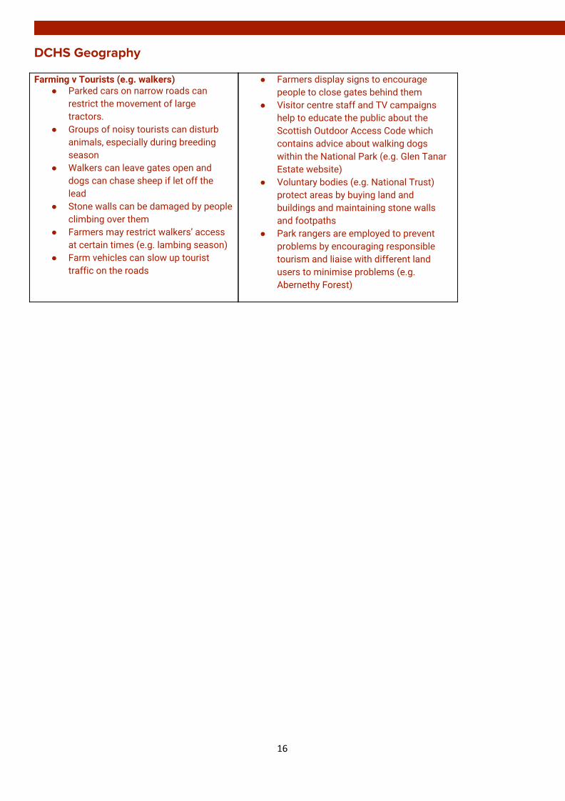
DCHS Geography Farming v Tourists (e.g. walkers)
● Parked cars on narrow roads can restrict the movement of large tractors.
● Groups of noisy tourists can disturb animals, especially during breeding season
● Walkers can leave gates open and dogs can chase sheep if let off the lead
● Stone walls can be damaged by people climbing over them
● Farmers may restrict walkers’ access at certain times (e.g. lambing season)
● Farm vehicles can slow up tourist traffic on the roads
● Farmers display signs to encourage people to close gates behind them
● Visitor centre staff and TV campaigns help to educate the public about the Scottish Outdoor Access Code which contains advice about walking dogs within the National Park (e.g. Glen Tanar Estate website)
● Voluntary bodies (e.g. National Trust) protect areas by buying land and buildings and maintaining stone walls and footpaths
● Park rangers are employed to prevent problems by encouraging responsible tourism and liaise with different land users to minimise problems (e.g. Abernethy Forest)
16

DCHS Geography Coasts: Case Study Dorset
Conflicts Management Tourists v Locals
● The high number of tourists arriving by car means that traffic congestion is a huge problem. Small coastal roads become easily congested.
● Many tourists increase congestion in ‘honeypot’ areas (e.g. Corfe Castle). The higher volume of traffic increases noise and air pollution
● Car parks are Studland and Lulworth Cove have limited access so there is a concentration of cars in this area. Tourists don’t always consider where they are parking and often restrict access for locals
● Second home ownership increases as more people buy second ‘holiday’ homes. This causes local first time buyers problems getting on the property ladder and they may have to move away as houses are unaffordable.
● Tourist facilities spoil the natural beauty of the coast. Tourists often leave litter on the beaches (e.g. Chesil Beach)
● Around Studland 4 main car parks have been expanded and accommodate 820 cars. However, some visitors continue to park on and damage verges.
● Train lines, buses, cycle routes and boat trips offer alternative forms of transport (e.g. from Swanage to Corfe). This decreases the number of drivers on roads.
● Bins are put along the paths and beaches. Some tourists still leave litter. Local authorities fine people and voluntary litter picks.
● The government offers help to first time buyers to enable them to buy a property in their local area (e.g. Affordable Homes Ownership Schemes).
17
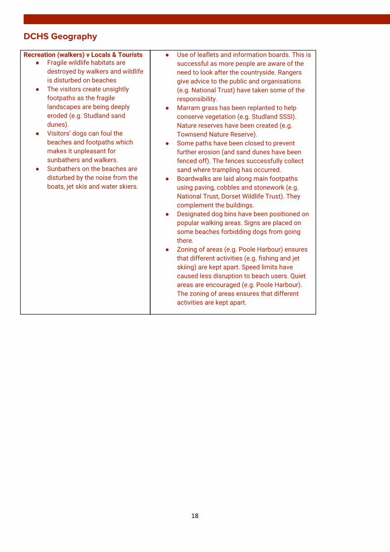
DCHS Geography Recreation (walkers) v Locals & Tourists
● Fragile wildlife habitats are destroyed by walkers and wildlife is disturbed on beaches
● The visitors create unsightly footpaths as the fragile landscapes are being deeply eroded (e.g. Studland sand dunes).
● Visitors’ dogs can foul the beaches and footpaths which makes it unpleasant for sunbathers and walkers.
● Sunbathers on the beaches are disturbed by the noise from the boats, jet skis and water skiers.
● Use of leaflets and information boards. This is successful as more people are aware of the need to look after the countryside. Rangers give advice to the public and organisations (e.g. National Trust) have taken some of the responsibility.
● Marram grass has been replanted to help conserve vegetation (e.g. Studland SSSI). Nature reserves have been created (e.g. Townsend Nature Reserve).
● Some paths have been closed to prevent further erosion (and sand dunes have been fenced off). The fences successfully collect sand where trampling has occurred.
● Boardwalks are laid along main footpaths using paving, cobbles and stonework (e.g. National Trust, Dorset Wildlife Trust). They complement the buildings.
● Designated dog bins have been positioned on popular walking areas. Signs are placed on some beaches forbidding dogs from going there.
● Zoning of areas (e.g. Poole Harbour) ensures that different activities (e.g. fishing and jet skiing) are kept apart. Speed limits have caused less disruption to beach users. Quiet areas are encouraged (e.g. Poole Harbour). The zoning of areas ensures that different activities are kept apart.
18

DCHS Geography
BIOSPHERE
Properties and formation processed of podzol, brown earth and gley soils
1. PODZOL They are found under northern coniferous forests or under heather moorland. They tend to be found at high ground with reduced temperatures. They show very distinct horizons due to leaching and lack of mixing because of few earth worms being able to survive the acidic soil and the cold climate restricts mixing. Ao/A horizon: is not rich in nutrients, as there is a relatively slow decomposition of plant litter (e.g. pine needles) in a cold climate. This produces thin dark acidic mor humus due to lack of the activity of soil organisms (e.g. earthworms). The soil is pale ash-grey in colour with a sandy texture. Leaching is caused as precipitation exceeds evaporation and water washes down through the soil taking iron & aluminium oxides (eluviation) and leaves silicates. There is increased water during the spring snow melt. B horizon: The soil is reddish/brown in colour and has a denser texture. An iron pan is created due to deposition of iron oxides from leaching (illuviation). Results in waterlogging above and roots being unable to penetrate. C horizon: Parent material could be acidic rock or glacial sands or tills
19
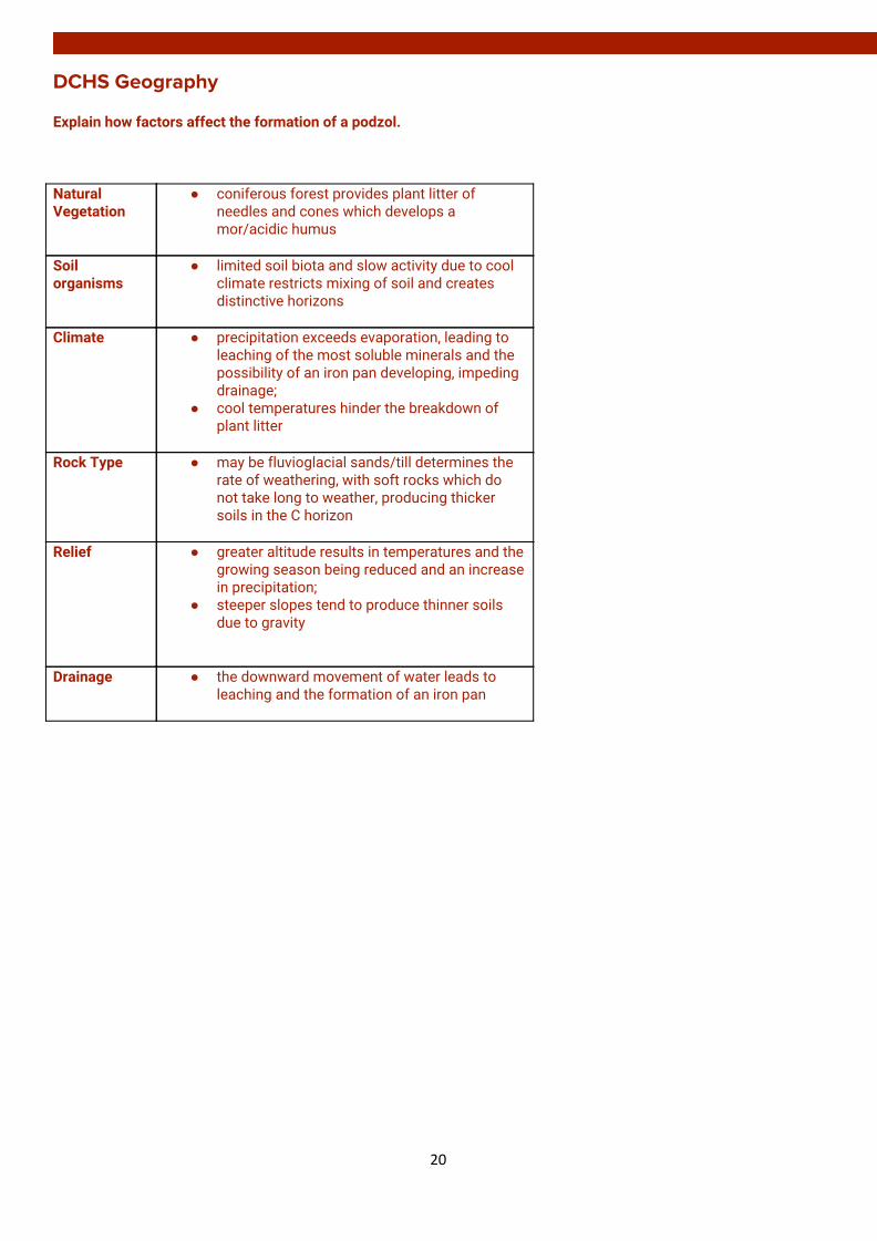
DCHS Geography Explain how factors affect the formation of a podzol.
Natural Vegetation
● coniferous forest provides plant litter of needles and cones which develops a mor/acidic humus
Soil organisms
● limited soil biota and slow activity due to cool climate restricts mixing of soil and creates distinctive horizons
Climate ● precipitation exceeds evaporation, leading to
leaching of the most soluble minerals and the possibility of an iron pan developing, impeding drainage;
● cool temperatures hinder the breakdown of plant litter
Rock Type ● may be fluvioglacial sands/till determines the
rate of weathering, with soft rocks which do not take long to weather, producing thicker soils in the C horizon
Relief ● greater altitude results in temperatures and the
growing season being reduced and an increase in precipitation;
● steeper slopes tend to produce thinner soils due to gravity
Drainage ● the downward movement of water leads to leaching and the formation of an iron pan
20
DCHS Geography
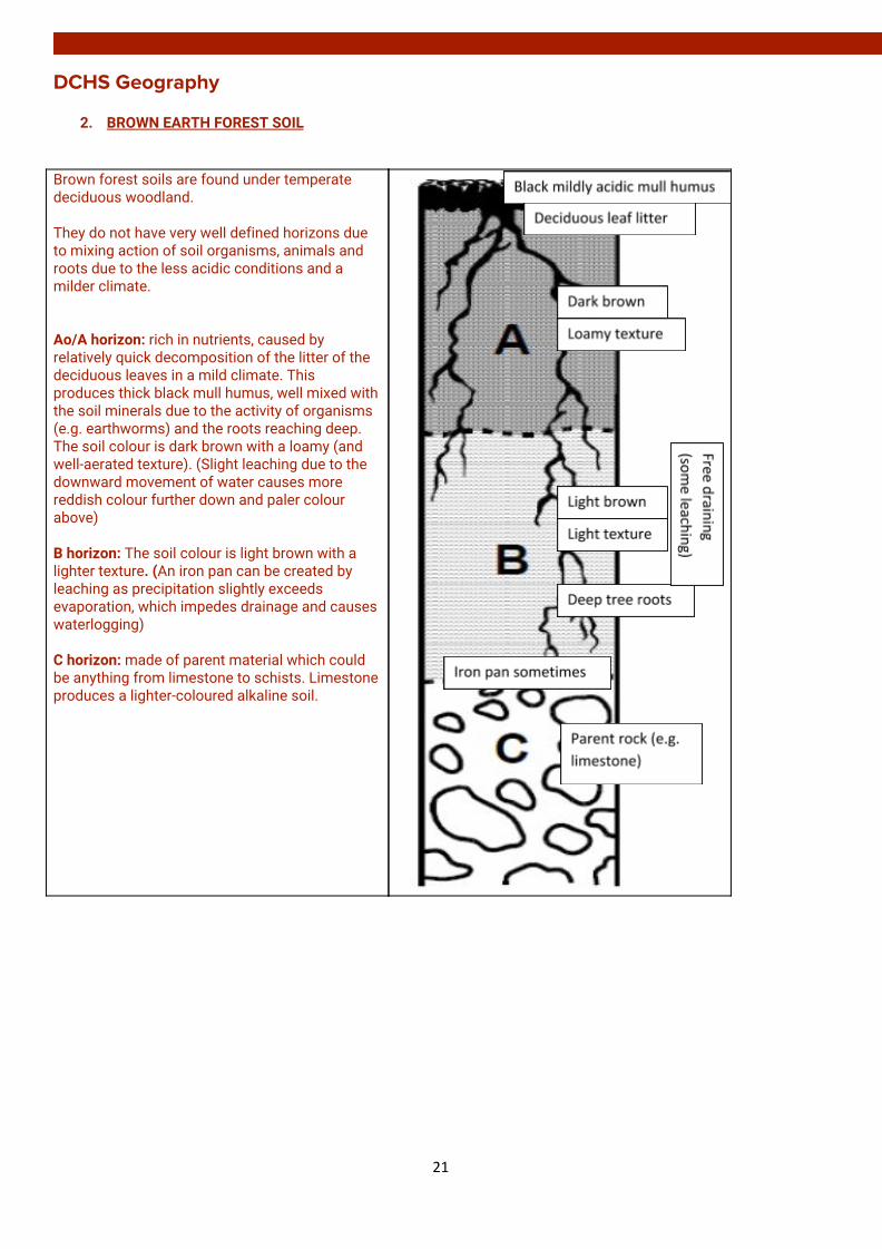
2. BROWN EARTH FOREST SOIL
Brown forest soils are found under temperate deciduous woodland. They do not have very well defined horizons due to mixing action of soil organisms, animals and roots due to the less acidic conditions and a milder climate. Ao/A horizon: rich in nutrients, caused by relatively quick decomposition of the litter of the deciduous leaves in a mild climate. This produces thick black mull humus, well mixed with the soil minerals due to the activity of organisms (e.g. earthworms) and the roots reaching deep. The soil colour is dark brown with a loamy (and well-aerated texture). (Slight leaching due to the downward movement of water causes more reddish colour further down and paler colour above) B horizon: The soil colour is light brown with a lighter texture. (An iron pan can be created by leaching as precipitation slightly exceeds evaporation, which impedes drainage and causes waterlogging) C horizon: made of parent material which could be anything from limestone to schists. Limestone produces a lighter-coloured alkaline soil.
21

DCHS Geography Natural Vegetation
● deciduous forest provides deep leaf litter which is broken down rapidly in mild/warm climate;
● trees have roots which penetrate deep into the soil, ensuring the recycling of minerals back to the vegetation
Soil organisms
● soil biota break down leaf litter producing mildly acidic mull humus. They also ensure the mixing of the soil, aerating it and preventing the formation of distinct layers within the soil
Climate ● precipitation slightly exceeds evaporation,
giving downward leaching of the most soluble minerals and the possibility of an iron pan developing, impeding drainage.
Rock Type ● determines the rate of weathering, with hard
rocks (schists) taking longer to weather, producing thinner soils. Softer rocks (e.g. shale) weather more quickly
Relief ● greater altitude results in temperatures and the
growing season being reduced and an increase in precipitation;
● steeper slopes tend to produce thinner soils due to gravity
Drainage ● well drained with throughflow and little
accumulation of excess water collecting, producing limited leaching
Explain how factors affect the formation of a podzol.
22
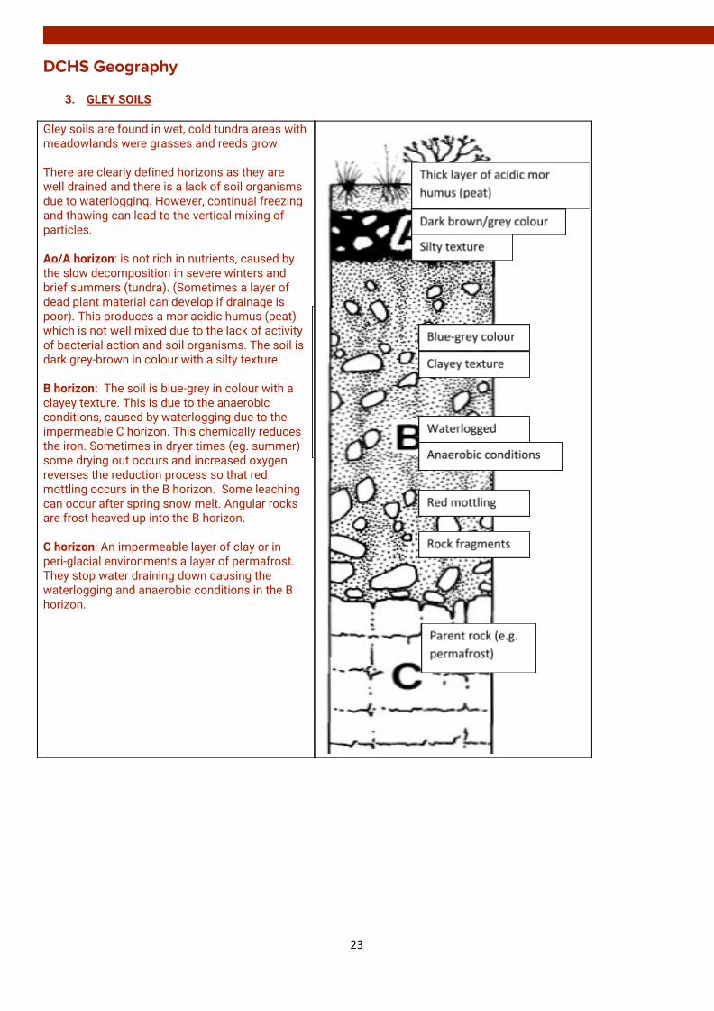
DCHS Geography
3. GLEY SOILS Gley soils are found in wet, cold tundra areas with meadowlands were grasses and reeds grow. There are clearly defined horizons as they are well drained and there is a lack of soil organisms due to waterlogging. However, continual freezing and thawing can lead to the vertical mixing of particles. Ao/A horizon: is not rich in nutrients, caused by the slow decomposition in severe winters and brief summers (tundra). (Sometimes a layer of dead plant material can develop if drainage is poor). This produces a mor acidic humus (peat) which is not well mixed due to the lack of activity of bacterial action and soil organisms. The soil is dark grey-brown in colour with a silty texture. B horizon: The soil is blue-grey in colour with a clayey texture. This is due to the anaerobic conditions, caused by waterlogging due to the impermeable C horizon. This chemically reduces the iron. Sometimes in dryer times (eg. summer) some drying out occurs and increased oxygen reverses the reduction process so that red mottling occurs in the B horizon. Some leaching can occur after spring snow melt. Angular rocks are frost heaved up into the B horizon. C horizon: An impermeable layer of clay or in peri-glacial environments a layer of permafrost. They stop water draining down causing the waterlogging and anaerobic conditions in the B horizon.
23
DCHS Geography Natural Vegetation
● Plant roots do not penetrate deeply resulting in limited recycling of minerals back to the vegetation
● cold tundra areas with grasses and reeds and thick layer of mor/acidic humus (peat);
● decay is so slow that a thick layer of dead plant material develops
Soil organisms
● Anaerobic conditions means few organisms living in the soil to burrow and tunnel through the soil
● limited soil biota and slow activity due to cool climate restricts mixing of soil and creates distinctive horizons
Climate ● Low temperatures lead to a slow rate of decomposition of organic matter creating a thin humus
● severe winters and brief summers causes very slow bacterial action;
● freezing and thawing can lead to vertical mixing of layers;
● in summer some drying occurs and reverses the reduction of oxygen so red mottling occurs
Rock Type ● Impermeable clay impedes drainage and causes waterlogging. Found on flat surfaces (e.g. plateau moorland or foot of slops means water cannot drain away)
Relief ● greater altitude results in temperatures and the growing season being reduced and an increase in precipitation;
● steeper slopes tend to produce thinner soils due to gravity
Drainage ● waterlogging means water takes the place of air in soil pores and gives anaerobic conditions, chemically reducing the iron; some leaching after snow melt
Explain how factors affect the formation of a podzol.
• Soil has a blue grey colour due to anaerobic conditions • The iron compounds are changed from the red brown to blue due to oxygen being extracted by
microorganisms • Red mottling in small air pockets due to re-oxygenation of the iron in the soil due to burrowing
animals/soil drying out in summer
24

DCHS Geography POPULATION
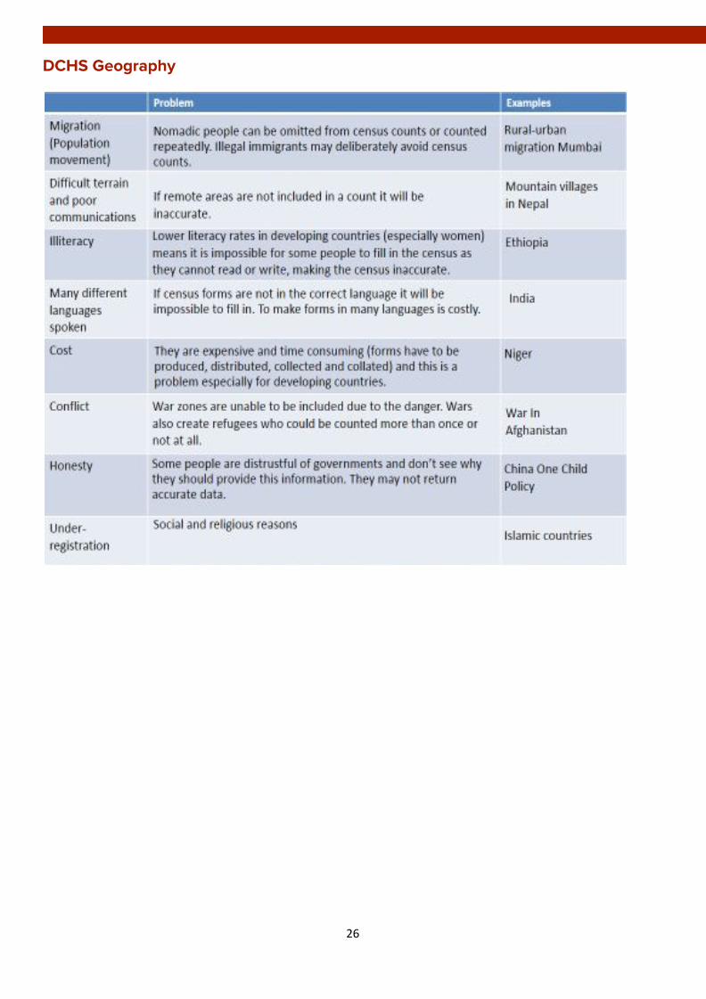
Methods and problems of data collection
CENSUS This is a type of questionnaire that every household is required by law to complete. In Scotland a census is carried out every 10 years (the last one took place in 2011). Each householder is asked about the number of people living in their home, their age, gender, employment, home and languages spoken. An enumerator collects them and checks that all individuals are recorded. Government agencies process the data and make it available for interested parties. Census statistics show population characteristics (and how they change over time) and indicate how we live. They provide a detailed ‘snapshot’ of the population and help government bodies decide how best to spend the country’s money. VITAL REGISTRATIONS In many countries people are also required to register important events in their lives. Vital registrations in the UK include a record of births, deaths, marriages, divorces and adoptions. The registrations of important life events results in the production of legal documents (e.g. a baby must be registered within 21 days in Scotland). The baby is issued with a birth certificate. These are recorded officially so that the government has a continually updated picture of the changing make-up of the population. This allows the government to change allocated funds to different areas. SAMPLING Population surveys are conducted to gather social and economic data, and can be conducted at regional, national and international levels. (E.g. in China National Population Sample Surveys have been conducted annually, with 1% of its population being asked to complete the form) ELECTORAL ROLL Data from electoral roll and NHS records allows population data to be updated in between census collection.
25
DCHS Geography
26
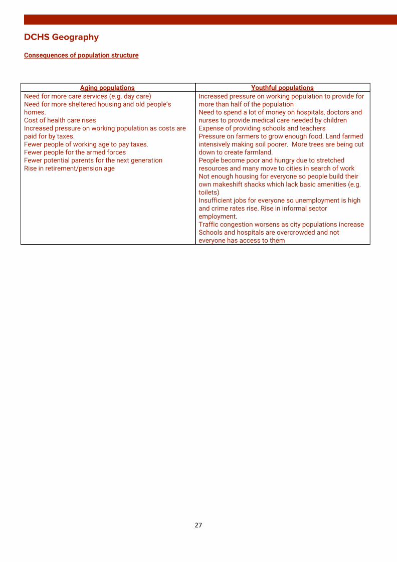
DCHS Geography Consequences of population structure
Aging populations Youthful populations Need for more care services (e.g. day care) Need for more sheltered housing and old people’s homes. Cost of health care rises Increased pressure on working population as costs are paid for by taxes. Fewer people of working age to pay taxes. Fewer people for the armed forces Fewer potential parents for the next generation Rise in retirement/pension age
Increased pressure on working population to provide for more than half of the population Need to spend a lot of money on hospitals, doctors and nurses to provide medical care needed by children Expense of providing schools and teachers Pressure on farmers to grow enough food. Land farmed intensively making soil poorer. More trees are being cut down to create farmland. People become poor and hungry due to stretched resources and many move to cities in search of work Not enough housing for everyone so people build their own makeshift shacks which lack basic amenities (e.g. toilets) Insufficient jobs for everyone so unemployment is high and crime rates rise. Rise in informal sector employment. Traffic congestion worsens as city populations increase Schools and hospitals are overcrowded and not everyone has access to them
27
DCHS Geography
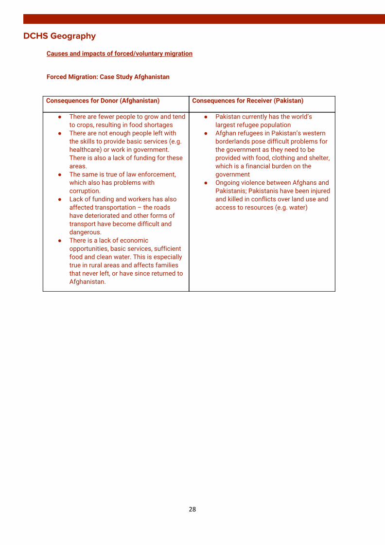
Causes and impacts of forced/voluntary migration
Forced Migration: Case Study Afghanistan
Consequences for Donor (Afghanistan)
Consequences for Receiver (Pakistan)
● There are fewer people to grow and tend to crops, resulting in food shortages
● There are not enough people left with the skills to provide basic services (e.g. healthcare) or work in government. There is also a lack of funding for these areas.
● The same is true of law enforcement, which also has problems with corruption.
● Lack of funding and workers has also affected transportation – the roads have deteriorated and other forms of transport have become difficult and dangerous.
● There is a lack of economic opportunities, basic services, sufficient food and clean water. This is especially true in rural areas and affects families that never left, or have since returned to Afghanistan.
● Pakistan currently has the world’s largest refugee population
● Afghan refugees in Pakistan’s western borderlands pose difficult problems for the government as they need to be provided with food, clothing and shelter, which is a financial burden on the government
● Ongoing violence between Afghans and Pakistanis; Pakistanis have been injured and killed in conflicts over land use and access to resources (e.g. water)
28
DCHS Geography
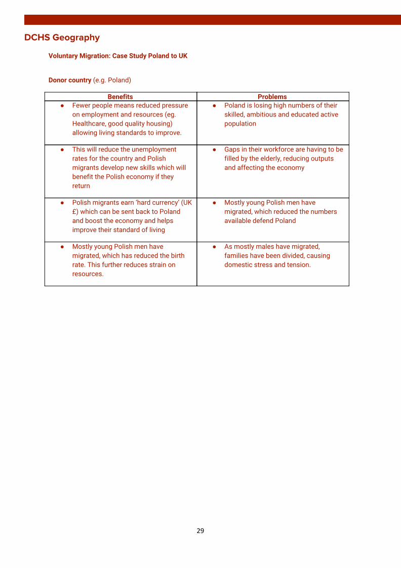
Voluntary Migration: Case Study Poland to UK
Donor country (e.g. Poland)
Benefits Problems ● Fewer people means reduced pressure
on employment and resources (eg. Healthcare, good quality housing) allowing living standards to improve.
● Poland is losing high numbers of their skilled, ambitious and educated active population
● This will reduce the unemployment rates for the country and Polish migrants develop new skills which will benefit the Polish economy if they return
● Gaps in their workforce are having to be filled by the elderly, reducing outputs and affecting the economy
● Polish migrants earn ‘hard currency’ (UK £) which can be sent back to Poland and boost the economy and helps improve their standard of living
● Mostly young Polish men have migrated, which reduced the numbers available defend Poland
● Mostly young Polish men have migrated, which has reduced the birth rate. This further reduces strain on resources.
● As mostly males have migrated, families have been divided, causing domestic stress and tension.
29
DCHS Geography
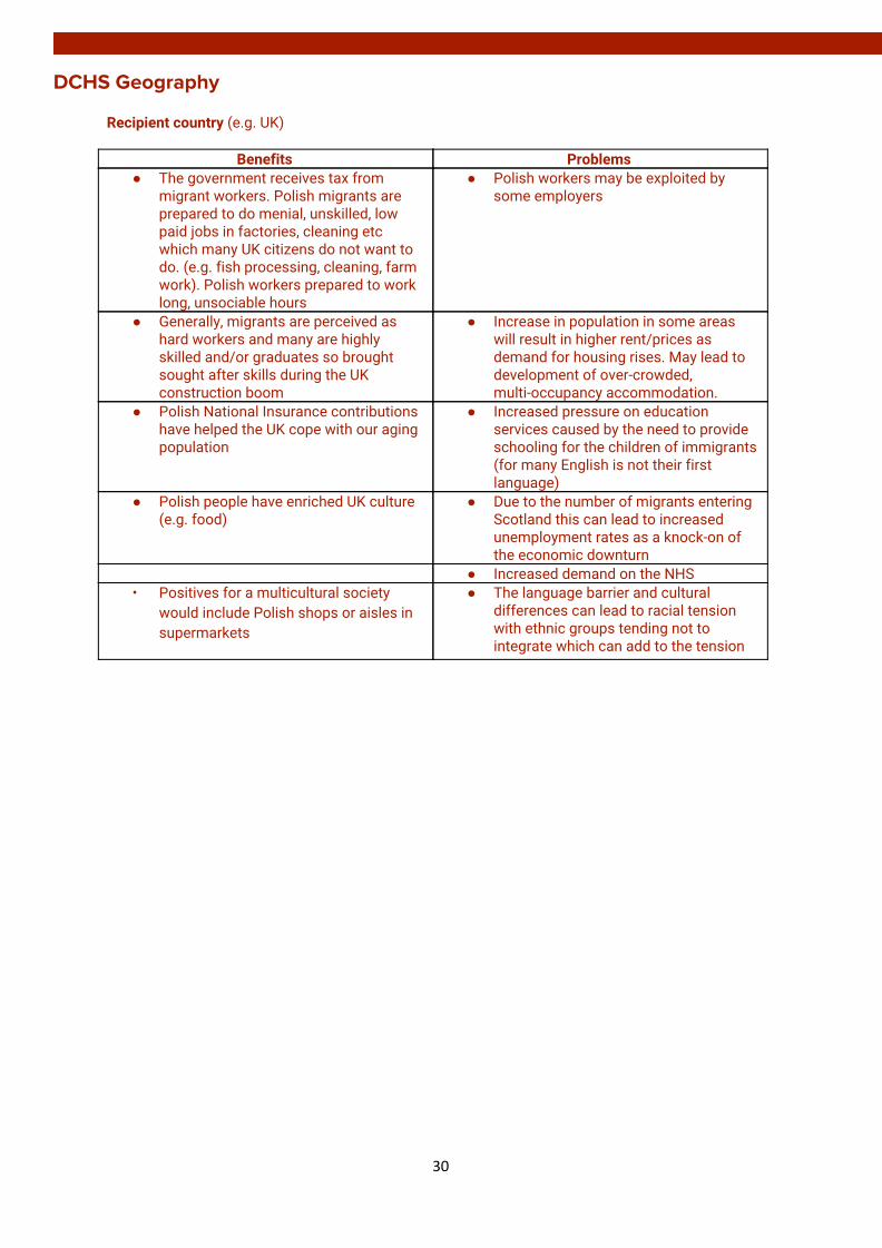
Recipient country (e.g. UK)
Benefits Problems ● The government receives tax from
migrant workers. Polish migrants are prepared to do menial, unskilled, low paid jobs in factories, cleaning etc which many UK citizens do not want to do. (e.g. fish processing, cleaning, farm work). Polish workers prepared to work long, unsociable hours
● Polish workers may be exploited by some employers
● Generally, migrants are perceived as hard workers and many are highly skilled and/or graduates so brought sought after skills during the UK construction boom
● Increase in population in some areas will result in higher rent/prices as demand for housing rises. May lead to development of over-crowded, multi-occupancy accommodation.
● Polish National Insurance contributions have helped the UK cope with our aging population
● Increased pressure on education services caused by the need to provide schooling for the children of immigrants (for many English is not their first language)
● Polish people have enriched UK culture (e.g. food)
● Due to the number of migrants entering Scotland this can lead to increased unemployment rates as a knock-on of the economic downturn
● Increased demand on the NHS • Positives for a multicultural society
would include Polish shops or aisles in supermarkets
● The language barrier and cultural differences can lead to racial tension with ethnic groups tending not to integrate which can add to the tension
30

DCHS Geography
RURAL
The impact and management or rural land degradation related to a rainforest area
31
DCHS Geography
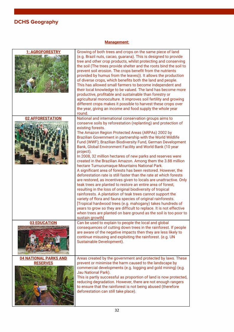
Management:
1: AGROFORESTRY
Growing of both trees and crops on the same piece of land (e.g. Brazil nuts, cacao, guarana). This is designed to provide tree and other crop products, whilst protecting and conserving the soil (The trees provide shelter and the roots bind the soil to prevent soil erosion. The crops benefit from the nutrients provided by humus from the leaves)). It allows the production of diverse crops, which benefits both the land and people. This has allowed small farmers to become independent and their local knowledge to be valued. The land has become more productive, profitable and sustainable than forestry or agricultural monoculture. It improves soil fertility and growing different crops makes it possible to harvest these crops over the year, giving an income and food supply the whole year round.
02 AFFORESTATION
National and international conservation groups aims to conserve soils by reforestation (replanting) and protection of existing forests. The Amazon Region Protected Areas (ARPAs) 2002 by Brazilian Government in partnership with the World Wildlife Fund (WWF); Brazilian Biodiversity Fund, German Development Bank, Global Environment Facility and World Bank (10 year project). In 2008, 32 million hectares of new parks and reserves were created in the Brazilian Amazon. Among them the 3.88 million hectare Tumucumaque Mountains National Park. A significant area of forests has been restored. However, the deforestation rate is still faster than the rate at which forests are restored, as incentives given to locals are unattractive. Only teak trees are planted to restore an entire area of forest, resulting in the loss of original biodiversity of tropical rainforests. A plantation of teak trees cannot support the variety of flora and fauna species of original rainforests. [Tropical hardwood trees (e.g. mahogany) takes hundreds of years to grow so they are difficult to replace. It is not effective when trees are planted on bare ground as the soil is too poor to sustain growth]
03 EDUCATION
Can be used to explain to people the local and global consequences of cutting down trees in the rainforest. If people are aware of the negative impacts then they are less likely to continue misusing and exploiting the rainforest. (e.g. UN Sustainable Development).
04 NATIONAL PARKS AND RESERVES
Areas created by the government and protected by laws. These prevent or minimise the harm caused to the landscape by commercial developments (e.g. logging and gold mining) (e,g. Jau National Park). This is partly successful as proportion of land is now protected, reducing degradation. However, there are not enough rangers to ensure that the rainforest is not being abused (therefore deforestation can still take place).
32
DCHS Geography
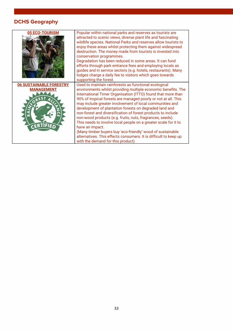
05 ECO-TOURISM
Popular within national parks and reserves as tourists are attracted to scenic views, diverse plant life and fascinating wildlife species. National Parks and reserves allow tourists to enjoy these areas whilst protecting them against widespread destruction. The money made from tourists is invested into conservation programmes. Degradation has been reduced in some areas. It can fund efforts through park entrance fees and employing locals as guides and in service sectors (e.g. hotels, restaurants). Many lodges charge a daily fee to visitors which goes towards supporting the forest.
06 SUSTAINABLE FORESTRY MANAGEMENT
Used to maintain rainforests as functional ecological environments whilst providing multiple economic benefits. The International Timer Organisation (ITTO) found that more than 90% of tropical forests are managed poorly or not at all. This may include greater involvement of local communities and development of plantation forests on degraded land and non-forest and diversification of forest products to include non-wood products (e.g. fruits, nuts, fragrances, seeds). This needs to involve local people on a greater scale for it to have an impact. (Many timber buyers buy ‘eco-friendly’ wood of sustainable alternatives. This effects consumers. It is difficult to keep up with the demand for this product)
33
DCHS Geography
URBAN
The need for management of recent urban change (housing and transport) in a developed and in a developing world city
The management strategies employed
The impact of the management strategies
Edinburgh: Housing
The need for management The management strategies employed
The impact of the management strategies
The tenement buildings had become substandard (e.g. overcrowding, disease)
A. New council estates were constructed on the edge of Edinburgh (e.g. Pilton)
B. Many tenements in the inner city were bulldozed and replaced with multi-storeys (e.g. Newhaven)
C. Some of the remaining tenements were renovated and improved (e.g. sandblasted, plumbing)
A. In the estates many people lacked the skills for new jobs and people became isolated
B. The multi-storey flats were poorly built and had no private garden
C. The renovation of the existing tenements is cheaper and encourages private developers (e.g. Wimpey)
Most former industries had gone into decline leading to unemployment and large areas of the port had become derelict and an ageing population(e.g. shipbuilding in Leith)
The old warehouses were converted into flats A new shopping centre was created (e.g. Ocean Terminal) Tourist attractions were created (e.g. Royal Yacht Britannia) with hotels (e.g. Holiday Inn)
It tackled social and environmental problems (e.g. unemployment and derelict land) Middle class people moved into a working class area as it caters for more affluent residents and customers
34

DCHS Geography
Edinburgh: Transport
The need for management
The management strategies employed
The impact of the management strategies
A. The medieval street pattern means the roads are narrow
One way systems have been created to improve traffic flow (e.g. George Street)
Has reduced waiting times at junctions. Most businesses opposed this as it may affect them.
B. Increased numbers of cars and lorries, including those that intend to travel to the opposite side of Edinburgh
• A ring road was constructed around the city centre (A720).
• The City Bypass links up with the M8, M9 and FRB.
Traffic does not need to flow through the centre and removed unnecessary traffic from bottlenecks. However, the volume of traffic has increased because of the development of Edinburgh Park which means frequent delays
C. Increase in car ownership and reluctance to use public transport
• Bus lanes (Greenways) were designated which operate all day
• The rail services into Edinburgh from Lothian and Fife have been improved and new stations have been built
• Tram facilities link Edinburgh Airport to the CBD via Edinburgh Park.
Bus lanes have produced faster journey times into the CBD but have increased traffic in the outer lane and have affected the trade of small shops. Fewer cars in this area leads to lower emissions and improves air quality and environment People still prefer the conveniences of using their own car.
D. Shortage of parking spaces in the CBD means cars often park on the streets which can impact on traffic flow
• Multi-storey car parks have been constructed (e.g. OMNI Centre)
• The introduction of traffic meters and traffic wardens to control kerbside parking
Parking restrictions have reduced the amount of on street parking which slows the streets to be wider allowing more space for cars Brownfield sites have been used to create the car parks
E. Many commuters travel into the city on the A90 and the Forth Road Bridge (e.g. Fife) which means traffic jams
• Park and Ride schemes means less cars have to travel into the city centre (e.g. Hermiston)
• The A90 was improved by building a dual carriageway within the greenbelt
Congestion continues and increases on the narrower stretch of road in the built up area
35
DCHS Geography
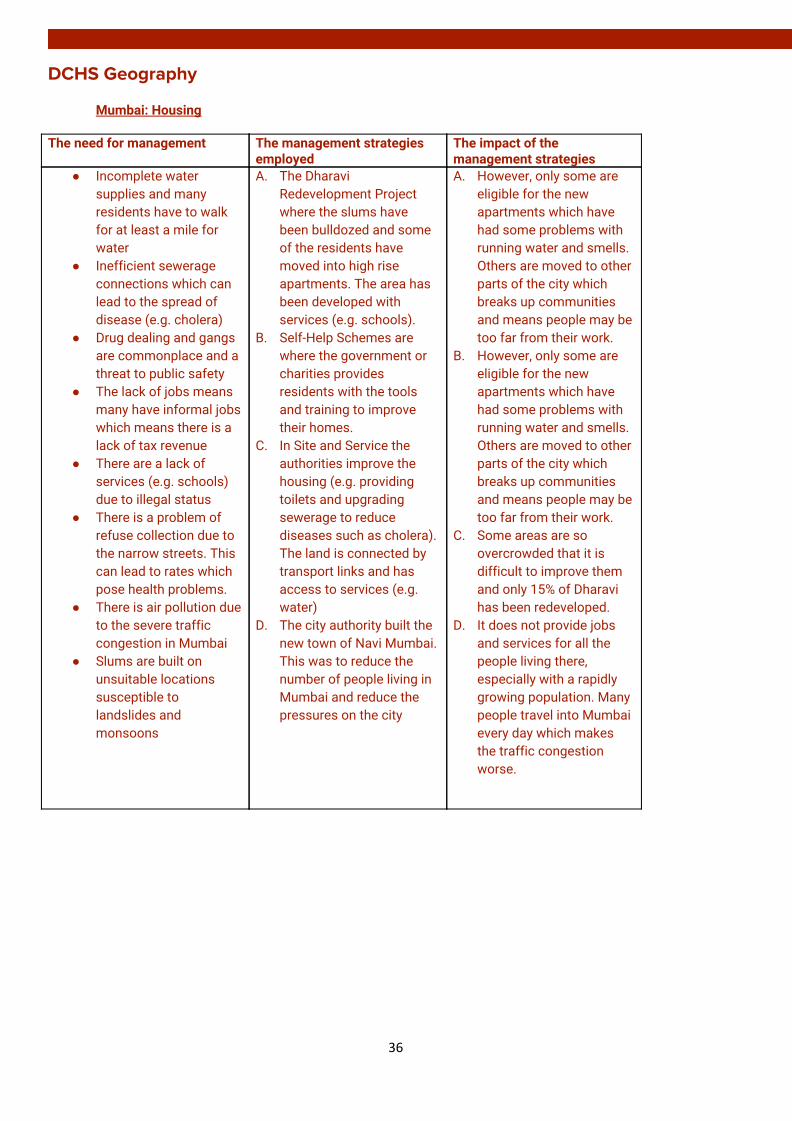
Mumbai: Housing
The need for management The management strategies employed
The impact of the management strategies
● Incomplete water supplies and many residents have to walk for at least a mile for water
● Inefficient sewerage connections which can lead to the spread of disease (e.g. cholera)
● Drug dealing and gangs are commonplace and a threat to public safety
● The lack of jobs means many have informal jobs which means there is a lack of tax revenue
● There are a lack of services (e.g. schools) due to illegal status
● There is a problem of refuse collection due to the narrow streets. This can lead to rates which pose health problems.
● There is air pollution due to the severe traffic congestion in Mumbai
● Slums are built on unsuitable locations susceptible to landslides and monsoons
A. The Dharavi Redevelopment Project where the slums have been bulldozed and some of the residents have moved into high rise apartments. The area has been developed with services (e.g. schools).
B. Self-Help Schemes are where the government or charities provides residents with the tools and training to improve their homes.
C. In Site and Service the authorities improve the housing (e.g. providing toilets and upgrading sewerage to reduce diseases such as cholera). The land is connected by transport links and has access to services (e.g. water)
D. The city authority built the new town of Navi Mumbai. This was to reduce the number of people living in Mumbai and reduce the pressures on the city
A. However, only some are eligible for the new apartments which have had some problems with running water and smells. Others are moved to other parts of the city which breaks up communities and means people may be too far from their work.
B. However, only some are eligible for the new apartments which have had some problems with running water and smells. Others are moved to other parts of the city which breaks up communities and means people may be too far from their work.
C. Some areas are so overcrowded that it is difficult to improve them and only 15% of Dharavi has been redeveloped.
D. It does not provide jobs and services for all the people living there, especially with a rapidly growing population. Many people travel into Mumbai every day which makes the traffic congestion worse.
36
DCHS Geography
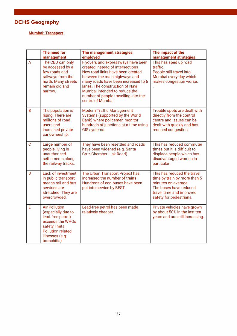
Mumbai: Transport
The need for management
The management strategies employed
The impact of the management strategies
A The CBD can only be accessed by a few roads and railways from the north. Many streets remain old and narrow.
Flyovers and expressways have been created instead of intersections New road links have been created between the main highways and many roads have been increased to 6 lanes. The construction of Navi Mumbai intended to reduce the number of people travelling into the centre of Mumbai
This has sped up road traffic. People still travel into Mumbai every day which makes congestion worse. .
B The population is rising. There are millions of road users and increased private car ownership.
Modern Traffic Management Systems (supported by the World Bank) where policemen monitor hundreds of junctions at a time using GIS systems.
Trouble spots are dealt with directly from the control centre and issues can be dealt with quickly and has reduced congestion.
C Large number of people living in unauthorised settlements along the railway tracks.
They have been resettled and roads have been widened (e.g. Santa Cruz-Chember Link Road)
This has reduced commuter times but it is difficult to displace people which has disadvantaged women in particular.
D Lack of investment in public transport means rail and bus services are stretched. They are overcrowded.
The Urban Transport Project has increased the number of trains Hundreds of eco-buses have been put into service by BEST.
This has reduced the travel time by train by more than 5 minutes on average. The buses have reduced travel time and improved safety for pedestrians.
E Air Pollution (especially due to lead-free petrol) exceeds the WHOs safety limits. Pollution related illnesses (e.g. bronchitis)
Lead-free petrol has been made relatively cheaper.
Private vehicles have grown by about 50% in the last ten years and are still increasing.
37

DCHS Geography
GLOBAL CLIMATE CHANGE
PHYSICAL AND HUMAN CAUSES OF CLIMATE CHANGE
Physical Causes Human Causes ● Changes in the tilt of the Earth: the
greater the tilt of the Earth towards the sun, the closer some areas are and the greater amount of energy received. There is a change every 41,000 years.
● Changes in rotation of Earth around the
sun: Over a 97,000 year cycle, the Earth’s orbit stretches and affects the amount of energy received.
● Sun spot activity: 11 year cycle of rises
and falls in solar energy. If there are lots of sun spots more solar energy is being sent out from the sun.
● Volcanic eruptions: Release gas and
sulphur dioxide. This combines with water to form droplets which absorb the sun’s radiation. The Earth does not receive as much insolation (e.g. Krakatoa, 1883).
● Ocean circulation: warming and cooling
of tropical areas in Pacific Ocean can affect climate and lead to flooding. Retreating ice caps release water which leads to changes in the oceanic circulation and reduces the albedo effect.
● Burning of fossil fuels: Factories, cars etc have burned fossil fuels which release CO² into the atmosphere which increases the ‘greenhouse effect’ and temperature.
● Deforestation: CO² is released when the
cleared trees are burned. There is less absorption of CO² which leads to a build-up in the atmosphere.
● Methane: Huge numbers of cows bred
for human consumption. Rice grown in large quantities in paddy fields to feed growing populations - India (Methane is produces by microbes underwater as they help to decay flooded organic matter). Humans waste in landfills decaying underground releases methane.
● CFCs: Increasing in the atmosphere due
to aerosols, fridges and air conditioning. It is released if appliances are not disposed of correctly.
● War: Bombs create large amounts of
dust which can reduce insolation and the Earth’s temperatures.
38

DCHS Geography
LOCAL AND GLOBAL EFFECTS OF CLIMATE CHANGE
Local Effects in Scotland ● ☺ Agriculture and Forests: warming climate has potential to improve growing conditions and increase productivity (plants can grow for a longer period of time)
● ☹ Pests and Disease: New conditions may allow pests
and disease to spread and create new threats. This may impact on health and ecosystems if not managed.
● ☹ Soils: may be altered due to changes in rainfall
patterns and increased temperatures.
● ☹ Environment: some species may be lost and invasive species may thrive and a degraded environment may not be able to sustain a productive land or water supply.
● ☹ Water: as rainfall patterns change there may be
increased competition for water. Summer droughts may become more frequent and severe causing problems for water quality and supply.
● ☹ Flooding: More heavy downpours could lead to
increased flood risk. This could impact on properties, business and communities.
● ☹ Coasts: we can expect more coastal flooding and
erosion with consequences for coastal communities and infrastructure.
● People: more opportunities to be outdoors and enjoy an
active lifestyle. But, it could lead to increase in skin cancers.
● ☹ Cultural Heritage and Identity: threatens historic
environment through coastal erosion and flooding. Rising temperatures could affect ski industry.
● ☹ Energy supply: influence capacity to generate
renewable energy (e.g. hydro)
39
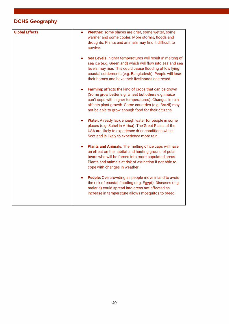
DCHS Geography Global Effects ● Weather: some places are drier, some wetter, some
warmer and some cooler. More storms, floods and droughts. Plants and animals may find it difficult to survive.
● Sea Levels: higher temperatures will result in melting of
sea ice (e.g. Greenland) which will flow into sea and sea levels may rise. This could cause flooding of low lying coastal settlements (e.g. Bangladesh). People will lose their homes and have their livelihoods destroyed.
● Farming: affects the kind of crops that can be grown
(Some grow better e.g. wheat but others e.g. maize can’t cope with higher temperatures). Changes in rain affects plant growth. Some countries (e.g. Brazil) may not be able to grow enough food for their citizens.
● Water: Already lack enough water for people in some
places (e.g. Sahel in Africa). The Great Plains of the USA are likely to experience drier conditions whilst Scotland is likely to experience more rain.
● Plants and Animals: The melting of ice caps will have
an effect on the habitat and hunting ground of polar bears who will be forced into more populated areas. Plants and animals at risk of extinction if not able to cope with changes in weather.
● People: Overcrowding as people move inland to avoid
the risk of coastal flooding (e.g. Egypt). Diseases (e.g. malaria) could spread into areas not affected as increase in temperature allows mosquitos to breed.
40

DCHS Geography
STRATEGIES TO MINIMISE THE IMPACTS OF CLIMATE CHANGE
Local/Individual Strategies
● Switch to energy saving products: (e.g. light bulbs) generate less heat and use less energy. Switch of the light when leaving a room.
● Seal and Insulating homes: prevents leaks by sealing home
and blocking out heat and cold.
● Recycling: Saves energy and reduces pollution and emissions from manufacturing products and disposing of them (e.g. Falkirk Council) Composting food and garden waste reduces rubbish sent to landfills and reduces emissions (e.g. methane)
● Use water efficiently: (e.g. when brushing teeth, dishwasher
use) reduces energy needed to pump and treat water for our use.
● Green power: (e.g. solar panels on the roof). It is a clean
energy supply and reduces emissions. However, it can be expensive.
● Transport: people encouraged to use public transport, walk or
cycle to reduce fossil fuel consumption.
● Education: Educate people on benefits of being energy efficient
National (UK) Strategies
• Government Policies (e.g. Insulation). Over 10% of Scottish homes have received financial support to fit loft insulation. Encourages the use of ‘Smart Meters’ to improve energy efficiency
• Reducing amount of energy from coal-fired power stations
which emit the most CO² (E.G. Cockenzie power station closed in 2013). Increased power generation from renewable sources and use of low carbon technologies. The UK Government is committed to creating 15% of energy by renewable sources (e.g. Whitelee Wind Farm outside Glasgow is the second largest in Europe with 2015 turbines). In 2014, 50% of Scotland’s energy consumption was met by renewables. However, these can be unsightly, effect local wildlife and costly and are not able to completely replace non-renewables as a source of energy. This makes it difficult to meet future targets on green energy supplies.
• Scottish Government introduced a bill in 2008 committing itself to an 80% reduction in greenhouse gas emissions between 1990 and 2050. Between 1990 and 2012 there has been a 30% reduction, although there was a rise of almost 1% between 2011 and 2012.
41
DCHS Geography
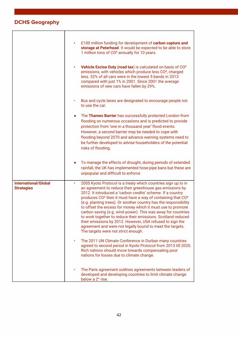
• £100 million funding for development of carbon capture and storage at Peterhead. It would be expected to be able to store 1 million tons of CO² annually for 10 years.
• Vehicle Excise Duty (road tax) is calculated on basis of CO² emissions, with vehicles which produce less CO², charged less. 32% of all cars were in the lowest 5 bands in 2013 compared with just 1% in 2001. Since 2001 the average emissions of new cars have fallen by 29%.
• Bus and cycle lanes are designated to encourage people not to use the car.
● The Thames Barrier has successfully protected London from
flooding on numerous occasions and is predicted to provide protection from ‘one in a thousand year’ flood events. However, a second barrier may be needed to cope with flooding beyond 2070 and advance warning systems need to be further developed to advise householders of the potential risks of flooding.
● To manage the effects of drought, during periods of extended
rainfall, the UK has implemented hose-pipe bans but these are unpopular and difficult to enforce
International/Global Strategies
• 2005 Kyoto Protocol is a treaty which countries sign up to in an agreement to reduce their greenhouse gas emissions by 2012. It introduced a ‘carbon credits’ scheme. If a country produces CO² then it must have a way of containing that CO² (e.g. planting trees). Or another country has the responsibility to offset the excess for money which it must use to promote carbon saving (e.g. wind power). This was away for countries to work together to reduce their emissions. Scotland reduced their emissions by 2012. However, USA refused to sign the agreement and were not legally bound to meet the targets. The targets were not strict enough.
• The 2011 UN Climate Conference in Durban many countries
agreed to second period in Kyoto Protocol from 2013 till 2020. Rich nations should move towards compensating poor nations for losses due to climate change.
• The Paris agreement outlines agreements between leaders of developed and developing countries to limit climate change below a 2° rise.
42
DCHS Geography
DEVELOPMENT AND HEALTH
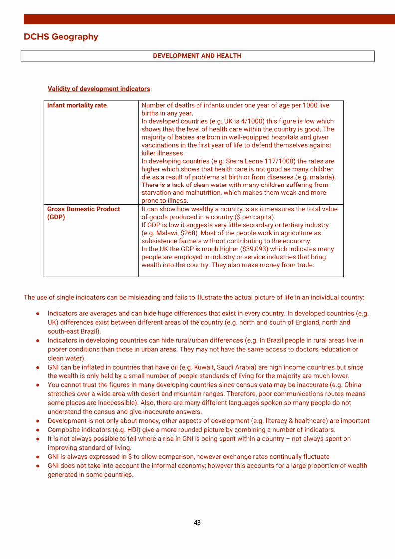
Validity of development indicators
Infant mortality rate Number of deaths of infants under one year of age per 1000 live births in any year. In developed countries (e.g. UK is 4/1000) this figure is low which shows that the level of health care within the country is good. The majority of babies are born in well-equipped hospitals and given vaccinations in the first year of life to defend themselves against killer illnesses. In developing countries (e.g. Sierra Leone 117/1000) the rates are higher which shows that health care is not good as many children die as a result of problems at birth or from diseases (e.g. malaria). There is a lack of clean water with many children suffering from starvation and malnutrition, which makes them weak and more prone to illness.
Gross Domestic Product (GDP)
It can show how wealthy a country is as it measures the total value of goods produced in a country ($ per capita). If GDP is low it suggests very little secondary or tertiary industry (e.g. Malawi, $268). Most of the people work in agriculture as subsistence farmers without contributing to the economy. In the UK the GDP is much higher ($39,093) which indicates many people are employed in industry or service industries that bring wealth into the country. They also make money from trade.
The use of single indicators can be misleading and fails to illustrate the actual picture of life in an individual country:
● Indicators are averages and can hide huge differences that exist in every country. In developed countries (e.g. UK) differences exist between different areas of the country (e.g. north and south of England, north and south-east Brazil).
● Indicators in developing countries can hide rural/urban differences (e.g. In Brazil people in rural areas live in poorer conditions than those in urban areas. They may not have the same access to doctors, education or clean water).
● GNI can be inflated in countries that have oil (e.g. Kuwait, Saudi Arabia) are high income countries but since the wealth is only held by a small number of people standards of living for the majority are much lower.
● You cannot trust the figures in many developing countries since census data may be inaccurate (e.g. China stretches over a wide area with desert and mountain ranges. Therefore, poor communications routes means some places are inaccessible). Also, there are many different languages spoken so many people do not understand the census and give inaccurate answers.
● Development is not only about money, other aspects of development (e.g. literacy & healthcare) are important ● Composite indicators (e.g. HDI) give a more rounded picture by combining a number of indicators. ● It is not always possible to tell where a rise in GNI is being spent within a country – not always spent on
improving standard of living. ● GNI is always expressed in $ to allow comparison, however exchange rates continually fluctuate ● GNI does not take into account the informal economy; however this accounts for a large proportion of wealth
generated in some countries.
43

DCHS Geography Differences in levels of development between developing countries
• Some countries have natural resources (e.g. oil) which can be sold to generate foreign currency. • Some countries are landlocked (e.g. Chad) and find it more expensive to export and import goods. • Countries with a poor education system have many low skilled workers and are unable to attract foreign
investment. • Countries with fertile soils and a suitable climate can grow cash crops which can be sold for income. • Corruption in government (e.g. Nigeria) can lead to money being used inappropriately. • Where countries suffer from conflict/civil war they are unable to keep the economy working and spend
extra finance on weapons • Countries which have accumulated large debts have to repay loans and interest causing less money for
services. • Famine can lead to malnutrition, and a reduced capacity to work and create income.
44
DCHS Geography
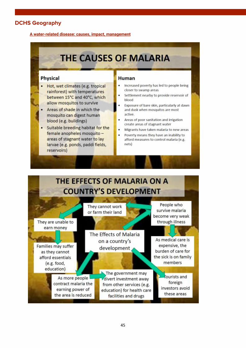
A water-related disease: causes, impact, management
45
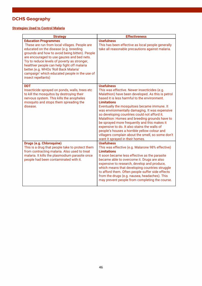
DCHS Geography Strategies Used to Control Malaria
Strategy Effectiveness Education Programmes These are run from local villages. People are educated on the disease (e.g. breeding grounds and how to avoid being bitten). People are encouraged to use gauzes and bed nets. Try to reduce levels of poverty as stronger, healthier people can help fight off malaria better.(e.g. WHOs ‘Roll Back Malaria’ campaign’ which educated people in the use of insect repellants)
Usefulness This has been effective as local people generally take all reasonable precautions against malaria.
DDT Insecticide sprayed on ponds, walls, trees etc to kill the mosquitos by destroying their nervous system. This kills the anopheles mosquito and stops them spreading the disease.
Usefulness This was effective. Newer insecticides (e.g. Malathion) have been developed. As this is petrol based it is less harmful to the environment. Limitations Eventually the mosquitoes became immune. It was environmentally damaging. It was expensive so developing countries could not afford it. Malathion: Homes and breeding grounds have to be sprayed more frequently and this makes it expensive to do. It also stains the walls of people’s houses a horrible yellow colour and villagers complain about the smell, so some don’t want it sprayed in their homes.
Drugs (e.g. Chloroquine) This is a drug that people take to protect them from contracting malaria. Also used to treat malaria. It kills the plasmodium parasite once people had been contaminated with it.
Usefulness This was effective (e.g. Malarone 98% effective) Limitations It soon became less effective as the parasite became able to overcome it. Drugs are also expensive to research, develop and produce, which means that developing countries struggle to afford them. Often people suffer side effects from the drugs (e.g. nausea, headaches). This may prevent people from completing the course.
46

DCHS Geography
Spraying Oil/Egg White on Breeding Grounds This puts a layer of oil or egg white on top of the stagnant water which drowns and suffocates the mosquito larvae. Mustard seeds in paddi fields drag larvae down and drown them.
Limitations Although this kills the mosquitos the oil can damage the environment. Oil and eggs are also too expensive for developing countries to use. Food is scarce in many developing countries so using egg whites can be seen as a waste of a valuable food resource.
Infect Coconuts with BTI Bacteria Infecting coconuts with Bti bacteria and then throwing them into stagnant water will encourage the larvae to eat them. This destroys their stomach lining and kills them.
Usefulness This is effective because when the larvae eat the coconuts the bacteria kills them. Cheap and environmentally friendly solution. 2/3 coconuts clears a pond of mosquito larvae for 45 days.
Sprinkle Mustard Seeds Sprinkle mustard seeds on stagnant water (e.g. paddi fields). They drag larvae down and drown them.
Usefulness This is effective as the mustard seeds are sticky and the larvae will stick to the seeds and sink down into the stagnant water, which will drown them.
Fish By putting fish into areas of stagnant water mosquito larvae will be eaten by muddy loach fish which reduces the larvae
Usefulness This stops the mosquito population from multiplying. This is effective as the fish can also be eaten by the humans to add protein to their diet.
Drainage of Breeding Grounds The areas where mosquitos breed (e.g. ponds, swamps, paddy fields) are drained. Every 7 days as it takes longer than this for larvae to develop into adult mosquitos.
Usefulness This was effective because mosquitos cannot survive without stagnant water. Limitations Unfortunately it is impossible to drain every breeding ground. In tropical areas there can be heavy rainfall every day so new areas of stagnant water can appear all the time.
Bed Nets (insecticide coated) These are placed over beds at night to stop mosquitoes from biting people. They are coated with insecticide.
Usefulness These are effective in stopping the spread of malaria as they are cheap (about £5) and easy to introduce into communities. Using nets at night is effective as mosquitos are more active during dusk and dawn.
47

DCHS Geography
Cover Windows and Doors with Gauze Gauze works like bed nets as it stops mosquitoes from entering people’s homes. Mosquitoes like to bite ankles or arms, especially in darkened rooms. Gauze stops mosquitoes from getting in. Covering water storage cans (e.g. the Oxfam Bucket) reduces the chances of mosquitos breeding there
Usefulness This is an effective method as it is cheap.
Planting Eucalyptus Trees These trees soak up excess water, which helps to drain breeding grounds.
Usefulness This is a reasonably effective method as it reduces stagnant water and also reduces the breeding grounds of the female anopheles mosquito.
Breeding genetically modified sterile mosquitos To reduce the number of female mosquitos
Mosquito traps They mimic animals and humans by emitting a small amount of CO² in order to lure the mosquitos into the trap where they are killed
Usefulness Have been effective at a small scale, Limitations But mosquitoes breed so quickly that it is impossible to trap them all
Vaccine Trials have produced a vaccine (RTSS) which has now been recommended as being safe for use, as prevention us better than cure
Usefulness They have been trialled on children across Africa and early results from this are encouraging (a 56% drop in malaria after a year with children who had the vaccine, compared with those who did not)
48
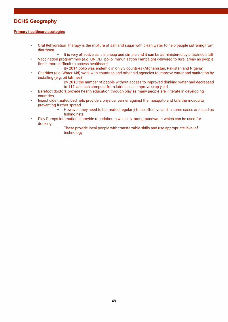
DCHS Geography Primary healthcare strategies
• Oral Rehydration Therapy is the mixture of salt and sugar with clean water to help people suffering from
diarrhoea – It is very effective as it is cheap and simple and it can be administered by untrained staff
• Vaccination programmes (e.g. UNICEF polio immunisation campaign) delivered to rural areas as people find it more difficult to access healthcare
– By 2014 polio was endemic in only 3 countries (Afghanistan, Pakistan and Nigeria) • Charities (e.g. Water Aid) work with countries and other aid agencies to improve water and sanitation by
installing (e.g. pit latrines) – By 2010 the number of people without access to improved drinking water had decreased
to 11% and ash compost from latrines can improve crop yield. • Barefoot doctors provide health education through play as many people are illiterate in developing
countries. • Insecticide treated bed nets provide a physical barrier against the mosquito and kills the mosquito
preventing further spread – However, they need to be treated regularly to be effective and in some cases are used as
fishing nets • Play Pumps International provide roundabouts which extract groundwater which can be used for
drinking – These provide local people with transferrable skills and use appropriate level of
technology
49