Recorded walks of the SFC collated by Gordon Drummond
87
i List of walks Recorded walks of the SFC: collated by Gordon Drummond Contents Blackford, The Braids and Mortonhall .............................................................................................. 1 Peebles Circular Walk via Cademuir Hill ........................................................................................ 2 Glasgow’s “Dear Green Places” ......................................................................................................... 3 Lamington and the Cowgill Reservoirs ............................................................................................ 4 Innerdownie, White Wisp, Tarmangie.............................................................................................. 5 Whitehope Law .................................................................................................................................... 6 Glen Finglas and Loch Venachar ....................................................................................................... 7 Capelaw and Allermuir hills .............................................................................................................. 8 Corstorphine hill and Cammo estate ................................................................................................ 9 Roman road from West Linton to Garvald, back by Nether Cairn. ............................................ 11 Lammer Law....................................................................................................................................... 12 Innnerdownie /Glen Sherrup (Ochils) ............................................................................................ 13 Tweedsmuir, Upper Tweed valley .................................................................................................. 14 Heriot and the Borders Rail Link ..................................................................................................... 15 South-East Edinburgh to Fisherrow Harbour ................................................................................ 17 Minchmoor.......................................................................................................................................... 18 North Eildon Hill and the South Bank of the Tweed.................................................................... 19 Dunslair Heights, Peebles ................................................................................................................. 20 Dollar, Innerdownie & Glen Quey .................................................................................................. 21 Wanlockhead, Lowther Hills............................................................................................................ 22 Lomond Hills Fife .............................................................................................................................. 23 East Linton to Dunbar ....................................................................................................................... 24 Cockleroy, Torphichen and Beecraigs............................................................................................. 25 Granton, Cramond and Cammo ...................................................................................................... 26 Portmore Loch and Dundreich Hill................................................................................................. 27 Bracklinn Falls and Callander Craig................................................................................................... 28 Stobo and Manor Valley.................................................................................................................... 29 Tinto Hill, Southern Uplands (Fallburn Car Park) ........................................................................ 30 Cademuir Hill and the Tweed.......................................................................................................... 31 Garleton Hills, East Lothian ............................................................................................................. 32
-
Upload
khangminh22 -
Category
Documents
-
view
0 -
download
0
Transcript of Recorded walks of the SFC collated by Gordon Drummond

i
List of walks
Recorded walks of the SFC: collated by Gordon Drummond
Contents Blackford, The Braids and Mortonhall .............................................................................................. 1
Peebles Circular Walk via Cademuir Hill ........................................................................................ 2
Glasgow’s “Dear Green Places” ......................................................................................................... 3
Lamington and the Cowgill Reservoirs ............................................................................................ 4
Innerdownie, White Wisp, Tarmangie .............................................................................................. 5
Whitehope Law .................................................................................................................................... 6
Glen Finglas and Loch Venachar ....................................................................................................... 7
Capelaw and Allermuir hills .............................................................................................................. 8
Corstorphine hill and Cammo estate ................................................................................................ 9
Roman road from West Linton to Garvald, back by Nether Cairn. ............................................ 11
Lammer Law ....................................................................................................................................... 12
Innnerdownie /Glen Sherrup (Ochils) ............................................................................................ 13
Tweedsmuir, Upper Tweed valley .................................................................................................. 14
Heriot and the Borders Rail Link ..................................................................................................... 15
South-East Edinburgh to Fisherrow Harbour ................................................................................ 17
Minchmoor .......................................................................................................................................... 18
North Eildon Hill and the South Bank of the Tweed .................................................................... 19
Dunslair Heights, Peebles ................................................................................................................. 20
Dollar, Innerdownie & Glen Quey .................................................................................................. 21
Wanlockhead, Lowther Hills ............................................................................................................ 22
Lomond Hills Fife .............................................................................................................................. 23
East Linton to Dunbar ....................................................................................................................... 24
Cockleroy, Torphichen and Beecraigs ............................................................................................. 25
Granton, Cramond and Cammo ...................................................................................................... 26
Portmore Loch and Dundreich Hill ................................................................................................. 27
Bracklinn Falls and Callander Craig ................................................................................................... 28
Stobo and Manor Valley .................................................................................................................... 29
Tinto Hill, Southern Uplands (Fallburn Car Park) ........................................................................ 30
Cademuir Hill and the Tweed .......................................................................................................... 31
Garleton Hills, East Lothian ............................................................................................................. 32

ii
List of walks
Union Canal, Rough Castle, and the Antonine Wall .................................................................... 33
Dalmeny, South Queensferry, Cramond Brig Walk ..................................................................... 34
Cupar, the Moor Road, Hill of Tarvit and Ceres ........................................................................... 36
Abbotsford Circular Trek .................................................................................................................. 37
Glen Ogle Trail ................................................................................................................................... 38
St Mary’s Loch / Riskinhope Hope .................................................................................................. 39
Broughton Heights ............................................................................................................................. 40
A Pentland Ramble ............................................................................................................................ 41
Pressmennan Wood Walk, East Lothian......................................................................................... 42
Janet’s Brae, Glentress and Eshiels Woodland walk ..................................................................... 43
Crossing the Forth .............................................................................................................................. 44
Howe of Fife Walk ............................................................................................................................. 45
Primrose Hill and Loch Katrine ....................................................................................................... 46
Tentsmuir Forest, Fife ........................................................................................................................ 47
King’s Seat Hill (648m), from Dollar (Clackmannanshire) Walk ................................................ 48
Cloich Hills from Newlands, Romanno Bridge (Scottish Borders) Walk .................................. 50
Water of Leith Walkway and Union Canal - Balerno to Fountainbridge .................................. 51
The Esk Valley and Peebles railways – Penicuik and Roslin Glen ............................................. 52
Cove to Siccar Point Walk ................................................................................................................. 53
Temple ................................................................................................................................................. 55
St. Abb’s Head .................................................................................................................................... 56
Cairnpapple Hill and Torphichen ................................................................................................... 57
Harestanes, Waterloo Monument and Peniel Heugh ................................................................... 59
Lammerlaw from Hopes Reservoir ................................................................................................. 60
Burntisland and The Binnend Village ............................................................................................. 61
Another Pentland Ramble ................................................................................................................ 63
Hopetoun to Blackness ...................................................................................................................... 64
Water of Leith Walkway Slateford to Leith ....................................................................................... 65
The Battle of Pinkie Cleugh September 1547 ................................................................................. 66
Berwick-on-Tweed: the Ramparts and the Tweed Estuary .............................................................. 70
Priestlaw Hill circular from Whiteadder Reservoir ...................................................................... 71
Blairadam Forest ................................................................................................................................ 72
Loch Ore Circuit .................................................................................................................................. 73
iii
List of walks
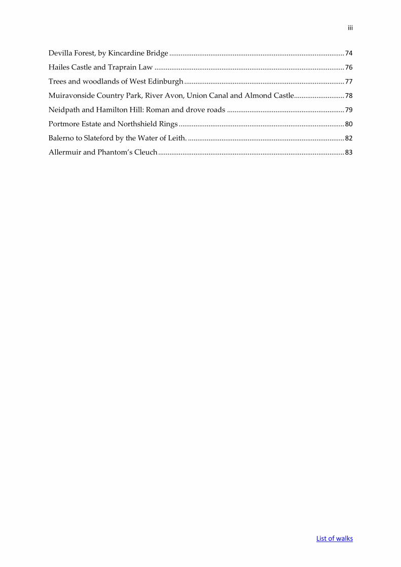
Devilla Forest, by Kincardine Bridge .............................................................................................. 74
Hailes Castle and Traprain Law ...................................................................................................... 76
Trees and woodlands of West Edinburgh ...................................................................................... 77
Muiravonside Country Park, River Avon, Union Canal and Almond Castle........................... 78
Neidpath and Hamilton Hill: Roman and drove roads ............................................................... 79
Portmore Estate and Northshield Rings ......................................................................................... 80
Balerno to Slateford by the Water of Leith. .................................................................................... 82
Allermuir and Phantom’s Cleuch .................................................................................................... 83
iv
List of walks
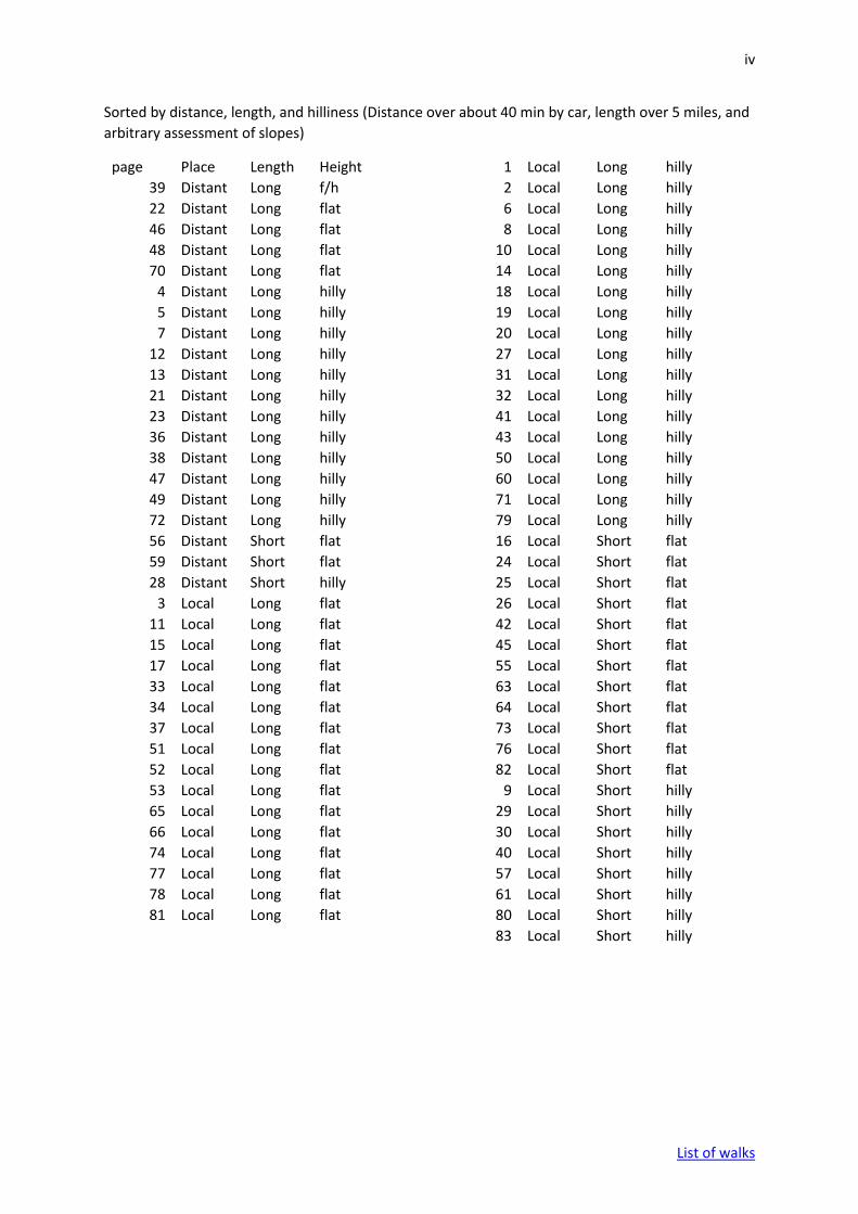
Sorted by distance, length, and hilliness (Distance over about 40 min by car, length over 5 miles, and
arbitrary assessment of slopes)
page Place Length Height 1 Local Long hilly
39 Distant Long f/h 2 Local Long hilly
22 Distant Long flat 6 Local Long hilly
46 Distant Long flat 8 Local Long hilly
48 Distant Long flat 10 Local Long hilly
70 Distant Long flat 14 Local Long hilly
4 Distant Long hilly 18 Local Long hilly
5 Distant Long hilly 19 Local Long hilly
7 Distant Long hilly 20 Local Long hilly
12 Distant Long hilly 27 Local Long hilly
13 Distant Long hilly 31 Local Long hilly
21 Distant Long hilly 32 Local Long hilly
23 Distant Long hilly 41 Local Long hilly
36 Distant Long hilly 43 Local Long hilly
38 Distant Long hilly 50 Local Long hilly
47 Distant Long hilly 60 Local Long hilly
49 Distant Long hilly 71 Local Long hilly
72 Distant Long hilly 79 Local Long hilly
56 Distant Short flat 16 Local Short flat
59 Distant Short flat 24 Local Short flat
28 Distant Short hilly 25 Local Short flat
3 Local Long flat 26 Local Short flat
11 Local Long flat 42 Local Short flat
15 Local Long flat 45 Local Short flat
17 Local Long flat 55 Local Short flat
33 Local Long flat 63 Local Short flat
34 Local Long flat 64 Local Short flat
37 Local Long flat 73 Local Short flat
51 Local Long flat 76 Local Short flat
52 Local Long flat 82 Local Short flat
53 Local Long flat 9 Local Short hilly
65 Local Long flat 29 Local Short hilly
66 Local Long flat 30 Local Short hilly
74 Local Long flat 40 Local Short hilly
77 Local Long flat 57 Local Short hilly
78 Local Long flat 61 Local Short hilly
81 Local Long flat 80 Local Short hilly
83 Local Short hilly

1
List of walks
Thursday 10th November 2011
Blackford, The Braids and Mortonhall Meeting Place: 10 Wyvern Park Edinburgh EH9 2JY. There is limited free
parking in our drive and in Wyvern Park. Any overflow would have to be
meter parking in Dick Place. Let me know if you plan to bring your car and I
shall check there is a space.
Walking distance: 7 miles
Duration: 4 hours including stops
Directions: Wyvern Park is a cul-de-sac off the west end of Dick Place. From the
Meadows, take Marchmont Road south. Cross Grange Road/Strathearn Road
onto Kilgraston Road. Dick Place is the first left and Wyvern Park first right
between pillars. If you come by bus, No 41 stops on Kilgraston Road just past
Dick Place (Monkwood Court bus stop 200 yards after Marchmont Crossroads).
Nos 5 and 24 stop at Marchmont Crossroads.
Walk details: This is a walk of moderate difficulty with several short climbs,
some with steps. Much of it is on quiet paths through deciduous woods behind
the main roads of south Edinburgh. They are mostly good stony paths but
very muddy in a few places (which can be bypassed if necessary). There is
some walking on roads. We walk down the road to Blackford pond then
through Hermitage of Braid and up to Braid Hills’ golf course. We skirt round
this, use a short stretch of Braid Road then climb gently up a good path to
Mounthooly and then Mortonhall. We return skirting the east boundary of
Braid Hills’ golf course, taking a path down to Liberton Brae which we take for
a very short distance to Blackford Glen and Hermitage of Braid. From there we
return through the grounds of the Astley Ainslie Hospital.
Roger Kellett

2
List of walks
Wednesday 25th April 2012
Peebles Circular Walk via Cademuir Hill
OS Maps: Landranger Map - sheet 73
Grid Ref: NT 251 402
Meeting Place: Large car park on south bank of the Tweed in Peebles
Driving directions: From Hillend take the A701, then the A703 to Peebles. Go right
along the High Street. At the far end, turn left over the Tweed Bridge and then
left into the car park where there are facilities.
Driving time: Approximately forty minutes.
Walking distance: 8 miles, climbing 700 feet
Duration: Four and a half hours including stops
Walk details: There is some road walking to start with, but the walk is mainly on
tracks and grass – rough in places. After ascending the hill, we drop down on a
track to the Manor Water and then make our way back along the south and the
north bank of the Tweed to the car park. This is a pleasant and fairly strenuous
walk with good views.
Sadie Nuttall

3
List of walks
Thursday 17 May 2012
Glasgow’s “Dear Green Places”
Meeting Point: The lounge at Sherbrooke Castle Hotel [Postcode G41 4PG]
Walking distance: Total distance 7.5 miles. Return fare on subway £2.40.
Driving time: Please see attached sheet.
Driving directions: Please see attached sheet.
Walk details: Despite being a large industrial city, Glasgow is blessed with
numerous parks, many of them very large. Many of these were donated to the city
by prominent Victorian benefactors, of whom the most influential was Sir John
Stirling Maxwell MP [1866-1956] the 10th Baronet of Pollok. Most of our walk will
be on his former lands.
We will start our walk in the “Avenues” in Pollokshields, down some of Glasgow’s
finest streets, with some very impressive Victorian houses, to Maxwell Park. We will
continue into Pollok Country Park, seeing the Highland Cattle, the Burrell
Collection, and Pollok House, although we may not have time to visit [unless the
weather is poor]. Then on to Bellahouston Park, site of the 1938 Empire Exhibition,
and currently of the Palace of Art and the House for an Art lover [based on Charles
Rennie McIntosh’s prize winning 1901 design]. Lunch is planned in the walled
garden, then a short walk to the subway at Cessnock where we will cross under the
Clyde to Kelvingrove Park for the best views of the City and University, returning
on the subway and a short walk back to our start.
W S Hislop
4
List of walks
Tuesday 19 June 2012
Lamington and the Cowgill Reservoirs OS Landranger Sheet 72; OS Explorer Sheet 336 NS 978 309 Meeting Point: Lamington Old Church carpark Walking distance: Approximately 7 to 8 miles Duration Four hours 45 minutes from Fairmilehead Driving directions: From Edinburgh take the A702 towards Biggar. In Lamington, approximately six miles past Biggar, take the inconspicuously signed second right to the old church and primary school. The car park is immediately after the turn and just before the cemetery. From Glasgow it is probably best to take the M74 south and leave at junction 13 (Edinburgh). At the junction with the A73 keep right on the A702. Lamington is about six miles from the motorway and the car park turn is on your left as you enter the village, just after the 40 mph limit sign. Walk details: This is a moderate walk on paths and tracks, muddy in places. The longer route adds a short but steep climb over rough moorland. The country is mainly open but with some cover from hedges and small, chiefly conifer, plantations. There are free public toilets at the Abington services and (paying) by the old town hall in the centre of Biggar.
There is a steady gentle climb for about a mile from the car park to Cowgill Loch.
At this point there is an optional diversion over rough moorland to the summit
of Lamington Hill (492 m), with fine views from the top in good weather
towards Biggar and the Clyde valley. The route continues along a well-defined
but often muddy track through a pretty glen, around Cowgill Lower Reservoir
to the dam at the head of Cowgili Upper Reservoir. There are no convenient
paths or tracks around the Upper Reservoir. We return largely along the same
route.
Malcolm Merrick
5
List of walks
Wednesday, 18th July 2012
Innerdownie, White Wisp, Tarmangie
OS Maps: OS Landranger; Sheet 58; Harvey- Ochil Hill
Grid Ref: NN 972 052
Meeting Point: Glensherup Car Park to start the walk
Walking distance: Approximately 13 Km
Duration: 4.5 hours
Driving time: One hour from Barnton
Driving directions: Drive north up the M90 to Exit 6 signed Kinross. Head
west for 1.5 miles on the A977 and take the right fork and join the A91 in two miles.
Drive west to Yetts of Muckhart. Join the A823 [a very complicated corner] and head
north for six miles to the TORMAUKIN HOTEL on your right where coffee is
available. Glensherup Car Park is two miles beyond the hotel, on the left.
Walk details: The first section of the walk, to Innerdownie [610 m], is a steady uphill
pull, initially on forestry roads and then onto grassy paths after a short muddy
section. The three tops are on grass paths along a ridge. We then contour round on
the paths to the north side of Glen Sherup and can return via Ben Shee, if it's a nice
day, or through the woods to Glenquey reservoir. Donald Macleod

6
List of walks
Thursday 16 August 2012
Whitehope Law
OS Maps: OS Explorer Map 337
Grid Ref: NT 336 428
Meeting Point: B709 between Whitehope and Glentress Cottages
Walking distance: Total distance 7 miles (there is a longer option) Ascent about
350 m.
Driving directions: From Edinburgh, take the A7. The road bypasses North
Middleton (signed ¼ mile on the left) and then passes between two bus stops.
Very soon after this, take the next right B7007 signed Innerleithen (the sign is
partly obscured by foliage) and continue south and SSW up and then over the
Moorfoot Ridge. Just beyond Garvald, the road is joined on the left by the B709
(NT 355 505). Continue straight on until you pass a low white building labelled
Glentress. After about ¼ mile more, park on the right hand side of the road:
there are two or three narrow metalled patches. (I hope to be there first!)
From Glasgow Drive to Peebles and continue east on the A72 towards Galashiels. In
Innerleithen, drive slowly through the town until you pass the Bank of
Scotland on the left: at this point there are a number of unhelpful tourist signs
and the important sign is utterly obscured by foliage. Turn sharp left here, just
before the main road takes a slight right bend over an inconspicuous bridge.
Drive north up the B709, cross the Leithen Water at the golf course, and
continue for about 2.7 miles to see a prominent white bridge on the left and a
small group of white houses labelled Whitehope. After another ¼ mile, park
on the left hand side of the road.
Walk details: Through a metal gate, cross a field and a footbridge over Glentress
Water. A steep zig-zag path ascends 80 metres and then reduces in gradient
towards the peak of Winside Hill (434 m). A gentle ascent leads to the peak of
Whitehope Law (623 m) which on good days gives excellent views of the
surrounding hills. We then descend to the west, into Leithenwater forest, by
Williamslee Burn, Leithen Water, and past Whitehope back to the B709.
The first part of the walk is steep: the rest is not so bad! Boots are needed and poles
will help. there is no reception in the Leithen Water valley for at least two
networks.

7
List of walks
Gordon Drummond
Tuesday 11 September 2012
Glen Finglas and Loch Venachar
OS Maps: Landranger 57 - Stirling and the Trossachs
(The good well-marked paths we use are recent and do not appear on this map).
Grid Ref: NN 551 063
Meeting Point: Little Drum Car Park on the A821 overlooking Loch Venachar
just before Lendrick Steading.
Walking distance: Approximately six miles; ascent 200 metres.
Driving directions
To Callander by preferred route (via M9 to Stirling from Edinburgh.) Through
Callander then A84 towards Strathyre. Left at Kilmahog onto A821 “Trossachs
Road” signposted Aberfoyle. After two to three miles you pass the Harbour
Café and Boat Hire on the left. Little Drum Car Park is approximately one mile
further, on the left. There are three car parking spots on the loch-side before
Little Drum which is clearly marked and is free. It takes about one hour and 15
minutes from the Newbridge Roundabout (start of M9) to the car park, so
leaving after 9.00 am should be possible for those coming from Edinburgh.
Walk details: The walk is largely in the policies of the Woodland Trust
Scotland which is conserving the area. The walk is on well-made paths apart
from a short distance uphill on the access road to Glen Finglas reservoir. After
walking along the side of Loch Venachar to Brig o’ Turk, we join the access
road for the short uphill section. We can make a short detour to view the dam
and visit the spot where Millais painted his famous portrait of John Ruskin
viewing “nature” from a rock in the Finglas Burn (shortly after completing the
portrait, Millais eloped with Ruskin’s wife - Effie – to the satisfaction of all
concerned!) From the reservoir we take an undulating path traversing the
hillside eastwards and then descend back to the car park.
Michael Sudlow

8
List of walks
Wednesday 10 October 2012
Capelaw and Allermuir hills OS Maps: Explorer Sheet 344 - Pentland Hills, Penicuik and West Linton (some paths
not shown)
Grid Ref: NT 212 675
Meeting Point Bonaly Country Park Car Park, on the left at the end of Bonaly Road
(narrow - drive with care! The nearest WCs are at Colinton Shops, on the north side
of the junction of Bridge Road in Colinton)
Walking Distance: About six miles; overall ascent about 350m, time about 334-4
hours
Directions: To Colinton, in south-west Edinburgh, preferably approaching from the
City down Colinton Road, then its continuation Bridge Street, and forking left at the
shops up Woodhall Road. Take the second road on the left (Bonaly Road) and
continue to its termination at the car park - about 20 minutes from the West End of
Edinburgh.
The walk is in the Bonaly Country and the Pentland Hills Regional Parks. It starts up
the made-up track walk, ascending to Bonaly Reservoir, then if dry, west along the
north shore of the reservoir, and then south-east, on emerging from the trees,
following the plantation to a gate. We then skirt the north-west side of Capelaw Hill,
and (just short of the col, and of a Pentlands Paths green marker post) turn east up a
well-marked track which wends its way east to a false summit and then north-east to
the true summit (marked by a double metal post) at 454m. It then continues winding
down to the col between Capelaw and Allermuir Hills (crossing a style or a gate, and
then a made-up track) and ascends to the trig point at Allermuir Hill summit
(493m). On a fine day, the views are spectacular from both! We re-trace our steps
down to the col and style/gate, and skirt Capelaw north and then west to Bonaly
Reservoir, and then re-trace the track down to the car park. All paths are sound
underfoot, and of mild-to-moderate severity, wet only in places. Sticks are advised,
but not essential. It can be very windy on the tops!
Neil Davidson

9
List of walks
Thursday November 8 2012
Corstorphine hill and Cammo estate
Meeting Place: At gate on Corstorphine Road, opposite the top of Balgreen Road.
Buses from town: Numbers 12, 26, 31
Buses back to town from Cramond Brig: Numbers 41 and 43
Walk details: We cross Corstorphine Hill to Queensferry Road, then take a
woodland path to Barnton. After a picnic stop at house/garden in Braehead
Road, we will walk a circuit of Cammo Estate, then take a path down river to
the Cramond Brig Inn for the AGM.
Eiona Conacher

10
List of walks
Tuesday 26 March 2013
Gladhouse Reservoir and the Moorfoot Hills
OS Maps: Landranger Sheet 73
Grid Ref: NT 292 528
Meeting Place: South Tip of Gladhouse Reservoir
Walking distance: 12 – 14 km
Duration: Approximately 4 to 5 hours including stops
Driving time: Approximately 30 minutes from Hillend. Please try to arrange car
sharing as parking is not unlimited.
Driving directions: From Hillend drive towards Peebles on the A703/A701. At the
Leadburn Junction continue on A 701 towards Peebles. After about 4 km take a
sharp left turn at Waterheads. There are two sharp bends uphill at the start
then a reasonably straight minor road for approximately 4 km. Turn right on a
narrow but tarmac lane and continue for 1 to 2 km to the south end of
Gladhouse where there is off- road parking for 5 or 6 cars facing the loch.
Walk details: From the car park we follow the course of the River South Esk
into the hills. Close to the head of the glen we ascend to a boundary fence
along the ridge of the Moorfoots. We continue on the ridge to Torfichen Hill
from where it is possible to descend on a good path west towards Gladhouse
reservoir and back to the car park. Total ascent approximately 350 metres.
In adverse weather conditions there is a shorter low level walk available - around
Gladhouse - on tracks and quiet lanes.
Mike Sudlow

11
List of walks
Probably April or May 2013
Roman road from West Linton to Garvald, back by Nether Cairn.
OS Maps: Explorer sheet 344
Grid Ref: NT 142 523
Meeting Place: Near (but not in) golf club entrance. Space is not copious!
Walking distance: 14 km: gentle going, total ascent 110 m.
Duration: Approximately 4.5 hours including stops
Driving time: Approximately 20 minutes from Hillend. Car sharing advisable as
parking is not unlimited.
Driving directions: From Hillend, drive south towards Biggar on the A702. In West
Linton, having passed the Gordon Arms on the left, cross the bridge and
immediately take a right turn : two road ends are facing , take the left one
(Medwyn Road) and drive about 0.5 m to see the Golf club signed as a left turn.
Park before or after the opening of the golf club road which opens to the right.
Walk details: Past some transplanted Bronze age burial chambers, to the Roman
Road built by Agricola’s forces in ~AD80. We cross a restored bridge over West
water, and pass restored buildings at Hardgatehead, leaving Mendick Hill to
the right. After Ingraston Farm we come to Sandy Hill, then a riding school, to
meet up with the road via a narrow path between the houses lining the road.
Turn right, and after a short tramp along the road we turn right onto the
Garvald road, which leads to Garvald and then Medwynbank. A short climb
alongside a narrow V shaped valley leads to the Nether Cairn, then North
Slipperfield farm, and the road though the golf course back to the cars.
Facilities: There is a single person toilet in a narrow road to the South East of the
Monumental column in the main street of West Linton. The Olde Toll Tea
House a little further on near the church has tasty homemade cakes but only
limited seating accommodation
Gordon Drummond
12
List of walks
Tuesday 18 June 2013
Lammer Law
Explorer Sheet 345
Total distance approximately 12 km, about 4 hours.
Start from Tollishill - NT 518 580
Journey: from the Edinburgh bypass (Sheriffhall) about 21 miles (40 minutes) to Tollishill
Take the Edinburgh Bypass (A720) East then A68 south. After the long descent
from Soutra Hill, turn left at roundabout onto A697 - signposted Coldstream.
The Carfraemill Hotel is immediately on the left. They serve coffee etc, and
provide the last toilet stop! Skirt round the far side of the hotel taking a single
track road to the left, signposted Tollishill. After ½ mile there is a sign for
Hillhouse but keep right at this fork. After another 1 ¾ miles the road becomes
unfenced. Turn left here, ignoring an unmade track up to the right. After a
further % mile turn sharp right up a metalled single track road climbing steeply.
The track ends in a small parking area just past a white house (Tollishill Farm).
The walk starts on the ancient Haddington to Lauder Way which is a wide
bridle path with gentle gradients across open moorland. After 4½ km there is an
excellent panoramic view over East Lothian and the Firth of Forth. At this point
we turn off for 200 m up a rough path (not steep) through the heather to the top
of Lammer Law (527 m). If the weather is good we could have lunch at the top.
Those who want an easier walk can return by the same route; otherwise we cut
across open moor descending gradually into the Kelphope Valley. This part is on
a rough grassy path through heather and could become muddy. Boots essential.
We then follow a bridle path along the valley and back up to Tollishill Farm.
Roger Kellett

13
List of walks
July 2013
Innnerdownie /Glen Sherrup (Ochils)
OS Maps: OS Landranger; Sheet 58; Harvey – Ochil Hill
Grid Ref: NN 972 052
Meeting Point: Glensherup Car Park to start the walk
Walking distance: Approximately 13 Km
Duration: 4.5 hours
Driving time: One hour from Barnton
Driving directions: Drive north up the M90 to Exit 6 signed Kinross. Head west for
1.5 miles on the A977 and take the sharp right fork and join the A91 in two
miles. Drive west to Yetts of Muckhart. Join the A823 [a very complicated
corner] and head north for six miles. Pass the TORMAUKIN HOTEL on your
right Glensherup Car Park is two miles beyond the hotel, on the left.
Walk details: The first section of the walk, to Innerdownie [610m] is a steady pull
uphill, initially on forestry roads and then onto grass paths after a short muddy
section. The three tops are on grass paths along a ridge which can be very
windy. We then contour round the north side of Glen Sherup, with more
muddy stretches, and return via the Glensherup reservoir. A shorter
alternative is available retracing a short section of the first stretch of grass path
and then returning via the Glenquey Hill paths. The last section of this path
can be very muddy.
Donald MacLeod

14
List of walks
August 2013
Tweedsmuir, Upper Tweed valley
OS Maps: OS Landranger; Sheet 52; Upper Clyde Valley
Grid Ref: NT 1126
Meeting Place: The Crook Inn car park
Walking distance: Approximately 10 Km
Duration: Approximately four hours
Driving time: 45 minutes from ring road
Driving directions: Take the A701 south from the ring road. You may prefer to take
the B7026 via Auchendinny and Howgate, re-joining the A701 at Leadburn.
Tweedsmuir is eight miles south of Broughton. The Crook Inn is in the right.
Plenty of car parking space. (Unfortunately it is not open for refreshments or
conveniences – yet).
Walk details: The walk will start on the A701 for about ¼ mile to Hearthstanes, then
cross River Tweed. The walk is largely by farm or forest tracks, winding up the
Hearthstanes valley along a route to Broadlaw, then turning left off that track
through Glenheurie Rig. It continues at the edge of the forest on the slopes of
Great Knock and Little Knock. There are good views up the Tweedsmuir
valley. The route will then leave these tracks to descend quite steeply over
somewhat rough ground to Polmood valley. Sticks may be helpful in the
descent. The walk then continues on tracks to Polmood, crosses the A701 and
completes the walk to the Crook Inn along a short section of the old Talla
railway line.
You are welcome to refreshments after at Oliver House in Tweedsmuir and there is a
good Laurelbank Tearoom in Broughton en route back to Edinburgh
Duncan Davidson

15
List of walks
Tuesday 10th September 2013
Heriot and the Borders Rail Link
OS Maps: Explorer Sheet 345; Landranger Sheet 73
Grid Ref: NT 394528
Meeting Place: The Macfie Hall, Heriot
Walking distance: approximately 8 to 9 miles
Duration: 4 hours
Driving time: 30 minutes from Edinburgh City Bypass
Driving directions: From Edinburgh take the A7 towards Galashiels.
Approximately twelve miles from the bypass turn right on to the B709 signed
to Heriot (there is little warning of this junction). Follow the road for about 1.5
miles. The Macfie Hall is on the left behind a stand of trees and just before the
main part of the village. The entrance is just beyond a slight curve in the road
and is easily missed. The toilets in the Hall will be available in the morning.
Walk details: This is a moderate walk mainly on farm tracks, and could be muddy in
places. Apart from a short fairly steep section at the start and a short fairly
steep descent near the end, the terrain is undulating rather than hilly. The
route takes us over farmland heavily stocked with sheep and cattle. Some of
the herds included a bull, but all were placid. The mid-section runs parallel to
and has a good view over the construction work on the Borders Rail Link. This
part of the walk is unavoidably on an un-numbered minor road. The rest is on
farm tracks and farm roads with many good views.
Malcolm Merrick

16
List of walks
Wednesday 9 October 2013
Limekilns and Broomhall Estate in Fife
OS Maps: Landranger Sheet 65 – Falkirk & Linlithgow - Dunfermline
Grid Ref: NT 075834
Meeting Place: Car park by the old pier in Limekilns
Walking distance: Approximately five miles
Duration: Approximately three hours
Driving time: Approximately 40 minutes (from Edinburgh)
Driving directions: From Edinburgh, cross the Forth Bridge on the A90. Then take
the first exit A985 west through Rosyth for about two miles. Take left turn,
Dunfermline Road, to Limekilns. After half a mile, turn right at the promenade
for a quarter of a mile, to the Car Park on the left at the old pier
Walk details: This is an easy autumn stroll on tracks and minor roads with negligible
gain in height; initially east along the sea front from the pier, then skirting
Limekilns on the Windy Law Heritage Path through the countryside via
Douglas Bank cemetery and Bellknowes to the Broomhall Estate. Passing
Broomhall House, there are views over the Forth from the adjacent escarpment.
Leaving Broomhall Estate we return to the coast road west of Limekilns and
thence back to the Car Park.
Roger Wild

17
List of walks
Thursday 27 March 2014
South-East Edinburgh to Fisherrow Harbour
OS Maps: Explorer Sheet 350
Meeting Place: Outside the Commonwealth Pool on Dalkeith Road
Walking distance: 9 miles but walkers can leave at 5 or 7 miles to return early by
bus. Ascent negligible.
Duration: Approximately 4-4½ hours including stops
Driving time: No suitable parking is available. Those driving from outwith
Edinburgh could use the park and ride at Newcraighall (50p per day) and take
the no. 30 bus to the Commonwealth Pool. Buses every 12 minutes; 15 minute
journey.
The Commonwealth Pool is served by the following buses 2, 14, 30, 33, and 86.
At the end of the walk we can return to the Commonwealth Pool or
Newcraighall Park and Ride by the 30 bus.
Walk details: We walk into Holyrood Park and join the Innocent Railway path. We
follow this and then the Niddrie Burn and Brunstane Burn. Just before
Eastfield we cut through the grounds of New Hailes house and cross
Newcraighall Road (possible to finish here) and follow the path to Queen
Margaret University. From here we follow the railway and then the River Esk
Walkway to the outskirts of Musselburgh (another possible finish) where we
walk along the bank of the Esk to its mouth then the promenade to Fisherrow
Harbour. Most of this walk is on Tar Mac footpaths away from main roads
although we do have to cross roads at several points. One patch could be very
muddy in which case we can divert for 200 yards through a housing estate.
Facilities: Toilets and snackbar at Commonwealth Pool and New Hailes House.
Roger Kellett
18
List of walks
Wednesday 23 April 2014
Minchmoor
OS Maps: Landranger Sheet – 73
Explorer Sheet -337
Grid Ref: NT 331 345
Meeting Place: In the car park at Traquair village hall (NT 331345). This is just
off the B 709 about 2 Km south of Innerleithen.
Walking distance: About 11 Km (7 miles)
Duration: About four hours
Driving time: Traquair is 30 miles from Edinburgh city centre. Drive to Peebles then
East on the A72 to Innerleithen where you turn South on to the B709 signposted
to Traquair. At the Traquair crossroads turn left at the Southern Upland Way
sign and the village hall is almost immediately on your left.
Walk details: The walk begins on the SUW and there is quite a stiff pull up for about
2½ Km but after that the gradient is easier as it takes a zigzag track shared with
mountain bikes through a mixture of forest and open hillside. The summit of
Minchmoor is reached after 400 m ascent at about 5 Km. From here there are
extensive views of the hills in all directions including The Cheviot (56 Km).
The return route is by the SUW at first but then by a pleasant detour by the
valley of the Fingland Burn. Mostly firm surfaces but with some muddy
patches.
Facilities: Several tea shop options in Innerleithen and Peebles.
Bruce Ogilvie

19
List of walks
Tuesday 20th May 2014
North Eildon Hill and the South Bank of the Tweed
OS Maps: Explorer sheet 338 Grid Ref: NT 547 339
Meeting Place: The car park outside the old Railway Station, Melrose, at
10:30, 20th May
Space is not copious!
Walking distance: 9.7 km: an initial climb of 465m, steps moderating to a steep
path, getting easier as we go, but also a steepish descent. It always seems to be
muddy. Sticks are helpful. There is also a bit with nettles! If the hill looks too
daunting for some, there is a convenient rendezvous and car park where we
could join up at 12:00 before we start the river walk, see below.
Duration: Approximately 3.5 hours including stops.
Driving time: Approximately 45 minutes from Edinburgh. Car sharing advisable as
parking is not unlimited.
Driving directions: Drive S down the A68, though Earlston, and after another 3m, at
the roundabout at Old Melrose Lodge, take the second exit, A6091 for Melrose.
After 1.5m, turn right “Melrose local services”. At the Market Square (stone
monument) turn sharp left and then immediately right up the hill to park
outside the Station which is now an Italian restaurant and nursery.
Walk details: We walk south up the B6359 to join St Cuthbert’s way which passes
between two houses, and then up a long flight of steps ( the steepest part of the
ascent!) and then a progressively easier path to the col between the Mid and
North Hills, turning NE to the Roman Signal Station on North Hill. Descending
to the E, we cross the cemetery road and take a broad track to the subway
under the A6091, pass through the edge of Newstead, to take the path along the
Tweed as far as the Chain Suspension Bridge with a short walk through
Melrose back to the Station.
If any members wish to meet the Hill party’s descent, then just before the turn into
Melrose, turn left off A6091 “crematorium and cemetery” and drive just past
“Oakendean House” where there is parking, just before the road is blocked.
Facilities: There are toilets in Abbey Road which goes N from the Market Place.
There are several smallish cafes in Melrose that may be roomy enough on a
weekday!
Gordon Drummond

20
List of walks
Thursday 26th June 2014
Dunslair Heights, Peebles
OS Maps: ‘Tweed Valley’ OS Outdoor Leisure No 44
or ‘Peebles & Innerleithen’ Explorer Sheet No 337 Map Ref - NT 253 409
Meeting Place: We meet at the foot of Venlaw Hill Road under a big sign
‘VENLAW’, up a slight rise, just off the east (left) side of the Edinburgh Road
on entering Peebles from the north. The Honda Showroom is opposite, on the
west (right) side of Edinburgh Road.
Travel by car: Take the A703 south out of Edinburgh, about 50 minutes to
Peebles. The big, ‘Pay & Display’ Eastgate Car Park, with public toilets, to the
west (right side) of the Edinburgh Road, entering Peebles from the north, may
be congested because of the Thursday market. Small side streets south of the
Honda Showroom can offer a limited amount of parking. Car sharing is
advised.
Travel by First Bus X62: A limited stop bus leaves Waterloo Place (Stop ZH) at 08.50
am, Salisbury Place (09.05 am) and Nether Liberton, after Lady Road, (09.16
am) etc. It arrives at Peebles at 10.01 am. Request the bus to stop just beyond
the Renault and Honda Showrooms at ‘March Street opp’. Then walk back
150m on the same side of the road to our meeting place. Always check bus
times.
The Walk: The Club climbed this hill in 2006 when we were eight years younger!
It is strenuous (8.7 miles, 14 Km) with a total ascent of about 1440 ft (440 m)
taking 4-5 hours It is mainly on un-metalled roads, tracks through deciduous
and coniferous woods, and with one steep grassy descent. Leki poles are
advised as there may be slippery mud and grass. We climb up the NW side of
Venlaw Hill, and then descend to Shieldgreen Centre. A very long steep ascent
(Tower Rig) next takes us up through pine woods. We then turn SE up to the
communications mast on Dunslair Heights, 1968 ft (600 m), Map Ref NT 287
436. Next, a long welcome descent beckons. We can either go down to the road
which takes us past the Holiday Village to the A 72, Peebles-Innerleithen Road
near the Hydro, or we can descend further to cross the bridge over the
Soonhope Burn and, after a very short but steep ascent, gain the road taking us
back to our starting point.
Jim Gray
21
List of walks
Wednesday 23rd July
Dollar, Innerdownie & Glen Quey
OS Maps: Explorer Sheet 366; Landranger Sheet 58
Grid Ref: NS963994
Meeting Place: Castle Campbell upper car park
Walking distance: approximately 11 miles with a total ascent of 1400 ft
Duration: 5 hours (excluding stops)
Driving time: 60 minutes from Barnton junction
Driving directions: Leave M90 at junction 4 and follow B914 through Saline, where
it becomes the B915. At junction with A91 in Dollar turn right, then take 4th left
(East Burnside) and follow signs to Castle Campbell. There is also a lower car
park on the right. The road from the lower to the upper car park is badly pot-holed.
Walk details: This is a fairly demanding walk on good paths but with some muddy
patches. From the car park we ascend 400 ft in about 1.5 miles to the saddle
between Hillfoot and Saddle Hills to enter Forestry Trust land, then descend
towards the Glenquey reservoir, before tuning south west on to a Forestry
Trust path which is not on the OS maps. (At this point there is a low level
alternative to Burnfoot and Glen Devon.) The FT path is a grassy track through
young deciduous woodland which climbs 1000 ft over about 2 miles before
following the ridge of Innerdownie. There is a fairly steep descent towards
Burnfoot until we meet the Three Reservoirs track, when we turn right on a
fairly level or downhill route leading eventually back to the car park.
Malcolm Merrick

22
List of walks
Tuesday 12 August 2014
Wanlockhead, Lowther Hills
OS Maps: Explorer Sheet 329 - Landranger Sheet - 71
Meeting Place: Car Park, Wanlockhead Village
Walking distance: 8 Miles (about 4 - 5 hours)
Journey time: One hour from Fairmilehead. Take A702 via Biggar to Abington, then
B797 over the A74(M) via Leadhills to Wanlockhead. The large car park is
adjacent to the Mining Museum in the centre of the village, where toilets open
24hrs a day are sited adjacent to a café. This café opens at 11.00 am, but I have
arranged a 10.00 am opening for our group.
Walk details: This is a walk on undulating terrain taking in a loop of the Southern
Upland Way in a clockwise direction, giving fine hill and moorland views of
Conrig Hill and the distant Lowther peaks. It begins at Meadowfoot, about one
mile’s drive from our meeting place. Those wishing a shorter walk can re-trace
their steps, possibly from the ruined building at Cogshead and return to the
café and have refreshments there, or at the fine Wanlockhead Inn nearby whilst
awaiting the return of the full circuit walkers for a visit to the Lead Mining
Museum - which is well worth a visit for those of us who still have the energy!
Richard Denison

23
List of walks
Thursday 11 September 2014
Lomond Hills Fife
OS Maps: Landranger Sheet – 59 or Explorer Map 370 - Glenrothes
Meeting Place: Craigmead car park (off minor road between Leslie and Falkland)
Walking distance: Approximately 13 km (plus 2 if we include East Lomond)
Journey time: One hour from Barnton roundabout.
Driving directions: Take A90 and then M90 across the Forth. Leave the M90 at
Junction 2A to join the A92 to Glenrothes. On entering Glenrothes on the dual
carriageway take the left exit at a roundabout to join the A911 towards Leslie.
Go straight ahead at the several roundabouts through Glenrothes. Shortly after
entering Leslie (approx 100 yards past the Town sign there is a pedestrian
crossing with traffic lights. In a further 100 yards turn right down a narrow
lane which is not marked by any road sign,( however on the side of the stone
building at the turnoff there is a brown sign indicating Lomond Hills and
Falkland.) This road winds uphill to reach the Craigmead car park on your left
(4 to 5 km from Leslie). The entrance is just before the road descends steeply
to Falkland. There is a brown signpost just beyond the entrance. The large car
park is well maintained and has toilets and picnic tables.
Walk details: This is a walk on good paths and tracks with a short distance on a
quiet country road. There is a steep descent from the summit of West Lomond
for a short distance and a short rough and possibly muddy section towards the
end. The walk is approx 13 km with a height gain of around 300 m.
From the car park we first ascend West Lomond - good path with gradual ascent
apart from a very short final stretch to the summit (total “up” 200 m.) We then
descend steeply to Glen Vale before a circuit of the three reservoirs on level or
downhill paths. There is a final ascent back to the road leading back to the car
park (100 m)
If there is time and you so wish, we can ascend East Lomond on the return limb
of the walk. This will add 2 -3 km and a further climb of 100 m.
Mike Sudlow

24
List of walks
Tuesday 14 October 2014
East Linton to Dunbar
OS Maps: Landranger Sheet 67
Meeting Place: East Linton
Walking distance: 6 or 7 miles
Duration: 3 – 4 hours
Journey time: Half an hour from the Sheriffhall roundabout at the east end of the
Edinburgh By-pass. Continue East along the by-pass to take the A1 South for
Berwick. Leave A1 at Haddington, taking A199 to East Linton. Take B1377
into East Linton. Do not go into village. After going under the railway bridge,
turn right past the Linton Arms Hotel on left. Sharp right on to the bridge over
the River Tyne and there is parking 100 yards on the right.
Walk details: John Muir was born in Dunbar in 1838 and emigrated to America with
his family at the age of 11. A devoted naturalist, he persuaded President
Theodore Roosevelt to establish America’s first National Park in Yosemite in
1903. He died on Christmas Eve 1914. I thought it would be fitting to celebrate
this centenary by walking a short attractive section of the John Muir Way
following the River Tyne from East Linton to its estuary near Dunbar. This is
an easy, low level, autumn stroll, initially through agricultural scenery and
thence to the coast via sand and mud flats. There is a regular bus service for
our return to East Linton, either from Belhaven [6 miles] or from Dunbar main
street [7 miles].
Roger Wild

25
List of walks
Thursday 6 November 2014
Cockleroy, Torphichen and Beecraigs
OS Maps: Landranger 65
Grid Ref: NT006 746
Meeting Place: Cockleroy Car Park, Beecraigs Country Park, by Linlithgow
Journey Details: Leave the M9 from Edinburgh at Junction 3 towards Linlithgow.
Turn right at the mini roundabout at the Star and Garter Hotel and go along
the High Street for about ¾ mile. Look out for a sign to “Linlithgow Academy,
Donaldson’s School and Beecraigs Country Park” on a lamp-post outside the
Black Bitch Inn on your right. Turn left up the road opposite; proceed out of
town and up the hill. Near the top, pass the two signs pointing left to Beecraigs
and continue till there are trees on both sides. The sign to Cockleroy Car Park
is on your right.
Walk Details: We start with a moderately steep walk up Cockleroy Hill, return
down and then go for a gentle walk past Kipps and Lochcote to Torphichen
where we can lunch at the Prefectory. We then walk back via a lovely country
road, visiting the Korean War Memorial en route to Beecraigs.
John Hunter
26
List of walks
Tuesday 24 March 2015
Granton, Cramond and Cammo
OS Maps: Landranger Sheet 66
Meeting Place: Junction of Craigleith Crescent with Ravelston Dykes
Walking distance: 9 km plus optional extensions
Driving directions: This walk involves the use of the Lothian 38 Bus to get to the
start at Granton. The return is again by bus along the Queensferry Road.
Craigleith Crescent connects Ravelston Dykes to Queensferry Road. I suggest we
take the 38 bus from the stop on Craigleith Crescent, 40 to 50 metres past the
junction with Ravelston Dykes and opposite the entrance to Craigleith View.
There is good, free, on street parking close to the bus stop on both sides of
Craigleith Crescent. We should take the bus timed to leave the stop at 10.11.
Please allow time to put on boots etc to be ready to board the bus. It is about 20
minutes to Granton from the stop. If you wish to take a different route please
contact me in advance as meeting up will be difficult.
Walk details: We start the walk close to the Granton Gasholder (now a listed
building, I believe). We walk down to the foreshore past Caroline House and
join the path along the Forth to Cramond. If the tides are favourable and the
causeway clear we can make a detour to visit the island which is accessible on
foot at certain times (it is approx one mile each way). We then follow the path
up the river Almond to Cramond Brig and beyond towards the Airport. We
can enter Cammo Estate by a side entrance and visit the old water tower and
adjacent hill (more an artificial mound!). We then return to Barnton junction
and either proceed on foot via Barnton Park and Corstorphine Hill to our
starting point, or take the bus along the Queensferry Road to
Blackhall/Craigleith.
Michael Sudlow

27
List of walks
Wednesday 15th April 2015
Portmore Loch and Dundreich Hill
OS Maps: Landranger Sheet 73; Outdoor Leisure Map 44
Meeting Place: The walk will start from the quiet lane parallel to the A703, at
the Scots Pine Restaurant, half a mile north of Eddleston on the Edinburgh to
Peebles road. The restaurant normally opens at 10.30am
Walking distance: Approximately 11 km
Duration: Approximately four to four and a half hours
Driving time: Approximately 30 minutes from the bypass at Hillend. The
Scots Pine Tearoom and Restaurant is just off the main road between Peebles
and Edinburgh on the A703.
Walk details/Route: The walk covers approximately 11 km through the lovely
grounds of Portmore House and circling Portmore Loch before a relatively
short but steep climb up a grassy slope to Dundreich Hill – the highest hill in
the Moorfoot Hills at 622 m. This climb is the only section of the walk not on
paths. The views from the top on a clear day are stunning with exception of a
windfarm to the south south-east. I estimate the walk will take 4 to 4½ hours.
The walk is very flexible with an easier option by going through the grounds of
Portmore House and round the Loch before avoiding the hill and returning to
the cars by a low level route, saving approximately 1 to 1½ hours. The paths
can be muddy underfoot in some relatively short sections.
Donald Macleod

28
List of walks
Tuesday 23 June 2015
Bracklinn Falls and Callander Craig Starts in Callander.
On entering Callander take a right turn signposted to Bracklinn Falls. The turning is
opposite the entrance to The Roman Camp Hotel on the left. (If you reach the
junction with the A81 -- a left turn signed to Glasgow, you have gone too far
along the main street of Callander!
From the right turn continue up the hill following signs to Bracklinn Falls or
Callander Golf Course. After a few hundred yards you see the entrance to the
Golf Club straight ahead. The road swings left and then almost immediately
right and continues up hill. You pass a car park on the left as you continue
uphill; after another 200 yards you see a car park on the right. There is a sign
pointing to the falls along a level track just —below the car park. There is space
for a number of cars but if it is full you can use the lower car park which you
passed
Walk details: From the car park we follow the track to the Bracklinn Falls by a new
bridge and head upstream on a good path. We cross the river by a farm bridge
and head back on a narrow road with Callander Craig - a rocky outcrop above
the town - on our right. We ascend on a narrow path stony in places to the
summit. We descend steeply at first through pleasant woodlands and back
briefly uphill on the road to the car park.
Mike Sudlow
29
List of walks
Wednesday 15th July 2015
Stobo and Manor Valley
OS Maps: Explorer 336
Grid Ref: NT 18270 37854 (X 318270 – Y 637854)
Meeting Place: Entrance to Easter Dawyck Farm, Stobo
Walking distance: Approx 8 Km (with 270m ascent)
Duration: Approximately four hours
Driving time: Approximately 50 minutes from the A701 on the A720 city
bypass
Driving directions: Route 1: Take the A701 from the A720 city bypass south to
Broughton. After going through Broughton, turn left onto the B712 to Stobo.
The rusty sign to Easter Dawyck is on the right after a very straight road. Turn
right and there is parking soon after turning.
Route 2: Alternatively, take the A702 south from the A720 city bypass. At West
Linton, turn left through the village onto the B7059 to link with the A701 going
south. At Romanno Bridge turn left on the B7509 (signposted Peebles/A72),
then left onto the A72, then right over a bridge onto the B712 to Stobo. About
200 yards after a sign to Stobo Kirk there is a rusty sign on the left to ‘Easter
Dawyck’. There is hard standing parking soon after the turnoff to the left.
Walk details: The walk starts along part of the John Buchan way, and is a steady
uphill walk from Stobo with views of the valley, then down to the Manor
Valley at a group of farm buildings, the Glack. We will turn right up the valley
along the quiet main road for about 1½ miles, then right through a forest walk
at Hall Manor. This is another steady climb between Whitestone Hill and Hunt
Law. Finally, then there is light as we emerge to look down to the Stobo valley
again, passing the site of the ‘Dead Wife’s Grave’. A steady descent takes us up
back to the valley and a final gentle walk along an abandoned railway line
beside the River Tweed to the parked cars. Duncan Davidson

30
List of walks
Thursday 13 August 2015
Tinto Hill, Southern Uplands (Fallburn Car Park)
OS Maps: Landranger 72 (Map of Upper Clyde Valley, Biggar & Lanark)
Grid Ref: NS 965374; nearest postcode ML12 6PD
Meeting Place: Fallburn car park near Thankerton
Walking distance: Walking distance approximately 8 Km (490 M ascent from
Wiston)
Duration: Approximately four hours including lunch
Driving time: Allow 40 minutes to reach Biggar from Fairmilehead, where a fine
coffee stop at the Gillespie Centre Cafe, 74 High Street [in a prominent church
conversion], may be of interest before the final 10 minutes’ drive to our meeting
point. This is a linear walk.
Driving directions: All cars to meet at the Fallburn car park near Thankerton - (A72
Glasgow road just south of Biggar, under the railway line at Symington before
it joins the A73.) Continue to car park 2 Km on left hand side of the road at
Fallburn – the disused Tinto Hill Cafe marks its entrance – then half the cars are
left there and the others take us all to Wiston – (retrace A73 south for about 7
Km to the B7055 to Wiston. Drive to Wiston Lodge and park the cars at or close
to the Primary School layby there).
Walk details: All then walk to Tinto summit with its rewarding panoramic views,
using tracks which may be indistinct, steep, and (if rainfall has been recent)
muddy. Lunch at the top. Take the easier walk back down to the cars parked
at Fallburn, retrieve cars from Wiston, and, if wished, return to the Gillespie
Centre as we re-enter Biggar. The walk is less than six miles in total and we
should allow four hours including lunch for walking time. Previous
refreshment possibilities near our start at Thankerton and Tinto are no longer
in business.
Richard Denison

31
List of walks
Tuesday 1 September 2015
Cademuir Hill and the Tweed
OS Maps: Landranger 73 (Peebles, Galashiels & Selkirk)
Explorer 337 (Peebles & Innerleithen)
Grid Ref: NT 251402
Meeting Place: Kingsmeadows Car Park, Peebles
Walking distance: 12.5 Km (8 Miles) with ascent of 345 metres
Duration: Four hours walking time
Driving time: Take the A701 from Edinburgh towards Peebles (A703 beyond
Leadburn). It is 18 miles from the Edinburgh Bypass to Peebles, and this
should take about half an hour
Driving directions: Turn right at the roundabout on entering Peebles and pass West
along the High Street. At the far end of the High Street, turn left over the
Tweed Bridge, and Kingsmeadows car park is on your left.
Walk details: We walk South through the town and then South West on to
Cademuir Hill, following the John Buchan Way at first. There is a moderate
pull up to the summit and then along the ridge of the hill (407 M) with
extensive views in all directions. There are remains of Iron Age Forts on the
top. We then descend steeply to the Manor Water where there is a good
location for a lunch stop. We then walk North to Barns Tower (16 century but
recently restored) and then return to Peebles by a path alongside the River
Tweed, partly on the line of the former Symington – Peebles railway. There is
an option for those so minded to walk through the Neidpath Tunnel -
otherwise along the river below Neidpath Castle. On return to Peebles there
are many options for refreshments.
The whole walk is on decent paths or hard surfaces. If you wish to go through
the tunnel please bring a good torch.
Bruce Ogilvie

32
List of walks
Thursday 8 October 2015
Garleton Hills, East Lothian
OS Maps: Landranger 66 (Edinburgh, Penicuik and North Berwick)
Grid Ref: NT 535 773
Meeting Place: Main Street and small car park opposite primary school at
Athelstaneford. No facilities.
Walking distance: 10 km; height 186 metres
Duration: Three to four hours including lunch
Driving time: Maximum - half hour from Edinburgh Bypass
Driving directions: Take A1 to Haddington. Then A199 for East Linton. After two
miles take B1347 (left) for East Fortune. After one mile take B1343 (left) to
Athelstaneford.
Walk details: Another gentle autumn stroll in East Lothian, with one or two
points of interest. First walk south and then west, climbing gently on farm
tracks to vantage point near communications masts on the top of the hill. We
pass ruins of Barnes castle and the site of an Iron Age fort on the way. Descend
to a road, cross and pass an old quarry. Climb again across fields to the
Hopetoun monument on Byres Hill. There are 360° panoramic views from the
top of the monument (132 narrow dark steps, not for the faint hearted!),
probably a suitable place for lunch. Descend to road and return to
Athelstaneford on farm tracks and through woods on Kilduff Hill. The walk
finishes at the church, behind which is located the Scottish Flag Heritage Centre
which is worth a visit for those who have not already done so. I am told it is
open until the end of October.
Roger Wild
33
List of walks
Wednesday 11 th November 2015
Union Canal, Rough Castle, and the Antonine Wall
OS Maps: Explorer 349 (Map of Falkirk, Cumbernauld and Livingston)
Grid Ref: NS 893796; nearest postcode FK1 1YR
Meeting Place: Callendar Park car park
Walking distance: Approximately 10 Km, with minimal changes in altitude.
Mostly even paths but one or two short possibly muddy stretches.
Duration: Approximately five hours including lunch
Driving time: Allow 30 minutes to reach Callendar Park from the start of the M9.
There are toilets available in the park. Callendar House tearoom opens at 10:00
and welcomes muddy boots.
Driving directions: Take the M9 from Edinburgh to Falkirk. Leave the motorway at
Junction 5 and take the left of three lanes and then the first exit (if you were
travelling west on the M9) on to the A9 for Falkirk. At the next two
roundabouts, take the second exits to stay on the A9. At the third roundabout,
take the first exit, B805 to Laurieston. After a short length of dual carriageway,
take the third exit at the roundabout, sign-posted for Falkirk, and pass under a
railway bridge. At the next roundabout, take the second exit (straight on).
There are now several mini roundabouts: continue to the next real roundabout,
and take the first exit for Callendar Park, then the second right for the car park.
Walk details: We walk up through Callendar Park and then on a short stretch of road
past Falkirk High station, and descend to the Union canal (completed 1822).
We cross to the south at the first bridge and wind our way through wooded
countryside and scrub-land to enter Rough Castle, a small but well preserved
fort on the Antonine wall (completed AD 144). We then traverse the wall to
enter Scottish territory, turning east to reach the Falkirk wheel (completed
2002) which forms the junction of the Union Canal with the Forth and Clyde
Canal (opened 1790). This is a suitable place for lunch, refreshment, and toilets.
We then walk up to the north bank of the canal, and return along the towpath.
Gordon Drummond

34
List of walks
2016
Wednesday 16 March 2016
Dalmeny, South Queensferry, Cramond Brig Walk OS Maps: Landranger map Sheet 65
This is a linear walk from Dalmeny Village to South Queensferry and then along the
Forth through the Dalmeny Estate to Cramond Brig and the Cammo Estate.
We will take the Stagecoach 40A bus from Cammo Road, Barnton to Dalmeny where
the walk starts.
Walking distance: Approximately seven or eight miles. No significant height gain.
Duration: Approximately five hours depending on stops.
Driving time: All driving within Edinburgh
Driving directions: On-street parking on Cammo Road (close to the Queensferry
Road end if possible). Cammo Road is the first left-hand turn off the
Queensferry Road beyond the Barnton intersection (junction of Queensferry
Road and the Maybury Road). It is a sharp left turn approximately 250 metres
beyond the Barnton intersection (formerly “roundabout”) just after the
Queensferry Road bends to the right (and the traffic begins to accelerate as the
30 mph restriction is about to end). I advise keeping in the inside lane after the
intersection. Please bring your bus pass or change for the bus.
Walk details: We will take the 40A Bus from Cammo Road to Dalmeny. The bus
stop is 20 to 30 metres past the turn-off to Cammo Road. Walk left at the
junction of Cammo Road with Queensferry Road – the stop is obvious.
I hope we will catch the 40A bus which is timed to arrive just after 10.20 am. It is a
ten minute journey to Dalmeny. Do not take the 40 bus which bypasses
Dalmeny on the outward route to South Queensferry.
You can also take the bus from the centre of Edinburgh. It is timed to leave
Edinburgh Bus Station at 9.55 am and stops at the West End (Queensferry
Street) at 10.07 am. If you wish to take the bus all the way, I would recommend
catching an earlier bus and getting off at Cammo Road to join the group before
the final leg of the journey.
At Dalmeny we can admire the church which is a fine example of Romanesque
architecture. We walk on a disused railway line path to Dalmeny Station and
the rail approach to the Forth Bridge. We descend to the main street of South

35
List of walks
Queensferry along a path which was once a railway line to the VAT 69
Distillery. I hope we will find somewhere for coffee in Queensferry. From
there we follow the riverside path through the Dalmeny Estate to the River
Almond and take a quiet estate road to Cramond Brig. If time allows we can
walk further up the River Almond and make our way back to the cars via the
Cammo Estate.
Mike Sudlow

36
List of walks
Thursday 14 April 2016
Cupar, the Moor Road, Hill of Tarvit and Ceres
OS Maps: Landranger Sheet 59
Meeting Place: Fluthers Car Park, East Burnside near East Bridge, Cupar
Walking distance: 13 kilometres / 8 miles; ascent 180 metres
Duration: Approximately five hours including stops
Driving time: Approximately one hour and five minutes from Edinburgh
Driving directions: M90 Forth Road Bridge, take exit 2A on to A92 towards
Glenrothes. Beyond Glenrothes at the Melville Lodge Roundabout, turn right
on to A91 (signposted Cupar/St Andrews). Fluthers Car Park (free, long-stay
with toilets) is at the end of the Main Street not far from Cupar Station.
Walk details: This circular walk is on footpaths, farm roads and a short stretch on a
minor road. From the Fluthers car park we walk past the railway station and
take the road to Ceres. At the edge of town past the golf course we follow the
Moor Road on the right towards Ceres. This is a gentle slope but is muddy
especially at the top. Before descending to Ceres we turn right at a way marker
and follow the path along the edge of the fields to Whitehill Farm from where
we descend on the farm road towards Hill of Tarvit Mansion. This National
Trust property should be open, including the tea room
From here we climb a short but steep slope to the summit of Hill of Tarvit,
descending back to the house and gardens for a picnic lunch. We leave the
NTS property by the main gate and follow a farm road down towards
Craigrothie, crossing the burn by a packhorse bridge adjacent to the ford.
Bearing south east, we follow the old footpath and Waterless Road into Ceres
where we re-join the Moor Road back to Cupar. As some sections of the Moor
Road are likely to be wet and MUDDY, walking poles may be useful.
Claire Benton

37
List of walks
Wednesday 11 May 2016
Abbotsford Circular Trek
OS Maps: Landranger Sheet 73 - Map of Peebles, Galashiels & Selkirk
Start Point: Tweedbank Railway Station
The 9.24 am train from Waverley arrives at Tweedbank at 10.21 am. We
propose boarding it at Shawfair Station at 9.38 am. The car park is free, is
immediately adjacent to the platforms, and tickets can be purchased by a credit
card swipe machine on the platform, or on the train from the ticket inspector at
no extra cost. Off peak fares apply on this train.
The train is just two carriages but there should be no problem with seats for us all.
Bear in mind there are no toilets at the station, so ensure you are comfortable
before leaving the train!
Walking distance: 7+ miles – 150m height gain involved – mostly on waymarked
paths and minor roads.
Duration: Approximately four hours including stops
Walk details: The walk is based on the one described by Robin Howie in The
Scotsman shortly after the opening of the Borders Railway. We will do a
circular anti-clockwise route via Abbotsford, Cauldshiels Loch, and Rhymer’s
Glen. Sturdy footwear and walking poles are recommended, as the section
around Cauldshiels is on an indistinct track and could be muddy. A coffee and
toilet break will be taken less than two miles into the walk at the Abbotsford
Visitor Centre. Part of the day’s walk uses the waymarked Borders Abbeys
Way. Those wishing a shorter walk can simply return to the railway station
after visiting Abbotsford and its grounds. Trains return to Edinburgh every 30
minutes from Tweedbank.
Richard Denison and Tim Hargreave

38
List of walks
Thursday 16 th June 2016
Glen Ogle Trail OS Maps: Explorer 365 / OL 46
Meeting Place: NN 593 237 - The walk will start from the public car
park in Lochearnhead.
Walking distance: Approximately 10.5 km - Ascent 402 m
Duration: Four hours
Driving time and route: Approximately 1 ¼ hours from the Newbridge
roundabout at the start of the M9. Take the M9 towards Stirling and
turn onto the A84 westbound and follow this through Callander to
Lochearnhead. At the centre of the village turn right onto the A85
signposted Perth. After 200 yards there is a police station and the car
park on the left. As you enter the car park, watch o ut for the free-
range hens! There are fairly primitive toilets at the car park. There is
a possible coffee stop (Golden Larches) 2 ½ miles before
Lochearnhead on the left at Balquhidder Station.
Walk details/Route: This is a mixed walk. The first section is a 30 minute
steep climb on an eroded path through woodland. The path is stony
so that boots and poles are advised. We reach the old railway which
is now a well-maintained wide track, part of the Carlisle to Inverness
cycle track and of the Rob Roy Way. We follow this up Glen Ogle at a
hardly discernable gradient for 5km. There are primroses and wild
flowers and interesting remains of the railway including an
impressive viaduct which we cross. There are views across the valley
to Loch Earn, the Ogle Burn and the old viaduct of the railway to St
Fillans. As we approach the head of the glen we turn off to follow a
track back down the glen, partly at the bottom of the glen and partly
through sheep grazing on the eastern slopes. This is mostly flat,
through rough grassland and can be very boggy. Again watertight
boots and poles are advised. If it is too wet or if preferred, there is
always the option of retracing our steps back along the railway. It is
worth noting that there is one quite difficult stile on the return
through the valley which is effectively a sturdy section of wooden
fence to climb.
Roger Kellett
39
List of walks
Tuesday 19 July 2016
St Mary’s Loch / Riskinhope Hope
OS Maps: Explorer 330 / Landranger maps 73 and 79
Grid Ref: NT242206
Meeting Place: St Mary’s Loch Sailing Club Clubhouse
Walking distance: 1. Low Level - 13K; 2. High Level – 10K
Duration: Approximately four hours including stops
Driving time/route: Approximately 1.25 hours from the city bypass via
Auchendinny to Peebles on the A703, turning left at the Peebles roundabout
onto the A72 for Innerleithen. In Innerleithen take the first right signposted for
Traquair [B709]. Carry on to the Gordon Arms Hotel in approximately 10 miles
and turn right onto the Moffat road [A708]. At the west end of St Mary’s Loch
turn left and just past Tibbie Shiels Hotel [closed], enter the sailing club
grounds and park at the clubhouse where toilets and refreshments will be
available.
Walk details: There is a choice of two walks, splitting the Senior Fellows into two
groups.
1. Low Level - 13Km; No climb; 4 hours. A good track along the south side of St
Mary’s Loch to Dryhope Tower. Return the same route as a full circuit of the
loch involves using a busy roadside verge.
2. A High Level walk is also feasible on the day if the weather is suitable and any of
the Senior Fellows are interested. 10Km; total climb 300m; 4 hours. A good
path but one boggy section of a couple of hundred metres. Walk to Riskinhope
Farm, ascend 200m on a hill path for 2 km to join the Southern Upland Way at
244175. Return via the SUW passing Riskinhope Hope followed by a shorter
second climb of 100 m to Earl’s Hill.
Points of Interest: The statue of James Hogg, the Ettrick Shepherd, looking over
the loch; Dryhope Tower on the walk; St Mary’s Church Yard on the hillside
above the road between Cappercleuch and the Gordon Arms Hotel.
Donald Macleod

40
List of walks
Wednesday 17 August 2016
Broughton Heights
OS Maps: Landranger Sheet 72 / Explorer Sheet 336
Grid Ref: NT 119374
Meeting Place: Walkers’ car park just beyond Broughton Place
Walking distance: 9K
Duration: About four hours including stops
Driving time: Approximately one hour
Driving route: Broughton is 28 miles from the centre of Edinburgh. Take the A701
via Leadburn and Romanno Bridge to Broughton. 50 metres before the
Broughton 30 mph sign there is a sign to Broughton Place on the left. Take this
narrow road up the hill through a farm steading and past Broughton Place to a
walkers’ car park (signposted).
Walk details: This is not a long walk but is moderately strenuous with some
steep sections although these are not long. There are hard tracks and firm grass
with only a few mildly muddy sections. We will climb Broomy Side, Green
Law and Pyked Stane Hill (571m), and then Clover Law on the return. There
are very good long distance views from the tops to the Pentlands in the North
and Broad Law in the South. Total ascent 565m. There is no mobile phone
signal at the car park but there is a signal on most of the walk.
There is a good tearoom (Laurel Bank) in the village of Broughton.
Bruce Ogilvie

41
List of walks
Thursday 1 September 2016
A Pentland Ramble
OS Maps: Landranger Sheet 66
or Harvey Superwalker XT25 - 1:25,000 - Pentland Hills)
Grid Ref: NT166638
Meeting Place: Threipmuir Car Park (Opposite Red Moss Reserve above Balerno)
Walking distance: 11Kms with 300m ascent
Duration: Approximately four hours, not including stop for lunch
Driving time: Approximately 30 mins from Murrayfield/Haymarket
Driving directions: Take the A70 route towards Lanark (the Lang Whang) out of
Edinburgh through Juniper Green and then Currie. Leaving Currie there is a
sign on the left “Balerno”. Half a mile beyond this the road forks at traffic
lights. Take the left fork leaving the A70. After 350 yards, take the sharp left
turn to bypass the centre of Balerno. You pass Malleny Gardens on the left and
continue on the main road uphill into the Pentlands. There are brown road
signs indicating Threipmuir. The road narrows and you pass the “Animal
Rescue & Rehoming Centre” on the left Continue uphill, and after the road
clears the woodland you reach a T-junction. Go straight ahead ignoring a right
turn. The large car park is on the left just before the public road ends.
Walk details: From the carpark we cross the causeway at Threipmuir reservoir and
walk up Beech Avenue towards Bavelaw Castle (home of Sir Derrick Dunlop
for many years). We follow the track towards Nine Mile Burn until we reach
the bealach at the foot of West Kip. There is a short steep climb to the summit
(100 m). We follow the main Pentland ridge for less than 1km to East Kip.
(From here we have the possibility of ascending Scald Law, adding 2km and
100 m ascent to the walk). From the foot of East Kip we descend on rough
paths towards the house at the west end of Loganlea Reservoir. Passing the
waterfall on the Logan Burn we walk through the Green Cleuch towards
Bavelaw Castle and on to the starting point.
Terrain: Mostly on good paths but can be wet and muddy in places. One steep
section to the West Kip Summit of less than 0.5 km. Boots advised.
Mike Sudlow

42
List of walks
Thursday 13 October 2016
Pressmennan Wood Walk, East Lothian
OS Maps: Explorer Sheet 351; Landranger Sheet 67
Grid Ref: NT 624 726
Driving time: Allow 45 minutes from Sheriffhall Roundabout on the Edinburgh
Bypass
Driving directions: Take Bypass to A1 and A1 south to Dunbar roundabout at the
end of the dual carriageway. Take third exit B6370 to Stenton and then follow
sign for Pressmennan Wood (left turn off the B6370 in Stenton – Stenton Loan).
After one mile, take signed left turn along ½ mile of track to the car park.
Plenty of room to park but no facilities.
Meeting Place: Pressmennan Wood car park
Walking length: Approximately 5K (2-2½ hours including lunch-break) on good but
muddy tracks.
Walk details: A short autumn stroll in colourful, largely deciduous woodland which
should be fine even if the weather proves inclement.
Roger Wild

43
List of walks
Wednesday 2nd November 2016
Janet’s Brae, Glentress and Eshiels Woodland walk
OS Maps: Landranger Sheet 73
Grid Ref: NT 251401
Driving time: Allow 50 minutes from A701 from the Edinburgh City Bypass
Driving directions: Heading south from the City Bypass, follow the A701 (Straiton
Road) out of Edinburgh. At the Gowkley Moss Roundabout, take the 2nd exit
and stay on the A701. After 0.4 miles, bear left onto The Brae/B7026. Carry on
for about three miles to a roundabout, and continue straight onto the A6094.
After another 1.9 miles, turn left onto the A703 to Peebles. In Peebles turn right
onto the High Street, turn left at the end and cross the bridge over the Tweed,
turn left and find the large Kingsmeadow car park on the left.
Meeting Place: Kingsmeadow car park
Walking length: Approximately seven miles (2-2½ hours plus lunch-break) on good
tracks
Walk details: The walk starts on a riverside path by playing fields, crosses the
A72, and after 150 m, turns left. We soon start up Janet’s Brae, walking steadily
through woodlands to join a good forest path, passing good views of the
Tweed valley and a historic Roundhouse. We will proceed to the Buzzard’s
Nest Car Park, in the heart of the very macho Glentress mountain biking centre.
The route then descends through a woodland path, passing below the
Glentress visitor centre to the A72, but only for about 100 m, before walking
down to the Eshiels woodland. The path then leads back to Peebles.
Duncan Davidson

44
List of walks
Thursday 16 March 2017
Crossing the Forth
Meeting Place The Railbridge Bistro, South Queensferry foreshore for coffee to begin
To get there Park at village foreshore at old ferry terminal near rail bridge, or train
to Dalmeny and take 10 minute stepped footpath to meeting place.
Walk Information fifecoastalpath.co.uk (Official Guide)
OS Maps None necessary
Walking distance 4-10 miles (exit options on walk)
Duration 4-5 hrs including 45 mins for lunch
Walk details
This walk is a leisurely start to our new season. Original plan was to walk to Fife on
the new Queensferry Crossing Bridge OR walk on the east walkway on the
current Forth Road Bridge and cross to North Queensferry, with sights of
interest highlighted on our stroll. At the Ferrybridge Hotel in that village, light
lunches may be bought by those preferring not to eat their packed snacks
outside on the nearby pier in uncertain weather. From this point, we take the
Fife Coastal path, again highlighting points of interest, to Inverkeithing,
Dalgety Bay, and Aberdour.
Terrain Mostly good tracks. No special footwear.
End of walk exit point Option 1 North Queensferry 4 miles
Option 2 Inverkeithing 6 miles
Option 3 Dalgety Bay 7+ miles
Option 4 Aberdour 10 miles
all these points terminate in rail transfer back to Dalmeny
Richard Denison

45
List of walks
Wednesday 26 April 2017
Howe of Fife Walk
OS Maps: Explorer Sheet 370 / Landranger Sheet 59
Grid Ref: Car park shown clearly in both OS Maps
Meeting Place: Car Park in Heatherhall Wood, near Ladybank, Fife
Walking distance: About six miles, almost all on nearly level ground
Duration: Approximately five hours, including stops
Driving time: Approximately 35 – 40 minutes from north end of Forth Bridge
Driving directions: Leave the M90 at Junction 2a (signed to Kirkcaldy and
Glenrothes) on the A92 and stay on this road till you are north of Freuchie. The
road goes straight down a gentle hill then curves to the left before crossing a
bridge over the River Eden. Take the left fork onto the B937 just after the
bridge, and go along it for about half a mile, then take the first road on the left
(signed to Shiells, Dunshalt and Auchtermuchty). The Car Park is 50 – 60 yards
on the right in the trees.
Walk details: We walk north through the woods to Giffordtown where we take the
Coffin Road to join the B937 for half a mile to reach Birnie and Gaddon Lochs
Nature Reserve, which we will go round before lunch. We then walk along a
path (which can be muddy and slippery) through some scrubland to a minor
road where we turn east until we reach, and cross, the A92. We then walk,
mainly through trees, around the edge of Ladybank Golf Course, and make our
way back to the car park via the north edge of the town, a path beside
Edensmuir Wood and Heatherhall Wood.
John Hunter

46
List of walks
Tuesday May 16 2017
Primrose Hill and Loch Katrine
OS Maps: Landranger Sheet 57, 1:50,000 (or any walkers’ map of the Trossachs)
Start Grid Ref: NN495071
Meeting Place: Loch Katrine Car park (large car park at east end of Loch at jetty/
steamer terminal, with adjacent gift and coffee shops, (and if you are unlucky a
welcoming piper!) Note: there is a car parking charge of approximately £5.00
Walking distance: 11Kms with 300m ascent
Duration: Approximately four hours not including a stop for lunch
Driving time: Approximately 1hr 30 mins from Murrayfield/Haymarket
Driving directions: From Edinburgh, join the M9 motorway towards Linlithgow
and Falkirk. Continue on the M9 towards Stirling and then Dunblane. Leave
the M9 at junction 10 and join the A84 towards Doune and then Callander.
Continue on the A84 through the main street of Callander. About a mile after
leaving Callander at Kilmahog turn left onto the A821. Pass Loch Venachar on
your left and then Loch Achray. At the west end of Loch Achray continue
straight ahead for less than a mile to the pier and car park at Loch Katrine. (Do
not follow the A821 round the west end of Loch Achray or you will end up at
Aberfoyle.)
Walk details: From the carpark we join a private road alongside Loch Katrine with
the steamer terminal on our left. We proceed along the north shore of the loch
for 2Km and then follow a way-marked path uphill though wooded terrain to a
track heading west parallel to the lochside. We follow the waymarks for a mile
or two and then descend back to the lochside and return on the private road
back to the steamer terminal/carpark. Excellent views of the Trossachs Hills
and Ben Lomond on a clear day.
Terrain Mostly on good paths but can be wet and muddy in places. There is one
steep uphill section on an uphill track when we leave the private road and a
similar steep descent on the way back.
Mike Sudlow
47
List of walks
Tuesday 20 June 2017
Tentsmuir Forest, Fife
OS Maps: Explorer Sheet 371; Landranger Sheet 59
Meeting Place: Morton Lochs car park
Walking distance: 7.5 miles
Duration: Approximately 4½ hours, including stops
Driving time: Approximately 1 hour 30 mins from Forth Road Bridge
Driving directions: M90 North. About six miles from bridge (just after Amazon
warehouse) take A92 towards Glenrothes/Kirkcaldy. Stay on A92 beyond
Kirkcaldy. Follow Glenrothes/Tay Bridge signs through several roundabouts
until you reach A92/A91 junction. Take A91 (signs for Cupar and St Andrews).
Pass through Cupar and then Dairsie. At next roundabout, take A914 to St
Michaels. At crossroads go diagonally across onto B945 (“Tayport”). Ignore
the first “Tentsmuir Forest” sign and continue for another mile to an
unmetalled road on the right (small sign for “Morton Lochs” on the left of the
road). Take this road to Morton Lochs car park.
Walk details: See website -
http://scotland.forestry.gov.uk/images/pdf/rec_pdfs/TentsmuirLeaflet.pdf for
information and map. From Morton Lochs we shall take the track heading SE
to junction 7, then to Junction 6 and East, via Junction 3, to Junction 5. Turn
South to ice house and from there divert slightly East onto the beach path and
head South to the Tentsmuir car park for lunch stop.
After lunch, we head back North to Junction 2 then North-West, via junctions 8
and 7, retracing the final mile to Morton Lochs.
The total distance (7-8 miles) is longer than most of our walks but there are NO
HILLS! All the tracks are firm to hard, other than the beach element which is
firm but sandy.
Most of the time we shall be in mature woodland but there is the chance
(particularly from the beach) of spotting ospreys, sea-eagles, otters, red
squirrels and seals (no guarantees!)
Michael Steel

48
List of walks
Wednesday 19 July 2017
King’s Seat Hill (648m), from Dollar (Clackmannanshire) Walk
OS Maps: Explorer Sheet 366; Landranger Sheet 58
Meeting Place: Lower level Car Park (free) – Dollar Glen
Walking distance: 7.5 miles plus 1,000 feet climb (extended walk possible - 9 miles
with optional bus return).
Duration: Approximately 5 hours, including stops
Driving time: Approximately 45 minutes from Forth Road Bridge
Driving directions: M90 North. At Junction 6 (Kinross and Kinross services)
proceed west and just after the services make a right turn onto the B918 which
after a mile and a half joins the A91. Follow the A91 for approximately 12 miles
through Yetts of Muckhart to Dollar. In Dollar follow the Brown signs for
Dollar Glen and Castle Campbell. Immediately after the main road crosses
Dollar Burn make a right hand turn onto the road that runs uphill alongside
Dollar Burn (there is a brown sign for Dollar Glen, Castle Campbell). Drive up
alongside Dollar Burn to the T junction at the top and turn right (east) across
the bridge and then take the road up to the left and after about 30 metres take a
sharp left (easy to miss) following the brown sign Dollar Glen and Castle
Campbell. Continue up the narrow road between houses for about 500 metres
until the sign for the Car Park on the right. This is the bottom of two Car Parks.
Do not drive up past the sign which says “Pedestrians only” to the top car park
although you are actually allowed to do so!
Walk details: The main walk is a summer walk up King’s Seat Hill 648m. There is a
fine view of the Forth Valley from the top. For those who do not wish to climb
to the top there is a lesser option of Bank Hill 346m, and for those who wish a
longer walk there is the option of descent down to Tillicoultry instead of back
to Dollar. There is a wet / poor visibility option of a walk along the bottom of
the valley.
The choice of walks depends on the weather and inclination Assuming the weather
is good I anticipate most will come on the Option C walk and at the top we can
take a vote as to whether anyone wants to continue with Option D.
Option A - short walk; weather good. We will walk down into Dollar Glen and then
follow the Burn of Sorrow up to the entrance of Castle Campbell. Entrance to
the castle is free for members of the National Trust for Scotland or Historic
Scotland (both membership cards work). For those who wish to tour the Castle
49
List of walks
there is the opportunity to buy coffee. Please note that although the distance
up and down is short (¼ mile) the walk up and down from the Castle is steep
both by the road or by the path.
Option B - ascent of Bank Hill 346m and back to Dollar. The path up to Bank Hill is the
same as the path up to King’s Seat but much shorter (1/4 mile) and half the
height of King’s Seat.
Option C - Main walk King’s Seat 648m; weather good. For those who wish to continue
on the main walk we now walk up to the summit of Kings Seat Hill (648
metres). Picnic at a suitable place. We then return the same way back to Castle
Campbell. The lower part of the ascent is steep. The first cairn one sees is not
the top but is a bit of a surprise. From the car park to the top takes about 2
hours.
Option D - longer (quite a lot longer) walk; weather good. Instead of descending back to
Castle Campbell we continue over the top of King’s Seat and make a long
descent (2 miles) to Tillicoultry. The final part of the descent is spectacular and
steep. The descent from the top of King’s Seat to Tillicoultry takes about 2
hours. In Tillicoultry there is an option to call a taxi to go back to Dollar (Tilly
Taxis 01259 759070 or 07935 988880) four miles approx. Depending on the time
of arrival in Tillicoultry another option is to take the 15.21 Bus from Tillicoultry
(Dollar Bus Stance, Murray Square) back to Dollar (Bus Pass). Or there is a 4
mile walk back along Glen Devon Way and the Jubilee Way. The complete
walk via Tillicoultry without bus or taxi makes a long day out with arrival back
at the Car Park at about 16.30 and a total distance of about 10 miles plus steep
climbs and descents.
Option E - Bad weather - rain or mist - low level walk. We proceed down from the Car
Park down the Burn of Sorrow into Dollar and then walk along the Glen Devon
way to Tillicoultry where we can have coffee/sandwich and then back along the
Glen Devon way and then taking the Jubilee Way. 3.5 miles each way.
Tim Hargreave
50
List of walks
Thursday 24th August 2017
Cloich Hills from Newlands, Romanno Bridge (Scottish Borders) Walk
OS Maps: OS Explorer 336 / Landranger 72 Explorer
Meeting Place: Parking area almost opposite Newlands Kirk
Walking distance: 7 miles /11.3km
Duration: Approximately 4-5 hours, including stops.
Driving time: Approximately 40 minutes from the Edinburgh ring road (A720).
Driving directions: From Edinburgh ring road, take the A701. Approximately 0.4 m
after the Gowkley Moss roundabout keep left to take the B7026 through
Auchendinny, continue to the Leadburn junction, cross the A703 to continue on
the A 701. At Romanno Bridge, turn left on the B7059. After two miles the
Newlands Kirk/Church is on the left and the car parking area beyond on the
right.
Walk details: This is a circular, largely Tweed Trails way-marked route through
Borders Hills, well grazed by sheep. There are fine views down Lyne Valley,
then of Broughton Heights, later the Pentland Hills and an interesting hill fort
on Whiteside Hill (368m).
[see https://canmore.org.uk/site/49989/whiteside-hill ].
Duncan Davidson

51
List of walks
Thursday 14 September 2017
Water of Leith Walkway and Union Canal - Balerno to Fountainbridge
Meeting Place: The Balerno High School bus stop on Bridge Street, Balerno. This is
a one-way walk so you are advised to arrive by bus. Take Lothian bus 44 from
Princes Street or Haymarket (Dalry Road). The meeting place is just after the
bus turns left off Lanark Road West towards Balerno. The journey takes about
50 minutes and the service is every 10 minutes.
Walking distance: 8.5 miles; a few steps in Colinton Dell, otherwise flat.
Duration: Approximately 4 hours, including stops
Walk details: This is an easy walk alongside the river for most of the way using the
green wildlife strip afforded by the Water of Leith. It follows the old
Caledonian Railway Balerno branch past the site of old watermills to Colinton
then we go through Colinton Dell. There is the option of ending the walk at the
Water of Leith Visitor Centre on Lanark Road, or continuing along the Union
Canal past playing fields and increasing industrialisation to Fountainbridge. (I
have abandoned the original plan to follow the Water of Leith from the Visitor
Centre to Leith Docks because of multiple obstructions and diversions caused
by flood prevention works and the upgrading of Saughton Park.)
Roger Kellett

52
List of walks
Wednesday 11 th November 2017
The Esk Valley and Peebles railways – Penicuik and Roslin Glen
Meeting Place: From the north, take the A701 through the centre of Penicuik,
follow the road round a left hand turn and down the hill towards the bridge over the
North Esk. Turn left immediately before the bridge, into a prominent road entering
from the left: Valleyfield road. Down a gentle slope, just beyond a band of red
paving on the road, there is a small car park on the right, at the start of the walk. If
it’s full, there is also space to park at the roadside. If approaching from the south,
take the A701 from Leadburn, cross the North Esk bridge at the entrance to Penicuik,
and turn right into Valleyfield Road.
Walking distance: 8 miles; a few short inclines, otherwise flat.
Duration: Approximately 4 ½ hours, including stops
Walk details: We will first visit the Valleyfield Monument round the corner at the
end of Bellerophon Drive and then take the footpath between the Esk and the mill
lade, to reach the site of the Valleyfield Paper Mill. Along the old railway, now a
cycle track, through Beeslack Woods and Auchendinny, we reach a prominent sign
for Roslin Glen. Turn left off the railway track, up the steps, and take the right fork
that leads down to the weir and mill lade for the Gunpowder Mills. Taking the track
past the old buildings we exit at the Mill gates onto B7003. Turn right and follow the
road up, over the old railway, and take the first right signed for Rosslynlee. We pass
the old station and at the next crossroad take the road past Rosslynlee Hospital.
Reaching Firth Mains, turn right, take the next left down through a valley to emerge
on the B7026. Turn right and shortly after left, and the road leads down to a point
where we re-join the cycle track to return to the car park.
Gordon Drummond

53
List of walks
Thursday 9 November 2017
Cove to Siccar Point Walk
OS Maps: Landranger Sheet 67 Explorer Sheet 346
Grid Ref: NT780717
Meeting Place: Cove Car Park
Walking distance: 7 miles. Ascent - three short ascents of 50 metres each
Duration: 4.5 hours
Driving time: Cove is 40 minutes from the junction of the City Bypass and the A1
Driving directions: Leave Edinburgh on the A1. At the roundabout 2.5 miles
beyond Torness Power Station, take the second left signposted Cove and Pease Bay,
then the first left to Cove. Follow this narrow road towards the coast. The car park is
situated on the right shortly after a sharp right-hand bend in the road.
There are NO toilet facilities in Cove, so consider calling on the way at Asda outside
Dunbar (accessed off the Spott roundabout on the A1) or make a detour into
Cockburnspath, a 15 minute walk from Cove.
Walk details: From Cove we follow the cliff top path above Cove Harbour to
Pease Bay. The path can be muddy and is in places unfenced. Descend by steps to
the bridge over Cockburnspath Burn to join the road down to the Caravan Park.
Cross Pease Burn and ascend to the right hand bend in the road where we join a
path on the left ascending by steps to the cliff top above Pease Bay. We continue east
then south on a well-defined path before joining a road to the left towards
Drysdale’s Vegetable Processing Factory. Watch out for occasional farm tractors
bringing in the vegetables and lorries taking them away. At the Siccar Point Car
Park we climb over a style into the field, past the ruins of St Helen’s Church, towards
the stone wall on the seaward side of the field. Follow this wall along the cliff top to
Siccar Point.
The best views of the geological features described by James Hutton can be seen by
walking inland along the wall then looking back with binoculars.
It is safer not to try to approach Siccar Point directly as the grassy slope is very steep
and always slippery.

54
List of walks
We return to Drysdale’s road and as we head westwards, take the first road on the
right down to Pease Bay. We return to Cove along the same cliff-top path and those
who wish can visit Cove Harbour.
Boots are essential, walking poles useful because the path may be muddy in places.
Fred Benton

55
List of walks
21st March 2018
Temple OS Maps: Explorer Sheet -345 Landranger Sheet -66
Grid Ref: NT318606
Meeting Place: Carrington Main Street or Manse Road
Walking distance: Approx. 9 km / 5 miles. Mostly tracks, some road, could be
muddy, nothing too steep
Duration: Approximately -5hr-- including stops
Driving time: 60-mins from city centre, 25 min from Sheriffhall roundabout
Driving directions: We start in Carrington (very little parking in Temple) Use either
the Gilmerton junction (if coming from the West) or the Sheriffhall junction (if
coming from the city) from the city bypass to get to the A7. Going south, after the
Hardengreen Roundabout, (under a new bridge carrying the Borders railway), look
out for the road to Carrington. It is about 0.2 miles beyond the roundabout, just at
the start of the railway viaduct, signposted as a small sharp right turn labelled
“Carrington” and “unsuitable for HGV”.
If you miss this turn, don’t worry: keep going down the A7. If you do take the turn
successfully, follow the road about 3 miles to Carrington. There is an awkward
oblique crossroad after 0.6 miles, where you have to cross the right of way,
otherwise it’s a direct route. As you enter Carrington, bear right into the main street.
If you missed the turn earlier, keep going down the A7 until you come to a large
crossroad sign where the right turn is labelled Penicuik (B6372). This road goes to
Temple, but you should not: just before you get there, turn right over a big bridge
(signed for Penicuik) and then right again (signed for Carrington). When you get
there, turn LEFT into the village.
In Carrington, there should be parking available on the right hand side of the road,
past the deconsecrated church. If not, just beyond a sign “Horse Riders: proceed
with caution”, take a left hand fork called “Manse road” and signposted “Danger,
children”. More parking spaces are available on the right up this road. We start our
walk up this road.
Walk details: Via Redside farm, Redside burn, a short stretch on the B6372, then
south of Great Law and Dove Wood to Millbank Cottage: on to Rosebery Reservoir,
then Yorkston, and then loop back to Temple Farm and Temple itself. We will visit
the old churchyard, and then talk a short walk along the South Esk before crossing
Braidwood Bridge and walking, mainly by field edges, back to Carrington.
I am afraid there are NO conveniences and NO local caffeine vendors. Gordon Drummond
56
List of walks
Tuesday 24th April 2018
St. Abb’s Head Start from the National Trust Car Park, St. Abb’s
OS Maps: Landranger 67, Explorer 346
Meeting Place: NTS Car Park, grid ref. 913 674
Walking distance: 5 miles plus St Abb’s village (0.5 miles) and Coldingham Beach
(1.5miles).
Total ascent about 110 metres, one steep descent of 70 metres which can be
bypassed by following the lighthouse service road.
Duration: 4.5 hours
Driving time: St. Abb’s is about 60mins. (41 miles) from the junction of the City
Bypass and the A1.
Driving directions: Leave Edinburgh on the A1 continuing to the Cockburnspath
roundabout. One and a half miles after the roundabout turn left on to the A1107
signposted to Coldingham In Coldingham follow the sign to St. Abbs and after 1
mile turn left (on a right hand bend) into the NTS car park. This is free for National
Trust members otherwise there is a £3 parking fee. There is an exhibition centre
with information about the nesting seabird colonies as well as a small cafe and
toilets.
Walk details: We join the path alongside the road to St. Abb’s turning left towards
the cliff top coastal path around Starney Bay and down steps to Horsecastle Bay.
Shortly after passing through a gate we ascend Kirk Hill, past the remains of the
600AD monastery where Aebbe, daughter of Aethelfrith, King of Northumbria was
abbess. We continue towards the lighthouse at St. Abb’s Head and ascend towards
Nunnery Point round the headland. We descend a steep but short slope to Pettico
Wick. This bay is surrounded by cliffs of sedimentary rock which contrasts with the
harder, pink and purple larva rock of St. Abbs Head. We return along the east side
of Mire Loch which lies along a geological fault line but was artificially created in
1901 for trout fishing and wildfowl shooting. Once past the loch, we rejoin the
original path back to St. Abb’s. The walk can be extended by descending the steps
to St Abb’s village, the harbour and possibly Coldingham Bay.
Coffee is available at the NTS Cafe or at The Old School Cafe in St Abb’s. Walking
boots and poles advisable.
Fred Benton
Thursday 17th May, 2018
57
List of walks
Cairnpapple Hill and Torphichen
OS Maps: OS Map 34
Grid Ref: NS 987 717.
Meeting Place: At entrance to Cairnpapple Site.
Walking distance: 5.5 miles.
Duration: Approximately 5.5 hrs -- including stops
Driving time: Approximately 50 minutes from central Edinburgh
Driving directions: From the Newbridge/Ratho roundabout, take the M9 towards
Stirling. After about 6 miles, take the exit for Linlithgow (A803). As you enter
Linlithgow, the road swings right into the High Street. Follow that almost to
the end and you come to a rather confusing cluster of minor roads leading off
to the left. Look for the one signposted “Beecraigs Country Park” (Brown
Tourist Board sign). It is also signposted for Linlithgow Academy. If you miss it
first time, continue for 50 yards to the big roundabout at the end of the High
Street and double back. The exit you want (Preston Road) is directly opposite
the Black Bitch pub.
Follow this road out of Linlithgow and after a mile or so you will enter Beecraigs
Counry Park. Continue straight through, past a couple of large car parks and a
play area until you reach the exit at a T junction on a minor road. Turn Right
and look for another Tourist Board sign, within half a mile, pointing left to
Cairnpapple Hill. The site entrance is a few hundred yards up that road. There
is a layby that can accommodate about seven cars just by the gate and more
space for parking on the verge close by.
Cairnpapple is managed by Historic Scotland so bring your membership Card if you
have one. There is a charge of £4 for non-members to enter the Cairn but it is a
unique and spectacular attraction dating from around 3000BC.
Walk details: The approach to the Cairn is by a steep flight of steps, then a path. We
shall return to the cars after the visit of perhaps 20 minutes, then drive about
half a mile to the Korean War Memorial Garden on the minor road to
Cockleroy. There is another large layby there where we can park for the rest of
the day. We shall spend another 20 minutes or so in the garden, which includes
a pleasant circular walk of about half a mile.
After that we take a farm road (metalled but virtually traffic-free) via Gormyre farm
to Torphichen (about 2 miles) where we shall stop at the Preceptory (the 12th

58
List of walks
Century HQ of the Knights Hospitallers and subsequently also HQ of the
Knights of St John). The attractive Garden is open and contains many
informative story-boards. The building itself is normally open only at
weekends. I am trying to organise a special opening for us but am not very
hopeful. It too is administered by Historic Scotland. We can eat our lunch in the
garden then head North on another farm road for about a mile before striking
off East on a farm track (unmetalled) that will lead us along the North shore of
Loch cote reservoir back to the Road where we left the cars. We shall have to
walk about a mile along this road which carries quite a lot of traffic. There is an
adequate (but not wide) verge so it will mean single file walking until we reach
the War Memorial Garden again.
Michael Steel
59
List of walks
Wednesday, 20th June 2018
Harestanes, Waterloo Monument and Peniel Heugh
OS Maps: OS MAP 74
Grid Ref: NT 645242.
Meeting Place: HARESTANES VISITOR CENTRE
Walking distance: 8km
Duration: ~ 4 HOURS – depending on access to Waterloo Monument
Driving time: ~ 1 HOUR from the A720 Edinburgh Bypass turn off for the A68
signposted to Jedburgh
Driving directions: Travel east along the A720 bypass to the exit left signposted for
the A68 to Jedburgh. Approximately 4.5 miles beyond St Boswells there is a sign on
your left promoting Harestanes. In a few hundred yards there is a sign “Visitor
Attractions” on your right pointing to the narrow road on the left leading to Nisbet,
Rutherford and Harestanes, B6400.
Walk details: Harestanes is a Countryside Visitor Centre well worth a visit with an
excellent café, and a series of interesting craft outlets.
The walk is an easy circuit on woodland paths, which can be muddy, and a stretch
on quiet back roads. The route passes Mounteviot House before a gently climb up
Peniel Heugh [100m] to the Waterloo Monument.
The monument was commissioned by William Kerr, the 6th Marquis of Lothian, and
was completed in 1824. The tower is 48 metres high with a wooden pagoda on the
top. The monument has recently undergone extensive repairs and I am assured by
the Lothian Estate Office that we will have access to the tower for those who wish to
climb it! The 360 degree views from the top of Peniel Heugh are impressive, from the
top of the tower they must be amazing.
Scotland’s only victory during Henry V111’s “rough wooing” was the Battle of
Ancrum Moor in 1545, fought just to the west of Peniel Heugh, commemorated by
the Maiden Lilliard monument.
“Fair maiden Lilliard lies under this
Little was her stature, but muckle was her fame;
Upon the English loons she laid many thumps,
And when her legs were cuttit off,
She fought upon her stumps.”
The return includes 1km along a quiet back road which is crossed by Dere Street and
St Columba’s Way.
Donald Macleod

60
List of walks
Tuesday 17th July 2018 10.30 am
Lammerlaw from Hopes Reservoir
OS Maps: Explorer Sheet 345
Grid Ref: NT558633
Meeting Place: at 10.30 on road to Hopes Reservoir 300 yards past East Hopes
House
Walking distance: approximately 13 km, ascent approx 320 m
Duration: Approximately 4-4.5 h including stops
Driving time: Approximately 30 mins from Sherriffhall Roundabout
Driving directions: From Sherriffhall roundabout take the Edinburgh Bypass east
(A720) and then the A68 south at the first junction. After 4 miles turn left onto the
A6093 signposted Pencaitland and Haddington. At far edge of Pencaitland turn
right onto the B6355 towards Gifford. In East Saltoun follow the main road round
to the left (Gifford). After 6 miles at the entrance to Gifford (immediately before
the ‘Gifford’ sign) bear right to Longyester. After 2 miles at Longyester farm the
road turns sharp left passing the farm buildings on your right. In 500 yards, just
after a modern phone box on the right, turn right onto a single-track road
signposted ‘The Hopes’. After a mile this road descends to a bridge over the
stream. Follow the road round to the right past East Hopes House. Continue past
a cottage and a water treatment building and park on the left at a large septic tank
just before the ‘Private Road’ sign. (We parked here in 2007 for a different walk).
Walk details:This is a walk along the Hopes valley past Hopes reservoir climbing
up Lammerlaw. We approach from East Lothian. The walk starts in a sheep
farming area and rises up into an open grouse moor (but before August 12th!).
Although the moor is a mixture of bog and deep heather we shall be following a
broad well-maintained bridle path apart from the last 1km to Lammermuir
summit.
The walk follows the broad Hopes valley through sheep grazing country passing
the reservoir on our right. After 5km. there is a steady climb, mostly gentle but
steep in places, up to join the medieval Lauder-Haddington road. We follow this
path for 1km. then turn left up a track that can get quite muddy to the summit of
Lammerlaw where, weather permitting, there should be spectacular views of East
Lothian and the coast. We return by the same route. Anyone wanting a more
gentle walk can retrace their steps at any point.

61
List of walks
Roger Kellett
Tuesday 21 August 2018
Burntisland and The Binnend Village
OS Maps: Explorer Sheet ----- Landranger Sheet 66
Meeting Place: Links Place Car Park, Burntisland town centre (Free)
Walking distance: About 7 miles (walking sticks advised)
Duration: Approximately 4 hrs including a stop for our packed lunches
Driving time: Approximately 30 mins from Barnton roundabout
Driving directions: Follow signs for Burntisland
Walk details:
We will meet for coffee at 10.30am at the Old Port Bar which is at the start of the
walk and is bright and cheery. The first 2 miles takes us on level ground to
Kinghorn, using the beach if the tide is out. We then briefly use the Fife Coastal
path before crossing the A921 to Kinghorn Golf Clubhouse, from which we
walk uphill through the golf course on a clear track past Kinghorn loch toward
the Mast, reaching the Binn Summit with its fine views (on a clear day!). There
is a short cut back to Burntisland before the final steeper half mile to the top;
anyone choosing this could visit Burntisland museum or a nearby café in the
High Street. The walk after the summit becomes a little more challenging,
with a steep possibly muddy descent on a grassy bank with no path in places if
the bull is visible, and crossing a wide ditch without a crossing plank, so a
walking stick would be an advantage. There was a “beware of the Bull” sign
when I did my recce. We finally join the A909 for the final 30 minute pavement
return to our cars.
Places of interest on this walk are linked to Burntisland’s industrial past and will be
paused at as we do our circuit.
Richard Denison

62
List of walks
September 2018 cancelled because of adverse conditions
63
List of walks
Wednesday 17 October 2018
Another Pentland Ramble
OS Maps: Landranger Sheet 66 (or Harvey Superwalker XT25 - 1:25,000 - Pentland
Hills)
Grid Ref: NT166638
Meeting Place: Threipmuir Car Park (Opposite Red Moss Reserve above Balerno)
Walking distance: 8 Km with less than 100m ascents - none steep or sustained
Duration: Approximately three hours not including stops for lunch etc.
Driving time: Approximately 30 mins from Murrayfield/Haymarket
Driving directions: Take the A70 route towards Lanark (the Lang Whang) out of
Edinburgh through Juniper Green and then Currie. Leaving Currie there is a
sign on the left “Balerno”. Half a mile beyond this the road forks at traffic
lights. Take the left fork leaving the A70. After 350 metres take the sharp left
turn to bypass the centre of Balerno. You pass Malleny Gardens on the left and
continue on the main road uphill into the Pentlands. There are brown road
signs indicating Threipmuir. The road narrows and you pass the “Animal
Rescue & Rehoming Centre” on the left. Continue uphill, and after the road
clears the woodland you reach a T-junction. Go straight ahead ignoring a right
turn. The large car park is on the left just before the public road ends.
Walk details: From the carpark we cross the causeway at Threipmuir reservoir and
walk up Beech Avenue towards Bavelaw Castle (home of Sir Derrick Dunlop
for many years). We follow the track towards Nine Mile Burn until we reach a
bealach at the foot of Hare Hill. There we fork sharp left on a track following
but above the Logan Burn. After a kilometre or so the track descends into the
Green Cleuch. We bear right and take a narrow but clear path around Black
Hill then descending to Threipmuir. We cross the narrow, eastern arm of the
reservoir and head towards Harlaw and the Ranger centre. We return along a
well-defined track on the side of the reservoirs to our starting point.
Terrain: Mostly on good paths but can be wet and muddy in places. 5 km. Boots
advised.
Mike Sudlow

64
List of walks
Thursday 8 th November 2018 at 10.30 am
Hopetoun to Blackness
OS Maps: Landranger Sheet 65
Meeting Place: New Hopetoun Garden Centre, by Newton EH52 6QZ
Walking distance: About 8 Km over fairly gentle terrain
Duration: Approximately 4 hours including stops
Driving time: Approximately 20 minutes from the Barnton Roundabout
Driving directions: Take the A90 north from the Barnton Roundabout to the Turn
off for South Queensferry. At the top of the slip road, turn left on the A904
towards Linlithgow and Bo’Ness. After about 2 miles you will pass through
Newton. The Garden Centre is another ¾ mile on your right; it has a large car
park. Morning Coffee will be available from 10 am in the Orangery Tea Room
in the Garden Centre.
Walk details: We walk through Hopetoun Woods then into the grounds of Hopetoun
House where we join the John Muir Way. We walk first north to near the Forth
then west through West Shore Woods to the Picnic area of Blackness Castle
where we will have lunch. After retracing our steps for a short distance we will
climb a fairly gentle brae through the woods till we reach a gate where we join
a path beside a field. This then becomes a farm track which will take us to
Midhope and from there we return to the car park.
John Hunter

65
List of walks
Thursday 21st March 2019
Water of Leith Walkway Slateford to Leith
Meeting Place Water of Leith Visitor Centre. 24 Lanark Road EH14 1TQ. This is a
one-way walk so you are advised to arrive by bus. Lothian buses 34 (from
Usher Hall and Princes Street), 36 (Queensferry Street Lothian Road,
Morningside Road) and 44 (Princes Street, Dairy Road, Slateford Road) all
stop here opposite the Visitor Centre, just southwest of the aqueduct over
Lanark Road and the junction with Craiglockhart Avenue.
Walking distance 7 ½ miles one 50 yard climb up a steep road, a few steps
otherwise flat.
Duration Approximately 4 ½ hours, including stops
Walk details Two years ago we followed the Water of Leith from Balerno to
Slateford, now that the flood defences are complete, we can walk the lower
section. It is an easy walk through the centre of Edinburgh using the green
wildlife strip afforded by the Water of Leith. We pass through parks and
narrow valleys past the site of old watermills and railways down to Leith
docks. On the way we pass through Saughton Park, Bell's Mill, Dean
Village, St Bernard's Well, Stockbridge, Rocheid Path, Bonnington, Coalie
Park, Sandport Place and Victoria Bridge. You may leave the walk at any of
these points. If you continue to Leith Docks, there are frequent buses back
up Leith Walk.
Roger Kellett

66
List of walks
Tuesday April 23rd 2019
The Battle of Pinkie Cleugh September 1547
OS Maps: Explorer Sheet 351- Landranger Sheet 66
Meeting Time 10.15 for Battlefield Briefing by Andy Coulson
Briefing place Battle field Board no 1 at the free municipal car park at Roman
Bridge in Musselburgh
Parking Free municipal car park in Musselburgh on the other side of the main
road from Tesco by the east side of the Roman Bridge. In the unlikely event the
municipal car park is full there is additional free parking in the street on the
west (Edinburgh) side of the Roman Bridge (walk across the Roman Bridge to
the municipal car park).
Walking distance: About 8 miles if you do the whole walk – There are two shorter
options- see below. For section three of the walk down from Fa’side - Boots
with good ankle support and walking poles and ideally machete!! But for those
who do not want to do this more taxing section there are two opportunities to
break off earlier (see below)
Duration: Approximately 6 hrs including stops for historical briefings and
lunch
Driving time: Approximately 20 mins from Cameron toll
Driving directions: Proceed to Musselburgh. Immediately after the A199 from
Edinburgh (Bridge Street) crosses the river Esk turn right into Mall Avenue.
The entrance to the car park is on the right just past the Roman Bridge and
opposite a large Tesco.
Brief Description of Walk
Walk part One
Flat along Esk walkway good path. Short but not difficult path up to St
Michaels Kirk maybe muddy depending on weather – it was dry when I did it.
Pavement along Inveresk high street to the National Trust Garden at Inveresk
Lodge. For those who wish to leave main group there is a short path by the
National Trust Garden path (maybe muddy) back down to Esk River Walkway
and return to car park. About 2 .5 miles for the round trip and about 2 hours if
you don’t visit the National Trust Garden (If you visit the Garden National
Trust Membership cards)

67
List of walks
Walk part Two
Along Crookstone road and path (both flat and dry) to Pinkie Memorial stone.
1 mile to the Memorial stone and if you want to leave the walk at this point
then one mile back the same way to the National Trust garden and then down
the path by the National Trust Garden to the Esk river walkway making a total
distance for the round trip of about 4.5 miles and approximately 3 hours.
The complete walk
From the Memorial stone across the bridge over the A1 and then 1.5 miles up
hill up a little used country road to Fa’side Castle. From Fa’side Castle 200
metres down a rough path with deep potholes (boots with good ankle support,
poles and ideally machete). Then on good paths to Wallyford and through
some housing and for ¼ mile along Salters Rd (A6094) to join a path to
Musselburgh and then on secluded paths through Musselburgh and Inveresk
coming out below Oliver’s mound on the main road and briefly along the
pavement back to the Roman Bridge and Car park. Distance from the Memorial
stone about 5 miles. Time for total walk about 6 hours.
All times are estimated and include time for stopping and historical briefing
The Battle of Pinkie Cleugh – September 1547
We will walk the terrain where the battle was fought between the Scots and the
English in September 471 years ago. Henry VIII died in January the same year
and England was being run on behalf of the 9 year old Edward VI by the Lord
Protector, Edward Seymour, 1st Duke of Somerset. He led an army into
Scotland to continue Henry’s policy of the “rough wooing” of Scotland.
It is said that the battle of Pinkie Cleugh was the end of the Age of Chivalry and the
first “modern battle” It was a serious defeat for the Scottish army with
estimated Scottish losses of 6-15,000 men (English losses estimated at 2-600
only). These losses were equal or greater than those at Flodden which are
estimated at 5 – 17,000 (English losses at Flodden estimated at 1500). The wide
estimates are because in those times the ordinary soldier didn’t really count for
much, except of course, to their families. Following their victory, the English
army failed to follow up. The five year old Mary Queen of Scots was smuggled
to France to escape any more English “wooing” and later was married to
Francis 11 Dauphin of France in 1558. Pinkie Cleugh, a battle won but a
campaign lost.
Historical details:
Walk part one
68
List of walks
We will start off from Roman Bridge going south following the river Esk to join the
river Esk walkway. The Scottish army camp was on the higher ground on the
Edinburgh side of the river. The Scots army crossed the Roman Bridge to
garrison the heights near St Michaels Kirk overlooking Musselburgh. As we
walk along the Esk path the Scottish camp was on the other side of the river to
our right and St Michaels Kirk and the site of the old Roman fort is up to our
left. We then take a short path up to the left to St Michaels Churchyard in
Inveresk where we will find Pinkie Battlefield Board no 2 on top of a grassy
mound, the site of the Scottish artillery. Andy will explain the disposition of the
Scottish army on and around the area and the role and range of the artillery
and give a brief overview of the Battle.
We then leave the Churchyard by the same entrance and proceed along Inveresk
high street as far as inveresk House. Just past Inveresk house is Inveresk lodge
garden, a National Trust property, which is open all the year round (National
Trust Members Free). This is an opportunity for those who want a shorter walk
to maybe visit the garden and then return via the nearby path down to the river
Esk walkway and back along the river Esk walkway to the car park. I estimate
you would arrive back 12 ish
Walk Part two
We leave Inveresk high street just beyond the National Trust Garden and walk along
Crookstone road crossing the railway where we will find Pinkie Battlefield
Board no 3. Here Andy will explain the general flow of the Battle including
pointing out Fa’side castle and Carberry and with an explanation to the cavalry
action the day before the Battle. We then proceed further along Crookstone
road and then left along the path to The Battlefield Memorial stone and Pinkie
Battlefield Board no 4. Andy will talk more about the battle including pointing
out the direction of Acheson’s harbour (Morrisons Haven) and the role of the
English shallow draft galley with its cannon. For those who wish to leave the
return is the same way back along Crookstone Road to Inveresk and then
taking the first path (near the National Trust Garden) down to the Esk
walkway and back to their car. I estimate you should arrive back at 1- 2 ish.
Walk Part three
This is the Hill Walking bit. The descent from Fa’side is down a steep, maybe
muddy and potholed path (Boots with good ankle support, walking poles and
ideally machete!). The walk back from Fa’side is a different way and the total
circular round trip is approximately 8-9 miles. For those who do the whole
walk I arrived back at 1600 having taken several false turns so considering

69
List of walks
stopping time for battlefield descriptions I estimate return at 1600ish.
After leaving the Pinkie Battlefield Memorial stone we cross the A1 and walk 1.5
miles uphill on a small little used country road to Fa’side castle. Mr Ian Brash
(Architect) and owner of Fa’side Castle and Estate has very kindly agreed to
allow us to enter his Garden to view the battlefield. Ian, who hopes to be there
will tell us about Fa’side Castle.
After leaving Fa’side we descend a path past the Council notice “Be Aware path in
poor condition.” There is approximately 200 metres of difficult descent. An
interesting feature of the path down relates to Dolly the sheep.
Towards the bottom the path improves and there is a bridge crossing over the A1
into Wallyford. We walk approximately ¼ mile through Wallyford housing
walking west until we join a path to Musselburgh which runs close to the site
the Battlefield as marked on the ordnance survey maps. This path then takes us
under the railway and onto Musselburgh and then there are easy to follow off
road secluded paths to Lewisvale park where there is a stone marking the
English camp (When you see this stone and having walked the rest of the
battlefield you may wonder if this really was the site of Somerset’s camp). We
continue in the park until we find the main road below Oliver’s mound and
then on the pavement back to the Roman Bridge.
Tim Hargreave

70
List of walks
Wednesday 22nd May 2019
Berwick-on-Tweed: the Ramparts and the Tweed Estuary From Berwick-on-Tweed railway station
Walking distance approx. 7.5 miles. Ascent: 103m. Mostly paths and
tracks, some road. May be muddy, nothing too steep
Duration Approximately 4 1/2 hours, not including stops
WALK DETAILS: Leave Edinburgh Waverley on the 9.30 am LNER King's
Cross service, arriving in Berwick at 10.12.
Parking may be difficult: although there are several long stay car parks
and a station car park, they may all be full. (LIB,WIE)
We walk along Railway St. and Castlegate to Scotsgate, there climbing
steps up to the Ramparts which surround the Old Town. We head
north, turning south-east at Brass Bastion towards the Tweed Estuary
and the Russian Gun at Fisher's Fort. We proceed along Wellington
Terrace and Quay Walls to the Old Bridge (1634).
There we join the Riverside Walk, passing under the Royal Tweed Bridge
(1928) and Royal Border Railway Viaduct (1850). We climb awa y from
the river through woodland towards Letham Plantation, then descend
to a long grassy haugh. We join a narrow path alongside the Tweed
and just before the A1 bridge (1984), climb the embankment up to the
main road, crossing the Tweed on the pavement a longside this busy
road. Immediately after the bridge, we turn left up to a picnic area
(public conveniences are nearby).
We return towards Berwick beside fields above the river, descending to
the riverside under the Railway Viaduct and Royal Tweed Bridge. We
cross the Old Bridge back into town and the railway station.
Fred Benton

71
List of walks
Thursday 20th June 2019
Priestlaw Hill circular from Whiteadder Reservoir
Meeting Place: 10:15 am at the turn-off to Priestlaw Farm on the B6355, map ref.
NT 643642, immediately before a cattlegrid.
Driving time: 45 minutes from the Sheriffhall roundabout. 25 minutes from
Haddington.
Driving directions: Whiteadder Reservoir is just under nine miles from Gifford. The
fastest route from Sheriffhall is along the city bypass (Eastbound), exit onto the
A68, then left onto the A6093 for Pencaitland. Go through Pencaitland and turn
right onto the B6355 that takes you through Gifford towards Preston and
Chirnside. From Haddington: B6369 to Gifford to join the B6355.
Parking is available off road opposite the start of the walk – space for 5/6 cars – and
then some 200m along the road towards the reservoir where there is a picnic
area.
Walking distance: 11km / 7 miles. Ascent 234m.
Duration: 3 - 4 hours
Maps: OS Maps, Explorer 345, Lammermuir Hills; or Landranger Series Sheet 67.
Walk details: This enjoyable and peaceful circuit follows the route of the old Herring
Road from Whiteadder Reservoir to climb up into the Lammermuirs. The easy
walk leads to the top of Priestlaw Hill at 428m before returning past the
reservoir.
The route may be slightly boggy in places and the path indistinct. Boots with good
ankle support will suffice. There is one section of quiet road, of roughly 1¾K,
fortunately coinciding with the only sustained climb.
Here is the link to our source: https://www.walkhighlands.co.uk/lothian/priestlaw-
hill.shtml - that includes an illustrated description of the walk.
Angela Thomas

72
List of walks
Tuesday July 23rd 2019
Blairadam Forest
OS Maps: Explorer 367, Landranger 58
Grid ref NT129946
Meeting Place Clentry Car Park, NT 129946
Walking distance 10 miles
Duration 4 ~ 5 hours
Driving time about 30-40 min from west Edinburgh
Drive from Edinburgh over Queensferry Crossing to exit 4 on M90 (to Kelty).
At junction, turn left passing the former Baxter's cafe and shop.
After 150 yards turn right into forest passing a small car park at entrance, and
continue for 34 mile to main car park with information boards and parking space.
Walk description Some ascent and one very short steep descent, including Cowden
Hill, Nivington Craigs and Dumglow (379m) and Loch Glow. A mixture of open
moorland, woodland and some boggy areas. There is one fence to negotiate. Poles
and walking boots suggested.
Cafe on completion Dobbies at junction 3 M90 , Fife Leisure Park, Sanderling way if
you wish!
Tony Falconer
73
List of walks
Wednesday 21st August 2019
Loch Ore Circuit
Maps Landranger 58, OS 153952
Meeting place: Car Park east of Kelty.
Driving time Allow 20-30 minutes' drive time from Barnton traffic junction.
Driving directions Take the M90 from the Queensferry Crossing and leave it at
junction 4 for Kelty. Bypass the town centre on the A909, bear left at the junction
with B996, then take the unclassified road to the right (signposted Lochore Meadows
Country Park) to the car park 200yds on the right at the end of this road
Walking distance 5 - 8 miles.
Walk duration 3-4 hours, incl. breaks.
Walk details Two walk options are planned. The access to Loch Ore and back, with
the circuit of the Loch, avoids any hill climbs and is about 5 miles. The cafeteria at
the east end is halfway round and is excellent for food and refreshments-plus
modern toilet facilities. No special footwear is required for this shorter walk. The
extra 2-3 mile extension, for which walking poles and good footwear are
recommended, begins at the cafeteria, heads up hill past the Mary Pit across grassy
fields to the Ladath Stripe, the former pit route from Ballingry to Harran Hill Wood,
to then cross a minor road for the steep ascent of Benarty Wood Hill for views over
Loch Ore towards Lochgeily and Cowdenbeath. The descent is down through
Hallan Hill to the west end of the loch, and there is a good Bird Hide on the track
back to the parked cars, so take your binoculars!
Richard Denison

74
List of walks
Thursday 19 th September 2019
Devilla Forest, by Kincardine Bridge
Driving directions: The quickest route is along the M9 towards Stirling, but watch
for the sign to Kincardine Bridge, which takes you onto the M876 for the last
couple of miles. Cross the bridge and head right at the roundabout, on the
A985. The (very large) Devilla Forest car park is clearly signed on your left,
little more than a mile from the roundabout.
If you want to come along the North shore of the Forth, take the Queensferry
Crossing and look for the exit on the A985 for Kincardine. Stay on the A985
past High Valleyfield and the Culross turnoff. The Devilla Forest sign will then
be on your Right, about 2 miles further on.
Walking distance: 8 miles. Ascent is no more than 400 feet.
Walk details: This 8 mile route has nothing too arduous. Conditions underfoot vary
from gravelled vehicle tracks to single file paths through the woods and while
there are a number of gentle hills, the total ascent is no more than 400 feet. The
forest offers a wide variety of interesting plant, bird, animal and aquatic life.
There are no formal shelter or eating facilities in the forest but a good café in
Culross (a couple of miles away) where we can stop for refreshments on the
way home.
Michael Steel

75
List of walks
Nothing for October that I can find
76
List of walks
Wednesday 6th November
Hailes Castle and Traprain Law
OS Maps: Landranger 67, Explorer 351
Grid Ref: NT593771
Meeting Place: car park by train halt on B1377 in East Linton
Walking distance: short: 5.5 km, long: 10.5 km
Duration: 2hr / 3.5 hr (excluding lunch)
Driving time: about 25 min from start of A1 on Milton Road
Driving directions: South on A1 to Abbotsview junction (signed for East Linton):
leave A1 and at the roundabout take second exit for A199 to East Linton. After
about 5 miles, take the smaller left fork (B1407) for the centre of East Linton,
pass under the railway bridge and continue to take the narrow road bridge
over the river Tyne, and then park at the right hand side of the road by the Rail
Halt.
Walk details: An interesting walk on a narrow path up the rive gauche of the Tyne,
under the new A1, to Hailes Mill and across a bridge to Hailes Castle (mainly
14C)
After that, the short walk returns along the other side of the Tyne on an easy road to
the old A1 (now A199) crossing to Lauder place, under the railway, and turn
right for the car park.
The long walk takes a track and then a road up out of woods to open road and the
foot of Traprain law, which is a short but steep ascent some may wish to take.
Then a return to the Tyne past a number of interesting farm buildings to rejoin
the short walk, pass under the motorway and railway to return to the car park.
There are several opportunities for coffee in East Fortune.
Gordon Drummond

77
List of walks
2020: nothing!
2021
Wed 16 th June 2021
Trees and woodlands of West Edinburgh
Meeting Place: Silverknowes golf club car park, bus terminal 27, 29, 37 and 16
Walking distance: 8.25 miles
Duration: 4 hours including a 20-minute stop
Walk details We shall walk from the car park up Lauriston Farm road, visit
Lauriston Castle gardens, then along Barnton Avenue, between the Royal
Burgess and Bruntsfield golf clubs to Whitehouse Road. Then down Braepark
Road to the river Almond and Cramond Brig. After crossing the bridge, we
turn left to continue along the Almond walkway to the rapids and the Grotto
bridge. Crossing that, we walk uphill to the Cammo estate and wildlife park
and walk to the site of the old estate house and curling pond. After walking
round the periphery, we return to Grotto bridge and walk back to the Cramond
Brig inn where we might get refreshments. We then cross the bridge again and
go back along the Almond walkway to Cramond village. This involves
climbing the 80-up, 80-down Salversen steps; these can be by-passed if
necessary. At Cramond village there is a bistro and a public loo. We then go
from the village carpark through the woods by the Mesolithic site and cross the
Roman camp by the kirk and through the Cramond woodlands and across the
fields to the esplanade as far as the Beach Café where refreshments can be
bought if necessary. A final walk up Silverknowes road takes us back to the
carpark.
Anthony Seaton

78
List of walks
Wednesday 21st July 2021
Muiravonside Country Park, River Avon, Union Canal and Almond
Castle
OS Maps: Landranger 65
Meeting Place: Muiravonside Country Park EH49 6LW
(Main Car Park – Entrance Fee £1 payable by Card)
Walking distance: About 8 miles Duration: 5 hours including stops
Driving directions: Take M9 and leave at Junction 4. At top of slip road, turn left and
take A801 till you reach a large Roundabout then turn left on to B825 signed
‘Linlithgow and Muiravonside Country Park’. Travel about ¾ mile then turn
right into the Park. The entrance is not well signposted as you drive, but it is
about 50m before woods on right give way to fields on both sides of the road.
Walk details: This is an easy walk and consists of 3 loops centring on the point about
¼ mile east of the car park where the Avon Viaduct crosses the River Avon, so
it is possible to leave at the end of each section.
We start by walking west from the car park onto a wooded track, which leads down
to the River Avon. We walk along the riverside path (which may be muddy
and slippery so suitable footwear is needed) then up to the site of
Muiravonside House and follow the track down to the river, (1st option to leave
by turning left back up to car park). The Avon Viaduct is on the right but we
carry on up the path ahead and leave the Park. We cross the road past Bridge
49 Café onto a wooded path, which takes us to Muiravonside Church and
Almond Castle, then turn back along the towpath of the Union Canal to the
Viaduct where there is the 2nd chance to leave by going down steps and back to
the car park. The remainder of the group continue across the viaduct and the
down steps to turn right and go along the wooded path, which follows the
River Avon to Linlithgow Bridge. We skirt the edge of the town and join the
towpath of the Canal heading west to re-cross the viaduct then go down the
steps, which will lead us back to the car park.
John Hunter

79
List of walks
Wednesday 18 th August 2021
Neidpath and Hamilton Hill: Roman and drove roads
OS Maps: Explorer 337
Grid Ref: NT 252402
Meeting Place: Kingsmeadow Car Park, Peebles
Walking distance: 5 km + 7 km
Duration: 3 or 5 hours
Driving time: ~ 45 min from Edinburgh centre
Driving directions: Take the A701, then A703, south from the ring road. At the
mega roundabout near Roslin, you may prefer to take the B7026 via
Auchendinny and Howgate, and then re-join the A703 at Leadburn. On
entering Peebles, take the last exit from the roundabout onto the main street. At
the end of the main street, turn left, cross the bridge over the Tweed, and
Kingsmeadow car park is on the left.
Walk details: A level walk upriver on the south bank of the tweed to Fotheringham
Bridge, with a moderate climb to Manor Sware and a descent to Manor Bridge.
Looping back down the rive gauche, we reach Hay Lodge park where we may
lunch: the choice is then to return to the carpark(1 km),(possibly safer to
continue to the next pretty footbridge and cross to the east end of the car park).
The alternative is to climb out of the park, cross the A72, and climb in a
clockwise circle, leaving the peak of Hamilton Hill to the left, to join an old
drove road that descends to Peebles again. This loop is about 5 km, total ascent
about 200 metres, and rewards with excellent views.
Gordon Drummond
80
List of walks
Wednesday, 3rd November 2021
Portmore Estate and Northshield Rings
Landranger OS map 75 – Peebles, Galashiels and Selkirk
Grid Reference. 243478
Meeting point: Scots Pine Tearoom and Restaurant.
Walking Distance: 7.5km / 8.0km if we visit the Northshield Rings historic site.
Duration: 2hours 15mins excluding stops. Add 30mins if we visit the Rings.
Driving Time: 20mins from Hillend via Auchendinny to Leadburn and onto the
Peebles road. The Tearoom is 1km north of Eddleston. Car parking is available
on the lane adjacent to the Tearoom.
Walk Details:
The walk starts at the Tearoom, which opens at 10.00am. The first part of the walk is
gently uphill on good paths via the mixed woodland of Portmore Estate to Portmore
Loch. The detour to Northshield Rings is in the woods. We circle Portmore Loch and
we return to the Tearoom via farm roads and tracks which can be muddy and there
are 4 small streams which are easy to cross. The last 1.5km is downhill on a single
track road. Boots are best and poles can help.
Donald Macleod.

81
List of walks
2022
Wed 16 th March 2022
Old railways: now cycle and walking ways
OS Maps: I advise the Spokes Cycle Map of Edinburgh (In all good cycle shops!)
Meeting Place: Silverknowes golf club car park, bus terminal 27, 29, 37 and 16
Walking distance: 10 miles
Duration: 4 ½ hours including a 20-minute stop
Walk details We shall walk from the car park south to the Blackhall path. We join
the Roseburn path and then head east along Ravelston Dykes to the Dean
Village to take the Water of Leith Path to Stockbridge. Along the south side of
the Botanics by the Rocheid Path, and cross Inverleith Road to Warriston
Crescent, and regain the cycle orbit on the Goldenacre path. Passing through
“Five ways” we plunge through a railway tunnel to take a peek at the sea at
Newhaven, and retreat through Trinity to the Ferry road Path which leads us
back to Craigleith.
Gordon Drummond

82
List of walks
Thursday 21st April 2022
Balerno to Slateford by the Water of Leith.
Map: Streetfinder Edinburgh (Collins,2005). Pages 58, 48, 49, 50, 51, 41.
Meeting Place: Bus Stop in Bridge Road at Balerno just beyond its junction with
Lanark Road West
Walking distance: 5.25 miles.
Duration: 3.0 hours
Driving directions: Cars can generally be parked fairly easily in the roads off
Craiglockhart Avenue above its junction with Lanark Road. Turn left into
Lanark Road at the foot of Craiglockhart Avenue and the 44 bus leaves from
the bus stop in Lanark Road every 10-12 mins and takes about 20mins to reach
Balerno. The 10.05 bus reaches Balerno about 10.22. Alight at the bus stop just
as the bus leaves Lanark Road West and enters Bridge Road. Alternatively, cars
could be parked at Balerno with return from Slateford by the 44 bus.
Walk description: The walk starts at Balerno and ends at Slateford at the Water of
Leith Visitor Centre where coffee/tea and buns are available and there are good
toilets. The walk is on a good path and declines gently. It passes Spylaw Park
and Spylaw House (now a hotel). We then continue through the painted
tunnel, which is well worth a visit, cross the Lanark Road to the Union Canal
and then return via the aqueduct which takes us to the Water of Leith Visitor
Centre.
Niall Finlayson.

83
List of walks
Wednesday 11 May 2022
Allermuir and Phantom’s Cleuch
OS Maps: OS Explorer 344 Pentland Hills
Grid Ref: NT234631
Meeting Place: Flotterstone Information Point (EH26 0PP)
Walking distance: Full walk 9-10 Km, short walk 6 Km, no steep or sustained
ascents
Duration: Approximately 3.5 hours not including stops for snacks
Driving time: 10 minutes drive from Lothianburn junction on City bypass
Driving directions: From the Lothianburn junction take the A702 to Biggar, and
after approximately 3 miles past the sign to Easter Howgate take the right turn
to the Flotterstone Inn. Travel past the Inn to the carpark close to the
Flotterstone information Point.
Walk description: From the car park we walk along the single track road towards
Glencorse reservoir before turning R following the signs to Castlelaw fort.
From the fort we ascend up the edge of Castlelaw Hill (486m) heading towards
Allermuir Hill (493m). As we walk down round the edge of Castlelaw Hill
there is a shorter walk skirting round the west side of the hill on an unsurfaced
track which is easily managed provided it has not been wet. For the longer
walk we continue towards the bottom of Allermuir Hill, which may be a
suitable spot for a snack break. From Allermuir Hill we skirt round Capelaw
Hill (454m) taking Phantom’s Cleuch to head back to the single track road
running along the north side of Glencorse reservoir. From there we walk back
along the road to the car park. Sadly the well regarded café at the car park is
not open on Wednesdays but refreshments are available at the Flotterstone Inn.
Richard Logan